SUBDIVISION ORDINANCE 2018 - City of Wasco
120
SUBDIVISION ORDINANCE 2018 CITY OF WASCO 764 E Street, Wasco, CA 93280
-
Upload
khangminh22 -
Category
Documents
-
view
4 -
download
0
Transcript of SUBDIVISION ORDINANCE 2018 - City of Wasco

SUBDIVISION ORDINANCE
2018
CITY OF WASCO
764 E Street, Wasco, CA 93280


16.04.010--16.04.020
224 (Wasco #9, 11/11)
Title 16
SUBDIVISIONS
Chapters:
16.04 General Provisions16.08 Definitions16.12 Administration and Enforcement16.16 Tentative Maps16.20 Final and Parcel Maps16.26 Vesting Tentative Maps16.28 Design Standards16.32 Improvements16.36 Exceptions16.40 Appeals16.44 Storm Drainage Fees16.46 Park Land Dedication16.48 Violation--Penalty
Appendix A
Chapter 16.04
GENERAL PROVISIONS
Sections:
16.04.010 Title.16.04.020 Purpose.
16.04.010 Title.This title shall be known as the subdivision ordinance
of the city. (Ord. 617 §2 (Exh. A (part)), 2011: Ord. 474 (part), 2002).
16.04.020 Purpose.This title is adopted to supplement and implement the
Subdivision Map Act of the state and shall apply to all sub-division within the city. (Ord. 617 §2 (Exh. A (part)), 2011: Ord. 474 (part), 2002).

16.08.010--16.08.020
224-1 (Wasco #9, 11/11)
Chapter 16.08
DEFINITIONS
Sections:
16.08.010 Generally.16.08.020 Advisory agency.16.08.030 Alley.16.08.040 Appeals board.16.08.050 Arterial street.16.08.060 Block.16.08.070 Collector street.16.08.080 Commission.16.08.090 Cul-de-sac street.16.08.100 Designated city official.16.08.110 Distribution line.16.08.120 Frontage street or frontage road.16.08.130 Legislative body.16.08.140 Local street.16.08.150 Lot.16.08.155 Improvement.16.08.157 Project area.16.08.160 Sidewalk.16.08.170 Standards.16.08.180 Stubbed street.16.08.190 Subdivision Map Act or Map Act.16.08.200 Subdivision Map Act terms.16.08.210 Transmission line.16.08.220 Working day.
16.08.010 Generally.The words and phrases in this chapter shall have the
meanings respectively ascribed to them in Sections 16.08.020 through 16.08.220. (Ord. 617 §2 (Exh. A (part)), 2011: Ord. 474 (part), 2002).
16.08.020 Advisory agency."Advisory agency" means the planning commission of the
city. (Ord. 617 §2 (Exh. A (part)), 2011: Ord. 474 (part), 2002).

16.08.030--16.08.090
224-2 (Wasco #9, 11/11)
16.08.030 Alley."Alley" means a public way permanently reserved prima-
rily for vehicular service access to the rear or side of properties otherwise abutting on a street. (Ord. 617 §2 (Exh. A (part)), 2011: Ord. 474 (part), 2002).
16.08.040 Appeals board."Appeals board" means the city council of the city.
(Ord. 617 §2 (Exh. A (part)), 2011: Ord. 474 (part), 2002).
16.08.050 Arterial street."Arterial street" means a street designated as an arte-
rial street in the general plan which, because of its design and location with respect to other streets and other sources of traffic, is used or designed to carry relatively heavy volumes of traffic through an urban area or between urban areas, which serves as approach to a highway or freeway. (Ord. 617 §2 (Exh. A (part)), 2011: Ord. 474 (part), 2002).
16.08.060 Block."Block" means the distance, measured along a street cen-
terline between the centerlines of intersecting streets, between the centerline of an intersecting street and a rail-road right-of-way, or between the centerline of an intersect-ing street and the end of said street. (Ord. 617 §2 (Exh. A (part)), 2011: Ord. 474 (part), 2002).
16.08.070 Collector street."Collector street" means a street designated as a col-
lector street in the general plan which, because of its loca-tion with respect to other streets and other sources of traffic, is used or designed to carry moderately heavy vol-umes of traffic between portions of urban areas or between arterial streets. (Ord. 617 §2 (Exh. A (part)), 2011: Ord. 474 (part), 2002).
16.08.080 Commission."Commission" means the planning commission of the city.
(Ord. 617 §2 (Exh. A (part)), 2011: Ord. 474 (part), 2002).
16.08.090 Cul-de-sac street."Cul-de-sac street" means a street having only one outlet
for vehicular traffic and which is not intended to be extended or continued to serve future development on adjacent lands. (Ord. 617 §2 (Exh. A (part)), 2011: Ord. 474 (part), 2002).

16.08.100--16.08.155
224-3 (Wasco #9, 11/11)
16.08.100 Designated city official."Designated city official" means any employee or other
representative of the city appointed by ordinance, resolu-tion, or minute order of the city council who is qualified in accordance with state and city statutes to perform the specific functions as set forth in this title. (Ord. 617 §2 (Exh. A (part)), 2011: Ord. 474 (part), 2002).
16.08.110 Distribution line."Distribution line" means an electrical power line of
twenty kV or less which is located on the project site. (Ord. 617 §2 (Exh. A (part)), 2011: Ord. 474 (part), 2002).
16.08.120 Frontage street or frontage road."Frontage street" or "frontage road" means a local street
which is parallel to and adjacent to an arterial street or collector street and which provides access to abutting prop-erties while relieving them of the effects of heavy volumes of fast through traffic. (Ord. 617 §2 (Exh. A (part)), 2011: Ord. 474 (part), 2002).
16.08.130 Legislative body."Legislative body" means the city council of the city.
(Ord. 617 §2 (Exh. A (part)), 2011: Ord. 474 (part), 2002).
16.08.140 Local street."Local street" means a street which, because of its
design and location with respect to other streets, is used primarily for access to the abutting properties. (Ord. 617 §2 (Exh. A (part)), 2011: Ord. 474 (part), 2002).
16.08.150 Lot."Lot" means a parcel or subdivided land under one owner-
ship used, or susceptible to being used, in accordance with the provisions of this title and in accordance with the zon-ing regulations applicable to the district in which the par-cel is located. (Ord. 617 §2 (Exh. A (part)), 2011: Ord. 474 (part), 2002).
16.08.155 Improvement."Improvement" refers to any street work and utilities to
be installed, or agreed to be installed, by the subdivider on the land to be used for public or private streets, high-ways, ways, and easements, as are necessary for the general use of the lot owners in the subdivision and the local neigh-borhood traffic and drainage needs, as a condition precedent

16.08.157--16.08.200
224-4 (Wasco #9, 11/11)
to the approval and acceptance of the final map thereof. "Improvement" also refers to any other specific improvements or types of improvements, the installation of which, either by the subdivider, by the public agencies, by the private utilities, by any other entity approved by the local agency, or by a combination thereof, is necessary to ensure consis-tency with, or implementation of, the general plan or any applicable specific plan. (Ord. 617 §2 (Exh. A (part)), 2011: Ord. 474 (part), 2002).
16.08.157 Project area."Project area" shall refer to the entire site being
developed or proposed to be developed including all property to the centerline of all adjacent streets. (Ord. 617 §2 (Exh. A (part)), 2011: Ord. 474 (part), 2002).
16.08.160 Sidewalk."Sidewalk" means a way designed for use by pedestrians,
which is located within a street right-of-way. (Ord. 617 §2 (Exh. A (part)), 2011: Ord. 474 (part), 2002).
16.08.170 Standards."Standards" means standard drawings, specifications, and
design criteria for the design and construction of public improvements in the city as adopted by the city council. (Ord. 617 §2 (Exh. A (part)), 2011: Ord. 474 (part), 2002).
16.08.180 Stubbed street."Stubbed street" means a street having only one outlet
for vehicular traffic and which is intended to be extended or continued to serve future development on adjacent lands. (Ord. 617 §2 (Exh. A (part)), 2011: Ord. 474 (part), 2002).
16.08.190 Subdivision Map Act or Map Act."Subdivision Map Act" or "Map Act" means the Subdivision
Map Act of the state, being Division 2 of Title 7 (commencing with Section 66410) of the Government Code. (Ord. 617 §2 (Exh. A (part)), 2011: Ord. 474 (part), 2002).
16.08.200 Subdivision Map Act terms.All terms, unless defined in this chapter, which are
defined in the Subdivision Map Act shall have the same mean-ing as ascribed thereto in said act and as said act may here-after be amended. (Ord. 617 §2 (Exh. A (part)), 2011: Ord. 474 (part), 2002).

16.08.210--16.12.020
224-5 (Wasco #9, 11/11)
16.08.210 Transmission line."Transmission line" means an electrical power line which
is in excess of twenty kV and is located on the project site. (Ord. 617 §2 (Exh. A (part)), 2011: Ord. 474 (part), 2002).
16.08.220 Working day."Working day" means a day in which City Hall is open and
doing business with the public. (Ord. 617 §2 (Exh. A (part)), 2011).
Chapter 16.12
ADMINISTRATION AND ENFORCEMENT
Sections:
16.12.010 Commission responsibility.16.12.020 Executive secretary.16.12.030 Tentative, final and parcel maps required.16.12.040 Waiver of parcel map.16.12.050 Limitations on issuance of permits.16.12.060 Unlawfulness of certain transactions.16.12.070 Voidability of certain transactions.16.12.080 Severability.
16.12.010 Commission responsibility.The planning commission shall constitute the advisory
agency and is authorized to approve, conditionally approve, or disapprove tentative maps. In addition to all other responsibilities assigned to the advisory agency by the Map Act, the agency is assigned the responsibilities referred to in the Map Act and all other responsibilities set forth in this title. (Ord. 617 §2 (Exh. A (part)), 2011: Ord. 474 (part), 2002).
16.12.020 Executive secretary.The community development director is designated as the
executive secretary to the advisory agency with the authority to receive preliminary and tentative maps of proposed subdi-visions according to the Subdivision Map Act. (Ord. 617 §2 (Exh. A (part)), 2011: Ord. 474 (part), 2002).

16.12.030--16.12.040
224-6 (Wasco #9, 11/11)
16.12.030 Tentative, final and parcel maps required.A tentative, final and parcel map shall be required for
all subdivisions of land authorized or required by the Sub-division Map Act. Any division of lands not subject to a parcel map or final map procedure by the provisions of the Subdivision Map Act shall be exempt from the provisions of this title. (Ord. 617 §2 (Exh. A (part)), 2011: Ord. 474 (part), 2002).
16.12.040 Waiver of parcel map.A. Pursuant to Section 66428 of the Map Act, the plan-
ning commission may waive the requirements of a parcel map imposed by Section 66426 of said act. The community devel-opment director may also waive the requirements of a parcel map for the minor adjustment of property lines (lot line adjustments) between two or more adjacent parcels which do not create an additional parcel.
B. The planning commission shall not approve the waiver of the parcel map unless it makes the following findings:
1. The proposed division is in compliance with all requirements of the zoning ordinance;
2. That all improvements for the proposed division of land have been completed in accordance with the require-ments for a final map as set forth in Chapter 16.32 excluding survey markers and/or monuments which must be bonded or paid for before planning commission approval;
3. The proposed division of land is in compliance with all requirements imposed by the California Environmen-tal Quality Act (CEQA) of 1970 and the city CEQA guidelines;
4. That no additional dedications for the purpose of public facilities or improvements are necessary for the public safety and welfare;
5. The proposed division of land is in conformance with the general plan;
6. Modified deeds of trust have been reviewed and approved by the city of Wasco.
C. The community development director may approve a lot line adjustment after responsible agency consultation with the following findings:
1. The proposed division is in compliance with all requirements of the zoning ordinance;
2. The proposed division of land is in compliance with the Subdivision Map Act and all the requirements imposed by the California Environmental Quality Act (CEQA) of 1970 and the city CEQA guidelines;

16.12.050--16.12.060
224-7 (Wasco #9, 11/11)
3. The proposed division of land is in conformance with the general plan;
4. Upon making these findings, the community devel-opment director shall issue a certificate of compliance for recording in accordance with Section 66499.35 of the Map Act.
D. A tentative map subject to the requirements of this title or other additional information deemed necessary by the commission for waiver consideration may be required with the request for waiver. In addition, a preliminary title report in accordance with Section 16.16.050(B) will be required. Fees for filing, checking, and processing the waiver and cer-tificate of compliance shall be in the amount prescribed by resolution of the city council. (Ord. 617 §2 (Exh. A (part)), 2011: Ord. 474 (part), 2002).
16.12.050 Limitations on issuance of permits.A. No permit shall be granted for the construction,
installation or placement of any building for sale, lease, or financing on any lot or parcel for which a final map or parcel map is required by this chapter until such map thereof, in full compliance with the provisions of this title and the Map Act, has been filed for record by the county recorder.
B. No permit shall be granted for the construction, installation or placement of any building for sale, lease, or financing on any lot or parcel for which a final map or parcel map is required by this chapter until such time that all required releases, licenses, forms and acknowledgements, as may be required by the city manager or other designated city official, have been submitted in a form to the satis-faction of the city.
C. No final certificate of occupancy shall be granted for any building for which a final map or parcel map is required by this chapter until such time that all required improvements have been completed and accepted by the city council.
D. Any permit or certificate of occupancy issued con-trary to the provisions of this section shall be void. (Ord. 617 §2 (Exh. A (part)), 2011: Ord. 612 §2 (Exh. A (part)), 2010: Ord. 474 (part), 2002).
16.12.060 Unlawfulness of certain transactions.It is unlawful to offer to sell or lease, to contract to
sell or lease, to sell or lease, to finance any lot or parcel of real property or commence construction of any building for sale or lease or financing thereon except for model homes for

16.12.070--16.12.080
224-8 (Wasco #9, 11/11)
which a final map or parcel map is required by this title until such map thereof, in full compliance with the provi-sions of this title and the Map Act, has been filed for record with the county recorder. (Ord. 617 §2 (Exh. A (part)), 2011: Ord. 474 (part), 2002).
16.12.070 Voidability of certain transactions.Any deed of conveyance, sale or contract to sell real
property which has been divided, or which has resulted from a division, in violation of the provisions of the Map Act or this title, is voidable to the extent and in the same manner provided in Section 66499.32 of the Map Act. (Ord. 617 §2 (Exh. A (part)), 2011: Ord. 474 (part), 2002).
16.12.080 Severability.If any section, subsection, paragraph, sentence, clause,
or phrase of this title is, for any reason, held to be uncon-stitutional or invalid, such decision shall not be deemed to affect the validity of the remaining portions of this chap-ter, which remaining portions the city council declares it would have adopted, notwithstanding. (Ord. 617 §2 (Exh. A (part)), 2011: Ord. 474 (part), 2002).
Chapter 16.16
TENTATIVE MAPS
Sections:
16.16.010 Preparation and processing procedure requirements.
16.16.020 Form.16.16.030 Information required.16.16.040 Preliminary review.16.16.050 Filing.16.16.060 Environmental review.16.16.070 Transmittal to public agencies and
utilities.16.16.080 Report and recommendations of community
development director--Service on subdivider.
16.16.090 Public hearing.16.16.100 Commission review of tentative map.16.16.110 Commission action of tentative map.16.16.120 Expiration of maps and extensions.

16.16.010--16.16.030
224-9 (Wasco #9, 11/11)
Sections: (Continued)
16.16.130 Modifications or revisions of maps.16.16.140 Fees.
16.16.010 Preparation and processing procedure requirements.
The tentative map for which approval is sought for any subdivision which requires a final or parcel map shall be prepared and processed in accordance with the provisions of the Map Act and this title. (Ord. 617 §2 (Exh. A (part)), 2011: Ord. 474 (part), 2002).
16.16.020 Form.Tentative map shall be clearly and legibly drawn on one
or more eighteen-by-twenty-six-inch sheets at a scale of not less than one hundred feet to the inch. If more than one sheet is required, the total number of sheets comprising the tentative map shall be stated on each of the sheets, and its relationship to each adjoining sheet shall be clearly shown. (Ord. 617 §2 (Exh. A (part)), 2011: Ord. 474 (part), 2002).
16.16.030 Information required.A. Each tentative map shall contain the following
information:1. Number of proposed subdivision as secured from
the county planning department proceeded by the word "tenta-tive" and date of preparation;
2. Name and address of record owner or owners;3. Name and address of registered engineer or land
surveyor preparing the map and his registration number;4. The name and address of the subdivider;5. Sufficient description to define the location
and boundaries of the proposed subdivision and its relation to existing, adjacent subdivision maps, north point, scale and approximate acreage;
6. The name, location and width of adjacent streets and alleys; and the location of buildings and other improve-ments within fifty feet of the boundary of the proposed sub-division;
7. The location, names and width of proposed streets and alleys within the boundary of the proposed sub-division;
8. The boundary of the proposed subdivision as delineated by a colored border;

16.16.030
224-10 (Wasco #9, 11/11)
9. Lot or parcel layout and dimension and square footage of each lot or parcel; with the square footage of each lot or parcel noted in the lot;
10. Lots or parcels shall be numbered consecutively;11. Topographic contours (one-foot minimum contour
interval);12. Proposed direction of drainage flow in streets
and alleys;13. Boundaries of areas subject to inundation or
stormwater overflow and the locations, width and direction of flow of all watercourses, drainage channels and existing drainage structures;
14. All physical structures including, but not lim-ited to, buildings, trees, fences, curb and gutter, side-walks, power poles, etc., shall be shown on the property being subdivided; such structure shall be dimensioned and accurately located by dimension in relation to lot or parcel lines or boundary lines of the proposed subdivision;
15. The existing use of all buildings located on the proposed subdivision or other uses of property;
16. Zoning district proposed subdivision lies within;
17. Land use designation as shown on land use ele-ment of the general plan;
18. Assessor’s parcel number;19. Proposed method of water supply;20. Proposed method of sewage and sewage disposal;21. Proposed public areas, if any;22. Proposed method of storm drainage disposal for
each phase; and drainage calculations to support the proposed method of disposal;
23. Location of street lights and fire hydrants to be installed;
24. The width and location of all existing and pro-posed public or private easements;
25. The location, size, and description of any underground facilities such as wells, pipelines, telephone lines, septic tanks, etc.;
26. Radius of each curve;27. Statement of improvements and utilities pro-
posed to be made or installed;28. Show all dedications and irrevocable offers of
dedication on the tentative map or to be made by separate instrument;
29. A typical cross section on each side of the project that abuts a public street starting from a point fif-

16.16.040--16.16.050
224-11 (Wasco #9, 11/11)
teen feet inside the rear property line and ending fifteen feet on the street side from the edge of curb. The location of any proposed perimeter wall, any planting area and side-walk area adjacent to the perimeter wall, curb and gutter, and bicycle paths shall be shown on the cross section. Addi-tional cross sections may be required depending on the pres-ence of any physical feature that may be located adjacent to the project.
B. Other Requirements. Some of the information speci-fied in subsection A of this section may not practically be shown on the map and shall be contained in a statement accom-panying the tentative map. (Ord. 617 §2 (Exh. A (part)), 2011: Ord. 521 §1 (Exh. A (part)), 2006; Ord. 474 (part), 2002).
16.16.040 Preliminary review.Prior to the filing of a tentative map, the subdivider
or his authorized representative shall file with the commu-nity development director five copies of the tentative map and one copy of the preliminary title report. The community development director shall review the proposed subdivision for conformity with the Map Act and this title. The director shall confer with city staff as necessary to make such determinations. Within ten working days of receipt, the com-munity development director shall complete the preliminary review and in writing notify the subdivider of any necessary corrections or modifications. The subdivider may, at his option, request a conference with the community development director for clarification of any determination made by the community development director and/or staff in preliminary review. (Ord. 617 §2 (Exh. A (part)), 2011: Ord. 474 (part), 2002).
16.16.050 Filing.Each subdivider or his authorized representative shall
file or cause to be filed with the community development director at the City Hall, Wasco, California, the required documents as follows:
A. Thirty full size copies and one eight-and-one-half-inch by eleven-inch reduced copy of the tentative map;
B. Two copies of the preliminary title report no more than sixty days old;
C. Two copies of a preliminary soils report; a prelim-inary soils report shall be required for all tentative maps which require a final map; a preliminary soils report may be

16.16.060--16.16.070
224-12 (Wasco #9, 11/11)
required as a condition of approval for a tentative map which requires a parcel map; in any case, such report shall be pre-pared in accordance with the Map Act requirements;
D. Any other required or pertinent information not shown on the map or elsewhere;
E. A letter of transmittal specifying all documents above in this section. (Ord. 617 §2 (Exh. A (part)), 2011: Ord. 474 (part), 2002).
16.16.060 Environmental review.When divisions of land are subject to the environmental
review process in accordance with the California Environmen-tal Quality Act (CEQA) of 1970, Public Resources Code Section 2100 et seq., and the city CEQA guidelines, the community development director shall complete the process within the time limits set forth in Section 66452.1 of the Map Act for action or tentative maps may be extended to coincide with environmental review process. Tentative map and environmen-tal review shall be processed concurrently to assure minimum time delay. (Ord. 617 §2 (Exh. A (part)), 2011: Ord. 474 (part), 2002).
16.16.070 Transmittal to public agencies and utilities.A. Within five working days after reviewing tentative
map and other required documents, the community development director shall transmit the tentative map to each of the fol-lowing:
1. City of Wasco building department;2. Kern County fire department;3. Office of Intergovernmental Management when
required under Section 12037 of the Government Code;4. City of Wasco public works department;5. Southern California Gas Company;6. Pacific Gas and Electric Company;7. Pacific Bell Telephone Company;8. Warner Cable Television Company;9. Other public agencies or utilities as affected
by the subdivision;10. School districts affected by the subdivision.
B. Such entities may review the tentative map and transmit any comments, recommendations, or requirements thereon to the community development director, who shall incorporate them into his report and recommendations to the commission. Should no comments be received by the community development director within the time set forth in the Map

16.16.080--16.16.100
224-13 (Wasco #9, 11/11)
Act, it shall be presumed that the tentative map is approved by the entities as submitted. (Ord. 617 §2 (Exh. A (part)), 2011: Ord. 474 (part), 2002).
16.16.080 Report and recommendations of community develop-ment director--Service on subdivider.
The community development director shall prepare a report and recommendations which will include all comments received on the tentative map, a copy of which will be served on the subdivider three calendar days prior to any action on the tentative map by the commission. Service may be person-ally or by mail. Service shall be deemed complete two days after depositing such report and recommendations in the U.S. mail. (Ord. 617 §2 (Exh. A (part)), 2011: Ord. 474 (part), 2002).
16.16.090 Public hearing.Pursuant to Section 66451.3 of the Map Act, a public
hearing shall be held for all proposed divisions of land which require a parcel or final map. In addition to pub-lished notice prescribed by Section 66451.3, all property owners as shown on the city’s last equalized assessment roll within three hundred feet of the proposed subdivision shall be given notice of such hearing by direct mail. Public hear-ing shall be held before any commission action on tentative map. (Ord. 617 §2 (Exh. A (part)), 2011: Ord. 474 (part), 2002).
16.16.100 Commission review of tentative map.The commission shall review the tentative map consider-
ing the following:A. Environmental findings;B. Project’s consistency with the city of Wasco general
plan and any applicable community plan and/or specific plan;C. All applicable provisions of this title;D. All applicable provisions of the Map Act;E. All applicable provisions of the zoning ordinance;F. Planned unit developments. Where, in accordance
with the provisions of the zoning ordinance, and any appli-cable combining districts, a planned unit development has been approved subject to the approval of a tentative map, the commission shall find that the tentative map conforms to such plans;
G. Report and recommendation of the community develop-ment director;

16.16.110--16.16.120
224-14 (Wasco #9, 11/11)
H. Comments received by the public in conjunction with the required public hearing. (Ord. 617 §2 (Exh. A (part)), 2011: Ord. 521 §1 (Exh. A (part)), 2006; Ord. 474 (part), 2002).
16.16.110 Commission action of tentative map.A. The planning commission shall approve, disapprove,
or approve with conditions the tentative map and report its action in writing to the subdivider and city engineer within one calendar week after the date of decision.
B. At the same time the commission shall designate the improvements which will be required under the provisions of this title, the dedications, and irrevocable offers of ded-ication and the form thereof, which will be required under the provisions of this title and shall designate any other requirements lawfully authorized to be made.
C. At the discretion of the planning commission, areas of real property within the subdivision may be reserved for future need for schools, fire stations, libraries, recre-ational facilities, or other public uses, pursuant to the applicable provisions of the Subdivision Map Act as a condi-tion of approval of the tentative map.
D. The decision of the commission shall be final, sub-ject to appeal by the subdivider or any other interested per-sons as provided in this title and the Map Act.
E. Nothing contained herein shall be construed to pro-hibit the filing of different tentative maps for the same property regardless of whether the first one has been approved, provided when such subsequent map is filed, the first on file is deemed completely rescinded and of no fur-ther force or effect. Optional tentative maps may be filed at the same time but action of commission shall be related only to one such map. (Ord. 617 §2 (Exh. A (part)), 2011: Ord. 474 (part), 2002).
16.16.120 Expiration of maps and extensions.The approval or conditional approval of a tentative map
shall expire in accordance with Subdivision Map Act requirements. Extensions of the tentative or conditional approval shall be in accordance with the provisions of the Map Act. In granting an extension, the planning commission may impose new or revise existing conditions of approval. (Ord. 617 §2 (Exh. A (part)), 2011: Ord. 474 (part), 2002).

16.16.130--16.20.010
224-15 (Wasco #9, 11/11)
16.16.130 Modifications or revisions of maps.The modification or revision of an approved tentative map
shall not extend the time limits imposed by the Map Act and this title. The planning commission may impose new and revise existing conditions of approval. (Ord. 617 §2 (Exh. A (part)), 2011: Ord. 474 (part), 2002).
16.16.140 Fees.Fees for environmental review and tentative map process-
ing, appeals, requested extensions of time for tentative maps, and requests for modifications of an approved tentative map as described in this title shall be in the amount pre-scribed by resolution of the city council. (Ord. 617 §2 (Exh. A (part)), 2011: Ord. 474 (part), 2002).
Chapter 16.20
FINAL AND PARCEL MAPS
Sections:
16.20.010 Filing with the city.16.20.020 Map processing fees.16.20.050 Size, format and materials of the map.16.20.060 Form and content of map.16.20.065 Reversion to acreage--Title sheet
information.16.20.070 Approval of the city engineer.16.20.080 Action by the city council.16.20.090 Taxes and assessments.16.20.100 Improvement security and agreement.16.20.110 Cash payment for drainage fees.16.20.120 Subdivision guarantee.16.20.130 Transmittal to county.16.20.140 Subdivision improvement security.
16.20.010 Filing with the city.Any time after the approval or conditional approval of
the tentative subdivision map and prior to the expiration thereof the subdivider may file with the city engineer, or designated city official, the original and three prints of the final or parcel map completed in accordance with the Sub-division Map Act and this title. Such map shall be accompa-nied by:

16.20.010
224-16 (Wasco #9, 11/11)
A. One eight-and-one-half-inch by eleven-inch reduced copy of the map;
B. Two eighteen-inch by twenty-four-inch bond copies of the map;
C. Three AutoCAD (or compatible) on three separate readable CDs or three e-mail copies of the map shall be pro-vided to the city. This data is for government use and is not available to the general public in electronic format;
D. Five complete sets of improvement plans, (if neces-sary) including utility composites;
E. Current engineer’s estimate (estimated cost of all improvements);
F. Preliminary title report dated within thirty days of map submittal issued by a title insurance company with offices in the county in the name of the owner of the land, issued to or for the benefit and protection of the city, showing all parties whose consent is necessary and their interest therein, except where the land included in such sub-division is registered under the Land Registration Act; if the land is so registered, a copy of the certificate of title shall be furnished, certified;
G. Mathematical traverses, in a form acceptable to the city engineer, of the boundary of the division of land, block boundaries, not-a-part areas, centerline loops, each lot and parcel shown on the map, and all closures used in computing the distances, angles, and courses with ties to existing and proposed monuments. Closures shall be within the allowable limits specified in this title;
H. Other documents and design calculations as may be required or referenced on the map;
I. Two copies of the proposed deed restriction, if applicable;
J. Fee(s) for checking and processing the map and related documents as set forth in this title;
K. Complete copies of all deeds, recorded easements, and other maps referenced on the map or required for the interpretation of deeds referenced on the map;
L. Complete copies of all field-book pages referenced on the map;
M. A print of the most recent Assessor Map Book page or pages covering the proposed division of land (if needed);
N. A preliminary soils report. (Ord. 617 §2 (Exh. A (part)), 2011: Ord. 474 (part), 2002).

16.20.020--16.20.060
224-17 (Wasco #9, 11/11)
16.20.020 Map processing fees.A. Where the city engineer processes a final or parcel
map under the provisions of the Subdivision Map Act, the sub-divider shall pay a map processing fee to the city engineer in addition to all other fees and charges required by law. This fee, payable upon submission of the map, or a print thereof, for review by the city engineer or determination of compliance with Section 66492 of the Subdivision Map Act by the city, shall be the total of the following applicable fees:
Fees for checking and processing maps, improvement plans and related documents shall be in the amount prescribed by resolution of the city council.
If any deposit made is less than sufficient to pay all of the costs of plan checking inspection, the subdivider, upon demand of the city engineer, shall pay to the officer making the demand an amount equal to the deficiency. If the subdivider fails or refuses to pay such deficiency upon demand, the city may recover the same by action in any court of competent jurisdiction. Until such deficiency is paid in full the improvement shall be considered uncompleted.
B. Where the city engineer is required to check street improvement plans for a parcel or final map under the provi-sions of the Subdivision Map Act, the subdivider shall pay a plan checking fee to the city in addition to all other fees and charges required by law. These fees, payable upon com-pletion of the plans for checking by the city engineer, shall be based on estimated construction costs and number of resub-mittals, and are based on the fee schedule as approved by resolution of the city council.
C. Recording fees and mileage of the officer making the recording shall be paid by the subdivider. (Ord. 617 §2 (Exh. A (part)), 2011: Ord. 474 (part), 2002).
16.20.050 Size, format and materials of the map.The map which is filed shall be in full accord with the
Subdivision Map Act. (Ord. 617 §2 (Exh. A (part)), 2011: Ord. 474 (part), 2002).
16.20.060 Form and content of map.A. General. The map shall be accurately and legibly
drawn in a professional manner in keeping with standard engi-neering practices. The map shall be prepared in conformance with the Map Act. Scale shall not be less than one hundred

16.20.060
224-18 (Wasco #9, 11/11)
feet to the inch. When the commission has waived improve-ments in accordance with Section 16.32.030, the following certificate shall be ascribed on the map:
Pursuant to Section 66411.1 of the Subdivision MapAct, all improvements have been waived. Notice ishereby given that no building permit shall be is-sued until such time as improvements are completedin accordance with Chapter 16.32 of the Wasco Mu-nicipal Code.B. When more than three sheets are used an index shall
show the entire subdivision.1. The title sheet of each map shall contain a
title consisting of the words "Tract No." and the number of the division of land on a final map, or the words "Parcel Map No." and the number of division of land on a parcel map; also the words "in the City of Wasco"; also, except as provided in the section of this chapter, a subtitle consisting of a description of all the property being divided, by reference to such map or maps of the property shown thereon, as shall have been previously filed or recorded in the office of the county recorder or shall have been previously filed with the city clerk pursuant to a final judgment in an action in par-tition, or shall have been previously filed in the office of the county recorder under authority of Division 3 of Title 7 of the Government Code or by reference to the plat of any United States survey. When necessary for greater clarity or definiteness, supplemental reference may be made to any other map on file in the office of the county recorder.
2. Each reference, in such description, to any division of land shall be spelled out and worded identically with the original record thereof, and must show a complete reference to a book and page of records of the county.
3. Upon such title sheet the certificate of the surveyor or engineer referred to in Section 66449 or 66441 of the Subdivision Map Act shall appear. Also upon such title sheet, or upon at least one map sheet, shall appear the basis of bearings, marking reference to a recorded subdivi-sion map, county surveyor’s map or other record acceptable to the city engineer, or to a solar or polaris observation.
4. Pursuant to Sections 66434 and 66445 of the Sub-division Map Act, certificates, affidavits and acknowledg-ments may be legibly stamped or printed upon the title sheet of the final map or parcel map with opaque ink. All stamped or written matter, including signatures, shall be so made

16.20.060
224-19 (Wasco #9, 11/11)
with opaque ink that legible blue-line prints may be obtained therefrom.
C. The names without abbreviations of all:1. Proposed streets;2. Adjoining streets;3. Proposed public areas;4. Adjacent tracts, records of survey or parcel
maps.D. North Arrow and Scale.
1. North arrow and graphic scale used shall be shown on each sheet except the title sheet. The graphic scale used shall not be less than one hundred feet to the inch.
2. The map on each sheet and the lettering thereon shall be so oriented that, with the North point direction away from the reader, the map may be read most conveniently from the bottom or lower right corner of such sheet, the binding edge to be at the left and lengthwise of the sheet, keeping in mind that the sheets are always on the right page of the map book, the left page being always blank.
3. Each sheet of a final map or parcel map, except-ing the title sheet or sheets thereof, shall bear the main title of the map, the scale of the map, North point and street number together with a designation of the relation, if any, between each sheet and each other sheet thereof.
4. Additional information which does not affect record title interests shall be placed on a separate document or additional map sheet which shall indicate that it is for informational purposes and is not intended to affect record title interests. Such additional information may include, without limitation, building setback lines, flood hazard zones, seismic lines and setbacks, geologic mapping and archaeological sites. The final or parcel map shall contain a notation of reference to the separate document or addi-tional map sheet.
E. Lot Data.1. All lots shall be numbered consecutively begin-
ning with the number one with no omissions or duplications; provided, however, where the subdivision is a continuation of or an addition to an existing subdivision being the same tract number, the lot number shall commence with the number immediately following the last highest number of the existing subdivision and in all other respects conform to the proceed-ing requirements. Each lot shall be shown entirely on one sheet. No block numbers shall be used. The dimension of each lot shall be used. Lots shall show net acreage to the nearest

16.20.060
224-20 (Wasco #9, 11/11)
hundredth or net square footage to the nearest square foot. The last lot number shall be circled.
F. Survey Data.1. All survey data shown on the map shall be deter-
mined by a field survey made in accordance with standard practices and principles for land surveying.
2. A traverse of the boundaries of the tract and all blocks must close within a limit of error not to exceed one foot in twenty thousand feet. A traverse of the interior lots of the tract must close within a limit of error not to exceed one foot in ten thousand feet.
3. The bearing and length of each lot line, block line and boundary line shall be shown on the final map or parcel map; provided, that when bearings and lengths of lot lines in any series of lots are the same, either the bearings or lengths may be omitted from each interior parallel lot line of such series. Each required bearing and length shall be shown in full, and no ditto mark or other designation of repetition shall be used. Bearings shall be shown to the nearest second and distances shall be shown to the nearest one-hundredth of a foot.
4. Each map shall use the California Coordinate system for its "basis of bearings" and shall express all mea-sured and calculated bearing values in terms of said system. The angle of grid divergence from a true meridian (theta or mapping angle) and the North point of said map shall appear on each sheet thereof. Establishment of said basis of bear-ings may be by use of existing horizontal control stations or astronomic observations.
5. The length, radius and total central angle or bearings of terminal radii of each curve and the bearing of each radial line to each lot corner on each curve, or the central angle of each segment within each lot, shall be shown thereon.
6. Upon each lot containing an area of three-fourths of an acre or more shall be designated the acreage of such lot shown to the nearest one-hundredth of an acre.
7. Upon the final map or parcel map shall be shown on each city boundary line crossing or adjoining the division of land, and such line shall be clearly designated and tied in.
8. There shall be shown upon each final map or par-cel map the centerline of each highway, street or way, the total width thereof, the width of that portion, if any, to be dedicated and, in the case of any existing highways, streets or ways, the width thereof, and the width of each

16.20.060
224-21 (Wasco #9, 11/11)
highway, street or way on each side of the centerline thereof. On each such centerline shall be shown the bearing and length of each tangent and radius, central angle and length of each curve.
9. The final map or parcel map shall show the width of each railroad right-of-way, flood control or drainage easement and each other easement appearing on such map, whether previously of record or offered for dedication on such map.
G. Flood and Geological Hazards.1. If any portion of a lot or parcel of a division
of land is subject to flood hazard, inundation or geological hazard, such fact and portion shall be clearly shown on a separate document or additional map sheet. A dedication of building-restriction rights over the flood hazard, inunda-tion or geological hazard area may be required.
2. In the event that a dedication of right-of-way for storm drainage purposes is not required, the location of any watercourse, channel, stream or creek, flood hazard area or floodway shall be shown on a separate document or addi-tional map sheet to the satisfaction of the city engineer.
H. Monuments.1. The map shall clearly describe and show the
locations of stakes, monuments or other evidence found on the ground to determine the boundaries of the tract. The map shall identify and show the locations of all new monuments as required by Section 16.32.230.
I. Record of Easements.1. The map shall show the location, width, and side
lines of all easements to which the lots are subject. If an existing easement is not definitely located of record, a statement as to the easement shall appear on the title sheet. Public utility easements for storm drains, sewers, utilities, and other purposes shall be denoted by broken lines. Distance and bearings on the side lines of the lots which are cut by an easement shall be shown as to indicate clearly the actual lengths of the lot lines. The width of the easement shall be clearly labeled and identified, and, if already of record, proper reference to the records shall be given. Easements being dedicated shall be so indicated in the certificate of dedication.
J. Dedications.1. All streets, alleys, access rights, drainage
easements, public utility easements, and other easements and parcels of land shown on the map as intended for public use shall be offered for dedication for public use in accordance

16.20.065--16.20.070
224-22 (Wasco #9, 11/11)
with the Subdivision Map Act and shall be properly set out in the owner’s certificate of dedication on the map.
K. Reservations.1. All property reserved for schools, fire sta-
tions, libraries, recreation facilities or other public uses shall be shown on the map.
L. Certificates.1. In addition to the certificates required by the
Subdivision Map Act a certificate by the community develop-ment director shall be required on the map as follows:
I hereby certify that this map substantially con-forms to the tentative map as conditionally ap-proved by the Planning Commission on_____________, 20_____.
_______________________________________Community Development Director DateCity of Wasco
(Ord. 617 §2 (Exh. A (part)), 2011: Ord. 474 (part), 2002).
16.20.065 Reversion to acreage--Title sheet information.A. Upon the title sheet of each map filed for the pur-
pose of reverting subdivided land to acreage, the subtitle shall consist of the words "A Reversion of Acreage of..." (insert a legal description of the land being reverted).
B. A parcel map may be used to revert to acreage land previously subdivided and consisting of four or less contig-uous parcels under the same ownership. (Ord. 617 §2 (Exh. A (part)), 2011: Ord. 474 (part), 2002).
16.20.070 Approval of the city engineer.A. The city engineer shall examine all the documents as
to conformity with the tentative map, as to the sufficiency of affidavits and acknowledgments, correctness of surveying data, mathematical data and computations, and such other mat-ters as require checking to ensure compliance with the pro-visions of the Subdivision Map Act and of this title.
B. Within twenty working days after date of receipt of the map, the city engineer shall either approve or return one copy of the map, improvement plans or other documents to the subdivider or his engineer showing the necessary corrections. On subsequent resubmittals to the city engi-neer, the subdivider shall submit corrected documents and

16.20.080--16.20.110
224-23 (Wasco #9, 11/11)
plans in duplicate. The city engineer shall respond within ten working days approving or showing required corrections. At such time as the map, improvement plans, and other required documents are found to be in correct form and the matters shown thereon are sufficient, the city engineer shall endorse his approval thereon and transmit it to the city council for approval. (Ord. 617 §2 (Exh. A (part)), 2011: Ord. 474 (part), 2002).
16.20.080 Action by the city council.Within the time limits set forth in the Map Act, the city
council shall approve the map if it conforms to all the requirements of this title and the Map Act applicable at the time of approval or conditional approval of the tentative map and any rulings made thereunder, or, if it does not so con-form, disapprove the map. If the city council does not approve or disapprove the map within the time prescribed in the Map Act, or any authorized extension thereof, and the map conforms to all the requirements and rulings, it shall be deemed approved, and the clerk of the city council shall cer-tify its approval thereon. (Ord. 617 §2 (Exh. A (part)), 2011: Ord. 474 (part), 2002).
16.20.090 Taxes and assessments.Prior to the filing of the map with the city council, the
owner or subdivider shall file such certificates and such security and make sure payments as are required by Sections 66492, 66493 and 66494 of the Map Act shall comply fully with such provisions of law. (Ord. 617 §2 (Exh. A (part)), 2011: Ord. 474 (part), 2002).
16.20.100 Improvement security and agreement.A. The city council, as a condition precedent to the
approval of the final map, shall require the subdivider to enter into a subdivision improvement completion agreement upon mutually agreeable terms to thereafter complete such improvements at the subdivider’s expense.
B. The city shall require that performance of such agreement be guaranteed by the security in accordance with Sections 16.32.260, 16.32.270 and 16.32.280. (Ord. 617 §2 (Exh. A (part)), 2011: Ord. 474 (part), 2002).
16.20.110 Cash payment for drainage fees.Prior to filing of the map, the subdivider shall make a
cash payment for fees as provided for in Chapter 16.44. (Ord. 617 §2 (Exh. A (part)), 2011: Ord. 474 (part), 2002).

16.20.120--16.20.140
224-24 (Wasco #9, 11/11)
16.20.120 Subdivision guarantee.Before recording of the map, the subdivider shall obtain
a dated subdivision guarantee from a company authorized to issue title insurance which shall guarantee the county and the city in a designated sum that, according to public records of matters affecting the title to the land contained in the subdivision, the only parties having any record title interest in the land whose signatures are necessary under the Map Act on the certificates consenting to the recordation of the map of the land and offering for dedication any streets, roads, avenues, and other easements offered for dedication of the map are as stated in the subdivision guarantee. (Ord. 617 §2 (Exh. A (part)), 2011: Ord. 474 (part), 2002).
16.20.130 Transmittal to county.When the subdivider has filed the subdivision improve-
ment agreement and bond or other security with the city clerk and has made the deposits and cost payments required by the provisions of this title and the Subdivision Map Act and when such agreement, deposits, and/or security has been approved by the city attorney as to form and by the city engineer as to sufficiency, the map shall be transmitted by the city clerk of the county board of supervisors for ultimate trans-mittal to the county recorder. (Ord. 617 §2 (Exh. A (part)), 2011: Ord. 474 (part), 2002).
16.20.140 Subdivision improvement security.Upon the furnishing by the contractor of the faithful
performance and labor and material bonds required as part of an assessment proceedings, the improvement security of the subdivision may be reduced by an amount corresponding to the amount of such bonds so furnished by the contractor con-structing/installing the improvements. (Ord. 617 §2 (Exh. A (part)), 2011: Ord. 474 (part), 2002).
Chapter 16.26
VESTING TENTATIVE MAPS*
Sections:
16.26.010 Authority.16.26.020 Purpose and intent.16.26.030 Consistency with zoning and general plan.16.26.040 Application.

16.26.010--16.26.030
224-25 (Wasco #9, 11/11)
Sections: (Continued)
16.26.050 Filing and processing.16.26.060 Fees.16.26.070 Expiration.16.26.080 Vesting on approval of vesting tentative
map.16.26.090 Development inconsistent with zoning.16.26.100 Applications inconsistent with current
policies.
* Prior ordinance history: Ord. 474.
16.26.010 Authority.This chapter is enacted pursuant to the authority granted
by Chapter 4.5 (commencing with Section 66498.1 of Division 2 of Title 7 of the Government Code of the state of Califor-nia--Subdivision Map Act) and is intended to implement the provisions of this chapter. (Ord. 617 §2 (Exh. A (part)), 2011: Ord. 488 §1 (Exh. A (part), 2004).
16.26.020 Purpose and intent.It is the purpose and intent of this chapter to establish
procedures necessary for the implementation of the vesting tentative map statute, and to supplement the provisions of the Subdivision Map Act and this title. Except as otherwise set forth in the provisions of this chapter, the provisions of this title shall apply to maps considered under this chap-ter.
To accomplish this purpose, the regulations outlined in this chapter are determined to be necessary for the preser-vation of the public health, safety and general welfare, and for the promotion of orderly growth and development. (Ord. 617 §2 (Exh. A (part)), 2011: Ord. 488 §1 (Exh. A (part), 2004).
16.26.030 Consistency with zoning and general plan.No vesting tentative map or vesting tentative parcel map
shall be approved if the proposed map or the design or improvement of the proposed development is not consistent with the applicable general, specific or master plans or with the applicable provisions of Title 17 or any other applicable ordinances. (Ord. 617 §2 (Exh. A (part)), 2011: Ord. 488 §1 (Exh. A (part), 2004).

16.26.040--16.26.050
224-26 (Wasco #9, 11/11)
16.26.040 Application.Whenever a provision of the Map Act, as implemented and
supplemented by this title, requires the filing of a tenta-tive map or tentative parcel map, a vesting tentative map may instead be filed, in accordance with the provisions herein. (Ord. 617 §2 (Exh. A (part)), 2011: Ord. 488 §1 (Exh. A (part), 2004).
16.26.050 Filing and processing.A vesting tentative map shall be filed in the same form
and have the same contents, accompanying data and reports and shall be processed in the same manner as set forth in this title for a tentative map except as hereinafter provided:
A. At the time a vesting tentative map is filed, it shall have printed conspicuously on its face the words "Vest-ing Tentative Map";
B. At the time a vesting tentative map is filed, a sub-divider shall also supply the following information:
1. Height, size, location and uses of all existing and proposed buildings;
2. Existing and proposed sewer, water, storm drain and road details;
3. Detailed grading plans, including geologic and soils information;
4. Flood control information, or engineer’s drain-age study, as required and approved by the city engineer;
5. Plans, which shall include but not be limited to: type of roofs, building materials, fences and walls, building elevations, landscaping and irrigation plans, park-ing areas and proposed driveways, signs and other such improvements as may be required for architectural or design review;
6. Dimensions depicting front, side and rear yard setbacks; areas of paving and landscaping, porches, decks and fencing;
7. A traffic study approved by the city engineer, unless otherwise waived by the city engineer;
8. If the proposed use or intensity of development is not permitted in the existing zoning district, a completed application for rezoning the property and, if inconsistency between the proposed rezoning and existing general plan would result, a completed application to amend the land use clas-sification of the general plan;
9. Location of easements that affect the property and identification of other pertinent legal features;

16.26.060--16.26.080
224-27 (Wasco #9, 11/11)
10. A fiscal impact report analyzing the projected impacts the development will have on public facilities and services;
11. Detailed environmental information sufficient to permit assessment of all environmental effects of the project including cumulative and long-term efforts. (Ord. 617 §2 (Exh. A (part)), 2011: Ord. 488 §1 (Exh. A (part), 2004).
16.26.060 Fees.Upon filing a vested tentative map, the subdivider shall
pay the fees required by city council resolution. (Ord. 617 §2 (Exh. A (part)), 2011: Ord. 488 §1 (Exh. A (part), 2004).
16.26.070 Expiration.The approval or conditional approval of a vesting tenta-
tive map shall expire at the end of the same time period, and shall be subject to the same extensions, established by this title, for the expiration of an approval or conditional approval of a tentative map. (Ord. 617 §2 (Exh. A (part)), 2011: Ord. 488 §1 (Exh. A (part), 2004).
16.26.080 Vesting on approval of vesting tentative map.A. Approval or conditional approval of a vesting ten-
tative map or vesting tentative parcel map shall confer a vested right to proceed with residential development in sub-stantial compliance with the ordinances, policies and stan-dards described in Section 66474.2 of the Government Code. However, if Section 66474.2 is repealed the approval shall confer a vested right to proceed with development in substan-tial compliance with the ordinances, policies and standards in effect at the time the vesting tentative map or vesting tentative parcel map was approved or conditionally approved. Any disputes whether a development substantially complies with the approved or conditionally approved map, or with the ordinances, policies or standards described in this subsec-tion, shall be resolved by the city council.
B. Notwithstanding subsection A of this section, a per-mit or entitlement for development may be conditionally approved or denied if at the time of the issuance of the per-mit approval or entitlement it is determined by the issuing authority or the city council on appeal that:
1. A failure to do so would place the residents of the subdivision or the immediate community, or both, in a condition dangerous to their health or safety, or both; or

16.26.090
224-28 (Wasco #9, 11/11)
2. The conditional approval or denial is required in order to comply with state or federal law.
C. The rights conferred by a vesting tentative map or vesting tentative parcel map shall expire if:
1. A final map or parcel map is not approved prior to the expiration of the vesting tentative map or the vesting tentative parcel map;
2. The applicant has requested and the city has approved a change in the type, density, bulk or design of the development unless an amendment to the vesting tentative map or vesting tentative parcel map has been approved.
D. Upon the filing of a final map or parcel map for a vesting tentative map or vesting tentative parcel map, the rights conferred by subsection A of this section shall con-tinue for one year. Where several final maps or parcel maps are recorded on various phases of a project covered by a sin-gle vesting tentative map or vesting tentative parcel map, this period shall begin for each phase when the final map or parcel map for that phase is recorded.
E. A subdivider may apply to the city council for a one-year extension of the rights conferred by subsection D of this section at any time before the time period set forth in subsection D of this section expires. An extension may be granted only if the council finds that the map still complies with the requirements of this title. The city council may approve, conditionally approve or deny an extension in its sole discretion.
F. If the subdivider submits a complete application for a building permit during the periods of time set forth in subsections D and E of this section, the rights referred to therein shall continue until the expiration of that building permit or any extension of that permit.
G. Upon the expiration of the time limits specified in subsection A, D, E or F of this section, all rights conferred by this section shall cease and the project shall be consid-ered as the same as any subdivision which was not processed pursuant to this chapter. (Ord. 617 §2 (Exh. A (part)), 2011: Ord. 488 §1 (Exh. A (part), 2004).
16.26.090 Development inconsistent with zoning.Whenever a subdivider files a vesting tentative map for
a subdivision whose intended development is inconsistent with the zoning ordinance in existence at the time, that inconsistency shall be noted on the map. The city shall deny such a vesting tentative map or approve it conditioned on the subdivider, or his or her designee, obtaining the necessary

16.26.100--16.28.010
224-29 (Wasco #9, 11/11)
change in the zoning ordinance to eliminate the inconsistency. If the change in the zoning ordinance is obtained, the approved or conditionally approved vesting tentative map shall, notwithstanding Section 16.26.080(A), confer the vested right to proceed with the development in substantial compliance with the change in the zoning ordi-nance and the map, as approved. (Ord. 617 §2 (Exh. A (part)), 2011: Ord. 488 §1 (Exh. A (part), 2004).
16.26.100 Applications inconsistent with current policies.Notwithstanding any provision of this chapter, a prop-
erty owner or his or her designee may seek approvals or per-mits for development which depart from the ordinances, policies and standards described in Sections 16.26.080(A) and 16.26.090, and the city may grant these approvals or issue these permits to the extent that the departures are authorized under applicable law. (Ord. 617 §2 (Exh. A (part)), 2011: Ord. 488 §1 (Exh. A (part), 2004).
Chapter 16.28
DESIGN STANDARDS
Sections:
16.28.010 General requirements.16.28.020 Conformance to plans.16.28.030 Streets.16.28.040 Alleys.16.28.050 Blocks.16.28.060 Lots.16.28.070 Pedestrian way or walkways.16.28.080 Commercial and industrial areas.16.28.090 Reserve strips for controlling access.16.28.100 Easements.
16.28.010 General requirements.Each subdivision and the map thereof shall be in confor-
mity to the standards contained in this chapter. Where a specific design issue is not addressed in this chapter, the most recent edition of the Kern County development standards and/or California Building Code shall apply. Unless specif-ically addressed in Appendix A, all proposed designs are sub-

16.28.020--16.28.030
224-30 (Wasco #9, 11/11)
ject to the approval of the city engineer and the director of public works. (Ord. 617 §2 (Exh. A (part)), 2011: Ord. 474 (part), 2002).
16.28.020 Conformance to plans.All subdivision maps shall conform to any specific plans
of streets, public areas or other projects or plans adopted or approved by the council. There shall be conformance to the principles and standards of the general plan and to the city zoning regulations. (Ord. 617 §2 (Exh. A (part)), 2011: Ord. 474 (part), 2002).
16.28.030 Streets.A. General. All streets shall conform to the city of
Wasco improvement standards in Appendix A.B. Minor Collector/Local Streets. Minor collector and
local streets shall conform to the city of Wasco improvement standards in Appendix A.
C. Collector Streets. Collector streets shall conform to the city of Wasco improvement standards in Appendix A.
D. Arterial Streets. Arterial streets shall conform to the city of Wasco improvement standards in Appendix A. Medi-ans or fees in lieu in the amount of an engineer’s estimate will be required at the time of development for all arterial streets.
E. Cul-de-Sacs. Cul-de-sacs shall conform to the city of Wasco standards. Cul-de-sac streets shall not exceed block lengths as described in Section 16.28.050.
F. Dead-End or Stubbed Streets. Where a street is extended to the edge of the subdivision and is intended to be continued to serve future subdivisions, a one-foot reserve strip shall be offered for dedication for future street purposes. No stubbed streets shall be permitted unless a part of a phased and vested project for a subsequent phase. A fifty-foot radius turnaround shall be provided when deter-mined by the planning commission to be necessary for the movement of emergency vehicles.
G. Private Streets. Private streets shall not be per-mitted.
H. Frontage Streets.1. Frontage streets shall conform to the city of
Wasco standards for minor collector/local streets.2. Frontage streets shall be required for residen-
tial lots of a subdivision fronting on a freeway, major high-way, secondary highway, or arterial.

16.28.040
224-31 (Wasco #9, 11/11)
I. Planned unit development streets shall conform to the standards and guidelines set forth in the city of Wasco zoning ordinance and any applicable combining districts.
J. Part Width Streets. Where a part width street is required at the edge of a subdivision the width of such street shall not be less than one-half the full width required in accordance with city of Wasco standards.
K. Street Curves and Tangents. A minimum centerline radius of at least five hundred feet shall be used on all streets, except local streets shall have minimum radii of two hundred fifty feet.
L. Street Corner Property Line Radii. Street corner radii shall be twenty feet.
M. Street Intersections. Street intersections shall be as near right angles as is feasible.
N. Alignment of Continuation of Streets. Streets which are a continuation of streets in contiguous territory shall be so aligned as to assure that their centerlines will coincide. In cases where straight line continuations are not physically possible, such centerlines shall be continued by curves. In cases where such streets cannot be continued or aligned, a minimum distance of one hundred fifty feet between the centerlines shall be maintained.
O. Street Grades. No street shall be a grade of more than seven percent or less than two-tenths percent. (Ord. 617 §2 (Exh. A (part)), 2011: Ord. 474 (part), 2002).
16.28.040 Alleys.A. General. All alleys where approved or required
shall conform to the city of Wasco standards.B. Maintenance District Required. All new alleys
and/or extensions of existing alleys shall be subject to annexation into a maintenance district.
C. Alley Required. Alleys may be required by the com-mission for lots used or intended to be used for commercial, industrial, or multifamily residential purposes.
D. Alley Optional. Alleys in single-family residential subdivisions shall be optional and subject to the commis-sion’s approval.
E. Alley Width. The width of alleys shall be thirty feet minimum except alleys in single-family residential sub-divisions shall be twenty feet minimum.

16.28.050--16.28.060
224-32 (Wasco #9, 11/11)
F. Alley Intersections. Where two alleys intersect, the corner shall be cut on a straight line connecting points on both lot lines ten feet from the projected intersection of the alleys. (Ord. 617 §2 (Exh. A (part)), 2011: Ord. 474 (part), 2002).
16.28.050 Blocks.A. Residential Block Lengths. The design of residen-
tial blocks, including, but not limited to, block length, street design, and pedestrian access, shall comply with the policies and standards of the general plan.
The planning commission may approve exceptions to the above block lengths if existing conditions merit such an exception.
B. Residential Block Widths. The width of each resi-dential block shall be sufficient to allow two tiers of lots therein of a depth referred by the provisions of the zoning ordinance except where access to lots is limited to one street frontage only. (Ord. 617 §2 (Exh. A (part)), 2011: Ord. 521 §1 (Exh. A (part)), 2006; Ord. 474 (part), 2002).
16.28.060 Lots.A. Access. Each lot of a subdivision shall have direct
access to a street maintained by a public agency.B. Divided Lots. No lot shall be divided by the bound-
ary line of the city, a school district or any other taxing district.
C. Residential Lot Size. The minimum lot sizes within the subdivision shall conform to the standards as set forth in the zoning ordinance as shown in Table 17-4.
D. Double Frontage Lots Shall Be Avoided Where Possible. Where such lots are unavoidable due to geographic locations, existing layout or other adverse conditions, such lots will be permitted under the following conditions:
1. The dedication or irrevocable offer of dedica-tion of the street on which double frontage occurs shall
Max. Blk.Length (in feet)
R-1 Zone 6,000 sq. ft. min. lot 800
R-1-8 Zone 8,000 sq. ft. min. lot 1,100
R-1-10 Zone 10,000 sq. ft. min. lot 1,320

16.28.070--16.28.100
224-33 (Wasco #9, 11/11)
include a waiver of direct access rights to such street from any property abutting thereon.
E. Cul-de-Sac Lots. Minimum frontage on a cul-de-sac lot shall be as shown in Table 17-4 of the zoning ordinance. (Ord. 617 §2 (Exh. A (part)), 2011: Ord. 521 §1 (Exh. A (part)), 2006; Ord. 474 (part), 2002).
16.28.070 Pedestrian way or walkways.The subdivider may be required to dedicate and improve
walkways through long blocks or to provide access to schools, parks, or other public areas. (Ord. 617 §2 (Exh. A (part)), 2011: Ord. 474 (part), 2002).
16.28.080 Commercial and industrial areas.When property is designated for commercial or industrial
use either in the general plan or the zoning regulations, the plan of the subdivision shall be appropriate for such uses. Streets shall be designed to have adequate capacity to handle the anticipated traffic which will utilize them. As far as practicable, streets shall be laid out so that there will be direct access to the commercial or industrial area from arte-rial or collector streets without utilizing local streets traversing residential areas. Lot areas and dimensions shall be adequate to accommodate the yard spaces, off-street park-ing facilities, and off-street loading facilities required by the zoning regulations. (Ord. 617 §2 (Exh. A (part)), 2011: Ord. 474 (part), 2002).
16.28.090 Reserve strips for controlling access.A one-foot reserve strip controlling the access to
streets or other public rights-of-way from adjoining prop-erty shall be approved where such strips are necessary for the protection of the public welfare or for a substantial property right. The reserve strips shall be specifically referred to in the dedication certificate. (Ord. 617 §2 (Exh. A (part)), 2011: Ord. 474 (part), 2002).
16.28.100 Easements.Distribution lines shall be placed underground within
the public right-of-way. On all street rights-of-way less than sixty feet in width an additional five feet on each side and parallel to the street right-of-way will be required. Easements for equipment enclosures shall be required as needed. (Ord. 617 §2 (Exh. A (part)), 2011: Ord. 474 (part), 2002).

224-34 (Wasco #9, 11/11)
Chapter 16.32
IMPROVEMENTS
Sections:
16.32.001 Definitions.16.32.010 General requirements.16.32.020 In subdivisions for which a final map is
required.16.32.030 In subdivisions for which a parcel map is
required.16.32.040 Standards and design criteria.16.32.050 Plans.16.32.060 Required improvements--Generally.16.32.070 Required improvements--Grading.16.32.080 Required improvements--Street improvements.16.32.090 Required improvements--Storm drain.16.32.100 Required improvements--Sanitary sewer.16.32.110 Required improvements--Water system.16.32.120 Required improvements--Street signs.16.32.130 Required improvements--Access barricade.16.32.140 Required improvements--Street lights.16.32.150 Required improvements--Public utilities.16.32.160 Required improvements--Railroad crossings.16.32.170 Required improvements--Fences or walls.16.32.180 Required improvements--Trees.16.32.190 Required improvements--Street striping.16.32.200 Required improvements--Stop signs, stop
lights or any other traffic safety device.16.32.210 Required improvements--Solid waste
containers.16.32.220 Supplemental improvements and reimbursement
agreements.16.32.230 Monuments and lot corners.16.32.240 Completion of subdivision improvements.16.32.250 Subdivision agreement.16.32.260 Security--Type.16.32.270 Security--Form of bonds.16.32.275 Alternative to faithful performance bond
described--Procedures.16.32.280 Security--Amount.16.32.290 Security--Release.16.32.300 Security--Forfeiture.16.32.310 Notice to commence work.16.32.315 Required permits.

16.32.001--16.32.030
224-35 (Wasco #9, 11/11)
Sections: (Continued)
16.32.320 Inspection--Required.16.32.330 Inspection--Fees.16.32.340 Inspections and tests--Required.16.32.350 Final inspection.16.32.360 As-built plans.16.32.370 Insurance requirements.
16.32.001 Definitions."Improvement" refers to any street work and utilities to
be installed, or agreed to be installed, by the subdivider on the land to be used for public or private streets, high-ways, ways, and easements, as are necessary for the general use of the lot owners in the subdivision and the local neigh-borhood traffic and drainage needs, as a condition precedent to the approval and acceptance of the final map thereof. "Improvement" also refers to any other specific improvements or types of improvements, the installation of which, either by the subdivider, by the public agencies, by private util-ities, by any other entity approved by the local agency, or by a combination thereof, is necessary to ensure consistency with, or implementation of, the general plan or any applica-ble specific plan. (Ord. 617 §2 (Exh. A (part)), 2011: Ord. 474 (part), 2002).
16.32.010 General requirements.All improvements shall be constructed at the subdi-
vider’s expense in accordance with the requirements of this chapter and in accordance with the city of Wasco improvement standards as shown in Appendix A. (Ord. 617 §2 (Exh. A (part)), 2011: Ord. 474 (part), 2002).
16.32.020 In subdivisions for which a final map is required.As a condition of approval of a tentative map for which
a final map is required, all improvements as set forth in this chapter shall be required. (Ord. 617 §2 (Exh. A (part)), 2011: Ord. 474 (part), 2002).
16.32.030 In subdivisions for which a parcel map is required.
As a condition of approval of a tentative map for which a parcel map is required, improvements as set forth in this chapter may be required. The extent of such improvements shall be determined by the planning commission pursuant to Section 66411.1 of the Map Act. The planning commission may

16.32.040--16.32.050
224-36 (Wasco #9, 11/11)
waive improvements until development of proposed division of land occurs. Improvements shall not be waived in any devel-oped area. (Ord. 617 §2 (Exh. A (part)), 2011: Ord. 474 (part), 2002).
16.32.040 Standards and design criteria.The criteria and standards used for the design and con-
struction of improvements shall be in accordance with the following:
A. City of Wasco standards, copies of which are for sale or available for examination by the public in the offices of the city clerk, community development department, or public works department;
B. All the applicable provisions of Chapter 16.28, entitled "Design Standards";
C. All other requirements set forth in this chapter;D. Exceptions. The city engineer or other designated
city official may make minor changes in typical sections and details if unusual conditions pertain to the subdivision or arise during construction to warrant such change;
E. All utilities shall be extended as necessary to meet the definition of "improvement" (Section 16.32.001). (Ord. 617 §2 (Exh. A (part)), 2011: Ord. 474 (part), 2002).
16.32.050 Plans.A. Improvement plans shall include all drawings and
specifications necessary for the orderly construction of improvements for the subdivision.
B. All such plans shall be prepared in a professional manner in keeping with standard engineering practices.
C. All such plans shall be drawn on polyester base film in ink capable of producing a legible print.
D. All sheets shall be twenty-four inches by thirty-six inches and shall be incorporated into one complete set of plans. All such sheets shall be of the same size. When more than three sheets of drawings are required, an index to draw-ings shall be ascribed on the first sheet of the set.
E. Plans, profiles and specifications for such improve-ments shall be furnished to the city engineer or other des-ignated city official for checking, and such plans, profiles and specifications shall be subject to the approval of the city engineer or other designated city official before any such map shall be approved or certified. Such plans, pro-files and improvements shall be in accordance with the stan-dards of the city, as adopted by the council.

16.32.060--16.32.090
224-37 (Wasco #9, 11/11)
F. An AutoCAD (or compatible) copy of the map shall be provided on a transportable media storage device (i.e., com-pact disk, USB flash drive, or other current media acceptable to the public works department) and delivered to the city of Wasco public works department. This data is for government use and is not available to the general public in electronic format. (Ord. 617 §2 (Exh. A (part)), 2011: Ord. 474 (part), 2002).
16.32.060 Required improvements--Generally.The improvements set out in Sections 16.32.070 through
16.32.210 as required shall be clearly set forth in the improvement plans and constructed or installed in accordance therewith. (Ord. 617 §2 (Exh. A (part)), 2011: Ord. 474 (part), 2002).
16.32.070 Required improvements--Grading.Grading shall include all excavation, embankment and
fill necessary to produce the surface on which the lowest layer of improvement or structure is placed. Such grading shall be constructed to the lines and grades approved by the city engineer or other designated city official for all sur-face improvements in the subdivision including streets, alleys, sidewalks, curbs and gutters, building pads, and sur-face drainage facilities. All building pads shall be graded to provide eighteen inches minimum from finished floor of building to finished gutter flow line. (Ord. 617 §2 (Exh. A (part)), 2011: Ord. 474 (part), 2002).
16.32.080 Required improvements--Street improvements.Street improvements shall include curb and gutter, val-
ley gutters, sidewalks, structural street and alley sections which include subbase, base and paving as required. (Ord. 617 §2 (Exh. A (part)), 2011: Ord. 474 (part), 2002).
16.32.090 Required improvements--Storm drain.Drainage facility improvements shall include storm drain
lines, catch basins, manholes or other improvements that may necessitate the drainage of stormwater from the subdivision. On-site ponding basins as a method of disposal of stormwater may be permitted upon approval of the city engineer or other designated city official. The maximum distance permitted for surface drainage shall be one thousand three hundred feet. (Ord. 617 §2 (Exh. A (part)), 2011: Ord. 580 Exh. A, 2008: Ord. 474 (part), 2002).

16.32.100--16.32.110
224-38 (Wasco #9, 11/11)
16.32.100 Required improvements--Sanitary sewer.Sanitary sewer improvements shall include the main line
connected to the existing system, manholes and a lateral stubbed to the property line of each lot. Such laterals shall be marked on the top of the curb with the letter "S" at such time as concrete is placed. Septic tanks, cesspools, leach fields, or permanent force mains will not be permitted without specific written approval by the city engineer prior to tentative map approval. (Ord. 617 §2 (Exh. A (part)), 2011: Ord. 474 (part), 2002).
16.32.110 Required improvements--Water system.Water system improvements shall include water mains,
fire hydrants, valves and services to property line of each lot. Location of water services shall be marked on the top of the curb with the letter "W" at such time concrete is placed. Fire hydrants shall be of the size and type approved by the Kern County fire department and city engineer or other designated city official; provided, however, that such hydrants shall not be less than any hydrant required by the city as set forth in the city of Wasco standards and adopted Uniform Fire Code. The following criteria shall be used for placement of fire hydrants:
A. Single-Family Residential Development. One hydrant shall be placed for each six hundred lineal feet of residen-tial frontage. No development shall be less than two hydrants or as required by the planning commission.
B. Multiple-Family or Mobilehome Park Residential Development. One fire hydrant shall be placed for each four hundred fifty lineal feet of residential development frontage. No development shall have less than two hydrants or as required by the planning commission.
C. Commercial and Industrial Development. One fire hydrant shall be placed for each three hundred lineal feet of commercial or industrial frontage. No development shall have less than two fire hydrants or as required by the plan-ning commission.
D. Combined Type Development. When combined type developments are developed, fire hydrants shall be placed in accordance with the most restrictive of the above criteria as approved by the city engineer or other designated city official. (Ord. 617 §2 (Exh. A (part)), 2011: Ord. 474 (part), 2002).

16.32.120--16.32.140
224-39 (Wasco #9, 11/11)
16.32.120 Required improvements--Street signs.All street signs shall be provided by the subdivider.
Street signs shall be of the type approved by the city. Street signs shall be placed at each intersection in accor-dance with the city of Wasco standards. (Ord. 617 §2 (Exh. A (part)), 2011: Ord. 474 (part), 2002).
16.32.130 Required improvements--Access barricade.Any required barricade to protect access at dead-end
streets shall be provided by the subdivider. (Ord. 617 §2 (Exh. A (part)), 2011: Ord. 474 (part), 2002).
16.32.140 Required improvements--Street lights.Street lights, conduits and wiring shall be installed at
the expense of the subdivider. No direct burial of wiring will be permitted. Conduit will be required for all under-ground wiring. Light poles shall be provided by and installed by the subdivider and dedicated to the city as part of improvements. No point along any collector or arterial street shall be more than two hundred fifty feet from a mast arm type street light. No point along any minor collector or local street shall be less than two hundred feet or more than two hundred fifty feet from a post type street light. Street lights shall be placed in the following numbers at exact locations to be determined by the city of Wasco city engineer or designee:
When an intersection includes an arterial/collector street and a minor collector/local street, the highest order street shall govern the number of street lights required at that intersection. (Ord. 617 §2 (Exh. A (part)), 2011: Ord. 474 (part), 2002).
Number of Street Lights Required
Type of IntersectionArterial/
Collector StreetMinor Collector or Local Street
Four-way intersection 4 (each corner) 2
Three-way intersection 2 1
Two-way intersection 1 1
End of a cul-de-sac 1 1

16.32.150--16.32.170
224-40 (Wasco #9, 11/11)
16.32.150 Required improvements--Public utilities.The subdivider shall provide public utilities to each lot
of the subdivision including electric, communications (tele-phone), street lighting, natural gas, and cable television. Existing and new utility distribution facilities, and lines, shall be placed underground in any residential, commercial or industrial subdivision. The subdivider shall be respon-sible for complying with the requirements of this section, and the subdivider shall make the necessary arrangements with the utility companies for the installation and access to such facilities. Such facilities shall be installed underground before any permanent street facilities are placed. For the purpose of this chapter, appurtenances and associated equip-ment such as, but not limited to, surface-mounted transform-ers, pedestal-mounted terminal boxes and meter cabinets may be placed above ground where below ground or ground level units are not feasible or possible. If above ground boxes or pedestals are required, they shall have a minimum amount of surface area, be aesthetically pleasing and be covered with an anti-graffiti coating. The provisions of this sec-tion shall not apply to utility distribution facilities and lines which do not provide services to the area being subdivided. Utility plans shall be incorporated into the improvement plans. (Ord. 617 §2 (Exh. A (part)), 2011: Ord. 474 (part), 2002).
16.32.160 Required improvements--Railroad crossings.Provisions shall be made for any and all railroad cross-
ings necessary to provide access to, or circulation with, the proposed subdivision, including the preparation of all doc-uments necessary for application to the public utilities com-mission of the state for the establishment and improvement of such crossing. Costs for such establishment and improve-ment shall be the responsibility of the subdivider. (Ord. 617 §2 (Exh. A (part)), 2011: Ord. 474 (part), 2002).
16.32.170 Required improvements--Fences or walls.Fences or walls shall be constructed by the subdivider
of the size and type and in the locations as may be required by the planning commission. Block walls shall be installed per city of Wasco improvement standards. (Ord. 617 §2 (Exh. A (part)), 2011: Ord. 474 (part), 2002).

16.32.180--16.32.220
224-41 (Wasco #9, 11/11)
16.32.180 Required improvements--Trees.Trees shall be planted by the subdivider of the size and
type and in the locations as may be required by the planning commission for screening purposes or as required pursuant to the city of Wasco zoning ordinance. Street trees shall be planted along all public rights-of-way in all new development. (Ord. 617 §2 (Exh. A (part)), 2011: Ord. 474 (part), 2002).
16.32.190 Required improvements--Street striping.Street striping shall be required in accordance with the
currently approved CalTrans Standards. (Ord. 617 §2 (Exh. A (part)), 2011: Ord. 474 (part), 2002).
16.32.200 Required improvements--Stop signs, stop lights or any other traffic safety device.
Stop signs, stop lights or any other traffic safety device shall be as required by the planning commission and shall be installed in accordance with CalTrans Standards. (Ord. 617 §2 (Exh. A (part)), 2011: Ord. 474 (part), 2002).
16.32.210 Required improvements--Solid waste containers.Containers used for the collection of solid waste and
recycling by the city shall be furnished at the subdivider’s expense. The city staff shall determine the number of con-tainers required. The cost of each container shall be paid prior to recordation of the subdivision map. Containers shall be purchased from the city of Wasco and remain the property of the city of Wasco. (Ord. 617 §2 (Exh. A (part)), 2011: Ord. 474 (part), 2002).
16.32.220 Supplemental improvements and reimbursement agreements.
The subdivider may be required to install improvements for the benefit of the subdivision which may contain supple-mental size, capacity, number, or length for the benefit of property not within the subdivision and thereafter to dedi-cate such improvements to the public. The subdivider may be reimbursed for a portion of his costs as provided in Sections 66486 and 66487 of the Subdivision Map Act, or other reim-bursement enabling acts. The subdivider’s engineer shall submit to the city engineer or other designated city official an engineer’s estimate for approval. (Ord. 617 §2 (Exh. A (part)), 2011: Ord. 474 (part), 2002).
16.32.230--16.32.240
224-42 (Wasco #9, 11/11)
16.32.230 Monuments and lot corners.A. Permanent Monuments.
1. Permanent monuments in accordance with the city of Wasco standards shall be set by the subdivider’s engineer or land surveyor at the following locations:
a. At all angle points and at the beginning and ending of all curves on the exterior boundaries of the sub-division;
b. At all intersections of street centerlines;c. At the beginning and ending of all curves on
the street centerlines within the tract;d. At all the intersections of street center-
lines and the exterior boundary of the subdivision.2. All such monuments shall be set as to ensure an
unobstructed site between adjacent monuments.3. All such monuments shall be set as required by
the Subdivision Map Act. The city engineer or other desig-nated city official may check such monuments by field survey and verify that the positions of such monuments are correct. At such time as structural street sections are completed, frames and covers in accordance with city of Wasco standards shall be constructed.
B. Lot Corners.1. The subdivider’s engineer or land surveyor shall
monument all lot corners including each angle point, the beginning of each curve and the end of each curve. Such mon-ument shall not be less substantial and enduring than a half-inch iron pipe eighteen inches long with a noncorrosive reg-istered engineer’s or licensed surveyor’s marker on the head thereof. (Ord. 617 §2 (Exh. A (part)), 2011: Ord. 474 (part), 2002).
16.32.240 Completion of subdivision improvements.A subdivision map which requires a final or parcel map
shall not be approved and subsequently recorded until improvements required as a condition of approval of the ten-tative map have been completed or a subdivision agreement to complete the improvements has been entered into pursuant to Section 66462 of the Map Act. Such agreement to complete improvements shall be guaranteed by security in the amount, type, form, and content as set forth in this chapter. (Ord. 617 §2 (Exh. A (part)), 2011: Ord. 474 (part), 2002).

16.32.250--16.32.270
224-43 (Wasco #9, 11/11)
16.32.250 Subdivision agreement.A. The subdivision agreement to complete required
improvements shall contain such stipulations as may be required to assure completion of the subdivision in accor-dance with the requirements of the city. Such stipulations shall specify that the subdivider shall complete the improved work within twelve months and providing that if he fails to complete such work within such period, the city may complete the same and recover the full cost and expense thereof from the subdivider. The subdivision agreement shall provide for inspection of all improvements by the city. The form and content of such agreement shall be approved by the city attorney.
B. The subdivision agreement shall be secured by a bond or security in the amount, type, form and content as set forth in this chapter.
C. Except for assessments authorized after tentative map approval for the financing and completion of improvements required of the subdivider, all outstanding or remaining assessments on the land of the subdivision established for improvements contracted under special assessment district proceedings shall be paid by the subdivider. (Ord. 617 §2 (Exh. A (part)), 2011: Ord. 474 (part), 2002).
16.32.260 Security--Type.Improvement security shall be of the type as provided for
in Section 66499 of the Map Act subject to review by the city attorney and approval of the city council. (Ord. 617 §2 (Exh. A (part)), 2011: Ord. 474 (part), 2002).
16.32.270 Security--Form of bonds.When a bond is used to secure the faithful performance
of the agreement for subdivision improvements it shall be in substantially the same form as provided for in Section 66499.1 of the Map Act, subject to review by the city attor-ney and approval by the city council. The form of bond for the security of laborers and materialmen shall be in substan-tially the same form as provided for in Section 66499.2 of the Map Act subject to review by the city attorney and approval by the city council. Appropriate modifications shall be made in such form if the bond is being furnished for the performance of an act not provided for by agreement. All bonds shall be furnished by a surety company authorized to write the same in the state of California. (Ord. 617 §2 (Exh. A (part)), 2011: Ord. 474 (part), 2002).

16.32.275--16.32.290
224-44 (Wasco #9, 11/11)
16.32.275 Alternative to faithful performance bond described--Procedures.
In lieu of any faithful performance bond required by this chapter, the subdivider may deposit with the city engineer, on behalf of the city council, one of the following: (1) a deposit, either with the city or a responsible escrow agent or trust company, selected by the city, of cash or negotiable bonds of the kind approved for securing deposits of public moneys, or (2) an irrevocable instrument of credit from one or more responsible financial institutions regulated by state or federal government and pledging that the funds are on deposit and guaranteed for payment on demand by the city. The forms of all documents relating to such security shall be subject to approval by the city attorney. (Ord. 617 §2 (Exh. A (part)), 2011: Ord. 474 (part), 2002).
16.32.280 Security--Amount.The improvement security shall be provided in the amount
as follows:A. Performance Security. One hundred percent of the
total estimated cost of the improvements or act to be per-formed securing payment to the contractor, the subcontrac-tors and to persons furnishing labor, materials or equipment to them for the improvement of the performance of the required act.
B. Labor and Material Security. Fifty percent of the total estimated cost of the improvement or act to be per-formed securing payment to the contractor, the subcontrac-tors and to persons furnishing labor, materials or equipment to them for the improvement or the performance of the required act. (Ord. 617 §2 (Exh. A (part)), 2011: Ord. 474 (part), 2002).
16.32.290 Security--Release.A. Security for performance may be reduced as work
progresses only for the work satisfactorily completed. Upon written request from the subdivider, the city engineer or other designated city official shall determine the value of work completed satisfactorily and submit it to the city coun-cil for approval. In no event shall such security be reduced more than ninety percent. Upon final completion and accep-tance of the work as determined by the city engineer or other designated city official, a notice of completion shall be filed with the county recorder. Ten percent of such security shall be retained for one year after the filing of such notice.

16.32.300--16.32.320
224-45 (Wasco #9, 11/11)
B. Security for labor and material shall be released six months after such notice of completion is filed; pro-vided, that no claims are filed, the amount of such security shall be reduced equal to the amount of such claims. The balance of the security will be released on the satisfactory settlement of such claims. No security given for the guar-antee or warranty of work shall be released until the expi-ration of the period thereof. (Ord. 617 §2 (Exh. A (part)), 2011: Ord. 474 (part), 2002).
16.32.300 Security--Forfeiture.Upon the failure of the subdivider to complete any
improvement, acts, or obligations within the time specified, or an approved extension thereof, the city council may, upon notice in writing of not less than ten days, served upon the person responsible for the performance thereof, or upon notice in writing of not less than twenty days, served by certified mail addressed to the last known address of such person, determine that the subdivider is in default and may cause the improvement security or such portion thereof as is necessary to complete the work or act or other obligation of the subdivider secured thereby to be forfeited to the city. (Ord. 617 §2 (Exh. A (part)), 2011: Ord. 474 (part), 2002).
16.32.310 Notice to commence work.Improvement work shall not commence until the city engi-
neer or other designated city official has been given twenty-four hours’ notice. If the work is discontinued for any rea-son, it shall not be commenced until such notice is given. (Ord. 617 §2 (Exh. A (part)), 2011: Ord. 474 (part), 2002).
16.32.315 Required permits.All permits required to commence work including but not
limited to CalTrans encroachment permits and city of Wasco encroachment permits must be obtained prior to commencement of work. (Ord. 617 §2 (Exh. A (part)), 2011: Ord. 474 (part), 2002).
16.32.320 Inspection--Required.The construction of all required improvements shall be
inspected by the city engineer or other designated city offi-cial for conformance with improvement plans. (Ord. 617 §2 (Exh. A (part)), 2011: Ord. 474 (part), 2002).
16.32.330--16.32.340
224-46 (Wasco #9, 11/11)
16.32.330 Inspection--Fees.Inspection fees shall be in the amount prescribed by res-
olution of the city council. (Ord. 617 §2 (Exh. A (part)), 2011: Ord. 474 (part), 2002).
16.32.340 Inspections and tests--Required.A. Grading. All embankments and excavation shall be
compacted in accordance with the city standards. There shall be a sufficient number of tests at sufficient depths to ensure proper compaction and moisture content. At such time as the grading is completed, a summary report of such tests shall be submitted to the city engineer or other designated city official for review and approval.
B. Concrete Work. Prior to the placement of any con-crete in public right-of-way, the subdivider or his contrac-tor shall notify the city. The city shall inspect the forms and base for compaction. The city engineer or other desig-nated city official may require additional compaction tests to assure proper compaction and moisture content. The city engineer or other designated city official may take concrete cylinder samples as he may deem necessary. The breaking of such samples shall be at the subdivider’s expense. The city shall check all curb and gutter to assure proper drainage. The contractor shall remove any curb and gutter which fails to meet required tolerances as set forth in the city of Wasco standards.
C. Underground Utilities. All trench backfill shall be compacted to city requirements. The contractor may use any method approved by the city to obtain required compaction. There shall be a sufficient number of tests at sufficient depths to assure proper compaction and moisture content. At such time as the underground improvements have been com-pleted, a summary report of such tests shall be submitted to the city engineer or other designated city official for review and approval.
D. Streets and Alleys.1. Prior to placement of any required base, the
subbase shall be prepared and a sufficient number of compac-tion tests taken at sufficient depths to assure proper com-pactions and moisture content. The subdivider shall submit such tests to the city engineer or other designated city official for review and approval. No base shall be placed until such approval is obtained.
2. After the placement of base and prior to place-ment of pavement, the city engineer or other designated city official may require additional compaction tests to be taken

16.32.350--16.32.360
224-47 (Wasco #9, 11/11)
to assure proper compaction. The subdivider shall submit such tests to the city for review and approval. The city engineer or other designated city official may require addi-tional tests or require additional information as deemed nec-essary to assure proper construction in compliance with the improvement plans. A summary report of such tests shall be submitted to the city engineer or other designated city offi-cial.
3. After the pavement is placed, the subdivider or contractor shall submit all weight slips to the city engineer or other designated city official.
4. The city engineer or designated city official shall inspect the installation of all sewer and water facil-ities except for backfill requirements as classified in this title. In addition to the above tests and requirements, the city engineer or other designated city official may require additional testing or other information necessary to assure proper construction in compliance with the improvement plans. (Ord. 617 §2 (Exh. A (part)), 2011: Ord. 474 (part), 2002).
16.32.350 Final inspection.At such time as all improvements are completed, the sub-
divider shall arrange a meeting with the city engineer or other designated city official for an inspection of the work. The subdivider’s engineer or land surveyor or their representative shall be present during the time of inspections. All required monuments as required in this chapter shall be exposed including all street monuments and not corner monuments. The city engineer or other designated city official may survey or cause to be surveyed the subdi-vision for assurance that all such monuments satisfy the final map or parcel within allowable tolerances. No defer-ment of monuments shall be allowed. When all improvements are completed, the city engineer or other designated city official shall proceed to release security as provided for in this chapter. (Ord. 617 §2 (Exh. A (part)), 2011: Ord. 612 §2 (Exh. A (part)), 2010: Ord. 474 (part), 2002).
16.32.360 As-built plans.At such times as the improvement work has been satisfac-
torily completed and approved as set forth in this chapter, before filing the notice of completion, the subdivider shall submit a complete set of as-built improvement plans capable of being reproduced. Such plans shall clearly show any changes that were made during construction. As-built

16.32.370
224-48 (Wasco #9, 11/11)
improvement plans shall include the stamp and signature of the subdivider’s engineer and permanent elevation bench mark based upon the city datum on each centerline of street mon-ument and any other location as may be required by the city engineer or other designated city official. Bench mark ele-vations bench mark based upon the city datum (data) on each centerline of street monument and any other location as may be required by the city engineer or other designated city official. Bench mark elevations shall be set to the nearest one-hundredth of a foot. (Ord. 617 §2 (Exh. A (part)), 2011: Ord. 612 §2 (Exh. A (part)), 2010: Ord. 474 (part), 2002).
16.32.370 Insurance requirements.Construction shall not commence, or continue, until or
unless there is in full force and effect all required insurance. The owner shall not permit any work to be done unless and until the worker’s compensation insurance and lia-bility insurance requirements have been complied with.
The types of insurance the owner’s contractor shall obtain and maintain are worker’s compensation insurance and liability insurance, all as set forth herein.
Worker’s compensation insurance and liability insurance shall be maintained in full force and effect for the full warranty period of one year from the date of final acceptance of the work.
Insurers must be authorized to do business and have an agent for service of process in California and have an "A" policyholder’s rating and a financial rating of at least Class XI in accordance with the most current Best’s Rating.
As evidence of specified insurance coverage, the owner shall provide certificates of insurance and endorsements to the city on the forms provided as a part of these improvement standards. No alteration or substitution of said forms will be allowed.
Coverage amounts and limits to be provided for worker’s compensation and liability insurance shall be as specified in the contract.
A. Worker’s Compensation Insurance. The owner shall provide a certificate(s) of insurance to the city certifying that his contractor has obtained for the period of the con-tract full worker’s compensation insurance coverage for all persons whom the contractor employs or may employ in carrying out the work under the contract. This insurance shall be in strict accordance with the requirements of the most current and applicable state worker’s compensation insurance laws.

16.32.370
224-49 (Wasco #9, 11/11)
B. Liability Insurance. The owner shall provide a cer-tificate(s) of insurance to the city showing his contractor has the liability insurance coverage stated in the contract.
Included in such insurance shall be a "cross liability" or "severability of interest" clause.
As applicable, the liability insurance coverage shall include each of the following types of insurance:
1. General Liability.a. Comprehensive form;b. Premises--Operations;c. Explosion and collapse hazard;d. Underground hazard;e. Products/completed operations hazard;f. Contractual insurance;g. Broad form property damage including com-
pleted operations;h. Independent contractors;i. Personal injury.
2. Automobile Liability.a. Comprehensive form including loading and
unloading;b. Owned;c. Hired;d. Non-owned.
The liability insurance shall include as additional insureds: the city, the city engineers, their consultants, all other city consultants and each of their directors, officers, agents and employees. The insurance afforded to these additional insureds shall be primary insurance. If the additional insureds have other insurance which might be applicable to any loss, the amount of the insurance provided under this section on liability insurance shall not be reduced or prorated by the existence of such other insurance. (Ord. 617 §2 (Exh. A (part)), 2011: Ord. 474 (part), 2002).
Chapter 16.36
EXCEPTIONS
Sections:
16.36.010 Purpose.16.36.020 Exceptions permitted.16.36.030 Memorandum of justification.

16.36.010--16.36.030
224-50 (Wasco #9, 11/11)
Sections: (Continued)
16.36.040 Planning commission review and decision.16.36.050 Planned unit developments.16.36.060 Appeals.16.36.070 Final map.
16.36.010 Purpose.The purpose of this chapter is to allow the planning com-
mission to approve or conditionally approve exceptions to any of the requirements and regulations set forth in this title in accord herewith. (Ord. 617 §2 (Exh. A (part)), 2011: Ord. 474 (part), 2002).
16.36.020 Exceptions permitted.Exceptions to the regulations and requirements of this
title may be allowed for the following conditions:A. When property is impossible or impractical to
develop in accordance with any of the provisions of this title because of special circumstances or conditions which affect such property.
B. When a subdivider proposes to develop property using modern site planning techniques in a manner which does not conform or literally comply to the design standards or reg-ulations set forth in this title but would serve to facili-tate the ultimate development of the land in a manner that will be commensurate with contemporary living patterns and technical progress. (Ord. 617 §2 (Exh. A (part)), 2011: Ord. 474 (part), 2002).
16.36.030 Memorandum of justification.Under normal circumstances, at no time later than the
time of filing of the tentative map the subdivider shall sub-mit a memorandum in writing containing the following infor-mation:
A. A complete list of all exceptions requested and jus-tification for such exceptions;
B. Tentative plans, plan of development or any other material necessary to support justification of such excep-tion;
C. If applicable, any decision previously made by the planning commission on the proposed property with respect to the zoning regulations, complete with all material and infor-mation required therewith. (Ord. 617 §2 (Exh. A (part)), 2011: Ord. 474 (part), 2002).

16.36.040--16.36.060
224-51 (Wasco #9, 11/11)
16.36.040 Planning commission review and decision.A. At such time as the planning commission reviews the
tentative map it shall review the memorandum of justification. The commission shall approve, approve with conditions or disapprove the requested exceptions. The deci-sion and findings of the commission shall be transmitted to the subdivider and city engineer with the tentative map. In making their decision the planning commission shall make the following findings of fact:
1. That there are special circumstances or condi-tions affecting the property;
2. That the exception is necessary for the preser-vation and enjoyment of a substantial property right;
3. That the total development of the property with the exceptions shall in the aggregate be at least equivalent to standard requirements set forth in this title and be in harmony with other developed areas in the immediate vicinity;
4. That such exceptions will not be detrimental to the public health, safety, convenience and public welfare;
5. That such exceptions conform to the requirements of the zoning ordinance or any approved exception thereof.
B. The findings of fact described in subsections (A)(1) and (2) of this section may not be necessary when a subdi-vider files for an exception based on the condition described in Section 16.36.020(B). (Ord. 617 §2 (Exh. A (part)), 2011: Ord. 474 (part), 2002).
16.36.050 Planned unit developments.Where in accordance with the provisions of the zoning
ordinance a planned unit development has been tentatively approved subject to the approval of exceptions required in these regulations the commission shall find that the tenta-tive map conforms to such plan. (Ord. 617 §2 (Exh. A (part)), 2011: Ord. 474 (part), 2002).
16.36.060 Appeals.The subdivider or any interested person may appeal any
action or decision of the planning commission with respect to granting or denying any exception as set forth in this chapter. All appeals shall be filed and processed in accor-dance with Chapter 16.40. (Ord. 617 §2 (Exh. A (part)), 2011: Ord. 474 (part), 2002).

16.36.070--16.44.010
224-52 (Wasco #9, 11/11)
16.36.070 Final map.A copy of such exceptions and all required findings shall
be transmitted to the city council with the final map. (Ord. 617 §2 (Exh. A (part)), 2011: Ord. 474 (part), 2002).
Chapter 16.40
APPEALS
Sections:
16.40.010 Board.16.40.020 Requirements.
16.40.010 Board.The city council is designated the appeals board. (Ord.
617 §2 (Exh. A (part)), 2011: Ord. 474 (part), 2002).
16.40.020 Requirements.The subdivider or any interested person may appeal any
action or decision of the advisory agency with respect to the tentative map to the appeals board. All appeals shall be filed and processed in accordance with Section 66452.5 of the Map Act. (Ord. 617 §2 (Exh. A (part)), 2011: Ord. 474 (part), 2002).
Chapter 16.44
STORM DRAINAGE FEES
Sections:
16.44.010 Adoption.16.44.020 Fees--Required.16.44.030 Fees--Calculation and payment.16.44.040 Fees--Amount.
16.44.010 Adoption.Pursuant to Section 66483-B of the Map Act, the city
council does adopt as one complete drainage area that area within the city limits. (Ord. 617 §2 (Exh. A (part)), 2011: Ord. 474 (part), 2002).

16.44.020--16.46.010
224-53/224-59 (Wasco #13, 11/15)
16.44.020 Fees--Required.Pursuant to Section 66483 of the Map Act, the subdivider
shall pay fees prior to issuance of grading permits for the purpose of defraying the estimated cost of constructing planned drainage facilities for the removal, transportation, and disposal of storm water from the city. (Ord. 617 §2 (Exh. A (part)), 2011: Ord. 474 (part), 2002).
16.44.030 Fees--Calculation and payment.Drainage fees shall be calculated on a per acre basis for
the project area and be paid prior to issuance of grading permits. The project area shall be defined as the entire project site being developed or proposed to be developed including all property to the centerline of all adjacent streets. (Ord. 617 §2 (Exh. A (part)), 2011: Ord. 474 (part), 2002).
16.44.040 Fees--Amount.Fees shall be in the amount prescribed by resolution of
the city council. All such fees shall be determined and administered in accordance with the Map Act. (Ord. 617 §2 (Exh. A (part)), 2011: Ord. 474 (part), 2002).
Chapter 16.46
PARK LAND DEDICATION
Sections:
16.46.010 General.
16.46.010 General.This section is enacted pursuant to the authority granted
by Section 66477 of the Government Code of the state of Cal-ifornia and AB 1600. The park and recreational facilities for which dedication of land and/or payment of a fee is required by this chapter are in accordance with the city of Wasco general plan, the city of Wasco Urban Greening, Parks, and Open Space Master Plan and the Wasco Recreation and Parks District Master Plan, and are to be calculated, dedicated and/or paid in accordance with Chapter 13.26. (Ord. 646 §2, 2014: Ord. 617 §2 (Exh. A (part)), 2011: Ord. 474 (part), 2002. Formerly 16.46.020).

16.48.010--16.48.020
224-60 (Wasco #16, 3/19)
Chapter 16.48
VIOLATION--PENALTY
Sections:
16.48.010 Unlawful acts declared misdemeanor.16.48.020 Remedies not barred.
16.48.010 Unlawful acts declared misdemeanor.Any act declared by this title to be unlawful shall be a
misdemeanor and any person, upon conviction thereof, shall be punishable by a fine of not more than five hundred dollars or imprisonment in the county jail for a period of not more than six months, or by both such fine and imprisonment. (Ord. 617 §2 (Exh. A (part)), 2011: Ord. 474 (part), 2002).
16.48.020 Remedies not barred.This title does not bar any legal, equitable or summary
remedy to which the city or any aggrieved public agency or person may otherwise be entitled, and the city or any aggrieved public agency or person may file a suit in the superior court to restrain or enjoin any attempted or pro-posed division of land or other act which is in violation of this title. (Ord. 617 §2 (Exh. A (part)), 2011: Ord. 474 (part), 2002).
Appendix A
CITY OF WASCOCONSTRUCTION STANDARDS
TABLE OF CONTENTS
ROADS
R1 Street SectionsR2 Curb, Gutter and SidewalkR3 Alley SectionsR4 Cross GutterR5 Cul-de-sac and Knuckle TreatmentsR6 Pavement Tie-InR7 Residential Drive ApproachR7A Residential Drive Approach Planting StripR8 Commercial Drive Approach

Appendix A
224-61 (Wasco #16, 3/19)
R9 Curb RampR10 Street Signage/Light Pole LocationsR11 Street SignageR12 Street Sign ResidentialR13 Street LightR14 Street Lights General NotesR15 (Intentionally Deleted)R16 Solar Street LightR17 Survey Monument
WATER
W1 Water ServiceW2-A Fire HydrantW2-B Fire Hydrant Installation PolicyW3-A Valve BoxW3-B Water Valve InstallationW4 Thrust BlocksW5 Backflow Prevention Device InstallationW6 Vacuum Breaker Device Installations
SEWER
S1 Manhole Type "A"S2 Manhole Frame and CoverS3 Manhole Type "B"S4 Drop ManholeS5 Eight Inch (8") CleanoutS6 Sewer Pipe ConnectionS7-A Sewer Design StandardsS7-B Sewer Design Standards (Continued)
DRAINAGE
D1 Catch BasinD2 Junction BoxD3 Storm Drain ManholeD4 Sidewalk UnderdrainD5 Drainage BasinD6 Drainage Basin Outlet Structure
BACKFILL
B1-A Standard Trench BackfillB1-B Standard Trench Backfill NotesB2-A Two Sack Slurry Trench Backfill

Appendix A
224-62 (Wasco #16, 3/19)
B2-B Two Sack Slurry Trench Backfill Notes
MISCELLANEOUS
M1 Retaining Wall 5' High MaximumM2 Retaining Wall Over 5' High to 8' HighM3 Trash Bin EnclosureM4 Chainlink FenceM5 Chainlink GatesM6 Masonry Wall Screening and RetainingM7 (Intentionally Deleted)M8 Wrought Iron Gate
LANDSCAPING
L1 Bike PathL2 Belt ParkL3-A Tree Placement ResidentialL3-B Tree PlacementL4-A Synthetic Turf InstallationL4-B Synthetic Turf Installation Procedures and Speci-
fications

Appendix A
224-63 (Wasco #16, 3/19)
GENERAL NOTES
1. Class "A" concrete is defined as 6 sack per cubic yard with slump 2.5" to 4" maximum.
2. Class "B" concrete is defined as 5 sack per cubic yard with slump 3" to 5.5" maximum.
ABBREVIATIONS DEFINITIONS
AB Aggregate Base
AC Asphalt Concrete
B.W. Both Ways
BCR Begin Curb Return
C Clearance
CL Centerline
CLR Clear
CONC. Concrete
CONT. Continuous
CORP. Corporation
D Distance
D.F. Douglas Fir Tree
DIA. Diameter
E.W. Each Way
ECR End Curb Return
ELEC. Electrical
FL Curb and Gutter Flowline
FPS Feet Per Second
FT. Foot (Feet)
GAL. Gallon(s)
GALV. Galvanized
GPD Gallons Per Day
I.D. Inner Diameter
IRRG. Irrigation
L Length
LB(S). Pound(s)
MAX. Maximum
MIN. Minimum

Appendix A
224-64 (Wasco #16, 3/19)
(Ord. 697 §1 (Exh. A), 2018; Ord. 550 (Exh. A), 2007; Ord.549 (Exh. A), 2007; Ord. 474 (part), 2002).
O.C. On Center
O.D. Outer Diameter
P.S.I. Pounds Per Square Inch
PL Property Line
PUE Public Utility Easement
R Radius
RAD. Radius
ROW Right-of-Way
S Slope
SHT. Sheet
SPECS. Specifications
SQ. FT. Square Foot (Feet)
STD(S) Standard(s)
T.I. Traffic Index
TW Travel Width
TYP. Typical
V-GUTTER Valley Gutter
W Width
W/ With
ABBREVIATIONS DEFINITIONS


augarcia
Typewritten Text
EXPANSION JOINT (OPTIONAL)
augarcia
Typewritten Text
EXPANSION JOINT (OPTIONAL)
augarcia
Pencil
augarcia
Pencil
augarcia
Pencil
augarcia
Pencil


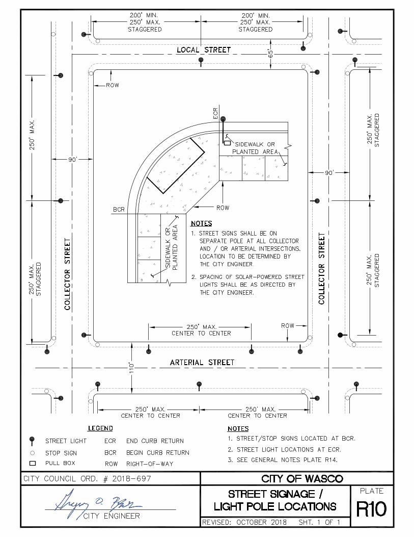


augarcia
Typewritten Text
2' FENCE CLEARANCE
augarcia
Typewritten Text
augarcia
Typewritten Text
augarcia
Typewritten Text
augarcia
Typewritten Text