Model Subdivision Conditions Schedule - Department of ...
63
Model Subdivision Model Subdivision Conditions Schedule Conditions Schedule June 2021 June 2021 The Department of Planning, Lands and Heritage acknowledges the traditional owners and custodians of this land. We pay our respect to Elders past and present, their descendants who are with us today, and those who will follow in their footsteps. © State of Western Australia Published by the Western Australian Planning Commission Gordon Stephenson House 140 William Street Perth WA 6000 Locked Bag 2506 Perth WA 6001 Published June 2021 Disclaimer This document has been produced by the Department of Planning, Lands and Heritage on behalf of the Western Australian Planning Commission. Any representation, statement, opinion or advice expressed or implied in this publication is made in good faith and on the basis that the Government, its employees and agents are not liable for any damage or loss whatsoever which may occur as a result of action taken or not taken, as the case may be, in respect of any representation, statement, opinion or advice referred to herein. Professional advice should be obtained before applying the information contained in this document to particular circumstances. website: www.dplh.wa.gov.au email: [email protected] tel: 08 6551 8002 fax: 08 6551 9001 National Relay Service: 13 36 77 This document is available in alternative formats on application to the Department of Planning, Lands and Heritage Communications Branch.
-
Upload
khangminh22 -
Category
Documents
-
view
0 -
download
0
Transcript of Model Subdivision Conditions Schedule - Department of ...

Model Subdivision Model Subdivision Conditions ScheduleConditions ScheduleJune 2021June 2021
The Department of Planning, Lands and Heritage acknowledges the traditional owners and custodians of this land. We pay our respect to Elders past and present, their descendants who are with us today, and those who will follow in their footsteps.
© State of Western AustraliaPublished by theWestern Australian Planning CommissionGordon Stephenson House140 William StreetPerth WA 6000
Locked Bag 2506Perth WA 6001
Published June 2021
Disclaimer
This document has been produced by the Department of Planning, Lands and Heritage on behalf of the Western Australian Planning Commission. Any representation, statement, opinion or advice expressed or implied in this publication is made in good faith and on the basis that the Government, its employees and agents are not liable for any damage or loss whatsoever which may occur as a result of action taken or not taken, as the case may be, in respect of any representation, statement, opinion or advice referred to herein. Professional advice should be obtained before applying the information contained in this document to particular circumstances.
website: www.dplh.wa.gov.auemail: [email protected]
tel: 08 6551 8002fax: 08 6551 9001National Relay Service: 13 36 77
This document is available in alternative formats on application to the Department of Planning, Lands and Heritage Communications Branch.
Model Subdivision Conditions ScheduleModel Subdivision Conditions Schedule || June 2021June 2021 iiWESTERN AUSTRALIAN PLANNING COMMISSIONWESTERN AUSTRALIAN PLANNING COMMISSION
Contents1. Introduction 1
2. Model Subdivision Conditions and Advice 8
Part 1 – Administrative conditions 8 Administrative advice 9
Part 2 – Amenity conditions 10 Amenity advice 12
Part 3 – Buildings and use conditions 13 Buildings and use advice 16
Part 4 – Drainage and site works conditions 17 Drainage and site works advice 20
Part 5 – Electricity and gas pipeline conditions 21 Electricity and gas pipeline advice 23
Part 6 – Environmental conditions 24 Environmental advice 27
Part 7 – Fire and emergency infrastructure conditions 29 Fire and emergency infrastructure advice 34
Part 8 – Heritage (indigenous, state, local, etc) conditions 36 Heritage (indigenous, state, local, etc) advice 36
Part 9 – Lot design conditions 37
Part 10 – Reserves conditions 39 Reserves advice 42
Part 11 – School sites conditions 43
Part 12 – Transport roads and access conditions 44 Transport roads and access advice 52
Part 13 – Water and sewer conditions 53 Water and sewer advice 59
Part 14 – Telecommunications advice 61

Model Subdivision Conditions ScheduleModel Subdivision Conditions Schedule || June 2021June 2021 1WESTERN AUSTRALIAN PLANNING COMMISSIONWESTERN AUSTRALIAN PLANNING COMMISSION
1. Introduction About Model Subdivision Conditions and advice notes
The Western Australian Planning Commission (WAPC) determines all freehold, vacant and survey strata subdivisions in Western Australia with the exception of built strata subdivisions which are generally determined by Local Government.
Model subdivision conditions and associated advice notes are an essential tool used by the WAPC to ensure compliance with its statutory and policy responsibilities. Model conditions reduce the assessing time of subdivision applications by providing a standardised set of tested and agreed conditions, as well as providing advice for the Department of Planning, Lands and Heritage (the Department) in its role supporting the WAPC. Model subdivision conditions should also be used by referral agencies as the basis for referral advice. Advice notes provide supplementary information to inform conditions.
The application of Model Subdivision Conditions
The sensitive use of planning conditions can improve the quality of a proposal, enabling an application to be approved that otherwise may need to be refused. In order to ensure public confidence in the planning system, it is important that conditions are only imposed where they have a valid planning purpose and relate fairly and reasonably to the proposal.
Model conditions do not replace thorough and careful assessment of applications and should not be used as a matter of routine. The need for each condition should be carefully considered giving regard to the merits of the case by both the referral agency in recommending the conditions and the WAPC in imposing these conditions.
In general, the WAPC will not support the use of a non-standard condition when the circumstance is adequately covered by a model condition included in this document. There may however be site conditions or specific circumstances that warrant the use of a non-standard condition. In such cases, the referral agency must provide the WAPC with adequate justification to support the requested condition. This must take into account the context of the application proposed, the WAPC planning framework and the validity tests applied by the State Administrative Tribunal (see below). Advice notes can be used to provide supplementary information to inform conditions, but have no legal status and should be used sparingly. As a general principle, it is not the role of subdivision conditions or advice notes to advise of requirements under other legislation, or requirements applying at the (later) development approval stage. Conditions should be used sparingly, having regard to the regulatory burden imposed by excessive numbers of conditions.
The subdivision approval process
Application to the WAPC for subdivision approval is initiated by a landowner and/or applicant. Application forms, any explanatory documents and plan(s) are lodged with the WAPC and assessed on its behalf by the Department. If the WAPC is of the opinion that the subdivision may affect the functions of a local government, utility provider or public agency, it may (under Section 142 of the Planning and Development Act 2005) refer the application for objections and recommendations. In reality, almost all subdivision applications are referred. The Act provides referral agencies with 42 days to respond, unless otherwise agreed, and if referral advice is not received in this timeframe there is deemed to be no objection and no requested conditions. The WAPC may consider some referral agencies’ advice to be critical to the assessment of an application, and on that basis can provide referral agencies with additional time to provide a recommendation.
The Department assesses the application, recommending to the WAPC that the application be refused or approved with or without conditions (using the Model Subdivisions Schedule as a basis for the condition setting). In accordance with Section 145 of the Planning and Development Act 2005 an approval may be granted for a ‘prescribed period’, which is defined as four years for applications involving more than five lots (excluding common property) and three years in any other case. The subdivision can be constructed in accordance with the approval conditions. The landowner and/or applicant is responsible for obtaining the ‘clearance’ from the agency prescribed with the responsibility for ‘clearing’ the relevant condition.

Model Subdivision Conditions ScheduleModel Subdivision Conditions Schedule || June 2021June 2021 2WESTERN AUSTRALIAN PLANNING COMMISSIONWESTERN AUSTRALIAN PLANNING COMMISSION
Additionally, they are responsible for advising the WAPC that the requirements of the condition have been fulfilled so that the WAPC are able to endorse the diagram or plan of survey of subdivision. Subdivision conditions are to be drafted to include a clearance agency and when no clearance agency is nominated the WAPC is the nominated clearing agency. As all subdivision conditions are to the satisfaction of the WAPC, the WAPC will arbitrate if there is a dispute as to the clearance requirements.
The 2009-2012 review
The 2005 version of the Model Subdivision Conditions was reviewed over the period from 2009 to 2012. The review was recommended as part of the planning reform agenda outlined in Planning Makes it Happen— a Blueprint for Planning Reform, released in 2009, and endorsed by the Minister for Planning. The objectives of the review were to audit the effectiveness, validity and application of the then current model subdivision conditions and advice notes. In addition, the review was to formulate a revised schedule that:
• reduced the number of conditions;
• standardised and simplified conditions to core issues;
• ensured that the conditions imposed are specific so proponents and referral agencies are clear as to compliance requirements; and
• ensured that the conditions imposed are consistent with the validity rules set by the State Administrative Tribunal.
A review was undertaken of the frequency of use of conditions and advice notes, and in February 2010 a consultation paper and a draft set of revised conditions were released. A limited number of new conditions were proposed to deal with new policy measures and issues that had arisen since the last (2005) review. In addition, a number of conditions were modified to provide greater clarity and to reflect updated requirements based on policy and practice as well as changes to clearance agencies. A number of conditions and advice notes were also deleted. Submissions were invited on the draft conditions and topic specific workshops conducted. As a result, a number of referral agencies requested the inclusion of additional conditions.
The approach taken with the review was to reduce conditions as much as possible to those pertaining to core planning matters that have a clear basis in planning policy and that warrant conditions that are used frequently. A large number of advice notes have been removed, with the WAPC determining that advice notes referring to non-planning legislation should be used sparingly, if at all. New conditions requested by clearance agencies have generally not been incorporated unless they are commonly used or reflect a planning policy basis.
The 2012 Model Subdivision Conditions Schedule
This document lists model subdivision conditions and advice notes categorised into 13 parts. The previous ‘Encumbrances and Notification’ conditions have been included in the subject specific part to which the encumbrance/notification relates; ‘Local Government’ conditions have been relocated to the subject specific part, and remaining ‘Agriculture’ conditions included in ‘Environment’. The ‘Marine’ section has been deleted as these conditions are not commonly imposed. The structure is as follows:
AD – Administrative AM – Amenity B – Buildings And Use D – Drainage And Site Works E – Electricity And Gas Pipelines EN – Environment F – Fire And Emergency H – Heritage (Indigenous, State, Local, Etc) L – Lot Design S – School Sites R – Reserves T – Transport, Roads And Access W – Water And Sewer

Model Subdivision Conditions ScheduleModel Subdivision Conditions Schedule || June 2021June 2021 3WESTERN AUSTRALIAN PLANNING COMMISSIONWESTERN AUSTRALIAN PLANNING COMMISSION
Amendments to this Schedule
The Model Conditions Schedule is a living document that requires constant monitoring and amendment to ensure relevance. Planning standards and requirements are not static. As statutory and policy requirements change, the Model Conditions Schedule needs to be updated to reflect those changes.
When drafting a new model condition, the proposed model condition must be discussed with the Department’s Perth and Peel Planning Division which has custodianship of the Model Conditions Schedule. If agreed, it is then considered by the Statutory Planning Committee of the WAPC. This usually occurs in conjunction with consideration of the specific application that realised the need for such a condition, or in relation to a new or to-be-amended planning instrument, such as a planning policy, that would necessitate an amendment to the Model Conditions Schedule.
Validity of conditions The State Administrative Tribunal (SAT), and other appeal bodies in Australia have adopted the approach taken in Newbury DC v Secretary of State for the Environment (1981) AC578 when considering the validity of specific conditions. That decision held that, in order to be valid, a condition must:
• be imposed for a planning purpose;
• fairly and reasonably relate to the development for which permission is given; and
• be reasonable, that is, be a condition which a reasonable planning authority, properly advised, might impose.
The principles considered by the High Court have been adopted and generally applied in relation to development and subdivision approval in Western Australia: see in particular Renstone Nominees Pty Ltd v the Metropolitan Region Planning Authority (TPAT 32/84 and 57/84).
This section discusses the tests of conditions and makes reference to both subdivision and development conditions, to provide a comprehensive overview.
Planning purpose
The first requirement is that a condition must have a planning purpose. The then Town Planning Appeals Tribunal (TPAT) in Ross M Love v Western Australian Planning Commission (No. 68/98) observed that this has two aspects. The first is whether the condition bears a relationship to planning theory and policy. In this case TPAT concluded that the ceding of land for open space within a subdivision is ipso facto1 a planning purpose because, among other things, it is WAPC policy and was contemplated under the Town Planning and Development Act 1928.
The second aspect is to determine whether the condition, in the particular circumstances of the case, fulfils the proper planning purpose. A condition that is an aspect of usual planning practice may not fulfil a planning purpose in the circumstances of the case if the ceding of open space is unnecessary for the orderly and proper planning of the locality of which the subdivision is a part.
In considering whether a particular condition is necessary, the question should be asked as to whether approval would have to be refused if that condition were not to be imposed. If it would not, then the condition would need special and precise justification. The argument that a condition will do no harm is no justification for its imposition. As a matter of policy a condition ought not to be imposed unless it is necessary to fulfil a planning purpose in the circumstances of the case.
1 ‘by the fact itself’ which means that a certain phenomenon is a direct consequence, a resultant effect ,of the action in question, instead of being brought about by a subsequent action.

Model Subdivision Conditions ScheduleModel Subdivision Conditions Schedule || June 2021June 2021 4WESTERN AUSTRALIAN PLANNING COMMISSIONWESTERN AUSTRALIAN PLANNING COMMISSION
A condition which duplicates controls under separate legislation would not normally be necessary and may not fulfil a planning purpose. Where other controls are available, however, a condition may be needed to address the land use impacts of the proposed development. For example, a condition would not normally be appropriate to control the level of emissions from a proposed development where these are subject to control under the Environmental Protection Act, but may be needed to address the impact of the emissions on land use (for example, separation distances) which are not controlled by the Environmental Protection Authority. A condition which conflicts with the jurisdiction of another agency is likely to be found to be unreasonable.
Relevance
The second test of validity is that the condition fairly and reasonably relates to the application. Unless a condition fairly and reasonably relates to the development to be approved it will be ultra vires.
It is not sufficient that a condition is related to planning objectives. It must also be justified by the nature of the development and the effect on its surroundings. For example, if subdivision approval is being granted subject to a condition requiring the upgrading of adjacent roads then it would be necessary to demonstrate that the upgrading arises out of the effects of the subdivision or development rather than being primarily directed to the public benefit.
In some instances, the nexus between the condition and the effect of the development is capable of being quantified – for example, the proportion of traffic which is generated by regional demands as opposed to the demands of a particular subdivision or development.
A condition does not fail because it is also incidentally of public benefit. This principle was recognised by TPAT in Perrymead Pty Ltd v WAPC (1996). However, as observed by the tribunal in Ross M Love v WAPC (68/98), if a condition is, because of the scale of the contribution imposed primarily directed to the public benefit, it may no longer be said to “fairly and reasonably relate” to the development.
This distinction was also foremost in the decision of the High Court in Lloyd v Robinson (1962) where the High Court stated:
“The assumption must be accepted that the statutory power to annex conditions to an approval of a subdivision does not extend to requiring the setting aside for public recreation of land which is so unrelated to the land to be subdivided, because of remoteness from it or some other circumstance, that there is no real connection with the provision of open space and the contemplated development of the area to be subdivided.”
The open space contribution was allowed in this landmark decision because it was justified to “satisfy the reasonable requirements in respect of the total area”.
There must, therefore, be some nexus between the condition and the effect of the subdivision or development and, if a nexus can be established, a
condition is valid even if the imposition of the condition is also for the public benefit. Where a condition requiring works that are for the benefit of the subdivider and the general community the costs of the requirement may be shared, if nexus can be demonstrated (e.g. road upgradings).
Reasonableness
The third test of the validity of a condition is that it should be reasonable or not be found to be unreasonable.
The underlying concept of reasonableness derives from the Wednesbury 2 decision and is used to determine if a condition should not be imposed because it is so unreasonable that no reasonable body or persons could have made the decision.
The issue of reasonableness arose in the decision of the tribunal in Renstone Nominees. In that planning appeal, a condition of development approval required a foreshore reserve under the MRS to be ceded to the Crown free of cost. TPAT accepted as appropriate a policy by the former Metropolitan Region Planning Authority that land might be so ceded where the planning objective can be achieved without disadvantage to the developer on the basis that the value of the remaining land would not be adversely affected but may well be enhanced by reason of the ceding of the reserved land free of cost. The tribunal went on to observe that such a policy requires an assessment to be made of the advantages or disadvantages to the developer to determine whether the requirement to cede land free of cost is reasonable
2 Associated Provincial Picture Houses Limited v Wednesbury Corporation (1947) 2 All ER 680.

Model Subdivision Conditions ScheduleModel Subdivision Conditions Schedule || June 2021June 2021 5WESTERN AUSTRALIAN PLANNING COMMISSIONWESTERN AUSTRALIAN PLANNING COMMISSION
in the circumstances of the particular appeal. In Renstone Nominees, TPAT ultimately found that, on the evidence before it, the existence of a regional reservation had led to a substantial detriment or disadvantage to the appellant and, in the circumstances of that case, that detriment would be compounded by a requirement that the reserved land be ceded free of cost. While such a condition, if upheld, would confer a substantial benefit on the community, there is no corresponding, balancing or compensating advantage or benefit to the appellant. For those reasons, TPAT deleted the condition requiring the ceding of the reserved land free of cost.
In Swick Holdings Pty Ltd v the State Planning Commission (7/91) TPAT upheld conditions requiring 19 per cent of a residential subdivision site being ceded free of cost for public open space in addition to a foreshore reserve on the Helena River. In this case TPAT took into account the special topographical features of the site which limited subdivision of the land, the existence of a regional reservation and two gas easements across the site. TPAT found that the conditions were reasonable because they not only conferred a benefit on the community (because acquisition of a foreshore reserve would be achieved without payment) but the appellant also received a balancing or compensating advantage arising out of the residential subdivision of the land.
A condition may be unreasonable because it is unduly restrictive. A condition may in principle impose a continuing restriction on the use of land (providing there are good planning reasons for that restriction) but should not be imposed if the restriction effectively nullifies the benefit of the approval. For example, it may be reasonable to limit the hours during which an entertainment venue may be open so as not to affect the amenities of the locality. It would be unreasonable,
however, to do so to such an extent as to make it impossible for the owner to run the business properly. If it appears that an approval could only be given subject to conditions that effectively remove the benefit of the approval, then the proposed development should be refused.
It is also unreasonable to impose a condition worded in a positive form which developers are unable to comply with themselves, or which they can only comply with following the consent or authorisation of a third party (e.g. a condition which requires a developer to close a road in order to provide alternative access to a site). Similarly, conditions which require the applicant to obtain an authorisation from another body (such as the Environmental Protection Authority) should not be imposed.
It may, however, be possible to achieve a similar result by a condition worded in a negative form, by prohibiting development until a specified action has been taken. For example, it might be reasonable to impose a condition requiring that a development should not commence until a particular road is closed if there were reasons to suppose that the local government would be willing and able to take the necessary action.
Subdivision approvals are a form of outline approvals where third party clearance of conditions is a standard convention. As such it is necessary to ensure (through the consultation process) that the condition can be cleared prior to granting preliminary approval.
An unreasonable condition does not become reasonable because an applicant suggests it or agrees to its terms. The condition will normally run with the land and may, therefore, still be operative long after the landowner/applicant has moved on. (This would ordinarily be the
case for development conditions but not generally for subdivision conditions that in the main cease to have effect once they are fulfilled.) Conditions should always be justified on their planning merits.
Other practical considerations in imposing planning conditions
There are other practical considerations in considering the imposition of planning conditions.
The framing of conditions requires care to ensure that the condition is enforceable. A condition, for example, limiting the number of persons using a particular development at any one time would be impractical to monitor and pose severe difficulties in enforcement. To be enforceable, conditions should be capable of being monitored and there should be clear evidence of any breaches.
In order to be enforceable conditions must be precise. This means the condition must be complete and must be clear and free from any ambiguity leading to possible differences of interpretation. A condition, for example, requiring “the submission and approval of a landscaping scheme” would be incomplete as it does not clearly state when the scheme is to be submitted, who is to approve the scheme and when the scheme is to be completed.
Vague expressions — for example, “the proposed development is not to cause annoyance to nearby residents” — should be avoided because they give little idea of what is to be expected of the applicant. Conditions subject to qualifications that do not provide any specific criteria for the applicant should be also avoided — for example, “the proposed access to be closed if the growth of traffic makes it necessary”.

Model Subdivision Conditions ScheduleModel Subdivision Conditions Schedule || June 2021June 2021 6WESTERN AUSTRALIAN PLANNING COMMISSIONWESTERN AUSTRALIAN PLANNING COMMISSION
Conditions reserving other matters
Sometimes, an application may contain insufficient details of an aspect of the development (such as car parking or landscaping) or there may be a need to modify that particular aspect. In this case, approval may be granted subject to a condition requiring that further details of the specified aspect of the development be submitted for approval before the development is commenced.
Time limits for endorsement of deposited plan
Section 145(2) of the Planning and Development Act 2005 provides that a person to whom approval of a plan of subdivision or survey-strata has been issued may request that the WAPC endorse a diagram or plan of survey of subdivision or appropriate form. Such a request must be lodged:
• within four years if the plan of subdivision or survey-strata proposes the creation of more than five lots (excluding any common property lots); or
• within three years in any other case.
No statutory timeframe is specified for strata plan approvals issued by the WAPC. However, it is the practice of the WAPC to issue its approval for a period of two years.
Conditions modifying a proposed subdivision, survey-strata or strata design
If a particular aspect of an application is unacceptable in planning terms, the best course may be for the applicant to modify the application prior to determination. This would require the submission of an amended plan (Form 2A). However, if the modification is substantial it may not be accepted as an amended plan and would require the submission of a new application. Generally, a condition of this kind should only be imposed following discussion with the landowner/applicant. Such a condition cannot be imposed if it would make the approved subdivision substantially different from that proposed in the application.
Ambulatory conditions
An ambulatory condition is a condition imposed by the WAPC in approving a subdivision which requires an applicant to undertake action to the satisfaction of a third party (clearing authority) with the clearing authority responsible for certifying compliance with those conditions. There is both some uncertainty as to the validity of such conditions as well as general acknowledgement of the importance of such conditions in ensuring effective operation of the subdivision process.
While referral agencies may recommend the imposition of conditions and may also be nominated to provide written confirmation that a condition has been fulfilled, responsibility ultimately rests with the WAPC.
This is reflected in determination notice preambles (see Determination Notice Schedule – Freehold, Survey-Strata & Strata available at www.dplh.wa.gov.au). It has been the established practice that subdivision applications are referred to referral agencies and the WAPC is responsible (per s.145 of the Planning and Development Act 2005) for the imposition and satisfaction of any condition recommended by referral agencies. The WAPC utilises the professional advice from referral agencies as to whether applicants have complied with conditions.
In Hill v State Planning Commission TPAT considered the matter of ambulatory conditions. The relevant judgements are as follows.
1 The State Planning Commission has the power to impose such conditions as it sees fit consistent with the application of sound town planning principles. The limitation on this power is that the conditions must not be ultra vires, must “fairly and reasonably relate to the permitted development”, must be “reasonably capable of being regarded as relevant to the implementation of planning policy” and must not be so unreasonable that no reasonable planning authority could have imposed them. As the extension of the doctrine of proportionality to the process of judicial review has not been established in this state, proportionality will not be used by the Tribunal as a test for the validity of a planning condition.
2 The ground of finality differs from the ground of uncertainty. A condition will be void for lack of finality if the State Planning Commission or local authority has abdicated its duty to exercise its discretion as required by the Act.

Model Subdivision Conditions ScheduleModel Subdivision Conditions Schedule || June 2021June 2021 7WESTERN AUSTRALIAN PLANNING COMMISSIONWESTERN AUSTRALIAN PLANNING COMMISSION
3 A condition which purports to leave a matter to the satisfaction of another authority is not ipso facto invalid. However, a condition will be invalid if it requires a future determination by another authority pertaining to an essential element in the application, where that determination could alter the proposed development significantly.
4 As a general principle, landowners cannot reasonably be expected to comply with conditions with regards to subdivision approvals when the conditions are expressed to be subject to the satisfaction of a local government authority or other third party. Ambulatory conditions are the antithesis of valid contractual arrangements between an applicant for approval and the approving authority.
Clearance of Subdivision Conditions
The timing for the implementation of subdivision conditions, including some subdivisional works, may not be practicable prior to the issuing of a clearance of subdivision conditions. Accordingly, alternative clearance arrangements may be negotiated between the landowner/applicant and the clearance agency. Ultimately the WAPC makes the final decision in this regard, considering the advice of the clearance agency when a request to endorse a diagram or plan of survey of subdivision is made by a landowner/applicant in accordance with Section 145 of the Planning and Development Act 2005.
Review of the Model Subdivision Conditions
The Model Subdivision Conditions will be periodically reviewed by the Department, to ensure that the conditions continue to be robust and address current planning policy and practice.

Model Subdivision Conditions ScheduleModel Subdivision Conditions Schedule || June 2021June 2021 8WESTERN AUSTRALIAN PLANNING COMMISSIONWESTERN AUSTRALIAN PLANNING COMMISSION
2. Model Subdivision Conditions and Advice
Part 1 – Administrative conditionsCode Administrative condition Related
codeSummary Situation Policy link
AD1 Prior to the Western Australian Planning Commission’s endorsement of a diagram or plan of survey (deposited plan) for the creation of the lots proposed by this application, the lot that is the subject of this application being created on a separate diagram or plan of survey (deposited plan) and the plan being endorsed by the Western Australian Planning Commission. (Western Australian Planning Commission)
_ Creation of parent lot on diagram or plan of survey (deposited plan).
Imposed where application relates to a lot that has not yet been created, but is subject to Western Australian Planning Commission conditional approval.
OP 1.1 Subdivision of Land – General Principles
AD2 The portion of land shown on the plan dated [INSERT VALUE] (attached) being amalgamated with the adjacent lot pending joint subdivision with the adjoining owner. (Western Australian Planning Commission)
_ Part lot(s) amalgamation.
Imposed where application seeks approval for part lots.
OP 1.1 Subdivision of Land – General Principles
AD3 The existing lots that are the subject of this application being amalgamated on the diagram or plan of survey (deposited plan). (Western Australian Planning Commission)
_
Amalgamation on diagram or plan of survey (deposited plan).
Imposed on survey strata applications that propose the amalgamation of existing freehold lots.
OP 1.1 Subdivision of Land – General Principles
DC 1.3 Strata Subdivision
AD4 The strata plan containing certification that the boundaries of the lots or part of the lots which are buildings shown on the strata plan are the inner surfaces of the walls, the upper surfaces of the floor and the under surface of the ceiling. The certification is to be in the form provided by Section 32 of the Strata Titles Act 1985 and Regulation 15(2) of the Strata Titles (General) Regulations 2019 (Western Australian Planning Commission).
_ Boundaries of multi-tiered strata developments.
Always use with approvals of strata plans for multi-tiered strata developments.
OP 1.1 Subdivision of Land – General Principles
DC 1.3 Strata Subdivision
AD5 Arrangements being made with the City/Shire [DELETE AS APPLICABLE] of [INSERT NAME] for the landowner/applicant to contribute towards the costs of providing community and/or common infrastructure as established through amendment [INSERT NUMBER] (when gazetted) to the City/Shire [DELETE AS APPLICABLE] of [INSERT NAME] Local Planning Scheme No. [INSERT NUMBER]. (Local Government)
Aa1 Developer contributions – scheme amendment advertised.
Always use when the developer contribution provisions have been initiated as an amendment but are not yet included in the Local Planning Scheme.
SPP 3.6 Development Contributions for Infrastructure
AD6 The landowner/applicant contributing towards development infrastructure provisions pursuant to the City/Shire [DELETE AS APPLICABLE] of [INSERT NAME] Local Planning Scheme No. [INSERT NUMBER]. (Local Government)
_ Developer contributions as per Scheme provisions.
Use when developer contribution provisions are included in the Local Planning Scheme.
SPP 3.6 Development Contributions for Infrastructure

Model Subdivision Conditions ScheduleModel Subdivision Conditions Schedule || June 2021June 2021 9WESTERN AUSTRALIAN PLANNING COMMISSIONWESTERN AUSTRALIAN PLANNING COMMISSION
Code Administrative condition Related code
Summary Situation Policy link
AD7 The leasehold lots proposed in this subdivision expire on a specific day being not more than [INSERT VALUE] years from registration.
Leasehold by-laws are to be written in accordance with Section 8(3) of the Strata Titles Act 1985 (as amended) and Regulation 163 of the Strata Titles (General) Regulations 2019. The scheme notice is to specify the term of the leasehold scheme. (Western Australian Planning Commission)
_ Leasehold term to be specified in the scheme notice.
Always use with approvals of leasehold strata or survey-strata lots.
Strata Titles Act 1985 s.8
DC 1.3 Strata Subdivision
AD8 Leasehold by-laws to enable the postponement of the expiry day of the term, being prepared and submitted for the Western Australian Planning Commission’s consideration and written in accordance with Section 20 and 40 of the Strata Titles Act 1985 (as amended) and Regulation 164 of the Strata Titles (General) Regulations 2019. (Western Australian Planning Commission).
_ Postponement of expiry date for leasehold lots.
Impose where applicant seeks a postponement for the leasehold expiry day.
Strata Titles Act 1985 s.20 and 40
DC 1.3 Strata Subdivision
AD9 Prior to the Western Australian Planning Commission’s endorsement of a diagram or plan of survey (deposited plan) for the creation of the lots proposed by this application, the current strata title scheme XXX [INSERT VALUE] being terminated and created on a separate diagram or plan of survey (deposited plan) as a single lot, being endorsed by the Western Australian Planning Commission. (Western Australian Planning Commission)
_ Termination of strata lots.
Imposed where the application relates to the termination of an existing strata, survey-strata, leasehold (strata) or leasehold (survey-strata) scheme and the lot that has not yet been created, but is subject to Western Australian Planning Commission conditional approval.
OR
Imposed where application relates to existing strata, survey-strata, leasehold (strata) or leasehold (survey-strata) scheme where the lots are to be terminated to create/revert to the parent lot, which is subject to Western Australian Planning Commission conditional approval.
Strata Titles Act 1985
DC 1.3 Strata Subdivision
Administrative advice
Code Administrative advice Related code
Summary Situation Policy link
ADa1 Condition [INSERT VALUE] is in acknowledgement of proposed Amendment No. [INSERT VALUE] that is viewed by the Western Australian Planning Commission to be a seriously entertained planning proposal, which will provide for developer contributions for community infrastructure.
AD5 Always with AD5

Model Subdivision Conditions ScheduleModel Subdivision Conditions Schedule || June 2021June 2021 10WESTERN AUSTRALIAN PLANNING COMMISSIONWESTERN AUSTRALIAN PLANNING COMMISSION
Part 2 – Amenity conditions Code Amenity condition Related
codeSummary Situation Policy link
AM 1 To provide a spray drift buffer between the market garden and adjacent residential lots, the landowner/applicant is to install a specially designed 1.8 metre high fence and a protected and maintained vegetation buffer of one line of evergreen trees or bushes (a minimum height of 1.5 metres) in accordance with the plan dated [INSERT VALUE] (attached). (Local Government)
AMa1
AMa2
Always with AMa1 and AMa2
AM 2 The landowner/applicant shall provide a written undertaking to ensure that prospective purchasers of lots proposed within 300 metres of an operating market garden are notified on contracts of sale of the existence of the market garden operations and the potential to be affected by odours, noise, dust and spray drift that this land use may cause. (Local Government)
AM3
AMa2
Prospective purchasers advised of existing market garden.
Always with AMa2
If the market garden is zoned urban and likely to be urbanised in the short term, only AM2 is necessary, not AM3.
Environmental Protection Authority Guidance for the Assessment of Environmental Factors: Separation Distances between Industrial and Sensitive Land Uses No. 3 (June 2005)
AM 3 A notification, pursuant to Section 165 of the Planning and Development Act 2005 is to be placed on the certificate(s) of title of the proposed lot(s) advising of the existence of a hazard or other factor. Notice of this notification is to be included on the diagram or plan of survey (deposited plan). The notification is to state as follows:
“This lot is located within 300 metres of operating market garden/s and has the potential to be affected by odours, noise, spray drift and dust that are associated with the continued operation of a market garden”. (Western Australian Planning Commission)
AM2
AMa2
Notification 165 PDA – market garden.
Always with AMa2 PB 3 Notifications on Titles (Memorials)
AM 4 The landowner/applicant installing suitable rural fencing of good standard in accordance with the plan dated [INSERT VALUE] (attached). (Local Government)
_ Rural style fencing – urban/market gardens.
AM 5 A notification, pursuant to Section 165 of the Planning and Development Act 2005 is to be placed on the certificates of title of the proposed lot(s) advising of the existence of a hazard or other factor. Notice of this notification is to be included on the diagram or plan of survey (deposited plan). The notification is to state as follows:
“This lot is in close proximity to known mosquito breeding areas. The predominant mosquito species is known to carry viruses and other diseases.” (Western Australian Planning Commission)
_ Notification 165 PDA – mosquito.
To be applied where the land is identified as being of ‘Frequent High Ross River Virus (RRV) Disease Risk’ or ‘Frequent High and Occasional Very High RRV Disease Risk’, as identified by the Department of Health’s Mosquito-borne Disease Risk Maps, or as otherwise advised by the relevant agency.
Planning and Development Act 2005 s.165
PB 3 Notifications on Titles (Memorials)

Model Subdivision Conditions ScheduleModel Subdivision Conditions Schedule || June 2021June 2021 11WESTERN AUSTRALIAN PLANNING COMMISSIONWESTERN AUSTRALIAN PLANNING COMMISSION
Code Amenity condition Related code
Summary Situation Policy link
AM 6 A notification, pursuant to Section 165 of the Planning and Development Act 2005 is to be placed on the certificate(s) of title of the proposed lot(s) advising of the existence of a hazard or other factor. Notice of this notification is to be included on the diagram or plan of survey (deposited plan). The notification is to state as follows:
“This lot is in close proximity to the [INSERT VALUE] waste water treatment plant and may be adversely affected by virtue of odour emissions from that facility.” (Western Australian Planning Commission)
_ Notification 165 PDA – odour emissions.
Always if land is proximate to a waste water treatment plant and odour may be an amenity concern.
Planning and Development Act 2005 s.165
PB 3 Notifications on Titles (Memorials)
AM 7 A notification, pursuant to Section 165 of the Planning and Development Act 2005 is to be placed on the certificate(s) of title of the proposed lot(s) advising of the existence of a hazard or other factor. Notice of this notification is to be included on the diagram or plan of survey (deposited plan). The notification is to state as follows:
“This lot is in close proximity to an existing poultry farm(s) and may be adversely affected by virtue of odour, noise, dust and/or light emissions from that land use.” (Western Australian Planning Commission)
_ Notification 165 PDA – poultry farm.
Always if land is proximate to a poultry farm in accordance with State Planning Policy No. 2.5 Rural Planning
Planning and Development Act 2005 s.165
SPP 2.5 Rural Planning
PB 3 Notifications on Titles (Memorials)
AM 8 A notification, pursuant to Section 165 of the Planning and Development Act 2005 is to be placed on the certificates of title of the proposed lot(s) advising of the existence of a hazard or other factor. Notice of this notification is to be included on the diagram or plan of survey (deposited plan). The notification is to state as follows:
“This lot is situated in the vicinity of [INSERT AIRPORT], and is currently affected, or may in the future, be affected by aircraft noise. Noise exposure levels are likely to increase in the future as a result of increases in numbers of aircraft using the airport, changes in aircraft type or other operational changes. Further information about aircraft noise, including development restrictions and noise insulation requirements for noise-affected properties, are available on request from the relevant local government offices.” (Western Australian Planning Commission)
_ Notification 165 PDA – airport aircraft noise.
Always if land is proximate to Perth International and Domestic Airports in accordance with State Planning Policy No. 5.1 Land Use Planning in the Vicinity of Perth Airport, Jandakot Airport in accordance with State Planning Policy No. 5.3 Jandakot Airport Vicinity or any other airport where noise exposure levels are identified as an issue.
SPP 5.1 Land Use Planning in the Vicinity of Perth Airport
SPP 5.3 Jandakot Airport Vicinity
AM 9 A notification, pursuant to Section 165A of the Planning and Development Act 2005 is to be placed on the certificate(s) of title of the proposed lot(s). Notice of this notification is to be included on the diagram or plan of survey (deposited plan). The notification is to state as follows:
“This lot is located in an area likely to be subject to coastal erosion and/or inundation over the next 100 years from the date this notification is registered.” (Western Australian Planning Commission)
_ Notification 165 PDA - coastal hazard
If land is proximate to a future coastal hazard as determined in accordance with State Planning Policy 2.6 State Coastal Planning Policy and an endorsed CHRMAP. A shorter timeframe than 100 years may be appropriate where identified in an endorsed CHRMAP.
Planning and Development Act 2005 s.165
SPP 2.6 State Coastal Planning Policy
PB 3 Notification on Titles (Memorials)

Model Subdivision Conditions ScheduleModel Subdivision Conditions Schedule || June 2021June 2021 12WESTERN AUSTRALIAN PLANNING COMMISSIONWESTERN AUSTRALIAN PLANNING COMMISSION
Code Amenity condition Related code
Summary Situation Policy link
AM 10 A notification, pursuant to Section 165 of the Planning and Development Act 2005 is to be placed on the certificate(s) of title of the proposed lot(s) advising of the existence of a hazard or other factor. Notice of this notification is to be included on the diagram or plan of survey (deposited plan). The notification is to state as follows:
“This lot is located within the floodway / flood fringe of the [INSERT VALUE] River and may be affected by flooding. Additional planning and building requirements may apply to development on this lot to ensure flood risk is managed.” (Western Australian Planning Commission)
_ Notification 165 PDA – floodway/flood fringe
If land is located within a floodway/flood fringe.
Planning and Development Act 2005 s.165
PB 3 Notification on Titles (Memorials)
AM 11 A notification, pursuant to Section 165 of the Planning and Development Act 2005/Section 70A of the Transfer of Land Act 1893 [DELETE AS APPLICABLE] is to be placed on the certificate(s) of title of the proposed lot(s). Notice of this notification is to be included on the diagram or plan of survey (deposited plan). The notification is to state as follows:
“The use of this lot may be affected by 24-hour operation of machinery, aerial spraying and generation of other noise, dust and odours [INSERT/DELETE VALUE AS APPLICABLE] arising from agricultural operations being carried out on surrounding land holdings.” (Local Government) OR (Western Australian Planning Commission)
_ Notification 165 PDA/70A TLA - agricultural operations
If land is proximate to agricultural uses of State significance and/or to uses not reasonably anticipated by future landowners.
Apply whichever notification (S 165 or S 70A) is more appropriate depending on the severity of the impact to amenity.
SPP 2.5 Rural Planning
DC 3.4 Subdivision of rural land
PB 3 Notification on Titles (Memorials)
Amenity advice
Code Amenity advice Related code
Summary Situation Policy link
AMa2 In relation to Condition/s [INSERT VALUE], the landowner/applicant is advised that if evidence is provided that the market garden/s have ceased operating after conditional approval is granted then Condition/s [INSERT VALUE] will no longer need to be satisfied.
AM2
AM3
Market Garden conditions no longer relevant.
Impose to reflect the transitional nature of land uses.

Model Subdivision Conditions ScheduleModel Subdivision Conditions Schedule || June 2021June 2021 13WESTERN AUSTRALIAN PLANNING COMMISSIONWESTERN AUSTRALIAN PLANNING COMMISSION
Part 3 – Buildings and use conditions Code Buildings and use condition Related
codeSummary Situation Policy link
B1 All buildings and effluent disposal systems (delete as applicable) having the necessary clearance from the new boundaries as required under the relevant legislation including the Local Planning Scheme, Building Act 2011, and National Construction Code Series/Building Code of Australia (as amended). (Local Government)
Ba1 Boundary and effluent disposal clearance.
On local government advice, where changes have the potential to impact on setbacks of existing dwellings, and there may be existing effluent disposal systems on site.
SPP 7.3 Residential Design Codes
B2 Uniform fencing/walls [DELETE AS APPLICABLE] being constructed along the boundaries of lots abutting [INSERT VALUE]. (Local Government)
_ Uniform fencing. On local government advice, when lots abut primary regional roads, rail reserves and public open space.
SPP 7.3 Residential Design Codes
SPP 5.4 Road and Rail Noise
DC 2.2 Residential Subdivision
B3 Written confirmation from the local government that all necessary local government approval(s) have been issued and that the whole of the building has been completed in accordance with those approvals. (Local Government)
_ Built strata construction. All strata applications where buildings are to be retained or to be/are under construction.
DC 1.3 Strata Titles
B4 All dwelling(s) being constructed to plate height prior to the submission of the diagram or plan of survey (deposited plan). (Local Government)
_ Plate Height. If subdivision is dependent on built form residential, for example, if lot size concessions are granted for specific dwelling types.
DC 2.2 Residential Subdivision
B5 Other than buildings, outbuildings and/or structures shown on the approved plan for retention, all buildings, outbuildings and/or structures present on lot(s) [INSERT VALUE] at the time of subdivision approval being demolished and materials removed from the lot(s). (Local Government)
Ba2 Demolition/removal of buildings/structures.
If subdivision is dependent on demolition and/or where applicant indicates on Form 1A buildings to be demolished.
SPP 7.3 Residential Design Codes
OP 1.1 Subdivision of Land – General Principles
B6 Scheme by-laws being prepared and submitted for the Western Australian Planning Commission’s consideration and written confirmation in accordance with Section 39 of the Strata Titles Act 1985 (as amended), to include the following additions to the by-laws contained in Schedules 1 and 2 of that Act:
(a) Development or redevelopment on the [strata][survey strata] [DELETE AS APPLICABLE] lots is to comply with a development approval issued by the local government.
(b) Amendment to or repeal of the above provision cannot be effected without the Western Australian Planning Commission’s agreement. (Local Government)
_ Strata management statement.
On local government advice and in accordance with Development Control Policy 1.3 Strata Titles.
DC 1.3 Strata Titles

Model Subdivision Conditions ScheduleModel Subdivision Conditions Schedule || June 2021June 2021 14WESTERN AUSTRALIAN PLANNING COMMISSIONWESTERN AUSTRALIAN PLANNING COMMISSION
Code Buildings and use condition Related code
Summary Situation Policy link
B7 The existing dwelling being retained is to comply with the requirements of the Residential Design Codes. (Local Government)
_ Upgrade to R-Code compliance.
Only where dwelling is being retained and further works are required to comply with the Residential Design Codes.
SPP 7.3 Residential Design Codes
B8 Prior to commencement of subdivisional works, a detailed plan identifying building envelope(s)/building exclusion area(s) [DELETE AS APPLICABLE] on all lots on the approved plan of subdivision is to be prepared in consultation with the local government to ensure the appropriate siting of development. (Local Government)
Ba2 Building envelope or building exclusion area.
Only when there is a Scheme or other statutory provision which requires the preparation of a Building Envelope Plan in a rural circumstance.
OP 1.1 Subdivision of Land – General Principles
SPP 2.5 Rural Planning
DC 2.5 Special Residential Zones
B9 The landowner/applicant shall provide a written undertaking to advise prospective purchasers of the provisions of the local government’s local planning scheme that relate to the use and management of the land. (Local Government)
_ Mostly applied to rural residential or similar zones where special land use provisions/controls exist.
Only impose when there are area specific land use controls and provisions that would not normally be anticipated by a purchaser.
B10 A restrictive covenant, to the benefit of the local government, pursuant to section 129BA of the Transfer of Land Act 1893 (as amended) is to be placed on the certificates of title of the proposed lot(s) advising of the existence of a restriction on the use of the land. Notice of this restriction to be included on the diagram or plan of survey (deposited plan). The restrictive covenant is to state as follows:
“No new development shall occur within [INSERT VALUE] of the right-of-way abutting the [INSERT VALUE] boundary of the lots to accommodate widening of the right-of-way should it be required in the future.” (Local Government)
_ Restrictive covenant – no development in ROW setback.
To be imposed to ensure that right of ways can be widened in the future to a width of 6 metres in accordance with Planning Bulletin 33.
PB 3 Notifications on Titles (Memorials)
PB 33 Rights-of-way or Laneways in Established Areas Guidelines
B11 Common walls being shown on the survey strata plan as prescribed “party wall easements”, pursuant to Regulation 33 of the Strata Titles (General) Regulations 2019 and Section 61 of the Strata Titles Act 1985. (Local Government)
Ba4 Party wall – easements. Where party walls are shown on survey strata plan.
B12 Boundary(ies) of lots defined by “party walls”, are to be subject to a party wall rights easement(s) created pursuant to section 136C of the Transfer of Land Act 1893, which is to be shown on the diagram or plan of survey (deposited plan) as constructed. (Local Government)
Ba4 Party wall – easement (136C).
Where party walls are shown on freehold subdivision plan. Only used where abutting freehold lots share an existing or proposed common wall that forms part of the built structure of buildings on both sides.

Model Subdivision Conditions ScheduleModel Subdivision Conditions Schedule || June 2021June 2021 15WESTERN AUSTRALIAN PLANNING COMMISSIONWESTERN AUSTRALIAN PLANNING COMMISSION
Code Buildings and use condition Related code
Summary Situation Policy link
B13 A restriction(s) in accordance with Section 32 (2) of the Strata Titles Act 1985 is to be placed on the certificate(s) of title of the proposed lot(s) confirming that [INSERT VALUE]. The restriction(s) are to be included on the deposited plan. The restriction(s) are to state as follows:
“[INSERT APPROPRIATE WORDING FROM SITUATION COLUMN]” (Local Government)
_ S32 Restriction Strata Titles. On local government advice. Advise of existence of a restriction on land use, for example use of lots restricted aged and dependant development, tourism developments.
“No person shall occupy any [INSERT VALUE] for more than a total of [INSERT VALUE] months in any 12 month period.”
“No person shall occupy [INSERT VALUE] that is not disabled, physically dependent or aged over 55, or is the surviving spouse of such a person.”
SPP 7.3 Residential Design Codes
PB 83 Planning for Tourism
B14 A restrictive covenant, to the benefit of [INSERT VALUE] pursuant to Section 129BA of the Transfer of Land Act 1893 is to be placed on the certificate(s) of title of the proposed lot(s) advising of the existence of a restriction on the use of the land. Notice of this restriction is to be included on the diagram or plan of survey (deposited plan). The restrictive covenant is to state as follows:
“[INSERT APPROPRIATE WORDING FROM SITUATION COLUMN]” (Local Government)
_ Restrictive covenant 129BA – generic.
129BA TLA can be used for any restrictive covenant that is to benefit a local government or public body. Mostly used to specify accommodation for aged and dependant persons and single bedroom dwellings.
“This lot is not to be developed for any purposes other than for a single bedroom dwelling.”
“This lot is not to be developed for any purposes other than for residential use by aged and dependant persons.”

Model Subdivision Conditions ScheduleModel Subdivision Conditions Schedule || June 2021June 2021 16WESTERN AUSTRALIAN PLANNING COMMISSIONWESTERN AUSTRALIAN PLANNING COMMISSION
Code Buildings and use condition Related code
Summary Situation Policy link
B15 A restrictive covenant to the benefit of the Western Australian Planning Commission, pursuant to Section 129BA of the Transfer of Land Act 1893 is to be placed on the certificate(s) of title of the proposed lot(s) advising of the existence of a restriction on the use of the land. Notice of this restriction is to be included on the diagram or plan of survey (deposited plan). The restrictive covenant is to state as follows:
“No development is to take place unless it is designed to minimise impact on the movement of flood water and complies with the minimum habitable floor level of 0.5 metres above the 1 in 100 Annual Exceedance Probability flood level to provide an adequate measure of flood protection”. (Western Australian Planning Commission)
_ Restrictive covenant 129BA – minimize impact on floodwater
OP 1.1 Subdivision of Land - General Principles
PB 91 Restrictive Covenants
Buildings and use advice
Code Buildings and use advice Related code
Summary Situation Policy link
Ba2 In regard to Condition [INSERT VALUE], a demolition permit may be required to be obtained from the local government prior to the commencement of demolition works.
B5 Planning/building approval required for partial demolition.
Always with B5. s. 157 of the Planning and Development Act 2005
OP 1.1 Subdivision of Land - General Principles
Ba3 This approval does not represent approval for any existing encroachments over the road reservation, private road or right-of- way. You are advised to contact the Department of Planning, Lands and Heritage regarding this matter.
_ Subdivision/strata approval not approval for encroachments.
Where it is apparent that development encroaches on road reservation, private road, right of way outside of lot. If the application area encroaches onto crown land, the signature of State Land Services within the Department of Planning, Lands and Heritage should be obtained.
Model Subdivision Conditions ScheduleModel Subdivision Conditions Schedule || June 2021June 2021 17WESTERN AUSTRALIAN PLANNING COMMISSIONWESTERN AUSTRALIAN PLANNING COMMISSION
Part 4 – Drainage and site works conditionsCode Drainage and site works condition Related
codeSummary Situation Policy link
D1 Engineering drawings and specifications are to be submitted, approved, and works undertaken in accordance with the approved engineering drawings, specifications and approved plan of subdivision, for grading and/or stabilisation of the site to ensure that:
a) lots can accommodate their intended use; and
b) finished ground levels at the boundaries of the lot(s) the subject of this approval match or otherwise coordinate with the existing and/or proposed finished ground levels of the land abutting. (Local Government)
D3 , D4 Grade and stabilise land, lots accommodate intended development, match finished levels.
If earthworks are proposed/necessary.
For large freehold and problematic sites where drainage issues have been identified use with D3 – fill and drainage condition consistent with Urban Water Management Plan.
Alternative condition for small scale subdivision, small infill, and sites without drainage issues, sites at D4.
Engineering drawings required by Planning and Development Act 2005 s.170
OP 1.1 Subdivision of Land – General Principles
D2 Prior to the commencement of subdivisional works, an urban water management plan is to be prepared and approved, in consultation with the Department of Water and Environmental Regulation, consistent with any approved [INSERT VALUE] Local Water Management Strategy/Drainage and Water Management Plan [DELETE AS APPLICABLE]. (Local Government)
D1, D3, Da1
Preparation of an UWMP prior to subdivisional works.
Condition to be applied in areas where water issues are of concern, such as high nutrient catchments, high groundwater table and/or the presence of environmentally significant wetlands and/ or waterways and for all medium to large subdivisions where management plan not previously approved. Generally on the advice of the Department of Water and Environmental Regulation.
Local Government may separately approve bulk earthworks that will not compromise UWMPs. Local Government may consult with Department of Water and Environmental Regulation in approving UWMPs if required.
SPP 3.4 Natural Hazards and Disasters
Better Urban Water Management Manual and Guidelines
Liveable NeighbourhoodsElement 5

Model Subdivision Conditions ScheduleModel Subdivision Conditions Schedule || June 2021June 2021 18WESTERN AUSTRALIAN PLANNING COMMISSIONWESTERN AUSTRALIAN PLANNING COMMISSION
Code Drainage and site works condition Related code
Summary Situation Policy link
D3 Engineering drawings and specifications are to be submitted and approved, and works undertaken in accordance with the approved engineering drawings and specifications and approved plan of subdivision, for the filling and/or draining of the land, including ensuring that stormwater is contained on-site, or appropriately treated and connected to the local drainage system. Engineering drawings and specifications are to be in accordance with an approved Urban Water Management Plan (UWMP) for the site, or where no UWMP exists, to the satisfaction of the Western Australian Planning Commission. (Local Government)
D1, D8, D2
Fill and drain land potentially in accordance with UWMP.
Always with D1 and D8. D2 may be reqired.
If earthworks are proposed/necessary. May need to be in accordance with UWMP for greenfields development. For large scale subdivisions and sites which have significant water management issues.
For large scale subdivisions of sites with drainage issues only. For small scale subdivision and sites with no drainage issues, use D4.
It is not intended to apply in brownfield or infill circumstances or to small scale
subdivision (5 lots or less) unless the subject land has significant water management issues present. With the advice of Local Government and/or Department of Water and Environmental Regulation.
OP 1.1 Subdivision of Land – General Principles
Liveable NeighbourhoodsElement 5
Better Urban Water Management Manual and Guidelines
Engineering drawings required by Planning and Development Act 2005 s.170
D4 The land being filled, stabilised, drained and/or graded as required to ensure that:
a) lots can accommodate their intended development; and
b) finished ground levels at the boundaries of the lot(s) the subject of this approval match or otherwise coordinate with the existing and/or proposed finished ground levels of the land abutting; and
c) stormwater is contained on-site, or appropriately treated and connected to the local drainage system. (Local Government)
D1, D2, D8
Fill, drain, stabilise, grade land- small, infill and non-problematic sites.
Large scale/sites with drainage issues.
Where an Urban Water Management Plan is not required.Use D1 and D2. D8 may also be required to provide for easements and reserves.
OP 1.1 Subdivision of Land – General Principles
Liveable NeighbourhoodsElement 5
Better Urban Water Management Manual and Guidelines.
Engineering drawings required by Planning and Development Act 2005 s.170

Model Subdivision Conditions ScheduleModel Subdivision Conditions Schedule || June 2021June 2021 19WESTERN AUSTRALIAN PLANNING COMMISSIONWESTERN AUSTRALIAN PLANNING COMMISSION
Code Drainage and site works condition Related code
Summary Situation Policy link
D5 Prior to the commencement of subdivisional works, the landowner/applicant is to provide a pre-works geotechnical report certifying that the land is physically capable of development or advising how the land is to be remediated and compacted to ensure it is capable of development; and
In the event that remediation works are required, the landowner/applicant is to provide a post geotechnical report certifying that all subdivisional works have been carried out in accordance with the pre-works geotechnical report. (Local Government)
_ Pre- and post-geotechnical report – physically capable.
Freehold, survey-strata and vacant lot strata approvals may require the imposition of this condition, but only on land that may have unknown or uncertain development capacity.
Engineering drawings required by Planning and Development Act 2005 s.170
OP 1.1 Subdivision of Land – General Principles
Liveable Neighbourhoods Element 5
PB 10 Geotechnical Reports for Subdivision
D6 Suitable arrangements being made with the Water Corporation for the drainage of the land either directly or indirectly into a drain under the control of that body. (Water Corporation).
Wa1 Water Corp. drainage – district.
Drainage connection to a Water Corporation district drain, if available.
SPP 2.0 Environment and Natural Resources
OP 1.1 Subdivision of Land – General Principles
Liveable Neighbourhoods Element 5
D7 Suitable arrangements being made for connection of the land to the comprehensive district drainage system at the landowner/applicant’s cost. (Local Government)
_ Local Govt. drainage – district.
Drainage connection to a district drain under Local Government control, if available.
SPP 2.0 Environment and Natural Resources
OP 1.1 Subdivision of Land – General Principles
Liveable Neighbourhoods Element 5
D8 Drainage easements and reserves as may be required by the local government for drainage infrastructure being shown on the diagram or plan of survey (deposited plan) as such, granted free of cost, and vested in that local government under Sections 152 and 167 of the Planning and Development Act 2005. (Local Government)
D3, D4 Drain – easements under s.167 PDA.
If a drainage easement is required by local government.
Planning and Development Act 2005 s.152 and s.167
OP 1.1 Subdivision of Land – General Principles
Liveable Neighbourhoods Element 5
D9 A management plan detailing how risk of drainage, erosion and sedimentation or other environmental impacts into nearby water bodies/reserves [DELETE AS APPLICABLE] will be minimised during subdivision is to be:
a) prepared by the landowner/applicant and approved prior to the commencement of subdivisional works; and
b) implemented during subdivisional works. (Department of Biodiversity, Conservation and Attractions)
_ Management plan to address erosion and sedimentation into water bodies under the control of the Department of Biodiversity, Conservation and Attractions.
On advice of Department of Biodiversity, Conservation and Attractions – Rivers and Estuaries Division and only where likelihood of erosion and sedimentation impacts exists without appropriate management adjacent to the Swan and Canning Rivers.
SPP 2.6 State Coastal Planning Policy
SPP 2.9 Water resources
SPP 2.10 Swan and Canning River Systems
OP 1.1 Subdivision of Land – General Principles

Model Subdivision Conditions ScheduleModel Subdivision Conditions Schedule || June 2021June 2021 20WESTERN AUSTRALIAN PLANNING COMMISSIONWESTERN AUSTRALIAN PLANNING COMMISSION
Code Drainage and site works condition Related code
Summary Situation Policy link
D10 Arrangements being made for the filling and/or capping of any bores and/or wells, or the identification of any bore and/or well to be retained on the land. (Local Government)
_ Where bores on site require filling.
On advice of the local government.
OP 1.1 Subdivision of Land – General Principles
Drainage and site works advice
Code Drainage and site works advice Related code
Summary Situation Policy link
Da1 Condition [INSERT VALUE] has been imposed in accordance with Better Urban Water Management Guidelines (WAPC 2008). Further guidance on the contents of urban water management plans is provided in “Urban Water Management Plans: Guidelines for preparing and complying with subdivision conditions” (Published by the then Department of Water 2008).
D2, D3 Urban water management plan advice.
Always with D2 and D3

Model Subdivision Conditions ScheduleModel Subdivision Conditions Schedule || June 2021June 2021 21WESTERN AUSTRALIAN PLANNING COMMISSIONWESTERN AUSTRALIAN PLANNING COMMISSION
Part 5 – Electricity and gas pipeline conditions Code Electricity and gas pipeline condition Related
codeSummary Situation Policy link
E1 Arrangements being made with a licensed electricity network operator for the provision of an underground electricity distribution system that can supply electricity to each lot shown on the approved plan of subdivision. (Western Power / Horizon Power) [DELETE / INSERT LICENSED SERVICE PROVIDER AS APPLICABLE]
Ea1 Underground electricity provision for freehold lots.
Considered an essential service. Not appropriate for strata lots (refer E3) homestead lots, boundary realignments, amalgamations, broad acre rural subdivisions (for these refer E2).
Majority of freehold approvals require the imposition of this condition; E3 covers strata lots.
OP 1.1 Subdivision of Land – General Principles
DC 2.2 – Residential Subdivision
Liveable Neighbourhoods Element 6
E2 Arrangements being made with a licensed electricity network operator for the provision of an electricity distribution system that can supply electricity to each lot shown on the approved plan of subdivision. (Western Power / Horizon Power) [DELETE / INSERT LICENSED SERVICE PROVIDER AS APPLICABLE
Ea2 Electricity provision for freehold lots.
Where underground electricity may not be appropriate.
OP 1.1 Subdivision of Land – General Principles
Liveable Neighbourhoods Element 6
E3 Arrangements being made to the specification of Western Power [DELETE / INSERT LICENSED SERVICE PROVIDER AS APPLICABLE], for the provision of an electricity supply to the survey-/vacant [DELETE AS APPLICABLE] strata lots shown on the approved plan of subdivision, which may include the provision of necessary service access rights either as an easement under Section 136C and Schedule 9A of the Transfer of Land Act 1893 for the transmission of electricity by underground cable, or (in the case of approvals containing common property) via a portion of the common property suitable for consumer mains. (Western Power) [DELETE / INSERT LICENSED SERVICE PROVIDER AS APPLICABLE]
Ea1 Electricity provision for survey strata and/or vacant strata lots.
All survey-strata and vacant lot strata approvals require the imposition of this condition; unless acceptable provision details are demonstrated on application (in which case E1 is appropriate).
OP 1.1 Subdivision of Land – General Principles
DC 1.3 Strata Titles
DC 2.2 Residential Subdivision
Liveable Neighbourhoods Element 6
E4 A notification, pursuant to Section 70A of the Transfer of Land Act 1893 is to be placed on the certificate(s) of title of the proposed lot(s). Notice of this notification is to be included on the diagram or plan of survey (deposited plan). The notification is to state as follows:
“This lot is not connected to a reticulated network electricity supply. An alternative electricity supply may be required for development on this lot.” (Western Power) (Local Government) (Western Australian Planning Commission) [DELETE AS APPLICABLE]
Notification- no network electricity supply.
Where no network electricity supply.
PB 3 Notifications on Titles (Memorials)
SPP 2.5 Rural Planning

Model Subdivision Conditions ScheduleModel Subdivision Conditions Schedule || June 2021June 2021 22WESTERN AUSTRALIAN PLANNING COMMISSIONWESTERN AUSTRALIAN PLANNING COMMISSION
Code Electricity and gas pipeline condition Related code
Summary Situation Policy link
E5 Arrangements being made to the specifications of Western Power for the provision of necessary electricity easement(s) to the lot(s) shown on the approved plan of subdivision/plan dated [INSERT DATE] (attached) [DELETE AS APPROPRIATE]. (Western Power) [DELETE/INSERT LICENSED SERVICE PROVIDER AS APPLICABLE]
_ Electricity service supply easements for transmission (>33,000V) and /or distribution (≤33,000V) network infrastructure.
Approvals require the imposition of this condition when it is known that an easement is necessary and justified, and the need for any easements is created by the subdivision and consequent development.
OP 1.1 Subdivision of Land – General Principles
Liveable Neighbourhoods Element 6
E6 Arrangements being made to the specification of Western Power [DELETE / INSERT LICENSED SERVICE PROVIDER AS APPLICABLE] for the removal, relocation and/or replacement of electricity supply infrastructure, including plant and/or equipment located on or near the lot(s) shown on the approved plan of subdivision. (Western Power) [DELETE / INSERT LICENSED SERVICE PROVIDER AS APPLICABLE]
_ Electricity infrastructure removal / relocation.
Freehold, survey-strata approvals and vacant lot strata require the imposition of this condition when it is known that Western Power infrastructure on or near the subject land is required to be removed, relocated or replaced.
OP 1.1 Subdivision of Land – General Principles
Liveable Neighbourhoods Element 6
E7 Prior to the commencement of subdivisional works, the landowner/applicant shall prepare and implement as part of the subdivisional works a pipeline risk management/protection plan in accordance with Planning Bulletin 87 High Pressure Gas Transmission Pipelines in the Perth Metropolitan Region. (INSERT GAS PIPELINE OPERATOR)
_ Gas pipeline protection plan. In accordance with Planning Bulletin 87 High Pressure Gas Transmission Pipelines in the Perth Metropolitan Region.
PB 87 High Pressure Gas Transmission Pipelines in the Perth Metropolitan Region
E8 The transfer of land as a Crown reserve free of cost to Western Power for the provision of electricity supply infrastructure. (Western Power)
R2 Electricity infrastructure land. Freehold, survey-strata and vacant lot strata approvals require the imposition of this condition where it can be justified by Western Power.
OP 1.1 Subdivision of Land – General Principles
Liveable Neighbourhoods Element 6

Model Subdivision Conditions ScheduleModel Subdivision Conditions Schedule || June 2021June 2021 23WESTERN AUSTRALIAN PLANNING COMMISSIONWESTERN AUSTRALIAN PLANNING COMMISSION
Electricity and gas pipeline advice
Code Electricity and gas pipeline advice Related code
Summary Situation Policy link
Ea1 In regard to Condition [insert E1/E2 condition number], Western Power [DELETE /INSERT LICENSED SERVICE PROVIDER AS APPLICABLE] provides only one underground point of electricity supply per freehold lot.
E1, E3 Electricity – one connection per lot; advice (WP).
Apply with E1 or E3 if the land is in an existing urban area.
Ea2 In regard to Condition [INSERT VALUE], the applicant/landowner is advised that the purpose of this condition is to ensure the existing electricity supply infrastructure complies with acceptable standards of safety and maintenance. Upgrades and/or replacement infrastructure may be required should a Western Power inspection determine the current infrastructure is deficient.
E2 SPP 2.5 Rural Planning
DC 3.4 Subdivision of rural land

Model Subdivision Conditions ScheduleModel Subdivision Conditions Schedule || June 2021June 2021 24WESTERN AUSTRALIAN PLANNING COMMISSIONWESTERN AUSTRALIAN PLANNING COMMISSION
Part 6 – Environmental conditions Code Environmental condition Related
codeSummary Situation Policy link
EN1 Prior to the commencement of subdivisional works a foreshore/ environmental/ bushland/tree/wetland/wildlife protection [DELETE AS APPLICABLE] management plan for [INSERT VALUE] is to be prepared and approved to ensure the protection and management of the sites environmental assets with satisfactory arrangements being made for the implementation of the approved plan. (Department of Water and Environmental Regulation) OR (Local Government) OR (Department of Biodiversity, Conservation and Attractions) [DELETE AS APPLICABLE]
_ Environmental Management Plan.
Where management plan required to protect specific, named, environmental values. On advice of relevant authority.
SPP 2.0 Environmental and Natural Resources, 5.1 – General Measures
SPP 2.6 State Coastal Planning Policy, 5.1 – Coastal Strategies and Management Plans
4.1 Foreshore Management
EN2 Prior to the commencement of subdivisional works, measures being undertaken to identify any vegetation on the site worthy of retention, including any potential habitat or foraging trees for threatened fauna species, and protection measures implemented to ensure such vegetation is not impacted by subdivisional works. (Local Government)
_ Vegetation protection. SPP 2.0 Environmental and Natural Resources, 5.1 – General Measures
OP 1.1 Subdivision of Land General Principles
EN3 A revegetation plan being prepared, approved and implemented for the revegetation of [INSERT VALUE] or the area shown on the dated [INSERT VALUE] (attached) [DELETE AS APPLICABLE] with appropriate native species to the specifications of the Department of Water and Environmental Regulation OR Department of Biodiversity, Conservation and Attractions OR Local Government (DELETE AS APPLICABLE). (Department of Water and Environmental Regulation) OR (Local Government) OR (Department of Biodiversity, Conservation andAttractions) [DELETE AS APPLICABLE]
_ Requirement for revegetation.
SPP 2.0 Environmental and Natural Resources, 5.1 – General Measures
EN4 Measures being taken to ensure vegetation within the proposed Regional Open Space Reserve as identified in the plan dated [INSERT VALUE] (attached), is protected prior to the commencement of subdivisional works. (Local Government), (Western Australian Planning Commission) OR (Department of Biodiversity, Conservation and Attractions) [DELETE AS APPLICABLE]
_ Protection of Regional
Open Space vegetation.
Applies in respect of land reserved for Parks and Recreation in a region scheme.
SPP 2.0 Environmental and Natural Resources
EN5 Measures being taken to ensure no vegetation within Bush Forever Site No. [INSERT VALUE] is removed or disturbed during subdivisional works, other than as approved in a [INSERT VALUE Management Plan or plan of subdivision], including any secondary impacts from works to provide service infrastructure and drainage to implement the approved plan of subdivision. (Department of Biodiversity, Conservation and Attractions), (Western Australian Planning Commission) or (Local Government). [DELETE AS APPLICABLE]
_ Protect Bush Forever site within the subject land.
Only where a subdivision proposal is within or abutting a Bush Forever site and no vegetation is to be removed.
Always Department of Biodiversity, Conservation and Attractions unless Department of Biodiversity, Conservation and Attractions advises it should be Local Government.
SPP 2.8 Bushland Policy for Perth Metropolitan Region, 5.1.1 – General Policy Measures – Bush Forever Boundaries

Model Subdivision Conditions ScheduleModel Subdivision Conditions Schedule || June 2021June 2021 25WESTERN AUSTRALIAN PLANNING COMMISSIONWESTERN AUSTRALIAN PLANNING COMMISSION
Code Environmental condition Related code
Summary Situation Policy link
EN6 A fence restricting [vehicle] [pedestrian] [stock] [feral animal] [DELETE AS APPLICABLE] access to [INSERT VALUE] is to be constructed:
a) on the [INSERT VALUE] boundary; OR
b) on the boundaries shown on the plan dated [INSERT VALUE] (attached);
to protect native vegetation. (Local Government) OR (Department of Water and Environmental Regulation) OR Department of Biodiversity, Conservation and Attractions. [DELETE AS APPLICABLE]
_ Fencing of reserve/bushland. Where a public open space/regional open space/ reserve, state forest, wetland, waterway etc. is to be fenced. For waterway fencing, the Department of Water and Environmental Regulation is the clearing agency.
SPP 2.0 Environmental and Natural Resources, 5.1 – General Measures
EN7 Prior to subdivisional works in the foreshore/waterway area, a plan is to be submitted and approved, detailing the waterway crossing and indicating how design and construction will minimise detrimental impacts on the waterway form and function. The waterway crossing plan is to be implemented as part of the subdivisional works. (Department of Water and Environmental Regulation)
_ Waterway crossings. Applied where a crossing of a waterway is proposed, on the request of the Department of Water and Environmental Regulation.
SPP 2.0 Environmental and Natural Resources, 5.1 – General Measures
EN8 An acid sulphate soils self-assessment form and, if required as a result of the self-assessment, an acid sulphate soils report and an acid sulphate soils management plan shall be submitted to and approved by the Department of Water and Environmental Regulationbefore any subdivision works or development are commenced.
Where an acid sulphate soils management plan is required to be submitted, all subdivision works shall be carried out in accordance with the approved management plan. (Department of Water and Environmental Regulation)
ENa1 Acid sulphate soils assessment and management plan.
To be imposed where:
• requested by Department of Water and Environmental Regulation; or
• where site is identified as being within a “high to moderate” acid sulphate soils risk; or
• where the applicant advises on the Form 1A that there may be a significant risk of disturbing acid sulphate soils.
SPP 2.0 Environmental and Natural Resources, 5.4 – Soil and Land Quality
WAPC Acid Sulphate Soil Planning Guidelines, December 2008
EN9 Prior to commencement of subdivision works, investigation for soil and groundwater contamination is to be carried out to determine if remediation is required.
If required, remediation, including validation of remediation, of any contamination identified shall be completed prior to the issuing of titles on advice from the Department of Water and Environmental Regulation, to ensure that the lots created are suitable for the proposed use.
Investigations and remediation are to be carried out in compliance with the Contaminated Sites Act 2003 and current Department of Water and Environmental Regulation Contaminated Sites Guidelines. (Department of Water and Environmental Regulation)
ENa2 Soil and groundwater contamination investigation and remediation.
Where advice from Department of Water and Environmental Regulation provided indicates site is potentially contaminated and further investigation and remediation is required.
SPP 2.0 Environmental and Natural Resource, 5.4 Soil and Land Quality
OP 1.1 Subdivision of Land – General Principles, 3.8 – Suitability for Development
DC 4.2 Planning for Hazards and Safety, 9 Planning for Contaminated Land

Model Subdivision Conditions ScheduleModel Subdivision Conditions Schedule || June 2021June 2021 26WESTERN AUSTRALIAN PLANNING COMMISSIONWESTERN AUSTRALIAN PLANNING COMMISSION
Code Environmental condition Related code
Summary Situation Policy link
EN10 A restrictive covenant, to the benefit of the Department Biodiversity, Conservation and Attractions, pursuant to Section 129BA of the Transfer of Land Act 1893 is to be placed on the certificate(s) of title of the proposed lot(s) advising of the existence of a restriction on the use of the land to protect areas identified for conservation. Notice of this restriction is to be included on the diagram or plan of survey (deposited plan). (Department of Biodiversity, Conservation and Attractions)
_ Conservation covenant – generic (129BA TLA).
Agreement regarding covenant must be reached with covenanting agency prior to applying condition.
‘Conservation’ covenants under S129BA can only be issued in favour of a public authority- generally Department of Biodiversity, Conservation and Attractions.
For ‘conservation’ covenants under the National Trust of Australia (WA) Act 1964, (see Clause 21A) substitute the appropriate wording in the condition after ‘benefit’, and the appropriate legislation, but use the Department of Biodiversity, Conservation and Attractions as the clearing agency.
For conservation covenants in favour of the Department of Primary Industries and Regional Development (Agriculture and Food) the relevant legislation is the Soil and Land Conservation Act 1945 and a specifically worded condition should be created.
SPP 6.1 Leeuwin – Naturalist Ridge SPP
DC 3.4 Subdivision of Rural Land
PB 3 Notifications on Titles (Memorials)
PB 91 Restrictive Covenants
EN 11 A restrictive covenant, to the benefit of the local government, pursuant to section 129BA of the Transfer of Land Act 1893 is to be placed on the certificate(s) of title of the proposed lot(s) advising of the existence of a restriction on the use of the land.
Notice of this restriction is to be included on the diagram or plan of survey (deposited plan). The restrictive covenant is to state as follows:
“No buildings and effluent disposal systems are to take place outside the defined building envelope(s), unless otherwise approved by the local government.” (Local Government)
_ Restrictive covenant – building envelope (129BA TLA).
Where Scheme setback provisions do not adequately control the siting of development.
DC 3.4 Subdivision of Rural land
PB 3 Notifications on Titles (Memorials)
PB 91 Restrictive Covenants

Model Subdivision Conditions ScheduleModel Subdivision Conditions Schedule || June 2021June 2021 27WESTERN AUSTRALIAN PLANNING COMMISSIONWESTERN AUSTRALIAN PLANNING COMMISSION
Code Environmental condition Related code
Summary Situation Policy link
EN 12 A restrictive covenant, to the benefit of the local government, pursuant to section 129BA of the Transfer of Land Act 1893 is to be placed on the certificate(s) of title of the proposed lot(s) advising of the existence of a restriction on the use of the land. Notice of this restriction is to be included on the diagram or plan of survey (deposited plan). The restrictive covenant is to state as follows:
“No development or clearing [DELETE AS APPLICABLE] is to take place within the defined building exclusion area(s), unless otherwise approved by the local government.” (Local Government)
_ Restrictive covenant – building exclusion areas (129BA TLA).
Where there is a requirement to protect native vegetation or watercourse protection areas, but Scheme provisions do not adequately provide for this.
SPP 2.0 Environment and Natural Resources
SPP 2.5 Rural Planning
DC 3.4 Subdivision of rural land
PB 3 Notification on Titles (Memorials)
PB 91 Restrictive Covenants
EN 13 A notification, pursuant to Section 70A of the Transfer of Land Act 1893 is to be placed on the certificate(s) of title of the proposed lot(s). Notice of this notification is to be included on the diagram or plan of survey (deposited plan). The notification is to state as follows:
“The use of this lot may be affected by the following activities that occur in the adjoining [INSERT VALUE] Reserve:
(a) prescribed burning for the enhancement and conservation of biodiversity values and/or fire hazard reduction purposes;
(b) application of herbicides and other chemicals for weed and plant disease control;
(c) feral animal control; and
(d) road construction and maintenance.” (Department of Biodiversity, Conservation and Attractions) or (Local Government) [DELETE AS APPLICABLE]
_ Notification – adjoining reserve activities
SPP 2.5 Rural Planning
DC 3.4 Subdivision of rural land
PB 3 Notification on Titles (Memorials)
Environmental advice
Code Environmental advice Related code
Summary Situation Policy link
Ena1 Condition [INSERT VALUE] makes reference to an “acid sulphate soils self-assessment form”. This form can be downloaded from the Western Australian Planning Commission’s website at: www.dplh.wa.gov.au
The “acid sulphate soils self-assessment form” makes reference to the Department of Water and Environmental Regulation’s “Identification and Investigation of Acid Sulphate Soils” guideline. This guideline can be obtained from the Department of Water and Environmental Regulation’s website at: www.dwer.wa.gov.au
EN8 Always with EN8.

Model Subdivision Conditions ScheduleModel Subdivision Conditions Schedule || June 2021June 2021 28WESTERN AUSTRALIAN PLANNING COMMISSIONWESTERN AUSTRALIAN PLANNING COMMISSION
Code Environmental advice Related code
Summary Situation Policy link
Ena2 In relation to Condition [INSERT VALUE] And in accordance with regulation 31(1)(c) of the Contaminated Sites Regulations 2006, a Mandatory Auditor’s Report, prepared by an accredited contaminated sites auditor, will need to be submitted to the Department of Water and Environmental Regulation as evidence of compliance with Condition [INSERT VALUE]. A current list of accredited auditors is available from www.dwer.wa.gov.au
EN9 Remediation guidelines. Always with EN9.
Ena3 The landowner/applicant is advised that the Department of Water and Environmental Regulation has prepared dust control guidelines for development sites, which, outline the procedures for the preparation of dust management plans.
The dust management plans are generally approved, and their implementation overseen, by the Local Government. Further information on the guidelines can be obtained from the Department of Water and Environmental Regulation’s website www.dwer.wa.gov.au under air quality publications.
_ Dust control guidelines.
Ena4 The landowner/applicant is advised that no street verge trees are to be removed. Street verge trees are to be retained and protected from damage, including unauthorised pruning, unless otherwise approved by the local government. In this regard, the landowner/applicant is advised to liaise with the [INSERT LOCAL GOVERNMENT] prior to commencement of subdivisional works.
_ Street verge trees. Liveable Neighbourhoods
Ena5 The [INSERT LOCAL GOVERNMENT] advises that it has identified trees of significance on the site that may have potential to be retained, and advises the applicant/ landowner to investigate the viability of retention.
OR
The landowner/applicant is advised to liaise with the [INSERT LOCAL GOVERNMENT] regarding the retention and protection of any trees of significance on the site, and investigating the potential for tree retention within the open space or setback areas of future development.
_ Retention of trees Liveable Neighbourhoods
Ena6 In regard to Condition [INSERT VALUE] the Department of Biodiversity, Conservation and Attractions advises that the deed of covenant is to:
(a) prevent clearing;
(b) clearly delineate a building envelope and/or building exclusion area; and
(c) prevent stocking outside any designated building envelope and/or building exclusion area; and
Prevent any activities that may result in or contribute to the destruction or removal of local indigenous flora and fauna and the introduction of non-indigenous flora and fauna.
EN10 Covenants SPP 2.5 Rural Planning
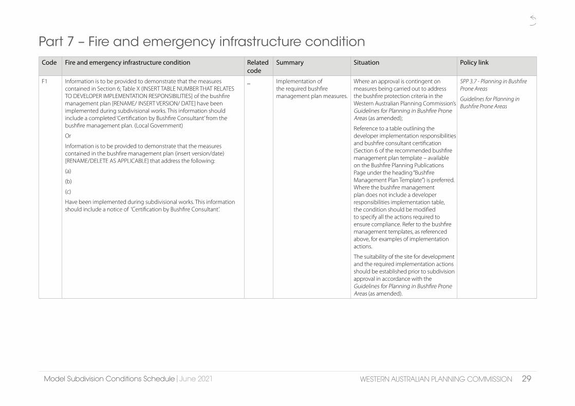
Model Subdivision Conditions ScheduleModel Subdivision Conditions Schedule || June 2021June 2021 29WESTERN AUSTRALIAN PLANNING COMMISSIONWESTERN AUSTRALIAN PLANNING COMMISSION
Part 7 – Fire and emergency infrastructure conditionCode Fire and emergency infrastructure condition Related
codeSummary Situation Policy link
F1 Information is to be provided to demonstrate that the measures contained in Section 6; Table X (INSERT TABLE NUMBER THAT RELATES TO DEVELOPER IMPLEMENTATION RESPONSIBILITIES] of the bushfire management plan [RENAME/ INSERT VERSION/ DATE] have been implemented during subdivisional works. This information should include a completed ‘Certification by Bushfire Consultant’ from the bushfire management plan. (Local Government)
Or
Information is to be provided to demonstrate that the measures contained in the bushfire management plan (insert version/date) [RENAME/DELETE AS APPLICABLE] that address the following:
(a)
(b)
(c)
Have been implemented during subdivisional works. This information should include a notice of ‘Certification by Bushfire Consultant’.
_ Implementation of the required bushfire management plan measures.
Where an approval is contingent on measures being carried out to address the bushfire protection criteria in the Western Australian Planning Commission’s Guidelines for Planning in Bushfire Prone Areas (as amended);
Reference to a table outlining the developer implementation responsibilities and bushfire consultant certification (Section 6 of the recommended bushfire management plan template – available on the Bushfire Planning Publications Page under the heading “Bushfire Management Plan Template”) is preferred. Where the bushfire management plan does not include a developer responsibilities implementation table, the condition should be modified to specify all the actions required to ensure compliance. Refer to the bushfire management templates, as referenced above, for examples of implementation actions.
The suitability of the site for development and the required implementation actions should be established prior to subdivision approval in accordance with the Guidelines for Planning in Bushfire Prone Areas (as amended).
SPP 3.7 - Planning in Bushfire Prone Areas
Guidelines for Planning in Bushfire Prone Areas

Model Subdivision Conditions ScheduleModel Subdivision Conditions Schedule || June 2021June 2021 30WESTERN AUSTRALIAN PLANNING COMMISSIONWESTERN AUSTRALIAN PLANNING COMMISSION
Code Fire and emergency infrastructure condition Related code
Summary Situation Policy link
F2 A notification, pursuant to Section 165 of the Planning and Development Act 2005, is to be placed on the certificate(s) of title of the proposed lot(s) with a Bushfire Attack Level (BAL) rating of 12.5 or above, advising of the existence of a hazard or other factor.
Notice of this notification is to be included on the diagram or plan of survey (deposited plan).
The notification is to state as follows:
“This land is within a bushfire prone area as designated by an Order made by the Fire and Emergency Services Commissioner and is/may be subject to a Bushfire Management Plan [RENAME/DELETE AS APPLICABLE]. Additional planning and building requirements may apply to development on this land” (Western Australian Planning Commission)
_ Notification 165 PDA - land within a bushfire prone area.
Where land is, or will through subdivisional development conditions, be within a bushfire prone area identified on the Map of Bush Fire Prone Areas and have a Bushfire Attack Level (BAL) rating of 12.5 or above.
SPP 3.7 Planning in Bushfire Prone Areas
Guidelines for Planning in Bushfire Prone Areas
PB 3 Notifications on Titles (Memorials)
F3 A plan is to be provided to identify areas of the proposed lot(s) that have been assessed as BAL-40 or BAL-Flame Zone.
A restrictive covenant to the benefit of the local government, pursuant to section 129BA of the Transfer of Land Act 1893, is to be placed on the certificate(s) of title of the proposed lot(s) advising of the existence of a restriction on the use of the land within areas that have been assessed as BAL-40 or BAL-Flame Zone.
Notice of this restriction is to be included on the diagram or plan of survey (deposited plan).
The restrictive covenant is to state as follows:
“No habitable buildings are to be built within areas identified as BAL-40 or BAL-Flame Zone”.(Local Government)
_ Restrictive covenant – 129BA Transfer of Land Act 1893.
To be imposed where the proposed lot(s) contain both:
• areas of land assessed to be BAL-29 or lower where development can be accommodated; and
• areas of land assessed to be BAL-40 or BAL-Flame Zone where the encroachment will significantly restrict the location of a future habitable building (including, but not limited to, where proposed lot(s) are less than 1,100m2).
This condition should only be used where no other transparent alternative mechanism is available. Not intended to be used in rural situations where there are multiple building location options available.
The nature of the bushfire hazard should also be taken into account (i.e. whether or not the bushfire prone vegetation is permanent or likely to be removed in the future).
SPP 3.7 Planning in Bushfire Prone Areas
Guidelines for Planning in Bushfire Prone Areas
PB 3 Notifications on Titles (Memorials)

Model Subdivision Conditions ScheduleModel Subdivision Conditions Schedule || June 2021June 2021 31WESTERN AUSTRALIAN PLANNING COMMISSIONWESTERN AUSTRALIAN PLANNING COMMISSION
Code Fire and emergency infrastructure condition Related code
Summary Situation Policy link
F4 Easement(s) in accordance with Section 195 of the Land Administration Act 1997 specifying access rights for emergency fire purposes in favour of the Local Government and/or public authority are to be placed on the certificate(s) of title of the proposed lot(s) and the deed(s) of easement to specify care and management of the easement area is by the Local Government. Notice of this easement(s) is to be included on the diagram or plan of survey (deposited plan). The easement(s) are to state as follows:
“x metre wide permanent emergency access way for vehicles is to be provided between … [INSERT LOCATION DETAILS AS APPLICABLE]” (Local Government)
Fa1 Bushfire access not for public access – easement under s.195 LAA.
Where access rights for the use by fire emergency services are necessary. Provided as an easement in gross, not for use by the public and is only to be used in fire emergencies.
Note – the constructed emergency access way must meet the minimum requirements of the Guidelines for Planning in Bushfire Prone Areas. The total easement width may need to be wider to accommodate drainage, engineering or infrastructure requirements.
Land Administration Act 1997 s.195
SPP 3.7 Planning in Bushfire Prone Areas
DC 5.1 Regional Roads
(Vehicular Access)
Guidelines for Planning in Bushfire Prone Areas
F5 A [INSERT VALUE] wide emergency access way in accordance with the approved plan of subdivision (attached) is to be provided. The provision of necessary access rights for the emergency access way:
a) as an easement under Sections 195 and 196 of the Land Administration Act 1997 in favour of the Local Government and/or public authority for emergency fire purposes and the deed of easement to specify care and management of the easement area is by the Local Government; OR
b) vested in the Crown under Section 152 of the Planning and Development Act 2005 and such land to be ceded free of cost and without any payment or compensation by the Crown. (Local Government)
Fa1, T26 Public bushfire access – easement under s.195 and 196 LAA or right of way under s.152 PDA.
Where public access rights for the provision of emergency access are necessary. Includes public easement in gross or right of way, for public access and fire emergency services during a fire emergency.
Note – the constructed emergency access way must meet the minimum requirements of the Guidelines for Planning in Bushfire Prone Areas. The total easement width may need to be wider to accommodate drainage, engineering or infrastructure requirements.
Land Administration Act 1997 s.195 & s.196
Planning and Development Act 2005 s.152
SPP 3.7 Planning in Bushfire Prone Areas
DC 5.1 Regional Roads
(Vehicular Access)
Guidelines for Planning in Bushfire Prone Areas

Model Subdivision Conditions ScheduleModel Subdivision Conditions Schedule || June 2021June 2021 32WESTERN AUSTRALIAN PLANNING COMMISSIONWESTERN AUSTRALIAN PLANNING COMMISSION
Code Fire and emergency infrastructure condition Related code
Summary Situation Policy link
F6 Easement(s) in accordance with Section 195 of the Land Administration Act 1997 specifying access rights for alternative bushfire access for lot(s) X [INSERT AS APPLICABLE], in favour of the Local Government and/or public authority are to be placed on the certificate(s) of title. The Local Government and landowner to agree on management arrangements of the easement area by deed. Notice of the easement(s) is to be included on the diagram or plan of survey (deposited plan). The easement(s) are to state as follows:
“x metre wide right-of-carriageway easement is to be provided between… [INSERT LOCATION DETAILS AS APPLICABLE]”. (Local Government)
Fa1, Fa2 ‘Right-of-carriageway’ bushfire access – easement under s.195 LAA.
Where access rights for the provision of fire emergency access are necessary for private use and fire services during an emergency.
Note – the constructed emergency access way must meet the minimum requirements of the Guidelines for Planning in Bushfire Prone Areas.
The total easement width may need to be wider to accommodate drainage, engineering or infrastructure requirements.
Land Administration Act 1997 s.195
SPP 3.7 Planning in Bushfire Prone Areas
DC 5.1 Regional Roads (Vehicular Access)
Guidelines for Planning in Bushfire Prone Areas
F7 The proposed reserve(s) shown on the approved plan of subdivision being shown on the diagram or plan of survey (deposited plan) as reserve(s) for “strategic water supply for fire fighting purposes” and vested in the Crown under Section 152 of the Planning and Development Act 2005, such land to be ceded free of cost and without any payment of compensation by the Crown. (Local Government)
Fa3, R2 Reserve for strategic water supply for fire fighting purposes.
Where a strategic water tank for fire fighting purposes is necessary.
Planning and Development Act 2005 s.152
SPP 3.7 Planning in Bushfire Prone Areas
Guidelines for Planning in Bushfire Prone Areas

Model Subdivision Conditions ScheduleModel Subdivision Conditions Schedule || June 2021June 2021 33WESTERN AUSTRALIAN PLANNING COMMISSIONWESTERN AUSTRALIAN PLANNING COMMISSION
Code Fire and emergency infrastructure condition Related code
Summary Situation Policy link
F8 Prior to the commencement of subdivision works:
a) An assessment survey for UXO is to be undertaken to determine if a remediation survey is required, as this property is on a site where records confirm a history of numerous UXO finds or heavy residual fragmentation. If no evidence of UXO is found, no further action is required.
b) If evidence of UXO is found, a remediation survey is to be completed to locate and remove any UXO.
c) If a remediation survey is completed, a Notification pursuant to Section 70A of the Transfer of Land Act 1893 is to be placed on the certificate(s) of title of the proposed vacant lot(s) advising of the existence of a hazard or other factor. Notice of this notification is to be included on the diagram or plan of survey (deposited plan). The notification to state as follows:
“This land has been used by Defence for military activities. There is a history of numerous UXO finds or heavy residual fragmentation. Whilst the land has been surveyed for UXO, there is still a possibility that dangerous items of UXO may be found on this site. Contact police if a suspicious item that may be UXO is found. Visit www.defence.gov.au/uxo for further information”. (Department of Fire and Emergency Services)
Fa4, Fa5, Fa6
Unexploded Ordnance (UXO).
‘Substantial’ occurrence of UXO. This includes impact areas, demolition sites and areas of heavy explosive ordnance dumping.
Planning and Development Act 2005 s.165
SPP 3.4 Natural Hazards and Disasters
OP 1.1 Subdivision of Land – General Principles
DC 4.2 Planning for Hazards and Safety
PB 3 Record of Information on Titles

Model Subdivision Conditions ScheduleModel Subdivision Conditions Schedule || June 2021June 2021 34WESTERN AUSTRALIAN PLANNING COMMISSIONWESTERN AUSTRALIAN PLANNING COMMISSION
Fire and emergency infrastructure advice
Code Fire and emergency infrastructure advice Related code
Summary Situation Policy link
Fa1 The easement is to provide for emergency access in the event of a bushfire emergency and should be constructed to the standards as outlined in the Guidelines for Planning in Bushfire Prone Areas.
F4, F5, F6 Easement – bushfire access. SPP 3.7 Planning in Bushfire Prone Areas
DC 5.1 Regional Roads (Vehicular Access)
Guidelines for Planning in Bushfire Prone Areas
Fa2 The management arrangements for the easement area are at the discretion of the local government.
F6 Management arrangements for ‘right-of-carriageway’ easement – bushfire access.
SPP 3.7 Planning in Bushfire Prone Areas
DC 5.1 Regional Roads (Vehicular Access)
Guidelines for Planning in Bushfire Prone Areas
Fa3 The required strategic water tank for fire fighting purposes and its associated infrastructure should be installed/constructed to the standards as outlined in the Guidelines for Planning in Bushfire Prone Areas.
F7 Reserve – strategic water supply for fire fighting purposes.
SPP 3.7 Planning in Bushfire Prone Areas
DC 5.1 Regional Roads (Vehicular Access)
Guidelines for Planning in Bushfire Prone Areas
Fa4 The Department of Defence has established the Defence Environment and Heritage Panel, which includes contractors for UXO and derelict explosive ordnance assessment and management. The list of UXO contractors on the panel can be found under Category F, F2, Unexploded Ordnance Remediation Works at this link: www.defence.gov.au/estatemanagement/support/DEHP/WhoToEngage.asp
F8 Unexploded Ordnance (UXO).
Where F9 is applied. Planning and Development Act 2005 s.165
SPP 3.4 Natural Hazards and Disasters
OP 1.1 Subdivision of Land – General Principles
DC 4.2 Planning for Hazards and Safety
DC 4.2 Planning for Hazards and Safety

Model Subdivision Conditions ScheduleModel Subdivision Conditions Schedule || June 2021June 2021 35WESTERN AUSTRALIAN PLANNING COMMISSIONWESTERN AUSTRALIAN PLANNING COMMISSION
Code Fire and emergency infrastructure advice Related code
Summary Situation Policy link
Fa5 This property is on a site where records confirm there is a history of military activities that have resulted in residual UXO. A possibility exists that dangerous items of UXO may still be found on this site. Contact police if a suspicious item that may be UXO is found. Visit www.defence.gov.au/uxo for further information.
ADVICE ONLY
Unexploded Ordnance (UXO).
‘Slight’ occurrence of UXO.
Where the UXO Category is ‘Slight’, the land has been used by Defence for military activities.
Planning and Development Act 2005 s.165
SPP 3.4 Natural Hazards and Disasters
OP 1.1 Subdivision of Land – General Principles
Fa6 This property is on a site where records confirm the area was used for military training but do not confirm that the site was used for live firing. No specific UXO contaminated site has been identified in the area and no UXO has been recovered from the site. However, a possibility still exists that UXO may be found on this site. Contact police if a suspicious item that may be UXO is found. Visit www.defence.gov.au/uxo for further information.
ADVICE ONLY
Unexploded Ordnance (UXO).
‘Other’ possible occurrence of UXO.
Where the UXO Category is ‘Other’, the land may have been used by Defence for military training.
Planning and Development Act 2005 s.165
SPP 3.4 Natural Hazards and Disasters
OP 1.1 Subdivision of Land – General Principles
DC 4.2 Planning for Hazards and Safety
PB 3 Record of Information on Titles

Model Subdivision Conditions ScheduleModel Subdivision Conditions Schedule || June 2021June 2021 36WESTERN AUSTRALIAN PLANNING COMMISSIONWESTERN AUSTRALIAN PLANNING COMMISSION
Part 8 – Heritage (indigenous, state, local, etc) conditionsCode Heritage conditions Related
codeSummary Situation Policy link
H1 The owner of the land must enter into a Heritage Agreement with the Heritage Council of Western Australia / Local Government [DELETE AS APPLICABLE] for the purposes of conserving and maintaining the cultural heritage significance of the land. (Heritage Council WA) (Local Government). [DELETE AS APPLICABLE
Ha2 Heritage agreement For State Registered sites, impose on advice of the Heritage Council in accordance with S.74 and S.75 of Heritage Act 2018.
Impose where subdivision of rural for the purposes of conservation of heritage places in accordance with DC 3.4 is sought.
Heritage Act 2018
DC 3.4 Subdivision of Rural Land
Heritage (indigenous, state, local, etc) advice
Code Heritage advice Related code
Summary Situation Policy link
Ha1 Prior to the commencement of subdivisional works, the landowner/applicant is advised to investigate whether or not approval is required pursuant to the Aboriginal Heritage Act 1972. The landowner/applicant should conduct a search of the Register of Aboriginal Sites to determine if any aboriginal sites have been recorded in the vicinity of their application, and this heritage information should be submitted to the Department of Planning Lands and Heritage (Indigenous Affairs) with a request for advice.
_ Advice – obligations under the Aboriginal Heritage Act 1972.
Where there is a likelihood of aboriginal heritage, to alter proponents to their requirements under the Aboriginal Heritage Act 1972.
Ha2 The preparation and execution of a Heritage Agreement is governed by the Heritage Act 2018. The Department of Planning, Lands and Heritage may assist the local government in preparing a Heritage Agreement. [DELETE AS APPLICABLE]
H1 Advice – heritage agreements
To accompany heritage agreement condition.

Model Subdivision Conditions ScheduleModel Subdivision Conditions Schedule || June 2021June 2021 37WESTERN AUSTRALIAN PLANNING COMMISSIONWESTERN AUSTRALIAN PLANNING COMMISSION
Part 9 – Lot design conditionsCode Residential design condition Related
codeSummary Situation Policy link
L1 The plan of subdivision is to be modified so that no lot is less than [INSERT VALUE] in area. (Local Government)
_ Minimum lot area. If dimension is marginal or non compliant.
SPP 7.3 Residential Design Codes
DC 2.2 Residential Subdivision
Liveable Neighbourhoods Element 3
L2 The plan of subdivision is to be modified so that no lot is greater than [INSERT VALUE] in area. (Local Government)
_ Maximum lot area – approved plan variation.
If dimension is marginal or non compliant.
SPP 7.3 Residential Design Codes
DC 2.2 Residential Subdivision
Liveable Neighbourhoods Element 3
L3 Local Development Plan(s) being prepared and approved for lots shown on the plan dated [INSERT VALUE] (attached) that address the following:
a)
b)
c)
(INSERT SPECIFIC REQUIREMENTS AS APPROPRIATE). (Local Government)
_ Local Development Plans If Local Development Plans are required by a Local Planning Scheme and/or Structure Plans. Should be used sparingly, and be justified.
Officers will be required to prepare a plan which identifies the lots which will require a Local Development Plan.
Condition must specify contents of Local Development Plans as appropriate, from the list of matters and criteria in Liveable
Neighbourhoods Element 3, Tables 9 and 10. Area(s) to which Local Development Plans apply must be indicated.
Liveable Neighbourhoods Element 3 Tables 9 and 10
Approved Structure Plans or Local Planning Schemes
Framework for Structure Plans and Local Development Plans (Planning and Development Regulations 2015)

Model Subdivision Conditions ScheduleModel Subdivision Conditions Schedule || June 2021June 2021 38WESTERN AUSTRALIAN PLANNING COMMISSIONWESTERN AUSTRALIAN PLANNING COMMISSION
Code Residential design condition Related code
Summary Situation Policy link
L4 The landowner/applicant shall make arrangements to ensure that prospective purchasers of lots subject of a Local Development Plan are advised in writing that Local Development Plan provisions apply. (Local Government)
_ Prospective purchasers advised of Local Development Plans.
On local government advice. Memorials on title are inappropriate in this circumstance.
L5 The plan of subdivision is to be modified in accordance with the attached plan (Attachment A) dated [INSERT VALUE]. (Western Australian Planning Commission)
_ Minor modification to approved subdivision plan

Model Subdivision Conditions ScheduleModel Subdivision Conditions Schedule || June 2021June 2021 39WESTERN AUSTRALIAN PLANNING COMMISSIONWESTERN AUSTRALIAN PLANNING COMMISSION
Part 10 – Reserves conditions Code Reserves condition Related
codeSummary Situation Policy link
R1 A foreshore reserve:
a) [INSERT VALUE] in width from the high water mark of the [INSERT VALUE],
OR [DELETE AS APPLICABLE]
b) in accordance with the plan dated [INSERT VALUE] (attached); as established by survey, being shown on the diagram or plan of survey (deposited plan) as a reserve for recreation/reserve for foreshore management/reserve for conservation/reserve for waterway management [DELETE / INSERT AS APPPLICABLE] and vested in the Crown under Section 152 of the Planning and Development Act 2005, such land to be ceded free of cost and without any payment of compensation by the Crown. (Western Australian Planning Commission)
Ra3 Reserve for recreation/reserve for foreshore management/reserve for conservation/reserve for waterway management –foreshore reserve; vest free of cost (Planning and Development Act s.152).
If foreshore is reserved for ‘Parks and Recreation’ in region scheme and relevant agency has agreed to accept management. Purpose of reserve dependent on advice from relevant referral authority and proposed management of reserve.
Planning and Development Act 2005 s.152
SPP 2.0 Environment and Natural Resources Policy
SPP 2.6 State Coastal Planning Policy, 5.1 – Coastal Foreshore Reserves
SPP 2.9 Water Resources, 5.1 – General Measures
SPP 2.10 Swan Canning River System – Creating and maintaining foreshore reserves
DC 2.3 Public Open Space in Residential Areas 3.2 – Foreshore Reserves
Liveable Neighbourhoods Element 4

Model Subdivision Conditions ScheduleModel Subdivision Conditions Schedule || June 2021June 2021 40WESTERN AUSTRALIAN PLANNING COMMISSIONWESTERN AUSTRALIAN PLANNING COMMISSION
Code Reserves condition Related code
Summary Situation Policy link
R2 The proposed reserve(s) shown on the approved plan of subdivision being shown on the diagram or plan of survey (deposited plan) as reserve(s) for [INSERT VALUE] and vested in the Crown under Section 152 of the Planning and Development Act 2005, such land to be ceded free of cost and without any payment of compensation by the Crown. (INSERT CLEARING AGENCY AS APPLICABLE)
Ra1 Reserves for named public purpose(s).
Reserves to be ceded to the crown. Reserve type should be specified and this will appear on the diagram or plan of survey (deposited plan). Land may be ceded for one or more purpose. Specific conditions apply for generic reserves for water/sewer/power infrastructure
Reserves shown on the approved plan being ceded. Clearing Agency to be specific to the vesting eg.
Local GovernmentPublic Open Space
Pedestrian accessway
Right of way
Drainage
Foreshore management
Recreation
Conservation or protection of the environment
Waterway management
Servicing Authorities (Western Power and Water Corporation)Sewerage
Drainage
Electricity supply
Department of Water and Environmental RegulationConservation or protection of the environment
Waterway management
Planning and Development Act 2005 s.152
SPP 3.6 Developer Contributions for Infrastructure
DC 2.3 – Public Open Space in Residential Areas Liveable Neighbourhoods Element 4
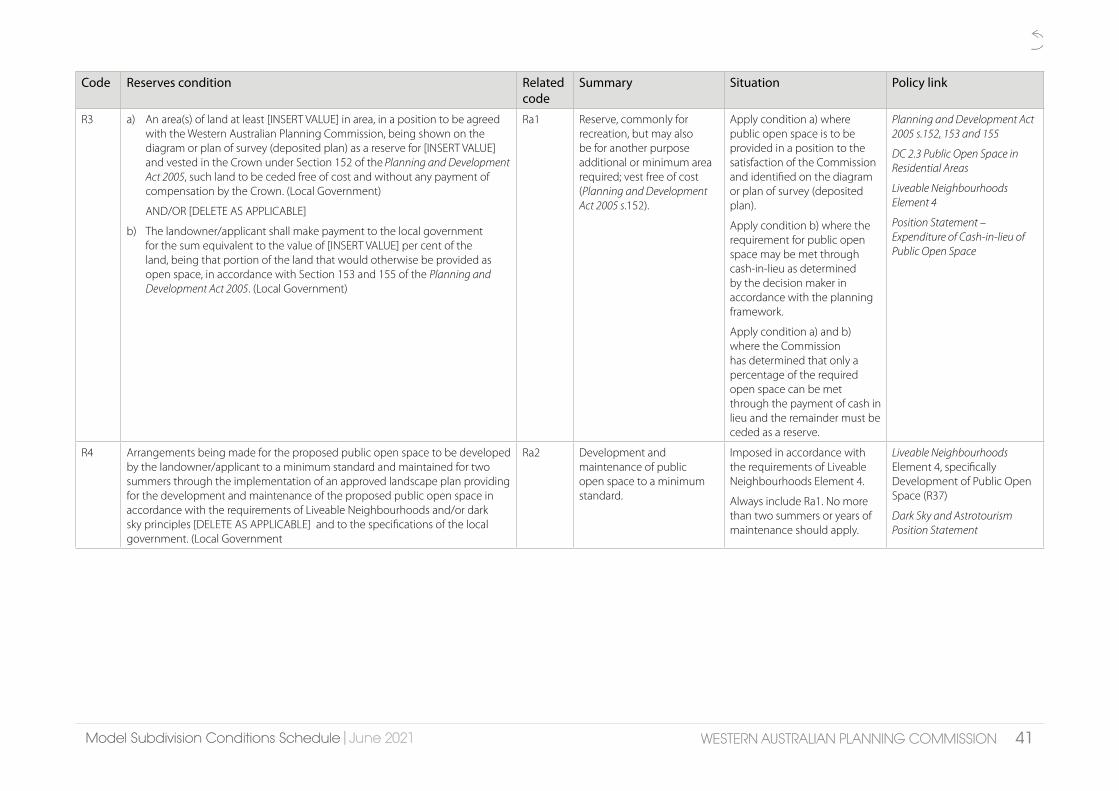
Model Subdivision Conditions ScheduleModel Subdivision Conditions Schedule || June 2021June 2021 41WESTERN AUSTRALIAN PLANNING COMMISSIONWESTERN AUSTRALIAN PLANNING COMMISSION
Code Reserves condition Related code
Summary Situation Policy link
R3 a) An area(s) of land at least [INSERT VALUE] in area, in a position to be agreed with the Western Australian Planning Commission, being shown on the diagram or plan of survey (deposited plan) as a reserve for [INSERT VALUE] and vested in the Crown under Section 152 of the Planning and Development Act 2005, such land to be ceded free of cost and without any payment of compensation by the Crown. (Local Government)
AND/OR [DELETE AS APPLICABLE]
b) The landowner/applicant shall make payment to the local government for the sum equivalent to the value of [INSERT VALUE] per cent of the land, being that portion of the land that would otherwise be provided as open space, in accordance with Section 153 and 155 of the Planning and Development Act 2005. (Local Government)
Ra1 Reserve, commonly for recreation, but may also be for another purpose additional or minimum area required; vest free of cost (Planning and Development Act 2005 s.152).
Apply condition a) where public open space is to be provided in a position to the satisfaction of the Commission and identified on the diagram or plan of survey (deposited plan).
Apply condition b) where the requirement for public open space may be met through cash-in-lieu as determined by the decision maker in accordance with the planning framework.
Apply condition a) and b) where the Commission has determined that only a percentage of the required open space can be met through the payment of cash in lieu and the remainder must be ceded as a reserve.
Planning and Development Act 2005 s.152, 153 and 155
DC 2.3 Public Open Space in Residential Areas
Liveable Neighbourhoods Element 4
Position Statement – Expenditure of Cash-in-lieu of Public Open Space
R4 Arrangements being made for the proposed public open space to be developed by the landowner/applicant to a minimum standard and maintained for two summers through the implementation of an approved landscape plan providing for the development and maintenance of the proposed public open space in accordance with the requirements of Liveable Neighbourhoods and/or dark sky principles [DELETE AS APPLICABLE] and to the specifications of the local government. (Local Government
Ra2 Development and maintenance of public open space to a minimum standard.
Imposed in accordance with the requirements of Liveable Neighbourhoods Element 4.
Always include Ra1. No more than two summers or years of maintenance should apply.
Liveable Neighbourhoods Element 4, specifically Development of Public Open Space (R37)
Dark Sky and Astrotourism Position Statement

Model Subdivision Conditions ScheduleModel Subdivision Conditions Schedule || June 2021June 2021 42WESTERN AUSTRALIAN PLANNING COMMISSIONWESTERN AUSTRALIAN PLANNING COMMISSION
Reserves advice
Code Reserves advice Related code
Summary Situation Policy link
Ra1 With regard to Condition [INSERT VALUE], provisions of section 153 of the Planning and Development Act 2005 provide that arrangements can be made, subject to further approval of the Western Australian Planning Commission, for a cash-in-lieu contribution by the landowner/applicant to the local government.
R2 R3 Reserve for recreation – cash-in-lieu contribution.
With R4 where cash in lieu may be considered.
Where condition R3(a) is applied, section 153(4) of the Planning and Development Act 2005 still allows for cash in lieu to be considered.
Ra2 With regard to Condition [INSERT VALUE], the development is to include full earthworks, reticulation, grassing of key areas, and pathways that form part of the overall pedestrian and/or cycle network.
Any lighting within the public open space shall comply with the dark sky principles and AS4282:2010 - control of the obtrusive effects of lighting. Smart lighting should also be installed to ensure that lighting infrastructure is capable of remote operation and/or timing.
R4 POS development advice. With R4 Liveable Neighbourhoods
Dark Sky and Astrotourism Position Statement
Ra3 In regard to Condition(s) [INSERT VALUE] the location of the foreshore reserve is to be confirmed prior to ground disturbing activities on abutting land. The foreshore reserve is to be protected from disturbance during subdivisional works.
Always with R1

Model Subdivision Conditions ScheduleModel Subdivision Conditions Schedule || June 2021June 2021 43WESTERN AUSTRALIAN PLANNING COMMISSIONWESTERN AUSTRALIAN PLANNING COMMISSION
Part 11 - School sites conditions Code School site condition Related
codeSummary Situation Policy link
S1 Arrangements being made for the transfer of land free of cost to the Department of Education for the provision of a primary school site(s) to serve the area, as identified within the approved plan of subdivision/[INSERT NAME/DELETE AS APPLICABLE] Structure Plan. (Department of Education)
_ Education – school site land free of cost.
On advice of the Department of Education. Generally where school site in single ownership and ceding free of cost is appropriate.
DC 2.4 School Sites
Liveable Neighbourhoods Element 8 – Schools
S2 The land denoted as proposed primary school site on the approved plan of subdivision is to be set aside as a separate lot, pending the acquisition of the land by the Department of Education. (Department of Education)
_ Education – school site land separate lot as per plan.
On advice of the Department of Education when ceding free of cost is not appropriate.
DC 2.4 School Sites
Liveable Neighbourhoods Element 8 – Schools (R15 and 16)
S3 The landowner/applicant making a pro-rata contribution towards the cost of the acquisition of the primary school site identified in the subdivision locality. (Department of Education)
_ Education – pro-rata contribution.
On advice of the Department of Education.
DC 2.4 School Sites
Liveable Neighbourhoods Element 8 – Schools (R15 and 16)

Model Subdivision Conditions ScheduleModel Subdivision Conditions Schedule || June 2021June 2021 44WESTERN AUSTRALIAN PLANNING COMMISSIONWESTERN AUSTRALIAN PLANNING COMMISSION
Part 12 – Transport, roads and access conditions Code Transport, roads and access condition Related
codeSummary Situation Policy link
T1 Engineering drawings and specifications are to be submitted, approved, and subdivisional works undertaken in accordance with the approved plan of subdivision, engineering drawings and specifications, to ensure that those lots not fronting an existing road are provided with frontage to a constructed road(s) connected by a constructed road(s) to the local road system and such road(s) are constructed and drained at the landowner/applicant’s cost.
As an alternative, and subject to the agreement of the Local Government the Western Australian Planning Commission (WAPC) is prepared to accept the landowner/applicant paying to the local government the cost of such road works as estimated by the local government and the local government providing formal assurance to the WAPC confirming that the works will be completed within a reasonable period as agreed by the WAPC. (Local Government)
Ta2, Ta3 Road – construction. All approvals where plan shows lots without existing road lot frontage, requiring road construction/extension.
Engineering drawings required by Planning and Development Act 2005 s.170
OP 1.1 Subdivision of Land – General Principles
DC 1.7 General Road Planning
Liveable Neighbourhoods Element 2
T2 Engineering drawings and specifications are to be submitted and approved, and subdivisional works undertaken for construction of roads in accordance with the approved plan of subdivision, engineering drawings and specifications to ensure that:
(a) street lighting in accordance with dark sky principles is installed on all new subdivisional roads to the standards of the relevant licensed service provider and/or
(b) roads that have been designed to connect with existing or proposed roads abutting the subject land are coordinated so the road reserve location and width connect seamlessly and/or
(c) temporary turning areas are provided to those subdivisional roads that are subject to future extension and/or
(d) embayment parking is provided within the/abutting the proposed. [INSERT VALUE]
[DELETE OPTIONS A) TO D) AS APPLICABLE]
(Local Government)
Ta3, Ta6 Road – coordination with abutting roads.
Where coordination with adjoining land is required, on local government advice.
Where new roads are proposed.
Where coordination with connecting roads is required.
Where roads are subject to future extension and temporary turning areas are required.
Where on street parking provision is required including parking embayments.
OP 1.1 Subdivision of Land- General Principles
DC 1.7 General Road Planning
DC 2.6 Residential Road Planning
Liveable Neighbourhoods Element 2
Dark Sky and Astrotourism Position Statement

Model Subdivision Conditions ScheduleModel Subdivision Conditions Schedule || June 2021June 2021 45WESTERN AUSTRALIAN PLANNING COMMISSIONWESTERN AUSTRALIAN PLANNING COMMISSION
Code Transport, roads and access condition Related code
Summary Situation Policy link
T3 Engineering drawings and specifications are to be submitted, approved, and subdivisional works undertaken in accordance with the approved plan of subdivision, engineering drawings and specifications, for the provision of shared paths through and connecting to the application area:
EITHER
to the satisfaction of the Western Australian Planning Commission;
OR
in accordance with the plan dated (attached);
OR
in accordance with the approved [INSERT NAME] structure plan.
[DELETE AS APPLICABLE]
The approved shared paths are to be constructed by the landowner/applicant. (Local Government)
Ta3 Shared path – detailed plan required.
For all suburban residential subdivision shared path design is not depicted on the plan of subdivision.
DC 1.5 Bicycle planning
DC 2.6 Residential road planning
Liveable Neighbourhoods Element 2
T4 Engineering drawings and specifications are to be submitted and approved, and satisfactory arrangements being made for subdivisional works to be undertaken in accordance with the approved plan of subdivision and engineering drawings and specifications, for the construction of full earthworks, one carriageway, shared path(s), drainage facilities and grade separated pedestrian crossing(s) required for the portion of [INSERT VALUE] within/abutting [DELETE AS APPLICABLE] the application area. (Local Government)
Ta3 Road – distributor and arterial road construction arrangements. (Local Government)
Consistent with Western Australian Planning Commission policy or developer contribution Local planning Scheme provisions.
SPP 3.6 Development Contributions for Infrastructure
OP 1.1 Subdivision of Land – General Principles
DC1.7 General Road Planning
T5 Satisfactory arrangements being made with the local government for the full/partial [INSERT VALUE HERE] cost of upgrading and/or construction of [INSERT VALUE ROAD(S)] in the locations as shown on the plan dated [INSERT] (attached) to a standard of [INSERT VALUE]. (Local Government)
_ Road upgrading and construction.
Where an existing road is required to be upgraded and/or constructed as a result of the proposal. Outline the specific upgrading requirements for example by reference to the road type in the Liveable Neighbourhoods policy road hierarchy.
SPP 3.6 Development Contributions for Infrastructure
OP 1.1 Subdivision of Land – General Principles
DC 1.7 General Road Planning
Liveable Neighbourhoods Element 2
T6 The [INSERT VALUE] reserve being set out on a separate diagram or plan of survey (deposited plan) and transferred free of cost to the Commissioner for Main Roads WA for road purposes and without any payment of compensation. (Main Roads WA)
_ Road – widening and transfer.
MRWA Widening needed, but not shown on plan and subdivision justifies ceding free of cost in accordance with WAPC policy.

Model Subdivision Conditions ScheduleModel Subdivision Conditions Schedule || June 2021June 2021 46WESTERN AUSTRALIAN PLANNING COMMISSIONWESTERN AUSTRALIAN PLANNING COMMISSION
Code Transport, roads and access condition Related code
Summary Situation Policy link
T7 The land required for the widening of [INSERT] as shown on the plan dated [INSERT] (attached) for [INSERT] is to be set aside as a separate lot for acquisition pending future road widening requirements. An easement is to be provided over all of the lot(s) to be set aside for the benefit of the remaining lot(s) for the purpose of providing [vehicular access] [DELETE IF ALTERNATIVE ACCESS POSSIBLE], right of footway, water, sewer, drainage, gas, electricity, television, telecommunications and other necessary service infrastructure, pending construction of the future road widening. (Western Australian Planning Commission)
Ta1 Road widening – land to be a separate lot with easement.
Generally applied where land is reserved in a Region Scheme or Local Planning Scheme and where there is a high degree of certainty of acquisition in the short to medium term.
OP 1.1 Subdivision of Land – General Principles
DC 1.7 General Road Planning
Liveable Neighbourhoods Element 2
SPP 3.6 Development Contributions for Infrastructure
T8 An agreement for the acquisition of the land within the subdivision required for the road widening shown on the approved plan (attached) between the landowner and the [local government/ Main Roads WA] [DELETE AS APPROPRIATE] is to be executed. The land required for road widening is to be shown as ‘Road Widening’ on the agreement for the acquisition and the diagram or plan of survey (deposited plan). (Local Government) (Main Roads WA) [DELETE AS APPLICABLE]
_ Road – widening and agreement for acquisition.
Note – where required, local government can be replaced with Main Roads should an agreement to acquire be requested by Main Roads.
OP 1.1 Subdivision of Land – General Principles
DC 1.7 General Road Planning
Liveable Neighbourhoods Element 2
T9 [INSERT VALUE] being widened in accordance with the approved plan of subdivision/plan dated [INSERT VALUE/DELETE AS APPLICABLE] (attached) by the landowner transferring the land required to the Crown free of cost for the purpose of widening [INSERT VALUE].
_ Existing or proposed road(s) – widening and transfer as per attached plan.
Existing or proposed road(s) - widening required in accordance with plan of subdivision or plan attached to approval. Need and extent to be consistent with WAPC policy.
OP 1.1 Subdivision of Land – General Principles
DC 1.7 General Road Planning
Liveable Neighbourhoods Element 2
T10 The section of [INSERT VALUE] widened in accordance with this approval, is to be constructed and drained at the full cost of the landowner/applicant. (Local Government)
_ Existing or proposed road(s) – construction of widening.
With R4 if required. Construction requirement to be consistent with WAPC policy.
OP 1.1 Subdivision of Land – General Principles
DC 1.7 General Road Planning
Liveable Neighbourhoods Element 2
T11 All local streets within the subdivision being truncated in accordance with the Western Australian Planning Commission’s Liveable Neighbourhoods policy/DC 1.7 General Road Planning/ DC 4.1 Industrial Subdivision [DELETE AS APPLICABLE]. (Local Government)
_ Road – corner truncation. Where street corners require truncation.
DC 1.7 General Road Planning
DC 4.1 Industrial Subdivision
Liveable Neighbourhoods Elements 2 and 3

Model Subdivision Conditions ScheduleModel Subdivision Conditions Schedule || June 2021June 2021 47WESTERN AUSTRALIAN PLANNING COMMISSIONWESTERN AUSTRALIAN PLANNING COMMISSION
Code Transport, roads and access condition Related code
Summary Situation Policy link
T12 [INSERT VALUE] metre truncation is to be provided at the junction of the access way and the proposed [INSERT VALUE] rear lot. (Local Government)
_ Access way to rear lot – rear lot truncation.
All battle-axe type configuration applications where dimension is marginal or non-compliant. Should only be necessary if NOT shown on the subdivision plan.
DC 2.2 Residential Subdivision
Liveable Neighbourhoods Element 3
T13 A [INSERT VALUE] metre truncation is to be provided at the junction of the access way and the [INSERT VALUE] road reserve. (Local Government)
_ Access way to rear lot – road truncation.
All battle-axe type configuration applications where dimension is marginal or non-compliant.
Should only be necessary if NOT shown on the subdivision plan, upon the advice of Local Government and/or there are visibility issues.
DC 2.2 Residential Subdivision
Liveable Neighbourhoods Element 3
T14 A right-of-way adjoining the site along the [INSERT VALUE] boundary is to be widened by [INSERT VALUE] metres and the widening accurately shown on the diagram or plan of survey (deposited plan) and/or survey strata plan [DELETE AS APPLICABLE] and vested in the Crown under Section 152 of the Planning and Development Act 2005, such land to be ceded free of cost and without any payment of compensation by the Crown. (Local Government)
_ Right-of-way – ceding as per approved plan.
If ROW not shown on plan, but necessary.
Planning and Development Act 2005 s.152
DC 1.7 General Road Planning
T15 The portion of the right-of-way abutting the [INSERT VALUE] boundary of the site and any land required for its widening being constructed and drained to its full width at the landowner/applicants cost and the remaining portion of the right-of-way from the [INSERT VALUE] boundary of the site to the nearest constructed road being made trafficable. (Local Government)
_ Right-of-way – construction (adjoins land) plus trafficable access to nearest constructed road.
If ‘infill’ plan abuts ROW and upgrade to nearest trafficable street is required.
DC 1.7 General Road Planning
T16 The proposed access way(s) being constructed and drained at the landowner/applicant cost to the specifications of the local government. (Local Government)
T22 if adjoining battle-axe legs.
Battle-axe or common property – access way(s) being paved, drained and sealed.
DC 2.2 Residential Subdivision
Liveable Neighbourhoods Element 3
T17 The access way forming part of the rear lot/common property access leg [DELETE AS APPLICABLE] shall have a minimum width of [INSERT VALUE] metres, free of any building projections associated with existing site development and depicted on the diagram or plan of survey (deposited plan) and/or survey strata plan [DELETE AS APPLICABLE] accordingly. (Local Government))
_ Access way to rear lot – minimum width.
All battle-axe type configuration applications where dimension is marginal or non-compliant, or includes encroachments that are required to be removed.
OP 1.1 Subdivision of Land – General Principles
DC 2.2 Residential Subdivision
Liveable Neighbourhoods Element 3

Model Subdivision Conditions ScheduleModel Subdivision Conditions Schedule || June 2021June 2021 48WESTERN AUSTRALIAN PLANNING COMMISSIONWESTERN AUSTRALIAN PLANNING COMMISSION
Code Transport, roads and access condition Related code
Summary Situation Policy link
T18 The whole of the access way to the rear lot(s), including truncations and vehicle manoeuvring areas, being shown on the survey strata plan as common property. (Local Government)
_ Battle-axe – access way being common property.
SPP 7.3 Residential Design Codes
DC 1.3 Strata Subdivision
DC 2.2 Residential Subdivision
Liveable Neighbourhoods Element 3
T19 All pedestrian access way(s) within the subdivision being constructed and drained at the landowner/applicantcost and shown on the diagram or plan of survey (deposited plan) as such and vested in the Crown under Section 152 of the Planning and Development Act 2005, such land to be ceded free of cost and without any payment of compensation by the Crown. (Local Government)
_ Pedestrian-access way – ceding and construction as per approved plan.
If PAW shown on plan. Planning and Development Act 2005 s.152
T20 Suitable arrangements being made with the local government for the provision and/or upgrading [DELETE AS APPLICABLE] of vehicular crossover(s) to service the lot(s) shown on the approved plan of subdivision. (Local Government)
_ Road – crossover construction.
Desirable if identifying the location of crossovers is integral to the design, or if there are significant site constraints.
May not be applied in rural situations or where it is desirable to retain flexibility in siting of crossover(s).
Generally on the advice of the Local Government.
OP 1.1 Subdivision of Land General Principles
T21 Pursuant to Section 150 of the Planning and Development Act 2005 and Division 3 of the Planning and Development Regulations 2009 a covenant preventing vehicular access onto [INSERT VALUE] being lodged on the certificate(s) of title of the proposed lot(s) at the full expense of the landowner/applicant. The covenant is to prevent access, to the benefit of [INSERT VALUE], in accordance with the plan dated [INSERT VALUE] (attached) and the covenant is to specify:
“No vehicular access is permitted to and from (as applicable) [INSERT VALUE].” (Local Government or Main Roads WA)
_ Road access – restriction. Where access to a road is to be restricted or prohibited, based on advice of relevant road authority and in accordance with s.150 of the Planning and Development Act 2005 and Division 3 of the Planning and Development Regulations 2009. This includes annotating the plan to identify the portion or portions of the boundary between the land and road across which access to or from the land is prohibited.
OP 1.1 Subdivision of Land General Principles
DC 2.2 Residential Subdivision
DC 5.1 Regional Roads (Vehicular Access)

Model Subdivision Conditions ScheduleModel Subdivision Conditions Schedule || June 2021June 2021 49WESTERN AUSTRALIAN PLANNING COMMISSIONWESTERN AUSTRALIAN PLANNING COMMISSION
Code Transport, roads and access condition Related code
Summary Situation Policy link
T22 An easement in accordance with Section 136C of the Transfer of Land Act 1893 is to be created to ensure reciprocal rights of access over adjoining battle-axe legs. (Local Government).
T16 Battle-axe – reciprocal rights of access over adjoining battle-axe access ways.
DC 2.2 Residential Subdivision
Liveable Neighbourhoods Element 3
T23 Redundant vehicle crossover(s) to be removed and the kerbing, verge, and footpath (where relevant) reinstated with grass or landscaping to the specifications of the local government. (Local Government)
_ Vehicle crossover and reinstatement.
SPP 7.3 Residential Design Codes
Liveable Neighbourhoods Element 3
T24 A notification, pursuant to Section 165 of the Planning and Development Act 2005 is to be placed on the certificate(s) of title of the proposed lot(s). Notice of this notification is to be included on the diagram or plan of survey (deposited plan). The notification is to state as follows:
This lot is situated in the vicinity of a transport corridor and is currently affected, or may in the future be affected by transport noise. Additional planning and building requirements may apply to development on this land to achieve an acceptable level of noise reduction. (Western Australian Planning Commission)
_ Notification – Transport noise
In accordance with the implementation guidelines for State Planning Policy 5.4 Road and Rail Noise. Specifically, for those lots where noise reduction levels cannot achieve the target noise levels for noise sensitive developments and/or additional requirements may apply to development under SPP 5.4 Road and Rail Noise.
SPP 5.4 Road and Rail Noise

Model Subdivision Conditions ScheduleModel Subdivision Conditions Schedule || June 2021June 2021 50WESTERN AUSTRALIAN PLANNING COMMISSIONWESTERN AUSTRALIAN PLANNING COMMISSION
Code Transport, roads and access condition Related code
Summary Situation Policy link
T25 The proposed rear lot(s) being provided with a 1.5/1 [DELETE AS APPLICABLE] metre wide pedestrian access leg(s) clear of any encroachments or projections associated with the existing dwelling/s including pipework, water heater systems, air-conditioning units, eaves or other such projections associated with the existing dwelling(s). (Local Government)
Ta4 Pedestrian access leg. Where the lots propose access via a right of way.
To provide for visitor parking in the primary street, servicing, postal address and rubbish collection.
To ensure pedestrian access leg is provided, with 1m width clear of any encroachments/projections.
Projections which do not impact on the minimum 1m width may be suitable, if they provide sufficient height clearance, and if protected with appropriate easements (e.g. for survey-strata, those provided for in r 34 Strata Title (General) Regulations 2019).
The 1.5 metre wide pedestrian access leg may be reduced to 1m, if there is an existing house to be retained.
PB 33 Rights of Way or Laneways in Established Areas – Guidelines
T26 Easement(s) in accordance with Sections 195 and 196 of the Land Administration Act 1997 for the benefit of [INSERT VALUE] are to be placed on the certificate(s) of title of the proposed lot(s) specifying access rights. Notice of this easement(s) is to be included on the diagram or plan of survey (deposited plan). The easement(s) are to state as follows:“...[INSERT VALUE]...” (Local Government or Main Roads WA)
_ Easement – generic (195 and 196 LAA) easement in gross.
Where access rights for a local government or public body are necessary. Includes easement in gross, for public access. To allow for coordinated pedestrian access and parking arrangements.
DC 5.1 Regional Roads (Vehicular Access)

Model Subdivision Conditions ScheduleModel Subdivision Conditions Schedule || June 2021June 2021 51WESTERN AUSTRALIAN PLANNING COMMISSIONWESTERN AUSTRALIAN PLANNING COMMISSION
Code Transport, roads and access condition Related code
Summary Situation Policy link
T27 Suitable arrangements being made with Main Roads WA/Local Government [DELETE AS APPLICABLE] and the Public Transport Authority to ensure that railway crossings and crossovers providing access to the lots are suitable for their intended use. (Main Roads WA/Local Government and Public Transport Authority) [DELETE AS APPLICABLE]
_ Railway crossings and crossovers
Only to be used where the subdivision generates additional traffic use or changes to an existing crossover warrants the condition, and/or a new agreement between a new lot and the use of an existing crossover is required.
OP 1.1 Subdivision of Land - General Principles
T28 A notification, pursuant to section 70A of the Transfer of Land Act 1893, is to be placed on the certificate(s) of title of the proposed lot(s). Notice of this notification is to be included on the diagram or plan of survey (deposited plan). The notification is to state as follows:
“This lot gains vehicular access onto [INSERT] via a level crossing over the adjoining railway reserve. Landowners are responsible for the care and maintenance of the crossing, and may need to make access arrangements with the Public Transport Authority.” (Western Australian Planning Commission)
_ Notification – level crossing OP 1.1 Subdivision of Land - General Principles
T29 An easement, in accordance with Section 136C of the Transfer of Land Act 1893, is to be placed on the certificate of title of proposed Lot(s) [INSERT VALUE] specifying [INSERT VALUE e.g. vehicular access rights] for the benefit of Lot(s) [INSERT VALUE] over a portion of Lot(s) [INSERT VALUE] (as shown on the attached plan). Notice of the easement is to be included on the diagram or plan of survey (deposited plan). (Local Government) OR (Western Australian Planning Commission) [DELETE AS APPLICABLE]
_ Easement S. 136c of the Transfer of Land Act
T30 A [INSERT VALUE] metre truncation is to be provided at the junction of [INSERT STREET NAME] and [INSERT STREET NAME]. (Local Government) OR (Western Australian Planning Commission) [DELETE AS APPLICABLE]
_ Road truncation DC 1.7 General Road Planning

Model Subdivision Conditions ScheduleModel Subdivision Conditions Schedule || June 2021June 2021 52WESTERN AUSTRALIAN PLANNING COMMISSIONWESTERN AUSTRALIAN PLANNING COMMISSION
Transport, roads and access advice
Code Transport, roads and access advice Related code
Summary Situation Policy link
Ta1 In regard to Condition [INSERT VALUE], the landowner/applicant is advised to contact the Department of Planning, Lands and Heritage /Main Roads WA/ Local Government [DELETE AS APPLICABLE] for information on purchase option(s).
T7 Road – widening lot purchase advice; advice.
Always use with T7.
Ta2 The landowner/applicant and the local government are advised to refer to the Institute of Public Works Engineering Australia Local Government Guidelines for Subdivisional Development (current edition). The guidelines set out the minimum best practice requirements recommended for subdivision construction and granting clearance of engineering conditions imposed.
T1, D2, D3, D4
Subdivisional works to be undertaken generally in accordance with the IPWEA guidelines.
All applications that include site preparation including earthworks, roads, drainage, street lighting, pathway, and/or public open space conditions.
Planning and Development Act 2005
Ta3 In regard to Condition [INSERT VALUE], the landowner/applicant is advised that the road reserves, including the constructed carriageways, laneways, truncations, footpaths/dual use paths and car embayments, are to be generally consistent with the approved plan of subdivision.
T1, T2, T3, T4
Road Reserves consistent with approved plan of subdivision
Freehold subdivision, to ensure that engineering drawings are consistent with approved plan of subdivision.
DC 2.2 Residential Subdivision
DC 2.6 Residential Road Planning
Liveable Neighbourhoods
Ta4 In regard to Condition [INSERT VALUE], the landowner/applicant is advised that to provide a minimum [INSERT VALUE] metre(s) clear of any encroachments or projections, any such encroachments or projections will need to be either removed, relocated or appropriately protected with easements, as required.
T17, T25 Pedestrian access leg advice. Always with T25. PB 33 Rights of Way or Laneways in Established Areas – Guidelines
Ta5 Main Roads Western Australia advises the landowner/application with regard to the [INSERT ROAD RESERVE NAME]
i) no earthworks are to encroach onto the road reserve;
ii) no stormwater drainage is to be discharged onto the road reserve; and
iii) the landowner/applicant shall make good any damage to the existing verge vegetation within the road reserve.
_ MRWA advice. Upon the advice of Main Roads Western Australia.
Ta6 In regard to Condition [INSERT VALUE], the landowner/applicant is advised that to achieve the dark sky principles, new street lighting is to comply with a correlated colour temperature of 3,000 kelvins or less, shielded luminaires and in accordance with AS4282:2010 – control of the obtrusive effects of lighting.
T2 Street lighting advice Apply with condition T2 when required.
Dark Sky and Astrotourism Position Statement

Model Subdivision Conditions ScheduleModel Subdivision Conditions Schedule || June 2021June 2021 53WESTERN AUSTRALIAN PLANNING COMMISSIONWESTERN AUSTRALIAN PLANNING COMMISSION
Part 13 – Water and sewer conditions Code Water and sewer condition Related
codeSummary Situation Policy link
W1 For all lots apply a):
a) Arrangements being made with a licensed water provider for the provision of a suitable water supply service to each lot shown on the approved plan of subdivision. (Water Corporation/Aqwest/Busselton Water) [DELETE/INSERT LICENSED SERVICE PROVIDER AS APPLICABLE]
For applications for survey strata or vacant strata schemes also include b):
b) Additionally, arrangements are to include the provisions of a suitable water supply service to each lot in the scheme (plan) (Western Australian Planning Commission)
(DELETE AS APPLICABLE)
Wa1
Wa3 where applicable If exemption use W4
Water Supply. Considered an essential service.
Majority of freehold, survey-strata and vacant lot strata approvals require the imposition of this condition.
The Water Corporation’s No. 63 Water Reticulation Standard is deemed to be the baseline criterion for fire hydrant installation and should be applied unless the local water supply authority has a similar standard.
Guidance for water servicing in Rural and Rural Living purposes are provided in SPP 2.5 and DC 3.4.
Water service suppliers in WA are required to be licensed by the Economic Regulation Authority (Water Services Licensing Act 1995).
The developer is responsible for ensuring that all lots on the strata plan are provided with water supply services at all times. These services are to be provided in accordance with the Plumbers Licensing and Plumbing Standards Regulations 2000 (as amended)
May not be required for boundary realignments.
SPP 2.5 Rural Planning
OP 1.1 Subdivision of Land – General Principles
DC 3.4 Subdivision of Rural Land
Liveable Neighbourhoods Element 6

Model Subdivision Conditions ScheduleModel Subdivision Conditions Schedule || June 2021June 2021 54WESTERN AUSTRALIAN PLANNING COMMISSIONWESTERN AUSTRALIAN PLANNING COMMISSION
Code Water and sewer condition Related code
Summary Situation Policy link
W2 For all lots apply a):
a) Arrangements being made with the Water Corporation [DELETE/ INSERT SERVICE PROVIDER AS APPLICABLE] for the provision of a sewerage service to each lot shown on the approved plan of subdivision. (Water Corporation/ Local Government) [DELETE/INSERT LICENSED SERVICE PROVIDER AS APPLICABLE
For applications for survey strata or vacant strata schemes also include b):
b) Additionally, arrangements are to include the provision of a suitable sanitary drainage service to each lot on the strata scheme (plan) by a Licensed Plumbing Contractor. (Western Australian Planning Commission)
Wa1
Wa3 where applicable
If exemption use W5
Sewerage service. Considered an essential service.
Majority of freehold, survey-strata and vacant lot strata approvals require the imposition of this condition.
Possible exemptions are outlined in the Government Sewerage Policy (as amended), the Draft Country Sewerage Policy 2003, SPP 2.1, DC 2.2, SPP 2.5, DC 4.1.
Need to confirm that reticulated sewerage service can be provided with the licensed service provider.
The developer is responsible for ensuring that all lots on the strata plan are provided with sanitary drainage services at all times. These services are to be provided in accordance with the Plumbers Licensing and Plumbing Standards Regulations 2000 (as amended).
SPP 2.1 The Peel Harvey Coastal Plain Catchment
DC 2.2 Residential Subdivision
SPP2.5 Rural Planning
DC 4.1 Industrial Subdivision
Government Sewerage Policy
Liveable Neighbourhoods Element 6
W3 The provision of easements for existing or planned future water, sewerage and/or drainage infrastructure as may be required by [ INSERT SERVICE PROVIDER] being granted free of cost to that body.
[INSERT SERVICE PROVIDER]
_ Water/sewer/drainage easements.
Easements may be required for essential infrastructure.
Freehold, survey-strata and vacant lot strata approvals may require the imposition of this condition; unless
easements requirements are known and shown on approved plan.
Planned future water, sewerage and drainage infrastructure, is one that can be provided by the licensed service provider.
Planning and Development Act 2005 s.167
OP 1.1 Subdivision of Land General Principles

Model Subdivision Conditions ScheduleModel Subdivision Conditions Schedule || June 2021June 2021 55WESTERN AUSTRALIAN PLANNING COMMISSIONWESTERN AUSTRALIAN PLANNING COMMISSION
Code Water and sewer condition Related code
Summary Situation Policy link
W4 A notification, pursuant to Section 70A of the Transfer of Land Act 1893 is to be placed on the certificate(s) of title of the proposed lot(s). Notice of this notification is to be included on the diagram or plan of survey (deposited plan). The notification is to state as follows:
“This lot is not connected to a reticulated potable water supply. An alternative water supply may be required for development on this lot.” (Local Government)
_ Notification of no mains potable water supply.
Generally only for urban or rural living lots and always where the relevant licensed water service advises that a mains water supply is not available.
Local Government to clear if it recommends the condition. Otherwise WAPC is the clearance agency.
PB 3 Notifications on Titles (Memorials)
W5 A notification, pursuant to Section 70A of the Transfer of Land Act 1893 is to be placed on the certificate(s) of title of the proposed lot(s). Notice of this notification is to be included on the diagram or plan of survey (deposited plan). The notification is to state as follows:
“A reticulated sewerage service is not available to the lot(s).” (Local Government)
Wa2 Notification – reticulated sewerage connection is not available.
Always if reticulated sewerage connection is not available and a secondary treatment system is not specifically required.
Government Sewerage policy
PB 3 Notifications on Titles (Memorials)
W6 All septic sewer systems including all tanks and pipes and associated drainage systems (soak wells or leach drains) and any stormwater disposal systems are to be decommissioned, in accordance with the Health (Treatment of Sewerage and Disposal of Effluent and Liquid Waste) Regulations 1974, removed, filled with clean sand and compacted. Proof of decommissioning is to be provided in the form of either certification from a licensed plumber or a statutory declaration from the landowner/applicant, confirming that the site has been inspected and all septic tanks, soak wells, leach drains and any associated pipework have been removed. (Local Government)
_ Sewer, decommissioning on-site effluent disposal system.
If septic sewer system(s) exist on the land they are to be removed and the site made-good.
OP 1.1 Subdivision of Land – General Principles
W7 The transfer of land for the purposes of the provision of water and sewerage infrastructure to be shown on the diagram or plan of survey (deposited plan) as a reserve and vested in the Crown under Section 152 of the Planning and Development Act 2005, such land to be ceded free of cost and without any payment of compensation by the Crown. [INSERT SERVICE PROVIDER]
R2 Transfer of crown reserve for water and/or sewer infrastructure.
If land to be transferred shown on subdivision plan- use R3.

Model Subdivision Conditions ScheduleModel Subdivision Conditions Schedule || June 2021June 2021 56WESTERN AUSTRALIAN PLANNING COMMISSIONWESTERN AUSTRALIAN PLANNING COMMISSION
Code Water and sewer condition Related code
Summary Situation Policy link
W8 A notification, pursuant to Section 70A of the Transfer of Land Act 1893 is to be placed on the certificate(s) of title of the proposed lot(s). Notice of this notification is to be included on the diagram or plan of survey (deposited plan). The notification is to state as follows:
“A reticulated sewerage service is not available to the lot(s). As such, an on-site secondary treatment and disposal system for sewage will be required. Therefore, the developable area of the lot is reduced. There are ongoing landowner obligations to ensure that the treatment and disposal system is regularly maintained in accordance with relevant health regulations. Contact the local government for further information.” (Local Government)
_ Notification – reticulated sewerage connection is not available and a secondary treatment system is required.
Notification that the developable area of the lot is reduced.
Notification that these types of systems have ongoing maintenance requirements.
Always if reticulated sewerage connection is not available and a secondary treatment system is required to be used and the WAPC has determined that these systems will affect the use and enjoyment of the land.
An on-site sewage disposal system with secondary treatment has ongoing maintenance and monitoring requirements for landowners, secondary treatment system providers and local government. For further information refer to S 6.2 of the Government Sewerage Policy.
Local governments should consider their administrative capacity to monitor these systems for both human health and environmental protection.
The land application area (i.e. disposal irrigation area) of these systems may take up a substantial portion of the lot, which restricts the use and enjoyment of the land. For example, the erection of temporary and permanent structures such as swings, sheds, outdoor entertaining areas or swimming pools are prohibited within the land application area.
NOTE:
On-site secondary treatment and disposal systems are generally known as Alternative or Aerobic Treatment Units - ATUs.
For further information refer to the Government Sewerage Policy.

Model Subdivision Conditions ScheduleModel Subdivision Conditions Schedule || June 2021June 2021 57WESTERN AUSTRALIAN PLANNING COMMISSIONWESTERN AUSTRALIAN PLANNING COMMISSION
Code Water and sewer condition Related code
Summary Situation Policy link
W9 A notification, pursuant to Section 70A of the Transfer of Land Act 1893 is to be placed on the certificate(s) of title of the proposed lot(s). Notice of this notification is to be included on the diagram or plan of survey (deposited plan). The notification is to state as follows:
“A reticulated sewerage service is not available to the lot(s). As such, an on-site secondary treatment and disposal system for sewage (which includes nutrient removal) will be required. Therefore, the developable area of the lot is reduced. There are ongoing landowner obligations to ensure that the treatment and disposal system is regularly maintained in accordance with relevant health regulations. Contact the local government for further information.” (Local Government)
_ Notification – reticulated sewerage connection is not available and a secondary treatment system with nutrient removal is required.
Notification that the developable area of the lot is reduced.
Notification of ongoing maintenance requirements.
Always if reticulated sewerage connection is not available and a secondary treatment system with nutrient removal is required to be used and the WAPC determines that these systems will affect the use and enjoyment of the land.
An on-site sewage disposal system with secondary treatment has ongoing maintenance and monitoring requirements for landowners, secondary treatment system providers and local government. For further information refer to S 6.2 of the Government Sewerage Policy
Local governments should consider their administrative capacity to monitor these systems for both human health and environmental protection.
The land application area (i.e. disposal irrigation area) of these systems may take up a substantial portion of the lot, which may restrict the use and enjoyment of the land. For example, the erection of temporary and permanent structures such as swings, sheds, outdoor entertaining areas or swimming pools are prohibited within the land application area.
NOTE:On-site secondary treatment and disposal systems are generally known as Aerobic Treatment Units - ATUs.
For further information refer to the Government Sewerage Policy.
Government Sewerage policy
PB 3 Notifications on Titles (Memorials)

Model Subdivision Conditions ScheduleModel Subdivision Conditions Schedule || June 2021June 2021 58WESTERN AUSTRALIAN PLANNING COMMISSIONWESTERN AUSTRALIAN PLANNING COMMISSION
Code Water and sewer condition Related code
Summary Situation Policy link
W10 Prior to the commencement of subdivisional works, the landowner/ applicant is to provide a site and soil evaluation to determine the type of on-site sewage treatment system required and the appropriate location for on-site sewage disposal. (Department of Health/Local Government)
W5, W8, W9 Requirement for site and soil evaluation.
Where the Western Australian Planning Commission, after considering advice from referral agencies, is satisfied that proposed lots are capable of accommodating onsite sewage disposal, but require further information to inform future development.
In all other instances, the site and soil evaluation will generally be required to be submitted in support of the subdivision application. The Department of Health will provide assessment of the evaluation.
Ensures that the lot can accommodate the envisaged development, primary sewage treatment apparatus, land application areas and associated setback distances for on-site sewage disposal in accordance with Schedule 2 of the Government Sewerage Policy.
Government Sewerage policy
SPP 2.1 The Peel Harvey Coastal Plain Catchment
DC 2.2 Residential Subdivision
DC 2.5 Special Residential Zones
DC 4.1 Industrial Subdivision
Liveable Neighbourhoods Element 6
W11 A notification, pursuant to Section 70A of the Transfer of Land Act 1893 is to be placed on the certificate(s) of title of the proposed lot(s). Notice of this notification is to be included on the diagram or plan of survey (deposited plan). The notification is to state as follows:
“A reticulated sewerage service is not available to the lot(s). As such, an on-site sewage system will be required. Clean fill will be required in order to achieve separation distances between sewage disposal system and groundwater.” (Local Government)
W5, W8, W9 Notification that substantial clean fill required
Where a substantial amount of fill is required to achieve separation distances (Minimum 0.5m) from groundwater.
(Relates to legacy urban zoned land with high groundwater tables where unsewered development is proposed)
Government Sewerage Policy
W12 The sewage treatment and disposal system for development must service each dwelling/unit and be owned and operated by a single person or entity contracted to provide the service or the strata company for the strata scheme. An acceptable maintenance program must be in place for the sewage treatment system and disposal area. (Local Government)
W5 Single person or entity or strata company to provide the sewerage service for the strata scheme
Where onsite disposal is proposed for grouped dwellings or multiple unit commercial or industrial development
Government Sewerage Policy

Model Subdivision Conditions ScheduleModel Subdivision Conditions Schedule || June 2021June 2021 59WESTERN AUSTRALIAN PLANNING COMMISSIONWESTERN AUSTRALIAN PLANNING COMMISSION
Code Water and sewer condition Related code
Summary Situation Policy link
W13 A notification, pursuant to Section 70A of the Transfer of Land Act 1893 is to be placed on the certificate(s) of title of the proposed lot(s). Notice of this notification is to be included on the diagram or plan of survey (deposited plan). The notification is to state as follows:
“The lot is provided with a water service subject to an agreement with the Water Corporation.” (Water Corporation)
_ Notification - water agreement in place
PB 3 Notifications on Titles (Memorials)
Water and sewer advice
Code Water and sewer advice Related code
Summary Situation Policy link
Wa1 In regard to Condition/s [INSERT VALUE], the landowner/applicant shall make arrangements with the [INSERT SERVICE PROVIDER] for the provision of the necessary services. On receipt of a request from the landowner/ applicant, a Land Development Agreement under Section 83 of the Water Services Act 2012 will be prepared by the [INSERT SERVICE P ROVIDER] to document the specific requirements for the proposed subdivision.
W1, W2, D6 Easements advice. Always with W1 and W2.
Wa2 The Water Corporation has tentatively scheduled construction of sewers for this area in the Five Year Programme [INSERT VALUE]. Subject to factors that influence adherence to the programme, it is unlikely that a connection to sewerage would be available before [INSERT VALUE].
W5 Sewer - connection tentatively scheduled advice (WC).
If the Water Corporation is able to give advice regarding the projected development of a reticulated sewerage service to the subject land pass this advice on to the landowner/applicant.
Wa3 In regard to Condition(s) [INSERT VALUE], it is the Western Australian Planning Commission’s expectation that each strata lot be provided with its own suitable Utility service connection, which is protected by easements where necessary. This is to ensure that each strata lot is development ready and does not result in the need to extend services over adjacent strata lots after titles have been created.
In relation to the provision of water and sewer service connections the applicant is required to provide direct services to the lots or enter into an agreement with the water service provider for multi metering.
Where water and sewer drainage works are undertaken, a Certificate of Compliance and a Drainage Plumbing Diagram from a licensed plumbing contractor is to be provided, confirming the works have been undertaken in accordance with the conditions of subdivision approval and relevant standards.
W1, W2 Water and sewer survey-strata connection advice.
For use on survey-strata applications. Used to clarify the intention of the conditions and ensure appropriate servicing of survey-strata lots occurs.

Model Subdivision Conditions ScheduleModel Subdivision Conditions Schedule || June 2021June 2021 60WESTERN AUSTRALIAN PLANNING COMMISSIONWESTERN AUSTRALIAN PLANNING COMMISSION
Code Water and sewer advice Related code
Summary Situation Policy link
Wa4 In regard to Condition [INSERT VALUE], the Western Australian Planning Commission will only clear these conditions upon written confirmation that the reticulated sewerage service has been provided in accordance with a licence issued by the Economic Regulation Authority, or a licensing exemption granted by the Minister for Water; and the works required to provide a reticulated sewerage service have been completed to the satisfaction of the sewage service provider.
W2 Confirmation of satisfactory works.
For use when a new reticulated scheme is proposed. Generally this will be non Water Corporation schemes.
Government Sewerage Policy
Wa5 In regard to Condition [INSERT VALUE], temporary servicing arrangements in public drinking water source areas should be a last resort. If temporary sewage pumping arrangements are essential, they should be located as far away as possible from public drinking water bores. Best practice operations, including a spill pad around the tankering point and automated telemetry of sewerage levels, need to be in place to prevent overflows. Pre- development water quality monitoring program, including for pathogens, nutrients and other contaminants, should be in place. This information should be incorporated into the urban water management plan [delete where applicable]. Contact the Department of Water and Environmental Regulation for further advice.
W2 Ensure best practice in PDWSA if temporary sewage pumping is proposed.
Where proposal is located in a public drinking water source area and reticulated sewerage is proposed.
Government Sewerage Policy
Wa6 The size and location of sewage disposal areas are to be consistent with Government Sewerage Policy. Best practice is provided in Australian/New Zealand Standard 1547 On-site domestic sewage management.
W5, W8, W9, W10, W11, W12
Ensure best practice for onsite sewage disposal.
Where onsite sewage disposal is proposed.
Government Sewerage Policy
Wa7 In regard to Condition [INSERT VALUE], the Water Corporation requires applicants to enter into a Service by Agreement arrangement which specifies the terms of the non-standard water service. The non-standard water service may be subject to interruptions and limitations.
W13 Non standard water service.

Model Subdivision Conditions ScheduleModel Subdivision Conditions Schedule || June 2021June 2021 61WESTERN AUSTRALIAN PLANNING COMMISSIONWESTERN AUSTRALIAN PLANNING COMMISSION
Part 14 – Telecommunications advice Code Telecommunications advice Related
codeSummary Situation Policy link
Tea1 The applicant/landowner is advised that pursuant to the Commonwealth Telecommunications Act 1997 there will generally be a requirement for the installation of fibre-ready telecommunications infrastructure. Exemptions can be sought for certain types of development. Further information is available from the Australian Government Department of Infrastructure, Transport, Regional Development and Communications website at www.infrastructure.gov.au
Provision of fibre-ready telecommunications infrastructure.
Where NBN rollout map indicates services will be provided through fixed line connections, including Fibre to the Premises (FTTP), Fibre to the Curb (FTTC), Fibre to the Node (FTTN) and Hybrid Fibre-Coaxial (HFC).
Fibre-ready Telecommunications Infrastructure Fact Sheet