lee county ordinance no. 84-28
613
LEE COUNTY ORDINANCE NO. 84-28 AN ORDINANCE TO BE ENTITLED: LEE COUNTY COMPREHENSIVE PLAN, AN ORDINANCE OF THE COUNTY OF LEE, FLORIDA, RE- LATING TO COMPREHENSIVE PLANNING AND THE REGULATION OF LAND USE; PROVIDING FINDINGS; PROVIDING FOR THE ADOPTION OF AMENDMENTS TO THE LEE COUNTY COMPREHENSIVE PLAN PUR- SUANT TO THE REQUIREMENTS OF THE LOCAL GOVERNMENT COMPRE- HENSIVE PLANNING ACT OF 1975, SAID PLAN CONSISTING OF AN INTRODUCTION, A CHAPTER ON POPULATION AND ECONOMICS, A LAND USE ELEMENT, A LAND USE MAP, A TRAFFIC CIRCULATION ELEMENT, A MASS TRANSIT ELEMENT, A PORTS, AVIATION, AND RELATED FACILITIES ELEMENT, A COMMUNITY FACILITIES AND SERVICES ELEMENT, A PARKS, RECREATION, AND OPEN SPACE ELEMENT. A CONSERVATION AND COASTAL ZONE ELEMENT, A HOUS- ING ELEMENT, A HISTORIC PRESERVATION ELEMENT, AN' INTER- GOVERNMENTAL COORDINATION ELEMENT, A CHAPTER.ON IMPLEMENTA- TION, A CHAPTER ON ADMINISTRATIVE AND PROCEDURAL PROVISIONS; PROVIDING FOR THE LEGAL EFFECT OF THE COMPREHENSIVE PLAN; PROVIDING FOR GEOGRAPHICAL APPLICABILITY; PROVIDING FOR THE EFFECT OF THIS COMPREHENSIVE PLAN ON OTHER COMPREHENSIVE PLANS OF LEE COUNTY; PROVIDING A SEVERABILITY CLAUSE; PRO- VIDING AN EFFECTIVE DATE. I NOW, THEREFORE, BE IT ORDAINED:BY THE BOARD OF COUNTY COMMIS- SIONERS OF LEE COUNTY, FLORIDA: ( SECTION ONE LEGISLATIVE FINDINGS. The Board of County Commissioners hereby makes the following legislative findings: 1. Pursuant to Chapter 125, Florida Statutes, and Sectlons 163.3161-.3211, Florlda Statutes, entltled the Local Government Comprehensive Planning Act of 1975, Lee County is authorized and required to adopt a Comprehensive Plan, and, when necessary, amend such plan to encourage the most appropriate use of land, water, and resources, consistent with the public interest; overcome present handicaps; and deal effectively wlth future problems that may result from the use and development of land wlthin its jurisdiction. The Legislature of the State of Florida has further mandated, in the Local Government Comprehensive Planning Act, that the planning process be a continuous and ongoing process in which the success or failure of an existing plan be periodically evaluated. I 2. The exlsting Comprehensive Plan which Lee County adopted in 1979, with qubsequent amendments, is inadequate, often fails to provide clear standards or guidelines, lacks a map of land use cate- gories in the County, and generally fails to provide guidance and
-
Upload
khangminh22 -
Category
Documents
-
view
5 -
download
0
Transcript of lee county ordinance no. 84-28

LEE COUNTY ORDINANCE NO. 84-28
AN ORDINANCE TO BE ENTITLED: LEE COUNTY COMPREHENSIVE PLAN, AN ORDINANCE OF THE COUNTY OF LEE, FLORIDA, RE- LATING TO COMPREHENSIVE PLANNING AND THE REGULATION OF LAND USE; PROVIDING FINDINGS; PROVIDING FOR THE ADOPTION OF AMENDMENTS TO THE LEE COUNTY COMPREHENSIVE PLAN PUR- SUANT TO THE REQUIREMENTS OF THE LOCAL GOVERNMENT COMPRE- HENSIVE PLANNING ACT OF 1975, SAID PLAN CONSISTING OF AN INTRODUCTION, A CHAPTER ON POPULATION AND ECONOMICS, A LAND USE ELEMENT, A LAND USE MAP, A TRAFFIC CIRCULATION ELEMENT, A MASS TRANSIT ELEMENT, A PORTS, AVIATION, AND RELATED FACILITIES ELEMENT, A COMMUNITY FACILITIES AND SERVICES ELEMENT, A PARKS, RECREATION, AND OPEN SPACE ELEMENT. A CONSERVATION AND COASTAL ZONE ELEMENT, A HOUS- ING ELEMENT, A HISTORIC PRESERVATION ELEMENT, AN' INTER- GOVERNMENTAL COORDINATION ELEMENT, A CHAPTER.ON IMPLEMENTA- TION, A CHAPTER ON ADMINISTRATIVE AND PROCEDURAL PROVISIONS; PROVIDING FOR THE LEGAL EFFECT OF THE COMPREHENSIVE PLAN; PROVIDING FOR GEOGRAPHICAL APPLICABILITY; PROVIDING FOR THE EFFECT OF THIS COMPREHENSIVE PLAN ON OTHER COMPREHENSIVE PLANS OF LEE COUNTY; PROVIDING A SEVERABILITY CLAUSE; PRO- VIDING AN EFFECTIVE DATE. I
NOW, THEREFORE, BE IT ORDAINED:BY THE BOARD OF COUNTY COMMIS-
SIONERS OF LEE COUNTY, FLORIDA: (
SECTION ONE LEGISLATIVE FINDINGS.
The Board of County Commissioners hereby makes the following
legislative findings:
1. Pursuant to Chapter 125, Florida Statutes, and Sectlons
163.3161-.3211, Florlda Statutes, entltled the Local Government
Comprehensive Planning Act of 1975, Lee County is authorized and
required to adopt a Comprehensive Plan, and, when necessary, amend
such plan to encourage the most appropriate use of land, water, and
resources, consistent with the public interest; overcome present
handicaps; and deal effectively wlth future problems that may result
from the use and development of land wlthin its jurisdiction. The
Legislature of the State of Florida has further mandated, in the
Local Government Comprehensive Planning Act, that the planning process
be a continuous and ongoing process in which the success or failure
of an existing plan be periodically evaluated. I
2. The exlsting Comprehensive Plan which Lee County adopted
in 1979, with qubsequent amendments, is inadequate, often fails to
provide clear standards or guidelines, lacks a map of land use cate-
gories in the County, and generally fails to provide guidance and

predictability or consistency in land use regulation or actions.
The Florida Department of Community Affairs has indicated on more
than one occasion that the situation in Lee County is of such a
nature that if Lee County does not act, the State may initiate
steps, under Chapter 380, Florida Statutes, to undertake desiqqa-
tion of Lee County as an area of critical State concern.
3. In addition to the inadequacy of the existing plan, the
current framework of Lee County land use regulations, including
zoning, development standards and other land use related regulations
is a patchwork of incomplete, inadequate, and often conflicting
requirements which unnecessarily encumber the citizens of Lee
County, is often ineffective in protecting public or private inter-
ests, and in some cases is in direct conflict with State enabling \
legislation. Because all land use regulations must be consistent
wlth comprehensive plan standards, none of these criti~a1'~roblems
can be resolved without first establishing policies and standards
through the amendment of the existing comprehensive plan. An urgent,
critical need therefore exists for amendment of the exlsting Compre-
hensive Plan if subordinate land use regulations are to be there-
after enacted.
4. Lee County's population is expected to more than double
Ln the next twenty years. This population increase will bring
sharply increased demand for additional public services, which in
some cases are already overtaxed, including additional demands for
sanltary sewer, potable water, and roads. Absent.an effective
Comprehensive Plan, and the subsequent revision of existing inade-
quate subordinate land use regulations, Lee County will be unable
to effectively plan for or reasonably direct development and popula-
tion growth as mandated by the Local Government Comprehensive Plan-
ning Act. There exists an urgent and critical, if not emergency,
need for Amendment to the existing Comprehensive Plan.
5. Adoption of an amended Comprehensive Plan is further
necessary to protect the heqlth, safety and welfare of the citizens
of Lee County,'protect the human, environmental, social, and economic

resources of Lee County, maintain the character and stability of
present and future land use in Lee County, and to preserve, promote,
protect, and improve the public health, safety, comfort, good order,
appearance, convenience, law enforcement and fire prevention, and
general welfare; prevent the overcrowding of land and avoid undue
concentration of population; facilitate the adequate and efficient
provision of .transportation, water, sewerage, schools, parks,
recreational facilities, housing, and other requirements and services;
and conserve, develop, utilize, and protect natural resources within
Lee County. '
6. On December 14, 1983, Lee County Ordinance No. 83-36 was
adopted to establish a Comprehensive Plan Amendment Publlc Participa-
tion Procedure to provide effective public participation procedures
for broad dissemination of proposals and alternatives, opportunity
for written comments, public hearings, provisions for open discussion,
communications programs, information services, and consideration of
and response to public comments. To date the Board of County Commls-
sioners has held more than twenty (20) workshops or hearings on the
plan amendment process, the Local Planning Agency held more than
seventeen (17) separate workshops or hearing days consisting of more
than eighty (80) hours of hearing time, and staff has conducted exten-
sive public input sessions in all sections of the County.
7. Aspart of its efforts to move forward with solving lts
critical land use and planning problems, the Board of County Commis-
sioners on December 14, 1983, adopted an Ordinance to replace what
had been a one-man Local Planning Agency consisting of the Director
of the Division of Community Development w ~ t h a seven member agency,
including appointed citizens. Lee County Ordinance No. 83-37 desig-
nated and established the Lee County Local Planning Agency to prepare
and recommend an amendment to the Lee County Comprehensive Plan.
Thereafter pursuant to Section 163.3174, Florida Statutes, the Lee
County Board-of County Commissioners, in cooperation wlth the Lee
County Local Planning Agency, designated the Lee County Division of

1 8 I ' ' I
Community Development as the entlty to actually draft and prepare
the amendments to the Lee County Comprehensive Plan, and affirmed
the responsibility of the Local Plannlng Agency to provide final
recommendations on the adoption of said amendment.
8. The Lee County Local Planning Agency held, after due
public notice, more than seventeen (17) public workshops, and six
( 6 ) public hearings to solicit public comment on the proposed plan,
and make its report and recommendations to the Board of County
Commissioners as to the proposed plan.
9. The Lee County Local Plannlng Agency and the Board of
County Commissioners received reports from two technical advisory
committees, created by Lee County Ordinance No. 83-36, pursuant to
Section 163.3207, Florida Statutes, to coordinate technical elements
and provide advice thereon.
10. Following its public hearings, the Lee County Local Plan-
ning Agency prepared a two-volume Final Report and Recommendations
on the adoptlon of amendments to the Lee County Comprehensive Plan,
which report and recommendations were transmitted to the Lee County
Board of County Commissioners on June 7 and 20, 1984.
, I 11. On June 13 and 27, 1984, the Board of County Commissioners
held two public hear~ngs, after due public notice, and incorporated
the recommendations of the Local Planning Agency into the draft amend-
ments dated April 29, 1984, and instructed staff to transmit the plan
as recommmended by the LPA, the Recommended Plan, to the Florida
Department of Community Affalrs, the Southwest Florida Regional Plan-
ning Council, and the Florida Department of Environmental Regulation,
for review.
12. The hPA Recommended Plan, entitled the "Lee Plan", was
transmitted to the Florida Department of Community Affairs on July
9, 1984. The Florida Department of Community Affairs transmitted,
within ssxty (60) days of receipt of the proposed amendment, three
objections and comments to the proposed Lee Plan, noted that the plan
was a substantial improvement over Lee County's 1979 plan, and stated

that the Lee Plan compares favorably with some of the better plans
that the Department has renewed. Pursuant to Section 163.3184,
Florida Statutes, Lee County, by letter dated September 11, 1984,
replied to the objections of the Department of Community Affa~rs.
13. Also pursuant to the June 13 and 27, 1984, hearings,
and the Board directive, the Lee Plan was transmitted to the South-
west Florida Regional Planning Council on July 6, 1984, which Counc~l
did not transmit any objections to the Lee Plan within sixty (60)
days, as required by statute.
14. Thzoughout the comprehensive planning process, studies and
surveys have been prepared, numerous data have been collected, and
such studies, surveys, and data have been evaluated and reviewed, to
serve as appropriate data for the proposed Lee County Comprehens~ve
Plan. As a kesblt of these documents and other testimony, the Board
of County Commissioners finds:
a the several elements of the Lee Plan are coordinated
and consistent; and
b) ' the Lee Plan is economically feasible.
15. The Lee County Board of County Commissioners has held more
than twenty-one (21) days of workshops and special meetings, and
eleven (11) days of public hearings on the Comprehensive Plan amend-
ment process, after due public notice, considered all comments of
the public, Stake and reg~onal planning agencies, other agencies and
local governments, revised the proposed Lee Plan in response to said
comments, and complied with all other requirements of the Local
Government Comprehensive Planning Act of 1975 for the adoption of
the Comprehensive Plan.
SECTION TWO ADOPTION OF AMENDMENTS TO THE LEE COUNTY COMPRE-
HENSIVE PLAN. , -
The Board of County Commissioners hereby amends the existing plan
and adopts the "Lee Plan", in its entirety, said Lee Plan consisting , '
of a one-volume document, and including an Introduction, a chapter on
Population and Economics, a Land Use Element, a Land Use Map,,a Traffic
Circulation Element, a, Mass Transit Element, a Ports, Aviation, and
Related Facilities Element, a Community Facilities and Services Element,

a Parks, Recreation, and Open Space Element, a Conservation and
Coastal Zone Element, a Housing E:lement, an Historic Preservation
Element, an Intergovernmental Coordination Element, a chapter on
Implementation, and a chapter on Adminrstrative and Procedural
Pirovisions, as the Lee County Comprehensive Plan pursuant to, and
in compliance with, the provisions of the Local Government Compre-
hensive Planning Act of 1975, as amended. Said document, the "Lee
Plan", is attached hereto, and is a part hereof for all purposes.
SECTION THREE LEGAL EFFECT OF THE "LEE PLAN".
No public or private development shall be permitted except in
conformity with the "Lee Plan" and all land development regulatrons
and land development orders shall be consistent with the "Lee Plan".
SECTION FOUR GEOGRAPHIC APPLICABILITY.
The "Lee Plan" shall be applicable throughout the unincorporated
area under the jurisdiction of Lee County, Florida, or in such unin-
corporated areas as are not included in any joint agreement with
municipalities.
SECTION FIVE EFFECT ON PREVIOUS COMPREHENSIVE PLANS OF
LEE COUNTY. -
The "Lee Plan" shall replace all previous Lee County Comprehen-
sive Plans, or amendments thereto.
SECTION SIX SEVERABILITY. -
If any provision of this Ordinance, including, but not limrted
to, any goal, objective, policy or standard, is for any reason
finally held invalid or unconstitutional or unenforceable by any
court of competent ~urisdiction, such provision shall be deemed a
separate, distinct and independent provision and such holding shall
not affect the validity of the remaining provisions which shall
remain in full force and effect.
SECTION SEVEN EFFECTIVE DATE.
This Ordinance shall be filed wrth the Department of State and,
after receipt of official acknowledgement of such filing, this
Ordinance shall take effect on December 21, 1984.

DULY PASSED AND ADOPTED by the Board of County Commissioners
of Lee County, Florida, this 16th day of November ,1984.
ATTEST : BOARD OF COUNTY COMMISSIONERS
LOIS F. KURTZ, AD INTERIM CLERK OF LEE COUNTY, FLORIDA
By: && By: . . ~Bpufy Clerk
, .,\,$,;:I 1,. . , " _ I
i' *// , , ..
, c \ . j - C1
Approved As To Form

LEE COUNTY COMPREHENSIVE PLAN
"THE LEE PLAN"
Adopted by the
Lee County Board of County Commissioners
on
November 16, 1984

CONTENTS
I.
11.
111.
IV.
v.
VI . VII.
VIII.
IX.
X.
XI.
XII.
XIII.
XIV . XV . XI' I.
XVII.
POPU~TION AND ECONOMICS ....................... LAND USE ELEMENT ............................... TRAFFIC CIRCULATION ELEMENT .................... f.IASS T m S I T ELEMENT ........................... PORTS, AVIATION, AND RELATED FACILITIES ELEMENT-
COMMUNITY FACILITIES AM) SERVICES ELEMENT ------ PA-KYS, RECREATION, AND OPEN SPACE ELEMENT ------ CONSERVATION AND COASTAL ZONE ELEMENT ---------- HOUSING ELEMENT ----------------me--------------
HISTORIC AND SCENIC PRESERVATION ELEMENT ------- INTERGOVERWMENTAL COO-RDINATISK ELE3EiriT --------- iMpI;EMENTATION ................................. ADMINISTRATIVE AND PROCEDURAL PROVISIONS ------- GLOSSARY --- . -. ---. - - ---." -- - . - -. -
REFERENCES
ILLUSTRATION
PAGE - 1-1
11-1
111-1
1v-1
v-1
v1-1
v11-1
VIII-1
1x-1
X-1
x1-1
x11-1
XIII-1
x1v-1

ACKNOWLEDGEMENTS
BOARD OF COUNTY COMMISSIONERS
P o r t e r J. Goss, & s t r l c t One Roland "Ro" Rober ts , D l s t r l c t Three Melvin Morgan, D i s t r l c t F l v e
LOCAL PLANNING AGENCY
Char les Bigelow, Chalrman James LaRue Michael C a r r o l l
TECHNICAL ADVISORY COMMITTEE
Danle l K. Shaw, Cha~rman
J Rlck Carr John Kremskl
PLANNING STAFF
Danle l K. Shaw, Divrs ion D ~ r e c t o r Robert Magee, Senlor Planner
P r o j e c t Coordinator Ray Judah, Senlor Planner Susan B. Thompsoq, Senlor Planner John Reynolds, Assocla te Planner Max Forgey, Ass l s t an t Planner Edward Sperandeo, Ass l s t an t Planner Cyndl Pe r sone t t e , Bookkeeper
WORD PROCESSING
Dennls Morrls Word Processing S t a f f
SPECIAL CONSULTANTS
Peeples , E a r l and Blank, Spec ia l Counsel
B l l l E a r l , Esq. Dennls S t o t t s , Esq . B l l l Ta r r , Esq.
Thomas H. Roberts
,'- .Roland 3a~twood;~%liaTrman,~District Two - B l l l F u s s e l l , D l s t r l c t Four
David Plummer and Associates
Robert French, Vice Chairman Daniel K. Shaw Wllllam Gross
Wayne Da l t ry Robert Duane - D r . Don Stone
P. K. Sharma
Paul D. S tewar t , Department Di rec to r Juddson A. Dewar, Senlor Planner Roger Clark , Senlor Planner Barbara R. Barnes, Senior Planner Cynthla Wilson, Assoclate Planner Robert Johnson, Assoclate Planner Louet ta DeGroot, Ass l s t an t Planner Llz Valver, Senlor Secre tary
COUNTY ATTORNEY'S OFFICE
Neale Montgomery, Asst.rCo: Attorney
D r . M. Brown
Camp, Dresser and McKee

I. INTRODUCTION
LEE COUNTY COMPREHENSIVE PLAN

LEE COUNTY - 'I'm SECOND CENTURY
In 1987, Lee County w l l l celebrate its centennial as a
county. Much has changed s ince 1887 when a small band of f isher-
men and farmers assumed t h e re ins of governing an i s s l a t e 6 com-
munity i n the low-lying marsh country of Southwest Florida.
There was l i t t l e t o encourage growth m 1887 i n the hamlets which
clung t o the banks of the Caloosahatchee and t o t h e beaches of
the is lands and mainland. There were no rai lroads o r highways
and no available markets f o r manufactured goods. The climate,
though undeniably pleasant i n the winter, was oppressive i n the
s r One of Lee County's most famous residents, t he inventor
Thomas Edison, put e l e c t r i c i t y t o work i n the rest of the
d) country, but i n Fort Myers there was no e i e c t r i c i t y . Edison,
along with Henry Ford and Harvey Firestone, had t o wait a month
for t h e packer which brought mail, f re ight , and passengers from
the outside world.
Rai l se-vice commenced i n the ear ly years of the Twentieth
Century, followed by the bullding of the s to r i ed Tamiami Tra i l
and t h e introducrion of passenger a i r service which culminated i n
the opening of the Southwest Florida Regional Airport i n 1983.
L e e Countyls del icate environment of fers many pleasures f o r
both v i s i t o r s and full-time residents. The marshes, beaches,
coastal zone, and i n t e r i o r wetlands feature some of the na t ion ' s
most de l ight fu l f lora , including sea oats and sea grape, gumbo
limbo, gardenia, hibiscus, sabal and royal palms. The waters of f - - Lee County teem with a d ivers i ty of f i n f i s h andashellfish and are

the h a b i t a t of manatees and bottle-nosed dolphins. The f r e sh and
brackish waters of the county a r e the home of Flor ida 's most
f a ~ ~ o u s ariixial symbol - the a l l iga to r . Lee County is the home of
many o ther species - some common, other very r a r e - including the
CL- . - bald eagle, the brown pelican, the roseate s p o c ~ b i l l , u r r p u e -
ated woodpecker, the bobcat, and t h e Florida Panther. Few would
will ingly sac r i f i ce t h i s abundant natural heri tage, but a l l a re
threatened by thoughtless, unplanned growth.
This Plan addresses the problems of Lee County as it faces
unparalleled growth as w e move i n t o our second century.
LEE COUNTY: OPTIONS FOR THE FUTURE
Expected Population Growth:
(b Over the next twenty (20) years Lee County can look forward
t o more of the phenomenal growth which has placed t h i s community
among the nat ion 's top growth areas. Lee County w i l l grow t o a
population of between one-half and three-quarters of a mill ion
people.
Economic Growth and Diversification:
The economy of L e e County w i l l expand and diversify beyond
the t r a d i t i o n a l bases of retirement, construction, 1a1-n_d c l e v e l ~ p
ment, and tourism. High-tech industry and l i g h t manufacturing
w i l l provide higher wages and increased employment f o r young /
wage-earners and professionals. The Regional Airport and most / /
1-75 interchanges w i l l serve as a focus for this d ivers i f ied 1
growth, allowing Lee County t o maintain its s t a t u s as the hub of /
the southwest Florida regional economy.

Housinq:
Providing adequate, affordable housing w i l l be a major
County goal over the next twenty (20 ) years. A cooperative
inkergovernmental e f fo r t w i l l be undertaken t o eliminate sub-
standard housing through adoption of a housing c~fde, demolition,
rehabil i ta t ion, and comprehensive replacement strategies. Low
and moderate income housing needs w i l l also be m e t through bonus
densit ies f o r developers and the t ransfer of development r ights
from environriientally sensit ive areas t o urban service areas.
Future Land Use:
To accommodate the County's rapid growth, future land use
w i l l be guided by the urban services areas concept, which w i l l
d i rec t the extension of services such as roads, sewerage, water,
d and mass t r a n s i t to corridors ef high densi-cy residential , com-
merciai, and industr ial usage. This concept, i f properly imple-
mented, w i l l avoid pervasive urban sprawl and allow future f lexi-
b i l i t y i n deciding which areas of the County w i l l or w i l l not
a t t a in an urban character. Regulation of water and sewer u t i l i -
t i e s w i l l a lso a s s i s t i n guiding growth. Higher densities w i l l
be evidenced i n the central uzban service areas and the growth
nodes (e.g. Bonita Springs, North Fort Myers, San Carlos Park,
e t c . ) w i l l expand i n size. Planned developments with mixed uses
w i l l become the general rule , with a trend toward increased
multi-family configurations.
Resource Protection:
The urban services concept w i l l a lso d i rec t growth away from -
- f rag i le natural resource areas and allow the conservation of

a coastal and fresh water wetlands and other valuable resource
areas essential to the County's economy and its attractiveness as
a work place aiid center for tourists and visitors.
Capital Improvements:
Existing deficiencies in urban services canxot be entirely
overcome, but new growth will be required to pay its fair share
for roads and other necessary capital improvements. Impact and
user fees, special districts and other financing mechanisms will
be utilized in an effort to provide the requisite roads, water
arid sewer facilities, fire and emergency services, police protec-
tion, schools, and other urban services. Of necessity, the
County will be forced to undertake a workable capital improvement
program, bonding programs and other mechanisms to assure imple-
a mentation of its urban se-mices strategk-.
Tremendous growth wlll occur in Lee County gver the next
twenty (20) years. The question is whether it will be uncontrol-
led and haphazard or part of an overall plan to protect the
character, economy, resources and people of Lee County.
THE LEE PLAN: A COMPREHENSIVE PROCESS
This plan is comprehensive because it considers the needs of
the entire unincorporated portion of Lee County. It includes
services to the municipalities, as well, when the County is the
service provider (e.g. libraries, emergency medical services).
This plan is comprehensive in a functional, as well as a geo-
graphical, sense because it addresses a wide range of community
needs and services. It is comprehensive also because it inter- -
- relates physical, social, and economic considerations in an
interdisciplinary approach to Lee County's future.
1 - 5

Comprehensive plans are statements of policy which guide
public capital investments, public expenditures, and fiscal
policies. Plans establish the community's priorities, aiding
future decisions about the allocation of human, financial, and
natural resources.
The planning process is continuous, cumulative, and cyclic-
al. Comprehensive plans, as guides for future decision-making,
must not be seen as stacic documents imposing rigid long-term re-
stric~ions upon the actions of governments and clt&zens. The
~olicies contained in thxs plan can be amended using the same - process, throughout the effective life of this plan, since
Florida law requires that comprehensive plans be evaluated and
updated every five years.
a The planning process begiris w i t 2 1 Yne establishment of para-
meters, the restrictions imposed by state law, public policy, and
economic conszraints upon the gathering of data and che formula-
tion of policy. Planning staff members gather information and
data to determine problems and remedies which the plan must
confront. (See illustration 1). Information gathering is cer-
tainly the most time consuming part of the process. Data
gathering is continuous throughout the life of the plan becmse
information is needed to monitor and analyze the efficacy of
policies and the overall success of the plan.
Issues are analyzed in light of State and County policy as
directed by the County Commissioners and other officials respons-
ible for the implementation of the prospective plan. The County's
- intentions are then expressed in goals, which are stated in broad

8 language. Objectives are statements anci l lary t o goals which
express the County's inrentions on specif ic subjects in language
i e s s general than the terms used i n the goals. Policies s t a t e
the County's commitment t o implement g ~ a l s and objectives.
This process cannot be conducted i n a vac~~1~m.. The Csusty
has so l i c i t ed 3nd received advice from the c i t izens of Lee County
and has depended upon private consultants and public o f f i c i a l s .
INTE~GOVERNMENTAL COORDINATION AND PUBLIC
PARTICIPATION WITHIN THE PLANNING PROCESS
Adoption of the Lee Plan was the culmination of more than a
- year of public meetings, workshops, and hearings. Over t h a t time
period County Staff , the Local Planning Agency and the Board of
e County Corn-%issioners, held more "dan nine.cy days of public meet-
ings and hearings.
To f a c i l i t a t e the dissemination of information and insure
f u l l public input, the Board of County Commissioners i n December
of 1983, adopted a Comprehensive Plan Amendment Public Participa-
t ion Procedures Ordinance. That ordinance required, among other
things, t he establishment of a Comprehensive Plan Public Informa-
t ion Center t o receive public comment and input, and t o provide
copies of d r a f t tex t , maps, studies, data and schedules re la ted
t o the Comprehensive Plan. T h i s information center has been
operating fo r approximately one year p r io r t o the adoption of t h e
Lee Plan, and it i s anticipated t o remain i n operation for a
reasonable t rans i t ion period.
The ordinance further required that meetmgs be held by
Staff in twelve different sectors of Lee County to inform the
public and receive input on proposed plan amendments, and that a
full range of meetings, workshops, and hearings, duly noticed, be
held by Staff, the Lee County Local Plzr,-,ix~g Agency, and the
Board of County Commissioners.
In response to the Public Participation Procedures Ordi-
nance, two Technical Advisory Committees (TAC) were formed and
met to review and comment on proposed amendments to the Compre-
hensive Plan. The initial TAC which represented intergovern-
mental interests was composed of representatives of the Southwest
Florida Regional Planning Council, the Lee County School Board,
the South Florida Water Management District, and the cities of
Cape Corai, Sanibei and Fort Myers. The second TAC represented
intragovernmental interests and was composed of representatives
of government entitles which exercise taxing authority within Lee
County. Comments from each TAC were reviewed by the Local Plan-
ning Agency and the Board of County Commissioners.
To make the Local Planning Agency (LPA) more responsive to
the public, and to increase its efficiency and effectiveness, the
Board of County Commissioners in December of 1983, adopted an
ordinance to replace what had been a one-man Local Planning
Agency with a seven-member Agency, which includes appointed
citizens. The Lee County Local Planning Agency held, after due
public notice, more than eighty hours of hearings on plan re-
visions and conducted more than seventeen public workshops and
six public hearings to solicit public comment on the plan, and

formulate i t s repor t and recommendations on plan amendments t o
the Board of County Commissioners. Following i ts public hearings,
t h e Local Planning Agency prepared and transmitted t o the Board
of County Commissxoners i t s Final Report and Recommendations on
the adoption of amendments t o the Com2rehensive Plan.
Ia June of 1984, the Board of County Commissioners held two
publ ic hearings, a f t e r due public notice, and incorporated the
Recommendations of the LPA in to a d r a f t plan amendment. This
IILPA ~ecommended Plang1 was then transmitted t o the Florida De-
parunent of Community Affairs and the Southwest Florida Reglonal
Planning Council f o r review and comment. During the review by
t h e S ta te and regional agencies, t he Board of County Commis-
s ioners held a series of e ight public informational workshops, a t
S t:hich t h e Boar6 reviewed the LPA Recommended Plan on a page by
page bas is and received substant ia l public input.
After receiving comments and ob jectlons from the Deparment
of Community Affairs , and comments from the Regional Planning
Council, the Board of County Commissioners then held more than
three additional days of workshops and special meetings and ten
days of public hearings on the Comprehensive Plan amendment pro-
cess , a f t e r due public notice, and considered a l l comments of the
publ ic , State and Regional Planning Agencies, and other agencies
and loca l governments.
In addition, the Board of County Commissioners i n odtober of
1984, transmitted an individual not ice t o each property owner i n
L e e County, i n order t o not i fy each owner of the hearings on the
adoption of the amendments t o the Plan. In response t o a l l

corm
19,
Rev:
tha'
makc
COUl
reg
men'
men.
plai
com]
can
f ac:
nents received, the Board of County Commissioners on October
1984, revised the LPA Approved Plan and prepared a Board
~sed Draft incorporating all of the Board directed changes to
t date. Thereafter, the Board held additional hearings to
5 further revisions. The Lee _Plan vss a d ~ s t e d liy L3e ijoard of
nty Commissioners on Novem$er 16, 1984.
ELEMENTS OF THIS COMPREHENSIVE PLAN
The Local Government Comprehensive Planning Act of 1975
uires that the following elements be contained in this docu-
t:
- A FUTURE LAND USE PLAN ELEMENT
- A TRAFFIC CIRCULATION ELEEENT
- A ZENiiiiii SAXITARY SEWER, SOLID WASTE, DRAINAGE, AND POT-?3LE WATER ELEMENT
- A CONSERVATION A-$3 COASTAL ZONE ELEMENT
- A RECREATION AND OPEN SPACE ELEMENT
- A HOUSING ELEMENT
- A UTILITY ELEEENT
- AN INTERGOVERMvIENTAL COORDINATION ELEMENT
- A MASS TRANSIT ELEMENT
- A PORTS, AVIATION, AND RELATED FACILITIES ELEMENT
This Act also permits county governrnents to include an ele-
t for historic preservation. This element 3ppears in this
n. Counties may also include a safety element. In this
prehensive plan, law enforcement, fire protection, and health
? appear in the support services portion of the community
ilities element.

The Land Use Element is the cornerstone of this plan. The
elements which follow often cite the strategic importance of the
Urban Services Area concept in channeling the expansion of urban
services, including roads, mass transit, water, and sewerage, to
meet the needs 05 a grerring coimunity in ar; or&?rly, efficient,
environmentally responsible manner. The phenomenal growth pat-
terns of Lee County during the past three decades demand that
population projections be used which are also acceptable to state
and regional authorities. - - All population projections used in
this plan, unless otherwise indicated, are from the Florida
Bureau of Economic and Business Research.
PURPOSES OF COMPREHENSIm PLANNING
This comprehensive plan will contribute to the achievement
of the following purposes:
1. To protect, preserve, promote and improve the public health, safety, comfort, convenience and general welfare.
2. To achieve the most appropriate use of land, water, and other natural resources consistent with the public interest.
3. To protect and conserve the County's natural resources.
4. To prevent inefficient, unsafe, inconvenient or unattractive land development patterns such as urban sprawl.
5. To assure the efficient, adequate and timely provision of public facilities and services.
6. To prevent overcrowding of land and undue concentration of population.
7 . To establish a land use system that provides the opportunity for suitable housing, shopping, employment, investment, recreational, charitable, cultural, spiritual, and other private human needs and opportunities consistent with the public interest.
0 8. To establish a land use system that assures Lhe efficient use of energy, public finances and other limited resources.

9. To es tab l i sh a growth management system and mechanisms t h a t can r e a c t t o changing conditions and needs, consistent with the p lan ' s in t en t s and the public i n t e r e s t .
CONCEPTS UNDERLYING THIS COMPREHENSIVE PLAN
These e ight concepts have been formulated as a general
foundation f o r the Plan. Most of the policies within the Tlan
can 2je closely re la ted t o one o r more of the concepts. A synop-
sis of each follows:
Population Assumptions
The Lee County population w i l l continue t o grow. A s w i t h
any future event, the exact magnitude and timing of growth i s
unknown. Lee County has the responsibi l i ty t o plan and provide
f o r t h e population growth which can be reasonably expected. The
current projected leve l of population f o r the Year 2005 is
422,000. This ijrojectioil is subject t o frequent revision and
cannot be accepted as an immutable number. Considering the
inaccuracies of population projection and a substant ia l seasonal
population, planning f o r a population should include an addition-
a l 25% above the fixed figure, for a t o t a l projection of 536,250.
Natural Resource Role In Economic S t a b i l i t y
The protect ion of the natural resources of Lee County i s
essent ia l f o r the economic well-being of the community. The
natural environment, which a t t r a c t s people t o Lee County and
r e s u l t s i n growth, is the natural resource base of the Lee County
economy. I f it i s plundered, the Lee County economy w i l l f a i l .
Economic Diversifxcation
In order t o provide opportunities t o Lee County residents t o
enjoy higher earnings it w i l l be necessary t o divers i fy the

economic base of the County. The basis for diversification
presently exists in the transportation-related facilities, a
growing labor force and a growing market. Diversification of the
economy should be undertaken in such a manner that it is consis-
tent with and complementary to the exis+Ar,g retail/toiirist eco-
nomic base of the community. Light industry, compatible with the
environment and associated with higher wages, must be provided
and encouraged in order to expand the economic base and attract
aria retain an educated working force.
Conformance with State, Regional and Local Policies
Coordination and cooperation between government entities is
essential in order to avoid duplication of services and promote
optimal government efficiency. The Comprehensive Plan must be
@ cor.sisteat with the poiicies of State, regional and other local
gover-ments. Policies promoting or creating inconsistencies must
be justifiable.
The Role of 1-75 in che Comprehensive Plan
The recent completion of 1-75 places Lee County in a unique
position. Interchange areas which connect with County arterials
increase access and create excellent opportunities for promoting
planned growth designed to assist in the divers~fication sf +&e
County economy. Conversely, care must be taken to insure that
shortsighted development does not preclude uses which will be
more beneficial to Lee County in the more distant future. It is
important to make maximum beneficial use of these critical access
points and at the same time avoid irreconcilable conflicts be-
0 tween demands such as thxough traffic and local traffic, con-

servation and development, commercial development and industrial
development, and tourist commercial facilities and general shop-
ping facilities. Land uses surrounding each of the eight inter-
changes must be analyzed in regards to these points. Land uses
should reflect demonstrated highest and best zlse for t h e futcre
welfare of Lee County. Flexibility to promote these uses through
market forces should not be prohibited.
Transferrable Development Rights (TDR's) and Low and Moderate
Income Housing Bonuses
Provision of adequate low and moderate income housing and
protection of environmentally sensitive areas are two primary
objectives to be accomplished by the Plan. These objectives are
best achieved through the creation and implementation of incen-
@ tive systems. TDii's and bonus densities can (within reasonable
limits) be acceptable tools for seeking to accomplish the above
objectives, and are incorporated into the Land Use Element.
Urban Services Concept
To maximize efficiency and minimize cost, public expendi-
tures should be concentrated in areas which are specified far
Urban Services. Development should therefore be focused on areas
where government and private utilities can best provide a6e~ate
infrastructure and services. Increased densities and land use
intensities are reflected within these Urban Services areas to
reflect the present or future availability of infrastructure and
urban services. Conversely, lana located outside the Urban
Service Area reflects lower densities and lesser intensities due
0 -to the lesser commitment to infrastructure and services. The

a c m i t m e n t t o provide inf ras t ruc ture within the Urban Service
Area i n a reasonable and e f f i c i en t manner is essent ial t o the
success ai the urban service concept and these plan amendments.
Non-Urban Development Option
To minimize the negative ef fec ts of s p r m l , anc? t o be cun-
s i s t e n t with the Urban Services Area concept, development outside
the Urban Services Area may be allowed, but w i l l not be encour-
aged. Cri ter ia t o guide this development is set for th within the
Plan.

TFSLE 1 LEE COUNTY YEAR 2005
ZELEV&-T STATISTICS
Permanent 429,000 Seasonal Adjustment + 25% Total 536,000
2. Households :
Size: - 2.45 persons per household (1980) 2.04-persons per household-(2005)
Totals : 85,823 Households (1980) 263,000 Households (2005)
3. Land Use:
49,0002 Acres - (currently vacant) to be urbanized by 2005 28,000f Acres for residential uses 21,0002 Acres for non-residential uses
4. Parks :
Co.mmunity Parks : 601 Acres (1984) 1,094 Acres (2005) 492 Additional Acres by 2005
Regional Parks : 1,390 Acres (1984) 2,531 Acres (2005) 1,141 Additional Acres by 2005
5. Employment/Economic Base:
- Assume 7.5% of Year 2005 pop. to be employed by Industry - Yields approximately 50,000f Industrial workers by 2005 as compared to 15,163 current Industrial workforce - 10,683 Acres required to support Industrial Growth by 2005, as compared to approximately 1,100 Acres current- ly in Industrial use
6. Transit:
- Assume extension of current transit service levels through Year 2005 - Yields need for 9 additional buses -

II. POPULATION AND ECONOMICS
LEE COUNTY COMPREHENSIVE PLAN

POPULATION AND ECONOMICS
TABLE OF CONTENTS
Page
ECONOMIC BASE ......................................... 11-3
DEMOGRAPHIC GROWTH .................................... 11-11
INFRASTRUCTURE NEEDS .................................. 11-15
GOVERNMENT REVEWES ................................... 11-19

ECONOMIC BASE
The economic base of any community cons is t s of those econom-
i c functions which bring income i n t o the community. There a re
two general explanatory approaches t o economic bases. These two
a re n o t mutually exclusive. The first i s the export base theory
and the second is supply-side theory.
EXPORT BASE THEORY. The export base theory argues t h a t
demand f o r goods and services produced i n the pa r t i cu la r area
determines that area 's l eve l of economic a c t i v i t y , as w e l l as i t s
r a t e of growth. Local businesses face t w o sources of demand f o r
t h e i r products. The f i r s t , export demand, or iginates from outside
t h e area. Businesses which s e l l t h e i r goods and services t o
demand which or iginates outside t h e area a re known as f lbasicff
e industries and are gezeral ly associareir with t h e "exportff sec tor
of the economy. Local demand, the second sector , cons is t s of
demands f o r the goods and services of firms which o r ig ina te
w i t h i n t he area. Businesses which ca t e r t o local demand a re
llnon-basicfl. Simply put , the bas ic o r export sector brings
income i n t o the pa r t i cu la r region and the non-basic o r l o c a l
sec tor rec i rcu la tes t h a t income within the region.
The size of a region 's export sector i n a large p a r t deter-
mines the overal l revel of economic ac t iv i ty . The greaeer -che
exports of l oca l firms, t h e grea te r t h e s i z e of the labor force,
and therefore the greater t h e purchases of loca l ly or iginated
goods and services. Thus, t h e s i z e of the loca l market -- c r i t i c a l f o r non-basic indus t r i e s -- is strongly t i e d t o the
@ a r e a ' s export industr ies .

e Similarly, the growth of the area depends upon the growth of
its export sector. A s demand f o r exports increases, basic indus-
L--. - , L L L ~ ~ increase both t h e i r employment and orders for goods and
services used i n the production of exports. This r e s u l t s i n a
v l . 2 - multiple expansion of the non-basic sector. process i s
sometimes cal led the ' 'r ipple effect" . Under the export base
theory, then, some areas grow f a s t e r and others slower because of
differences i n the r a t e a t which the demand f o r t h e i r exports
grows.
Despite i ts a b i l i t y t o explain the process of growth, the
export base theory has some serious shortcomings i n i ts i n a b i l i t y
t o explain some aspects of l o c a l area growth. For example, the
theory does not o f f e r any explanation as t o why par t icu lar firms
4si select individual areas. Additionaliy, it of fe r s no explanation
as t o why cer ta in areas do not grow while the demand f o r t h e i r
exporrs a re growing and vice versa. The a l te rna t ive cheory bases
i ts explanation of regional growth on the ava i l ab i l i ty of fac tor
(land, labor, and cap i t a l ) inputs.
SUPPLY-SIDE TITEORIES. The supply-side approach t o explain-
ing loca l area growth assumes t h a t the f r e e market forces gener-
a l l y lead t o f u l l employment f o r labor, capi ta l , ar?d other pro-
ductive inputs. A region 's leve l of economic ac t iv i ty , then,
depends d l rec t ly on the amounts of labor and cap i t a l supplied and
on the available technology. Similarly, regional growth depends
d i rec t ly on the r a t e of growth of land (available f o r use) ,
labor, capi ta l , and technology. -

Areas grow a t different ra tes , according t o supply-side
theories, because supplies of land, labor, and capi ta l inputs
grow a t d i f ferent r a tes i n d i f ferent areas. The supply-side
approach would suggest t h a t the higher costs of doing business i n
the older ~ a n ~ f a c t l ~ r i n - Y areas woTfid acccziriit fo r their S ~ O W r a t e s
of growth. The argument i s t ha t high costs -- for land, labor,
transportation, energy, taxes, etc. -- reduce the r a t e of return
and encourage f l i g h t t o lower cost areas such as the South and
West. This i s the basis for the common economic development
strategy of advertising an area 's lower cost business environment
and ins t i tu t ing special tax breaks and other incentives t o at-
t r a c t new investment.
A s pointed out above, the two theories are not mutually
exclusive. Any market response is a function of both supply and
demand. The two theories above of fer independent explanations of
the growth process which are e i the r demand oriented or supply
oriented. Clearly, for there t o be economic growth, there must
be both supply and demand. If e i the r is missing, there w i l l be no
growth. While an area has only limited a b i l i t y t o a f fec t the
demand for i t s exports, it can have a s ignif icant e f f ec t on its
a b i l i t y t o supply inputs. Thus local planning e f fo r t s are
normally directed a t adequate provision of inputs. If demand
exis ts and grows, then economic growth w i l l follow.
In Lee county, those basic functions are tourism and r e t i r e -
ment. While some may view retirement as a local economic activ-
i t y it rea l ly is an export. The reason t h a t retirement is an
export ac t iv i ty is t h a t the basis for the demand, the r e t i r e e

earnings, o r i g i n a t e d o u t s i d e o f the area. The economic role o f
these indus t r ies is clear when the dis tr ibut ion o f employment is
observed.
TABLE 1. EMPLOYMENT BY INDUSTRY
LEE COUNTY
NUMBER 1970 - 1983 - % CHANGE
SERVICES 5 ,850 RETAIL TRADE 7,570 GOVERNMENT 5 ,520 CONSTRUCTION 4 ,300 FINANCE, INSURANCE AND REAL ESTATE (FIRE) 2 ,870
WHOLESALE TRADE 1,110
@ Y!Am2FACTGTRING 1 , 7 4 0 TRFLNSPORT, CO-ENJN. ,
& PUBLIC UTILITIES 2 ,020 OTmR 530 FARM 1 ,590 MINING 1 1 0
ALL 33,190 79,640 140.0
POPULATION 105,216 232,700 221.2
SOURCES: T. H. R o b e r t s , INDUSTRIAL LAND USE NEEDS I N THE LEE COMPREHENSIVE DEVELOPMENT PLAN.
FLORIDA STATISTICAL ABSTRACT - 1982
T a b l e 1 shows the d x s t r i b u t i o n o f employment and the change since
1970. I t 1 s clear t ha t the greatest percentage o f change i s i n
w h o l e s a l e trade which i s t h e o n l y employment c a t e g o r y which grew
more rapidly than the p o p u l a t i o n . The most new j o b s are f o u n d i n
rn the services. T h l s trend i s t y p i c a l of what some c o n s i d e r t o be
the post-industrial era. Con ta ined within T a b l e 1 are several
11 - 6

"megatrends" for Lee County. The first is the growth of whole-
sale trade and the second is the growth of manufacturing. Lee
County is evolving as the distribution center for Southwestern
Florida. 1-75 and the Regional Airport have made the Fort Myers
area the economic center for t h e rapidly gzowiiq region. As bo~h
the airport and 1-75 become integrated into the regional economic/
transit network, wholesale and distribution activities should
become even more important. The other major economic event is
manufacturing. While manufacturing is declining as an employer
nationally, in Lee County it is holding its own. In 1970, manu-
facturing employed 5.2% of all Lee County employees. In 1983,
manufacturing employed 5.1%. Nationally, manufacturing has
declined from over 25% to approximately 18% of total employment.
a The fact remains, however, chat the present and future economic
base of Lee County lies with tourism and retirement. In the
U.S., services employ 20.9% of non-agricultural employees. In
Lee County, services employ 21.9%. Retail trade employs 20.2%
nationally as compared to 22.6% in Lee County. Table 2 contrasts
local employment distribution with national. This table is
helpful in identifying the economic base of the County. The con-
vention is to conclude that those economic activities where tlere
is a greater percentage of employees locally than nationally en-
gaged in lJbasicE1 activities (i-e., bringing money into the area).
By this criterion, the economic base of Lee County is made up of
construction; retail trade; services; and finance, insurance, and
real estate. The role of the tourlst and the retiree in this
e make up is obvious.

a TABLE 2. DISTRIBUTION OF EMPLOYMENT UNITED STATES AND LEE comm
MINING LTiTED STfiES LEE COUNTY
1.2 0.4 CONSTRUCTION 5.0 MANUFACTURING 22-0. TRPJISPORT, COMMUNI- CATIONS & UTILITIES (TCU) 5.7 RETAIL TRADE 20.2 WHOLESAW TRADE 7.2 F. I .R.E. 5.7 SERVICES 20.9
SOURCE: U.S. Department of Comerce, Bureau of the Census, comm BUSINESS P.VEZRUS-
The problem which Lee County has with this economic base is
that it tends to be low wage. The average annual pay for Lee
County employees in 1980 was $11,545 (FLORIDA STATISTICAL AB-
STRACT - 1982) as contrasted with $12,660 for the state and
@ $14,363 for the nation. The reason for these iower annual earn-
ings is the concentration of lower wage industries in Lee County.
Table 3 contains the average annual earnings for Lee County
employees.
TABLE 3. AVERAGE ANNUAL EARNINGS LEE COUNTY
1980
INDUSTRY EARNINGS % OF EMPLOYMENT MANUFACTURING $12,243 5 -1 CONSTRUCTION 16,773 12.7 T.C.U. 21,025 5.9 WHOLESALE TRADE 20,500 5.2 RETAIL TRADE 10,386 22.6 F. I .R.E. 15,801 9.0 SERVICES 15,378 21.4 SOURCE: FLORIDA STATISTICAL ABSTRACT - 1982

The largest portion of Lee employees are concentrated in the
lowest paying industry while the industries which have the
highest pay are among the smaller employers.
One of the objectives of Lee County planning is to encourage
those economic zctivities h i 1 1 ~ffer L&e possi~ili-cy of
higher employee earnings. The recent major transportation im-
provements offer the opportunity to capitalize upon the unique
location of Lee County and the rapid growth of the region to
attract higher ~ ~ paying, and stable, businesses in the transporta-
tion, communication, and public utility (T.C.U.) industry. Addi-
tionally, the most rapidly growing industry, wholesale trade, is
one of the better paying employers. Thus, there appear to be
possibilities to improve the relatively low wages within Lee
Counizy.
Growth is the reality of the Lee County economy. In fact,
growth itself has been a major indus~ry. While current and near
term growth is a significant factor in the Lee economy, two
factors must be given careful consideration. First, as Lee
County develops the rate of growth will eventually decline. The
second is that the growth of Lee County is based not upon the
exploitation of a natural resource base buS ra+&er upon Lbs
availability of a pleasant living environmenr.. Growth itself
tends to run counter to the pleasantness ~f the living environ-
ment. Thus, it is essential that the growth of Lee County not
"exploitI1 the natural amenities, in the sense of destroying them,
otherwise the driving force of the economy will be lost. John
Naisbitt wrote in MEGATRENDS:

During the past decade, the debate over the environment and non-renewable resources has raised our collec.cive consciousness about the dangers of the short-term ,,,,a,,,. As a general proposition, we havs become much more sensitive to the longer-range implications of our short term actions. It has become apparent to most people, for example, t h a ~ the short-term convenience that encouraged us to pollute the air and water was not ..*-+I. +I.- -..- -..- ,,,,, -= ~ U I L ~ - L C L . L ~ ~ ~ ~ 6diixag~ done to Yne quality 05 our lives and our environment. (page 80)
In Lee County, the point that Naisbitt is making is even more
relevant than to the typical community. Pollution, of any form,
no-c only damages the quality of life and the environment but it
also does irreparable dmage to the economy.
Tourists and retirees come to Lee County for one reason -- it is a pleasant place to be. If Lee County ever loses the
qualities which attracted these individuals, they will leave and
r?ot come back. With them will go the vitality of the Lee economy
and any hopes for economic attainment of Lee County citizens.
Fred Bosselman warns in IN THE WAKE OF THE TOURISTS:
The tourist developer cannot regard his attention to environmental considerations as a grudging concession to public pressure. He must treat the protection of environmental quality as an 'internality' -- a cost of doing business that feeds back into the long-range profitability of his hotel, campground, or resort. Different segments of the tourist industry vary greatly in their responsiveness to environmental issues, but most of the industry is well aware that at some point overcrowding and overdevelopment can csuse an area to be perceived by tourists as less desirable.
The fact that the tourist industry as a whole may eventually suffer from the excesses of certain deve- lopers is unlikely to deter these developers from attempting to maximize immediate gains. Consequently, deficiencies of the market have spurred a search for ways to strengthen control over the development process. (page 33)
Bosselman and Naisbitt are making the same point. Growth, if it
is to be a process of economic and social development, must be
directed so that i t results in long-_term vitality, or return,
rather than maximizing short-term goals.
The points discussec! &aT.% lead to Lye first set of econonic
assumptions for Lee County planning:
1.1 The protection of the environmental quality of Lee County is essential for the economic well-being of the community. The natural environment is the natural resource base of rhe Lee economy. If it is plundered, then the Lee economy will fail. -~
1.2 Over time, it is expected and even normal for the rate of growth to slow. It is necessary, therefore, to anticipate the maturation process and to design an economic base which is capable of providing the degree of economic vitality desired with slower growth rates.
I . 3 In order to provide opportunities to Lee County resi- dents to enjoy higher earnings it will be necessary to diversify the economic base of the county. The basis for diversification currently exists in the transit facilities, a growing labor force and a growing market. Diversification of the economy should be undertaken in such a manner that it is consistent with and comple- mentary to the existing economic base of the community.
DEMOGRAPHIC GROWTH
The single most dominant characteristic of past and presenc
Lee County is population growth. Lee County has been among the
most rapidly growing areas of the nation. Moreover, it is project-
ed to continue to be in this select group in the foreseeable
future. Table 4 sets out the past population of Lee County.
During the 1950fs, Lee County grew at a rate of 3,287 persons per
household.

TABLE 4. LEE COUNTY POPULATION 1950 - 1980
YEAR - POPULATION
SOURCE: U.S. BUREAU OF THE CENSUS
CHANGE NUMBER %
During the 1960 fs , this rose . t o . 5,468. For the 1970fs., the
annual r a t e almost doubles t o 10,005 per year. A s ign i f i can t
aspect of the population growth has been the age p ro f i l e of the
residents. Table 5 contrasts the growth of the County by age
cohort. The greater than proportional growth of persons i n the
upper age cohorts is clear . Three factors account f o r t h i s
change. F i r s t , there is the national and loca l tendency f o r b i r t h
r a t e s t o decline. Second, there is the national and loca l t rend
toward greater longevity and, th i rd , there i s the immigration of
r e t i r ees . I t is expected t h a t these trends w i l l continue.
TABLE 5. AGE DISTRIBUTION OF THE POPULATION LEE COUNTY
0-14 - 15-24 25-44 - 45-64 65+ 1950 4,360 2,938 6,739 5,249 2,524 1960 15,544 6,162 12,980 12,925 6,545
% CHANGE 256.5 109.7 92.6 146.2 159.3
1970 24,936 13,362 20,935 26,935 19,767 % CHANGE 60.4 112,8 55.6 108.4 202.0
1980 35,890 28,218 44,885 50,402 45,871 % CHANGE 43.9 111.2 122.2 87.1 132.1
SOURCE: U.S. CENSUS OF THE POPULATION

Table 6 contains the projected future age d is t r ibut ion of Lee
County. The age group which is expected t o have the grea tes t r a t e
of growth i n the future i s the 45-59 bracket followed by the
25-44 group. The slowest growth is projected t o occur within the
0-14 groQ -- r e f l ec t i cg lever rates.
TABLE 6. PROJECTED AGE DISTRIBUTION LEE COUNTY 1980-2005
0-14 15-24 25-44 45-59 - 6O.t TOTAL 1980 35.9 28 -2 44.9 33.6 62.6 205.3
ANNUAL 1.8% 2.1% 3.6% 4.2% 2.9% 3.0% GRGWTE RATZ
SOURCE: FLORIDA STATISTICAL ABSTRACT - 1982
The second set of economic assumptions r e l a t e t o the demo-
graphic growth of Lee County:
11.1 The Lee County population w i l l continue t o grow. A s with any future event, the exact magnitude of growth and the timing of the growth i s unknown. Lee County has the respons ib i l i ty t o plan and provide for +&-e popula- t ion growth which can be reasonably expected. The cur- ren t projected leve l of population f o r the year 2005 is 429,000. This projection is subject t o frequent revi- sion and cannot be accepted as an immutable number. Rather, Lee County must es tab l i sh a reasonable leve l of demographic growth t h a t it is planning for . Thus, the 429,000 projection i s assumed t o be a minimum projec- t ion. The assumed population which Lee County should plan f o r is 536,250 -- 25% higher than the 2005 projec- t ion.

11.2 The age distribution of the future population will be subject to change. This follows from the current and projected dynamics of demographic change -- both nati~aally and l~cally, The plar~ed age distribnti~n is set out in Table ~7:
TABLE 7 . PLANNED POPULATION (in thousands) LEE CGLXTY 1985 - 2005
0-14 15-24 25-44 45-59 65+ - TOTAL
11.3 The average household size has been declining. As discussed above, this decline is due to declining birth rates and greater longevity. Inasmuch as the trends are projected to continue it is expected that average household size will continue to decline. Table 8 contains the historic and projected average household size of Lee County.
TABLE 8. AVERAGE HOUSEHOLD SIZE
LEE COUNTY
1950 - 2005
AVERAGE HOUSE- POPULATION HOLD SIZE HOUSEHOLD
NOTES : (1) Projected population and households. (2) Planning population and households.

11.4 A l l of the population estimates s e t out above deal only with permanent residents. This tends t o underestimate the need for housing and public services i n Lee County. The slmple f a c t i s tha t Lee County ~ u s t serve tlisse people who are within Lee County, not j u s t those who have residency skavus. Traff ic counts, census data and hotel occupancy would indicate t ha t the to ta l number of people within Lee County, a t peak season, i s 25% higher than the permanentpopulstio~. This f a c t ~ r rieeds t o be added inro t r a f f i c , u t i l i t y , and other public service planning. These non-permanent residents, however, have l i t t l e impact on housing demand.
INFRASTRUCTURE NEEDS
Whether growth resul ts i n community development depends, -. ~
more than anything else, upon wheeer the infrastructure needs of
new development are met. I f new development is provided with
adequate roads, parks, u t i l i t i e s , schools, etc., then tha t new
development w i l l not impose costs upon the existing community.
The problem of providing suff icient infrastructure i s one of the
@ most fundamental issues o f g a w t k i iilariagement. .
There are two basic problems of infrastructure provision.
The f i r s t is tha t the need for infrastructure increases with the
degree of urbanization (or the density of the population). The
second re la tes t o t he financing of infrastructure -- inf la t ion
has eroded the sources used t o finance infrastructure. When
these two factors combine, a s ignif icant problem of service
provision resul ts .
A s population becomes more densely se t t led , the need fo r
public infrastructure increases. For example, septic tanks a re
an e f f i c ien t and suitable means of wastewater disposal i n areas
t ha t are sparsely set t led. However, when density increases the
?. acceptabxlity of septic systems decreases. After some level of
density i s attained, central sewers w i l l be needed depending upon

t h e natural features of a given area. Thus, what was once a
p r iva t e cos t becomes a publ ic cost . The same i s t rue f o r parks,
open space, and even roads. A s Lee County grows, there w i l l be
increasing needs f o r publ ic in f ras t ruc ture . Lee County must plan
t o assure t h a t the needed infras+-ructzlr:: is availrlr;l? as +"- ULC
county grows. This i s a problem both of timing and of flnance.
His tor ical ly , i n Florida, most in f ras t ruc ture c a p i t a l i m -
provements have been financed with "fixed basen1 taxes o r fees. A - -
t a x o r f ee i s "fixed based1' when the amount of revenue - does not
grow with the value of t he base. The b e s t example may be motor
vehicle l icense fees. The charge f o r a l i cense tag i s f ixed i n
t h a t it i s a s e t amount t h a t does no t increase with the value of
a ca r o r the cos t of providing the services which the l i cense fee
v i e s . The revenues derived from the motor vehicle l i cense
fee is divided between t h e t ranspor ta t ion t r u s t fund, t o provide
roads, arnd the Public Educational Capital Outlay JPECO) Fund
which is used t o pay f o r schools. As i n f l a t i o n increases the cos t
of both roads and schools, the l i cense fee does not respond.
Thus, it is "fixed base1'. A s a r e s u l t , roads and schools could
be underfinanced. This i s a l so t r u e of roads which are financed
by the motor fue ls t a x ( i n 1982 t h e motor fue l s tax was modified
so t h a t a port ion of t h e tax is now value ra ther than f ixed
base). Capital f a c i l i t i e s which a r e financed by service charges
present another problem. U t i l i t y services such as water and
sewer a re typ ica l ly financed by issuing bonds against fu ture
increased revenues which would r e s u l t from growth. However,
these in f la t lonary times mean t h a t t he bond i ssues which are so ld
at the present will tend to have higher interest rates -- and debt service costs -- than those of earlier bond issues. The
higher debt service costs of recent bond issues mean that utility
rates for all users may need to be raised given that new and
exsting users ccul:! nct be charged differentia: n t i l i t i ; ra tss .
Lee County, as a policy-maklng body, faces several problems
with respect to infrastructure. The quality of the natural and
man-made environment demands that infrastructure support facili-
ties be in place at the time that new development is occupied.
To do otherwise would mean that the residents of new development
would be undersupplied with needed services, Such an undersupply
would be counter to the objectives of protecting the health,
safety, and welfare of all residents. ~hus, it is necessary for
Lee County to utlllze growth management methods which assure that
necessary support services grow along with the population and the
economy. The two main issues are coordinarion of capi-cal im-
provement with growth and the financing of the capital improve-
ments.
The coordination of capital facilities with growth is best
accomplished by maintaining performance standards for the ap-
proval of new development. Such perfop-z~ce stzndards would
require, as a condition for development approval, that there be
sufficient support facilities e . , roads, schools, parks,
utilities, etc.) to meet the needs of new development at the time
that the new development is expected to be populated. If such
capacity does not exist, then provisions for its creation must be
made before the development is approved. This approach will

assure tha t the needed services are supplied. However, such
assurance then leads t o the issue of finance.
Lee County has three broad alternatives for financing public
f a c i l i t y capi ta l improvements. The f i r s t is the expenditure of
g e ~ e r a l rexrences t o palr for the ;1&2&4 roads, parks, schools,
e tc . The second is the use of user fees t o s h i f t a 'lproportion-
a te share" of the capi tal costs t o the new users of the system.
The th i rd i s for some other ent i ty t o pay the cost of the needed
capi tal improvements. This other ent i ty could be the private
developer or some special d i s t r i c t charged with the responsi-
b i l i t y t o make capi ta l improvements. In terms of the protection
of the health, safety, and welfare of present and future Lee
County residents and v i s i to r s , it does not make any difference
wnich of these alternatives, or combination of alternatives, is
selected. RaLher, Lhe public health, safety, and welfare w i l l be
protected simply by having the needed supporz; f a c i l i t i e s i n place
when they are needed.
While the manner i n which the capi tal costs for new develop-
ment is paid i s not c r i t i c a l t o the protection of the public,
there are several issues which are relevant. F i r s t , the normal or
h i s to r ic sources of capi tal finance w i l l zo t be suff icient t o pzy
for the capi tal improvements which w i l l be needed. Therefore,
Lee County must determine some mechanism t o ra ise the funds
necessary t o pay for the improvements. The selection of the
part icular method i s not the point here. Rather, the point is t o
clearly s e t out t h a t some supplemental funding w i l l be necessary:

111.1 In order to have sufficient revenues to pay for the public capital improvements which new development will require, some supplemental source of revenue will be required.
111.2 The available su9plemental fevenue sources are: A. General revenues B. Developer assumption and/or user fees C. Special districts
GOVERNMENT REVENUES
Throughout the plan there are proposals which directly or
indirectly imply a commitment of public expenditures. It follows
then mat it is assumed that revenues will be available for
appropriation. At this time, this assumption may be somewhat in
doubt. The plan itself and its several elements are based upon
the assumption that there will be no restrictions on public
revenues. Should any event occur which would restrict Lee County
@ revenues, then this assa~ption wcslS be inoperative and the
entire fiscal projections, analyses, and conclusions of the plan
would have to be reconsidered.
In the past, the Federal government has made significant
contributions to the financing of capital improvements. This is
especially true in the case of water and sewer systems. However,
the federal government has been restricting the availability of
snch -ding. All indications are that future supply of federal
grants and similar forms of intergovernmental aid will not be
available, Moreover, there is no indication that the State of
Florida is willing or able to make up the shortfall in Federal
allocations. .. The outlook for futqre allocations of intergovernmental w
grants and appropriations, together with the possibility that

a local governmental revenue structuring may change substantially
in the future, lead to the fourth set of assumptions of the Lee
1V.L There will be a continuation of past fiscal parameters.
IV.2 Future intergovernmenzal aid and grants from the feder- al government will be restricted. Moreover, no al- ternative source will be available.

111. LAND USE PLAN ELEMENT
LEE COUNTY COMPREHENSIVE PLAN

TABLE OF CONTENTS
INTRODUCTIOhJ .......................................... 'Am E S E PJQJ .........................................
U r b a n Service A r e a ............................... Land U s e Plan Map ................................ G o a l s , O b j e c t i v e s and Policies ------------------- Standards ........................................
PLANNED DEVELOPMENT DISTRICT .......................... NEW COMMU'Im -&=A ....................................
Page
111-3
111-11
iii-11
111-16
1 1 1 - 3 2
111-50
111-62
111-67

* lNTR0DUCTION
The Land U s e Element i s i n many ways the centerpiece of the
en t i r e Comprehensive Plan. I t es tabl ishes the framework t h a t - -
leads t o corresponding decisions on the location, capacity, and
timing of roads, water and sewer lir-es, s c h ~ o l s , lieaith cenLers,
parks, and other public services and f a c i l i t i e s . I t provides
opportunities f o r adequate housing, for shopping areas, f o r
tourism, and f o r the expanding economic development t h a t is . .
needed t o broaden and improve the County's employment and busi-
ness opportunities. I t provides f o r the protection of key en-
vironmental areas and resources. The 1979 Plan was primarily a
pol ic ies plan. I t established some important land use pr inciples
and s e t fo r th techniques f o r achieving them. This 1984 revis ion
e builds on tha-c 1979 base by adding, among other things, a land
use plan map t o give spec i f ic geographic guidance t o zoning,
development regulations, capi ta l improvement programming, and
other tools t h a t w i l l carry out the plan.
The Land Use Plan lays the groundwork f o r the pol ic ies i n
other elements. I t does t h i s by es tabl ishing a sensible develop-
ment pat tern -- not the random, disorganized and cost ly sprawl
and sca t t e r of the pas t , but a spec i f ic log ica l configuat ion.
The Land U s e Plan Map designates areas f o r development - U r -
ban Service Areas, based on a number of considerations: zoning,
land use, population density and distribution, sewer and water
service areas, drainage, environment, f ire and pol ice protection,
schools, parks and recreation, roads, and transit. The cornunity -
~- - F a c i l i t i e s and Services element, i n turn, d i r e c t these services
and facilities t o the Urban Service Areas.
111 - 3

6 The loca t ion of i n d u s t r i a l and commercial land uses a r e
d i r e c t l y r e l a t e d t o t h e t ranspor ta t ion system - r a i l , a i r , road,
and t r a f f i c c i rcu la t ion . The Conservhtion and Coastal Zone
Element def ines env i r~nmenta l ly s e n s i t i v e areas. These a r e
depicted on the Land U s e 1Ylzp as Peswree Protect ion Areas and
Trans i t ion Zones.
EXISTING CONDITIONS AND FUTURE NEEDS
Census da ta show t h e County near ly doubled i n s i z e each
decade from 1950 t o 1980. Population projec t ions i nd i ca t e con-
t inued g r ~ w t h of aproximately 10,000 new res iden ts p e r year.
Consequently, e f f e c t i v e land use p o l i c i e s and plans a r e needed t o
e acc~m?oc?ate siich growth wniie preserving t h e qua l i t y of l i f e t h a t
makes Lee County a t t r a c t i v e .
Since the advent of zoning i n Lee County i n 1962, a sub-
s t a n t i a l amount of property has been converted from a g r i c u l t u r a l
t o more intensive zoning. A l a rge po r t l on of such rezonings has
been specula t ive , with t h e bulk of specula t ion being f o r m u l t i -
family (RM-2) zoning encompassing over 7,000 acres y i e ld ing
approximately 47,000 p o t e n t i a l dewlling un i t s . I n the unincoLrp-
ora ted County alone, t h e r e a r e over 20,000 vacant acres zoned f o r
residential use which could accommodate approximately 100,000 new
dwelling u n i t s with a populat ion of 237,000 a t cur ren t r a t i o s .
There a r e t e n s of thousands of vacant p l a t t e d r e s i d e n t i a l l o t s .
Vacant zoning together with p l a t t e d lands could accommodate over
0 218,700 u n i t s o r 518,000 people.

* The County could decline t o rezone additional lands f o r
res ident ia l purposes through year 2005. This would be an unsound
approach, however, because ex is t ing zonings were granted without
the guidance of a good comprehensive plan, resul t ing i n a land
use pa t te rn whlck? hzs been %ei the r - cohereil'. nor c o n s i s ~ e n t .
Furthermore, many parcels a r e located i n r e l a t ive ly remote areas,
o r areas of environmental significance which are precluded from
development by current County and S ta te regulations.
Prior t o 1981, no d e f i m t i v e e x i s t u g land use data exis ted
f o r unincorporated Lee County- During 1981, the Planning Depart-
ment undertook an exhaustive land use survey, which showed t h a t
approximately 36% of ex is t ing res ident ia l uses i n the unincorpor-
a t ed area a re located i n the South Fort Myers and North Fort
e Eyers Planning Districts. Forty-five percent (45%) of t h e
housing stock is devored t o s ingle family uses, twenty percent
(20%) t o multi-family uses and twenty-eight percent (28%) t o
mobile home uses i n the unincorporated County. A tremendous
amount of p la t t ed but vacant l o t s current ly e x i s t countywide (in-
cluding the City of Cape Coral) and pose a s igni f icant problem i n
terms of adequate phasing of public f a c i l i t i e s and services s ince
most l o t s are individually owned.
A study completed for the Southwest Florida Regional Plan-
ning Council wlmplernenting A Plan FQr Pla t ted Landst1 i d e n t i f i e s
over 480,458 p la t t ed l o t s in Lee County encompassing over 153
square miles. The l i o n ' s share of these p la t ted lands occur
within the City of Cape Coral (287,869 l o t s ) * and i n Lehigh Acres
a " D e e d o n s i n Caoe Coral reaui re rwo l o t s t o make one homesite. Also, 3,768 i o t s are colisidered 'lnon-developable. "

* (132,512 lots). Given the monumental impact of development of
these platted areas, the County must devise an acceptable
SC-^'- ,-~e~rg-y to effectively serve these areas as infill occurs.
At present, in excess of 5.8 million square feet of commer-
cial space currently exists or is u ~ a e r csnstrictson councywide.
This equates to approximately 25 square feet per capita as com-
pared to the Statewide average of 17 square feet per capita.
Additionally, the 1981 Land Use Survey identified approximately
4,377 vacant commerciaLly zoned acres. The percentage of the
4,377 acres which have been converted to active use between 1981
and 1983 is not available, but a substantial amount of vacant
commercially zoned acreage exists today.
Several major public improvements since 1979 have had sub- * stantial impact on Cc~cty land use. The construction of the
Southwest Florida Regional Airport in the remote and environment-
ally sensitive Six Mile Basin area has stimulated development
pressures. Prior to obtaining Federal funds to build the Air-
port, the County commizted to protecting the surrounding area
from "induced development." This commitment was made in the
Southwest Florida Regional Airport Environmental Impact Statement
and subsequentD.R.1. Development Order and has been bolstered by
the adogtlon of special development regulations for the Six Mile
Basin in early 1983. The completion of Interstate 75 has reduced
traffic on other major thor~ughfares but has also resulted in
induced pressure for development in undeveloped areas and along
connecting corridors. The completion of County Road 869 (Summer-
lin Road), a four lane divided limited access thoroughfare which

runs from urbanized South Fort Myers t o the ba r r i e r beaches of
Sanibel and Estero Islands, has stimulate@ tremendous development
pressure along xhe corridor. The County had-designed County Road
869 t o rel ieve t r a f f i c congestion on the exis t ing a r t e r i a l system
by v i r tue of its accommodating a substantis1 portisii 05 a o u g h -
t r i p s from the urbanized area t o the beaches, a s w e l l a s t o serve
as a desperately needed additional hurricane evacuation route.
The 1979 Plan has proven vague and subject t o conflict ing
inzerpretatlon, and d i f f i c u l t t o determine plan consistency, The
1979 Land I&e Element. provided insuff ic ient guidance for de-
cisions regarding the approximate location and timing of fvture
development. Furthermore, it has been d i f f i c u l t t o design an
e f f i c ien t Capital Improvements Program given t h e Plan 's lack of * defini t ive land use direction. A i ~ o u g h the Land Use Element
estabiishes pol icies which address the importance of agriculture,
coastal areas, natural systems, and recreational areas, it f a i l s
t o adequately ident i fy methods of protecting these land uses from
potent ia l adverse actions.
This Land Use Element i s structured t o effect ively accomp-
l i s h these objectives and t o implement the following needs:
1. A capi ta l improvement program tha t is responsive t o
land use;
2 . Adequate and available urban services and f a c i l i t i e s i n
developed and areas designated for development;
3. Methods t o p ro tec t agr icul tural , coastal , environmental
and recreational land uses.
4. The control of sprawl and premature development;
5. A guidance system f o r day-to-day zoning, land use and
development decisions;
6 . The promotion of mixed use, . .. c l u s t e r and planned devel-
opments, and other innovative land use deslgns; and
7. The provision of adequate areas f o r anticipated growth.
@ Data Base and ~~e"u"1odoiogy
This plan resul ted from an intensive two-year analysis,
including the preparation of a series of in-depth studies r e su l t -
i n g i n the preparation of detai led planning maps depicting the
information s e t for th i n Table 1.

TABLE 1. Land Use Element Plaming Studias
'Generalized Zoning Study Preserve Areas, Refuges and Sanct- uaries (See Illustration l4).
'Generalized Land Use Study Existinrj firterial aad CoLIeczor Roads--Urban and Rural
'Major and Outlying Urban MPO year 2000 Transportation Plan Areas Study (See Illustra- tion 2 ) .
OPopulation Distribution Transit Routes by Census Tract Study (See Illustration 5 ) .
'Water Distribution Study Hurricane Evacuation Routes (See Illustration - 8) 'Sewage Collectioq Study Bicycle Facilities (See Illustration 9 ) .
'Emergency and Protective Aquatic Preserves Services Study (See Illustration 16).
@ -
(See Illustration 2).
'1-ilic Schools and Hurri- Environmentally Sensitive Lands cane Evacuation Shel-cers (See Illustration - 15). Study (See Illustration - 12)
'Public Parks, Recreation Cones of Influence Areas and Preserves Study (See Illustration - 7). (See Illustration - 13).
'Primary and Secondary Potential Recharge Areas to Upper Coastal Zone Study Artesian Aquifer
'100 Year Flood Elevations Commercial Centers Study (See Illustration l7)
'Surface Water System Study Enterprise Zones (See Illustration - 10).
'Ground Water Resources Port, Rail, Airfields, Airstrips Study and Heliports (See Illustration - 7) (See Illustration - 6).

Beginning in 1981, the County conducted a land use inventory
and the results were compiled. Historical growth trends and
population density, distribution and projections were noted. (See
Illustration - 2.). Existing land use, existing zoning and land
ownership patterns were e+a!!ined. Stzdies ar,d plans for adjacent
counties, the municipalities, the Charlotte Harbor Area, and the
Southwest Florida Regional Planning area were also reviewed and
incorporated, where appropriate, into this element. An economic
data base was prepared and economic and industrial development
needs were identified in specific studies.
Services, facilities and utilities were inventoried and
mapped including sewer and water, park, and recreation, police,
fire and emergency services, transportation systems, water re-
@ sources, environmenxaily sensitive lands and water, natural
resources, schools and evacuation shelters.
Through this process, planning staff has had several hundred
meetings, hearings, and workshops with civic and community assoc-
iations, economic development and environmental interest groups, .~
individuals, consulting firms, representatives from local, re-
gional, state and federal public agencies, other county divi-
sions, private developers and utilities,
The Cities of Fort Myers, Cape Coral and Sanibel are inde-
pendent planning jurisdictions. However, the analyses underlying
the plan were generally conducted on a county-wide basis in order
to give as complete a picture as possible and to provide a
county-wide and intergovernmental perspective. Those portions of
e the Land Use Plan map that are within these municipal boundaries

are not the official plans of these cities but are an attempt to
represent such plans in a generalized, consistent fashion in
order to make the map geographically comprehensive.
LA-W USE PUJ!
The Urban Service Area
The heart of this Land Use Plan is the Urban Service Area
concept. The successful implementation of the plan depends upon
a consistent and effective commitment to this concept.
The Urban Service Area consists of those areas which should
be permitted to develop to urban levels of density or intensity.
It incluc?es the five Urban Areas that are shown on the Land Use
Plan Map and described in the following section: (1) Intensive
Development Aress; (2) Central Urban Area; (3) Suburban; (4)
Urban Community; and, (5) the Industrial/ Business Areas. For
purposes of non-residential development, it also includes the
Airport Commerce Area and the Interstate Highway Interchange
Areas.
The identification of t-lese areas makes it pcssible for L\e
County to implement an "urban developmenr guidance system" by
coordinating its regulatory, fiscal, and publlc investment powers
to see that proper decisions are made as to where and when urban
development should occur in the unincorporated areas of the
County. By controlling private development through such regula-
t~ry tools as zoning, transferable development rights, develop-
ment standards, and impact fees, the County can see ro it that
111 - 11

the Urban Service Area i s permitted t o accept urban levels of
land use density and intensi ty and t h a t other areas are not. By
similarly controlling the timing, location and capacity of such
public services as water, sewer, roads, t r ans i .~ , public safety,
schools, recreation. drainage, colic? Fasts, and health care
f ac i l i t i e s , the County can ensure t h a t the Urban Service Area is
properly groomed t o support these same levels of urban develop-
ment while the other areas of the County are not.
In the case of urban services which the County provides
direct ly, it can control the timing and location of public ser-
vices through capi tal improvements, programming and related
ac t iv i t i e s . In the case of urban services provided by others,
@ such as the School Board, special d i s t r i c t s , and private u t i l i -
t i e s , the County w i l l need t o coordinate and, where applicable,
asser t appropriate regulatory requirements.
The specif ic nature of these various urban services and
the i r provision is discussed i n the other relevant elements of
the Comprehensive Plan.
Notwithstanding the ample amount of vacant and developable
land tha t i s included i n the Urban Service Area, urban develop-
ment proposals w i l l be submitted which are located outside the
Urban Service Area. Such proposals may include an offer t o
provide infrastructure costs. The provision of a l l local capi ta l a W L'acility costs by the developer can mitigate somewhat the public 's

a concern over the excess and inefficiency of scattered or leapfrog
growth, but it will fall short of eliminating the concern for
which the urban services areas concept was adopted.
Even where the developer pr~vic?es his owii iocal infrastruc-
ture, certain areawide or c0untywi.de services still tend to be
provided for, and funded by, the public-at-large. For example,
the cost of areawitie public safety, health, and cultural fa-
cilities and services, which are not typically viewed as a part
of local infrastructure, can be adversely affected by inefficient
settlement patterns. Some public services, such as libraries and
emergency medical services, may not be as wide-spread now as they
will become in the future, as demographic and public service
@ iiemands change, These can then become an additional future public
cost.
Some public service costs are affected by the relative
location of various developments to each other, and not merely by
the site-specific location of one development or another, Thus,
even though the placement of one development further away from
another or from the community-at-large m y sot increase its o m
on-site costs, it can increase the public costs of interconnect-
ing it by way of public services systems that must therefore be
stretched over further distances or split among separated service
districts. One example is the splitting of a present or possible
future high school district among remote developments.

The purpose of the Urban Service Area is not to stop or
retard urban growth but to direct it, manage it, and improve its
quality. It is intended as a loose and flexible envelope.
Hence, it should always contain more land than anticipated needs
indicate, to all- fer a sa fe ty factor as wall as for choice an6
competition. Moreover, conditions change and it is important
that the land use plan in general, and Urban Service Area in
particular, be responsive to periodic adjustment. State law pro-
vides that ~ - the Comprehensive P l g shall be reviewed and evaluated
at least every five years. In addition, however, this plan
establishes a review procedure in Section XIV whereby a study of
the need for adjusting the boundaries of the Urban Service Area
will be conducted and forwarded, to the Board of County Commis-
sioners for its review and consideration of amendment.
A basic understanding of the purpose of the Federal Flood
Insurance Program is needed before any assumptions concerning its
relation to the Lee County Land Use scenario can be made. In
hindsight and exercising pure planning theory, all development
within floodplains should be prohibited for obvious reasons.
Strict prohibition is conceivable in new communities but not
realxstic in established areas which have already beer, committed
to development over a period of years. This situation, which
exists in Lee County, was brought about by Federal Policy which
previously up until the late 1960's centered around actual alter-
ing of floodplains through massive drainage projects to allow for
development. The focus of the Federal Flood policy was changed,
however, in 1968 when Congress established the National Flood

Insurance Program. The present program takes into consideration
the already existing development within floodplains as well as
economic pressures for continued development and attempts to
mitigate flood damage by requiring local governments to adopt
mnre stringent l ax? us? aye buiidiiig criteria in order for irs
citizens to receive subsidized flood insurance. It is important
to note that the Program only prohibits extending Federal Flood
Insurance for new construction on designated undeveloped barrier
islands. In summary, m e Federal Flood Insurance Program at-
tempts to minimize or mitigate flood damage within floodplains.
As a result, new development, planed and built under special
criteria, may occur in the floodplains. This takes into con-
sideration basic existing economic development pressures and
patterns found in many communities.
The present classifications for a majority of the floodplain
within the U.S.A. are Urban Community and Suburban. These class-
ifications have assigned densities which are substantially lower
than the other U.S.A. categories of Intensive Development and
Central Urban. Hence, the classifications assigned to a majority
of the floodplain within the U.S.A. are consistent with the
intenx of the Lee County Flooclplain Ozdinance.
In some instances small areas of &e floodplain have been
designated for Industrial and Intensive Development use, These
designations reflect economic conditions and irreversible de-
velopment trends. Existing compatible land use along with in
place infrastructure account mainly for the Industrial classifi-
cation, while the proximity to downtown Fort Myers and the avail-

9 a b i l i t y of urban services underlies the Intensive Development
use. A l l new development o r substantial rehabili tation i n these
areas, however, w i l l have t o meet t h e increased building c r i t e r i a
designed t o mitigate or minimize flood damage. Hence, the objec-
t ives of the Ordinance should be &cc~%pllshed.
The Land Use Plan Map ( S e e Illustration # 3 )
The Land Use categories described i n t h l s section are shown
on the Land Use Plan map. The Plan defines the location and . ~
extent of land uses and establishes performance standards and
design requirements. The Lee County Land Use Plan incorporates
both the Land Use Plan map and the Comprehensive Plan text .
Neither the map or the t ex t can be interpreted correctly inde-
pendently of each other.
@ The Land iise Plan map is used t o make determinations regard-
ing applications for land use and development the iscat ion of
various land uses and the levels of resident ial densities and
non-residential intensi t ies . The Goals, Objectives, Policies and
Standards shal l provide the primary guidance i n making these
determinations. In the case of apparent conf l ic t between the map
and the t ex t the more specific o r r es t r i c t ive shal l take preced-
ence.
A l l development sha l l be consistent with the Land U s e Plan
Element and the Comprehensxve Plan. The categories sha l l be
reflected i n the appropriate zoning classif icat ion and land
development regulations. Where there are apparent confl icts
between the Lee Plan and any adopted rule, regulation or ordi-
@ nance, the Plan shal l prevail.

The accompanying Land Use Plan map designates the following
Land Use categories.
1. Urban Service Areas
a. Urban Areas
(1 ) Intensi?~e Developiilent Areas
(2) Central Urban Areas
(3) Urban Community
(4) Suburban
(b) Southwest Florida Reqional Airport Area
(1) Airport
(2) Airport Commerce Areas
(c) Interstate Highway Interchange Areas
(ij Industrial Interchange Area
(2) General Tnterchange
(3) General Commercial Interchange
(4) Industrial Commercial Interchange
2. Non-Urban Areas
a. Rural Areas
b. Open Lands
c. Fringe ~ r e a
3 . Environmentally Critical Areas
a. Resource Protection Areas
b. Transition Zones

4. Special Treatment Areas
a. Airport Hazard Zone
5. New Community
Each of these is descrihec? helew.
1. Urban Areas
The Urban Areas on the Land Use Plan Map are those portions
of the County where urban development already exists or
where it is to be located in the foreseeable future- There
are four types of Urban Area: Intensive Development Areas,
Central Urban Area, Urban Communities, and Industrial/Bus-
iness Areas. (See Attached Land Use Plan Map, Illustration
3.) - --
a. m e Intensive Development Areas are the small dark
brown areas clustered near the center of zhe
map--in and around Forr: Myers, North Fort Myers,
and Cape Coral. By virtue of their central loca-
tion, the County's current development patterns,
and the available and potential levels of public
services, they are well suited to accommodate high
densities and inte~sities . ,D:&-&ed mixed-iise
centers of high-density residential, commercial
and office uses are appropriate in these loca-
tions. As Lee County moves toward becoming a
metropolitan complex of a half-million people,
these centrally located urban nodes can offer a
diversity of lifestyles, cosmopolitan shopping

opportunities, and specialized professional ser-
vices t ha t b e f i t such a region. The standard
density range is from eight -dwelling uni ts per
acre (8du/ac) t o fourteen dwelling uni ts per acre
( 14 d??,'az 1 . Maximii density is rwenry Two dwell-
ing uni ts per acre (22 du/acre).
b. The Central Urban Area, shown i n a medium-brown
color, can best be characterized as the "urban
core1' of the County. I t consists generally of the
City of Fort Myers, the Capital Improvement In-
vestment Area of the City of Cape Coral, and the
close-in suburbs of these two cen-cral c i t i e s .
This i s the pa r t of the County tha t is already
most heavily se t t l ed and which has the greatest
range and highesr: levels of urban service--water,
sewer, roads, schools, and so on. I t is also the
area i n which public services can most readily be
expanded t o serve the outward expansion of central
urban development t h a t can be expected and which
should be fosterecl a t x b a n levels of density and
intensity. Residential, commercial, public and
quasi-public, and limited l i gh t ipdustr ial land
uses w i l l continue t o predominate i n the Central
Urban Area. This category has a standard density
range from five dwelllng units per acre (5 du/ac)
t o ten dwelling uni ts per acre (10 du/ac) and a

maximum density of fifteen dwelling units per acre
(15 du/acre) .
c. The Urban Communities are shown in llght orange.
mL.-- L L L C ~ ~ are freestal?dG-g se-c-ciements that are some-
what removed from the Central Urban Area- In-
cluded among them, for example, are Lehigh Acres,
San Carlos, Fort Myers Beach, Bonita Springs, and
parts of Sanibel, Pine Island and Gasparilla
Island. Although the Urban Communities have a
distinctly urban character, they should be devel-
oped at slightly lower densities. As the vacant
portions of these communities are urbanized, they
will need to maintain their existing bases of
urban services and expand and strengthen them
accordingly. As in the Central Urban Area, pre-
dominant land uses in the Urban Communities will
be residential, commercial, public and quasi-pub-
lic, and limited light industry. Standard density
ranges from one dwelling unit per two acres (.5
du/zcre) to six dwelling units per acre ( 6 du/
acre) with a maximum of ten dwelling units per
acre (10 du/acre).
d. Suburban areas are shown in dark orange with brown
diagonal stripes. They are characterized as being
predominantely residential areas that are either

on the fringe of the Central Urban Area or in
areas where it is appropriate to protect existing
residential neighborhoods. Residential densities
are the same as the Urban Community category.
Higher densities, co%~erciai development greater
than neighborhood centers or industrial land uses
would not be permitted.
e. The Industrial/Business Areas; shown in gray, are -
the final component of the Urban Areas category.
They have an important role to play in the streng-
thening of Lee Countyts economic base and will
become increasingly important as the County grows
in size and urban complexity. To a great extent
these are the areas to which Lee County must look
for expanded job opportunities, investment and
production opportunities, and a balanced and
sufficient tax base. These areas have special
locational requirements that are more stringent
than those for residential areas, including trans-
portation needs (e.g., air, rail, highway); indus-
trial levels of water, sewer, fire protection, and
other urban services; and locations that are
convenient for employees to reach. Whereas the
other urban areas will include a broad combination
of residential, commercial, public, and limited
industrial land uses, the Industrial/Business

areas are to be reserved mainly for industrial
activities per se, as well as for selective land
use mixtures such as the combinations of indus-
trial, research, and related office complexes that
constitute a grotring part of Florida's economlc
development sector.
2. Non-Urban Areas
The Non-Urban Areas of the Land Use Plan Map include
the Rural Areas and Open Lands categories. These are
areas in which non-urban development is encouraged.
."L - a. 2urai Areas are shown in light yellow. Their
land use character is to remain predominately
rural--that is, low densizy residential use and
minimal non-residential land uses that are needed
to serve the rural community. These areas are not
to be programmed to receive urban-type capital
improvements, and they can anticipate a continued
level of public services below that of the urban
areas. However, if the Urban Service Area bound-
ary is expanded, the Rural Areas--because of their
location and character -- are the non-urban areas most likely to be added to the Urban Service Area.
Maximum density in the Rural Area is one dwelling
unit per acre (1 du/ac) except as permitted by the
Planned Development District Option.
b. The Open Lands are shown in dark yellow. These
areas are very sparsely settled, have minimal
existing or planned infrastructure, and are gener-
ally quite distant from major shopping and employ-
ment centers, They are n ~ t "- LU be programmed to
receive urban type capital improvements, and they
can anticipate a continued level of public ser-
vices below that of the urban areas. The Open
Lands contain most of Lee Countyfs viable agri-
cultural activities--grazing, cultivation, and
other farming. The continuation of the Open Lands
essentially in their present character will pro-
tect and encourage such agricultural activities,
pr~vide for a rural character and lifestyle,
reserve open space and conserve importanr: natural
upland resources. Maximum density is from one
dwelling unit per acre to one dwelling unit per
five acres (1 du/l-5 acres), except as permitted
by the Planned Development District Option.
c. Fringe Area. These areas are shown in pink on the
Land Use Plan Map. These areas border clesignated
Urban Service Areas yet are nor. a part of the
Urban Service Area. The Plan recognizes these
fringe areas as potentially appropriate for de-
velopment at Urban Community densities, although
their overall lack of requisite infrastructure may
delay such development unless private sector

provision of services and facilities occurs. The
Lee Plan does not target these areas for public
expenditures. Therefore, development approva-ls
will be wholly based upon a satisfactory demon-
s t r a t i en cf necessary infzastructure including
potential fiscal mitigation for services such as
EMS, police and fire protection, educational
facilities, as well as all appropriate Plan Goals,
Objectives, Policies and Standards- Developments
that have lower levels of infrastructure, environ-
mentally sensitive areas or potential negative
impacts on potable water resources should be con-
sidered for the lower end of the density range and
lower levels of intensity compatible with adjacent
land uses.
Southwest Florida Regional Airport Area
This is the portion of the Land Use Plan Map that
includes the new regional airport and the airport-
related business and inckstrial areas "&at will be
attracted to it.
a. The Airvort is the dark blue area in the center of
the County, just east of Interstate Highway 1-75.
It is a focal point for transportation activity in
Southwest Flor~da,

b. The Airport Commerce Areas are shown in the
diagonal gray-and-red striped pattern, adjacent to
the airport. These areas will accommodate plamed,
mixed-use developments consisting of warehousing
and distributian facilities; offices; ground
transportation and airport-related interconnection
activity; and hotels/motels, meeting facilities
and other hospitality services. Because this area
is located within the Six Mile Cypress Watershed
Basin Area of Special Concern and is also a pri-
mary point of entry into Lee County, special
environmental and design review guidelines will be
applied to its development.
4. Interstate Highway Interchange Areas
The construction of Interstate Highway 1-75 through a
corridor rhat contains parts a£ the Central Urban Area,
the Regional Airport, major anticipated Airport Com-
merce and Industrial/Business areas, and the Six Mile
Cypress Watershed Basin, poses special plaaning consid-
erations for the use of land adjacent to its inter-
changes. It is important to make maximum beneficial
use of these critical access points and at the same
time avoid irreconcilable conflicts between competing
demands, such as through traffic vs. local traffic,
conservation vs. development, commercial development

vs. industrial development, and tourist commercial
facilities vs. general shopping facilities.
Development at these interchanges is to occur as plan-
ned developments--that is, deve:~pmeiits &tat ilre de-
signed as integrated, cohesive units rather than as
separate, unrelated projects. This will minimize
adverse traffic impacts and provide appropriate
buffers, visual amenities, and safety measures.
Each interchange area is designated for a specific primary
role: General, General Commercial, Industrial Commercial and
Industrial.
a. The indus~rial Interchange Areas are shown as gray
squares or rectangles. Permitted land uses in these
interchange areas will be essentially the same as those
permitted in the Industrial/Business areas--that is,
combinations of light industry, research, and offices.
In addition, certain visitor-serving uses such as
restaurants and hotels will be appropriate if they are
part of an integrated office park or industrial ce~ter.
b. The General Interchange Areas, as shown as red squares
or rectangles with diagonal pink stripes. They are
intended primarily for land uses that Serve the travel-
ing public: service stations, hotel, motel, xestaur-
ants, and gift shops. But, because of their location,
market attractions and desire for flexibxlity, these
interchange uses permit a broad range of land uses that
include tourist commercial, general commercial and
light industrial/commercial,
c. The General Commercial Interchange Area is shown as a
red rectangle. They ;re iritenclsii primsriiy for general
community commercial land uses: retail, planned com-
mercial districts, shopping, office, financial and
business.
d. The Industrial Commercial Interchange Area is shown as
a gray rectangle with diagonal red stripes. They are
designated to permit a mix of light industrial and
commercial uses: warehousing, wholesaling, distribu-
tion, and contractor yards. This category does not
--%--< .& rLI.IIIL L hea-vy or general industrial uses.
5. Environmentally Critical Areas
The Environmentally Critical Areas shown on the Land Use
Plan Map consist of areas in which, because of overriding
environmental considerations, development is permitted only
at very low densities and intensities. These are Yne Re-
source Protection Areas and the Transition Zones.
a. The Resource Protection Areas appear on the Land Use
Plan map in a light buff tone. A Resource Protection
Area means lands that exhibit soil types, hydrologic
and vegetation characteristic of freshwater and salt-

water wetlands. They are areas in which it is neces-
sary to protect, conserve, restore or preserve water
resources systems and the biological functions at-
tendant thereto. These areas are unsuitable for all
but extremely Low density 6eve:opmmt Eor one or more
of the following reasons:
1. To prevent degradation of water quality.
2. To prevent degradation of freshrvater storage
capabilities.
3. To prevent the degradation of biological produc-
tivity.
4. To prevent damage to property and loss of life due
to flooding.
5. To prevent degradation of the viability and diver-
sity of native plans and animals and their habi-
tats.
6. To assure the conservation of irretrievable or
irreversible resources.
Permitted land uses in the Resource protection Areas consist
of very low density residential use and uses of a recrea-
tional, open space, or conservation nature that will not
adversely affect the Area's critical environmental char-
acter. The construction of ditches, canals, dikes, roads
above grade, or additional drainage is prohibited. Maximum
density is one dwelling unit per forty acres (1 du/40 acre).
h, The Transition Zones a re shown on the Land Use Plan Map i n
the same dark yellow shade used f o r Open Lands but with a
superimposed green diagonal s t r ipe . A Transition Zone rr.eazs
lands t h a t may be seasonally inundated from one t o three
months as indicated by water marks, do n o t have depressional
s o i l s , and are characterized by a mixture of p lan t species
typica l of uplands and wetlands. These areas cons is t of
important water resources areas t h a t a r e adjacent t o major
freshwater wetland 'sloughs and provide protectiod and buf- -- -
f e r ing from fire, water pollutants and exotic vegetation.
Permitted land uses i n the Transition Zones consis t of very
low density res ident ia l use and uses of a recreat ional , open
space, o r c ~ n s e r i a t i o n narure t h a t w i l l no t adversely a f fec t
the Area's c r i t i c a l environmental character. The construc-
t i o n of ditches, canals, dikes, roads above .grade, o r ad-
d i t iona l drainage i s prohibited unless it is demonstrated
t h a t such proposed construction w i l l not: cause higher
r a t e s of runoff o r degradation of water qua l i ty o r re tent ion
capacity; increase the poss ib i l i ty of flooding; o r otherwise
a l t e r the ex is t ing wetland systems.
6. Special Treatment Areas
These maps are not shown as separate colors on the Land U s e
Plan Map but a r e depicted instead by means of overlay pat-
te rns on rop of other categories. Eence, areas shown as

Special Treatment Areas are governed by a l l of the require-
ments of the i r underlying categories, and, i n addition, they
are governed by the additional restr ict ions associated with
t h e i r particular overlay category. There is one Special
Treatment Area depicted on the Ilaii map -- the Airport
Hazard Zone.
The Airport Hazard Zone comprises the areas overlaid
with diagonal blue s t r ipes . These areas are subject t o
excessive levels of airport-related noise. In addition
t o meeting the requirements of the underlying Land Use
Plan Map categories, these areas do not permit res i -
dential land use.
Residential Densities
The following table lists the ranges of permitted densit ies
within various Land Use Plan Map categories, expressed i n
dwelling units per acre (du/ac). In addition, the County may
permit higher densities up t o the maximums l i s ted , under the
special conditions ident if ied i n the footnotes,
Although a resident ial development must comply with the
standard density requirement, it is by no means assured of
the maximum density allowed for t h a t category. The applica-
t ion of the Plan's Goals, Objectives, Policies and Standards
may preclude a type or density of development on a particu-

lar site even though the development would not exceed the
maximum number of dwelling units permitted by the Standard
Density Range.
Developments utiliz~ng TDR1s or the low and moderate lncome
housing prov~sions are assured a density above the standard
density range.
TABLE 2 . RESIDENTIAL DENSITIES
Standard Density Maximum Bonus
Range Density
Intensive Development Area 8-14 du/ac 22 du/acl)
Central Urban Area
Urban ~ommunlty'
Suburban 0.5-6 du/ac No Bonus
Rural Areas 1 du/lac
Open Lands 1 du/l-5ac
Fringe Area 0.5-6 du/ac
Transition Zones 1 du/20ac
Resource Protection Areas 1 du/40ac
Planned Development Dist. Option 0.5-6 du/ac
As a planned development and if development rights are trans- ferred from Resource Protection Areas or Transition Zones; or if at least ten percent (10%) of the residential units are perma- nently for low and moderate income families as defined by the most recent definition from the U-S. Department of Housing and Urban Development Section 8.
In no case shall the maximum permitted density exceed 3 du/ac on Captiva Island and Gasparilla Island.

GOALS, OBJECTIVES AND POLICIES - GOALS
Goals III.A.1. Provide for a high cpality of life by plan-
ning for population growth, public and pri-
vate development and redevelopment and the
proper distribution, location and extent of
land uses by type, density and intensity
consistent with the efficient and adequate
levels of -services and facilities and the
Goal III.A.2.
protection of natural and environmental
resources.
Provide for an economically feasible plan by
utilizing growth management systems which
coordinate the staging of development with
local, regional, State and Federal capiizal
improvements, services and facilities.
1II.B. Growth Management/Development Pattern
Policy XII.B.1. Most residential, commercial, industrial and
public development is encouraged and expected
to occur within the designated Urban Service
Areas.
Policy III.B.2. Land uses shall not be permitted unless they
are consistent with Land Use Plan Map and
text.

a Policy III.B.3. Contiguous and compact growth patterns shall
be promoted to contain sprawl, minimize
er,ergy ;ycsts, conse-re landi water and natur-
al resources, mlnimize the cost of services,
and reverse development patterns where large
tracts of land have been bypassed in favor of
development more distant from services.
Policy III.B.4. Land development shall not be permitted
unless adequate capital -facilities exist or
are assured.
Policy III.B.5. The County shall coordinate, as fiscally ap-
propriate, capital improvements with the Land
Use Plan Map.
e Policy III.B.6. In developed areas where services and fa-
cilities are inadequate, the planning, pro-
gramming and construction of urban services,
facilities and capital improvements shall be
a priority over undeveloped areas.
Pqlicy III.B.7. The cost for the provision and expansion of
services and facilities that benefit new
development shail be borne primarily by those
who benefit. Funding may include, but not be
limited to, impact fees, special taxing dis-
tricts, capital construction, operation and
maintenance funds, in-lieu-of fees, dedica-
tion of land and facilities.

Policy III.B.8. Cities will be encouraged to plan coopera- - tively with the County for land areas within
snd adjacent to their respective urban ser-
vice areas.
Policy III.B.9. All Special Purpose Districts, unics of Local
and state governments (excluding lands within
incorporated municipalities) and Municipal
Se-mice Taxing Units shall . . comply with the
adopted Comprehensive Plan.
Policy III.B.lO. MSTU's may be considered outside Urban Ser-
vice Areas provided they are consistent with
the adopted Plan, are established for a
specific improvement for existing develop-
ment? do not require the County to expend
general funds and not induce demand for
additional services and facilities.
Policy III.B.ll. Development design shall insure that land
uses and structures are well integrated,
properly oriented and functionally related to
the topographic and natural features of the
site, and the placement of uses or structures
within the development minimizes the expan-
sion and construction of street and utility
improvements.
Policy III.B.12. Development design shall insure that the in-
ternal street system is designed for the
Bb efficient and safe flow of vehicles and

pedestrians without having a disruptive
effect on the activities and functions con-
tained witlhi~ adjacent to the develop-
ment.
policy 111.~.13. In residential developments, community fa-
cilities, such as park, recreational and open
space areas are functionally related to all
dwelling units and are easily ~. accessible via
pedestrian and bicycle pathways. Townhouses,
condominiums, apartments and other similar
types of dense multi-family residential
development shall have common space provided
directly accessible thereto.
Policy III.B.14. All land use categories permit the considera-
tion of churches and schools (except in Re-
source Protection Areas, Transition Zones and
the Airport Hazard Zones), public uses and
buildings, public utilities and Resource
Recovery Facilities, public recreation uses
(including franchised quasi-commercial uses
in conjunc.cion wich a public use) and sites
for compatible public facilities when con-
sistent with the Goals, Objectives, Policies
and Standards and applicable zoning and de-
velopment regulations.

9 Policy III.B.15. Structures which have been damaged by fire or
other natural forces to the extent that the
cost of their reconstruction-or repair ex-
ceeds 50% of the replacement cost of the
structzre may be recoiistrttcted at, but not to
exceed, the lawful density and/or intensity
at the time of destruction providing that the
affected structure is not inconsistent with
Federal, State and all local regulations
pertaining to it.
Policy III.B.16. In those instances in which a parcel under
single ownership at the time of adoption of
the Lee Plan and not a legally sub-divided
single famlly homesite, is divided by the
line separating two land use categories, not
including t he Environmentally Sensitive
areas, the parcel may be developed, as appro-
priate :
- entirely for for residential purposes
(including accessory uses) at a level
which is the scm of the build-outs of
each section permitted under the respec-
tive land use categories and applicable
zoning restrictions; or,
- only partially for commercial or other
non-residential uses given that:

(a) 50% or more of the parcel lies in a
land use category that permits the
commercial or non-residential use;
and
' , LL- ,,,, u l ~ segment of the parcei lying in
the land use category of lower in-
tensity is encroached on only to
the extent that it is required to
create a minitnun building site for
the zoning district and only to the
extent that, when combined with the
higher intensity segment, it cre-
ates a minimum legal building site
as set forth in the current zoning
(ordinance) regulations for that
district.
Parcels which are bona -- fide legally sub-
divided single family homesites, may be
developed in accordance with the single
family residence provision of the Lee Plan.
I I I. C . Residential
Obj. III.C.l. Accommodate a wide choice of housing types,
densities and prices within the County.
Obj. III.C.2. Provide for adequate locations of low and
moderate income housing, through zoning and

Policy III.C.5
the provision of public facilities and serv-
ices.
Provide incentives and requirements for the
reassembly, redesign, and replatting of
vacazzt platted residentiai lots that are not
suitable for timely, safe, efficient, and
healthy development.
Require residential developments that are
Developments of County Impact (DCIs) to be
developed as planned residential develop-
ments.
Policy III.C.6. Protect existing and future residential areas
from encroachment of incompatible uses that
are destructive to the character and integri-
ty of the residentla1 environmenc.
Policy III.C.7. Prohibit residential development where phys-
ical constraints or hazards exist, or require
the density and design to be adjusted accord-
ingly. Such constraints or hazards include
but are not limited to flood, storm, or
Policy III.C.8
hurricane hazards; unstable soil or geologic
conditions; environmental limitations; or
other characteristics that may endanger the
residential community.
Require high-density, multi-family, cluster
and mixed-use developments to have additional
open space, buffering, landscaping and recre-

ation areas appropriate to their density and
design.
Policy III.C.9. Direct high density residentlal developme~ts
to locations that are near employment and
+-opping cencers; have access to shopping,
parks, and schools; and are accessible to
transit and bicycle facilities.
Policy III.C.10. Prohibit residential development in all
Industrial/%usiness and Airport Hazard Areas
indicated on the Land Use Plan Map, except
for residences in the Industrial/Business
Area for a bona fide caretaker or security
guard.
1II.D. Commercial
Objective III.D.l. Promote orderly and well-planned commercial
development.
Objective III.D.2. Provide appropriate requirements and in-
centives for the conversion of strip commer-
cial development into series of discrete,
concentrated commercial areas.
Objective III.D.3. Encourage the upgrading or revitalization of
deteriorating commercial areas, but prohibit
the expansion or replacement of commercial
uses which are inappropriately located or
that have an adverse impact on surrounchng

residential and non-residental uses. Such
revitalization includes but is not limited
to: st-- GuLe-fron2 renewal , s i z control and
the provision of common parking areas and
consolidated access.
Policy I11 .D.4. Commercial developments which are Develop-
ments of County Impact (DCI) shall be de-
veloped as planned commercial developments
designed to cluster uses as an integrated and
cohesive unit in order to:
- provide visual harmony, sign control and
screening;
- reduce dependence on the automobile;
- promote pedestrian movement within the
development;
- utilize joint parking, access and load-
ing facilities;
- avoid negative impacts on surrounding
land uses and traffic circulation;
- protect natural resources; and
- provide necessary services and faciii-
ties where they are inadequate to serve
the proposed use.
Policy III.D.5. Commercial development shall occur only in
locations that are appropriate to its service
and trade area, and that are compatible with

adjacent existing and proposed land uses and
with existing and programmed public services
and facilities.
Policy I11 .D.6+ Commercial Development shall-be designed to
protect the traffic carrying capacity of
roads and streets. Methods to achieve this
include, but are not limited to:
a. frontage roads . ~
b. clustering of activities
c. limiting access
d. sharing access
e. setbacks from existi~g or future right-
of -way
f. acceleration, deceleration and right-
turn-only lanes
g. signalization and intersection improve-
ments
Policy III.D.7. Commercial development shall provide adequate
and appropriate 1 andscaping , open space, and
buffering and be architecturally designed so
as to enhance the appearance of structzres
and parking areas and blend with the char-
acter of existing or planned surrounding land
use and development.
Policy III.D.8. Prohibit commercial developments from locat-
ing in such a way as to open new areas to
premature, scattered or strip development;
but permit commercial development to infill
on vacant parcels in areas where an estab-
lished and substantial trend of commercial
development clearly exists.
Policy III.D.9. Commercial development shaii occur oniy
within the Urban Sexvice Area, Planned De-
velopment District or New Community land use
categories. Minor or rural commercial uses
which serve rural residents, Limited agri-
cultural - commercial uses which serve rural areas and agriculturally related needs, and
limited commercial marinas (not including
heavy marine commercial such as extensive
storage and hull, engine, and electronic
repairs) may be permixxed in Non-urban areas.
Policy III.D.lO. Prohibit commercial development from locating
near existing or planned elementary or middle
school areas in such a way as to jeopardize
the safety of students.
Policy III.D.ll. The approval or existence of commercial de-
velopment on one corner of aii intersectior,
shall not dictate the development of all
corners for commercial development, nor does
the existence of commercial development on an
arterial dictate that all frontage must be
similarly used.

- 1II.E. Industrial -
- - . Objective III.E.1. Promote planned, Fell-designed iniiustrial.
development and technological parks.
Objective III.E.2. Industrial land use planning and development
should be coordinated with the economic
assumptions and aims of the Comprehensive
Plan.
objective III.E.3. Support programs and efforts to attract
industrial development and diversification
consistent with the Comprehensive Plan and
seek industries that employ the local labor
force.
0 Policy III.E.4. Industrial devel~p~ents thzt are Developments
of County Impact (DCIs) shall be developed as
planned industrial developments designed to
cluster uses as an integrated and cohesive
unit in order to:
- promote compatibility, sign control and
screening;
- reduce dependence on the auromobiie;
- promote pedestrian movement within the
development;
- utilize joint parking, access and load-
ing facilities;
- avoid negative impacts on surrounding
land uses and traffic circulation;

- protect natural resources; and
- provide necessary facilities and ser-
vices where Lley are inadequate to serve
the proposed use.
Objective III.E.5. Industrial lands shall be located m areas
appropriate to its special needs and con-
straints, including but not limited to con-
siderations of: topography; choice and
flexibiliq in site selection; access by
truck, air, deep water and rail; commuter
access for home-to-work trips; utilities;
greenbelt and other amenities; air and water
quality considerations; proximity to sup-
pcrtive and related land uses; and compat-
ibility with neighboring uses.
Policy III.E.6. The Land Use Plan map shall designate a
sufficient quantity of land to accommodate
industrial development that will employ the
equivalent of between 5% and 7.5% of the
County's population in industrial activities
by Year 2005.
Policy III.E.7. Permit heavy and industrially related commer-
cial uses in areas indicated as Industrial/
Business, and Industrial Interchange on the
Land Use Plan Map.
Policy III.E.8. The timing and locatlon of industrial devel-
opment shall be permitted only with the
availability and adequacy of existing or
planned services and facilities.
Policy 111 .E. 9. Priority shall be given for capital improve-
ments, services, facilities and the location
of induscr~ai developments to those parts of
the industrial land use categories that are
adjacent to or near other urban categories.
Policy III.E.lO. Permit areas of flve acres or less for ser-
vice commercial, low intensity and light \
industrial uses outside of the Industrial/
Business areas but within the designated
Urban Service Areas, provided that adequate
services and facilities are available; the
use will not adversely impact surrounding
land uses; a demonstraced need for such a use
can be shown; and environmental and natural
resources are protected.
Policy III.E.11. Permit agriculturally related industrial uses
that directly serve the rural and agricultur-
al community in areas indicated on the Land
'552: Plaa Map as Riiral Areas or Open Lands,
provided they have adequate fire protection,
transportation, wastewater treatment and
water supply and have no adverse effect on
surrounding land uses and natural resources.

policy 111.E.12. Permit only those industr ial ac t iv i t i e s t h a t
demonstrate they meet local, State and Fed-
e ra l a i r and water quality standards.
Policy I I I .E .13 . Industrial uses sha l l be adequately buffered
and screened from adjacent existrng o r pro-
posed residential areas so as t o prevent
visual blight and noise pollution.
Policy III.E.14. Industrial development sha l l not be permitted . . -
u i t h a t r a f f i c circulation plan t h a t allows
industr ial t r a f f i c t o t ravel through pre-
dominately resident ial areas.
Policy III.E.15. Industrial development on San Carlos Island
shal l be related only t o marine, boating and
f isheries .
1II.F. Aqriculture
Objective III .F. l . Preserve and protect existing agricultural
lands as a valuable resource for an agricul-
tu ra l and rural environment.
Objective I11 .F.2. Encourage the u t i l i z a t i on of energy and s o i l
eonseLvation maiiageiilent practices m agricul-
tu ra l ac t iv i t ies .
Policy III.F.3. Require agricultural operations t o meet
adopted water qual i ty standards.

Policy IIT.F.4. Prohibit developments that would diminish,
disrupt, pollute or otherwise jeopardize
irrigation waters used for agricultural
purposes.
Policy I I I . P . 5 . r r2 LL: - w l u l r r r t w o years after the adoption of this
plan: complete a study to determine (a) the
economic and environmental significance of
agricultural land use in the - . County, and (b)
whether the amount and location of lands
should be limited to agricultural use; and
adopt regulations implementing the results of
the study.
1 I I . G . Schools
Objective I I I . G . l . Protect the integrity of schools so that
educational functions are not disrupted by
the intrusion of incompatible land uses.
Objective I I I . G . 2 . Promote safe, efficient and energy-saving
transportation for students to and from
schools.
Objective I I I . .G ,3 . Cooperate with the School ijoard in the plan-
ning and selection of future school sites and
the development of mutually acceptable guide-
lines for the selection of such sites.
Objective I I I . G . 4 . Encourage the acquisition of school sites
large enough to accommodate possible increas-
es in enrollment.

Objective I11 .G. 5.
Objective III.G.6.
Policy III.G.7.
Policy III.G.8.
Policy III.G.lO.
Policy III.G.11.
Policy III.G.12.
Promote the shared use of park and school
sites.
Land uses and development shall not be per-
mitted to the extent that it could neccessi-
tate t2e relocation of schools due to pres-
sures from incompatible uses.
Prohibit developments and land uses that
would interfere with the safe, efficient and
energy-saving transportation of students to
and from schools.
Encourage that neighborhood elementary
schools to be located within walking distance
of the residential areas they serve.
School sites shall be selected in advance of
the developments they are intended to serve
and based upon planned densities and develop-
ment patterns.
Elementary schools shall not be located on
arterial streets.
Prohibit school sites that are or will be
exposed to physical constraints, hazards or
nuisances which are detrimental to the health
and safety of students and to the general
operation of the school.
Require that secondary schools have access to
a collector or arterial street.

- Policy 111.~.13. Consideration should be given to the design -
and construction of new schools to serve as
hiirricaiie evacuation and emergency shelters.
Policy III.G.14. Prohibit the location of schools in the areas
designaced on the Land Use Plan Map as kir-
port Hazard Zone or within other high noise
impact areas.
Policy III.G.15. Require that new residential development
provide for adequate pedestrian and bicycle
access for school children.
1II.H. Mineral Extraction
Objective III.H.1. Protect areas containing identified mineral
resources from incompatible urban develop-
ment,
Policy III.H.2. Mineral extraction operations shall meet or
exceed local, state and federal standards for
noise, iur and water quality.
Policy III.H.3. Applications for mineral extraction permits
for new or expanding areas shall include an
environmental assessment. The assessment
shall include, but is not limited to, consid-
eration of air emissions, impact on environ-
mental and natural resources, effect on
nearby land uses, degradation of water qual-
ity, depletion of water quantity, drainage,
fire and safety, noise, odor, visual impacts,

transportation including access roads, sewage
disposal, and solid waste disposal.
Policy III.E.4, Applicati~ns for mineral extraction permits
for new or expanding sites shall include a
reclqation plan which provides assurance oi
implementation.
Policy IIS.H.5. Extraction operations shall be located and
designed in such a way as to minimize adverse
-environmental impacts.
Standards
The following water, sewer and traffic stapdards shall be
considered in reviewing zoning applications and shall be met in
a order for 2 develop~ent to receive development approval. These
Standards may not be required for a single-family residence under
the Single-Family Residence Provision in order to receive a
building permit.
Standard III.A.1. Water
a. The appropriate water provider shall agree to
supply adequate water (pressure and volume to
serve the needs of the development.
b. There shall be provided proof that prior commit-
ments of the provider plus the projected need of
the applicant do not exceed the supply and treat-
ment capacity.

c. Development shall connect to a water system pro-
vided:
(I) the water system complies with Chapter 10 D-4
or 17-22 of the Florida Administrative Code;
(2 ) a&aq<ate fire fiow reqaireiileiits a+e av-aii&ie
or assured.
Development within one-quarter (k) mile of an
existing public water system shall connect to the - public water system .provided .that:
(1) the existing public water system has suf-
ficient capacity or has approved plans to
provide sufficient capacity to accommodate
the demand/usage;
(2) the rules or regulations which govern the
existing public water system can be amended
to accommodate the connections.
Standard III.A.2. Sewer
a. The appropriate sewer utility must agree to supply
service to the development.
5. There shall be provided proof that prior commit-
ments of the utility plus the projected needs of
the applicant do not exceed the supplier's treat-
ment capacity.
c. The development shall connect to a public sewage
system, except that any development which gener-
ates no more than 5,000 gallons per day may be

permitted to use an individual sewage disposal
system provided it complies with Chapter 10 D-6 of
the Florida Administrative Code and the proper
permits are obtained. . - d. De-:elap~eiit ~i+d~iri Oiie qmrtef p<j mzle of an
existing public sewage system shall connect to the
public sewage system, provided that:
(1) the existing sewage system has sufficient
capacity. or has approved plans to prov~de
sufficient capacity; and,
(2) The rules and regulations which govern the
existing public sewage system can be amended
to accommodate the connection.
e. Where a development provides a public sewage
system, that system shall meet minimum standards
adopted by d e County.
Standard III.A.3. Traffic
a. A traffic impact statement shall be submitted to
and approved by the County Engineer for the fol-
lowing developnents of county impact.
I. A Planned Development District.
2. Residential developments involving in excess
of 50 units and/or 10 acres.
3. Business uses involving in excess of 5 acres
and/or 50,000 sq. ft.

4. Mobile home parks involving in excess of 150
mobile units.
5. Recreational, cultural, or entertainment fa-
cilities (exclusive of golf courses) involv-
ing in excess 02 500 vehicle off-sneer:
parking space capacity or 20 acres.
6. Office buildings or office complexes involv-
ing in excess of 5 acres and over 50,000 sq.
ft.
7. Industrial, processing or manufacturing
activity involving in excess of 5 acres.
b. The traffic impact statement shall include the
following:
1. Project peak hour trafflc generation, distri-
bution and assignment to the area-wide road-
way network.
2, Other committed area development traffic.
3. Existing and future capacity of roadways/
intersections.
4. Peak hour traffic impact analysis at "critic-
al" intersecti~ns (aperating at Level of
Service "C" or below or high accident inter-
sections) which abut or provide access to the
project from the primary entrance(s) or
access point(s) to and including the inter-
section of the prlmary access with the near-
est arterial or collector.

5. Hurricane evacuation time impacts of the pro-
posed development.
6. Required ixprovexents to offset the total
traffic impacts and improvements to maintain
Level of Service "Dl1 dur~ng the peak seasons.
7 . Relationship of the proposed project to the
Traffxc Circulation Element, Capital Improve-
ment Program and the Metropolitan Planning
Organization (MPO) Transportation Plan.
Standard III.A.4. Environmental Review Factors
In any case where there exists or there is the probability
of environmentally segsitive areas, as identified by Lee County,
the Corps of Engineers, Department of Environmental Regulation,
a Department of Natural Resources, South Florida Water Management
District or other applicable regulatory agency, the developer/
applicant shall prepare an environmental assessment that examines
the existing conditions, addresses the environmental problems and
proposes means and mechanisms to protect, conserve, or preserve
the environmental and natural resources,
Standard 1II.B.
Urban residential densi.cles above the standard density range
shall have access to a collector street or a street of
higher functional classification.

Standard 1 I I . C . Factors Applicable To Commercial Land Use, Zon-
ing and Development Review
In addition to the Standards required above; Lhe following
factors apply to commercial applications and development.
1. Applxcatlons for commercial development shall be ro-
viewed and evaluated as to:
(a) Trafflc and access impacts (Zoning and Development
Review )
(b) Landscapxng and site planning (Development Review)
(c) Screening and buffering (Development Review)
(d) Availability and adequacy of services and facili-
ties (Zoning and Development Review)
(e) Impact on adjacent land uses and surrounding
neighborhoods (Zoning)
(f) Proximity to other similar centers (Zoning)
(g) Environmental considerations (Zoning and Develop-
ment Review)
(h) Market analysis for neighborhood, community or
regional commercial (Zoning)
2. Minor Commercial
( a ) Piajor function Provide o r sale of conven-
ience goods and services.
(b) - Location (1) On or near intersections
with direct access to col-
lector street or street of
higher classification.

( 2 ) May be located within a
planned development pro-
vided it is located and
designed t o meet the com-
merciai needs of ~e
majority of the residents
of the development.
( c ) Trade Area Generally within one mile and
not considered as an at t rac-
tor .
(d) S i t e Area Two acres or less .
( e ) Range of Gross Less than 25,000 square
Floor Area fee t .
(f) Design Standards (1) Compatible w i t h
adjacent uses
(2) Adequate buffering,
screening, landscap-
ing, & architectural
treatment.
(3 ) Sufficient parking;
prop.arly designed
and safe internal
t r a f f i c circulation.
3 . Neighborhood Commercial
( a ) Major function Provide for the sa le of con-
venience goods and personal
services such as food, drugs,
sundries and hardware items.
I11 - 56

(b ) Leading tenants Supermarket and drug s to re .
(c ) Location A t t h e in te rsec t ion of co l lec -
t o r and a r t e r i a l o r a r t e r i a l
and a r t e r i a l . In Urban Com-
munities wifiour: any incer-
s ec t ing network of co l l ec to r s
and a r t e r i a l s , Neighborhood
Commerical centers may be
loca ted using t h e standards
f o r minor commercial cen te rs .
( d ) Radius of primary 1% miles o r 5 minutes
t r ade area dr iving time ( a t 20 mph)
( e ) Minimum population 4,000 people
t o support center
( f ) S i t e Area 2 t o 10 acres
(g) Range of Gross 25,000 t o 100,000
Floor Area square f e e t .
4. Community Commercial
( a ) Major Function Some functions of neighborhood
commercial, Provide f o r s a l e
of r e t a i l goods such a s cloth-
ing, va r l e ty items, appliances
and furn i tu re .
(b ) Leading tenants Supermarket, drug s to re , minor
department s t o r e , v a r i e t y o r
discount center .

( c ) Location
(d) Radius of trade
area
( e ) Minimum population
to support cekiter
(f) Site Area
(g) Range of Gross
- Floor Area
Regional Commercial
(a) Major Function
(b) Leading Tenants
(c) Location
At the intersection of arteri-
als.
5 miles or 15 to 20
minutes driving time.
30,000 people
10 to 35 acres
100,000 to 300,000 square
feet
Some functions of community
center. Provides full range
and variety of shopping goods
for comparative shopping such
as general merchandise, ap-
parel, furniture, and home
furnishings.
One or more full line depart-
ment stores.
Easily reached via a major
arterial from and wi+aLin a
short distance of an inter-
change (from % to 1 mile).
Requires special access lanes,
points of entrance & exit &
traffic control devices care-
fully designed to disperse

traffic over the major tho-
roughfare system and to handle
the peak loads generated by
such centers. Access by public
transir. is required.
(d) Radius of trade 8 or more mile or 30
area minutes driving time.
(e) Minimum population 150,000 people
to support center .
(f) Site Area 35 to 100 acres
(g) Range of Gross 300,000 to 1 million
Floor Area square feet or more.
6. Applxcation for neighborhood and community commerical
zoning and development shall provide a professional
market analysis indicating among other dings a demon-
strated need for commercial development at the proposed
location, the types of marketable commercial activi-
txes, and the projected trade area needs of the pro-
posed development.
(a) In addition to the requirements of Section I11 .C.
above, applications for a regisaal commercial
center shall include:
(1) Trade area of proposed center.
(2) Present and projected popplation of the trade
area.
(3) Effective byying power in the trade area,
present and projected.

( 4 ) Net p ~ t e n t i a l buying power for stores i n the
proposed center, and on the basis of such
buying power, the recommended store types and
store floor area.
j5j Besidual a ~ o u _ ~ t of buying power and how iz
may be expected t o be expanded i n an existing
business area serving the proposed trade
area.
7. Commercial Development Itat an intersectiant1 shall
extend no more than one-quarter mile from the in ter -
section and include proper spacing of access p o ~ n t s .
8. Development a t the Daniels Road/I-75 and the Luckett
Road/I-75 interchanges sha l l be located within one-half
mile rectangle as measured from the interchange center-
point. Any contiguous property under one ownership may
be developed as par t of the in ters ta te interchange
provided the property under contiguous ownership t o be
developed as pa r t of the Interstate Interchange may not
extend beyond three-quarters of a m i l e from the in ter -
change centerpoint. This i s intended t o promote planned
developments nnder nnified ow~ershlp snd coritrcl, and
t o insure proper spacing of access points.
-\
Development a t the other designated in ters ta te in ter -
'.. changes shal l be located within one-half mile as
measured east or west from the interchange centerpoint
and within one-quarter mile as measured norkh or south
from the centerpoinr;.

Standard 1II.D. Factors Applicable To Industrial Land Use, Zon-
ing and Development Review
In addition to the standards required above, the following
factors apply to industrial applications and development.
1. The development shali comply wixh iocai, stste and
federal air, water and noise pollution standards.
2. When located next to residential areas, Industry shall
not generate noise levels incompatible with the resi-
dential development.
3. Bulk storage or production of toxic, explosive or
hazardous materials shall not be permitted near resi-
dential areas.
4. Contamination of ground or surface waxer shall not be
permitted.
5. Applications for industrial development shall be re-
viewed and evaluated as to:
(a) air emissions (Development Review)
(b) impact and effect on environmental and natural
resources (Zoning and Development Review)
(c) effect on neighbors and surrounding land use (Zon-
ing)
(d) impacts on water quality and water needs (Zoning
and Development Review)
(e) drainage system (Development Review)
(f) employment characteristics (Zoning)
(g) fire and safety (Zoning and Development Review)
III - 61

(h) noise and odor (Zoning and Development Review)
(i) buffering and screening (Development Review)
(j) impacts on transportation facilities, street
access roads, and access points (Zoning and De-
veiopment Reviewj
(k) access to rail, major thoroughfares, air and, if
applicable, water (Zoning and Development Review)
(1) utility needs (Zoning and Development Review)
(m) sewage collection and treatment (Zoning and Qe-
velopment Review)
PLANNED DEVELOPMENT DISTRICT OPTION
I. PURPOSE
The Planned Development District option is presented as a
mechanism for adding flexibility to the Urban Service Area ap-
proach of the Lee County Comprehensive Plan; it provides a means
for increased residential density and ancillary development to
take place in certain land use areas outside the Urban Service
Area. That development must be totally independent of County
subsidized facilities and services and shall not result in harm-
ful environmental/ natiiral resource, econo~ic, fiscal, infra-
structure/ services, or public safety impacts. The rationale for
the Planned Development District is that the Plan commits the
County government to provide urban services within the Urban Ser-
vice Area; outside that area (urban level) County facilities and
services are not available, but the County is responsible for
orderly land use and for ensuring against impacts harmful to the
public health, safety or welfare.
111 - 62

11. CONCEPT.
A "Floating" performance standard-based d i s t r i c t can be
requested by a property owner or.developer seeking permission t o
develop outside the Urban Service Areas a t densities higher than
these p e ~ i t t e d by r ight iii "ue iiiiral Ares or Open Lands ianu use
categories. Requests w i l l be granted only a f t e r comprehensive
reviews, including professional impact analyses provided by the
applicant, and demonstration tha t the project w i l l be self-suf- . . ~ .
f ic ient . I f standards and requirements are met, then the density
may be increased up t o the Urban Community density range (without
bonuses ) . 111. TITLE: PLANNED DEVELOPMENT DISTRICT OPTION
I V . PERFORMANCE STANDARDS:
1. Self-sufficiency: Capital Costs:
A l l internal improvements (water, sewer, roads, water
management, recreation) must be ins ta l led t o County stand-
ards a t the developer's expense and the developer must pay
an equitable share of the capi tal costs of a l l of f -s i te
improvements and services required by t h e project (e.g.
a r t e r i a l s t ree t s , t r ans i t service extensions, sol id waste
disposal, public protection).
2. Self-sufficiency: Operacing Costs:
The developer must demonstrate t ha t the operating and
maintenance costs of the project w i l l not be borne by the
County, through establishment of a homeowners association,
Municipal Services Taxing Unit (MSTU) , or other legal ly
responsible organization or arrangement (e.g., contracts
with public o r private service providers).
111 - 63
3 . Impact Analysis: Environmental:
The developer must provide an analysis of environmental
impacts of the pro jec t , conducted by professional engineers.
b iologis ts , landscape archi tec ts , and/or planners, includ-
ing :
a. Hydrologic. Modeling of surface water qua l i ty and
quanti ty impacts witkin the drainage bas in(s ) and
environmental systems affected. Modeling of
ground water drawdown. Description of mitigatian
of impacts.
b. Vegetation: Mapping of vegetation within pro jec t
area. Description of mitigations of impacts.
c . Wildlife : Mapping of habitats . Mitigation mea-
sures.
d. Soils . Description of anticipated erosion and
sedimentation impacts. Mitigation measures.
e. Wetlands. Description of impacts on wetlands.
Mitigation measures.
f . Floodplains o r Riverine Areas. Description of
impacts on floodplains o r r iver ine areas, Mitiga-
t i o n measures.
4. Impact Analysis: Fiscal & Economic:
The developer must provide an analysis of f i s c a l and
economic impacts of the pro jec t , including:
a. Estimated annual average ad valorem tax y ie ld from
the development during each phase;

b. Estimated capi tal costs of the development and the
source of these funds for a l l public f a c i l i t i e s
and services required by the development, on-site
and off-s i te , during each phase.
c - Ectimatsd zTv7erage amual cperatirlg and maintenatnce
costs of the development and the source of these
funds for a l l publlc f a c i l i t i e s and services re-
quired by the development during each phase; in-
cluding water supply, wastewater disposal. so l id
waste disposal, storm water management, recrea-
t ion, roads, and public protection (such as EMS,
hospitals, police and f i r e protection).
d. Estimated expenditures for development during each
phase.
e. Impacts of displaced ac t iv i t i e s including agri-
culture or other pre-development $and uses.
f . Market feas ib i l i ty of the development.
5. Impact Analysis: Social:
The developer must provide an analysis of the social
impacts of the project, including:
a. Imwact on adjacent neighborhoods &ring each phase
of the development, including t r a f f i c generazion,
noise, runoff, etc.
b. Impact on housinq supplv including the number of
low/moderate income dwelling uni ts provided, the
t o t a l units and the proposed sales price or rental
range (by type) of uni t .

c. Public safe ty impact f o r pol ice and f i r e protec-
t i o n and land uses i n hazard areas, such as flood-
plains , and measures f o r hurricane evacuation
and/or sheltering.
a . Ec?ucational ixpact inciiiding estiraates of average
annual school-age children and contributions t o
school s i t e o r construction needs and any special
needs of the population.
e. Health impact including t r a v e l time t o health and
medical f a c i l i t i e s and provisions for any special
heal th needs of the population.
v. PROCEDURE:
The application f o r a Planned Development D i s t r i c t w i l l
proceed through the following steps:
1. Preliminary consultation wlth County Planning Depart-
menr . 2. Submission of proposed plan and impact analyses, with
required fee.
3. Determination by County Planning Department of adequacy
of information and proposal with respect t o standards
ilrld requirements.
4. Revision of plan and analyses as necessary.
5. Public hearing.
6. Approval/disapproval of proposal.
7. Completion of necessary agreements and funding arrange-

8. Issuance of development approval.
9. Submission of construction plans for permit approval.
10. Issuance of construction permits. .
NEW COMMUNITY
New Cl~m-*.??nity areas are depicted i n &ark green on fie Land
Use Map. These lands are areas of the County outside of the
Urban Service Area which are suitable for the development of
large scale multi-use communities developed pursuant to a Compre-
hensive Master Plan. New Community lands are lands that are
capable of being planned and developed as a cohesive unit in
order to better achieve conservation of important environmental
resources and to initiate areawide management of surface water
systems. The New Community land is located such that the area is
capabie of being developed with a balance of residential and
non-residential uses and that major impacts of the development
are internalized and/or alleviated by existing or planned infra-
structure. New Community areas will be developed as free-stand-
ing economic units and will not impose negative fiscal impacts on
the County.
New Communities shall not exceed a gross residential density
of six (6) dwelling units per gross acre and shall hzve at least
the following characteristics:
1) The land will be developed under a well conceived
overall Master Plan.
2) The land can be served with all necessary facilities
and services, at no expense to the County. Uniform
Community Development Districts and Special Taxing
Districts may be utilized to achieve this objective.
I11 - 67

3) The land can distribute population, recreation, open
space, educational, office and research facilities in
an orderly and attractive manner,
4) The land shall be developed in such a manner as to
protect e~~iro~entally sensitive areas.
5) The land shall be developed as a free standing communi-
ty offering a complete range of land uses (e.g. a full
mix of housing types for a range of household incomes, -
industrial and office employment centers, community
facilities such as fire departments, schools, law
enforcement offices, public recreational areas and
health care facilities1 and community commercial areas.
6) Offsite impacts shall be mitigated.

IV. TRAFFIC CIRCULATION ELEMENT
LEE COUNTY COMPREHENSIVE PLAN

TABLE OF CONTENTS
INTRODTJCTIQE .......................................... Purpose .......................................... Existing Conditions and Current Needs ------------ Data Base; Methodology ------------------me-------
ECONOMIC ASSUMPTIONS .................................. CAPITAL IMPROVEMENTS .................................. GOALS, OBJECTIVES AM) POLICIES- ........................ STANDARDS ............................................. CONSJSTENCY ...........................................
Page
iv-3
iv-3
--- .L v-4
1v-9
1v-11
1v-16
1v-21
1v-36
1v-45
TRAFFIC CIRCULATION
INTRODUCTION
Ptirpose
Fiorida state law mandates that the Lee County Comprehensive
Plan contain "a traffic circulation element consisting of the
types, locations, and extent of existing and proposed major
thoroughfares and transportation routes.'! ( Florida Statutes.
Section l63,3177(6)(b)).
Florida law also requlres that the Comprehensive Plan ad-
dress matters of mass transit and of ports, aviation, and related
facilities. These two portlons of the Comprehensive Plan may be
incorporated within the traffic circulation element, or presented
as separate elements as they are in this plan. (Florida Statutes,
Sections 163.3177(7)(a) and (b)).
The traffic circulation element may include plans for the
development of non-automotive vehicular and pedestrian traffic, 1
but such inclusion is strictly optional. This element will
include plans for the development of bikeways, in coordination
with the recreation and open space element.
'~lorida Statutes, Section 163.3177(7) (c) and (d) .

Existing Conditions and Current Needs
Transportation plays a vital part in the daily life of every . .
nrban citizen. Efficient transportation systems stimulate and
facilitate economlc growth and inadequate transportation systems
impede economic progress. The condltlon of transportation ser-
vices and facilities heavily Influences the overall desirability
of a community as a place to live, work, or visit. Further, the
state of a communltyls transportation system can preserve or
degrade the region's environmental quality;
The Lee County Planning Department staff has revlewed the
existing County Comprehensive Plan Traffic Circulation Element
and the Transportation Plan of the Metropolitan Planning Organi-
zatlon. The Evaluation and Appraisal Report, which is required
by the 1975 Local Government Comprehensive Planning Act, con-
cluded that the objectives and policies in the 1979 element were
often too vague to guide public and private action. Although the
provisions of this new traffic circulation element are in general
agreeement with the MPO plan, staff has identified additional
needs which have been incorporated.
The provision of adequate transportation facilities and
services is one of %he primary responsibiiities of local govern-
ments. Lee County shares the responslblllty for developing its
transportation system with the State of Florida, and with the
three municipal governments. Studies have demonstrated that
significant percentages of the population of each municipality,
and of the unincorporated area, work, shop, and seek recreation
in other parts of the County. In light of the need for the

relatively free movement of people, goods, and services, a sound
transportation system is essential to the economic health and
social well-being of L\e CoEETGnitl;.
Lee County has seen phenomenal population growth during the
pasr thirty years. Population has nearly doubled each decade
since 1950. This high growth rate has made Lee County the na-
tion's fastest growing Standard Metropolitan Statistical Area
(SMSA) during the decade of the 1970s.
Two-thirds of this growth has occurred in the urbanized part
of the County, including Fort Myers, North Fort Myers, South Fort
Myers, and Cape Coral. Growth within the urbanized portion of
the County has been fairly distributed between the north and
south. Approximately half of the growth has taken place north of
0 the Calooszhatchee giver (incll~dxng Cape Coral) and approxim=.tely
half has occurred south of the river.
A summary of the origins and destinatlons of work trips is
shown in Table 1. In 1980, 52% of all work trips within Lee
County were made to the City of Fort Myers, although a majority
of the trips were - not to the Central Business District. Cape
Coral, on the other hand, provides employment for only 46% of its
workforce, thereby placing 54% of its workforce on the roads.
The heaviest work trip movement has its origins in the unin-
corporated South Fort Myers area with destinatlons in the City of
Fort Myers. Six times as many persons travel to work from the
unincorporated portions of Lee County to the City of Fort Myers
than travel from the City to work in the unincorporated areas.

a Lee County is served by I n t e r s t a t e 75, which passes t o the
e a s t of the urban area. This f a c i l l t y primari ly ca r r i e s through
t r a f f i c from t h e County t o other p a r t s of t h e s t a t e . The other
components of t h e county system include one major U.S. highway
(U.S. 41), seven s t a t e highways, several major county roads, and
a number of l oca l service roads. A discussion of road types w i l l
be included i n the "Standards" sect ion of t h i s element.
Current T ra f f i c Volumes: Lee County monitors i t s road
system through a t r a f f i c counting program which helps t o iden t i fy
roads which a re aproaching t h e i r capaci t ies . The Lee County
Department of Transportation maintains several t r a f f i c count
s t a t ions on S t a t e and County roads. T ra f f i c volume trends along
major thoroughfares during the p a s t f i v e years lnd ica te an annual
Bb average zncrease of near ly 4% per year.
Lee County's bus i e s t a r t e ry i s t h e sect ion of U.S. 41 which
runs through t h e City of Fort Myers south t o College Parkway,
carrying da i ly volumes approaching 50,000 vehicles. The opening
of 1-75 has ac tua l ly reduced t r a f f i c volumes on U.S. 41 by di-
ver t ing through t r a f f i c from the Countyt s 'busiest commercial
area. Bridge crossings, especia l ly the Caloosahatchee and Cape
Coral Bridges, experience heavy volumes due t o constricted craf -
f i c flow.
Tra f f l c volumes f luc tua te depending upon the time of day and
the season during which the count was taken. Traf f ic c i r cu la t ion
plans must seek t o accommodate rush hour volumes. In Lee County,
seasonal t r a f f i c is an Important consideration because durlng t h e
winter months t h e t r a f f i c volumes r i s e by approximately 25%.
These increases a r e not d i s t r ibu ted evenly throughout the County.
I V - 5

0 T M L E 1: Lee County Work Trips OriginjDestination - 1980
DESTINATION
City of Rest of
ORIGIN - CBD ' Ft. Myers Cape Coral County - Total
Cape Coral 400 3,388 4,863 1,761 10,412
Clty of Ft. Myers 981 9,505 473 2,905 13,868
N. Ft. Myers 657 3,550 670 2,362 7,2-39
Rest of County 1,653 15,050 1,495 17,502 35,700
Total 3,691 31,493 7,501 24,530 67,219
(Of these work-type trips, 93% were made by automobile, 4% by walking; 1% by transit, and
3% by other means.)
This updated traffic circulation element recognizes five
land use needs and realities confrontlng Lee County, which are as
follows:
1) There are criticai environmental and economic deveiop-
ment issues that demand a carefully controlled future
land use pattern -- one with sufficient flexibility to allow for individual choice and to accept changing
circumstances, but one which also contains enough
certainty to be relied upon with a reasonable measure
of confidence.

2 ) The County's r a t e of growth requires t h a t the govern-
ment, and the public, know where growth is going t o
occur so public f a c i l i t i e s can be planned i n advance.
The government needs t o avoid urban s c a t t e r and sprawl
k~hich is i n e f f i c i e ~ t arrd expensive -co serve.
3 ) Because of i ts la rge geographic s i ze , Lee County has
much more area than w i l l be needed f o r development i n
the foreseeable future. Therefore, d i f f i c u l t a s the
t a s k may seem, some areas must be given p r i o r i t y over
others f o r development during the coming f ive , ten ,
f i f t een , and twenty year periods.
4 ) There is a present demand for , and acceptance of ,
s t r ingent , bu t equitable, growth management too l s
contrary t o a few years ago. The s t a t e of the a r t i n
growth management has advanced rapidly over che pas t
few years, pa r t i cu la r ly i n high-growth Florida coun-
t i e s . Conventional Euclidean zoning and traditional
subdivision regulations have been supplemented with a
wide array of p rac t i ca l , l ega l ly defensible too l s , such
as special environmental controls, development stand-
ards, impact fees , t ransferable developxent r i g h t s ,
performance-based zoning, and increasingly de f ln i t lve
capi ta l improvement programming.
5) The control of decisions as t o when and where roads
s h a l l be b u i l t is one of the County's prime tools f o r
shaplng future development patterns. By extending ox
enlarging the road network t o make cer ta in areas more

accessible or less congested, residential, commercial,
and industrial growth can be channeled and gulded into
their proper places. Conversely, by withlholding road
improvements, development can be deterred in areas
where it should be avolded in the xnterests of environ-
mental conservation or government economy.
Data Base; Methodology
The two principal sources of data for this element were the
1981 field survey conducted by the Lee County Planning Department
and the Lee County Transportation Study conducted by the Metro-
politan Planning Organization (M.P.O.).
The fleld survey determined the existing land use of every
section of Lee County relylng upon aerial photographs and on-site
verification by staff members. In con-junction with the work on
the proposed Land Use Map, the Plannlng Department staff studied
the exlsting land use maps to determine the amount of vacant
acres within the Urban Services Area and multiplied that acreage
by the proposed allowable densities. The resultant figures
became the basis for determining future traffic volumes. The
M.P.O. Transportation Study provided daiza in each of 325 Traffxc
Analysis Zones (TAZ) relating to population, size of labor force,
commercial and industrial employment, and other flgures useful in
determxning future traffic trends.
This 1984 plan update process begins by recommending a
specific future land use plan map. Once this future land map has
been reviewed and adjusted to the point where it emerges as a

consensus County Policy, the future road network can be fashioned
in greater specificity to include recommended roadway and bridge
alzgnments, cross-sections and staging priorities. Th3.t- will be
done as a part of this update so that an appropriate synergy
betiieen land use and traffic wiii be refiected in the two ele-
mepts . A Traffic Circulation Network map is a part of this element
and is included herein. (See Illustration 4). The Traffic
Circulation Network map as presented identifies the future free-
way, arterial and major collector roadway network, the basic
number of lanes necessary to support future growth and construc-
tion cost estimates associated with that future network. As such
it represents the future roadway network necessary to serve the
County's growth and future land use pattern suggested in other
elements of thls Plan update. Modificarions will be made in the
future to reflect the adjusted and consensus future land use plan
with greater specificity given to that network including recom-
mended roadway and bridge alignments, necessary cross-section
( e , number of lanes, etc.) to serve the projected population
growth and location of future development, and recommended stag-
ing of that network.
The balance of this element sets forth recommended traffic
circulation goals, objectives and policies that are to be fol-
lowed in the establishment of the detailed road network.

8 ECONOMIC ASSUMPTIONS: TRAFFIC CIRCULATION ELEMENT
A. GENERAL
The provision of roads and other traffic accommodation sys-
tems has become one of the more difficult planning and capital
improvemenr. flnance issues facing local governments. Growing
areas such as Lee County face the need to provide transportation
improvements in proportion to the growth. Rapidly growing areas,
again such as Lee, face the even more difficult problem of financ-
ing improvements at a rate which is consistent with the growth of
traffic. Providing an adequate traffic circulation system is one
of the most important determinants of the economic success of a
community and also one of the more important determinants of the
quality of life to residents. An insufficient traffic circula-
a tion system results in an unsafe condition for the motoring
public, and also repels potential buslness from such locations.
Thus, Lee County must make provision for an adequate traffic
circulation system for both the health and safety of the publlc
and the vitality of the economy.
The growth which Lee County should plan for is set out in
Table 2. This table contains the projected future residential
population for the county to 2005. The objective of this element
of the plan is to provide the needed traffic circulation servlces
for a growing Lee County. Thus, Lee County needs to be m the
position where adequate provision has been made for future
growth. Thus, an "adequacy" factor of 25% is added to assure
that there will be plannlng for sufficient capacity to meet the
future needs of the county.

* TABLE 2
PROJECTED POPULATION
LEE COUNTY
1980 - 2005
YEAR - RESIDENTS ADEQUACY
1980 205,266 51,317
TOTAL
256,583
313,250
368,750
421,750
473,875
536,250
SOURCE: Florida Statistical Abstract - 1982, and Lee County
Division of Community Development.
B. ROAD FINANCE
The general approach t o financing construction pro jec t s ,
both i n Florida and the other states, has been t h e use of a user
fee. Road pro jec t s have been h i s t o r i c a l l y paid f o r by motor fue l
taxes and other user based assessments such a s motor vehicle
l i cense fees. These col lect iqns have been separated and u t i l l z e d
fo r road projects . The theory behind t h i s approach is t h a t t he
users of the roads were the ones who benef i t ted from the roads
and therefore they should pay f o r them. This system had a
a c e r t a i n simple beauty t o it. A l l owners paid a fixed amount --

almost a road access charge -- i n the form of a motor vehicle
l icense fee. In Florlda the amount of the fee is based upon the
weight of the vehlcle, f o r the weight of the vehicle i s deemed t o
be a determinant of the amount of damage which individual ve-
hicies do co ~e road system. The more t ha t the road system i s
u t i l i z ed by an individual user the greater the individual bene-
f i t . Taxing motor fuel sa les t o bui ld roads imposes a greater
share of road costs on those who make greater use and receive
greater benefi ts- This system applied t o local , State and Federal
road programs.
The f i r s t major deviation from the user fee approach t o road
finance came with the in te r s t a te highway system. Congress deter-
mined tharr there were significant national defense benefl ts t o
the i n t e r s t a t e highway system and thus appropriated general
revenues for the system. However, a return t o the t radi t ional
approach has occurred when Congress ralsed the federal motor
fuels tax t o 1 2 cents per gallon i n order t o maintain the in te r -
s t a t e highway system. The State of Florida has u t i l i zed the
motor fuels t ax as the primary basis for financing road construc-
t i on and maintenance programs. The s t a t e maintains a tax of 5%
of the value of a gallori of motor fue l plus 4 cents per gallon.
These revenues are placed in to a transportation t r u s t fund from
which they are divided between the s t a t e ( the 5%), the counties
(5th, 6th and 7th cents) and the municipalities ( the 8th cent ) .
Additionally, counties may propose a 9th cent motor fuels tax
which must be approved by referendum and counties may impose up

t o a 4 cent per gallon t a x f o r road construction or maintenance.
@ Counties I n Florlda frequently u t i l i z e "road and bridge" (prop-
e r t y ) taxes t o -supplement a v a i l a l e road construction and mainte-
nance monies. Like the federal policy, the Florida system makes
use of motor fue l taxes witin some supplement from otiner sources
when it is deemed t h a t there is a substant ia l public benef i t
occurring from such an appropriation.
The basic system of road cap i t a l finance i n both Florida and
the nation was firmly established i n the 1930's. Mmor revisions
were occasionally made i n t h i s basic system but wlthout modifying
it t o any extent. The objective of the motor fuels taxat lon
system was t o provide enough revenue from motor fuel and s imilar
taxes t o pay f o r the needed roads. However, these taxes were
8 imposed on a "fixed uni t" basis . This means t h a t the motor fue ls
taxes were so much per gallon ra ther than baslng the t a x on the
value of a gallon. What t h i s meant was t h a t the revenue base did
not expand t o m e e t the growth of road construction and main-
tenance costs resu l t ing from inf la t ion . The consequences of t h i s
approach, glven in f l a t ion , was t h a t as each year passed the
a b i l i t y of the t ransporta t ion finance system t o pay f o r needed
improvements f e l l f ~ r t h e r behmd. The 1983 Flcrida Legislature
responded t o t h i s problem by sh i f t ing the s t a t e portlon of the
motor fue l t ax from a fixed base (4 cents per gallon) t o a value
base (5% of value). This did not subs tan t ia l ly r ec t i fy the pas t
deficiencies of the system but it did provide some addi t ional ly
needed revenue for the s t a t e transportat ion system. Addltlonal-

a ly, in 1983, the legislature gave counties the power to impose up
to 4 cents per gallon for local road projects. It is clear that
the local roac! finance system remains prlmarxly a fixed base
program.
As xnflatlon eroded the road flnance program, an equity
issue arose. As growth proceeded, new roads were requxred while
the ability of the system to finance new roads declined. All
available options to add revenues imposed the additional burden
upon the entire community. The equlty issue was that the new
roads were required to serve the traffic resulting from new
development, while all were being required to pay for those
roads. This was a clear violation of the benefit theory of
taxation which had been utilized in road construction finance.
This violation led to a search for alternative sources and means
for road construction finance. The first alternative considered
was to requlre developers to physically construct some or all of
the roads needed to serve the new development. The second al-
ternative was what has become known as the "impact fee1'. An
impact fee is a charge required to be paid by new development
which would provide the funds needed to build roads where the
exiscing sysizem is incapabie of serving h e new development.
These two alternative systems are not mutually exclusive and can
be used together.
Motor fuels taxes are simply not adequate to pay for the
roads required in a growing community. Therefore, alternative
sources and means are needed. As Lee County grows, these al-
terna~ives musc be utilized if the transportation needs of a
growing Lee County are to be met.
IV - 15

CAPITAL IMPROVEMENTS
Priorities - General The County accepts as its principal responsibility the
construction of major facllities for moving traffic such as
collector and arterial roads, and major bridges and related
facilities. Most local street and mlnor improvements outside of
the cities will hereafter be charged to assessment dlstrlcts or
similar mechanisms including developer provision. Beyond this
basic policy, the following criteria, set forth in the order af
their importance, shall guide capital Investment in the facll-
ities required crlteria for improving the traffic circulation on
the arterial and collector road system of the County. These
priorities are set forth with full awareness that rhe overriding
obligation or commitment of public resources should be to the
maintenance of existing facllities. Otherwise, the priorities
are :
1) Priority in the expenditure of limited publlc roadway
funds should be given to the construction, maintenance
or reconstruction of roadways needed to serve existing
developments.
2) Ensure that streets currently operating at Level of
Service I'D1' or below on an annual average daily basis
and projected to have additional traffic shall be
improved consistent with the Trafflc Circulation Net-
work Map before improvements are made to new streets or
those operating at Level of Service I'C" or better.

3) Glve priorlty to construction of roadway improvements
to serve future development for those areas within the
Urban Service Area and accessible to required urban
services as defined in the Land Use Element.
coszs
Each increment of population growth adds to the traffic on
Lee County roads. The additional 280,000 individuals in 2005 will
constitute approximately 119,000 households. Table 3 sets forth
a general estimate of the cost of providing new roads for popula-
tion growth over the next twenty years consistent wlth the Traf-
flc Circulation Network map.
Maklng precise estimates of the costs of additional roadways
over &e long term (20 years) is not realistic due to uncertain-
ties over location of demand and scheduling of improvements.
They are also highly sensizive to technical and social issues
arislng from chosen alignments and environmental factors. The
total estimated cost of constructing the additional roadways,
exclusive of rights-of-way is approximately $477 million (current
dollars). Right-of-way costs would be approximately $75 million.
These estimates should be treated as very preliminary and subject
to change tipon detalled engineering and appraisal study.
Funding
The funding sources to be utilized in financing public road
and bridge improvements are structured to enable growth to gener-
ate the necessary revenue for serving that growth. The current
road flnance system, if continued unchanged, would generate only

$82
der!
ing
opt:
roac
men1
t ia :
fear
idei
t r a :
eacl
beg-
million. This means t h a t almost $395 million w i l l have t o be
ived from new revenue sources-or increased revenue from exis t-
sources. These s t ra tegies include increasing t he local
ion motor fuels tax, increasing property taxes and ad valorem
I and bridge Tax, manda~ory provision of off-size roil6 inprove-
e s by development, and road impact fees. A l l of these poten-
L sources, and more, should be scrutinized and adopted where
jible. The expected sources of funds for road and bridge
rovements over the next twenty years include:
1) State motor fuel taxes and local option motor fuel
taxes ;
2 ) Road and Bridge Fund (based on ad valorem taxes) ;
3 ) User charges or t o l l s ;
4 ) Impact fees on a l l new development;
5 ) Special assessment of benefit ted properties;
6 ) Mandatory developer provision of on- & off -s i te improve-
ments; and
7 ) General revenues, as available.
P r io r i t i e s - Specific
During the f i r s t f ive years of t h i s plan, the County has
n t i f ied a nunher of projects providincj f o r inprovements i n +&e
f f i c c irculat ion infrastructure. The detailed p r lo r i t y of
h item i s i l l u s t r a t ed by the order i n which construction is
MI. These are s e t for th i n Table a .

ROADWAYS
State Roads Roadways
Bridges
Total
County Roads Roadways
TABLE 3
ROADWAY COST ESTIMATES ($1,000)
1985 - 2005'~) ""'S"~T"""'"' - L V L " I " L I I V L Y XFif I'UIUL
COSTS COSTS COSTS
Bridges 84,770 - - (2 84,770
Total 305,913 47,622 353,535
Total
8 Roadways
Bridges
Total
Footnote : (1) Costs as shown represent 1984 cost estimates for the 20 year
Traffic Circulation Network Map of the Proposed Lee County Comprehensive Plan (year 2005). As such they are estimates only and were based on generalized area wide construction cost factors on a per lane and per mile basis. Right-of-way cost estimates were based on area wlde right-of-way cost factors.
The cost estimates for a specific roadway improvement were not based on detailed engineering aqd design studies and detailed right-of-way surveys including right-of-way en- croachment and displacements for that particular improve- ment. Those detailed engineering and design stuhes are normally beyond the scope of a 20 year comprehensive plan and are properly addressed in the flve year capital improve- ment program (Transportation Improvement Program). There- fore, the cost estimates identified above will vary by specific improvement from the more detailed cost estimates
9 of the five year capital improvements program.
(2) ROW included in bridge construction cost estimates.

,-. - -?-.A,-.-
CI n y m n m m m t i 1 1 yq.ncnm m m m m m m X m ., mmsss g g i & & SC.
.7 Y
2 CI - -
m m 8 h r. m m m m m m
m I / I / I I
Z - m P - P - - P - P - u c c m m m m m
E ii s - --- . W r . P-P-r. H I l , hh P-,--b
9 2 W U W I , l l i m m m o w o e w
Ou " urr m m m m m

a TRAFFIC CIRCULATION
GOALS, OBJECTIVES AND POLICIES
GOAL IV: To provide a safe, convenient and economical
traffic circulation system consistent with the
environmental, economic, social and land use goals
expressed in this plan.
Objective IV .A: To develop and malntain an integrated traffic
circulation system that will meet existing and
future needs, that maximizes public and private
investments in the most efficient manner possible,
and which is financially feasible to construct and
maintain.
P~blic/Private Investmenz
Polrcy IV.A.1: Assure that transportation corridors combine cost
effectiveness with minimum service standards.
Design roadways and intersections to operate at
Level of Service I1C" or better on an annual aver-
age basis (AADT) and Level of Service l'D1I or
better during the peak season.
Policy IV.A.2: Preserve the through traffic capacity of the
expressway, arterial and collector street system
by:
a) Controlling land access.
b) Providing sufficient distance between land
access and expressway interchanges.

c) Spacing intersections on a r t e r i a l s and col-
lec tors for e f f i c i en t t r a f f i c signal opera-
mon.
Policy IV.A.3: a ) Prohibit on-street parking on a r t e r l a l and
collector s t r ee t s .
b) A l l new development adjacent t o a r t e r i a l or
collector roads sha l l be requlred t o provide
para l le l access or frontage roads except
where demonstrably infeasible , technically o r
f inancially.
Policy IV.A.4: Provide suff ic ient road capaclty for access t o and
from the Southwest Florida Regional Airport.
Insure t h a t the future expansion of t h i s f a c i l i t y
is senricec! by adeqmte road capacity and parjring
f a c i l i t i e s t o accommodate t h a t anticipated growth.
Policy IV.A.5: Develop standards, c r i t e r i a , bnd fees t o equitably
define the developers' obligations and costs
associated wlth the construction and rlght-of-way
dedication of necessary s i t e and of f -s i te improve-
ments.
Policy IV.A.6: Provide t h a t a l l developments and land use changes
have adequate roadway f a c i l i t i e s t o accommodate
anticipated t r a f f i c 'demands.
a ) Insure t h a t proper in ter face i s provided
between development and the external road
network including turn lanes and signaliza-
t ion.

b) Insure that the external road network (arter-
ials and collectors) servlng a proposed
development during and upon completion of the
project do not exceed reasonable and safe
levels of service. if &equate facilities are
not available, the following should be con-
sidered:
1. the development should provide tlhe
necessary improvement to overcome the
deficiency, or
2. the development should be delayed until
the public sector makes the identified
improvement, or
3. the development should be staged to
, colnclae with the staged improvement.
Policy IV.A.7: Encourage the loca~ion of high intensity land uses
on arterial streets that have or are scheduled to
have public transit service.
Policy IV.A.8: Provide off-street parking and loadlng of suf-
ficlent quantity and adequate design for the type
and intensity of development, o r the mode of
access to the develop men^ and for its users.
Priority Improvements
Policy IV.A.9: Make efficient use of the existing capacity of the
transportation system before investing in new
facilities. Emphasize low cost improvements with
priority improvements as follows:

a) At intersections:
- improved signal timing
- improved signing and marking . -
- improved channelization
- turn prohibitions
- on-street parking restrictions
b) Public transit, van pooling, car pooling or
other methods of encouraging use of high
occupancy veh~cles.
c) Maintenance of existing highway facilities or
reconstruction of existing intersections.
Policy IV.A.lO: Thls Comprehensive Plan establishes the
following priorities for improving the exlst-
iricj a d future road system of Lee County.
1) Priority in rrhe expenditure of limited
public roadway funds should be given to
the construction, maintenance or recon-
struction or roadways needed to serve
existing developments.
2 ) Ensure that streets operating at Level
of Service I'D" or below on an arnxal
average daily basis and projected to
have additional traffic shall be im-
proved consistent with the Traffic

Rights-of-way
Policy IV.A.ll:
Policy IV.A.12:
Circulation Plan before improvements are
made to new streets or those operating
at Level of Service I1C1' or better.
3 ) Give priorlty co construction of roadway
~!%pxo~~ements to serve future development
for those areas wlthin the Urban Service
Area and accessible to required urban
services as defined in the Land Use
Element.
Protect planned rights-of-way from
future development by establishing a thorough-
fare right-of-way protection map, which
identifies future rights-of-way to meet
roadway needs in order to ensure councywide
continuity of che transportation system.
Establish minimum rights-of-way requirements
for new roads in developing areas and desir-
able rights-of-way for improvements in de-
veloped areas.
a) Arterial - 150' ROW
b) Collector - 100' ROW c) Local - 60' ROW (Swale Drainage)
- 50' ROW (Curb and Gutter)

Policy 1V.A. 13 :
ment
too
deve
deve
Policy IV.A.14: Requ
shar
ing
all
tion
part
and/
Traf
a)
Avoid transportation right-of-way align-
s that create parcels of land that are
small for any practical use or cannot be
loped in a manner consistent with the
lnnmnn+ cf surr-anding land uses. --r...I"- ire the dedication of the appropriate
e of all necessary rights-of-way (includ-
section and half section line roads) from
developments ~- through development regula-
s and local ordinances which apply. In
icular, land developers shall dedicate
or construct roadways designated in the
fic Circula~on Plan as described below:
In all instances, right-of-way necessary
to implement the Traffic Circulation
Plan and Official Trafficways Map shall
be dedicated to the County at the time
of property development (including half
section and section line roads).
In cases where there are missing seg-
ments in the trafflc circulation system,
or new thoroughfares to be constructed,
a land developer shall construct and
dedicate that portion of the thorough-
fare that lies withln or abuts the
boundary lines of the development.

Funding
Policy IV.A.15:
c) If for reasons of safety or system con-
tinulty, improvement of the thoroughfare
is determined to be unfeasible at the
tlme of development, the developer shall
provlde funds or other securi-cy for his
share of the cost in lieu of undertaking
construction at that tlme.
d) The above requirements shall be imple-
mented through appropriate land develop-
ment regulations whlch may provide for
exemptions and for waiver, modification,
or variance where the existing road
capacity in the area of the development
is adequate to provide for the traffic
generated by the development.
e) The County shall prepare and adopt an
"Official Trafficways Map" identifying
future rights-of-way.
Assess on a continuing basis and estab-
iish, as required, additional f-dnding re-
sources such as impact fees, special taxing
districts, revenue bonds, increased millage,
and the establishment of a Transportation
Toll Authority, in order to provide sufflci-
ent revenue to eliminate estimated revenue
short falls for plan implementation.

Policy IV.A.16: Establish a fund for the acquisition of
missing rights-of-way in developed areas and
advance acquisition of right-of-way.
Policy IV.A.17: Establish a traffic impacrr fee system as
a2 additiozal funding aonrce to iisiii-e that
prlvate development pays its falr share of
future roadway improvements. Annually update
the impact fee system to reflect changing
travel characteristics and construction
costs.
Policy IV.A.18: Lee County shall make improvements to the
road system based on the need for improve-
ment. This may on occasion require that
improvements be made to roadways on the State
Highway System. In the event this becomes
necessary, zhe County shall work with the
State to ensure that it will be eligible for
reimbursement when future State funding
becomes available.
OBJECTIVE 1V.B: To develop a transportation system that
is energy-efficient by redwing traffic
congestion and incorporating provisions for
alternate modes of travel.
Develop and implement, in conjunction with
the Metropolitan Planning Organization, other
local governments, and the private sector, an
Policy IV.B.1:
area-wide transportation system management
program designed to ensure the efficient use
of existing road space, conserve energy and
reduce peak hour vehicle usage in congested
areas including but not iimlted to the foi-
lowing:
1) Employer - based varlable work hours,
2) County government varlable work hours,
3) County and municipal parking policies
controlling the amount, location and use
of public facilities,
4) Employer - based carpool program. Policy IV.B.2: Implement traffic signal progression on
controlled access arterlal facilities.
Policy IV.B.3: Encourage the following provisions for all
Policy IV.B.4:
developments.
a) Bicycle facilities such as bicycle
storage areas.
b) Bus shelter access and bus turn off
lanes on adjacent arterials and col-
lectors.
c) Mass translt information dissemination
on the slte.
Contlnue to develop a system of walkwayhi-
cycle paths for use by cyclists and pedes-
trians, emphasizing recreation and reduction

of motor vehicle traffic. In particular,
require or provide for the construction of
the following:
a) appropriate walkways/bikeways from
residenrlal areas to recreation areas,
schools and shopping facilities within
the neighborhood.
b) walkways for access to transit stops. - .
C) walkblays/bikeways where heavy pedestrian
movements may be anticipated between
land uses.
d) pedestrian displays at all new signal
installations and signal modifications.
@ OBJECTIVE 1V.C: To develop and maintain a transportation
system that protects community and neigh-
borhood integrity and which preserves critic-
al environmental habitats and significant
aesthetic values.
ENVIRONMENT
Policy IV.C.l: Evaluate, during road corridor planning for
undevelopec areas, the suitability of ad-
jacent land for development and direct road-
way construction away from environmentally
sensitive areas, rural areas not designated
fox development in other sections of this
plan, and areas not adequately served by
anfrastructure systems.

Policy IV.C.2: Prohibit the development of new roads and the
expansion of existing facilities within
designated Resource Protection and Transi-
tional Zones, except in instances of over-
riding public inreresz o r Planned Developiriei~t
Dlstrict options.
Policy IV.C.3: Establish and implement guidelines to protect
and maintain transportatlon corridors of
local and/nr state scenic, historic and/or
environmental significance. In particular,
establish measures for those transportation
corridors to:
a) preserve and protect trees and other
significant environmental features,
b) require that the design and construction
of all development actlvity be executed
in a manner consistent with the above,
c) provlde guidelines for making roadway/
intersection improvements ( e . , sig-
nals, turn lanes) along those corridors
while preserving Lke integrity of those
corridors.
Policy IV.C.4 Require the preparation of an environmental
impact assessment for all proposed new or
improved arterial or collector roads.

Policy IV.C.5: a
Develop and implement where appropriate the
construction of adequate corridors for safe
passage of wildlife across new and recon-
structed county roads.
,.-I-..- 2 L-. T ---, L ~ u n u u u ~ l ~ ~y inlpac. L
Policy IV.C.6: Select alignments of new arterial roads and
transportatlon improvements to minimlze costs
while :
a) minimlzlng the number of businesses and
residences displaced.
b) using major roads to define neighbor-
hoods.
c) allowing sufficient land area between
Policy IV.C.7:
Policy IV.C.8:
arterials to enable the formation of new
neighborhoods.
d) distributing traffic loadings among
available facilities.
Discourage the allgnment of arterials or
expressways which penetrate or divide es-
tablished residential neighborhoods, except
in instances of overriding public interest.
Discourage through trafflc in neighborhoods
by accommodating arterial demands. For those
neighborhoods where through traffic is a
problem, study and implement when warranted

Policy IV.C.9:
Policy IV.C.lO:
Safety
Policy IV.C.ll:
Policy IV.C.12:
Policy IV.C.13:
neighborhood traffic control devices to
protect residential areas from the harmful
impacts of excessive traffic.
Avoid development access through areas of
significaatiy lower intensity e=r dens~t;.
development.
Establish design criteria for landscaping and
signs along new transportation corridors and
implement a program to landscape and maintain
existing median strips.
Require where desirable the interconnection
of local streets between adjacent develop-
ments but in a manner that discourages use by
through traffic . Require that all new developments adjacent to
arterial or collector roads shall provide,
where feasible, access roads which run gen-
erally parallel to and provide access on the
arterial or collector roads at regular inter-
vals.
Maintain a transportac~on systems management
program to identify high-hazard/accident
locations. Engineering studies designed to
identify structural and non-structural mea-

sures to mitigate such hazards shadd be
prepared annually and incorporated into the
annual Transportation in~rovement Prograiila.
Policy IV.C.14: Eliminate or minimize hazardous condltlons in
the design of roadways by providing the
following:
1) Providing adequace srorage and weavlng
areas.
2 ) Prohibiting local access onto free flow
traffic lanes.
3 ) Preventing conflicts between roadway and
e OBJECTIVE 1V.D:
Policy IV.D.l:
pedestrian or rail traffic.
4) Providing adequate capacity for emer-
gency evacuation.
Coordinate the Traffic Circulation Element
with the other elements of the Lee County
Comprehensive Plan, the zoning code and the
development standard regulations and develop
future transportation facilities in coopera-
tion with other governmental entities and
with the highest level of public participa-
tion possible.
Maintain the Traffic Circulation Element
consistent with the urban development and
growth management plans and policies con-
tained in other elements of this Compre-
hensive Plan.

Policy IV.D.2:
Policy IV.D.3:
a Policy IV.D.4:
Coordinate local transportation planning
efforts, and, specifically: a) bring the Long
Rarrge Transportation Plan of the MPO lnto
conformance with the land use and growth
strateg~es of this Comprehensive Pian and bj
amend the Traffic Circulation Element of the
Comprehensive Plan as needed to insure con-
sistency with that Long Range Transportation
Plan.
Review proposed transportation lmprovements
to determine thelr contribution to the achieve-
ment of the adopted Comprehensive Plan and
orderly development of the community.
Coordinate land use development with the
programming of transpor~ation improvements,
by analyzing trafflc and road conditions that
would be a£ fected by private development.
a) Impose fees or construction xequirements
as necessary to obtain improvements
required to provide adequate service to
rhe residents of that developnent.
b) Program public transportation improve-
ments in the Transportation Improvement
prdgram as growth occurs and fundlng is
available.

I Policy IV.D.5:
a Establish a development impact review process
to determine in a systematic and comprehens-
ive~ m q e r the effect of proposed develop-
ments of county impact (but below the De-
velopments of Re~$.onal I~pact threshold) on
the human and natural environment. As part of
the development review process, requlre a
detailed traffic impact study to ldentlfy
traffic generation, other area committed
development traffic, capacity of adjacent
roadways/intersections, and required improve-
ments to offset the development's impacts.
STANDARDS
A. FUNCTIONAL STREET CLASSIFICATION
Roadways serve two functions: mobility and land access. From a
design standpoint, these functions are not always compatible.
For mobility, high or continued speeds are desirable with vari-
able or low speeds undesirable. For land access, only low speeds
are desirable.
A community's roadway system is generally grouped into different
classifications for administrative, planning and design purposes,
For planning purposes, the main consideration for classifying
roads are travel desires of the road user, land access provision
and the overall road system continuity.
A t the same time, lt i s also beneficlal t o dist inguish between
- urban and ru ra l roadways. Urban and rura l areas have funda-
mentally d i f ferent land density and use character is t ics . The
magnitude of the number of lanes on s t r ee t s and highway networks
and area t ravel pacxerns are correspondingly different . Ir, other
sections of t h i s plan, the County has been categorized as urban
and rura l . The roadway functional c lass i f ica t ion described
herein is independent of those designations.
While there are numerous functional classification systems avail-
able, a l l (including urban and ru ra l ) have four basic components.
1. Freeways/Expressways,
2 . Arter ials ,
3. Collectors (Major and Minor), and
4. Local roads
Each i s depicted schematically i n Exhibit 1. The degree t o which
each serves the t r a f f l c mobility and land access objectives as
described previously i s shown i n Exhibit 2 .
For purposes of t h i s E'laa, col lectors have been subdivided in to
11rnajor31 and "minor" collectors. Whlle each i s primarily intended
t o move local t r a f f i c from local s t r ee t s t o the nearest a r t e r i a l ,
major col lectors also provide service t o through movements. Each
of the four functional c lassif icat ions is b r ie f ly described
below.

Freeway/Expressway :
This system includes highways and parkways and has the sole
purpose of carrying through- traffic. It will not provide dlrect
land/property access. Freeway access is fully controlled with
carefully spilced high speed exl"L/"eiittrclr;ce raqs anc? grade separa-
tion with intersecting roadways.
The freeway/expressway system generally exhibits the following
additlonal character~stics.
1. Inter-city, inter-county and inter-regional service.
2. Linkage only to the arterial street system.
3. Wide medians, 4, 6 or 8 lanes and paved shoulder.
a 4. Trip length ususally greater than 3 miles.
5. Speed limits generally 55 m.p.h.
Arterial
The arterial street system is primarily intended to carry large
volumes of through traffic connecting major activity centers to
other major traffic generators. Access to abutting properties
must be limited to carefully controlled points.
The arterial system generally exhibits the following additlonal
characteristics:

Inter-community and intra-country service.
Linkage to the collector street system and freeway sys-
tem.
Typically 4 to 6 lanes divided wlth turn lanes.
Pronibired parking.
Moderate trip length, generally 1 to 3 miles.
Speed limits 35 to 50 m.p.h.
Signalized intersections with other arterials and
collectors generally 1/4 to 1/2 mile separation.
Generally aligned along 1/2 section and section lines.
Major Collector
Major collector streets have the primary purpose of collecting
8 traffic from intersecting local streets and distributing this
volume to the nearest arterial. The secondary purpose is to
carry moderate volumes of through traffic. Access to abutring
land uses is a secondary function which with proper land planning
can be limited.
The major collector street system generally exhibits the follow-
ing additional characteristics:
1. Intra-community and inter-neighborhood servlce includ-
ing access to activity centers and neighborhoods.
2. Linkages to the arterxal, minor collector and local
street systems.

3. Four-lane divided sections (in certain rural setting
tkie sectlon could be two-lane undivided).
4. Prohibited parking.
5. Principal trip length one mile.
6. Speed limit 30 to 40 m.p,h,
Minor Collector
Minor collector streets have the primary purpose of collecting
traffic from intersecting local streets and distributing this
volume to the nearest major collector and/or arterial. As such
it provides the linkage from neighborhoods (i.e., local streets)
to the arterial system and provides intra-neighborhood access.
Continuity of the mlnor collector beyond the nearest major col-
lector and/or arteriai is not desirable.
Access abutting land uses is a secondary function which with
proper land planning can be limited.
The minor collector street system generally exhibits the follow-
ing additional characteristics:
1. Intra-neighborhood servlce including access to neigh-
borhood activity centers.
2. Linkages to the arterial, ma)or collector and local
street system.
3. Generally two and three lane section.

4. Prohibited parking.
5. Principal trip length less than one mile.
6. Speed limit 25 to 35 m.p.h.
T nr-1 uvrirr :
The primary function of the local street system is to serve ad-
jacent properties. As such it provides the linkage from adjacent
land uses to the collector street system. Thru volume service is
in conflict with these functions and must be prohibited in the
design of the street network.
The local street system generally exhibits the following addi-
tional characteristics.
1. Internal neighborhood service.
2. Linkage from and between individual uses and to the
collector street system.
3. Typically two lanes.
4. For aesthetics and pedestrian safety, it is desirable
to prohibit all on-street parking. Parking could be
permitted mld block if it does not interfere with
roadway operations. Under those conditions, it must be
prohibited at intersections in order to obtain proper
sight distance triangles.
5. Principal trip length less than 1/2 mile.

6. No access control except for driveway location and
deslgn criteria.
7. Speed limit generally 25 m.p.h. or less.
8. Typically one block spacing.

. EXHIBIT 1 I ILLUSTRATION OF FUNCTIONAL CLASSIFICATION
I Local - - Minor Collector Arterial or Major Collector
School Crossing

EXHIBIT 2
RELATIONSHIP OF FUNCTIONALLY CLASSIFIED SYSTEMS IN SERVING - TRAFFIC MOBILITY AND LAND ACCESS
PROPORTION OF SERVICE
I ARTERIALS
SOURCE: U.S. Department of Transportation,
Highway ~unctional Classification.
COLLECTORS

CONSISTENCY
No part of a Comprehensive Plan stands alone. Compre-
hensive plans seek to bring unlty to a community's efforts to
address the entire spectrum of public needs. The relationshxp
, between land use planning and traffic circulation planning is
particularly important. Land use patterns impose traffic burdens
upon transportation networks; the age, condition, and capacity of
roads helps to shape and determine the land use patterns of the
areas they serve.
Recent decades have wrought many changes in the relation-
ship between land development patterns and transportatlon net-
works. In the 1950s and 1960s, American citles forecast land
..-A-
. . e U ~ C D in great detail, desiFiiig a road netiiork adecpate to carry
the trips generated by the projected land uses. Unfortunately,
the land use controls of those decades proved unreliable. As a
result, the level and pattern of development differed substan-
tially from the one which had been forecast. When development
exceeded predictions, it resulted in an endless cycle of road
building, followed by congestion, followed by road expansion. On
the other hand, if development fell far short of predictions,
communities found themselves building, financing, and maintaining
underutilized roads.
The 1979 Lee County Comprehensive Plan took a different
approach. The Plan recognized that road buildlng is a predict-
able process because of the heavy financial and policy involve-
m ment of federal and state governments; while land development is
far more volatile, keyed to the local private development market.
IV - 45

Zoning was used largely to avoid land use frictions between
adjoining properties more than as a county-wide growth management
tool. Consequently, the 1979 plan featured a Year 2000 road
network map, whlch is shown in this element strictly for refer-
---- *,-,-,.,-. c r r b c ru~r,ses, but EC l a d w e map. The land use element of that
plan consisted solely of verbal goals, policies, objectives ,
strategies, and standards which were intended to be flexxble
guides useful on an -- ad hoc basis for evaluatxng the merits of
each proposed development. This approach had the . clear - advantage
of recognizing the realitxes of land use and trafflc circulation
planning and implementation as they existed at that time. This
realism was bought at the price of ineffectuality and poor co-
ordination. The plan gave a clear picture of where roads were to
8 go, but gave no picture of the land uses which those roads would
serve.
The 1984 Comprehensive Plan reverses the methodology of
its 1979 predecessor by prescribing a pattern for future land
development with mandatory maximum (and in some cases, minimum)
densitxes and intensities which give a clear image of future
traffic volumes. This procedure offers a flexible structure in
which rights-of-way may be acquired and improvements to the
existing network programmed, thereby avoiding the familiar pat-
tern of bullding -- congestion -- expansion. The Traffic Circulation Element must also agree with pro-
visions of the Conservatxon and Coastal Zone Element as it re-
iates to the protection of soil and water, wildlife, and environ-
a mentally sensitive areas. This element must be compatible with

the Intergovernmental Coordination Element in matters involving
a cooperation wlth other levels of government. Flnally, it must be
compatible with the Ports, Aviatlon, Rail, and Mass Transit
Elements in order to provide efficient access to other transpor-
tation modes, avoiding duplication of services whenever pcss~ble.

V. MASS TRRNSIT ELEMENT
LEE COUNTY COMPREHENSIVE PLAN
TABLE OF CONTENTS
Page
i;{TROD7SCTION ............................................... v- 1
A. Purpose ........................................ V-3
Evaluation of Existing System ---------- V-6 . ~
c. Future Mass Transi t .............................. v-6 Future Needs ........................... V-7
Cost/Benefit of Mass Transit------------ V-10
Benefits of Mass Transit t o the Public-- V - l l
Mass Transit Funding Sources and
Programs------------------------------ V-11
Transit Impact Fees --------------- V-12
Employer Pass Program ------------- V-12
vanpooling ........................ v-12
Other Operating Revenues ---------- V-13
D i r e c t Government Subsidies ------- V-14
D. Capital Improvements ............................. V-15
Prior i t ies ............................. V-15
mnding ................................ V-16
p r i o r i t i e s (Specific) ------------------ V-16
E. Goals, Objectives and Pol ic ies ------------------- V-17

0 A. Purpose
INTRODUCTION
The uraditional reliance upon the automobile for transport-
ation has resulted in numerous problems manifested at the local
and national level. Extensive use of automobiles res~lts ir,
enormous commitments of capital for roads, inefficient expendi-
ture of energy, environmental degradation and traffic congestion.
A workable mass transit system coordinated with the Lee County
Land Use Pl& can significantly minimize those transportation
related problems.
Public transit is a critical component of a successful urban
service delivery system. Dispersed low density patterns of
development in Lee County make it financially impossible to
e provide adequate piublic transit service to ail residents. The
Urban Service Area concept in the Land Use Elemenr; will greatly
enhance the ability of Lee County to improve transit service
through a more efficient use of resources.
B. EXISTING CONDITIONS
Equipment and Routes
Lee County (Lee Tran) currently maintains a fleet of 24
buses of which 16 are actively servicing 6 scheduled routes. The
County's public transit system provides service from residential
areas to major employment and commercial centers with the great-
est emphasis on the Downtown Ft. Myers Business District and the
Edison Mall. The existing Perimeter and Commuter routes repre-
0 sent 378.3 miles of fixed route service. (See Illustration 5).

Exist ing headways range from 30 minute in te rva ls (Green
Route) between the Courthouse and the Michigan Links Projects t o
60 minutes on a l l o ther routes except f o r the Redbrown route . ~
which has a 12 minute headway. There a re f i v e Commuter Routes
s t a r t i n g a t 6:45 A.M. t o 7:50 A,M, The Com~~ztP-rs inclu6e Merth
Fort Myers, Fort Myers Beach, East For t Myers and North and South
Cape Coral.
Fares
U s e r cos t s range from $1.50 and $.75 fo r Adults t o $.75 and
$.35 f o r Handicapped/Senior Cit izens. Lee Tran of fe rs reduced
f a re s t o students and commuters. Students may purchase booklets
of 10 passes f o r $5.00 and commuters may buy monthly passes f o r
$18.00 and $30.00. Tne va r i a t ion i n fares is subject t o the
distance t raveled on spec i f i c routes.
Ridership
The r idersh ip on Lee Tran is younger than the general popu-
l a t i o n of Lee County, with an average passenger age less than 37
years. Only 24% of the r i d e r s are e lder ly (age 60 and o lder )
versus 32% of the t o t a l County population, and 52% of the r i d e r s
a re ages 18 t o 59 versus 46% of t h e County population. Over 67%
of the r i d e r s a re female versus 52% of t h e t o t a l County popula-
t i o n . A l a rge proportion of bus r i d e r s a re minorities: 31%
Black and 4% Hispanic versus 9% and 0.2%, respectively, of the
t o t a l County population.

Bus r i d e r s i n Lee County tend t o be from low income house-
holds; 43% have annual family incomes of l e s s than $7,000.00 and
68% have incomes o f l e s s than $12,000.00. Over 75% of t h e r i d e r s
a r e I1captive1l, i . e . , they have no auto ava i lab le o r do n o t dr ive .
an0/ "A cf a l l Lee Tran t r i p s are hcme-based ( o m end ~f t r i p a t
home) and two-thirds a r e f o r work o r shopping. Almost 19% of t h e
r i d e r s t r a n s f e r a t l e a s t once. Frequent o r i g i n or de s t i na t i on
po in t s include t h e Lee County Courthouse and other p laces i n
Downtown For t Myers, Edison Mall, t h e Michlgan Link Housing
P ro j ec t , t h e r e s i d e n t i a l a rea South of Anderson Avenue, and
Southern Cape Coral.
TABLE J.
PROFILE OF LEE TRAN CHOICE AND CAPTIVE RIDERS
Cha rac t e r i s t i c Choice Rider Captive Rider
Age 25% elder ly , 16% youth 23% elder ly , 33% youth
Sex 64% female 60% female
Race 24% minority 38% minority
Income 23% less than $7,000 47% l e s s than $7,000
Autos per
Household 1.62 (average) 0.9 ( average )

Evaluation of Existing Systems
An evaluation of the County's existing transit
system was conducted by Kimley-Horn and Associates and
1s documented in the Lee County Five Year Transit De-
velopment Frogrxm Technical Eeport, 0 7 e r , 1981.
Their analysis indicates that the transit system is
adequate in the Urban Areas but recommends route devia-
tion and feeder routes.
- - While the system's overall accessibility and
coverage is adequate, the comfort and convenience to
passengers could be improved primarily through re-
duction in headway time. Further, existing routes tend
to discourage tra~lsfers and contribute to overall low
ridership- In addition, variable headways discourage
the use of the sys-cem by passengers who are employed
and must arrive at their destination at a specific
time. Improvements in the system should encourage
greater utilization of the Lee Tran System over the
next several years.
C. FUTURE MASS TRANSIT
Over the next 25 years, Lee County is expectin9 an
increase of over 290,000 persons to its population. The
population will require access to mass transit.
The rising costs of energy have been one of the
dominant factors of the recent past. All present in-
dications appear to show that energy costs will remain
an issue for the foreseeable future. Mass transit

systems are one of the most e f f i c ien t means of conserv-
ing scarce energy. A s energy costs continue t o in-
crease, mass t r a n s i t w i l l become an even more Important
component of a viable community.
One of the most inef f ic ient systems curreztly
u t i l i zed is an automobile occupied by a s ingle in-
dividual. Frequently the lone individual i n an auto-
mobile is u t i l i z i ng t h i s means of t r a n s i t because there
are no e f f i c ien t al ternatives. A s the Lee County
population increases, especially within the Urban
Service Areas and Urban Communities, mass t r a n s i t w i l l
become more feas ib le both for the County which w i l l
supply it and the public which w i l l u t i l i z e it.
A s mass transi-r; becomes increasingly u t i l ized , Lee
County can expect t o incur increasing capi ta l costs for
f a c i l i t i e s and equipment. However, Lee County can also
expect t o a t t a i n savings i n road capxtal costs due t o
the more e f f i c i en t u t i l i za t ion of t he transportation
system.
Future Needs
Population, growth, energy shortages, and the
creation of more compact resident ial centers under the
Urban Service concept w i l l increase t h e demand for mass
t r ans i t . The t o t a l increase is uncertain, bu t a "mini-
mum requirements" estimate can be generated by compar-
ing expected population growth with current population
figures and exis t ing levels of t r a n s i t service. Assum-

ing that the existing mass transit system represents a
minimum acceptable level of service, expansion of the
Lee Tran System by 50% may be expected by the year 2005
to accommodate an additional 1% of the urban popula-
tion. This f i ~ ~ r e was derived by accllming a ---_ 1 1 301
increase in the urban population by the year 2005 and
further calculating, that between 1% and 2% of this
increase would become Lee Tran Riders. By maximizing - .
the capacity of our current fleet and increasing the
system by nine additional buses (2 spares) Lee Tran
will be capable of accommodating the increase in urban
transportation needs in Lee County.
Lee County currently plans mass transit service
based upon the following methodology. Areas within a
five-minute walk of a transit stop (about -25 mlle) are
defined as belng located within "primary service
areas." People living withln such areas are copsidered
to be potential passengers. Beyond the five-minute
radius, however, the percentage of persons opting for
transit drops rapidly due simply to their unwillingness
to walk. Thus, ridership on a specific route is de-
pendent upon the population within its primary service
area; and without sufficient population density, a
route will not be economically viable. Areas of low
density single-family residential land use generally do
not have sufficient ridership potential to justify mass

t r ans i t . Hence, present development patterns of urban
sprawl decrease the efficiency of the Lee Tran System.
Projection of future mass t r a n s i t routes for the
Year 2005 i s necessarily tentat ive due t o the time
h ~ r i z ~ n and variables invclvec?. Hewever, future ex-
pansion can be correlated t o the Land Use M a p , assuming
tha t the correlation between high density development
and t r a n s i t users remains val id and present day t r i p . -
at t rac tors remain constant. Future routes should be
based on a consideration of the urban service area
concept and e f f i c ien t service.
Under a general route plan fo r the Year 2005,
service t o growth areas i n East and South Fort Myers,
West and North Cape Coral, Lehxgh Acres, and Bonxta
Springs would be enhanced by additional buses. Lehigh
Acres and Bonita Springs would have daily service t o
the Edison Mall with one hour headways. East Fort Myers
route service would expand far ther East connecting with
Lehigh Acres with potential i n t h i s area t o reduce
headways t o half-hour service. I f a midpoint bridge is
constructed, Lee Tran would locate a major t ransfer a t
the Coralwood Mall i n Cape Coral. Cape Coral's service
would then be greatly expanded within the area using
half-hour headways to connect t o a feeder route over
the bridge into Fort Myers, with Coralwood Mall as the
t ransfer point fo r t h i s service. In addition, service
on existing routes would be greatly improved by a
reduction i n headway time.
v - 9

In order to achieve the forecasted level of ser-
vice for the Year 2005, certain capital and operational
needs must be proportionately increased to offset the
added operational costs. Basic equipment and personnel
prc?jectiQns along w;+& their 2pprap~iste c~st- sre
listed below.
Table 2
Additional Capital & Equipment for Year 2005
1) 9 Transit Coaches - (30 ' -35 ' ) Load Capacity 31-44
passengers, $165,000.00 each - $1,485,000.00
2 ) 1 Transfer Facility - Coralwood Mall - $50,000.00.
3 ) 200 Bus Stop Signs - $8,000.00
4 ) 30 Mini Shelters - $210,000.00.
5 ) 3 Administrative Vehicles - $60,000.00.
6 ) 1 Service Truck - $20,000.00
Table 3
Additional Operations - Personnel for Year 2005
1) Operations - 12 Transit Drivers - $240,000.00.
2 ) Maintenance - 2 Mechanics - $40,000.00.
3 ) Operations - 2 -Information Service Clerks - (Coralwood Mall and Edison Mall) - $30,000.00.
CostjBenefit of Mass Transit
The level of subsidization for mass transit within
Lee County is quite high. Lee Tran ridership figures
show that 1% of the total population of the county
actually use the system. As a result, farebox revenues

comprise only 32.9% of operating expenses. A study
done by Lee Tran comparing these figures with twenty
(20) other Florida mass t r a n s i t systems show them t o be
average.
The hi9h cos t of o p e r a t i ~ g a mzss trznsit system
i s evident. Direct benefits i n the form of actual
ridership seem low. However, there are anci l lary
benefits t o the general public which m u s t be calculated
i n any cos tbene f i t analysis concerning mass t r ans l t .
The benefits are l i s t ed below:
Benefits of Mass Transit t o the Public
1. Reduce pollution.
2. Roads l ess congested a t peak hours - seasonal
3. Provides transportation for people with no avail-
able transportation.
4 - Provides alternate transportation mode t h a t i n
most cases is overall l e ss expensive than auto-
mobile operation.
5. Reduces need for fuel - conserves natural re-
sources.
6. Reduces requirements for public parking.
Mass Transit Funding Sources and Programs
Lee Tran, l ike most t r ans i t authorit ies, has
re l ied upon di rec t government subsidies and operating
revenues for i t s tradi t ional funding sources. The
recent s h ~ f t i n emphasis from Federal financial support

of public transportation to greater local self-suf-
ficiency has created an enormous challenge, given
increased demand for service. Ridership levels of Lee
Tran for the Year 2005 have been forecasted to Increase
by at least 50% hssed on populatinn projections; Lee
County's present and potential funding sources listed
below must increase correspondingly in order to meet
the challenge. In addition, alternative source pro-
grams, also listed below, may be initiated to satisfy
increased demand.
Transit Impact Fees - are defined as fees imposed on developers to mitigate the impact of their pro-
jects on transit service. Transit impact fees
have the potential to become a significant new
funding source for mass transic.
Employer Pass Programs - Transit agencies can
raise revenues by attracting new ridership through
employer pass programs. Fims participating in
these programs distribute monthly transit passes
through the work place to their employees, usually
at a discounted price. Experience indicates that
lower pass prices provide strong incentives for
employees to ride the transit system. The subsi-
dies are offset by the revenues generated from
increased ridership.
Vanpooling - is a form of rldesharing in whlch a group of 8 to 15 people who live close to each

other ride together in a passenger van to a common
work locale. The vanpool drivers usually lease
the vehicles from the transit agency. Whether the
vans are leased or owned, the riders1 monthly fees
are calculated to cover the costs of ~ x n i ~ g ar?d
operating the vehicles. Therefore, the costs to a
transit agency are primarily administrative.
Vanpooling programs are most successful in areas
where long distance commuting is common, and could
be used in such outlying urban areas as Lehigh
Acres and Bonita Springs.
Other Operating Revenues - come from fares, sup- plemented by revenues from advertising, bus
charters, contract services, and other miscel-
laneous sources. Operating revenues &mount to
about one-third of total operating expenses of the
nation's transit agencies. Assuming no substan-
tial changes in fare levels or services, farebox
revenues will depend mainly on patronage levels.
Projections of ridership must take into account
long zerm trends (annual losses or gains) and
economic conditions, which may affect work and
shopping trips.
Fare changes generally raise more difficult
problems. The traditional rule has been that a
fare increase of X% will reduce ridership by X/3%,
corresponding to a demand elasticity of -.333.

The common e l a s t i c i t i e s a re i n the range of -.3 t o
-.7. With an e l a s t i c i t y of - . 3 , a 10% increase i n
f a re s would reduce t r a f f i c by only 3% and would
increase revenues by 6.3%. With an e l a s t i c i t y of
- 7 a 10% f a r e increase would resul t i n EL 7%
decline i n t r a f f i c and only a 2.3% increase i n
revenues. Lee Tran w i l l s t r i v e t o maintain f a r e
l eve l s which w i l l a t a minimum o f f s e t 40% of
operating costs .
D i r e c t Governmental Subsidies - Currently, e ighty
percent (80%) of cqp i t a l cos t s needed fo r expan-
s ion of t he Lee Trans System a re provided by the
Federal Government. Lee Tran receives these funds
..-;I-- u r r u e L Sections 5, 7, 8, 9, and 18 of t he Urban
Mass Transi t A c t s (UMTA). Increased funding from
UMTA beyocd present l eve ls i s unpredictable.
However, a minimum l e v e l of $450,000 has been
established f o r long range budget forecasts .
Various S ta t e and loca l subsidy sources a re
po ten t ia l ly avai lable fo r Lee Tran funding. The
4 th cent of t he S t a t e gas tax could be a major
funding source i n t h e future. Funds generated
from the 4 th cent gas t a x a re earmarked fo r t rans-
por ta t ion r e l a t ed pro jec t s and could be a l located
d i r e c t l y t o mass t r a n s i t by a 4 t o 1 County Com-
mission vote. More t r ad i t iona l funding sources
include County general revenue, addit ional s a l e s

tax revenues and/or general obligation bond fi-
nancing.
Minimum levels of funding must be maintained
t o provide Federal match money. However, further
support from local and State sources w i l l be
needed i f the trend toward decreasing Federal
subsidies is continued. Like a l l mass t r a n s i t
authorit ies, the level of service of Lee Tran w i l l
be related t o the ultimate level of commitment by
the Community.
D . CAPITAL IMPROVEMENTS
Pr ior i t ies - General
Specific cspi tz l iziprovements arid eq-uipment for mass -transit
operations w i l l be generally priori t ized according t o two basic
c r i t e r ia . The f i r s t i s the degree t o which any improvement w i l l
provide o r improve t r a n s i t services i n and t o the central c i t i e s
portion of the Urban Services Areas (Fort Myers, Cape Coral,
North Fort Myers, East and South Fort Myers), while connecting it
to outlying employment and commercial areas ( for example the
Southwest Florida Regional Airport area and in te r s ta te highway
interchange areas). Second, consideration should be given t o
those capi tal investments necessary to provide and improve mass
t r ans i t services t o the outlying urban community areas.
costs
In the long term, a 70% increase i n service level is pro-
posed for year 2005. The capi tal improvements and equipment

necessary include nine additional busses, a major transfer fac i l -
i t y i n the City of cape Coral, several adh t iona l administrative
and service vehicles, and signs and mini-shelters ( the l a t t e r
group not generally provided for i n capi tal budgets due t o rela-
t ive ly low uni t pr ices) . This package is expected t o cost $2.2
million i n 1984 dollars (See Table 2 ) . This does not include the
costs of replacement of worn-out vehicles which w l l l be con-
siderable over the twenty year period. Additional routes are
contemplated.
Funding
The following funding sources e i ther are or could be used t o
support existing and increased levels of mass t r ans i t i n the Lee
Tran service areas.
IncluSed are:
1) Federal subsidies from UMTA, i f available (requires
match of 1 t o 4) ;
2 ) State and local subsidies including the 4th cent gas
tax, sa les tax, general revenues and bonds;
3 ) User charges or fares, advertising and charters - etc. ;
4) Transit impact fees;
5 ) Vendor financing (reduced finance costs provided by or
arranged by equipment manufacturers).
P r io r i t i e s - Specific
Within the f i r s t f ive years of t h i s plan the programmed
capi ta l equipment requirements include twenty four (24) busses i n
f i s ca l year 1988-9 and one van i n 1985-6. Most of the busses
(13) w i l l be replacement of worn out ro l l ing stock and eleven

will provide for expanded services. Replacement and additional
new equipment are subject to availability of UMTA grants.
E. GOALS, OBJECTIVES AND POLICIES
MnS S TR-A-TVS IT
GOAL V: To provide an accessible transit service to
all residents of the concentrated population
centers within the Urban Services Areas.
Objective V.A.1: Maximlze public transit as a viable - -
transportation mode and an alternative to
automobile use and maintain and develop
transit services which offer reliable, ac-
cessible, safe, convenient, and affordable
travel for the transit-dependent.
Objective V.A.2: Scrive to establish operacing revenues
(Farebox revenues) at a minimum of 40 percent
Policy V.A.l:
of operating costs.
Encourage the following provisions for
all developments of County and/or Regional
Impact.
a) Bicycle facilities such as bicycle
storage areas
b) Bus shelter access and bus turn off
lanes on adjacent arterials and col-
lectors
c) Mass transit information dissemination
on site. (See Traffic Circulation
Element).
V - 17

Policy V.A.2:
Policy V.A.3:
Policy V.A.4:
Continue to develop a system of walkway/
bicycle paths for use by cyclists and pedes-
trians, emphasizing recreation and reduction
of motor vehicle traffic. In particular,
provide for the construction of the follow-
ing :
a) walkways/bikeways from residential areas
to recreation areas, schools and shop-
ping facilities within the neighborhood.
b) walkways for access to transit stops
C) walkways/bikeways where heavy pedestrian
movements may be anticipated between
land uses
6) pedestrian displays at ail new signai
installatiops and signal modifications
(See Traffic Circulation Element)
Systematically improve the public transit
system to:
a) emphasize efficient routing
b) reduce traffic congestion in developed
areas
c) maintain or increase the public trsn-
sit's proportion of all trips
d) serve the elderly, handicapped and
people dependent on public transit.
Confine public transit service within
the Urban Service Area as defined and

Policy V.A.5:
delineated in other elements of this
Comprehensive Plan. Emphasize service to
activlty centers and major trlp genera-
tors, such as employment, shoppmng,
medical, education recreation centers
and the Southwest Florlda Regional
Airport.
Establish a minimum level of ppublic
transit service to accommodate antici-
pated passenger volumes including but
not limited to the following:
a) Hours of operation including night
service.
b) X a x i ~ ~ lieadways during peak hours
and off peak hours.
c) Realistic bnd achievable route
schedules.
d) Route spacing criteria to achieve a
"grid like1! system for local ser-
vices.
e) Express bus service location
criteria.
f) Preventive maintenance measures in-
cluding a systemwlde average number
of vehicle miles per vehicle per
year and a reasonable ratio of
maintenance personnel to reve-
nue-generating vehicles.
V - 19

Policy V.A.6:
Policy V.A.7.:
Policy V.A.8:
Policy V.A.9:
g) Maximum dead heading miles as a
percent of total revenue miles.
h) Minimum number of spare vehicles.
Monitor existing service performance to
identify and implement changes in the
public transit system.
a) Establish minimum ridership and
revenue service levels including
revenues to costs. Monitor and - ~
evaluate route performance for the
reallocation of transit service.
b) Designate those routes whose fiscal
performance is less than 1/2 of the
average '?revenue t~ cost" ratio for
all operations as provisional sub-
ject to investigation and change.
Establish a dedicated source of revenue
for public transit operatlons, and
additionally, explore alternative public
transit operations funding sources.
Monitor transit fare structures to
insure that rates are affordable for
those members of the community who are
transit-dependent.
Maintain a public information system
whereby accurate and current route
schedules are available.

Policy V.A.10:
Policy V . A . l l :
Policy V.A.12:
Upon adopaon of the Comprehensive Plan,
and i n par t icular , the Traffic Circula-
t ion and Mass Transit elements, amend
the exis t ing Transit Development Program
(T.D .P. ) t o insure i t s consistency wlth
the Comprehensive Plan.
Lee Tran sha l l investigate the Park and
Ride concept i n re la t ion t o t he i r system
planning and, when feasible, acquire ap- ~-
propriate s i t e s t o Insure future imple-
mentation.
Develop a formula based upon the urban
requirements of the land use map t o meet
+k- -.--A U15 IICGUS ~f expanded ridership. AS zhe
needs of t he users increase, transporta-
t ion funding should be available t o
enhance exiszing t r a n s i t connections.

V I . PORTS, AVIATION AND RELATED
FACILITIES ELEMENT
LEE COUNTY COMPREHENSIVE PLAN

TABLE OF CONTENTS
B. Existing Conditions ........................ VI-5
1. Lee County Commerce Movement ----------- VI-5 2. Railway Facilities ..................... VI-8
3. Aviation Facilixies .................... VI-10
4, port Facilities ........................ VI-15
5. Environmental Concerns ----------------- VI-17
D. Needs ...................................... v1-21
1. Lee County Commerce Movement ----------- VI-21 2, Railway FacilltiPs ..................... VI-21
3. Aviation Facilities .................... VI-22
port Facilities ........................ VI-22
ECONOMIC ASSTJM'PTIONS ................................. v1-25
GOALS, POLICIES AND OBJECTIVES ....................... VI-27
PLAN CONSISTENCY ..................................... V I -30

VI, PORTS, AVIATION AND RELATED FACILITTES ELEMENT
ILGTSODUCTiSi9
A. Purpose
Sections 163.3177(6)(j) and ( b ) , Florida Statutes ,
require the inclusion of plans f o r porcs, aviation, and
re la ted f a c i l i t i e s coordinated with the general c i rcu la t ion
and transportat ion element i n the Comprehensive Plan for
'chose un i t s of loca l government having a population greater
th& 50,000. In compliance with the mandates of Chapter
163, t h i s element discusses the exis t ing and potent ia l plans
f o r railways, aviation f a c i l i t i e s , por ts and re la ted f a c i l i -
t i e s and t r a f f i c c i rculat ion. The plans are t o meet the
projected needs of the area f ~ r gasds a ~ d peopie movement
during the next twenty (20) years.
Railways, aviation, por ts and marina f a c i l i t i e s can
provide a v i t a l l i n k i n the movement of people and goods
i n t o and from the County as does highway oriented transpor-
t a t ion , such as automobiles and trucks. The County's demand
f o r railways, aviation, and re la ted f a c i l i t i e s is dependent
upon the a rea ' s need f o r transporting goods t o locations
where they can be used, and the need for persons t o t r a v e l
t o other locations. Selection of the type of f a c i l i t y t o be
used i n such commerce movement is dependent upon a va r i e ty
of fac tors such as cost , length of t rave l time, type, size,
and weight of t h e commodity. The commerce movement market

is .extremely competitive exhibiting fluctuations as com-
peting commerce modes (railways, zrucking, airlines, ports)
alter i e r race structures. Therefore, planning for the
development or expansion of a commerce movement facility
must be based on demonstrated demand and some assurance c?.f a
competitive and profitable user cost. It is anticipated
that the fucure provision of additional ports, aviation, and
related facilities will primarily be the responsibility of
the private sector. - . -
ailw ways, aviation, ports, and related facilities
cannot be evaluated on an individual basis for they are
integral components in the overall Lee County Transportation
System which is designed to facilitate the effective and
efficient movement of goods into arrd from the County. The
evaluation of existing or proposed plans for railways,
aviation, and related facilities must be closely coordinated
with the area's traffic circulation and transportation
system to ensure economic and environmental compatibility.
f ( ~ e e Illustration 6 ) .

B, Existing Conditions
1. Lee County Commerce Movemenc
fl-- ~u~aerce movement into and from Lee County ranges from
the movement of persons to the movement of a variety of
goods and services which include domestic as well as inter-
national origins and destinations.
A February-March 1984 Metropolitan Fort Myers Chamber
of Commerce survey identified some of the different types of
goods which are imported~ and exported by Lee County. The
s ~ G e y identified a variety of imports such as flowers,
beer, films, gifts, shells, furniture, electronics, and
steel wires, These imports are generally truck freighted
into Lee County from Port Everglades, Port of Miami or the
Port of Tampa. The slu-rvep also identified some of Lee
County exports such as: flowers, electronics, outboard
motors, signal instruments, packaging, plants, nylon poly-
mers, and machines.
Aviation Commerce Movement
A substantial source of commerce movement is reflected
in the amount of emplanements and deplanements through the
Lee County aviation facilities. During 1983, there were
638,296 emplanements and 620,008 deplanements for a total of
1,258,304 passengers. The total figure waq up 7.67 percent
from the 1982 emplanement and deplanement total of 1,168,475
passengers.
Airmail and air freight represent a substantial com-
merce movement. During the first quarter of Fiscal Year

83-84, there were 52,733 pounds flown i n and 184,359 pounds
flown out of the Southwest Florida Regional Airport. A i r
h e i g h t which was flown i n duriag the same quarter equaled
427,782 pounds while a i r f r e igh t which was flown out amount-
ed t o 419,746 pounds.
Railway Commerce Movement
Railways play an important p a r t i n the Lee County
Commerce Movement Market. Although spec i f ic quantity data
a r e n o t available, the type of products shipped i n t o and from
Lee County is available. The type of products transported
out of the County include c i t r u s , limestone, dolomite,
coquina, softwood, sand and gravel. Products transported
i n t o the County include newsprint (Georgia Pac i f i c ) , beer,
canned food. LP gas, f e r z i l i z e r pro*~cts, saiid stone, and
gravel and aggregate lumber (wallboard, plywood & r e l a t ed
materials) .
Port Related Commerce Movement
Petroleum products a re shipped inizo Lee County v ia the
one act ive petroleum p o r t terminal site i n Lee County which
i s located on Gasparilla Island. However, due t o lack of
adequate vehicular access t o the por t s i t e , the s i t e remains
a transshipment point f o r the subsequent t ransfer of petrol-
eum t o shallow d r a f t barges. These barges t rave l through
the Intra-coastal waterway v i a the Pine Island Aquatic
Preserve, t o the Florida Power & Light uprxver barge p o r t
and generating f a c l l i t y site located a t the confluence of
the Caloosahatchee and Orange Rivers.

Truck Freight Commerce Movement
Fuel used for aviation purposes is stored a t the South-
w e s t Florida Reglonal Airport Fuel Farm i n three (3) tanks
containing 10,000 barrels each. The fue l is transported i n
by truck tankers from Port Everglades, P ~ r t of Tampa and the
Port of Jacksonville.
Intra-s tate trucking was deregulated as of June 30,
1980. Therefore, determining specif ic movements i s d i f f i - -
c u l t . However, there are approximately twenty major truck- . ~
ing motor freighz car r ie rs servicing the Lee County area.
In addition, substantial amounts of commerce are moved
v ia vehicles such as United Parcel Service, Purolator,
Federal Express, Greyhound Bus Line and Trailways Bus Lines.
Fishery Product Commerce Movement
Fishery products contribute substant ia l ly t o Lee County
Commerce Movement. For example, 1982 toza l seafood land-
ings, as reported by the Nazional Marine Fisheries Service
(NMFS) r e f l e c t t h a t 14,249,894 pounds of f ishery products
were landed. These landing s t ak i s t i c s (from wholesale
transaction records) are not completely indicative of a l l
the f ishing ac t i v i t i e s t h a t take place i n local waters. For
instance, some products caught local ly are landed i n other
counties, and also some products are landed i n Lee County
and sold t o a wholesaler i n another county, and thus not
recorded for Lee County. This l a t t e r s i tua t ion occurs

frequently i n r e l a t ion t o the Blue Crab fishery. The statis-
t i c s are, however, the b e s t information available. A break-
down of t h a t t o t a l is : 10,383,282 pounds of f i n f i s h and
3,866,612 pounds of she l l f i sh (includes shrimp, crabs,
oysters, squid, e t c . ) f o r 1982. A l i t t l e over 5 mill ion
pounds of mullet w e r e landed, making f o r about half of t h e
f i n f i s h t o t a l .
Several v a r i e t i e s of Tuna are landed i n Lee County.
The most valuable i s the B lue f in Tuna. This Tuna is sought - ~
by export markets, mainly i n the Orient, and commands a high
pr ice . These a re large f i sh , averaging about 500 pounds.
The other species of Tuna caught i n t h i s area are Yellowfin,
Big Eye, and Blackfin. The 1983 t o t a l landings of a l l Tuna
in Lee Col~nty W e r e 109,688 pellr,ds.
2. Railway F a c i l i t i e s
Rail f a c i l i t i e s i n Lee County cons is t of approximately
f i f t y (50) miles of l i g h t (80-85 pounds per yard) r a i l l i n e
linked t o the national r a i l network. The l ines a re c lass i -
f i ed i n the S ta te Rail Plan as Class I l i n e s operated by the
Family Lines System. Lee County's exis t ing r a i l service
t r ave l s north through Arcadia and travels south in to Col l ier
County where it terminates. Rail service is current ly
l imited t o the transportat ion of goods. The type of goods
being shipped from Lee County is generally limlted t o mining
re la ted products.

Wile information on product movement is limited, the
State Rail Plan does indicate the types of products exported
by Lee Counizy, including citrus, limestone, dolomite,
coquina, softwood, sand and gravel. During 1980, the lines
north from Fort Myers carried 4,250 carloads. Subsizantial
increases in this volume are not anticipated in the near
future unless the local economy diversifies. It is reported
by the Florida Department of Transportation that the rail-
road briage over the Caloosahatchee River may be in need of
repair or replacement at some point in the future.
There are 23 grade crossings with collector and arter-
ial roads in Lee County. Railroad activity is low, however,
ranging between one and three trains per day. Ten of these
crossings are protected by gates &?d bells aiid anotner seven
by flashing lights only. The remaining street crossings are
marked with crossbucks. Rail service to Port Boca Grande on
Gasparilla Island was recently abandoned by the Seaboard
Coastline Railroad. Lee County opposed this acbon although
it was ultimately approved by the Interstate Commerce Com-
mission.
At this point in time, Lee County has no passenger rail
service. The State Rail Plan recommended future consider-
ation be given to a west coast distribution system. Rail
passenger services, such as Amtrak would require heavy
(100-132 pound per yard) rail line. AMTRAK service current-
ly stops in Tampa.

The State Department of Transportation has recently
initiated a Florida High Speed Rail Study. The Firsc report
was &ue Tebruary of 1984. The Study will investigate five
(5) different route options including: 1) Tampa to Jackson-
ville; 2) Jacksonville to Pensacola; 3) Jacksonville to
Orlando; 4) Tampa to Orlando to Miami; and 5) Tampa to
Naples to Miami. The potential High Speed Rail would util-
ize Interstate Corridors,
It is anticipated that in the near future, ~ e e County
will substantially benefit from investigation into the
development and implementation of a rail oriented intra-
county people mover.
3 . Aviation Facilizies
In May of 1983 the Southwest Florida Regional Airport
opened and Lee County gained its second aviation facility,
Currently, the Page Field Aviation facility lends itself
quite adequately to general aviation while xhe Southwest
Florida Regional Airport handles commercial air traffic.
The County is currently applying to the Federal Aviation
Administration for funding to update the Master Plans for
the Southwest Florida Regional Airport and Page Field. The
Master Plan Updates will be developed to provide guidelines
for future development which will satisfy aviation demand
and be compatible w ~ t h the environment, community develop-
ment, other modes of transportation, and other airports.

T h e development of the two a i rpor t masker plan updates
w i l l provide the county with a wri t ten and graphic pre-
sentation of the uicimate development of the a i rports and of
appropriate land uses adjacent t o these facilities. Upon
completion, these s tudies w i l l provide additional informa-
t i a n which may require adjustments t o relevant Comprehensive
Plan Elements.
Since the Southwest Florida Regional Airport opened i n
May of 1983,Page Field has 'served a general aviation func- .-
t ion. However, a t present, Page Field operations a re not
functioning as revenue generating operations. The Page
Field Master Plan Update Study should provide the County
with a viable plan with appropriate guidelines f o r future
development which w i l l s a t i s f y aviacLon demand and be com-
pa t ib le wlth the environment, community development, other
modes of transportat ion, and other a i rpor t s as w e l l as serv-
ing a revenue producing ro le .
Page F i e l d l s c lose proximity t o the r a i l l i nes provides
a jus t i f i ab le bas is f o r serious evaluation of potent ia l s for
a commercial d i s t r ibut ion f a c i l i t y u t i l i z i n g aviation, r a i l ,
and truck commodity movement. A commercial center such as
t h i s would provide users w i t h a var ie ty of options f o r
commodity movement and would undoubtedly encourage economic
development and diver isf icat ion.

The Master Plan Updates will analyze Lee County's
potential for creating a Foreign Trade Zone. The Lee County
Port Authority adopted Resolution 82-9-19 on September 9,
1982 supporting and endorsing the creation of a Foreign
Trade Zone in Lee County. A Foreign Trade Zone is an
isolated, enclosed, and policed area, operated as a public
ucility, in or adjacent to a Port of Entry, furnished with
facilities for loading, unloading, handling, storing,
- manipulating, manufacturing, and exhibiting goods, and for . -
reshipment by land, waxer, or air (Part 400. "General
Regulations Governing Foreign Trade Zones in the United
States, with Rules of Procedure", -- Code of Federal Regula-
tions) . As part of Lee County's effort to reduce thq dezri-
mental effects from noise pollution within airport approach
zones, the County has applied to the Federal Aviation Ad-
ministration f ~ r funding to be used for an Airport Noise
Control and Land Use Compatibility (ANCLUC) Study. The
ANCLUC Plan will be designed to reduce existing non-compat-
ible land uses around aixports and to preclude the introduc-
tion of non-compatible uses. The plan will provide for the
achievement and maintenance of compatibility between the
airport and its environs.
The ANCLUC Study will determine the existing and fore-
casted noise exposure impacts for lands in the vlcinity of
the Southwest Florida Regional Airport. The study will
identify feasible alternatives that will result in both a

reduction of aircraft noise at significant points, as well
as procedures and priorities aimed at improving the com-
patibility between the alrport and the surrounding com-
munity. The increasing demands by development in this area
make the study a necessity.
Land Use Planning in the vicinity of the Southwest
Florida Regional Airport is currently guided by the require-
ments of Lee County Ordinance No. 78-12, Airport Hazard
Zoning District, the southwest Florida Regional Airport ~ ~
Environmental Impact Statemenr, the Development of Regional
Impact Development Order and the Lee County Comprehensive
Plan. The existiqg noise control requirements as discussed
in Lee County Ordinance No. 78-12 were developed in 1976 and
were based 0x1 Conr,ol..- Ncise Batings {ChZttmnj.
In addition to the public aviation facilities, there
are seven (7) private airstrips in Lee County. One of these
airstrips has a paved runway, and is equipped wlth lighting.
Operations at private airstrips is minimal and with contin-
ued operation of the County's general aviation facility, are
aot expected to increase significantly.
In addition, there are eight (8) helistops located
within the unincorporated area, one located with the City of
Fort Myers and one in the City of Cape Coral. The helistops
are generally used for emergency medical service or mosquito
control operations.

TABLE I A i r T r a f f i c Data
Lee County A i r p o r t - Page F i e l d
Y e a r v
T o t a l Passenger
For F/Y
T o t a l Mail i n 10001s
of l b s .
700,257
728,839
254,973
209,600
154,546
10,183
10,183
11,063
22,237
Not Available
Not Avai lab le
T o t a l Cargo i n 1000's
o f l b s .
3,859,289
3,642,477
2,981,490
2,949,472
1,151,575
278,517
522,118
N o t Avai lable
Not Avai lable
T o t a l Aircraf t Movement
Source: Lee County Div i s ion o f A i r p o r t s

4. Port Fac i l i t i e s
Lee County currently has no public port f a c i l i t y .
There is one (1) active pr ivate port terminal s i t e on the . -
southern t i p of Gasparilla Island used i n conjunction with
one (1) private upriver barge port used t o f a c i l i t a t e trans-
portation of o i l . The Gasparilla Island Florida Power &
Light port s i t e i s maintained a t a depth of 32 f e e t by
biannual dredge maintenance. The maintenance dredging,
currently supported by public funds, d i rec t ly benefi ts the
so le pr ivate por t user. The Gasparilla Island Florida Power
and Light (F.P. & L . ) t en acre s i t e is leased t o the Belcher
O i l company and serves as the transshipment point f o r petro-
leum products. The fue l is off-loaded a t t h i s s i t e and
-. s-cored i n o i l storage tanks. xne fue i i s then transshipped
upriver i n shallow d ra f t barges, through the Intracoastal
Waterway v ia the Pine Island Sound Aquatic Preserve, t o %he
F.P. & L. upriver barge port and generating f ac i l i t y . The
petroleum i s then used by F.P. & L. for e l ec t r i c power
generation. The generating f a c i l i t y s i t e and upriver F.P.&
L. barge por t i s located approximately f ive miles northeast
of the City of Fort Myers and located where the Orange River
flows in to the Caloosahatchee. The Florida Power & Light
Company has indicated, t h a t the Company "has always maintain-
ed and i s currently involved i n programs t o monitor, review
and update i t s fuel procurement, delivery and transportation

system t o make sure t h a t they are up t o date, e f f ic ient and
re f lec t the most modern technology which Florida Power &
Light Company can make use of within the many geographical,
legal and environmental res t r ic t ions currently existing".
However, a change i n the current delivery system of petro-
leum products i s not expected i n the near future.
An additional Gasparilla Island private port s i t e i s
the inactive Seaboard Coast Line (SCL) phosphate shipping
terminai. CSX ~ksources , Inc. (parent company of the Sea-
board Coast Line) i s currently seeking t o u t i l i z e t h i s
property for residential and related uses md has recently
been granted zoning approval. In the past , t h i s deep water
port was used extensively for the shipment of phosphate. The
phosphate was shipped from the Peace giver via railroad -co
Port Boca Grande where it was transloaded in to large vessels
for transportation v ia the Gulf of Mexico. Abandonment of
the rai l road l i n e in-co rhe Port eliminated any future poten-
t i a l fo r such use of Port Boca Grande.
The Caloosahatchee River is pa r t of the Okeechobee
Intracoastal Waterway System which provides a navigable
waterborne transportation opportunity from the City of
Stuart on Florida's eas t coast t o the City of Port Myers on
Florida's west coast. The Intracoastal Waterway System,
provides an integrated transportation system connecting the
Okeechobee Waterway and intersecting r iver channels t o
provide access t o the inland region. The System was de-
signed t o augment the deep water ports of Florida.

In addition t o the Florida Power & Light P e ~ o l e u m Port
and the upriver barge port there i s a small commercial
f i sher ies por-c on Pine Island.
5. Environmental Concerns
Potential development or expansion of ports, aviation,
railways, and re la ted f a c i l i t i e s must be managed i n a manner
which mitigates adverse impacts upon estuarine, coastal and
inland areas. A fundamental assumption of t h i s Plan s t a tes :
"The protection of m e environmental qual i ty of Lee County
is essent ia l for the economic well-being of the community.
The natural environmental i s the natural resource base of
Lee economy. I f it i s plundered, then the Lee economy w i l l
f a i l .I1 Costs and benefi ts of any port , aviation or related
r 'aci l i ty proposa-l m.ust be weighed! ts ensGre Lee Coiiity's
exls t lng resource base, including our recreational and fish-
ing waters, is not damaged.
The Charlotte Harbor Management Plan, adopted by the
Cabinet on June 5, 1981, supports the abc~ve s tated assump-
t ion and s e t s for th goals, objectives and implementation
actions which guide development ac t i v i t i e s within the vicin-
i t y of Charlotte Harbor, including Lee County.
Two Aquatic Preserve Management Plans af fec t the Lee
County area. Both plans, the Charlotte Harbor Aquatic Pre-
serves Manaqement Plan (adopted by the Cabinet on May 18,
1983) and the Estero Bay Aquatic Preserve Manaqement Plan
(adopted by the Cabinet on September 6 , 1983) address por t
development (The two areas governed by these plans are shown

on the Aquatic Preserve Map). These adopted plans state:
"New port facilities shall be prohibited, and expansion of
existing porx facilities will be strongly discouraged and
such approval will be carefully evaluated as to potential
environmental damage1'. Therefore, potential new port de-
velopment is primarily limited to areas outside the Aquatic
Preserves.
A major environmen~al concern is related to potential
oil spills thatmay occur during Florida Power & Light
Company's (F.P. & L.) petroleum product transshipment. A
minor oil spill occurred in April of 1983 as a result of the
disconnection of two connecting hoses involved in the trans-
fer of petroleum product from the Belcher Oil Storage and
Transfer facility. The containment area -A-31 rvuru A --+ r r v ~ ECCOEI-
modate the overflow and consequently petroleum ultimately
spilled into Boca Grande Pass. As stated by the Gasparilla
Sound-Charlotte Harbor Aquatic Preserve Manager (Florida
Department of Natural Resources) in his "Crisis and Mis-
cellaneous Incidents Report1I, "Approximately ten (10) yards
of beach sand were removed by front-end loaders and placed
in the Belcher retention pond, where rain will leach the oil
from the sand and an oil separator will collect it. Con-
taminated marine grasses, sponges, and fishes washed up
along the mean high water line were limited in extent due to
the absence of wind and waves to disperse the spill, and due
to intial containment activities. The Coast Guard Marine

Safety Board s tated t h a t Belcher took immediate action
"professionally and eff icient lyf1. Wlthin 24 hours of che
s p i l l , no signs of the discharge were evident.
Railway operations also pose several concerns including
noise and safety impacts. Land uses within the v ic in i ty of
the railway corridor should be compatible with the existing
and proposed railway operations. In addition, e f fo r t s
should be caken t o insure t ha t railway crossings are ade-
quately signed -and protected. A s urbanization increases i n . . ~.
the v ic in i ty of rai l road crossings, maximum effor ts should
be taken t o insure safe crossings.
C . METHODOLOGY
The methodology used while developing the Ports, Avia-
t ion and Relaced Facilities Elerne~t included ail inveiitory of
existing and proposed Lee County Commerce Movement f ac i l i -
t i e s . Railways aviation f a c i l i t i e s , port f ac i l i t i e s , truck
freight movements, and related t r a f f i c circulation was ana-
lyzed t o determine potential deficiencies i n the existing
system.
Coordination with the Metropolitan Fort Myers Chamber
of Commerce regarding the i r February-March 1984 survey on
area imports and exports was maintained i n order t o gain
information on the area commerce movement system. In addi-
tion, individual commerce movement sectors or modes such as
railways, aviation related movements, por t shipments, and
truck freight were examined.

Seaboard Coastline Railroad and the Florida Department
of Transportation were contacted LO determine types of com-
merce movement v ia r a i l . Although data f o r types of com-
merce were available, data f o r spec i f ic amounts were not.
Commerce movement u t i l i z i n g a i r c r a f t was obtained from
Lee County Division of Airports. The information was very
detai led and ident i f ied emplanements, deplanements, incoming
and outgoing a i r f re ight , incoming and outgoing airmail and
a l l a i r c r a f t movements. -
Port re la ted commerce movement primarily focuses upon
petroleum products. In addition, data indicate t h a t Lee
County produces a grea t deal of f ishery products. However,
these f igures a re not eas i ly quantified due t o the lack of a
central ized l a n d i q locatis=.
Truck f re ight commerce movement data were most d i f f i -
c u l t t o obtain due t o the many trucking companies. However,
according t o research and data from the Florida Department
of Commerce, the lack of back-hauls from the South Florida
area is one of the most notable charac ter i s t ics of the South
Florida trucking industry. Many products a re freighted i n t o
the South Florida area but the re is l i t t l e t o be freighted
o r back-hauled north. The lack of back-hauls can be ident i -
f i ed as a saleable a s se t of Lee County.
Exist ing and proposed commerce movement f a c i l i t i e s were
then analyzed i n l i g h t of the exis t ing and proposed t r a f f i c
c i rcu la t ion system. Needs, objectives and pol ic ies were
then formulated based on t h i s analysis and evaluation. A s

part of the methodalogy, constant coordination was main-
tained with all comprehensive planning staff in order co
,-,T.+2iT4 a --L--2 wu - bu~r~z.~Ve and consiscent piannlng framework.
n.
1. Lee County Commerce Movement
An inventory of Lee County commerce movement facilities
and issues indicates potential deficiencies in the existing
railways, aviation facilities and port facilities. It is
necessary to provide a coordinated system of commerce move-
ment facilities and related-traffic circulation in order to
meet the projected needs of the area for goods and people
movement in the future. The current Lee County commerce
movement system is a result of the natural competitive
market. However, as the Lee Cou~ty ec011==y ex~aiids azd
diversifies over the next several years, it will be neces-
sary to guide the development and expansion of commerce
movement facilities in order to provide optimum opportunit-
ies for our existing and potential import and exporc sect-
ors.
Future options associated with railways, aviation, and
port facilities should be investigated as changing condi-
tions indicate.
2. Railway Facilities
Specific areas along railway right of ways should be
designated for commercial and industrial acreage in order to
provide optimum opportunity for railway commerce movement.

In addition, it w i l l be necessary t o provide e f fec t ive
s ignal and rai l road crossing protection. A s urbanization
increases i n tine v i c l n i t y of the raxlway, maximum e f f o r t s
should be taken t o insure safe crossings. The preservation
of ra i l road right-of-way corridors should be considered f o r
the potent ia l use of l i g h t r a l l t r a n s i t . Lee County's
exis t ing r a i l t racks can currently accommodate l i g h t r a i l
vehicles.
3 : Aviation F a c i l i t i e s
Lee County qurrently has two public aviation f a c i l i t -
i e s . The previously discussed Master Plan Updates and
ANCLUC Studies should provide the County with economic
incentives such as Foreign Trade Zones and commercial avia-
t i o n ports with warehouseing and inte,~,cc?al t ransfer points ,
and appropriate land use quidell- 1 nes,
Over the next several years, pr ivate aviation ar?d
helicopter service is expected t o increase i n the area. I t
w i l l be necessary t o provide more s t r ingent guidelines f o r
ax r s t r ip and helistop/pad location, construction and opera-
t ions . ~t is recommended t h a t detai led standards be de-
veloped i n order t o f a c i l i t a t e sa fe and effect ive opera-
t ions . I t w i l l a l so be necessary t o inventory the ex is t ing
zoning regulations t o provide appropriate and ef fec t ive
treatment.
4. Por t F a c i l i t i e s
Over the pas t decade e f f o r t s have been taken by the
County t o determine the feasibility f o r establishing a p o r t

facility in Lee County. However, the studies on the op-
portunities of ports in Lee County have indicated that there
- -- A+-e LWU ( 2 j basic problems. The first problem deals with
environmental concerns including policy impacts of the Char-
lotte Harbor Management Plan and Aquatic Preserve Regul-
ations. The second problem has to do with the need for
public subsidiza~ion of projects of mis magnitude. Although
discussion and studies regarding Lee County port feasibility
have been ongoing, no appropriate-sites have been identi£ied
to date.
During 1963, the Lee County Port Authority Legislation
(Ch. 63-1541) was authorized by a Special Act of the Legis-
1 ature . a. Upriver Port Terminal
As discussed in the Lee County Port Authority Planning
and Economic Study, prepared by Watson and Company in Octo-
ber of 1981, the county should consider identifying property
along the river which would be suitable for a potential
upriver port terminal site. In the Study, it was recommend-
ed that "the Lee County Port Authority assure the availabil-
ity of upland for spur construction in the area contiguous
to the railroad north of the river in order to take advant-
age of factors which may develop in the future, relating to
the viability of generating revenues from the movement of
bulk solids. The capital costs associated with the develop-
ment of bulk solids handling capability at that location,
including railspur construction, car unloading equipment,

conveying, and barge loading equipment developed by t h e
f e a s i b i l i t y calculations indicates tha-c major tonnages w i l l
be required, '' b. Seafood Indus t r ia l Port Complex
A s discussed i n the Marine Resources Study, prepared by
the Division of Community Development i n September of 1981,
the Marine Resources Industry i n Lee County was the S t a t e ' s
second larges-c producer of seafood i n 1979. However, due t o
the apparent lack of investment i n land based l a c i l i t i e s t o
s tore , process and dis-cribute the catch, t h e industry oper-
a tes a t a leve l f a r below i t s potent ia l economic benef i t t o
Lee County. There are approximately f i f t e e n f i s h houses i n
Lee County. The opera-cions of the f i s h houses vary accord-
ing t o t h e i r o ? = ~ a t ~ r s . K a ~ y s+--;-+~-- CLIbLIY L.CLCIVC -------- L&e f i s h and
ship the product by truck t o processing and packing houses
i n d i f f e ren t locales. Some f i s h houses a r e able t o r e t a i l
as well as wholesale the products.
However, there i s no facili-cy i n Lee County which has
the capacity t o process both f i n f i s h and s h e l l f i s h from the
water t o the table , resul t ing i n the majority of the fish
products being transported.
Dis t r ibut ing the product is one of the most prominent
problem areas i n Lee County. The product i s shipped out of
the area by truck t o points northward, with a limited amount
of the product sold a t local r e t a i l operations. In r e a l i t y ,
a very small percentage of the speci ies landed i n Lee County
actual ly remalns here for consumption.

Local fishermen w e r e asked t o respond t o a survey i n
1978, commenting on present por t f a c i l i t i e s . The fishermen
were q ~ i c k t o emphasize the neeci f o r additional dockage
space and controls of pol lut ion and excessive pressure on
the f ishery resources. Lee County fishermen also voiced
support for a t ransport system f o r the fresh product (e-g.
marine railway system), i n addition, t o expanding f a c i l i t i e s
f o r gear r epa i r and storage. Lee County should consider
i d e n ~ i f y i n g and designating a spec i f i c area for some type of
Seafood ~ n d u s t r i a l Por t Complex t o s to re , process and dis-
t r i b u t e the potent ia l f i she r i e s catch. Any spec i f ic loca-
t i o n of a seafood processing f a c i l i t y should be located i n
areas compatible with surrounding land uses.
ECONOMIC ASSUMPTIONS
In order t o provade the foundatioo f o r a more secure
economic base, it is of utmost importance t h a t Lee County
evaluate i ts potent ia l and determine i ts direct ion for
commodity movement through ports , *viation, railways, and
re la ted f a c i l i t i e s . The re la t ionship between ports , avi-
at ion, and railways and the economic base can be more thor-
oughly evaluated i n l i g h t of t h i s P lan ' s economic assump-
t ions .
Commodity movement f o r the export sec tor i s currently
l imited t o truck f r e igh t t r a f f i c , some a i r t r a f f i c and
minimal railway t r a f f i c . In addition, there a re limited
t ransfer and storage f a c i l i t i e s f o r goods u t i l i z i n g truck,
a i r o r r a i l t ransport . Commodity transport over water i s

even more limited consisting solely of the transport of
~etroleun products for Florida Power & Light. At this point - i" .,-;,,,- +ha -..L72 +., J+WJ.LC or priva-ce interests in Lee County
cannot export or import commodities via shallow or deepwater
shipping.
The availability of transportation and commodity move-
ment systems is an imporcant locational consideration for
manufacturing, wholesaling, and related uses. This issue is
furaer discussed in Mr. Thomas H. Robert's August, 1983
study entitled lfIndustrial Land Use Needs in the Lee County
Comprehensive Development Planff (page 31). Nr . Roberts
discusses criteria for locating sites for manufacturing,
wholesaling, and related uses. He discusses chapin and
Kaiser's "Planning Principles for Locating Mamfacturing
Wnoiesaie, and Belated Use Areas" and states "These criteria
deal with topographi~ considerations; the need for a choice
of locations; accessibility by truck, air, deep water, and
rail; commuter access for home-to-work trips; utilities;
greenbelts and other ameni-cies; and air and water quality
con~iderations.~~ The availability of and accessibility to
transportation and commodity movement facilities appears to
be one of the most critical criteria for the location of
manufacturing, wholesaling, and related uses.

POETS, AVIATION AND RELATED FACILITIES ELEMENT
GOALS, POLICIES AND OBJECTIVES
To develop and maintain a coordinated system of rail-
ways, aviation, ports, and related facilities to facilitate
the safe, cost effective, and efficient movement of commerce
consistent with community values and economic objectives.
OBJECTIVES
Objective VI.B.l Provide for services and the needs of
commerce moxre.nent f acilities vhich are
economically feasible and compatible
with adjacent land uses, environmental
standards and public safety.
Objective VI.B.2. Evaluate the needs for the developmenz
of commerce movement facilities such as
railways, ports, aviation, and related
facilities, in order to diversify the
economic growth of Lee County in a
manner consistent with the environment
and the County's overall quality of
life.

Objective VI.B.3 Evaluate development proposals f o r
property located within the v i c i n i t y of
exis t ing commerce movement f a c i l i t i e s t o
ensure for compatibility.
Objective VI.B.4. Evaluate the projected demands for
public commerce movement f a c i l i t i e s i n
order t o ensure t h e i r cost e f fec t ive
u t i l i za t ion .
Objective VI.B.5. A t t r a c t increased ava i l ab i l i ty and . ~
qual i ty of commerce movement services
through cooperative e f fo r t s .
Objective VI.B.6. Ensure for the provision of warehouses,
cargo handling f a c i l i t i e s and t r ans fe r
points neecled f c r cezxzerce m~vement 5i;
l oca l industries. t r ade and commerce.
POLICIES
Policy VI.B.l. Lee County s h a l l support the ex is t ing
and potent ia l expansion of r a i l service
t o the area.
Policy VI.B.2. Lee County s h a l l coordinate e f f o r t s w i t h
the State Department of Transportation
t o promote the development of a High
Speed Rail People Mover u t i l i z i n g the
In te r s t a t e Corridor.

Policy VI.B.3. Lee County should invest igate t h e possl-
b i l i t i e s of coordinating e f f o r t s with
aviation interesxs a t the Southwest
Florida Regional Airport t o provide sea-
food packaging and t r ans fe r f a c i l i t i e s .
Policy VI.B.4. Lee County should invest igate comme~cial
and induszrial po tent ia l s a t Page Field.
Policy VI.B.5. Existing and proposed commerce movement
f a c i l i t i e s with the Traff ic Cukculation
Plan and appropriate Transportation
Agencies such as the Metropolitan Plan-
ning Organization and the Federal Avia-
, t i o n Administration.
Policy VI.B.6. The opporzunity f o r pr ivate in~.7ecrors ts
develop commerce movement f a c i l i t i e s
should be encouraged.
Policv VI.B.7. The f e a s i b i l i t y of pr ivate enterpr ise
proposals t o develop an upriver barge
por t s h a l l be investigated.
Policy VI.B.8. L e e County s h a l l investigate the feasi-
b i l i t y of pr iva te enterpr ise supporting
the development of a Seafood Industrial
Port Complex i n accordance with the Land
U s e Plan.
Policy VI.B.9. Industr ia l propert ies located adjacent
t o spec i f ic interchange areas a re appro-
p r i a t e truck termlnal t r ans fe r points.

Policy VI.B.10. Lee County shall consider land use com-
patibility when reviewing development
proposals wiLLLii the vicinity of exist-
ing or proposed commodity movement
facilities.
Policy VI.B.ll. Lee County shall endeavor to establish a
Port of Entry and Foreign Trade Zone in
order to encourage economic diversifica-
tion.
Policy VI.B.12. Lee County shall develop guidelines for
the location, development, and operation
of private aviation facilities.
Policy VI.B.13. Locations adjacent to or near commerce
movement facilities as identifed in the
Land Use Map are suitable for commerce
movement support facilities such as
warehouses, cargo handling facilities,
and transfer points shall be designated.
CONSISTENCY
The Ports, Aviation, and Related Facilities Element
reflects several assumptions found throughout the Lee County
Comprehensive Plan including: addressing the facilities as
part of the urban services area concept by maximizing the
efficiency of existing and planned facilities and services;
protection of the environmental quality of Lee County which
is essential for the economic well-being of the community;
diversification of the Lee County economic base; ensuring
that sufficient revenues are available to pay for capital
improvements; and stressing intergovernmental (public) and
private coordination.
The urban service area concept plays a critical part in
the Ports, Aviation, and Relaced Facilities Element. The
concept supports the infrastructure requirements for com-
merce movement facilities. For example, land uses should be
integrated with the transportation network. Industrial land
uses have been mapped t o take advantage o f -the existing
transportation facilities. The concepts used while develop-
ing the Ports, Aviation, and Related Facilities Element have
been specifically coordinated with the Land Use Element and
the Traffic Circulation Element. The Ports, Aviation, and
Related Facilities Element maximizes the efficiency of
existing and planned facilities and services such as identi-
fication of the need to develop plans and programs for the
more efficient and effective use of the existing Lee County
aviation facilities. The element stresses any potential
development or expansion of commerce movement facilities
should be based on a ratlonal and sound basis of a demon-
strated demand for such facilities.
The protection of the environmental quality of Lee
County is essential to the economic well-being of the com-
munity. The natural environment is The natural resource
base. Therefore, commerce movement facilities and opera-
tions which may impact the natural resource base must be
analyzed and monitored closely. The Ports, Aviation, and

Related Facilities Element has addressed these environmental
concerns and coordinated with the Conservation and Coastal
Zone Element on these vital issues.
The diversification of the County economic base is
directly related to the Porcs, Aviation, and Related Facili-
ties Element. The element describes the means of moving the
commerce into, throughout and from the County. Availability
of these means, at times, can act as an attractor to indus-
tries interested in moving into an -area. However, ckioice of
the type of commerce movement facility to be employed is
typically based on the competitive transportation markec.
Intergovernmental coordination is vital in the develop-
ment or expansion of commerce movement facilities. The
reglonal commerce movement is interconnected and therefore
autually dependent on the commerce movement into, throughout
and from the County. Local, State and Federal agencies and
organizations as well as private investors must be included
in a coordinated effort to insure the most effective and
efficient commerce movement system to support our economy of
people, goods, and services movement.
In conclusion, we recogiiize the limitations of the
policies related to he Ports, Aviation and Related Facili-
ties Element. However, circumstances limit the extent of
development and operational control the County has over many
of our commerce movement facilities due to their private
ownership and operations in the competitive marketplace.

VII. COMMUNITY FACILITIES AND SERVICES ELEMENT
LEE COUNTY COMPREHl3NSIVE PLAN

GENERAL TABLE OF CONTENTS
Page
VII-I. POTABLE WATER SUB-ELEMENT VII-3
VII-11. WASTEWATER MAXAGEXEXT SVB-ELECEiTT VII-23
VII-111. SURFACE WATER MRNAGEMENT SUB-ELEMENT VII-41
VII-IV. SOLID WASTE MANAGEMENT SUB-ELEMENT VII-58
VII-V. ELECTRIC POWER SUB-ELEMENT VII-73
VI I-VI . DISASTER PREP-DNESS SUB-ELEMENT VII-81
VII-VII. COMMUNITY SERVICES VII-100
VII - 2

POTABLE WATER SUB-ELEMENT
TABLE OF CONTENTS
P u r p o s e ............................................. Existing C o n d i t i o n s ................................. Data B a s e and Methodology ...........................
CAPITAL IMPROVEMENTS ..................................... Pr io r i t i e s - G e n e r a l ................................ costs ----------------------------------------em-----
P r o p o s e d Funding Sources ............................ Pr ior i t ies - Specif ic ...............................
GOALS, OBJECTITv%S &\? POLICIES ........................... CONSISTENCY ..............................................
page
vii-4
v11-4
V I 1-4
v11-9
V I I - 1 0
V I I - 1 1
V I I - 1 1
V I 1-12
V I I - 1 3
V I I - 1 6
V I I - 1 7
V I I - 2 1
V I I - 3
--

V I I - I . POTABLE WATER SUB-ELEMENT
INTRODUCTION
Purpose
Perhaps the most difficult f a c t t o accept about Florida and
L e e County spec i f ica l ly is t h a t there could be a day when there
might not be su f f i c i en t water available f o r human consumption and
use. L i m i t s on the supply may vary according t o the pr ice con-
sumers are wil l ing t o pay f o r the commodity, but the l i m l t s e x i s t
nevertheless. The purpose of the Potable Water Sub-element i s t o
provide policy guidance f o r the provision of an adequate volume
and qual i ty of potable water f o r ex ls t ing and future populations
of Lee County while recognizing and l iv ing within those l imita-
t ions . ( S e e ~lluktration #7s.
Existirig Conciitions
There a r e two basic resources for potable water i n Lee
County: surface water, p r inc ipa l ly represented by the Caloosa-
hatchee River, and ground water from various subterranean aqui-
fe rs . Saline surface water from the Gulf of Mexico, bays and
es tuar ies might prove t o be an addit ional resource i n the future,
but it is not considered exploitable a t 'chis time. A s it has
become unquestionably apparent t h a t the C ~ l o o s ~ ~ ~ t c h e e is nor: a
r e l i ab le source of qual i ty raw water, due t o contamination from
several or igins , there has been a move toward abandoning the
r ive r as a source and t o relying en t i r e ly on groundwater. The
problems with the Caloosahatchee a r i s e i n p a r t from the encroach-
ment of sal twater upriver, i t s e l f due t o low outflows from Lake - Okeechobee, and i n p a r t from the contaminant loads from human -

a and natural origins in the whole Kissimmee River/Lake Okeechobee
Basin. However, groundwater itself is also subject to some
variability in quality, principally as a result of naturally
occuring levels of dissolved minerals including common salt. The
choices available to the co~munity range widely from the direct,
relatively low cost utilization of fresh (low salinity) ground
waters, which may be limited geographically in their occurrence,
to the somewhat more costly (energy and capital) intensive util-
ization of saline groundwater which may be more widely available,
-through lying in deeper strata. The total costs of producing and
delivering the finished commodity vary greatly in accordance with
many factors in addition to the basic technology used, including
the scale of facility, the auxilliary infrastructure required and
S the variable costs of operatioa. It is desirable to maintain
maxlmum flexibility in choosing the most cost-effective strategy
to serve ary defined aggregation of demand as it evolves m the
future.
At the present time, only two major utilities (Fort Myers
City and Lee County Utilities-North) rely on surface waters. The
trend clearly is to satisfy larger scale demands with fresh
groundwaters, as illustrated by the lee County 'Jtilities - Corkscrew Plant, the Florida Cities - Greenmeadows Plant, Gulf Utilities and Bonita Sprlngs Water System. At the other end of
the spectrum, where lack of fresh water resources or geographic
isolation offset the costs of more costly technological options,
the application of such technologies as reverse osmosis to saline
VII - 5

groundwater by Island Water Association, Pine Island Water Assoc-
iation and the City of Cape Coral by way of example, has proven
highly successful. If this trend. continues, and groundwater
becomes the principal .source of quality raw water for human
consumption and use. then variozs measures, silch as wellfield
protection ordinances, will be required in order that the com-
munixy may protect the quality and volume of its groundwater
resource from the negative influences of urbanization and devel-
opment a6d other human activity, generally.
Additional water resources can be created in effect by
tapping alternate sources where water uses do not require quality
potable water. These include the use of recycled wastewater or
the limited use of shallow wells for irrigation and grounds
S rr.anage%:.ent. Additional supply can be the result of conservation
efforts. Conservation may prove to be the most cost effective
method of creating additional water supplies and system capacity.
Investments by the public or by investor-owned utilities to
provide the physical plant to pump, treat, and deliver water to
the consumer are considerable. In a sense, these investments
become a resource that should be conserved itself by effective
management. One way in which capital of this a t i s not
conserved is by permitting induced urban growth to intercept
capacity; for example, tapping a water system designed primarily
to serve another area, thereby reducing or eliminating that
utility's ability to meet its fundamental objectives. Indeed,
VII - 6

TABLE 1 CHAFXCWISTIC-S l T R !3l'ILITIES
LEE C O U N r i . nORIDA
D S I G N AVERAGE PEAK P U r n - CAPACITY - Elm - FLOW
Lee Counrv U r ~ l ~ c ~ e s Coskscreu 10 0 YGD -- L.9 %D <Sourn
io 20 %D (long term1
Lee Countv Oril~tles Olga 5 0 XGD -- 2 8 X D (Vnrrh)
I Cape Coral C i t y w i n 2 0 XU 1 8 X D 3 0 X D
'?*o Coral City 0. 5 0 l t D 3.5 X D 6 2 .XD
r l o r 01 C ~ c r e s Water Greenmeadows 6.0 HGD 3 3 %D 5 1 XD LO 'P rPI
t o I? X D . 1'184
t o 18 0 XGD (long term)
'lor <? Clcles Uarer College Pk'vay 1 5 .XU 0.5 ,WD 0 8 XD r o ?FPI
4 . LS. F
Flor dn C ~ r l e s Water (Yo 1 Cape Coral 57D.000 GPD 351.000 GPD 592.000 GPn Co '"FP1
-10- .- --ties bat<? Waterway E s t a t e s 7 5 0 . W GPO 5 W . W GPD 800.000 GPD r,. >
. - -. 1. LS. F
5 - - a E Terry S r . 3 25 U*rD 1.35 LX;D 2 2 'GD 5 , :"I-
Indec LS. F
RO. Ed
Greater P i l e I s l a n d ---- 1 5 X D 0.55 Y E 0 74 %D hater A s ~ n [PUP]
Cajparr Lla =land 5W.000 GPD 4 5 O . W GPD 525.000 GPD Later is$- PYPl
Burnr >core 'rtl~rles Burnt S t o r e 190.WO GPO -- -- /PFPI (Charlorce Co.)
RO. A
[PFPI - i n v e s t o r o r developer prrvare f o r p r o f i t uacer vrlllcy '
iPYP1 - Consumer owned coopererlve or ocher non-prof ic water u ~ ~ l r ~ y
4 - aerarran
ED - E l e c r r o dialysl~
= F~ltraclon
GPD - Gallons par Day '
LS - L~me s o f r e n ~ n g
XD - Y ~ l l ~ o n gallons p e r Day
Pu r - Purchase from wholesole uclllcy
RC - Recarbonarran RO - Reverse O~mos~s
SP - Ground water from shallow a q u l f e r r echa rged urrh usrer pumped from river

the fulfillment of the objectives of land use planning can often
be achieved only through the selective provision of utilities,
particuiarly potable water. Conversely, one tool in implezenting
the Land Use Element of this plan should be the restriction of
access to such resources in specifierl localities where growth is
undesirable, coupled with assisted access where growth and de-
velopment are desirable. The result is a process by which selec-
tive utility provision and regulation of land use work together
to improve the efficiency of public service provision- --
Selective provision of water service implies that there is
some central authority which can and will be committed to imple-
menting this plan. Presently, the production and delivery of
water services is substantially fragmented. In addition to the
water utilities of the cities of Port Myers and Cape Coral, and
@ in addition to the private utillty serving the City of Sanibel,
there are eight (8) major water utilities including Lee County
Utilities serving the County (See Malor Water Utilities and
Characteristics - Table 1 and Illustration 8) . Other than the
latter, these are either cooperatives (associations), developer
systems or are for-profit investor-owned utilities all of which
can be expected to operate in accordance with their own corporate
goals. Without a mechanism that insures that these corporate
goals are coordinated with public needs, these utilities can have
the effect of creatlng growth and development conditions which
are not consistent with the overall public needs. Regulation of
many of these private utilities presently lies with the Florida
VII - 8

Public Service Commission (rates, franchise areas, servlce) and
the South Florida Water Management District <withdrawal and
consumptive use). Chapter 367, Florida Statutes_, permits the
Board of County Cornmissloners to exercxse regulatory control,
equivalent to that currently exercised ?q the Florida PSC, over
private utilltles.
Due to the rate of growth which thls community has experi-
enced, it has often outgrown infrastructure such as water sys-
tems. ~nsufficient volumes of water, plus specified pressure and-
flow deficiencies, have recently led Lee County Utilities to make
substantial investments in a new wellfield and treatment plant,
additional storage and transmission facilities. Several private
utlllties have made similar investments. Given the interest
5 rates anG etller costs of capital investment that are faced today,
all utilities are well advised to use various "best managementl1
strategies to maximize the usefulness of these investments.
Among these are control of land uses induced or encouraged by the
availability of water, protection of sources through wellfleld
and recharge area protection ordinances, encouragement of the use
of alternative sources of water for non-potable uses, and reduc-
tion of demand through conservation.
Data Base and Methodology
This inventory of the needs of the community is derived from
a survey of public records and documents concerning potable water
service in Lee County, existing and proposed. Data were compiled
and depicted as maps of system franchise areas, service areas,
treatment, distribution, and storage locations and groundwater
VII - 9

characteristics. Other data was furnished by the Lee County
Division of Environmental Protective Services, the Southwest
Florida Regional Planning Council, the South Florida Water Maz-
agement District, various agencles of the State of Florlda, and
varlous enqineering znd plzminq consulting firms. Particular
reliance was placed on the Lee County Water Master Plan, (Hole,
Montes & Assocs., - et a, Dec. 1981) and the Water Use and Supply Development Plan, Vol. 111-C, Lower West Coast (SFWMD, April
. ..
1980). Conclusions and recognendations from these various ~ .~
sources were compared and contrasted to the proposed Land Use
element and policy derived from this and good planning and admin-
istrative practice generally.
Needs
e Potabie water (or water of sufficient quality for human
consumption) is a primary need. However, the need for potable
water far exceeds that required for simple human consumption.
Good quality water is required for a number of domestic purposes
as well as being important for commercial uses. Florida general-
ly, and Lee County specifically, are surrounded by vast quan-
tities of water. The simple availability of quantities of water
is irrelevant. Rather, the cpality and cost of water is the
matter of concern. A quantity of warer that cannot be used for
potable purposes is irrelevant for the purposes herein. The Gulf
of Mexico does not meet the potable water needs of businesses and
residences. It is possible for the Gulf to meet the needs, but
this would require incurring the cost of desalinization. Durlng

the planning horizon, Lee County must be prepared t o supply, a t * most, an additional 280,000 people with potable water. A t an
average consumption of 165 gallons per person per day, a= addi-
t ional 46.15 mill ion gallons (MGD) of capacity are required.
Beyond insuring the provision of standard ievei of potable
water service t o the future communities of Lee County, the needs
of the future communities a s defined by t h i s study are, general-
ly:
1. t o establish and implement standards fo r lmproved and . - -
uniform water service;
2 . t o coordinate public and pr ivate investments i n water
f a c i l i t i e s with other public needs expressed i n the Lee
plan;
3 . t o es tabi i sn a central coordinating agency for water.
resource management;
4. t o es tabl i sh a program of resource management fo r
ensuring sustained yield with mlnlmal adverse impacts
on environmental quality; and
5. t o manage and conserve infrastructure t o minimize t o t a l
costs of public services and t o avold duplication of
services and f a c i l i t i e s .
CAPITAL IMPROVEMENTS
Pr io r i t i e s - General
Over the time horlzon contemplated i n t h i s plan, the primary
p r io r i t y for capi ta l investment i n potable water f a c i l i t i e s i s
the provision of potable water services within the urban service
a areas. The actual implementation of t h i s f a l l s t o several agen- - ties besides Lee County.
VII - 11

costs
Utilizing generally accepted data, Table 2 i l l u s t r a t e s a
broadly drawn estimate of the costs of providing a major p o r t i ~ n
of the potable water infrastructure needed t o serve t h e residen-
t i a l population groFTLh EF t= t k e ysar 2i j05. These flgures, i n
1983 dol lars , are not inf la ted over the twenty year period and
can be expected t o vary i n de t a i l over time and from actual
prevail ing local prices. Further, two opposing s t ra tegies of
f a c i i i t y provision, small plant versus large plant, a r e compared
ro demonstrate achievable economies of scale. This analysis
indicates tha t , a l l other things being equal, large scale waxer
plants produce finished potable water i n a more cost effect ive
manner,
Ib Eata set 5orzh i n Table I indicate t h a t the several larger
u t i l i t i e s plan over 82 mill ion gallons per day of capacity. I f
locational problems do not in ter fere , 28 million gallons per day
of additional capacity, costing from $21, million t o $42 million
should suff lce t o serve the additional population (Table 2 ) .
The actual investments required of the several u t i l i t i e s
service producers w i l l be determined by the degree t o whlch
population and the resul t ing service demand are iocaxed and
consolidated i n t he i r respective service areas. Par t icular ly
sensitive t o the patterns of development, the costs of these
d is t r ibut ion systems, mains, pumps and s a t e l l i t e storage, which
are not projected, can be accurately determined only when engi-
neering design is s e t and capi ta l budgets are established. These
costs w i l l be largely determined by t he degree of compactness of

the settlement pat tern, i n turn by the degree t o which the urban ' services areas are successfully implemented through the develop-
ment review process. One v i r tue o f the urban servlces area
strategy of growth management is t h a t the future demand fo r
services can be more confidentl:r predicted.
Proposed Funding Sources
The funding sources t o be u t i l i zed i n financing potable
water capi ta l f a c i l i t i e s are structured i n such a manner t h a t
growth i t s e l f w i l l generate the revenue necessary to finance the
needed f a c i l i t i e s . Therefore, the p r i o r i t y of f a c i l i t y expansion
within the urban service area w i l l be revealed by development
applications and capi ta l receipts. A s development applications
indicate needed expansion, the funds coming from those new devel-
3 opr?.er;ts s h ~ - ~ l d be direccea toward t h e areas of need.
There are seven proposed funding sources fo r capical improve-
ments for potable water treatment and dis t r ibut ion systems:
1. Connection charges and impact fees assessed agalnst new
development f o r a proportional share of the cos t t o
provide capi ta l facilities t o meet the potable water
needs of new development.
2 . Developer dedication of necessary distribirtion i i n e s
both on-site and off-sl te.
3 . Any available grants.
4, Monthly charges for capi ta l improvements or t o amortize
capl ta l Improvement bond issues.
VII - 13

5. Speclal assessment of benef i t ted property.
6 . Investment by p r iva t e sec tor u t ; i l i t i es .
7. A d - valorem taxes t o of £se t general obligatxon Sosd
issues .

TABLE 2
POTABLE WATER CAPITAL COSTS
LEE COUNTY
1985-2005
1980 1985 1990 1995 2000 2005 CHANGE
POPULATION:
RESIDENTS 205.3 257.7 311.0 355.8 400.6 429.0 - ADEQUACY 51.3 64.4 77.8 89.0 100.2 107.3 - - TOTAL 256.6 322.1 388.8 444.8 500.8 536.3 279.7
DEMAND (MGD)* 25.7 32.2 38.9 44.5 50.1 53.6 - INCREASE (MGD) - 6.6 6.7 5.6 5.6 3.6 28.0
COST OF ADDITIONAL DENAND: SMALL PLANT OPTION (in thousands of dollars)
1985 - 1990 - 1995 - 2000 - 2005 - Total
WELLS 655.0 666.5 560.0 560.0 355.0 2796.5 TiiiSATmNT 8187.5 8331.3 7000.0 7000.0 4437.5 34956.3
STORAGE 982.5 999.8 840.0 840.0 532.5 4194.8
DISTRIBUTION NOT PROJECTED NOT PROJECTED
TOTAL 9825.0 9997.6 8400.0 8400.0 5325.0 41947.6
COST OF ADDITIONAL DEMAND: LARGE PLANT OPTION (in thousands of dollars)
1985 - 1990 - 1995 - 2000 - 2005 - Total - WELLS 655.0 666.5 560.0 560.0 355.0 2796.5
TREATMENT 3275.0 3332.5 2800.0 2800.0 1775.0 13982.5
STORAGE 982.5 999.8 840.0 840.0 532.5 4194.8
DISTRIBUTION NOT PROSECTED NOT PROJECTED
TOTAL 4912.5 4998.8 4200.0 4200.0 2662.5 20973.8
.L *.Demand in millions of gallons per day is based on a rate of 100 gallons per day per capita
VII - 15

e P r i o r i t i e s - Specific
Within the f i r s t f ive years of t h i s plan, Lee County has
defined two major prolects and has set 'chelr p r i o r i t y over a l l
other possible potable water improvements i n the Lee County
E i l z t i e s service area. These are:
1) Colonial Boulevard Water Mains
Extension of 12" (N. s i d e ) and 16'' (S . s ide) potable
water mains along Colonlal Boulevard from Metro Parkway
t o Ortiz Avenue with intercannection a t Ortiz Avenue.
This is financed through assessment of benefitted
propert ies. Project i s ongolng and goes through
1984-5.
2 ) System Expansion Lee County U t i l i t i e s North
Establish a new treatment p lan t (contingent on locat ing
qual i ty ground water i n N. Ft. Myers) o r construct
subaqueous crossing of Caloosahatchee River from c i t y
of Fort Myers t o N. Fort Myers. Also, other improve-
ments t o the d is t r ibut ion system. This w i l l be f i -
nanced through revenue bonds served from user charges.
Prolect runs through 1984-5 and 1985-6.
In a d d ~ t i o n t o the zbove, a U t i l i t y Administration Compiex
is budgeted for construction i n 1984-5. Some portion of t h i s
cos t should be charged t o the provision of potable water services
i n the Lee County U t i l i t i e s service area and the water resources
management function.

GOALS, QBJECTIVES AND POLICIES
a Goal V1I.A: To ensure chat a l l residents of the Urban Service
areas of Lee County have access t o high qual i ty
potable water service.
Objective VII,A.To provide minimum uniform standards of service
fo r high qual i ty potable water service.
P o l ~ c y VII.A.l. ~evelopment i n the Urban Service Areas shall .
occur only where the standard potable water
service is or can be made avaxlable a t t he prop-
e r t y l ine .
Policy VII.A.2. The C~sn ty , "trough coordlnative ef for ts , sha l l
8 prevent the undesirable inducement of growth
through the interdict ion of supply.
Policy VSI.A.3. The County sha l l es tabl ish a county-wide water
resources management agency fo r the purposes of:
a ) monitoring and coordinating the consumptive
use and conservation of potable water;
b ) representing the public in te res t before
various regulatory agencies such as the
Florida Public Service Commlssio~, the South
Florida Water Management Dis t r l c t Board,
e tc . ;
V I I - 17

c ) conducting research l n t o water resource
management issues including such matters as
loca l regulation of u t i l i t i e s ; a-lterna-Le
s t r a t eg ies of f a c i l i t y provision and finance,
etc.
Goal V1I.B: To ensure the e f f i c i e n t provision of high qual i ty
potable water f a c i l i t i e s t o t h e urban population
of Lee County.
0 V I I Promote the creation of an e f fec t ive and e f f i -
c i e n t system of distributing t rea ted potable
water t o the urban areas of L e e County through
capi ta l investment regulation and cooperation
between public and pr iva te u t i l i t i e s .
Policy VII.B.l The County sha l l provide, d i rec t ly , or ind i rec t -
l y , s u f f i c i e n t infras t ructure t o provide standard
water service t o developing areas within the
Urban Service Areas.
Policy VII.B.2. The County s h a l l encourage a l l utilities t o ex-
tend service only t o land uses permitted under
the Land U s e Element of t h i s plan, and only
a f t e r review by County s t a f f .
VII - 18

Obj-VII.B.2.: Promote the coordination of potable water systems
and the continuity of service.
Policy VII.B.3. In the Urban Service Areas and elsewhere as
required, the County s h a l l p r o ~ o t e +,h,e i;;tereoii-
nection of contiguous water u t i l i t i e s t o provide
for continuity of service and t o avold o r reduce
duplication of service.
Policy VII.B.4. Toral system design s h a l l encourage uniform
service by the integrat ion of separate u t i l i t i e s .
Goal VII-C: To ensure t h a t the costs of providing f a c i l i t i e s
fez We siipply of potabie water are borne by
those who benefi t from them.
O b j . V1I .C : To provlde regulation and administrative process
t h a t ensures t h a t the costs of new or augmented
potable water inf ras t ruc ture a re borne by those
who benefi t from the lmproved supply.
Policy VII.C.1 New development s h a l l pay, through impact fees
and dedication of cap i t a l asse ts o r fees i n l i e u
of dedication o r through other administrative
mechanisms, i t s f a i r share of the the cos ts of
providing standard potable water service f o r t h a t
development.
VII - 1 9

Goal VI1.D: To ensure the protection and conservation of the
natural resource base of the potable water sys-
tem.
Obj. VI1.D: To encolzrage Lhre conservazion of hlgh mality
water resources by protecting the sources, by
identifying alternative resources and by provid-
ing for use reduction.
Policy VII.D.l. Ground waters of specified areas of the County
shall be designated as "future potable water
supply" and appropriate legislation shall be
enacted to protect that supply from contamina-
tion, waste or depletion.
Policy VII.D.2. Wellfield and recharge area protection ordinances
shall be adopted to establish regulations for
development over recharge areas of exlsting and
planned wellfields.
Policy VII.D.3. The County shall ide~tify a?ternative supplies of
water for uses not requiring high quality po-
tential potable water, and provide o r their
exploitation where feasible.

Policy VII.D.4. The County shall establish and implement a pro-
0 gram of water conservation including:
a. immediate adoption of amendments to the
building azc! pi-mbing codes to require
low water use fixtures in new and re-
novated construction (in conformance
with g553.14, - F.S.);
b. incentives for "grey. water" .systems or
other recycling activities;
c. standing criteria for water emergencies
and conservation measures related there-
to ;
d. adoption of incentives for household use
of appliances with low water consumption
rates; and
e. education and extension service to
householders to reduce water use,
CONSISTENCY
Good planning, as well as state statutes, deiaands inkernai
consistency of any comprehensive plan. The Potable Water Sub-
element is designed and intended to be consistent primarxly with
the Land Use and ConserVation/Coastal Zone Management Elements,
as well as with the Wastewater Management, Surface and Stormwater
Management, and Solid Waste Sub-elements, and through these, the ,* remainder of the plan. This is achieved in the following way.
VII - 21

The Potable Water sub-element is based on the same economic
and demographic assumptions as the remainder of the plan. The
central Intent of this sub-element is to provide an ac?ey&ate
level of service to the future urban population of the various
communities of Lee Ceunty vhfle achieving an acceptable balance
of costs and benefits. The Potable Water Sub-element is directly
connected to the Land Use Element through its reinforcement of
the Urban Contaxnment strategy. It does this by comrnittxng the
main part of the investment in publlc water Infrastructure to the
Urban Services Areas. Further, it relates directly to the Con-
servation/Coastal Zone Management Element through its particular
emphasis on resource conservation. Lastly, it coordinates both
by recommending restricted land use in areas designated as future
* potable (ground) water areas. The issue of resource conservatior
is also a common thread throughout the Wastewater, Surface and
Stomwater and Solid Waste sub-elements.

WASTEWATER MANAGEMENT SUB-ELEMENT
TABLE OF CONTENTS
Page
INTRODUCTION ............................................. VII-24
VII - 23

VII-11. WASTEWATER MANAGEMENT SUB-ELEMENT
e INTRODUCTION
Purpose
One of the basic attractions of Florida is its water. A key
to the quality of the water is the vay iin which tine community
deals with wastewater. The Wastewater Management sub-element
provides policy guidance for the provision of wastewater collection,
treatment and disposal facilities and servlces in conjunction
with the Land Use Element and in a manner consistent with the
Conserva~ion and Coastal Zone Management Element.
Existlng Conditions
Wastewater systems are used by communities for practical and
Q aes~hetic reasorrs to remove various contaminants from the waste-
water stream before the water is returned to natural hydrologic
systems. The primary goal has been the protection of human
health, although more recently the protection of water quality in
natural syszems has become a community goal of equal weight. The
most inexpensive method of treatment and disposal is the septic
tank. However, it is recognized that this is an appropriate
solution where soils and hydrologic conditions ;'re favorable. It
is also appropriate where land use intensities and residential
densities are very low, and when effluents are produced which are
relat~vely easy to process. Further it can be argued that the
cost effectiveness of the septic system is based on unpriced or
VII - 24
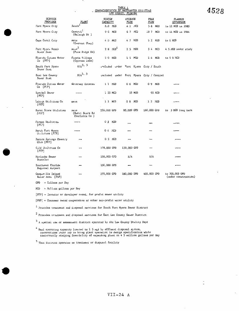
TABLE I CIIARACLERTS~ICS OFEWATCR V C I ~ I T ~ L S
LeE COUNTY, FLORIDA 4528 SERVICE DESIGN AVERAGE PEAK PLANNED
PROVIDER PLANT CAPACITY FLOW - - FLOW - EXI'ANSTON r o r r ~ y c r s c l r y south1 6.0 UGD A 1 PGD s 8 PGD t o 1 2 MGD i n 1985
F o r t Myers C L C ~ c e n t r 4 l 1 9 0 MCD 6 7 MGD 10 7 MGD r o 11 MGD i n 1884 ( R a l n g h S r )
Capc C o r a l C L L ~ main 4 0 MCD 4 7 MGD 5 2 bIGD t o 6 bGD (Cvetcbr Pkuy)
ro r r t1)ers Beach n1u1n3 ? 8 HGD 1 5 MGD 3 4 ElGD 4 5 MGD under s t u d y Scvcr D l s r ( P i n e Rldge Rd)
P l u r ~ d a C~rles Water F~esra V ~ l l a s e 2 0 ELGD 1 5 VGD 2 4 tCD t o 5 0 bGD Co [PFP] (Cypress Lake)
South F o r t Myers N / A ~ ~ " c l u d e d u r d e r narc ?I,e;s C i t y 1 Souih Sever Dls r
Easr Lee County N I A ~ ' inc luded u n d e r F o r t Myers C l t y / C e n t r a l S w e r D ~ s r
Florida C l r x e s Wacer Waterway E s r e r e s 1 1 NGD 0 6 b!GD 0 9 b1GD -we-
." [PIP]
Sdnlbc l Sewer 1 25 MGD 55 MGD 95 MGD [PFPI
Lehlgh U t ~ l l t l e s Co maw 1 5 K O 0 8 MGD 1 2 MGD ---- [PFPI
Burnt S t o r e U r l l l t l c s naln 250,000 GPD 80 ,WO GPD 166.000 GPD t o 5 MGD l o n g term I P r P l ( B u r n t S t a r e Rd
C h a r l o t r e Co )
r o r e s r U t ~ l t r ~ e s ---- 0 5 MGD - - - N o r ~ l l F o r t Myers ---- 0 L MGD -- -- ----
U r ! l ~ t r e s [PrP]
l l o n ~ c a S p r l n g s Country -- 0 3 MGD -- -- ---- Club [PFPI
G ~ l f U t l l l t l e s Co -- 178,000 GPO 130,WO GPD - ---- [PrPi
!larlacha Sewer -- 150,WO GPD N/ A NIA ---- D l s r r i c r
Sourhwesr F l o r i d a -- 150, OW GPO -- -- ---- Reelonal Azrpar i
G a s p a r ~ l l a I s l a n d -- 275.000 GPO 180.000 GPD 405.000 GPD c o 705,000 GPD h'atcr Assn [PNPI (under c o n s t r u c t ~ o n )
CPD - Gal lons p e r Day
K O = b l ~ l l ~ a n g a l l o n s ]per Day
[PFP] a 1nve.tor or ~ l e ~ ~ l ~ p e r awned, f o r p r o f a r sewer u c l l i r y
[PNP] - Consumer owned cooperac lve o r o t h e r non-praflc water u r l l r c y
Provldcs t rea tn len t and d i s p o s a l servlces for Sourh For r Myers Sewer D l s t r l c L
2 P r o v ~ d e s ireatment and d i s p o s a l services f o r Easr Lee Counry Sever D l s t r l c t
A s p e c l a l use or assessment d l s r n c i opera ted by the Lee Counry U e z l l t y Depr
Real opernru tg capacz ty l l n n t e d r o 1 3 mgd by e f f l u e n t d l n p o s a l s)srem. rennovarrons under way 10 bring plant operhr ran ro des lgn s p e c l f l c a t l o n u h l l e c o n c u r r e n t l y s c u d y ~ n g f e a s l b z l i r y of e x p a n d ~ n g p ldnr LO 4 5 m l l l l o n g a l l o n s p e r day

unrecognized costs of ground water pollution and/or resulting
surface water contamination. As Lee County grows and becomes
more urban in form and intensity, the septic tank wxll be even
less acceptable as a method of waterwater treatment and disposal,
except in those outlying area meetxng the conditions specified
above.
The alternative requires more complex technology and a
community scheme of capital improvement. Central wastewater
systems are capital and energy intensive, particularly in South-
west Florida where gravity sewers are costly to construct and
operate due to the flat terrain. Fiscal feasibility requires
concentration of wastewater generation in a relatively compact
area. It is recommended that investment in wastewater management
e iofrastrcc~&re be concen~rated in the Urban Services Area.
Central wastewater management infrastructure can be divided
into four components -- collectxon, zreatment, discharge of
effluent, and disposal of sludge. This infrastructure must also
be soundly engineered and constructed to prevent infiltration of
ground waters which dilute and increase the volume of the efflu-
ent, and thereby the costs of treatment and disposal.
What remains after treatment, relatively clean water or
effluent and sludge, must be disposed of in a manner consistent
with economlc efficiency and environmental safety.
Another resource that can be beneficially conserved is
effluent itself. After treatment, the water has uses, such as
irrigation or grounds management. In several communities, a
d) secondary effluent distribution system has been established to
VII - 25

supply high qual i ty t reated ef f luent t o homeowners, large scal!e
grounds managers (parks, golf courses, etc.), or t o agricul tural
in teres ts . Other ways of reducing demand include "gray water"
systems where water from bathlng and washing machines i s used for
lawn i r r iga t ion .
After treatment and disposal o r recycling of the eff luent ,
The so l ids remain as "sludge". Sludge from small sca le Waste-
water Treatment Package Plants (WWTPPs), and sept ic tank and
grease t r ap pumpage has become a problem, characterized as the
most serious public health problem i n the community. In these
cases, the materials are collected by "septage" haulers or sept ic
tank services and disposed of by land spreading on open f i e ld s
and pastures. This legitimate pract ice, together with "wildcatw
e d-umping i n roadside swales o r on unpermitted f ie lds , r e su l t s i n
the potent ia l contamination of ground and surface water and the
land i t se l f . Additional public heal th r i s k can also be produced
from t h i s pract ice by the transmission of pathogenic organisms by
insects, rodents and other vectors.
An additional issue i n defining a s t rategy for creating a
wastewater management infrastructure i s identifying the ro le t h a t
small scale wastewater t r e a t ~ e n t package plants ('%wTPP) are t o
play i n t h a t strategy. A recent survey counted over 225 WWTPPis
of 100,000 gallons per day (gpd) capacity or l e s s permitted i n
Lee County, some not ye t constructed or i n operation. The
greater number of these are i n the unincorporated county and
provide some degree of wastewater treatment for developments
lying beyond the reach of exis t ing central sewer systems. In
VII - 26

some instances, the use of a relatively s m a l l scale p lan t (up t o * .5 million gallons per day) i n providing wastewater services t o
geographically isolazed pockets of urban density o r intensxty is
a highly ra t iona l option. However, f o r the most par t , the WWTPP
is used by pr ivate development t o en te r the market p r io r t o &2ie
extension of central sewer service o r t o avoid the higher cos ts
of land already served by central sewer. In conjunction with
r e l a t ive ly unconstrained extension of water mains and pr iva te ly
financed road construction, this use of package plants (as w e l l - -
- . - - -~ - as over-slzed sept ic systems) has in t ens i f i ed the tendency of
settlement pat terns t o develop the form of and discon-
tinuous "leap frog1' development. While economically advantageous
t o the developer, it increases the cos t s of delivering the t o t a l
package of public services, and ce r t a in ly some of the p r iva te
costs of ut i l izxng developed land.
In addition, the WWTPP is not always an adequate solutlon t o
the treatment and dlsposal of wastewazers. In p a r t t h i s is due
t o the scale of the operation. By i ts nature, the smaller p l a n t
i s not as r e l i a b l e as a la rger p lan t as it generally does not
have the redundant o r duplicate equipment required t o back up
material not i n operation due t o periodic maintenance o r break-
down. Also, the small plant does not lend rtself economically t o
higher levels of treatment such as the e f fec t ive removal of
nitrogen, phosphorous, cer ta in soluble chemicals and toxic metals
(Advanced Wastewater Treatment o r AWT). Lastly, the WWTPP is
of ten inadequately operated and maintaxned due t o insuf f ic ien t
e t r a in ing and experience of the operators. Given t h a t these
VII - 27

various issues are recognized and dealt with through redundancy
standards for permanent WWTPPs, through locational limitations
for plants not capable of AWT, and programs of assistance a d
extension servrce to WWTPP operators, and given that the small
plant may, in certain ~eogra2hic instances, be a cost/effective
competitor to the large scale wastewater plant, then the waste-
water treatment package plant has a potential role in achieving
the community's goals through the implementation of this general
plan. _ __-__-.------------I - ... -----
_I___I._.I._--.C.___ ____------ -- -
Data Base and Methodolo= (See Illustration #g)
The sectlon concerni~g the existing conditions and needs of
the community is based on an analysis of public records and
documents concerning wastewater facilities and management pollcy
a in Lee Co-dnty existlng and proposed. Data were compiled and
graphically depicted as maps of system franchise areas, service
areas, treatment and disposal locations and collection systems.
Other information was provided by Lee County Division of Environ-
mental Protection Servlces, the Southwest Florida Regional Plan-
ning Council, the South Florida Water Management District,
agencies of the State of Florida, the U.S. Environmental Protec-
tion Agency, and various engineering and plaiming consuixing
firms. Particular reliance was placed on the South Lee County
Facility Plan Update (2 vols., Post, Buckley, Schuh & Jernigan,
Inc., 1982) and the Water Use and Supply Development Plan, Vol. - 111-C, Lower-West Coast (SFWMD, April, 1980). Conclusions and
recommendations from these various sources were compared and
contrasted to the proposed Land Use, Conservation/Coastal Zone
Elements and Potable Water Subelement.
VII - 28

N*
Beyond insuring the provision of standard wastewater treat-
mr;t an6 Sisposai services, the needs of Lee County are: -. 1. to establish and implement standards for improved
and uniform wastewater treatient services;
2. to ensure the coordination of investment in
central wastewater facilities with other elements
of the Lee plan;
3. to establish a central coordinating - _ ____ agenc~fsr , - __ . ~- ~ .~ ~.- -A A
- - -- - - water resource management with responsibility a ~ d
capability in wastewater management;
4. to protect the natural resource base from waste-
water pollution and subsequent destructions;
5. to utilize treate6 wastewater;
6. to coordinate infrastructure needs so as to
minimize the total costs of public services, and
to avoid duplication of services and facilities.
CFJITAL IMPROVEMENTS
Priorities - General Over the time horizon contemplated in this plan, the primary
priority for capital investment in wastewater facilities is the
provision of collection and treatment services wichin the urban
service areas. As in the realm of potable water, the implementa-
tion of this policy falls to several agencies.
costs
Table 2 illustrates a very broadly drawn estimate of the
costs of providing a major portlon of the wastewater infrastruc-

ture needed t o serve the residential population growth up t o the
year 2005. These estimates assume cost parameters drawn from
generally excepted standards and can be expected t o vary i n
de ta i l from locally prevailing costs or they may vary i n time.
Also, they re f lec t a csr,stant 1383 dollar base, not inf lated over
the twenty year period. Lastly, the costs of collection systems,
mains, pump stat ions, interceptors, trunks, e. are not pro-
jected. This table compares two s t rategies of f a c i l i t y pro-
vision; Small p l a n t and Large plant (1-5 MGD V~<S_U.S-QY~~.~GQ)- - . . _-_ __-. -. --A-
I t demonstrates t h a t given the assumptions above and a l l other
factors being equal, the large plant option provides treatment
capacity a t the lowest t o t a l cost.
From Tahle 1 it appears tha t the major u t i l i t i e s already
a plan over 42 million gallons per day of wastewater treatment
capacity. According t o the estimates l a id our. i n Table 2 , the
22.4 m i l l i o n gallons per day additional capacity needed by 2005
w i l l cost i n the aggregate from $35.7 million t o $67.4 mlllion
depending upon the scale of treatment f a c i l i t i e s used,
The actual investments required of the several u t i l i t y
service producers w i l l be determined by the degree t o which
population and the resul t ing service demand are located and
consolidated i n t h e i r own service areas. The costs of the col-
lection systems, which are part icular ly sensi t ive t o the patterns
of development and are not therefore projected, can be accurately
determined only when engineering design is set and capi ta l
budgets are established. These costs w i l l be a function of the
VII - 30

compactness of the settlement pattern and further by the degree
@ to which the urban services areas are implemented in the develop-
ment review process. One virture of the urban services area
strategy of growth management is that the future demand for
servlces can be confidently predicteS.
Proposed Fundlng Sources
The funding sources to be utllized in financing wastewater
capital facilities are structured in such a manner that growth
itself wlll generate the revenue necessary to finance the need@ ~ -
facilities. Therefore, the priority of facility expansion within
the urban service area will be revealed by development appllca-
tions and capital receipts. As development applications indicate
needed expansion, the funds comlng from those new developments
Q shmld he directed -coward tne areas of need.
There are seven proposed funding sources far capital im-
provements for wastewater treatment and c~llection systems:
(1) Connection charges and impact fees assessed against new
development for a proportional share of the cost to
provide capital facilities to meet the wastewater needs
~f new development.
( 2 ) Developer dedication of necessary collection and trails-
mission lines both on-site and off-site.
(3) Any available grants.
(4) Monthly charges for capital improvements or to amortize
capital improvement bond issues.
(5) Special assessment of benefitted property.
VII - 31

(6 ) Investment by private sector utilities.
(7) A d valorem tax to offset general obligation bond is-
sues.
Priorities - Specific Within the first five years of Ynis plan, Lee County has
defined three major projects related to wastewater management and
has set their prlority over all other possible wastewater im-
provements in the various sanitary sewer districts operated by
~ e e County Utilities. These are: ~. . . " , - -
(I) Fort Myers Beach Sewer Plant Expansion
Expansion of the Ft. Myers Beach Sewer District treat-
ment plant (Pine Ridge Rd.) from a 2.7 million gallons
per day (mgd) capacity to 4.5 mgd. This includes im-
provement and expansion of the effluent disposal sys-
tem. This is financed through user charges. Project
is programmed to run through fiscal years 1984-5 and
1985-6.
(2) South Fort Myers Sewer System Expansion
Expansion of the South Fort Myers Sewer District col-
lection system by constructing master pump stations and
interceptor lines. Thxs project is financed through
user charges and construction runs from 1985-6 through
1986-7.
(3) Regional Sludge Composting Facility
In collaboration with the City of Fort Myers, construct
a 16 ton per day sewer sludge composting plant to serve
City and Fort Myers Beach treatment plants. This pro-
VII - 32

ject will be financed by sales of resuLting product
(solld soil conditioner) and by user charges. Con-
struction is programmed for 1984-5 and 1985-6.
In addition to the above, a Utility Administration Complex
is budgeted for constructior. in 1984-5. Some porcion of thls
cost should be charged to the provision of wastewater management
in the County sewer districts and to the water resources manage-
ment activity.
VII - 33

TABLE 2
VASTE WATER CAPITAL COST
LEE COUNTY
1985-2005
1980 - 1985 - 1990 - 1995 - 2000 - 2005 - CHANGE
POPULATION:
RESIDENTS 205,266 257,700 311,000 355,800 400,600 429,000 - ADEQUACY 51,317 64-,425 77,750 88,950 100,150 107,250 - TOTAL - - 256,583 322,125 388,75-0 444,750 500,750 536,250 279,700
WASTEWATER:
PRODUCTION (MGD)* 20.53 25.77 31.10 35.58 40.06 42.90 - INCREASE (MDG) - 5.24 5.33 4.48 4.48 2.84 22.37
COST OF ADDITIONAL CAPACITY:
WITH SMALL PLANTS (in thousands of dollars) - - - - 1963 - 1990 1995 - 2000 - 2005 - Total
i3T STATIONS 1,216 1,236 1,039 1,039 659 5,189
TREATMENT 14,385 14,623 12,291 12,291 7,792 61,381
STORAGE 198 201 169 169 - 107 843
COLLECTION ...................... not projected------------------
TOTALS 15,799 16,060 13,499 13,499 8,557 67,413
COST OF ADDITIONAL CAPACITY:
WITH LARGE PLANTS (in thousands of dollars)
1985 - 1990 1995 - 2000 - 2005 - Total LIFT STATIONS 521 529 445 445 282 2,221
TREATHENY 7,645 7,771 6,532 6,532 4,141 32,621
STORAGE 196 199 167 106 834 - 167 - COLLECTION not projected------------------
TOTALS 8,361 8,499 7,144 7,144 4,529 35,677
* Generation in millions of gallons per day is based on a rate of 80 gallons per day per capita.
VII - 34

e GOALS, OBJECTIVES AND POLICIES
Goal VII-G.: To ensure a clean and- healthier h&m.zc znii
natural environment through the provision of
semfces ~7uld facilities to collect, treat, and
dispose of water borne wastes and sewage.
Obj, V1I.G.: To create and maintain a healthful urban en-
vironment by ensuring the provision of central
wastewater facilities. and . services in urban
servlce areas where economically feasible.
Policy VII.G.l: The County shall provide, directly, or indi-
rectly through franchised or regulated sewer
utilities, sufficient infrastructure to en-
Qb courage development in the Urban Service Weas.
Policy VII.G.2: The County shall establish a county-wide water
resources management agency which, i n addition
to responsibilities relating to potable water
set forth elsewhere in this plan (see Potable
Water Subelement, Policy VII.A.3.), wlll be
responsible for:
a) monitoring an2 coordinaCing the treaunent
and disposal of wastewater, and counseling
of operators of WWTPP;
b) representing the public interest before
various regulatory agencies including the
Florida Department of Environmental Regu-
lation, the Florida Publlc Service Commis-
sion, &;
VII - 35

c) conducting research into wastewater man-
agement Issues including such matters as - iocal regulation of utilities, consolida-
tion of utilltles, alternate strategies of
facility provision and ficaiice, - erc.
Policy VII.G.3: In order to provide services and facilities in
the most economical manner consistent with the
general goals of the plan, wastewater process-
ing should be consolidated through regional . .
sewer servlce areas operating treatment and
disposal facilities and by cooperation with
, other service providers including the munici-
Policy VII.G.4: Small was.+e7zater treatment package plants
@ (WWTPPs) and septic tanks shall be authorized
only as interim means of providing wastewater
treatment services in the Urban Service Areas
and shall be abated upon the extension of
central sewer services.
Policy VII .G.5: Where small pockets of existing urban land use
or'intensity lie beyond a central wastewater
service area, nothing herein should preclude
the use of small scale but efficient wastewater
technology as a permanent means of treating
wastewater.
Goal VI1.H: To ensure that the management of water borne
wastes and sewage is conducted in a manner that

minimizes negative impacts on resources and the
environment, par t icu lar ly ground and surface
water qua l i ty and freshwater, es tcar ine an6
marine b io tas . Obj . V I I .H: TG crea te and operate a system and program of
wastewater management t h a t provides adequate
services t o the community, including the con-
servation of the recognized values of the
na tura l resource base. . " . .
Policy VII.H.l: Development outside of Urban Services Areas,
not having d i r e c t access t o cent ra l s e w e r
service and su f f i c i en t treatment capacity may
u t ~ l ' i z e sep t i c tanks, where s o i l s and hydro-
log ic conditions a re appropriate, where the
land use itself is of low denslty o r In tens i ty
and where sewage flows are minimal, and where - biological oxygen demand (BOD), chemical oxygen
demand (COD) or other specified pol lutants do
not exceed adopted maximum l i m i t s . L i m i t s may
be more s t r ingent i n areas designated as re-
source protection areas.
Policy VII.H.2: The County s h a l l adopt a wel l f ie ld and recharge
area protection ordinance t h a t w i l l regulate
the disposal of t rea ted ef f luents by percola-
t i o n pond o r drainf ie ld (or s imilar devices) t o
ground waters i n areas lying within recharge
areas of exis t ing or po ten t i a l wel l f ie lds .
VII - 37

Pollcy VII.H.3: Wastewater Treatment Package Plants s h a l l not
be operated so as t o c rea te a nuisance through
odor, noise,- s p i l l s of chemicals o r sewage, o r
v isua l b l ight .
Policy VII.H.4: The County s h a l l establish, fArough impact fees
o r other mechanisms, incentives for homeowners,
septage haulers ( sept ic tank services) and
small WWTPP managers t o dispose of septage and
sludge through public o r franchised -sludge . - ~-
processing plants.
Policy VII.H.5: The County s h a l l es tab l i sh an environmentally
sound program of sludge and sept ic tank pumpage
processing and disposal
m-7 4 ,.%. 7 - 7 7 L U I ~ ~ ~ v ~ ~ ~ i i . 6 : +'ne County s h a l l continue i ts exploration of
the f e a s i b ~ l ~ t y of processing sewer sludge t o
recover a cornposted s o i l condition f o r publlc
use o r f o r marketing t o agr icul tural operators
o r grounds managers-
Policy VII.H.7: The County s h a l l es tab l i sh and enforce stan-
dards t o ensure t h a t a l l wastewater treatment
p lan ts a re operated and maintained so as t o
produce ef f luents of a qual i ty commensurate
with the public heal th and the needs of the
receiving hydrologic system.
Goal VII.1: To ensure t h a t maximum advantage is taken of
the resource represented by t rea ted wastewater
e f f luents i n conserving water resources gener-
a l l y .
VII - 38

Ob]. VII.1: To support and encourage various methods +nd
plans of reusing treated effluent.
Policy VII.I.l: The County shall adopt development regulatisns
which permit the reuse of wastewater in planned
developments.
Policy VII.I.2: The County shall examine and assess the feasi-
bility of constructing a secondary treated
effluent distribution network to convey treated
wastewater to consumers of reuse water..
CONSISTENCY
The Wastewater Management Subelement is designed and
intended to be consistent primarily with the Land Use and Con-
servation/Coastal Zone Management Elements, as well as with the
e ?stable Water and Surface and Stomwater Management Subelements,
and through these, the remainder of the plan. This is achieved
in the following manner.
The Wastewater Management Subelement is based on the same
economic and demographic assumptions as the remainder of the
plan. The central intent of this subelement is to provide an
adequate level of servlce to the future urban population of the
various communities of Lee County while achieving an acceptable
balance of costs and benefits. The Wastewater Management Sub-
element re;lates directly to the Land Use Element through its
reinforcement of the Urban Services strategy. It does this by
concentrating the investment in public wastewater infrastructure
in the Urban Services Areas. It is related dlrectly to the
Conservation/ Coastal Zone Hanagement Element through its imple-

mentation of values of resource protection, particularly the
9 conservation of potential potable resources as well as the fresh-
- -- wdter, estuarine, and marine ecosystems. Recommended restric-
tions on wastewater plants and suggestions concerning the use of
treated wastewater effluents as ;m =.Iterrrate to quaiity treated
potable water tie this body of policy to the Potable Water Sub-
element, also.
V I I - 40

SURFACE WATER MANAGEMENT SUB-ELEMENT
TABLE O F CONTENTS
A. INTRODUCTION ................................. purpose ................................ E x i s t i n g C o n d i t i o n s .................... D a t a B a s e and M e t h o d o l o g y -------------- N e e d s ..................................
. -
B. CAPITAL IMPROVEMENTS ......................... p r i o r i t i e s - G e n e r a l ------------------- costs .................................. Proposed Funding Sources ---------------
(Cb Priorities - Specific ------------------
C. GOALS, OBJECTIVES AND P O L I C I E S --------------- D. CONSISTENCY ..................................
Page
V I 1-42
V I 1-42
V I 1-42
V I 1-49
V I 1-49
V I I - 5 0
V I I - 5 0
V I I - 5 0
V I I - 5 1
V I I - 5 1
V I I - 5 2
V I I - 5 6
V I I - 41

VII-111. SURFACE WATER WAGEMENT SUB-ELEMENT
A. INTRODUCTION
Purpose
The purpose of surface water maiiagement is .KO maintam a
clean and healthy environment f o r people and t h e i r a c t i v i t i e s ,
and t o reduce the damage t o personal and r e a l property caused by
inundation o r flow of water. However, of equal concern i s the
maintenance the qual i ty of the waters-, f resh estuarine -and -
marine, t o which storm and surface waters are discharged. I t i s
the i n t e n t of t h i s element t o e s t ab l i sh a policy t h a t creates a
balance between the benef i ts and costs of requirement.
Existing Condizions
Tradit ionally, surface water management i n Sou~3-1 Florida
meant "drainage1', get t ing the water a f f , o r out of the land.
Generally, t h i s function was performed through digging ditches
and recention p i t s , through the erect ion of dikes, dams, and
other diversionary s t ructures , through the use of pumps, o r by
f i l l i n g property up t o a leve l above the expected llfloodll. Thxs
treatment is cap i t a l and energy intensive ax? has rad ica l ly
a l te red the topography and the loca l (of ten regional) ecosystem.
The guiding ru le has been t h e l ega l doctrine of the I1comon
enemy", and the motive was t o reclaim inundated or overflowed
VII - 42

land for "productive* (h i s to r i ca l ly agricul tural) use. The
resu l t was over-drainage of the surface water and lowering of
water tables , and the unwitting a l t e ra t ion of the qual i ty and
s a l i n i t y of receiving waters, streams o r estuaries. Over the
years we have accl.z"?.~lated a -*--L L I L ~ ~ ~ ~ greater comprehension of the
mechanics of the local hydrologic cycle and of the consequences
of the changes t h a t have been wrought i n it. These consequences
include the wastage of potential potable water resources, erosion
of the land and sedimentation of receiving stream and bay bot-
toms, and a l t e ra t ion of the s a l i n i t y and nutr ient loads i n estu-
a r ies t h a t function as nurseries for economically s ignif icanr
marine l i f e .
The growth of urban land uses is a trend t ha t exacerbated
@ the probiems presented by surface water management. Urban land
uses can be characterized as having been al tered by being covered
by impervious surfaces, buildings, pavements, and compacted
so i l s , from which water t h a t f a l l s as r a in or which flows from
other locations generally col lects on the surface or runs off
entirely. By comparison, i n non-urban areas, there is propor-
t ional ly l e s s impervious surface i n comparison t o natural sur-
faces, which are characterized by ,yemeable s o i l s and exxensxve
vegetative cover. Natural surfaces tend t o permit water t o
percolate down through the s o i l t o be stored i n ground water and,
by t he i r roughness, t o reduce the velocxty of the runoff t h a t
remains. Also, some pollutants carr ied by the runoff can be
picked up by vegetation on natural surfaces. However, runoff

from urban land uses tends t o carry more complex pol lutants t h a t
@ cannot be incorporated by vegetation, and there is re l a t ive ly
less vegetation. The r e s u l t i s t h a t increased conversion of
non-urban lands t o urban uses disproportionately increases vol-
umes of storm and surface w a t e r x-i-i~ff as - - w e l l 7 - as increased
pol lutant loads. Further, due t o the lack of storage on o r i n the
ground, and the higher veloci ty of water running from smoother
pavements through ditches and canals, the water wreaks havoc with
the natural cycles of s a l i n i t y i n brackish o r sal ine receiving
waters. This i n turn upsets the reproductive cycles of marine
l i f e i n Lee County's otherwise very productive es tuar ies .
TABLE 1. HYDROLOGIC CHARACTERISTICS COMPARED
Urban Land Non-Urban Land
e -low % of vegerative ccver -higher % of vegetative cover
-high % of impervious surfaces -low % of impervious surfaces
-low r a t e s of percolation o r -high r a t e s of percolation o r i n f i l t r a t i o n i n f i l t r a t i o n
-high veloci ty of runoff due -low veloci ty of runoff due t o smoothness of surface t o roughness of surface and channel iza~ion
-low r a t e of uptake of water -high r a t e of uptake of water and nut r ien ts and nut r ien ts
-high r a t e of runoff (100% -low r a t e of runoff i n the from impervious surfaces) aggregaze
SOURCE: Lee County Planning Department
The choices offered by t h i s i ssue cons t i tu te a c l a s s i c case
of competing and of ten contradictory ends. No one wants water i n
8 t h e i r home or business, few want t h e i r yards o r s t r e e t s inun-

dated, and it is not i n the public in te res t t o permit water t o
e stand over underground u t i l i t i e s o r sept ic system drainf ields .
On the other hazld, few would wanc TO dlminish the opportunities
t o prsvide for a renewable water resource for the community's
future, nor would they will ingly discard the environmental qzali-
t l e s whlch led many of them t o come t o Florlda, and which may
provide, d i rec t ly or mdirec t ly , for t he i r economlc livelihood.
Yet, there does not appear t o be any way by whlch th i s community
can have both the speedy and- complete removal and disposal of
storm water and a healthy coastal environment or an adequate
reserve of high qual i ty ground water for human use (see also the
Potable Water Sub-element). What the community can have i s a
body of policy t h a t seeks an optimal package of benefi ts by
containing the d i r e c t costs of drainage ir;fraslruc-cure and by
d) reducing *+e loss of natural resources and damage t o property.
One approach which may be taken is t o concentrate invest-,
ments i n t radi t ional surface water management infrastructure i n
the Urban Services Areas. These are areas i n which we may assume
t h a t the benefits of natural systems are already consumed, l o s t
o r otherwise committed t o intense human ac t iv i ty . Here too,
demands created by impervious surfaces are a t t h e i r greatest and
surplus land fo r retention i s most dear. Eff ic ient management of
exis t ing and future surface water management infrastructure i s
enhanced by reducing demand through mandatory standards fo r re-
tent ion and disposal. However, as the system grows i n the
future, more at tent ion w i l l be required t o techniques of main-
ta ining o r Improving the qual i ty of water removed from the urban

areas. This can be accomplished through detaining and s e t t l i n g
the f i r s t f lush of r a i n f a l l runoff and the par t icu la te matter it
ca r r i e s , by spreading - . the water over. vegetated surfaces (where
access t o su f f i c i en t land i s avai lable) including lawns and
grassed swales, through progrs,ms sf sC---' b ~ = ~ ~ c lean~ng , and, i n
extreme cases, by the treatment of storm waters before re lease t o
natural systems.
On the other hand, outside of the urban servlce areas, .
emphasis ought t o be placed on t h e preservation and use of the
natural systems of drainage consist ing of s t r e a m s , sloughs and
floodways, and sheetflow. These systems hold o r slow the flow of
water permitting i n f i l t r a t i o n t o ground waters, reduce eroslon,
and reduce the peak volume released t o sa l ine es tuar ies as well
(b as releasing Yle f resh water t o brackish o r sa l ine systems on a
schedule t o which the b io ta i s adapted. A s these are "natural
systems", the costs of inf ras t ruc ture and energy are reduced.
Development i n r u r a l and suburban, o r a t l e a s t qon-urban areas
w i l l have t o be designed t o maintain low leve ls of runoff, t o
maintain the qual i ty of water discharged and t o t o l e r a t e occa-
sional temporary inundation, while the public w ~ l l have t o be - ~ -
educated t o accept t h i s s t ra tegy. In most instznces when t rad i -
t iona l drainage inf ras t ruc ture e x i s t s outside the Urban Sexvices
Areas, and where i t s harm is minxmal, e f f o r t s should be made only
t o maintain it but t o permit no extension o r expansion. Where it
i s demonstrable t h a t a public harm is created by i t s continuance,
old drainage systems should be modified t o res tore water t a b l e
levels , t o end diversions and t o res tore wetlands t h a t function
as e f fec t ive imitators of na tura l systems.
VII - 46
In some quarters, the re have been assert ions t ha t the whole
4) emphasis on tldisposalxl of surface waters is wrong; t h a t t h i s i s
another source for qual i ty raw water f o r human use and consxmp-
t ion; t h a t this resource ought t o be conserved. Indeed the
protection of freshwater wetlands E E . ~ L%e uss of nazural topo-
graphic features designated "flow ways" aids i n resource conserv-
ation by holding water on the land for a time equaling o r ap-
proaching the h i s to r i c hydroperiod and permitting tha t water t o - .
percolate in to the su r f i c i a l and other aquifers. O n a broader
scale , large areas might be designated water conservation areas
with concomitant res t r ic t ions on surface uses. Other conserva-
t i on actions would include constructing surface reservoirs kept
up by pumpage from surplus runoff, o r by deep well inject ion of
surplus surface water t a sa i ine aquifers. Both of these act ivi-
@ ties are f a i r l y expensive t o execute, and i n both instances care
should be taken t o insure suf f ic ient f resh water remains f o r
wetlands and fo r the estuarine ecosystems.
Much of t he foregoing i s aimed a t providing a necessary
service while conserving the values of various natural resources.
These values are generally concentrated i n the qual i ty of receiv-
ing waters. In the highly productive bays and estuaries, f resh
water is a necessity for regulating s a l l n i t y and flushing nutr i -
ents in to the system. However, too much fresh water i s as much a
pol lutant t o these systems as the chemical output of human activ-
i t y often carr ied by t h i s fresh water. Any man-made surface
water management system ought t o be designed t o reduce the pol-
d lu tan t load of urban runoff. To a large degree, t h i s function i s
performed by natural systems, but even these can be overwhelmed
by intense development. Therefore, i n the process o f maintaining
or restoring the quali ty, volume and hydroperiod of surface
waters discharged t o natural systems, development should be
designed t o max~rr.ize tk,e i t of surface or ground waters
discharged.
I f this strategy i s adopted, there w i l l remain contradic-
t ions and inconsistencies m carrying it out. This is due - t o . the -
f ac t t h a t other agencies and jur isdict ions w i l l still approach
the problems i n a d i f ferent fashion or w i l l remain t i e d t o the
llcommon enemyE1 doctrine. Substantial negotiation w i l l be re-
quired with s t a t e and sub-state regional agencies t o ensure t h a t
local standards are consistent with and e i t he r equally o r more
Ib restrictive than the standards used by those agencies. In addi-
t ion , Lee County w i l l have t o re ly on those agencies t o mediate
coordination with adjacent jurisdictions t o ensure t h a t t he i r
actions do not overwhelm the natural systems with point dis-
charges from artificial systems.2 The l a s t problem l i e s w i t h the
Chapter 298 Drainage Dis t r ic t s . Coordination of expanded ser-
vices i n accordance with a "natural system" method and restora-
Coordination with municipalities i s expected t o be l e ss complex as they w i l l be contained, for the most pa r t , i n the Urban Service Areas and, therefore i n the area of a r t i f i c i a l drainage service.
V I I - 48

a t ion of water t a b l e s and wetlands outside of Urban Service Areas
e should be required by t h i s plan under Chapter 163 - F.S.
Data Base and Methodology
This sect ion concerning the exis t ing condi-txons and needs of
the community i s based on an analysis of public records and
documents concerning storm and surface water management policy i n
Lee County. Data were compiled and graphically depicted as-maps
of natural drainage basins, and man-made drainage features. - Maps
of the U.S. Federal Emergency Management Agency delineating
coastal storm surge flooding were a l so consulted. Reports and
documents consulted a l so included materials from the South
Florida Water Management D i s t r i c t , engineering and planning
cons?rlr-mts t o tile Lee County Dlvlsion of Transportationflublic
Works, pa r t i cu la r ly Johnson Engineering Co . , the Southwest Florida
Regional Planning Council and agencies of the State of Florida
and United Sta tes , (See Illustration # l o )
These sources were compared and contrasted, i n r e l a t ion t o
the confl ic t ing needs of removing waters from densely occupied
areas and maintaining the quality, quantity, and timing of waters
discharged t o sens i t ive wetland ecosystems. gveral l , a body of
policy was derived which seeks t o balance these competing in te r -
ests.
Needs
The needs of the communities of L e e County i n re la t ion t o
(b storm and surface water management are:

1. t o provide continued management and improvement of
t radi t ional drainage infrastructure, par t icu lar ly i n
areas of intense land use;
2. t o protect freshwater, estuarmne, and marine ecosystems
from pollution 2s-d hydroloqic disruption and subsequent
destruction;
3. t o provide a workable surface water management scheme
for areas outside the urban areas;
4 t o conserve and rat ional ly .- u t i l i z e surplus storm and
surface water; and
5. t o manage and conserve infrastructure t o minimlze the
cost of public services.
3. CAX'x'?AL I ~ ~ ~ X ~ ~ ~ ~ V ~ N ~ S
Pr io r i t i e s - General
Specific capi ta l improvements for surface water management
w i l l be prioritxzed i n accordance with the re la t ive severity of
the surface water problems a t speci f ic locations. The highest
p r i o r l t y is asslgned t o those improvements i n the exist ing de-
veloped areas where f a c l l i t l e s a re inadequate t o handle any
floodlng which is a th rea t t o the public healL\, safety and
welfare.
Costs
The fundamental underlying f i s c a l strategy of t h i s subele-
ment i s t o minimize the Impact of surface water management on the
public. This is realized by requiring, insofar as it is feas-
a ~ b l e , t h a t storm water management be accomplished on-site on a

development by development basis. Where cumulative spi l lover
Qs, becomes s ignif icant , spec i f ic improvements t o the public system
w i l l be designed and c ~ i i a t r i i ~ t e d and t he i r costs assessed t o the
p r s p r t i e s benefitted. The main exception t o this is the
authorization t o use general revenue funds fo r such igprovezents
t h a t can be assumed t o provide general benefits.
Where a surface water management strategy is implemented
through the reservation and dedication of wetlands fo r water
management, through res t r i c t ion of development i n wetlands, near
stream banks and coastal areas, and through special bullding
requirements i n flood prone areas the costs of water management
become an internalized charge of between $2000 and $20,000 per
acre.
Proposed Fundrng Sources
The several p o ~ e n t i a l sources of f i s ca l support for surface
water management include:
(1) development speci f lc improvements including reservation
of wetlands;
( 2 ) special assessment of benefitted properties; and
( 3 ) where benefits a re general t o the community, general
fund monies (& valorem revenues).
P r io r i t i e s - Specific
Within the f irst f i v e years of t h i s plan, Lee County has
ident i f ied two major projects and has s e t t he i r p r i o r i t y over a l l
other possible surface water management projects within i ts
jurisdiction. These are:
V I I - 51

(1) Winkler Canal i n Fort Nyers
Improvements t o Wlnkler Canal running from Evans Avenue
t o Caloosahatchee River. Funded from ~ v a l o r e ~ . Cot-
s t ruc t ion i n f i s c a l year 1985-6.
( 2 ) Powell Creek Drainage I~prc~emeiits
Miscellaneous improvements t o area of N. F t . Myers i n
the Powell Creek dralnage basin. Funded through
special assessment of benef i t ted propert ies. Project
t o run through 1984-5.
( 3 ) Lakes Park Watershed Protection
C. SURFACE WATER MANAGEMENT SUB-ELEMENT GOALS, OBJECTIVES AM)
POLICIES
Goal V1I.L: To ensure rhe health and safety of the publlc
Ib water run-off by providing f o r the management of
storm and the removal of flood waters from areas
of intense use and gccupation.
Obj. V1I .L: Develop a coordinated system of infras t ructure
f o r managing storm and remaining flood waters i n
areas of intense use and occu~at ion , while pro-
viding for the conservation of water and the
na tura l environment.
Policy VII.L.l. The County s h a l l develop a comprehensive plan f o r
coordinated surface water management system f o r
t h e Urban Service Areas using "best managemenx
practice" drainage techniques.

Policy VII.L.2(a): General Tax Revenue sha l l be expended for
storm water management systems i n the Urban
Service Areas only .
- P o l 2 5 ) : Storin water management systems outslde of the
Urban Service Areas may be funded by mechan-
i s m s such as Nunicipal Services Taxing Units
(MSTUs) by which the f i s ca l burden i s l imited
t o those who benef i t from the improvements.
Policy VII.L.3. Cr i te r ia sha l l be adopted fo r maintaining or
reducing demand on the capacity of t radi t ional
drainage infrastructure by requiring storm water
management.
Goal V1I.M: To ensure t h a t the management of surface and
storm waters i n the non-urban areas is carr ied
out with minimal inf ras t ruc tura l investment or
requirement of energy.
Obj. V1I.M: Support a surface water panagement straregy t h a t
r e l i e s on natural features (flow ways, sloughs,
strands, e tc . ) and natural systems t o receive,
detain and otherwise manage storm and surface
water,

Poliey VII .M. 1. A l l development proposals outside the Urban Ser-
vice Areas sha l l recognize areas where s o i l s ,
vegetation, hydrageology, topography and other
factors indicate t h a t water has flowed o r ponded;
and reqr.u.rre t h a t f,h,ese areas be utiiizecl t o the
maximum extent possible, without s igni f icant
s t ruc tura l a l t e ra t ion for on-site storm water
management; and require t h a t these areas be in te-
grated in to area wide coordinated storm water
management schemes.
Policy VII.M.2. Where no natural features of flow or ponding
ex i s t on a s i t e outside the Urban Service Areas,
"&e Counry sha l l require t h a t water management
structures be designed and constructed i n such a
manner as t o imitate na-cural systems. Special
engineering and design standards for such s t ruc-
tures sha l l be incorporated in to revised Develop-
ment Standards by ordinance.
Policy VII.M.3. Outside the Urban Service Areas where t r ad i t iona l
drainage structures ex i s t (ditches, canals,
dikes, e t c . ) , the County may permxt t h e i r con-
tinued existence and maintenance, but sha l l
discourage t h e i r expansion or extension.
VII - 54

Policy VITII.M.4. Where feasible within Urban Service Areas, sur- e face water management may imitate natural sys-
tems, notwithstanding the type or intensity of
development pemtted.
Goal VI1.N: En~~-?re that L& p-&lic and private condstruction,
operation and maintenance of storm water manage-
ment systems are consistent with the need to
protect receiving waters.
Obj. VI1.N: Support and encourage standards and processes of
surface water management that are consistent with
needs of receiving waters (wetland systems,
streams, estuaries and marine environments) for
the optimal hydroperiod, for low pollutant loads
and optimal nutrient loads, by regulating the
quality, volume and hydroperlod of discharged
surface water.
Policy VII.N.l. In the Urban Service Areas, the County shall
require "best management practicesI1 be used to
design and construct storm and surface water
management systems to minimize the pollutant load
eventually discharged to natural systems, as well
as to regulate the volume and timing (hydroperi-
od) of storm water delivered to natural systems.
VII - 55

Goal V I I - 0 : Ensure tbak the public and prlvate conduct of
surface and storm water management contributes t o
the conservation of fresh water as a future
potable vater supply while recognizing the need
t o preserve flows t o natursl estnarins systems,
0 VII.0: Support and encourage standards and processes of
surface water management t h a t conserve storm and
surface waters and minimize the wasting of ground
water for future potable water supply, while
recognizing the need t o preserve flows t o natural
estuarine systems.
Policy VII.O.1. The cse azd maintenance, or imitation of natural
hydrologic features fo r surface water management
shal l be required t o promote the inf i lzra t ion of
such water t o recharge su r f i c i a l or ar tesian
aquifers.
Policy VII.0.2. Standards t o insure both quality and maximum
quantity of water percolating t o future potable
suppLies shal l be adopted.
D . CONSISTENCY
The Surface and Stormwate~ Management subelement i s designed
and intended t o be consistent prxmarily w i t h the Land Use and
Conservation/Coastal Zone Management Elements, as well as the V
V I I - 56

Potable Water subelement, and through these, the remainder of the
plan. This .is achieved in the following manner.
This sub-element is based on the same economic and demo-
graphic assumptions as the remainder of the plan. One of two
competing central issues in this element is the necessity to
provide adequate drainage to an area to be developed at densities
or intensities sufficient to support water, wastewater, trans-
portation, and private commercial or industrial land uses. For
this reason, traditional drainage strategies are harnessed to the
Land Use Element's identification of "Urban Service Areas" and
for economy's sake limited to those areas. Conversely, outside
of the Urban Service Areas, the intent is to maximize the values
identified by the Conservation/ Coastal Zone Management Element
in various water dependent ecosystems, by limiting surface water
management to use of natural features or imitations of natural
features and, hopefully, their natural hydrologic characteris-
tics. Lastly, it is suggested that potential potable water
resources can be augmented by conservation of surplus surface
waters.

SOLID WASTE MANAGEMENT SUB-ELEMENT
TABLE OF CONTENTS
. - l?age
i&luTRoDD-JCTION ............................................. VII-59
VII - 58
VI'I - IV. SOLID WASTE MANAGEMENT SUB-ELEMENT
INTRODUCTION
Purpose
Solid r?raste mariageaent and disposal represents a potent ia l
th rea t t o public heal th and convenience, and the environment of
L e e County. Improper management and dlsposal can have a s i g n i f i -
cant negative impact on the water, a i r , land, and aesthet ics of
Lee County. Properly conducted~, so l id waste management c a n
mlnimize these concerns and maximize service t o the c i t i zens of
the County. The purpose of t h i s sub-element is t o e s t ab l i sh a
so l id waste management pollcy which considers these negative
~mpacts , and balances them with the need f o r a cost-effective
system.
Existing Conditions
Solid waste includes everything discarded by people t h a t is
not carr ied away i n water through sewers. I t ranges from domes-
t i c garbage t o abandoned automobiles, from lawn clippings t o
demolition debris, from feed-lot manure t o used indus t r ia l chem-
i c a l s (which may be l iqu id but a re handled i n containers as
so l ids ) . To ensure the cleanliness of Lle community and the
health of its inhabitants, the s o l i d wastes a r e collected from
points of production, consolidated and delivered t o some po in t ( s )
of disposal o r destruction. This service, although appearing t o
be a s t r a i g h t forward set of ac t iv i t i e s , is expensive, energy

intensive, and, because of the obnoxiousness of the materials
handled, productive of extreme controversy i n land use decision
making. Good planning can only begin t o deal effect ively with
the issues generated by it.
~h~ bbsic ------ vice in so i id waste management is col lect ion.
This i s provided by e ight garbage haulers having exclusive fran-
chise r i g h t s within specified areas of the county and by the City
of Fort Myers. Collection i n the c i t i e s of Sanibel and Cape
Coral i s mandated by ordinance, b u t is- provided by franchised
hauler. In a l l cases, users are b i l l e d d i rec t ly f o r the service.
Outside of the three municipalities there is no requirement t h a t
householder o r business subscribe t o col lect ion services. House-
holder o r businesses may convey waste t o the l a n d f i l l themselves,
and by paying a minimum or graduated t ipping (durmpingf fee,
dispose of the trash. The r e s u l ~ of not having mandatory col-
lec t ion and/or pa-pent f o r col lect ion services has been I1wildcatlt
dumping of t r a sh and garbage i n sparsely s e t t l e d areas of the
County. Without incentives t o use the var ie ty of services avai l -
able, many people w i l l not t ransport t h e i r t r a s h t o the l a n d f i l l
nor pay the fees. This "negative incentive" t o use s o l i d waste
services a l so indicates t h a t volumes of s o l i d was-ce w i l l f luctu-
a t e with pricing, making it d i f f i c u l t t o plan cap i t a l investment
and other f i s c a l aspects of producing this service. In many
quarters, the obvious solution i s the adoption of mandatory
trash/garbage col lect ion throughout the unincorporated county.
Reliance would s t i l l be placed on pr ivate sec tor haulers governed
by e i the r franchise agreements o r sexvlce conzracts with the

County. This would insure consistency of service, predictabili-cy
of volumes and help t o end 'Lwildcat" dumping.
The ultimate ac t iv i ty i n sol id waste management is 6dipssal.
The method used i n Lee County is sanitary l and f i l l wherein t rash
etc. is placed i n +,rer,ches or oii an accreting face of an excava- - t ion, compressed and compacted and covered with a layer of com-
pacted so i l . Ideally, t h i s closes the t rash off from oxygen sup-
ported bacter ial (aerobic) decomposition, from b ~ r d s and rodents,
and water. When completed or f u l l , the l and f i l l is closed w i t h a
cap of clay or other relat ively impervious material t o repel
water. A l s o , the bottom of the l andf i l l should be sealed with
clay or a synthetic material l i ne r t o hold i n contaminated water,
which could otherwise seriously pollute ground or surface water.
a i n Lee County, the so-called "Florida method1' of l and f i l l is
used, where Lie t rash and cover is mounded up from the surface
( o r near surface), and becomes an a r t i f i c i a l h i l l . The present
l and f i l l i s operated by Gulf Disposal Inc., a subsidiary of Waste
Management Inc., on contract w i t h Lee County.
The capaclty the present l and f i l l is nearly exhausted. By
1987, an expansion of the existing l andf i l l on its present s i t e
w i l l have t o be authorized, a cew landf i l l sxte w i l l have t o be
designated o r some al ternat ive method of disposal w i l l have t o be
found. Recent attempts t o expand the capacity of the exist ing
l and f i l l have met resistance from adjacent property owners and
advocates of environmental quality. A s t h i s only presages the
controversy t h a t would ar ise from the attempt t o locate a new
landf i l l , some other method of disposal which would a t l e a s t

extend the life of the existing landfill appears to be desirable.
@ One suggestion that appears to have merit is a technologically
modern incinerator with the potential of recovering energy frool
the waste stream. Whlle trash incinerators still have a negative
reputation due to air pollution in the past, zodern incinerator
technologies with controlled air charging and electrostatic
precipitators can have relatively little impact on air quality.
In addition, the heat liberated can be used to generate electric-
ity for internal use or sale to local utilities.. The major
drawback of such a massive capital investment is the added costs
to the individual service consumer. However, when realistically
compared to the increasing costs of landfill over the long run,
the-additional costs may not be so great.
Since the oil startages of che early 1970ts, an internation-
al trend has evolved that perceives rhe solid waste stream as a
resource rather than a liability. Upon analyzing the solid waste
stream, it has been found that our discards include ferrous
metals, non-ferrous metals (particularly aluminum), paper, and
plastics derived from petroleum and natural gas. The recovery
and re-use or recycling of these materials on a national s'cale
could result in energy savings measurable in the millions of tons
of coal or oil as well as aggregate savings from reduced costs of
solid waste management. The state has mandated that specified
local jurisdictions including Lee County plan for resource re-
covery (Chapter 403, Florida Statutes). The resulting study
and subsequent deliberations of the County's advisory Resource
* Recovery Task Force have concluded that:

---generally, there a re insuf f ic ien t markets for recovered
materials;
---source separation of aluminum and s a l e by households t o
commercial recyclers is the only feasible material re-
covery system;
---recovery of energy f o r use by u t i l i t i e s was feasible,
but;
---costs of f a c i l i t i e s f o r resource recovery were not f in- *
ancial ly feas ib le (c. 1979) .
However, there a r e indicators t h a t incineration and energy re-
covery may be approaching f e a s i b i l i t y due t o r i s ing cos ts of
l a n d f i l l operations.
While the fundamental ra t lona le f o r s o l i d waste management
is enviromelltal qiiality, cne operation of a l a n d f i l l presents
i ts own special problems f o r t h i s objective. One basic problem
is ground water pollution. If the l a n d f i l l is not sealed a t the
bottom with compacted clay, o r some other impervious material ,
f l u i d contaminants i n the waste o r water (present i n the waste o r
leaklng from top down) carrying soluable or suspended comtamin-
ants co l l ec t a t the bottom of the f i l l and leak i n t o ground
water. This contamination of ground water by "leachate3' is a
fundamental problem with l a n d f i l l s and is considered by some
authori ta t ive sources as inevitable. The problem may become more
serious i f incineration i s used as a disposal method. Landfi l l
w i l l s t i l l be required for ash, residues and material not s u i t -
* Lee CO~nty Resource Recovery and Management Plan, Post, Buckley,
Schub & Jernigan, Inc., May, 19?9.

able f o r incineration. The volumes w i l l be s igni f icant ly reduced,
@ but new chemicals w r l l be released i n the incinerator, some of
..I-: -r w r r s u l may be more dangerous than those present i n unprocessed
waste. A move t o incineration of s o l i d waste w i l l require grea t
confidence i n the in teg r i ty of the l z n d f i l l sea ls .
The second basrc problem i s t h a t of v isua l bl ight , e i t h e r
l i t t e r from escaped materials o r the very mass of the mound of
waste r i s ing above the surrounding landscape. These a re general-
l y mat ters-of management and design, b u t are c ruc ia l i n reducing -
the impacts of a very e s sen t i a l service upon surrounding land.
Two special i s sues e x i s t i n the general matter of s o l i d
waste, these being hazardous wastes and sewer sludge. There 1s
l i t t l e information concerning the klnds and volumes of hazardous
waste i n the lecsl s o l i d was-ce stream. In 1979, only four in- * d u s t r ~ a l firms were depicted as generators of s o l i d waste, hou-
ever, discounting pes t ic ide and herbicide containers from agri-
cul ture and grounds management, household discards of pa in ts ,
petrochemicals, herbicides and pesticides may be the major source
of hazardous materials i n the loca l so l id waste stream. This i s
s t i l l open t o investigation. Hazardous wastes a re removed from
the County by a special hauler based i n Bradenton.
Insofar as sewer sludge is concerned, the County and the
Clty of Fort Myers a r e exploring the opportunity t o j o i n t l y
develop a p lan t t o compost t h i s material, the r e su l t an t product
t o be used and/or marketed as a s o i l conditioner.
I f Lee County does grow t o a population of 525,000 people i n
2005, and i f so l id waste is produced a t a r a t e of 5.5 lbs. /

e person/day, the daily burden of collection and disposal of solid
waste will be 1,444 tons/day or 527,000 tons/year. Significant
public benef~t would result if this volume were reciuced by re-
source recovery, particularly of aluminum and clean newsprint,
and if the t?&?ir, benefits of eiiergy recovery and bulk reduction
were accomplished through incineration. This may be more than
one community such as Lee County can accomplish alone, but ad-
ditional opportunities exist for regional programs. Resource
Recovery may be an idea whose time is not yet here, but then too,
it may be just over the horizon.
Data Base and Methodology
This essay concerning the existing conditions and needs of
(b zhe community 1s derxved from a survey of public records and
other documents concerning solid waste management and resource
recovery generally and solid waste management and policy in Lee
County specifically. These included reports, planning documents,
and oral comment in public meetings of the Lee County Resource
Recovery Committee, the Lee County Division of Environmental
Protective Services, various State, Federal and private non-proflt
interest groups, and private planning and engineering consultants-
Conclusions and recommendations from these sources were compared
and contrasted to principles of envlromental and land use plan-
ning generally and policies proposed by the draft Land Use and
Conservation/Coastal Zone Management Elements and po1ic;y derived
from this and good planning and administrative practice generally.

N e e d s
The needs of the future communities as deflned by this study
are generally:
1. t o continue and enhance the provision of e f fec t ive
so l id waste disposal and co l l ec t i sn ser~ices;
2 . t o seek out and explo i t opportunities for recycling o r
resource recovery;
3. r o lmprove the general san i ta t ion of the community; and
4. t o reduce the impacts of so l id waste g3nagement on
natural resources pa r t i cu la r ly water and water depen-
dent ecosystems.
Resource Recovery
The improper disposal of s o l i d wastes has been a leadlng
cause of env~rsr i iec ta l degrada-cion i n the country. Disposal of
s o l i d wastes i n a sani tary l a n d f i l l does not completely eliminare
the potent ia l f o r environmental qua l i ty degrada-cion. Not only
does t h i s pract ice pose a potent ia l danger, even when conducted
i n accordance with the bes t procedures, but represents a waste
of recoverable materials. I t is c l e a r t h a t the long term envi-
ronmental qual i ty and economic v i t a l i t y of Lee County are not
b e s t served by the continuance of land f i l l as the so le meLlod
of s o l i d waste disposal.
A t t h i s t i m e , an a l te rna t ive t o burying wastes is not known.
Improved methods of land f i l l i n g a r e a l ternat ives t o present
pract ices . Experience elsewhere has shown t h a t even improved
VII - 66

methods of land f i l l i n g , alone, are not a long tern solution t o
@ the problem. Rather, resource recovery is the most feasible
method t o provide a needed long term solution.
Resource recovery requires a large volume of material a t a
central location i n order TO be feasible. %sether there is
suff ic ient volume of sol id wastes within the County and whether
the volumes which do ex i s t can be centralized are not known a t
t h i s time.
Also, resource recovery technology is expensive, requiring
massive capi tal investments i n such categories as processing
plants and material storage. The additional costs t o the con-
sumer are offset , t o some degree, by income derived from recycled
materials and energy production. A s the cost of acquiring and
operating landf i l l s i s expected t o r i s e quickly i n the future,
rhe remaining additional costs may be nearly equal t o resource
recovery. Any remaining difference i n cost represents the price
required fo r water resources protection.
Although the feas ib i l i ty of resource recovery i s not pre-
sently known, it may be the only means which w i l l be economically
feasible i n the long term. Lee County w i l l have t o continue land
f i l l i n g as a method of disposal while resource recovery is being
explored. Due t o the f ac t t h a t t h i s issue has not been studied,
capi ta l costs are impossible t o project.
CAPITAL IMPROVEMFNTS
P r i o r i t i e s - General
Over the time horizon contemplated i n t h i s plan, the prmci-
0 pal p r io r i ty for capl tal investment i n sol id waste f a c i l i t i e s
V I I - 67

shall be the establishment of a long term solution for waste
disposal; either through an augmented sanitary landfill capacity
alone or through incineration with resource recovery and a re-
duced scale of land fill. "
Ccsts
At this time, the capital costs for solid waste management
facilities are borne by the service consumer through user charges
paid to private sector collection and disposal firms. The future
indications are, however, weighted-on the side of some public-
involvement. Although no firm decision has been made that Lee
County shall own and/or operate a landfill or mass burn incinera-
tor, budgetary contingencies have been made to support a major
public entry into solid waste disposal. In either case, the
e costs of construction and operation will be defrayed fro% a
tipping fee on each ton of waste, che charge passed back through
the haulers (private firms franchised to serve a specific geo-
graphic area) to the consumers. One advantage presented by the
higher cost incinerator is that additional revenues may be cap-
tured through sales of co-generated electricity and recycled
materials. A resource recovery through incineration program will
cost over oDe hundred million dollars to implement. Landfill will
appear to be cheaper in direct costs but can be anticipated to
generate substantial unpriced costs in environmental degradation.
Proposed Funding Sources
Acceptable funding sources for capital investments in solid
waste management facilities, emphasizing reliance on user
a charges, include:

1) Tipping fees/user charges;
2) Grants and subsidies from other levels of government,
as available;
3 ) Revenues from energy sales ( assuming co-generation of
4 ) Revenues from recycled materials (assuming a materials
recovery program); and
5) Private or vendor financing. . .
Priorities - Specific Within the first five years of this plan, Lee County has
identified two major capital expenditures related to solid waste
management and has set their priorities over all other possible
public solid waste improvements in the County. These are:
1) New landfill facility (contingent)
Should expansion of the privately operated Gulf Coast
Landfill be blocked, this would provide for land pur-
chase and improvement of a new landfill facillty of
approximately 900,000 tons capacity ( 3 years at present
rates of waste generation). Facility to be bullt in
1984-5 and funded from user charges.
2 ) Mass burn incineratior, with recovery of energy
Design and construcrrion of a mass burn incinerator of
1000 tons per day capacity with capacity to generate
electricity from heat released. Project programmed to
be constructed from 1985-6 through 1988-9. Funding
projected from user charges.
V I I - 69

GOALS, OBJECTIVES AND POLICIES
Goal V1I.Q.: Ensure the heal th and safe ty of the populace,
and the environmental qyal l ty of the corn-
munity through the management and disposal of
s e l i d waste.
Objective V I I . Q . 1 . To provide d i rec t ly , o r ind i rec t ly through
pr ivate service providers, so l id waste . . col-
lec t ion and disposal services which are cos t
e f fec t ive and soc ia l ly and environmentally
responsible.
Policy VII.Q.l. An ordinance mandating refuse and garbage
col lect ion throughout the County s h a l l be
adopted.
Policy VII.Q.2. The County s h a l l contlnue t o study the avail-
a b l e technologies and economics of resource
recovery and volume reduction tkrough incm-
erat ion of s o l i d waste.
Policy VII.Q.3. Hazardous materials s h a l l not be allowed t o
en ter t h e s o l i d waste stream. Hazardous
waste generators s h a l l be ident i f ied and the
proper handling and disposal,
VII - 70

Objective VII.Q.2: To establ ish programs and policy guidance
t h a t successfully encourage the recycling of
materials i n the sol id waste s t r e m wit,!
corresponding reduction of the volume of
repdse.
Policy VII.Q.6. The County shal l establish and expand incen-
t lves and provide information t o the publlc
i n order t o encourage the private recyclxng
of s e l ec t high quality materials, such as
aluminum, newspaper, f i r s t class wastepaper,
e tc .
(b Policy VI1.Q.7. The County sha l l establish or encourage the
establishment of resource recovery f a c i l i t i e s
for the recycling of products including
paper, metal, and glass.
Objective VII.0.3: To establ ish and conduct programs tha t reduce
the volume of roadside l i t t e r and the amount
of llwildcat'l dum2ing i n the unincorpora~ed
county.
VII - 71

Policy V I I . Q . 1 1 . The County s h a l l es tab l i sh a "clean commun-
i ty" campaign of education and infonnatlon t o
redttce l i t t e r . Participation sha l l be sol ic-
i t e d from major sources of l i t t e r materials
such as f a s t food franchisers and co~~ren ience
market operators.
CONSISTENCY
This sub el em en^; i s designated and intended t o be consis tent
primarkly- w i t h t he ~ o n s e r v a t i o n / ~ o a s t a l Zone Management Element
as well as other subelements of t h i s Community Facilities and
Services Element, and through these the remainder of the plan.
The essence of Solid Waste Management i s t o provide a public
service while ensuring a hlgh leve l of protection f o r environ-
d) mental valaes. X i Z h xne major exception of the disposal f a c i l i -
ties, s o l i d waste rnanagemenc does not require a substant ia l f ixed
investment and consistency with Land U s e Plans is ensured through
land use and environmental regulation. Further, the d i f f e r -
en t ia t ion of Urban versus non-urban service areas provides an
economically sound opportumty f o r reducing the t o t a l cos ts of
the service. Again, t h i s element is founded upon the same eco-
nomic and demographic assumptions as the rest of the plan.
V I I - 72

ELECTRIC POWER SUB-ELEMENT
TABLE OF CONTENTS
INTRODUCTION ............................................. VII-74
GOALS, OBJECTIVES AND POLICIES -------------------------a- VII-77
CONSISTENCY .............................................. VII-80
VII - 73

I - . ELECTRIC POWER SUB-ELEMENT
ImRODUCTION
Purpose and Requirements -- The Florida Local Govern-~exit Co~preliensive planning Act
(Chapter 75-257, Laws of Florida) requlres that a local govern-
ment's comprehensive plan contain:
A utility element in conformance with the 10-year si-te plan required by the Florida Electrlctil Power Plan Siting Act In Part IIsof Chapter 403 [sic- this require- -S ment is now found at s 23.0191, F.S.]. - [s 163.3177(6)(i), Florida Statutes].
This Electric Power Sub-element is intended to satisfy that
requirement.
The purpose of the Electric Power Sub-element js to ensure
e Lkat local pians are consistent with the current Ten Year Power
Plant Site Plan of the Florida Power & Light Co. as approved by
the Florida State Department of Communlcy Affairs which effective-
ly preempcs local land use and environmental regulation for power
generating facilities. However, this leaves open the opportunity
to address other issues within the power of local government to
assist the electric utilities in achieving their goals as well as
protecting the public interest generally.
Existing Conditions
Electric power is delivered to consumers by two utilities;
Florlda Power & Light Co., and the Lee County Electric Cooper-
VII - 74

ative. (see map of service areas and major facilities). The
@ Florida Power & Light Co. is however the sole producer of power,
the maln supply of which, for Lee County, is the Fort Eyers
Generating Station at the Caloosahatchee/Orange River confluence
8 miles east of Fort Flyers. TPLs facility is equipped with
two fossil steam generators and twelve (12) combustion turbines
producing a total of 1,337 kw (rated Winter Net Capability).
Fuel for this facility consists of heavy and light fuel oil
(bunder) delivered to the station by barge. Fuel is furnished by . -
Belcher Oil Co. from its depot on the southern tip of Gasparilla
Island (Port Boca Grande). No fuel alternatives are suggested.
Florida Power and Light Company has submitted a Ten Year Power *
Plant Site Plan to the Florida Department of Community Affairs.
Tbs plan &oes not pro)ect the need for -additional generating
capacity to be built in Lee County, but rather identifies a site
in Hartin Couzty for two 700 IvIW coal fired steam generators
adjacent to two existing 783 MW oil fired generators. A second
site for additional future capacity is identified in DeSoto
County. No changes are proposed for the 1,176 MW generating
complex in Lee County.
Lee County Electzic Cooperative is often referred to as the
largest rural electric cooperatxve in the world (in geographic
* 1983-1992, dated April 1, 1983.

extent). However, Lee County Coop is solely a d is t r ibuter of
power from the reg~ona l grid; the firm has no generating capacity.
S t l l l , the firmt$ ac t iv i t i e s create land use and environmental
impacts, which, with other issues, require public scrutiny and
create implications f o r p ~ l i c pclicg.
Florida Power & Light's projections of growth are based on
t h e i r ent i re service area which covers the ent i re east coast of
Florida (except Duval County) from Nassau, Baker, and C o l d i a . .
Counties south and the west coast from Manatee County south.
Population projections which underlie e lec t r i ca l power demand
estimates cannot be disaggregated; therefore, it must be assumed
tha t they are consistent i n the short run with the projections
underlying this plan and t h a t suff ic ient generating and d i s t r i -
db bution capacity- i s provided for. The short range of both u t i l -
i t i e s ' planning and the requirement of annual rei terat ions of the
s i t e planning process provides for suff ic ient co r r ec t~ve leeway.
The local governmentls obligation i n the joint planning
process appears t o be t o accommodate the u t i l i t y ' s approved plan,
given i t s regional or s t a t e wide implications. However, several
issues are ident if iable t h a t remain t o the local jurisdiction.
These issues overlap questions t reated i n other elements of t h i s
general plan such as Conservation/Coastal Zone Management and
Land Use. These t r e a t particularly the impacts of u t i l i t y struc-
tures and land uses on other land uses and wildlife. Also, the
local government, through i ts building codes and development
standards, i s i n an unique position t o a s s i s t the u t i l i t y i n
a reducing demand and increasing the effective range of i t s capi ta l
investment.
VII - 76

Data Base and Methodology
This essay concerning the existing conditions and needs of
both I'ie community and its electric power suppliers is derived
primarily from general planning principles, the Ten Year Power
Plant Site Plan, 1983-1992 of Florida Power & Light Co. and
various communications with the engineering department of the Lee
County Electric Cooperative Inc. Policy implications relating to
land use and environmental issues were identified and policy
derived from these and good planning and administrative practice.
Needs
The needs of the future community as defined in this study
are:
1. ts >rot%& local land use and environmental
qualities from adverse impacts of the gener-
ation and distribution of electric power; and
2. to assist, as far as it lies within the
County's power, in reducing demand for elec-
tricity thereby conserving energy and capi-
tal.
The following policies are intended to satrsfy these needs in an
efficient and effective manner.
GOALS, OBJECTIVES A?AD POLICIES
Goal V1I.S: To assist the electric power utilities in achiev-
ing their objective(s) of providing ". . . an
VII - 77

adequate and r e l i a b l e e l e c t r i c power supply for
i t s customers as economically as posslble with
due regard t o environmental and other established
guidelines and pol ic ies . "*
Obj.VII.S.1: To protect local land uses and environmental
qual i ty from the impacts of e l e c t r i c power fa-
c i l i t i e s through reasonable standards of design
and construction.
Policy VII.S.l. Insofar as it l ies within i t s regulatory author-
i t y , the County s h a l l ensure t h a t su f f i c i en t land
is available for the erect ion of electric power
f*ci:ities.
Policy VII.S.2. Where conf l i c t o r incompatibili.cy occurs between
power facilities and adjacent land uses, the
County s h a l l require t h a t compatible design
c r i t e r i a , landscaping and buffering be invoked t o
protect those adjacent land uses.
*FP&L Ten Year Power Plant S i t e Plan, 1983-1992, Apl. 1, 1983, p.3.
V I I - 78

Policy VII.S.3. The County shall encourage that power line ease-
@ ments or rights-of-way be deslgned for multiple
use consistent with the type of area; e.g, recre-
ation and transportation in the urban areas or
aqricaltl~re, w~ldlife managemenz or recreation in
non-urban areas, if feasible and safe.
Policy VII.S.4. The County shall require that in the non-urban .-
areas, power line easements -shall be designed so - -
that :
- service trails not impede or divert
surface water flow; and
- secondary land uses, including recre-
atian, agriculture, and wildllfe manaqe-
ment, will not be unnecessarily inhibit-
ed or prohibited.
Policy VII.S.5. The County shall maintain a cooperative program
of information exchange with the local electric
utilities.
Obj . VII. S .2 : To contribute to the reduction of future demand
for electric power through regulatory means
available only to local authority.
Policy VII.S.6. The County shall- adopt or amend existing build-
ing, electrical, and plumbing codes and develop-

ment standards to promote energy efficient design
of buildings and sites, to require the use of
energy efficient appliances and to encourage the
use of alternate energy sources in new develop-
ment. in renovatien, an5 replaceient.
CONSISTENCY
Good planning practice, as well as State statute, demands
internal consistency of any comprehensive plan. The Electrlc -
Power Sub-element is lntended to assure consistency between a
local government comprehensive plan and an electric generating
utllityts Ten Year Power Plant Site Plan. In this case, the plan
goes a step beyond the mandatory requirements and identifies
0 certain fundamenCai connecizion between the distribution of elec-
tric power and Land Use and environmental policy generally.
Policy is suggested that implies at least these connections to
the Land Use, Conservation/Coastal Zone, and Housing Elements.
VII - 80

DISASTER PREPAREDNESS SUB-ELEX3NT
TABLE OF CONTENTS
Page
INTRODUCTION .............................................. VII-82
Exlstlng Canditisns .................................. VII-82
VII - 81

VTI-TI. DISASTER PREPAREDNESS SUB-ELEMENT
INTRODUCTION
Purpose and Requirements
The Florida Local C-ovemmient Cosprehensive ijiannxng Act
(Chapter 75-257, Laws of Florida) provides authority for a local
government comprehensive plan to:
( 7 ) - . . include the following additional elements, or portions or phases thereof: . . * * . . . . . . . . . - * - . . . . . . . . . . * + (i) A safety element for the protection of residents and property of the area from fire, hurricane, or man-made or natural catastrophe, including such neces- sary features for protection as evacuation routes and their control in an emergency, water supply requirements, minimum road widths, clearances aroung and elevations of structures, and similar matters. fs 163.3177(7)(i), Florida Statutes]
e :t xas "he declsion of the Lee County Board of County Commis-
sioners to limit this sub-element to those matters emanaring
directly from the hazard of hurricane and tropical storm. The
purpose of this element 1s to identify those measures that the
County intends to take to avoid the loss of life in the event of
a hurricane or other major storm.
Existing Conditions
Historically, hurricanes have caused significant property
damage and loss of life in South Florida. The potential problem
is of such magnitude that the Sou-chwest Florida Regional Planning
Council recently completed one of the nation's first hurricane
evacuation plans .' This plan focuses on evacuation routing and
e ' Southwest Florida Regional Hurricane Evacuation Plan, 1981 and Hurricane Evacuation Plan Update 1983, 1983.
VII - 82

the provision of public shelters and contains numerous recommen-
dations pertaining to current County operations. The Council in
subsequent studies adopted growth management policies and recox-
mended these policies to its member governments.
In the preplrl txcn sf this kiiiurricane evacuation element for
the Lee County Comprehensxve Plan the current conditions affecting
Lee County's Hurricane evacuation capabilities have been assessed,
The extent to which the County has hurricane evacuation programs
and policies is identified and the extent to which these address
adopted Regional Council policies and adopted Plan recommendations
is discussed. This Comprehensive Plan element by and large In-
corporates unchanged the recommendations of these hurricane evac-
uation planning studies.
8 Hurricanes have the potential to cause widespread injury and
property damage in Lee County. Hurricane Donna (1960) was the
last major storm to have hliz me County. It passed over Lee,
Collier, and Charlotte Counties. Peak tides of 17 feet were
recorded in the Everglades with inundation of areas six to ten
miles inland. In those three counties alone, the storm damaged
more than 5,000 buildings and left 26 million dollars in damage.
Statewide, the storm claimed thirteen (13) lives and lefc $86
million in property damage. 2
Southwest Florida Hurricane Loss Study, 1982, Executive Summary 1 (SWE'RPC, Nov. 1982) p.10.

Damage and loss of l i f e due t o hurricanes could be much more
severe. The Southwest Florida ?.egi=nal Pliiraiiig Councii srudy
es+" "'--
L U U ~ L C D "hat -the monezary damage i n the region would be 16 t o
25 times greater than sustained i n 1960.~ For t ha t reason, and
others, the National Hurricane Center advises the evacuation of
low lying coastal areas. Thus, a l l of the bar r ie r islands and
other Gulf Shore areas are subject t o evacuation orders which may
be g ivenby the State, County, or Municipalities. In the event of
a Category 1 o r stronger storm, residents i n those areas i n the
path of the s t o m , would be asked t o evacuate.
The or iginal Regional Hurricane Evacuation Plan has iden-
t i f i e d 'chose routes which would have t o be re l ied upon i n the
event of a hurricane (See Map 1). This map shows routes which * allow evacua t i~n t o be completed i n an orderly fashion i n the
l e a s t possible amount of time. Specific roadway capacit ies vary
depending on physical conditions and may be par t icular ly con-
strained a t intersections. Those locations where important
t r a f f i c capacity constraints ex i s t , w i l l l i m i t the maximum flow
t h a t may be accommodated. Locations where t h i s occurs are indi-
cated by the square symbols on the evacuation route map.
An important factor considered i n route designation is the
potential for inundation of the road due t o heavy r a in f a l l and/or
t i d a l surges which frequently occur several hours before landfa l l .
This is a l ike ly poss ib i l i ty because many coastal roads and low
lying bridge approaches e x i s t i n the County. The following table
Ibid. - VII - 84

(next page) indicates t h a t t h i s i s a par t icu lar ly serious problem
i n cer ta in pa r t s of Lee County. Evacuation planning must allow
enough time for vehicles t o pass over these low lying locations
before flooding occurs. More t i m e must be allowed i f l a rge
populations are t o be evacuated and only o m evacrtatior: r ~ u t e i s
available.
In estimating evacuation t i m e it is essential t o know where
people would choose t o go. In 1981, the Southwest Florida Re-
gional Planning Council study conducted a survey which indicated ~. . . -
t h a t upon the issuance of an Evacuation order:
--34% of the respondents would leave the county;
--24% would go t o a public she l te r ;
-21% did not know what action they would take; and
--21% ha6 al termite plans including szaying with r e l a t i v e ,
going t o a motel and so for th .
For Shelter planning, it is assumed t h a t between 24% and 45% (21
+ 24%) of the population a t r i s k l ies the contingent demand f o r
she l t e r f a c i l i t i e s i n case of a t ropica l storm, the population a t
r i s k ranging i n s i z e i n accordance with the storm in tens i ty , e t c .
The evacuation routing and t r a f f i c handling capabi l i t ies in-
fluence which of the public she l te rs an area w i l l be directed t o
use. The locations of a l l currently designated emergency shel-
ters a r e shown on Map 3 . These she l te rs have been inventoried
t o determine usable area, available emergency she l t e r equipment,
and parking capabil i ty. The t o t a l maximum capacity of each shel-
ter was determined by dividing by a fac tor of 20 square f e e t per
person.
V I I - 85

0 TABLE 1 Cri t ica l Evacuation Route and Off-Shore Poi;;ts*
(See Map 2 ) ~ n a l ~ b i s
Elevation Evacuation Area Subiect Location (May Key) (MSL) F t . Myers Bch (1) 1 . 0
Ft. Myers Bch Bridge (2) 1.0
Sanibel Island (Point Ibe l ) (3) 1-0
Punta Rassa (4.) 1.0
Shell Point (5) 1.0
Cape Coral Pkwy. (6 ) 4.0
Harney Point (7) 3.0
* Iona (8 )
Caloosahatchee River, s - (9) 1.0
New Bridge (10) 5.0
E a s t F t . Myers (11) 15.0
Blind Pass (12) 1 . 0
Pine Island Sound (13) 1 . 0
Pine Island Center (14) 5.0
Matlacha (15) 1 . 0
Burnt Store Marina (16) 1 .0
Boca Grande (17) 1 . 0
Placida (18) 1 . 0
Bonita Bch/Skr (19) 2.0
*Derived from SWFRPC, 1981, Table 1. VII - 86
t o Being Cutoff by ~nundat ion ~ , , ~ r n r n c r . . + ---+l. - - - ~ ~ v u ~ ~ r ~ ~ r r c rLuL CIL D i i 3 .x. a03
Movement north on S.R. 865 t o mainland
Offshore point
Movement north on S.R. 867
Movement t o S.R. 867
Movement north on D e l Prado Pkwy.
Movement north on Del Prado Pkwy.
Movement north on S.R. 867
Movement north on U.S. 41 Movement north on U.S. 41
Movement eas t on S .R. 80
Offshore; movement eas-c on Periwxnkle Way
O f f shore
Movement north on S.R. 767 and e a s t on S.R. 78
Movement eas t on S .R. 78
Movement north on S.R, 765
Movement north on Gulf Blvd. & bridge t o Placida (Charlotte Co. mainland)
Movement north on S .R. 771
Mvmt. E on SR 865, N on US 41

VII '- 87


TABLE 2 S h e l t e r Capacities by Type of Storm**
Wind
Category H i s t o r i c a l . Speed -Flooding She l te r - Shel ter Demand
of Storm Probabili ty (mph) Threshold Capacity - 24%" - 45%*
1 1 i n 12 yrs . 74-95 up t o 9 f t 57,524 38,216 71,655
2 l i n 2 5 y r s . - 96-110 u p t o 1 2 f t 62,370 51,229 96,055
3 1 i n 50 yrs . 111-130 up t o 17 f t 62,480 61,064 114,496
Note:
According t o the In tens i ty of any pa r t i cu l a r storm, these numbers may be reduced. Barrier
e s l a n d s may have t o evacuate f o r vlrcuai iy any storm af fec t ing the county.
SWIerived from SWFRPC, 1983, Table 18.
A -Proportion of population a t r i sk .
VII - 89


e The ability of these shelters to accommodate the evacuating
population under varying storm conditions is given in the fol-
lowing table. It should be noted that the num3erc =re fez L I e
worst case scenario where the path of the hurricane passes over
the area xi%! t l e kissviest concenrratlon of population. Shelrer
demand is assumed to range from 24% of all evacuees to a maximum
of 45%, which include all those uncertain as to their destina-
tion.
The following table indicates a capacity problem during all
storms if the maximum number of residents seek refuge in a public
shelter. Nevertheless, absent better information, Lee County
must utilize the maximum shelter demand as the basis for its
contingency planning since:
1. The Regional Evacuation Plan recommends evacuees re~ain
in their home county during Category 1, 2, and 3 storms (The
road network may not have the capacity to handle heavy
loading from several counties);
2. A significant proportion of those persons unsuccessful
in seeking local. hotel/motel accommodations might turn
to the public shelters as a last resort; and
3. A large percentage of the gopulation consists of new-
comers and retirees who may have few acquaintances
outside of the immediate neighborhood.
The problem of shelter capaclty is compounded in that sever-
al of the most conveniently located shelters will be inadequate

e t o accommodate everyone who wants t o go there . Furtheymore, 17
of the 27 she l t e r s are themselves located i n areas potent ia l ly
affected by flooding from the Category 2 o r stronger stcLm.
In response t o t h e t h r e a t of a hurricane or other natural
disastex, Lee Connty has deveioped and adopted a s t a t e . manda-ced
Peacetime Emergency Plan. This Plan s e t s f o r t h the responsibil i-
ties of County depar.tments and other organizations i n the event
of a natural d i sas te r . This plan focuses on the p r o c e d ~ ~ e s f o r
the control of emergency resouces ; warning-and comrpunications
operations; emergency purchasing procedures and report procedures
t o S ta t e and Federal agencies. This plan contains a sectlon
giving general hurricane evacuation direct ions and includes a
l is t of available hurricane she l te rs . Implementing this plan i n
0 conjunction with the Regional Hurricane Evacuation Plan should
ensure e f fec t ive operation i n the event of a natural d i sas te r
such as a t ropica l storm or hurricane.
Data Base and me tho do log^
This essay concerning the exis t ing conditions of needs of
the community is based mainly on the regional hurricane evacuation
and d isas te r mitigation plans of Lye SouL&west Florida Regional
Planning Council. This source was augmeneted w i t iqformation
from the South Florida Water Management Dis t r i c t , the U.S. Army
Corps of Engineers (USACE) and the U.S. Federal Emergency Xanage-
ment Agency (FEMA), including d r a f t flood insurance maps. A s
t h i s sub-element is intended t o provide sanction ,for t h e use of
VII - 92

these other plans and policy documents as i f incorporated in to
t h i s general plan, the reader i s respectful ly requested t o con-
su l t those documents for d e t a i l s of method.
hTeer7s
Upon examining the various source documents re fer red t o
above the following needs of the future community were defined:
1. the consistent use of storm evacuation issues i n trans-
portat ion planning;
2. the regulation of land use and development i n a manner
consistent with the l imita t ions of the storm evacuation
system;
3 . the establishment of workable evacuation and storm
she l t e r programs; and
4. the adoptlon and implementation of progarms t o reduce
the r i s k of l l f e and property of development i n flood
hazard areas, including s t ruc tu ra l requiremen~s and
regulation of development in tens i ty .
ECONOMIC ASSUMPTIONS
During the next twenty (20 ) years Lee County may be ca l led
upon t o accept an increase of 280,000 persons t o i t s population,
A l l indications a re t h a t a large proportion of t h i s addit ional
population, along with a substant ia l port ion of the present
population, w i l l res ide i n areas which would have t o be evacuated
i n the event of a major t ropica l storm.

3 The a b i l i t y oof Lee County t o provide f o r public evacuation
w i l l e f f e c t the future costs of those roads which w i l l be used a s
evacuation routes i n t h a t they w i l l have t o be elevated t~ a
l e v e l su f f i c i en t t o move t r a f f i c during a major storm.
Bistori; has shown thac a storm which l n f l i c t s substant ia l
losses w i l l have a long t e r m negative impact upon the loca l
economy. Prospective residents, v i s i t o r s , and businesses w i l l
tend t o avoid areas t h a t are subject t o such losses. The r e s u l t s
follow$ng the 1926 hurricane i n southeastern Flor ida demonstrate
t h i s point. However, when an area is prepared for such events
there is l i t t l e long term impact. Thus, the continued economic
v i t a l i t y of t h e County w i l l be, i n pa r t , a function of the abil-
i t y t o undergo a major storm with minimum losses.
Bb In addition t o protecting human l i f e , property and economic
v i t a l i t y , being prepared f o r a nacural d isas te r should be re-
f lec ted i n lower insurance costs f o r a l l property owners within
the County.
GOALS, OBJECTIVES AND POLICIES
Goal V I I - A A : To ensure the public safe ty against the e f fec t s
of t ropica l storms and hurricanes.
Objective VII-AA To es tab l i sh and maintain a system t h a t
provides a reasonable opportunity f o r
evacuating the population t h a t i s a t
r i s k of in ju ry o r death from wind o r
storm surge flooding t o safe o r sa fe r
locations.
V I I - 94

Policy VII.AA.1 The County shall assess the impact of all new
residential developments, DCI scale or larger,
upon the projected evacuation network and u2on
projected evacuation times and require mitigation
either g structurai ion-site shelter)
provision or through non-structural organized
mitigation methods.
Policy VII.AA.2 Transportation plannlng shall he consistent with
the demands for timely evacuation of population
at risk for the Class 3 storm where environment-
ally and fiscally feasible.
Poiicy VII.AA.3 The County, in cooperation with other public
agencies and public service groups, shall in-
stitute and maintain a system of storm shelters
adequate for 45% of the population at risk from
the Class 3 storm. This requirement may be
reduced by the number of persons provided shelter
on-site in their development or neighborhood.
Policy VII.AA.4 The County shall adopt the minimum standards for
public and on-site shelters.
Policy VII.AA.5 The County shall require that all new Mobile Home
Developments and Recreational Vehicle Develop-
ments (where permanent emplacement is permitted)

of 50 units or more (cumulative) provide standard
on-site shelter for 45% of their potential pogu- . . lation. Shelters shall be elevated to a EiCiiiiUi
hexght equal to or above worst case category 3
storm flooding ievel, utilxzing the National Wea-
ther Service storm surge model I1SLOSH. "
Policy VII.AA.6 The County shall recommend that each residential
development of 50 unlts or more establish a
homeowners1 or residentst assocation to provide
information to residents concerning hurricane
evacuation, shelters, etc.
a Policy VII.AA.7 The Lee County Peacetime Emergency Plan shall be
used as the operational guide in preparation for,
in response to and for the recovery from, a
tropical storm or hurricane event requiring
emergency actions by local government officials.
Policy VII.AR.8 The County, in cooperation with local news media,
edccational institutions, public service groups,
and other agencies, shall implement a program of
education and information describing the risks of
environmental hazards such as hurricanes and
other tropical storms, severe thunderstorms,
tornadoes, lightning, and freezes, as well as the
actions necessary to mitigate the dangers which
these hazards present.

Policy VII.AA.9 The County s h a l l es tab l i sh and maintain an Emerg-
8 ency Faci l i ty/Si te Survey (EF/SS) describing
those f a c i l i t i e s and sites -designated t o se-we as
loca l , s r a t e o r federal ly sponsored emergency
assistance locatloas; exampies of such facilities
include emergency she l te rs , d i sas te r ass is tance
centers, d i sas te r f i e l d of f ices , temporary hous-
ing s i t e s , and debris disposal locations.
Pollcy VII.AA.10 The County s h a l l update the Lee County Hur-
r icane Evacuation Plan on January 1st and
Ju,ne 1st of each year, and maintain it ac-
cording t o the formulas and methodologies
contained i n t h e most current Southwest
Florida Regional Hurricane Evacuation Plan.
Goal VII-BB: To minimize the future l o s s of property from the
impacts of t ropica l storms and hurricanes.
O b j . VII.BB: To es tab l i sh programs of incentives and regul-
a t ion t h z t prevent the placement of pr iva te or
public lnvesment i n locations of high r i s k of
damage o r destruction from the e f fec ts of trop-
i c a l storms and hurricanes.
Policy V I I . B B . l The County s h a l l adopt a Coastal Flood mitigation
ordinance acceptable t o the Federal Emergency
Management Administration.

Policy VII.BB.2 The County shall not permit new or expanded
mobile home or recreational vehicle development
on barrier islands or in Coastal ISigh- Eazzrd
Areas (V Zones) as designated on the adopted
Flood insurar?ce Rate Maps (FIRM) for Lee County.
Policy VII.BB.3 The County shall review and revise as necessary
all development regulations to establish stan-
dards for development in flood prone areas that
reduce the potential for loss of life or property
due to hurricanes.
CONSISTENCY
Good planning practice, as well as State statute, demands
i~ternal consistency of any comprehensive plan. However, the
objective of the Disaster Preparedness Sub-element is to ensure
that this general plan and independently developed disaster
evacuation, shelter, and mitigation plans are mutually consis-
tent.
Examination of all other relevant policy (Land Use, Conserv- -- ation and Coastal Zone Management, Traffic Circulation, nousing
and Intergovernmental Coordination) reveals no points of incon-
sistency. Points of positive relationship, wherein the Disaster
Preparedness Sub-element expands upon or implements policy estab-
lished elsewhere exist in Land Use, Conservation/Coastal Zone
Management and Intergovernmental Coordination. Such relationship
J) with Traffic Circulation must be inferred where that element

yields the burden of consistency to other element. In addxtion,
policy set forth in the Education section of the Community Ser-
vices sub-element calls for capital investments to upgrade schml
buildings used or planned as storm shelter. The remaining policy
set fort?? ur;d?r Eisaster Preparedness is directly implementation
or reference to operational plans.

COMMUNITY SERVICES
TABLE OF CONTENTS
. - POLICE AND JUSTICE ...................................... V I I - 1 4 2
~ -
GOALS, OBJECTIVES AND POLICIES .......................... V I I - 1 4 9

VII-VII. COMMUNITY SERVICES
INTRODUCTION .
Purpose and Requirement
The Florida Local Zovernmenz Comprehensive Planning Act
(Chapter 75-257, Laws of Florida) provides authority t o include
i n a local comprehensive plan:
( 7 ) . . . additional elements, or portions o r phases thereof: [including] . . . . . . ; . . . . . . . . . . Ce) A public services and facilities elemeniz, not including . . . [ that] which is required under paragraph (6 ) ( c ) o r . . . paragraph ( 6 ) ( i ) , . . . . [and]
( f ) A public buildings and related f a c i l i t i e s element showing locations and arrangements of civic and commun- i t y centers, public schools, hospitals, l ib ra r ies , police and f i r e s tat ions, and other public buildings. This plan element should show pa r t i cu l a r l l~ he:? 5t i s proposed t o ef fec t coordination with governmental units, such as school boards o r hospital authority, housing public development and service responsibil i t ies, capabili t ies, and patented but not hav'ng land develop- ment regulatory authority . . . . [!? 163.3177 ( 7 ) (e) and ( 7 ) ( f ) , Florida Statutes].
The purpose of t h i s Community Services sub-element of izhe
Lee County Comprehensive Plan is zo provide fo r the development
of policy regarding a se lec t s e t of public services not otherwise
treated, which have implications for other areas of the general
plan. These services a re generally producers of intangible (or
l e ss tangible) goods o r are less capi tal intensive than water,
wastewater, so l id waste, e tc . Frequently, they are not produced
by the general purpose government, Lee County, but by Consti-
tut ional Officers, agencies of s t a t e and federal government,
special d i s t r i c t s or by quasi-public and private organizations,
the County playing a secondary ro le or no ro le i n t he i r pro-

0 duction. There i s no i n t e n t herein t o preempt the planning
powers o r independence of Constitutional Officers, spec ia l dis-
t r i c t s and other or.ganizations. Rather, the in ten t is t o make
exp l i c i t t he issues a r i s ing i n providing those services t h a t
cencern Lk,e C w t y a36 t o es tab i i sn the grounds upon which oper-
a t ive policy f o r coordination, collaboration o r intervention may
be formulated.
After some consideration of the issues and available re-
sources, the Lee County Board of County Commissioners on the
advice of s t a f f chose t o study f i v e service areas where i ssues
were most c ruc ia l o r where the County had a dominant r o l e i n
production. The services examined herein and t h e i r pr inc ip le
providers a re :
Service
Libraries
Fire Protection
Education
Health & Emergency Medical Services
Police & Jus t ice
Principal Provider
Lee County Board of County Commis- sioners
Various special d i s t r i c t s
Lee County Board of Education
Lee Memorial Hospital Board, pr iva te hospi ta ls , Lee County Board of County Commissioners
Various; Lee County sher i f f , o f f i ce r s of 20th Judicia l Ci rcui t of Florida, e tc .

LIBRARIES
Existing Conditions
Public libraries are the depositories of infe,~.ation and
ideas useful t o the e n t i r e community. Although few communities
have the rssources to maintain coi lect lons which fos te r bas ic
research i n every topic, a community with the f inancial and human
resources found i n Lee County can, and should, expect t o have a
public l i b r a r y system which maintains an accessible body of
information adequate f o r the needs of the community.
Public l i b r a r i e s provide a host of services, but f ive main
functions a re readi ly apparent: 1) Education; 2 ) Information; 3)
Research Assistance; 4 ) Recreation; and 5 ) Special services.
The function of l i b r a r i e s i n the education a c t i v i t i e s of any
Q) community, a t i t s minimum, consists of maintaining an infonnatior,
base and teaching people how t o use it. The range of educational
opportunity i n Lee County has expanded over the years t o the
extent t h a t a l imited number of undergraduate college degrees and
graduate programs a r e available from the University of South
Florida a t For t Myers. In addition, s igni f icant numbers of loca l
res5dents commute t o campuses i n other areas of the State f o r
programs of stucy and professional deveiopmenr. I t is apparent
t h a t demand f o r education oriented l ib ra ry services from primary
through graduate school leve ls ex is t s , but it is not apparent how
it is going t o be met. F i r s t , growth has overtaken the com-
munity's i n s t i t u t i o n s , both i n the absolute magnitude of the
population and the economic and cu l tu ra l sophist ication of t h a t
population. Thus, many ins t i tu t ions a re new and l i b r a r i e s have
not had the opportunity t o accumulate large and broad collec-
VII-103

tions. Second, it does not appear appropriate to rely on local
institutions of higher education to provide local library ser-
vices. These entities operate under their own Scdget c~nstraints
and seek to fulfill their own institutional goals in developing
eeir c~lleetions.
Libraries. also provide a wide range of information servlces
to the general public. This often results from the library's
being a repository for government documents and publications for
both reference and distribuEim- However, libraries are fre-
quently utilized by governme~t agencies as a means of communicat-
ing with their constituencies: for example, by deposixing copies
of draft comprehensive plans for public review and reference.
This function is rounded out by a library's furnishing meeting
@ space, by sponsoring public discussions or seminqrs.
Research assistance covers services furnished to in-
dividuals, businesses, governments, and others who require in-
formation for decision making, and for other purposes. The main
service is provided by assembling and maintaining reference
materials; standard works such as dictionaries, encyclopedias and
indexes, business, economic and demographic data, serials and
~eriodicals of special i~teresk, and special collections, par- - titularly of local and regional history and geneology. For the
new institution, much of this will be on microfilm or fiche which
is not only more economical, but easily and quickly acquired on
demand. Other assistance to includes answering specific in-
qulries, 38,000 in 1983*, many by telephone, and temporarily
* Lee County, Florida Program Performance Budget 1983-84 VII-104

* acquiring additional materials from inter-l ibrary loan consorti-
urns. Due t o the costs of material and specialized personnel,
t h i s service i s generally provided by- one central f ac i l i t y ,
although the growzh of a second central c i t y may warrant a well-
eq~ippe:! sa te l l f te . Recreation may be the most readily recognized function of
l ib ra r ies . This includes access t o film programs, and t o phono-
graph records, tapes, and soon, d ig i t a l video and audio disks, as
well as books and magazines, These needs -are frequently s a t i s -
f ied by branch l ib ra r ies whose collections are biased i n t h i s
direction and generally away from reference services.
Special services include the outreach services and special
materials which l ib ra r ies provide t o those with impaired access
a t o conventional materials, including the young, the elderly,
shut-ins, and the handicapped. For these persons, l ib ra r ies can
make an addi-cional e f fo r t , by operating a bookmobile t o reach the
mobility-impaired, by keeping a collection of large p r i n t books,
and distributing books i n b ra i l l e , talking books, and cassettes
i n conjunction with the State Regional Library for the Blind and
Physically Handicapped a t Daytona Beach.
The Lee Co~nty Public Library serves a l l of Lee County
except Fort Myers Beach and the City of Sanibel, which have
separate taxing authorit ies t o support the i r own l ibrar ies . The
system currently consists of a 24,000 square foot main l ibrary i n
downtown Fort Myers and seven branches throughout the County.
The Bonlta Springs branch was recently enlarged t o over 4: times
i ts original area. The Dunbar Jupi ter Hammon branch had been

renovated, but has since suffered vandalism and w i l l require
@ substantial repair . A 4000 square foot North Fort Myers branch
was opened i n 1980.
Two of the system's branches are scheduled for replacement
durinn Y the 1983-84 f i s c a l year: a new branch i n Cape Coral for
which $1.2 mill ion has been appropriated for building and furn-
ishings, and a new f a c i l i t y on Pine Island. No expansion is
currently contemplated fo r t he Lehigh Acres and Captiva branches.
The main l ib ra ry should not require expansion a t l e a s t during the
next f ive years the addition of two new branches has been pro-
posed. The f i r s t would be located on the County's Rutenberg Park
t o serve the rapidly growing South Fort Myers/Iona area. I t i s
suggested t h a t the f a c i l i t y be housed i n a low-cost portable
* structure of approximately 4,000 square fee t . The second branch
expansion is recommended f o r East For t Myers, also i n a portable
structure, t o serve the area between the main l ibrary and Lehigh
Acres. No s i t e has been designated.
The system currently employs the full-time equivalent of
33.25 employees, both professional and non-professional. Volun-
teers , many of them re t i r ed , donated a t o t a l of 34,716 hours of
work during FY 1982-83, or +&e equivalent of 20.50 fuli-time
employees, according t o County OMB standards. This substant ia l
g i f t of f ree time allows the system t o function a t a much lower
cost t o taxpayers than l i b r a r i e s of equivalent s ize and budget,
par t icular ly those outside Florida. The American Library As-
sociation recommends a standard of one l ib ra ry employee per 2000
ci t izens semed. Lee County's library system f a l l s below t h i s
L. mark by approximately 50 percent, even with the large amount of
volunteer assistance.
The Lee County Public Library s y s t e ~ has .- cztzLoy~e =f
214,741 volumes as of December 1, 1983. The t o t a l collection,
inclndizg cludio-visual t i t l e s and microforms, numbers approxi-
mately 260,000, o r about 1.2 items fo r each permanent resident i n
the service area. The American Library Associatlon (ALA) and the
Florida Library Association (FLA) suggest 2.5 volumes per capita
as the minimum. s i z e of a well-equipped public library: The Lee
County system f a i l s t o reach even half t h i s guideline. I t f a l l s
f a r below the Florida average of 1.55 items per capita and below
the r a t i o of most Florida counties of similar s ize and economic
conditions.
e Despite the system's obvious weakness, the demand for books
and other a r t i c l e s from the Lee Councy system appears stronger
than the Florida average. I n FY 1981-82 per capita c irculat ion
was a surprisingly high 4.44. This f igure does not take in to
account the number of reference works and periodicals consulted,
but not checked out, nor does it consider research assistance
provided or questions answered by s t a f f . The s t a f f performed a
task seldom seen i n Florida p&lic l i b r a r i e s - hey circulated
more than one million volumes a t an operating cost of l e s s than
$800,000.
Libraries are v i t a l public assets and not frivolous c iv ic
ornaments. They are essent ial t o the research needs of business
and government and v i t a l t o the encouragement of entrepreneur-
ship, individual scholarship, and l i t e racy i t s e l f . The degree

e and qual i ty of t h e i r provision i s of ten an indicator of the
qual i ty of l i f e i n a community. No public expenditure produces
so grea t a benef i t t o the community as a - whole an6 a t such a
small expense as the funds spent on libraries, nor does any
p~uhlic e ~ t e ~ q r i a e sei-ve so broad a cross-sectlon of the commun-
i t y , from elementary school children t o r e t i r ees .
Other Florida communities have recognized t h e i r obligation
t o the dissemination of knowledge and ideas. Among neighboring
counties ~. and counties of s imi la r size and economic condition; Lee
County is f a r behind i n v i r t u a l l y every category of s t a t i s t i c a l
comparison. S t a t i s t i c s cannot te l l the whole s tory and no
l i b r a r y system deserves t o be judged so le ly on the weight of one
o r two numerical measurements. S t i l l , when viewed as a whole,
a the numbers betray a chronic weakness i n the system produced by
defaul t i n the face of overwhelming growth. The col lect ion is
too small f o r che population served; the s i ze of the s t a f f , even
when supplemented by volunteers, is inadequate; acquisitions have
not kept pace w i t h growth of population.
I t may not be reasonable t o uncr i t iqa l ly apply the ALAFLA
standards t o L e e County o r other fast-growing Florida communi-
ties. The or ig ina l l ib ra ry col lect ion was assembled t o accommo-
date the needs of a much smaller population. Older, more estab-
l i shed public l ib ra r i e s , pa r t i cu la r ly those i n the urban areas of
the Northeast and Midwest, benef i t from a core of books accumu-
l a t ed over decades. These volumes, many of them out of p r i n t ,
cannot be obtalned without grea t expense by a system determined
t o expand i ts holdings. The effectiveness of the col lect ion i s

further weakened by the rzpidly expanding population of the
County. To bring the collection up to ALA/FLA guidelines would
mean the acquisition, cataloguing, and shelving of *ore than
300,000 volumes and the addition of thousands more volumes every
year thereafter as long as the current rate of growth continues.
It appears, therefore, that the systemwide rate of acquisition
should increase substantially if the library system is to provide
for the information needs of Lee County residents. The magnitude . .
of the task is reduced in part by the many donated volumes re-
ceived each year. Donated volumes must be carefully screened to
assure balance and avoid duplication, but they can provide an
excellent, if uneven, core of books no longer in print. The
majority of acquisitions, however, must come from direct pur-
8 chase. It would be advisable for the library system to increase
the size of the collection during che next five years to achieve
a system standard at 1.5 items per capita. This falls far below
the ratios in Brevard, Charlotte, Hendry/Glades, and Volusia
Counties, but compares respectably with the catalogues of
Sarasota and Manatee Counties. This objective is realistic in
recognizing the impossibility of reaching the national standard
at any time in the near fuhre. Eowever, this standard, 2.5
volumes per capita, should reman as a long term goal.
It is recommended that the governors of the Lee County
Public Library System recognize a dual service obligation.
First, the main library should acquire and maintain a standard
collection of research materials to serve the needs of business,
a government, students, and other individuals. While Lee County

may not wish t o support a l ib ra ry of the s i z e and scope of a
major metropolitan o r universi ty system, Lee County - can provide a
l ib ra ry which encourages individual learning and of fers fcr
public use information which may now require c i t lzens t o t rave l
mare than m e h i idred iuiles t o acquire. Second, the county
system should continue i t s commitment t o neighborhood-based
branches which serve loca l needs and reading in te res t s . Circula-
t i o n figures demonstrate t h a t these f a c i l i t i e s have enjoyed wiee
use and popular support, par t icu lar ly among re t i r ed persons.

FIRE PROTECTION
The respons ib i l i ty f o r f i r e prevention and suppression
services i n Lee County i s divided among twenty ( 2 0 ) jur isdic-
C: ,,,,,s. -n AiiOiig &&esrrese are -the citles of Fort Myers and Cape Coral
and sixteen special use o r assessment d i s t r i c t s established by
the Florida Legislature f o r f i r e protection and rescue." These
provide geographic coverage for approximately 85% of the land
area of the county. F i r e protection f o r theremainder of t h e
county is the responsibi l i ty of the Board of County Commissioners
and the S ta te Division of Forestry. ( S e e Illustratibn' #11)'
Although a de ta i led his tory of the evolution of the organi - zation of f i r e protection i n unincorporated Lee County is not
a available, it appears t h a t beginning with the Boca Grande dis-
t r ic t i n 1943, the Florida Legislature has adopted special ac t s
t o c rea te d i s t r i c t s where and when s u f f i c i e n t growth, both of
demand and f i s c a l capacity, has occurred t o jus t i fy a higher
leve l of service and a greater degree of loca l control than could
be obtained from the county system. By 1975, there were nine
independent d i s t r i c t s i n addition t o a Lee County fire department
* Fire protection i n t h e City of Sanibel i s provided by an over- lapping but independent f i r e protection d i s t r i c t .

serving suburban pa r t s of Port Flyers and i so la ted communities. In
1976, responding t o a perception t ha t the County was e i the r
unable or unwilling t o provide an acceptable level of service,
the leg is la ture created seven additional districts i n generally
ru ra l areas of Cuke county, estabiisnxng the organizational smut-
ture t h a t ex is t s today. The only active f i r e department present-
l y i n County service i s t h a t operated by the Division of Airports
a t the Southwest Florida Regional Airport (SWFRAP). and Page
Field.
The f i f t een f i r e control (and rescue) d i s t r i c t s i n the
unincorporated county are governed by Boards of Fire Commission-
e r s chosen for the most pa r t by the electors of the d i s t r i c t .
Fire Commissioners f o r Boca Grande, Captiva Island and North Fort
C Myers are appointed by the Governor of Florida. Fire commission-
e r s serve without salary and are nor: required t o have public
safety o r f i ref ighring experience. The d i s t r i c t s are independent
special use d i s t r i c t s and administer t he i r own budgets based on a
millage - ad valorem on rea l property. Half of the d i s t r i c t s ,
par t icu lar ly those chartered i n 1976, face Itsunsett1 provisions i n
which the continuance of the d i s t r i c t w i l l be subject t o referen-
dum during a 1986 primary election.
In the areas noT; covered by a f i r e control d i s t r i c t , the
County meets i ts responsibi l i t ies i n several ways. In areas
where no established f i r e control d i s t r i c t ex i s t s and the only
service available is t h a t provided by the Florida Division of
Forestry, development permits are res t r ic ted . Where suf f ic ient
development pressure or actual demand for service ex i s t s , the

County usually erects a Municipal Services Taxing Unit (MSTU) to * fund fire protection for a geographically delimited area. These
MSTU funds may be used to support capital needs and operations of
a volunteer fire company in the MSTU or to reimburse an adjacent
fire district I , U S ~ S L L A----L---L\ L ^ L U ~ L ~ L J for service provided under an inter-
local agreement. The only fire companies actually operated by
the County provide specialized flre suppression services at Page
Field and the Southwest Florida Regional Airport. Given the
special nature of their missi~n, it is not -reasonable to assume
them to be available for fires off the alrport(si) grounds. For
that area not covered by a city department, fire district or MSTU
there is no service specifically for structure fires save that
which adjoining district chiefs provide on their own initiative.
e For woods and brush fires in all areas of the county, the
State Division of Forestry has a first response responsibility.
During perlods of high hazard, the dry winter months, men and
apparatus are dispersed throughout the district's area of respon-
sibility (Lee, Hendry and Collier Counties) and this undoubtedly
assists all other jurisdictions indirectly by protecting homes
and structures in rural areas by suppressing or diverting woods
fires. Conversely, many of +&e fire distric2s maintain a brush
or woods fire capability as the leap frog and sprawling nature of
development has left substantial areas of brush and woods within
the more suburban area of settlement.
As independent and separate governments, the various fire
districts are their own planning and budgeting authorities respon-
g) sible to their own constituencies. So far as can be determined,

the c r i t e r i a used for manpower, equipment and location of s ta -
@ t ions r e l a t e t o local ly sat isfactory response t i m e s balanced
against costs. The standards u t i l i zed i n p l a n n i ~ g are generzlly
those used by the Florida Commercial ra t ing bureau, IS0 Comer-
T cia1 Risk Services, ~ n c . (ISOj t o sec f i r e insurance premiums.
The stasfing, equipping and locations of f i r e r i s k s ( r e l a t i ve t o
water and s t a t ions ) make up approximately half of t he rating.
Availabil i ty and sufficiency of f i r e flow from potable - water
systems make ~. up t h e r e s t of the rating, Table 1 se t s fo r th some
data re la t ing t o f i r e d i s t r i c t s which includes the IS0 rat ings
for each. This rat ing, co~taminated as it is with the issue of
adequate f i r e flow, is the only readily available index of ser-
vice adequacy. The f i r s t point t o keep i n mind when reviewing the
a IS0 ratzings fo r zhe independent f i r e d i s t r i c t s i s tha t the ra t ing
for the f i r e protection jur isdict ions of che Cit ies of Fort Myers
and Cape Coral are 5 and 6 respectively. In t h i s context, the 6
and 7 ratings of the urban o r urbanizing d i s t r i c t s appears t o be
more than adequate and the 5 i n urban Lehigh Acres is outstand-
ing. The lower rat ings are found i n d i s t r i c t s which are pr inci-
pally rura l i n character o r are poorly sewed with urban water
f a c i l i t i e s or are mainly volunteer conpanies. Several d i s r r i c t s
have development plans which should move them from 6 and 7 r a t -
ings t o 5 rat ings i n the re la t ive ly near future. In the absence
of any evidence t o the contrary, it must be assumed t h a t the
service provided by these f i r e companies is adequate.

TABLE I GENERAL CHARACTERISTICS OF FIRE DISTRICTS
YEAR 7
DISTRICT CRARTERED~ 1 R R T Pl, A 7 1 0
Bayshore 1976 Boca Grande 1943 Bonita Springs 1965 Captiva 1955 Estero 1976 Fort Myers Beach 1951 Fort Myers Shores 1976 Iona/McGregor 1976. Lehigh Acres 1963 Matlacha/Pine Is. 1963 N. Fort Myers 1955 San Carlos Park 1976 South Trail 1976 Tice 4 1976 (Sanibel) (1955) Maravilla County MSTU Usseppa Is. County MSTU
e Alico Road County MSTU Burnt Store County MSTU N. Captiva Is. County MSTU
Pending
MSCL. ss ss aP
aP ss S S
aP s S ss ss
Some districts established on the base of former County MSTUs. Tentative or proposed for FY 1985 (9/84) unless marked 11*"
?jhich indicates adoption. Ratings furnished by IS0 Commercial Rlsk Service, Inc. as of
9/27/84. Lower numbers indicate lower levels of underwriting risk for insurers or a higher level of service. Composite rat- ings (6/9 for example) indicates that rating is 6 within 1,000 feet of a hydrant and less +&an 5 miles from a station, wniie for locations over 1,000 feet from the hydrant or beyond 5 miles from &he station, the rating is 9. Sanibel Island Fire Control District serves the area of the
City of Sanibel; data provided for information only. ss - subject to sunset referendum in 1986 ap - boards of fire commissioners appointed by the Governor of 5lorida Service prov~ded by the City of Fort Myers Fire Department
through interlocal agreement (rated 5) NA - Not Available * NR - Not Rated

One reason t h a t the level of sexvice is relat ively high, i n
@ sp i te of the large number of independent d i s t r i c t s , is a high
level of cooperation between d i s t r i c t s . Examples of t h i s are
mutual aid agreements which cover second or subsequent response,
sharing af specialized eqiiipiilent, coverage of a nelghbor ' s ter -
r i t o ry during alarms, etc. Others include the development of a
consolidated vehicle numbering system, establishment of a common
protocol fo r t ac t i ca l radio frequencies and reliance on a central
dispatch system; cooperative ventures which seem t o be expanding-
on the i n i t i a t i ve of the various d i s t r i c t s . The l a s t point on
which the quality of service appears t o be growing is the increas-
ing professionalization of manpower. Several d i s t r i c t s which were
once a l l volunteer now have a substantial paid professional cadre
e and some formerly mixed companies a r e now a l l professional. Some
d i s t r i c t s continue t o use volunteers t o augmen.c paid personnel in
order t o maintain cosr. effectiveness. While not a l l d i s t r i c t s are
fu l ly caught up i n these trends, it is clear t h a t the trends are
rea l and t h a t they ought t o be fostered through cooperation by
the County, i n the absence of alternative policy.
One crit icism which has been leveled a t the existing organi-
zation of f i r e protection i s t h a t it i s th.e most expensive way t o
go about providing a service t h a t can be organized t o capture
l'economies of scale." To the degree t ha t cer ta in items of over-
head or internal services are duplicated, t h i s cri t icism is
logical. This i s mitigated t o some degree by the expanding sphere
of cooperation, however, noninstitutionalized and dependent upon
individuals t h i s nay be. The combined budgets (proposed) for

fire protection in the unincorporated county for FY 1985 (not
including Fla. Div. of Forestry, County Division of Airports, or
Boca Grande) totaled $9.83 million or roughly $60 per capita.
It is difficult to compare these numbers to the average
L.. uudgets of other diszric-cs or city departments as several Lee
County districts are in the process of making substantial invest-
ments in capital equipment and facilities. Also, it would be
difficult to match the risks from district to district. Finally,
without a well reasoned and budgeted program plan for some- as-
sumedly more efficient organization, say a County fire department
or a consolidated independent fire district, the assertion that
the existing system provides an adequate service at lower cost
cannot be refuted. Unless it is clearly demonstrated that an
alternative is more cost effective, it does not appear that
alternatives will be entertained by zhe constituencies of these
districts.
The one exception to the above emanates from the fact that
eight districts are subject to a referendum on their continued
operation. Should any one of these be voted out of existence,
there should be a contingency plan to be put in operation to
assure continuity of service and a gaarantee of public safety,
This seems to be a proper place for a County policy initiative.
A second criticism leveled at the existing system is that
the Lee County Fire Code is inadequately or inconsistently en-
forced. All fire district boards were originally empowered to
adopt a fire code, but only eight are explicitly tied to the Lee
County Fire Code. Nevertheless, it is assumed that the Lee

County Fi re Code is applicable i n a l l areas of the unincorporated
County. A memorandum of agreement i n 1976 sh i f ted the enforce-
ment of the code t o the d i s t r i c t s and subsequently th.e County has
not provided i t s e l f sufficient expert manpower t o provide f i r e
prevention and inspection services beyond a F l re Marshall's
review of building and development plans, The r e s u l t has been
apparently inconsistent and uneven enforcement, and disputed
interpretat ion of the code, although even this conclusion is -
sub jec t t o controversy and dispute. Some d i s t r i c t s maintain- a
high level of personnel capabil i ty; i n one instance s u f f i c i e n t t o
o f fe r inspection services t o neighboring d i s t r i c t s . Other dis-
t r l c t s may be indi f fe rent o r incapable f o r f i s c a l reasons t o
provide themselves with inspection manpower. Given t h a t everyone
seems t o be unhappy o r confused by the ex is t ing situation it may
be necessary LO renegotiate the delegation of the enforcement
authority.
The policy options open t o the County i n the matter of
enforcing the f i r e code range from the County's reassert ing so le
responsibi l i ty f o r the enforcement, with the attendent necessity
of funding and s t a f f ing an adequate f i r e marshall 's off ice , t o
allowing "he f i r e d i sGc ic t t o continue t o enforce b u ~ bringing
them more f u l l y i n t o the development review and inspection pro-
cess. A mlddle ground t h a t has been suggested would make f ire
code enforcement p a r t of the normal process of building inspec-
t ions . I t is c lea r t h a t several f i r e d i s t r i c t s would prefer t o
continue inspections because it is i n t h i s pract ice t h a t they

C obtain their l'as-builtl' knowledge of access and floor plans for
tactical firefighting. It may be a necessary by-product of this
organization of fire protection and building regulation t h t copse
duplication of effort will have to be tolerated.
The existiiiq orgailization of fire protection was born of the
desire of local communities and neighborhoods to provide them-
selves with a service in an economical manner and with a high
level of local control. The relatively fierce protectiveness
- . with which . . many of these~communities respond to threats, real or
imagined, to their fire departments indicated that the districts
provide more than simply a public safety service. The other side
of this coin is the assumption that the flre districts provide
what their constiruencies want: a locally appropriate trade off
e between level of service and level of taxation. Until substan-
tial dissatisfaction is revealed through pezitions to dissolve or
sunset referendums, there seems little room for County initiative
beyond tailoring its own policies to fit the system.

EDUCATION
Education is one of the lazgest, if not - the largest, si~gle-
cost center in local government service provision. Lee County is
2 exception to this generaiizat<on, "he Lee county Distrlct
Board of Education is the primary provider of public education
services, operating on an annual budget of $85.1 million for N
1983-84. Of this amount, 53% is direct local monies, 47% comes
from the State of Florida, and the remaining portion, less than
1%, is from other sources, principally the federal government.
For comparison, the FY 1983-84 net budget for Lee County is
$192.8' million.
The Lee County School Board operates a system consisting of
e twenty-seven (27) elementary schools (grades - 5 , eleven (11)
middle schools (grades 6-81, five (5) secondary schools (grades
9-12) and nine (9) special instructional facilities or campuses.
(Tables 3-5 and map). These facilities serve a student body of
over 30,000, not including adult education and vocational/tech-
nical trainees. The staff of the system numbers 1987 (FTE) with
a ratio of administrative/operational personnel to instructors of
1 to 10.~ The ultimate proitact is considered one of the best
school systems in Florida. ( S e e Illustration #12)
Lee County District Board of Education; Lee County Program Terformance Budget, 1983-84.
Lee County District Board of Education; Florida Statistical Abstract, 1983.

PUBLIC SCHOOLS IN LEE COUNTY Elementary
Elementary School (grades K-5)
Alle2 Park 1 Alva Bayshore Bonita Springs - Bucking29 Caloqsa ' Cape Edgewood Edison Park Ft. Myers Beach Franslin Park Gulf Heights
@ J. Collie English Lehigh Acres Michiuan orange Riv~r Orangewqod Pelican Pine 1sland2 San Carzos Park Sanibel Spring Cseek Suncoast Tanglewood Tice Tropic Isles Villas
Enrollment 3
proposed 1,065 557 2 77 332 195 282 518 677 675 726 423 696 478
1,030 231 630 149 415
proposed 74
Emergency Shelzer
hot in unincorporated county '~oint campus with middle school 3~nrollment as of 3rd qtr. 1982-83 academic year 4~ull time Equivalent (FTE) positions, including aides, rounded to nearest whole position SOURCE: Lee County District Board of Education, and Southwest Florida Regional Hurricane Evacuation Plan Update, 1983 (SWFRPC; 1983) a

PUBLIC SCHOOLS IN LEE COUNTY Middle
Middle School (graaes (6-8) Alva' Bonita T~5ings Caloosa Cypress Lake 3
Dunbar Fort Myers Gulf Lee Lehigh Acre3 Pine Isl9nd Suncoast
Enrollment 4
83 6
Secondary
Emergency Staff Shelter 47 X
High Schools 4 Emergency (grades 9-12) Enrollment Staff Shelter
Cape Coral 1 1,929 156 X Corkscrew proposed proposed Cypress Lajfe 1,565 136
( 1 X
Fort Myers 1,456 12 5 X North Fort Myers 1,418 124 X Riverdale 1,507 134 X
'Not in unincorporated County 2~oint campus with elementary school 3~ontiguous campus with high school 4~nrollment as of 3rd Qtr., 1982-83 academic year
SOURCE: Lee County District Board of Education and Southwest Florida Regional Hurricane Evacuation Plan Update, 1983 (SWFRPC; July 1983).

0 TABLE 5 Pt%iIC SCzOOiS IN Lbb CO-"jj-,Ty
Secondary, Exceptional Student, Special Progra~~s
Special Caiipnses EnroLLmen-c Staff Lee Countv Area 770 9 0-f ~ocation>l-~ech- nical School
- Dunbar Community Sch. - Lee Adolescent Mothers 54 Program (LA-!)
Lee County Alternative 50 Learning Center
Lee County Art Center - Riverside School 168
@ Buckingnam School under dev.
Exceptional Learning 139 Center
Sunland Center 73
Environmental Ed. Ctr. N/A
Currxculum secondarv & adult adv. voc ational training
secondary & adult avocational
general secondary- w/day care svc.
spec. prog. for disciplinary excl.
Exceptional Students Educat~on
Exceptional Students Education
Exceptional Students Education
Exceptional Students Education
Natural History, Sclence Ed,
SOURCE: Lee County District Board of Education

A s of the first quarter of 1984, expansion plans were gen-
e r a l l y l imited t o three new f a c i l i t i e s . The f i r s t , an excep-
t iona l student education center (ESEC) Located on Buckinqhm, R ~ a d
j u s t south of Riverdale High School, was i n design phase and
scheduled f o r scctipancy by Fai i , 1984. The other two f a c i l i t i e s
were an elementary school on the Buckingham ESEC site within two
years and a new high school off the Corkscrew Road i n Estero,
between U.S.41 and 1-75 (see I l lus t r a t ion 12 fpr.schoo1 loca-
t ions ) . - -
Each f i v e years, o r sooner, where required, a Florida school
d i s t r i c t must have a school p lan t survey conducted. This survey
is the basic planning process for the d i s t r i c t board and recom-
mends cap i t a l and other investments t o serve the expanding school
@ age population. I f , as has been suggested t o the Lee County
School System s t a f f , &he public school student body increases by
7,000 students over the next f ive years, this w i l l require the
construction of , roughly estimated from curren-c r a t ios , one (1)
high school, two (2 ) middle schools, and four (4 ) new elementary
schools. Over the next twenty years, t o t a l school enrollment is
expected t o grow t o over 51,000. I f a l l current r a t i o s hold
t rue ; an_d EO more than - 10% of the market is drawn in to pr ivate
educational insti-curions (see below), the additional f a c i l i t i e s
required, as a very conservative estimate, would be s i x ( 6 )
elementary schools, four (4) middle schools and two (2) high
schools.
One of the most c ru ic i a l issues i n providing t h i s expanded
capi ta l p lan t i s obtaining appropriately located land. While the

neighborhood school remains a powerful ideal i n the popular mind,
it is np longer a useful concept i n an economic environment where
services m u s t be provided i n the most cost effective- manner
possible. The larger school resulting from both the seeking of
eco~omies of scale aid e combinaizion of campuses must draw
pupils from broader areas. This f a c t by i t s e l f Indicates t h a t a
greater volume of vehicular t r a f f i c should be expected and, when
coupled with busing for social equity, it becomes clear t h a t - vehicular, not pedestrian, access becomes or should become, a
major cr i te r ion for s i t e selection. In addition, the impacts of
t h i s t r a f f i c on surrounding land uses must be considered. This
suggests t ha t school s i t e s should be located with d i rec t access
t o collector or a r t e r i a l s t r ee t s and not be ent irely dependent on
local s t ree ts . A s a pract ical matter, t h i s places the school
d i s t r i c t i n d i rec t competition with commercial and other more
intense land uses for more and more expensive land.
Traditionally, the Lee County School Board has purchased i t s
rea l es ta te direct ly i n the local market. This i s supplemented,
where possible, by donations and exactions from developers o r &I
l i eu payments. Generally, t h i s system has worked without d i f f i - - culty, but there have been s i t e s procured and developed i n the
name of economy which were (are) l e s s than ideal from the stand-
point of the general public. Also, the Lee County School Board,
relying on Chapter 235 E, has declined t o comply with Lee
County's land use regulations, including zoning. This has de-
prived the public of the proper forum i n which t o comment on the
school system's land use proposals and may be perceived as an
inequitable exemption of a public body from rules tha t constrain
VII-125

private development. The result* have been problematic only in e isolated instances, but the potential for mischief due to uncoor-
dinated action on the part of one agency or the other grows with
the need for more facilities. It appears that the public interest
might be b e t t e r ----- u e ~ v r d if Lee Councy brought the School Board
under local land use regulations by mutual agreement or by declar-
ation in this general plan. The objectives of such an action are
to ensure that school system locational decisions are better
coordinated with service and facility provisions of the County
and franchised utilities, and that the County's obligation to the
general welfare as regards the protection of various land uses
and resources can be sexved to the fullest.
The Lee County District Board of Education is not the only
@ provider of primary and secondary education in the community.
There are over thlrty private or parochial schools, kindergartens
and day-care cencers providing some level of instruction from
pre-kindergarten or preschool through high school. This does not
include commercial schools of business, cosmetology, etc., which
are considered commercial activities. Table 6 lists those private
and parochial schools with 100 or more students, their levels of
instruction and tlkeir enrollments. The enrollments of all private
schools represent about 11% of: the total school attendance (K-12)
in Lee County. For the most part (over 60%), ''private schools1'
are day care centers and nursery schools with some primary level
classes. However, over 80% of the attendance is accounted for by
the ten largest institutions (Table 6 , ) , which generally run to or
through high school.

F- -- - LnaLr, 6
Private Schools in Lee County
With Enrollments of 100 or More Pupils
School
Avalon Park School
Bishop Verot Eigh School
Canterbury School
Evangelical Christian Sch.
Ft. Myers Christian Sch . Ft. Myers Junior Acad.
Good Shepherd Lutheran Sch.
N. Ft. Myers Bapt. Ch. Sch.
St. Francis Xavier
St. Michael Lutheran Sch.
Enrollment Levels of Inst.
Pre-School - 12 9-12
PK-12
PK-12
PK-12
K-9
PK-8
PK-4
K-8
K- 9
SOURCE: Characteristics of Non-Public Schools in Florida, 1982-83,
Florida Dept. of Education (Oct., 1983); and Avalon Park School.

A s f a r as can be determined, pr ivate schools face t h e same ' s o r t of locational and service provision questions as do public
ins t i tu t ions . Lee County, however, has had f e w concrete c r i t e r i a
with which t o guide che location of such land uses. I t is sug-
gested Lhat c r i t e r a f o r ins t i tuc ionai iand use locations be
established i n cooperation with Lee County, Lee County school
board s t a f f , and the pr ivate education industry. These c r i t e r i a
should, idea l ly , specify minimum standards f o r vehicular and
pedestrian access, water and wastewater service provision, and
buffering against less intense adjacent land uses. Separate
c r i t e r i a w i l l be appropriate for primary and middle grades (K-8)
and for secondary schools with sports stadiums, auditoriums",
student t r a f f i c and parking, and extensive community programs and
* activities a f t e r hours,
Three other special educational inst izuzions require mentxon.
F i r s t i s the L e e County Area Vocational-Technical School operated
by the Lee County School Board on Michigan Avenue i n the Dunbar
d i s t r i c t of eastern Fort Myers. This school provides secondary
and post-secondary t rade school ins t ruc t ion i n various s k i l l s and
cxafts. Its enrollment is 770. The second i s Edison Community
College, a u n i t of the Florida Comilnity College system operated
by a d i s t r i c t community college board. Frograms include Associ-
a t e i n Science and Associate i n A r t s degrees as well as the
freshman-sophomore years of conventional baccalaureate programs
t o be completed a t a s i s t e r i n s t i t u t i o n , University of South
Florida a t Fort Myers, o r another senior campus. Numerous off-
campus centers are operated i n Lee, Coll ier , and Charlotte

Counties. Enrollment a t the main canpus i n the 3rd quarter of
3 1983-84 was 4,447.
The University of South Florida a t Fort Myers is a brarcc-h,
campus of t h e s t a t e r s University of South Florida i n Tampa. A
very limiter? b e sf isaccalaureace and MS/MA programs are
available a t the campus it shares with Edison Community College.
Enrollment i n the 3rd quarter of 1983-84 was 985.
Issues facing these three i n s t i t u t i o n s a re not as urgent as
those facing the general system of primary and secondary edu-
cation. One reason is t h a t the expansion of these f a c i l i t i e s
w i l l not be required t o keep pace with a growing population of
compulsory comsumers. However, future planning of these ins t i tu -
t ions should be done w i t h t he f u l l knowledge of and assistance of
e Lee County i n order t o pro tec t the i n t e r e s t s of both the i n s t i t u -
t ions an6 the community a t large.
In addit ion EO educational services, the Lee County School
Board permits many of their buildings t o be used as storm and
emergency evacuation she l te rs . In some instances, however, the
school buildings are not well equipped t o provide long term
(several days duration) she l t e r f o r displaced populations due t o
a lack of emergency power, f$ood lxardening o r r e l i ab le u t i l i r i e s .
I t appears incumbent upon -the County t o assist the school system
i n making appropriate modifications and iq providing equipment
and provisions t o ensure the safe and convenient operation of
she l te rs , i f only t o ensure t h a t the she l t e r program is effec-
t ive .

llEALTH CARE
County governments are not the principal health care plan-
nlng units in Florida. The Florida Department of Health and
Reh8Silitative Cervices has 'he primary responsibllxty in this
area which is partially executed through statewide guidelines
which are in turn applied by multi-county dlstrict health plan-
ning councils across the state.
The District VIII Health Council, Inc, serves Lee, -Charlotte,
Collier, DeSoto, Glades, Hendry, and Sarasota Counties from its
headquarters in Sarasota. Created in 1982, the Council replaces
the South Central Florida Health Systems Council, Region VI,
which served a ten county region until it was closed and re- :
a organized in 1982.
The RegLon VI Council had prepared a Health Systems Plan
detailing very specific goals and objectives for health care
delivery. The proposed 1984 District Eight Health Plan is a less
ambitious work with specific goals, most of which more closely
follow state guidelines, adjusted to demographic, economic, and
environmental conditions within the district.
The District VILI Health Council rules upon the issuance of
Certificates of Need (CON) for health care facilities within the
district, including nursing homes, acute care hospitals, mental
health facilities, comprehensive medical rehabilitative care
facilities, and hospices. The state health planning agency
determines need on a district-wide basis, leaving the sub-state
district council the responsibility of allocating facilities

within the d i s t r i c t . This need i s usually expressed as addition-
@ a l acute care beds divided among f ive categories: IS0 (Medical,
Surgical/Other), Obstetrics, Pediatrics,- General Psychiatry, azd
Substance Abuse. The Council's jurisdiction does not ex-tend t o
those care f a c i l i t i e s which are considered ro be long-term pro-
viders of housing rather than medical treatment, such as Adult
Congregate Living Fac i l i t i e s (ACLFs), Intermediate Care Facil l-
t i e s f o r the Mentally Retarded (ICFMRS), and group homes of a l l . .
types.
ACUTE CARE HOSPITALS
While elder ly persons are not the only users of health care
services i n Lee County, the county's high median age d ic ta tes a
@ neai th care pollcy i n which the number of ins t i tu t ional beds
exceeds national standards. National health care guidelines s e t
for th i n Public Law 93-641, c a l l f o r a nationwide goal of a
minimum of four (4 ) acute care hospital beds per 1 ,000 population.
The previous regional standard for the now defunct South Central
Florida Health Systems Council was 4.7 beds per 1 , 0 0 0 population.
The new planning structure generally adjusts standards i n
accordance with t he detailed character of +&e local (regional)
population: need for obstetr ics beds is based upon t h e number of
women ages 15 t o 44; need fo r pediatrics beds is based upon the
number of persons, regardless of sex, under 14 years old; and so
on. Finally, the number of MSO beds--the vas t majority of a l l
hospital beds-- i s calculated by taking a percentage of the under
65 population plus a higher percentage of the over 65 population.

B The Council, using estimates of population and population age
structure by the University of Florida Bureau of Economic and
Business Research, predicts a need for 78 new MSO beds i n Lee
County by 1968 as well as two addxtional obstetr ic beds. Addi-
t ional beds i n other categories should not be seeded during the
next f ive years, provided the beds for which cer t i f ica tes of need
have been issued are bu i l t . The need f o r more beds cannot be
described as a c r i t i c a l problem i n Lee County a t th i s time.
The f i v e acute care hospitals i n Lee County--Charter Glade . . -
(104 beds: general psychiatry and substance abuse treatment);
Cape Coral (94 beds); F t . Myers Community (400 beds); Lee Memorial
(558 beds); and East Pointe a t Lehigh Acres (88 beds) serve
residents of neighboring counties as well as local persons. Cape
Coral, Community, Eemorial and Kast lo in te are general hospitals
and each receives emergency ca l l s . Lee Memorial offers the only
pediatric and obstetr ic uni ts i n the Cou3ty; Fort Myers Cornunity
maintams the only open heart surgery unit; Charter Glade is the
exclusive provider of mental health acute care beds and substance
abuse treatment i n Lee County. In other matters, excepting
Charter Glade, these hospitals provide more or less the same
medical and surgical services. In addition t o these f a c i l i t i e s ,
a private for-profit firm has recently opened two commercial
emergency care c l in ics which provide a limited range of f i r s t -a id
and acute trauma care.
Lee Memorial Hospital is operated by a quasi-public csrpora-
t ion governed by a board of directors elected from county commis-
sion d i s t r i c t s . I t i s considered the public hospital and enjoys a

long h is tory of collaboration with coanty government i n many ' areas. Cape Coral and East Pointe Hospitals are pr ivate non-
p r o f i t corporations w h i l e Fort Myers Community and Charter Glade
Hospitals a re run by for-prof i t health care firms. In the current
stmesphere of reckdced F~n&ng and cos t conrainment, a i l h o s p ~ t a l s
are behaving l i k e p r o f i t maximizing pr ivate concerns seeking t o
maximize t h e i r share of the most prof i tab le portions of the
market while avoiding the l e a s t prof i table , and t o occupy the
most advantageous geographic location.
The two issues believed t o be the most pressing r e l a t i v e t o
the County's i n t e r e s t i n providing heal th services are the stand-
ards of locat ion f o r the new f a c i l i t i e s and the equitable funding
of indigent care. In the p a s t several years, zoning and develop-
e menc review had Indicated f e w problems with the S i t e Location/
Development standards adopted i n previous plans (1979). I t has
been noted, however, t ha r some greater f l e x i b i l i t y , pa r t i cu la r ly
i n s i te s i z e , would be benefic ia l t o a l l involved. I t i s recom-
mended t h a t s i te location and development standards for hospi ta ls
and other acute care c l i n i c s be reviewed with an industry com-
mittee and t h e revised standards be incorporated in to a revised
zoning ordinance and de~elopraent standards reg-dlation.
By fa r , t he most important new issue for hospi ta ls i s fund- *
ing care f o r the medically indigent. Lee Memorial Hospital i s
;5 The term umedically indigentgt is used here t o r e f e r t o a
varying population; bas ica l ly those persons who cannot a f f o r t medical care due t o low income and constrained consumption pat-
@ terns , but a l so those persons who usually consume a normal l e v e l of medical services, but a re economically devastated by catas t ro- phic i l l n e s s o r injury.

t radi t ional ly considered the primary care f a c i l i t y for the eco- a nomically indxgent i n Lee County. I t finds l t s e l f faced with the
same so r t of f i sca l issues t h a t bese tpubl ic h o s ~ i t a l s across the
country. In Lee County's case several factors , notably the
d e c l m ~ in real iixoiire, "u4e striictnre of -the iocai economy, the
increasing reliance on technology and capi tal , have increased the
magnitude of the problem. Lee Memorial Hospital, faced with the
greater volume of medically indigent persons, usually spread the
costs of the i r treatment over a i l the i r b i l l i n g s for t rea t ing
paying consumers. However, the inequities of requiring a small
segment of the community t o bear the whole cost of providing t h i s
community wide public good have been recognized. Recent pro-
posals by Lee Memorial Hospital Board for t he County t o con-
@ t r ibute t o a prenatal care program are indications of t h i s . I t
may be time for the County t o a s s i s t i n creating an equitable
mechanism t o fund hospical care for the indigent, one which
places Lee Memorial Hospital on an equal footing with other
providers i n the area.
NURSING HOMES
Nursing homes se-we Lhe needs of persons who cannot care for
themselves due t o physical or mental infirmities. These persons'
d i sab i l i t i e s are typically long term, making acute care hospital-
ization too costly and an ineff ic ient use of f a c i l i t i e s and s ta f f
needed by others i n the community, Their d i sab i l i t i e s are usually
i rreversible and chronic. Nursing home care ideally seeks t o
a promote wellness and prevent deterioration of health. For t h i s

reason, nursing home care should be distinguished from comprehen-
Q sive medical rehabilitation care and also from most forms of
mental health care and substance abuse treatment, all of- which
seek to effect a complete or partial rehabilitation of the patient.
2 . . The -31 2VU* cf ~zrskiig home care is staulzation and not recovery.
Finally, nursing homes are not necessarily health care institu-
tions for the terminally ill. State policy encourages the de-
velopment of hospices to attend to the medical, emotional, and . .
spiritual ~ - needs of terminally ill patients and. their families.
Nursing home beds can be initially divided into two broad
categories: 1) Sheltered beds, which are attached to life care
facilities; and 2) Community care beds, which are not - attached to life care facilities. There are currently 220 sheltered beds
in Lee County, with certificate of need approval for an addi-
tional twenty. Residents, or their families, conzracz for nursing
services, usually wizh a substantial down payment and monthly
billing. Sheltered nursing beds do not necessarily belong to
conventionial nursing homes; they are often a part of retirement
centers which offer nursing care along with a comprehensive
package of other services. Under certain circumstances, Medicare
can be used as a source of papent f ~ r sheltered bed service.
Life care centers may offer zheir services to the general public
and may accept Medicaid or other public assistance when they do,
but they are not required to do so.
Nursing home beds not located within a life care facility
are community care beds. Both types require certificates of need
and state inspection standards are identical. There are cur-

rently six community care nursing homes in Lee County--five in ' Fort Nyers (628 beds) and one in Cape Coral (120 beds) and certi-
ficates of need have been issued for four others with a total of
332 additional beds--two facilities in Cape Coral, one in Fort
Xyers, ax? a a110 bed facility at Zaast Pointe Hospital extending
nursing services to Lehigh Acres.
Current statewide guidelines recommend a maximum of 27
community care beds per 1,000 persons aged 65 and older. - The
District VIII Health Council has adjusted this maximum downward
to a maximum of 23.15 beds/1,000 elderly. The Council further
recommends an occupancy rate of at least 90 percent in any area
before new licenses are approved, The ratio may soon be revised
downward again. However, the District Council has projected a
e need for 391 new beds in Lee County by 1986, taking into account
the 332 beds at facilities which have received certificates of
need, but are under construction or still in litigation. This
situation contrasts with substantial overbuilding in other coun-
ties, notably Sarasota and Charlotte. The need for more nursing
home beds is likely to continue as long as Lee County maintains
its phenomenal growth, and alternative methods of care are not
implemented, public policy notwithstaxling.
As in other institutional uses, more explicit yet more
flexible standards appear to be required for locating and speci-
fying minimum services for nursing homes. Further, the evolving
"life care" institution, which is more residential than institu-
tional, but which is encumbered with accessory uses more of a
commercial. or institutional nature, bears some scrutiny. It may

be suggested that such facilities be regulated through special
@ planned developments with a relatively broad and discretionary
mix of permitted uses.
rVrE2NTF.L UPPATZ
Long term inpatient mental health services for Lee County
residents are provided at the G. Pierce Wood Hospital in Arcadia,
one of four public mental hospitals in the state. Acute care
long-term hospitalization is available from the private Charter
Glade Hospital in Fort Myers, a 108 bed, four unit (Substance
Abuse, Gerontology, Childrens', and General Psychiatric) hospital
which opened in 1983.
The Lee County Mental Health Center is the county's only
e comprehensive mental health service, offering services from the
most restrictive (i.e. crisis stabilization) to the leas?: re-
strictive (i.e. out-patient and theraputic foster care). The
Center operates a 20 bed inpatient drug abuse treatment program
for adult males. Another 30 beds are available through the
foster care program. Additional beds are under consideration to
provide Baker Act services in the community.
The 1984 District Eight E e s l t z Plan cites the problems of
mental health care under the 1972 Baker Act: . . . the District Eight Health Council recognizes the limited funding for Baker Act
patients and encourages the State of Florida to fund the program
more appropriately. Meanwhile, the need for a receiving u m t in
Lee County for servicing Baker Act patients within Southwestern
6 Florida has been identified as a long standing concern." The

Council urges the establishment of an inpatient receiving unit in
@ Lee County to serve area Baker Act patients. The need for such a
facility appears to be Lee County' greatest need for an addi-
tional mental health facility.
OTHER SERVICES
All five acute care hospitals in Lee County provide some
form of rehabilitative services. Charter Glade provides only
psychiatric therapy; the others provide some combination of
respiratory, physical, occupational, and speech therapy. Histor-
ically, inpatient beds available for persons requiring extended
therapy have been counted in the llMedical/Surgical/Otherll (MSO)
category. A special Certificate of Need designated for Compre-
@B hensive Medical Rehabilitative Care beds is now emerging in
Floriaa. District VIII Health Plan predicts the need for 20 beds
in Lee County holding his designation by 1988.
Inpatient stays for persons receiving rehabilitative care
tend to be lengthy (28 days is the official average used for
projecting future bed need). Outpatient care is typically pro-
vided outside the institutional environment by private physicians
and therapists.
Hospices, facilities thaz care for and comfort the terminal-
ly 111 and their families, are a new feature in health care which
has developed in recent years. They require Certificates of
Need, but they are non-institutional by design. Although physi-
cians are often present at hospices, they are typically managed
a by nurses, clergy, and volunteers whose aims are to relieve the

emotional and physical suffering of the terminally ill through
home care, homelike inpat ient care and outpatient care with
24-hour support services. The Certificate of Need process par t i -
cularly considers local cancer ra tes , as cancer patients are
;=tag L52 most n'tiiierieaiiy s ignif icant hospice ci ients .
No r e a l i s t i c estimate can be made for future hospice demand.
Indeed, its future is uncertain as the hospice movement i s of too
recent origin t o determine the preference by patients and t h e i r - -
families fo r hosj-ice services as opposed. to the t radi t ional
ins t i tu t ional methods fo r t rea t ing the terminally ill. I t has
also not been fu l ly accepted by Medicare and other hospital-
izat ion insurance providers as an alternative t o ins t i tu t ional
care.
EMERGENCY MEDICAL SERVICES
Lee Counizy, through i ts Emergency Services Department,
operates a state-of-the-art emergency medical and rescue service.
From nine s tat ions scattered throughout the County, ambulances
carrying a paramedic and an emergency medical technician provide
Advanced Life Support response t o a l l areas except Fort Myers
Beach, Lehigh Acres, P i ~ e Island md Gasparilla Island (Boca
Grande). In these re la t ive ly isolated areas, the local f i r e
d i s t r i c t provides f i r s t response emergency medical services with
backup from Lee County EMS (excepting Boca Grande, where backup
is provided by Englewood Fire Department i n Charlotte/Sarasota
Counties). In addition, Lee County EMS operates a helicopter
ambulance for eaergency evacuation, part icular ly for barr ier and
bay islands or where ground evacuation is d i f f i cu l t .
VII-139

In FY 1982-83, Lee County EMS responded t o approximately
15,000 ca l l s of which 62% required a hospitalization. Response
times average approximately 4 minutes. No screening is dose by
dispatch and an Advanced Life Support Unit responds t o every c a l l
(except where F i r e E i s t ~ i e t iinits without a paramedic, a Baslc
Life Support System, responds).* While t h i s is an expensive
strategy of service provision, it is d i f f i cu l t t o c r i t i c i ze on a
f i sca l basis assuming tha t it does save l ives . Costs of t h i s
service are budgeted i n FY.1983-84 a t ahout $2.5 million with a
substantial revenue from user fees.
The one feature lacking i n t h i s system is a consolidated
communication/dispatch system centered on the 911 telephone
emergency code. 911 systems vary widely i n sophistication,
Q ranging from the Basic System, i n which an operator relays the
message t o the appropriate response uni t ( i .e . f i r e department,
EMS, l a w enforce men^ agency), t o the electronic alley advanced
Selective Routing System, which is not currently available i n
Southwest Florida.
Lee County can develop an Enhanced (E-911) system with
Automatic Number Indicator (ANI), Automatic Location Indicator
(ALI ) , and Emergency Service N7amber (ESN) , three electronic aids
which give dispatchers the -telephone number from which the c a l l
originated, cross referenced t o the location and the names and
*Advanced Life Support = licensed paramedic and a 4 minute re- sponse t i m e ; Basic Life Support = paramedic not provided, 8 minute response time.

telephone numbers of all appropriate response agencies. The
enhanced 911 system could eliminiate much of the confusion cur-
rently experienced by Lee County residents in times of emergency.
Tourists and newcomers can use the 911 system with ease. Un-
fort.dnatzly, L5e E-911 system requires as much as two years1 lead
time before it can be used, and it is not cheap. Telephone
directory addresses must be converted to specific streets and
numbers. Systems corrections of this sort require a conversion - -
period of approximately twenty-fox months, As it has potential
for saving lives, however, it appears that serious consideration
should be given to the 911 concept.
ENVIRONMENTAL HEALTH
@ Lee County, in colli*boration with the Florida Department of
Health and Rehabilitative Services (DHRS), operaces a county
health unit (CHU) which provides a unique body of public health
services in addition to a conventional clinic heavily patronized
by low and moderate income households. These services fall into
three main realms. First is the traditional activity of records
keeping and statistical compilation and reporting. There statis-
tics form the heart of +&e epidemiolcgical rspor'cing system that
is monitored by state health officers as well as the U.S. Public
Health Service. The second service is a set of special clinical
programs including ontological (cancer) screening, postpartum
maternal health, home health care, and, of course, low cost
immunizations. The third program is enforcement of the state
,a health code including inspections of institutions, food service

locations and general sanitation of regulated facilities. Also,
engineering review and inspection of water and wastewater sys-
tems, including septic tanks, is provided,
POLICE AND JUSTICE
The p-blic safety ir; Lee C o u i i t y is insured by -che Board of
County Commissioners through their support of various law en-
forcement agencies [and the state and county judicial system]. As
a non-charter home rule county, Lee County is limited generally ~. . ..
to providing and maintaining facilities and providing~services to
the constitutional officers, State and municipal agencies and
officers of the various courts.
The criminal (and civil) justice system consists of law
enforcement agencies, the Lee County Sheriff's Departmenr*, the
g3 police departments of Cape Coral, Fort Myers, Sanibel and the
Southwest Florida Regional Airport, and officials of the courcs
system, justices and administrators, State's Attorney*, Public
Defender, Clerk of Court*, Medical Examiner, and probation of-
ficers. With the exception of the municipal and airport police
departments, and the medical examiner, these officials occupy a
complex of, buildings in downtown Fort Myers including the six
story 350,000 square foot Justice Center completed and occupied
during the 1983-84 Fiscal Year. The Justice Center contains a
310 bed jail, courtrooms, offices and records storage, and the
central communications, and dispatch center for the Sheriff's
Department. The jail can be expanded to 750 beds and is supple-

mented by a 120 bed minimum security stockade, i t s e l f eypandable ' t o 400 beds. The Just ice Center i s operated by a public build-
ings authority. The County's ro le i n the system is i n providing
the f a c i l i t i e s , communications and u t i l i t i e s and capi tal equip-
~ e z t .
Planning for the Just ice Center was performed i n 1978-79
based on a number of parameters including an estimated population
for the year 2000 of 430,500 ( res ident ia l only). Under the
assumptions of t h i s plan^ and the extended t i m e l i n e t o 2005 there-
should be suf f ic ient capacity i n t h i s building for the l i f e of
this general plan. However, since population i s not the only
determining factor for space requirements fo r justice and law
enforcement agencies, good planning practice indicates a need for
continuous evaluation and review of t h i s f a c i l i t y plan with
revisions of t h i s program as necessary. I t is xherefore recom-
mended t h a t a con-cinuous f a c i l i t i e s planning process be maintain-
ed and the resu l t s be incorporated i n some de t a l l i n subsequent
i te ra t ions of t h i s genexal plan.
General responsibil i ty for law enforcement i n the unin-
corporated county l i e s with the Sher i f f ' s Department. However,
enforcement of t r a f f i c regulstions anc? accident investigation are
generally carried out by zhe Florida Highway Patrol . This permits
the Sheriff t o a l locate h i s resources mainly t o security pa t ro l ,
auxi l l iary services, criminal investigation, and court service.
A s of December, 1983, the Sher i f f ' s Department employed
approximately 400 persons. Thirty four percent (34%) of these
are off icers on security patrol , 26% operate the j a i l and stock-

ade, 21% are administrative/support personnel and 9% are involved
i n criminal investigation. Growth i n personnel has generally
paral le led growth i n population. Departmental policy emphasizes
increased numbers of patrolmen and investigators over support
perso.n_n+el mC! e ther GI-erhead. At the present time, ~e Sherlff
operates from the main s t a t i o n located i n the Just ice Center i n
downtown Fort Myers and four substations: North Fort Myers/Cape
Coral, Bonita Springs, Lehigh A c r e s and Fort Myers Beach. The
substations, Lehigh Acres excepted, are on- County park land, are
mainly vehicle parks and refuel ing depots and carry minimum
administrative overhead a s they a r e not used as precinct s ta -
t ions . The Sher i f f ' s Department ant ic ipates no need f o r addi-
t iona l substations f o r a t l e a s t the immediate future ,
Planning f a r law enforcement i s hampered by a lack of re le -
vant standards f o r various c lasses of o f f i ce r s and supporz per-
sonnel required t o provide an adequate level of service. There
does not appear t o be any generally accepted standard f o r defin-
ing an "adequate l e v e l of service." Standards borrowed from
other ~ u r i s d i c t i o n s must be used w i t h care. In a growing com-
munity, par t icu lar ly one with few constraints on the geographic
extent of settlement, d i r e c t costs znc! respcxse time f o r a cri t-
i c a l service can r i s e t o unacceptable leve ls very quickly. The
costs of providing law enforcement services should become a
consistent fac tor i n evaluating development proposals. In order
t o do t h i s , some standards a re required, i n turn requiring a
planning process i n which a l l in terested p a r t i e s par t ic ipa te .

~ a t a B a s e and Methodology
@ Librar ies
This account of ex i s t ing conditions and assessment of ser-
v ices fo r l i b r a r i e s was based on s t a t i s t i c a l data from The - Florida S t a t i s t i c a l Abstract and info-macion from t h e American
and Florida Library Associations. This was augmented with d i r e c t
communication with the Director of t he Lee County Library System
and various budget documents.
F i r e Protection
This account of ex i s t ing conditions and assessment of needs
f o r f i r e protect ion was based on information from the following
sources: Lee County F i r e Off ic ia l , interviews with chiefs and
f i r e o f f i c i a l s of several d i s t r i c t s , Insurance Services Office of
Q Flor lda (Jacksonvil le) , S ta te F i r e Marshall ' s Off ice
(Tallahassee), Lee County Tax Collector, The F i re Chief 's Hand-
book, - and the o f f i c e of (F la . ) Senator Frank Mann.
Education
This account of ex i s t ing conditions and assessment of needs
f o r education was based on s t a t i s t i c a l data from The Florida
S t a t i s t i c a l Abstract, from the Lee County D i s t r i c t Board of
Education, and from the Florida (S ta t e ) Depi?artmezit of Education.
Additional Information was obtained from various school of f ic -
i a l s , t he Edison Community College and University of South
Flor ida a t For t Myers. Data coccerning schools such a s storm
s h e l t e r s is from SWFRPC, Southwest Florida Regional Hurricane
Evacuation Plan (1980) and Update (1983).

Health Care
This account of existing conditions and assessment of needs
was based generally on the 1982 Health System Plan, the draft
1984 District Eight Healzh Plan, Florida Administrative Code,
Flerida Statistical am&-- a LL SLC. -A- ~ b , and personal communicarions with
the Lee Memorial Hospital Administration.
Police & Justice
This account of existing conditions and assessment of needs
for police and justice was based on data publishedin The Florida
Statistical Abstract and personal communication from the Lee
County Sheriff's Office. Additional information was obtained
from the 1983-84 Lee County Program Performance Budget and per-
sonal communications from Watson and Company and .the Lee County
Specla1 Projects Coordinator.
NEEDS
The fundamental need is to ensure the proper conditions for
the provision of an adequate level of service, by whatever
agency, but also:
- to ensure that service provision by any agency is con-
sistent with this general plan and does not create
negative spill-overs or other avoidable costs to the
County or any other agency;
- to facilitate the achievement of the provider agency's
goals; and
- to provide a basis for cooperation between the County
and the agency charged with primary responsibility for
service provision.
VI 1-146

The service specific needs for the future community as assessed
from existing conditions and assumptions concerning the future
are :
Libraries
Te establish a coriaeiisnal definition of an acceprabie level
of library services and to set forth a specific program of
achieving that level of service.
Fire Protection - .-
To ensure acceptale levels of fire servxe including fire
prevention and inspection services; and
- to increase the general effectiveness and efficiency of
fire services provision; and
- to improve 150 ratings and thereby reduce fire insur-
ance rates; and
- to ensure the coordination of land development and ex-
pansion of fire services.
Education
To ensure improved coordination between the development of
education facilities and the development of all other public
facilities and services; and
- (for the Coustyf to assume a greater role in preparing
school facilities for disaster shelters.
Health Care
To ensure improved coordination between the development of
health care facilities and the development of all other public
facilities and services.

Police & Justice
To ensure improved coordination between the development of
police facilities and services and justice facilities and the
development of all other public facilities and services.

GOALS, OBJECTIVES AND POLICIES
Goal VII.T.l: To improve the overall level of service throughout
the county system and to increase the size and
quality of the collection.
Obj. VII.T.1: To avail the County of all resources and opportun-
ities to raise the standards of library service to
correspond to that of other Florida communities of -
comparable size, demographic characteristics, and
financial resources.
Policy VII.T.1 The County may provide the budgetary authority
necessary to increase the number of items per
capita in the Lee County Public Library System
collection to 1.5 by 1989.
Policy VII.T.2 The County may provide budgetary support for
acquisitions and the addition of full-time profes-
sional personnel at levels equal to that of other
Florida communities of comparable size, demo-
graphic characteristics, and financial resources.
Policy VII.T.3 Prior to the next iteration of this element, the
County shall apply to the State Librarian for
funds to underwrite a thorough survey of Lee
County's library servlces , conducted by a quali-
fied independent authority, and execute this

program. This survey s h a l l include as a minimum
the iden t i f i ca t ion of spec i f i c needs, the ident i -
f i ca t ion of community preferences, pa r t i cu la r ly of
special ized service, and an analysis of c o s t s and
funding al terr lat ives.
Goal VII.T.2: To ensure t h a t l i b r a r y services a re provided i n a
manner t h a t is responsive t o the needs of the
community and of spec i f i c t a rge ted cansti tuencies -
Obj. VII.T.2: To e s t ab l i sh a system of accurately assessing the
information needs of the various iden t i f i ab le
consti tuencies i n t h e community.
e Obj. V I I T.3. To ad jus t acquis i t ions and personnel a l locat ions
so a s t o provide optional se rv ice f o r both the
system as a whole and f o r each neighborhood
branch.
Policy VII.T.4 The County Library System s h a l l per iodical ly
survey tihe information nee& of the business
community, government, t he media, and the general
public, adjust ing acquis i t ions and personnel
assignments accordingly.

Policy VII.T.5 The Fort Myers-Lee County Main Library sha l l be
the central focus of reference f a c i l i t i e s and
services, such services and f a c i l i t i e s t o be
extended t o branches as demand requires.
Policy VII.T.6 The County may provide budgetary support for
reference acquisit ion and services equal t o t h a t
devoted by other Florida communities of comparable
size, economic s t ructure, and .financial- resources.
Policy VII.T.7 The County sha l l es tabl i sh a special fund t o
s o l i c i t and receive donations from the local
business community t o a s s i s t i n providing augment-
ed reference services.
Policy VII.T.8 The County sha l l periodically canvass the patrons
of branch l i b r a r i e s t o determine the i r reading and
service needs and preferences and t o adjust acqui-
s i t ions and personnel assignments accordingly.
Policy VII.T.9 The County s h a l l ensnre t h a t programs of coopera-
t ion and colaberation between the County Library
system and the l i b r a r i e s of Edison Community
College and USF-Fort Myers are established and
carried out.

Goal U:
Objective U.1:
Policy U.1.:
Policy U.2.:
Policy U.3,:
Insofar as possible to ensure the provi-
sion of high yet cost-effective levels
of fire suppression and prevention
servlces throughout the unincorporated
county*
To support or facilitate the maintenance
or improvement of the present level of
fire servlce in the unincorporated
county.
Through interlocal agreement, the County
shall make available to the various fire
districts such services as the districts
could not duplicate individually at
similar or lower cost.
With the advice and cooperation of che
fire districts and the potable water
utilities, the County shall establish a
standard for water facilities and ser-
vices, relating to fire flow and pres-
sure, including a latest date for com-
pliance with said staildard.
Where cost-effective and technically
feasible, existing potable water systems
will be refitted to current fire flow
standqrds .

Policy U.4.: *
Policy U.5.:
Policy U.6.:
Policy U.7.:
Objective U.2. :
Policy U.8.:
The County shall cooperate with the fire
districts in establishing a single
county wide communications system that
will enable the dispatch of fire and
rescue personnel to an emergency without
second phone calls.
The County shall explore the feasibility
of a "911" emergency telephone system
with central dispatch of public safety
and EMS units.
The County, in cooperation with the
various fire districts and the area's
legislative delegarion, shall establish
contingency plans to ensure continuity
of service in the event of rhe dissolu-
tion of a district by referendum in
1986.
The County shall investigate and monitor
the feasibility of alternate organiza-
tions of fire protection servlce for the
various co~mxnities of the unincoqor-
axed county.
To insure the consistent and uniform
enforcement of the Lee County Fire Code.
The County shall renegotiate the memo-
randum of agreement with the various
fire districts concerning the Fire Code
to either:
VII-153

Policy U.9.:
Objective U.3.:
Policy U.10.:
a) set clear and unequivocal standards
for enforcement of the Code by
those districts which accept the
delegation of the County's re-
sponsikiility (inciuding provisions
for the resolution of questions of
interpretation), or
b) commit the responsibility for
enforcing the Lee County fire Code
to the building inspection section
of the Division of Code Enforce-
ment.
Where a fire district does not choose to
accept the delegation of the responsi-
bility of enforcing the Fire Code, -the
County may establish an assessment
district to fund the service provided by
a County Fire Marshall to another fire
district through interlocal agreement.
To provide procedures whlch coordinate
land conversion m d developmerit wi'3i the
requisite expansion of fire services and
facilities.
The County shall require that all new
development be located in an established
Fire District. Lacking an established
Fire District, prior to the issuance of

Policy U.11.:
Policy U.12.:
permits an otherwise approved developer
must arrange for the extension of the
service area of an existing district,
obtain a charter for a new distrxct, or
petition for "be erection of a ~unicipai
Services Taxing Unit (MSTU) or Community
Development District (CDD) for the
provision of fire suppression and pre-
vention services,
The County shall require that new devel-
opment pay for that additional fire
equipment, apparatus and facilities for
which it creates a demand. This may be
accomplished through mandatory dedica-
tions or fees in lieu of dedication, or
the County may establish impact fees fpr
fire service capital equipment and
facilities.
The County shall exercise every oppor-
tunity and device to insure that the
kterests of each indqendent fire
district are represented in the zoning
and development review processes.

Policy U.13.: *
Goal VI1.V:
The County, with the advice and coopera-
t i o n of the f i r e d i s t r i c t s and other
interesrted agencies, sha l l es tab l i sh
standards for establishing, equipping
an6 locat ing new -Fire sta-cions.
To ensure t h a t physical p lan t investments of
educational i n s t i t u t i o n s are consistent with
the pol ic ies of t h i s plan a s well as with - ~
good planning principles.
Objective VII.V.l: To es tab l i sh standards and enforcement mecha-
nisms t o ensure the protection of the general
welfare i n the provision of educa-cional
f a c i l i t i e s .
Objective VII.V.2: To esrabl ish a program and al locate responsi-
b i l i t y f o r supporting the use of schools as
emergency shel ters .
Policy VII.V.1.: The County s h a l l , i n collaboration w i t h the
Lee County Disczict Board of Ed~cat ion ,
representatives of pr ivate and p a r ~ c h i a l
school associations and other in te res ted
i n s t i t u t i o n s , develop and adopt standards f o r
the locat ion and development of educational
i n s t i t u t i o n s consistent with Chapter 235,
F.S. -

Policy VII.V.2: The County s h a l l require t h a t a l l educational
ins t i tu t ions comply with local zoning and
land use xegulation where not pre-empted by
S ta te s t a t u t e o r administrative code.
policy v11.v.3: -I-.. rirc: LUWLY " ---- .,--- s h a i i provide informa.cion and
services t o public educational i n s t i t u t i o n s
t o enhance in te r ju r i sd ic t iona l cooperation
and the achievement of mutual goals.
Policy VII.V.4
Goal VII.W.l:
The County s h a l l encourage programs of col la-
boration between economic development agen-
c i e s and the loca l Board of Education, the
Community College Dis t r i c t , and USF a t Fort
Myers t o ensure t h e i r support of loca l eco-
nomic development goals.
To ensure the e f f i c i e n t provision of public
services t o heal th care f a c i l i t i e s .
Objective VII.W.l: To es tab l i sh and enforce standards of design,
u t i l i t y provision, and location f o r health
citre f a c i l i t i e s t h a t e,nhanze t h e i r provision
of service while minimizing negative inpacts
on surrounding propert ies and the general
welfare.

Policy VII.W.l: The County sha l l review, revise, and readopt
as necessary the standards for locating and
providing water, wastewater, so l id waste, and
transportat ion services t o hospi ta ls and
~ c r s i n g hoiiles. Any new s t a ~ d a r d s s h a i i
recognize i n d e t a i l the d i f f e ren t f a c i l i t y
and service needs of d i f fe rent types and
levels of care.
Policy VII.W.2: The County s h a l l review, revise , and readopt
as necessary standards f o r the u x of land
uses comprising heal th care f a c i l i t i e s and
the zoning c lass i f ica t ions permitting those
uses.
Policy VII.W.3: The Councy sha l l revise zoning and develop-
ment regulations t o provide for the Life Care
Fac i l i ty concept ( a res ident ia l use w i t h
various leve ls of nursing care as an acces-
sory use) while preserving the public in-
t e r e s t .
Goal VII.W.2: To maintain and enhance the qual i ty of Emerg-
ency Medical Services i n Lee County.

Objective VII-W.2: To create a single county-wide conununications
system to receive medical emergency and fire
calls, and to dispatch rescue and EMS per-
sonnel to the scene without transferring
calls.
Policy VII.W.4: The County shall continue to explore the
feasibility of establishing a "911" emergency
telephone system coupled with centralized
dispatch of Emergency Medical Service and
fire units.
Policy VII.W.5: Where communities are adjacent to ocher
jurisdictions and opportunities exist for
cooperative service extension across juris-
dic-cional boundaries, the County shall en-
courage and facilitate the inclusion of other
jurisdications in systems of centralized
Goal VI1.X:
communication and dispatch.
To ensure the effective and efficient pro-
vision of facilities anc! se,vices in s~pport
of law enforcemenr: and justice for the grow-
ing population of Lee County,

Objective VII.X.l: To establish goals and standards by which
both private development and public service
provision and their mutual effects can be
gauged in the area of law enforcement.
Policy VII.X.l: The Coupty in collaboration with the Lee
County Sheriff shall establish a planning
process to set forth measurable goals and .
standards. for law enforcement planning and
budgeting.
Objective VII.X.2: To establish an ongoing facilities planning
program for justice and law enforcement
agencies.
Policy VII.X.2: The County shall commence to evaluate the
planning program for justice and law enforce-
ment facilities, and review and revise as
necessary plans for such facilities with each
reiteration of this plan.

STANDARDS
Specific standards for the implementation of the Community
Services Sub-element sha l l be developed and adopted by ordinance
a f t e r the adoption of t h i s general plan. Said standards sha l l be
~nce-rp~ratsc? hexe i n s-&se~aeiit iiiteratioii of tinis p l a ~ .
An exception t o the above is:
Libraries: the aggregate collection of the Lee County
Library system sha l l equal o r exceed 1.5 items per capi ta res i -
dent population by September 30, 1989.
CAPITAL IMPROVEMENTS
A. Libraries
P r io r i t i e s - General
Over the time horizon contemplated i n the plan, t he princi-
pal prlorxty fo r investments i n capi ta l f a c i l i t i e s f o r l ib ra ry
seIvices w i l l be the improvement and expansion of exist ing f ac i l -
i t i e s . The next prioricy w i l l be the establishment of new fac i l -
i t i e s i n areas of high growth of population and service demand.
costs
Cost estimates for capi ta l improvements f o r l ibrary services
are subject t o a high level of va r iab i l i ty depending upon the
sources re l ied upon and the nlpackzgenl of improvements sought.
Achievement of the augmentation of the collection standard alone
is expected t o cos t from $8.6 t o $10.7 million. Fac i l i t i e s and
equipment estimates are re la t ive ly sensi t ive t o the organization
of the l ibrary system and the services provided a t each branch.
Costs for f a c i l i t i e s demanded by the additional population ex-
pected by 2005 range from $3 million t o $8 million.

Proposed Funding Sources
Several sources of funds or resources for l lbrary f a c i l i t i e s
ex i s t or have been rel ied on his tor ical ly. These include:
1) Capital Improvement Fund based on - ad valorem revenues;
"A 2 ) Graxks f r m Federal, at ate and privste sources as
available;
3 ) Private donations; and
4) Assessment Distr icts .
P r i o r i t i e s - Specific
Within the f i r s t f ive years of t h i s plan, four l ibrary
f a c i l i t i e s have been designated for construction, t he l r p r io r i ty
i l lus t ra ted by the years of construction act ivi ty. These are:
1) Cape Coral Library
Construction of a 15-20,000 square foot l ibrary on
eleven acres of land donated for the purpose. Replaces
an e x i s ~ i n g unserviceable structure. Project i s on-
going and w i l l be completed i n 1984-5, pald f o r from
general Capital Improvement Fund.
2 ) Pine Island Library
Construction of a 5,300 square foot l ibrary on public
park la=?. Replaces exis t ins f ac i l i t y jnclcjed inads-
quate. Project i s ongoing and w i l l be completed i n
1984-5, paid from general Capital Improvement Fund.
3 ) East Fort Myers Library
Construction of a 5,000 square foot l ibrary. Assumes
no land cost. Funded from Capital Improvement Fund and
b u i l t i n 1986-7 and 87-8.

4) South Fort Myers Library
Construction of a 5,000 square foot l ibrary i n conjunc-
t ion with community center (see Parks & Recreation).
To be b u i l t on public land av Rutenberg Park i n 1986-7
an:! 1987-8. a C--- ULUCU LLVUL CZpitZi iiupru~eilent FU6.
B. Emergency Medical Services
Pr io r i t i e s - General
Capital investments for County emergency medical services
w i l l principally be fo r equipment. Advanced Life Support Uni ts
w i l l usually be stationed a t firehouses under interlocal agree-
ments w i t h f i r e d i s t r i c t boards. Where t h i s i s not feasible,
leased commercial space a t appropriate locations w i l l be used.
Maintenance of adequate response time (4 minutes or l e s s ) as
a function of c a l l frequency and geographic constraints is the
measpre of need on a day by day necessity. Evolving patterns of
uxban development often require relocating existing equipment and
personnel as well as procurement of new equipment.
None of t h i s discussion deals with the provision of Basic
Life Support or Advanced Life Support teams by those independent
f i r e and rescue d i s t r i c t s which choose t o provide e i ther service.
costs
I t i s estimated t h a t the t o t a l growth t o 2005 w i l l require 6
2/3 additional ambulance units and t h a t each ful ly equipped
vehicle w i l l cost $70,000 each (reuse of equipment reduces the
cost of replacement vehicles considerably). If free standing
ambulance s tat ions were t o be provided, it is suggested t h a t they
would add $375,000 t o each un i t ( i n 1984 dol lars) .

Funding
The sources of funds for the capital equipment for this
service is the County general fund. Operating expenses are
defrayed in part from user charges and from the general fund. A
f ~ t ~ r e cpticn may be the ase of assessment districts.
Priorities - Specific During the first five years of this plan, the programmed
capital equipment requirements for EMS are three ambulances; two
replacements for worn out vehicles and one for an additional
level of service.
CONS I STENCY
Good planning practices, as well as State statutes, demand
internal consistency of any comprehensive plan. The relation of
this Cornmunlty Services Subelement to the remainder of this
general plan is indicated mainly by indirect means. As services
by their nature are in-tangible, their provision effects or is
effected materially through the facilities constructed to support
their provision. Generally, these facilities are tied to the
standards of development created by the Land Use and Conserva-
tion/~oastal Zone Elements and utility sub-elements, just as
would be any developrne~t~ Locational standards rewired in this
sub-element will supplement and expand upon those established
under these others. And lastly, to a substantial degree, they
are to ensure coordination of this plan with development plans of
independent agencies and other service providers.

V I I I . PARKS, RECREATION, AND OPEN SPACE ELEMENT
LEE COUNTY COMPREHENSIVE PLAN

H H H H H H H H H H H H H H H H H H C I ; . ; , ; , ; ; ; ; ; . ; . ; . ; ; . : ; . ~

I. INTRODUCTION
• A. Purpose
The Parks, Recreatxon, and Open Space Element provides
directLon for Lee County officials and citizens to serve the
needs of perirkanent residents, seasonal residents, and visltors
for leisure activxties, facilities, and spaces. It is intended
to guide the development of recreational programs and acquisition
of facilities by setting objectives and strategies.
Several documents have been prepared .in support of the
Parks, Recreation, and Open Space plan element. The Compre-
hensive Parks Development Program, covering the five year period
from 1978 to 1982, has guided the Lee County Parks Department in
a short range program of land acquxsition and capital improve-
e ments. The Southwest Florida Regional Plannlng Council issues
Support Services, which xncludes a detailed listing of parks and
recrea~ion areas serving the County. These documents and the
objectives and strategies set forth in thrs element provide a
sound basis for directing decisions regarding recreational ser-
vxces for Lee County.
Lee County will continue to provide activities and acquire
space EIC? facilities to meet hie passive and sports-oriented
recreational interests of the County. The relationship of popu-
lation density and the accessibility of parks and land will
remain an important determinant of programmed capital xmprove-
ments. The parks classification system, consisting of Neighbor-
hood Parks, Community Parks, Regxonal Parks, Nature Preserves,
and Special Areas provides guidance concerning size, service

area, and uses for existing parks or those proposed in the cap-
e ital improvements program. The policies set forth following the
goal and objectives for this element provlde a strategy for
implementing and financing Lee County's parks, recreatxon, and
open space proqram.s.
B. Existing Conditions
The physical locatlon of Lee County affords permanent resl-
dents, seasonal residents, and visitors with a variety of leis- ~ - .
ure opportunities. Natural amenities such as the Caloosahatchee
River, the Gulf of Mexico, barrier islands with beautiful
beaches, warm climate, and tropical breezes are foremost among
our resources. Lee County is fortunate because the quality of
our scenic spaces has not yet been overshadowed by rapid develop-
mem. The threat to the amount, availability, and accessibility
of open space and recreational resources is real and imminent.
Without adequate prior designations of parks and open space, the
reservation or acquisition of suitable sites and spaces becomes
increasingly difficult as land costs rise and other uses are
established.
The parks and recreation program is administered by the Lee
County Division of Community Se-rvices, and includes responsibil-
ties for the acquisition of park sites, the construction and
maintenance of facilities, the program development and super-
vision of recreational activities. Initially, the Parks and
Recreation Department had only one large site at Terry Park,
which consisted mostly of ballflelds and fairgrounds. There were
a very few other parks and their facilities were limited. The
distribution of the limited number sf parks was not systematic or
VIII - 4

orderly. In 1971, there were 49 park areas, many with severe
@ srte limitations and some no larger than a ballfield or lot.
There are now 62 parks and other recreational facilities ccvering
over 2,900 acres (see pages ~111- 6do):The County continues to
iqrove the utilization of its avaiiabie recreational facilities,
servrces and spaces. (See 1llustrati6n #13)-
Table 1 identifies exrsting levels of public parkland pro-
vision by Lee County. With the development of the five-year work
program in 1978 and the adoption -of the Comprehensive Plan in
1979, the framework for a continuing and systematic parks, recre-
ation, and open space plannlng process was established. This
includes a park classification scheme and standards for the
development of park facilities. The classifications serve as a
* guide for planning and programming improvements and locating new
sites as warranted by population growth and changing service
demands. The integration of long-range planning and capital
improvements programming will ensure that an adequate level of
service is provided to equitably meet our recreational and open
space needs.
Recreational opportunities provided in the private sector
abound in Lee County. In addition to the traditional condominium
recreational amenities (i.e. tennis courts and swimming pools)
there are over 26 private golf courses, 70 marinas and 35 camp-
groynds and travel trailer parks. In a recreationally oriented
county such as Lee, these privately operated facilities play a
major role in servlng the residents as well as the tourist popu-
lation.

AVOCADO PAl lK ClIAllI.ES1'ON PARK DUNDAR NI11111 PK Irr. MYERS SHORES
( C Y P R L S S ) PK IIIINl'BR PARK .I COI.1 N I!NG.
PARK O I G A NGll t ln I'K PAGE PAllK (COMM.) P I N E IS. EI,I<M. SCl lOOL 1%. ROYAI. I'A1,M PARK RUSSELL PARK S T J A M E S C I T Y 12 1 S A N CARLOS IILEM SCIII,. PARK 9 3 5 VJ1,LAS BLIIM. SCIIL. PARK 2 3 1IONITA S P R I N G S
H

MATLACllA PARK 3 6 X X N FT MYERS COMM I1 S . I'AllK 4 1 0 N IT MYERS SRNTOR CEN1'I;R 4 11.1 X X TIIRNPR nnncil 17 I r. Y
JERRY IIIIOOK SPORTS CObIPIBX PIITI.I.TI'S PARK
TICE l<LCM SCII. COMM. PARK TURNER BEACll WATERWAY PARK SANIIIBL/CAPTIVA SI'ORTS PARK MY OAKS

Al.VA C W N I T Y PARK 5 1 0 BOCA GRANDlC UALLFJELDS 15 8 BOCA GRANIIE UEACII 15 1.5 BOCA GRhNDE COMMUNTTY CENTER 15 5 BONITA IlEACll 10 2 IIONITA CO~iIINITY PARK 8 2 U0NlTA SPRINGS RECREATION PARK 0 60 IlUCKlNGllAM SCllOOL 6 1 CAIXOSA CON. SC11001. PARK 3 4 0 ChPE CORAL CM.l?l H S. PARK 3 1 0 CARL JOHNSON WAYSlDE 10 1 1 5 CISflDIVCE PARK 1 5 CYI'RRSS I.AKII COMEIIINTTY I'ARK 2 4 0 F1LlRll)A POWER & 8,TGllr 1'hRK 5 7
~ ~~~ - ~ ~~~ ~ ~ ~ ~
;{.INCOCK PARK i 17 H H'GHUWDS E. COMMUNITY PARK I 11 H SCIIUC~L FARM 1 11 H SUNCOGT COh@l SCIIlWL PARK i, 6 0 I TAP.PON GAY ItD BEACH 13 1
TERRY PARK 7. 36 YICE E L M S. COMMUNITY PARK 1 ' 5 WATERWAY PARK 3 G SANIBEL/CAPIIVA SPORTS PARK DAY OAKS IlARLLiM IlErGHTS IIUNTER PARK .IUDD PARK LYNN IlAl,l. PARK I,ElIIG11 COMMUNT1"I PARK I,EIIIGH COMElUNtTY CENTER LEI11 Gtl SENIOR CEN1 ER

CARL .IOIIN'3ON PARK CAPO COSTA LAKES
NALLE GRADE PARK 4 80 I3UCKINGHAM LAN11 F ILL 7 70 ORANGE RT\'I:R PARK 7 15 BUCKlNGHAM RII CXT PARK 6 5 IIAMCDCK CRX PARK 3 10 IDALIA 5 10 IIICKEI'S CIIBEK 5 10
4 GKEENDRLER 6 1 2 6 H IIJSCNIIOCIEII BLVD 6 12 14
PERSlElllONS RlBGR I1Il. 5 4 0
- AI,VA BOAT IMMP 5 1 CAPE CORAL BRIDGE PARK 3 3 C JOHNSON BOAT RAMP 10 1 FT MYERS SHORES BOAT RAMP 5 I LICE COUNTY CIVIC CENTER 5 I X X

C. DATA BASE/METHODOLOGY
@ Classification System
Planning and programming for the provision of c-ew facili-
ties, and maintenance of existing ones, requlre consideration of
the uniqze a ~ d specialized secreationai needs of the population
to be served. The inventory of parks and recreational facilities
should be kept current as this information is essential for a -
responsive and responsible parks and recreational facilities - .
system. The following classlficat~ons are intended to guide the
provision of adequate facilities and services. It should be
noted that not all service areas are similar in location, form,
appearance, or population served. The typlcal facilities and
services set forth for each classification will be adapted to
9 suit the community in which they are located. The selection and
siting of suitable facilities must be done carefully to insure
that each will become an asset to the county.
1. Neighborhood Parks
One of the most easily identified and smallest planning
units of an urban area is the neighborhood. Such areas are
generally bordered by major streets which experience medium to
hlgh traffic volurmes . Wi+&in +JAe can£ iaes of "cese bordering
streets, children are generally able to walk with a degree of
safety from their homes to a park. Neighborhood parks are there-
fore designed as llwalk-tol' parks serving people in the immediate
neighborhood and without barriers inhibiting safe movement.
VIII - 11

The r ec r ea t~ona l f a c i l i t i e s provided i n neighborhood parks
should be scaled t o the needs and desires of the neighborhood
c i t izens , taking into consideration t h e i r age, income and social
background. Park f a c i l i t i e s can include a multi-purpose play
area. a play~rsuxd f e r sck;ool children, f ree play area, a land-
scaped, shaded picnic area, a small ac t iv i ty she l t e r , informal
sports f i e l d s and some mmox provision for of f -s t ree t parking.
Bicycling or walking should be encouraged as the primary means of
access by the provision . of - pedestrian and bicycle paths.
2 . Community Parks
A community park i s designed t o serve the active, sports
oriented recreation needs of a specif ic , defined community, o r
from four t o s i x neighborhoods. Since teenagers and young adul ts
8 uz i i i ze t h i s type of park qui te extensively, extra area is needed
t o permit activities which require large open areas and sub-
s t a n t i a l f a c i l i t y developmenz.
Community park f a c i l i t i e s may include buildings sui table f o r
meetings, indoor sports, and a r t s and c ra f t s . In addition t o
indoor f a c i l i t i e s , outdoor areas f o r active sports such as s w i m -
ming, tennis, sof tba l l ana open play should be provided along
with extensive green areas, a t t r ac t ive ly landscqsc2 f o r passive
recreational pursuits. In order t o create a "park-like" atmo-
sphere, scenlc qual i t ies a re desirable but not absolutely neces-
sary. I t i s recommended t h a t approximately one-fourth of the
t o t a l area be undeveloped and landscaped open space.
VIII - 12

In increasing the utility of the park to the immediate area
it serves, selected areas and facilities should be lighted for
night use, Adequate off-street parking should be provided.
Recreational programs and facilities should reflect the needs and
preferences of the c~munity LIe park serves. The site should be
easily accessible to bicycle and automobiles, and consideration
should be given to access by public transportation. Commun-
ity-wide access can be assisted by park location on collector
roads near ma] or arterials. The community palrk should- be^ well ~.
buffered by space or vegetation from adjacent residential areas
since they attract fairly large numbers of people.
3. Regional Parks
Regional or county-wide parks (des~gnated by Florida Depart-
d) menz of Natural Resources as Urban-District) are large acreage,
resource-based parks. The prlmary purpose of this type of park is
to provide access to specially attractive natural resources for
the recreational enjoyment of all ages.
The actual location of this park type is dependent upon the
availability of superior natural resource areas whlch are capable
of being developed for outdoor recreation activities. In Lee
County, regional p+rks should be located in areas that have wazer
resources readily available--such as the Gulf of Mexlco, rivers,
creeks or lakes--because of the highly desirable recreational
opportunities these features afford. Activities such as camping,
boating, hiking, swimming, fishing, nature study and apprecia-
tion, picnicking, and some organized sports can all take place in
regional parks.
VIII - 13
Facilities within the regional park should promote both * active and passive pursuits conducive to the enjoyment of nature.
All facilities developed should harmonize with the natural char-
acter of the regional park. There is occasionally pressure to
locate facilities in a regiasal park L2at are iiot in keeping wicn
the purpose or design of the park. This can be avoided if the
remainder of the county park system is developed to adequately
meet these specialized needs.
Since regional . ~ . parks are normally located outside the urban-
ized area, access is typically by automobile or public transit
via a regional thoroughfare. Bicycle access should be provided
for when feasible. Adequate parking is a necessity and should be
designed to minimize adverse effects upon the natural environ-
ment.
4. Nature Preserves
The uniquepess of nature preserves makes it difficult to
express an overall space or need standard which would facilitate
analysis or to justify for preserving natural areas. The nature
preserve areas in Lee County serve the dual purpose of combined
water conservation and game management areas while serving the
recreational needs of the region. Due to the primary function of
these natural resource areas, emphasis is normally placed on
resource oriented activities. (See Illustration #14).
Access to the fringe of the nature preserve is usually by
automobile or bicycle paths, and access to the interior is pro-
vided by a variety of conveyances such as llwetl' trails, board-
0 walks, observation towers, etc. There is a close relationship

between regional parks and nature preserves, slnce the location
@ of available open space i n the i n t e r i o r of the County indicates
t h a t preserve areas must serve a major segment of the t o t a l
recreation needs of the regional park c lass i f ica t ion . The major-
;+-- af areas c lass i f ied as ~ a t u r e preserves i n Lee County cur- & L2
rent ly have areas desigated for recreational use, and most have
plans fo r expanded recreational uses which w i l l be compatible
with t h e i r natural character.
5. Special Areas
Special areas do not f i t conveniently in to any of the pre-
viously described categories. Included i n this category are
highway r e s t stop areas, greenways and landscaped median s t r ips .
Single purpose areas such as beach access and h i s to r i c s i t e s ,
* boat ramps and fishing p iers are also included i n the category,
but due t o t h e i r widespread c l i en te le are considered t o be s i m i -
l a r t o a regional park resource. Speclal areas are necessary t o
serve special needs. They can take advantage of unusual physical
s i t e s and provide specialized opportunities which are beyond the
scope of general purpose parks. Another advantage of special
areas is t h a t they supplement general purpose recreatxon areas
where space i s a t a premilm er recreational development is other-
wise limited.
Special areas sa t i s fy a var iety of purposes. They may be
aesthet ic as well as functional. The Special Area category in-
cludes beach access points, boat ramps, f ishing piers , bicycle
paths, roadside parks and open space areas. Because of t h e l r
d) multiple functions, the special areas are d i f f i c u l t t o c lass i fy ,

but they are still vital components of a parks and recreation
program.
Therefore, it is important that these areas and auxiliary
facilities are incorporated into the parks and recreatxon classx-
fication system.
Open Space areas are among the most difficult to define. A
precise definition of the term "open space", as used for compre-
hensive planning purposes is not easily determined. It is dlf-
ficult to find an exact accepted definition for open space and it
remaies one of the most elusive terms in modern planning litera-
ture. Even the State of Florida's guidelines for the parks and
open space elements of the comprehensive planning process do not
offer a precise definition of open space. Open space means many
e things co many people, and among these are many of the features
we enjoy about Lee County as a place to live and work:
-The green, undeveloped countryside which is deslrable for
preservation in its natural state for ecological, historic,
or recreational purposes;
-Agricultural lands used for crops, pastures, or groves ;
-The Gulf beaches, the mangrove islands, bayous, and their
associated tidal marshes; and
-The major and minor rivers and creeks thar. provide meander-
ing flows of water for our use as well as our aesthetic
en j oyment . These various forms of open space serve to supplement the
more lrorganizedlr recreational opportunities available at public
a parks and private amenities.

The value of open space to Lee County's residents and visi-
e tors has been demonstrated by the commitment to and usage of
existing parks and residential facilities.. Programs should be
developed to help communicate the open space concept and its tre-
nez~dous izportance to Lie f u t u r e mral and urban population of
Lee County. Open space should be one of the main tools for
balancing the unique rural/urban blend so hlghly prized and
characteristic of Lee County today. An emphasis in public in-
formatlon and education on open space, as an aspect of the land
use planning program, will result in an understanding of the need
for the preservation of these areas in the years ahead.
D. STANDARDS
In order to insure adequate park provisions for present and
d future citizens, the County has adopted Florida Department of
Natural Resources recommended park acreage standards for Commun-
ity and Urban-Districc (or regional and county-wide parks as
classified by Lee County Parks Department) parks. These stand-
ards are 2.00 park acres per thousand population and 5.00 park
acres per thousand respectively. Table 2 outlines relevant data
with regard to the current level of park provision by classifica-
tion pxesent in Lee County.

TABLE 2
LEE COUNTY PAWS/RECREATION
PLANNING COMMUNITY PARKS REGIONAL PARKS UNDEVELOPED PARKLANDS DISTRICT (ACRES) (ACRES) (COUNTY OWNED)
POPULATION TOTAL TOTAL TOTAL 235,465* Acres = 602.5 Acres = 1,390 Acres = 265.0 58,866 (25%) Acresj1,OOO Acres / 1,000 Acres /1,000 294,331 Total Pop. 2.04 Total Pop. 4.72 Total Pop. 1.10
* 1983 Figure - UnJvers~ty of Florida estimate for April 1, 1983
VIII - 18

E. NEEDS
• The combination of rapid population growth and general
xnflation has resulted in a rapid increase in park land acqui-
sition costs. Consequently, the county has attempted to acquire
land for park development in an+,icipati~n of 3iYurs need. As
Table 2 shows, the county currently has 265 acres of undeveloped
park land. At a ratio of 7.00 acres per 1,000 population to be
served, these undeveloped acres will meet the park needs of an
additional' 70,000 people. This inventory ~. of undeveloped park
land is not sufficient t o meett. the needs of-the - ~ + ~ e c k & p o p u l a - ~ - ~
~ ~. - - - - - -
tion growth during the planning horizon of the Comprehensive
Plan. During the planning horizon the Lee County Plan is being
designed to accommodate a population increase of approximately
241,914 (includes 25%j. AE a ratio of 7.00 acres per 1 , 0 0 0 , Lee
County will need to add a total of 1,694 acres of parks. Given
the present inventory of park land of 265 acres, approximately
1,429 acres of parks will have to be acquired and developed in
the nex-c 20 years.
F. CAPITAL IMPROVEMENTS
Priorities - General Generally, the County will limit its respozzsibility t~ LIE
provision of Community and Regional Parks and Special Recreation-
al Facilities. The acquisition and development of community and
regional parks are to a large degree a function of demand. The
ratio between a planning area's current population and available
park and recreation facilities can effectively measure demand
a when compared to adopted park standards. Functional thresholds

which trigger expenditures for park acquisitxon and development
e can thus be developed. In this manner a detalled and specific
priority system can be established for park and recreation facil-
ity investments. The current thresholds for parks are:
1) a Com~unity ?ark for each 4,500 resident popuia-cion,
and
2) a Regional Park to each 27,000 resident population.
This index of demand should also be weighed together wxth
other important park acquisition and development factors such-as: - .
. -- -- a) valuable and_ _significant - naeural - or- environmentaf
features of significant benefit to the public, and
b) special recreational needs or opportunities for the
entire community.
.. 7 saencificaxion, acquisition and development of these latter * must follow an opportumstic course.
Costs
Costs for parks are highly dependent upon the vagaries of
land costs and the particular mix of facilities and recreational
opportunities sought. Historical analysis demonstrates the
following average costs of park acquisition by type over the last
twelve years:
Land ($/ac.) Development
Comtnunlty Park - $69,425 $ 32,991
Regional Park - $ 9,930 $ 1,128
Special Area (Facility) - $ 8,752 $123,598
NOTE: All costs in 1984 dollars.
VIII - 20

Current per capita costs for Community and Regional parks are
@ about $260. These costs are assumed to be consistent with those
faced in the future.
Funding
*ile ce~siste~t ~iiL5 the general stracegy of placing the
burden of financing new facilities on new population, a broad and
opportunistic strategy for funding capital investments in park
and recreation facilities is recommended. The sources of funds
include :
1) Impact fees (or dedication of suitable land in lieu
thereof)-earmarked for the purpose and limited to
benefit district (Policy VIII.A.lO);
2) General funds (based on - ad valorem raxes and other
general revenues);
3) Special levies - ad valorem (by referendum);
4) User charges and fees;
5) Federal and State grants (as available) and philan-
thropic gifts; and
6) Private ownership in favor of the public's interest
(particularly of natural areas, wildlife sanctuaries,
etc. providing open space and passive recreation and - education).
In addition, there is expected mandatory provision of devel-
opment specific and neighborhood parks by large scale develop-
ments (Policy VIII.A.1).
Pr io r i t i e s - Speci-fic
Within the f i r s t f ive years of t h i s plan, the County has
ident i f ied a number of projects eqta i l ing capi ta l investment i n
improvements of exis t ing parks or recreation f a c i l i t i e s or the
development and construction of new. The detailed :----'"-- Y L ~ U L I - I - ~ of
each item is i l l u s t r a t ed by the order i n which construction i s
begun, These are s e t fo r th i n Table 3 .
VIII - 22

CAPITAL IMPROVEEIENTS
1984-5 - 1988-9 Project - Year Construction Begins (Continues) -
Bowmans Beach Park (Improvements)
Highlands East Park (Improvements & Equipment)
Caloosa (Middle School) Park (Intprovements)
Rutenberg Park (Improvements) 1984-5 (1986-7)
Nalle Grade Park (initial plan and design, basic construction). 1984-5 (1985-6)
Lakes Park (Improvements) 1984-5
Boating Improvement Projects
Pelican Park (Improvements)
Civic Center Park~ng
Boca Grande Lighthouse restoration & renovation
Bay Oak Park (Improvements & Equipment)
Bonita Springs Park (Improvements and Equipment)
Lehigh Acres Park (Improvements & Equipment)
Terry Park (Improvements)
Horton Boat Ramp
Fort Myers Beach Park (Improvements and Equ~pment)
Bonita Springs Park (Swimming Pool)
San Carlos Community Park (Swimming Pool)
Harlem Heights Recreation Center
Miner's Corner Sr. Center
Rutenberg Park (Community Center-see also libraries)
Bonita Springs/Ft. Myers Beach Sr. Center
SOURCE: Capital Improvement Program 1984-5--1988-9, Lee County Board of County Commissioners, no date (19134).

G. GOALS, POLICIES AND OBJECTIVES
GENERAL GOAL
To provide diverse parks, recreational facilities and activities,
and open spaces of high quality for Lee County residents and
visitors,
A. PARKS AND RECREATION FACILITIES
Goal V1II.A: To supply sufficient parks and recreational fa-
cilities to meet County needs, according to the
Standards . . established in Section G in this Compre-
hensive Plan.
Oblective VIII-A: Coordinate efforts/programs with all levels
of government in providing recreational
opportunities for all residents of Lee
County, as provided for in the Intergovern-
mectal Element of the Lee County Comprehens-
ive Plan.
Policy VIII.A.l. The County shall require, through its develop-
ment regulations, the provision of sufficient
neighborhood parks designed to meet the
recreational needs of the occupants for all
new residential developments via lane dedica-
tions, fees in lieu, the provision of common
areas, or other innovative means. In addi-
tion, the County development regulations
shall require that the maintenance of these
neighborhood parks be the responsibility of
the developer or development.

Policy VIII.A.2. The County shall identify significant cultur-
al and historical sites and acquire identi-
fied sites, as feasible, to insure the avail-
ability of cultural enrichment and recrea-
tienal benefit.
Policy VIII.A.3. The County shall upgrade existing parks and
recreational facilities, as needed, to main-
tain a high level of service.
Policy VIII.A.4. The County shall seek additmnal fundlng
sources to augment ad valorem tax revenues
for acquisition, capital improvements, and
maintenance of parks and recreational facili-
ties .
a policy ~ 1 1 1 . ~ ~ 5 . The County shall provlde for the means for
the allocation of sufficient funds to ade-
quately supervise and maintain for existing
and future County parks and recreational
facilities in order to protect the public
investment.
Policy VIII.A.6. The County shall conslder the policles and
actions of the L&xC! Use and Conselvation and
Coastal Zone Management elements along with
other appropriate plans, when recommending
acquisition of environmentally sensitive or
crltical areas for parks, open space, and
recreational areas.

Policy VIII.A.7. The County shall insure that 'any development
of recreational facilities in environmentally
sensitive areas, as identified in the Land
Use Element, be of a compatible nature. The
recreational developeenE shall maintain or
improve the existing environmental quallty.
Policy VIII.A.8. The County shall consider, but not be limited
to, the following criteria when determining
the acquisition potential of environmentally
sensitive lands for parks, recreation, and
open space:
1. unique features, such as plant communi-
ties, wildlife populations, sand dune
and ciune lxnes and geological forma-
tions,
2 . critical ecological functions, such as
protecting surface or groundwater qual-
ity and supply,
3. relatively undisturbed examples of
native biological communities, and
4. locations and features suitable folr
outcioor education programs,
Policy VIII.A.9.: Land development shall not be permitted
unless adequate parks exist or are assured.
Land development shall bear a proportionate
cost of the provision of new or expanded
parks requlred by such development. The
VIII - 26

imposition of impact fees and dedicatzon
requirements a re the preferred methods of
insuring t h a t land development bears a pro-
portionate share of the cos t of parks neces-
sary t o accoru?iodate "&at deveiopment and t o
promote the publlc health, safety, and gener-
a l welfare.
Policy VIII.A.l.0.: Within one year a f t e r the adoption of t h i s
plan, the County sha l l adopt and implement an
equitable system of impact fees for community
and regional parks based on the proportionate
cos t of the provision of new or expanded
parks required by new development i n order t o
provlde suff ic ient park acreage t o maintain
standards adopted i n Section D.
B. LOCATION AND ACCESS
Goal V1II.B: To provide park and recreational opportuni-
t i e s t o a l l residents regardless of age, sex,
income, race, handicap, or in teres t .
Objective V1II.B: Provide parks and open spaces with equxtable
access and d i s t r i b ~ t l o n m,ong L l s population
of the Planning Disrr ic ts , a s defined i n the
introduction of the Lee County Comprehensive
Plan.
Policy VIII.B.1. Lee County sha l l s t r i ve t o locate parks and
recreation areas with access t o urban service
area residents.

Policy VIII-B-2. Lee County sha l l require t h a t buffering be
provided t o avoid conf l ic ts between different
recreational uses and between recreational
and adjacent uses.
Policy VIII.B.3. Lee County may u t i l i z e County school sites as
locations for neighborhood and community
parks, where determined appropriate and
feasible by the Department of Parks and
Recreation. ~ -
Policy VIII~B.~. Lee County sha l l guarantee the availability
of beach recreational areas equlpped with
suf f ic ient parking f a c i l i t i e s t o insure user
convenience and t o avoid unnecessary disrup-
t ion of asjacent neighborhoods. In addition,
Lee County sha l l secure and maintain adequate
and environmentally responsive public beach
access, through the maintenance of a beach
access program which s h a l l include:
1. acquistion of su i table beach properties
for public use and enjoyment i n accor-
dance with the Standards addressing
beaches and beach access;
2. assurances t h a t beach access acquisition
is coordinated and has equal p r io r i ty
with beachfront acquisition;
3. assurances t h a t no present public access
be infringed upon or vacated;
VIII - 28

4. assurances that an ongoing program of
beach access maintenance and upkeep is
carried out in accordance witb juris-
dictional authority over the particular
beach access. Tbis maintenance program
will encompass: 1) adequate provision
of trash removal; 2 ) placement of beach
access markers at visible points along
its intersection with a major thorough-
fare; 3) designating beach access areas
with parklng restrictions by providing
adequate regulatory slgns; 4) continued
enforcement of parking restrictions at
beach accesses that have such limita-
tions by the proper law enforcemen1
authorities; 5) development of natlve
beach vegetation, landscaped entryways
at access points where space allows; and
6) coordination of this program with the
intent and aims of the Coastal Zone and
Conserva.tion Xleme~t as it applias to
beach preservation and public access;
and,
5. coordination of present and future
locations of parks and recreational
facilities with existing and proposed
transportation systems (including public
translt where feasible) and that
V I I I - 29

6. private proper* r ights are not in-
fringed upon by the improvement of
access and expenditure of County funds
t o specif ic beach areas under p r ~ v a t e
ownership.
Policy VIII.B.5. Lee County sha l l consider when determining
the need for additional parks, recreational
facilities, and open space and locations the
population density and socioeconom~c char-
ac ter is t ics , location of other recreational
and open space areas i n the vicini ty, and
access t o private recreational lands and
f a c i l i t i e s . County recreational funds,
excluaLng accrued iiiipact fees, sha i i be
allocated on a f a i r and equitable basis with
those planning demonstrating tlhe most need
having pr ior i ty .
Policy VIII.B.6: Lee County sha l l inventory exlsting public
beach acreage and determine its adequacy i n
order t o develop standards t o be used t o
establ ish a beach acquisition program t o
ensure suff ic ient beach acreage for future
populations.
C. OPEN SPACE AND AESTHETICS
Goal VII1.C: To establish and preserve suff icient open
space areas t o provide fo r aesthetic and
VIII - 30

environmental values the pub11.c health,
safety, and welfare by preserving aesthetic
and environmental amenities.
Objective VII1.C: Protect public parks, easements, and open
space fro= conversion to incompa~ibie public
or private uses.
Policy VIII.C.2. Lee County shall make available public open
space areas, such as the Six Mile Cypress
Preserve, for -limited and compatible recrea-
tional uses, where feasible.
Policy VIII.C.3. Lee County shall designate and evaluate open
space areas in a manner consistent with other
applicable Comprehensive Plan Elements.
D. PROGRAMS AND ACTIVITIES
Goal VII1.T): To promote recreational programs and services
to enrich the lives of residents and visi-
tors.
Ob j ect~ve VI I I .D: To periodically review existing and proposed
recreational facilities and activ~ties in
order to identify needed improvements, and to
insure the delivery of responsive ~ n d appro-
priate services.
Policy VIII.D.1. Lee County's Department of Parks and Recrea-
tion shall provide for, through Florida
Boating Improvement Program grants and all
other means, navigational improvements, boat
launching facilities and other recreational
boating activities.
VIII - 31

Policy VTTI.D.2. Lee County, upon adoptlon of thls Plan, shall
adopt an Lmpact Fee program to assist in the
provision of Community and Regional Parks.
Policy VIII.D.3. Lee County shall maintain a continuing pro-
gram of open space pr~tectioii and preserva-
tion for Areas in Lee County wh~ch are essen-
tial for maintaining an ecological balance,
the public safety and welfare, natural re- . -
sources, and historic and sc-enic values. ~ ~
Policy VIII.D.4. Lee County shall maintain and improve the
aesthetic quality of parks and recreational
facilities through a comprehensive beautifi-
cation program, including innovative and
appropriate landscape design.
Lee County shall provide leisure activity
opportunities to County residents to enhance
their health and well being.
Policy VIII.D.6. Lee County shall promote enrichment programs
to acquaint residents and visitors with a e
unique, natural, historical and cultural
assets of Lee County.
Policy VLII.D.7. Lee County shall offer environmental inter-
pretive programs and facilities in coordina-
tion with the Lee County School Board En-
vironmental Education Center and the Depart-
ment of Parks and Recreation.
VIII - 32

Policy V I I I . D . 8 . Lee County s h a l l determine and program appro-
p r i a t e public recreat ional uses f o r h i s t o r i c
and cul tura l s i t e s , consistent w i t h the
Histor ic and Scenlc Preservation Element of
the C~mprehenslve Plan.
Policy VIII.D.9. Lee County s h a l l provide current information
concerning the ava i l ab i l i ty of recreations$
program activities throughout the County, i n
coordination with other recreational .service . -- -
providers.
E. ADMINSTRATION AND COORDINATION
Goal V1II.E: To administer the parks and recreation pro-
grams and services, i n coordination with
o-cher public and pr iva te e f fo r t s , t o ef-
ficien-cly and ef fec t ive ly provide f a c i l i t i e s
and activities f o r recreational pursui ts .
Objective V1II.E: Encourage the use of publlc and prxvate
propert ies, where appropriate, a s supple-
mental areas f o r park and recreational use.
Pollcy VIII.E.l. A l l persons s h a l l submit proposed conversions
from public parks and open space lands t o
other land uses t o Lee County for review and
approval. Approval s h a l l be granted only i f
the proposed conversion is consistent with
the requirements of the comprehensive plan.
VIII - 33

Policy VIII.E.2. Lee County's Department of Parks and Recrea-
,8 t i o n w i l l enter in to j o l t - u s e agreements
with the L e e County School Board f o r mainte-
nance and operation of school s i t e s f o r park
and recreation uses whenever feasible.
Policy VIII.E.3. Lee County's Deparunent of Parks and Recrea-
t i o n s h a l l encourage cooperation among other
loca l governments, pr ivate u t i l i t i e s , and
regulatory agencies for the purpose of ex-
ploring the f e a s i b i l i t y of using rights-of-
way, easements, and vacant land f o r public
recreation.
Policy VIII.E.4. Lee County's Department of Parks and Recrea-
tic:: s h a l l monitor tlne efficiency, respons-
iveness, and success of i t s recrearional pro-
grams by conducting assessments of recreation
preferences, program participation, and
attendance.
Policy VIII.E.5. Lee County's Department of Parks and Recrea-
t i o n s h a l l prepare and update on an annual
bas is a five-year Comprehensive Park Develop-
ment Program. The park development program
s h a l l be consistent with the County Compre-
hensive Plan and capi ta l improvements pro-
gram.
VIII - 34
H. CONSISTENCY WITH OTHER PLAN ELEMENTS * The Parks, Recreation, and Open Space Element serves as a
framework to guide the County's efforts in providing adepate
public recreational opportunities for an ever expanding popula-
tion, In order fcr this to be a workzble frainework, consisrency
with the goals, objectives, and policies of all other Plan ele-
ments is essential.
Public parks are an integral urban service, and should be ~ -
appropriately located so as to primarily serve the urban popu-
lation. Locational criteria for future parklands as Included in
the Land Use Element serve to supplement, as well as quallfy, the
goals, policies, and objectives included herein. These loca-
tional criteria are consistent with the Traffic Circulation and
(Q Mass Transit Elements by virtue of access, rights-of-way, rout-
ing, and circulation system committments. Furthermore, the
County's efforts to implemen-c the conservation of bona fide
historic/ archeologic and environmentally significant sites can
be assisted by the public acquisition of parkland and open space.
VIII - 35

IX. CONSERVATION AND COASTAL ZONE MANAGEMENT ELEMENT
LEE COUNTY COMPREIBNSIVE PLAN

TABLE OF CONTENTS
A. purpose ..................................... B. D a t a B a s e / M e t h o d o L o g y .......................
GOALS, OBJECTIVES AND P O L I C I E S ........................ A. Water R e s o u r c e s ............................. B. Water Q u a l i t y and W a s t e w a t e r ---------------- C. Floodplain and D r a i n a g e ..................... D. W e t l a n d s .................................... E. C o a s t a l Z o n e and E s t u a r i e s ------------------ F. A i r Qua l i ty ................................. G. R e s o u r c e C o n s e r v a t i o n and D e v e l o p m e n t -------
0 APPENDIX I
Wetlands Classification - S o i l s C r i t e r i a --------- APPENDIX I1 B l u e R i b b o n Marina C o m m i t t e e -------------- APPENDIX I11 C h a r l o t t e H a r b o r A q u a t i c Preserve
APPENDIX I V Estero Bay A q u a t i c Preserve M a n a g e m e n t Plan - APPENDIX V L e e C o u n t y B e a c h A c c e s s Survey -------------- LITERATURE CITED .......................................
Page
ix-3
ix-3
1x-5
1x-6
1x-7
1x-10
1x-14
1x-18
1x-21
1x-27
1x-28
1x-3 7

IX. CONSERVATION AND COASTAL ZONE MANAGEMENT ELEMENT
INTRODUCTION
A. Purpose
_ _ i . L The quality of the emiror-cent, bcL5 nataral a u l d ~ U I I L ~ is
of most significant concern to the residents of Lee County.
Unless locally responsive and responsible resource development
and conservation practices are implemented, resources will con-
tinue to be degraded and used inefficiently. The existing and . ~
potential problems of degradation are most critical in the coast-
al zone and estuarine systems. The relationship of coastal and
estuarine systems to the wetlands, waterways and uplands of the
remainder of the county must be recognized, and the cumulative
effect of aii development considered and addressed. Compre-
hensive planning, sound conservation and development practices,
and the proper implementation of both, are necessary to ensure
the preservation, enhancement, and restoration of the natural
environment in balance with the built environment.
Since the Coastal and conservation elements address many
interrelated concerns, and are to be consistent and coordinated
according to the state statutory language, these elemectc hzve
been combined in the Lee Plan.
For Lee County, the coastal zone includes natural communi-
ties of the marine/estuarine and terrestrial ecosystems.
The marine/estuarine ecosystem is characterized by the
subtidal, intertidal and supratldal zones of the Gulf of Mexico,
e coastal bays, lagoons, and trxbutaries, landward to the point at

which seawater becomes significantly diluted with freshwater in
a flow from land. The highly productive seagrass beds are sparsely
distributed in the GSen gulf but form extensive submarine com-
miinities wir'nin the coastal bays and lagoons.. Turtle Grass
(Thalassia testudinum) and Manatee Grass (Cymodocea filifomis!
and Shoal Grass (Halodule wriqhtii) are the local seagrasses.
The forested and non-forested saltwater wetlands occupy the low
energy shoreline of the estuarine system including coastal tribu-
taries, The wetland-hardwood forest is dominated by a mangrove ~.
community consisting of Red Mangrove (Rlzophora mangle), Black
Mangrove (Avicennia qerminans), White Mangrove (Laguncularia
racemosa), Buttonwood (Conocarpus erecta). Saltwort (Batis
maritima) and Glasswort (Salicornia virginica). The tidal marshes
include such typical plants as Cordgrass (Spartina spp-j, ~eedle-
a rush (J.dacus roemerianus), Saltgrass (Distichlls spicata) and Sea
Oxeye (Borrichia frutescens).
The Coastal terrestrial ecosystem includes beaches, dunes,
coastal ridge, overwash plaln and shell mound. Some beaches and
dunes fringe the estuarine system but are predominant along the
edge of the Gulf of Mexlco. The beach-dune system extends land-
ward from the open sandy foreshore to the vegetated dunes domin-
ated by low growing plants such as Sea Oats (Uniola paniculata),
Railroad Vine (Ipomoeae pes caprae), Beach Berry (Scaevola
plumieri), Sea Purslane (Sesuvium portulacastrum) and Sand Spurs
(Cenchrus sp.). The stabilized sand substrate of the coastal
ridge is slightly higher and inland of the beach-dune system.
Vegetation characteristic of the coastal ridge includes Bay Cedar

(Suriana maritima) , Wlld Olive (Forestiera segregata) , Marsh
Elder (Iva imbricata), Spanish Bayonets (Yucca sp . ) , Prickly Pear
Cacti (Opuntia sp. ~ ~~ ) , Sea Grape (Coccoloba uvifera) , and Cabbage
Palm (Sabal palmetto). Overwash plalns such as those found a t
the southern end of Gasparill. Island ==.,c? a t Lovers Key are not
common t o the landscape of Lee County. The f l a t sand substate of
the overwash plains are t l da l l y influenced by a combination of
heavy seasonal r a m s and high spring t ides o r major storms.
SaLient vegetation includes Buttonwood - (Conocarpus erecta),
Saltgrass (Distichlis sp ica ta) , Sea Oxeye (Borrichia frutescens)
and some mangrove, Indian mlddens with she l l substrate, char-
ac te r i s t i ca l ly described as shel l mounds, a re found along the
coastal ridge of the mainland and barr ier islands and on small
isolated islands. Typical vegetation found on she l l mounds
includes Gumbo Limbo (Bursera sinnaruba), Strangler Fig (Ficus
aurea) and the Mastic Tree (Mastichodendron foeridissimum).
B. Data Base; Methodology
The data base supportive of the natural resource management
guidelines set for th i n t h i s element was derived from s t a t e land
c lass i f ica t ion inventories and County-wide su-veys an6 stncly
reports. The defini t ion of the coastal zone f o r Lee Coun-cy was
based on natural resource communities selected and consolidated
from the Florida Natural Areas Inventory (1983) and the Florida
Land Use and Cover Classification System (1976).
Significant inland water resource systems were identified, * assessed and mapped by the South Florida Water Management Dis-
trict Lee County Water Resource Mapping Program (1982), Camp
Dresser and McKee special area study (1984), and The Lee County
Master water Plan prepared by Bole, Xontes and Associates, Inc.,
(1981). Environmentally critical lands delineated in the Land
Use Plan include the designated Resource Protection Areas and
Transition Zones. (See Illustration #15). . . -
The designated Resource Protection Areas and Transition
Zones were identified in accordance with the South Florlda Water
Management District Land Use and Land Cover Classification System
(1977), the Lee County Water Resource Mapping Program (1982), and
the U.S. Fish anc? Wildlife Service Wetlands Inventory (1977).
d Soiis criteria from the U.S. Soil Conservation Service Natlonal
Soils Handbook (1980) was also used to evaluate Resource Protec-
tion Areas (Appendix 1).
SECTIONS - GOALS, OBJECTIVES AND POLICIES This element is divided into seven sections which address
development as it relates to the conservation and stewardship of
the natural resources of Lee County. Goals, objectives asd
policies consistent with the Charlotte Harbor Managemenz Plan
have been developed for Water Resources, Water Quality and Waste-
water, Floodplain and Drainage, Wetlands, Coastal Zone and Estu-
aries, Air Quality, and Resource Conservation and Development.

1X.A. Water Resources
Effective water resource management i s becoming more dif-
f i c u l t as a r e su l t of increased population and accompanying urban
growth. During the summer months, the area receives most of i t s
ra in fa l l , which was formerly retained m litkes and vetland areas
and then slowly released throughout the d r i e r months v ia sheet
flow and ~ n f i l t r a t i o n t o underground aquifers. When the area
began t o be s e t t l ed i n greater numbers, water was regarded as a
"common enemy" under legal doctrine wherein each landowner had an
unqualified r i gh t t o fend off or dispose of surface waters with-
out being required t o take i n t o account the consequences t o other
landowners, who enjoyed t he same r ight . With the desire t o
remove water from the land by the quickest means possible began
Lye practice of dredging and f i l l i n g whlch continues t o the
present day.
Large canal networks and drainage systems were excavated t o
drain off standing water and the excavated material was deposited
alongside t o create higher, more buildable land. Whlle t h i s
method d ia succeed i n reducing flooding, the combination of
increased impervious surfaces and extensive drainage systems
resulted m shortages of water during the dry season. The exis t -
ing ecological balmce which had evolved i n the area was al tered,
increasing the flow of freshwater t o the estuar ies i n the summer
while reducing it i n the winter, and thus changing plant and
animal populations.
One c r i t i c a l r e su l t of the widespread dredglng and f i l l i n g
a of the freshwater wetlands has been the pa r t i a l loss of aquifer

recharge. Beneath the surface of Lee County are several a w l -
fers--permeable, water-bearing geologic s t ra ta . These begln with
the water table, which i s closest t o the surface, and lnclude-the
sandstone, upper and lower Hawthorn, and Suwanee aquifers layered
between ~ t h e r s t r a t a OWL t~ a depth of greater -an 700 fee t .
These aquifers supply a large portion of the freshwater needed
for human use. Another source of freshwater i n the County i s the
Caloosahatchee River. The protection and maintenance of natural
water resource systems includ~ng but not l ~ m i t e d t o lands. of the- - -
designated Resource Protection Areas and Transitional Zones are
essent ial t o insure water supplies of suff ic ient quantity and
quality for projected populatxon growth.
a Goal 1x.A: To conserve, manage, and protect the natura l
hydrologic system of Lee County t o insure continu-
ed water resource avai labi l i ty .
Obj. 1X.A: Insure water supplies of suff ic ient quantity and
quality t o meet the present and projected demands
of a l l consumers and the environment, based on the
capacity of the natural system.
Policy IX.A.1. Natural water system features which are essent ia l
fo r retention, detention, purification, runoff,
recharge and maintenance of stream flows and
groundwater levels sha l l be identified, protected,
and managed.

Policy IX.A.2. The Caunty shall recognize and encourage water and
0 wastewater management, provided that such manage-
iiienk does not exceed the natural assimilative
capacity of the environment or applicable health
standards. Appropriate water and wastewater
management includes, but is not limited to,
groundwater and aquifer recharge, spray or drip
irrigation, gray-water systems, agricultural
.~ - production and other recycling techniques. -
Policy IX.A.3. Freshwater resources shall be managed in order to
maintain adequate freshwater supplies during dry
perlods and to conserve water.
Policy 1X.A. 4. Development designs shall provide for maintaining
surface water flows, groundwater levels, and lake
levels at or above existing conditions.
Policy IX.A.5. Development affecting coastal and estuarine water
resources shall, maintain or enhance the biological
and economic productivity of these resources.
Policy IX.A.6. The County shall assess available water resources
data and prepare an areawide water resource plan.

Policy IX.A.7. The County shall cooperate with the United States
Geological Survey, South Florida Water Management
District and State agencies to develop -an areawide
water resources plan emphasizing planning and
management of ---' w n ~ e + resources on the basis o f
drainage basins; and addressing the needs of the
existing and potential built environment, natural
hydrologic system requirements, and freshwater
flow impacts on estuarins sysAems.
Policy IX.A.8. The County shall establish a monitoring program of
existing baseline conditions of water resources
and discharges into ground and surface waters.
The continual movemenc of water interconnects with the air,
the ground, and the open waters. These interconnections col-
lectively constitute the hydrologic cycle. The cyclical nature
of the hydrologic system necessitates prudent management and
treatment of water that affects the integrity of the environment
and health and safety of Lee County resi6ents.
The maintenance of high quality water for use by natural
systems and human consumption becomes increasingly difficult due
to the Impact of development on ground and surface water. The
Caloosahatchee River has an excess of nutrients, expecially
nitrogen and phosphorus contained in the low quality water flow-
ing from Lake Okeechobee. Surface water runoff that drains urban

and agriculture areas is often laden with nutrients, pesticides,
0 herbicides, f e r t i l i z e r s and other deleterious substances as it
flows towards freshwater and estuarine systems. Inadequately
t reated sewage eff luent discharged from wastewater treatment
f a c i l i t i e s adversely impacts the wzter resources of Lee County.
Increased numbers of sept ic tanks i n the v ic in i ty of Matlacha and
Eszero Bay threaten estuarine water quali ty i n these areas.
Sub-surface aquifers have been contaminated by saltwater in t ru-
sion -- a r e su l t of the loss of hydrostatic freshwater pressure
due co excessive pumping, extensive drainage and canal systems,
the drainage of wetlands, and improperly cased or deteriorated
wells. The lower the quall ty of raw water, the more cos t ly
treatment becomes t o achieve potable standards.
'.?ater is an essen-ciai requirement for a l l l iving thlngs and
water of poor quali ty is a serious th rea t t o the healrh and
v i t a l i t y of any area. A l l development should be required t o
provide retention and detention ponds and vegetated swale systems
t h a t t r ap and remove suspended sol lds and pollutants contained i n
surf ace water runoff. Natural systems including fores ts and
wetlands help t o purify and f i l t e r surface water runoff. Natural
vegetated systems should be included i n Frzter quality conCroi
programs planned i n designated Rural Areas, Open Lands, Transi-
t i on Zones and Resource Protection Areas.
The qual i ty of surface and ground water i s inextricably
linked t o the-standard of treatment of sewage effluent. County
regulatory authority of wastewater service3 should insure ade-
a quate and properly desxgned sewage collection systems fo r t he

treatment and discharge of any l iquid or so l id wastes so a s not
t o contribute t o the pollution of estuarine and freshwater sys-
tems. I t is imperative t h a t any development i n the cone of
influence of natural recharge areas including, but not l imlted
to , the Six Mile Cypress Watershed Easisl and The designated
Resource Protection Areas and Transition Zones of southeast Lee
County provide for t he most advanced wastewater treatment avail-
able.
Goal 1X.B: To ensure t h a t water quali ty is maintained o r
improved for the protection of the environment and
people of Lee County.
a b . X i . : Maintain the best possible water quality, meeting
or exceeding State and Federal wacer qual i ty
standards.
Obj. IX.B.2.: Sources of water pollution sha l l be identlfxed,
controlled, and eliminated wherever feasible .
Policy I X . B . l . New developments sha l l act degrade surface and
ground water quality.
Policy IX.B.2. The design, construction and maintenance of a r t i - . - f i c i a l drainage systems sha l l provide for reten-
t ion and detention areas and vegetated swale
systems t h a t minimize nutr ient loading and pollu-
t i on of freshwater and estuarine systems.
IX - 12

Policy IX.B.3. The County shal l cooperate with the South Florida
Water Management Dls t r l c t , local u t i l i t i e s , and
other appropriate agencies fo r monitori-nq and
revlew of freshwater discharges affecting estu-
arine areas, i n order t o maintain Eqe biological
and chemical balances necessary for optimum pro-
ductivity,
Policy IX.B.4. Developments which have the potential of lowering . .
existlng water quallty below s t a t e and federal
water quality standards sha l l provxde standardized
appropriate monitoring data.
e Policy TX.8.5. New deveiopments shal l demonstrate compl~ance with
a l l applicable Federal, State and local water
quallty standards.
Policy IX.B.6. No garbage or untreated sewage sha l l be discharged
into coastal and in te r io r surface waters.
Policy IX.B.7. The County sha l l cooperate with the Florida Marine
Patrol, U.S. Coast Guard, U.S. Army Corps of
Engineers and the Florida Department of Environ-
mental Regulation i n the enforcement of pollution
control standards for marlnas, marine dumping, and
i l l ega l discharges from water c ra f t .

Policy IX.B.8. Ins t a l l a t ion of shoreside pumpout s t a t ions a t
0 marinas t h a t serve live-aboards sha l l be required
t o provide adequate f a c i l i t i e s for subsequent
t ransfer and treatment of boat sewage.
Policy IX.B.9. The County s h a l l i n i t i a t e a wel l f ie ld protection
program t o prevent the contamination of shallow
wells by pollutant generating development includ-
ing surface water runoff. . - . ~
Policy IX.B.10 Valid permits and inspections s h a l l be required
p r i o r and subsequent t o d r i l l i n g operations f o r
wells, elevator shaf t s , foundation holes and test
borlngs .
Policy IX.B.11 The County s h a l l pa r t i c ipa te i n a program t o plug
improperly constructed w e l l s which are detrimental
t o ground water resources.
1X.C. Floodplain and Surface Water Management ( S e e Illuseration #16).
Development i n coastal and i n t e r i o r flood prone areas places
l ives and property i n immediare danger fron flooding asd stoim
surge and r e s u l t s i n severe a l t e ra t ion af narural drainage sys-
tems. Future development i n flood hazard areas as determined by
the South Florida Water Management D i s t r i c t and the Federal . .
Emergency ~anagement Administration should comply with sens i t ive
performance and design standards protect ive of the function of
flood plains which ult imately contribute t o the protection of

human l i f e . The preservation and maintenance of floodplain drain-
e age systems allows for flood water from severe storms and sheet
flow from seasonal r a ins t o spread overland resu l t ing i n slow
r a t e of runoff. Decreasing the r a t e and volume of surface runoff
reduces the t h r e a t of flooding a ~ d seCi!;,;;;entaLton bulid-up of
downstream areas. In addition, slow flow of runoff enhances
water storage, recharge and puri f icat ion.
Artificial dralnage systems can be patterned t o slmulate the
natural function of floodplain drainage systems. Development
tha-c makes use of re tent ion and detention ponds for the col-
l ec t ion and storage of surface water and the subsequent re lease
i n t o vegetated swales, provides a system t h a t allows f o r runoff
t o approximate the natural flow p r i o r t o development.
Goal 1X.C 1: To ensure the continuation of the natural flood-
p l a i n drainage systems.
Goal 1X.C 2: To ensure t h a t surface water runoff from land
al-cered by development approximates the t o t a l
charac ter i s t ics of the na tura l flow p r i o r t o
development.
Obj. 1X.C 1: Provide s u f f i c i e n t performance and design stand-
ards f o r development i n floodplain areas pro-
t ec t ive of the function of na tura l drainage sys-
t e m s .

Obj. 1X.C 2: Provide sufficient performance and design stand-
• ards t o require p o s t development runoff t o ap-
proximate the natural flow pr io r t o development.
Policy I X , C , l . F l~odp la ins s h a l l be iilanaged zo minimize the
potent ia l l o s s of l i f e and damage t o property by
flooding.
Policy IX.C.2. Floodways ~ should ~ be kept .as unobstrmcted a s possl-
ble .
Policy IX.C.3. Natural flow pat terns s h a l l be publicly restored
where such action is of significan-c publlc bene-
f i t , and feasible .
Policy IX.C.4. Surface water management systems s h a l l demonstrate
adequate operation and maintenance programs.
Policy IX.C.5. The County s h a l l adopt regulations which provide
f o r the management and protection of floodplains,
consistent with requlst ions af Sta te and Pederai
regulations.
Policy IX.C.6. Future development s h a l l be consistent with the ~.
master surface water management plan, which s h a l l
be adopted by t h e County.

P o l ~ c y IX.C.7. Developments s h a l l have and maintain an adequate
@ surface water management system, provision f o r
acceptable programs f o r operation and maintenance,
and post-development runoff conditions which
approximate the natural surface water flow i n
terms of r a t e , qual i ty , hydroperiod and drainage
basin.
Policy IX.C.8. Artificial channelization of n a t w a l watercourses
s h a l l be discouraged.
Policy IX.C.9 The banks of wet re tent ion and detention areas
s h a l l be sloped t o promote growth of vegetation
and safeguard against accidents.
Standard IX.C.1. New a r t i f i c i a l drainage systems s h a l l not
channel runoff d i r ec t ly i n t o waterbodies.
Standard IX.C.2. Runoff s h a l l be routed through retent ion and
detention ponds and vegetated swales i n order
t o reduce flow velocity, allsw for percoia-
t l o n and t r a p and remove suspended so l ids and
pol lutants .
Standard IX.C.3. Ins t a l l a t ion of erosion and sedimentation
control devices for development a c t i v i t i e s
adj acent t o waterbodies , water courses and

wetlands sha l l be required. Such control
devices sha l l be maintained t o insure opera-
t ional effectiveness.
Standard IX.C.4. A r t i f i c i a l watercourses sha l l be iiesigzied so
as t o reduce velocity of runoff and prevent
erosion.
Standard I X . C. 5. The design of shorelines of retention and
detention areas and other excavations sha l l
be sinuous ra ther than s t raight .
1X.D. Wetlands
Fresh and sa l tva te r wetlands provide economic and environ-
mental values t o Lee County residents as well as valuable habi ta t
f o r f i s h and wildl i fe and should be incorporated i n the designat-
ed Resource Protection Areas.
The topography of freshwater wetland systems is sui ted t o
the collection and storage of surface water runoff and i n f i l t r a -
t ion of su r f i c i a l and deepwater aquifers. F i l t r a t ion of sus-
pended sol ids and pollutants occurs as runoff flows through
vegetated areas, and percolates t o the ground water tab le . The
marsh and slough systems of freshwater wetlands together w ~ t h
adlacent uplands creates a heterogeneous environment t h a t sup-
ports a diversicy of plant and anlmal species.
The saltwater wetland system provides for storm protection,
a flood attenuation, f i l t r a t i o n t h a t improves water qual l ty of
estuarine systems and the de t r l tus base of the marine food web.
IX - 18
The diverse plant communities ranging from the Spartina-Juncus
* marsh to the mangrove forests provide food and cover for animal
life.
Acjacent to freshwater and saltwater wetlands are transition
zones. These zones are slightly higher and drier and character-
lzed by a mixture of plant species typical of uplands and major
wetland systems. The contiguous nature of transition zones and
major wetlands serve to expand land area suitable for dispersion
of surface water runoff and infiltration to ground water systems. -
Support buffering protects major wetlands from fire and invasion
of exotic vegetation and provides for filtration of pollutants
and excess nutrients. The interconnection of transition zones to
major wetlands and uplands creates an edge effect which allows
r" - -2L. for a high diversity of flora and fanna. ~ranalL.lon zones and
major wetlax6 systems are integral components of natural water
resource areas and should be conserved and managed as environ-
mentally sensitive lands.
Goal 1X.D: To conserve, manage and protect the natural eco-
logical function of wetlands.
O b j . 1X.D: Provide for density, performance and design stan-
dards for development in wetlands sensitive to the
fragile environmental characteristics of wetland
systems.

Policy IX.D.1. The County shall require land uses and development
deslgns which protect the values and functions of
wetlands, and, to the maximum extent possible,
avoid the drainage, filling or excavation of
wetlznds .
Policy IX.D.2. Restoration or mitigation programs shall be re-
quired for development which causes destruction or
functional degradation of wetland areas.
Policy IX.D.3. The Division of Community Development shall pre-
pare and maintain an inventory of typical plant
species characteristic of fresh water and salt-
water wetlands and transition zones and shall
prepare and malntain maps identifying significant
wetland systems of Resource Protection Areas and
Transition Zones which specify appropriate uses in
these areas.
Policy IX.D.4. The County shall insure through appropriate reg-u-
lations the management and protection of transi-
tlon zones, in recognition of their function as
protective buffers for wetlands.
~dlicy IX-~.5 All lands exhibiting soil t$es, hydrologic and
vegetation characteristic of freshwater and salt-
water wetlands, are classified as Resource Pro-
tection Areas.

1X.E. Coastal Zone and Estuaries
The coast of Lee County comprises a significant part of one
of the most vxtal and productive coastal areas in the United
States. Its 590 miles of shoreline is the fourth most extensive
in the Stste af Fl~ric?;, and there are wer 50 miles of s z i Q -A-
beach. The beaches are not stable, and shlft configuration in
response to the dynamic action of the wind and waves. They are
not sultable for permanent construction, which causes irreparable
alteration. Protection of beach stabilizing . . native vegetation
wxll help prevent excessive erosion. The many barrier Islands
known widely for their beauty and recreational value, buffer the
coastal malnland from destructive tropical storms. These lslands
have experienced a wide variety of development, from the almost
prxstine splendor of Cayo Costa to the energy and activity inten-
sive resort areas on Estero Island. It is now an establxshed
national and State policy, as recognized in the Federal Coascal
Zone Management Act and supported by the Charlotte Harbor Manage-
meqt Plan and by a consensus of governmental policies and expert
opinion, that barrier islands are not appropriate locations for
intensive development, considering environmental and public
safety reasons.
Among the most productive resources in the coastal zone are
the mangrove forests, tidal marshes, and submerged marine grass
beds. These communities perform several vital functions, includ-
ing provision of fish and wildlife habitat and formlng the basis
of some of the food chain hierarchy. The second most extensive
e marine grass beds and fourth largest mangrove forest coverage in

Florida are located i n Lee County. Mangroves are also essent ia l * for shoreline s t ab i l i za t ion and storm protectlon. Perhaps the
most tangible product of the coastal zone comes from the com- ~ .~
mercial f ishing industry, which ranks second among a l l Florida
counties. The economic contribution of spc r t f ishing i s e s t i -
mated t o be a t l e a s t two t o three times as large, and the two
industries together add well i n excess of $200 million annually
t o Lee County's economy.
Abundantly productive i n a natural s t a t e , the forestet5 and
non-forested saltwater wetlands have eminent ecological value and
minlmal development value. The ecological value is reversed when
the land i s dras t ica l ly al tered by the dredging and f i l l i n g
necessary t o create development. Development landward of the
County and the Departiiest of Natural Resources Coastal construc-
t i on control l i n e along the coastal ridge is possible, but w i l l
r e su l t i n environmental degradation unless special care is taken.
The most c r i t i c a l requirement of the coastal zone i s t h a t it be
understood and managed as a complete system. Beaches, dunes,
coastal ridge, mangroves, t i d a l marshes, marine grass beds and
estuaries -- important as they may be xndividually -- derive
t h e i r f u l l significance as integral components of Lhe coastal
zone.
One of izhe most important physical factors affecting t he
coastal es tuar ies is the amount, r a t e , and qual i ty of freshwater
runoff flowing from the uplands. ~ h k chaiacter of the runoff is
i n turn affected by the upland land use, with freshwater wetlands
a and open space being izhe most important. This runoff is v i t a l t o
the continued high productivity i n the es tuar ies and is a primary
a reason why concern for the health of the natural systems i n the
coastal zone must not stop a t the beaches, bu t extend t o the
in tens i ty and location of a l l land use i n the county.
The r a c r e a t ~ n n a l nnanities of the coastal zone a r e highly . valued by the t o u r l s t s and residents of Lee County. Current
available public beach and boating accesses a re heavily used and
w i l l not meet the demands of an expanding population. There is
an urgent need f o r the County t o address the problems of public
beach and boating accesses as well as providing for adequate
parking and restroom facilities a t appropriate access points.
The construction of elevated walkways w i l l minimize degradation
of the beach-dune system a t the se lec ted beach access points.
@ Goal 1X.E: To preserve, res tore , and enhance the natural
balance of ecological functions i n the coastal
zone.
Obj. IX. E: Manage the coastal zone t o provide a balance among
conservation of resources, public safety capabil-
i t i e s and development,
Policy IX.E.l. The Lee County coastal zone s h a l l include, a t t he
minimum, the following natural systems:

(1) Marine - Gulf of Mexico
( 2 ) Estuarine - Coastal Bays
Coastal Lagoons
Coaszai i r i iuizaries
Forested Saltwater Wetlands
Non-Forested Saltwater W e t -
lands
Sea Grass. Beds .
(3) T e r r e s t r i a l - Beaches
Dunes
Coastal Ridge
Overwash P la in
Shel l Mound
Policy IX.E.2. The coas ta l zone, w i t h s ign i f i can t public value
fo r water retention and purification, w i l d l i f e
hab i t a t , primary productivi ty, and dynamlc geology
s h a l l be protected through the development pennit-
t i n g prscess and enfercement of a?propriate codes
and regulat ions.
Policy IX.E.3. Development within t h e coasta l zone s h a l l be
compatible with protection of natural systems and
i n accordance with applicable coas ta l construction
codes.

Policy IX.E.4. The County s h a l l provide for adequate public beach
and boating access t o accommodate the demands of
an expanding ~~ population.
Pollcy IX.E.5. Further developxent cr, barrier islands sha i i be
discouraged and construction of vehicular access
to , and paved roads or commercial marinas on,
undeveloped barr ier islands sha l l be prohibited, -
as mandated by the Charlotte Harbor Management
Plan.
Policy IX.E.6. Lee County sha l l protect, and conserve through
regulation, incentives, acquisition, and sound
policy guidance, the following environmentally
sensitive coastal areas: wetlands, estuaries ,
floodplains, mangrove scands, barrier islands,
beach and dune systems, aquatic preserves and
wildl i fe refuges, undeveloped t i da l creeks and
in l e t s , c r i t i c a l wildl i fe habitats, benthic com-
munitles, and marine grass beas.
Policy IX.E.7, Future development i n flood prone areas sha l l be
compatible with evacuation and public safety
capabil i t ies , including pol icies of the Disaster
Preparedness sub-element of t h i s plan.

Policy IX.E.8. All developments shall adhere to coastal construc-
tion control line criteria, as established by Lee
County and the State, to prevent or reduce beach
erosion, property damage and human injury.
Policy IX.E.9. Construction of environmentally compatible shore-
line stabilizing systems shall be allowed along
the active gulf beach where necessary for the
protection of shorelines from eroslcm.
Policy IX.E.10 Vertical seawalls should not be constructed along
natural water bodles except where no reasonable
alternative exists, and seawalls without an ade-
quate littoral zone should not be constructed
along artifical canals although seawalls along
artifical canals where 50% of the canal or greater
is seawalled, or for seawalls of less than 300
feet where both adjoining properties are sea-
walled, will be exempt from this requirement.
Policy IX.E.ll The County shall encourage planting of xangroves
or placement of rip-rap in artificial and natural
canal systems to replace existing seawalls in need
of repair.
Policy IX.E.12 The County shall gather and utilize available
technical criteria and supporting information
rl) necessary to guide the formulation of plans,

ordinances, and regulations t o Insure t h a t ae-
velopment i n the coastal zone is compatible with
the functioning of t h e natural coastal systems.
Policy IX.E.13 The County s h a l l adopt regulations protective of
the archeological resources within the coastal
zone.
1X.F. A i r Quality
A i r qua l i ty 1s generally very good i n Lee County. The main . ~-
a i r pol lut ion problem is a r e s u l t of vehicular t r a f f i c , which
does not always flow o r consume fue l i n an e f f i c i e n t fashion.
This problem is exacerbated during the peak t o u r i s t season when
there is an lncrease i n the level of ozone measured. Open burn-
ing af debris from laiid clearing and par t icu la te matter from
@ development activities poses an additional t h r e a t t o a i r qual i ty .
Goal 1X.F: To ensure t h a t a i r qua l i ty is maintained o r i m -
proved for the protection of the environment and
people of Lee County.
Obj. 1X.F: Maintain the bes t possible a i r qual i ty , meeting o r
exceeding S ta te and Federal a i r qual i ty standards.
pokicy IX, F.1. Development s h a l l malntain ex is t ing a l r qua l i ty
and prevent s i & i f i c a n t emissions of a i r pol lu-~
t ion.

Policy TX.F.2. The County shall support enforcement of applicable
a standards for alr quality to control sxgnificant
emissions of pollutants.
Policy IX.P.3. The Col~nCy shall encourage rescnrce recovery
alternatives to open burning of debris from land
1X.G. Resource Conservation and Development - ~
Lee County is part of the Florida peninsula which is aqder-
lain by the crystalline rock of the Florida plateau. This geo-
logic formation extends ten or more miles off the west coast of 1
Southwest Florida and is covered by the shallow, warm water of
the Gulf of Mexico. The peninsula is composed primarxly of
marine and fresnwater sediments consisting of limestones; mix-
@ tures of shell, clay and sand called marls; and unconsolidated
sands. The present area of Lee County is geologically very young
and is characterized by broad, flat, gently sloping and poorly
drained plains with extensive wetlands, numerous lakes and a
complex drainage system. The County is part of one of the most
diverse and productive land and water interfaces in the United
States where the dynamic and complex geologic features of Lhe
barrier islands, bays, estuaries and wetlands are connected to
the Gulf of Mexico.
There are eight major soils associations in Lee County:
~bme~lo ,' ~Gokalee - Myakka - Pompano, Adamsville Pompano, Felda High - Wahasso - Pineda, Kerit - Fort Drum - Hallandale, Pompano -
Q Charlotte, Medisaprista - Anclote, and Saltwater Marsh and Swamp.

These so i l s and the various subcategories of each have d i f ferent
0 capabili t ies, suitabilities, and carrying capacities. The use
limitations are quite severe i n many par t s of the County, i n
particular for sept ic f ie lds . Sound planning i s necessary t o
discourage inapproprlate uses of varlcxs so i l s . Agriculture is
an important County industry which is direct ly dependent on s o i l
productivity i n terms of yields by crop type, f e r t i l i t y , topo-
graphy, and available moisture. While the County does not con-
t a in any so i l s c lass i f ied as "prime agricultural, ' ' there are some - .
which are "unique" because of the climate and the investments
made i n them. These so i l s are deserving of protection and con-
version t o urban uses should be discouraged.
Lee County enjoys a moderate subtropical climate, with an
average annual iemperarure of 74" F. and monthly averages ranging
from a low of 64' F. i n January t o a high of 83O P. i n August.
Average amual precipitation is 54 inches. However, the r a in fa l l
is not evenly distributed, with two-thirds of the t o t a l received
i n the summer months from June through September. Prevailing
winds average about eight m i l e s per hour from the southeast. The
County i s subject t o periodic tropical storms and hurricanes
which can be a serious th rea t t o property and public safety,
especially t o the Sarrxer islands and low-lying coastal areas.
The plant associations of Lee County can be easily identi-
f ied by type of location. Pine (Pinus spp.) and Saw Palmetto
(Serenoa repens) are predominant on the uplands. Willows (Salxx
spp.) and Dahoon Holly (I lex cassine) are common in the fresh-
e water t ransi t ional zone between upland and freshwater wetland. In

the coastal transition zone Seashore Saltgrass (Distlchlis
a spicata) and Sea Grape (Coccoloba uvifera) are often present,
while the coastal wetland-is dominated by mangrove and cord grass
(Spartina spp.). The wetlands and associated vegetation perform
vital ecological 51nztioz;s ; for siiaiiipie, Cle mangrove system
supplies the basis of detrital food web which is an absolute
necessity for continued estuarine productivity.
There is a serious problem with exotic plant species domin-
ating and supplanting native species. These imports include the
Melaleuca or Punk Tree (Melaleuca quinquenervia), Brazilian
Pepper (Schinus terebinthifolius), AustralIan Pine (Casuarina
equisetifolia), Water Hyacinth (Eichornia crassipes) and Hydrilla
(Hydrilla verticillata). Australian Pines are shallow rooted
trees that easlly topple over from wind and wave action in the
coastal zone. These poorly-secured trees represenr a publxc
safety hazard and destroy beach nesting habitat of sea turtles.
Melaleuca and Brazilian Pepper displace native plants rapidly,
prevent the natural recovery of disturbed ecosystems and are
extremely difficult to eliminate. The Hyacxnth and Hydrilla are
aquatic plants which can be a nuisance to boaters and water
management channels with character~st-,ically dense surface growth.
Preventative measures to minlmize the threat of aquatic weed
problems requires careful regulation of available control tech-
niques. Chemical application methods for treatment of noxious
aquatics may adversely impact the natural biota and ground and
surface waters. Toxic insecticides including the organophosphate

chemicals used i n Zhe local mosquito control program represents
another potent ia l source of contamination t o the natural re-
sources.
The County st i l l has a d ivers i ty of wl ld l i fe , especially the
marine 2~" ,d~ im species. s L - 4 , -.. cz&s, iiiill~t, grouper and
other species support a multi-million do l l a r commercial f lshing
industry. The i n s t a l l a t i o n of additional a r t i f i c a l f ishing ree f s
w i l l help t o support the f i sher ies resource f o r expandzng com-
mercial and spor t f ishing demands. The eviclent increase 02
population growth w i l l r e s u l t i n the need for more public f i sh ing
p ie r s and boating f a c i l t i e s . Development of new marinas s h a l l be
regulated and managed i n accordance with the s l t i n g and develop-
ment pol lc ies of the Blue Ribbon Marina Committee, Charlotte
Harbor Aquatic Preserve Management Plan and the Estero Bay
Aquatic Preserve Management Plan (Appendix 2 ) . Lee County i s home
f o r s igni f icant populations of many endangered wildl i fe species
including the Manatee (Trichechus manatus), Florida Panther
(Fe l i s concolor cory i ) , Brown Pelican (Pelecanus occidental is) ,
Loggerhead Turt le (Caretta care t ta c a r e t t a ) , Southern Bald Eagle
(Haliaeetus leucocephalus), and Red Cockaded Woodpecker (Pendro-
covos borea l i s ) . One i ~ p o r t a n t reason f o r the S'mCance of
wi ld l i fe a re the several wlldl i fe refuges and nacure preserves
located i n the County and considerable privately-owned land xn
i t s natural s t a t e . -
Resource consematlon should be inherent i n development
designs. The use of native vegetation i n pr ivate and public
89 areas, including County r igh t s of way should be encouraged i n a l l

landscape designs. The County should require that development
@ designs promote energy efficiency and that water conservation
practices conform with the State Water Conservation Act. Resource
recovery is essential to an expanding population and provision
For recycling ef pre&~cts , i m h d i n g paper, metals and glass, - should be implemented.
Growth in the energy intensive coastal zone should be dis-
couraged and shifted to the interior where growth can be more
evenly distributed snd impzct of-the natural resouces minimized,
Access roads and land development in the interior should be
confined to areas suitable for development and directed away from
environmentally sensitive lands including the designated Resource
Protection Areas and Transition Zones. Adequate safe passage for
wildlife shoqld be provided in all new and reconstructed county
roads. Vegetated buffer zones should separate all environmental-
ly sensitive larlds from development. The clearing of land for
development should require the protection of trees as well as
understory vegetation. Provision must be made to insure that
agriculture lands exempt from the tree ordinance are regulated
prior to and in accordance with any zoning change to residential
use.
Goal 1X.G: To conserve, manage, and protect the natural and
environmental resources of Lee County to insure
continued resource availability.

Obj. 1X.G: Manage the natural resources to provide a balance
between irreversible commitments and conservation
of resources, based on sound ecological planning
principles and the public interest.
Policy IX.G.l. The County shall identify, inventory and protect
endangered and rare plant and animal species.
Policy IX.G.2. Critical habitat of rare and endanqerec? plant and
animal species shall be protected and conserved
through development review, regulation, and Incen-
tives.
lolicy IX.G.3. Development designs submitted to the County shall
0 ~romote energy efficiency. -
Policv IX.G.4. The County shall support management and education
programs on energy efficiency and conservation,
resource conservation and recycling, appropriate
community technology, and environmental protec-
tion.
Policy IX.G.5. The County shall emphasize the use of natxve
species of vegetation for landscaping and shall . .
formulate a program for the control and management
of Brazilian Pepper, Melaleuca and Australian
Pine.

Pollcy IX.G.7. Development adjacent t o aquatic and other nature
preseryes, wildlife refuges, and recreation areas
s h a l l - protect Lhe natural character and public
benefit of these areas including, but not limlted
to , scenlc values for the benefi t of future gen-
erations.
Policy IX.G.8.Restoration . . of resource extraction land tha t
incl-udes mining operations co standards sui table
for future development o r t o wetland reclamation
sha l l be required.
Policy IX.G.9. The planting of Brazilian Pepper, Melaleuca, and
Australian Pine - sha l l be prohibited i n order t o
prevent the spread of these noxious species.
Policy IX.G.10 The County shal l support State and Federal f isher-
i e s management programs tha t protect and enhance
the long term biological and economic productivity
of coastal and estuarine waters fo r commercial and
sporx f isheries .
Policy IX.G.ll The County shal l maintain and improve marine
fisheries productivity, and promote the conserv- . .
ation of fishery resources through the protection
and restoration of f in f i sh and shel l f i sh habi tat .

Policy IX.G.12 Non-water-dependent uses of shoreline lands shall
@ be discouraged.
Policy IX.G.13 The County shall develop an artifical reef program
in coordination wi-ch e Fiorida Department of
Natural Resources, the County Marine Advisory
Board, the University of Florida's Marine Advlsory
Program, and appropriate public organization.
~.
Policy IX.G.14 The location and construction, or rejuvenation, of
artificial reefs and fishing piers shall meet the
needs of the fxshing community.
Policy IX.G.15 Unmarked channels or passages that have been used e to traverse shallow in-shore waters should be
marked to reduce injury to marine seagrass beds.
Policy IX.G.16 The County shall support the identification and
marking of areas frequented by manatees.
Policy IX.G.17 The sltlng and development of marinas shall be
consistent with the management policy of Blue
Ribbon Marina Committee, or Charlotte Harbor
Aquatic Preserve Management Plan or the Estero Bay
Aquatic Preserve Management Plan, whichever is
applicable.

Policy IX.G.18 Lee County shall cooperate with the Sauthwest
@ Florida Regional Planning Council, Marine Resource
Advisory Council and other appropriate agencies in
the preparation and implementation of a long-range
boating facilities pian and capital improvement
program.
Policy IX.G.19 The County shall prepare and adopt regulations to
control the clearing of naeural vege-cation except -
where and when needed for permitted development.
Policy IX.G.20 Adequate corridors for safe passage of wildlife
across new and reconstructed County roads shall be
encouraged, where appropriate.
Policy IX.G.21 The County shall, through regulation, provision of
incentives to the private sector and capital
investment, promote the use of energy efficient
transportation systems, solar energy technology
applications for new and existing development,
solic! waste resource recovery systems, and ocher
appropriate technologies.
Policy IX.G.22 absent overriding public concerns, access roads
and land development in the coastal zone and
designated Resource Protection Areas and Transi-
tion Zones shall be strongly discouraged.

Pollcy IX.G.23 Lee County shall protect its natural resources by
encouraging and cooperating with the local Mosqui-
to Control District to employ the maximum feasible
use of natural biological agents to control in3u.r-
lous insects.
Policy IX.G.24 Consideration should be given to avoid needless
destruction of upland vegetation communities
inclming coastal and interlor hammocks through
the site plan review process.
CONSISTENCY WITH OTHER PLAN ELEMENTS
Each of the elements in the Comprehensive Plan must be
consistent with the Conservation and Coastal Zone ~anagement
Element.
Because the Land Use Element is the foundation to the Com-
prehensive Plan, its relationship to the Conservation and Coastal
Zone Management Element is based on the management of population
and urban growth, which allows for the protection of critical
environmental areas and resources. The low density requirements
of the designated Iiesource Protection Areas and Trsnsition Zones
are compatible with desired resource protection.
The Community Facilities and Services Element and the Con-
servation and Coastal Zone Management Element overlap in the
protection of freshwater and estuarine systems. Both elements
re,guire the preservation of natural drainage systems that allow
ab for filtration of surface water runoff and ground water recharge.

The Coawunity Facilities and Services Element requires regulatory
a control of water and wastewater services. County control of
these two services will ensure water of sufficient quantity and
quality for the consumer and the environment and will mlnimize
source poiiurion from wasrewa-cer faciiities.
The Traffic Circulation Element is compatible with the
Conservation and Coastal Zone Management Element in the regula-
tion of road systems. New roads will be prohibited wlthin the - .
designated Resource Protection Areas and Transltion Zones. In
addition, new and reconstructed County roads will provide for
adequate corridors for safe passage of wildlife.
The preservation of parks and scenic resources including
beaches, wetlands, mangrove forests and barrier islands as pro-
vided for in the Parks and Recreation and Historic and Scenic
Preservation Elements is inherent in the Conservarion and Coastal
Zone Management Element.
Compliance with the Charlotte Harbor Management Plan and the
Charlotte Harbor and Estero Bay Aquatic Preserve Management Plans
provides the consistent link between the Ports, Aviation and Rall
Element and the Conservation and Coastal Zone Management Element.
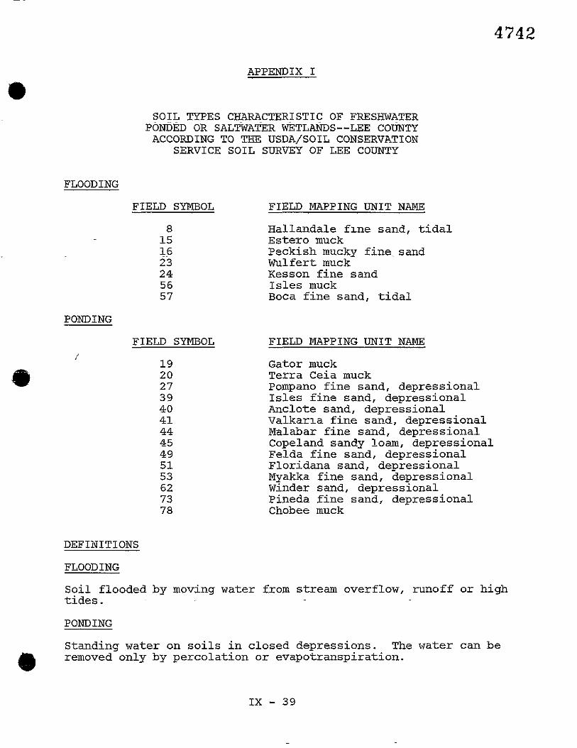
APPENDIX I
SOIL TYPES CHARACTERISTIC OF FRESHWATER PONDED OR SALTWATER WETLANDS--LEE COUNTY ACCORDING TO THE USDA/SOIL CONSERVATION
SERVICE SOIL SURVEY OF LEE COUNTY
FLOODING
FIELD SYMBOL
PONDING
FIELD SYMBOL /
19 20 2 7 39 40 41 44 45 49 51 53 62 73 78
FIELD MAPPING UNIT NAME
Hallandale f ~ n e sand, tidal Estero muck Peckish mucky fine. sand Wulfert muck Kesson fine sand Isles muck Boca fine sand, tidal
FIELD MAPPING UNIT NAME
Gator muck Terra Ceia muck Pompano fine sand, depressional Isles fine sand, depressional Anclote sand, depressional Valkar~a fine sand, depressional Malabar fine sand, depressional Copeland sandy loam, depressional Felda fine sand, depressional Floridana sand, depressional Myakka fine sand, depressional Winder sand, depressional Pineda fine sand, depressional Chobee muck
DEFINITIONS
FLOODING
Soil flooded by moving water from stream overflow, runoff or high tides.
PONDING
Standing water on soils in closed depressions. The water can be
$b removed only by percolation or evapotranspiration.

APPENDIX I1 BLUE RIBBON MARINA COMMITTEE REPORT
P_PPZ?.?.K!IX I I I CHARLOTTE HARBOR AQUATIC PRESERVE MRNAGEMENT PLAN
(See Illuseration #lf) APPENDIX IV
ESTER0 BAY AQUATIC PRESERVE MANAGEMENT PLAN (See Iiiusrration #lij
APPENDIX v LEE COUNTY BEACH ACCESS SURVEY

LITERATURE CITED
Camp Dresser and McKee. Inc.; 1984, Specis1 ?+re. S t U e i n Lee County, Florida.
Florida Land U s e and Cover Class i f ica t ion System. 1976. Florida Department of Administration. T e c h i c a l X e p ~ r t . -'--' ulvls.t.on -' of SEate Planning. S ta t e of Florida.
Florida Natural Areas Inventory. 1983. The Nature Conservancy. Tallahassee, Florida-
- .
Hole, Montes and Associates, Inc . , Engineers - Lane Surveyors. -1981. Lee County Water Master Plan. ~ p p e n d i r 1 A - Hydro- geologic Text. Naples, Florida.
Lee County Water Resources Mapping Program (#7740). 1982. Technical Report. Water Management Division, Resource Con- t r o l . Department, South Florida Water Management D i s t r i c t , West Palm Beach, Florida.
e South Florida Water Pkmgeiiient D I s L t i c t Land U s e and Land Cover Class i f ica t ion System. 1977.

X. HOUSING ELEMENT
LEE COUNTY COMPREHENSIVE PLAN

TABLE OF CONTENTS
INTRODUCTION x-3
PURPOSE ............................................... X-3
EXISTING CONDITIONS ................................... X-3
A. EXISTING HOUSING SUPPLY ...................... X-3
B. OWNER VS. RFNTER OCCUPIED UNITS -------------- X-6
C. REPLACEMENT AND RESABILITATION --------------- D. PLANS AND PROGRAMS ........................... E. SPECIAL ISSUES ...............................
NEEDS ................................................. A. EXISTING AND PROJECTED HOUSING DEMAND --------
a 3. &-.FORDABILITY ................................ DATA METHODOLOGY ...................................... ECONOMIC ASSUl'QTIONS .................................. GOALS, OBJECTIVES AND POLICIES ........................ CONSISTENCY WITH OTHER PLAN ELEMENTS ------------------

INTRODUCTION
Purpose
This element provides guidance for County officials and . .
crt~zens csncern;ng yihlic decisions affectxng one of the mosz
basic needs -- shelter. Local governments in Florida are re-
quired by law to address several housing issues. These include
provision of adequate sites for new or rehabilitated dwellings to
serve all . - existing and anticipated residenzs, regardless of
income or special needs. Local plans should also address the
identification of housing conditions, conservation, replacement,
and improvements of existing stock, relocation, and elimination
of substandard conditions. Implementation programs to respond to
znese issues are to be set forth as well.
Existing Conditions
A. Existing Housing Supply
Lee County has experienced a very high level of housing
construction through the 1970's and into the 1980's (See Figure
1). In November, 1982, Lee County issued the largest number of
building permits for any month of record.' According zo the 1980
Census, Lee County had 111,013 housing units, an increase of
67,502 units or 155% more than the 43,511 units reported in 1970.
Recent construction has occurred primarily in the unincor-
porated areas of Lee County. Multlple family housing has com-
e Lee County Building Department.
X - 3


e prised the largest proportion of residentla1 development. In the
latter part of 1982 a gradual increase in single family construc-
tion was accompanied by a decrease in multiple faaily starts, but
multi-family units continued to become a larger proportion of the
total hecsiaq st=&. (Sse Table lj. As of hprrl 1, 1980, the
unincorporated area of Lee County had 72,407 permanent (year-
round) units. Of this total, 53,612 were occupled on a year-
round basis. The numerical increase in year-round housing stock
in Lee County, on a county-wide basis., is categorized by struc-
ture type in Table 2:
TABLE 1
Type of Structure
as % of County-wide Houslng Stock
1970, 1980, 1983
1970 - 1980 1983" - Single family 71% 52% 49%
Multi-family & Duplex 37% 3 0% 35%
Mobile Home 12% i 8 % 16%
*Estimated from permit activity.
SOURCE: 1970 and 1980 Census; 1983 volumes were estimated from permit activity published by University of Florida, Bureau of Business and Economic Resources ; See Figure 1

e TABLE 2
Additions t o Housing Stock
Lee Co-&'zty, 1976-1980
Single family uni ts : 26,745
Multiple family uni ts* 25,881
Mobile home ricits : l.3,811
Total u n i t s added: 66,437
*Includes duplex and s ing le family attached.
SOURCE: 1970 and 1980 Census
Absent any subs tan t ia l annexations by zhe municipali t ies
within the Cpunty, t he dis.cribution depicted above is not expect-
ed t o change dramatically during t h e time frame of the Plan.
B. Owner vs. Renter Occupied Units
On a county-wide bas i s i n 1980, a t o t a l of 82,509 u n i t s were
occupied, 61,217 by omers and 21,292 by ren te rs . (See Table 3 ) .
Given a t o t a l year-round housing stock of 108,598 un i t s (1980),
t h i s y ie lds a county-wide t o t a l of 26,089 vacant un i t s o r an
overa l l vacancy r a t e of 24% (Table 4). Occupancy/vacancy r a t e s
represent an indicat ion of t h e degree t o which t h e housing supply
is being u t i l i zed . Total sa tura t ion occupancy ( loo%), while
@ t heo re t i ca l ly possible, i s not desi rable since a ce r t a in amount

EXISTING IIOUSING SUPPLY, 1980 ' , -
Total Vacant Total Vacant I Total Total Vacant Ilousing - Seasonal, = Year- - Units = year- = Owner + Renter ~ ~ l i t s migratory Round Round Occupied Occupied
Units Occupied ~ ~
la coral 15,942 3 14 15,628 2,669 i2,959 10,148 , 2,811
1l:CE: "A940 Cc~rsus of Population alld Housing. Census Tracts: Fort Myers-Cape Coral, Fla. b8 11. S. Rul-eau of Llle Census

TADLE 4 I -
OWNER VS. RENTER OCCUPIED UNITS (COUNTY-WIDE)
UNIT TYPE TOTAL YEAR-. TOTAL IJO. OWNER- NO. ' RENTER- TOTAL VACANT VACANC! ROUND UNITS OCCUPIED UNITS OCCUPIED OCCUPIED UNITS RATE
Single Family 6 5 , 5 0 7 55 ,740 45 ,693 10,047 9 ,847 . 15% (ALtached &
De tactled )
Avjcancy r a t e s inc lude u n i t s h e l d for Nseasonal /occas ionalu u s e .
SOURCE; t11900 Census of llousing, General Ilousing c h a r a c t e r i s t i c s 1 ' FloridaI1 U. S . Rurcdu of the Census
X I

(b of vacancy is necessary to facilitate efficient operation of the
market. A county-wide vacancy rate of 24% is deceiving unless
further qualified by the. fact that approximately 15,098 units are
held for lfoccasionalfl use (1980 census). By deducting this
figure from the co~nty-wide vaearuy total of 26,089 unlts, a more
reasonable rate of 10% (10,991 units) can be derived (Table 4).
C. Replacement and Rehabilitation
Lee County is corrxitted to an ongoing effortior-the identi-
fication, rehabilitation and/or replacement of substandard hous-
ing units. The County's Dec. 1983 Florida Small Cities Community
Development Block Grant Application designated as its Target Area
the Ben-David neighborhood (which is part of the larger Dunbar
@ Community and located in desigated U.S.A. Land Use Map). Thirty-
four (34) of this neighborhood's forty-three (43) houses are
sdstandard (80%). The Counry seeks to rehabilitate twenty-three
(23) structures while demolishing nine (9) dilapidated units, and
in addition will upgrade water lines, street, and drainage fa-
An effective neighborhood revitalization program is critical
to promoting housing rehdilitatior. in Lee County. Eousing
rehabilitation and replacement represents a significant opportu-
nity for sheltering future population. Although most of the
County's housing stock is relatively new in comparison to other
metropolitan areas, dilapidation is a serious problem which
merits public xntervention and assistance. According to data
provided by the Lee County Xousing Assistance Office, unincorpor-
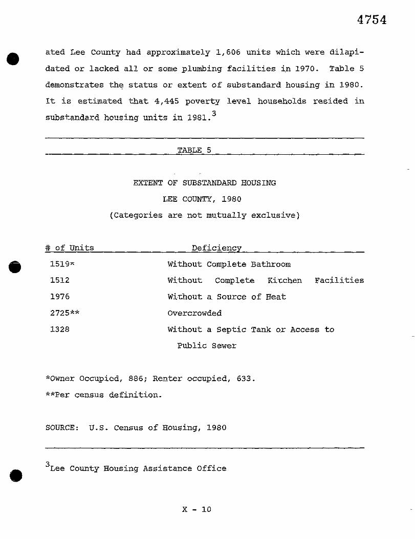
0 ated Lee County had approximately 1,606 un i t s which were d i lap i -
dated o r lacked a l l o r some plumbing f a c i l i t i e s i n 1970. Table 5
demonstrates the s t a t u s o r extent o f substandard housing i n 1980.
I t is estimated t h a t 4,445 pgverty level households resided i n
substandard bousing an i t s in 1981.
TABLE 5
EXTENT OF SUBSTANDAFLE HOUSIi?G
LEE COUNTY, 1980
(Categories a re not mutually exclusive)
# of Units Deficiency
1 5 1 9 ~ Without Complete Bathroom
1512 Without Complete Kitchen F a c i l i t i e s
1976 Wi-&out a Source of Heat
2725** Overcrowded
Without a Sept ic Tank o r Access t o
Public Sewer
"Owner Occupied, 886; Renter occu2ied, 633.
**Per census def ini t ion.
SOURCE: U.S. Census of Housing, 1980
* 3 ~ e e County Housing Assistance Office

Through a combination of Block Grant funds and related
Federal programs, it is tbe County's initial responsibility to
systematically identify and improve existing substandard neigbkor-
hoods. Additionally, the County is committed to developing joint
funding zppllcatic=s xiL5 ziaiiicipallties to rnaximlze the local
redevelopment effort .
D. Plans and Programs
Local government~has a primary role in a community~s housing
market. Without supporting urban facilities and services, the
housing industry would be unable to respond to residential needs.
Where the marketplace does not meet housing needs, it is the
responsibility ~f local government to take appropriate actions to
promoce residentla1 opportunities. The serious shorxage of sound
housing at prices affordable to persons of low and moderate
income must be solved by cooperation and programs between the
public and private sectors. The adequate provision of housing
for low/moderate income families is a primary goal of this Plan
*rough density and development incentives reflected in the Land
Use Element. The County can and must play a significant role in
the supply of houslng for low/aoderate incorne individuals.
Government housing subsidies play an important role in
providing shelter for Lee Countyls low- and moderate-income
households (Defined in Table 6). To date, 1,197 public and HUD
Section 8 houslng units have been constructed, all within the
City of Fort Myers. Of these units, 873 are family units and 324
d) are for the elderly. Federal subsidies from the community Devel-

opment Block Grant program have also been awarded to Lee County.
Rental assistance is also being offered to qualified residents;
to date, 540 families are receiving assistance in the urimcor-
porated areas. In addition, State funds have been successfully
utilized to cocstnlct 166 (60 for h"uS, l06 for Lee County Houslng
Assistance) homes in East Fort Myers for low- and moderate-income
households. 7
TABLE 6 . . . - -
DEFINITIONS FOR LOW INCOME FAMILIES Very-Low Income Families
1 Person 2 Persons 3 Persons 4 Persons $7,950 $9,100 $10,200 $11,350
5 Persons 6 Persons 7 Persons 8 Persons $12,250 $13,150 $14,050 $15, GOO
Lower Income Famllles
1 Person 2 Persons 3 Persons 4 Persons m $14,500 $16,350 $18,150
5 Persons 6 Persons 7 Persons 8 Persons $19,300 $20,400 $21,550 $22,700
SOURCE: U.S. Dept. of Housing & Urban Development, Region IV,
April 1983.
The median household income for Lee County was $14,612 in
1979 (Table 7). Planning District #13 (Sanibel) held the highest
median income ($22,840) while Planning District 88 (Bonita) held
the lowest ($11,983) (Table 8). While the provision of law;/
a ' Ibid. -

ab moderate income housing is a county-wide concern, a Planning
District-specific approach allows for a more area-sensitive
treatment. Obviously, an effort to provide housing for l~w/
moderate income families would address varying income thresholds
depending upor, geographic location or' potential sltes. Currently
recognized practices for calculating income level indicators for
low and very low income families assumes low income to be 80% or
less of the median and very low to be 50% or more of the median.
This method estblishes a county-.~ide median low income to be
$11,690 and median very low income to be $7,306. By recognizing
these standards and applying them on a Planning District basis,
the goals, objectives and policies of this Plan can be imple-
mented.
C TABLE 7
IWIAN HOUSEHOLD INCOME
LEE COUNTY
All Households $14,612
Owner Occupied Household $15,767
Renter Occupied Household $11,666
Median Family Income $16,757
Median Income for Unrelated
Individuals 15 and Over $ 7,077
SOURCE: "1980 Census of Population-General Social-and Economic Characteristics: Florida" U.S. Bureau of the Census "1980 Census of Population and Housing-Census Tracts: Port Myers-Cape Coral, Floridagt U. S . Department of the Census

40 TABLE 8
MEDIAN HOUSEHOrn INCOME
BY PLANNING DISTRICT
Planning Median Household Low Income Very Low District Income (80% of Median) (50% of
Median)
Fort Myers $12,789 $10,231 $ 6,395
South Ft. Myers 17,691 14,153 8,846
Cape Coral 16,046 12,837 8,023
N. Ft. Myers 14,669 11,735 7,335
Alva 13,739 10,991 6,870
Lehigh 14,034 11,227 7,017
East Ft. Myers 17,273 13,818 8,637
Bonita 11,983 11,983 5,992
San Carlos 14,803 11,842 7,402
Ft. Myers Beach 17,086 13,669 8,543
Iona-McGregor 14,122 11,298 7,061
Pine Island 12,605 10,084 6,303
Sanibel 22,840 18,272 11,420
Capziva 14,926 i1,94i 7,463
Gasparilla 16,205 12,964 8,103
SOURCE: "1980 Census of Population and Housing Census Tracts:
a Fort Myers - Cape Coral, Fla" U.S. Bureau of Census Sununary Tape File 3A printout.

E. Special Issues
Resort and vacation destinations such as Lee County have
special housing issues which are represented by 1) hotels, mo-
tels, and kindred services and 2) recreational vehicles. The
number nf hctel,/totel =its had grow szeadiLy (30%) from 1970 to
1979 when the number began to decline. This was probably due to
conversion of hotels to condominiums and also to unrealistic and
uneconomical regulation of this kind of development. In July,
1981, there ~- were 199 motels or hotels wiL& 6,145 unics. How this
number relates to optimum needs of a growth tourist economy is
not clear. In both cases, there is not sufficient information
for policy development at this time. There are several classes
of hotels/motels: those that serve a transient market only, those
@ at have convention and meeting facxlities, and those which, by
their location and amenities, cater to vaca~ioners. Each may
have different needs and produce different impacts on the public
interest. The data are insufficient to do more than logically
distinguish them at this time.
Also, within the past decade, the small house trailer (250 - 300 or so square feet) has reappeared as the "park modelg1 recre-
ational vehicle. While RVgc were conceived of as a way of camp-
ing in comfort, it is suspected that they are creating a new op-
portunity for low and moderate prlce housing for small permanent
or long term seasonal households. Again, the data do not yet
support policy formulation.

In both these instances it is more useful to treat the few
obvious issues as relating to land use and community facilities.
When better data are available, more explicit policy chn be
generated for subsequent plans.
Needs
A. Existing and Projected Housing Demand
With the tremendous growth rates Lee County has experienced . -
to date, housing den~nc! . . has increased accordingly. New housing
units must accommodate the future population, projected at
536,250 total persons, or 264,163 total permanent households by
the year 2005. Thus, an estxmated 175,000 additional dwelling
units will be needed by the year 2005 to accommodate future
permanent and seasonal househglds. In addition, an estimated
44,855 uni~s will require either replacement or rehabilitation by
the pear 2005, based on existing calculations. In summary, Lee
County (on a county-wide basis) will need at least 175,000 addi-
tional housing units between 1980 and 2005 to accommodate future
population growth and replacement units. 4
B. Affordability
The cost of new housing -- land costs, financing charges -- land costs, and increases in construction prices, the cost of new
housing is pricing many families out of the market. According to
the 1980 Census, the median value of an owner-occupied home in
8 '~ousin~ Report, Update 1980, June, 1980 (Southwest Florida Regional Planning Council).

Lee County was $52,200, while the median contract r en t was $231.
Estimates by the Five County Builders Association in December of
1982 revealed t h e average costs of two- bedroom homes- to excsed
$50,000 and three bedroom homes t o be over $60,000.
k e t= these pr ices , ownership alternatives are being sought
by prospective buyers i n the form of condominiums and mobile
homes. While condominium prices a l so remain quite high (aver-
aging between $60,000-$70,000), they offer amenities which are
~ a r t i c u l a r l y sc i t ed t o t bz r e t i r e d person. However, moblle homes - have proven t o be the most affordable, a t l e a s t i n i t i a l l y . New
mobile homes can be purchased for anywhere from $20,000-$40,000,
somewhat less than a s i t e - b u i l t home o r condominium uni t . A
drawback is t h a t mobile homes a r e financed through consumer
C ioans, whlch carry lugher i n t e r e s t r a t e s than conventional mort-
gage lozns. Table 9 i d e n t i f i e s unic value of owner-occupied
housing based upon the 1980 census and contrasted t o similar
s t a t i s t i c s from 1970. During t h i s t en year perlod, median value
of owner occupied housing increased from $17,500 (1970) t o
$52,200 (1980).
When compared t o S ta te and natiopal f igures , Lee County's
median pr ice f o r owner-occupied housing was s imi i i a r i n 1970 and
re la t ive ly higher i n 1980 (Table 10) . However, t h i s should not

0 TABLE 9
Unlt Value of Owner Occupied Housing
Owner Occupied Housing Owner Occupied Condo.
Value of Units # af Enits B of Units
1980% 1970** 1980*
Total Units 40,699 21,427 5,367
Less than $10,000 496 3,448 3
10,000-14,999 725 4,900 8
15,000-19,999 1,077 4,245 19
20,000-24,999 1,743 3,315 95
25,000-29,999 2,124 181
30,000-34,999 2,848 3,558 320
@ 35,000-39,999 3,101 508
40,000-49,999 6,658 1,248
50,000-59,999 5,869 1,031
60,000-79,999 8,321 1,112
80,000-99,999 3,650 1,961 460
100,000-149,999 2,852 267
150,000-199,999 746 62
200,000 + 488 53
Median Value $52, ZOO $17,500 $52,400
*Complete Count Data
**Sample Data
SOURCE: tt1980 Census of Housing-General Housing Characteristics: Floridant U.S. Bureau of the Census; and
tt1970 Census of Housiny-Detailed Housing Characteristic$: Floridatt U.S. Bureau of the Census

MEDIAN PRICE OF OWNER-OCCUPIED HOUSING
COMPARISON
S'mer-Oeciipied Owner-Occupied Renter-Occupied
Housing Unit Condo Units Units-Contract
Rent
1980 - 1970 1980 - 1980 . - 1970 - Lee County $52,200 $17,500 $32,400 $231 $88
Florida $45,100 $15,000 $49,600 $208 $92
USA $47,200 $17,000 $59,600 $198 $89
SOURCE: "1980 Census of Housing - General Hozcing Characteristics: Unzted States Summary" U.S. Bureau of the Census
"1970 Census of Housing - General Housing Characteristics: Florida Summary" U.S. Bureau of the Census
"Florida Statistical Abstract 197211 University of Florida Press
be considered extraordinary given the tremendous growth in the
County's housing stock over the ten year period. Rather it is
apparent m a t newly constructed ucits aad resort uni-cs comprise a
significant portion of the County's stock, thereby substantially
affecting median prices.
The households with special needs, including the elderly,
minorities and female-headed, are finding it increasingly dif-
ficult to afford decent, safe housing. In fact, only 10.1% of
@ all Lee County households were capable of affording =he median

new single family detached unit home in 1978. On the other hand,
73.9% could afford a new mobile home unit. Aside from income
levels, other factors such as building industry practices, govern-
mental regulations, financial restrictions and social constraints
contribute to 5% lack sf affordable iious~ng. Those households
unable to afford safe and sanitary shelter are in need of as-
sistance. According to the 1978 Housing Assistance Plan, such
households numbered 1,507 in Lee County. Of these families,
about 31% were minorities and 57Xwere female-headed. Nearly
one-half of all needy households are renters. 6
Ibid. - Lee County Housing Assistance Office via - Information Services
Dept .

Data Methodologe
A majority of data represented i n t h i s element was taken
from the T'1980 Census of Population and-HousingTT generate& by L5e
U. S. Bureau of the Census. O t h e r sources of projections and data
include6 tlbe Fziversi ty of Florida Bureau of Economic and Busi-
ness Research (BEBR), t he Southwest Florida Regional Planning
Council, Florida S t a t i s t i c a l Abstract, Lee County Housing A s s i s -
tance Office, and the U.S. Department of Housing and Urban Devel- - -
opment . The Planning Department, using the data mentioned above,
first established a generalized housing inventory depicting cype,
condition, and location of units . A market p r o f i l e ( i . e . avail-
able un i t s and pr ice) was then compared with Lee County median
C household income statist ics i n order t o es tab l i sh preliminary
housing trends within individual planning sectors. These trends
compiled with housing projections can then be analyzed t o develop
spec i f ic housing plans which include the goals, objectives, and
pol ic ies of t h i s element f o r localized planning sections.
ECONOMIC ASSUMPTIONS
While housing is LC in tegra l p a r t of 'he overall Comprehen-
s ive Planning process, the Plan does not foresee an inordinate
amount of loca l government f inancial par t ic ipat ion, but primarily
assumes the continuation of the current housing-related level of
public funding. Rather, the economic assumptions t h a t follow
serve t o support the relevant housing-related pol ic ies f o r this
plan element.

0 -- The unincorporated County will continue to provide a dispro-
portionate share of low and moderate income housing for members
of the work force in adjacent jurisdictions who are priced out sf
the housing market in those adjacent jurisdictions.
-- E~usLcg affsrdability will be maintained by reduction in
size of units, reduction in accessories and amenities, and re-
duction in costs per unit through higher densities.
- - Certain economic goals can be best achieved by eliminati~g
discrimination against families in homing-
-- The major Federal subsidy to consumers of housing through
home or apartment ownership and reduction of taxable income through
interest payments, will continue for the foreseeable future.
-- The private sector will continue to play a major role as the
suppiier of housing for all segments of society. Public in-
tervention will focus primarily on programs chat are supported by
intergovfnmental transfer payments (grants etc.). Therefore, in
an effort to successfully compete and attract additional housing
related grants, Lee County will seek the maximum coordination of
the municipalities in submitting joint county-wide application
for funding.
-- Public intervention will be fizanced by the following state
and federal programs.
1) Community Development Block Grants, U.S. Department of Housing and Urban Development
2) Section 8 Rental Assistance Funds, U.S. Department of Housing and Urban Development
3 ) Florida Rural Housing Land Acquisition and Site Develop- ment Assistance Trust Funds
4) Rural Amerlca Loan Funds 5) Section 312 Houslng Rehabilitation Loan Funds, USKUD

6) Florida Department of Community Affairs Weatherization Loan Funds
7) Farmer's Home ~dministration (Federal) 8 j Federll Ucusing ~&tinistratio?i 9) Lee County-Housing Finance Agency
iO) Urban Development Action Grants (Pockets of Poverty)
-- Grants may also be received for historic preservation,
relocation necessary due to transportation problems, removal of
architectural barriers, and establishment of data systems through
other Federal or State programs. ' It is also desirable that the
private developmen-c and financial concerns in Lee County offer
their support for progrms such as housing assistance, construc-
tion of modest-cost dwellings, and below-market-rate interest
loan funds to benefit minorities and low or moderate income
persons.
HOUSING ELEMENT
GOALS, OBJECTIVES, AND POLICIES
GENERAL HOUSING GOAL
To assure the availability of a sound, afford-
able, safe, healthful, and diverse residential
environment for all Lee county existing and
anticipated residents.

e A. LOCATION
Goal X.A: To ensure that housing is located in a maozer
consistent with the Land Use Plan and the urban
..> w~~~~ l.1: ... services and facilities, w~th the local - environment, and with the policies of this Plan.
Objective X.A: Administer the planning, zoning and development
review p-rgcesses in such a manner that proposed
land uses acceptably minimize adverse drainage,
environmental, spatial, traffic, noise, and glare
impacts upon adjacent residential properties
while maximizing aesthetic qualities.
Policy X.A.1. The County shall encourage residential develop-
men.cs to include a variety of housing types which
are properly related to existing and planned com-
munity facilities and services, employment, acL
cess, and other land uses.
Policy X.A.2. In order to serve parsons witi special needs,
disabilities, or handicaps, the County shall
provide for the location of adequate sites for
group homes and foster care facilities through
the designation of zoning districts dispersed
among the residential neighborhoods of Lee County

in which such facilities are considered to be
permitted uses as long as such locations are
consistent with all elements of t h i s P1a.n..
Policy X.?. .3 . mL,. n---- L-- r r L s LULLLILY shall supporc the provision of reason-
ably located standard housing for persons exper-
iencing displacement due to public actions.
Policy X.A.4. The County shall.provide for the location- of^ ade-
quate sites for low and moderate-income resident-
ial development including mobile homes and mi-
grant worker housing.
@ Policy X.A.5. The County shall require that new development ad-
jacent to areas of established residential neigh-
borhoods be compatible with or improve the area's
existing character.
Policy X.A.6. The County shall provide for the location of low
and moderate-income residential development on a
project specific basis through density incenzives
and regulatory actlons in those planning dis-
tricts experiencing growth and/or increasing
employment.

0 B. NEW HOUSING
Goal X.B: To provide consistent policies for guiding resi-
dencia1 development which ensure that future
hcnsing needs are a~ticipared, and assurxng that
housing production is stabilized in order to
promote an adequate supply while protecting
construction trades employment.
Objective X.B: Promote housing development that results in safe,
energy efficient, convenient, affordable, and at-
tractive residential environments.
Policy X.B.1. The County shall encourage a mix of residential
types and designs on a county-wide basis by pro-
viding for a variety of allowable housing densi-
ties and intensities.
Policy X.B.2. The County shall coordinate residential develop-
ment within urban areas to coincide with existing
-or p1a1r-n-ed and. progzammed services and facilities
so as to avoid premature or non-contiguous urban-
ization, the use of septic tanks, and the use of
private wells for potable water within developed
areas.

e Policy X.B.3. The County, recognizing that financing represents
the greatest percentage of housing costs, shall
improve government regulations hnd procedures , '
when feasible to assist in the lowering of costs
c,.- - - - :2 - L 2 - 7 L C ~ ) L W = ~ ~ L L ~ L development and the provision of
more affordable housing.
Policy X.B.4. The County shall improve the local regulatory
process to recluce delays and provide incentives
for lower-cost and energy efficient design,
consistent wlth this Plan and the County's eco-
nomic and administrative capabilities.
Policy X.B.5. County land development regulations shall estab-
lish standards to protect aesthetic qualities and
the physical natural environment, while providing
incentives for residential development designs
which emphasize energy efficient construction,
appropriate solar exposure, air circulation, and
the use of natural shading.
Policy X.B.6. The County land pLanning and zoning process shall
ensure the availability of adequate sites for
future housing, including low and moderate-income
housing and mobile homes.

Policy X.B.7. The County shall develop mechanisms such as den-
sity bonuses and reduced lot sizes in order to
encourage the provision of low-and moderate-in-
come housing in a manner consistent with the Land
Use Element.
Policy X.B.8. The County shall provide density bonuses above
base density to those developments which commit
to the construction of 10% of their coizal units
(on or off-site) for low-and moderate-income
occupancy.
Policy X.B.9. The County phall provide height, bulk and/or
floor area ratio incentives to nonresidential
developments which construct and/or fund low and
moderate-income housing.
C. IMPROVEMENT AID REHABILITATION
Goal X.C: To promote conservation and rehabilitation of
existing housinc; in Lee Counky as a means of
maintaining or improving neighborhood character
and reducing the waste of resources.

a Objective X.C: Support, through financial and tax incentives
within ~tatutory powers, programs which facil-
itate public and private efforts at housing and
property maintenance, rehabilitation, and preser-
Ty-+: -- V S L C L U L L .
Policy X. C. 1. The County shall operate a comprehensive housing
program to be administered by the Housing Assist-
ance Office which includes ~ community and -neigh-
borhood improvement or redevelopment programs
directed at correcting substandard housing con-
ditions, blighting influe~ces, and incompatible
land usage.
Policy X.C.2. The County shall supporz and promote houslng re-
habili~ation programs which use energy conserva-
tion practices for the improvement and reuse of
existing residences as a means of conserving and
preserving existing housing stock.
Policy X.C.3. Weatheriza+Aon prograns provided by State and
Federal agencies shall be Incorporated into the
County's comprehensive housing effort as a means
of encouraging housing maintenance and preserva-
tion by both the public and private sectors.

e Policy X.C.4. The Divislon of Code Enforcement and Housing
Assistance Office shall take the lead in County
efforts to identify homes eligible for various
rehabilitation programs.
Policy X.C.5. Conservation of existing residential areas shall
be supported by enforcement of existing codes,
public improvements, and the provision of infor-
mation on the availability of housing programs to
promote rehabilitation and improvements.
Policy X.C.6. Within eighteen (18) months of the adoption q f
this Plan, the County shall develop, adopt, and
enforce a housing code to assure that housing
shall remain habitable. Adminiszration of this
program shall be by the Housing Assistance Office
and administration with inspection responsibility
by the Division of Code Enforcement.
D. AVAILABILITY AND ACCESSIBILITY
Goal X.D: To ensure that ~e opportunity for adequate
housing is available and accessible to all Lee
County residents.

a Objective X.D: Support a comprehensive county-wide housing pro-
gram which will promote equal housing opportun-
ities for all persons.
Policy X.D.1. The Coznty shail encourage the provision of a
variety of rental and ownership housing oppor-
tunities for all income groups.
Policy X.D.2. Tee County shall sot knowingly appro-ve any de-
velopment which discriminates against housing
availability or opportunities on the basis of
race or other legally prohibited distinctions.
6 Policy X.D.3. The Lee County Housing Assistance Office shall
use available rental subsidies and Community
Development funds for programs designed to pro-
vide sound, safe, and healthful housing and
related community services and facilities for low
and moderate-income residents.
Policy X.D.4. Lee County shall provide coiinseling services co
low- and moderate-income residents which may in-
clude financial guidance, housing maintenance
tips, and consumer advice to assist these house-
holds in securing affordable and sound housing.

Policy X.D.5. Housing plans prepared by County agencies shall
address the provision of low- and moderate-income
housing, quality residential enviro~ments , znd
accessibility to employment and community ser-
T%. #-- LC.=~ arrd facilities .
Policy X.D.6. The provision of adequate housing for migrant
farm labor families and other low income house- . .
.. holds shall be addressed in housing development
plans and ensured by code enforcement.
Policy X.D.7. The availability of housing to suit the special
needs of the elderly and handicapped shall be
addressed in all official housing plans and new
or rehabilitated housing shall be encouraged to
provide access for these persons in sufficient
units to meet their needs.
Policy X.D.8. Self-help housing programs shall be used by the
County as a means of reducing housing costs for
low- and moderate-income households.
Policy X.D.9. The Division of Human Services and Community
Relations shall cooperate with other public
agencles for the enforcement of anti-discrimina-
tion laws.

e Policy X.D. lO. The County s h a l l cooperate w i t h appropriate agen-
c ies i n order t o provide adequate sites f o r con-
gregate l iv ing f a c i l i t i e s , including group and
fos te r care homes, t o meet the requiremenizs of
- - - - - I L 1 ve~nvrrn wi LL-I speciai needs, d i s a b i i i t l e s , and -
handicaps for a community res ident ia l environment
and deinst i tut ional izat ion.
Policy X.D.11 The pol ic ies o f . +he L e e Plan should encourage
f u l l housing opportunities f o r a l l income groups.
E . PLANS AM) PROGRAMS
(6 X-E: To promote the e f fec t ive use of public and p r i -
vate resources t o provide below market r a t e hous-
ing chrough o f f i c i a l plans, programs, and incen-
t ives .
Objective X.E: Maintain a continuing e f f o r t t o improve condi-
t ions f o r r e s iden t i a l development including the
refinement and updating oE codes, reguiaizions,
and enforcement a c t i v i t i e s i n order t o promote
housing opportunities f o r all residents without
sacr i f ic ing m i n i m u m qual i ty standards.

Policy X.E.1. The County s h a l l seek a coordinated redevelop-
ment e f f o r t through in te r loca l agreements allow-
ing f o r jo in t plans, programs, and funding appli-
cations by Lee County and i ts three municipali-
t ies .
Policy X.E.2. The County s h a l l consider, as an integral p a r t of
a l l s f f i c i a l plans and housing programs, the . .
housing and re la ted commaiiity services and fa-
c i l i t i e s needs of ru ra l residents.
Policy X . E . 3 . The County s h a l l continue t o support an e f fec t ive
code enforcement program.
Policy X.E.4. Lee County s h a l l fos te r meaningful participaxion
i n the housing planning process by both the con-
sumers and producers of housing i n the County t o
b e t t e r provide and encourage housing construction
su i ted t o the needs and af fordabi l i ty of resi-
dents.
Policy X.E.5, The County s h a l l assure t h a t exis t ing and new
housing meet minimum standards of l i v a b i l i t y and
design through programs for regulation and re-
view, including code enforcement.

Policy X.E.6. The County sha l l s t r i v e t o ensure t h a t a m i n i m u m
of 10% of a l l new and exis t ing housing un i t s are
a t ta inable t o low- and~moderate-income families.
Policy X.E.?. The ,-.A~..+ - % - 7 7 - -? . -A rvurr~y Duc lLA ~ a a ~ n ~ a i n an ongoing research and
information e f f o r t on housing apd re la ted issues,
including Sta te and Federal leg is la t ion affect ing
housing, county-wide housing needs, and the pro- . .
vls lon of aavice regarding ass is tance programs.
Pol icy X.E.8. The County s h a l l par t ic ipa te i n State and Federal
housing assistance programs t o a id the elderly,
migrant, and other low- and moderate-mcome
households t o secure su i tab le , affordable hous-
ing, including Housing and Community Development
programs, renzal assistance, and new construction
home ownership programs.
Policy X.E.9. The Division of Code Enforcement sha l l e s t ab l i sh
and enforce minimum standards of housing and san-
i t a t i o n an& r e w i r e prompt action i n the ident i -
f i c a t i o n of abandoned o r dilapidated property
which may need demolition, including mobile homes
and migrant worker housing.

Policy X.E. lO. A l l County agencies and departments performing
housing planning and program a c t i v i t i e s s h a l l
coordinate t h e i r a c t i v i t i e s and cooperate with
other relevant public and pr ivate i n t e r e s t s t o
ensure e f fec t ive par t ic ipa t ion i n the houslng
planning process regarding loca l and regional
housing-related issues and developments.
Policy X.E.11. - The ~ County sha l l update loca l regulaCions affect-
ing res ident ia l development, as prac t ica l , t o re-
f l e c t changing household preferences, community
needs, and housing industry economics.
e Poiicy X.E.12. Lee County sha l l invest igate the development of a
special building code f o r s t ructures proposed t o
be located i n vulnerable coastal areas.
CONSISTENCY WITH OTHER PLAN ELEMENTS
The goal of providing sound, affordable, safe , and heal thful
housing f o r the c i t izens of Lee County w i l l be great ly enhanced
by the urban service area concept by +&e provision of building
sites which include adequate and e f f i c i e n t urban services.
Planned growth management w i l l a lso promote affordable housing by
eliminating the higher costs of providing basic services general-
l y associated with urban sprawl.

a Housing sector plans along with the policies contained
within the element will contribute to the local economy by assist-
ing the private sector in delivering housing consiste~t with
demand. Additional revenues for County builders can also be
ex~ected thzcugh t he attraction of Federai Housing Grants for new
construction.
Policies contained within the other elements which also
contribute to the urban service concept will insure that the -. Lee - - .
County resident in the year 2005 will live. in a neighbornood
conveniently located to parks and schools and connected to other
portions of the County by an efficient transportation network.
Services such as police and fire will also insure their safety.

XI. HISTORIC PRESERVATION ELEMENT
LEE COTJNTY COMPREHENSLVE - PLAN ~

TABLE OF CONTENTS
INTRODUCTION ............................................. Puqyse ............................................. Existing Conditions ................................. Needs ...............................................
ECONOMIC ASSUMPTIONS ..................................... GOALS, OBJECTIVES a m POLICIES ...........................
General Goal ........................................ Identi-fication anci Designation ...................... Preservation and protection ......................... Restoration and Rehabilitation ......................
CONSISTENCY ..............................................
Page
xi-3
xi-3
x1-3
x1-4
x1-5
x1-7
XI-?
x1-7
x1-10
x1-13
x1-13

INTRODUCTION - e Purpose
The Historic Preservation element is designed to allow Lee ~. -~
County and its citizens to identify, preserve and protect his-
torlc sites which have scientific, historical, or cul~urai value.
Although the Local Government Comprehensive Planning Act
provides that the Historical Preservation element is opt~onal, it
is an important element for Lee County. This element sets forth
plans and programs for those structures or lands in. the communizy . .
which have historical, archaeological, architectural, or similar
significance.
Existing Conditions
d) Lee Coiiiity's exiszing and past plans and programs for the
preservation of historic sites have been narrow in scope. Affirm-
ative actio~ has consisted primarily of the adoption of the
Historic and Scenic Preservation Element in the 1979 Lee County
Comprehensive Plan and site specific efforts by various groups of
private citizens to preserve structures from demolition.
The County's efforts in implementing the Historic and Scenic
Preservation element of the 1979 Plan were meager. The Co-uty
started an inventory designated as the Lee County Master Site
File. This consisted primarily of a data compilation and an
inventory of archaeological sites, but failed to identify histor-
ical and scenic sites.

Since adoption of the L979 Plan, various citizen's groups
have espoused the historic, architectural and archaeological
significance of such areas as Port Boca Grande, The Orange River,
McGregor Boulevard, the Caloosahatchee River, Pine Island, Cayo
Costa. Galt Island, Lover's Key,'i/Slack island, and many others.
The Board of County Commissioners has publicly acknowledged the
signflcance of these areas and lent at least some public support
to protecting or preserving these areas.
Needs
If this element is going to be successful, sites must be
Identified. All available sources of State and Federal funds
must be pursued to assist in the preservation of sites and struc-
db Lures. A zrust fund should be established by Lee County for the
preservation of historic structures to enable private persons and
organizations to make charitable contributions for site preserva-
tion. Once appropriate sites are identified and designated, the
regulatory efforts should ensure the protection and preservation
of sizes and structures, and that development surrounding desig-
nated sites and structures is consistent and harmonious.
Lee County must aid the efforts of private citizens to lisr;
histor~cal sites on the National Register of Ilistoric Places.
Since Lee County is relying heavily on Federal assistance to
bring the goals expressed hereln to fruition, it will be neces-
sary to have sites in Lee County registered.

The National Historic Preservation Act Amendments of 1980
established a certified local government program. To be certi-
fied under the program, the governgent must enact a local Histor-
ic Preservation Ordinance. Lee County needs to establish uniform
criteria and standards by which s~tes are to be idenufied and
designated. The standards for designation and identificatlon
should be set forth in an ordinance thereby satisfying the
County's need for consistent implementation of this element as
well as satisfying one of the prerecpisites to estahlishkng a . ~
- .
certified local government program for Lee County.
An effective historic board or commission is necessary. The
board should be qualified and aggressive and should assume the
forefront in identifiying and designating sites as well as mon-
e itoririq L5e protection and preservation of sites once designated.
The County needs to identify and maintain historic sites to
provide a sense of community identity and heritage. They are an
invaluable resource that is forever lost once destroyed.
ECONOMIC ASSUMPTIONS
Although Lee County will not be making any capital expendi-
tures on historic preservation, Lee County will receive an eco-
nomic benefit as the preservation of historic resources enhances
the quality of life for all citlzens of Lee County. The preser-
vation of historic areas and structures in Lee County also pre-
serves important amenities whlch can be enjoyed by the tourlst
population recognizing the importance of the tourism industry to
0 Lee County's economy.

The Plan recognizes t h a t there may be an overlap between
@ those si tes and s t ruc tures t h a t a r e h i s t o r i c and those areas o f
the County t h a t a re su i tab le for . use as a county park. To the
extent t h a t a h i s t o r i c s i t e or s t ruc ture is a l so a meritorious
park s i t e , the funding mechanis,.cs delineate6 in the parks eiement
w i l l be applicable.
I f a s i t e is l i s t e d i n the National Register, ce r t a in tax
p r ~ v i s i o n s may apply. The Economic Recovery Tax A c t of 1981,
which revised the h i s t o r i c preservation tax incentives authorized
by Congress i n the Tax Reform Act of 1976, the Revenue A c t of
1978, and the Tax Treatment Extension Act of 1980, provide f o r a
twenty-five percent (25%) investment t ax c r e d i t f o r r ehab i l i t a t -
ing h i s t o r l c commercial, indus t r ia l and ren ta l res ident ia l build-
: --L * il~scrad of a f i f ~ e e n (15) o r twenty (20) percent c r e d i t
available f o r rehabilita-cion of non-historic buildings more than
t h i r t y years old. This can be comb~ned with a f i f t e e n (15) year
cos t recovery perxod f o r the adjusted basis of the buildings.
Cert i f ied s t ructures with c e r t i f i e d rehabi l i ta t ions receive
additional t ax savings because owners are allowed t o reduce the
bas is by one half (1/2) of the amount of the c redi t . The Tax
Treatment Extension A c t of 1980 provides FeGeral tax reductions
f o r char i table contributions for conservation purposes of a
p a r t i a l i n t e r e s t i n h i s t o r i c a l l y important land areas o r s t ruc-
tures .
The -1982 Tax Equity and Fiscal Responsibility A c t (TEFRa)
allows a twenty-five percent (25%) income tax c r e d i t for the cos t
of r ehab i l i t a t ing s t ructures l i s t e d individually o r as port ions

e of a historical district listed on the National Register of
Historic Places. Structures not on the National Register are
ellgible for credits of twenty percent (20%) for structures forty
years or older or fifteen percent (15%) for structures thirty to
thlrty-nine years old,
GOALS, OBJECTIVES AND POLICIES
General Goal
-sites and properties which have sxgnificant scientific,
historical, archaeological, or architectural value to the public
should be identified, designated, preserved, protected, rehabili-
tated and restored in order to protect such sites from drastic
alteration in order to retain a sense of community identity and
Identzfication and Designation
GOAL XI. A. To establish a standard method, plan or program
for the identification and designation of sites
and properties of historic significance.
Obj. X1.A. To encourage the private sector and other public
agencies to identify sites and properties which
should be designated as historical sites or prop-
erties.

e Obj. X1.B. To obtain public and private fundlng for the
identification and designation of sites and prop-
erties.
a 1--- Policy XI .B.1 Lee Cnl111ty shall enact LUCICL~ hlstozic preserva-
tion ordinance.
Policy XI.B.2 Lee County shall establish a Historic Preservation ~.
~.
Board or Com~iss~on to be responsible for. the
identification and designation of historic sites
and properties.
Policy XI.B.3 The Historic Preservation Board or Commission
snail be appointed from among professionals in the
disciplines of architecture, history, architectur-
al history, planning, archaeology or related
disciplines, to the extent that such professionals
are available in the community. Additionally,
Board or Commission members shall include other
persons who have demonstrated a special interest,
experience, or knowledge in Lee County history,
architecture or related disciplines.
Policy XI.B.4 The Historic Preservation Board or Commission
shall meet at regular intervals, but no less than
four times a year.

Poliey XI.B.5 Once sites are identified by the Historlc Preser-
vation Board or Commission, they should be submit-
ted to the Board of County Commissioners for local
designation as an historic site ax a publlc hear-
ing after notice t@ t h e affected property owner.
Policy XI.B.6 The Division of Community Development shall main-
tain an official list of all identified and desig-
nated historic sites and properties in Lee Co-mty~,
and all Federal and State locally designated sites
and other sites of architectural and cultural
significance.
6 f ta~~darc! XI -8.1 A historic site or property should be associated
with events that have made a contribution to the
broad pattern of our history, and should be as-
sociated with the lives of persons sigificant in
our past, or should embody the distinctive char-
acceristics of a type perlod or method of con-
struction, or that represent the work of a master
or that possesses high artistic values, cr that
represent a significant and distinguishable entity
whose components may lack individual distinction,
or that should have yielded, or may be likely to
yield, information important in prehistory or
history.
0 Preservation and Protection
GOAL B To protect designated sites. and properties from
destruction, and to preserve the site or property . . I n its original cr sat-trzl character.
Obj. X1.c.
Obj. X1.D.
To encourage the private sector and public agen-
cies to actively pursue the preservation, protec-
tion and enhancement of desigilated sites.. and
properties.
Obtain public and private funding for the identi-
fication, preservation, protection and enhancement
of sites.
Promote educational programs and the dissemination
of public information on the protection and pre-
servation of historical sites and properties.
Policy XI.E.l Lee County shall landscape, preserve and protect
County-owned and maintained historic sites and
properties.
Policy XI.E.2 The Historic Preservation Commission or Board
shall review all proposals to demolish or partial-

ly destroy a designated slte prior to demolition
and make recommendations tq the Board of County
Commissioners as to the propriety and effect of
the demolition.
Policy XI.E.3 The Commission or Board shall provide assistance
in the coordlnatlon of preservation activities
among the community, to include preservation
groups, citizens groups, - the developmeat com- .
munity, and governmental entities.
Pollcy XI.E.4 Commission shall establish a Historic Marker
Program.
ab Policy XI.E.5 The Board or Comisslon shall accumulate and
disseminate information on Federal and State
grants, funds, and incentives for historic preser-
vation including, but not limlted to, information
on tax incentives, investment tax credlts , tax
preferences, and depreciation for qualified his-
toric structures.
Policy XI.E.6 The Board or Commission shall recommend ordinanc-
es, permit application procedures, and land use
regulations to the Board of County Commxssianers
for adoption to further the goals of historic
preservation and protection.

Policy XI.E.7 Lee County shall exert every effort to enter into
@ an interlocal agreement with the municipalities
within Lee County to-establish a City/County
Historic Preservation Commission or Board.
Policy XI.E.8 Lee County shall establish an Historic Preserva-
tion Trust Fund, to be administered by the Board
of County Commissioners after recommendation of ~ -
the Historic Preservation Commiss.ion or Board- The
Trust Fund shall consist of all monies received
from Federal and State sources, all monies appro-
priated, if any, by Lee County, and monies contri-
buted to the Fund from any other source.
!B Policy XI.E.9 Lee County shall provide the necessary staff
personnel to the Eistoric Preservation Board or
Commission to assist them in all duties.
Policy XI.E.10 Lee County shall protect and preserve designated
sites and properties from destructive, detrimental
or incompatible uses by regulating szlch land uses
and developments in the area of che designated
sites or properties. This policy is referring to
Federal, State and locally designated sltes and
properties.

Restoration and Rehabilitation
a GOAL C: To restore and rehabilitate identified and deslg-
nated historical sites and properties which due to
their curreW s ta te =f r e arc in need of
affirmative action to insure their preservation.
Ob]. X1.F Obtain public and private funding for the restor-
ation and rehabilitation . - of identified and desig-
nated historic sites and properties.
Policy XI.F.l Lee County shall support a program to rehabilitate
and restore structures of historic, architectural,
or cui~ural significance.
Policy X1.F-2 Lee County shall support a program to rehabilitate
and restore structures so that the buildings may
be suitable for reuse, or uses other than the
original use.
CONSISTENCY
The Historical Preservation Element blends in wid several
of the other elements to provide greater definition and respon-
siveness. The Land Use Element seeks to protect existing devel-
opment from incompatible development, and seeks to permit the
diversification of the community s economy, housing and commer-
e clal endeavors, while retaining those resources that initially

a t t r a c t persons t o the L e e County area. Historic s l t e s and
properties are speci f ic resources of the County t ha t add t o the
quality ~ns? chzzscter of che Lee County l l f e s t y l e which a t t r a c t
persons t o the area.
The Parks and Recreation and Open Space Elemest, and the
Conservation and Coastal Zone Element recognize the need t o
maintain unique environmental areas, as w e l l as the need t o
provide adequate areas t o provide for the l e i su re time demands of . -
. a growing community. The Historic ~ r e s e m a t l o n Element i s harmon-
ious with ~e goals and ambitions of the Parks and Recreation and
Open Space Element and the Conservation and Coastal Zone Element,
and these elements, along w i t h the Land Use Element form a co-
hesive un i t as they interface with each other.

XII. INTERGOVERNMENTAL COORDINATION ELEMENT
LEE COUNTY COMPREHEl?SIVE PLAN

TABLE OF CONTENTS
Page INTRODUCTION -----;----------------------------------- XII-3
PEFiMANENT INTERGOVERNMENTAL COORDINATION FORUMS ------ XII-4 RELATIONSHIPS AND IMPACTS ON OTHER GOVERNMENTS ------ XII-5
111. Intra-County Government Agencies ---------- XII-25
A. Potable Water and Wastewater Treatment XII-26 B, Solid Waste .......................... XII-26 C. Educational Facilities --------------- XII-27 D. Skyex- Service Providers -------------- XII-27
IV. Regional, State and Federal Government Agencies ............................. XII-29
A. Special Environmental Concerns and Protection ------------------ XII-32
B. Coordination with Southwest Florida Regional Plan ----------- XII-32
C. Coordination with Charlotte Harbor Management Plan ----------------- XII-33
INTERGOVERNMENTAL COORDINATION GOALS, POLICIES OBJECTIVES ................................. XII-35

INTERGOVE-AL COORDINATION ELEMENT
Introduction
As tile poplation ~i Lee County continues to grow and urban
development intensifies, the number of governmental agencies
exercising some measure of authority or influence within the
County also increases. Policies contained - within ~ the Lee County
Comprehensive Plan, especially the Land Use Element, also impact
County incorporated areas and neighboring county governments.
Coordination and cooperation within and between these govern-
mental units to avoid duplication and promote optimal performance
is neecied on a daily basis. The Local Government Comprehensive
a Pianning Act (LGCPA) provides for this by requiring that an
Intergovernmental Coordination Element be included in.all compre-
hensive plans. Section 163.3177(6)(h), Florida Statutes specifi-
cally requires that the Element show relationships and state
principles and guidelines to be used in the accomplishment of
coordination of the adopted comprehensive plan with the plans of
other inter- and intra-governmental entities at the local, region-
al and State Level. Further, in crder to foster and promote
initial coordination, Florida Statutes also require the element
to include specific policy statements indicating the relationship
of the proposed development of the area to the comprehensive
plans of adjacent municipalities and counties.

* The purpose of the Lee County Intergovernmental Coordination
Element is thus threefold. First, to outline governmental rela-
tionships both within and outside the county; second, to depict
the impact, if any, the Comprehensive Plan shall have on these
goverr-%e?ts; a ~ d finally, to establish mechanisms to ensure con-
tinued cooperation and coordination.
PERMANENT INTERGOVERNMENTAL
COORDINATIOH FORUMS
Cooperation and coordination between governments must not
terminate with the adoption of the Lee County Comprehensive Plan.
Intergovernmental coordination must continue on a daily basis.
Forums to promote and insure this coordination and communication
should be established and maintained.
County-wide transportation planning has been coordinated and
conducted through the Metropolitan Planning Organziation. The
M.P.O. has been the primary vehicle for getting elected repre-
sentatives from the County and the three municipalities together
to discuss not only road needs, but also various related issues
of mutual concern and benefit. The Technical Advisory Commi.ccee
to the M.P-0. (TAC/MJ?O) has served as an excellent vehicle for
brlnging together technical staffs of the four local jurisdic-
tions to discuss mutual traffic improvement issues and programs.
The personal contacts established through the TAC/MPO have led to
a better working relationship among staffs of the four local
governments within Lee County.

0 The Executive Advisory Committee (E.A.C.) is a permanent
committee of the chief executive officers (or their designees) of
the County, the municipalibes, the Regional Planning Council,
the School Board and the South Florida Water Management District.
This comittee has zet periodicaliy as situations and issues have
dictated, and has proven to be an effective mechanism for promot-
ing the flow of information and dialogue among its represented
agencies/governments.
In addition, land use and planning issues of the Southwest
Florida region have been discussed and reviewed by local govern-
ments via participation w i w the Southwest Florida Regional
Planning Council. Major concerns calling for intergovernmental
coordination, such as a hurricane evacuation plans and Develop-
a ments of Regional Impact, have been addressed on a regional
planning level.
Lee County will continue to participate in and support these
forums described above in order to promote and insure inter-
governmental coordination.
RELATIONSHIPS AND IMPACTS
ON OT-XER GOVERNMENTS
The Lee County Comprehensive Plan contains policies and
objectives which may impact other governmental units. In order
to understand these relationships and facilitate communication,
the development plans within the Lee Plan were compared to those
of other governmental units for possible conflict. Particular

emphasis was placed on proposed land uses for abutting jurisdic-
tions, as well as the policies and objectives contained wlthin
the Fort Myers, Cape Coral, and Sanibel plans.
I. COUNTY GOVERNMENTS
A. Collier County
Land Use ~-
The Collier-Lee border west of 1-75 to the Gulf of Mexico is
designated in Collier as Urban and in Lee as Urban Community.
The Collier Plan describes the Urban designation as the area with
the greatest residential densities or expected to receive future
urban servxces resulting in rapid urbanization. In addition to
reside~tial uses, the Collier Plan allows recreacian and open
space uses, communizy facilities and institutions, utilities,
communications facilities, convenience and ~eighborhood com-
mercial uses, and certain kinds of extractive industries.
East of 1-75, there appears to be a difference between the
Lee and Collier plans. Lee County designates the area east of
1-75 as l'open Lands" with some interspersed "Resource Prote~tion:~
and 'ITransitional Zones1'. Collier County has continued its
lSUrban1' designation for approximately two (2) miles to the east
of 1-75. Past this area, the Collier Plan designates the Lee/
ColLier boundary as either ltRuralll or "Parks or Preserves1'. The
Lee Plan lists the primary purpose of the llOpen Lands" category
as being for the utilization of agricultural-rural pursuits

(grazing, fanning, etc.) with residential densities to range from
one (1) unit per one (1) acre to one (1) unlt per fxve (5) acres.
llTransitional ZonesI1 are viewed as being importqnt areas -for the
future water resources and as buffers for "Resource Protectionw
=reas. P.es:c?ential densities woiild not exceed one i S j unit per
twenty (20) acres. Areas designated as "Resource Protection"
areas are environmentally critical, and residential densities
would be limited to one (1) unit per forty (40) acres.
- - - The I'Rurall1 designation in the Collier Co-mty Comprehensive
Plan is not intended for intensive urban uses. Maximum resi-
dential densities would be one (1) unit per five (5) acres with
other allowable uses being agriculture, preserves and open
spaces, utilities and communications facilities, mining and
extraction, and recreational vehicle parks that are compatible
with surrounding land uses and have access to an arrerial road.
Th2 "Parks and Preserveslj category, specifically the Corkscrew
Swamp Sanctuary, was established to protect and preserve. native
Florida wildlife and their habitats.
A basis for mutual agreements regarding development along
the Lee/Collier boundary exists, but a potential for some con-
flict also is present. Given the relatively undeveloped nature
of the lands east of 1-75, it appears that the two counties could
resolve any conflicts through mechanism of an interlocal agree-
ment which would provide for review and comment on proposed
projects .

Other
1. Col l ie r County' s Comprehensive Plan includes overal l
goals and ob jec t ivesand recommendations from which t o achieve
these fu ture goals and objectives. Upon review of t h i s County's
Comprehensive Plas, it i s eviderrt &&-at Lee Countyis Plan is con-
s i s t en t .
2 . Coordination between Lee and Col l ier Counties should be
u t i l i zed t o determine the f e a s i b i l i t y of Lee County t o serve
Coll ier Caunty wiLh a method of s o l i d waste disposal.
3 . Coordination between Lee and Col l ie r County is a l so
important with respect t o the common objective of protecting and
upgrading the commercial f i sher ies resources of the coastal area.
e B. Hendry County
Land U s e
Hendry and Lee Counties abut in a north/south alignment, f o r
approximately 18 m i l e s , t o form the northeastern border of Lee
County. The Land Use Element of t h e Hendry County Comprehensive
Plan, wri t ten i n 1979, characterizes the generalized ex is t ing
land use along i ts westernmost section as uAgricultural Conserva-
tion". In terms of a two (2) m i l e wide pel~endicular corridor
nearest Lee County, the exis t ing land use is almost en t i r e ly
pasture, rangeland, and citrus-production; such uses are general-
l y consistent wizh those found nearby i n Lee County. Extremely
limited growth i s expected i n t h i s area except along Sta te Road
80 where the Hendry County Generalized Exist ing Land U s e Map de-
p i c t s an area one (1) mile (north/south) by two ( 2 ) m i l e s (east /

west) as- "Residential (low density) 'I development. Such a category
allows for one (1) dwelling unit per "gross arear1. A gross area
is defined as an area consistent with prevailing lot sizes and
with the applicable zoning requirements. T h s definition is used
to mitigate Che s&staztial n-mabers of platted lots (subdivi-
sions) created years ago, much like that which occurred in Lee
County. Rather than opting for assemblage of lots, the Element
simply legitimizes those which currently exist. The character of
this area will Lherefore depend up oil^ huyer preference^ and the
availability of lots; the latter topic is not addressed in specl-
fic numbers.
The corridor widens as it nears LaBelle and, at about four
miles inside the County, a "Residential (medium density)" desig-
na-cion begins and continues to the eastern outskirts of the city.
Medium density allows one (1) to five (5) dwelling units per
gross acre and includes all existing subdivisions without any
qualifying text as found in the low density areas. While a range
is given, there is no mechanism or criteria to determine the
allocation of units within the range.
The remaining lands near the Lee County border are seen as
~lAgricultural-Conservationu which preclude residential deveiop-
ment entirely except for thaz which has a direct relationship
with the principal use (agriculture); even suburban residential
development is not permitted. This is contrasted with Lee
Countyls designation of "Open LandsI1 which begins at the County
line and extends westwardly for about three (3) miles interrupted
only by the l1Urban Communitiesw of Alva and Lehigh. These areas

form pockets within the "Open Land1! category approximately two
(2) miles and one-and-one-quarter (1-14) miles, respectively,
west ~. of Hendry County. "Open Lands" does not- specifically pro-
hibit residential use, although it is predicted that these areas
w i l l rmair. rural i~ character afid receive minimal or no infra-
structure improvements; densities ranging from one (1) dwelling
unit per one (1) acre to one (1) dwelling unit per five (5) acres
have been projected. The Ifurban Communitiesu of Alva ~ and - Lehigh
exhibit an emerging urban configuration and have a recognizable -
community character. Capital improvements are projected, shop-
ping and employment centers will likely emerge, and the base
density range extends from .5 dwelling unit per acre to six (6)
dwelling units per acre. Planned Developmenxs meeting perform- * ante criteria could obtain as many as 10 dwelling units per acre.
No real conflict appears evident between the respective Land
Use plans of the counties. The built-in safeguards of the DRI
process coupled with a mechanism for inter-governmental coaper-
ation (e-g., the sharing of information on a formal basis) for
the LaBelle, Alva, and Lehigh communities ensures that neither
County should be adversely affected by development activity for
the foreseeable future.
Other
1. The Hendry County Comprehensive Plan is basically a
policy plan which illustrates general goals and objectives of the
County. However, the specific means by which these goals and
objectives are to be accomplished are not included.
the
nee
way
R i g --
cou
ob j
i b i
rec
for
P l a
cou
for
e i t
f u t
are
the
eco
sub
l i n
2 . The fu ture inadequacy of S t a t e Road 80 is addressed i n
: Traf f ic Circulat ion Element of t he Hendry County Plan. The
id t o widen S t a t e Road 80 t o produce a four-lane -divided high-
from F t . Myers easr: t o the in te rsec t ion of S ta te Road 80 and
.hb?2y 27 is discussed. Coordinazion between Lee and Hendry
.nty should be u t i l i z e d i n the attempt t o meet t h i s common
ective.
3 . Lee and Hendry Counties should invest ivate the feas-
l i t y of Lee County's proposed f u t u r e s o l i d waste resource
lovery f a c i l i t y t o provide the means f o r s o l i d waste disposal
Hendry County.
4, The issues and concerns addressed i n Hendry County's
.n are fundamentally the same as zhose expressed i n Lee
.n ty f s Plan.
Charlotte Councy
Land U s e
Lee and Charlotte Counties share a common east/west border
approximately 42% m i l e s . A two (2) mile wide corridor, on
her s ide of t he boundary, has been examined f o r comparison of
:ure land uses i n zn attempt t o iden t i fy po ten t i a l problem
In terms of ex is t ing land use, development is minimal from
! eastern boundary t o U.S. 41 with agr icul ture the dominant
lnomic pursu l t i n both counties. There is, however, a small,
turban enclave about one-half (1/2) m i l e south of t he County
te and e a s t of U.S. 41 i n Lee County. Moving westerly, some

development is found west of S.R. 765 (Burnt Store Road) and is
increasing which i s a ref lect ion of Punta Gorda I s l e s1 ac t iv i ty .
Commercial endeav-ors, including a marina and warehousing are a l s ~
found i n the area. Contxnuing westward t o t he Gulf, Gasparilla
L s l ~ i r ! shov?s limited deveiopmezlt consisting almost en t i r e ly of
seasonally-occupied, conventional homes.
The present land use along the ent i re corridor can bes t be
characterized as "emerging" with a pat tern fo r increasing intea- . ~
s i t i e s . A comparison of land use plans w a s made - in the same
directional manner and within the above described corridor.
Lee County proposes an 'lopen Lands" designation almost
exclusively from the eastern border t o In te r s t a te 75, interrupted
only by two comparatively small "Resource Protection Areas".
0 "Open Lands" are considered "very rural" i n nature and permit a.
density range from one (1) dwelling un i t per one (1) acre t o one
(1: dwelling un i t per f i ve (5) acres whereas "Resource Protection
Areas" are ecologically lJincompatible with development" and allow
for maximum density of one (1) dwelling u n i t per for ty (40)
acres.
The Charlotte County Plan exhibits more diversi ty i n the
dis t r ibut ion of land use categories within L&e adjacenr: area:
slAgriculture I , Agriculture I - Special Treatment, Residential
Estate Lands, and Commercial and I n d ~ s t r i a l ~ ~ . The l a t t e r three \
(3) categories comprise an extremely small portion of the t o t a l
acreage.

* Comparative analysis of the adjoining areas shows four (4 )
use d i s t r i c t s i n Lee County each permitting only low density
development, i e . , rural , open lands, t ransi t ional , and resource
protection areas. Charlotte County, on the other hand, addresses
s ix ( 6 ) ~ i s + r i c t s w2ich, i n "-- L C ~ S of density, vary from two (2 )
units per acre t o one (1) uni t per t en ( 1 0 ) acres. Also included
are industr ial and commercial pockets while Lee has none.
Charlotte's map i s quite sectlonalized i n t ha t d i s t r i c t s vary . -
frequently and many are small t r ac t s as opposed t o izhe few, large . - - - -
classif icat ions i n Lee County.
Continuing west from 1-75 t o Burnt Store Road, Char lo t~e
County has designated almost a l l areas as "Agriculture It', with
i t s potential one (1) un i t per acre density, contrasted by Lee
C C ~ u n t y ~ s use of "Open Lands1# with a projected density range of
one (1) uni t per one (1) acre t o one (1) uni t per f ive (5) acres.
Lee's Plan przdicts more limited development south of the County
l i n e near Burnt Store Road where rather large t rac t s have been
designated as llResource Protection Areas" and llTransitional
Zones1'. In Charlotte, a ''Mobile Home" usage is projected
abutting the County l ine a t U.S.41. This category has a density
range from one (1) unit per acre t o s i x (6) units per acre. Two
(2 ) miles north on U.S. 41 areas have been s e t aside for "Resi-
dential Estates1' (density range: one (1) uni t per five (5) acres
to two (2 ) uni ts per acre), "Low Density" (density range: one
(1) uni t per acre t o f ive (5) units per acre) and a small ltCom-
mercialt1 node. llAgriculture 1" i s predominant east of Burnt
@ Store Road, except for the northern section which shows a mix of

"LO
t o
"Pa
ess
cou
t i o
ing
WOU
men
mi
10
lis
abu
Cha
"Hi
gat
as
Lee
sen
w Density", "High Density" (density range: 11 uni ts per acre
15 uni t s per acre) , ltCommerciallt and "Park/Open Space1'. The
rk/ Open Spacer1 i s an amenity of the P.G.I. developmect zzd is
e n t i a l l y open space ra ther than a t r ad i t iona l park.
west of 9~rr;t Stors Road tfie land usage in tens i f ies i n Lee
nty with the introduction of the !'Urban Communityt1 designa-
n. I1Urban Community Areas" are ident i f ied as having an emerg-
, recognizable community character. Capital improvements
Id be directed t o these areas aloing with shopping and employ-
t centers. A base density of .5 un i t per acre t o s i x ( 6 )
ts per acre has been projected along with a maximum density of
un i t s per acre contingent upon meeting ce r t a in c r i t e r i a estab-
hed f o r a Planned Development. The "Urban Community Area1'
ts a r e l a t ive ly small "Resource Protection Arean adjacent t o
r l o t t e Harbor. Charlotte County contains a ra ther narrow
gh Density1I corridor along Burnt Store Road and similar elon-
.ed segments t o the west abutting another D i s t r i c t ident i f ied
"Preservationtt. Charlotte 's "Preservatlontl areas, s imilar t o
's Resource Protection Areas, cons is t of 31environmentally
s i t i v e lands and should be protected from urban type devel-
opment. They are major water rechazge areas, lands of s ign i f i -
cant ecological value and/or wi ld l i f e and vegetative habi ta ts ."
The 'tPreservationll c l a s s i f i ca t ion of Charlotte County ex-
tends t o Gasparilla Island interspersed with a "Limited Develop-
ment" category which i s "generally associated closely with pre-
servation land. Development should tzke place only i n those areas
t h a t ensure the long term functioning of the natural hydrologic

e and ecological systems". Development is proposed at a maximum
ratio of one (1) unit per ten (10) acres. Also, east of S.R. 771
(Gasparilla Road) exists a "Commercialr1 node and an flInC!cstrialll
node. This is contrasted by Lee Countyls use of I1Resource Pro-
tection" for a like distance south and east of S.R. 771. On &he
Gulf side, Lee County has assigned an "Urban Community Areal1
designation while, to the north, Charlotte exhibits a variety of
districts beginning with I1Low Density", then . . I1Medium Density1!
(six (6) dwelling units per acre to 10 dwelling unirs per acre),
then llCommercialll and another "Medium Density1' tract. The penin-
sular shoreline shows a narrow strip of I1Limited Development1'
serving as a buffer zone.
Land use inconsistencies do exist within the joint corridor,
(b but it is belleved that there will be no impact on either County
during the interim between any subsequent Plan updates. This is
particularly true from &e eastern border to Burnt Store Road
wherein very little development is likely to occur. There are
instances of Charlotte County projecting higher density land
usage than does Lee in an adjacent area. A bilateral effort at
resolving these instances should be instituted before the next
update. The area adjacent to Surnt Store Road is generaliy
consistent between Counties insofar as density allocation is
concerned. Development here may accelerate, and could conceiv-
ably necessitate cooperative effort. Finally, Gasparilla Island
presents a continuing mutual need to protect its delicate environ-
mental and topographical constraints through prudent land use
policies.

Other
1. The remaining policies contained within the Charlotte
County Comprehensive Plan (i.e. environmental. housing, etc-)
correspond closely to those found within the Lee County Compre-
hensive Pl;tn..
2. Potential future land use conflicts exist for the Burnt
Store area necessitating continued mqnitoring and communication
between each county's respective planning department. ~ . .
3. Interlocal - ~ agreements- to provide joint urban services
for the emerging Burnt Store area could be economically bene-
ficial for Charlotte and Lee County in the future.
11. CITY GOVERNMENTS
A. Cape Coral
Land Use
Because the majority of Cape Coral is currently zoned and
platted for development, the timing and location of public capi-
tal improvements serves as an important guidance mechanism for
future development. The area delineated for the planned place-
ment of all public improvements is termed the Capital Improvement
Investment Area. The City concentrates on the improvement,
extension, and provision of services and facilities within the
Capital Improvement Investment Area and therefore provides de-
velopment incentives within a concentrated land area. The place-
ment of public water lines is probably the greatest incentive for
development within the City of Cape Coral. The groundwater

a throughout most areas of the City i s undeslxable for domestic use
due t o high chloride, sulfur , o r iron content. The planned
placement of public sewer l ines , construction of a new school,
bridge, hospital , or park can also serve t a stimulate develop-
ment, Thus, r.?ithir, L%e City or" Cape Corai, future land use and
development i s directed by the provision of urban services.
The land use designations depicted on the proposed Future
Land Use Map for Lee County within the incorporated area of Cape . .
Coral are consiste-ct wi+h. the curysat and proposed zoning. The
future capi ta l improvement investment areas of Cape Coral are
included en t i r e ly within t he designated Lee County 2005 urban
service boundaries.
a B. Sanibel -
Land Use
Analysis of the Sanibel Comprehensive Plan reveals an ap-
proach t o the planning process which i s s ignif icant ly more s i t e
specif ic than Lee County's Plan. The Sanibel Plan provides t h a t
both t he type and intensi ty of use sha l l be determined by the
capacity of the island t o accommodate development w i t h minimum
~ e g a t i v e impacts. Development areas sI.icli as the Gulf Beach
Ecological Zone, the Gulf Beach Ridge, In ter ior Wetlands, Man-
grove Forest, the Bay Beach Ecological Zone, e tc . , are ident i f ied
and allowable uses, including densi t ies and in tens i t ies , are
assigned t o each area. An analysis of the annual growth r a t e i s
included as a p a r t of the Sanibel Plan and serves as a guide for
the number of development permits issued each year. The number

of permits allocated are based upon projected population growth
anticipated for the coming year. Location of the permits is
based largely upon the availability to provide services for the
projected population increase. The Sanibel Plan also includes a
set of very speclfic nse reg-~latioiis.
Limitations of space, access, water, wastewater treatment,
and the other urban services have combined with ecological con-
straints to produce a maximum carrying capacity. Given that . .-
maximum, Sanibel has outlined, in their Plan, the exact mecha-
nisms which will work, including performance criteria, to achieve
that ultimate figure.
Lee County, however, has quite a different problem in that
its land area, relative to Sanibel, has constraints on a dif-
ferent order of magmtude. The ultimate carrying capacity cannot
readily be dete-mined at this time. Instead, growth must be
predicted over the next twenzy years along with provisions to
service that growth and preserve those environmental qualities
deemed critical to the overall economy and lifestyle of the
County.
While the goals of the Sanibel Plan are fundamentally dif-
ferent from the Lee County Plan, it cioes not mean "Aey are con-
flicting.or exclusive of one another.
Other
The Sanibel Plan evidences a concern with the ecological
balance of the natural systems found in the Island. Commitments
are made to conserve environmentally sensitive areas, as defined

by hydrology, geology, flora, and fauna, as well as recognizing
the critical water management values inherent m the wetland
ecosystems prevalent in many parts of the island.
These policies are also reflected in the Lee County Plan.
The Conservation/Coas+,&! Zone Elment sets up aE inventory of
soils, vegetation, and wildlife critical in the determination of
resource protection areas whlch is similar to Sanibel's approach.
Further, current Lee County regulations require post development
stormwater runoff to replicate pre-c?evelopmenc stormwater runoff ~- -
and flows. Also, the Wastewater Subelement mandates that growth
may not proceed faster than the ability to provide adequate
disposal facilities
Evacuation is also a major concern of the Sanibel Plan.
8 Because egress from the Islapd i s limited by the Causeway, it is
critical that no additional limitations be added which would
further delay evacuation times. Developments in the area refer-
enced above will be carefully studied for such impacts by both
Lee County and Sanibel. The Public Safety Subelement will also
address evacua-cion issues, requiring that development along
evacuation routes provide mitigation for any impact upon those
routes.
Sanibel has identifed beach access as a crltical element in
their Parks and Recreation Plan. This echoes what has been set
forth in the Lee County Plan for the coastal areas. Indeed,
Sanibel and Lee County have already been working cooperatively to
utilize the Causeway and Bowman's Beach areas for the benefit of
the public. Likewise, slmilar goals exist for the recognition
and preservation of archaeological and historical sites.
XI1 - 19

e In conclusion, a series of intergovernmental agreements
covering land use, evacuation, and other issues of mutual inter-
est appears to be merited.
C = Fort Myers
Land Use
The City of Fort Myers' Comprehensive Plan does not include
a future land use map. The Element is based on "existing com-
munity patterns It which serve I1majo+ functions including: living
areas; economic enterprise areas such as commercial business,
sales, services, and production/distribution including industry,
warehousing, utilities and transportation; and public/semi/public
community use areas, including parks, government agencies,
(b schools, churches, and conservation areasgt. Since less than 30%
of the city was undeveloped at the time of adoption of this
Element (June, 1982 ) , che liexisting community pattern" approach is essentially unavoidable. However, a comparison of City/County
future land uses cannot be undertaken. Had the City substituted
the current zoning map for the future land use map, then comparl-
sons could be made.
Annexation by Ft. Myers requires consultation to insure znaz
the process does not regate necessary land use controls. This is
particularly true in critical environmental areas such as Six
Mile Cypress Basin.

Other
The City of Fort Myers' Comprehensive Plan is, in essence, a
policy plan which delineates the broad goals and objectives
toward which the City has committed its efforts. Because of the
npnr r r3n~ ,-,,, j..-.l ..CLIIY I-. L ~ ~ ~ a ~ . ~ a ~ n e d ----.L---L - boundaries, relative to Lee County, i-c
presents somewhat of a different problem for planning purposes
than does the much larger, more rural Lee County. Nevertheless,
Fort Myers' and Lee County's Plans have several aspects in com-
mon, ~. -
Ft. Myerst Plan stresses the need for adequate access to the
Interstate, North Fort Myers, and the Southwest Florida Regional
Airport. It also stresses the need for the improvement of its
collector road system and cites a necessity to relieve develop- * ment congestion due to commercial activities although no mention
is rnade in the City's Plan regarding how these improvements are
to be financed. Lee County's Plan is fully consistent with these
goals and, through the Metropolitan Planning Organization, County
officials have already been working to coordinate transportation
planning efforts. These activities will continue in the foresee-
able future in order to ensure the maximum in accessibility.
For future parks and recreation needs the Ci-cy has recog-
nized as a major priority the need to provide both active and
passive opportunities. The Ft. Myers Plan suggests that an
annually budgeted and escrowed fund be established to achieve
these objectives. Land would be acquired and facilities devel-
oped for identified areas of need within specific neighborhoods
as well as attempting to locate and acquire a community-wide

f a c i l i t y . Additionally, the need f o r an urbanstyle park within
the Central Business D i s t r i c t i s ident i f ied . Programming pr ior-
i t i e s include year-round residents a s well as seasonal residents,
t ou r i s t s , and special groups and in te res t s .
Lee County's Plan idzii t if ied the need -co provlde parks and
recreational f a c i l i t i e s according t o specified standards. While
this i s more detai led an approach than the Ci ty ' s Plan, it ap-
pears f u l l y consistent with the goals and objectives described ~. by
the City. The County's Plan also 1s more e x p l i c i t i n es-cab-
l i sh ing the authority t o enact an impact fee f o r financing park
improvements associated with the demands placed upon the Parks
system by new growth. Like the Ci ty 's Plan, Lee County's element
provides d i rec t ion i n order t o most e f f i c i e n t l y serve the needs
8 of residents and v i s i t o r s for l e i su re a c t i v i t i e s , f a c i l i t i e s , and
spaces.
Ft. Myers1 plan f o r iizs potable water system seeks t o con-
t inue its l eve l of water qual i ty while expanding its a b i l i t y t o
respond t o shor t and long term demands. Improvements i n capacity,
wel l f ie ld protection, f i l t r a t i o n , softening, transmission and
d is t r ibut ion l i n e s , and storage are a l l addressed. Lee County's
Plan meshes w e l l wiLh Lhese concerns but is broader i n i ts scope,
due t o the grea ter d ivers i ty of development i n the unincorporated
areas of the County. Nevertheless, the issues t rea ted by the
Ci ty 's Plan are consistent with the pol ic ies specified i n the
County's Plan.

Sanitary sewer and solid waste disposal are both areas of
concern for Ft. Myers. Improvements to sewer systems will be
designed to increase capacity for future growth while naintaining
environmental integrizy. Solid waste disposal is envisioned to
meve iscreasiogli- into "ue area of resource recovery. In both
these areas, City and County Plans show not only similar con-
cerns, but also the ongoing efforts made to deal jointly with
problems of communitywide concern.
The Ft- Myers Plan also seeks to rninimize drainage pollution
of the Caloosahatchee via on-site retention while improving
runoff characteristics through improvements to local collection
and transmission facilities. Again the fundamental difference in
jurisdictions becomes apparent through the review of this sub-
d, element. While the City's Plan can be seen as consistent with
the County's the issues dealt with in an urban setting are some-
what different than chose of a larger and more rural environment.
The County has the luxury of utilizing the natural drainage
systems as flood control and water purifying mechanisms while the
City does not.
This difference is also reflected in the Conservation and
Coastal Zone Elements. While Ft. Myers identifies the need -co
protect the estuarine features of the Caloosahatchee, the flood-
plains, the solls, vegetation, air quality, groundwater, natural
habitats, aesthetic and scenic sites, flora, and fauna, the areas
encompassed by these commitments are only a small fraction of
those environmentally sensitive lands under the County's juris-
d) diction. Nevertheless, the basic consistency of the two Plans can

e be evidenced in the shared commitment to these features found in
the adoption by both jurisdictions of the Charlotte Harbor Man-
agement Plan.
The Ft. Myers' Housing Element seeks to improve the supply
;md srariety cf & ~ ~ a i l & l e mits, assure aifordabiiity (especially
for the disadvantaged), improve the quality of the existing
housing stock, and to improve and protect neighborhoods as suit-
able living areas. The County's Plan supports these goals and
proceeds further to o~tline implementation s'irategies including
density bonuses for developments that provide low and moderate
cost hoqsing. Recognizing that local government plays a role in
the housing market, Lee County's Plan recognizes the need to
promote sufficient residential opportunities throughout the
community.
Ft. Myers' Plan also contains an Economic Development ele-
ment. This segment recognizes the position of Ft. Myers in the
regional economy and commits the City to work in broadening its
economic base. While the Countyf s Plan does not have a separate
element, economic development commitments have been woven through-
out its fabric. The Plan recognizes the need to diversify and
strengthen the County's econo~ic Sase as well as ?lie necessity to
provide public services for commercial and industrial develop-
ment.
In summary, the City's Plan appears fully consistent with
the policies articulated by the County's Plan. The major efforts
at intergovernmental coordination will likely remain in areas of
information exchange. Interlocal agreements to cooperate on

0 decisions wkch impact land uses and infra8tructure demands w i l l
become more c r i t i c a l as growth progresses. I t is i n these areas
t h a t primary e f fo r t s should be made.
- :><Ta-""""' "--- --- w u l u l r WVLRNIWNT AGENCIES
In the past , services within the County have been provided
by a multitude of government agencies o r pr ivate u t i l i t i e s . A
majority -~ of these asencies finance "Leir respective semi-ces from
t h e i r taxing authority. This taxing authority i n most cases,
however, has not been accompanied by regulatory authority. A s a
r e su l t , many of these agencies have responded t o individual
demand which has precluded the establishment of overall develop- * merit plans fo r t he i r individual areas. This has caused a pat tern
of disjointed development throughout many pa r t s of the County.
One of the major objectives of the Lee County Comprehensive
Plan is t o provide a common framework for development from which
each government agency o r private u t i l i t y extending services may
make decisions. In t h i s manner, a coordinated well managed
development pattern should evolve with a l l areas of the County
having suff ic ient infrilstructure t o support tne par t icular level
and type of land use prevalent.
Many of the pol ic ies within the comprehensive plan w i l l
d i r ec t ly affect the government authority o r u t i l i t y providing
urban services. A s a r e su l t , an analysis of the relationship of
the comprehensive plan t o the provision of essent ial urban ser-
e vlces has been conducted.

A. POTABLE WATER AND WASTEWATER TREATMENT
Most of the policies pertaining to these services are con-
tained in their respective sections of the Community Facilities
znd S~ppert Services Eleiiient. Basicaiiy, these utilltles will be
affected in a similar manner. Policies VII.B.l. (Potable Water)
and VII.G.l. (Wastewater) require the provision of sufficient
infrastructure to provide standard utility service (i.e. central
water and sewer) to all parts of the Xrban Development -Areas,
Interstate Highway Interchanges, Airport and Airport Commerce
areas as designated on the future land use map. To ensure coor-
dination and assist in compliance w~th the Comprehensive Plan,
policies within the Potable Water Subelement provide for the
Q County to establish a Water Resource Agency. Finally, policies
contained within their respective elements require utility com-
panies to file with che County a capital investment and system
development plan consistent with the County's Comprehensive Plan.
B. SOLID WASTE
Solid waste mazcagernent is specifically addressed in a sub-
element of the Community Facilities and Support Services Element.
Provision of solid waste management services shall remain with
those independent private compa~ies which demonstrate the most
effective performance. (Objective VII.Q.l).

C . EDUCATIONAL FACILITIES
The School Board of Lee County is responsible for provieing
educational services to the community. As mentioned previously,
representatives of the School -marc3 have been involved in the
comprehensive planning process through their inclusion in the
Technical Advisory Committee. Membership on the Executive
Advisory Committee (E.A.C.) also insures their participation
within -- the daily planning process.
The County has pledged within the Educational subelement to
establish a closer planning relationship with the School Board by
creating and adopting mutually satisfactory standards for the
location and development of educational institutions. It is
expected that these standards will allow the School Board to
locate schools consistent with local zoning and land use regula-
tion (Policy VII.V.2.).
D. OTHER SERVICE PROVIDERS
Policies throughout the Comprehensive Plan insure that the
County will work closely with the foilowing government agencies
to provide the most coordinated and cost efficient level of
service to their respective districts in coordination with the
Land Use map.

TABLE 1. GGVGiiiGGiiTT AGENCIES - -
- .
; Lee County Hyacinth Control Lee County Mosquito Control Lee County Unincorp. - MSTU Alabama Grove Light - MSTU P.1x.a Fire ~ i ~ t ~ i ~ t Bsyshore Flre Distrzct BiLly Cr. Comm. Light - MSTU Boca Grande Fire District Bonita Springs Fire District Bonita Springs Light Caloosa View 1st Addn. Light Captiva Eroslon - General Captiva Erosion - I & S Captiva Fire District Charlestoo Park Light - MSTU Cypress Lakes Ligh-c Estero Fire District Flamingo Bay Light Ft. Myers Beach Fire District Ft. Myers Beach-Library Ft. Myers Beach Li~ht Ft, Myers Beach Mosquito Cont. Ft .- Myers Beach Sewer Ft. Myers Beach Sewer - MSTU Ft. Myers Shores Fire District Ft. Myers Shore Light Ft. Myers Villas Light - MSTU Gasparilla Is. Waste - MSTU Harlem Heights Light Hendry Creek Light - MSTU Iona Gardens Light - MSTU Iona-McGregor Fire District Lehigh Acres Fire District Lehigh Acres Light Lochmoor Light - MSTU Maravilla Fire District - MSTU Matlacha-P.I. Fire District Matlacha-P.I. Ambulance Mobile Haven Light Morse Shores Light N. Ft. Myers Fire District N. Ft. Myers Light
(b Page Park Lighz Palmetto Point Light - MSTU Palmona Park Light - MSTU Port Edison Light Russell Park Light - MSTU San Carlos Fire District San Carlos Light Sanibel Fire District Skyline Light S . Fla. Water Mgmt. S. Ft. Myers Sewer S. Ft. Myers Sewer - MSTU S. Trail Fire District St. Jude Harbor Light Tanglewood Imp. Tice Fire Distrlct Town & River Imp. - MSTU Trailwinds Light - MSTU Tropic Isles Light Useppa Fire District - MSTU Villa Palms Light Villa Pines Light - MSTU Waterway Estates Light Waterway Shores Light West Coast Inland Waterway Whiskey Creek Imp. - MSTU County Line Drainage Esst Mulloch Drainage East County Water Control San Carlos Estates Drainage Clty of Fort Myers City of Cape Coral Cape Coral Water & Sewer City of Sanibel

I V . REGIONAL, STATE, -kND FEDERAL GOVERNMENT AGENCIES
Goals, po l ic ies and objectives contained-with the Lee C o u ~ t y
Comprehensive Plan r e l a t e o r coordinate closely with those of a
myraid ef goveriiixent agencies locared a t the regional, S ta te , and
Federal levels . The matrix included within the element depicts
various port ions of the Comprehensive Plan where goals, po l i c i e s
and objectives re la ted t o the respective mission of the govern-
ment zgency may be found.

~ ~ . -
STATE OF FLORIDA
Dept. of Environ. Regulation (DER)
Dept. of Natural Resources (Dm)
Dept. of Community Affairs (DCA)
Dept. of Health and Rehab. Svcs. m s )
Dept. of Agriculture and Consum. Svc.
Dept. of Transportation X X (DOT)
Dept. of Education X X
Dept. of Corrections X
Dept. of Banking and Finance
Dept. of Business X Regulation
Dept. of State X
Game and Fresh Water X
e Fish Commission
Dept. of Commerce X X

rn TABLE 2. STATE AND REGIONAL AGENCY MATRIX
REGIONAL AGENCIES C-OVERNMENTS
S.W. Fla. Regional X X X X X X X X Planning Council
South Florida Water Management
W. Coast Inland Navigation Dist.
Chario~ze Co. X X X X X
Collier Co. X X X X X
Hendry Co. X X X X X
City of Cape Coral X X X X X X X X
City of Ft. Myers X X X X X X X X
Sanibel X X X X X X X X
FEDERAL AGENCIES
Environ. Prot. Agency
Axmy Corps of Eng.
H.U.D.
Dept. of Interior X
Soil Conservation Svc. X X

e A. Special Environmental Concerns and Protection
The government agencies which exert regulatory authority
over the environment are of particular importance to lee^ County.
Each agency's permit authority is limited, primarily due to
legislati',.:: rules or budget constraints. In many instances (i.e.
upland ponds) satisfactory protection of the environment may be
lacking. Environmental policies within the Lee County Comprehen-
sive Plan are designed to provide a safety net in areas ~ where .
other goverz-tent21 permit authority aay be .lacking or absent.
Policies located within the Conservation and Coastal Zone Manage-
ment Element coordinate with and provide additional protection
where needed with the permit authority of the State Department of
Environmental Regulation (DER); State Department of Natural
d Resources (DNR);- South Florida Watex Management District (SFWMD):
Army Corps of Engineers and the Federal Environmental Protection
Rg?.ncy (EPA) .
B. Coordination with Southwest Florida Regional Plan
The importance of developing and adherlng to a regional plan
has taken on added significance in this decade. An overall
regional development philosophy can assist :ocal governments in
developing planning goals and objectives which will preserve
their communities1 unique qualities and yet allow citizens of the
region access to urban services based on economies of scale.
The regional development philosophy of Southwest Florida,
put simply, can best be compared with the mechanics of a wheel.
The hub, in this case Lee County--Fort Myers, provides urban

services such as shopping (Edison Hal l ) and transportat ion f a c i l -
i t ies (Southwest Florida Regional Airport) on a sca le which
individual communities could not afford. Periphery comnunities
such as Sanibel, LaBelle and Punta Gorda a c t as spokes whose
co~b ixed demand s ~ p p o r t tilie la rger sca ie urban services located
i n the hub.
The Regional Land U s e Policy Plan developed by the Southwest
Florida Regional Planning Council was analyzed i n re la t ion t o the
Lee County Comprehensive Plan i n order t o - i n s u r e regional consis-
tency and promote intergovernmental coordination. Many of the
goals, po l ic ies and objectives contained within the regional plan
were ref lected throughout the County Plan.
C. COORDINATION W I T H C W O T T E HARBOR MANAGEMENT PLAN
Section 380.045(1)(2), Florida Statutes , provides the
Governor, acting as the chief planning o f f i ce r of the S ta te , the
authority t o es tab l i sh resource planning and management commit-
t ees foy sections of Florida which are deemed t o contain s i g n i f i -
cant s t a t e wide resources. The purpose of the committees i s t o
examine issues threatening these resources and t o create resource
management plans which would prevent t h e i r degradation. The
tremendous growth pressure exhibited i n Lee, Charlotte, and
Sarasota Counties and its p o t e ~ t i a l impact on the Charlotte
Harbor estuarine system resul ted i n Governor Graham appointing
the Charlotte Harbor Committee i n 1978. The Committee w a s charged

with the responsibility of creating a resource management plan
which would preserve the Charlotte Harbor estuarine system and
environs and still provide for the forecasted growth.
The Charlotte Harbor Committee, whose membership included
- representatives frsm each local govermt~ent within Charlorre,
Sarasota and Lee County adopted the Charlotte Harbor Management
Plan (CHR) on June 5, 1981. The CHMP contains two goals; flfteen
objectives and numerous implementation actions which are designed . .
to provide local goverments a general framswork of cri'aria to
be used in regards to development decisions. In order to insure
implementation of the resource plan the Committee approved a
resolution that required each local government to incorporate
goals, policies and objectives within their own comprehensive
plan that reflect those contained within the CHMP.
Many of the goals, policies and objectives contained wil;hin
the Lee County Comprehensive Plan coordinate with and support
those of the Charlotte Harbor Management Plan.
Implementation of the Charlotte Harbor Management Plan is
insured through its incorporation into the Lee County Comprehen-
slve Plan and the creation and adoption of implementing ordi-
nances.

INTERGOVERNMENTAL COORDINATION
GOALS, POLICIES, AND OBJECTIVES
GOAL -
XI1 .A. To cooperate and coordinate with the various govern-
ments in Southwest Florida in order to achieve effec-
tive, efficient, and responsive government for the
citizens of Lee County,. - ~
OBJECTIVES
Objective XII.A.l. Strive to increase effectiveness, efficiency,
and responsiveness of local government opera-
tions through coordination and cooperation in
order to :
a. reduce duplication of effort and facil-
ities;
b. increase the positive external effects
of the Countyy's activities on other
jurisc?ictians, while reducing the nega-
tive;
c. reduce the negative internal effects on
Lee County that may be caused by the
activities of other jurisdictions; and
d. insure cooperation in mutually advan-
tageous plans, programs, and activities.

Objective XI1.B. Establish appropriate coordinating mechan-
isms, particularly at the policy level, where
they do not now exist.
Objective XI1.C. n - - 2 7 2 L..L ca~lssLe.Le the an~exation of areas by the
several municipalities where such annexations
are appropriate and improve the effectiveness
of service delivery to the subject areas and
enhance the efficiency of both the c i ~ y and
the county.
Policy XII.C.l. Lee County shall encourage and cooperate in
the annexation of areas adjacent to the
various municipalities consistent with good
planning and management principles as well as
rhe specific language of Chapter 171, F.S.
Policy XII.C.2. The County, in consideration with each city,
shall designate areas which would be appro-
priately alylexed to that city in order to
rationalize boundaries and to improve the
delivery of public services by both jurisdic-
tions to the land involved.
Policy XII.C.3. The County shall act to encourage each city
to pursue annexations of enclaves, pockets or
finger areas of unincorporated county and

Policy XII.4.1. Lee County shall support intergoverv>.e~tal
coordination by mamntainlng a liason with
agencies of tire State and Federal Governments
to coordinate relevant programs, activities
and funding mechanisms at the local level.
Policy XII.A.2. Lee County shall:
a. utilize the Metropolitan Planning Organ-
ization (MPO) for all matters of coor-
dination in transportatio~ planning and
implementation;
b. utilize the Technical Advisory Committee
to the MPO (TAC/MPO) in matrers requir-
ing communication, cooperation, and
coordination between Lee County and
other jurisdictions;
Policy XII.A.3. Lee County shall work closely with munici-
palities, special use districts, adjacent and
overlapping jurisdictions to adopt mutual
policies consistent with the Comprehensive
Plan in order to give common direction to all
local government actions where possible and
appropriate.

Policy XI1 .A.4. Lee County after prior consult?tion and
resolution where possible will establish,
execute, and maintain interlocal agreeme~ts,
which will include notification and exchange
of significant deveiopmenc appiications, wzth
adjoining jurisdictions for an "area of
impact" relating to:
a. changes in land use or developments
adjoining Couiity rights-of-way in ocher
jurisdictions;
b. cha~ges in land use or developments that
specifically impact county-wide services
or utilities;
c. entering into prior consultation with
the municipalities and adjacent counties
in cases of development of land use
changes when such changes are of mutual
concern; and
d. coordinating housing and economic de-
velopment.
e. joint grant applications including, but
not limited to, Housing Assistance,
redevelopment, transit, and utilities.

Policy XII.A.5. Lee County will investigate and if feasible,
initiate the creation of an intergovernmental
forum designed-to hear and resolve conflicts
through a binding resolution format.
Policy XII.A.6. Lee County shall establish and maintain the
appropriate mechanisms and organizations to
ensure maximum feasible communication and
coordination with all ti12 relevant juris-
dictions and agencies in planning, executing
and evaluating disaster preparedness pro-
grams.

X I I I . I-TLEMENTATION
LEE COUNTY C O M P m N S I V E PLAN

IMF'LEME-?KL'AT I ON
TABLE OF CONTENTS
FINDINGS AS TO PLAN CONSISTENCY ....................... XIII-5

IMPLEMENTATION
No plan can be effective unless its goals, objectives, and
policies are implemented and its standards and mandates enforced.
This comprehensive plan requires two types of performance from
Cnunty sfficials: legislative actions from 'the Board of County
Commissioners and administrative actions to be directed by the
County Administrator's office.
Legislative actions include the drafting and passage-of ~. -
ordinances -- and amendments to existing ordinances -- necessary to enforce the provisions of this plan. The following list sum-
marizes these legislative actions.
1. Amendments to the County Zoning Ordinance which must
be passed within eight months addressing the matters
of:
- Planned Development Districts
- Sign Regulations
2. An amendment to the County Zoning Ordinance providing
for the complete rezoning of unincorporated Lee
County to make all zoning regulations consistent with
the comprehensive plan. This amendment shall be
adopted within thirty mcnt?s.
3. Amendments to che Development Standards Ordinance
addressing matters of:
- Emergency storm shelter provisions
- Incentives for greywater systems
- Neighborhood park dedication requirements

- Other park dedication requirements
- Development design standards for Resource Pro-
tection Areas and Transition Zones
- Removal of noxious exotic species
- r.7--+- r F c r u ~ e water iilanagemenz revisions
4. Adoptlon of a Comprehensive Houslng Code within
eighteen months
5. Adoption of a Transfer of Development Rights (TDR)
Ordinance within twelve monAts
6. Adoption of a Marine Sanitation Ordinance
7 . Adoption of an Environmental Impact Statement Ordi-
nance
8. Adoption of a Mandatory Refuse Collection Ordinance
9. Adoption of a Wellfield Protection Ordinance
10. Amendments to the Building Code
11. Adoption of an ordinance providing density bonuses
for the construction of lqw and moderate income
housing. This ordinance shall also incorporate or
encourage interlocal agreements relating to housing.
12. Adoption of a Historic Preservation Ordinance
13. Adoptioz of a Flar~ed Developnent District Ordinance
The principal adminisxrative actions mandated by this plan
include the following studies and actions:
1. A Transfer of Development Rightsmarket Analysis
Study
2. An Agricultural Lands Study

3. Establishment of a Water Resource Agency
4. A county-wide Fire Coverage Feas ib i l i ty Analysis
5. Establishment of a unified "911" Emergency Response
Communications network
6. EstahlisYiieat of a Beach Acquisition and Maintenance
Program
7 . Establishment of a Master Storm Water Management Pro-
gram
8. Mamiate the afioptioil of a Capital Improvement Program
FINDINGS AS TO PLAN CONSISTENCY
A. Pr ior t o the approval of a land use change, including any
zoning change, special exception, variance, special use
permit, o r unusual use permit, the following findings
sha l l be made:
(1) The land use change is consistent with the adopted
Lee Plan. In addition, the application meets the
following speci f ic c r i t e r i a .
( 2 ) The land use change meets or exceeds the applicable
performance and locational standards.
( 3 ) Urban Services as defined by the Lee Elan are o r w i l l
be available and adequate t o serve t he proposed land
use change, when proposing a change t o an Urban Ser-
vices Category.
( 4 ) The land use change complies with the densit ies and
general uses s e t fo r th i n the Lee Plan.

(5) The land use change w i l l protect, conserve or pre-
serve environmentally c r i t i c a l areas and natural
resources.
( 6 ) The land use change is compatible w i t h existing o r
=la-ad land uses and wouid nob cause damage, hazard - or nuisance, or other detriment t o persons or proper-
t y - ( 7 ) The location of the proposed land use change does not
glace an undue burden upon exis t ing transportation
and other services and f a c i l i t i e s and w i l l be served
by s t ree t s of a capacity suff ic ient t o carry t r a f f i c
generated by the development.
B. Prior t o s i t e plan approval or the issuance of a develop-
ment order, the following additional findings sha l l be
milde i n writing:
(1) Land uses and structures are w e l l integrated, proper-
l y oriented and functionally related TO the topo-
graphic and natural features of t he s i t e , and the
placement of uses or structures within the develop-
ment minimizes the expansion and construction o f
s t r e e t &-ad u t i l i t y improvements.
( 2 ) The internal s t r e e t system is designed for the e f f i -
c ient and safe f l o w of vehicles and pedestrians
without having a disruptive ef fec t on the ac t iv i t i e s
and functions contained within and adjacent t o the
development.

(3) In residential aevelopments, community facilities,
such as park, recreational and open space areas are
functionally related to all dwelllng units and are
easily accessible via pedestrian and bicycle path-
Ways. m-.-I---.-- r u w r u i u u a e s , - co~dominiums , apartments and other
similar types of dense multi-family residential
development shall have common open space provided
directly accessible thereto.

~-
XIV. ADMINISTRATI-VE W PROCEDURAL PROVISIONS
LEE COUxTY COMPRFHENSIVE PLAN

TABLE OF CONTENTS
EFFECT AND LEGAL STATUS OF PLAN------------------------ Effect of the Comprehensive Plan and Preservation of C1early Vested xights--------------------------
ADMINISTRATIVE INTERPRETATIONS OF THE PLAN-------------
Subject Matter of Administrative Interpretations--
Standards for Administrative Interpretations------
Procedure for Administrative Interpretations------
PLAN AMENDMENT PROCEDURES------------------------------
Frequency of Plan Amendments and Mandatory Urban Services Area Review------------------------
Plan Oversight Review and Amendment Procedures --- Application and Review Procedures for Plan Amadment~----~-----------------------------------
XIV - 2

EFFECT AND LEGAL STATUS OF PLAN
A. Effect of the Comprehensive Plan and Preservation of Clearly
Vested Rights ~.
Upon adoption of the Amended Plan, all development and all
actions taken in regard to desrelcpme;;t ori;ers shaii be consistent
with the Plan as adopted. All land development regulations en-
acted or amended after the effective date of the Lee Plan shall
be consistent wlth the Lee Plan. Land development regulations . . in
existence as of the effective date of the Lee Plan which are
inconsistent with the Lee Plan shall be amended to conform to the
goais, objectives, and policies of the Lee Plan, as provided for
the implementation section of the Plan.
The terms "consistent with1! and j'in conformity withw shall
a Sean that all development actions or orders will tend to further
the goals, objectives, and policies of the Plan and will not
specifically inhibit or obstruct the attainment of articulated
policies. Where goals, pollcies or objectives of particular ele-
ments appear to be in conflict, such conflicts shall be resolved
upon an analysis of the entire Lee Plan as it may apply to the
particular area at issue.
The impact of the Lee Plan upon ongoing devzlopment may
involve a balancing of public needs reflected in the Lee Plan and
the expectations of those persons in the process of developing
property in a manner inconsistent with the goals, policies, and
objectives of the Lee Plan. There will necessarily be a transi-
tion perlod in which such development r~ghts will have to be
XIV - 3

balanced with the public needs and purposes expressed in the Lee
qP Plan. During this transition period, in instances where develop-
men.+ .,Lb,,b L- r~as been reviewed and determined to be consisten$ with the
1979 Comprehensive Plan as amended and a final development order
has been issued, such development: to Zhe exteat ~t cannot rea-
sonably comply with the standards established in the Lee Plan,
will be deemed consistent with the Lee Plan as outllned below.
A preliminary development order, not otherwise vested, ~. ~- - -
issued prior to the effective date of this plan, and subsequenrly
issued, shall be deemed consistent with this plan for a period of
three years oniy as to:
(1) terms specifically approved in writing; or
(2 ) accompanying plans expressly approved as to matters
requested ts bs in said plans and requested to be ap-
proved as part of the preliminary development order
process.
A final development order, not otherwise vested, shall be
deemed consistent with the amended plan for a period of five
years from the date of issuance of the development order, only as
to :
(1) terms specifically approved in writing: or
(2) accompanying plans expressly approved as to matters
requested to be in said -plans and requested to be
approved as part of the development order process.
To be deemed consistent, such preliminary and final develop-
ment orders shall also meet all applicable public health, safety,
a and welfare standards. In addition to above-mentioned prelimi-

nary and f i n a l development orders, the following categories of
@ approvals, projects and developments sha l l be deemed t o be consis-
t e n t with t h e Lee Plan, subject t o the applicable condirions as
s e t fo r th below:
(1) A development o r preject Lht has a buiiding permit
issued by Lee County, v a l i d on the e f fec t ive date of
the Lee Plan;
( 2 ) A development o r project t h a t has been granted an
approval under the s i t e plan approval process o f zhe - - -
Lee County Administrative Code F-0015, o r its predeces-
so r s , and the approval was obtained p r i o r t o the effec-
t i v e date of the Lee Plan;
( 3 ) A s i t e plan approved by court order o r s t ipu la ted
se r~ iement which is the r e s u l t of l i t i g a t i o n I n which
Lee County was a party;
(4) An approved, p la t t ed subdivision pursuant t o Pa r t I of
Chapter 177, Florida Statutes;
(5) Final P.U.D. approvals;
( 6 ) A l l developments approved under a s i te -spec i f ic P.U.D.
ordinance;
(7 ) Valid agr icu l tura l a c t i v i t i e s ir, Urban Service Areas,
i n existence p r i o r t o t h e e f f e c ~ i v e date of the Lee
Plan. No increase i n leve l o r change i n type of act iv-
i t y w l l l be deemed consistent under t h i s category;
(8) For ongoing commercial operations, an addition o r
i n t e r i o r remodelmg, l imited t o 25% of the ex i s t ing
f loor area o r 1500 square f ee t , whichever i s less,

except within Resource Protection Areas and Transition
Zones (this is a one time addition); and
(9) A development or projecr. that has been grant& aii
exemption from the requirements of Ordinance 82-42,
provided that the deveioper apply for and receive site
plan approval within six (6) months after the effective
date of the Lee Plan. Such application shall be re-
viewed under Lee County Administrative Code P-0015, and
Lee County regulations ,. - as they exist on the effective
date of the Lee Plan.
The following general conditions shall apply ta the above
nine categories:
(1) Construction must have begun within two (2) years of
the issuance of the approval;
(2') The activity must comply with all applicable public
health, safety, and welfare standards and regulations;
(3) These categories shall be deemed consistent only inso-
far as those items specifically approved; and
(4) The activity shall not be deemed consistent if there
has been a substantial deviation from the approval
granted.
Notwithstanding anything in this section to the contrary, a
development order which would otherwise be deemed consistent
shall not be deemed consistent upon a showing by the County of a
peril to the public health, safety, or general welfare of the
residents of Lee County, which peril was unknown at the tlme of
@ approval.

In other circumstances where development expectations may
conflict with the Lee Plan, the Lee Plan provides a procedure for
administrative determinations of vested rights as set forth in
subsequent sectlons of this Chapter.
Nothing i n the Lee Plan shall liiilit or modify the rights of
any person to complete any development that has been authorized
as a development of regional impact pursuant to Chapter 380,
Florida Statutes.
ADMINISTRATIVE INTEWRETATIONS OF THJ3 PLAN
Persons or entities whose interests are directly affected by
the Lee Plan have the right to an administrative interpretation
of the Plan as it affects then specific interests. Such an
db interpreta~ion, under the procedures and standards set forth
below, shall thereafter be binding upon the County. Such admlnis-
trative intexpretations axe inzended to expedlte and reduce
disputes over interpretations of the Lee Plan, resolve certain
map or boundary disputes, avoid unnecessary litigation, ensure
consiszency in plan interpretation, and provide predictability in
interpreting the Plan.
Anyone seeking an administrative interpretation shall submit
an application and requested information and shall have the
burden of demonstrating compliance with the standards set forth
below.
XIV - 7

A. Subject Matter of Administrative Interpretations
a The person designated by the Board of County Comm~ssioners
shall provide administrative interpretations .only as to the
matters set forth below. In no event shall administrative inter-
pretatlons hereunder involve cpestf ens of "" u r r - consisrency of
development or land use regulations with the Lee Plan. Admini-
strative interpretations shall be limited to:
(1) Clarification of land use map boundaries as to a speci-
fic parcel of property;
(2) Whether, for administrative purposes, rights have
vested as to a specific parcel of property or develop-
ment. Applications for vesting interpretations shall
be made within six (6) months after the effective date
of the Lee Pian;
(3) Whether the single-family residence provision, as
hereinafter defined, applies; and
(4) Whether an area has been designated a resource protec-
tion area or transition zone on the basis of a clear
factual error.
(5) During the transition period six (6) months following
the effective date of the Lee Plan, spparea over-
sights, policy conflicts, and scrivener's errors pre-
viously identified by the LPA may be the subject of an
administrative interpretation where they result in
inequities or unreasonable interpretations.
XIV - 8

* B. Standards for Administrative Interpretations
Administrative interpretations of the Comprehensive Plan
shall be determined under the following standards:
(I) Interpretations which would be confiscatory, arbitrary, . .
capz;cxx;s, urlreason&?jie, or which would deny all
economically viable use of property shall be avoided;
(2) Vesting determinations shall be governed by the stan-
dards for vesting set forth in section (6) below;
(3) All interpretations should weigh rhe public benefits
and burdens against the private benefits and burdens to
be imposed. If an interpretation has the effecc of
providing a substantial public benefit, greater weight
should be given to the effect of the interpretation on
the private property rights and vested rights.
However, if the effect of rhe interpretation would be
to relieve or prevent a substantial public burden,
greater weight should be given to the relief or preven-
tion of that burden;
(4) Interpretations should be consistent with background
data, other policies, and objectives of the Plan, as a
whole;
(5) Interpretations should, to the extent practical, be
consistent with comp3rable prior interpretations;
( 6 ) Szandards for administrative interpretations of vested
rights: The period for administrative determination of
vested rights shall be limited to six months from the

effective date of the Plan. Vested rights shall be
deemed to exist where it is clearly shown by the appli-
cant that:
(a) The applicant has relied on an official affirma-
A:.*- ,IY5: act or oxission of a requ~red act of Lee
County, within the scope of the County's authori-
ty; and
(b) The applicant has acted in good faith and without
--bowledge that existing or pending regulations
might prohibit or prevent the development expecta-
tions claimed to be vested; and
(c) The applicant has acted to his or her substantial
detriment in reliance upon the Countyts act or
approval, and, such that it would be highly i_n-
equitable and unjust to des-croy the rights he or
she has acquired.
To provide applicants with additional predictability in
considering an administrative interpretation of vested
rights, the person designated shall consider whether:
(a) The applications for development approvals and
adqizistrative interpretations of vesred rights
contain factual errors or misrepresentations;
(b) The applicant would suffer actual and substantial
economic loss if required to complete development
in accordance with the Plan or implementing regu-
lations;

(c) The applicant has at all times conformed with
relevant laws, rules, and regulations of the State
of-Florida and Lee County: and
(d) The applicant is not otherwise estopped from
claiming vested righzs though its own acts.
However, a determination of vested rights under
this provision shall expire and be null and voia unless
construction is actually commenced within five years of
the date- of such &termination and unless said con-
struction continues at a reasonable rate under the
circumstances to completion of the project;
Substantial Deviation. Any substantial deviation
from a prior approval which has received vested rights
or partial vested rights status shall cause the develop-
ment involved to be subjecr: to the policies and imple-
menting decisions and regulations set forth in this
plan.
Notwithstanding anything in this Section to the
contrary, a vested rights determination may be revoked
upon a showing by the County of a peril to the public
health, safety or general gelfare of -the residents of
Lee County unknown at the time of approval.
(7) Single-Family Residence Provisions: Notwithstanding
and other provision of this plan, any entity owning
property prior to the effective date of the Lee Plan
which is; 1) a lot created pursuant to Part I, Chapter
177, Florida Statutes plat, 2) a lot not approved by
XIV - 11

the County but recorded pursuant t o the 1973 Subdivi-
sion Regulations, o r 3 ) a l o t o r parcel which was
lawfully recorded i n the of f ice of t h e Clerk of Ci rcui t
Cour-c pr ior t o the adoption of the Lee Plan, s h a l l be
allswed t o construcr. no t l e s s than one single-family
residence on sa id property. The residence s h a l l comply
with a l l applicable health, safety , and welfare regula-
t ions , as those regulations e x i s t a t t he time .the
zpplication f o r *&e residence i s submitted. This r i g h t
sha l l run with the land and be available t o any sub-
sequent owner i f the property owned pr ior t o the adop-
t i o n of the Lee Plan is t ransferred i n i ts ent i re ty .
The l o t or parcel s h a l l have been i n conformance with
the zoning regulations in e f f e c t a t the t i m e the l o t o r
parcel was recorded.
C. Procedure f o r Administrative Interpretat ions
The following procedures s h a l l apply i n obtaining admini-
s t r a t i v e interpretat ions:
(1) Anyone seeking administrative interpretat ions of the
Plan s h a l l submit an application on a form provided by
the County with a l l requssted information;
( 2 ) The person designated by the Board sha l l review such
information, i n conjunction w i t h the County Attorney's
off ice , and i ssue an administrative interpretat ion i n
writ ing within s i x t y (60) days a f t e r submittal of a l l
requested information,
XIV - 1 2

(3) Jn the case of a vested rights or single-family resi-
dence provision determination, such interpretation
shall contain findings and reasons for declaring the
existence or non-existence of vested rights.
(4) An a*inist~ative interpretation may be appealed to the
Board of County Commissioners by filing a written
request within fifteen (15) days after the administra-
tive interpretation has been made. In reviewing such
an ap2ea1, the Board shall consider only information
submitted in the administrative interpretation process
and shall review only whether the designated individual
has properly applied, to the facts presented, izhe
standards set forth in the Plan for such administrative
interpretations. No additional evidence shall be con-
sidered by the Board. The Board of County Commission-
ers snall conduct such appellate review at a public
hearing.
(5) The Board of County Commissioners shall consider the
appeal at a heaing to be held within thirty (30) days
after the date of the written request for appeal. A
decision overruling L'1e written interpretation rendereci
by the Board's designee shall be in writing and shall
be rendered by the Board within thirty (30) days after
the date of the hearing- Alternatively, the Board may
adopt the administrative interpretation being appealed.
(6) Where appropriate and necessary all administrative in-
terpretations rendered by the Board's designee and

thereaf ter approved by the Board of County Commis-
sioners sha l l be incorporated in to the Plan a t the next
amendment.
,.- ".. ..-.--em-- r WY .~ .~~SUIUILN'I' PROCEDURES
Anyone whose in te res t s are shown t o be substant ia l ly af-
fected by the Plan may request i n i t i a t i on of a p l a ~ amendment
under the procedures s e t fo r th below.
A. Frequency of Plan Amendments and Mandatory Urban Services i
Area Review
In order t o avoid piecemeal amendments t o the Plan and t o
ensure a complete evaluation of both the public and pr iva te I m -
a pacts of a l l requested amendments, proposed changes t o the Plan
w i l l be considered on the f i r s t anniversary of plan adoption and
once every LWO years thereafter. Specific inaccuracies or spe-
c i f i c interpretat ions of the Plan may be obtained a t any time
through the administrative interpretat ion procedures of the Plan.
To ensure t h a t adequate land is available f o r growth and t o
ascertain whether designated urban service areas require modi-
f icat ion, the Local Planning Agency shal l , s i x months p r io r t o
each biannual plan amendment period, investigate the need for
modification of exis t ing urban service areas and, i f modifi-
cations are necessary, sha l l recommend necessary modifications t o
the Board.
XIV - 14

B. Plan Oversight Review and Amendment Procedures
Within thirty (30) days after the effective date of the Lee
Plan, the LPA shall hold public hearings -LO identify apgare~t
oversights, policy conflicts, scrivener's errors, or incomplete
policies is h%e T - - u=e n 7 - - r l a r r . The LZA shaii provide the Board of
County Commissioners wlth a report and recommendations for correc-
tive amendments as to such matters not before 120 days, but no
later than 180 days, after the effective date of the Lee Plan.
Thirty (30) days after receipt .of "ke L?A1s reporx zhe first
amendment process, as specified below, will commence.
C. Application and Review Procedures for Plan Fmendments
Any request for amendments, modifications, additions or
e changes to the Comprehensive Plan shall be submitted to the Di-
vision of Community (DCD) at any time. The DCD shall intiate
review of such requests on January 1 of each year in which plan
amendment may occur. Requests received prior to January will be
held for review until that tune. Requests received after January
31 will be held until the next review period begins.
Unclear or incomplete applications may be supplemented no
later than February 15th- Pay request which repires a modifica-
tion to designated urban service areas shall be accompanied by an
analysis of expected economic and environmental impacts. To
ensure analysis of all relevant information, all appraisals,
economic, environmental, or other reports or studies relied upon
by a person or entity seeking plan amendment, shall be submitted
no later than February 15. The LPA and the Board shall not
e consider any reports or studies submitted thereafter. After
receipt of applications the following procedure shal l be fol-
lowed: -
(1) The DCD sha l l prepare. a list and description of a l l
applications received, inciuding s t a f f applications,
and describe the nature of each application and the
reasons s tated fo r requesting each proposed amendment.
Such l is t sha l l be submitted t o the Local Planning
. ~
Agency on or before Na~ch 1st;
(2 ) The DCD shal l submit t o the Local Planning Agency on or
before the f i r s t business day of April the Division's
recommendations on each application whether or not an
impact statement is required;
( 3 ) DCD shql l also prepare and submit by the f i r s t business
day i n May, an economic and environmental impact s ta te-
menr: as t o a l l plan'amendments requiring a change i n
the existing urban service area. Such statement sha l l
describe economic and environmental benefits and det r i -
ments reasonably expected t o resu l t from the proposed
amendment;
(4) The Local Planninq Agency sha l l hold one or more public
hearings on applications fo r plan amendments pr ior t o
June 1st;
(5 ) The Local Planning agency sha l l make i ts recommenda-
t ions and e i ther ce r t i fy proposed amendments, modifica-
t ions, additions or changes t o the Plan, or cer t i fy i ts
XIV - 16

reasons-for not recommending such changes. Said c e r t i -
f i ca t ion s h a l l be transmitted t o the Board of County
Commi_ssioners on o r before July 1st;
( 6 ) On or before August 15th, the Board of County Commis-
s i ~ s e r s , follo'w'iag one o r more pubiic hearings, s h a l l
transmit i t s proposed amendments t o the Department of
Community A f f a i r s and the Regional Planning Council;
( 7 ) A t l e a s t two weeks a f t e r replying t o any Department of
Community Af.fa$rs_ and Reglaaal Planning Council obgec-
t ions , the Board of County Commissioners s h a l l take
f i n a l action on applications f o r a l l amendments t o the
Comprehensive Plan. A t l e a s t two public hearings s h a l l
be held on such applications.
XIV - 17

4860 GLOSSARY OF "TERMS"
ACTIVE RECREATION: Actxve r e c r e a t l o n r e q u l r e s a c e r t a l n degree of ~ h y s l c a l ex- e r t i o n . Recreation a c t l v l t i e s t h a t a r e of this srienLafjon-a~e:ggneralf~ ,
Of CQ groan' _ . _ _ - ? P A 1 _ 01 tea" n 2 ~ u r e and ..-..-ll-- U ~ ~ a ~ ~ ~ ~ ~ ~ u f r e an e s ~ a b l ~ s h e d play- f l e l d o r type of cour t t o accommodate them (1.e. basebal l , f o o t b a l l , t e n n l s , baske tba l l ) . Thls form of r e c r e a t l o n h e l p s t o promote b e t t e r phys lca l f l t n e s s and mental wellbeing by allowxng f o r a r e l e a s e of ene rg le s and tensions.
AVERAGE ANNUAL DAILY TRAFFIC: The t o t a l yea r ly volume d lv ided by t h e number of days i n t h e year , commonly abbreviated a s AADT.
BASERLIOD: The f l o o d havlng a one percent (1%) chance of belng equal o r exceeded I n any glven year .
"BEST MANAGDENT PRACTICE": That prac tzce which provides reasonable assurance t h a t a glven s tandard of performance can be a c h ~ e v e d (South Flarxda Water- Management D l s t r l c t ) .
BIOLOGICAL OXYGEN DFMAW (BOD): The amount of organic ma t t e r i n water a v a l i a b i e t o be taken up with d isso lved oxygen from t h e water by biological processes.
CXPaCITYF.C&~2ci:t.y l s ' t h e maxlmum number of veh lc l e s w h ~ c h has a reasonable ex- pec ta t lon 0.f passlng over a g lven- sec t~on-d f roadway durlng a glven tlme per lod under p revaxhng roadway and t r a f f l c condl t lons .
a CAPITAL I M F ' R O ~ S : The a c q u l s l t l o n of l a n d , r e a l proper ty o r a phys lca l facility, o r t h e cons t ruc t ion of a phys lca l f a c l l l t y .
CAPITAL IMPROVEMENT BUDGET: The annual ly adopted llst of c a p l t a l mprovements t o be bullt: o r begun i n t h e ensulng f l s c a l year t o g e t h e r wlth d e t a l l e d c o s t estlrnates and commitments of funds by source.
CAPITAL IMPROVEMENT PROGRAM: The adopted schedule o r t u n e t a b l e of proposed c a p i t a l Improvements t o be c a r r i e d out during a s p e c l f l c perlod and l l s t e d i n order of p r l o r l t y , t oge the r wl th c o s t estimates and t h e an t l c lpa ted means of f lnanclng each p r o j e c t . Often used as a b r ldge between t h e Comprehensive Plan and t h e annual budgetxng process.
CREMICAL OXYGEN DEMAND (COD): The amount of matter a v a l l a b l ~ e i n water w i th t h e p o t e n t i a l t o t a k e up dissolved oxygen froiu t h e water by var lous chemlcal processes .
CLUSTERING: A development deslgn technique t h a t concent ra tes on a group of bul ld lngs o r uses l n s p e c l f l c a r e a s t o a l low t h e remalnlng a r e a t o be used f o r open space, buffering, ~ o l n t - p a r k i n g , r e c r e a t l o n , water management o r p ro tec t lon of envlronrnentally sensitive a reas .
CONDOMINIUM: A t ype of ownership of an apartment i n a bul ldug--or a house i n a development--where ownership of common a r e a s 1s shared. Ownership i n

GLOSSBRY OF "TERMS" (cont 'd)
CONDOMINIUM (cont 'd) : which t h e owner has an i n d l v l d u a l deed (and l l k e l y a l s o an individual mortgage) 02 t h e u n i t , and a l s o holds a common o r jo ln r owner- shxp m a l l common a r e a s , such a s grounds, l o b b l e s , and e l eva to r s . A condomlnlum u n l t need n o t be occupled by t h e owner t o be counted.
Noncondomlnlum: A 1 1 o t h e r types of ownership, ~ n c l u d l n g cooperatives where a h e r e i n a corporat loi i ~ i t h t i t l e t o a niuiti-unlt property en- t i t l e s t h e owner t o occupy a s p e c l f ~ c u n l t .
COST EFFECTIVE: An a c t l o n o r technique i s "cost e f f e c t i v e " when it o f f e r s more b e n e f l t per u n l t c o s t o r lower c o s t per u n i t b e n e f i t than an alternative.
COUNTY COASTAL CONSTRUCTION CONTR& LINE (ZONES): The County Coastal Construct lon Control . -
l i n e o r Zones landward of t h e mean h ~ g h water along t h e Gulf o f Mexico-are
-- l d e n t l f i e d on t h e Lee County Coastal Construct lon SetbackMap w h u 3 is on file- a t t h e Div l s lon of Community Development.
DENSITY: The number of r e s l d e n t l a l d ~ ~ e l l l n g o r housing u i i i t s per gross a c r e (du/a j . Dens l t l e s s p e c l f l e d i n t h l s Plan a r e Gross Res lden t l a l D e n s ~ t l e s . For t h e purpose of calculating g r o s s r e s l d e n t l a l dens l ty , t h e t o t a l acreage of a development lnc ludes those lands t o be used f o r r e s l d e a t l a l uses , and lnc ludes land wi th ln t h e development proposed t o be used f o r s t r e e t s and s t r e e t rlghts-of-way, u t l l l t y rlghts-of-way, pub l l c and p r l v a t e parks, recreation and open space, schools , community c e n t e r s , and f a c x l i t l e s such a s p o l l c e , f l r e and emergency services, sewage and water and drainage. Lands f o r commercial, o f f i c e and l n d u s t r l a l u ses , e x l s t l n g open water b o d ~ e s and o t h e r non-resxdentlal uses s h a l l no t be included.
DEPARmNT OF NATURAL h%SOoLmCES COASTAL CONSTRUCTION CONTROL LINE: The Department of Natural Resources Coas ta l Construct lon Cont ro l l l n e o r Control l l n e i s t h e l l n e established pursuant t o t h e provls lons of Sec t ions 161.052-16.053, F lo r lda S t a t u t e s .
DEVELOPMENT: Has t h e meanlng given i n Chapter 380, F lo r lda S t a t u t e s .
DEVELOPMENT OF COUNTY IMPACT (D.C.I.): A development whlch, because of i t s cha rac te r , magnitude, location, s u e , t imlng,dens i ty o r I n t e n s i t y would have a sub- s t a n t l a l e f f e c t upon t h e h e a l t h , s a f e t y and wel fare of t h e c l t l z e n s of t h e County, Developments of County Impact s h a l l be spec l f l ed i n zonlng o r development regulations and ordinances.
DEVELOPMENT ORDER:-Any order grant lng , denylng, o r g ran t lng wlth condl t lons an app l l ca t lon f o r a development permlt.
DEVELOPMENT PFHET: Inc ludes any bul ld lng permlt , zonlng permi t , subdlvls lon approval , rezoning, c e r t l f z c a t i o n , s p e c i a l exceptlorrj. variance, o r any o the r o f f l c l a l a c t l o n of l o c a l government havlng t h e e f f e c t of perml t t lng t h e development of t h e land.

4862 GLOSSARY OF "TEXMS" (cont ' d)
FLOODING: A genera l o r temporary condl t lon of p a r t l a l o r complete inundation-of r?ormllly iry lznd .reas frGm; '1 \ " 7 --GI-.. -G --?--a o r ' - 2 - 7 '"\ \*, " J r r L l U r "L l l l l C L l ' Y c l u a r waLcr, \L,
Unusual and r ap ld accumulation o r runoff of su r face water from any source.
FLOOD HAZARD AREA: The a r e a s u b j e c t t o f looding dur inz t h e 100 Year Storm Event o r base f lood a s defxned by t h e Federal Flood Insurance Program.
FLOOD PRONE AREA OR FLOODPLAIN: Any land a r e a susceptible t o belng inundated by water from any source.
FRANCHISE: An exclusive r l g h t t o s e l l a good o r produce a s e r v l c e wl th ln a l l m l t e d geographic a rea . -
FZTNCTIONAL STREET CLASSIFICATION: Funct lonal c l a s s ~ f i c a t x o n i s t i i e process by which s t r e e t s and hlghways a r e grouped l n t o c l a s s e s , o r systems, according t o t h e - - cha rac te r of s e r v l c e they-are-intended t o provide. - ~ a s l c t o t h l s p;ocess i s t h e recognition t h a t l nd lv ldua l roads and s t r e e t s do not serve t r a v e l indepnnann+lrr -..-----, LC any ma;Cr :ray. D ..acrrcr tho- , most +--. - 7 --..- I. - LL ~ J S I LIIVUIJCS IIIUVCIIICIII-
through a network of roads. It becomes necessary then t o determine how t h l s t r a v e l can be channelized wi th ln t h e network i n a l o g l c a l and e f f z c l e n t manner. Funct lonal c l a s s & ~ c a t l o n de f ines t h e n a t u r e of this c h a n n e l l z a t ~ o n process by def ln lng t h e p a r t t h a t any particular road o r s t r e e t should play i n serv ing t h e f low of t r l p s through t h e o v e r a l l network.
HOUSING UNIT: A house, apartment, mobile home o r t r a l l e r , group of rooms, o r s l n g l e room occupied o r lntended f o r occupancy a s a s epa ra t e l lvxng q u a r t e r s . Separate l l v l n g q u a r t e r s a r e those i n whlch t h e occupants do not l i v e and e a t wlth any o the r person I n t h e s t r u c t u r e and whlch have d l r e c t access from t h e ou t s lde of t h e bul ld lng o r through a common h a l l .
HYDROPERIOD: The c y c l l c v a r l a t l o n i n t h e volume of water flowlng I n a system through tlme.
IMPERVIOUS: The condl t lon of not permlttxng a m a t e r l a l (gas o r l i q u ~ d ) t o pass through another ma te r l a l ( s o l i d ) ; f o r example, water through an a s p h a l t pavement.
INFILTRATION: The f low of a l ~ q u i d through a porous ma te r l a l ( a l s o pe rco la t lon ) .
INTENSITY: A measurement of t h e degree of customarl ly n o n - r e s l d e n t ~ a l uses based on use, s i z e , impact, bulk, shape, he lgh t , coverage, sewage genera t lon , water demand, t r a f f l c genera t lon , o r f l o o r a r e a r a t i o s .
LAND : Earth, water and a l r , above, below o r on t h e su r face , and inc ludes any improvements o r s t r u c t u r e s customarl ly regarded a s land .
LAND USE: The development t h a t has occurred on t h e land , t h e development t h a t i s proposed by a developer on t h e land , o r t h e use t h a t i s permitted o r per- mlssable on t h e land under t h e adopted Comprehensive Plan o r element or
e p o r t l o n - t h e r e o f , land development regulations, o r a land development code, a s t h e context may indicate.

4863 GLOSSARY OF "TERMS" (cont'd)
LEXCHATE: The ~olutlon/suspenslon of materral in water whlch has percolated ihrough a landfill.
TEErn OF SBVICE: Level of servxfe is a term-whlch, broadly interpreted, denotes any one of an lnflnlte number of differing combinations of operating condltlons that may occur on a glven lane or roadway when it is accommo- dating varlous traffic volumes. Level of Zervzce is a qualltatlve measure of the effect of a number of factors, which Include speed and travel tlme, trafflc interruptions, freedom to maneuver, safety, drlvlng comfort and convenience, and operating costs. In practice, selected speciflc levels are deflned m terms of particular llmltlng values of certaln of these factors. Levels of Servlce. vary from "A" to "F". Level of Servlce "A" provtdes a free flow condition with relatively low volumes and hlgh speeds. Level of Servlce "E". provldes unstable flow and Level of Servlce "F" forced flow. Level of Servlce "C" is a desirable efflclency -whereas Level of S e m c e "D" 1s often asso~ciated with urban and peak season travel.
MARINA: Marlna means any place whlch allows for the mooring and/or storage of boats or fuellng*facllltles or sales.
MARINA (INDUSTRIAL): Any place whlch allows for the mooring and/or storage of boats fuelxng faclllties or ancllllary repair and maintenance servlces or sales.
MIXED USE: The development of land or bulldlng or structure wlth two or more different but compatible uses, such as, but not limlted to, resxdentxal, offlce, industrial and technological, retall, commercial, public, enter- tarnment, or recreatlon, in a compact urban form.
OPEN SPACE: Land, publlc or prlvate, unoccupied or predominately unoccupied by burldlngs or structures, havlng use for parks, recreatlon, water management vegetation, agriculture, conservation, protection or preservation of water resources, hstorlc or scenlc resources, green space, green belts, natural rxvers and streams, forest, wetlands, beaches and dunes, wlldllfe habltat, preserves, sanctuaries, reserves and refuges, and alr and water.
PASSIVE RECREBT33l: Passlve recreatlon actlvltles are ones whlch requlre a rnlnlmal amount of' piiysical-:.eff ore -and-help 'greatly m promotxng - physlcal and psy- chol-ogiX.irefreshment. Such actlvltles as plcnlclng, camping, strolling In the park, and water-or~ented recreatlon in the forms of flshing and boating all help to stimulate feellngs of relaxation and outdoor enjoyment.
PEBR HOUR TRAFFIC: The hlghest number of vehicles found to be passlng over a sectlon of roadway durlng 60 consecutive minutes.
PEAK TRAFFIC SEASON: Generally, that quarter of the year (consecutive three months) wlth the highest average daily trafflc volumes exhlbxted on the area roadway network.
PERCOLATION: The flow of a lxquld through a porous material under the Influence of gravxty or pressure (also infxltratlon).

4864 GLOSSARY OF "TERMS" (cont ' d)
PLANNED DEVELOPMENT: A development that 1s deslgned and developed as a cohesive, integrated unlt under s~ngle ownersh~p or unifled control whlch permlts flexibility in bulldug sltlng, mlxture of houslng types or land uses, clustering, common functlonaz open space, the sharing of services,. facllltles and utllitles and protectlon of environmental and natural re- sources. A Planned Development is synonomous wlth a Planned Unxt De- velopment.
PLBNNED DEVELOPMENT DISTRICT: .A land use category that is a "floatmg" performance standard-based dlstrlct to permit the consideration-6f developments outslde the Urban Servrce Area, provided that the development must be totally independent of County subsrdlzed facilltles and servlces and shall not result in harmful envlronmental/natural resource, economlc, flscal, ~nfrastructure/servlc+, or publlc safety impacts. .
. .
RECREATION USE: The occupation, ubl~zatlon; consumption or enjoyment of a recreation resource, or of a particular part of a recreatlon resource.
ZSOIIXCE BASED RECREATION AREAS: These are areas that possess a hlgh degree of natural beauty through the land, alr and water resources that compose them. These areas generally have a hlgher level of intrinsic value- meanlng those visual and other aesthetic qualities of thelr natural environment. Examples of resource-based recreatlon areas are beaches, wetland preserves, and riverfront parks.
RESOURCE PROTECTION AREA: A Resource Protection Area means lands thar exhxbit sol1 types, hydrologic and vegetation characterlstlc of freshwater and salt- water wetlands.
RESOURCE RECOVERY: Varlous techniques of recovering reuseable or recyclable materials or energy from garbage and trash.
REUSE WATER: Treated wastewater whlch, as a commod~ty, is sold to varxous users for agricultural irrigation, coal slurry pipelmes, grounds management (institutional lawns, golf courses) or industrial use:
REVERSE OSMOSIS: A technology for desalinizing water through mechanical pressure.
SERVICE VOLUME: Servlce volume is the maxlmum number of vehicles that can pass over a given sectlon-of roadway durlng a speclf~ed tlme period whlle operating condltlons are maintained corresponding to the selected or specified I level of servlce.
SLUDGE: The solids remawing after settllng and treating wastewater (also septage).
TRAFFIC ANALYSIS ZONE: A geographzcal area wlthln the County by whlch economlc, land use, soclo-economlc and other data is collected and projected. Usually comprised of one or more census tracts with boundaries generally formed by major roadways, municipal jurlsdictlons and natural barriers.

4865 GLOSSARY OF "-" (Eont 'd)
TRANSITION ZONE: A Transition Zone means lands that may be seasonally inundated from one to three months as indicated by water marks, do not have de- pressional soils, and are characterized by a mixture of plant specles
- - typical of uplands and wetlands.
UNDEVELOPED BARRIER ISLAM): Undeveloped coastal barrier lslands are 1) areas de- slgnated by the United States Congress as undevelo~ed in the Coastal Barrler Resource Act (PL 97-348); 2) other barrier islands, spits, peninsulas or portions thereof that have sparse settlement, no infrastructure for support services, and access by watercraft or aircraft only.
UNIQUE (FARMLANDS): Unique farmland is land other than prlme farmland that is used for the production of specific hlgh value food and fiber crops. It has a special combination of sox1 quality, location, growlng season and moisture. supply needed to economically produce sustained high quality alid-or'.high
- yields of a speciflc crop when treated andmanaged according to acceptable farming methods. Examples of such crops are cltrus, fruit and vegetables.
--- ----- ---- ~ M A N bhKVlLEb: The requisite servlces, facilltles, capital improvements and infrastructure necessary to support growth and development at levels of urban denslty and intensity. Urban Services as used in this Plan lnclude, but are not lxmxted to:
. public sewer and water
. urban standard streets and roads
. publlc translt - . parks and recreation facllitles
. urban levels of pollce, flre and emergency servlces
. urban surface water management
. location of schools . location of employment, industrial and commercial centers
. location of institutxonal, publlc or administrative facilities,
. community facilities such as senlor citizens centers, libraries and community centers.
URBAN SPRAWL: The uncontrolled, premature or untimely expansion and spreading out of urban levels of density or intensity lnto outlylng non-urban areas.
USER ORIENTED RECREATION AREAS: These are-areas where numerous recreational ac- tivitles can take place and are more or less independent of speclal natural features for their conduction. Commonly, areas such as these contaln ballfields, tennis courts, playgrounds, swimming pools, and the llke that are planned and located to help satisfy specif~c user demand. User oriented recreation areas generally have a greater amount of extrinsic value meaning that recreational values are created through manmade adaptation, alteration, or additlon to the natural landscape.

4866 GLOSSARY OF "TERMS" (cont ' d)
0 VACANCY STATUS: Determined f o r housmg u n i t s a t t h e tzme of enumeration. Vacancy s t a t u s p e r t a m s t o year-round vacant u n l t s . Vacancy s t a t u s and o t h e r c h a r a c t e r l s t l c s of vacant u n i t s a r e determined by enumerators questioning land lo rds , owners, neighbors, r en ta r agent-s, and o the r s .
WATER BASED RECREATION AREA: Th i s i s an a rea t h a t has wl th ln i t s boundarses a body of s a l t o r f reshmater , sho re l ine f ron tage , o r access t o a shoreline where water-related facilities such as boat ramps, docks, f l s h l n g p l e r s , and beach a r e a f o r swlmming can be loca ted .
WETLAND: A wetland means a r e a s t h a t a r e inundated by su r face o r groundwater wl th frequency s u f f l c l e n t t o suppor t , and under normal. circumstances do OF-
would suppor t , a prevalence of vegetatxve o r aqua t sc l l f e t h a t r e q u l r e s sa tu ra t ed o r seasonal ly sa tu ra t ed s o i l candltxons f o r growth and repro- duct ion. Wetlands genera l ly lnc lude swamps and marshes and may inc lude
s i m ~ l a r a r e a s such a s sloughsf wet meadows an8 n a t u r a l ponds; \,
"WILDCAT" BUMPING: Dumpsng of varsous klnds of s o l l d waste a t l oca t ions of opportunity r a t h e r a t l a n d f ~ l l s o r l e g a l plck up po ln t s .
YF.AR ROUND HOUSING UNITS: A l l occupled u n i t s p l u s vacant u n i t s intended f o r year- round use . Almost a l l d a t a on housing c h a r a c t e r l s t l c s are l i rnl ted t o year round u n i t s . Vacant u n l t s he ld f o r seasonal u s e o r migratory l abor a r e excluded because i t i s d r f f i c u l t t o obta ln r e l l a b l e lnformatlon f o r them. Counts of t h e coca i houslng inventory Include both year round and seasonal u n l t s .

.. REFERENCES
Analysis of Wetland Structure, Aquatic Preserve Management Plan by Mark Bro!sr
Annual Plannlng ~nformatlon, 1982 : Ft. Myers S .M. S .A. 1 1 t y
May, 1981
1983 Annual Report: ltGrowing to Serve Yout1 Lee County Electrlc Cooperative, 1984
Apoxsee: Sarasota County's Comprehensive Framework for the Future June, 1981
1973 Appraisal of the Water Resources of Charlotte County,-Florida H. Sutcliffe, Jr., principal author, IJ-S, Geological Survey
Attitudes of Lee County Residents by Dr. James Nicholas
Background on Impact Fees Jullan C. Jurgensmeyer and James C. Nichola's, undated
Bayshore North Study Area Department of Long Range Planning. May, 1982
Augusz, 1978
Bi-County Transportation S-cudy Southwest Florlda Reglonal Planning Council
Broward County, FL Plannlng Council, 1980
Broward County Land Use Plan 1977
Building Permit Activity In Florida Bureau of Economxc and Busxness Research University of Florida. Annual through 1981; Monthly for 1982
Cape Coral Comprehensive Plan
Capital Improvements Program 1984-85--1988-89 Office of Management and Budget Lee County, Florida, September, 1984

REFERENCES (contld) a Cayo Costa-Planning Assessment: Executive Summary - --- Department of Long Ii.nga Plarinin~, jiiiy,' LYXL
1970 and 1980 Census 1983 volumes' were estimated from permit actlvity published by University of Florida, Bureau of Business and Economic Resources
Ill980 Census of Housing-General Houslnq Characteristics: Floridaf1 U.S. Bureau of the Census
111970 Census of Housing-Detailed Housing Characterlstics: Florida" U. S. Bureau of the Census
"1980 Census of Housing-General Housinq Cbaracterlstics: ~nlted States Summary11
U. S. Bureau of "the Census
"1970 Census of Housing-General Eousing Characteristics: Florida Summary" U. S. Bureau of the Census
1980 Census of Housing, General Housinq Characteristics" Florida, U. S. Bureau of the Census
111980 Census of Population and HousinqI1
6 Census Tracts: Fort Myers-Cape Coral, FL . S. 3~rea-a of the Census
'1980 Census of Population-General Social and Economic Characteristics: Florida"
U. S. Bureau of the Census
111980 Census of Population-General Social and Economic Characteristics: Florida"
U. S. Bureau of the Census
"1980 Census of Population and Housing-Census Tracts: Fort Myers-Cape Coral, FLfl
U. S. Bureau of Census Summary Tape File 3A printout
Characteristics of Nonpublic Schools in Florida 1982-83; Florlda Department of Education, 1983
Charlotte County Comprehensive Plan
Charlotte Harbor - A Florida Resource 1978
Charlotte Harbor Aquatic Preserves Management Plan Florida Department of Natural Resources Adopted Ma? 18, 1983

m REFERENCES (cont'd)
Charlotte Harbor Management Plan Charlotte E=.rhsr Resource Planning and Management Committee Adopted June 5, 1981
Charlotte Harbor Resource Planning and Management Committee Varlous agenda packages and other materials
City of Cape Coral Comprehensive Plan As currently adopted
City of Fort Myers Comprehensive Plan As currently adopted
City of Sanibel-Comprehensive Plan As currently adosted
Coastal Ecosystem Management John Clark? 1977
Coastal Zone The Pinellas Planning Council
Coastal Zone Vols. 1-111 Proceedings of the second Symposium on Cosstal an6 Ocean iqanagement;
C November, 1980
Coastal Zone Protection Element Hlllsborough County Planning Commission, August, 1977
Collier County Comprehensxve Plan
Commentaries on Coastal Zone Management in Florida Florida Audobon Society, 1977
Commercial and Industrial Strategies Southwest Florida Regional Plannlng Council June, 1980
1981 Comprehensive Bicycle Facilities Plan
Comprehensive Development Master Plan for Metropolitan Dade County, Florida July, 1979
Comprehensive Parks Development Program 1978-1982, Lee County Parks Department, 1978.
1980 Comprehensive Plan Palm Beach County

0 REFERENCES (contld)
criteria for Lake Excavations In Dade Count Department of Ec.lirsmental Rssoilr5e iqianagement, Dade County (Fla.), 1978.
. ~
~rlteria for Leisure Facilities Florida Recreation and Parks Assoclation and Florida Planning and Zonlnq Assoclation, Florida Desiqi Srandards and Quantltltes for - - Parks, Recreation and Open Space January, 1975
The Costs of Sprawl 3 Vol. Real Estate Research Corporation, Washington, D. C. U. S. Governmet Printing Office, 1974.
Daughtrey's Creek Area Study Department of Long Range Planning, May, 1982
District VIII Health Plan (Draft) Sarasota
District VIII Health Council, 1984
Dunbar Community Growth Plan 7
@ Econ0rn.i~ Feasibility Reporr. by James Nicholas
Economic View: Special Annual Summary Southwest Florida Regional Planning Council, April, 1983
"Economics of Impact Fees", Hank Fishkind. Business and Economic Dimensions, Vol. 19, No. 3, 1983, pp. 23-28
Effecxs of Point Source Pollutants in a Semi-Tropical Estuarine Environment Frank Balogh, Andrea Erwin and Wayne Johnson September, 1977
Elements in Florida's Coastal Zone March, 1978
Enfo, Florida Conservation Foundation - hpril, 1978 Environmental Assessment of the Peace, Myakka and Caloosahatchee River Basins and Charlotte Harbor Estuarine System, Southwest Florida
May, 1980
Environmental Pollution Control Alternatives: Municipal Wastewater,
a U.S. Environmental Protection Agency

a REFERENCES (cont'd)
Estero Bay Aquatic Preserve Management Plan Florlda Depzr-ent of "- rvatu~c lr ----' Iiesources Bureau of Environmental Land Management, 1983 -
Estahllshing and Areawiae Water Supply Authorit 3 j b i n r n d Urban Problems, 1982
1981 Existing Land Use Department of Long Range planning June, 1983
Finger-Fill Cnal Studies, Florida and North Carolina U. S. Environmental Protection Agency May, 1975
Final Report - Transportation Program for the Transporta~ion Disadvantage for Lee County, Florida
Kimley-Horn S: Associates, Inc. June, 1982
The Fire Chief's Handbook 4th Ed. James F. Casey, Editor. New York: Technical Publishing Company
Fiscai Feasibility of the Proposed Composite County Land Use Plan (Broward Co., FL) FAU/FIU Jolnt Center for Public Policy Analysis
"Fiscal Impact Analysis: A Tool for Managing Growth" Business and Economic Dimensions
Vol. 19, No. 3; 1983, pp. 15-22
The Fiscal Impact Handbook American Planning Association/Planners Advisory Servlce
Five Year Capital Improvement Program, Lee County, Florida 1982-83-1986-87
Office of Management and Budget
The Florida Coastal Macagement Wsrkshop Draft, F.D.E.R. October, 1977
The Florida Coastal Zone Management Program F.D.E.R.
Florida Coastal Zone Management Program F .D.N.R., Section 305 Status Report to the Governor January, 1977
Florida County Comparison, 1980
0 Florida Department of Commerce October, 1980

a REFERENCES (contld)
Florida Land Use and Cover Classification System Florida Departwent of PLc?,%inistrstiozi, Giv. of S~are Planning, 1976
Florida Law in the Coastal zone F.D.N.R. Coastal Coordinating Council
Florida Natural Areas Inventory Tallahassee, Florida: The Nature Conservancy, 1983
Florida Population: A Summary of 1980 Census Results, Bureau of Economic and Business Research, University of Florida May, 1981
Florida Power & Light Ten Year Power Plant Slte Plan 1978-1987 Florida Power & Light Company April, 1978
Florida Regional Coastal Zone Studies F.D.N.R. Region 9 Series September, 1975
Florida Standards for Public Library Service Florida Library Association, 1982
* Florida Scare Comprehensive Plan: Utilities Element (Draft) Florida Department of Administration, Div. of State Planning, 1977
Florida State Comprehensive Plan: Water Element (Drart) Florida Department of Administration, Div. of State Planning, 1977
Florida Statistical Abstract Gainesville, Florida. Bureau of Economic and Business Research, University of Florida, 1972, 1980, 1981, 1982, 1983 Editions
"Florida's Infrostructure: Past Needs and Future Requdirements" Business and ~conomic Dimensions, Vo. 19, No. 3; 1983, pp. 8-14
Florida's Water: A Shared Resource I t u t e of Food and Agricultural Sciences,
University of Florida, April, 1977
Fort Myers Urbanized Area Metropolitan Planning Organization Unified Plannlng Work Program
As currently adopted
Fort Myers Economist; First National Bank of Fort Myers Sprlng 1981 and Spring 1982
Forecasts of Population, Tourism, Housing & Hotel/Motel Units; 1
September, 1982

0 REFERENCES (contld)
Gator Slough Watershed Analysis and Preliminary Plan Fort Eyers : Jchnson Engineering, inc., 1983
Guideiines or Beachfront Construction F.D.N.R. February, 1977
Hendry County Comprehensive Plan
Hlllsborough county Horizon 2000 Plan March, 1975
Housing Assistance Plan Lee Councy Division of Community Services August,. 1979
Housing Report Update 1980's Southvest Florida Regional Planning Council June, 1980
Hurricane Awareness Lee County Disaster Preparedness Agency, 1984
Hurricane Evacuation Plan Update 1983, Eaecut~ve S3.zrELary
Q Southwest Florida Regional Planning Council, 1983
Hydrogeologie Atlas Hole, Montes & Associates, Inc. December, 1981
Hvdrogeological Reconnaissance in Lee County, Florida South Florida Water Management Water Management District, Technical Publication 82-1, 1982, Part 1
Hydrogy and Ecology of a Proposed New Well Field Site in South Lee County, Florida
Post, Buckley, Schuh & Jernigan March, 1978
Hydrogy and Geology of a Proposed New Well Field Slte in South Lee County, Florlda
Post, Buckley, Schuh & Jernigan, Inc., 1978
h s John J. Simons July, 1978
Hydrology and Water Resources of Lee County Lee County Planning Department July, 1978

e REFERENCES (contld)
The Illustrated Book of Development Definitions American Plaming Association Planners' Advisory Sewlce
Iiiipleinenting a Piail for platted Lands Schnidman and Baker August, 1982
Industrial Development Handbook Urban Land Institute
Industrial Development Problems and Priorities in Lee County, Florida The Fantus Company, 1982
Industrial Location Advantages of Lee County, Florida The Fantus Company, 1982
Interim Soils Report U. S. Department of Agriculture Soil Conservation Service
Inventory of Islands Within Pine Island Sound and Matlacha Pass Sylvla Schwartz October, 1976
Inventory of Support Se-vices
e Souizhwest Florida Regional Planning Council, 1984
The Lakes - A Regional Park for Lee County, Economics Research Assoc. July, 1980
A Land Use and Water Management Plan for the Six Mile Cypress Strand and Surrounding Area; Division of Community Development
March, 1981
Land Use Policy Plan Update, 1980 Southwest Florida Regional Planning Council June, 1980
Lee County: An Area of Rapid Growth University of Florida and Florida Depar'ment of Administration
Lee County Comprehensive Plan As adopted August, 1979 and amended, February, 1983 Conservation and Coastal Zone Element, Community Facilities
Lee County Economic Analysis Florida Department of Commerce January, 1979
Lee County Economic Data Florida Department of Commerce January, 1982

81 REFERENCES (cont d!)
Lee County 201 Facilities Plan - Public Information Program Posr, 5cckley, Sckh & Jernigan, Inc. March, 1976
Lee County 201 Facilities Plan Post, Buckley, Schuh & Jernigan, Inc. March, 1977
Lee County 201 Facilities Plan, Addendum Post, Buckely, Schuh & Jerniqan, Inc. - October, 1977
Lee County Mobile Home Study Lee County -Planning Department November, 1976
Lee County Overall Economic Development Plan, 1982 Update Department of Long Range Planning June, 1982
Lee Countv Florida 1982-83 Plat Directory Lee Soil and Water Conservation District, 1982
Lee County Comprehensive Plan Research Reports
C 1979
Lee Cou~ty Comprehensive Plan, Research Report Number 1, Parks, Recreation and Open Spaces
June, 1979
Lee County Comprehensive Plan Research Report Number 2, Conservation/ Coastal Zone Management
Division of Community Services, Dept. of Long Range Planning June, 1977
Lee County Recreational Boating Study Division of Community Services, 1983
Lee County Resource Recovery and Managemenr Plan Post, Buckley, Schuh & Jernigan, Inc., 1979
Lee County Transportation Study As currently adopted by the Metropolitan Planning Organlzatlon and associated technical reports.
Lee County Water Master Plan Hole, Montes & Associates, 1981
Lee County Water Master Plan
a Hole, Montes & Associates, Inc. Appendix IA. Hydrogeologic text.

REFERENCES (contld)
Lee County Water Master Plan Rppendix I I : "-Pop??letion Prs jections . Hole, Montes & Associates, Inc.
Lee County Water Resource Mapping Program South Florida Water Management District, 1982
Lee Tran Operating Reports 1979-1984
Lee Tran Five Year Transit Development Program Technical Report Kimley-Horn and Associates, 1981
,Lee Tran Technical Reports Lorraine Hanna
Legal Foundations of Land Use Planning APA/PAS reports.
Legal Foundations of Land Use Planninq APA Planners Advisory Service
Local Capital Improvements and Development Management: Analysis and Case Studies
e American Planning Association. Washington: U.S. GoverL%ent Printing Office June, 1980
A Local Official's Guide EO Economic Considerations in Comprehensive Plannin
Fl:rida Department of Community Affairs, 1980
Local Options for FloodpLains and Wetlands Management: Conference Materials
Florida Department of Community Affairs
Management of Coastal Island Resource: Lee County, Florida The Conservation Foundation April, 1981
The Manatee Plan Pulley Documenr: October, 1981
Marine Resources Stud Department of Lozg Range Planning September, 1981
Materials Recycling: The Virtue of Necessity William U. Chandler. Washington, D.C. Worldwatch Institute, 1983

a REFERENCES (cont d)
"Manaqinq Florida's Growth: An Introduction.I1 Hank Fishklnd - - Business &?c? Zc~s~rniz Diiii~nsions; Voi. 19, No. 3, 1983, pp. 2-7
Piaceriais ~ec~cling: The Virtue of Necessity William U. Chandler. Washington, D.C. Worldwatch Institute, 1983
National Park Recreatioii iind Open Space Standards >park Association, 1971
Neighborhood Strategy Area Southwest Florlda Regional Planning Councxl June, 1980
North Colonial Water Management Area Johnson Engineering, 1984
Open Space and Recreation in Southwest Florida Southwest Florida RegLana1 Planning Councii June, 1980
Outdoor Recreation in Florida in 1981 F.D.N.R., Division of Recreation and Parks April, 1981
a Outdoor Recreation Space Standards U.S. Deparunent of Interior, Bureau of Outdoor Recreation Reprinted March, 1970
Pennsylvania Coascal Zone Management Program Executive Summary Pennsylvania Dept. of Environmental Resources September, 1977
Performance Controls for Sensitive Lands A.S.P.O. PAS Report No. 307, 308 June, 1975
Pine Island at the Crossroads p
February, 1982
Planning and Control of Land Development : Policy Plan for the Development of the Southwest Florida Regional Airport and Its Environs
Lee County Division of Transportatlon Adopted, November, 1977

REFERENCES (contld)
100% Population and Housing Data by Census Tract for Lee County Department of Icfo-~atiari Services January, 1983
Population Forecasts (1985-2005), Cape Coral, Florida Cape Coral planning Department
Lee County Planning Department August, 1978
Preliminary Assessment of 1-75 Interchange Development in Collier County, Florida
John E. Alexander, Ph-D., P.E. and Stan ldoling
A Program Performance Budget, 1983-84 *.A?-- Lee County Office of Management ar,d uuYct, i9S4
Recommendation for Development Activities in Florida's Coastal Zone F.D.N.R., Aprll, 1973
Regional Hurricane Evacuation Plan Southwest Florida Regional Planning Council
0 November, 1981 -
A Report on the Economic Feasibility of the Proposed Lee County Comprehensive Plan
Dr. James Nicholas, 1984
Report on the Prevention of Environmental Degradation Through Land Use Control
Dade County Division of Environmental Resources Management, 1978
Review and Analysis of Capital Financing Issues Prepared for Lee County, Florida
Public Financial Management, Inc., 1983
Rural Strateqles Southwest Florida Reqional Plannincr Council - September, 1980
Sanibel Comprehensive Plan
The Sanibel Report John Clark, 1976

REFERENCES (con t fd )
Section 208 - Water Quality Management Program/Interim Report on Regional Water Quality: Iiesnlts 3f "'- UL~: Wet Season and Interim Season Water Qualitx Sampling Program, July through December~, 1970
Enviro~rimental Sciene and Engineering, Inc., S.W.F.R.P.C. February, 1977
Section 2QE! Water @al<ty Xaiiagehen~ Program/Financlal and Management Pract ice i n Selected Sewer Systems of Southwest Florida Post, Florida Regional
PLanning Council April, 1977
Section 208 Water Quality Management Program Environmen~al Sclence and Engineering, Inc. Southwest Florida Begional Planning Council November, 1977
Shallow Wellfield Potent ia l f s r Northern Lee and Southeastern Charlotte Counties
Lee County Division of Environmental Protection Servicec, 1983
Shopping Center Development Handbook Urban Land I n s t i t u t e
@ S i t e Planning Standards hPA Planners' Advisory Service
Six M i l e Cypress Watershed Basin Eoward, Needles, Tammen & Bergendoff and Johnson Engineering August, 1977
Soi l s Survev of Lee County, Florida U.S. Dept. of Agriculture/Soil Conservation Service; University of Florida I n s t i t u t e of Food and Agriculture Sciences, Agricultural Experiment Stations, and Soi ls Sclence Department, 1984
South Florida Water Management D i s t r i c t -Lee County Water Resource Water Mapping Program, November, 1982 -Determination of 100 Year Flood Zlevations Eor Coastal Lee County, Florida, January, 1983
-Hydrogeologic Reconnaissance of Lee County, Florida, January, 1982 -Dis t r ic t Rules, Regulations and Legislation; Permit Information Establishing an Areawide Water Supply Authority, September, 1982
South Florida Water Management Dis t r i c t Land U s e and Land Cover Classi f icat ion System, 1977
South Lee County Fac i l i ty Plan Update, Vol. 1: Fort Myers Beach Area Post, Buckley, Schuh & Jernigan, Inc., 1982

9 REFERENCES (cont'd)
South Lee County Facility Plan Update, Vol. 2: 1-75 Corridor Post, Buckley, S c h k & Jerrriga~, 1982
Sorr"&west Florida Communxty Survey - 1979 University of South Florida April, 1979
The Sothwest Florlda Economy 1982 Southwest Florida Regional Planning Council - March, 1982
Southwest Florida Homeowner's Guide to Water Qualit Southwest Florida Regional Planning Council, 1884
~ ~
Southwest Florida Hurricane Loss Study, Executive Summary Southwest Florida Regional Planning Council, 1982
Southwest Florida Hurricane Loss Stxddy, Phase 11: iviitiga-clon and Assistance (Draft)
Southwest Florida Regional Planning Council February, 1984
Southwest Florida Regional Airport: Final Environmental Impact Statement Dept. of Transportation and Federal Aviation -%k?~nxs+~atx~n May, 1977
Southwest Florida Regional Airport Master Plan Report R. Dixon Speas Assoc. and Brevard Engineering Company August, 1977
Southwest Florida Regional Hurricane Evacuation Plan Southwest Florida Regional Planning Council, 1981
Southwest Florida Regional Land Use Policy Plan Southwest Florida Regional Planning Council,
208 Southwest Florida Water Quality Management Advisory Handbook Southwest Florida Regxonal Planning Councxl September, 1975
Special. Area Study in Lee County, Florida Camp, Dresser and McKee, Inc., 1984
Standards and Guidelines for Public Library Services Tallahass,ee, Florida Library Assoc., 1984
State and Metropolitan Area Data Book, 1982 U.S. Department of Commerce August, 1982 Revised February, 1983

a REFERENCES ( cont ; d )
State Comprehenszve Plan Sf f i c e of Lcd~e Governor February, 1978
State Plan of Florida (Unadapted), 1979
Statistical Inventory of Key Biophysical F.D.F.R. C.Z.M.
A Study of Beach Acquisition Proposals ~ ~ e v e l o p m e n t
Department of Long Range Planning February, 1979
Suggested S t a t e Ob ject lves , Policy and Cr i t e r i a f o r Coastal Management i n Florida
F.D.N.B. January, 1977
Summary Report - Energy Contingency Plan (ECP) f o r Lee County, Florida Kimley-Horn & Associates, Inc. July, 1982
Summerlin Road (C.R. 869) Corridor Deveopment Stud Lee County Long Range P l a n n i ~ g Department azd associated maps and technical data
Support Services Inventory and Analysis Update 1982 Southwest Florida Regional Planning Council March, 1983
1981 T.S.M.E. Project P r io r i t i za t ion Study M.P.O. Staff
Ten M l l e Watershed Water Manaqement Report Johnson Engineering, Inc. September, 1974
Ten Year Power Plant S i t e Plan, 1983-1992 Florida Power & Light Company, 1983
Throughfare Study f o r Lee County, Florida Lee County Plannlng Department June, 1975
Traff ic Data provided by Lee County Division of Transportation and associated consultants

e REFERENCES (cont'd)
1974 Traffic Operations Program to Improve Capacity and Safety (TOPICS) Kimley-Horr & Ass~cia%c,es, IK.
Transfer OF Development Rlghts (G): An Introductory Report Divislon of Community Development June, 1980
Transportation Improvement Program As currently adoped by the Metropolitan Planning Organization
Trip Generation APA Planners' Advisory Service
. - Txip Generation Characteristics
-. Plunmer ana Chapin
U.S. Fish and Wildlife Service Wetlands Inventorx 1977
U.S. Soil Conservation Service National Soils Handbook 1980
Urban Land Use Planning Chapin and Kaiser, University of Illinois Press, 1979
Urban Service Capaciry Analysis m Lee County, Florida Camp, Dresser & McKee, Inc., 1984
1981 Vacant Land Use/Zoning Study Department of Long Range Plannlng
Vested Right APA Planners' Advisory Service
Water Conservation in Residential Development: Land Use Techniques Washington, D.C.: American Planning Association, 1982 (PAS Report #373)
Water Management in Lee County: A Report for the Board of County Commissioners
Johnson Engineering, Inc., 1979
Water Management Study: Cecil M. Webb Wlldlife Management Area Johnson Engineering, Inc., 1983
Water Master Plan for Lee County Utilities Post, Buckley, Schuh & Jernigan, Inc.

e REFERENCES (cont* d )
Water Resources of t h e Region Regioml Co~?.prehensxve PI&= Ser ies ; Soutnwest Flor lda Regional Planning Council- February, 1978
Water U s e and Supply Development Plan, Summary S t a tu s Report, Lower West Coast
South F lor lda Water Management D i s t r i c t , 1979
Water Use and Supply Development Plan, Vol. 111 C, Lower W e s t Coast South Flor ida Water Management D i s t r i c t

1. Conceotual Land trse I-IV - A-G~rist, i982 - June, 1983
2. C.R. 869 Corridor Zonlng Map Department of Current Plannlng November, 1981
3. Drainage D i s t r i c t as:! Xs l l f ie ld Boundaries Lee County Planning
4. Emergency, F i re and Protective Services Lee County Planning Department April-May , 1983
5. E f i Lee County Planning Department July, 1979
6. Generalized Exist ing Land 5Tse Lee County Planning Department April, 1982
7 . Generalized Natural Resource Map Lee County Planning Department July, 1979 - -
8 . 1377 Lard Cover Nap f o r Lee County South Florlda Water Management D i s t r l c t
9. Lee County, 1980 Census Tracts Planning Department July, 1979
10. Lee County, Florida Existing Land U s e & Cover Map Lee Co. Planning Dept. and South Florida Water Management D i s t r l c t
11. Population Growth and Dist r ibut ion 1970-2000 Lee County Planning Department March, 1979
12. Population Growth by Planning D i s t r i c t Lee County Information Services March, 1983
13. Primary and Secondary Coastal Zone Map Department of Long Range Planning April-May, 1983
14. Proposed Land Use, Steady, Moderate and Rapid Growth planning Department
a

MAPS (con t ld )
15. Public F z k s esd ::ahre Freselrves Lee County Planning Department
16. Public Schools and Evacuation Shelters L e e County Planiiiiig Departmen-c April-May, 1983
17. River and Stream Setback Map L e e County Planning Department July, 1979
18. Sewer Treament Plants, Franchise and Service Area Department of Long Range Plannmg April-May, 1983
19. Six M i l e Cypress Watershed Basin Existing Zoninq Divison of Community Development May, 1980
20. Six Mile Cypress Watershed Basin Land U s e Divlsion of Community Development May, 1980 -
21. Six l i l e Cypress Watershed Basin Natural Resources System Map Kevm Irwin
22. Soi ls Subject -LO Freshwater Pondinq Lee County Planning Department i n conjunction with the U.S.D.A. Soi l Conservation Service Spring, 1982
23. Soi ls Subject t o Saltwater Inundation Map Lee County Planning Department i n conjunction with the U.S.D.A. Soi l Conservation Services Spring, 1982
24. Southwest Florida Regional Airport Existing Land U s e and Zoning Department of Long Range Planning January, 1983
25. Traff ic Analysis Zones March, 1982
26. The Estuaries Study Area Map Department of Long Range Planning

27. Ten Mile Land Use St=& Department of Long Ranie Planning
28. Water Treatment Plants, Sewices and Franchise Areas Department of Long Range Planning April-Play; 1983

LIST OF ILLUSTRATIONS
I l l u s t r a t i o n # Subjec t
Plannlng D r s t r x c t s
Urbanized Areas
Land Use
T r a f f l c Circulation
T r a n s l t Routes
P o r t s , R a l l , A l r f l e l d s , A l r s t r l p s & Hel lpor ts
Water Resources . -
Water D i s t r l b u t l o n
Sewer Col lec t ion
Water Resources - Dramage Baslns
Emergency & P r o t e c t ~ v e Serv lces
Scnoois
Parks & Recreat lon
P rese rves , Refuges, Sanctuaries & Reserves
Sa l twater and Freshwater Inundat lon & Pondzng
Flaod.H&ard Zones- ' '
Aquatxc Preserves