Heron Bay Subdivision - City of Ottawa
91
Environmental Impact Statement and Tree Conservation Report Towers 3, 4 and 5a and 5b, 8900 Jeanne d’Arc Boulevard North Cumberland Ward, Ottawa, Ontario Version 1.1 Prepared for: Brigil Homes 98, rue Lois Gatineau, Quebec J8Y 3R7 Prepared by: Bowfin Environmental Consulting Inc. 168 Montreal Road Cornwall, ON K6H 1B3 September 2018
-
Upload
khangminh22 -
Category
Documents
-
view
5 -
download
0
Transcript of Heron Bay Subdivision - City of Ottawa
Environmental Impact Statement
and
Tree Conservation Report
Towers 3, 4 and 5a and 5b, 8900 Jeanne d’Arc Boulevard North
Cumberland Ward, Ottawa, Ontario
Version 1.1
Prepared for: Brigil Homes 98, rue Lois
Gatineau, Quebec J8Y 3R7
Prepared by:
Bowfin Environmental Consulting Inc. 168 Montreal Road
Cornwall, ON K6H 1B3
September 2018
Towers 3, 4, 5a and 5b – 8900 Jeanne d’Arc Boulevard North EIS/TCR
Bowfin Environmental Consulting Page 2 September 14, 2018
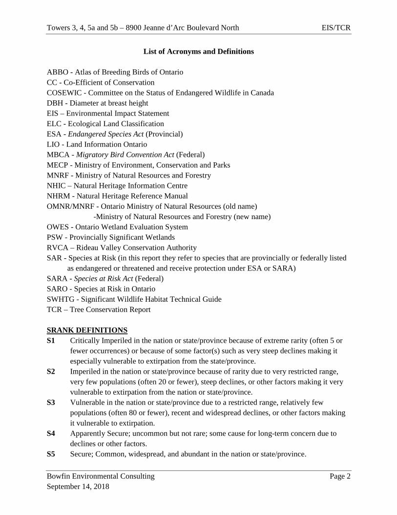
List of Acronyms and Definitions
ABBO - Atlas of Breeding Birds of Ontario CC - Co-Efficient of Conservation COSEWIC - Committee on the Status of Endangered Wildlife in Canada DBH - Diameter at breast height EIS – Environmental Impact Statement ELC - Ecological Land Classification ESA - Endangered Species Act (Provincial) LIO - Land Information Ontario MBCA - Migratory Bird Convention Act (Federal) MECP - Ministry of Environment, Conservation and Parks MNRF - Ministry of Natural Resources and Forestry NHIC – Natural Heritage Information Centre NHRM - Natural Heritage Reference Manual OMNR/MNRF - Ontario Ministry of Natural Resources (old name) -Ministry of Natural Resources and Forestry (new name) OWES - Ontario Wetland Evaluation System PSW - Provincially Significant Wetlands RVCA – Rideau Valley Conservation Authority SAR - Species at Risk (in this report they refer to species that are provincially or federally listed
as endangered or threatened and receive protection under ESA or SARA) SARA - Species at Risk Act (Federal) SARO - Species at Risk in Ontario SWHTG - Significant Wildlife Habitat Technical Guide TCR – Tree Conservation Report SRANK DEFINITIONS S1 Critically Imperiled in the nation or state/province because of extreme rarity (often 5 or
fewer occurrences) or because of some factor(s) such as very steep declines making it especially vulnerable to extirpation from the state/province.
S2 Imperiled in the nation or state/province because of rarity due to very restricted range, very few populations (often 20 or fewer), steep declines, or other factors making it very vulnerable to extirpation from the nation or state/province.
S3 Vulnerable in the nation or state/province due to a restricted range, relatively few populations (often 80 or fewer), recent and widespread declines, or other factors making it vulnerable to extirpation.
S4 Apparently Secure; uncommon but not rare; some cause for long-term concern due to declines or other factors.
S5 Secure; Common, widespread, and abundant in the nation or state/province.
Towers 3, 4, 5a and 5b – 8900 Jeanne d’Arc Boulevard North EIS/TCR
Bowfin Environmental Consulting Page 3 September 14, 2018
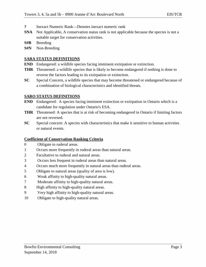
? Inexact Numeric Rank—Denotes inexact numeric rank SNA Not Applicable, A conservation status rank is not applicable because the species is not a
suitable target for conservation activities. S#B Breeding S#N Non-Breeding SARA STATUS DEFINITIONS END Endangered: a wildlife species facing imminent extirpation or extinction. THR Threatened: a wildlife species that is likely to become endangered if nothing is done to
reverse the factors leading to its extirpation or extinction. SC Special Concern, a wildlife species that may become threatened or endangered because of
a combination of biological characteristics and identified threats. SARO STATUS DEFINITIONS END Endangered: A species facing imminent extinction or extirpation in Ontario which is a
candidate for regulation under Ontario's ESA. THR Threatened: A species that is at risk of becoming endangered in Ontario if limiting factors
are not reversed. SC Special concern: A species with characteristics that make it sensitive to human activities
or natural events. Coefficient of Conservatism Ranking Criteria 0 Obligate to ruderal areas. 1 Occurs more frequently in ruderal areas than natural areas. 2 Facultative to ruderal and natural areas. 3 Occurs less frequent in ruderal areas than natural areas. 4 Occurs much more frequently in natural areas than ruderal areas. 5 Obligate to natural areas (quality of area is low). 6 Weak affinity to high-quality natural areas. 7 Moderate affinity to high-quality natural areas. 8 High affinity to high-quality natural areas. 9 Very high affinity to high-quality natural areas. 10 Obligate to high-quality natural areas.
Towers 3, 4, 5a and 5b – 8900 Jeanne d’Arc Boulevard North EIS/TCR
Bowfin Environmental Consulting Page 4 September 14, 2018
Table of Contents
1.0 INTRODUCTION ..................................................................................................... 6
2.0 METHODOLOGY .................................................................................................... 9
2.1 Background Review .................................................................................................. 9
2.2 Field Studies .............................................................................................................. 9
2.2.1 Habitat Descriptions and Flora Observations .......................................................... 10
2.2.2 Butternut Inventory .................................................................................................. 11
2.2.3 Bird Surveys ............................................................................................................ 12
2.2.4 Bats .......................................................................................................................... 12
2.2.5 Incidental Fauna Observations ................................................................................ 13
3.0 Results ..................................................................................................................... 15
3.1 Background Review ................................................................................................ 15
3.2 EIS - Existing Conditions ........................................................................................ 16
3.2.1 Geology and Hydrologic Conditions ....................................................................... 16
3.2.2 Vegetation Cover ..................................................................................................... 19
3.2.3 Bird Survey .............................................................................................................. 25
3.2.4 Bats .......................................................................................................................... 26
3.2.5 Incidental Wildlife Observation .............................................................................. 26
4.0 EIS – Analysis of Potential to Impact the Natural Features .................................... 27
4.1 Impact Assessment Methods ................................................................................... 27
4.2 Evaluation of Potential Impacts ............................................................................... 28
4.2.1 Provincially Significant Wetlands ........................................................................... 28
4.2.2 Significant Valleylands ............................................................................................ 31
4.2.3 Urban Natural Feature ............................................................................................. 33
4.2.4 SAR ......................................................................................................................... 35
4.2.5 Accidents and malfunctions ..................................................................................... 43
5.0 TREE CONSERVATION AND PLANTING PLAN ............................................. 43
6.0 CONCLUSIONS AND RECOMMENDATIONS .................................................. 62
7.0 REFERENCES ........................................................................................................ 63
Towers 3, 4, 5a and 5b – 8900 Jeanne d’Arc Boulevard North EIS/TCR
Bowfin Environmental Consulting Page 5 September 14, 2018
Appendix A: Background Review Mapping................................................................................. 66 Appendix B: Communications from MNRF................................................................................. 77 Appendix C: List of Birds present in the General Area (Atlas of Breeding Birds in Ontario) ..... 79 Appendix D:List of Observed Species (2013 and 2018) ............................................................. 83 Appendix E: SAR Hand-Out ........................................................................................................ 88 List of Figures Figure 1 Location of the Project Area ..................................................................................... 8 Figure 2 Area to be Disturbed ................................................................................................ 14 Figure 3 Habitat Mapping ...................................................................................................... 18 Figure 4: Map 1 Location of Individual and Groupings of Trees near Towers 3 and 4 ............... 50 Figure 5: Map 1 Location of Individual and Groupings of Trees near Towers 5a and 5b ........... 51 Figure 6: Map 2 Trees to be Removed near Towers 3 and 4 ........................................................ 52 Figure 7: Map 2 Trees to be Removed near Towers 5a and 5b .................................................... 53
List of Tables
Table 1 Summary of Dates, Times of Site Investigations ...................................................... 9 Table 2 Summary of Soil and Geology Information Available from the Characterization of Ottawa’s Watershed Maps ............................................................................................................ 17 Table 3 Summary of Potential SAR (Endangered and Threatened) ..................................... 40 Table 4: Summary of Trees and Groupings .................................................................................. 45 Table 5 Summary of Impacts, Mitigation Measures and Residual Effects .......................... 54
List of Photographs Photo 1 Eastern portion of the cultural meadow, September 14, 2018 ................................. 20 Photo 2 Western portion of the cultural meadow with the mixed forest in background, September 14, 2018 ...................................................................................................................... 20 Photo 3 Dry-Fresh Oak – Red Maple Forest (June 8, 2018) ................................................ 21 Photo 4 Dry-Fresh Poplar White Pine Mixed Forest and staghorn sumac (September 14, 2018) 22 Photo 5 Deciduous Tree and Tall Shrub Wetland Community (September 5, 2013) ........... 23 Photo 6 Narrow Emergent Dominated Wetland Community (September 5, 2013) ............. 24 Photo 7 Robust Emergent Dominated Wetland Community (September 5, 2013) .............. 24
Towers 3, 4, 5a and 5b – 8900 Jeanne d’Arc Boulevard North EIS/TCR
Bowfin Environmental Consulting Page 6 September 14, 2018
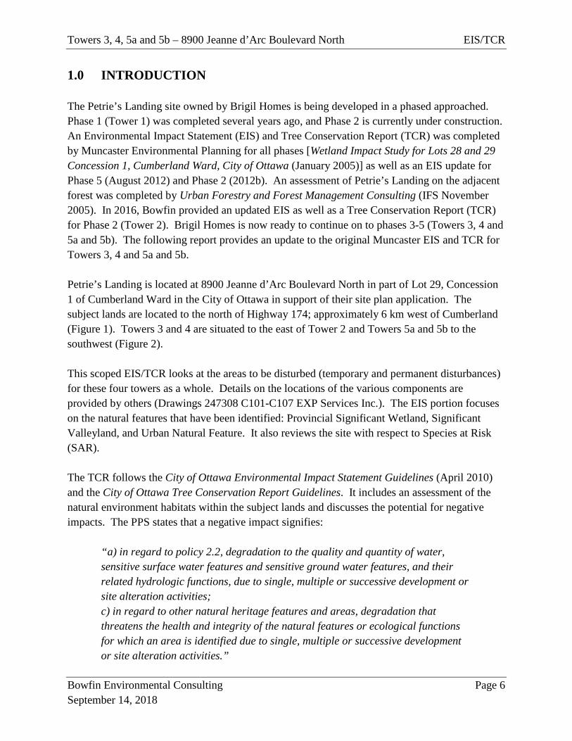
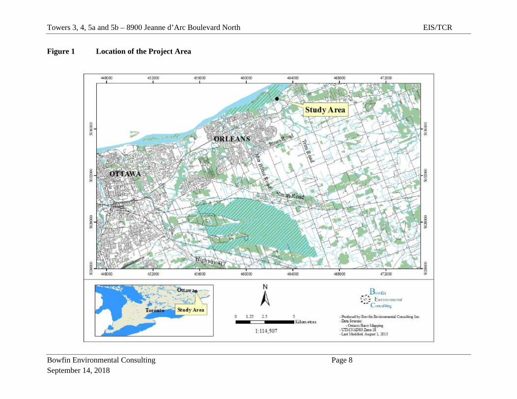
1.0 INTRODUCTION The Petrie’s Landing site owned by Brigil Homes is being developed in a phased approached. Phase 1 (Tower 1) was completed several years ago, and Phase 2 is currently under construction. An Environmental Impact Statement (EIS) and Tree Conservation Report (TCR) was completed by Muncaster Environmental Planning for all phases [Wetland Impact Study for Lots 28 and 29 Concession 1, Cumberland Ward, City of Ottawa (January 2005)] as well as an EIS update for Phase 5 (August 2012) and Phase 2 (2012b). An assessment of Petrie’s Landing on the adjacent forest was completed by Urban Forestry and Forest Management Consulting (IFS November 2005). In 2016, Bowfin provided an updated EIS as well as a Tree Conservation Report (TCR) for Phase 2 (Tower 2). Brigil Homes is now ready to continue on to phases 3-5 (Towers 3, 4 and 5a and 5b). The following report provides an update to the original Muncaster EIS and TCR for Towers 3, 4 and 5a and 5b. Petrie’s Landing is located at 8900 Jeanne d’Arc Boulevard North in part of Lot 29, Concession 1 of Cumberland Ward in the City of Ottawa in support of their site plan application. The subject lands are located to the north of Highway 174; approximately 6 km west of Cumberland (Figure 1). Towers 3 and 4 are situated to the east of Tower 2 and Towers 5a and 5b to the southwest (Figure 2). This scoped EIS/TCR looks at the areas to be disturbed (temporary and permanent disturbances) for these four towers as a whole. Details on the locations of the various components are provided by others (Drawings 247308 C101-C107 EXP Services Inc.). The EIS portion focuses on the natural features that have been identified: Provincial Significant Wetland, Significant Valleyland, and Urban Natural Feature. It also reviews the site with respect to Species at Risk (SAR). The TCR follows the City of Ottawa Environmental Impact Statement Guidelines (April 2010) and the City of Ottawa Tree Conservation Report Guidelines. It includes an assessment of the natural environment habitats within the subject lands and discusses the potential for negative impacts. The PPS states that a negative impact signifies:
“a) in regard to policy 2.2, degradation to the quality and quantity of water, sensitive surface water features and sensitive ground water features, and their related hydrologic functions, due to single, multiple or successive development or site alteration activities; c) in regard to other natural heritage features and areas, degradation that threatens the health and integrity of the natural features or ecological functions for which an area is identified due to single, multiple or successive development or site alteration activities.”
Towers 3, 4, 5a and 5b – 8900 Jeanne d’Arc Boulevard North EIS/TCR
Bowfin Environmental Consulting Page 7 September 14, 2018
The field work for both the EIS and TCR was led by Michelle Lavictoire who has a Master of Science in Natural Resource Sciences and over 20 years of experience in completing natural environment assessments. The intention of the TCR is to determine what woody vegetation needs to be retained and protected on site. In the paragraphs below, we have outlined the methods, followed by a review of the available background information and a description of the site’s existing conditions. This information is used to evaluate the potential impacts to the features and to make recommendations in terms of the EIS and TCR.
Towers 3, 4, 5a and 5b – 8900 Jeanne d’Arc Boulevard North EIS/TCR
Bowfin Environmental Consulting Page 8 September 14, 2018
Figure 1 Location of the Project Area
Towers 3, 4, 5a and 5b – 8900 Jeanne d’Arc Boulevard North EIS/TCR
Bowfin Environmental Consulting Page 9 September 14, 2018
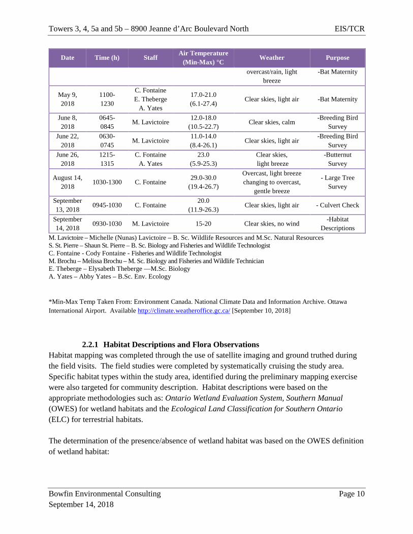
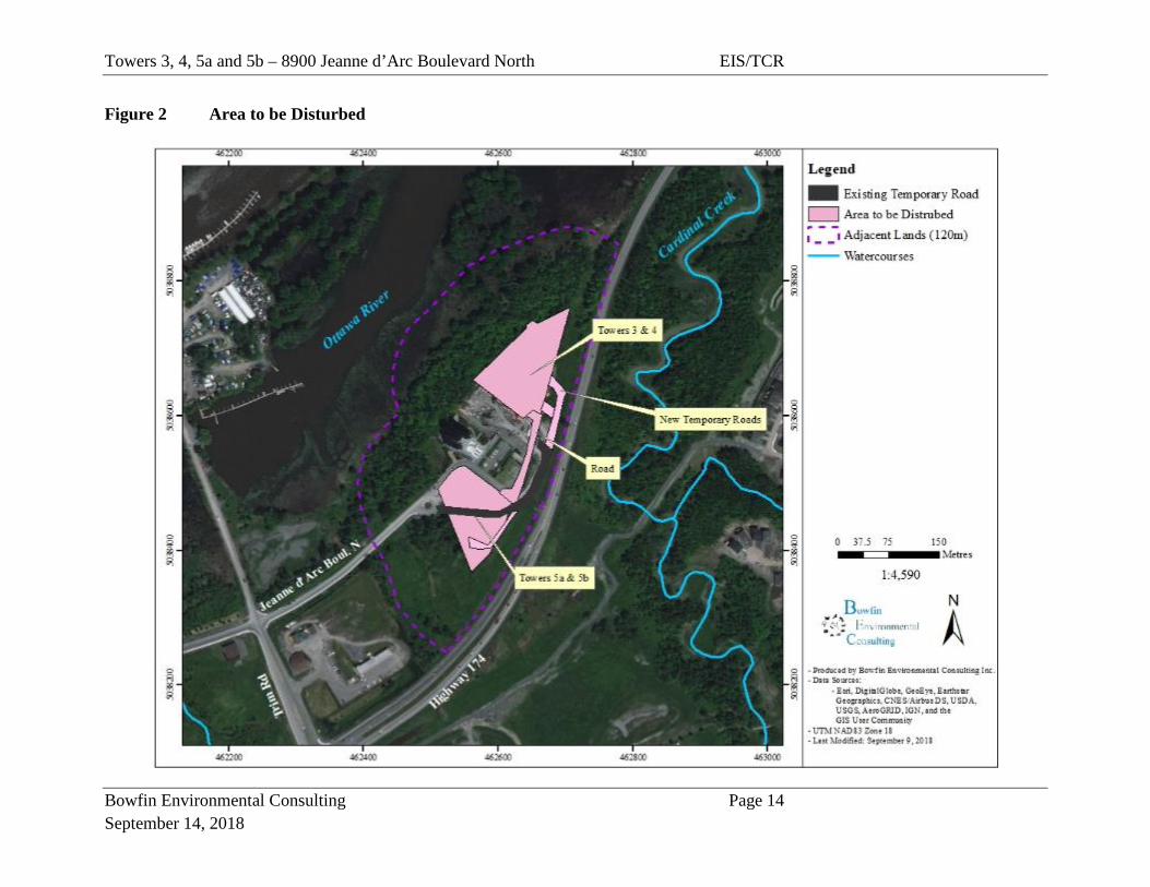
2.0 METHODOLOGY Work undertaken for the completion of this project included a background review of existing information and field investigations. The study area consists of the areas to be disturbed, temporarily or permanently, for all of the remaining towers (Figure 2). The adjacent lands shown on Figure 2 and the surrounding 120 m. It is noted, that the assessment of impacts sometimes included larger area as needed. The background review included a much larger terrestrial area (~5 km). The study area for each item is described in the methods below.
2.1 Background Review The background review began with a review of the available consulting reports and a preliminary mapping of the vegetation communities as a desktop exercise. A search through available records was then made to gather information on the three identified natural heritage features of focus as well as on SAR within the project area. The following web sources were used during the background review: Natural Heritage Information Centre (NHIC), Make-A-Map - Land Information Ontario (LIO), and the City of Ottawa Official Plan, Schedules and Species at Risk in Ottawa table (dated August 1, 2018). An information request was also sent directly to MNRF Kemptville District (May 2018) for additional information not available on the website. The response to the MNRF request is pending.
2.2 Field Studies Given that the study area for the Tower 2 project included a portion of the study area for Towers 3-5, the information collected during the visits in 2013 are included herein. A summary of the dates, times, ambient conditions and purpose for the visits are provided in Summary of Dates, Times of Site Investigations Table 1. Table 1 Summary of Dates, Times of Site Investigations
Date Time (h) Staff Air Temperature
(Min-Max) °C Weather Purpose
August 2, 2013
1030-1215 M. Lavictoire S. St. Pierre
25.0 (13.7-25.0)
50% cloud cover, light air
-Butternut inventory -Habitat
Descriptions September
5, 2013 1200-1315
M. Lavictoire S. St. Pierre
15.0 (4.8-17.0)
30% cloud cover, gentle breeze
-Habitat Descriptions
May 4, 2018
0945- 1200
C. Fontaine E. Theberge
9.0-10.0 (6.1-23.1)
Overcast, light breeze changing to
-Initial Site Visit -Raptor Nest
Survey
Towers 3, 4, 5a and 5b – 8900 Jeanne d’Arc Boulevard North EIS/TCR
Bowfin Environmental Consulting Page 10 September 14, 2018
Date Time (h) Staff Air Temperature
(Min-Max) °C Weather Purpose
overcast/rain, light breeze
-Bat Maternity
May 9, 2018
1100- 1230
C. Fontaine E. Theberge
A. Yates
17.0-21.0 (6.1-27.4)
Clear skies, light air -Bat Maternity
June 8, 2018
0645- 0845
M. Lavictoire 12.0-18.0
(10.5-22.7) Clear skies, calm
-Breeding Bird Survey
June 22, 2018
0630- 0745
M. Lavictoire 11.0-14.0 (8.4-26.1)
Clear skies, light air -Breeding Bird
Survey June 26,
2018 1215- 1315
C. Fontaine A. Yates
23.0 (5.9-25.3)
Clear skies, light breeze
-Butternut Survey
August 14, 2018
1030-1300 C. Fontaine 29.0-30.0
(19.4-26.7)
Overcast, light breeze changing to overcast,
gentle breeze
- Large Tree Survey
September 13, 2018
0945-1030 C. Fontaine 20.0
(11.9-26.3) Clear skies, light air - Culvert Check
September 14, 2018
0930-1030 M. Lavictoire 15-20 Clear skies, no wind -Habitat
Descriptions M. Lavictoire – Michelle (Nunas) Lavictoire – B. Sc. Wildlife Resources and M.Sc. Natural Resources S. St. Pierre – Shaun St. Pierre – B. Sc. Biology and Fisheries and Wildlife Technologist C. Fontaine - Cody Fontaine - Fisheries and Wildlife Technologist M. Brochu – Melissa Brochu – M. Sc. Biology and Fisheries and Wildlife Technician E. Theberge – Elysabeth Theberge —M.Sc. Biology A. Yates – Abby Yates – B.Sc. Env. Ecology
*Min-Max Temp Taken From: Environment Canada. National Climate Data and Information Archive. Ottawa International Airport. Available http://climate.weatheroffice.gc.ca/ [September 10, 2018]
2.2.1 Habitat Descriptions and Flora Observations Habitat mapping was completed through the use of satellite imaging and ground truthed during the field visits. The field studies were completed by systematically cruising the study area. Specific habitat types within the study area, identified during the preliminary mapping exercise were also targeted for community description. Habitat descriptions were based on the appropriate methodologies such as: Ontario Wetland Evaluation System, Southern Manual (OWES) for wetland habitats and the Ecological Land Classification for Southern Ontario (ELC) for terrestrial habitats. The determination of the presence/absence of wetland habitat was based on the OWES definition of wetland habitat:
Towers 3, 4, 5a and 5b – 8900 Jeanne d’Arc Boulevard North EIS/TCR
Bowfin Environmental Consulting Page 11 September 14, 2018
“Lands that are seasonally or permanently flooded by shallow water as well as lands where the water table is close to the surface; in either case the presence of abundant water has caused the formation of hydric soils and has favoured the dominance of either hydrophytic or water tolerant plants”.
OWES defines the wetland boundary as the location where over 50% of the plant community consists of upland species with the woody vegetation layer (trees and shrubs) taking precedence over the herbaceous layer (OMNR 2002). Furthermore, the presence of large numbers of obligate upland species requires an upland classification. Unless they contain a special feature or function wetlands smaller than 0.5 ha are not delineated. Representative plant species were recorded within the communities and a running list of plants observed within the study area was kept (Appendix A). This list includes observations from 2013 and 2018. Specific attention was paid to locating species at risk (SAR) or species of conservation value1 listed as potentially occurring within the study area. If these species were observed, they would be photographed, and their coordinates recorded on a hand-held GPS using NAD83. Plants that could not be identified in the field were collected for a more detailed examination in the laboratory. Nomenclature used in this report follows the Southern Ontario Plant List (Bradley, 2007) for both common and scientific names which are based on Newmaster et al. (1998). Authorities for scientific names are given in Newmaster et al. (1998).
2.2.2 Butternut Inventory Butternuts are an endangered species. The MNRF have certified Butternut Health Assessors (BHA) to complete Butternut Health Assessments as per MNRF specifications. The BHA was completed by a qualified Butternut Health Assessor (BHA #117 and #281) on August 2nd, 2013. This inventory consisted of searching the study area in and within 50 m of the subject lands for Phase 2 (Tower 2). Any individuals noted would be marked with white spray paint and flagging tape and numbered sequentially. Their UTMs, using a GPS unit set at NAD83, would be recorded and the individual would be assessed according the BHA protocol. No butternuts were found in 2013. The inventory work was repeated on June 26, 2018 for the full area to be disturbed and the surrounding 50 m. No butternuts were found.
1 “Species of conservation value” are those species listed as S1-S3 or as Special Concern (provincially or federally) or endangered or threatened federal species that are not listed as endangered or threatened provincially.
Towers 3, 4, 5a and 5b – 8900 Jeanne d’Arc Boulevard North EIS/TCR
Bowfin Environmental Consulting Page 12 September 14, 2018
2.2.3 Bird Surveys Information on bird use of the area was collected through a raptor nest survey and breeding bird surveys. The raptor nest survey consisted of looking for evidence of nesting (such as stick nests, food caches, whitewashing of branches and foliage, accumulation of feathers/fur or prey remains on the ground or in shrubs as per the Significant Wildlife Habitat Technical Guide (SWHTG) Appendix O) as well as the raptors themselves. The search for raptor nests took place on May 4th and 9th, 2018. The breeding bird surveys included daytime forest breeding bird surveys. The daytime breeding bird surveys methods were as follows:
• Two visits were completed for the forest and field habitats and these two visits were a minimum of 15 days apart (June 8th and 22nd, 2018).
• Surveys began no earlier than 30 minutes after dawn and completed by midday. • Visits were conducted on days with no rain, little to no wind and good visibility. • The survey type was point counts.
o Consisted of 5-min point count stations spaced 300 m apart (or as near as 100 m if needed to obtain information from all habitat types)
o Point counts consisted of listening and observing over the specified time period and recording the number of birds heard/seen, their sex, location, behaviour and interactions with others; and
o While walking between points, any additional observations were recorded. • Birds were identified by sound and/or sight.
2.2.4 Bats Currently, there are four bat species listed as SAR in Ontario. The potential to impact these species depends on the presence/absence of critical habitat: hibernation or maternity sites. There were no potential hibernacula sites present as such, no hibernacula surveys were completed. The need to conduct maternity site surveys was determined based on the Significant Wildlife Habitat Criteria Schedules Draft 6E. This guideline indicates that consideration for maternity sites should be made when the vegetation community consists of a mature deciduous or mixed forest with >10 large trees/ha [large trees are defined as having a diameter-at-breast-height (dbh) ≥25 cm]. The subject and adjacent lands included deciduous forest which could potentially meet this criterion. As such, forest plots were established following the MNRF’s bat maternity protocol outlined below:
• Survey was completed during leaf-off period, to facilitate locating cavities. • A minimum of 10 plots were created within suitable habitat. An additional plot was
added for each additional hectare over 10 ha, up to a maximum of 35 plots. In this instance, the minimum of 10 plots sufficed.
Towers 3, 4, 5a and 5b – 8900 Jeanne d’Arc Boulevard North EIS/TCR
Bowfin Environmental Consulting Page 13 September 14, 2018
• Each plot had a 12.6 m radius resulting in a surveyed area of 0.05 ha per plot. • Information collected consisted of: tree species, dbh, presence/absence of cavity,
description of cavity and snag class.
2.2.5 Incidental Fauna Observations During the site visit any wildlife observations were recorded. Incidental observations included observations of an individual, its tracks, burrows, feces and/or kill sights.
Towers 3, 4, 5a and 5b – 8900 Jeanne d’Arc Boulevard North EIS/TCR
Bowfin Environmental Consulting Page 14 September 14, 2018
Figure 2 Area to be Disturbed
Towers 3, 4, 5a and 5b – 8900 Jeanne d’Arc Boulevard North EIS/TCR
Bowfin Environmental Consulting Page 15 September 14, 2018
3.0 Results
3.1 Background Review The subject lands, approximately 2.9 ha in size, are in Cumberland Ward of the City of Ottawa on Part of Lot 29 Concession 1. They are situated to the north of Highway 174 and east of Trim Road. The lands are bordered by Highway 174 on the south and east sides, the Ottawa River to the north, and developed lands to the west (Figure 2). The designated land-use for the subject lands is General Urban Area on Schedule B of the City of Ottawa Official Plan (OP) and no constraints were listed within the subject lands. This is a combined scoped EIS and TCR. The EIS deals with PSW, Significant Valleylands and Urban Natural Area (Appendix A). The first two are located within the adjacent 120 m and the latter is shown to include a portion of the subject lands on the UNA mapping. The PSW in question is the Petrie Island Provincially Significant Wetland is identified on Schedule B of the OP and in mapping and correspondence from MNRF [LIO, letter from MNRF (dated July 30, 20132)] (Appendix B). The significant valleyland consists of a forested slope located along the northwest side of the subject lands, which forms part of the Ottawa valley. The Urban Natural Area (UNA) Petrie Island and Mainland Urban Natural Area is identified as forming part of the subject lands (Appendix A). The letter received from MNRF (July 30, 2013) identified five species protected by the Endangered Species Act (ESA) as potentially occurring on or near the site. These were: Blanding’s turtle, barn swallow, bobolink, eastern meadowlark and butternut. During the search of the NHIC dataset, only Lake Sturgeon was noted within 1 km of the subject lands. The NHIC search was widened to 10 km which added three species: American eel, chimney swift and Henslow’s sparrow. This list was then updated based on the changes to the SAR listings under ESA (August 1, 2018). The resulting list of SAR being considered consists of fifteen species: lake sturgeon, American eel, Blanding’s turtle, whip-poor-will, chimney swift, bank swallow, barn swallow, bobolink, eastern meadowlark, Henslow’s sparrow, little brown myotis (bat), northern myotis (bat), eastern small-footed myotis (bat), tri-colored bat and butternut. These are further discussed in Section 4.2.4. Note that this species list may need to be updated once information is received from MNRF.
2 Note that MNRF was contacted in May 2018 for an updated letter and this information is still pending.
Towers 3, 4, 5a and 5b – 8900 Jeanne d’Arc Boulevard North EIS/TCR
Bowfin Environmental Consulting Page 16 September 14, 2018
3.2 EIS - Existing Conditions
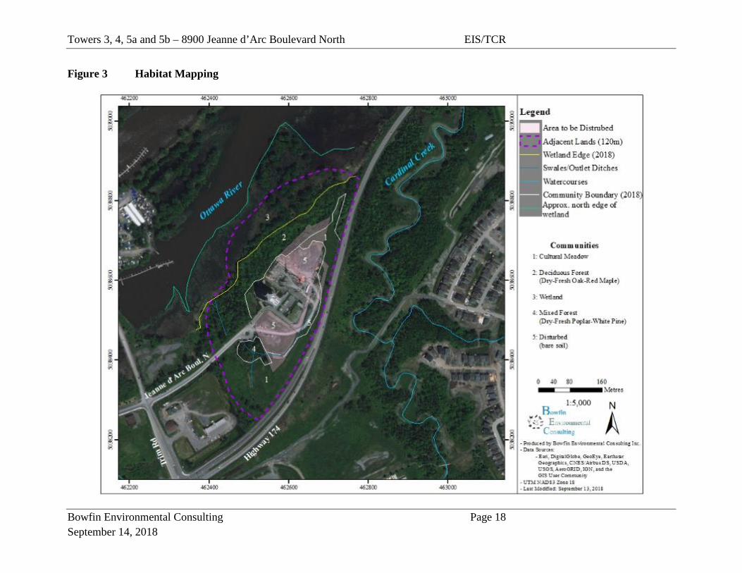
3.2.1 Geology and Hydrologic Conditions The subject lands where the towers and access roads would be built are in a flat area and southeast of a forested slope. West of the lands near Tower 5 and the adjacent lands in that same area was hilly and contained a ravine. The slope of the valley in the adjacent lands to the north was steep with an approximate gradient of 25 percent (IFS Associates). Wetland habitat found at the base of the slope included deciduous treed swamp and marsh wetland communities. No surface water was present within the marsh during the summer visits however this area flooded during the spring runoff (as was noted during the spring visits). The approximate edge of the area flooded during the spring is depicted in Figure 3. The nearest surface water feature was the Ottawa River (approx. 160 m to the northwest of the subject lands during summer; approx. 80 m in the spring). The forested area is very steep and does not contain vernal pools. Muncaster Environmental Planning (2012b) reported that the swale in the ravine on the west side of current study area, was dry during all visits and was not directly connected to the Ottawa River (Figure 3). During 2018, it was noted that the swale now receives some flow from the construction site (outlet ditch) and, on occasion, there was surface water present (no depth). The lack of direct connection to the Ottawa River was confirmed in 2018. This ravine does not provide fish habitat. The IFS report indicated that any water from the tablelands of the subject lands would likely be absorbed on-site and not flow downstream. The water table at the crest of the slope was found at a depth of 3.3 m. In 2002, the soils consisted of topsoil (20-23 cm thick) underlain by very stiff silty clay. Since that time, the topsoil in the subject lands has been disturbed by clearing activities during its use as a temporary staging area for Towers 1 and 2. The area is identified as Ottawa Valley Plains in the mapping from the Characterization of Ottawa’s Watershed: An Environment Foundation Document with Supporting Information Base (March 2011). A summary of the information from the above-mentioned report and maps is provided in Table 2. The soils map of the area shows the subject lands as having the Rideau soil association (which tends to have gray neutral heavy clay marine material) (Soils of Regional Municipality of Ottawa-Carleton).
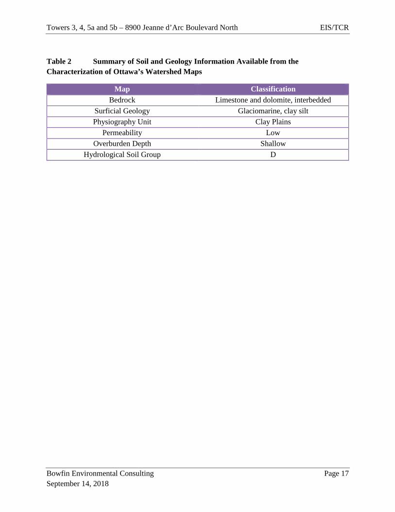
Towers 3, 4, 5a and 5b – 8900 Jeanne d’Arc Boulevard North EIS/TCR
Bowfin Environmental Consulting Page 17 September 14, 2018
Table 2 Summary of Soil and Geology Information Available from the Characterization of Ottawa’s Watershed Maps
Map Classification Bedrock Limestone and dolomite, interbedded
Surficial Geology Glaciomarine, clay silt Physiography Unit Clay Plains
Permeability Low Overburden Depth Shallow
Hydrological Soil Group D
Towers 3, 4, 5a and 5b – 8900 Jeanne d’Arc Boulevard North EIS/TCR
Bowfin Environmental Consulting Page 18 September 14, 2018
Figure 3 Habitat Mapping

Towers 3, 4, 5a and 5b – 8900 Jeanne d’Arc Boulevard North EIS/TCR
Bowfin Environmental Consulting Page 19 September 14, 2018
3.2.2 Vegetation Cover Much of the subject lands has been disturbed over recent years during construction of Towers 1 and 2. The area labelled as “Disturbed” on the Figure 3 consisted of bare soil and/or gravel and provided parking, lay down yard and access roads for the current construction. Outside of the existing disturbed area, some of the previously disturbed areas have revegetated and now consist of cultural meadows. To the northwest the habitat consisted of deciduous forest and at the base of the slope, wetland. A small mixed forest is situated to the southwest of Towers 5a and 5b. None of the communities identified are considered rare vegetation communities [Significant Wildlife Habitat Technical Guide (2000)]. A description of the subject lands and natural habitats are provided below. There was little change in the communities between those described in previous reports and observed in 2018, where appropriate additional notes on species were added to the original descriptions.
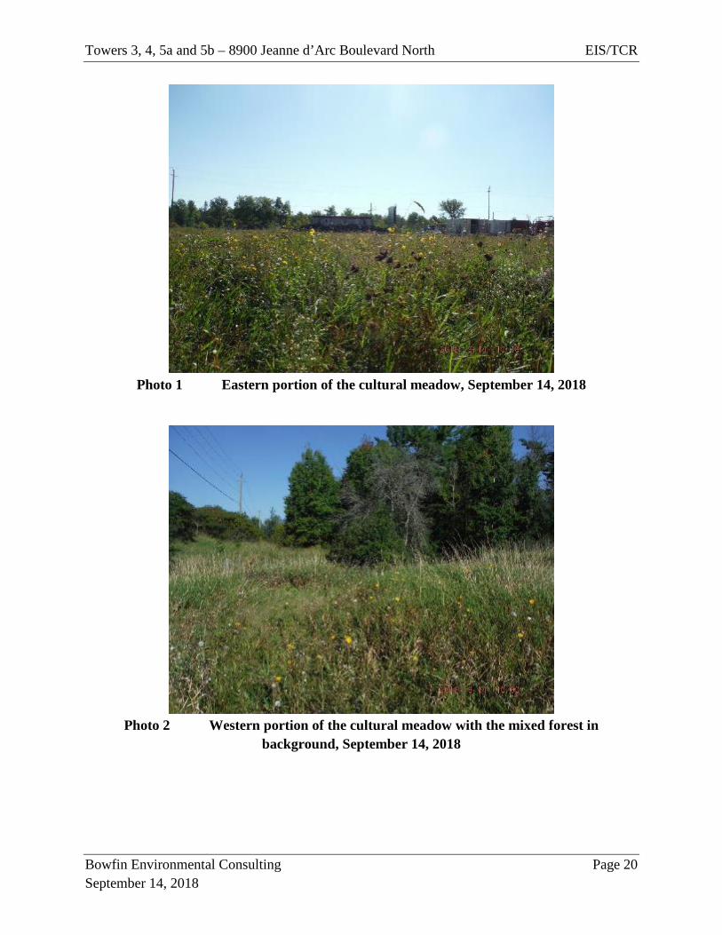
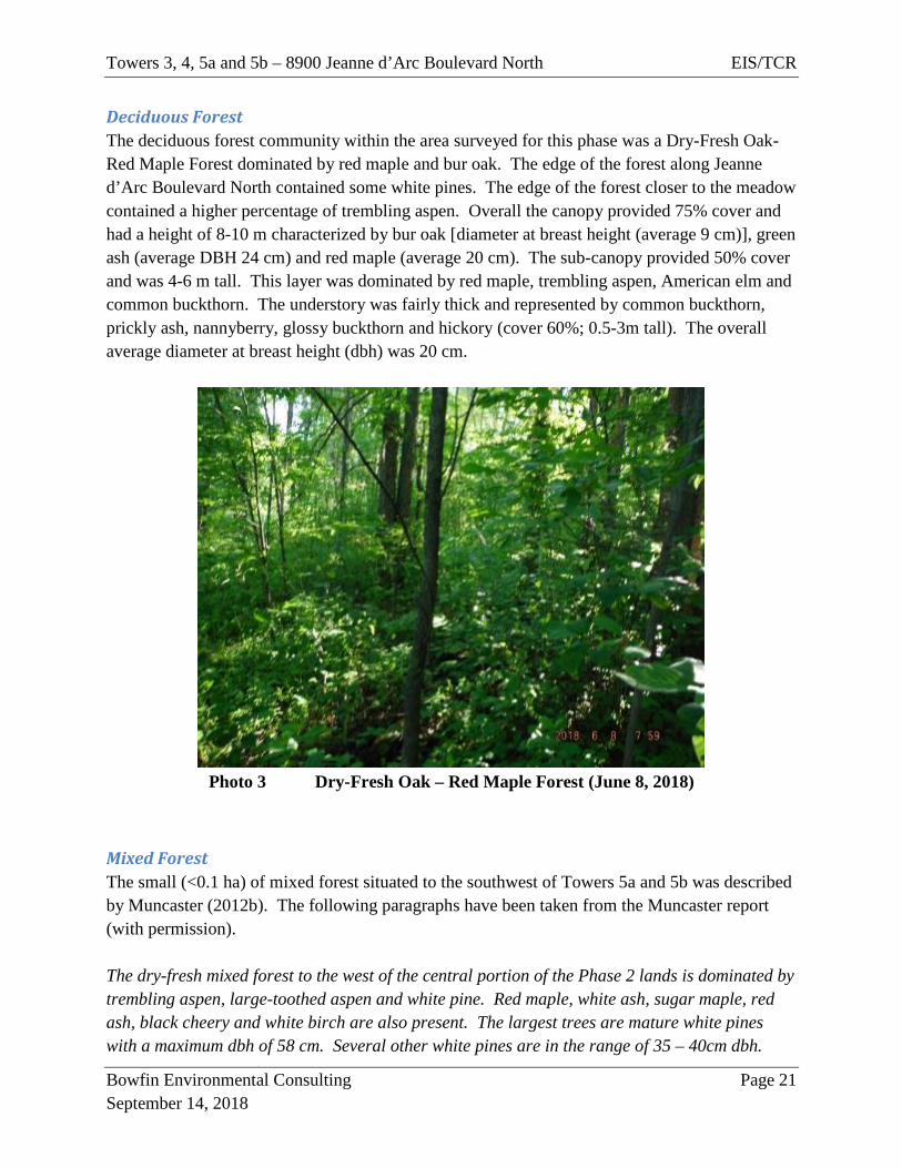
Cultural Meadow This community is a mixed meadow dominated by both grass and broadleaf plants with 90% cover. On the east side of the subject lands, location of future Towers 3 and 4, much of the habitat had been recently disturbed and consisted of an old cultural meadow with ruts and gravel/dirt piles. This area was flat. The vegetation varied by tended to be dominated by species such as tall goldenrod, late goldenrod, sow thistle, reed canary grass, daisy fleabane, cow vetch and evening primrose with some regenerating white ash. On the west side, the meadow was situated on a step hilly terrain. The dominant vegetation included: sow thistle, tall and late goldenrods, Canada thistle, wild carrot, cow vetch and reed canary grass. The outlet ditch and the ravine were located at the base of the hills. This portion of the meadow included patches of staghorn sumac. There were also the occasional individual young trembling aspen and common buckthorn.
Towers 3, 4, 5a and 5b – 8900 Jeanne d’Arc Boulevard North EIS/TCR
Bowfin Environmental Consulting Page 20 September 14, 2018
Photo 1 Eastern portion of the cultural meadow, September 14, 2018
Photo 2 Western portion of the cultural meadow with the mixed forest in
background, September 14, 2018
Towers 3, 4, 5a and 5b – 8900 Jeanne d’Arc Boulevard North EIS/TCR
Bowfin Environmental Consulting Page 21 September 14, 2018
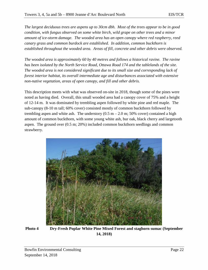
Deciduous Forest The deciduous forest community within the area surveyed for this phase was a Dry-Fresh Oak-Red Maple Forest dominated by red maple and bur oak. The edge of the forest along Jeanne d’Arc Boulevard North contained some white pines. The edge of the forest closer to the meadow contained a higher percentage of trembling aspen. Overall the canopy provided 75% cover and had a height of 8-10 m characterized by bur oak [diameter at breast height (average 9 cm)], green ash (average DBH 24 cm) and red maple (average 20 cm). The sub-canopy provided 50% cover and was 4-6 m tall. This layer was dominated by red maple, trembling aspen, American elm and common buckthorn. The understory was fairly thick and represented by common buckthorn, prickly ash, nannyberry, glossy buckthorn and hickory (cover 60%; 0.5-3m tall). The overall average diameter at breast height (dbh) was 20 cm.
Photo 3 Dry-Fresh Oak – Red Maple Forest (June 8, 2018)
Mixed Forest The small (<0.1 ha) of mixed forest situated to the southwest of Towers 5a and 5b was described by Muncaster (2012b). The following paragraphs have been taken from the Muncaster report (with permission). The dry-fresh mixed forest to the west of the central portion of the Phase 2 lands is dominated by trembling aspen, large-toothed aspen and white pine. Red maple, white ash, sugar maple, red ash, black cheery and white birch are also present. The largest trees are mature white pines with a maximum dbh of 58 cm. Several other white pines are in the range of 35 – 40cm dbh.
Towers 3, 4, 5a and 5b – 8900 Jeanne d’Arc Boulevard North EIS/TCR
Bowfin Environmental Consulting Page 22 September 14, 2018
The largest deciduous trees are aspens up to 30cm dbh. Most of the trees appear to be in good condition, with fungus observed on some white birch, wild grape on other trees and a minor amount of ice-storm damage. The wooded area has an open canopy where red raspberry, reed canary grass and common burdock are established. In addition, common buckthorn is established throughout the wooded area. Areas of fill, concrete and other debris were observed. The wooded area is approximately 60 by 40 metres and follows a historical ravine. The ravine has been isolated by the North Service Road, Ottawa Road 174 and the tablelands of the site. The wooded area is not considered significant due to its small size and corresponding lack of forest interior habitat, its overall intermediate age and disturbances associated with extensive non-native vegetation, areas of open canopy, and fill and other debris. This description meets with what was observed on-site in 2018, though some of the pines were noted as having died. Overall, this small wooded area had a canopy cover of 75% and a height of 12-14 m. It was dominated by trembling aspen followed by white pine and red maple. The sub-canopy (8-10 m tall; 60% cover) consisted mostly of common buckthorn followed by trembling aspen and white ash. The understory (0.5 m – 2.0 m; 50% cover) contained a high amount of common buckthorn, with some young white ash, bur oak, black cherry and largetooth aspen. The ground over (0.5 m; 20%) included common buckthorn seedlings and common strawberry.
Photo 4 Dry-Fresh Poplar White Pine Mixed Forest and staghorn sumac (September
14, 2018)
Towers 3, 4, 5a and 5b – 8900 Jeanne d’Arc Boulevard North EIS/TCR
Bowfin Environmental Consulting Page 23 September 14, 2018
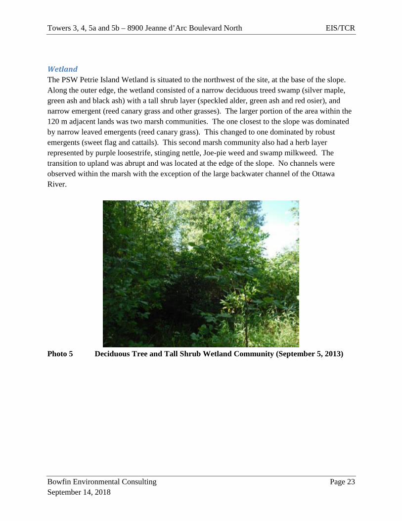
Wetland The PSW Petrie Island Wetland is situated to the northwest of the site, at the base of the slope. Along the outer edge, the wetland consisted of a narrow deciduous treed swamp (silver maple, green ash and black ash) with a tall shrub layer (speckled alder, green ash and red osier), and narrow emergent (reed canary grass and other grasses). The larger portion of the area within the 120 m adjacent lands was two marsh communities. The one closest to the slope was dominated by narrow leaved emergents (reed canary grass). This changed to one dominated by robust emergents (sweet flag and cattails). This second marsh community also had a herb layer represented by purple loosestrife, stinging nettle, Joe-pie weed and swamp milkweed. The transition to upland was abrupt and was located at the edge of the slope. No channels were observed within the marsh with the exception of the large backwater channel of the Ottawa River.
Photo 5 Deciduous Tree and Tall Shrub Wetland Community (September 5, 2013)
Towers 3, 4, 5a and 5b – 8900 Jeanne d’Arc Boulevard North EIS/TCR
Bowfin Environmental Consulting Page 24 September 14, 2018
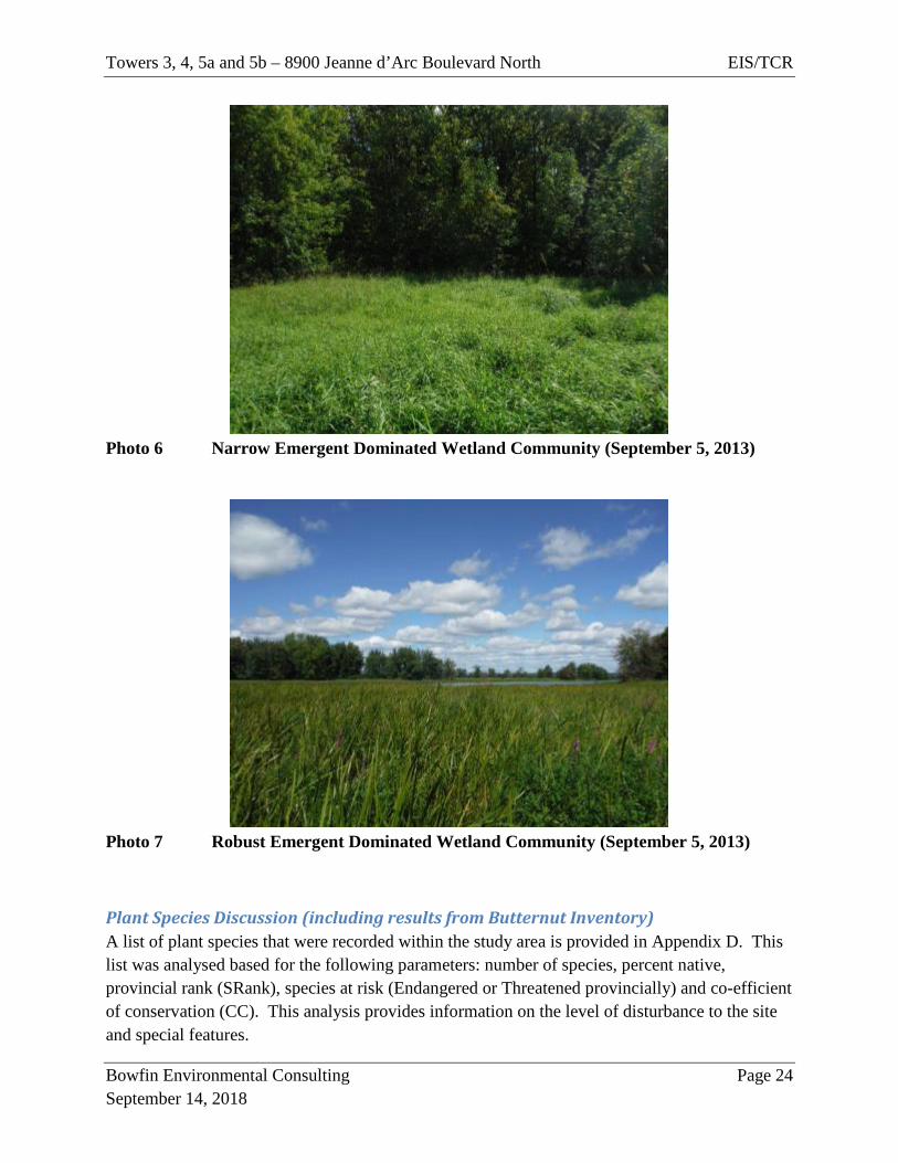
Photo 6 Narrow Emergent Dominated Wetland Community (September 5, 2013)
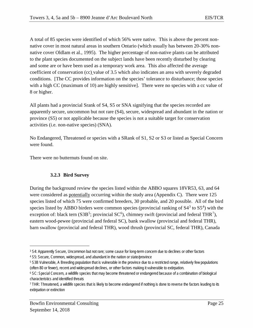
Photo 7 Robust Emergent Dominated Wetland Community (September 5, 2013)
Plant Species Discussion (including results from Butternut Inventory) A list of plant species that were recorded within the study area is provided in Appendix D. This list was analysed based for the following parameters: number of species, percent native, provincial rank (SRank), species at risk (Endangered or Threatened provincially) and co-efficient of conservation (CC). This analysis provides information on the level of disturbance to the site and special features.
Towers 3, 4, 5a and 5b – 8900 Jeanne d’Arc Boulevard North EIS/TCR
Bowfin Environmental Consulting Page 25 September 14, 2018
A total of 85 species were identified of which 56% were native. This is above the percent non-native cover in most natural areas in southern Ontario (which usually has between 20-30% non-native cover Oldlam et al., 1995). The higher percentage of non-native plants can be attributed to the plant species documented on the subject lands have been recently disturbed by clearing and some are or have been used as a temporary work area. This also affected the average coefficient of conservation (cc) value of 3.5 which also indicates an area with severely degraded conditions. [The CC provides information on the species’ tolerance to disturbance; those species with a high CC (maximum of 10) are highly sensitive]. There were no species with a cc value of 8 or higher. All plants had a provincial Srank of S4, S5 or SNA signifying that the species recorded are apparently secure, uncommon but not rare (S4), secure, widespread and abundant in the nation or province (S5) or not applicable because the species is not a suitable target for conservation activities (i.e. non-native species) (SNA). No Endangered, Threatened or species with a SRank of S1, S2 or S3 or listed as Special Concern were found. There were no butternuts found on site.
3.2.3 Bird Survey During the background review the species listed within the ABBO squares 18VR53, 63, and 64 were considered as potentially occurring within the study area (Appendix C). There were 125 species listed of which 75 were confirmed breeders, 30 probable, and 20 possible. All of the bird species listed by ABBO birders were common species (provincial ranking of S43 to S54) with the exception of: black tern (S3B5; provincial SC6), chimney swift (provincial and federal THR7), eastern wood-pewee (provincial and federal SC), bank swallow (provincial and federal THR), barn swallow (provincial and federal THR), wood thrush (provincial SC, federal THR), Canada
3 S4: Apparently Secure, Uncommon but not rare; some cause for long-term concern due to declines or other factors 4 S5: Secure, Common, widespread, and abundant in the nation or state/province 5 S3B Vulnerable, A Breeding population that is vulnerable in the province due to a restricted range, relatively few populations (often 80 or fewer), recent and widespread declines, or other factors making it vulnerable to extirpation. 6 SC: Special Concern, a wildlife species that may become threatened or endangered because of a combination of biological characteristics and identified threats 7 THR: Threatened, a wildlife species that is likely to become endangered if nothing is done to reverse the factors leading to its extirpation or extinction
Towers 3, 4, 5a and 5b – 8900 Jeanne d’Arc Boulevard North EIS/TCR
Bowfin Environmental Consulting Page 26 September 14, 2018
warbler (provincial SC, federal THR), bobolink (provincial and federal THR), and eastern meadowlark (provincial and federal THR). The results from all the field visits found a total of 30 bird species were observed during the breeding bird survey period: (Appendix D). Most were heard calling from the forests in or the wetland the adjacent lands. The observations were typically males calling though some pairs were observed (pair of common yellowthroat and American redstart on June 8th visit). The common yellowthroat were situated in the adjacent lands to Towers 5a and 5b and the American redstart pair was in the forest near the edge of the wetland. Species that were only observed foraging were: great blue heron (in wetland) and barn swallows (flying high in sky towards Trim Road). Canada geese and the goslings were observed in the Ottawa River. Birds observed outside of the breeding bird period are listed under the incidental observations. The only SAR that were identified during the June visits were: barn swallows (provincial and federal THR) and eastern wood-pewee (provincially and federally SC). No other species noted as potentially occurring in the last ABBO surveys were found on-site. The potential impacts to barn swallows are discussed in the SAR section of this report. No raptor nests were present within the study area.
3.2.4 Bats The Significant Wildlife Habitat Criteria Schedules Draft 6E indicates that consideration for maternity sites should be made when the vegetation community consists of a mature deciduous or mixed forest with >10/ha of large trees (>25 cm DBH). MRNF guidelines for bat maternity sites require a minimum of >10 cavity trees (with a minimum DBH of 25 cm) / ha. A search of appropriately sized trees and those with cavities was made. Within the forested portion of the subject lands and adjacent lands a total of 10 plots were established. The number of cavities trees with a minimum DBH of 25 cm was 4 (out of the 10 plots). When this number is extrapolated per hectare it equates to 8 cavity trees with a dbh ≥25 cm/ha. As such the habitat does not meet the minimum requirements for bats maternity sites.
3.2.5 Incidental Wildlife Observation There were only a few incidental observations in 2013, these were: white-faced meadowhawk (a dragonfly), northern leopard frog, song sparrow, American goldfinch and great blue heron. In 2018, the incidental observations included: northern leopard frog, ruffed grouse, mourning dove, and American crow. All are common species. A list of fauna observations from 2013 and 2018 is provided in Appendix D.
Towers 3, 4, 5a and 5b – 8900 Jeanne d’Arc Boulevard North EIS/TCR
Bowfin Environmental Consulting Page 27 September 14, 2018
4.0 EIS – Analysis of Potential to Impact the Natural Features The development of Towers 3, 4 and 5a and 5b will require the removal of the vegetation in an area that is approximately 2.9 ha. This area consisted mostly of the meadow with a small (±0.29 ha) portion of the Dry-Fresh Oak-Red Maple deciduous forest community on the north and a sliver (±0.02 ha) of the Dry-Fresh Poplar White Pine Mixed Forest to the southwest. The impacts will be restricted to the area south of the Development Limit previously agreed to with RVCA which is approximately 30 m from the edge of the wetland, at its nearest point. The new towers will utilize the stormwater management pond which was constructed as part of Phase 1 and which drains into the City’s storm sewer and continues to the Ottawa River. The construction of Towers 3 and 4 will make use of the existing temporary road (built for Tower 2 construction) along with new sections that will be a total of 115 m long and 8 m wide. Construction access for Towers 5a and 5b will be from the existing temporary road. Once the towers are built, these temporary roads will be removed, and the area rehabilitated (seeded). There is no anticipated change in flow volumes or patterns from the existing conditions. The purpose of this section of the report is to discuss the potential impacts to the Provincially Significant Wetlands, Significant Valleylands, Urban Natural Feature and Species at Risk. The potential to impacts these features, list of mitigation measures and a conclusion is provided below following the summary of the impact assessment methods.
4.1 Impact Assessment Methods The assessment of the potential impacts is completed by analyzing the impact of various activities associated with the project. The development of Towers 3, 4 and 5a and 5b would include the following activities:
• Clearing of terrestrial vegetation • Excavation, Grading and backfilling of upland habitat • Installation of sheet piles • Pouring of concrete
The significance of the potential impacts is measured using four different criteria:
1. Area affected may be:

Towers 3, 4, 5a and 5b – 8900 Jeanne d’Arc Boulevard North EIS/TCR
Bowfin Environmental Consulting Page 28 September 14, 2018
a. local in extent signifying that the impacts will be localized within the project area b. regional signifying that the impacts may extend beyond the immediate project
area.
2. Nature of Impact: a. negative or positive b. direct or indirect
3. Duration of the impact may be rated as:
a. short term (construction phase, 1-2 years per tower) b. medium term (3-4 years) c. long term (>4 years). d. permanent
4. Magnitude of the impact may be:
a. negligible signifying that the impact is not noticeable b. minor signifying that the project’s impacts are perceivable and require mitigation c. moderate signifying that the project’s impacts are perceivable and require
mitigation as well as monitoring and/or compensation d. major signifying that the project’s impacts would destroy the environmental
component within the project area.
4.2 Evaluation of Potential Impacts
4.2.1 Provincially Significant Wetlands The Petrie Island PSW is situated at the base of the forested slope at a distance of approximately 60 m form the area to be disturbed. It is not located within the subject lands. This wetland was found to contain a narrow band of deciduous treed swamp (silver maple and green ash) followed by a narrow-leaved emergent dominated marsh (reed canary grass) and then a robust emergent dominated marsh (sweet flag and cattail). The findings of the 2005 Wetland Impact Study Lots 28 and 29, Concession 1 Cumberland Ward, City of Ottawa Petrie’s Landing as written by Muncaster Environmental Planning (Muncaster 2005) remain applicable. A summary of the Muncaster (2005) findings are provided below.
• These types of habitat provide wildlife habitat and water supply and purification (surface water treatment and groundwater discharge and maintenance of flow regime).
• They can also provide flood control however this is likely limited at this site due to its location (small upstream catchment and position on the Ottawa River which is regulated by waterpower facilities).
Towers 3, 4, 5a and 5b – 8900 Jeanne d’Arc Boulevard North EIS/TCR
Bowfin Environmental Consulting Page 29 September 14, 2018
• The open water, found outside of the study area, can provide habitat for waterfowl breeding, rearing and moulting.
• The Petrie Island area is well known as an important recreation, tourism and education site however these activities primarily occur on the island, west of Trim Road and to the northwest of the site. The interpretative and walking trails are also found to the west of Trim road and north of the North Service Road. The portion of the wetland located near the subject lands are not used for these purposes.
• The more ecologically significant areas [alluvial island complex, Petrie Island swamps and aquatics and the Queenswood Forest (including a Hackberry Shrub community)] are all found to the west of Trim Road and north of the North Service Road. They are not found in the vicinity of the subject lands.
o These significant areas are described as such due to the low rate of disturbance, greater level of ecological integrity and much higher diversity as compared to the habitat found northwest of Petrie’s Landing complex.
o They also were identified as providing habitat for species such as northern map turtle, Blanding’s turtle, Cooper’s hawk as well as many significant plant species including the swamp and mixed forest habitat with the Provincially-significant Carex typhina and Polygonum arifolium (Brunton 1999).
o Brunton (1999) also listed the least bittern but concluded that ‘the limited quantity of suitable breeding habitat in the vicinity of the Petrie Islands complex suggests that the likelihood of breeding by this species is very low in the Petrie Island study area’.
Conclusion:
• The Petrie Island Wetland is a Provincially Significant Wetland however the portion of the wetland with the highest significance is not located within the vicinity of the subject lands. The areas of higher significance are situated to the west of Trim Road and north of the North Service Road.
• The PSW is located a minimum of 30 m from the proposed development of Petrie’s Landing Towers 3 and 4 and over 100 m from Towers 5a and 5b.
• The nearest wetland communities are a narrow band of treed swamp and larger marsh communities which have a lower sensitivity to disturbances than other types of wetland communities.
Potential Impacts and Mitigation Measures:
• No direct impacts to the wetland will occur. There is a minimum buffer of approximately 30 m between the activities and the wetland.
• The clearing of trees on the top of the slope will be minimized. • A permit from the City will be required prior to removing trees greater than 10 cm in
diameter.
Towers 3, 4, 5a and 5b – 8900 Jeanne d’Arc Boulevard North EIS/TCR
Bowfin Environmental Consulting Page 30 September 14, 2018
• Indirect impacts could occur as a result of change in water supply or quality, sediment/erosion to the forested slope between the wetland and the site, changes to light or noise levels within the wetland and/or increased access to the wetland. These have been mitigated by:
o Stormwater management pond designed and constructed as part of Phase 1 releases its stormwater to a City owned storm sewer and does not impact the water quality within the wetland.
o Water quantity will not be impacted as IFS found that there is little surficial contribution from the tablelands. Furthermore, the water levels are controlled by waterpower on the Ottawa River.
o The site plan calls for mitigation measures (sheet piling) along the slope to ensure that no slope failure occurs (slope failure could have resulted in the transportation of soil down into the wetland).
o During construction an appropriate erosion and sediment control strategy will be developed, installed, monitored and maintained. This will include, at a minimum, the installation of sediment fence (countersunk) along the edge of the limit of development (along the edge of the forest) and on the south side of the temporary access road.
• Any stock piles of soil or fill material would be stored at least 30 m from the slope and protected by silt fencing.
• Additional materials (i.e. rip rap, filter cloth and silt fencing) should be readily available in case they are needed promptly for erosion and/or sediment control.
• Sediment and erosion control measures need to be maintained and will require daily inspection to ensure that they are working as intended. Additional inspections will be required after rainfall or storm events.
• The sediment fencing would not be removed until the site is stable. • Any outlet or drains will be constructed to ensure that no erosion of the soil occurs (to
prevent slope failure and the transportation of sediments into the wetland). • No additional access to the wetland will be created (no trails). • No changes in light or noise impacts are anticipated. No removal of vegetation in or over
the wetland will occur. The noise from Highway 174 and the marina will likely generate more noise than that from Phase 2.
Area Nature Duration Magnitude Local Negative
Indirect Short to Medium
Term depending on extent
Unlikely to occur (would occur as a
result of an accident or malfunction)
Towers 3, 4, 5a and 5b – 8900 Jeanne d’Arc Boulevard North EIS/TCR
Bowfin Environmental Consulting Page 31 September 14, 2018
4.2.2 Significant Valleylands The dry-fresh oak-red maple forest on the slope to the northwest of the subject lands forms part of a valleyland. As mentioned in the Wetland Impact Study (Muncaster 2005), Highway 174 borders the entire Petrie’s Landing development to the south and east thereby limiting the value of the valleyland as a linkage function. The better linkage is along Cardinal Creek to the east of the site on the opposite side of Highway 174. Conclusion:
• The forested slope along the northwest side of the subject lands form part of the valleyland.
• The proposed development abuts the valleyland. • The development will require the removal of a small (±0.29 ha) portion of the forest. • This valleyland is limited in its function as a linkage due to existing development.
Design Changes:
• The main storm sewer system servicing Towers 1-4 is situated on the north side of the study area, adjacent to trees to be retained. The location of this storm sewer cannot be moved as it connects to the existing stormwater pond that was constructed in Phase 1. To minimize the impacts to the critical root zone (CRZ) of the trees to remain, the sewer will be constructed using a trench box. Even using this technique, which minimizes the ground disturbed, a small portion of the CRZ buffer from the trees to be retained may be impacted along a length of 12 m. The CRZ width has been estimated at 3.5 m resulting in an impacted area of 15.5 m2. At this time, the location of the pipe has not been surveyed. As such, the site investigations looked at trees in the general area and identified the largest trees. The largest trees within 10-15 m of the edge of the forest were typically less than 35 cm with a couple of individuals that were 60-67 cm. The CRZ is defined by the City as 10 x the DBH of the trunk of the closest trees to the work area. Using a DBH of 35 cm gives a CRZ of 3.5 m. In reality, when the locates are completed, the trees to be retained along the Development Limit that are nearest to this area may actually be smaller which would result in a smaller CRZ and reduce or eliminate this impact. The exact size of the CRZ could be determined once surveys and layouts have been completed.
• Where vegetation clearing, and grading is within the CRZ of the trees to be retained, the clearing of vegetation will be done by hand. This will affect the forest to the north of Towers 3 and 4 along a length of 175 m and the small mixed forest on the west side of Towers 5a and 5b along a length of 68 m.
• The walkways have been designed so as not to encroach on the CRZ.
Towers 3, 4, 5a and 5b – 8900 Jeanne d’Arc Boulevard North EIS/TCR
Bowfin Environmental Consulting Page 32 September 14, 2018
Potential Impact and Mitigation Measures:
• An agreement between the proponent and RVCA has seen that a limit of development be created. This setback (Development Limit) will be respected and is shown on the site plans and prevents direct impact with the top of slope (valleyland).
• Indirect impacts could occur if the trees along the top of the slope are harmed resulting in less stability of the slope.
o Sheet piling will be installed along the edge of the development that will ensure that slope stability is maintained and minimize the potential for erosion following construction.
• The removal of woody vegetation will be minimized. • As discussed above, the CRZ will be respected for the trees along the Development Limit
with the possible exception of the 12 m length for the tie-in to the existing storm sewer of Phases 1 (15.5 m2) and where the retaining wall near Tower 4 encroaches into the 3.5 m CRZ. There are two retaining walls that encroach into the CRZ of the trees to be retained outside of the development limit; one that is 280 m long and the other 130 m long. The area of CRZ that may be impacted by the retaining walls is 410 m2. The total area of CRZ that may be impacted by both the storm sewer and retaining walls is 425.5 m2.
• A permit from the City will be required prior to removing trees greater than 10 cm in diameter.
• No signs, notices or posters should be attached to any trees; • Any landscape plans should include native species as much as possible. Various species
could be used including: red maple, white spruce, American basswood, red pine, sugar maple, hickory, red oak, bur oak, green ash, white ash, nannyberry, gray dogwood, or red osier dogwood. Where possible the woody vegetation should be planted in groupings to maximize wildlife benefit.
• When clearing the forest on the slope mitigation measures to minimize harm to the root systems of trees adjacent to the proposed works will be implemented to protect them from indirect harm:
o Clearing of vegetation within the CRZ of trees to be retained will be completed by hand.
o Sturdy fencing will be installed outside of the CRZ. This sturdy fence will remain in place until final grading and seeding takes place.
o The sediment fence will be installed on the edge of the CRZ (no soil to be disturbed between the CRZ and the Development Limit/Trees to be retained.
o No grading or activities that may cause soil compaction (such as heavy machinery and stockpiling of materials) will be allowed within the fenced area.
o Furthermore, no machinery maintenance or refueling or stockpiling is permitted within 5 m of the outer edge of this fencing.
Towers 3, 4, 5a and 5b – 8900 Jeanne d’Arc Boulevard North EIS/TCR
Bowfin Environmental Consulting Page 33 September 14, 2018
o Exhaust fumes from all equipment will be directed away from the canopy of the trees to be retained.
o If roots of trees to be retained become exposed during site alterations, they will be buried immediately with soil or covered with filter cloth or woodchips and kept moist until the roots can be buried permanently.
o Any roots that must be cut will be cut cleanly to allow for healing.
Area Nature Duration Magnitude Local Negative
Indirect Long Term to
Permanent depending on extent
Negligible to Unlikely to occur (with exception of the 2.4 m2 which is a worst case scenario, this has been
eliminated and impacts would occur as a result of an accident or
malfunction)
4.2.3 Urban Natural Feature The Petrie Island Wetland also forms part of the Urban Natural Area #92: Petrie Islands and Mainland. This area has been described as a 288.2 ha parcel of alluvial islands, riparian deciduous swamp forests and mainland deciduous and mixed upland forests. UNA assessment of the area assigned high ranking for the UNA’s:
• Connectivity o Connected to the Ottawa River and is adjacent to UNA 188 (Petrie West), UNA
93 (Taylor Creek Valley) • Size and shape
o Contains approximately 160 ha of interior habitat (primarily wetland habitat) • Natural communities
o High native flora [co-efficient of conservation (cc) 4.61 with 63 high-rate cc species]
o Moderate to severe impacts from invasive species (including glossy buckthorn, common buckthorn and reed-canary grass all of which were found within the adjacent lands of this development proposal)
• Representative flora o Young to sub mature Green Ash Deciduous Swamp Forest o Sub mature United Maple, Silver Maple, Red Maple Deciduous Swamp Forest
(dominant vegetation on alluvial islands) o Sub mature to mature Hackberry Deciduous Swamp Forest (small areas on all
islands) o Deciduous Thicket Swamp o Reed canary grass Marsh (found in adjacent lands)
Towers 3, 4, 5a and 5b – 8900 Jeanne d’Arc Boulevard North EIS/TCR
Bowfin Environmental Consulting Page 34 September 14, 2018
o Cattail Marsh (found in adjacent lands) o Shallow water aquatic associates o Young to sub mature upland forest (Green Ash, White Birch and Red Maple –
common in lower slopes and backshore) (Red Maple found in adjacent lands to site)
o Mature upland Mixed Forest (Eastern Hemlock and Sugar Maple – small area of original Ottawa shore forest in Queenswood Forest)
o Sand barren (dune-like area on West Island) • Significant flora and fauna
o High level of native biodiversity o Faunal representation of both common urban breeding birds, herptiles and
mammals • Wildlife habitat
o Large population of map turtles and Blanding’s turtles in wetlands and adjacent swamp forest, respectively
o Provincially significant least bittern and black tern, at least former breeding species, in open marsh habitat
o Breeding habitat for Regionally significant raptor Cooper’s hawk in Queenswood Forest
Conclusion:
• This UNA consists of alluvial islands, riparian deciduous swamp forests and mainland deciduous and mixed upland forests
• While the mapping for this UNA includes a portion of the cultural meadow; this disturbed area does not contribute to any of the criteria listed above. The meadow has a high percentage of non-native species and low cc value.
• A small (±0.29 ha) portion of the forest will need to be removed. This removal of woody species will only occur within the area identified as being developable (Development Limits).
Potential Impact and Mitigation Measures:
• This UNA is situated north of Jeanne d’Arc Boulevard North and will not be impacted by the temporary access road.
• The removal of the small portion of woodland along the edge will not have any measurable impact on the UNA functions. No interior habitat will be impacted, and no raptor nests were found during 2013 or 2018.
• The mitigation measures outlined above for the wetland and valleyland will also protect the functions of this UNA.
• No additional mitigation measures for the UNA are required.
Towers 3, 4, 5a and 5b – 8900 Jeanne d’Arc Boulevard North EIS/TCR
Bowfin Environmental Consulting Page 35 September 14, 2018
Area Nature Duration Magnitude Local Negative
Indirect Long Term to
Permanent depending on extent
Unlikely to occur (would occur as a result of an accident or malfunction)
4.2.4 SAR Endangered and Threatened Species at Risk (SAR) are protected under provincial Endangered Species Act. The federal Species at Risk Act (SARA) applies to only fish species on private land. Together, provincially and federally protected species are referred to as SAR. There is a potential of fifteen of SAR species to occur within the general area based on the available background information. These are: lake sturgeon, American eel, Blanding’s turtle, whip-poor-will, chimney swift, bank swallow, barn swallow, bobolink, eastern meadowlark, Henslow’s sparrow, little brown myotis (bat), northern myotis (bat), eastern small-footed myotis (bat), tri-colored bat and butternut. As is discussed in the paragraphs below, the habitat requirements for the majority of these species was not present. It is noted that communications from MNRF on April 24th, 2014 (email from Ms. Heather Zurbrigg) indicated that they had no SAR concerns for this project (Appendix B).
Fish The only fish habitat near the site is the backwaters of the Ottawa River. The year-round habitat of this area is approximately 160 m from the subject lands and the seasonal fish habitat 90 m. The seasonally flooded robust emergent and narrow leaved emergent marsh and deciduous treed swamp communities do not provide critical habitat for either species. No direct impacts will occur outside of the subject lands. Potential indirect impacts to the aquatic habitat would be the result of erosion or sediment laden runoff. The potential to cause indirect impacts to the year-round fish habitat is extremely low due to its distance from the edge of the slope and the dense emergent communities. Those which could occur to the seasonal fish habitat found in the marsh will be mitigated through the use of common best management practices for erosion and sedimentation control during construction, compliance with a setback as agreed to with RVCA and installation of steel sheeting at the edge of the development. While there is a potential for these species to utilize the fish habitat found within the adjacent lands or further offshore for feeding and/or rearing there is no potential for this area to be directly impacted and the indirect impact would be the result of accidents or malfunctions. Mitigation measures were summarized in the wetland section above (Section 4.2.1).
Towers 3, 4, 5a and 5b – 8900 Jeanne d’Arc Boulevard North EIS/TCR
Bowfin Environmental Consulting Page 36 September 14, 2018
Turtles There is a potential for Blanding’s turtle to utilize the same aquatic habitat discussed in the paragraphs above (Ottawa River and associated wetland habitat). This turtle can also often be found far from waterbodies during its seasonal migrations. As such habitat that is within 2 km of a known occurrence can be designated as Category 2 (appropriate wetland and waterbodies plus a 30 m area surrounding these habitats) or Category 3 (habitat found between 30 and 250 m from Category 2 habitat). The purpose of Category 3 habitat is to serve as a migration corridor. The question to be asked is whether or not there are any areas in or beyond the study area to which the turtle would have a desire/need to migrate to. Turtles would likely migrate into or through the study area to get to suitable nesting habitats or adjacent wetlands. Figure 3 shows the habitats in and surrounding the study area. As depicted on Figure 3 the site is fragmented from other natural areas by Highway 174 and Trim Road. Previously discussed in Section 3.2.2 of this report there was no wetland habitat within the area of impact. Almost all of the area to be disturbed consisted of the cultural meadow and most of this area has been disturbed during construction of Towers 1 and 2. Three visits took place during the turtle survey period and the only turtle observed was a painted turtle next to the Ottawa River. It is more likely that any movement corridor would be found along Cardinal creek to the north (Figure 3). Note that comments received form MNRF on April 24, 2014 (email from Ms. Heather Zurbrigg) indicated that they had reviewed the file and confirmed that MNRF did not feel that the activities associated with the development of Tower 2, including the disturbed areas (location of Towers 5a and 5b) would contravene Section 10 of the Endangered Species Act or require registration (Appendix BError! Reference source not found.).
Birds Two breeding bird visits were undertaken in 2018 (June 8, 15 and 22). During these visits, the only SARs identified was barn swallows (THR, provincially and federally). The barn swallows were observed flying overhead foraging closer to Trim Road. Whip-poor-will As per the MNRF guidelines, whip-poor-wills surveys are required when a minimum of 9 ha of forest is present. The forest stand within this area (inside and outside of the subject lands) is ±4.2 ha and does not meet the minimum forest requirements. This species is considered absent. Chimney Swifts and Barn Swallows Both chimney swifts and barn swallows require structures for nesting. No structures were present within the subject lands or any of the land which could be used as a temporary work space. The nesting habitat for both species’ habitat is considered absent.
Towers 3, 4, 5a and 5b – 8900 Jeanne d’Arc Boulevard North EIS/TCR
Bowfin Environmental Consulting Page 37 September 14, 2018
Bank Swallow Bank swallows are known to nest in vertical banks including those along riverbanks, and sand pits. No bank swallow nests were noted on the valley slopes during the surveys. This species’ habitat is considered absent from the study area. Bobolink, Eastern Meadowlark and Henslow’s Sparrow All three are grassland birds. The first two require areas of grassland of a minimum of 4.0 ha and the third needs even more habitat. In Ontario, it has been documented as requiring in the order of 50 to 100 ha of suitable habitat. Suitable habitat includes fields that are used are usually moist with tall herbaceous vegetation, little to no woody vegetation and a deep thatch layer (Environment Canada 2006; Herkert et al. 2002; Pruitt 1996). During the second Ontario Breeding Bird Atlas, the Henslow’s Sparrow was not found at all in eastern Ontario (Tuininga 2007) and it is now considered extirpated (SH ranking). No eastern meadowlark or bobolinks were observed in 2018. The subject lands are 2.9 ha in size and include meadow habitat. The total meadow habitat, both in and adjacent to the area to be disturbed, has a total size of 2.8 ha. These two species are considered unlikely to occur as this 2.8 ha is not optimum habitat for the following reasons:
• It is less than the minimum 4.0 ha. • No bobolinks or eastern meadowlark were observed during the breeding bird visits. • Subject lands consist of recently cleared lands with a disturbed topsoil layer and that is
now revegetated with species such as reed canary grass, common sow thistle, common ragweed, lady’s thumb and white clover.
• The ‘larger’ 2.8 ha area is actually made up of three smaller parcels [0.6 ha (which includes the future area for Towers 3 and 4), 0.2 ha (narrow band 20-50 m wide situated between the parking garage of Tower 2 and Highway 174) and 2.0 ha (west of Towers 5a and 5b)]
• The entire meadow habitat is bordered by Highway 174 Again it is noted that in 2013, MNRF indicated that they had no concerns about any SAR for this project and with the construction of Tower 2, there is now less potential habitat then present in 2013.
Bats The potential SAR bats within the general area are: little brown myotis, northern myotis, eastern small-footed myotis and tri-coloured. All but the eastern small-footed myotis are protected as endangered species both provincially and federally. The eastern small-footed myotis is not listed
Towers 3, 4, 5a and 5b – 8900 Jeanne d’Arc Boulevard North EIS/TCR
Bowfin Environmental Consulting Page 38 September 14, 2018
federally but is protected as an endangered species provincially. Their habitat requirements vary for different life stages: hibernacula (winter hibernation sites), bat maternity sites and day-roots. These species prefer to hibernate in caves or mines or buildings. No known hibernation sites were present in the study area. The bat maternity sites varies by species. Species-specific information is available for the northern myotis. This species prefers large portions of older forests. The maternity sites tend to be in snags in the mid stage of decay. This species tends to prefer larger expanses of older forests (late successional or primary forests) with intact interior habitat and is shown to be negatively correlated with edge habitat (Menzel et al, 2002; Broders et al., 2006; Yates et al., 2006; SWH Ecoregion 6E Criterion Schedule). This habitat is not present in the study area and this species is considered absent. The Significant Wildlife Habitat Criteria Schedules Draft 6E indicates that consideration for maternity sites should be made when the vegetation community consists of a mature deciduous or mixed forest with >10/ha of large trees (>25 cm DBH). MRNF guidelines for bat maternity sites require a minimum of >10 cavity trees (with a minimum DBH of 25 cm) / ha. Based on the plot results, the forest habitats did not meet this minimum requirement. The trees to be removed could provide day-roost habitat and as such, avoidance measures listed below are recommended. Mitigation Measures:
• Educate contractors by informing them that most bats in Ontario are protected. • When possible, remove trees after September 30th or before June 1st. If this is not
possible, conduct exit survey or shake the trees prior to cutting them down. If a bat is observed leaving the tree, then stop clearing vegetation and wait until after September 30th for any additional tree clearing (there are sufficient trees nearby for bats to quickly find alternative day-roost).
Plants A survey was completed for Butternuts by BHA #117 and #281 in 2013 and repeated in 2018 (#117). None were found. This species is considered to be absent. Mitigation Measures: General:
• Endangered and Threatened species are protected and cannot be harmed, harassed or killed and in some cases their habitats are also protected. These individuals will only be

Towers 3, 4, 5a and 5b – 8900 Jeanne d’Arc Boulevard North EIS/TCR
Bowfin Environmental Consulting Page 39 September 14, 2018
handled by qualified person and only if the individual is in imminent threat of harm. An authorization under the ESA 2007 would be required to handle individuals that are not in imminent threat of harm.
• If a SAR enters the work area during the construction period, any work that may harm the individual is to stop immediately and the supervisor will be contacted. No work will continue until the individual has left the area.
• Should an individual be harmed or killed then work will stop and MNRF will be contacted immediately.
• Mitigation measures listed under Sections 4.2.1-4.2.3 are also applicable to this section. Turtles
• Sediment fencing along the banks will be properly countersunk and maintained to ensure that any turtles cannot get into the site. This sediment fencing is, at a minimum, to include the three sides of the project area closest to the PSW.
• Ensure that construction personal are aware that Blanding’s turtle is a protected species, and should any turtles be encountered on-site they cannot be harmed or harassed. Turtles should be allowed to leave the area on their own.
Birds In order to ensure that no impacts to SAR birds or any other bird (as birds are also protected by the Migratory Bird Convention Act) - no clearing of vegetation (in this case it includes no clearing of any vegetation) between April 1st and August 15th unless the area to be cleared has been walked by a biologist within 5 days prior to the planned clearing and no active nests are present.
Towers 3, 4, 5a and 5b – 8900 Jeanne d’Arc Boulevard North EIS/TCR
Bowfin Environmental Consulting Page 40 September 14, 2018
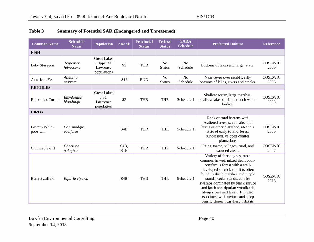
Table 3 Summary of Potential SAR (Endangered and Threatened)
Common Name Scientific Name Population SRank Provincial
Status Federal Status
SARA Schedule Preferred Habitat Reference
FISH
Lake Sturgeon Acipenser fulvescens
Great Lakes - Upper St. Lawrence
populations
S2 THR No Status
No Schedule Bottoms of lakes and large rivers. COSEWIC
2000
American Eel Anguilla rostrata
S1? END No Status
No Schedule
Near cover over muddy, silty bottoms of lakes, rivers and creeks.
COSEWIC 2006
REPTILES
Blanding's Turtle Emydoidea blandingii
Great Lakes / St.
Lawrence population
S3 THR THR Schedule 1 Shallow water, large marshes,
shallow lakes or similar such water bodies.
COSEWIC 2005
BIRDS
Eastern Whip-poor-will
Caprimulgus vociferus
S4B THR THR Schedule 1
Rock or sand barrens with scattered trees, savannahs, old
burns or other disturbed sites in a state of early to mid-forest succession, or open conifer
plantations
COSEWIC 2009
Chimney Swift Chaetura pelagica
S4B, S4N THR THR Schedule 1 Cities, towns, villages, rural, and
wooded areas. COSEWIC
2007
Bank Swallow Riparia riparia S4B THR THR Schedule 1
Variety of forest types, most common in wet, mixed deciduous-
coniferous forest with a well-developed shrub layer. It is often
found in shrub marshes, red maple stands, cedar stands, conifer
swamps dominated by black spruce and larch and riparian woodlands along rivers and lakes. It is also associated with ravines and steep brushy slopes near these habitats
COSEWIC 2013
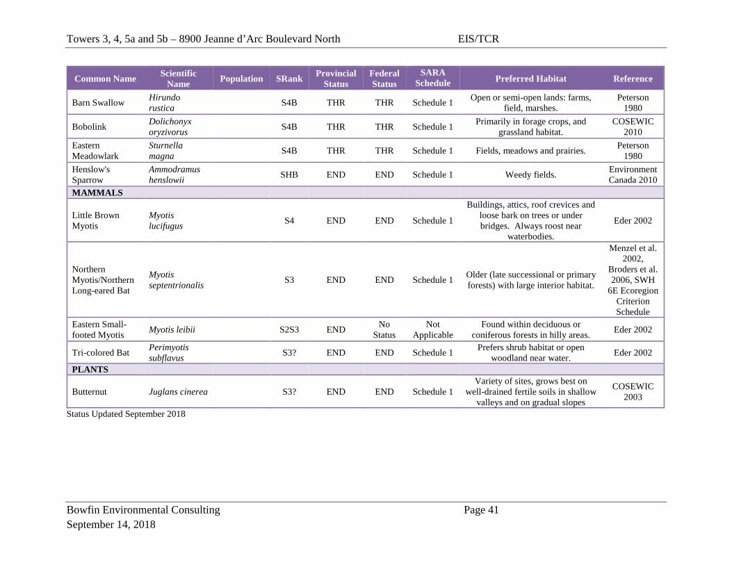
Towers 3, 4, 5a and 5b – 8900 Jeanne d’Arc Boulevard North EIS/TCR
Bowfin Environmental Consulting Page 41 September 14, 2018
Common Name Scientific Name Population SRank Provincial
Status Federal Status
SARA Schedule Preferred Habitat Reference
Barn Swallow Hirundo rustica
S4B THR THR Schedule 1 Open or semi-open lands: farms, field, marshes.
Peterson 1980
Bobolink Dolichonyx oryzivorus
S4B THR THR Schedule 1 Primarily in forage crops, and grassland habitat.
COSEWIC 2010
Eastern Meadowlark
Sturnella magna
S4B THR THR Schedule 1 Fields, meadows and prairies. Peterson 1980
Henslow's Sparrow
Ammodramus henslowii
SHB END END Schedule 1 Weedy fields. Environment Canada 2010
MAMMALS
Little Brown Myotis
Myotis lucifugus
S4 END END Schedule 1
Buildings, attics, roof crevices and loose bark on trees or under bridges. Always roost near
waterbodies.
Eder 2002
Northern Myotis/Northern Long-eared Bat
Myotis septentrionalis
S3 END END Schedule 1 Older (late successional or primary forests) with large interior habitat.
Menzel et al. 2002,
Broders et al. 2006, SWH
6E Ecoregion Criterion Schedule
Eastern Small-footed Myotis Myotis leibii S2S3 END No
Status Not
Applicable Found within deciduous or
coniferous forests in hilly areas. Eder 2002
Tri-colored Bat Perimyotis subflavus
S3? END END Schedule 1 Prefers shrub habitat or open woodland near water. Eder 2002
PLANTS
Butternut Juglans cinerea S3? END END Schedule 1 Variety of sites, grows best on
well-drained fertile soils in shallow valleys and on gradual slopes
COSEWIC 2003
Status Updated September 2018
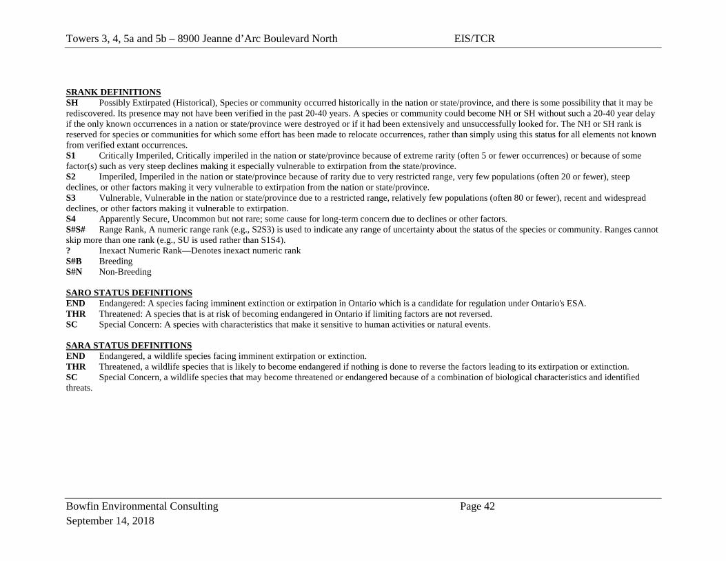
Towers 3, 4, 5a and 5b – 8900 Jeanne d’Arc Boulevard North EIS/TCR
Bowfin Environmental Consulting Page 42 September 14, 2018
SRANK DEFINITIONS SH Possibly Extirpated (Historical), Species or community occurred historically in the nation or state/province, and there is some possibility that it may be rediscovered. Its presence may not have been verified in the past 20-40 years. A species or community could become NH or SH without such a 20-40 year delay if the only known occurrences in a nation or state/province were destroyed or if it had been extensively and unsuccessfully looked for. The NH or SH rank is reserved for species or communities for which some effort has been made to relocate occurrences, rather than simply using this status for all elements not known from verified extant occurrences. S1 Critically Imperiled, Critically imperiled in the nation or state/province because of extreme rarity (often 5 or fewer occurrences) or because of some factor(s) such as very steep declines making it especially vulnerable to extirpation from the state/province. S2 Imperiled, Imperiled in the nation or state/province because of rarity due to very restricted range, very few populations (often 20 or fewer), steep declines, or other factors making it very vulnerable to extirpation from the nation or state/province. S3 Vulnerable, Vulnerable in the nation or state/province due to a restricted range, relatively few populations (often 80 or fewer), recent and widespread declines, or other factors making it vulnerable to extirpation. S4 Apparently Secure, Uncommon but not rare; some cause for long-term concern due to declines or other factors. S#S# Range Rank, A numeric range rank (e.g., S2S3) is used to indicate any range of uncertainty about the status of the species or community. Ranges cannot skip more than one rank (e.g., SU is used rather than S1S4). ? Inexact Numeric Rank—Denotes inexact numeric rank S#B Breeding S#N Non-Breeding SARO STATUS DEFINITIONS END Endangered: A species facing imminent extinction or extirpation in Ontario which is a candidate for regulation under Ontario's ESA. THR Threatened: A species that is at risk of becoming endangered in Ontario if limiting factors are not reversed. SC Special Concern: A species with characteristics that make it sensitive to human activities or natural events. SARA STATUS DEFINITIONS END Endangered, a wildlife species facing imminent extirpation or extinction. THR Threatened, a wildlife species that is likely to become endangered if nothing is done to reverse the factors leading to its extirpation or extinction. SC Special Concern, a wildlife species that may become threatened or endangered because of a combination of biological characteristics and identified threats.
Towers 3, 4, 5a and 5b – 8900 Jeanne d’Arc Boulevard North EIS/TCR
Bowfin Environmental Consulting Page 43 September 14, 2018
4.2.5 Accidents and malfunctions The potential impacts associated with this proposed development largely stem from accidents or malfunctions. Although the likelihood of accidents and malfunctions occurring would be minimized by following the mitigation measures outlined below, should accidents and/or malfunctions occur they have the possibility of presenting serious impacts and require consideration. Maintenance on construction equipment such as refueling, oil changes or lubrication would only be permitted in designated area located at a minimum of 30 m from the slope and from the reed canary grass and trees to the west and south of the temporary access road. And in an area where sediment erosion control measures and all precautions have been made to prevent oil, grease, antifreeze or other materials from inadvertently entering the ground or the surface water flow. Machinery should be cleaned prior to arriving on-site to prevent the potential spread of invasive species. Emergency spill kits would be located on site. The crew would be fully trained on the use of clean-up materials in order to minimize impacts of any accidental spills. The area would be monitored for leakage and in the unlikely event of a minor spillage the project manager would halt the activity and corrective measures would be implemented. Any spills would be immediately reported to the Ministry of Environment, Conservation and Parks (MECP) Spills Action Centre (1800 268-6060).
5.0 TREE CONSERVATION AND PLANTING PLAN This development (approximately 2.9 ha) is located to the east of Trim Road and north of Highway 174; approximately 6 km west of Cumberland. This report includes the development of the towers as well as the construction, operation and decommissioning of the temporary access road. There were few trees within the subject lands with the exception of a portion of the Dry-Fresh Oak-Red Maple Forest located on the north edge of the property and the Dry-Fresh Poplar White Pine Mixed Forest next to Towers 5a and 5b. Both areas are less than 200 m wide and as such there is no forest interior associated with the stand (in or outside of the study area). There were no occurrences of SAR or their protected habitats.
Towers 3, 4, 5a and 5b – 8900 Jeanne d’Arc Boulevard North EIS/TCR
Bowfin Environmental Consulting Page 44 September 14, 2018
The trees to the north of the tower form part of the Significant Valleyland and the impacts to them and this feature is discussed above under Section 4.2.2. Other than the retention of trees for the purposes of slope stability and the features discussed under section 4.0, no additional trees are recommended for retention. Note that the slope stability issue has been addressed by geotechnical experts. Given that there will be the removal of a portion of the woodland, it is recommended that planting of native trees and shrubs occur where feasible. Species such as red maple, bur oak, sugar maple, black cherry, green ash, white ash, nannyberry and hickory may be appropriate. Design changes and mitigation measures outlines in Section 4.0 have been implemented to mitigate potential harm to the trees to be retained. No additional mitigation measures other than those listed under Section 4.0 are required. Summary of individual trees and groupings is provided in Table 4. Map 1 and Map 2 as per the City’s TCR requirements are provided below (Figure 4-Figure 7).
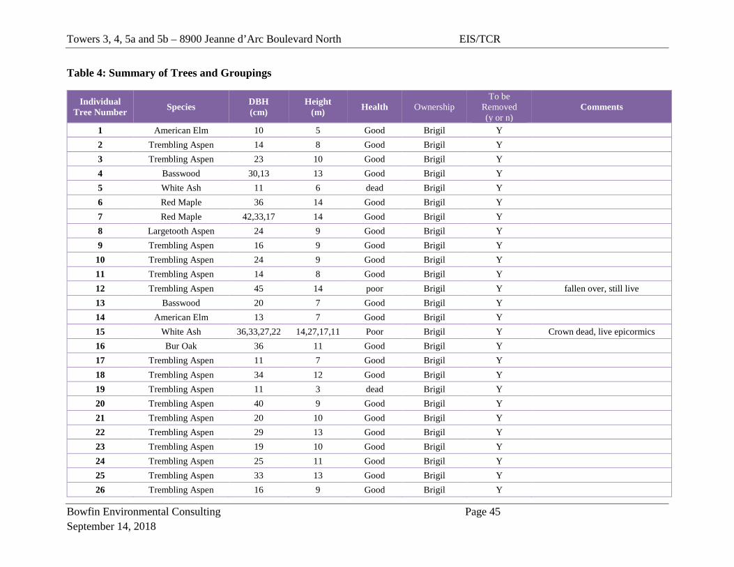
Towers 3, 4, 5a and 5b – 8900 Jeanne d’Arc Boulevard North EIS/TCR
Bowfin Environmental Consulting Page 45 September 14, 2018
Table 4: Summary of Trees and Groupings
Individual Tree Number Species DBH
(cm) Height
(m) Health Ownership To be
Removed (y or n)
Comments
1 American Elm 10 5 Good Brigil Y 2 Trembling Aspen 14 8 Good Brigil Y 3 Trembling Aspen 23 10 Good Brigil Y 4 Basswood 30,13 13 Good Brigil Y 5 White Ash 11 6 dead Brigil Y 6 Red Maple 36 14 Good Brigil Y 7 Red Maple 42,33,17 14 Good Brigil Y 8 Largetooth Aspen 24 9 Good Brigil Y 9 Trembling Aspen 16 9 Good Brigil Y
10 Trembling Aspen 24 9 Good Brigil Y 11 Trembling Aspen 14 8 Good Brigil Y 12 Trembling Aspen 45 14 poor Brigil Y fallen over, still live 13 Basswood 20 7 Good Brigil Y 14 American Elm 13 7 Good Brigil Y 15 White Ash 36,33,27,22 14,27,17,11 Poor Brigil Y Crown dead, live epicormics 16 Bur Oak 36 11 Good Brigil Y 17 Trembling Aspen 11 7 Good Brigil Y 18 Trembling Aspen 34 12 Good Brigil Y 19 Trembling Aspen 11 3 dead Brigil Y 20 Trembling Aspen 40 9 Good Brigil Y 21 Trembling Aspen 20 10 Good Brigil Y 22 Trembling Aspen 29 13 Good Brigil Y 23 Trembling Aspen 19 10 Good Brigil Y 24 Trembling Aspen 25 11 Good Brigil Y 25 Trembling Aspen 33 13 Good Brigil Y 26 Trembling Aspen 16 9 Good Brigil Y
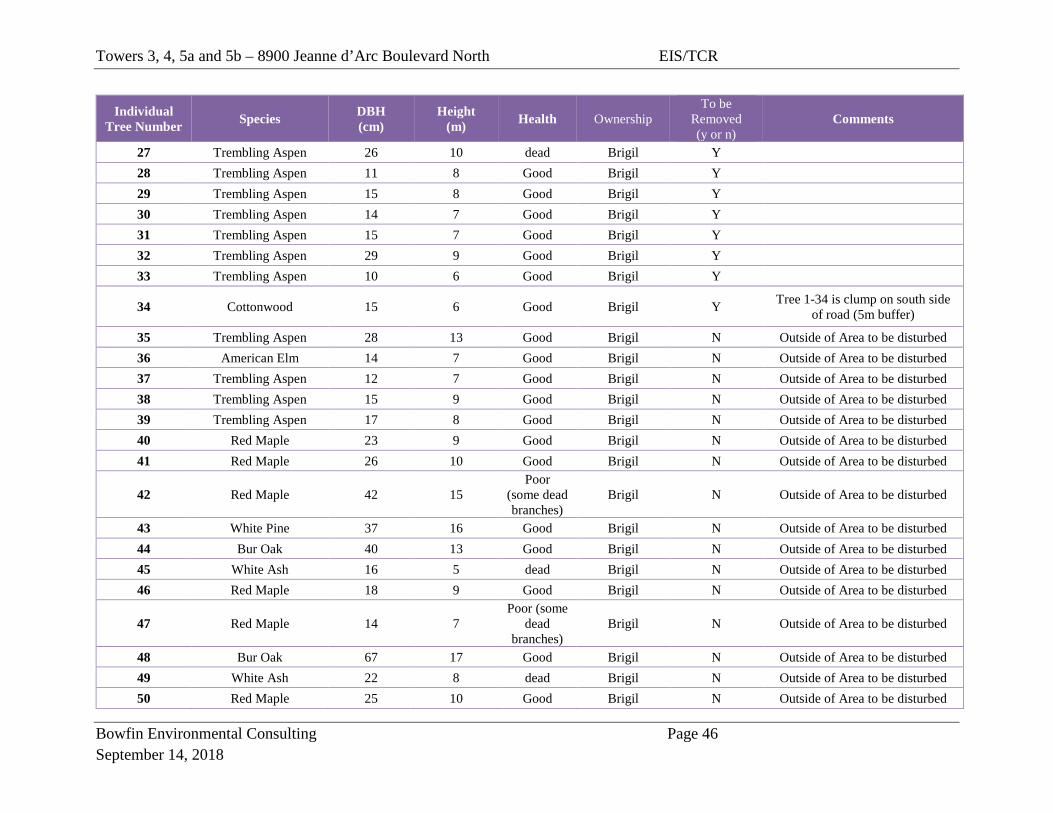
Towers 3, 4, 5a and 5b – 8900 Jeanne d’Arc Boulevard North EIS/TCR
Bowfin Environmental Consulting Page 46 September 14, 2018
Individual Tree Number Species DBH
(cm) Height
(m) Health Ownership To be
Removed (y or n)
Comments
27 Trembling Aspen 26 10 dead Brigil Y 28 Trembling Aspen 11 8 Good Brigil Y 29 Trembling Aspen 15 8 Good Brigil Y 30 Trembling Aspen 14 7 Good Brigil Y 31 Trembling Aspen 15 7 Good Brigil Y 32 Trembling Aspen 29 9 Good Brigil Y 33 Trembling Aspen 10 6 Good Brigil Y
34 Cottonwood 15 6 Good Brigil Y Tree 1-34 is clump on south side of road (5m buffer)
35 Trembling Aspen 28 13 Good Brigil N Outside of Area to be disturbed 36 American Elm 14 7 Good Brigil N Outside of Area to be disturbed 37 Trembling Aspen 12 7 Good Brigil N Outside of Area to be disturbed 38 Trembling Aspen 15 9 Good Brigil N Outside of Area to be disturbed 39 Trembling Aspen 17 8 Good Brigil N Outside of Area to be disturbed 40 Red Maple 23 9 Good Brigil N Outside of Area to be disturbed 41 Red Maple 26 10 Good Brigil N Outside of Area to be disturbed
42 Red Maple 42 15 Poor
(some dead branches)
Brigil N Outside of Area to be disturbed
43 White Pine 37 16 Good Brigil N Outside of Area to be disturbed 44 Bur Oak 40 13 Good Brigil N Outside of Area to be disturbed 45 White Ash 16 5 dead Brigil N Outside of Area to be disturbed 46 Red Maple 18 9 Good Brigil N Outside of Area to be disturbed
47 Red Maple 14 7 Poor (some
dead branches)
Brigil N Outside of Area to be disturbed
48 Bur Oak 67 17 Good Brigil N Outside of Area to be disturbed 49 White Ash 22 8 dead Brigil N Outside of Area to be disturbed 50 Red Maple 25 10 Good Brigil N Outside of Area to be disturbed
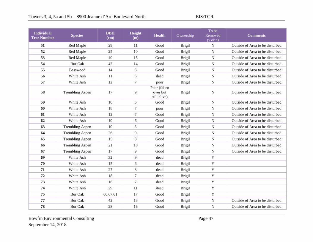
Towers 3, 4, 5a and 5b – 8900 Jeanne d’Arc Boulevard North EIS/TCR
Bowfin Environmental Consulting Page 47 September 14, 2018
Individual Tree Number Species DBH
(cm) Height
(m) Health Ownership To be
Removed (y or n)
Comments
51 Red Maple 29 11 Good Brigil N Outside of Area to be disturbed 52 Red Maple 25 10 Good Brigil N Outside of Area to be disturbed 53 Red Maple 40 15 Good Brigil N Outside of Area to be disturbed 54 Bur Oak 42 14 Good Brigil N Outside of Area to be disturbed 55 Basswood 14 6 Good Brigil N Outside of Area to be disturbed 56 White Ash 11 6 dead Brigil N Outside of Area to be disturbed 57 White Ash 12 7 poor Brigil N Outside of Area to be disturbed
58 Trembling Aspen 17 9 Poor (fallen
over but still alive)
Brigil N Outside of Area to be disturbed
59 White Ash 10 6 Good Brigil N Outside of Area to be disturbed 60 White Ash 18 7 poor Brigil N Outside of Area to be disturbed 61 White Ash 12 7 Good Brigil N Outside of Area to be disturbed 62 White Ash 10 6 Good Brigil N Outside of Area to be disturbed 63 Trembling Aspen 10 5 Good Brigil N Outside of Area to be disturbed 64 Trembling Aspen 26 9 Good Brigil N Outside of Area to be disturbed 65 Trembling Aspen 15 8 Good Brigil N Outside of Area to be disturbed 66 Trembling Aspen 21 10 Good Brigil N Outside of Area to be disturbed 67 Trembling Aspen 17 9 Good Brigil N Outside of Area to be disturbed 69 White Ash 32 9 dead Brigil Y 70 White Ash 15 6 dead Brigil Y 71 White Ash 27 8 dead Brigil Y 72 White Ash 18 7 dead Brigil Y 73 White Ash 16 7 dead Brigil Y 74 White Ash 29 11 dead Brigil Y 75 Bur Oak 60,67,61 17 Good Brigil Y 77 Bur Oak 42 13 Good Brigil N Outside of Area to be disturbed 78 Bur Oak 28 16 Good Brigil N Outside of Area to be disturbed
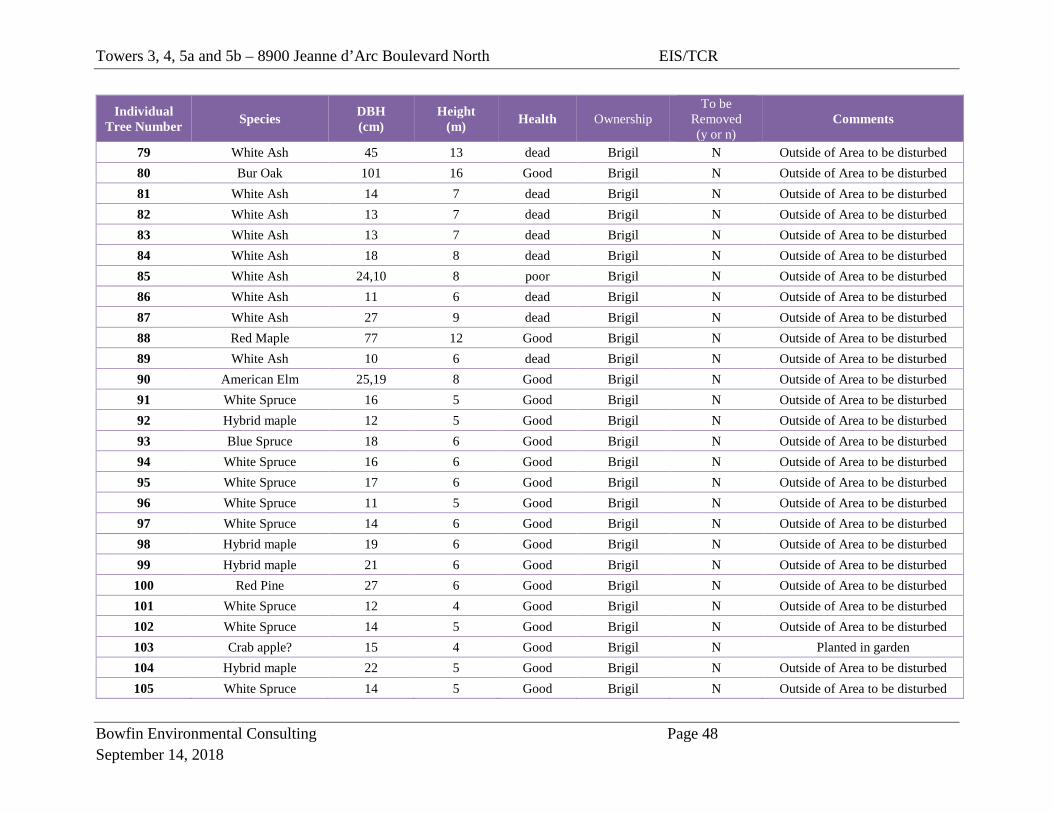
Towers 3, 4, 5a and 5b – 8900 Jeanne d’Arc Boulevard North EIS/TCR
Bowfin Environmental Consulting Page 48 September 14, 2018
Individual Tree Number Species DBH
(cm) Height
(m) Health Ownership To be
Removed (y or n)
Comments
79 White Ash 45 13 dead Brigil N Outside of Area to be disturbed 80 Bur Oak 101 16 Good Brigil N Outside of Area to be disturbed 81 White Ash 14 7 dead Brigil N Outside of Area to be disturbed 82 White Ash 13 7 dead Brigil N Outside of Area to be disturbed 83 White Ash 13 7 dead Brigil N Outside of Area to be disturbed 84 White Ash 18 8 dead Brigil N Outside of Area to be disturbed 85 White Ash 24,10 8 poor Brigil N Outside of Area to be disturbed 86 White Ash 11 6 dead Brigil N Outside of Area to be disturbed 87 White Ash 27 9 dead Brigil N Outside of Area to be disturbed 88 Red Maple 77 12 Good Brigil N Outside of Area to be disturbed 89 White Ash 10 6 dead Brigil N Outside of Area to be disturbed 90 American Elm 25,19 8 Good Brigil N Outside of Area to be disturbed 91 White Spruce 16 5 Good Brigil N Outside of Area to be disturbed 92 Hybrid maple 12 5 Good Brigil N Outside of Area to be disturbed 93 Blue Spruce 18 6 Good Brigil N Outside of Area to be disturbed 94 White Spruce 16 6 Good Brigil N Outside of Area to be disturbed 95 White Spruce 17 6 Good Brigil N Outside of Area to be disturbed 96 White Spruce 11 5 Good Brigil N Outside of Area to be disturbed 97 White Spruce 14 6 Good Brigil N Outside of Area to be disturbed 98 Hybrid maple 19 6 Good Brigil N Outside of Area to be disturbed 99 Hybrid maple 21 6 Good Brigil N Outside of Area to be disturbed
100 Red Pine 27 6 Good Brigil N Outside of Area to be disturbed 101 White Spruce 12 4 Good Brigil N Outside of Area to be disturbed 102 White Spruce 14 5 Good Brigil N Outside of Area to be disturbed 103 Crab apple? 15 4 Good Brigil N Planted in garden 104 Hybrid maple 22 5 Good Brigil N Outside of Area to be disturbed 105 White Spruce 14 5 Good Brigil N Outside of Area to be disturbed
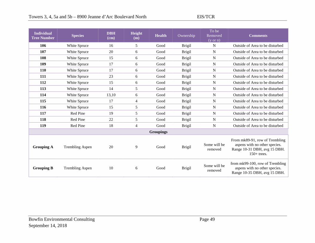
Towers 3, 4, 5a and 5b – 8900 Jeanne d’Arc Boulevard North EIS/TCR
Bowfin Environmental Consulting Page 49 September 14, 2018
Individual Tree Number Species DBH
(cm) Height
(m) Health Ownership To be
Removed (y or n)
Comments
106 White Spruce 16 5 Good Brigil N Outside of Area to be disturbed 107 White Spruce 20 6 Good Brigil N Outside of Area to be disturbed 108 White Spruce 15 6 Good Brigil N Outside of Area to be disturbed 109 White Spruce 17 6 Good Brigil N Outside of Area to be disturbed 110 White Spruce 17 6 Good Brigil N Outside of Area to be disturbed 111 White Spruce 23 6 Good Brigil N Outside of Area to be disturbed 112 White Spruce 15 6 Good Brigil N Outside of Area to be disturbed 113 White Spruce 14 5 Good Brigil N Outside of Area to be disturbed 114 White Spruce 13,10 6 Good Brigil N Outside of Area to be disturbed 115 White Spruce 17 4 Good Brigil N Outside of Area to be disturbed 116 White Spruce 15 5 Good Brigil N Outside of Area to be disturbed 117 Red Pine 19 5 Good Brigil N Outside of Area to be disturbed 118 Red Pine 22 5 Good Brigil N Outside of Area to be disturbed 119 Red Pine 18 4 Good Brigil N Outside of Area to be disturbed
Groupings
Grouping A Trembling Aspen 20 9 Good Brigil Some will be removed
From mk89-91, row of Trembling aspens with no other species.
Range 10-31 DBH, avg 15 DBH. 150+ trees.
Grouping B Trembling Aspen 10 6 Good Brigil Some will be removed
from mk99-100, row of Trembling aspens with no other species.
Range 10-35 DBH, avg 15 DBH.
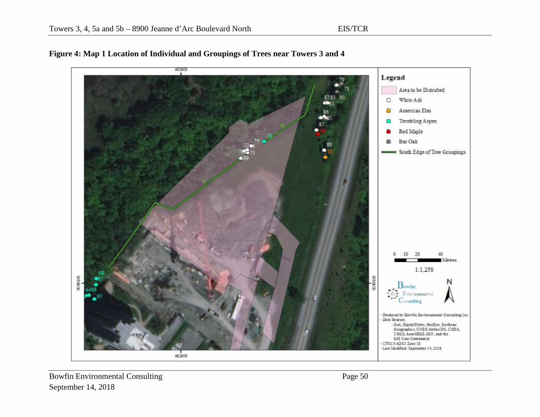
Towers 3, 4, 5a and 5b – 8900 Jeanne d’Arc Boulevard North EIS/TCR
Bowfin Environmental Consulting Page 50 September 14, 2018
Figure 4: Map 1 Location of Individual and Groupings of Trees near Towers 3 and 4
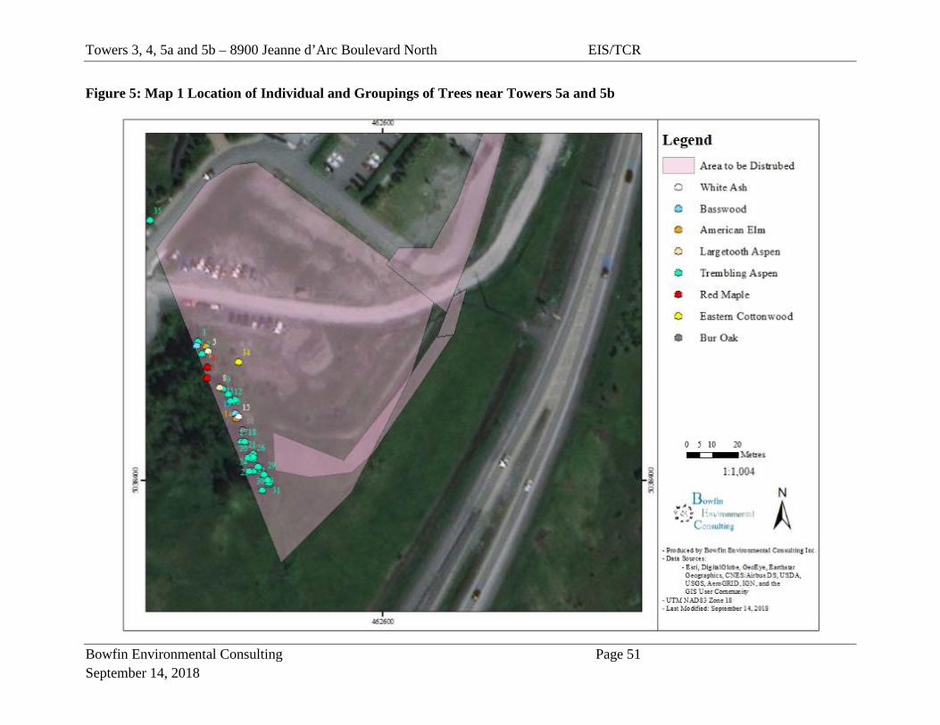
Towers 3, 4, 5a and 5b – 8900 Jeanne d’Arc Boulevard North EIS/TCR
Bowfin Environmental Consulting Page 51 September 14, 2018
Figure 5: Map 1 Location of Individual and Groupings of Trees near Towers 5a and 5b
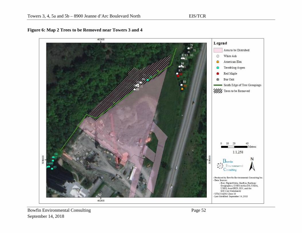
Towers 3, 4, 5a and 5b – 8900 Jeanne d’Arc Boulevard North EIS/TCR
Bowfin Environmental Consulting Page 52 September 14, 2018
Figure 6: Map 2 Trees to be Removed near Towers 3 and 4

Towers 3, 4, 5a and 5b – 8900 Jeanne d’Arc Boulevard North EIS/TCR
Bowfin Environmental Consulting Page 53 September 14, 2018
Figure 7: Map 2 Trees to be Removed near Towers 5a and 5b
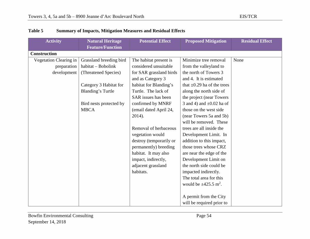
Towers 3, 4, 5a and 5b – 8900 Jeanne d’Arc Boulevard North EIS/TCR
Bowfin Environmental Consulting Page 54 September 14, 2018
Table 5 Summary of Impacts, Mitigation Measures and Residual Effects
Activity Natural Heritage Feature/Function
Potential Effect Proposed Mitigation Residual Effect
Construction Vegetation Clearing in
preparation development
Grassland breeding bird habitat – Bobolink (Threatened Species) Category 3 Habitat for Blanding’s Turtle Bird nests protected by MBCA
The habitat present is considered unsuitable for SAR grassland birds and as Category 3 habitat for Blanding’s Turtle. The lack of SAR issues has been confirmed by MNRF (email dated April 24, 2014). Removal of herbaceous vegetation would destroy (temporarily or permanently) breeding habitat. It may also impact, indirectly, adjacent grassland habitats.
Minimize tree removal from the valleyland to the north of Towers 3 and 4. It is estimated that ±0.29 ha of the trees along the north side of the project (near Towers 3 and 4) and ±0.02 ha of those on the west side (near Towers 5a and 5b) will be removed. These trees are all inside the Development Limit. In addition to this impact, those trees whose CRZ are near the edge of the Development Limit on the north side could be impacted indirectly. The total area for this would be ±425.5 m2. A permit from the City will be required prior to
None
Towers 3, 4, 5a and 5b – 8900 Jeanne d’Arc Boulevard North EIS/TCR
Bowfin Environmental Consulting Page 55 September 14, 2018
Activity Natural Heritage Feature/Function
Potential Effect Proposed Mitigation Residual Effect
removing trees greater than 10 cm DBH. No signs, notices or posters should be attached to any trees; Any landscape plans should include native species as much as possible. Various species could be used including: red maple, sugar maple, hickory, bur oak, green ash, white ash or nannyberry. Where possible the woody vegetation should be planted in groupings to maximize wildlife benefit. Use small machinery within 20 m of valleyland to the north of Towers 3 and 4.

Towers 3, 4, 5a and 5b – 8900 Jeanne d’Arc Boulevard North EIS/TCR
Bowfin Environmental Consulting Page 56 September 14, 2018
Activity Natural Heritage Feature/Function
Potential Effect Proposed Mitigation Residual Effect
Any clearing of vegetation within the CRZ (DBH x 10 cm) of trees to be retained (from both the trees to the west and those to the north) will be done by hand. All vegetation clearing should occur outside of breeding bird season and the day-roost period for bats (no clearing between April 15th and September 30th). If this is not possible, then have a biologist complete a bird nest surveys a maximum of 5 days prior to clearing between April 15th and August 15th. Take precautions for bats between June 1st and September 30th.
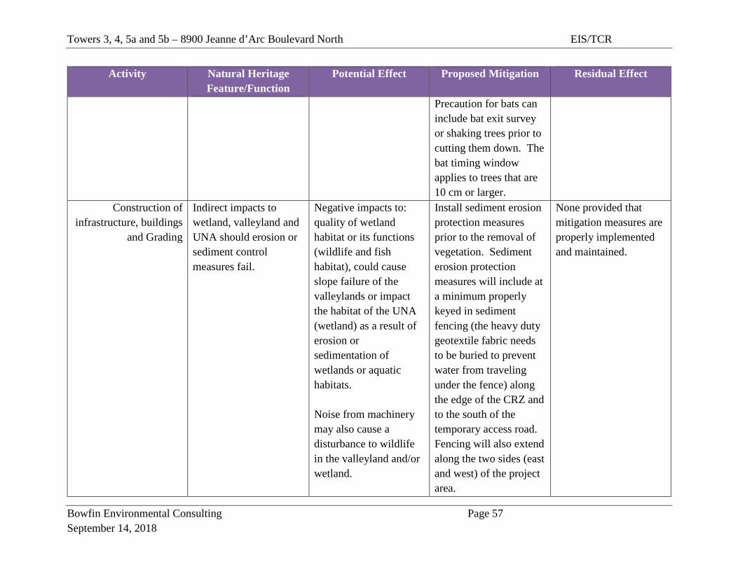
Towers 3, 4, 5a and 5b – 8900 Jeanne d’Arc Boulevard North EIS/TCR
Bowfin Environmental Consulting Page 57 September 14, 2018
Activity Natural Heritage Feature/Function
Potential Effect Proposed Mitigation Residual Effect
Precaution for bats can include bat exit survey or shaking trees prior to cutting them down. The bat timing window applies to trees that are 10 cm or larger.
Construction of infrastructure, buildings
and Grading
Indirect impacts to wetland, valleyland and UNA should erosion or sediment control measures fail.
Negative impacts to: quality of wetland habitat or its functions (wildlife and fish habitat), could cause slope failure of the valleylands or impact the habitat of the UNA (wetland) as a result of erosion or sedimentation of wetlands or aquatic habitats. Noise from machinery may also cause a disturbance to wildlife in the valleyland and/or wetland.
Install sediment erosion protection measures prior to the removal of vegetation. Sediment erosion protection measures will include at a minimum properly keyed in sediment fencing (the heavy duty geotextile fabric needs to be buried to prevent water from traveling under the fence) along the edge of the CRZ and to the south of the temporary access road. Fencing will also extend along the two sides (east and west) of the project area.
None provided that mitigation measures are properly implemented and maintained.
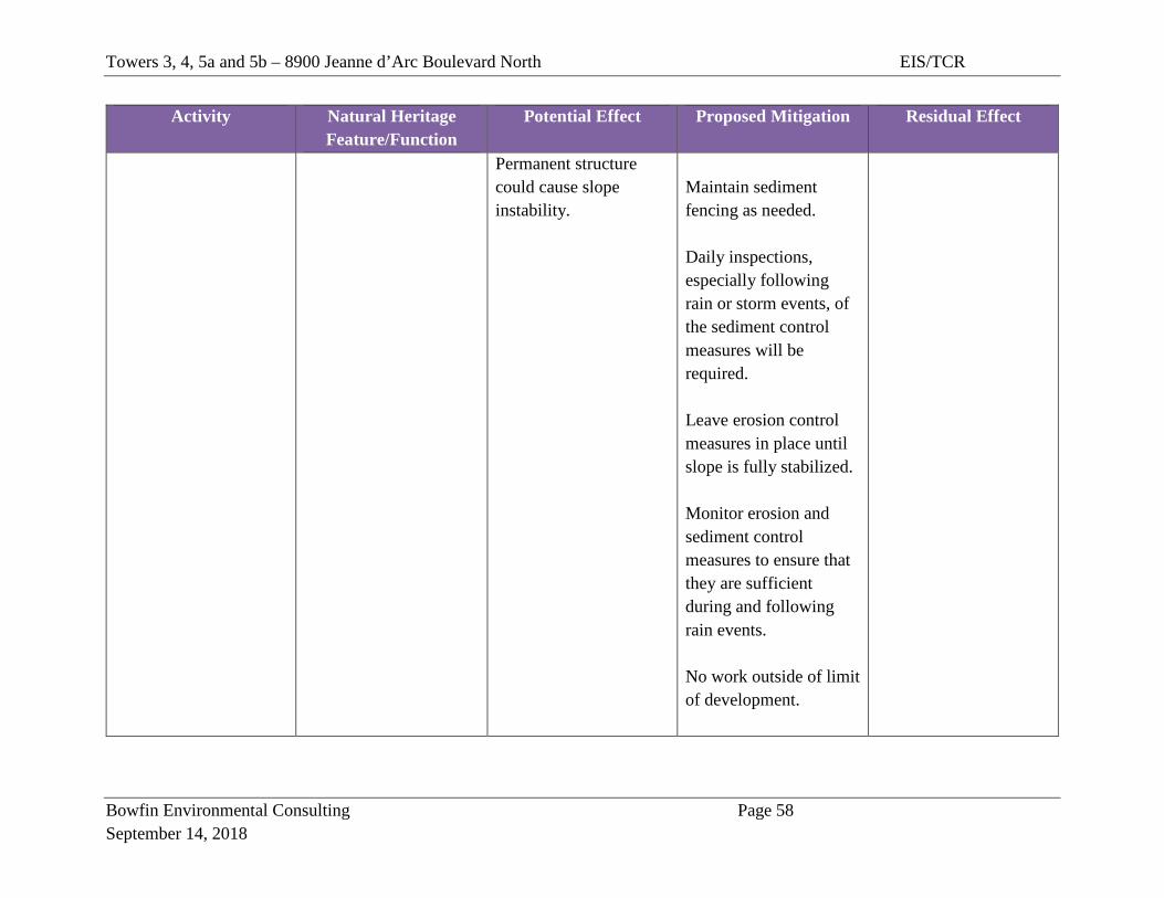
Towers 3, 4, 5a and 5b – 8900 Jeanne d’Arc Boulevard North EIS/TCR
Bowfin Environmental Consulting Page 58 September 14, 2018
Activity Natural Heritage Feature/Function
Potential Effect Proposed Mitigation Residual Effect
Permanent structure could cause slope instability.
Maintain sediment fencing as needed. Daily inspections, especially following rain or storm events, of the sediment control measures will be required. Leave erosion control measures in place until slope is fully stabilized. Monitor erosion and sediment control measures to ensure that they are sufficient during and following rain events. No work outside of limit of development.
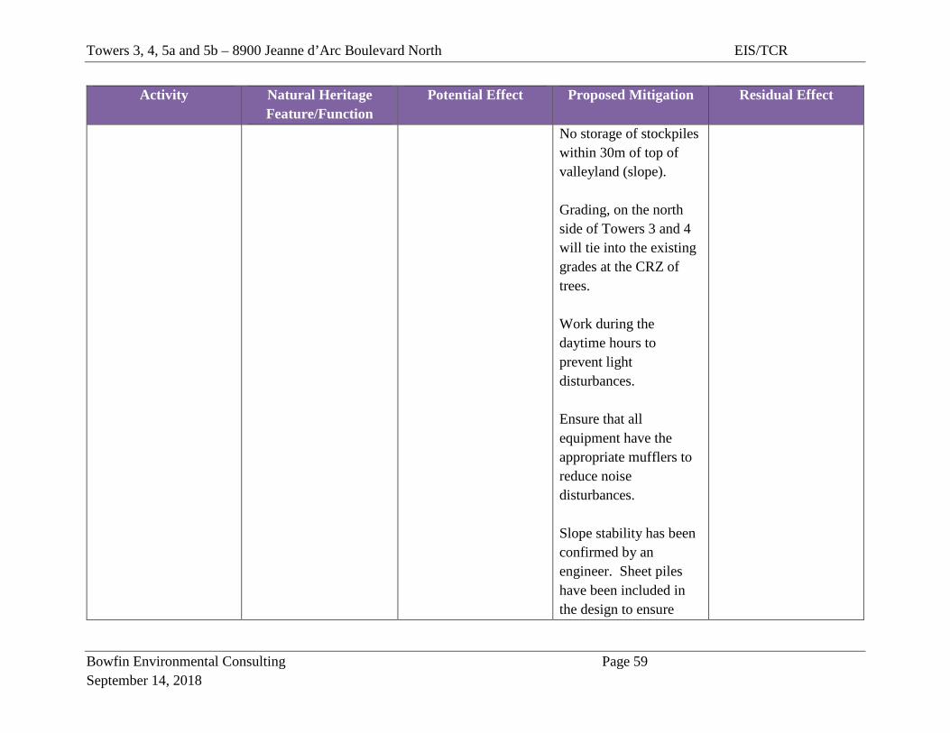
Towers 3, 4, 5a and 5b – 8900 Jeanne d’Arc Boulevard North EIS/TCR
Bowfin Environmental Consulting Page 59 September 14, 2018
Activity Natural Heritage Feature/Function
Potential Effect Proposed Mitigation Residual Effect
No storage of stockpiles within 30m of top of valleyland (slope). Grading, on the north side of Towers 3 and 4 will tie into the existing grades at the CRZ of trees. Work during the daytime hours to prevent light disturbances. Ensure that all equipment have the appropriate mufflers to reduce noise disturbances. Slope stability has been confirmed by an engineer. Sheet piles have been included in the design to ensure
Towers 3, 4, 5a and 5b – 8900 Jeanne d’Arc Boulevard North EIS/TCR
Bowfin Environmental Consulting Page 60 September 14, 2018
Activity Natural Heritage Feature/Function
Potential Effect Proposed Mitigation Residual Effect
slope stability in the future. There is no walkway located within the development limit or the CRZ of the trees to be retained. Construction staff will be informed of the SAR in the area (Appendix C).
Accidents or Malfunctions
Indirect impacts to wetland, valleyland and UNA should erosion or sediment control measures fail.
Spills or accidents during construction could impact the quality of wetland habitat or its functions (wildlife and fish habitat), could cause slope failure of the valleylands or impact the habitat of the UNA (wetland).
All equipment should be well maintained, clean and free of leaks. Maintenance of construction equipment should occur at a minimum of 30m from the top of the slope/valleyland and from the reed canary grass and trees west and south of the temporary work area. It is to be in
Unlikely
Towers 3, 4, 5a and 5b – 8900 Jeanne d’Arc Boulevard North EIS/TCR
Bowfin Environmental Consulting Page 61 September 14, 2018
Activity Natural Heritage Feature/Function
Potential Effect Proposed Mitigation Residual Effect
an area where all precautions have been made to prevent oil, grease, antifreeze or other materials from inadvertently entering the ground or surface water. Any machine coming from offsite should be cleaned and free of mud (to prevent the transfer of non-native vegetation). Emergency spill kits should be located on site and the crew trained on their use. Any spills will be reported immediately to MECP Spills Action Centre (1.800.268.6060).
Towers 3, 4, 5a and 5b – 8900 Jeanne D’Arc Boulevard North EIS/TCR
Bowfin Environmental Consulting Page 62 September 14, 2018
6.0 CONCLUSIONS AND RECOMMENDATIONS The lands to be developed are bordered by Highway 174 on the east and south sides and by Phase 1 of the Petrie Landing development on the southwest. They consisted of cultural meadows and a small (±0.29 ha) portion of the deciduous forest on the slope and within the mixed forest (±0.02 ha). The deciduous and mixed forests that would be directly impacted are within the Development Limit for the site. Much of the remaining area to be disturbed is already in a disturbed state (bare soil and used for laydown yard, access roads). Other parts of the cultural meadows have recently re-established after having served as a temporary work area during the construction of Phase 1 (2008-2010). The temporary access road for Phase 2 remains in place and additional access roads, totaling 115 m long, will be added to access Towers 3 and 4 during construction. Towers 5a and 5b will be accessed from the already existing access road. The northwest side consists of the forested slope and wetlands which form part of the identified natural features (PSW, valleylands and UNA). No SAR habitat or species were documented in the study area. The PSW is situated to the northwest of the proposed development and its access road. The PSW will not be directly impacted. While the UNA mapping includes a portion of the subject lands, most of these lands consist of the cultural meadow and do not provide any function identified in the UNA report. The small portions of the forest that will be removed are on the edge and do not include interior habitat. No raptor nests were found within this area. The small mixed forest is not part of the UNA. No measurable impact to the functions of the UNA will occur. The Development Limit established by RVCA has been respected. The estimated CRZ along the north edge of the Development Limit is 3.5 m. The only work that is proposed in this CRZ is a portion of the storm sewer and the retaining walls. The total area that may be impacted has been calculated at 425.5 m2. This small impact would only occur if the trees along the Development in this area are 35 cm. If the impact occurs it is considered negligible due to the small footprint (which may actually be smaller) and as geotechnical experts have concluded that no impacts to the slope will occur. No trees requiring retention were identified within the area to be cleared. All of the impacts can be mitigated through the use of common mitigation measures and no residual negative impacts to the natural environment are anticipated as a result of the development of Towers 3, 4 and 5a and 5b or the temporary access roads. This proposed development can be accepted as planned.
Towers 3, 4, 5a and 5b – 8900 Jeanne D’Arc Boulevard North EIS/TCR
Bowfin Environmental Consulting Page 63 September 14, 2018
I trust that this report will meet your requirements. Should you have any questions or comments, please contact the undersigned. Sincerely, Bowfin Environmental Consulting Inc.
Michelle Lavictoire, Biologist / Principal
7.0 REFERENCES Bradley, David. 2007. Southern Ontario Vascular Plant Species List. Prepared by Southern
Science and Information Section, Ontario Ministry of Natural Resources, Peterborough, Ontario. 57pp.
Brunton, D.F. 1999. Natural environment inventory and interpretative concepts: Petrie Island
study area, Cumberland, Ontario. 105 pp. COSEWIC. (2000). COSEWC assessment and update status report on the Lake Sturgeon
Acipenser fulvescens in Canada. Committee on the Status of Endangered Wildlife in Canada. Ottawa xi +107pp.
COSEWIC. (2003). COSEWIC assessment and status report on the Butternut Juglans cinerea in
Canada. Committee on the Status of Endangered Wildlife in Canada. Ottawa. vii + 32 pp. COSEWIC. (2005). COSEWIC assessment and update status report on the Blanding's Turtle
Emydoidea blandingii in Canada. Committee on the Status of Endangered Wildlife in Canada. Ottawa. viii + 40 pp.
Towers 3, 4, 5a and 5b – 8900 Jeanne D’Arc Boulevard North EIS/TCR
Bowfin Environmental Consulting Page 64 September 14, 2018
COSEWIC. (2006). COSEWIC assessment and status report on the American Eel Anguilla rostrata in Canada. Committee on the Status of Endangered Wildlife in Canada. Ottawa. x + 71 pp.
COSEWIC. (2007). COSEWIC assessment and update status report on the Chimney Swift
Chaetura pelagica in Canada. Committee on the Status of Endangered Wildlife in Canada. Ottawa. vii + 49 pp.
COSEWIC. (2009). COSEWIC assessment and status report on the Whip-poor-will Caprimulgus
vociferus in Canada. Committee on the Status of Endangered Wildlife in Canada. Ottawa. vi + 28 pp.
COSEWIC. (2010). COSEWIC assessment and status report on the Bobolink Dolichonyx
oryzivorus in Canada. Committee on the Status of Endangered Wildlife in Canada. Ottawa. vi + 42 pp.
COSEWIC. (2013). COSEWIC assessment and status report on the Bank Swallow Riparia
riparia in Canada. Committee on the Status of Endangered Wildlife in Canada. Ottawa. ix + 48 pp.
Environment Canada. (2010). Amended Recovery Strategy for the Henslow’s Sparrow
(Ammodramus henslowii) in Canada. Species at Risk Act Recovery Strategy Series. Environment Canada, Ottawa. vi + 23 pp.
Fischer, L. (2002). COSEWIC status report on the Milksnake Lampropeltis triangulum in
Canada in COSEWIC assessment and status report on the Milksnake Lampropeltis triangulum in Canada. Committee on the Status of Endangered Wildlife in Canada. Ottawa. 1-29 pp.
IFS (2005) Petrie’s Landing (North Service Road, Cumberland) – Impact on the adjacent forest.
Letter prepared by Urban Forestry and Forest Management Consulting (IFS November 2005).
Menzel. M, S. Owen, W. Edwards, P. Wood, B. Chapman & Miller, K. (2002). Roost tree
selection by northern long-eared bat (Myotis septentrionalis) maternity colonies in an industrial forest of the central Appalachian Mountains. Forest Ecology and Management 155:107-114.
Muncaster (2005). Wetland Impact Study for Lots 28 and 29 Concession 1, Cumberland Ward,
City of Ottawa. Prepared by Muncaster Environmental Consulting Inc.
Towers 3, 4, 5a and 5b – 8900 Jeanne D’Arc Boulevard North EIS/TCR
Bowfin Environmental Consulting Page 65 September 14, 2018
Muncaster (2012) Petrie’s Landing Tower ‘E’ (Phase 5) – Cumberland Ward, Ottawa, ON. Tree
Conservation Report. Prepared by Muncaster Environmental Planning Inc. Muncaster (20112b) Petrie’s Landing Phase 2 Tree Conservation Report and Environmental
Impact Statement Update. Prepared by Muncaster Environmental Planning Inc. for Brigil. 14pp.
OMNR (2010). Natural Heritage Reference Manual for policy 2.3 of the Provincial Policy Statement.
OMNR (2001). Ecological land Classification for Southern Ontario: Training Manual SCSS TM
01, March 2001. Ontario Provincial Policy Statement. (2005). OWES (1993). Ontario Wetland Evaluation System. Southern Manual NEST Technical Manual
TM-002 March 1993. Peterson, R.T. (1980). A field guide to the birds: A completely new guide to all the birds of
eastern and central North America. Houghton Mifflin Company, Boston.
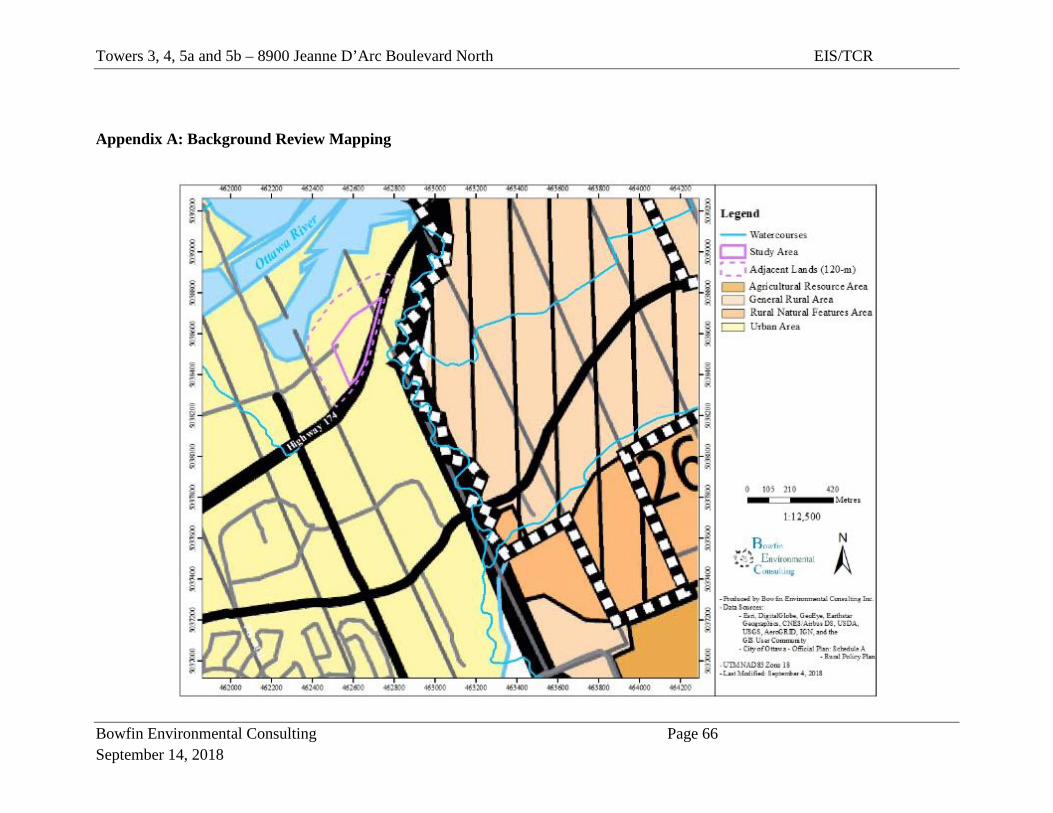
Towers 3, 4, 5a and 5b – 8900 Jeanne D’Arc Boulevard North EIS/TCR
Bowfin Environmental Consulting Page 66 September 14, 2018
Appendix A: Background Review Mapping
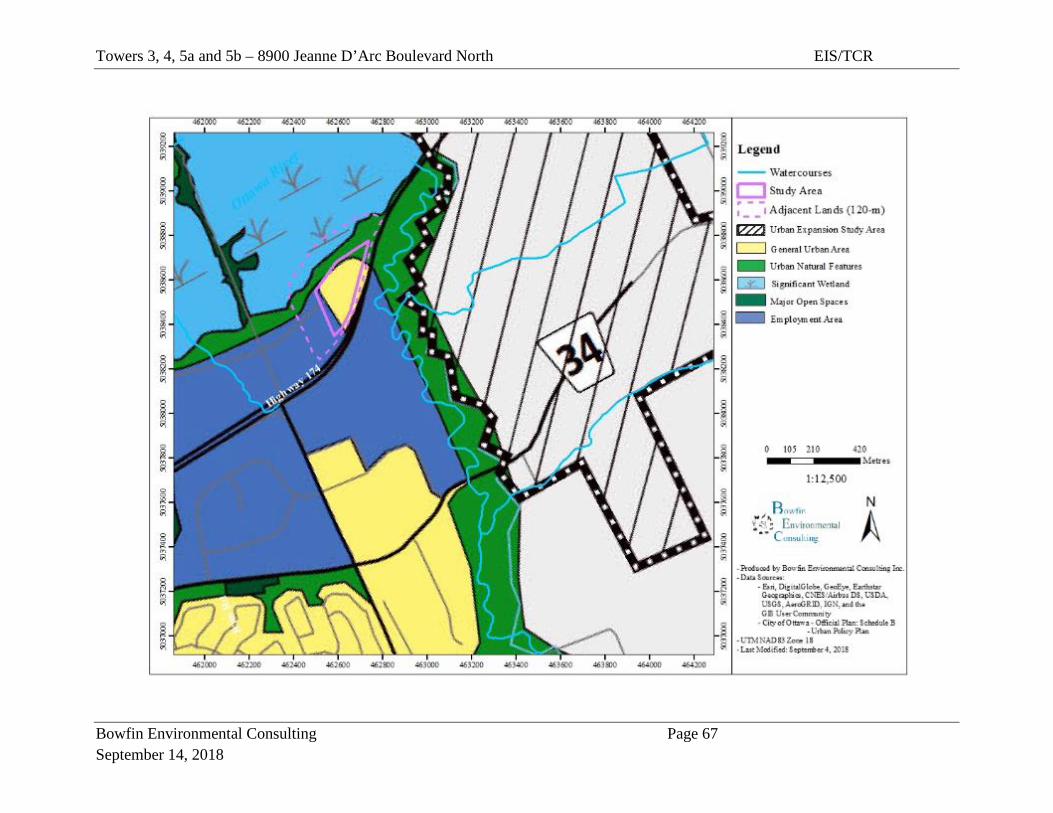
Towers 3, 4, 5a and 5b – 8900 Jeanne D’Arc Boulevard North EIS/TCR
Bowfin Environmental Consulting Page 67 September 14, 2018
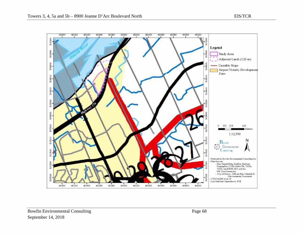
Towers 3, 4, 5a and 5b – 8900 Jeanne D’Arc Boulevard North EIS/TCR
Bowfin Environmental Consulting Page 68 September 14, 2018

Towers 3, 4, 5a and 5b – 8900 Jeanne D’Arc Boulevard North EIS/TCR
Bowfin Environmental Consulting Page 69 September 14, 2018
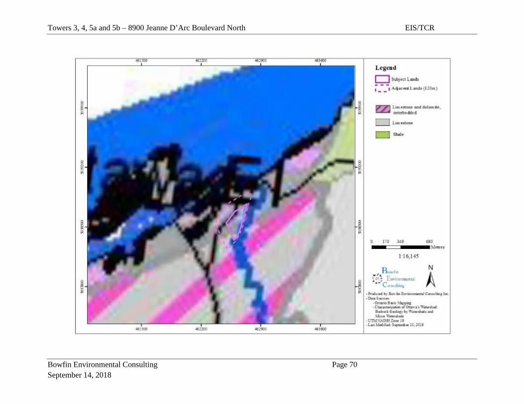
Towers 3, 4, 5a and 5b – 8900 Jeanne D’Arc Boulevard North EIS/TCR
Bowfin Environmental Consulting Page 70 September 14, 2018

Towers 3, 4, 5a and 5b – 8900 Jeanne D’Arc Boulevard North EIS/TCR
Bowfin Environmental Consulting Page 71 September 14, 2018
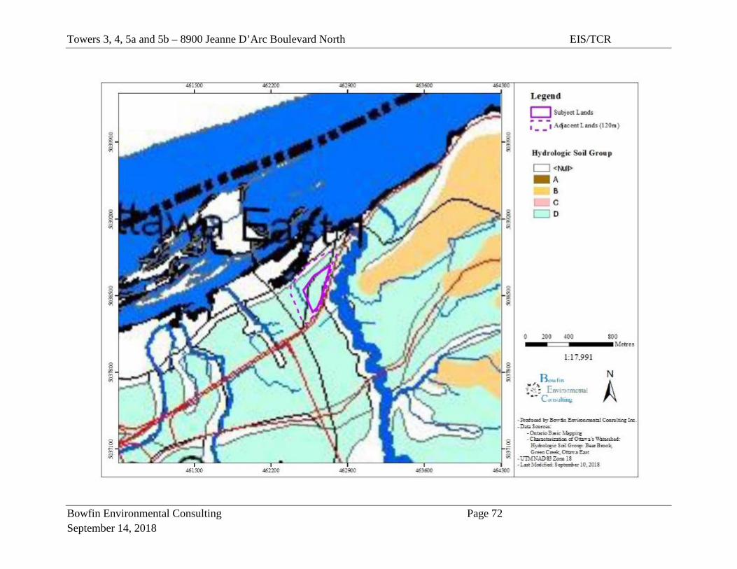
Towers 3, 4, 5a and 5b – 8900 Jeanne D’Arc Boulevard North EIS/TCR
Bowfin Environmental Consulting Page 72 September 14, 2018
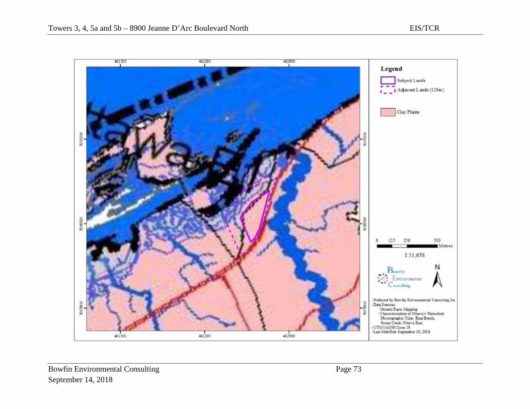
Towers 3, 4, 5a and 5b – 8900 Jeanne D’Arc Boulevard North EIS/TCR
Bowfin Environmental Consulting Page 73 September 14, 2018
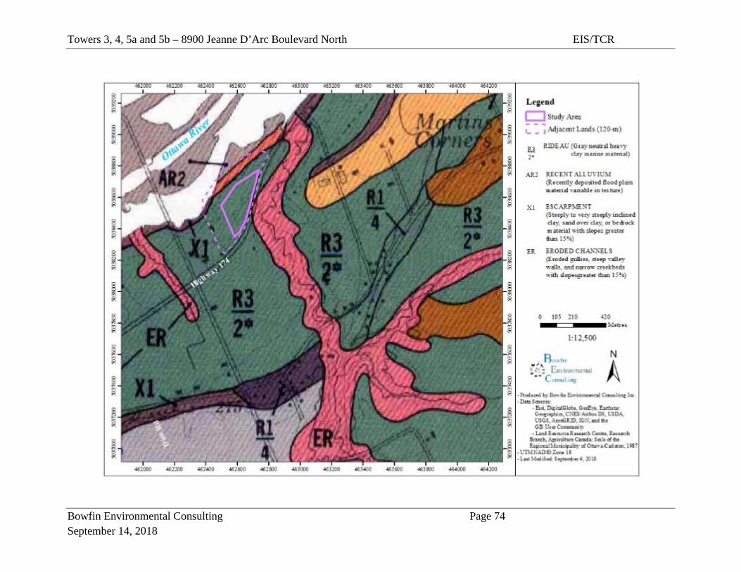
Towers 3, 4, 5a and 5b – 8900 Jeanne D’Arc Boulevard North EIS/TCR
Bowfin Environmental Consulting Page 74 September 14, 2018
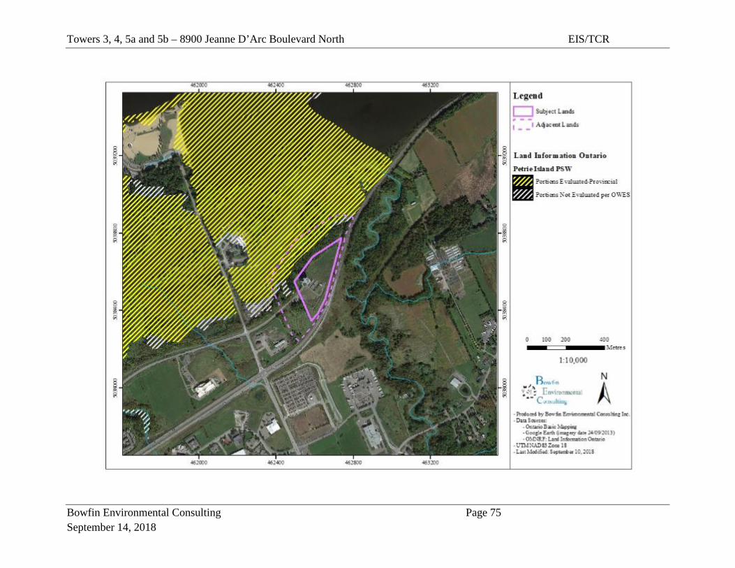
Towers 3, 4, 5a and 5b – 8900 Jeanne D’Arc Boulevard North EIS/TCR
Bowfin Environmental Consulting Page 75 September 14, 2018
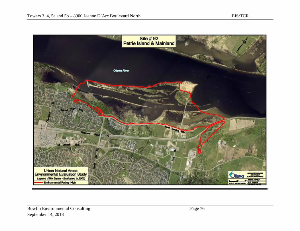
Towers 3, 4, 5a and 5b – 8900 Jeanne D’Arc Boulevard North EIS/TCR
Bowfin Environmental Consulting Page 76 September 14, 2018
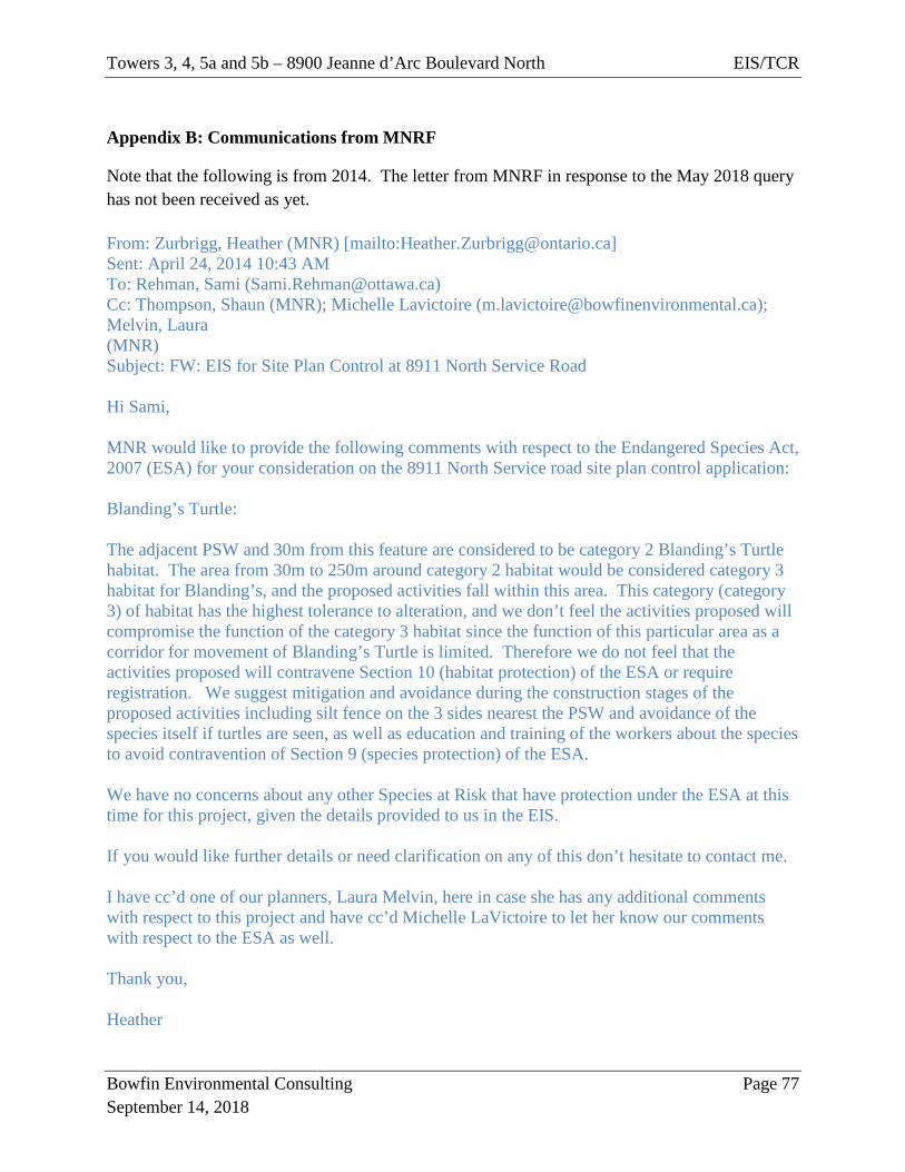
Towers 3, 4, 5a and 5b – 8900 Jeanne d’Arc Boulevard North EIS/TCR
Bowfin Environmental Consulting Page 77 September 14, 2018
Appendix B: Communications from MNRF
Note that the following is from 2014. The letter from MNRF in response to the May 2018 query has not been received as yet. From: Zurbrigg, Heather (MNR) [mailto:[email protected]] Sent: April 24, 2014 10:43 AM To: Rehman, Sami ([email protected]) Cc: Thompson, Shaun (MNR); Michelle Lavictoire ([email protected]); Melvin, Laura (MNR) Subject: FW: EIS for Site Plan Control at 8911 North Service Road Hi Sami, MNR would like to provide the following comments with respect to the Endangered Species Act, 2007 (ESA) for your consideration on the 8911 North Service road site plan control application: Blanding’s Turtle: The adjacent PSW and 30m from this feature are considered to be category 2 Blanding’s Turtle habitat. The area from 30m to 250m around category 2 habitat would be considered category 3 habitat for Blanding’s, and the proposed activities fall within this area. This category (category 3) of habitat has the highest tolerance to alteration, and we don’t feel the activities proposed will compromise the function of the category 3 habitat since the function of this particular area as a corridor for movement of Blanding’s Turtle is limited. Therefore we do not feel that the activities proposed will contravene Section 10 (habitat protection) of the ESA or require registration. We suggest mitigation and avoidance during the construction stages of the proposed activities including silt fence on the 3 sides nearest the PSW and avoidance of the species itself if turtles are seen, as well as education and training of the workers about the species to avoid contravention of Section 9 (species protection) of the ESA. We have no concerns about any other Species at Risk that have protection under the ESA at this time for this project, given the details provided to us in the EIS. If you would like further details or need clarification on any of this don’t hesitate to contact me. I have cc’d one of our planners, Laura Melvin, here in case she has any additional comments with respect to this project and have cc’d Michelle LaVictoire to let her know our comments with respect to the ESA as well. Thank you, Heather
Towers 3, 4, 5a and 5b – 8900 Jeanne d’Arc Boulevard North EIS/TCR
Bowfin Environmental Consulting Page 78 September 14, 2018
Heather Zurbrigg A /Management Biologist Resources Management Team Kemptville District Ontario Ministry of Natural Resources 613-258-8417
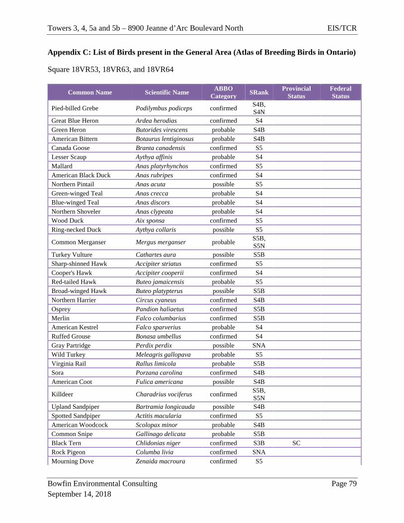
Towers 3, 4, 5a and 5b – 8900 Jeanne d’Arc Boulevard North EIS/TCR
Bowfin Environmental Consulting Page 79 September 14, 2018
Appendix C: List of Birds present in the General Area (Atlas of Breeding Birds in Ontario)
Square 18VR53, 18VR63, and 18VR64
Common Name Scientific Name ABBO Category SRank Provincial
Status Federal Status
Pied-billed Grebe Podilymbus podiceps confirmed S4B, S4N
Great Blue Heron Ardea herodias confirmed S4
Green Heron Butorides virescens probable S4B
American Bittern Botaurus lentiginosus probable S4B
Canada Goose Branta canadensis confirmed S5
Lesser Scaup Aythya affinis probable S4
Mallard Anas platyrhynchos confirmed S5
American Black Duck Anas rubripes confirmed S4
Northern Pintail Anas acuta possible S5
Green-winged Teal Anas crecca probable S4
Blue-winged Teal Anas discors probable S4
Northern Shoveler Anas clypeata probable S4
Wood Duck Aix sponsa confirmed S5
Ring-necked Duck Aythya collaris possible S5
Common Merganser Mergus merganser probable S5B, S5N
Turkey Vulture Cathartes aura possible S5B
Sharp-shinned Hawk Accipiter striatus confirmed S5
Cooper's Hawk Accipiter cooperii confirmed S4
Red-tailed Hawk Buteo jamaicensis probable S5
Broad-winged Hawk Buteo platypterus possible S5B
Northern Harrier Circus cyaneus confirmed S4B
Osprey Pandion haliaetus confirmed S5B
Merlin Falco columbarius confirmed S5B
American Kestrel Falco sparverius probable S4
Ruffed Grouse Bonasa umbellus confirmed S4
Gray Partridge Perdix perdix possible SNA
Wild Turkey Meleagris gallopava probable S5
Virginia Rail Rallus limicola probable S5B
Sora Porzana carolina confirmed S4B
American Coot Fulica americana possible S4B
Killdeer Charadrius vociferus confirmed S5B, S5N
Upland Sandpiper Bartramia longicauda possible S4B
Spotted Sandpiper Actitis macularia confirmed S5
American Woodcock Scolopax minor probable S4B
Common Snipe Gallinago delicata probable S5B
Black Tern Chlidonias niger confirmed S3B SC
Rock Pigeon Columba livia confirmed SNA
Mourning Dove Zenaida macroura confirmed S5
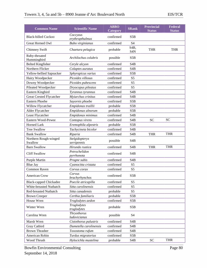
Towers 3, 4, 5a and 5b – 8900 Jeanne d’Arc Boulevard North EIS/TCR
Bowfin Environmental Consulting Page 80 September 14, 2018
Common Name Scientific Name ABBO Category SRank Provincial
Status Federal Status
Black-billed Cuckoo Coccyzus erythropthalmus confirmed S5B
Great Horned Owl Bubo virginianus confirmed S4
Chimney Swift Chaetura pelagica probable S4B, S4N THR THR
Ruby-throated Hummingbird Archilochus colubris possible S5B
Belted Kingfisher Ceryle alcyon confirmed S4B
Northern Flicker Colaptes auratus confirmed S4B
Yellow-bellied Sapsucker Sphyrapicus varius confirmed S5B
Hairy Woodpecker Picoides villosus confirmed S5
Downy Woodpecker Picoides pubescens confirmed S5
Pileated Woodpecker Dryocopus pileatus confirmed S5
Eastern Kingbird Tyrannus tyrannus confirmed S4B
Great Crested Flycatcher Myiarchus crinitus confirmed S4B
Eastern Phoebe Sayornis phoebe confirmed S5B
Willow Flycatcher Empidonax traillii probable S5B
Alder Flycatcher Empidonax alnorum probable S5B
Least Flycatcher Empidonax minimus confirmed S4B
Eastern Wood-Pewee Contopus virens confirmed S4B SC SC Horned Lark Eremophila alpestris probable S5B
Tree Swallow Tachycineta bicolor confirmed S4B
Bank Swallow Riparia confirmed S4B THR THR Northern Rough-winged Swallow
Stelgidopteryx serripennis possible S4B
Barn Swallow Hirundo rustica confirmed S4B THR THR
Cliff Swallow Petrochelidon pyrrhonota confirmed S4B
Purple Martin Progne subis confirmed S4B
Blue Jay Cyanocitta cristata confirmed S5
Common Raven Corvus corax confirmed S5
American Crow Corvus brachyrhynchos confirmed S5B
Black-capped Chickadee Poecile atricapilla confirmed S5
White-breasted Nuthatch Sitta carolinensis confirmed S5
Red-breasted Nuthatch Sitta canadensis probable S5
Brown Creeper Certhia familiaris probable S5B
House Wren Troglodytes aedon confirmed S5B
Winter Wren Troglodytes troglodytes probable S5B
Carolina Wren Thryothorus ludovicianus possible S4
Marsh Wren Cistothorus palustris confirmed S4B
Gray Catbird Dumetella carolinensis confirmed S4B
Brown Thrasher Toxostoma rufum confirmed S4B
American Robin Turdus migratorius confirmed S5B
Wood Thrush Hylocichla mustelina probable S4B SC THR
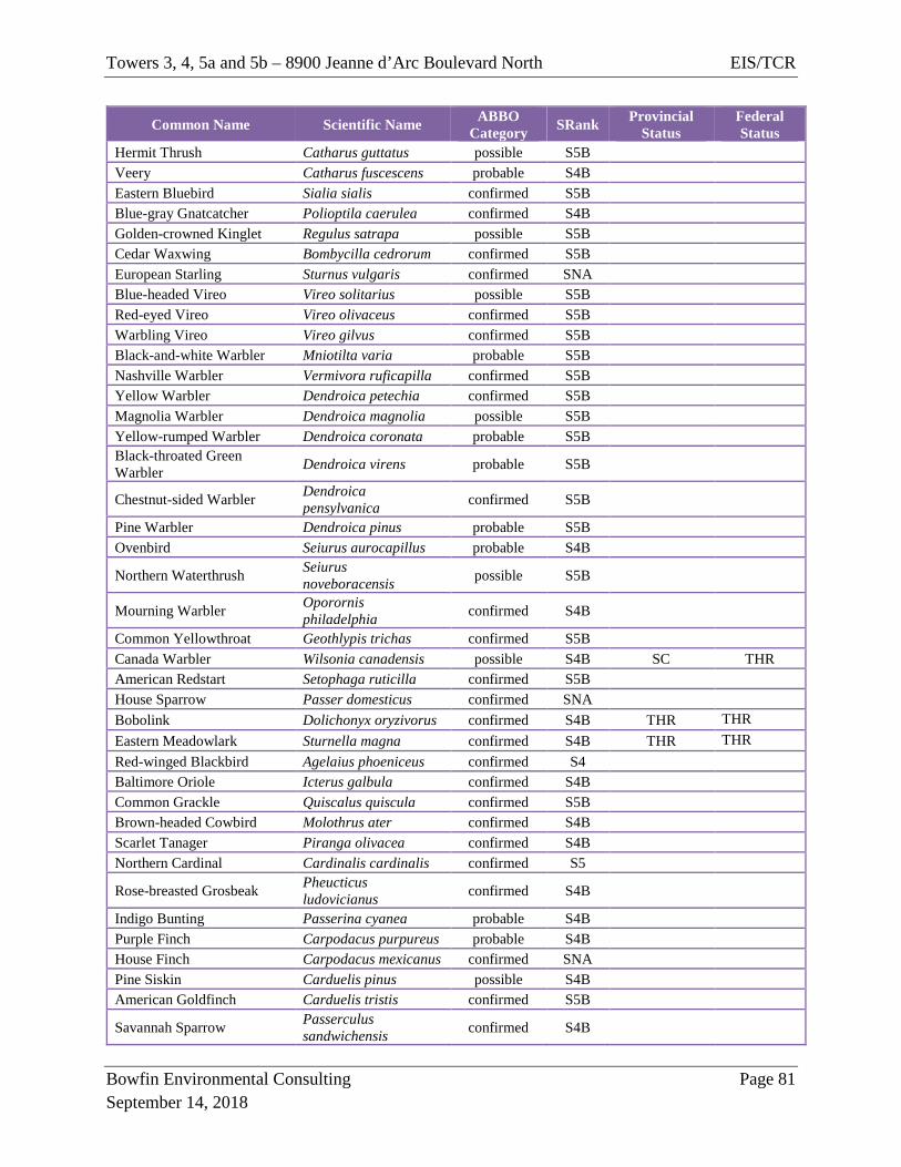
Towers 3, 4, 5a and 5b – 8900 Jeanne d’Arc Boulevard North EIS/TCR
Bowfin Environmental Consulting Page 81 September 14, 2018
Common Name Scientific Name ABBO Category SRank Provincial
Status Federal Status
Hermit Thrush Catharus guttatus possible S5B
Veery Catharus fuscescens probable S4B
Eastern Bluebird Sialia sialis confirmed S5B
Blue-gray Gnatcatcher Polioptila caerulea confirmed S4B
Golden-crowned Kinglet Regulus satrapa possible S5B
Cedar Waxwing Bombycilla cedrorum confirmed S5B
European Starling Sturnus vulgaris confirmed SNA
Blue-headed Vireo Vireo solitarius possible S5B
Red-eyed Vireo Vireo olivaceus confirmed S5B
Warbling Vireo Vireo gilvus confirmed S5B
Black-and-white Warbler Mniotilta varia probable S5B
Nashville Warbler Vermivora ruficapilla confirmed S5B
Yellow Warbler Dendroica petechia confirmed S5B
Magnolia Warbler Dendroica magnolia possible S5B
Yellow-rumped Warbler Dendroica coronata probable S5B
Black-throated Green Warbler Dendroica virens probable S5B
Chestnut-sided Warbler Dendroica pensylvanica confirmed S5B
Pine Warbler Dendroica pinus probable S5B
Ovenbird Seiurus aurocapillus probable S4B
Northern Waterthrush Seiurus noveboracensis possible S5B
Mourning Warbler Oporornis philadelphia confirmed S4B
Common Yellowthroat Geothlypis trichas confirmed S5B
Canada Warbler Wilsonia canadensis possible S4B SC THR American Redstart Setophaga ruticilla confirmed S5B
House Sparrow Passer domesticus confirmed SNA
Bobolink Dolichonyx oryzivorus confirmed S4B THR THR Eastern Meadowlark Sturnella magna confirmed S4B THR THR Red-winged Blackbird Agelaius phoeniceus confirmed S4
Baltimore Oriole Icterus galbula confirmed S4B
Common Grackle Quiscalus quiscula confirmed S5B
Brown-headed Cowbird Molothrus ater confirmed S4B
Scarlet Tanager Piranga olivacea confirmed S4B
Northern Cardinal Cardinalis cardinalis confirmed S5
Rose-breasted Grosbeak Pheucticus ludovicianus confirmed S4B
Indigo Bunting Passerina cyanea probable S4B
Purple Finch Carpodacus purpureus probable S4B
House Finch Carpodacus mexicanus confirmed SNA
Pine Siskin Carduelis pinus possible S4B
American Goldfinch Carduelis tristis confirmed S5B
Savannah Sparrow Passerculus sandwichensis confirmed S4B
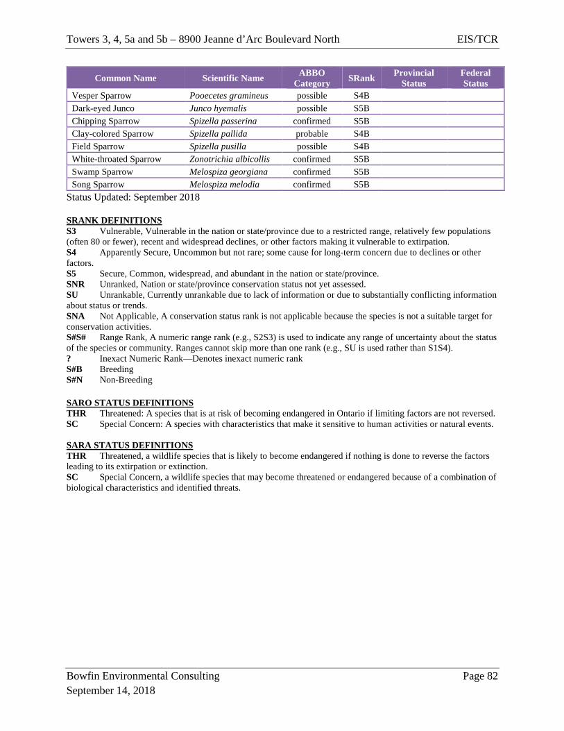
Towers 3, 4, 5a and 5b – 8900 Jeanne d’Arc Boulevard North EIS/TCR
Bowfin Environmental Consulting Page 82 September 14, 2018
Common Name Scientific Name ABBO Category SRank Provincial
Status Federal Status
Vesper Sparrow Pooecetes gramineus possible S4B
Dark-eyed Junco Junco hyemalis possible S5B
Chipping Sparrow Spizella passerina confirmed S5B
Clay-colored Sparrow Spizella pallida probable S4B
Field Sparrow Spizella pusilla possible S4B
White-throated Sparrow Zonotrichia albicollis confirmed S5B
Swamp Sparrow Melospiza georgiana confirmed S5B
Song Sparrow Melospiza melodia confirmed S5B
Status Updated: September 2018 SRANK DEFINITIONS S3 Vulnerable, Vulnerable in the nation or state/province due to a restricted range, relatively few populations (often 80 or fewer), recent and widespread declines, or other factors making it vulnerable to extirpation. S4 Apparently Secure, Uncommon but not rare; some cause for long-term concern due to declines or other factors. S5 Secure, Common, widespread, and abundant in the nation or state/province. SNR Unranked, Nation or state/province conservation status not yet assessed. SU Unrankable, Currently unrankable due to lack of information or due to substantially conflicting information about status or trends. SNA Not Applicable, A conservation status rank is not applicable because the species is not a suitable target for conservation activities. S#S# Range Rank, A numeric range rank (e.g., S2S3) is used to indicate any range of uncertainty about the status of the species or community. Ranges cannot skip more than one rank (e.g., SU is used rather than S1S4). ? Inexact Numeric Rank—Denotes inexact numeric rank S#B Breeding S#N Non-Breeding SARO STATUS DEFINITIONS THR Threatened: A species that is at risk of becoming endangered in Ontario if limiting factors are not reversed. SC Special Concern: A species with characteristics that make it sensitive to human activities or natural events. SARA STATUS DEFINITIONS THR Threatened, a wildlife species that is likely to become endangered if nothing is done to reverse the factors leading to its extirpation or extinction. SC Special Concern, a wildlife species that may become threatened or endangered because of a combination of biological characteristics and identified threats.
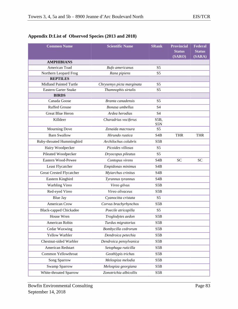
Towers 3, 4, 5a and 5b – 8900 Jeanne d’Arc Boulevard North EIS/TCR
Bowfin Environmental Consulting Page 83 September 14, 2018
Appendix D:List of Observed Species (2013 and 2018)
Common Name Scientific Name SRank Provincial Status
(SARO)
Federal Status
(SARA) AMPHIBIANS
American Toad Bufo americanus S5 Northern Leopard Frog Rana pipiens S5
REPTILES Midland Painted Turtle Chrysemys picta marginata S5 Eastern Garter Snake Thamnophis sirtalis S5
BIRDS
Canada Goose Branta canadensis S5
Ruffed Grouse Bonasa umbellus S4
Great Blue Heron Ardea herodias S4 Killdeer Charadrius vociferus S5B,
S5N
Mourning Dove Zenaida macroura S5
Barn Swallow Hirundo rustica S4B THR THR Ruby-throated Hummingbird Archilochus colubris S5B
Hairy Woodpecker Picoides villosus S5
Pileated Woodpecker Dryocopus pileatus S5
Eastern Wood-Pewee Contopus virens S4B SC SC Least Flycatcher Empidonax minimus S4B
Great Crested Flycatcher Myiarchus crinitus S4B
Eastern Kingbird Tyrannus tyrannus S4B
Warbling Vireo Vireo gilvus S5B
Red-eyed Vireo Vireo olivaceus S5B
Blue Jay Cyanocitta cristata S5
American Crow Corvus brachyrhynchos S5B
Black-capped Chickadee Poecile atricapilla S5
House Wren Troglodytes aedon S5B
American Robin Turdus migratorius S5B
Cedar Waxwing Bombycilla cedrorum S5B Yellow Warbler Dendroica petechia S5B
Chestnut-sided Warbler Dendroica pensylvanica S5B
American Redstart Setophaga ruticilla S5B
Common Yellowthroat Geothlypis trichas S5B
Song Sparrow Melospiza melodia S5B
Swamp Sparrow Melospiza georgiana S5B
White-throated Sparrow Zonotrichia albicollis S5B
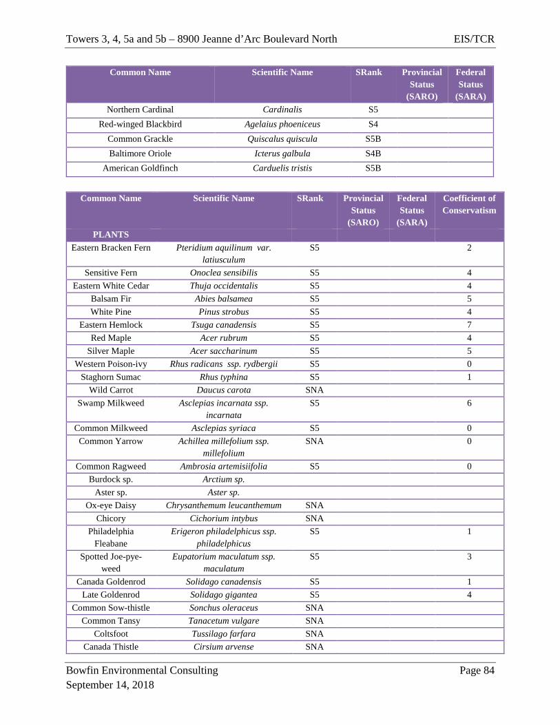
Towers 3, 4, 5a and 5b – 8900 Jeanne d’Arc Boulevard North EIS/TCR
Bowfin Environmental Consulting Page 84 September 14, 2018
Common Name Scientific Name SRank Provincial Status
(SARO)
Federal Status
(SARA) Northern Cardinal Cardinalis S5
Red-winged Blackbird Agelaius phoeniceus S4
Common Grackle Quiscalus quiscula S5B
Baltimore Oriole Icterus galbula S4B
American Goldfinch Carduelis tristis S5B
Common Name Scientific Name SRank Provincial
Status (SARO)
Federal Status
(SARA)
Coefficient of Conservatism
PLANTS Eastern Bracken Fern Pteridium aquilinum var.
latiusculum S5 2
Sensitive Fern Onoclea sensibilis S5 4 Eastern White Cedar Thuja occidentalis S5 4
Balsam Fir Abies balsamea S5 5 White Pine Pinus strobus S5 4
Eastern Hemlock Tsuga canadensis S5 7 Red Maple Acer rubrum S5 4
Silver Maple Acer saccharinum S5 5 Western Poison-ivy Rhus radicans ssp. rydbergii S5 0
Staghorn Sumac Rhus typhina S5 1 Wild Carrot Daucus carota SNA
Swamp Milkweed Asclepias incarnata ssp. incarnata
S5 6
Common Milkweed Asclepias syriaca S5 0 Common Yarrow Achillea millefolium ssp.
millefolium SNA 0
Common Ragweed Ambrosia artemisiifolia S5 0 Burdock sp. Arctium sp.
Aster sp. Aster sp. Ox-eye Daisy Chrysanthemum leucanthemum SNA
Chicory Cichorium intybus SNA Philadelphia
Fleabane Erigeron philadelphicus ssp.
philadelphicus S5 1
Spotted Joe-pye-weed
Eupatorium maculatum ssp. maculatum
S5 3
Canada Goldenrod Solidago canadensis S5 1 Late Goldenrod Solidago gigantea S5 4
Common Sow-thistle Sonchus oleraceus SNA Common Tansy Tanacetum vulgare SNA
Coltsfoot Tussilago farfara SNA Canada Thistle Cirsium arvense SNA
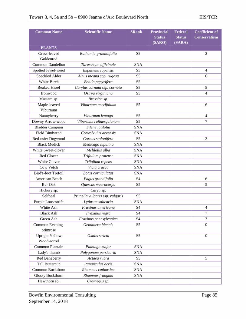
Towers 3, 4, 5a and 5b – 8900 Jeanne d’Arc Boulevard North EIS/TCR
Bowfin Environmental Consulting Page 85 September 14, 2018
Common Name Scientific Name SRank Provincial Status
(SARO)
Federal Status
(SARA)
Coefficient of Conservatism
PLANTS Grass-leaved Goldenrod
Euthamia graminifolia S5 2
Common Dandelion Taraxacum officinale SNA Spotted Jewel-weed Impatiens capensis S5 4
Speckled Alder Alnus incana spp. rugosa S5 6 White Birch Betula papyrifera S5
Beaked Hazel Corylus cornuta ssp. cornuta S5 5 Ironwood Ostrya virginiana S5 4
Mustard sp. Brassica sp. Maple-leaved
Viburnum Viburnum acerifolium S5 6
Nannyberry Viburnum lentago S5 4 Downy Arrow-wood Viburnum rafinesquianum S5 7
Bladder Campion Silene latifolia SNA Field Bindweed Convolvulus arvensis SNA
Red-osier Dogwood Cornus stolonifera S5 2 Black Medick Medicago lupulina SNA
White Sweet-clover Melilotus alba SNA Red Clover Trifolium pratense SNA
White Clover Trifolium repens SNA Cow Vetch Vicia cracca SNA
Bird's-foot Trefoil Lotus corniculatus SNA American Beech Fagus grandifolia S4 6
Bur Oak Quercus macrocarpa S5 5 Hickory sp. Carya sp.
Selfheal Prunella vulgaris ssp. vulgaris S5 Purple Loosestrife Lythrum salicaria SNA
White Ash Fraxinus americana S4 4 Black Ash Fraxinus nigra S4 7 Green Ash Fraxinus pennsylvanica S4 3
Common Evening-primrose
Oenothera biennis S5 0
Upright Yellow Wood-sorrel
Oxalis stricta S5 0
Common Plantain Plantago major SNA Lady's-thumb Polygonum persicaria SNA
Red Baneberry Actaea rubra S5 5 Tall Buttercup Ranunculus acris SNA
Common Buckthorn Rhamnus cathartica SNA Glossy Buckthorn Rhamnus frangula SNA
Hawthorn sp. Crataegus sp.
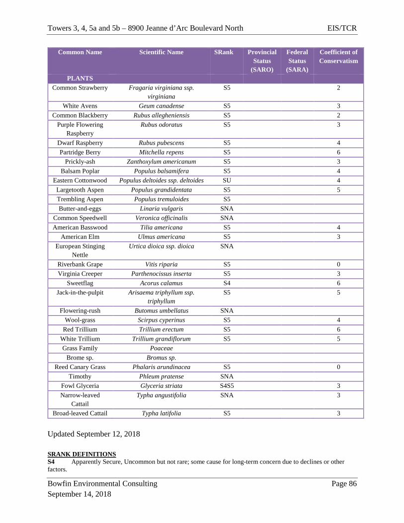
Towers 3, 4, 5a and 5b – 8900 Jeanne d’Arc Boulevard North EIS/TCR
Bowfin Environmental Consulting Page 86 September 14, 2018
Common Name Scientific Name SRank Provincial Status
(SARO)
Federal Status
(SARA)
Coefficient of Conservatism
PLANTS Common Strawberry Fragaria virginiana ssp.
virginiana S5 2
White Avens Geum canadense S5 3 Common Blackberry Rubus allegheniensis S5 2
Purple Flowering Raspberry
Rubus odoratus S5 3
Dwarf Raspberry Rubus pubescens S5 4 Partridge Berry Mitchella repens S5 6
Prickly-ash Zanthoxylum americanum S5 3 Balsam Poplar Populus balsamifera S5 4
Eastern Cottonwood Populus deltoides ssp. deltoides SU 4 Largetooth Aspen Populus grandidentata S5 5 Trembling Aspen Populus tremuloides S5 Butter-and-eggs Linaria vulgaris SNA
Common Speedwell Veronica officinalis SNA American Basswood Tilia americana S5 4
American Elm Ulmus americana S5 3 European Stinging
Nettle Urtica dioica ssp. dioica SNA
Riverbank Grape Vitis riparia S5 0 Virginia Creeper Parthenocissus inserta S5 3
Sweetflag Acorus calamus S4 6 Jack-in-the-pulpit Arisaema triphyllum ssp.
triphyllum S5 5
Flowering-rush Butomus umbellatus SNA Wool-grass Scirpus cyperinus S5 4
Red Trillium Trillium erectum S5 6 White Trillium Trillium grandiflorum S5 5 Grass Family Poaceae
Brome sp. Bromus sp. Reed Canary Grass Phalaris arundinacea S5 0
Timothy Phleum pratense SNA Fowl Glyceria Glyceria striata S4S5 3 Narrow-leaved
Cattail Typha angustifolia SNA 3
Broad-leaved Cattail Typha latifolia S5 3 Updated September 12, 2018 SRANK DEFINITIONS S4 Apparently Secure, Uncommon but not rare; some cause for long-term concern due to declines or other factors.
Towers 3, 4, 5a and 5b – 8900 Jeanne d’Arc Boulevard North EIS/TCR
Bowfin Environmental Consulting Page 87 September 14, 2018
S5 Secure, Common, widespread, and abundant in the nation or state/province. SU Unrankable, Currently unrankable due to lack of information or due to substantially conflicting information about status or trends. SNA Not Applicable, A conservation status rank is not applicable because the species is not a suitable target for conservation activities. S#B Breeding S#N Non-Breeding
Towers 3, 4, 5a and 5b – 8900 Jeanne d’Arc Boulevard North EIS/TCR
Bowfin Environmental Consulting Page 88 September 14, 2018
Appendix E: SAR Hand-Out
The following table provides photographs and general descriptions of potential species at risk that may occur within the project area and information on what actions to take should any of these species be observed. Endangered and Threatened species are protected and cannot be harmed, harassed or killed and in some cases their habitats are also protected. These individuals will only be handled by qualified person and only if the individual is in imminent threat of harm. An authorization under the ESA 2007 would be required to handle individuals that are not in imminent threat of harm. For all Endangered or Threatened species found on-site any activity which may cause harm to the individual will be stopped and the site supervisor will be contact immediately for further instructions.
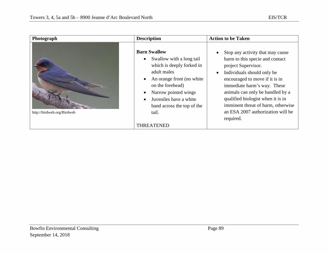
Towers 3, 4, 5a and 5b – 8900 Jeanne d’Arc Boulevard North EIS/TCR
Bowfin Environmental Consulting Page 89 September 14, 2018
Photograph Description Action to be Taken
http://birdweb.org/Birdweb
Barn Swallow
• Swallow with a long tail which is deeply forked in adult males
• An orange front (no white on the forehead)
• Narrow pointed wings • Juveniles have a white
band across the top of the tail.
THREATENED
• Stop any activity that may cause
harm to this specie and contact project Supervisor.
• Individuals should only be encouraged to move if it is in immediate harm’s way. These animals can only be handled by a qualified biologist when it is in imminent threat of harm, otherwise an ESA 2007 authorization will be required.
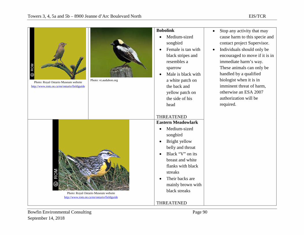
Towers 3, 4, 5a and 5b – 8900 Jeanne d’Arc Boulevard North EIS/TCR
Bowfin Environmental Consulting Page 90 September 14, 2018
Photo: Royal Ontario Museum website
http://www.rom.on.ca/en/ontario/fieldguide
Photo: vt.audubon.org
Bobolink • Medium-sized
songbird • Female is tan with
black stripes and resembles a sparrow
• Male is black with a white patch on the back and yellow patch on the side of his head
THREATENED
• Stop any activity that may cause harm to this specie and contact project Supervisor.
• Individuals should only be encouraged to move if it is in immediate harm’s way. These animals can only be handled by a qualified biologist when it is in imminent threat of harm, otherwise an ESA 2007 authorization will be required.
Photo: Royal Ontario Museum website
http://www.rom.on.ca/en/ontario/fieldguide
Eastern Meadowlark • Medium-sized
songbird • Bright yellow
belly and throat • Black “V” on its
breast and white flanks with black streaks
• Their backs are mainly brown with black streaks
THREATENED
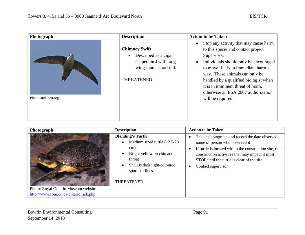
Towers 3, 4, 5a and 5b – 8900 Jeanne d’Arc Boulevard North EIS/TCR
Bowfin Environmental Consulting Page 91 September 14, 2018
Photograph Description Action to be Taken
Photo: audubon.org
Chimney Swift
• Described as a cigar shaped bird with long wings and a short tail.
THREATENED
• Stop any activity that may cause harm to this specie and contact project Supervisor.
• Individuals should only be encouraged to move if it is in immediate harm’s way. These animals can only be handled by a qualified biologist when it is in imminent threat of harm, otherwise an ESA 2007 authorization will be required.
Photograph Description Action to be Taken
Photo: Royal Ontario Museum website http://www.rom.on.ca/ontario/risk.php
Blanding’s Turtle • Medium sized turtle (12.5-28
cm) • Bright yellow on chin and
throat • Shall is dark light-coloured
sports or lines
THREATENED
• Take a photograph and record the date observed, name of person who observed it
• If turtle is located within the construction site, then construction activities that may impact it must STOP until the turtle is clear of the site.
• Contact supervisor