CHAPTER 22 SUBDIVISION AND LAND DEVELOPMENT
101
CHAPTER 22 SUBDIVISION AND LAND DEVELOPMENT PART 1 GENERAL PROVISIONS §101. Short Title §102. Purpose §103. Authority §104. Jurisdiction §105. Municipal Responsibility and Liability §106. Copies PART 2 DEFINITIONS §201. General Interpretations §202. Definitions PART 3 PROCEDURES; MAJOR SUBDIVISIONS §301. Sketch Plan (Pre-Application Investigation) §302. Preliminary Plan Application §303. Approval of Preliminary Plan §304. Final Plan Application §305. Approval of Final Plan §306. Recording of Plan PART 4 PROCEDURES; MINOR SUBDIVISIONS, REPLATS AND LAND DEVELOPMENTS §401. Sketch Plan §402. Preliminary Plan Application and Approval §403. Final Plan Application and Approval §404. Recording of Plan
-
Upload
khangminh22 -
Category
Documents
-
view
3 -
download
0
Transcript of CHAPTER 22 SUBDIVISION AND LAND DEVELOPMENT
CHAPTER 22
SUBDIVISION AND LAND DEVELOPMENT
PART 1
GENERAL PROVISIONS
§101. Short Title§102. Purpose§103. Authority§104. Jurisdiction§105. Municipal Responsibility and Liability§106. Copies
PART 2
DEFINITIONS
§201. General Interpretations§202. Definitions
PART 3
PROCEDURES; MAJOR SUBDIVISIONS
§301. Sketch Plan (Pre-Application Investigation)§302. Preliminary Plan Application§303. Approval of Preliminary Plan§304. Final Plan Application§305. Approval of Final Plan§306. Recording of Plan
PART 4
PROCEDURES; MINOR SUBDIVISIONS, REPLATS AND LAND DEVELOPMENTS
§401. Sketch Plan§402. Preliminary Plan Application and Approval§403. Final Plan Application and Approval§404. Recording of Plan
PART 5
ASSURANCES OF COMPLETION
§500.1. General§501. Improvements§502. Performance Assurance
PART 6
DEVELOPMENT STANDARDS
§601. General Standards
PART 7
PLAN REQUIREMENTS
§701. Sketch Plan§702. Preliminary Plan§703. Final Plan
PART 8
DESIGN STANDARDS
§801. General§802. Streets§803. Curbs and Sidewalks§804. Blocks§805. Lots and Building Lines§806. Lot Grading for Subdivisions and Land Developments§807. Open Space, Lot Siting, Planting and Beautification
for Subdivision and Land Developments§808. Easements§809. Reserved§810. Street Names§811. Stormwater Drainage§812. Utility Regulations for Subdivision and Land Development§813. Floodplain Area Regulations§814. Sanitary Sewer System§815. Water

PART 9
REQUIRED IMPROVEMENTS
§901. General§902. Improvements
PART 10
CONSTRUCTION REQUIREMENTS
§1001. General§1002. Monuments and Markers§1003. Water Supply§1004. Sanitary Sewage Conveyance§1005. Storm Sewers§1006. Streets, Subgrade, Subbase, Pavements, Curbs and Sidewalks§1007. Utilities§1008. Street Trees§1009. Street Lighting§1010. Existing Natural Areas§1011. Erosion Control
PART 11
MOBILE HOME PARK REGULATIONS
§1101. Applicability§1102. Plan Requirements§1103. Preliminary Plan§1104. Final Plan Approval§1105. Design Requirements§1106. Utility and Fire Requirements
PART 12
ACCEPTANCE OF PUBLIC IMPROVEMENTS
§1201. General
PART 13
OTHER STANDARDS FOR LAND DEVELOPMENT
§1301. Jurisdiction§1302. Procedures§1303. Site Plan§1304. Design Standards§1305. Assurance for Completion and Maintenance of Improvements
PART 14
ADMINISTRATION ANDMODIFICATION
§1401. Amendments§1402. Filing Fee and Review§1403. Records§1404. Appeals§1405. Validity§1406.1 Preventive Remedies§1406.2. Enforcement Remedies§1407. Modifications and Regulations§1408. Conflict
PART 15
APPENDIX
Typical Street Cross-Sections - Minor and Residential StreetsTypical Street Cross-Sections - Commercial, Industrial and Collector StreetsTypical Concrete Curb Detailtypes of Lots IllustrationClear Site Triangle DrawingSight Distance IllustrationAs-built Drawing RequirementsMap of Future Right-of-WaysList of State Route NumbersApproval Boxes for Preliminary and Final PlansTypical Exhibits for Preliminary and Final Plans

(22, Part 1)
PART 1
GENERAL PROVISIONS
§101. SHORT TITLE.
This Chapter shall be known as the "City of Hermitage Subdivision and Land DevelopmentOrdinance."
(Ord. 18-91, 12/12/1991, §101)
§102. PURPOSE.
This Chapter is adopted for the following purposes:
102.1. To assure sites suitable for building purposes and human habitation.
102.2. To provide for the harmonious, orderly, efficient and integrated develop-ment of the City.
102.3. To assure new development will be coordinated with existing Citydevelopment.
102.4. To provide for adequate easements and rights-of-way for drainage andutilities.
102.5. To make provisions, as needed, for the reservation of land as it may beneeded for public grounds.
102.6. To accommodate prospective traffic, facilitate fire protection and make suchprovisions as are necessary for public safety and convenience.
102.7. To make provisions for appropriate standards for streets, storm drainage,sanitary sewers, water facilities, curbs, gutters and such other improvementsas shall be considered needed by the City.
102.8. To promote the sound layout and design for subdivisions and land develop-ments.
102.9. To allow for new and flexible standards of design, where appropriate.
102.10. To secure equitable handling of all subdivision plans by providing uniformprocedures and standards.
102.11. To implement the Comprehensive Plan.

SUBDIVISION AND LAND DEVELOPMENT
(Ord. 18-91, 12/12/1991, §102)
§103. AUTHORITY.
The City of Hermitage is vested by law with jurisdiction and control of the subdivision of land,mobile home parks and land development located within the City limits in accordance withArticle V of the Pennsylvania Municipalities Planning Code.
(Ord. 18-91, 12/12/1991, §103)
§104. JURISDICTION.
104.1. Plans for subdivisions within the City shall be submitted to and approved by theCity before they are recorded. Such approval is in addition to, and does notsupersede, those required by other ordinances, resolutions or regulations of theCity, State or Federal Government.
104.2. Land Development Control.
A. Land development, as herein defined, must comply with the regulations containedherein. Such compliance shall include, but not be limited to, the filing andrecording of plans, the dedication and improvements of rights-of-way, streets androads, and the payment of fees and charges as established by ordinance of the Cityof Hermitage.
B. Land development plans shall indicate the location of each structure and clearlydefine each unit and shall indicate all easements, common areas and improve-ments, all easements appurtenant to each unit, and improvements to publicrights-of way. Developments are subject to the zoning regulations as they applyto use and density requirements,setbacks, parking and other features, and shall beindicated on the land development plans.
104.3. Plans for mobile home parks shall be submitted to and approved by the Citybefore they are recorded.
(Ord. 18-91, 12/12/1991, §104)
§105. MUNICIPAL RESPONSIBILITY AND LIABILITY.
The provisions within this Chapter are designed to fulfill the purposes cited in §102. The degreeof protection sought by the conditions and requirements of this Chapter for the present andfuture residents and land owners in the City is considered reasonable for regulatory purposes.This Chapter does not imply that compliance with the minimum requirements for subdivisionsor land developments will be free from inconveniences, conflicts, danger or damages.Therefore, this Chapter shall not create liability on the part of the individual members of the
(22, Part 1)
Board of Commissioners, the City of Hermitage Planning Commission or any officer, appointeeor employee of the City for any damages that may result from reliance on this Chapter or anyadministrative decision lawfully made thereunder.
(Ord. 18-91, 12/12/1991, §105)
§106. COPIES.
Copies of this Chapter shall be made available to the general public at the Hermitage CityBuilding at a fee adequate to compensate the City for the cost of reproduction.
(Ord. 18-91, 12/12/1991, §107)


(22, Part 2)
PART 2
DEFINITIONS
§201. GENERAL INTERPRETATIONS.
Unless otherwise expressly stated, the following terms shall, for the purpose of this Chapter,have the meaning indicated: words in the singular include the plural, and words in the pluralinclude the singular. The word "person" includes a corporation, unincorporated association anda partnership as well as an individual or any other legal entity. The words "shall" and "will" aremandatory; the word "may" is permissive. An "agency" shall be construed to include itssuccessors or assigns. Words not defined in this Part or the Pennsylvania MunicipalitiesPlanning Code shall have their normal meanings.
(Ord. 18-91, 12/12/1991, §201)
§202. DEFINITIONS.
ACCESSORY BUILDING - a subordinate building, the use of which is customarily incidentalto that of the principal building on the same lot.
ALLEY - a minor right-of-way, publicly or privately owned, primarily for vehicular serviceaccess to the back and sides of properties. Alleys are not intended for through vehicular traffic.
APPLICANT - a landowner or developer, as hereinafter defined, who has filed an applicationfor development including his heirs, successors and assigns.
APPLICATION FORDEVELOPMENT - every application, whether preliminary, tentative orfinal, required to be filed and approved prior to the start of construction or developmentincluding, but not limited to, an application for a building permit, for the approval of asubdivision plan, for the approval of a land development plan, for the approval of a plannedresidential development or for the approval of a mobile home park.
AUTHORITY - the Municipal Authority of the City of Hermitage, Pennsylvania.
BLOCK - an area, divided into lots, and usually bounded by streets.
BUILDING - a roofed structure, whether or not enclosed by walls, to be used for the shelter,enclosure or protection of persons, goods, materials or animals.
BUILDINGOR SETBACK LINE - the line within a property defining the required minimumdistance between any building and the adjacent right-of-way and/or property lines.
CARTWAYOR ROADWAY - the improved surface of a street or alley designed for vehiculartraffic.
CITY - The City of Hermitage, Mercer County, Pennsylvania.
SUBDIVISION AND LAND DEVELOPMENT
Page Revised 12/18/2002
CITY ENGINEER - a professional engineer licensed as such in Pennsylvania, duly appointedas the Engineer of the City of Hermitage.
CITY SOLICITOR - a professional attorney licensed as such in Pennsylvania, duly appointedas the Solicitor of the City of Hermitage.
CLEAR SIGHT TRIANGLE - an area of unobstructed vision at street intersections defined bylines of sight between points at a given distance from the intersection of street center lines. (Seeillustration in Appendix.)
COMMISSION - the Planning Commission of the City of Hermitage.
COMPREHENSIVE PLAN - the Hermitage Comprehensive Plan and any amendments thereto.
CONDOMINIUM - real estate, portions of which are designated for separate ownership andthe remainder of which is designated for common ownership solely by the owners of thoseportions. Real estate is not a condominium unless the undivided interests in the commonelements are vested in the unit owners.
CORNER LOT - a lot, located at the intersection of two or more existing or proposed streetrights-of-way.
COUNTY - the County of Mercer, Pennsylvania.
COUNTY PLANNING COMMISSION - the Planning Commission of the County of Mercer.
CUL-DE-SAC - a street intersecting another street at one end and terminating at the other ina vehicular turn-around.
CURBING - nonmountable, reinforced concrete curbing or curbing of comparable durability.Extruded or precast surface-mounted types shall be prohibited. [Ord. 5-2002]
CUT - an excavation. The difference between a point on the original ground and a designatedpoint of lower elevation on the final grade. Also, the material removed in excavation.
DEPARTMENT OF ENVIRONMENTAL PROTECTION (DEP) - the PennsylvaniaDepartment of Environmental Protection, its bureaus, divisions, departments and/or agencies,as may from time to time be established, or such department or departments as may in thefuture succeed it. [Ord. 11-98]
DESIGNATED FLOODPLAIN AREAS - a relatively flat or low land area adjoining a river,stream, or watercourse which is subject to partial or complete inundation in a 100-year flood.
DETENTION POND - an area in which surface water runoff is temporarily stored pending itsrelease at a controlled rate.

(22, Part 2)
Page Added 12/18/2002
DEVELOPER - any landowner, agent of such landowner or tenant with the permission of suchlandowner, who makes or causes to be made a subdivision of land or a land development.
[Text continued on following page.]

(22, Part 2)
DEVELOPMENT - any manmade change to improved or unimproved real estate including butnot limited to, the construction or expansion of buildings or other structures, the placement ofmobile homes, streets and other paving, utilities, mining, dredging, filling, grading, excavation,or drilling operations, and the subdivision of land.
DEVELOPMENT PLAN - the provisions for development, including a planned residentialdevelopment, a plat of subdivision, all covenants relating to use, location and bulk of buildingsand other structures, intensity of use or density of development, streets, ways and parkingfacilities, common open space and public facilities. The phrase "provisions of the developmentplan" when used in this Chapter shall mean the written and graphic materials referred to in thisdefinition.
DOUBLE-FRONTAGE LOT - a lot with front and rear street frontage.
DRAINAGE - the removal of surface water or ground water from land by drains, grading orother means, and includes control of runoff to minimize erosion and sedimentation during andafter construction or development.
DRAINAGE FACILITY - any ditch, gutter, culvert, storm sewer or other structure designed,intended or constructed for the purpose of carrying, diverting or controlling surface water orground water.
DRAINAGE EASEMENT - the lands required for the installation of stormwater sewers ordrainage ditches, or required along a natural stream or watercourse for preserving the channeland providing for the flow of water therein to safeguard the public against flood damage.
DRIVEWAY - a private vehicular passageway providing access between a street and a privateparking area or private garage.
DWELLING UNIT - any structure, or part thereof, designed to be occupied as living quartersas a single housekeeping unit.
EASEMENT - a right granted for limited use of private land for public and quasi-publicpurposes including such things as utilities and drainage. There shall be no structures on anyeasements unless approved in writing by the grantee of the easement.
ENGINEER - a professional engineer licensed as such in the Commonwealth of Pennsylvania.
EROSION - the removal of surface materials by the action of natural elements.
EROSION AND SEDIMENTATION CONTROL PLAN - a plan showing all present andproposed grades and facilities for stormwater, drainage, erosion and sediment controls, andwhich is in accordance with §1011 of this Chapter.
EXCAVATION - any act by which earth, sand, gravel, rock or any other similar material is duginto, cut, quarried, uncovered, removed, displaced, relocated or bulldozed and shall includethe conditions resulting therefrom.
SUBDIVISION AND LAND DEVELOPMENT
FILL - any act by which earth, sand, gravel, rock or any other material is placed, pushed,dumped, pulled, transported or moved to a new location above the natural surface of theground or on top of the stripped surface and shall include the conditions resulting therefrom.The difference in elevation between a point on the original ground and a designated point ofhigher elevation on the final grade. The material used to make a fill.
FLOODPLAIN - the area along a natural watercourse which may from time to time beoverflowed by water therefrom.
FLOODWAY - the channel of a river or other watercourse and the adjacent land areas requiredto carry and discharge a flood of the 100 year magnitude.
FUTURERIGHT-OF-WAY - the future right-of-way of a street designated on the Official StreetMap of the City of Hermitage established by ordinance.
GRADING AND DRAINAGE PLAN - a plan showing all existing ground features andproposed grading, including existing and proposed surface and subsurface drainage facilities,described by grades, contours and topography.
IMPROVEMENTS - those physical additions and changes to the land that may be necessaryto produce usable and desirable lots.
LAND DEVELOPMENT - any of the following activities:
A. The improvement of one lot or two or more contiguous lots, tracts or parcels ofland for any purpose involving:
1. A group of two or more residential or nonresidential buildings, whetherproposed initially or cumulatively, or a single nonresidential building on alot or lots regardless of the number of occupants or tenure; or,
2. The division or allocation of land or space, whether initially or cumulatively,between or among two or more existing or prospective occupants by meansof, or for the purpose of streets, common areas, leaseholds, condominiums,building groups or other features.
B. A subdivision of land.
C. Land development does not include development which involves:
1. The conversion of an existing single-family detached dwelling orsingle-family semidetached dwelling into not more than three residentialunits, unless such units are intended to be a condominium;
2. The addition of an accessory building, including farm buildings, on a lot orlots subordinate to an existing principal building; or,
(22, Part 2)
Page Revised 12/18/2002
3. The addition or conversion of buildings or rides within the confines of anenterprise which would be considered an amusement park. For thepurposes of this subsection, an amusement park is defined as a tract or areaused principally as a location for permanent amusement structures or rides.This exclusion shall not apply to newly acquired acreage by an amusementpark until initial plans for the expanded area have been approved by theproper authorities.
LANDOWNER OR OWNER - the legal or beneficial owner or owners of land including theholder of an option or contract to purchase (whether or not such option or contract is subjectto any condition), a lessee, if he is authorized under the lease to exercise the rights of thelandowner, or other person having a proprietary interest in land.
LOT - a designated parcel, tract or area of land established by a plat or otherwise as permittedby law and to be used, developed or built upon as a unit.
LOT AREA - the area contained within the property lines of the individual parcels of land asshown on a subdivision plan, excluding space within any street right-of-ways, but includingthe area of any easement.
LOT, CORNER - a lot abutting upon two or more streets at their intersection. (See illustrationin Appendix.)
LOT, DOUBLE FRONTAGE - an interior lot which abuts streets in both the front and rear. (Seeillustration in Appendix.)
LOT INTERIOR - a lot having side lot lines which do not abut on a street. (See illustration inAppendix.)
LOT MINIMUMWIDTH - the distance between the side lot lines measured at the buildingset-back line.
LOT, NONCONFORMING - a lot of record at the time of the adoption of this Chapter, whichby reason of area or dimension, does not conform to the requirements of this Chapter.
LOT OF RECORD - a lot described in a deed or shown on a plan of lots which has beenrecorded in the office of the Recorder of Deeds of Mercer County, Pennsylvania.
LOT, REVERSE FRONTAGE - a lot extending between and having frontage on an arterialstreet and a local access street, and with vehicular access solely from the latter.
MAINTENANCEGUARANTEE - any security, other than cash, which may be accepted by theCity of Hermitage for the maintenance of any improvements required by this Chapter.
MAJOR SUBDIVISION - any subdivision not classified as a minor subdivision.
MARKER - a metal stake placed to designate the boundary and corners of lots in thesubdivision of land for the purpose of reference in land and property survey and facilitate the
SUBDIVISION AND LAND DEVELOPMENT
Page Revised 12/18/2002
sale of lots. (See §1002.)
MINOR SUBDIVISION - the subdivision of land into not more than ten parcels, including theresidual property located on an existing improved street that does not involve:
Installation of improvements as required by this Chapter.
Extension of utilities.
Frontage on an arterial or collector street.
Conflict with City of Hermitage's Comprehensive Plan, any portion of this Chapter orother State, County or municipal ordinances, laws or regulations.
MOBILEHOME - a transportable, single-family dwelling intended for permanent occupancy,contained in one unit or in two or more units designed to be joined into one integral unitcapable of again being separated for repeated towing, which arrives at a site complete andready for occupancy except for minor and incidental unpacking and assembly operations, andconstructed so that it may be used without a permanent foundation.
MOBILE HOME LOT - a parcel of land in a mobile home park, improved with the necessaryutility connections and other appurtenances necessary for the erection thereon of a singlemobile home.
MOBILE HOME PARK - a parcel or contiguous parcels of land which has been so designatedand improved that it contains two or more mobile home lots for the placement thereon ofmobile homes.
MONUMENT - a concrete, stone or other permanent object placed to designate boundary lines,corners of property, and rights-of-way of streets and utilities, for the purpose of reference inland and property survey.
MUNICIPAL AUTHORITY - a body politic and corporate created pursuant to the Act of May2, 1945 (P.L. 382, No. 164), known as the "Municipalities Authority Act of 1945."
MUNICIPALITIES PLANNINGCODE - Act 247 of 1968, as amended by Act 170 of 1988, andsuch other amendments to same as may be adopted from time to time.
ONEHUNDREDYEAR FLOOD - a flood that, on the average, is likely to occur once every 100years.
PAVED SURFACE - a parking, loading or other vehicular driving or storage surface areaconstructed of asphalt, concrete, brick, paving block or other similar hard surface material.Gravel and other loose aggregate shall not be considered a paved surface. [Ord. 5-2002]
PERSON - an individual, partnership, corporation or other legally recognized entity.

(22, Part 2)
Page Revised 12/18/2002
PLAN, FINAL - a complete and exact subdivision plan, mobile home park or site plan preparedfor official recording as required by statute and this Chapter (see Part 7).
PLAN, PRELIMINARY - the preliminary drawing indicating the proposed layout of thesubdivision or mobile home park to be submitted to the City of Hermitage for consideration,as required by this Chapter (see Part 7).
PLAN, SKETCH - an informal plan indicating salient existing features of a tract and itssurroundings and general layout of the proposed subdivision or land development.
PLAN, SOIL EROSIONANDSEDIMENTATIONCONTROL - a plan for controlling erosionand sediment during construction which shall provide all steps, including scheduling, to assureerosion and sediment control during all phases of construction, including final stabilization.
PLANNING CODE - the Pennsylvania Municipalities Planning Code, Act 247 of 1968, asamended by Act 170 of 1988, and such other amendments to same as may be adopted from timeto time.
PLANNING COMMISSION - the Planning Commission of the City of Hermitage,Pennsylvania.
PLAT - the map or plan of a subdivision or land development, whether preliminary or final.
PRINCIPAL BUILDING - the building or buildings which contain(s) the principal use or useson a property. [Ord. 5-2002]
PUBLICGROUNDS - parks, playgrounds and other public areas, and sites for schools, sewagetreatment, refuse disposal and other publicly owned or operated facilities.
PUBLICHEARING - a formal meeting held pursuant to public notice by the City of Hermitageor the Planning Commission, intended to inform and obtain public comment, prior to takingaction in accordance with this Chapter.
PUBLIC MEETING - a forum held pursuant to notice under the Act of July 3, 1986 (P.L. 388,No. 84), known as the "Sunshine Act."
PUBLICNOTICE - notice as required under the provisions of the Pennsylvania MunicipalitiesPlanning Code.
REPLAT - See "subdivision, replat."
RESERVE STRIP - a narrow parcel of ground having inadequate area for building purposesseparating a street or a proposed street from other adjacent properties.
REVERSE FRONTAGE LOT - a lot extending between, and having frontage on an arterialstreet and a minor street, and with vehicular access solely from the latter.
SUBDIVISION AND LAND DEVELOPMENT
Page Revised 12/18/2002
RIGHT-OF-WAY - land dedicated for use as a public street, alley or crosswalk, which may alsobe used by sewer, water, storm sewer, electric, gas, telephone and cable system(s). (See also"future right-of-way.")
RUNOFF - the surface water discharge or rate of discharge of a given watershed after a fall ofrain snow that does not enter the soil but runs off the surface of the land.
SEDIMENTATION - the process by which mineral or organic matter is accumulated ordeposited by moving wind, water or gravity. Once this matter is deposited (or remainssuspended in water), it is usually referred to as "sediment."
SEPTIC TANK - a watertight tank in which raw sewage is broken down into solid, liquid, andgaseous phases to facilitate further treatment and final disposal.
SETBACK (BUILDING SETBACK LINE) - the line within a property defining the requiredminimum distance between any structure and the ultimate adjacent right-of-way, and the linedefining side and rear yards where required. (See also "future right-of-way.")
SEWAGEDISPOSAL SYSTEM, ONSITE - a system of piping tanks or other facilities servinga lot and collecting and disposing of sewage in whole or in part into the soil.
SEWAGE DISPOSAL SYSTEM, PUBLIC - a sanitary sewage collection method in whichsewage is carried from the site by a system of pipes to a central treatment and disposal plant.(Community)
SHOULDER - the portion of a roadway (cartway) between the curb or gutter and the travelway intended for emergency and parking use.
SIGHTDISTANCE - the extent of unobstructed vision, in a horizontal or vertical plane, alonga street, as defined in §802 of this Chapter.
SLOPE - the face of an embankment or cut section; any ground whose surface makes an anglewith the plane of the horizon.
STREET - includes street, avenue, boulevard, road, highway, freeway, parkway, lane, alley,viaduct and any other ways or strips of land used or intended to be used by vehicular trafficor pedestrians whether public or private, and including the entire right-of-way. Particular typesof streets are further defined as follows:
A. ARTERIAL (EXPRESSWAY) - this class of highway facility is devoted entirely tothe task of moving large volumes of traffic and performs little or no land servicefunction. It is generally characterized by some degree of access control. Normally,this classification should be reserved for multi-lane, divided roads with few, if any,grade intersections.
B. COLLECTOR - a collector street serves to carry and distribute traffic betweenlower order streets, such as minor and subcollector streets and higher order streets
(22, Part 2)
Page Added 12/18/2002
such as arterial streets. A collector street may serve to provide access to abuttingproperties and shall have more than one access point. [Ord. 3-93]
C. SUBCOLLECTOR - a subcollector street serves to provide access to abuttingproperties as well as a connection between minor streets and collector or arterialstreets. A subcollector street must have more than one access point. [Ord. 3-93]
[Text continued on following page.]

(22, Part 2)
D. MINOR - the minor streets' function is to provide access to immediately adjacentland. A minor street may have one or more access points. Minor streets mayinclude short loops, cul-de-sacs or courts. [Ord. 3-93]
E. COMMERCIAL - commercial roads service areas whose predominant use iscommercial. In function, design and specification, they will be considered as acollector street.
F. INDUSTRIAL - industrial roads are primarily designed to serve industrial andmanufacturing development. These roads will be designed to accommodateextensive truck traffic of all types.
G. PRIVATE - the term denotes ownership and clearly indicates a street which isowned and maintained by an entity other than the City of Hermitage, theCommonwealth of Pennsylvania or other political subdivision. The maintenanceand upkeep of private streets along with all other obligations are the responsibilityof the owning party.
STREET CENTERLINE - an imaginary line which passes through the middle of theright-of-way and the cartway simultaneously, or which is in the center of the right-of-way incases where the cartway is not centered in the right-of-way.
STRUCTURE - anything constructed or erected, the use of which requires a fixed location onthe ground or an attachment to something having a fixed location on the ground, including, inaddition to buildings, billboards, carports, porches, swimming pools, and other buildingfeatures but not including sidewalks, drives, fences and porches without a roof or enclosedsides.
SUBDIVISION - the division or redivision of a lot, tract or parcel of land by any means intotwo or more lots, tracts, parcels or other division of land including changes in existing lot linesfor the purpose, whether immediate or future, of lease, partition by the court for distributionto heirs or devisees, transfer of ownership or building or lot development; provided, however,that the subdivision by lease of land for agricultural purposes into parcels of more than tenacres, not involving any new street or easement of access or any residential dwelling, shall beexempted.
SUBDIVISION, MAJOR - see "major subdivision."
SUBDIVISION, MINOR - see "minor subdivision."
SUBDIVISION, REPLAT - the change of a lot line between two abutting existing parcels notintended to create a new parcel and where such lot line change is in full compliance with thisChapter, the Hermitage Zoning Ordinance [Chapter 27] and related ordinances, rules andregulations of the City. A replat which involves the creation of new lots, a change in a streetline, or involves more than two lots shall be treated as a major or minor subdivision.
SUBSTANTIALLY COMPLETED - where, in the judgment of the City Engineer, at least 90%(based on the cost of the required improvements for which financial security was posted) of
SUBDIVISION AND LAND DEVELOPMENT
Page Revised 12/18/2002
those improvements required as a condition for final approval have been completed inaccordance with the approved plan, so that the project will be able to be used, occupied oroperated for its intended use.
SURVEYOR - a professional surveyor, licensed as such in the Commonwealth of Pennsylvania.
SWALE - a low-lying stretch of land characterized as a depression used to carry surface waterrunoff.
TEMPORARY TURN-AROUND - a temporary circular turn-around at the end of a road whichterminates at or near the subdivision boundary bordering undeveloped land.
TOP SOIL - surface soils and subsurface soils which normally are fertile soils and soil material,ordinarily rich in organic matter of humus debris. Top soil is usually found in the uppermostsoil layer called the A Horizon.
UNDEVELOPED LAND - any lot, tract, or parcel of land which has not been graded or in anyother manner prepared for the construction of a building or other improvement.
UNIT - a part of the property, structure or building designed or intended for any type ofindependent use, which has direct exit to a public street or way, or to an easement orright-of-way leading to a public street or way, and includes a proportionate undivided interestin the common elements, which is assigned to the property, structure or building.
UTILITY PLAN - a plan to show all existing and proposed fire hydrants, water and sewer lines,storm sewer lines, gas and electric lines, cable television facilities, and street lighting.
WATER FACILITY - any water works, water supply works, water distribution system or partthereof, designed, intended or constructed to provide or distribute potable water.
WATER SURVEY - an inventory of the source, quantity, yield, and use of ground water andsurface-water resources within the City.
WATERCOURSE - a permanent stream, intermittent stream, river, brook, creek, or a channel,drain, or ditch for water, whether natural or manmade.
(Ord. 18-91, 12/12/1991, §201; as amended by Ord. 3-93, 4/20/1993, §1; by (Ord. 11-98, 9/23/1998;and by Ord. 5-2002, 9/25/2002, §1)
(22, Part 3)
PART 3
PROCEDURES; MAJOR SUBDIVISIONS
§301. SKETCH PLAN (PRE-APPLICATION INVESTIGATION).
301.1. Developers are urged to discuss possible development designs with the CityPlanning Department prior to submission of the preliminary plan. The purpose ofthe preapplication meeting is to afford the developer an opportunity to availhimself of the advice and assistance of these offices. A second purpose is todetermine if the proposed development is in general accordance with this Chapter.The developer is encouraged to further discuss his proposal with PennDOT orutility companies as may be appropriate.
301.2. A sketch plan may be prepared and presented for review and discussion atthe same time. Sketch plans should generally include those items listedunder plan requirements, Part 7, §701, of this Chapter.
301.3. Normally, the sketch plan will be presented to the Planning Commission for theirinformation and informal review unless the developer requests otherwise.Following their review, the Planning Commission will inform the developer ofrecommended changes to the development design, which the developer may thentake into consideration in the preparation of his preliminary and final plans.
(Ord. 18-91, 12/12/1991, §301)
§302. PRELIMINARY PLAN APPLICATION.
302.1. The purpose of the preliminary plan is to define, in detail, the design, constructionstandards, lot layout and related items for a subdivision. It is necessary that suchmatters be resolved prior to the submission of the final plan. (See also §508(4)(v)of the Planning Code.)
302.2. The preliminary plan and all information and procedures relating thereto shall, inall respects, be in compliance with the applicable provisions of this Chapter whensubmitted to the City. It is the responsibility of the developer to coordinate hisplans pursuant to the provisions of this Chapter with all private and public serviceagencies and utility companies.
302.3. Five copies of the preliminary plan and all required exhibits shall be receivedduring regular office hours of the Planning Department and must be received atleast 2 weeks prior to the Planning Commission meeting to be considered forinclusion on that meeting's agenda. Additional copies shall be provided ifrequested by the City.
302.4. Information to be filed with preliminary plans shall include those items listed

SUBDIVISION AND LAND DEVELOPMENT
under "Plan Requirements," Part 7, §702 of this Chapter, and shall be prepared inaccordance with, and submitted with the number of copies, as specified herein.
302.5. The City Planning Department shall receive all preliminary plans, and shall reviewsaid plans for completeness. Any subdivision submission which is not insubstantial compliance with this Chapter will be returned to the developer as anincomplete submission. After such review, a copy of the plan will be referred tothe Hermitage Planning Commission and a copy referred to the Mercer CountyPlanning Commission for review and recommendations by these bodiesrespectively.
302.6. In cases where the subdivision fronts on an existing or proposed State highway orhas proposed streets entering on such highways, the developer shall submit theplans to the Pennsylvania Department of Transportation (PennDOT) for reviewand permits(s) as required. All plans shall note the requirements of §420 of the Actof June 1, 1945 (P.L. 1242, No. 428). (See Appendix)
(Ord. 18-91, 12/12/1991, §302)
§303. APPROVAL OF PRELIMINARY PLAN.
303.1. Before acting on the preliminary plan, the Planning Commission or the Board ofCommissioners may arrange for a public hearing thereon. Adequate public noticeshall be given.
303.2. Final Action.
The Board of Commissioners shall take final action on the preliminary plan nolater than 90 days following the date of the next regular meeting of the PlanningCommission following the date that the application is filed with the PlanningDepartment; provided, however, that should the next regular meeting occur morethan 30 days following the filing of the application, the 90 day period shall then bemeasured from the thirtieth (30th) day following the day the application was filed.
The Board of Commissioners shall render its decision during a public meeting. TheBoard may approve the plan, disapprove the plan or approve the plan with certainconditions or revisions required. If the Board either disapproves the plan orapproves it conditionally, it shall cite the provisions of this Chapter upon whichit has taken such action. Within 15 days after the public meeting, the City shallnotify the developer, in writing, of the action taken at the public meeting, andspecifying what revisions or additions, if any, will be required prior to theapproval of the final plan.
If the developer fails to accept the City's revisions or conditions, if any, set forthin its preliminary plan approval within 20 days from notification, the approvalshall be automatically rescinded.
(22, Part 3)
303.3. Any revisions of the preliminary plan required, as prerequisite to approval, willbe noted on two copies of the preliminary plan. One copy of the conditionallyapproved preliminary plan will be returned to the developer and one copy will beretained by the City.
303.4. One reproducible original or permanent copy of the preliminary plan on stableplastic tracing film will be required for the City's permanent records. Said copy isto show the preliminary plan as approved with all required changes.
303.5. Status of Approved Preliminary Plan. Once the preliminary plan has beenapproved by the Board of Commissioners, including the fulfillment of allconditions of said approval, the developer may commence the construction ofimprovements in accordance with the approved plan.
303.6. Unforeseen Circumstances. In the event the developer encounters unforeseen siteconditions while constructing required site improvements and such conditionsrequire changes to the approved design of the plan, the developer shall request anamended approval in view of said conditions. This provision is strictly limited tosite conditions which could not be foreseen prior to the actual construction ofimprovements.
(Ord. 18-91, 12/12/1991, §303)
§304. FINAL PLAN APPLICATION.
304.1. After the developer has received official notification that the preliminary plan hasbeen approved and what changes, if any, must be made if the plan is to proceedto consideration as a final plan and has accepted these conditions, the developerhas 18 months in which to submit a final plan. If the developer does not do sowithin the 18 month period, the approval of the preliminary plan shall become nulland void unless an extension of time is requested by the developer in writing andis granted in writing by the City before the expiration date.
304.2. The information, certificate and plans to be filed with the final plan applicationshall include those items listed under "Plan Requirements," Part 7, §703 of thisChapter.
304.3. Assurance of the completion of improvements, where required, shall be submittedin accordance with Part 5 of this Chapter.
304.4. At least two copies of the final plan on stable plastic drafting film (permanentcopies), along with five prints thereof and all other exhibits required for approvalshall be filed with the Planning Department. A copy of typical exhibits is found inthe Appendix.
304.5. When an extension of time is granted for the submission of a final plan, the Cityshall do one of two things when the final plan is submitted: (1) make a finding that
SUBDIVISION AND LAND DEVELOPMENT
the conditions on which its approval of the preliminary plan were based have notchanged substantially; or, (2) require changes in the plan, prior to final approval,that will reflect any substantial changes on the site of the subdivision or in itssurroundings, that have taken place since the grant of preliminary approval.
304.6. It is not necessary for the whole plan that received preliminary approval to besubmitted as a final plan. The final plan may be submitted in sections, eachcovering a portion of the entire proposed subdivision shown on the preliminaryplan. In the case where development is projected over a period of years, the Boardof Commissioners may authorize submission of final plats by section or stages ofdevelopment subject to such requirements or guarantees as to improvements infuture sections or stages of development as it finds essential for the protection ofany finally approved section of the development. (See also §508.(4)(v) of thePlanning Code.)
304.7. The developer must provide sewerage and water system plans for the entiredevelopment site of the preliminary plan regardless of the number of sections orstages to be initially developed. (See also §503.1 of the Planning Code.)
(Ord. 18-91, 12/12/1991, §304)
§305. APPROVAL OF FINAL PLAN.
305.1. The Planning Department of the City of Hermitage shall receive all final plans.After receipt, the Planning Department shall review said plans for completenessand conformance to the preliminary plan and any conditions relevant thereto.Submissions which are not in substantial compliance with this Chapter will bereturned to the developer as incomplete submissions. After such review, a copyof the plan will be referred to the Hermitage Planning Commission and a copyreferred to the Mercer County Planning Commission for review and recommen-dations by these bodies respectively.
305.2. Before acting on the final plan, the Planning Commission or the Board of Commis-sioners may arrange for a public hearing thereon. Adequate public notice shall begiven.
305.3. The Board of Commissioners shall take final action on the final plan no later than90 days following the date of the next regular meeting of the Planning Commissionfollowing the date that the application is filed with the Planning Department;provided, however, that should the next regular meeting occur more than 30 daysfollowing the filing of the application, the 90 day period shall then be measuredfrom the thirtieth day following the day the application was filed. The Board ofCommissioners shall render its decision during a public meeting. The decision ofthe Board of Commissioners shall be communicated to the developer in writing nolater than 15 days following the date the decision was made.
305.4. The developer may wish to seek a modification of certain regulations where,
(22, Part 3)
owing to special conditions, a literal enforcement of this Chapter would result inunnecessary hardship to the developer. All requests for modification shall then bereviewed and considered by the Board of Commissioners in accordance with §1407of this Chapter.
305.5. If after the review required by §305.1 the Board of Commissioners finds that thefinal plan is in conformance with this Chapter, it shall sign the final plan. Onecopy of the final plan will be retained by the Board of Commissioners for theCity's records.
305.6. Conformance.
If the Board of Commissioners finds that the final plan is not in conformance withthis Chapter, it shall not sign the final plan, and shall notify the developer as to theSection(s) of this Chapter that is not being complied with.
When the plan is approved with conditions, the formal date of approval shall bedeemed to be that date following approval by the Board of Commissionerswhereby the developer provides satisfactory evidence that all conditions set forthby the Board's action have been met. In no event shall that time extend beyond 6months from the date of the Board action.
305.7. No final plan shall receive approval by the Board of Commissioners unless thedeveloper shall have filed with the City financial guarantees in accordance with§509 of the Planning Code in favor of the City, or shall have completed all requiredimprovements listed in Part 9 or as the City may require in the public interest.
305.8. Upon completion of the public improvements in accordance with the specificationsof this Chapter or those of the City, the developer shall take steps to dedicate thepublic improvements and have the same accepted by the City, as set forth in Part12 of this Chapter.
305.9. Unforeseen Circumstances. In the event the developer encounters unforeseen siteconditions while constructing required site improvements and such conditionsrequire changes to the approved design of the plan, the developer shall request anamended approval in view of said conditions. This provision is strictly limited tosite conditions which could not be foreseen prior to the actual construction ofimprovements.
(Ord. 18-91, 12/12/1991, §305)
§306. RECORDING OF PLAN.
306.1. After completion of all procedures and upon approval of the final plan, the Planshall then be immediately recorded with the County Recorder of Deeds. In no caseshall the final plan be recorded after 90 days from the date of the final planapproval (see §305.6). Should the developer fail to record the final plan within such
SUBDIVISION AND LAND DEVELOPMENT
a period, the approval shall be considered null and void in accordance with §513of the Pennsylvania Planning Code. Reapproval thereafter may be granted by theBoard of Commissioners, provided no changes have been made to the final plan.
306.2. The final plan shall be recorded with the County Recorder of Deeds beforeproceeding with the sale of lots, issuance of building permits or the constructionof buildings.
306.3. Recording the final plan after approval shall have the effect of an irrevocable offerto dedicate all public streets and other public ways to public use, unlessspecifically reserved on the plan, and to dedicate or reserve all park reservations,and school sites and other public service areas as hereafter provided. Approvalshall not impose any duty upon the City concerning maintenance or improvementof any such dedicated streets, parks, areas or portions of same until the properauthorities of the City shall have made actual appropriation of the same byordinance or resolution, or by entry, use or improvement.
(Ord. 18-91, 12/12/1991, §306)
(22, Part 4)
PART 4
PROCEDURES; MINOR SUBDIVISIONS, REPLATS AND LAND DEVELOPMENTS
§401. SKETCH PLAN.
401.1. The applicable provisions of the sketch plan procedure for major subdivisions maybe followed, but is not required.
(Ord. 18-91, 12/12/1991, §401)
§402. PRELIMINARY PLAN APPLICATION AND APPROVAL.
402.1. A preliminary plan is not required, but may be submitted, at the developer'soption.
(Ord. 18-91, 12/12/1991, §402)
§403. FINAL PLAN APPLICATION AND APPROVAL.
403.1. All applicable provisions of the final plan application and approval procedures(Part 3) shall be followed, as shall the provisions of Part 7, "Plan Requirements."All applications shall be complete.
403.2. Replats shall be considered as minor subdivisions.
(Ord. 18-91, 12/12/1991, §403)
§404. RECORDING OF PLAN.
404.1. Minor subdivisions and replats shall be recorded in the same manner and with thesame responsibilities as other subdivisions.
(Ord. 18-91, 12/12/1991, §404)


(22, Part 5)
PART 5
ASSURANCES OF COMPLETION
§500.1. GENERAL.
The purpose of these regulations is to provide sound subdivision and land developmentstandards for the City of Hermitage.
(Ord. 18-91, 12/12/1991, §500.1)
§501. IMPROVEMENTS.
501.1. The developer shall, for all major subdivisions, agree to complete all improve-ments in accordance with these regulations or such other improvements as theCity may require in the public interest as a prerequisite to approval of the finalplan.
501.2. No plan shall receive final plan approval by the Board of Commissioners unlessthe developer shall have completed all improvements as required by theseregulations or shall have filed with the appropriate surety or other assurancesguaranteeing the completion of such improvements (See §502).
501.3. The Board of Commissioners shall require the City Engineer to check finalconstruction plans for the correctness and to inspect the construction ofimprovements.
501.4. Upon completion of the improvements in accordance with the specifications of thisChapter and upon final inspection of the improvements by the City Engineer, thedeveloper shall take the final steps to dedicate the improvements and have thesame accepted by the City. (See Part 12.)
501.5. Improvements shall include, but not necessarily be limited to, the following:
A. Monuments or markers.
B. Grading, streets, curbs and walks, as required.
C. Sanitary sewers.
D. Water service, including fire hydrants.
E. Storm drainage improvements, as required.
F. Erosion and sedimentation control measures, as required.
SUBDIVISION AND LAND DEVELOPMENT
G. Street lighting, where required.
H. Street signs.
(Ord. 18-91, 12/12/1991, §501)
§502. PERFORMANCE ASSURANCE.
502.1. An assurance of proper completion of the improvements in the subdivision shallbe made by one of the following methods, or such other method as shall besatisfactory to the City of Hermitage:
A. A bond, irrevocable letter of credit, restrictive or escrow account, certified check,or other security satisfactory to the City and in accordance with §509 of thePlanning Code, which shall run or be made payable to the City.
B. In the case of a bond, it shall also:
1. Be with surety satisfactory to the City.
2. Be in form, sufficiency and execution acceptable to the City.
502.2. The amount of the assurance shall be in an amount determined to equal 110% ofthe cost of the required improvements in accordance with §509 of the PlanningCode, and shall be approved by the City Engineer.
502.3. The bond, certified check or other securities shall specify the time for thecompletion of the required improvements. Such time shall be satisfactory to theCity Engineer, but not exceed 2 years. When the improvements have beencompleted and approved by the Board of Commissioners, the guarantee shall bereleased and returned. When a portion of the required improvements has beencompleted and approved by the Board of Commissioners, a portion of the bond,monies or security commensurate with the cost of the improvement may bereleased and returned and in accordance with §509 of the Planning Code. At least10% of the performance assurance shall be retained until:
A. All improvements have been completed, approved and accepted by the City.
B. The required maintenance bond (see Part 12) has been filed and accepted by theCity.
C. All the requirements of Part 12, specifically including the as-built drawings.
502.4. In the event that cash or its equivalent is deposited as an improvement guarantee,it shall be held in an escrow fund, which may bear interest to the credit of thedeveloper, but the developer shall pay all costs for the maintaining of such escrowfund.
(22, Part 5)
502.5. For circumstances relating to performance assurances not specifically delineatedin this Chapter, it is the intention of the City of Hermitage to follow the guidelinesand procedures as set forth by §§509(k) and 510 of the Pennsylvania MunicipalitiesPlanning Code.
502.6. For maintenance bond requirements, see Part 12.
(Ord. 18-91, 12/12/1991, §502)

(22, Part 6)
PART 6
DEVELOPMENT STANDARDS
§601. GENERAL STANDARDS.
601.1. It is the policy of the City that these regulations shall state minimum standards fordevelopment.
601.2. The following requirements and guiding principles for land subdivision shall beobserved by all developers, and the City shall consider the suitability as to locationof any proposed subdivision with respect to the following:
A. Any development in areas considered by the City as habitable yet subject toperiodic or occasional inundation shall comply with the regulations and standardsas established under §813 of this Chapter and any other Federal, State or localmunicipal law, rule and regulation, including, but not limited to, the FloodplainManagement Act.
B. The subdivision plan shall conform to the Official Map of the City, and as the samemay be adopted or amended from time to time.
C. No subdivision showing reserve strips controlling the access of public ways willbe approved.
D. The following regulations and/or legislation must also be complied with:
1. Pennsylvania Sewage Facilities Act.
2. Pennsylvania Stormwater Management Act.
3. City of Hermitage Zoning Ordinance [Chapter 27] and other ordinancespertaining to land use or development.
4. Regulations of the Pennsylvania Department of Transportation relating, butnot limited to, driveway and street openings.
5. Wetland regulations and restrictions.
6. Fire protection.
7. Floodplain regulations (see the City of Hermitage Zoning Ordinance[Chapter 27, Part 8]).
8. City of Hermitage Stormwater Management regulations.
(Ord. 18-91, 12/12/1991, §601)

(22, Part 7)
Page Revised 12/27/2000
PART 7
PLAN REQUIREMENTS
§701. SKETCH PLAN.
701.1. A subdivision sketch plan may be submitted by the developer or property owneras a basis for informal and confidential discussion with the staff of the PlanningDepartment.
701.2. Data furnished in a sketch plan shall be at the discretion of the developer. Thesketch plan may be at any scale, and precise dimensions are not required. It issuggested that the following items be included in the sketch plan presentation:
- Subdivision boundary.
- North arrow.
- Streets on and adjacent to the tract.
- General topographical and physical features.
- Proposed general street layout.
- Proposed general lot layout.
- Proposed easements.
- Information relative to and the location of water and sanitary sewer lines in andadjacent to the proposed subdivision.
- Surrounding property and the names of owners.
- Name, address and telephone number of the surveyor, and, if needed, engineer.
- Existing zoning district(s), zoning district boundary lines or nearby zoning districtboundary lines.
(Ord. 18-91, 12/12/1991, §701)
§702. PRELIMINARY PLAN.
702.1. A preliminary plan is required for all major subdivisions. Copies of thepreliminary plan drawing shall consist of an original drawn on stable plastic filmand shall be in India ink. Accurate, permanent photographic reproduciblereproductions in black will be accepted in lieu of inked drawings. Copies may be
SUBDIVISION AND LAND DEVELOPMENT
Page Revised 12/27/2000
either black on white or blue on white diazo prints. Five copies shall be submittedto the Planning Department.
702.2. The preliminary plan shall be drawn at a scale of fifty 50 feet to the inch. Inunusual circumstances, other scales may be acceptable. If the preliminary plan isdrawn in two or more sections, it shall be accompanied by a key map showing thelocation of the various sections. The size of the preliminary plans shall beconsistent with the requirements for final plans.
702.3. The following information shall be shown on, or included with, all preliminaryplans when they are submitted to the City:
A. Proposed subdivision name, identifying title and the words "Preliminary Plan."
B. Name and address of the owner of the tract or of his agent, if any, and of thedeveloper.
C. Date, north arrow and graphic scale.
D. Total acreage of the tract, number of lots, proposed land use, remaining acreageof any unsubdivided land.
E. Zoning district(s) and location of zoning district boundary lines.
F. Tract boundaries which shall show distances and bearings.
G. A key map, for the purpose of locating the site in the City, showing the relation ofthe tract to adjoining property and streets, roads, bodies of water and municipalboundaries.
H. Contours at vertical intervals of 2 feet for land with average natural slope of 4% orless, and at vertical intervals of 5 feet for more steeply sloping land. Locations ofbench marks.
I. The names of all owners of all immediately adjacent unplatted land; the names ofall platted subdivisions immediately adjacent to the development, and thelocations and dimensions of any streets or easements terminating adjacent to thedevelopment.
J. The locations and dimensions of all existing streets, roads, railroads, public sewers,aqueducts, water mains and feeder lines, fire hydrants, gas, electric,communication and oil transmission lines, streams, intermittent drainage ways,swales and other significant features within the property proposed to besubdivided, or within 100 feet of said property.
K. The location of all buildings and approximate location of all tree masses within theproperty.
(22, Part 7)
Page Revised 12/27/2000
L. A description and map of the existing vegetative cover.
M. A full plan of the development, showing the location of all proposed streets, roads,alleys, utility easements, parks, playgrounds, pedestrian ways and other publicareas, sewer and water facilities; proposed lot lines and approximate dimensionsof lots; lot numbers and/or block numbers in consecutive order; and all streets andother areas designed for appurtenant facilities, public use or future public use,together with the conditions of such dedications or reservations.
N. Components for Act 537 on-lot sewage disposal system, if applicable. Status of anyrequired DEP sewer system or water system permits (as applicable), includingpermits or approvals for system line extension. [Ord. 11-98]
O. Preliminary designs of sewerage and water plans. These designs may be submittedon separate sheets.
P. Typical cross-sections and centerline profiles for each proposed street shall beshown on the preliminary plan (see Part 8). These profiles may be submitted asseparate sheets.
Q. A complete drainage plan (see also the Hermitage Stormwater ManagementOrdinance [Chapter 26, Part 1]).
R. Preliminary designs of any bridges or culverts which may be required. Thesedesigns may be submitted as separate sheets.
S. Name, address and telephone number of engineer/surveyor.
702.4. The following certificates, where applicable, shall appear on the preliminary plan:
A. Certificate for the approval of the City of Hermitage Board of Commissioners
B. Certificate for review of the Planning Commission of the City of Hermitage.
C. Certificate of review of the Mercer County Planning Commission.
D. Certificate of the surveyor and/or engineer (if required) as to the accuracy of thesurvey and/or design.
702.5. Where the preliminary plan submitted covers only a part of the subdivider's entireholding, a sketch plan of the prospective future street system of the unsubmittedpart shall be furnished; the street system of the submitted part will be consideredin the light of connections with future streets in the part not submitted.
(Ord. 18-91, 12/12/1991, §702; as amended by Ord. 11-98, 9/23/1998)
§703. FINAL PLAN.
SUBDIVISION AND LAND DEVELOPMENT
Page Revised 12/27/2000
703.1. A final plan is required for all subdivisions. Two permanent copies on stableplastic film, or an original and one copy and five prints shall be submitted.
703.2. The final plan original for all subdivisions shall be drawn on stable plastic film,and shall be in India ink. Accurate, permanent photographic reproductions inblack will be accepted in lieu of inked drawings.
703.3. Sheet size for final plans shall be 18 x 24 inches or 24 x 36 inches in size for allsubdivisions.
703.4. If the final plan is drawn in two or more sections, it shall be accompanied by a keymap showing the location of the several sections.
703.5. The final plan shall be drawn at the scale as required of preliminary plans unlessotherwise approved by the City.
703.6. The following information shall be included on final plans where applicable:
A. Block and lot numbers (in consecutive order).
B. Lot lines and tract boundaries with accurate bearings and distances. Distances tobe to the nearest hundredth of a foot; bearings to the nearest second. Surveyclosure shall be 1:5,000 or less. A copy of the closure computations shall also besubmitted as a matter of record.
C. Exact acreage of entire subdivision and each individual lot. Acreage to be to thenearest hundredth acre exclusive of street rights-of-ways, or other public areas.
D. Accurate bearings and distances to the nearest established street corners or officialmonuments. Reference corners shall be accurately described on the plan.
E. Accurate locations of all existing and recorded street rights-of-way and easementsintersecting the boundaries of the tract, for a distance of not less than 20 feetbeyond the boundaries of the tract. [Ord. 7-2000]
F. Complete curve data for all curves included in the plan, including radius, deltaangle, tangent and arc length, chord length and chord bearing.
G. Street centerlines with accurate dimensions in feet and hundredths of feet, withbearings of such street centerlines.
H. Street names.
I. Location and material of all permanent existing and proposed monuments and lotmarkers.
J. Easements for utilities and any limitations on such easements.
(22, Part 7)
Page Revised 12/27/2000
K. Accurate dimensions of existing public land and of any property to be dedicatedor reserved for public, semipublic or community use; and all areas to which titleis reserved by owner.
L. Source of title to the land of the subdivision and to all adjoining lots, as shown bythe books of the County Recorder of Deeds and names of the owners of alladjoining unsubdivided land.
M. Any other information required by these regulations.
703.7. The following certificates, where applicable, shall be shown on the final plan:
A. Certification, with seal, by a registered land surveyor and/or engineer, asappropriate, to the effect that the survey and plan are correct.
B. Certificate for approval by the Board of Commissioners of the City of Hermitage.
C. Certificate for review of the Hermitage Planning Commission.
D. Certificate of review of the Mercer County Planning Commission.
E. A statement, duly acknowledged before a notary public, with seal, and signed bythe owner or owners of the property, to the effect that the subdivision shown onthe final plan is the act and deed of the owner, that he/she is the owner of theproperty shown on the survey and plan, and that he/she desires the same to besubdivided and recorded as shown. Said statement to include an offer ofdedication of public roads, easements or other improvements as needed.
F. A certificate to provide for the recording of the subdivision plan.
G. A highway occupancy permit notice when so required by §508(6) of thePennsylvania Municipalities Planning Code.
Note: Approved forms of some of these required certificates are set forth in the Appendixof this Chapter.
703.8. The following information, in addition to that shown on the final plan, shall besubmitted to the Board of Commissioners for final plan review, when applicable.Five copies shall be submitted unless noted otherwise.
A. Application for review or approval.
B. Approval of sanitary sewerage service and water service by the City Engineerand/or water and utility company, as applicable. (One copy)
C. Draft of any proposed covenants to run with land.
D. Tentative timetable for the proposed sequence of development for the subdivision,
SUBDIVISION AND LAND DEVELOPMENT
Page Revised 12/27/2000
if required.
E. A letter from the appropriate postmaster and the Coordinator of the MercerCounty Emergency Operations Center stating that the proposed names (except inthe case of the extension of existing or proposed streets) do not duplicate thenames of streets now in use. If a "911" system is in use in Mercer County, theadministering body of that system will also be asked, by the developer, tocomment upon the proposed street names. (One copy.)
F. Required assurances of completion or a letter of approval of required improve-ments by the City Engineer, per §502 of this Chapter. (One copy.)
G. Certificate of dedication of streets and other public property. This is the offer ofdedication.
H. Final profiles, cross sections and specifications for street improvements, andsanitary and storm sewerage, and water distribution systems shall be shown onone or more separate sheets. (Number of copies the same as §703(1).) Street designcross sections shall be provided at intervals of not less than 200 feet for most roads.If a road's grade is in excess of 6%, the City may require cross sections at closerintervals.
I. Performance security as required by Part 5 of this Chapter, if applicable. (Onecopy.)
(Ord. 18-91, 12/12/1991, §703; as amended by Ord. 7-2000, 6/28/2000, §2))
(22, Part 8)
PART 8
DESIGN STANDARDS
§801. GENERAL.
The design standards set forth by these regulations are intended to insure proper developmentin the City of Hermitage.
801.1. The following land subdivision principles, standards and requirements shallbe applied by the City of Hermitage in evaluating the plans for proposedsubdivisions and shall be considered minimum requirements, except asprovided for above.
801.2. In reviewing subdivision plans, the City will consider the adequacy ofexisting or proposed community facilities to serve the additional dwellingunits proposed by the subdivision. A reservation of land for communityfacilities may be requested when appropriate.
801.3. The subdividing of land shall be done in a manner that will not have theeffect of debarring adjacent property owners from access to the streets andways of the allotment. The City may require dedicated, improved orundedicated parcels to be provided for future access to adjacent land.
801.4. Land which is unsuitable for development because of hazards to life, safety,health or property shall not be subdivided or developed until such hazardshave been eliminated or unless adequate safeguards against such hazardsare provided for in the subdivision or land development plan. Landincluded as having unsuitable characteristics would be the following:
A. Land subject to flooding or which has a high ground water table.
B. Land which, if developed, will create or aggravate a flooding conditionupon other land.
C. Land subject to subsidence.
D. Land subject to underground fires.
E. Land containing significant areas of slopes greater than 16%.
F. Land which, because of topography or means of access, is consideredhazardous by the City of Hermitage.
G. Land which is subject to ground pollution or contamination.
801.5. Proposed subdivisions and land developments shall be coordinated with
SUBDIVISION AND LAND DEVELOPMENT
Residential, other cul-de-sacs follows commercial/industrial standards.1
existing nearby neighborhoods so that the community as a whole maydevelop harmoniously.
801.6. Proposed land uses shall conform to the City Zoning Ordinance [Chapter27] as applicable.
(Ord. 18-91, 12/12/1991, §801)
§802. STREETS.
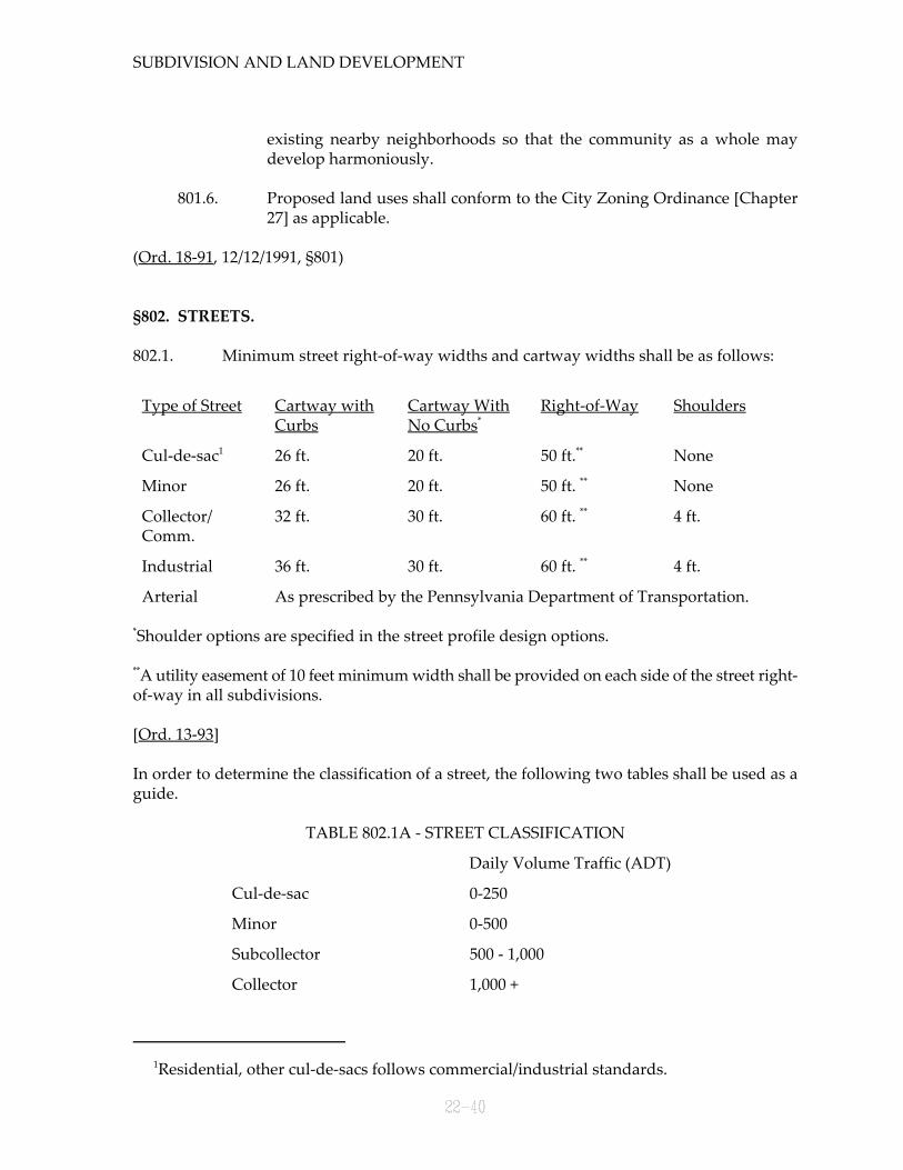
802.1. Minimum street right-of-way widths and cartway widths shall be as follows:
Type of Street Cartway with Cartway With Right-of-Way ShouldersCurbs No Curbs*
Cul-de-sac 26 ft. 20 ft. 50 ft. None1 **
Minor 26 ft. 20 ft. 50 ft. None**
Collector/ 32 ft. 30 ft. 60 ft. 4 ft.Comm.
**
Industrial 36 ft. 30 ft. 60 ft. 4 ft.**
Arterial As prescribed by the Pennsylvania Department of Transportation.
Shoulder options are specified in the street profile design options.*
A utility easement of 10 feet minimum width shall be provided on each side of the street right-**
of-way in all subdivisions.
[Ord. 13-93]
In order to determine the classification of a street, the following two tables shall be used as aguide.
TABLE 802.1A - STREET CLASSIFICATION
Daily Volume Traffic (ADT)
Cul-de-sac 0-250
Minor 0-500
Subcollector 500 - 1,000
Collector 1,000 +
(22, Part 8)
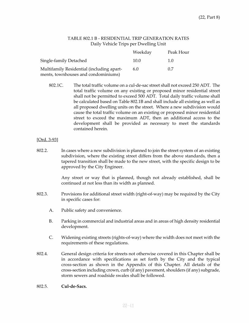
TABLE 802.1 B - RESIDENTIAL TRIP GENERATION RATESDaily Vehicle Trips per Dwelling Unit
Weekday Peak Hour
Single-family Detached 10.0 1.0
Multifamily Residential (including apart- 6.0 0.7ments, townhouses and condominiums)
802.1C. The total traffic volume on a cul-de-sac street shall not exceed 250 ADT. Thetotal traffic volume on any existing or proposed minor residential streetshall not be permitted to exceed 500 ADT. Total daily traffic volume shallbe calculated based on Table 802.1B and shall include all existing as well asall proposed dwelling units on the street. Where a new subdivision wouldcause the total traffic volume on an existing or proposed minor residentialstreet to exceed the maximum ADT, then an additional access to thedevelopment shall be provided as necessary to meet the standardscontained herein.
[Ord. 3-93]
802.2. In cases where a new subdivision is planned to join the street system of an existingsubdivision, where the existing street differs from the above standards, then atapered transition shall be made to the new street, with the specific design to beapproved by the City Engineer.
Any street or way that is planned, though not already established, shall becontinued at not less than its width as planned.
802.3. Provisions for additional street width (right-of-way) may be required by the Cityin specific cases for:
A. Public safety and convenience.
B. Parking in commercial and industrial areas and in areas of high density residentialdevelopment.
C. Widening existing streets (rights-of-way) where the width does not meet with therequirements of these regulations.
802.4. General design criteria for streets not otherwise covered in this Chapter shall bein accordance with specifications as set forth by the City and the typicalcross-section as shown in the Appendix of this Chapter. All details of thecross-section including crown, curb (if any) pavement, shoulders (if any) subgrade,storm sewers and roadside swales shall be followed.
802.5. Cul-de-Sacs.
SUBDIVISION AND LAND DEVELOPMENT
A. In no event shall a street be allowed to deadend without a permanent ortemporary cul-de-sac.
B. Residential deadend streets (cul-de-sacs) may be permitted when it is clear thatthrough traffic is not essential to the street system in that district, and underexisting conditions. A dead-end street must have adequate turning space forvehicles, which shall include a minimum right-of-way radius of 55 feet, and aminimum road edge or curb radius of 40 feet.
C. Where a temporary residential cul-de-sac is proposed in a residential develop-ment, the developer will be allowed to install a fully graveled temporary facilityadequate with a minimum radius of 40 feet; provided, that such a temporarycul-de-sac will not be permitted for more than a 2 year period; and, furtherprovided, that the developer shall post a bond, in accordance with the provisionsof §502 of this Chapter, in an amount sufficient to construct a permanent cul-de-sacaccording to the requirements of this Chapter in the event the street is notcontinued in said 2 year period.
If the street is not constructed in said 2 year period, the developer shall constructa cul-de-sac in full accordance with the standards of this Chapter. In such event,the bond shall be returned. In the event the developer neither continues the streetnor constructs the cul-de-sac in a 2 year period, the City shall use the bond fundsto construct same.
Where a temporary cul-de-sac is proposed, the needed street right-of-way to thetract boundary shall be clearly shown on the preliminary and final plat. Theright-of-way of any future street shall meet the requirements of this Part. Areaneeded to provide the temporary turn-around may be provided by an easement.Said easements shall be so designed as to meet the requirements for cul-de-sacs ofthis Part. If the cul-de-sac shall become permanent, the easement andimprovements will be considered as a permanent dedication to the City ofHermitage. If the road is extended and the temporary cul-de-sac is no longerneeded, then the easement will be terminated.
D. Cul-de-sacs in commercial or industrial developments shall have a minimumright-of-way radius of 60 feet, and a minimum road edge or curb radius of 45 feet.
Temporary cul-de-sacs shall not be permitted in industrial or commercialsubdivisions.
802.6. Street intersections shall comply with the following requirements:
A. All curbs at intersections shall be rounded by a minimum radius of:

(22, Part 8)
Collector, Commercial and Arterial Streets 30 feet
Minor Streets 30 feet
Industrial Streets 40 feet
B. When fences, hedges or other plantings, structures or walls on any lot cornerwould create a traffic hazard by limiting clear vision across a corner lot from aheight of 3 feet above the finished paved area, at the centerline of the right-of-way,such structure and/or vegetation shall be removed in conjunction with grading theright-of-way to provide a sight line of 150 feet along the centerline of a collector,commercial, arterial or industrial street from the centerline intersections and 120feet at minor street intersections. When an arterial, commercial, industrial orcollector and a minor street intersect, each shall retain its respective footagerequirements along the centerline to form the sight triangle. No building orstructure shall be permitted in this sight triangle. Sight triangles shall be shown onthe plan.
C. Where the grade of any street at the approach to an intersection exceeds 2%, aleveling area shall be provided, if possible, with a transitional grade not to exceed1% for a minimum distance of 50 feet from the nearest right-of-way line of theintersection.
D. Intersections of more than two streets shall be avoided.
E. Minimum street intersection angles shall be 60 degrees. Right angle intersectionsshall be used whenever possible.
F. Intersecting streets shall be separated by 350 feet or more, measured betweencenterlines along the centerline of the intersected street.
G. Residential driveways shall be at least 30 feet from adjacent driveways on the sameside of the street and at least 50 feet from the centerline of an intersecting street.For industrial subdivision, there shall be at least 70 feet between driveways on thesame side of the street, and at least 90 feet between the closest intersection and anyindustrial driveway.
For commercial developments, there shall be at least 50 feet between drivewayson the same side of the street and at least 70 feet between the closest radius of thedriveway and the intersecting street. Shared driveways shall not be permittedexcept in instances of land development on single lots.
802.7. Horizontal curves shall be laid on all deflecting angles along the centerline ofstreets, and the degree of curvature shall be set to assure the proper sight distanceas required by Table A.
802.8. Vertical curves shall be used in changes of grade exceeding 1%, and shall be
SUBDIVISION AND LAND DEVELOPMENT
designed for maximum visibility as set forth by Table A.
802.9. In general, minor and collector streets shall not join into the same side of arterialstreets at intervals of less than 800 feet.
802.10. Half streets shall be prohibited. If circumstances render this impractical, adequateprovisions for the concurrent dedication of the remaining half of the street mustbe furnished by the developer. Where there exists a half street in an adjoiningsubdivision, the remaining half shall be provided in the proposed development.The use of reserve strips is prohibited.
802.11. The provisions for the extension and continuation of major streets into and fromadjoining areas is required. Where a subdivision abuts or contains an existing orproposed major street, the City may require reverse frontage lots or suchtreatments as will provide protection for abutting properties, reduction in thenumber of intersections with the major traffic streets, and separation of local andthrough traffic.
802.12. When the subdivision adjoins unsubdivided acreage, new streets or reservedright-of-ways shall be provided through to the boundary lines of the development.
802.13. Proposed streets shall be properly related to the official map of the City (ifapplicable), and shall be logically related to the topography so as to produceusable lots and reasonable grades.
802.14. Where a subdivision borders on, or contains a railroad right-of-way, an arterialhighway right-of-way or a stream, ravine, steep hill or swamp, the City mayrequire a street approximately parallel to and on each side of such right-of-way orother obstruction at a distance suitable for the appropriate use of the interveningland. Such distances shall also be determined with due regard for the requirementsof approach grades and future grade separations, and for nonresidential uses ofland, where permitted.
802.15. If the lots in a development are large enough for resubdivision, or if a portion ofthe tract is not subdivided, suitable access and street openings for suchresubdivision shall be provided. Such access and/or street openings shall not beless than 50 feet in width.

(22, Part 8)
For arterial roads, PennDOT standards shall apply.1
Please see cul-de-sac definition - a cul-de-sac is the entire street not merely the vehicular2
turn-around.
Grades in excess of allowable percentage may be approved by the City Engineer where it3
is clear that it is necessary and that no traffic hazardf is or will be created thereby.
Sight distance shall be measured along the centerline of the street between points where a4
driver's eyes at 3 feet 6 inches in height can see an object 6 inches high.
TABLE A
DESIGN CRITERIA OF STREETS1
(Not to Include Intersections)
Item Type of Street
Com/Ind. Collector Minor Res. Cul-de-Sac2
Maximum Grade 8.0% 6.0% 8.0% 8.0%3
Minimum Grade 0.5% 0.5% 0.5% 0.5%
Minimum Center- 300 ft. 300 ft. 150 ft. 150 ft.line Radius
Minimum Sight 200 ft. 250 ft. 200 ft. 200 ft.Distance4
Tangent between N.A. 150 ft. 100 ft. N.A.Curves
802.16. Alleys are prohibited.
(Ord. 18-91, 12/12/1991, §802; as amended by Ord. 3-93, 4/20/1993, §3; and by Ord. 13-93,10/21/1993, §1)
§803. CURBS AND SIDEWALKS.
803.1. Curbs.
A. Curbs shall be provided on all streets and parking compounds located withinmultifamily and apartment building developments. Curbs shall also be requiredon new streets in subdivisions or land developments in which the average lotwidth of interior lots at the required building setback line is less than 100 feet.
B. Where sidewalks are installed, curbs shall be depressed at intersections to
SUBDIVISION AND LAND DEVELOPMENT
sufficient width to accommodate wheelchairs. Depression shall be in line withsidewalks where provided.
C. Curbs shall be vertical.
D. All curbs shall be constructed of Portland cement concrete with expansion jointsevery 20 feet, and shall follow Penn DOT standards where applicable. (See CurbDesign Detail.)
803.2. Sidewalks.
A. Sidewalks shall be provided on all streets and parking compounds located withinmultifamily and apartment building developments. Sidewalks shall also berequired on new streets in subdivisions or land developments in which averagelot width of interior lots at the required building setback line is less than 100 feet.The requirement of sidewalks may be waived at the discretion of the Board ofCommissioners. In addition, where ever the Board of Commissioners shall sodetermine, due to potential volume of pedestrian traffic, sidewalks may berequired regardless of any other regulations in this Chapter.
B. Minimum widths for sidewalks along each type of public street shall be 4 feet, andshall follow Penn DOT specifications where applicable.
(Ord. 18-91, 12/12/1991, §803)
§804. BLOCKS.
804.1. Blocks shall be designed to insure proper fire safety.
804.2. In general, all blocks in a subdivision shall have a maximum length of 1,500 feet.Blocks subdivided into lots shall be approximately two lot depths in width, exceptlots along a major thoroughfare which front on an interior street. Block lengthsshall not be less than 575 feet.
804.3. In commercial areas, the block layout shall conform, with due consideration to siteconditions, to the best possible layout to serve the buying public, to permit goodtraffic circulation and the parking of cars, to make delivery and pickup efficient,and to reinforce the best design of the units in the commercial areas.
804.4. The block layout in industrial areas shall be governed by the most efficientarrangement of space for present use and future expansion, with due regard forworker and customer access parking. Of special interest will be in accommodationof truck traffic.
804.5. Cul-de-sacs (temporary or permanent) shall not exceed 1,000 feet in length, asmeasured from the centerline of the intersecting street to the center of the cul-de-sac except where approved by the Board of Commissioners to provide for future

(22, Part 8)
extension. [Ord. 3-93]
(Ord. 18-91, 12/12/1991, §804; as amended by Ord. 3-93, 4/20/1993, §2)
§805. LOTS AND BUILDING LINES.
805.1. The depth-to-width ratio of usable lot length shall be a maximum of three to one.
805.2. Double frontage and reverse frontage lots should be avoided except whereessential to provide separation of residential development from traffic arteries orto overcome specific disadvantages of topography and orientation. A plantingscreen easement across which there shall be no right of access may be required bythe Board of Commissioners along the line of lots abutting such a traffic artery orother disadvantageous use.
805.3. Side lines of lots, so far as practical, shall be at right angles or radial to street lines.
805.4. Corner lots shall be increased in size whenever necessary so as to conform to theCity's Zoning Ordinance [Chapter 27] or land development standards so that anystructure to be placed thereon shall conform to minimum building setback linerequirements.
805.5. Lots abutting local streets shall front upon the streets which parallel the longdimension of the block, if possible.
805.6. All lots shall abut by their frontage on a publicly dedicated street or on a street thathas received the legal status as such. Lots abutting on a private street or easementshall not be approved unless specifically permitted by the Board of Commissionersby special resolution. All streets, public or private, must meet the design andconstruction standards set forth by this Chapter.
805.7. Flag Lots. The City of Hermitage, as a matter of policy, does not encourage the useof flag lots. However, it recognizes that in certain situations it may be the onlypractical method to develop road frontages which are associated with large lots.For residential development, flag lots shall be at least one acre in size and have a50 foot right-of-way to a public street. For all other types of developments, the flaglot shall have a connection of at least 60 feet and shall be at least ten acres in size.Only one flag lot per development in industrial/commercial areas will bepermitted.
(Ord. 18-91, 12/12/1991, §805)
§806. LOT GRADING FOR SUBDIVISIONS AND LAND DEVELOPMENTS.
SUBDIVISION AND LAND DEVELOPMENT
806.1. Blocks and lots shall be graded to provide proper drainage away from buildingsand to prevent the collection of stormwater in pools.
806.2. Lot grading shall be of such design as to carry surface waters to the nearestpractical street, storm drain or natural water course. Where drainage swales areused to deliver surface waters away from buildings, their grade shall not be lessthan l% nor more than 4%. The swales shall be sodded, planted or lined asrequired. A grading and drainage plan shall be required for all subdivisions andland developments, except minor subdivisions.
806.3. No final grading, fill or cut shall be permitted with a cut face steeper in slope thantwo horizontal to one vertical except under one or more of the followingconditions:
A. The material in which the excavation is made is sufficiently stable to sustain aslope of steeper than two horizontal to one vertical, and a written statement of acivil engineer, licensed by the Commonwealth of Pennsylvania and experiencedin erosion control, to that effect is submitted to the City Engineer and approved bysame. The statement shall state that the site has been inspected and that thedeviation from the slope specified herein before will not result in injury to personsor damage to property.
B. A concrete or stone masonry wall constructed according to sound engineeringstandards for which plans are submitted to the City Engineer for review andwritten approval is provided.
806.4. The top or bottom edge of slopes shall be a minimum of 3 feet from property orright-of-way lines of street or alleys in order to permit the normal rounding of theedge without encroaching on the abutting property. All property lines, or right-of-way lines, where walls or slopes are steeper than one horizontal to one verticaland 5 feet or more in height shall be protected by a protective fence no less than3 feet in height approved by the City Engineer.
(Ord. 18-91, 12/12/1991, §806)
§807. OPEN SPACE, LOT SITING, PLANTING AND BEAUTIFICATION FOR SUBDIVI-SION AND LAND DEVELOPMENTS.
807.1. In order to promote the highest environmental quality possible, the degree towhich the applicant of a subdivision or land development plan has preservedexisting salient natural features and land forms intrinsic to the site shall beassessed. Terms of approval of a plat may be subject to the manner in which thelayout or design of the plan has preserved existing natural features, such as, butnot limited to, trees, wooded areas and watercourses.
807.2. Open Space. Where the applicant is offering for dedication, or is required byordinance to establish a reservation of open space or preserve an area of scenic or
(22, Part 8)
historic importance, a "limit of work," which will confine excavation, earth movingprocedures and other changes to the landscape, may be required to ensurepreservation and prevent despoliation of the character of the area in open space.
807.3. Tree Preservation.Whenever possible, trees shall not be removed unless they arelocated within the proposed street right-of-way, within the proposed buildingarea, well area, sewage facility area, or within utility locations and equipmentaccess areas. In areas where trees are retained, the original grade level shall bemaintained, if possible, so as not to disturb the trees.
807.4. Topsoil Preservation.All of the topsoil from areas where cuts and fills have beenmade should be stockpiled and redistributed uniformly after grading. All areas ofthe site shall be stabilized by seeding or planting on slopes of less than 10% andshall be stabilized by sodding on slopes 10% or more and planted in ground coveron slopes 20% or greater.
807.5. Landscaping. For all multifamily, apartment, office, commercial and industrialsubdivisions or land developments, a landscaping plan shall be provided and shallinclude sufficient plantings for the required open space, planting strips, screenings,formal gardens, shade trees and natural barriers.
807.6. Buffer Planting Requirements. Buffer yard as may be required (see ZoningOrdinance [Chapter 27]).
807.7. Preserved Landscaping. When there is a conscientious effort to preserve theexisting natural integrity and character of a site and where such preservationeffectuates areas of woodland and trees comparable to required plantingimprovements, i.e., landscaping and buffer screening, the plan may be received inlieu of additional landscaping requirements.
807.8. Trees.The planting of trees within industrial and commercial street right-of-waylines shall be required. Such trees shall be as specified by the City.
(Ord. 18-91, 12/12/1991, §807)
§808. EASEMENTS.
808.1. Where a subdivision is traversed by a watercourse, drainage way, channel orstream, a drainage easement may be required that conforms substantially with thewater line of such watercourse, drainage way, channel or stream and of such widthas will be adequate to preserve the unimpeded flow of natural drainage, or for thepurpose of widening, deepening, relocating, improving or protecting suchdrainage facilities.
808.2. Utilities.
A. Adequate easements or dedications for public service utilities shall be provided for
SUBDIVISION AND LAND DEVELOPMENT
sewer, water, electric power, gas lines, storm drainage and similar services. Nostructure or obstruction of any kind shall be placed or allowed to be placed whereit will interfere in any way with such easements.
B. A utility and drainage easement of 10 feet minimum width shall be requiredadjacent and parallel to the street right-of-way in all subdivisions.
808.3. Where required, utility and drainage easements, not contained in the easementadjacent to a street right-of-way, shall have a minimum width of 20 feet and beplaced at the side or rear of lots whenever possible. Utility and drainageeasements shall be required as needed to accommodate existing or proposedutilities or drainage facilities, or as reasonably necessary to provide utility ordrainage service to adjacent unsubdivided land. In determining where drainageand utility easements are required, the Planning Commission and the CityEngineer shall take the following into consideration:
A. The presence of existing natural watercourses, streams, drainage ditches, springsor other natural drainage conditions.
B. The topography of the proposed subdivision as related to adjacent land at a lowerelevation, and the possible need to divert surface drainage from the lots of theproposed subdivision away from lower lying adjacent properties.
C. The topography of the proposed subdivision as related to adjacent land at a higherelevation, and the possible need to divert surface drainage from the adjacent landaway from the lots of the proposed subdivision.
D. In the event that said easement requirements conflict with building setbackrequirements of the Hermitage Zoning Ordinance [Chapter 27], said easementrequirements shall prevail.
[Ord. 14-93]
(Ord. 18-91, 12/12/1991, §808; as amended by Ord. 14-93, 10/21/1993, §1)
§809. RESERVED.
§810. STREET NAMES.
The developer may choose his street names subject to the review and approval by the City andthe Post Office. No street, other than an extension, may be given a name identical or similar toanother street in the City or nearby areas, unless such street is a continuation of an existingstreet.
(Ord. 18-91, 12/12/1991, §810)

(22, Part 8)
§811. STORMWATER DRAINAGE.
811.1. All drainage facilities and plans shall comply with the Pennsylvania StormwaterManagement Act and the City's Stormwater Management Regulations [Chapter26, Part 1] that may be applicable.
811.2. Lots shall be laid out and graded to provide positive drainage away frombuildings. The City may require a grading and drainage plan for individual lotsindicating a buildable area within each lot, complying with the setbackrequirements, for which positive drainage is assured.
811.3. No person, corporation, or other entity shall block, impede the flow of, alter,construct any structure, or deposit any material or thing, or commit any act whichwill affect normal or flood flow in any communal stream or watercourse withouthaving obtained prior approval from the City or Department of EnvironmentalProtection, whichever is applicable. [Ord. 11-98]
811.4. Where a subdivision or land development is traversed by a natural watercourse,there shall be provided a drainage easement or right-of-way conformingsubstantially with the line of such watercourse and of such width as will beadequate to preserve natural drainage. (See also §808.)
(Ord. 18-91, 12/12/1991, §811; and by Ord. 11-98, 9/23/1998)
§812. UTILITY REGULATIONS FOR SUBDIVISION AND LAND DEVELOPMENT.
Gas, electric, water, telephone and cable utilities shall be located in subdivisions in accordancewith utility company practice and shall be placed underground. (See §808.) Generally, electricaland related work shall follow the criteria of the National Electrical Code (as amended).
Street Lighting. Adequate lights shall be provided to illuminate streets, driveways andwalkways for the safe movement of vehicles and pedestrians at night. Street lighting shall beof a design and size compatible with adjacent areas and in accordance with the standards of theIlluminating Engineering Society of America. At a minimum, street lights shall be located at allintersections, at all horizontal curves of 145 or less, all vertical curves in excess of 12% (seeo
illustrations) where necessary to provide for safe pedestrian or vehicle travel, and at all otherlocations deemed by the City Engineer to be necessary for the health and safety of the generalpublic. As with all utility installation, the cost of installation will be borne by the developer.
(Ord. 18-91, 12/12/1991, §812)
§813. FLOODPLAIN AREA REGULATIONS.
All developers are required to follow the City of Hermitage's Floodplain Regulations which canbe found within the City's Zoning Ordinance [Chapter 27, Part 8]. In addition, when anyfloodplains are located within a proposed development, they should be clearly identified on

SUBDIVISION AND LAND DEVELOPMENT
the preliminary and final plat. The developer will use the most recent floodplain informationfor the City of Hermitage as available from the Federal Emergency Management Agency.
Any public facilities or utilities which are constructed in floodplain ares shall be designed inaccordance with approved regulations. These regulations are set forth in the City's ZoningOrdinance [Chapter 27, Part 8] in that Section which deals with the floodplain.
(Ord. 18-91, 12/12/1991, §813)
§814. SANITARY SEWER SYSTEMS.
Generally, sanitary sewer systems shall follow the criteria as listed in the Developers' Manualas issued by the Municipal Authority of the City of Hermitage. Where a community sanitarysewer system will not be dedicated to the Authority, the development engineer will present thedesign to the City Engineer. To the extent possible, especially for collection systems, the designand construction criteria of the Developers' Manual will be used. All designs must demonstratecompliance with DEP permit requirements and secure DEP approval.
(Ord. 18-91, 12/12/1991, §814; as amended by Ord. 11-98, 9/23/1998)
§815. WATER.
A. Water Systems. Generally, public water service will be provided by a public utilityregulated by the Pennsylvania Public Utility Commission, and that organization will setdesign criteria. When a water system is proposed that will not be part of the ShenangoValley Water Company system, the developer's engineer will present the design to theCity Engineer for review and approval. Generally, the City will use, to the extentpossible, the Water Company's design practices, it will also consult the Hermitage FireMarshall for fire safety concerns and require all designs be approved by DEP. All watersupply systems which are provided by means other than private wells shall meet therequirements and provide the assurances as set forth by §503.1 of the Planning Code.[Ord. 11-98]
All water systems will be designed to meet the National Fire Protection AssociationStandards for Suburban and Rural Fire Fighting (NFPA 1231) and the BOCA NationalFire Prevention Code (City of Hermitage Ordinances 6-76/7-76, as amended).
B. Individual On-Lot Water. On-lot water will normally be provided by wells. For majorsubdivisions, the developer shall provide reasonable assurances that such water will beavailable in sufficient quantity and quality for residential use per DEP standards. Formajor subdivisions, the developer shall either provide a test well for the first ten lots orfraction thereof. Thereafter, a test well shall be completed for each ten additional lots. Inlieu of the test wells, a statement of a qualified hydrologist attesting to the availability ofwater in sufficient quantity and quality (DEP standards) shall be acceptable. [Ord. 11-98]
(Ord. 18-91, 12/12/1991, §815; as amended by Ord. 11-98, 9/23/1998)

(22, Part 9)

(22, Part 9)
PART 9
REQUIRED IMPROVEMENTS
§901. GENERAL.
901.1. The construction of subdivision improvements is the responsibility of thedeveloper insomuch as it is his property which is being developed. Adequatestreets, utilities and other improvements are essential elements in the creation andpreservation of stable residential, commercial and industrial areas, and must becompleted by the developer.
901.2. All of the following improvements, as required by the City pursuant to theauthority granted in the Pennsylvania Planning Code, Act 247, as amended, shallbe completed in accordance with the requirements established by this Chapterprior to final approval of the plan, except as otherwise provided herein.
901.3. Final plan approval, except for minor subdivisions and replats, shall not be givenprior to the completion and acceptance of all subdivision improvements, exceptwhere assurance of completion is furnished as herein provided (Part 5).
901.4. All the requirements in this Chapter concerning street paving, curbing, utilities,street signs, street lighting and sidewalks shall be followed.
(Ord. 18-91, 12/12/1991, §901)
§902. IMPROVEMENTS.
902.1. Utility and street improvements shall be provided, where required, in each newsubdivision as follows, except that improvements are not required in existingpublic streets which may be incorporated into, or be adjacent to, the subdivision.
A. Survey monumentation.
B. Water supply.
C. Public or community sanitary sewage facilities.
D. Storm drainage facilities.
E. Streets, including required grading, subgrade, preparation, under drains, base andpaving.
F. Curbing on streets (if required).
G. Sidewalks (if required).

SUBDIVISION AND LAND DEVELOPMENT
H. Seeding between the sidewalk and curb (if required).
I. Required utilities, street lighting, street name signs and required grading.
J. Erosion and sedimentation control, as needed.
(Ord. 18-91, 12/12/1991, §902)
(22, Part 10)
PART 10
CONSTRUCTION REQUIREMENTS
§1001. GENERAL.
1001.1. The construction of improvements shall be in accordance with the requirementsof this Section. It is the intent of these regulations that these constructionrequirements shall be for the purpose of establishing a standard of quality anddurability.
(Ord. 18-91, 12/12/1991, §1001)
§1002. MONUMENTS ANDMARKERS.
1002.1. Survey monuments and markers shall be placed at all points as determined by thefollowing criteria:
A. Monuments shall be concrete with a 3/8 inch metal dowel in the center at the top.Monument size shall be no less than 6 inches x 6 inches x 30 inches with verticalsides.
B. Markers shall be ferrous metal rods, 1/2 inch minimum diameter by 18 inchesminimum length or may be standard manufactured steel survey markers of asimilar length.
C. Monuments shall be placed so that the center point shall coincide exactly with theintersection of lines to be marked.
D. Monuments shall be placed so that they protrude approximately 2 inches abovegrade in areas which are not paved, at grade if in a paved area not subject tovehicle traffic, and 4 inches to 8 inches below grade if in a paved area subject tovehicle traffic. Monuments set in areas subject to traffic shall be protected with acast iron frame and access cover of adequate design for truck traffic, or may havedouble monuments, one above the other, with the top monument flush with thepavement.
E. Markers shall be driven into the ground so as to be approximately flush with thefinal grade.
F. Monuments shall be set at the intersection of the lines forming angles in theboundaries of major subdivisions. Not less than 4 such monuments shall berequired for all major subdivisions, with the location of the monuments to be asdetermined by the City Engineer.
G. Markers shall be set at all lot angles and corners, and at the beginning and end ofall curves in lot and street lines and at the angle points of all streets right(s)-
SUBDIVISION AND LAND DEVELOPMENT
of-way(s). Front lot corners (along street right-of-way) may alternatively be locatedby P.K. nail on the street centerline.
(Ord. 18-91, 12/12/1991, §1002)
§1003. WATER SUPPLY.
1003.1. The developer shall contact the public utility for the specifications of a watersupply system. Prior to the approval of the preliminary plan, the developer shallprovide documentation to the City that arrangements for the provision of thewater system are proceeding satisfactorily.
1003.2. Fire hydrants shall be provided concurrently with the water supply.
1003.3. When a public or community water supply system is reasonably available (within500 feet), the development shall be required to connect to same. If a public orcommunity water system is not available, then each lot in the subdivision or landdevelopment application shall be capable of being provided with an individualwater supply system in accordance with the minimum standards approved by thePennsylvania Department of Environmental Protection standards. [Ord. 11-98]
(Ord. 18-91, 12/12/1991, §1003; as amended by Ord. 11-98, 9/23/1998)
§1004. SANITARY SEWAGE CONVEYANCE.
1004.1. Where required, the developer shall construct a sanitary sewer system and providelateral connections for each lot in accordance with the specifications of the City andthe Hermitage Municipality Authority.
1004.2. The developer shall secure from the Authority, prior to approval of thepreliminary plan, a letter indicating the general design, location and preliminaryapproval of the proposed sanitary sewer collection system. Prior to the approvalof the final plan, the developer shall supply documentation attesting to theinstallation of the sanitary sewer collection system and its approval/ acceptance bythe Authority. The developer may also offer an acceptable financial surety in lieuof this arrangement.
1004.3. If a development generates such additional sanitary sewer flows as to requirechanges to the Authority's sanitary sewer collection system, the developer shall berequired to pay a share of the costs consistent with the provisions of Act 203 of1990. It is the purpose of these regulations that developments which occur underthis Chapter shall pay their fair share toward needed improvements as set forthby Act 203 of 1990.
1004.4. Private Community Sewer Systems. When a complete private sanitary sewersystem using a treatment plant is to be provided, a statement shall be submitted
(22, Part 10)
to the City from the Pennsylvania Department of Environmental Protectioncertifying that a permit has been issued by the appropriate agency approving theproposed facilities. Adequate security for the maintenance of such plant shall befurnished to the City. The developer shall offer the private system to the Authoritywhich may or may not accept same. [Ord. 11-98]
1004.5. On-Lot Sewage Disposal. In subdivisions where public sewers are not availableand a complete private community sanitary sewer system is not required, on-lotsewage disposal systems shall be provided. In such instances, the developer shallprovide evidence that the planning module required for on-lot disposal by DEPhas been approved. The developer must show compliance with Act 537, and otherState, County or City law and/or regulation governing on-lot sewage disposal.[Ord. 11-98]
1004.6. When a major subdivision is located within 300 feet of an existing sewer line, thatsubdivision shall be required to connect to and utilize the community's sewagefacilities. Where a minor subdivision or individual lot is located within 150 feet ofan existing sewer line, that individual lot or minor subdivision shall be requiredto use the community sanitary sewer collection system.
(Ord. 18-91, 12/12/1991, §1004; as amended by Ord. 11-98, 9/23/1998)
§1005. STORM SEWERS.
1005.1. A drainage system adequate to serve the needs of the proposed development,accommodating natural waterways and overland flow will be required in newsubdivisions. The developer shall construct a storm sewer system and connect thedrainage system with the existing City storm sewer system if one exists.
1005.2. If a development generates such additional storm drainage sewer flows as torequire changes to the City's storm sewer collection system, the developer will berequested to pay a share of the costs consistent with the provisions of Act 203 of1990. It is the purpose of these regulations that developments which occur underthis Chapter shall pay their fair share toward needed improvements as set forthby Act 203 of 1990.
1005.3. Bridges or culverts shall be designed to support and carry loads according to therequirements of the City Engineer, but not less than AASHTO Loading HS-20 andshall be constructed the full width of the cartway plus additional length asnecessary to provide a proper installation.
1005.4. Where open watercourses are planned, adequate safety, erosion control, drainage,protection of capacity and appearance measures shall be taken by the developerto insure proper, safe, healthful disposal of stormwater. All open watercoursesmust be approved by the City Engineer.
1005.5. For specific standards, see the Hermitage Stormwater Management Ordinance

SUBDIVISION AND LAND DEVELOPMENT
[Chapter 26, Part 1].
(Ord. 18-91, 12/12/1991, §1005)
§1006. STREETS, SUBGRADE, SUBBASE, PAVEMENTS, CURBSANDSIDEWALKS.
1006.1. Streets shall be graded to the full width of the right-of-way, surfaced, curbed (ifrequired), and improved to the grades and dimensions shown on plans, withprofiles and typical cross-sections submitted by the developer and approved bythe City Engineer.
1006.2. Side slopes shall be graded to blend with the natural lay of the land, or inaccordance with cross sections approved by the City Engineer. Where fill materialis necessary to establish uniform grades, compacting shall be required inaccordance with Pennsylvania Department of Transportation Form 408Specifications for embankment. A maximum slope of 2 horizontal feet to 1 verticalfoot beyond the right-of-way line in cut or fill, shall ordinarily be required.
1006.3. The subgrade shall be shaped to rough lines and elevations equal to the width ofthe pavement plus 2 feet. Adequate drainage facilities shall be installed to providefor the disposition of underground seepage and the percolation of surface water.The subgrade shall be thoroughly compacted by power rollers as required by theCity Engineer. It shall be compacted at optimum moisture content. The finishsurface shall be uniformly shaped to facilitate drainage, and any irregularities fromplanned grade shall be corrected prior to placing the subbase. Where materialencountered in the normal excavation has a C.B.R. value of 2.5 or less and will notdevelop the required stability and provide for adequate drainage, the area shall beundercut and granular material added to a depth of at least 12 inches. It shall thenbe brought to a firm and thoroughly compacted surface as hereinbefore specified.The prepared subgrade shall be protected by the contractor to prevent unduerutting from trucks or other equipment and if such damage does occur, thesubgrade shall be reshaped and compacted prior to placing the subbase material.
1006.4. Subbase drains shall be designed and installed per the specifications of the CityEngineer. Base drains shall be required at 100 feet intervals on both sides of newstreets. Base drains shall be constructed of coarse aggregate.
Class 4 Geotextile Fabric shall be installed over the approved subgrade inaccordance with Penn DOT Form 408.
1006.5. All roadway pavement and subbase shall conform to the requirements of the CityEngineer.
A. Subbase.The subbase shall consist of PennDOT approved road material, spreadand compacted in layers to a total depth of 12 inches.
Road subbase for all streets shall be constructed of two 6 inch layers of 2A coarse
(22, Part 10)
aggregate or one lower 6 inch layer of No. 4 coarse aggregate and one upper 6 inchlayer of No. 2A coarse aggregate. Subbase fabric shall be required on all roads.
B. Pavement and curb (where required) shall be installed as indicated on thepreliminary plan and in accordance with PennDOT Publication 408 or its successorpublication or standard. Bituminous prime coat shall be applied to the subbaseprior to the placement of pavement at a rate of 0.40 gallons per square yard.
Pavement on all minor and residential streets (except as noted in this Chapter)shall be according to State Highway Specification ID-2. Minimum pavement shallconsist of 2 1/2 inches ID-2 binder course plus 1 inch FJ-l wearing course or 2 1/2inches ID-2 binder course plus 1 1 /2 inches ID-2 wearing course.
Minimum pavement on all commercial, collector and industrial streets shall consistof 6 inches of bituminous concrete base course, plus 2 1 /2 inches of ID-2 bindercourse, plus 1 1/2 inches of ID-2 wearing course.
In the instance paving does not immediately follow installation of the subbase, thesubbase shall, if considered necessary by the City Engineer, be regraded and newmaterial added and rolled to secure an even and properly graded base for thepavement.
C. Shoulders, where required, shall be constructed of 6 inches of 2A coarse aggregatesubbase plus bituminous prime coat, plus 2 1/2 inches ID-2 wearing course.
D. For industrial developments or other developments which may generate extremelyheavy traffic loads, the City Engineer may require pavement design calculationsand alternative pavement design as needed to accommodate the traffic anticipatedby the proposed development.
1006.6. Areas between the sidewalk and curb (if required) shall be seeded as required bythe City Engineer.
1006.7. Shoulders; Tree Lawn Areas. Where no curb is required, shoulders shall begraded and rolled even with the edge of the pavement. Where curb is required, thespace behind the curb shall be filled and graded.
1006.8. See §803 for curb and sidewalk specifications.
1006.9. Generally all street construction shall conform to PennDOT Form 408.
1006.10. Inspection. Base course and curb forms (where required) shall be inspected forconformity to approved profiles and cross-sections prior to placing pavement andcurb. Finished work shall be inspected and certified by the City Engineer.
(Ord. 18-91, 12/12/1991, §1006)
§1007. UTILITIES.

SUBDIVISION AND LAND DEVELOPMENT
Gas, electric, water, and telephone and cable utilities shall be located in subdivisions inaccordance with utility company practice and in accordance with agreements with, or asapproved by, the City Engineer and shall be placed underground. For electrical and relatedinstallation, the construction criteria of the National Electrical Code (as amended) shall befollowed.
(Ord. 18-91, 12/12/1991, §1007)
§1008. STREET TREES.
Street trees of a deciduous hardwood type with a minimum caliper of 1 1/2 inches shall, whenprovided, be planted between the curb and the sidewalk (if required), provided the plantingstrip is a minimum of 6 feet wide and located as near the center of the planting strip as possible,but at no instance shall a tree be planted closer than 3 feet to the curb, sidewalk or any otherutility above or below the ground. The tree species shall be subject to the approval of the Boardof Commissioners.
(Ord. 18-91, 12/12/1991, §1008)
§1009. STREET LIGHTING.
Street lighting shall be provided by the developer using devices and wiring approved by theelectric utility company and to the standards of the Illuminating Engineering Society ofAmerica.
(Ord. 18-91, 12/12/1991, §1009)
§1010. EXISTING NATURAL AREAS.
In wooded areas, floodplains, wetlands, areas having slopes of 15% or greater or where othernatural conditions exist in such a manner that development would be hazardous to the safetyof life and property or would cause permanent ecologic instability, the City may require thatthe developer preserve as much of the original natural conditions as is economically feasibleand ecologically practicable and may limit the amount of grading and excavating to theminimum improvement standards included herein.
(Ord. 18-91, 12/12/1991, §1010)
§1011. EROSION CONTROL.
It shall be a requirement of all major subdivisions that the developer shall have a soil erosionand sedimentation control plan and/or permit, prepared in accordance with current state law(Erosion and Sedimentation Control, Chapter 102, Pennsylvania Rules and Regulations, asamended), reviewed by the Mercer County Soil Conservation District. The City may also

(22, Part 10)
require a like plan for any minor subdivision. The plan shall be fully implemented during theconstruction of the development.
(Ord. 18-91, 12/12/1991, §1011)


(22, Part 11)
PART 11
MOBILE HOME PARK REGULATIONS
§1101. APPLICABILITY.
No person, firm or corporation proposing to open, re-arrange or expand a mobile home parkin the City of Hermitage shall proceed with any construction work on the proposed park untilthey have obtained from the City written approval of the preliminary plan of the proposedpark, according to procedures herein outlined.
(Ord. 18-91, 12/12/1991, §1101)
§1102. PLAN REQUIREMENTS.
A. Preliminary and final plans as required, shall comply in form and content to Parts 3 and7 of these regulations in-so-far as applicable and the standards set forth herein.
B. Stormwater Management Plan. The owner shall prepare and submit for review andapproval to the City and a stormwater management plan. Said plan will be in accordancewith the City's Stormwater Management Ordinance [Chapter 26, Part 1].
(Ord. 18-91, 12/12/1991, §1102)
§1103. PRELIMINARY PLAN.
A. Pre-Application Procedure (Sketch Plan). The mobile home park developer should meetwith the Planning Department, prior to formal application, to discuss his plans and mayprepare a suitable sketch and plan sufficient to give a general understanding of hispurposes. The Planning Department shall inform the developer as to the generalsuitability of the plans and of any modifications required by these regulations, if deemedadvisable.
B. Application. The developer shall then prepare and submit a complete preliminary plan,together with improvement plans and other supplementary material, as required. (See§302.)
C. Action. The Planning Commission and the Board of Commissioners shall review thepark plan as submitted and take actions as required in §303.
(Ord. 18-91, 12/12/1991, §1103)
§1104. FINAL PLAN APPROVAL.
A. Upon completion of any modifications required by the Commissioners and/or upon
SUBDIVISION AND LAND DEVELOPMENT
completion of required improvements or the alternate posting of acceptable surety, thedeveloper may apply for approval of the final plan. Until the final plan for the mobilehome park is approved and recorded and until all necessary improvements are complet-ed for the mobile home park, the placement and habitation of individual mobile homesshall not be permitted. (See Section 509(m) of the Planning Code.)
B. The Planning Commission and the Commissioners shall review the final plan forconformance with the approved preliminary plans and all requirements of these rulesand regulations. Where required, an appropriate bond must be posted or requiredimprovements have been installed, according to specifications. (See §§304 and 305 of thisChapter.)
C. Filing.Following approval, the developer shall file one copy of the approved plan withthe Mercer County Recorder's Office within 90 days. Should the developer fail to file suchplan within said period, the approval shall be null and void.
(Ord. 18-91, 12/12/1991, §1104)
§1105. DESIGN REQUIREMENTS.
A. Minimum Area of Tract or Park. The minimum area of the tract or park shall be fiveacres. The site shall be so located that soil conditions, ground water level, drainage andtopography shall not create hazards to the property, health or safety of the occupants oradjacent property owners.
B. Individual Lots. The planning and location of individual lots shall be guided by thefollowing requirements:
1. Access. Each lot shall be directly accessible from an approved internal streetwithout the necessity of crossing any other space.
2. Size. Each mobile home lot shall have a minimum lot width of 50 feet, depth of 100feet and a minimum of 5,000 square feet in area.
3. Yard Requirements.
a. Mobile homes shall be parked on each lot so that there will be a minimumof 15 feet between the mobile home, appurtenant structures, and anyadjacent side or rear lot line.
b. There shall be a minimum of 20 feet between an individual mobile home,attached structure, fences and accessory structure, and the pavement of apark street or common parking area.
c. The setback from the right-of-way of any public street or highway shall be50 feet.

(22, Part 11)
d. Mobile homes shall be located a minimum of 30 feet from any commonbuilding or structure.
e. Each mobile home lot shall be so platted to permit a minimum of 30 feetbetween individual mobile homes.
f. There shall be at least 40 feet between any mobile home, appurtenancebuilding, office or similar structure and any boundary line.
4. Screening. Screening shall be installed as required in the Hermitage ZoningOrdinance [Chapter 27].
5. Skirting. The plans shall specify that skirting shall be provided on all mobilehomes.
C. Mobile Home Stands.
1. The location of each mobile home stand shall be at such elevation, distance andangle in relation to the access street so that the placement and removal of themobile home is practical.
2. The size of each mobile home stand shall be suitable for the general market to beserved by the individual park, be sufficient to fit the dimensions of mobile homesanticipated, and sufficient to handle any appurtenant structures and appendages,including prefabricated "Florida rooms," car ports and storage structures.
3. A 1% to 5% gradient longitudinal crown or cross gradient for surface drainageshall be provided.
4. Mobile home stands shall be either concrete pads or be provided with a foundationfor the mobile home set at least 36 inches deep.
5. Each mobile home stand shall provide adequate tie downs. For mobile homesconstructed before June 15, 1976, at least one over-the-top tie down at each end ofthe home is recommended. The following minimum tie down schedule is requiredof all mobile homes:
- For mobile homes up to 50 feet long, three frame tie downs per side.
- For mobile homes 51-70 feet long, four frame tie downs per side.
- For mobile homes over 70 feet long, at least five frame tie downs per side.
Anchors for tie downs must have steel rods at least 5/8 inch in diameter with atensioning head. Each anchor must be able to withstand at least 4,725 pounds.
6. There shall be a concrete patio area provided for each stand, not less than 10 feetwide and 20 feet long located convenient to the main entry door to the mobile
SUBDIVISION AND LAND DEVELOPMENT
home.
D. Internal Street System. The internal street system in privately owned mobile home parksshall be privately owned, constructed and maintained in accordance with the applicableSections set forth in Part 8, Design Standards, Part 10, Construction Requirements, andthe BOCA National Fire Protection Code (City of Hermitage Ordinances 6-76/7-76, asamended).
E. StreetWidths at Access Points.At points where general traffic enters or leaves the park,streets shall be 24 feet in width within 20 feet of the existing public street to permit freemovement from or to the stream of traffic on the public street, and no parking shall bepermitted which in any way interferes with such free movement.
F. Parking Spaces. Car parking spaces, at a minimum size of 9 by 18 feet, shall be providedin sufficient number to meet the needs of the occupants of the property and their guests,without interference with normal movement of traffic. Such facilities shall be providedat the rate of at least two parking spaces for each mobile home lot, located on the lot. Ifno on-street parking is permitted, then one additional parking space for each four lotsshall be provided. This parking shall be in lots convenient to the mobile home lots.
G. Recreation. For a proposed park of 15 acres or more, at least 5% shall be reserved ordedicated for recreation purposes with appropriate location, dimensions and topographiccharacteristics which, in the judgment of the City, lend themselves to recreational uses.
H. Waste Disposal.Dumpsters or other park waste disposal facilities shall be isolated fromindividual mobile homes by at least 50 feet and shall be screened on at least three sides.
(Ord. 18-91, 12/12/1991, §1105)
§1106. UTILITY AND FIRE REQUIREMENTS.
A. General. In accordance with the rules and regulations, Commonwealth of Pennsylvania,Department of Environmental Protection, provisions for all sewerage disposal andtreatment of water supply and such other information required by the Department ofEnvironmental Protection shall be shown on plans and submitted to and approved bythe Department of Environmental Protection. If a proposed park is within 500 feet of anexisting community sewer system or public water system, it shall be required to connectto same. All design standards and specifications of this Chapter will be followed formobile home parks. [Ord. 11-98]
B. Electric.All electrical facilities shall be installed and inspected according to the standardsset forth by the City of Hermitage Fire Marshal, and in accordance with the NationalElectrical Code, as amended. [Ord. 11-98]
C. Fire.
1. General. For the safety and welfare of the residents and future residents of the
(22, Part 11)
mobile home park, the following fire regulations shall be incorporated into thepark. All fire safety plans shall be approved by the Hermitage Department ofFire/Rescue. [Ord. 11-98]
2. Fire hydrants shall hereafter be required in any new mobile home park where theextension of central water lines, whether public or private, are proposed for themobile home park development.
a. Hydrant size and type of all hydrants installed shall be of a standard sizeand type as specified by the City or the water utility company and shall beapproved by the Fire Marshal of the City of Hermitage. [Ord. 11-98]
b. Spacing. Hydrant spacing shall be adequate to serve all lots within themobile home park. Hydrants shall be arranged per municipal or waterutility practice as approved by the Fire Marshal of the City of Hermitage.Where an existing hydrant is less than 1,000 feet as measured along streetsurface edges or curb lines from the park, the existing hydrant shall bedeemed satisfactory and spacing can be determined and shown, taking theexisting hydrant into consideration. [Ord. 11-98]
c. Location. Hydrants shall be located within dedicated easements.
d. Design. The proposed locations of fire hydrants shall be shown on thesubmitted plans. Any existing fire hydrants less than 1,000 feet as measuredalong street surface edge or curb lines from the proposed park, shall beshown in the vicinity sketch with an exact distance in feet from the hydrantto the nearest lot line of the mobile home park.
3. In areas where there are no central water line extensions proposed, the followingstandards for fire safety shall be incorporated into the park. The developer retainsthe option of installing either the tank or pond system.
a. The Tank System. An approved underground, static water tank of not lessthan that as required by the National Fire Protection Association Standardsfor Suburban and Rural Fire Fighting (NFPA 1231) suitably arranged for firedepartment drafting at a spacing of that as required by the National FireProtection Association Standards for Suburban and Rural Fire Fighting(NFPA 1231). In addition:
(1) The tank shall be designed to permit a discharge of no less than thatas required by the National Fire Protection Association Standards forSuburban and Rural Fire Fighting (NFPA 1231).
(2) Each tank shall have two combination vent pipe and dump valveopenings above ground. The openings shall be 24 inch square coveredby either a removable type lid or a hinged type lid.
(3) Each tank shall have an approved outlet above ground, no less than
SUBDIVISION AND LAND DEVELOPMENT
4 1/2 inches in diameter. This outlet shall be encased in a hydrant fordrafting, with at least two 2-1/2 inch outlets.
b. The Pond System. A water pond shall be located in such a way as to serveall park lots. The pond shall be utilized by a "dry hydrant" type of outlet tobe designed as specified by the U.S. Department of Agriculture. The volumeof water within the pond shall be sufficient, as determined by the FireMarshal of the City of Hermitage, to adequately serve all park lots. [Ord.11-98]
In addition, a cyclone fence at a minimum height of 6 feet with single strandbarbed wire shall enclose the pond.
D. Exterior Lighting.Adequate lights shall be provided to illuminate streets, driveways andwalkways for the safe movement of vehicles and pedestrians at night. Exterior lightingshall be of a design and size compatible with adjacent areas and in accordance with thestandards of the Illuminating Engineering Society of America. Lights at or near theperimeter of the park shall be shielded to avoid glare on neighboring properties. At aminimum, street lights shall be located at all intersections, at all horizontal curves of 145o
or less, all vertical curves in excess of 12% (see illustration) where necessary to providefor safe pedestrian travel, and at all other locations deemed by the City Engineer to benecessary for the health and safety of the general public and designed to the standardsof the Illuminating Engineering Society of America. As with all utility installations, thecost of installation will be borne by the developer.
(Ord. 18-91, 12/12/1991, §1106; as amended by Ord. 11-98, 9/23/1998)

(22, Part 12)
PART 12
ACCEPTANCE OF PUBLIC IMPROVEMENTS
§1201. GENERAL.
Upon completion of street and drainage systems and/or the sanitary sewer system as set forthon the final plan, the developer shall request the City accept the street and drainage systemand/or sanitary sewer system for ownership and perpetual maintenance. The City's acceptanceshall require the following:
1201.1. Certificate by the City Engineer and the City Inspector that the improve-ments have been completed as shown on the final plan and in accordancewith this Chapter.
1201.2. Execution of bill of sale by the developer transferring the improvements tothe City or the Hermitage Municipal Authority as appropriate.
1201.3. The City shall require the posting of financial security for any improvementsto be accepted. Said financial security is for the structural integrity and/orfunctioning of said improvements for a period of 18 months from the dateof their acceptance by the City and shall be in the amount of 15% of theactual cost of installation of same.
1201.4. Submission by the developer of as-built drawings of the said improvements.As-built drawings are to be permanent drawings on stable plastic draftingfilm and be prepared by a professional engineer or land surveyor. (SeeAppendix for as-built drawing details.)
(Ord. 18-91, 12/12/1991, §1201)
(22, Part 13)
Page Revised 12/18/2002
PART 13
OTHER STANDARDS FOR LAND DEVELOPMENT
§1301. JURISDICTION.
Certain physical developments are classified as land developments in the PennsylvaniaMunicipalities Planning Code, Act 247, and as such are subject to regulation. The design andconstruction standards as found elsewhere in this Chapter are applicable to land developmentas such standards may be appropriate. The following developments shall require thesubmission and approval of a land development plan:
A. Major Land Development. All nonresidential development, excepting those in theLight Industrial or Heavy Industrial zoning districts, which meet the followingcriteria:
(1) Any new nonresidential principal building.
(2) Any addition to a nonresidential principal building equal or greater than100% increase in floor area, or 10,000 square feet.
(3) Renovation of an existing nonresidential principal building, with a buildingarea of 10,000 square feet or more. For purposes of this Section, “renovation”is defined as rebuilding or remodeling of all or portions of the buildinginterior or exterior, where the project requires approval from the Pennsyl-vania Department of Labor and Industry, is undertaken to accommodate anew tenant or use, and has a project cost of at least $50,000 as certified by aprofessional architect or engineer using the R.S. Means BuildingConstruction Cost Data method, current edition.
B. Minor Land Development. All nonresidential development, excepting those in theLight Industrial or Heavy Industrial zoning districts, which meet the followingcriteria:
(1) Any addition to a nonresidential principal building of 5,000 square feet ormore (unless otherwise classified as a major land development). Separateadditions occurring after the date of this Chapter shall be cumulative, andupon reaching a total area of 10,000 square feet, shall be classified as a majorland development.
(2) Renovation of an existing nonresidential principal building between 5,000square feet and 10,000 square feet. For purposes of this Section,“renovation” is defined as rebuilding or remodeling of all or portions of thebuilding interior or exterior, where the project requires approval from thePennsylvania Department of Labor and Industry, is undertaken toaccommodate a new tenant or use, and has a project cost of at least $50,000as certified by a professional architect or engineer using the R.S. Means
SUBDIVISION AND LAND DEVELOPMENT
Building Construction Cost Data method, current edition.
(3) Conversion of an existing residential building to a nonresidential use.
(4) Any increase to the impervious area of the lot of 5,000 square feet or more.Separate increases in impervious area occurring after the date of thisChapter shall be cumulative, and upon reaching a total area of 5,000 squarefeet, shall require submission and approval of a land development plan.
(5) Nonresidential accessory building or buildings with a building area of 5,000square feet or more.
C. Industrial Land Development. Any development in the Light Industrial or HeavyIndustrial zoning districts which meet the following criteria:
(1) Any new principal building.
(2) Any accessory building of 10,000 square feet or more.
(3) Any addition to an existing industrial building of 10,000 square feet or more.
(4) Any increase in parking, loading, or vehicular storage or circulation areasof 1 acre or more (whether paved or unpaved).
D. Residential Land Development.
(1) A group of two or more residential buildings, whether proposed initially orcumulatively, on a lot or lots regardless of the number of occupants ortenure.
(2) The division or allocation of land or space, whether initially or cumulatively,between or among two or more prospective occupants by means of, or forthe purpose of streets, common areas, leaseholds, condominiums, buildinggroups or other features. This shall include any development whichproposes the construction of more than one dwelling unit on a single lot orparcel.
(3) Land development does not include the conversion of an existing single-family detached dwelling or single-family semidetached dwelling into notmore than three residential units, unless such units are intended to be acondominium.
E. Any other residential or nonresidential development which meets the definitionof “land development” contained in the Pennsylvania Municipalities PlanningCode.
[Ord. 5-2002]
(22, Part 13)
Page Added 12/18/2002
It shall be unlawful for an applicant to construct land developments as defined herein until:
1301.1. The final site plan has been approved by the City and recorded as requiredby this Chapter.
1301.2. A valid permit from the Pennsylvania Department of EnvironmentalProtection, where applicable, has been approved for issue to the applicant.[Ord. 11-98]
1301.3. A valid occupancy permit has been secured from the City or from thePennsylvania Department of Transportation for highway right-of-wayoccupancy for the purpose of constructing access facilities.
(Ord. 18-91, 12/12/1991, §1301; as amended by Ord. 11-98, 9/23/1998; by Ord. 7-2000, 6/28/2000,§1; and by Ord. 5-2002, 9/25/2002, §2)
§1302. PROCEDURES.
For land development a preliminary site plan will not be required. If desired a sketch site planmay be submitted. A final site plan shall be required. The land development processingrequirements, drawing size, certifications, acknowledgments, number of copies, etc., forsubmission of site plans shall be the same as for subdivisions (unless otherwise noted) and asset forth in Parts 3 and 7 of this Chapter.
Unless exempted by the Pennsylvania Municipalities Planning Code or this Chapter all landdevelopment in the City of Hermitage shall be required to submit a site plan as specified by thisChapter. Specifically exempted from this requirement are:
Single family detached dwellings.
Developments as outlined by §503(1.1) of the Pennsylvania MunicipalitiesPlanning Code.
Additions for existing development which equal 25% or less of the floor area of theexisting development, except any addition of 5,000 square feet or more.
The final site plan shall be recorded in the County Recorder's Office.
(Ord. 18-91, 12/12/1991, §1302)
§1303. SITE PLAN.
In lieu of a plot plan, the developer shall submit a site plan. Such plan shall be at a scale whichmay range from 1 inch to 10 feet, to 1 inch to 50 feet at 10 foot increments (for example, 1" to 20',etc). Each site plan shall through one or more pages show:
SUBDIVISION AND LAND DEVELOPMENT
Page Added 12/18/2002
A. Existing site conditions to include topography (at 2 foot contour intervals),drainage, tree dusters, buildings, utilities, roads, wetlands, floodplains and nearbyproperties.
B. Off site conditions, which are intended to show the land development inrelationship to surrounding properties, land uses and facilities. Information willinclude land within 100 feet of the proposed development and will includetopographic contours, building location, ownership, land use, vehicular facilitiesand circulation as well as related information.
C. Proposed developments, including buildings (with frontal elevation), parking,vehicular and pedestrian access areas, storm drainage, landscaping, lighting plan,utility location and size.
(22, Part 13)
All traffic, parking and pedestrian plans shall be completed using such standard resource*****
criteria as provided by the American Planning Association or the Institute for Traffic Engineers.
Page Revised 12/27/2000
D. Property information with a boundary survey completed by a professional landsurveyor.
(Ord. 18-91, 12/12/1991, §1303)
§1304. DESIGN STANDARDS.
1304.1. Vehicular access connections to the surrounding existing road network shall besafe, shall have adequate site distances and shall have the capacity to handle theprojected traffic.
1304.2. Service areas for the land development shall be planned and constructed such thatthey are not visible from adjacent uses.
1304.3. The site plan shall demonstrate that building locations and areas for vehicularcirculation.
1304.4. A parking and access plan shall be submitted along with estimated traffic flows.The developer shall demonstrate that the proposed parking/access layout isadequate for the proposed development and is in conformance with the HermitageZoning Ordinance [Chapter 27]. The developer shall follow professional standardsin parking lay out and design. The City shall use standard reference works inreviewing parking lot layout and design which shall include: "Parking," the EnoFoundation (1990), "Site Planning," Lynch and Hack (1986) and "Transportationand Land Development," Stover and Koepke (1988) as well as individualpublications of the American Planning Association.
1304.5. All land development plans shall comply with the requirements of the HermitageStormwater Management Ordinance [Chapter 26].
1304.6. A complete landscaping plan shall be submitted by all developers that includes acomplete interior landscape plan in addition to a landscaped transition toadjoining properties. Landscape treatment shall be provided to enhancearchitectural features, strengthen vistas and important axis, or provide shade. Inreviewing the landscaping plan, the City shall use for reference standard siteplanning books and guides such as published by the American PlanningAssociation.
1304.7. A complete interior pedestrian circulation plan shall be submitted by alldevelopers indicating the safe and efficient movement of people within andthrough the site.*****
SUBDIVISION AND LAND DEVELOPMENT
Page Revised 12/27/2000
1304.8. Exterior Lighting. Adequate lights shall be provided to illuminate streets,driveways, walkways, and parking lots for the safe movement of vehicles andpedestrians at night. Exterior lighting shall be of a design and size compatible withadjacent areas and in accordance with the standards of the IlluminatingEngineering Society of America. At a minimum, street lights shall be located at allintersections, at all horizontal curves of 145 or less, all vertical curves in excess ofo
12% (see illustration) where necessary to provide for safe pedestrian travel, and atall other locations deemed by the City Engineer to be necessary for the health andsafety of the general public and designed to the standards of the IlluminatingEngineering Society of America. As with all utility installations, the cost ofinstallation will be borne by the developer.
1304.9. The City shall be provided with information on the availability of water that is inconformance with §1003, "Water Supply."
1304.10. Utilities.Gas, electric, water, and telephone and cable utilities shall be located inland developments in accordance with utility company practice and in accordancewith agreements with, or as approved by, the City Engineer. All such utilities shallbe underground.
(Ord. 18-91, 12/12/1991, §1304)
§1305. ASSURANCE FOR COMPLETION AND MAINTENANCE OF IMPROVE-MENTS.
Insofar as the land development involves the lease or rental of buildings and/or space on thesite and site improvements (such as roads, parking areas and stormwater drainage devices),which are to be privately maintained or maintained by a private (nonpublic) organizationcreated by the developer - there is no need for municipal acceptance of the site improvements(roads, stormwater drainage devices). If the developer shall propose and the City shall agreethat certain onsite improvements should be dedicated to the City the provisions for thisapproach shall follow those as specified for subdivisions in this Chapter. Where a developerproposed improvements on the site plan and the same is approved by the City the developershall make such improvements as indicated on the plan. Where the developer fails to make orsatisfactorily complete such improvements then the developer shall be considered in violationof this Chapter and the action for the enforcement of this Chapter as set forth by Part 14 shallbe instituted. In addition, all permits which the City issues (building, zoning, etc) shall be heldin abeyance until the developer successfully complies with the requirements of this Chapter.
Where the developer does not intend to maintain the improvement and where a homeowners'association or similar organization will not be organized for these responsibilities, the developerwill submit a plan for maintenance of such facilities. This document will be legally enforceable,one clearly establishing maintenance responsibility. It must be approved by the City.
(Ord. 18-91, 12/12/1991, §1305)

(22, Part 14)
PART 14
ADMINISTRATION ANDMODIFICATION
§1401. AMENDMENTS.
The Board of Commissioners of the City of Hermitage may from time to time revise, modifyand amend this Chapter by appropriate action in accordance with the PennsylvaniaMuncipalities Planning Code, Act 247, as amended.
(Ord. 18-91, 12/12/1991, §1401)
§1402. FILING FEE AND REVIEW.
The filing fee for subdivision plans shall be established by the Board of Commissioners. Suchfiling fees shall include those for mobile home parks and land development. Review fees shallinclude the review of subdivision plats, mobile home park plans and land development siteplans. Review fees shall also include the field inspection of such plats, plans or site plans ortheir final inspection. The fees charged shall be in accordance with §§503(1), 509 and 510 of thePlanning Code.
(Ord. 18-91, 12/12/1991, §1402)
§1403. RECORDS.
The City shall maintain an accurate public record of all plans upon which it takes action andof its findings, decisions and recommendations in relation thereto.
(Ord. 18-91, 12/12/1991, §1403)
§1404. APPEALS.
In any case where the Board of Commissioners disapproves a subdivision plan, any personaggrieved thereby may, within 30 days thereafter, appeal to the Court of Common Pleas ofMercer County, Pennsylvania, in accordance with Part X-A of the Pennsylvania MunicipalitiesPlanning Code.
(Ord. 18-91, 12/12/1991, §1404)
§1405. VALIDITY.
Should any Section or provision of this Chapter be declared by a court of competent jurisdictionto be invalid, such decision shall not affect the validity of the remainder of this Chapter as a
SUBDIVISION AND LAND DEVELOPMENT
whole, or any individual part thereof.(Ord. 18-91, 12/12/1991, §1405)
§1406.1. PREVENTIVE REMEDIES.
A. In addition to other remedies, the City may institute and maintain appropriate actionsby law or in equity to restrain, correct or abate violations, to prevent unlawfulconstruction, to recover damages and to prevent illegal occupancy of a building,structure or premises. The description by metes and bounds in the instrument of transferor other documents used in the process of selling or transferring shall not exempt theseller or transferror from such penalties or from the remedies herein provided.
B. The City may refuse to issue any permit or grant any approval necessary to furtherimprove or develop any real property which has been developed or which has resultedfrom a subdivision of real property in violation of this Chapter or preceding regulationsof the City of Hermitage. This authority to deny such a permit or approval shall applyto any of the following applicants:
(1) The owner of record at the time of such violation.
(2) The vendee or lessee of the owner of record at the time of such violation withoutregard as to whether such vendee or lessee had actual or constructive knowledgeof the violation.
(3) The current owner of record who acquired the property subsequent to the time ofviolation without regard as to whether such current owner had actual orconstructive knowledge of the violation.
(4) The vendee or lessee of the current owner of record who acquired the propertysubsequent to the time of violation without regard as to whether such vendee orlessee had actual or constructive knowledge of the violation.
As an additional condition for issuance of a permit or the granting of an approval to anysuch owner, current owner, vendee or lessee for the development of any such realproperty, the City may require compliance with the condition that would have beenapplicable to the property at the time the applicant acquired an interest in such realproperty.
(Ord. 18-91, 12/12/1991, §1406.1)
§1406.2. ENFORCEMENT REMEDIES.
A. Any person, partnership or corporation who or which has violated the provisions of thisChapter enacted under the Pennsylvania Municipalities Planning Code or prior enablinglaws shall, upon being found liable there for in a civil enforcement proceeding com-menced by the City of Hermitage, pay a judgment of not more than $500, plus all court

(22, Part 14)
costs, including reasonable attorney fees incurred by the City of Hermitage as a resultthereof. No judgment shall commence or be imposed, levied or be payable until the dateof the determination of a violation by the district justice. If the defendant neither pays nortimely appeals the judgment, the City of Hermitage may enforce the judgment pursuantto the applicable rules of civil procedure. Each day that a violation continues shallconstitute a separate violation, unless the district justice determining that there has beena violation further determines that there was a good faith basis for the person,partnership or corporation violating this Chapter to have believed that there was no suchviolation, in which event there shall be deemed to have been only one such violationuntil the fifth day following the date of the determination of a violation by the districtjustice and thereafter each day that a violation continues shall constitute a separateviolation.
B. The Court of Common Pleas, upon petition, may grant an order of stay, upon causeshown, tolling the per diem judgment pending a final adjudication of the violation andjudgment.
C. Nothing contained in this Section shall be construed or interpreted to grant to any personor entity other than the City the right to commence any action for enforcement pursuantto this Section.
(Ord. 18-91, 12/12/1991, §1406.2)
§1407. MODIFICATION OF REGULATIONS.
1407.1. The Board of Commissioners may grant a modification of the requirements of oneor more provisions of this Chapter if the literal enforcement will exact unduehardship because of peculiar conditions pertaining to the land in question;provided, that such modification will not be contrary to the public interest and thatthe purpose and intent of this Chapter is observed.
1407.2. All requests for a modification shall be in writing and shall accompany and be apart of the application for development. The request shall state in full the groundsand facts of unreasonableness or hardship on which the request is based, theprovision or provisions of the ordinance involved and the minimum modificationnecessary.
1407.3. The Board of Commissioners shall keep a written record of all action on allrequests for modification.
1407.4. The Board of Commissioners may approve or deny the request for modification.If the Board of Commissioners approves the request for modification, it shallauthorize the minimum modification from this Chapter that will afford relief.
(Ord. 18-91, 12/12/1991, §1407)
SUBDIVISION AND LAND DEVELOPMENT
§1408. CONFLICT.
Wherever there is a difference between the minimum standards or dimensions specified hereinand those contained in other regulations, resolutions or ordinances of the City, the higheststandards shall govern.
(Ord. 18-91, 12/12/1991, §1408)
(22, Part 15)
APPENDIX
1. Typical Street Cross-sections - Minor and Residential Streets2. Typical Street Cross-sections - Commercial, Industrial and Collector3. Typical Concrete Curb Detail4. Types of Lots Illustration5. Clear Sight Triangle6. Sight Distance Illustration7. As-built Drawing Requirements8. Map of Future Rights-of-Way9. List of State Route Numbers10. Exhibits for Final and Preliminary Plans

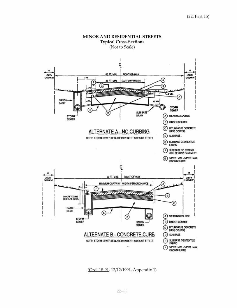
(22, Part 15)
MINOR AND RESIDENTIAL STREETSTypical Cross-Sections
(Not to Scale)
(Ord. 18-91, 12/12/1991, Appendix 1)

SUBDIVISION AND LAND DEVELOPMENT
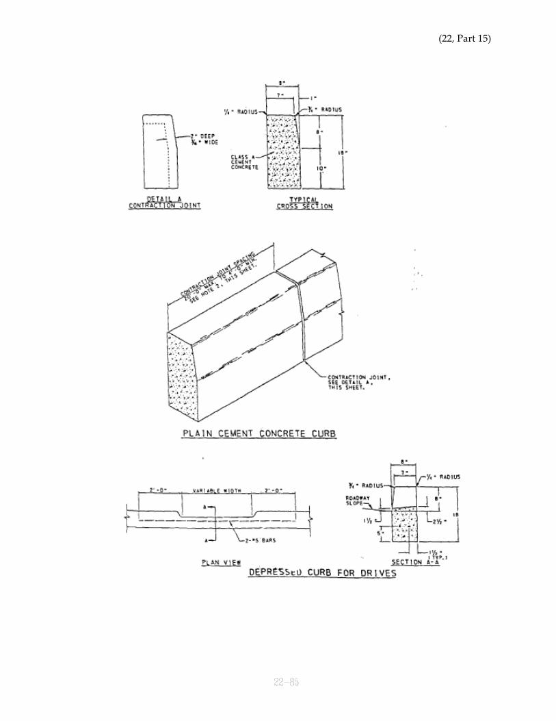
(22, Part 15)
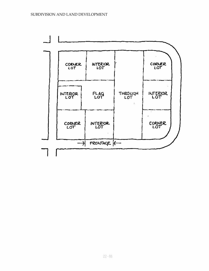
SUBDIVISION AND LAND DEVELOPMENT
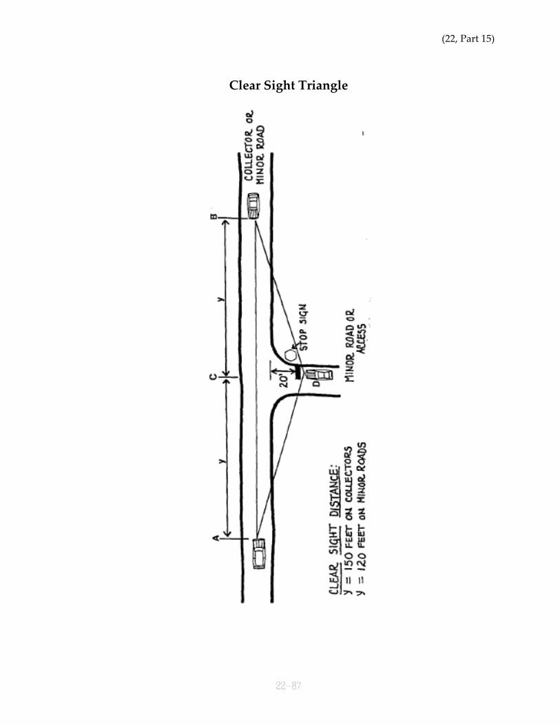
(22, Part 15)
Clear Sight Triangle
SUBDIVISION AND LAND DEVELOPMENT
Sight Distance
(22, Part 15)
City of Hermitage
Requirements for As-Built Drawings
SANITARY SEWER SYSTEMS
April 4, 1991
GENERAL
As-built drawings are to be submitted in the form of permanent black line mylar (notprocess mylar) for the City's permanent records. The preferred size is 24" x 36", and therecommended scale is 1" = 50 ft. (Prints may be submitted for City review.)
As-built drawings must include a certification and seal of a professional engineer orsurveyor registered in the State of Pennsylvania.
PLAN
1. The dimensions of the road right-of-way and/or easements within which the sewerlines are located.
2. The location of property lines intersecting the road right-of-way or sewer easement,and location of property corner pins. The lot numbers of all lots and/or the streetaddress (if available of each lot).
3. Stations of all manholes and wyes.
4. Location of all utilities, including storm sewers, water lines and fire hydrants, gaslines, underground electric, cable and telephone lines, power poles and utility boxeswhich are in the vicinity of the sewer system. (Note: As-builts for sanitary sewers andstreet/storm drainage systems may be combined on one set of drawings ifappropriate)
5. Location of each inspection stack as measured from two fixed points (i.e. manholes).Length of pipe at wye and depth at end of lateral.
6. Location of all storm drainage facilities, including catch basin size and type, pipe typeand diameter, centerline of drainage swales, headwalls and endwalls.
7. Curb location (if applicable).
PROFILE
1. All manholes located with top and invert elevations and stationing.
2. Pipe type, size, joint type and name of manufacture.

SUBDIVISION AND LAND DEVELOPMENT
3. Slope of each section of line.
4. Indicates where rock was encountered during construction.
(22, Part 15)
City of Hermitage
Requirements for As-Built Drawings
STREET AND STORM DRAINAGE SYSTEMS
April 4, 1991
GENERAL
As-built drawings are to be submitted in the form of permanent black line mylar (notprocess mylar) for the City’s permanent records. The preferred sheet size is 24" x 36", andthe recommended scale is 1" = 50 ft. (Prints may be submitted first for City review.)
As-built drawings must include a certification and seal of a professional engineer orsurveyor in the State of Pennsylvania.
PLAN
1. The complete metes and bounds description of the road right-of-way of the portion ofroadway being accepted. Also to be included are the location and dimensions of anyeasements for temporary turn around, drainage or utilities, etc.
2. The location of property lines intersecting the road right-of-way, and location ofproperty corner pins. The lot numbers of all lots and/or street address (if available) ofeach lot.
3. Road stations, and stations of catch basins, manholes, etc.
4. Location of all utilities, including sanitary sewers, water lines and fire hydrants, gaslines, underground electric, cable, and telephone lines, power poles and utility boxes.(Note: As-built for sanitary sewers and street/storm drainage systems may becombined on one set of drawings if appropriate.)
5. Road cernterline bearings and dimensions and horizontal curve data.
6. Location of all storm drainage facilities, including catch basins size and type, pipetype and diameter, centerline of drainage swales, headwalls and endwalls.
7. Curb location (if applicable).
PROFILE
1. All catch basins and maholes located with top and invert elevations.
2. Road centerline elevations and grade...also vertical curve data.
SUBDIVISION AND LAND DEVELOPMENT
3. Storm sewers profile(s) and grade(s).
ROADWAY CROSS-SECTION
1. As-built cross-section showing typical base and pavement thickness and composition,i.e., exact material used in construction... curbing dimensions and specifications (ifapplicable.)

(22, Part 15)

SUBDIVISION AND LAND DEVELOPMENT
STATE ROADS AND ROUTE NUMBERS(for State Roads that traverse the City of Hermitage)
STREET NAME L.R.# S.R.#
Broadway Avenue 43111 3004 [Ord. 11-98]
Buhl Farm Drive (N & S) 43008 3025
Clark Street 43141 3012
Council Avenue 238 0418 N. of Posner Blvd.0718 S. of Posner Blvd.
Dutch Lane 43091 3035
Forker Boulevard 43101 3021
Freeway (Rt. 62 By-pass) 74 parallel 0062
Hermitage Road (N & S) 320 0018
Highland Road 43122 3014
Keel Ridge Road (N & S) 43005 3011
Lamor Road(west of Rt. 18) 238 0518(east of Rt. 18) 43099 3020
Longview Road 238 0518
Maple Drive 238 Spur A 0418 from Freeway to 3M intersection3035 from East State St. to Freeway
Mercer Avenue 238 Spur A 0418
Neshannock Road (N & S) 43009 3037
Ohio Street 43092 3015
Orangeville Road 43031 03019
River Road 43034 0846
State Line Road (S) 43109 3015
State Street (East) 74 0062 from intersect with Freeway toJefferson Twp. line3008 from Sharon City line to intersectwith Freeway
Water Avenue (North) 43032 0718
(Ord. 18-91, 12/12/1991, Appendix 9; as amended by Ord. 11-98, 9/23/1998)
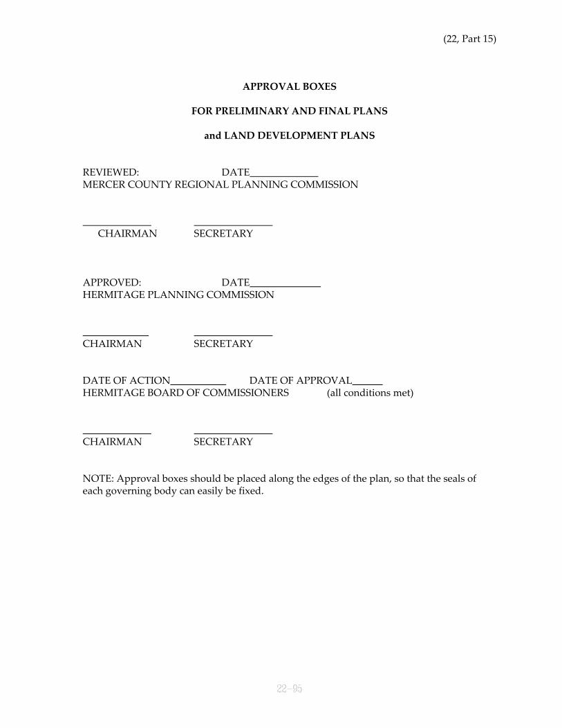
(22, Part 15)
APPROVAL BOXES
FOR PRELIMINARY AND FINAL PLANS
and LAND DEVELOPMENT PLANS
REVIEWED: DATEMERCER COUNTY REGIONAL PLANNING COMMISSION
CHAIRMAN SECRETARY
APPROVED: DATEHERMITAGE PLANNING COMMISSION
CHAIRMAN SECRETARY
DATE OF ACTION DATE OF APPROVALHERMITAGE BOARD OF COMMISSIONERS (all conditions met)
CHAIRMAN SECRETARY
NOTE: Approval boxes should be placed along the edges of the plan, so that the seals ofeach governing body can easily be fixed.