S-26-18 Barcroft Place Subdivision Administrative Action ...
Upload
khangminh22Category
view
0download
0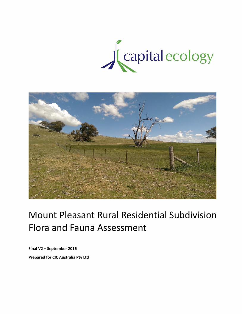
Mount Pleasant Rural Residential Subdivision Flora and Fauna Assessment
Final V2 – September 2016
Prepared for CIC Australia Pty Ltd

Capital Ecology Pty Ltd PO Box 854 ACN: 607 364 358 Phone: 0412 474 415 Gungahlin ACT 2912 ABN: 50 607 364 358 Email: [email protected] www.capitalecology.com.au
ii
Document Information
Report for: CIC Australia Pty Ltd
Prepared by: Robert Speirs
Capital Ecology project no.: 2681
Citation: Capital Ecology (2016). Mount Pleasant Rural Residential Subdivision – Flora and Fauna
Assessment. Final V2 – September 2016. Prepared for CIC Australia Pty Ltd. Author: R. Speirs. Project no.
2681.
Version Control
Version Internal reviewer External reviewer Date of issue
Draft version 01 Dr Monica Campbell Hoa Luu (CIC Australia) & 21/01/2016
Jenny Rudolf (Elton Consulting)
Draft version 02 Dr Monica Campbell Hoa Luu (CIC Australia) & 31/01/2016
Jenny Rudolf (Elton Consulting)
Final version 01 - - 08/02/2016
Final version 02 - Matthew Frawley (CIC Australia) 12/09/2016
Acknowledgements
Capital Ecology gratefully acknowledges the contributions and/or assistance of the following people and
organisations in undertaking this study.
Hoa Luu and Matthew Frawley, CIC Australia Pty Ltd.
Jenny Rudolf, Director, Elton Consulting Pty Ltd.
Arden Jones, Landscape Architect, SpaceLab Pty Ltd.
Dr Monica Campbell, Senior Ecologist.
Alex Christie and Sally Hatton, Research Assistants.
Lynn and Michael Dunn and James Wells, owners of Mount Pleasant.
Disclaimer
Capital Ecology Pty Ltd has undertaken the supporting studies and developed this document, including any assessment/s provided herein, in
accordance with the relevant Commonwealth, State/Territory and local legislation and current industry best practice. This document does not provide legal or investment advice. Capital Ecology Pty Ltd accepts no liability for any damages or loss of any type incurred as a result of reliance placed upon the content of this document for any purpose other than that for which it was expressly intended.
© Capital Ecology Pty Ltd
This document is and shall remain the property of Capital Ecology Pty Ltd. This document may be used solely for the purposes for which it was commissioned and only by those parties for whom it is intended. Use of this document in any form other than that authorised is prohibited.
© Capital Ecology Pty Ltd 2016 iii
Table of Contents
1 Executive Summary ............................................................................................. 1
2 Introduction ........................................................................................................ 7
2.1 Objective of this Flora and Fauna Assessment ..................................................................... 7
2.2 Key Requirements ................................................................................................................. 7
2.2.2 Standard scope of a F&FA ................................................................................................. 7
2.2.3 OEH requirements ............................................................................................................. 8
3 Background ......................................................................................................... 9
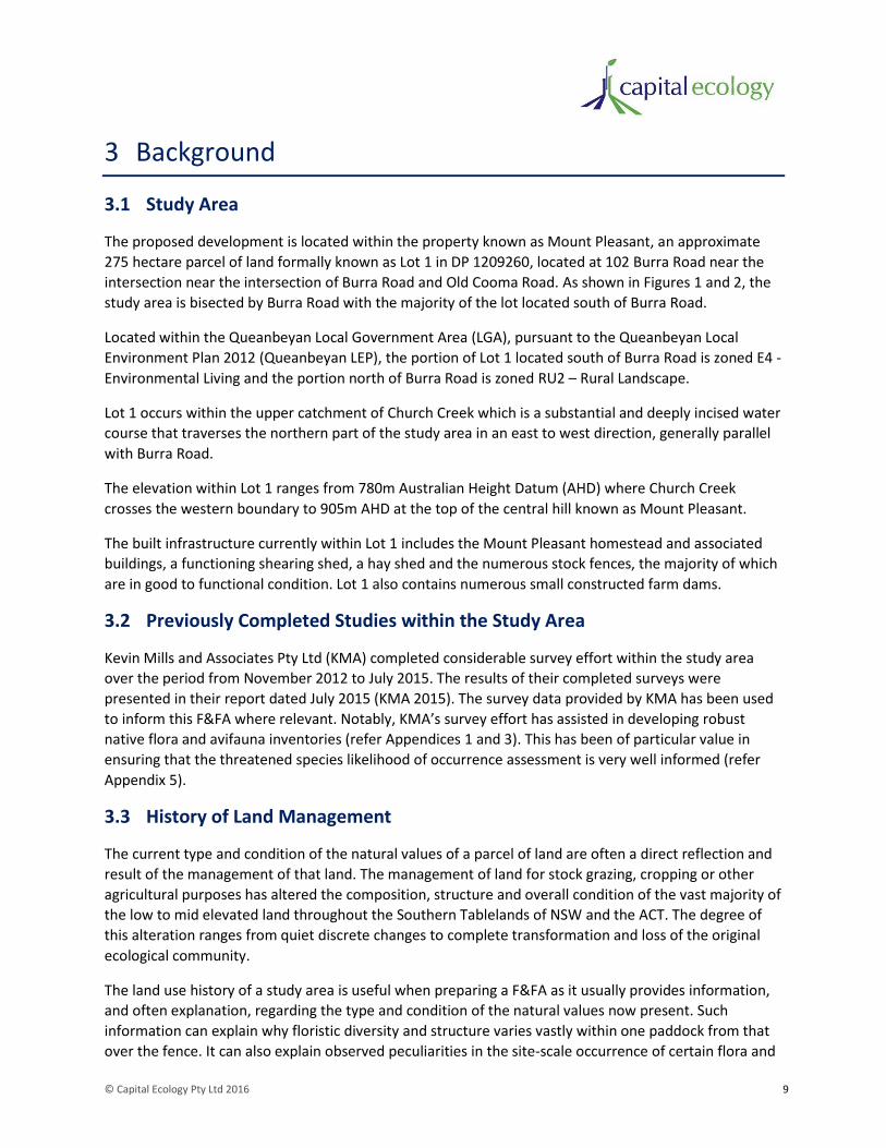
3.1 Study Area ............................................................................................................................. 9
3.2 Previously Completed Studies within the Study Area .......................................................... 9
3.3 History of Land Management ............................................................................................... 9
3.4 Proposed Development ...................................................................................................... 11
4 Methods ............................................................................................................ 15
4.1 Taxonomy ............................................................................................................................ 15
4.2 Database and Literature Review ......................................................................................... 15
4.3 Definitions of Conservation Significance ............................................................................ 15
4.4 Likelihood of Occurrence Assessment ................................................................................ 15
4.5 Field Surveys ....................................................................................................................... 16
4.5.2 Preliminary Field Inspection ............................................................................................ 16
4.5.3 Vegetation Survey and Mapping ..................................................................................... 16
4.5.4 Targeted Threatened Fauna Surveys .............................................................................. 19
4.5.5 Grassland Fauna Habitat Assessment Transects ............................................................. 20
4.5.6 Opportunistic Flora and Fauna Observations ................................................................. 20
4.5.7 Authority to Undertake Surveys ..................................................................................... 20
4.6 Study Limitations................................................................................................................. 24
4.6.2 Survey Limitations ........................................................................................................... 24
4.6.3 Spatial Data Limitations .................................................................................................. 24
5 Results............................................................................................................... 25
5.1 Vegetation Survey and Mapping ......................................................................................... 25
5.1.2 Plant Community Type (PCT) mapping ........................................................................... 25
5.1.3 Vegetation Zone Definition and Mapping ....................................................................... 26

© Capital Ecology Pty Ltd 2016 iv
5.1.4 Plots and Transects ......................................................................................................... 30
5.2 Threatened Ecological Community Assessment ................................................................. 31
5.2.2 Commonwealth EPBC Act ............................................................................................... 31
5.2.3 NSW TSC Act .................................................................................................................... 33
5.3 Fauna Habitat ...................................................................................................................... 35
5.3.2 Grassland Fauna Habitat Assessment Transects ............................................................. 36
5.4 Flora and Fauna Species Recorded Within the Study Area ................................................. 37
5.4.2 Recorded Flora ................................................................................................................ 37
5.4.3 Recorded Fauna .............................................................................................................. 37
5.4.4 Listed Threatened Flora .................................................................................................. 37
5.4.5 Listed Threatened Fauna................................................................................................. 38
5.5 Likelihood of Occurrence Assessment ................................................................................ 44
5.6 Noxious Weeds ................................................................................................................... 49
5.7 Pest Animals ........................................................................................................................ 51
6 Proposed Measures to Avoid, Minimise and Mitigate Impacts on Biodiversity ... 53
6.1 Proposed Measures to Avoid, Minimise and Mitigate Impacts .......................................... 53
6.1.2 Development Design/Layout .......................................................................................... 53
6.1.3 Biodiversity Protection Controls and Enhancement Measures ...................................... 55
6.2 Net Biodiversity Impact Position with Implementation of Measures................................. 56
6.3 Development vs Non-development – Future Net Biodiversity Values Position under each Scenario .................................................................................................................................... 57
7 Assessment against Biodiversity Conservation Legislation and Policy ................. 59
7.1 Commonwealth ................................................................................................................... 59
7.1.2 Environment Protection and Biodiversity Conservation Act 1999 ................................. 59
7.2 New South Wales (State) .................................................................................................... 60
7.2.2 Environmental Planning and Assessment Act 1979 ........................................................ 60
7.2.3 Threatened Species Conservation Act 1995 ................................................................... 63
7.2.4 Native Vegetation Act 2003 ............................................................................................ 63
7.2.5 Noxious Weeds Act 1993 ................................................................................................ 64
7.2.6 Fisheries Management Act 1994 .................................................................................... 64
7.3 Summary of Assessment Results and Requirements .......................................................... 64
8 Conclusion ......................................................................................................... 67
References ................................................................................................................. 68

© Capital Ecology Pty Ltd 2016 v
Appendices ................................................................................................................ 70
Appendix 1. Recorded Flora Species and Vegetation Survey Data................................................... 71
Appendix 2. Grassland Fauna Habitat Transect Data ....................................................................... 77
Appendix 3. Vertebrate Fauna Species Recorded ............................................................................ 78
Appendix 4. Golden Sun Moth surveys – weather conditions and results ....................................... 81
Appendix 5. Likelihood of Occurrence Assessment .......................................................................... 83
Appendix 6. TSC Act Assessments of Significance ............................................................................ 99
Appendix 7. Mount Pleasant Rural Residential Subdivision – Vegetation Management Plan ....... 120
Appendix 8. Mount Pleasant Rural Residential Subdivision – BioBanking Metric Assessment ..... 121
List of Figures
Figure 1. Locality Plan ................................................................................................................................. 13
Figure 2. Study area and Proposed Development ...................................................................................... 14
Figure 3. Vegetation Surveys ...................................................................................................................... 18
Figure 4. Pink-tailed Worm-Lizard Surveys ................................................................................................. 22
Figure 5. Golden Sun Moth Surveys ............................................................................................................ 23
Figure 6. Biodiversity Values ....................................................................................................................... 43
Figure 7. Proposed Development ............................................................................................................... 58
List of Tables
Table 1. Vegetation Zones .......................................................................................................................... 26
Table 2. Assessment against the listing criteria for the EPBC listed TEC – White Box-Yellow Box-Blakely's
Red Gum Grassy Woodland and Derived Native Grassland. ...................................................................... 32
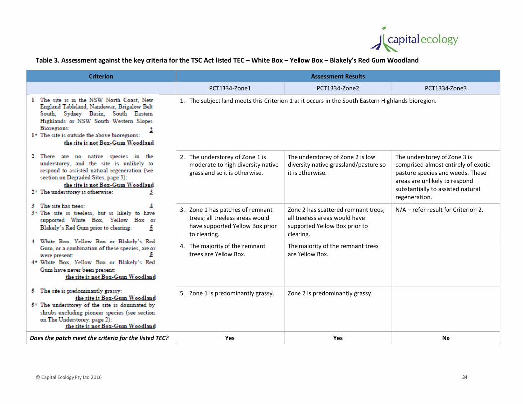
Table 3. Assessment against the key criteria for the TSC Act listed TEC – White Box – Yellow Box –
Blakely's Red Gum Woodland ..................................................................................................................... 34
Table 4. Fauna habitat features .................................................................................................................. 35
Table 5. Potential for adverse impacts to species with moderate or higher likelihood of occurrence ...... 45
Table 6. Noxious weed occurrence ............................................................................................................. 49
Table 7. Assessment of the potential for significant impacts upon MNES ................................................. 60
Table 8. Summary of assessment results and corresponding requirements .............................................. 65
Table 9. Vegetation survey data – species recorded during transect/plot surveys ................................... 71

© Capital Ecology Pty Ltd 2016 vi
Table 10. Vegetation survey data – additional species recorded ............................................................... 75
Table 11. Summary of results from Grassland Habitat Transects............................................................... 77
Table 12. Fauna species recorded ............................................................................................................... 78
Table 13. Golden Sun Moth surveys – weather conditions and results ..................................................... 81
Table 14. Threatened Species Likelihood of Occurrence Assessment ........................................................ 83
Table 15. Activities to assist the recovery of TSC Act Box-Gum Woodland .............................................. 102
Table 16. Key threatening processes relevant to the proposed development ........................................ 104
Table 17. Consistency of the proposed development with ‘Action Toolbox’ items for the Scarlet Robin
and Flame Robin ....................................................................................................................................... 109
Table 18. Consistency of the proposed development with ‘Action Toolbox’ items for the Diamond Firetail
.................................................................................................................................................................. 117

© Capital Ecology Pty Ltd 2016 1
1 Executive Summary
CIC Australia Pty Ltd (CIC) is currently progressing with the planning and approval process for the
development of a 41 lot rural residential subdivision at Burra, NSW (the ‘proposed development’).
Capital Ecology Pty Ltd (Capital Ecology) has been commissioned by CIC to undertake ecological surveys
and prepare this Flora and Fauna Assessment Report (F&FA) to identify and assess the significance of
the impacts that the proposed development may have upon biodiversity values of the subject land (the
‘study area’).
Objective and Scope
Although general biodiversity values are identified and considered, the primary objective of this F&FA is
to specifically identify and assess the potential impacts of the proposed development upon biodiversity
values of formally recognised conservation significance. To achieve this objective, Capital Ecology has
completed a thorough investigation into the currently listed significant biodiversity values (i.e.
threatened species, populations and ecological communities) that occur or have the potential to occur
within the study area. The results of this investigation have then informed a thorough assessment of the
likely type and degree of any impacts that the proposed development may have upon the identified
biodiversity values, as required in accordance with the:
• Commonwealth Environment Protection and Biodiversity Conservation Act 1999 (EPBC Act);
• NSW Environment Planning and Assessment Act 1979 (EP&A Act);
• NSW Threatened Species Conservation Act 1995 (TSC Act); and
• NSW Fisheries Management Act (FM Act).
The scope of this F&FA was developed to include all of the elements and matters for consideration in a
standard F&FA in NSW. In addition to covering this standard scope, this F&FA also unambiguously
addresses the survey, mapping and assessment inclusions requested by the NSW Office of Environment
and Heritage (OEH), specifically:
• mapping of the vegetation communities present within the study area with reference to the
NSW Vegetation Information System classifications;
• targeted surveys for the Pink-tailed Worm-lizard Aprasia parapulchella (listed as vulnerable
pursuant to both the EPBC Act and TSC Act) and Golden Sun Moth Synemon plana (listed as
critically endangered pursuant to the EPBC Act and endangered pursuant to the TSC Act);
• consideration of the likelihood of occurrence and potential for impacts to any of the numerous
other threatened flora and fauna species with the potential to occur in the locality; and
• assessment for each threatened species, population or ecological community identified as
potentially occurring within the study area to determine whether it is likely to be significantly
affected by the proposed development.

© Capital Ecology Pty Ltd 2016 2
Methods and Results
Surveyed and mapped using a method based on the NSW BioCertification Assessment Methodology,
with a further level of categorisation added to suitably recognise the substantial variation in
groundstorey floristic diversity, the study area was assessed as supporting the following three Plant
Community Types (PCTs).
• PCT999 – Norton's Box - Broad-leaved Peppermint open forest on foot slopes, central and
southern South Eastern Highlands Bioregion.
• PCT1289 – Wallaby Grass - Red-grass - Tall Speargrass - Kangaroo Grass dry tussock grassland of
the North-western and Eastern Southern Tablelands in the South Eastern Highlands Bioregion.
• PCT1334 – Yellow Box grassy woodland in lower valleys on lower slopes and valley bottoms.
Based on the structure, floristic composition and overall condition (‘intactness’) of the groundstorey,
each of these PCTs was catergorised into three discernable Vegetation Zones. The distribution of each
Vegetation Zone of each PCT was ground-truthed, accurately mapped using a Geographic Information
System, and quantified (i.e. total hectares).
Zone 1 of PCT1334 was determined to be clearly consistent with the definition of the Box-Gum
Woodland threatened ecological community (TEC) as listed pursuant to the EPBC Act and TSC Act. Zone
2 of PTC1334 is consistent with the TSC Act listed TEC, albeit it a very marginal form.
An extensive targeted survey for the Pink-tailed Worm-lizard was undertaken during optimal survey
conditions, covering all potential habitat within the study area and employing a level of survey effort
sufficient to achieve an indication of the species’ presence/absence to the 95% confidence interval. This
survey recorded seven individual Pink-tailed Worm-lizards, all of which were found in a patch of high
quality habitat located in the eastern extent of the study area.
A program of four targeted Golden Sun Moth surveys was undertaken in accordance with the
Commonwealth Government survey guidelines, with no Golden Sun Moth individuals or other evidence
of Golden Sun Moth occurrence recorded. Whilst the study area does occur within the broad
distribution of the Golden Sun Moth and it does support an extensive area of characteristically suitable
habitat, the absence of Golden Sun Moths recorded across the targeted surveys provides strong
evidence for the absence of the species within the study area.
A total of 156 native flora species were recorded within the study area, however none of the eleven
listed threatened flora species identified as potentially occurring within the study area were recorded.
Given the considerable survey effort employed by experienced ecologists, covering the entire study area
and occurring across each season, it is considered unlikely that any threatened flora species occurs
within the study area.
A total of 81 native vertebrate fauna species were recorded within the study area, and four of the 35
listed threatened or terrestrial migratory fauna species identified as potentially occurring within the
study area were recorded during the surveys, namely, the Pink-tailed Worm-lizard and the TSC Act
vulnerable listed woodland birds Scarlet Robin Petroica boodang, Flame Robin P. phoenica and Diamond
Firetail Stagonopleura guttata.

© Capital Ecology Pty Ltd 2016 3
A total of 50 exotic plant species were recorded within the study area, of which Serrated Tussock
Nassella trichotoma and African Love Grass Eragrostis curvula currently pose a very high to critical
threat level to the biodiversity values of the study area and adjoining land.
A total of eleven exotic fauna species were recorded within the study area, of which European Rabbit
Oryctolagus cuniculus, Feral Pig Sus scrofa and Red Fox Vulpes vulpes are listed as declared pest species.
The study area currently contains a very large European Rabbit infestation with numerous large warrens
present, particularly around the periphery of Mount Pleasant.
Proposed Measures to Avoid, Minimise and Mitigate Impacts
A number of measures have been incorporated into the design and layout of the proposed development
with the objective of avoiding, minimising and mitigating impacts upon the biodiversity values of the
study area. The key measures are the:
• proposed establishment of a 107 hectare ‘Biodiversity Conservation Area’ (39% of the study
area) which will include all of the moderate to high quality Box-Gum Woodland TEC, the patch of
Pink-tailed Worm-lizard habitat, all of the high quality woodland bird habitat and all of the steep
sloping land; and
• design and layout of lots and infrastructure which allows for the retention of all remnant trees,
restricts the minimum lot size to two hectares, restricts maximum building envelope size to
2,000m2 (0.2 hectare) and stipulates the location of these building envelopes to minimise
impacts.
In addition to the above, the implementation of a number of biodiversity protection controls and
enhancement measures is proposed as part of the proposed development. As detailed in the Vegetation
Management Plan (VMP) prepared for the proposed development, as applicable to the defined
‘Vegetation Management Areas’, the key measures proposed to be implemented are the:
• requirement to preserve all remnant eucalypts;
• restrictions on the clearing or removal of native vegetation;
• requirement to maintain the native grass groundstorey;
• prohibition or restriction on the keeping of hooved animals;
• prohibition on the planting of noxious weeds and potential pest plant species;
• restrictions on plant species used for revegetation, landscaping and other planting;
• requirements to undertake initial and ongoing priority weed and vertebrate pest monitoring and
control; and
• commitment to undertake initial revegetation works (tree and shrub planting).
© Capital Ecology Pty Ltd 2016 4
A Community Management Statement (CMS) has been developed and, once endorsed and
implemented, will provide in perpetuity legal certainty for the measures detailed in the VMP. CMS ‘Part
5 – By-Laws Required by Authorities’ will ensure that the authorities have the power to enforce the
implementation of the VMP in perpetuity.
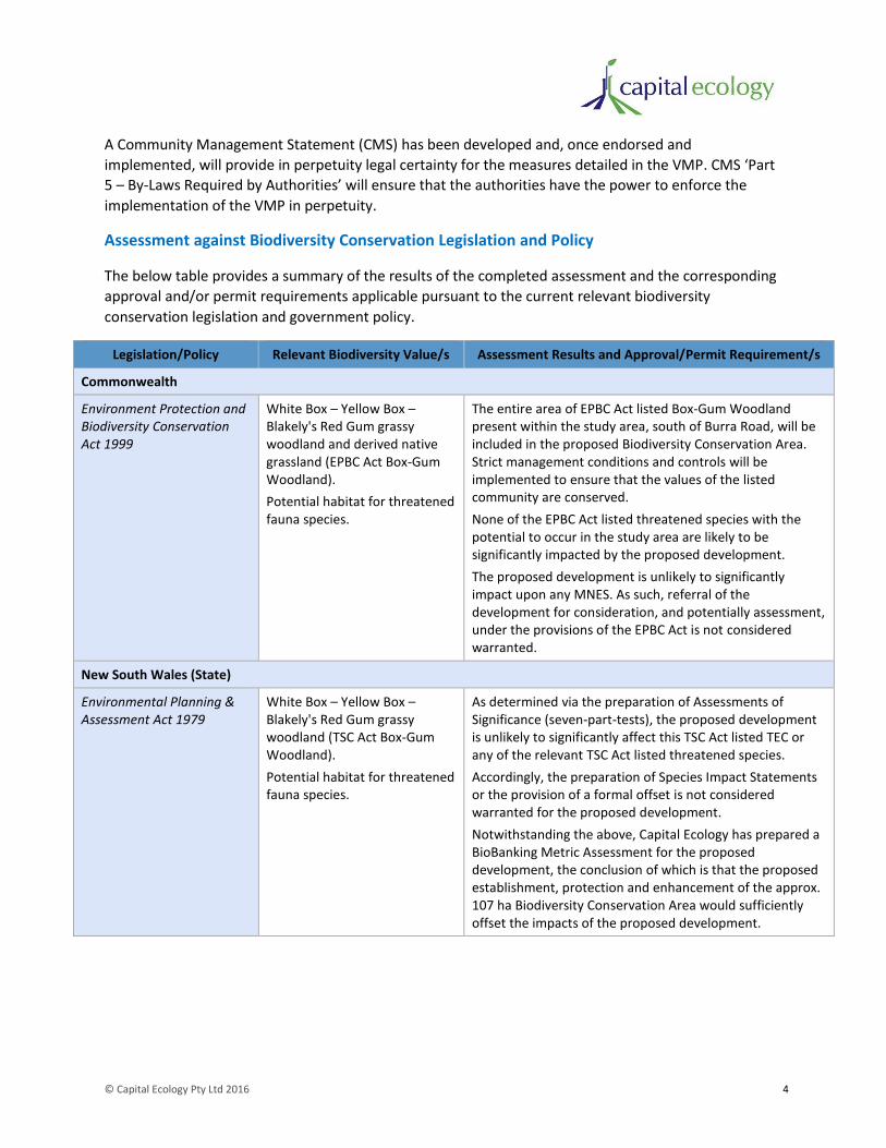
Assessment against Biodiversity Conservation Legislation and Policy
The below table provides a summary of the results of the completed assessment and the corresponding
approval and/or permit requirements applicable pursuant to the current relevant biodiversity
conservation legislation and government policy.
Legislation/Policy Relevant Biodiversity Value/s Assessment Results and Approval/Permit Requirement/s
Commonwealth
Environment Protection and Biodiversity Conservation Act 1999
White Box – Yellow Box – Blakely's Red Gum grassy woodland and derived native grassland (EPBC Act Box-Gum Woodland).
Potential habitat for threatened fauna species.
The entire area of EPBC Act listed Box-Gum Woodland present within the study area, south of Burra Road, will be included in the proposed Biodiversity Conservation Area. Strict management conditions and controls will be implemented to ensure that the values of the listed community are conserved.
None of the EPBC Act listed threatened species with the potential to occur in the study area are likely to be significantly impacted by the proposed development.
The proposed development is unlikely to significantly impact upon any MNES. As such, referral of the development for consideration, and potentially assessment, under the provisions of the EPBC Act is not considered warranted.
New South Wales (State)
Environmental Planning & Assessment Act 1979
White Box – Yellow Box – Blakely's Red Gum grassy woodland (TSC Act Box-Gum Woodland).
Potential habitat for threatened fauna species.
As determined via the preparation of Assessments of Significance (seven-part-tests), the proposed development is unlikely to significantly affect this TSC Act listed TEC or any of the relevant TSC Act listed threatened species.
Accordingly, the preparation of Species Impact Statements or the provision of a formal offset is not considered warranted for the proposed development.
Notwithstanding the above, Capital Ecology has prepared a BioBanking Metric Assessment for the proposed development, the conclusion of which is that the proposed establishment, protection and enhancement of the approx. 107 ha Biodiversity Conservation Area would sufficiently offset the impacts of the proposed development.

© Capital Ecology Pty Ltd 2016 5
Legislation/Policy Relevant Biodiversity Value/s Assessment Results and Approval/Permit Requirement/s
Queanbeyan Local Environment Plan 2012
Land mapped as ‘Biodiversity’ on the Terrestrial Biodiversity Map.
The proposed establishment and enhancement of the Biodiversity Conservation Area, together with the sensitive design and location of a lots, building envelopes and infrastructure, will avoid, minimise and mitigate impacts such that the proposed development is unlikely to result in any significant adverse impact upon the biodiversity values of the study area.
As such, the proposed development is consistent with the objective of Clause 7.3 of the Queanbeyan LEP.
Threatened Species Conservation Act 1995
White Box – Yellow Box – Blakely's Red Gum grassy woodland (TSC Act Box-Gum Woodland).
Potential habitat for threatened fauna species.
The study area does not contain declared critical habitat for any species, population or ecological community.
The proposed development will retain all trees and most of the groundcover throughout the development footprint. Therefore, it will not result in substantial damage to habitat of a threatened species, population or ecological community. As such, a licence under Section 91 of the TSC Act is unlikely to be required.
Fisheries Management Act 1994
None The study area does not support any community, species, or potential habitat for any species, listed pursuant to the FM Act.
Native Vegetation Act 2003 Native vegetation The proposed development is the subject of a Development Application to be assessed by Queanbeyan-Palerang Regional Council under the provisions of the EP&A Act. On approval of the proposed development the clearing for ‘dwellings’ will be subject to an exclusion under Section 25 of the NV Act. However, the proposed clearance of native vegetation for the road network is not subject to an exemption, and therefore, this clearance requires consent under the NV Act.
CIC Australia has commenced the NV Act assessment process with South-East Local Land Services (LLS), the outcomes of which will be known following LLS’ onsite vegetation survey scheduled for October 2016.
Noxious Weeds Act 1993 Noxious weeds The occupier is required under the NW Act to implement all reasonable measures in accordance with the requirements of Weed Control Order No. 30. This is of particular relevance for the control of the Serrated Tussock and African Love Grass within the study area as these species currently pose a very high to critical threat level to the biodiversity values of the study area and adjoining land.
© Capital Ecology Pty Ltd 2016 6
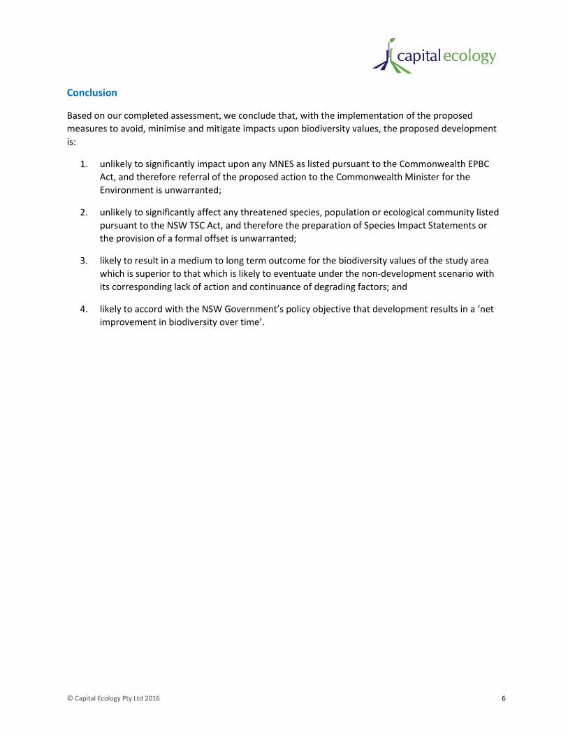
Conclusion
Based on our completed assessment, we conclude that, with the implementation of the proposed
measures to avoid, minimise and mitigate impacts upon biodiversity values, the proposed development
is:
1. unlikely to significantly impact upon any MNES as listed pursuant to the Commonwealth EPBC
Act, and therefore referral of the proposed action to the Commonwealth Minister for the
Environment is unwarranted;
2. unlikely to significantly affect any threatened species, population or ecological community listed
pursuant to the NSW TSC Act, and therefore the preparation of Species Impact Statements or
the provision of a formal offset is unwarranted;
3. likely to result in a medium to long term outcome for the biodiversity values of the study area
which is superior to that which is likely to eventuate under the non-development scenario with
its corresponding lack of action and continuance of degrading factors; and
4. likely to accord with the NSW Government’s policy objective that development results in a ‘net
improvement in biodiversity over time’.
© Capital Ecology Pty Ltd 2016 7
2 Introduction
CIC Australia Pty Ltd (CIC) is currently progressing with the planning and approval process for the
development of a 41 lot rural residential subdivision at Burra, NSW (the ‘proposed development’).
Capital Ecology Pty Ltd (Capital Ecology) has been commissioned by CIC to undertake ecological surveys
and prepare this Flora and Fauna Assessment Report (F&FA) to identify and assess the significance of
the impacts that the proposed development may have upon biodiversity values of the subject land (the
‘study area’).
Although general biodiversity values are identified and considered, the primary focus of this F&FA is to
specifically identify and assess the potential impacts of the proposed development upon biodiversity
values of formally recognised conservation significance.
In addition to covering the standard scope of a F&FA in NSW, this F&FA has been developed to
unambiguously address the requirements specified by the NSW Office of Environment and Heritage
(OEH).
2.1 Objective of this Flora and Fauna Assessment
The objective of this F&FA is to provide a thorough investigation into the currently listed significant
biodiversity values (i.e. threatened flora and fauna species and threatened ecological communities) that
occur or have the potential to occur within the study area. The results of this investigation will then to
be used to inform a thorough assessment of the likely type and degree of any impacts that the proposed
development may have upon the identified biodiversity values, as required in accordance with the:
• Commonwealth Environment Protection and Biodiversity Conservation Act 1999 (EPBC Act);
• NSW Environment Planning and Assessment Act 1979 (EP&A Act);
• NSW Threatened Species Conservation Act 1995 (TSC Act); and
• NSW Fisheries Management Act (FM Act).
2.2 Key Requirements
2.2.2 Standard scope of a F&FA
The scope of this F&FA has been developed to include all of the elements and matters for consideration
in a standard F&FA in NSW. This includes the following.
1. A thorough desktop database and literature review to identify all of the currently EPBC Act, TSC
Act or FM Act listed significant biota (i.e. threatened species, population and ecological
communities) known to occur, or considered to have the potential to occur, within the study
area.

© Capital Ecology Pty Ltd 2016 8
2. Use of the results of the desktop review to inform and develop:
• detailed survey and GIS prepared mapping of the vegetation present within the study
area, employing survey methods and classification currently recognised by the NSW
Government;
• detailed survey and mapping the habitat features present that are of specific relevance
to one or more of the threatened species identified during the desktop review; and
• targeted surveys for threatened species identified during the desktop review, employing
appropriate survey methods and effort in accordance with current published survey
guidelines (where available).
3. The preparation of a likelihood of occurrence assessment which addresses all threatened
ecological communities, threatened flora species and threatened and/or terrestrial migratory
fauna species with the potential to occur within the study area.
4. An assessment of the potential for impacts, and the likely significance of these impacts, upon the
listed significant biota identified as occurring or potentially within the study area.
5. Advice and recommendation regarding the impact avoidance, minimisation, mitigation and if
required, offset, measures that will be required to facilitate accordance with the NSW
Government’s policy objective that development results in a ‘net improvement in biodiversity
over time’.
2.2.3 OEH requirements
In addition to the above, it is noted that the scope of this F&FA has been developed to specifically
address the survey, mapping and assessment inclusions requested by OEH in their advice to
Queanbeyan City Council dated the 29th of April 2015 and subsequent email communications. These
inclusions are summarised as follows.
• Mapping of the vegetation communities present within the study area with reference to the
NSW Vegetation Information System (VIS) (OEH 2016) classifications.
• Targeted surveys for the Pink-tailed Worm-lizard Aprasia parapulchella, listed as vulnerable
pursuant to both the EPBC Act and the TSC Act.
• Targeted surveys for the Golden Sun Moth Synemon plana, listed as critically endangered
pursuant to the EPBC Act and endangered pursuant to the TSC Act.
• Consideration of the likelihood of occurrence and potential for impacts to any of the numerous
other threatened flora and fauna species with the potential to occur in the locality.
• Assessment for each threatened species, population or ecological community identified as
potentially occurring within the study area to determine whether it is likely to be significantly
affected by the proposed development.
© Capital Ecology Pty Ltd 2016 9
3 Background
3.1 Study Area
The proposed development is located within the property known as Mount Pleasant, an approximate
275 hectare parcel of land formally known as Lot 1 in DP 1209260, located at 102 Burra Road near the
intersection near the intersection of Burra Road and Old Cooma Road. As shown in Figures 1 and 2, the
study area is bisected by Burra Road with the majority of the lot located south of Burra Road.
Located within the Queanbeyan Local Government Area (LGA), pursuant to the Queanbeyan Local
Environment Plan 2012 (Queanbeyan LEP), the portion of Lot 1 located south of Burra Road is zoned E4 -
Environmental Living and the portion north of Burra Road is zoned RU2 – Rural Landscape.
Lot 1 occurs within the upper catchment of Church Creek which is a substantial and deeply incised water
course that traverses the northern part of the study area in an east to west direction, generally parallel
with Burra Road.
The elevation within Lot 1 ranges from 780m Australian Height Datum (AHD) where Church Creek
crosses the western boundary to 905m AHD at the top of the central hill known as Mount Pleasant.
The built infrastructure currently within Lot 1 includes the Mount Pleasant homestead and associated
buildings, a functioning shearing shed, a hay shed and the numerous stock fences, the majority of which
are in good to functional condition. Lot 1 also contains numerous small constructed farm dams.
3.2 Previously Completed Studies within the Study Area
Kevin Mills and Associates Pty Ltd (KMA) completed considerable survey effort within the study area
over the period from November 2012 to July 2015. The results of their completed surveys were
presented in their report dated July 2015 (KMA 2015). The survey data provided by KMA has been used
to inform this F&FA where relevant. Notably, KMA’s survey effort has assisted in developing robust
native flora and avifauna inventories (refer Appendices 1 and 3). This has been of particular value in
ensuring that the threatened species likelihood of occurrence assessment is very well informed (refer
Appendix 5).
3.3 History of Land Management
The current type and condition of the natural values of a parcel of land are often a direct reflection and
result of the management of that land. The management of land for stock grazing, cropping or other
agricultural purposes has altered the composition, structure and overall condition of the vast majority of
the low to mid elevated land throughout the Southern Tablelands of NSW and the ACT. The degree of
this alteration ranges from quiet discrete changes to complete transformation and loss of the original
ecological community.
The land use history of a study area is useful when preparing a F&FA as it usually provides information,
and often explanation, regarding the type and condition of the natural values now present. Such
information can explain why floristic diversity and structure varies vastly within one paddock from that
over the fence. It can also explain observed peculiarities in the site-scale occurrence of certain flora and

© Capital Ecology Pty Ltd 2016 10
fauna species. In this regard, the following land use information, provided as an extract from KMA 2015,
was sought by KMA from the Wells family, the current owners of the property who have farmed the
area for over 80 years by. Discussions with James Wells during the current surveys also confirmed the
below information.
The Mount Pleasant property has been grazed intensively from 1930 to date by various
members of the Wells family. Cattle and sheep grazing involved approximately 1,000 sheep
and 80 head of cattle and horses. Cropping and sowing has occurred on much of the farm
over the years. The notes tabulated in Table 2 relate to the paddock numbers shown on the
map at Figure 3.
Fertilising with superphosphate was undertaken on an annual basis for many decades up until
1995. The whole property was fertilised, from an aeroplane and/or tractor spreader. The
above farming activities can still be recognised on the ground today. Those paddocks that
were cropped support exotic and native grassland, the latter composed of common
recolonising natives following cessation of cropping activity. This includes paddocks 3 and 4
that were intensively ploughed and sown.
In recent years the property has been gradually de-stocked. A maximum of approximately
1,000 sheep and 80 to 100 cattle have been on the property from time to time between 1930
and the present.

© Capital Ecology Pty Ltd 2016 11
Farming History Map – Image extracted from KMA 2015
3.4 Proposed Development
As illustrated in Figure 2, the proposed development will involve the subdivision of the lower elevated
western portion of the study area. The intent is to establish 41 rural residential lots ranging in size from
approximately 2 hectares to approximately 5 hectares. The creation and subsequent occupation of these
lots will involve the following development and related activities.
• Clearing of existing vegetation and modification of the landform.
• Construction of the public road network and bridge over Church Creek.
• Installation of the subterranean electricity and data network.
© Capital Ecology Pty Ltd 2016 12
• On-ground survey, delineation and fencing or lot boundaries.
• Confirmation, on-ground demarcation and establishment of building envelopes within the
identified maximum building envelopes shown in Figure 2.
• Construction of internal driveways.
• Construction of houses and associated buildings.
• Planting of trees along public roads and within lots, notably in accordance with the specifications
provided in the Landscape Master Plan (SpaceLab 2015) and Vegetation Management Plan
(Capital Ecology 2016).

0 1 2 3 4 km
Study_Area_Boundary
Legend
Figure 1. Locality Plan
Acknowledgement - Basemap (c) NSW Land and Property Informa on 2016 Scale 1:60,000 @ A4, GDA 1994, MGA Zone 55
Capital Ecology Project No: 2681Drawn by: R. SpeirsDate: 12 September 2016
Lot 1 DP1209260
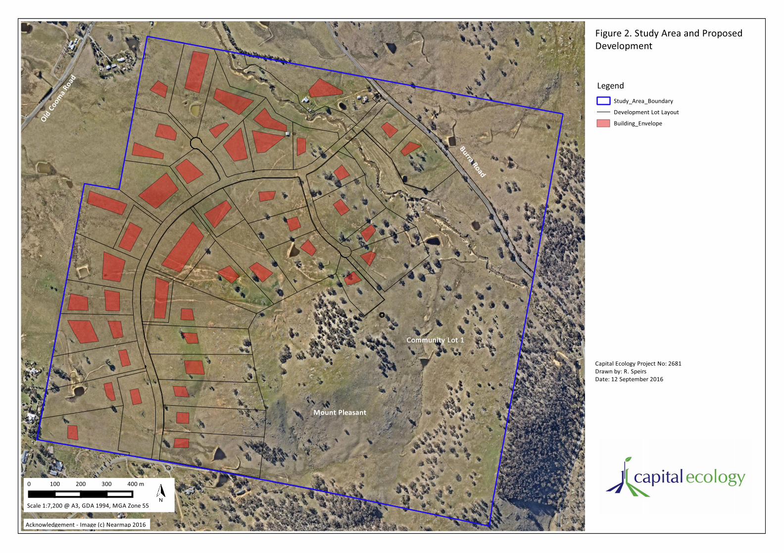
Figure 2. Study Area and ProposedDevelopment
Study_Area_Boundary
Development Lot Layout
Building_Envelope
Legend
0 100 200 300 400 m
Acknowledgement - Image (c) Nearmap 2016
Scale 1:7,200 @ A3, GDA 1994, MGA Zone 55
Capital Ecology Project No: 2681Drawn by: R. SpeirsDate: 12 September 2016
Burra Road
Old Co
oma R
oad
Mount Pleasant
Community Lot 1Community Lot 1

© Capital Ecology Pty Ltd 2016 15
4 Methods
4.1 Taxonomy
The plant taxonomy (method of classification) used in this report follows the most recent Flora of New
South Wales, volumes 1-4 (Harden 2002). The most current scientific and common names for plant
species have been determined using recently published field guides on the native and/or exotic flora of
the ACT and region (Wood and Wood 2005, Eddy et al. 2011, Cosgrove 2014, Richardson et al. 2011).
The naming convention used for vertebrate fauna follows the Census of Australian Vertebrates (CAVs)
maintained by the Commonwealth Department of the Environment.
In the body of this report flora and fauna species are referred to by both their common and scientific
names when first mentioned. Subsequent references to these species cite the common name only.
4.2 Database and Literature Review
The References section of this report lists the literature referred to during the conduct of the surveys for
this study and/or during the preparation of this report.
A list of threatened species (flora and fauna), threatened populations and threatened ecological
communities (TECs) listed pursuant to the EPBC Act with the potential to occur within a five kilometre
radius of the study area was obtained using the Department of the Environment's online EPBC Act
Protected Matters Search Tool (PMST) on 15 September 2015. An updated search was also run on 12
January 2015 to check for recently added listings.
Ecological point data from the NSW Wildlife Atlas (BioNet) was also obtained. The point data does not
include any records of significant species within the study area, however it does show many threatened
species as occurring in the wider locality (i.e. within a five kilometre radius of the study area). It is noted
that a lack of records submitted for a given study area may simply reflect a lack of previous survey and
does not necessarily indicate that the subject species does not occur within. As such, the point data is
used herein to inform likelihood of occurrence assessments and as useful background.
4.3 Definitions of Conservation Significance
The conservation significance of a species, population or community is determined by its current listing
pursuant to Commonwealth and/or State legislation and associated policy, more specifically:
National – Listed as threatened (critically endangered, endangered, vulnerable or conservation
dependent) pursuant to the EPBC Act.
State (NSW) – Listed as threatened (critically endangered, endangered or vulnerable) pursuant
to the TSC Act.
4.4 Likelihood of Occurrence Assessment
The likelihood of occurrence assessment for threatened flora species and threatened and/or terrestrial
migratory fauna species is a categorisation used to determine the likelihood that the subject species

© Capital Ecology Pty Ltd 2016 16
occurs within a study area. The results of the likelihood of occurrence assessment are based on the
findings of completed desktop studies and field surveys, expert opinion and consideration of the
species’ currently recognised distribution and preferred habitat.
Threatened species and populations included in the likelihood of occurrence assessment include all of
those identified during the database and literature review as potentially occurring within five kilometres
of the study area. We have also included threatened species listed only pursuant to the TSC Act and not
identified by BioNet as previously being recorded within five kilometres of the study area, yet
considered by Capital Ecology to have at least some potential of occurring within the study area.
The likelihood of a species occurring within the study area is categorised as either negligible, low,
moderate or high. A species that has been identified within the study area during the surveys for this
study or by other confirmed records is expressed as confirmed.
The completed likelihood of occurrence assessment is provided as Appendix 5. Species assigned a
moderate or higher likelihood of occurrence are considered in more detail in this F&FA, these are listed
in Table 5 in Section 5.5.
4.5 Field Surveys
4.5.2 Preliminary Field Inspection
A preliminary field inspection was undertaken during September 2015 to develop an independent
assessment of the broad vegetation communities present, the habitat features present and the
potential for threatened species occurrence. The information obtained was then considered in the
context of the results of the completed desktop review and findings previous studies and used to tailor
the subsequent field surveys.
4.5.3 Vegetation Survey and Mapping
The vegetation across the entire study area was surveyed and mapped in accordance with the NSW
BioCertification Assessment Methodology (BCAM) (DECCW 2011). It is noted however that an additional
level of categorisation was added to the survey method to allow for the substantial variation in
groundstorey floristic diversity to be recognised and mapped. The vegetation survey and mapping
involved the three-staged process outlined below.
The results of the complete vegetation mapping have been accurately mapped using GIS which provides
accurate calculations of the total area of each Vegetation Zone within the study area.
4.5.3.1 Plant Community Type (PCT) mapping (October 2015)
The on-ground boundaries of each of the Plant Community Types (PCTs) (as provided in the NSW
Vegetation Information System, VIS) present within the study area were accurately mapped using either
hand-held GPS or by marking boundaries directly onto high resolution orthorectified aerial photograph
field maps.
Given that ecotones are usually gradual transitions between vegetation communities (i.e. often in excess
or 50m in width) and that the vegetation across the study area has been subject to various disturbances

© Capital Ecology Pty Ltd 2016 17
over an extended period, it is now difficult to define the boundary of the climax communities with great
precision. Notwithstanding this, the PCT boundaries were defined based on the:
• presence, species, growth form and density of remnant canopy trees and/or stags or stumps of
these;
• presence and species of midstorey shrubs and trees;
• floristic composition of the groundstorey; and
• the landscape position and other geographical features (elevation, aspect soils, apparent
hydrology).
4.5.3.2 Vegetation Zone definition and mapping (November 2015)
Each of the mapped PCTs was divided into Vegetation Zones based on the structure, floristic
composition and overall condition (‘intactness’) of the groundstorey. Each PCT can contain one or more
of the following three ‘Zones’:
• Zone 1 – Native dominated groundstorey – moderate to high diversity;
• Zone 2 – Native dominated groundstorey – low diversity; or
• Zone 3 – Exotic dominated groundstorey.
4.5.3.3 Plots and transects (November 2015)
A series of a vegetation assessment survey plot/transect combination was completed in a manner that
adequately sampled each Vegetation Zone. For each plot/transect the ten condition attributes listed in
Table 1 of the BCAM were collected. The number of survey plot/transects completed within each
Vegetation Zone was determined in accordance with Table 11 of the BCAM and involved a total of 18
across the eight zones as shown in Figure 3.
As illustrated in Diagram 1, Each transect/plot combination involved a 20x20m (400m2) plot within
which all species were recorded. A 50m transect traverses the plots and runs 30m further, along this all
of the other attributes were collected.
20x20m 50m
Diagram 1. Vegetation survey plot/transect combination
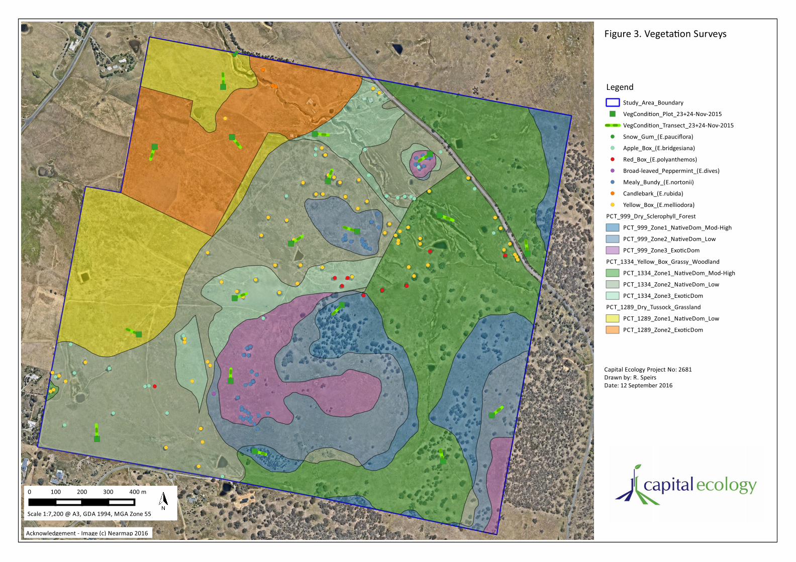
Figure 3. Vegeta on Surveys
Legend Study_Area_Boundary VegCondi on_Plot_23+24-Nov-2015 VegCondi on_Transect_23+24-Nov-2015 Snow_Gum_(E.pauciflora)
Apple_Box_(E.bridgesiana)
Red_Box_(E.polyanthemos)
Broad-leaved_Peppermint_(E.dives)
Mealy_Bundy_(E.nortonii)
Candlebark_(E.rubida)
Yellow_Box_(E.melliodora)
PCT_999_Dry_Sclerophyll_Forest PCT_999_Zone1_Na veDom_Mod-High PCT_999_Zone2_Na veDom_Low PCT_999_Zone3_Exo cDom
PCT_1334_Yellow_Box_Grassy_Woodland PCT_1334_Zone1_Na veDom_Mod-High PCT_1334_Zone2_Na veDom_Low PCT_1334_Zone3_Exo cDom
PCT_1289_Dry_Tussock_Grassland PCT_1289_Zone1_Na veDom_Low PCT_1289_Zone2_Exo cDom
0 100 200 300 400 m
Acknowledgement - Image (c) Nearmap 2016
Scale 1:7,200 @ A3, GDA 1994, MGA Zone 55
Capital Ecology Project No: 2681 Drawn by: R. Speirs Date: 12 September 2016
© Capital Ecology Pty Ltd 2016 19
4.5.4 Targeted Threatened Fauna Surveys
4.5.4.1 Pink-tailed Worm-Lizard surveys and habitat mapping
The Pink-tailed Worm-lizard Aprasia parapulchella is listed as vulnerable pursuant to the EPBC Act and
the TSC Act. The Pink-tailed Worm-lizard is known to occur at numerous sites in the ACT and
surrounding region, notably along the mid and upper slopes of the Murrumbidgee, Molonglo and
Queanbeyan rivers and nearby hills. Within this distribution, the occurrence of the Pink-tailed Worm- lizard is usually confined to sites which are characterised by a moderate to high scatter density of
surface rock of volcanic origin, generally interspersed by Kangaroo Grass Themeda triandra, Red Grass
Bothriochloa macra and Wattle Mat-rush Lomandra filiformis (Osborne and Jones 1995).
As described in detail in Section 5.3, the slopes of Mount Pleasant and much of the land in the eastern
portion of the study area is characterised by moderate to high surface scatter density of rock of volcanic
origin, primarily dacite and granodiorite. The degree of embedment of the rocks and the composition
and structure of the groundcover vegetation are highly varied, however substantial patches of this rock
scatter are characteristic of Pink-tailed Worm-lizard habitat. Notably, the less modified rocky habitat
located in the eastern portion of the study area appears consistent with the high quality Pink-tailed
Worm-lizard habitat located in the Googong township Pink-tailed Worm-lizard Conservation Area (R.
Speirs pers. obs.).
Given the above, a targeted rock-turning survey was undertaken across all rocky habitat within the study
area. Prior to the rock-turning survey all of the rocky habitat within the study area (i.e. potential Pink- tailed Worm-lizard habitat) was mapped onto high resolution field maps, the extent of this rocky habitat
is illustrated in Figure 4.
The targeted survey was undertaken during optimal survey conditions (sunny with maximum
temperatures of 23 and 25 respectively) on the 1st and 2nd of October 2015 and resulted in a total of
approximately 36hrs of active survey effort (i.e. one ecologist with two field assistants for two six hour
days). The survey immediately followed the Googong township Pink-tailed Worm-lizard Conservation
Area population monitoring which was undertaken on the 30th of September. The survey was scheduled
in this manner to provide a useful ‘control’ against which to compare the results obtained.
Jones (1999) found that 750 suitable habitat rocks need to be turned within a given site to achieve an
indication of Pink-tailed Worm-lizard presence/absence to the 95% confidence interval. Accordingly,
where possible, the number of rocks turned per rocky patch was determined with the objective of
achieving the 95% confidence interval of presence/absence within the patch. However, given the
sparsity of loose surface rocks within the smaller patches in the western portion of the study area, in
effect, the survey involved the turning of most turnable surface rocks within these patches. The total
number of habitat rocks turned during the survey is estimated to be approximately 9,700 (based on
extrapolation of the average of five half hour counts).
A GPS track was taken during the survey across the large and generally contiguous patch of rocky habitat
across Mount Pleasant and the higher elevated land to the east (refer Figure 4). This track was not
extended to cover the survey of the smaller patches due to their scattered locations. Where Pink-tailed
Worm-lizards were found, they were photographed and their location was recorded via hand-held GPS.
Sloughed skins of the species were similarly recorded where encountered.

© Capital Ecology Pty Ltd 2016 20
The results of the targeted survey were used to identify which patches, or portions of patches, of the
mapped potential habitat actually support the species (to the 95% confidence level), and are therefore
considered confirmed Pink-tailed Worm-lizard habitat. The boundary of the area of confirmed habitat
was subsequently delineated via hand-held GPS (accurate +/- 3m) and the relative quality of the habitat
was assessed.
4.5.4.2 Golden Sun Moth surveys
A program of four targeted Golden Sun Moth surveys was undertaken in accordance with the survey
guidelines detailed in the Background Paper to EPBC Act Policy Statement 3.12 - Significant Impact
Guidelines for the Critically Endangered Golden Sun Moth (Synemon plana) (DEWHA 2009). As illustrated
in Figure 5, each survey involved two ecologists walking broad belt transects (approx. 200m apart)
throughout the open native grass dominated areas across the entire study area. Broad belt transects
were chosen as the most suitable method for the surveys given the large area (approx. 100ha) of
potential habitat requiring survey.
As recommended in DEWHA (2009), four surveys were undertaken with at least four days between each
survey. On each survey day moths were confirmed to be flying at a reliable reference site located
immediately south of IKEA, Majura Valley, ACT. Golden Sun Moth activity across the region was also
confirmed by email and phone communication with other ecologists conducting surveys at other sites.
The details of the four survey days and relevant survey conditions are provided in Table 13 in Appendix
4. In summary, each of the four targeted surveys was undertaken during good to optimal survey
conditions on days when moderate to high Golden Sun Moth numbers were observed at a reliable
reference site.
A GPS track was recorded for each survey, these are illustrated in Figure 5. Whilst the surveys primarily
focused on recording observed male flights, the ecologists also searched for female moths and pupal
cases, particularly in the areas considered to have the highest potential for Golden Sun Moth
occurrence.
4.5.5 Grassland Fauna Habitat Assessment Transects
As requested by OEH, five Grassland Habitat Assessment Transects were completed on 10 December
2015 to accompany the Golden Sun Moth surveys. These transects were located with the aim of
capturing the variation in grassland composition and condition across the portions of study area covered
by the Golden Sun Moth surveys. Figure 5 shows the locations of the completed transects.
4.5.6 Opportunistic Flora and Fauna Observations
All notable observations of flora and fauna made across the program of surveys have been recorded and
added to species inventories and/or are otherwise noted in this F&FA.
4.5.7 Authority to Undertake Surveys
All flora and fauna surveys were undertaken under the terms and conditions of Capital Ecology’s
Scientific Licence (SL101623, expiry 30 September 2016) issued by OEH under the National Parks and
Wildlife Act 1974. As required under this licence, records of threatened flora and fauna species will be
submitted to OEH for incorporation into the NSW Wildlife Atlas.

© Capital Ecology Pty Ltd 2016 21
Fauna survey was conducted under approval 15/2046 (Robert Speirs – Principal Investigator) from the
NSW Department of Primary Industries Secretary’s Animal Care and Ethics Committee.
All flora and fauna surveys were undertaken by and/or under the direct supervision Robert Speirs,
Capital Ecology’s Principal Ecologist who has over ten years of experience in ecological survey and
assessment.

Figure 3. Pink-tailed Worm-lizardSurveys
Study_Area_Boundary
Surveyed_Rocky_Habitat
PTWL_Survey_Track_2-Oct-2015
PTWL_Points_2-Oct-2015
Likely_Extent_Of_PTWL_Presence
Legend
0 100 200 300 400 m
Acknowledgement - Image (c) Nearmap 2016
Scale 1:7,200 @ A3, GDA 1994, MGA Zone 55
Capital Ecology Project No: 2681 Drawn by: R. Speirs Date: 12 September 2016

Figure 5. Golden Sun Moth Surveys
Study_Area_Boundary
Poten al_Golden_Sun_Moth_Habitat
Grassland_Fauna_Habitat_Transect_10-Dec-2015
GSM_Survey_Track_1_23-Nov-2015
GSM_Survey_Track_2_30-Nov-2015
GSM_Survey_Track_3_6-Dec-2015
GSM_Survey_Track_4_10-Dec-2015
Legend
0 100 200 300 400 m
Acknowledgement - Image (c) Nearmap 2016
Scale 1:7,200 @ A3, GDA 1994, MGA Zone 55
Capital Ecology Project No: 2681 Drawn by: R. Speirs Date: 12 September 2016
© Capital Ecology Pty Ltd 2016 24
4.6 Study Limitations
4.6.2 Survey Limitations
No degree of survey effort or array of employed survey methods can ensure that all species are
detected during a survey. Numerous factors can impact upon the detection of some species, these
include: seasonal conditions, species dormancy, grazing impacts, the ephemeral nature of waterbodies
(i.e. creeks, farms dams etc) and the breeding, migratory and other behaviours of some fauna.
Notwithstanding the above, as described herein, the ecological studies completed to inform this study
have involved numerous surveys, undertaken by experienced ecologists, across all seasons and
employing various survey methods as deemed necessary to thoroughly assess the biodiversity values of
the study area. Assessment and mapping of vegetation community type and condition has been
undertaken in accordance with currently recognised NSW survey techniques and metrics. Where there
was recognised potential for threatened species to be present the presence or absence of the species
was appropriately assessed in accordance with the current Commonwealth Government and/or NSW
Government survey guidelines.
In addition to the surveys undertaken by Capital Ecology, this study is informed by the results of the
considerable survey effort completed previously by KMA (KMA 2015). KMA’s survey effort has greatly
assisted in developing native flora and avifauna inventories in a manner that is as complete as
practicable (refer Appendices 1 and 3). This has been of particular value in ensuring that the threatened
species likelihood of occurrence assessment is very well informed (refer Appendix 5).
Given the above, this study is not considered to be subject to any significant survey limitations.
4.6.3 Spatial Data Limitations
Conclusions on the likelihood of some species to occurring within the study area are reliant, at least in
part, upon external data sources and information managed by third parties (i.e. NSW BioNet etc).
Vegetation community mapping data and threatened species point data was collected using a hand-held
(uncorrected) GPS unit and high resolution aerial photograph interpretation. The accuracy of the
mapping presented in the resulting figures is therefore subject to the accuracy of the GPS unit (up to ± 4
metres) and the rectification and registration limitations of NSW Land and Property Information’s aerial
imagery data.
The figures presented in this report have been prepared using a Geographic Information System (GIS).
Electronic files (.shp) of all data presented in the figures can be provided for incorporation in third party
plans and documents. It must be noted however that this data may not be sufficiently precise for
detailed survey or design purposes.
© Capital Ecology Pty Ltd 2016 25
5 Results
5.1 Vegetation Survey and Mapping
5.1.2 Plant Community Type (PCT) mapping
The study area supports the following three PCTs as shown in Figure 3.
1. PCT999 – Norton's Box - Broad-leaved Peppermint open forest on foot slopes, central and
southern South Eastern Highlands Bioregion.
Historically, PCT999 would have occurred across the higher elevated land within the study area,
notably on the summit and slopes of Mount Pleasant. This community is primarily associated
with thin infertile soils over geology of volcanic origin. In its climax form this community would
have supported a moderately dense canopy with a defined shrubstorey and groundstorey
dominated by Red-anther Wallaby Grass Rytidosperma pallidum.
Three relatively intact yet varied examples of PCT999 remain within the study area, being:
• the patch on the southern slope of Mount Pleasant which supports an intact canopy of
Broad-leaved Peppermint Eucalyptus dives, a typically dominant species of PCT999 where
it occurs in protected southern aspects;
• the patch on the northern slope of Mount Pleasant which supports and dense canopy of
Norton’s Box E. nortonii (also known as Mealy Bundy) and Drooping Sheoak Allocasuarina
verticillata;
• the patch in the eastern extent of the portion of the study area north of Burra Road, this
patch supports a canopy of Norton’s Box with relatively intact groundstorey dominated by
Red-anther wallaby grass.
2. PCT1289 – Wallaby Grass - Red-grass - Tall Speargrass - Kangaroo Grass dry tussock grassland of
the North-western and Eastern Southern Tablelands in the South Eastern Highlands Bioregion.
Historically, PCT1289 would have occurred across the lowest elevated land in the north-western
corner of the study area. This community occurs on the most fertile and deepest alluvial soils
within the study area and is generally associated with valley bottoms which are subject to
lingering frost and cold air during winter. In its climax form this community would have been
characterised by the named native grasses with a high diversity of native forbs (lilies, daisies,
orhids, rushes etc).
Owing to the fertile soil, close proximity to the homestead and shearing sheds and little
impediment to cultivation, the entire area of PCT1289 within the study area has undergone a
high degree of modification. This is consistent with the land management history described in
Section 3.3. No relatively intact yet varied examples of PCT1289 remain within the study area.

© Capital Ecology Pty Ltd 2016 26
3. PCT1334 – Yellow Box grassy woodland in lower valleys on lower slopes and valley bottoms.
Historically, PCT1334 would have occurred across the majority of the study area, including the
lower slopes of Mount Pleasant and throughout the valleys and gently undulating areas. This
community occurs on soils of moderate to high fertility and generally moderate depth. In its
climax form this community would have been characterised by an open canopy, sparse or absent
mid and shrubstorey, together with a defined grassy groundstorey supporting a high diversity of
native forbs.
As detailed below and illustrated in Figure 3, the condition of the PCT1334 is highly varied across
the study area. The majority of the PCT1334 within the western two thirds of the study area has
been highly modified and exists now as native pasture with or without scattered remnant trees.
Numerous substantial stock camps occur within this area and these support only exotic pasture
and weed species.
The eastern paddock of the study area and the block north of Burra Road are the classic ‘back
paddock’ of the property, furthest from the homestead and shearing shed and consequently
having been subject to a considerably lighter grazing history. As shown in Figure 3, the majority
of this area supports PCT1334 in a relatively intact form, retaining a clearly native groundstorey
with moderate forb diversity. Bulbine Lily Bulbine bulbosa, Nodding Chocolate Lily Dichopogon
fimbriatus, Dusky Scurfpea Cullen microcephalum, Billy Buttons Craspedia variabilis and other
species indicative of less intense grazing were recorded in these patches of PCT1334 but absent
elsewhere.
5.1.3 Vegetation Zone Definition and Mapping
The study area was found to support eight discernible Vegetation Zones, as detailed in Table 1 and
illustrated in Figure 3. Plates 1 to 8 provide representative photographs of each of the Vegetation Zones.
Table 1. Vegetation Zones
PCT Zone ID Photograph Plate
Groundstorey Dominance
Native or Exotic
Diversity
Low or Mod-high
Vegetation Zone ID
Total Area
Ha
PCT999 1 1 Native Mod-high 999.1 23.24
2 2 Native Low 999.2 28.43
3 3 Exotic Low 999.3 60.89
PCT1289 1 4 Native Low 1289.1 34.69
2 5 Exotic Low 1289.2 29.23
PCT1334 1 6 Native Mod-high 1334.1 64.53
2 7 Native Low 1334.2 59.32
3 8 Exotic Low 1334.3 19.22

© Capital Ecology Pty Ltd 2016 27
Plate 1. PCT 999 – Zone 1
Plate 2. PCT 999 – Zone 2

© Capital Ecology Pty Ltd 2016 28
Plate 3. PCT 999 – Zone 3
Plate 4. PCT 1110 – Zone 1
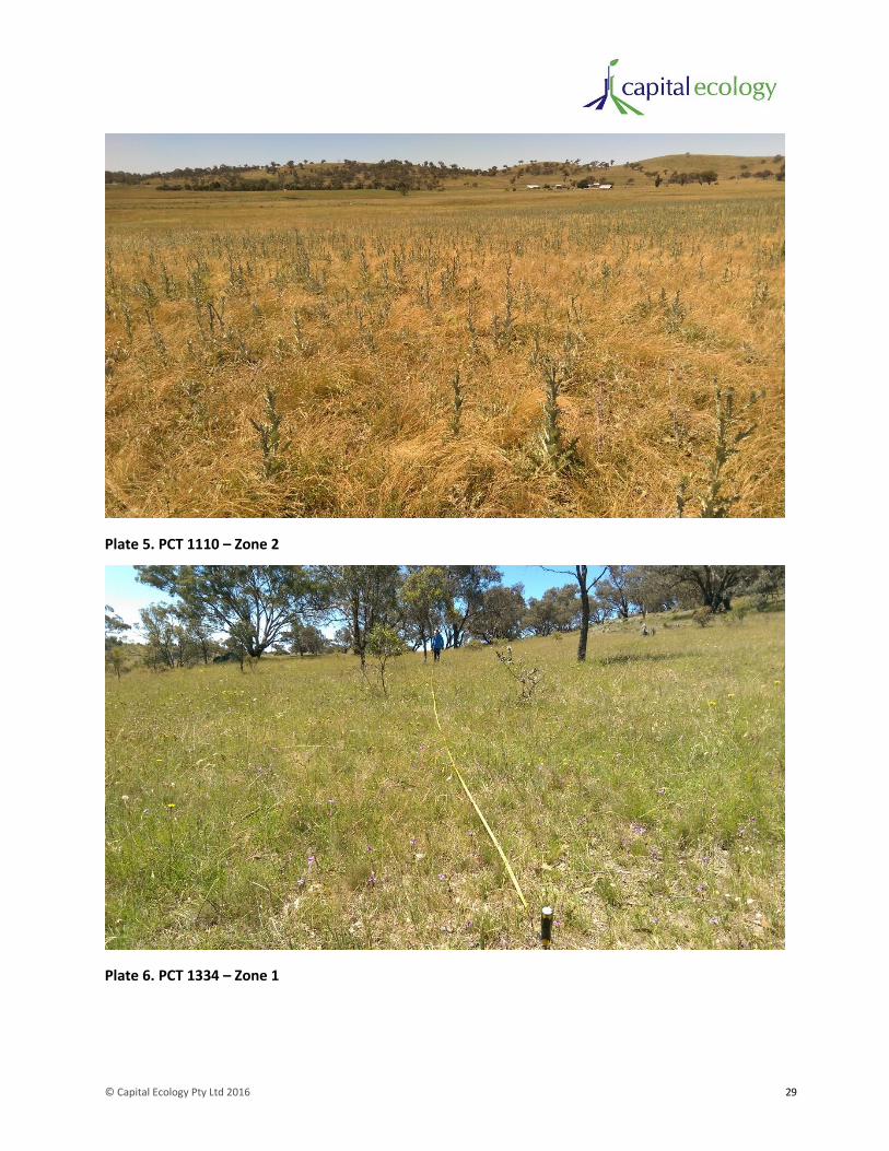
© Capital Ecology Pty Ltd 2016 29
Plate 5. PCT 1110 – Zone 2
Plate 6. PCT 1334 – Zone 1

© Capital Ecology Pty Ltd 2016 30
Plate 7. PCT 1334 – Zone 2
Plate 8. PCT 1334 – Zone 3
5.1.4 Plots and Transects
The results of the 18 floristic plot/transect combinations are provided in Appendix 1. The results
obtained provide clear confirmation of the distinction between the identified Vegetation Zones. For

© Capital Ecology Pty Ltd 2016 31
example, Zones 1334.1 and 1334.2 are both characterised by a native dominated groundstorey,
however Zone 1334.1 supports an average or 26 native species per plot compares to 11.6 for Zone
1334.2. This diversity quantification is important as the accurate documentation of groundstorey
diversity is of critical importance to the listing criteria for temperate threatened ecological communities
(discussed further in Section 5.2).
5.2 Threatened Ecological Community Assessment
5.2.2 Commonwealth EPBC Act
The following two threatened ecological communities (TECs) were identified on DoE’s EPBC Act
Protected Matters Search Tool as having the potential to occur within the study area.
Natural Temperate Grassland of the South Eastern Highlands and New England Tablelands – listed as
critically endangered pursuant to the EPBC Act.
Description – The Natural Temperate Grassland TEC is characterised by grassy vegetation dominated by
moderately tall (25–50cm) to tall (50–100cm), dense to open tussock grasses in the genera
Rytidosperma, Austrostipa, Bothriochloa, Poa and Themeda. Up to 70% of all plant species may be forbs.
The community may be treeless or contain up to 10% cover of trees, shrubs or sedges. Natural
Temperate Grassland occurs within the geographical region of the Southern Tablelands of NSW and the
ACT at altitudes between 560m in central and northern parts of its distribution and 1200m in the south,
in valleys influenced by cold air drainage and in broad plains (link to the EPBC Act listing advice
http://www.environment.gov.au/cgi-
bin/sprat/public/publicshowcommunity.pl?id=152&status=Critically+Endangered).
Presence within the study area – None. The portion of the study area mapped as PCT1289 would have
once supported this TEC, however intensive agricultural land use (notably grazing, cropping and pasture
improvement) has modified the structure and composition of this area such that it longer has the
structural and floristics characteristics of this TEC.
White Box-Yellow Box-Blakely's Red Gum Grassy Woodland and Derived Native Grassland – listed as
critically endangered pursuant to the EPBC Act.
Description – The White Box - Yellow Box - Blakely's Red Gum Grassy Woodland and Derived Native
Grassland TEC is characterised by a species-rich understorey of native tussock grasses, herbs and
scattered shrubs (where shrub cover comprises less than 30% cover), and a dominance or prior
dominance of White Box and/or Yellow Box and/or Blakely’s Red Gum trees. This TEC occurs along the
western slopes and tablelands of the Great Dividing Range from southern Queensland through New
South Wales and the Australian Capital Territory to Victoria (link to the EPBC Act listing advice
http://www.environment.gov.au/node/14495).
Presence within the study area – Confirmed – The entire portion of the study area mapped as PCT1334
would have once supported the climax community of this TEC.
Assessments of structure and floristic composition were undertaken within each of the three discernible
condition categories (Vegetation Zones) of PCT1334 present within the study area. The purpose of these
assessments was to determine whether the patches of each Vegetation Zone support characteristics

© Capital Ecology Pty Ltd 2016 32
sufficient to meet the listing criteria for the EPBC Act listed TEC. The assessment process follows that
provided in the Commonwealth EPBC Act Policy Statement 3.5 – White Box – Yellow Box – Blakely’s Red
Gum grassy woodlands and derived native grasslands (DEH 2006). The results of this assessment are
provided in Table 2. As detailed in Table 2, the area mapped as PCT1334 - Zone 1 clearly meets the
criteria for the EPBC Act listed TEC. PCT1334 – Zones 2 and 3 do not meet the listing criteria.
Table 2. Assessment against the listing criteria for the EPBC listed TEC – White Box-Yellow Box-
Blakely's Red Gum Grassy Woodland and Derived Native Grassland.
Criterion Assessment Results
PCT1334-Zone1 PCT1334-Zone2 PCT1334-Zone3
1. Is, or was previously, at least one of the most common overstorey species White Box, Yellow Box or Blakely’s Red Gum?
Yes
Yellow Box is dominant or co-dominant throughout this zone.
Yes
Scattered Yellow Box trees remain in areas of the zone and this species is expected to have been dominant or co-dominant throughout this zone historically.
Yes
Scattered Yellow Box trees remain in areas of the zone and this species is expected to have been dominant or co-dominant throughout this zone historically.
2. Does the patch have a predominantly native understorey?
Yes – clearly
The understorey was recorded as ranging from 54 to 84 % native species cover.
Yes – marginally
The understorey was recorded as ranging from 44 to 52 % native species cover.
No
The understorey was recorded as ranging from 0 to 6 % native species cover.
3. Is the patch 0.1 ha (1000 m2) or greater is size with 12 or more native understorey species present (excluding grasses)? There must be at least one important species.
Yes
Zone 1 occurs as a generally contiguous patch with a total area of 64.53ha.
An average of 20.3 native non-grasses and 4 important species were recorded across the plot/transects.
No
While Zone 2 occurs as a generally contiguous patch with a total area of 59.32ha, only an average of 6.7 native non-grasses was recorded across the plot/transects.
N/A
Refer Criterion 2 results.
Or
Is the patch 2 ha or greater in size with an average of 20 or more mature trees per hectare, or is there natural regeneration of the dominant overstorey eucalypts?
No
Zone 1 occurs as a generally contiguous patch with a total area of 64.53ha, however it has an average of less than 20 mature trees per hectare and virtually no regeneration of overstorey eucalypts.
No
Zone 2 occurs as a generally contiguous patch with a total area of 59.32ha, however it has an average of less than 20 mature trees per hectare and no regeneration of overstorey eucalypts.
N/A
Refer Criterion 2 results.
Does the patch meet the criteria for the listed TEC?
Yes No No

© Capital Ecology Pty Ltd 2016 33
5.2.3 NSW TSC Act
White Box – Yellow Box – Blakely's Red Gum Woodland
The below description is extracted from the NSW Final Determination for the TSC Act endangered listed
ecological community White Box – Yellow Box – Blakely's Red Gum Woodland (TSC Act Box-Gum
Woodland) (the ‘Final Determination’) (NSW Scientific Committee 2002, gazetted 15 March 2002).
White Box Yellow Box Blakely's Red Gum Woodland is found on relatively fertile soils on the
tablelands and western slopes of NSW and generally occurs between the 400 and 800 mm isohyets
extending from the western slopes, at an altitude of c. 170m to c. 1200 m, on the northern
tablelands (Beadle 1981). The community occurs within the NSW North Coast, New England
Tableland, Nandewar, Brigalow Belt South, Sydney Basin, South Eastern Highlands and NSW South
Western Slopes Bioregions.
White Box Yellow Box Blakely's Red Gum Woodland includes those woodlands where the
characteristic tree species include one or more of the following species in varying proportions and
combinations - Eucalyptus albens (White Box), Eucalyptus melliodora (Yellow Box) or Eucalyptus
blakelyi (Blakely's Red Gum). Grass and herbaceous species generally characterise the ground layer.
In some locations, the tree overstorey may be absent as a result of past clearing or thinning and at
these locations only an understorey may be present. Shrubs are generally sparse or absent, though
they may be locally common.
Although the Final Determination does not provide specific listing criteria against which assess a patch
of vegetation, a useful key is provided in Identification Guidelines for Endangered Ecological
Communities - White Box Yellow Box Blakely's Red Gum Woodland (Box-Gum Woodland) (NSW NPWS
2002), which draws its information from the Final Determination. An extract of this key and brief
assessment of the areas of the zones of PCT1334 within the study area is provided in Table 3 below.
© Capital Ecology Pty Ltd 2016 34
Table 3. Assessment against the key criteria for the TSC Act listed TEC – White Box – Yellow Box – Blakely's Red Gum Woodland
Criterion Assessment Results
PCT1334-Zone1 PCT1334-Zone2 PCT1334-Zone3
1. The subject land meets this Criterion 1 as it occurs in the South Eastern Highlands bioregion.
2. The understorey of Zone 1 is moderate to high diversity native grassland so it is otherwise.
The understorey of Zone 2 is low diversity native grassland/pasture so it is otherwise.
The understorey of Zone 3 is comprised almost entirely of exotic pasture species and weeds. These areas are unlikely to respond substantially to assisted natural regeneration.
3. Zone 1 has patches of remnant trees; all treeless areas would have supported Yellow Box prior to clearing.
Zone 2 has scattered remnant trees; all treeless areas would have supported Yellow Box prior to clearing.
N/A – refer result for Criterion 2.
4. The majority of the remnant trees are Yellow Box.
The majority of the remnant trees are Yellow Box.
5. Zone 1 is predominantly grassy. Zone 2 is predominantly grassy.
Does the patch meet the criteria for the listed TEC? Yes Yes No

© Capital Ecology Pty Ltd 2016 35
As described in the Final Determination and the associated key, the definition for the TSC Act Box-Gum
Woodland TEC is extremely broad. In effect, any land for which the climax community is Box-Gum
Woodland that has not been cultivated, become a stock camp or otherwise been entirely modified is
likely to meet the definition of the TSC Act listed TEC.
With regard to the above, it must be noted that the TSC Act definition provides the absolute minimum
requirements a patch to be considered to support the TEC. As such, the NSW Government encourages
the use of a suitable biometric (such as the BioCertification Assessment Methodology) to categorise the
vegetation within a given study area in a manner that reflects the actual and relative values of the
vegetation. This categorisation is essential in informing planning processes, such that more intact (i.e.
higher value) areas of TEC can be appropriately prioritised for conservation. Conversely, marginal areas
of the TEC, such as those that support only scattered remnant trees or low diversity native
grassland/pasture, may be unlikely to degrade further under an alternate management regime.
5.3 Fauna Habitat
The fauna habitat features within the study area include scattered and outcropping rock, native and
exotic grassland/pasture, remnant eucalypts, scattered shrubs and the numerous water courses and
farm dams. These fauna habitat features are detailed in Table 4.
Table 4. Fauna habitat features
Habitat Feature Description Revenant Native Fauna Species/Assemblages
Rock scatters and outcrops
The slopes of Mount Pleasant and much of the land in the eastern portion of the study area are characterised by moderate to high surface scatter density of rock of volcanic origin, primarily dacite and granodiorite (refer Figure 4). The degree of embedment of the rocks and the composition and structure of the groundcover vegetation are highly varied.
The patches of the rock scatter with small to medium plate-like rocks surrounded by native grasses are potential habitat for the Pink-tailed Worm-lizard. As detailed in Section 5.4.5.1, these were surveyed for this F&FA with the species recorded in one patch of rocky habitat. As detailed in Appendix 3, the rocky habitat within the study area was found to support numerous other common reptiles, frogs and invertebrates.
Grassland/pasture As described in Section 5.1, the study area supports grassy vegetation communities. The degree of modification of these varies from the moderately intact areas in the Zone 1s to entirely modified pasture and weeds in cropped areas and stock camps.
The less modified grassy areas would provide foraging resources for the numerous woodland birds occurring in the study area. The open and more modified areas of grassland/pasture would provide hunting resources for raptors and other predatory birds.
The grassy areas in eastern portion of the study area would provide grazing resources for common herbivores such as the Eastern Grey Kangaroos Macropus giganteus, Swamp Wallaby M. bicolor and Common Wombat Vombatus ursinus.

© Capital Ecology Pty Ltd 2016 36
Habitat Feature Description Revenant Native Fauna Species/Assemblages
Remnant eucalypts
The many mature eucalypts contain tree hollows with varying characteristics and many Mistletoe Amyema spp. plants. The eucalypts, particularly the Yellow Box, provide a nectar resource when in flower.
The hollows in the remnant trees in the western more modified portion of the study area are likely to be used by Brushtail Possums Trichosurus vulpecula, common native birds (e.g. Red-rumped Parrot Psephotus haematonotus, Rosellas Platycercus spp.) as well as Starlings Sturnus vulgaris and potentially Indian Mynas Sturnus tristis.
Hollows in the eastern portion of the study area may be inhabited by broader variety of birds as well as other small mammals such as the Sugar Glider Petaurus breviceps and microchiropteran bats.
Tree hollows are a limiting habitat feature for many native fauna species, some of which are now listed threatened species.
The flowering eucalypts and Mistletoe, particularly in the eastern portion of the study area, are likely to provide feeding resources for a broad variety of birds.
Scattered shrubs The midstorey and shrubstorey strata a conspicuously absent component of the vegetation communities within the study area. This is a legacy of the long history of intense stock grazing which has removed most shrubs and prevented tree regeneration. Notwithstanding this, a few scattered Native Buckthorn Bursaria spinosa subsp. spinosa shrubs occur in Zone 1 of the study area.
In addition, the study area supports many large Briar Rose Rosa rubiginosa bushes.
The few scattered native shrubs would provide limited nesting and refuge resources for the small native birds recorded within the study area. Although an exotic weed, the Briar Rose bushes were noted to be utilised by numerous native birds, including the TSC vulnerable listed species Scarlet Robin Petroica boodang and Diamond Firetail Stagonopleura guttata.
Water courses and farm dams
Church Creek and numerous tributary drainage lines run through the study area. In addition, the study area contains numerous small farm dams. The dams in the western portion of the study are murky and support little fringing vegetation, however those in the eastern portion of the study area are clear with much fringing vegetation.
The water bodies along Church Creek and the dams located in the eastern portion of the study area are likely to provide foraging and/or breeding resources to numerous common native fauna. These include the numerous recorded waterfowl and frogs (refer Appendix 3) and Eastern Long-necked Turtles Chelodina longicollis.
The dams in the western paddocks are likely to be of far less habitat value owing to their disturbed condition and distance from tree cover.
5.3.2 Grassland Fauna Habitat Assessment Transects
The results of the five completed OEH Grassland Habitat Assessment Transects are provided in Table 11
(Appendix 2). As detailed in Table 11, the native dominant portions of the open grassland portions of the
study area support a cover primarily comprising species of the grass genera Rytidosperma (Wallaby
Grasses) and Austrostipa (Spear Grasses) with Wheat Grass Elymus scaber and Hairy Panic Panicum
© Capital Ecology Pty Ltd 2016 37
effusum also codominant. Kangaroo Grass Themeda triandra, Tussock Grass Poa labillardieri and Snow
Grass P. sieberiana occur as codominant grasses in the poorly drained patches in the western paddocks
of the study area.
As discussed in Section 5.1 and detailed in Table 9 and Table 11, the open grasslands present across the
western paddocks of the study area have been highly modified and simplified by extended high intensity
grazing. Whilst this modification has greatly depleted the habitat value of this land for a diversity of
native flora and fauna, it has likely encouraged the dominance of the most grazing tolerate native
grasses, namely Wallaby Grasses and Spear Grasses. This dominance of Wallaby Grasses in particularly
noteworthy given that the genus is the primary natural fodder plant for the Golden Sun Moth.
Accordingly, OEH’s request for targeted Golden Sun Moth surveys was well founded and reasonable.
5.4 Flora and Fauna Species Recorded Within the Study Area
5.4.2 Recorded Flora
A total of 106 flora species were recorded within the study area during the completed transect/plot
surveys, comprising 66 native species and 40 exotic species (refer Table 9 in Appendix 1).
Fifty (50) additional flora species were recorded within the study area during one or more of the other
surveys completed by Capital Ecology or KMA (KMA 2015). These comprised 40 native species and 10
exotic species (refer Table 10 in Appendix 1).
5.4.3 Recorded Fauna
A total of 81 native vertebrate fauna species were recorded within the study area during one or more of
the surveys completed by Capital Ecology or KMA (KMA 2015). These comprised 64 birds, 4 mammals, 9
reptiles and 4 frogs.
In addition, 11 exotic fauna species were recorded, including 3 domestic/farmed species and 8 feral
species.
A list of vertebrate fauna species recorded within the study area is provided in Table 12 in Appendix 3.
5.4.4 Listed Threatened Flora
Eleven (11) EPBC Act and/or TSC Act listed threatened flora species are identified as potentially
occurring within the study area on NSW BioNet and/or the EPBC Protected Matters Search Tool. An
additional one exclusively TSC Act listed threatened flora species, Silky Swainson-pea Swainsona sericea,
is considered by Capital Ecology to warrant consideration. These species are detailed in the likelihood of
occurrence assessment provided in Appendix 5.
No threatened flora species have been recorded within the study area during any of the field surveys
undertaken by Capital Ecology or those previously undertaken by KMA (KMA 2015). These surveys have
involved many hours of survey by experienced ecologists, covering the entire study area and occurring
across each season. Notably, the vegetation survey and mapping (refer Section 4.5.3) and targeted
fauna surveys (refer Section 4.5.4) completed to inform this F&FA involved approximately 80hrs of
survey spread across spring 2015. Accordingly, it is considered unlikely that any threatened flora species
occurs within the study area that have not been recorded to date.

© Capital Ecology Pty Ltd 2016 38
5.4.5 Listed Threatened Fauna
Nineteen (19) EPBC Act and/or TSC Act listed threatened or terrestrial migratory fauna species are
identified as potentially occurring within the study area on NSW BioNet and/or the EPBC Protected
Matters Search Tool. An additional 16 listed threatened fauna species are considered by Capital Ecology
to warrant consideration. These species are detailed in the likelihood of occurrence assessment
provided in Appendix 5.
As the site does not support any marine areas or substantial wetlands, marine and wetland migratory
species will not be impacted by the proposed development and thus they have not been considered in
this F&FA.
5.4.5.1 Pink-tailed Worm-Lizard
Seven (7) individual Pink-tailed Worm-lizards were recorded during the survey (refer Plate 9), all of
which were found in the large patch of high quality habitat located in the eastern extent of the study
area (refer Figure 4).
In addition to many scorpions, spiders, centipedes and other common invertebrates, a number of non-
target herpetofauna species were recorded during the survey, these are detailed in Table 12 or
Appendix 3).
As shown in Plate 10, the majority of the approximate 80ha of rocky habitat within the study area (refer
Figure 4) is characterised by deeply embedded boulder-like rocks with few loose surface rocks. Many of
the patches are also associated with stock camps where the key native groundcover flora species have
generally been replaced by exotic pasture and weed species. The only substantial patches of rocky
habitat which support moderate to high surface rock scatter interspersed by native groundcover species
(notably Kangaroo Grass) are located in the eastern extent of the study area. As shown in Plate 11, the
rocky habitat in this location is similar to the high quality Pink-tailed Worm-lizard habitat elsewhere in
the locality (i.e. Googong, R. Speirs pers. obs.). Although all of this characteristic Pink-tailed Worm-lizard
habitat was thoroughly surveyed, the species was only found in the centre of the northern portion of
the large patch adjoining the eastern boundary of the study area.
Based on the rock characteristics, the composition and condition of the groundcover vegetation and the
results of the completed targeted survey, the area considered likely to currently support the Pink-tailed
Worm-lizard is that mapped in Figure 4. Whilst this mapping should not be read as entirely precluding
the occurrence of the Pink-tailed Worm-lizard more broadly within the eastern portion of the study
area, it is considered highly unlikely that the species is present on Mount Pleasant or further west.
In light of the above, although the patch of Pink-tailed Worm-lizard habitat within the study area is quite
small in the context of those known to occur in the Googong-Burra locality, it supports all of the
characteristics of very high quality habitat and is apparently quite densely occupied. Furthermore, it is
likely that the habitat patch extends well into the adjoining O’Keefe Reserve, and thus, it may be a
component of a much larger habitat patch.

© Capital Ecology Pty Ltd 2016 39
Plate 9. Adult Pink-tailed Worm-lizard A. parapulchella.
Plate 10. Representative photograph of rocky habitat – not Pink-tailed Worm-lizard habitat
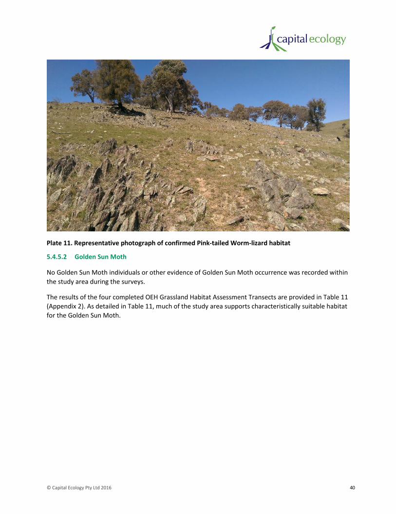
© Capital Ecology Pty Ltd 2016 40
Plate 11. Representative photograph of confirmed Pink-tailed Worm-lizard habitat
5.4.5.2 Golden Sun Moth
No Golden Sun Moth individuals or other evidence of Golden Sun Moth occurrence was recorded within
the study area during the surveys.
The results of the four completed OEH Grassland Habitat Assessment Transects are provided in Table 11
(Appendix 2). As detailed in Table 11, much of the study area supports characteristically suitable habitat
for the Golden Sun Moth.

© Capital Ecology Pty Ltd 2016 41
Plate 12. Representative photograph of potential GSM habitat surveyed. Note: as illustrated in this
photograph, much of the area surveyed supports a high proportion of Short Wallaby Grass Rytidosperma
carphoides, a favoured fodder species for the Golden Sun Moth.
The absence of Golden Sun Moths recorded across the completed full survey program of targeted
surveys for the Golden Sun Moth provides strong evidence for the absence of the Golden Sun Moth
within the study area.
To date the only confirmed records of the Golden Sun Moth in the Googong – Burra locality are located
approximately 5.5 kilometres northwest of the study area (Johnstone Centre in 2004). Those records
occur in a patch of remnant Natural Temperate Grassland (the primary habitat of the Golden Sun Moth)
located on land that has been subject to a history of considerably lighter grazing than the study area. It
is also relevant to note that no Golden Sun Moths have been recorded at Googong during any of the
targeted surveys completed in recent years (Johnstone Centre in 2004, Biosis Research 2009, Capital
Ecology 2015).
In light of the above, whilst the study area does occur within the broad distribution of the Golden Sun
Moth and it does support an extensive area of characteristically suitable habitat, based on the results of
this survey program and those of previous surveys completed nearby, it is now reasonable to assert that
the species is highly unlikely to occur within the study area.
5.4.5.3 Threatened Woodland Birds
Three woodland bird species listed as vulnerable pursuant to the TSC Act were recorded within the
study area during the surveys, namely the Scarlet Robin Petroica boodang, Flame Robin P. phoenica and
Diamond Firetail Stagonopleura guttata.

© Capital Ecology Pty Ltd 2016 42
Numerous small flocks of non-breeding Scarlet Robins and Flame Robins were observed foraging
throughout much of the study area during the preliminary field inspection undertaken during winter
2015. Substantial flocks have been observed to over-winter in the open agricultural land across the
locality (Biosis 2015, R. Speirs pers. obs.) and the presence of these species within the study area was
also noted in previous years by KMA (KMA 2015).
Diamond Firetails were observed within the study area during each field survey, primarily associated
with the large dense patch of remnant Drooping Sheoak on the northern slope of Mount Pleasant. Small
flocks of the species were observed during winter and early spring with these breaking into breeding
pairs from early November. As shown in Figure 6, a single active nest was observed in the canopy of a
large Red Box and it is expected that other pairs nested this season in the Drooping Sheoak patch and
immediate surrounds. Although no nests were observed, the Diamond Firetails and numerous other
small birds were observed to frequently utilise the refuge offered by the large Briar Rose bushes in this
portion of the study area. Diamond Firetails were observed to not stray further than approximately 100
metres from the Drooping Sheoak patch, indicating the importance of this dense patch of remnant trees
to this species.

Figure 6. Biodiversity Values
Study_Area_Boundary
QBN_LEP_Biodiversity
EPBC_Act_Box-Gum_Woodland
TSC_Act_Box-Gum_Woodland
Likely_Extent_Of_PTWL_Presence
Diamond_Firetail_Nest
Snow_Gum_(E.pauciflora)
Apple_Box_(E.bridgesiana)
Red_Box_(E.polyanthemos)
Broad-leaved_Peppermint_(E.dives)
Mealy_Bundy_(E.nortonii)
Candlebark_(E.rubida)
Yellow_Box_(E.melliodora)
Legend
0 100 200 300 400 m
Acknowledgements. Image (c) Nearmap 2016. LEP Biodivers y Layer (c) QBN City Council
Scale 1:7,200 @ A3, GDA 1994, MGA Zone 55
Capital Ecology Project No: 2681 Drawn by: R. Speirs Date: 12 September 2016
Note: EPBC Act Box-Gum Woodland is also TSC ActBox-Gum Woodland
© Capital Ecology Pty Ltd 2016 44
5.5 Likelihood of Occurrence Assessment
A likelihood of occurrence assessment for threatened flora and fauna species was undertaken as
described in Section 4.4. The full likelihood of occurrence assessment is provided as Appendix 5.
Table 5 lists those threatened species or populations assigned a moderate or higher likelihood of
occurrence within the study area.
As discussed in Section 7.2.2.1, the preparation of an Assessment of Significance (seven-part-test) is
required pursuant to EP&A Act for all threatened species or populations that may be adversely impacted
by the proposed development. It is of assistance to this assessment process to initially briefly assess
each species or population with a moderate of higher likelihood of occurrence to separate those that
have real potential to be adversely impacted upon from those that do not. For instance, a highly mobile
species may visit the study area as a component of its large foraging range but the habitat is of no
particular important to the species. Table 5 provides the results of this initial assessment and the
corresponding determination regarding whether an Assessment of Significance is required.
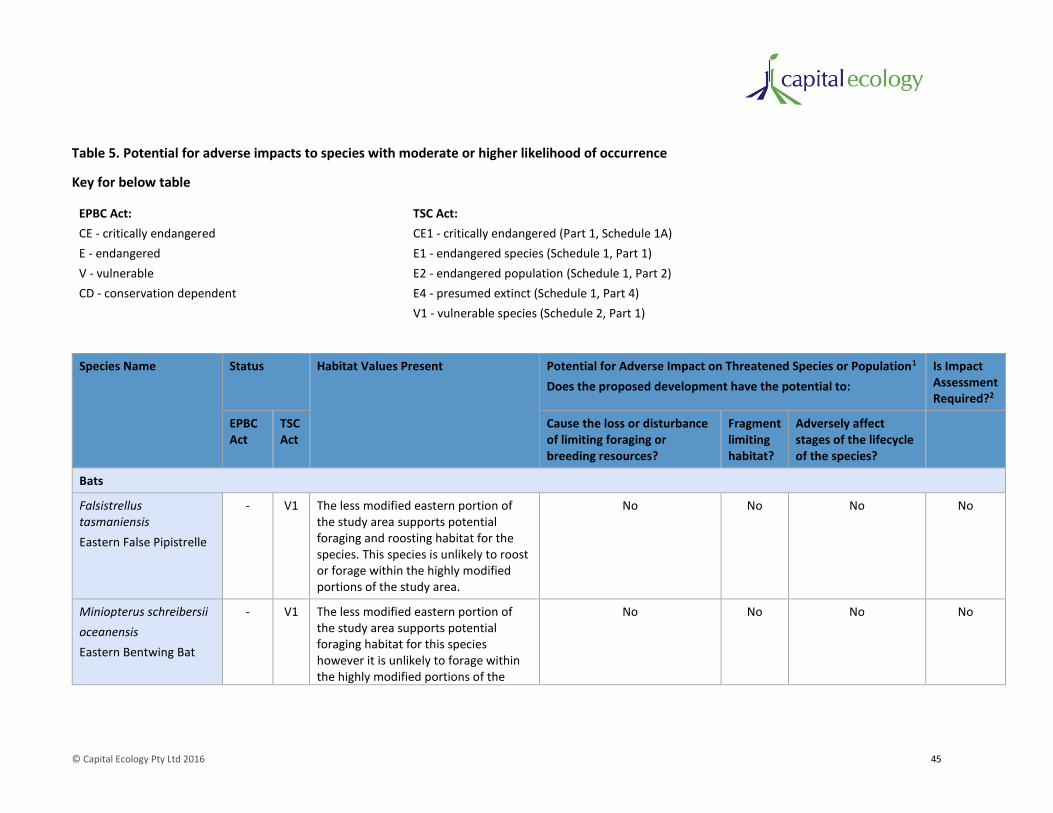
© Capital Ecology Pty Ltd 2016 45
Table 5. Potential for adverse impacts to species with moderate or higher likelihood of occurrence
Key for below table
EPBC Act: TSC Act:
CE - critically endangered CE1 - critically endangered (Part 1, Schedule 1A)
E - endangered E1 - endangered species (Schedule 1, Part 1)
V - vulnerable E2 - endangered population (Schedule 1, Part 2)
CD - conservation dependent E4 - presumed extinct (Schedule 1, Part 4)
V1 - vulnerable species (Schedule 2, Part 1)
Species Name Status Habitat Values Present Potential for Adverse Impact on Threatened Species or Population1
Does the proposed development have the potential to:
Is Impact Assessment Required?2
EPBC Act
TSC Act
Cause the loss or disturbance of limiting foraging or breeding resources?
Fragment limiting habitat?
Adversely affect stages of the lifecycle of the species?
Bats
Falsistrellus tasmaniensis
Eastern False Pipistrelle
- V1 The less modified eastern portion of the study area supports potential foraging and roosting habitat for the species. This species is unlikely to roost or forage within the highly modified portions of the study area.
No No No No
Miniopterus schreibersii
oceanensis
Eastern Bentwing Bat
- V1 The less modified eastern portion of the study area supports potential foraging habitat for this species however it is unlikely to forage within the highly modified portions of the
No No No No
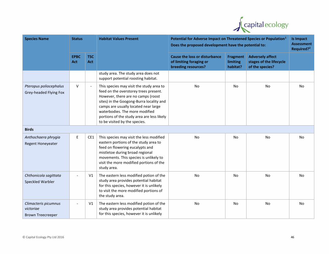
© Capital Ecology Pty Ltd 2016 46
Species Name Status Habitat Values Present Potential for Adverse Impact on Threatened Species or Population1
Does the proposed development have the potential to:
Is Impact Assessment Required?2
EPBC Act
TSC Act
Cause the loss or disturbance of limiting foraging or breeding resources?
Fragment limiting habitat?
Adversely affect stages of the lifecycle of the species?
study area. The study area does not support potential roosting habitat.
Pteropus poliocephalus
Grey-headed Flying Fox
V - This species may visit the study area to feed on the overstorey trees present. However, there are no camps (roost sites) in the Googong-Burra locality and camps are usually located near large waterbodies. The more modified portions of the study area are less likely to be visited by the species.
No No No No
Birds
Anthochaera phrygia
Regent Honeyeater
E CE1 This species may visit the less modified eastern portions of the study area to feed on flowering eucalypts and mistletoe during broad regional movements. This species is unlikely to visit the more modified portions of the study area.
No No No No
Chthonicola sagittata
Speckled Warbler
- V1 The eastern less modified potion of the study area provides potential habitat for this species, however it is unlikely to visit the more modified portions of the study area.
No No No No
Climacteris picumnus victoriae
Brown Treecreeper
- V1 The eastern less modified potion of the study area provides potential habitat for this species, however it is unlikely
No No No No
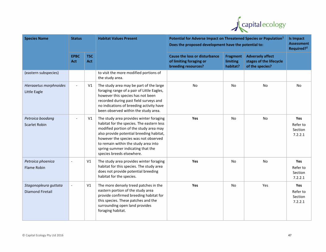
© Capital Ecology Pty Ltd 2016 47
Species Name Status Habitat Values Present Potential for Adverse Impact on Threatened Species or Population1
Does the proposed development have the potential to:
Is Impact Assessment Required?2
EPBC Act
TSC Act
Cause the loss or disturbance of limiting foraging or breeding resources?
Fragment limiting habitat?
Adversely affect stages of the lifecycle of the species?
(eastern subspecies) to visit the more modified portions of the study area.
Hieraaetus morphnoides
Little Eagle
- V1 The study area may be part of the large foraging range of a pair of Little Eagles, however this species has not been recorded during past field surveys and no indications of breeding activity have been observed within the study area.
No No No No
Petroica boodang
Scarlet Robin
- V1 The study area provides winter foraging habitat for the species. The eastern less modified portion of the study area may also provide potential breeding habitat, however the species was not observed to remain within the study area into spring-summer indicating that the species breeds elsewhere.
Yes No No Yes
Refer to Section 7.2.2.1
Petroica phoenica
Flame Robin
- V1 The study area provides winter foraging habitat for this species. The study area does not provide potential breeding habitat for the species.
Yes No No Yes
Refer to Section 7.2.2.1
Stagonopleura guttata
Diamond Firetail
- V1 The more densely treed patches in the eastern portion of the study area provide confirmed breeding habitat for this species. These patches and the surrounding open land provides foraging habitat.
Yes No Yes Yes
Refer to Section 7.2.2.1

© Capital Ecology Pty Ltd 2016 48
Species Name Status Habitat Values Present Potential for Adverse Impact on Threatened Species or Population1
Does the proposed development have the potential to:
Is Impact Assessment Required?2
EPBC Act
TSC Act
Cause the loss or disturbance of limiting foraging or breeding resources?
Fragment limiting habitat?
Adversely affect stages of the lifecycle of the species?
Reptiles
Aprasia parapulchella
Pink-tailed Worm-lizard
V V Based on the rock characteristics, the composition and condition of the groundcover vegetation and the results of the completed targeted survey, the portion of the study area considered likely to currently support this species is that shown in Figure 4. This patch of confirmed habitat is located entirely within the proposed Biodiversity Conservation Area and thus it will be conserved and not impacted by the proposed development.
No No No No
1Table adapted from the Threatened Species Assessment Guidelines – The Assessment of Significance (DECC 2007). 2 EPBC Act Significant Impact Criteria assessment and/or EP&A Act Assessment of Significance (seven-part-test) (refer Section 7.2.2.1).
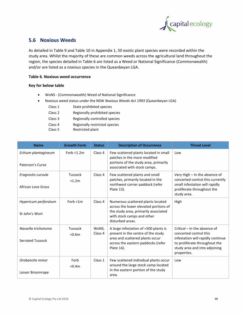
© Capital Ecology Pty Ltd 2016 49
5.6 Noxious Weeds
As detailed in Table 9 and Table 10 in Appendix 1, 50 exotic plant species were recorded within the
study area. Whilst the majority of these are common weeds across the agricultural land throughout the
region, the species detailed in Table 6 are listed as a Weed or National Significance (Commonwealth)
and/or are listed as a noxious species in the Queanbeyan LGA.
Table 6. Noxious weed occurrence
Key for below table
WoNS - (Commonwealth) Weed of National Significance
Noxious weed status under the NSW Noxious Weeds Act 1993 (Queanbeyan LGA)
Class 1 State prohibited species
Class 2 Regionally prohibited species
Class 3 Regionally controlled species
Class 4 Regionally restricted species Class 5 Restricted plant
Name Growth Form Status Description of Occurrence Threat Level
Echium plantagineum
Paterson's Curse
Forb <1.2m Class 4 Few scattered plants located in small patches in the more modified portions of the study area, primarily associated with stock camps.
Low
Eragrostis curvula
African Love Grass
Tussock
<1.2m
Class 4 Few scattered plants and small patches, primarily located in the northwest corner paddock (refer Plate 13).
Very High – In the absence of concerted control this currently small infestation will rapidly proliferate throughout the study area.
Hypericum perforatum
St John's Wort
Forb <1m Class 4 Numerous scattered plants located across the lower elevated portions of the study area, primarily associated with stock camps and other disturbed areas.
High
Nassella trichotoma
Serrated Tussock
Tussock
<0.6m
WoNS, Class 4
A large infestation of >500 plants is present in the centre of the study area and scattered plants occur across the eastern paddocks (refer Plate 14).
Critical – In the absence of concerted control this infestation will rapidly continue to proliferate throughout the study area and into adjoining properties.
Orobanche minor
Lesser Broomrape
Forb
<0.4m
Class 1 Few scattered individual plants occur around the large stock camp located in the eastern portion of the study area.
Low

© Capital Ecology Pty Ltd 2016 50
Name Growth Form Status Description of Occurrence Threat Level
Rosa rubiginosa
Briar Rose
Shrub
<3m
Class 4 Scattered plants occur throughout the lower elevated land, notably around the eastern paddocks. A few large bushes are located along the fence immediately north of the large patch of Drooping Sheoak on the northern slope of Mount Pleasant.
Moderate – Control of this species is recommended, however this should occur in conjunction with planting of native shrubs to replace the small bird habitat removed.
Rubus fruticosis
Blackberry
Shrub/bramble
<3m
WoNS, Class 4
A few small brambles occur along the creeks within the study area. The current infestation is light in comparison to similar sites in the locality.
Low-moderate – The infestation is currently at low levels but should be controlled to maintain this.
Plate 13. African Love Grass plants and small patches.

© Capital Ecology Pty Ltd 2016 51
Plate 14. Large patch of Serrated Tussock.
5.7 Pest Animals
As detailed in Table 12 in Appendix 3, 11 exotic animal species were recorded within the study area. Of
these European Rabbit Oryctolagus cuniculus, Feral Pig Sus scrofa and Red Fox Vulpes vulpes are listed as
declared pest species and species which are the cause of or key contributor a declared Key Threatening
Process.
Few foxes were observed within the study area and the presence of feral pigs was observed only from
the small patches of rooting along the drainage lines in the eastern portion of the study area. Such
infestation levels are consistent with those across similar agricultural land in the Googong-Burra locality
(R. Speirs pers. obs.).
The study area currently contains a very large rabbit infestation with numerous large warrens present,
particularly around the periphery of Mount Pleasant (refer Plate 15). These rabbits are causing
considerable erosion and other damage to the ecological and environmental values of the study area
through intense grazing, warren construction, run formation and nutrification. The implementation of a
broad scale and intensive rabbit control program is required to halt or at least substantially reduce the
impacts associated with this pest species.

© Capital Ecology Pty Ltd 2016 52
Plate 15. Large rabbit warren on northern slope of Mount Pleasant.

© Capital Ecology Pty Ltd 2016 53
6 Proposed Measures to Avoid, Minimise and Mitigate Impacts on Biodiversity
6.1 Proposed Measures to Avoid, Minimise and Mitigate Impacts
6.1.2 Development Design/Layout
The following measures have been incorporated into the design and layout of the proposed
development to avoid and minimise impacts of the upon biodiversity values, particularly those of
recognised conservation significance.
Biodiversity Conservation Area
As shown in Figure 7, the establishment of a 107 hectare ‘Biodiversity Conservation Area’ (39% of the
study area) which will include the following.
1. The entire area of each Zone 1 of each Plant Community Type (PCT) south of Burra Road. Notably,
this will include all of the EPBC Act listed Box-Gum Woodland TEC south of Burra Road.
2. The patch of confirmed Pink-tailed Worm Lizard habitat as well as most of the other rocky habitat
within the study area.
3. All of the high quality woodland bird habitat occurring within the study area, south of Burra Road.
Notably, all of the Drooping Sheoak, other dense patches of woody vegetation and the areas
observed to be of importance to threatened woodland birds will be included.
4. All of the steep sloping land within the study area, including the summit and slopes of Mount
Pleasant.
In addition to the above, from a landscape perspective, the proposed Biodiversity Conservation Area will
include all of the land within the study area (south of Burra Road) of significance to the retention of the
fauna habitat linkage running generally north-south along the eastern portion of the study area. The
fauna habitat value of the remnant eucalypts located within the proposed development footprint is
likely to be limited to that of ‘stepping-stones’, primarily for birds common to rural environs. All of these
trees are proposed to be retained and their stepping-stone function is unlikely to be substantially
altered.
The establishment of the proposed Biodiversity Conservation Area will also maintain (and enhance, refer
Section 6.1.3) the direct linkage to the expanses of high biodiversity conservation value land located to
the east within Palerang LGA (i.e. within O’Keefe’s Reserve and Googong Foreshores beyond).
The majority of the Biodiversity Conservation Area will become the community titled parcel of land
known as Community Lot 1 (refer Figure 7).
It is recognised that the proposed Biodiversity Conservation Area (developed based on the ground-
truthed values presented in this F&FA) varies from the area identified on the ‘Biodiversity’ layer of the
LEP Terrestrial Biodiversity Map Sheet BIO_001. As illustrated on Figure 6, whilst the Biodiversity layer

© Capital Ecology Pty Ltd 2016 54
roughly reflects the areas of the study area of highest biodiversity significance, the mapping as it relates
to the study area requires considerable refinement. Specifically, the Biodiversity layer:
1. Does not include substantial areas of the Zone 1 areas of both PCT999 and PCT1334 west of
Mount Pleasant. These areas support the highest quality Box-Gum Woodland within the study
area.
2. Includes much of the toe slope and mid slope land around the western and northern sides of
Mount Pleasant. These areas primarily support Zones 2 and 3 of PCT1334 which are characterised
as low diversity native or exotic grassland/pasture, with or without scattered remnant eucalypts.
Beyond protecting the remnant trees in this area, little would be gained by including this area in
the proposed Biodiversity Conservation Area.
3. Does not include most of the confirmed Pink-tailed Worm-lizard habitat.
4. Does not include the land of high fauna habitat linkage value located in the south-east corner of
the study area which is directly linked to the high biodiversity conservation value land located to
the east within Palerang LGA (i.e. within O’Keefe’s Reserve and Googong Foreshores beyond).
5. Includes two fingers which extend across the western paddocks but do not represent any
substantial watercourse or other important habitat feature on the ground.
Infrastructure and lot location
As shown in Figure 7, the following impact avoidance measures have been included in the location and
design of infrastructure and rural residential lots.
1. The location of public roads, positioning of building envelopes and alignment of boundary fences
in a manner that allows for the retention of all remnant trees.
Given their high habitat value and the long period of time required for woodland eucalypts to
reach the age at which hollows begin to develop (i.e. generally >100 years), the retention of
hollow-bearing and other remnant eucalypts has been included as a key priority during
development design.
2. The stipulation of two hectares as the minimum lot size.
3. The stipulation of 2,000m2 (0.2 hectare) maximum building envelope size. This restricts the area
of the lot that may be cleared for development related activities to a maximum of 10% of the lot.
4. The designation of a specific location for the building envelopes where the subject lot includes
PCT Zones 1 or 2. In such cases, the designated position is located in Zone 3 (exotic) areas or in a
manner that otherwise minimises impacts.

© Capital Ecology Pty Ltd 2016 55
6.1.3 Biodiversity Protection Controls and Enhancement Measures
Vegetation Management Plan
The Mount Pleasant Rural Residential Subdivision – Vegetation Management Plan (VMP) (Capital
Ecology 2016) (refer Appendix 7) has been developed to provide specifications for revegetation works
and other planting to occur within the subdivision and Biodiversity Conservation Area. More specifically,
the VMP details the suite of management measures to be implemented specific to each of the following
three ‘Vegetation Management Areas’(VMAs).
1. Vegetation Management Area 1 – Community Biodiversity Conservation Area.
VMA 1 will comprise the community titled portions of the Biodiversity Conservation Area (i.e.
Community Lot 1, refer Figure 7). As detailed in the VMP, VMA 1 will be subject to active
measures which aim to conserve and enhance the condition of the ecological communities within
and increase the habitat value of the area for native flora and fauna, notably threatened fauna.
The proposed measures include replanting 3,000 woodland trees and shrubs (notably Drooping
Sheoak to increase the potential habitat value for Glossy Black-cockatoos, aiming to encourage
more visitation of the broader locality by this species), initial and ongoing weed control and
control of vertebrate fauna pest species (notably rabbits).
2. Vegetation Management Area 2 – Private Biodiversity Conservation Area.
VMA 2 will comprise the portions of the Biodiversity Conservation Area included within privately
owned lots. In a similar manner to VMA 1, VMA 2 will be subject to active measures which aim to
conserve and enhance the condition of the ecological communities encompassed and increase the
habitat value of the area for native flora and fauna, notably threatened fauna. The appropriate
management and enhancement of VMA 2 will be of particular value as a means of strengthening
the biodiversity corridor which runs north-south along the eastern side of the study area.
3. Vegetation Management Area 3 – Biodiversity Covenant Areas.
VMA 3 will comprise the portions of private lots that support Vegetation Zone 2 of either PCT999
or PCT1334. The portions of private lots encompassed by VMA 3 will be subject to land
management provisions requiring landowners to retain all remnant trees, plant only trees of
species indigenous to the locality and maintain the ‘native grassland’ characteristics of the
groundstorey.
Community Management Statement (CMS)
The Mount Pleasant Rural Residential Subdivision – Community Management Statement (CMS) (Holding
Redlich, Draft 2015) has been developed to provide controls relating to the management of the
subdivision during occupation. Once endorsed and implemented, the CMS will provide in perpetuity
legal certainty for the measures detailed in the VMP (among numerous other elements). CMS ‘Part 5 –
By-Laws Required by Authorities’ will ensure that the authorities have the power to enforce the
implementation of the VMP in perpetuity. The following biodiversity protection related controls will be
enforced to protect biodiversity values following occupation of the lots.
1. Lot owners must preserve all remnant eucalypts within their lot.
© Capital Ecology Pty Ltd 2016 56
2. Lot owners must comply with the requirements of the Vegetation Management Plan (i.e.
becoming conditions of consent as applied via the CMS) applicable to the lot.
3. On all lots contained either partly or wholly within the Biodiversity Conservation Area, an owner
and/or occupier must ensure that all native vegetation within the Biodiversity Conservation
Area is protected and managed in a way that facilitates and encourages regeneration of
indigenous native species, using the strategies nominated below:
a. no clearing or removal of native vegetation, including standing trees (living or dead), fallen
dead timber greater than 20 cm diameter, shrubs, grasses or groundcovers (except for the
purposes of constructing a single vehicle access road (driveway) between the public road
and the building envelope), unless approval is obtained from the Council or other relevant
authority;
b. no keeping of hooved animals (either on a permanent or temporary basis) on the lot, unless
approval is obtained from the Council or other relevant authority;
c. light grazing is permitted provided that grazing is confined to those parts of these Lots
outside the Biodiversity Conservation Area and that a stock proof fence (hinge jointed mesh
and two plain wire strands) is erected to ensure no grazed animals may enter the
Biodiversity Conservation Area areas. Stocking rates are not to exceed 1 horse or cow (or
equivalent) per 2 hectares of grazing and/or 5 sheep or goats (or equivalent) per 2 hectares
of grazing land. Groundcover must not fall below 70% coverage before stock is removed.
d. no species listed as prohibited plants in the Vegetation Management Plan may be planted
on the lot; and
e. landscaping of the lot may only be carried out if it is complementary to the native
indigenous vegetation of the lot, using species from the list provided in the Vegetation
Management Plan.
6.2 Net Biodiversity Impact Position with Implementation of Measures
With the implementation of the above described impact avoidance, minimisation and mitigation measures, the residual impacts of the proposed development will be limited to the clearance of groundcover vegetation within Vegetation Zones 2 (low diversity native) and 3 (exotic) for the 2,000m2 maximum building envelopes and that required to construct public roads, internal driveways and install underground services.

© Capital Ecology Pty Ltd 2016 57
6.3 Development vs Non-development – Future Net Biodiversity Values Position under each Scenario
As described above, the clearance of limited areas of lower condition vegetation cannot be avoided. As
discussed in Section 7, given the substantial reduction in impacts achieved through the incorporation of
ecologically sensitive design measures, this residual impact is considered unlikely to significantly affect
the relevant significant biodiversity values.
When assessing the likely impacts of a proposed development on biodiversity values, it is useful to also
consider the likely future net biodiversity values in the non-development scenario. In this regard, the
following salient points should be considered.
1. If the proposed development does not go ahead, then the current land management regime will
continue unchanged. In this scenario:
a. the set stock grazing will continue, preventing tree regeneration and gradually yet
progressively continuing to degrade and simplify the groundstorey;
b. with the lack of recruitment, the old remnant trees will senesce and die without
replacement, eventually turning the Zone 2 areas of scattered trees over modified grassland
to modified grassland only (estimated to occur noticeable over the next 50 years);
c. the significant infestations of noxious weeds, notably Serrated Tussock and African Love
Grass are unlikely to be effectively controlled, leading the proliferation of these species
within the study area and potentially their spread into adjoining properties;
d. vertebrate pests, notably rabbits which are the cause of a declared Key Threatening Process,
are unlikely to be effectively controlled, leading to continued land degradation; and
e. the erosion and sediment management measures proposed to address the significant
erosion along Church Creek will not be implemented.
2. If the proposed development does not go ahead, then the substantial biodiversity protection
and enhancement measures described in Section 6.1.3 and detailed in the VMP will not be
implemented. Therefore, the potential benefits to biodiversity within the study area and
broader locality would not be realised.
Given the above, it is reasonable to suggest that the non-development scenario, with its corresponding
lack of action and continuance of degrading factors, may in fact result in an inferior medium to long
term outcome for the biodiversity values of the study area.

Figure 7. Proposed Development
Study_Area_Boundary
Development Lot Layout
Proposed_Biodiversity_Conserva on_Area
Building_Envelope
EPBC_Act_Box-Gum_Woodland
TSC_Act_Box-Gum_Woodland
Likely_Extent_Of_PTWL_Presence
Diamond_Firetail_Nest
Snow_Gum_(E.pauciflora)
Apple_Box_(E.bridgesiana)
Red_Box_(E.polyanthemos)
Broad-leaved_Peppermint_(E.dives)
Mealy_Bundy_(E.nortonii)
Candlebark_(E.rubida)
Yellow_Box_(E.melliodora)
Legend
0 100 200 300 400 m
Scale 1:7,200 @ A3, GDA 1994, MGA Zone 55
Capital Ecology Project No: 2681Drawn by: R. SpeirsDate: 12 September 2016
Note: EPBC Act Box-Gum Woodland is also TSC ActBox-Gum Woodland
Community Lot 1Burra Road

© Capital Ecology Pty Ltd 2016 59
7 Assessment against Biodiversity Conservation Legislation and Policy
This section provides an assessment of the proposed development against the current biodiversity
conservation legislation and government policy.
7.1 Commonwealth
7.1.2 Environment Protection and Biodiversity Conservation Act 1999
The EPBC Act is the key Commonwealth Government legislation for the protection and conservation of
Australia’s environment and biodiversity. The EPBC Act provides the legislative framework for the
assessment and approval mechanism requiring that proposed ‘actions’ to be assessed in terms of their
potential to impact upon ‘Matters of National Environmental Significance’ (MNES). MNES currently
listed under the EPBC Act are:
• world heritage properties;
• natural heritage places;
• wetlands of international importance (listed under the Ramsar Convention);
• threatened species and ecological communities;
• migratory species (protected under international agreements);
• Commonwealth marine areas;
• the Great Barrier Reef Marine Park;
• nuclear actions (including uranium mining); and
• a water resource, in relation to coal seam gas development and large coal mining development.
Where a potential impact on a MNES may occur as a result of a proposed action, the significance of that
impact must be assessed. Guidelines for determining whether an impact is significant are provided by
the DoE (DoE 2013). If it is determined that a proposed action will, or is likely to, have a significant
impact on a MNES, the action must be referred to the Commonwealth Minister for the Environment.
The DoE will then consider the referred action and the Minister (or his/her Delegate) will make a
determination regarding whether the action requires approval under the EPBC Act and associated
conditions and controls.
The following website provides further information regarding the EPBC Act referral and approval
process: http://www.environment.gov.au/epbc/index.html
The MNES of relevance to the proposed development are described in Table 7. Table 7 also provides an
assessment of the potential for the proposed development to significantly impact the MNES. As detailed
in Table 7, referral of the proposed development is not required.

© Capital Ecology Pty Ltd 2016 60
Table 7. Assessment of the potential for significant impacts upon MNES
MNES Occurrence/Relevance Assessment
Threatened species and ecological communities
The portions of the study area mapped as PCT1334 – Zone 1 are consistent with the definition of the critically endangered listed ecological community White Box – Yellow Box – Blakely's Red Gum grassy woodland and derived native grassland (Box-Gum Woodland).
Twenty-six (26) EPBC Act threatened species are known or considered likely to occur in the locality
The entire area of EPBC Act listed Box-Gum Woodland present within the study area, south of Burra Road, will be included in the proposed Biodiversity Conservation Area. As described in Section 6.1.3, this area will be subject to strict management conditions and controls which will ensure that the values of the community are conserved.
As detailed in Table 14, none of the EPBC Act listed threatened species with the potential to occur in the study area are likely to be impacted by the proposed development.
Migratory species Six (6) terrestrial migratory species are known or considered likely to occur in the locality.
An area of 'important habitat' for a migratory species is defined by the Department of the Environment (DoE 2013) as:
• habitat utilised by a migratory species occasionally or periodically within a region that supports an ecologically significant proportion of the population of the species; and/or
• habitat that is of critical importance to the species at particular lifecycle stages; and/or
• habitat utilised by a migratory species which is at the limit of the species range; and/or
• habitat within an area where the species is declining.
While some of the relevant listed migratory species may visit the study area, the study area does not provide important habitat for an ecologically significant proportion of any migratory listed species.
Wetlands of international importance (Ramsar wetlands)
The study area is located in the catchment of three Ramsar wetlands:
Banrock Station Wetland Complex;
Coorong and Lakes Alexandrina and Albert; and
Riverland
The study area is remote from each of these Ramsar wetlands and, as such, none will be significantly impacted be the proposed development.
The removal of stock grazing and effective management of sediment and erosion will result in improved water quality in flows to the receiving environment.
7.2 New South Wales (State)
7.2.2 Environmental Planning and Assessment Act 1979
The EP&A Act was enacted to ensure that the impacts of proposed development or land-use changes on
the environment (biodiversity and broader) are properly considered and controlled. The EP&A Act is
administered by the NSW Department of Planning and Infrastructure.

© Capital Ecology Pty Ltd 2016 61
The Parts of the EP&A Act of key relevance to the protection and conservation of biodiversity are
discussed in the following sections. Consideration is provided regarding the implementation of EP&A Act
for the proposed development.
7.2.2.1 Assessment of Significance (Section 5A)
Section 5A of the EP&A Act (and Section 94 of the TSC Act) outlines seven factors that must be taken
into account in an Assessment of Significance (AoS) (known as a seven-part-test). If an AoS deems the
development likely to significantly affect a threatened species, population, ecological communities or its
habitat, a Species Impact Statement (SIS) must be prepared as outlined in Section 110 of the TSC Act.
The following website provides further information regarding the AoS and SIS preparation and
assessment: http://www.environment.nsw.gov.au/threatenedspecies/tsaguide.htm
As discussed in Table 5, three TSC Act listed woodland birds were considered to warrant the preparation
of an AoS. The resulting assessments are provided in Appendix 6, the results of which indicate that the
proposed development is unlikely to significantly affect any of these species.
As described in Section 5.2.3, the portions of the study area mapped as PCT1334-Zone1 support the
NSW listed TEC White Box – Yellow Box – Blakely’s Red Gum grassy woodland. The area mapped as
PCT1334-Zone2 is also consistent with the listed community, albeit in a very marginal form. An AoS was
prepared for this community and is provided in Appendix 6, the results of which indicate that the
proposed development is unlikely to significantly affect this TEC.
Given the above, no SISs are required for the proposed development.
7.2.2.2 BioBanking Metric Assessment
Item 2 of the Request for Further Information (‘RFI’) received from Queanbeyan-Palerang Regional
Council (‘Council’), dated 6 June 2016, requested that the NSW BioBanking metric be applied to the
vegetation mapping prepared by Capital Ecology across spring 2015 and presented in the version of this
F&FA dated 8 February 2016.
It is noted that a BioBanking agreement/statement cannot be issued for the study area due to the non-
urban land zone (i.e. E4 - Environmental Living). Notwithstanding this, as noted in the RFI, the
BioBanking metric provides the most appropriate means of assessing the adequacy of the proposed
offset (i.e. the Biodiversity Conservation Area) in a quantified, open and transparent manner.
Accordingly, Capital Ecology has undertaken a BioBanking Metric Assessment to address RFI Item 2, a
copy of which is provided as Appendix 8.
The conclusion of the BioBanking Metric Assessment is that the proposed establishment, protection and
enhancement of the approx. 107 ha Biodiversity Conservation Area would sufficiently offset the impacts
of the proposed development.
7.2.2.3 State Environmental Planning Policies
State Environmental Planning Policies (SEPPs) outline policy objectives relevant to state wide issues. No
SEPPs of a biodiversity conservation focus are of relevance to the study area or the proposed
development.

© Capital Ecology Pty Ltd 2016 62
7.2.2.4 Local Environment Plan
The Queanbeyan Local Environment Plan (LEP) applies to the study area, providing the zoning of the
land and stipulating what development and other activities may occur within the relevant zone.
‘Clause 7.3 Terrestrial Biodiversity’ of the LEP applies to land identified as ‘Biodiversity’ on the Terrestrial
Biodiversity Map (BIO_001 maps). The objective of Clause 7.3 is to:
Maintain terrestrial biodiversity by:
(a) protecting native fauna and flora, and
(b) protecting the ecological processes necessary for their continued existence, and
(c) encouraging the conservation and recovery of native fauna and flora and their habitats.
In accordance with Clause 7.3, before determining a development application for development on land
identified as ‘Biodiversity’, the consent authority must consider:
(a) whether the development is likely to have:
(i) any adverse impact on the condition, ecological value and significance of the fauna and
flora on the land, and
(ii) any adverse impact on the importance of the vegetation on the land to the habitat and
survival of native fauna, and
(iii) any potential to fragment, disturb or diminish the biodiversity structure, function and
composition of the land, and
(iv) any adverse impact on the habitat elements providing connectivity on the land, and
(b) any appropriate measures proposed to avoid, minimise or mitigate the impacts of the
development.
Development consent must not be granted to development on land on land identified as ‘Biodiversity’
unless the consent authority is satisfied that:
(a) the development is designed, sited and will be managed to avoid any significant adverse
environmental impact, or
(b) if that impact cannot be reasonably avoided by adopting feasible alternatives-the development
is designed, sited and will be managed to minimise that impact, or
(c) if that impact cannot be minimised-the development will be managed to mitigate that impact.
Shown overlain on Figure 6, a substantial portion of the study area is subject to the ‘Biodiversity’ layer
on the LEP Terrestrial Biodiversity Map Sheet BIO_001 maps. As discussed Section 6.1.2, whilst the
Biodiversity layer roughly reflects the areas of the study area of highest biodiversity significance, the
mapping as it relates to the study area requires considerable refinement.

© Capital Ecology Pty Ltd 2016 63
As detailed in Section 6, the protection and conservation of terrestrial biodiversity has been a key
consideration throughout the design of the proposed development. The proposed establishment and
enhancement of the 107 hectare Biodiversity Conservation Area, together with the sensitive design and
location of a lots, building envelopes and infrastructure, will avoid, minimise and mitigate impacts such
that the proposed development is unlikely to result in any significant adverse impact upon the
biodiversity values of the study area.
Given the above, the proposed development is consistent with the objective of Clause 7.3.
7.2.3 Threatened Species Conservation Act 1995
The TSC Act provides for the protection and conservation of biodiversity in NSW through the listing of
threatened species, populations and communities, together with the listing of critical habitat and key
threatening processes for these.
Critical habitat for an endangered or critically endangered species, population or ecological community
is described on the Register of Critical Habitat maintained by OEH. The study area does not contain
declared critical habitat for species, population or ecological community.
Under Section 91 licence of the TSC Act a licence is required for actions that are likely to result in:
• harm to, or picking of, a threatened species, population or ecological community;
• damage to a habitat of a threatened species, population or ecological community, including
critical habitats.
Licensing provisions for protected flora and fauna are provided in the National Parks and Wildlife Act
1974. However, a Section 91 licence may be extended to include protected flora and fauna when these
will be affected by a proposed development or action.
The proposed development will retain all trees and most of the groundcover throughout the
development footprint. Therefore, it will not result in substantial damage to habitat of a threatened
species, population or ecological community. As such, a licence Under Section 91 licence of the TSC Act
is unlikely to be required.
7.2.4 Native Vegetation Act 2003
The NV Act provides the framework for the management of native vegetation in NSW, preventing broad-
scale clearing unless it improves or maintains environmental outcomes. Native vegetation is classified as
any species of vegetation that existed in NSW before pastoral settlement, including trees, saplings,
shrubs, scrub, understorey, groundcover or wetland plants.
Under the NV Act clearing of native vegetation is prohibited unless it is permitted for a routine
agricultural management activities (RAMAs), is in accordance with development consent from the
relevant Council or other authority or under a Property Vegetation Plan (PVP) approved by NSW Local
Land Service.
The following website provides further information regarding NV Act and its application:
http://www.environment.nsw.gov.au/vegetation/nvact.htm

© Capital Ecology Pty Ltd 2016 64
The proposed development is the subject of a Development Application to be assessed by Queanbeyan-
Palerang Regional Council under the provisions of the EP&A Act. On approval of the proposed
development the clearing for ‘dwellings’ will be subject to an exclusion under Section 25 of the NV Act.
However, the proposed clearance of native vegetation for the road network is not subject to an
exemption, and therefore, this clearance requires consent under the NV Act.
CIC Australia has commenced the NV Act assessment process with South-East Local Land Services (LLS),
the outcomes of which will be known following LLS’ onsite vegetation survey scheduled for October
2016.
7.2.5 Noxious Weeds Act 1993
The NW Act was enacted to provide for the identification, classification and control of declared noxious
weeds. The Noxious Weeds (Weed Control) Order 2014 (known as Weed Control Order No. 30) (DPI
2014) details the weeds declared noxious in New South Wales under the NV Act. Weed Control Order
No 30 lists the weed name, control class and legal control requirements for each species declared in a
Local Control Authority area (generally aligning with a Local Government Area).
The following website provides further information regarding NW Act and its application:
http://www.dpi.nsw.gov.au/aboutus/about/legislation-acts/noxious-weeds
The declared noxious weeds recorded within the study area are detailed in Table 6. An occupier (other
than a public authority or a Local Control Authority) is required under the NW Act to implement all
reasonable measures to eradicate state prohibited weeds and comply with the stated requirements for
a notifiable weeds and restricted plants.
7.2.6 Fisheries Management Act 1994
The objective of the FM Act is to conserve, develop and share the fishery resources of NSW for the
benefit of present and future generations. The FM Act includes provisions to ensure the protection and
conservation of aquatic species and their habitat throughout NSW. Similar to terrestrial species listed
pursuant to the TSC Act, impacts to threatened species, populations and communities listed pursuant to
the FM Act must be assessed via the Assessment of Significance process under Section 5A of the EP&A
Act.
The study area does not support any community, species or potential habitat for any species listed
pursuant to the FM Act, and therefore, the proposed development is unlikely to significantly affect any
such species or population thereof. Accordingly, no further consideration of aquatic species and their
habitat is provided herein.
7.3 Summary of Assessment Results and Requirements
This F&FA provides a thorough investigation into the currently listed significant biodiversity values (i.e.
threatened flora and fauna species and threatened ecological communities) that occur or have the
potential to occur within the study area. A thorough assessment has then been undertaken to assess the
likely type and degree of any impacts that the proposed development may have upon the identified
biodiversity values, as required in accordance with the EPBC Act, EP&A Act and TSC Act.

© Capital Ecology Pty Ltd 2016 65
Table 8 provides a summary of the results of this assessment and the corresponding approval and/or
permit requirements applicable pursuant to the current relevant biodiversity conservation legislation
and government policy.
Table 8. Summary of assessment results and corresponding requirements
Legislation/Policy Relevant Biodiversity Value/s Assessment Results and Approval/Permit Requirement/s
Commonwealth
Environment Protection and Biodiversity Conservation Act 1999
White Box – Yellow Box – Blakely's Red Gum grassy woodland and derived native grassland (EPBC Act Box-Gum Woodland).
Potential habitat for threatened fauna species.
As shown in Figure 7, the entire area of EPBC Act listed Box-Gum Woodland present within the study area, south of Burra Road, will be included in the proposed Biodiversity Conservation Area. Strict management conditions and controls will be implemented to ensure that the values of the listed community are conserved. (refer to Section 6).
As detailed in Table 14, none of the EPBC Act listed threatened species with the potential to occur in the study area are likely to be significantly impacted by the proposed development.
The proposed development is unlikely to significantly impact upon any MNES. As such, referral of the development for consideration, and potentially assessment, under the provisions of the EPBC Act is not considered warranted.
New South Wales (State)
Environmental Planning & Assessment Act 1979
White Box – Yellow Box – Blakely's Red Gum grassy woodland (TSC Act Box-Gum Woodland).
Potential habitat for threatened fauna species.
As detailed in the AoSs provided in Appendix 6, the proposed development is unlikely to significantly affect this TSC Act listed TEC or any of the relevant TSC Act listed threatened species.
Accordingly, the preparation of Species Impact Statements or the provision of a formal offset is not considered warranted for the proposed development.
Notwithstanding the above, Capital Ecology has prepared a BioBanking Metric Assessment for the proposed development, the conclusion of which is that the proposed establishment, protection and enhancement of the approx. 107 ha Biodiversity Conservation Area would sufficiently offset the impacts of the proposed development.
Queanbeyan Local Environment Plan 2012
Land mapped as ‘Biodiversity’ on the Terrestrial Biodiversity Map.
The proposed establishment and enhancement of the Biodiversity Conservation Area, together with the sensitive design and location of a lots, building envelopes and infrastructure, will avoid, minimise and mitigate impacts such that the proposed development is unlikely to result in any significant adverse impact upon the biodiversity values of the study area.
As such, the proposed development is consistent with the objective of Clause 7.3 of the Queanbeyan LEP.

© Capital Ecology Pty Ltd 2016 66
Legislation/Policy Relevant Biodiversity Value/s Assessment Results and Approval/Permit Requirement/s
Threatened Species Conservation Act 1995
White Box – Yellow Box – Blakely's Red Gum grassy woodland (TSC Act Box-Gum Woodland).
Potential habitat for threatened fauna species.
The study area does not contain declared critical habitat for any species, population or ecological community.
The proposed development will retain all trees and most of the groundcover throughout the development footprint. Therefore, it will not result in substantial damage to habitat of a threatened species, population or ecological community. As such, a licence under Section 91 of the TSC Act is unlikely to be required.
Fisheries Management Act 1994
None. The study area does not support any community, species, or potential habitat for any species, listed pursuant to the FM Act.
Native Vegetation Act 2003
Native vegetation. The proposed development is the subject of a Development Application to be assessed by Queanbeyan-Palerang Regional Council under the provisions of the EP&A Act. On approval of the proposed development the clearing for ‘dwellings’ will be subject to an exclusion under Section 25 of the NV Act. However, the proposed clearance of native vegetation for the road network is not subject to an exemption, and therefore, this clearance requires consent under the NV Act.
CIC Australia has commenced the NV Act assessment process with South-East Local Land Services (LLS), the outcomes of which will be known following LLS’ onsite vegetation survey scheduled for October 2016.
Noxious Weeds Act 1993 Noxious weeds. The occupier is required under the NW Act to implement all reasonable measures in accordance with the requirements of Weed Control Order No. 30. As detailed in Section 7.2.5, this is of particular relevance for the control of the Serrated Tussock and African Love Grass within the study area as these species currently pose a very high to critical threat level to the biodiversity values of the study area and adjoining land.

© Capital Ecology Pty Ltd 2016 67
8 Conclusion
This F&FA presents the results of a thorough investigation undertaken by Capital Ecology into the
currently listed significant biodiversity values that occur or have the potential to occur within the study
area. The results of this study, together with information obtained from a review of relevant databases
and literature, have informed our assessment of the significance of the impacts that the proposed
development is likely to have upon the identified biodiversity values.
Based on our completed assessment, we conclude that, with the implementation of the proposed
measures to avoid, minimise and mitigate impacts upon biodiversity values (as detailed in Section 6), the
proposed development is:
1. unlikely to significantly impact upon any MNES as listed pursuant to the Commonwealth EPBC
Act, and therefore referral of the proposed action to the Commonwealth Minister for the
Environment is unwarranted;
2. unlikely to significantly affect any threatened species, population or ecological community listed
pursuant to the NSW TSC Act, and therefore the preparation of Species Impact Statements or
the provision of a formal offset is unwarranted;
3. likely to result in a medium to long term outcome for the biodiversity values of the study area
which is superior to that which is likely to eventuate under the non-development scenario with
its corresponding lack of action and continuance of degrading factors; and
4. likely to accord with the NSW Government’s policy objective that development results in a ‘net
improvement in biodiversity over time’.

© Capital Ecology Pty Ltd 2016 68
References
Biosis (2015). Googong Township Neighbourhoods 2 to 5 – Ecological Values and Constraints
Assessment. Author: S. Vertucci. Prepared for Googong Township Pty Ltd.
Capital Ecology (2016). Mount Pleasant Rural Residential Subdivision – Vegetation Management Plan.
Final – February 2016. Prepared for CIC Australia Pty Ltd. Author: R. Speirs. Project no. 2681.
Cosgrove (2014). Photographic Guide to Native Plants of the Australian Capital Territory. Published by
Meadow Argus.
DECCW (2011). NSW BioCertification Assessment Methodology. NSW Department of Environment,
Climate Change and Water.
DECC (2007). Threatened Species Assessment Guidelines – The Assessment of Significance. NSW
Department of Environment and Climate Change.
DEH (2006). Policy Statement 3.5: White Box – Yellow Box – Blakely’s Red Gum grassy woodlands and
derived native grasslands. Environment Protection and Biodiversity Conservation Act 1999.
Commonwealth Department of Environment and Heritage.
DEWHA (2009). Background Paper to EPBC Act Policy Statement 3.12 - Significant Impact Guidelines for
the Critically Endangered Golden Sun Moth (Synemon plana). Commonwealth Department of Water,
Heritage and the Arts.
DoE (2013). Matters of National Environmental Significance - Significant Impact Guidelines 1.1.
Environment Protection and Biodiversity Conservation Act 1999. Commonwealth Department of the
Environment.
DPI (2014). Noxious Weeds (Weed Control) Order 2014 (Weed Control Order No. 30). NSW Department
of Primary Industries.
Eddy D., Mallinson D., Rehwinkel R. and Sharp S. (2011). Grassland Flora – A field quide to for the
Southern Tablelands (NSW & ACT).
Harden G.J. (2002). Flora of New South Wales. Volume 1-4. University of New South Wales Press Ltd.,
Kensington.
Holding Redlich (2015). Mount Pleasant Rural Residential Subdivision – Community Management
Statement (Draft). Prepared for CIC Australia Pty Ltd.
Johnstone Centre (2004). Environmental Assessment – Googong Urban Investigation Area. A report to
Willana Associates Pty Ltd. Report No. 66, Charles Sturt University, Wagga Wagga. Authors: L. Thompson
and B. Mullins.
Jones S.R. (1999). Conservation biology of the pink-tailed worm lizard (Aprasia parapulchella). PhD
thesis, Applied Ecology Research Group, University of Canberra.

© Capital Ecology Pty Ltd 2016 69
Kevin Mills & Associates (2015). Revised Report, Flora and Fauna Assessment, Rural Residential
Subdivision. Mount Pleasant, Burra Road, Queanbeyan. Report prepared for CIC Australia, Canberra,
July.
NSW NPWS (2002). Identification Guidelines for Endangered Ecological Communities - White Box Yellow
Box Blakely's Red Gum Woodland (Box-Gum Woodland). NSW National Parks and Wildlife Service.
NSW Scientific Committee (2002). Final Determination: White Box Yellow Box Blakely's Red Gum
Woodland. Gazetted 15 March 2002.
OEH (2016). NSW Vegetation Information System. NSW Office of Environment and Heritage.
http://www.environment.nsw.gov.au/research/Vegetationinformationsystem.htm
Osborne W.S. and Jones S.R. (1995). Recovery plan for the Pink-tailed Worm Lizard Aprasia
parapulchella. Technical Report No.10. ACT Parks and Conservation Service.
Queanbeyan City Council (2012). Local Environmental Plan. Terrestrial Biodiversity Map Sheet BIO_001.
http://www.legislation.nsw.gov.au/mapindex?type=epi-made&year=2012&no=576
Richardson F.J, Richardson R.G. and Shepherd R.C.H (2011). Weeds of the South-East – An Identification
Guide for Australia. Second Edition.
SpaceLab (2015). Mt. Pleasant Burra - Landscape Master Plan. Prepared for CIC Australia.
Wood D. and Wood B. (2005). Flowers of the ACT & Region – A field guide. Wood’s Books, ACT.

© Capital Ecology Pty Ltd 2016 70
Appendices
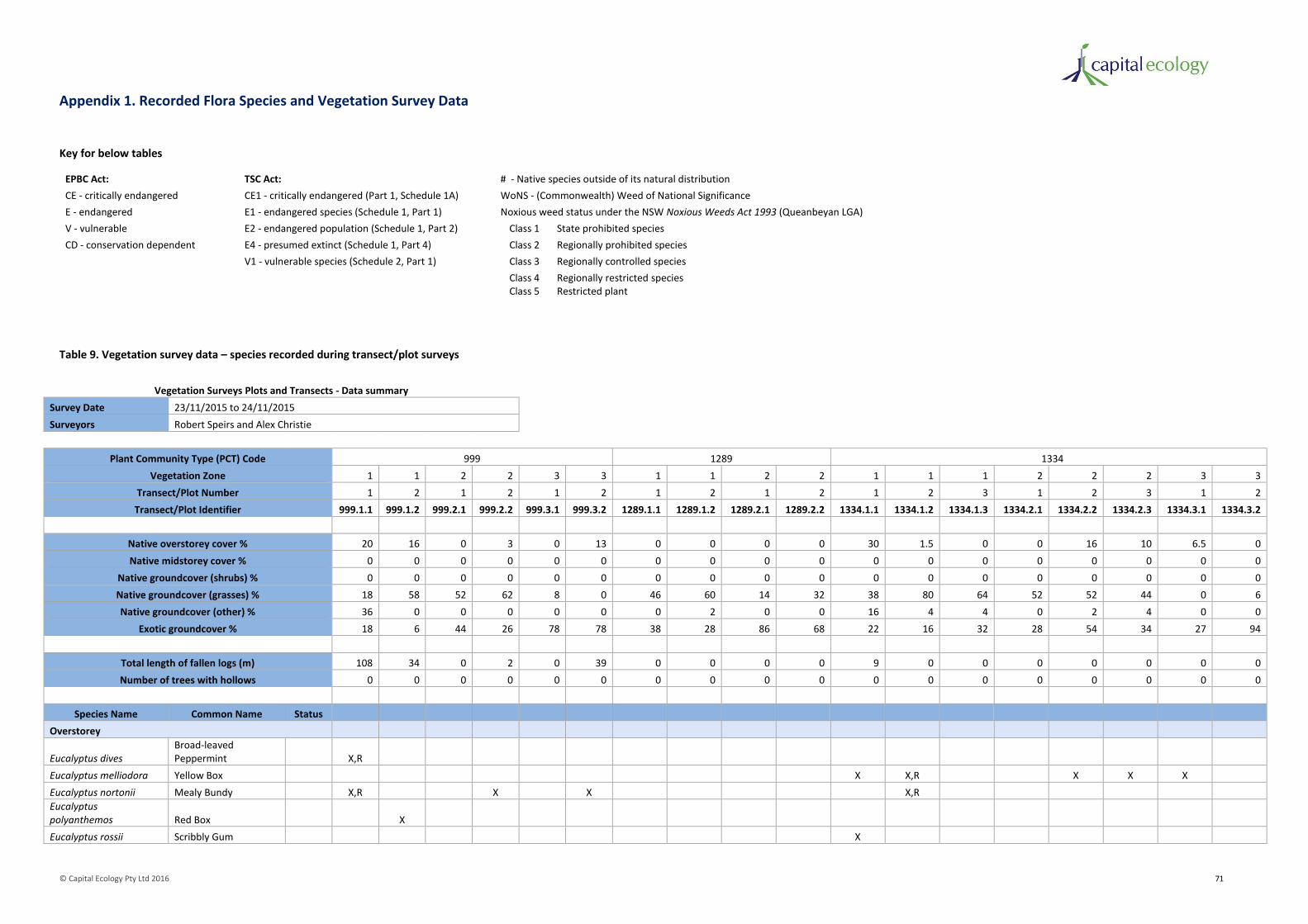
© Capital Ecology Pty Ltd 2016 71
Appendix 1. Recorded Flora Species and Vegetation Survey Data
Key for below tables
EPBC Act: TSC Act: # - Native species outside of its natural distribution
CE - critically endangered CE1 - critically endangered (Part 1, Schedule 1A) WoNS - (Commonwealth) Weed of National Significance
E - endangered E1 - endangered species (Schedule 1, Part 1) Noxious weed status under the NSW Noxious Weeds Act 1993 (Queanbeyan LGA)
V - vulnerable E2 - endangered population (Schedule 1, Part 2) Class 1 State prohibited species
CD - conservation dependent E4 - presumed extinct (Schedule 1, Part 4) Class 2 Regionally prohibited species
V1 - vulnerable species (Schedule 2, Part 1) Class 3 Regionally controlled species
Class 4 Regionally restricted species Class 5 Restricted plant
Table 9. Vegetation survey data – species recorded during transect/plot surveys
Vegetation Surveys Plots and Transects - Data summary
Survey Date 23/11/2015 to 24/11/2015
Surveyors Robert Speirs and Alex Christie
Plant Community Type (PCT) Code 999 1289 1334
Vegetation Zone 1 1 2 2 3 3 1 1 2 2 1 1 1 2 2 2 3 3
Transect/Plot Number 1 2 1 2 1 2 1 2 1 2 1 2 3 1 2 3 1 2
Transect/Plot Identifier 999.1.1 999.1.2 999.2.1 999.2.2 999.3.1 999.3.2 1289.1.1 1289.1.2 1289.2.1 1289.2.2 1334.1.1 1334.1.2 1334.1.3 1334.2.1 1334.2.2 1334.2.3 1334.3.1 1334.3.2
Native overstorey cover % 20 16 0 3 0 13 0 0 0 0 30 1.5 0 0 16 10 6.5 0
Native midstorey cover % 0 0 0 0 0 0 0 0 0 0 0 0 0 0 0 0 0 0
Native groundcover (shrubs) % 0 0 0 0 0 0 0 0 0 0 0 0 0 0 0 0 0 0
Native groundcover (grasses) % 18 58 52 62 8 0 46 60 14 32 38 80 64 52 52 44 0 6
Native groundcover (other) % 36 0 0 0 0 0 0 2 0 0 16 4 4 0 2 4 0 0
Exotic groundcover % 18 6 44 26 78 78 38 28 86 68 22 16 32 28 54 34 27 94
Total length of fallen logs (m) 108 34 0 2 0 39 0 0 0 0 9 0 0 0 0 0 0 0
Number of trees with hollows 0 0 0 0 0 0 0 0 0 0 0 0 0 0 0 0 0 0
Species Name Common Name Status
Overstorey
Eucalyptus dives Broad-leaved Peppermint X,R
Eucalyptus melliodora Yellow Box X X,R X X X
Eucalyptus nortonii Mealy Bundy X,R X X X,R
Eucalyptus polyanthemos Red Box X
Eucalyptus rossii Scribbly Gum X

© Capital Ecology Pty Ltd 2016 72
Midstorey
Allocasuarina verticillata Drooping Sheoak X
Bursaria spinosa subsp. spinosa Native Blackthorn X
Groundcover
Native
Acaena ovina Sheep's Burr X X
Asperula conferta Common Woodruff X X X X X
Austrostipa bigeniculata Tall Speargrass X X X X X X X X
Austrostipa scabra Corkscrew X X X X X X X X X X X X X X
Bossiaea buxifolia Matted Bossiaea X
Bothriochloa macra Red-leg Grass X X X X X
Bulbine bulbosa Bulbine Lily X X
Bursaria spinosa subsp. spinosa Native Blackthorn X X
Carex appressa Tall Sedge X X
Carex inversa Knob Sedge X X X X
Cassinia quinquefaria Sifton Bush X
Cheilanthes austrotenuifolia Rock Fern X X
Chloris truncata Windmill Grass X
Chrysocephalum apiculatum Common Everlasting X X
Convolvulus angustissimus Austral Bindweed X X X X X
Cullen microcephalum Dusky Scurfpea X
Cymbonotus lawsonianus Austral Bears-ear X X X X X X
Cynoglossum suaveolens Sweet Hound's Tongue X
Daucus glochidiatus Native Carrot X
Desmodium varians Slender Tick-trefoil X X X
Dianella revoluta Black-anther Flax-lily X
Dichelachne sp. Plume Grass X
Dichondra repens Kidney Weed X
Dichopogon fimbriatus Nodding Chocolate Lily X
Drosera peltata Pale Sundew X
Elymus scaber Wheat Grass X X X X X X X X
Euchiton sp. Native Cudweed X X X X X X X X X X X X X X X
Geranium solanderi Native Geranium X X X X X X X X X
Gonocarpus tetragynus Raspwort X X
Hardenbergia violacea False Sarsparilla X
Hibbertia obtusifolia Grey Guinea-flower X
Hydrocotyle laxiflora Stinking Pennywort X X X
Hypericum gramineum Small St John's Wort X X X X
Juncus australis Austral Rush X X X X X X X X
Juncus subsecundus Finger Rush X X X X

© Capital Ecology Pty Ltd 2016 73
Leptorhynchos squamatus Scaly Buttons X X
Lomandra filiformis subsp. coriacea Wattle Mat-rush X X X X
Luzula densiflora Woodrush X
Melichrus urceolatus Urn Heath X
Microlaena stipoides Weeping Grass X X X X X X X X X
Microtis unifolia Common Onion Orchid X
Oreomyrrhis eriopoda Australian Carraway X X
Oxalis perennans Perennial Oxalis X X X X X X X X X
Panicum effusum Hairy Panic X X X X X
Plantago varia Variable Plantain X X
Poa sieberiana Snow Grass X X X X X X X X X
Rubus parvifolius Native Raspberry X
Rumex brownii Swamp Dock X X X X X X X X X X X
Rytidosperma sp. Wallaby Grass X X X X X X X X X X X X
Schoenus apogon Common Bog Sedge X X X X
Solenogyne dominii Smooth Solenogyne X X X X
Themeda triandra Kangaroo Grass X X X X X
Tricoryne elatior Yellow Rush-lily X X X
Triptilodiscus pygmaeus Common Sunray X X X X
Viola betonicifolia Arrowhead Violet X
Vittadinia cuneata Fuzzweed X
Vittadinia muelleri Narrow-leaved New Holland Daisy X X X
Wahlenbergia sp. Blue Bell X X X X X X X X X
Wurmbea dioica Early Nancy X
Total Native Groundcover Species 59 23 19 9 10 8 2 16 10 7 7 34 27 17 14 9 12 1 7
Exotic
Acetosella vulgaris Sorrel X X X X X X X X X X X X X X X
Aira sp. Air Grass X X X X X X X X X X X
Briza maxima Quaking Grass X X
Briza minor Shivery Grass X X X X
Bromus sp. Brome Grass X X X X X X X X X X X X X X X X
Carthamus lanatus Saffron Thistle X X X X X X X X X X X X
Capsella bursa-pastoris Shepherd's Purse X X X
Centaurium erythraea Common Centaury X X X X X X
Cirsium vulgare Spear Thistle X X X X X X X X X X X
Conyza sp. Fleabane X X X X X X X
Crataegus monogyna Hawthorn X
Cyperus eragrostis Umbrella Sedge X
Eleusine tristachya Goose Grass X
Eragrostis curvula African Love Grass Class 4 X
Erodium sp. Storksbill X X X X X X X X X

© Capital Ecology Pty Ltd 2016 74
Gamochaeta sp. Spike Cudweed X X X X X X X
Hirschfeldia incana Hoary Mustard X X
Holcus lanatus Yorkshire Fog X X X
Hordeum sp. Barley Grass X X X X X X X
Hypericum perforatum St John's Wort Class 4 X X X X
Hypochaeris glabra Smoot Cat's Ear X X X X X X X X X X X X X X X
Hypochaeris radicata Flatweed X X X X X X X X X X X X X X X X
Lolium perenne Perennial Ryegrass X X
Malva sp. Mallow X X X
Nassella trichotoma Serrated Tussock WoNS, Class 4 X
Onopordum acanthium Scotch Thistle X X X X X X X
Orobanche minor Lesser Broomrape Class 1 X
Paronychia brasiliana Brazilian Whitlow X X X X X X X X X X X
Petrorhagia nanteuilii Proliferous Pink X X X X X
Phalaris aquatica Phalaris X X
Plantago lanceolata Ribwort Plantain X X
Poa bulbosa Bulbous Bluegrass X X X
Rosa rubiginosa Briar Rose Class 4 X X X X X X
Salvia verbenaca Wild Sage X
Solanum linnaeanum Apple of Sodom X
Sonchus sp. Milk Thistle X X
Spergularia rubra Red Sand-spurrey X
Trifolium sp. Clover X X X X X X X X X X X X X X X X
Verbascum thapsus Great Mullein X X X X X X
Vulpia sp. Rat's Tail Fescue X X X X X X X X X X X X X X X X X X
Total Exotic Groundcover Species 40 15 17 10 15 11 13 15 14 12 14 15 15 15 14 15 13 9 10

© Capital Ecology Pty Ltd 2016 75
Table 10. Vegetation survey data – additional species recorded
Species Name Common Name Status
Overstorey
Amyema pendulum Drooping Mistletoe
Eucalyptus blakelyi Blakely's Red Gum
Eucalyptus bridgesiana Apple Box
Eucalyptus pacuiflora Snow Gum
Eucalyptus rubida Candlebark
Pinus radiata Radiata Pine
Midstorey
Acacia dealbata Silver Wattle
Acacia implexa Hickory
Leptospermum myrtifolium Swamp Teatree
Groundcover
Native
Acaena novae-zelandiae Bidgee Widgee
Alternanthera sp. Joyweed
Aristida ramosa Three-awned Speargrass
Bossiaea buxifolia Matted Bossiaea
Cheilanthes sieberi Mulga Fern
Craspedia variabilis Billy Buttons
Crassula sieberiana Australian Stonecrop
Cryptandra amara Bitter Cryptandra
Cymboporgon refractus Barb-wire Grass
Cynodon dactylon Couch Grass
Cynoglossum australe Austral Hound's Tongue
Eleocharis acuta Small Spike Rush
Eleocharis sphacelata Tall Spike Rush
Enneapogon nigricans Nineawn Grass
Epilobium billardierianum Willowherb
Exocarpos cupressiformis Native Cherry
Haloragis heterophylla Swamp Raspwort
Hovea linearis Creeping Hovea
Lachnagrostis filiformis Blown Grass
Lomandra longifolia Spiny-headed Mat-rush
Lomandra multiflora Many-flowered Mat-rush
Pimelea curviflora Curved Rice-flower
Poa labillardieri River Tussock
Rytidosperma pallidum Red-anther Wallaby Grass
Scleranthus biflorus Twin-flowered Knawel
Senecio quadridentatus Cotton Fireweed
Vittadinia gracilis Woolly New Holland Daisy
Total Additional Native Groundcover Species 27
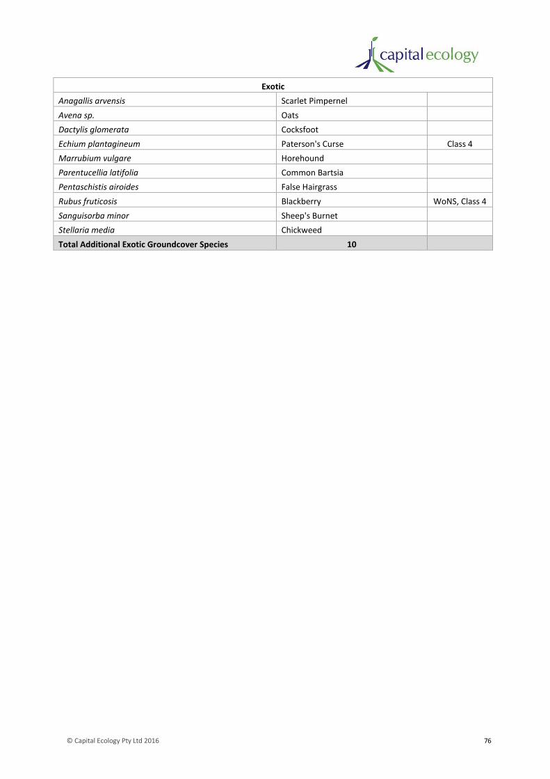
© Capital Ecology Pty Ltd 2016 76
Exotic
Anagallis arvensis Scarlet Pimpernel
Avena sp. Oats
Dactylis glomerata Cocksfoot
Echium plantagineum Paterson's Curse Class 4
Marrubium vulgare Horehound
Parentucellia latifolia Common Bartsia
Pentaschistis airoides False Hairgrass
Rubus fruticosis Blackberry WoNS, Class 4
Sanguisorba minor Sheep's Burnet
Stellaria media Chickweed
Total Additional Exotic Groundcover Species 10
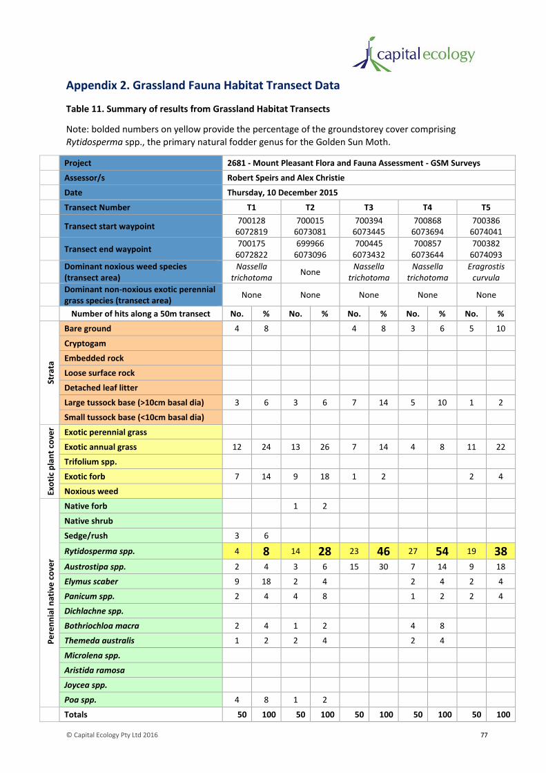
© Capital Ecology Pty Ltd 2016 77
Appendix 2. Grassland Fauna Habitat Transect Data
Table 11. Summary of results from Grassland Habitat Transects
Note: bolded numbers on yellow provide the percentage of the groundstorey cover comprising
Rytidosperma spp., the primary natural fodder genus for the Golden Sun Moth.
Project 2681 - Mount Pleasant Flora and Fauna Assessment - GSM Surveys
Assessor/s Robert Speirs and Alex Christie
Date Thursday, 10 December 2015
Transect Number T1 T2 T3 T4 T5
Transect start waypoint 700128
6072819 700015
6073081 700394
6073445 700868
6073694 700386
6074041
Transect end waypoint 700175
6072822 699966
6073096 700445
6073432 700857
6073644 700382
6074093
Dominant noxious weed species (transect area)
Nassella trichotoma
None Nassella
trichotoma Nassella
trichotoma Eragrostis
curvula
Dominant non-noxious exotic perennial grass species (transect area)
None None None None None
Number of hits along a 50m transect No. % No. % No. % No. % No. %
Stra
ta
Bare ground 4 8 4 8 3 6 5 10
Cryptogam
Embedded rock
Loose surface rock
Detached leaf litter
Large tussock base (>10cm basal dia) 3 6 3 6 7 14 5 10 1 2
Small tussock base (<10cm basal dia)
Exo
tic
pla
nt
cove
r Exotic perennial grass
Exotic annual grass 12 24 13 26 7 14 4 8 11 22
Trifolium spp.
Exotic forb 7 14 9 18 1 2 2 4
Noxious weed
Pe
ren
nia
l nat
ive
co
ver
Native forb 1 2
Native shrub
Sedge/rush 3 6
Rytidosperma spp. 4 8 14 28 23 46 27 54 19 38 Austrostipa spp. 2 4 3 6 15 30 7 14 9 18
Elymus scaber 9 18 2 4 2 4 2 4
Panicum spp. 2 4 4 8 1 2 2 4
Dichlachne spp.
Bothriochloa macra 2 4 1 2 4 8
Themeda australis 1 2 2 4 2 4
Microlena spp.
Aristida ramosa
Joycea spp.
Poa spp. 4 8 1 2
Totals 50 100 50 100 50 100 50 100 50 100

© Capital Ecology Pty Ltd 2016 78
Appendix 3. Vertebrate Fauna Species Recorded
Key for below table
EPBC Act: TSC Act:
CE - critically endangered CE1 - critically endangered (Part 1, Schedule 1A)
E - endangered E1 - endangered species (Schedule 1, Part 1)
V - vulnerable E2 - endangered population (Schedule 1, Part 2)
CD - conservation dependent E4 - presumed extinct (Schedule 1, Part 4)
V1 - vulnerable species (Schedule 2, Part 1)
D - Declared Pest Species under the NSW Local Land Services Act 2013 KTP - Key contributor to a Key Threatening Process listed under the EPBC Act.
Table 12. Fauna species recorded
Species Name Common Name Status Observed Occurrence for Notable Species
Native
Mammals
Macropus bicolor Swamp Wallaby
Macropus giganteus Eastern Grey Kangaroo
Tachyglossus aculeatus Short-beaked Echidna
Vombatus ursinus Common Wombat
Birds
Acanthiza chrysorrhoa Yellow-rumped Thornbill
Acanthorhynchus tenuirostris Eastern Spinebill
Acrocephalus stentoreus Clamorous Reed-Warbler
Anas gracilis Grey Teal
Anas rhynchotis Australian Shoveler
Anas superciliosa Pacific Black Duck
Anthus novaeseelandiae Richard's Pipit
Aphelocephala leucopsis Southern Whiteface
Aquila audax Wedge-tailed Eagle
Ardea pacifica Pacific Heron
Artamus cyanopterus Dusky Woodswallow
Many breeding pairs observed within the more densely wooded areas of the study area. Numerous nest very observed during November surveys around the Drooping Sheoak patch on the northern side of Mount Pleasant.
Aythya australis Hardhead
Cacatua galerita Sulphur-crested Cockatoo
Cacatua roseicapilla Galah
Chenonetta jubata Australian Wood Duck
Cincloramphus mathewsi Rufous Songlark
Colluricincla harmonica Grey Shrike-thrush
Coracina novaehollandiae Black-faced Cuckoo-shrike
Corvus coronoides Australian Raven

© Capital Ecology Pty Ltd 2016 79
Cracticus torquatus Grey Butcherbird
Cuculus pallidus Pallid Cuckoo
Dicaeum hirundinaceum Mistletoebird
Egretta novaehollandiae White-faced Heron
Elseyornis melanops Black-fronted Dotterel
Falco berigora Brown Falcon
Falco cenchroides Nankeen Kestrel
Fulica atra Eurasian Coot
Grallina cyanoleuca Magpie-lark
Gymnorhina tibicen Australian Magpie
Hirundo neoxena Welcome Swallow
Hirundo nigricans Tree Martin
Lalage sueurii White-winged Triller
Lichenostomus chrysops Yellow-faced Honeyeater
Lichenostomus leucotis White-eared Honeyeater
Lichenostomus penicillatus White-plumed Honeyeater
Malacorhynchus membranaceus Pink-eared Duck
Malurus cyaneus Superb Fairy-wren
Manorina melanocephala Noisy Miner
Falco cenchroides Nankeen Kestral
Ocyphaps lophotes Crested Pigeon
Pachycephala rufiventris Rufous Whistler
Pardalotus striatus Striated Pardalote
Petroica boodang Scarlet Robin V1
Numerous non-breeding small flocks observed foraging during winter, primarily around Mount Pleasant.
Petroica phoenicea Flame Robin V1
Numerous non-breeding small flocks observed foraging during winter, primarily around Mount Pleasant.
Phalacrocorax carbo Great Cormorant
Phalacrocorax melanoleucos Little Pied Cormorant
Phaps chalcoptera Common Bronzewing
Phylidonyris novaehollandiae New Holland Honeyeater
Platycercus elegans Crimson Rosella
Platycercus eximius Eastern Rosella
Poliocephalus poliocephalus Hoary-headed Grebe
Psephotus haematonotus Red-rumped Parrot
Neochmia temporal Red-browed Finch
Rhipidura fuliginosa Grey Fantail
Rhipidura leucophrys Willie Wagtail
Sericornis frontalis White-browed Scrubwren
Smicrornis brevirostris Weebill
Stagonopleura guttata Diamond Firetail V1
Numerous pairs observed, particularly associated with the patch of Drooping Sheoak on the northern side of Mount Pleasant. One active nest was observed during November surveys.

© Capital Ecology Pty Ltd 2016 80
Strepera graculina Pied Currawong
Strepera versicolor Grey Currawong
Tachybaptus novaehollandiae Australasian Grebe
Taeniopygia bichenovii Double-barred Finch
Threskiornis spinicollis Straw-necked Ibis
Vanellus miles Masked Lapwing
Frogs
Crinia parinsignifera Plains Froglet
Crinia signifera Common Eastern Froglet
Limnodynastes tasmaniensis Spotted Grass Frog
Uperoleia laevigata Smooth Toadlet
Reptiles
Aprasia parapulchella Pink-tailed Worm-Lizard V1 7 individuals found under rocks in the eastern extent of the study area. Refer to Figure 4.
Chelodina longicollis Long-necked Tortoise
Ctenotus robustus Robust Striped Skink
Ctenotus taeniolatus Copper-tailed Skink
Egernia cunninghami Cunningham's Skink
Lampropholis delicata Delicate Skink
Morethia boulengeri South-eastern Morethia Skink
Pseudechis porphyriacus Red-bellied Black Snake
Pseudonaja textilis Eastern Brown Snake
Total Native Fauna Species 81
Exotic
Mammals
Bos taurus Domestic Cattle Approx. 80 head kept in western paddocks.
Equus caballus Domestic Horse Domestic - few observed being ridden in paddocks.
Lepus capensis Brown Hare Few observed grazing in western paddocks.
Oryctolagus cuniculus European Rabbit D, KTP Numerous very large warrens observed, particularly around Mount Pleasant.
Ovis aries Domestic Sheep Approx. 500 head kept in various paddocks across property.
Sus scrofa Feral Pig D, KTP Damage from pig rooting observed along water courses and seepages.
Vulpes vulpes Red Fox D, KTP Numerous individuals observed.
Birds
Carduelis carduelis European Goldfinch Few observed in trees around farm house.
Passer domesticus House Sparrow Few observed in trees around farm house.
Sturnus tristis Indian Myna Few observed in trees around farm house and western paddocks.
Sturnus vulgaris Common Starling Few observed in trees across western paddocks.
Total Exotic Fauna Species 11
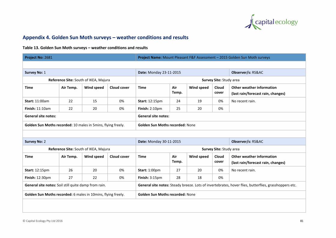
© Capital Ecology Pty Ltd 2016 81
Appendix 4. Golden Sun Moth surveys – weather conditions and results
Table 13. Golden Sun Moth surveys – weather conditions and results
Project No: 2681 Project Name: Mount Pleasant F&F Assessment – 2015 Golden Sun Moth surveys
Survey No: 1 Date: Monday 23-11-2015 Observer/s: RS&AC
Reference Site: South of IKEA, Majura Survey Site: Study area
Time Air Temp. Wind speed Cloud cover Time Air Temp.
Wind speed Cloud cover
Other weather information
(last rain/forecast rain, changes)
Start: 11:00am 22 15 0% Start: 12:15pm 24 19 0% No recent rain.
Finish: 11:10am 22 20 0% Finish: 2:10pm 25 20 0%
General site notes: General site notes:
Golden Sun Moths recorded: 10 males in 5mins, flying freely. Golden Sun Moths recorded: None
Survey No: 2 Date: Monday 30-11-2015 Observer/s: RS&AC
Reference Site: South of IKEA, Majura Survey Site: Study area
Time Air Temp. Wind speed Cloud cover Time Air Temp.
Wind speed Cloud cover
Other weather information
(last rain/forecast rain, changes)
Start: 12:15pm 26 20 0% Start: 1:00pm 27 20 0% No recent rain.
Finish: 12:30pm 27 22 0% Finish: 3:15pm 28 18 0%
General site notes: Soil still quite damp from rain. General site notes: Steady breeze. Lots of invertebrates, hover flies, butterflies, grasshoppers etc.
Golden Sun Moths recorded: 6 males in 10mins, flying freely. Golden Sun Moths recorded: None

© Capital Ecology Pty Ltd 2016 82
Survey No: 3 Date: Sunday 6-12-2015 Observer/s: RS&AC
Reference Site: South of IKEA, Majura Survey Site: Study area
Time Air Temp. Wind speed Cloud cover Time Air Temp.
Wind speed Cloud cover
Other weather information
(last rain/forecast rain, changes)
Start: 12:30pm 29 17 0% Start: 1:30pm 30 15 15% No recent rain.
Finish: 12:45pm 30 10 0% Finish: 3:00pm 31 9 35%
General site notes: General site notes: Very hot, lots of invertebrates.
Golden Sun Moths recorded: 8 males in 15mins, flying freely. Golden Sun Moths recorded: None
Survey No: 4 Date: Thursday 10-12-2015 Observer/s: RS&AC
Reference Site: South of IKEA, Majura Survey Site: Study area
Time Air Temp. Wind speed Cloud cover Time Air Temp.
Wind speed Cloud cover
Other weather information
(last rain/forecast rain, changes)
Start: 1:15pm 26 20 10% Start: 10:30am 24 9 0% No recent rain.
Finish: 1:30pm 25 18 10% Finish: 12:45pm 27 18 5%
General site notes: General site notes:
Golden Sun Moths recorded: 4 males in 15mins, most required flushing from grass.
Golden Sun Moths recorded: None
*Temperature and wind speed data obtained from Bureau of Meteorology website, Canberra Airport.

© Capital Ecology Pty Ltd 2016 83
Appendix 5. Likelihood of Occurrence Assessment
Key for below table
EPBC Act: TSC Act:
CE - critically endangered CE1 - critically endangered (Part 1, Schedule 1A)
E - endangered E1 - endangered species (Schedule 1, Part 1)
V - vulnerable E2 - endangered population (Schedule 1, Part 2)
CD - conservation dependent E4 - presumed extinct (Schedule 1, Part 4)
V1 - vulnerable species (Schedule 2, Part 1)
Table 14. Threatened Species Likelihood of Occurrence Assessment
Species Name EPBC Act Status
TSC Act Status
Description (Distribution and Habitat) Likelihood of Occurrence
Plants
Calotis glandulosa
Mauve Burr-daisy
V V1 Occurs at higher altitudes between Eden and Dubbo where it grows in grassland and sclerophyll forest. The main distribution is in the Monaro and Kosciuszko regions. The species is found in montane grasslands in the Australian Alps and subalpine grassland (dominated by Poa spp.), Natural Temperate Grassland and Snow Gum Woodlands on the Monaro and Shoalhaven area. The species appears to be a coloniser of bare ground, which explains why it is often seen on roadsides. Apparently common on roadsides in parts of the Monaro but does not persist in heavily-grazed pastures. Dispersed by the sticky burrs.
Low
The species was not recorded during any of the completed surveys.
If once present, the species is unlikely to have persisted within the study area due to the history of moderate to high intensity stock grazing.
Dillwynia glaucula
Michelago Parrot-pea
- E1 Michelago Parrot-pea is recorded from four areas on the NSW Southern Tablelands: near Windellama, where the species is locally abundant, near Mongarlowe, north-east of Michelago and at Numeralla. There is potential habitat between the known sites. Occurs on exposed patches of clay or on rocky outcrops in eucalypt woodland often dominated by Scribbly Gum Eucalyptus rossii, Snow Gum E. pauciflora, Broad-leafed Peppermint E.dives and Red Stringybark E. macrorhyncha. The
Negligible
The species’ form is a moderately sized shrub and it was not recorded during any of the completed surveys.

© Capital Ecology Pty Ltd 2016 84
Species Name EPBC Act Status
TSC Act Status
Description (Distribution and Habitat) Likelihood of Occurrence
understorey may be either grassy or shrubby. Grows adjacent to Natural Temperate Grassland in the Michelago area.
Eucalyptus aggregata
Black Gum
V V1 Black Gum occurs on the central and southern tablelands of NSW, and in a small disjunct population in Victoria. In NSW, it occurs predominantly in the South Eastern Highlands Bioregion. The species is a small to medium-sized woodland tree which grows in grassy woodlands on alluvial soils in moist sites along creeks on broad, cold and poorly-drained flats and hollows. It commonly occurs with Candlebark Eucalyptus rubida, Ribbon Gum E. viminalis, and Snow Gum E. pauciflora, with a grassy understorey of River Tussock Poa labillardieri. Most populations are located on private land or road verges and travelling stock routes.
Negligible
This species is not present within the study area.
Lepidium hyssopifolium
Basalt Peppercress
E - This species is known from a few populations in NSW, Victoria and Tasmania. The Basalt Pepper-cress is known to establish on open, bare ground with limited competition from other plants. It was previously recorded from eucalypt woodland with a grassy ground cover, low open Casuarina woodland with a grassy ground cover and tussock grassland, however recently recorded localities have predominantly been in weed-infested areas of heavy modification, high degradation and high soil disturbance such as road and rail verges, on the fringes of developed agricultural land or within small reserves in agricultural land. Many populations are now generally found amongst exotic pasture grasses and beneath exotic trees.
Low
The species was not recorded during any of the completed surveys, nor has it been recorded in the locality.
Leucochrysum albicans var.
tricolor
Hoary Sunray
E - The Hoary Sunray occurs from Queensland to Victoria and in Tasmania. In the ACT the species can be seen in spring in abundance on the roadside along Fairbairn Avenue and into Mt Ainslie Nature Reserve, on the western slopes of Mt Majura and adjacent to the Federal Highway road easement. In NSW it is distributed on the inland slopes and plains including grasslands and woodlands on the Monaro and is quite a common species along Old Cooma Road and other less modified areas south of Queanbeyan. The species is usually found in ungrazed and lightly grazed areas, along roadsides in particular. It appears to be very
Low
Although this species is known to occur on many sites throughout the locality (notably Googong Foreshores and along Old Cooma Road), it was not found within the study area during any of the completed surveys.
If once present, the species is unlikely to have persisted within the study area due to the history of moderate to high intensity stock grazing.
© Capital Ecology Pty Ltd 2016 85
Species Name EPBC Act Status
TSC Act Status
Description (Distribution and Habitat) Likelihood of Occurrence
sensitive to grazing, but responds to disturbance as a coloniser and appears to tolerate mowing. Flowers spring to summer.
Pelargonium sp. Striatellum
Omeo Stork's-bill
E E1 An undescribed species of Pelargonium, Omeo Stork’s Bill is a tufted perennial herb threatened by grazing, recreational activities, and exotic species. It is known to occur just above the high water level of ephemeral lakes in NSW and Victoria.
Negligible
There is no potential habitat for this species in the study area.
Pomaderris pallida
Pale Pomaderris
V V1 Pale Pomaderris has been recorded from near Kydra Trig, north-west of Nimmitabel, Tinderry Nature Reserve, and the Queanbeyan River. A record from Byadbo in Kosciuszko National Park has not been relocated. The main distribution is along the Murrumbidgee in the ACT. It was recorded recently in eastern Victoria. This species usually grows in shrub communities surrounded by Brittle Gum Eucalyptus mannifera and Red Stringybark E. macrorhynca or Black Cypress Callitris endlicheri woodland.
Negligible
This species is not present within the study area.
Prasophyllum petilum
Tarengo Leek Orchid
E E1 When first described in 1991, the Tarengo Leek Orchid was known only from the Hall Cemetery in the ACT. It has since been found at four sites in New South Wales: Captains Flat Cemetery, Ilford Cemetery, Steves Travelling Stock Route (TSR) at Delegate and the Tarengo TSR near Boorowa.
The Tarengo Leek Orchid occurs on relatively fertile soils in grassy woodland or natural grassland. The three cemetery sites originally contained grassy woodland, dominated by Snow Gum Eucalyptus pauciflora and Black Gum E. aggregata at Captains Flat, and Blakely's Red Gum E. blakelyi and Yellow Box E. melliodora at Hall and Ilford. Both Tarengo TSR and Steves TSR are natural grasslands.
The species is intolerant of grazing and this is considered to be the key reason it has been found only within cemeteries and TSRs, land from which grazing has been restricted.
Negligible
The species was not recorded during any of the completed surveys and the majority of the study area is too modified and grazed to constitute potential habitat. The species is also not known to occur in the locality.
Rutidosis Leptorrhynchoides
E E1 In the ACT and NSW, Button Wrinklewort occurs in box-gum woodland, secondary grassland derived from box-gum woodland or in natural
Negligible
© Capital Ecology Pty Ltd 2016 86
Species Name EPBC Act Status
TSC Act Status
Description (Distribution and Habitat) Likelihood of Occurrence
Button Wrinklewort temperate grassland. It prefers open spaces where it does not have to compete for light. It is known from several sites in the ACT, NSW and Victoria, where it is threatened by habitat loss, grazing and weed encroachment.
The species is quite conspicuous when present and it was not recorded during any of the completed surveys.
Swainsona recta
Small Purple-pea
E E1 The Small Purple-pea occurs in the grassy understorey of woodlands and open forests dominated by Blakely’s Red Gum, Yellow Box, Candlebark and Bundy. The species grows in association with understorey dominants that include Kangaroo Grass, Poa tussocks and spear-grasses. Plants die back in summer, surviving as rootstocks until they shoot again in autumn. The species is intolerant of grazing but generally tolerant of fire, which also enhances germination by breaking the seed coat and reducing competition from other species.
Negligible
The species was not recorded during any of the completed surveys and the majority of the study area is too modified and grazed to constitute potential habitat.
The only portion of the study area within which the species could have persisted is the block on the northern side of Burra Road, however this species was not recorded during surveys in this area.
Swainsona sericea
Silky Swainson-pea
- V1 Silky Swainson-pea is a low growing perennial, found from the Northern Tablelands to the Southern Tablelands and Monaro region as well as further inland on the slopes and plains. The species is found in Natural Temperate Grassland and Snow Gum Woodland on the Monaro, and in Box-Gum Woodland in the Southern Tablelands and South West Slopes.
Low
The species was not recorded during any of the completed surveys. It is likely that the majority of the study area is too modified and grazed to constitute potential habitat.
Thesium australe
Austral Toadflax
V V1 Found in very small to large populations scattered across eastern NSW, along the coast, and from the Northern to Southern Tablelands. Austral Toadflax is a root parasite that takes water and some nutrients from other plants, especially Kangaroo Grass. It is often found in damp sites in association with Kangaroo Grass but it is also found on other grass species at inland sites. Occurs on clay soils in grassy woodlands or coastal headlands.
Negligible
The species was not recorded during any of the completed surveys and the majority of the study area is too modified and grazed to constitute potential habitat.
The only portion of the study area within which the species could have persisted is the block on the northern side of Burra Road, however this species was not recorded during surveys in this area.
Mammals

© Capital Ecology Pty Ltd 2016 87
Species Name EPBC Act Status
TSC Act Status
Description (Distribution and Habitat) Likelihood of Occurrence
Dasyurus maculatus
maculatus
Spot-tailed Quoll (SE
mainland population)
E V1 The Spot-tailed Quoll occurs along the east coast of Australia and the Great Dividing Range. The species uses a range of habitats including sclerophyll forests and woodlands, coastal heathlands and rainforests. Occasional sightings have been made in open country, grazing lands, rocky outcrops and other treeless areas. Habitat requirements include suitable den sites, including hollow logs, rock crevices and caves, an abundance of food and an area of intact vegetation in which to forage. Seventy per cent of the diet is medium-sized mammals, and also feeds on invertebrates, reptiles and birds. Individuals require large areas of relatively intact vegetation through which to forage. The home range of a female is between 180 and 1000ha, while males have larger home ranges of between 2000 and 5000ha. Breeding occurs from May to August.
Low
The species is likely to occur within the natural habitat provided in nearby Googong Foreshores, Tinderry Range and Tallaganda National Park etc. The species may also occur within or move through O’Keefes Reserve adjoining the east of the study area. However, it is unlikely that the study area would provide suitable habitat for the species. Whilst it is possible that the species may visit the eastern portion of the study, it is highly unlikely to venture into the highly modified portions of the study area.
Falsistrellus tasmaniensis
Eastern False Pipistrelle
- V1 The Eastern False Pipistrelle is found on the south-east coast and ranges of Australia, from southern Queensland to Victoria and Tasmania. The species generally roosts in eucalypt hollows, but has also been found under loose bark on trees or in buildings. The species prefers moist, tall forest environments. The species is known to occur in the ACT region however it has not been found to forage or roost in urban or highly modified rural areas.
Moderate
The species has been recorded in intact dry sclerophyll forest in nearby Googong Foreshores and may forage and roost in the less modified eastern portion of the study area. The species is unlikely to roost or forage within the highly modified portions of the study area.
Miniopterus schreibersii
oceanensis
Eastern Bentwing Bat
- V1 The Eastern Bentwing Bat is a subspecies of the Common Bentwing Bat, with a range thought to be from central Victoria to Cape York Peninsula, Queensland. It is a fast flyer, able to travel many kilometres in a night. Caves are the primary roosting habitat for this species however similar man-made structures are also used (culverts, eaves etc.). The species forages above the forest canopy.
Moderate
The species has been recorded in intact dry sclerophyll forest in nearby Googong Foreshores and may forage over the less modified eastern portion of the study area. The study area does not support roosting habitat and the species is unlikely to forage within the highly modified portions of the study area.
Myotis macropus
Southern Myotis
- V1 The Southern Myotis occurs from the north-west of Australia, across the top-end and south to western Victoria. It is rarely found more than 100 km inland, except along major rivers. The species roosts close to water in caves, hollow-bearing trees, man-made structures (bridges, culverts etc) and in dense foliage. Colonies occur close to water bodies, ranging from
Low
There are no suitable major water bodies within the study area or vicinity and the species is not known to venture far from such habitat features.
© Capital Ecology Pty Ltd 2016 88
Species Name EPBC Act Status
TSC Act Status
Description (Distribution and Habitat) Likelihood of Occurrence
rainforest streams to large lakes and reservoirs. The species catches aquatic insects and small fish with their large hind claws, and also catches flying insects.
Petaurus australis
Yellow-bellied Glider
- V1 Restricted to tall native forests in regions of high rainfall along the coast of NSW. Preferred habitats are productive, tall open sclerophyll forests where mature trees provide shelter and nesting hollows. Critical elements of habitat include sapsite trees, winter flowering eucalypts, mature trees suitable for den sites and a mosaic of different forest types. The species lives in family groups of 2-6 individuals which commonly share a number of tree hollows. Family groups are territorial with exclusive home ranges of 30-60 ha. Very large expanses of forest (>15,000 ha) are required to conserve viable populations.
Negligible
The study area does not support potential habitat for the species.
Phascolarctos cinereus
Koala (combined populations of Qld, NSW and the ACT)
V V1 In NSW, the Koala mainly occurs on the central and north coasts with some populations in the western region. Koalas feed almost exclusively on eucalypt foliage, and their preferences vary regionally. They are solitary with varying home ranges. In high quality habitat home ranges may be 1-2 hectare and overlap, while in semi-arid country they are usually discrete and around 100 ha.
Negligible
The species is not known to occur in the lowland areas of the ACT and surrounding region of NSW.
Pteropus poliocephalus
Grey-headed Flying Fox
V - The Grey-headed Flying Fox occurs in the coastal belt from Rockhampton in central Queensland to Melbourne in Victoria. Whilst Brisbane, Newcastle, Sydney and Melbourne are occupied continuously, the species is widespread throughout their range during summer. In autumn the species occupies coastal lowlands and is uncommon inland. In winter the species congregates in coastal lowlands north of the Hunter Valley and is occasionally found on the south coast of NSW and on the northwest slopes (associated with flowering eucalypts of these areas).
The Grey-headed Flying-fox requires foraging resources and roosting sites. It is a canopy-feeding frugivore and nectarivore, which utilises vegetation communities including rainforests, open forests, closed and open woodlands, Melaleuca swamps and Banksia woodlands.
Moderate
The species may visit the study area to feed on the flowering eucalypts however there are no camps (roost sites) in the Googong-Burra locality and camps are usually located near large waterbodies. The more modified portions of the study area are less likely to be visited by the species.

© Capital Ecology Pty Ltd 2016 89
Species Name EPBC Act Status
TSC Act Status
Description (Distribution and Habitat) Likelihood of Occurrence
The Grey-headed Flying-fox roosts in aggregations of various sizes on exposed branches. Roost sites are typically located near water, such as lakes, rivers or the coast. The roost at Commonwealth Park in Canberra is the only known roost in the ACT region.
Birds
Anthochaera phrygia
Regent Honeyeater
E CE1 A semi-nomadic species occurring in temperate eucalypt woodlands and open forests. Most records are from box-ironbark eucalypt forest associations and wet lowland coastal forests. Key eucalypt species include Mugga Ironbark, Yellow Box, Blakely's Red Gum, White Box and Swamp Mahogany. Also utilises a number of other eucalypt species. Nectar and fruit from the mistletoes Amyema miquelii, A. pendula, and A. cambagei are also eaten during the breeding season. Regent Honeyeaters usually nest in horizontal branches or forks in tall mature eucalypts and sheoaks as well as within mistletoe haustoria (section of the root which connects with the host tree). An open cup-shaped nest is constructed by the female of bark, grass, twigs and wool.
Moderate
The species may visit the less modified eastern portions of the study area to feed on flowering eucalypts and mistletoe. The species is unlikely to visit the more modified portions of the study area.
Botaurus poiciloptilus
Australasian Bittern
E E1 The Australasian Bittern is distributed across south-eastern Australia. It is often found in terrestrial and estuarine wetlands, generally where there is permanent water with tall, dense vegetation including Typha spp. and Eleoacharis spp. Typically this species forages at night on frogs, fish and invertebrates, and remains inconspicuous during the day. The breeding season extends from October to January with nests being built amongst dense vegetation on a flattened platform of reeds.
Low
Whilst the section of Church Creek which traverses the study area does support disturbed wetland vegetation, this habitat is unlikely to be suitable for the species.
Callocephalon fimbriatum
Gang-gang Cockatoo
- V1 In summer the Gang-gang Cockatoo occupies tall montane forests and woodlands, particularly in heavily timbered and mature wet sclerophyll forests. Also occur in subalpine Snow Gum woodland and occasionally in temperate or regenerating forest. In winter, the species occurs at lower altitudes in drier, more open eucalypt forests and woodlands, particularly in box-ironbark assemblages, or in dry forest in coastal areas.
Low
The species is quite conspicuous when present and it has not been recorded within the study area during any of the numerous surveys undertaken. As such, it is unlikely that the species forages much if at all within the study area. The species is highly unlikely to breed within the study area.
© Capital Ecology Pty Ltd 2016 90
Species Name EPBC Act Status
TSC Act Status
Description (Distribution and Habitat) Likelihood of Occurrence
The Gang-gang Cockatoo usually breeds in tall forests in the ACT region, however they have been observed on occasion to breed in Box-Gum Woodland on Red Hill and other similar lowland habitat around Canberra (R. Speirs pers. obs., M. Mulvaney pers. comm.).
Calyptorhynchus lathami
Glossy Black-cockatoo
- V1 The Glossy Black-cockatoo has a patchy distribution, having once been widespread across most of the south-east of Australia. The species is now distributed throughout an area which extends from the coast near Eungella in eastern Queensland to Mallacoota in Victoria. Glossy black-cockatoos feed on casuarina seeds, however they occasionally consume seeds from eucalypts, angophoras, acacias and hakeas, as well as insect larvae. In the ACT region the species feeds almost exclusively on Drooping Sheoak Allocasuarina verticillata. Pairs mate for life and nest in the hollows of large, old living or dead eucalypt trees. Breeding takes place between March and August.
Low
The species is quite conspicuous when present and it has not been recorded within the study area during any of the numerous surveys undertaken. As such, it is unlikely that the species currently forages much if at all within the study area. The species is highly unlikely to breed within the study area.
The Drooping Sheoak present within the study area do provide potential foraging habitat for this species, however to date the species has not been observed to utilise this resource (i.e. via observation of birds or chewed cones).
Chthonicola sagittata
Speckled Warbler
- V1 The Speckled Warbler lives in a wide range of Eucalyptus dominated communities that have a grassy understorey, often on rocky ridges or in gullies. Typical habitat includes scattered native tussock grasses, a sparse shrub layer, some eucalypt regrowth and an open canopy. Large, relatively undisturbed remnants are required for the species to persist in an area. The diet consists of seeds and insects, with most foraging taking place on the ground around tussocks and under bushes and trees. Pairs are sedentary and occupy a breeding territory of about ten hectares, with a slightly larger home-range when not breeding. The rounded, domed, roughly built nest of dry grass and strips of bark is located in a slight hollow in the ground or the base of a low dense plant.
Moderate
The species has not been recorded during any of the completed surveys. However, the species is known to occur in nearby Googong Foreshores and may occur in O’Keefes Reserve and possibly in the eastern less modified potion of the study area.
The species is unlikely to visit the more modified portions of the study area.
Climacteris picumnus victoriae
Brown Treecreeper
- V1 In the ACT region, Brown Treecreepers occur in dry woodlands and open forest below 1,000 metres. The species is relatively common along the Clear Range and along the Lower Naas River. Other populations occur at Mulligans Flat Reserve, Campbell Park, Burbong and former quarries
Moderate
The species has not been recorded during any of the completed surveys. However, the species is may
© Capital Ecology Pty Ltd 2016 91
Species Name EPBC Act Status
TSC Act Status
Description (Distribution and Habitat) Likelihood of Occurrence
(eastern subspecies) south of the airport in the northern part of the ACT, and at Castle Hill, north of Tharwa. Brown Treecreepers also frequent paddocks and grasslands where there are sufficient logs, stumps and dead trees nearby. The species prefers relatively undisturbed woodland and dry open forest where the native understorey, especially grasses, has been preserved. The species usually prefers predominantly rough-barked trees such as Stringybarks and rough barked Boxes.
occur in O’Keefes Reserve and possibly in the eastern less modified potion of the study area.
The species is unlikely to make any substantial use of the more modified portions of the study area.
Daphoenositta chrysoptera
Varied Sittella
- V1 In the ACT region, the Varied Sittella occurs in a wide variety of woodland and forest habitats, particularly in lowland areas. The species prefers areas with a dominance of rough barked trees, notably Red Stringybark at relatively high density. The species is rarely recorded in sparsely treed areas.
Low
The species has not been recorded during any of the completed surveys. Although the species is likely to occur in more intact areas nearby (i.e. Googong Foreshores, O’Keefes Reserve etc.) it is unlikely to occur in the study area and surrounding open rural land.
Grantiella picta
Painted Honeyeater
- V1 The Painted Honeyeater is found in Queensland and New South Wales west of the Great Dividing Range, through to northern Victoria. The species displays some migratory movement and is occasionally found in the Northern Territory and is a vagrant to South Australia and the ACT. The species frequents eucalypt forests and woodlands, particularly those that are infested heavily with mistletoes. In the ACT, the species' primary habitat is River Oak (Casuarina cunninghamiana) along river systems, especially the Murrumbidgee River.
Low
This species is only an occasional visitor to the ACT region and based on the location of previous recordings, is unlikely to visit the study area or locality. The study area also lacks habitat for the species.
Hieraaetus morphnoides
Little Eagle
- V1 The Little Eagle is distributed throughout the Australian mainland excepting the most densely forested parts of the Dividing Range escarpment, and occupies habitats rich in prey within open eucalypt forest, woodland or open woodland. The species is sensitive to human disturbance.
Moderate
The study area may be part of the large foraging range of a pair of Little Eagles, however the species has not been recorded during past field surveys and no indications of breeding activity have been observed within the study area.
Lathamus discolor
Swift Parrot
E E1 The Swift Parrot occurs in woodlands and forests of NSW from May to August, where it feeds on eucalypt nectar, pollen and associated insects.
Low
© Capital Ecology Pty Ltd 2016 92
Species Name EPBC Act Status
TSC Act Status
Description (Distribution and Habitat) Likelihood of Occurrence
The Swift Parrot is dependent on flowering resources across a wide range of habitats in its wintering grounds in NSW. This species is migratory, breeding in Tasmania and also nomadic, moving about in response to changing food availability.
The species has not been recorded during any of the completed surveys and there are no records of the species in the locality. The species may move through the study area during winter, however the species is unlikely to make substantial use of the study area given the presence of expanses of higher quality foraging habitat in the region.
Melanodryas cucullata
cucullata
Hooded Robin (southeastern form)
- V1 The Hooded Robin occupies drier eucalypt forest, woodland and scrub, grasses and low shrubs, as well as cleared paddocks with regrowth or stumps. The species uses stumps, posts or fallen timber from which to locate prey on the ground. In the ACT region, the species is found in woodland, often with scattered Yellow Box and/or Blakely’s Red Gum, with long grass and low shrubs, or fallen logs.
Low
The species has not been recorded during any of the completed surveys and the groundstorey throughout the study area is not that preferred by the species.
Petroica boodang
Scarlet Robin
- V1 The Scarlet Robin is found in south-eastern Australia (extreme south-east Queensland to Tasmania, western Victoria and south-east South Australia) and south-west Western Australia. In NSW it occupies open forests and woodlands from the coast to the inland slopes, breeding in drier eucalypt forests and temperate woodlands.
Confirmed
Numerous small flocks of non-breeding Scarlet Robins were observed foraging throughout much of the study area during the preliminary field inspection undertaken during winter 2015. Substantial flocks have been observed to over-winter in the open agricultural land across the locality (Biosis 2015, R. Speirs pers. obs.) and the presence of these species within the study area was also noted in previous years by KMA (KMA 2015).
No breeding activity has been observed within the study area and the species was not observed to remain within the study area into spring-summer.
Petroica phoenica
Flame Robin
- V1 The Flame Robin is found in south-eastern Australia, from the Queensland border to Tasmania, western Victoria and south-east South Australia. In NSW it breeds in upland moist eucalypt forests and woodlands, often on ridges and slopes, in areas of open understorey. The species migrates in winter to more open lowland habitats such as
Confirmed
Numerous small flocks of non-breeding Flame Robins were observed foraging throughout much of the study area during the preliminary field inspection undertaken during winter 2015. Substantial flocks
© Capital Ecology Pty Ltd 2016 93
Species Name EPBC Act Status
TSC Act Status
Description (Distribution and Habitat) Likelihood of Occurrence
grassland with scattered trees and open woodland on the inland slopes and plains.
have been observed to over-winter in the open agricultural land across the locality (Biosis 2015, R. Speirs pers. obs.) and the presence of these species within the study area was also noted in previous years by KMA (KMA 2015).
The species was not observed to remain within the study area into spring-summer, this is consistent with its known altitudinal migration for breeding.
Polytelis swainsonii
Superb Parrot
V V1 Found mainly in open, tall riparian River Red Gum forest or woodland. Often found in farmland including grazing land with patches of remnant vegetation. Breeds in hollow branches of tall eucalypt trees within nine kilometres of feeding areas.
Negligible
The species is not known to occur in the Googong-Burra locality and is generally not known to occur south of the Molonglo River in the ACT region.
Rostratula australis
Australian Painted Snipe
V E1 Usually found in shallow inland wetlands including farm dams, lakes, rice crops, swamps and waterlogged grassland. The species prefers freshwater wetlands, ephemeral or permanent, although it has been recorded in brackish waters.
Negligible
The study area does not provide potential habitat for the species. The species is has been recorded on rare occasions at only a few locations in the ACT region (i.e. Jerrabomberra Wetlands, upper Yerrabi Ponds, North Mitchell Grasslands etc.).
Stagonopleura guttata
Diamond Firetail
- V1 The Diamond Firetail is found in eastern Australia, from Eyre Peninsula, South Australia, to south-eastern Queensland. There has been a decline in density throughout the range, and many remaining populations may now be isolated. The species inhabits a wide range of eucalypt-dominated vegetation communities that have a grassy understorey, including woodland and mallee.
Confirmed
Diamond Firetails were observed within the study area during each field survey, primarily associated with the large dense patch of remnant Drooping Sheoak on the northern slope of Mount Pleasant. Small flocks of the species were observed during winter and early spring with these breaking into breeding pairs from early November.
Tyto novaehollandiae
Masked Owl
- V1 The Masked Owl may be found across a diverse range of wooded habitats that provide tall or dense mature trees with hollows suitable for nesting and roosting. The species has primarily been recorded in open forests and woodlands adjacent to cleared lands. They nest in hollows, in
Low
There are not records of the species within 10kms of the study area and very few more broadly in the region, those that do occur are from fairly intact tall

© Capital Ecology Pty Ltd 2016 94
Species Name EPBC Act Status
TSC Act Status
Description (Distribution and Habitat) Likelihood of Occurrence
trunks and in near vertical spouts of large trees, usually living but occasionally dead. The nest hollows are usually located within dense forests or woodlands. Masked Owls prey upon hollow dependent arboreal marsupials, but terrestrial mammals including Rabbits and rodents make up the largest proportion of the diet. The species has a large home range of between 500 and 1000ha.
forest. The study area is unlikely to provide habitat for the species.
Amphibians
Litoria castanea
Yellow-spotted Tree Frog
E CE1 The Yellow-spotted Tree Frog previously had a disjunct distribution, being recorded on the New England Tablelands and on the Southern Tablelands from Lake George to Bombala. The species has only recently (2010) been rediscovered on the Southern Tablelands. Prior to this the species had not been recorded on the Southern Tablelands since the 1970s. Found in large permanent ponds, lakes and dams with an abundance of bulrushes and other emergent vegetation, it shelters during autumn and winter under fallen timber, rocks, other debris or thick vegetation.
Negligible
There is no potential habitat within the study area for the species and the species is not known to occur in the locality.
Litoria raniformis
Growling Grass Frog
V E1 In NSW the species is known to exist only in isolated populations in the Coleambally Irrigation Area, the Lowbidgee floodplain and around Lake Victoria. Usually found in or around permanent or ephemeral swamps or billabongs with an abundance of bulrushes and other emergent vegetation along floodplains and river valleys. The species has also been found in irrigated rice crops. Outside the breeding season animals disperse away from water and take shelter beneath ground debris such as fallen timber and bark, rocks, grass clumps and in deep soil cracks. The species previously occurred on the Southern Tablelands at a number of sites within the Murrumbidgee River corridor, however it is now widely considered to have become extinct on the Southern Tablelands.
Negligible
There is no potential habitat within the study area for the species and the species is not known to occur in the locality.
Reptiles
Aprasia parapulchella
Pink-tailed Worm-lizard
V V The Pink-tailed Worm-lizard is a fossorial species which lives beneath surface rocks and occupies ant burrows. It feed on ants, particularly their
Confirmed
© Capital Ecology Pty Ltd 2016 95
Species Name EPBC Act Status
TSC Act Status
Description (Distribution and Habitat) Likelihood of Occurrence
eggs and larvae. Thought to lay eggs within the ant nests under rocks that it uses as a source of food and shelter and for thermoregulation. Key habitat features are a cover of native grasses, particularly Kangaroo Grass, sparse or no tree cover, little or no leaf litter, and scattered small rock with shallow embedment in the soil surface.
The species was recorded during the completed targeted survey.
Based on the rock characteristics, the composition and condition of the groundcover vegetation and the results of the completed targeted survey, the area considered likely to currently support the species is that shown in Figure 4.
Delma impar
Striped Legless Lizard
V V1 The Striped Legless Lizard is patchily distributed in grasslands of south-eastern NSW, the ACT, north-eastern, central and south-western Victoria, and south-eastern South Australia. In the ACT, the species is known to occur at four separate locations - in grassland areas of Gungahlin, Majura and Jerrabomberra Valleys, and Yarramundi. Unsuitable habitat, roads and urban development separate these sites. Most areas where the species persists are thought to have had low to moderate levels of agricultural disturbance in the past and it has been suggested that ploughing in particular may be incompatible with the survival of the species. Until recently, the species was thought to inhabit only native grasslands dominated by species such as Tall Speargrass and Kangaroo Grass. In recent years, surveys have revealed the Striped Legless Lizard in many sites dominated by exotic grasses such as Phalaris, Serrated Tussock and Flatweed (Biosis Research 2012). They have also been found in several secondary grassland sites, generally within two kilometres of primary grassland.
Low
The Natural Temperate Grassland (NTG) ecological community is known to the primary habitat for the species. The ACT Government has commissioned numerous large-scale tile surveys over the last five years encompassing many sites within the ACT. The data obtained from these surveys demonstrates that the species' current distribution is confined to the historical extent of the NTG ecological community plus up to approximately two kilometres into adjoining ecological communities (i.e. Box-Gum Woodland) where these support a grassy groundstorey with a moderate to high herbage mass (R. Speirs pers. obs.). Within this distribution the species has been found to occur in both native grasslands/pasture and exotic pasture such as that dominated by Phalaris.
Given the distance of the study area from the closest known record of the species and the high degree of modification throughout the lower elevated land within the study area, the likelihood of the species being present within the study area is considered very low.

© Capital Ecology Pty Ltd 2016 96
Species Name EPBC Act Status
TSC Act Status
Description (Distribution and Habitat) Likelihood of Occurrence
Suta flagellum
Little Whip Snake
- V1 Occurs in Natural Temperate Grassland, grassy woodland, and secondary grasslands derived from clearing of woodland. Found on well-drained hillsides, mostly associated with scattered loose rocks.
Low
There are no records of the species within the Queanbeyan Local Government Area (LGA) and the closest record is approximately 28kms northeast of the study area. The species was also not recorded during the extensive targeted rock-turning surveys completed.
Tympanocryptis pinguicolla
Grassland Earless Dragon
E E1 In the Canberra-Monaro region the Grassland Earless Dragon appears to be restricted to Natural Temperate Grassland or native grassland/pasture that is dominated by perennial tussock-forming species and has an open structure. It is known to make use of grass tussocks, surface rocks and small holes in the ground that are also used by invertebrates such as wolf spiders and crickets. Spiders and insects appear to comprise the majority of its diet. In the ACT region the species is known to occur in suitable native grassland habitat in the Majura and Jerrabomberra valleys and at the Queanbeyan Nature Reserve and 'Letchworth' property near Queanbeyan in NSW. It is presumed extinct in Victoria.
Negligible
The recent (i.e. last few thousand years) distribution of the species is considered likely to have been entirely confined to the historical distribution of the NTG ecological community. The extant ACT-Queanbeyan population is known from only a few small sub-populations persisting in a number of retained patches of NTG within the Majura and Jerrabomberra valleys. At these sites the species is confined to moderate to high quality NTG. Given the distance of the study area from the closest known populations and the high degree of modification, the study area is highly unlikely to support the species.
Varanus rosenbergi
Rosenberg's Goanna
- V1 Rosenberg’s Goanna is a medium to large monitor species occurring in southern parts of Western Australia and South Australia, with isolated populations in Victoria and New South Wales. In NSW it has been recorded from coastal areas around Sydney and further south, and west to Mount Victoria and the Namadgi and Kosciusko national parks. The species is found in a range of habitats including coastal heaths, humid woodlands and both wet and dry sclerophyll forests, preferring eucalyptus woodlands and heathland. Termite mounds are a critical habitat component, and are used for egg incubation.
Low
The species is likely to occur within the natural habitat provided in nearby Googong Foreshores, Tinderry Range and Tallaganda National Park etc. The species may also occur within or move through O’Keefes Reserve adjoining the east of the study area. However, it is unlikely that the study area would provide suitable habitat for the species. Whilst it is possible that the species may visit the eastern portion of the study to hunt/forage, it is highly unlikely to venture into the highly modified portions

© Capital Ecology Pty Ltd 2016 97
Species Name EPBC Act Status
TSC Act Status
Description (Distribution and Habitat) Likelihood of Occurrence
of the study area. The study area contains no substantial termite mounds which are a limiting breeding habitat resource.
Fish and Crustacea
Bidyanus bidyanus
Silver Perch
CE V1 Silver perch are endemic to the Murray-Darling system (including all states and sub-basins). They show a general preference for faster-flowing water, including rapids and races, and more open sections of river, throughout the Murray-Darling Basin. Silver perch are a highly migratory freshwater fish. The extensive migration of adults, particularly during flooding, has long been recognised and is considered to be part of their spawning behaviour.
Negligible
There is no potential habitat within the study area for the species.
Maccullochella peelii
Murray Cod
V - The Murray Cod's natural distribution extends throughout the Murray-Darling basin ranging west of the divide from south east Queensland, through NSW into Victoria and South Australia. The species is found in the waterways of the Murray– Darling Basin in a wide range of warm water habitats that range from clear, rocky streams to slow flowing turbid rivers, billabongs and large deep holes. Murray Cod is entirely a freshwater species and will not tolerate high salinity levels.
Negligible
There is no potential habitat within the study area for the species.
Macquaria australasica
Macquarie Perch
E E1 Macquarie Perch are found in the Murray-Darling Basin (particularly upstream reaches) of the Lachlan, Murrumbidgee and Murray rivers, and parts of south-eastern coastal NSW, including the Hawkesbury and Shoalhaven catchments. Macquarie perch are found in both river and lake habitats, especially the upper reaches of rivers and their substantial tributaries.
Negligible
There is no potential habitat within the study area for the species.
Insects
Synemon plana
Golden Sun Moth
CE E1 The Golden Sun Moth's NSW populations are found in the area between Queanbeyan, Gunning, Young and Tumut. The species occurs in Natural Temperate Grasslands and Box-Gum Grassy Woodland in which the groundcover is dominated by Wallaby Grasses (Rytidosperma spp.). It is believed that the females lay up to 200 eggs at the base of the Wallaby
Low
A full program of targeted surveys for the species was completed during the 2015 survey season with no evidence of the species observed. As such, the

© Capital Ecology Pty Ltd 2016 98
Species Name EPBC Act Status
TSC Act Status
Description (Distribution and Habitat) Likelihood of Occurrence
Grass tussocks. After hatching, the larvae tunnel underground where they remain feeding on the roots of Wallaby Grass tussocks. The species is also known to feed on the introduced species (and Weed of National Significance), Chilean Needle Grass Nassella neesiana.
species is considered highly unlikely to occur within the study area.
Note: The brief species distribution and habitat descriptions provided in the above table are sourced from the threatened species online profiles, listing determinations and/or
recovery plans prepared for the species by the Commonwealth Government and NSW Government. These resources and associated references are provided on the relevant
government websites.
© Capital Ecology Pty Ltd 2016 99
Appendix 6. TSC Act Assessments of Significance
Section 5A of the EP&A Act lists seven factors against which a proposed development/action/activity
must be assessed to determine whether it is likely to have a significant effect on species, populations
and communities (and their habitats) listed under the TSC Act and FM Act. The Threatened Species
Assessment Guidelines; the Assessment of Significance (DECC 2007) detail the manner in which the
Assessment of Significance (AoS) (also known as the seven-part-test) is to be interpreted and applied.
Prepared in this manner, an AoS is provided below for the one TSC listed TEC and three TSC Act listed
woodland birds considered to have some potential to be impacted by the proposal.
In preparing the AoSs relevant to the proposed development, information provided in the following key
documents has been relied upon.
Capital Ecology (2016a). Mount Pleasant Rural Residential Subdivision – Flora and Fauna
Assessment. Prepared for CIC Australia Limited. Author: R. Speirs. Project no. 2681.
Capital Ecology (2016b). Mount Pleasant Rural Residential Subdivision – Vegetation
Management Plan. Prepared for CIC Australia Limited. Author: R. Speirs. Project no. 2681.
White Box – Yellow Box – Blakely's Red Gum Woodland (Box – Gum Woodland)
Introduction
White Box – Yellow Box – Blakely's Red Gum Woodland (TSC Act Box-Gum Woodland) is currently listed
as an endangered ecological community under the TSC Act.
As described in the Final Determination (NSW Scientific Committee 2002) and the associated key (refer
Section 5.2.3 of the F&FA), the definition for the TSC Act Box-Gum Woodland TEC is broad and
encompasses a range of community variants. In effect, any land for which the climax community is Box-
Gum Woodland that has not been cultivated, become a stock camp or otherwise been entirely modified
is likely to meet the definition of the TSC Act listed TEC.
With regard to the above, the TSC Act definition provides the absolute minimum requirements for a
patch of vegetation to be considered to support the TEC. As such, the NSW Government encourages the
use of a suitable biometric (such as the BioCertification Assessment Methodology) to categorise the
vegetation within a given study area in a manner that reflects the actual and relative values of the
vegetation. This categorisation is essential in informing planning processes, such that more intact (i.e.
higher value) areas of TEC can be appropriately prioritised for conservation. Conversely, marginal areas
of the TEC, such as those that support only scattered remnant trees or low diversity native
grassland/pasture, may be unlikely to degrade further under an alternate management regime.
The existing Little Burra rural residential subdivision and others in Royalla and elsewhere, provide
examples of the how the retention and maintenance of the basic elements of the TSC Act listed TEC can
be achieved within large lots. Created on land which supported generally equivalent vegetation to that
within the proposed development, many of the lots in these subdivisions have retained the scattered
remnant eucalypts and maintained the characteristically grassy groundstorey. In general, most
landowners who purchase a large lot in this location view the remnant eucalypts as assets.

© Capital Ecology Pty Ltd 2016 100
As described in Section 5.2.2 of the F&FA, the portions of the study area mapped as PCT1334-Zone1
(total area of 64.53ha) are clearly consistent with the listed TEC. In addition, the portions of the study
area mapped as PCT1334-Zone2 (total area of 59.32ha) support a highly modified and marginal example
of this TEC.
Assessment of Significance
a. in the case of a threatened species, whether the action proposed is likely to have an adverse
effect on the life cycle of the species such that a viable local population of the species is likely
to be placed at risk of extinction.
Not applicable, the matter is not a threatened species.
b. in the case of an endangered population, whether the action proposed is likely to have an
adverse effect on the life cycle of the species that constitutes the endangered population such
that a viable local population of the species is likely to be placed at risk of extinction.
Not applicable, the matter is not an endangered population.
c. in the case of an endangered ecological community or critically endangered ecological
community, whether the action proposed:
i. is likely to have an adverse effect on the extent of the ecological community such that its
local occurrence is likely to be placed at risk of extinction, or
ii. is likely to substantially and adversely modify the composition of the ecological community
such that its local occurrence is likely to be placed at risk of extinction.
Effect on the extent of the local occurrence
The proposed development will have minimal impact on the local occurrence of this TEC. All of the
moderate to high quality Box-Gum Woodland (PCT1334-Zone1) within the study area (south of Burra
Road) will be included within the proposed Biodiversity Conservation Area. The entire Biodiversity
Conservation Area will be protected in perpetuity as detailed in the VMP and enforced by the
Community Management Statement (CMS).
The limited clearance of marginal TSC Act Box-Gum Woodland (PTC1334-Zone2) for building envelopes,
roads, driveways and service installation comprises a very small portion of the extent of the local
occurrence of this marginal example of the community.
All areas with a native groundstorey outside of the Biodiversity Conservation Area (i.e. PCT1334-Zone2)
will be subject to land management provisions requiring landowners to retain all remnant trees, plant
only indigenous species and maintain the ‘native grassland’ characteristics of the groundstorey.
Given the above, the proposed development is unlikely to have an adverse effect on the extent of the
ecological community such that its local occurrence is unlikely to be placed at risk of extinction.

© Capital Ecology Pty Ltd 2016 101
Effect on the composition of the local occurrence
As discussed above, the proposed development is unlikely to substantially and adversely modify the
composition of the ecological community such that its local occurrence is likely to be placed at risk of
extinction.
d. in relation to the habitat of a threatened species, population or ecological community:
i. the extent to which habitat is likely to be removed or modified as a result of the action
proposed, and
ii. whether an area of habitat is likely to become fragmented or isolated from other areas of
habitat as a result of the proposed action, and
iii. the importance of the habitat to be removed, modified, fragmented or isolated to the long-
term survival of the species, population or ecological community in the locality.
Extent of habitat removal or modified
As stated above, all of the high quality Box-Gum Woodland (PCT1334-Zone1) within the study area
(south of Burra Road) will be included within the proposed Biodiversity Conservation Area. The limited
clearance of marginal TSC Act Box-Gum Woodland (PTC1334-Zone2) for building envelopes, roads,
driveways and service installation comprises a very small portion of the extent of the local occurrence of
this marginal example of the community.
Fragmentation and isolation of habitat
As described above, all of the moderate to high quality Box-Gum Woodland (PCT1334-Zone1) within the
study area (south of Burra Road) will be included within the proposed Biodiversity Conservation Area
and the basic elements of the marginal TSC Act Box-Gum Woodland (PTC1334-Zone2) will be largely
conserved within lots.
Importance of the habitat
The limited areas of the TSC Act Box-Gum Woodland to be removed are a marginal example of the
ecological community (PCT1334-Zone2). Specifically, these marginal communities are characterised by a
highly modified yet native groundstorey, with or without retained remnant eucalypts. The community in
this condition is of value as a buffer to the more intact Box-Gum Woodland and for its value as a
component of fauna movement corridors etc. Notwithstanding the above, the community in this
condition is unlikely to respond substantially to assisted natural regeneration and is of relatively low
importance to the long-term survival of the ecological community in the locality.
e. whether the action proposed is likely to have an adverse effect on critical habitat (either
directly or indirectly).
There are currently no critical habitat declarations, or draft declarations, for this community.
f. whether the action proposed is consistent with the objectives or actions of a recovery plan or
threat abatement plan.

© Capital Ecology Pty Ltd 2016 102
There is currently no NSW recovery plan or threat abatement plan for TSC Act Box-Gum Woodland.
However, Table 15 below provides an assessment of the consistency of the proposed development with
each of the activities listed on the NSW threatened species profile as recommended activities to assist
the recovery of this community.
As described in Table 15, the proposed development is likely to have either a generally positive influence
on the conservation activities recommended for TSC Act Box-Gum Woodland.
Table 15. Activities to assist the recovery of TSC Act Box-Gum Woodland
Recovery Activity Proposed Development’s Influence on Action
Positive/Neutral/Negative
Undertake control of rabbits, hares, foxes, pigs and goats (using methods that do not disturb the native plants and animals of the remnant).
Positive
As detailed in Section 5.7 of the F&FA, the study area currently contains numerous large rabbit warrens and these rabbits are causing considerable degradation through overgrazing and erosion.
The proposed development will include the implementation of a comprehensive rabbit control program.
Manage stock to reduce grazing pressure in high quality remnants (i.e. those with high flora diversity or fauna habitat).
Positive
One of the key conservation measures to result from the proposed development will be the removal of intense grazing, notably within the high quality woodland remnants.
Do not harvest firewood from remnants (this includes living or standing dead trees and fallen material).
Positive
As detailed in the VMP and enforced by the CMS, harvesting of firewood will be prohibited within the proposed Biodiversity Conservation Area and within lots.
There are currently no controls on firewood harvesting within the study area.
Leave fallen timber on the ground. Neutral
All remnant trees within the subdivision footprint, alive or dead, are to be retained. The majority of the downed trees and logs within the study area are located in the proposed Biodiversity Conservation Area and will be retained.
Erect on-site markers to alert maintenance staff to the presence of a high quality remnant.
Positive
Appropriate signage will be erected to inform maintenance staff and the public regarding the high conservation value of the land encompassed by the proposed Biodiversity Conservation Area.
Encourage regeneration by fencing remnants, controlling stock grazing and undertaking supplementary planting, if necessary.
Positive
As detailed in the VMP, all of the high quality Box-Gum Woodland within the study area (south of Burra Road) will

© Capital Ecology Pty Ltd 2016 103
Recovery Activity Proposed Development’s Influence on Action
Positive/Neutral/Negative
be fenced into the proposed Biodiversity Conservation Area. The establishment of the proposed Biodiversity Conservation Area will remove stock grazing allowing natural recruitment and regeneration.
As detailed in the VMP, substantial habitat enhancement planting will also occur in the proposed Biodiversity Conservation Area.
Undertake weed control (taking care to spray or dig out only target species).
Positive
As described in Section 5.6 of the F&FA, the study area currently contains infestations of Serrated Tussock and African Love Grass. The proposed development will include effective control of these weeds which is otherwise unlikely to occur.
Protect all sites from further clearing and disturbance. Positive
The establishment of the proposed Biodiversity Conservation Area will protect the high quality Box-Gum Woodland from further disturbance and degradation caused by stock, rabbits and weeds.
Ensure remnants remain connected or linked to each other; in cases where remnants have lost connective links, re-establish them by revegetating sites to act as stepping stones for fauna, and flora (pollen and seed dispersal).
Positive
The proposed Biodiversity Conservation Area has been designed in a manner that will maintain and enhance connectivity to O’Keefe’s Reserve to the east and the habitat linkage running north-south through the eastern portion of the study area.
Mark remnants onto maps (of the farm, shire, region, etc) and use to plan activities (e.g. remnant protection, rehabilitation or road, rail and infrastructure maintenance work). On-site markers can alert maintenance staff to the presence of a threatened ecological community.
Positive
A key component of the F&FA is the fine-scale, ground-truthed categorisation and mapping of the Plant Community Type (PCT) and condition (Vegetation Zone) of the vegetation within the entire study area. This mapping has been used to inform the proposed development layout and may be used for other purposes as relevant.
g. whether the action proposed constitutes or is part of a key threatening process or is likely to
result in the operation of, or increase the impact of, a key threatening process.
The key threatening processes (KTPs) currently listed on Schedule 3 of the TSC Act of relevance to these
species and the proposed development are listed in Table 16.
As described in Table 16, the proposed development does not constitute a key threatening process, nor
is it likely to result in the operation of, or increase the impact of, a key threatening process.

© Capital Ecology Pty Ltd 2016 104
Table 16. Key threatening processes relevant to the proposed development
Key Threatening Process Impact from Proposed Development
Positive/Neutral/Negative
Aggressive exclusion of birds by Noisy Miners Manorina melanocephala
Neutral to Positive
The study area is currently open agricultural land and the Noisy Miner is conspicuously present throughout.
In addition to removing stock to allow regeneration of the native shrubstorey and midstorey, the proposed development will include native shrub and tree planting within the proposed Biodiversity Conservation Area. The objective of these measures is to enhance the habitat value for woodland birds. Increasing the density of the shrubstorey and midstorey may in time lead to a decrease in Noisy Miner presence.
Clearing of native vegetation Neutral to Positive
The proposed clearance of vegetation is limited to clearance or groundcover for building envelopes, roads, driveways and the installation of underground services. All remnant trees within the subdivision footprint are to be retained.
As detailed in the VMP, substantial habitat enhancement planting will occur in the Biodiversity Conservation Area. In addition, planting of only indigenous shrubs and trees within lots will provide shrubstorey and midstorey habitat where these elements are currently absent. These measures are expected to result in a net increase in native vegetation within the study area.
Removal of dead wood and dead trees Neutral
All remnant trees within the subdivision footprint, alive or dead, are to be retained. The majority of the downed trees and logs within the study area are located in the proposed Biodiversity Conservation Area and will be retained.
Competition and grazing by the feral European Rabbit Oryctolagus cuniculus
Positive
As detailed in Section 5.7 of the F&FA, the study area currently contains numerous large rabbit warrens and these rabbits are causing considerable degradation through overgrazing and erosion.
The proposed development will include the implementation of a comprehensive rabbit control program.
Invasion of native plant communities by exotic perennial grasses
Positive
As described in Section 5.6 of the F&FA, the study area currently contains infestations of Serrated Tussock and African Love Grass. The proposed development will include effective control of these weeds which is otherwise unlikely to occur.
Loss and degradation of native plant and animal habitat by invasion of escaped garden plants, including aquatic plants
Neutral
As detailed in the VMP and enforced by the CMS, only indigenous species may be planted within the proposed Biodiversity Conservation Area and adjoining areas subject to the provisions of the VMP. These

© Capital Ecology Pty Ltd 2016 105
Key Threatening Process Impact from Proposed Development
Positive/Neutral/Negative
controls will greatly reduce the potential for unwanted garden plants to invade the high biodiversity value portions of the study area.
Predation by the feral cat Felis catus Neutral
Feral cats are known to occur throughout the locality and would no doubt roam within the study area. The proposed subdivision is unlikely to substantially impact upon feral cat numbers in the locality. Notwithstanding this, responsible ownership of domestic cats is noted as a requirement in the CMS.
Predation, habitat degradation, competition and disease transmission by feral pigs Sus scrofa
Neutral to Positive
The presence of feral pigs was observed only from the small patches of rooting along the drainage lines in the eastern portion of the study area. Such infestation levels are consistent with those across similar agricultural land in the Googong-Burra locality (R. Speirs pers. obs.).
The proposed development is unlikely to increase feral pig presence within the study area. Moreover, the increase in human presence and surveillance within the study area may discourage feral pigs.

© Capital Ecology Pty Ltd 2016 106
Scarlet Robin Petroica boodang and Flame Robin Petroica phoenica
Introduction
Both the Scarlet Robin and Flame Robin are listed as a vulnerable species on Schedule 2 of the TSC Act.
The Flame Robin is an altitudinal migrant which breeds during spring-early summer upland tall moist
eucalypt forests and woodlands, often on ridges and slopes. The species moves down to over-winter in
dry forests, open woodlands, native grasslands and modified pastures, with or without scattered trees.
Less of a notable altitudinal migrant than the Flame Robin, the Scarlet Robin is known to breed on
ridges, hills and slopes across the Southern Tablelands, preferring to move into more open grassy
woodlands, native grasslands and grazed paddocks with scattered trees to over-winter.
While both species will readily forage across open highly modified agricultural land with a simplified
groundstorey, an abundance of logs and other coarse woody debris is considered an important
structural habitat component.
As described in Section 5.4.5.3 of the F&FA, numerous small flocks of non-breeding Scarlet Robins and
Flame Robins were observed foraging throughout much of the study area during the preliminary field
inspection undertaken during winter 2015 and the presence of these species within the study area was
also noted in previous years by KMA (KMA 2015). Substantial flocks of each of these species have been
observed to over-winter in the open agricultural land across the locality, recorded generally between
May to August at many study sites in the Googong, Burra, Royalla, Williamsdale and Michelago localities
(Biosis 2015, R. Speirs pers. obs.). Birds described as “small red robins” were described by a resident of
Little Burra (adjoining the southern boundary of the study area) as regularly visiting their garden and
those of their neighbours.
Based on the known ecology of these species, their recorded occurrence within the study area and the
habitat present, it is considered likely that study area comprises a small portion of the broad over-winter
foraging habitat for both species.
The Flame Robin is highly unlikely to breed within the study area or locality. However, the Scarlet Robin
may breed in the more intact woodland/dry forest in the eastern portion of the study area, expansive
areas of similar habitat occur in the broader locality.
Assessment of Significance
a. in the case of a threatened species, whether the action proposed is likely to have an adverse
effect on the life cycle of the species such that a viable local population of the species is likely
to be placed at risk of extinction.
The proposed development will involve the establishment of 2 to 5 hectare rural residential lots across a
substantial area of foraging habitat for these species. Within these lots a maximum of 0.2ha will be
cleared for homes and associated buildings. As detailed in the VMP and enforced by the CMS, the
remnant trees within each lot will be retained and the grassy/pasture groundcover will be retained
across the remainder of the lot.
© Capital Ecology Pty Ltd 2016 107
The proposed development will result in the planting of many trees throughout the subdivision area and
within the proposed Biodiversity Conservation Area (refer VMP). These trees will be indigenous species,
chosen from the lists provided in the VMP which have been developed to enhance the habitat values of
the land for native fauna, notably woodland birds.
Anecdotal evidence suggests that the development of native gardens (as has occurred at Little Burra and
other rural-residential subdivisions) does not exclude these species, apparently encouraging their
inhabitation. It is likely that the marked increase if native shrub and midstorey vegetation would
substantially increase the refuge and foraging resources present (i.e. increasing the number and
diversity of invertebrate prey).
Given the above, the proposed development is considered unlikely to have an adverse effect on the life
cycle of either species, such that a viable local population is likely to be placed at risk of extinction.
b. in the case of an endangered population, whether the action proposed is likely to have an
adverse effect on the life cycle of the species that constitutes the endangered population such
that a viable local population of the species is likely to be placed at risk of extinction.
Not applicable, the matter is not an endangered population.
c. in the case of an endangered ecological community or critically endangered ecological
community, whether the action proposed:
i. is likely to have an adverse effect on the extent of the ecological community such that its
local occurrence is likely to be placed at risk of extinction, or
ii. is likely to substantially and adversely modify the composition of the ecological community
such that its local occurrence is likely to be placed at risk of extinction.
Not applicable, the matter is not and endangered ecological community.
d. in relation to the habitat of a threatened species, population or ecological community:
i. the extent to which habitat is likely to be removed or modified as a result of the action
proposed, and
ii. whether an area of habitat is likely to become fragmented or isolated from other areas of
habitat as a result of the proposed action, and
iii. the importance of the habitat to be removed, modified, fragmented or isolated to the long-
term survival of the species, population or ecological community in the locality.
Extent of habitat removal or modification
The proposed development will involve the clearance of a small extent of foraging habitat, limited to
that required for the construction of building envelopes, public roads, internal drive ways and the
installation of underground services. The extent of the proposed clearance of foraging habitat for these
species represents a small proportion of the foraging habitat present throughout the study area and a
very small proportion of the analogous habitat available across much of the broader locality.
© Capital Ecology Pty Ltd 2016 108
The groundstorey throughout the proposed Biodiversity Conservation Area and the majority of the
subdivision footprint will remain largely unmodified from that currently present. In fact, the removal of
intense stock grazing, implementation of weed control and native tree and shrub planting, is likely to
increase the habitat value of the study area for these species.
Fragmentation and isolation of habitat
The study area comprises a small portion of the analogous habitat occurring throughout much of locality
and the limited clearance required for the proposed development is unlikely to significantly remove or
reduce the habitat value of the land encompassed by rural residential lots. As such, the proposed
development is unlikely to fragment or isolate an area of habitat.
Importance of the habitat
As discussed herein, the foraging habitat present within the study area is analogous with that that which
occurs throughout much of the locality and is not of any lesser or greater importance to these species.
The proposed development is also unlikely to substantially remove, modify, fragment or isolate the
foraging habitat present.
The Flame Robin is not known to breed in the locality and the Scarlet Robin would be unlikely to breed
in the areas subject to the proposed development, if it breeds in the locality at all.
e. whether the action proposed is likely to have an adverse effect on critical habitat (either
directly or indirectly).
There are currently no critical habitat declarations, or draft declarations, for this species.
f. whether the action proposed is consistent with the objectives or actions of a recovery plan or
threat abatement plan.
No specific recovery plan or threat abatement plan has been prepared for these species. However, both
species have been assigned to the Landscape Species management stream under the ‘Saving our Species
Program’ and associated Species Action Statement. The objective of the Species Action Statement is to
ensure that the species is secure in the wild in NSW and that it’s NSW geographic range is extended or
maintained.
Website: http://www.environment.nsw.gov.au/savingourspeciesapp/project.aspx?ProfileID=20133
Table 17 provides an assessment of the consistency of the proposed development and associated
proposed biodiversity protection controls and enhancement measures with the described actions.
As described in Table 17, the proposed development is likely to have either a positive or neutral
influence on the conservation actions recommended for the Scarlet Robin and Flame Robin.

© Capital Ecology Pty Ltd 2016 109
Table 17. Consistency of the proposed development with ‘Action Toolbox’ items for the Scarlet Robin and Flame Robin
Action Description Scale
(site or area/region)
Proposed Development’s Influence on Action
Positive/Neutral/Negative
Fence sites to control grazing within native woodland remnants. Site Positive
One of the key conservation measures to result from the proposed development will be the removal of intense grazing, notably within the high quality woodland remnants.
Apply occasional strategic grazing to sites with high productivity (natural and secondary grassland and woodland on low-lying productive sites; not low productivity sites such as hillslopes) to ensure ground layer biomass does not build up; grazing should only occur in remnants in mid- to late summer and be applied by stock numbers and for periods sufficient to reduce standing live and dead matter but not to a point at which bare ground is exposed (advice from an agronomist may be sought).
Site Positive
Much of the more intact woodland and dry forest remaining within the study area occurs on relatively low fertility soils. The replacement of intense stock grazing with naturally occurring native herbivore grazing will improve the habitat present whilst preventing over build-up of biomass.
Control biomass accumulation in productive sites by applying strategic patch burns; burning up to 5% of a site in any year, the majority of a site can be burnt on a long rotation, but unburnt refuge patches (up to 10% of a site) should be retained.
Site Neutral
The majority of the productive land is located within the subdivision footprint and supports exotic pasture. Biomass within these areas will be suitably controlled by landowners.
Apply "corridor" or "stepping-stone enclosure" (20x20m plots maximum 100m apart) plantings to reconnect patches of isolated habitat, ensuring corridors are sufficiently wide and varied in structure and composition to deter noisy miners (using a mix of canopy and mid-layer tree species, shrubs, tussocky ground layer species); this measure is particularly appropriate along riparian corridors or along existing fence lines; plantings must use locally indigenous species, appropriate to the vegetation type predicted for replanting sites.
Site Positive
The proposed development will include substantial native vegetation plantings along Church Creek. The development of gardens planted with dense and varied indigenous shrubs and trees will also improve habitat (refer VMP).
Encourage landholders to enter into management agreements (preferably in perpetuity covenants or stewardship agreements) to protect woodland and forest communities, and grasslands with scattered trees, and particularly where native mid- and ground-layers are intact and regeneration of local native trees, shrubs and ground cover plants is continuing.
Site Positive
The entire proposed Biodiversity Conservation Area will be protected in perpetuity as detailed in the VMP and enforced by the CMS.
All areas with a native groundstorey outside of the proposed Biodiversity Conservation Area will be subject to land management

© Capital Ecology Pty Ltd 2016 110
Action Description Scale
(site or area/region)
Proposed Development’s Influence on Action
Positive/Neutral/Negative
provisions requiring landowners to retain all remnant trees, plant only indigenous species and maintain the ‘native grassland’ characteristics of the groundstorey.
Apply augmentation planting of missing structural layers (e.g., mid-layer wattles (Acacia spp.), shrub layer species, or coarse tussocky ground layer species), using locally indigenous species appropriate to the vegetation type predicted for replanting sites.
Site Positive
As detailed in the VMP, substantial habitat enhancement planting will occur in the proposed Biodiversity Conservation Area. In addition, planting of only indigenous shrubs and trees within lots will provide shrubstorey and midstorey habitat where these elements are currently absent.
Liaise with landholders to raise awareness of the importance of retaining standing dead trees, fallen trees, coarse woody debris and logs in remnants, and place material from fallen trees and logs into rehabilitated remnants if sourced from non-remnant vegetation (e.g. developments).
Site Positive
As detailed in the VMP and enforced by the CMS, all remnant trees will be retained. The VMP also requires that course woody debris, logs etc. are retained throughout the Biodiversity Conservation Area.
Implement control of exotic berry-bearing trees or shrubs (e.g. sweet briar rose, hawthorn, blackberry) in woodland remnants and ensure to replace removed thickets with locally indigenous species, particularly bipinnate wattles (Acacia spp.), prickly native shrubs (e.g. Bursaria spinosa) or she-oaks (Allocasuarina spp.), as appropriate.
Site Positive
As detailed in the VMP, control of Blackberry and Briar Rose will be implemented throughout the proposed Biodiversity Conservation Area. Indigenous shrubs will be planted to replace the removed habitat.
In addition, only indigenous species may be planted within lots, preventing the planting of exotic berry-bearing species.
Create buffers around existing remnants and increase size of remnants by fencing out a large area surrounding existing remnants; such buffers could consist of a native grassy ground layer, with or without scattered or regenerating trees; buffers could be additionally planted with locally indigenous trees and shrubs; buffers provide additional feeding grounds, as well as providing for future colonisation of native woody species (trees and shrubs).
Site Positive
The proposed Biodiversity Conservation Area includes all of the high-quality woodland bird habitat located south of Burra Road. The boundary of the proposed Biodiversity Conservation Area is generally located in a manner that provides a buffer to the highest quality patches.
The land which adjoins the proposed Biodiversity Conservation Area is also subject to covenants that require landowners to retain all

© Capital Ecology Pty Ltd 2016 111
Action Description Scale
(site or area/region)
Proposed Development’s Influence on Action
Positive/Neutral/Negative
remnant trees, plant only indigenous species and maintain the ‘native grassland’ characteristics of the groundstorey.
Increase and enhance native ground cover by replacing areas of exotic perennial pasture grasses (e.g. Phalaris, cocksfoot, Paspalum) or aggressive environmental weeds (e.g. African love-grass, serrated tussock) with native grass species appropriate to the vegetation type; weeds should be removed using best-practice methods as prescribed by the herbicide manufacturer; techniques for removal and replacement of ground layer species are in development and could be applied with the appropriate expert assistance.
Site Positive
The objective of the VMP is to maintain the ‘native grassland’ characteristics of the groundstorey within lots and it is unlikely that native dominance of the exotic pasture and weedy areas will be reversed. Notwithstanding this, the proposed development will include a control program for Serrated Tussock and African Love Grass.
Increase and enhance native ground cover by applying mosaic style patch burns, particularly in remnants with high cover of exotic annual pasture grasses (e.g., oats, ryegrass, Bromus, barley); most of the site can be burnt on a long rotation, burning up to 5% of any site per year, but unburnt refuge patches of 10% of the site should be retained.
Site Neutral
Burning will not be an appropriate biomass management technique within the subdivision.
Initiate a community education program with a focus on threatened woodland birds in important parts of the specie’s range; actions may include to: promote the Office of Environment and Heritage Threatened Species website; develop landholder guidelines; run bird identification courses and threatened woodland bird field days, particularly to demonstrate important habitat attributes at prime sites; and encourage experts to attend Landcare or other non-government organisation events, schools, agricultural shows, etc.
Area Positive
No specific community education program is proposed. However, appropriate signage will be erected to inform maintenance staff and the public regarding the high conservation value of the land encompassed by the proposed Biodiversity Conservation Area.
© Capital Ecology Pty Ltd 2016 112
g. whether the action proposed constitutes or is part of a key threatening process or is likely to
result in the operation of, or increase the impact of, a key threatening process.
The key threatening processes (KTPs) currently listed on Schedule 3 of the TSC Act of relevance to these
species and the proposed development are listed in Table 16.
As described in Table 16, the proposed development does not constitute a key threatening process, nor
is it likely to result in the operation of, or increase the impact of, a key threatening process.
Conclusion
As determined via consideration of the above seven factors, the proposed development is unlikely to
significantly affect either the Scarlet Robin or the Flame Robin. Accordingly, a Species Impact Statement
is not considered warranted for these species.
© Capital Ecology Pty Ltd 2016 113
Diamond Firetail Stagonopleura guttata
Introduction
The Diamond Firetail is listed as a vulnerable species on Schedule 2 of the TSC Act.
The Diamond Firetail is known to occur in grassy eucalypt woodlands across much of the Southern
Tablelands. The species prefers Box-Gum Woodland, Snow Gum Eucalyptus pauciflora Woodland and
open dry sclerophyll forests, generally where a shrubby understorey and native grass dominated
groundstorey have been retained. The species will also forage in open natural grasslands, derived
grasslands and sometimes lightly wooded agricultural land, generally confining movements to within
reasonably close proximity of a patch of eucalypt woodland or dry forest.
The Diamond Firetail forages exclusively on the ground, feeding on grass seeds, herb seeds, green leaves
and invertebrates. Invertebrates appear to be a particularly important component of the diet during the
breeding season.
A primarily sedentary bird, the Diamond Firetail usually occurs in flocks of 5 to 50 with these separating
into small loose-knit breeding colonies of two to ten pairs.
As described in Section 5.4.5.3, Diamond Firetails were observed within the study area during the field
surveys, primarily within the large dense patch of remnant Drooping Sheoak on the northern slope of
Mount Pleasant. Small flocks of the species were observed during winter and early spring with these
breaking into breeding pairs from early November. Pairs and small flocks of Diamond Firetail are
relatively commonly observed on sites across the Googong, Burra, Royalla, Williamsdale and Michelago
localities (R. Speirs pers. obs.). Within these sites, the species has generally only been observed in the
areas of more structurally intact vegetation, notably moderate to high quality Box-Gum Woodland.
Together with the more common Red-browed Finch Neochmia temporalis and Double-barred Finch
Taeniopygia bichenovii, Diamond Firetails have been observed to visit gardens in the Little Burra and
Royalla rural residential subdivisions, particularly gardens with substantial plantings of native shrubs and
tussock grasses.
As shown in Figure 6 of the F&FA, a single active nest was observed in the canopy of a large Red Box and
it is expected that other pairs nested this season in the Drooping Sheoak patch and immediate
surrounds. Although no nests were observed in them, the Diamond Firetails and numerous other small
birds were observed to frequently utilise the refuge offered by the large Briar Rose bushes in this
portion of the study area. Diamond Firetails were not observed further than approximately 100m from
the Drooping Sheoak patch, indicating the importance of this dense patch of remnant trees to this
species.
Based on the known ecology of the Diamond Firetail, its recorded occurrence within the study area and
the habitat present, it is considered likely that the more intact Box-Gum Woodland and dry sclerophyll
forest in the eastern portion of the study area comprises a small part of the foraging and breeding
habitat for the species in the locality.

© Capital Ecology Pty Ltd 2016 114
Assessment of Significance
a. in the case of a threatened species, whether the action proposed is likely to have an adverse
effect on the life cycle of the species such that a viable local population of the species is likely
to be placed at risk of extinction.
The proposed development will involve the subdivision of a substantial portion of the lower value
foraging habitat within the study area into 2 to 5 hectare rural residential lots. Within these lots a
maximum of 0.2ha will be cleared for homes and associated buildings. As detailed in the VMP and
enforced by the CMS, the remnant trees within each lot will be retained and the grassy/pasture
groundcover will be retained across the remainder of the lot.
Breeding activity was observed during the surveys to be confined to the Drooping Sheoak patch on the
northern slope of Mount Pleasant and immediate vicinity. Birds were not observed further than
approximately 100m from the Drooping Sheoak community. This patch and all of the moderate to high
quality Box-Gum Woodland (PCT1334-Zone1) and dry sclerophyll forest (PCT999-Zone1) in the vicinity of
the patch will be included in the proposed Biodiversity Conservation Area. As detailed in the VMP, these
areas will be protected and the habitat will be enhanced by tree planting and allowing natural
regeneration to occur.
Anecdotal evidence suggests that the development of native gardens (as has occurred at Little Burra and
other rural-residential subdivisions in the locality) does not exclude these species, apparently
encouraging their inhabitation. It is likely that the marked increase in native shrub and midstorey
vegetation would substantially increase the refuge and foraging resources in the locality and may
increase the breeding habitat available.
Given the above, the proposed development is considered unlikely to have an adverse effect on the life
cycle of either species such that a viable local population is likely to be placed at risk of extinction.
b. in the case of an endangered population, whether the action proposed is likely to have an
adverse effect on the life cycle of the species that constitutes the endangered population such
that a viable local population of the species is likely to be placed at risk of extinction.
Not applicable, the matter is not an endangered population.
c. in the case of an endangered ecological community or critically endangered ecological
community, whether the action proposed:
i. is likely to have an adverse effect on the extent of the ecological community such that its
local occurrence is likely to be placed at risk of extinction, or
ii. is likely to substantially and adversely modify the composition of the ecological community
such that its local occurrence is likely to be placed at risk of extinction.
Not applicable, the matter is not an endangered ecological community.
d. in relation to the habitat of a threatened species, population or ecological community:

© Capital Ecology Pty Ltd 2016 115
i. the extent to which habitat is likely to be removed or modified as a result of the action
proposed, and
ii. whether an area of habitat is likely to become fragmented or isolated from other areas of
habitat as a result of the proposed action, and
iii. the importance of the habitat to be removed, modified, fragmented or isolated to the long-
term survival of the species, population or ecological community in the locality.
Extent of habitat removal or modification
All of the breeding habitat and higher value foraging habitat within the study area will be included in the
proposed Biodiversity Conservation Area. However, the proposed development will involve the
clearance of lower value foraging habitat, limited to that required for the construction of building
envelopes, public roads, internal drive ways and the installation of underground services. This clearance
will impact upon a small proportion of the foraging habitat present throughout the study area and a very
small proportion of the analogous habitat present across much of the broader locality.
The groundstorey throughout the proposed Biodiversity Conservation Area and the majority of the
subdivision footprint will remain largely unmodified from that currently present. In fact, the removal of
intense stock grazing, implementation of weed control and native tree and shrub planting, is likely to
increase the foraging habitat value, and potentially the breeding habitat value, of the study area for this
species.
Fragmentation and isolation of habitat
All of the breeding habitat and higher value foraging habitat within the study area will be included in the
proposed Biodiversity Conservation Area. The proposed development will not fragment this habitat or
isolate it from the similar habitat adjoining the proposed Biodiversity Conservation Area to the south,
north and east.
Importance of the habitat
As discussed herein, the breeding habitat present within the study area is similar to that which occurs on
many other sites in the locality. The foraging habitat is analogous to that present throughout much of
the locality and is not of any lesser or greater importance to this species. The proposed development
will conserve and enhance the breeding habitat present and is unlikely to substantially remove, modify,
fragment or isolate the foraging habitat.
e. whether the action proposed is likely to have an adverse effect on critical habitat (either
directly or indirectly).
There are currently no critical habitat declarations, or draft declarations, for this species.
f. whether the action proposed is consistent with the objectives or actions of a recovery plan or
threat abatement plan.

© Capital Ecology Pty Ltd 2016 116
No specific recovery plan or threat abatement plan has been prepared for this species. However, the
species has been assigned to the Landscape Species management stream under the ‘Saving our Species
Program’ and associated Species Action Statement. The objective of the Species Action Statement is to
ensure that the species is secure in the wild in NSW and that it’s NSW geographic range is extended or
maintained.
Website: http://www.environment.nsw.gov.au/savingourspeciesapp/project.aspx?ProfileID=10768
Table 18 provides an assessment of the consistency of the proposed development and associated
proposed biodiversity protection controls and enhancement measures with the described actions.
As described in Table 18, the proposed development is generally consistent with the actions described
for the Diamond Firetail.

© Capital Ecology Pty Ltd 2016 117
Table 18. Consistency of the proposed development with ‘Action Toolbox’ items for the Diamond Firetail
Action Description Scale
(site or area/region)
Proposed Development’s Influence on Action
Positive/Neutral/Negative
Protect and maintain areas of high quality habitat, which includes open forest, woodland, mallee and grasslands with a diverse ground layer dominated by a mixture of grass species which seed at different times of year (providing a year round food supply) and provides scattered shrubs for shelter. Areas with access to water, especially riparian areas, are particularly important. Where possible negotiate conservation agreements with landholders, agreements should preferably be funded and in perpetuity.
Site, Area Positive
All of the breeding habitat and higher value foraging habitat will be included in the proposed Biodiversity Conservation Area. As detailed in the VMP, these areas will be protected and the habitat will be enhanced by tree planting and allowing natural regeneration to occur.
The existing dams within the proposed Biodiversity Conservation Area will be retained.
Undertake revegetation, using a diverse mix of locally appropriate native species, which will produce high quality habitat. Revegetation should focus on expanding areas of existing habitat, connecting isolated habitat patches (either through corridor or stepping stone plantings) or establishing additional habitat patches in landscapes with already existing, although insufficient, patches of suitable habitat. Areas with access to water, especially riparian areas, are particularly important, although care should be taken to ensure that riparian revegetation programs are sufficiently wide (minimum 50m wide), and that the composition of the ground and understorey is managed.
Site, Area Positive
As detailed in the VMP, the breeding habitat and areas of higher value foraging habitat will be protected and enhanced by tree planting (assisted regeneration) and allowing natural recruitment and regeneration to occur.
Undertake control of invasive exotic plant species that compete with native grasses, so as to increase the prevalence and diversity of food plants, in suitable habitat.
Site, Area Positive
The objective of the VMP is to maintain the ‘native grassland’ characteristics of the groundstorey within lots and it is unlikely that native dominance of the exotic pasture and weedy areas will be reversed. Notwithstanding this, the proposed development will include effective control of Serrated Tussock and African Love Grass which is otherwise unlikely to occur.
Exclude grazing from suitable habitat, or reduce grazing intensity and regularity so that a diverse grass sward and scattered shrub layer is maintained, and seeding grasses are present throughout the year.
Site, Area Positive
One of the key conservation measures to result from the proposed development will be the removal of intense grazing, notably within the high quality woodland remnants which provide foraging and potential breeding habitat for this species.
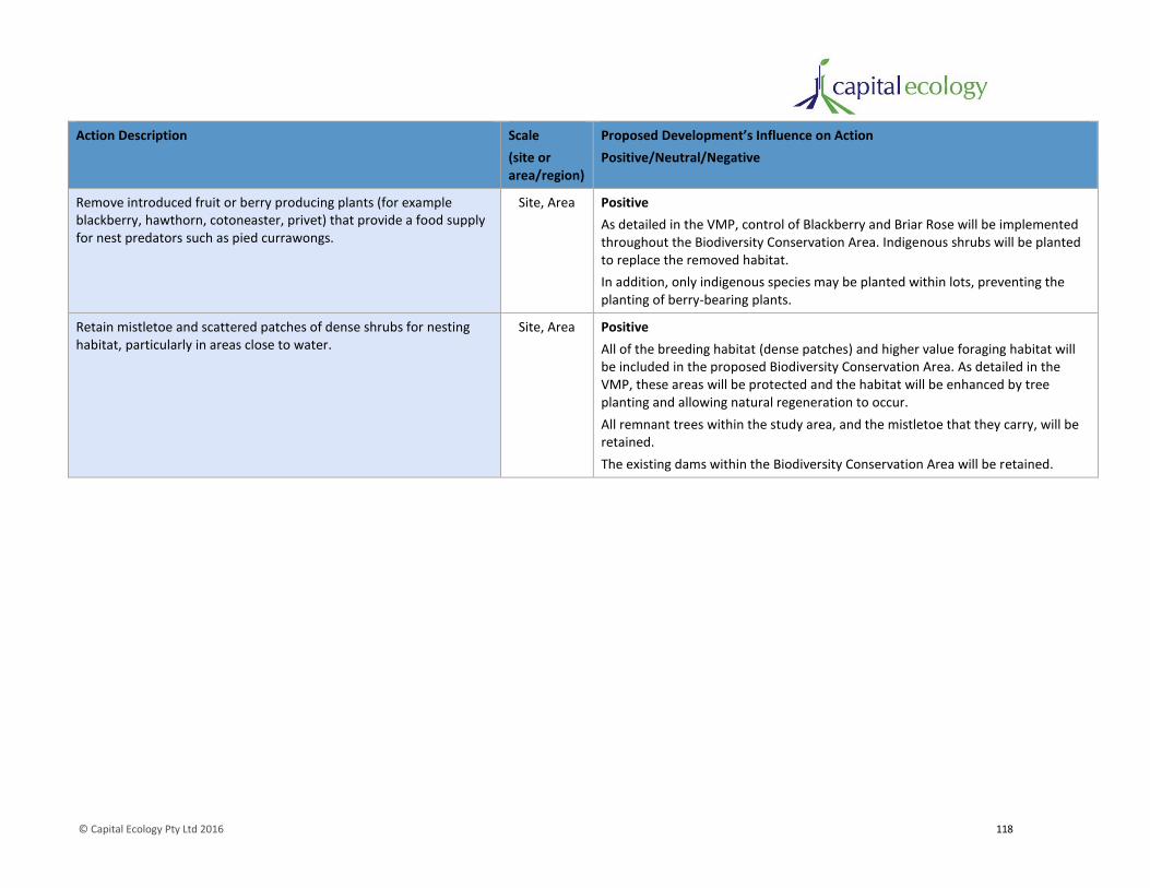
© Capital Ecology Pty Ltd 2016 118
Action Description Scale
(site or area/region)
Proposed Development’s Influence on Action
Positive/Neutral/Negative
Remove introduced fruit or berry producing plants (for example blackberry, hawthorn, cotoneaster, privet) that provide a food supply for nest predators such as pied currawongs.
Site, Area Positive
As detailed in the VMP, control of Blackberry and Briar Rose will be implemented throughout the Biodiversity Conservation Area. Indigenous shrubs will be planted to replace the removed habitat.
In addition, only indigenous species may be planted within lots, preventing the planting of berry-bearing plants.
Retain mistletoe and scattered patches of dense shrubs for nesting habitat, particularly in areas close to water.
Site, Area Positive
All of the breeding habitat (dense patches) and higher value foraging habitat will be included in the proposed Biodiversity Conservation Area. As detailed in the VMP, these areas will be protected and the habitat will be enhanced by tree planting and allowing natural regeneration to occur.
All remnant trees within the study area, and the mistletoe that they carry, will be retained.
The existing dams within the Biodiversity Conservation Area will be retained.

© Capital Ecology Pty Ltd 2016 119
g. whether the action proposed constitutes or is part of a key threatening process or is likely to
result in the operation of, or increase the impact of, a key threatening process.
The key threatening processes (KTPs) currently listed on Schedule 3 of the TSC Act of relevance to these
species and the proposed development are listed in Table 16.
As described in Table 16, the proposed development does not constitute a key threatening process, nor
is it likely to result in the operation of, or increase the impact of, a key threatening process.
Conclusion
As determined via consideration of the above seven factors, the proposed development is unlikely to
significantly affect the Diamond Firetail. Accordingly, a Species Impact Statement is not considered
warranted for this species.

© Capital Ecology Pty Ltd 2016 120
Appendix 7. Mount Pleasant Rural Residential Subdivision – Vegetation Management Plan
Mount Pleasant Rural Residential Subdivision Vegetation Management Plan
Final V2 – September 2016
Prepared for CIC Australia Pty Ltd

Capital Ecology Pty Ltd PO Box 854 ACN: 607 364 358 Phone: 0412 474 415 Gungahlin ACT 2912 ABN: 50 607 364 358 Email: [email protected] www.capitalecology.com.au
ii
Document Information
Report for: CIC Australia Pty Ltd
Prepared by: Robert Speirs
Capital Ecology project no.: 2681
Citation: Capital Ecology (2016). Mount Pleasant Rural Residential Subdivision – Vegetation Management
Plan. Final V2 – September 2016. Prepared for CIC Australia Pty Ltd. Author: R. Speirs. Project no. 2681.
Version Control
Version Internal reviewer External reviewers Date of issue
Draft version 01 Dr Monica Campbell Hoa Luu (CIC Australia) & 31/01/2016
Jenny Rudolf (Elton Consulting)
Final version 01 - - 08/02/2016
Final version 02 - Matthew Frawley (CIC Australia) 12/09/2016
Acknowledgements
Capital Ecology gratefully acknowledges the contributions and/or assistance of the following people and
organisations in undertaking this study.
Hoa Luu and Matthew Frawley, CIC Australia Pty Ltd.
Jenny Rudolf, Director, Elton Consulting Pty Ltd.
Arden Jones, Landscape Architect, SpaceLab Pty Ltd.
Dr Monica Campbell, Senior Ecologist.
Alex Christie and Sally Hatton, Research Assistants.
Lynn and Michael Dunn and James Wells, owners of Mount Pleasant.
Disclaimer
Capital Ecology Pty Ltd has undertaken the supporting studies and developed this document, including any assessment/s provided herein, in accordance with the relevant Commonwealth, State/Territory and local legislation and current industry best practice. This document does not provide legal or investment advice. Capital Ecology Pty Ltd accepts no liability for any damages or loss of any type incurred as a result of reliance
placed upon the content of this document for any purpose other than that for which it was expressly intended.
© Capital Ecology Pty Ltd
This document is and shall remain the property of Capital Ecology Pty Ltd. This document may be used solely for the purposes for which it was
commissioned and only by those parties for whom it is intended. Use of this document in any form other than that authorised is prohibited.
© Capital Ecology Pty Ltd 2016 3
Table of Contents
1 Introduction ........................................................................................................ 4
2 Biodiversity Conservation Area ............................................................................ 7
3 Vegetation Management Areas ........................................................................... 9
4 Subdivision-wide Controls ................................................................................. 16

© Capital Ecology Pty Ltd 2016 4
1 Introduction
CIC Australia Pty Ltd (CIC) is currently progressing with the planning and approval process for the
development of a 41 lot rural residential subdivision at Burra, NSW (the ‘proposed development’). As
shown in Figure 1, the proposed development is located within the property known as Mount Pleasant,
an approximate 275 hectare parcel of land formally known as Lot 1 in DP 1209260, located at 102 Burra
Road near the intersection near the intersection of Burra Road and Old Cooma Road.
Capital Ecology Pty Ltd (Capital Ecology) has been commissioned by CIC to undertake ecological surveys
and prepare a Flora and Fauna Assessment Report (F&FA) (Capital Ecology 2016) to identify and assess
the significance of the impacts that the proposed development may have upon biodiversity values of the
subject land (the ‘study area’). Reference should be made to the F&FA for the technical information
relevant to this Vegetation Management Plan (VMP).
As detailed in the F&FA, the study area supports significant biodiversity values, namely:
the Box-Gum Woodland threatened ecological community (TEC);
habitat for threatened woodland birds; and
habitat for the threatened Pink-tailed Worm-lizard Aprasia parapulchella.
As described in the F&FA, the subdivision’s extent and lot layout have been designed to avoid and
minimise impacts upon the biodiversity values of the study area (significant or otherwise).
Notwithstanding this, the implementation of the biodiversity protection and enhancement measures
prescribed in this VMP will be important to ensure that impacts are avoided, minimised or mitigated,
such that the proposed development does not adversely impact upon the significant biodiversity values
of the study area.
This VMP will implement the proposed biodiversity conservation measures in accordance with the
anticipated approval under the NSW Environmental Planning and Assessment Act 1979. It is envisaged
that the implementation of this VMP will become a condition of consent, and/or a requirement of a by-
law in the Mount Pleasant Rural Residential Subdivision – Community Management Statement (CMS)
(Holding Redlich, Draft 2015).
The CMS has been developed to provide controls relating to the management of the subdivision during
occupation. Once endorsed and implemented, the CMS will provide in perpetuity legal certainty for the
measures detailed in this VMP (among numerous other elements). As the CMS is linked to consent it will
be enforceable.
This VMP comprises the following three key sections, each of which details a key element of this VMP:
1. Section 2 – Biodiversity Conservation Area. Section 2 describes the purpose of the Biodiversity
Conservation Area and the rationale behind its location and extent.
2. Section 3 – Vegetation Management Areas. Section 3 describes each of the three Vegetation
Management Areas, the rationale behind their location and extent and the biodiversity
protection and enhancement measures that must be implemented within each.

© Capital Ecology Pty Ltd 2016 5
3. Section 4 – Subdivision-wide Controls. Section 4 described the controls that apply to the entire
subdivision.

0 1 2 3 4 km
Study_Area_Boundary
Legend
Figure 1. Locality Plan
Acknowledgement - Basemap (c) NSW Land and Property Informa on 2016 Scale 1:60,000 @ A4, GDA 1994, MGA Zone 55
Capital Ecology Project No: 2681Drawn by: R. SpeirsDate: 12 September 2016
Lot 1 DP1209260
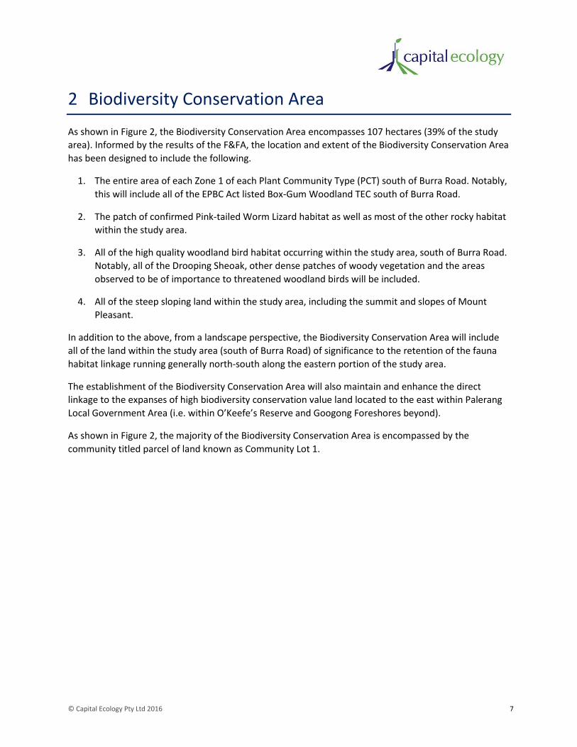
© Capital Ecology Pty Ltd 2016 7
2 Biodiversity Conservation Area
As shown in Figure 2, the Biodiversity Conservation Area encompasses 107 hectares (39% of the study
area). Informed by the results of the F&FA, the location and extent of the Biodiversity Conservation Area
has been designed to include the following.
1. The entire area of each Zone 1 of each Plant Community Type (PCT) south of Burra Road. Notably,
this will include all of the EPBC Act listed Box-Gum Woodland TEC south of Burra Road.
2. The patch of confirmed Pink-tailed Worm Lizard habitat as well as most of the other rocky habitat
within the study area.
3. All of the high quality woodland bird habitat occurring within the study area, south of Burra Road.
Notably, all of the Drooping Sheoak, other dense patches of woody vegetation and the areas
observed to be of importance to threatened woodland birds will be included.
4. All of the steep sloping land within the study area, including the summit and slopes of Mount
Pleasant.
In addition to the above, from a landscape perspective, the Biodiversity Conservation Area will include
all of the land within the study area (south of Burra Road) of significance to the retention of the fauna
habitat linkage running generally north-south along the eastern portion of the study area.
The establishment of the Biodiversity Conservation Area will also maintain and enhance the direct
linkage to the expanses of high biodiversity conservation value land located to the east within Palerang
Local Government Area (i.e. within O’Keefe’s Reserve and Googong Foreshores beyond).
As shown in Figure 2, the majority of the Biodiversity Conservation Area is encompassed by the
community titled parcel of land known as Community Lot 1.
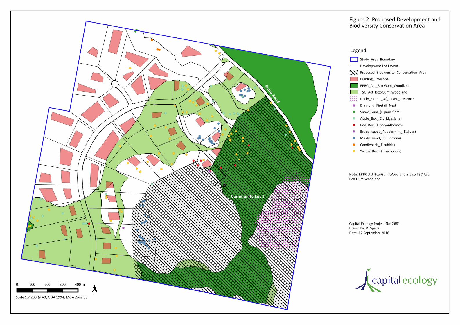
Figure 2. Proposed Development and Biodiversity Conservation Area
Study_Area_Boundary
Development Lot Layout
Proposed_Biodiversity_Conserva on_Area
Building_Envelope
EPBC_Act_Box-Gum_Woodland
TSC_Act_Box-Gum_Woodland
Likely_Extent_Of_PTWL_Presence
Diamond_Firetail_Nest
Snow_Gum_(E.pauciflora)
Apple_Box_(E.bridgesiana)
Red_Box_(E.polyanthemos)
Broad-leaved_Peppermint_(E.dives)
Mealy_Bundy_(E.nortonii)
Candlebark_(E.rubida)
Yellow_Box_(E.melliodora)
Legend
0 100 200 300 400 m
Scale 1:7,200 @ A3, GDA 1994, MGA Zone 55
Capital Ecology Project No: 2681Drawn by: R. SpeirsDate: 12 September 2016
Note: EPBC Act Box-Gum Woodland is also TSC ActBox-Gum Woodland
Community Lot 1Burra Road

© Capital Ecology Pty Ltd 2016 9
3 Vegetation Management Areas
As shown in Figure 3, the following three Vegetation Management Areas (VMAs) have been established
within the study area.
1. Vegetation Management Area 1 – Community Biodiversity Conservation Area.
VMA 1 will comprise the community titled portions of the Biodiversity Conservation Area (i.e.
Community Lot 1, refer Figure 3).
As detailed in Table 1, active measures will occur within VMA 1 which aim to conserve and
enhance the condition of the ecological communities within and increase the habitat value of the
area for native flora and fauna, notably the Pink-tailed Worm-lizard and threatened woodland
birds. The measures include replanting woodland trees and shrubs, initial and ongoing weed
control and control of vertebrate fauna pest species (notably rabbits).
2. Vegetation Management Area 2 – Private Biodiversity Conservation Area.
VMA 2 will comprise the portions of the Biodiversity Conservation Area included within privately
owned lots.
As detailed in Table 1, VMA 2 will be subject to active measures which aim to conserve and
enhance the condition of the ecological communities encompassed and increase the habitat value
of the area for native flora and fauna, notably threatened woodland birds. The appropriate
management and enhancement of VMA 2 will be of particular value as a means of strengthening
the biodiversity corridor which runs north-south along the eastern side of the study area.
3. Vegetation Management Area 3 – Biodiversity Covenant Area.
VMA 3 will comprise the portions of private lots that support Vegetation Zone 2 of either PCT999
or PCT1334.
As detailed in Table 1, the portions of private lots encompassed by VMA 3 will be subject to land
management provisions requiring landowners to retain all remnant trees, plant only trees of
species indigenous to the locality and maintain the ‘native grassland’ characteristics of the
groundstorey.
Figure 3. Vegeta on ManagementAreas
Legend Study_Area_Boundary Development Lot Layout
Building_Envelope Snow_Gum_(E.pauciflora)
Apple_Box_(E.bridgesiana)
Red_Box_(E.polyanthemos)
Broad-leaved_Peppermint_(E.dives)
Mealy_Bundy_(E.nortonii)
Candlebark_(E.rubida)
Yellow_Box_(E.melliodora)
Aboriginal_Artefact_Sca er_Area_(NOHC 2016)
Aboriginal_Cultural_Heritage_Site_(NOHC 2016)
Proposed_Biodiversity_Conserva on_Area Vegeta on_Management_Areas
VMA1_Community_Biodiversity_Conserva on_Area VMA2_Private_Biodiversity_Conserva on_Area VMA3_Biodiversity_Covenant_Area Ini al_Revegeta on_-_Key_Areas
0 100 200 300 400 m
Scale 1:7,200 @ A3, GDA 1994, MGA Zone 55
Capital Ecology Project No: 2681Drawn by: R. SpeirsDate: 12 September 2016
Burra RoadDroopingSheoakpatch
Acknowledgement - Image (c) Nearmap 2016
DroopingSheoakpatch
Community Lot 1
© Capital Ecology Pty Ltd 2016 11
Table 1. Vegetation Management Areas – Vegetation Management Controls and Enhancement Measures
Control / Enhancement Measure Applicable to Vegetation Management Area Timing Responsible Party
VMA 1 VMA 2 VMA 3
Control
1. Preservation of all remnant eucalypts
All remnant eucalypts, alive or dead, must be preserved.
Note: The outcome of this control should be achieved with due consideration of the Australian Standard – Protection of trees on development sites (AS4970-2009).
Yes Yes Yes During subdivision development and in perpetuity.
CIC then lot owners and the Community Association.
2. Restriction on clearing or removal of native vegetation
No clearing or removal of native vegetation, including fallen dead timber greater than 20 cm diameter, shrubs, grasses or groundcovers (except for the purposes of constructing the maximum 2000m2 building envelope and a single vehicle driveway between the public road and the building envelope), unless approval is obtained from the Council or other relevant authority.
Yes Yes - During subdivision development and in perpetuity.
CIC then lot owners and the Community Association.
3. Requirement to maintain native grass groundstorey
The ‘native grassland’ characteristics of the groundstorey must be maintained (except for the purposes of constructing the maximum 2000m2 building envelope and a single vehicle driveway between the public road and the building envelope), unless approval is obtained from the Council or other relevant authority.
- - Yes During subdivision development and in perpetuity.
CIC then lot owners.
4. Prohibition on the keeping of hooved animals
No keeping of hooved animals (either on a permanent or temporary basis), unless approval is obtained from the Council or other relevant authority.
Yes Yes - In perpetuity, onwards from lot occupation.
Lot owners and the Community Association.

© Capital Ecology Pty Ltd 2016 12
Control / Enhancement Measure Applicable to Vegetation Management Area Timing Responsible Party
VMA 1 VMA 2 VMA 3
5. Restriction on the keeping of hooved animals
Light grazing is permitted provided that a stock proof fence (hinge jointed mesh and two plain wire strands) is erected to ensure no grazed animals may enter the adjoining/adjacent Biodiversity Conservation Area. Stocking rates are not to exceed 1 horse or cow (or equivalent) per 2 hectares of grazing land and/or 5 sheep or goats (or equivalent) per 2 hectares of grazing land. Groundcover must not fall below 70% coverage before stock are removed.
N/A – 4. above
applies.
N/A – 4. above
applies.
Yes In perpetuity, onwards from lot occupation.
Lot owners and the Community Association.
6. Prohibition on planting of noxious weeds and potential pest plant species
No species listed in Table 3 may be planted.
Yes Yes Yes In perpetuity, onwards from lot occupation.
Lot owners and the Community Association.
7. Restriction on plant species used for revegetation, landscaping and other planting
Revegetation works, landscaping and other planting may only be carried out if it is complementary to the native indigenous vegetation of the lot. Only plant species listed in Table 2 may be planted.
Yes Yes Yes During subdivision development and in perpetuity.
CIC then lot owners and the Community Association.
8. Initial priority weed control
The presence and distribution of each priority noxious weed (Serrated Tussock, African Love Grass and Blackberry) will be assessed and mapped. This mapping will be provided to a suitably qualified and experienced weed control contractor who will be engaged to undertake the required initial weed control.
The specific weed control techniques employed will be determined by the weed control contractor at the time of engagement, based upon suitability/applicability for the subject species. The initial weed control works will be timed to maximise the effectiveness of the chosen technique.
Yes Yes Yes Prior to commencement of subdivision development.
CIC
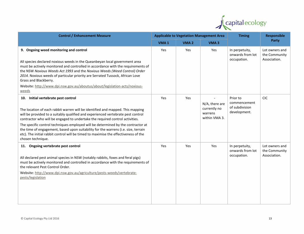
© Capital Ecology Pty Ltd 2016 13
Control / Enhancement Measure Applicable to Vegetation Management Area Timing Responsible Party
VMA 1 VMA 2 VMA 3
9. Ongoing weed monitoring and control
All species declared noxious weeds in the Queanbeyan local government area must be actively monitored and controlled in accordance with the requirements of the NSW Noxious Weeds Act 1993 and the Noxious Weeds (Weed Control) Order 2014. Noxious weeds of particular priority are Serrated Tussock, African Love Grass and Blackberry.
Website: http://www.dpi.nsw.gov.au/aboutus/about/legislation-acts/noxious-weeds
Yes Yes Yes In perpetuity, onwards from lot occupation.
Lot owners and the Community Association.
10. Initial vertebrate pest control
The location of each rabbit warren will be identified and mapped. This mapping will be provided to a suitably qualified and experienced vertebrate pest control contractor who will be engaged to undertake the required control activities.
The specific control techniques employed will be determined by the contractor at the time of engagement, based upon suitability for the warrens (i.e. size, terrain etc). The initial rabbit control will be timed to maximise the effectiveness of the chosen technique.
Yes Yes -
N/A, there are currently no warrens within VMA 3.
Prior to commencement of subdivision development.
CIC
11. Ongoing vertebrate pest control
All declared pest animal species in NSW (notably rabbits, foxes and feral pigs) must be actively monitored and controlled in accordance with the requirements of the relevant Pest Control Order.
Website: http://www.dpi.nsw.gov.au/agriculture/pests-weeds/vertebrate-pests/legislation
Yes Yes Yes In perpetuity, onwards from lot occupation.
Lot owners and the Community Association.

© Capital Ecology Pty Ltd 2016 14
Control / Enhancement Measure Applicable to Vegetation Management Area Timing Responsible Party
VMA 1 VMA 2 VMA 3
Enhancement Measure
1. Initial revegetation works (tree and shrub planting)
The primary measure to implemented to facilitate and encourage revegetation of the Biodiversity Conservation Area will be the removal of stock. This measure will allow natural recruitment and regeneration to occur as seedlings from the many remaining mature eucalypts will be allowed the opportunity to establish and grow unhindered. It is envisaged that seed from remaining trees and that in the soil seedbank and will be sufficient for most of the canopy species.
As described in the F&FA, the midstorey and shrubstorey of Box-Gum Woodland and dry sclerophyll forest communities are important habitat components for native fauna, notably woodland birds (including many threatened species). These are generally absent throughout the Biodiversity Conservation Area due to prolonged intense grazing.
Given the above, the following initial revegetation plantings will occur to add these missing habitat components to patches within the Biodiversity Conservation Area and encourage further future natural recruitment by inserting an ongoing source of seed.
a. 2000 saplings (tubestock) of suitable shrub species will be planted in Biodiversity Conservation Area, concentrating plantings in and around the denser patches of trees (refer Figure 3). Species will be chosen from the list provided in Table 2 but should include a substantial proportion of Native Blackthorn Bursaria spinosa subsp. Lasiophylla and Burgan Kunzea eriocoides as these vigorous species are commercially available, will establish well and readily self-seed.
b. 1000 Drooping Sheoak Allocasuarina verticillata saplings (tubestock) will be planted in and around the denser patches of trees, primarily on land with a northern aspect (refer Figure 3. The primary objective of this planting is to increase the potential foraging resource within the Biodiversity Conservation Area for the Glossy Black-cockatoo Calyptorhynchus lathami which feeds almost exclusively on this species in the region.
Yes
Figure 3 shows
proposed initial
revegetation areas
- - Prior to occupation of subdivision.
CIC

© Capital Ecology Pty Ltd 2016 15
Control / Enhancement Measure Applicable to Vegetation Management Area Timing Responsible Party
VMA 1 VMA 2 VMA 3
2. Ongoing revegetation works
Lot owners and the community may undertake revegetation works as desired, noting that only the species listed in Table 2 may be planted.
It is recommended that advice regarding specific species selection is sought from someone with expertise in the flora of the region (e.g. local ecologist, botanist, Greening Australia etc). This person will be able to match species to the relevant soil type, aspect, hydrology of the planting location.
Yes Yes Yes In perpetuity, onwards from lot occupation.
Lot owners and the Community Association.
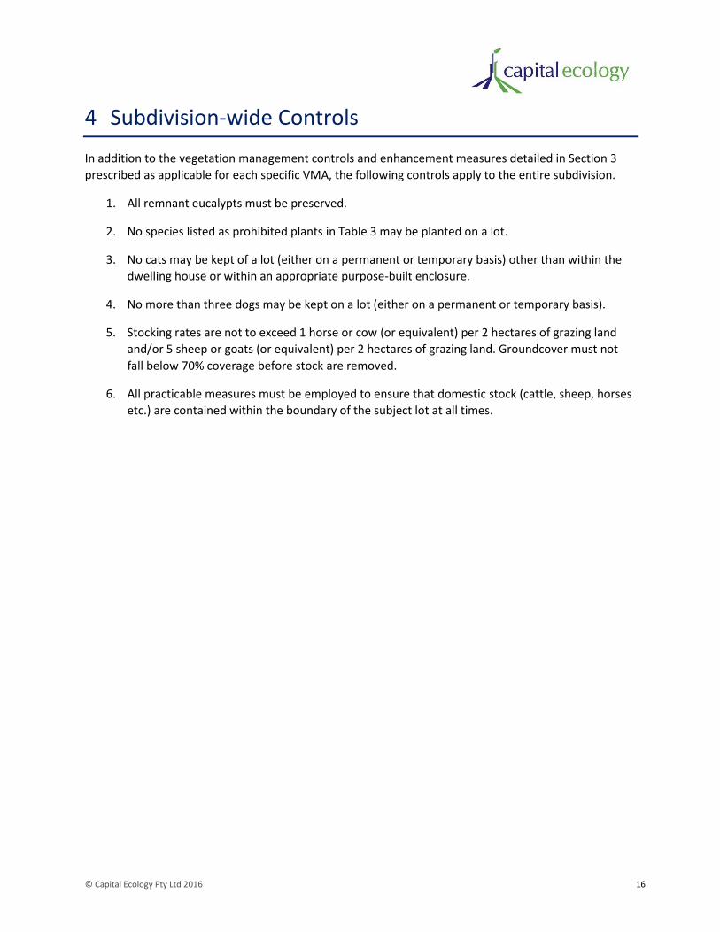
© Capital Ecology Pty Ltd 2016 16
4 Subdivision-wide Controls
In addition to the vegetation management controls and enhancement measures detailed in Section 3
prescribed as applicable for each specific VMA, the following controls apply to the entire subdivision.
1. All remnant eucalypts must be preserved.
2. No species listed as prohibited plants in Table 3 may be planted on a lot.
3. No cats may be kept of a lot (either on a permanent or temporary basis) other than within the
dwelling house or within an appropriate purpose-built enclosure.
4. No more than three dogs may be kept on a lot (either on a permanent or temporary basis).
5. Stocking rates are not to exceed 1 horse or cow (or equivalent) per 2 hectares of grazing land
and/or 5 sheep or goats (or equivalent) per 2 hectares of grazing land. Groundcover must not
fall below 70% coverage before stock are removed.
6. All practicable measures must be employed to ensure that domestic stock (cattle, sheep, horses
etc.) are contained within the boundary of the subject lot at all times.
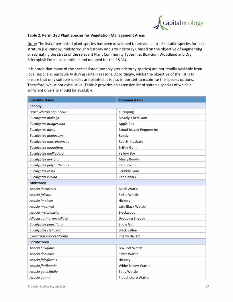
© Capital Ecology Pty Ltd 2016 17
Table 2. Permitted Plant Species for Vegetation Management Areas
Note: The list of permitted plant species has been developed to provide a list of suitable species for each
stratum (i.e. canopy, midstorey, shrubstorey and groundstorey), based on the objective of augmenting
or recreating the strata of the relevant Plant Community Types (i.e. Box-Gum Woodland and Dry
Sclerophyll Forest as identified and mapped for the F&FA).
It is noted that many of the species listed (notably groundstorey species) are not readily available from
local suppliers, particularly during certain seasons. Accordingly, whilst the objective of the list is to
ensure that only suitable species are planted, it is also important to maximise the species options.
Therefore, whilst not exhaustive, Table 2 provides an extensive list of suitable species of which a
sufficient diversity should be available.
Scientific Name Common Name
Canopy
Brachychiton populneus Kurrajong
Eucalyptus blakelyi Blakely's Red Gum
Eucalyptus bridgesiana Apple Box
Eucalyptus dives Broad-leaved Peppermint
Eucalyptus goniocalyx Bundy
Eucalyptus macrorhyncha Red Stringybark
Eucalyptus mannifera Brittle Gum
Eucalyptus melliodora Yellow Box
Eucalyptus nortonii Mealy Bundy
Eucalyptus polyanthemos Red Box
Eucalyptus rossii Scribbly Gum
Eucalyptus rubida Candlebark
Midstorey
Acacia decurrens Black Wattle
Acacia falcata Sickle Wattle
Acacia implexa Hickory
Acacia mearnsii Late Black Wattle
Acacia melanoxylon Blackwood
Allocasuarina verticillata Drooping Sheoak
Eucalyptus pauciflora Snow Gum
Eucalyptus stellulata Black Sallee
Exocarpos cupressiformis Cherry Ballart
Shrubstorey
Acacia buxiflora Box-leaf Wattle
Acacia dealbata Silver Wattle
Acacia falciformis Hickory
Acacia floribunda White Sallow Wattle
Acacia genistifolia Early Wattle
Acacia gunnii Ploughshare Wattle
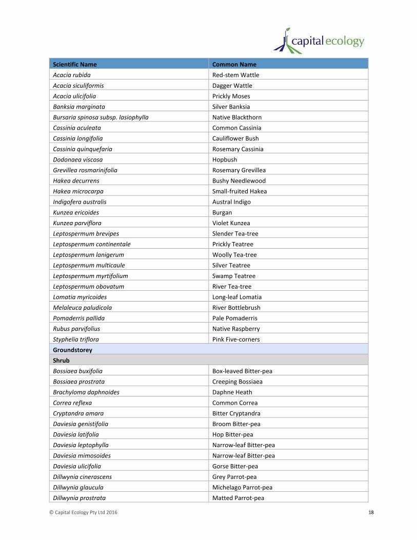
© Capital Ecology Pty Ltd 2016 18
Scientific Name Common Name
Acacia rubida Red-stem Wattle
Acacia siculiformis Dagger Wattle
Acacia ulicifolia Prickly Moses
Banksia marginata Silver Banksia
Bursaria spinosa subsp. lasiophylla Native Blackthorn
Cassinia aculeata Common Cassinia
Cassinia longifolia Cauliflower Bush
Cassinia quinquefaria Rosemary Cassinia
Dodonaea viscosa Hopbush
Grevillea rosmarinifolia Rosemary Grevillea
Hakea decurrens Bushy Needlewood
Hakea microcarpa Small-fruited Hakea
Indigofera australis Austral Indigo
Kunzea ericoides Burgan
Kunzea parviflora Violet Kunzea
Leptospermum brevipes Slender Tea-tree
Leptospermum continentale Prickly Teatree
Leptospermum lanigerum Woolly Tea-tree
Leptospermum multicaule Silver Teatree
Leptospermum myrtifolium Swamp Teatree
Leptospermum obovatum River Tea-tree
Lomatia myricoides Long-leaf Lomatia
Melaleuca paludicola River Bottlebrush
Pomaderris pallida Pale Pomaderris
Rubus parvifolius Native Raspberry
Styphelia triflora Pink Five-corners
Groundstorey
Shrub
Bossiaea buxifolia Box-leaved Bitter-pea
Bossiaea prostrata Creeping Bossiaea
Brachyloma daphnoides Daphne Heath
Correa reflexa Common Correa
Cryptandra amara Bitter Cryptandra
Daviesia genistifolia Broom Bitter-pea
Daviesia latifolia Hop Bitter-pea
Daviesia leptophylla Narrow-leaf Bitter-pea
Daviesia mimosoides Narrow-leaf Bitter-pea
Daviesia ulicifolia Gorse Bitter-pea
Dillwynia cinerascens Grey Parrot-pea
Dillwynia glaucula Michelago Parrot-pea
Dillwynia prostrata Matted Parrot-pea
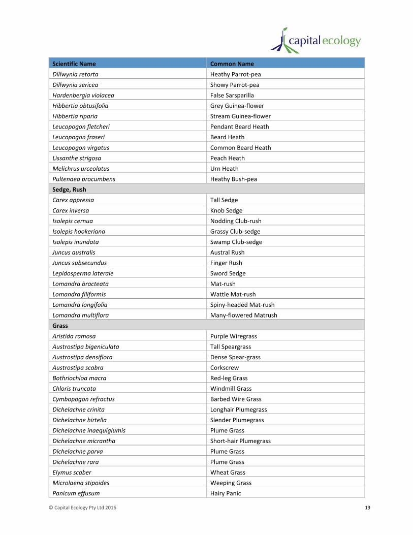
© Capital Ecology Pty Ltd 2016 19
Scientific Name Common Name
Dillwynia retorta Heathy Parrot-pea
Dillwynia sericea Showy Parrot-pea
Hardenbergia violacea False Sarsparilla
Hibbertia obtusifolia Grey Guinea-flower
Hibbertia riparia Stream Guinea-flower
Leucopogon fletcheri Pendant Beard Heath
Leucopogon fraseri Beard Heath
Leucopogon virgatus Common Beard Heath
Lissanthe strigosa Peach Heath
Melichrus urceolatus Urn Heath
Pultenaea procumbens Heathy Bush-pea
Sedge, Rush
Carex appressa Tall Sedge
Carex inversa Knob Sedge
Isolepis cernua Nodding Club-rush
Isolepis hookeriana Grassy Club-sedge
Isolepis inundata Swamp Club-sedge
Juncus australis Austral Rush
Juncus subsecundus Finger Rush
Lepidosperma laterale Sword Sedge
Lomandra bracteata Mat-rush
Lomandra filiformis Wattle Mat-rush
Lomandra longifolia Spiny-headed Mat-rush
Lomandra multiflora Many-flowered Matrush
Grass
Aristida ramosa Purple Wiregrass
Austrostipa bigeniculata Tall Speargrass
Austrostipa densiflora Dense Spear-grass
Austrostipa scabra Corkscrew
Bothriochloa macra Red-leg Grass
Chloris truncata Windmill Grass
Cymbopogon refractus Barbed Wire Grass
Dichelachne crinita Longhair Plumegrass
Dichelachne hirtella Slender Plumegrass
Dichelachne inaequiglumis Plume Grass
Dichelachne micrantha Short-hair Plumegrass
Dichelachne parva Plume Grass
Dichelachne rara Plume Grass
Elymus scaber Wheat Grass
Microlaena stipoides Weeping Grass
Panicum effusum Hairy Panic
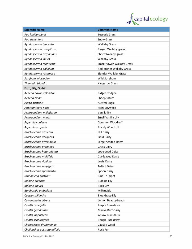
© Capital Ecology Pty Ltd 2016 20
Scientific Name Common Name
Poa labillardierei Tussock Grass
Poa sieberiana Snow Grass
Rytidosperma bipartita Wallaby Grass
Rytidosperma caespitosa Ringed Wallaby-grass
Rytidosperma carphoides Short Wallaby-grass
Rytidosperma laevis Wallaby Grass
Rytidosperma monticola Small-flower Wallaby Grass
Rytidosperma pallidum Red-anther Wallaby Grass
Rytidosperma racemosa Slender Wallaby Grass
Sorghum leiocladum Wild Sorghum
Themeda triandra Kangaroo Grass
Forb, Lily, Orchid
Acaena novae-zelandiae Bidgee-widgee
Acaena ovina Sheep's Burr
Ajuga australis Austral Bugle
Alternanthera nana Hairy Joyweed
Arthropodium milleflorum Vanilla-lily
Arthropodium minus Small Vanilla Lily
Asperula conferta Common Woodruff
Asperula scoparia Prickly Woodruff
Brachyscome aculeata Hill Daisy
Brachyscome decipiens Field Daisy
Brachyscome diversifolia Large-headed Daisy
Brachyscome graminea Grass Dairy
Brachyscome heterodonta Lobe-seed Daisy
Brachyscome multifida Cut-leaved Daisy
Brachyscome rigidula Leafy Daisy
Brachyscome scapigera Tufted Daisy
Brachyscome spathulata Spoon Daisy
Brunoniella australis Blue Trumpet
Bulbine bulbosa Bulbine Lily
Bulbine glauca Rock Lily
Burchardia umbellata Milkmaids
Caesia calliantha Blue Grass-Lily
Calocephalus citreus Lemon Beauty-heads
Calotis cuneifolia Purple Burr-daisy
Calotis glandulosa Mauve Burr-daisy
Calotis lappulacea Yellow Burr-daisy
Calotis scabiosifolia Rough Burr-daisy
Chamaesyce drummondii Caustic-weed
Cheilanthes austrotenuifolia Rock Fern

© Capital Ecology Pty Ltd 2016 21
Scientific Name Common Name
Chrysocephalum apiculatum Common Everlasting
Chrysocephalum semipapposum Clustered Everlasting
Clematis microphylla Small-leaved Clematis
Convolvulus erubescens Australian Bindweed
Cotula australis Common Cotula
Craspedia variabilis Billy Buttons
Cullen microcephalum Dusky Scurfpea
Cymbonotus lawsonianus Austral Bears-ear
Cynoglossum australe Australian Hound's-tongue
Cynoglossum suaveolens Sweet Hound's-tongue
Daucus glochidiatus Native Carrot
Derwentia perfoliata Digger's Speedwell
Desmodium brachypodum Large Tick-trefoil
Desmodium varians Slender Tick-trefoil
Dianella longifolia Smooth Flax Lily
Dianella revoluta Black-anther Flax-lily
Dichondra repens Kidney Weed
Dichopogon fimbriatus Nodding Chocolate Lily
Dichopogon strictus Chocolate Lily
Dipodium punctatum Hyacinth Orchid
Diuris aequalis Buttercup Doubletail
Diuris behrii Golden Cowslips
Diuris chryseopsis Common Golden Moths
Diuris dendrobioides Long-tail Purple Diuris
Diuris maculata Leopard Orchid
Diuris ochroma Pale Golden Moths
Diuris pedunculata Small Snake Orchid
Diuris punctata Purple Donkey-orchid
Diuris semilunulata Donkey-ears
Diuris sulphurea Tiger Orchid
Drosera peltata Pale Sundew
Drosera pygmaea Pigmy Sundew
Eriochilus cucullatus Parson's Bands
Erodium crinitum Native Crowfoot
Eryngium ovinum Blue Devil
Galium gaudichaudii Rough Bedstraw
Geranium antrorsum Antrorse Geranium
Geranium retrorsum Common Cranes-bill
Geranium solanderi Native Geranium
Glossodia major Wax-lip Orchid
Glycine clandestina Twining Glycine
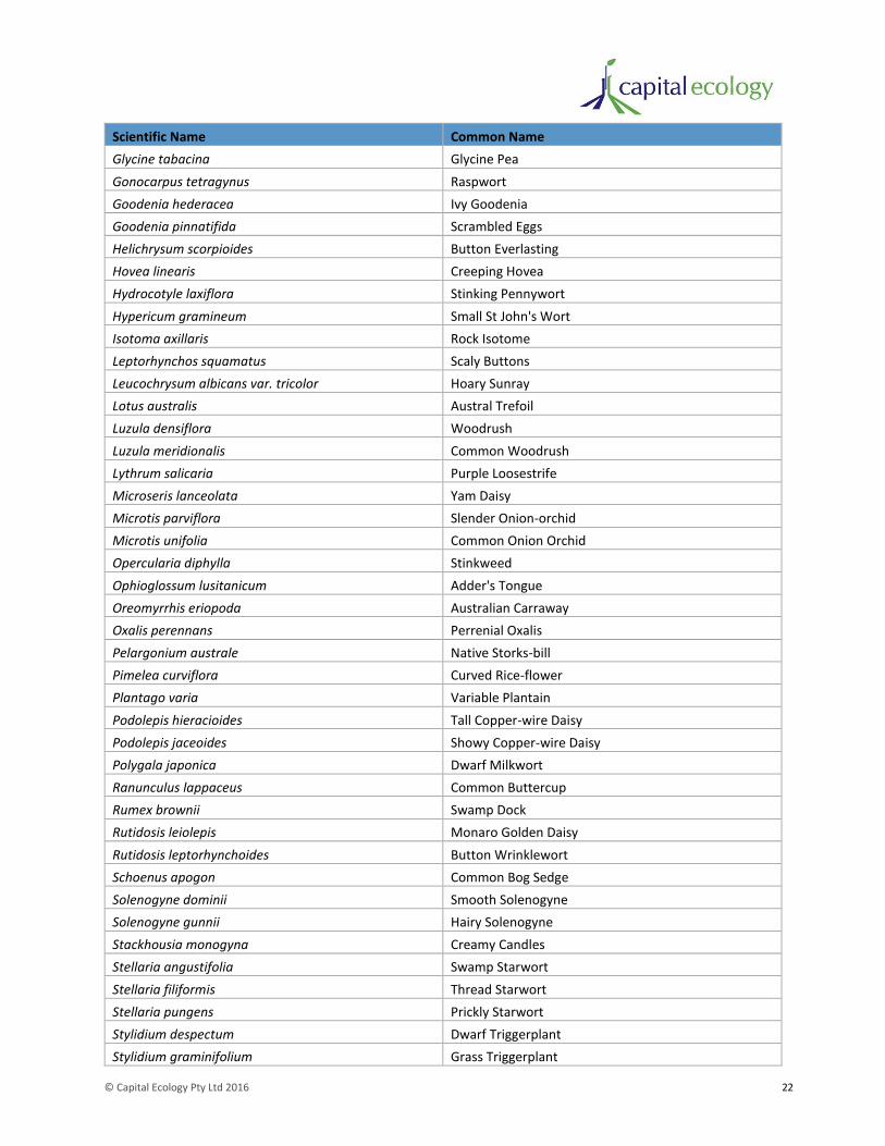
© Capital Ecology Pty Ltd 2016 22
Scientific Name Common Name
Glycine tabacina Glycine Pea
Gonocarpus tetragynus Raspwort
Goodenia hederacea Ivy Goodenia
Goodenia pinnatifida Scrambled Eggs
Helichrysum scorpioides Button Everlasting
Hovea linearis Creeping Hovea
Hydrocotyle laxiflora Stinking Pennywort
Hypericum gramineum Small St John's Wort
Isotoma axillaris Rock Isotome
Leptorhynchos squamatus Scaly Buttons
Leucochrysum albicans var. tricolor Hoary Sunray
Lotus australis Austral Trefoil
Luzula densiflora Woodrush
Luzula meridionalis Common Woodrush
Lythrum salicaria Purple Loosestrife
Microseris lanceolata Yam Daisy
Microtis parviflora Slender Onion-orchid
Microtis unifolia Common Onion Orchid
Opercularia diphylla Stinkweed
Ophioglossum lusitanicum Adder's Tongue
Oreomyrrhis eriopoda Australian Carraway
Oxalis perennans Perrenial Oxalis
Pelargonium australe Native Storks-bill
Pimelea curviflora Curved Rice-flower
Plantago varia Variable Plantain
Podolepis hieracioides Tall Copper-wire Daisy
Podolepis jaceoides Showy Copper-wire Daisy
Polygala japonica Dwarf Milkwort
Ranunculus lappaceus Common Buttercup
Rumex brownii Swamp Dock
Rutidosis leiolepis Monaro Golden Daisy
Rutidosis leptorhynchoides Button Wrinklewort
Schoenus apogon Common Bog Sedge
Solenogyne dominii Smooth Solenogyne
Solenogyne gunnii Hairy Solenogyne
Stackhousia monogyna Creamy Candles
Stellaria angustifolia Swamp Starwort
Stellaria filiformis Thread Starwort
Stellaria pungens Prickly Starwort
Stylidium despectum Dwarf Triggerplant
Stylidium graminifolium Grass Triggerplant

© Capital Ecology Pty Ltd 2016 23
Scientific Name Common Name
Stypandra glauca Nodding Blue Lily
Swainsona behriana Behr's Swainson-pea
Swainsona monticola Moutain Swainson-pea
Swainsona recta Small Purple-pea
Swainsona sericea Silky Swainson-pea
Thelymitra ixioides Spotted Sun-orchid
Thelymitra malvina Mauve-tuft Sun-orchid
Thelymitra pauciflora Slender Sun-orchid
Thesium australe Austral toadflax
Thysanotus patersonii Twining Fringe-lily
Thysanotus tuberosus Common Fringe-lily
Tricoryne elatior Yellow Rush-lily
Triptilodiscus pygmaeus Common Sunray
Velleia paradoxa Spur Velleia
Viola betonicifolia Arrowhead Violet
Viola hederacea Native Violet
Vittadinia cuneata Fuzzweed
Vittadinia gracilis Woolly New Holland Daisy
Vittadinia muelleri Narrow-leaved New Holland Daisy
Wahlenbergia communis Tufted Bluebell
Wahlenbergia gracilis Australian Bluebell
Wahlenbergia stricta Tall Bluebell
Wurmbea dioica Early Nancy
Xerochrysum viscosum Sticky Everlasting Daisy
© Capital Ecology Pty Ltd 2016 24
Table 3. Prohibited Plant Species
Note: The list of prohibited plant species is generally consistent with that provided in the Community
Management Statement for the adjoining Little Burra rural residential subdivision. However, additional
noxious weeds and pest plant species that have been recorded within the study area (refer F&FA), as
well as those listed in Section 2 of the Queanbeyan City Council 2011-2021 Weed Management Plan
(Queanbeyan City Council 2011), have been included.
Scientific Name Common Name
Acacia karoo Karoo Thorn
Acacia paradoxa Kangaroo Thorn
Acecia balieyana Cootamundra Wattle
Achillea millefolium Yarrow
Achnatherum cauda tum Broad-kernel Espartillo
Ailanthus altissima Tree of Heaven
Alnus gluttnosa Black Adder
Alternanthera philoxeroides Alligator Weed
Cannibis sativa Indian Hemp
Cardus pycnoncephalus Slender Thistle
Carduus nutans Nodding Thistle
Carduus tenuiflorus Slender Thistle
Cartaderia selloana Pampus Grass
Carthamus lanatus Saffron Thistle
Carus tenuiflorus Slender Thistle
Cassinia arctuata Sifton Brush
Celtus australis Nettle Tree
Censchrus longispinus Spiny Burrgrass
Centaurea caliptrata Star Thistle
Cestrum pargui Green Cestrum
Chromolaena ordorata Siam Weed
Cirsium vulgare Spear Thistle
Conium maculatum Hemlock
Cortaderia jubata Pampus Grass
Cotoneaster franchetti Cotoneaster
Cotoneaster glaucophyllus Cotoneaster
Cotoneaster pannosus Cotoneaster
Cotoneaster salicifolius Willow-leaf Cotoneaster
Cotoneaster simonsii Cotoneaster
Crataegus monogyna Hawthorn
Cuscuta campestris Golden Dodder
Cyperus eragrostis Umbrella Sedge
Cytisus scoparius Scotch Broom
Echium plantagineum Paterson's Curse
© Capital Ecology Pty Ltd 2016 25
Scientific Name Common Name
Echium vulgare Vipers Bugloss
Eichornia crassipes Water Hyacinth
Equisetum arvense Horsetail
Eragrostris culvula African Lovegrass
Erythroxylum coca Coca Leaf
Foeniculum vulgare Fennel
Genista monspessulana Montpellier Heliotrope
Gymnocoronis spilanthoides Senegal Tea Plant
Hedera helix English Ivy
Heliotropium europaeum Common Heliotrope
Hypeicum perforatum St John's Wort
Kochia scoparia Kochia
Lagarosiphon major Lagarosiphon
Ligustrum lucidum Privet
Ligustrum sinense Small-leaved Privet
Lonicera japonica Japanese Honeysuckle
Lycium ferocissimum Africa Boxthorn
Marrubium vulgare Horehound
Nassella charruana Lobed Needlegrass
Nassella neesiana Chilean Needlegrass
Nassella trichotoma Serrated Tussock
Onopordum acanthium Scotch Thistle
Onopordum illyrcum Stemless Thistle
Orobanche minor Lesser Broomrape
Papaver somniferum Opium Poppy
Parthenium hysterophorus Parthenium Weed
Phyllostachys aurea Yellow Bamboo
Pinus radiata Radiata Pine
Pistia stratiotes Water Lettuce
Populus alba White Poplar
Populus nigra "Italic" Lombardy Poplar
Prunus cerasifera Cherry Plum
Prunus serotina Black Cherry
Pyracantha angustifloia a Firethorn
Pyracantha coccinea a Firethorn
Pyracantha fortuneana a Firethorn
Robinia pseudoacica False Acacia
Rosa rubiginosa Briar Rose
Rubus fruticosus Blackberry
Salix alba var. vitellina Golden Upright Willow
Salix caprea Pussy Willow
© Capital Ecology Pty Ltd 2016 26
Scientific Name Common Name
Salix cinerea Grey Sallow
Salix fragilis Crack Willow
Salix glaucophylloides Willow
Salix matsudana "Pendula" Matsudana Willow
Salix matsudana "Tortuosa" Tortured Willows
Salix matsudana XS alba (all clones) Matsudana Hybrid Willows
Salix nigra Black Willow
Salix purpurea Purple Osier
Salix viminalis Common Osier
Salix X rubens (S. alba XS S.fragilis) Golden Crack Willow
Salvinia molesta Salvinia
Senecio madagascariensis Fireweed
Solanum linnaeanum Apple of Sodom
Sollya heterophylla WA Bluebell Creeper
Sorbus domestica Service Tree
Spartium junceum Spanish Broom
Toxicodendron succedaneum Rhus Tree
Tradescantia albiflora Wandering Jew
Ulex europaeus Gorse
Verbascum thapsus Great Mullein
Vinca major Periwinkle
Xanthium occidentale Noogoora burr
Xanthium spinosum Bathurst Burr

© Capital Ecology Pty Ltd 2016 121
Appendix 8. Mount Pleasant Rural Residential Subdivision – BioBanking Metric Assessment

Capital Ecology Pty Ltd PO Box 854 ACN: 607 364 358 Phone: 0412 474 415 Gungahlin ACT 2912 ABN: 50 607 364 358 Email: [email protected] www.capitalecology.com.au
26 July 2016
Mr Matthew Frawley
Landscape Manager
CIC Australia Limited
PO Box 1000, Civic Square ACT 2608
Level 3, 64 Allara Street, Canberra, ACT, 2601
T: 02 6230 0800
Mount Pleasant Rural Residential Subdivision – BioBanking Metric Assessment Capital Ecology project no. 2710
Dear Mr Frawley,
Item 2 of the Request for Further Information (‘RFI’) received from Queanbeyan-Palerang Regional
Council (‘Council’), dated 6 June 2016, requests that the NSW BioBanking metric be applied to the
vegetation mapping prepared by Capital Ecology across spring 2015 and presented in our Flora and
Fauna Assessment (dated 8 February 2016)1.
Council and the NSW Office of Environment and Heritage (OEH) have stated that they concur with
our previous advice that a BioBanking agreement/statement cannot be issued for the study area
(refer Figure 1 – Locality Plan) due to the non-urban land zone (i.e. E4 - Environmental Living).
Notwithstanding this, as noted in the RFI, the BioBanking metric provides the most appropriate
means of assessing the adequacy of the proposed offset in a quantified, open and transparent
manner. Accordingly, Capital Ecology has undertaken this BioBanking Metric Assessment to address
RFI Item 2.
This document should be read in conjunction with the following report: 1 Capital Ecology (2016). Mount Pleasant Rural Residential Subdivision – Flora and Fauna Assessment. Final – February 2016. Prepared for CIC Australia Pty Ltd. Author: R. Speirs. Project no. 2681.

© Capital Ecology Pty Ltd 2016 2
Background and Methodology
As per the ‘Native Vegetation Act 2003 Preliminary Assessment’ provided by NSW Local Land Services
(dated 22 July 2016)2, the following is noted:
once development approval for dwellings (and associated vegetation clearance) is granted
by Council, that clearance is a legislative exclusion under Section 25 of the NV Act;
clearance of native vegetation for the road network requires NV Act consent;
NV Act consent will require that a ‘maintain or improve’ outcome will be achieved, this may
be facilitated by the provision of an offset for clearance of native vegetation for the road
network; and
the NV Act offset will be registered on title in the form of a Property Vegetation Plan (PVP).
The same impact cannot be assessed and offset under both the NV Act the NSW Environment
Planning and Assessment Act 1979 (EP&A Act). Therefore, for the purposes of this BioBanking metric
assessment, only the impacts that will not be covered by the NV Act consent (and corresponding
offset requirement) have been considered. As detailed in Table 1 and illustrated in Figure 2, these
impacts comprise all of the land within the building envelopes across the 40 lots. The building
envelopes within each lot would be restricted to a maximum of 2,000 m2. The actual location of the
building envelope has not been defined for all lots, however to enable accurate maximum impact
area calculations to be drawn to inform this assessment, we have allocated a 2,000 m2 building
envelope to each lot (refer Figure 2). Based on the spatial data (i.e. GIS data) from the F&FA, Table 2
provides the total impact area for each Vegetation Zone included within these building envelopes.
Table 1. Impact area calculations
PCT and Vegetation Zone BioBanking Condition Area (ha)
PCT_999_Zone1_NativeDom_Mod-High Moderate/Good_High 0.0000
PCT_999_Zone2_NativeDom_Low Moderate/Good_Poor 0.4003
PCT_999_Zone3_ExoticDom Low 0.0485
PCT_1289_Zone1_NativeDom_Low Moderate/Good_Poor 1.8121
PCT_1289_Zone2_ExoticDom Low 1.8922
PCT_1334_Zone1_NativeDom_Mod-High Moderate/Good_High 0.0000
PCT_1334_Zone2_NativeDom_Low Moderate/Good_Poor 2.6934
PCT_1334_Zone3_ExoticDom Low 1.4539
Based on the spatial data from the F&FA, Table 2 provides the total area of each Vegetation Zone of
each Plant Community Type (PCT) included within the proposed Biodiversity Conservation Area.
2 NSW Local Land Services (dated 22 July 2016). Mt Pleasant Rural Subdivision Lot 1 DP 1209260, 102 Burra Rd, Googong, NSW, 2620: Native Vegetation Act 2003 Preliminary Assessment.
© Capital Ecology Pty Ltd 2016 3
Table 2. Offset area calculations
PCT and Vegetation Zone BioBanking Condition Area (ha)
PCT_999_Zone1_NativeDom_Mod-High Moderate/Good_High 19.6452
PCT_999_Zone2_NativeDom_Low Moderate/Good_Poor 22.7610
PCT_999_Zone3_ExoticDom Low 15.0320
PCT_1289_Zone1_NativeDom_Low Moderate/Good_Poor 0.0000
PCT_1289_Zone2_ExoticDom Low 0.0000
PCT_1334_Zone1_NativeDom_Mod-High Moderate/Good_High 46.8759
PCT_1334_Zone2_NativeDom_Low Moderate/Good_Poor 1.8794
PCT_1334_Zone3_ExoticDom Low 0.4132
The other key data used to inform the BioBanking Metric Assessment includes the following.
1. Landscape value data:
IBRA sub-region = Monaro Murrumbidgee
Mitchell Landscape = SEH Murrumbateman – Molonglo Ranges
% Native vegetation cover before impact/offset (refer Figures 3 and 4):
- Impact inner circle (354 ha) = 65% native
- Impact outer circle (4,000 ha) = 88% native
- Offset inner circle (198 ha) = 85% native
- Offset outer circle (2,000 ha) = 81% native
% Native vegetation cover after impact/offset (refer Figures 3 and 4):
- Impact inner circle (354 ha) = 62% native
- Impact outer circle (4,000 ha) = 88% native
- Offset inner circle (198 ha) = 92% native
- Offset outer circle (2,000 ha) = 82% native
2. Site value data. Data collected across spring 2015 employing the BioBanking Assessment
Methodology 20143, provided as Appendix 1 of the F&FA.
The above data were then imported into the NSW BioBanking Credit Calculator by Mr Ed Cooper
(Accredited BioBanking Assessor – Accreditation number 0157) to determine the:
1. Total number of credits required for each PCT to offset the proposed impact.
2. Total number of credits generated for each PCT by the proposed offset.
3 NSW Office of Environment and Heritage (2014). BioBanking Assessment Methodology 2014.
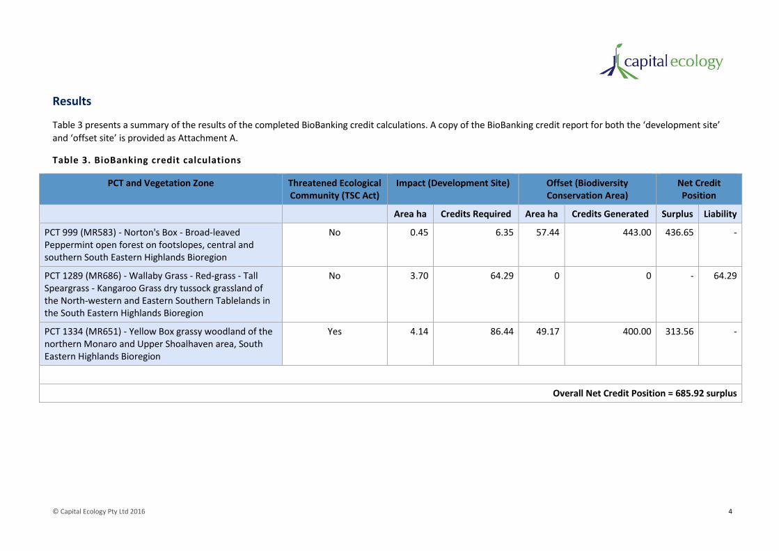
© Capital Ecology Pty Ltd 2016 4
Results
Table 3 presents a summary of the results of the completed BioBanking credit calculations. A copy of the BioBanking credit report for both the ‘development site’
and ‘offset site’ is provided as Attachment A.
Table 3. BioBanking credit calculations
PCT and Vegetation Zone Threatened Ecological Community (TSC Act)
Impact (Development Site) Offset (Biodiversity Conservation Area)
Net Credit Position
Area ha Credits Required Area ha Credits Generated Surplus Liability
PCT 999 (MR583) - Norton's Box - Broad-leaved Peppermint open forest on footslopes, central and southern South Eastern Highlands Bioregion
No 0.45 6.35 57.44 443.00 436.65 -
PCT 1289 (MR686) - Wallaby Grass - Red-grass - Tall Speargrass - Kangaroo Grass dry tussock grassland of the North-western and Eastern Southern Tablelands in the South Eastern Highlands Bioregion
No 3.70 64.29 0 0 - 64.29
PCT 1334 (MR651) - Yellow Box grassy woodland of the northern Monaro and Upper Shoalhaven area, South Eastern Highlands Bioregion
Yes 4.14 86.44 49.17 400.00 313.56 -
Overall Net Credit Position = 685.92 surplus

© Capital Ecology Pty Ltd 2016 5
Supplementary calculations – hypothetical ‘Scenario 2’
As detailed above, the native vegetation clearance associated with the road network will require assessment and consent under the NV Act, the offset
requirements for which will be determined using the Environmental Outcomes Assessment Methodology (EOAM)4. Notwithstanding this, and with recognition that
offset ratios etc. differ between the BioBanking metric and the EOAM, the BioBanking Credit Calculator has been used to determine the adequacy of the proposed
offset under the hypothetical ‘Scenario 2’ where the assessed impact includes both the building envelopes and the road network. Whilst we await the results of
the LLS EOAM assessment in late spring 2016, we believe that this exercise provides a useful indication regarding the adequacy of the proposed offset as an offset
for the entire proposed development. Table 4 presents a summary of the results of the completed BioBanking credit calculations for Scenario 2. Figure 5 illustrates
the impact and offset areas under Scenario 2.
Table 4. BioBanking credit calculations – Scenario 2
PCT and Vegetation Zone Threatened Ecological Community (TSC Act)
Impact (Development Site) Offset (Biodiversity Conservation Area)
Net Credit Position
Area ha Credits Required Area ha Credits Generated Surplus Liability
PCT 999 (MR583) - Norton's Box - Broad-leaved Peppermint open forest on footslopes, central and southern South Eastern Highlands Bioregion
No 1.04 14.35 57.44 443.00 428.65 -
PCT 1289 (MR686) - Wallaby Grass - Red-grass - Tall Speargrass - Kangaroo Grass dry tussock grassland of the North-western and Eastern Southern Tablelands in the South Eastern Highlands Bioregion
No 7.03 124.68 0 0 - 124.68
PCT 1334 (MR651) - Yellow Box grassy woodland of the northern Monaro and Upper Shoalhaven area, South Eastern Highlands Bioregion
Yes 8.16 171.75 49.17 400.00 228.25 -
Overall Net Credit Position = 532.22 surplus
4 NSW Office of Environment and Heritage (2013). Native Vegetation Regulation 2013 Environmental Outcomes Assessment Methodology.

© Capital Ecology Pty Ltd 2016 6
Discussion
The results of our BioBanking Metric Assessment demonstrate that the proposed establishment,
protection and enhancement of the approx. 107 ha Biodiversity Conservation Area would sufficiently
offset the impacts of the proposed development. Indeed, the proposed offset would generate a net
surplus of 685.92 credits, a surplus equal to 4.3 times the total credits required to offset the
proposed impact.
The key drivers behind the credit surplus generated by the proposed impact/offset are as follows.
1. At approx. 107 ha, the proposed offset area is far larger than the 8.29 ha total of the areas to
be impacted (12.9 times larger).
2. All of the higher condition areas of both the ‘PCT 999 Norton’s Box - Broad-leaved
Peppermint open forest’ and ‘PCT 1334 Yellow Box grassy woodland’ are located within the
proposed offset area. None of the higher condition areas of these PCTs would be impacted
by the proposed development.
3. A key biodiversity linkage, of which the eastern portion of the study area forms a part, would
not be impacted by the proposed development. Conversely, this linkage would be enhanced
by the establishment of the Biodiversity Conservation Area.
Whilst the offset requirements of NV Act consent cannot be accurately estimated prior to the
completion of the LLS spring survey and subsequent assessment, it is likely that the establishment of
the Biodiversity Conservation Area would be sufficient to address the offset requirements for the
entire development (i.e. scenario 2).
Conclusion
As demonstrated via our completed BioBanking Metric Assessment, the proposed establishment,
protection and enhancement of the approx. 107 ha Biodiversity Conservation Area would sufficiently
offset the impacts of the proposed development. It is our view that this assessment provides
quantifiable support for the conclusions of the Flora and Fauna Assessment.
We trust that this BioBanking Metric Assessment adequately addresses Item 2 of the RFI received
from Queanbeyan-Palerang Regional Council (‘Council’), dated 6 June 2016. However, if you have any
questions relating to this report, please do not hesitate to contact me to discuss.
Yours sincerely,
Robert Speirs
Director / Principal Ecologist

© Capital Ecology Pty Ltd 2016 7
Attachments:
Figure 1. Locality Plan
Figure 2. Vegetation Impact and Offset Areas
Figure 3. Impact Inner and Outer Circles
Figure 4. Offset Inner and Outer Circles
Figure 5. Vegetation Impact and Offset Areas – Scenario 2
Attachment A – BioBanking Credit Reports
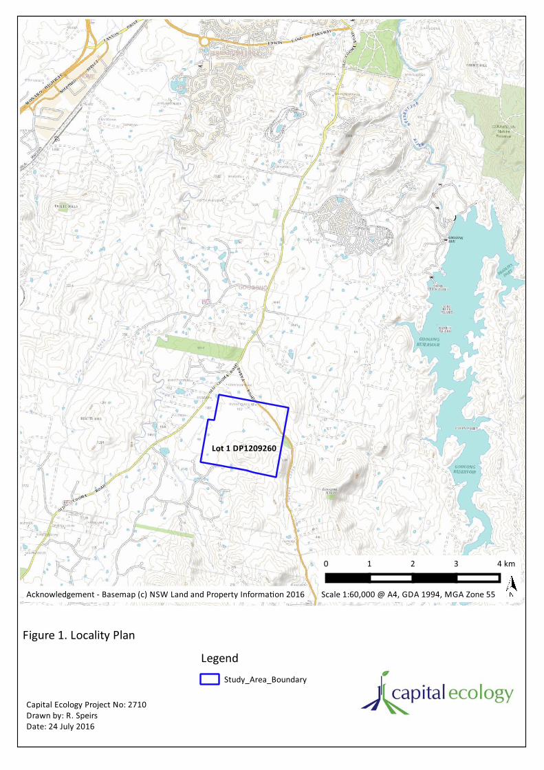
0 1 2 3 4 km
Study_Area_Boundary
Legend
Figure 1. Locality Plan
Acknowledgement - Basemap (c) NSW Land and Property Informa on 2016 Scale 1:60,000 @ A4, GDA 1994, MGA Zone 55
Capital Ecology Project No: 2710Drawn by: R. SpeirsDate: 24 July 2016
Lot 1 DP1209260

Figure 2. Vegeta on Impact and OffsetAreas
Legend Study_Area_Boundary Development Lot Layout - July 2016 Proposed_Biodiversity_Conserva on_Area
Building Envelope Impact Areas BE_PCT999_Zone2_Na veDom_Low BE_PCT999_Zone3_Exo cDom BE_PCT1289_Zone1_Na veDom_Low BE_PCT1289_Zone2_Exo cDom BE_PCT1334_Zone2_Na veDom_Low BE_PCT1334_Zone3_Exo cDom
Biodiverity Conserva on Area - Offset Areas BCA_PCT999_Zone1_Na veDom_Mod-High BCA_PCT999_Zone2_Na veDom_Low BCA_PCT999_Zone3_Exo cDom BCA_PCT1334_Zone1_Na veDom_Mod-High BCA_PCT1334_Zone2_Na veDom_Low BCA_PCT1334_Zone3_Exo cDom
0 100 200 300 400 m
Scale 1:7,200 @ A3, GDA 1994, MGA Zone 55
Capital Ecology Project No: 2710Drawn by: R. SpeirsDate: 26 July 2016
Burra Road
Acknowledgement - Image (c) Nearmap 2016

Figure 3. Impact Inner and OuterCircles
Study_Area_Boundary
Development Lot Layout - July 2016
Proposed_Biodiversity_Conserva on_Area
Na ve Vegeta on - Impact Inner Circle
Na ve Vegeta on - Impact Outer Circle
Legend
0 500 1000 1500 2000 m
Scale 1:26,500 @ A3, GDA 1994, MGA Zone 55
Capital Ecology Project No: 2710Drawn by: R. SpeirsDate: 26 July 2016
Acknowledgement - Image (c) Nearmap 2016

Figure 4. Offset Inner and Outer Circles
Study_Area_Boundary
Development Lot Layout - July 2016
Proposed_Biodiversity_Conserva on_Area
Na ve Vegeta on - Offset Inner Circle
Na ve Vegeta on - Offset Outer Circle
Legend
0 500 1000 1500 2000 m
Scale 1:26,500 @ A3, GDA 1994, MGA Zone 55
Capital Ecology Project No: 2710Drawn by: R. SpeirsDate: 26 July 2016
Acknowledgement - Image (c) Nearmap 2016

Figure 5. Vegeta on Impact and OffsetAreas - Scenario 2
Legend Study_Area_Boundary Development Lot Layout - July 2016 Proposed_Biodiversity_Conserva on_Area
Building Envelope Impact Areas BE_PCT999_Zone2_Na veDom_Low BE_PCT999_Zone3_Exo cDom BE_PCT1289_Zone1_Na veDom_Low BE_PCT1289_Zone2_Exo cDom BE_PCT1334_Zone2_Na veDom_Low BE_PCT1334_Zone3_Exo cDom
Road Network Impact Areas RN_PCT999_Zone2_Na veDom_Low RN_PCT1289_Zone1_Na veDom_Low RN_PCT1289_Zone2_Exo cDom RN_PCT1334_Zone2_Na veDom_Low RN_PCT1334_Zone3_Exo cDom
Biodiverity Conserva on Area - Offset Areas BCA_PCT999_Zone1_Na veDom_Mod-High BCA_PCT999_Zone2_Na veDom_Low BCA_PCT999_Zone3_Exo cDom BCA_PCT1334_Zone1_Na veDom_Mod-High BCA_PCT1334_Zone2_Na veDom_Low BCA_PCT1334_Zone3_Exo cDom
0 100 200 300 400 m
Scale 1:7,200 @ A3, GDA 1994, MGA Zone 55
Capital Ecology Project No: 2710Drawn by: R. SpeirsDate: 26 July 2016
Burra Road
Acknowledgement - Image (c) Nearmap 2016

© Capital Ecology Pty Ltd 2016 13
Attachment A – BioBanking Credit Reports

BioBanking credit report
Proposal ID:
Proposal name:
Calculator version:Date of report: 21/07/2016
0157/2016/3807D
Mount Pleasant Rural Residential Subdivision
This report identifies the number and type of credits required at a DEVELOPMENT SITE.
Time: 10:20:38PM
Development details
Proposal address: 102 Burra Road Burra NSW
v4.0
CIC Australia Pty LtdProponent name:
Proponent address: Level 3 64 Allara Street Canberra ACT 2601
Proponent phone:
Assessor name: Ed Cooper
02 6230 0800
Assessor address: Level 5, 116 Military Road Neutral Bay NSW 2089
Assessor accreditation: 0157
Assessor phone: 0410 765 736
Improving or maintaining biodiversity
An application for a red flag determination is required for the following red flag areas
Red flag Reason
Wallaby Grass - Red-grass - Tall Speargrass - Kangaroo Grass dry
tussock grassland of the North-western and Eastern Southern
Tablelands in the South Eastern Highlands Bioregion
Vegetation type being > 70% cleared; or it
contains an endangered ecological community;
Norton's Box - Broad-leaved Peppermint open forest on footslopes,
central and southern South Eastern Highlands Bioregion
Vegetation type being > 70% cleared; or it
contains an endangered ecological community;
Norton's Box - Broad-leaved Peppermint open forest on footslopes,
central and southern South Eastern Highlands Bioregion
Vegetation type being > 70% cleared; or it
contains an endangered ecological community;
Wallaby Grass - Red-grass - Tall Speargrass - Kangaroo Grass dry
tussock grassland of the North-western and Eastern Southern
Tablelands in the South Eastern Highlands Bioregion
Vegetation type being > 70% cleared; or it
contains an endangered ecological community;
The application for a red flag determination should address the criteria set out in the BioBanking Assessment
Methodology. Please note that a biobanking statement cannot be issued unless the determination is approved.
Additional information required for approval:
Change to percent cleared for a vegetation type/s
Use of local benchmark
Change negligible loss
Expert report...
Request for additional gain in site value
Predicted threatened species not on site

Ecosystem credits summary
Plant Community type Area (ha) Credits required Red flag
Norton's Box - Broad-leaved Peppermint open forest on
footslopes, central and southern South Eastern Highlands
Bioregion
0.45 6.35 No
Wallaby Grass - Red-grass - Tall Speargrass - Kangaroo
Grass dry tussock grassland of the North-western and
Eastern Southern Tablelands in the South Eastern
Highlands Bioregion
3.70 64.29 No
Yellow Box grassy woodland of the northern Monaro and
Upper Shoalhaven area, South Eastern Highlands
Bioregion
4.14 86.44 No
8.29 157Total
Credit profiles

BioBanking credit report
Proposal ID:
Proposal name:
Calculator version:Date of report: 21/07/2016
0157/2016/3807D
Mount Pleasant Rural Residential Subdivision
This report identifies the number and type of credits required at a DEVELOPMENT SITE.
Time: 9:45:58PM
Development details
Proposal address: 102 Burra Road Burra NSW
v4.0
CIC Australia Pty LtdProponent name:
Proponent address: Level 3 64 Allara Street Canberra ACT 2601
Proponent phone:
Assessor name: Ed Cooper
02 6230 0800
Assessor address: Level 5, 116 Military Road Neutral Bay NSW 2089
Assessor accreditation: 0157
Assessor phone: 0410 765 736
Improving or maintaining biodiversity
An application for a red flag determination is required for the following red flag areas
Red flag Reason
Wallaby Grass - Red-grass - Tall Speargrass - Kangaroo Grass dry
tussock grassland of the North-western and Eastern Southern
Tablelands in the South Eastern Highlands Bioregion
Vegetation type being > 70% cleared; or it
contains an endangered ecological community;
Norton's Box - Broad-leaved Peppermint open forest on footslopes,
central and southern South Eastern Highlands Bioregion
Vegetation type being > 70% cleared; or it
contains an endangered ecological community;
Norton's Box - Broad-leaved Peppermint open forest on footslopes,
central and southern South Eastern Highlands Bioregion
Vegetation type being > 70% cleared; or it
contains an endangered ecological community;
Wallaby Grass - Red-grass - Tall Speargrass - Kangaroo Grass dry
tussock grassland of the North-western and Eastern Southern
Tablelands in the South Eastern Highlands Bioregion
Vegetation type being > 70% cleared; or it
contains an endangered ecological community;
The application for a red flag determination should address the criteria set out in the BioBanking Assessment
Methodology. Please note that a biobanking statement cannot be issued unless the determination is approved.
Additional information required for approval:
Change to percent cleared for a vegetation type/s
Use of local benchmark
Change negligible loss
Expert report...
Request for additional gain in site value
Predicted threatened species not on site
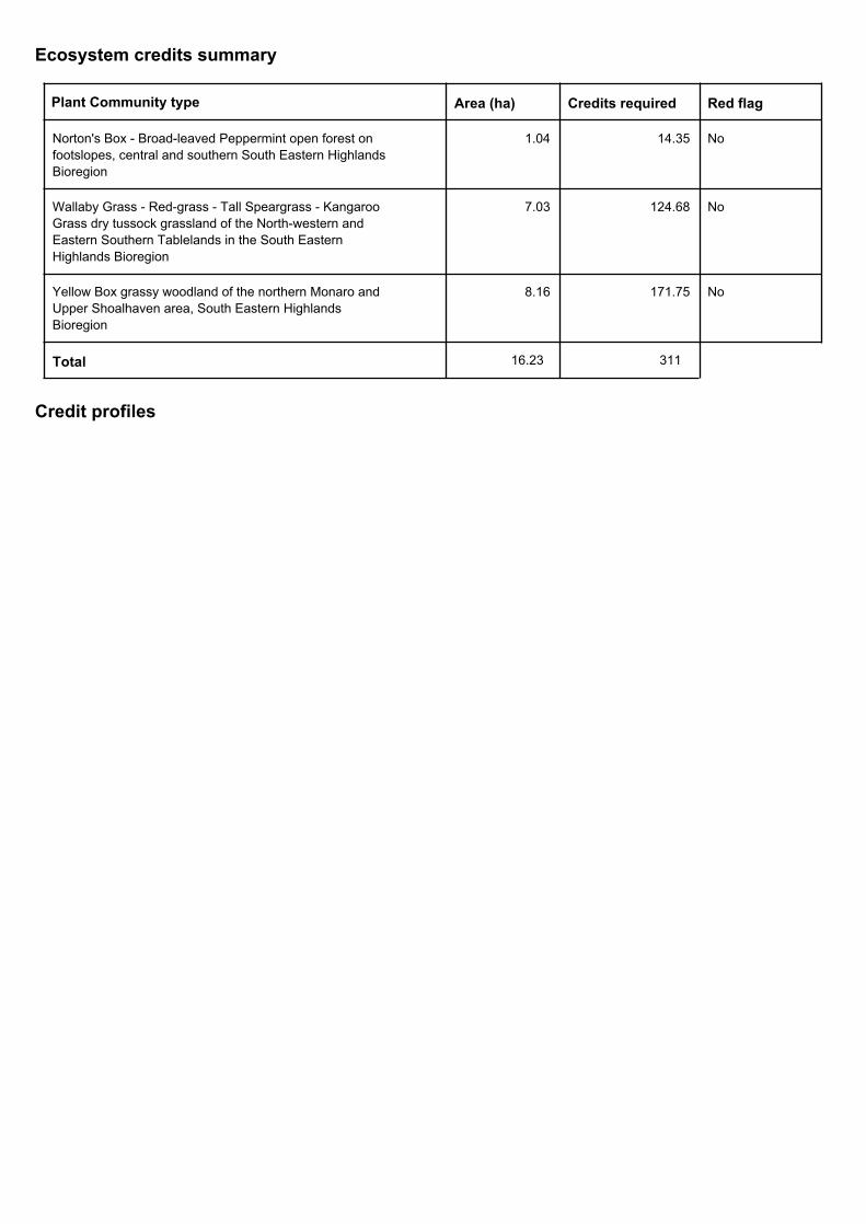
Ecosystem credits summary
Plant Community type Area (ha) Credits required Red flag
Norton's Box - Broad-leaved Peppermint open forest on
footslopes, central and southern South Eastern Highlands
Bioregion
1.04 14.35 No
Wallaby Grass - Red-grass - Tall Speargrass - Kangaroo
Grass dry tussock grassland of the North-western and
Eastern Southern Tablelands in the South Eastern
Highlands Bioregion
7.03 124.68 No
Yellow Box grassy woodland of the northern Monaro and
Upper Shoalhaven area, South Eastern Highlands
Bioregion
8.16 171.75 No
16.23 311Total
Credit profiles

BioBanking credit report
Proposal ID:
Proposal name:
Calculator version:Date of report: 24/07/2016
0157/2016/3808B
Mount Pleasant Rural Residential Subdivision
This report identifies the number and type of credits required at a BIOBANK SITE
Time: 8:34:04AM
Biobank details
Proposal address: 102 Burra Road Burra NSW
v4.0
CIC Australia Pty LtdProponent name:
Proponent address:
Proponent phone:
Assessor name: Ed Cooper
02 6230 0800
Assessor address: Level 5, 116 Military Road Neutral Bay NSW 2089
Assessor accreditation: 0157
Assessor phone: 0410 765 736
Additional information required for approval:
Use of local benchmark
Expert report...
Request for additional gain in site value

Ecosystem credits summary
Plant Community type Credits createdArea (ha)
Norton's Box - Broad-leaved Peppermint open forest on
footslopes, central and southern South Eastern Highlands
Bioregion
57.44 443.00
Yellow Box grassy woodland of the northern Monaro and
Upper Shoalhaven area, South Eastern Highlands
Bioregion
49.17 400.00
106.61 843Total
Credit profiles
1. Yellow Box grassy woodland of the northern Monaro and Upper Shoalhaven area, South Eastern
Highlands Bioregion, (MR651)
397Number of ecosystem credits created
IBRA sub-region Monaro - Murrumbidgee
2. Yellow Box grassy woodland of the northern Monaro and Upper Shoalhaven area, South Eastern
Highlands Bioregion, (MR651)
3Number of ecosystem credits created
IBRA sub-region Monaro - Murrumbidgee
3. Norton's Box - Broad-leaved Peppermint open forest on footslopes, central and southern South
Eastern Highlands Bioregion, (MR583)
327Number of ecosystem credits created
IBRA sub-region Monaro - Murrumbidgee
4. Norton's Box - Broad-leaved Peppermint open forest on footslopes, central and southern South
Eastern Highlands Bioregion, (MR583)
116Number of ecosystem credits created
IBRA sub-region Monaro - Murrumbidgee

Species credits summary
Additional management actions
Management action detailsVegetation type or threatened species
Additional management actions are required for:
Norton's Box - Broad-leaved Peppermint open forest on
footslopes, central and southern South Eastern Highlands
Bioregion
Exclude miscellaneous feral species
Norton's Box - Broad-leaved Peppermint open forest on
footslopes, central and southern South Eastern Highlands
Bioregion
Feral and/or over-abundant native herbivore control
Norton's Box - Broad-leaved Peppermint open forest on
footslopes, central and southern South Eastern Highlands
Bioregion
Fox control
Yellow Box grassy woodland of the northern Monaro and
Upper Shoalhaven area, South Eastern Highlands
Bioregion
Exclude commercial apiaries
Yellow Box grassy woodland of the northern Monaro and
Upper Shoalhaven area, South Eastern Highlands
Bioregion
Exclude miscellaneous feral species
Yellow Box grassy woodland of the northern Monaro and
Upper Shoalhaven area, South Eastern Highlands
Bioregion
Feral and/or over-abundant native herbivore control
Yellow Box grassy woodland of the northern Monaro and
Upper Shoalhaven area, South Eastern Highlands
Bioregion
Fox control
Copyright © 2022 FDOKUMEN