Mineral Resources of the Encampment River Canyon ...
24
Mineral Resources of the Encampment River Canyon Wilderness Study Area, Carbon County, Wyoming U.S. GEOLOGICAL SURVEY BULLETIN 1757-F r WYOMING **
-
Upload
khangminh22 -
Category
Documents
-
view
0 -
download
0
Transcript of Mineral Resources of the Encampment River Canyon ...

Mineral Resources of the Encampment River Canyon Wilderness Study Area, Carbon County, Wyoming
U.S. GEOLOGICAL SURVEY BULLETIN 1757-F
rWYOMING
**

SELECTED SERIES OF U.S. GEOLOGICAL SURVEY PUBLICATIONS
Periodicals
Earthquakes & Volcanoes (issued bimonthly). Preliminary Determination of Epicenters (issued monthly).
Technical Books and Reports
Professional Papers are mainly comprehensive scientific reports of wide and lasting interest and importance to professional scientists and en gineers. Included are reports on the results of resource studies and of topographic, hydrologic, and geologic investigations. They also include collections of related papers addressing different aspects of a single scien tific topic.
Bulletins contain significant data and interpretations that are of last ing scientific interest but are generally more limited in scope or geographic coverage than Professional Papers. They include the results of resource studies and of geologic and topographic investigations; as well as collections of short papers related to a specific topic.
Water-Supply Papers are comprehensive reports that present sig nificant interpretive results of hydrologic investigations of wide interest to professional geologists, hydro legists, and engineers. The series covers investigations in all phases of hydrology, including hydrogeology, availability of water, quality of water, and use of water.
Circulars present administrative information or important scientific information of wide popular interest in a format designed for distribution at no cost to the public. Information is usually of short-term interest.
Water-Resources Investigations Reports are papers of an interpre tive nature made available to the public outside the formal USGS publi cations series. Copies are reproduced on request unlike formal USGS publications, and they are also available for public inspection at depositories indicated in USGS catalogs.
Open-File Reports include unpublished manuscript reports, maps, and other material that are made available for public consultation at depositories. They are a nonpermanent form of publication that may be cited in other publications as sources of information.
Maps
Geologic Quadrangle Maps are multicolor geologic maps on topographic bases in 71/2- or 15-minute quadrangle formats (scales main ly 1:24,000 or 1:62,500) showing bedrock, surficial, or engineering geol ogy. Maps generally include brief texts; some maps include structure and columnar sections only.
Geophysical Investigations Maps are on topographic or planimetric bases at various scales; they show results of surveys using geophysical techniques, such as gravity, magnetic, seismic, or radioactivity, which reflect subsurface structures that are of economic or geologic significance. Many maps include correlations with the geology.
Miscellaneous Investigations Series Maps are on planimetric or topographic bases of regular and irregular areas at various scales; they present a wide variety of format and subject matter. The series also in cludes 71/2-minute quadrangle photogeologic maps on planimetric bases which show geology as interpreted from aerial photographs. Series also includes maps of Mars and the Moon.
Coal Investigations Maps are geologic maps on topographic or planimetric bases at various scales showing bedrock or surficial geol ogy, stratigraphy, and structural relations in certain coal-resource areas.
Oil and Gas Investigations Charts show stratigraphic information for certain oil and gas fields and other areas having petroleum potential.
Miscellaneous Field Studies Maps are multicolor or black-and- white maps on topographic or planimetric bases on quadrangle or ir regular areas at various scales. Pre-1971 maps show bedrock geology in relation to specific mining or mineral-deposit problems; post-1971 maps are primarily black-and-white maps on various subjects such as environmental studies or wilderness numeral investigations.
Hydrotogk lavestigarttois Attests are unulitacoiored or black-and- white maps on topographic or pknoamettric bases presenting a wide range of geohydrologic data of botih regular and irregular areas; principal scale is 1:24,000 and regional studies are at 1:250,000 scale or smaller.
Catalogs
Permanent catalogs, as well as some others, giving comprehen sive listings of U.S. Geological Survey publications are available under the conditions indicated below from the U.S. Geological Survey, Books and Open-File Reports Section, Federal Center, Box 25425, Denver, CO 80225. (See latest Price and Availability List)
"Publications of the Geological Survey, 1879-1961" may be pur chased by mail and over the counter in paperback book form and as a set of microfiche.
"Publications of the Geological Survey, 1962-1970" may be pur chased by mail and over the counter in paperback book form and as a set of microfiche.
"Publications of the U.S. Geological Survey, 1971-1981" may be purchased by mail and over the counter in paperback book form (two volumes, publications listing and index) and as a set of microfiche.
Supplements for 1982,1983,1984,1985,1986, and for subsequent years since the last permanent catalog may be purchased by mail and over the counter in paperback book form.
State catalogs, "List of U.S. Geological Survey Geologic and Water-Supply Reports and Maps For (State)," may be purchased by mail and over the counter in paperback booklet form only
"Price and Availability List of U.S. Geological Survey Publica tions," issued annually, is available free of charge in paperback book let form only.
Selected copies of a monthly catalog "New Publications of the U.S. Geological Survey" available free of charge by mail or may be obtained over the counter in paperback booklet form only. Those wishing a free subscription to the monthly catalog "New Publications of the U-S. Geological Survey" should write to the U.S. Geological Survey, 5#2 National Center, Reston, VA 22092.
Note. Prices of Government publications listed in older catalogs, announcements, and publications may be incorrect Therefore, ihe prices charged may differ from the prices in catalogs, announcements, and publications.
Chapter F
Mineral Resources of the Encampment River Canyon Wilderness Study Area, Carbon County, Wyoming
By EDWARD A. DU BRAY, VI Kl BAN KEY, and RANDALL H. HILL U.S. Geological Survey
GEORGE S. RYAN U.S. Bureau of Mines
U.S. GEOLOGICAL SURVEY BULLETIN 1757
MINERAL RESOURCES OF WILDERNESS STUDY AREAS- SOUTHERN WYOMING
DEPARTMENT OF THE INTERIOR
MANUEL LUJAN, JR., Secretary
U.S. GEOLOGICAL SURVEY
Dallas L Peck, Director
Any use of trade, product, or firm names in this publication is for descriptive purposes only and does not imply endorsement by the U.S. Government.
UNITED STATES GOVERNMENT PRINTING OFFICE: 1989
For sale by theBooks and Open-File Reports SectionU.S. Geological SurveyFederal CenterBox 25425Denver, CO 80225
Library of Congress Cataloging-in-Publication Data
Mineral resources of the Encampment River Canyon Wilderness Study Area, Carbon County, Wyoming.
(Mineral resources of wilderness study areas southern Wyoming; ch. F) (U.S. Geological Survey bulletin ; 1757)
Bibliography: p.Supt. of Docs, no.: I 19.3:1757F1. Mines and mineral resources Wyoming Encampment River Canyon
Wilderness. 2. Encampment River Canyon Wilderness (Wyo.) I. duBray, E.A. II. Series. III. Series: U.S. Geological Survey bulletin ; 1757. QE75.B9 no. 1757-F 557.3 s [553'.09787'86] 88-6007925 [TN24.W8]
STUDIES RELATED TO WILDERNESS
Bureau of Land Management Wilderness Study Areas
The Federal Land Policy and Management Act (Public Law 94-579, October 21, 1976) requires the U.S. Geological Survey and the U.S. Bureau of Mines to conduct mineral surveys on certain areas to determine the mineral values, if any, that may be present. Results must be made available to the public and be submitted to the President and the Congress. This report presents the results of a mineral survey of the Encampment River Canyon Wilderness Study Area (WY-030-301), Carbon County, Wyoming.

CONTENTSAbstract Fl Summary Fl
Character and setting FlIdentified mineral resources F2Mineral resource potential F2
Introduction F4Investigations by the U.S. Bureau of Mines F4Investigations by the U.S. Geological Survey F4
Appraisal of identified resources F4 Assessment of potential for undiscovered resources F5
Geology F5Geochemistry F6Geophysics F7Mineral and energy resources F8
References cited F9 Appendix Fll
FIGURES
1. Index map showing location of the Encampment River Canyon Wilderness Study Area F2
2. Map showing mineral resource potential and generalized geology for the Encamp ment River Canyon Wilderness Study Area F3
3. Residual aeromagnetic anomaly map of the Encampment River Canyon Wilder ness Study Area and vicinity F7
4. Uranium equivalent (eU) values for the Encampment River Canyon Wilderness Study Area and vicinity F8
5. Thorium equivalent (eTh) values for the Encampment River Canyon Wilderness Study Area and vicinity F8
6. Potassium (K) values for the Encampment River Canyon Wilderness Study Area and vicinity F9
Contents V

MINERAL RESOURCES OF WILDERNESS STUDY AREAS-SOUTHERN WYOMING
Mineral Resources of the Encampment River Canyon Wilderness Study Area, Carbon County, Wyoming
By Edward A. du Bray, Viki Bankey, andRandall H. HillU.S. Geological Survey
George S. Ryan U.S. Bureau of Mines
ABSTRACT
The Encampment River Canyon Wilderness Study Area (WY-030-301), which is about 4 miles south of En campment, Wyoming, contains 4,547 acres whose mineral endowment was jointly studied by the U.S. Bureau of Mines and U.S. Geological Survey in 1987. There are no identified resources in the study area. Resource potential for all undiscovered metallic com modities and for undiscovered industrial minerals is low. The study area has no potential for undiscovered ener gy resources, including oil and gas, coal, geothermal resources, and uranium.
SUMMARY
Character and Setting
The USGS (U.S. Geological Survey) and the USBM (U.S. Bureau of Mines) studied the mineral resource potential of 4,547 acres in the Encampment River
Canyon Wilderness Study Area (WY-030-301), Carbon County, Wyo., at the request of the BLM (U.S. Bureau of Land Management). In this report, the area studied is referred to as the"wilderness study area"or the "study area." Field studies of the study area were conducted during the summer of 1987 by USBM geologists and USGS geologists, geochemists, and geophysicists.
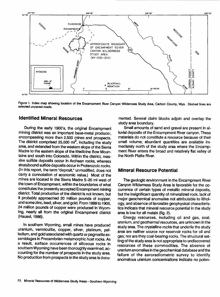
The Encampment River Canyon Wilderness Study Area is about 4 mi (miles) south of Encampment, Wyo. (fig. 1). The study area, which is accessible from numerous graded unpaved roads that intersect Wyom ing State Route 230, is on the eastern slope of the Sier ra Madre, the Continental Divide in this region. Elevations in the study area range between 7,200 and 8,545 ft (feet).
The study area is underlain by Archean felsic gneiss and Early Proterozoic quartzite (see geologic time chart in Appendix); both are intruded by minor Middle Proterozoic mafic plutonic rock. Gneiss occurs throughout the eastern and northwestern parts of the study area, whereas quartzite occurs in the western and southwestern parts. All lithologies are locally offset along high-angle faults.
Manuscript approved for publication January 11,1989.
Encampment River Canyon Wilderness Study Area F1
RIVERSIDE,
APPROXIMATE BOUNDARY OF ENCAMPMENT RIVER CANYON WILDERNESS STUDY AREA (WY-030-301)
BLACKHALL MOUNTAIN
Figure 1. Index map showing location of the Encampment River Canyon Wilderness Study Area, Carbon County, Wyo. Dashed lines are selected unpaved roads.
Identified Mineral Resources
During the early 1900's, the original Encampment mining district was an important base-metal producer, encompassing more than 2,500 mines and prospects. The district comprised 25,000 mi2, including the study area, and extended from the western slope of the Sierra Madre to the eastern slope of the Medicine Bow Moun tains and south into Colorado. Within the district, mas sive suifide deposits occur in Archean rocks, whereas stratabound suifide deposits occur in Proterozoic rocks. (In this report, the term "deposit," unmodified, does not carry a connotation of economic value.) Most of the mines are located in the Sierra Madre 5-20 mi west of the town of Encampment, within the boundaries of what constitutes the presently accepted Encampment mining district. Total production of the district is not known, but it probably approached 20 million pounds of copper, and some zinc, lead, silver, and gold. From 1899 to 1908, 24 million pounds of copper were produced in Wyom ing, nearly all from the original Encampment district (Hausel, 1986).
In southern Wyoming, small mines have produced uranium, vermiculite, copper, silver, platinum, pal ladium, and gold associated with quartz or pegmatite as semblages in Precambrian metamorphic host rocks. As a result, surface occurrences of siliceous rocks in southern Wyoming have been thoroughly examined, ac counting for the number of prospects in the study area. No production from prospects in the study area is docu
mented. Several claim blocks adjoin and overlap the study area boundary.
Small amounts of sand and gravel are present in al luvial deposits of the Encampment River canyon. These materials do not constitute a resource because of their small volume; abundant quantities are available im mediately north of the study area where the Encamp ment River enters the broad and relatively flat valley of the North Platte River.
Mineral Resource Potential
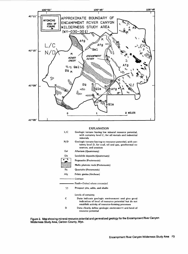
The geologic environment in the Encampment River Canyon Wilderness Study Area is favorable for the oc currence of certain types of metallic mineral deposits, but the insignificant quantity of mineralized rock, lack of major geochemical anomalies not attributable to I it hoi- ogy, and absence of favorable geophysical characteris tics indicate that mineral resource potential in the study area is low for all metals (fig. 2).
Energy resources, including oil and gas, coal, uranium, and geothermal resources, are unknown in the study area. The crystalline rocks that underlie the study area are neither source nor reservoir rocks for oil and gas; nor are they coal-bearing rocks. The structural set ting of the study area is not appropriate to undiscovered resources of these commodities. The absence of uranium anomalies in the geochemical database and the failure of the aeroradiometric survey to identify anomalous uranium concentrations indicate no poten-
F2 Mineral Resources of Wilderness Study Areas-Southern Wyoming
41*11'
41*10'
41*09'
41*08'
106*50' 106*48' 106*46T
APPROXIMATE BOUNDARY OF ENCAMPMENT RIVER CANYON WILDERNESS STUDY AREA (WY-030-301)
2 MILES
L/C
N/D
EXPLANATIONGeologic terrane having low mineral resource potential,
with certainty level C, for all metals and industrialminerals
Geologic terrane having no resource potential, with certainty level D, for coal, oil and gas, geothermal resources, and uranium
Alluvium (Quaternary)
Landslide deposits (Quaternary)
Pegmatite (Proterozoic)
Mafic plutonic rock (Proterozoic)
Quartzite (Proterozoic)
Felsic gneiss (Archean)
Contact
Fault Dotted where concealed
Prospect pits, adits, and shafts
Levels of certainty
Data indicate geologic environment and give good indication of level of resource potential but do not establish activity of resource-forming processes
Data clearly define geologic environment and level of resource potential
Figure 2. Map showing mineral resource potential and generalized geology for the Encampment River Canyon Wilderness Study Area, Carbon County, Wyo.
Encampment River Canyon Wilderness Study Area F3
tial for uranium deposits in the study area. The absence of geothermal phenomena and the old age of rocks in the study area indicate that there is no potential for geothermal energy resources. Accordingly, there is no potential for energy resources in the study area (fig. 2).
Available geologic, geochemical, and geophysical data indicate low potential for undiscovered industrial mineral resources in the study area (fig. 2).
INTRODUCTION
The Encampment River Canyon Wilderness Study Area, about 4 mi south of Encampment, Wyo. (fig. 1), is ac cessible from graded unpaved roads that intersect Wyom ing State Route 230. Travel in the study area is by way of a few rough jeep roads and on foot. The study area is located on the eastern slope of the Sierra Madre, part of the Con tinental Divide in this region, and is a gently rolling, dis sected upland covered by grasses and sage; the highest north-facing slopes support stands of aspen and fir trees. The Encampment River flows south to north, through a 1,000-ft-deep canyon, across the study area. Elevations in the area range from about 7,200 ft in the Encampment River canyon to 8,545 ft on the adjacent canyon walls.
This report presents an evaluation of the mineral en dowment (identified resources and mineral resource potential) of the study area and is the product of several separate studies by the USBM and the USGS. Identified resources are classified according to the system of the U.S. Bureau of Mines and U.S. Geological Survey (1980), which is shown in the Appendix of this report. Identified resour ces are studied by the USBM. Mineral resource potential is the likelihood of occurrence of undiscovered concentra tions of metals and nonmetals, of unappraised industrial rocks and minerals, and of undiscovered energy resources (coal, oil, gas, oil shale, and geothermal resources). It is classified according to the system of Goudarzi (1984), which is shown in the Appendix of this report. The poten tial for undiscovered resources is studied by the USGS.
Investigations by the U.S. Bureau of Mines
USBM geologists searched the literature in which min- ing, mineral lease, and mining claim information has been compiled. Files at the BLM State Office in Cheyenne, Wyo., and the Carbon County Courthouse in Rawlins, Wyo., were reviewed for mining claim locations, patented mining claims, and oil and gas and geothermal energy leases and lease applications. Lessees, mine owners, and persons having knowledge of mineral occurrences and
mining activities in and near the study area were contacted. Field work by USBM personnel entailed examination of prospects and mines in and near the wilderness study area. Accessible mine workings were mapped, and mineralized areas and mine dumps were sampled. Detailed descrip tions of analysis procedures and analytical results are presented by Ryan (1988), and complete analytical results are available for public inspection at the U.S. Bureau of Mines, Intermountain Field Operations Center, Building 20, Denver Federal Center, Denver, Colo.
Investigations by the U.S. Geological Survey
The assessment of the mineral resource potential of the Encampment River Canyon Wilderness Study Area is based on data from many sources. Among these are geologic studies of the Sierra Madre and the Medicine Bow Mountains (Ferris, 1964; Houston and Ebbett, 1977; Graff, 1978; Houston and others, 1978; and du Bray, this report); geochemical studies by the USBM (Ryan, 1988) and the USGS (R.H. Hill, unpub. data, 1987); and interpretations of geophysical data including aeromagnetic and aeroradiometric data (Viki Bankey, this report) and Landsat Thematic Mapper data (Alta Walker, written commun., 1988).
APPRAISAL OF IDENTIFIED RESOURCES
By George S. Ryan U.S. Bureau of Mines
Malachite, azurite, and iron and manganese oxides along contacts of quartz or pegmatite pods and veins within the metamorphic rocks and mafic intrusive rocks are similar to contact mineral associations and assemblages present at mines and prospects at nearby mining districts. Most workings in the study area appear to be from turn-of- the-century operations; in many cases caving and extensive erosion have obliterated the source of mineralized rocks found in dumps. One adit was found open and was mapped and sampled, but no significant mineralized rock was noted and only minor structures were found. No claim notices were found in the courthouse that could be associated with the prospects found in the field.
Assay results for selected elements (Ryan, 1988, table 1) indicate that copper and manganese were the most widespread elements of interest. Copper concentrations in some samples would be significant if present in large ton-
F4 Mineral Resources of Wilderness Study Areas - Southern Wyoming
nages; however, the restricted and limited occurrences ob served indicate small tonnages. A single panned-con- centrate sample was devoid of any elements of interest, and that absence indicates a lack of mineral concentrations in rocks upstream. Sixty-four chip and grab samples con tained no element concentrations other than those ex pected as a consequence of surface observations of copper, iron, and manganese oxides and carbonates. Four samples that contained greater than 1 percent copper were from widely separated sample localities and associated with u- biquitous copper and iron oxide-stained rocks. Two of these samples contained 20.8 ppm (parts per million) sil ver and 1.55 ppm gold, respectively. These low concentra tions and apparently restricted occurrences do not constitute a resource.
Although numerous prospect pits are present, no mineral resources were identified during the USBM inves tigation of the study area. Copper and manganese were present in samples from several widely spaced localities; however, these elements were not found in sufficient quan tities to indicate a resource. Similarly, silver and gold were present in low concentrations and do not appear to repre sent a resource.
Metamorphic rocks in the study area are not con ducive to the accumulation of hydrocarbons. Wilderness lands on the east flank of the Sierra Madre uplift have no known oil and gas potential (Spencer, 1983); nor are there oil and gas leases or lease applications in the study area.
Small amounts of sand and gravel are present in al luvial deposits of the Encampment River canyon, but steep, narrow drainage channels preclude major concentrations of sand and gravel deposits within the study area. Abun dant material is available immediately north of the study area where the Encampment River enters the broad and relatively flat valley of the North Platte River.
ASSESSMENT OF POTENTIAL FOR UNDISCOVERED RESOURCES
By Edward A. du Bray, Viki Bankey, andRandall H. HillU.S. Geological Survey
Geology
Existing geologic maps at various scales (Ferris, 1964; Graff, 1978; Houston and Ebbett, 1977; and Houston and others, 1978) were employed in compilation of a prelimi nary geologic map of the study area prior to field work by USGS personnel. Outcrops were examined for signs of
mineralized rock. Samples of all rock units were collected for petrographic studies.
The Encampment River Canyon Wilderness Study Area is at the southern margin of the Archean Wyoming craton (Hills and Houston, 1979) and is adjacent to the Colorado Plateau physiographic province (Bickford and others, 1986) along the Cheyenne belt. The Cheyenne belt is an inferred suture zone at the southern edge of the North American craton along which lithospheric material was ac creted during Proterozoic time. The study area is under lain by Archean felsic gneiss and Early Proterozoic quartzite; both are intruded by small bodies of Middle Proterozoic mafic plutonic rock. Gneiss occurs throughout the eastern and northwestern parts of the study area, whereas quartzite occurs in the western and southwestern parts. All lithologies are locally offset along high-angle faults.
Quartz-rich, biotite-muscovite felsic gneiss underlies much of the east half of the study area. The gneiss is moderately well foliated, as denoted by segregation band ing, and is fine to medium grained. Anhedral quartz grains 0.004-0.1 in. in diameter and displaying strain-induced un- dulose extinction form about 80 percent of the gneiss. Al- bite-twinned, anhedral grains and some relict porphyroblasts of plagioclase (0.004-0.08 in. in diameter) form 5-30 percent of the gneiss. Light-tan to tan subhedral flakes of biotite (0.004-0.06 in. in diameter) form 5-10 per cent of the rock. Colorless, subhedral muscovite (0.004- 0.03 in. in diameter), stably intergrown with biotite, composes 3-5 percent of the rock. About 1 percent granular epidote (0.004-0.02 in. in diameter) was also iden tified. The gneiss contains trace amounts of apatite and sphene.
Rock that varies between quartzite and quartz-mica schist underlies the western third of the study area. This white- to buff-weathering rock is fine grained and finely laminated. It is composed of 90 percent anhedral quartz grains (0.004-0.01 in. in diameter) that display undulatory extinction. Subhedral, interstitial muscovite laths (less than 0.008 in. in diameter) form accumulations that impart a laminated texture to this lithology. The quartzite contains trace amounts of gridiron-twinned microcline.
Altered, mafic plutonic rock intrudes the felsic gneiss and the quartzite. The mafic plutonic rock is massive to weakly foliated, fine grained, and equigranular. It is prin cipally (80-90 percent) composed of pale-brownish-green to pale-blue-green, anhedral actinolite grains (0.02-0.08 in. in diameter) that are probably pseudomorphs after pyroxene. Quartz, in anhedral grains (less than 0.008 in. in diameter) that display undulatory extinction, occurs inter- stitially as a trace constituent, forming as much as about 15 percent of the rock. Interstitial, albite-twinned plagioclase grains (0.016- 0.08 in. in diameter) form as much as 5 per cent of the mafic plutonic rock. About 5 percent subhedral
Encampment River Canyon Wilderness Study Area F5
epidote (less than 0.004 in. in diameter) and trace amounts of sphene, apatite, and opaque oxides were also identified.
Numerous pegmatite dikes concordantly intrude felsic gneiss east of the Encampment River. The dikes have mas sive quartz cores, and large feldspar crystals concentrated along dike margins have altered to clay. Because this clay is highly susceptible to erosion, most evidence of feldspar in the dikes is absent and the dikes resemble massive quartz veins. The dikes contain sparse, fine-grained kyanite.
Geochemistry
In September of 1987, a reconnaissance geochemical survey (R.H. Hill, unpub. data) was conducted in the En campment River Canyon Wilderness Study Area to aid evaluation of its mineral resource potential. Rocks, stream sediments, and heavy-mineral concentrates of stream sedi ment were selected as the sample media for evaluation.
Thirteen minus-60-mesh stream-sediment samples collected from active stream alluvium and 14 heavy- mineral panned concentrates derived from stream sedi ment were selected as primary sample media. The sediments are thought to represent a composite of the chemistry of rock and soil exposed in the drainage basin upstream from the sample site. Chemical analyses of such stream-sediment samples provide data useful in identifying those basins that contain unusually high concentrations of elements that maybe related to mineral occurrences. In ad dition, studies have shown that heavy-mineral panned con centrates derived from stream sediment are useful in studying arid to semiarid environments or areas of rugged topography, where mechanical erosion predominates over chemical erosion (Bugrov and Shalaby, 1975; Overstreet and Marsh, 1981). Heavy-mineral-concentrate samples provide information about the chemistry of a limited num ber of minerals present in rock material eroded from the drainage basin upstream from each sample site. Prepara tion of heavy-mineral concentrates from stream sediments results in a concentration of mineral assemblages that may contain ore-forming and ore-related minerals. The selec tive concentration of these minerals permits determination of some elements that are not easily detected in bulk stream-sediment samples.
Seven fresh and unaltered rock samples were collected from outcrops to provide chemical and mineralogic infor mation for rocks exposed near stream-sediment sample sites. In addition, a mine-dump sample was collected to provide information concerning the composition of mineralized rock present in the study area. The actual areal extent of the influence of each rock type on the chemistry of individual stream-sediment and panned-concentrate samples is indeterminate, though the sampling program
was designed to provide general information concerning the geochemical nature of the exposed lithologies.
The dry stream-sediment samples were sieved through 60-mesh stainless-steel sieves. The minus-60-mesh material was retained for analysis and pulverized with ceramic plates to at least minus-100 mesh prior to analysis. To produce the heavy-mineral concentrate, bulk stream sediment was first sieved through a 10-mesh screen. Ap proximately 25-30 pounds of the minus-10-mesh sediment was panned to remove most of the quartz, feldspar, organic material, and clay- sized material. These samples were then air dried, passed through a 30-mesh sieve, and separated into light and heavy fractions by means of bromoform (heavy liquid, specific gravity 2.86). The light fraction was discarded. The material of specific gravity greater than 2.86 was separated into three fractions (highly magnetic, weak ly magnetic, and nonmagnetic) by means of a modified Frantz Isodynamic Magnetic Separator. The nonmagnetic fraction was hand ground and retained for emission spectrographic analysis. Rock samples were crushed and pulverized to at least minus-100 mesh with ceramic plates prior to analysis. Rock, stream-sediment, and nonmagnetic portions of the prepared heavy-mineral concentrate were analyzed for 35 elements by means of a semiquantitative, direct-current arc emission spectrographic method (Grimes and Marranzino, 1968); abundances of platinum and palladium in the concentrate samples were also deter mined by this method.
Threshold values, defined as the upper limit of normal background values, were determined for each element by inspection of frequency-distribution histograms for all sample media. The composite mine-dump rock sample was not included in construction of the histograms. A geochemical value greater than the threshold value is con sidered anomalous and worthy of consideration as a pos sible indicator of mineralized rock.
The primary criterion for delineating an area as anomalous is the presence of multi-element geochemical anomalies clustered within a restricted geographic region. Follow-up studies should, however, include isolated anomalous sample localities with geographically extensive, geochemically anomalous areas because the scale of sam pling conducted for this study is so small that moderate- sized deposits could be indicated by a single sample site, or not be apparent at all. In addition, this study is a surface study and may not reflect the presence of mineralized rock at depth.
Heavy-mineral-concentrate samples from two sites in the southwestern part of the study area, one from a west- flowing stream and the other from a southeast-flowing stream (R.H. Hill, unpub. data, 1987), contained anomalous concentrations of beryllium (200 and 100 ppm, respectively), lead (300 and 200 ppm), tin (700 and 100
F6 Mineral Resources of Wilderness Study Areas - Southern Wyoming
ppm), and tungsten (500 and 200 ppm). In addition, the stream-sediment sample from the west-flowing stream contained 500 ppm chromium and 100 ppm nickel. Anomalous elemental abundances in the heavy-mineral concentrates may result from weak hydrothermal altera tion and mineralization of quartzite along thrust faults (Graff, 1978) that could have served as conduits for migrat ing hydrothermal fluids. Alternatively, the anomalies may arise from dense, detrital accessory minerals contained within quartzite and quartz-pebble conglomerate exposed in this area. Anomalous nickel and chromium abundances in the stream-sediment sample from the west-flowing stream are believed to represent detrital accumulations of chromite derived by mechanical weathering of nearby mafic plutonic rocks.
A heavy-mineral-concentrate sample from a site ap proximately 1 mi southwest of the confluence of Miner Creek and Encampment River (R.H. Hill, unpub. data, 1987), in a tributary of Miner Creek, contains 5,000 ppm barium, 100 ppm bismuth, and 150 ppm tungsten. These anomalous values may indicate weak metamorphism, hydrothermal alteration, and mineralization at the contact zone where quartzite is intruded by mafic plutonic rocks. Alternatively, the anomaly may be related to weak mineralization of rock in a thrust fault (Graff, 1978), which could have served as a conduit for migrating hydrothermal fluids, located upstream in the head of the drainage basin. Another heavy-mineral-concentrate sample from Miner Creek, near its confluence with Encampment River, con tains 150 ppm tin and 100 ppm tungsten. These anomalous concentrations may indicate downstream transport of dense ore minerals from anomalous areas upstream.
Anomalous bismuth and tungsten abundances were determined for heavy-mineral-concentrate samples sporadically distributed in the study area. The source of these element anomalies is uncertain, although they may indicate weak metamorphism, hydrothermal alteration, and mineralization at the contact zone where quartzite and (or) felsic gneiss is intruded by mafic plutonic rocks.
Geophysics
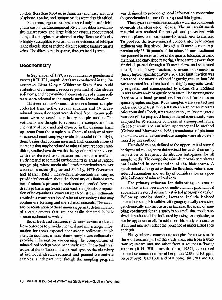
A detailed aeromagnetic survey of the wilderness study area and vicinity was flown in 1979 by a fixed-wing aircraft at a nominal ground clearance of 400 ft. Flight traverses were oriented north-south and spaced 0.25 mi apart; these specifications provide 60 percent coverage of surface sources and 100 percent coverage of sources buried below 200 ft depth. After correction for diurnal effects and tie-line discrepancies, the International Geomagnetic Reference Field was removed. The resulting residual mag netic data were compiled and contoured by the contractor
106°50' 106°45'
Figure 3. Residual aeromagnetic anomaly map of the Encampment River Canyon Wilderness Study Area and vicinity, Carbon County, Wyo. Heavy line is approximate boundary of wilderness study area. Contour interval 25 nanoteslas. A, aeromagnetic anomaly discussed in text; hachures indicate area of closed low.
(Bendix Field Engineering Corporation, 1983) to produce a regional aeromagnetic map. The map is useful in geologic interpretations of the region that contains the study area; a subset of the data was used to aid interpretation of the geology in the study area.
Aeromagnetic data (fig. 3) are useful in delineating concealed intrusive rocks that could be associated with mineral deposits. Aeromagnetic data for the Encampment River Canyon Wilderness Study Area are characterized by a northwest grain that corresponds with the outcrop pat tern of northwest-trending mafic plutonic rock and peg matite dikes. Specifically, two northwest-trending magnetic highs are associated with mafic plutonic rock; these highs are limited to the area underlain by this rock type. Mafic rocks in the southwestern part of the study area are not associated with magnetic anomalies, which suggests that the mafic plutonic rocks are variably magnetized. In the northeastern part of the study area and north of its boundary, a linear magnetic low trends northwest and is as sociated with pegmatite outcrops. Positive magnetic anomaly A causes discontinuity in the magnetic low in a region characterized by fewer pegmatite outcrops. Anomaly A is probably attributable to outcropping mafic plutonic rocks that are abundant in this area and more in tensely magnetized than those that crop out to the east. Neither quartzite nor felsic gneiss in the study area appear to contain magnetic minerals, and no other magnetic anomalies were detected.
Encampment River Canyon Wilderness Study Area F7

106°50' 106°45' 106°50' 106°45'
Rgure 4. Uranium equivalent (eU) values for the Encampment River Canyon Wilderness Study Area and vicinity, Carbon County, Wyo. Heavy line is approximate boundary of wilderness study area. Contour interval 0.5 parts per million; hachures indicate area of closed low.
Rgure 5. Thorium equivalent (eTh) values for the Encampment River Canyon Wilderness Study Area and vicinity, Carbon County, Wyo. Heavy line is approximate boundary of wilderness study area. Contour interval 1.5 parts per million; hachures indicate area of closed low.
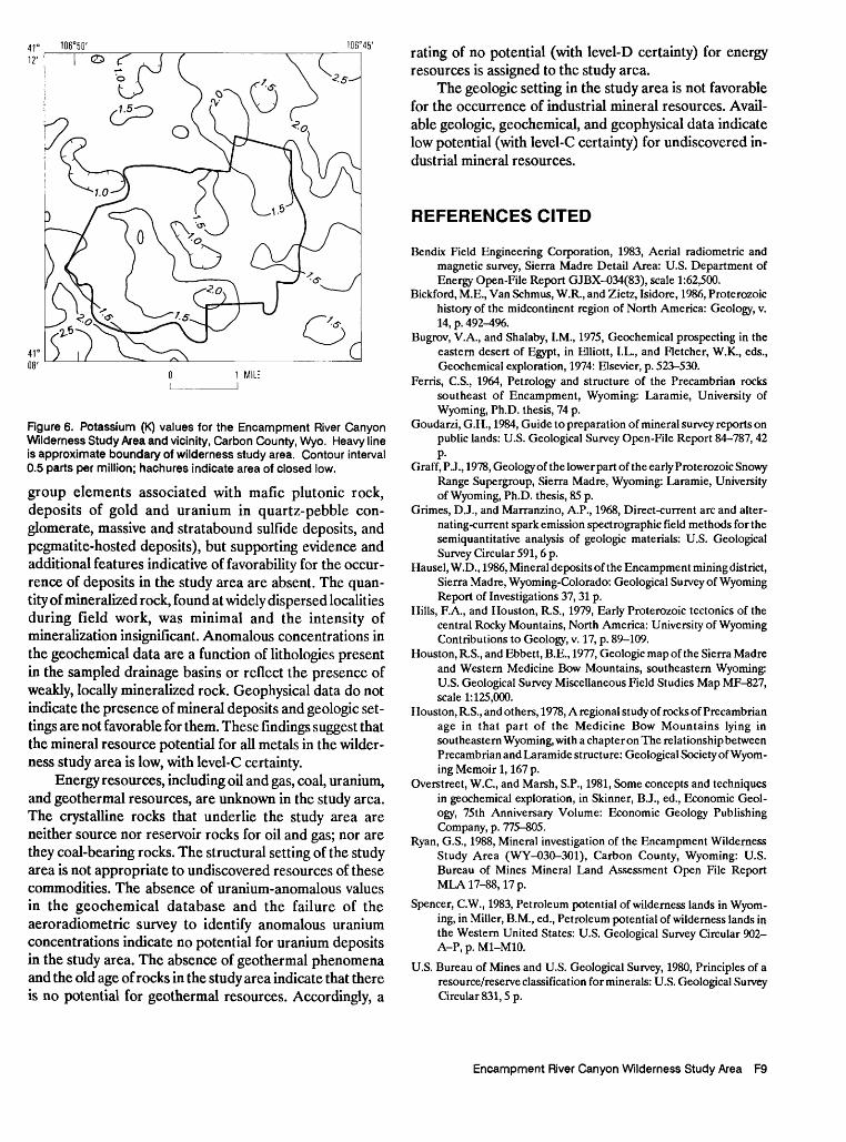
Aerial gamma-ray spectroscopy is a radiometric tech nique that provides an estimate of the near-surface (depth 0-20 in.) concentrations of uranium (U), thorium (Th), and potassium (K), and is used in exploration for uranium deposits. The occurrence of radioactive quartz-pebble conglomerate in the Medicine Bow Mountains and Sierra Madre necessitated a detailed aeroradiometric survey of the region to determine the extent and abundance of uranium. Aeroradiometric data for the study area (figs. 4- 6) were obtained from traverses flown in 1979 by contrac tors working for the U.S. Department of Energy as part of the National Uranium Resource Evaluation (Bendix Field Engineering Corporation, 1983). The traverses are along north-south lines spaced 0.25 mi apart and have a nominal ground clearance of 400 ft. These specifications are suffi cient to achieve 60 percent ground coverage. The U and Th values are "equivalent" values (eU and eTh) to account for possible disequilibrium in the decay series for those ele ments.
Some of the rock types in the study area, including fel- sic gneiss and quartzite, may have above-background radioactivity due to elevated abundances of the radioactive elements in potassium feldspar, mica, or accessory minerals. Uranium can become concentrated along frac tures in quartz and feldspar. However, clean quartzite may be depleted in radioactive minerals and would approach background levels. In the study area none of the concentra
tions of uranium, thorium, or potassium is anomalous where quartzite crops out. Concentrations range from 0.5 to 2.0 ppm eU, 4.0 to 13.5 ppm eTh, and 1.0 to 2.0 percent K. Observed radioactivity slightly exceeds background levels in and beyond the northern tip of the study area, where readings reach 2 ppm eU, 13.5 ppm eTh, and 2 per cent K. The weakly anomalous radioactivity may be as sociated with minor segregations of radioactive minerals in pegmatite dikes; the radioactivity is orders of magnitude less intense than that associated with ore-grade radioactive mineral deposits.
Landsat Thematic Mapper data can be used to iden tify indications of mineralized or altered rock exposed at the Earth's surface. Data for seven spectral bands, analyzed individually, as composites, and as ratios, do not indicate the presence of mineralized or altered rock in the study area (Alta Walker, written commun., 1988).
Mineral and Energy Resources
Accumulated evidence suggests that there is low mineral resource potential, with level-C certainty, for un discovered metallic mineral deposits in the Encampment River Canyon Wilderness Study Area (fig. 2). The geologic setting of the study area is favorable for various types of metalliferous deposits (including deposits of platinum-
F8 Mineral Resources of Wilderness Study Areas - Southern Wyoming
106 0 50' 10B°45'
Figure 6. Potassium (K) values for the Encampment River Canyon Wilderness Study Area and vicinity, Carbon County, Wyo. Heavy line is approximate boundary of wilderness study area. Contour interval 0.5 parts per million; hachures indicate area of closed low.
group elements associated with mafic plutonic rock, deposits of gold and uranium in quartz-pebble con glomerate, massive and stratabound sulfide deposits, and pegmatite-hosted deposits), but supporting evidence and additional features indicative of favorability for the occur rence of deposits in the study area are absent. The quan tity of mineralized rock, found at widely dispersed localities during field work, was minimal and the intensity of mineralization insignificant. Anomalous concentrations in the geochemical data are a function of lithologies present in the sampled drainage basins or reflect the presence of weakly, locally mineralized rock. Geophysical data do not indicate the presence of mineral deposits and geologic set tings are not favorable for them. These findings suggest that the mineral resource potential for all metals in the wilder ness study area is low, with level-C certainty.
Energy resources, including oil and gas, coal, uranium, and geothermal resources, are unknown in the study area. The crystalline rocks that underlie the study area are neither source nor reservoir rocks for oil and gas; nor are they coal-bearing rocks. The structural setting of the study area is not appropriate to undiscovered resources of these commodities. The absence of uranium-anomalous values in the geochemical database and the failure of the aeroradiometric survey to identify anomalous uranium concentrations indicate no potential for uranium deposits in the study area. The absence of geothermal phenomena and the old age of rocks in the study area indicate that there is no potential for geothermal resources. Accordingly, a
rating of no potential (with level-D certainty) for energy resources is assigned to the study area.
The geologic setting in the study area is not favorable for the occurrence of industrial mineral resources. Avail able geologic, geochemical, and geophysical data indicate low potential (with level-C certainty) for undiscovered in dustrial mineral resources.
REFERENCES CITED
Bendix Field Engineering Corporation, 1983, Aerial radiometric and magnetic survey, Sierra Madre Detail Area: U.S. Department of Energy Open-File Report GJBX-034(83), scale 1:62,500.
Bickford, M.E., Van Schmus, W.R., and Zietz, Isidore, 1986, Proterozoic history of the midcontinent region of North America: Geology, v. 14, p. 492-4%.
Bugrov, V.A., and Shalaby, I.M., 1975, Geochemical prospecting in the eastern desert of Egypt, in Elliott, I.L., and Fletcher, W.K., eds., Geochemical exploration, 1974: Elsevier, p. 523-530.
Ferris, C.S., 1964, Petrology and structure of the Precambrian rocks southeast of Encampment, Wyoming: Laramie, University of Wyoming, Ph.D. thesis, 74 p.
Goudarzi, G.H., 1984, Guide to preparation of mineral survey reports on public lands: U.S. Geological Survey Open-File Report 84-787, 42P-
Graff, PJ., 1978, Geology of the lower part of the early Proterozoic Snowy Range Supergroup, Sierra Madre, Wyoming: Laramie, University of Wyoming, Ph.D. thesis, 85 p.
Grimes, D.J., and Marranzino, A.P., 1968, Direct-current arc and alter nating-current spark emission spectrographic field methods for the semiquantitative analysis of geologic materials: U.S. Geological Survey Circular 591, 6 p.
Hausel, W.D., 1986, Mineral deposits of the Encampment mining district, Sierra Madre, Wyoming-Colorado: Geological Survey of Wyoming Report of Investigations 37, 31 p.
Hills, F.A., and Houston, R.S., 1979, Early Proterozoic tectonics of the central Rocky Mountains, North America: University of Wyoming Contributions to Geology, v. 17, p. 89-109.
Houston, R.S., and Ebbett, B.E., 1977, Geologic map of the Sierra Madre and Western Medicine Bow Mountains, southeastern Wyoming: U.S. Geological Survey Miscellaneous Field Studies Map MF-827, scale 1:125,000.
Houston, R.S., and others, 1978, A regional study of rocks of Precambrian age in that part of the Medicine Bow Mountains lying in southeastern Wyoming, with a chapter on The relationship between Precambrian and Laramide structure: Geological Society of Wyom ing Memoir 1,167 p.
Overstreet, W.C., and Marsh, S.P., 1981, Some concepts and techniques in geochemical exploration, in Skinner, B.J., ed., Economic Geol ogy, 75th Anniversary Volume: Economic Geology Publishing Company, p. 775-805.
Ryan, G.S., 1988, Mineral investigation of the Encampment Wilderness Study Area (WY-030-301), Carbon County, Wyoming: U.S. Bureau of Mines Mineral Land Assessment Open File Report MLA17-88,17p.
Spencer, C.W., 1983, Petroleum potential of wilderness lands in Wyom ing, in Miller, B.M., ed., Petroleum potential of wilderness lands in the Western United States: U.S. Geological Survey Circular 902- A-P, p. M1-M10.
U.S. Bureau of Mines and U.S. Geological Survey, 1980, Principles of a resource/reserve classification for minerals: U.S. Geological Survey Circular 831,5 p.
Encampment River Canyon Wilderness Study Area F9

APPENDIX

DEFINITION OF LEVELS OF MINERAL RESOURCE POTENTIAL AND CERTAINTY OF ASSESSMENT
Definitions of Mineral Resource Potential
LOW mineral resource potential is assigned to areas where geologic, geochemical, and geophysical charac teristics define a geologic environment in which the existence of resources is unlikely. This broad category embraces areas with dispersed but insignificantly mineralized rock as well as areas with few or no indications of having been mineralized.
MODERATE mineral resource potential is assigned to areas where geologic, geochemical, and geophysical characteristics indicate a geologic environment favorable for resource occurrence, where interpretations of data indicate a reasonable likelihood of resource accumulation, and (or) where an application of mineral-deposit models indicates favorable ground for the specified type(s) of deposits.
HIGH mineral resource potential is assigned to areas where geologic, geochemical, and geophysical charac teristics indicate a geologic environment favorable for resource occurrence, where interpretations of data indicate a high degree of likelihood for resource accumulation, where data support mineral-deposit models indicating presence of resources, and where evidence indicates that mineral concentration has taken place. Assignment of high resource potential to an area requires some positive knowledge that mineral-forming processes have been active in at least part of the area.
UNKNOWN mineral resource potential is assigned to areas where information is inadequate to assign low, moderate, or high levels of resource potential.
NO mineral resource potential is a category reserved for a specific type of resource in a well-defined area.
Levels of Certainty
U/A
UNKNOWN
POTENTIAL
H/B
HIGH POTENTIAL
M/B
MODERATE POTENTIAL
L/B
LOW
POTENTIAL
H/C
HIGH POTENTIAL
M/C
MODERATE POTENTIAL
L/C
LOW
POTENTIAL
H/D
HtGH POTENTIAL
M/D
MODERATE POTENTIAL
L/D
LOW POTENTIAL
N/D
NO POTENTIAL
toCL
O V)LU GC
LU
LU
B C
LEVEL OF CERTAINTY
A. Available information is not adequate for determination of the level of mineral resource potential.B. Available information suggests the level of mineral resource potential.C. Available information gives a good indication of the level of mineral resource potential.D. Available information clearly defines the level of mineral resource potential.
Abstracted with minor modifications from:
Taylor, R. B., and Steven, T. A., 1983, Definition of mineral resource potential: Economic Geology,v. 78, no. 6, p. 1268-1270.
Taylor, R. B., Stoneman, R. J., and Marsh, S. P., 1984, An assessment of the mineral resource potentialof the San Isabel National Forest, south-central Colorado: U.S. Geological Survey Bulletin 1638, p.40-42.
Goudarzi, G. H., compiler, 1984, Guide to preparation of mineral survey reports on public lands: U.S.Geological Survey Open-File Report 84-0787, p. 7, 8.
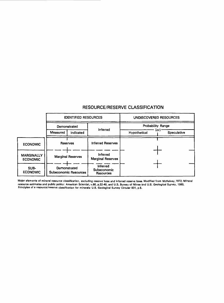
RESOURCE/RESERVE CLASSIFICATION
ECONOMIC
MARGINALLY ECONOMIC
SUB- ECONOMIC
IDENTIFIED RESOURCES
Demonstrated
Measured Indicated
1 Reserves
Marginal Reserves
_!___Demonstrated
Subeconomic Resources
Inferred
Inferred Reserves
Inferred Marginal Reserves
Inferred Subeconomic
Resources
UNDISCOVERED RESOURCES
Probability Range (or)
Hypothetical i Speculative
I
+11
Major elements of mineral resource classification, excluding reserve base and inferred reserve base. Modified from McKelvey, 1972, Mineral resource estimates and public policy: American Scientist, v.60, p.32-40, and U.S. Bureau of Mines and U.S. Geological Survey, 1980, Principles of a resource/reserve classification for minerals: U.S. Geological Survey Circular 831, p.5.
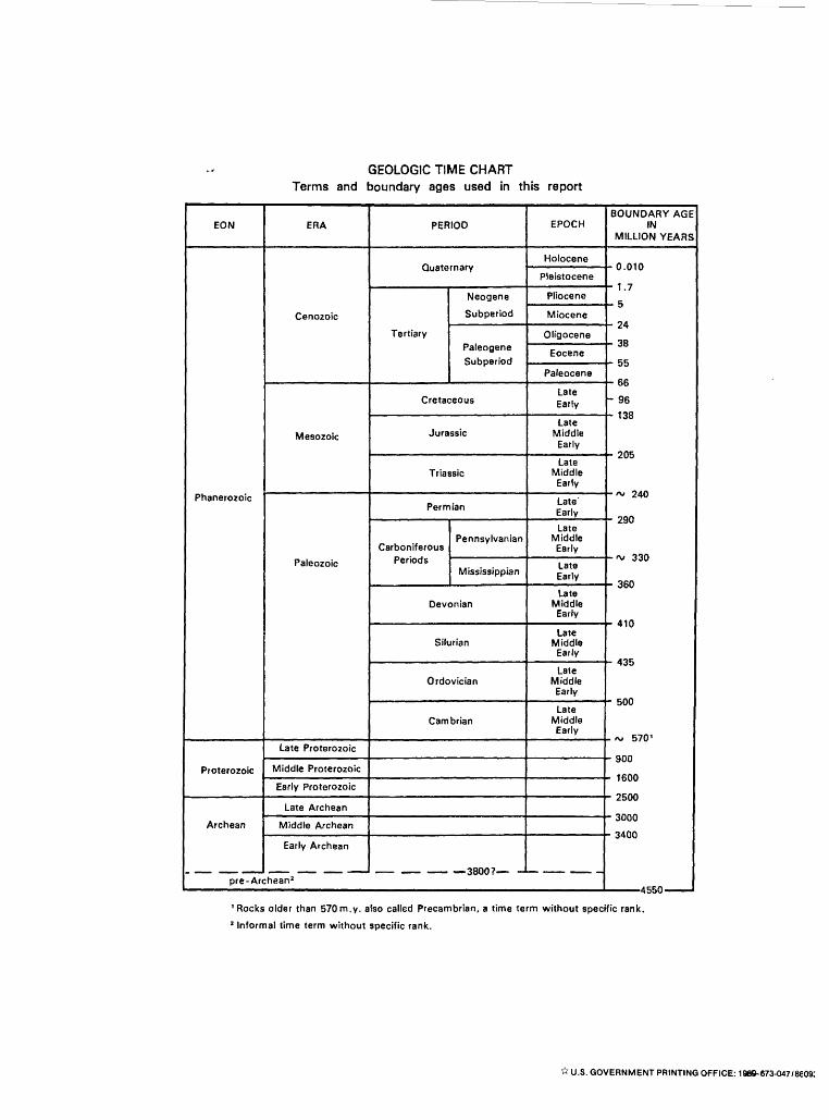
GEOLOGIC TIME CHART Terms and boundary ages used in this report
EON
Phanerozoic
Proterozoic
Archean
pre-Ar(
ERA
Cenozoic
Mesozoic
Paleozoic
Late Proterozoic
Middle Proterozoic
Early Proterozoic
Late Archean
Middle Archean
Early Archean
:hean 2
PERIOD
Quaternary
Tertiary
Neogene
Subperiod
Paleogene
Subperiod
Cretaceous
Jurassic
Triassic
Permian
Carboniferous Periods
Pennsylvanian
Mississippian
Devonian
Silurian
Ordovician
Cambrian
__ __ 3800,- -
EPOCH
Holocene
Pleistocene
Pliocene
Miocene
Oligocene
Eocene
Paleocene
Late Early
LateMiddle Early
Late Middle Early
LateEarly
Late Middle Early
Late Early
Late Middle Early
Late Middle Early
Late Middle Early
Late Middle Early
-
BOUNDARY AGE IN
MILLION YEARS
- 0.010
- 1.7
- 5
JO
GR
- 96
1 JO
.- 1AC
-A, 240
- oao
-~ 330
- 360
- 410
A OC
-~ 570'
- 900
- 1600
w 1CAA
- 3000
- 3400
1 Rocks older than 570m.y. also called Precambrian, a time term without specific rank.
2 Informal time term without specific rank.
* U.S. GOVERNMENT PRINTING OFFICE: 1989-673-047/8609:
AVAILABILITY OF BOOKS AND MAPS OF THE U.S. GEOLOGICAL SURVEY
Instructions on ordering publications of the U.S. Geological Survey, along with prices of the last offerings, are given in the cur rent-year issues of the monthly catalog "New Publications of the U.S. Geological Survey." Prices of available U.S. Geological Sur vey publications released prior to the current year are listed in the most recent annual "Price and Availability List." Publications that are listed in various U.S. Geological Survey catalogs (see back inside cover) but not listed in the most recent annual "Price and Availability List" are no longer available.
Prices of reports released to the open files are given in the listing "U.S. Geological Survey Open-File Reports," updated month ly, which is for sale in microfiche from the U.S. Geological Survey, Books and Open-File Reports Section, Federal Center, Box 25425, Denver, CO 80225. Reports released through the NTIS may be obtained by writing to the National Technical Information Service, U.S. Department of Commerce, Springfield, VA 22161; please include NTIS report number with inquiry.
Order U.S. Geological Survey publications by mail or over the counter from the offices given below.
BY MAIL . OVER THE COUNTER Books
BooksProfessional Papers, Bulletins, Water-Supply Papers, Techniques
of Water-Resources Investigations, Circulars, publications of general in- Books of the U.S. Geological Survey are available over theterest (such as leaflets, pamphlets, booklets), single copies of Earthquakes counter at the following Geological Survey Public Inquiries Offices, all& Volcanoes, Preliminary Determination of Epicenters, and some mis- of which are authorized agents of the Superintendent of Documents:cellaneous reports, including some of the foregoing series that have goneout of print at the Superintendent of Documents, are obtainable by mailfrom WASHINGTON, D.C.-Main Interior Bldg., 2600 corridor,
18th and CSts..NW.U.S. Geological Survey, Books and Open-File Reports DENVER, Colorado-Federal Bldg.. Rm. 169, 1961 Stout St.
Federal Center, Box 25425 LOS ANGELES, California-Federal Eldg., Rm. 7638,300 N. Denver, CO 80225 Los Angeles St.
MENLO PARK, California-Bldg. 3 (Stop 533), Rm. 3128,Subscriptions to periodicals (Earthquakes & Volcanoes and 345 Middlefield Rd.
Preliminary Determination of Epicenters) can be obtained ONLY from RESTON, Virginia-503 National Center, Rm. 1C402,12201 the Sunrise Valley Dr.
SALT LAKE CITY, Utah-Federal Bldg., Rm. 8105,125 Superintendent of Documents South State St.Government Printing Office SAN FRANCISCO, California-Customhouse, Rm. 504,555
Washington, D.C. 20402 Battery St. SPOKANE, Washington-U.S. Courthouse, Rm. 678, West
(Check or money order must be payable to Superintendent of Docu- 920 Riverside Ave.. ments.) ANCHORAGE, Alaska-Rm. 101,4230 University Dr.
ANCHORAGE, Alaska-Federal Bldg, Rm. E-146,701 C St.
Maps
For maps, address mail orders to
U.S. Geological Survey, Map Distribution MapsFederal Center, Box 25286 Maps may ^ purchased over the counter at the U.S. Geologi-
Denver, CO 80225 caj Sm^gy offices where books are sold (all addresses in above list) andat the following Geological Survey offices:
Residents of Alaska may order maps from
ROLLA, Missouri-1400 Independence Rd. Alaska Distribution Section, U.S. Geological Survey, . DENVER, Colorado-Map Distribution, Bldg. 810, Federal
New Federal Building - Box 12 Center 101 Twelfth Ave., Fairbanks, AK 99701 . FAIRBANKS, Alaska-New Federal Bldg., 101 Twelfth Ave.
f
.L,