Submarine slide in Little Loch Broom, NW Scotland
42
Paraglacial slope instability in Scottish fjords: examples from Little Loch Broom, NW Scotland 1 2 3 4 5 6 7 8 9 10 11 12 13 14 15 16 17 18 19 20 21 22 23 Martyn Stoker 1 *, Charles Wilson 2,3 , John Howe 2 , Tom Bradwell 1 & David Long 1 1 British Geological Survey, West Mains Road, Edinburgh, EH9 3LA 2 Scottish Association for Marine Science, Oban, Argyll, PA37 1QA, UK 3 Department of Earth Sciences, Durham University, Durham, DH1 3LE, UK * Corresponding author (M Stoker): (email: [email protected]) Number of words: 7,160 (excluding references and captions) Abbreviated title: Slope instability in Scottish Fjords Keywords: Fjord; Little Loch Broom; NW Scotland; Mass Failure Abstract Lateglacial–Holocene fjord sediments in Little Loch Broom preserve evidence of extensive slope instability. The major area of reworking is in the outer loch and mid-loch sill region where ice- contact/ice-proximal deposits of the Lateglacial Assynt Glacigenic Formation have been disrupted by sliding and mass flow processes linked to the Little Loch Broom Slide Complex and the adjacent Badcaul Slide. Mass failure was instigated about14–13 ka BP, and is probably the response of the landscape to deglaciation immediately following the removal of ice support during glacial retreat. An initial phase of translational sliding was followed by rotational sliding, 1
-
Upload
khangminh22 -
Category
Documents
-
view
5 -
download
0
Transcript of Submarine slide in Little Loch Broom, NW Scotland

Paraglacial slope instability in Scottish fjords: examples from Little Loch Broom, NW
Scotland
1
2
3
4
5
6
7
8
9
10
11
12
13
14
15
16
17
18
19
20
21
22
23
Martyn Stoker1*, Charles Wilson2,3, John Howe2, Tom Bradwell1 & David Long1
1British Geological Survey, West Mains Road, Edinburgh, EH9 3LA
2Scottish Association for Marine Science, Oban, Argyll, PA37 1QA, UK
3Department of Earth Sciences, Durham University, Durham, DH1 3LE, UK
*Corresponding author (M Stoker): (email: [email protected])
Number of words: 7,160 (excluding references and captions)
Abbreviated title: Slope instability in Scottish Fjords
Keywords: Fjord; Little Loch Broom; NW Scotland; Mass Failure
Abstract
Lateglacial–Holocene fjord sediments in Little Loch Broom preserve evidence of extensive slope
instability. The major area of reworking is in the outer loch and mid-loch sill region where ice-
contact/ice-proximal deposits of the Lateglacial Assynt Glacigenic Formation have been
disrupted by sliding and mass flow processes linked to the Little Loch Broom Slide Complex and
the adjacent Badcaul Slide. Mass failure was instigated about14–13 ka BP, and is probably the
response of the landscape to deglaciation immediately following the removal of ice support
during glacial retreat. An initial phase of translational sliding was followed by rotational sliding,
1

24
25
26
27
28
29
30
31
32
33
34
35
36
37
38
39
40
41
42
43
44
45
46
as revealed by the superimposition of scalloped-shaped slumps on a larger-scale rectilinear
pattern of failure. Paraglacial landscape readjustment may have also been enhanced by episodic
seismic activity linked to glacio-isostatic unloading. In the inner fjord, evidence of Holocene
mass failure includes the Ardessie debris lobe and a discrete intact slide block preserved within
the postglacial basinal deposits. The former is a localised accumulation linked to a fluvial
catchment on the adjacent An Teallach massif. These mass transport deposits may represent an
ongoing response to paraglacial processes, albeit much reduced (relative to the major slides) in
terms of sediment supply to the fjord.
Introduction
It is well established that fjords are areas of major landslide activity due to their steep lateral
slopes, characteristically high rates of sedimentation, and commonly exceptional rates of isostatic
uplift (Syvitski & Shaw 1995; Hampton et al. 1996). These factors make them ideal
environments for all kinds of sediment deformation, be it due to gravitational reworking of the
rapidly accumulating deposits, fluid flow or to external stimuli, such as earthquakes. Examples of
sediment slides, slumps, and extensional and compressional deformation structures are to be
found in fjords worldwide, including Canada (Syvitski & Hein 1991), East Greenland
(Whittington & Niessen 1997; Niessen & Whittington 1997) and Norway (Aarseth et al. 1989;
Hjelstuen et al. 2009).
Scotland’s fjords are no exception. Recent work in the Summer Isles region of NW Scotland
(Fig. 1) has identified an up to 100 m thick sequence of fjord sediments, which was rapidly
2

47
48
49
50
51
52
53
54
55
56
57
58
59
60
61
62
63
64
65
66
67
68
69
deposited during the landward retreat of the ice margin from the Summer Isles into the present-
day sea lochs of Loch Broom and Little Loch Broom (Stoker et al. in press). Swath bathymetric
imagery, high-resolution seismic reflection profiles and sediment core data have shown that mass
failure is pervasive throughout the Summer Isles region. Regional mapping has demonstrated that
early, post-depositional deformation in and around Loch Broom, including the Cadail Slide (Fig.
1), occurred during the Lateglacial interval (Stoker et al. 2006, in press; Stoker & Bradwell
2009). In this paper we focus on one of the largest areas of submarine mass failure yet to be
identified in nearshore UK waters – herein referred to as the Little Loch Broom Slide Complex
(Fig. 1). We also describe more localised features of instability in the inner part of Little Loch
Broom, including the Badcaul Slide and the Ardessie debris lobe; the latter most probably a
Holocene feature. We use geophysical and geological data to describe the style of the instability
and the nature of the resulting sediments, as well as to provide constraints on the timing of
failure. Considered together with the regional pattern of neotectonic deformation, the
development of the Little Loch Broom Slide Complex and adjacent mass failures may provide
clues as to the stability of the deglaciating Scottish hinterland during the Lateglacial–Holocene
interval.
Regional Setting
Little Loch Broom is a NW trending sea loch situated approximately 10 km west of Ullapool
(Fig. 1). The flanks of the loch are characterised by rugged headlands backed by mountains, such
as An Teallach to the south, and Beinn Ghoblach to the north. The loch is 12 km long, 0.5 to 2.0
km wide, and is divided more or less at its mid-point into inner and outer basins by a mid-loch
3

70
71
72
73
74
75
76
77
78
79
80
81
82
83
84
85
86
87
88
89
90
91
92
sill (~25 m below sea level). The deepest part of the loch is the inner basin (119 m), while the
outer basin reaches a maximum depth of 65 m (Stoker et al. 2006). Slope angles are also greater
in the inner loch (locally >50°) compared to the outer loch (locally up to 25°). No detailed
hydrographic survey from Little Loch Broom has been published; however, the Scottish
Environmental Protection Agency site data report for the loch (SEPA 2006) states that it is
protected from SW winds, but exposed to winds blowing from the NW. Heath et al. (2000) used
data from Lee and Ramster’s Atlas of the Sea (1981) to estimate a mean spring tidal current of 1-
2 ms-1 in both Loch Broom and Little Loch Broom. The approximate average flushing time for
the whole loch is 7 days, although the deeper basins take longer, and freshwater input is generally
low (SEPA 2006).
The depth to bedrock in Little Loch Broom is locally up to 160 m (maximum) below OD, in the
inner loch. The bedrock geology is dominated by Neoproterozoic Torridonian sandstone with
sporadic inliers of Archaean gneiss near the mouth of the loch. The orientation of the loch is
structurally controlled by a fault that trends along the length of Little Loch Broom (Fig. 1).
Significant NE trending structures in the area include the Moine Thrust and the Coigach fault.
The regional glacial geology of the Summer Isles area is summarised in Figure 2 and Table 1; for
details see Stoker et al. in press. All dates have been calibrated (Fairbanks et al. 2005) and are
expressed as calendar years (ka BP). The major part of the succession records a time-
transgressive landward retreat of the Lateglacial ice-sheet margin from The Minch, across the
Summer Isles, back to the sea lochs of Loch Broom and Little Loch Broom. The deposition of
ice-contact to ice proximal glacimarine and ice-distal glacimarine facies, assigned to the Assynt
4

93
94
95
96
97
98
99
100
101
102
103
104
105
106
107
108
109
110
111
112
113
114
115
Glacigenic and Annat Bay Formations, respectively, comprise the bulk of the sediment infilling
the fjord region. Cosmogenic-isotope surface-exposure ages of boulders from onshore moraines
within the Assynt Glacigenic Formation, combined with AMS radiocarbon dating of marine
shells from, and micropalaeontological analysis of, both the Assynt Glacigenic and Annat Bay
Formations in offshore sediment cores all suggest that these units were deposited largely between
about 14 and 13 ka BP, i.e. during the Lateglacial Interstadial (Bradwell et al. 2008; Stoker et al.
in press). In Loch Broom, there is evidence of late-stage oscillation of outlet glacier lobes back
into the fjord; this correlates with several discrete Late-stage members of the Assynt Glacigenic
Formation. An associated series of large fan-deltas comprise the Ullapool Gravel Formation,
which is sandwiched between these Late-stage members. As the fjord gradually became ice free,
the Outer and Inner Loch Broom shell beds accumulated as a time-transgressive deposit on the
floor of the fjord. The Inner Loch Broom shell bed is overlain by glacial diamicton belonging to
one of the Late-stage members of the Assynt Glacigenic Formation in the inner loch. This
relationship provides an age constraint of <13 ka BP for the late-stage ice-margin oscillation
within the inner fjord. A discrete lithogenetic unit, informally named the ‘Late-stage debris
flows’, occurs sporadically throughout the Summer Isles region. This unit post-dates the Assynt
Glacigenic and Annat Bay Formations, but pre-dates the Summer Isles Formation, which forms a
cover of Holocene marine sediments deposited after about 8 ka BP.
The Assynt Glacigenic, Annat Bay and Summer Isles Formations, together with the Late-stage
debris flow lithogenetic unit, have all been mapped in and around the inner part of Little Loch
Broom (Fig. 3). In contrast, the shallower, outer part of the loch is dominated almost completely
by the Assynt Glacigenic Formation, and its reworked upper component assigned to the
5

116
117
118
119
120
121
122
123
124
125
126
127
128
129
130
131
132
133
134
135
136
137
138
Rireavach Member; these units are overlain by a seismically unresolvable Holocene veneer
(Stoker et al. in press) (Figs 2 & 3). The mid-loch sill that separates the inner and outer lochs is
formed by a coincidence of a bedrock high and a major moraine ridge associated with the Assynt
Glacigenic Formation. Other prominent moraine ridges also belonging to this unit are preserved
on sills at the mouth (outer loch moraine) and near the head (inner loch moraine) of the loch.
From a stratigraphic perspective, the Rireavach Member defines the reworked extent of the
Assynt Glacigenic Formation within the confines of the Little Loch Broom Slide Complex.
Additional mass transport deposits are associated with the Late-stage debris flow unit, linked to
the Badcaul Slide, and with the Summer Isles Formation, including the Ardessie debris lobe.
Methods
This study combines geophysical and geological data collected by the British Geological Survey
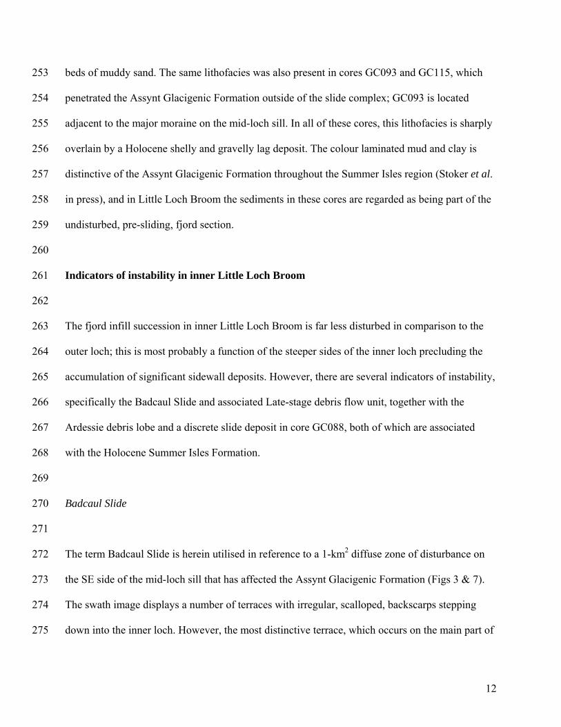
(BGS) and the Scottish Association for Marine Science (SAMS) in the Summer Isles region
between 2005 and 2007. A marine geophysical survey of the Summer Isles region, including
Little Loch Broom, was undertaken in July 2005, and acquired multibeam swath bathymetry and
high-resolution seismic reflection data (Stoker et al. 2006). Bathymetric data were acquired using
a GeoSwath system operating at 125 kHz, mounted on a retractable bow pole on the R/V
Calanus. Swath survey lines were traversed at a spacing of 200 m, thereby enabling swath
overlap and full coverage bathymetry across an area of 225 km2. The data were collected on a
GeoSwath computer with post-acquisition processing carried out on a separate workstation.
Output was in the form of xyz data with a typical grid spacing of 3 m. The grid was converted
into a depth-coloured shaded-relief image using Fledermaus (processing and visualisation
6

139
140
141
142
143
144
145
146
147
148
149
150
151
152
153
154
155
156
157
158
159
160
161
software). The shaded-relief image of the study area is shown in Figure 4. The seismic reflection
data were acquired using a BGS-owned Applied Acoustics surface-towed boomer and
hydrophone. Fifty-seven boomer profiles (a total length of about 235 km) were collected across
the region, including twelve profiles specifically acquired in Little Loch Broom. The data were
recorded and processed (Time Varied Gain, Bandpass Filter 800–200 Hz) on a CODA DA200
seismic acquisition system and output as SEG-Y and TIFF format. Further technical details of the
geophysical data collection are outlined in Stoker et al. (2006).
On the basis of regional measurements of superficial sediments offshore Scotland, sound
velocities in the fjord sediment fill are taken to be in the range of 1500–2000 ms-1 depending
upon their composition and degree of induration (McQuillin & Ardus 1977; Stoker et al. 1994).
In this paper, the conversion of sub-bottom depths from milliseconds to metres has been
generally taken as a maximum estimate (e.g. 20 ms two-way travel time (TWTT) ≤20 m) of
sediment thickness. The relief of features with expression at the sea bed is based on the sound
velocity in water of 1450 ms-1 (Hamilton 1985).
Geological calibration of the geophysical data was established using SAMS gravity cores GC087,
088, 092, 093, 112, 113, 115, 120 and 122, and BGS vibrocore 57-06/286 (a re-occupation of site
GC122) (Fig. 4). The SAMS cores were collected from the M/V Calanus in August 2006,
whereas the BGS core was collected in September 2007, using the R/V James Cook. Stratigraphic
correlation of these cores is based on a regional study of all cores collected in the Summer Isles
region (a total of 50 sample stations), which is detailed in Stoker et al. (in press). The lithology of
the cores is summarised in Table 2.
7

162
163
164
165
166
167
168
169
170
171
172
173
174
175
176
177
178
179
180
181
182
183
184
Indicators of instability in outer Little Loch Broom
Little Loch Broom Slide Complex
The Little Loch Broom Slide Complex extends between the mid- and outer loch moraine/bedrock
sills (Figs 3–5a). In this area, the maximum water depth is approximately 75 m. The sea bed in
the centre of the outer loch is flat, whereas much of the rest of the basin is characterised by
undulating bathymetry and an irregular, scalloped margin (Fig. 5a). On this basis, three main
areas of sliding have been identified, designated the Rireavach, Carnach and Scoraig slides, with
a further area of debris lobes offshore Corran Scoraig, near the outer sill. The morphology of
these features is detailed below, together with the resultant deposits, which collectively comprise
the Rireavach Member (Assynt Glacigenic Formation).
Rireavach Slide. This slide is the largest feature identified in Little Loch Broom, and has
affected an area of the sea bed about 1–2 km2 (Fig. 5a). Three distinct scarp surfaces (1–3) are
observed on the swath image, confirmed by their correlation with the boomer profile that
transects the slide (Fig. 3b). The most distinctive backscarp (1) displays a generally rectilinear
margin, at a water depth of about 35 to 40 m, that can be traced around the entire area of the
slide, a distance of about 4 km, and defines two main erosional hollows or re-entrants: a northern
one (NR) constrained by the side of the loch, and an eastern one (ER) constrained by the
morainic rampart that forms the mid-loch sill. These re-entrants indicate that material has been
displaced into the basin in both southerly (NR) and westerly (ER) directions. However, the
8

185
186
187
188
189
190
191
192
193
194
195
196
197
198
199
200
201
202
203
204
205
206
207
rectilinear shape of the scarp appears to have been modified by smaller scale (≤200 m), curved or
scalloped indentations that impart an irregularity to the backscarp. The southern wall of the loch
appears to have remained linear, steep and less obviously affected by sliding. Scarps 1–3 (in the
eastern re-entrant) range from 7 to 15 m high, with slope angles between 7° and 15°. They
display sub-planar to predominantly curved, concave-up, profiles. Distinct terraces occur between
scarps 1–2 and 2–3, at water depths of about 55 m and 65 m, respectively. The present-day basin
floor, at the foot of scarp 3 is at about 75 m water depth. Along the western edge of the northern
re-entrant (NR), the delineation of the separate scarps is less clear and a single scarp is present,
with an upper headwall limit at 30 to 35 m water depth, a vertical relief of 35 m and a slope angle
up to 10°. In Figure 3b, the seismic profile shows the basin floor to be slightly undulatory; a
characteristic also observed on the swath image (Fig. 5a).
Carnach Slide. The Carnach Slide forms a much smaller sea bed hollow on the northern slope
of the loch, between about 35 and 55 m water depth (Fig. 5a). It occupies an area of about 0.05
km2, has displaced sediment to a depth of about 5 m below sea bed, displays a curved, concave-
up, profile, with a maximum backscarp slope angle up to about 13˚. Downslope of the scar, an
equivalent area of seabed is raised ~1–2 m (convex-up) above the adjacent sea floor for a
distance of up to 300m from the foot of the scar. At least two separate lobes are identified from
the swath image, which represent material derived from the slide scar.
Scoraig Slide. The Scoraig Slide is expressed as a discrete crenulate scar that broadly
parallels the northern slope of the loch for about 500 m (Fig. 5a). The slide scar covers an area
of about 0.25 km2, and is cut into the slope between about 30 and 65 m water depth. It displays
9

208
209
210
211
212
213
214
215
216
217
218
219
220
221
222
223
224
225
226
227
228
229
a curved, concave-up, slide surface profile, with a maximum backscarp angle up to 18˚. Several
debris lobes are visible at the base of the scar, raised ~1-2 m above the sea bed, and extending
250–300 m into the basin, and up to 600 m along the strike of the basin.
Debris lobes offshore Corran Scoraig. Further NW along the northern flank of the outer loch
a series of less well-defined crenulations and hollows are visible on the swath image, some of
which have a gully-like appearance, up to 10 m deep and several tens of metres wide (Fig. 5a).
A series of overlapping debris lobes up to 4 m in relief and up to several hundred metres wide,
are found towards the base of the slope forming a package that extends for up to 1.3 km along
the axis of the basin. There may also be some input from the southern slope, though the swath
image is increasingly restricted (due to operational constraints) in extent near the mouth of the
loch. On both the swath image and the seismic profile data, the basin floor topography is
hummocky.
Rireavach Member (slide complex deposits). The Rireavach Member of the Assynt Glacigenic
Formation forms a discrete fjord slope to basin-floor package of mass transport deposits derived
from multiple slide sources. It has accumulated below about 30 m water depth, the approximate
upper bounding limit of the headwalls of the slides. On seismic profiles, it displays an irregular,
hummocky, sheet-like geometry, up to 12 m thick. In Figure 3, the base of the Rireavach Member
(the base of the slide complex) is clearly depicted by the truncation of acoustically layered strata
in the underlying, undisturbed deposits of the Assynt Glacigenic Formation. Internally, the mass
transport deposits display a predominantly chaotic internal reflection configuration; however,
10

230
231
232
233
234
235
236
237
238
239
240
241
242
243
244
245
246
247
248
249
250
251
252
sporadic subhorizontal reflections are locally observed, particularly in the area of the Rireavach
Slide and within the pile of debris lobes off Corran Scoraig, near the mouth of the outer loch.
The deposits of the Rireavach Member have been sampled at three sites: GC087, GC119 and
GC122 (57-06/286). All three cores are from the basin floor (Figs 4 & 5), and all recovered
different lithologies (Table 2). Deposits of the Rireavach Slide were tested by core GC087, which
recovered 0.62 m of colour laminated silty clay overlying a 0.14 m thick bed of shelly, gravelly,
sandy mud, in turn overlying homogeneous clay and silty clay. The contacts between all three
beds are sharp, and the laminated clay displays angular discordance with the underlying bed. In
Figure 6a, the laminations are clearly observed to be inclined, relative to the underlying bed of
sandy mud, and partially disrupted and offset along small faults. The laminated clay is in sharp
contact with the overlying Holocene unit, the base of which is marked by a gravelly and shelly
lag deposit (Fig. 4). Core GC119 is located on the edge of the debris lobes derived from the
Scoraig Slide, where the Rireavach Member contained a 0.2 m thick sandy bed overlying 0.69 m
of slightly sandy clay. Discrete patches of lithic grains are scattered throughout the clay and
possibly represent coarser, matrix-supported intraclasts. There is a sharp contact with the
overlying Holocene sandy mud. Cores GC122 and 57-06/286 tested the debris lobes off Corran
Scoraig and recovered 2.57 m of massive, compact, reddish brown gravelly sand, the top of
which is reworked and overlain by a veneer of Holocene muddy sand.
Pre-slide deposits (Assynt Glacigenic Formation). Cores GC112/113 and 120 are located in the
slide scar region of the Rireavach and Carnach slides, respectively (Fig. 4). They both recovered
homogeneous to colour laminated mud and clay with sporadic pebbles, shelly material and thin
11
253
254
255
256
257
258
259
260
261
262
263
264
265
266
267
268
269
270
271
272
273
274
275
beds of muddy sand. The same lithofacies was also present in cores GC093 and GC115, which
penetrated the Assynt Glacigenic Formation outside of the slide complex; GC093 is located
adjacent to the major moraine on the mid-loch sill. In all of these cores, this lithofacies is sharply
overlain by a Holocene shelly and gravelly lag deposit. The colour laminated mud and clay is
distinctive of the Assynt Glacigenic Formation throughout the Summer Isles region (Stoker et al.
in press), and in Little Loch Broom the sediments in these cores are regarded as being part of the
undisturbed, pre-sliding, fjord section.
Indicators of instability in inner Little Loch Broom
The fjord infill succession in inner Little Loch Broom is far less disturbed in comparison to the
outer loch; this is most probably a function of the steeper sides of the inner loch precluding the
accumulation of significant sidewall deposits. However, there are several indicators of instability,
specifically the Badcaul Slide and associated Late-stage debris flow unit, together with the
Ardessie debris lobe and a discrete slide deposit in core GC088, both of which are associated
with the Holocene Summer Isles Formation.
Badcaul Slide
The term Badcaul Slide is herein utilised in reference to a 1-km2 diffuse zone of disturbance on
the SE side of the mid-loch sill that has affected the Assynt Glacigenic Formation (Figs 3 & 7).
The swath image displays a number of terraces with irregular, scalloped, backscarps stepping
down into the inner loch. However, the most distinctive terrace, which occurs on the main part of
12

276
277
278
279
280
281
282
283
284
285
286
287
288
289
290
291
292
293
294
295
296
297
298
the sill at about 60 m water depth, displays a rectilinear shape up to 800 m wide and backed by a
headwall with a slope angle up to 15˚, and which is traced for 1.5−2 km. A series of narrower
(about 50 m wide) terraces occur between about 70 and 90 m water depth (Fig. 7). The narrower
terraces coincide with what appear to be several slide and/or slump blocks observed on the
seismic profile. The internal seismic reflection configuration of the Assynt Glacigenic Formation
on this part of the fjord wall is mostly structureless to irregular and chaotic, but with
discontinuous sub-planar reflecting surfaces dipping into the basin that impart a general large-
scale tabular structure to the depositional package (Fig. 7b). Gently curved, smaller scale,
concave-up, slide surfaces are also observed within the upper part of the slide package, and,
where bedding is observed, some rotation of reflections (including the sea bed) into the slope is
locally evident (Fig. 7b: upper inset). At the base of the slope, the sea bed occurs at 110 m water
depth and is characterised by a hummocky morphology that becomes smoother into the basin.
The seismic profile shows that this reflects a large debris lobe that has accumulated at the base of
the slope, and which becomes progressively buried beneath younger sediments into the basin
(Figs 3 & 7b). The debris lobe is up to 10–12 m thick, is lensoid in shape with a chaotic internal
reflection configuration, and can be traced for about 800 m along the line of the profile (Fig. 7b:
lower inset). This deposit forms part of the Late-stage debris flow lithogenetic unit of Stoker et
al. (in press). The overlying deposits belong to the Holocene Summer Isles Formation.
The debris lobe has been sampled by core GC092, which contained 1.5 m of homogeneous silty
clay of the Summer Isles Formation, with a slightly sandy base, sharply overlying 0.6 m of
interbedded silty clay and muddy sand of the Late-stage debris flow unit. Most of the latter
deposit is folded with recumbent isoclinal folds depicted by the paler sandy beds in Figure 6b. It
13

299
300
301
302
303
304
305
306
307
308
309
310
311
312
313
314
315
316
317
318
319
320
321
is unclear whether or not the basal sandy bed in the core is part of the deformed section; its
contact with the overlying interbedded section is sharp.
Ardessie debris lobe
The Ardessie debris lobe has been identified on the southern flank of inner Little Loch Broom,
immediately offshore Ardessie, at a water depth of 75–80 m (Figs 4 & 5b). The swath image
shows several gullies, 2–5m deep and 20–50m wide, eroded into the side of the fjord, on a slope
angle of 13º. At the base of the slope, a debris lobe is clearly observed at sea bed, with a convex-
up relief of up to 2m above the surrounding sea bed and covering an area of approximately 0.2
km2. Traced landward, the gullies trend back towards the coastline at the point where the Allt
Airdeasaidh drains into the loch. This stream and its tributaries drain part of the An Teallach
massif (Fig. 4), and have a catchment area of approximately 10km2.
The debris lobe is similarly well imaged on seismic profile data, which show a discrete lobe at
the sea bed with a double hump that may be indicative of several smaller component lobes. The
hummocky nature of the sea bed associated with the debris lobe contrasts with the generally
smoother morphology of the basin floor (Fig. 5b). The seismic profile also reveals an acoustically
structureless internal reflection configuration, and that the debris lobe overlies the bulk of the
basinal deposits associated with the Summer Isles Formation. In contrast to the Badcaul Slide,
there is no indication that the debris lobe is buried beneath any younger sediment (within seismic
resolution: ~0.5 m). A linear trail of pockmarks, which is associated with shallow gas in the
basin, appears to follow the course of a buried, former meltwater channel that retains expression
14

322
323
324
325
326
327
328
329
330
331
332
333
334
335
336
337
338
339
340
341
342
343
at the sea bed (Fig. 5b); however, it is unclear whether or not the debris lobe pre- or post-dates
pockmark formation. Although there are no core data available, the seismic stratigraphy indicates
that this is a Holocene deposit.
Core GC088 (Summer Isles Formation)
Core GC088 is located close to the southern slope of the inner loch, at a water depth of 102 m.
The core penetrated 2.88 m into the Summer Isles Formation, and recovered predominantly soft,
sticky, homogeneous, mottled silty clay. The seismic profile at the core site shows an undisturbed
acoustically bedded character; however, the core revealed a discrete bed of folded laminated clay
between 2.32 and 2.75 m (Fig. 6c) in contrast to the enclosing sediment. The deformed
lamination reveals recumbent folds showing varying degrees of complexity in fold pattern, from
symmetrical to asymmetrical isoclinal folds. The contact of the deformed bed with the underlying
homogeneous silty clay is sharp; the contact with the overlying bed also appears to be sharp,
though there may be some disruption of the top of the bed due to subsequent bioturbation or
erosion. It seems probable that this is a discrete bed of deformed clay incorporated within the
more typical basinal silty clay of the Summer Isles Formation.
Interpretation and discussion
Types of mass transport
15

344
345
346
347
348
349
350
351
352
353
354
355
356
357
358
359
360
361
362
363
364
365
366
The swath bathymetric, seismic reflection and core data provide unambiguous evidence for
widespread slope instability within Little Loch Broom, and two main types of mass transport
process can be identified: 1) sliding; and, 2) mass flow (Table 3). These processes are not
mutually exclusive, as the mass flow deposits are commonly sourced from the adjacent slides,
e.g. Carnach Slide (Fig. 5a), though the Ardessie debris lobe is a more discrete feature linked to a
series of slope gullies. The main characteristics of these two types of mass transport process are
described below, and summarised in Table 3:
Slides: A major characteristic of the slide failure surfaces found within the Little Loch Broom
Slide Complex, as well as the Badcaul Slide, is their curved, concave-up, profile, the morphology
of which is enhanced on the swath bathymetric image by the scallop shaped nature of the scarps
(Figs 5 & 7). Tilting of bedding is locally observed in the upper part of the Badcaul Slide mass
transport deposit, where bedding is rotated into the failure surfaces (Fig. 7b: upper inset).
However, the swath bathymetry also reveals that this irregular pattern of scarps is superimposed
on a larger-scale rectilinear pattern of failure, as indicated by both the northern and eastern re-
entrants of the Rireavach Slide, as well as the shallow part of the Badcaul Slide on the mid-loch
sill. Slides on curved surfaces are classified as slumps, whereby failure is accompanied by
rotation; in contrast, planar slides are classified as glides, with failure facilitated by translation
(Nardin et al. 1979; Cook et al. 1982; Mulder & Cochonat 1996). Our data suggest that both
translational and rotational sliding have occurred in Little Loch Broom, the implications of which
in terms of release mechanisms and timing of mass movement are considered elsewhere in this
section.
16

367
368
369
370
371
372
373
374
375
376
377
378
379
380
381
382
383
384
385
386
387
388
389
Probable slide deposits were recovered in cores GC087 and GC088 from the Rireavach Member
and Summer Isles Formation, respectively, which proved beds of deformed laminated clay in
sharp contact with undeformed beds (Figs 4 & 6a, c). The deformed laminations range from
gently inclined (core GC087) to recumbent and isoclinally folded (core GC088). The abrupt
contact with undeformed beds suggests that these beds represent discrete blocks that have moved
downslope. Despite some internal deformation they have retained an internal coherency in that
continuous laminations are still preserved. Deformation of the sediment may have begun as
creep, which, as gravitational stresses increased, may have ultimately failed as an intact block
(Syvitski & Shaw 1995). Comparable structures have been described from slide deposits cored on
the continental slope offshore Nova Scotia and elsewhere (Cook et al. 1982; Jenner et al. 2007),
and are commonly attributed to elastic mechanical behaviour of the sediment during submarine
slope failure (Nardin et al. 1979). As core GC087 did not penetrate the entire mass transport
deposit associated with the Rireavach Slide, the possibility that this bed represents a rafted block
within a debris flow cannot be discounted.
Mass flows: Mounded, lensoid and lobate packages of sediment form the predominant basin
floor deposit associated with the Little Loch Broom Slide Complex and the Badcaul Slide, as
well as the more discrete Ardessie debris lobe. This depositional morphology, combined with a
general lack of internal reflectors, is characteristic of mass flow deposits, whereby the absence of
internal structure is commonly related to deformational homogenisation of the sediment mass
during submarine slope failure (Nardin et al. 1979). The swath bathymetry shows clearly that the
Scoraig and Carnach debris lobes are derived from the adjacent slides, whereas several failure
surfaces have contributed to the accumulation of the basinal mass flow package associated with
17

390
391
392
393
394
395
396
397
398
399
400
401
402
403
404
405
406
407
408
409
410
411
412
the Rireavach Slide (Fig. 5a). The Late-stage debris flow unit at the foot of the Badcaul Slide is
sourced from the Badcaul Slide; the deposit gradually thinning into the basin (Fig. 7b). By way
of contrast, the Ardessie debris lobe is localised at the base of a series of erosional gulleys that
transect the adjacent slope (Fig. 5b). The hummocky surface of many of these mass flow
packages, as imaged on swath bathymetry or seismic profiles, suggests that each of the main
packages, which may extend >1 km across the basin floor, consists of an amalgamation of
smaller, stacked flows, e.g. the Scoraig and Ardessie debris lobes, that may be up to a maximum
of a few hundred metres in width.
The core data suggest that a number of different mass flow processes may have operated during
slope failure. The occurrence of a clay bed with matrix-supported intraclasts in core GC119, from
a mass flow lobe at the base of the Scoraig Slide (Fig. 4), is consistent with muddy debris-flow
deposition, which is associated with plastic mechanical behaviour whereby the strength of the
flow is principally a result of cohesion due to the clay content (Nardin et al. 1979; Mulder &
Cochonat 1996). In contrast, the massive gravelly sand recovered in cores GC122 and 57-06/286,
from the area of debris lobes offshore Corran Scoraig (Fig. 4), may be more characteristic of a
grain flow (Lowe 1982) or a sandy debris flow (Middleton 1967; Shanmugan 1996), whereby the
less cohesive sandy material is supported by dispersive pressure, thus exhibiting pseudo-plastic
flow, and deposited by ‘freezing’. Although, rapid mass deposition from a high-concentration
turbidity current – the Bouma A division – cannot be discounted, there is no evidence in the cores
for grading, which is commonly a defining structure in such deposits (Pickering et al. 1989;
Shanmugan 1996). Whereas debris flows can be initiated and moved along low-angle slopes,
grain flows usually require steep slopes for initiation and sustained downslope movement (Nardin
18

et al. 1979). All of these sediment types have been described in association with mass flow
processes from continental slopes and fjords (Cook et al. 1982; Syvitski & Hein, 1991; Jenner et
al. 2007). In core GC092, from the Late-stage debris flow unit, a deformed, folded bed was
present at the top of the mass flow lobe, underlain by a sandy bed. The deformed bed is more
typical of a slide block, as described above, and in this setting it may represent a rafted block
incorporated within the mass flow. Unfortunately, no core data are available at this time from the
Ardessie debris lobe. However, its association with erosional gullies implies some kind of
sediment gravity flow process linked to the formation of the gullies. On continental slopes, such
gullies are commonly associated with turbidity currents (Pickering et al. 1989). In Little Loch
Broom, the Ardessie debris lobe and associated gullies appear to represent the sink for part of the
fluvial catchment area on the northern slope of An Teallach drained by the Allt Airdeasaidh (Fig.
4); this potential linkage is further discussed below.
413
414
415
416
417
418
419
420
421
422
423
424
425
426
427
428
429
430
431
432
433
434
435
Timing of mass failure
A significant phase of mass failure is reported from elsewhere within the Summer Isles region
between about 14 and 13 ka BP, including the Cadail Slide in the North Annat Basin, and
slumping of basinal sediments in outer Loch Broom (Stoker & Bradwell 2009; Stoker et al. in
press) (Fig. 1). Seismic-stratigraphy indicates that the Cadail Slide, which also deformed
sediments of the Assynt Glacigenic Formation, occurred immediately prior to the deposition of
the glacimarine Annat Bay Formation in the North Annat Basin. A similar relationship is
observed in this study from the Badcaul Slide, where the main package of mass transport deposits
(of the Assynt Glacigenic Formation) is onlapped by the Annat Bay Formation (Figs 3b & 7b).
19

436
437
438
439
440
441
442
443
444
445
446
447
448
449
450
451
452
453
454
455
456
457
458
However, the Late-stage debris flow unit, also linked to the Badcaul Slide, overlies the Annat
Bay Formation, but is itself onlapped by the Summer Isles Formation. This stratigraphical
relationship supports strongly the idea that mass failure in Little Loch Broom (including the Little
Loch Broom Slide Complex) was initiated during the Lateglacial interval. It also suggests that
large-scale mass flow processes persisted for some time after the deposition of the Annat Bay
Formation, but are no younger than about 8 ka BP, the onset of deposition of the Summer Isles
Formation (Stoker et al. in press). A Holocene veneer also overlies the slide and mass flow
deposits of the Rireavach Member in outer Little Loch Broom. In contrast, the Ardessie debris
lobe and the slide deposit in core GC088 are both part of the Summer Isles Formation, and thus
are of Holocene age. This suggests that discrete areas of mass failure have continued to develop
in Little Loch Broom within the postglacial interval.
Triggering mechanism for mass failure, and implications for Lateglacial–Holocene instability in
the Summer Isles region
When glacier ice occupies a fjord, subglacial sediment and morainic debris are deposited on
sidewalls, which are commonly very steep. However, during glacier retreat, such sediment-
mantled slopes become inherently unstable as they lose support during glacial downwasting
(Church & Ryder 1972; Ballantyne 2002; Powell 2005). Thus, sidewall sediment is prone to
failure by gravitational processes soon after the removal of glacier ice (Syvitski 1989; Syvitski &
Shaw 1995; Ballantyne 2002). The walls of Little Loch Broom are no exception; they are locally
very steep, exceeding 50° on the northern slope of the inner loch close to the mid-loch sill. The
triggering of mass failure in Little Loch Broom due to the removal of ice support is consistent
20

459
460
461
462
463
464
465
466
467
468
469
470
471
472
473
474
475
476
477
478
479
480
481
with a timing of failure during the Lateglacial interval – as the depositional environment changed
from an ice-contact/ice-proximal setting to an ice-distal setting. Arguably, the initial failure on
both the Rireavach and Badcaul slides was as rectilinear glide blocks that slid downslope. The
sub-planar, basinward-dipping reflections in the mass transport package of the Badcaul Slide
imply a tabular geometry to this sediment package. However, the rectilinear shape of these two
slides has been subsequently modified by numerous smaller-scale, scallop-shaped failures whose
curved surfaces and evidence of bed rotation indicate rotational sliding (slumps). This is also the
dominant style of the smaller Carnach and Scoraig slides.
The time-lag between large-scale slide initiation and subsequent modification by smaller-scale
slumps is unknown, though the available stratigraphic evidence that has been presented suggests
that it had mostly occurred before 8 ka BP. This scenario is consistent with the paraglacial
concept of Church & Ryder (1972), who emphasised the relatively rapid adjustment of
deglaciated landscapes to nonglacial conditions through the enhanced operation of a wide range
of processes, including slope failure and mass transport. This essentially involves the progressive
relaxation of unstable or metastable elements of the formerly glaciated landscape to a new, more
stable state (Ballantyne 2002). Although the reason for the change in the style of sliding is
unclear, we propose the following two-stage process: 1) the planar rupture surfaces associated
with the rectilinear slide blocks most likely follow weak bedding layers within the poorly
consolidated sediment pile, rendering them highly susceptible to gravity sliding in the early stage
of deglaciation of the fjord; 2) rotational sliding is less influenced by bedding – instead, it may
relate more to subsequent rupturing of the infill through fractures generated by stress relaxation
in the later stage of deglaciation.
21

482
483
484
485
486
487
488
489
490
491
492
493
494
495
496
497
498
499
500
501
502
503
504
The identification of mass transport deposits within the Summer Isles Formation in inner Little
Loch Broom indicates that paraglacial processes probably continued into the Holocene. The
relaxation of the landscape following a widespread glaciation can operate over timescales of
101−>104 years, although the rate of sediment transfer is greatest immediately after deglaciation
and probably declines exponentially with time (Ballantyne 2002). On this basis, we infer that this
Little Loch Broom fjord region may still not have fully adjusted (in terms of sediment transfer) to
nonglacial conditions. In particular, the Ardessie debris lobe appears to be a localised,
anomalous, Holocene, seafloor sediment accumulation linked via a series of slope gullies to part
of the An Teallach drainage basin. We suggest that the source of the mass flow material is
reworked glacial deposits on the northern flank of the An Teallach massif, through fluvial
incision by the Allt Airdeassaidh and its tributaries (Fig. 4).
Paraglacial landscape readjustment may also have been enhanced by episodic seismic activity.
Mass failure linked to glacio-isostatic rebound is a well-established phenomenon along the
Atlantic continental margin of NW Europe. On the SW Norwegian margin, a detailed study of the
giant Storrega Slide concluded that a major seismic pulse most likely accompanied deglaciation
(Evans et al. 2002; Bryn et al. 2003; Haflidason et al. 2004). Differential rebound following ice
unloading is also known to reactivate pre-existing structural lineaments and bedrock weaknesses
as the new stress regime is accommodated, and enhanced neotectonic seismicity along the coastal
areas of northern, western and southeastern Norway is an established fact (Olesen et al. 2008). In
the UK, the earliest postglacial reactivation of pre-existing Caledonian and older lineaments is
known to have generated normal faulting with metre-scale displacement in the southern Sperrin
22

505
506
507
508
509
510
511
512
513
514
515
516
517
518
520
521
522
523
524
525
526
527
Mountains, in Northern Ireland (Knight 1999). Differential rebound and seismicity may also have
resulted in movement on faults, such as the Kinloch Hourn Fault, in western Scotland (Stewart et
al. 2001), and possibly caused liquefaction of lake sediments at Glen Roy, in Scotland (Ringrose
1989). Consequently, it seems probable that palaeoseismic activity was also occurring in the
Summer Isles region during Lateglacial–Holocene time. This hypothesis is strengthened when it
is noted that the west coast of Scotland, from Ullapool to Arran, continues to the present-day to
be a major focus for earthquakes (Musson 2003). Indeed, Stoker & Bradwell (2009) concluded
that earthquake activity was the most likely trigger of slumping and deformation of the basin-
floor fjord sediments in outer Loch Broom. It may be no coincidence that all three areas of large-
scale sediment deformation in the Summer Isles region (North Annat Basin, Loch Broom and
Little Loch Broom) are located along lines of NW trending faults (Fig. 1).
Conclusions
• Swath bathymetry, seismic reflection profiles and sediment core data have revealed evidence 519
of extensive slope instability within Lateglacial and Holocene sediments in Little Loch
Broom. The major area of reworking is in the outer loch where ice-contact/ice-proximal fjord
infill deposits of the Lateglacial Assynt Glacigenic Formation have been extensively
reworked by sliding and mass flow processes linked to the Little Loch Broom Slide Complex.
Collectively, this consists of the Rireavach, Carnach and Scoraig slides and associated mass
transport deposits – assigned to the Rireavach Member of the Assynt Glacigenic Formation.
In the inner loch, the Badcaul Slide has reworked the Assynt Glacigenic Formation on the
eastern flank of the mid-loch sill, and a major mass flow deposit at the foot of the slope is
23

528
529
530
532
533
534
536
537
538
539
540
541
542
543
544
545
547
548
549
550
assigned to the Late-stage debris flow lithogenetic unit. Elsewhere in the inner loch, localised
sliding and mass flow deposition, including the Ardessie debris lobe and an intact slide block
in core GC088, are preserved in the Holocene Summer Isles Formation.
• Regional stratigraphic and isotopic dating evidence suggest that the Little Loch Broom Slide 531
Complex and the Badcaul Slide were instigated between 14 and 13 ka BP, and that the bulk
of the mass failure activity had occurred prior to 8 ka BP. The Ardessie debris lobe and
GC088 slide-block deposit are both younger than 8 ka BP.
• The sea bed morphology and sub-bottom profiles suggest that both translational and 535
rotational sliding mechanisms were active in the generation of the Rireavach and Badcaul
slides; the superimposition of scalloped-shaped slumps on a larger-scale rectilinear pattern of
failure implies that an initial glide phase was superseded by rotational backwall failure. A
variety of associated mass transport deposits include intact blocks of laminated clay, and
mounded mass flow deposits (muddy debris-flow and sandy debris flow or grain-flow
deposits) preserved on the floor of the fjord. In contrast, the Holocene Ardessie debris lobe is
a localised, anomalous accumulation in the inner loch that appears to be fed by a series of
discrete slope gullies – downslope continuations of the Allt Airdeasaidh, which drains part of
the An Teallach massif. The intact Holocene slide block in core GC088 implies continuing,
albeit sporadic, post-glacial slide activity in the fjord.
• On the basis that the bulk of the mass failure in Little Loch Broom probably occurred 546
between about 14 and 8 ka BP, we infer that the major trigger of instability is probably the
response of the landscape to deglaciation, immediately following the retreat of the last ice
sheet. We further suggest that paraglacial landscape readjustment may have been enhanced in
this particular region by episodic seismic activity linked to glacio-isostatic unloading along
24

551
552
553
554
555
556
557
558
559
560
561
562
563
pre-existing geological faults. By way of contrast, the Holocene Ardessie debris lobe may
relate to erosion of the drift-mantled northern slopes of the An Teallach massif. This, together
with the slide block in core GC088, may represent an ongoing, albeit much reduced, response
to paraglacial processes in the fjords of NW Scotland.
Acknowledgements
The authors would like to thank the masters and crew of the R/V Calanus and R/V James Cook
for their skill and assistance during the collection of the geophysical and geological datasets in
2005 and 2006. We thank Robert Gatliff for comments on an earlier version of this manuscript,
which was further improved by the reviews of Robert Duck and Colm O’Cofaigh. Published with
the permission of the Executive Director, BGS (NERC).
25

References 564
565
566
567
568
569
570
571
572
573
574
575
576
577
578
579
580
581
582
583
584
585
586
AARSETH, I.A., LØNNE, O. & GISKEØDEGAARD, O. 1989. Submarine slides in glaciomarine
sediments in some western Norwegian fjords. Marine Geology, 88, 1–21.
BALLANTYNE, C.K. 2002. Paraglacial geomorphology. Quaternary Science Reviews, 21, 1935-
2017.
BRADWELL, T., FABEL, D., STOKER, M.S., MATHERS, H., MCHARGUE, L. & HOWE, J.A. 2008. Ice
caps existed throughout the Lateglacial Interstadial in northern Scotland. Journal of
Quaternary Science, 23, 401–407.
BRYN, O., SOLHEIM, A., BERG, K., LIEN, R., FORSBERG, C.F., HAFLIDASON, H., OTTESEN, D. &
RISE, L. 2003. The Storegga Slide complex; repeated large scale sliding in response to climate
cyclicity. In LOCAT, J. & MIENERT, J. (eds) Submarine Mass Movements and their
Consequences, Kluwer Academic Publishing, Netherlands, 215–222.
CHURCH, M. & RYDER, J.M. 1972. Paraglacial sedimentation: a consideration of fluvial processes
conditioned by glaciation. Geological Society of America, Bulletin, 83, 3059–3071.
COOK, H.E., FIELD, M.E. & GARDNER, J.V. 1982. Characteristics of Sediments on Modern and
Ancient Continental Slopes. In: SCHOLLE, P.A. & SPEARING, D. (eds) Sandstone Depositional
Environments. American Association of Petroleum Geologists, Tulsa, Oklahoma, 329–364.
EVANS, D., MCGIVERON, S., HARRISON, Z., BRYN, P. & BERG, K. 2002. Along-slope variation in
the late Neogene evolution of the mid-Norwegian margin in response to uplift and tectonism.
In DORÉ, A.G., CARTWRIGHT, J.A., STOKER, M.S., TURNER, J.P. & WHITE, N. (eds)
Exhumation of the North Atlantic Margin: Timing, Mechanisms and Implications for
Petroleum Exploration. Geological Society, London, Special Publications, 196, 139–151.
26

587
588
589
590
591
592
593
594
595
596
597
598
599
600
601
602
603
604
605
606
607
608
609
FAIRBANKS, R.G., MORTLOCK, R.A., CHIU, T.C., KAPLAN, A., GUILDERSON, T.P., FAIRBANKS,
T.W. & BLOOM, A.L. 2005. Marine radiocarbon calibration curve spanning 0 to 50,000years
B.P. based on paired 230Th/234U/238U and 14C dates on pristine corals. Quaternary Science
Reviews, 24, 1781–1796.
HAFLIDASON, H., SEJRUP, H.P., NYGÅRD, A., MIENERT, J., BRYN, P., LIEN, R., FORSBERG, C.F.,
BERG, K. & MASSON, D. 2004. The Storegga Slide: architecture, geometry and slide
development. Marine Geology, 213, 201–234.
HAMILTON, E.L. 1985. Sound velocity as a function of depth in marine sediments. Journal of the
Acoustic Society of America, 78, 1348–1355.
HAMPTON, M.A., LEE, H.J. & LOCAT, J. 1996. Submarine landslides. Revue of Geophysics 34,
33-59.
HEATH, S., HASTINGS, T. & RAE, G. (eds). 2000. Final Report of the Joint Government/Industry
Working Group on Infectious Salmon Anaemia (ISA) in Scotland. Scottish Executive. 142pp.
HJELSTUEN, B.O., HAFLIDASON, H., SEJRUP, H.P. & LYSÅ, A. 2009. Sedimentary processes and
depositional environments in glaciated fjord systems – Evidence for Nordfjord, Norway.
Marine Geology, doi:10.1016/j.margeo.2008.11.010.
JENNER, K.A., PIPER, D.J.W., CAMPBELL, D.C. & MOSHER, D.C. 2007. Lithofacies and origin of
late Quaternary mass transport deposits in submarine canyons, central Scotian Slope, Canada.
Sedimentology, 54, 19-38.
KNIGHT, J. 1999. Geological evidence for neotectonic activity during deglaciation of the southern
Sperrin Mountains, Northern Ireland. Journal of Quaternary Science, 14, 45–57.
LEE, A.J. & RAMSTER, J.W. 1981. Atlas of the Seas around the British Isles. Ministry of
Agriculture, Fisheries and Food (MAFF). 90pp.
27

610
611
612
613
614
615
616
617
618
619
620
621
622
623
624
625
626
627
628
629
630
631
632
LOWE, D.R. 1982. Sediment gravity flows, II. Depositional models with special reference to the
deposits of high-density turbidity currents. Journal of Sedimentary Petrology, 52, 279–297.
MCQUILLIN, R. & ARDUS, D.A. 1977. Exploring the Geology of Shelf Seas. Graham & Trotman,
London.
MIDDLETON, G.V. 1967. Experiments on density and turbidity currents, III. Deposition of
sediment. Canadian Journal of Earth Science, 4, 475–505.
MULDER, T. & COCHONAT, P. 1996. Classification of offshore mass movements. Journal of
Sedimentary Research, 66, 43–57.
MUSSON, R. 2003. Seismicity and Earthquake Hazard in the UK. British Geological Survey:
http://www.quakes.bgs.ac.uk/hazard/Hazard_UK.htm.
NARDIN, T.R., HEIN, F.J., GORSLINE, D.S. & EDWARDS, B.D. 1979. A review of mass movement
processes, sediment and acoustic characteristics, and contrasts in slope and base-of-slope
systems versus canyon-fan-basin floor systems. Society of Economic Palaeontologists and
Mineralogists Special Publication, 27, 61–73.
NIESSEN, F. & WHITTINGTON, R.J. 1997. Synsedimentary faulting in an East Greenland Fjord. In
DAVIES, T.A., BELL, T., COOPER, A.K., JOSENHANS, H., POLYAK, L., SOLHEIM, A., STOKER,
M.S. & STRAVERS, J.A. (eds) Glaciated Continental Margins: An Atlas of Acoustic Images,
Chapman & Hall, London, 130–131.
OLESEN, O., BUNGUM, H., DEHLS, J., LINDHOLM, C., PASCAL, C. & ROBERTS, D. 2008.
Neotectonics in Norway – mechanisms and implications. Abstract: International Geological
Congress, Oslo, 2008. Available at: http://www.cprm.gov.br/33IGC/1398408.html.
PICKERING, K., HISCOTT, R. & HEIN, F. 1989. Deep-marine environments: clastic sedimentation
and tectonics. Unwin Hyman Ltd, London, 416pp.
28

POWELL, R.D. 2005. Subaquatic Landsystems: Fjords. In: Evans, D.J.A. (ed) Glacial
Landsystems. Hodder Arnold, London, 313–347.
633
634
635
636
637
638
639
640
641
642
643
644
645
646
647
648
649
650
651
652
653
654
655
RINGROSE, P.S. 1989. Palaeoseismic (?) liquefaction event in late Quaternary lake sediment at
Glen Roy, Scotland. Terra Nova, 1, 57–62.
SEPA. 2006. Designated Shellfish Waters in Scotland : Site Data. 61 Little Loch Broom. Scottish
Environmental Protection Agency. 4pp.
SHANMUGAN, G. 1996. The Bouma Sequence and the turbidite mind set. Earth Science Reviews,
42, 201–229.
STEWART, I.S., FIRTH, C.R., RUST, D.J., COLLINS, P.E.F. & FIRTH, J.A. 2001. Postglacial fault
movement and palaeoseismicity in western Scotland: A reappraisal of the Kinloch Hourn
fault, Kintail. Journal of Seismology, 5, 307–328.
STOKER, M.S. & BRADWELL, T. 2009. Neotectonic deformation in a Scottish fjord, Loch Broom,
NW Scotland. Scottish Journal of Geology, in press.
STOKER, M.S., LESLIE, A.B., SCOTT, W.D., BRIDEN, J.C., HINE, N.M., HARLAND, R., WILKINSON,
I.P., EVANS, D. & ARDUS, D.A. 1994. A record of late Cenozoic stratigraphy, sedimentation
and climate change from the Hebrides Slope, NE Atlantic Ocean. Journal of the Geological
Society, London, 151, 235–249.
STOKER, M.S., BRADWELL, T., WILSON, C.K., HARPER, C., SMITH, D. & BRETT, D. 2006. Pristine
fjord landsystem revealed on the sea bed in the Summer Isles region, NW Scotland. Scottish
Journal of Geology, 42, 89-99.
STOKER, M.S., BRADWELL, T., HOWE, J.A., WILKINSON, I.P. & MCINTYRE, K. In press.
Lateglacial ice-cap dynamics in NW Scotland: evidence from the fjords of the Summer Isles
region. Quaternary Science Reviews.
29

656
657
658
659
660
661
662
663
664
665
666
667
SYVITSKI, J.P.M. 1989. On the deposition of sediment within glacier-influenced fjords:
oceanographic controls. Marine Geology 85, 301-329.
SYVITSKI, J.P.M. & HEIN, F.J. 1991. Sedimentology of an Arctic Basin: Itirbilung Fiord, Baffin
Island, Northwest Territories. Geological Survey of Canada Paper 91-11.
SYVITSKI, J.P.M. & SHAW, J. 1995. Sedimentology and Geomorphology of Fjords. In Perillo,
G.M.E. (ed) Geomorphology and Sedimentology of Estuaries. Developments in
Sedimentology 53, Elsevier Science BV, Amsterdam, 113–178.
WHITTINGTON, R.J. & NIESSEN, F. 1997. Staircase rotational slides in an ice-proximal fjord
setting, East Greenland. In DAVIES, T.A., BELL, T., COOPER, A.K., JOSENHANS, H., POLYAK,
L., SOLHEIM, A., STOKER, M.S. & STRAVERS, J.A. (eds) Glaciated Continental Margins: An
Atlas of Acoustic Images, Chapman & Hall, London, 132–133.
30

Table captions 668
670
672
674
675
677
678
679
681
683
684
685
686
687
688
1. Interpretation of Late Quaternary stratigraphic units in the Summer Isles region (after Stoker 669
et al. in press).
2. Summary of stratigraphy and lithofacies proved in SAMS and BGS cores in Little Loch 671
Broom. SAMS cores prefixed by GC; BGS core prefixed by 57-06.
3. Summary of characteristics of mass failure and mass transport deposits in Little Loch Broom. 673
Figure captions
1. Location of study area, which is expanded in Fig. 4, in relation to the regional structural 676
grain. Occurrences of all areas of mass failure cited in text are shown. Abbreviations: A,
Ardessie debris lobe; B, Badcaul Slide; C, Cadail Slide; LB, rotational slumping in Loch
Broom; LLB, Little Loch Broom Slide Complex.
2. Late Quaternary stratigraphic scheme for the Summer Isles region (simplified from Stoker et 680
al. in press), including inferred relative timing of neotectonic events.
3. Geoseismic profiles showing distribution of Quaternary units, major zones of sliding, and 682
location of sediment cores (used in this study). a) Slope-parallel profile on northern flank of
outer Little Loch Broom; b) axial profile along length of Little Loch Broom, with seismic
inset showing sub-bottom detail of the Rireavach Slide, and relationship to pre-slide
stratigraphy. Profiles are located in Fig. 4. 1−3, main slide scars associated with Rireavach
Slide. Abbreviations: BT, bottom tracking indicator; IR, internal reflector in disturbed
section; P, pockmark; SBM, sea bed multiple.
31

32
690
691
693
694
695
696
697
699
700
701
702
703
704
4. Swath bathymetric image of Little Loch Broom showing: 1) the location of the enlarged 689
panels in Figs 5 & 7; 2) the location of the geoseismic profiles in Fig. 3; and, 3) the location
and summary lithology logs of the SAMS and BGS cores used in this study.
5. a) Detailed swath bathymetric image of the Little Loch Broom Slide Complex, showing the 692
distribution of the component slides and mass transport deposits (see Fig. 4 for location).
Abbreviations: ER, eastern re-entrant; NR, northern re-entrant. 1−3, slide scars of Rireavach
Slide. b) Perspective view of Ardessie debris lobe, looking SE within inner Little Loch
Broom (see Fig. 4 for location). Seismic inset shows sub-bottom detail of the debris lobe
(base = yellow reflector) and relationship to Summer Isles Formation (base = red reflector).
6. Core photographs of mass transport deposits: a) core GC087 from Rireavach Member 698
(Rireavach Slide) showing sharp, discordant contact between sandy mud and dipping
laminated clay (1.24−1.68 m); b) core GC092 from Late-stage debris flow unit (Badcaul
Slide) showing recumbent, isoclinal folding of sand beds (1.61−2.05 m). Abbreviation: A,
artefact – caused by sweep of osmotic knife during cleaning of surface of core; c) core
GC088 from Summer Isles Formation showing recumbent, isoclinally-folded laminated clay
sharply bounded, above and below, by basinal silty clay (2.16−2.8 m).
7. Detailed swath bathymetric image (a) and seismic profile (b) showing the Badcaul Slide on
the inner part of the mid-loch sill. The seismic profile shows the disposition of the Late
Quaternary units, in particular the disturbed Assynt Glacigenic Formation, and the Late-stage
debris flow unit at the base of the slope, sandwiched between the Annat Bay and the Summer
Isles formations. Lower seismic inset in (b) shows detail of Late-stage debris flow unit; upper
seismic inset shows evidence of rotational sliding (slumping) in the Assynt Glacigenic
Formation. Abbreviations: BT, bottom tracking indicator; SBM, sea bed multiple.

Stratigraphic unit Depositional setting
Summer Isles Fm Marine deposits strongly influenced by bottom currents. Localised mass failure
Ullapool Gravel Fm Fluvioglacial outwash fan-deltas
Inner and Outer Loch Broom shell beds
Time-transgressive condensed section in Loch Broom
Late-stage debris flows Discrete, localised debris-flow deposits
Annat Bay Fm Distal glacimarine facies, diachronous with Assynt Glacigenic Fm
Assynt Glacigenic Fm (including Rireavach Member in Little Loch Broom and other Late-stage members in Loch Broom)
Recessional, oscillating, ice-contact and proximal glacimarine facies. Contemporaneous mass failure, e.g. Little Loch Broom slide complex; Cadail slide (pre-Annat Bay Fm); neotectonic deformation in Loch Broom
Loch Broom Till Fm Subglacial lodgement till
mss
Text Box
Table 1

Stratigraphy Cores Lithofacies description
HOLOCENE
Holocene lag (Outer Little Loch Broom)
GC087 GC093 GC112/113 GC115 GC119 GC120 GC122/57-06/286
Predominantly grey, dark grey and olive grey, very poorly sorted muddy, very fine-grained sand and sandy mud, with gravel clasts and shells/shell fragments, including Turritella sp. and paired bivalves, commonly concentrated at the base of the unit. In core GC120, muddy sandy gravel bed crops out at sea bed. In core GC122, fine- to coarse-grained muddy sand is predominant with abundant shells at the base of the unit.
Summer Isles Formation (Inner Little Loch Broom)
GC092 GC088
Dark to very dark greenish grey, homogeneous, massive, mottled (bioturbated), soft and sticky, organic-rich silty to slightly silty clay, with sporadic fine- to medium-grained sand grains and shells/shell fragments. Core GC088 preserves a discrete slumped bed, 0.43 m thick, of greenish grey laminated clay bounded by homogeneous clay. In core GC092, base of core is slightly sandy and mottled through bioturbation.
LATEGLACIAL
Late-stage debris flow (Lithogenetic unit)
GC092 Interbedded dark olive-grey homogeneous silty clay and greyish brown, muddy, very fine- to fine-grained sand, with scattered shells/shell fragments. Sandy beds are 1.5−4.0 cm thick, and display tight isoclinal folding.
Rireavach Member (Assynt Glacigenic Fm)
GC122 57-06/286
Reddish brown, massive, compact, medium- to coarse-grained, gravelly (granule grade) sand dominated by quartz and lithics; very poorly sorted, with sporadic shell fragments. Top of sand is reworked by Holocene lag.
GC119 0.2 m-thick bed of dark grey to grey, very fine- to fine-grained sand, moderately sorted with shells/shell fragments; on, 0.69 m of dark grey to grey, slightly sandy clay with abundant shells/shell fragments, and patches of lithic grains (intraclasts?).
GC087 0.62 m-thick bed of colour laminated (grey, dark greenish grey, pale red and dark greyish brown) silty clay, with inclined and disrupted lamination; on, 0.14 m-thick bed of grey sandy mud that includes abundant intact and comminuted shells, and subangular lithic clasts; on, homogeneous pale grey clay, becoming dark grey-brown and slightly silty towards the base.
Assynt Glacigenic Formation (Pre-slide deposits)
GC093 GC112 GC113 GC115 GC120
Homogeneous to colour laminated (dark grey to brown, greyish brown and reddish grey), soft and buttery, clay and silty clay. Laminae range from 0.5−1.5 cm. Bioturbation and reduction spots locally observed. Common pebbles (up to 2 cm) and shells/shell fragments, and sporadic very thin to thin beds (2−12 cm) of reddish grey, fine- to coarse-grained muddy sand.
mss
Text Box
Table 2

Stratigraphy Indicator of instability Morphology – swath and seismic characteristics
Sedimentary structures
Mass transport process
HOLOCENE
Summer Isles Formation
Ardessie debris lobe Base of slope lobe(s); hummocky sea bed; structureless internal reflection pattern; sourced by several slope gullies
No data Mass flow
Core GC088 Seismically unresolvable bed within parallel bedded sequence
Recumbent, isoclinally-folded clay bed; sharp upper and lower bed contacts
Slide
LATEGLACIAL
Late-stage debris flow (Lithogenetic unit)
Badcaul Slide & core GC092
Irregular, hummocky sea bed; series of terraces backed by scalloped headwall scarps; sub-planar and curved, concave-up slide surfaces; bedding locally rotated into slide surface; mounded, lensoid lobe at base of slope with structureless to irregular internal reflection pattern
Recumbent, isoclinally-folded interbeds of sand and silty clay; sharp bounding bed contacts
Slide and mass flow
Rireavach Member (Assynt Glacigenic Fm)
Littl
e Lo
ch B
room
Slid
e C
ompl
ex
Rireavach Slide & core GC087
Irregular, hummocky sea bed bounded by several discrete scarps, including multiple scarps and terraces of Rireavach Slide; scalloped to rectilinear slide scars; sub-planar and curved concave-up slide surfaces; stacked, lensoid lobes on lower slope and basin floor; mainly structureless to chaotic internal reflection pattern
Highly variable lithofacies, including dipping laminated clay, massive gravelly sand, mud with matrix-supported clasts, and thin-bedded shelly gravelly sand; bed contacts are sharp
Slide and mass flow
Carnach Slide & core GC119 Scoraig Slide Corran Scoraig debris lobes & cores GC122 & 57-06/286
mss
Text Box
Table 3

0 10Kilometres
N
57°48'0"N
58°0'0"N
5°24'0"W 5°12'0"W
Fig 4
*
*
*
LLB
LB
B
A
C
Co
igach
Fau
lt
Mo
ine T
hru
st
?
?
?
?
GruinardBay
GI
IsleMartin
EileanDubh
StatticPoint
CailleachHead
Little
Loch
Broom
AnnatBay
Cadail Bank
Martin Bank
Broom
Ullapool
CorryPoint
AchiltibuieTaneraBeg
SUMMERISLES
TaneraMòr
IsleRistol
RubhaCòigeach
An Teallach
Ben Mór CoigachHorse
Island
Beinn Ghobhlach
Loch
Lew
is
Heb
ride
s
She
lf
The
Min
ch
SCOTLAND
Skye
Mull
mss
Text Box
Fig 1

c.8 ka
c.13 ka
c.14 ka
c.15 ka
c.25 ka
Late
Dev
ensi
anS
tadi
al
Late
glac
ial
Inte
rsta
dial
Youn
ger
Dry
asS
tadi
al
Holocene
Outer Loch Broom shell bed
Inner Loch Broom shell bed
Holocenelag
Late-stagedebris flows
Summer Isles Formation
Assynt Glacigenic Formation(includes Rireavach Member
of this study)
Loch Broom Till Formation
Bedrock
Annat BayFormation
Ullapool Gravel Fm
Assynt Glacigenic Fm(Late-stage members)
LOCH BROOMSUMMER ISLES
Inst
igat
ion
of
Lit
tle
Lo
ch B
roo
mS
lide
Co
mp
lex
& B
adca
ul S
lide
Cad
ail S
lide,
Nor
th A
nnat
Bas
inF
aulti
ng &
fold
ing,
Loc
h B
room
Ard
essi
e d
ebri
s lo
be
& lo
calis
ed s
lum
pin
g,
Lit
tle
Lo
ch B
roo
m
NEOTECTONICEVENTS
mss
Text Box
Fig 2

0
40
80
120
160
200
0
40
80
120
160
200
m
VE x 12.5
10 20 30 40 50 60 70 100 110 120 130 140 150 160 170 180 200 210 220 230 240 250 260 270 280
1km
9080 190 290 300 310 320 330 340 350 360 370 380 390 4404304204104000
BEDROCK
BEDROCK
GC119GC087
GC112/113
GC088GC092
GC09357-06/286
GC122
2005/4 Line20
P P
12
3
GAS
Fig. 7b
GAS
SOUTH PRIESTBASIN
Debris lobes off Corran Scoraig
ScoraigSlide
Rireavach Slide
Badcaul Slide
OUTER LITTLE LOCH BROOM
LITTLE LOCH BROOM SLIDE COMPLEX
INNER LITTLE LOCH BROOMNW SE
SummerIsles Fm
SummerIsles Fm
Late-stagedebris flow
AnnatBay Fm
AnnatBay Fm
AssyntGlacigenic Fm
AssyntGlacigenic Fm
Probably diamicton(undifferentiated)
Bedrock or diamicton?
Rireavach Mb(Assynt Glacigenic Fm)
Outer loch moraine
Inner loch moraine
b)
3
Sea bed
BT
2IR
SBM
1
300 m
30 m
AssyntGlacigenic Fm
Rireavach Mb(Assynt Glacigenic Fm)
Mid-loch moraine
Probablydiamicton
ProbablybedrockGC119
GC087
GC112/113
GC093
AssyntGlacigenic Fm
Summer Isles Fm?
0
40
80
120
0
40
80
120
VE x 12.5
m
m
102030
1km
160
200
5060708090 40100110120130
W
GC115GC120
2005/4 Line31
Source of debris lobes offCorran Scoraig
(Scoraig Slide)
Hea
dwal
l of
Car
nach
Slid
e
Hea
dwal
l of
Rire
avac
h S
lide
Outer sill moraine
OUTER LITTLE LOCH BROOM
E
a)
mss
Text Box
Fig 3

Scoraig
CorranScoraig
Outerlochmoraine
Mid-lochmoraine
Innerlochmoraine
Carnach
Rireavach
Ardessie
Allt
A
irdeasa
idh
Badcaul
(AN TEALLACHcatchment - part of)
++
+
+
+
+
Fig. 3b
Fig. 3b
Fig. 3a
GC115GC120
Ho
l. la
g
Ho
l. la
g
AG
Fm
AG
Fm
GC112GC113
GC087GC119
GC12257-06/286
GC092
GC093
GC088
LS
DF
SIF
m
SIF
m
Ho
l. la
g
Ho
l. la
g
Ho
l. la
g
Ho
Ho
AG
Fm
AG
Fm
RM
b(A
GF
m)
RM
b(A
GF
m)
RM
b(A
GF
m)
Wa
ter
de
pth
(m
etr
es)
20
60
100
140
180
2km
Clay
Mud
Mollusc shells and fragments
Lithic Clasts
Unconformity
STRATIGRAPHY
Sand
Deformed laminae and beds
Key - Lithological logs
1 m
Coredepth
Ho/Hol. lag......Holocene lag
SIFm...............Summer Isles Formation
LSDF...............Late-stage debris flow
RMb (AGFm)....Rireavach Member (Assynt Glacigenic Fm.)
AGFm.............Assynt Glacigenic Formation
Fig. 5b
Fig. 5a
Fig. 7a
mss
Text Box
Fig 4

A BArdessiedebris lobe
SummerIsles Fm.
GasBed-rock
Annat Bay Fm.1 m 50 m
200m
N
Gullys
Ardessiedebris lobe
Ardessie
35°
13°Pockmarks
A B
Formermeltwaterchannel
b
2005/4 Line 22 (part of)
Mid-lochmoraine
N
RireavachSlide
CarnachSlide..and debris lobes
ScoraigSlide..and debris lobes
Mass flow debris lobesoff Corran Scoraig
GC12257-06/286
GC119
Fig. 3b (part of)
Fig. 3a (part of)
GC120
GC115
ER
1
23
NR
GC087
GC112GC113500m
aW
ate
r d
ep
th (
me
tre
s)
20
60
100
140
180
mss
Text Box
Fig 5

c) GC088
Laminatedclay
Siltyclay
Sandy, siltyclay
Siltyclay
5 cm
A
b) GC092
Sand
Silty clay
5 cm
a) GC087
5 cm
Sandymud
Laminatedclay
mss
Text Box
Fig 6

10 m
100 m
Sea bed
GC092
Sea bed
GC092
300 m2005/4 Line 20150 m
40 m 10 m
A
SBM
BT
Mid-loch moraine
B
Gas
Summer Isles Fm
Late-stagedebris flow
AssyntGlacigenic Fm
Annat Bay Fm
Probablydiamicton Probably
bedrock
Sea bed
Badcaul Slide
Wa
ter
de
pth
(m
etr
es)
20
60
100
140
180A
B
a
b
N
1 km
GC092
Mid-loch moraine
RireavachSlide
BadcaulSlide
mss
Text Box
Fig 7