North Anatolian Fault in the Gulf of Izmit (Turkey) - GeoMapApp
How far did the surface rupture of the 1999 İzmit earthquakereach in Sea of Marmara?
Luca Gasperini,1 Alina Polonia,1 Giovanni Bortoluzzi,1 Pierre Henry,2 Xavier Le Pichon,2
Michael Tryon,3 Namik Çağatay,4 and Louis Géli5
Received 15 April 2010; revised 22 November 2010; accepted 9 December 2010; published 23 February 2011.
[1] An open problem concerning the Mw 7.4, 1999İzmit earthquake along the North Anatolian Fault(NAF) system is the apparent conflict between esti-mates of strike‐slip deformation based on field andremote sensing data. This is due to the fact that themain strand of the NAF west of the epicenter liesbelow the Sea of Marmara. Seismological evidenceand models based on synthetic aperture radar interfer-ometry suggest that coseismic and early postseismicdisplacement accumulated after the earthquake couldhave reached the western end of the İzmit Gulf andpossibly the southern edge of the Çınarcık Basin,tapering off along the northern coast of the ArmutluPeninsula, more than 60 km from the epicenter. Thisscenario is not confirmed by onshore field observa-tions that point toward a termination of the surface rup-ture around 30 km to the east. These discrepanciesconvey high uncertainties in the estimate of the tecton-ic load produced by the İzmit earthquake on the adja-cent fault segment toward Istanbul. We analyzed datafrom different sources, including high‐resolutionmarine geophysical surveys and two Nautile divesalong the fault‐controlled canyon that connects İzmitÇınarcık basins. Our observations suggest that the sur-face rupture of the 1999 İzmit earthquake propagatedthrough the shallow Gulf but did not reach the deepMarmara basins. In fact, along the slope betweenÇınarcık and the western end of the İzmit Gulf, wedo not observe fault‐related ruptures affecting the sea-floor but rather a series of active gas seeps and “blackpatches” that mark the presence of known active faults.Our findings have implications for seismic risk assess-ment in the highly populated region of Istanbul, bothfor the estimate of tectonic load transferred to the nextfault segments and the location of the next earthquake.Citation: Gasperini, L., A. Polonia, G. Bortoluzzi, P. Henry, X.Le Pichon, M. Tryon, N. Çağatay, and L. Géli (2011), How far did
the surface rupture of the 1999 İzmit earthquake reach in Sea ofMarmara?, Tectonics, 30, TC1010, doi:10.1029/2010TC002726.
1. Introduction[2] The first benchmark for the new discipline of sub-
marine earthquake geology, which aims to reconstruct theearthquake records in the submarine environment, is testingits ability to unequivocally document the effects of the mostrecent events at the seafloor. These effects vary significantlydepending on earthquake magnitude and distance from theinferred epicenter, and can be classified into two broadcategories: (1) direct, such as ruptures and fractures alonggiven fault strands, which can form scarps or other mor-phological features at the seafloor, or (2) indirect, such asmass wasting and associated turbidites induced by theearthquake shaking whose effects could be eventually pre-served in the sedimentary sequence. The 1999 Mw 7.4 İzmitearthquake, on the North Anatolian Fault (NAF), whichhit northwestern Turkey causing over 20,000 casualtiesand heavy damage, has been, in that sense, an importantcase history (Figure 1). While the maximum right‐lateralslip was measured close to the epicenter, fault‐related rup-tures also propagated westward, in the Gulf of İzmit, ashallow embayment of the Sea of Marmara consisting ofthree interconnected basins, from west to east, the Darıca,Karamürsel, and Gölcük (Figure 2).[3] Soon after the earthquake, an international team
mapped coseismic deformation close to the epicenter [Barkaet al., 2002; Hartleb et al., 2002; Langridge et al., 2002;Rockwell et al., 2002], but the total length of the ruptureremained undetermined because its western extension wasunder the water in the İzmit Gulf. Several studies usingvarious data sets (near‐field strong motion records, far‐fieldbody waves, GPS measurements, and synthetic apertureradar (SAR) interferometry) have also attempted to charac-terize the coseismic slip distribution, with differing results[Bouchon et al., 2000; Reilinger et al., 2000; Yagi andKikuchi, 2000; Tibi et al., 2001; Wright et al., 2001;Bürgmann et al., 2002; Delouis et al., 2002; Feigl et al.,2002]. These data, and the analyses of the aftershock dis-tribution during several weeks after the event, were used tosuggest that strike‐slip deformations related to the mainshock extended over the entire İzmit Gulf and entered wellinto the Sea of Marmara, up to 29.1°E longitude [Gülenet al., 2002]. In a recent work based on the relocation ofthe aftershock activity, [Bulut and Aktar, 2007], it has beensuggested that a distinct Tuzla/Çınarcık cluster might havebeen triggered by the 1999 İzmit main shock. This could
1ISMAR, CNR, Bologna, Italy.2CEREGE, Aix‐en‐Provence, France.3Scripps Institution of Oceanography, La Jolla, California, USA.4EMCOL, Faculty of Mining, ITU, Istanbul, Turkey.5Ifremer, Plouzané, France.
Copyright 2011 by the American Geophysical Union.0278‐7407/11/2010TC002726
TECTONICS, VOL. 30, TC1010, doi:10.1029/2010TC002726, 2011
TC1010 1 of 11
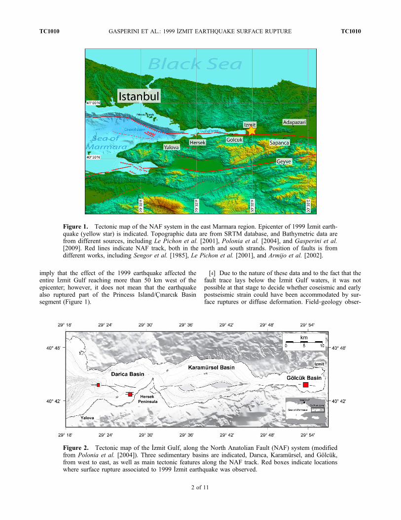
imply that the effect of the 1999 earthquake affected theentire İzmit Gulf reaching more than 50 km west of theepicenter; however, it does not mean that the earthquakealso ruptured part of the Princess Island/Çınarcık Basinsegment (Figure 1).
[4] Due to the nature of these data and to the fact that thefault trace lays below the İzmit Gulf waters, it was notpossible at that stage to decide whether coseismic and earlypostseismic strain could have been accommodated by sur-face ruptures or diffuse deformation. Field‐geology obser-
Figure 1. Tectonic map of the NAF system in the east Marmara region. Epicenter of 1999 İzmit earth-quake (yellow star) is indicated. Topographic data are from SRTM database, and Bathymetric data arefrom different sources, including Le Pichon et al. [2001], Polonia et al. [2004], and Gasperini et al.[2009]. Red lines indicate NAF track, both in the north and south strands. Position of faults is fromdifferent works, including Sengor et al. [1985], Le Pichon et al. [2001], and Armijo et al. [2002].
Figure 2. Tectonic map of the İzmit Gulf, along the North Anatolian Fault (NAF) system (modifiedfrom Polonia et al. [2004]). Three sedimentary basins are indicated, Darıca, Karamürsel, and Gölcük,from west to east, as well as main tectonic features along the NAF track. Red boxes indicate locationswhere surface rupture associated to 1999 İzmit earthquake was observed.
GASPERINI ET AL.: 1999 İZMIT EARTHQUAKE SURFACE RUPTURE TC1010TC1010
2 of 11

vation carried out on land suggested that surface rupturedue to the 1999 event ended east of the Hersek Peninsula, inthe middle of the İzmit Gulf (Figure 2). In fact, no evidentsurface break was observed across the Hersek Peninsula, butonly some minor cracks near its tip, where the long‐termmorphology indicates the passage of a large strike‐slip fault[Çakır et al., 2003].[5] GPS‐based models of coseismic and postseismic
deformation supported this second scenario, suggesting anabrupt drop in coseismic slip close to the Hersek Peninsula[Reilinger et al., 2000]. However, this model is based ontwo arbitrary assumptions: (1) a fault segmentation based
on the morphology of the İzmit Gulf shorelines and (2) thepresence of an extensional right step of the NAF in corre-spondence to the Hersek Peninsula.[6] Although surface rupture and total deformation after a
large earthquake could be different along a given faultstrand due to several factors including diffuse deformationand subsurface displacements, determining the extent ofsurface rupture is important to infer tectonic load and pos-sibly predict future behavior of seismogenic faults. For thisreason, we attempted to estimate the extent of the surfacerupture of the 1999 İzmit earthquake using geophysical datacollected during several marine‐geological expeditions in
Figure 3. Morphostructural map of the Darıca Basin, showing different tectonic domains. Pure strike‐slip deformation is observed only in the west end of the basin, where the diffuse pattern of en echelontranstensional faults merge to a single, localized E–W oriented fault track. Box indicates location ofthe map shown in Figure 8.
GASPERINI ET AL.: 1999 İZMIT EARTHQUAKE SURFACE RUPTURE TC1010TC1010
3 of 11

the Sea of Marmara, as well as direct observations carriedout during two Nautile submersible dives in 2007.
2. Methods[7] Data used in this work come from different sources.
The shelves and adjacent slopes of the northeastern Sea ofMarmara, including the Gulf of İzmit, were mapped usinghigh‐resolution multibeam echo sounders during three cruiseswith the R/VOdin Finder in October 2000 (MARMARA2000)and R/V Urania in 2001, 2005, and 2009 (MARMARA2001,2005 and 2009). During those cruises we also collectedclose‐spaced grids of high‐resolution seismic reflectionprofiles, side‐scan sonar mosaics, and images collected usingremotely operated vehicle (ROV) mounted video cameras,along the submerged trace of the NAF (material and methodsare described elsewhere [see Polonia et al., 2002, 2004;Gasperini et al., 2009]).[8] Two dives were also carried out using the submersible
Nautile for direct observation of the seafloor during theMARNAUT cruise [Henry et al., 2007]. A direct observa-tion carried out using a video camera on board a deep‐towedvehicle (the Medusa system) was performed during theMARMARA2009 cruise [Gasperini et al., 2009].
3. The North Anatolian Fault in the İzmit Gulf[9] The E–W aligned strike‐slip deformation pattern that
characterizes the NAF system can be followed on land forabout 1200 km from the Karliova triple junction in eastTurkey to the Marmara Sea by analyzing aerial and satelliteimages, as well as by using digital terrain models, thathighlight the presence of a relatively narrow principal dis-placement zone [Sengor et al., 1985]. However, the northernbranch of the NAF, that accommodates over 80% of theAnatolia‐Eurasia relative motion [Armijo et al., 2002;Meade et al., 2002], disappears below the Sea of Marmarajust west of the 1999 İzmit epicenter, and cannot be tracedusing field and remote sensing observations. Prior to the1999 earthquakes of Düzce and İzmit, marine geologicaldata in the Sea of Marmara and in the Gulf of İzmit werescarce. Geophysical data, including high‐resolution bathy-metric maps and seismic reflection profiles, have since beenextensively collected in the İzmit Gulf and in the deepMarmara basins as a consequence of the international effortthat followed the disasters. The morphobathymetric map ofthe İzmit Gulf compiled with high‐resolution multibeamecho sounder data [Polonia et al., 2004; Cormier et al.,2006] is among those results. It shows a complex patternof releasing and restraining bends along the submerged traceof the NAF that causes the subsidence of three main basinsseparated by sills (Figure 2). While the easternmost GölcükBasin is a shallow embayment with maximum depths<30 m, the Darıca and Karamürsel depressions accommo-date significant extension. These two basins, however, showdifferent morphologies. Karamürsel is a rhomb‐shapeddepression reaching a maximum depth of about 200 m at itscenter. The reason why transtensional fault scarps boundingthe basin shelves are exposed is that its depocenters subsideat a rate faster than the sediment supply (about 1 mm per
year during the Holocene [cf. Polonia et al., 2004]), and thiscauses formation of a rough topography characterized bytwo central depressions separated by a ridge. The transten-sional fault scarps show apparent vertical displacements ofseveral tens of meters, too large to result from a single event.As a consequence, high‐resolution multibeam images do notallow us to constrain the surface rupture of the 1999 event.However, Cormier et al. [2006], based on differences inseafloor reflectivity pattern, suggest a possible terminationof the 1999 rupture within the Karamürsel Basin.[10] The Darıca Basin (Figure 3) is shallower than
Karamürsel, and does not show a well‐defined depocenter.The principal displacement zone of the NAF system emer-ges from a generally flat topography forming steps andridges oriented E–W (strike slip), NW–SE (transtensive),and SW–NE (transpressive), particularly in the center of thebasin and close to the Hersek Peninsula, where the defor-mation zone appears wider. It converges again into a narrowE–W aligned furrow at the entrance of the İzmit Gulf.[11] A common pattern observed in the three basins is that
deformation zones widen at the basin centers and becomenarrow, and comparatively more focused, at their edges.
4. Following the 1999 Rupture[12] After the 1999 İzmit and Düzce events, this area was
extensively surveyed during several cruises by differentresearch groups. Extensional NW–SE oriented depressionsand tension gashes, alternated by E–W oriented strike‐slipfault scarps displacing the seafloor, were also mapped at awider scale using multibeam and side‐scan sonar imagery,as well as high‐resolution seismic profiles that allow forvertical resolution in the acoustic subseafloor imaging onthe order of a few cm [Polonia et al., 2004; Cormier et al.,2006]. Close to the epicenter, in the shallowest end of theİzmit Gulf (Gölcük Basin; Figure 1) the surface rupture ofthe 1999 earthquake was clearly visible soon after theearthquake, both by geophysical imagery (high‐resolutionseismic reflection profiles, multibeam and side‐scan sonar)and direct observations carried out using ROV‐mountedvideo cameras [Polonia et al., 2002]. ROV‐mounted videocameras allowed direct observations of the seafloor wherefresh rupture scarps affecting the muddy seafloor are visible(Figure 4). Further to the west, toward Karamürsel, thedeformation pattern associated with the İzmit earthquakewas less easily identified for several reasons. First, fault slipdecreases westward from the epicenter, where a maximumstrike‐slip surface displacement of 5.5 m was observed[Çakır et al., 2003]. Second, moving toward the basindepocenters we observe strain partitioning between domi-nantly strike‐slip and dip‐slip fault segments. The latter arecharacterized by prominent vertical scarps resulting from thecumulative displacement of several earthquakes. This madeevaluating the effects of the last event difficult. Third, wheredeformation affects a flat bottom and strain patterns result-ing from a single event may potentially be recorded, themuddy seafloor might not have been competent enough toform or preserve scarps. This is possibly the case in theDarıca Basin.
GASPERINI ET AL.: 1999 İZMIT EARTHQUAKE SURFACE RUPTURE TC1010TC1010
4 of 11

[13] West of the Hersek Peninsula, however, relevantobservations have been carried out. From the western coastof Hersek to a transpressive high formed at a left‐lateral stepof the NAF (Figure 3), we carried out high‐resolutionmultibeam and side‐scan sonar surveys. Here, an E–Woriented rectilinear segment of the NAF accommodatesalmost purely strike‐slip deformation along a narrowdeformation zone (<5 m). The fault trace appears as a 0.5 mhigh scarp on multibeam bathymetry, and a low backscatteralignment on side‐scan sonar images; it is also visible onhigh‐resolution seismic reflection profiles, that penetratethe fine‐layered Holocene marine sediments (Figure 5).Remarkably, a furrow (probably an anchor drag) crosses thefault scarp just west of Hersek. This furrow is apparentlyoffset by the fault, as shown by side‐scan images andbathymetric data (Figure 5). The relatively low resolution ofthe images (footprint about 25 cm) does not allow us toaccurately estimate the right‐lateral offset observed, whichwould probably fall between 0.5 and 1 m. The apparentdisplacement of this feature suggests that the 1999 surfacerupture could have reached this sector and, in this case,should have also affected the Hersek promontory onshore.However, clear surface ruptures were not observed onshoreHersek [Kozacı, 2002; Lettis et al., 2002]. A possibleexplanation is that the Hersek promontory is a pressure ridgeformed at a left‐lateral step over of the NAF. In this context,fault slip at depth may result in diffuse strain at the surfacewithout obvious strain markers.[14] Toward the west, the western end of Darıca Basin is
marked by a canyon that bends sharply across the NAF traceat the center of the İzmit Gulf, connecting it with the deepÇınarcık (Figure 3). The canyon is intersected by the NAFand appears to be right‐laterally displaced by about 100 m.
Several lines of evidence indicate that this displacement hasbeen accumulated during the last 10,000 years, corre-sponding to a slip rate of 10 mm/y [Polonia et al., 2004].Analysis of near‐bottom microtopography collected duringthe MARMARASCARPS cruise using the ROV Victor[Armijo et al., 2005] suggested that the bottom of the can-yon could be affected by a recent rupture that, due to therelative hardness of the canyon bottom, could have a goodpotential of forming a scarp. This line of reasoning inducedus to plan a dive along the canyon during the MARNAUTcruise using the submersible Nautile to gather visual evi-dence of recent ruptures from the canyon bottom.
4.1. The Nautile Dives
[15] Multibeam bathymetry and microbathymetry data col-lected using ROV VICTOR during the MARMARASCARPcruise [Armijo et al., 2005] were used to precisely locate themain trace of the E–W trending strike‐slip fault. A part ofthe fault is buried below a large landslide that, originatingfrom the southern shelf, modifies the trend of canyon inci-sion (Figure 6). The fault could only be visible east and westof the landslide front. Accordingly, we started our sub-mersible survey (dive 1657) from the Çınarcık Basin floor at900 m water depth, aiming to follow westward the inferredstrike‐slip fault track (Figure 6). Several morphologicalscarps were observed along our route, particularly close tothe north wall of the canyon, where they may also be due toerosion and gravity failures of the steep slope or by erosionof the canyon floor by turbidity currents. Indeed, none ofthese morphological scarps were clearly associated with thetrack of the NAF, as inferred by morphobathymetric data,except for one 25 cm scarp at the bottom of the canyon at
Figure 4. Earthquake‐related surface rupture observed close to the epicenter of the 1999 İzmit earth-quake using an ROV video camera during MARMARA2001 cruise.
GASPERINI ET AL.: 1999 İZMIT EARTHQUAKE SURFACE RUPTURE TC1010TC1010
5 of 11

660 m of water depth (Figure 7). This feature was at firstinterpreted as a good candidate for the surface expression ofa strike‐slip fault, with a minor dip‐slip component, possiblyrelated to the 1999 event. This hypothesis arose from severallines of reasoning, including observation that depositionrates in the area could span between 3.6 and 5 mm/y[Çağatay et al., 2003; Polonia et al., 2004]. Because recur-rence time of large earthquakes (large enough to cause sur-face rupture) is about 250 years along a given strand ofthe NAF [Ambraseys, 2002], and that possible dates of thepenultimate event in this segment could be 1766 or 1894[Ambraseys and Jackson, 2000], a vertical scarp on the orderof 25 cm could be potentially buried in less than 200 years.However, the strike of the observed feature was parallel toother scarps attributed to gravity failure along the canyonwall; moreover, the analysis of morphobathymetric data didnot confirm the presence of a continuous fault scarp corre-sponding with our observation.[16] After dive 1657 we decided to follow the rupture
further to the east along the NAF track. The most favorableplace to do this observation is the sharp bend of a canyon at
the İzmit Gulf entrance (Figure 3). The subsequent dive(1670) presented some logistical difficulties such as heavymaritime traffic, shallow depths (170–100 m), and highturbidity with a visibility range not exceeding 2.5–3 m.However, most of the dive was carried out very close to thebottom (2 m) and we could observe clearly any feature onthe bottom. Fortunately, the detailed morphobathymetricmaps allowed a precise navigation along the NAF track. Thedive began where the canyon bends from E–W to N–S at adepth of about 200 m. The bottom of the canyon wasubiquitously draped by bioturbated soft mud. No evidenceof fresh scarps or erosion were observed, neither scours, norripple marks that could eventually indicate tractive pro-cesses at the seafloor. At one point in the canyon we testedthe consistence of the seafloor using the arm of Nautile, thatpenetrated without effort the uppermost 40 cm (test site ofFigure 8). Within the canyon, the presence of the fault couldonly be noticed by an abrupt increase in the slope below190 m depth. We then followed the E–W offset of the scarpon the east wall of the canyon (Figure 8) but could not seeany evidence of fresh faulting. Interestingly, three small
Figure 5. Multibeam‐based slope map of the MAF fault trace west of the Hersek Peninsula. Insets showa chirp‐sonar seismic section (A‐A′) across the fault track and a 3‐D image that was obtained combiningmultibeam and side‐scan sonar data. The 3‐D image shows a track at the seafloor (probably an anchordrag) intersecting at high angle the strike‐slip fault and showing a displacement in a range between 1and 0.5 m.
GASPERINI ET AL.: 1999 İZMIT EARTHQUAKE SURFACE RUPTURE TC1010TC1010
6 of 11

black patches (Figure 9) were found in the area were the eastwall of the canyon is offset by the fault. Apparently, towardnorth, the gully related to the fault has been filled by sedi-ments. We noted a change in the nature of sediment coverthat appeared to be somewhat coarser immediately north ofthe scarp. As for the gully of the fault east of the canyon,it has a regular E–W 10–12° north slope with an offsetof about 9 m, but no outcrop or scarp of any kind wasobserved, and we did not see any other indication of vent-ing activity. No fresh ruptures were observed during thedive, although the probable fault trace was crossed at least5 times between the canyon and the dive termination 1 kmfurther east.
4.2. The Medusa Survey
[17] During the MARMARA2009 cruise we surveyed thewestern end of the Darıca basin using “Medusa,” a deeptowed multisensor system, able to carry out oceanographicmeasurements (CTD, oxygen, etc.) as well as to collecthigh‐definition images of the seafloor, as part of the as partof the Marmara Demonstration Mission (Marmara‐DM)project of the European Seafloor Observatory Network ofExcellence (ESONET NoE). During the survey, Medusawas equipped with two methane sensors to detect possiblemethane anomalies related to the presence of fluid flowalong faults [Gasperini et al., 2009]. We focused ourattention in the area between the Nautile 1657 dive to theeast, and the last evidence of 1999 rupture observed west ofHersek. The video camera on board Medusa enabled usto observe possible evidence of surface rupture along the
NAF track, just west of the displaced canyon (Figure 10).Considering that the fault trace east and west of this pointwas surveyed using the Nautile, evidence for seafloor rup-ture west of the Darıca basin is, at best, patchy.
5. The Black Patches[18] During the MARNAUT Nautile dives, numerous
so‐called “black patches” were observed marking the faultzones in the Sea of Marmara floor [Zitter et al., 2008; Géliet al., 2008; Tryon et al., 2010] and visual observationsand coring during the MARNAUT cruise confirmed thepresence of abundant carbonate concretions within them.Such features are typical indicators of relatively continuousemission of methane at the seafloor. The anaerobic oxidationof methane (AOM) triggers a suite of biogeochemical reac-tions that ultimately result in production of black Fe and Mnsulfide mineral assemblages. The overall AOM reaction canbe expressed as
CH4 þ SO2�4 ! HCO�
3 þ HS� þ H2O ð1Þ
This process is mediated by a consortium of methane oxi-dizing archaea and sulfate‐reducing bacteria [Boetius et al.,2000; Orphan et al., 2001]. Methane originates from belowfrom microbial degradation of organic matter or from deeperthermogenic hydrocarbon generation and passes upward as adissolved component in pore fluid advection or as a buoyantgas phase. The sulfate source is the overlying water column,with sulfate diffusing across the sediment‐water bound-ary. Secondary reactions include precipitation of authigenic
Figure 6. Morphobatimetric map of the Çınarcık basin and the west end of the İzmit Gulf. The track ofthe 1657 Nautile dive is indicated (yellow dashed line), as well as the position of a fresh scarp described inthe text as a possible candidate for the 1999 surface rupture (inset and Figure 7).
GASPERINI ET AL.: 1999 İZMIT EARTHQUAKE SURFACE RUPTURE TC1010TC1010
7 of 11

carbonates, and precipitation of a variety of Mn and Fe sul-fides [Çağatay et al., 2008]. The latter dominate the sulfidicsediment of methane seeps and give it the black color. Feoxyhydroxides often make up a significant percentage of
ocean margin seafloor sediment and these are prone to bio-geochemical reduction, often by a microbial intermediary.[19] These black sediment patches are indicators of active
methane emissions, either as free gas or, more commonly,
Figure 8. Track of Nautile Dive 1670 during MARNAUT cruise. Black dot indicates the test site duringdive (push core), green square indicates location where black patches were observed (see Figure 9), andyellow circle indicates site were the westernmost surface rupture, possibly related to the 1999 İzmitearthquake, was observed using the Medusa camera (see Figure 9).
Figure 7. Seafloor picture collected during Nautile dive 1657 in the canyon connecting Çınarcık to theİzmit Gulf. The scarp observed at the seafloor in not the result of tectonic rupture but more likely differ-ential erosion at the canyon flanks (see text).
GASPERINI ET AL.: 1999 İZMIT EARTHQUAKE SURFACE RUPTURE TC1010TC1010
8 of 11

dissolved in pore water. The emissions must be rapidenough to keep the bottom boundary layer anoxic. Flowmeasurements made in such environments have indicatedtypical outflow rates of millimeters to meters per day[LaBonte et al., 2007; Tryon et al., 2002]. Sulfide oxida-tion is rapid [Millero et al., 1987; Wang and Chapman,1999] and in the absence of outflow, oxygenated bottomwater will interact with the sediment and it will quickly(days) lose its black color. One control on how long the sitehas been active is the presence or absence of carbon-ates. The AOM reaction produces bicarbonate and leadsto the production of authigenic calcium carbonate and,at methane seeps, this occurs at and just below the sea-floor. While there are many factors affecting the accumu-lation rate, as a general rule significant carbonate cements,concretions, or structures relates to a relatively long life-time of venting activity on the order of some tens of yearsor more. Thus long‐term flow along faults causes the near‐surface sediment to be more indurated and thus more cap-able of being fractured during deformation rather thandeforming plastically. These fractures will also tend to bebetter preserved.[20] Given the above, we conclude that the black patches
marking the fault track at the seafloor within the canyonindicate a persistent tectonic‐driven fluid flow from thesubsurface and that, should surface ruptures occur, anyvertical offset should be preserved more readily than else-where. Observation of free gas in the water column notvisible during previous surveys, indicate that in most placesin the İzmit Gulf this flow was enhanced after the 1999İzmit earthquake [Kuşcu et al., 2005; Alpar, 1999] and
possibly immediately before this event as a consequence ofa strain change in the subseafloor. However, according tothese studies, gas releases along the seafloor expression ofthe fault were mostly observed east of the Hersek Peninsula,while to the west they appeared more diffuse. This is con-sistent with the sparse evidence for methane emission from
Figure 10. Image of a scarp at the seafloor possibly related tothe 1999 earthquake collected using Medusa (see Figure 8 forlocation).
Figure 9. Seafloor image collected during Nautile dive 1670 showing one of the black patches observedclose to the western termination of 1999 rupture (see Figure 8 for location).
GASPERINI ET AL.: 1999 İZMIT EARTHQUAKE SURFACE RUPTURE TC1010TC1010
9 of 11

Nautile and Medusa surveys and further suggests that sea-floor ruptures were sporadic in this area.
6. Discussion[21] The surface rupture related to the 1999 İzmit earth-
quake below the Marmara Sea probably ended in the Darıcabasin, west of the Hersek Peninsula (Figure 2). Althoughpossible clues of this surface rupture were observed in theÇınarcık eastern slope, along a fault‐controlled canyon, theywere not confirmed by observations carried out in theshallower and most favorable location at the entrance of theİzmit Gulf. However, in the light of rupture heterogeneity,widespread ground fishing and surface erosion, it is con-ceivable that submarine surface expressions further to thewest in the deep Çınarcık basin could easily be erased, hid-den or overlooked. As far as our observations are concerned,the morphology of the seafloor is critical for unequivocallylocating the presence of a recent fault‐related rupture. In fact,in the case of complex topography and fault scarps producedby multiple events it would be very difficult to recognizethe effect of the last earthquake. Another important factor isthe competence of the seafloor: a “soupy” mud‐dominatedseafloor appears to be unsuitable for forming and preservingfresh scarps. As was observed during both the MARNAUTand MARMARASCARPS cruises, fault ruptures are oftenassociated with fluid emissions from the subseafloor. Asdiscussed above, these emissions help in the creation andpreservation of these fault scarps. This also suggests thatobservations of evidence of long‐term fluid flow without thepresence of fractures/scarps indicate that no recent rupturesoccurred in that location. Our observations are in agree-ment with recent estimates of coseismic slip based on com-bined tectonic observations and SAR data [Çakır et al.,2003]. Yet, it is puzzling that no surface rupture is foundat locations where the seafloor fault trace is well defined,suggesting that earthquake ruptures only occasionally reachthe seafloor or that the seafloor does not necessarily showtraces of seismogenic rupture. Slip near the western end ofthe 1999 İzmit earthquake rupture, in west Darıca andÇınarcık may have occurred only at depth. These observa-tions could indicate that stress release is incomplete alongthis part of the North Anatolian Fault, and that the nextearthquake would possibly nucleate in this area and propa-gate westward. This conclusion, however, also dependson the slip distribution of the 1894 rupture. This earth-quake occurred in the region of Çınarcık Basin and thewestern part of the İzmit Gulf but its exact location is notcertain [Ambraseys, 2002]. Furthermore, postseismic exten-sion occurred in the Çınarcık Basin [Ergintav et al., 2009].This should result in a decrease of Coulomb stresses on faultbranches in Eastern Çınarcık and in some amount of west-ward stress transfer not accounted for by coseismic models.In alternative scenarios for future earthquakes, nucleationmay occur on the western side of the Sea of Marmara seismicgap, or near Istanbul at the fault bend on the western sideof Çınarcık Basin [Oglesby et al., 2008].[22] Since the westernmost evidence for seafloor rupture
was observed close to the canyon displaced by the NAFat the İzmit Gulf entrance, this location appears an ideal
observation point for monitoring the seismic activity alongthe NAF trace for the following reasons.[23] 1. It is the westernmost location of the NAF that did
not show surface ruptures associated with the 1999 İzmitearthquake; thus, it is an area where the next earthquakealong the northern branch of the NAF could nucleate.[24] 2. It has black sulfidic sediment patches caused by
gas and fluid emissions along the track of the NAF; thisoccurrence could be used to study correlations betweenseismicity and fluid emission.[25] 3. It is an area characterized by a “focusing” of the
NAF principal deformation zone, which is constituted hereby a single strike‐slip segment.[26] 4. It is a relatively accessible area, due to the mod-
erate water depth and its proximity to the coastline.[27] Due to these considerations, this area was selected for
a 1 year monitoring experiment that started last Septemberin the frame of the ESONET NoE Marmara‐DM project.A SN‐4 class seafloor observatory, equipped with severalsensors including a wide‐band seismometer and a methanesensor, was deployed close to the canyon, at 150 m of waterdepth during MARMARA2009 cruise [Gasperini et al.,2009]. Results from this experiment will help in analyzingpossible relationships between seismicity and gas emissionsfrom the seafloor.
7. Conclusion[28] A number of independent observations, including high‐
resolution seismic reflection profiles and acoustic imageryof the İzmit Gulf and Çınarcık basin seafloor, combined withdirect underwater observation carried out using ROVs andthe Nautile submersible, all suggest that the surface ruptureassociated with the Mw 7.4, 1999 İzmit earthquake taperedout in the Darıca Basin, before the eastern termination of theİzmit Gulf. Part of the tectonic load associated with stressrelease at the ruptured İzmit segment has been transferredin this area, increasing the probably for a future event tonucleate there. We found that at this location, deformationassociated with the NAF is almost purely strike slip andconcentrated in a relatively narrow zone. Moreover, a fewblack patches of reduced sediment close to the seafloortrace of the fault indicate fault‐controlled fluid and gasemission. Since the hydrogeologic system is directly coupledto the tectonic system through the interaction of strain,stress state, and fluid pressure and its resultant flow, thislocation may be ideal for monitoring post seismic, precur-sory, and/or systematic hydrologic variations through theseismic cycle.
[29] Acknowledgments. We thank captain and crew of cruisesMARMARA‐2001, ‐2005 and ‐2009 (R/V Urania), as well asMARMARASCARPS andMARNAUT (R/V L’Atalante). The Marmara2009cruise was partly funded by ESONET NoE Marmara‐DM project. Thanksare also due to the Medusa team, and in particular to G. Etiope, G. Mari-naro, and F. Furlan, for providing the image shown in Figure 10. L.G.would like to thank Rolando Armijo for invitation on board of L’Atalanteduring MARMARASCARPS cruise and for stimulating discussions on thesubject. Finally, we thank Georg Dresen and an anonymous referee forimproving the quality of the manuscript.
GASPERINI ET AL.: 1999 İZMIT EARTHQUAKE SURFACE RUPTURE TC1010TC1010
10 of 11
ReferencesAlpar, B. (1999), Underwater signatures of the Kocaeli
Earthquake (August 17th 1999), Turk. J. Mar. Sci.,5(3), 111–130.
Ambraseys, N. N. (2002), The seismic activity ofthe Marmara Sea region over the last 2000 years,Bull. Seismol. Soc. Am., 92, 1–18, doi:10.1785/0120000843.
Ambraseys, N. N., and J. A. Jackson (2000), Seismicityof the Sea of Marmara (Turkey) since 1500, Geophys.J. Int., 141, F1–F6, doi:10.1046/j.1365-246x.2000.00137.x.
Armijo, R., B. Meyer, S. Navarro, G. King, andA. A. Barka (2002), Asymmetric slip partitioningin the Sea of Marmara pull‐apart: A clue to propa-gation processes of the North Anatolian Fault?, TerraNova, 14, 80–86, doi:10.1046/j.1365-3121.2002.00397.x.
Armijo, R., et al. (2005), Submarine fault scarps inthe Sea of Marmara pull‐apart (North AnatolianFault): Implications for seismic hazard in Istanbul,Geochem. Geophys. Geosyst., 6, Q06009, doi:10.1029/2004GC000896.
Barka, A., et al. (2002), The surface rupture and slipdistribution of the 17 August 1999 İzmit earthquake(M 7.4), North Anatolian fault, Bull. Seismol. Soc.Am., 92, 43–60, doi:10.1785/0120000841.
Boetius, A., K. Ravenschlag, C. J. Schubert, D. Rickert,F. Widdel, A. Gieseke, R. Amann, B. B. Jørgensen,U. Witte, and O. Pfannkuche (2000), A marinemicrobial consortium apparently mediating anae-robic oxidation of methane, Nature, 407, 623–626,doi:10.1038/35036572.
Bouchon, M., N. Toksöz, H. Karabulut, M. P. Bouin,M. Dietrich, M. Aktar, and M. Edie (2000), Seismicimaging of the 1999 Izmit (Turkey) rupture inferredfrom the near‐fault recordings, Geophys. Res. Lett.,27, 3013–3016, doi:10.1029/2000GL011761.
Bulut, F., and M. Aktar (2007), Accurate relocation ofİzmit earthquake (Mw = 7.4, 1999) aftershocks inÇınarcık Basin using double difference method,Geophys. Res. Lett., 34, L10307, doi:10.1029/2007GL029611.
Bürgmann, R., S. Ergintav, P. Segall, E. H. Hearn, S.McClusky, R. E. Reilinger, H. Woith, and J. Zschau(2002), Time‐dependent distributed after slip onand deep below the İzmit earthquake rupture, Bull.Seismol. Soc. Am., 92, 126–137, doi:10.1785/0120000833.
Çağatay, M. N., N. Görür, A. Polonia, E. Demirbağ, M.Sakınç, M.‐H. Cormier, L. Capotondi, C. McHugh,Ö. Emre, and K. Eriş (2003), Sea‐level changes anddepositional environments in the İzmit Gulf, easternMarmara Sea, during the late glacial–Holoceneperiod, Mar. Geol., 202, 159–173, doi:10.1016/S0025-3227(03)00259-7.
Çağatay, M. N., et al. (2008), Sedimentary earthquakerecords in the Sea of Marmara, paper presented atEGU 2008 Meeting, Vienna.
Çakır, Z., J.‐B. de Chabalier, R. Armijo, B. Meyer,A. Barka, and G. Peltzer (2003), Coseismic andearly post‐seismic slip associated with the 1999Izmit earthquake (Turkey), from SAR interferometryand tectonic field observations,Geophys. J. Int., 155,93–110, doi:10.1046/j.1365-246X.2003.02001.x.
Cormier, M.‐H., et al. (2006), North Anatolian Faultin the Gulf of Izmit (Turkey): Rapid vertical motionin response to minor bends of a nonvertical conti-nental transform, J. Geophys. Res., 111, B04102,doi:10.1029/2005JB003633.
Delouis, B., D. Giardini, P. Lundgren, and J. Salichon(2002), Joint inversion of InSAR, GPS, teleseismicand strong‐motion data for the spatial and temporaldistribution of earthquake slip: Application to the1999 İzmit mainshock, Bull. Seismol. Soc. Am.,92, 278–299, doi:10.1785/0120000806.
Ergintav, S., S. McClusky, E. Hearn, R. Reilinger,R. Cakmak, T. Herring, H. Ozener, O. Lenk, andE. Tari (2009), Seven years of postseismic deforma-tion following the 1999,M = 7.4 andM = 7.2, Izmit‐
Düzce, Turkey earthquake sequence, J. Geophys.Res., 114, B07403, doi:10.1029/2008JB006021.
Feigl, K. L., et al. (2002), Estimating slip distributionfor the İzmit main shock from coseismic GPS,ERS 1, RADARSAT, and SPOT measurements,Bull. Seismol. Soc. Am., 92, 138–160, doi:10.1785/0120000830.
Gasperini, L., et al. (2009), MARM2009: Marine geo-logical study of the North‐Anatolian Fault beneaththe Sea of Marmara: Cruise report, technical report,ISMAR‐CNR, Bologna, Italy. (Available at http://projects.bo.ismar.cnr.it/CRUISE_REPORTS/2009/MARM09_REP.)
Géli, L., et al. (2008), Gas emissions and active tecton-ics within the submerged section of the North Anato-lian Fault zone in the Sea of Marmara, Earth Planet.Sci. Lett., 274, 34–39, doi:10.1016/j.epsl.2008.06.047.
Gülen, L., A. Pinar, D. Kalafat, N. Ozel, G. Horasan,M. Yilmazer, and A. M. Isikara (2002), Surface faultbreaks, aftershock distribution, and rupture processof the 17 August 1999 İzmit, Turkey, earthquake,Bull. Seismol. Soc. Am., 92, 230–244, doi:10.1785/0120000815.
Hartleb, R. D., et al. (2002), Surface rupture and slipdistribution along the Karadere segment of the 17August 1999 İzmit and the western section of the12 November 1999 Düzce, Turkey, earthquakes,Bull. Seismol. Soc. Am., 92, 67–78, doi:10.1785/0120000829.
Henry, P., et al. (2007), Marnaut cruise: Investigatingcold seeps along the northern branch of the NorthAnatolian Fault in the Sea of Marmara, cruise report,CEREGE/College de France, CNRS, Aix‐en‐Provence, France. (Available at http://www.cdf.u‐3mrs.fr/~henry/marmara/.)
Kozacı, Ö. (2002), Paleoseismological studies on theYalova segment of the North Anatolian Fault in theHersek Delta, M.Sc. thesis, 116 pp., Eurasian Inst.of Earth Sci., Istanbul Tech. Univ., Istanbul, Turkey.
Kuşcu, I., et al. (2005), Seafloor gas seeps and sedimentfailures triggered by the August 17, 1999 earth-quake in the eastern part of the Gulf of İzmit, Sea ofMarmara, NW Turkey, Mar. Geol., 215, 193–214,doi:10.1016/j.margeo.2004.12.002.
LaBonte, A. L., K. M. Brown, and M. D. Tryon (2007),Monitoring periodic and episodic flow events atMonterey Bay seeps using a new optical flow meter,J. Geophys. Res., 112, B02105, doi:10.1029/2006JB004410.
Langridge, R. M., H. D. Stenner, T. E. Fumal,S. A. Christoffereson, T. K. Rockwell, R. D. Hartleb,J. Bachhuber, and A. A. Barka (2002), Geometry, slipdistribution, and kinematics of surface rupture on theSakarya fault segment during the 17 August 1999İzmit, Turkey, earthquake, Bull. Seismol. Soc. Am.,92, 107–125, doi:10.1785/0120000804.
Le Pichon, X., et al. (2001), The active Main MarmaraFault, Earth Planet. Sci. Lett., 192, 595–616.
Lettis, W., J. Bachluber, R. Witter, C. Brankman,C. E. Randolph, A. Barka, W. D. Page, and A. Kaya(2002), Influence of releasing step‐overs on surfacefault rupture and fault segmentation: Examples fromthe 17 August 1999 İzmit earthquake on the NorthAnatolian Fault, Turkey, Bull. Seismol. Soc. Am.,92, 19–42, doi:10.1785/0120000808.
Meade, B. J., B. H. Hager, S. C. McClusky, R. E. Reilinger,S. Ergintav, O. Lenk, A. A. Barka, and H. Ozener(2002), Estimates of seismic potential in the Marmararegion from block models of secular deformation con-strained by GPS measurements, Bull. Seismol. Soc.Am., 92, 208–215, doi:10.1785/0120000837.
Millero, F. J., S. Hubinger, M. Fernandez, and S. Garnett(1987), Oxidation of H2S in seawater as a function oftemperature, pH, and ionic strength, Environ. Sci.Technol., 21, 439–443, doi:10.1021/es00159a003.
Oglesby, D. D., P. M. Mai, K. Atakan, and S. Pucci(2008), Dynamic models of earthquakes on theNorth Anatolian fault zone under the Sea of Mar-mara: Effect of hypocenter location, Geophys. Res.Lett., 35, L18302, doi:10.1029/2008GL035037.
Orphan, V. J. , C. H. House, K.‐U. Hinr ichs,K. D. McKeegan, and E. F. DeLong (2001), Meth-ane‐consuming Archaea revealed by directlycoupled isotopic and phylogenetic analysis,Science, 293, 484–487, doi:10.1126/science.1061338.
Polonia, A., et al. (2002), Exploring submarine earth-quake geology in the Marmara Sea, Eos Trans.AGU, 83(21), 235–236, doi:10.1029/2002EO000158.
Polonia, A., L. Gasperini, A. Amorosi, E. Bonatti,N. Çağatay, L. Capotondi, M.‐H. Cormier, N. Gorur,C. McHugh, and L. Seeber (2004), Holocene slip rateof the North Anatolian Fault beneath the Sea ofMarmara, Earth Planet. Sci. Lett., 227, 411–426,doi:10.1016/j.epsl.2004.07.042.
Reilinger, R. E., et al. (2000), Coseismic and postseismicfault slip for the 17 August 1999, M = 7.5, Izmit,Turkey earthquake, Science, 289, 1519–1524,doi:10.1126/science.289.5484.1519.
Rockwell, T. K., S. Lindval, T. Dawson, R. Langridge,W. Lettis, and Y. Klinger (2002), Lateral offsets onsurveyed cultural features resulting from the 1999İzmit and Düzce earthquakes, Turkey, Bull. Seismol.Soc. Am., 92, 79–94, doi:10.1785/0120000809.
Sengor, A. M. C., N. Görür, and F. Saroglu (1985),Strike‐slip faulting and related basin formation inzones of tectonic escape: Turkey as a case study,in Strike‐Slip Deformation, Basin Formation, and Sed-imentation, edited by K. T. Biddle and N. Christie‐Blick, Spec. Publ. Soc. Econ. Paleontol. Mineral.,37, 227–264.
Tibi, R., G. Bock, Y. Xia, M. Baumbach, H. Grosser,C. Milkereit, S. Karakisa, S. Zünbül, R. Kind, andJ. Zschau (2001), Rupture processes of the 1999August 17 Izmit and November 12 Düzce (Turkey)earthquakes,Geophys. J. Int., 144, F1–F7, doi:10.1046/j.1365-246x.2001.00360.x.
Tryon, M. D., K. M. Brown, and M. E. Torres (2002),Fluid and chemical flux in and out of sediments host-ing hydrate deposits on Hydrate Ridge, OR, II:Hydrological processes, Earth Planet. Sci. Lett., 201,541–557, doi:10.1016/S0012-821X(02)00732-X.
Tryon, M. D., P. Henry, M. N. Çağatay, T. A. C. Zitter,L. Géli, L. Gasperini, P. Burnard, S. Bourlange,and C. Grall (2010), Pore fluid chemistry of theNorth Anatolian Fault Zone in the Sea of Marmara:A diversity of sources and processes, Geochem.Geophys. Geosyst., 11, Q0AD03, doi:10.1029/2010GC003177.
Wang, F., and P. D. Chapman (1999), Biological impli-cations of sulfide in sediment—A review focusingon sediment toxicity, Environ. Toxicol. Chem., 18,2526–2532.
Wright, T., E. Fielding, and B. Parsons (2001), Triggeredslip: Observations of the 17 August 1999 Izmit(Turkey) earthquake using radar interferometry,Geophys. Res. Lett., 28, 1079–1082, doi:10.1029/2000GL011776.
Yagi, Y., and M. Kikuchi (2000), Source rupture pro-cess of the Kocaeli, Turkey, earthquake of August17, 1999, obtained by joint inversion of near‐fielddata and teleseismic data, Geophys. Res. Lett., 27,1969–1972, doi:10.1029/1999GL011208.
Zitter, T. A. C., et al. (2008), Cold seeps along the mainMarmara fault in the Sea of Marmara (Turkey),Deep Sea Res., Part I, 55, 552–570, doi:10.1016/j.dsr.2008.01.002.
G. Bortoluzzi, L. Gasperini, and A. Polonia, ISMAR,CNR, I‐40129 Bologna, Italy. ([email protected])
N. Çağatay, EMCOL, Faculty of Mining, ITU,34469 Istanbul, Turkey.
L. Géli, Ifremer, F‐29280 Plouzané, France.P. Henry and X. Le Pichon, CEREGE, F‐13545
Aix‐en‐Provence, France.M. Tryon, Scripps Institution of Oceanography,
La Jolla, CA 92093, USA.
GASPERINI ET AL.: 1999 İZMIT EARTHQUAKE SURFACE RUPTURE TC1010TC1010
11 of 11
Copyright © 2022 FDOKUMEN