North Anatolian Fault in the Gulf of Izmit (Turkey): Rapid vertical motion in response to minor...
25
North Anatolian Fault in the Gulf of Izmit (Turkey): Rapid vertical motion in response to minor bends of a nonvertical continental transform Marie-Helene Cormier, 1 Leonardo Seeber, 1 Cecilia M. G. McHugh, 1 Alina Polonia, 2 Namik C ¸ agatay, 3 O ¨ mer Emre, 4 Luca Gasperini, 2 Naci Go ¨ru ¨ r, 3 Giovanni Bortoluzzi, 2 Enrico Bonatti, 2 William B. F. Ryan, 1 and Kori R. Newman 1 Received 18 January 2005; revised 14 December 2005; accepted 27 December 2005; published 25 April 2006. [1] The catastrophic rupture of the North Anatolian Fault east of the Marmara Sea on 17 August 1999 highlighted a need for mapping the underwater extension of that continental transform. A new bathymetric map of Izmit Gulf indicates that the fault follows the axis of the gulf with a few minor bends. Submerged shorelines and shelf breaks that formed during the Last Glacial Maximum provide markers to quantify vertical deformation. Variable tilting of these horizons reveals that vertical deformation is highest just south of the fault. A correlation between vertical deformation of the southern fault block and distance to fault bends can be accounted for by a fault dipping steeply to the south. Hence subsidence (uplift) of the southern, hanging wall block would be expected where the fault strikes at a slightly transtensional (transpressional) orientation to relative plate motion. Subsidence reaches about 8 mm/yr west of the town of Golcuk and might be accommodated in 1–2 m subsidence events during large earthquakes. That scenario is compatible with the tsunami runups and the coseismic subsidence of the southern shore that occurred in 1999. Seafloor morphology also suggests that earthquakes are accompanied by widespread gas and fluid release. The periphery of the deepest basin displays a hummocky texture diagnostic of sediment fluidization, and mud volcanoes occur west of Hersek peninsula that might be activated by earthquakes. Finally, the backscatter imagery reveals a series of lineaments midway through the gulf that are interpreted as products of the 1999 surface rupture. The seafloor is undisturbed farther west, suggesting that surface slip decreased to an insignificant level beyond Hersek. Possibly, the stress shadow from the 10 July 1894 earthquake, which was felt strongly along the western Izmit Gulf, contributed to arrest the 1999 surface rupture. Citation: Cormier, M.-H., et al. (2006), North Anatolian Fault in the Gulf of Izmit (Turkey): Rapid vertical motion in response to minor bends of a nonvertical continental transform, J. Geophys. Res., 111, B04102, doi:10.1029/2005JB003633. 1. Introduction [2] The 1600-km-long right-lateral North Anatolian Fault has been rupturing across Turkey from east to west in a series of large earthquakes during the 20th century [Tokso ¨z et al., 1979; Barka, 1996; Stein et al., 1997]. That rupture front advanced 160 km in 1999 in two disastrous earth- quakes (Mw = 7.5 and 7.2) and the next earthquake is expected to rupture beneath the Marmara Sea [Barka, 1999; Hubert-Ferrari et al., 2000; Parsons et al., 2000; Reilinger et al., 2000b]. Because this region is home to about 20 million people and much of the country’s industrial activity, seismic hazards are particularly high. The Turkish authorities thus coordinated a large international effort to fully characterize the submerged portion of the North Anatolian Fault [Go ¨ru ¨ret al., 2002]. As part of that effort, a joint Italian, Turkish, and American project focused on key portions of the Marmara Sea shelves during two expeditions in fall 2000 and spring 2001 [Polonia et al., 2002]. This paper analyzes some of the high-resolution bathymetry data collected during these two surveys. [3] The northern branch of the North Anatolian Fault enters the eastern Marmara Sea through the Gulf of Izmit, a 50-km-long EW oriented coastal inlet [Sengo ¨r et al., 1985; Barka and Kadinsky-Cade, 1988; Wong et al., 1995; Go ¨ru ¨r et al., 1997; Kusc ¸u et al., 2002] (Figure 1). The Gulf of Izmit comprises three basins: the western basin, the central basin, and the eastern basin (also known as the Darica basin, Karamu ¨rsel basin, and Golcuk or Izmit basin, respectively). JOURNAL OF GEOPHYSICAL RESEARCH, VOL. 111, B04102, doi:10.1029/2005JB003633, 2006 1 Lamont-Doherty Earth Observatory of Columbia University, Palisades, New York, USA. 2 Institute of Marine Sciences, Consiglio Nazionale delle Richerche, Bologna, Italy. 3 Istanbul Technical University, Istanbul, Turkey. 4 General Directorate of Mineral Research and Exploration, Ankara, Turkey. Copyright 2006 by the American Geophysical Union. 0148-0227/06/2005JB003633$09.00 B04102 1 of 25
Transcript of North Anatolian Fault in the Gulf of Izmit (Turkey): Rapid vertical motion in response to minor...

North Anatolian Fault in the Gulf of Izmit (Turkey):
Rapid vertical motion in response to minor bends
of a nonvertical continental transform
Marie-Helene Cormier,1 Leonardo Seeber,1 Cecilia M. G. McHugh,1 Alina Polonia,2
Namik Cagatay,3 Omer Emre,4 Luca Gasperini,2 Naci Gorur,3 Giovanni Bortoluzzi,2
Enrico Bonatti,2 William B. F. Ryan,1 and Kori R. Newman1
Received 18 January 2005; revised 14 December 2005; accepted 27 December 2005; published 25 April 2006.
[1] The catastrophic rupture of the North Anatolian Fault east of the Marmara Sea on 17August 1999 highlighted a need for mapping the underwater extension of that continentaltransform. A new bathymetric map of Izmit Gulf indicates that the fault follows the axis ofthe gulf with a few minor bends. Submerged shorelines and shelf breaks that formedduring the Last Glacial Maximum provide markers to quantify vertical deformation.Variable tilting of these horizons reveals that vertical deformation is highest just south ofthe fault. A correlation between vertical deformation of the southern fault block anddistance to fault bends can be accounted for by a fault dipping steeply to the south. Hencesubsidence (uplift) of the southern, hanging wall block would be expected where the faultstrikes at a slightly transtensional (transpressional) orientation to relative plate motion.Subsidence reaches about 8 mm/yr west of the town of Golcuk and might beaccommodated in 1–2 m subsidence events during large earthquakes. That scenario iscompatible with the tsunami runups and the coseismic subsidence of the southern shorethat occurred in 1999. Seafloor morphology also suggests that earthquakes areaccompanied by widespread gas and fluid release. The periphery of the deepest basindisplays a hummocky texture diagnostic of sediment fluidization, and mud volcanoesoccur west of Hersek peninsula that might be activated by earthquakes. Finally, thebackscatter imagery reveals a series of lineaments midway through the gulf that areinterpreted as products of the 1999 surface rupture. The seafloor is undisturbed fartherwest, suggesting that surface slip decreased to an insignificant level beyond Hersek.Possibly, the stress shadow from the 10 July 1894 earthquake, which was felt stronglyalong the western Izmit Gulf, contributed to arrest the 1999 surface rupture.
Citation: Cormier, M.-H., et al. (2006), North Anatolian Fault in the Gulf of Izmit (Turkey): Rapid vertical motion in response to
minor bends of a nonvertical continental transform, J. Geophys. Res., 111, B04102, doi:10.1029/2005JB003633.
1. Introduction
[2] The 1600-km-long right-lateral North Anatolian Faulthas been rupturing across Turkey from east to west in aseries of large earthquakes during the 20th century [Toksozet al., 1979; Barka, 1996; Stein et al., 1997]. That rupturefront advanced 160 km in 1999 in two disastrous earth-quakes (Mw = 7.5 and 7.2) and the next earthquake isexpected to rupture beneath the Marmara Sea [Barka, 1999;Hubert-Ferrari et al., 2000; Parsons et al., 2000; Reilinger
et al., 2000b]. Because this region is home to about 20millionpeople and much of the country’s industrial activity, seismichazards are particularly high. The Turkish authorities thuscoordinated a large international effort to fully characterizethe submerged portion of the North Anatolian Fault [Gorur etal., 2002]. As part of that effort, a joint Italian, Turkish, andAmerican project focused on key portions of theMarmara Seashelves during two expeditions in fall 2000 and spring 2001[Polonia et al., 2002]. This paper analyzes some of thehigh-resolution bathymetry data collected during thesetwo surveys.[3] The northern branch of the North Anatolian Fault
enters the eastern Marmara Sea through the Gulf of Izmit, a50-km-long EW oriented coastal inlet [Sengor et al., 1985;Barka and Kadinsky-Cade, 1988; Wong et al., 1995; Goruret al., 1997; Kuscu et al., 2002] (Figure 1). The Gulf ofIzmit comprises three basins: the western basin, the centralbasin, and the eastern basin (also known as the Darica basin,Karamursel basin, and Golcuk or Izmit basin, respectively).
JOURNAL OF GEOPHYSICAL RESEARCH, VOL. 111, B04102, doi:10.1029/2005JB003633, 2006
1Lamont-Doherty Earth Observatory of Columbia University, Palisades,New York, USA.
2Institute of Marine Sciences, Consiglio Nazionale delle Richerche,Bologna, Italy.
3Istanbul Technical University, Istanbul, Turkey.4General Directorate of Mineral Research and Exploration, Ankara,
Turkey.
Copyright 2006 by the American Geophysical Union.0148-0227/06/2005JB003633$09.00
B04102 1 of 25
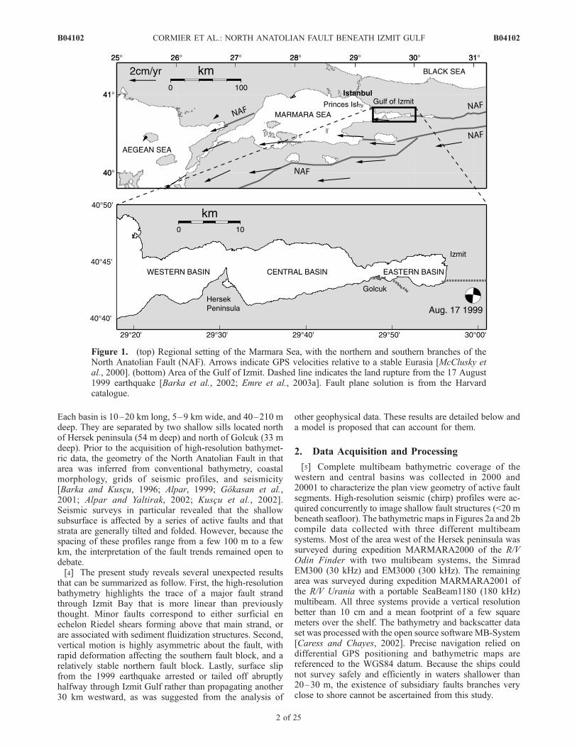
Each basin is 10–20 km long, 5–9 km wide, and 40–210 mdeep. They are separated by two shallow sills located northof Hersek peninsula (54 m deep) and north of Golcuk (33 mdeep). Prior to the acquisition of high-resolution bathymet-ric data, the geometry of the North Anatolian Fault in thatarea was inferred from conventional bathymetry, coastalmorphology, grids of seismic profiles, and seismicity[Barka and Kuscu, 1996; Alpar, 1999; Gokasan et al.,2001; Alpar and Yaltirak, 2002; Kuscu et al., 2002].Seismic surveys in particular revealed that the shallowsubsurface is affected by a series of active faults and thatstrata are generally tilted and folded. However, because thespacing of these profiles range from a few 100 m to a fewkm, the interpretation of the fault trends remained open todebate.[4] The present study reveals several unexpected results
that can be summarized as follow. First, the high-resolutionbathymetry highlights the trace of a major fault strandthrough Izmit Bay that is more linear than previouslythought. Minor faults correspond to either surficial enechelon Riedel shears forming above that main strand, orare associated with sediment fluidization structures. Second,vertical motion is highly asymmetric about the fault, withrapid deformation affecting the southern fault block, and arelatively stable northern fault block. Lastly, surface slipfrom the 1999 earthquake arrested or tailed off abruptlyhalfway through Izmit Gulf rather than propagating another30 km westward, as was suggested from the analysis of
other geophysical data. These results are detailed below anda model is proposed that can account for them.
2. Data Acquisition and Processing
[5] Complete multibeam bathymetric coverage of thewestern and central basins was collected in 2000 and20001 to characterize the plan view geometry of active faultsegments. High-resolution seismic (chirp) profiles were ac-quired concurrently to image shallow fault structures (<20 mbeneath seafloor). The bathymetric maps in Figures 2a and 2bcompile data collected with three different multibeamsystems. Most of the area west of the Hersek peninsula wassurveyed during expedition MARMARA2000 of the R/VOdin Finder with two multibeam systems, the SimradEM300 (30 kHz) and EM3000 (300 kHz). The remainingarea was surveyed during expedition MARMARA2001 ofthe R/V Urania with a portable SeaBeam1180 (180 kHz)multibeam. All three systems provide a vertical resolutionbetter than 10 cm and a mean footprint of a few squaremeters over the shelf. The bathymetry and backscatter dataset was processed with the open source software MB-System[Caress and Chayes, 2002]. Precise navigation relied ondifferential GPS positioning and bathymetric maps arereferenced to the WGS84 datum. Because the ships couldnot survey safely and efficiently in waters shallower than20–30 m, the existence of subsidiary faults branches veryclose to shore cannot be ascertained from this study.
Figure 1. (top) Regional setting of the Marmara Sea, with the northern and southern branches of theNorth Anatolian Fault (NAF). Arrows indicate GPS velocities relative to a stable Eurasia [McClusky etal., 2000]. (bottom) Area of the Gulf of Izmit. Dashed line indicates the land rupture from the 17 August1999 earthquake [Barka et al., 2002; Emre et al., 2003a]. Fault plane solution is from the Harvardcatalogue.
B04102 CORMIER ET AL.: NORTH ANATOLIAN FAULT BENEATH IZMIT GULF
2 of 25
B04102

Figure 2. Multibeam bathymetry of Izmit Gulf: (a) western basin, (b) central basin, and (c) easternbasin. Artificial sun illumination is from the northeast. Arrows point to segments of the North AnatolianFault. Figures 2a and 2b combine data from expeditions MARMARA2000 and MARMARA2001, andFigure 2c displays data provided by SHOD (see section 2).
B04102 CORMIER ET AL.: NORTH ANATOLIAN FAULT BENEATH IZMIT GULF
3 of 25
B04102

[6] The shallow water depths prevailing in Izmit Bayrequired that survey lines be spaced 50–250 m apart toensure continuous bathymetry coverage. The chirp subbot-tom profiles acquired along the same survey tracks thusprovide tight control on the shallow subsurface structures.Most chirp profiles across the shelves reveal an acousticallytransparent layer draping over a reflective acoustic base-ment. Where chirp profiles penetrate beneath the acousticbasement, they indicate a discordant, erosional contact withthe overlying transparent layer. Gravity cores collected inIzmit Gulf during the two surveys document that thistransparent layer corresponds to a Holocene mud drape,and the underlying strong reflector acoustic basement to thesubaerial erosion surface that formed during the last sealevel lowstand [Cagatay et al., 2003; Polonia et al., 2004],a result consistent with other studies [Aksu et al., 1999;Kuscu et al., 2002]. The thickness of the Holocene drapevaries from less than 1 m to more than 20 m, with verticalseparations across fault strands systematically larger at thebase of the Holocene than at the seafloor [Kuscu et al.,2002; Polonia et al., 2002]. Syntectonic sedimentation isnot the only factor that controls thickness variations. Strongbottom currents in the Gulf of Izmit [Algan et al., 1999]most likely redistribute Holocene sediments and contributeto subdue the tectonic fabric. Shallow sediments are alsocommonly gas charged, which can make it difficult toprecisely map the base of the Holocene drape.[7] Only sparse bathymetric coverage was produced dur-
ing both expeditions east of 29�440E, where the seafloor islargely shallower than 50 m. The multibeam bathymetry datadisplayed in Figure 2c were acquired in fall 1999 by theTurkish Department of Navigation, Hydrography and Ocean-ography (SHOD) and kindly made available for this study.
3. Physiography of Izmit Gulfand Surficial Fault Geometry
[8] The trace of an active fault that follows the approxi-mate axis of the Western and Central basins is clearly visiblein the multibeam bathymetry data (Figures 2, 3, and 4).Overall, the fault is continuous through these two basins,describing three small bends. The orientations of the faultsegments defined by these bends are all compatible with thatof the present N094�E ± 10� relative motion vector derivedfrom GPS measurements across Izmit Gulf [McClusky et al.,2000]. At a very local scale, the fault displays en echelongeometries typical of right-lateral transform faults, withindividual steps just a few hundred meters across. Henceplate motion in western and central basins seems to be takenup on a single throughgoing fault. In particular, there is noevidence for major fault step overs and associated normalfaults that could account for these basins. In contrast, easternbasin appears to be a small pull-apart basin accommodating a1 km right step of the fault. A detailed description of the faultgeometry through each of the three basins follows, withspecial emphasis on those features that permit to quantifyfault-related deformation.
3.1. Western Basin
3.1.1. Fault Geometry[9] The western (Darica) basin connects westward with
the 1200-m-deep Cinarcik basin in the Marmara Sea via a
narrow EW canyon (Figures 2a and 3a). The trace of theNorth Anatolian Fault follows the south wall of the canyonand offsets it right laterally by about 100m at 29�23.50E,where the canyon bends to the south [Polonia et al., 2004].The fault strikes N094�E overall, but near 29�24.50E, asplay deviates at N120�E toward the southeast and Hersekpeninsula. Transform motion is divided between the twosplays, as documented from a paleochannel detected beneaththe thin Holocene cover that is offset right laterally acrosseach splay [Polonia et al., 2004]. Most of the right-lateral slip(�90%) is accommodated on the main northern branch. Eastof the splay, the northern branch broadens into a series of enechelon left stepping segments. This geometry is compatiblewith that of Reidel shear fractures expected to develop alongright-lateral transform faults [Tchalenko, 1970; Sylvester,1988]. Each segment is 1–2 km long, strikes �N104�E(10� clockwise from the main fault orientation), and displaysa small vertical separation (down to the south). The SEstriking splay shares the same left stepping en echelongeometry. East of 29�270E, that splay bends into a more EWdirection. Themain branch and the fault splaymaymeet againonto Hersek peninsula, or possibly a short distance east of thepeninsula. Together, they define a lens 8–12 km long andabout 1 km wide.3.1.2. Variable Holocene Drape[10] The smooth, low relief of the basin probably reflects
the combined effect of bottom currents and high sedimen-tation rates. An isopach map of Holocene sediments derivedfrom the chirp profiles indicates highly variable thicknessesacross the basin (Figure 5). The relief of the erosionalsurface that underlies the Holocene mud is more pro-nounced than the bathymetry, with fault segments display-ing higher vertical offset across steeper, south facingescarpments [Kuscu et al., 2002; Polonia et al., 2002].The corrugated texture of the seafloor along the northernshore (Figure 2a) reflects the outcropping of stratigraphiclayers. Hard substrate in that area is also suggested by theacoustically reflective bottom (Figure 4). Prevailing bottomcurrents are directed westward along the northern shore[Algan et al., 1999] and may account for the low sedimentdeposition. In contrast, the thickness of the Holocene coverexceeds 20 m beneath the shallow depression south of themain fault and its splay (Figure 5).3.1.3. Submerged Shoreline[11] A striking feature of the basin is a west facing
escarpment that extends north of the main fault at�29�24.50E (Figures 2a and 6). This escarpment is bareof Holocene cover, as reflected by its acoustically reflectivecharacter (Figure 4), the rough seafloor texture near it,and the chirp records (Figure 5a). Nondeposition acrossthe 3-km-long, 5–10-m-high feature may reflect thetendency for bottom currents to winnow sediments acrosstopographic relief. The base of the escarpment is 90–95 mdeep, roughly 5 m deeper than another contour parallel,sparsely sedimented incline mapped southwest of Istanbulduring the same expedition (Figure 7). On the basis of theirmorphologies and nearly constant depths, we interpret bothfeatures as marking an ancient shoreline that formed aroundthe perimeter of the Marmara Sea during the Last GlacialMaximum (LGM). Indeed, the Dardanelles Strait was the sillfor a ‘‘Marmara Lake’’ that topped off at 85–95 mbsl duringthe last sea level lowstand [Smith et al., 1995; Ryan et al.,
B04102 CORMIER ET AL.: NORTH ANATOLIAN FAULT BENEATH IZMIT GULF
4 of 25
B04102

1997; Aksu et al., 1999; Cagatay et al., 2000]. The base ofthese two inclines thus marks the boundary between wave cutplatform and relict sea cliff, amorphological feature known as‘‘shoreline angle’’ [Lajoie, 1986]. The recoverywith a gravitycore (located in Figure 6) of an assemblage of pebbles near thecrest of that incline in Izmit Gulf does supports the
interpretation of an ancient shoreline [Polonia et al.,2002; Cagatay et al., 2003]. The shoreline angle SW ofIstanbul is located 4–5 km away from the main branch ofthe North Anatolian Fault [e.g., Le Pichon et al., 2001]and is probably not significantly affected by fault tecton-ics (Figure 7). Its depth of 87 m thus is a reference for
Figure 3. Geologic interpretations of the bathymetric maps in Figure 2: (a) western basin, (b) centralbasin, and (c) eastern basin. Thick gray lines in Figure 3c indicate shorelines that subsided or wereaffected by lateral spreading during the 1999 earthquake [Emre et al., 2003a; Rothaus et al., 2004].
B04102 CORMIER ET AL.: NORTH ANATOLIAN FAULT BENEATH IZMIT GULF
5 of 25
B04102

the level of the Marmara paleolake during the LGM. Theslightly greater depth of the paleoshoreline identified inwestern Izmit Gulf (Figure 6) indicates that since theLGM, the northern fault block subsided a small amount:6–8 m subsidence within 1 km from the fault trace, and�2–4 m subsidence a few kilometers away from thefault. Material collected just above the brackish/marine tran-sition in three cores (including a core sited on the paleoshore-line itself) during expedition MARMARA20001 indicatetightly grouped C-14 ages of 10,100 to 10,850 ± 55 years(uncorrected). A corrected age of 11,500–12,000 years BPfor the transgression of the Marmara paleoshoreline byMediterranean waters is compatible with independent agedeterminations reported in Cagatay et al. [2000] and implies asubsidence rate of the northern fault block that is slowerthan 1 mm/yr. The presence of gas-charged sedimentssouth of the fault makes it difficult to detect the sameshoreline from the chirp records beneath the thick Holo-cene cover. Nonetheless, where gas is absent, chirpprofiles indicate that the base of the Holocene drape near29�240E is as much as 30–40 m deeper than north of thefault (Figure 5). A very tight grid of Chirp profilescollected during expedition MARMARA2001 precisely
outlines beneath the Holocene drape a paleoriver thatcarved its channel across the erosional surface [Polonia etal., 2004]. This ancient river meandered immediately eastof the paleoshoreline, and is presently offset right laterallyacross the main fault branch and its southern splay by 80 mand 10 m, respectively [Polonia et al., 2004]. However,except for these two discrete offsets, its course does notappear to have been affected by the fault geometry, suggestingthat the erosional surface was roughly planar across the faultzone during the LGM. The preservation of that channel onboth sides of the fault also implies that the paleoshorelinesouth of the fault lies west of it. Assuming that the marinetransgression of the LGM surface occurred around 11.5–12 kyr, the difference in elevation of 30–40m across the faulttrace implies that the southern fault block subsides at anaverage rate of 2.5–3.5 mm/yr near the paleoshoreline. Incontrast, the base of the Holocene is not significantly offsetacross the fault near 29�270E, 3 km further east.3.1.4. Mud Volcanism[12] Closer to Hersek peninsula, three large mounds
straddle the fault segments and protrude from the smoothsedimented surface (Figures 8 and 9). These three moundsdisplay high acoustic reflectivity, an indicator of rough
Figure 4. (a) Seafloor slopes in the western and central basins. Light shading indicates subhorizontalbottom, and darker shading indicates steeper slopes. Escarpments are highlighted as dark lineaments.(b) Acoustic backscatter for the same area. Darker shading indicates acoustically nondiffractive areas; theseare typically associated with soft and/or smooth seafloor. Lighter shading indicates acoustically diffractiveseafloor; this is typically associated with hard and/or rough seafloor, such as may be associated with groundruptures. Isolated highly reflective swaths are artifacts. Evidence for disruption of the surface sedimentsalong the main fault trace is lacking, except for the eastern end of the central basin.
B04102 CORMIER ET AL.: NORTH ANATOLIAN FAULT BENEATH IZMIT GULF
6 of 25
B04102

Figure 5. (a) Thickness of the Holocene drape in the western basin derived from the grid of chirpprofiles collected during expedition MARMARA2000 (mean track spacing 150 m). Arrows point to themain branch of the North Anatolian Fault and a splay. Contour interval is 2 m. Gray patches correspondto areas where bottom penetration is obscured by the high gas content of the sediments. Sound velocitythrough the Holocene drape is assumed to be the same as water (1500 km/s); errors introduced with thisassumption are less than 5%. Note the asymmetry in the thickness of the drape across the fault.(b) Topography at the base of the Holocene drape, obtained by subtracting the grid in Figure 5a from thebathymetric grid. Contour interval is 5 m. Vertical deformation across the main branch increaseswestward.
B04102 CORMIER ET AL.: NORTH ANATOLIAN FAULT BENEATH IZMIT GULF
7 of 25
B04102

seafloor and/or coarse surficial material. The northernmound is composed of several cones across an area 0.5 kmwide (Figure 9a). It is less than 5 m high and issurrounded by a shallow, 1-m-deep moat. A grab sampletaken from the top of the largest of the cones duringexpedition MARMARA2000 recovered oyster shells, var-ious benthic fauna, and unconsolidated mud. The mor-phology of that mound is typical of mud volcanoes. Thesouthern mound is the largest and is elongated in a NE-SW direction (Figure 9c). It is 1.2 km long, 0.3 km wide,and 40 m high. Inspection with a towed camera across its
24-m-deep summit revealed scattered oyster shells stick-ing out of the mud cover. Only the western edge of thethird mound could be mapped, as it is located only 1 kmfrom shore (Figure 9b). Nonetheless, on the basis of theextent of the mapped area, we infer that it may havesimilar dimensions to the southern mound. It is locatedon the main fault branch and rises a minimum of 10–15 mabove the surrounding seafloor.[13] Mud volcanoes are constructs produced by the ascent
of gas-rich and/or fluid-rich overpressured fine-grainedsediments, and occur in association with faults, folds, or
Figure 6. Paleoshoreline mapped in the western basin. (top left) Seafloor gradient, with darker shadingindicating steeper slope. The escarpment striking NNW corresponds to the same paleoshoreline as inFigure 7. Lines indicate the location of the bathymetric profiles displayed at right. Dots indicate picks forthe shoreline angle, and arrows point to the North Anatolian Fault (NAF). The short, arcuate depressioneast of the shoreline is a river channel that has been truncated by the lake shore; the star locates gravitycore IZ19 that sampled a pebble assemblage characteristic of a shoreline [Polonia et al., 2004]. (top right)Bathymetric profiles taken perpendicular to the submerged shoreline (located at left). Dots indicate theshoreline angle picks. Vertical exaggeration is 15. (bottom left) Depth of shoreline angle versus distanceto the North Anatolian Fault. (bottom right) Index map; arrow points to the area displayed above.
B04102 CORMIER ET AL.: NORTH ANATOLIAN FAULT BENEATH IZMIT GULF
8 of 25
B04102

subsurface mud diapirs [Dimitrov, 2002; Kopf, 2003;Somoza et al., 2003; Hughen et al., 2004]. In itself, themorphology of the southern and eastern mounds is notdiagnostic of mud volcanoes and could simply indicatefolding of the surface strata along the right-lateral NorthAnatolian Fault, as proposed in [Polonia et al., 2004].However, a combination of factors suggests that these aremud volcanoes. First, their heights (20–40 m), lengths(�1 km), steep flanks (>15�), and high-amplitude acous-tic backscatter are common features of mud volcanoes[e.g., Dimitrov, 2002; Somoza et al., 2003]. Second, chirpprofiles do not show evidence for folded strata beneaththem, although the surrounding layers are upturned intheir vicinity (Figure 10). Instead, internal reflectors arelacking or chaotic, as is typical of mud volcanoes. Theabsence of a Holocene drape across the mounds (Figures 5aand 10) is also compatible with recurring expulsion of
subsurface sediments. The presence of overpressured sedi-ments in this area is suggested from the widespread liquefac-tion across Hersek peninsula reported during the 10 July 1894earthquake [Ambraseys, 2001]. Finally, the three mounds areelongated to the NE, parallel to the least compressive stressfor this section of the right-lateral North Anatolian Fault.Diapiric ridges and mud volcano fields are common onaccretionary prisms and broad shear zones and are similarlyelongated parallel to the least compressive stress [Griboulardet al., 1991; Somoza et al., 2003; Hughen et al., 2004].[14] Careful sediment sampling and geochemical analysis
should confirm whether these features are mud volcanoes. Ifindeed they are, they should be associated with folded and/or diapiric structures in the deeper subsurface, in agreementwith the slightly compressional regime we infer near this 7�bend of the North Anatolian Fault (see section 6). Possibly,these mud volcanoes become activated when large earth-
Figure 7. Paleoshorelines mapped southwest of Istanbul. (top) Seafloor gradient, with darker shadingindicating steeper slope. Area is located in inset at bottom right (arrow). NS lines locate the bathymetricprofiles displayed below. Dots indicate the shoreline angles picked from these profiles. These picksdelimit a smooth seafloor to the south from rough seafloor to the north. Rougher texture is interpreted asoutcropping bedrocks that may have been attacked by wave action along the shore of Marmara Lakeduring the Last Glacial Maximum. (middle) Series of NS depth profiles extracted from the bathymetry.Each profile is located directly beneath its corresponding map view location from the top map, with ‘‘up’’to the left. Vertical exaggeration is 12. Ticks indicate picks for the shoreline angle. (bottom) Depth ofshoreline angle versus longitude.
B04102 CORMIER ET AL.: NORTH ANATOLIAN FAULT BENEATH IZMIT GULF
9 of 25
B04102

quakes rupture the North Anatolian Fault. Accordingly, gasrelease has been documented in association with seismicevents for various offshore locations around the world[Clifton et al., 1971; Field and Jennings, 1987; Hasiotis etal., 1996; Kopf, 2002; Chapron et al., 2004; Hieke, 2004].
3.2. Central Basin
3.2.1. Fault Geometry[15] An escarpment up to 90 m high bounds the northern
side of the 210-m-deep central (Karamursel) basin
(Figures 2b and 11). It is aligned with the main fault tracein western basin and most likely corresponds to the samebranch. It strikes N086�E in the western half of the basin andbends to a N097�E orientation in the eastern half (Figure 3b).At the east andwest ends of the basin, the fault trace is sharplydefined by a south facing scarp, and locally, by a narrowgroove in that scarp. In the central portion of the basin, theescarpment is overprinted by three �500-m-wide and�10-m-high gentle ridges (Figure 11). These right step-ping ridges are oriented 10�–15� clockwise to the main
Figure 8. Detailed multibeam data for the area west of Hersek peninsula. Arrows point to en echelonsegments of the North Anatolian Fault. Tracks from a camera tow are indicated with the black-on-whitelines. Chirp line MARM078 is displayed in Figure 10. (bottom) Seafloor gradient overlaid with 2 mcontour intervals. Lineaments with steeper slopes (darker shades) outline the various fault segments. (top)Corresponding acoustic backscatter data. Lighter shading indicates high acoustic backscatter. The data donot outline any of the fault segments, as would have been expected if they ruptured recently. High-backscatter values, on the other hand, are associated with three mounds that straddle the fault segments.
B04102 CORMIER ET AL.: NORTH ANATOLIAN FAULT BENEATH IZMIT GULF
10 of 25
B04102

fault trend, compatible with the orientation of folds expectedto develop across right-lateral transform faults [Sylvester,1988; Tchalenko, 1970]. The largest fold forms a restrictingsill between the west and east halves of the basin.[16] The south facing escarpment progressively decreases
in height toward the coastlines of Hersek peninsula to thewest, and Golcuk to the east. It meets the Golcuk shorelinewhere the 17 August 1999 earthquake land rupture reached4.5–5 m of right-lateral slip, some of the largest recordedalong the emerged portion of the fault (Figure 2c). A series ofNS transects across central basin shows that maximumdepths occur systematically at the base of the fault scarp(Figure 11). Available seismic profiles indicate a progressivetilting of the basin infill toward that fault scarp (Figure 12,line I-44). Both observations suggest that the North Anato-lian Fault accommodates significant amount of dip slip(down to the south) through central basin.3.2.2. Marginal Mass Wasting[17] The periphery of the basin displays a lumpy, scalloped
bathymetry (Figures 2b, 4, and 11). The corresponding
subsurface structures consist of strata that are deformed intoa series of convex upward hummocks and intervening steep-sided depressions, draped by Holocene deposits (Figure 12,line I-33). This may be indicative of subsurface faulting, inagreement with models invoking numerous closely spacedfaults on the basis of high-resolution seismic surveys[Gokasan et al., 2001; Alpar and Yaltirak, 2002; Kuscu etal., 2002]. However, the multibeam bathymetry indicates thatmost hummocks extend laterally less than 1–2 km, suggest-ing that they are surficial features. Similar hummocky fea-tures imaged in high-resolution seismic records in varioustectonically quiet areas around the world have been inter-preted as seabed pockmarks formed by gas escaping from thesediments [Kelley et al., 1994; Cifci et al., 2003], or asfluidization pipes cutting through rapidly deposited sedi-ments [Davies, 2003]. Gas-charged sediments in Izmit Gulfare evident in the chirp records (Figure 12) [Kuscu et al.,2002], and must favor widespread fluidization and/or gasrelease during large earthquakes of theNorth Anatolian Fault.Accordingly, Ambraseys [2001, p. 119] reports that during
Figure 9. Detailed bathymetry of three mounds west of Hersek peninsula: (a) northern mound,(b) eastern mound (only its steep edge could be mapped), and (c) southern mound. Contour interval is 1 m.Arrows point to short en echelon segments of the North Anatolian Fault. Mounds are elongated to the NE, inthe direction of the least compressive stress for a right-lateral transform.
B04102 CORMIER ET AL.: NORTH ANATOLIAN FAULT BENEATH IZMIT GULF
11 of 25
B04102

the large 10 July 1894 earthquake, ‘‘at Hersek, mostfarmhouses were destroyed and the ground liquefied.’’The 17 August 1999 Izmit earthquake also inducedground liquefaction and lateral spreading along the south-eastern shore of central basin [Lettis et al., 2002; Emre etal., 2003a; Rothaus et al., 2004] and several gas plumeswere detected in the water column from seismic profiling[Alpar, 1999]. Hence the lumpy texture around the basinperiphery may preferentially reflect mass wasting andfluidization of gas-charged sediments, probably inducedby earthquake events. This scenario does not precludethat some of the sedimentary structures are rooted onsubsidiary faults.3.2.3. Submerged Shoreline[18] Most of the chirp profiles across the northern shelf
indicate the presence, beneath the Holocene cover, of asediment lens a few meters thick and a few hundred meterswide (Figure 12, lines I-15 and I-33). The top of that lens issubhorizontal and its north edge maintains a constant depthof 64 m ± 2 m (Figure 13), suggesting that its depositionwas controlled by water level. This constant depth alsoimplies that the lens has not been offset or tilted since itsdeposition. This feature may represent prograding beds thatformed just below wave base when water level in centralbasin was slightly higher than 64 m [Cagatay et al., 2003].The strait north of Hersek peninsula is crossed by a channelthat describes a broad meander down into the western basin(Figures 2a and 13). Chirp profiles show that this channel iscarving the same erosional surface that underlies the sedi-ment lens (Figure 14). Channel and lens may therefore havebeen contemporaneous features. A possible scenario is thatwhen the level of the Marmara Sea was deeper than 64 m, alake occupied the central basin that drained into the westernbasin via the channel, favoring the deposition of thesediment lens beneath wave base. An alternate scenario isthat this paleoshoreline formed during a world sea levelstillstand at around 60 m, as proposed by Cagatay et al.[2003]. Regardless, both models carry identical implicationswith regards to the uplift of the Hersek peninsula. The sill
depth north of the peninsula is presently 54 m (Figure 13),10 m shallower than the upper level of the sediment lens.Thus, while the horizontality of the sediment lens east of29�330E indicates that it has not deformed since its deposi-tion, the area north of Hersek peninsula may have upliftedby up to 10 m. The world’s sea level reached �64 m ataround 10 kyr BP [Fairbanks, 1989], implying a meanuplift rate of �1 mm/yr for the sill. Alternatively, the sillmay be partially filled by a recent landslide (Figures 13 and14), in which case the uplift rate north of the fault could bemuch lower, or even null.3.2.4. Ancient Shelf Break[19] The southern side of the central basin is defined by a
continuous escarpment that roughly parallels the shore,except between 29�350–390E where mass wasting disruptsits continuity (Figures 2b and 4). To the west, the escarp-ment curves northward and terminates against the main EWfault branch. To the east, the escarpment bends sharplynorthward and also abuts the EW branch at 29�43.20E. Theescarpment is everywhere 15–90 m high and steeper than10�. Because of this steepness, shallow-penetrating chirpprofiles did not provide useful images of subsurface geolog-ical structures. The crest of the escarpment approximatelymatches the 72 m depth contour in the western section of thebasin, but its height and slope are atypical of submergedshorelines. Its sinuous plan view geometry is also difficult toreconcile with that of a fault scarp, although it may be locallyfault controlled. Instead, we interpret that escarpment asmarking a shallow shelf break that developed when thecentral basinwas occupied by a lake with awater level around64 m, as discussed above. This interpretation is partlysupported by the presence of shelf breaks with similarly sharpoutlines along narrow continental shelves [Slater et al., 2002;Gardner et al., 2003] and lakes [Gardner et al., 2000;Morganet al., 2003]. The lack of a well-defined shelf break north ofthe fault may result from its destruction by gravitationalsediment failure and sediment fluidization. Provided thispaleoshelf break was nearly horizontal at the time of itsformation, present depth variations along its length provide
Figure 10. High-resolution seismic (chirp) profile MARM078 across two large mounds west of Hersekpeninsula. Profile location is given in Figure 8. Vertical exaggeration at the seafloor is 34. Arrowsindicate crossings of en echelon segments of the North Anatolian Fault. ‘‘M’’ indicates multiples; thetowed chirp profiler recorded both sea surface and seafloor multiples. Note the lack of coherent horizonsbeneath the mounds and the lack of a Holocene drape over them.
B04102 CORMIER ET AL.: NORTH ANATOLIAN FAULT BENEATH IZMIT GULF
12 of 25
B04102

some clues with regards to vertical tectonics. Chirp profilesindicate that the Holocene cover at the shelf break is 5–10 mthick, so depth variations in excess of 10 m should implyvertical motion. From 29�400E to 29�420E, the shelf breakdeepens by about 10 m. It turns northward at 29�43.20E anddeepens steadily by 80 m toward the fault scarp (Figure 15).This 3� northward dip is consistent with other indicators(discussed above) of tectonic subsidence of the southern faultblock. Rapid flooding of the 60–65 m paleolake by marinewaters must have occurred around 10,000 years ago[Fairbanks, 1989], at which time the paleoshelf breakwould have become inactive. Therefore the 80 m deep-ening of the paleoshelf break toward the fault planeimplies a subsidence rate of �8 mm/yr. The lack of
any significant depth variation along the remaining of thepaleoshelf break suggests, however, that rapid subsidenceis localized.
3.3. Eastern Basin
[20] The eastern (Golcuk) basin is only 40m deep and 6 kmlong (Figure 2c). The surface rupture from the 17 August1999 continues beneath the basin near its southern shore witha N80�–90�E orientation and a right-lateral displacement of3.0–3.2m [Barka et al., 2002;Emre et al., 2003a] (Figures 2cand 3c). Another on-land rupture occurred 3 km west of thebasin and produced a 3.5-km-long northeast facing scarpwith normal and right-lateral displacement (1.5–2 m and0.5–1.5 m, respectively.) Coseismic NE tilting and hang-
Figure 11. Series of depth sections highlighting the fine-scale physiography of the central basin. (left)Slope gradient (darker shading indicates steeper slopes). Lines locate the bathymetric profiles displayedat right. North is to the right. (right) Depth profiles shown with a vertical exaggeration of 10 in theirapproximate geographical position. The thick line locates the master branch of the north Anatolian Fault,and the shaded areas outline three en echelon right stepping folds. The arcuate escarpment to the south(left) is interpreted as an older shelf break (section 3.2); it is disrupted by mass wasting in the middlesection.
B04102 CORMIER ET AL.: NORTH ANATOLIAN FAULT BENEATH IZMIT GULF
13 of 25
B04102

ing wall subsidence along its length resulted in thedrowning of the shoreline along the SW corner of thebasin (Figure 3c) [Barka et al., 2002]. Multibeam bathymetryreveals the presence midway between these land ruptures oftwo 2–5 m high, south facing escarpments striking NW-SE(Figure 2c).
[21] A single transect with a towed camera across thelargest scarp did not detect any fresh rupture and revealedinstead a gently sloping seafloor draped with mud [Poloniaet al., 2002]. A lack of earthquake rupture along thatescarpment would be surprising considering that prominentruptures occurred on either side of the basin. Possibly, the
Figure 12. Sample chirp profiles across the central basin, located in Figure 13. The sediment lensbeneath the Holocene drape at 85 ms (64 m) on lines I-15 and I-33 is present on most profiles. Whitecircles mark the northern edge of that lens (also located in Figure 13). The strong seismic reflectorobscuring deeper returns in the southern half of line I-33 is interpreted as marking the top of gas-chargedsediments; the convex upward hummocks in the strata above the gas-charged interval are interpreted asresulting from sediment fluidization. Line I-44 images the flat bottom of the central basin; note how bedsbecome progressively tilted toward the North Anatolian Fault.
B04102 CORMIER ET AL.: NORTH ANATOLIAN FAULT BENEATH IZMIT GULF
14 of 25
B04102

1999 rupture is discontinuous and was missed by thetransect. Indeed, the towed camera imaged fresh-lookingpolygonal cracks on the flat basin floor at the base of thescarp that may be diagnostic of sudden fluid or gas releaseduring the 1999 earthquake. Accordingly, sediments in thatbasin are strongly gas charged and several gas plumes weredetected in the water column from high-resolution seismicprofiles acquired in March 2000 [Kuscu et al., 2002].[22] The patterns described by the land ruptures and the
submarine scarps are that of a pull-apart system, with dip-slip motion partitioned between two antithetic, NW strikingfaults (Figure 3c). This pull-apart geometry corresponds to a1.2 km releasing right step over of the North AnatolianFault. It contrasts with the fault geometry in Central andWestern basins, where dip slip is accommodated in theplane of the transform fault.
4. Fault Trace Across Hersek Peninsula
[23] The 17 August 1999 earthquake produced minoroffsets and cracking (<5 cm) across Hersek peninsula thathave been interpreted as sympathetic slip rather than surface
rupture [Witter et al., 2000; Lettis et al., 2002]. Paleoseismictrenches excavated on the peninsula near latitude 40�43.30Ndid not provide conclusive evidence for Holocene faults,and the precise location of the northern branch of the NorthAnatolian Fault across Hersek remained somewhat contro-versial. Simple extrapolations of the submarine branchesimply, however, that the main fault describes a �7� bendacross Hersek peninsula around latitude 40�43.50N, near thenorthern limit of the Hersek lagoon (Figures 2a and 3a). Nosignificant step over is required to match these eastern andwestern submarine fault traces. The southern fault splaymapped west of the peninsula intersects the shoreline nearlatitude 40�430N and may merge with the main branchsomewhere on the peninsula; possibly, it corresponds tothe WNW ‘‘Yalova fault segment’’ proposed on the basis ofgeomorphic lineaments [Witter et al., 2000; Lettis et al.,2002]. The existence of multiple splays could explain thedifficulties encountered in locating significant fault brancheswith paleoseismic trenching. Evidence of earlier fault rupturemay also be obscured by soil liquefaction, such as thatproduced across Hersek peninsula in the 10 July 1894earthquake [Ambraseys, 2001].
Figure 13. Some markers of vertical deformation in the central basin. (top) Depth of the northern edgeof the sediment lens versus longitude (dots). The solid line indicates the depth of the channel axis.Vertical exaggeration is 250. The deposition of the horizontal sediment lens was probably controlled by awater level in the central basin that was just slightly shallower than �64 m depth (see text). The sill northof Hersek peninsula is �10 m shallower than the lens; it may have uplifted by that much since it wascarved down; alternatively, it may be partially filled in by a landslide (see Figure 14). (bottom) Seafloorgradient in the central basin (darker shading indicates steeper slopes). The three chirp profiles displayedin Figure 12 are labeled. Dots indicate the northern extent of the shallow sediment lens picked from thechirp profiles. The arcuate escarpment delimiting the basin to the south approximately matches the 72 mdepth contour in the western half of the basin and progressively deepens eastward. North of the fault, the72 m contour traverses the zone of hummocky seafloor. Dotted line indicates the axis of a channel thatconnects the eastern and western basins.
B04102 CORMIER ET AL.: NORTH ANATOLIAN FAULT BENEATH IZMIT GULF
15 of 25
B04102

[24] Several lines of evidence suggest Hersek peninsula isuplifting, possibly as a consequence of the 7� bend. ThreeQuaternary marine terraces 6–8 m above sea level havebeen mapped across the fault zone at the northern tip of thepeninsula [Alpar and Guneysu, 1999; Lettis et al., 2002].Although their elevations may be compatible with that of asea level highstand during the last interglacial [e.g., Stirlinget al., 1998] and do not necessarily imply tectonic uplift,they are also compatible with a possible 5–10 m uplift ofHersek strait during the Holocene (see previous section).The sliver of crust bounded by the main fault and thesouthern splay is predicted to be under slight transpression,also implying uplift for the area. Recent fieldwork onHersek peninsula indeed documented the presence of aseries of en echelon thrust faults, interpreted to be absorbingthat transpression [Emre et al., 2003b]. Finally, the presenceof mud volcanoes west of Hersek also indicates that thewestern shore is under slight transpression.
5. Western Termination of the 17 August 1999Seafloor Rupture
[25] Significant fault slip during an earthquake will alterthe static stress on adjacent fault segments and may bring
them closer to rupture [Stein et al., 1994]. Hence a preciseknowledge of the length of fault that ruptured in a largeearthquake is critical for making a reliable assessment of theseismic hazards associated with the entire fault system.Maps of active faults and records of large earthquakes arecommonly used to model static stress loading across seis-mically sensitive areas and evaluate which fault segmentsmay be critically stressed. Several models have been pro-duced for the North Anatolian Fault that take into accounthistorical and recent earthquakes [Stein et al., 1996, 1997;Nalbant et al., 1998; Hubert-Ferrari et al., 2000; Parsons etal., 2000; Papadimitriou et al., 2001; Pinar et al., 2001;Parsons, 2004]. While recent models acknowledge that the17 August 1999 earthquake critically stressed the NorthAnatolian Fault beneath the Marmara Sea, the extent of therupture beneath Izmit Gulf remains a matter of debate. Thewesternmost surface displacement documented on landoccurs at Golcuk, at the eastern side of Central basin, whereright-lateral slip reached 4.5–5.0 m [Barka et al., 2002;Lettis et al., 2002; Emre et al., 2003a]. Despite the lack ofsurface rupture on Hersek peninsula, many consider that thepeninsula represents a short gap and that the fault rupturedas far west as Cinarcik basin. The fact that aftershocksextended 35 km west of Hersek peninsula along a narrowly
Figure 14. Details of the sill connecting the western and central basins. (top) Shaded bathymetryoverlaid with 5 m contours. The dotted line indicates the axis of a paleochannel. The solid line locates thechirp profile displayed at bottom. The thick contour approximately outlines a possible landslide, asinferred from the hummocky seafloor texture visible in both the chirp and bathymetric data. NS or EWfeatures are mostly ship track artifacts. (bottom) Chirp profile IZB12M intersecting the sediment lens inits long-axis direction (see Figures 12 and 13). The lens lies entirely beneath the Holocene drape andpinches on the channel connecting the western and central basins.
B04102 CORMIER ET AL.: NORTH ANATOLIAN FAULT BENEATH IZMIT GULF
16 of 25
B04102

defined zone [Ito et al., 2002; Karabulut et al., 2002;Ozalaybey et al., 2002] is presented as supporting evidence.Inversions of the InSAR, GPS, and teleseismic data alsosuggest that the North Anatolian Fault ruptured along the
entire length of Izmit Gulf, with slip averaging 1–1.5 m inthe western basin [Delouis et al., 2000; Reilinger et al.,2000a; Wright et al., 2001; Bouchon et al., 2002; Feigl etal., 2002; Cakir et al., 2003]. The lack of a clear surface
Figure 15. Detailed seafloor morphology at the eastern end of the central basin. Arrows at left point tothe North Anatolian Fault (NAF). (top) Acoustic backscatter imagery; lighter shades indicate higherbackscatter amplitude. The series of EW lineaments are not associated with any detectable relief and mayindicate open fractures and/or mole tracks resulting from the 1999 earthquake. The patch of reflectiveseafloor in the SW corner of the map likely indicates a landslide. The lack of reflectivity from the basinfloor may be typical of anoxic sediments. (bottom left) Seafloor gradient with 10 m depth contoursoverlaid; darker shading indicates steeper slopes. Dots mark the top of the paleoshelf break where it veersnorthward into the fault zone (see text). Solid line locates the bathymetric profiles shown at right. (bottomright) Depth of the NS striking paleoshelf break versus distance to fault (dots). Plot is extended north ofthe fault with bathymetric profile (solid line). Vertical exaggeration is 20. The paleoshelf break dips 3�northward into the fault plane.
B04102 CORMIER ET AL.: NORTH ANATOLIAN FAULT BENEATH IZMIT GULF
17 of 25
B04102

rupture in 1999 across Hersek peninsula may then be aconsequence of the 7� restraining bend at that location[Emre et al., 2003a].[26] Alternative interpretations are possible. Rather than
representing aftershocks that delineate the ruptured zone,seismic activity west of Hersek may indicate earthquakestriggered on the nearby fault segments by the increase instatic stress [Pinar et al., 2001]. For example, the densecluster of aftershocks west of Izmit Gulf near Yalova wasdominated by normal faulting [Ozalaybey et al., 2002; Aktaret al., 2004]. The spatial resolution of the various solutionsfor the 1999 surface rupture derived by inversion ofgeophysical observables is relatively low [Bos and Spakman,2003], and inversions may be equally compatible with atermination of the 1999 rupture around Hersek peninsula[Reilinger et al., 2000a, 2000b]. Spatial uncertainties may beas large as 10–20 km, as indicated by the variability of thepublished solutions [e.g.,Bouchon et al., 2002;Delouis et al.,2000; Feigl et al., 2002; Sekiguchi and Iwata, 2002], and thewestern extent of the rupture cannot be determined fromgeophysical inversion alone. An alternate interpretation, inwhich surface slip stopped or dropped significantly east ofHersek peninsula, would account very simply for the gap inseismicity observed around 29�350E and for the lack ofsurface rupture on the peninsula itself.[27] Modern sonar systems can detect minute variations
in seafloor relief and texture and a careful analysis of thedata presented in this paper can bring additional constraintson the extent of the 1999 surface rupture. The multibeamand side scan sonar systems used during expeditions MAR-MARA2000 and MARMARA2001 routinely mappedcables, pipelines, and drag marks from ship anchors, andimaged subtle fault scarps, fractures, and mounds. Swathdata for Western and Central basins reveal a seafloor that isundisturbed along the fault zone, in sharp contrast with thearea within 8 km from the Golcuk land rupture.[28] A lack of seafloor roughness along the fault zone
west of Hersek peninsula is documented from severalsources. Towed side-scan sonar data acquired during expe-dition MARMARA2000 indicate a uniformly low reflectiv-ity across the fault trace except for some occasional anchordrag marks. Acoustic backscatter data produced from allthree multibeam bathymetry systems also indicate a smoothseafloor (Figure 8). Although shaded relief renditions of thebathymetry clearly delineate the fault strands (Figure 2a),seafloor slopes measured in a direction transverse to thefault from raw multibeam echo sounder pings do not exceed6� (Figure 16). Direct observations made across severalfault strands during expedition MARMARA2001 with atowed camera (tracks located in Figure 8) indicate anundisturbed muddy substrate draping a gently slopingseafloor. Acoustic backscatter in central basin is also fea-tureless except in three areas. Most strikingly, highlyreflective seafloor occurs in the eastern part of the basin(Figure 15). A series of reflective lineaments strike subpar-allel to the main fault branch and cut across the depthcontours. These lineaments have no detectable relief in thebathymetry and must therefore have less than 50 cm ofrelief. Their pattern is akin to the EW open fracturesassociated with lateral spreading along the southern shoreof central basin after the 1999 earthquake [Lettis et al.,2002; Emre et al., 2003a], and our preferred interpretation is
that they represent a network of open cracks or mole tracksthat formed during the 1999 earthquake. High backscattervalues also outline a mass wasting deposit about 1 kmacross, just below the southern shelf break near 29�410E.That small slump may also have occurred during the 1999earthquake. The third area of reflective seafloor occurs northof Hersek peninsula, where bottom currents probably keepthe basement free of Holocene sediments (Figure 4). Incontrast, the very low reflectivity of the basin floor (>205 mdeep) indicates extreme attenuation of acoustic energy(Figure 15); similarly weak backscatter has been reportedfor the deep Santa Barbara basin offshore California[Eichhubl et al., 2002] and may be a characteristic ofanoxic mud with high gas content.[29] Features associated with ground rupture might in-
clude open fractures, small slumps, mole tracks, and lateralspreading, all of which would roughen the seafloor andproduce high acoustic backscatter. However, underwater,ground shaking may also trigger a series of events thatcontribute to masking the ground rupture. Disruption mightbe particularly prevalent for gas-charged sediments such asin the eastern and central basins, where fluidization orliquefaction would destroy rupture-related features. Duringan earthquake, strong ground shaking, seiche waves, orturbidites could also send fine sediments in suspension[Marco and Agnon, 1995; Thunell et al., 1999; Itou et al.,2000] and the slow settling of these sediments on theseafloor could mask the evidence for a ground rupture.However, we find it significant that, although finer sedi-ments occur at the eastern side of Central basin [Algan etal., 1999] near the area of maximum ground motion on17 August 1999, acoustic backscatter data clearly highlighta network of fault-parallel features. If sediments were sentin suspension by seismogenic activity in 1999, their subse-quent settling was not sufficient to mask the effects of thesurface rupture. Altogether, the sonar data suggest that on17 August 1999, surface slip stopped or decreased dramat-ically near 29�400–420E, about 14 km east of Hersekpeninsula. It does not preclude, however, that the faultmay have slipped in the lower crust by about 1 m.[30] The estimated subsidence rate of 8 mm/yr of the
southern fault block near 29�430E could be accomplishedwith discrete 1–2 m vertical displacements during majorearthquakes every few centuries, and it may have done so inthe eastern portion of Central basin during the 1999 earth-quake. Coastal subsidence, lateral spreading, and submarinelandslides occurred along the southern shore of the basinbetween 29�370–470E (Figure 3c) adjacent to the extensionalsegment of the fault, while the northern shore was littleaffected [Lettis et al., 2000; Barka et al., 2002; Emre et al.,2003a; Rothaus et al., 2004]. The EW lineaments we mappedacross a 2.5-km-wide zone centered on the fault east of29�420E suggest that lateral spreading also took place at theseafloor. The pattern of tsunami runups in the Gulf of Izmitindicates that it resulted predominantly from submarinefaulting rather than landslides, requiring that dip-slip motionoccurred in the central basin [Ozturk et al., 2000; Altinok etal., 2001; Rothaus et al., 2004]. The small landslide along thesteep southern margin of the basin near 29�410E (Figure 15)could have been triggered by coseismic tilt.[31] What may have caused the 1999 surface slip to
decrease abruptly near 29�420E remains to be determined.
B04102 CORMIER ET AL.: NORTH ANATOLIAN FAULT BENEATH IZMIT GULF
18 of 25
B04102

On the basis of preexisting conventional bathymetric data, itwas proposed that the fault described a 4–5 km releasingstep over across the central basin, and that this step overcould have arrested rupture propagation [Lettis et al., 2002].However, the fault describes instead a double bend between29�400–480E that is roughly equivalent to a 1.3 km rightstepping fault jog (Figure 3). Similar or larger fault jogs (1–4 km) did not arrest the propagation of the surface rupture in1999 [Harris et al., 2002; Lettis et al., 2002], and anadditional mechanism is therefore required. The NorthAnatolian Fault likely ruptured through Izmit Gulf duringthe 10 July 1894 earthquake, and much of the accumulatedstatic stress must have been relieved at that time. Patterns ofdamage and aftershock from that earthquake indicate amagnitude Ms = 7.3, similar to that of the 17 August1999 earthquake [Ambraseys, 2001]. However, unlike forthe 1999 event, damage in 1894 was extensive on thePrinces islands along the eastern shelf of the Marmara Sea(Figure 1) and on Hersek peninsula [Ambraseys, 2001],suggesting that the fault ruptured through the central basin
and westward. The 1999 rupture may thus have encounteredthe ‘‘stress shadow’’ from the 1894 event in the centralbasin, where the fault would not have been quite primed forrupturing [Harris et al., 2002]. If this scenario is correct,adjustments are needed to published models for static stressloading of the North Anatolian Fault beneath the MarmaraSea, and more generally, to seismic risk assessments for thatregion [Stein et al., 1997; Nalbant et al., 1998; Hubert-Ferrari et al., 2000; Parsons et al., 2000; Papadimitriou etal., 2001; Pinar et al., 2001; Parsons, 2004].
6. Vertical Deformation Affecting the SouthernFault Block and Correlating With Distance toFault Bends
[32] Results presented above document a pattern of crustaldeformation that can be summarized as follows. TheWesternand Central basins are bisected by a single, continuous right-lateral fault that strikes roughly EW. Additional transformbranches are not detected, although such branches might
Figure 16. Raw multibeam bathymetric data illustrating subtle variations in seafloor slopes. This swathwas acquired with the EM3000 system (300 kHz) parallel to the fault trace in the western basin in waterdepth of 63–73 m. North is to the left. (left) Seafloor slopes computed for the raw data. Slopes across thefault trace do not exceed 6�. (right) Unprocessed sonar pings provide a series of �NS depth profilesacross the fault zone. For clarity, only every fifth ping along track is plotted in its approximategeographical position. Vertical exaggeration is 30. For each ping, the average spatial sampling acrosstrack is �1 m. Steep scarps, as might be expected from an earthquake rupture, are not visible in the rawdata. While mole tracks would not be detected at this resolution, they would be expected to show in theassociated backscatter (Figure 8).
B04102 CORMIER ET AL.: NORTH ANATOLIAN FAULT BENEATH IZMIT GULF
19 of 25
B04102

occur nearshore just outside the survey boundaries. Dis-torted shorelines and shelf breaks dating from the LGMdocument that vertical motion varies both in intensity andin polarity over distances of a few kilometers along strike.This deformation is asymmetric about the fault: while thesouthern block subsides locally at rates of 8 mm/yr, thenorthern block subsides or uplifts at rates an order ofmagnitude slower. The deepest parts of both the Westernand Central basins occur along the North Anatolian Fault,on its southern side, and vertical deformation is thusclearly accommodated on its fault plane. In the centralbasin, this is demonstrated by the 3� tilt of the paleoshelfbreak toward the fault at 29�430E, and by the progressivetilting of the turbiditic infill toward the fault. This rapidHolocene deformation is restricted to a narrow corridor:paleoshorelines and paleoshelf breaks have remained sub-horizontal outside a �2–2.5-km-wide zone on either sideof the fault. In contrast, the surface fault geometry in theeastern basin resembles that of a small pull-apart basin: theEW striking 1999 surface rupture is right stepping 1.2 kmto the north, delimiting a depression bounded by twofacing NW striking fault segments with opposing normalthrow.[33] Along-strike variations in seafloor morphology do
correlate with minor bends in the fault trace. From east towest, the fault describes a south pointing 7� bend near29�47.50E, a north pointing 11� bend near 29�400E, andanother south pointing 7� bend across Hersek peninsula(Figures 17a and 17b). The physiography of the fault tracesuggests that the series of fault segments defined by thesebends are successively under compressional regime ordilational regime. Accordingly, the presence of extensionalRiedel shear west of Hersek may be favored by the slightlyreleasing strike of the fault relative to local plate motion;conversely, the occurrence of small folds across the faulttrace in the central basin may be favored by a slightlycompressional fault strike. The NW-SE fault splay in thewestern basin describes a releasing bend west of 29�270E,and most likely, a restraining bend east of that longitudewhere it may strike ENE across Hersek peninsula and mergewith the main branch in the central basin. The uplift historyof the peninsula [Alpar and Guneysu, 1999; Witter et al.,2000] and the presence of three mud volcanoes along itswestern shore (see section 3.1) are compatible with aslightly compressional regime associated with the southernfault splay. The 1999 surface rupture strikes �N090� whereit plunges beneath Izmit Gulf and where it resurfaces nearGolcuk; at both locations, it displays nil or insignificantthrows, compatible with pure strike-slip motion [Lettis etal., 2000; Emre et al., 2003a]. Hence the motion vectoracross the North Anatolian Fault through Izmit Gulf maystrike close to N090�E, a value intermediate between thestrikes of the compressive segment (86�) and dilationalsegments (93�–97�) (Figures 17a and 17b). This orientationis also intermediate between the orientations predicted forthe Euler poles derived from interseismic GPS measure-ments (N075�–078�E [McClusky et al., 2000]) and theNorth Anatolian Fault geometry across Marmara Sea(N097�–100�E [Le Pichon et al., 2003]). Although N090�is counterclockwise to GPS velocities measured south ofIzmit Gulf by McClusky et al. [2000] (N095� to N097;Figure 1), it fits within their 95% confidence interval.
[34] The minor bends of the fault through Izmit Gulf alsocorrelate with along-strike variations in seafloor depths(Figure 17d). Maximum or minimum depths measuredsouth of, and within 1 km from the fault trace varymonotonically from fault bend to fault bend, reaching someextremum near each bend. Depth increases westward alongthe two dilational fault segments, and the opposite trendapplies along the compressive segment (29�400E to Hersek).[35] Similarly, minor bends in the fault trace correlate
with cumulative uplift or subsidence over the past severalmillennia (Figure 17c). Indeed, relative changes in elevationacross the fault for areas that would have been maintainedflat by erosional or depositional processes during the LGMprovide a direct estimate of vertical displacement since thattime. Such areas include the shelves that developed aroundthe paleolake in the central basin and now lay deeper than�65 m (see section 3.2). Others include shallow areas thatwere subaerially exposed during the last Glacial and nowlay above 87 m west of Hersek and above 65 m east ofHersek (see sections 3.1 and 3.2). These surfaces wouldhave been rapidly submerged below wave base during thelast marine transgression between 10–14 ka [Fairbanks.,1989], and the fault escarpments cutting across them likelyrecord vertical displacements that have accumulated sincethen. East of Hersek on the paleoshelves, the thickness ofthe Holocene drape does not vary significantly across thefault trace and the vertical displacement in Figure 17c havebeen estimated directly from the bathymetry. West ofHersek, the thickness of the Holocene drape does varysignificantly across the fault (section 3.1 and Figure 5).Cumulative throws in Figure 17c are therefore estimatedfrom the map of the Holocene basement by measuring themaximum depth variations within 1 km from the fault trace.The resulting curve for cumulative throw is incompletebut the observed trends match those of the bathymetrysouth of the fault. Where measurable, variations incumulative throw over the past 10–14 kyr are roughlyhalf the bathymetric variations.[36] These simple correlations suggest that even with the
smoothing effect of mass wasting and other sedimentaryprocesses, water depth alone can be a good indicator ofrecent tectonics. The next section presents a self-consistentstructural model that accounts for these correlations and thephysiography of Izmit Gulf.
7. Model for Vertical Deformations AlongTransform Faults: Primarily Controlled byFault Dip and Fault Bends
[37] The basins that define the Marmara Sea and the Gulfof Izmit are commonly viewed as a series of negative flowerstructures [Aksu et al., 2000;Gokasan et al., 2001; Alpar andYaltirak, 2002] or as a series of pull-apart basins [Barka andKadinsky-Cade, 1988;Wong et al., 1995; Armijo et al., 2002;Lettis et al., 2002]. Models for negative flower structurespropose that at extensional jogs, the fault branches upwardinto a series of subparallel faults that accommodate bothstrike-slip and normal components [Harding, 1985]. Modelsfor pull-apart basins propose that at extensional offsets alongtransform faults, slip is distributed between two overlappingstrike-slip segments and some intervening normal faults[Rodgers, 1980; Mann et al., 1983]. A recent model advo-
B04102 CORMIER ET AL.: NORTH ANATOLIAN FAULT BENEATH IZMIT GULF
20 of 25
B04102

cates instead that theMarmara basins formed during an initialextensional phase and became mostly inactive after the NorthAnatolian Fault cleaned its course and cut across them [LePichon et al., 2001; Kuscu et al., 2002; Demirbag et al.,2003; Rangin et al., 2004].[38] Results documented in this paper challenge the
applicability of the above models to Izmit Gulf. First,multibeam bathymetric data highlight a fault that ismostly throughgoing across Izmit Gulf and, except for theeastern basin, there is no evidence for active normal faults
(Figures 2 and 3). Second, the 80 m of Holocene subsidenceof the southern fault block at the east end of the centralbasin (Figure 15) and the progressive tilting of the Holocenestrata toward the North Anatolian Fault (Figure 12, line I-44)indicate that rapid vertical motion is accommodated by dipslip on this throughgoing transform fault. We thus proposean alternate model in which asymmetric basins and ridgesdevelop where a continental transform meets two condi-tions: its fault plane is not quite vertical, and its strikedeviates locally from relative plate motion. With such fault
Figure 17. Fault strike and vertical deformation. (a) Geometry of the North Anatolian Fault across IzmitGulf. Thick lines indicate the 1999 surface rupture, and arrows point to fault bends. Thin lines indicatethe submarine trace. Dotted lines locate the two depth profiles shown in Figure 17d. (b) Mean azimuth ofthe fault segments delimited by fault bends versus longitude. A relative plate motion of 89�–91� (shadedareas) would be compatible with a morphological indicator of transpression, transtension, or pure strikeslip along each segment (see text). (c) Differential topography across the fault for the shelf areas that wereexposed during the Last Glacial Maximum (see text). Negative (positive) values indicate where thesouthern block subsided (uplifted). Measurements west of Hersek peninsula are taken from the map of thebase Holocene in Figure 5b. The Holocene drape is relatively thin over the shelves east of Hersek, andmeasurements are taken directly from the bathymetry. (d) Maximum relief within 1 km from the faulttrace versus longitude (solid line, south side; dotted line, north side). Measurements are taken frommultibeam bathymetric data (this paper) and altimetry data (NASA Shutte Radar Topography Mission).
B04102 CORMIER ET AL.: NORTH ANATOLIAN FAULT BENEATH IZMIT GULF
21 of 25
B04102

geometry, vertical motion will be accommodated by subsi-dence or uplift of the hanging wall block in the transformfault plane, rather than by slip partitioning on secondarynormal faults or reverse faults. In contrast, the footwallblock will offer a stable slip surface and be largely unaf-fected by vertical tectonics. That model also fits the patternof vertical deformation at a 17� bend of the North AnatolianFault, at the western side of the Marmara Sea: there, majorvertical deformations north of the fault are proposed toreflect a 50�–80�dip of the fault toward the north [Okay etal., 2004; Seeber et al., 2004]. In the case of a steeplydipping fault striking obliquely to relative motion, a smallamount of cumulative horizontal slip could result in largevertical motion of the hanging wall block.[39] Source parameters for the 1999 Izmit earthquake
indicate a near-vertical fault plane, and are compatible witha steep dip (>80�) to the south [Li et al., 2002]. Aftershocksepicenters through the central and western basins in Izmit
Gulf are mapping 1 to 2 km south of the surface fault trace[Ito et al., 2002; Ozalaybey et al., 2002]. This observation isalso consistent with a steeply southward dipping fault plane,although admittedly, uncertainties in the seismic structure ofthe crust could contribute to mislocating the aftershocks bya few kilometers. Assuming the North Anatolian Fault dips85�–88� southward through Izmit Gulf, minor deviations ofits azimuth from plate motion could locally produce largevertical displacement of the southern fault block. In particular,a steep dip could account for the rapid subsidence (8 mm/yr)documented in the central basin, adjacent to the 7� releasingtrend of the fault (Figure 18). Adjusting for a sedimentationrate of about 5mm/yr at the basin floor [McHugh et al., 2003],this rapid subsidence rate implies that the 140 m of verticalrelief in the central basin could have developed in as little as afew 100,000 years.[40] A youthful origin for the basins in Izmit Gulf appears
incompatible with the older age of the North Anatolian
Figure 18. Three-dimensional view of the central basin, looking toward the east. View area is 6.5 kmacross and 14 km long, and vertical exaggeration is 7. The white line marks the trace of the NorthAnatolian Fault. A subsurface fault geometry that could explain the rapid Holocene subsidence of thesouthern fault block is sketched in the foreground.
B04102 CORMIER ET AL.: NORTH ANATOLIAN FAULT BENEATH IZMIT GULF
22 of 25
B04102

Fault in the Marmara region, with estimates ranging be-tween 5 Myr and 7 Myr [Sengor, 1979; Gorur et al., 1997;Armijo et al., 1999]. Nonetheless, the present geometry ofthe North Anatolian Fault across the Marmara Sea isthought to have developed recently, with estimate rangingbetween 200,000 years [Le Pichon et al., 2003] and 1.2–2 Myr [Emre et al., 1998; Okay et al., 2004; Seeber etal., 2004]. If confirmed, the young age of the basins inIzmit Gulf could reflect the ephemeral nature of small (<4 km)step overs and fault bends, and their possible migration orspawning along the fault trace in response to inheritedstructural complexities.[41] A steep dip of the fault plane not only could account
for the asymmetry and rapidity of the vertical deformation,but also for the reversal of the deformation trend (uplift orsubsidence) at successive fault bends (Figures 17b and 17c).The vertical deformation of the southern (hanging wall)block varies monotonically with distance from each faultbend where a new deformation style initiates: in otherwords, the uplift or subsidence of the southern block isgetting more pronounced westward as the southern blockmoves away from each bend. The reason for this monotonicvariation from bend to bend is unclear, but may indicate thata deformation style does not become established instanta-neously as the plate passes around a bend. Instead, the fullimpact of the new stress regime may be realized somedistance away from a bend.[42] Whether the North Anatolian Fault dips indeed
steeply to the south through Izmit Gulf should berevealed in the next large earthquake this century. Thatfuture earthquake will also test whether slip from the1999 earthquake did drop abruptly west of Golcuk (seesection 5): if it did, the area around Hersek peninsula andthe western basin should be strongly affected by the nextearthquake. On the other hand, on the basis of thepatterns of Holocene deformation, little vertical deforma-tion should affect the shorelines of the western basin, asthey are located more than 3 km from the fault trace. Inthe area surrounding Hersek peninsula, mud volcanoesmay become activated and liquefaction and sedimentfluidization should be expected, as may have been thecase in 1894 (see section 3 and 5).
8. Conclusions
[43] 1. The North Anatolian Fault generally follows theaxis of Izmit Gulf, describing a few minor bends along itslength.[44] 2. Paleoshorelines, paleoshelf breaks, and shelf areas
that were subaerially exposed during the Last Glacial Ageprovide key markers to evaluate vertical deformation inthe Western (Darica) and Central (Karamursel) basins. Thenorthern fault block appears relatively stable, while thesouthern fault block locally subsides very rapidly, at ratesof up to 8 mm/yr.[45] 3. Holocene vertical deformation of the southern
block varies monotonically from fault bend to fault bend.This correlation can be explained if the plane of the NorthAnatolian Fault is dipping steeply to the south, accommo-dating oblique slip motion in its fault plane. Such modeldoes not require the existence of subsidiary normal orreverse faults that accommodate significant plate boundary
strain, and may imply a young age for the formation ofIzmit Gulf (a few 100,000 years).[46] 4. Backscatter imagery suggest that the surface slip
from the 17 August 1999 earthquake stopped (or decreasedsharply) 7 km west of Golcuk, in the central (Karamursel)basin. This observation is compatible with the 10 July 1894earthquake having ruptured the fault through western IzmitGulf.[47] 5. Sedimentary features such as mass wasting, fluid-
ization structures, and mud volcanoes occur along the faulttrace, suggesting that large earthquakes in the Marmara Seaare accompanied by widespread expulsion of fluid and/orgas.
[48] Acknowledgments. We thank the Turkish Council for Technicaland Scientific Research (TUBITAK) and the General Directorate of MineralResearch and Exploration (MTA) for their assistance and logistic support ofthis project, as well as the Turkish Department of Navigation, Hydrographyand Oceanography (SHOD) for providing their 1999 multibeam bathymetrydata. We are grateful to the captains and crews of the R/V Odin Finder andof the R/V Urania for their professionalism and dedication. The technicalexpertise of Emanuele Bartolini at Geological Assistance Services, S.A.,and of Alessandro Blasi at the Institute of Marine Sciences in Bolognaguaranteed the success of the two surveys. The scientific parties for the twoexpeditions also included Martina Busetti, Lucilla Capotondi, Kadir Eris,Paola Fabretti, E. J. Fielding, Caner Imren, Hulya Kurt, Marco Ligi,Alessandro Magagnoli, Gabrielle Marozzi, Nilgun Okay, Naside Ozer,Daniella Penitenti, Kerim Sarikavak, Giorgio Serpi, and Bugser Tok. EminDemirbag at Istanbul Technical University kindly provided us with avail-able digital data for the area. We thank Amotz Agnon, Christopher Sorlien,and an anonymous reviewer for their thoughtful reviews and constructivecriticisms of the manuscript. Christopher Sorlien reprocessed the chirp datadisplayed in Figures 12 and 14. Ata Suanda assisted with the interpretationof the chirp data during a summer internship at LDEO. James Dolancontributed invaluable ideas at the initial phase of this project. Figures havebeen prepared with the free software GMT [Wessel and Smith, 1998].NATO Collaborative Linkage grant 976826 provided seed funding andmade this international collaboration possible. Data acquisition and analysishave been jointly financed by U.S. National Science Foundation grantsOCE-0096668 and OCE-0222285, the Italian National Research Council(CNR), TUBITAK, and Lamont-Doherty Earth Observatory. Lamont-Doherty contribution 6766.
ReferencesAksu, A. E., R. N. Hiscott, and D. Yasar (1999), Oscillating Quaternarywater levels of the Marmara Sea and vigorous outflow into the AegeanSea from the Marmara Sea–Black Sea drainage corridor, Mar. Geol.,153, 275–302.
Aksu, A. E., T. J. Calon, R. N. Hiscott, and D. Yasar (2000), Anatomyof the North Anatolian Fault zone in the Marmara sea, westernTurkey: Extensional basins above a continental transform, GSA Today,10, 3–7.
Aktar, M., S. Ozalaybey, M. Ergin, H. Karabulut, M.-P. Bouin,C. Tapirdamaz, F. Bicmen, A. Yoruk, and M. Bouchon (2004), Spatialvariation of aftershock activity across the rupture zone of the 17 August1999 Izmit earthquake, Turkey, Tectonophysics, 391, 325–334.
Algan, O., H. Altinok, and H. Yuce (1999), Seasonal variation of suspendedparticulate matter in two-layered Izmit bay, Turkey, Estuarine CoastalShelf Sci., 49, 235–250.
Alpar, B. (1999), Underwater signature of the Kocaeli earthquake (August17th 1999), Turkish J. Marine Sciences, 5, 111–130.
Alpar, B., and A. C. Guneysu (1999), Evolution of the Hersek delta (IzmitBay), Turk. J. Mar. Sci., 5, 57–74.
Alpar, B., and C. Yaltirak (2002), Characteristic features of the NorthAnatolian Fault in the eastern Marmara region and its tectonic evolution,Mar. Geol., 190, 329–350.
Altinok, Y., S. Tinti, B. Alpar, A. C. Yalciner, S. Ersoy, E. Bortolucci, andA. Armigliato (2001), The tsunami of August 17, 1999 in Izmit Bay,Turkey, Nat. Hazards, 24, 133–146.
Ambraseys, N. N. (2001), The earthquake of 10 July 1894 in the Gulf ofIzmit (Turkey) and its relation to the earthquake of 17 August 1999,J. Seismol., 5, 117–128.
Armijo, R., B. Meyer, A. Hubert, and A. A. Barka (1999), Westwardpropagation of the north Anatolian Fault into the northern Aegean: Tim-ing and kinematics, Geology, 27, 267–270.
B04102 CORMIER ET AL.: NORTH ANATOLIAN FAULT BENEATH IZMIT GULF
23 of 25
B04102

Armijo, R., B. Meyer, S. Navarro, G. C. P. King, and A. A. Barka (2002),Asymmetric slip partitioning in the Sea of Marmara pull-apart: A clue topropagation processes of the North Anatolian Fault?, Terra Nova, 14,80–86.
Barka, A. A. (1996), Slip distribution along the North Anatolian Faultassociated with the large earthquakes of the period 1939 to 1967, Bull.Seismol. Soc. Am., 86, 1238–1254.
Barka, A. A. (1999), The 17 August 1999 Izmit earthquake, Science, 285,1858–1859.
Barka, A. A. (2002), The surface rupture and slip distribution of the 17August 1999 Izmit earthquake (M 7.4), North Anatolian Fault, Bull.Seismol. Soc. Am., 92, 43–60.
Barka, A. A., and K. Kadinsky-Cade (1988), Strike-slip fault geometryin Turkey and its influence on earthquake activity, Tectonics, 7, 663–684.
Barka, A. A., and I. Kuscu (1996), Extents of the North Anatolian Fault inthe Izmit, Gemlik and Bandirma bays, Turk. J. Mar. Sci., 2, 93–106.
Bos, A. G., and W. Spakman (2003), The resolving power of coseismicsurface displacement data for fault slip distribution at depth, Geophys.Res. Lett., 30(21), 2110, doi:10.1029/2003GL017946.
Bouchon, M., M. N. Toksoz, H. Karabulut, M.-P. Bouin, M. Dietrich,M. Aktar, and M. Edie (2002), Space and time evolution of ruptureand faulting during the 1999 Izmit (Turkey) earthquake, Bull. Seismol.Soc. Am., 92, 256–266.
Cagatay, M. N., N. Gorur, O. Algan, C. J. Eastoe, A. Tchapalyga, D. Ongan,T. Kuhn, and I. Kuscu (2000), Late Glacial-Holocene palaeoceanographyof the Sea of Marmara: Timing of connections with the Mediterraneanand the Black Seas, Mar. Geol., 167, 191–206.
Cagatay, M. N., N. Gorur, A. Polonia, E. Demirbag, M. Sakinc, M. H.Cormier, L. Capotondi, C. M. G. McHugh, O. Emre, and K. Eris(2003), Sea-level changes and depositional environments in the IzmitGulf, eastern Marmara Sea, during the late glacial –Holocene period,Mar. Geol., 202, 159–173.
Cakir, Z., J.-B. de Chabalier, R. Armijo, B. Meyer, A. A. Barka, andG. Peltzer (2003), Coseismic and early post-seismic slip associated withthe 1999 Izmit earthquake (Turkey), from SAR interferometry andtectonic field observations, Geophys. J. Int., 155, 93–110.
Caress, D. W., and D. N. Chayes (2002), Processing, archiving, anddisseminating large swath mapping datasets using MB-system, EosTrans. American Geophysical Union, 83(47), Fall Meet. Suppl., AbstractOS61C-07.
Chapron, E., P. Van Rensbergen, M. De Batist, C. Beck, and J. P. Henriet(2004), Fluid-escape features as a precursor of a large sublacustrine sedi-ment slide in Lake Le Bourget, NWAlps, France, Terra Nova, 16, 305–311.
Cifci, G., D. Dondurur, and M. Ergun (2003), Deep and shallow structuresof large pockmarks in the Turkish shelf, eastern Black Sea, Geo Mar.Lett., 23, 311–322.
Clifton, H. E., H. G. Greene, G. W. Moore, and R. L. Phillips (1971),Methane seep off Malibu Point following the San Fernando earthquake,in The San Fernando, California, Earthquake of February 9, 1971: APreliminary Report Published Jointly by the U.S. Geological Survey andthe National Oceanic and Atmospheric Administration, U.S. Geol. Surv.Prof. Pap., 733, 112–116.
Davies, R. J. (2003), Kilometer-scale fluidization structures formed duringearly burial of a deep-water slope channel on the Niger Delta, Geology,31, 949–952.
Delouis, B., P. Lundgren, J. Salichon, and D. Giardini (2000), Joint inver-sion of InSAR and teleseismic data for the slip history of the 1999 Izmit(Turkey) earthquake, Geophys. Res. Lett., 27, 3389–3392.
Demirbag, E., C. Rangin, X. Le Pichon, and A. M. C. Sengor (2003),Investigation of the tectonics of the Main Marmara Fault by means ofdeep-towed seismic data, Tectonophysics, 361, 1–19.
Dimitrov, L. I. (2002), Mud volcanoes: The most important pathway fordegassing deeply buried sediments, Earth Sci. Rev., 59, 49–76.
Eichhubl, P., H. G. Greene, and N. Mahler (2002), Physiography of anactive transpressive margin basin: High-resolution bathymetry of theSanta Barbara basin, southern California continental borderland, Mar.Geol., 184, 95–120.
Emre, O., T. Erkal, A. Tchapalyga, N. Kazanci, M. Kecer, and E. Unay(1998), Neogene-Quaternary evolution of the eastern Marmara region,northwest Turkey, Bull. Miner. Res. Explor., 120, 119–145.
Emre, O., Y. Awata, and T. Y. Duman (2003a), Surface Rupture AssociatedWith the 17 August 1999 Izmit Earthquake, 280 pp., Gen. Dir. of Miner.Res. and Explor., Ankara.
Emre, O., et al. (2003b), The retraining Hersek bend: Is it a barrier torupture propagation for the 1999 Izmit earthquake?, paper presented atInternational Workshop on the North Anatolian and East Anatolian andDead Sea Fault Systems, Middle East Tech. Univ., Ankara, 31 Aug. to12 Sept.
Fairbanks, R. G. (1989), A 17,000 year glacioeustatic sea-level record:Influence of glacial melting rates on the Younger Dryas event anddeep-ocean circulation, Nature, 342, 637–742.
Feigl, K. L., F. Sarti, H. Vadon, S. C. McClusky, S. Ergintav, P. Durand,R. Burgmann, A. Rigo, D. Massonnet, and R. E. Reilinger (2002),Estimating slip distribution for the Izmit mainshock from coseismicGPS, RADARSAT, ERS-1, and SPOT measurements, Bull. Seismol.Soc. Am., 92, 138–160.
Field, M. E., and A. E. Jennings (1987), Seafloor gas seeps triggered by anorthern California earthquake, Mar. Geol., 77, 39–51.
Gardner, J. V., L. A. Mayer, and J. E. H. Clarke (2000), Morphologyand processes in Lake Tahoe (California-Nevada), GSA Bull., 112,735–746.
Gardner, J. V., P. Dartnell, L. A. Mayer, and J. E. Hughes Clarke (2003),Geomorphology, acoustic backscatter, and processes in Santa MonicaBay from multibeam mapping, Mar. Environ. Res., 56, 15–46.
Griboulard, R., C. Bobier, J. C. Faugeres, and G. Vernette (1991), Claydiapiric structures within the strike-slip margin of the southern leg of theBarbados prism, Tectonophysics, 192, 383–387.
Gokasan, E., B. Alpar, C. Gazioglu, Z. Y. Yucel, B. Tok, E. Dogan, andA. C. Guneysu (2001), Active tectonics of the Izmit Gulf (NE MarmaraSea): From high resolution seismic and multi-beam bathymetry data,Mar.Geol., 175, 273–296.
Gorur, N., M. N. Cagatay, M. Sakinc, M. Sumengen, K. Senturk, C. Yaltirak,and A. Tchapalyga (1997), Origin of the Sea of Marmara as deduced fromNeogene to Quaternary paleogeographic evolution of its frame, Int. Geol.Rev., 39, 342–352.
Gorur, N., G. A. Papadopoulos, and N. Okay (2002), Preface, in Proceed-ings of the NATO Seminar on Integration of Earth Science Research onthe Turkish and Greek 1999 Earthquakes and Needs for Future Coop-erative Research, Istanbul, 14–17 May 2000, edited by N. Gorur, G. A.Papadopoulos, and N. Okay, pp. vii –viii, Springer, New York.
Harding, T. P. (1985), Seismic characteristics and identification of negativeflower structures, positive flower structures, and positive structural inver-sion, AAPG Bull., 69, 582–600.
Harris, R. A., J. F. Dolan, R. D. Hartleb, and S. M. Day (2002), The 1999Izmit, Turkey, earthquake: A 3D dynamic stress transfer model for in-traearthquake triggering, Bull. Seismol. Soc. Am., 92, 245–255.
Hasiotis, T., G. Papatheodorou, N. Kastanos, and G. Ferentinos (1996), Apockmark field in the Patras Gulf (Greece) and its activation during the14/7/93 seismic event, Mar. Geol., 130, 333–344.
Hieke, W. (2004), The August 27, 1886 earthquake in Messenia (Pelopon-nesus) and reported flames over the Ionian Sea: A Mediterranean ridgegas escape event? Mar, Geol., 207, 259–265.
Hubert-Ferrari, A., A. A. Barka, E. Jacques, S. S. Nalbant, B. Meyer,R. Armijo, P. Tapponier, and G. C. P. King (2000), Seismic hazard inthe Marmara Sea region following the 17 August 1999 Izmit earthquake,Nature, 404, 269–273.
Hughen, C., J. Mascle, E. Chaumillon, A. Kopf, J. M. Woodside, and T. A.C. Zitter (2004), Structural setting and tectonic control of mud volcanoesfrom the central Mediterranean Ridge (eastern Mediterranean), Mar.Geol., 209, 245–263.
Ito, A., S. B. Ucer, S. Baris, A. Nakamura, Y. Honkura, T. Kono, S. Hori,A. Hasewaga, R. Pektas, and A. M. Isikara (2002), Aftershock activityof the 1999 Izmit, Turkey, earthquake, revealed from microearthquakeobservations, Bull. Seismol. Soc. Am., 92, 418–427.
Itou, M., I. Matsumara, and S. Noriki (2000), A large flux of particulatematter in the deep Japan Trench observed just after the 1994 Sanriku-Okiearthquake, Deep Sea Res., Part I, 47, 1987–1998.
Karabulut, H., M. P. Bouin, M. Bouchon, M. Dietrich, C. Cornou, andM. Aktar (2002), The seismicity in the eastern Marmara Sea after the17 August 1999 Izmit earthquake, Bull. Seismol. Soc. Am., 92, 387–393.
Kelley, J. T., S. M. Dickson, D. F. Belknap, W. A. Barnhardt, andM. Henderson (1994), Giant sea-bed pockmarks: Evidence for gas escapefrom Belfast Bay, Maine, Geology, 22, 59–62.
Kopf, A. J. (2002), Significance of mud volcanism, Rev. Geophys., 40(2),1005, doi:10.1029/2000RG000093.
Kopf, A. J. (2003), Global methane emission through mud volcanoes andits past and present impact on the Earth’s climate, Int. J. Earth Sci., 92,806–816.
Kuscu, I., M. Okamura, H. Matsuoka, and Y. Awata (2002), Active faults inthe Gulf of Izmit on the North Anatolian Fault, NW Turkey: A high-resolution shallow seismic study, Mar. Geol., 190, 421–443.
Lajoie, K. R. (1986), Coastal tectonics, in Active Tectonics, edited by R. E.Wallace, pp. 95–124, Natl. Acad., Washington, D. C.
Le Pichon, X., et al. (2001), The active Main Marmara Fault, Earth Planet.Sci. Lett., 192, 595–616.
Le Pichon, X., N. Chamot-Rooke, C. Rangin, and A. M. C. Sengor (2003),The North Anatolian Fault in the Sea of Marmara, J. Geophys. Res.,108(B4), 2179, doi:10.1029/2002JB001862.
B04102 CORMIER ET AL.: NORTH ANATOLIAN FAULT BENEATH IZMIT GULF
24 of 25
B04102

Lettis, W. R., J. Bachhuber, A. A. Barka, R. C. Witter, and C. Brankman(2000), Surface fault rupture and segmentation during the Kocaeli earth-quake, in The 1999 Izmit and Duzce Earthquakes: Preliminary Results,edited by A. A. Barka et al., pp. 31–54, Istanbul Tech. Univ., Istanbul,Turkey.
Lettis, W. R., J. Bachhuber, R. C. Witter, C. Brankman, C. E. Randolph,A. A. Barka, W. D. Page, and A. Kaya (2002), Influence of releasingstep-overs on surface fault rupture and fault segmentation: Examplesfrom the 17 August 1999 Izmit earthquake on the North Anatolian Fault,Turkey, Bull. Seismol. Soc. Am., 92, 19–42.
Li, X., V. F. Cormier, and M. N. Toksoz (2002), Complex source process ofthe 17 August 1999 Izmit, Turkey, earthquake, Bull. Seismol. Soc. Am.,92, 267–277.
Mann, P., M. R. Hempton, D. C. Bradley, and K. Burke (1983), Develop-ment of pull-apart basins, J. Geol., 91, 529–554.
Marco, S., and A. Agnon (1995), Prehistoric earthquake deformations nearMasada, Dead Sea graben, Geology, 23, 695–698.
McClusky, S. C., et al. (2000), Global Positioning System constraintson plate kinematics and dynamics in the eastern Mediterranean and Cau-casus, J. Geophys. Res., 105, 5695–5719.
McHugh, C. M. G., M.-H. Cormier, L. Seeber, M. N. Cagatay, G. Losfezki,L. Capotondi, and A. Polonia (2003), Earthquake geology along theNorth Anatolian Fault zone in the Marmara Sea, Geophys. Res. Abstr.,5, abstract 07478.
Morgan, L. A., et al. (2003), Exploration and discovery in YellowstoneLake: Results from high-resolution sonar imaging, seismic reflectionprofiling, and submersible studies, J. Volcanol. Geotherm. Res., 122,221–242.
Nalbant, S. S., A. Hubert, and G. C. P. King (1998), Stress couplingbetween earthquakes in northwest Turkey and the North Aegean Sea,J. Geophys. Res., 103, 24,469–24,486.
Okay, A. I., O. Tuysuz, and S. Kaya (2004), From transpression to trans-tension: Changes in morphology and structure around a bend on theNorth Anatolian Fault in the Marmara region, Tectonophysics, 391,259–282.
Ozalaybey, S., M. Ergin, M. Aktar, C. Tapirdamaz, F. Bicmen, and A. Yoruk(2002), The 1999 Izmit earthquake sequence in Turkey: Seismologicaland tectonic aspects, Bull. Seismol. Soc. Am., 92, 376–386.
Ozturk, H., H. Koral, and E. L. Geist (2000), Intra-basinal water move-ments induced by faulting: The August 17, 1999, Golcuk (Izmit Bay)earthquake (Mw = 7. 4), Mar. Geol., 170, 263–270.
Papadimitriou, E. E., V. G. Karakostas, and B. C. Papazachos (2001),Rupture zones in the area of the 17.08.99 Izmit (NW Turkey) largeearthquake (Mw 7.4) and stress changes caused by its generation,J. Seismol., 5, 269–276.
Parsons, T. (2004), Recalculated probability of M � 7 earthquakes beneaththe Sea of Marmara, Turkey, J. Geophys. Res., 109, B05304,doi:10.1029/2003JB002667.
Parsons, T., S. Toda, R. S. Stein, A. A. Barka, and J. H. Dieterich (2000),Heightened odds of large earthquakes near Istanbul: An interaction-basedprobability calculation, Science, 288, 661–665.
Pinar, A., Y. Honkura, and K. Kuge (2001), Seismic activity triggered bythe 1999 Izmit earthquake and its implications for the assessment offuture seismic risk, Geophys. J. Int., 146, F1–F7.
Polonia, A., et al. (2002), Exploring submarine earthquake geology in theMarmara Sea, Eos Trans. American Geophysical Union, 83(21), 235,235–236.
Polonia, A., et al. (2004), Holocene slip rate of the North Anatolian Faultbeneath the Sea of Marmara, Earth Planet. Sci. Lett., 227, 411–426.
Rangin, C., X. Le Pichon, E. Demirbag, and C. Imren (2004), Strainlocalization in the Sea of Marmara: Propagation of the North AnatolianFault in a now inactive pull-apart, Tectonics, 23, TC2014, doi:10.1029/2002TC001437.
Reilinger, R. E., et al. (2000a), Coseismic and postseismic fault slip for the17 August 1999,M = 7.5, Izmit, Turkey earthquake, Science, 289, 1519–1524.
Reilinger, R. E., M. N. Toksoz, S. C. McClusky, and A. A. Barka (2000b),1999 Izmit, Turkey earthquake was no surprise, GSA Today, 10, 1–6.
Rodgers, D. A. (1980), Analysis of pull-apart basin development producedby en-echelon strike-slip faults, in Sedimentation in Oblique-Slip MobileZones, Spec. Publ. of Int. Assoc. of Sedimentol., vol. 4, edited byP. Ballance and H. G. Readings, pp. 27–41, Blackwell Sci., Malden,Mass.
Rothaus, R. M., E. Reinhardt, and J. Noller (2004), Regional considerationsof coastline change, tsunami damage and recovery along the southerncoast of the Bay of Izmit (the Kocaeli (Turkey) earthquake of 17 August1999), Nat. Hazards, 31, 233–252.
Ryan, W. B. F., W. C. Pitman, C. O. Major, K. Shimkus, V. Moskalenko,G. A. Jones, P. Dimitrov, N. Gorur, M. Sakinc, and H. Yuce (1997), Anabrupt drowning of the Black Sea shelf, Mar. Geol., 138, 119–126.
Seeber, L., O. Emre, M.-H. Cormier, C. C. Sorlien, C. M. G. McHugh,A. Polonia, N. Ozer, M. N. Cagatay, and the team of the 2000 R/VUrania cruise in the Marmara Sea (2004), Uplift and subsidence fromoblique slip: The Ganos-Marmara bend of the North Anatolian transform,western Turkey, Tectonophysics, 391, 239–258.
Sekiguchi, H., and T. Iwata (2002), Rupture process of the 1999 Kocaeli,Turkey, earthquake estimated from strong-motion waveforms, Bull. Seis-mol. Soc. Am., 92, 300–311.
Sengor, A. M. C. (1979), The North Anatolian transform fault: Its age,offset and tectonic significance, J. Geol. Soc. London, 136, 269–282.
Sengor, A. M. C., N. Gorur, and F. Saroglu (1985), Strike-slip faulting andrelated basin formation in zones of tectonic escape: Turkey as a casestudy, in Strike-Slip Deformation, Basin Formation, and Sedimentation,edited by K. T. Biddle and N. Christie-Blick, pp. 227–264, Soc. of Econ.Paleontol. and Mineral., Tulsa, Okla.
Slater, R. A., D. S. Gorsline, R. L. Kolpack, and G. I. Shiller (2002), Post-glacial sediments of the Californian shelf from Cape San Martin to theUS-Mexico border, Quat. Int., 92, 45–61.
Smith, A. D., T. Taymaz, F. Y. Oktay, H. Yuce, B. Alpar, H. Basaran, J. A.Jackson, S. Kara, and M. Simsek (1995), High resolution seismic reflec-tion profiling in the Sea of Marmara (northwest Turkey): Late Quaternarysedimentation and sea level changes, Geol. Soc. of Am. Bull., 107, 923–936.
Somoza, L., et al. (2003), Seabed morphology and hydrocarbon seepage inthe Gulf of Cadiz mud volcano area: Acoustic imagery, multibeam andultra-high resolution seismic data, Mar. Geol., 195, 153–176.
Stein, R. S., G. C. P. King, and J. Lin (1994), Stress triggering of the 1 994M = 6.7 Northridge, California, earthquake by its predecessors, Science,265, 1432–1435.
Stein, R. S., J. H. Dieterich, and A. A. Barka (1996), Role of stress trigger-ing in earthquake migration on the North Anatolian Fault, Phys. Chem.Earth, 21, 225–230.
Stein, R. S., A. A. Barka, and J. H. Dieterich (1997), Progressive failure onthe North Anatolian Fault since 1939 by earthquake stress triggering,Geophys. J. Int., 128, 594–604.
Stirling, C. H., T. M. Esat, K. Lambeck, and M. T. McCulloch (1998),Timing and duration of the last interglacial: Evidence for a restrictedinterval of widespread coral reef growth, Earth Planet. Sci. Lett., 160,745–762.
Sylvester, A. G. (1988), Strike-slip faults, Geol. Soc. Am. Bull., 100, 1666–1703.
Tchalenko, J. (1970), Similarities between shear zones of different magni-tudes, Geol. Soc. Am. Bull., 81, 1625–1640.
Thunell, R. C., E. Tappa, R. J. Varela, M. Llano, Y. Astor, F. E. Muller-Karger, and R. Bohrer (1999), Increased marine sediment suspension andfluxes following an earthquake, Nature, 398, 233–236.
Toksoz, M. N., A. F. Shakal, and A. J. Michael (1979), Space-time migra-tion of earthquakes along the North Anatolian Fault zone and seismicitygaps, Pure Appl. Geophys., 117, 1258–1270.
Wessel, P., and W. H. F. Smith (1998), New improved version of GeneticMapping Tools released, Eos Trans. AGU, 79, 579.
Witter, R. C., W. R. Lettis, J. Bachhuber, A. A. Barka, E. Evren, Z. Cakir,W. D. Page, J. Hengesh, and G. Seitz (2000), Paleoseismic trenchingstudy across the Yalova segment of the North Anatolian Fault, Hersekpeninsula, Turkey, in The 1999 Izmit and Duzce Earthquakes: Prelimin-ary Results, edited by A. A. Barka et al., pp. 329–339, Istanbul Tech.Univ., Istanbul, Turkey.
Wong, H. K., T. Ludmann, A. Ulug, and N. Gorur (1995), The Sea ofMarmara: A plate boundary sea in an escape tectonic regime, Tectono-physics, 244, 231–250.
Wright, T. J., E. J. Fielding, and B. Parsons (2001), Triggered slip:Observations of the 17 August 1999 Izmit (Turkey) earthquake usingradar interferometry, Geophys. Res. Lett., 28, 1079–1082.
�����������������������E. Bonatti, G. Bortoluzzi, L. Gasperini, and A. Polonia, Institute of
Marine Sciences, CNR, via Gobetti 101, Bologna I-40129, Italy.N. Cagatay and N. Gorur, Istanbul Technical University, Ayazaga,
Istanbul 80626, Turkey.M.-H. Cormier, C. M. G. McHugh, K. R. Newman, W. B. F. Ryan, and
L. Seeber, Lamont-Doherty Earth Observatory of Columbia University,Palisades, NY 10964, USA. ([email protected])O. Emre, General Directorate of Mineral Research and Exploration,
Ankara 06520, Turkey.
B04102 CORMIER ET AL.: NORTH ANATOLIAN FAULT BENEATH IZMIT GULF
25 of 25
B04102