


Sediment dynamics and post-glacial evolution of the continental shelf around the Blanes submarine...
63
Accepted Manuscript Sediment dynamics and post-glacial evolution of the continental shelf around the Blanes submarine canyon head (NW Mediterranean) Ruth Durán, Miquel Canals, Galderic Lastras, Aaron Micallef, David Amblas, Rut Pedrosa-Pàmies, José Luis Sanz PII: S0079-6611(13)00144-4 DOI: http://dx.doi.org/10.1016/j.pocean.2013.07.031 Reference: PROOCE 1319 To appear in: Progress in Oceanography Please cite this article as: Durán, R., Canals, M., Lastras, G., Micallef, A., Amblas, D., Pedrosa-Pàmies, R., Sanz, J.L., Sediment dynamics and post-glacial evolution of the continental shelf around the Blanes submarine canyon head (NW Mediterranean), Progress in Oceanography (2013), doi: http://dx.doi.org/10.1016/j.pocean.2013.07.031 This is a PDF file of an unedited manuscript that has been accepted for publication. As a service to our customers we are providing this early version of the manuscript. The manuscript will undergo copyediting, typesetting, and review of the resulting proof before it is published in its final form. Please note that during the production process errors may be discovered which could affect the content, and all legal disclaimers that apply to the journal pertain.
Transcript of Sediment dynamics and post-glacial evolution of the continental shelf around the Blanes submarine...
Accepted Manuscript
Sediment dynamics and post-glacial evolution of the continental shelf around
the Blanes submarine canyon head (NW Mediterranean)
Ruth Durán, Miquel Canals, Galderic Lastras, Aaron Micallef, David Amblas,
Rut Pedrosa-Pàmies, José Luis Sanz
PII: S0079-6611(13)00144-4
DOI: http://dx.doi.org/10.1016/j.pocean.2013.07.031
Reference: PROOCE 1319
To appear in: Progress in Oceanography
Please cite this article as: Durán, R., Canals, M., Lastras, G., Micallef, A., Amblas, D., Pedrosa-Pàmies, R., Sanz,
J.L., Sediment dynamics and post-glacial evolution of the continental shelf around the Blanes submarine canyon
head (NW Mediterranean), Progress in Oceanography (2013), doi: http://dx.doi.org/10.1016/j.pocean.2013.07.031
This is a PDF file of an unedited manuscript that has been accepted for publication. As a service to our customers
we are providing this early version of the manuscript. The manuscript will undergo copyediting, typesetting, and
review of the resulting proof before it is published in its final form. Please note that during the production process
errors may be discovered which could affect the content, and all legal disclaimers that apply to the journal pertain.

1
1
Sediment dynamics and post-glacial evolution of the continental shelf around the 2
Blanes submarine canyon head (NW Mediterranean) 3
4
Ruth Durán1, Miquel Canals1*, Galderic Lastras1, Aaron Micallef1, David Amblas1, Rut 5
Pedrosa-Pàmies1 and José Luis Sanz2 6
7
1: GRC Geociències Marines, Departament d'Estratigrafia, Paleontologia i Geociències 8
Marines, Facultat de Geologia, Universitat de Barcelona, E08028 Barcelona, Spain 9
2: Instituto Español de Oceanografía, E28002 Madrid, Spain 10
* Corresponding author: e-mail: [email protected] 11
Tel: +34 934021360; Fax: +34 934021340 12
13

2
ABSTRACT 14
The Blanes submarine canyon deeply incises the Catalan continental shelf in the 15
northwestern Mediterranean Sea. As a consequence of the closeness (only 4 km) of its 16
head to the coastline and the mouth of the Tordera River, the canyon has a direct influence 17
on the shelf dispersal system as it collects large amounts of sediment, mainly during high-18
energy events. Multibeam bathymetry, backscatter imagery and very-high resolution 19
seismic reflection profiles have allowed characterizing the morphology of the continental 20
shelf around the canyon head, also identifying sediment sources and transport pathways 21
into the canyon. The morphological data have also been used to reconstruct the evolution 22
of the continental shelf during the last sea-level transgression so that the current 23
understanding of shelf-to-canyon sediment exchanges through time could be improved. 24
The continental shelf surrounding the Blanes Canyon consists of both depositional and 25
erosional or non-depositional areas. Depositional areas display prominent sediment bodies, 26
a generally smooth bathymetry and variable backscatter. These include: (i) an area of 27
modern coarse-grained sediment accumulation that comprises the inner shelf; (ii) a modern 28
fine-grained sedimentation area on the middle shelf offshore Tossa de Mar; and (iii) a 29
modern sediment depleted area that covers most of the middle and outer shelf to the west 30
of the canyon head. Erosional and non-depositional areas display a rough topography and 31
high backscatter, and occur primarily to the east of the canyon head, where the arrival of 32
river-fed inputs is very small. In agreement with this pattern, the continental shelf north and 33
west of the canyon head likely is the main source of shelf sediment into the canyon. To the 34
north, a pattern of very high backscatter extends from the coastline to the canyon head, 35
suggesting the remobilization and off-shelf export of fines. Additionally, relict near-shore 36
sand bodies developed over the Barcelona shelf that extend to the canyon head rim 37
constitute a source of coarse sediment. High-energy processes, namely river floods and 38
coastal storms, are the main controls over the river-shelf-canyon sediment exchange. River 39
floods increase the delivery of terrigenous particles to the coastal system. Storms, mainly 40
from the east, remobilize the sediment temporarily accumulated on the shelf towards the 41

3
canyon head, so that the finer fractions are preferentially removed and a coarse lag is 42
normally left on the shelf floor. Exceptionally, very strong storms also remove the coarse 43
fractions from the shelf drive them into the canyon. Processes like dense shelf water 44
cascading, which is much more intense in canyons to the north of Blanes Canyon, and the 45
Northern Current also contribute to the transport of suspended sediment from far distant 46
northern sources. 47
During the last post-glacial transgression the Blanes Canyon had a strong influence on the 48
evolution of the inner continental margin, as it interrupted the shelf sediment dispersal 49
system by isolating the shelves to its north and south, named La Planassa and Barcelona 50
shelves, respectively. 51
Key words: Continental shelf, shelf floor morphology, sediment dynamics, eastern storms, 52
Blanes submarine canyon, Western Mediterranean Sea. 53

4
54
1. INTRODUCTION 55
Sediment dynamics in many continental shelves depends on the balance between 56
sediment supply by rivers and its dispersal across the shelf (Nittrouer and Wright, 1994). 57
Among the general factors that influence the across shelf transport of particles towards the 58
shelf break are the shelf morphology and the hydrodynamic regime. Irregular shelves, with 59
promontories and changing width, can modify the along-shelf circulation thus increasing the 60
off-shelf transport of particles such as off Cap de Creus promontory (Canals et al., 2006; 61
Puig et al., 2008; Ribó et al., 2011). Similarly, submarine canyons incising the continental 62
shelf may enhance the off-shelf transport of sediment, either by funnelling fluvial sediment 63
to the deep sea, like in Sepik (Kineke et al., 2000; Walsh and Nittrouer, 2003), Monterey 64
Canyon (Xu et al., 2002; Paull et al., 2003) and Kao-ping (Liu et al., 2002; Liu and Lin, 65
2004) canyons, or by intercepting the shelf sediment dispersal system, like in La Jolla 66
(Shepard and Dill, 1966), Quinault (Cutshall et al., 1986), Eel (Mullenbach and Nittrouer, 67
2000; Puig et al., 2003; Mullenbach et al., 2004), Cap de Creus (Canals et al., 2006), 68
Nazaré (Oliveira et al., 2007) and Bari (Turcheto et al., 2007) canyons. 69
The across and off-shelf transport of sediment also changes as a function of short-term 70
high-energy events such as river floods, storms or dense shelf water cascading (DSWC). 71
River floods increase the transfer of terrigenous material to the coastal area (Granata et al., 72
1999; Ogston et al., 2000; Liu et al., 2002; Zúñiga et al., 2009) that can be subsequently 73
remobilized during storms (Xu et al., 2002; Liu and Lin, 2004; Palanques et al., 2008). 74
When a storm coincides with a period of high river discharge, suspended sediment 75
concentrations are considerably enhanced, leading to an increased export of shelf 76
sediment to submarine canyon and the continental slope at large (Mullenbach and 77
Nittrouer, 2000; Ogston et al., 2004; Ulses et al., 2008). DSWC has also been identified as 78
an efficient mechanism in promoting the dispersal of sediment over the shelf and off-shelf 79
through submarine canyons mainly (Canals et al., 2006; Turcheto et al., 2007; Bourrin et 80
5
al., 2008; Puig et al., 2008; Sanchez-Vidal et al., 2008; Pasqual et al., 2011; Ribó et al., 81
2011). 82
The characterization of the sediment dynamics on the continental shelf adjacent to a 83
submarine canyon head allows improving the understanding of the continent-shelf-canyon 84
system functioning. Continental shelves are both sinks and major sources of sediment, 85
organic matter and pollutants that can be transported towards deep areas after being 86
trapped by submarine canyons (Canals et al., 2006; Palanques et al., 2008; Puig et al., 87
2008; Salvadó et al., 2012). Several authors have reported on the effects of submarine 88
canyon hydrosedimentary processes over marine biodiversity and living resources, also in 89
the study area (Gili et al., 1999; Company et al., 2008; Sardà et al., 2009). The magnitude 90
and nature of shelf-canyon sediment exchanges have important implications for the 91
morphological and stratigraphical development of continental shelves and slopes too 92
(Walsh and Nittrouer, 2003). 93
The analysis of the fine scale geomorphology of the continental shelf can potentially 94
provide significant insight into sediment dynamics. The shape, orientation and distribution 95
of large-scale depositional features and superimposed bedforms are strong indicators of 96
the effects of cumulated sediment transport and the processes behind (Belderson and 97
Stride, 1969; Dalrymple et al., 1978; Flemming, 1980; Allen, 1982; Ashley, 1990; Li and 98
King, 2007; Barnard et al., 2011). High-resolution multibeam bathymetry systems constitute 99
nowadays a fundamental tool to achieve such an analysis because of their ability to yield 100
high quality and density seafloor data that could be displayed in various forms such as 101
bathymetry, slope gradient or backscatter maps (Barnard et al., 2012; Hughes Clarke, 102
2012). Swath mapping shelf areas requires a stronger effort in terms of time and cost as 103
the coverage per swath is less because of its shallower depth compared to slope and 104
deeper ocean regions. 105
In this paper we present a detailed geomorphologic analysis of a narrow canyon-incised 106
continental shelf using multibeam bathymetry, including backscatter data, complemented 107
by wide-spaced very-high resolution seismic reflection profiles, in order to: (i) identify the 108

6
potential sources and transport pathways of sediment across the shelf and into the canyon, 109
and (ii) reconstruct the evolution of the continental shelf since the Last Glacial Maximum to 110
understand how shelf-to-canyon sediment processes have changed in space and time. The 111
continental shelf around the Blanes submarine canyon, in the northwestern Mediterranean 112
Sea, was chosen for this study because: (i) the shelf is very narrow where it is incised by 113
the canyon head, which itself is located in the vicinity of the coastline with a fluvial source ; 114
and (ii) previous studies of the Blanes Canyon revealed an intense shelf to canyon 115
transport of sediment, particularly during episodic high-energy events (Ulses et al., 2008; 116
Zúñiga et al., 2009; Sanchez-Vidal et al., 2012; Pedrosa-Pàmies et al., this issue) 117
118
2. GENERAL SETTING 119
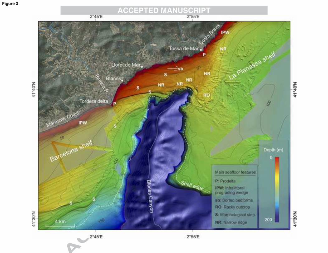
2.1. Geological setting 120
The study area comprises the segment of the Catalan continental shelf around the Blanes 121
submarine canyon head, between 41º30‘N and 41º45‘N (Fig. 1). The Blanes Canyon is 184 122
km long and has a nearly N–S trending course in its shelf-incised section (Amblas et al., 123
2006; Lastras et al., 2011). The continental shelf neighbouring the canyon head includes 124
the southernmost part of the La Planassa shelf to the east, the northernmost part of the 125
Barcelona shelf to the west, and a narrow shelf stretch between the coastline and the tip of 126
the canyon head to the north (Fig. 1). 127
Hercynian granitoids outcrop along the southern Costa Brava and the Maresme coastline, 128
with colluvial and alluvial deposits of Quaternary age forming a narrow coastal fringe along 129
the Maresme coastal stretch and in the Tordera delta (IGC-ICC, 2010) (Fig. 2A). According 130
to the onshore geological structure, the Barcelona and La Planassa shelves in the 131
neighbourhood of the Blanes canyon head are dominated by NE-SW structural directions 132
(Fig. 2A). In the Barcelona shelf, a large listric fault named Barcelona Fault and other 133
parallel to subparallel faults bound the NE–SW oriented Malgrat High off the Maresme 134
coast (IGC-ICC, 2010) (Fig. 2A). A vertical slip rate of 0.02-0.04 mm·yr−1 has been 135

7
estimated for the Barcelona Fault during the Plio-Quaternary (Perea et al., 2006 and 2012). 136
The coastline parallel Costa Brava Fault cutting the innermost La Planassa shelf represents 137
the north-eastern extension of the Barcelona Fault (IGC-ICC, 2010; Durán et al., 2012) 138
(Fig. 2A). The main morphological expressions of the structural offset associated to this 139
fault are the coastal cliffs of the Costa Brava, the steepness of the inner shelf, and the 140
lithological contrast between the coastal Hercynian granites and the rocky outcrops and the 141
overconsolidated Plio–Pleistocene sediment of the middle and outer shelf (Serra, 1976; 142
ITGE, 1989). 143
The Plio–Quaternary architecture of the continental shelf near the Blanes Canyon consists 144
of a vertical stacking of sequences separated by major discontinuities (Serra, 1976; ITGE, 145
1989; Liquete et al., 2008). Within these sequences, forced-regressive deposits (FRST; 146
Fig. 2B) are the predominant element comprising the outer shelf sequences, whilst 147
transgressive deposits (TST; Fig. 2B) are limited to thin units of reworked sands (Liquete et 148
al., 2008). The most recent sequence (sequence E; Fig. 2C) overlies an erosional surface 149
(SB 4; Figs. 2C and 2D) developed during the last sea-level lowstand of Marine Isotope 150
Stage (MIS) 2 and comprises the transgressive (TST) and highstand (HST) system tracts 151
(Liquete et al., 2008). In the Barcelona shelf, this TST is defined by a series of prograding 152
sediment bodies (Díaz and Maldonado, 1991; Serra and Sorribas, 1993; Liquete et al., 153
2007), whereas in the La Planassa shelf it is almost absent, with large rocky outcrops 154
dominating the middle shelf (Serra, 1976; ITGE, 1989; García et al., 2011). In both shelf 155
areas, the HST is mostly restricted to the inner shelf modern prodeltas and infralittoral 156
prograding wedges (IPW) (Serra, 1976; ITGE, 1989; Serra et al., 2003 and 2007). 157
General descriptions of the morphology of the studied continental shelf can be found in 158
Serra (1976) and ITGE (1989). Such works are based on single-beam echo sounder and 159
side scan sonar data, seismic reflection profiles and bottom samples and describe large 160
seafloor features such as prodeltas, infralittoral prograding wedges, middle-shelf sediment 161
bodies and rocky outcrops. The sparse bathymetric coverage did not allow these authors to 162
describe adequately these features in the study area. Recently, new multibeam bathymetry 163
8
data from the northern Catalan continental shelf have revealed a complex seafloor, 164
particularly near canyon heads, where large seafloor features such as modern and relict 165
sediment bodies and numerous rocky outcrops have been identified (Lastras et al., 2011; 166
Durán et al., 2012). The high-resolution swath bathymetry data presented in this study 167
allows precisely defining the morphology and shape of the above-mentioned seafloor 168
features and helps recognizing many other previously unknown and poorly known features. 169
2.2. Sediment input 170
The Tordera River and several torrents, such as the Tossa de Mar and Lloret de Mar ones, 171
fed the continental shelf of the Blanes canyons area (Fig. 2A). Their sediment input 172
depends directly of the rainfall regime, which is characterized by long dry periods 173
interrupted by short, strong events that can result in floods within a few hours, especially in 174
the case of eastern storms carrying wet air against the coastal relieves (Martín-Vide, 1982; 175
Martín-Vide et al., 2008). The Tordera River catchment area covers 879 km2 and has a 176
maximum altitude of 1684 m and a mean slope of 3.8° (Liquete et al., 2009). The Tordera 177
River headwaters are located in the Montseny-Guilleries Massif and the Pre-Littoral Chain. 178
The drainage system is incised to a large extent in the granites of the Catalan Coastal 179
Ranges (Fig. 2A). The Tordera River releases to its mouth high amounts of coarse 180
immature sands carried as bedload and fine sediment in suspension. Sand sizes represent 181
approximately 83% of the total sediment discharge of the river (Rovira et al., 2005; Liquete 182
et al., 2009). The immature character of these sediments is due to the nature of source 183
rocks, to the relatively short distances travelled and to the dominant fast flood torrential 184
regime of the river. 185
2.3. Hydrodynamic setting 186
The Catalan continental shelf is a wave-dominated, microtidal (<0.2 m) environment that 187
has a seasonal wave climate with high-energy events occurring during fall and winter 188
mostly. The cyclonic Northern Current (NC; Millot, 1999) is a quasi-permanent geostrophic 189
current flowing along the continental slope and shelf break that often develops meanders or 190

9
eddies eventually invading the continental shelf (Font et al., 1995; Rubio et al., 2005). The 191
30 km wide stream of the south-westwards flowing NC moves at speeds of up to 35 cm s-1 192
near the surface (Durrieu de Madron et al., 1990; Monaco et al., 1990), thus generating a 193
dominant south-westward transport of suspended sediment from the north-east (Canals et 194
al., 1995; Flexas et al., 2002; Arnau et al., 2004; Ulses et al, 2005; Heussner et al., 2006). 195
Northerly and easterly winds prevail over the Blanes shelf. Strong northerly winds mostly 196
occur during December and January, whilst easterly winds are more frequent during 197
February, March, April and November (Bolaños et al., 2009). Cold and dry northerly winds 198
are responsible for the formation of dense shelf water over the Gulf of Lion and the 199
northern Catalan continental shelf. This dense water mass flows southward along the shelf 200
and cascades down the continental slope through submarine canyons, thus resuspending 201
and transporting large amounts of sediment (Dufau-Julliand et al., 2004; Canals et al, 2006; 202
Puig et al., 2008; Ulses et al., 2008; Palanques et al, 2009; Ribó et al, 2011). Because of 203
the short fetch, northerly winds trigger only small waves over the inner-shelf (Gómez et al., 204
2005; Bolaños et al., 2009). In contrast, humid marine winds blowing from the east are 205
associated to large swells resulting from some hundreds of kilometres fetch that cause 206
intense sediment resuspension along the coastline (Monaco et al., 1990; Mendoza and 207
Jiménez, 2008; Sanchez-Vidal et al., 2012). The storm wave base is located at 20 m depth 208
(Calafat, 1986), but it can move down to at least 30 m during the strongest storms (Sorribas 209
et al., 1993). Because waves approach the coast at oblique angles during eastern storms, 210
they generate an intense south-westward alongshore transport of sediment that can be up 211
to 45 000 m3 y-1 (DGPC, 1986) or even 83 000 m3 y-1 (Copeiro, 1982) off the Maresme 212
Coast (Fig. 3). 213
214
3. METHODS 215
The morphosedimentary analysis of the continental shelf near the Blanes submarine 216
canyon head is based on the integration of multibeam swath bathymetry data, including 217

10
backscatter, with widely-spaced sub-bottom seismic reflection profiles (Fig. 1). Swath 218
bathymetry data cover an area of about 525 km2 and were acquired with two Simrad 219
systems, the EM-3000D and the EM-1002S, during several cruises carried out between 220
2004 and 2010. The EM-3000D is a dual system with two sonar heads, each of them with a 221
swath width of 130 degrees. This system uses 254 beams and operates at a frequency of 222
300 kHz with a maximum ping rate of 40 Hz. The EM-1002S system operates at a 223
frequency of 95 kHz with a maximum ping rate of 10 Hz, and it forms 111 beams. 224
Measurement accuracies are 5 cm and 10 cm of root mean square for the EM-3000D and 225
EM-1002S, respectively. Deep-water EM-120 multibeam data, on the other hand, were 226
acquired over the continental slope. Multibeam bathymetry data were supplemented with 227
single beam data from various sources (e.g. nautical charts, former bathymetric maps and 228
open access bathymetric databases) in the shelf areas lacking swath bathymetry coverage 229
(Fig. 1). Positioning during multibeam data acquisition was by differential GPS. Multibeam 230
bathymetry data processing was carried out with CARIS HIPS and SIPS software. 231
Backscatter strength, originally measured in decibels (dB), represents the amount of 232
energy that is scattered from the seafloor back to the receiver transducer. Backscatter is 233
influenced by several factors including surface roughness, impedance contrast and 234
volumetric heterogeneity, showing a good correlation with the mean grain size (Goff et al., 235
2000; Collier and Brown, 2005). Despite the limitations of backscatter intensity in predicting 236
seafloor texture, high backscatter intensities can be associated to larger grain sizes and 237
low backscatter intensities to smaller grain sizes (Collier and Brown, 2005; Amblas et al., 238
2006; Micallef et al., 2012). In parallel to the multibeam bathymetry data acquisition, very 239
high-resolution seismic reflection data were collected with a Simrad 018 TOpographic 240
PArametric Sonar (TOPAS). The TOPAS transmitted each 1–2 s, with a beam angle of 241
approximately 5°, and a modulated frequency sweep (chirp) ranging between 3 and 5 kHz. 242
243
4. RESULTS 244
11
4.1. Morphology of the continental shelf 245
The continental shelf shoreward of the Blanes Canyon tip is just 4 km wide. Subsequently, 246
shelf width increases towards the Barcelona and La Planassa shelves (up to 15 and 18 km, 247
respectively). The shelf of the study area comprises: (i) a narrow (0.4–0.7 km) inner shelf, 248
extending from the coastline to 30-50 m depth, (ii) a wider middle shelf from 30-50 to 90 m 249
depth, and (iii) an outer shelf from 90 m depth to the shelf edge. The shelf edge is located 250
at 125–150 m water depth along the western rim of the Blanes Canyon, and at less than 251
100 m water depth along the eastern rim (Fig. 3). 252
The inner shelf shows a relatively steep seafloor (1.5º average slope gradient; Fig. 4A) that 253
ends seaward in an abrupt step (up to 20º). The inner shelf displays numerous relieves that 254
correspond to infralittoral prograding wedges (IPWs), small prodeltas and rocky outcrops 255
(Fig. 3). To the west of the canyon head, the general bathymetric trend of the Barcelona 256
middle and outer shelf is disrupted by several morphological steps and narrow ridges that 257
show gradients in excess of 2º and up to 14º (Fig. 4A). To the east of the canyon head, the 258
La Planassa shelf shows a rugged seafloor that extends down to 90 m depth showing 259
gradients of about 2.8º. This uneven topography results from a large, complex rocky 260
outcrop and several narrow ridges (Figs. 3 and 4A). The middle La Planassa shelf offshore 261
Tossa de Mar and the outer shelf show a smooth seafloor (Figs. 3 and 4A). 262
The backscatter imagery reveals marked along- and across-shelf variations around the 263
canyon head (Fig. 4B). The inner shelf shoreward of the north of the canyon head shows 264
very-high backscatter intensities (brighter areas) with elongate, shore-normal regions of low 265
backscatter returns (darker areas) that extend from the coastline down to 40–50 m depth 266
(Fig. 4B). Backscatter intensities are medium to high over most of the middle shelf 267
surrounding the canyon head, except for small areas on the Barcelona shelf and a large 268
area of very low backscatter offshore Tossa de Mar (Fig. 4B). Backscatter decreases from 269
the middle Barcelona shelf towards the outer shelf, whilst the La Planassa shelf shows an 270
opposite trend with higher values on the outer shelf. 271

12
272
4.2. Seafloor features 273
Bathymetric and backscatter data and seismic reflection profiles led to the identification of 274
distinctive seafloor features over the studied continental shelf. These comprise prodeltas, 275
Infralittoral prografing wedges (IPW), rocky outcrops and sorted bedforms in the inner shelf; 276
and a widespread rocky outcrop, large morphological steps, narrow ridges, featureless 277
seafloor zones and sediment waves in the middle and outer shelf. 278
4.2.1. Prodeltas 279
The Tordera prodelta extends almost 5 km along-shelf and 0.4 km seawards ending in a 280
steep slope down to 40 m depth (Figs. 3 and 4A). The very high backscatter it shows is 281
most probably indicative of coarse sediment (Fig. 4B). To the north of the Tordera River 282
mouth, smaller prodelta-like wedges (0.7 km wide along-shelf) have been recognized at the 283
mouth of Tossa de Mar and Lloret de Mar torrents (Fig. 3). 284
4.2.2. Infralittoral prograding wedges 285
IPW develop from the lower edge of the shoreface to a strong break in slope at 30–35 m 286
water depth (Fig. 5A). Seawards, the gradient increases to a relatively steep slope down to 287
40–50 m depth (Fig. 4A). To the north of the Tordera River mouth, an IPW appears in the 288
form of isolated bodies that are best developed in bays and pocket beaches (Fig. 5A). In 289
contrast, south of the Tordera River mouth the IPW consists of a set of continuous, coast-290
parallel to coast-oblique sediment bodies that extend along the Maresme coastline (Fig. 3). 291
There, the IPW is characterized by very-high backscatter with elongate patches of lower 292
backscatter (Fig. 4B). 293
4.2.3. Sorted bedforms 294
Sorted bedforms appear in the bathymetry as slightly depressed (0.3–1 m in depth) and 295
elongate (50–250 m) features with a patchy distribution (Fig. 5A). Most of bedforms lay 296

13
normal to oblique to the general trend of the isobaths and develop at water depths between 297
10 and 40 m depth (Fig. 5A). The largest of these bedforms can exceed 700 m in length. 298
Backscatter data display an abrupt transition between high intensities in the shallow 299
depressions and low values in the adjacent shallower areas (Fig. 5B). 300
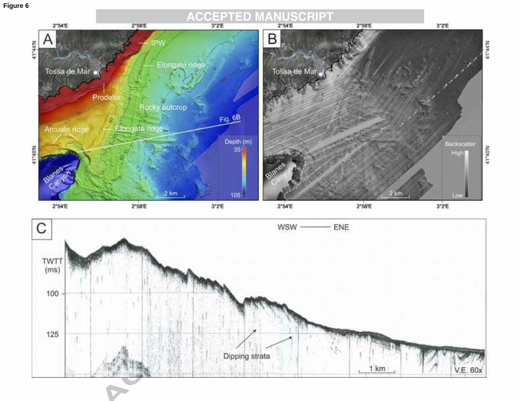
4.2.4. Rocky outcrops 301
Rocky outcrops appear sparsely in the inner shelf but become dominant on the middle shelf 302
to the north and east of the canyon head (Figs. 3 and 6A). In the inner shelf, zones with 303
rocky outcrops show a variable relief (up to 8–10 m high) and mean gradient (0.2º–7º), and 304
high backscatter (Figs. 4A and 4B). To the north and east of the canyon head, a large, 305
complex rocky outcrop occupies the entire middle shelf down to 90 m depth (Figs. 3 and 306
6A). It shows an uneven appearance determined by WNW-ESE trending, 2–3 m high and 307
1–4 km long linear crests almost normal to the isobaths (Fig. 6A). It is characterized by 308
intermediate backscatter, with crests showing higher intensities (Fig. 6B). Seismic reflection 309
profiles show an almost opaque, high amplitude seafloor reflection, with faint south-west 310
dipping outcropping strata, which are locally draped by a very thin transparent unit in the 311
deepest zones (Fig. 6C). 312
4.2.5. Morphological steps 313
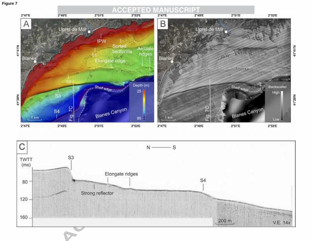
Seven morphological steps, S1 to S7, have been identified in the continental shelf adjacent 314
to the canyon head. The shallower steps, S1 to S3, show a general E-W orientation and 315
appear shoreward of the canyon head to the north, at water depths of 30–45 m, 30–50 m 316
and 35–65 m (Fig. 7A). The step S4, at 74–78 m depth, is NE-SW oriented and limits a 317
very smooth depression along its shoreward side (Fig. 8). A notch located 2.5 km away 318
from the modern Tordera River mouth, likely corresponding to the remnant of a narrow 319
fluvial channel, cuts S4. The deeper steps S5 and S6 are almost parallel and appear along 320
the outer Barcelona shelf at 78–90 m and 105–115 m of water depth, respectively (Fig. 9A). 321
While S5 and S6 are ENE-WSE oriented offshore the Maresme coast, they change to 322
NNE-SSW shoreward of the canyon head. S3 to S6 run across the shelf and die at the rim 323
14
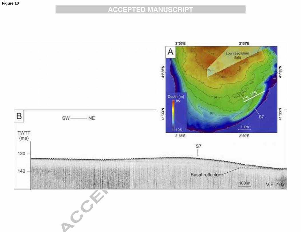
of the canyon head. To the east of the Blanes Canyon, a small step, S7, delineates a 1.5 m 324
thick sediment body that extends 3 km along the La Planassa outer shelf at 94–95 m depth 325
(Fig. 10). . 326
Backscatter data show very high values with small patches of very low reflectivity in the 327
continental shelf between the coastline and S3 (Fig. 4B and 7B). The same step S3 marks 328
an abrupt change in backscatter from very high to low reflectivity. This low backscatter 329
zone extends eastwards from the Tordera prodelta to the Blanes canyon rim (Fig. 7B). 330
Seaward from S3, the continental shelf displays medium backscatter down to S6, which 331
marks another change to low intensities in backscatter (Fig. 4B). Limited acoustic 332
penetration hinders the interpretation of TOPAS profiles in this zone. However, a semi-333
transparent unit of up to 20 m in thickness overlies a discontinuous and uneven high 334
amplitude reflector that locally crops out (Figs. 7B and 9C). 335
4.2.6. Narrow ridges 336
Narrow ridges are 40–100 m wide positive relieves up to 2.5 m above the surrounding 337
seafloor, which are either parallel or oblique to the isobaths (Fig. 3). They are straight 338
elongate features in plan view, except close to the canyon tip, where they become arcuate 339
(Figs. 6A and 7A). Their length ranges from 0.5 to 8 km. Within the study area, twelve 340
narrow ridges have been identified showing different shapes and orientations: (i) seven NE-341
SW straight ridges at depths of 48–59 m, 56–58 m, 63–65 m, 69–72m, 74 m, 74–77 m, and 342
77–78 m; (ii) a ENE-WSW straight ridge at 35–45 m depth (Fig. 7A); and (iii) four arcuate 343
ridges at 52–57 m (Figs 6A and 7A). The ridges yield medium to high backscatter (Figs. 6B 344
and 7B). In sub-bottom penetrator profiles they are associated to an irregular strong 345
reflector that prevents acoustic penetration (Fig. 7C). 346
4.2.7. Featureless shelf floor areas 347
A large almost flat (0.3–0.5º of slope gradient) and featureless area with very low 348
backscatter intensities extends along the middle La Planassa shelf offshore Tossa de Mar. 349

15
It covers 61 km2 at depths ranging from 50 to 102 m (Fig. 4B) though it probably extends 350
beyond the swath bathymetry data limit (Fig. 1). 351
East of the canyon, the outer La Planassa shelf is characterized by a relatively flat, gently 352
inclined (0.2º on average) bottom down to 98 m depth (Fig. 10A). It shows medium to high 353
backscatter (Fig. 4B), which probably corresponds to relatively coarse-grained sediment. 354
4.2.8. Sediment waves 355
To the west of the canyon, between steps S5 and S6, a field of almost contour parallel 356
sediment waves, 6 km2 in areal extent, drapes the outer shelf at 95–115 m of water depth 357
(Fig. 9B). The sediment waves are 0.2–0.5 m high with mean wavelengths of 400 m. 358
Backscatter data are of medium intensities both in the crests and troughs (Fig. 4B) 359
5. DISCUSSION 360
5.1. Seafloor morphology 361
The detailed multibeam bathymetry and backscatter data presented in this study yield a 362
new accurate image of the seabed that provides a comprehensive overview of the 363
geomorphology of the continental shelf and reveals a variety of seafloor features, some of 364
which had not been previously recognized in the study area. The interpretation of these 365
features together with the backscatter pattern provides useful insights about past and 366
present sediment dynamics. 367
5.1.1. Interpretation of seafloor features 368
5.1.1.1. Prodeltas 369
Sediment deposition by the Tordera River and smaller streams, such as Lloret de Mar and 370
Tossa de Mar torrents, has led to the formation of small submarine prodeltas off the river 371
mouths (Fig. 11). They display very high backscatter, which is indicative of the coarse 372
nature of the sediments supplied by these water courses (Fig. 2A). The bulging to elongate 373
shape of these features results from the predominant southwards littoral drift that 374

16
distributes the sediment delivered by these streams southwards along the inner shelf. This 375
alongshore transport is also evidenced by the formation of a large submerged sand spit 376
that extends southwards off the Tordera River mouth, as described by Serra et al. (2003 377
and 2007). 378
5.1.1.2. Infralittoral prograding wedge 379
Near the Blanes Canyon, the IPW develops laterally forming continuous prodeltaic wedges 380
such as those along the Maresme coastline (Liquete et al., 2007; Ercilla et al., 2010), or 381
isolated bodies, such as those to the north of the Tordera River mouth (Fig. 11). As the 382
IPW forms just below the wave-face depth of major storms (Hernández-Molina et al., 2000), 383
it is actively involved in the present day littoral sedimentary processes. This is confirmed by 384
very high backscatter corresponding to coarse-grained facies that reflect the dominant 385
influence of stormy hydrodynamic conditions along the infralittoral belt. The IPWs show a 386
predominant stretched geometry that is parallel to the coastline as a consequence of the 387
dominant south-westward littoral drift. 388
5.1.1.3. Sorted bedforms 389
The elongate patches in backscatter images observed on the IPW have been interpreted 390
as sorted bedforms (Murray and Thieler, 2004) or “rippled scour depressions” (Cacchione 391
et al., 1984). As commented above, sorted bedforms are slightly depressed features filled 392
with coarse sediments, as evidenced by backscatter data (Fig. 5). They appear between 10 393
and 40 m depth and their longitudinal axis is normal to oblique to the coastline (Fig. 11). 394
The generation and maintenance of these features arise primarily from a sediment sorting 395
feedback in shelf environments dominated by alongshore rather than cross-shore currents 396
(Murray and Thieler, 2004; Coco et al., 2007; Lo Iacono and Guillen, 2008), which is in 397
accordance to the hydrodynamic regime deduced from the prodeltas and IPWs. According 398
to their location in relation to the storm wave base level, these sorted bedforms possibly 399
become active during high-energy events. The storm wave base along the Maresme coast 400
has been estimated at 20-30 m water depth (Calafat, 1986; Sorribas et al., 1993), but 401

17
several works reported sediment remobilization down to 60 m depth under very strong 402
conditions (Puig et al., 2001; Palanques et al., 2002). 403
5.1.1.4. Rocky outcrops 404
Rocky outcrops appear in the inner and middle shelf primarily to the north and east of the 405
canyon head (Fig. 11). In the inner shelf, rocky outcrops appear as the submerged feet of 406
coastal cliffs showing continuity with the Hercynian granites outcropping inland (Fig. 2A). In 407
the middle shelf, a widespread rocky outcrop extends down to 90 m water depth covering 408
an area of 106 km2 (Fig. 11). Although it is partially capped by sediment, probably coarse 409
grained as suggested by backscatter data and sub-bottom seismic reflection profiles, the 410
structural features of the rock outcrop are clearly visible (Figs. 3 and 11). 411
5.1.1.5. Morphological steps 412
The large morphological steps observed in the middle and outer shelf near the Blanes 413
canyon belong to three main groups, according to their location and orientation (Fig. 11): (i) 414
a E-W oriented set that comprise steps S1 to S3 at 30–45, 35–55 and 35–65 m depth, 415
respectively; (ii) a NE-SW step (S4) cut by a shallow channel at 74–78 m depth; and (iii) a 416
set made of NNE-SSW oriented steps S5 and S6 at 105–115 and 78–90 m depth and an 417
arcuate step (S7) at 94–95 m depth. 418
The E-W oriented steps appear to the north of the canyon head (Fig. 11). They are 419
characterized by very high backscatter corresponding to coarse sand (see Pedrosa-Pàmies 420
et al., this issue, for more details). Step S3 marks an abrupt change in backscatter to low 421
intensities corresponding to an elongate patch of medium to fine sand (Pedrosa-Pàmies et 422
al., this issue) that extends from the Tordera prodelta to the canyon head rim (Figs. 4B and 423
11). Further south, the seafloor is characterized by medium backscatter associated to 424
medium sand (Pedrosa-Pàmies et al., this issue). 425
Based on the seismic profiles and backscatter characteristics, the morphological steps S1 426
to S3 to the north of the canyon head have been interpreted as the edges of sediment 427

18
bodies, most probably of sandy nature. S4 shows a particular morphology determined by a 428
narrow channel that likely corresponds to an old bed of the Tordera River. Samples from 429
the top of these relict sediment bodies consist of medium to coarse sand (ITGE, 1989; Díaz 430
and Maldonado, 1990), which is in agreement with the observed medium to high 431
backscatter (Fig. 4B). The basal reflector underlying these relict sand bodies corresponds 432
to a ravinement surface developed during the Versilian transgression (i.e. younger than 18 433
000 yr BP), which can be correlated across the entire study area and beyond (Serra, 1976; 434
Diaz and Maldonado, 1991; Liquete et al., 2007). Therefore, the Barcelona shelf relict 435
sediment bodies were built during the last postglacial sea-level rise. 436
5.1.1.6. Narrow ridges 437
Narrow ridges, oriented NE-SW or ENE-WSW, appear at depths between 35 and 78 m, but 438
mostly at 48–58 m and 74–78 m (Fig. 11). Based on the bathymetric and sub-bottom 439
seismic reflection data, the narrow ridges could be ascribed to relict beach-rock alignments. 440
Although no sediment cores were collected, the narrow ridges in the study area show 441
identical morphology and appear at the same position than the cemented beach-rocks 442
described further south in the same Barcelona shelf by Liquete et al. (2007). Surface 443
sediment is composed by bioclastic to siliciclastic-bioclastic, rounded to well-rounded sands 444
and gravels (Liquete et al., 2007) yielding high backscatter intensities (Fig. 7B). However, 445
further investigations are required to constrain their origin more accurately. 446
5.1.1.7. Featureless seafloor 447
Two areas of featureless seafloor have been identified in the La Planassa shelf (Fig. 11). 448
Offshore Tossa de Mar, the middle shelf displays very low backscatter suggesting that the 449
shelf floor there is covered by fines. This area corresponds to the southernmost limit of a 450
large patch of low backscatter that extends along the La Planassa middle shelf (Durán et 451
al., 2012). This pattern contrasts with the La Planassa outer shelf, where backscatter is 452
high, which would be indicative of coarse sediment pointing to erosion or non-deposition 453
and sorting of fines. 454

19
5.1.1.8. Sediment waves 455
Contour parallel sediment waves have been observed in a restricted area of the Barcelona 456
outermost shelf at 95–115 m depth (Fig. 11). The morphology of the sediment waves and 457
the local hydrodynamics suggest that they could be reactivated during energetic conditions, 458
particularly under strong storms. In the Gulf of Lion, numerical modelling showed that 459
strong energy events are able to remobilize and transport sand over the outermost shelf 460
and shelf edge (Bassetti et al., 2006). Recent observations in the Blanes Canyon head also 461
noticed that large storms were able to produce enough bottom shear stress to resuspend 462
shelf sediment including the transport of coarse sand down to 50–60 m water depth, which 463
could explain the arrival of this sediment fraction into the canyon head (Sanchez-Vidal et 464
al., 2012; Pedrosa-Pàmies et al., this issue). Such sediment remobilization over the outer 465
shelf would contribute to the activation of these sediment waves. However, the morphology 466
of these bedforms is inconclusive about their degree of present activity, so that additional 467
observations would be necessary to confirm or deny this interpretation. 468
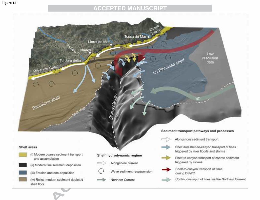
5.1.2. Shelf zonation 469
The interpretation of the shelf floor features allows distinguishing four zones dominated by 470
erosion (or non-deposition) and deposition that illustrate the sediment dynamics of the 471
study area (Fig. 12). These are: (i) a littoral belt of modern coarse sediment transport and 472
accumulation; (ii) a zone of modern fine sediment deposition; (iii) a zone dominated by 473
erosion or non-deposition; and (iv) a relict, modern sediment depleted zone. 474
The littoral belt of modern coarse sediment transport and accumulation covers almost the 475
whole inner shelf, i.e. 30 km2 or 5.7% of the study area (Fig. 12). It is characterized by large 476
depositional features, such as prodeltas, IPWs and sorted bedforms (Fig. 11). Backscatter 477
is very high along this belt, which fits with the coarse nature of sediment inputs from the 478
Tordera River and coastal torrents, and the action of eastern waves against this exposed 479
coastal stretch. Storm waves resuspend the finest fractions of sediment deposited on the 480

20
inner shelf that can be transported offshore towards the middle-outer shelf and slope, and 481
south-westward by the induced littoral drift. 482
Modern fine sediment deposition occurs at the middle shelf offshore Tossa de Mar, as 483
evidenced by backscatter data, covering an area of 61 km2 or 11.6% of the study area (Fig. 484
12). Middle shelf fine deposition zones, like the one observed in the La Planassa middle 485
shelf, have been recognized worldwide and described in the adjacent continental shelves 486
too, such as the Ebro shelf (Palanques and Drake, 1990; Puig et al., 2001), the Barcelona 487
shelf further south (Liquete et al., 2010) and the Gulf of Lion shelf (Got and Aloïsi, 1990, 488
Durrieu de Madron et al., 2008). 489
A large zone of long-term erosion or non-deposition measuring 226 km2, or 43.1% of the 490
study area, has been identified over the La Planassa middle and outer shelf, near the 491
canyon head (Fig. 12). This zone displays a rough bathymetry and high backscatter that 492
corresponds to rocky outcrops and coarse sediment (Fig. 11). The scarce fluvial sediment 493
input reaching La Planassa shelf, which is fed (only by short ephemeral torrents (Fig. 2A), 494
and the bottom shear stress resulting from high-energy storms leads to a sediment-starved 495
shelf. The erosive or non-depositional character of the La Planassa shelf in the vicinity of 496
Blanes Canyon extends to a sharp canyon rim there, which further indicates erosion and 497
sediment depletion (Lastras et al., 2011). 498
The relict zone, markedly starved of modern sediment accumulation, extends over the 499
middle and outer shelf to the north and west of the canyon head, covering an area of 208 500
km2, or 39.6% of the study area (Fig. 12). It includes six large-scale transgressive sediment 501
bodies that occupy the entire middle and outer shelf (Fig. 11). At present, the relict 502
character of this shelf zone is attested by (i) the relatively rough topography of the seafloor 503
with isolated rocky outcrops and narrow ridges; and (ii) the medium to high values of 504
backscatter intensity corresponding to coarse sand (Pedrosa-Pàmies et al., this issue). 505
5.2. Modern sediment dynamics 506
5.2.1. Sediment sources and transport processes 507
21
The variability of seafloor morphology and sediment type, and subseafloor configuration 508
across the studied continental shelf provides significant insight on sediment sources, 509
dynamics and transport pathways from the shelf to the canyon. The deeply incised into the 510
continental shelf Blanes Canyon intercepts the alongshore and along-shelf sediment 511
dispersal paths, which results in the escape of sediment from the shelf into the canyon 512
head (Fig 12). The sorting and preferential escape of fines makes the sedimentary cover of 513
the continental shelf around the canyon head to be mainly sandy, as shown by the high 514
backscatter pattern observed there, which also indicates reworking of shelf deposits finally 515
feeding into the canyon (Figs. 4B and 12). 516
Previous works have documented a dominant south-westward littoral and inner shelf drift 517
along the North Catalan continental shelf in previous works (Copeiro, 1982; DGPC, 1986) 518
(Fig. 12). Evidences of sediment transport over the shelf floor are provided by: (i) the 519
elongated morphology of modern prodeltas and IPWs; (ii) the orientation of sorted 520
bedforms; and (iii) a complex backscatter pattern (Figs. 3 and 4). The pattern of very high 521
backscatter between the coastline and the canyon head and the elongate patch of low 522
backscatter to the south of step S3 indicate the remobilization and south-westward along-523
shelf transport of fines that are deposited southwards on the lee side of S3 or off-shelf into 524
the canyon head (Fig. 12). 525
This predominant south-westward transport of sediment along the shelf would also explain 526
the limited contribution of river inputs directly into the canyon head. Due to the closeness of 527
the Blanes Canyon to the Tordera River mouth, a direct input from this river into the canyon 528
head could be expected. However, recent works have noticed that only a small amount of 529
the sediment volume released by the Tordera River enters the Blanes Canyon during high-530
energy events (Zúñiga et al., 2009; Sanchez-Vidal et al., 2012; Pedrosa-Pàmies et al., this 531
issue). This is attributed to the predominant along-shelf sediment transport that favours the 532
dispersal of the coarse sediment delivered by the Tordera River along the shore and inner 533
shelf towards the south-west, thus feeding river prodelta itself and the beaches and IPWs 534
off the Maresme coast. This view is supported by the seafloor morphology and backscatter 535

22
imagery (Fig. 12). The finest fractions supplied by the river bypass the inner shelf and 536
disperse over the middle shelf and beyond, as indicated by medium backscatter there 537
(Figs. 4B and 12). This interpretation is further supported by bottom samples collected in 538
the continental shelf offshore the Tordera River mouth that show a high contribution of 539
terrestrial sediment in the middle shelf that decreases toward the outer shelf and slope (see 540
Pedrosa-Pàmies et al., this issue). 541
According to this, the most probable shelf sources of sediment to the Blanes Canyon 542
responding to present day hydrodynamics are located to the north and west of its head. 543
Furthermore, the large relict sediment bodies that occupy almost the entire middle and 544
outer shelf, to the north (i.e. shoreward) and west of the canyon also represent a potential 545
source of coarse sediment into its head and upper course (Fig. 12). This would be in 546
agreement with the massive arrival of sand into the canyon during the severe storm of 547
December 2008, as observed by Sanchez-Vidal et al. (2012) and other morphological 548
evidences within the canyon head that reported a retrogradation of the Blanes Canyon 549
western rim seaward of the Maresme sediment bodies (Lastras et al., 2011) at the head of 550
a gully system that cut the whole canyon wall and reach the shelf edge. East of the canyon 551
head, the continental shelf is sediment starved and mostly erosional or non-depositional, so 552
that a minor sediment contribution into the canyon should be expected from there (Fig. 13). 553
5.2.2. Hydrodynamic forcings 554
Short-lived hydrodynamic processes such as floods, storms and DSWC largely drive the 555
transport and distribution of sediment over the Catalan continental shelf and deep margin. 556
In the Blanes Canyon, the eastern storms are the most prominent oceanographic 557
processes controlling the shelf-to-canyon transport of sediment, as noticed in recent works 558
(Sanchez-Vidal et al., 2012; Pedrosa-Pàmies et al., this issue). Storm waves generate bed 559
shear stresses sufficient to resuspend fine sediment on the inner shelf, which can be 560
subsequently deposited beyond the wave-base level forming a mid-shelf mud belt, as 561
observed offshore Tossa de Mar (Fig. 4B). The most energetic storms can resuspend again 562
these fines and force their transport further offshore and also off-shelf into the submarine 563
23
canyon (Guillén et al., 2006; Palanques et al., 2008; Pedrosa-Pàmies et al., this issue). 564
This would explain the lack of fines over the continental shelf adjacent to the canyon head, 565
particularly shoreward (Fig. 4B). Extreme storms are also able to remobilize sediment from 566
the shelf and supply sand sizes to the canyon head, as demonstrated by Sanchez-Vidal et 567
al. (2012) and Pedrosa-Pàmies et al. (this issue). The role of up and down currents along 568
the canyon over the resuspension of fines and, in general, sediment remobilization in the 569
Blanes Canyon area is not known at present. 570
DSWC likely contributes to the transfer of shelf sediment into the submarine canyon too 571
(Fig. 12). Dense shelf waters form mainly over the Gulf of Lion shelf and the Roses shelf to 572
the north, and to a much lesser extent over the La Planassa shelf, which southern limit 573
marks the boundary of the span of the cold, dry and persistent northern Tramuntana wind 574
(Canals et al., 2006; Ulses et al., 2008). Direct observations and numerical simulations 575
have shown that dense shelf water is transferred to the deep basin mostly through Cap de 576
Creus, La Fonera and Blanes canyons, with a decreasing trend from north to south (e.g. 577
Canals et al., 2006; Ulses et al., 2008; Palanques et al., 2009; Lastras et al., 2011; Ribó et 578
al., 2011). Accordingly, the Blanes Canyon traps dense shelf water formed over La 579
Planassa shelf and in northernmost areas. Because of topographical constrictions these 580
waters and the sediment load they carry after resuspension and turbulent bed load 581
transport enter Blanes Canyon mostly through its northern flank, as supported by direct 582
observations too (Zúñiga et al., 2009). However, the volume of water and sediment carried 583
out by DSWC into the Blanes Canyons likely is much less than in La Fonera Canyon and, 584
especially, Cap de Creus Canyon, which is by far the main outlet for these waters into the 585
deep margin and basin along the North Catalan margin. Sediment volumes entering the 586
Blanes Canyon because of DSWC remain to be precisely quantified. 587
The permanent mesoscale NC also brings fines to the Blanes Canyon area (Fig. 12). 588
Interaction of the NC with the canyon topography may lead to eddy formation and 589
enhanced resuspension of fines. Such eddies may enter the continental shelf, eventually 590
guided by the canyon topography, thus further resuspending the finest particles 591

24
accumulated on the outer shelf (Arnau, 2000; Flexas et al., 2002; Arnau et al., 2004) and 592
easing their southward transport along the shelf and trapping into the canyon, probably 593
contributing to the development of a canyon fill sedimentary body observed at the shelf 594
edge (Lastras et al., 2011). 595
5.3. Evolution of the continental shelf during the last transgression 596
Past studies of submarine canyons established that during sea-level low-stands they are 597
particularly efficient conduits for the transport of sediment from the continental shelf to the 598
deep margin and basin (May et al., 1983). Recent studies have also shown that canyons 599
incising narrow continental shelves receive large amount of sediment regardless of sea-600
level conditions (e.g. Cutshall et al., 1986; Kineke et al., 2000; Xu et al., 2002; Puig et al., 601
2003; Mullenbach et al., 2004). With this background in mind, we have investigated the 602
evolution of the Blanes continental shelf in terms of sediment transport pathways from 603
terrestrial and shelf sources into the canyon head during the last transgression. 604
5.3.1. Seafloor features as sea-level indicators 605
The evolution of the continental shelf around the Blanes Canyon can be reconstructed after 606
several geomorphological features, such as narrow ridges and morphological steps, which 607
can be used as sea-level indicators (Fig. 11). Narrow ridges have been ascribed to beach-608
rocks and thus they are excellent indicators of paleo-coastlines. Near the canyon head, 609
narrow ridges are mainly located at 52-58 m, 63-35 m, 69-72 and 74-78 m depth. 610
Morphological steps corresponding to the front of relict sediment bodies appear at 30-65 m 611
(S1 to S3), 74-78 m (S4), 78-90 m (S5), 94-95 m (S7), and 105-115 m depth (S6). They are 612
also considered as indicators of ancient sea-level positions during the last transgression, 613
although some caution is required. Present-day depositional breaks in slope such as 614
prodelta fronts or IPWs form below the storm-wave base, i.e., some meters below the 615
current sea-level. Consequently, a difference in water depth between the morphological 616
step and the relative sea-level must be taken into account. 617

25
The morphological features observed on the Blanes shelf area have been correlated to 618
global (Siddall et al., 2003; Deschamps et al., 2012) and Mediterranean (Aloïsi et al., 1978; 619
Lambeck and Bard, 2000) sea-level curves. We naturally focus on the last sea-level cycle, 620
as most of the geomorphological features on the studied shelf floor formed during the last 621
transgression and subsequent highstand. 622
Though studies of the Barcelona shelf reported differential subsidence across and along 623
the shelf, with maximum values at the shelf break and off Besòs and Llobregat river mouths 624
(Liquete et al., 2008), tectonic subsidence in the study area is of little relevance for the 625
purpose of our paper. Perea et al. (2006 and 2012) have estimated a vertical slip rate of 626
0.02-0.04 mm·yr−1 along the Barcelona Fault (Fig. 2A) during the Plio-Quaternary, which is 627
equivalent to 0.4-0.8 m for the last 20 kyr. In other deltaic nearby shelves, such as the Gulf 628
of Lion, Quaternary subsidence has been inferred at 0.25 mm y-1 near the shelf edge 629
(Rabineau et al., 2006). This subsidence is attributed to sediment compaction in a delta 630
environment, which cannot be directly transposed to the continental shelf near the Blanes 631
Canyon. Therefore, we consider reasonable to assume that the study area has been fairly 632
stable tectonically during the last 20 kyr. Sediment compaction likely is negligible given the 633
different setting with respect to the study cases above and also the dominant coarse nature 634
and limited thickness of post-glacial units and the short time elapsed since the beginning of 635
the transgression. However, because of the lack of correction, even if minor, for tectonic 636
vertical movements and sediment compaction, our results should be considered in terms of 637
relative sea levels. 638
During the last glacial cycle, the Mediterranean Sea was connected to the global ocean and 639
therefore followed a similar pattern of sea-level changes. The sea level reached its lowest 640
position during the Last Glacial Maximun (LGM) between 26.5 and 19 kyr (Fairbanks, 1989; 641
Lambeck and Chappell, 2001). In the Western Mediterranean, a minimum sea-level at 642
about 105–115 m below present sea-level (bpsl) was inferred (Lambeck and Bard, 2000; 643
Jouet et al., 2006; Berné et al., 2007). Since the LGM, the sea-level rise was not steady 644
(Fig. 13); instead relatively short periods of rapid sea level rise were followed by periods of 645
26
slower rise with occasional brief stillstands (Fairbanks, 1989). Intervals of rapid sea-level 646
rise occurred at 14.65 kyr and 11.3 kyr, referred to as Meltwater Pulse 1A (MWP1a) and 647
Meltwater Pulse 1B (MWP1b), respectively (Bard et al., 2010; Deschamps et al., 2012). 648
Periods of short stillstands or slow sea-level rise occurred during the early deglacial, after 649
MWP1a, during the Younger Dryas cold climatic event (12.8–11.5 kyr) and at the 8.2 kyr 650
cold event (Lambeck et al., 2002; Bard et al., 2010). 651
By comparing the depths of the main seafloor features of the Blanes shelf with the timing of 652
these well-known sea-level changes during the last post-glacial transgression, we found 653
noteworthy correlations to sea-level rise, even though our water depths are uncorrected, as 654
explained above (Fig. 13B). The depth of the narrow ridges at 52–65 m bpsl would likely 655
correspond to: (i) the onset of the Younger Dryas, when the sea-level was located at a 656
water depth of approximately 50–55 m bpsl in the Western Mediterranean (Siddal et al., 657
2003; Berné et al., 2007); and (ii) a phase of decreased sea-level rise after MWP1a when 658
sea level was at about 77 m bpsl (Fairbanks, 1989; Bard et al., 1990). The depths of the 659
morphological steps, however, fall at or below three short intervals of slow sea-level rise or 660
stillstand (Fig. 13B): (i) the decrease in sea level rise during the deglacial onset; (ii) the 661
short-lived stillstands or slowdowns in sea-level rise during the Younger Dryas; and (iii) the 662
8.2 kyr cold event, when sea level was at about 20 bpsl (Siddal et al., 2003; Camoin et al., 663
2004) or 30 m bpsl in the Mediterranean (Aloïsi, 1986, Lambeck et al., 2002). The 664
difference between water depth of sediment bodies and the relative sea-level would be 665
related to the storm-wave base level or other local factors, as has been commented above. 666
Our interpretation on the relation between sea-level rise and shelf floor features in the 667
Blanes canyon area would largely benefit from age dating so that they could be confirmed 668
or better adjusted. 669
5.3.2. Morphological development of the continental shelf under a rising sea-level 670
The identification of the various morphologies left mainly during relative stillstands or 671
slowdowns is critical in reconstructing the evolution of the submerged landscape of the 672
continental shelf near the Blanes Canyon since the LGM. Such reconstruction should help 673
27
understanding the varying influence of the canyon on the shaping of the shelf and how the 674
nature of their interactions has changed through time (Fig. 14). The morphology of the 675
continental shelf model reveals a major shift in sediment dynamics likely related to the 676
flooding of the shelf stretch shoreward of the canyon head, which determined the 677
reestablishment of the littoral drift and the coastline parallel circulation over the inner shelf. 678
We hypothesize that the achievement of modern conditions occurred in three stages 679
corresponding to the lowest LGM sea-level (∼18 kyr BP, 105–115 m) and to two 680
intermediate stillstands or slowdowns during the transgression placed before (∼14.1 kyr BP, 681
74–77 m) and after (∼8.2 kyr BP, 30 m) the flooding of the continental shelf shoreward of 682
the Blanes Canyon (Fig. 14). Each stage is plotted as a function of water depth of the main 683
morphological sea-level indicators on the shelf floor over the relative sea-level curve (Fig. 684
13B). 685
The lowest sea-level position corresponds to the maximum exposure of the continental 686
shelf, when the Blanes Canyon head was deeply incised in the paleo-coastline, thus 687
preventing a shallow water connection between the La Panassa and Barcelona shelves 688
(Fig. 14A). East of the Blanes Canyon, the relatively small volumes of sediment delivered 689
by the northern coastal streams, and the sediment resuspended on the inner shelf were 690
very likely transported southwards by the littoral drift till directly entering the submarine 691
canyon. West of the canyon, the Tordera River mouth opened into the canyon rim or very 692
close to it. Consequently, the paleo-Tordera River discharged directly into the canyon, 693
which trapped most of the fluvial input with only small amounts that could be transported 694
southwards by the littoral drift (Fig. 14A). 695
With the subsequent rise of sea-level and the landward migration of the coastline, 696
extensive transgressive sediment bodies began to develop on the Barcelona shelf, shown 697
by the reconstruction corresponding to a short stillstand or slowdown at about 74-77 m bpsl 698
(Fig. 14B). At this stage, the narrow shelf stretch landwards of the Blanes Canyon head 699
was still totally emerged. Small amounts of sediment were supplied by coastal torrents to 700
the La Planassa shelf, where fines could be easily resuspended during storms and 701

28
transported towards the canyon by the dominant circulation, thus leaving an essentially 702
sediment-starved shelf. West of the canyon, the increasing distance between the Tordera 703
River mouth and the canyon head with the sea-level rise favoured the development of large 704
sediment bodies in the half flooded Barcelona shelf. However, the relative closeness of the 705
river mouth to the canyon rim still favoured the off-shelf transport of some sediment, mainly 706
the finest fractions, to the western canyon flank. The notch attributed to a fluvial channel 707
cutting S4 corresponds to this stage. 708
The most significant change in the sediment dynamics of the Blanes shelf took place when 709
the sea-level raised enough to flood of the continental shelf stretch landwards of the 710
shallowest part of the canyon head (Fig. 14C). This allowed the establishment of an 711
alongshore sediment transport between the La Planassa and Barcelona shelves 712
uninterrupted by the canyon head. Such a situation favoured the development of new 713
morphosedimentary features on the shelf stretch north of the canyon head. The change in 714
the orientation of these features with regard to the sand bodies in the Barcelona shelf can 715
be tentatively attributed to a westward migration of the Tordera delta and prodelta from the 716
canyon rim at S3 to its current position, combined with a promontory effect by the same 717
delta that favoured the accumulation of sediment to the east under the effective action of 718
the newly established littoral drift carrying loose IPW deposits along the coastline of La 719
Planassa towards the southwest while redistributing the inputs by Tordera River. In the 720
Barcelona shelf, the steady landward migration of the coastline contributed to a reduction of 721
the off-shelf export of sediment till reaching the present situation with a south-westward 722
sediment transport belt attached to the shoreline. 723
724
6. CONCLUSSIONS 725
1. The detailed study of the geomorphology and uppermost sediment cover of the 726
continental shelf surrounding the Blanes submarine canyon yields insight into the past 727
and present shelf sediment dynamics and the shelf-to-canyon sediment exchanges. 728

29
2. The continental shelf near the canyon head consists of mosaic where erosional, or non-729
depositional, and depositional zones coexist. East of the canyon and offshore Tossa de 730
Mar, the modern sediment deposition is mostly confined to the inner and middle shelf, 731
whilst most of the La Planassa shelf is sediment depleted with numerous relict 732
morphosedimentary features cropping out. Rocky outcrops, narrow ridges and relict 733
coarse sand deposits suggesting erosion or non-deposition of fine sediments in modern 734
times occupy the middle and outer shelf floor east and northeast of the canyon head. In 735
contrast, north and west of the canyon head, the middle and outer shelf comprises 736
several large relict sand bodies that point out to long-term deposition. However, the lack 737
of modern sediments on top of these bodies supports active erosion or by-pass in 738
present times. 739
3. The morphology of the continental shelf near the canyon head records the imprint of the 740
main factors controlling the shelf sediment-dispersal system and provides evidence for 741
the main sources and transport pathways of sediment from the shelf into the canyon. 742
The depletion of fine sediments on the continental shelf, as evidenced by backscatter 743
data, suggests that the Blanes Canyon acts as a sediment trap collecting the finest 744
fractions resuspended primarily from the adjacent shelf to the north. The main 745
processes that control the shelf-to-canyon transfer of sediment are eastern storms, 746
which enhance the off-shelf export of mainly fine sediment from the shelf. Particularly 747
severe storms are also able to remobilize and transport coarse sediment from the shelf 748
and also from the relict sand bodies into the canyon. Other processes, such as DSWC 749
and the Northern Current, contribute to a lesser extent to the transport of sediment along 750
the shelf and into the canyon. 751
4. During the last post-glacial transgression, the Blanes Canyon played a crucial role in the 752
shaping of the continental shelf surrounding it by cutting the littoral drift of sediment 753
between the shelf areas to the north and south, thus severely modifying the across- and 754
along-shelf sediment pathways. As a result, to the east of the canyon, the poor 755
development of transgressive deposits indicates the prevalence of erosion and non-756

30
deposition associated to a limited sediment supply and an effective action of the littoral 757
drift leading to a south-westward transport of sediment towards the canyon head. To the 758
north and west of the canyon the morphology of the continental shelf changed 759
significantly during the sea-level rise. At the early stage of the transgression, the 760
sediment supplied by the Tordera River was discharged directly into the canyon, thus 761
preventing deposition over the shelf. Later, the progressive sea-level rise favoured the 762
development of large depositional bodies on the Barcelona shelf favoured by the 763
increase of accommodation space and the augmenting distance between the river 764
mouth and the canyon head. A drastic change in the configuration of the shelf occurred 765
when the sea-level raised enough to flood the entire continental shelf. The along-shelf 766
sediment transport between the shelf areas to the north and south of the canyon head 767
was then restored and new sediment bodies were formed between the coastline and the 768
canyon tip. At present, these sediment bodies constitute the primary source of coarse 769
sediment into the Blanes Canyon. 770
5. These results confirm that the Blanes submarine canyon head is highly dynamic and 771
sensitive to a variety of processes that enhance the transport of sediment from the shelf 772
into the canyon, particularly during major storms. 773
774
ACKNOWLEDGMENTS 775
This work is a contribution to the Spanish RTD projects DOS MARES (CTM2010-21810-776
C03-01/MAR), and VALORPLAT (CTM2011-14623-E) and GRACCIE-CONSOLIDER 777
(CSD2007-00067). Generalitat de Catalunya support through its grant 2009-SGR-1305 is 778
also acknowledged. Ruth Durán thanks the Spanish Ministry of Science and Innovation for 779
a Juan de la Cierva research contract. A. Micallef was supported by a Marie Curie Intra-780
European Fellowship PIEF-GA-2009-252702 within the 7th Framework Programme of the 781
European Commission. 782

31
REFERENCES 783
Allen, J.R.L., 1982. Simple models for the shape and symmetry of tidal sand waves: (1) 784
Statically stable equilibrium forms. Marine Geology, 48, 31-49. 785
Aloïsi, J.C., 1986. Sur un modele de sedimentation deltaique. Contribution a la 786
connaissance des marges passives. Ph.D. thesis. University of Perpignan, 170 pp. 787
Aloïsi, J.C., Monaco, A., Thommeret J., Thommeret, Y. 1978. Holocene transgression in 788
the Gulf of Lions (southern France): paleogeographic and palaeobotanic evolution. 789
Geographie Physique Et Quaternaire, 32, 145-162. 790
Amblas, D., Canals, M., Urgeles, R., Lastras, G., Liquete, C., Hughes-Clarke, J.E., 791
Casamor, J.L., Calafat, A.M., 2006. Morphogenetic mesoscale analysis of the northeastern 792
Iberian margin, NW Mediterranean Basin. Marine Geology, 234, 3-20. 793
Arnau, P., Liquete, C., Canals, M., 2004. River mouth plume events and their dispersal in 794
the northwestern Mediterranean Sea. Oceanography, 17, 22-31. 795
Arnau, P.A., 2000. Aspectos de la variabilidad de mesoescala de la circulación marina en 796
la plataforma continental catalana. Ph.D. Thesis. Universidad Politécnica de Cataluña, 600 797
pp. 798
Ashley, G.M., 1990. Classification of large-scale subaqueous bedforms: a new look at an 799
old problem. Journal of Sedimentary Petrology, 60, 160–172. 800
Bard, E., Hamelin, B., Delanghe-Sabatier, D., 2010. Deglacial Meltwater Pulse 1B and 801
Younger Dryas Sea levels Revisited with Boreholes at Tahiti. Science, 327, 1235-1237. 802
Bard, E., Hamelin, B., Fairbanks, R.G., Zindler, A., 1990. Calibration of the 14C timescale 803
over the past 30,000 years using mass spectrometric U-Th ages from Barbados corals. 804
Nature, 345, 405-410. 805
32
Barnard, P., Erikson, L., Kvitek, R., 2011. Small-scale sediment transport patterns and 806
bedform morphodynamics: new insights from high-resolution multibeam bathymetry. Geo-807
Marine Letters, 31, 227-236. 808
Barnard, P.L., Erikson, L.H., Elias, E., Dartnell, P., 2012. Sediment transport patterns in the 809
San Francisco Bay Coastal System from cross-validation of bedform asymmetry and 810
modeled residual flux. Marine Geology, in press. 811
Bartrina, M.T., Cabrera, L., Jurado, M.J., Guimerà, J., Roca, E., 1992. Evolution of the 812
central Catalan margin of the Valencia trough (western Mediterranean). Tectonophysics, 813
203, 219-247. 814
Belderson, R.H., Stride, A.H., 1969. Tidal currents and sand wave profiles in the 815
northeastern Irish Sea. Nature, 222, 74-75. 816
Berné, S., Jouet, G., Bassetti, M.A., Dennielou, B., Taviani, M., 2007. Late Glacial to 817
Preboreal sea level rise recorded by the Rhône deltaic system (NW Mediterranean). Marine 818
Geology, 245, 65-88. 819
Bolaños, R., Jorda, G., Cateura, J., Lopez, J., Puigdefabregas, J., Gomez, J., Espino, M., 820
2009. The XIOM: 20 years of a regional coastal observatory in the Spanish Catalan coast. 821
Journal of Marine Systems, 77, 237-260. 822
Bourrin, F., Durrieu de Madron, X., Heussner, S., Estournel, C., 2008. Impact of winter 823
dense water formation on shelf sediment erosion (evidence from the Gulf of Lions, NW 824
Mediterranean). Continental Shelf Research, 28, 1984-1999. 825
Cacchione, D.A., Drake, D.E., Grant, W.D., Tate, G.B., 1984. Rippled scour depressions on 826
the inner continental shelf off central California. Journal of Sedimentary Petrology, 54, 827
1280-1291. 828
Calafat, A., 1986. Morfo-sedimentología de las playas del Maresme (sector Calella-829
Blanes). Master Thesis. University of Barcelona, Spain. 830

33
Camoin, G.F., Montaggioni, L.F., Braithwaite, C.J.R., 2004. Late glacial to post glacial sea 831
levels in the Western Indian Ocean. Marine Geology, 206, 119-146. 832
Canals, M., Monaco, A., Dinet, A., Heussner, S., Buscail, R., Calafat, A.M., Durrieu de 833
Madron, X., Nyffeler, F., Sánchez-Cabeza, J.A., Thunus, V., Casamor, J.L., Gadel, F., 834
Palanques, A., Grehan, A. Puig, P., 1995. Transfer of matter and benthic response in the 835
Northwestern Mediterranean continental margins. In: Weyder M, Lipiatou E, Go& R, 836
Fragakis C, Bohle-Carbonell M. and Barthel K. G. (Eds.), MAST Days and EUROMAR 837
Market. Brussels. European Communities 1, 419-431. 838
Canals, M., Puig, P., de Madron, X.D., Heussner, S., Palanques, A., Fabres, J., 2006. 839
Flushing submarine canyons. Nature, 444, 354-357. 840
Coco, G., Murray, A.B., Green, M.O., Thieler, E.R., Hume, T.M., 2007. Sorted bed forms as 841
self-organized patterns: 2. Complex forcing scenarios. Journal of Geophysical Research: 842
Earth Surface, 112, F03016.Collier, J.S., Brown, C.J., 2005. Correlation of sidescan 843
backscatter with grain size distribution of surficial seabed sediment. Marine Geology, 214, 844
431-449. 845
Collier, J.S., Brown, C.J., 2005. Correlation of sidescan backscatter with grain size 846
distribution of surficial seabed sediments. Marine Geology, 214, 431-449. 847
Company, J.B., Puig, P., Sardà, F., Palanques, A., Latasa, M., Scharek, R., 2008. Climate 848
Influence on Deep Sea Populations. PLoS ONE, 3, e1431. 849
Copeiro, E., 1982. Playas y obras costeras en España. Revista de Obras Públicas, 3205, 850
531-547. 851
Cutshall, N.H., Larsen, I.L., Olsen, C.R., Nittrouer, C.A., DeMaster, D.J., 1986. Columbia 852
River sediment in Quinault Canyon, Washington — Evidence from artificial radionuclides. 853
Marine Geology, 71, 125-136. 854

34
Dalrymple, R.W., Knight, R.J., Lambiase, J.J., 1978. Bedforms and their hydraulic stability 855
relationships in a tidal environment, Bay of Fundy, Canada. Nature, 275, 100-104. 856
Deschamps, P., Durand, N., Bard, E., Hamelin, B., Camoin, G., Thomas, A.L., Henderson, 857
G.M., Okuno, J., and Yokoyama, Y., 2012, Ice-sheet collapse and sea-level rise at the 858
Bølling warming 14,600 years ago. Nature, 483, 559–64. 859
DGPC (Direcció General de Protecció Civil), 1986. Investigación tecnológica de las 860
acciones a tomar para la estabilidad de las playas del Maresme. Generalitat de Catalunya, 861
Barcelona, Spain. 862
Díaz, J.I., Maldonado, A., 1990. Transgressive sand bodies on the Maresme continental 863
shelf, western Mediterranean Sea. Marine Geology, 91, 53-72. 864
Dufau-Julliand, C., Marsaleix, P., Petrenko, A., Dekeyser, I., 2004. Three-dimensional 865
modeling of the Gulf of Lion's hydrodynamics (northwest Mediterranean) during January 866
1999 (MOOGLI3 Experiment) and late winter 1999: Western Mediterranean Intermediate 867
Water's (WIW's) formation and its cascading over the shelf break. Journal of Geophysical 868
Research C: Oceans, 109, C11002. 869
Durán, R., Canals, M., Sanz, J.L., Lastras, G., Amblas, D., Micallef, A., 2012. Morphology 870
and sediment dynamics of the northern Catalan continental shelf, northwestern 871
Mediterranean Sea. Geomorphology, in press. 872
Durrieu de Madron, X., Nyffeler, F., Godet, C.H., 1990. Hydrographic structure and 873
nepheloid spatial distribution in the Gulf of Lions continental margin. Continental Shelf 874
Research, 10, 915-929. 875
Durrieu de Madron, X., Wiberg, P.L., Puig, P., 2008. Sediment dynamics in the Gulf of 876
Lions: The impact of extreme events. Continental Shelf Research, 28, 1867-1876. 877

35
Ercilla, G., Estrada, F., Casas, D., Durán, R., Nuez, M., Alonso, B., Farrán, M., 2010. The 878
El Masnou infralittoral sedimentary environment (Barcelona province, NW Mediterranean 879
Sea): morphology and Holocene seismic stratigraphy. Scientia Marina, 74, 20. 880
Fairbanks, R.G., 1989. A 17,000-year glacio-eustatic sea level record: influence of glacial 881
melting rates on the Younger Dryas event and deep-ocean circulation. Nature, 342, 637-882
642. 883
Flemming, B.W., 1980. Sand transport and bedform patterns on the continental shelf 884
between Durban and Port Elizabeth (southeast African continental margin). Sedimentary 885
Geology, 26, 179-205. 886
Flexas, M.M., Durrieu de Madron, X., Garcia, M.A., Canals, M., Arnau, P., 2002. Flow 887
variability in the Gulf of Lions during the MATER HFF experiment (March–May 1997). 888
Journal of Marine Systems, 33–34, 197-214. 889
Font J., García-Ladona, E., Gorriz, E.G., 1995. The seasonality of mesoscale motion in the 890
Northern Current of the western Mediterranean: several years of evidence. Oceanologica 891
Acta, 18, 207-219. 892
García, M., Maillard, A., Aslanian, D., Rabineau, M., Alonso, B., Gorini, C., Estrada, F., 893
2011. The Catalan margin during the Messinian Salinity Crisis: Physiography, morphology 894
and sedimentary record. Marine Geology, 284, 158-174. 895
Gili, J.M., Bouillon, J., Pagès, F., Palanques, A., Puig, P., 1999. Submarine canyons as 896
habitats of prolific plankton populations: three new deep-sea Hydroidomedusae in the 897
western Mediterranean. Zoological Journal of the Linnean Society, 125, 313-329. 898
Goff, J.A., Mayer, L.A., Traykovski, P., Buynevich, I., Wilkens, R., Raymond, R., Glang, G., 899
Evans, R.L., Olson, H., Jenkins, C., 2005. Detailed investigation of sorted bedforms, or 900
“rippled scour depressions,” within the Martha's Vineyard Coastal Observatory, 901
Massachusetts. Continental Shelf Research, 25, 461-484. 902

36
Gómez, J., Espino, M., Puigdefabregas, J., Jerez, J., 2005. Xarxa d’Instrumentació 903
Oceanogràfica i Meteorològica de la Generalitat de Catalunya (XIOM), Boies d’onatge 904
dades obtingudes l’any 2004. Technical report (catalan). 905
Got, H., Aloisi, J.C., 1990. The Holocene sedimentation on the Gulf of Lions margin: a 906
quantitative approach. Continental Shelf Research, 10, 841-855. 907
Granata, T.C., Vidondo, B., Duarte, C.M., Satta, M.P., Garcia, M., 1999. Hydrodynamics 908
and particle transport associated with a submarine canyon off Blanes (Spain), NW 909
Mediterranean Sea. Continental Shelf Research, 19, 1249-1263. 910
Guillén, J., Bourrin, F., Palanques, A., Durrieu de Madron, X., Puig, P., Buscail, R., 2006. 911
Sediment dynamics during wet and dry storm events on the Têt inner shelf (SW Gulf of 912
Lions). Marine Geology, 234, 129-142. 913
Hernández-Molina, F.J., Fernández-Salas, L.M., Lobo, F.J., Somoza, L., Díaz del Río, V., 914
Alveirinho Dias, J.M., 2000. The infralittoral prograding wedge: a new large-scale 915
progradational sedimentary body in shallow marine environments. Geo-Marine Letters, 20, 916
109-117. 917
Heussner, S., Durrieu de Madron, X., Calafat, A., Canals, M., Carbonne, J., Delsaut, N., 918
Saragoni, G., 2006. Spatial and temporal variability of downward particle fluxes on a 919
continental slope: Lessons from an 8-yr experiment in the Gulf of Lions (NW 920
Mediterranean). Marine Geology, 234, 63-92. 921
Hughes Clarke, J.E., 2012. Optimal use of multibeam technology in the study of shelf 922
morphodynamics. International Assocciation of Sedimentologists. Special Publication, 44, 923
1-28. 924
IGC-ICC, 2010. Atles geològic de Catalunya. Institut Geològic de Catalunya - Institut 925
Cartogràfic de Catalunya, Barcelona, Spain. 926

37
Imbrie, J., Duffy, A. et al., Brown University, 1990. SPECMAP Archive #1, IGBP 927
PAGES/World Data Center for Paleoclimatology, Data Contribution Series # 90-001 928
[online]. Web page of the NOAA/NGDC Paleoclimatology Program, 929
ftp://www.ncdc.noaa.gov/paleo/paleocean/specmap/S. Last revision in 1994. 930
ITGE, 1989. Mapa Geológico de la Plataforma Continental Española y Zonas Adyacentes 931
1:200 000. Hoja 35/42E (Barcelona). Instituto Tecnológico GeoMinero de España, Madrid, 932
mem. expl. 117 pp. 933
Jouet, G., Berné, S., Rabineau, M., Bassetti, M.A., Bernier, P., Dennielou, B., Sierro, F.J., 934
Flores, J.A., Taviani, M., 2006. Shoreface migrations at the shelf edge and sea level 935
changes around the Last Glacial Maximum (Gulf of Lions, NW Mediterranean). Marine 936
Geology, 234, 21-42. 937
Kineke, G.C., Woolfe, K.J., Kuehl, S.A., Milliman, J.D., Dellapenna, T.M., Purdon, R.G., 938
2000. Sediment export from the Sepik River, Papua New Guinea: evidence for a divergent 939
sediment plume. Continental Shelf Research, 20, 2239-2266. 940
Lambeck, K., Bard, E., 2000. Sea level change along the French Mediterranean coast for 941
the past 30 000 years. Earth and Planetary Science Letters, 175, 203-222. 942
Lambeck, K., Chappell, J., 2001. Sea level Change Through the Last Glacial Cycle. 943
Science, 292, 679-686. 944
Lambeck, K., Yokoyama, Y., Purcell, T., 2002. Into and out of the Last Glacial Maximum: 945
sea level change during Oxygen Isotope Stages 3 and 2. Quaternary Science Reviews, 21, 946
343-360. 947
Lastras, G., Canals, M., Amblas, D., Lavoie, C., Church, I., De Mol, B., Duran, R., Calafat, 948
A.M., Hughes-Clarke, J.E., Smith, C.J., Heussner, S., 2011. Understanding sediment 949
dynamics of two large submarine valleys from seafloor data: Blanes and La Fonera 950
Canyons, northwestern Mediterranean Sea. Marine Geology, 280, 20-39. 951
38
Li, M.Z., King, E.L., 2007. Multibeam bathymetric investigations of the morphology of sand 952
ridges and associated bedforms and their relation to storm processes, Sable Island Bank, 953
Scotian Shelf. Marine Geology, 243, 200-228. 954
Liquete, C., Canals, M., De Mol, B., De Batist, M., Trincardi, F., 2008. Quaternary stratal 955
architecture of the Barcelona prodeltaic continental shelf (NW Mediterranean). Marine 956
Geology, 250, 234-250. 957
Liquete, C., Canals, M., Lastras, G., Amblas, D., Urgeles, R., De Mol, B., De Batist, M., 958
Hughes-Clarke, J.E., 2007. Long-term development and current status of the Barcelona 959
continental shelf: A source-to-sink approach. Continental Shelf Research, 27, 1779-1800. 960
Liquete, C., Canals, M., Ludwig, W., Arnau, P., 2009. Sediment discharge of the rivers of 961
Catalonia, NE Spain, and the influence of human impacts. Journal of Hydrology, 366, 76-962
88. 963
Liquete, C., Lucchi, R.L., García, J., Canals, M., Masqué, P., Pascual, C., Lavoie, C., 2010. 964
Modern sedimentation patterns and human impacts on the Barcelona continental shelf (NE 965
Spain). Geologica Acta, 8, 169-187. 966
Liu, J.T., Lin, H.-l., 2004. Sediment dynamics in a submarine canyon: a case of river–sea 967
interaction. Marine Geology, 207, 55-81. 968
Liu, J.T., Liu, K.-J., Huang, J.C., 2002. The effect of a submarine canyon on the river 969
sediment dispersal and inner shelf sediment movements in southern Taiwan. Marine 970
Geology, 181, 357-386. 971
Lo Iacono, C., Guillén, J., 2008. Environmental conditions for gravelly and pebbly dunes 972
and sorted bedforms on a moderate-energy inner shelf (Marettimo Island, Italy, western 973
Mediterranean). Continental Shelf Research, 28, 245-256. 974
Maillard A., Mauffret A., 1999. Crustal structure and riftogenesis of the Valencia Trough 975
(north-western Mediterranean Sea). Basin Research, 11, 357-379. 976
39
Martín-Vide, J., 1982. Característiques climatològiques de la precipitació en la franja 977
costera mediterrània de la Península Ibèrica. PhD Thesis, Universitat de Barcelona, Spain. 978
Martin-Vide, J., Sanchez-Lorenzo, A., Lopez-Bustins, J.A., Cordobilla, M.J., Garcia-Manuel, 979
A., Raso, J.M., 2008. Torrential rainfall in northeast of the Iberian Peninsula: synoptic 980
patterns and WeMO influence. Advances in Science and Research, 2, 99-105. 981
Mauffret, A., Pascal, G., Maillard, A., Gorini, C., 1995. Tectonics and deep structure of the 982
north-western Mediterranean Basin. Marine and Petroleum Geology, 12, 645-666. 983
May, J.A., Warme, J.E., Slater, R.A., 1983. Role of submarine canyons on shelfbreak 984
erosion and sedimentation: modern and ancient examples. In: Stanley, D.J., Moore, G.T. 985
(Eds.), The Shelfbreak: Critical Interface on Continental Margins, SEPM Special 986
Publication, 33, 315– 332. 987
Mendoza, E.T., Jiménez, J.S., 2008. Vulnerability assessment to coastal storms at a 988
regional scale. Proceedings 31st International Conference on Coastal Ingenierring, ASCE, 989
Hamburg, pp. 4154-4166. 990
Micallef, A., Le Bas, T.P., Huvenne, V.A.I., Blondel, P., Hühnerbach, V., Deidun, A., 2012. 991
A multi-method approach for benthic habitat mapping of shallow coastal areas with high 992
resolution multibeam data. Continental Shelf Research, 39-40, 14-26. 993
Millot, C., 1999. Circulation in the Western Mediterranean sea. Journal of Marine Systems, 994
20, 423-442. 995
Monaco, A., Courp, T., Heussner, S., Carbonne, J., Fowler, S.W., Deniaux, B., 1990. 996
Seasonality and composition of particulate fluxes during ECOMARGE—I, western Gulf of 997
Lions. Continental Shelf Research, 10, 959-987. 998
Mullenbach, B.L., Nittrouer, C.A., 2000. Rapid deposition of fluvial sediment in the Eel 999
Canyon, northern California. Continental Shelf Research, 20, 2191-2212. 1000

40
Mullenbach, B.L., Nittrouer, C.A., Puig, P., Orange, D.L., 2004. Sediment deposition in a 1001
modern submarine canyon: Eel Canyon, northern California. Marine Geology, 211, 101-1002
119. 1003
Murray, A.B., Thieler, E.R., 2004. A new hypothesis and exploratory model for the 1004
formation of large-scale inner-shelf sediment sorting and “rippled scour depressions”. 1005
Continental Shelf Research, 24, 295-315. 1006
Nittrouer, C.A., Wright, L.D., 1994. Transport of particles across continental shelves. 1007
Reviews of Geophysics, 32, 85-113. 1008
Ogston, A.S., Cacchione, D.A., Sternberg, R.W., Kineke, G.C., 2000. Observations of 1009
storm and river flood-driven sediment transport on the northern California continental shelf. 1010
Continental Shelf Research, 20, 2141-2162. 1011
Ogston, A.S., Guerra, J.V., Sternberg, R.W., 2004. Interannual variability of nearbed 1012
sediment flux on the Eel River shelf, northern California. Continental Shelf Research, 24, 1013
117-136. 1014
Oliveira, A., Santos, A.I., Rodrigues, A., Vitorino, J., 2007. Sedimentary particle distribution 1015
and dynamics on the Nazaré canyon system and adjacent shelf (Portugal). Marine 1016
Geology, 246, 105-122. 1017
Palanques, A., Puig, P., Guillén, J., Jiménez, J., Gracia, V., Sánchez-Arcilla, A., Madsen, 1018
O., 2002. Near-bottom suspended sediment fluxes on the microtidal low-energy Ebro 1019
continental shelf (NW Mediterranean). Continental Shelf Research, 22, 285-303. 1020
Palanques, A., Drake, D.E., 1990. Distribution and dispersal of suspended particulate 1021
matter on the Ebro continental shelf, northwestern Mediterranean Sea. Marine Geology, 95, 1022
193-206. 1023
41
Palanques, A., Guillén, J., Puig, P., Durrieu de Madron, X., 2008. Storm-driven shelf-to-1024
canyon suspended sediment transport at the southwestern Gulf of Lions. Continental Shelf 1025
Research, 28, 1947-1956. 1026
Palanques, A., Puig, P., Latasa, M., Scharek, R., 2009. Deep sediment transport induced 1027
by storms and dense shelf-water cascading in the northwestern Mediterranean basin. Deep 1028
Sea Research Part I: Oceanographic Research Papers, 56, 425-434. 1029
Pasqual, C., Lee, C., Goñi, M., Tesi, T., Sanchez-Vidal, A., Calafat, A., Canals, M., 1030
Heussner, S., 2011. Use of organic biomarkers to trace the transport of marine and 1031
terrigenous organic matter through the southwestern canyons of the Gulf of Lion. Marine 1032
Chemistry, 126, 1-12. 1033
Paull, C.K., Ussler, W., Greene, H.G., Keaten, R., Mitts, P., Barry, J., 2003. Caught in the 1034
act: the 20 December 2001 gravity flow event in Monterey Canyon. Geo-Marine Letters, 22, 1035
227-232. 1036
Pedrosa-Pàmies, R., Sanchez-Vidal, A., Calafat, A., Canals, M., Durán, R.. Storm-induced 1037
changes in organic carbon and the mineral fraction of sediment from the Blanes Canyon, 1038
NW Mediterranean Sea. Progress in Oceanography, this issue. 1039
Perea, H., Masana, E., Santanach, P., 2006. A Pragmatic Approach to Seismic Parameters 1040
in a region with Low Seismicity: The Case of Eastern Iberia. Natural Hazards, 39, 451-477. 1041
Perea, H., Masana, E., Santanach, P., 2012. An active zone characterized by slow normal 1042
faults, the northwestern margin of the València trough (NE Iberia): a review. Journal of 1043
Iberian Geology, in press. 1044
Puig, P., Ogston, A.S., Mullenbach, B.L., Nittrouer, C.A., Sternberg, R.W., 2003. Shelf-to-1045
canyon sediment-transport processes on the Eel continental margin (northern California). 1046
Marine Geology, 193, 129-149. 1047

42
Puig, P., Palanques, A., Guillén, J., 2001. Near-bottom suspended sediment variability 1048
caused by storms and near-inertial internal waves on the Ebro mid continental shelf (NW 1049
Mediterranean). Marine Geology, 178, 81-93. 1050
Puig, P., Palanques, A., Orange, D.L., Lastras, G., Canals, M., 2008. Dense shelf water 1051
cascades and sedimentary furrow formation in the Cap de Creus Canyon, northwestern 1052
Mediterranean Sea. Continental Shelf Research, 28, 2017-2030. 1053
Rabineau, M., Berné, S., Olivet, J.-L., Aslanian, D., Guillocheau, F., Joseph, P., 2006. 1054
Paleo sea levels reconsidered from direct observation of paleoshoreline position during 1055
Glacial Maxima (for the last 500,000 yr). Earth and Planetary Science Letters, 252, 119-1056
137. 1057
Ribó, M., Puig, P., Palanques, A., Lo Iacono, C., 2011. Dense shelf water cascades in the 1058
Cap de Creus and Palamós submarine canyons during winters 2007 and 2008. Marine 1059
Geology, 284, 175-188. 1060
Rovira, A., Batalla, R.J., Sala, M., 2005. Fluvial sediment budget of a Mediterranean river: 1061
the lower Tordera (Catalan Coastal Ranges, NE Spain). CATENA, 60, 19-42. 1062
Rubio, A., Arnau, P.A., Espino, M., Flexas, M.M., Jordà, G., Salat, J., Puigdefàbregas, J., 1063
Sanchez-Arcilla, A., 2005. A field study of the behaviour of an anticyclonic eddy on the 1064
Catalan continental shelf (NW Mediterranean). Progress in Oceanography, 66, 142-156. 1065
Salvadó, J.A., Grimalt, J.O., López, J.F., Palanques, A., Heussner, S., Pasqual, C., 1066
Sanchez-Vidal, A., Canals, M., 2012. Role of Dense Shelf Water Cascading in the Transfer 1067
of Organochlorine Compounds to Open Marine Waters. Environmental Science & 1068
Technology, 46, 2624-2632. 1069
Sanchez-Vidal, A., Canals, M., Calafat, A.M., Lastras, G., Pedrosa-Pàmies, R., Menéndez, 1070
M., Medina, R., Company, J.B., Hereu, B., Romero, J., Alcoverro, T., 2012. Impacts on the 1071
Deep-Sea Ecosystem by a Severe Coastal Storm. PLoS ONE, 7, e30395. 1072

43
Sanchez-Vidal, A., Pasqual, C., Kerhervé, P., Calafat, A., Heussner, S., Palanques, A., 1073
Durrieu de Madron, X., Canals, M., Puig, P., 2008. Impact of dense shelf water cascading 1074
on the transfer of organic matter to the deep western Mediterranean basin. Geophysical 1075
Research Letters, 35, L05605. 1076
Sardà, F., Company, J.B., Bahamón, N., Rotllant, G., Flexas, M.M., Sánchez, J.D., Zúñiga, 1077
D., Coenjaerts, J., Orellana, D., Jordà, G., Puigdefàbregas, J., Sanchez-Vidal, A., Calafat, 1078
A., Martín, D., Espino, M., 2009. Relationship between environment and the occurrence of 1079
the deep-water rose shrimp Aristeus antennatus (Risso, 1816) in the Blanes submarine 1080
canyon (NW Mediterranean). Progress in Oceanography, 82, 227-238. 1081
Serra, J., 1976. Le précontinent catalan entre le Cap Begur et Arenys de Mar (Espagne): 1082
structure et sédimentation récente. PhD Thesis, Université Paul Sabatier, Toulouse III. 1083
Serra, J., Montori, C., Valois, X., 2003. Tordera River delta relict lobes and Holocene Sea 1084
level rise (Maresme Coast, Spain, NW Mediterranean). Project IGCP 437 Final 1085
Conference, Puglia. GI2S Coast Research Publication, 4, 211-212. 1086
Serra, J., Sorribas, J., 1993. Las barras de arena infralitorales del Maresme, formación y 1087
cronología. Geogaceta, 14, 28-31. 1088
Serra, J., Valois, X., Parra, D., 2007. Estructura del prodelta de la Tordera (costa del 1089
Maresme, NO Mediterráneo) a partir del análisis sísmico de alta resolución. Geogaceta, 1090
41, 3. 1091
Shepard, F.P., Dill, R.F., 1966. Submarine Canyons and Other Sea Valleys. Rand McNally, 1092
Chicago. 1093
Siddall, M., Rohling, E.J., Almogi-Labin, A., Hemleben, C., Meischner, D., Schmelzer, I., 1094
Smeed, D.A., 2003. Sea level fluctuations during the last glacial cycle. Nature, 423, 853-1095
858. 1096

44
Sorribas, J., Serra, J., Calafat, A.M., 1993. Límites dinámicos y modos de transporte en el 1097
litoral del Maresme (Barcelona). Geogaceta, 14, 24–26. 1098
Turchetto, M., Boldrin, A., Langone, L., Miserocchi, S., Tesi, T., Foglini, F., 2007. Particle 1099
transport in the Bari Canyon (southern Adriatic Sea). Marine Geology, 246, 23. 1100
Ulses, C., Estournel, C., Durrieu de Madron, X., Palanques, A., 2008. Suspended sediment 1101
transport in the Gulf of Lions (NW Mediterranean): Impact of extreme storms and floods. 1102
Continental Shelf Research, 28, 2048-2070. 1103
Ulses, C., Grenz, C., Marsaleix, P., Schaaff, E., Estournel, C., Meulé, S., and Pinazo, C., 1104
2005. Circulation in a semi-enclosed bay under influence of strong freshwater input: 1105
Journal of Marine Systems, 56, 113-132. 1106
Waelbroeck, C., Labeyrie, L., Michel, E., Duplessy, J.C., McManus, J.F., Lambeck, K., 1107
Balbon, E., Labracherie, M., 2002. Sea level and deep water temperature changes derived 1108
from benthic foraminifera isotopic records. Quaternary Science Reviews, 21, 295-305. 1109
Walsh, J.P., Nittrouer, C.A., 2003. Contrasting styles of off-shelf sediment accumulation in 1110
New Guinea. Marine Geology, 196, 105-125. 1111
Xu, J.P., Noble, M., Eittreim, S.L., Rosenfeld, L.K., Schwing, F.B., Pilskaln, C.H., 2002. 1112
Distribution and transport of suspended particulate matter in Monterey Canyon, California. 1113
Marine Geology, 181, 215-234. 1114
Zúñiga, D., Flexas, M.M., Sanchez-Vidal, A., Coenjaerts, J., Calafat, A., Jordà, G., García-1115
Orellana, J., Puigdefàbregas, J., Canals, M., Espino, M., Sardà, F., Company, J.B., 2009. 1116
Particle fluxes dynamics in Blanes submarine canyon (Northwestern Mediterranean). 1117
Progress in Oceanography, 82, 239-251. 1118
45
FIGURE CAPTIONS 1119
Figure 1. Location and general bathymetric map of the Blanes Canyon area. The 1120
shadowed area on the continental shelf indicates the swath coverage area available for this 1121
study. Contours are every 100 m. The location of figures 4 to 11 is also shown. 1122
Figure 2. (A) Geological map of the Blanes coastal area. The offshore structural elements 1123
have been synthesized from Serra (1976), Bartrina et al. (1992), Mauffret et al. (1995) and 1124
Maillard and Mauffret (1999) and the onshore structure is adapted from IGC-ICC (2010). 1125
BF: Barcelona Fault. CBF: Costa Brava Fault. MF: Montseny Fault. (B) Across-shelf and 1126
(C) along-shelf and across-canyon sections showing the seismostratigraphic configuration 1127
of the study area synthesized from Serra (1976) and Liquete et al. (2008). FRST: Forced 1128
Regressive System Tracts. TST: Transgressive System Tracts. HST: Highstand System 1129
Tracts. (D) Main sequence boundaries (SB1 to SB4) and units (A to E) correlated to Marine 1130
Isotopic Stages MIS1 to MIS10 (Liquete et al., 2008). 1131
Figure 3. Shaded relief and bathymetry map of the study area showing the main seafloor 1132
features identified on the continental shelf adjacent to the Blanes Canyon head. Contours 1133
are at 10 m intervals down to 200 m and every 100 m in the slope and canyon. Onland 1134
orthophotomap from “Institut Cartogràfic de Catalunya”. See Fig. 1 for location. 1135
Figure 4. (A) Shaded relief and slope gradient map of the study area. (B) Shaded relief and 1136
backscatter intensity map of the study area. Onland orthophotomap from “Institut 1137
Cartogràfic de Catalunya”. See Fig. 1 for location. 1138
Figure 5. (A) Shaded relief and bathymetry map showing the infralittoral prograding wedge 1139
(IPW) offshore Tossa de Mar. Note the presence of sorted bedforms normal to contours 1140
atop of the IPW. Contours every 2 m. (B) Backscatter intensity map showing elongated 1141
patches of low backscatter normal to contours. Onland orthophotomap from “Institut 1142
Cartogràfic de Catalunya”. See Fig. 1 for location. 1143

46
Figure 6. (A) Shaded-relief and bathymetry map showing the large rocky outcrop to the 1144
east of the Blanes Canyon head occupying the La Planassa middle shelf. Contours every 1145
10 m. (B) Backscatter intensity map of the same area. Onland orthophotomap from “Institut 1146
Cartogràfic de Catalunya”. (C) Very-high resolution seismic reflection profile across the La 1147
Planassa middle shelf large rocky outcrop. Vertical scale in milliseconds two-way travel 1148
time (TWTT). See Fig. 1 for location. 1149
Figure 7. (A) Shaded-relief and bathymetry map showing steps S1 to S4 identified in the 1150
middle shelf stretch between the canyon rim and the coast of Blanes and Lloret de Mar. 1151
Contours every 10 m. (B) Backscatter intensity map of the same area. Onland 1152
orthophotomap from “Institut Cartogràfic de Catalunya”. (C) Very-high resolution seismic 1153
profile across steps S3 and S4. Vertical scale in milliseconds two-way travel time (TWTT). 1154
See Fig. 1 for location. 1155
Figure 8. (A) Bathymetry map showing the location and morphology of step S4 identified 1156
off the Tordera River mouth. Note the pronounced notch cut in the step. Contours every 10 1157
m. Bathymetric sections across (B and C) and along (D) S4. See Fig. 1 for location. 1158
Figure 9. (A) Shaded relief and bathymetry map showing steps S4 and S5 in the middle 1159
shelf and S6 in the outer shelf, close to the western rim of the Blanes Canyon. Contours 1160
every 10 m. (B) Detailed map of sediment waves on the outer shelf. Contours every 2 m. 1161
(C) Very-high resolution seismic reflection profile across steps S4 and S5. Vertical scale in 1162
milliseconds two-way travel time (TWTT). See Fig. 1 for location. 1163
Figure 10. (A) Detailed shaded-relief bathymetry map of the La Planassa outer shelf. 1164
Contours every 2 m. (B) Very-high resolution seismic reflection profile across step S7 1165
identified in the outer shelf. Vertical scale in milliseconds two-way travel time (TWTT). See 1166
Fig. 1 for location. 1167
Figure 11. General shaded relief map of the study area showing the main geomorphic 1168
elements commented in the text. Onland orthophotomap from “Institut Cartogràfic de 1169
Catalunya”. See Fig. 1 for location. 1170

47
Figure 12. 3D iamge of the study area illustrating the main domains in terms of sediment 1171
dynamics and sediment transport pathways across the shelf and into the canyon. See text 1172
for explanation. 1173
Figure 13. (A) Relative sea-level curves for the past 120 kyr (Waelbroeck et al., 2002; 1174
Siddall et al., 2003; Imbrie et al. 1990). (B) Global (Siddall et al., 2003) and Mediterranean 1175
relative sea-level curves of the last transgression (Aloïsi et al., 1978; Lambeck and Bard, 1176
2000). Vertical scale is in meters with respect to present sea-level (zero value). The steps 1177
and narrow ridges identified in the study area have been placed in the sea-level plot 1178
according to their present water depth. 1179
Figure 14. Reconstruction of the evolution of the continental shelf in the Blanes Canyon 1180
area during the last transgression. Schematic diagrams illustrate the coastline configuration 1181
and the main processes shaping the continental shelf at three different relative sea-level 1182
stages: (A) during the last lowstand and initial phases of the transgression (105–115 m); 1183
(B) at about 74–77 m bpsl; and (C) at about 30 m bpsl. 1184

48
Highlights: 1185
1186
The Blanes Canyon severely narrows the continental shelf close to the Tordera river 1187 delta. 1188
The shelf morphologies provide insights into sediment sources and transport pathways. 1189
Most of sediment export from the shelf into the canyon occurs through the Barcelona 1190 Shelf. 1191
Severe storms strongly impact the shelf enhancing off-shelf sediment export. 1192
The Blanes Canyon controlled the shaping of the shelf during the last transgression. 1193
1194
1195