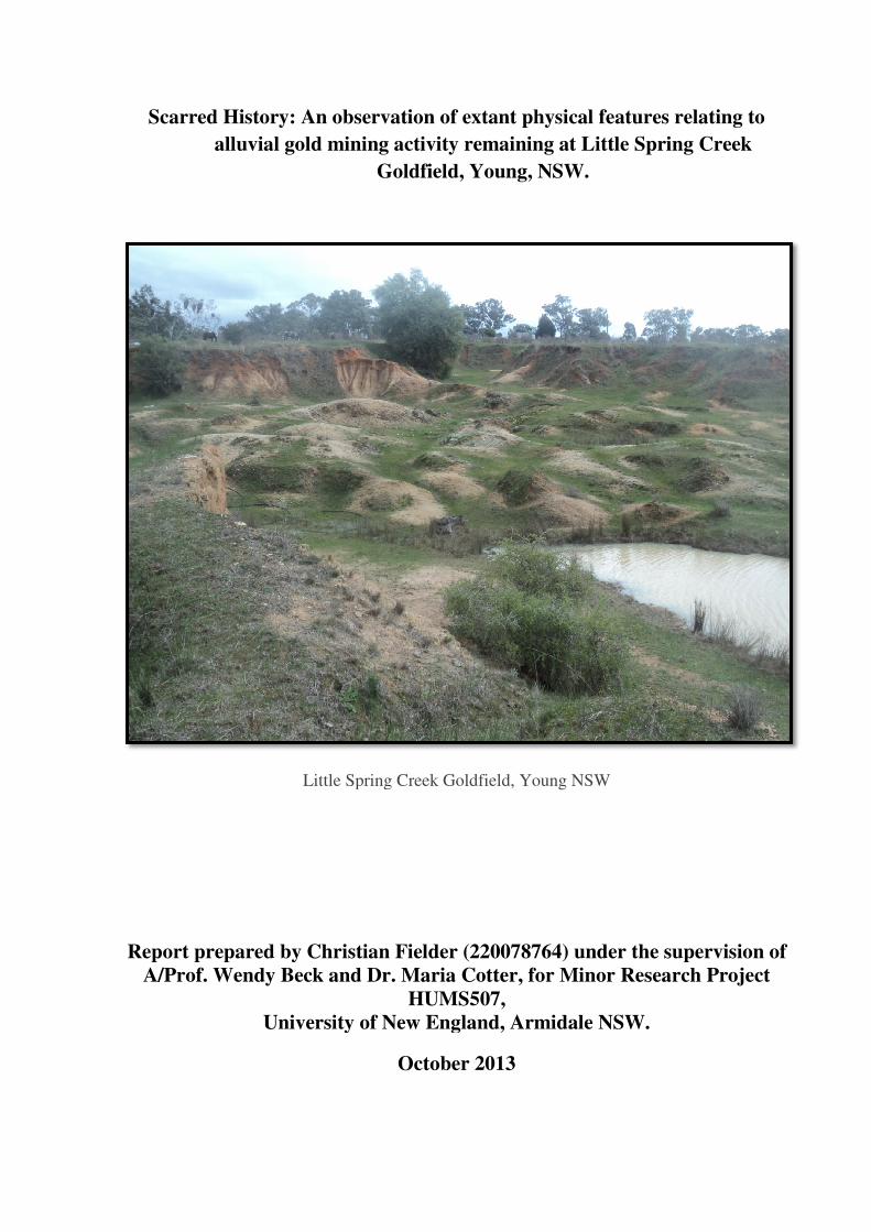
Scarred History: An observation of extant physical features relating to alluvial gold mining...
34
Scarred History: A alluvial gold Li Report prepared by C A/Prof. Wendy Beck Univer An observation of extant physical feat d mining activity remaining at Little Goldfield, Young, NSW. ittle Spring Creek Goldfield, Young NSW Christian Fielder (220078764) under k and Dr. Maria Cotter, for Minor R HUMS507, rsity of New England, Armidale NSW October 2013 tures relating to Spring Creek the supervision of Research Project W.
Transcript of Scarred History: An observation of extant physical features relating to alluvial gold mining...
Scarred History: An observation of extant p
alluvial gold mining activity remaining at
Little Spring Creek G
Report prepared by Christian Fielder
A/Prof. Wendy Beck and Dr. Maria Cotter
University of New England, Armidale NSW.
Scarred History: An observation of extant physical features relating to
alluvial gold mining activity remaining at Little Spring Creek
Goldfield, Young, NSW.
Little Spring Creek Goldfield, Young NSW
Report prepared by Christian Fielder (220078764) under the supervision of
Wendy Beck and Dr. Maria Cotter, for Minor Research Project
HUMS507,
University of New England, Armidale NSW.
October 2013
hysical features relating to
Little Spring Creek
under the supervision of
Minor Research Project
University of New England, Armidale NSW.

Christian Fielder 2
Abstract
The aim of this paper is to describe and illustrate the nineteenth century methods of gold
mining used at the Little Spring Creek goldfield located in the South West Slopes township of
Young, New South Wales. To date, there have been no archaeological investigations on the
application of gold mining technology at this site. A field survey was conducted at the site to
record the extant features in the landscape. An assessment of these physical remains is used to
fill the gap between the limited historical records that do exist. The field survey revealed
evidence of three successive periods of gold mining having occurred at the site, with the
methods of shallow sinking, ground and hydraulic sluicing having been employed.
Observations were also made on the site’s heritage and conservation value, along with its
potential for future research.
Christian Fielder 3
Table of Contents
Abstract ....................................................................................................................................... 2
Table of Contents ....................................................................................................................... 3
List of Figures ............................................................................................................................. 4
Introduction ................................................................................................................................ 5
Background ................................................................................................................................. 7
Data Sources and Literature Review ........................................................................................ 10
Fieldwork Methodology ........................................................................................................... 14
Results of Field Survey ............................................................................................................ 15
Discussion ................................................................................................................................. 23
Linking the Archival and Archaeological Evidence................................................................. 28
Heritage and Conservation Considerations .............................................................................. 30
Conclusion ................................................................................................................................ 31
References ................................................................................................................................ 33

Christian Fielder 4
List of Figures
Figure 1: Extent of Lambing Flat goldfields - 1862 ................................................................... 8
Figure 2: Little Spring Creek goldfield in relation to Young Township .................................... 9
Figure 3: Section of 1878 Geological Map of Young showing position of diggings east of
Little Spring Creek ................................................................................................................... 11
Figure 4: Network of ex-water races (in red) located near Maori Gully .................................. 12
Figure 5: Satellite image of Little Spring Creek goldfield with lined boundary ...................... 13
Figure 6: Site Plan Little Spring Creek Goldfield .................................................................... 16
Figure 7: Site A, mullock heaps. .............................................................................................. 17
Figure 8: Site A, shallow sinking ............................................................................................. 17
Figure 9: Site C. Photograph taken facing east. ....................................................................... 18
Figure 10: Site C. Photograph taken facing west. .................................................................... 19
Figure 11: Sluicing face located east at Site C ......................................................................... 19
Figure 12: Reservoir near Site C .............................................................................................. 20
Figure 13: Head water-race defined by red lines at Site B ....................................................... 20
Figure 14: Site B Plan ............................................................................................................... 21
Figure 15: Portion of dam wall at Site B .................................................................................. 22
Figure 16: Shelf located above the western working face of Site C......................................... 22
Figure 17: Earthen Mound. ....................................................................................................... 23
Figure 18: Cradling for gold at Box Ridge, near Sofala, NSW circa 1860s ............................ 24
Figure 19: Diagram of hydraulic sluicing system .................................................................... 27
Figure 20: Drift islands and exposed bedrock caused by hydraulic sluicing at Site C............. 28

Christian Fielder 5
Introduction
Goldmining methods used during the nineteenth century in New South Wales have attracted
relatively little archaeological research or interest. Academic study in Australian gold mining
activity has traditionally focused on the social and economic similarities and differences
between the gold rushes of California and Victoria (Goodman 1994, pp.10-14). The Lambing
Flat riots in 1861 for example, are often the only single focus of historical research relating to
gold mining in New South Wales (McGowan 2001, p.ii). The former Little Spring Creek
goldfield located at the South West Slopes township of Young, New South Wales still
possesses a landscape heavily scarred by intensive alluvial mining conducted during the
nineteenth century. In order to identify any correlation between the Little Spring Creek
goldfield landscape and the documented primary and secondary records that remain, a specific
research question has been formulated. The research reported in this paper focuses on the
question: What will an observation of the extant features in the landscape located at the
former Little Spring Creek goldfield add to the existing documentary accounts of nineteenth
century alluvial mining processes? It is envisioned that an archaeological survey and analysis
of this site will make a unique contribution, by both adding to, and acting as, an essential
corrective to the purely historical sources.
Archaeological evidence is rarely utilised by Australian historians (Connah 1998; Jack 1993).
To date, there have been no archaeological accounts written about the physical impact and the
extent of mining activity used at the Little Spring Creek goldfield during the nineteenth
century. Simple alluvial mining methods in the form of pan and cradle workings are often the
only single topic of discussion when describing gold extraction in the Young region during
the 1860s (Maroney 1980; McGregor & McGregor 1999). However, the Little Spring Creek
goldfield contains not only a rich archaeological record of shallow surface sinking but also
exhibits different phases of applied technology used to extract and process gold. More
intensive methods of gold extraction in the form of ground and hydraulic sluicing were also
used following the main gold rush of the 1860s (Christison 2008).
Identifying the actual extent of the Little Spring Creek site will be a difficult undertaking.
These diggings were last worked on any scale almost one hundred and thirteen years ago and
in most instances the workings are in the process of stabilisation, with natural vegetation
taking root along much of the site’s surface. Goldfields such as the Little Spring Creek site
Christian Fielder 6
were often established in isolated areas of land, the boundaries of which were determined by
the process of geological survey according to the extent of the auriferous deposits that they
could yield (Phillips 1867, pp.1-14). However, goldfields are also cultural landscapes which
integrate the mechanisms of society and technology, providing a rich source of past human
activity. The physical remains created by applied technology, especially those mechanisms
used over successive periods, are often difficult to identify (Rapp 1981, p.23). Vast mining
sites, ephemeral features and dispersion of archaeological evidence all add to this complexity.
Through the mining processes of extraction, accumulation and redeposition, the goldfield
landscape forms characteristic topographical features. These features, in addition to the
material remains, often provide information important to the archaeological interpretation of
mining sites (Pearson & McGowan 2000).
Archaeological analysis of the Little Spring Creek goldfield landscape may provide new
detail of the different types of alluvial mining techniques that were used intensively during the
years 1861 and 1862 and also in a secondary phase of gold extraction during the 1870s until
the early 1900s. There is evidence of several particular periods of alluvial gold extraction
remaining at the site, and these phases are represented by distinct landscape elements which,
to date, have not been rigorously documented for the archaeological record. A comparison of
these physical features in addition to the relevant primary and secondary documentation
relating to the site, may offer new archaeological interpretations of nineteenth century alluvial
gold extraction. However, the feasibility of recording this evidence, particularly information
that is ephemeral in nature, relies heavily upon interpretation (Wagstaff 1987). The
interpretation of the landscape will require observation of both the natural and cultural
topography that remains. This archaeological investigation must therefore be undertaken in
conjunction with an analysis of the primary and secondary historical sources available. In the
case of the Little Spring Creek goldfield little documentary evidence exists relating to the
techniques of alluvial mining. Information is limited to succinct observations in official
mining records and brief reports in newspaper articles on the region’s gold productivity
during the nineteenth century.
Although recent attempts to include the Little Spring Creek goldfield on the NSW State
Heritage Register have been made, the site remains susceptible to development as it does not
reside under legislative protection (Christison 2008). This paper will attempt to fill a gap in
the archaeological record by detailing the physical features that remain at the site thus
providing additional information concerning the site’s historical and archaeological

Christian Fielder 7
significance. Various sources of data will be reviewed in order to construct a framework for
the analysis of the applied gold mining methods that were traditionally used during the
nineteenth century. The documentary resources will include material specifically related to
the methods of extracting and processing alluvial gold deposits in the geographical area of
southern New South Wales. Local and regional histories will provide a background source of
information, as will the analysis of historical maps and photographs. As noted, documentary
sources on the Little Spring Creek goldfield are limited, therefore, an examination of the
physical remains will form an integral part of the process of compiling a detailed account of
the processes used in the mining of gold in this area during the nineteenth century. Field
reconnaissance at the Little Spring Creek site will be required in order to take detailed
photographs and measurements of remaining features, such as mullock heaps, water-races,
dams, and tailings. The purpose of undertaking this field survey will be to locate and identify
the archaeological remains of applied gold mining methods extant in the landscape, and to
examine the correlation between this evidence and their relative historical descriptions. No
archaeological features or artefacts will be disturbed in the process of conducting this research
and only non-intrusive fieldwork survey methods will be used.
Background
Gold was first discovered in Lambing Flat (now Young) on Burrangong Station in 1860 by a
cook known as Alexander ‘the Yankee’. The area of alluvial gold was found to be extensive,
with miners soon travelling to Lambing Flat from other goldfields, both from within the
colony and abroad. By October 1861, 1,500 men were working the area. Census reports show
that this number had grown to 10,000 by April of the following year. The Lambing Flat
goldfields were also at the centre of one of the most notorious incidents of the Australian gold
rushes. A series of anti-Chinese riots in the area led directly to the Colonial government
passing Chinese immigration restriction legislation in 1861 (Bayley 1977). In a response to
the continual rioting, NSW Premier Charles Cowper ordered that Chinese miners be
prohibited from working areas rich in alluvium. A furrowed line was ploughed across one half
of the Blackguard Gully diggings, segregating the Chinese and European miners (McGregor
& McGregor 1999 p.64). These events at Lambing Flat were well-recorded at the time, and
have been analysed by a number of historians in recent decades (Carrington 1960; Selth 1974;
Walker 1970). Due to the historical significance of these events, the Blackguard Gully site is

Christian Fielder
listed on the NSW State Heritage Register and
heritage legislation (unlike the Little Spring Creek goldfield)
The rich alluvial deposits on the Lambing Flat gold
years 1861 to 1862.The extent of the Lambing Flat goldfields circa 1862 has been represented
in Figure 1. During this time
been extracted (Bayley 1977
intensity of the shallow ground sluicing techniques employed by miners.
of the prospectors began to leave for more
located in Forbes and Grenfell.
and techniques for gold extraction.
Lambing Flat were constructed
sluicing operations. Two examples of
Blackguard Gully. Ground slu
was undertaken along Burrangong Creek and its tributaries
some other areas of the diggings by
been used effectively on the Californian goldfields
Figure 1: Extent of Lambing Flat goldfields
Folk Museum.
on the NSW State Heritage Register and is therefore afforded protection under State
(unlike the Little Spring Creek goldfield).
ts on the Lambing Flat goldfields were extensively
The extent of the Lambing Flat goldfields circa 1862 has been represented
During this time, it was estimated that over 6,600 kilograms
Bayley 1977, p.33). These deposits would soon be worked out
shallow ground sluicing techniques employed by miners.
began to leave for more profitable goldfields in the district such as those
Forbes and Grenfell. Those that decided to stay in Lambing Flat sought other areas
echniques for gold extraction. Dams located in the higher reaches of creeks surrounding
constructed, as were lengthy water-races to supply water for
Two examples of these reservoirs remain today at Victoria Gully and
Ground sluicing operations continued into the 1870s and extensive slui
was undertaken along Burrangong Creek and its tributaries. This practice was superseded in
some other areas of the diggings by the introduction of hydraulic sluicing, a method that had
been used effectively on the Californian goldfields during the 1850s (Bayley 1977
Figure 1: Extent of Lambing Flat goldfields - 1862 (not to scale). Source
8
therefore afforded protection under State
extensively mined between the
The extent of the Lambing Flat goldfields circa 1862 has been represented
kilograms of alluvial gold had
n be worked out due to the
shallow ground sluicing techniques employed by miners. By mid 1865, many
in the district such as those
Those that decided to stay in Lambing Flat sought other areas
higher reaches of creeks surrounding
to supply water for larger
Victoria Gully and
into the 1870s and extensive sluicing
This practice was superseded in
the introduction of hydraulic sluicing, a method that had
Bayley 1977).
(not to scale). Source: Lambing Flat

Christian Fielder
The former Little Spring Creek
along the western bank of Little
in the 1860s. After much of Lambing Flat had been abandoned for more lucrative ventures
elsewhere in the district, approximately ninety miners continued to work the
sinkings. During the latter part of the nineteenth century
Gold Mining and Prospecting
formed to capitalise on large
The Little Spring Creek goldfield
activity, which provides the physical evidence examined in this paper.
Figure 2: Little Spring Creek goldfield in relation to Young Township
Government, Land & Property Information Spatial Information Exchange website.
Little Spring Creek goldfield is located on a 3.898 hectare portion of crown land
Little Spring Creek (Figure 2). Mining first began in this area
in the 1860s. After much of Lambing Flat had been abandoned for more lucrative ventures
approximately ninety miners continued to work the
ing the latter part of the nineteenth century organisations such as
and Prospecting Company and the Burrangong Steam Sluicing Company
large scale hydraulic sluicing activities at the site
Little Spring Creek goldfield landscape still reflects all of these phases of
, which provides the physical evidence examined in this paper.
Figure 2: Little Spring Creek goldfield in relation to Young Township
Government, Land & Property Information Spatial Information Exchange website.
9
hectare portion of crown land
Mining first began in this area early
in the 1860s. After much of Lambing Flat had been abandoned for more lucrative ventures
approximately ninety miners continued to work the site’s shallow
such as the Burrangong
Company and the Burrangong Steam Sluicing Company were
at the site (Bayley 1977 p.35).
of these phases of past mining
Figure 2: Little Spring Creek goldfield in relation to Young Township. Source: NSW
Government, Land & Property Information Spatial Information Exchange website.
Christian Fielder 10
Data Sources and Literature Review
As previously indicated, primary and secondary sources of information relating to the mining
techniques employed at the Lambing Flat gold diggings, including those specifically citing
the former Little Spring Creek site, are extremely limited. Historic material relating to mining
methods used at other goldfields of a similar era are well documented and could be used to
inform assessment of the Little Spring Creek site. Wherever possible, information relating to
alluvial gold mining methods used in southern New South Wales between the periods of 1850
to 1900 was sought. Documentary material relating to goldfields in the Southern Tablelands
and Snowy Mountains region (such as the Braidwood and Kiandra diggings) proved
invaluable, as extensive alluvial mining also occurred in these areas between the specified
dates. This archival material is comprised primarily of newspaper and journal reports,
nineteenth century mining manuals, lease and parish maps as well as photographs.
Official records of the Department of Lands and Department of Mines for New South Wales
were utilised extensively for the purposes of researching the methods of alluvial gold mining
in the nineteenth century. These included annual reports, lease and claim folios and mining
and geological survey reports and their accompanying maps. The annual reports are
comprised of individual accounts written by mining authorities at the time. These reports
document the workings, mining methods being applied, and details of mine infrastructure
such as water-races, and the installation of sluicing boxes or hydraulic sluicing pumps. A
geological map of Young produced for the 1878 Department of Mines (NSW) Annual Report
details some areas where gold mining was being conducted in the township. Figure 3 is a
section of this map, and indicates a portion of ‘diggers holes’ located to the east of Little
Spring Creek.

Christian Fielder 11
Figure 3: Section of 1878 Geological Map of Young showing position of diggings east of
Little Spring Creek. Source: Department of Mines (NSW) 1878 Annual Report.
The New South Wales Government’s Land and Property Spatial Information Exchange
website has five digitised historical maps relating to the parish of Young from 1891 to 1954.
One map produced in 1933 provides some detail about the former gold mining features that
existed at Young during its mining boom. Figure 4 is an enlarged section of this map and
shows a network of ex-water races located on the property of G and J Eastlake. These water-
races flowed toward the former diggings at Maori Creek, which was situated approximately
two and half kilometres to the south-east of Little Spring Creek.

Christian Fielder 12
Figure 4: Network of ex-water races (in red) located near Maori Gully. Source: NSW
Government, Land & Property Information Spatial Information Exchange website.
Unfortunately, these maps often had scales too large to allow for reliable examination of
specific diggings. The maps were limited in detail and were designed to show the location of
the goldfields within the township, rather than the specific features that were built upon them.
Detail of water-races or other features relating specifically to gold mining activity at the Little
Spring Creek site were virtually non-existent on historical maps. Historical parish maps of
Young were useful only to the extent that they document the general layout of the township
and its environs.
Historical photographs are often useful for the purpose of visual comparison of the landscape
impact when researching goldfields (Pearson and McGowan 2000 p.8). The invention of
photography in 1834 resulted in Australia's gold rush era being recorded visually as well as
being documented in reports. Otto Holtermann, for instance, extensively photographed the
goldfields of Hill End providing a descriptive and visual recording of the town’s social history

Christian Fielder
and the impact of mining on
Flat or Young during its gold rush are
during 1944 provided some
such as Little Spring Creek
do not reveal the distinct landscape transformations of the mining process
imagery of Little Spring Creek
and clearly shows the remaining cultural disturbances in the landscape
Figure 5: Satellite image of Little Spring Creek goldfield
Google Earth, 2013.
Little reliance should be placed on
Flat diggings, as regrettably
literature on the history of Lambing Flat or Young often exclude
relating to the methods of gold extraction and instead focus
European and Chinese miners. T
book entitled Rich Earth: History of Young and the Shire of Burrangong New South Wales
(1977) and to a lesser degree
of the history of the Lambing Flat gold era includ
of the day and contains important data relating to civil records and gold mining productivity
on its landscape (Burke 1973). Archival photographs
Flat or Young during its gold rush are mysteriously rare. Aerial photographs
some means of historical comparison of topography. Natural f
Spring Creek do stand out in aerial photographs, but unfortunately
distinct landscape transformations of the mining process
Little Spring Creek does allow for an excellent analysis of topographical features
and clearly shows the remaining cultural disturbances in the landscape (Figure
: Satellite image of Little Spring Creek goldfield with lined boundary
should be placed on the majority of local histories produced on the Lambing
regrettably most are unreferenced and highly anecdotal. The available
Lambing Flat or Young often excludes much important material
relating to the methods of gold extraction and instead focuses on the conflict between
European and Chinese miners. Two notable exceptions can be found in William Bayley’s
Rich Earth: History of Young and the Shire of Burrangong New South Wales
and to a lesser degree Roll-Up (1999) by Hector and John McGregor
Lambing Flat gold era includes information sourced from
contains important data relating to civil records and gold mining productivity
13
hotographs of Lambing
graphs taken of Young
topography. Natural features
but unfortunately the images
distinct landscape transformations of the mining process. Google Earth
topographical features
Figure 5).
with lined boundary. Source:
majority of local histories produced on the Lambing
unreferenced and highly anecdotal. The available
much important material
on the conflict between
wo notable exceptions can be found in William Bayley’s
Rich Earth: History of Young and the Shire of Burrangong New South Wales
McGregor. Bayley’s account
es information sourced from official records
contains important data relating to civil records and gold mining productivity
Christian Fielder 14
in the book’s appendix. This publication is referenced and information was obtained mainly
from local nineteenth century newspapers such as the Burrangong Argus (1864-1914),
Burrangong Chronicle (1873-1902), and Miner (1861-1862). Other district newspapers that
reported mining activity in either Lambing Flat or Young included the Yass Courier,
Illustrated Sydney News, Sydney Morning Herald and Town and Country Journal. Periodicals
cited by Bayley include Department of Mines annual reports from 1875, Mines and Minerals
Statistics and information derived from the Government Gazette.
Fieldwork Methodology
In addition to an examination of the primary and secondary resources available, it was
necessary to locate and identify the archaeological remains at the Little Spring Creek site. The
first step in recording this site was to locate it accurately. This was achieved by obtaining the
site’s standard Australian Map Grid (AMG) reference, and using the largest scale topographic
map available for the area (1:25 000) as a base map. A Global Positioning System (GPS) was
also used to indicate the location and boundary of the area, and to record significant features
within the site itself. A site plan could then be created indicating important features such as
mullock heaps, shallow sinkings, dams, water-races and tailings as well as areas of sluicing
activity.
Two survey methods were used to produce detailed site plans. The tape offset technique was
used in conjunction with the less accurate compass and pacing technique. Before starting the
survey, ground reconnaissance was conducted to identify the extent of the remains, the edges
of the mining area and the location of elements within it. This allowed for the outer boundary
of the plan to be plotted on A4 and A3 sized graph paper and then filling in the detail by
taking bearings from the key landscape features. Three sample areas were then chosen based
on distinctive cultural transformations still evident in the landscape (and thus relating to
characteristic mining phases). These sample areas were then assessed according to the past
mining activity and labelled: Site A (area of shallow sinking), Site B (area of ground
sluicing), and Site C (area of hydraulic sluicing). These three areas were chosen to help
describe the main mining features and to differentiate between the main technologies that
were utilised at the site.

Christian Fielder 15
The height, diameter and slope of key landscape features were also recorded by direct
measurement using a thirty metre fibreglass tape. Lines marking the upper edge of these
features and slopes were noted on the site plan. The relative difference in elevation between
flat and high land could be estimated and written on the plan. References to roads, creek lines,
ridges, fences and property boundaries were also included. Separate notes were taken
describing each key element to enable a detailed plan to be produced in addition to the
creation of an overall site plan.
The site was also extensively photographed using a 10.1 megapixel digital camera. A two
metre range pole with fifty centimetre increments was used as a photographic scale. A north
arrow was also used to indicate the position of view. Key features of the landscape were
chosen for photography as were overall views of the area showing a number of features of the
mining site and its environment. All photographs were recorded in a log describing what they
show, the angle from which they were taken, and the direct GPS co-ordinates of these
photographed features. The photographed features were also noted on the site plan showing
the viewpoint from which each photograph was taken.
Results of Field Survey
The Little Spring Creek site contains evidence of three periods of alluvial gold mining that are
represented by three distinct landscape elements still present in the environs. Figure 6 is the
site plan that was produced as a result of the field survey. The site plan defines the three sites
according to the observation of different modifications in the landscape occurring as a result
of past mining activity. The site plan also indicates the location of where the prominent gold
mining features were photographed during the course of the survey.
Site A runs along the western edge of the Little Spring Creek goldfield and contains remnants
of mullock heaps (Figure 7) as well as an abundance of round surface depressions extending
by approximately 120 metres (west to east) and 100 metres (north to south). The area worked
at Site A appears to be quite large but always very shallow, with sinkings ranging from a
maximum of twenty centimetres to only a few centimetres deep (Figure 8). Other than the
surface sinkings and mullock heaps in Site A, there is no evidence of water-races, tailing
mounds or other landscape transformations.

Christian Fielder 16
PHOTOGRAPH AND FEATURE KEY
07 Mullock heaps 08 Shallow sinking 09 Gully face, east 10 Gully face, west 11 Sluicing face 12 Reservoir 13 Head water-race 15 Earthen dam wall 16 Shelf 17 Tailing mound 20 Drift islands and exposed bedrock
LEGEND
Shallow sinking
= = = Water-race
_____ Face of hydraulic sluicings
Figure 6: Site Plan Little Spring Creek Goldfield
Site B
8
7
9
10
11
12
13
15 16
17
20

Christian Fielder 17
Figure 7: Site A, mullock heaps.
Figure 8: Site A, shallow sinking
Mullock Heaps
Shallow sinking

Christian Fielder 18
The central and eastern sections of the goldfield (Site C) form a deep gully with heavily
eroded cliffs (Figures 9 and 10). The gully contains patches of large open cuttings and high
steep faces that retain innumerable sluicing scars (Figure 11). Mounds of re-deposited gravel
are scattered on the gully floor. Site C is extensive and extends approximately 130 metres
(west to east) and 150 metres (north to south). The height of the gully face varies but is in
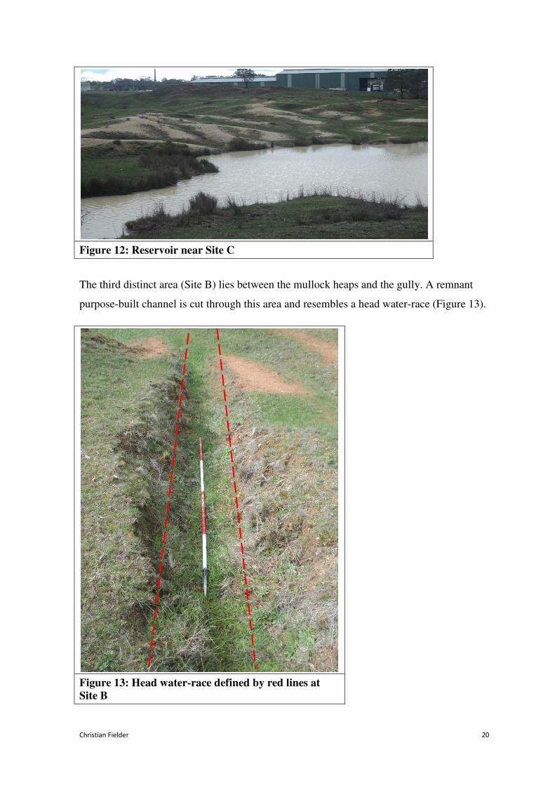
parts five metres or more high. Near Site C is a twenty-nine metre low level reservoir situated
very close to the gully, the construction of which is non-natural (Figure 12). There is no
visible hydraulic machinery or infrastructure on the surface in this area.
Figure 9: Site C. Photograph taken facing east.
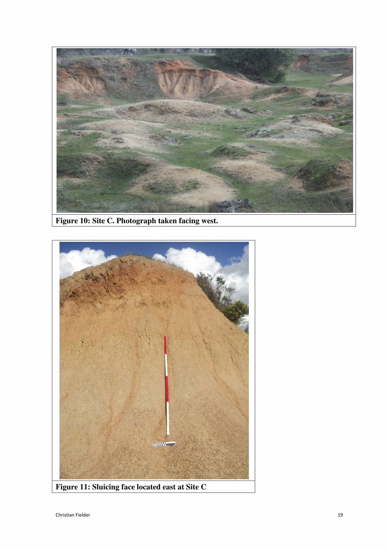
Christian Fielder 19
Figure 10: Site C. Photograph taken facing west.
Figure 11: Sluicing face located east at Site C
Christian Fielder 20
Figure 12: Reservoir near Site C
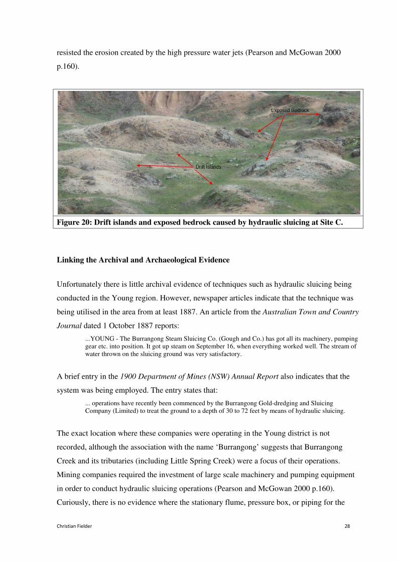
The third distinct area (Site B) lies between the mullock heaps and the gully. A remnant
purpose-built channel is cut through this area and resembles a head water-race (Figure 13).
Figure 13: Head water-race defined by red lines at
Site B

Christian Fielder 21
Eight large pits were measured within close proximity to the beginning of the head water-race
(Figure 14). The topography of these pits suggests that alluvial deposits were washed by
channelled water, rather than sunk by picks or shovels. A partial earthen-built dam wall
extending for thirty-seven metres is also present at Site B (Figure 15). The dam wall is on a
rise, with an elevation of 458 metres at its highest point. The water-race appears to start at the
dam wall and extends approximately fifty metres towards sites A and C. Located on the
boundary of Site B is a large shelf of flat ground which falls sharply on top of a gully wall on
the western side of Site C (Figure 16).
Site B - Ground Sluicing Pits and Water-Race
Area: 30m x 10m
Scale: 1:250
General Slope: North, North East
Depth Below Ground Surface
Water-race = 200mm Pit 1 = 700mm Pit 2 = 400mm Pit 3 = 800mm Pit 4 = 700mm Pit 5 = 600mm Pit 6= 300mm Pit 7 = 750mm Pit 8 = 700mm
Figure 14: Site B Plan
-

Christian Fielder 22
Figure 15: Portion of dam wall at Site B.
The red line denotes the length of the dam
wall at its highest point.
Figure 16: Shelf located above the western working face of Site C
Shelf

Christian Fielder 23
Another prominent feature in the landscape is a 150 metre long mound extending west to east
across the site (Figure 17). The feature consists of an earthen-built elongated mound
approximately eighty centimetres high. An important characteristic of the mound is that it is
located on a fall of land and arranged in such a way to facilitate water drainage for the entire
site. The long mound appears to utilise the natural slope of the site and may have directed
water flow into Little Spring Creek.
Figure 17: Earthen Mound. The
red line denotes the length of the
mound at its highest point.
Discussion
The field survey conducted at the Little Spring Creek goldfield revealed that extensive mining
activity had been carried out during three particular phases. Impact on the landscape caused
by shallow surface sinking as well as from ground and hydraulic sluicing was immense. It
appears that vast depths of overburden had to be removed to access the narrow auriferous
deposits close to the bedrock, leaving numerous surface depressions, as well as deeply eroded
chasms and high sluicing faces. The features located at Site A, are possibly the result of

Christian Fielder 24
shallow sinkings where a number of shafts are sunk in close proximity to each other. The
excavated material was then washed in a cradle or sluice box to extract the alluvium. The
photograph in Figure 18 demonstrates this technique being employed at Box Ridge, near
Sofala NSW. This technique was the most basic of alluvial mining methods and was used
extensively in the area during the early stages of gold prospecting (Bayley 1977, p.29).
Figure 18: Cradling for gold at Box Ridge, near Sofala, NSW circa 1860s. Source:
NSW Department of Primary Industries.
The large round pits and head water-race located at Site B suggests that parts of the area were
worked using ground sluicing. This mining technique involved digging narrow channels into
the ground or bedrock to direct water flow from the head-race through a known gold-bearing
site. The ground sluice was often lined with wooden blocks, or stones, to prevent erosion of
the floor and to allow the capture of gold bearing deposits, however this infrastructure is not
visible at Site B. The shelf located below the top of the western sluicing face on Site C
suggests that water flow was directed from Site B for the purposes of saturating and then

Christian Fielder 25
loosening gold-bearing deposits. Site B is situated on a rise of land suggesting that a
sufficient flow of water was channelled into ground sluices which escaped via water-borne
tailings toward the lower end of the site to the east. It was a technique used extensively on the
Lambing Flat goldfields throughout the 1860s and 1870s (Christison 2008).
The boundary between Site B and Site C may provide the clearest indications of a deliberate
change in mining methodology and technology used at the Little Spring Creek site. The extant
remains that intersect these sites indicate a change from ground to hydraulic sluicing. The
shelf located on top of the western working face of Site C indicates that water was once
brought over the top of the working face and run down the surface to saturate and loosen
deposits that existed along the western bank of Little Spring Creek (see Figure 16). The shelf
is a very distinct feature of the landscape and does not appear to be caused by natural erosion.
During the process of hydraulic sluicing water was not run down over the working face.
Instead it was hosed, under pressure, onto the alluvial deposit. The method of working
alluvial deposits by ground sluicing depended upon the depth of the auriferous drift and the
topography of the area (Pearson and McGowan 2000 p.96).
Ground sluicing had earlier proved an effective method used at other alluvial goldfields in the
south-east of New South Wales during the 1850s (McGowan 2001 p. 8). The ground sluicing
technique may have been transferred to the Little Spring Creek goldfield after its successful
utilisation on goldfields such as Braidwood, Adelong and Kiandra. Ground sluicing was a
mining process where efficient operation could yield a reasonable gold return from relatively
poor ground. This system certainly would have been an easy adaption to the Little Spring
Creek site, having been described during the initial gold rush of the 1860s as ‘poor man’s
diggings’ (Sydney Morning Herald November 10 1860, p. 5). The alluvium in this area, for
instance, did not require the use of intensive shaft tunnelling or ore-crushing equipment to
extract gold, unlike the quartz reef mines in neighbouring townships such as Grenfell.
Two essentials for a successful ground sluicing operation were an abundant supply of water
and a clear outfall for the tailings (Pearson and McGowan 2000 p.96). The major requirement
was water and difficulties were sometimes encountered in securing a permanent supply near
claims in the Lambing Flat area. Drought had affected the area between 1876 and 1877 and
again between 1880 and 1881 (Bayley 1977 p.186). The mining warden for the Young

Christian Fielder 26
district, Mr. Robinson, comments upon the situation in the 1880 Department of Mines (NSW)
Annual Report:
...The season ... has been so dry that few opportunities have been afforded for sluicing, which is the
only mode pursued hereabouts for winning gold.
Again, in the 1881 Department of Mines (NSW) Annual Report, the mining registrar, H.A.
Smith, notes:
...There has been little sluicing done, as water has been too scarce. Until we have a return of wet
seasons, gold-mining in this district will be at a standstill.
Until the early 1880s, rainfall and water supply at the Little Spring Creek goldfield must have
been adequate enough to utilise the ground sluicing technique. As indicated at Site B, a large
dam had been created on a rise of land to the west, and a head-race cut with a sufficient
gradient to supply an uninterrupted flow for sluicing the main working face located at Site C.
The flow of water over the face of the workings loosened the wash-dirt (creating the shelf in
Figure 16) and assisted the miners working below with picks to undermine sections of the
alluvial deposit. As the mass of wash-dirt disintegrated, it then needed to be passed in a
stream of water via a sluice channel. Objects, such as stones, riffle boards or wooden blocks
placed in the sluice further assisted the breaking up of the wash-dirt, causing the deposition of
the heavier gold particles to be obstructed along the channel (Pearson and McGowan 2000
p.157). The extant tailing mound in the north-east of the site also suggests that ground
sluicing was utilised at the site. Non-gold bearing detritus needed to be carried away from the
main diggings after the gold was extracted and was usually redirected back into creeks or
streams via tailing mounds (Pearson and McGowan 2000 p.113).
The ground sluicing process was superseded by the introduction of hydraulic sluicing during
the late 1800s. The process of hydraulic sluicing utilised powerful jets of water to saturate and
erode the overburden and auriferous drift. However, its implementation on the goldfields of
Young must have been hampered intermittently by the lack of reliable rainfall (Bayley 1977
p.186). The benefit of hydraulic sluicing was that it required considerably less physical
intervention on the part of the miners than ground sluicing. The hydraulic sluicing process
allowed for large areas of auriferous deposit to be removed quickly and efficiently. Water was
brought to the hydraulic sluicing leases, usually from a dam or large reservoir, by means of
water-races which was then directed into a flume. The flume was a metal or wooden trough
that conveyed water from a higher to a lower level enabling water pressure to be accumulated

Christian Fielder 27
and then released via a hose and monitor system (Pearson and McGowan 2000 p.160). Figure
19 is a diagram of a typical hydraulic sluicing process that was used on the Kiandra goldfield
circa 1880s.
Figure 19: Diagram of hydraulic sluicing system. Source Lambing Flat Folk Museum.
As indicated earlier, the earthen-built dam towards the west of the site may have contained
sufficient water to supply the entire site for both the purposes of ground sluicing, then in later
years for hydraulic operations. The race which flowed from this dam may have been used to
direct water into a flume erected somewhere above the workings at Site C, then conveyed to
the working floor via a pressure box. The ‘wash’ of auriferous clay and gravel created by the
force of water directed onto the working face then needed to be run through sluice boxes for
gold extraction, with the uneconomic tailings discharged into collection ponds (Pearson and
McGowan 2000 p.160). The low level reservoir located near Site C may have served the
purposes of tailing collection and to drain the back-wash created by the action of hydraulic
sluicing.
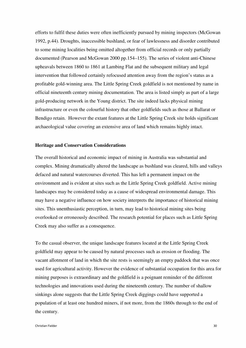
It is clear that the extant landscape features formed at Site C are a result of the hydraulic
sluicing process. The intensive removal of auriferous alluvium by the process of hydraulic
sluicing often created vast open chasms such as those located at site C. The deep scarring on
the gully cliffs was also typically formed as a result of spraying water under high pressure
through a hose which eroded vast quantities of auriferous clay and gravel away from the
working face (Pearson and McGowan 2000 p.99). In addition to the extant vertical working
face at Site C, the working floor is scattered with drift islands and large areas of exposed
bedrock (Figure 20). These particular features were formed at points where the natural ground
Christian Fielder 28
resisted the erosion created by the high pressure water jets (Pearson and McGowan 2000
p.160).
Figure 20: Drift islands and exposed bedrock caused by hydraulic sluicing at Site C.
Linking the Archival and Archaeological Evidence
Unfortunately there is little archival evidence of techniques such as hydraulic sluicing being
conducted in the Young region. However, newspaper articles indicate that the technique was
being utilised in the area from at least 1887. An article from the Australian Town and Country
Journal dated 1 October 1887 reports:
...YOUNG - The Burrangong Steam Sluicing Co. (Gough and Co.) has got all its machinery, pumping
gear etc. into position. It got up steam on September 16, when everything worked well. The stream of
water thrown on the sluicing ground was very satisfactory.
A brief entry in the 1900 Department of Mines (NSW) Annual Report also indicates that the
system was being employed. The entry states that:
... operations have recently been commenced by the Burrangong Gold-dredging and Sluicing
Company (Limited) to treat the ground to a depth of 30 to 72 feet by means of hydraulic sluicing.
The exact location where these companies were operating in the Young district is not
recorded, although the association with the name ‘Burrangong’ suggests that Burrangong
Creek and its tributaries (including Little Spring Creek) were a focus of their operations.
Mining companies required the investment of large scale machinery and pumping equipment
in order to conduct hydraulic sluicing operations (Pearson and McGowan 2000 p.160).
Curiously, there is no evidence where the stationary flume, pressure box, or piping for the

Christian Fielder 29
hydraulic sluicing system once stood at the Little Spring Creek site. It is possible to surmise
that the equipment was detached from the site and later reused at other goldfields, but there
are no documentary accounts suggesting that this occurred.
It is often incorrectly assumed that goldmining sites are the product of a single event or
movement (Ritchie 1991). Cultural transformations in the landscape at Little Spring Creek
represent three distinct phases of applied mining technologies. It is only when each individual
landscape component is assessed in its context that the most effective and accurate
interpretation can be achieved. Research into alluvial gold workings in New South Wales has
been significantly overlooked with attention credited only to those sites that still possess
remaining mining machinery and related infrastructure (McGowan 2001, p.1). There may be
several reasons for this to have occurred. The physical substantiality of large scale mining
equipment such as ore-crushing batteries, boilers and engines together with recognition of
their association with the historical mining process are probably the most apparent reasons.
These types of physical remains still command attention from those interested in the heritage
and conservation of nineteenth century goldfields.
The introduction of new technology at the Little Spring Creek site was identified in the field
survey as occurring at both sites B and C. The implementation of ground and hydraulic
sluicing methodology was an important advancement in gold extracting technology and
represents a deliberate effort to improve mining production through innovation. Both ground
and hydraulic sluicing methods allowed claims to be worked more effectively than basic
ground sinking techniques. The extant remains accumulating from these two types of mining
activities debunk the mythology that simple pan and cradle equipment were the only methods
being utilised in the area. Another striking feature of alluvial mining at this site was
persistence over relatively long periods of time. From the 1860s until the early 1900s there
was always some mining activity, even during periods of severe drought.
Official records of mining activity from the nineteenth century reflect a certain favouritism
toward the more well established or high gold-yielding areas of the time. The discovery of the
286 kilogram Holtermann Nugget at Hill End in 1872, for instance, received continued
attention and press coverage long after the famous, but perhaps once-off, event occurred
(Mayne 2003, p.33). Mining officials were required to carry out regular goldfield inspections
within their jurisdiction, in order to issue Miners Rights and to record gold yields. However,
Christian Fielder 30
efforts to fulfil these duties were often inefficiently pursued by mining inspectors (McGowan
1992, p.44). Droughts, inaccessible bushland, or fear of lawlessness and disorder contributed
to some mining localities being omitted altogether from official records or only partially
documented (Pearson and McGowan 2000 pp.154–155). The series of violent anti-Chinese
upheavals between 1860 to 1861 at Lambing Flat and the subsequent military and legal
intervention that followed certainly refocused attention away from the region’s status as a
profitable gold-winning area. The Little Spring Creek goldfield is not mentioned by name in
official nineteenth century mining documentation. The area is listed simply as part of a large
gold-producing network in the Young district. The site indeed lacks physical mining
infrastructure or even the colourful history that other goldfields such as those at Ballarat or
Bendigo retain. However the extant features at the Little Spring Creek site holds significant
archaeological value covering an extensive area of land which remains highly intact.
Heritage and Conservation Considerations
The overall historical and economic impact of mining in Australia was substantial and
complex. Mining dramatically altered the landscape as bushland was cleared, hills and valleys
defaced and natural watercourses diverted. This has left a permanent impact on the
environment and is evident at sites such as the Little Spring Creek goldfield. Active mining
landscapes may be considered today as a cause of widespread environmental damage. This
may have a negative influence on how society interprets the importance of historical mining
sites. This unenthusiastic perception, in turn, may lead to historical mining sites being
overlooked or erroneously described. The research potential for places such as Little Spring
Creek may also suffer as a consequence.
To the casual observer, the unique landscape features located at the Little Spring Creek
goldfield may appear to be caused by natural processes such as erosion or flooding. The
vacant allotment of land in which the site rests is seemingly an empty paddock that was once
used for agricultural activity. However the evidence of substantial occupation for this area for
mining purposes is extraordinary and the goldfield is a poignant reminder of the different
technologies and innovations used during the nineteenth century. The number of shallow
sinkings alone suggests that the Little Spring Creek diggings could have supported a
population of at least one hundred miners, if not more, from the 1860s through to the end of
the century.

Christian Fielder 31
However there are certain threats to the conservation of the site. Some of the most severe
deterioration observed at the site could not be attributable to mining, but to the activity of
agisted livestock (both cattle and horses) on the property. Grazing trails are scattered
throughout the site, and have caused disturbances to much of the surface particularly in Site
A. Commercial development in the area may be another concern for the future preservation of
the site. Several agricultural machinery sale yards are already in the vicinity, especially
surrounding the north-west sector of the site, which according to a report from a local
historian, occupy the site of the former diggings (B James 2013, pers. comm., August 5).
Listing the site on the NSW State Heritage Register may be the only means by which to
protect the goldfield’s rich historical and archaeological significance as well as its potential
for future research. The author contends that the Little Spring Creek site would make a
valuable model of comparative study especially if a researcher were seeking to assess the
environmental impact that ground and hydraulic sluicing activity had on Australian or
international goldfields.
Conclusion
This paper started with the research question: What will an observation of the extant features
in the landscape located at the former Little Spring Creek goldfield add to the existing
documentary accounts of nineteenth century alluvial mining processes? The methods of
mining used at the Little Spring Creek goldfield included simple alluvial gold extraction
methods, such as shallow sinking and cradling, as well as two different types of complex
alluvial workings, the methods of ground and hydraulic sluicing. The field survey conducted
on this site has identified several intact landscape features that were produced as a result of
different mining processes. Historical information, in the form of New South Wales
Department of Mines publications as well as nineteenth century newspaper reports
specifically documenting the Little Spring Creek site is severely limited. The existing
documentary evidence is more useful in understanding the general layout of the former
Lambing Flat or Young goldmining region and for obtaining data on annual production levels,
rather than an explanation as to what mining methods were being utilised.
The archival records that were examined for this paper rarely included information on the
physical impact and extent of mining methodology. However there is importance and value
for historians and archaeologists in studying the material evidence that remains at such sites.

Christian Fielder 32
The empirical evidence gathered whilst conducting the field survey shows that landscape
transformations at the Little Spring Creek goldfield are not the product of a single event, but
instead display three distinct phases of alluvial mining activity. The goldfield landscape at
Little Spring Creek represents how society adapted to and changed nature, for better or worse.
Archaeologists cannot afford to be selective about the past. It is important when researching
and assessing mining places, to always consider the broader context in which the mining
occurred. Even those landscapes devoid of physical mining infrastructure or machinery still
have a story to tell.

Christian Fielder 33
References
Australian Town and Country Journal 1887, October 1, p 24, viewed 3 October 2013,
http://nla.gov.au/nla.news-article71089640
Bayley, W. 1977, Rich Earth: History of Young, New South Wales, Young Municipal
Council, Young.
Burke, K. 1973, Gold and Silver: An Album of Hill End and Gulgong Photographs from the
Holtermann Collection, Heinnemann, Melbourne.
Carrington, D. 1960, ‘Riots at Lambing Flat 1860-1861’, Journal of the Royal Australian
Historical Society, vol. 46, pp. 223–243.
Christison, R. 2008, Young Shire Community Based Heritage Study, High Ground Consulting,
Lithgow.
Connah, G. 1998, ‘Pattern and purpose in historical archaeology’, Australian Historical
Archaeology, vol. 16, pp. 3–7.
Department of Mines 1880, Annual Report, Department of Mines, Sydney.
Department of Mines 1881, Annual Report, Department of Mines, Sydney.
Department of Mines 1900, Annual Report, Department of Mines, Sydney.
Goodman, D. 1994, Gold Seeking: Victoria and California in the 1850s, Allen & Unwin St
Leonards.
Jack, I. 1993, ‘Historical archaeology and the historian’, Australian Historical Archaeology,
vol. 11, pp. 130–138.
Maroney, R. 1980, A Short History of the Lambing Flat Gold Rush 1860-1861. R. Maroney,
Young.

Christian Fielder 34
Mayne, A. J. C. 2003, Hill End : an historic Australian goldfields landscape, Melbourne
University Press, Carlton.
McGowan, B. 1992. ‘Aspects of gold mining and mining communities in the Shoalhaven area
of New South Wales: An archaeological and historical study’, Australasian Journal of
Historical Archaeology, vol. 10 pp. 43–54.
McGowan, B. 2001, Dust and Dreams : Mining Communities in South-East New South
Wales, 1850-1914. ANU Press, Canberra.
McGregor, H. & McGregor, J. 1999, Roll-up, J.K McGregor, Young.
Pearson, M & McGowan, B. 2000, Mining Heritage Places: Assessment Manual. Australian
Council of National Trusts & Australian Heritage Council, Canberra.
Phillips, J. 1867, The Mining and Metallurgy of Gold and Silver, E. and F.N. Spon, London.
Rapp, F. 1981, Analytical Philosophy of Technology, D. Reidel Publishing Company,
London.
Ritchie, N. 1991, ‘Is there an optimum system?: The recording and assessment of historic
mining sites’, Australian Journal of Historical Archaeology, vol 9, pp. 37–44.
Selth, P. 1974, ‘The Burrangong (Lambing Flat) riots 1860-61: a closer look’, Journal of the
Royal Australian Historical Society, vol 60, no. 1, pp. 48–69.
Sydney Morning Herald 1860, November 10, p. 5, viewed 3 October 2013,
http://nla.gov.au/nla.news-article13048447
Wagstaff, J. (ed.) 1987, Landscape and Culture. Geographical and Archaeological
Perspectives, Blackwell, Oxford.
Walker, R. 1970, ‘Another look at the Lambing Flat riots, 1860 – 1861’, Journal of the Royal
Australian Historical Society, vol. 56, no. 3, pp. 193–205.