modulation techniques for range measurements from satellites
Upload
khangminh22Category
view
0download
0
SATELLITES GOING LOCAL
Eurisy is a non-profi t association of space agencies and government offi ces dealing with space affairs in Europe.
It is mandated and fi nanced by its members to increase the access of society to the benefi ts of innovative satellite information and services.
Eurisy
8-10 rue Mario Nikis75015 Paris, France
+33 (0) 1 47 34 00 79
PUBLIC AND PRIVATE ORGANISATIONS SHARE THEIR SUCCESS STORIES
2016-2017

1
E U R I S Y W O U L D L I K E T O T H A N K T H E C O N T R I B U T O R S T O T H I S P U B L I C A T I O N
F O R T H E I R R E A D I N E S S T O S H A R E T H E I R E X P E R I E N C E S , A N D T H E T I M E A N D E F F O R T T H E Y H AV E P U T
I N T O H E L P I N G E U R I S Y T O P R O D U C E T H I S C O L L E C T I O N O F G O O D P R A C T I C E S .

2

3
CONTENTS
C O N T E N T S 3
E D I T O R I A L 5
M E M B E R S 7
E N D O R S E M E N T S 9
A G R I C U LT U R E & E N V I R O N M E N T 1 1
C O M M U N I C A T I N G & D I G I T A L S O C I E T Y 1 7
I N F R A S T R U C T U R E , T R A N S P O R T & L O G I S T I C S 2 3
R I S K M A N A G E M E N T 2 9
T O U R I S M & L E I S U R E 3 5
E U R I S Y S U R V E Y 4 1
P R E V I O U S E D I T I O N S 4 4

4

D E A R R E A D E R ,
You are holding Eurisy’s 5th edition of its regular collection of good practice examples. You may know little about satellite applications, or you may be a specialist. In both cases, we hope you will find these articles interesting.
For the non-space professionals they are intended to demonstrate, in a down-to-earth manner, how digital products and services that rely on satellite navigation, satellite communications and Earth observation, benefit professionals in all areas of activity. Examples range from agriculture and environment, to risk management, to tourism and leisure, to infrastructure and building, to mobility and transport.
To satellite professionals, they will offer insights into user needs, and possible business cases. Beyond cutting edge algorithms, successful services for the user involve cooperation with thematic experts as well as managing change.
Nowadays, the digital society is the main source for jobs and growth. Satellite applications are here to enhance it.
We hope you are inspired by these testimonials and will be encouraged to follow suit.
Enjoy!
D O M I N I Q U E T I L M A N S , E U R I S Y P R E S I D E N T
5
EDITORIAL
E U R I S Y ’ S M E M B E R S I N C L U D E M O S T S PA C E A G E N C I E S O R G O V E R N M E N TA L
O F F I C E S I N C H A R G E O F S PA C E A F FA I R S I N E U R O P E , A N D I N T E R N AT I O N A L O R G A N I S AT I O N S
D E A L I N G W I T H S PA C E M AT T E R S .
6

E U R I S Y ’ S M E M B E R S I N C L U D E M O S T S PA C E A G E N C I E S O R G O V E R N M E N TA L
O F F I C E S I N C H A R G E O F S PA C E A F FA I R S I N E U R O P E , A N D I N T E R N AT I O N A L O R G A N I S AT I O N S
D E A L I N G W I T H S PA C E M AT T E R S .
7
MEMBERS

“Water, migration, transport and civil protection are only some of the many other issues at the core of regional administrators’ responsibilities. They are often shared by neighbouring regions so tackling them through cross border coordination is essential.
Since satellites are not bound by borders, they can be ideal tools for regional authorities. AEBR, the Association of European Border Regions, has been following Eurisy’s pioneering work with re-gions for many years and with growing interest, despite some regions’ shyness to dare try new “revolutionary” options.
New technologies should be affordable for every region, and Eurisy works hard and successfully to this end. This new edition of Satellites Going Local will continue to inspire our member regions with fresh ideas as shared by their peers. We wish you an interesting and fruitful reading!”MARTIN GUILLERMO-RAMÍREZ, SECRETARY GENERAL ASSOCIATION OF EUROPEAN BORDER REGIONS
“As reported in various studies from the Euro-pean Space Policy Institute, Space has become an important vehicle for achieving objectives in key policy areas including environment, security, economic development, mobility and resource management.
Eurisy’s grassroots approach not only effectively helps the space community reach out to new com-munities in these sectors, it also brings valuable insights into the benefits of satellite services, and into adoption obstacles and success factors, from an end-user perspective. In particular, ESPI followed with great interest the results of the Eurisy survey among public authorities using satellite services, also reported in this edition of the handbook.”JEAN-JACQUES TORTORA, DIRECTOR, EUROPEAN SPACE POLICY INSTITUTE
8
“Satellite infrastructures play a pivotal role in the efficient functioning of societies and their economic development. The OECD Space Forum has been assisting stakeholders in understanding the global economic significance of space infrastructure, its role in inno-vation and its potential im-pacts on the wider economy.
We welcome Eurisy’s unique and complementary insights into successful examples of space benefits on a regional and local level.”CLAIRE JOLY, HEAD, OECD SPACE FORUM / OCEAN ECONOMY GROUP, DIRECTORATE FOR SCIENCE, TECHNOLOGY AND INNO-VATION, ORGANISATION FOR ECONOMIC CO-OPERATION AND DEVELOPMENT
“As Copernicus is entering its fully operational phase, the programme is starting to bear fruit.
Beyond macro economic stu-dies, Eurisy’s grassroots work in collecting examples of the successful uptake of EO and other satellite applications by end-users is a refreshing complement to the efforts to promote the use of satellite services and their benefits. The feedback from early adopters also enables us to orient our efforts to support them.”ANDREAS VEISPAK, HEAD OF UNIT, EURO-PEAN COMMISSION, DIRECTORATE GENE-RAL FOR INTERNAL MARKET, INDUSTRY, ENTREPRENEURSHIP AND SMES, SPACE DATA FOR SOCIETAL CHALLENGES AND GROWTH UNIT
“Satellite navigation has made major inroads in many realms of society, impacting on business, public services and consumer behaviour in increasingly profound ways. We track GNSS market and technology trends, via our Market report and our Tech-nology report, and we analyse and foster European GNSS adoption.
We are committed to ensure that European citizens get the most out of Europe’s satellite navigation programmes in re-lation to current and emerging needs related to positioning. Eurisy’s proven concept of using operational examples to inspire is a great tool. We can only welcome this new edition illustrating the growing num-ber of innovative end-users.”GIAN GHER ARDO CALINI, HEAD OF MARKET DEVELOPMENT, EUROPEAN GLOBAL NAVIGATION SATELLITE SYSTEMS AGENCY
9
ENDORSEMENTS

10

11
LO
GIS
TICS
& IN
FRA
STRU
CTU
RE
AGRICULTURE& ENVIRONMENT

12
AG
RIC
ULT
UR
E A
ND
ENV
IRO
NM
ENT GREECE: satellite
information and field knowledge help farmers reduce fertilisers and water
The Agricultural Cooperative of Nestos uses Copernicus and Pleiades satellite imagery along with field sensors to monitor crops and manage the use of water and fertilisers
The userFounded in 1988, the Agricultural Cooperative of Nestos (A.C. Nestos) is located in Greece’s Northern Kavala Region. The cooperative serves
70 farms spread on 23,144 sqm of land. In addition to asparagus, cultivated since its esta-blishment, the farms grow kiwi plantations since 2004. These new plantations have helped farmers diversify outputs and enter new global markets.
The challengeAs agriculture moved to mass-production, famers regularly increased the quantity of fertilisers and water to raise crop yields. These practices led to sometimes disastrous results, from water loss and soil degradation to ecosystem damage and human water supply contamination.While yields are under strain to respond to growing market needs, the EU Nitrites and Water Framework Directives require farmers to respect high environmental standards. Locally,
austerity measures taken by the Greek govern-ment pushed cooperatives to search for better site-specific crop management solutions.New technologies can help with such constraints but farmers are often attached to traditional practices. Moreover, high-tech may be expensive and complex to use, which further discourages farmers from using it.Therefore, without funds and scientific exper-tise, farmers would rarely afford to move towards low-input agriculture outside well- organised cooperatives.
The satellite solutionA.C. NESTOS offered part of its lands to Agroless, a project funded under the European Territorial Cooperation Programme Greece-Bulgaria 2007-2013, and led by the Inter-Balkan Environment Center (i-BEC).I-BEC used Copernicus satellite imagery, in combination with commercial satellite images (PLEIADES) and data coming from field sensors, to monitor kiwi and asparagus crops remotely. Additional mobile soil scanners and meteorological stations helped produce real-time soil maps. By assembling all this data into an easy-to-use control dashboard, i-BEC is able to provide farmers with advice on irrigation and crop health.During the project agronomists from the region were also trained to advise and support local farmers in reducing water and fertilisers.
The resultSince its launch, cooperative members managed to reduce their water consumption by up to 60% .The distribution of fertilisers and pesticides have also been improved. Last but not least, the cooperative was able to market healthier products and reach their environ-mental sustainability targets.
C O N T A C T S
Eleni Kalopesa
i-BECThessaloniki, Greece
www.i-bec.org
©I-BEC
“Our products gained an eco-friendly added-value, by being produced in a sustainable way, therefore allowing us to comply with environmental concerns and new customer needs”
ANASTASIOS KARKATZALOS, HEAD AGRONOMIST, A. C NESTOS

13
AG
RIC
ULT
UR
E A
ND
ENV
IRO
NM
ENTMONTENEGRO: protecting
marine habitats thanks to a map based on satellite information
The Ministry of Sustainable Development and Tourism of Montenegro defined the most suitable areas for marine biodiversity conser-vation by using satellite-derived information
The MinistryMontenegro is known for its attractive coast-lines and seashores. Its rich natural heritage includes more than 110 beaches along the Adriatic coast. Thus, tourism is a strategic industry for the small country. The Ministry of Sustainable Development and Tourism of Montenegro (MSDT) is responsible for develo-ping and implementing policies, strategies and legislation on environmental issues. As such, the MSDT plays a central role in supervising spatial planning and tourism development in Montenegro.
The challengeIn July 2011, the MSDT took part in the MPA2 project “Start-Up of Katic Marine Protected Area in Montenegro and Assessment of Marine and Coastal Ecosystems along the Coast”. Funded by the Italian Ministry for Environment, Land and Sea, the bilateral cooperation project aimed to support the implementation of the National Strategy for Sustainable Development (NSSD) of Montenegro. To target actions for environmental protection, the project also helped develop procedures for the recognition of Marine Protected Areas (MPA).
The satellite solutionIn order to assess marine biodiversity in coastal areas, the MSDT contracted S.G.I, an Italian company. The company was tasked with analy-sing the country’s seabeds and coastal areas. To do so, S.G.I. used satellite-derived information to identify the type of existing seabed (rocky, sandy, vegetated, etc.). The same information
was also used to screen coastal areas to iden-tify where infrastructure would impede on protected areas. An example was the Lustica-Traste Bay. These assessments resulted in a map which highlighted suitable biodiversity conservation areas for the Ministry.
The resultThe map served as a base to develop the mana-gement plan for the “Katic” MPA. Situated near Petrovac city, “Katic” was the first Marine
Protected Area in Montenegro. The Ministry also used the map to define measures for the pro-tection of habitats and species in the country’s coastal areas. By publishing several educational communication materials, the map served as an ideal tool to improve public awareness on the value of biodiversity and marine ecosystems.
C O N T A C T S
Ministry of Sustainable Development and Tourism
Podgorica, Montenegro
www.mrt.gov.mewww.mpa-katic.me
Technical contact : Mia Frant
SGI S.p.APadova, Italy
www.sgi-spa.it
©DFS Engineering Montenegro

14
AG
RIC
ULT
UR
E A
ND
ENV
IRO
NM
ENT SOGRAPE VINHOS:
improving wine production thanks to satellite and climate information
The largest family-owned wine company in Portugal, Sogrape Vinhos, uses climate and weather data to improve wine production on its vineyards
The companySogrape Vinhos is a Portuguese company, based in Porto. In 1942, with European markets in turmoil and supplies cut off by war, its founder Fernando van Zeller Guedes decided to create a wine for the Brazilian market. This resulted in the creation of the first global Portuguese wine brand—Mateus Rosé—which is currently sold in more than 120 countries. Today Sogrape Vinhos owns over 750 hectares of vineyards in all the key Portuguese wine regions.
The challengeThe taste and character of wine are heavily influenced by weather conditions. The effects of climate change —droughts, diseases, soil erosion, heavy rainfall and hail — can severely damage grapes. Entire crops can be compro-mised due to heat or delayed harvests. Thus, precise soil and climate information are vital for vineyard management and winemaking practices. To obtain such information, the company used to rely on the Portuguese Sea and Atmosphere Institute’s weather stations. However, due to their distant location from the vineyards, on many occasions the data
was unusable.In 2009 the company launched the I.C.O.N.E. project (co-financed by the Portuguese govern-ment with approx. 25%). The project aimed to survey consumer preferences in order to tailor the company’s production strategy accordingly. Identified preferences could be transposed into winemaking protocols and more specifically, into grape quality specifications. To achieve these specifications more and better geo-in-formation and climate data were needed.
The satellite solutionTo obtain more reliable data, 21 automatic weather stations were installed directly on the company’s vineyards. Detailed vineyard data was then merged with production, climate, soil and grape physiology data on 1:10 000 scale digital maps. To monitor vines individually, 20 cm resolution aircraft remote sensing vegetation data was used. For sea-sonal (3-6months) and long term (3-5 years) forecasts, Sogrape Vinhos also uses data from the Royal Dutch Meteorological Institute (KNMI Climate Explorer), the European Meteorological Center (ECMWF) and the International Research Institute for Climate of theColumbia University.
The resultOn-site weather stations allowed the company to acquire almost real-time weather data with an availability rate of 85-90%. Thanks to better forecasting, Sogrape Vinhos saves over €30,000 per year by limiting treatments, tractor fuel and labour. By monitoring the vine’s water needs relative to soil moisture, the producer has also managed to save 25% of its water consumption for irrigation while increasing production and grape quality.
“Galileo Galilei once said that wine is sunlight held together by water. At Sogrape, we are using the most advanced technologies to make sure we will never be in short supply of neither for our vineyards”
ANTONIO AMÉRICO DA ROCHA GRAÇA, RESEARCH AND DEVELOPMENT, SOGRAPE VINHOS S.A.
C O N T A C T S
Antonio Américo da Rocha Graça
Sogrape Vinhos S.A.Avintes, Portugal
www.sograpevinhos.com
@ Fotolia_Ahfotobox

15
AG
RIC
ULT
UR
E A
ND
ENV
IRO
NM
ENTIRELAND: using
satellite applications to boost farming
The National Agriculture and Food Develop-ment Authority uses satnav and EO-derived information to improve its service to 40,000 farmers across the country
The userTeagasc – the Agriculture and Food Development Authority – provides research, advisory and training services to the agriculture and food industries, as well as rural communities. Serving 40,000 Irish client farmers, the agency works closely with universities, government institutions and farmer associations to support innovation in the agri-food sector.
The challengeThe 2008 economic crisis meant Teagasc had to cut costs and close down many regional offices which had enabled it to offer a proximity service to farmers. To continue to assist farmers remo-tely, Teagasc needed to be able to locate them. However, Ireland lacked an address and postal code system, making it almost impossible for Teagasc to have an overview of its customers.The 2013 fodder crisis cost the economy €900 million, putting a lot of farmers under extreme financial pressure. A new crisis could trigger serious animal health concerns and damage farm profitability. Since most of Ireland’s farming revenues come from dairy and beef products, it became urgent to better assist farmers with accurate information about grass availability, herd and stored feed demand.What is more, Ireland’s high 2020 targets for agricultural growth made using innovative ways of assisting farmers a national priority.
The satellite solutionIn the absence of a functional postal codes system, Teagasc turned to using hand-held GPS devices to locate and identify their clients.In addition, in the spring of 2015, Teagasc in coo-peration with University College Cork launched
an online platform based on MODIS satellite data. Continuous daily satellite data is used to give insights on biomass levels, vegetation growth and health. By combining satellite with in-situ measurements, Teagasc produced an interactive map based on weekly time series. Having a client friendly format, the map will allow farmers to stay up to date with grass growth forecasts each spring.
The resultTeagasc maintains a similar level of service as prior to closing down regional office. Thanks to regular updates, Teagasc advisors can understand local growing conditions around the country. Farmers can also take better informed
decisions on, for example, when to turn out cattle from winter housing. In turn, this has helped farmers better plan their future storage and business activities.The service is available during spring months. In the future it will include an early warning system to deal with fodder crises. Thanks to smartphones and web-apps it will also be made available directly to farmers. Research is ongoing to develop a high resolution grass growth forecasting system.
C O N T A C T S
Stuart Green
TeagascDublin, Ireland
www.teagasc.ie
© alma_sacra
16
AG
RIC
ULT
UR
E A
ND
ENV
IRO
NM
ENT VOJVODINAŠUME:
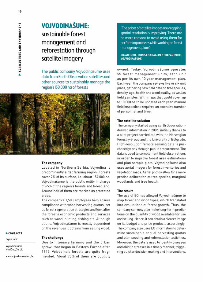
sustainable forest management and reforestation through satellite imagery
The public company Vojvodinašume uses data from Earth Observation satellites and other sources to sustainably manage the region’s 130,000 ha of forests
The companyLocated in Northern Serbia, Vojvodina is predominantly a flat farming region. Forests cover 7% of its surface, i.e. about 154,000 ha. Vojvodinašume is the public entity in charge of 65% of the region’s forests and forest land. Around half of them are marked as protected areas.The company’s 1,500 employees help ensure compliance with wood harvesting quotas, set up forest regeneration strategies and look after the forest’s economic products and services such as wood, hunting, fishing etc. Although public, Vojvodinašume is mostly dependent on the revenues it obtains from selling wood.
The challengeDue to intensive farming and the urban sprawl that began in Eastern Europe after 1945, Vojvodina’s forests are quite frag-mented. About 90% of them are publicly
owned. Today, Vojvodinašume operates 55 forest management units, each unit as per its own 10 year management plan. Each year, the company reviews five or six unit plans, gathering new field data on tree species, density, age, health and wood quality, as well as field samples. With maps that could cover up to 10,000 ha to be updated each year, manual field inspections required an extensive number of personnel and time.
The satellite solutionThe company started using Earth Observation-derived information in 2006, initially thanks to a pilot project carried out with the Norwegian Forestry Group and the University of Belgrade. High-resolution remote sensing data is pur-chased yearly through public procurement. The data is used to complement field observations in order to improve forest area estimations and plan sample plots. Vojvodinašume also uses aerial imagery for forest inventories and vegetation maps. Aerial photos allow for a more precise delineation of tree species, marginal woodlands and tree health.
The resultThe use of EO has allowed Vojvodinašume to map forest and wood types, which translated into evaluations of forest growth. Thus, the company can now also make long-term predic-tions on the quantity of wood available for use and selling. Hence, it can obtain a clearer image on its budget and price products accordingly.The company also uses EO information to deter-mine sustainable annual harvesting quotas and plan seeding and reforestation activities. Moreover, the data is used to identify diseases and abiotic stresses in a timely manner, trigge-ring quicker decision making and interventions.
C O N T A C T S
Bojan Tubic
VojvodinašumeNovi Sad, Serbia
www.vojvodinasume.rs/en
©Vojvodinašume
“The prices of satellite images are dropping, spatial resolution is improving. There are no more reasons to avoid using them for performing analyses while working on forest management plans”
BOJAN TUBIC, FOREST MANAGEMENT DEPARTMENT, VOJVODINAŠUME
“The prices of satellite images are dropping, spatial resolution is improving. There are no more reasons to avoid using them for performing analyses while working on forest management plans”
BOJAN TUBIC, FOREST MANAGEMENT DEPARTMENT, VOJVODINAŠUME

17
LO
GIS
TICS
& IN
FRA
STRU
CTU
RE
COMMUNICATING& DIGITAL SOCIETY
18
CO
MM
UN
ICAT
ING
AN
D D
IGIT
AL
SOCI
ETY BOLOGNA: satellite
navigation to smoothen public bus traffic flows
Satellite navigation is used to calculate arrival times of public buses and to adjust traffic light cycles so as to optimise flows
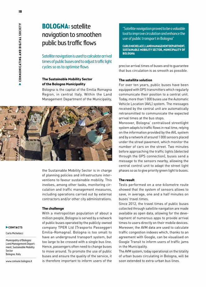
The Sustainable Mobility Sector of the Bologna MunicipalityBologna is the capital of the Emilia Romagna Region, in central Italy. Within the Land Management Department of the Municipality,
the Sustainable Mobility Sector is in charge of planning policies and infrastructure inter-ventions to favour sustainable mobility. This involves, among other tasks, monitoring cir-culation and traffic management measures, including operations carried out by external contractors and/or other city administrations.
The challengeWith a metropolitan population of about a million people, Bologna is served by a network of public buses operated by the publicly-owned company TPER Ltd (Trasporto Passeggeri Emilia-Romagna). Bologna is too small to have an underground transport system, but too large to be crossed with a single bus line. Hence, passengers often need to change buses to move around. To promote the use of public buses and ensure the quality of the service, it is therefore important to inform users of the
precise arrival times of buses and to guarantee that bus circulation is as smooth as possible.
The satellite solutionFor over ten years, public buses have been equipped with GPS transmitters which regularly communicate their position to a central unit. Today, more than 1 000 buses use the Automatic Vehicle Location (AVL) system. The messages received by the central unit are automatically retransmitted to communicate the expected arrival times at the bus stops.Moreover, Bologna’ centralised streetlight system adapts to traffic flows in real time, relying on the information provided by the AVL system and by a network of around 1 000 sensors placed under the street pavement, which monitor the number of cars on the street. Two minutes before approaching the traffic lights (detected through the GPS connection), buses send a message to the sensors nearby, allowing the central control unit to adapt the street light phases so as to give priority green light to buses.
The resultTests performed on a one-kilometre route showed that the system of sensors allows to save, in average, one and a half minutes on buses’ travel times.Since 2012, the travel times of public buses collected through satellite navigation are made available as open data, allowing for the deve-lopment of numerous apps to provide arrival times to users directly on their mobile devices. Moreover, the AVM data are used to calculate traffic congestion indexes which, thanks to an agreement with Google, can be visualised on Google Transit to inform users of traffic jams in the Municipality.The AVM system, today operational on the totality of urban buses circulating in Bologna, will be soon extended to extra-urban bus lines.
C O N T A C T S
Carlo Michelacci
Municipality of BolognaLand Management Depart-ment, Sustainable Mobility SectorBologna, Italy
www.comune.bologna.it
“Satellite navigation proved to be a valuable tool to improve circulation and enhance the use of public transport in Bologna”
CARLO MICHELACCI, LAND MANAGEMENT DEPARTMENT, SUSTAINABLE MOBILITY SECTOR, MUNICIPALITY OF BOLOGNA
©minoandriani
19
CO
MM
UN
ICAT
ING
AN
D D
IGIT
AL
SOCI
ETYISSY-LES-MOULINEAUX:
engaging citizens thanks to satellite navigation
The French city of Issy-les-Moulineaux im-plemented a satellite-based app to allow residents to indicate issues, suggest an ideas or congratulate the city on its public services
Smart IssyIssy-les-Moulineaux is a French city of about 65 000 inhabitants. The city is specialised in innovation and new technologies. Indeed the ICT sector offers 60% of the jobs. The city’s Living Lab strategy currently aims to involve residents and companies in the innovation process, to test and to unroll new services.
The challengeWith the ubiquity of connected devices and social media, residents were asking for more efficient ways of communicating with their city services than phone calls or emails. City administrations on the other hand also needed to improve and modernise their traditional tools for dealing with citizens’ requests.Issy-les-Moulineaux therefore felt the need to keep up with these new ways of interaction and started looking for an efficient solution to better involve residents in their city management.To do so, Issy-les-Moulineaux joined the European project “RADICAL” (www.radical-pro-ject.eu) in 2013, aiming at developing intero-perable social networking and IoT services in smart cities. Indeed, in this framework, Issy-les-Moulineaux had to implement a service to encourage and facilitate information exchange and dialogue between the city and its residents.
The satellite solutionTell My City is composed of two complementary services. On the one hand, residents can use a smartphone app based on satellite navigation or a dedicated website. To report a problem, make suggestions or congratulate the city for an initiative, users just need to pin the item on a virtual map, and attach a comment to it.
The dedicated city services then receive the messages directly on an online platform. Thanks to the phones’ embedded satellite navigation, the city services can precisely locate the issues and re-organise the intervention teams more effectively.The users can follow the status of their request on the app, until it has been dealt with. Internally, the administration also monitors the perfor-mance of its services, such as reactivity, via a dashboard.
The resultAfter a one-year test by city employees and community centres, Tell My City was officially launched in September 2015 and residents showed to highly appreciate it through a huge participation. In addition to strengthening the links between Issy-les-Moulineaux and its inha-bitants, Tell My City allows the city to better understand their needs. The application also helps improve the efficiency of city services, while lowering administrative costs.
C O N T A C T S
Matteo SattaIssy MédiaIssy-les-Moulineaux, France
www.issy.com/en
“Tell My City is an innovative and effective tool to let residents communicate with their City”
ISSY-LES-MOULINEAUX ADMINISTRATION
©Kadal - Fotolia
20
CO
MM
UN
ICAT
ING
AN
D D
IGIT
AL
SOCI
ETY UNIVERSITY HOSPITAL
COVENTRY AND WARWICKSHIRE: putting satcoms to use in public health
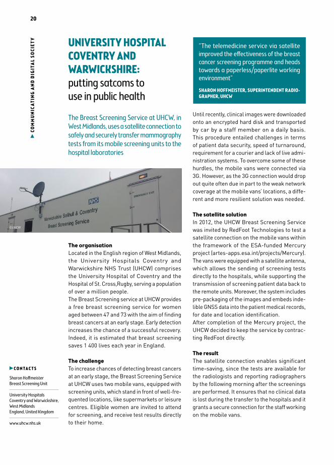
The Breast Screening Service at UHCW, in West Midlands, uses a satellite connection to safely and securely transfer mammography tests from its mobile screening units to the hospital laboratories
The organisationLocated in the English region of West Midlands, the University Hospitals Coventry and Warwickshire NHS Trust (UHCW) comprises the University Hospital of Coventry and the Hospital of St. Cross,Rugby, serving a population of over a million people.The Breast Screening service at UHCW provides a free breast screening service for women aged between 47 and 73 with the aim of finding breast cancers at an early stage. Early detection increases the chance of a successful recovery. Indeed, it is estimated that breast screening saves 1 400 lives each year in England.
The challengeTo increase chances of detecting breast cancers at an early stage, the Breast Screening Service at UHCW uses two mobile vans, equipped with screening units, which stand in front of well-fre-quented locations, like supermarkets or leisure centres. Eligible women are invited to attend for screening, and receive test results directly to their home.
Until recently, clinical images were downloaded onto an encrypted hard disk and transported by car by a staff member on a daily basis. This procedure entailed challenges in terms of patient data security, speed of turnaround, requirement for a courier and lack of live admi-nistration systems. To overcome some of these hurdles, the mobile vans were connected via 3G. However, as the 3G connection would drop out quite often due in part to the weak network coverage at the mobile vans’ locations, a diffe-rent and more resilient solution was needed.
The satellite solutionIn 2012, the UHCW Breast Screening Service was invited by RedFoot Technologies to test a satellite connection on the mobile vans within the framework of the ESA-funded Mercury project (artes-apps.esa.int/projects/Mercury). The vans were equipped with a satellite antenna, which allows the sending of screening tests directly to the hospitals, while supporting the transmission of screening patient data back to the remote units. Moreover, the system includes pre-packaging of the images and embeds inde-lible GNSS data into the patient medical records, for date and location identification.After completion of the Mercury project, the UHCW decided to keep the service by contrac-ting RedFoot directly.
The resultThe satellite connection enables significant time-saving, since the tests are available for the radiologists and reporting radiographers by the following morning after the screenings are performed. It ensures that no clinical data is lost during the transfer to the hospitals and it grants a secure connection for the staff working on the mobile vans.
C O N T A C T S
Sharon HoffmeisterBreast Screening Unit
University HospitalsCoventry and Warwickshire, West MidlandsEngland, United Kingdom
www.uhcw.nhs.uk
“The telemedicine service via satellite improved the effectiveness of the breast cancer screening programme and heads towards a paperless/paperlite working environment”
SHARON HOFFMEISTER, SUPERINTENDENT RADIO-GRAPHER, UHCW
©UHCW
21
CO
MM
UN
ICAT
ING
AN
D D
IGIT
AL
SOCI
ETYSONS: the blind and visually
impaired empowered through satnav
The Czech Blind United association provides guiding assistance to its clients thanks to its Navigation Centre relying on geolocation
The associationCzech Blind United (SONS) is the national asso-ciation of blind and partially sighted people in the Czech Republic. Its headquarters are located in Prague, with 80 local branches spread over the country. It counts almost 10 000 members and 100 employees manage its activities, from a specialised library and a dedicated shop to a navigation centre.
The challengeTaking the right tram or finding a zebra crossing are only some of the struggles that the blind and partially sighted face, when they are not being accompanied by a guide. SONS has made it a priority to eliminate barriers to their mobility and support their full access to public places. Some adaptations of the public infrastructure exist, such as acoustic traffic lights. But they are not always sufficient to enable the blind to navigate autonomously and with ease. SONS
was looking for a system which could truly support its clients on the move.
The satellite solutionTen years ago, the association set up a Navigation Centre to guide the blind during their trips.Before starting his/her journey, the user calls the navigation centre via a dedicated number.
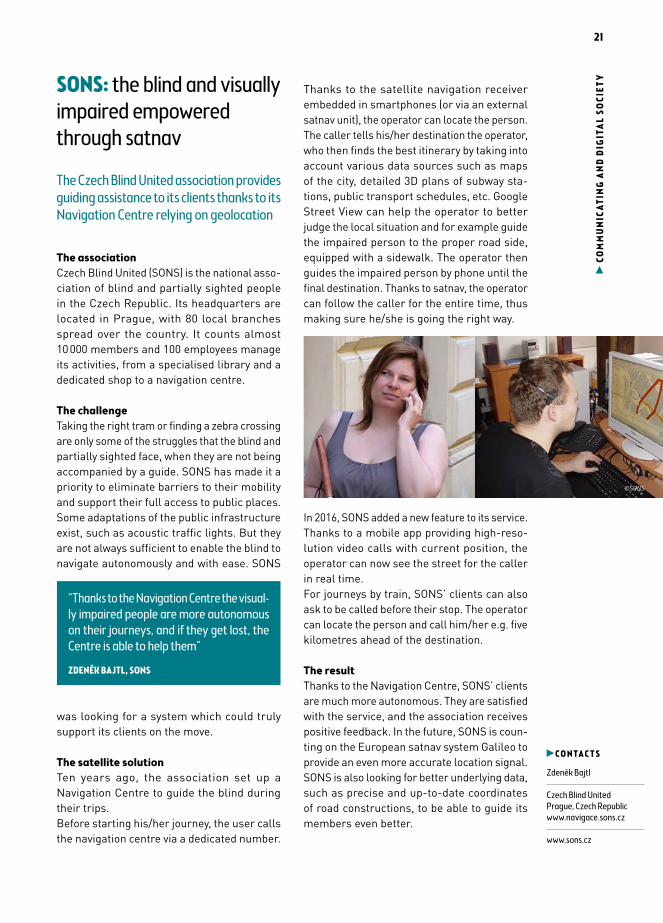
Thanks to the satellite navigation receiver embedded in smartphones (or via an external satnav unit), the operator can locate the person. The caller tells his/her destination the operator, who then finds the best itinerary by taking into account various data sources such as maps of the city, detailed 3D plans of subway sta-tions, public transport schedules, etc. Google Street View can help the operator to better judge the local situation and for example guide the impaired person to the proper road side, equipped with a sidewalk. The operator then guides the impaired person by phone until the final destination. Thanks to satnav, the operator can follow the caller for the entire time, thus making sure he/she is going the right way.
In 2016, SONS added a new feature to its service. Thanks to a mobile app providing high-reso-lution video calls with current position, the operator can now see the street for the caller in real time.For journeys by train, SONS’ clients can also ask to be called before their stop. The operator can locate the person and call him/her e.g. five kilometres ahead of the destination.
The resultThanks to the Navigation Centre, SONS’ clients are much more autonomous. They are satisfied with the service, and the association receives positive feedback. In the future, SONS is coun-ting on the European satnav system Galileo to provide an even more accurate location signal. SONS is also looking for better underlying data, such as precise and up-to-date coordinates of road constructions, to be able to guide its members even better.
C O N T A C T S
Zdeněk Bajtl
Czech Blind UnitedPrague, Czech Republicwww.navigace.sons.cz
www.sons.cz
“Thanks to the Navigation Centre the visual-ly impaired people are more autonomous on their journeys, and if they get lost, the Centre is able to help them”
ZDENĚK BAJTL, SONS
©SONS
22
CO
MM
UN
ICAT
ING
AN
D D
IGIT
AL
SOCI
ETY GEOSYS: developing a
location-based community map for a bustling Malta
A Maltese SME has developed an online por-tal based on satellite navigation to provide accurate information on local activities and services for citizens
The companyCreated in 2011, GeoSYS is a Maltese SME specialised in geospatial technology solutions for a variety of applications, such as finding
route emergency vehicles, promising new sites for companies, target markets for commerce, urban and land planning, studying behavioural habits of wildlife species, locating outages for utilities, and many others. GeoSYS is the ESRI – an international supplier of Geographic Information System (GIS) software distributor in Malta, and a leader in GIS in the country, delivering data, applications and integrated WebGIS systems.
The challengeIn an ever more connected world, mobile users today depend on their smartphones to make their lives easier — whether to look for the nearest coffee shop, to attend an event, or to discover the best deal from a nearby retailer. However, this information is not easily
centralised. GeoSYS was therefore looking for a way to provide Maltese inhabitants with precise information on what is happening next to them, by employing their expertise in gathe-ring and making visible large amounts of data and information.
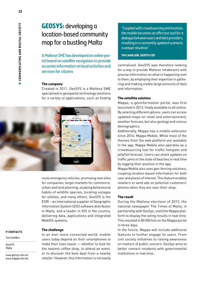
The satellite solutionMappa, a geoinformation portal, was first launched in 2013, freely available to all online. By selecting different options, users can access updated maps on retail and entertainment, weather forecast, but also geology and census demographics.Additionally, Mappa has a mobile extension since 2014: Mappa Mobile. While most of the themes from the web platform are available in the app, Mappa Mobile also operates as a crowdsourcing tool for traffic hotspots and jellyfish forecast. Users can share updates on traffic jams or the state of beaches in real time by tagging their position in the app.Mappa Mobile also uses geo-fencing solutions, coupling location-based information for both user and places of interest. This feature enables retailers to send ads on potential customers’ phones when they are near their shop.
The resultDuring the Maltese elections of 2013, the national newspaper The Times of Malta, in partnership with GeoSys, used the Mappa plat-form to display the voting results in real time. This resulted in 80 000 hits on the Mappa portal in three days.In the future, Mappa will include additional features to further engage its users. From civil society initiatives to raising awareness on matters of public concern, GeoSys aims to better connect residents with governmental institutions in real time.
C O N T A C T S
Tim Camilleri
GeoSYSMalta
www.geosys.com.mtwww.mappa.com.mt
“Coupled with crowdsourcing and location, the mobile becomes an effective tool for a dialogue between users and data providers, resulting in a constantly updated scenario, a unique situation”
TIM CAMILLERI, GEOSYS CEO
©GeoSYS
23
LO
GIS
TICS
& IN
FRA
STRU
CTU
RE
INFRASTRUCTURE, TRANSPORT & LOGISTICS

24
INFR
AST
RUCT
UR
E, T
RA
NSP
OR
T A
ND
LOG
ISTI
CS FINLAND : all-year-round open ports due to efficient ice-breaking services
The Finnish Transport Agency uses satel-lite data together with ice charts, weather maps, and in-situ observations to produce information for its fleet of icebreakers
The Finnish Transport AgencyManaging a €1.7 billion budget and employing over 600 experts, the Finnish Transport Agency (FTA) is responsible for keeping Finns on the move.
The FTA head office is located in Helsinki. It ope-rates under the Finnish Ministry of Transport and Communications and serves civilian, trade and industry needs. The FTA develops and maintains the country’s roads, railways and waterways while coordinating traffic routes to and from Finland’s 45 ports. During harsh winter months its fleet of eight icebreakers clears “fairways” into the ports, while also guiding merchant ships safely through Finland’s continental waters.
The challengeFinland is the only country in the world where all ports freeze during winter. In 2014 77.5% of Finnish imports and 89.6% of exports passed by sea. Keeping ports open and navigation fluid during winter months is therefore vital for the country’s highly industrialised economy. In the absence of wind, once opened, ice lanes can stay open for days. However, in stormy
conditions, ice blown into ridges can trap and severely damage ships, hinder shipping routes and disrupt the supply value chains.Early ice-detection methods done with radars and helicopters would only covered small areas. The FTA was then missing a large-scale over-view to allow for effective vessel traffic planning.
The satellite solutionSince 1991, Finland has fully replaced data collected from helicopters with satellite data (ERS-1, Envisat, Radarsat-1 & 2, Sentinel 1). Unlike helicopters, radar satellite images offered wide-area coverage, day and night and in all weather conditions. A single picture taken twice every three days could cover the whole Baltic region.Currently, satellite data is combined with ice charts, weather maps, and in-situ observa-tions to produce information available to each icebreaker captain directly and ready for use through a shared information system called IBNet.
The resultThe switch has resulted in a number of tan-gible benefits for the agency. For instance, the agency saved an estimated €1m by reducing the fleet’s fuel consumption. Giving up the use of helicopters stationed has saved the agency a further €8.2 m over the last 11 years*.Better route planning has also reduced operational costs for the 20,000 ships travelling to the Finnish ports in an average winter, due to reduced transit and waiting time and a decrease in ice-related damages for shipping companies.Finally, the FTA and Swedish Maritime Administration are operating their icebreaker fleets in a joint cooperation agreement which will allow them to exploit further economies of scale. Talks to include Estonia are currently under way.*A detailed analysis of the case can be at www.earsc.org
“Radar satellite SAR-images are vital for us to keep Northern Baltic merchant vessels going through challenging and continuously changing sea ice”
CAPT. JARKKO TOIVOLA, FINISH TRANSPORT AGENCY
C O N T A C T S
Capt. Jarkko ToivolaChief Maritime Specialist
Winter Navigation UnitFinnish Transport AgencyHelsinki, Finland
www.liikennevirasto.fi/web/en
©FTA

25
INFR
AST
RUCT
UR
E, T
RA
NSP
OR
T A
ND
LOG
ISTI
CSTHE GERMAN FEDERAL OFFICE FOR GOODS TRANSPORT benefits from a tolling system relying on satnav
Since 2005, a tolling system based on satnav on Federal motorways generated 35 billion euros in revenue
The German Federal Office for Goods Transport
The German Federal Office for Goods Transport is an independent higher federal authority and an executive agency of the German Federal Ministry of Transport and Digital Infrastructure. It performs numerous functions related to road haulage and makes a valuable contribution towards enhancing safety on Germany’s roads, in particular by carrying out roadside checks.
The challengeIn 1990, the German federal administration started to reduce truck traffic on Federal motorways by implementing a tax targeting heavy vehicles. The goal was not only to reduce congestion but also to limit the deterioration of roads. The tax would also start charging foreign trucks which previously circulated on federal roads without paying any fees. In 1994 Germany, The Netherlands, Belgium, Luxembourg and Denmark signed an agreement to introduce a common charge based on road usage time (the Eurovignette). In 1999, the Ministry of Transport decided to replace it by a distance-related tolling system.
The satellite solutionIn 2002, the tolling system was implemented by a consortium including Daimler Chrysler Services AG (now Daimler Financial Services AG), Deutsche Telekom AG & Cofiroute S. A., which created a dedicated company, Toll Collect. The system became operational in January 2005.
Trucks circulating on Federal motorways are equipped with On-Board Units (OBU), containing truck identification data and a geo-positioning device which records the position and distance covered by the vehicles. The OBUs periodically download satellite time-stamped position, and then records trucks’ movements. Those signals are confirmed thanks to data generated by complementary on-board sensors so that the accuracy stands below 10 metres. The system automatically logs in when the truck takes off. It automatically calculates the toll fees due by users.
The resultThe system entails time-savings and more flexibility for the drivers. The toll network covers
about 12,500 km of highways (plus some federal roads) and includes 2,213 junctions. The system does not require any road-side equipment and enables a free-flow traffic on German motorways and federal roads. In contrast to conventional tolling systems, there is no need for vehicle speed restrictions, stops or special toll lanes.During the first two years of implementa-tion (2005/2006) only, the system generated revenues of €5,943 billion, which reached €35 billion in 2014. System operating costs are currently equivalent to around 10% of revenues.About 158,000 transport and logistics com-panies from 41 countries and nearly 1 million vehicles are registered with Toll Collect. The revenues of the system are used to maintain the motorway network and to provide increasingly satisfying services to motorway users.
C O N T A C T S
German Federal Office for Goods Transport
Cologne, Germany
www.bag.bund.de
Technical contact: Toll CollectBerlin, Germany
www.toll-collect.de
©Toll Collect

26
INEOS: safe transportation of hazardous goods thanks to satcom & satnav
INEOS, a world leading chemical company uses satcom and satnav technologies to mo-nitor its fleet of wagons carrying Ethylene Oxide
The companyINEOS is a world leading chemical company headquartered in Switzerland founded in 1999. It employs a staff of 17,000 and produces 60
million tons of products yearly. With a turnover of €50 billion in 2014, the company operates 65 manufacturing facilities in 16 countries, as well as the largest ethylene oxide terminal in Europe and the second-largest in the world. Its diverse portfolio includes textile and packaging companies, as well as fuels and other chemical products.
The opportunityEthylene Oxide is used in many agricultural pro-ducts and as a steriliser for medical equipment and supplies. It is highly flammable, reactive and very toxic, so it is risky to transport. During transport, the units are exposed to shocks and extreme weather conditions, which can lead to accidents with very serious security and health risks.
Despite such risks, whether delivery contai-ners travelled by sea or train, INEOS had little information on their exact location and route.Traditional track-and-trace systems rely on an external electricity supply to function. When on rail or boats, this is not the case. Rechargeable batteries, as well as GSM technology are inherently incompatible with highly flammable products such as ethylene oxide. Finally, real time monitoring on global transports, including cross-ocean travels, required a complete rethinking of the technologies to use so as guarantee the functioning of the tracking device in those conditions for a minimum of 4 years.
The satellite solutionRecently, Ovinto, a Belgian SME, developed a satcom solution that relies on Globalstar (a commercial satellite network provider). In combination with satnav, it allows for a real time tracking and monitoring of unpowered assets. INEOS tasked Ovinto to equip its fleet with the monitoring device and to set-up additional services based on the data monitored. The equipment enabled the company to monitor its wagons and containers carrying Ethylene Oxide worldwide. The system provides a continuous stream of data, such as location, temperature, pressure, leakage or shocks in near real-time.
The resultThanks to the innovative tracking system, INEOS managed to cut maintenance costs, improve delivery times, and optimise the use of its wagons, thus increasing their economic cycle.Last but not least, INEOS can better achieve its safety, health, and environmental objectives. As the service provides near real-time data, the company is better equipped to act accordingly in case of failures or accidents.
INFR
AST
RUCT
UR
E, T
RA
NSP
OR
T A
ND
LOG
ISTI
CS
C O N T A C T S
Patrick De Block
INEOS OxideAntwerp, Belgium
www.ineos.be
Technical contact:Hans de WithNevele, Belgium
www.ovinto.com
“There was at times an insufficient grip on the whereabouts of our INEOS Ethylene Oxide containers. Now, thanks to a satcom based system we can track our entire fleet remotely and retrieve safety critical pa-rameters”
PATRICK DE BLOCK, BUSINESS SHE MANAGER, INEOS OXIDE
© fotolia
27
INFR
AST
RUCT
URE
, TR
AN
SPO
RT A
ND
LOG
ISTI
CSCITY OF JASTRZĘBIE-ZDRÓJ: monitoring ground surface deformations with satellite services
The Polish city relies on satellite imagery to control soil movements caused by mining activities and prevent damages to the en-vironment and the population
The cityThe city of Jastrzębie-Zdrój is located in the south-west of Poland, near the border with the Czech Republic. It has a population of nearly 90.000 inhabitants over an area of 85 km2, of which 60% represent mining areas. There are four major mining plants located in the city. Therefore, local economy relies heavily on the coal mining industry.
The challengeIn the long term, mining activities lower soil surface and cause soil movements. If changes are not observed in time, soil displacements can have considerable impacts on the environment and on urban areas, significantly damaging buildings and infrastructure.While mining activities entail dangers for the environment, they are also vital for the current economy of the city. Hence, the Municipality needed to constantly monitor the consequences of mining on soil and infrastructure, with the aim to minimise risk and expected damages. To do so, city authorities looked for a solution that would allow them to acquire objective and independent data on soil movements, while avoiding the costs associated with regular site inspections on the whole city territory.
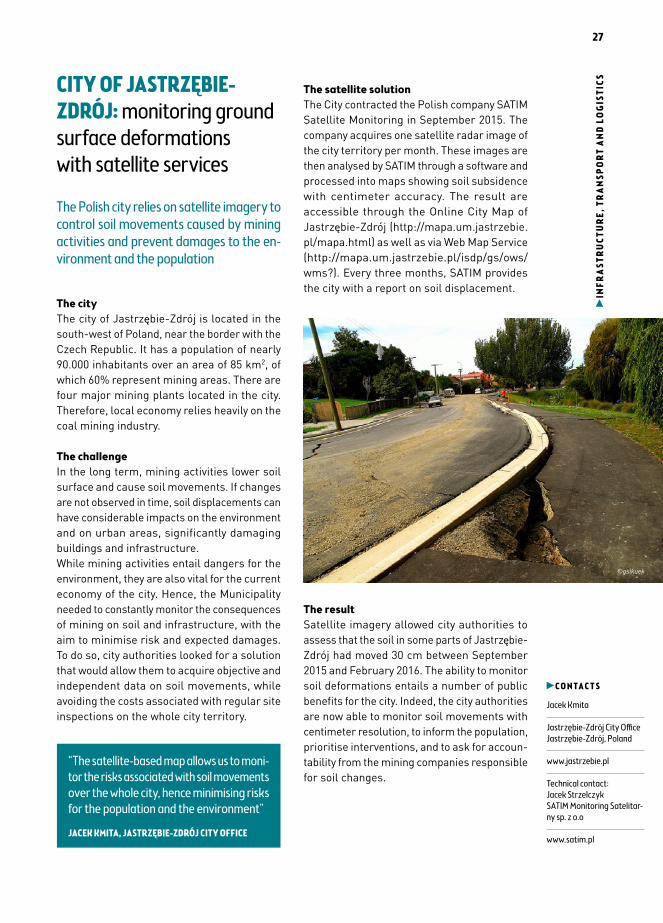
The satellite solutionThe City contracted the Polish company SATIM Satellite Monitoring in September 2015. The company acquires one satellite radar image of the city territory per month. These images are then analysed by SATIM through a software and processed into maps showing soil subsidence with centimeter accuracy. The result are accessible through the Online City Map of Jastrzębie-Zdrój (http://mapa.um.jastrzebie.pl/mapa.html) as well as via Web Map Service (http://mapa.um.jastrzebie.pl/isdp/gs/ows/wms?). Every three months, SATIM provides the city with a report on soil displacement.
The resultSatellite imagery allowed city authorities to assess that the soil in some parts of Jastrzębie-Zdrój had moved 30 cm between September 2015 and February 2016. The ability to monitor soil deformations entails a number of public benefits for the city. Indeed, the city authorities are now able to monitor soil movements with centimeter resolution, to inform the population, prioritise interventions, and to ask for accoun-tability from the mining companies responsible for soil changes.
C O N T A C T S
Jacek Kmita
Jastrzębie-Zdrój City Office Jastrzębie-Zdrój, Poland
www.jastrzebie.pl
Technical contact: Jacek Strzelczyk SATIM Monitoring Satelitar-ny sp. z o.o
www.satim.pl
“The satellite-based map allows us to moni-tor the risks associated with soil movements over the whole city, hence minimising risks for the population and the environment”
JACEK KMITA, JASTRZĘBIE-ZDRÓJ CITY OFFICE
©gslkuek

28
INFR
AST
RUCT
UR
E, T
RA
NSP
OR
T A
ND
LOG
ISTI
CS EXETER: a more efficient bin collections service in Exeter relying on satellite navigation
The Environment and Cleansing Services created an information system based on sa-tellite navigation to smoothen bin collections and facilitate communication with customers
The Exeter City CouncilExeter is a city in Devon, England. The Exeter City Council is responsible for the economic
development of the city and to provide a range of services.These include police and fire services, housing, refuse collections, and recycling.The Environment - Cleansing Services has 12 lorries which collect domestic waste. For most residents, rubbish collections take place once a fortnight.
The challengeUntil recently, the Exeter City Council had no coherent information system to track and plan bin collections. Lorry drivers had no written instructions on their itineraries and decided which bins to collect based on their memory. Residents would only know when their bins would be emptied by calling customer advi-sors. In the absence of an internal information system, advisors would simply note down their complaints. When lorries came back to the central offices, they were sent back to repeat their itineraries, without checking which of the bins were actually collected or the reasons for
the non-collection. This caused an overload of work for the employees of the waste collection service and inefficiencies both in terms of time and resource management.
The satellite solutionIn 2011, The Exeter City Council decided to combine mobile and desktop technologies to develop an information system for managing bin collections. Using funds provided by the South West Regional Efficiency and Improvement Partnership, the Council equipped the bin lorries with Satnav systems. Thanks to them, the crew and central office employees are always aware of the position and itinerary of each lorry in real-time.
The resultToday, drivers responsible for bin collections can record their work on the shared platform, helping coordinate itineraries more efficiently. All relevant information is accessible via an online portal, open 24/7. Customers simply need to enter their address to know when their bins will be collected. They can report problems directly online. As a result, lorry returns for missed bins, went down from 100% to 27% of the queries. The system is also used by the City Council to deliver new bins to customers. Before the adoption of the new system, it took approximately 10 days to deliver the new bins, while it now takes four to five days only. Overall, the satellite-based system enabled the service to save time, to better organise waste collection and to do more with less, with no need to pur-chase new lorries or to hire new staff. For an initial investment of £240k, the system entailed £340k in capital savings and £470k in revenue savings since its implementation. The Exeter City Council shared this experience with other city managers, and is currently working with two other City Councils to transfer the system.
C O N T A C T S
Lesley Rapley
Environment - Cleansing Services Exeter City Council Exeter, England, United Kingdom
www.exeter.gov.uk
“Our information system integrating satel-lite navigation helps us to keep Exeter clean and to enhance communication between residents and the City Council”
LESLEY RAPLEY, EXETER CITY COUNCIL
©Goss Vitalij - Fotolia

29
LO
GIS
TICS
& IN
FRA
STRU
CTU
RE
RISK MANAGEMENT
30
RIS
K M
AN
AGEM
ENT CNSAS: geo-information
technologies for prevention and surveillance of mountain activities
The National Alpine Cliff and Cave Rescue Corps uses satellite-based information to effectively rescue people caught in risky situations in mountainous areas
The National Alpine Cliff and Cave Rescue CorpsThe National Alpine Cliff and Cave Rescue Corps (CNSAS) is an Italian public service, with a staff of 7,000 alpine experts, established in 1954. It is mandated to rescue and help people injured in the mountains or in hostile environments. It operates from the Alps and Dolomites to the mountainous areas of the Islands. CNSAS can also rescue injured people in caves and rock shelters, thanks to its speleological unit.In addition, CNSAS provides assistance in case of natural disasters. It is also a member of the European Cave Rescue Association, the community of European cave-rescuers.
The challengeClimbing, hiking, trekking and other adventu-rous sports in the mountains can sometimes lead to serious accidents. Even an apparently small wound can seriously impair the safety of the injured person.During mountain rescue operations, CNSAS needs extremely precise information on the position of the aid seeker and that of the rescuer. This enables the rescuers to inter-vene fast and carefully, while staying safe too.
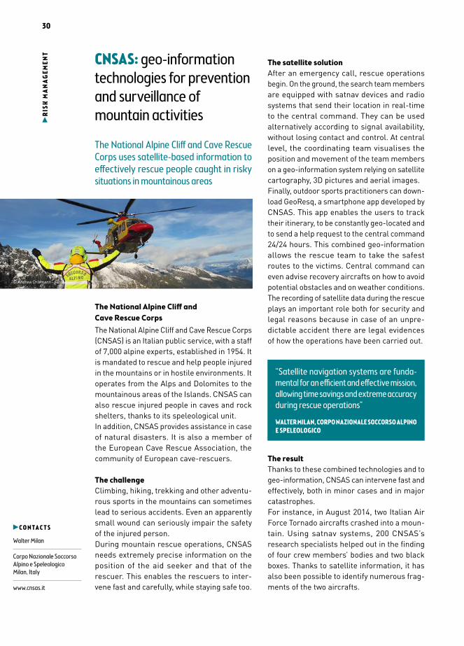
The satellite solutionAfter an emergency call, rescue operations begin. On the ground, the search team members are equipped with satnav devices and radio systems that send their location in real-time to the central command. They can be used alternatively according to signal availability, without losing contact and control. At central level, the coordinating team visualises the position and movement of the team members on a geo-information system relying on satellite cartography, 3D pictures and aerial images.Finally, outdoor sports practitioners can down-load GeoResq, a smartphone app developed by CNSAS. This app enables the users to track their itinerary, to be constantly geo-located and to send a help request to the central command 24/24 hours. This combined geo-information allows the rescue team to take the safest routes to the victims. Central command can even advise recovery aircrafts on how to avoid potential obstacles and on weather conditions.The recording of satellite data during the rescue plays an important role both for security and legal reasons because in case of an unpre- dictable accident there are legal evidences of how the operations have been carried out.
The resultThanks to these combined technologies and to geo-information, CNSAS can intervene fast and effectively, both in minor cases and in major catastrophes.For instance, in August 2014, two Italian Air Force Tornado aircrafts crashed into a moun-tain. Using satnav systems, 200 CNSAS’s research specialists helped out in the finding of four crew members’ bodies and two black boxes. Thanks to satellite information, it has also been possible to identify numerous frag-ments of the two aircrafts.
C O N T A C T S
Walter Milan
Corpo Nazionale Soccorso Alpino e SpeleologicoMilan, Italy
www.cnsas.it
“Satellite navigation systems are funda-mental for an efficient and effective mission, allowing time savings and extreme accuracy during rescue operations”
WALTER MILAN, CORPO NAZIONALE SOCCORSO ALPINO E SPELEOLOGICO
© Andrew Orlemann - Fotolia

31
RIS
K M
AN
AGEM
ENTTHE GREEK MINISTRY of
Environment uses real-time satellite data to detect fires
The General Directorate for the Develop-ment and Protection of Forests and Rural Environment relies on the FireHub service to spot and intervene on forest fires in Greece
The DirectorateThe General Directorate for the Development and Protection of Forests and Rural Environment of the Greek Ministry of Environment, Energy and Climate Change is the central competent body for the protection of forests and public lands. Within the DG, the Directorate of Planning and Forest Policy is responsible for planning and implementing forest-related policies in compliance with Greek and EU legislation. An important area is fire intervention and miti-gation, where 30 people are responsible for fire monitoring and restoration measures in collaboration with 1,500 staff of the national Regional Forest Services.
The challengeGreece is covered with wide expanses of forests, often in remote and mountainous areas. Droughts, high winds, and the sprawl of land development in the proximity of forests, cause several wildfires every year. Early detection is paramount for the Fire Brigades to limit damages to both environment and human assets. Previously early fire detection was done by aircrafts surveying sensitive areas. Fire alerts were communicated by the pilots to the Fire Services, who then send brigades to the spot. Manned flight monitoring over large expanses is very costly and time-consuming, and the communications are less efficient.
The satellite solutionThe National Observatory of Athens (NOA) has developed a satellite based service named FireHub. It aims to build a centre of excellence for Earth observation-based monitoring of natural disasters in South-Eastern Europe.
FireHub is an early-warning service which relies on meteorological information, Earth obser-vation data and other geospatial information.Since 2013, users receive near-real time satel-lite images with new monitoring data produced every five minutes. It also enables forecasts of smoke dispersion 15 minutes ahead. Through
a dedicated web-GIS application, the service also provides information on fires that occurred in Greece during the last 30 years.
The resultFireHub provides the DG and the Fire Brigades with early and more efficient warnings, an increased situational awareness during an emergency, enabling more effectively deploy-ment of available resources. FireHub also maps burnt areas for damage and deforestation assessment which are used to implement relief activities, estimate carbon balance, monitor fire and soil erosion risk, and to plan urban developments.FireHub is particularly useful when fires originate outside Greek borders. Recently, a fire that started in Albania close to the Greek border was not officially notified to Greek authorities. The accident was instead detected via FireHub, allowing the Fire Brigades to intervene before the fire entered Greek territory.
C O N T A C T S
Tryfon Daskalakis
Ministry of Environment, Energy & Climate Change General Directorate of Development and Protection of Forests and Rural Environment Athens, Greece
www.ypeka.gr
“FireHub is a very useful tool that helps us with early detection of fires, thus hastening significantly intervention and restoration activities”
TRYFON DASKALAKIS, MINISTRY OF ENVIRONMENT, ENERGY & CLIMATE CHANGE
©CNSAS

32
RIS
K M
AN
AGEM
ENT SLOVENIAN
ADMINISTRATION for Civil Protection and Disaster Relief improve services with EO and SatNav
Thanks to a 3D GIS system using EO data and satnav, call-takers and rescue officers can now locate of the victim, view terrain accessibility and weather conditions to im-prove their service
The organisationThe Administration of the Republic of Slovenia for Civil Protection and Disaster Relief (referred to as ACPDR) is a constituent body of the Ministry of Defence. It performs administra-tive and professional protection, rescue and relief tasks, as well as other tasks regarding protection against natural and other disasters.
The challengeThe Dinaric Alps and the Pannonian Plain meet in Slovenia. The territory is mostly mountainous, with over half of it covered by forest, where human settlements are dispersed and uneven.When making an emergency call, the caller’s location appeared on a GIS interface at the closest emergency response centre. However, due to the two-dimensional display previously used, one could not see whether the caller was on a hill, on a mountain or in a valley. Information that is highly important. Accuracy was also poor with frequent error margins of 1 km. The ACPDR therefore looked for solution to
provide additional landscape information, ideally in 3D, while improving the accuracy of the caller’s location in case of emergency.
The satellite solutionSince 2008, the ACPDR has commissioned XLAB, a Slovenian company, to develop “Gaea”, a 3D-based geographic information system. The final solution is based on the NASA World Wind open-source virtual globe. The programme includes NASA satellite imagery, aerial photo-graphy and topographic maps. The World Wind data combined with local spatial data were used to create a database that is now used by all Slovenian 112 Emergency Response Centres. Thus, in this case satellite images provided information about places, spaces and spatial phenomena for the Slovenian dispatchers.Additionally, satellite navigation is being used as well. All 112 Emergency Response Centres in Slovenia are equipped with a software tool that permits to read the location of the caller in distress that is acquired from the smartphone’s global navigation satellite system (GNSS).
The resultThe 3D geographic information system allows the ACPDR to identify additional information that dispatchers need in order to start a suc-cessful rescue operation. Among these data are the exact location of the caller in distress that uses a GNSS-enabled smartphone to call the
emergency services, and a 3D overview of the location of the caller in order to get additional information that is relevant in case of emer-gency (terrain accessibility, landscape type..)The European Emergency Number Association (EENA) awarded the ACPDR in 2014 with the award “Most Outstanding Innovation 2014” for the provision of the service.
C O N T A C T S
Grigorij Krupenko
Administration of the Republic of Slovenia for Civil Protection and Disaster ReliefLjubljana, Slovenia
www.sos112.si/eng/
“We use Gaea+ tools as rescue support even in most demanding situations. Gaea+ en-ables us simply perform tasks for which we before spent much more time”
GRIGORIJ KRUPENKO, ADMINISTRATION OF THE REPUBLIC OF SLOVENIA FOR CIVIL PROTECTION AND DISASTER RELIEF
© Marcus Obal
33
RIS
K M
AN
AGEM
ENTHELCOM countries use
satellite information to monitor oil spills in the Baltic Sea
The members of the Baltic Marine Envi-ronment Protection Commission receive early warnings of potential oil spills based on satellite data from EMSA, allowing near real-time spot checks
The CommissionThe members of the Helsinki Commission are the nine Baltic Sea states (Denmark, Estonia, Finland, Germany, Latvia, Lithuania, Poland, Russia and Sweden) and the EU, which are Contracting Parties to the Helsinki Convention. The aim of the intergovernmental cooperation is to protect the Baltic Sea from all sources of pollution and to ensure safety of navigation in the region.
The challengeOil spills are one source of pollution, among other substances from ships and from land. Even small amounts of oil can have a negative impact on the marine environment; seabirds for instance are very sensitive to oil.Any oil and oily mixture discharges into the Baltic Sea are prohibited according to IMO MARPOL Annex 1 special area regulations. However, HELCOM statistics, based on detec-tions by national surveillance aircraft, show that over 100 illegal oil discharges by ships occur every year in the Baltic Sea.
The satellite solutionIn order to prevent and detect any violation of existing discharge regulations, the Baltic Sea states have agreed within the HELCOM framework to regularly conduct aerial sur-veillance, individually and jointly.Satellite observations support the efforts of the Baltic Sea states in their surveillance work. Satellite surveillance in the Baltic Sea has inten-sified since 2007 thanks to the CleanSeaNet
satellite surveillance service provided by the European Maritime Safety Agency (EMSA). The satellite images are delivered to users of CleanSeaNet in near real time to provide a first indication of possible oil slicks to be checked by aircraft on spot. The HELCOM Group on Aerial Surveillance annually checks the operational satellite coverage requirements for the Baltic Sea area and sends a request to EMSA for each sub-area.
The resultRegular aerial and satellite surveillance has contributed significantly to the decrease in illegal discharges of oil in the last ten years because ships are aware that their activities are being monitored.In 2013, a total of 565 satellite scenes were provided by EMSA to the users of CleanSeaNet in the Baltic Sea indicating 130 possible detec-
tions of which the national surveillance aircraft were able to inspect 61% within three hours of the first warning. Of these detections the aircrews were able to confirm 5% as mineral oil spills, 11% as spills of other oil types, chemical, sewage or garbage, and 8% as unknown substances. Typical false positive detections are caused by natural phenomenon like waves.
C O N T A C T S
Laura Meski
Baltic Marine Environment Protection Commission Helsinki, Finland
www.helcom.fi
“The EMSA CleanSeaNet service has proven to be a valuable asset in the Baltic Sea in deterring and monitoring illegal oil spills as it provides near real time information on potential spills”
LAUR A MESKI, BALTIC MARINE ENVIRONMENT PROTECTION COMMISSION, HELSINKI, FINLAND
©Kasto
34
RIS
K M
AN
AGEM
ENT MAZOVIA: satellite
data to improve emergency services
The Polish Province of Mazovia relies on satellite navigation and satellite-based maps to monitor and coordinate first aid operations
The provinceThe Mazowieckie Voivodeship or Mazovia Province is the largest of the Polish provinces, including 42 counties and 314 municipalities. The province is also home to the countries’ capital, Warsaw. Warsaw has a population of over 1.7 million people, i.e. about 33% region’s residents.
The Office of the Marshal of the Mazowieckie Voivodeship oversees the delivery of a wide range of regional public services. These can range from healthcare, public education and environmental protection to culture and public transport. To perform its mandate, the Office can count on over 1,100 employees and five branch offices.
The challengeIn 2006, the Marshal Office was looking for a solution to improve the efficiency of its ambu-lance service. In particular, the Office wanted to reduce its rescue teams’ intervention time to emergency calls. To help rescue teams reach their destination more rapidly, the emergency service needed real-time positioning equipment and accurate maps of the areas of intervention.
The new positioning and coordination equip-ment had to be easily integrated into the existing ambulances and emergency procedures of the Mazovia province.
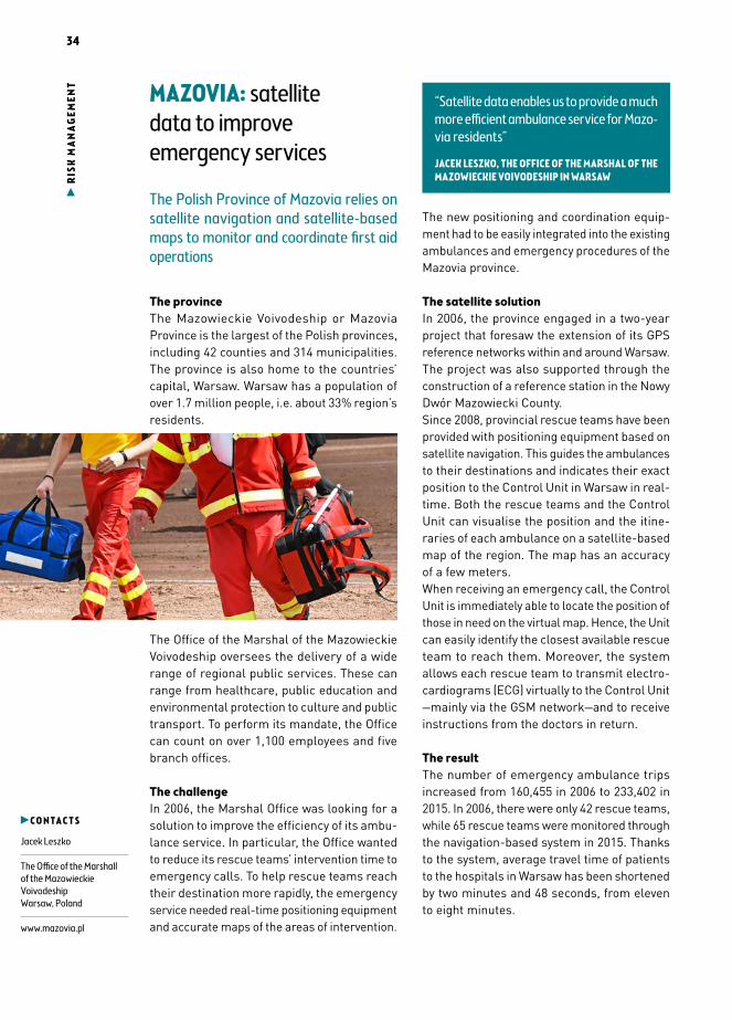
The satellite solutionIn 2006, the province engaged in a two-year project that foresaw the extension of its GPS reference networks within and around Warsaw. The project was also supported through the construction of a reference station in the Nowy Dwór Mazowiecki County.Since 2008, provincial rescue teams have been provided with positioning equipment based on satellite navigation. This guides the ambulances to their destinations and indicates their exact position to the Control Unit in Warsaw in real-time. Both the rescue teams and the Control Unit can visualise the position and the itine-raries of each ambulance on a satellite-based map of the region. The map has an accuracy of a few meters.When receiving an emergency call, the Control Unit is immediately able to locate the position of those in need on the virtual map. Hence, the Unit can easily identify the closest available rescue team to reach them. Moreover, the system allows each rescue team to transmit electro-cardiograms (ECG) virtually to the Control Unit —mainly via the GSM network—and to receive instructions from the doctors in return.
The resultThe number of emergency ambulance trips increased from 160,455 in 2006 to 233,402 in 2015. In 2006, there were only 42 rescue teams, while 65 rescue teams were monitored through the navigation-based system in 2015. Thanks to the system, average travel time of patients to the hospitals in Warsaw has been shortened by two minutes and 48 seconds, from eleven to eight minutes.
C O N T A C T S
Jacek Leszko
The Office of the Marshall of the Mazowieckie Voivodeship Warsaw, Poland
www.mazovia.pl
“Satellite data enables us to provide a much more efficient ambulance service for Mazo-via residents”
JACEK LESZKO, THE OFFICE OF THE MARSHAL OF THE MAZOWIECKIE VOIVODESHIP IN WARSAW
© majorosl66

35
LO
GIS
TICS
& IN
FRA
STRU
CTU
RE
TOURISM & LEISURE
36
TO
UR
ISM
AN
D LE
ISU
RE THE FRENCH ALPINE
CLUB uses satellite communication to connect mountain huts in remote areas
Thanks to internet via satellite, the Alpine Club improves the safety and connectivity of mountain huts
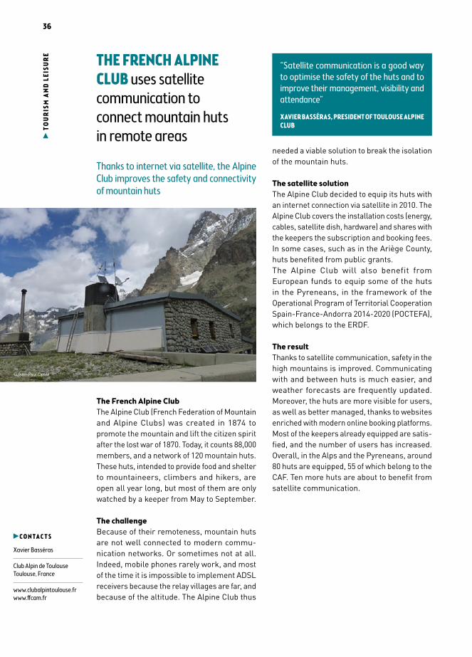
The French Alpine ClubThe Alpine Club (French Federation of Mountain and Alpine Clubs) was created in 1874 to promote the mountain and lift the citizen spirit after the lost war of 1870. Today, it counts 88,000 members, and a network of 120 mountain huts. These huts, intended to provide food and shelter to mountaineers, climbers and hikers, are open all year long, but most of them are only watched by a keeper from May to September.
The challengeBecause of their remoteness, mountain huts are not well connected to modern commu-nication networks. Or sometimes not at all. Indeed, mobile phones rarely work, and most of the time it is impossible to implement ADSL receivers because the relay villages are far, and because of the altitude. The Alpine Club thus
needed a viable solution to break the isolation of the mountain huts.
The satellite solutionThe Alpine Club decided to equip its huts with an internet connection via satellite in 2010. The Alpine Club covers the installation costs (energy, cables, satellite dish, hardware) and shares with the keepers the subscription and booking fees. In some cases, such as in the Ariège County, huts benefited from public grants.The Alpine Club will also benefit from European funds to equip some of the huts in the Pyreneans, in the framework of the Operational Program of Territorial Cooperation Spain-France-Andorra 2014-2020 (POCTEFA), which belongs to the ERDF.
The resultThanks to satellite communication, safety in the high mountains is improved. Communicating with and between huts is much easier, and weather forecasts are frequently updated. Moreover, the huts are more visible for users, as well as better managed, thanks to websites enriched with modern online booking platforms. Most of the keepers already equipped are satis-fied, and the number of users has increased. Overall, in the Alps and the Pyreneans, around 80 huts are equipped, 55 of which belong to the CAF. Ten more huts are about to benefit from satellite communication.
C O N T A C T S
Xavier Basséras
Club Alpin de ToulouseToulouse, France
www.clubalpintoulouse.frwww.ffcam.fr
“Satellite communication is a good way to optimise the safety of the huts and to improve their management, visibility and attendance”
XAVIER BASSÉRAS, PRESIDENT OF TOULOUSE ALPINE CLUB
©Jean-Paul Cande
37
TO
UR
ISM
AN
D LE
ISU
RETRAILZE: boosting
outdoor experiences with satellite navigation and crowdsourcing
An Israeli start-up developed a satellite-based application providing hikers and mountain bikers with a new navigation experience
The start-upTrailze is a five people start-up created in December 2014 and based in Tel Aviv, in Israel. It is specialised in outdoor activities. It was initially funded by the Israeli Chief Scientist via TheTime incubator. At Trailze, mountain bikes are considered as “company vehicles”. Indeed, the team is using them on a daily basis to develop and test its products.
The opportunityWhile street maps in cities are now ubiquitous, precise, digital outdoor maps are harder to come by. Indeed, most hikers and bickers are still using paper maps, which are not updated very frequently. Directions can thus be very misleading and as a result people get lost. Moreover, most of the times, the accuracy of such maps is not very good either, with many of the trails missing or incompletely covered.Being outdoor activity lovers themselves, Trailze team members decided to come up with an outdoor navigation solution that would fill in that gap.
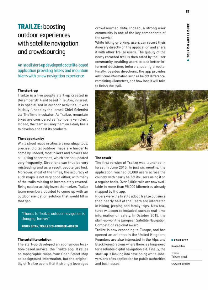
The satellite solutionThe start-up developed an eponymous loca-tion-based service, the Trailze app. It relies on topographic maps from Open Street Map as background information, but the origina-lity of Trailze app is that it strongly leverages
crowdsourced data. Indeed, a strong user community is one of the key components of the service.While hiking or biking, users can record their itinerary directly on the application and share it with other Trailze users. The quality of the newly recorded trail is then rated by the user community, enabling users to take better-in-formed decisions before choosing a route. Finally, besides directions, the app provides additional information such as height difference, remaining kilometres, and how long it will take to finish the trail.
The resultThe first version of Trailze was launched in Israel in June 2015. In just six months, the application reached 50,000 users across the country, with nearly half of its users using it on a regular basis. Over 2,000 trails are now avai-lable in more than 95,000 kilometres already mapped by the app.Riders were the first to adopt Trailze but since then nearly half of the users are interested in hiking, jeeping and family trips. New fea-tures will soon be included, such as real-time information on safety. In October 2015, the start-up won the European Satellite Navigation Competition regional award.Trailze is now expanding to Europe, and has opened an antenna in the United Kingdom. Founders are also interested in the Alps and Black Forest regions where there is a huge need for a reliable digital navigation aid. Finally, the start-up is looking into developing white-label versions of its application for public authorities and businesses.
C O N T A C T S
Ronen Bitan
TrailzeTel Aviv, Israel
www.trailze.com
“Thanks to Trailze, outdoor navigation is changing, forever”
RONEN BITAN, TRAILZE CO-FOUNDER AND CEO
©Trailze

38
TO
UR
ISM
AN
D LE
ISU
RE THE CITY OF BARCELONA
uses a satellite-based service to monitor water quality on the coast
Thanks to satellite imagery, the Department of Environment of the Barcelona City Council can inform citizens and tourists on coastal water quality
The Department of Environment of the City of BarcelonaThe City of Barcelona is located on the western coast of the Mediterranean Sea. The popula-tion is about 1,650,000 inhabitants. Around 7.5 million tourists visit the city every season.The mission of the Department of Environment of the City of Barcelona is to build a sustainable city, respectful of the environment and with no carbon emissions. To achieve these goals, the Department implemented several initiatives, such as promoting the use of electric public transport and raising awareness on sustaina-bility in schools. The coast was transformed in order to convert degraded areas into first quality beaches.
The challengeThe City manages eight beaches. During summer, around 200 people work to maintain the beaches in good shape. The high number of
users (3.5 million in the summer time), as well as urban development pressure on the coast, affect water quality and imply a significant effort from the municipality to offer a good service and to reliably control water quality.The Department of Environment thus needed an efficient and accurate tool to monitor coastal water quality often.
The satellite solutionThe City of Barcelona adopted Barnamar—an information service based on satellite imagery— in 2010. It enables the Department of Environment to monitor the suspended matter in the water, its transparency, temperature and algae bloom. The service is operational during bathing season, which runs from June to September. The maps are updated every two to three days, with a 24 hour delay for processing the images.The service is used in addition to other monito-ring tools such as visual control and analyses in laboratories.
The resultThe service proved to be an efficient informa-tion and awareness raising tool. Indeed, the city benefits from real-time information on water quality disseminated through a dedicated webpage. A smartphone app for citizens, tou-rists and beach managers is under construction. With four years of data, the City of Barcelona hopes to create historical maps to track the evolution of water quality and identify the areas most vulnerable to temperature increases or human activities.
C O N T A C T S
Xavier Amat
Water Cycle Department and Beach Management, City of Barcelona, Spain
www.bcn.cat
Technical contact:Elizabeth Gil-Roldan LittleStarlabBarcelona, Spain
www.starlab.es
“Thanks to satellite imagery, we can offer accurate information, in real-time, to citizens and tourists, and raise awareness on coastal water quality”
XAVIER AMAT, CITY OF BARCELONA
©Marine26
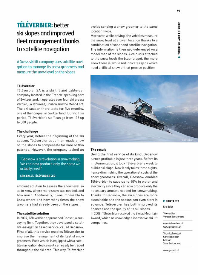
39
TO
UR
ISM
AN
D LE
ISU
RETÉLÉVERBIER: better
ski slopes and improved fleet management thanks to satellite navigation
A Swiss ski lift company uses satellite navi-gation to manage its snow groomers and measure the snow level on the slopes
TéléverbierTéléverbier SA is a ski lift and cable-car company located in the French-speaking part of Switzerland. It operates over four ski areas: Verbier, La Tzoumaz, Bruson and the Mont-Fort.The ski season there lasts for five months, one of the longest in Switzerland. During this period, Téléverbier’s staff can go from 135 up to 500 people.
The challengeEvery year, before the beginning of the ski season, Téléverbier adds man-made snow on the slopes to compensate for bare or thin patches. However, the company lacked an
efficient solution to assess the snow level so as to know where more snow was needed, and how much. Additionally, it was impossible to know where and how many times the snow groomers had already been on the slopes.
The satellite solutionIn 2007, Téléverbier approached Geosat, a sur-veying firm. Together, they developed a satel-lite-navigation based service, called Geosnow.First of all, this service enables Téléverbier to improve the management of its fleet of snow groomers. Each vehicle is equipped with a satel-lite navigation device so it can easily be traced throughout the ski area. This way, Téléverbier
avoids sending a snow groomer to the same location twice.Moreover, while driving, the vehicles measure the snow level at a given location thanks to a combination of sonar and satellite navigation. The information is then geo-referenced on a model map of the slopes. A colour is attached to the snow level: the bluer a spot, the more snow there is, while red indicates gaps which need artificial snow at that precise position.
The resultBeing the first service of its kind, Geosnow turned profitable in just three years. Before its implementation, it took Téléverbier a week to build a ski slope. Now it only takes three nights, hence diminishing the operational costs of the snow groomers. Overall, Geosnow enabled Téléverbier to save up to 40% in water and electricity since they can now produce only the necessary amount needed for snowmaking. Thanks to Geosnow, the ski slopes are more sustainable and the season can even start in advance. Téléverbier has both improved its finances and the quality of its ski slopes.In 2008, Téléverbier received the Swiss Mountain Award, which acknowledges innovative ski lift companies.
C O N T A C T S
Eric Balet
Téléverbier Verbier, Switzerland
www.televerbier.chwww.geosnow.ch
Technical contactChristian HaginGeosatSion, Switzerland
www.geosat.ch
“Geosnow is a revolution in snowmaking. We can now produce only the snow we actually need!”
ERIC BALET, TÉLÉVERBIER CEO
©Téléverbier

40
TOU
RIS
M A
ND
LEIS
UR
E STYRIAN MOUNTAIN RESCUE: satellite applications for improved safety in the Austrian Alps
A regional mountain rescue organisation uses a satellite-based control system to ensure more effective and coordinated operations
The userStyria is a mountainous region in the south-east of Austria, covering 16,401 km². The Styrian Mountain Rescue is the regional branch of the Austrian Mountain Rescue Service (ÖBRD) association. Counting 53 local sites, 1,600 mountain rescuers and 22 search dogs, the Styrian Mountain Rescue service is called upon on average 1,200 times per year.
The challengeSeveral hundred people die every year in the Austrian Alps. The increasing mountain tourism entails a variety of high risks. In case of acci-dents, the race against time is crucial. 10% of the rescue missions are classified as “large missions”, in which more than 50 mountain rescuers are involved. The missions are divided into several mobile teams and include members of external organisations, like the rescue dog brigade or the crisis intervention team. A solid and structured coordination is thus needed for
a successful intervention. A single coordination system was required.
The satellite solutionSince 2015, the Styrian Mountain Rescue has been using the SARONTAR service. The service is based on a smartphone app for the rescue teams and a centralised software for the mission control centre.The app automatically transmits positioning data — including time stamps based on satnav — to the mission control centre, at constant intervals. It also offers a mapping function displaying all the relevant geo-information concerning the ongoing mission. The map helps coordinators orient the team and monitor the mission. It is based on high-resolution ortho-photos and topographic maps. Finally, the app also enables rescue teams to communicate faster and better with the control centre by exchanging messages with only a few clicks.When terrestrial networks are unavailable, an external satcom modem is used to provide a reliable and seamless communication between rescue forces, mission controllers and emer-gency management centres. The connection between the smartphone and the satellite modem is established via Bluetooth and the switching between terrestrial and satcom is fully automatic.
The resultSARONTAR provides the mission control centre with an up-to-date and comprehensive view of the mission state at any time. The exchange of information provided by the service, through stable communication links, is a major benefit compared to the past. Another key enabler is the automatic rescue mission documentation, since a lot of effort can be avoided after the mission. Information loss is avoided and the data recorded in a rescue mission report can be also used at court.
C O N T A C T S
Stefan Schröck
Mountain Rescue Service LiezenLiezen, Styria, Austria
www.bergrettung-stmk.at
“SARONTAR enables faster localisation of persons, facilitates the decision-making process in the mission control centre and increases security of the rescue teams”
STEFAN SCHRÖCK, MOUNTAIN RESCUE SERVICE LIEZEN
©ÖBRD/ESA
41
LO
GIS
TICS
& IN
FRA
STRU
CTU
RE
EURISY SURVEY
Satellites for societyoperational uses of satellite-based services in the public sectorThe European Space Agency, the European Union and National governments have made significant investments to develop satellite infrastructure and services.Public authorities, being among the main funders and customers of satellite-based services, should be able to fully profit from these investments. On the one hand, they should be supported to adopt existing services. On the other hand, their experience and feedback should be taken into account to understand which services work and how they can be improved.To better understand the needs of public administrations, the challenges faced, the benefits gained and the lessons learned, Eurisy launched a survey for local, regional and national administrations operating in sectors as different as environmental protection, urban planning and transport, among many others .The following two pages present some of the main findings obtained from the analysis of the replies received from 106 public administrations from 19 countries. The complete survey report is available at www.eurisy.org.
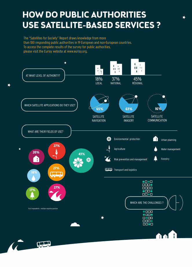
42
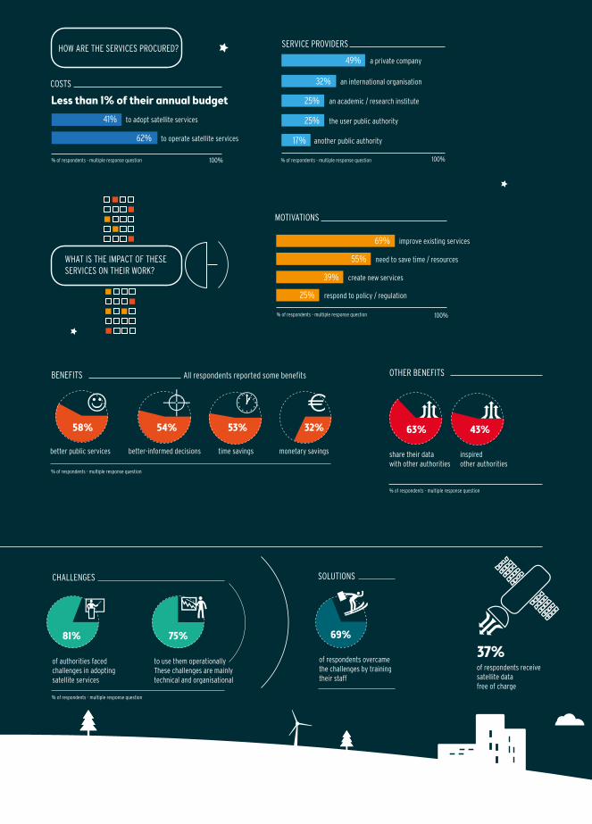
43
44
PREVIOUS EDITIONS
Eurisy has been publishing “Satellites Going Local: regions, cities and SMEs share good practice” since 2011.
The objective of the publication is to encourage regions, cities and SMEs to make the most of European investments in space, by learning from their peers how to use satellite applications in many different sectors, and by following suit.This publication, and its online counterpart – Eurisy’s database of good practices – (www.eurisy.org/good-practices.php), is currently the only resource in Europe which systematically and regularly collects “satellite success stories” – examples of how satellite navigation, imagery and communication are used in practice, shared by the users themselves.For previous editions, and more good prac-tices in your country and field of interest, visit www.eurisy.org.

Editor | Eurisy
Graphic Design | E. Gressant - Guillemot | www.latelierdelestuaire.com
Print | FEM OFFSET Copyright | © Eurisy 2016

SATELLITES GOING LOCAL
Eurisy is a non-profi t association of space agencies and government offi ces dealing with space affairs in Europe.
It is mandated and fi nanced by its members to increase the access of society to the benefi ts of innovative satellite information and services.
Eurisy
8-10 rue Mario Nikis75015 Paris, France
+33 (0) 1 47 34 00 79
PUBLIC AND PRIVATE ORGANISATIONS SHARE THEIR SUCCESS STORIES
2016-2017
Copyright © 2022 FDOKUMEN