Rezoning Application RZ 2010-HM-008 - LDSnet
78
County of Fairfax, Virginia To protect and enrich the quality of life for the people, neighborhoods and diverse communities of Fairfax County May 1, 2013 Brian J. Winterhalter Cooley LLP Reston Town Center One Freedom Square 11951 Freedom Drive Reston, VA 20190 RE: Rezoning Application RZ 2010-HM-008 Dear Mr. Winterhalter: Enclosed you will find a copy of an Ordinance adopted by the Board of Supervisors at a regular meeting held on April 30, 2013, granting Rezoning Application RZ 2010-HM-008 in the name of RBP & M LLC, Section 913, LP and Bozzuto Development Company. The Board's action rezones certain property in the Hunter Mill District from the 1-4 District to PRM District to permit mixed use development with a Floor Area Ratio (FAR) of 2.5 on the northern portion and a 0.42 FAR on the southern portion, excluding bonus density associated with ADU and WDU, approval of the conceptual development plan and a waiver #2615-WPFM-003-01 to permit the location of underground storm water management facilities. The subject property is located N. of Route 267, S. of Sunset Hills Road and W. of Wiehle Avenue on approximately 5.507 acres of land. [Tax Map 17-4 ((19)) 1-4, 5A and 6A; 17-4 ((24)) 4B], and is subject to the proffers dated April 11, 2013. The Board also: • Modified paragraph 1 of Section 16-102 of the Zoning Ordinance for yard regulations, setbacks, bulk regulations, and building heights, in favor of that shown on the CDP/Final Development Plan (FDP). • Modified the transitional screening and a waiver of the barrier requirements, in favor of that shown on the CDP/FDP. • Modified the loading requirement, in favor of the loading spaces depicted on the CDP/FDP. Office of the Clerk to the Board of Supervisors 12000 Government Center Parkway, Suite 533 Fairfax, Virginia 22035 Phone: 703-324-3151 • Fax: 703-324-3926 • TTY: 703-324-3903 Email: [email protected] http://www.fairfaxcounty.gov/bosclerk
-
Upload
khangminh22 -
Category
Documents
-
view
1 -
download
0
Transcript of Rezoning Application RZ 2010-HM-008 - LDSnet

County of Fairfax, Virginia To protect and enrich the quality of life for the people, neighborhoods and diverse communities of Fairfax County
May 1, 2013
Brian J. Winterhalter Cooley LLP Reston Town Center One Freedom Square 11951 Freedom Drive Reston, VA 20190
RE: Rezoning Application RZ 2010-HM-008
Dear Mr. Winterhalter:
Enclosed you will find a copy of an Ordinance adopted by the Board of Supervisors at a regular meeting held on April 30, 2013, granting Rezoning Application RZ 2010-HM-008 in the name of RBP & M LLC, Section 913, LP and Bozzuto Development Company. The Board's action rezones certain property in the Hunter Mill District from the 1-4 District to PRM District to permit mixed use development with a Floor Area Ratio (FAR) of 2.5 on the northern portion and a 0.42 FAR on the southern portion, excluding bonus density associated with ADU and WDU, approval of the conceptual development plan and a waiver #2615-WPFM-003-01 to permit the location of underground storm water management facilities. The subject property is located N. of Route 267, S. of Sunset Hills Road and W. of Wiehle Avenue on approximately 5.507 acres of land. [Tax Map 17-4 ((19)) 1-4, 5A and 6A; 17-4 ((24)) 4B], and is subject to the proffers dated April 11, 2013.
The Board also:
• Modified paragraph 1 of Section 16-102 of the Zoning Ordinance for yard regulations, setbacks, bulk regulations, and building heights, in favor of that shown on the CDP/Final Development Plan (FDP).
• Modified the transitional screening and a waiver of the barrier requirements, in favor of that shown on the CDP/FDP.
• Modified the loading requirement, in favor of the loading spaces depicted on the CDP/FDP.
Office of the Clerk to the Board of Supervisors 12000 Government Center Parkway, Suite 533
Fairfax, Virginia 22035 Phone: 703-324-3151 • Fax: 703-324-3926 • TTY: 703-324-3903
Email: [email protected] http://www.fairfaxcounty.gov/bosclerk

RZ 2010-HM-008 -2- May 1, 2013
The Board also:
• Modified paragraph 4 of Section 17-201 of the Zoning Ordinance for the widening of Sunset Hills Road, in favor of that shown on the CDP/FDP and as proffered
• Approved a deviation from the tree preservation target percentage, in favor of the proposed landscaping shown on the CDP/FDP and as proffered
• Waived paragraph 1(b) of Section 2-414 to permit the existing office building to be set back approximately 70 feet from the Dulles Toll Road
• Approved waiver to locate underground stormwater management facilities in a residential area (PFM Section 6-0303.8), subject to the conditions dated October 9, 2012, for Waiver Number 2615-WPFM 003-1.
Sincerely,
es1042ffiksksittl .C (Azisvt.e Catherine A. Chianese Clerk to the Board of Supervisors
Cc: Chairman Sharon Bulova Supervisor Catherine Hudgins, Hunter Mill District Tim Shirocky, Acting Director, Real Estate Division, Dept. of Tax Administration Barbara Berlin, Director, Zoning Evaluation Division, DPZ Diane Johnson-Quinn, Deputy Zoning Administrator, Dept. of Planning and Zoning Thomas Conry, Dept. Manager — GIS - Mapping/Overlay Angela K. Rodeheaver, Section Chief, Transportation Planning Division Donald Stephens, Transportation Planning Division Department of Highways-VDOT Sandy Stallman, Park Planning Branch Manager, FCPA Charlene Fuhrman-Schulz, Development Officer, DHCD/Design Development Division Planning Commission Denise James, Office of Capital Facilities/Fairfax County Public Schools Karyn Moreland, Chief Capital Projects Sections, Dept. of Transportation
At a regular meeting of the Board of Supervisors of Fairfax County, Virginia, held in the Board Auditorium in the Government Center at Fairfax, Virginia, on the 30 th day of April, 2013, the following ordinance was adopted:
AN ORDINANCE AMENDING THE ZONING ORDINANCE PROPOSAL NUMBER RZ 2010-HM-008
WHEREAS, RBP & M, LLC, Section 913, LP and Bozzuto Development Company, filed in the proper form an application requesting the zoning of a certain parcel of land herein after described, from the 1-4 District to the PRM District, and
WHEREAS, at a duly called public hearing the Planning Commission considered the application and the propriety of amending the Zoning Ordinance in accordance therewith, and thereafter did submit to this Board its recommendation, and
WHEREAS, this Board has today held a duly called public hearing and after due consideration of the reports, recommendation, testimony and facts pertinent to the proposed amendment, the Board is of the opinion that the Ordinance should be amended,
NOW, THEREFORE, BE IT ORDAINED, that that certain parcel of land situated in the Hunter Mill District, and more particularly described as follows (see attached legal description):
Be, and hereby is, zoned to the PRM District, and said property is subject to the use regulations of said PRM Districts, and further restricted by the conditions proffered and accepted pursuant to Va. Code Ann., 15.2-2303(a), which conditions are in addition to the Zoning Ordinance regulations applicable to said parcel, and
BE IT FURTHER ENACTED, that the boundaries of the Zoning Map heretofore adopted as a part of the Zoning Ordinance be, and they hereby are, amended in accordance with this enactment, and that said zoning map shall annotate and incorporate by reference the additional conditions governing said parcel.
GIVEN under my hand this 30th day of April, 2013.
r4Eittil . Catherine A. Chianese Clerk to the Board of Supervisors


RBP & M, LLC BOZZUTO DEVELOPMENT COMPANY SECTION 913 LIMITED PARTNERSHIP
.PROFFER STATEMENT RZ 2010-RM-008
November 9, 2010 Revised April 11, 2013
Pursuant to Section 15,2-2303 (A) of the Code of Virginia (1950, as amended) and Sect. 18-204 of the Zoning Ordinance of Fairfax County (1978, as amended) (the "Zoning Ordinance"), the property owners and applicants, for themselves and their successors and assigns (collectively referred to as the "Applicant"), in this rezoning application proffer that the development of the parcels under consideration and shown on the Fairfax County Tax Map as 17-4 ((19)) 1, 2, 3, 4, 5A, and 6A (the "RBP & M Property") and 17-4 ((24)) 4B (the "Section 913 Property" and, collectively with the RBP & M Property, the "Property") shall be in accordance with the following conditions ("Proffers") if, and only if, RZ 2010-HM-008 (the "Application") is granted. In the event that this Application is denied, these Proffers shall be immediately null and void and of no further force or effect
GENERAL
1. Conceptual Development Plan/Final Development Plan, The Property shall be developed in substantial conformance with the Conceptual Development Plan/Final Development Plan ("CDP/FDP") dated April 23, 2010, and revised through February 7, 2013, prepared by Urban Ltd., and consisting of 31 sheets, as further described below.
2. CDP Elements. Notwithstanding that the Conceptual Development Plan and the Final Development Plan are presented on the same sheets and defined as the CDP/FDP in Proffer 1, it shall be understood that the CDP consists of (i) the maximum square footage of permitted development on the Property, including the proposed mix and locations of uses as set forth on the CDP/FDP and as qualified under Proffer 5; (ii) the minimum proposed open space; (iii) the general location and arrangement, minimum setbacks, and maximum building heights of the buildings on the Property as shown on the CDP/FDP; and (iv) the points of access to the Property and accompanying pedestrian and vehicular circulation routes through the Property (collectively, the "CDP Elements"). The Applicant reserves the right to request approval from the Planning Commission of a Final Development Plan Amendment ("FDPA") pursuant to Section 16-402 of the Zoning Ordinance for elements other than the CDP Elements for all or a portion of the Property and the CDP/FDP, provided such FDPA is in substantial conformance with these Proffers.
3. Minor Modifications. Minor modifications to the CDP/FDP may be permitted pursuant to Section 16-403(4) of the Zoning Ordinance when necessitated by sound engineering or when
1
455722 v24/itli
C

necessary as part of final site engineering. Such modifications shall be permitted, provided: (a) the maximum building heights for each building are not increased beyond the heights identified on Sheet 6 of the CDP/FDP and Proffer 7; (b) the minimum setbacks for each building are not decreased beyond the setbacks identified in Sheet of the CDP/FDP; (c) the amount of open space identified on Sheet 2 of the CDP/FDP is not reduced; and (d) the development otherwise is in substantial conformance with these Proffers and the CDP/FDP.
4. Future Applications. . Any portion of the Property may be the subject of a Conceptual Development Plan. Amendment ("CDPA"), FDPA, Proffered Condition Amendment ("PCA"), Rezoning, Special Exception, Comprehensive Sign Plan, Special Permit, Variance or other zoning action (including that the Section 913 Property may be the subject of any such an application in order to develop the Phase II Development, as hereinafter defined, in accordance with Proffer 5 below) without the joinder and/or consent of the owners of the other land areas, provided that such application complies with Par., 6 of Sect. 18-204 of the Zoning Ordinance and Section 15.2-2302 of the Code of Virginia, as applicable. Previously approved proffered conditions or development conditions applicable to a particular portion of the Property that are not the subject of such an application shall remain in full force and effect.
PROPOSED DEVELOPMENT
5. Proposed Development. Redevelopment of the Property may 'occur in phases. The - development proposed with this Application shall include: .(a) a multi-family residential building--
on the RBP & M Property containing up to 421 multi-family dwelling units (the "Residential Units") and up to 10,000 square feet of non-office secondary uses ("Secondary Uses") as permitted under Section 6-403 of the Zoning Ordinance (the "Proposed Development") in accordance with the tabulations set forth on Sheet 2 of the CDP/FDP; and (b) the existing office building on the Section 913 Property containing 30,608 square feet of office and accessory uses ("Office Uses") in accordance with the tabulations set forth on Sheet 2 of the CDP/FDP (collectively, the Proposed Development and the Office Uses shall constitute the "Phase I Development"). The Applicant anticipates that the Section 913 Property may be the subject of a future Rezoning, CDPA, FDPA, PCA or other zoning action, as permitted in accordance with Proffer. .4 above, to redevelop the Section 913 Property (the "Phase II Development"). Although no improvements are proposed for the Section 913 Property with Phase I, the Section 913 Property is included with this Application for the purpose of facilitating coordinated development of the RBP & M Property and the Section 913 Property. At such time as the Phase II Development occurs, such development shall be consistent with, and complementary to, the general character of the Phase I Development as a high-quality, mixed-use, and transit-oriented development and shall be well-integrated into the transit station area.
6. Secondary Uses. The Secondary Uses shall be located on the ground floor of the residential building along the Reston Station Boulevard frontage of the RBP & M Property as shown on Sheet 6 of the CDP/FDP. The Applicant shall develop a minimum of 3,500 square feet of Secondary Uses, provided, however, that the Applicant may convert such Secondary Use space to amenity space for residents of the building (such as, but not limited to, a fitness center,
2
455722 v24/RE

business center, or community room) if the Applicant is unable to lease the Secondary Use space for Secondary Uses within one (I) year of the issuance of Residential Use Permits ("RUPs") for sixty-five percent (65%) or more of the Residential Units shown on the final site plan. The Secondary Uses shall have at least two (2) direct pedestrian access points from the sidewalk along the north side of Reston Station Boulevard.
7. Building Height. The building heights for the Proposed Development shall not exceed the maximum building heights shown on Sheet 6 of the CDP/FDP. Building height shall be measured in accordance with the provisions of the Fairfax County Zoning Ordinance and shall be exclusive of those structures that are excluded from the maximum building height regulations as set forth in Section 2-506 of the Zoning Ordinance, including, for example, penthouses and other rooftop structures used for common amenity space, exercise rooms, meeting rooms and similar facilities, Notwithstanding the foregoing, however, nothing shall preclude the Applicant from constructing the Proposed Development to a lesser building height than that which is represented on the CDP/FDP, provided the configuration of the building footprint remains in substantial conformance with that shown on the CDP/FDP.
8. Declarations and Owners' Associations.
A. Umbrella Owners' Association. At any time, the Applicant may record a declaration and/or establish an Umbrella Owners' Association (the "UOA") for the RBP & M Property to address the general maintenance and other-obligations (including stormwater management and transportation demand management) of the owner(s) (and their successors and assigns), including the fulfillment of these Proffers. If recorded or established, the declaration and/or UOA documents shall separately identify those maintenance or proffer obligations that will or are expected to fall principally on owners or residents of the residential building and such obligations shall be disclosed to the owners/residents in accordance with the terms of this proffer.
B. Homeowner and Condominium Owners' Association, In the event units in the residential building are held for sale, the Applicant shall cause either a homeowners' association and/or a condominium owners' association ("HOA/COA") to be formed for the residential building. If a declaration is recorded and/or a UOA is established for the RBP & M Property, the HOA/COA shall be a member of the declaration and/or UOA.
C. Commercial Association. In the event the residential building is a rental residential building without units held for sale, the Applicant may cause a Commercial Association ("CA") to be formed for the residential building. If a declaration is recorded and/or a UOA is established for the RBP & M Property, the CA shall be a member of the declaration and/or UOA.
D. Disclosures. The declaration establishing any HOA/COA/CA on the RBP & M Property (including budgets provided in any offering or sale materials) shall
3
455722 1,24/RE

specify the proffer. and maintenance conditions and obligations set forth in these Proffers. Purchasers shall be advised in writing of these proffer conditions and obligations prior to entering into a contract of sale.
E. UOA Transportation Demand Management ("TDM") Obligations. All residents, tenants, owners, employers and employees living, working, operating a business or owning property within the RBP & M Property shall be advised of the TDM Plan described in Proffer 26. All HOA/COA/CA members shall be informed of any funding obligations for the TDM program prior to entering into a contract of sale, and all such obligations shall be included in the HOA/COA/CA documents.
LIGHTING
9. Lighting. All on-site outdoor and parking garage lighting provided with the Proposed Development shall comply with the Outdoor Lighting Standards of Section 14-900 of the Zoning Ordinance and shall be generally consistent with the outdoor lighting fixtures provided for other developments in the Wiehle-Reston East Metro Station area, as determined by the Applicant in consultation with the Zoning Evaluation Division ("ZED"). All proposed parking garage and building mounted security lighting on the RBP & M Property shall utilize full cut-off fixtures.
NOISE ATTENUATION ENUATION
10. Noise Attenuation. Concurrent with the initial submission of a site plan for the residential building, the Applicant shall submit to the County a refined acoustical analysis detailing the projected noise impacts of the Dulles Toll Road on the Residential Units and proposed mitigation techniques (the "Noise Study"). The Noise Study shall be conducted in accordance with requirements established by the Fairfax County Department of Planning & Zoning ("DPZ") and shall be submitted to DPZ and the Fairfax County Department of Public Works & Environmental Services ("DPWES") for review and approval. The Noise Study shall include projected noise levels in the Residential Units, outdoor balconies/patios, and outdoor recreation areas shown on the submitted site plan based on the proposed final site topography and conditions as shown on the site plan (rather than existing topography and conditions). The Noise Study shall include the following information: site plan and cross section views of the source of the noise in relation to the residential building, the affected Residential Units, and the affected outdoor recreation areas, and the consultant's recommendations for appropriate noise attenuation measures to ensure that the affected areas meet the standards outlined below. A copy of the approved Noise Study shall be included with the submission of the building permit applications for the residential building. The building plan shall identify the noise-affected spaces and the noise attenuation measures, including materials, to be provided to ensure that each such affected occupied space meets the standards outlined below,
A. Acceptable Noise Levels within Residential Units. The Applicant shall provide noise attenuation measures in order to reduce interior noise in all Residential Units to approximately45 dBA Ldn or less.
4
455722 v24/RE

i. Above 75 dBA Ldn. No Residential Unit (or portion thereof, such as outdoor balconies) may be established in areas projected to be impacted by noise levels greater than 75 dBA Ldn,
ii. 70 dBA Ldn to 75 dBA Ldn. In order to reduce interior noise to a level of no more than 45 dBA Ldn for Residential Units that are projected to be impacted by noise greater than 70 dBA Ldn (but not more than 75 dBA Ldn) the Applicant shall construct such units using the following acoustical measures:
a. Exterior walls shall have a laboratory sound transmission class ("STC") rating of at least 45;
b. Doors and glazing shall have a laboratory STC rating of at least 37 unless glazing constitutes more than 20% of any facade exposed to noise levels of Ldn 70 dBA or above;
c, If glazing constitutes more than 20% of an exposed façade, then the glazing shall have a laboratory STC rating of at least 45; and
d. All surfaces shall be sealed and caulked in accordance with methods approved by the American Society for Testing and Materials ("ASTM") to minimize sound transmission.
iii. 65 dBA Ldn to 70 dBA Ldn, In order to reduce interior noise to a level of no more than 45 dBA Ldn for Residential Units that are projected to be impacted by noise projected greater than 65 dBA Ldn (but not more than 70 dBA Ldn), the Applicant shall construct such units using the following acoustical measures:
a. Exterior walls shall have a laboratory STC rating of at least 39;
b, Doors and glazing shall have a laboratory STC rating of at least 28 unless glazing constitutes more than 20% of any facade exposed to noise levels of Ldn 70 dBA or above;
c. If glazing constitutes more than 20% of an exposed façade, then the glazing shall have a laboratory STC rating of at least 39; and
d. All surfaces shall be sealed and caulked in accordance with methods approved by the ASTM to minimize sound transmission.
B, Noise Levels at Outdoor Recreation Areas and Balconies/Patios. The Applicant shall provide noise attenuation measures as determined necessary by the Noise Study as approved by DPWES and DPZ to ensure that traffic-related noise in the
5
455722 v24/RE

outdoor recreation areas and balconies/patios do not exceed 65 dBA Ldn. Adjustments to the noise attenuation measures that are in substantial conformance with those indicated on the CDP/FDP may be permitted subject to the approval of the Zoning Administrator to ensure that the noise attenuation measures provide the necessary noise attenuation.
C. Noise Contours on Site Plans and Building Permits. All site plans, building permit applications and building plans submitted to the County for the Residential Units shall indicate whether such building is required to include noise attenuation measures and, if so, the type of attenuation measure to be implemented. Building and site plans for each unit that is subject to noise mitigation as provided herein shall depict the final noise contours as determined by the Noise Study.
PARKING
11. Zoning Ordinance Parking Requirements. Parking shall be provided in accordance with the parking requirements of Article 11 of the Fairfax County Zoning Ordinance, as determined by DPWES, for the uses within the Proposed Development. The maximum number of parking spaces for the Residential Units shall be the minimum number of parking spaces required under Article 11 of the Zoning Ordinance in effect as of the date of these Proffers. The Applicant reserves the right to provide parking spaces for the Secondary Uses in addition to the total number of parking spaces shown on Sheet 2 of the CDP/FDP (a) if such additional spaces result from the final design of the parking structure, or (b) to the extent necessary to accommodate uses established on the RBP & M Property that result in a higher parking requirement than is shown on the CDP/FDP (e.g., eating establishments), provided that (i) the building height as set forth on Sheet 6 of the CDP/FDP and in Proffer 7 are not exceeded and (ii) the building footprints for each building remain in substantial conformance with the building footprints shown on Sheet 6 of the CDP/FDP.
12. Future Parking Reductions. Given (a) the Property's proximity to the Wiehle-Reston East Metro Station, (b) the planned bus service at the Property, (c) the character of the Proposed Development as a mixed-use, urban development, and (d) the Transportation Demand Management ("TDM") Plan detailed in Proffer 26, the Applicant may pursue a parking reduction for the Proposed Development, as may be permitted by Article 11 of the Fairfax County Zoning Ordinance and approved by the Board of Supervisors.
13. Bicycle Parking. As part of site plan approval for the Proposed Development, the Applicant shall designate on the site plan and install secure bicycle storage sufficient to provide one (1) visitor bicycle space for every twenty-five (25) Residential Units, one (1) long-term bicycle space for residents for every five (5) Residential Units, and one (1) visitor/employee bicycle space for every 5,000 square feet of Secondary Uses. The Applicant also shall provide signage within the RBP & M Property to guide bicyclists to the secure bicycle storage facilities. The Applicant shall determine the final location of the secure bicycle storage, the type of bicycle racks, and bicycle signage in consultation with the Fairfax County Department of Transportation
6
455722 v24/RE

("FCDOT") Bicycle Coordinator prior to site plan approval for the Proposed Development. The bicycle storage facilities designated on the site plan and the bicycle signage shall be installed prior to the issuance of the first RUP for the Residential Units.
14. Electric Vehicle Charging Facilities. As part of site plan approval for the Proposed Development, the Applicant shall designate on the site plan and install at least one (1) electric vehicle charging station, and ancillary wiring and infrastructure necessary to increase the number of electric vehicle charging stations, within the parking garage for the residential building.
SIGNAGE
15. Signage. Signage for the Proposed Development shall be provided in accordance with the requirements of Article 12 of the Zoning Ordinance or pursuant to a Comprehensive Sign Plan approved by the Planning Commission in accordance with Section 12-210 of the Zoning Ordinance,
LANDSCAPING
16. Landscape Plan. The Applicant shall implement the landscape design for the Proposed Development shown on Sheet 10 of the CDP/FDP (the "Overall Landscape Plan"), which illustrates the plantings and other features to be provided with the Proposed Development, including streetscapes, plazas and parks. The Overall Landscape Plan is conceptual in nature and may be modified by the Applicant as part of final engineering and building design, provided that such modifications provide a similar quality of landscaping as that shown on the Overall Landscape Plan and the CDP/FDP, as determined by Urban Forest Management Division of DPWES ("UFMD"),
A. Native Species. The Applicant shall use native species to the extent practicable throughout the Proposed Development, provided that the Applicant reserves the right, in consultation with and approval by UFIVID, to modify as part of site plan approval for each building the exact species to be used, such as where some plant materials are not available or have been deemed by UFMD to no longer be appropriate.
B, Site Plan(s). As part of the initial site plan submission for each building of the Proposed Development, the Applicant shall submit to U.FMD for review and approval a detailed landscape and tree cover plan (the "Landscape Plan") for such building(s), which shall include, among other things:
Irrigation information;
ii. Design details for tree wells or grates and other similar planting areas above structures and along streets;
7
455722 v24/12E

iii. Composition of the planting materials and/or structural soils used for street trees or where plantings are to be located within or on top of structures and other methods to be used to ensure the viability of the proposed plantings;
iv. Information demonstrating that the Landscape Plans are consistent with and are part of implementation of the SWM Plan defined in Proffer 18; and
v. Other information that may be requested by UFMD.
C. Planting Quality. Each Landscape Plan shall be consistent with the quality and quantity of plantings and materials shown on the Overall Landscape Plan of the CDP/FDP and may include the use of additional shade trees and other plant materials as determined by the Applicant. The Applicant may adjust the type and location of vegetation and the design of the public spaces, courtyard areas and streetscape improvements and plantings as approved by ZED and UFM, provided such adjustments otherwise are in substantial conformance with the CDP/FDP.
D. Planting Strips. The Applicant shall install street trees consistent with the Streetscape plans included on Sheet 10 of the CDP/FDP. For trees not planted within an 8-foot wide minimum planting area, or that do not meet the minimum planting area required by the PFM, the Applicant shall provide details for alternative designs showing how the proposed planting spaces will provide for normal tree growth and performance by installing structural cells or an equivalent solution acceptable to UFMD to meet the following specifications:
i. A minimum of 6 feet open surface width and 48 square feet open surface area
ii. Rooting area a minimum of 8 feet wide, which can be achieved in instances where open surface area width is less than 8 feet by providing suitable rooting area below paved surfaces using methods that do not require soil compaction for structural purposes such as structural cells.
iii. Soil volume for Category III or IV trees (as indicated in Table 12.17 of the Public Facilities Manual) shall be a minimum of 455 cubic feet per tree for single trees. For two trees planted in a contiguous planting area, a total soil volume of at least 760 cubic feet shall be provided. For three trees or more planted in a contiguous area, the soil volume shall equal at least 400 cubic feet per tree.
iv. Planting spaces shall provide 36-48 inches of soil depth.
v. Planting spaces shall be interconnected to the furthest extent feasible.
8
455722 v24/RE

vi, Soil in planting sites shall be as specified in planting notes to be included in site plans reviewed and approved by Urban Forest Management.
The Applicant shall provide notice to UFMD not less than 72 hours prior to the Applicant's implementation of the tree planting spaces to permit UFMD to verify the proper installation and planting of trees in conformance with the approved site plan. At such time, the Applicant also shall provide UFMD written documentation demonstrating that the materials and methods used satisfy the requirements of the plan and verifying that the contractors performing the work are licensed as may be required by the manufacturer. Following installation and no later than final bond release for the site plan for which this proffer is applicable, the Applicant shall provide written confirmation from a certified arborist and/or landscape architect verifying installation of trees by a licensed contractor consistent with the requirements of this proffer.
E. Open Space Designs. As part of final engineering and design, and subject to review and approval by ZED, the Applicant may elect to modify the designs of the various open space areas from the designs shown on Sheets 10, 11, and 12 of the CDPIFDP, provided that such modifications offer a similar quality of design and quantity of plantings and materials as those shown on the CDP/FDP and are in accordance with Section 16-403(4) of the Zoning Ordinance. The Applicant shall incorporate into the design or architecture of the Proposed Development public art features or designs selected by the Applicant in consultation with representatives of the Initiative for Public Art in Reston to be maintained by the Applicant. The public art shall be completed prior to final bond release for the Proposed Development.
F. Tree Preservation. UFM has approved a tree preservation deviation for the RBP & M Property based on the provision that construction activities be reasonably expected to impact existing trees or forested areas used to meet the Tree Preservation Target to the extent these would not likely survive in a healthy and structurally sound manner for a minimum of ten (10) years in accordance with the post-development standards for trees and forested areas provided in Section 1.2-0403 and 12-0404 of the PFM. The tree canopy requirement will be met with new planting proposed with the Proposed Development.
G. Tree Replacement. The Applicant shall replace any tree that is planted on the RBP & M Property, and is counted toward meeting the overall tree canopy requirement, that is damaged, such that thirty percent (30%) or more of the crown is no longer viable, as a result of maintenance to the stonnwater management facilities and storm sewer pipe on the RBP & M Property with a tree of equal or greater size. The size of the replacement tree shall be based on the caliper size of the tree to be replaced as shown on the final site plan.
9
455722 v24/RE
EF

17. Streetscaping. The Applicant shall provide streetscape improvements and plantings ("Streetscape") as indicated on the Overall Landscape Plan shown on Sheet 10 of the CDP/FDP. Notwithstanding the foregoing, and subject to approval by ZED, the Applicant may make minor modifications to the Streetscape, including shifting the locations of street trees, to accommodate final architectural designs, sight distance concerns and utilities, as well as to facilitate outdoor elements in the Proposed Development, provided that such changes are in substantial conformance with these Proffers and the CDP/FDP and as approved by DPWES. As part of site plan approval for the Proposed Development, the Applicant shall grant public access easements for the entry plaza area and sidewalks on the RBP & M Property.
STORMWATER MANAGEMENT
18. Stormwater Management. As part of site plan approval for the Proposed Development, the Applicant shall demonstrate that the Proposed Development will meet applicable Fairfax County Public Facilities Manual ("PFM") requirements for stormwater quantity and stormwater quality in effect at the time of the approval of this Application. The site plan shall include strategies for addressing both water quantity and water quality management issues, including detailed mitigation measures to be implemented as part of construction, The Applicant shall construct stormwater quantity and quality measures in accordance with the site plan (and each subsequent revision thereto) with the Proposed Development, such that the runoff reductions outlined below shall be achieved.
A. Stormwater Management Goals. Using a series of infiltration facilities and/or structural and non-structural stormwater management and/or Best Management Practices ("BMP") facilities, the Applicant shall demonstrate the Proposed Development's conformance with applicable PFM requirements for stormwater pantity and stormwater quality in effect at the time of the approval of this Application. Underground stormwater detention shall be provided in conformance with the conditions of DPWES Waiver #2615-WPFM-003-1.
B. Maintenance Responsibility. Prior to site plan approval for the Proposed Development, the Applicant shall execute an agreement with the County in a form satisfactory to the County Attorney (the "SWM Agreement") providing for the perpetual maintenance of all stormwater management facilities that are part of the Proposed Development ("SWM Facilities"). The SWM Agreement .shall require the Applicant (or its successors) to perform regular' routine maintenance of the SWM Facilities and to provide a maintenance report annually to the Fairfax County Maintenance and Stormwater Management Division of DPWES, provided DPWES requests such a maintenance report. The SWM Agreement also shall address easements for County inspection and emergency maintenance of the SWM Facilities to ensure that the facilities are maintained by the Applicant in good working order.
10
455722 v24/RE

TRANSPORTATION IMPROVEMENTS
19. Right-of-Way for Sunset Hills Road. As part of the first site plan approval for the Proposed Development, or upon the written request of Fairfax County, whichever occurs first, the Applicant shall reserve for future dedication to the Board of Supervisors right-of-way to 53 feet from the existing centerline of Sunset Hills Road, as shown on Sheets 2 and 6 of the CDP/FDP. Upon the written request of Fairfax County at such time as the necessary engineering and funding exist to permit the widening of Sunset Hills Road, the Applicant shall dedicate such right-of-way in fee simple to the Board of Supervisors for public street purposes.
20. Right-of-Way and Construction for Reston Station Boulevard and Metro Center Drive, As part of the first site plan approval for the Proposed Development, or upon written request of Fairfax County, whichever occurs first, the Applicant shall dedicate in fee simple the right-of-way along Reston Station Boulevard and Metro Center Drive, as shown as "Proposed R.O.W. Dedication" on Sheet 6 of the CDP/FDP, to the Board of Supervisors for public street purposes. Subject to VDOT approval, the Applicant shall construct widening and frontage improvements, and implement lane restriping as necessary, for Reston Station Boulevard and Metro Center Drive as shown on Sheet 6 of the CDP/FDP. The Applicant shall complete and open such improvements to traffic (but not necessarily have such improvements accepted by VDOT) prior to the issuance of the first RUP for the Proposed Development.
21. Construction of Interim Private Drive. Prior to the issuance of the first RUP for the Proposed Development, the Applicant shall construct a private drive along the eastern boundary of the RBP & M Property as shown on Sheet 6 of the CDP/FDP. This private drive shall be for the purpose of serving the parking garage entrance and loading spaces on the RBP & M Property as an interim condition until the approval and establishment of a public road connection from Reston Station Boulevard to Sunset Hills Road.
22. Escrow for Future Access Connection. Prior to the issuance of the first RUP for the Proposed Development, the Applicant shall post an escrow in the amount of $15,079.16 in the form of cash or a letter of credit from a financial institution authorized to conduct business in the Commonwealth of Virginia as a contribution toward the implementation of a future access connection from Reston Station Boulevard to Sunset Hill Road along the eastern boundary of the RBP & M Property as shown on Sheet 5B of the CDP/FDP. Fairfax County shall be permitted to draw upon the escrow at such time as the required engineering is complete and the necessary funding is in place for the construction of such access connection. At such time, the Applicant shall grant to the County a temporary construction and grading easement on the RBP & M Property as necessary for the construction of the access connection.
23. Retail Loading Area. Prior to site plan approval for the Proposed Development, the Applicant shall determine, in consultation with VDOT and DPWES, whether to proceed with the retail loading entrance along Metro Center Drive as shown on Sheet 6 of the CDP/FDP or the alternative retail loading entrance along Metro Center Drive as shown on Sheet 13A of the CDP/FDP to provide safe and efficient retail loading for the residential building. In the event the
11
455722 v24/RE
LE

Applicant determines, in consultation with VDOT and DPWES, that an alternative design for the retail loading entrance along Metro Center Drive is preferable to both options identified in the CDP/FDP, the Applicant shall be permitted to proceed with such an alternative without the need for a CDPAIFDPA/PCA. The Applicant shall incorporate the selected retail loading entrance prior to final site plan approval.
24. Traffic Signal Timing Study. As part of the site plan process, if VDOT determines that a signal timing study is necessary, the Applicant shall submit a signal timing study for the signalized intersections along Wiehle Avenue, from the intersection of Sunset Hills Road to the intersection of the Dulles Toll Road (Westbound Ramps), to determine appropriate signal timing modifications. Such signal timing study shall be subject to review and approval by VDOT and shall provide for sufficient pedestrian crossing times in accordance with established standards as determined by VDOT.. This proffer will be considered to be satisfied with the submittal of the signal timing study to VDOT, if required,
25. Traffic Signal Facilities. If the relocation of any traffic signal heads, poles, mast arms, or related ancillary facilities is required to accommodate the Proposed Development, the Applicant shall complete the relocation of such traffic signal facilities prior to the issuance of the first RUP for the residential building. If the traffic signal has not yet been installed at the intersection of Reston Station Boulevard, the Metro parking garage entrance, and the proposed private road referenced in Proffer 21, the Applicant shall not be responsible for installation of the new traffic signal, but shall coordinate with others to ensure that the traffic signal design will accommodate the Proposed Development on the RBP & M Property.
TRANSPORTATION DEMAND MANAGEMENT
26. Transportation Demand Management, This proffer sets forth the components of a transportation demand management program for the Proposed Development that shall be implemented by the Applicant, and its successors or assigns, to reduce peak hour vehicle trips generated by the residents of the RBP & M Property. The proffered elements of the transportation demand management program shall be identified and more fully described in a Transportation Demand Management Plan (the "TDM Plan") the Applicant shall submit to FCDOT for review and approval as set forth below. It is the intent of this proffer that the TDM Plan adapt over time to respond to changing transportation related circumstances of the RBP & M Property, as well as to technological and/or other improvements, with the objective of meeting the proffered vehicle trip reduction goals.
A. Definitions:
i. Applicant Control Period. The "Applicant Control Period" is the period starting immediately following approval of this rezoning Application and ending on the date when three (3) consecutive annual Trip Counts conducted starting at least one (1) full calendar year after the Residential Units reach Full Occupation show that vehicle trips generated by the Residential Units are less than or equal to the TDM Goal (as defined
455722 v24/12E

herein). Upon expiration of the Applicant Control Period, the Applicant may assign responsibility for ongoing implementation of the TDM Plan to a future U0A/H0A/COA/CA, in the event such an association is created that includes the Residential Units, provided the Applicant gives written notice to FCDOT within ten (10) days of any such assignment. Upon the assignment of the TDM responsibilities to a U0A/H0A/COA/CA, the Applicant shall have no further obligations under this proffer.
ii. Full Occupation. For purposes of this proffer, "Full Occupation" of the Residential Units shall be deemed to occur upon the issuance of 80 percent (80%) of all RUPs for the Residential Units, except as otherwise agreed to by the Applicant and FCDOT.
iii. Peak Hours. For purposes of this proffer, the relevant weekday "Peak Hours" shall be that 60-minute period during which the highest weekday volume of mainline trips occurs between 7:00 to 9:00 AM and 4:00 to 6:00 PM, as determined by mechanical traffic counts conducted at two select locations abutting the RBP & M Property as approved in consultation with FCDOT. To determine the Peak Hours, such counts shall be collected beginning on a Monday at 24:00 hours and continuing to the following Thursday at 24:00 hours at a time of year that reflects typical travel demand conditions (e.g. September to May, not during a holiday week or when public schools are not in session). The methodology for determining the Peak Hours may be modified subject to approval of FCDOT in order to respond to technological and/or other improvements in trip counting.
B. Trip Reduction Objective. The objective of this TDM program shall be to reduce the number of vehicle trips generated by the Residential Units to be developed on the RBP & M Property during weekday Peak Hours (as determined based on the Institute of Transportation Engineers, Trip Generation, 8 th Edition) by meeting the vehicle trip reductions set forth below. The Secondary Uses established as part of the Proposed Development and the Existing Development shall not be included in the TDM Plan.
C. Baseline Trips. The baseline number of vehicle trips for the Residential Units against which the TDM Goals (as defined herein) will be measured shall be 210 AM Peak Hour trips and 249 PM Peak Hour trips (the "Baseline Trips"). The Baseline Trips are based on the 421 Residential Units that may be constructed on the RBP & M Property as part of the Proposed Development and using the trip generation rates/equations applicable to such uses and densities as set forth in the Institute of Transportation Engineers, Trip Generation, 8 th Edition. In the event the Applicant constructs fewer than 421 Residential Units as part of the Proposed Development, then the Baseline Trips applicable upon Full Occupation 0811 be
13
455722 v24/RE
EF.

calculated as if 421 Residential Units in the Proposed Development had actually been constructed as reflected on the CDP/FDP.
TDM Goals. The "TDM Goals" for the vehicle trip reductions for the Residential Units shall be as follows:
Peak Hour Residential Use
Permits ITE Land Use Code
Maximum ITE Projected nips
Target Peak HOW Trip Reduction Percentage
TDM Trip Reduction Goal
AM 1 to 421 220 210 40% 126 PM 1 to 421 220 249 40% 149
E. TDM Plan. In order to meet the TDM Goals set forth in this proffer, the Applicaut shall develop and implement the 11)M Plan. The TDM Plan shall outline the components of the Applicant's TDM program and the specific TDM strategies the Applicant will implement to meet the TDM Goals, which shall be selected by the Applicant in consultation with FCDOT. The Applicant shall submit the TDM Plan to FCDOT for review and approval prior to site plan approval for the Proposed Development, The Applicant shall implement the TDM Plan, as approved by FCDOT, prior to the issuance of the first RUP for the Residential Units. The Applicant may amend and supplement the TOM Plan from time to time, subject to approval by FCDOT, without the need for a PCA.
F. TDM Strategies. The following list represents potential TDM strategies the Applicant may select and implement as part of the TDM Plan in order to meet the TDM Goals. It is the Applicant's intent to identify a non-exclusive list of potential TDM strategies, which the Applicant may amend and supplement from time to time, subject to approval by FCDOT, without the need for a PCA. The TDM strategies are as follows:
i. Designation of the TPM, as described above;
ii. A targeted marketing program for residential sales/leases that encourages and attracts TDM-oriented residents, such as bicyclists, one or no-car individuals/farailies and employees of nearby employers to live in the Proposed Development; provided, however, that such marketing shall be completed on a non-discriminatory basis in conformance with the Fair Housing Act and all other applicable laws and regulations;
iii. Integration of transportation information and education materials into office leases and residential sales/rental kits;
iv. Coordination/assistance with vanpool and carpool formation programs,-including ride matching services, with adjacent office/residential buildings
14
455722 V24/RE

and homeowners associations and established guaranteed ride home programs;
v. Establishment of a site-specific project website that includes multimodal transportation information, real-time travel and transit data, the possibility of online transit pass sales or value loading and connections to supporting links;
vi. Provision of a 500 — 850 square-foot business center that offers broadband or high-speed data. connections (including "secure" voice and/or data connections), computers, facsimile machine and similar items;
vii. Provision of broadband or high-speed data connections/wiring for internet access for all Residential Units;
viii. Establishment of a location to be staffed/managed by the TPM within the Proposed Development at which transit and ridesharing information is made available to tenants, residents and visitors;
• ix.. A parking management plan for the Residential Units, which shall include (i) a unit sales/rental program/policy under which each residential unit is allocated one (1) parking space as part of the base purchase/rental price, and that additional parking spaces may be purchased/leased for an additional cost; and (ii) dedicated space for residential vanpools and car-sharing vendors not otherwise addressed in these Proffers;
x. Distribution of fare media or other incentives up to a maximum $50.00 per Residential Unit, at least one time, to all initial residents of driving age, as well as on select occasions as an incentive;
xi. Use of car sharing program(s) (such as the existing ZipCar service or comparable program);
xii. Provision of secure bicycle storage in accordance with Proffer 13; and
xiii, "Personalized transportation advising" integrated into new residential unit walk-throughs, including appropriate training of residential sales/leasing agents.
G. Process of Implementation. The Applicant shall implement the '1DM program as follows, provided that amendments and supplements to the implementation process set forth below may be made, subject to approval by FCDOT, without the need for a PCA.
15
455722 v24/RE
EF

i. TDM Program Manager. Prior to the issuance of the first building permit for the Proposed Development; the Applicant shall appoint a professional TDM Program Manager (the "TPM") to develop, implement, and monitor the elements of the '11)M Plan. The TPM may have additional duties beyond implementation of the TDM Plan. The Applicant shall provide written notice to FCDOT of the appointment of the TPM within ten (10) days of such appointment and, thereafter, within ten (10) days of any change in such appointment. Following the initial appointment of the TPM, the Applicant, and its successors or assigns, shall continuously employ a TPM for the Proposed Development.
ii, Annual Report and TDM Budget. Within thirty (30) days following the issuance of the first building permit for the Proposed Development, the TPM shall prepare and submit to FCDOT a "TDM Budget" sufficient to implement the TDM Plan for the remainder of the year and for the next calendar year. Each calendar year thereafter, but no later than October 15 th, the TPM shall prepare and submit to FCDOT a report ("Annual Report") detailing the implementation of the TDM Plan and any modifications to the TDM Budget, The Annual Report shall include, at a minimum, the following items or the items identified in a template for the Annual Report provided by FCDOT:
a. A description of the current calendar year's TDM saategies and implementation efforts;
b. Description of the details associated with the monitoring and reporting requirements of the TDM program;
c. Analysis of any applicable Surveys and/or Trip Counts for the current calendar year;
d. Description of the TDM strategies that will be put into place for the upcoming calendar year; and
e. Any revisions to the TDM Plan for the upcoming calendar year; and
f. Any revisions to the TDM Budget needed to implement the TDM Plan for the upcoming calendar year.
The Annual Report, the TDM Budget, and any revisions to the TDM Plan shall be reviewed by FCDOT. if FCDOT does not respond with any comments within sixty (60) days after submission, then the Annual Report for the current calendar year and the TDM Budget and TDM Plan for the upcoming calendar year shall be deemed approved and the TDM Plan
16.
455722 v24/RE

shall be implemented accordingly. If FCDOT responds with comments on the Annual Report, the TDM Budget, or any revisions to the TDM Plan, then the TPM will meet with FCDOT within fifteen (15) days of receiving FCDOT's comments. No later than thirty (30) days after the meeting, the TPM shall submit revisions to the Annual Report, the TDM Budget, and/or the TDM Plan to FCDOT for review and approval. Upon FCDOT's approval, the TPM shall implement the approved TDM Plan and fund the approved TDM Budget.
iii. TDM Account. Within sixty (60) days following the issuance of the first building permit for the Proposed Development, the Applicant, through the TPM, shall establish and fund a separate interest-bearing account with a financial institution qualified to do business in Virginia (the "TDM Account") in an amount equal to the initial TDM Budget for the purpose of implementing the. TDM Plan, The TPM shall provide written documentation demonstrating the establishment of the TDM Account to FCDOT within ten (I 0) days of its establishment. All interested earned on the principal shall remain in the TDM Account and shall be used by the TPM for TDM purposes.
a. Annual Funding. The TDM Account shall be replenished annually, no later than December 31 m, in accordance with the upcoming calendar year's approved TDM Budget. The annual '11..)M Budget shall not exceed $25,000, which shall escalate on a yearly basis in accordance with Proffer 38 below,
b. Management of TDM Account. The TDM Account shall be managed by the Applicant, its successors or assigns, as applicable. In the event the implementation of the TDM program becomes the responsibility of an assignee U0A/HO,A/COA/CA, a line item for the TDM Account shall be included in the applicable U0A/H0A/COA/CA budget. The documents that establish and control the U0A/H0A/COAJCA shall provide that the TDM Account shall not be eliminated as a line item in the applicable budget, and that funds in the 'IBM Account shall not be utilized for purposes other than to fund the TDM program.
iv. '1 .'DM Remedy Fund. Concurrent with the establishment and funding of the TDM Account, the Applicant, through the TPM, shall establish a separate interest-bearing account with a financial institution qualified to do business in Virginia (the "TDM Remedy Fund") for the purpose of meeting immediate needs for funding to supplement the TDM Account in support of additional TDM strategies. The TPM shall provide written documentation demonstrating the establishment of the TDM Remedy
17
455722 v24/RE

Fund to FCDOT within ten (10) days of its establishment. All interest earned on the principal shall remain in the TDM Remedy Fund and shall be used for TDM Remedy Fund purposes.
Prior to the issuance of the first RUP for the Proposed Development, the Applicant shall fund the '11.3M Remedy Fund by making a one-time contribution of $0.10 per gross square foot of floor area of the Residential Units to be constructed on the RBP & M Property. This contribution amount shall escalate on a yearly basis in accordance with Proffer 38 below. Funds in the TDM Remedy Fund shall be drawn upon only for the purpose of meeting immediate needs for additional TDM funding and may be drawn on prior to any TDM Budget adjustments as may be necessary.
v. TDM Incentive Fund. Prior to the issuance of the first RUP for the Residential Units, the Applicant shall make a one-time contribution of $75 per unit into a .sub-account of the TDM Account to fund a multi-modal/transit incentive program for initial purchasers and/or lessees of the Residential Units. Such program shall be prepared by the Applicant, in consultation with FCDOT, and shall include consideration of fare media distribution and value loading, financing incentives, and alternative incentives (such as grocery delivery) tailored to residents who are not Likely to make use of alternative commuting option benefits.
vi. Surveys. One year after the Residential Units reach Full Occupation and every three (3) years thereafter, unless otherwise approved by FCDOT, the TPM shall conduct a survey of residents of the RBP & M Property to evaluate the effectiveness of the TDM Plan in meeting the TDM Goals and to evaluate the need for changes to the TDM Plan (the "Survey"). The TPM shall submit to FCDOT, as part of each Annual Report, an analysis of any Survey conducted during the year. Analysis of the Survey shall include, at a minimum, the following items or the items identified in a template for the Survey provided by FCDOT:
a. A description of the TDM strategies in effect for the survey period and a description of how such measures have been implemented;
b. The number of people surveyed and the number of people who responded;
c. -The results of the surveys taken during the survey period;
d. The number of residents participating in the TDM programs, displayed by category and mode of use; and
18
455722 v24/RE

e. An evaluation of the effectiveness of the TDM program elements in place, including their effectiveness at achieving the TDM Goals, and, if necessary, proposed modifications and how they will be implemented.
If a Survey reveals that changes to the TDM Plan are needed or advisable, then the TPM shall coordinate such changes with FCDOT and, as necessary, adjust the TDM Budget and implement the revisions.
vii, Trip Counts. The Applicant, through the TPM, shall verify that the proffered TDM Goals are being met through the completion of vehicle trip counts of the Residential Units (the "Trip Counts") as follows:
a. Methodology. For purposes of this Proffer, Trip Counts shall be measured on three (3) consecutive days over a maximum two-week period (but not including a. week containing a federal holiday or when public schools are not in session) between September lst and October 31 st of each calendar year, or such other time as the TPM and FCDOT shall mutually determine. The Trip Counts shall include Peak Hour counts of vehicles entering and exiting driveways to the residential building as well as intersection turning movement counts at those street connections to/from the RBP & M Property, as coordinated with and approved by FCDOT. The Trip Counts shall be conducted so that only trips generated by the Residential Units on the RBP & M Property shall be counted (i.e. cut-through trips, retail trips, etc., shall be excluded).
b. Frequency of Trip Counts. One year after the Residential Units reach Full Occupation, and every year thereafter until such time as three (3) consecutive Trip Counts show that the vehicle trips generated by the Residential Units are less than or equal to the TDM Goals, the TPM shall conduct Trip Counts to measure the actual vehicle trips generated by the Residential Units constructed on the RBP & M Property as of the date the Trip Count is completed and to evaluate whether such vehicle trips are less than, equal to, or greater than the TDM Goals.
If the results of three (3) consecutive Trip Counts reveal that the TDM Goals have been met, then the Applicant Control Period shall expire and the Applicant shall have no further obligations under this proffer. Thereafter, the Applicant's successor and/or an assignee U0A/H0A/COA/CA shall conduct Trip Counts every two (2) years.
19
455722 v24/RE

H. Evaluation and Remedies. The results of each Trip Count shall be compared to the maximum number of trips allowed for the Residential Units to determine whether actual traffic counts are equal to, less than, or greater than the maximum allowed trips under the TDM Goals.
i. Compliance. In. the event the Trip Counts conducted upon Full Occupation of the Residential Units show that the vehicle trips generated by the Residential Units at the time the Trip Counts are conducted are equal to or less than the maximum number trips allowed under the TDM Goals set forth above for three (3) consecutive years, then (a) the Applicant Control Period shall expire, (b) any funds remaining in the TDM Remedy Fund shall be released back to the Applicant, and (c) the Applicant, and subsequently its successors and assigns, shall continue to administer the TDM Plan in the ordinary course, in accordance with the provisions of these Proffers.
ii. Out of Compliance. In the ' event a Trip Count conducted upon Full Occupation of the Residential Units shows that the vehicle trips generated by the Residential Units at the time the Trip Count is conducted are greater than the maximum number of trips allowed under the TDM Goals set forth above, then the TPM shall convene a meeting with FCDOT within thirty (30) days of the completion of the Trip Count to review the results of the Trip Count and the TDM Plan then in place and to develop modifications to the TDM Plan and the TDM Budget to address the surplus of trips. The TPM shall submit any revisions to the TDM Plan and TDM Budget to FCDOT within thirty (30) days following this meeting. If no written response is provided by FCDOT within sixty (60) days, the TPM's revisions to the TDM Plan and updated TDM Budget shall be deemed approved. Following approval of the revised TDM Plan and updated TDM Budget, the TPM shall (a) draw down on the TDM Remedy Fund, as needed; (b) increase the TDM Account with TDM Remedy Funds, if necessary, in order to cover any proportional additional costs to implement the updated TDM Budget; and (c) implement the provisions of the revised TDM Plan as developed in consultation with FCDOT.
Ongoing Implementation of TDM Plan. Upon the expiration of the Applicant Control Period, the Applicant, a successor, or an assignee U0A/H0A/COA/CA, as applicable, shall be responsible for the ongoing implementation of the TDM Plan, The TPM shall conduct additional Trip Counts every two (2) years to determine whether the TDM Goals continue to be met. In the event an Annual Report submitted by the TPM demonstrates through trend analysis that a change in commuting patterns has occurred that is significant enough to reasonably call into question whether the TDM Goals continue to be met, then FCDOT may require the TPM to conduct additional Trip Counts on a more frequent basis (but
20
955722 v24/RE

not more frequently than once per year) to determine whether, in fact, the TDM Goals are being met.
i. Continuation of TDM Plan. In the event subsequent Trip Counts conducted after the Applicant Control Period expires reveal that the actual trips generated remain equal to or less than the maximum number of trips permitted under the TDM Goals, then the TPM shall continue to implement the TDM Plan and to make Annual Reports to FCDOT.
ii. Future Increases in Vehicle Trips. In the event subsequent Trip Counts conducted after the Applicant Control Period expires reveal that the actual trips generated exceeds the maximum number of trips permitted under the TDM Goals, then the TPM shall resume conducting Trip Counts until such time as three (3) consecutive annual Trip Counts show that vehicle trips generated by the Residential Units once again are Iess than or equal to the TDM Goals. The TPM also shall convene a meeting with FCDOT within thirty (30) days of the completion of the Trip Count to review the results of the Trip Count and the. TDM Plan then in place and to develop modifications to the TDM Plan and the TDM Budget to address the surplus of trips. The TPM shall submit any revisions to the TDM Plan and '1DM Budget to FCDOT within thirty (30) days following this meeting. If no written response is provided by FCDOT within sixty (60) days, the TPM's revisions to the TDM Plan and updated TDM Budget shall be deemed approved. Following approval of the revised TDM Plan and updated '1DM Budget, the TPM shall (a) draw down on the TDM Remedy Fund, as needed; (b) increase the TDM Account with '1DM Remedy Funds, if necessary, in order to cover any proportional additional costs to implement the updated TDM Budget; and (c) implement the provisions of the revised TDM Plan as developed in consultation with FCDOT.
Additional Trip Counts. The TPM shall repeat the process • above (including additional adjustments to the TDM Plan, additional funding and additional monitoring) until the TDM Goals again have been met for three (3) consecutive years, whereupon the TPM shall then be required to conduct Trip Counts only every two (2) year, as described above.
I. Review of Trip Reduction Goals. At any time the TPM may request that FCDOT review the TDM Goals for the Residential Units and set a lower goal for vehicle trips reductions consistent with the results of Surveys and Trip Counts provided for in this proffer. In the event a revised lower goal is established, the TDM Goals shall be revised accordingly without the need for a PCA.
3, Enforcement. If the TPM fails to timely submit the Annual Report to FCDOT as required by this Proffer, the TPM shall have sixty (60) days within which to cure
21
455722 v24/RE

such violation, If after such sixty (60) day period the TPM has not submitted the delinquent Annual Report, then the Applicant and/or U0A/H0A/COA/CA, as applicable, shall be subject to a penalty of $75 per day payable to Fairfax County to be used for multi-modal/transit related improvements in the vicinity of the Property until such time as the report is submitted to FCDOT.
RECREATIONAL FACTLI I LES
27. Amenities and Facilities for Residents. The Applicant shall provide as part of the Proposed Development facilities designed to meet the on-site recreational needs of the future residents of such units, Pursuant to Paragraph 2 of Section 16-409 of the Zoning Ordinance regarding developed recreational facilities, the Applicant shall expend a minimum of $1,700.00 per non-Affordable Dwelling Unit on such recreational facilities. Prior to final bond release for any site plan for the Proposed Development, the balance of any funds not expended on-site shall be contributed to the Fairfax County Park Authority for the provision of recreational facilities located in proximity to the Property. To satisfy the above Zoning Ordinance requirement, the Applicant shall make the following facilities or amenities available for the residential building:
A. Swimming pool;
B, Interior courtyard areas, which shall include informal seating areas, landscaping, hardscape areas, and passive recreation areas;
C. Fitness center with stationary bikes, treadmills, weight training equipment with weight machines and free weights, etc.; and
D. At least one of the following to be located in the area identified as "Lawn" on Sheet 11 of the CDP/FDP: i) bocce ball court, ii) putting green, iii) volleyball court, and/or iv) badminton court/equipment.
28, Parks Contribution. Prior to the issuance of the first RUP for the Proposed Development, the Applicant shall contribute $1,786 per Residential Unit to the Fairfax County Park Authority for public parks in the vicinity of the Property. The public parks contribution shall escalate from the date of the approval of this Application to the date of payment in accordance with Proffer 38.
PUBLIC .SCHOOLS CONTRIBUTION
29. Public Schools Contribution, Per the Residential Development Criteria Implementation Motion adopted by the Board of Supervisors on January 7, 2003, at the time of issuance of the first building permit for the residential building, the Applicant shall contribute $816 per Residential Unit (based on an assumed rate of 0.087 students per unit multiplied by $9,378 per student generated) constructed on the RBP & M Property to the Board of Supervisors for transfer to the Fairfax County School Board to be utilized for capital improvements and capacity enhancements to schools in the Reston area that serve the RBP & M Property. The public
22
455722 v24/RE
EF

schools contribution shall escalate from the date of the approval of this Application to the date of payment in accordance. with Proffer 38.
AFFORDABLE HOUSING
30. Affordable Dwelling Units. Regardless of whether the Proposed Development is exempt from the requirement to provide Affordable Dwelling Units ("ADUs") pursuant to Section 803 of Part 8 of Article 2 of the Fairfax County Zoning Ordinance in effect as of the approval date of this Application (the "ADU Ordinance"), the Applicant shall provide five percent (5%) of the total number of Residential Units constructed as part of the Proposed Development to be soldlrented as ADUs administered pursuant to the ADU Ordinance.
31. Workforce Dwelling Units. In addition to the number of ADUs required pursuant to Proffer 30, the Applicant also shall provide seven percent (7%) of the total number of Residential Units constructed as part of the Proposed Development to be sold/rented as Workforce Dwelling Units ("WDUs") administered as set forth in the "Board of Supervisors' Workforce Dwelling Unit Administrative Policy Guidelines" adopted October 15, 2007. When the required number of WDUs results in a fractional unit less than 0.5, the number shall be rounded down to the next whole number. When the required number of WDUs results in a fractional unit greater than or equal to 0,5, the number shall be rounded up to the next whole number, Notwithstanding the foregoing, the Applicant reserves the right to enter into a separate binding written agreement with the appropriate Fairfax County agency as to the terms and conditions of the administration of the WDUs following approval of this Application, Such an agreement shall be on terms mutually acceptable to both the Applicant and Fairfax County and may occur after the approval of this Application, Neither the Board of Supervisors not Fairfax County shall be obligated to execute such an agreement. If such an agreement is executed by all applicable parties, then the WDUs shall be administered solely in accordance with such agreement and the provisions of this proffer shall become null and void. Such an agreement and any modifications thereto shall be recorded in the land records of Fairfax County.
GREEN BUILDING
32. Green Building for the Residential Units.. In order to promote energy conservation and green building techniques, the Applicant shall select one of the following programs to be implemented and will inform the Environment and Development Review Branch of DPZ which program the Applicant has chosen as part of the first site plan submission for the Proposed Development.
A. NAHB Green. If the Applicant selects NAHB Green, then the Applicant shall seek certification of the Residential Units in. accordance with the National Association of Home Builders ("NAHB") National Green Building Certification rating system • using the Energy Star Qualified Homes path for energy performance, as demonstrated through documentation submitted to DPWES and the Environment and Development Review Branch of . DPZ from a home energy
23
455722 1/24/RE

rater certified through the NAHB Research Center that demonstrates each Residential Unit has attained Bronze level certification prior to the issuance of the RUP for each unit.
B. LEED New Construction or LEED for Homes Multifamily Mid-Rise, If the Applicant selects T.F.ED New Construction or LEED for Homes Multifamily Mid-Rise, then the Applicant will include, as part of the site plan submission and building plan submission, a list of specific credits within the most current version of the U.S. Green Building Council's Leadership in Energy and Environmental Design—for Homes Multifamily Mid-Rise (LEEDS-for Homes Multifamily Mid-Rise) or LEFTS NC rating system determined to be applicable to the residential building in consultation with the Environment and Development Review Branch of the DPZ. A LEED-accredited professional ("LEED-AP") who is also a professional engineer or licensed architect will provide certification statements at both the time of site plan review and the time of building plan review confirming that the items on the list will meet at least the minimum number of credits necessary to attain LEED Certification of the project.
In addition, the Applicant will designate the Chief of the Environment and Development Review Branch of the DPZ as a team member in the USGBC's LEED Online system. This team member will have privileges to review the project status and monitor the progress of all documents submitted by the project team, but will not be assigned responsibility for any LEED credits and will not be provided with the authority to modify any documentation or paperwork.
Prior to building plan approval, the Applicant will submit documentation, to the Flivironment and Development Review Branch of DPZ, regarding the U.S. Green Building Council's preliminary review of design-oriented credits in the LEED program. This documentation will demonstrate that the residential building is anticipated to attain a sufficient number of design-related credits that, along with the anticipated construction-related credits, will be sufficient to attain LEED certification. Prior to release of the bond for the project, the Applicant shall provide documentation to the Environment and Development Review Branch of DPZ demonstrating the status of attainment of LEED certification or a higher level of certification from the U.S. Green Building Council for the building.
If the U.S. Green Building Council's review of design-oriented credits indicates that the project is not anticipated to attain a sufficient number of design-related credits to support attainment of T FED certification, the Applicant will post a "green building escrow" in the form of cash or a letter of credit from a financial institution authorized to do business in the Commonwealth of Virginia in the amount of $2 per gross square foot of the residential building. This escrow will be in addition to and separate from other bond requirements and will be released upon demonstration of attainment of LEED certification, or higher level of
24
455722 v24/RE

certification, by the U.S. Green Building Council, under the most current version of the LEED for Homes Multifamily Mid-Rise rating system or the LEED-NC rating system. The provision to the Environment and Development Review Branch of DPZ of documentation from the U.S. Green Building Council that the building has attained LEED certification will be sufficient to satisfy this commitment.
If the Applicant provides to the Environment and Development Review Branch of DPZ, within one year after issuance of the final RUP for the residential building, documentation demonstrating that LEED certification for the building has not been attained but that the building has been determined by the U.S Green Building Council to fall within three points of attainment of LEED certification, fifty percent (50%) of the escrow will be released to the Applicant; the other fifty percent (50%) will be released to Fairfax County and will be posted to a fund within the County budget supporting implementation of County environmental initiatives.
If the Applicant fails to provide, within one year after issuance of the final RUP for the residential building, documentation to the Environment and. Development Review Branch of DPZ demonstrating attainment of LEED certification or demonstrating that the building has fallen short of LEED certification by three points or less, the entirety of the escrow for that building will be released to Fairfax County and will be posted to a fund within the County budget supporting implementation of County environmental initiatives.
If the Applicant provides documentation from the USGBC demonstrating, to the satisfaction of the Environment and Development Review Branch of DPZ, that USGBC completion of the review of the LEED certification application has been delayed through no fault of the Applicant, the Applicant's contractors or subcontractors, the time frame may be extended as determined appropriate by the Zoning Administrator, and no release of escrowed funds shall be made to the
• Applicant or to the County during the extension.
C. EarthCraft. If the Applicant selects EarthCraft, then the Applicant shall provide documentation to DPWES and DPZ th.it the residential building has been awarded certification in accordance with the EarthCraft House Program prior to the issuance of the first RUP for the residential building.
ARCHITECTURE
33. Architectural Design. and Building Materials. Notwithstanding the notes oh Sheets 13C and 13D of the CDP/FDP, the character of the architectural design and building materials for the residential building shall be in general conformance with the elevations shown on Sheets 13C and 13D of the CDP/FDP. The Applicant reserves the right to adjust the quantity of parking
25
455722 v24fRE

stories and occupied stories with the final design and to adjust the finished grade as part of the final design and engineering, provided the maximum building height is honored, no more than an additional thirty percent (30%) of a parking story is raised above the grades shown on Sheets 13C and 13D, and any such parking story area raised above grade has architectural treatment consistent with the character of the architectural design and building materials shown on Sheets 13C and 13D. Exterior building materials for the residential building shall be selected by the Applicant from among the following: brick, masonry/stone, aluminum, steel, glass, cementitious paneling and siding, and architectural pre-cast concrete headers, sills, and trim details, provided that final architectural details and accents may include other materials.
RESTON ASSOCIATION
34. Participation in the Reston Association. The Applicant shall negotiate in good faith with the Reston Association, with the goal of reaching an agreement within 180 days of the approval of this Application, for the joinder of the individual Residential Units within the RBP & M Property into the Reston Association with respect to the- use of. Reston Association amenities/facilities and the payment of appropriate annual dues for the use of such amenities/facilities, as mutually agreed upon by the Applicant and the Reston Association.
MISCELLANEOUS PROFFERS
35. Advance Density Credit. The Applicant reserves density credit as may be permitted by the provisions of Paragraph 4 of Section 2-308 of the Zoning Ordinance for all eligible dedications described herein.
36. Successors and Assigns. These proffers will bind and inure to the benefit of the Applicant and its successors and assigns. Each reference to "Applicant" in this proffer statement shall include within its meaning and shall be binding upon Applicant's successor(s) in interest and/or developer(s) of the site or any portion of the site.
37. Counterparts. These proffers may be executed in one or more counterparts, each of which when so executed and delivered shall be deemed an original, and all of which taken together shall constitute but one and the same instrument.
38. Annual Escalation Clause. For all proffers in this document specifying monetary contributions, the contribution and/or budget amount shall escalate or de-escalate, as applicable, on a yearly basis from the base year of 2012 and change effective each January 1 thereafter, as permitted by Section 15.2-2303.3 of the Code of Virginia, as amended.
[Signature pages follow]
26
455722 v24/RE

REP & M, LLC, a Virgini _limi 1 ab .
By Name: Charles A. Veatch, II Title: Manager
27
455722 v24/RE

SECTION 913 LIMITED PARTNERSHIP, a Virginia ed partners
By: Name: Charles A. Veatch, II Title: General Partner and Limited Partner
28
455722 v24/RE

BOZZUTO DEVELOPMENT COMPANY, a Maryland corporat e
■
0 p,4 AO% owls By:
Nam teven A. Strazzella Title: Senior Vice President
29
455722 v24/RE


MARCH, 2010
SHEET I OF 24 ZP-12556
REZONING PLAN(RZ) CONCEPTUAL DEVELOPMENT PLAN (CDP) AND FMTAL DEVELOPMENT PLAN (FDP)
(RZ# 2010-HM-008, FDP# 2010 -HM-008) FOR
VEATCH PROPERTY HUNTER MILL DISTRICT
FAIRFAX COUNTY, VIRGINIA
OWNERS
(TM. 017-4-19-0001, 0002, 0003, 0004, 0005A, 0006A)
RIP M, LLC PO BOX 8008
RESTON, VA 20195
(TM. 017-4-24-0004B) SECTION 913 LP
C/0 R H HAGNER.14 CO INC 102 SHERIDAN AV.
AAFMAA FE MEYER, VA. 22211
DEVELOPERS CIVIL ENGINEER LANDSCAPE ARCHITECT ATTORNEY ARCHITECT RPB AND M LLC URBAN, Ltd. URBAN. Ltd. Cooky, LLP KTGY Group, INC.
11160C1 South Lakes Dr. Suite 805 7712 Little River Turnpike 7712 Little RiverILmpike One Freedom Square 8605 Westwood Centex Drive Reston, VA 20190 Annandale, V. 221303 Annandale, VA 22003 Reston Town Center Suite 300
703-471-7522 703-642-8080 703-642-8080 11951 Freedom Drive Vienna, VA 22182 Reston, VA 20190
BOZZUTO DEVELOPMENT COMPANY 703-456-8000 7850 Walker Dr. Suite 400
Greenbelt, MD 20770 301-220.0I00
PUN MR 04-2,10 11-01-10 01-27-12 02-011-11
011F-10r7 01-21-12 02-07-10

PUBLIC RIGHT-OF-MAY RESERVATION OCR FUTURE DEDICATION:
T.M. 017-4- 19-0001 0.05 ACRES
T.M. 5017-4-19-0002 0.05 ACRES
T.M. 1017-4-19-00113 0.00 ACRES
T.D. 017-4-19-0004 0.05 ACRES (53' FROM CENIT3UNE OF DAISES HILLS ROA°, SEE SHEET fa)
L. so RETIMENCE13 NTLICADoN manOrits AE CURRENTLY 701E0 1-4. ME mosso zoNs0 3 ERN.
170%1 X, '071illfgr LTPT0r.ZILTEI 4174EREINIZZATZ AS AoTeIrcel NOYENOM Ia. 2001074 SECTION 11-1700 MID EANTAX EMIT CMS CHMTER IT.
1. THERE ARE NO 010484 CRAWS EN MOTS CR STRUCTURES 1140920 MACES CF Nat MOM 111 STE
5. THERE ARE COSMO ButoNOS 011-91E MAT 811.1. BE DalcUSHED AS PART OF THIS DEVELCINENE
0. AUEINITES PROPOSED MIN MS PROJECT INCLUDE 1.11114LE KOREA. counnrmos TO M OTT.. BY INE PROPERTY OMER OR csmincrr ASSECATION.
7. To TNE BEST or THE APTIMANTS 10101UOCE ARO BELIEF, SEM AS SET KNOT IR SE PHASE 1 DINFIG.•TN. PREPARED rot FAIRFAX LINTY, DERE Act NO HADADous al TONE SUBSTAKEs ((AS SET FORTH IN BILE 40, MOE Of FE➢SIAL REICAARCNS (COIN)) HMS LINA, 3014 MO 355, OCIMOSIZALIN NRCINIA/SPARINEXT OF WASTE MANACMIENT REOLEADde 872-10-1-10414x4 HAEARO33 WASTE LIARACENENT REGULATIONS. AND/OR PENTIUM PROOUCTS AS OM. DT BRE 40 COO PART 200)) OR STORAGE TANIS OR ONITMANS M NTE SRN SUBSTANcts NU NOT BE GEMMED, VIIMED, STURM• TREATED AND/OR DISPOZI CT M01E. El 11E TOT MAT 9201 SUBSTANCES ARE FUND TO BEM SHE OM WEL BE INSPOs ➢ DT w AN APPROPRIATE MAIMS.
• BOuNDARY INTINNATION MOM MEM K TMEN sac A EON/SATE OF DUOS MO PLATS FRB AVAAANE U50 RECORDS AND 00E5 Ns REPRESENT A BELO RUN BoN0ANY SURIEy By NUNN LIM ON ALL PARCELS
t THE TOPMAST,' ARM TOM IS Al 14001 CENSOR UOINVALS, COMM BY URBAN. ALL TOPOGRAPHY NAS MUSS NA NR NOEL
10. THE OEVELOPIMIT MOLL SRN/ BE ITTERMNED BD THE APPUCNIT BASED WEN MARKET DONIONS.
NTECT TO MASCOT ONCOIONS, IS CURRENTLY MITICPATED SAT ozeisumm OF DT IMPOSED DEALORNENT PAROTID Raul. NU. CarkesE As sow AS AIL NECESSART COMITY APPRINAIS Ao pouas 012 CMAINEO.
muuncia DV 9TE, SURDNO. PARKING NC TONDO DATA AFC PROVED ON STET 52 6 IFS PLAN.
Accomula NM SCOW 14-403 1 TIC ZONES onus.. DOR 1310FICAT00 TO ME NEB 040503. NO/CR !COMMIT ANO LOCAMINS OF EANDRIGS, MEMOS. TRMS NO UTILITIES NAT 000.5 NM FINAL ENCOUSTIO NO 01501 1111110111 REGAN. NI N/ENDUENT TO MS COP/IDP. SO LEIN AS A/aI LICOFICADONS MEN RUSSIANS. COCCONTE MIN TIE 1P/TOP NO 011 GOVERNING PROFFERS.
N. PUNIC WANDR OR Sou NIALL BE pRoyou 41 INNER %CUD MIMES SALE pRovmo TO TIC STE BY MUNSON Of FASTING SEANCE N THE AREA. SOUR MST 0000111.91.. SE PROMO BY MOM osTRA01011 MD/0R fAXIFAX COUNT
M. ME KWIC. RESERVES THE 8111 10 LOCATE MIPOROY ONSTRUCTION/SITE53EA4I0 %AMOS C11 TT ATE IN ASCENDANCE NM catiTY TROURENOITS.
II. PM PRotoso DRET.ENT IS 01 CONFORMANCE NM ITT COWDEIRSOVE PLAN AND ALL APPUCABLE ONNHANCES. ODALARONS MO Amens cosonloss NM TM EXCEMOI Of IC ITALTOG
A 111E APPLIGRI REMY ROUES'S A 140061O161 Cr SECION 16-1011 CP ME MIRO ORTNANCE RR ROD PE.ABITS. SETRAMS, NIX RECIDARCOR 30 DULDPIS HEIM% M SPAM 111E TAYOUI PROPOSED MON.
6 DIE APRICOT HOOT NEOLIESIS A MCOSICADCW OF SEC101 13-303 OF TIT ZOMINC ORDINANCE FM 110 ITINISTIONAT SOLOANC MO BARRIER RECIMENENT FOR 1113 APPUO361 PI FAVOR 6 DIE LANOSCPSTG PROPOSED 10004
C. DIE APRICOT HOED RETORTS A 110131CA11011 OF SECTOR 11-201 CC ME DM. COOMANCE FOR TO LOAM% SP. REOUNNENTS Pi FAWN OF ME CNN.. PROPOSER HOOT
0. DIE APPLICOI HEREBY ROOSTS A MOOPICASCH CNOTRE I7-201.4 CD
DIE TOMO MONA. FOR THE WING OF SUNSET 111. ROAD.
L NT APPLICANT NAT PLASM A PAM. REDO.. AS STAIER HERON L THE APPIONIT HERESY ROBERTS A DOMINI:I OM IRE MEE PRESERVADOI TARGET. 11T TREE 11T PECUIREINAT WU BE NET NM
1 HEW PINION:1
DIE APPLICANT HEREBY ROOST A WAIVER OF NE 75 . OD OM MORENO% F51 NON-RESISESTAL USES AtIUTTINCI PRIMEVAL ARTERIAL MEWS AS RECMITED BY SEETTON 2-4101.0 OP ME TARTER MUNN ZomNO ORDNANCE
SERE 3 AN COMING MITT EASEMENT (2•' OR METER) OM INF SUBJECT PROPERTY. A 55' OAS EA5E1.17 ORES ATMS NNSET IDLE ROM.
POI SECTIONS 18-201 30 16-101 OF 1110 FTC CO. TOP. ONANOCE, TIT LIMIT OF 0121100 Aso 0MAD04 AM LNIOSCAPEO WEN SPACE ROOTS. GI ME CRAMS ME SUREST 70 MINOR 11001FICATON AT DIE IBC OF MAT ENCINEERINC NO 01001. PROM. THE 1114110 OF 0EARN1 ASO maws ARE IN SUBSTANDAL 031.142416 11.1 INF CDP/100. LANOSCAPNC 12% 1RD. CONANAIL BE PROVIDED PER
NT. 13 MO111.XCI PROEMS AITIMIALLY, OFPRIF ENDROMOTAT PAPROWNENTS SIN/OLIO) KI OfTS111.R UTILITY IMPROMEHTS IF RESER BB TO nHAL OESION, RE POL..
BEM% DIE 1.18 OFAIMIC 400 CRNAM DIOWN ODEON MOUT DE /TEO 10 1100IFY OS COP/EDP OR ME PROFFERS
11 UNLESS OTERMSE WM. EN 110 COUNTY 20POMMES TOE 000(4550 OFF-0141 SIONDWATO MADAME. ADO BEREMANA6.1.1 PRACTICES MT BE PROVIDED ON 90 M ACCORDANCE 16111 DE MKS FAOUTIES somAl. PI AFFECT AS OF . DAM or NT AppROTED PROEMS. NIT CODIE VORMAGR IONAGEFOIT mouno SAL SE LOOT/001SY THE MINERS AM/1THE LOA, PROMO DI DE GOT MY Of OE .6211AT MOOS ARE DOROPID AS, OR LANA COTERIES 10, IMPASUAL FOR SRL COONDIULI MT NO POWSUAL 40500111A1 UNIT EWER WO HAVE MT REGOCITIIT TO CONTRINE TO DE SANTORO OR RONACOENT Cf NOT PAC.
V. PRIVATE TROTS ARE TO BE LOCATE, ON COMM NIERS ASSOSIATM PROM.. 10 TE MOD . 1/1161171111 BY IRE PROP.): ONO ON ITT COINER OM. ASO:COTO
21. 010010/ 140 COUPUANCE WTI ME COP/FOP NN 40 PRMTDI CONDITICK 1BNOR UCOTICA1125S TO PE BOLD. %MOPES. UND USES GROSS ROCA AREA QUANTITY OT REMITS UNIM AM PANG% SPA03 U. ET MOTTO yam 14o1 DEsal.
010E A/C NO Amu MIN SCENIC ASSETS EN NATURAL HAD. ORONO OF PROMO% CM MS STE
INTINTAL 011111 PUNS ma PROFILES 1111 BC NINE= CUPRIC THE 9T PLO 41001 FOR 001151M011011 POMO.
NE.,51.01, 142,F40JPRINIS CM DIE COP/OP ARE CONCEPT& AM SUITE.' 10 CHANGE AT ITT TT OF
IL
IC
71
GENERAL NOTES: I. Dr MOMS PITEVERITES DIUNFATED ILIEON ME LOCATED ON SYNTAX COUNTY TAX MAP MASERS
USTED ADDS TIM ME CURRENTLY 1011 1-4 NESS DITENSITT MUSTS& INSERTS}
COSTING TOTAL DEVELOPMENT AREA
EM. 1017-4-161-0001 IM. 1017-4"19-0002
24700 21,780
S.F. OR 5.0, CO
0.5000 0.5000
ACRES ACRES
1.1A. /017-4-10-0003 FM. 3017-4-19-0004
21.7130 15,181
ST. OR Sf.
0.5000 0.34110
ACRES ACRES
T.M. R017-4-19-00054 T.M. /017-4-19-0005A
0017-4-24-00049
39,245 47,157 72.988
S.F. OR S.F.' OR S.F. OR
0.9009 1.0828 1.5755
ACRES ACRES ACRES
APPLICATION STE AREA 238,000 51. OR 63070 ACRES
RESIDENTIAL STE
OFFICE 910 OTIV;119"PNA742.)
4%- 13 I.D. 57472 PROBLEM
SOIL PROBLEM
CLASS
IA. MIXED ALLum. A
100+ W.VA. 0
5502 CLENVITIE C
NOT: SOIL INFORMATION IS PER THE 1990 FAIRFAX COUNTY SOILS MAP ANO
OILS OF FAIRFAX. GENERAL RATINGS FOR URBAN DEVELOPMENT.
VICINITY MAP SCALE : = 2.000'
SOILS MAP MALE: 500'
EXISTING EDGE Of PAVEMENT -
PROPOSED FIVE Of PAVEMENT
PROPOSED HEADER CURD
DOTING CURB
PROPOSED CURB 1 GUTTER
PROPOSED CO-II
VUITTON MOM CO-1 TO CO OR
EXISTING WATERLINE WOE
PROPOSED WATERLINE W/TEE
IDOSTIMS TELEPHONE LINE
PROPOSED TELEPHONE UNE
DUSTING STORM SEWER
PROPOSED STORM SEWER
OUSTING ONROY SEWER
PROPOSED M.A. SEINER
OUSTING E10CTRI0 SERVICE
PROPOSED ELECTRIC SERVICE
OISTINO CAS UNE
PROPOSED GAS UNE
PROPERTY UNE
- -T-T- -
. GENERAL NOTES (CONTINUED):
23. BERME NI BE PASSED IN AECESTANCE 1ME WU COMTE ECIOIC OROMANCE 111 04415 5110.11 c0opERAZ NTH DX PANINCION MEINCPOUTNI AREA MIST AMMON OWN 70 ONSET LOCAMMS FOR DIRECIIIMAT SM. 70 40 METRO STAMM PLATFORM.
26. ME T.HC MCMADON MIEN 130 ME p005R.Roomo1811 STOUT Neu.% DT MATT AND MOT CP NL TREEIS, DRAMA. ENTRANCES 10 0430010 AREAS 400 P00% SITICIURES. MAMA DOME PATS ANIVOR ORIOLE OMB OD.. TAILS PEGS. BY ME AMMO COMPROGISIVE PAY
910244
17. DRS DEVELOPMENT IS MOT LOCA. IN A MIMIC TERI. OISTRIOT AM TUMORS HO ARCHECLOOCAL SOTO IS REGARCO.
It DIE NPLICANT RESERVES ME ORM TO WORKMATE TIE PROMO NA MONO. POUITED USTS THE PRP TOME AS USDA NI ARMOR 6-402 010.1-12 6 TT MOM COMO 20000 ORDNANCE. PROMO TUT INCLUSION 6 5100 SHAU. NM CAUSE ME PREFECT TO EXCEED THE mimed BOE NO
IONS OSSITTES CF 1101 COP/FDP.
4C tgrazuloavd.r.meas SECICSS SAE Re 11.111SIRAME PIIRPOSTS GAT Al. MIMI TO
3
O
9
0
=sgSZSSg
2 snagr
2 OP
24
PRE Ha. ZP-I2556
SMELT NITS MDR TINT CEMOMANN
i6
WILE
.I
F,
4 + YA
-34 .
■
g g g
ECTM CATE I•-.
SITE TABULATIONS:
Lonna zoNn
N [SEEMED zole 140363 3NNOT
10 . slows DISTRIET BZE
6.5070 AC. MUNN Or AREA
NO REONIENENT
mtsunni LOT NOM
MO REMIN010(1
150,41011 NTT MAY-51E EPSOM TOM 0141211011 AREA:
VIM AG (1163113 SL) LIFO AD MOM sf.)
PROP. AMC 60311101:
4515 510 N/A
EI OEVSLCPUDIT AREA (113,3
16197 AD (IRMO SS.) 0155 AC. (71.086 U.)
OPEN SAFE ROMEO (SOX Cf ND A3
0.73 AC. (31312 Sf.) 1134 AC (14.515 SF)
OPEN SPACE PROMO MGR ILDA3
0.77 ACM. OAR AL OR 200 - COSMO 10 ROAN
12AXWOI FAX :
25 06410 16 417.157 074. 0.11(20,606/72.91%) - m5.010 MYNN
MMUS PROPOSO CMS ROM AREA: 417357 SF. 30305 E. (TX ISA !PLR CORITY UT MOOS) TO REM)
1.11111 PROM .611113:
411367 SE••• N/A
OMAN ALMA. 0013210 10011
OD MOURNERS NO ROOM.
PROMO BUTTS 111011
ILY TDC (01 5012110111 ROM)
NM PINE RECOMMEND
11010 ROWED NONE ROLM%
DOM N0! 51511E 140 BONS 0X511101100 CR MPS 44 ANA IS ROME% DINO MN NO 0101.11/0 AT NI& OT RJR NO IS .31400 FOR .9DOEUT
•• If 10 10300 SF. NAT BE MCC.° ON 98011003700:
Parking/ Loading Computallons"" 0700 910 PAO. NOT NO MOUS ARE PREP°. 10 TT WINO OfFICE 91E 1111101.ONS 101 ORM% PROMO SPA. DIE PARIONS k COMM ROME. IS NOT WOOED BY TM APPONICH ND DIE MUTING PARKS SAGS ME 10 ROM.
squima PNAls 1,44104.144 0041 , 3163. N. 121 • EN spa
""Tg11.11==.- 8563.1 • TIT s.s.
NO W.G le.Bn61N.M.NW 6111:
R1464331114 ION SF 111006006131% •OTAOR Spa.
34.1.3/ VM1Y ROMS; •11 3,054w
93100 • .432034.0 ■44332.0.11.202.18)
Tax •I
141.1318.51,4•71148542431,9 0.1154101100211 ANT 41 ,241.1.10. %W NW P1.
sp...1.4,1 Latium • 3 sp.ouplu Sou Isla,. 4133
- Du 1,22.4/1.3, 41313433.3... 4
. 42033343.43513.4....2.444313.13.2.41.3.3.34:13.3.5.4(4.43.1. ........4.4413.452.13143.31. 2. 2133.1 14114 741440.12.441.2..
03:.4.3”...e.311:2312.4163.14.1.45.3:44.63.11402:413FAMAIMNy 444413NATAINNA. 34144.3.1.333.3.33.34,........
SHEET INDEX
I. COVP-R SHEET
2. GENERAL NOTES
3. EXISTING CONDITIONS
4. CERTIFIED PLAT
5. COAMENENSIVE PLAN SUB-UNIT 04 EXHIBIT
5A. PEDESTRIAN CIRCULATION PLAN
511. 'ULTIMATE VEtuculAR & PEDESTRIAN CIRCULATION PLAN
6. CDP/FDP
7. CDP/FDP WITH TOPO
8. OPEN SPACE EXHIBIT 9. CONCEPTUAL PIRELANE PLAN
10. OVERALL LANDscApE PLAN AND COMPUTATIONS
II. COURTYARD DETAIL PLANS
12. MAIN ENTRANCE PLAZA DETAIL PLAN
12A. SITE SECTIONS MMUS
13. BUILDING SECTION EXHIBiTs
13A. BUILDING GARAGE LEVEL EX/DBIT
135. PERSPECTIVES &MASSING DIAGRAM
13C-131/ BUILDING ELEVATIONS
14-17. SWM/EMP STUDY
IL EXISTINO VEGETATION MAP
19. TREE PRESERVATION PLAN
20. TREE INVENTORY AND DETAILS
21. LANDSCAPE SPECIFICATIONS AND DETAILS
22-24. SIGHT DISTANCE PROFILES
LEGEND
ICOVING INTERMEDIATE CONTOUR •
DIMOND CONTOUR DIODE
PROPOSED CONTOUR
EASEMENT TINE
CENTER LINE
LIMITS OF CLEARING lc GRADING
EcirmEs SPOT ELEVATIONS
PROPOSED SPOT ELEVATION
DIMING TREE UNE
COSTING OTT WOOD, INNOTER
1.15TIN0 TREE W/DRIPUNE
ROW LIME OF SWORE
FENCE UNE
MORO 1.1.171 POLE
PROPOSED UTILITY POLE
COSTING FIRE HITTRANT
PROPOSED FIRE HYDRANT
PROP. CURB STOP
TOTTING WATER VALVE
PROPOSED WATER VALVE
CIMINO REDUCER
PROPOSED REDUCER
WATER MEIEROMOLE At DOUBLE)
OVERLAND RELIEF
STOP SION
HANDICAP IIMIP of.N010s LOCATION OF OD VOOT CD-12 AND/OR JURISDICTIONAL STNIOARD RAMP CONSTRUCTION
I.NOICAP ',ROME SON
HANDICAP PARKIN° SIGN. VAN ACCESSIBLE
PARKING INDICATOR INDICATES 01E 011ANTOY OF PARIMG SPICES
TEST Kr liEcilltiono (SEE N010. INS SHEET)
STREET LIGHT
IEIE JUNCTON BOX
ELEC. TRANSFORMER
ID BE REMOVED
TO BE ABANDONED
CRE
cD
(1844) GW

.A.N..A.eaen913Vswlfaefon1.6-0.Cf....aHrdlnny.1 nVta.lo
--------
__ .. .." ------ ------- .---.---
._.
...---- ----..• ------ - ..„ -------- ------------ ---- - - -
......:-.-- -..... ......
: ---------------- ____=_...----_ - ,■••■ ..... ------- -- , „..• ..--- .... -------- --
----
----- ." ---- ... - - --.-.---■-••■•,,.-*.4, _.
=:.--.---=" _ --------------------------- -, -',.., -7 . -,--.) "-, --, -',.-',,, .,- / - -------------- -=' - -,-...7--,--3------.;-,,;---:-.:-.,..z7.-.-::,-.
•• as-a NVE-Aw Tel-roa- 49Z many:- ma TICS aZ fssm,, Sanaa." - ■■' ------
---------
------
-------------------------- 7.1 an "' , 49Z 31909 99021 TIOS CENY 99832Y --------------
1,1
-1,W.11W11_
' o;
TO 9
linv.S11
\ 1 ■ I ( t 1
•
w
-•;' "i• * ,1,.f 4,414,401 -■,._.. e v.-t___ftele04:,
4444011, Affskt, 4 ito#40,e*Arg .00,---.43. 411ip
'-'-. • .-war-A....4.4., , 414 44,,,.iir., YLC74P44 41._ -0.441414444 -• .011141vitt ,
putialps**Arie, ldiokorifiv -ff,y4ittfp*Ipti.
•twk4ttor44; tv-Attitottpg,4%
1341)4 :11714 r W417401** 1 **4 g 410- 4
■ 44743),It ar"..44,4a40i,
•-410e-Atravelt . 41•11,t0,,Q0,4 itivirWAIVIlt) A t Ir
r440NitiVi 44-1. 404.00 141441,1 ;14r Akt, 4tit COVAbzitati...ktif 04r44440,trArt "V445444* . '4itit*A'AE1044 PS '14°1'41p 44.41
oT 0 • - -
• 11
*1444 /
' 414 **4- *441444 • ■4#2P4 0 44ty -
_3.d•••■
7FF1117
I 171040,401 Rte." WNW tiaWf
11161MANW,ff&ikraralialtak..4
W/NAMEgwa ,J3IMEMIIMMINNEEMISIZIMMIKAP
•-; • MidgMtle
7". • *-.4 =.4% SIMMS VAIVA MerdIfffarteiaThrgdy "
SCALE DATE: MA01CH,2010
77.1. Aim impas Urbao,L14. urban Trn.d.1016478r='
Engurso' • Ludsope Anthiens.Land Surveyors APPRVIC DATE
REVISION APPROVED BY DIVISION REDESIGN REVIEW

00
....
b -6 E=660 ga
O
O QS
P 8
s 4 OP 24
Pal Me.
94
ZP-12226
ii r~YM
PPM. KC Et
471.7Dru 41642'4r4 0239
EK R.O.N. 06 22166 PC 1876 “„„., lu
But
/ HR.
0,1011-=;-T9--0-0-0;A-F1P8 IND /.1 LLC. DB.17628 392---, OB 22168 P 1876 '
ZONED: 1 1 4
1
f. 12m22, 2 pea).
I T.M. 1017-4-
g
RP AND LLC.
DB 22166 PG 1876,, 56.17525 PC.1392
8, ZONED: 1-4
111 6110
T.H. 017-4-19-0003 RPB AND LLC. 1
DB.17626 P0.1392 ZONED: 1-4
,
& L ise
1
ITC
l'
L I
rt 5
T.M.TM. 1017-4-24-00046 I . 41991•111 1-1
SEC11001 913 LP.
D8.10854 P6.824 1-1 112122 "“0" 2 ZONED: 1- 4 I 045162 161106
\ ...
EA.1.6755 AC. 908 5r)
PROPOSED ZONE: PM
-e 943117.
1M.R/
Ip EX 211 40153 18901111 01602 141106
J
• 11131 AC. .4166,903
PROPOISE0 ZONE: r , u
TM. 7-4-194008A RPB AND hi D13.1 26 PC.1392 DB 2 186 PC 7876
2 NED: 1-41
T.M. /017-4-19-0001 RPB AND M LLC. 08.17626 PC.1392
ZONED: 1-4
/017-4-19-0002 RPB AND Al LLC. 08.17628 PC.1392
431.64' 61911$1/111
T.M. /017-4-01-0017A FAIRFAX COUNTY BOARD OF SUPERVISORS
08.9454.P2.453 ZONED: 1-4
WOVE TABLE NO.
1 RAMS 32.59
MC 1953'
DELTA 81395'14
TANGENT 3115'
CHORD
11111'
SEARING
823156'50'11 2 466.22' 13102. 6140'34 29.04' 5705' 422121'02'1 3 •
761.66' 129412'
9171' 76.31
7102'04 3 .22'21
16.13' MUT
9369' 713.31'
02212.41 .F 112071.231
. 16614' 9772' 419'14 11.209 2779 1136-2P027
.1•11.11,
EX F.ErAYE151147.1I 045022 Prl 22 946393/4143
T.M. /017-4-20A-0001 711641 017-4-250-0030 SUNSET HILLS PROFESSIONAL CENTER
08.5619 P0.229 ZONED: 1-4
T.M. /017-4-24-0003 COMSTOCK PARTNERS LC.
C/0 ROCKCREST CROUP DB.11293 PC.1544
ZONED: 1-4
T.M. 1017-4-24-0004A MAXIMUS PROPERTIES LLC.
DB.10749 PC.850 ZONED: 1-4
NOTES 1 EASEMENTS SHOWN HEREON ME TA1101 FROU AVAILABLE INFORMATION AND IMT
NOT INCLUDE ALL EASEMENTS THIS PLAT DOES NOT PURPORT TO INCLUDE ALL ENCUMBRANCES OR CIRCUMSTANCES AFFEC1ING THE ITRITPERNES.
2. 131:12210MT INFORMATION SWIM HEREON IS TANEN FROM A CONFORM Of DEEDS AND PLATS FRO91 AVAILABLE LAND RECORDS AND DOES NOT REPRESENT A FIELD RUN BOUNCIAAT SURVEY BY URBAN, LTD., ON ALL PARCELS.

zO
CI =NIA DAM MARCH, 1010 SCALP 1,30'
tht...,...
- urban " DIM... Taspaz Aarecdslc V.02.0.1 7410161.10 PEC103.612051
mma
Plasmerangineen•Iandscape Architects - Land Survern DATE DESCA,00.7 REVS! APPRO. 0A11 a.
REVISION APPROVED BY DIVISION OF DESIGN REVIEW
MAN WE COMPREHENSIVE PLAN SUB-UNIT G-4 =BIT
5 a 0,23-10 11-01 0 01
11- 05-12 0108-0
:11;-33
VEATCH PROPERTY
kIUNTER MILL ELECTION DISTRICT FAIRFAX COMM, VIRGINIA
n:\.1 1 All Veatch\CDP-F0,12556-CcupPien17actl,2/14013 Zga plcnato

1 fg I ; E.. [ q
1
1
• 1 1=nt-- AO i 411
fr_r__ -A Z-1 a--. - --I
igi I
.. 1 , \11:-•.-=-:i1;, ,-4.-,.,. • I ii'...--,'4 1 ' : i.. / -
ii.1-..,-7-i'V' -• ,.. .. . ,.
4 1 , / V-,-4, ; '--.*-S-0,wg--%_•,-,L--- - c -`
I i'-' t: - 1 V • ..._-_-,.-.__...:nc.i...-d_L-.4-r - (-, :'•
1. II 1
Y •
.
/ , 11
PT I
PI .
III iii ii
. I
: ' .
/ • I
91 G
A'
.
. 1 1._ I; V - . • -,..• .•
\'-‘ — •. :_-_,--7-1,---.
i---p---- --,,V. - § E
1 i
6
.1 ',....i.:;,,' .. .L„.... &,.. rr -r-v, q , . 0 7 04\ i s \>. _,. yl \ .,, k
i
uau4-- '''- ' II, 1 1,1115, ,
• ,...-•-•• ....•
I 1 : 1 1 i 1 i . . . " " : : 4' * ' " - "
' 1 j''''' r----._—_,—..,--_,--.,--„
I ,-' J —II N ---"--''' riVil 1 FITT ....._--- 6.41 .1113irk444. • . -Li4 iiiiiiO35131113fiftlirtaxammudiCitlt MAJNIttill z7=-"V" 1 -
...., 40kA444 s=sirLssit _,/ ir 5, ,,,,..-- —..__._._::z_ar.eikiuH_Iie.A.
-•%1.111i1LiiiiTh ...,.. , ..—.....___...„, — --- — ....._— m.r ...,„ ,L-j-
,--- , e, --P
_ _ il r— _.....-
1:11o.17
1100 3 .04M
g i
4:1 k 3..g -
1:
= .1 I '
26112,
VIM I
(--L_--A :::47.7eCe----,,19---,, .1:
• —
cr-----,,Imo ni' 111-_ Ir—D, .--11E-
I, IT 1
1 —
. — 0— --=
ii ri)
1 :
F-) J '9 ®I--- ( -7-11E pi,
II / li IL ,,i--/ r .1 I111— —Oa Q Pill 111 1E
____._ _ )
cEmoir--
.7. 1i 1:-_—___>
1111 111111111 IT H
i n-rm- ii I
I E.1111 III!?
,_ic:1-1 i
pa
L- am
nion:am/ea
• •ticomottvlsrogs 1
' i i I '
!HP ,-__ I L V9 -.1 L„ 9 A — ‘____—
11-- 7T11H117
J I I
;El
- .1111E
1J1111
:
LEM
il
!
4
ll
ITTITTTUT
LLI I I 111111
ii . al: _.: '47,ST
4,r,f,1° , „,, --4-,N g. ''' , 1 iii? II II
--N IL-"
ta L II r /-
ro-,4_00 91 PAINiii ''' F--i vi-41-4 ,,:i4 es-___.1
tIF.SP• E ,g,:p...:,, . L f o
0.- 5Ns, al. K 1 - 1 v +-4 NA i
%.";',01`s;' lk
II I 1 ..:...42 II— L-- _. ..-0 la
---- 1 11 4 FriTrac) fg . :tunic!! Al
t
A _
PED
EST
RIA
N &
VE
HIC
UL
AR
CIR
CU
LA
TIO
N E
Z•cF
marr
VE
AT
CH
PRO
P ER
TY
HU
N=
MIL
L EL
F-C
ITO
N D
IST
RIC
T
FA
IRF
AX
co
wry
. VIR
GINIA
I otos -lorni .area
Yk
.. T
awas
i Nsr___.-'—' .2-` ” 1 I I I LLLIlltp_1111111.111111 ' ► sTa_...1.P .13011:111ra: ‘400--"'---
t a a
t
r IA
' — --- -- •../ K. —
\ \
—I r --=-
I- 1 ill
,-1"-------r--1,, 1
I LF .11
i I I
14
AO
4' ''
I Ej
F _,=5- -='__J- ---__6_----.....---T--i-t,
---7— , ,.____, M-Tr-Trrr §1111 li I 11:ouTITITT-L_ . ,
I I \ W\ \1 111 t
I i ,1,
..,..=1 -,7 I I Li i
I I I
I i P 1 111,___
PEDESTRIAN CIRCULATION KEY
IE C—D C7711 IMMO (NINE AISLE MARKER t A
I l '
HiT i-- H
I r i i t_-_-_- __A 1 — I 10.
_,--- — —
=
PROPOSED OWE NUE MUER I e'
.
DOSTING 10TAJOR REGIONAL
nw"As PliALT) Millaii I 'l l il II
r
I
1
p,i
=I _ [
=a,"")szEw^th — PRmos—cums—Au( 1111111111.2 1 (CONCRUE)
— L PECIESTIOSA MAW OTHER 1000 0 m•wi . .... b iO r,fF .m.s..,,,c,,,EDA,,,,v, 1 E.,
SHEET
5011. 24 I
11 1
1101E: 11
VASIATC01 114:11===1
S ECTS TIE =MAL CHAS C1E11 II Of ,7,Parra..-mg-, NAY OCCOP WM no, WADING MOGI MDOE PL. I 1 711211:N:51.1i6

Ito II I `Ii
071 I 011 11. L
1
I-0
a
viliy
IF :- -','—__ 1 %<_,,-
,----- 7.7-rn---v-ty il
''', ' . ' s: ‘, „).„, "°<--t?".-7--) i--1.1i I Lill L\ --;''''
_.trstNIT p.TM_I J
`‘..-‘• s. '11-11-1J-111 -U 1 C) ,, cei ----1 ri
1 - 1
\,.\ fx,P) :=1,1 1 I 1:-__- 11,---e.
s_. -Iil— ---,-1 i
ii --_—? J -_—il t-
i:: .5 t I : -P:- 1 H. -:i:]-11E--: =E1 1 ) OE - illr-u 0°
,P In-= 11:1; iVii III' r-
IC: I i l. lb: --:-- 1 1
4
11— ----=air___ vll 1
1[-: 'LI L---. —)) --1 I 11 FE ::. :::-_ :__ E-: IL--=-1 .-Z-1-.- IL- --:1
II -- —
II ----- rii-7JJ 1 _ -..-iir-t 1--A.. il I--
li% FL 7111----- HI - --- —.or -_-_-4 ir (L_ . I — e =1 —..1_._, =El I • II[
1 \ \\IIIII IIIIII1
I LLJ. J_ I I I Li LillifAllialiiill11„;,r—i' ,, -wit iii .1 ---; -0AiLit-t,--- CI_ _ --', 7-77- --ii ---_:.f----».•--
/ • • ./aAti,c.,._,:- .;."171-1, 1 1,•11 .
0.1/0 1' `'. ,, •
•'.: k.----- --;=-- -- -'_r--,-,- r-,---r--.4.— • - ^tr,..111.•
A . i ;.;..1,....4,..4;;'' '''..".'"......"
le r yti
11 1 1 1 1
Pill ;
I it:: :=11 /
L .E / _I g /
I Fr_ *1 1 . j Oa IT rTFIA____:1 I
e , PEDESTRIAN CIRCULATION AisCuIR KEY ,.. I j-1 "11 311
___ Ili PROPOSED ERNE AIM IMAM rf, C
/1 \
EXISTING 10.1.1MORREGIONAL 111•11111 1, I . .1.111 -).
NOTE. MIS PI• AN OPTION Fat 1111 ULMIATE VlaRCULAR & PEDESTRIAN CARGULASON BASED ON PREI110 AR ENGINEERING, ARCNITECTURAL AND LANOSCAPE ARCHITECTURE DESICAL SOS ULTNATE PUN IS PRONOM FOR REFERENCE PURPOSES OILY.
• MIS DilliANCeS SOK DISTANCE REQUIRES A 5.0.11 OF AND A S.13.1. OF Tve, BUT DUE M THE PROM., OF THE PITERSECTONS TO ME ENHANCE ME S.D.R. IS 510. NM THE S.D.L IS 20D'.
I:- 1r: Li_i_LL_L_I Ili I I \—:LITt .---.)--: Ir: :7--2,----,----:-ji —
II= Was•ut 11:::
LE
IL- -
I __ [--- TRAit(AspitAm tltl p
Ti — MUM', HIM SIDEWALK
;CONCRETE)
I D F PROPOSED Pal SMEWAER ;CONCRETE)
I rr- PEDESTRIAN PATIWAY HER I ---11 --- I n" sPEcfm AlmvE
1111111111111111
4
A..t.a4kAi;
mg 11
r
SHEET 50
24
ZP-12552

e _,:f ,....../.:..,, 11172,2 ..... .,-.1.-- ,..‘ 11 rkfr ---'
„71-Tr-r—
_rf*) " ..„--< 3,-,',/ • --,----1,,,,,,, , k
- a ...„<*,;. \-;:c,;v0- - /„......:-:".laudi ibr -,„ ■ \ ,,_, • \ , `-= /—,.._.....!..y.:-.2.„..,--.-„, It 1111111
irl,limmizAmi-42'1111: a""wilhonwirdariLIE ‘
1.1 I Iar*1 " '=":7.> ° r
A 0 T 1 ..-- Ihz-, -,..05 I -1 ( .,..11
)1 1.d q; 1.7'/ _ riRi V101,—. Ei (1
....zs_____I—P 1 , ___,,, i 1r 1—e;,, - arrs-15F REZONIIiC—,1 „
i;VA/74 L
PPLIC:ciAllON
___111,...,_ _.:LI-1771--tr .....trit 1 Ir-Ll n r ., :,... -,. \I-1
.1E,J if Itii.), J., I,-- , .„,. , ,1_
-. i i i : EX OFFICE BLDG 1'-' ri.-L---,,, f,- .....
‘0.
1 ,L1,1 I , „ . IL-
I OLOG HEIGHT i 28 Jill_
.1.I ,: ] I 11:74- ;,: ::-.' IA -
' c..— ,-H i_2' ,,, . rd e itri — '. 0 lt-:--- IELE
it{ 111111illt. Jlliirk
coton'Alio ISLE MAIL..5 ON 5H[E1 Cl)
BE M& COURIT&RD 6. (SEE HAULS ON SHEET II)
LC TIRE RESIDENTIAL
/RETAIL MAX HEIGHT 85'
4UP 10 7 STORIES TM PARKING BELOW)
WEINPNG--/ AP/LIcAliON
• sm.-- DA
/
• ljeN G 1 APPLICATION _
-15151&T
M
Ti
— -11 7
Frs 54171-717:1- .4=FaTtf
-144-51;;;;;1_1-L 717 ,
IF tP; 41' 01 :I
1 1' , • b NOTE. CAS PLAN R FLEETS THE GENERAL CHARIOTS AND INT NI Or CIE PROP SELIDEVELOPUENT DARIO OM PRELIMINARY NERNEERINC. ARCHTECTURAL ANO LANOSGPC ARCHITECTURE D . MIXDR VACATIONS MAY OCCUR OM FINAL IMMO SPOON NO SIP PUN.
Tr.% FILE NH.
ZP-12556

I qt.-• NI-- , . g, 0: A' .
I ' . s, 7 ,,, I . 1 if g
. ..-.74-7.t-k"-*?!.7F"'-', -- - ',..... :..,,,,,, :GYM,' '''vrt.i&4,1 .,2r,,Jr...). •'''''' Ix, ' ./ ,--- • -71,1 I I __ ...,•'',.. ' 1 •;1.,:: 7. t',"., .. ‘.• X,:•.11PC. - , :.,..._.,,stf" •• ' ',TT-Tv..,:r•:'T ,,,,,...' I ; 1 r...- ';.1) .; " -6 EIPYFRCIErk.34:41FE: , ...13.,--,Ti.S."--.
-•
., _,:„.„4,,,,.-2-..1.1iii.F.4%-ia-,Z -1'.-- \ - , 4 11 I I :1-. - a:20Z.-T(--''," t,„,, ' , A _::::&--.,•L,.•••:- A,•- —T,,,• . ,-',.,-,,,•• T-)-• -I I V•LiZfi „, .....277-'-,47 -111Tr''- it
I i AI ■
I ., , ..,
I-I _i
1 -, ' ll•
P
a a
'
h
->, ' 41'1'
% ,
z -,4
01111WA
NF A
IIIrrffi
,
V' i I
ii 1,r- Iwl Ii MI
I
!I;
i
•
•• -
--I Zi .r:- t
-a- hi/ t V- 4-
,. ,...: ‘.--.:^A.,; \\' --- I li
17- --,- ,x.,- -1s., - ... :- .r.,1! . I . - ' '.....v
, 1 tr-
..." .,',. i r r p...i..,:e ‘- It'. s, Ir,v,..t ,b., ,, ..•
.. \•// r i 7-41.-60 ., rt .-- ,,z1. , -,,:, _--..z.-- , .., \ :4:0\7' i 1.1 ',
-.':. : I % \ \ \ 04'5.r1' .."' \ ‘ i • \ \•••‘ 1.We'r , ,• :. 11 1 —
x ••••,. . ...... e...-- ' '-% " '-'--- 1- q 122- Y. ‘•--- s- ." -
IX '
•1
,,,, , 424
VA
.. , -
0 . , •,,,....•, ..-..
• \,(., • \
-A•411're." --P.-- -- , A'..--4X1g-IS-r-T-1, ':•!--.-- TTAA- •'-■ ,,,z ...,,,,-_-_m•fr.r..t.,v.-_„_•,,,,_/ ....,13.- . ■
.• -4..
..... .. . e ..! A; .. A . • .01•PI '
MI ,
.1 ._ ' 7.71 . ...,,,-- ■,........,,,,,,■-.,_.0.. ■-0,-0.
17-47444 :,.s. . l, s.4 4 _, i19 IOLA
, • Ti si ,,, ,
1 tfi,- ior......_
•T '
1.----, , II.---- 1„
11E1;.,,,,---1- '-_- , '
' •--1 \,.. ..., ,
-
II [ r` .1. .
,. ..-.1 .
, ;1,. I
a-.4,...1. - V .--
DESC
IPPI
OB
ION
APP
RO
VE
D B
Y D
I VIS
I ON
0
J L., • ..... .,,,_.• t ., VI / tr'....-.. ”.4...",... ::: . ..- .1‘. .... 0 ..■_.-.,■ ..... -r.--,-6. -',..W......... I, ■IoN ....,:fly::: - ...-.... 1.-•.::::: •'". V* i ... ( ' I ..firifTnibri...(7,,,J.: ="...I . ...1111._, ,,,,,>',7, , . ...
' * /
' - ....,,-C ''.../ -- i--- NT' ": '' " r".i, • •••,-, NA„..",.. ,," ti• 1, ' - , .. '... ''''.s.. ' \ X;') i.-.7-Y/'--- '--- 1 ' 'T-171:1'7: ‘ Y •
..,..........., ._. . I • _ 4.3.21a - ' . -SW ' .t. / '
i 3
.., . 08o eee
1-i
on
°"' , "I
, 1 I I poo
1 I I 5 k ? . k,
-;_t.-....!:ff7-1:V.. a' 'F•,---- r.,
-,-,,,,--,,,,,,MarPAI 11c
,,A,,, 2W-.4.7.„,
et:
I
Bill 1
.... -77
= I
'.F b ■••‘;`) ›•-•-•???■ \••••-‘') ; -- ,6:.4..1,11-111_011,0 .. ,, .,\.);,- . ,4-0f,f '' ‘,1..,„:7;=7--2•-• r
_... ... .,... ,,, EigiagjaNZME.I7- - , a1.111:311wLWAANIIIL : r-'
4-
.:OIO
.ISS
purl s-,N
otp
y ad
osp
or i.s
1.4
1:3
.,:uurrj clrA
lor
Dltot,
[00,147
.17=
1. 11104,m
- ro
p.an
immtatimr . — 7 , , • 4:( e [ ji 4 . , . • . Q.,' . \ \---
. , ,, ,vizrz■ w..ww/IIIM.,ffi TIZ .
-,-•
A •;— , ''''., \ r'.- ,,
ri'''', ,i";- ', .., ,- •
. ' 10— - 11 Vii,cr:// .1q1="li
ltt: 1 t I l7_. [LT-, ,-,-'"-11/77. .
I . ' . • caf 3Lt.,314. \.. LIMTIro-F REZONING-4
!' i , APPLICATION
2,-L1-..t
I t 1:4-._- — --I It , • ir_-_ -:'
E.11' ' -- - 1,-7,1,5, 'T I 1,
• Rti'.1-• !Pt %-•.-lt.-.-_- „. , , •---111—•
.
, . 4, h
. Ill
° eTtip 'Ili 10
. o•
rk„ "Vati ,7
'-','"iaz. TV' 51 r CU t, i
- I
7dalarAVIIIIIIIANINIVAIIII y" ':" NA. I '
-'. AMOS Lac ''''''''' ' Cr MAL ! - N
;
T=-;,•- • ,.........c--.11 EI El Illiegif.L5M-135_4_14,1ilar.' yca o od
II al F,,,,IL,,,r,„G___,..., IN
I I ...,
ii
,seir-
, •-"7
' aziv).
„. I ..-
1
II ' I-
N IV
SO
VO
EZ
ON
1N
•
'"="1".ff
taB
,B7
,._
1
1,1
1
...
•
-•
14,17:;11i 14
'j 1 L
I_ .".,-L
jj, •
A.1.--i-r1 _ , -I ii, 1
,. III , ,,fl
-1 \-- ="1 - A I I
•
:
=-11 :-.7.1 --1:fi
,I
It. I
E• NW. `, i —I 1 -11-;L ' :---.1
tj ' I
-,,,,,,,Tzp-,.: ,, :7-1 ,1E:
fr....-...,... __:li Il= — 11 11.__
• F
• il l 1
1:-..1 1
II 1 1 ! I , , .•
IrtiFit-i
$11i ill 0 L, ,.. ,•-# ill)
I I - i,- Efc,.% I
coimErmo c (SEE 7EI/13 ON WET III
k. COURTYARD A (SEC (CAA CLIN SItECI HI
,)
libil OR tit, Od -,
c
!i ;1'41;1;1-i
1
..1; j 117-"Trr
11;rnir-rne q‘'l 'I .f.'
, r•
1". ••, ,
• • ro,v.
r ....s ll .•
s .
)
I I
I
1
41
i .
—
_1—.44 III 01
••7 II
"cr
--- - , .._
, ,....7.7 . 111;1, L 2I--..- --',,,"."..:1- ' - .NNNNII 4.'`.r. , : , ----trly, i - 7=1_._.. ___•_,....:.-Jr_-....__.:T, , 1 1
J ,I1 I , \ ''-" xi 1 ''', L i ._. —..._ •_--,..
' 1,
'' ia 'I _
_'•— — 'if •I-- .1.: f. .,,,,k,t,,s • .."--"-='
...,:'1;r1oniMG ,..,g,,,,Ati
. i: , ,I • ' III
riI° RESIDENTIAL
/RETAIL IL PRE NIDRANI
MAX. HEIGHT =851 • . (UP TO 7 STORIES, 0110 )4111. PARKING BELOW) mc .,. IMEr-I-A
• •
4.1
I. PM
'."-'
'di 1
■-,‘ /.%;C
.
s,,,
••=. akr--;•,%4
L.-4
1 I
; 1
I
I 1
il I ." . 1 . ,
I
I
f I 1
I I ,
1 11 it.
' ::1
4,......_.-z.... : 11 EX OFFICE BLDG 1 : C."1-2-‘1",;, -ffi,VI.
II (10 REMAIN) 1,.,•-• IF - I - •‘t.j.-1 '1''''' - '-i ll-tr _2, BLDG HEIGHT i 28 1, .....‘„,41 1,1„,.._.... I i 1,-.... '''''''' 4 11
1,-, -1-1,,r4/ -
I 14.i • filiEN, Iiir
10(1;k4,4.,,
• -, Ls. . 12-31214_1.
MOWN) R (SET OFIAILS
„ ON SNCEY II
=.t.' M
a/. t
-f. p
ula
o -••■
s la
cult
W.:
. ___J LEN. '- 1 ir7‘711 F. 1
.,....41, ::''-..—.....`-'
•• - -
...:2—,-.r._-7•;r ................,.
:1 .,1 I 1 ,
l •
!I — I — / ,. .
..
\
.1'0
• •
II I,
11- IHMVIrit► ■
,, ' '
'Or /g
kilti/ =
' I , ,- , g FORM AY MARIO
• jit& (&.1.4
CD
P/F
DP
WIT
H T
OP
O
VE
AT
CH
PRO
PER
TY
I IU
NTE
R M
ILL
ELE
CT
ION
DIS
TRIC
T FA
IRFA
X C
OU
NT
Y. V
IRG
INIA
SC
AL
E ■-
..ur
CI.
I
DA
TE
: ni
AP
C11
.. 20
10
Tti [ al 1J-1-1-11. '4.1.1_) te AIMMICHIIMill.r.00=1:20 1MMEIVISIML 1 1 t 1 11\ 'k.,: ' . --.".7.'.— .„„,...,„..„„.„....,, ill.mmemr MI 1 1 [
Wzgi • ,.—, :=,-.,.,,•:.-. :
{iii ,iii .,•.. --tf.yr:_,,••••••-• -- .-,-1=7,-...-..---.--- 0 .r,- "m.,411=F , , iftraliriiii i - emstmliggRim 0 ° ' 1..;, , • - ' ) 0707.1it-lz,-Jii. -, --- r- ̀- -j-;:172.,.e_.• • -- __...c --- , /LIGATION / I,
I II ,,,,,iff.,, „/„.. , ,,, -----Dwrg-o# , ..... __,.... a • '
y_ f , """ '... - - -
_ - LI un p ,.. ',pug
• i 1/ N \ — r
ill
ti. 1 I'',.. ,,-- sf ,iagnba.- -F. ".5
1''' •1.'11 ; ,-.1.
fr' 0(
I? :1,,,
uEz
nirros.o. , ^ " p
---' 4:my,..1_,yT
- I ..., .1 ,..... r • ( APPLICATION i
'.1" C
018 •
kr
-
, a f.. • ,t.,.=
E1=1,
O. g ,..4,1 t
Vil. ifW
Wkg- 51;
zr;21-4,tatilW
I , o. /■ '...\s
1 ,1\ t •
.1. IF _ 1
1-11-11., .., ", .
:-. . PH 1 s 1,1 1
_ III .•. 1 1.:..c —.. , -.F4i• r
?,-_,_•-•‘-b- ,I-L I -11" ..__
'11.,L .,m,(. 4."-%Irli-=_,t"--7-__---L---)....:..V.47-.7it.il .0.-: ' ---Lr eIr49.7' '''''Wd1111
•
-- I ,_,_ 1
no
lD P
O
•
— —
--, i '• I
,
U
t 1 1 I 1
1 i ; 1, IN
, 1 1 , I
. •
4 1
t- --i t•-
.1
ti si
.';',=-7r7L-:- F --zur iifiTTI.2ii Lin ErgiP .0 . rl - • - 0- - — A-. ' ---. - '.' ' '.. - ' :. L - u..q. .- • .
-IP:I-
, , „ ,..,_„_,,... . i .
., I
1 -
-.,,,
1 = , ..........,.
f i
I i
, i
T111 *-1,i.if'4.-i---u.40k..i'----4-N.Y.:-.'-'--'- --- 1 r .l ::: -i• ..• •
.41T
11-1111-Tig
l '--tr—
=~,..-1:•-•
11-11_1:1:11:011
...„4._:,
-;r-
i irTP --, Iiil
.. ,
rr.
wrri-Trirrrti
/ .-'-'7 „...,ir" . linilli-hr-v_ILA .'•
.. .,..,
...,4 •
i.1!
' I I
-. L .,--1
,. •-., i .14.... hi
r-.,
i--1).N.;.:-.---
--K
-_--
- ', ■ ''-.C4r1.0 c;
.
I 1. L. ,.,i ,,,...,„
It,P4 ■ . ..:
f,
...
s •,,-, ' 1:=.•
i .----11 i Iii
• .
1 li
1 li
I
' 1
-
simEr 7
OF 24
L )1 •-Olt';'.4()-A- 4) 44. 4,- I 'ir'' r It.
[ ,' 1,
1 I T (-'
---, 7-1 — 0
,-6-1('713- NOTE: INS PUN MEM llir GENERAL OUR CIE AND mug OF
DE PRDP SID DEVELOPLYENI RASED ON PRELIMINARY KNEE MC. 1/1 1,
' Ci5-''' 'T.',..r - • I _ II - Pr -0" "t f'fAIVAlgyntiel"OTEI=AgrA
an ND 511[ FILE No. Zp•12556

IMO
RESIDENTIAL (RETAIL
MAX HEIGHT.85 (UP TO 7 STORIES
MTH PARKING BELOW)
11TITITIT7
441 IOel41111101-4:04wpri rwar woo frolvec **140,40,,,4,41.•0•1•0•0#0.044F, 0,••? Ape_4044404 -**** • • • • 4. trit**, ***. *****•00144t- ofv-- toe 4 c4747.4 te4 - Pt*S*0-4•1441.0,4=4F4v44146:04441#40o0***4■0 Pit 43/4.4 tr*/*/**** 4t* **/** r"t" 4*Naft. ** *4 fw• *4444.,14.* -
*4440 *4404** • 9 V•4 - 4 1 ii
11 th 11
0...4: j ,
im--
U
EX OFFICE BLDG (TO RERAN)
BLDG. HEIGHT ± 28'
1g31011111
-Z• 11
TTITTZTITI
'11_1111111L1111a1111_111.' 1111
In 6
a
[fIEM PROPOSED RESIDENTIAL SITE OPEN SPACE (TABULATIONS SEE SHEET 2)
EXISTING OFFICE SITE OPEN SPACE (TABULATIONS SEE SHEET 2)
NOSE IRS PLAN DEUCES THE GENERAL CHARACTER MO WENT OF MC PROPOSED DOELOPMNI BASED ON PRELIMINARY ENGINEERING, ARCHUECHRIAL AND LANDSCAPE ARCHHECTURE DESIGN. MICR VARIATIONS MAT OCCUR YAM MAL BUILDING DESIGN ASO SITE PL.
SHEET
8 OP 24
ME Na ZP-12556

1 t v8 I II ilg I '
I ii . j . I
1 1 4 L-7. lir • i F— -AP F
, p--4 $ IE --4
1 Nr; C, :11.- :...,:_..._
I II e,),
• . /.../.„,.)/4 -.:...,. , /. . ; • .?._ .- • ' . - • -
, , .--,-
i i. g I i r 1 i
/ r
I ! 1
i
,I .I
• • 1
• ' \ . .
I .
"j—zi3=17.;
I iii : _.2,9; / •:-'''. ,,/,- . , . ' ‘ .'" .. . ..,/ -- ~id' / r --, ,L.,/---4'• ,-,..,..`.... :‘,..-- ; --,.:., ..,,,72--,,--,--, /II i
11 %6 IL_ I - i g-'4,bri., - • i )4r.,_-,1. ' • -7:.:4,,,,,,,L'_---,7:r.,,L_Lo ' tf \'' ' .IiI i ../ • • - .... _-_:,---T-74.--_:::._:
1p I 1 r ; I! °II--
1-A fcr _ _ iJ II ..; -77-.... :. .. '...;--.., 7 -, ...! ;•,. / -. ,
q • y • .. ,
'I/ '' \t.'y ' -'4 ;L fr • '
14/I Vk'-',-;?;,.* • ,,,-;,._-,-;,:,,, •........-- ,_.:___,--.
r-f- 1:).i -0_„\\̀,< „: 1,-' . , • ......1., \
i A 1 i
1 1 r t----.
—r--- 1 —Ht+
i 1 . ;,_1 ,I Ai 5 \ k _•'
/
--11 pTli
II_fTliTiti '•-.- j..-- .-----_ ,..._,-.-..i ...;,... 7,7:":".,747 7.171 72 ■ LT 8., Sa`G.,5au I I
tm, ,-- '..‘.'-14''7 I , [11.1111tdir
___IL,,,..,
F '
.7-- - ---- - _ -- - _ f KM W11121 - —____7"- r—=-7_,,-Z
il M Am g.
a fri
e_i -9
_______-\ r ---i -------i ( (------,_i -..a.. ...--
, xtit
I
I
/
._.) rp ,1,1 r:- I , '•1L .7.11 111---?
. -1 1T--- L = 1 r=
.
•
•
; • .
, . •
L E --LIP 1 E- 11
-- V.,'.IR
.., ,, , ig-ilm Waritt;
"II I
.1 ll It 411— IF.. 51 P . -401 --III
,,__IL: ‘---------))
I t qi..44.,,
014113;1,:.
\
I
L 11
r= 7-11-
:14 1 o IF
LA:4 IL •,.:) H --i Mr,9410,14., .0, Poi lor
.\5■; 7-1 ..1:•_—_ ---__I---- t...tp• ;,!I , 411— —
5-■ U . a
H I I IJJILLIIImilluilllit ...._-----__:±i) . _____.1 , „,_________ _
10.
\ I
,.._,„ ----L. ,,_,_4,-- 1--- _____=,_, Rfairma)
" I' ,..--7---••'•______ _.__ ",--, p i
IQ A
=_, _ __ _ '-E
d 0 (
I I
_ _ li._------r--Th
1-1.1i. 1-r-
9-j:1 J ; I
si
1 r 1 411 I, -- &--=-r. — -- I-L-r i r -I Pi 11
q'Il 1 E II 2
/ / I II lg
i I . c i-r----1 1
I IT_ -11-TriTTFTN, kdIT1TITFTSLTrUTTI_____1 ii
I r i •1
\CI ■ il
I
1
711LaLL11.1.1_ffii11_11111_f_LIFI)
Il ---, i 1 I 14 4 'i 1 1
I
ri ; ,-I
i?' -"-----' ---j----1 -I E 1 L 1 I 5. ,1,,,,, ,1 1 i , = 1
, o ii_K -- F--Ie it
iii=111 ii 1 \ \ \ II \. " 1 I
11§il I I
1
sus.Er 0, 24 monnzwamourAanc,==. m•
AAPPLECIIIIIAL ANO UNIMAK ANCIVECTURE E SILK OMR
reZcal FILIuMIVIOtricrIrsgr r'1,,,.AE'w ONLY ANO APE NOE RENAMED SERMONS.
I I lh ,R cl 1 1-1 FILE N. 7142556

7 al r eaL
cal T al
rat
1.5 NAM Spades 1.1 Naive Species 1.5 /Oars Socks
Naive Specks I.SNaln Spain
Corn Soracanny Ewen Renal Fn. inn Megan Daonad SMAC•
OEM Own
CATEGORY I DECIDUOUS TREES Amennchlir snores Ce.reanade Ads MAC
O Manna. desaian Conn nods Morale LaqInlau
Tr. 1.10140a11•11
Ponta x dram 'Ohms'
CATEGORY A EVERGREEN TREES ono Annan Nay
.I.A.A.V.101111na Ea.II 'Wads rir IS Nolo apnea TIE SS NAM SORT.
111.1. TM Can. 11.0tenterl 10.1,ar SE..canopy 1...0 011 (6.• • TWO
tea
Area nvouNI inn Pasannennal Poona. calaraltna DORI Pirona Para... re masa Ton 1,01 s. .I Tom unperson*
1.516
et Is ne rearnaan.. Ir to Fran Ilan... I
11111 Alt
Imo 1.1slanidlon T•11.1 mai nl- nu
14111.411en ta11141mal
(1.1111116 .2 ICE)
awe
Tr" Po wen. Tana TALI
Gaol LP. EOM near ...I NA. le I Nand I I I ILMI I
Ern
TYPICAL PLANT MEN Sped Wanda Name
CATEGORY N CECCU0115IREES Mambo. Palms oarklenalls °Yuan prim& Cams plans IDR arnakona Ulna Amnon 1/Alley Fop'
Conran Nan*
Rol MO& Emmy no OM wb. OMl Amaral assayroad Madan ERR
SIN **ler
1.5 NAV SPX. LSIbbe Sped. 1.5 NAN Swiss U NNW !Odes IS WON Spades IS Improve WINN
Tat T cal T al Tat rat rm
CATEGORY II UEMUCUS TREES Ban nIgn Mar Birth Tod UK*. Spain 'lane Woo.t, vo dansalrOlne SRA% lanedoona r cal
donna. UMW Urea. Tad
Na 11.311,110,1 RUMANIA A GINFP.Y.nlMA PAOPOSAII RANT KAMM ITalli SIM
TAA31115110,1/ITENDFOTOIEFISLYIIICLUSIVE Of ALLVANIVIES1NAT NAT f
PIN IT UST SAMMONS Will IXCLLIK SPEriSI171.1•11 ,01C01011011.R.SAS APPROVAII AV 1.0 A1111.0
PLUISLIBIA1141.
Or..111.0
I1111fB Of TREES Wall A1101.1110LIICA1101,1.1111.11PUERAW, OF AINVSIEDWITN HRH. SUE PLAN 70101.CAROPVIIFOAPAGVNILIKPROVIOAIIVAINfl.fat IuxasT.ulfO LIES OF TREES WV V. MAIM. !AND VGN.IiIIIPIRITSTOIANIOVEINIIS 511.4,01/111' AND PRCNOF A VANN. .10.1,00.11111:11f111.11,1. flANFI01. MANY Of MAAS SNOVilik.4.1.11.10.40PV2OVIPACIE PEGIARANAN111.111.SINIOVIGEO.
1 INA SUPPLAMENTAL 11.4111NOINNISFAVAIION VIM MIL, .50 'NE ona SU.C7 10 MOM AFINICI.Mr. 4,3C.PANY.
,NOSCAK COWCAIIONIME 1%51.1111.111f I.F.11/10 Cf 1.15114,40,-.40 AFOLIAI.ENTS.1107.1.11LE 10 11111/..110N.
monad sou an Ran Da)
1,••R.....A■ Nea el W./ Fn. Calor 1•1.1
..... Al gem All. N.. CoYm1 by Its.. 7. Canopy
1. 4•• /f•I•Inlion
Pon* .
a Re TO.Year Tin cam amen nal mad sr ma TIMIgh T Penna. (116 Is Ye Tn. Paola. TANPITI Am Mlle 1..1. Cm 5...15 ANA be M.
m.1 df.TAanAA a al
MCI
rel.! Canopy MO 14.0.11 Throw, n Aqes.r..141.1
Kai 1,1,1 /1......14nAprA..A 10.1
1.1.1 TI.. C.anspy 51.05.5 r
1.115 PosumetIoN I.1 ■.11.01
DEVIVION11.11/1141111PRESEITIATIONIMIAT NASIEEN AFOUESNO. CONSITIUCTIONACIMIESCOLLOIA EXPECIA0101A.C1 03911■10 111(ES 011f MEM ARMS USW 10 NFU PIE Mt PALV.liVA110111 ■AGET
PEE PRESSWA110011/10.1 . 10114P1111.1EVOMONOYMVIIIIAN.PlAnall1r0.110 MIX1.1.1.1,0lA10 Amman Toa mama Or mopes ws
131mcoNoNevAlm IE1.051.1.110.[IIISTNIOARCSFOAIIIMANDIORESIE0
OW MOWED Si 12.01AN1111.0101.NMEECANI.RFOIARON.Nt1.1111I7 VAIN MIPLANIING 0M1.0.011.
TRY
Nee 1.4
OcilvANAGE
R.o.w. nAnnasen OAT
DAT
E:
klA
RCIL
331
0
Oa. NIA 111.a Imsgheaping It..1.1 ism 1.71
$0416001, asap
N / A Gant~ ant
I - axone. - :=.- ...• - • lifglauffrEttlF-
T-
_ --- --;.--__E.).....411-7.A77 at -
"
A
is
1 5
SUPPLEMENTAL PLANING WRNS RESERVATION AREA NOT COUNTED
TOWARDS 10 YR. CANOPY REQUIREMENTS
RESERVATION FOR FORME DEDICAR (SEE SECTION SHEET 2)
15:1 _5141321..__ 714 as Ff
Pg 77,
,ar- ['mink RIP
f'&118"11MilbtiaNntiMill%%W
o
T1.71.11z. r.o mn. 1
NI A
to M CAN.0 IAA)
mad A!
IN.Przierrsimd.t. cifiVEr
MOM RIGS PLAN REELECTS IRE GENERAL CHARACTER AND SHIM or THE PROPOSED DEVELOPMENT RASED ON PREUIRNARY ENONEERRIE. ARDITECTURAL AND LANDSCAPE AD 015111. WINOS VARIAT.ONS OAR OCCUR MIN MAL SALOON DESIGN AND SITE PLAN.
Maio Larasopan PIA*. a MO Dan at T.4...L Ann
Nowlneno on, . a at mai 4
SI JO or 24
FILE No.
ZP•12556
a
yi
......... „
. - -
• . ...• _ • • .. •
•
Op "
It 5
0
.0.,t
.6,071
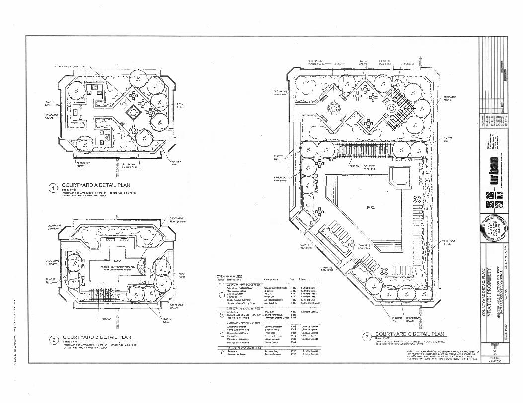
ENTERIA/
FOCAL
POINT
PONDER Ery DECORATIVE WALL :Ek: PLANTER CURB ss
PLANTER
WALL
'BECOMING GRAVEL
DECORAXNE GRAVEL
0 COURTYARD A DETAIL PLAN COURTYARD A IS APPRONNARLY 4.250 - ACTUAL SIZE SUBJECT TO CHANGE YAW /V AL ARCHITECTURAL RES.
PERGOLA PLANTER WAIL
DECORATIVE PLANTER FIRE PIT OR PLANTER CURB BENCH WALL FOCAL POINT PERGOLA
DECORATIVE
CO
UR
TY
AR
D D
ETA
IL PL
AN
S
DECORATIVE GRAVEL
DECORATIVE GRAVEL
PLANTER
WALL
0 COURTYARD B DETAIL PLAN
COURTYARD B 6 APPROAPAAMLY ..230 Y - ACTUAL CIE SUILECT TO CRAW AM rook ARCHITECTURAL 0(502
DECORATIVE
GRAVEL CATEGORY III LIECI011011S TREES 8oluls Also Ric Birch 3..t. URN. Good.
(3) v Glad p
1116 oor.to 'Greentplre . Graonspire Melee Uralo hsla laanMos an loam. SEA.' Skyline llonsykonust S'
CATEGORY C GOODS TREES
Annolandatr a.m., Downy Smlubany Tel TS NatUe Sped. Ca. caneelennIs Alba' Eallem Raabo0 r col 1.5 Natl. Species
O Malan. vInghlos FrInga Rea 7 cal 1.5 Nagy. Spades
Corn. Ruler. RonearIng Darmod rot LS N.W. Sync!.
Magna. seuta4sna Sam, Magnolia TUG 1.5 Naive Species
PrunuctIncam VkAme. Okorre awry rd.
CATEGORY II EVERGREEN TREES Iaa opw knack. FREE 5'-la 15 Naha Soden
EaslomRE<Inglx 0-10. 1.5 Naito Sped.
DECORATIVE GRAVEL
WALL
SI HT. POOL
FENCE
LAWYER DECORATE/EN WAIL GRAVEL Gr.
C) COURTYARD C DETAIL PLAN 1,10.
COURTYARD CTS APPROXIMATELY HOBO SF - ACTUAL SIZE SUMO TO OUNCE MM MAL AROCECIII./ DESIGN
NOTE MIS PLAN REFLECTS MC GENERAL OURAVER AND WENT CF LE PROPOSED DEVELOP/LAT BASED CAI PRELANNARY EXCAHEERING. ARCHITECTURAL HOE LANDSCAPE ARCHITECTURE DESIGN HONOR YARIAIIONS NAT OMR MM nx.q. OMSK DESIGN AND SITE PLAN.
STAIRS TO POOL DECK
FOCAL POINT
TYPICAL PLANT PA CITE - Symbol Bounloi Nam.
Common NOM Stu Molar
'POSSIBLE OUTDOOR RECREATION
AREA (SEE PROFFER 4210)
PLANTER WALL
FENCE
DECORATIVE
PLANTER CLOTH
RAMP TO POOL DECK
CATEGORY IV DECIDUOUS TREES AM tulutan ICKlater Gloy 6tleber Glory Red M.* FIManus ...as Spamo.
0 Onannus palm. Ph Oak onenn. one., WA. OA RIB ornerk-ana 'Redmond Merlon Basswood LErnos americana Valk Eno' Ametkao Eh
3' .1.
7 col rs.
r rd.
LS Noll. Species Nallve Special Na We Sped.
IS Nei,. Sped"
1.5 Nall. Spades
IS Improved CCIYar
SHEET
OF 24
FILE Na
ZP-I2556
VE
AT
CH
PR
OP
ER
TY
DAT
E:
MA
RC
H.
211
10

.1.03311 llW
CI-LO-2D C1-1•Z
.."w+
010211:M1"W 31Ya ',N. T3 TISOS CI-S0-40 21-SO-U YIN1011111 .7.12.1110.3 xvairva lannsia NO11.731117764
,Tagaaaaa HDIVH/i
-10 i-Or
t aux,"rtrto ..ottrtetare
tri .rta Fr U-113 01-LOlt OlKL-10
.1111/01i Nrld 1Pflaa WrIcl 3:31•1V2iLtia NIVIN

BrEXISTINGILDING UILDING
EX. PUBLIC ACCESS EASEMENT RIGHT-OF-WAY
PUBLIC ACCESS EASEMENT
jr#,,A METRO CENTER DRIVE
4 dx,
IL .."..
.. .iir" ...
1;c1,j(0' 1:1/0/7:q4:..vtk.:arAtifliViivps04 II I
‘ 1tict u
EX. B' WIDE EX. &WIDE SIDEWALK
STRIP O STREETSCAPE SECTION 1: METRO CENTER DRIVE
8' W DE 8' WIDE PLANTING SIDEWALK
STRIP
, AW -
EX. PUBLIC ACCESS EASEMENT KEY PLAN RIGHT-OF-WAY
PUBLIC ACCESS EASEMENT
RESTON STATION BLVD. Scale: 1".100'
EXISTING PARKING LOT
8' WIDE 8' WIDE
PLANTING SIDEWALK STRIP
EXISTING TREES EX. 8' WIDE ES. 6' WIDE SIDEWALK PLANTING
STRIP
9
2 STREETSCAPE SECTION 2: RESTON STATION BLVD.
In
NOM 1111S PLAN RERECTS ME GENERAL OIARACIIR AND INTENT Of TIE PROPOSED DEVELOPREN, BASED ON PREUUNIARy ENLINEERINO ANCRITECIUNAL MO LANDSCAPE ARCIIIIFONNE DEMON. NOON VARIAN°. RAY OCCUR RIM ADVAL BUILDING DESICN AN° sliE PLAN.
SHEET
12A OP 24
FILE No.
71-12556

ura
31A
311 NO
Cara
dere
0 NO
ISIAIC
I A0
021A0
11,14V
ra
tan
= SLA3E1
Mtti
1 hs ,474kiki A...,As...1Ai
COURTYARD COURTYARD
UNITS UNITS UNITS ""`I-
. Wa
n, IA
. P
i il_ u
rban
,,... „
..,...
_ . F
as.1
..
151
Eli "
'nnra
ult
en
P
lann
er
Eng
inm
s. L
andio
pe A
r.hh
eas
• Lan
d S
un-e
rn
U NITS
(RIOTS
UNITS
UNITS
UNI TS
MIS
611111' cloolanno 1,...„. A P fall 2 illii %co
UNITS U a
PODIUM LEVEL
111.11 •Nina UNITS UNITS
TOUTS
UNITS
12,13r31313113131
IP a _ UNITS II
[1
1 I
-
I I 6ARAOS PAWING, ILI R.R- 0 440
ANCIEOEIIIIF . ' . (s>. i
UNITS ARAGEPARPNG ---- I ---TATIAGE PAR G
PARKING
I
OARAGE PARASOL
7 ° 11
---- , — -1-11- -
G -11 1 I...1.1.1 CS.,
SECTION A
l..., r.:, GS, .0.0 ...a
0 II IN a:
..44'3 nA
o/a
n
&1- 7
11
BU
ILD
ING
SEC
TIO
N D
UD
IDT
VE
AT
CH
PR
OPE
RT
Y
HU
NT
ER
MIL
L E
LEC
TIO
N D
IST
RIC
T
FAIR
FAX
CO
UN
TY. V
IRG
INIA
S
CA
LE: 1
,75.
Cl 4
4/A
DA
IS M
AR
CH
_ 20
10
&ALI I I I
RESTON STATION BUILDING SECTION A-400 .BOZZUTO RESTON. TA Archltecture+PlannIng
##### 1111.1111 11.11.1111 8805 Westwood Center Dr. • Suite 900 '
Vienna, VA 22182 703.992.8118 kigy.com
L?
.
IA
DE SEDNONS SHODI 010(01 TAD 50101050 No NATURE MO RN ALUSIRADVE PURPOSES 0105. THE APPIDAIII RESERVES ISE 11017 TO ADJUST THE 0(01101 CC PARNVIC STORES MO OCCUAND STORIES NTH MA!. MUGS PNOTOED DIM III GUM. HEWN'S AK HONORED
stiErr 13 UP 24
FILL 110 Zr. 2556

RESIDENTIAL BUILDING PARKING LEVELS
110
LEVEL B2 LEVEL B I
TIPC/LP.UHC vux 00lN91+15
T Tse e'
TOTH IDADRIC vE0 00(0000
♦
IIII IIIII IIIII
THE LEVELS 5110401 HEREON ARE SCHEIIATIC RI RAMIE AHD FOR 01.0S1RA1IVE PURPOSES OrilT. 500 PPPUCANT RESERVES THE RICHT TO AO-UST 114 00011010 OE PARIONO LEVELS AHD MEITNER STORIES MTH MAL DEVON PROVIDED DiAr T4 TIA/Tuuu MOMS Mt HONORED. PILS No.
ZP-12556
. ALTERNATE LOADING ENTRANCE
8
1
LEVEL 01
EA 8
p Pa
1 6
5
3116117 13A OP 21

PERSPECTIVE 2 1(.1101.8
RESTON STATION
Lnozzirro Irnriamlivs tY ". to •
JAA
tr". b al l
• u, Wig Z.N •!;:t1 • •
107 nip
111E INFORMATION SILIAN HEREON IS SCHELADC Ai NATURE AND FOR ILUSITIALWE PURPOSES ONLY. THE APPLICANT RESERVES DIE RIGHT TO AOAIST DIE QUANTITY OF PARKING STORIES AND OCCUPIED STORIES SAM FINAL DESIGN PROMO MAT THE MAIRIAMI HEIGHTS ARE HONORED.
Ii
0110EE 032 OP 24
PILE Ho. Z242536
RESTON STATrT11. PERSPECTIVE I /III
ALBOZZUTO Imung W?'"'t11'
III1011. IA
=irti • 4r tiq — ma
A
0..
41 424A
R15101f.STATION* MASSING •

Fa a II wnwiliiiirEa usinno
mimull11111111
grim • III gi 0= !FA. mill ii iil 11 lair tromill ..ri mom_ Iii1=7,..ill.dimmi
mill em m
. ai 11- l Ntli 'FIE el, a, 1.-Iiiii ,,,, Pin ir i.fil m m
52111,8.111 MHO II li ■ lai
ivti
ii 11 15 iakiiimir=iisii •
—
ail mai 'az -II
1E1 i.
Lt-11 Lig 11 K1 1:111 ii •m,
•••
Hi
■11
COMSTOCK METRO CENTER DR
RESTON STATION BLVD
MAIN ENTRANCE
1!..111 MIMES ME11•11MIN
Ill I UIILUIIU IMP
;:g Is Y, A Oil 161
II • T A - 2 0 0
U RESTON STATION ELEVATION IN id 11111,111,:ivn:11,,ATN.trAW.1....a1s1:1,111 1 NFTTFIL■E1-11101,2,411.ENFIniv.-,(0 10.3.0.0.1‘terai 144Parza 1•111111.1.11,..10,74 .6:111/..ME341,NNIXTAFAV
B OZZ UT 0 RESTON,' VA ArchlteciurePhiming
**** 8605 Westwood Center Dr. * 1111.1141 11.11.1111 - Suite 300 • •
Vienne, VA 22182 703.992.0110 klgy.com
111E INEDNIATCN SHOP. n0E01115 SC11DAATC PI HANPE Au0 FOR PLUS111A11VE PURPOSES ORM NE APPLICANT RESENTS TIE RICHT 10 AONST ME OUA111111 OF PARKING STONE AND OCCUPIED STONES FIN MAL DESIGN PRovbro TEAT 111E 1.1171.1 HENNES ARE 17011011ED.
S11EL, 1 3C or 24
PUE No.
ZP-12556
acs 6=ss8

IMMO 1••• 111111111111.111•1111•I■101
111111MIN 1111.1.■
;;■
Fialw) II
MO • 3,11 I le: !IN
EN 1111
6 6
we -I ra; =4" mi Eli
EL-11-64-1r- Dal
=■U
MEM: 1111 imp. !!1"Fi 11 m Il l
M IWO rei IRO iii
Ins, 1111 141 iii
iii
'ALLEY
. SUNSET HILLS RD
i I T R.ESLON STATION ELEVATIONS , A-201 MP •N....,....,•r2t,...W..*i,V.•, rrft.,UA,-SVW.r. .I..Vr.W.4.11.7,...:Vp ,Wlr.t.L1V.SiannvL.rf.ola■A.Itieknk..I'Wtb.e."..C ,C•tkl•.IIAW„..kei•Ia'.tV..n.:IeN,LVZCJ.VVa:•t.mr....U.y,..a..,t1 ,21• IMIIMI.n.rr,...ree...,onfa:.Ivn,.G.,)iV...,3.•...I../...=*. ,M1,,-..,-•, .,-l•.AS.R.. ■,....,:,.,.....T..".•.,•,...•■■,,,r.,=,,'' .
!!!!! ml-nu 11.11.2m 8605 Westwood Coheir Dr. I, - Fig .sozzuTo RESTON, VA L . Arohltecture+PlennIng •
Suite 300 Vienna, VA 22182 i0 q; 703.992.6116 Cl'i ft
• APPIJC/HT RESERVES THE RICHT ro ADJUST DIE .:
HAIURE AND . ILLUSTRATIVE KJ...0MT. THE Idgy.corn . thi (0,4 ....ti iii TIE RIPOPIJAPCII SIMI HEREON IS SCHEVATC Pi JJ
moony w posolo STORIES AO OCCUPIED STORES SETH VIAL DESIGN PROVIDED moo THE 0A101/1111 ' NEIGHIS ARE HONORED.
191.2544 ZP-12556
SHEET I3D OP 24

II J
LIMITS 0 REZONIN APPLICATION
0 ❑
SIERT 14 OP 24
PILO No.
ZP-12556
1E 1111 IZITFITCD
L_11111_111141111_11111UiruLL
TS Of ZONING PLICATION
/
tl
I I
(In
1
• ; IDA=0.02 AC. "C"=0.60
...".1111 1 UNCONTROLLED
II=
E
IE (TO VAULT #4)1 DA= 022 AC. C = 0.65 % IMP.=55%
ITFTT
1E ---ce I 1E 1
(TO VAULT #3) DA=1.66 AC. "C=0.70 % IMP.=65%
3J5
(TO VAULT #2) DA=1.18 AC. "C"=0.80 % IMP.=75%
a
NOM 1H1 PTA RERECTS THE COMM CHARACTER AND WENT OF 111E PROPO ED DEYELOMELlt BASED Oil PRELRANARY ENGINEERING,
O ARCHITECRIRAL AND LANDSCAPE MCA VANATIONS MAY Oa. MM noL OUROPIG
ARORTECTURE DIEHOI
DESIGN. AND SITE PLAN.

SWM/BMP & OUTFALL NARRATIVE Preliminary BMP&SWM Calculations . MINIMUM STORMWATER INFORMATION FOR REZONING, SPECIAL EXCEPTION.
SWM sod Beat
SPECIAL PERMIT AND DEVELOPMENT PLAN APPLICATIONS II la .0. N
T. to Inforrnalion Ir nothorl 4 tor obwn or prorldrol In DO Sofr4•451.115o4 or • 0000 Noted 11. rulanloolon nous. 4.1014.251.5514105 .1114.4 NNW W.I. 421 Co NW u011,53.4 SO. io........................0 4 ...OM .5.1. •
{No IroompOon lo noorred we. I. foltrorno 7.444 .ananoo P.G... • 54.2.1Pourrlo (3411 214 21) 9451.10.repoon. 4701177 5 213
Clueor gueovIslut.IMO XVI Mourn ReweelbouenC1.4(05 -221A ID) a (14)) oevevemeri Pilia• PPG 411110 BM. a 2 hi PRO P1.1000.1. a 10) FOP P MOON omov MC) (14412 IF S. 10) Arnordrrenio (14200 10P • MI
yetis Ma Net Me Ar. 01.1....V) 164056.( Sionowater Minagenut and Bal Minmemeol Pre.. requ4coma0 on being met for Me Residential SI. only. The &Ming Office Si. will remain La its existing coodlnoo and on SWM or RV Morava:4W me to provided The total development propos. disturbing approximately 5 ..ue. .• belweea Sunset NUL Road, Wleble Avenue and the Dulles Ace. Bud. The Ws.' 2010 site conditions will be co... die bau use exilthig condilions, with Me .ceptleo al. propose Improvements as sheens on Rums Mallon Road Improve...Site P. (FE7C Comfy Plan f16 IS•SP-001) ...II be considered mdsdne as shaman he CIM/FDP. Improvements beyond Mese wilming coodhlow will be mills.. In ace... with dm Public Pacillau Manual (PPM) •
Ea P 50 Mao Cu Irusoilous S.
53055 116,992
el el
Ex Percent tenp.o.
141 Sflo kaa (Reed.. 0.7)
05.97
154050,5
MO
M
ION
AP
PR
OV
ED
BY
D= IV
ISIO
NO
0 MX. roe. Porrlows Am 73.775
11 375 2( al
reemiscutento The silo area for SWM &BM? m.o. 1.1 We Net Development wet of 3.61 urea. The ROW &di.. is In Me SWM heillaas FFX Plan /1615.SP.007 No .01 soll Pools. (Gaunt. .
Pro , Impel** Ma 1 I0172 na vested & BMP proposed with
(Realm Stsdon Road P.), which were deals. to aroommodale the ROW. ..me wed
yr. 14•Maelenirtrnum wale el 1.7 0....p.don ern Mow .• .irnum wale V • 'OW).
Se; a implic deplellng Ow sintr.lamuffimerlfacility.) en:Mi. ofelowIng a. wading summulale m wow... um.. hdeal.), Pam tkolnap pp. srelenot loN O5I4I polo., 4242 aOrloays, 1.50 rorI4 No 54.4 envoy asr.54004 eava, m0 sIroom aionewoon meow. se rm. on
, 1. 1.1 .-11.-,
g... Pa.: Fuely Num/ Ch. no W.. DaMegs Footpdre Mingo Ilporel, dam 7V5e X No sewed 1.0 roma locroa, ...eel um ou 4.2.151 1.4.111.1 linssiffir// 005 ye /J/ r_.1 .___I
.1711.111''''' , '''''''' F..2750, 4 A .01127/1
P.. tomeneeue
NY flu
X Siorenrwer Mauagment (SWM) and Best ...gen. Pull. (MO) mustou ufficleol Muddy the Pr. requirements sbaLl be provided for MI project subject to final dosIgn et Ma time of Mc B.
M.o. In bp.. amo !reran.. r. le waling .0111. OM
0a/ silo plinth). The "Iglu 240 6 lergely lourvIoue ted Um proposed developm. produce a minor - decrease in I. unnuot a impcnious area The propueddovelopment q.lcs as s redevelopmeat foe
11170 41.0 0.111 f P do. 12
Me 7oo
1301P ...ie. becuse tb. is Ices Than hems° in Impervious aux Preliminary SWM and
BIWP sishig calculadoos art provided on this sheet and preliminary loud.. shown on Shut 014, ;
ows.1 .11wit Ma based o1 *a tuffielp.d undergroud detention vault end undergroud Storuffillier vault solidi. lbc Worm woler detution vaults will be duigned such MI the 041-developm. discharge does emu..
Rm. Treatment • Me mwdeveloprout diseheue for ha 1 and 10 must..
0•11. MI. 531P 011 Iwo
• 0.50 A ....I for providing below grade SWM and BMP measures oe a she hat Includes resIdenthl
C A to . haat. 4. glumMet X len mi 1 i 5
0.05 loom
We will bet OUbrnI14.5 la Foie. Co.ly Slafr concurnAlly With 2. CDPNI3P appllesilon.
7l r'= -̂=7 ,4s411- 4
1,41-4,att
,,,,,, ■ ....... ....... Tam i co, .,es
O.. 1.11
ate ADEQUATE OUTFALL•
(21...1. 04 owalanappo Men. .e faun an 044 _5(, most all of the prop.. develop.. Mins lo Ma west to he exietinx Reston Mellon 913 SW. 0.70 oft 4 00000 4. Moor* oero roollml lo 21.55311or
Po. N5 .0 54.1 pp 01012 am .444 rested _d pond. There Is a email Novpu of pervious mu sloog Seoul HIM Road Mal hypnoses the exisiusx SWM
gi............ pond . The rc ere ao diversions proposed In the exisang mu ...Inge RM.. Floodlit. Study
0.41...m.....,,..0.1*(1.) ere.. en eheet.j.L, 91. 11. Baum. OM 00111-FP-01-0, gadded . floodplela Study Ewe:alum . and approved on 0024001, modeled he Typo 5 a norpeorso.roorl ourleoso no1.514211,15 roer jr•poor. 44.5. o.r. 4.4 ' 5 II 1 0 I 1 existing MO. Section 513 SWM pood ■.1 depleted the 10-year 210/714 event one
Whim
Sunset Hilh Raul. Tb., Mere Is s known dowp.s. askant. WWI capeclly concern. The eusiing .
Urb
ao. D
EL _
_
urba
n tzt
ta---
IL
Ki
ha.1
0111
{2.1
Innratrn
Than
.. E
4ra
crs
-Lan
dsca
e A
rch
itcet
sla
nd S
am
na
51:...torrourr.........whanerwee m etern........1.016.. li.,t,011, [ :VI ttlAr..tnItrx."7 14,-.:grot="7°Droia''''elstIrwi AaVa': Mecham., II Boum to have a well defined bed and b... Thechannel dm rm.. a culvert [MI. le /111Lurrhsler numporned
I 02 ,...1 10.211
' MM.. torWre • deft1471. of how...n.041 to convey Worm watu beau. a fain. of he Hidden Creek OoleCe.e. nough the espechy of the 02 5.11 la.:01 tun. .........11b. rm... en surffiliMee. culvert It man al Ulla lime. 113cra vea“o olucrved erodoo on 11. golf coursz h.q. The culvert
010 2.11 19E11
mrtfolle Inlo a defined channel and hes milen an existing wet pond oa the golf co.e. The cbsuelluir 5•11. a eimelmon of liw ...goo.. or w.....o.1 an. door.. Iron M. I
fli0 .1 21.131 auffill from thh poodioins wt. Colvin Run which bas a drainage vu mesh, than are mile. - • one square .....11.11COM.M. ma www-en ...inapt or. ai at b. one uume
„.16....11......./ALi Mece •
2 sr R•othwl P.O MI. Reduction -IASI.
I . ?Wm. Biiei his Pim Uproul. the Applicant Intend. eon, the downs.. outfall chamele and 1 ' ex P. Ilic FU T. Co dun to For ..01... liew.9.4.0. I 10 4 nopulroo flow ih.etlanl -1.1 review unty soli verify whethee ems. velocities aro prem. pupa. 0111112 A desedenen of how ine ....... .. tion
" Ilo. W.. do.. el No Publo FooNooriorul will to NONNI la pron. on., 117,5:5/7" 0. CD111FDP, coeupstallons arc prorldcd to depla how lba ad.. oulfell regulaloot could be rut ohne • the DuotIon Method of the FM. Co.ty PPM. Computed°. oe 00[01 16 sbow the required
gi tel Dimling Meet' Oyer. mierriern MOS ...le M./11.s. • nteo a beam, la eil•V • I. PM BLIP PURPOSES, ROOMM POMO IS COWED AS RIPERVOJS propordoord Improvement and aa =ans.& undermo.dSWIte vaull els... 4 provide Ms .vey w me. i• mum. eh. Ja ) 2 E RE ANIMATE OUITAIL SIM OFID111011 ME11100. MICH IS SEWER PUN 11E retard Dow =dud. The mom sewer AM uodergrowid null kyoat 4 shown Pa Shut PM The tnY•5
MOM SIMI REOMMLIEMS. 19 USEE 0f IMMIX 00IMM Si. Of TEX MX MOM SWM and MO fecIllthe will be privately mainialned aad we Unlined lo be off-ane eo am no SWM or . SI 1 .,•1 A outalsolon Veolverloreou.151 for undempund SW' A LBAIP 11.1E9, CALCUMMIS MALL SUM IN PREUMMII1 CCHPUTADONS KR MIME MN DENSITICN. BMP luny will be loes. 4 a Mono sewer easemeot or In W° pub. right of way.
FOR 00000014 MM. auDince MCITLATIONS SEE SliEET/19. • el sm......4,....., mu.4.4.44. 4E, The Dem., Method 4 ...read. approach ia model the larva inalleImied dungen volume hal
ospoo oloors May . req.. hi smisfy odespmeouffallsuulrements. At Me Orne et 71.1 She plan; subject to Anal,
deslgo computetioos, additional citrate daie azd ...am ovineres.operation; Om Applicant mu , pusssue alternative methods of ...Pyle& We deatimm outfall sequIrooteM provided by he PRI.
CONTECH STORMOLTER DESIGN TABLE
LIFilter. __- ---a. . r -01,
i
GENERAL NOTES
DETAILS ON THIS SHEET REPRESENT A PRELIMINARY DESIGN AND IS SUBJECT TO CHANGE WITH ANAL ENGINEERING . .
•
• ron V v 14 510531.17.12.5.5111emr 0.sorr 4.255 571111402110521212.5.101111425 515117.2220 IWO 1271.104.7.41/14 inf241.4 504 COMM. C00142705425.4,017151.220 . 1:25. I•
• Trie Moms. omarwommi 25 N.M. MIMI. 07efial..12.15401,2155,21711421751711.41055.9217144.47•4522N11. . 540. ON 45.224.1.4.15151.
• .73515 r.44720 MO 1/021043455241521. MCC71120152010220.221250242045 2541.1255 01417415511011(53 toP17120. io
' "giatirg"""'"'"O=4T"'"ro iinTr.'"rmr''''''""'"c*"'"'''' 2. 1r , reu. n.rore, . um.. Brine sire a. Bunn. mu. nse re. mauve otrourr or me
72.0011.. NI OMR. 145555 5110.31152 0 42.0.0. II.55 WPM= COOL. 52010.4407.50241.15 rat
T. nolea C..17.042120 Mt 54110114.01/5170 NOD 52220.(104. Tit 5177.19057773171VIVING MOWS 142 1.4311.541 15.243 Of 5..1120.5.142..01124.1/.50.50.41.525.4424 WIVE 5112 CIVII. 21./4225 ON 5122 71.415 CA 4I 0420.7.11 MOW. 7575.4.52 5151.1172 10 BO CON511.21020 51.472.0124.41.WM1 ATIM C457.010 C554
4. 5255101234517.4 02.44 UM MR PLOW. 1.73.471.15 0.0r. FOR 55.13.4 IOW MP 01257.4 M. • C045...50. =RAU coa. 520544.124 501447. 137517.15.14.4.:4 5. NI WWII 4252122,2003,435 5.20452 223400C154512.3241. 35 0=WD IN 1112 OM 515052.5. movlor
2.4 ■444.10.1341. 2012.1411112.4. 475.555. G. 51417521112,710 .....552 COV.5 20 14227.5530 2520 /047 IMMO. 7. 412 542.21.5.2/ .....45 55024.55 2012122.4,55247.1011.4.11.1.0525 APO Vortra5(022427. 5. NO 54..11.1. 022212,70-6.52. MO 05 4221-7104.2.17.41510. MO 535.52201W 0551511.1441721.1235 MO
54713 of 51,14C13 BY .22.420151,12213 i 9. 51340ort0 VAMP. II215112 I5 27,12.0. 2115012 CA511504 741745.300,17.007.5.1114724.4972.5 FM
520o/roll ro DM. 2700- 10. 3■0441,25 57 401122.1 / Marra. SOM.. 105. 925-5240.
, .......
.4 r,"" 4 . k,‘
II
(a: 41.i.b..$ a B ... a
‘1/4‘2,9,424
000 ......
II • (T • 41:13.44=5MMERLINII ■ dri=mau--,•=_E-4,4Rnmir.....mcw_r4.44mar-,AmmL7......sr•-, ' IMAM NME.M11/M11.=/IMMENUM
000 1.241122.1.....45 ue num
44 COM 1722
4144111
GENERAL NOTES
1152.132=1, 710544.44235.41.515.1140. OR 0.5144.4027.54440.4031.41•74•07-4274 ,.,...“...,,,,,,,,,,,,,,,,,,..., 00ro, ,,00
wrorl a.. Locm roo mom or vour w. vo......04 orinre P.N. PO 040147.3 3...../41
IN. PM... • •
24.44r.04:::,..40 ,,,,rsI44007 ,t,t,,r oao 440 4.45... et Te =42. 1.1:5741.57.00.4.4 50.40c......ormo4111.11.-4105. oNson..c420 o44525441002.s. er.4445...roo 4 ono mug..., Dow, moroo sm nue n...4 Men Nanurro14.565 ON MA !MC 541.4.575.4414141174.40..4parnosn44.52411.155.
NM/.
SW
IA/B
MP
STU
DY
VE
AT
CH
PR
OPE
RT
Y
HU
NT
ER
MEL
EL
EC
TIO
N D
ISTR
ICT
F
AM
FA
X C
OU
NT
Y, V
IRCE
NIA
.
BIOV
IDIrY
PI atY
CI
YQ
Y T
3 O
l...131V
DS
FUT 7. MC MOTO II
• Meili5i11111117■1■1•5•111•11111(11 1.55
Pliream ,, , ,VI1 Ir , .tzsAls4arlaziermiremerverweeppk.4.-.. . SITE 9recu9c ,*. rounnor
WOO POS MOP= 4
i MATL.4 s Jul% ' en 4 'Al
I
LeTATATill uftreef DATA REQUIREMENTS
4.4Lcmte 004.1.04,422 wo175 War
..,.. 'W•9..e.SALSIVGAVMANEWmIEVANILVA• I A
E,it MS 110.4 RAM 441 MIMI rum Or e110.4) •
oo,,,,e 21.1574 4
23er 4 I 0-.11 mi3O1.401.2%,Teror,* ...or,
STORMGATE VAUL I Or CARIRJOGIM Itr041520 C/4171042 nOW5.315
" DATA rRnu • 525i174150/12115.7.551773
■V.:413.412.45,754AT
FE
1 v, ,.. •
L .24. nog
WON 2rte 2LN, reunt WM • RIN I WM Sit l .1. a
WA. U l4.11521 R w
.
40 1,,
31,10141 i1,
12Wilke
t
:40,44A11
,
[
135.1025 II nriritiLi el e non
'1- ' '' F' ''• ' ' ''P't Al I *II
Bmil.7.711.1.5:5.....
rgoinswounsst ROL efietil.1470772711123111T553127T112.2.17175111:70
FSSF 111W ,ffii•E VB. BIV 49 'k8[ • alai 1E1.1 v. - , .. ■Baiimmwma■mi u e...,1 m Or II
wi., l',.., , 14..01
WEIR DETAIL PLAN VIEW -
'rrg
4.1=3. 7.7.57•=orr.
norm. ear eau., mu :.
C210240.4 272;fg, , I
eau .rt MR
NM A MM
POI meitcozire
PS. et
10..1 frrr Or 0 .con''''''
teanf I I g,,, ,„ ...... ... . . moron li FLAN
1.4.2.55(5.4.440 COV7.. • rex arre ow M6011111
a era i.e..
STORTAGATE VAULT-PLAN VIEW 0 r
1:11g2a111111111111 ....
.- 01.4150 =WM.
,...
V CI viamiC
ei-UTLeCr1-1■■
..... z,"ar... I 19 t. ma
' v i a.... um• or a N` \
CE--....441) I% /ii141 14 e,1%;;,7,77,',„</:j
• IN
TP 1.... ..----r \-• 11■ 11
.."1.';' ..1.:-...
t.' 1 .....1 ,7I .I. II 1 .. WEIR DETAIL - SECTION VIEW
53.1/2 4111511=5C51. ..... a geN-I .' I II IM Ell WIN ilfl .-- ,'......1, DUI lf,ID
t 4111' MAME AND COVER
31
00=7,01 WWI. ancuwommommumeemnavenoramm alm SMART. 04.4115,51
I T,<ZA 1E11 s •
FiNinkiNC44 51010.4.15 0011517.2
CA.507.. WC usorROgoal 4Nsiny.
.52 110125 A. 51 CONI1ECK P11.4.11... .
THE STORMWATER MANAGEMENT STORMFILTER.
, IF X 111. STORMFILTER STANDARD DETAIL
SHEET
15 OF
24
MOOR ON
SECTION A - A
I
-m*••••••■• ■ ElDRMEATE VAULT-SECTION NEW 11.,...1 I -.t•P .........................,...........................................,,,,....,.........,...................,.... 0
FILE No. 7P-12556
•

Preliminary Outfall SWM Calculations
1. 0 411 6 rut M
10.• /3
111 Am le .1 II Onesprosnl Os le .11 11 MA sunk
Mee l• 0411 12 0401.0.6401 Yl• le .117 100 wok lY 0000001 Olt le loll P 014 0001,
tool 146.1 son0114.
171 Good 140401 066110 1•11-0.41061 *.11 0.04. 0
la Ctad 1.0141 Pes1-00.16 1001 0.01661011 011 knell Wins. (1 0
101 el Ie... Ile, 0. 1.. N .11011.0 116 0200 68 si (16
O.tly
Peco 0.1166 116 0040.1 a. le 0.110 11(06,
1.04 eusullin
6 ros1-1144.001 6.0 00110.1 rat et /mut* De. ;a
11 11
061.1 r 21. 00.10
11 y 2. 00110
1 1 01 11
7416 0.10 t y 246/ .11 10 y 746.
11 01
1 yM 0.161 /1 1 cs. 2.0v rolnlet 11
la y 01110 10 y go0es
1 y Cood leas. nosOlin nen.
O 1 y ca 1.010 cone. curoll 011 1 y 1410 06.61 1.4110 4.W. son. 01. /610 711161
Pos1-000.01 041 0. 160 2 , UN tral 1.01.64 sant. 004,11 ni. (611
7560,40 04111.6
1 r 21,4 P•st-0000.01...8 .0.0. 160 1166.1. 100 .6.14 6001. seped X 10Gad 1.01.4 4.110 .11 weYe. (44
30317.14 7122
1361036 M NY Me61-01.10.011 .711 Wort. (40 ,3e6410 es. 4.01•1 6.11. 0.0 Z
0314.1 71.77
1 r206 004 Itouled 100.46161 4,0611 co1.00160 1 74er Pesl-Oscelccrnsui renell yob.. 1,1
111104 +... I.6( , 242. rall-13.4,00.1 .01 a. 4) Pest-000.0 so. caumes 011
7 m wed ko. 6.16so vok. y .24Iw Goof .01641 10611 Wow Se.0 2 p Goel lers.1 centilon iouy/1 rolvoce 1eM 174. 1.1111,71 7 71, oact-ncassyr. 00.1 0.1 Sc0 7 y PeS1 - 00.0.01 rw.11 7 71hr Post-0.00.1 necori would 100
71.63 00.(11, 6666 Wrested coml. (00.01 111010 04. 10.10 seedllan repolue6 10 7416 0.1 1.6.010 cen•Rlin .611 0.0 (60 10 y MI6 Pes.1-00clopmsnl sunall csience
06.00 1116. beissled conClon ruyied 10 y Coed 1.01.0 6.0.61..11 Wu. Sol) 10 y 21. 00.1 16.64 gendlyn nnol1 0 1.6. (.0 10 y 244 las1-0.00001 mall rhos II) 1193191 1711194 10 , 1110 6661.0000.01 alume (0) noa 7104614 1000 conellal 0.110 ccccc Yan 1.6.1.6 60.100 ..666 .0.01en eche 1.0.1.6.110 006.1
dl At, ly slam I. 11 Ist 1004. . 4+1., el 1, Mem Ice 24 br Yen. 0.101 01110 el ly Iv .1.1.61... 0160 ly Wein br 460.
Cere. 106 ■ 166 01.060rys .0 1 6 .14.6711 Ones f CouGloc mi. 1.1 ” 01.6.101 0 Ids) 01.00 (04 .16(.001.0) 0 0.0 S114
1.1C 0 0640.6 (41.11 00014640nn
tok 1.11 1 - cc. ( 7-.170 111 lOccacc 100 10-mak* Ul 1U 071 106
.00. au. Mesh, 2 0.31 IJle.e...1144 1061.9. 010
Appewbooli CM el Sohoot Aim on11016614. by MI .3 II
s
Cool 41 07 091 Myyl 6 ■ 64 010 .1 cle
11 0.60 wee 41..0 b. 5101 a. 02 001 40
00101 11.0 110.1e w0 3W well 010 000 de
els Ns.. 0410 (010.16 07 moye014 aellal 01..02 ,.Yes 02 006 014 /60.14ii eutlea Morale .141 M.., WO cls Mmete aulla 1160040 010
.01 Appewinele CA ol 00.06 406 uMooloMo by 3101
1.01
yr*. el 0 Orsitops Nee salcsolobla 16.1011•11 600.64 y 300 Ow
els Iluonlrveat 1064 02 045 11.0 Ms. 02 hod 400 010 046 1.160.11.110. Aces 010 0.17 Lee t.
017 els Ws. yak .e.bsses .1 177 0461. rya taker I. SW .14 02 0060 0d 010.0 by DM v. 02 els
Os. 003 di.or Yam UV 011010 0.13 de 0.101 PM 60.04 bon 3S1 malle 010 0.10 0x.0 6. 5161 .0 MO .6 <le
6.10 0.010411 Reiole1 Wield Cans..
PIM IW 0/36' 1111 111}
ago MIT M M 113-16.01
eskylellcas 416.4.0. 6.1.41 0000 aoky .6011y
Ivir OW
111.
64 .
s01101 6.011y
I Cr
O.
61
g0.
Wyss 60101 0.60. aPied611.11. I. hi.
1114 °010 11.70 ,
111.91.51
.111. 6.1.1 101.1. pest bier .0.66
1;15 M. mit 1. Nib
-. sant 1-ys. 001 goose les 0.1 064 625113 UAW 619 2-cc. caul I-. a 1671 2.03 16111.02 1-ms eant 6110 1.37 0 10 010.09
10-ya nen! 9941.37 10-cser 6.1 10-yes 001 2 66 03-066 001 79.20
DI.. Su el N... ro 2.610 5 61 N.Y. reale 5.1 N Oslaillen .617 I 701.
.0 000. 1.11 Md. .16 I length
kW Wee 160 Wbove Tele! Velcro.
11,1 la WM tioyi 1.to 7.1
60.1.6.4 6.1 0.0.11 1 b not 4..00 116,641
Or 1,790.1 1 y 70 esisk4 10 / 11
1 y 70 Ca 10.0.0 1 y 160 10-110.1 1 y 7110 teal 10.6 soc610.11 4.. kg
(114 144-0649.4 NO 006 110 64,0 ic.k6 .10..6 . 0
11 Mc WI I. III 1.,arossl4 1 16 7.
00.16...10.0 .11 0.0
11046.16de. loadricy410 0.6.
0100 1.6. N OM. 101
2661.00 Caps .61.0.154
1.0. 11M 10,6 1110
1.2 OM 900
6.4.1.00 46144 Cl silk* ow
A* M .1 1.6.0.
0Uu.1.1s.ssa.m
U do
101.1.6.11
111M II1M
ax
.11..1160 611611 We sloop al Man 14. IL. 7,61
lY 16111 UI UM 03 1.37
IM 1.11 MVO
41.44115re 0.4•6410.
SUM'
16
24
00 14141 Wm.
MEND.
ZP-12556

TOP VIEW MODIFIED END CAP FOR BOX CULVERT. SHOP DRAWINGS TO BE PROVIDED TO ENGINEER FOR APPROVAL (rm.)
rd 1
O
A A
CONTRACTOR TO GROUT BOTTOM AS NECESSARY TO ENSURE POSITIVE DRAINAGE FROM SWM VAULT
FAIRFAX COUNTY PUBLIC FACILITIES MANUAL
Wel 7'61. .r.ntt .... ....Pa./ Vat In
VS'
..'ilit
•
G 2 II
Elevation
■ 44;4.44m,
IAIECI "i'•
7111111111 • -i ,-.• 1- ... .., 17.= (••• PIA.V1) Section
Iletm 0 ".......I. .rxerneu.s. en ...P...0; ri . Y. (1.• ......, M...
4 ibi: is'ast=ittr:Intriell.tv . VPH.I Amtip .1. Ine.... .... ° tp.V:".ar"1....ilf• LIAL•71.":"..1:,..a•
". "....""" 1111P EXTENDED DRAWDOWN
DEVICE' (EXAMPLE DETAIL)
PUTS no. no. xo.
61-6
DETAILS ON THIS SHEET REPRESENTS A PRELIMINARY GENERIC UNDERGROUND •'.VAULT DESIGN AND IS NOT THE FINAL DESIGN FOR THESE VAULTS PROVIDED WITH APPLICATION. FINAL DETAILS AND DESIGNS ARE SUBJECT TO CHANGE PATH FINAL ENGINEERING.
CONTRACTOR TO PROVIDE SHOP DRAWINGS FOR MODIFIED BOX CULVERT TO ENGINEER FOR APPROVAL PRIOR TO FABRICATION AND CONSTRUCTION..
•••, a ' ..., -
a a U -0
10. DIA. FLOW THIN (TOP.). BRA
COAL ENGINEER BY CONTRACTOR PRIOR
--....
61ixg- CONSTRUCTOR (TOO
— g _ t..i
1
• 1
— 13 I .
VARIES
1 I
- :" VARIES
•
\ •
BILCO MODEL JD-2AL H2O ACCESS DOOR OR APPROVED EQUAL PROVIDE ACCESS STEPS (ST-1) AT 16" MIN. ; SPACUNG (TYP)
CROSS-SECTION A-A PAVEMENT SECTION PER TO BE PROVIDED WITH FINAL DESIGN
15" DIA. FLOW THROUGH HOLES (TYP.). SHOP DRAWINGS TO BE SUBMITTED TO THE REGISTERED CPAL ENGINEER BY 111E CONTRACTOR PRIOR TO CONSTRUCTION
VARIES
. LL.i
% >
7......-- MIER WALL— ONE CHAMBER ONLY
• •
' • . '■ • • • . . :. • ••
.. • • f, • VARIES ' . . _
ORIFtE' . :W/. TRASH' RACK.
•.... - e • ..
- . . • •
• USE EIMP DEBRIS CAGE, DETAIL THIS SHEET, OR EQUIVALENT
MODIFIED END CAP FOR BOX CULVERT. SHOP DRAWINGS TO BE PROVIDED TO ENGINEER FOR APPROVAL
6 L-666+66 Ahi6.46
SHEET 17 OP 24
PILE No. 2P-12556
RO
ry
P ij

LA...Viestrnsu Mur1,12556_....g. Waal
. . i:i••g•:!:1:1
If [1
!pp - dfl / fi
,m ii 111
letistl >-- kkiig.. ■ ' - • NI ‘.1.4s.NI‘At‘s :" - . . -■. N......:. NoZikabs■ot,,I. i . •
ilf jit. ;t i t 2 I -
l, , ............
N .t2„, rte, 7r; ' -4: NTst IL‘1`;1431" ''''''''";'7"41%77k7c7124 141F—X.177:11. 11%1 N..,11M/41/41%*21142 .̀..11,.a..N. ,s..7.,,,,, 1,44 I '')... I I , ' , i ,, . r,._•3---2__----f7c.-'-'-h14- --'4 -
NAN._74,Vt-----„\N", :. ,w,-* ., ,v,,, '41-‘ - N ■ x 4N., , IL-,A. , N.. , „.1.,\_,.
14, 1.?-i- " 'i..\ ' IPZ- es.: xxxxtsl-s2k. XN't‘N it -a -‘4... NNNNNN N . ' N L N N. N. x. AiNi0j 41 i •-•--.:...•
u--/. / _ - .." . ' l :. .. _
r
iiikv,\H;gtv■- \ . .r.,,._ .4.ul, -it,,,I trit
\N\ . 'i■ 4■.
IL ir, ill \ "1141
• ti441..,,,,, i i
, II 1..
.
-.t: .fr-V; -•
..„ ,
li, MR
i t.\1. , .\\ ,,,\ ",tz 4
.. .i. , ...I ,Niszb Air I 0 _ - N, N Vs,,Al-, 01 l-ri " "i4NN.\\. XX \ ' '''" 14" ST
LIILIMilit - - L., jot„,'V\oNwri N4.‘ Ni.,*111,,,. 'I 1 , __"'„,..... . i: .. ..___ • !:i;:;-.`t7:::ii-air .:-.'
I :4" •• ' ,- v,„,-- ,Itl I NA, N'xl
" N -, .. ftiN,,...4N re w, NN:s. \i, 0 1, „ ,., , „„_. N ks ,4,4 4 1 , , i. ,... ,.....- ,,1-4, , ,
•,1 1 - --- •
- -A.sl
-- - 41. rrffurFR1-10— - . liiLEil •-TT- _ - 01,INN bik VIV14. ' L.:•,-' I - ''"'
-...„_.,..--,
tEP
,szkip.....x*...N..... Pp, oi , •
4d
..„
. , • 1 ,_....z....:sp-,,,k,NiA, I' t - N•7 .„,„„
■,;,, /131- I wiL),
....,.:, Ir...-4.7.,.$444...N-. .,v..-iathv,m .11 :34 tt. la - Ns tIkk 9sitA :VA tIVN tUL Mill&
Z N* id
..L.
. 1 .' )
I
1 . --, ,
4:4'4f UN F,1.4tt :
0
,
It 4 4 I AR 11 -1 .Nalt. ' N11 1 ■ % 1-- —;"`'LL-- t krm k ' ktl .0''
'•••.'..• Z47 4-to-AN& ., 11 ii
"WM ,T4INti, .i.... 1 N 1 , ' N XX\ AZ r- •
.** ih ., L 4 i - AWir mabliN011.■
- itt-it •
0 •,b5. t: - "". '..7... ......L.:4:, Ito , API', - • . - - ' 7.= - - . T. ''
411.,...... . .,....74.S, . ' ----c.1-,, . av•D 1 .. 44::Vi IZ Iii Jititiz°4;' 4 **Pitak*Wrgi 4.., -.Air - .• ••■i: • _il 1r; A's AV= itt B fl4',*211wW.;
',. ''.. --`7-- ... , ',. - =•,•--- '1- - 'r- =;-- -, - • - -
• - -•,--Q- -̀. -, ',''=7T' 's =, , - .,-,--1- r =N- , -,-,- -,- - , -,- - -------...--•- aiswommumnimealormi ., 1.7- , ,. - 1 , , \—:____ ,_.,-,.._,_ , --t- -.L. ..,,,,,_...;-.-1 . :,...1,_ _
- ____„_. ,, immtarmas
---,..9.7 , - — -.- - — - . -----.. -4-_- ... -_-_,•-•_=-*--7. --___, ---,,--,- „ . - -
_,-_-_,--,,,_ , -.„.,...,,...lis.. ,. IP .k; ' itialitilli relZ , ■ \ , ,,
;.”' c';'. ....' Al •:.,,„:,7):\ ‘ S.,,,,,..v.k.. \ \ \ \ \ \ \ .., ..t's ..■, ‘7.°"'It,÷52.a..71,,z_\_,4r...i. .• 1__ fr ,':
. . . ,. :4,
, T Nt'IC. o , e .., 731.FATZ7, 4141grieffir...r.
.1".'" •, ,,
"AT Si: - " - - ' : ---- - , ' , • . ' t*' , • •
Y, '..t.4i3:4 .--">- - \ \ I, S 4_.% \ .,,..
"1,-- .-.,=- ' • , ' '''''-'- - ;41 ■:.3.u.„ ''--.,:*c.....,._...,.,:-=:-'--......=6 __ _ „
'?'---:?' I 7- -..--- -' - - ..C715711WER7074•W '
n, -:$74:e67 E - - . , 'IT ,..134 -,..c.,Ty .DH 1.4V-4 ..!r.. ,--_-,,,,,,,,,.; IFTW , : _.,=Z=.=-=- " 47.--...A.,,:""■,.,:,.•. ....,• . -3_,...2,1•,,,,-,.7,,:_. ?„,,,,,,,,,,,./.
• , 1 r . • % 1 • " 11 , ".\‘• ■ : ■.:0,,,,sttt, ...: ..,,`,
EXISTING VEGETATION MAP I
I.. Fei al MO 0.wqt. 0.010,.01.01
--4 - urban 74.7C140.2721 ..,,,,..„. MI Fi ______ N am 4
VEATCH PROPERTY HUNTER MILL ELECTION DISTRICT
FAIRFAX COUNTY, VIRGINIA
,,,,,r,ISTN : dk i 4 ),./. .,"-,, 18 ''''' ' = %12, 02/07/13
1.10.417
01-7,10 11-01-10 01 27 ..-..-.
12
07-20-12 11-05-12 17100-13 01-21-13 02-07-13 I Ak SCALE 1"-40 DATE MAROL 2010 A> 9',,,V
,,,,, DESOLP101 DEMONS

N X
a
I
LEGEND
• ; MING TREE CANOPY
K> APPROXIMATE LOCATION OF DEAD
tej 1REES,NING11111N 150. OF UMIT OF
EXISI1NO TREEIOERIVICAllON NUMBER (SEE 'TREE INVENTORY'FOR INDNIDUAL TREE DATA)
-- Mg OF CLEARING
— 25' AND 10' OFFSET FROM THE UNITS OF CLEARING
5
O io
NOTE: THIS PIM REFLECTS RE GENERAL CHARACTER A110 INTENT OF INC PROPOSED DEVELOPSIEHT BASED ON PRELVAINART ERCUIEFARD. ARORTECRIRAL AND lANDSCAPE ARCHITECIDRE DEVON. 111105 VAR/ARCMS NAY OCCUR MM MAL BURMA DESIGN A110 VIE
SHEET 19
OP 24
FILEN. ZP-I2556
14046..LkAi

7.1 ROOT PILLENINO
]canorn n
All
Tin marocnox oevicas TOO PI OVA
I-11 atrrICAL anar Zams .04o
Rm.. OF MLR
1.:3.4:- 1' • MSl I R4.4.4
TREE PROTECTION DURING CONSTRUCTION COLcA Rvol
,44 pmerravon am... LWOW on.. 4 ■44 44.4. 4,4DOND• 45 proOLL A ,IlLsal rod Lau . /CRC 4101ln 54Lurl40 on IlL4.54na.n“Grly 41.44 ant BM...ft LW Oa bny14.45 Ortulum..C.112 41141114 414*.41484.41:1Seciln LLGSLCLIG
I. Tot lom414,444 51•44,154 CAL 0.1164 Duman. bye 4444.114 deck ante on VL* en Bunk 4s1 mmurrs I bd. sao11• 14m144.455144.
B. Deng *Mania I.PMrb.NUM OLCutunca .44150 4,0LON.10ON4. Koh 44 LeleN hocks .013 usairl ad.. LIN. CRT of Luba Dr One • el 44.4 545,444nrwl. PG44411a bur.. m4alL.5 WoL5Sout 4455nLhotbn. No go. chanou or Nano LI 4,1,w* rotte. 5.1411. u DIAL. Laamd AN.. ems pulad4.114,5G bud., Ne arar.c. 5.44 5.+54 4154ould gulfs IL penrige4 On CAE
1,41 MON DILLAL nuLllu 445trul YWCA 5.11114441,5/ or LINN LuOroeol rufally la Cs las11. rne. r44.4441. d0 up. Imery mama el. re. [Nang uor.,41.11don•
*Son Old Wm Om si'd b. tanul4B phrto 444.114.bance u/v144.
3.1.44 ■N.Loun &Lay move. el root, Y. maLL 4.5.44 how expoud u14:44 444.444 Jung Km4440 414•44. Tame, 441,544,4/ /rola pounou, mold Lulu, 44 *Or Lio.dou•deLDBLIGIJ 14 hap Run hom dring Dui unli gunnel, towEen b. .M11 .
CUNT DNS le ea as 41441141444 COLA.. 4.40015/1114 15 lug DI IM1464.1041440. 4110441145 Ix Sea {4444441. LULL OW Junor,
B. GMT 554oves Lo5 Mum.. Owl wl encruch LB. Da 444 WI...4 LILIG.445 044 VLB4. 5 LLV 4 LLUT poM0•oMYb BS 1.0 Rd Lpuovulyw Go.y.
IL. N4 1.4 nutotals. W4.5 porolaun proCGLL. 111.4 be WM 100 00 4168 CRS
T. SatNnenl relenD5n. and ABB. 4.1 nal La Ia.. Us CRS 11,4 0 0 ..chr yottlwel. MGM Wt.. Ns Wu .15MUBbu4000 b cwt./ u Buono au COO a YO.d4p.10a.n sam nu/ pond
GUIDELINES FOR TREE PRESERVATION AREAS (TPA'S) ThornolavAng puwoluBltiun 4144.11141,14414,445 44 0000 Rua devsbuRo4,4444 4.1. 45I.SILL• maILL44445. olOu TRA.11,444 41.4141. prorle• LLe m44snanc. old maul Se41. ouNallalLDO 4LYAIPA,
I. Tons Lk, prepas.4.4 ctLeaboxs a In Lew ram ellIN TPA 4vt on. pacOal WM Um Owbdmllu Tin Rauntln 1:544 and .ILA g remald Ourhp pram.
T. ha. tqc.. ehouldlu genteel ate pupil Clay Me aneloprraii proms sm as put d laptem frunipmoi ppm DOM 14•UnleuLL m0v L dud. Imola., 440, Ind., or 400,41 mead mocod. La. mu. LBW, aerGIty 411444.14,4m14.40 •
unsCa planla oNu
I. The 511.1.1,4 41444150411444p11541 developeN4 and pul db. 14444lons nunspunnl 4.re* 414.4.41,1554.504 . an 44144u L1414440 cosy mot, LuDar marm.**40410414.444. paw.* eloscaeop 44444.04. naGRouncr.L.Loui 15454544 pooLLallen d krulLNI4 Levenl IN mad 1441445, N. MM..
4. My Wank. 6444 *OW134.451:4 ruro00 Pvltlbbgpbb 414 Oeyelounol
5. °Ms.., 4.0104 alb nxbo 0.4,4444la. ago unON.1.4 Luau.
1
BERET 20 OP 24
NOM MS PLAN REFLECTS TNT GENERAL 01ARACIER AND WENT O TOE PROPOSED DEVELONENT BASED ON PRI:URINARY ENUNEERING, AACNINCIVRAL AND UNDSGAPE ARGIRLICTLIRE MSGR. LOUR 110105ONS NAV OCCUR WIN TRIAL BOLDING DESIGN AND UTE PIM. MI No.
Zr- 12556

L — EVERGREEN TREE PLANTING
KT IMMO. OWNS OEM. POOTY11.
OM= 1.0WOODIALOi
1SOL LW. USE MOWED
AEON.
B.
,1"01,EB AT TOP Of L.1. OWL AB BELOW TOP IN Of MAP. 1104110DELPK.1.6 MAIM. 4011 IS roma No.00:0
1.1111.11.1,111141
1...1.11011111)1M1
® ORNAMENTAL TREE PLANTING INS
MEMLSZIMONEE
9MELMIAMA: Lan OW led, hoe. hi IspowW,Aw......"...
a.. P.O.W.. Vrph La*
Ana
NNANA`ANANNA w. 1.3 114.0110 DM. RM. •
.. all.M•aAnynd
• usect
N
1 ELIVQ__
• Oi
▪
l ▪ hni eah.
.mw.. Me~IbwaaM R.
•
W OWN, Woo A
• 01.
• 000/
• O*
▪
. Mon.1.■,31. 0..1.0* Il • Er.q. I WI, IWIWW • Iv
mow le Mb WHAM ISO.1 00110. A
▪ 0.04.0.1.1.10.0.0 A
0. WOW. • .40.1 O. M.
M.. MM..
Ran •101 MP W.
Sa.....1.1ISSW1
.7.4.0 0.1 Sand SHWA
<WS Or, .11-N%na
Phr...11V 00. Nwidan•IE0 121.
W.
N
O. hew.
• 114
▪
. 00.40. 6.4 MINOS
P. Pah
IMM.....111, • Wire
NEL
HANN N
▪
hh 0.0
N
N Tn.*. ...PI
I.
Sol Asa.1..1.....1.1.1,..a.arow.4
444. N 1....111.1.1.1. 1) 0.4. NW.
"IINIJi.+rYVIMiRaP~ipya "w
j,0 Asjelpit 11.1. RANTISTM.4021101.0.47.....M.AN
•
•
• henu in kWh.... WO
lopit .11s. m
Mad. NSA I W mow
1.1.2%
a NI11£021
B. 0..515114.1 ErEW.JF.YMeyhN.pe1511.nwr..FVI+
1.41. snglyMI0D,Lo
• sm.*.
• hal In intr...
.1A
▪
LLAVONV.1...WIA■VNMOSOBOILADF: su
man.. nnn•Rem mn4R). 4). 4)::).4 mnmnimaitnown mnno) INN Wow.
ONSTANATIWOf swan,. mq.nute, ..........1.1.11.4.1•.•1•1Yair Wt.( 1111111.11.0.111. 1.0I,
MM..
11.70/ANN M. FON ILLOOLMILL...rntlf DS, WNW.
• Lai .1414.1.11.10.114m. mi.. ninnuinnm w mar non. mannnnnian.... 4.4n, ILI. RIO
at. uvaldr.u.......
LA M
▪
..4.At 21.7
11400
O AMC.
....41.1.101,1601•0•146114.1•1•./.1.014.1.1,114,10.01••■ •14 •••■• •••11Yr
a. h. v.
•
eueon.r-Ir nals,
▪ mid. he mot.. sopa.. Ig VIDSFLI GONDOL VATERIAL RAMO, STEEN.01.1:
41.4.1......1.nrwito 'maw wi how. ...I*
A L.. b...11. . •
M. an) mn.).■ ....N.). Anna) piniNI .1) nanolmahlumnmi
a. D. AI hhe has m
h ilut S. h. hh
W A MOO 12,,15,,,Mtffigh, 1...1r. nyled.h.
N F.
UM-011.1.114mmal..0•1104.100.14.11.411.M....VOuni1 Xi 6, Om "pad••611.1•11.
O TYPICAL PLANTER SECTION
NOISFONONS IN NUM MI PAGPEA MAW..
LET IREE.OVEMMED BMX DEM Or BOOT
lIMEGEDIVAMOODKAO1
LLOODALEOMPECESTAL
C—N SHRUB PLANTING
11111111110SE AT LAM DM EA01.0.18l ALMA. MM. WOAD LE WW ED TOWNE.
LOMB .0.0•1011A1.014. IN CCM OPROOI BALL
WILD0(1.1.01.10001.8101
IIC/L..OSE AND IOP.wlr MIN
MM. MBES 13)
110.4.7110P WT.. UMIAK!. NEMIX.S. IOW NALAP.NOODESRADAKE M.
MULL Le 01A1111.040
MILO !MOBIL IEMORE
INDISTAILDSIOLPEDESTAL
ga BR7V-702 .22
d=6 6 ~ 66iT W4A0A6
O DECIDUOUS TREE PLANTING tas
EOM MIS HAN REFLECTS THE GENERAL CHARACTER ANO WOOS Or mE PROPOSED DEVELOPMENT BASED OH PRBORNARY ENCINEDINI• ABM IICIIBIAL ANO LAMOSCKE DESIGN. mon 5ARIATIONS SAY OCCUR 40111 FURL OUILCANC DESIGN AND STE Pl.
.111, 11111511111....1
D"
n„dynWlW 1.11111.1.601, 1.
VSYME.11111.10o1FASI .SO4 OE INMAN OALVAMAO
ME FAS! 110401Ensp). ST IRAS AIM OHMS OWE NOSH 01.1100.411 1,110.100.1210.400000
NuarACCo COM
APES AMP Of SALNIALS SEE 10 OF WALNAN0I11.00.0.0.2 W. sevuntomun)ndso munammonnu,
11 la Ea= 1TA ONSISMIEDSOLPEDESTIL
vigq;k0.cliW5.1 — — — tur=nek-
P
6
Na. ZP-I2556
SHEET 21 OR 24
p
A
U
Foxe I. STAKING AND GUYING SHALL BE IMPLEMENTED ONLY AS NEEDED FOR SUPPORT AND &TAMMY AS DETERMINED BY THE LANDSCAPE CONTRACTOR BASED ON LANDSCAPE SPECIFICATION GUIDELINES. ALL STAKING AND GUYING SHALL BE REMOVED MANN ONE YEAR OF THE TIME OF INSTAUANON.

. /r 4..WIP" Ardr/ Ar ■STIfffrt7' ARM& lill -7.-,......a- .z... ,.........,....... immaim Ivor
_L_L_Lt_-_
i . ......>,:_s\xXiN';,.\,\\,\„\,\,\,•.,,,N,..\\;\;\,\.:\xxx.N.N _ — t... - • — --- -_ =-. . =.--- _ , , — — .
. me — - - .-......moamo■NOIMMIIMIMMT :7
Vao.r
na
l NO
ION
AP
PR
OV
ED B
Y D
IVLS
ION
0
mt. T --
/ . , . ._.„
f- i , I Mr' ..
• I
:4.. ..; ,,14.,,,„, „ 'VP tY4I04% Mefielr AIO'i , lAki..,14 : 7 -i hi*Ali:31**
PLAN VIEW scam 1'.40'
6:iii;k6 ii, 64 SUNSET HILLS ROAD ROUTE 675
( PUBIJC STREET, CATEGORY: N/A) POSTED SPEED: 35 MPH DESIGN SPEED: 40 MPH
EYE #1
395 === M11111,411E
gra ER
Iszrun
OC
.1
-47=
meq,m Thal 1711P
-
= UMW=
IMINIMEIN I =
■ 385
=CI= 1•11111M111111 IIMI=IIMIIIMIIIIIIMIIIIIM■ MMINI
IIIIIMIM■ MMIIIIMIIIN EMIIIIIIIIIIMIIMMIII 1 1.1=.1 1111111111...
Mil M M 11 IMM 1 MEM , 1 ■M. M ill ..,......, ! IIIIIIIIMIIIIIINMIIMIIIIMIIIIIIIIIIMEIIIIMIMMIIIIIIIIIIIIIIIIIIIIIIIIIIINMIIMI
—.,•.=.=—
IMMIWIWilliNEMIEWmmumemm ,7.,- —m-- . 380
1 NNE Moilmwm■ im NININNEMIMimiliss.M
illammE■IMIEmi■ImimiNNU■11.11MIMIZIMINNI IF NM MEN
MEM MOBNIIrMi iiMINIMMOPT Ilm=9 mom Immino■ mow miimm=p-...... ria== .. .., =1
=iiiiiiiii=1.111111.1.1. .,
= = ======== N-11= 71.„1,11 ma■im■maimmusimisom■somm■■=milmmmin wmpsiipm. = == IIIIIIIIIMIIIIMI mimmim■mil=ulom momoM■Milbii ■
mem M 1M 'MX a: 1 w 1 ismooMmi Nim■mosEmmmmimmi
n/ a
/m
ottczo ++1
, m
ISS47ri
......... Em Immo _Nommi=■ implormirldim N5v i MIIIIINIMIIIMMEIIM•111111111111 WillWi....-IM a ■
=-- =, --- !
E szle:==1... —...--..... li-MO=M MEMINIEMMINE=011.—Trugok....sE■m_mwMemai,■enowmmonomMommi 1111111.1M1
ow= ■ .....= = IIIIIMMIMIIIIIII I■1
SIG
HT
DIS
TA
NC
E P
RO
FIL
ES
VE
AT
CH
PR
OPE
RT
Y
HU
NT
ER
MIL
L E
LE
CT
ION
DIS
TR
ICT
F
AIR
FA
X C
OU
NT
Y, V
IRG
INIA
OIT
Z -
1471tYN
I rgria
Z
. 10
N/11016 S
V 3
1f-JS
■......•_EEimilEE,--- irm--Iprown im■••Imumlimmm.Emmi m..■mmE1
I i
fps's 1 -..,,,,„ MMINM 1=M1= MI == 01•11■1111■7■
•kir ■"= BM in, IM1
an=
I I
1
. ,..... ..iii ...-==!==== EEEEE -1-a.-mi ......4 -..... ... ,......ww. • Immitimill IIIN MIMI ■ .............. mi MUM mum MI wm.. limMENnommonsmEanimmommommimsWimmi NIM 345---- NNMEMIMMI...--...mulmmil
E = =`' ' ommoMffilimm■mi ...M.. siemmi —.1.ma■ ■amion
111 illifillilliiii. g = = .,'--====m-
111111MINIIIIIIMM=1•1111111111tom••■■■■Ww■MILEMIN■■=aimmems— ==========r1=--- = = === =
IN. —1--- .0._ on PLAN noucls ME si,,,,
22 OP 24
1.1111MbillIMMII MED. CNADAC. AND wmtr Or IDE INWOOD] DVELOPDOLL
MAI; E . -- .** 4 •••• DAS CN PPEOLCDPAE
S • 1MM 7.= ,
- J ENCOLEEAND, NICHIIICIURAL AND
LANDSCAPE mcnutounE Dew. 00 -4+50 - 0+00 2+50 '" ". 44 '. ''' .i711"FiriluntgligrilN0
51. ,... ,,Ls...
2P-12556 PEN= SCALE: llir.50% V.1".6'

'2
o ip
p p
PUN VIEW SCALES 1 -40
mminim'eaaaffill ■•HINIMILEM1 Mir wimistsmim
■INI■Angglow
METRO CENTER DRIVE (PUBLIC STREET, CATEGORY: N/A)
DESIGN SPEED: 25 MPH EYE 12
E.E.= 1161111MMII=IIMIN•11
C=IC ==■==Frrt. NM= EMBM
- = "'"C.,==
orm...nurit ”I•MMONOM■i■ ■••■■•••■••
.1mm
M=121251-1M-EM==M4MM
Mom NINA NI, a -3+00 -2+ -2+00 -1+ i , -140 -0+50 0+00 0+50 1+00 1+50 2400 2+50 3+00
P1101,11.0 8001NI Etr=60.
re.
===E- •111■-•..
-■=7a== ". 1■01011■1MY-7M1
NM, Marrp7
1111
rigrimmursiiwww=••••••Plui musEsomiiicrIll
t.
6
S~6 966
A
NOM III PLAN REFLECTS MC CORRAL CHARACTER AND INTENT OF ME PROPOSED DEVELOPSEHI SAND OH PRELDANART ElICNEERRIO. ARCHITECTURAL MD LAMSCAPE ARCHITECTURE DESCH SNOR 010500 NS RAY OCCUR NTH MIL BUILDNO DESIGN ARD STE MAK
05507 23 OP 24
MEND.
ZP-12556

L.
I I i 1 1 tl 1 U I I I Wil 1 II I I I I I I I ) 1 I 1 I Ii il 11 1 ,,m7,1
1 1 I ll I I I
..,-, . Ablky all I_MUIJ111_1111111111111 I I Id
- L I-"--4 . I
LY
R
REV
ISIO
N A
PPRO
VE
D B
Y D
IVIS
ION
OF
DES
IGN
REV
IEW
I
„It
1.1
.10
53
0
42- = T .0:- ...o. _ , ... ,„..;
.0 -f• IINF-.11■■■••.... .D.L. &
_. = wIfe.
- ',..
44170".
,../.4-4,------&--L_._------1, , - J
.....,,z...-1/4:: .,_ rir L
M
—wmr -4 —4- --t— —, —
, I . .1 4'
4/PA141 1 Z . =bate=S5g
ti,liW!.. „iituro: 7-1-71 iTTIFF 0 Tr TTITTr
..... .
p.,...
.„-.
..,...—
.... o
rtAlic
i ... „............
. 1=Z
71. -ugamn _tad= .
d.v
.z. r
s,n
nu
Prl V
•941 fin 'Sir I
„,,,,,,....„,
PLAN 516E SCALE: 1 40
!,IMMIIMIIIIIIIIIMIMMIMIMIIMIIMI RESTON STATION BLVD. (PUBLIC STREET, CATEGORY: N/A)
EYE 13 DESIGN SPEED: 25 MPH
.
. I = = = El MI MI WarP111111 111111•11=11=111111•1111M11111•1111111
En 1111•11•11•11111= ' KM:, IIMIIIMININI 1111M11111111111MIIIMI ••11
NIIIII M 111111•111111111•= ...... mmii.i.■
- .pl I■ ■ 11111
11.111MIT
IIIII .,t , i
1 II 1
1 w.....,......1
- 01111141111 MIMI . .. I ____i
I I
I
i illITIMINIMIII=MM■ IIIIN■71.1111■14•1511=1111••••11111•1111111111111Mr. .. •„ 1/ II mospoiti_ ii. (t. At z -
i --, .,,t. s 4,-AN A -, iSsy`%, elo
44444444
mi...whm ■ 375111 irmmlingt 11111111Miti= • 11111011M111111 MIN IIMII=Mb..M-L ...=, Meliprimo rrmiramoll.-aba._—'.."="=■-----aTimmaii.."
SIG
HT
DIS
TA
NC
E P
RO
FILE
S
VE
AT
CH
PRO
PER
TY
HU
NT
ER
NIL
ELE
CT
ION
DIS
TR
ICT
FA
IRFA
X C
OU
NTY
. VIR
GIN
IA
MO
E 'H
IM/ 3
1Va
Z
. T3
N/A
OH
S S
Y 3
1VX
imal i .—imias.................. ... MEM. E MI ......,,
MI10;41404111r.-TelljE , IIME
PIN M I= 111114111.1
IHMENIMMIleffill = ■I
IIIIIIIIE ili
111.11111MMIREEMEMEMOMMINNIE 111111MIM 35, IM
111
IMIMIMMM7LMMMIIII
SIN!! IIIMINE I
INIIIIIIIIIIIMI10 '"IM
■■ Iiiim I Uri.' IM 1 'MEM 11•IMIIIMIIIIIIIIIIIIIIIIMINIIIIIIIIIIMININ 1
— MIMI . Ma= SINST
24 °F 24
- .1. - .Vi mit L'L PSOF11.11 SCAM L4-44o' 5a -.4'
NOM DRS MAN INVENTS S. GENERAL MARA MA AND INTL. Cl DIE PROPOSED DEVELOPMENT BASED CN PREIJMINALIT ENAMEL,. ANCIITECDNIAL ANA LANDSCAPE AROATECLURE 001100. KILEM 015001000 MAT OCCUR MIL EWA at.. 01500 MD Si[E PLAN ZP - 12556


( ) ( CDP APPLICATION TYPE(S): FDP ( X) FDPA CDPA PCA ( )
Lot(s) Block(s) Page No. Deed Book Subdivision
LEGAL DESCRIPTION: lease see attachment.
ADVERTISING DISCRIPTION: (Example - North side of Lee Highway approx. 1000 feet west of its intersection with Newgate Blvd.) North of ROute 267, south of Sunset Hills Road, west of Wiehle Avenue
PRESENT USE: office and warehousing PROPOSED USE: residential, office, retail
MAGISTERIAL DISTRICT:Hunter Mill . OVERLAY DISTRICT (S):
DO NOT WRITE BELOW THIS SPACE
`9/./ 3 11
Date application accepted:
APPLICATION No: iii2Z-/FbP40/ -"Of (Assigned by staff)
COUNTY OF FAIRFAX Department of Planning and Zoning Zoning Evaluation Division 12055 Government Center Parkway, Suite 801 Fairfax, VA 22035 (703) 324-1290, TTY 711 www.fairfaxcounty.gov/dpz/zoning/applications
APPLICATION FOR A REZONING (PLEASE TYPE or PRINT IN BLACK INK)
PETITION
RECEIVED Department ot Planning & Zoninp
DEC 1 0 2012
Zeal Evaluation Division
TO: THE BOARD OF SUPERVISORS OF FAIRFAX COUNTY, VIRGINIA I (We) , RBP&M, LLC; Section 913, LP; & Bozzuto Development Company, the applicant (s) petition you to adopt an ordinance
amending the Zoning Map of Fairfax County, Virginia, by reclassifying from the 1-4 District to the PRM District the property described below and outlined in red on the Zoning Section Sheet(s) accompanying and made part of this application.
TAX MAP DESCRIPTION: 17-4 19 1, 2, 3, 4, 5A, 6A 3.8315
17-4 24 4B 1.6755
5.507 Map No. Double Circle No. Single Circle No. Parcel(s)/Lot(s) No. Total Acreage
POSTAL ADDRESS OF PROPERTY: 11401, 11403, 11407, 11411, and 11417 Sunset Hills Road
The name(s) and address(s) of owner(s) of record shall provided on the affidavit form attached and made part of this application. The undersigned has the power to authorize and does hereby authorize Fairfax County staff representative on official business to enter on the subject property as necessary to process the application.
Brian J. Winterhalter
Type or Print Name
11951 Freedom Drive, Reston, VA 20190
t4t
Signature of Applicant or Agent
(Work) 703-456-8168 (Mobile) Address Telephone Number
Please provide name and telephone number of contact if different from above:
Rq1=- D r 2-012-42/4_116,49-2-
Fee Paid


North of Route 267, south of Sunset Hills Road, west of Wiehle Avenue PRESENT USE: office and warehousing PROPOSED USE: residential, office, retai: MAGISTERIAL DISTRICT: Hunter Mill OVERLAY DISTRI
The name(s) and address(s) of owner(s) of record shall provided on the affidavit form attached undersigned has the power to authorize and does hereby authorize Fairfax Co aff represent subject property as necessary to process the application.
Mark C. Looney
art of this application. The official business to enter on the
Type or Print Name
11951.Freedom Drive, Reston, VA 20190 Address
Signature of Applica
(work)703-456-8652 Telephone Number —1t)0
(Mobile)
DO NOT WRITE BELOW THIS SPACE
Date application accepted: rt h ■ IQ 11
Fee Paid $
APPLICATION No: I t7;D2 a Dl o - C)53
(Assigned by staff) COUNTY OF FAIRFAX Department of Planning and Zoning Zoning Evaluation Division 12055 Government Center Parkway, Suite 801 Fairfax, VA 22035 (703) 324-1290, TTY 711 www.fairfaxcounty.gov/dpz/zoning/applications
APPLICATION FOR A REZONING (PLEASE TYPE or PRINT IN BLACK INK)
RECEIVED Dapaament of Planning & Zoning
JUN 2 8 2010
Zoning Evaluation Division
PETITION
TO: THE BOARD OF SUPERVISORS OF FAIRFAX COUNTY, VIRGINIA I (We), RPB&M, LT,C, and Section 913, LP , the applicant (s) petition you to adopt an ordinance
amending the Zoning Map of Fairfax County, Virginia, by reclassifying from the 1-4 District to the PRM District the property described below and outlined in red on the Zoning Section Sheet(s) accompanying and made part of this application.
APPLICATION TYPE(S): PCA ( ) , CDP
FDP ) CDPA
FDPA
LEGAL DESCRIPTION: Please see attachment.
Lot(s) Block(s) Subdivision Deed Book Page No.
TAX MAP DESCRIPTION:
17-4 19 1', 2, 3, 4, 5A, 6A 4.592
17-4 24 4B 1.675
-6-r2-6-7 (p.,;27 Map No. Double Circle No. Single Circle No. Parcel(s)/Lot(s) No. Total Acreage
POSTAL ADDRESS OF PROPERTY:
11401, 11403, 11407, 11411, and 11417 Sunset Hills Road
ADVERTISING DISCRIPTION: (Example - North side of Lee Highway approx. 1000 feet west of its intersection with Newgate Blvd.)
Please provide name and telephone number of contact if different from above: t D513

LEGAL DESCRIPTIONS
Lots: Subdivision: Deed Book: Page
1 Reston Industrial Venture 17626 1392
2 Reston Industrial Venture 17626 1392
3 Reston Industrial Venture 17626 1392
4 Reston Industrial Venture 17626 1392
5A Reston Industrial Venture 17626 1392
6A Reston Industrial Venture 17626 1392
4B Reston Block 4 Section 913 10854 0824
436309 vl/RE 04/02/10

Proposed Zoning Approved Zoning Existing Zoning
DISTRICT
PRM
AREA 5.50 ACRES
DISTRICT AREA DISTRICT AREA
0174 ((19))( )0001 0174 ((19))( )0003 0174 ((19))( )0002
0174 ((24))( )0004 B
0174 ((19))( )0004
0174 ((19))( )0005 A
0174 ((19))( )0006 A
TOTALS 421 22 28
General Information
APPLICANT: RBP&M, LLC; SECTION 913, LP; & BOZZUTO DEVELOPMENT COMPANY
DECISION DATE: 03/27/2013
CRD: NO
HEARING BODY: PC
ACTION: APPROVE
STAFF COORDINATOR: WILLIAM ODONNELL
SUPERVISOR DISTRICT: HUNTER MILL (PREV C
DECISION SUMMARY:
ON MARCH 27, 2013, THE PLANNING COMMISSION UNANIMOUSLYAPPROVED
FDP 2010-HM-008, ON A MOTION BY COMMISSIONERDE LA FE SUBJECT TO TO THE BOARDLS APPROVAL OF THE CONCURRENT
REZONING APPLICATION.
APPLICATION DESCRIPTION:
MIXED USE
Zoning Information
Tax Map Numbers
Approved Land Uses
Zoning District PRM
LAND USE DU'S RES LAND AREA ADU'S WDU'S GFA EAR NRELIANDAREA
MFD 421 3.62 ACRES 22 28
OFFC/GENRL 30,608 0.42 1.68 ACRES
Approved Waivers/Modifications
FDP 2010-HM-008 Zoning Application Closeout Summary Report
Printed: 7/3/2013
SEE FILE FOR ALL WAIVERS AND MODIFICATIONS
7/3/2013
Zoning Application Cioseout Summary Repertspt, created 02/14/2011. for Robert Harris on, seq num 4164615


RZ 2010-HM-008
Zoning Application Closeout Summary Report
Printed: 7/3/2013
General Information
APPLICANT: RBP&M, LLC; SECTION 913, LP; & BOZZUTO DEVELOPMENT COMPANY
DECISION DATE: 04/30/2013
CRD: NO
HEARING BODY: BOS
ACTION: APPROVE
STAFF COORDINATOR: WILLIAM ODONNELL
SUPERVISOR DISTRICT: HUNTER MILL (PREV C
DECISION SUMMARY:
ON APRIL 30, 2013, THE BOARD UNANIMOUSLY APPROVED RZ 2010-HM-008, ON A MOTION BY SUPERVISOR HUDGINS, SUBJECT
TO PROFFERS DATED APRIL 11, 2013.
APPLICATION DESCRIPTION:
MIXED USE
Zoning Information
Existing Zoning
Proposed Zoning Approved Zoning
DISTRICT AREA DISTRICT AREA
DISTRICT
AREA
I- 4 5.50 ACRES PRM 5.50 ACRES
PRM
5.50 ACRES
Tax Map Numbers
0174 ((19))( )0004
0174 ((19))( )0002
0174 ((19))( )0006 A
0174 ((19))( )0001 0174 ((19))( )0003
0174 ((19))( )0005 A
0174 ((24))( )0004 B
Approved Land Uses
Zoning District PRM
LAND USE
MFD
OFFC/GENRL
RESIANDAREA ADU'S WDU'S GEA EAR NRES LAND AREA
421 3.62 ACRES 22 28
30,608 0.42 1.68 ACRES
TOTALS 421
22 28
Approved Waivers/Modifications
SEE FILE FOR ALL WAIVERS AND MODIFICATIONS
7/3/2013
Zoning Application Closeout Summary Report.rpt, created 02/14/2011 for Robert Harrison, seq num 4164614

Approved Proffers PROFFER STATEMENT DATE: 04-11-2013
PROFFER DUE TRIG # TRIG EVENT CONTRIB AMT EXPIR DTE
HEIGHT - BUILDING / STRUCTURE 01-01-0001 0 N/A $0 01-01-0001
TRAFFIC SIGNAL/TIMING 01-01-0001 1 RUP $0 01-01-0001
PROCESS PLANS FOR OTHERS 01-01-0001 0 N/A $0 01-01-0001
MINOR MODIFICATION 01-01-0001 0 N/A $0 01-01-0001
RIGHT OF WAY - RESERVATION 01-01-0001 0 SITE PLAN ' $0 01-01-0001
ROAD PHASING 01-01-0001 1 RUP $0 01-01-0001
ARCHITECTURE/ BUILDING MATERIALS/ COLORS 01-01-0001 0 N/A $0 01-01-0001
LIGHTING/GLARE 01-01-0001 0 N/A $0 01-01-0001
OTHER - TRANSPORTATION 01-01-0001 0 SITE PLAN $0 01-01-0001
AFFORDABLE DWELLING UNITS 01-01-0001 0 SITE PLAN $0 01-01-0001
USE RESTRICTIONS 01-01-0001 0 N/A $0 01-01-0001
PARKING 01-01-0001 0 N/A $0 01-01-0001
STREETSCAPE 01-01-0001 0 SITE PLAN $0 01-01-0001
RECREATION FACILITIES 01-01-0001 0 N/A $0 01-01-0001
OTHER - GENERAL 01-01-0001 0 N/A $0 01-01-0001
FLOOR AREA RATIO (FAR) / GROSS FLOOR AREA (GFA) 01-01-0001 0 N/A $0 01-01-0001
SIGNAGE 01-01-0001 0 N/A $0 01-01-0001
TRANSPORTATION DEMAND MANAGEMENT PROGRAM (TDM) 01-01-0001 1 RUP $0 01-01-0001
WORKFORCE HOUSING 01-01-0001 0 SITE PLAN $0 01-01-0001
CONTRIBUTION - SCHOOLS 01-01-0001 1 BLDG PRMT APRV $343,536 01-01-0001
PROFFERED PLANS 01-01-0001 0 N/A $0 01-01-0001
BICYCLE RELATED FACILITIES 01-01-0001 0 SITE PLAN $0 01-01-0001
UNDERGROUND - SWM 01-01-0001 0 SITE PLAN $0 01-01-0001
LOADING 01-01-0001 0 SITE PLAN $0 01-01-0001
TRAFFIC SIGNAL/TIMING 01-01-0001 0 ON DEMAND $0 01-01-0001
ARCHITECTURE/ GREEN BUILDING/ LEEDS 01-01-0001 0 SITE PLAN $0 01-01-0001
HOA ESTABLISH 01-01-0001 0 N/A $0 01-01-0001
NOISE ATTENUATION (STUDY/ WALL) 01-01-0001 0 SITE PLAN $0 01-01-0001
LANDSCAPE PLAN REQUIRED 01-01-0001 0 SITE PLAN $0 01-01-0001
OFF-SITE CONTRIBUTION - RECREATION 01-01-0001 1 RUP $751,906 01-01-0001
7/3/2013
Zoning Application Closeout Summary Reportspt, created 02/14/2011 for Robert Harrison, seq num 4164614

- urban. PLANNERS
ENGINEERS
LANDSCAPE ARCHITECTS
LAND SURVEYORS
DESCRIPTION
Description of Lots 1, 2, 3, 4 of Reston Industrial Venture as recorded in Deed Book 5002 at Page 23, among the land records of Fairfax County, Virginia, and Lots 5A and 6A of Reston Industrial Venture as recorded in Deed Book 6362 at page 872 and in Deed Book 17626 at Page 1392. Said property being last modified by deed of dedication recorded in Deed Book 22166 at Page 1876.
Beginning at a point being on the southerly line of Sunset Hills Road (Route 675 — width varies), the northeast corner of Comstock Metro Center Drive (width varies) and being on northerly line of said lot 4; thence
S 70°56'13" E a distance of 336.49' to a point being at the northeast corner of said lot 1 and being at the northwest corner of the lands to Sunset Hills Professional Center, A Condominium, as recorded in Deed Book 5619 at Page 229; thence departing said point and running with the westerly line of said Condominium
S 19°03'47" W a distance of 435.75' to a point being on the northerly line of Reston Station Boulevard (width varies)'; thence departing said point and running with the northerly line of said Reston Station Boulevard
N 74°50'14" W a distance of 208.71' to a point;
N 71°01'28" W a distance of 139.72' to a point; thence
with a curve turning to the right with an arc length of 49.53', with a radius of 31.50', with a chord bearing of N 25°58'50" W, with a chord length of 44.58' to a point being on the easterly line of said Comstock Metro Drive; Thence with the easterly line of said Comstock Metro Drive
N 19°03'47" E a distance of 153.40' to a point; thence
with a curve turning to the right with an arc length of 58.02', with a radius of 498.00', with a chord bearing of N 22°24'02" E, with a chord length of 57.98' to a point; thence
with a reverse curve turning to the left with an arc length of 93.74', with a radius of 761.65', with a chord bearing of N 22°12'44" E, with a chord length of 93.68' to a point; thence
REGE1VED Deparimont of Piannirgi &Zoning
JAN 1 7 2 013
ZonfAil"'-n7 Urban, Ltd. 7712 Little River Turnpike Annandale, Virginia 22003 PH 703.642.8080 FX 703.642.82514 :tirbari=ltd:com
Annandale, VA Chantilly, VA Winchester, VA Wilmington, NC

- urban.
with a reverse curve turning to the right with an arc length of 76.32', with a radius of 1296.49', with a chord bearing of N 20°22'23" E, with a chord length of 76.31' to a point; thence
N 55°51'16" E a distance of 2.68' to a point; thence
N 22°36'45" E a distance of 12.69' to a point; thence
N 67°23'15" E a distance of 5.58' to a point; thence
N 29°21'17" E a distance of 1.20' to a point; thence
with a curve turning to the right with an arc length of 22.72', with a radius of 156.44', with a chord bearing of N 56°29'02" E, with a chord length of 22.70' to a point; thence
N 89°17'00" E a distance of 11.46' to the point of beginning and containing 166,903 square feet or 3.8315 acres, more or less.

urban. PLANNERS
ENGINEERS
LANDSCAPE ARCH ITECTS
LAND SURVEYORS
Description of the Land of Section 913 Limited Partnership As Acquired in Deed Book 10854 at Page 824
Hunter Mill District Fairfax County, Virginia
Parcel B, Block 4, Section 913, Reston, as the same appears duly dedicated, platted and recorded in Deed Book 6462 at Page 1108 among the land records of Fairfax County, Virginia and being more particularly described by metes and bounds as follows:
BEGINNING at a point on the northeasterly corner of the land of Section 913 Limited Partnership, as recorded in Deed Book 10854 at Page 824 among the land records of Fairfax County, Virginia, and shown as the northeasterly corner of Parcel B as depicted on a plat entitled "Plat Showing Resubdivision of Block 4, Section 913 Reston" as recorded in Deed Book 6462 at Page 1108 among the land records of Fairfax County, Virginia; Said point also being the southeasternmost corner of the land of RPB&M, LLC, as recorded in Deed Book 17626 at Page 1392 among the land records of Fairfax County, Virginia; Said point also being on the westerly line of the land of The Board of Supervisors of Fairfax County, Virginia, as recorded in Deed Book 9454 at Page 453 among the. land records of Fairfax County, Virginia; Thence departing the land of said RPB&M, LLC and running with the westerly line of the land of said The Board of Supervisors of Fairfax County, Virginia, in common with the easterly line of Parcel B as shown on said Plat;
South 19°03'47" West 431.64 Feet to a point on the northerly right-of-way of Dulles Airport Access Highway, a variable width right-of-way; Thence departing the land of said The Board of Supervisors of Fairfax County, Virginia, and continuing with the southerly line of said Parcel B in common with the northerly right-of-way line of said Dulles Airport Access Highway as shown on said Plat;
North 77°21'40" West 113.71 Feet to the southeasternmost corner of Parcel A as shown on said Plat; Thence departing the northerly right-of-way line of said Dulles Airport Access Highway and running with the easterly lines of said Parcel A in common with the westerly lines of Parcel B as shown on said Plat the following courses and distances;
North 19°03'47" East 56.46 Feet to a point;
North 70°56'13" West 103.17 Feet to a point;
North 19°03'47" East 123.23 Feet to a point;
South 70°56'13" East 11.50 Feet to a point;
North 19°03'47" East 59.84 Feet to a point;
South 70°56'13" East 16.83 Feet to a point;
Urban, Ltd. 7712 Little River Turnpike Annandale, Virginia 22003 PH 703.642.8080 FX 703.642.8251 www.urban - ltd.com
Annandale, VA Chantilly, VA Winchester, VA Wilmington, NC

North 19°03'47" East 11.83 Feet to a point;
South 70°56'13" East 18.34 Feet to a point;
North 19°03'47" East 91.50 Feet to a point;
South 70°56'13" East 64.00 Feet to a point;
North 19°03'47" East 101.50 Feet to the point on the northeastern corner of said Parcel A as shown on said Plat; Said point also being on the northernmost corner of said Parcel B as shown on said Plat; Said point also being on the southerly line of the land of the aforementioned RPB&M, LLC; Thence departing said Parcel A and running with the southerly line of the land of said RPB&M, LLC, in common with the northerly line of said Parcel B as shown on said Plat;
South 70°56'13" East a distance of 105.50 feet to the POINT OF BEGINNING; Containing an area of 72,986 Square Feet or 1.6755 ACRES, more or less.


![2[Ze¶d T]RZ^ WR]dV _` ecfT\ hZeY 3;A+ ARhRc - Daily Pioneer](https://static.fdokumen.com/doc/165x107/6322454c117b4414ec0bd31a/2zed-trz-wrdv-ecft-hzey-3a-arhrc-daily-pioneer.jpg)