Fairfax County Auxiliary Police Unit Frequently Asked Questions
Upload
khangminh22Category
view
1download
0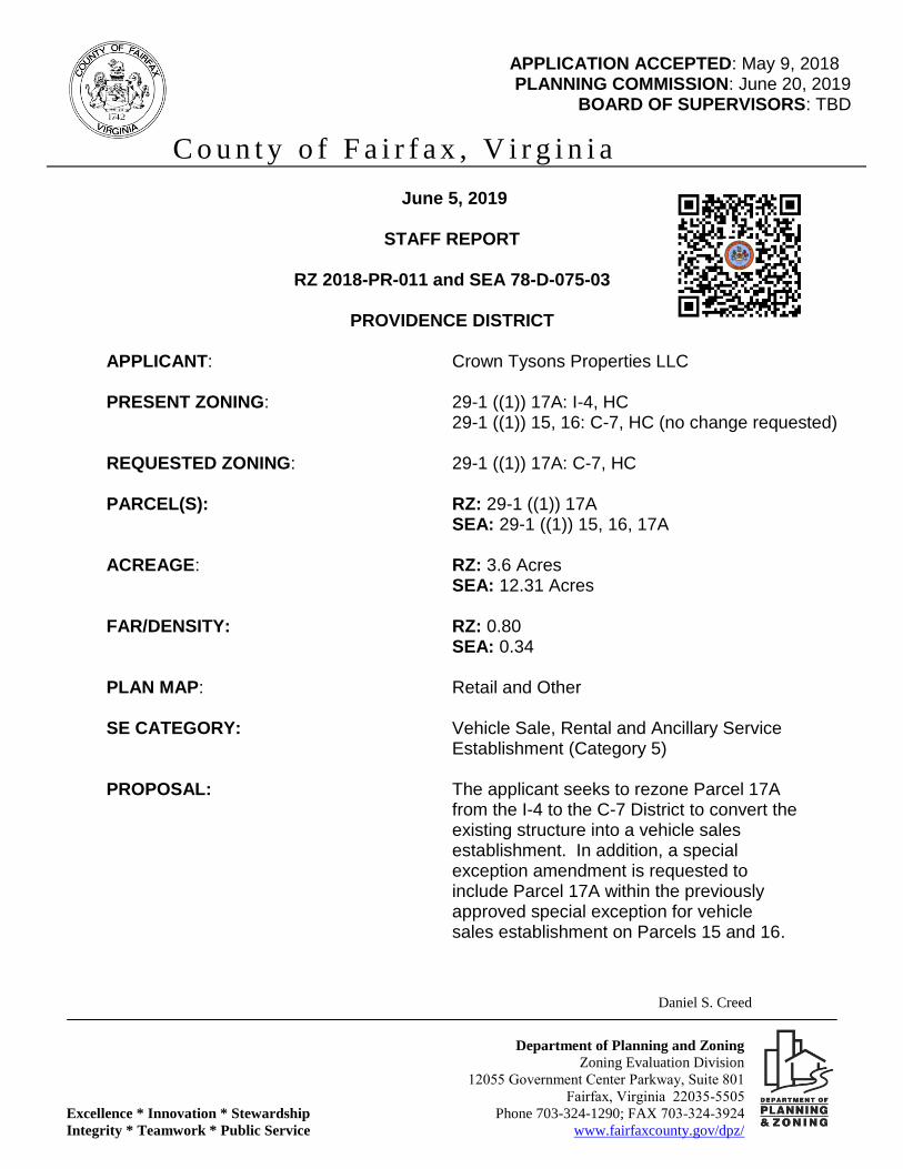
Daniel S. Creed
Department of Planning and Zoning
Zoning Evaluation Division
12055 Government Center Parkway, Suite 801
Fairfax, Virginia 22035-5505
Excellence * Innovation * Stewardship Phone 703-324-1290; FAX 703-324-3924
Integrity * Teamwork * Public Service www.fairfaxcounty.gov/dpz/
APPLICATION ACCEPTED: May 9, 2018 PLANNING COMMISSION: June 20, 2019
BOARD OF SUPERVISORS: TBD
C o u n t y o f F a i r f a x , V i r g i n i a
June 5, 2019
STAFF REPORT
RZ 2018-PR-011 and SEA 78-D-075-03
PROVIDENCE DISTRICT
APPLICANT: Crown Tysons Properties LLC PRESENT ZONING: 29-1 ((1)) 17A: I-4, HC 29-1 ((1)) 15, 16: C-7, HC (no change requested) REQUESTED ZONING: 29-1 ((1)) 17A: C-7, HC PARCEL(S): RZ: 29-1 ((1)) 17A SEA: 29-1 ((1)) 15, 16, 17A ACREAGE: RZ: 3.6 Acres SEA: 12.31 Acres FAR/DENSITY: RZ: 0.80 SEA: 0.34 PLAN MAP: Retail and Other SE CATEGORY: Vehicle Sale, Rental and Ancillary Service Establishment (Category 5) PROPOSAL: The applicant seeks to rezone Parcel 17A
from the I-4 to the C-7 District to convert the existing structure into a vehicle sales establishment. In addition, a special exception amendment is requested to include Parcel 17A within the previously approved special exception for vehicle sales establishment on Parcels 15 and 16.
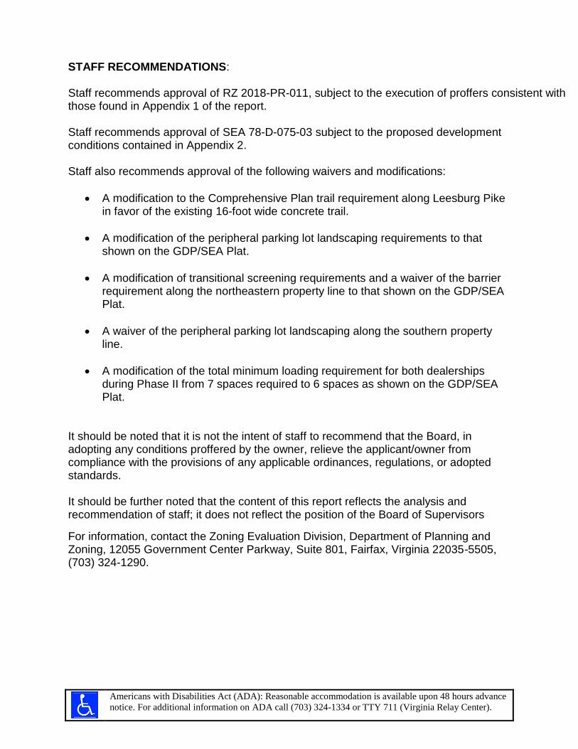
STAFF RECOMMENDATIONS: Staff recommends approval of RZ 2018-PR-011, subject to the execution of proffers consistent with those found in Appendix 1 of the report. Staff recommends approval of SEA 78-D-075-03 subject to the proposed development conditions contained in Appendix 2. Staff also recommends approval of the following waivers and modifications:
• A modification to the Comprehensive Plan trail requirement along Leesburg Pike in favor of the existing 16-foot wide concrete trail.
• A modification of the peripheral parking lot landscaping requirements to that shown on the GDP/SEA Plat.
• A modification of transitional screening requirements and a waiver of the barrier requirement along the northeastern property line to that shown on the GDP/SEA Plat.
• A waiver of the peripheral parking lot landscaping along the southern property line.
• A modification of the total minimum loading requirement for both dealerships during Phase II from 7 spaces required to 6 spaces as shown on the GDP/SEA Plat.
It should be noted that it is not the intent of staff to recommend that the Board, in adopting any conditions proffered by the owner, relieve the applicant/owner from compliance with the provisions of any applicable ordinances, regulations, or adopted standards. It should be further noted that the content of this report reflects the analysis and recommendation of staff; it does not reflect the position of the Board of Supervisors
For information, contact the Zoning Evaluation Division, Department of Planning and Zoning, 12055 Government Center Parkway, Suite 801, Fairfax, Virginia 22035-5505, (703) 324-1290.
Americans with Disabilities Act (ADA): Reasonable accommodation is available upon 48 hours advance
notice. For additional information on ADA call (703) 324-1334 or TTY 711 (Virginia Relay Center).

L L L L L L L L L L L L L L L L L L L L L L L L L L L L
L L L L L L L L L L L L L L L L L L L L L L L L L L L L
L L L L L L L L L L L L L L L L L L L L L L L L L L L L
L L L L L L L L L L L L L L L L L L L L L L L L L L L L
L L L L L L L L L L L L L L L L L L L L L L L L L L L L
L L L L L L L L L L L L L L L L L L L L L L L L L L L L
L L L L L L L L L L L L L L L L L L L L L L L L L L L L
L L L L L L L L L L L L L L L L L L L L L L L L L L L L
L L L L L L L L L L L L L L L L L L L L L L L L L L L L
L L L L L L L L L L L L L L L L L L L L L L L L L L L L
L L L L L L L L L L L L L L L L L L L L L L L L L L L L
L L L L L L L L L L L L L L L L L L L L L L L L L L L L
L L L L L L L L L L L L L L L L L L L L L L L L L L L L
L L L L L L L L L L L L L L L L L L L L L L L L L L L L
L L L L L L L L L L L L L L L L L L L L L L L L L L L L
L L L L L L L L L L L L L L L L L L L L L L L L L L L L
L L L L L L L L L L L L L L L L L L L L L L L L L L L L
L L L L L L L L L L L L L L L L L L L L L L L L L L L L
L L L L L L L L L L L L L L L L L L L L L L L L L L L L
L L L L L L L L L L L L L L L L L L L L L L L L L L L L
L L L L L L L L L L L L L L L L L L L L L L L L L L L L
L L L L L L L L L L L L L L L L L L L L L L L L L L L L
L L L L L L L L L L L L L L L L L L L L L L L L L L L
L L L L L L L L L L L L L L L L L L L L L L L L L L L
L L L L L L L L L L L L L L L L L L L L L L L L L L L
L L L L L L L L L L L L L L L L L L L L L L L L L L L
L L L L L L L L L L L L L L L L L L L L L L L L L L L
L L L L L L L L L L L L L L L L L L L L L L L L L L L
L L L L L L L L L L L L L L L L L L L L L L L L L L L
L L L L L L L L L L L L L L L L L L L L L L L L L L L
L L L L L L L L L L L L L L L L L L L L L L L L L L L
L L L L L L L L L L L L L L L L L L L L L L L L L L L
L L L L L L L L L L L L L L L L L L L L L L L L L L L
L L L L L L L L L L L L L L L L L L L L L L L L L L L
L L L L L L L L L L L L L L L L L L L L L L L L L L L
L L L L L L L L L L L L L L L L L L L L L L L L L L L
L L L L L L L L L L L L L L L L L L L L L L L L L L L
L L L L L L L L L L L L L L L L L L L L L L L L L L L
L L L L L L L L L L L L L L L L L L L L L L L L L L L
L L L L L L L L L L L L L L L L L L L L L L L L L L L
L L L L L L L L L L L L L L L L L L L L L L L L L L L
L L L L L L L L L L L L L L L L L L L L L L L L L L L
L L L L L L L L L L L L L L L L L L L L L L L L L L L
L L L L L L L L L L L L L L L L L L L L L L L L L L L
L L L L L L L L L L L L L L L L L L L L L L L L L L L L L L L L
L L L L L L L L L L L L L L L L L L L L L L L L L L L L L L L L
L L L L L L L L L L L L L L L L L L L L L L L L L L L L L L L L
L L L L L L L L L L L L L L L L L L L L L L L L L L L L L L L L
L L L L L L L L L L L L L L L L L L L L L L L L L L L L L L L L
L L L L L L L L L L L L L L L L L L L L L L L L L L L L L L L L
L L L L L L L L L L L L L L L L L L L L L L L L L L L L L L L L
L L L L L L L L L L L L L L L L L L L L L L L L L L L L L L L L
L L L L L L L L L L L L L L L L L L L L L L L L L L L L L L L L
L L L L L L L L L L L L L L L L L L L L L L L L L L L L L L L L
L L L L L L L L L L L L L L L L L L L L L L L L L L L L L L L L
L L L L L L L L L L L L L L L L L L L L L L L L L L L L L L L L
L L L L L L L L L L L L L L L L L L L L L L L L L L L L L L L L
L L L L L L L L L L L L L L L L L L L L L L L L L L L L L L L L
L L L L L L L L L L L L L L L L L L L L L L L L L L L L L L L L
L L L L L L L L L L L L L L L L L L L L L L L L L L L L L L L L
L L L L L L L L L L L L L L L L L L L L L L L L L L L L L L L L
L L L L L L L L L L L L L L L L L L L L L L L L L L L L L L L L
L L L L L L L L L L L L L L L L L L L L L L L L L L L L L L L L
L L L L L L L L L L L L L L L L L L L L L L L L L L L L L L L L
L L L L L L L L L L L L L L L L L L L L L L L L L L L L L L L L
L L L L L L L L L L L L L L L L L L L L L L L L L L L L L L L L
L L L L L L L L L L L L L L L L L L L L L L L L L L L L L L L L
L L L L L L L L L L L L L L L L L L L L L L L L L L L L L L L L
L L L L L L L L L L L L L L L L L L L L L L L L L L L L L L L L
L L L L L L L L L L L L L L L L L L L L L L L L L L L L L L L L
L L L L L L L L L L L L L L L L L L L L L L L L L L L L L L L L
L L L L L L L L L L L L L L L L L L L L L L L L L L L L L L L L
L L L L L L L L L L L
L L L L L L L L L L L
L L L L L L L L L L L
L L L L L L L L L L L
L L L L L L L L L L L
L L L L L L L L L L L
L L L L L L L L L L L
L L L L L L L L L L L
L L L L L L L L L L L
L L L L L L L L L L L
L L L L L L L L L L L
L L L L L L L L L L L
L L L L L L L L L L L
L L L L L L L L L L L
L L L L L L L L L L L
L L L L L L L L L L L
L L L L L L L L L L L
L L L L L L L L L L L
L L L L L L L L L L L
L L L L L L L L L L L
L L L L L L L L L L L
L L L L L L L L L L
L L L L L L L L L L
L L L L L L L L L L
L L L L L L L L L L
L L L L L L L L L L
L L L L L L L L L L
L L L L L L L L L L
L L L L L L L L L L
L L L L L L L L L L
L L L L L L L L L L
L L L L L L L L L L
L L L L L L L L L L
L L L L L L L L L L
L L L L L L L L L L
L L L L L L L L L L
L L L L L L L L L L
L L L L L L L L L L
L L L L L L L L L L
L L L L L L L L L L
L L L L L L L L L L
L L L L L L L L L L L L L L L L L L L L L L L L L L L L L
L L L L L L L L L L L L L L L L L L L L L L L L L L L L L
L L L L L L L L L L L L L L L L L L L L L L L L L L L L L
L L L L L L L L L L L L L L L L L L L L L L L L L L L L L
L L L L L L L L L L L L L L L L L L L L L L L L L L L L L
L L L L L L L L L L L L L L L L L L L L L L L L L L L L L
L L L L L L L L L L L L L L L L L L L L L L L L L L L L L
L L L L L L L L L L L L L L L L L L L L L L L L L L L L L
L L L L L L L L L L L L L L L L L L L L L L L L L L L L L
L L L L L L L L L L L L L L L L L L L L L L L L L L L L L
L L L L L L L L L L L L L L L L L L L L L L L L L L L L L
L L L L L L L L L L L L L L L L L L L L L L L L L L L L L
L L L L L L L L L L L L L L L L L L L L L L L L L L L L L
L L L L L L L L L L L L L L L L L L L L L L L L L L L L L
L L L L L L L L L L L L L L L L L L L L L L L L L L L L L
L L L L L L L L L L L L L L L L L L L L L L L L L L L L L
L L L L L L L L L L L L L L L L L L L L L L L L L L L L L
L L L L L L L L L L L L L L L L L L L L L L L L L L L L L
L L L L L L L L L L L L L L L L L L L L L L L L L L L L L
L L L L L L L L L L L L L L L L L L L L L L L L L L L L L
L L L L L L L L L L L L L L L L L L L L L L L L L L L L L
L L L L L L L L L L L L L L L L L L L L L L L L L L L L L
L L L L L L L L L L L L L L L L L L L L L L L L L L L L
L L L L L L L L L L L L L L L L L L L L L L L L L L L L
L L L L L L L L L L L L L L L L L L L L L L L L L L L L
L L L L L L L L L L L L L L L L L L L L L L L L L L L L
L L L L L L L L L L L L L L L L L L L L L L L L L L L L
L L L L L L L L L L L L L L L L L L L L L L L L L L L L
L L L L L L L L L L L L L L L L L L L L L L L L L L L L
L L L L L L L L L L L L L L L L L L L L L L L L L L L L
L L L L L L L L L L L L L L L L L L L L L L L L L L L L
L L L L L L L L L L L L L L L L L L L L L L L L L L L L
L L L L L L L L L L L L L L L L L L L L L L L L L L L L
L L L L L L L L L L L L L L L L L L L L L L L L L L L L
L L L L L L L L L L L L L L L L L L L L L L L L L L L L
L L L L L L L L L L L L L L L L L L L L L L L L L L L L
L L L L L L L L L L L L L L L L L L L L L L L L L L L L
L L L L L L L L L L L L L L L L L L L L L L L L L L L L
L L L L L L L L L L L L L L L L L L L L L L L L L L L L
L L L L L L L L L L L L L L L L L L L L L L L L L L L L
L L L L L L L L L L L L L L L L L L L L L L L L L L L L
L L L L L L L L L L L L L L L L L L L L L L L L L L L L
L L L L L L L L L L L L L L L L L L L L L L L L L L L L
L L L L L L L L L L L L L L L L L L L L L L L L L L L L L L L L L L
L L L L L L L L L L L L L L L L L L L L L L L L L L L L L L L L L L
L L L L L L L L L L L L L L L L L L L L L L L L L L L L L L L L L L
L L L L L L L L L L L L L L L L L L L L L L L L L L L L L L L L L L
L L L L L L L L L L L L L L L L L L L L L L L L L L L L L L L L L L
L L L L L L L L L L L L L L L L L L L L L L L L L L L L L L L L L L
L L L L L L L L L L L L L L L L L L L L L L L L L L L L L L L L L L
L L L L L L L L L L L L L L L L L L L L L L L L L L L L L L L L L L
L L L L L L L L L L L L L L L L L L L L L L L L L L L L L L L L L L
L L L L L L L L L L L L L L L L L L L L L L L L L L L L L L L L L L
L L L L L L L L L L L L L L L L L L L L L L L L L L L L L L L L L L
L L L L L L L L L L L L L L L L L L L L L L L L L L L L L L L L L L
L L L L L L L L L L L L L L L L L L L L L L L L L L L L L L L L L L
L L L L L L L L L L L L L L L L L L L L L L L L L L L L L L L L L L
L L L L L L L L L L L L L L L L L L L L L L L L L L L L L L L L L L
L L L L L L L L L L L L L L L L L L L L L L L L L L L L L L L L L L
L L L L L L L L L L L L L L L L L L L L L L L L L L L L L L L L L L
L L L L L L L L L L L L L L L L L L L L L L L L L L L L L L L L L
L L L L L L L L L L L L L L L L L L L L L L L L L L L L L L L L L
L L L L L L L L L L L L L L L L L L L L L L L L L L L L L L L L L
L L L L L L L L L L L L L L L L L L L L L L L L L L L L L L L L L
L L L L L L L L L L L L L L L L L L L L L L L L L L L L L L L L L
L L L L L L L L L L L L L L L L L L L L L L L L L L L L L L L L L
L L L L L L L L L L L L L L L L L L L L L L L L L L L L L L L L L
L L L L L L L L L L L L L L L L L L L L L L L L L L L L L L L L L
L L L L L L L L L L L L L L L L L L L L L L L L L L L L L L L L L
L L L L L L L L L L L L L L L L L L L L L L L L L L L L L L L L L
L L L L L L L L L L L L L L L L L L L L L L L L L L L L L L L L L
L L L L L L L L L L L L L L L L L L L L L L L L L L L L L L L L L
L L L L L L L L L L L L L L L L L L L L L L L L L L L L L L L L L
L L L L L L L L L L L L L L L L L L L L L L L L L L L L L L L L L
L L L L L L L L L L L L L L L L L L L L L L L L L L L L L L L L L
L L L L L L L L L L L L L L L L L L L L L L L L L L L L L L L L L
L L L L L L L L L L L L L L L L L L L L L L L L L L L L L L L L L
L L L L L L L L L L L L L L L L L L L L
L L L L L L L L L L L L L L L L L L L L
L L L L L L L L L L L L L L L L L L L L
L L L L L L L L L L L L L L L L L L L L
L L L L L L L L L L L L L L L L L L L L
L L L L L L L L L L L L L L L L L L L L
L L L L L L L L L L L L L L L L L L L L
L L L L L L L L L L L L L L L L L L L L
L L L L L L L L L L L L L L L L L L L L
L L L L L L L L L L L L L L L L L L L L
L L L L L L L L L L L L L L L L L L L L
L L L L L L L L L L L L L L L L L L L L
L L L L L L L L L L L L L L L L L L L L
L L L L L L L L L L L L L L L L L L L L
L L L L L L L L L L L L L L L L L L L L
L L L L L L L L L L L L L L L L L L L L
L L L L L L L L L L L L L L L L L L L L
L L L L L L L L L L L L L L L L L L L L
L L L L L L L L L L L L L L L L L L L L
L L L L L L L L L L L L L L L L L L L
L L L L L L L L L L L L L L L L L L L
L L L L L L L L L L L L L L L L L L L
L L L L L L L L L L L L L L L L L L L
L L L L L L L L L L L L L L L L L L L
L L L L L L L L L L L L L L L L L L L
L L L L L L L L L L L L L L L L L L L
L L L L L L L L L L L L L L L L L L L
L L L L L L L L L L L L L L L L L L L
L L L L L L L L L L L L L L L L L L L
L L L L L L L L L L L L L L L L L L L
L L L L L L L L L L L L L L L L L L L
L L L L L L L L L L L L L L L L L L L
L L L L L L L L L L L L L L L L L L L
L L L L L L L L L L L L L L L L L L L
L L L L L L L L L L L L L L L L L L L
L L L L L L L L L L L L L L L L L L L
L L L L L L L L L L L L L L L L L L L
L L L L L L L L L L L L L L L L L L L
D D D D D D D D D D D D D D D D D D D D D D D D D D D D D D D
D D D D D D D D D D D D D D D D D D D D D D D D D D D D D D D
D D D D D D D D D D D D D D D D D D D D D D D D D D D D D D D
D D D D D D D D D D D D D D D D D D D D D D D D D D D D D D D
D D D D D D D D D D D D D D D D D D D D D D D D D D D D D D D
D D D D D D D D D D D D D D D D D D D D D D D D D D D D D D D
D D D D D D D D D D D D D D D D D D D D D D D D D D D D D D
D D D D D D D D D D D D D D D D D D D D D D D D D D D D D D D
D D D D D D D D D D D D D D D D D D D D D D D D D D D D D D D
D D D D D D D D D D D D D D D D D D D D D D D D D D D D D D
D D D D D D D D D D D D D D D D D D D D D D D D D D D D D D D
D D D D D D D D D D D D D D D D D D D D D D D D D D D D D D D
D D D D D D D D D D D D D D D D D D D D D D D D D D D D D D D
D D D D D D D D D D D D D D D D D D D D D D D D D D D D D D D
D D D D D D D D D D D D D D D D D D D D D D D D D D D D D D D
D D D D D D D D D D D D D D D D D D D D D D D D D D D D D D D
D D D D D D D D D D D D D D D D D D D D D D D D D D D D D D D
D D D D D D D D D D D D D D D D D D D D D D D D D D D D D D D
D D D D D D D D D D D D D D D D D D D D D D D D D D D D D D D
D D D D D D D D D D D D D D D D D D D D D D D D D D D D D D
D D D D D D D D D D D D D D D D D D D D D D D D D D D D D D D
D D D D D D D D D D D D D D D D D D D D D D D D D D D D D D D
D D D D D D D D D D D D D D D D D D D D D D D D D D D D D D
D D D D D D D D D D D D D D D D D D D D D D D D D D D D D D D
D D D D D D D D D D D D D D D D D D D D D D D D D D D D D D D
D D D D D D D D D D D D D D D D D D D D D D D D D D D D D D D
D D D D D D D D D D D D D D D D D D D D D D D D D D D D D D D
D D D D D D D D D D D D D D D D D D D D D D D D D D D D D D D
D D D D D D D D D D D D D D D D D D D D D D D D D D D D D D D
D D D D D D D D D D D D D D D D D D D D D D D D D D D D D D D
D D D D D D D D D D D D D D D D D D D D D D D D D D D D D D D
D D D D D D D D D D D D D D D D D D D D D D D D D D D D D D D
D D D D D D D D D D D D D D D D D D D D D D D D D D D D D D
D D D D D D D D D D D D D D D D D D D D D D D D D D D D D D D
D D D D D D D D D D D D D D D D D D D D D D D D D D D D D D D
D D D D D D D D D D D D D D D D D D D D D D D D D D D D D D
D D D D D D D D D D D D D D D D D D D D D D D D D D D D D D D D D D D D D D D D D D D D D D
D D D D D D D D D D D D D D D D D D D D D D D D D D D D D D D D D D D D D D D D D D D D D
D D D D D D D D D D D D D D D D D D D D D D D D D D D D D D D D D D D D D D D D D D D D D D
D D D D D D D D D D D D D D D D D D D D D D D D D D D D D D D D D D D D D D D D D D D D D D
D D D D D D D D D D D D D D D D D D D D D D D D D D D D D D D D D D D D D D D D D D D D D D
D D D D D D D D D D D D D D D D D D D D D D D D D D D D D D D D D D D D D D D D D D D D D D
D D D D D D D D D D D D D D D D D D D D D D D D D D D D D D D D D D D D D D D D D D D D D D
D D D D D D D D D D D D D D D D D D D D D D D D D D D D D D D D D D D D D D D D D D D D D D
D D D D D D D D D D D D D D D D D D D D D D D D D D D D D D D D D D D D D D D D D D D D D D
D D D D D D D D D D D D D D D D D D D D D D D D D D D D D D D D D D D D D D D D D D D D D D
D D D D D D D D D D D D D D D D D D D D D D D D D D D D D D D D D D D D D D D D D D D D D
D D D D D D D D D D D D D D D D D D D D D D D D D D D D D D D D D D D D D D D D D D D D D D
D D D D D D D D D D D D D D D D D D D D D D D D D D D D D D D D D D D D D D D D D D D D D
D D D D D D D D D D D D D D D D D D D D D D D D D D D D D D D D D D D D D D D D D D D D D D
D D D D D D D D D D D D D D D D D D D D D D D D D D D D D D D D D D D D D D D D D D D D D
D D D D D D D D D D D D D D D D D D D D D D D D D D D D D D D D D D D D D D D D D D D D D D
D D D D D D D D D D D D D D D D D D D D D D D D D D D D D D D D D D D D D D D D D D D D D
D D D D D D D D D D D D D D D D D D D D D D D D D D D D D D D D D D D D D D D D D D D D D D
D D D D D D D D D D D D D D D D D D D D D D D D D D D D D D D D D D D D D D D D D D D D D
D D D D D D D D D D D D D D D D D D D D D D D D D D D D D D D D D D D D D D D D D D D D D D
D D D D D D D D D D D D D D D D D D D D D D D D D D D D D D D D D D D D D D D D D D D D D
D D D D D D D D D D D D D D D D D D D D D D D D D D D D D D D D D D D D D D D D D D D D D D
D D D D D D D D D D D D D D D D D D D D D D D D D D D D D D D D D D D D D D D D D D D D D
D D D D D D D D D D D D D D D D D D D D D D D D D D D D D D D D D D D D D D D D D D D D D D
D D D D D D D D D D D D D D D D D D D D D D D D D D D D D D D D D D D D D D D D D D D D D
D D D D D D D D D D D D D D D D D D D D D D D D D D D D D D D D D D D D D D D D D D D D D D
D D D D D D D D D D D D D D D D D D D D D D D D D D D D D D D D D D D D D D D D D D D D D
D D D D D D D D D D D D D D D D D D D D D D D D D D D D D D D D D D D D D D D D D D D D D D
D D D D D D D D D D D D D D D D D D D D D D D D D D D D D D D D D D D D D D D D D D D D D
D D D D D D D D D D D D D D D D D D D D D D D D D D D D D D D D D D D D D D D D D D D D D D
D D D D D D D D D D D D D D D D D D D D D D D D D D D D D D D D D D D D D D D D D D D D D
D D D D D D D D D D D D D D D D D D D D D D D D D D D D D D D D D D D D D D D D D D D D D D
D D D D D D D D D D D D D D D D D D D D D D D D D D D D D D D D D D D D D D D D D D D D D D
D D D D D D D D D D D D D D D D D D D D D D D D D D D D D D D D D D D D D D D D D D D D D D
D D D D D D D D D D D D D D D D D D D D D D D D D D D D D D D D D D D D D D D D D D D D D D
D D D D D D D D D D D D D D D D D D D D D D D D D D D D D D D D D D D D D D D D D D D D D D
D D D D D D D D D D D D D D D D D D D D D D D D D D D D D D D D D D D D D D D D D D D D D D
D D D D D D D D D D D D D D D D D D D D D D D D D D D D D D D D D D D D D D D D D D D D D D
D D D D D D D D D D D D D D D D D D D D D D D D D D D D D D D D D D D D D D D D D D D D D D
D D D D D D D D D D D D D D D D D D D D D D D D D D D D D D D D D D D D D D D D D D D D D
D D D D D D D D D D D D D D D D D D D D D D D D D D D D D D D D D D D D D D D D D D D D D D
D D D D D D D D D D D D D D D D D D D D D D D D D D D D D D D D D D D D D D D D D D D D D
D D D D D D D D D D D D D D D D D D D D D D D D D D D D D D D D D D D D D D D D D D D D D D
D D D D D D D D D D D D D D D D D D D D D D D D D D D D D D D D D D D D D D D D D D D D D
D D D D D D D D D D D D D D D D D D D D D D D D D D D D D D D D D D D D D D D D D D D D D D
D D D D D D D D D D D D D D D D D D D D D D D D D D D D D D D D D D D D D D D D D D D D D
D D D D D D D D D D D D D D D D D D D D D D D D D D D D D D D D D D D D D D D D D D D D D D
D D D D D D D D D D D D D D D D D D D D D D D D D D D D D D D D D D D D D D D D D D D D D
D D D D D D D D D D D D D D D D D D D D D D D D D D D D D D D D D D D D D D D D D D D D D D
!! !!
!! !!
! !!
(
(
((
((
(
((
(((( (
))
((
))
((
(
((
((
((
((
((
((
((
((
(
(
))-
(
(
((
(( ((
((
((
((
((
((
((
((
F.P.L.
F.P.L.F.P.L.
F.P.L.
Commonwealth
Virginia
22' Outlet Rd.
of
C.E.
Easem
ent
C.E.
1
SPRING HILL
35
GREENSBORO SQ
BUILD
TYSON'S VILLAGE
24
1
LEW
INSV
ILLE
III
20
18
ADAIRE
25
33
ASCENT CONDO
16BE
LLME
ADE
II
GREENSBORO SQ
SALOME27
32
CONDO
CONDO
8
10
18
CARRINGTON
34
31
BUILD AMERICA III
SEC. 2A
TYCO
ROA
D LA
ND C
ONDO
MINI
UM
OFFICE COMPLEX
AMERICA
TYCO PARK
STON
Y
WESTWOOD
19
TYSONS WESTSTATION
17
RESIDENCES AT SPRING HILL STATION
13
Lodge Sheraton
Boyd Pointe Way
Rd.
Broad St.
Rd.
Northern
Dr.
Ashgrove Ln.
Tysons
Spring
Dulles
Dr.
Spring
Airport
Toll
Hunting
House
Neck
Dr.
Dr.
Tyco Rd.
Hill
Toll
Ln.
Westwood Center
Ashgrove
Neck
Rd.
Tyco
Leeds
Ct.
Northern
Ct.
Ashgrove
North
ernNe
ck
Dulles
Jarrett Valley Dr.
Cornerside Blvd.
Hardi
son
Ln
.
Dulles
Hill
Ashgrove Ln.
Yard St.
Leesburg
Access
Ln.
Castle D
r.
HouseLn.
Pike
Dr.
Airport
Airport
Gordo
n
Rt. 684
Rt. 1
0481
Rt.3888
Rt. 3888
Rt. 684
Rt.6634
Rt. 7
Rt.10195
BLDG
PARKING
SPRING HILL METRO STATIONLAND
TYSONS
VP
POOL
POOL
TOLL
POOL
PARKING
Comm.of
Va.
See
PARKING
POOL
(29-1)(1-35A)
CORNERFIRE STA.
BOOTH
9
7
72A
32 23A
18
139 - 1
54
10
5A
10A
49 -
64
2P
2C2
5
14
3
57B
47
2
40
17 15
24
5 4 2 1
17
A-B
27
56
34
36
38
49
63
40A
57
8
9A
2M2N
71A
34
38A
31
22A
27A
24
26A
16A
7 8
12A
4A3A
2C1
B
6
55 C1
1 - 2
46A
50
49
63C
9
4
8
6
21
10
13
15
A-B57
45
59
32
A-B
50
66 67
1-8
73A
106A - 112A
52A
29
20
45
4617A 9
1 -
16
10
12
11
15
17B
57G
C
42
28
18
20
55
24
43A-B
48A-B A-B
3
A
1-6
41A
9B
3940
2119
13A
1A
81 -
104
1
2
15
2C3
53B 57M
17A
17C
58A
63B
3
43
7 6
27
38
25
36
13
22
3
20
32
41
2928
22
58A-B
3940
46
60
47
62
52 53
8
30
42
44
114
17 - 32
2A
2
3
4
16
3
57K
11
17
5
56A
B
11
3167C
39
16
34
18
21
42 44A-B
65
4
6
53A
6A
1514
D1
C2
65 -
80
11B
E3
3
4
2D
1
1E
1
53A
A
12
10
37
12
60C
1925
23
33
35
A-B51
69
A
5
33
4143
123 - 138
2547A
115-
122
5
57A
1
C -
4
48C
56
C D
31
5
41
26 23
35
11
33
9
14
26
A-B 61 64
54
3A
2
28
105 -
11
33 -
48
2
13
2F
51A
53
18C
14
22A
57
1
30 29
8 7
14
19
50C
16
30
37
A-B 68
40B
7 68
10
2
D
45
1
3
9
C
8836 - 8820
8807
1583
8846
1597
1592
8661 LEESBURG PIKE
1580
8536-
8536A
8525
8606
8524
A
56
08
A
8472C 72
60E
20
18
8866
8861
1498
1547
2015
56
8608
1587
23
20A
1521
1572
54
52
8455L
8453H
1524
V
8502
70
66E
50C
8333
8365A-8361A
19
1592 -
8882
- 1576
1571
1423
8800
8801
1586
02
8545
1568
8608
55
48
8501
8455M
8440
8480
66
68
8377B-8371B
1600
15
1567
8837
1488
1500
40
1591
1577
46
1575
8526
50
8550
1570
8604
96E 8496A
8490
8474
66
8450
67
8365B-8361B
09
8863 8850
8855
8800
16
8606
1500
8740
21
44
8500
- 850
0C
Y
8504
- 850
4N
78
64
62
1350
8614
1604
8818
8851
8841
8837
8830 1461 1451 1441
25
8600
8524
B
16
60
1524
8478
874
E
60
56C
04
8377A-8371A
8616
1602
8849
8800
8831
1487
36
8527
8590
8515-8525
8528
A-G
12
40
8401
8405
8486
I
90E
8455
8453R
80I
02
69
8616A-M
1499
1531
07
05
03
8601
8610
19
48
20C
8598
8520
56
8421
1524
A
8453A
8455
8453L
8486
8470C
8456
03
65
1410
1349
ééééééééééééééééééééééééééééééééééééééééééé
é é é é é é é é é é é é é é é é é é é é é é é é é é é é é é é é éééééééééééééééééééééééééééééééééééééééééééééééééééééé
ççççççççççççççççççççççççççççççççççççççççççççççççççççççççççç
çççççççççççççççççççççççççççççççççççççç
çççççççççççççççççççççççççççççççççççççççççççç
ççççççççççççççççççççççççççççççççççççççççç
çççççççççççççççç
çççç
çççççççççççççççççççççççç çççç
ççççççççççççççççççççççççççççççççççççççççççççççççççççççççççççççççççççççççççççççççççççççççççççççççççççççççççççççççççççççççççççççççççççççççç çççççççççççççççççççççççççççççççççççççççççççççççççç ççççççççççççççççççççççççç ççççç
çççççççççççççççççççççççççççççççççç
VVVVVVVVVVVVVVVVVVVVVVVVVVVVVVVVVVVVVVVVVVVVVVVVVVVVVVVVVVVVVVVVVVVVVVVVVVVVVVVVVVVVVVVVVVVVVVVVVVVVVVVVVVVVVVVVVVVVVVVVVVVVVVV
V V V V VV VV V V V V V V V V V V V V V V V V V V V V V V V V V V V V V V V V V V V V V V V V V V V V V V V V V V V V V V V V V V V V V V V V V V V V V V V V V V V V V V V V V V V V V V V V V V V
VV V V V V V V V V V V V V V V V V V V V V V V V V V V V V V V V V V V V V V V V V V V V V V V V V V V V V V V V V V V V V V V V V V
V V V V VV VV V V V V V V V V V V V V V
VV
VV
VVVV
VVV
VVV
VVV
VV
VV
VV
VV
VV
V V V V V V V V V V V V V V V V V V V V V V V V V V V V V V V V V V V V V V V V V V V V V V V V V V V V V V V V V V V V V V V V V V V V V V V V V V V V V V V V V V V V V V V V V V V V V VV V V V V V V V V V V V V V V V V V V V V V V V V V V V V V V V V
For PTC
C-322
11-HM-032*
B-383
B-170
C-395
81-C-066*(11.01 D/U)
B-529
C-53782-C-056
B-58010-PR-014D*
14-PR-013*
74-3-032*
A-842
A-842
C-122
95-D-018*
B-315
B-580
756
10-PR-014A*
C-161
A-842
11-HM-012*
C-1041502
A-434
76-C-024*
A-434
B-297
77-D-090*
B-441
10-PR-014E*
(1.65 D/U)
80-C-072*
02-HM-012*
B-35
17-PR-010
B-173
B-441
B-463
94-P-015
A-865
C-42481-D-045*
90-D-025*
B-831
96-H-022*
(11.01 D/U)
C-104
A-842
A-942
C-395
10-PR-014B*
85-D-011*
78-D-051
84-P-057*
01-PR-005*
12-DR-006
82-C-057
80-C-072*
92-C-033*
B-455
77-C-059*
408
1179
96-H-022*
11-HM-027*
76-D-080
347
B-189
A-761
C-123
A-842
83-D-088
SCH-C
C-537
SC
H-C
C-537
H-C
78-H-088-B
H-C
83-W-005
R-1
R-1
R-1
R-1
PDH-12
PDH-12
R-1
PDH-2
PDH-2
I-5I-5
PTC
C-8
PDC
PTC
I-4
C-7
C-7
C-7
C-7
PTC
C-7 I-4
I-4
C-7
I-4
I-4
C-8
I-5
PTC I-4
I-5
PTC
0 100 200 300 400 500 Feet
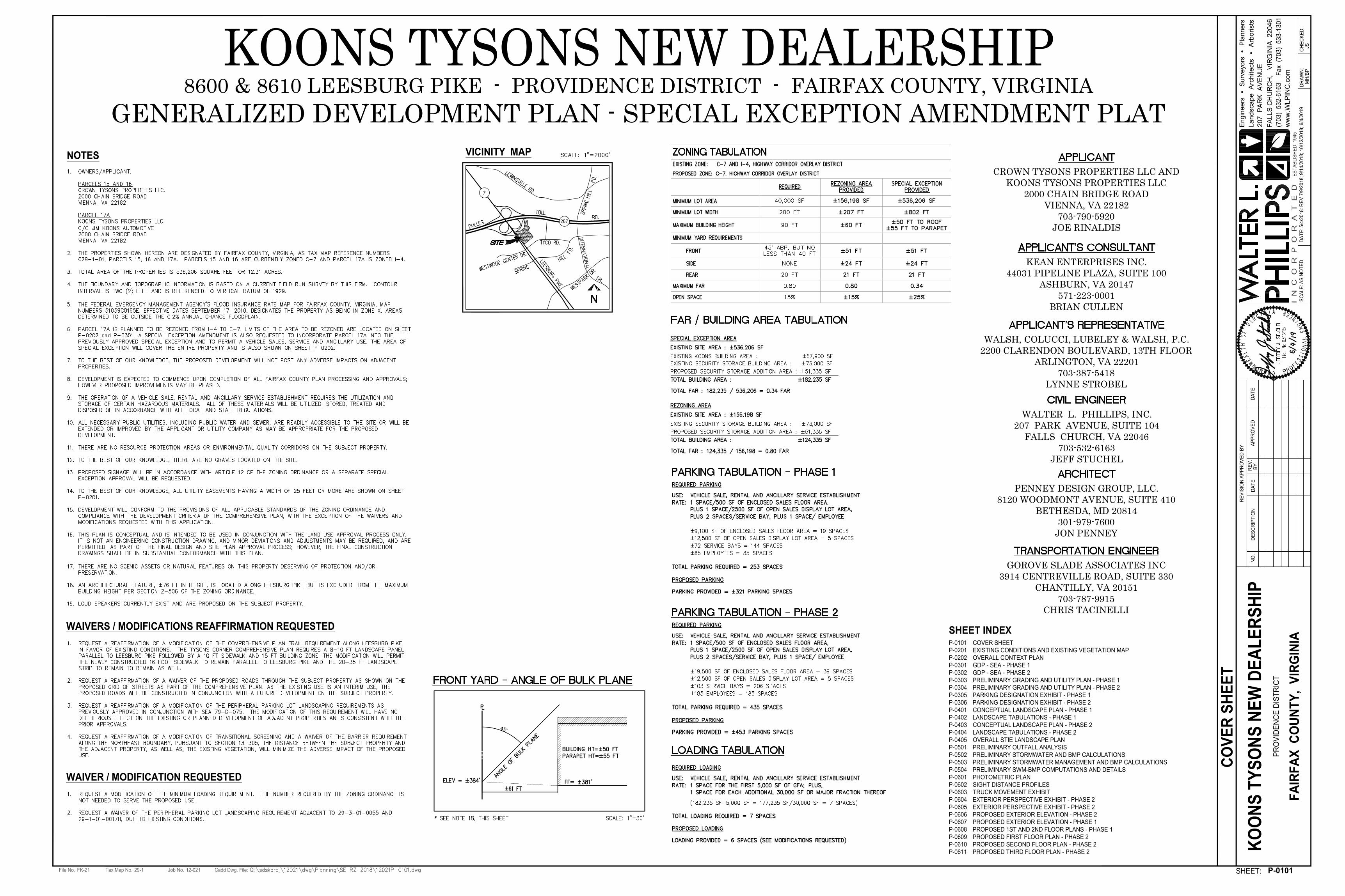
Special Exception AmendmentSEA 78-D -075-03
Rezoning ApplicationRZ 2018-PR-011
Applicant: CROWN TYSONS PROPERTIES LLCAccepted: 05/09/2018Proposed: AMEND SE 78-D-075 PREVIOUSLY APPROVED FOR
VEHICLE SALE, RENTAL AND ANCILLARY SERVICEESTABLISHMENT TO ADD LAND AREA, MODIFYDEVELOPMENT CONDITIONS AND PERMIT SITE &BUILDING MODIFICATIONS
Area: 12.31 AC; DISTRICT - PROVIDENCEZoning Dist Sect: 04-0704Located: 8600, 8602 & 8610 LEESBURG PIKE, VIENNA, VA 22182
Zoning: C- 7Plan Area: 2,Overlay Dist: HCMap Ref Num: 029-1- /01/ /0015 /01/ /0016 /01/
/0017A
Applicant: CROWN TYSONS PROPERTIES LLCAccepted: 05/09/2018Proposed: VEHICLE SALE, RENTAL AND ANCILLARY
SERVICE ESTABLISHMENTArea: 3.6 AC; DISTRICT - PROVIDENCEZoning Dist Sect:Located: NORTH SIDE OF LEESBURG PIKE
APPROXIMATELY 600 FEET EAST OF THEINTERCHANGE WITH THE DULLES AIRPORTACCESS AND TOLL ROAD
Zoning: FROM I- 4 TO C- 7Overlay Dist: HCMap Ref Num: 029-1- /01/ /0017A
Leesburg Pike
Dulles Toll Rd.
Tyco Rd.
Tax Map No.File No. Job No. Cadd Dwg. File:
SHEET:
AP
PR
OV
ED
RE
VIS
IO
N A
PP
RO
VE
D B
Y
RE
V.
BY
DA
TE
DA
TE
NO
.D
ES
CR
IP
TIO
N
SC
AL
E:
DA
TE
:D
RA
WN
:C
HE
CK
ED
:
29-1FK-21 12-021
5/4
/2
01
8: R
EV
7
/9
/2
01
8; 9
/1
4/2
01
8; 1
0/1
2/2
01
8; 6
/4
/2
01
9
MH
/B
PJS
KO
ON
S T
YS
ON
S N
EW
D
EA
LE
RS
HIP
PR
OV
ID
EN
CE
D
IS
TR
IC
T
FA
IR
FA
X C
OU
NT
Y, V
IR
GIN
IA
207
P
AR
K A
VE
NU
E
(703) 532-6163 F
ax (703) 533-1301
FA
LL
S C
HU
RC
H, V
IR
GIN
IA
2
20
46
ww
w.W
LP
IN
C.co
m
I N
C
O
R
P
O
R
A
T
E
D
Engineers S
urveyors P
lanners
Landscape A
rchitects A
rborists
ES
TA
BL
IS
HE
D 1
94
5
P-0101
CO
VE
R S
HE
ET
GENERALIZED DEVELOPMENT PLAN - SPECIAL EXCEPTION AMENDMENT PLAT8600 & 8610 LEESBURG PIKE - PROVIDENCE DISTRICT - FAIRFAX COUNTY, VIRGINIA
WAIVERS / MODIFICATIONS REAFFIRMATION REQUESTED
KOONS TYSONS NEW DEALERSHIPVICINITY MAP
NOTES
CROWN TYSONS PROPERTIES LLC ANDKOONS TYSONS PROPERTIES LLC
2000 CHAIN BRIDGE ROADVIENNA, VA 22182
703-790-5920JOE RINALDIS
WALSH, COLUCCI, LUBELEY & WALSH, P.C.2200 CLARENDON BOULEVARD, 13TH FLOOR
ARLINGTON, VA 22201703-387-5418
LYNNE STROBEL
PENNEY DESIGN GROUP, LLC.8120 WOODMONT AVENUE, SUITE 410
BETHESDA, MD 20814301-979-7600
JON PENNEY
WALTER L. PHILLIPS, INC.207 PARK AVENUE, SUITE 104
FALLS CHURCH, VA 22046703-532-6163
JEFF STUCHEL
GOROVE SLADE ASSOCIATES INC3914 CENTREVILLE ROAD, SUITE 330
CHANTILLY, VA 20151703-787-9915
CHRIS TACINELLI
WAIVER / MODIFICATION REQUESTED
SHEET INDEX
P-0101 COVER SHEET
P-0201 EXISTING CONDITIONS AND EXISTING VEGETATION MAP
P-0202 OVERALL CONTEXT PLAN
P-0301 GDP - SEA - PHASE 1
P-0302 GDP - SEA - PHASE 2
P-0303 PRELIMINARY GRADING AND UTILITY PLAN - PHASE 1
P-0304 PRELIMINARY GRADING AND UTILITY PLAN - PHASE 2
P-0305 PARKING DESIGNATION EXHIBIT - PHASE 1
P-0306 PARKING DESIGNATION EXHIBIT - PHASE 2
P-0401 CONCEPTUAL LANDSCAPE PLAN - PHASE 1
P-0402 LANDSCAPE TABULATIONS - PHASE 1
P-0403 CONCEPTUAL LANDSCAPE PLAN - PHASE 2
P-0404 LANDSCAPE TABULATIONS - PHASE 2
P-0405 OVERALL STIE LANDSCAPE PLAN
P-0501 PRELIMINARY OUTFALL ANALYSIS
P-0502 PRELIMINARY STORMWATER AND BMP CALCULATIONS
P-0503 PRELIMINARY STORMWATER MANAGEMENT AND BMP CALCULATIONS
P-0504 PRELIMINARY SWM-BMP COMPUTATIONS AND DETAILS
P-0601 PHOTOMETRIC PLAN
P-0602 SIGHT DISTANCE PROFILES
P-0603 TRUCK MOVEMENT EXHIBIT
P-0604 EXTERIOR PERSPECTIVE EXHIBIT - PHASE 2
P-0605 EXTERIOR PERSPECTIVE EXHIBIT - PHASE 2
P-0606 PROPOSED EXTERIOR ELEVATION - PHASE 2
P-0607 PROPOSED EXTERIOR ELEVATION - PHASE 1
P-0608 PROPOSED 1ST AND 2ND FLOOR PLANS - PHASE 1
P-0609 PROPOSED FIRST FLOOR PLAN - PHASE 2
P-0610 PROPOSED SECOND FLOOR PLAN - PHASE 2
P-0611 PROPOSED THIRD FLOOR PLAN - PHASE 2
AS
N
OT
EDKEAN ENTERPRISES INC.
44031 PIPELINE PLAZA, SUITE 100ASHBURN, VA 20147
571-223-0001BRIAN CULLEN

Tax Map No.File No. Job No. Cadd Dwg. File:
SHEET:
AP
PR
OV
ED
RE
VIS
IO
N A
PP
RO
VE
D B
Y
RE
V.
BY
DA
TE
DA
TE
NO
.D
ES
CR
IP
TIO
N
SC
AL
E:
DA
TE
:D
RA
WN
:C
HE
CK
ED
:
29-1FK-21 12-021
5/4
/2
01
8: R
EV
7
/9
/2
01
8; 9
/1
4/2
01
8; 1
0/1
2/2
01
8; 6
/4
/2
01
9
MH
/B
PJS
KO
ON
S T
YS
ON
S N
EW
D
EA
LE
RS
HIP
PR
OV
ID
EN
CE
D
IS
TR
IC
T
FA
IR
FA
X C
OU
NT
Y, V
IR
GIN
IA
207
P
AR
K A
VE
NU
E
(703) 532-6163 F
ax (703) 533-1301
FA
LL
S C
HU
RC
H, V
IR
GIN
IA
2
20
46
ww
w.W
LP
IN
C.co
m
I N
C
O
R
P
O
R
A
T
E
D
Engineers S
urveyors P
lanners
Landscape A
rchitects A
rborists
ES
TA
BL
IS
HE
D 1
94
5
P-0201
EX
IS
TIN
G C
ON
DIT
IO
NS
A
ND
E
XIS
TIN
G V
EG
ET
AT
IO
N M
AP
LEGEND
EXISTING VEGETATION MAP INFORMATION
025 2001005050
1 INCH = 50'
(IN FEET)
1" =
5
0'
Tax Map No.File No. Job No. Cadd Dwg. File:
SHEET:
AP
PR
OV
ED
RE
VIS
IO
N A
PP
RO
VE
D B
Y
RE
V.
BY
DA
TE
DA
TE
NO
.D
ES
CR
IP
TIO
N
SC
AL
E:
DA
TE
:D
RA
WN
:C
HE
CK
ED
:
29-1FK-21 12-021
5/4
/2
01
8: R
EV
7
/9
/2
01
8; 9
/1
4/2
01
8; 1
0/1
2/2
01
8; 6
/4
/2
01
9
MH
/B
PJS
KO
ON
S T
YS
ON
S N
EW
D
EA
LE
RS
HIP
PR
OV
ID
EN
CE
D
IS
TR
IC
T
FA
IR
FA
X C
OU
NT
Y, V
IR
GIN
IA
207
P
AR
K A
VE
NU
E
(703) 532-6163 F
ax (703) 533-1301
FA
LL
S C
HU
RC
H, V
IR
GIN
IA
2
20
46
ww
w.W
LP
IN
C.co
m
I N
C
O
R
P
O
R
A
T
E
D
Engineers S
urveyors P
lanners
Landscape A
rchitects A
rborists
ES
TA
BL
IS
HE
D 1
94
5
P-0202
OV
ER
AL
L C
ON
TE
XT
P
LA
N
LEGEND
025 2001005050
1 INCH = 50'
(IN FEET)
1" =
5
0'
LEGEND
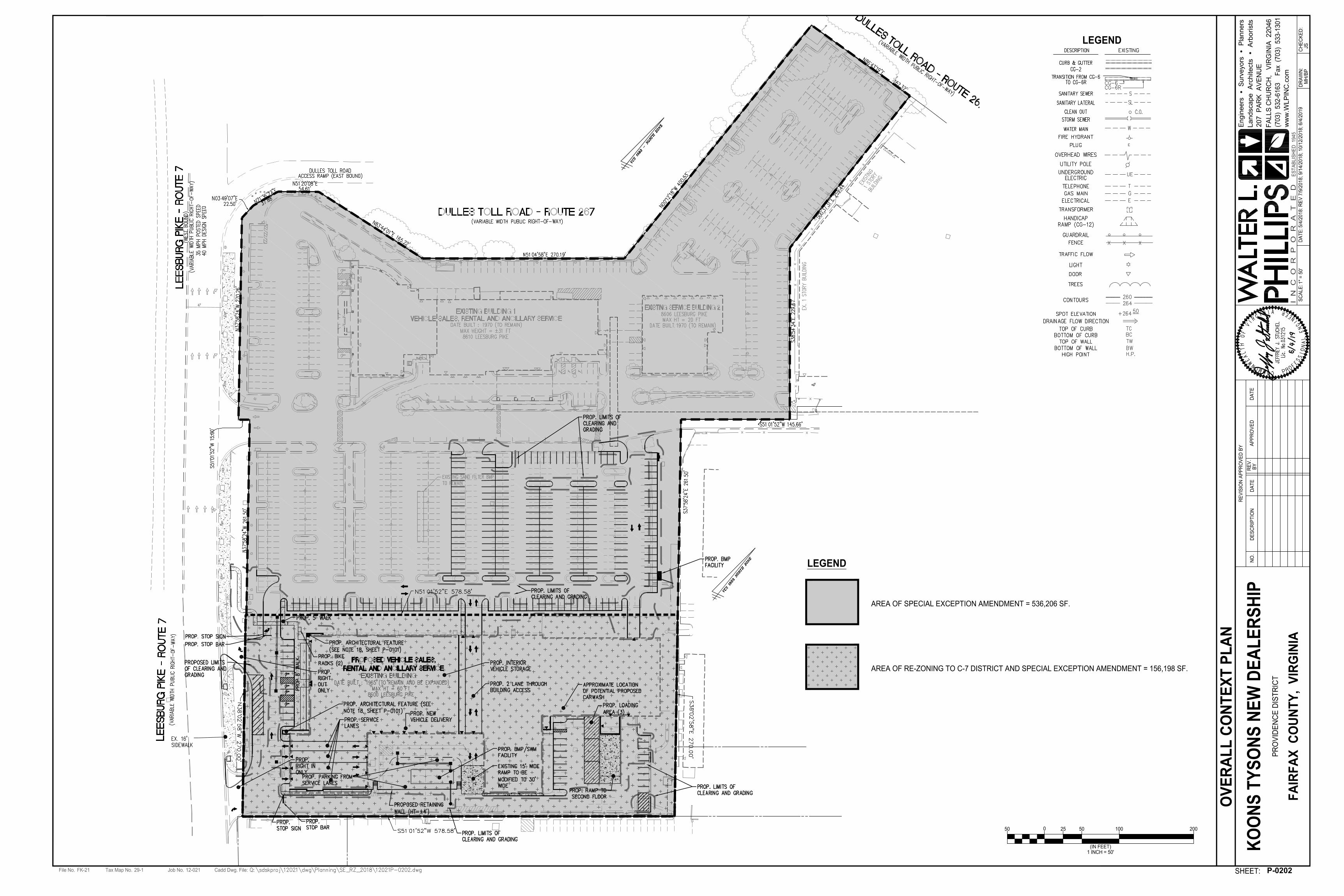
AREA OF SPECIAL EXCEPTION AMENDMENT = 536,206 SF.
AREA OF RE-ZONING TO C-7 DISTRICT AND SPECIAL EXCEPTION AMENDMENT = 156,198 SF.

Tax Map No.File No. Job No. Cadd Dwg. File:
SHEET:
AP
PR
OV
ED
RE
VIS
IO
N A
PP
RO
VE
D B
Y
RE
V.
BY
DA
TE
DA
TE
NO
.D
ES
CR
IP
TIO
N
SC
AL
E:
DA
TE
:D
RA
WN
:C
HE
CK
ED
:
29-1FK-21 12-021
5/4
/2
01
8: R
EV
7
/9
/2
01
8; 9
/1
4/2
01
8; 1
0/1
2/2
01
8; 6
/4
/2
01
9
MH
/B
PJS
KO
ON
S T
YS
ON
S N
EW
D
EA
LE
RS
HIP
PR
OV
ID
EN
CE
D
IS
TR
IC
T
FA
IR
FA
X C
OU
NT
Y, V
IR
GIN
IA
207
P
AR
K A
VE
NU
E
(703) 532-6163 F
ax (703) 533-1301
FA
LL
S C
HU
RC
H, V
IR
GIN
IA
2
20
46
ww
w.W
LP
IN
C.co
m
I N
C
O
R
P
O
R
A
T
E
D
Engineers S
urveyors P
lanners
Landscape A
rchitects A
rborists
ES
TA
BL
IS
HE
D 1
94
5
P-0301
GD
P - S
EA
- P
HA
SE
1
015 120603030
1 INCH = 30'
(IN FEET)
1" =
3
0'
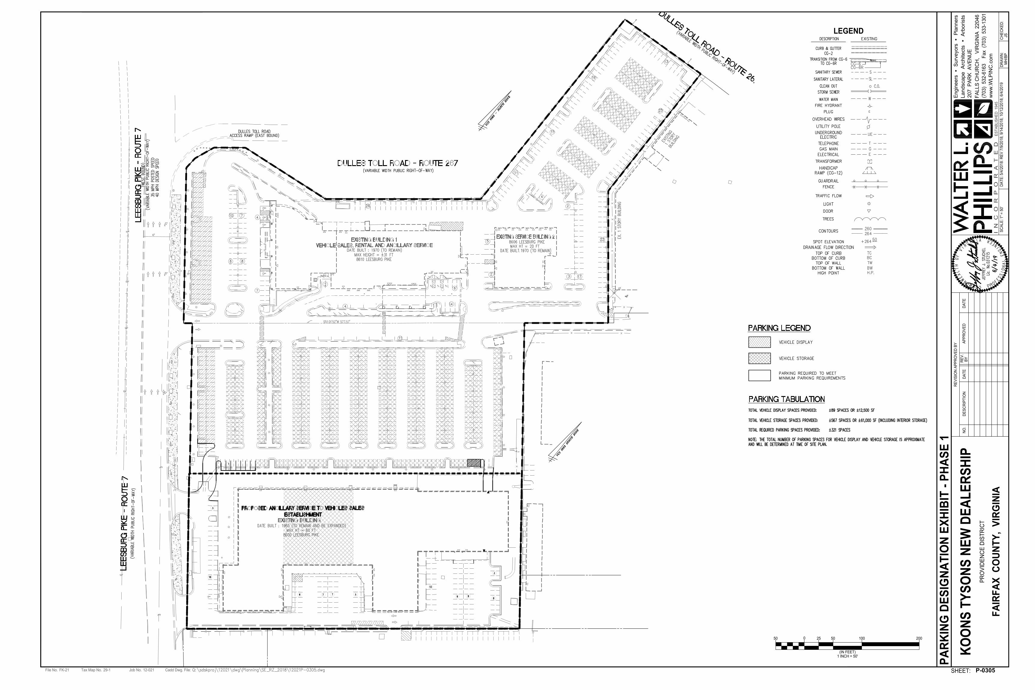
PARKING LEGEND

21
19
12
10
9
26
17 14 14 14 14 14
22
17
19
Tax Map No.File No. Job No. Cadd Dwg. File:
SHEET:
AP
PR
OV
ED
RE
VIS
IO
N A
PP
RO
VE
D B
Y
RE
V.
BY
DA
TE
DA
TE
NO
.D
ES
CR
IP
TIO
N
SC
AL
E:
DA
TE
:D
RA
WN
:C
HE
CK
ED
:
29-1FK-21 12-021
5/4
/2
01
8: R
EV
7
/9
/2
01
8; 9
/1
4/2
01
8; 1
0/1
2/2
01
8; 6
/4
/2
01
9
MH
/B
PJS
KO
ON
S T
YS
ON
S N
EW
D
EA
LE
RS
HIP
PR
OV
ID
EN
CE
D
IS
TR
IC
T
FA
IR
FA
X C
OU
NT
Y, V
IR
GIN
IA
207
P
AR
K A
VE
NU
E
(703) 532-6163 F
ax (703) 533-1301
FA
LL
S C
HU
RC
H, V
IR
GIN
IA
2
20
46
ww
w.W
LP
IN
C.co
m
I N
C
O
R
P
O
R
A
T
E
D
Engineers S
urveyors P
lanners
Landscape A
rchitects A
rborists
ES
TA
BL
IS
HE
D 1
94
5
P-0302
GD
P - S
EA
- P
HA
SE
2
015 120603030
1 INCH = 30'
(IN FEET)
1" =
3
0'
PARKING LEGEND
Tax Map No.File No. Job No. Cadd Dwg. File:
SHEET:
AP
PR
OV
ED
RE
VIS
IO
N A
PP
RO
VE
D B
Y
RE
V.
BY
DA
TE
DA
TE
NO
.D
ES
CR
IP
TIO
N
SC
AL
E:
DA
TE
:D
RA
WN
:C
HE
CK
ED
:
29-1FK-21 12-021
5/4
/2
01
8: R
EV
7
/9
/2
01
8; 9
/1
4/2
01
8; 1
0/1
2/2
01
8; 6
/4
/2
01
9
MH
/B
PJS
KO
ON
S T
YS
ON
S N
EW
D
EA
LE
RS
HIP
PR
OV
ID
EN
CE
D
IS
TR
IC
T
FA
IR
FA
X C
OU
NT
Y, V
IR
GIN
IA
207
P
AR
K A
VE
NU
E
(703) 532-6163 F
ax (703) 533-1301
FA
LL
S C
HU
RC
H, V
IR
GIN
IA
2
20
46
ww
w.W
LP
IN
C.co
m
I N
C
O
R
P
O
R
A
T
E
D
Engineers S
urveyors P
lanners
Landscape A
rchitects A
rborists
ES
TA
BL
IS
HE
D 1
94
5
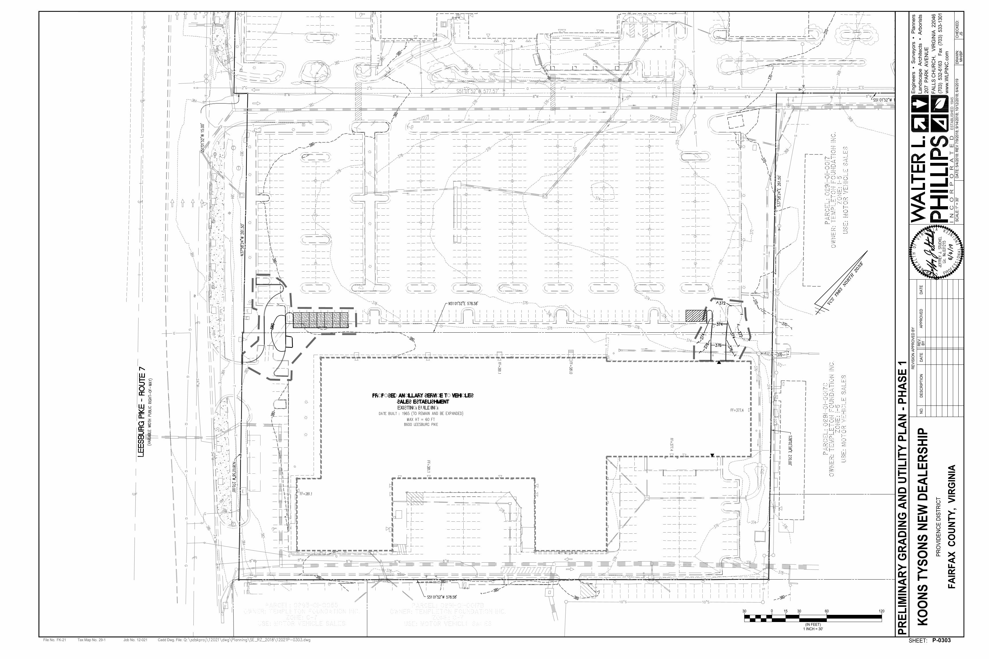
P-0303
PR
EL
IM
IN
AR
Y G
RA
DIN
G A
ND
U
TIL
IT
Y P
LA
N - P
HA
SE
1
015 120603030
1 INCH = 30'
(IN FEET)
1" =
3
0'

Tax Map No.File No. Job No. Cadd Dwg. File:
SHEET:
AP
PR
OV
ED
RE
VIS
IO
N A
PP
RO
VE
D B
Y
RE
V.
BY
DA
TE
DA
TE
NO
.D
ES
CR
IP
TIO
N
SC
AL
E:
DA
TE
:D
RA
WN
:C
HE
CK
ED
:
29-1FK-21 12-021
5/4
/2
01
8: R
EV
7
/9
/2
01
8; 9
/1
4/2
01
8; 1
0/1
2/2
01
8; 6
/4
/2
01
9
MH
/B
PJS
KO
ON
S T
YS
ON
S N
EW
D
EA
LE
RS
HIP
PR
OV
ID
EN
CE
D
IS
TR
IC
T
FA
IR
FA
X C
OU
NT
Y, V
IR
GIN
IA
207
P
AR
K A
VE
NU
E
(703) 532-6163 F
ax (703) 533-1301
FA
LL
S C
HU
RC
H, V
IR
GIN
IA
2
20
46
ww
w.W
LP
IN
C.co
m
I N
C
O
R
P
O
R
A
T
E
D
Engineers S
urveyors P
lanners
Landscape A
rchitects A
rborists
ES
TA
BL
IS
HE
D 1
94
5
P-0304
PR
EL
IM
IN
AR
Y G
RA
DIN
G A
ND
U
TIL
IT
Y P
LA
N - P
HA
SE
2
015 120603030
1 INCH = 30'
(IN FEET)
1" =
3
0'
Tax Map No.File No. Job No. Cadd Dwg. File:
SHEET:
AP
PR
OV
ED
RE
VIS
IO
N A
PP
RO
VE
D B
Y
RE
V.
BY
DA
TE
DA
TE
NO
.D
ES
CR
IP
TIO
N
SC
AL
E:
DA
TE
:D
RA
WN
:C
HE
CK
ED
:
29-1FK-21 12-021
5/4
/2
01
8: R
EV
7
/9
/2
01
8; 9
/1
4/2
01
8; 1
0/1
2/2
01
8; 6
/4
/2
01
9
MH
/B
PJS
KO
ON
S T
YS
ON
S N
EW
D
EA
LE
RS
HIP
PR
OV
ID
EN
CE
D
IS
TR
IC
T
FA
IR
FA
X C
OU
NT
Y, V
IR
GIN
IA
207
P
AR
K A
VE
NU
E
(703) 532-6163 F
ax (703) 533-1301
FA
LL
S C
HU
RC
H, V
IR
GIN
IA
2
20
46
ww
w.W
LP
IN
C.co
m
I N
C
O
R
P
O
R
A
T
E
D
Engineers S
urveyors P
lanners
Landscape A
rchitects A
rborists
ES
TA
BL
IS
HE
D 1
94
5
LEGEND
025 2001005050
1 INCH = 50'
(IN FEET)
1" =
5
0'
P-0305
PA
RK
IN
G D
ES
IG
NA
TIO
N E
XH
IB
IT
- P
HA
SE
1

21
19
12
10
9
26
17 14 14 14 14 14
22
17
19
Tax Map No.File No. Job No. Cadd Dwg. File:
SHEET:
AP
PR
OV
ED
RE
VIS
IO
N A
PP
RO
VE
D B
Y
RE
V.
BY
DA
TE
DA
TE
NO
.D
ES
CR
IP
TIO
N
SC
AL
E:
DA
TE
:D
RA
WN
:C
HE
CK
ED
:
29-1FK-21 12-021
5/4
/2
01
8: R
EV
7
/9
/2
01
8; 9
/1
4/2
01
8; 1
0/1
2/2
01
8; 6
/4
/2
01
9
MH
/B
PJS
KO
ON
S T
YS
ON
S N
EW
D
EA
LE
RS
HIP
PR
OV
ID
EN
CE
D
IS
TR
IC
T
FA
IR
FA
X C
OU
NT
Y, V
IR
GIN
IA
207
P
AR
K A
VE
NU
E
(703) 532-6163 F
ax (703) 533-1301
FA
LL
S C
HU
RC
H, V
IR
GIN
IA
2
20
46
ww
w.W
LP
IN
C.co
m
I N
C
O
R
P
O
R
A
T
E
D
Engineers S
urveyors P
lanners
Landscape A
rchitects A
rborists
ES
TA
BL
IS
HE
D 1
94
5
LEGEND
025 2001005050
1 INCH = 50'
(IN FEET)
1" =
5
0'
P-0306
PA
RK
IN
G D
ES
IG
NA
TIO
N E
XH
IB
IT
- P
HA
SE
2

Tax Map No.File No. Job No. Cadd Dwg. File:
SHEET:
AP
PR
OV
ED
RE
VIS
IO
N A
PP
RO
VE
D B
Y
RE
V.
BY
DA
TE
DA
TE
NO
.D
ES
CR
IP
TIO
N
SC
AL
E:
DA
TE
:D
RA
WN
:C
HE
CK
ED
:
29-1FK-21 12-021
5/4
/2
01
8: R
EV
7
/9
/2
01
8; 9
/1
4/2
01
8; 1
0/1
2/2
01
8; 6
/4
/2
01
9
MH
/B
PJS
KO
ON
S T
YS
ON
S N
EW
D
EA
LE
RS
HIP
PR
OV
ID
EN
CE
D
IS
TR
IC
T
FA
IR
FA
X C
OU
NT
Y, V
IR
GIN
IA
207
P
AR
K A
VE
NU
E
(703) 532-6163 F
ax (703) 533-1301
FA
LL
S C
HU
RC
H, V
IR
GIN
IA
2
20
46
ww
w.W
LP
IN
C.co
m
I N
C
O
R
P
O
R
A
T
E
D
Engineers S
urveyors P
lanners
Landscape A
rchitects A
rborists
ES
TA
BL
IS
HE
D 1
94
5
P-0401
CO
NC
EP
TU
AL
L
AN
DS
CA
PE
P
LA
N - P
HA
SE
1
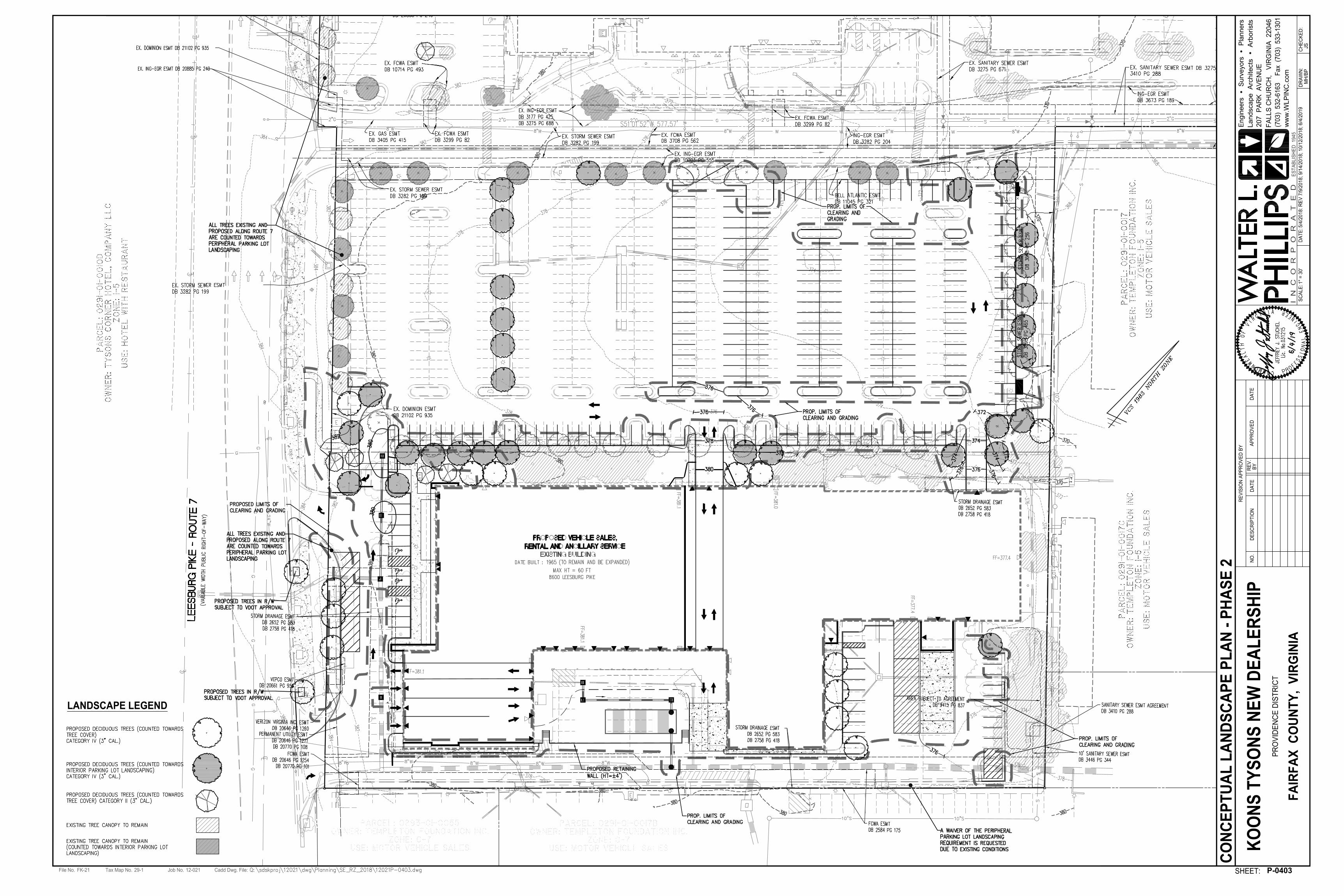
LANDSCAPE LEGEND
1" =
3
0'

Tax Map No.File No. Job No. Cadd Dwg. File:
SHEET:
AP
PR
OV
ED
RE
VIS
IO
N A
PP
RO
VE
D B
Y
RE
V.
BY
DA
TE
DA
TE
NO
.D
ES
CR
IP
TIO
N
SC
AL
E:
DA
TE
:D
RA
WN
:C
HE
CK
ED
:
29-1FK-21 12-021
5/4
/2
01
8: R
EV
7
/9
/2
01
8; 9
/1
4/2
01
8; 1
0/1
2/2
01
8; 6
/4
/2
01
9
MH
/B
PJS
KO
ON
S T
YS
ON
S N
EW
D
EA
LE
RS
HIP
PR
OV
ID
EN
CE
D
IS
TR
IC
T
FA
IR
FA
X C
OU
NT
Y, V
IR
GIN
IA
207
P
AR
K A
VE
NU
E
(703) 532-6163 F
ax (703) 533-1301
FA
LL
S C
HU
RC
H, V
IR
GIN
IA
2
20
46
ww
w.W
LP
IN
C.co
m
I N
C
O
R
P
O
R
A
T
E
D
Engineers S
urveyors P
lanners
Landscape A
rchitects A
rborists
ES
TA
BL
IS
HE
D 1
94
5
P-0402
LA
ND
SC
AP
E T
AB
UL
AT
IO
NS
- P
HA
SE
1
NO
NE
Tax Map No.File No. Job No. Cadd Dwg. File:
SHEET:
AP
PR
OV
ED
RE
VIS
IO
N A
PP
RO
VE
D B
Y
RE
V.
BY
DA
TE
DA
TE
NO
.D
ES
CR
IP
TIO
N
SC
AL
E:
DA
TE
:D
RA
WN
:C
HE
CK
ED
:
29-1FK-21 12-021
5/4
/2
01
8: R
EV
7
/9
/2
01
8; 9
/1
4/2
01
8; 1
0/1
2/2
01
8; 6
/4
/2
01
9
MH
/B
PJS
KO
ON
S T
YS
ON
S N
EW
D
EA
LE
RS
HIP
PR
OV
ID
EN
CE
D
IS
TR
IC
T
FA
IR
FA
X C
OU
NT
Y, V
IR
GIN
IA
207
P
AR
K A
VE
NU
E
(703) 532-6163 F
ax (703) 533-1301
FA
LL
S C
HU
RC
H, V
IR
GIN
IA
2
20
46
ww
w.W
LP
IN
C.co
m
I N
C
O
R
P
O
R
A
T
E
D
Engineers S
urveyors P
lanners
Landscape A
rchitects A
rborists
ES
TA
BL
IS
HE
D 1
94
5
P-0403
CO
NC
EP
TU
AL
L
AN
DS
CA
PE
P
LA
N - P
HA
SE
2
LANDSCAPE LEGEND
1" =
3
0'
Tax Map No.File No. Job No. Cadd Dwg. File:
SHEET:
AP
PR
OV
ED
RE
VIS
IO
N A
PP
RO
VE
D B
Y
RE
V.
BY
DA
TE
DA
TE
NO
.D
ES
CR
IP
TIO
N
SC
AL
E:
DA
TE
:D
RA
WN
:C
HE
CK
ED
:
29-1FK-21 12-021
5/4
/2
01
8: R
EV
7
/9
/2
01
8; 9
/1
4/2
01
8; 1
0/1
2/2
01
8; 6
/4
/2
01
9
MH
/B
PJS
KO
ON
S T
YS
ON
S N
EW
D
EA
LE
RS
HIP
PR
OV
ID
EN
CE
D
IS
TR
IC
T
FA
IR
FA
X C
OU
NT
Y, V
IR
GIN
IA
207
P
AR
K A
VE
NU
E
(703) 532-6163 F
ax (703) 533-1301
FA
LL
S C
HU
RC
H, V
IR
GIN
IA
2
20
46
ww
w.W
LP
IN
C.co
m
I N
C
O
R
P
O
R
A
T
E
D
Engineers S
urveyors P
lanners
Landscape A
rchitects A
rborists
ES
TA
BL
IS
HE
D 1
94
5
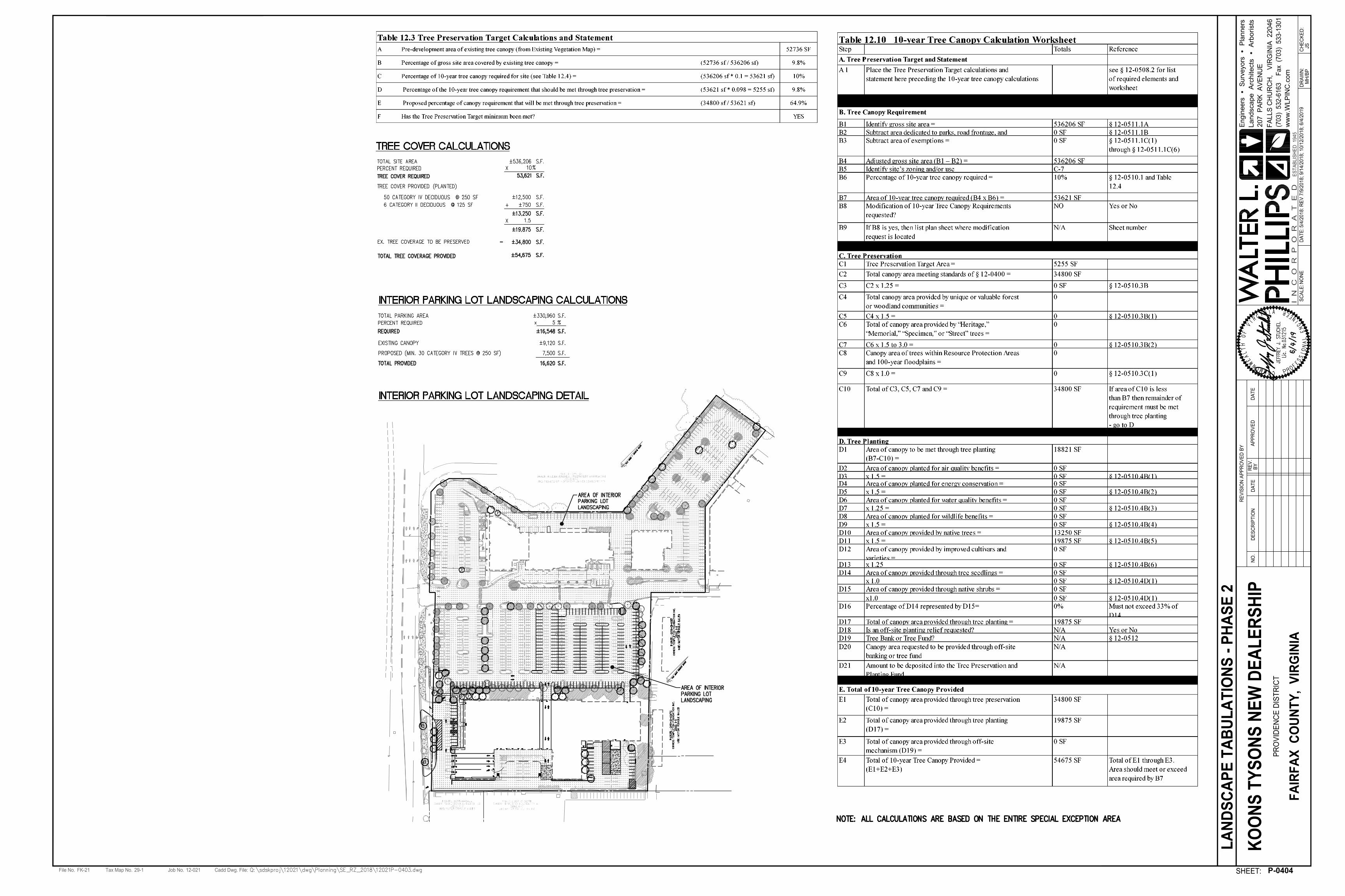
P-0404
LA
ND
SC
AP
E T
AB
UL
AT
IO
NS
- P
HA
SE
2
NO
NE
Tax Map No.File No. Job No. Cadd Dwg. File:
SHEET:
AP
PR
OV
ED
RE
VIS
IO
N A
PP
RO
VE
D B
Y
RE
V.
BY
DA
TE
DA
TE
NO
.D
ES
CR
IP
TIO
N
SC
AL
E:
DA
TE
:D
RA
WN
:C
HE
CK
ED
:
29-1FK-21 12-021
5/4
/2
01
8: R
EV
7
/9
/2
01
8; 9
/1
4/2
01
8; 1
0/1
2/2
01
8; 6
/4
/2
01
9
MH
/B
PJS
KO
ON
S T
YS
ON
S N
EW
D
EA
LE
RS
HIP
PR
OV
ID
EN
CE
D
IS
TR
IC
T
FA
IR
FA
X C
OU
NT
Y, V
IR
GIN
IA
207
P
AR
K A
VE
NU
E
(703) 532-6163 F
ax (703) 533-1301
FA
LL
S C
HU
RC
H, V
IR
GIN
IA
2
20
46
ww
w.W
LP
IN
C.co
m
I N
C
O
R
P
O
R
A
T
E
D
Engineers S
urveyors P
lanners
Landscape A
rchitects A
rborists
ES
TA
BL
IS
HE
D 1
94
5
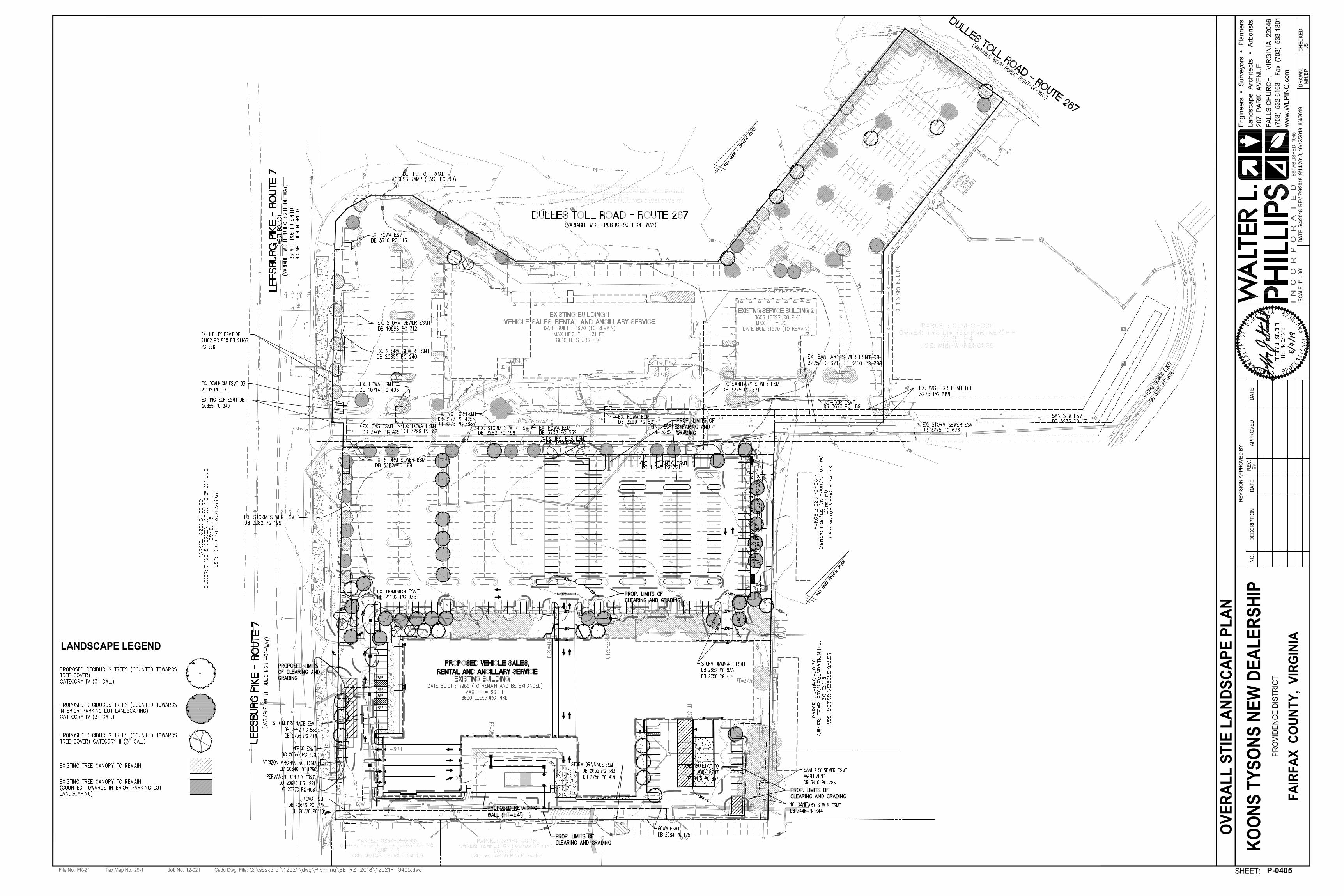
LANDSCAPE LEGEND
1" =
3
0'
P-0405
OV
ER
AL
L S
TIE
L
AN
DS
CA
PE
P
LA
N
Tax Map No.File No. Job No. Cadd Dwg. File:
SHEET:
AP
PR
OV
ED
RE
VIS
IO
N A
PP
RO
VE
D B
Y
RE
V.
BY
DA
TE
DA
TE
NO
.D
ES
CR
IP
TIO
N
SC
AL
E:
DA
TE
:D
RA
WN
:C
HE
CK
ED
:
29-1FK-21 12-021
5/4
/2
01
8: R
EV
7
/9
/2
01
8; 9
/1
4/2
01
8; 1
0/1
2/2
01
8; 6
/4
/2
01
9
MH
/B
PJS
KO
ON
S T
YS
ON
S N
EW
D
EA
LE
RS
HIP
PR
OV
ID
EN
CE
D
IS
TR
IC
T
FA
IR
FA
X C
OU
NT
Y, V
IR
GIN
IA
207
P
AR
K A
VE
NU
E
(703) 532-6163 F
ax (703) 533-1301
FA
LL
S C
HU
RC
H, V
IR
GIN
IA
2
20
46
ww
w.W
LP
IN
C.co
m
I N
C
O
R
P
O
R
A
T
E
D
Engineers S
urveyors P
lanners
Landscape A
rchitects A
rborists
ES
TA
BL
IS
HE
D 1
94
5
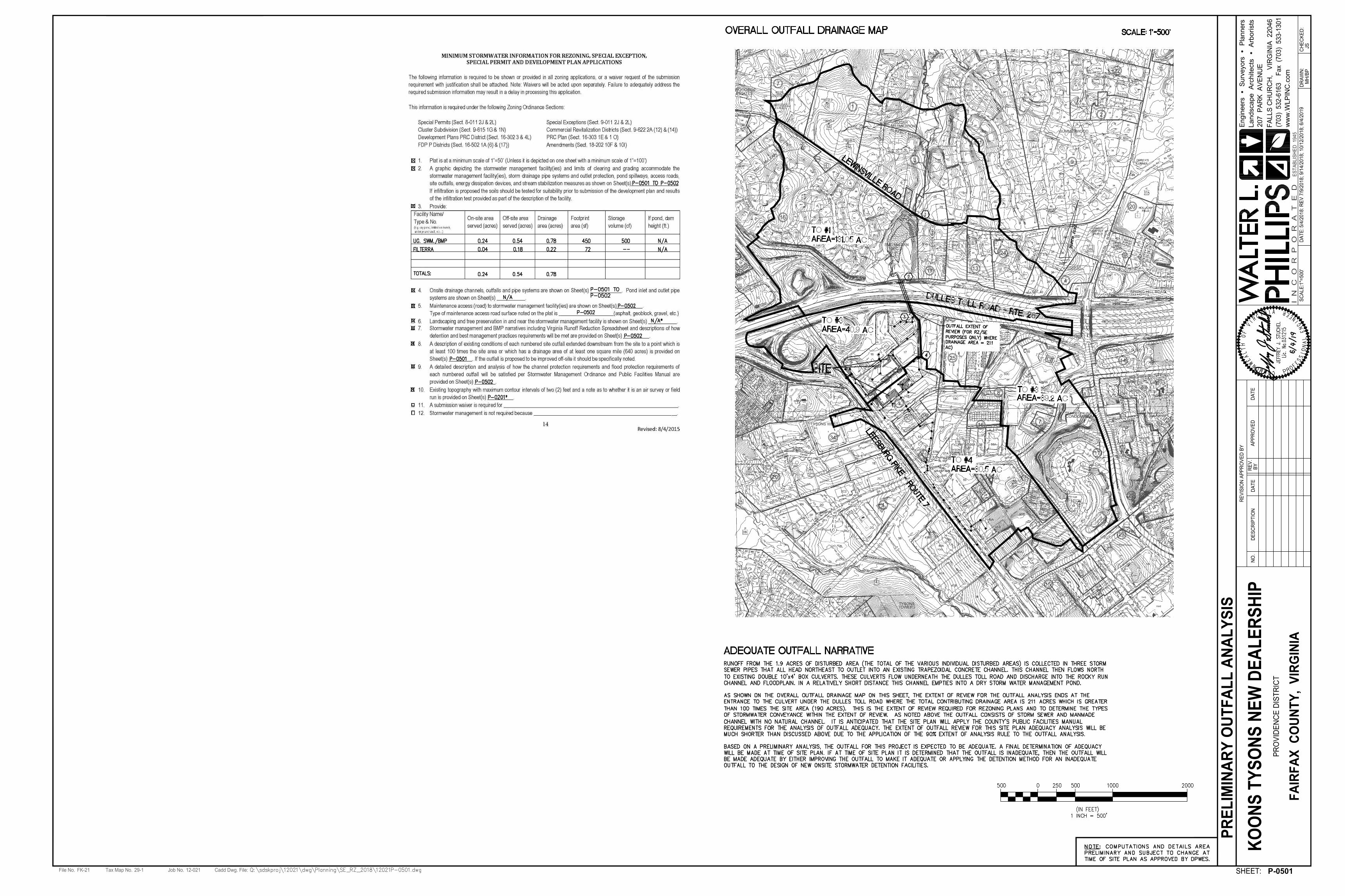
PR
EL
IM
IN
AR
Y O
UT
FA
LL
A
NA
LY
SIS
P-0501
1"=
50
0'
Tax Map No.File No. Job No. Cadd Dwg. File:
SHEET:
AP
PR
OV
ED
RE
VIS
IO
N A
PP
RO
VE
D B
Y
RE
V.
BY
DA
TE
DA
TE
NO
.D
ES
CR
IP
TIO
N
SC
AL
E:
DA
TE
:D
RA
WN
:C
HE
CK
ED
:
29-1FK-21 12-021
5/4
/2
01
8: R
EV
7
/9
/2
01
8; 9
/1
4/2
01
8; 1
0/1
2/2
01
8; 6
/4
/2
01
9
MH
/B
PJS
KO
ON
S T
YS
ON
S N
EW
D
EA
LE
RS
HIP
PR
OV
ID
EN
CE
D
IS
TR
IC
T
FA
IR
FA
X C
OU
NT
Y, V
IR
GIN
IA
207
P
AR
K A
VE
NU
E
(703) 532-6163 F
ax (703) 533-1301
FA
LL
S C
HU
RC
H, V
IR
GIN
IA
2
20
46
ww
w.W
LP
IN
C.co
m
I N
C
O
R
P
O
R
A
T
E
D
Engineers S
urveyors P
lanners
Landscape A
rchitects A
rborists
ES
TA
BL
IS
HE
D 1
94
5
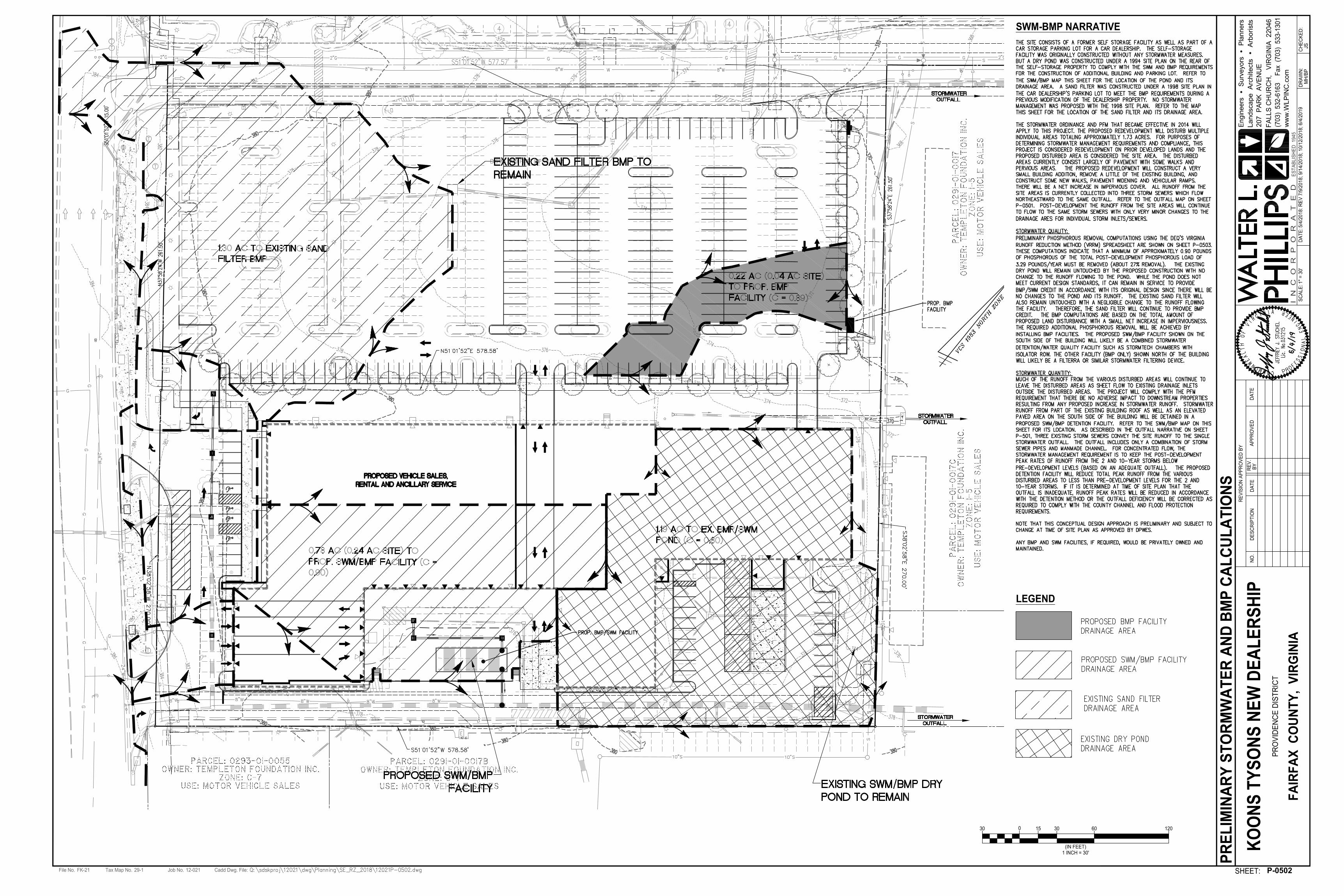
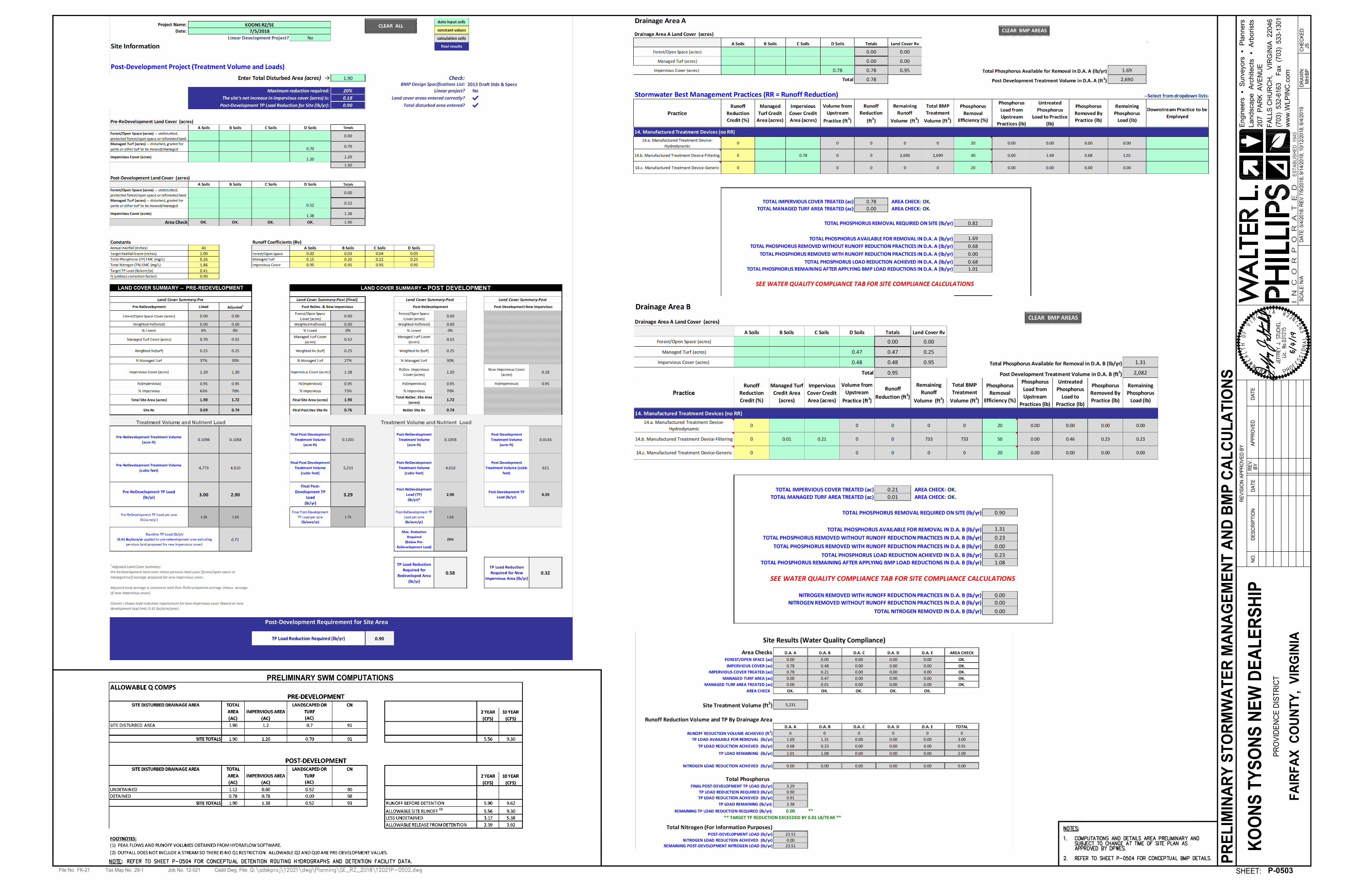
P-0502
PR
EL
IM
IN
AR
Y S
TO
RM
WA
TE
R A
ND
B
MP
C
AL
CU
LA
TIO
NS
SWM-BMP NARRATIVE
1" =
3
0'
015 120603030
1 INCH = 30'
(IN FEET)
LEGEND
P-0503
PR
EL
IM
IN
AR
Y S
TO
RM
WA
TE
R M
AN
AG
EM
EN
T A
ND
B
MP
C
AL
CU
LA
TIO
NS
Tax Map No.File No. Job No. Cadd Dwg. File:
SHEET:
AP
PR
OV
ED
RE
VIS
IO
N A
PP
RO
VE
D B
Y
RE
V.
BY
DA
TE
DA
TE
NO
.D
ES
CR
IP
TIO
N
SC
AL
E:
DA
TE
:D
RA
WN
:C
HE
CK
ED
:
29-1FK-21 12-021
5/4
/2
01
8: R
EV
7
/9
/2
01
8; 9
/1
4/2
01
8; 1
0/1
2/2
01
8; 6
/4
/2
01
9
MH
/B
PJS
KO
ON
S T
YS
ON
S N
EW
D
EA
LE
RS
HIP
PR
OV
ID
EN
CE
D
IS
TR
IC
T
FA
IR
FA
X C
OU
NT
Y, V
IR
GIN
IA
207
P
AR
K A
VE
NU
E
(703) 532-6163 F
ax (703) 533-1301
FA
LL
S C
HU
RC
H, V
IR
GIN
IA
2
20
46
ww
w.W
LP
IN
C.co
m
I N
C
O
R
P
O
R
A
T
E
D
Engineers S
urveyors P
lanners
Landscape A
rchitects A
rborists
ES
TA
BL
IS
HE
D 1
94
5
N/A
PRELIMINARY SWM COMPUTATIONS
Tax Map No.File No. Job No. Cadd Dwg. File:
SHEET:
AP
PR
OV
ED
RE
VIS
IO
N A
PP
RO
VE
D B
Y
RE
V.
BY
DA
TE
DA
TE
NO
.D
ES
CR
IP
TIO
N
SC
AL
E:
DA
TE
:D
RA
WN
:C
HE
CK
ED
:
29-1FK-21 12-021
5/4
/2
01
8: R
EV
7
/9
/2
01
8; 9
/1
4/2
01
8; 1
0/1
2/2
01
8; 6
/4
/2
01
9
MH
/B
PJS
KO
ON
S T
YS
ON
S N
EW
D
EA
LE
RS
HIP
PR
OV
ID
EN
CE
D
IS
TR
IC
T
FA
IR
FA
X C
OU
NT
Y, V
IR
GIN
IA
207
P
AR
K A
VE
NU
E
(703) 532-6163 F
ax (703) 533-1301
FA
LL
S C
HU
RC
H, V
IR
GIN
IA
2
20
46
ww
w.W
LP
IN
C.co
m
I N
C
O
R
P
O
R
A
T
E
D
Engineers S
urveyors P
lanners
Landscape A
rchitects A
rborists
ES
TA
BL
IS
HE
D 1
94
5
P-0504
PR
EL
IM
IN
AR
Y S
WM
-B
MP
C
OM
PU
TA
TIO
NS
A
ND
D
ET
AIL
S
N/A
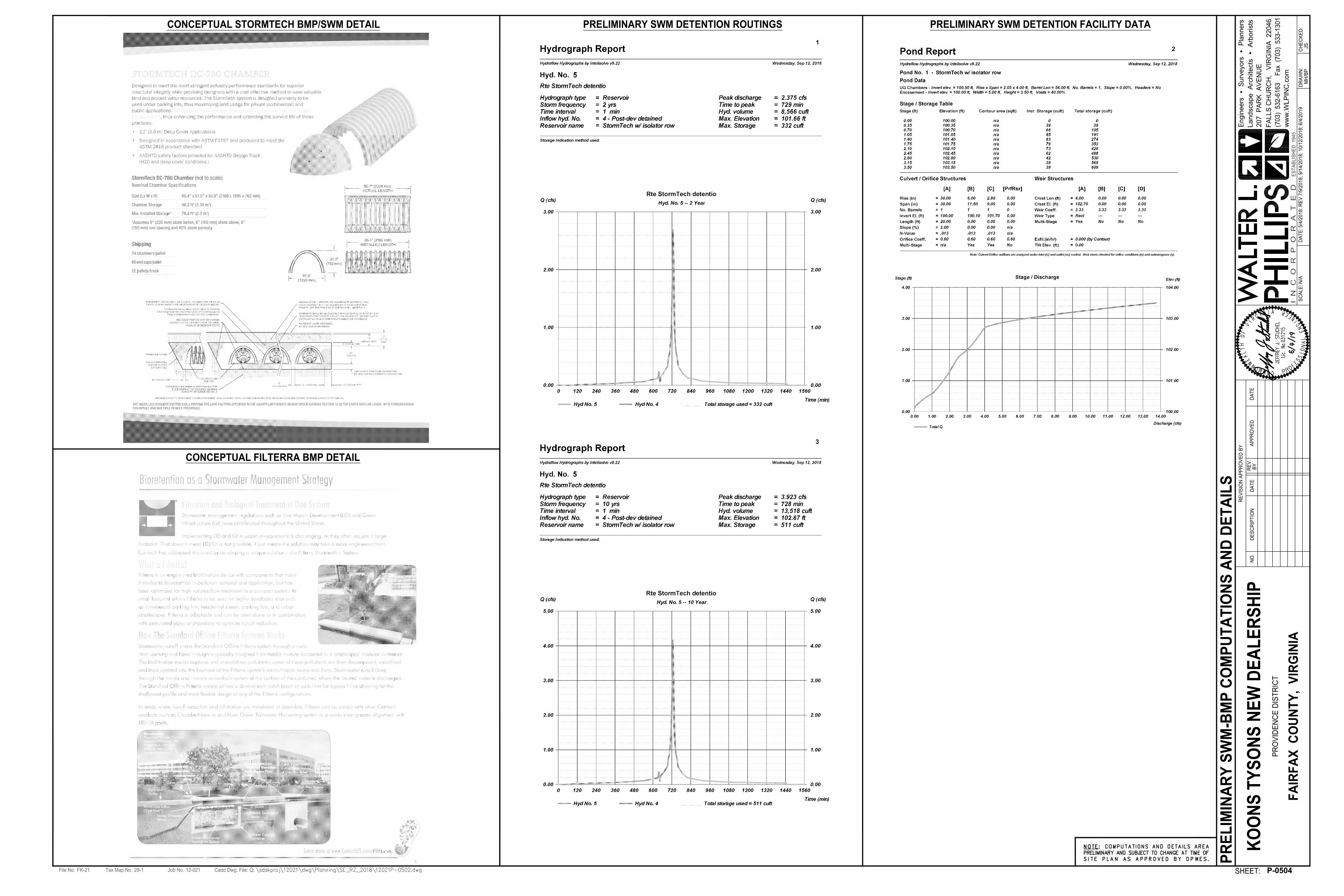
CONCEPTUAL STORMTECH BMP/SWM DETAIL
CONCEPTUAL FILTERRA BMP DETAIL
PRELIMINARY SWM DETENTION ROUTINGS PRELIMINARY SWM DETENTION FACILITY DATA
380
390
400
ON
LY
ON
LY
ON
LY
Tax Map No.File No. Job No. Cadd Dwg. File:
SHEET:
AP
PR
OV
ED
RE
VIS
IO
N A
PP
RO
VE
D B
Y
RE
V.
BY
DA
TE
DA
TE
NO
.D
ES
CR
IP
TIO
N
SC
AL
E:
DA
TE
:D
RA
WN
:C
HE
CK
ED
:
29-1FK-21 12-021
5/4
/2
01
8: R
EV
7
/9
/2
01
8; 9
/1
4/2
01
8; 1
0/1
2/2
01
8; 6
/4
/2
01
9
MH
/B
PJS
KO
ON
S T
YS
ON
S N
EW
D
EA
LE
RS
HIP
PR
OV
ID
EN
CE
D
IS
TR
IC
T
FA
IR
FA
X C
OU
NT
Y, V
IR
GIN
IA
207
P
AR
K A
VE
NU
E
(703) 532-6163 F
ax (703) 533-1301
FA
LL
S C
HU
RC
H, V
IR
GIN
IA
2
20
46
ww
w.W
LP
IN
C.co
m
I N
C
O
R
P
O
R
A
T
E
D
Engineers S
urveyors P
lanners
Landscape A
rchitects A
rborists
ES
TA
BL
IS
HE
D 1
94
5
HO
R. 1
" =
3
0'
VE
RT
. 1
" =
5
'
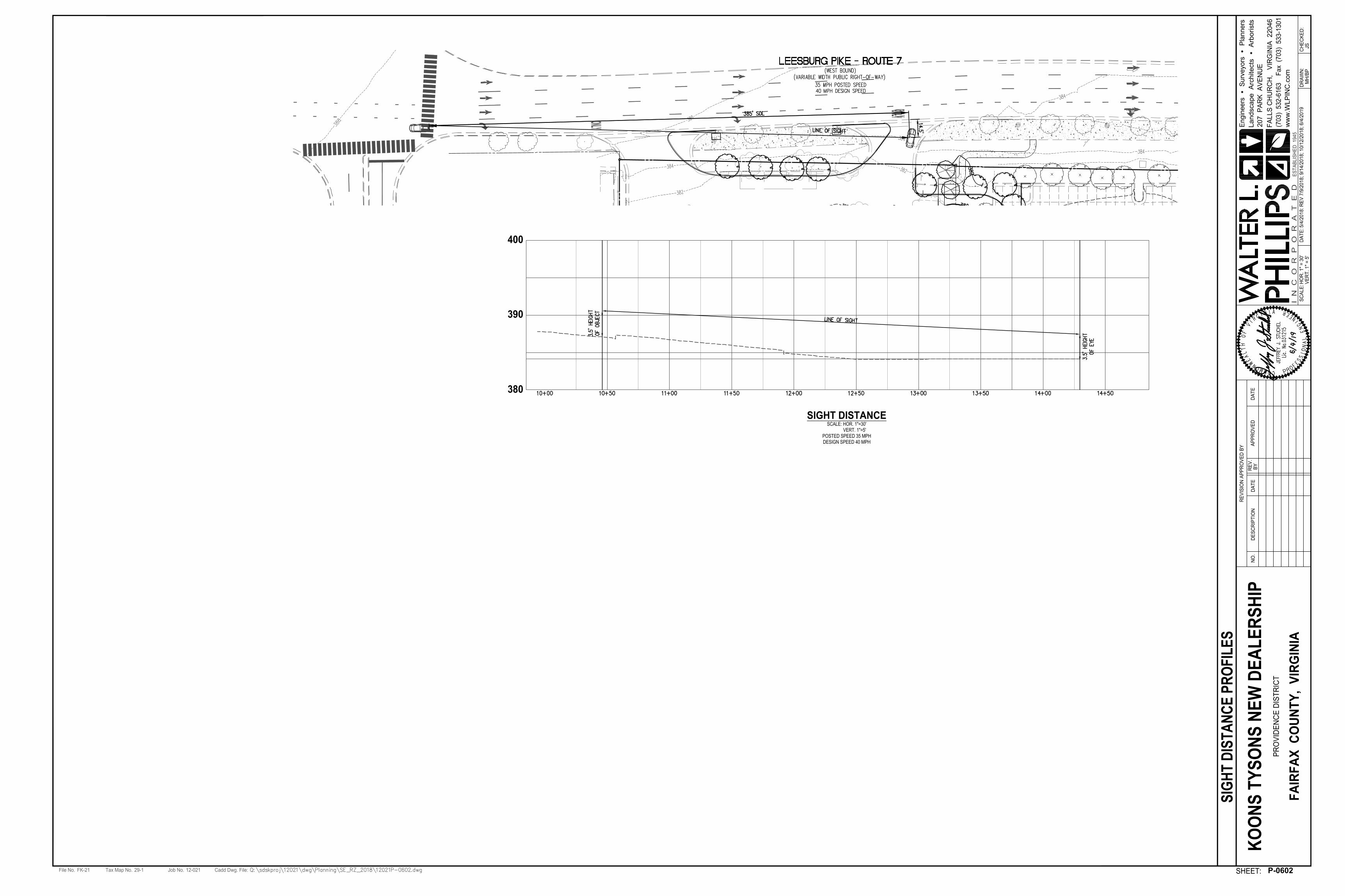
SIGHT DISTANCE
SCALE: HOR. 1"=30'
VERT. 1"=5'
POSTED SPEED 35 MPH
DESIGN SPEED 40 MPH
P-0602
SIG
HT
D
IS
TA
NC
E P
RO
FIL
ES
VEHICLE LEGEND
CAR CARRIER SU-30 PARTS DELIVERY
Tax Map No.File No. Job No. Cadd Dwg. File:
SHEET:
AP
PR
OV
ED
RE
VIS
IO
N A
PP
RO
VE
D B
Y
RE
V.
BY
DA
TE
DA
TE
NO
.D
ES
CR
IP
TIO
N
SC
AL
E:
DA
TE
:D
RA
WN
:C
HE
CK
ED
:
29-1FK-21 12-021
5/4
/2
01
8: R
EV
7
/9
/2
01
8; 9
/1
4/2
01
8; 1
0/1
2/2
01
8; 6
/4
/2
01
9
MH
/B
PJS
KO
ON
S T
YS
ON
S N
EW
D
EA
LE
RS
HIP
PR
OV
ID
EN
CE
D
IS
TR
IC
T
FA
IR
FA
X C
OU
NT
Y, V
IR
GIN
IA
207
P
AR
K A
VE
NU
E
(703) 532-6163 F
ax (703) 533-1301
FA
LL
S C
HU
RC
H, V
IR
GIN
IA
2
20
46
ww
w.W
LP
IN
C.co
m
I N
C
O
R
P
O
R
A
T
E
D
Engineers S
urveyors P
lanners
Landscape A
rchitects A
rborists
ES
TA
BL
IS
HE
D 1
94
5
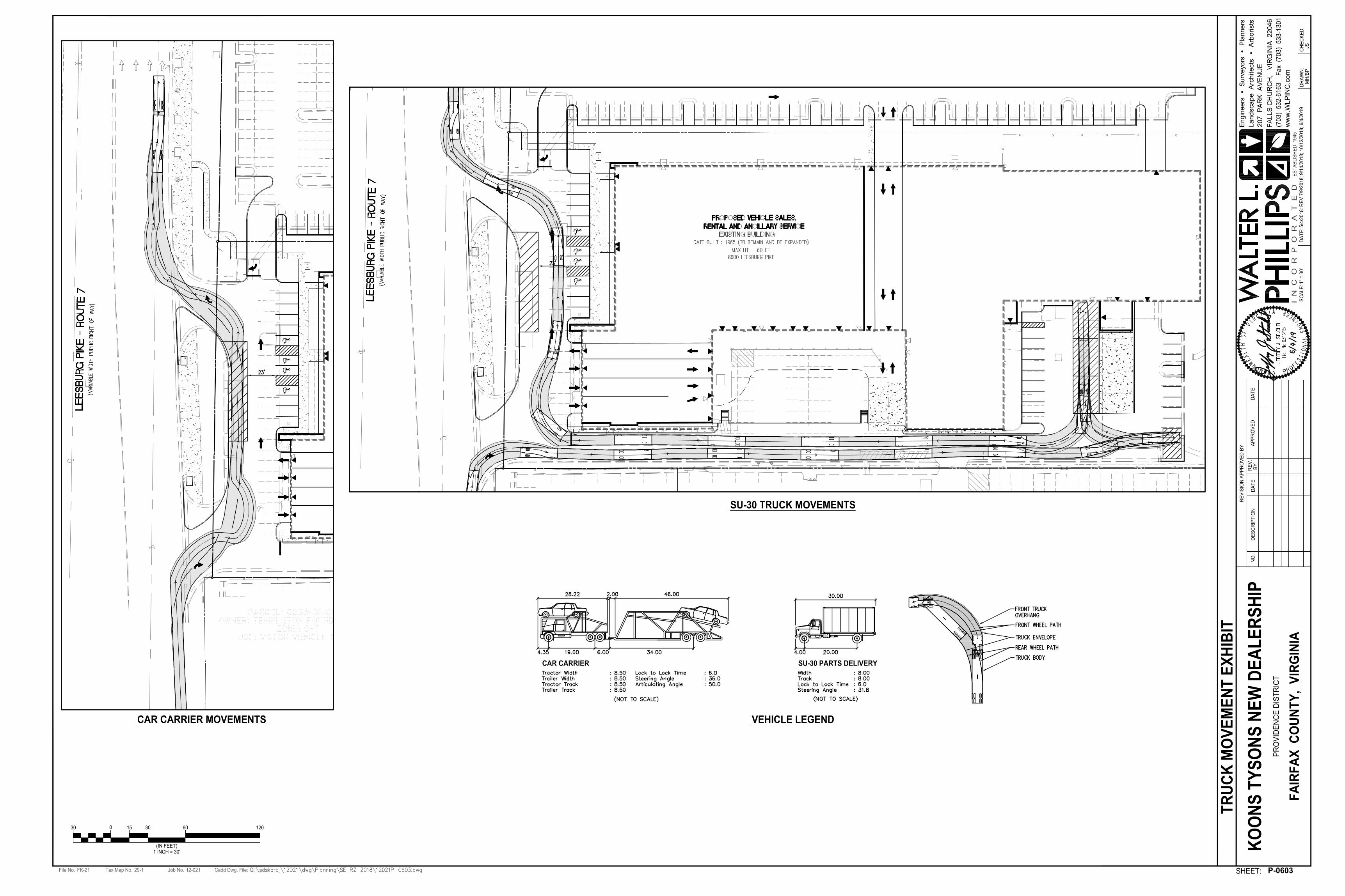
015 120603030
1 INCH = 30'
(IN FEET)
1" =
3
0'
P-0603
TR
UC
K M
OV
EM
EN
T E
XH
IB
IT
SU-30 TRUCK MOVEMENTS
CAR CARRIER MOVEMENTS VEHICLE LEGEND

8120 Woodmont Avenue | Suite 410 | Bethesda, Maryland 20814p.301.979.7600 | f.301.710.6384 | www.penneydesigngroup.com SCALE:
8600 Leesburg PikeVienna, VA 22182
---
Jim Koons Automotive Companies2000 Chain Bridge Road
Vienna, VA 22182 NTS24 x 36
P-060407/09/2018
Special Exception Ammendment Plat / Generalized Development Plan
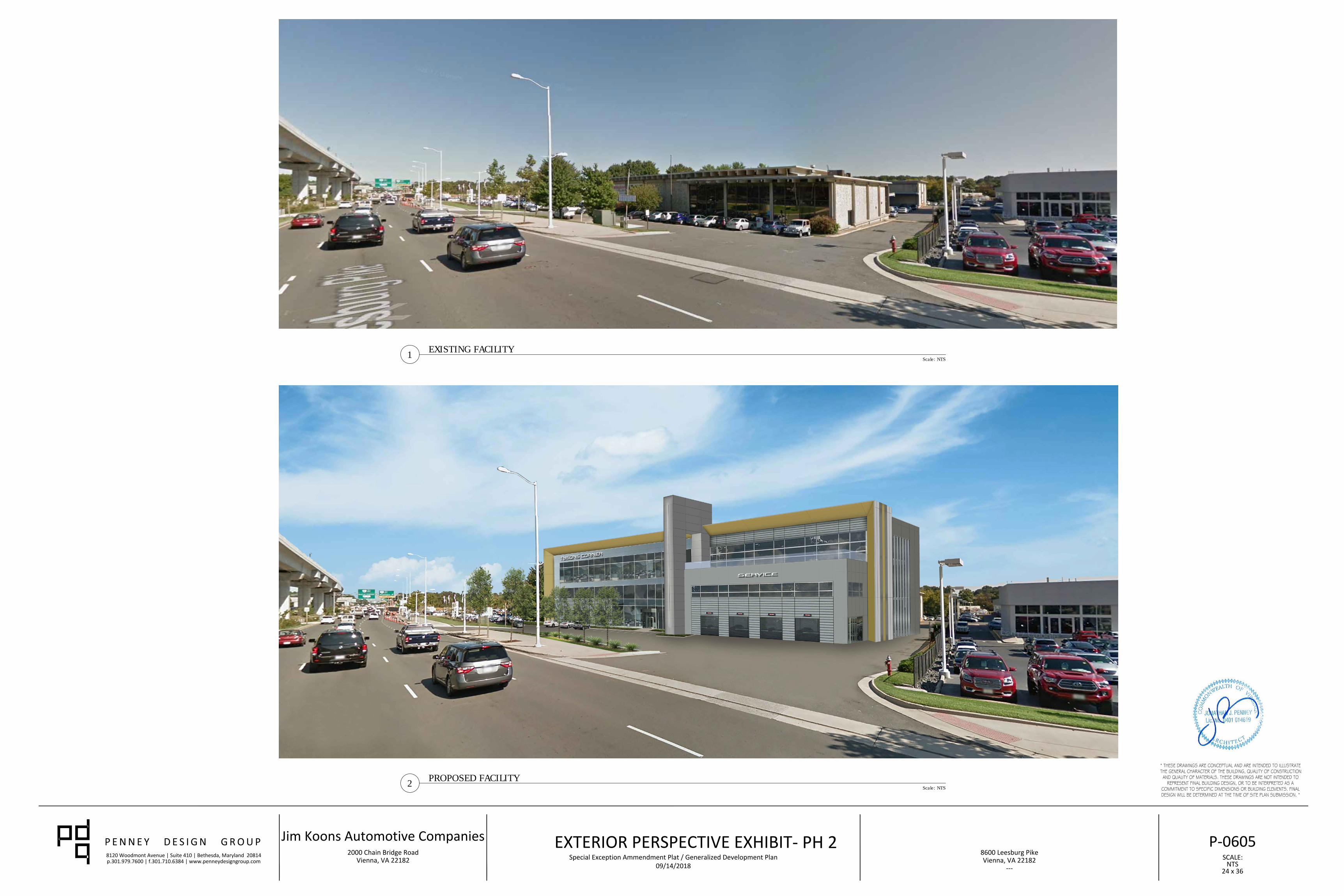
EXTERIOR PERSPECTIVE EXHIBIT09/14/2018
- PH 2
8120 Woodmont Avenue | Suite 410 | Bethesda, Maryland 20814p.301.979.7600 | f.301.710.6384 | www.penneydesigngroup.com SCALE:
8600 Leesburg PikeVienna, VA 22182
---
Jim Koons Automotive Companies2000 Chain Bridge Road
Vienna, VA 22182 NTS24 x 36
P-060507/09/2018
Special Exception Ammendment Plat / Generalized Development Plan
EXTERIOR PERSPECTIVE EXHIBIT
Scale: NTS
EXISTING FACILITY
1
Scale: NTS
PROPOSED FACILITY
2
09/14/2018
- PH 2
8120 Woodmont Avenue | Suite 410 | Bethesda, Maryland 20814p.301.979.7600 | f.301.710.6384 | www.penneydesigngroup.com SCALE:
8600 Leesburg PikeVienna, VA 22182
---
Jim Koons Automotive Companies2000 Chain Bridge Road
Vienna, VA 22182 1/16"=1'-0"24 x 36
P-060607/09/2018
Special Exception Ammendment Plat / Generalized Development Plan
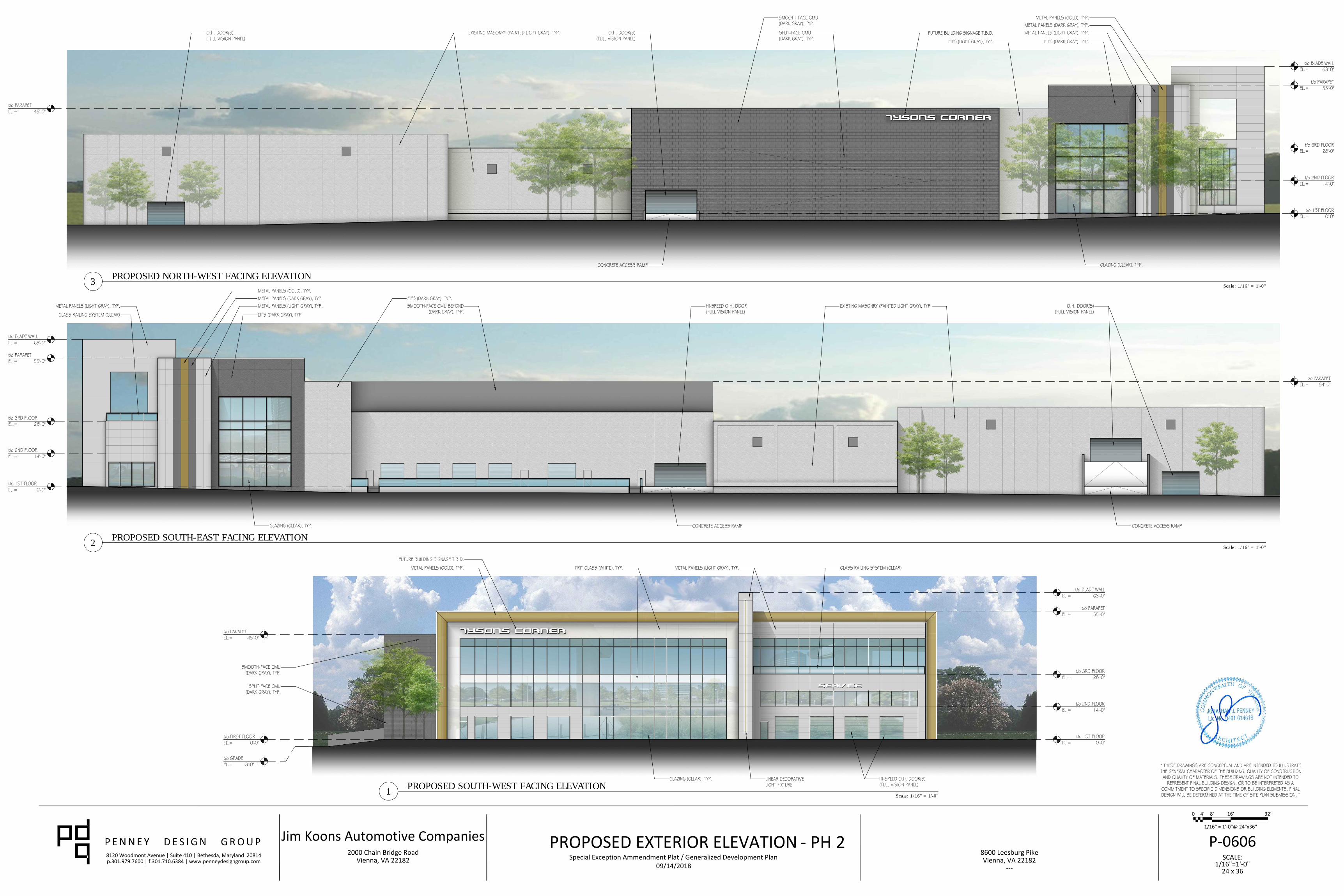
PROPOSED EXTERIOR ELEVATION
0 4' 8' 16' 32'
1/16" = 1'-0"@ 24"x36"
Scale: 1/16" = 1'-0"
PROPOSED SOUTH-WEST FACING ELEVATION
1
Scale: 1/16" = 1'-0"
PROPOSED SOUTH-EAST FACING ELEVATION
2
Scale: 1/16" = 1'-0"
PROPOSED NORTH-WEST FACING ELEVATION
3
09/14/2018
- PH 2
8120 Woodmont Avenue | Suite 410 | Bethesda, Maryland 20814p.301.979.7600 | f.301.710.6384 | www.penneydesigngroup.com SCALE:
8600 Leesburg PikeVienna, VA 22182
---
Jim Koons Automotive Companies2000 Chain Bridge Road
Vienna, VA 22182 1/16"=1'-0"24 x 36
09/14/2018Special Exception Ammendment Plat / Generalized Development Plan
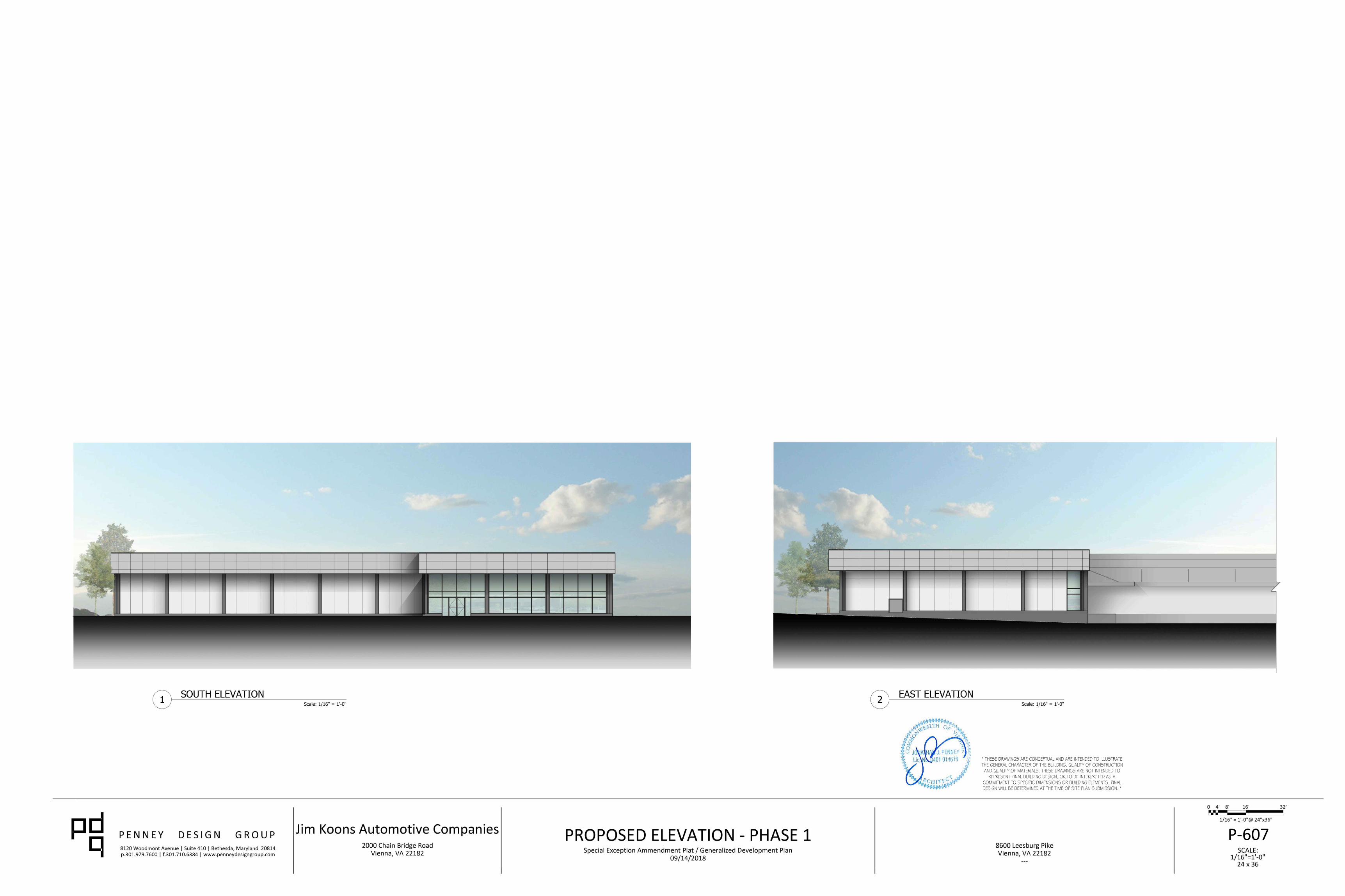
PROPOSED ELEVATION - PHASE 1
0 4' 8' 16' 32'
1/16" = 1'-0"@ 24"x36"
Scale: 1/16" = 1'-0"
SOUTH ELEVATION
1
Scale: 1/16" = 1'-0"
EAST ELEVATION
2
P-607
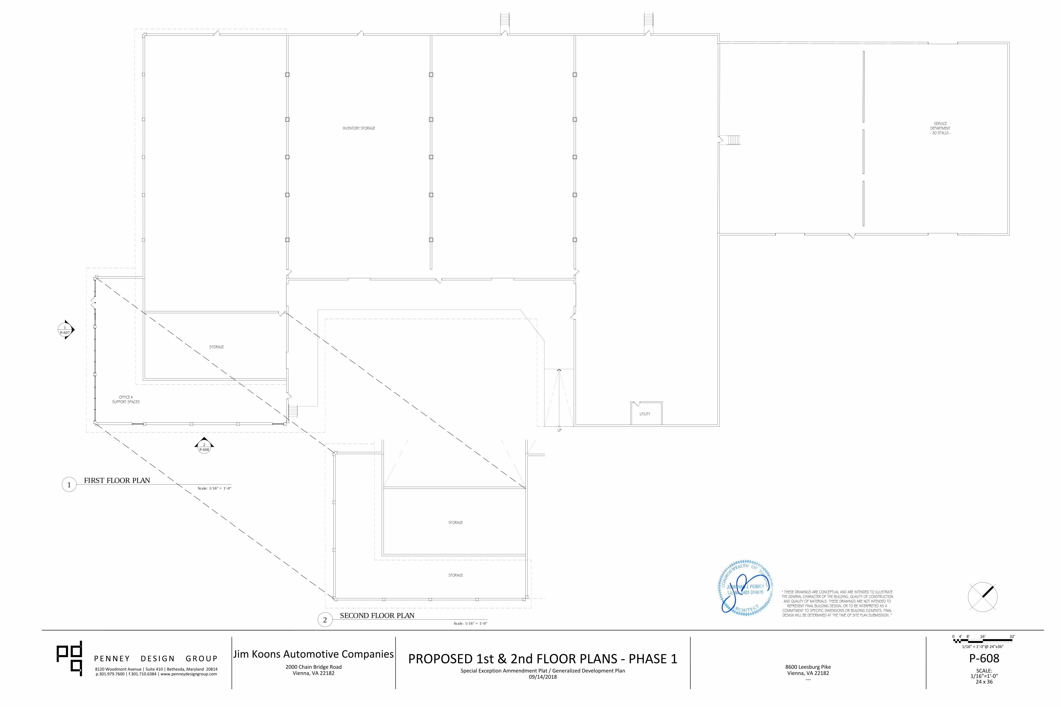
2
P-608
1
P-607
8120 Woodmont Avenue | Suite 410 | Bethesda, Maryland 20814p.301.979.7600 | f.301.710.6384 | www.penneydesigngroup.com SCALE:
8600 Leesburg PikeVienna, VA 22182
---
Jim Koons Automotive Companies2000 Chain Bridge Road
Vienna, VA 22182 1/16"=1'-0"24 x 36
P-60809/14/2018
Special Exception Ammendment Plat / Generalized Development Plan
PROPOSED 1st & 2nd FLOOR PLANS - PHASE 1
0 4' 8' 16' 32'
1/16" = 1'-0"@ 24"x36"
Scale: 1/16" = 1'-0"
SECOND FLOOR PLAN
2
Scale: 1/16" = 1'-0"
FIRST FLOOR PLAN
1
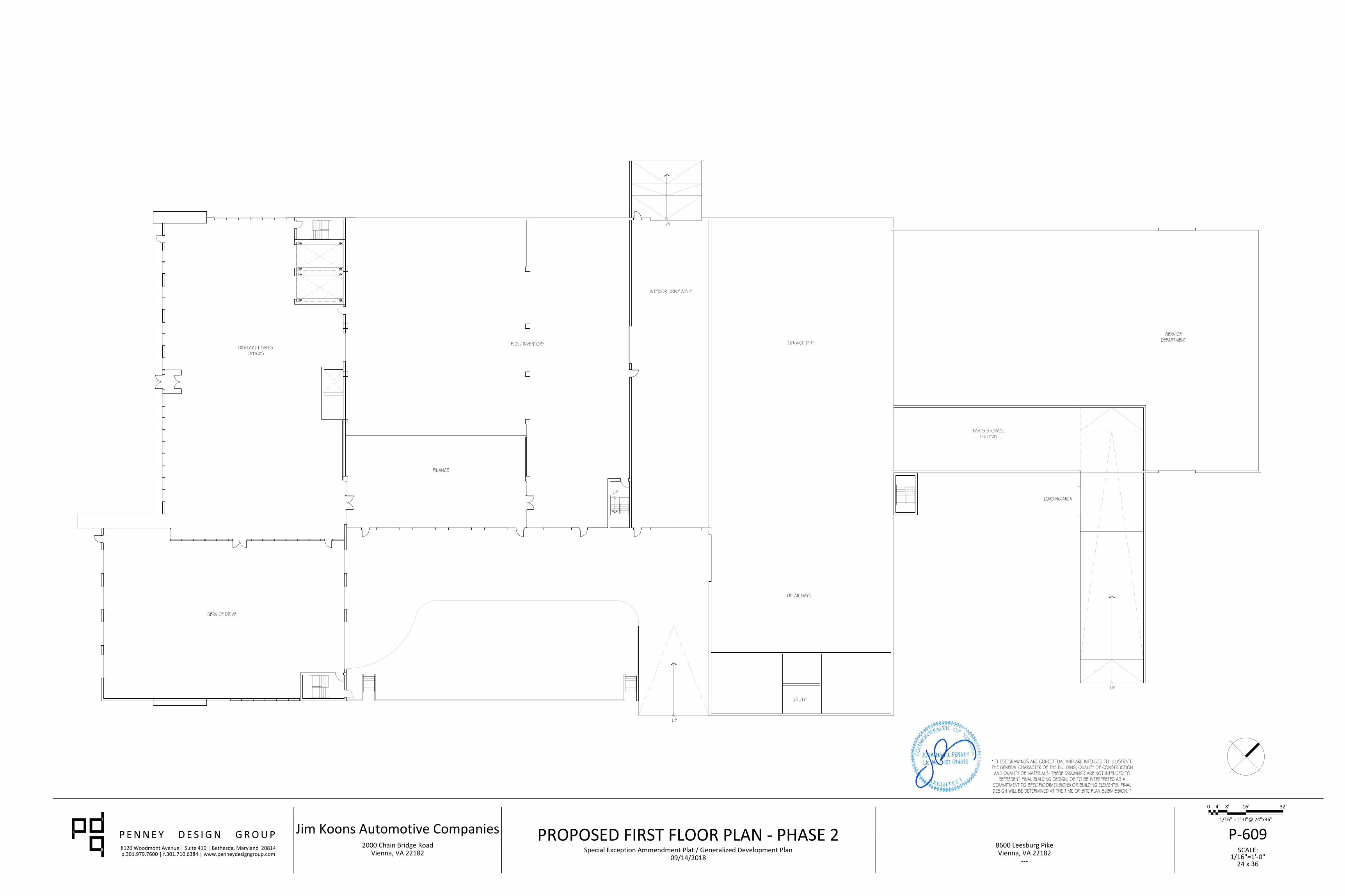
8120 Woodmont Avenue | Suite 410 | Bethesda, Maryland 20814p.301.979.7600 | f.301.710.6384 | www.penneydesigngroup.com SCALE:
8600 Leesburg PikeVienna, VA 22182
---
Jim Koons Automotive Companies2000 Chain Bridge Road
Vienna, VA 22182 1/16"=1'-0"24 x 36
P-60909/14/2018
Special Exception Ammendment Plat / Generalized Development Plan
PROPOSED FIRST FLOOR PLAN - PHASE 2
0 4' 8' 16' 32'
1/16" = 1'-0"@ 24"x36"
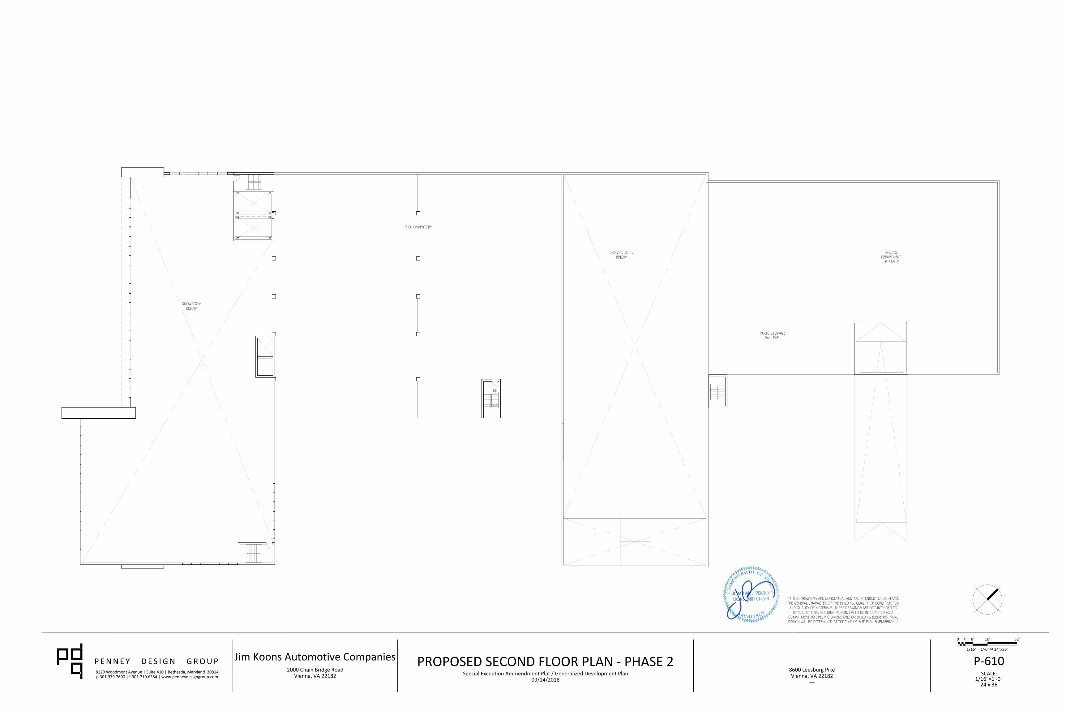
8120 Woodmont Avenue | Suite 410 | Bethesda, Maryland 20814p.301.979.7600 | f.301.710.6384 | www.penneydesigngroup.com SCALE:
8600 Leesburg PikeVienna, VA 22182
---
Jim Koons Automotive Companies2000 Chain Bridge Road
Vienna, VA 22182 1/16"=1'-0"24 x 36
P-61009/14/2018
Special Exception Ammendment Plat / Generalized Development Plan
PROPOSED SECOND FLOOR PLAN - PHASE 2
0 4' 8' 16' 32'
1/16" = 1'-0"@ 24"x36"
8120 Woodmont Avenue | Suite 410 | Bethesda, Maryland 20814p.301.979.7600 | f.301.710.6384 | www.penneydesigngroup.com SCALE:
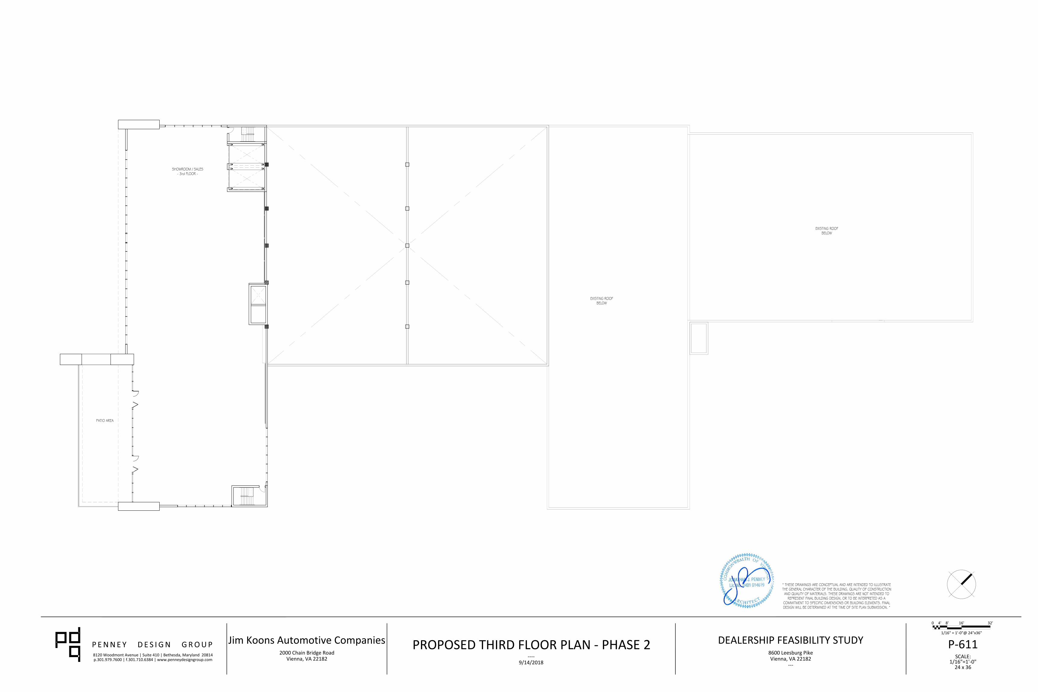
DEALERSHIP FEASIBILITY STUDY8600 Leesburg PikeVienna, VA 22182
---
Jim Koons Automotive Companies2000 Chain Bridge Road
Vienna, VA 22182 1/16"=1'-0"24 x 36
P-6119/14/2018
----
PROPOSED THIRD FLOOR PLAN
0 4' 8' 16' 32'
1/16" = 1'-0"@ 24"x36"
- PHASE 2
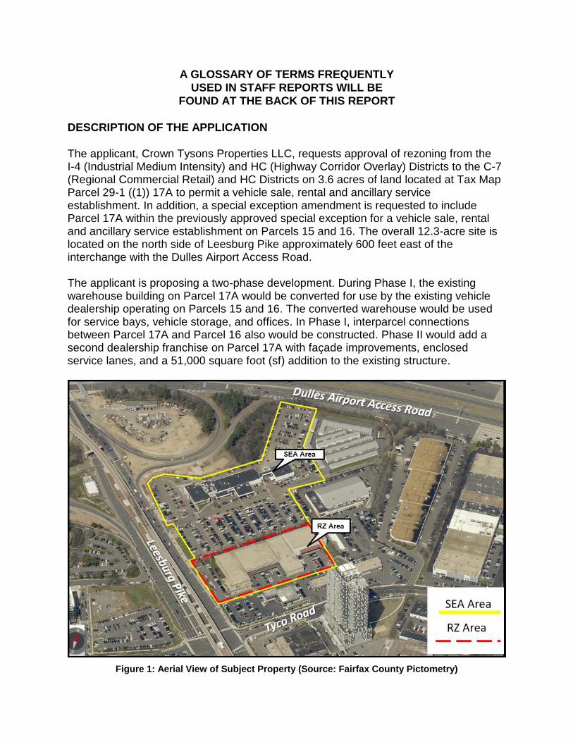
A GLOSSARY OF TERMS FREQUENTLY
USED IN STAFF REPORTS WILL BE
FOUND AT THE BACK OF THIS REPORT
DESCRIPTION OF THE APPLICATION
The applicant, Crown Tysons Properties LLC, requests approval of rezoning from the I-4 (Industrial Medium Intensity) and HC (Highway Corridor Overlay) Districts to the C-7 (Regional Commercial Retail) and HC Districts on 3.6 acres of land located at Tax Map Parcel 29-1 ((1)) 17A to permit a vehicle sale, rental and ancillary service establishment. In addition, a special exception amendment is requested to include Parcel 17A within the previously approved special exception for a vehicle sale, rental and ancillary service establishment on Parcels 15 and 16. The overall 12.3-acre site is located on the north side of Leesburg Pike approximately 600 feet east of the interchange with the Dulles Airport Access Road. The applicant is proposing a two-phase development. During Phase I, the existing warehouse building on Parcel 17A would be converted for use by the existing vehicle dealership operating on Parcels 15 and 16. The converted warehouse would be used for service bays, vehicle storage, and offices. In Phase I, interparcel connections between Parcel 17A and Parcel 16 also would be constructed. Phase II would add a second dealership franchise on Parcel 17A with façade improvements, enclosed service lanes, and a 51,000 square foot (sf) addition to the existing structure.
Figure 1: Aerial View of Subject Property (Source: Fairfax County Pictometry)
RZ 2018-PR-011 / SEA 78-D-075-03 Page 2 Operationally, the dealership will maintain the existing approved hours of Monday through Friday 7:00 a.m. to 11:00 p.m., Saturday 8:00 a.m. to 9:00 p.m., and Sunday 9:00 a.m. to 9:00 p.m. during both phases. Under the current special exception, the number of employees is 85 on site at any one time. During Phase I, the number of employees will remain unchanged. With the addition of the second dealership franchise during Phase II, the total number of employees for both dealerships will increase to 185 employees at one time.
WAIVERS AND MODIFICATIONS REQUESTED:
• A modification to the Comprehensive Plan trail requirement along Leesburg Pike in favor of the existing 16-foot wide concrete trail.
• A modification of the peripheral parking lot landscaping requirements to that shown on the GDP/SEA Plat.
• A modification of transitional screening requirements and a waiver of the barrier requirement along the northeastern property line to that shown on the GDP/SEA Plat.
• A waiver of the peripheral parking lot landscaping along the southern property line.
• A modification of the total minimum loading requirement for both dealerships during Phase II from 7 spaces required to 6 spaces as shown on the GDP/SEA Plat.
LOCATION AND CHARACTER
Site Description:
The overall 12.3-acre site, consisting of Parcels 29-1 ((1)) 15, 16 (zoned C-7) and 17A (currently zoned I-4), is located at 8602, 8610 and 8600 Leesburg Pike in Tysons. The existing vehicle dealership, located on Parcels 15 and 16, is developed with two buildings totaling 58,000 sf. The western building (labeled existing Building 1) includes showroom space, offices, enclosed drive-up service lanes, and service bays. The second, eastern building (labeled existing Building 2) is developed only with service bays. Parcels 15 and 16 are primarily paved with asphalt for customer parking and used for new vehicle display and storage of vehicles. Parcels 15 and 16 are accessed via Industrial Way, a private street, that straddles the property line between Parcels 15 and 16. Industrial Way is subject to a public ingress/egress easement and is the sole access to Tysons Self Storage (Parcel 11). Parcel 17A, located south of Parcel 15 and 16, is developed with a one-story, 73,000 sf. warehouse building which is currently used for new vehicle storage. The building
RZ 2018-PR-011 / SEA 78-D-075-03 Page 3 features a small asphalt parking area, covered loading docks and a small stormwater pond. Parcel 17 has two entrances along Leesburg Pike. A summary of the surrounding land use, zoning, and Comprehensive Plan recommendations is provided in the following table:
Table 1: Surrounding Conditions
Zoning Existing Use Plan Recommendation
North: ROW Right-of-way Road
East: I-5 Vehicle Sales Establishment Transit Station Mixed Use
South: C-7 Vehicle Sales Establishment Transit Station Mixed Use
West PTC Mixed-use (Tysons West) Transit Station and Residential Mixed Use
BACKGROUND
Parcel 16 was originally developed with two separate vehicle sales and service establishments in 1973. With the adoption of the 1978 Zoning Ordinance, this use became a special exception use. Subsequently, pursuant to SE 78-D-075 approved in 1978, the use was expanded to include Parcel 29-1 ((1)) 15. On July 27, 1998, the Board of Supervisors (BOS) approved SEA 78-D-075 on Parcels 29-1 ((1)) 15 and 16 for vehicle sales, rental and ancillary service establishments to permit an increase in land area, building additions, and site modifications. On June 14, 2014, the BOS approved SEA 78-D-075-2 to permit site modifications, modifications to the development conditions and building additions totaling approximately 10,340 square feet (sf).
The warehouse on Parcel 17A was constructed in 1965. The applicant recently acquired the site and is using the existing warehouse structure for an office and new vehicle storage. In 2004, Ourisman Bethesda, Inc. filed two concurrent applications, RZ 2003-PR-054 and SE 2003-PR-030, to permit a two-phased commercial development, including a vehicle sales, rental and ancillary service establishment in Phase I and an office component in Phase II. The case was indefinitely deferred and ultimately dismissed.
RZ 2018-PR-011 / SEA 78-D-075-03 Page 4
COMPREHENSIVE PLAN PROVISIONS
Plan Area: Area II
Planning District: Tysons Corner Urban Center,
Planning Sector: M1 – Tysons
Plan Map: Retail and Other
Plan Text:
TYSONS WEST
Tysons West is a gateway to Tysons from Leesburg Pike (Route 7) and the Dulles Airport Access Road and Dulles Toll Road (DAAR, Route 267). This area of industrial uses, car dealerships and offices is envisioned to transform into a new transit-oriented, mixed use destination with special emphasis as an arts and entertainment center.
NORTH SUBDISTRICT
The North Subdistrict is comprised of about 125 acres and is bounded by the DAAR on the north, Leesburg Pike on the southwest, and the Tysons Central 7 and North Central Districts on the southeast.
Base Plan
Auto sales and retail uses are the predominant land uses along Leesburg Pike, along with one high-rise office building. This area is developed and planned for auto sales and retail uses, as well as portions developed and planned for office use with support retail and service uses at existing intensities between 0.7 FAR and 1.3 FAR. In the area away from Leesburg Pike, industrial and industrial flex uses are the predominant land uses. On the eastern end of Tyco Road, there is an electrical substation and a three building office complex. On Spring Hill Road, there is a fire station, post office and two office buildings. This area is planned for low intensity industrial and industrial flex uses and office use with support retail and service uses at existing intensities between 0.5 FAR and 0.7 FAR…
Policy Plan Guidance: Guidelines for Interim Improvement of Commercial Establishments In some areas of the county, the Comprehensive Plan envisions a substantial change in land use that is expected to come about in connection with eventual redevelopment. In
RZ 2018-PR-011 / SEA 78-D-075-03 Page 5 such areas, it may be immediately beneficial and further the overall principles of the Plan to allow changes in existing uses that do not strictly conform with the long-term recommendations of the Comprehensive Plan. Such changes in use may be allowed, on a case-by-case basis, if:
1. They result in significant public benefits, for example, improvements in circulation or access, parking, landscaping, site design or building design; 2. Those public benefits outweigh any adverse effects of the change in use; and 3. Allowing the change in use will not delay or interfere with the achievement of the long-range objectives of the Comprehensive Plan.
DESCRIPTION OF THE GENERAL DEVELOPMENT PLAN (GDP) / SPECIAL
EXCEPTION AMENDMENT PLAT (SEA PLAT) General Development Plan/Special Exception Amendment Plat
Title of GDP/SEA Plat: Koons Tysons New Dealership
Prepared by: Walter L. Philips Inc.
Original and Revision Dates: May 4, 2018, as revised through June 4, 2019
Proposed Site Layout: As noted earlier in this report, the applicant proposes a two-phase development on Parcel 17A. Each phase is described below. Phase I There are no building or major layout changes proposed for the existing dealership located on Parcels 15 and 16. With Phase I, there are two interparcel access connections proposed to link the existing dealership to Parcel 17A, including one on the eastern side adjacent to Leesburg Pike and one on the western side adjacent to the property line. Additionally, the applicant is proposing one loading space to be located adjacent to the proposed interparcel access located on the adjacent to the eastern interparcel access. Phase I proposes no other major site or layout changes to Parcel 17A. Phase I does include façade improvements and interior renovations to the existing warehouse building on Parcel 17A for the proposed dealership functions including offices, service bays and new vehicle storage.
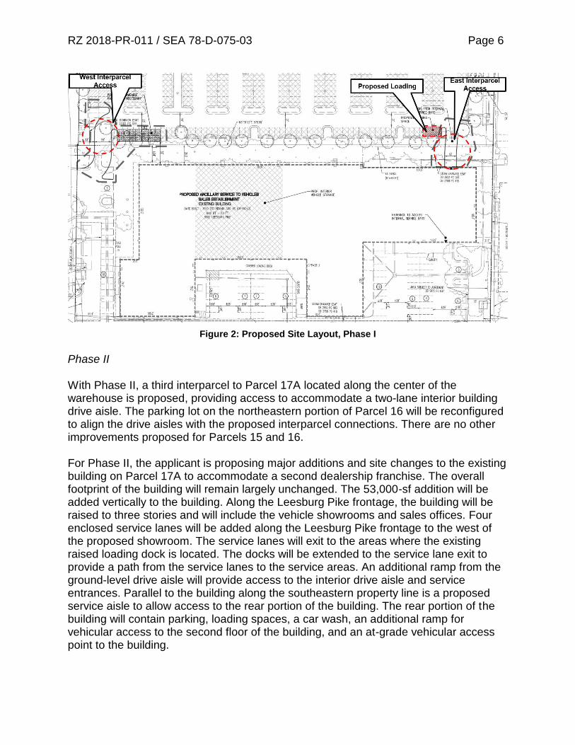
RZ 2018-PR-011 / SEA 78-D-075-03 Page 6
Figure 2: Proposed Site Layout, Phase I
Phase II With Phase II, a third interparcel to Parcel 17A located along the center of the warehouse is proposed, providing access to accommodate a two-lane interior building drive aisle. The parking lot on the northeastern portion of Parcel 16 will be reconfigured to align the drive aisles with the proposed interparcel connections. There are no other improvements proposed for Parcels 15 and 16. For Phase II, the applicant is proposing major additions and site changes to the existing building on Parcel 17A to accommodate a second dealership franchise. The overall footprint of the building will remain largely unchanged. The 53,000-sf addition will be added vertically to the building. Along the Leesburg Pike frontage, the building will be raised to three stories and will include the vehicle showrooms and sales offices. Four enclosed service lanes will be added along the Leesburg Pike frontage to the west of the proposed showroom. The service lanes will exit to the areas where the existing raised loading dock is located. The docks will be extended to the service lane exit to provide a path from the service lanes to the service areas. An additional ramp from the ground-level drive aisle will provide access to the interior drive aisle and service entrances. Parallel to the building along the southeastern property line is a proposed service aisle to allow access to the rear portion of the building. The rear portion of the building will contain parking, loading spaces, a car wash, an additional ramp for vehicular access to the second floor of the building, and an at-grade vehicular access point to the building.

RZ 2018-PR-011 / SEA 78-D-075-03 Page 7
Figure 3: Proposed Site Layout, Phase II
Architecture and Design Sheets P-604 through P-607 depict illustrative examples of the architectural elevations for both phases of the development. These elevations only relate to the structure on Parcel 17A as no changes are proposed to the structures on Parcels 15 and 16.

RZ 2018-PR-011 / SEA 78-D-075-03 Page 8
Figure 4: Proposed Phase I (above) and Phase II below front architectural elevations for Parcel 17A
as viewed from Rt. 7
Landscaping and Open Space: Sheets P-401 through P-404 depict the proposed landscape plans on the site for both phases. During Phase I, the applicant is meeting the tree preservation target through preservation of existing trees on site and the canopy requirement through the provision supplemental plantings, including 32 Category IV deciduous trees and 9 Category II deciduous trees. During Phase II, the applicant is meeting the tree preservation target through the preservation of existing trees on site and the canopy requirement through supplemental plantings including 50 Category IV deciduous trees and 6 Category II deciduous trees. Interior parking lot landscaping is met through the provision of 30 proposed Category IV deciduous trees located throughout the surface parking areas. Both phases will meet interior parking lot landscaping through the planting of 30 proposed Category IV deciduous trees to be located throughout the surface parking areas.
RZ 2018-PR-011 / SEA 78-D-075-03 Page 9 The proposed C-7 District requires 15% open space, which will be provided in the rezoning area (Parcel 17A). The overall SEA area also requires 15% open space; 25% will be provided. A modification of transitional screening, a waiver of peripheral parking lot landscaping and a waiver of the barrier requirements along the northeastern and southern boundary lines is requested. These waivers will be discussed further in the Waivers and Modifications Section of this report.
In 2011, Transportation Design Standards for Tysons Corner Urban Center were adopted by FCDOT (Fairfax County Department of Transportation) and VDOT (Virginia Department of Transportation) for Tysons. As part of the Transportation Design Standards, the applicant submitted a waiver to these design standards to waive the streetscape improvement requirement. The subject properties Leesburg Pike frontage requires a boulevard streetscape consisting of an 8- to 10-foot wide landscape panel, a 10-foot wide sidewalk, and 15-foot wide building zone. The frontage is currently improved with a 16-foot wide sidewalk and a 20- to 25-foot wide landscape strip. The applicant is requesting a waiver to permit the existing frontage improvements in lieu of the required streetscape.
Stormwater Management: Per the Stormwater Management Narrative provided on Sheet P-502, the applicant intends to meet both stormwater quality and quantity through the combination of underground detention (such as a stormtech chamber) and a tree box filter (such as a filterra). The underground detention is proposed to be located within the southern portion of Parcel 17A adjacent to the service lane exits, while the tree box filter is proposed to be located north of the warehouse along the northwestern property line of Parcel 16. The GDP/SEA Plat also depicts possible pervious pavement to be installed adjacent to the western interparcel access between Parcels 17A and 16 if required to meet stormwater requirements during Phase I. The proposed stormwater improvements will supplement the existing dry pond in the eastern corner of Parcel 17A and the existing sand filter located in the center of Parcel 16.
Access and Parking: Parcels 15 and 16 are currently accessed from Leesburg Pike via Industrial Way, a private street (with a recorded public ingress/egress easement). Parcel 17A is accessed through two entrances along Leesburg Pike. During Phase II, the widths of the entrances on Parcel 17A will be reduced in size by extending the aprons. Additionally, the southern entrance will be restricted to right-in only and the northern access will be right-out only. There are no proposed changes to the Industrial Way access. The applicant proposes three new interparcel access points between Parcels 16 and 17A, two of which will be constructed with Phase I.
RZ 2018-PR-011 / SEA 78-D-075-03 Page 10 There are minor modifications proposed to the parking and new vehicle storage areas on Parcel 15. These changes will align the drive aisles with the three proposed interparcel connections. The overall number of parking spaces required for Phase I totals 253 spaces; 321 spaces are provided. Phase II (when the new dealership franchise is established) requires 435 spaces; 453 spaces will be provided between both dealerships. In addition, per the Additional Standards for Vehicle Sale, Rental and Ancillary Service Establishments (Sect. 9-518), the applicant depicts areas for new vehicle display and new vehicle storage on Sheets P-0305 (Phase 1) and P-0306 (Phase 2).
STAFF ANALYSIS
Land Use Analysis (Appendix 4) Under Phase I, the applicant is proposing the expansion of the existing dealership use by repurposing an existing warehouse building on Parcel 17A. This proposal is being developed under the Comprehensive Base Plan, which supports auto and retail sales at existing intensities of 0.7 FAR and 1.3 FAR. The proposed overall FAR for the proposed vehicle sales establishments is 0.80.
The proposed auto dealership use on Parcel 17A and the existing auto dealership uses on Parcels 15 and 16 are consistent with the base plan for the area. The Plan does recognize that Tysons will develop over time and there is a need to support and allow for interims uses. As outlined in the Policy Plan’s Guidelines for Interim Improvement of Commercial Establishments, interim commercial uses that do not strictly conform with the long-term recommendations of the Plan may be permitted on a case-by-case basis if they met certain guidelines and if the use should results in significant public benefit. The proposed use will provide updated stormwater management on site and would be reusing an existing underutilized building and would be improving the character and appearance of the building. Staff finds that these benefits would outweigh any negative impacts and the proposed dealership would not interfere with the achievement of the long-range objectives of the Plan. Consolidation of neighboring properties is also a primary objective of the Tysons Plan, in order to ensure coordinated development and achievement of the overall vision. The overall subject property is now under single ownership and would be governed under a single SEA approval if the requested application is approved.
Staff believes the application will remain in conformance with the land use recommendations of the Comprehensive Plan for the subject property.
Environmental Analysis (Appendix 4)
In keeping with the Comprehensive Plan’s Environmental Policy Plan and the Tysons Areas Wide Recommendations: Environmental Stewardship, staff has encouraged the
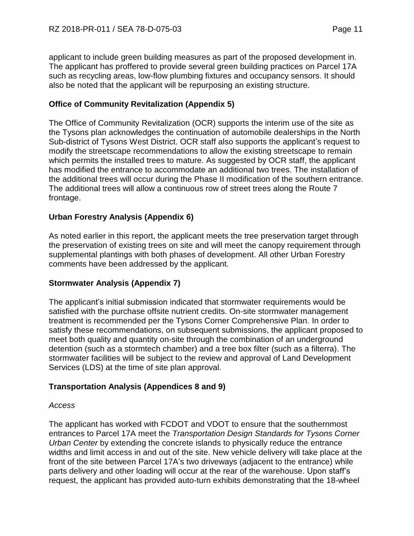
RZ 2018-PR-011 / SEA 78-D-075-03 Page 11 applicant to include green building measures as part of the proposed development in. The applicant has proffered to provide several green building practices on Parcel 17A such as recycling areas, low-flow plumbing fixtures and occupancy sensors. It should also be noted that the applicant will be repurposing an existing structure.
Office of Community Revitalization (Appendix 5)
The Office of Community Revitalization (OCR) supports the interim use of the site as the Tysons plan acknowledges the continuation of automobile dealerships in the North Sub-district of Tysons West District. OCR staff also supports the applicant’s request to modify the streetscape recommendations to allow the existing streetscape to remain which permits the installed trees to mature. As suggested by OCR staff, the applicant has modified the entrance to accommodate an additional two trees. The installation of the additional trees will occur during the Phase II modification of the southern entrance. The additional trees will allow a continuous row of street trees along the Route 7 frontage.
Urban Forestry Analysis (Appendix 6)
As noted earlier in this report, the applicant meets the tree preservation target through the preservation of existing trees on site and will meet the canopy requirement through supplemental plantings with both phases of development. All other Urban Forestry comments have been addressed by the applicant.
Stormwater Analysis (Appendix 7)
The applicant’s initial submission indicated that stormwater requirements would be satisfied with the purchase offsite nutrient credits. On-site stormwater management treatment is recommended per the Tysons Corner Comprehensive Plan. In order to satisfy these recommendations, on subsequent submissions, the applicant proposed to meet both quality and quantity on-site through the combination of an underground detention (such as a stormtech chamber) and a tree box filter (such as a filterra). The stormwater facilities will be subject to the review and approval of Land Development Services (LDS) at the time of site plan approval.
Transportation Analysis (Appendices 8 and 9) Access The applicant has worked with FCDOT and VDOT to ensure that the southernmost entrances to Parcel 17A meet the Transportation Design Standards for Tysons Corner Urban Center by extending the concrete islands to physically reduce the entrance widths and limit access in and out of the site. New vehicle delivery will take place at the front of the site between Parcel 17A’s two driveways (adjacent to the entrance) while parts delivery and other loading will occur at the rear of the warehouse. Upon staff’s request, the applicant has provided auto-turn exhibits demonstrating that the 18-wheel

RZ 2018-PR-011 / SEA 78-D-075-03 Page 12 car carrier trucks can move adequately through the site. Although vehicle delivery at the entrance is not the most ideal location, alternative locations are unavailable due to repurposing of the existing building. Development conditions have been included that would require unloading to take place at the depicted location and require those unloading activities not to interfere with traffic on Leesburg Pike.
Figure 5: Autoturn Exhibit
There are no proposed changes to the existing access on Industrial Way for either phases. Currently, Industrial Way does not meet spacing requirements from the on-ramp to the Dulles Airport Access Road. Based on the VDOT Road Design Manual, intersections near interchanges on multilane crossroads require a spacing distance of 750 feet; Industrial Way is located 75 feet from the on-ramp. The increase in trips attributed to the expansion warranted the submission of an Access Management Exception (AME). The applicant has submitted an AME request, which VDOT approved on April 2, 2019,
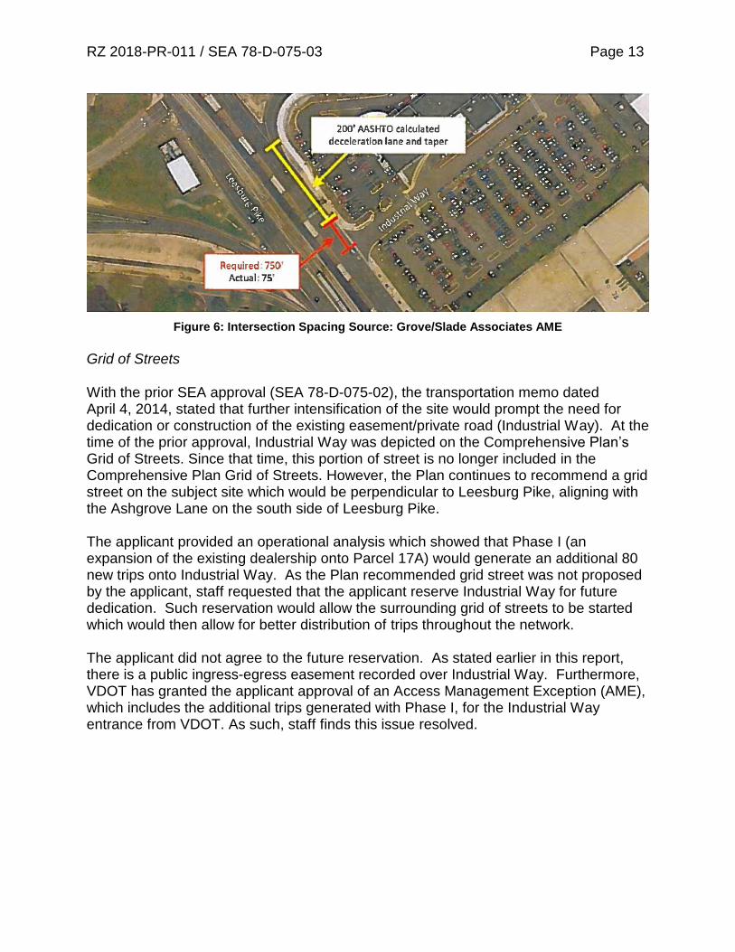
RZ 2018-PR-011 / SEA 78-D-075-03 Page 13
Figure 6: Intersection Spacing Source: Grove/Slade Associates AME
Grid of Streets With the prior SEA approval (SEA 78-D-075-02), the transportation memo dated April 4, 2014, stated that further intensification of the site would prompt the need for dedication or construction of the existing easement/private road (Industrial Way). At the time of the prior approval, Industrial Way was depicted on the Comprehensive Plan’s Grid of Streets. Since that time, this portion of street is no longer included in the Comprehensive Plan Grid of Streets. However, the Plan continues to recommend a grid street on the subject site which would be perpendicular to Leesburg Pike, aligning with the Ashgrove Lane on the south side of Leesburg Pike. The applicant provided an operational analysis which showed that Phase I (an expansion of the existing dealership onto Parcel 17A) would generate an additional 80 new trips onto Industrial Way. As the Plan recommended grid street was not proposed by the applicant, staff requested that the applicant reserve Industrial Way for future dedication. Such reservation would allow the surrounding grid of streets to be started which would then allow for better distribution of trips throughout the network. The applicant did not agree to the future reservation. As stated earlier in this report, there is a public ingress-egress easement recorded over Industrial Way. Furthermore, VDOT has granted the applicant approval of an Access Management Exception (AME), which includes the additional trips generated with Phase I, for the Industrial Way entrance from VDOT. As such, staff finds this issue resolved.
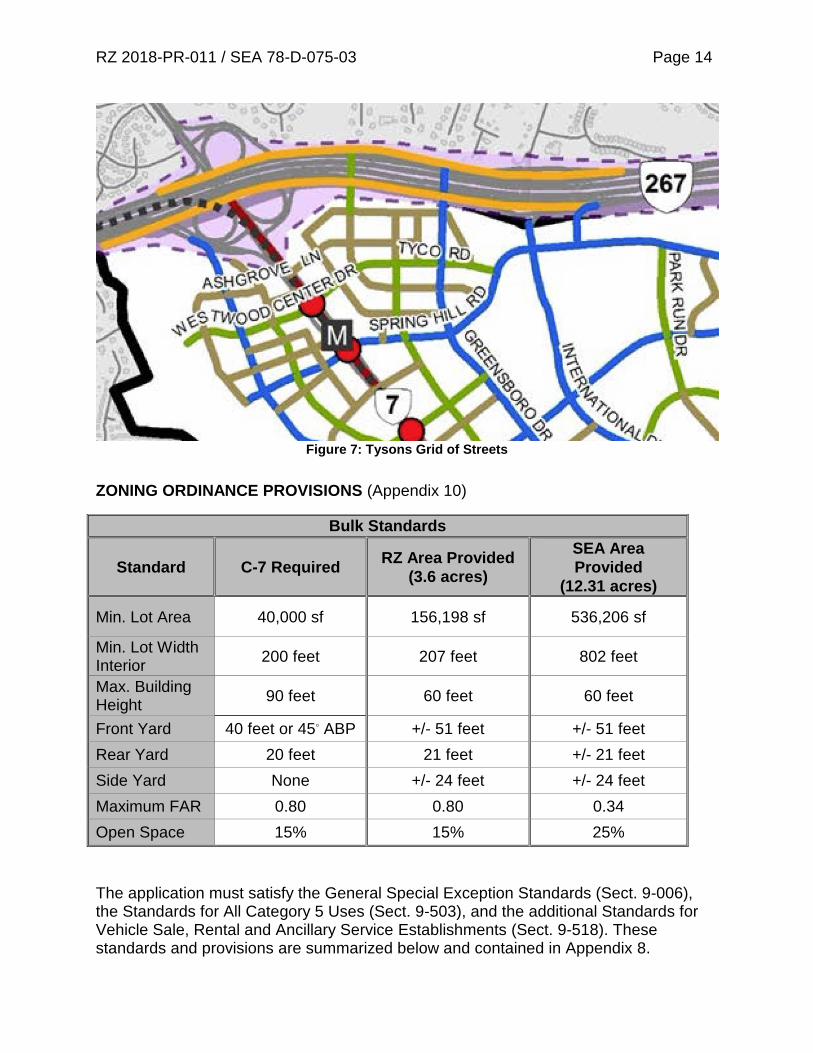
RZ 2018-PR-011 / SEA 78-D-075-03 Page 14
Figure 7: Tysons Grid of Streets
ZONING ORDINANCE PROVISIONS (Appendix 10)
The application must satisfy the General Special Exception Standards (Sect. 9-006), the Standards for All Category 5 Uses (Sect. 9-503), and the additional Standards for Vehicle Sale, Rental and Ancillary Service Establishments (Sect. 9-518). These standards and provisions are summarized below and contained in Appendix 8.
Bulk Standards
Standard C-7 Required RZ Area Provided
(3.6 acres)
SEA Area
Provided
(12.31 acres)
Min. Lot Area 40,000 sf 156,198 sf 536,206 sf
Min. Lot Width Interior
200 feet 207 feet 802 feet
Max. Building Height
90 feet 60 feet 60 feet
Front Yard 40 feet or 45◦ ABP +/- 51 feet +/- 51 feet
Rear Yard 20 feet 21 feet +/- 21 feet
Side Yard None +/- 24 feet +/- 24 feet
Maximum FAR 0.80 0.80 0.34
Open Space 15% 15% 25%
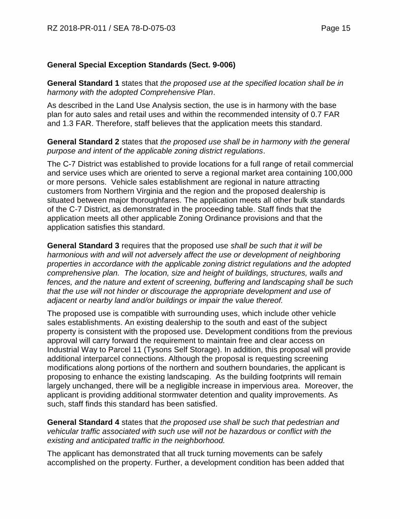
RZ 2018-PR-011 / SEA 78-D-075-03 Page 15
General Special Exception Standards (Sect. 9-006)
General Standard 1 states that the proposed use at the specified location shall be in harmony with the adopted Comprehensive Plan.
As described in the Land Use Analysis section, the use is in harmony with the base plan for auto sales and retail uses and within the recommended intensity of 0.7 FAR and 1.3 FAR. Therefore, staff believes that the application meets this standard.
General Standard 2 states that the proposed use shall be in harmony with the general purpose and intent of the applicable zoning district regulations.
The C-7 District was established to provide locations for a full range of retail commercial and service uses which are oriented to serve a regional market area containing 100,000 or more persons. Vehicle sales establishment are regional in nature attracting customers from Northern Virginia and the region and the proposed dealership is situated between major thoroughfares. The application meets all other bulk standards of the C-7 District, as demonstrated in the proceeding table. Staff finds that the application meets all other applicable Zoning Ordinance provisions and that the application satisfies this standard.
General Standard 3 requires that the proposed use shall be such that it will be harmonious with and will not adversely affect the use or development of neighboring properties in accordance with the applicable zoning district regulations and the adopted comprehensive plan. The location, size and height of buildings, structures, walls and fences, and the nature and extent of screening, buffering and landscaping shall be such that the use will not hinder or discourage the appropriate development and use of adjacent or nearby land and/or buildings or impair the value thereof.
The proposed use is compatible with surrounding uses, which include other vehicle sales establishments. An existing dealership to the south and east of the subject property is consistent with the proposed use. Development conditions from the previous approval will carry forward the requirement to maintain free and clear access on Industrial Way to Parcel 11 (Tysons Self Storage). In addition, this proposal will provide additional interparcel connections. Although the proposal is requesting screening modifications along portions of the northern and southern boundaries, the applicant is proposing to enhance the existing landscaping. As the building footprints will remain largely unchanged, there will be a negligible increase in impervious area. Moreover, the applicant is providing additional stormwater detention and quality improvements. As such, staff finds this standard has been satisfied.
General Standard 4 states that the proposed use shall be such that pedestrian and vehicular traffic associated with such use will not be hazardous or conflict with the existing and anticipated traffic in the neighborhood.
The applicant has demonstrated that all truck turning movements can be safely accomplished on the property. Further, a development condition has been added that

RZ 2018-PR-011 / SEA 78-D-075-03 Page 16 requires all loading and unloading (particularly that of vehicles) to occur on the subject property. The applicant is proposing to modify the existing driveways on Parcel 17A and allow for limited access during Phase II. Staff raised concerns with vehicle conflicts at this entrance. With the adoption of the proposed development conditions limiting the service driveway hours for delivery, staff finds this issue resolved. Also, as previously stated, staff’s concerns with the increased trips to Industrial Way during Phase I have been resolved with the VDOT approved AME. Therefore, staff finds this standard has been met.
General Standard 5 requires that landscaping and screening be provided in accordance with the provisions of Article 13.
The applicant requests approval of several waivers and modifications to reflect the existing conditions on the site. These requests include a modification of the peripheral parking lot landscaping requirements, a modification of transitional screening and a waiver of the barrier requirement along the northeastern and southern property lines to reflect the existing conditions. With approval of these modifications and waivers, the application will satisfy the requirements of Article 13. Therefore, staff finds this standard has been met.
General Standard 6 requires that open space be provided in an amount equivalent to that specified for the zoning district in which the proposed use is located.
The open space requirement for the C-7 District is 15%. The applicant is meeting this requirement for the SEA area with the provision of 25% open space.
General Standard 7 requires that adequate utility, drainage, parking, loading and other necessary facilities to serve the proposed use shall be provided. Parking and loading requirements are proposed to be in accordance with the provisions of Article 11.
The proposal meets the requirements for parking. The applicant is requesting a modification of the loading requirements for reasons discussed later in this report. The drainage from the site will be accommodated in an underground detention facility and the existing stormwater facilities on site. All utilities appear to be adequate to serve the project.
General Standard 8 requires that signs be regulated by the provisions of Article 12; however, the Board may impose more strict requirements for a given use than those set forth in this Ordinance.
The applicant will be required to comply with Article 12 of the Zoning Ordinance with regards to signage on site. Therefore, staff finds this standard has been met.
Standards for All Category 5 Uses (Sect. 9-503)
This application is also subject to the three additional standards for all Category 5 special exception uses.
RZ 2018-PR-011 / SEA 78-D-075-03 Page 17
Standard 1 states that all uses shall comply with the lot size and bulk regulations of the applicable zoning district. As shown earlier in this report, the proposed vehicle sales, rental and ancillary service establishment conforms to the lot size and bulk regulations as required by Standard 1.
Standard 2 stipulates that all uses shall comply with the performance standards for the applicable zoning district. The vehicle sale, rental and ancillary service establishment will be required to comply with all performance standards set forth in Article 14 of the Zoning Ordinance including lighting standards which the photometric plan (found on Sheet P-0601 of the GDP/SEA Plat) has demonstrated will be met.
Standard 3 specifies that all uses shall be subject to the provisions of Article 17, Site Plans. A development condition noting this requirement is included in Appendix 2.
In summary, with the approval of the requested waivers and modifications described in the Waivers and Modifications section of this report and the proposed development conditions, staff believes that the proposed use would satisfy the Standards for all Category 5 Uses. Additional Standards for Vehicle Sale, Rental and Ancillary Service Establishments (Sect. 9-518)
Additional Standard 1 requires that outdoor storage, parking and display areas be located only on the same lot with and ancillary to a sales room, rental office or service facility, which shall be entirely enclosed on all sides. The GDP/SEA Plat depicts all parking areas, display areas and vehicle storage spaces, and demonstrates compliance with this standard.
Additional Standard 2 requires that the outdoor area devoted to storage, loading, parking and display of goods be limited to that area so designated on an approved special exception plat and that such areas not be used for the storage or display of vehicles that are not in operating condition. The GDP/SEA Plat depicts outdoor areas for vehicle loading and unloading and vehicle storage on-site. In addition to the condition regarding loading and unloading on site, staff is also recommending a condition regarding the prohibition of outdoor storage of non-operating vehicles. With the implementation of these conditions, staff believes this standard will be met.
Additional Standard 3 states that notwithstanding the bulk regulations of the zoning district in which located, any such outdoor area that is located on the ground and is open to the sky may be located in any required yard but not nearer to any front lot line than ten (10) feet, except as may be qualified by the provisions of Article 13. This standard also states that all structures shall be subject to the bulk regulations of the zoning district in which located, except structures which are completely underground may be located in any required yard, but not closer than one (1) foot to any lot line. The GDP/SEA plat demonstrates compliance with this standard.
RZ 2018-PR-011 / SEA 78-D-075-03 Page 18
Additional Standard 4 states that vehicle sales establishments must be provided with safe and convenient access to a street. As discussed in the Analysis portion of this report, staff raised concerns with the potential conflicts at the southern driveway on Parcel 17A. With the adoption of the proposed development conditions limiting deliveries times along the service drive, staff believes this standard has been met.
Additional Standard 5 states that all outdoor storage areas, including aisles and driveways, must be constructed and maintained with an approved surface in accordance with Par. 11 of Sect. 11-102, and must be improved in accordance with construction standards presented in the Public Facilities Manual (PFM). This will be a requirement at site plan.
Additional Standard 6 states that all lighting fixtures used to illuminate such outdoor areas must be in conformance with the performance standards for outdoor lighting set forth in Part 9 of Article 14. The photometric plan shows this standard has been met.
Additional Standard 7 does not apply to the C-7 District and therefore is not applicable to this application.
Additional Standard 8 applies only to the PTC District and therefore is not applicable to this application. Highway Corridor (HC) Overlay District Requirements (Sect. 7-600) The HC Overlay District puts additional restrictions on certain automobile oriented uses, including drive-in financial institutions, fast food restaurants, quick-service food stores, service stations and service station/mini-marts. A vehicle sales, rental and ancillary service establishment is not subject to the requirements of the Highway Corridor Overlay District. Waivers and Modifications
• Modification to the Comprehensive Plan trail requirement along Leesburg Pike in favor of the existing 16-foot wide concrete trail.
The Comprehensive Plan recommends a major paved trail (at least 8-feet wide) along Leesburg Pike. The applicant requests a waiver of this trail requirement in favor of the existing 16-foot wide sidewalk which was installed with the Dulles Rail Project. Staff notes that sidewalks are preferred in Tysons and as such, staff supports this modification to the existing condition.

RZ 2018-PR-011 / SEA 78-D-075-03 Page 19
• Modification of the peripheral parking lot landscaping requirements. A modification of peripheral parking lot landscaping requirements was originally approved as part of SEA 78-D-075 along the northern lot line abutting Parcel 11. The modification was granted to accommodate additional parking areas for vehicle storage which had previously been stored offsite. As there are no site modification proposed on this portion of the application area, staff finds that the continuation of this modification will not have deleterious impacts on Parcel 11. As such, staff supports this modification of the peripheral parking lot landscaping requirements to permit that as depicted on the GDP/SEA Plat.
• Modification of transitional screening requirements and a waiver of the barrier requirement along the northeast boundary.
The application shares a northern boundary with the Dulles Airport Access Road (DAAR). This use was previously granted a modification to the required 50-foot screening yard and barrier requirements along the DAAR due to the distance between this uses and the residences north of the DAAR. As there are no building additions proposed on the northern parcel, the proposal remains consistent with the previous approvals. In addition, where possible, the applicant has added deciduous trees along the northern boundary. Staff continues to support both the modification of the transitional screening and the waiver of the barrier requirement to that shown on the GDP/SEA Plat
• Waiver of the peripheral parking lot landscaping along the southern boundary line.
Peripheral parking lot landscaping is required for the southern boundary line to screen the parking lot located behind the warehouse. The building footprint of the proposed dealership is largely unchanged, and the existing service drive leaves no space for the required landscaping. The current adjacent use is another car dealership. Staff finds the absence of such landscaping will not have deleterious impacts of the adjacent property. As such, staff supports this waiver to permit the peripheral parking lot landscaping as depicted on the GDP/SEA.
• A Modification of the total minimum loading requirement for both dealership during Phase II from 7 spaces required to 6 spaces as shown on the GDP/SEA Plat.
Per Section 11-202 of the ZO, the applicant is required to provide a total of seven loading spaces for both dealerships for Phase II. The GDP/SEA Plat depict an ultimate build out of six loading spaces. During Phase I, the applicant requires four loading spaces. Currently, three existing loading spaces serve the use located on the north side of the existing dealership. With the proposed loading space to serve the expanded service use, located adjacent to the northeastern interparcel access, the applicant is meeting the loading requirement for Phase I. During Phase II, the applicant is proposing three loading spaces on the southern corner to serve the newly converted dealership on
RZ 2018-PR-011 / SEA 78-D-075-03 Page 20 Parcel 17A and to convert the loading space added during Phase I back to required parking. In staff’s opinion three loading spaces for each dealership during Phase II will provide adequate loading areas for both dealerships. Staff supports the Phase II modification to permit six loading spaces in lieu of the seven total loading spaces required for both dealerships.
CONCLUSIONS AND RECOMMENDATIONS
Staff Conclusions The applicant is proposing to reuse an existing structure on Parcel 17A for a vehicle sales, rental and ancillary service establishment. Staff finds that this proposal represents an interim use of the site which will consolidate all three parcels under single ownership and provide architectural and site improvements to Parcel 17A. As such, staff believes that the application is in harmony with the land use recommendations of the Comprehensive Plan and is in conformance with the applicable Zoning Ordinance provisions.
Recommendation Staff recommends approval of RZ 2018-PR-011, and its associated GDP, subject to the execution of proffers consistent with those contained in Appendix 1. Staff recommends approval of SEA 78-D-075-03 subject to conditions consistent with those contained in Appendix 2. Staff also recommends approval of a modification to the Comprehensive Plan trail requirement along Leesburg Pike in favor of the existing 16-foot wide concrete trail.
Staff also recommends approval of a modification of the peripheral parking lot landscaping requirements to that shown on the GDP/SEA Plat.
Staff also recommends approval of a modification of transitional screening requirements and a waiver of the barrier requirement along the northeastern property line to that shown on the GDP/SEA Plat.
Staff also recommends approval of a waiver of the peripheral parking lot landscaping along the southern property line.
Staff also recommends approval of a modification of the total minimum loading requirement for both dealerships during Phase II from 7 spaces required to 6 spaces as shown on the GDP/SEA Plat.
RZ 2018-PR-011 / SEA 78-D-075-03 Page 21 It should be noted that it is not the intent of staff to recommend that the Board, in adopting any conditions proffered by the owner, relieve the applicant/owner from compliance with the provisions of any applicable ordinances, regulations, or adopted standards.
The approval of this special exception does not interfere with, abrogate or annul any easement, covenants, or other agreements between parties, as they may apply to the property subject to this application.
It should be further noted that the content of this report reflects the analysis and recommendations of staff; it does not reflect the position of the Board of Supervisors. APPENDICES
1. Draft Proffers 2. Proposed Development Conditions 3. Statement of Justification 4. Affidavit 5. Land Use Analysis 6. Office of Community Revitalization Analysis 7. Urban Forestry Analysis 8. Stormwater Management Analysis 9. Fairfax County Department of Transportation Analysis 10. Virginia Department of Transportation Analysis 11. Sanitary Sewer Analysis 12. Applicable Zoning Ordinance Provisions 13. Glossary
DRAFT
PROFFERS
CROWN TYSONS PROPERTIES LLC
RZ 2018-PR-011
June 4, 2019
Pursuant to Section 15.2-2303(a) of the Code of Virginia, 1950, as amended, and Section
18-204 of the Zoning Ordinance of Fairfax County 1978, as amended (hereinafter referred to as
the “Zoning Ordinance”), Crown Tysons Properties LLC, for and on behalf of itself as the
owner, and/or its successors and assigns (hereinafter referred to as the “Applicant”), in RZ 2018-
PR-011 filed on property identified as Fairfax County Tax Map 29-1 ((1)) 17A (hereinafter
referred to as the “Application Property”) hereby proffers the following, provided that the Board
of Supervisors (the “Board”) approves a rezoning of the Application Property from the I-4
District to the C-7 District. Upon approval of the rezoning, these proffers will replace and
supersede all previous proffers, if any, approved on the Application Property. In the event the
Board denies this rezoning, these proffers will immediately be null and void.
1. GENERALIZED DEVELOPMENT PLAN
A. Development Plan. Subject to the provisions of Section 18-204 of the Zoning
Ordinance, development of the Application Property will be in substantial
conformance with the generalized development plan/special exception
amendment plat (“GDP/SEA Plat”) consisting of twenty-nine (29) sheets,
prepared by Walter L. Phillips Incorporated dated April 13, 2018 and revised
through June 4, 2019. Development may occur in two phases with Phase 1 shown
on Sheet P-0301 of the GDP/SEA Plat and Phase 2 shown on Sheet P-0302 of the
GDP/SEA Plat.
B. Minor Modifications. Pursuant to Section 18-402 of the Zoning Ordinance, minor
modifications to the GDP/SEA Plat may be permitted as determined by the
Zoning Administrator in accordance with the provisions of Section 18-204 of the
Zoning Ordinance. In accordance with the Zoning Ordinance, the Applicant
reserves the right to modify the layout shown on the GDP/SEA Plat at time of site
plan based on final engineering and design provided that there is no decrease in
the amount or location of open space or landscaping, or distances to peripheral lot
lines as shown on the GDP/SEA Plat.
C. Improvements. Proposed improvements to the Application Property may be
constructed in phases as shown on the GDP/SEA Plat. Phase 1 will consist of an
existing building containing 73,000 square feet of gross floor area and associated
site modifications as shown on the GDP/SEA Plat. Phase 2 will consist of a
building containing 124,335 square feet of gross floor area and associated site
modifications as shown on the GDP/SEA Plat.
APPENDIX 1
RZ 2018-PR-011
Page 2
D. Uses. The building will be operated as a vehicle sale, rental and ancillary service
establishment.
2. TRANSPORTATION
A. With the implementation of Phase 1, and as shown on the GDP/SEA Plat, the
Applicant will provide interparcel access consisting of a twenty-three foot wide
drive aisle and a sixteen foot wide exit drive to the adjacent property identified
among the tax map records as 29-1 ((1)) 15 (Parcel 15). With the implementation
of Phase 2, an additional two-way interparcel access to Parcel 15 will be provided
as shown on the GDP/SEA Plat. The Applicant will construct the improvements
for interparcel access with each phase as shown on the GDP/SEA Plat.
B. With the implementation of Phase 2, the southernmost access to the Application
Property will be restricted to right-in traffic movements and the northernmost
access to the Application Property shall be restricted to right-out traffic
movements, all as shown on the GDP/SEA Plat.
C. Density credit is reserved consistent with Section 2-308 of the Zoning Ordinance
for all eligible dedications described herein or as may be required by Fairfax
County or the Virginia Department of Transportation (VDOT) pursuant to the
Public Facilities Manual (PFM), at or prior to time of site plan approval.
D. At the time of issuance of the Non-Residential Use Permit (Non-RUP) for Phase
2, the Applicant will contribute $4.46 for each new square foot of non-residential
space to the Tysons Corner Transportation Fund in accordance with the Board of
Supervisors’ policy adopted on February 20, 2018. The payment may be made
earlier than required pursuant to this paragraph.
E. Prior to the issuance of the Non-RUP for Phase 2, the site entrances from
Leesburg Pike will be physically narrowed as shown on the GDP/SEA Plat.
F. At the time of issuance of the Non-RUP for Phase 2, the Applicant will contribute
$0.12 for each new square foot of non-residential space toward the Route 7/State
Street improvements in accordance with VDOT policy.
G. The installation, location, number and type of bicycle rack will be coordinated
with the Fairfax County Bicycle Coordinator during site plan review and
installation of the racks.
3. LANDSCAPING AND OPEN SPACE
A. Landscape Plan. In conjunction with Phase 1, the Applicant will install
landscaping on the Application Property as generally shown on Sheets P-0401
and P-0402 of the GDP/SEA Plat. In conjunction with Phase 2, the Applicant will
install landscaping on the Application Property as generally shown on Sheet P-
0403 of the GDP/SEA Plat. As part of the first site plan submission and all

RZ 2018-PR-011
Page 3
subsequent submissions, the Applicant will submit a detailed landscape plan to
the Urban Forest Management Division (UFMD), DPWES for review and
approval that will be generally consistent with the quality and quantity of
plantings and materials shown on the GDP/SEA Plat. The landscape plan will be
designed to ensure adequate planting space for all trees based on the requirements
in the PFM. Plantings will include only non-invasive species and, to the extent
practical, native species. At time of each site plan submission, adjustments to the
type and location of vegetation and the design of landscaped areas from that
shown on the GDP/SEA Plat will be permitted as approved by UFMD. All
landscaping will be installed prior to the issuance of the Non-RUP for each phase,
or as determined by UFMD but no later than bond release.
B. Tree Inventory and Condition Analysis. The Applicant will submit a Tree
Inventory and Condition Analysis as part of the first and all subsequent plan
submissions associated with Phase 2. The Tree Inventory and Condition Analysis
will be prepared by a Certified Arborist or Registered Consulting Arborist, and
will include elements of PFM 12-0507 deemed appropriate to the project site as
determined by UFMD.
C. Tree Preservation Plan. The Applicant will submit a Tree Preservation Plan and
Narrative as part of the first and all subsequent plan submissions associated with
Phase 2. The Tree Preservation Plan and Narrative will be prepared by a Certified
Arborist or Registered Consulting Arborist, and will include elements of PFM 12-
0509 deemed appropriate to the project site as determined by UFMD.
D. Project Arborist/Pre-construction Meeting. Prior to the pre-construction meeting
the Applicant will have the approved limits of clearing and grading flagged with a
continuous line of flagging. The Applicant will retain the services of a Certified
Arborist or Registered Consulting Arborist (Project Arborist) to attend the pre-
construction meeting to review the limits of clearing and grading with an UFMD
representative to determine where adjustments to the clearing limits can be made
to increase the area of the tree preservation and/or to increase the survivability of
trees at the limits of clearing and grading. Such adjustments will be recorded by
the Project Arborist and tree protection fencing will be implemented under the
Project Arborist’s supervision based on these adjustments.
E. Tree Protection Fencing. The Applicant will provide appropriate tree protection
devices, based on site conditions and proposed construction activities as reviewed
and approved by UFMD. Tree protection fence will consist of four-foot high
welded wire attached to six-foot steel posts driven 18 inches into the ground and
space no further than 10 feet apart; or super silt fence.
F. Tree Preservation Measures. Tree preservation measures will be clearly
identified, labeled, and detailed on the Erosion and Sediment Control Plan sheets
and Tree Preservation Plan. Tree preservation measures may include, but are not
limited to the following: root pruning, crown pruning, mulching, watering, etc.
Specifications will be provided on the plan detailing how preservation measures

RZ 2018-PR-011
Page 4
will be implemented. Tree preservation activities will be completed during
implementation of Phase 1 of the Erosion and Sediment Control Plan.
G. Site Monitoring. The Applicant’s Project Arborist will be present on site during
implementation of the Phase 1 Erosion and Sediment Control Plan and monitor
any construction activities conducted within or adjacent to areas of trees to be
preserved. Construction activities include, but may not be limited to clearing, root
pruning, tree protection fence installation, vegetation/tree removal and pruning,
and demolition activities. During implementation of Phase 2 Erosion and Sediment
Control Plan, the Project Arborist will visit the site on a regular basis to continue
monitoring tree preservation measures and ensure that all activities are conducted
as identified in the Tree Preservation Plan and approved by UFMD. Written
reports will be submitted to UFMD and SDID site inspector detailing site visits. A
monitoring schedule and Project Arborist reports will be described and detailed in
the Tree Preservation Plan.
H. Landscape Planting Pre-installation Meeting. Prior to installation of any plants to
meet the requirements of the approved landscape plan, the contractor/developer
will coordinate a pre-installation meeting on the site with the landscape contractor,
UFMD staff, and any additional appropriate parties. Any proposed changes to
planting locations, tree/shrub planting sizes, and species substitutions shown on the
approved plan will be reviewed and must be approved by UFMD staff prior to
planting. The installation of plants not approved by UFMD may require the
submission of a revision to the landscape plan or removal and replacement with
approved trees/shrubs prior to bond release.
I. Soil Remediation. Soil in planting areas that contain construction debris and
rubble, are compacted, or are unsuitable for the establishment and long-term
survival of landscape plants, will be the subject of remedial action to restore
planting areas to satisfy cultural requirements of trees, shrubs and groundcovers
specified in the landscape plan. The applicant will provide notes and details
specifying how the soil will be restored for the establishment and long-term
survival of landscape plants for review and approval by UFMD.
J. Tree Space Requirements. Tree planting spaces proposed in the streetscape and
other areas restricted by barriers to root growth will provide a planter open surface
area at least 6 x 6 feet. Where minimum planting areas cannot be met and planting
spaces at least 8 feet wide cannot be provided, rooting zone width a minimum of 8
feet will be provided beneath paved surfaces using structural cell technology or
other solutions acceptable to UFMD that provide uncompacted soil within the
planting space, with planting sites meeting the following specifications:
i. A minimum of 6 feet open surface width and 36 square feet open surface
area.
ii. Rooting area beneath paved surfaces a minimum of 8 feet wide, taking
into consideration sloped sides as may be needed to support adjacent
RZ 2018-PR-011
Page 5
compacted soils for roadways and pedestrian walkways. Planting space
depth will be 4 feet within four feet of the tree on all sides. Soil depth in
areas beyond four feet may be willower or narrower as long as specified
minimum soil volumes are met. Paved surfaces over the specified rooting
area will not be dependent upon compacted soil for structural support.
iii. Soil volume for Category III or IV trees (as indicated in Table 12.17 of the
Public Facilities Manual) will be a minimum of 700 cubic feet per tree for
single trees. For two trees planted in a contiguous planting area, a total soil
volume of at least 1200 cubic feet will be provided. For three trees or
more planted in a contiguous area, the soil volume will equal at least 500
cubic feet per tree. A contiguous area will be defined as any area with a
soil depth of 3-4 feet, within which lateral root growth is unrestricted.
iv. Soil in planting sites will be as specified in planting notes to be included in
site plans reviewed and approved by UFMD.
v. Applicant will contact UFM (703-324-1770) at least 3 business days prior
to installation of trees and any structural cell technology, and provide an
opportunity for UFMD staff to verify conformance with these
requirements.
4. STORMWATER MANAGEMENT
A. In conjunction with the site plan submitted with Phase 1, and subject to review and
approval by Land Development Services (LDS), stormwater management (SWM)
will be addressed with the installation of permeable pavement, if necessary, as
depicted on the GDP/SEA Plat.
B. In conjunction with the site plan submitted with Phase 2, and subject to review and
approval by LDS, stormwater management (SWM) and Best Management Practice
(BMP) measures for the Application Property will be provided in underground
facilities as permitted by the PFM and as depicted on the GDP/SEA Plat. The
SWM and BMP measures will be developed in accordance with the PFM, unless
waived or modified by LDS.
5. ARCHITECTURAL DESIGN
The architectural design of the building located on the Application Property in each phase
will be generally consistent with the elevations including quality of construction and
quality of materials shown on Sheets P-0604 through P-0607 of the GDP/SEA Plat. Final
design will be determined at the time of site plan submission.
RZ 2018-PR-011
Page 6
6. GREEN BUILDING PRACTICES
A. The car wash will be equipped to reuse at least 90% of the waste water associated
with the car wash operation.
B. The Applicant shall utilize green building practices in the construction of the
Phase 2 improvements including, but not limited to the following features:
i. Green Building Professional. The proposed improvements shall be
designed by a design firm with at least one professional accredited by
LEED (or equivalent program) on the team. Prior to building permit
issuance, the accredited professional will provide documentation to the
Department of Public Works and Environmental Services demonstrating
compliance with this proffer.
ii. Sustainable sites. The Applicant will install bike racks for employees and
customers, provide incentives for employees who walk or bike to work,
provide preferred parking for carpools and low emission vehicles, provide
showering and changing facilities for those employees who bike, walk, or
jog to work, implement a light pollution reduction strategy utilizing
motion sensors and photocell/time clock, and install a “white” roofing
membrane to increase reflectiveness.
iii. Water efficiency. The Applicant will install motion sensor faucets and
flush valves and install ultra-low-flow plumbing fixtures.
iv. Energy and atmosphere. The Applicant will provide occupancy sensors in
applicable areas, turn-off all computers & peripherals when not in use,
install daylight sensors (automatic light controls tied into skylights),
provide LED or fluorescent lamps in building light fixtures, provide
Energy Star equipment and appliances, install large fans to facilitate air
movement and cut down on use of air conditioning systems, recycle all
waste oil, utilize vegetable oil (instead of caustic hydraulic fluid) for
service lifts, increase roof and wall insulation to increase R-value of the
building envelope and cut down on heat loss/gain, install high-speed doors
at service areas to cut down on heat loss/gain, and provide airlock at entry
areas with walk-off mats.
v. Materials and resources. The Applicant will provide for the separation,
collection and storage of recyclables for glass, paper, metal, plastic and
cardboard waste, implement a battery/light bulb recycling program,
recycle all computer equipment (printers, cartridges, etc.), and use rapidly
renewable, certified and recycled content products when available.
vi. Indoor environmental quality. The Applicant will use only “green” clean
products for janitorial services, install carbon dioxide monitors with
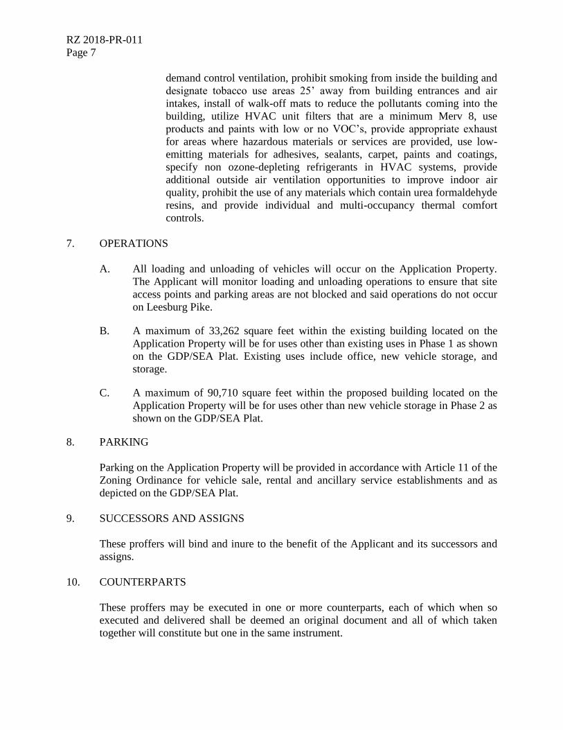
RZ 2018-PR-011
Page 7
demand control ventilation, prohibit smoking from inside the building and
designate tobacco use areas 25’ away from building entrances and air
intakes, install of walk-off mats to reduce the pollutants coming into the
building, utilize HVAC unit filters that are a minimum Merv 8, use
products and paints with low or no VOC’s, provide appropriate exhaust
for areas where hazardous materials or services are provided, use low-
emitting materials for adhesives, sealants, carpet, paints and coatings,
specify non ozone-depleting refrigerants in HVAC systems, provide
additional outside air ventilation opportunities to improve indoor air
quality, prohibit the use of any materials which contain urea formaldehyde
resins, and provide individual and multi-occupancy thermal comfort
controls.
7. OPERATIONS
A. All loading and unloading of vehicles will occur on the Application Property.
The Applicant will monitor loading and unloading operations to ensure that site
access points and parking areas are not blocked and said operations do not occur
on Leesburg Pike.
B. A maximum of 33,262 square feet within the existing building located on the
Application Property will be for uses other than existing uses in Phase 1 as shown
on the GDP/SEA Plat. Existing uses include office, new vehicle storage, and
storage.
C. A maximum of 90,710 square feet within the proposed building located on the
Application Property will be for uses other than new vehicle storage in Phase 2 as
shown on the GDP/SEA Plat.
8. PARKING
Parking on the Application Property will be provided in accordance with Article 11 of the
Zoning Ordinance for vehicle sale, rental and ancillary service establishments and as
depicted on the GDP/SEA Plat.
9. SUCCESSORS AND ASSIGNS
These proffers will bind and inure to the benefit of the Applicant and its successors and
assigns.
10. COUNTERPARTS
These proffers may be executed in one or more counterparts, each of which when so
executed and delivered shall be deemed an original document and all of which taken
together will constitute but one in the same instrument.

RZ 2018-PR-011
Page 8
{A0866739.DOC / 1 Draft Proffers (RZ 2018-PR-011) (blk) - 06.04.19 003292 000011}

APPLICANT/AGENT FOR TITLE OWNER
KOONS TYSONS PROPERTIES LLC
By: Crown Real Properties, L.C., its Member
By: Jim Koons Management Company, Inc., its Managing
Member
__________________________________________
By: James S. O’Connell
Its: President
[SIGNATURES CONTINUE ON NEXT PAGE]
TITLE OWNER OF TAX MAP 29-1 ((1)) 17A
CROWN TYSONS PROPERTIES LLC
By: Crown Real Properties, L.C., its Member
By: Jim Koons Management Company, Inc., its Managing
Member
__________________________________________
By: James S. O’Connell
Its: President
[SIGNATURES END]
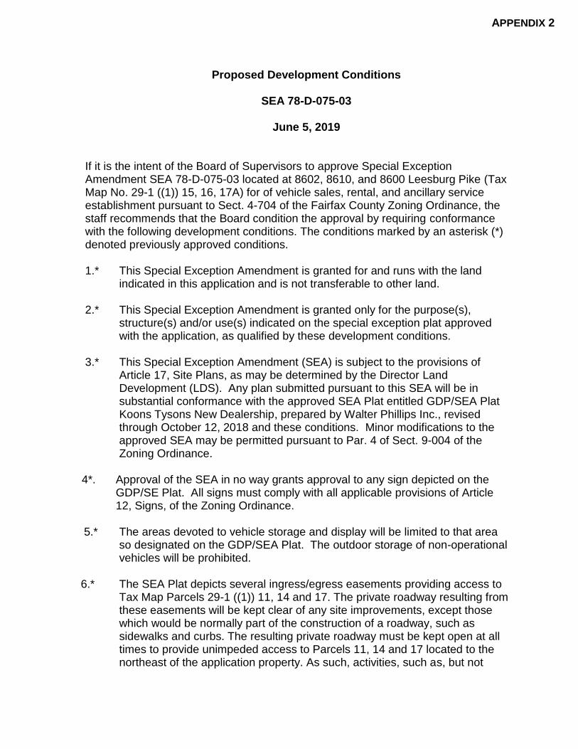
Proposed Development Conditions
SEA 78-D-075-03
June 5, 2019
If it is the intent of the Board of Supervisors to approve Special Exception Amendment SEA 78-D-075-03 located at 8602, 8610, and 8600 Leesburg Pike (Tax Map No. 29-1 ((1)) 15, 16, 17A) for of vehicle sales, rental, and ancillary service establishment pursuant to Sect. 4-704 of the Fairfax County Zoning Ordinance, the staff recommends that the Board condition the approval by requiring conformance with the following development conditions. The conditions marked by an asterisk (*) denoted previously approved conditions.
1.* This Special Exception Amendment is granted for and runs with the land
indicated in this application and is not transferable to other land.
2.* This Special Exception Amendment is granted only for the purpose(s), structure(s) and/or use(s) indicated on the special exception plat approved with the application, as qualified by these development conditions.
3.* This Special Exception Amendment (SEA) is subject to the provisions of
Article 17, Site Plans, as may be determined by the Director Land Development (LDS). Any plan submitted pursuant to this SEA will be in substantial conformance with the approved SEA Plat entitled GDP/SEA Plat Koons Tysons New Dealership, prepared by Walter Phillips Inc., revised through October 12, 2018 and these conditions. Minor modifications to the approved SEA may be permitted pursuant to Par. 4 of Sect. 9-004 of the Zoning Ordinance.
4*. Approval of the SEA in no way grants approval to any sign depicted on the
GDP/SE Plat. All signs must comply with all applicable provisions of Article 12, Signs, of the Zoning Ordinance.
5.* The areas devoted to vehicle storage and display will be limited to that area
so designated on the GDP/SEA Plat. The outdoor storage of non-operational vehicles will be prohibited.
6.* The SEA Plat depicts several ingress/egress easements providing access to
Tax Map Parcels 29-1 ((1)) 11, 14 and 17. The private roadway resulting from these easements will be kept clear of any site improvements, except those which would be normally part of the construction of a roadway, such as sidewalks and curbs. The resulting private roadway must be kept open at all times to provide unimpeded access to Parcels 11, 14 and 17 located to the northeast of the application property. As such, activities, such as, but not
APPENDIX 2
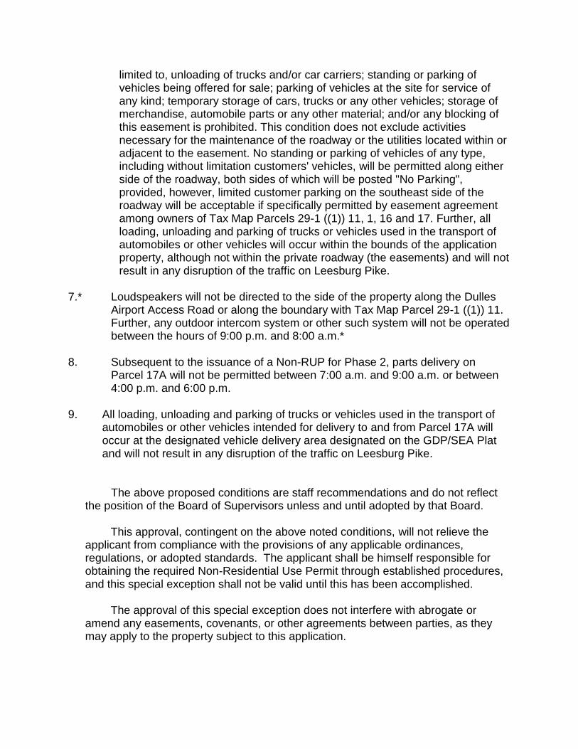
limited to, unloading of trucks and/or car carriers; standing or parking of vehicles being offered for sale; parking of vehicles at the site for service of any kind; temporary storage of cars, trucks or any other vehicles; storage of merchandise, automobile parts or any other material; and/or any blocking of this easement is prohibited. This condition does not exclude activities necessary for the maintenance of the roadway or the utilities located within or adjacent to the easement. No standing or parking of vehicles of any type, including without limitation customers' vehicles, will be permitted along either side of the roadway, both sides of which will be posted "No Parking", provided, however, limited customer parking on the southeast side of the roadway will be acceptable if specifically permitted by easement agreement among owners of Tax Map Parcels 29-1 ((1)) 11, 1, 16 and 17. Further, all loading, unloading and parking of trucks or vehicles used in the transport of automobiles or other vehicles will occur within the bounds of the application property, although not within the private roadway (the easements) and will not result in any disruption of the traffic on Leesburg Pike.
7.* Loudspeakers will not be directed to the side of the property along the Dulles
Airport Access Road or along the boundary with Tax Map Parcel 29-1 ((1)) 11. Further, any outdoor intercom system or other such system will not be operated between the hours of 9:00 p.m. and 8:00 a.m.*
8. Subsequent to the issuance of a Non-RUP for Phase 2, parts delivery on
Parcel 17A will not be permitted between 7:00 a.m. and 9:00 a.m. or between 4:00 p.m. and 6:00 p.m.
9. All loading, unloading and parking of trucks or vehicles used in the transport of
automobiles or other vehicles intended for delivery to and from Parcel 17A will occur at the designated vehicle delivery area designated on the GDP/SEA Plat and will not result in any disruption of the traffic on Leesburg Pike.
The above proposed conditions are staff recommendations and do not reflect the position of the Board of Supervisors unless and until adopted by that Board.
This approval, contingent on the above noted conditions, will not relieve the
applicant from compliance with the provisions of any applicable ordinances, regulations, or adopted standards. The applicant shall be himself responsible for obtaining the required Non-Residential Use Permit through established procedures, and this special exception shall not be valid until this has been accomplished.
The approval of this special exception does not interfere with abrogate or
amend any easements, covenants, or other agreements between parties, as they may apply to the property subject to this application.
Pursuant to Section 9-015 of the Zoning Ordinance, this special exception shall automatically expire, without notice, thirty (30) months after the date of approval unless the use has been established or construction has commenced and been diligently prosecuted. The Board of Supervisors may grant additional time to establish the use or to commence construction if a written request for additional time is filed with the Zoning Administrator prior to the date of expiration of the special exception. The request must specify the amount of additional time requested, the basis for the amount of time requested and an explanation of why additional time is required.
APPENDIX 3


MEMORANDUM Office of the County Attorney
Suite 549, 12000 Government Center Parkway Fairfax, Virginia 22035-0064
Phone: (703) 324-2421; Fax: (703) 324-2665 www.fairfaxcounty.gov
DATE: October 23, 2018
TO: Daniel Creed, Staff Coordinator Zoning Evaluation Division Department of Planning and Zoning
FROM: Jo Ellen Groves, Paralega Office of the County Attorney
SUBJECT: Affidavit Application No.: RZ 2018-PR-011 Applicant: Crown Tysons Properties LLC PC Hearing Date: 11/29/18 BOS Hearing Date: Not yet schedled
REF.: 145810
Attached is an affidavit which has been approved by the Office of the County Attorney for the referenced case. Please include this affidavit dated 10/22/18, which bears my initials and is numbered 145810a, when you prepare the staff report.
Thank you for your cooperation.
Attachment cc: (w/attach) Julia Nichols, Planning Technician I (Sent via e-mail)
Zoning Evaluation Division Department of Planning and Zoning
\\S17PROLAWPGC01 \Documents \ 145810 \JEG \Affidavits \ 1102818.docx
APPENDIX 4

REZONING AFFIDAVIT 145-841C) DATE: October 22. 2018
(enter date affidavit is notarized)
Lynne J. Strobel, attorney/agent , do hereby state that I am an (enter name of applicant or authorized agent)
(check one)
[ applicant
applicant's authorized agent listed in Par. 1(a) below
in Application No.(s): RZ 2018-PR-011 (enter County-assigned application number(s), e.g. RZ 88-V-001)
and that, to the best of my knowledge and belief, the following information is true:
1(a). The following constitutes a listing of the names and addresses of all APPLICANTS, TITLE OWNERS, CONTRACT PURCHASERS, and LESSEES of the land described in the application,* and, if any of the foregoing is a TRUSTEE,** each BENEFICIARY of such trust, and all ATTORNEYS and REAL ESTATE BROKERS, and all AGENTS who have acted on behalf of any of the foregoing with respect to the application:
(NOTE: All relationships to the application listed above in BOLD print must be disclosed. Multiple relationships may be listed together, e.g., Attorney/Agent, Contract Purchaser/Lessee, Applicant/Title Owner, etc. For a multiparcel application, list the Tax Map Number(s) of the parcel(s) for each owner(s) in the Relationship column.)
NAME ADDRESS
RELATIONSHIP(S) (enter first name, middle initial, and (enter number, street, city, state, and zip code) (enter applicable relationships last name) listed in BOLD above)
Crown Tysons Properties LLC
Agents: James S. O'Connell Joseph M. Rinaldis
• James E. Koons
Koons Tysons Properties LLC
Agents: James S. O'Connell Joseph M. Rinaldis
• James E. Koons
2000 Chain Bridge Road Applicant/Agent for Title Vienna, VA 22182 Owner
2000 Chain Bridge Road Title Owner of Tax Map Vienna, VA 22182 29-1 ((1)) 17A
(check if applicable) [/] There are more relationships to be listed and Par. 1(a) is continued on a "Rezoning Attachment to Par. 1(a)" form.
* In the case of a condominium, the title owner, contract purchaser, or lessee of 10% or more of the units in the condominium.
** List as follows: Name of trustee, Trustee for (name of trust, if applicable), for the benefit of: (state name of each beneficiary).
14-0v-vvvit!
0/41 ORM RZA-1 Updated (7/1/06)
Page 1 of Rezoning Attachment to Par. 1(a)
DATE: October 22, 2018 (enter date affidavit is notarized)
for Application No. (s): RZ 2018-PR-011 (enter County-assigned application number (s))
(NOTE: All relationships to the application are to be disclosed. Multiple relationships may be listed together, e.g., Attorney/Agent, Contract Purchaser/Lessee, Applicant/Title Owner, etc. For a multiparcel application, list the Tax Map Number(s) of the parcel(s) for each owner(s) in the Relationship column.
NAME (enter first name, middle initial, and last name)
Keane Enterprises Inc.
Agent: Brian J. Cullen
Walsh, Colucci, Lubeley & Walsh, P.C.
Agents: Martin D. Walsh Lynne J. Strobel M. Catharine Puskar
• Sara V. Mariska (FORMER) Andrew A. Painter
• Matthew J. Allman (FORMER) Robert D. Brant Nicholas V. Cumings
• Steven M. Mikulic (FORMER) Elizabeth D. Baker
Walter L. Phillips, Incorporated
Agents: Aaron M. Vinson • Monica R. Hawkins formerly
Monica R.Westgate Jeffrey J. Stuchel
Penney Design Group, LLC
Agents: Jonathan J. Penney Peter W. Beylo Patrick G. Swift
ADDRESS (enter number, street, city, state, and zip code)
44031 Pipeline Plaza, #100 Ashburn, VA 20147
2200 Clarendon Boulevard, Suite 1300 Arlington, VA 22201
207 Park Avenue Falls Church, Virginia 22046
8120 Woodmont Avenue, Suite 450 Bethesda, Maryland 20814
RELATIONSHIP(S) (enter applicable relationships listed in BOLD above)
Consultant/Agent
Attorneys/Planner/Agents
Attorney/Agent Attorney/Agent Attorney/Agent Attorney/Agent Attorney/Agent Attorney/Agent Attorney/Agent Attorney/Agent Attorney/Agent Planner/Agent
Engineer/Agent
Architect/Agent
Transportation Consultant/ Agent
Lessee
Gorove/Slade Associates, Inc.
Agents: Christopher M. Tacinelli Maria C. Lashinger
• Penske Automotive Group, Inc.
Agent: Robert F. Farrell (check if applicable) [
FORM RZA-1 Updated (7/1/06)
1140 Connecticut Avenue, NW Suite 600 Washington, DC 20036
2555 Telegraph Road Bloomfield Hills, MI 48302-0954
There are more relationships to be listed and Par. 1(a) is continued further on a "Rezoning Attachment to Par. 1(a)" form.
.tvytoirvtirvIt4potot-f7e4r
REZONING AFFIDAVIT
DATE: October 22, 2018 (enter date affidavit is notarized)
for Application No. (s): RZ 2018-PR-011 (enter County-assigned application number(s))
Page Two
145S1 0 a_
1(b). The following constitutes a listing*** of the SHAREHOLDERS of all corporations disclosed in this affidavit who own 10% or more of any class of stock issued by said corporation, and where such corporation has 10 or less shareholders, a listing of all of the shareholders, and if the corporation is an owner of the subiect land, all of the OFFICERS and DIRECTORS of such corporation:
(NOTE: Include SOLE PROPRIETORSHIPS, LIMITED LIABILITY COMPANIES, and REAL ESTATE INVESTMENT TRUSTS herein.)
CORPORATION INFORMATION
NAME & ADDRESS OF CORPORATION: (enter complete name, number, street, city, state, and zip code)
Crown Tysons Properties LLC 2000 Chain Bridge Road Vienna, VA 22182
DESCRIPTION OF CORPORATION: (check one statement) There are 10 or less shareholders, and all of the shareholders are listed below.
[ There are more than 10 shareholders, and all of the shareholders owning 10% or more of any class of stock issued by said corporation are listed below.
[ J There are more than 10 shareholders, but no shareholder owns 10% or more of any class of stock issued by said corporation, and no shareholders are listed below.
NAMES OF THE SHAREHOLDERS: (enter first name, middle initial, and last name)
Crown Real Properties, L.C., Member James S. O'Connell, Manager
NAMES OF OFFICERS & DIRECTORS: (enter first name, middle initial, last name, and title, e.g. President, Vice-President, Secretary, Treasurer, etc.)
(check if applicable) V] There is more corporation information and Par. 1(b) is continued on a "Rezoning Attachment 1(b)" form.
*** All listings which include partnerships, corporations, or trusts, to include the names of beneficiaries, must be broken down successively until: (a) only individual persons are listed or (b) the listing for a corporation having more than 10 shareholders has no shareholder owning 10% or more of any class of stock. In the case of an APPLICANT, TITLE OWNER, CONTRACT PURCHASER, or LESSEE* of the land that is a partnership, corporation, or trust, such successive breakdown must include a listing and further breakdown of all of its partners, of its shareholders as required above, and of beneficiaries of any trusts. Such successive breakdown must also include breakdowns of any partnership, corporation, or trust owning 10% or more of the APPLICANT, TITLE OWNER, CONTRACT PURCHASER, or LESSEE* of the land. Limited liability companies and real estate investment trusts and their equivalents are treated as corporations, with members being deemed the equivalent of shareholders; managing members shall also be listed. Use footnote numbers to designate partnerships or corporations, which have further listings on an attachment page, and reference the same footnote numbers on the attachment page.
FORM RZA-I Updated (7/1/06)
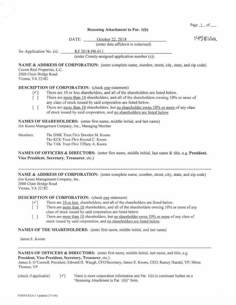
Page 1 of Rezoning Attachment to Par. 1(b)
DATE: October 22, 2018 ti-t5tbek (enter date affidavit is notarized)
for Application No. (s): RZ 2018-PR-011 (enter County-assigned application number (s))
NAME & ADDRESS OF CORPORATION: (enter complete name, number, street, city, state, and zip code) Crown Real Properties, L.C. 2000 Chain Bridge Road Vienna, VA 22182
DESCRIPTION OF CORPORATION: (check one statement) [,./] There are 10 or less shareholders, and all of the shareholders are listed below. [ ] There are more than 10 shareholders, and all of the shareholders owning 10% or more of
any class of stock issued by said corporation are listed below. [ ] There are more than 10 shareholders, but no shareholder owns 10% or more of any class
of stock issued by said corporation, and no shareholders are listed below.
NAMES OF SHAREHOLDERS: (enter first name, middle initial, and last name) Jim Koons Management Company, Inc., Managing Member
Members: The DMK Trust f/b/o Dresden M. Koons The KCK Trust f/b/o Krystal C. Koons The TAK Trust f/b/o Tiffany A. Koons
NAMES OF OFFICERS & DIRECTORS: (enter first name, middle initial, last name & title, e.g. President, Vice President, Secretary, Treasurer, etc.)
NAME & ADDRESS OF CORPORATION: (enter complete name, number, street, city, state, and zip code) Jim Koons Management Company, Inc. 2000 Chain Bridge Road Vienna, VA 22182
DESCRIPTION OF CORPORATION: (check one statement) [V] There are 10 or less shareholders, and all of the shareholders are listed below. [I There are more than 10 shareholders, and all of the shareholders owning 10% or more of any
class of stock issued by said corporation are listed below. [ There are more than 10 shareholders, but no shareholder owns 10% or more of any class of
stock issued by said corporation, and no shareholders are listed below.
NAMES OF THE SHAREHOLDERS: (enter first name, middle initial, and last name)
James E. Koons
NAMES OF OFFICERS & DIRECTORS: (enter first name, middle initial, last name, and title, e.g. President, Vice-President, Secretary, Treasurer, etc.) James S. O'Connell, President; Edward H. Waugh, CFO/Secretary; James E. Koons, CEO; Ramzy Handal, VP; Mirza Thomas, VP
(check if applicable) V] There is more corporation information and Par. 1(b) is continued further on a "Rezoning Attachment to Par. 1(b)" form.
FORM RZA-1 Updated (7/1/06)
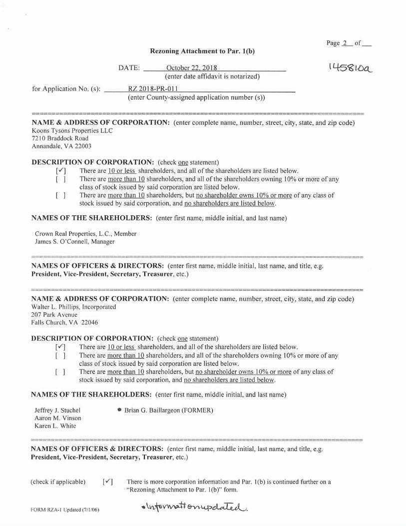
Rezoning Attachment to Par. 1(b)
Page 2 of
DATE: October 22. 2018
tiocc_ (enter date affidavit is notarized)
for Application No. (s): RZ 2018-PR-011 (enter County-assigned application number (s))
NAME & ADDRESS OF CORPORATION: (enter complete name, number, street, city, state, and zip code) Koons Tysons Properties LLC 7210 Braddock Road Annandale, VA 22003
DESCRIPTION OF CORPORATION: (check one statement) There are 10 or less shareholders, and all of the shareholders are listed below.
[ ] There are more than 10 shareholders, and all of the shareholders owning 10% or more of any class of stock issued by said corporation are listed below.
[ ] There are more than 10 shareholders, but no shareholder owns 10% or more of any class of stock issued by said corporation, and no shareholders are listed below.
NAMES OF THE SHAREHOLDERS: (enter first name, middle initial, and last name)
Crown Real Properties, L.C., Member James S. O'Connell, Manager
NAMES OF OFFICERS & DIRECTORS: (enter first name, middle initial, last name and title, e.g. President, Vice-President, Secretary, Treasurer, etc.)
NAME & ADDRESS OF CORPORATION: (enter complete name, number, street, city, state, and zip code) Walter L. Phillips, Incorporated 207 Park Avenue Falls Church, VA 22046
DESCRIPTION OF CORPORATION: (check one statement) There are 10 or less shareholders, and all of the shareholders are listed below.
[ ] There are more than 10 shareholders, and all of the shareholders owning 10% or more of any class of stock issued by said corporation are listed below.
[ ] There are more than 10 shareholders, but no shareholder owns 10% or more of any class of stock issued by said corporation, and no shareholders are listed below.
NAMES OF THE SHAREHOLDERS: (enter first name, middle initial, and last name)
Jeffrey J. Stuchel
• Brian G. Baillargeon (FORMER) Aaron M. Vinson Karen L. White
NAMES OF OFFICERS & DIRECTORS: (enter first name, middle initial, last name, and title, e.g. President, Vice-President, Secretary, Treasurer, etc.)
(check if applicable)
El
There is more corporation information and Par. 1(b) is continued further on a "Rezoning Attachment to Par. 1(b)" form.
FORM RZA-1 Updated (7/1/06) skwkevytewIt e-vvLA.paartA).

Page 3 of Rezoning Attachment to Par. 1(b)
DATE: October 22, 2018 (enter date affidavit is notarized)
for Application No. (s): RZ 2018-PR-011 (enter County-assigned application number (s))
t-Est
NAME & ADDRESS OF CORPORATION: (enter complete name, number, street, city, state, and zip code) Gorove/Slade Associates, Inc. 1140 Connecticut Avenue, NW, Suite 600 Washington, DC 20036
DESCRIPTION OF CORPORATION: (check one statement) [7] There are 10 or less shareholders, and all of the shareholders are listed below. [ ] There are more than 10 shareholders, and all of the shareholders owning 10% or more of any
class of stock issued by said corporation are listed below. 1. There are more than 10 shareholders, but no shareholder owns 10% or more of any class
of stock issued by said corporation, and no shareholders are listed below.
NAMES OF THE SHAREHOLDERS: (enter first name, middle initial, and last name) Christopher M. Tacinelli, Chad A. Baird, Daniel B. VanPelt, Erwin N. Andres, Tushar A. Awar
NAMES OF OFFICERS & DIRECTORS: (enter first name, middle initial, last name, and title, e.g. President, Vice-President, Secretary, Treasurer, etc.)
NAME & ADDRESS OF CORPORATION: (enter complete name, number, street, city, state, and zip code) Walsh, Colucci, Lubeley & Walsh, P.C. 2200 Clarendon Boulevard, Suite 1300 Arlington, VA 22201
DESCRIPTION OF CORPORATION: (check one statement) [ There are 10 or less shareholders, and all of the shareholders are listed below. [7] There are more than 10 shareholders, and all of the shareholders owning 10% or more of any
class of stock issued by said corporation are listed below. I There are more than 10 shareholders, but no shareholder owns 10% or more of any class of
stock issued by said corporation, and no shareholders are listed below.
NAMES OF THE SHAREHOLDERS: (enter first name, middle initial, and last name) Wendy A. Alexander William A. Fogarty • Sara V. Mariska (FORMER) Kathleen H. Smith David J. Bomgardner John H. Foote Charles E. McWilliams Lynne J. Strobel E. Andrew Burcher H. Mark Goetzman J. Randall Minchew Garth M. Wainman Thomas J. Colucci Bryan H. Guidash Andrew A. Painter Nan E. Walsh Michael J. Coughlin Michael J. Kalish M. Catharine Puskar Peter M. Dolan, Jr. Michael R. Kieffer John E. Rinaldi
NAMES OF OFFICERS & DIRECTORS: (enter first name, middle initial, last name, and title, e.g. President, Vice-President, Secretary, Treasurer, etc.)
(check if applicable) [/] There is more corporation information and Par. 1(b) is continued further on a "Rezoning Attachment to Par. 1(b)" form.
FORM RZA-1 Updated (7/1/06) .Mitrynaitto-vt ui-xLe, •

Rezoning Attachment to Par. 1(b)
DATE: October 22, 2018 (enter date affidavit is notarized)
for Application No. (s): RZ 2018-PR-011
Page 4 of
11-60Da_
(enter County-assigned application number (s))
NAME & ADDRESS OF CORPORATION: (enter complete name, number, street, city, state, and zip code) Penney Design Group, LLC 8120 Woodmont Avenue, Suite 450 Bethesda, Maryland 20814
DESCRIPTION OF CORPORATION: (check one statement) [V] There are 10 or less shareholders, and all of the shareholders are listed below. [ ] There are more than 10 shareholders, and all of the shareholders owning 10% or more of any
class of stock issued by said corporation are listed below. There are more than 10 shareholders, but no shareholder owns 10% or more of any class of stock issued by said corporation, and no shareholders are listed below.
NAMES OF THE SHAREHOLDERS: (enter first name, middle initial, and last name) Jonathan J. Penney
NAMES OF OFFICERS & DIRECTORS: (enter first name, middle initial, last name, and title, e.g. President, Vice-President, Secretary, Treasurer, etc.)
NAME & ADDRESS OF CORPORATION: (enter complete name, number, street, city, state, and zip code) Keane Enterprises Inc. 44031 Pipeline Plaza, #100 Ashburn, VA 20147
DESCRIPTION OF CORPORATION: (check one statement) [V] There are 10 or less shareholders, and all of the shareholders are listed below. [ ] There are more than 10 shareholders, and all of the shareholders owning 10% or more of
any class of stock issued by said corporation are listed below. [ ] There are more than 10 shareholders, but no shareholder owns 10% or more of any class
of stock issued by said corporation, and no shareholders are listed below.
NAMES OF SHAREHOLDERS: (enter first name, middle initial, and last name)
Brian J. Cullen, Andrew Shucicra
NAMES OF OFFICERS & DIRECTORS: (enter first name, middle initial, last name, and title, e.g. President, Vice-President, Secretary, Treasurer, etc.)
(check if applicable) [/] There is more corporation information and Par. 1(b) is continued further on a
"Rezoning Attachment to Par. 1(b)" form.
FORM RZA-1 Updated (7/1/06)
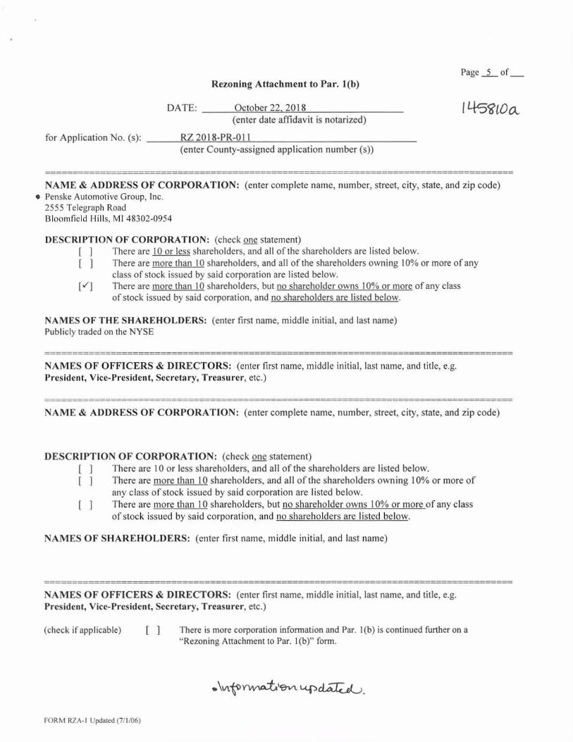
Page 5 of Rezoning Attachment to Par. 1(b)
DATE: October 22. 2018
1,0 (enter date affidavit is notarized)
for Application No. (s): RZ 2018-PR-011 (enter County-assigned application number (s))
NAME & ADDRESS OF CORPORATION: (enter complete name, number, street, city, state, and zip code) • Penske Automotive Group, Inc.
2555 Telegraph Road Bloomfield Hills, MI 48302-0954
DESCRIPTION OF CORPORATION: (check one statement) [ ] There are 10 or less shareholders, and all of the shareholders are listed below. [ ] There are more than 10 shareholders, and all of the shareholders owning 10% or more of any
class of stock issued by said corporation are listed below. There are more than 10 shareholders, but no shareholder owns 10% or more of any class of stock issued by said corporation, and no shareholders are listed below.
NAMES OF THE SHAREHOLDERS: (enter first name, middle initial, and last name) Publicly traded on the NYSE
NAMES OF OFFICERS & DIRECTORS: (enter first name, middle initial, last name, and title, e.g. President, Vice-President, Secretary, Treasurer, etc.)
NAME & ADDRESS OF CORPORATION: (enter complete name, number, street, city, state, and zip code)
DESCRIPTION OF CORPORATION: (check one statement) There are 10 or less shareholders, and all of the shareholders are listed below. There are more than 10 shareholders, and all of the shareholders owning 10% or more of any class of stock issued by said corporation are listed below. There are more than 10 shareholders, but no shareholder owns 10% or more of any class of stock issued by said corporation, and no shareholders are listed below.
NAMES OF SHAREHOLDERS: (enter first name, middle initial, and last name)
NAMES OF OFFICERS & DIRECTORS: (enter first name, middle initial, last name, and title, e.g. President, Vice-President, Secretary, Treasurer, etc.)
(check if applicable)
[
There is more corporation information and Par. 1(b) is continued further on a "Rezoning Attachment to Par. 1(b)" form.
`AP
FORM RZA-1 Updated (7/1/06)

REZONING AFFIDAVIT
DATE: October 22, 2018 (enter date affidavit is notarized)
for Application No. (s): RZ 2018-PR-011 (enter County-assigned application number(s))
Page Three
045s/1 cL_
1(c). The following constitutes a listing*** of all of the PARTNERS, both GENERAL and LIMITED, in any partnership disclosed in this affidavit:
PARTNERSHIP INFORMATION
PARTNERSHIP NAME & ADDRESS: (enter complete name, number, street, city, state and zip code) NONE
(check if applicable) [ ] The above-listed partnership has no limited partners.
NAMES AND TITLE OF THE PARTNERS (enter first name, middle initial, last name, and title, e.g. General Partner, Limited Partner, or General and Limited Partner)
(check if applicable) [ ] There is more partnership information and Par. 1(c) is continued on a "Rezoning Attachment to Par. 1(c)" form.
*** All listings which include partnerships, corporations, or trusts, to include the names of beneficiaries, must be broken down successively until: (a) only individual persons are listed or (b) the listing for a corporation having more than 10 shareholders has no shareholder owning 10% or more of any class of stock. In the case of an APPLICANT, TITLE OWNER, CONTRACT PURCHASER, or LESSEE* of the land that is a partnership, corporation, or trust, such successive breakdown must include a listing and further breakdown of all of its partners, of its shareholders as required above, and of beneficiaries of any trusts. Such successive breakdown must also include breakdowns of any partnership, corporation, or trust owning 10% or more of the APPLICANT, TITLE OWNER, CONTRACT PURCHASER, or LESSEE* of the land. Limited liability companies and real estate investment trusts and their equivalents are treated as corporations, with members being deemed the equivalent of shareholders; managing members shall also be listed. Use footnote numbers to designate partnerships or corporations, which have further listings on an attachment page, and reference the same footnote numbers on the attachment page.
FORM RZA- 1 Updated (7/1/06)
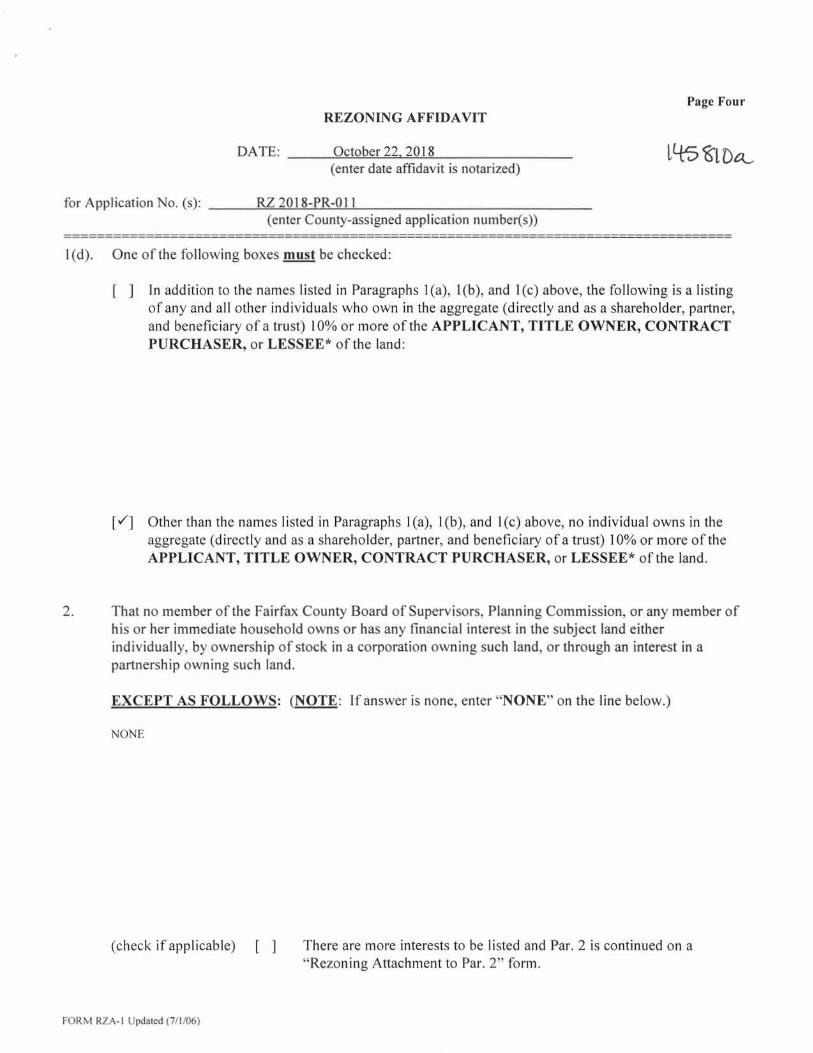
REZONING AFFIDAVIT Page Four
DATE: October 22, 2018 it-t5 ba_
(enter date affidavit is notarized)
for Application No. (s): RZ 2018-PR-011 (enter County-assigned application number(s))
1(d). One of the following boxes must be checked:
[
In addition to the names listed in Paragraphs 1(a), 1(b), and 1(c) above, the following is a listing of any and all other individuals who own in the aggregate (directly and as a shareholder, partner, and beneficiary of a trust) 10% or more of the APPLICANT, TITLE OWNER, CONTRACT PURCHASER, or LESSEE* of the land:
[1 Other than the names listed in Paragraphs 1(a), 1(b), and 1(c) above, no individual owns in the aggregate (directly and as a shareholder, partner, and beneficiary of a trust) 10% or more of the APPLICANT, TITLE OWNER, CONTRACT PURCHASER, or LESSEE* of the land.
2. That no member of the Fairfax County Board of Supervisors, Planning Commission, or any member of his or her immediate household owns or has any financial interest in the subject land either individually, by ownership of stock in a corporation owning such land, or through an interest in a partnership owning such land.
EXCEPT AS FOLLOWS: (NOTE: If answer is none, enter "NONE" on the line below.)
NONE
(check if applicable) [ ] There are more interests to be listed and Par. 2 is continued on a "Rezoning Attachment to Par. 2" form.
FORM RZA-1 Updated (7/1/06)
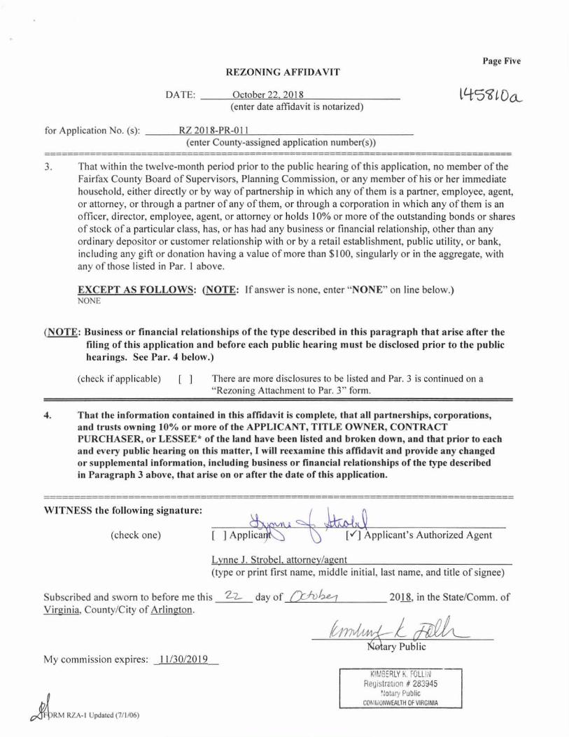
WITNESS the following signature:
(check one) U4,L
[ ] Applica [sr] Applicant's Authorized Agent
REZONING AFFIDAVIT
DATE: October 22, 2018 (enter date affidavit is notarized)
for Application No. (s): RZ 2018-PR-011 (enter County-assigned application number(s))
Page Five
ViSS1,00,_
3. That within the twelve-month period prior to the public hearing of this application, no member of the Fairfax County Board of Supervisors, Planning Commission, or any member of his or her immediate household, either directly or by way of partnership in which any of them is a partner, employee, agent, or attorney, or through a partner of any of them, or through a corporation in which any of them is an officer, director, employee, agent, or attorney or holds 10% or more of the outstanding bonds or shares of stock of a particular class, has, or has had any business or financial relationship, other than any ordinary depositor or customer relationship with or by a retail establishment, public utility, or bank, including any gift or donation having a value of more than $100, singularly or in the aggregate, with any of those listed in Par. 1 above.
EXCEPT AS FOLLOWS: (NOTE: If answer is none, enter "NONE" on line below.) NONE
(NOTE: Business or financial relationships of the type described in this paragraph that arise after the filing of this application and before each public hearing must be disclosed prior to the public hearings. See Par. 4 below.)
(check if applicable)
[
There are more disclosures to be listed and Par. 3 is continued on a "Rezoning Attachment to Par. 3" form.
4. That the information contained in this affidavit is complete, that all partnerships, corporations, and trusts owning 10% or more of the APPLICANT, TITLE OWNER, CONTRACT PURCHASER, or LESSEE* of the land have been listed and broken down, and that prior to each and every public hearing on this matter, I will reexamine this affidavit and provide any changed or supplemental information, including business or financial relationships of the type described in Paragraph 3 above, that arise on or after the date of this application.
Lynne J. Strobel. attorney/agent (type or print first name, middle initial, last name, and title of signee)
Subscribed and sworn to before me this 2-2— day of (_,TAA-e--7 2018, in the State/Comm. of Virginia, County/City of Arlington.
1/(A4/11/Sa-ry Public My commission expires: 11/30/2019
KIMBERLY K. FOLIA Registration # 283945
Notary Public COMIviONWEALTH OF VIRGINIA
RM RZA-1 Updated (7/1/06)
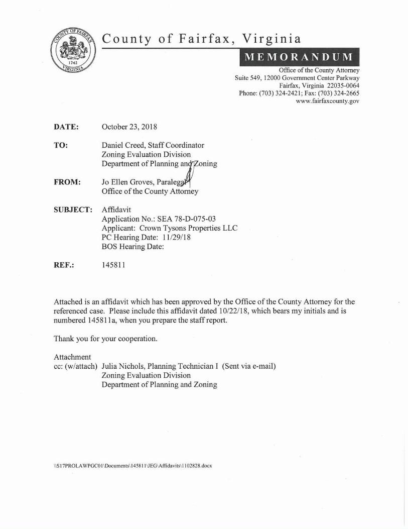
County of Fairfax, Virginia
MEMORANDUM Office of the County Attorney
Suite 549, 12000 Government Center Parkway Fairfax, Virginia 22035-0064
Phone: (703) 324-2421; Fax: (703) 324-2665 www.fairfaxcounty.gov
DATE: October 23, 2018
TO: Daniel Creed, Staff Coordinator Zoning Evaluation Division Department of Planning an )Zoning
FROM: Jo Ellen Groves, Paraleg Office of the County Attorney
SUBJECT: Affidavit Application No.: SEA 78-D-075-03 Applicant: Crown Tysons Properties LLC PC Hearing Date: 11/29/18 BOS Hearing Date:
REF.: 145811
Attached is an affidavit which has been approved by the Office of the County Attorney for the referenced case. Please include this affidavit dated 10/22/18, which bears my initials and is numbered 145811a, when you prepare the staff report.
Thank you for your cooperation.
Attachment cc: (w/attach) Julia Nichols, Planning Technician I (Sent via e-mail)
Zoning Evaluation Division Department of Planning and Zoning
11S17PROLAWPGC01 \ Documents\ 145811 \JEG \Affidavits\ 1102828.docx

SPECIAL EXCEPTION AFFIDAVIT
DATE: October 22, 2018 1 1-1-5811&
(enter date affidavit is notarized) Lynne J. Strobel, attorney/agent , do hereby state that I am an (enter name of applicant or authorized agent)
(check one) [ ] applicant [/] applicant's authorized agent listed in Par. 1(a) below
in Application No.(s): SEA 78-D-075-03 (enter County-assigned application number(s), e.g. SE 88-V-001)
and that, to the best of my knowledge and belief, the following information is true:
1(a). The following constitutes a listing of the names and addresses of all APPLICANTS, TITLE OWNERS, CONTRACT PURCHASERS, and LESSEES of the land described in the application,* and, if any of the foregoing is a TRUSTEE,** each BENEFICIARY of such trust, and all ATTORNEYS and REAL ESTATE BROKERS, and all AGENTS who have acted on behalf of any of the foregoing with respect to the application:
(NOTE: All relationships to the application listed above in BOLD print are to be disclosed. Multiple relationships may be listed together, e.g., Attorney/Agent, Contract Purchaser/Lessee, Applicant/Title Owner, etc. For a multiparcel application, list the Tax Map Number(s) of the parcel(s) for each owner(s) in the Relationship column.)
NAME ADDRESS
RELATIONSHIP(S) (enter first name, middle initial, and (enter number, street, city, state, and zip code) (enter applicable relationships last name)
listed in BOLD above)
Crown Tysons Properties LLC
Agents: James S. O'Connell Joseph M. Rinaldis
• James E. Koons
Koons Tysons Properties LLC
Agents: James S. O'Connell Joseph M. Rinaldis
• James E. Koons
2000 Chain Bridge Road Applicant/Title Owner of Tax Vienna, VA 22182 Map 29-1 (OD 15,16
2000 Chain Bridge Road Title Owner of Tax Map Vienna, VA 22182 29-1 ((I)) 17A
(check if applicable) [1] There are more relationships to be listed and Par. 1(a) is continued on a "Special Exception Attachment to Par. 1(a)" form.
In the case of a condominium, the title owner, contract purchaser, or lessee of 10% or more of the units in the condominium.
** List as follows: Name of trustee, Trustee for (name of trust. if applicable), for the benefit of: (state name of each beneficiary).
cl)NrWjat i.(9v) U-14^1,
ORM SEA-I Updated (7/1/06)
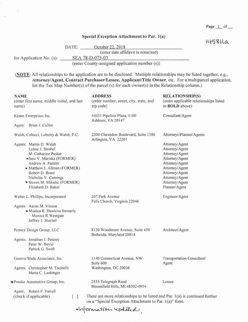
Page 1 of
Special Exception Attachment to Par. 1(a)
DATE: October 22, 2018 (enter date affidavit is notarized)
for Application No. (s): SEA 78-D-075-03 (enter County-assigned application number (s))
(NOTE: All relationships to the application are to be disclosed. Multiple relationships may be listed together, e.g., Attorney/Agent, Contract Purchaser/Lessee, Applicant/Title Owner, etc. For a multiparcel application, list the Tax Map Number(s) of the parcel (s) for each owner(s) in the Relationship column.)
NAME (enter first name, middle initial, and last name)
Keane Enterprises Inc.
Agent: Brian J. Cullen
Walsh, Colucci, Lubeley & Walsh, P.C.
Agents: Martin D. Walsh Lynne J. Strobel M. Catharine Puskar
'Sara V. Mariska (FORMER) Andrew A. Painter
• Matthew J. Allman (FORMER) Robert D. Brant Nicholas V. Cumings
• Steven M. Mikulic (FORMER) Elizabeth D. Baker
Walter L. Phillips, Incorporated
Agents: Aaron M. Vinson • Monica R. Hawkins formerly
Monica R.Westgate Jeffrey J. Stuchel
Penney Design Group, LLC
Agents: Jonathan J. Penney Peter W. Beylo Patrick G. Swift
ADDRESS (enter number, street, city, state, and zip code)
44031 Pipeline Plaza, #100 Ashburn, VA 20147
2200 Clarendon Boulevard, Suite 1300 Arlington, VA 22201
207 Park Avenue Falls Church, Virginia 22046
8120 Woodmont Avenue, Suite 450 Bethesda, Maryland 20814
RELATIONSHIP(S) (enter applicable relationships listed in BOLD above)
Consultant/Agent
Attorneys/Planner/Agents
Attorney/Agent Attorney/Agent Attorney/Agent Attorney/Agent Attorney/Agent Attorney/Agent Attorney/Agent Attorney/Agent Attorney/Agent Planner/Agent
Engineer/Agent
Architect/Agent
1140 Connecticut Avenue, NW
Transportation Consultant/ Suite 600
Agent Washington, DC 20036
2555 Telegraph Road
Lessee Bloomfield Hills, MI 48302-0954
[ ] There are more relationships to be listed and Par. 1(a) is continued further on a "Special Exception Attachment to Par. 1(a)" form.
Lci-3.4.47a.",&
Gorove/Slade Associates, Inc.
Agents: Christopher M. Tacinelli Maria C. Lashinger
• Penske Automotive Group, Inc.
Agent: Robert F. Farrell (check if applicable)
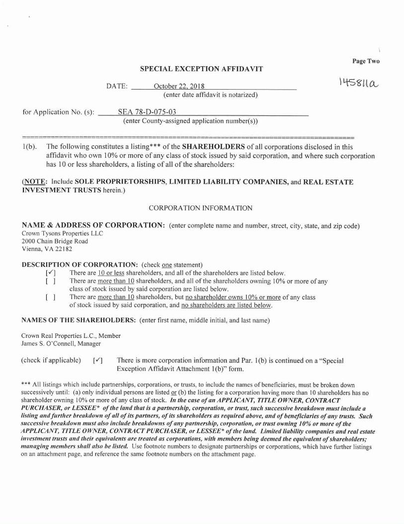
Page Two SPECIAL EXCEPTION AFFIDAVIT
DATE: October 22. 2018 (enter date affidavit is notarized)
for Application No. (s): SEA 78-D-075-03 (enter County-assigned application number(s))
1(b). The following constitutes a listing*** of the SHAREHOLDERS of all corporations disclosed in this affidavit who own 10% or more of any class of stock issued by said corporation, and where such corporation has 10 or less shareholders, a listing of all of the shareholders:
(NOTE: Include SOLE PROPRIETORSHIPS, LIMITED LIABILITY COMPANIES, and REAL ESTATE INVESTMENT TRUSTS herein.)
CORPORATION INFORMATION
NAME & ADDRESS OF CORPORATION: (enter complete name and number, street, city, state, and zip code) Crown Tysons Properties LLC 2000 Chain Bridge Road Vienna, VA 22182
DESCRIPTION OF CORPORATION: (check one statement) [V] There are 10 or less shareholders, and all of the shareholders are listed below. [ There are more than 10 shareholders, and all of the shareholders owning 10% or more of any
class of stock issued by said corporation are listed below. [ There are more than 10 shareholders, but no shareholder owns 10% or more of any class
of stock issued by said corporation, and no shareholders are listed below.
NAMES OF THE SHAREHOLDERS: (enter first name, middle initial, and last name)
Crown Real Properties L.C., Member James S. O'Connell, Manager
(check if applicable) [v] There is more corporation information and Par. 1(b) is continued on a "Special Exception Affidavit Attachment 1(b)" form.
*** All listings which include partnerships, corporations, or trusts, to include the names of beneficiaries, must be broken down successively until: (a) only individual persons are listed or (b) the listing for a corporation having more than 10 shareholders has no shareholder owning 10% or more of any class of stock. In the case of an APPLICANT, TITLE OWNER, CONTRACT PURCHASER, or LESSEE* of the land that is a partnership, corporation, or trust, such successive breakdown must include a listing and further breakdown of all of its partners, of its shareholders as required above, and of beneficiaries of any trusts. Such successive breakdown must also include breakdowns of any partnership, corporation, or trust owning 10% or more of the APPLICANT, TITLE OWNER, CONTRACT PURCHASER, or LESSEE* of the land. Limited liability companies and real estate investment trusts and their equivalents are treated as corporations, with members being deemed the equivalent of shareholders; managing members shall also be listed. Use footnote numbers to designate partnerships or corporations, which have further listings on an attachment page, and reference the same footnote numbers on the attachment page.
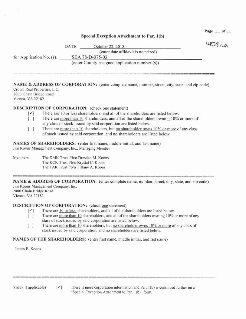
Special Exception Attachment to Par. 1(b) Page I of
DATE: October 22, 2018 (enter date affidavit is notarized)
for Application No. (s): SEA 78-D-075-03 (enter County-assigned application number (s))
NAME & ADDRESS OF CORPORATION: (enter complete name, number, street, city, state, and zip code) Crown Real Properties, L.C. 2000 Chain Bridge Road Vienna, VA 22182
DESCRIPTION OF CORPORATION: (check one statement) [V] There are 10 or less shareholders, and all of the shareholders are listed below. [ ] There are more than 10 shareholders, and all of the shareholders owning 10% or more of
any class of stock issued by said corporation are listed below. [ ] There are more than 10 shareholders, but no shareholder owns 10% or more of any class
of stock issued by said corporation, and no shareholders are listed below.
NAMES OF SHAREHOLDERS: (enter first name, middle initial, and last name) Jim Koons Management Company, Inc., Managing Member
Members: The DMK Trust f/b/o Dresden M. Koons The KCK Trust f/b/o Krystal C. Koons The TAK Trust f/b/o Tiffany A. Koons
NAME & ADDRESS OF CORPORATION: (enter complete name, number, street, city, state, and zip code) Jim Koons Management Company, Inc. 2000 Chain Bridge Road Vienna, VA 22182
DESCRIPTION OF CORPORATION: (check one statement) [v] There are 10 or less shareholders, and all of the shareholders are listed below. [ ] There are more than 10 shareholders, and all of the shareholders owning 10% or more of any
class of stock issued by said corporation are listed below. [ ] There are more than 10 shareholders, but no shareholder owns 10% or more of any class of
stock issued by said corporation, and no shareholders are listed below.
NAMES OF THE SHAREHOLDERS: (enter first name, middle initial, and last name)
James E. Koons
(check if applicable) There is more corporation information and Par. 1(b) is continued further on a "Special Exception Attachment to Par. 1(b)" form.
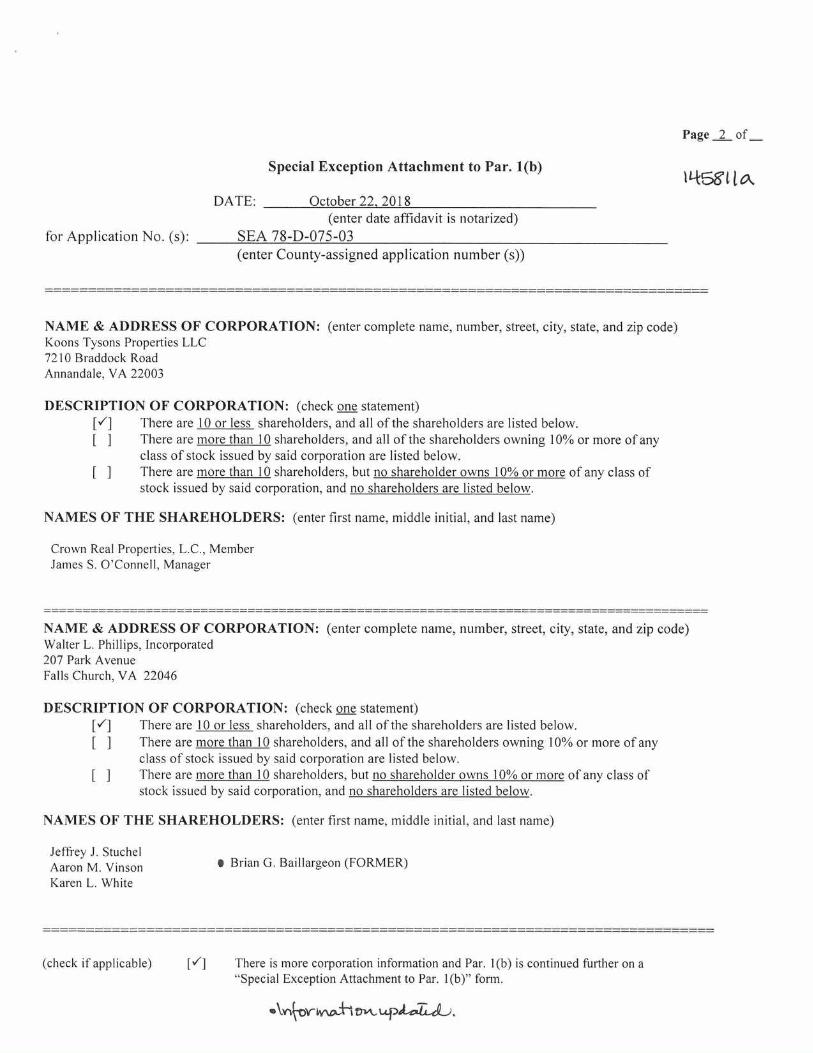
Special Exception Attachment to Par. 1(b)
Page 2 of_
14581ta DATE: October 22. 2018
(enter date affidavit is notarized) for Application No. (s):
SEA 78-D-075-03 (enter County-assigned application number (s))
NAME & ADDRESS OF CORPORATION: (enter complete name, number, street, city, state, and zip code) Koons Tysons Properties LLC 7210 Braddock Road Annandale, VA 22003
DESCRIPTION OF CORPORATION: (check one statement) V] There are 10 or less shareholders, and all of the shareholders are listed below. [ 1 There are more than 10 shareholders, and all of the shareholders owning 10% or more of any
class of stock issued by said corporation are listed below. [ I There are more than 10 shareholders, but no shareholder owns 10% or more of any class of
stock issued by said corporation, and no shareholders are listed below.
NAMES OF THE SHAREHOLDERS: (enter first name, middle initial, and last name)
Crown Real Properties, L.C., Member James S. O'Connell, Manager
NAME & ADDRESS OF CORPORATION: (enter complete name, number, street, city, state, and zip code) Walter L. Phillips, Incorporated 207 Park Avenue Falls Church, VA 22046
DESCRIPTION OF CORPORATION: (check one statement) [1
There are 10 or less shareholders, and all of the shareholders are listed below. [ ]
There are more than 10 shareholders, and all of the shareholders owning 10% or more of any class of stock issued by said corporation are listed below.
[ ]
There are more than 10 shareholders, but no shareholder owns 10% or more of any class of stock issued by said corporation, and no shareholders are listed below.
NAMES OF THE SHAREHOLDERS: (enter first name, middle initial, and last name)
Jeffrey J. Stuchel Aaron M. Vinson Karen L. White
• Brian G. Baillargeon (FORMER)
(check if applicable) Vi
There is more corporation information and Par. 1(b) is continued further on a "Special Exception Attachment to Par. 1(b)" form.
.\,‘A--oriv‘ca-Irm.,upt.c.TA-41).
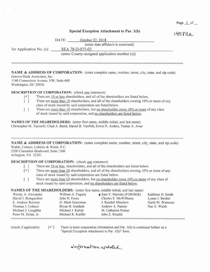
Special Exception Attachment to Par. 1(b)
DATE: October 22, 2018 (enter date affidavit is notarized)
for Application No. (s): SEA 78-D-075-03 (enter County-assigned application number (s))
Page 3 of
NAME & ADDRESS OF CORPORATION: (enter complete name, number, street, city, state, and zip code) Gorove/Slade Associates, Inc. 1140 Connecticut Avenue, NW, Suite 600 Washington, DC 20036
DESCRIPTION OF CORPORATION: (check one statement) Ml There are 10 or less shareholders, and all of the shareholders are listed below. I There are more than 10 shareholders, and all of the shareholders owning 10% or more of any
class of stock issued by said corporation are listed below. [
There are more than 10 shareholders, but no shareholder owns 10% or more of any class of stock issued by said corporation, and no shareholders are listed below.
NAMES OF THE SHAREHOLDERS: (enter first name, middle initial, and last name) Christopher M. Tacinelli, Chad A. Baird, Daniel B. VanPelt, Erwin N. Andres, Tushar A. Awar
NAME & ADDRESS OF CORPORATION: (enter complete name, number, street, city, state, and zip code) Walsh, Colucci, Lubeley & Walsh, P.C. 2200 Clarendon Boulevard, Suite 1300 Arlington, VA 22201
DESCRIPTION OF CORPORATION: (check one statement) [
There are 10 or less shareholders, and all of the shareholders are listed below. Ml
There are more than 10 shareholders, and all of the shareholders owning 10% or more of any class of stock issued by said corporation are listed below. There are more than 10 shareholders, but no shareholder owns 10% or more of any class of stock issued by said corporation, and no shareholders are listed below.
NAMES OF THE SHAREHOLDERS: (enter first name, middle initial, and last name) Wendy A. Alexander William A. Fogarty • Sara V. Mariska (FORMER) Kathleen H. Smith David J. Bomgardner John H. Foote Charles E. McWilliams Lynne J. Strobel E. Andrew Burcher H. Mark Goetzman J. Randall Minchew Garth M. Wainman Thomas J. Colucci Bryan H. Guidash Andrew A. Painter Nan E. Walsh Michael J. Coughlin Michael J. Kalish M. Catharine Puskar Peter M. Dolan, Jr. Michael R. Kieffer John E. Rinaldi
(check if applicable)
[V ] There is more corporation information and Par. 1(b) is continued further on a "Special Exception Attachment to Par. 1(b)" form.
*\v\tor,wki--,9-L,t Lk-PA-at-4,

Page 4 of
Special Exception Attachment to Par. 1(b)
DATE: October 22, 2018 (enter date affidavit is notarized)
for Application No. (s): SEA 78-D-075-03 (enter County-assigned application number (s))
45E1 ta_
NAME & ADDRESS OF CORPORATION: (enter complete name, number, street, city, state, and zip code) Penney Design Group, LLC 8120 Woodmont Avenue, Suite 450 Bethesda, Maryland 20814
DESCRIPTION OF CORPORATION: (check one statement) There are 10 or less shareholders, and all of the shareholders are listed below.
[ ] There are more than 10 shareholders, and all of the shareholders owning 10% or more of any class of stock issued by said corporation are listed below.
[ ] There are more than 10 shareholders, but no shareholder owns 10% or more of any class of stock issued by said corporation, and no shareholders are listed below.
NAMES OF THE SHAREHOLDERS: (enter first name, middle initial, and last name) Jonathan J. Penney
NAME & ADDRESS OF CORPORATION: (enter complete name, number, street, city, state, and zip code) Keane Enterprises Inc. 44031 Pipeline Plaza, #100 Ashburn, VA 20147
DESCRIPTION OF CORPORATION: (check one statement) There are 10 or less shareholders, and all of the shareholders are listed below.
[ ] There are more than 10 shareholders, and all of the shareholders owning 10% or more of any class of stock issued by said corporation are listed below.
[ ] There are more than 10 shareholders, but no shareholder owns 10% or more of any class of stock issued by said corporation, and no shareholders are listed below.
NAMES OF SHAREHOLDERS: (enter first name, middle initial, and last name)
Brian J. Cullen, Andrew Shucicra
(check if applicable) [ f̀] There is more corporation information and Par. 1(b) is continued further on a "Special Exception Attachment to Par. 1(b)" form.

Page 5 of
Special Exception Attachment to Par. 1(b) (45Vta- DATE: October 22, 2018
(enter date affidavit is notarized) for Application No. (s): SEA 78-D-075-03
(enter County-assigned application number (s))
NAME & ADDRESS OF CORPORATION: (enter complete name, number, street, city, state, and zip code) is Penske Automotive Group, Inc.
2555 Telegraph Road Bloomfield Hills, MI 48302-0954
DESC RI PTION OF CORPORATION: (check one statement) I I There are 10 or less shareholders, and all of the shareholders are listed below. [ ] There are more than 10 shareholders, and all of the shareholders owning 10% or more of any
class of stock issued by said corporation are listed below. There are more than 10 shareholders, but no shareholder owns 10% or more of any class of stock issued by said corporation, and no shareholders are listed below.
NAMES OF THE SHAREHOLDERS: (enter first name, middle initial, and last name) Publicly traded on the NYSE
NAME & ADDRESS OF CORPORATION: (enter complete name, number, street, city, state, and zip code)
DESCRIPTION OF CORPORATION: (check one statement) [ ] There are 10 or less shareholders, and all of the shareholders are listed below. [ ] There are more than 10 shareholders, and all of the shareholders owning 10% or more of
any class of stock issued by said corporation are listed below. [ ] There are more than 10 shareholders, but no shareholder owns 10% or more of any class
of stock issued by said corporation, and no shareholders are listed below.
NAMES OF SHAREHOLDERS: (enter first name, middle initial, and last name)
(check if applicable) [ ] There is more corporation information and Par. 1(b) is continued further on a "Special Exception Attachment to Par. 1(b)" form.
.1,n,f-oYtiv.c.t;o-vv u_pcit,e7c4).
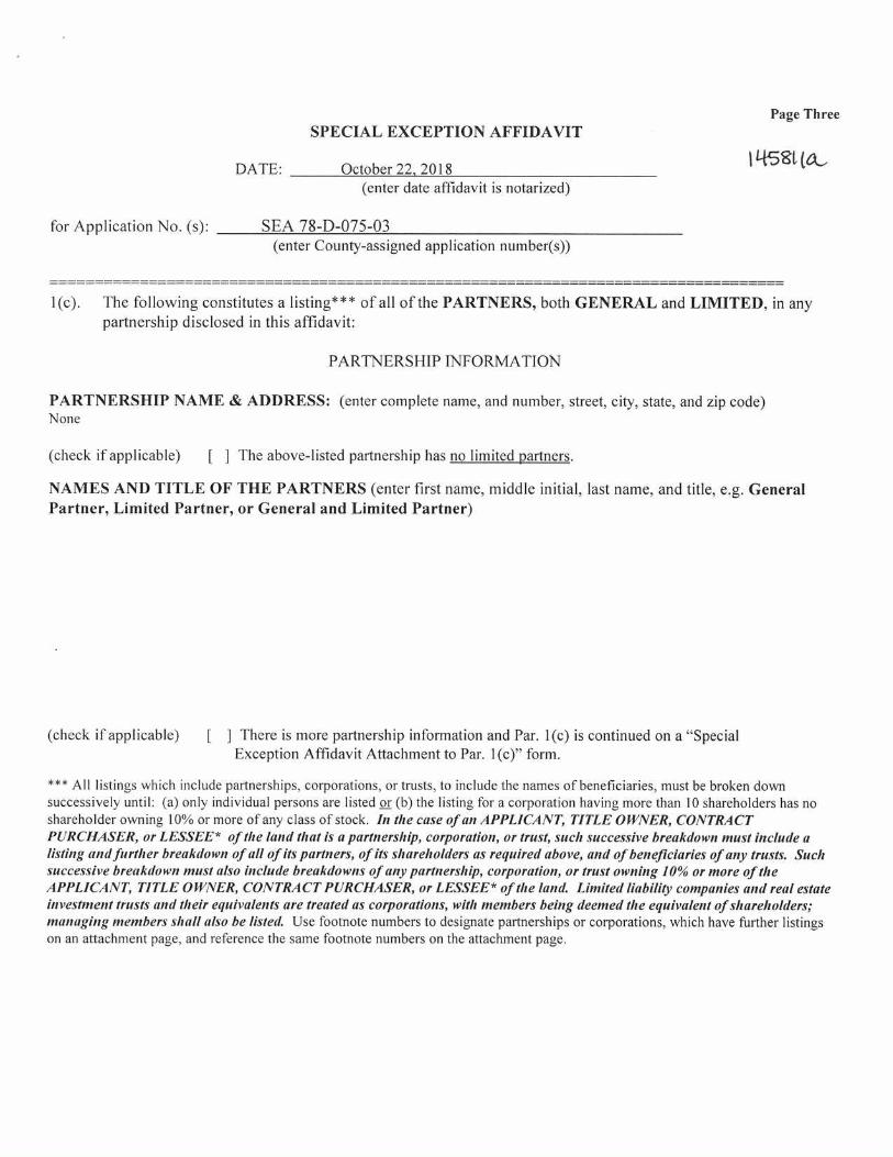
Page Three SPECIAL EXCEPTION AFFIDAVIT
DATE: October 22, 2018 I 1-681,
(enter date affidavit is notarized)
for Application No. (s): SEA 78-D-075-03 (enter County-assigned application number(s))
1(c). The following constitutes a listing*** of all of the PARTNERS, both GENERAL and LIMITED, in any partnership disclosed in this affidavit:
PARTNERSHIP INFORMATION
PARTNERSHIP NAME & ADDRESS: (enter complete name, and number, street, city, state, and zip code) None
(check if applicable) [ ] The above-listed partnership has no limited partners.
NAMES AND TITLE OF THE PARTNERS (enter first name, middle initial, last name, and title, e.g. General Partner, Limited Partner, or General and Limited Partner)
(check if applicable) [ ] There is more partnership information and Par. 1(c) is continued on a "Special Exception Affidavit Attachment to Par. 1(c)" form.
*** All listings which include partnerships, corporations, or trusts, to include the names of beneficiaries, must be broken down successively until: (a) only individual persons are listed or (b) the listing for a corporation having more than 10 shareholders has no shareholder owning 10% or more of any class of stock. In the case of an APPLICANT, TITLE OWNER, CONTRACT PURCHASER, or LESSEE* of the land that is a partnership, corporation, or trust, such successive breakdown must include a listing and further breakdown of all of its partners, of its shareholders as required above, and of beneficiaries of any trusts. Such successive breakdown must also include breakdowns of any partnership, corporation, or trust owning 10% or more of the APPLICANT, TITLE OWNER, CONTRACT PURCHASER, or LESSEE* of the land. Limited liability companies and real estate investment trusts and their equivalents are treated as corporations, with members being deemed the equivalent of shareholders; managing members shall also be listed. Use footnote numbers to designate partnerships or corporations, which have further listings on an attachment page, and reference the same footnote numbers on the attachment page.
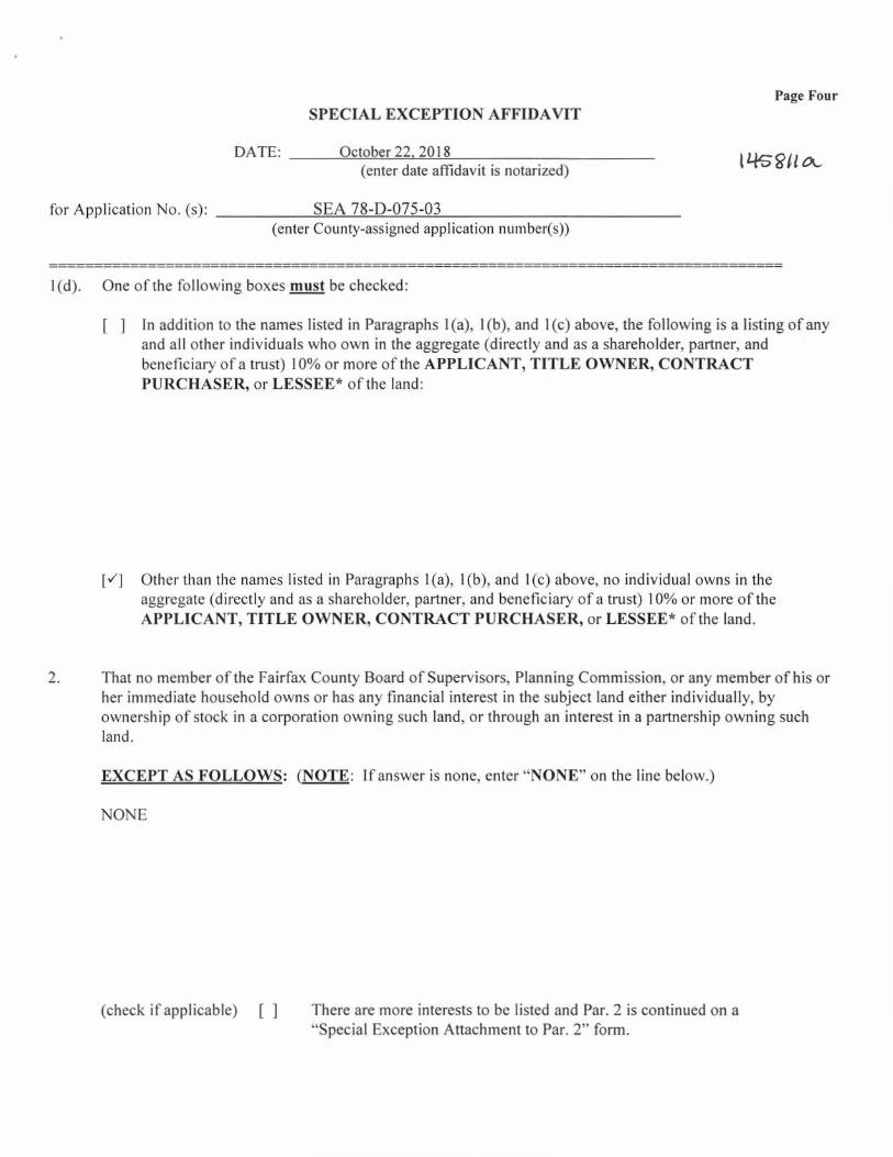
Page Four SPECIAL EXCEPTION AFFIDAVIT
DATE: October 22, 2018
1 14sglia.
(enter date affidavit is notarized)
for Application No. (s): SEA 78-D-075-03 (enter County-assigned application number(s))
1(d). One of the following boxes must be checked:
[
In addition to the names listed in Paragraphs 1(a), 1(b), and 1(c) above, the following is a listing of any and all other individuals who own in the aggregate (directly and as a shareholder, partner, and beneficiary of a trust) 10% or more of the APPLICANT, TITLE OWNER, CONTRACT PURCHASER, or LESSEE* of the land:
[v'] Other than the names listed in Paragraphs 1(a), 1(b), and 1(c) above, no individual owns in the aggregate (directly and as a shareholder, partner, and beneficiary of a trust) 10% or more of the APPLICANT, TITLE OWNER, CONTRACT PURCHASER, or LESSEE* of the land.
2. That no member of the Fairfax County Board of Supervisors, Planning Commission, or any member of his or her immediate household owns or has any financial interest in the subject land either individually, by ownership of stock in a corporation owning such land, or through an interest in a partnership owning such land.
EXCEPT AS FOLLOWS: (NOTE: If answer is none, enter "NONE" on the line below.)
NONE
(check if applicable) [ There are more interests to be listed and Par. 2 is continued on a "Special Exception Attachment to Par. 2" form.

WITNESS the following signature:
(check one) "It1114-6(\
[ ] Applicant [v'] Applicant's Authorized Agent
ary Public
Page Five SPECIAL EXCEPTION AFFIDAVIT
DATE: October 22, 2018 11-1-53t (
(enter date affidavit is notarized)
for Application No. (s): SEA 78-D-075-03 (county-assigned application number(s), to be entered by County Staff)
3. That within the twelve-month period prior to the public hearing of this application, no member of the Fairfax County Board of Supervisors, Planning Commission, or any member of his or her immediate household, either directly or by way of partnership in which any of them is a partner, employee, agent, or attorney, or through a partner of any of them, or through a corporation in which any of them is an officer, director, employee, agent, or attorney or holds 10% or more of the outstanding bonds or shares of stock of a particular class, has, or has had any business or financial relationship, other than any ordinary depositor or customer relationship with or by a retail establishment, public utility, or bank, including any gift or donation having a value of more than $100, singularly or in the aggregate, with any of those listed in Par. I above. EXCEPT AS FOLLOWS: (NOTE: If answer is none, enter "NONE" on line below.)
NONE
NOTE: Business or financial relationships of the type described in this paragraph that arise after the filing of this application and before each public hearing must be disclosed prior to the public hearings. See Par. 4 below.)
(check if applicable)
[
There are more disclosures to be listed and Par. 3 is continued on a "Special Exception Attachment to Par. 3" form.
4. That the information contained in this affidavit is complete, that all partnerships, corporations, and trusts owning 10% or more of the APPLICANT, TITLE OWNER, CONTRACT PURCHASER, or LESSEE* of the land have been listed and broken down, and that prior to each and every public hearing on this matter, I will reexamine this affidavit and provide any changed or supplemental information, including business or financial relationships of the type described in Paragraph 3 above, that arise on or after the date of this application.
Lynne J. Strobel, attorney/agent (type or print first name, middle initial, last name, and & title of signee)
Subscribed and sworn to before me this "Z:2.- day of 0C-f-Db-e-r- 2018, in the State/Comm. of Virginia, County/City of Arlington.
y commission expires: 11/30/2019 KIMBERLY K. FCLLIN
Registration # 283945 Notary Public
COMMONWEALTH OF VIRGINIA
Department of Planning and Zoning
Planning Division
12055 Government Center Parkway, Suite730
Fairfax, Virginia 22035-5509
Phone 703-324-1380
Excellence * Innovation * Stewardship Fax 703-324-3056
Integrity * Teamwork * Public Service www.fairfaxcounty.gov/dpz/
DATE: October 29, 2018
TO: Tracy D. Strunk, Director
Zoning Evaluation Division, DPZ
FROM: Denise M. James, Chief
Environment and Development Review Branch, DPZ
SUBJECT: Land Use Analysis: RZ 2018-PR-011, conc. w/SEA 87-D-075-03,
Crown Real Properties, LC
The memorandum, prepared by Michael Lynskey, includes citations from the Comprehensive
Plan (Plan) that provide guidance for the evaluation of the Rezoning and concurrent Special
Exception Amendment (SEA) application dated May 4, 2018, as revised through October 12,
2018. The extent to which the application conforms to the applicable guidance contained in the
Plan is noted. Possible solutions to remedy identified issues may be suggested. Other solutions
may be acceptable provided that they achieve the desired degree of mitigation and are also
compatible with Plan policies.
DESCRIPTION OF THE APPLICATION
The applicant proposes to rezone a 3.6-acre parcel from the I-4 Medium Intensity Industrial and
Highway Corridor Overlay (HC) Districts to the C-7 Regional Retail Commercial District and
HC districts. The application would also amend existing SEA 87-D-075-02, which governs an
adjacent 8.72-acres consisting of two parcels (already zoned C-7) under the same ownership, to
incorporate the rezoned parcel. The rezoning and SEA approvals would permit the conversion
and expansion of an existing 73,000-square-foot (SF) warehouse structure on the rezoned parcel
to a 124,335 SF vehicle sales, rental and ancillary service establishment (automobile dealership),
similar to the existing 57,900 SF automobile dealership on the neighboring properties.
RZ 2018-PR-011 is filed on 3.6-acre Tax Map # 29-1 ((1)) 17A only, while SEA 87-D-075-03 is
filed on 12.31 acres, including Tax Map # 29-1 ((1)) 15, 16 and 17A. The 124,335 SF of
proposed building area on Parcel 17A results in a Floor Area Ratio (FAR) of 0.80 on that parcel
alone. The 182,235 SF of total building area results in a Floor Area Ratio (FAR) of 0.34 on the
combined 12.31-acre site.
LOCATION and CHARACTER
The application parcels are located at 8602, 8610 and 8600 Leesburg Pike, in the southeast
quadrant of the interchange of the Dulles Airport Access Road and Leesburg Pike (Route 7).
The site lies just northeast of the Spring Hill Metro Station, an entrance to which is only
M E M O R A N D U M
C o u n t y o f F a i r f a x , V i r g i n i a
APPENDIX 5
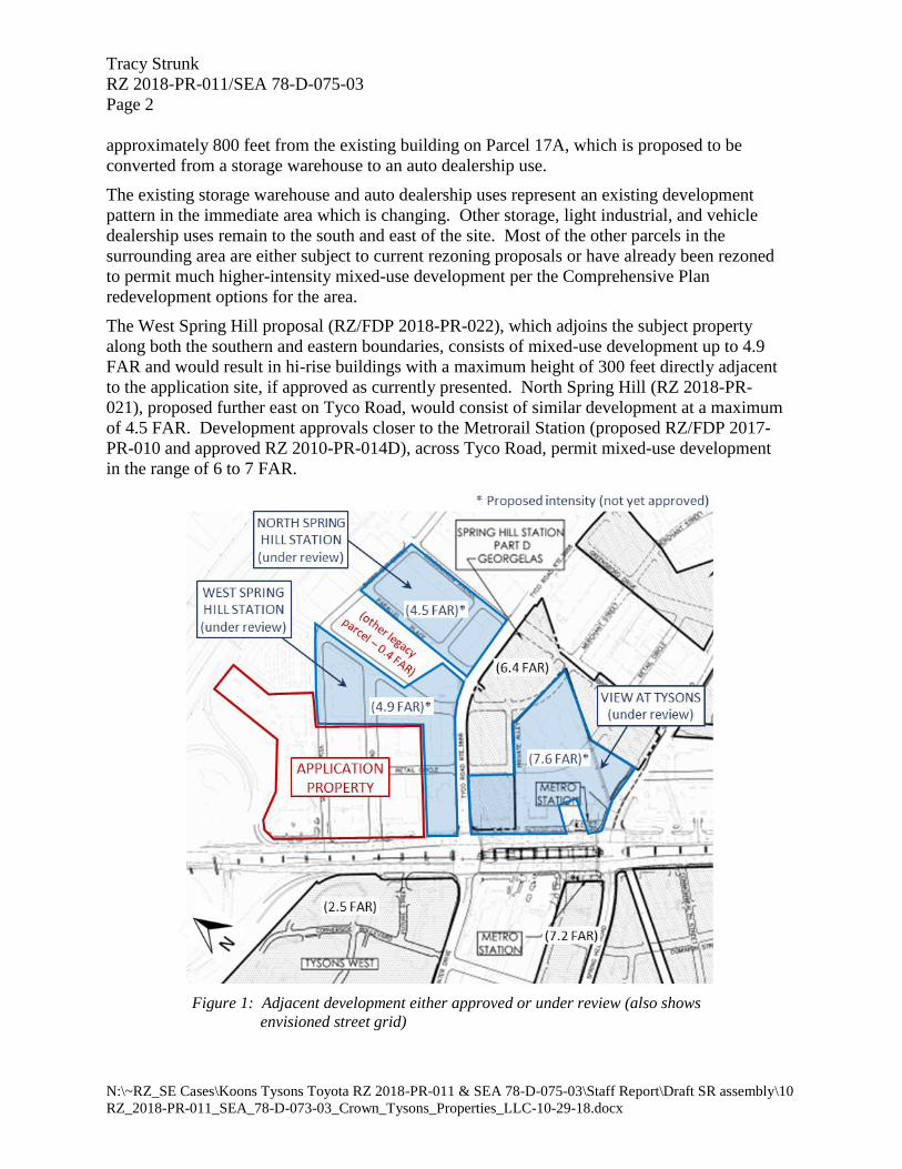
Tracy Strunk
RZ 2018-PR-011/SEA 78-D-075-03
Page 2
N:\~RZ_SE Cases\Koons Tysons Toyota RZ 2018-PR-011 & SEA 78-D-075-03\Staff Report\Draft SR assembly\10
RZ_2018-PR-011_SEA_78-D-073-03_Crown_Tysons_Properties_LLC-10-29-18.docx
approximately 800 feet from the existing building on Parcel 17A, which is proposed to be
converted from a storage warehouse to an auto dealership use.
The existing storage warehouse and auto dealership uses represent an existing development
pattern in the immediate area which is changing. Other storage, light industrial, and vehicle
dealership uses remain to the south and east of the site. Most of the other parcels in the
surrounding area are either subject to current rezoning proposals or have already been rezoned
to permit much higher-intensity mixed-use development per the Comprehensive Plan
redevelopment options for the area.
The West Spring Hill proposal (RZ/FDP 2018-PR-022), which adjoins the subject property
along both the southern and eastern boundaries, consists of mixed-use development up to 4.9
FAR and would result in hi-rise buildings with a maximum height of 300 feet directly adjacent
to the application site, if approved as currently presented. North Spring Hill (RZ 2018-PR-
021), proposed further east on Tyco Road, would consist of similar development at a maximum
of 4.5 FAR. Development approvals closer to the Metrorail Station (proposed RZ/FDP 2017-
PR-010 and approved RZ 2010-PR-014D), across Tyco Road, permit mixed-use development
in the range of 6 to 7 FAR.
Figure 1: Adjacent development either approved or under review (also shows
envisioned street grid)
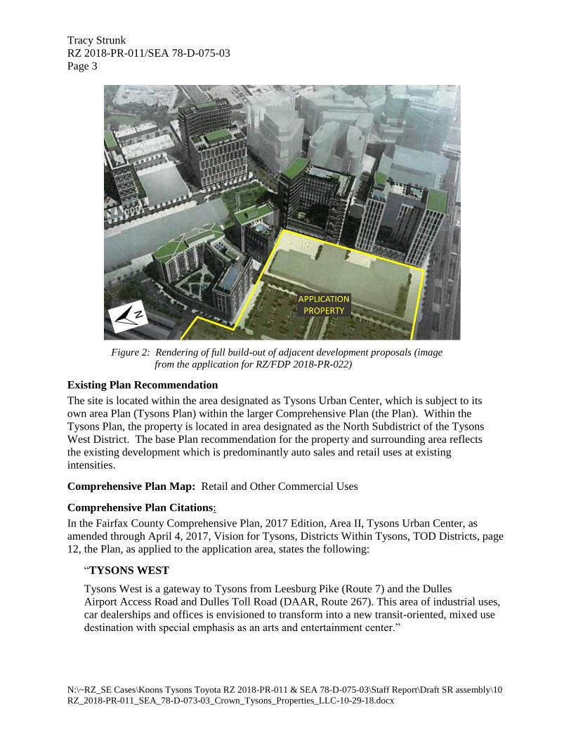
Tracy Strunk
RZ 2018-PR-011/SEA 78-D-075-03
Page 3
N:\~RZ_SE Cases\Koons Tysons Toyota RZ 2018-PR-011 & SEA 78-D-075-03\Staff Report\Draft SR assembly\10
RZ_2018-PR-011_SEA_78-D-073-03_Crown_Tysons_Properties_LLC-10-29-18.docx
Figure 2: Rendering of full build-out of adjacent development proposals (image
from the application for RZ/FDP 2018-PR-022)
Existing Plan Recommendation
The site is located within the area designated as Tysons Urban Center, which is subject to its
own area Plan (Tysons Plan) within the larger Comprehensive Plan (the Plan). Within the
Tysons Plan, the property is located in area designated as the North Subdistrict of the Tysons
West District. The base Plan recommendation for the property and surrounding area reflects
the existing development which is predominantly auto sales and retail uses at existing
intensities.
Comprehensive Plan Map: Retail and Other Commercial Uses
Comprehensive Plan Citations:
In the Fairfax County Comprehensive Plan, 2017 Edition, Area II, Tysons Urban Center, as
amended through April 4, 2017, Vision for Tysons, Districts Within Tysons, TOD Districts, page
12, the Plan, as applied to the application area, states the following:
“TYSONS WEST
Tysons West is a gateway to Tysons from Leesburg Pike (Route 7) and the Dulles
Airport Access Road and Dulles Toll Road (DAAR, Route 267). This area of industrial uses,
car dealerships and offices is envisioned to transform into a new transit-oriented, mixed use
destination with special emphasis as an arts and entertainment center.”
Tracy Strunk
RZ 2018-PR-011/SEA 78-D-075-03
Page 4
N:\~RZ_SE Cases\Koons Tysons Toyota RZ 2018-PR-011 & SEA 78-D-075-03\Staff Report\Draft SR assembly\10
RZ_2018-PR-011_SEA_78-D-073-03_Crown_Tysons_Properties_LLC-10-29-18.docx
In the Fairfax County Comprehensive Plan, 2017 Edition, Area II, Tysons Urban Center, as
amended through April 4, 2017, District Recommendations, Tysons West District, pages 135 –
138, the Plan, as applied to the application area, states the following:
“NORTH SUBDISTRICT
The North Subdistrict is comprised of about 125 acres and is bounded by the DAAR on the
north, Leesburg Pike on the southwest, and the Tysons Central 7 and North Central Districts
on the southeast.
Base Plan
Auto sales and retail uses are the predominant land uses along Leesburg Pike, along with one
high-rise office building. This area is developed and planned for auto sales and retail uses, as
well as portions developed and planned for office use with support retail and service uses at
existing intensities between 0.7 FAR and 1.3 FAR.”
…
Redevelopment Option
The subdistrict is envisioned for substantial redevelopment to mixed use with office being
focused along Leesburg Pike and adjacent to the DAAR and Toll Road. Urban residential
neighborhoods should be provided and will enliven the vibrancy of this mixed use district.
Other land uses should include hotels, arts and entertainment, retail and support services. A
series of urban parks should be provided and be linked by the street grid; this green network
will provide places for people of all ages to walk and enjoy parks and open space.
To achieve this vision, development proposals should address the Areawide
Recommendations, and provide for …” (the remainder of the Subdistrict recommendation
applies only to proposals utilizing the redevelopment option)
LAND USE ANALYSIS
The land use analysis evaluates whether the application is in general conformance, and in harmony
with, Comprehensive Plan objectives such as land use, intensity, and consolidation.
Use and Intensity
The existing auto dealership and storage warehouse uses, at 0.15 FAR and 0.47 FAR respectively,
are consistent with the base Plan option for the area, which reflect the existing development pattern
at the time the Tysons Plan was implemented. The base Plan option for the property continues to
support auto sales at existing intensities between 0.7 and 1.3 FAR. While the proposed 51,335-SF
addition to the warehouse building on Parcel 17A represents an increase from the existing intensity
of the parcel, the resulting 0.80 FAR on that parcel remains below the maximum FAR of 1.3 FAR
cited by the base Plan for this area.
The Tysons Plan supports interim improvements and/or modifications to existing uses if such a
proposal does not delay or interfere with the achievement of the long-term vision for Tysons;
however the Plan also recommends that all “new development or redevelopment proposals that
increase intensity, increase height, or substantially change the design of a previously-approved
development should be in general conformance with the Areawide Recommendations as well as

Tracy Strunk
RZ 2018-PR-011/SEA 78-D-075-03
Page 5
N:\~RZ_SE Cases\Koons Tysons Toyota RZ 2018-PR-011 & SEA 78-D-075-03\Staff Report\Draft SR assembly\10
RZ_2018-PR-011_SEA_78-D-073-03_Crown_Tysons_Properties_LLC-10-29-18.docx
the District Recommendations”. The proposed auto dealership use is consistent with the base plan
for the area and with the neighboring property, which will be under the same ownership, but does
represent a new use on Parcel 17A, and would increase the development intensity, as well as
building height, on the site. Therefore, general Areawide and District Recommendations of the
Tysons Plan are applicable to the proposal, including recommendations regarding the envisioned
Transportation grid, development phasing, and urban design, among others.
Consolidation of neighboring properties is also a primary objective of the Tysons Plan, in order to
ensure coordinated development and achievement of the overall vision. The primary mechanism
envisioned by the Plan for doing so is to consolidate properties under common proffered
development plans, typically using PTC (Planned Development Tysons Corner) zoning. The
proposed rezoning and proffered Generalized Development Plan (GDP) would only be applicable
to Parcel 17A, and not the existing auto dealership on Parcels 15 and 16; however, the SEA Plat
and Conditions would apply to all three parcels, in effect consolidating them under one
development plan for the foreseeable future. It is anticipated that all three parcels would eventually
be included in a common rezoning, at such future time as the redevelopment option of the Plan
may be pursued.
Implementation of the Tysons Plan
Overall implementation of the Tyson Plan relies on coordinated development of the various sub-
regions in order for larger Plan goals to be realized. One major consideration is implementation
of transportation improvements, which could serve to provide additional mobility and access
options throughout the Tysons area. There may be opportunities for the current proposal to address
such transportation improvements, and staff defers to the Fairfax County Department of
Transportation (FCDOT) for any detailed comments related to local road improvements that could
be considered, including dedications of right-of-way and access improvements.
Character of the Proposal
The application proposes no significant physical changes to the existing auto dealership on Parcels
15 and 16, but proposes modifications and expansion of the existing warehouse structure on Parcel
17A, as well as access and parking modifications to service that structure. The existing 73,000 sf
building would be expanded to 124,335 sf by the addition of an upper floor to the portion of the
building fronting on Leesburg Pike. Both the lower and upper floors along the street frontage
would be utilized for vehicle display and showroom space, which would be visible through large
windows to the street and to passengers on the adjacent elevated Metrorail tracks. The street-
facing building façade would also be updated to present a more attractive and modern appearance
to the public. Rear portions of the building would be utilized for both a vehicle service and storage
of new vehicles.
The proposed modifications to the building façade would be an improvement over the character
and appearance of the existing structure, until such time as the assemblage redevelops and creates
a better opportunity to further the ultimate vision of the Tysons Plan. Staff notes that the site
represents a prominent location per the Tysons plan, serving as a “gateway” to the Tysons Urban
Center for visitors along Leesburg Pike and from the adjacent elevated Metrorail facility.
Tracy Strunk
RZ 2018-PR-011/SEA 78-D-075-03
Page 6
N:\~RZ_SE Cases\Koons Tysons Toyota RZ 2018-PR-011 & SEA 78-D-075-03\Staff Report\Draft SR assembly\10
RZ_2018-PR-011_SEA_78-D-073-03_Crown_Tysons_Properties_LLC-10-29-18.docx
Development Phasing
The applicant proposes to Phase the development to allow limited use of the existing structure on
Parcel 17A for vehicle sales, storage, and service at Phase 1 of implementation, while not
constructing the proposed building addition and related improvements until Phase 2. The majority
of proffer commitments, including proposed access improvements other measures meant to offset
the impacts of the proposed improvements, would not be provided until the time of the second
Phase of development.
Staff has concerns that permitting even limited use of the existing structure on Parcel 17A for
activities associated with a vehicle sales and service use may require additional vehicular traffic
to utilize the site access on that parcel. Specifically, utilization of that building as a vehicle service
center would require the transport of vehicles to/from the neighboring dealership parcels, for which
adequate interparcel connections may not be provided until the later phase of development.
Similarly, such use may invite customers to utilize the entrance and parking on that parcel as a
service entrance. Staff also has concerns that any proposed limitation placed on the utilization of
existing building square-footage at Phase I of development (intended to mitigate potential site
impacts at that phase) may be difficult to monitor and/or enforce. Such considerations may warrant
implementation of the proposed access improvements for Parcel 17A at Phase I of development.
CONCLUSION
While the current proposal does little to immediately forward the implementation of the ultimate
vision for the area, the Plan recognizes the potential for continuation and expansion of existing
uses as the base Plan recommendation. The proposed consolidation of the three subject parcels
under a single Special Exception Plat serves to provide some level of assurance that the
properties will continue to be treated as a coordinated unit at such future time as the site may be
considered for further redevelopment under the redevelopment option of the Tysons Plan.
As previously noted, the proposed application may also provide an opportunity to address local
transportation improvements, and consideration of recommendations from FCDOT is strongly
encouraged. The phasing of access improvements and other proffer commitments should ensure
that potential impacts of the proposal are addressed at all phases of development.
Subject to those recommendations, staff believes that the application would conform with the
base land use recommendations of the Comprehensive Plan for the subject property.
ADDITIONAL COMPREHENSIVE PLAN CITATIONS
In the Fairfax County Comprehensive Plan, 2017 Edition, Area II, Tysons Urban Center, as
amended through April 4, 2017, Areawide Recommendations, Land Use, pages 38-39, the Plan
states the following:
“Existing Development Services
Most existing development in Tysons is not consistent with the long-term vision for
Tysons. However, expansion and remodeling of existing buildings may be permitted as long
as these changes are not counter to Plan objectives. Proposals to modify an existing use
should be considered if they result in significant public benefits and do not delay or interfere
with the achievement of the long-term vision for Tysons. Improvements to open space,

Tracy Strunk
RZ 2018-PR-011/SEA 78-D-075-03
Page 7
N:\~RZ_SE Cases\Koons Tysons Toyota RZ 2018-PR-011 & SEA 78-D-075-03\Staff Report\Draft SR assembly\10
RZ_2018-PR-011_SEA_78-D-073-03_Crown_Tysons_Properties_LLC-10-29-18.docx
streetscapes, and streets identified in the Plan are encouraged; if full compliance with the
Plan is not feasible due to an existing building's location on the site, alternative
improvements may be considered.
It is desirable to maintain many services, such as auto dealerships, service and repair shops,
and storage facilities, even if their physical surroundings change. For example, auto
showrooms and other retail and service uses could be incorporated into street-level retail
spaces provided through mixed use redevelopment.”
In the Fairfax County Comprehensive Plan, 2017 Edition, Area II, Tysons Urban Center, as
amended through April 4, 2017, Areawide Recommendations, Land Use, page 20, the Plan states
the following:
“Development proposals that involve redevelopment and that increase intensity, increase
height, or substantially change the design of a previously approved development should be in
general conformance with the Areawide Recommendations as well as the District
Recommendations. Areawide Recommendations include:
• Land Use Section, which identifies the land use pattern, mix of uses and intensities, and
sets forth guidelines for phasing development with public facilities, infrastructure and
amenities;
• Transportation Section, which addresses the grid of streets, the bicycle and pedestrian
network, and the proposed system of circulators;
• Environmental Stewardship Section, the system of stormwater management, and the
requirements for green architecture;
• Parks and Recreation Section, which addresses the network of parks, open space,
recreational facilities, and trails;
• Public Facilities Section, which identifies existing facilities serving the area and
additional planned public facilities needed to serve future growth; and
• Urban Design Section, which provides guidance on the pedestrian realm and on building
and site design.”
DMJ:MHL
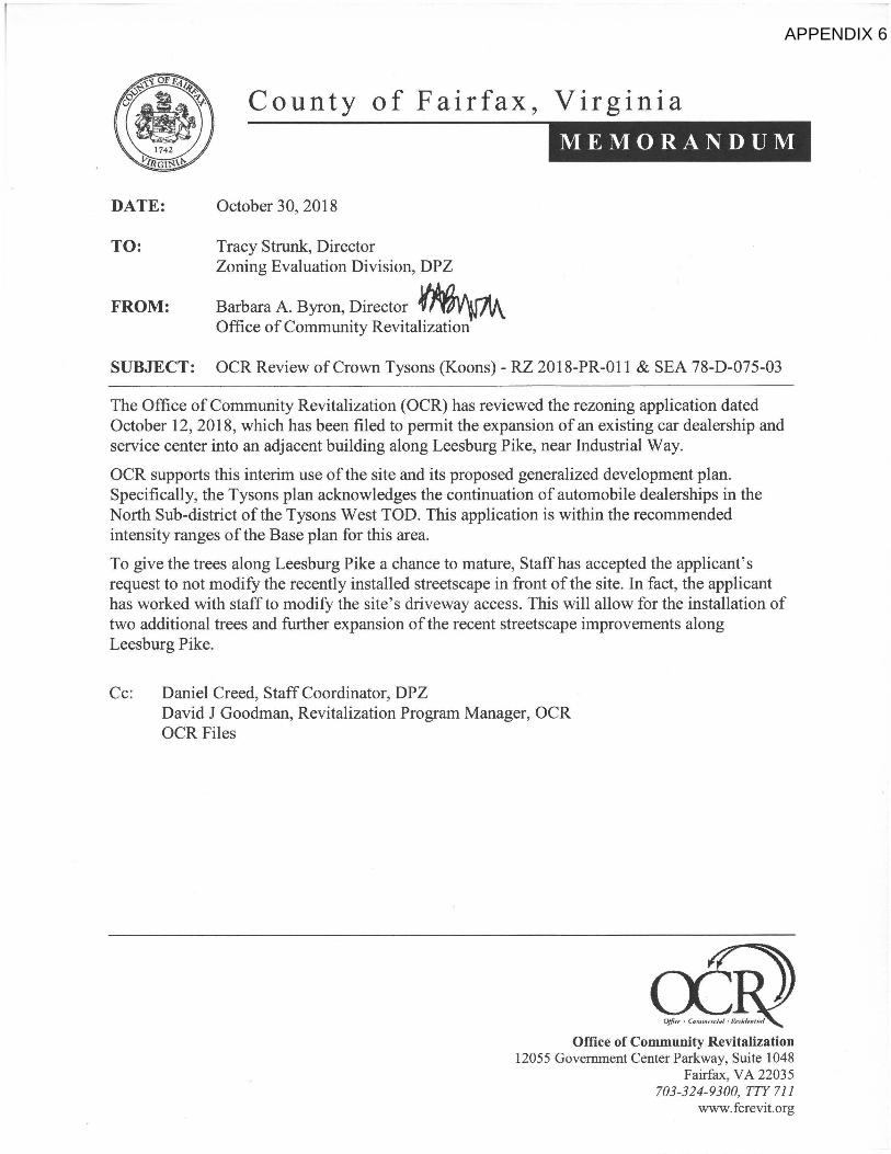
County of Fairfax, Virginia MEMORANDUM
DATE: October 30, 2018
TO: Tracy Strunk, Director Zoning Evaluation Division, DPZ
FROM: Barbara A. Byron, Director Office of Community Revitalization
SUBJECT: OCR Review of Crown Tysons (Koons) - RZ 2018-PR-011 & SEA 78-D-075-03
The Office of Community Revitalization (OCR) has reviewed the rezoning application dated October 12, 2018, which has been filed to permit the expansion of an existing car dealership and service center into an adjacent building along Leesburg Pike, near Industrial Way. OCR supports this interim use of the site and its proposed generalized development plan. Specifically, the Tysons plan acknowledges the continuation of automobile dealerships in the North Sub-district of the Tysons West TOD. This application is within the recommended intensity ranges of the Base plan for this area. To give the trees along Leesburg Pike a chance to mature, Staff has accepted the applicant's request to not modify the recently installed streetscape in front of the site. In fact, the applicant has worked with staff to modify the site's driveway access. This will allow for the installation of two additional trees and further expansion of the recent streetscape improvements along Leesburg Pike.
Cc: Daniel Creed, Staff Coordinator, DPZ David J Goodman, Revitalization Program Manager, OCR OCR Files
Office of Community Revitalization 12055 Government Center Parkway, Suite 1048
Fairfax, VA 22035 703-324-9300, TTY 711
wvvw.fcrevit.org
APPENDIX 6
Department of Public Works and Environmental Services
Urban Forest Management Division
12055 Government Center Parkway, Suite 518
Fairfax, Virginia 22035-5503
Phone 703-324-1770, TTY: 711, Fax: 703-653-9550
www.fairfaxcounty.gov/dpwes
DATE: October 3, 2018
TO: Daniel Creed, Staff Coordinator
Zoning Evaluation Division, DPZ
FROM: Linda Barfield, Urban Forester II
Forest Conservation Branch, DPWES
SUBJECT: Koons Tysons Toyota.RZ 2018-PR-011 con with SEA 87-D-075-02
I have reviewed the above referenced Rezoning/Special Exception Amendment Application and
Revised Statement of Justification dated September 13, 2018”; and plan set stamped “Received,
Department of Planning and Zoning, September 14, 2018”. The following comments and
recommendations are based on this review.
It appears all UFMD comments have been adequately addressed.
lb/
UFMDID #: 187487
cc: DPZ File
C o u n t y o f F a i r f a x , V i r g i n i a
M E M O R A N D U M
APPENDIX 7
MEMORANDUM
DATE: September 25, 2018
TO: Daniel Creed, Staff Coordinator Zoning Evaluation Division Department of Planning and Zoning
FROM: Bin Zhang, Tysons Corner Site Reviewer Site Development and Inspections Division Land Development Services
SUBJECT: Rezoning Application #RZ 2018-PR-011; SEA 78-D-075-03; LDS Project #9764-ZONA-002-3; Koons Tysons Toyota; GDP dated September 14, 2018; Tax Map #029-1-((01))-15,16,17A; Providence District; Difficult Run Watershed
We have reviewed the subject application and offer the following comments.
Chesapeake Bay Preservation Ordinance (CBPO) There is no Resource Protection Area (RPA) designated on the site.
Floodplain There are no regulated floodplains on the site.
Downstream Drainage Complaints There are no applicable downstream drainage complaints on file.
Stormwater Quality Control There are two existing stormwater management (SWM) facilities located onsite. A sand filter (County ID SF0224) is located on Parcel 15, and a dry pond (County ID UBPRIVATE) is located on Parcel 17A. These facilities will remain in place with minimal changes to the contributing drainage area. In addition, two new SWM/BMP facilities are proposed to satisfy the water quality requirements of the Stormwater Management Ordinance (SWMO) Section 124-4-2 under redevelopment.
Stormwater Quantity Control There is an increase of impervious area with this redevelopment. The applicant indicates that the development will meet SWMO Section 124-4-4.D through a proposed underground detention facility.
Department of Land Development Services 12055 Government Center Parkway, Suite 659
Fairfax, Virginia 22035-5503 Phone 703-324-1780 • TTY 711 • FAX 703-653-6678
www.fairfaxcounty.gov
APPENDIX 8
Daniel Creed, Staff Coordinator 9764-ZONA-002-3 Page 2 of 2
Adequate Outfall An outfall narrative has been provided. The applicant has identified the point where the drainage area exceeds 100 times the contributing site area. Runoff from the site is collected in three storm sewer pipes that all head northeast to outfall into a trapezoidal concrete channel. The channel then flows north to a double box culvert underneath Dulles Toll Road and discharges into Rocky Run. A detailed analysis shall be provided at final site plan to demonstrate adequacy in accordance with SWMO Section 124-4-4.
Notwithstanding any notes, analysis, computations, narrative, facilities, details and/or design presented on the GDP, or statements in the Proffers, the final design, construction, operation and maintenance of the site, including, but not limited to, the stormwater facilities, shall be subject to review and approval by Land Development Services, in accordance with all applicable codes, requirements, standards, specifications, policies and procedures in effect at the time of Site Plan approval.
Please contact me at 703-324-1720 if you require additional information.
County of Fairfax, Virginia
MEMORANDUM
DATE: April 11, 2019
TO: Tracy Strunk, Director Zoning Evaluation Division, DPZ
FROM: William Capers III Transportation Planner Site Analysis Section
SUBJECT: RZ 2018-PR-011/SEA 78-D-075-03 Crowns Tysons Properties LLC Land Identification Maps: 29-1((1)) 15,16, and 17A
Date of original memo: October 24, 2018 Date of first revision: December 26, 2018 to address comments submitted by the applicant on November 29,2018.
Fairfax County Department of Transportation (FCDOT) has reviewed the subject Rezoning/Special Exception Amendment (SEA) application with Generalized Development Plat (GDP) (last update) dated October 12, 2018. The applicant proposes to rezone parcel 17A from the 1-4 District to the C-7 district to permit the development of a car dealership. The associated SEA application is to allow for the proposed dealership to operate with the existing car dealership located on Parcels 15 and 16.
The applicant proposes to improve the existing building in two phases. Phase I of the redevelopment will include an expansion of the current service operation, which includes the improvement of 33,262 square feet (SF) of the subject property for internal service bays and office space. Phase I will also include onsite improvements to allow for inter-parcel connection to the adjoining sites. Phase II will include development of 90,710 SF of the subject property for a new vehicle sales facility with full service operations to include four (4) service lanes into the facility. Phase II will also provide site modifications to the existing driveways to allow for limited access in and out of the site. The applicant indicates that the remaining 33,625 SF of the existing building will be used for vehicle storage and will not add any additional trips to the adjacent road network.
Primary Concerns
Industrial Way
Staff's most significant concern is related to the intensification of the existing car dealership during Phase I of the development. Staff recommended in a memo dated April 4, 2014 as part
Fairfax County Department of Transportation 4050 Legato Road, Suite 400
Fairfax, VA 22033-2895 Phone: (703) 877-5600 TTY: 711
Fax: (703) 877-5723 www.fairfaxcounty.gov/fcdot
FCDOT
Serving Fairfax County Since 1977
APPENDIX 9
Tracy Strunk, Director
April 11, 2019 Page 2 of 5
of the previously approved SEA, that further intensification of the site will prompt the need for
dedication or construction of the existing easement/private road (Industrial Way) that is a
planned grid street per the Comprehensive Plan. The intent of the planned grid of streets is to
provide additional capacity to the Tyson's road network by allowing for better distribution of
traffic. The applicant indicates that Phase I of the development will include an expansion of
the existing service center, and the Operational Analysis (OA) shows that the expansion will
add 80 new peak hour trips to the road network, which will access the site via Industrial Way.
The expansion of the service center is an intensification of the site which will add additional
trips to Industrial Way and the surrounding road network. Staff recommends the applicant
provides right-of-way reservation along Industrial Way for future construction of the planned grid street upon demand by the County.
Phasing
The applicant indicates that only a portion of the subject property will be used for the auto-
sales/service operations during all phases of the development. The anticipated new trips for
Phase I was based on the use of 33,262 SF of new car sales within the building area, and new
trips for Phase II was based on the use of 90, 710 SF of new car sales within building area. The
applicant indicates that the remaining SF of the building will be used for vehicle storage and
will not generate any additional traffic. The development program to include the total SF of the
subject property to be used for new car sales during both phases of the development and the
portions to be used for auto storage were agreed upon by staff and the applicant during the
scoping of the OA. As such, staff recommends the applicant modify proffers 7A to indicate
that 33,262 SF within the building during Phase I will be used solely for new car sales and
modify proffer 7B to indicate that 90,710 SF within the building during Phase II will be used
solely for new car sales.
Response to comments submitted on November 29, 2018
As an update to this memorandum, the applicant provided a response letter to address staff
comments regarding right-of-way reservation for future dedication of Industrial Way to
minimize site impacts to the overall network in Tysons. The following provides FDCOT's
point by point response to the applicant's comments dated, November 29, 2018. The
applicant's comments are provided in this memorandum are in bold with staffs responses in
italics.
1. The Plan includes a Base Recommendation and a Redevelopment Option. The
Base Recommendation reflects existing uses that may be continued as interim uses. As the Redevelopment Option permits much higher intensities, the expectation is that the grid of streets will be implemented with the Redevelopment Option. The Applicant's proposal is an interim use that is evaluated under the
Plan's Base Recommendation and Implementation of the grid of streets is not
warranted.

Tracy Strunk, Director April 11,2019 Page 3 of 5
Response: The comprehensive plan for the Tysons West sub-district
distinguishes the Base Plan and Redevelopment Option on land use intensity but
establishes that any planned development should provide commitments for
improvements needed to mitigate transportation impacts directly related to site
generated traffic. The applicant indicated that Phase I of the development will
further intensify the use of the existing car sales dealership, which will further
intensifi, the surrounding road network The intent of the planned grid of streets is to provide additional capacity to the Tyson's road network by allowing for
better distribution of traffic. Implementation of the grid of streets is not a
function of development options, but rather a mechanism to improve mobility in
Tysons. The plan does not stipulate that continued development under the "Base
Plan" precludes the need to provide transportation improvements consistent
with the goals established in the Comprehensive Plan for Tysons. Given the
scale of the proposed development, staff requests the applicant provides right-
of-way reservation for future dedication along Industrial Way to accommodate the future construction of the planned grid street. Staff is not requesting that the
applicant construct the roadway with this application.
2. Even if the implementation of the street grid is warranted, it is premature to identify and reserve a location for a street without the ultimate improvements will be proposed under the Redevelopment option. The fact that Industrial Way was originally shown in the street grid and was subsequently removed is evidence that the best locations for access are constantly being evaluated and updated.
Response: The planned grid of streets is conceptual and is subject to change pending results from additional analyses as surrounding development occurs.
The grid provides a conceptual outlook for a direct connection to Route 7. The
current iteration of plan proposes a direct connection to Route 7 that bisects the
subject site, and cuts through the building footprint of the proposed auto dealership. The current location of the planned grid connection to Rt. 7
identified on the plan map may not be consistent with implementation of the
grid of street network planned by surrounding applications at the
redevelopment option, and may also cause a fragmented parcel that that may
not be developable should this applicant redevelop to the Planned Tysons
Corner (PTC) zoning district. Industrial Way currently serves as a point of
access to the existing car dealership, and is consistent with the plan goals to provide an alternate connection to Rt. 7 from south of the Dulles Toll Road.
Consistent with other development projects in Tysons, roadway design and
location of the planned grid of streets are subject to modifications to fit the need
for Tysons development at that time.
3. The Phase I proposal will not intensify the use of the Application Property to warrant a dedication or reservation of right-of-way as suggested by the
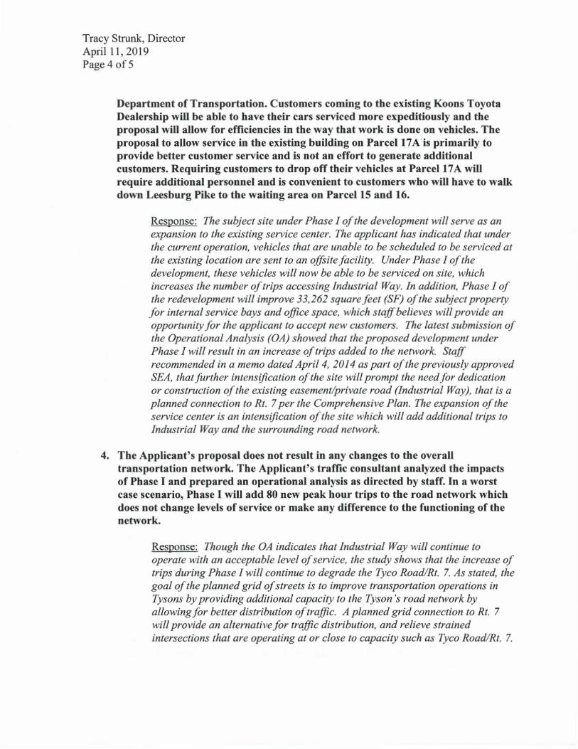
Tracy Strunk, Director April 11, 2019 Page 4 of 5
Department of Transportation. Customers coming to the existing Koons Toyota Dealership will be able to have their cars serviced more expeditiously and the proposal will allow for efficiencies in the way that work is done on vehicles. The proposal to allow service in the existing building on Parcel 17A is primarily to provide better customer service and is not an effort to generate additional customers. Requiring customers to drop off their vehicles at Parcel 17A will
require additional personnel and is convenient to customers who will have to walk down Leesburg Pike to the waiting area on Parcel 15 and 16.
Response: The subject site under Phase I of the development will serve as an
expansion to the existing service center. The applicant has indicated that under
the current operation, vehicles that are unable to be scheduled to be serviced at
the existing location are sent to an offsite facility. Under Phase 1 of the
development, these vehicles will now be able to be serviced on site, which
increases the number of trips accessing Industrial Way. In addition, Phase 1 of
the redevelopment will improve 33,262 square feet (SF) of the subject property
for internal service bays and office space, which staff believes will provide an
opportunity for the applicant to accept new customers. The latest submission of
the Operational Analysis (OA) showed that the proposed development under
Phase I will result in an increase of trips added to the network. Staff
recommended in a memo dated April 4, 2014 as part of the previously approved
SEA, that further intensification of the site will prompt the need for dedication
or construction of the existing easement/private road (Industrial Way), that is a
planned connection to Rt. 7 per the Comprehensive Plan. The expansion of the
service center is an intensification of the site which will add additional trips to
Industrial Way and the surrounding road network.
4. The Applicant's proposal does not result in any changes to the overall transportation network. The Applicant's traffic consultant analyzed the impacts of Phase I and prepared an operational analysis as directed by staff. In a worst case scenario, Phase I will add 80 new peak hour trips to the road network which does not change levels of service or make any difference to the functioning of the network.
Response: Though the OA indicates that Industrial Way will continue to
operate with an acceptable level of service, the study shows that the increase of
trips during Phase I will continue to degrade the Tyco Road/Rt. 7. As stated, the
goal of the planned grid of streets is to improve transportation operations in
Tysons by providing additional capacity to the Tyson's road network by
allowing for better distribution of traffic. A planned grid connection to Rt. 7
will provide an alternative for traffic distribution, and relieve strained
intersections that are operating at or close to capacity such as Tyco Road/Rt. 7.

Tracy Strunk, Director April 11, 2019 Page 5 of 5
5. Special exception conditions are proposed by staff and intended to mitigate impacts directly related to the proposed development. Development conditions must be reasonable, have a rationale relationship to the proposed development, and maintain a nexus to the proposal. Based on this criteria, the Applicant's Phase I proposal does not warrant the dedication or reservation of Industrial Way.
Response: Staff believes the intensification of the site and increase in traffic as part of the expansion of the current service operation under Phase I is reasonable to warrant reservation for future dedication of Industrial Way to help meet the goals outlined in The Plan. The request for an applicant not proposing a PTC rezoning to provide a physical or monetary contribution for implementation of the grid of streets is not uncommon. There have been other by right and non- PTC redevelopment applications in Tysons that have provided commitments for implementation of the grid streets based on the increase of traffic proposed by the site.
Cc: Daniel Creed, DPZ-ZED Gregory Fuller, Transportation Planner IV, FCDOT-SAS Jeffrey Hermann, AICP, Chief, FCDOT-SAS

DEPARTMENT OF TRANSPORTATION 4975 Alliance Drive Fairfax, VA 22030
We Keep Virginia Moving
STEPHEN C. BRICH, P.E. COMMISSIONER
August 9, 2018
To: Ms. Tracy Strunk Director, Zoning Evaluation Division From: Alex Faghri Virginia Department of Transportation – Land Development Section Subject: RZ 2018-PR-011; 8600 Leesburg Pike Crowns Tysons
We have reviewed first submission Operational Analysis (OA) associated with the subject application that was received on July 6, 2018 and offer the following comments:
1. Please check the in/out AM and PM traffic volumes for the two site entrances with the collected traffic data in Appendix B. The numbers on Figure 4 for the in/out traffic volumes to the site are incorrect. All traffic calculations/tables based on these existing traffic volumes at these two locations should be updated accordingly.
2. Please clarify the data collection on page 5? The dates on page 5 and Appendix B do not match.
3. The traffic volumes generated from the site increase more than 21% (AM) and 68% (PM) northbound U-Turn traffic at the intersection of Leesburg Pike and Jarrett Valley Drive accordingly on the build-out year 2021 (See Appendix C). In order to keep the northbound left-turn/U-turn control delay within the acceptable level, the study reduced about 12 seconds (AM) and 15 seconds (PM) southbound through green time to balance the other directions. However, this analysis indicates that no mitigation measures are recommended on Page 27. Please correct it in the Conclusion on page 27.
4. The analysis indicates that queues for the northbound left/U turns at the intersection of Leesburg Pike and Jarrett Valley Drive will exceed the available storage. Please indicate which additional mitigation measures can be implemented to address this issue. If mitigation measures are not feasible, please consider reducing the level of development.
5. The collected heavy truck data in Appendix B for the intersection of Leesburg Pike and Jarrett Valley Drive (6/21/2018) could not be located. The TIA found the existing heavy vehicles for the northbound traffic at the intersection of Leesburg Pike and Jarrett Valley Drive are about 13% on Appendix C Page 2 and about 12% , 5% for northbound right turn, northbound through accordingly at the intersection of Leesburg Pike and Tyco Road on Appendix C Page 8. Please provide the details regarding the percentage of heavy truck in Existing Traffic Volumes on page 5.
Please revise and resubmit the OA including a comment / response sheet for further review.
All submittals subsequent to the first submittal shall provide a response letter to the previous VDOT comments. Submittals without comment response letters are considered incomplete and will be returned without review.
APPENDIX 10
Department of Public Works and Environmental Services
Wastewater Planning & Monitoring Division
12000 Government Center Parkway, Suite 358
Fairfax, VA 22035
Phone: 703-324-5030, Fax: 703-803-3297
www.fairfaxcounty.gov/dpwes
DATE: June 28, 2018
TO: Daniel Creed
Zoning Evaluation Division
Department of Planning and Zoning
FROM: Sharad Regmi, P.E. (703-324-5008)
Engineering Analysis and Planning Branch
SUBJECT: Sanitary Sewer Analysis Report
REF: Application No. RZ 2018-PR-011 con. with SEA 78-D-075-03
Tax Map No. 029-1-((01))-0015; 0016; 0017-A
(8602; 8610; 8600 Leesburg Pike)
The proposed RZ & amendment to SE do not increase existing FAR and therefore do not have
adverse impact on the capacity of the sanitary sewer system. Please contact me at the number
above if you have any questions.
M E M O R A N D U M
M
C o u n t y o f F a i r f a x , V i r g i n i a
Page 1 of 4
9-006 General Standards In addition to the specific standards set forth hereinafter with regard to particular special exception uses, all such uses shall satisfy the following general standards: SPECIAL EXCEPTIONS 9-9 1. The proposed use at the specified location shall be in harmony with the adopted
comprehensive plan. 2. The proposed use shall be in harmony with the general purpose and intent of the
applicable zoning district regulations. 3. The proposed use shall be such that it will be harmonious with and will not adversely
affect the use or development of neighboring properties in accordance with the applicable zoning district regulations and the adopted comprehensive plan. The location, size and height of buildings, structures, walls and fences, and the nature and extent of screening, buffering and landscaping shall be such that the use will not hinder or discourage the appropriate development and use of adjacent or nearby land and/or buildings or impair the value thereof.
4. The proposed use shall be such that pedestrian and vehicular traffic associated with
such use will not be hazardous or conflict with the existing and anticipated traffic in the neighborhood.
5. In addition to the standards which may be set forth in this Article for a particular
category or use, the Board shall require landscaping and screening in accordance with the provisions of Article 13.
6. Open space shall be provided in an amount equivalent to that specified for the
zoning district in which the proposed use is located. 7. Adequate utility, drainage, parking, loading and other necessary facilities to serve
the proposed use shall be provided. Parking and loading requirements shall be in accordance with the provisions of Article 11.
8. Signs shall be regulated by the provisions of Article 12; however, the Board may
impose more strict requirements for a given use than those set forth in this
Ordinance.
Appendix 12
Page 2 of 4
9-503 Standards for all Category 5 Uses In addition to the general standards set forth in Sect. 006 above, all Category 5 special exception uses shall satisfy the following standards: 1. Except as qualified in the following Sections, all uses shall comply with the lot size
and bulk regulations of the zoning district in which located. 2. All uses shall comply with the performance standards specified for the zoning district
in which located, including the submission of a sports illumination plan or photometric plan as may be required by Part 9 of Article 14.
3. Before establishment, all uses, including modifications or alterations to existing uses,
shall be subject to the provisions of Article 17, Site Plans.

Page 3 of 4
9-518 Additional Standards for Vehicle Sale, Rental and Ancillary Service Establishments 1. Outdoor storage, parking and display areas shall be permitted only on the same lot
with and ancillary to a sales room, rental office or service facility, which shall be entirely enclosed on all sides.
2. The outdoor area devoted to storage, loading, parking and display of goods shall be
limited to that area so designated on an approved special exception plat. Such areas shall not be used for the storage or display of vehicles that are not in operating condition.
3. Notwithstanding the bulk regulations of the zoning district in which located, any such
outdoor area that is located on the ground and is open to the sky may be located in any required yard but not nearer to any front lot line than ten (10) feet, except as may be qualified by the provisions of Article 13.
All structures shall be subject to the bulk regulations of the zoning district in which located, except structures which are completely underground may be located in any required yard, but not closer than one (1) foot to any lot line.
4. All such uses shall be provided with safe and convenient access to a street. If any
outdoor area is located contiguous to a street, the street side thereof shall be curbed, and ingress and egress shall be provided only through driveway openings through the curb of such dimension, location and construction as may be approved by the Director in accordance with the Public Facilities Manual.
5. All outdoor areas, including aisles and driveways, shall be constructed and
maintained with an approved surface in accordance with Par. 11 of Sect. 11-102, and shall be improved in accordance with construction standards presented in the Public Facilities Manual.
6. All lighting fixtures used to illuminate such outdoor areas shall be in conformance
with the performance standards for outdoor lighting set forth in Part 9 of Article 14. 7. In the C-3, C-4, I-3, I-4, I-5, PDC, PRC and PRM Districts, only vehicle rental
establishments may be allowed and such use shall be subject to Paragraphs 1 through 6 above and the following:
A. Vehicle rental establishments shall be limited to the rental of automobiles and
passenger vans and the rental of trucks or other vehicles shall not be permitted.
B. There may be a maximum of twenty-five (25) rental vehicles stored on site and such vehicles shall be stored in a portion of the parking lot designated on the special exception plat for the storage of rental vehicles.
C. There shall be no maintenance or refueling of the rental vehicles on-site.

Page 4 of 4
8. In the PTC District, vehicle sale, rental and ancillary service establishments may only be permitted in accordance with the provisions of Sect. 6-505.
GLOSSARY This Glossary is provided to assist the public in understanding the staff evaluation and analysis of development proposals. It should not be construed as representing legal definitions. Refer to the Fairfax County Zoning Ordinance, Comprehensive Plan or Public Facilities Manual for additional information. ABANDONMENT: Refers to road or street abandonment, an action taken by the Board of Supervisors, usually through the public hearing process, to abolish the public's right-of-passage over a road or road right-of way. Upon abandonment, the right-of-way automatically reverts to the underlying fee owners. If the fee to the owner is unknown, Virginia law presumes that fee to the roadbed rests with the adjacent property owners if there is no evidence to the contrary. ACCESSORY DWELLING UNIT (OR APARTMENT): A secondary dwelling unit established in conjunction with and clearly subordinate to a single family detached dwelling unit. An accessory dwelling unit may be allowed if a special permit is granted by the Board of Zoning Appeals (BZA). Refer to Sect. 8-918 of the Zoning Ordinance. AFFORDABLE DWELLING UNIT (ADU) DEVELOPMENT: Residential development to assist in the provision of affordable housing for persons of low and moderate income in accordance with the affordable dwelling unit program and in accordance with Zoning Ordinance regulations. Residential development which provides affordable dwelling units may result in a density bonus (see below) permitting the construction of additional housing units. See Part 8 of Article 2 of the Zoning Ordinance. AGRICULTURAL AND FORESTAL DISTRICTS: A land use classification created under Chapter 114 or 115 of the Fairfax County Code for the purpose of qualifying landowners who wish to retain their property for agricultural or forestal use for use/value taxation pursuant to Chapter 58 of the Fairfax County Code. BARRIER: A wall, fence, earthen berm, or plant materials which may be used to provide a physical separation between land uses. Refer to Article 13 of the Zoning Ordinance for specific barrier requirements. BEST MANAGEMENT PRACTICES (BMPs): Stormwater management techniques or land use practices that are determined to be the most effective, practicable means of preventing and/or reducing the amount of pollution generated by nonpoint sources in order to improve water quality. BUFFER: Graduated mix of land uses, building heights or intensities designed to mitigate potential conflicts between different types or intensities of land uses; may also provide for a transition between uses. A landscaped buffer may be an area of open, undeveloped land and may include a combination of fences, walls, berms, open space and/or landscape plantings. A buffer is not necessarily coincident with transitional screening. CHESAPEAKE BAY PRESERVATION ORDINANCE: Regulations which the State has mandated must be adopted to protect the Chesapeake Bay and its tributaries. These regulations must be incorporated into the comprehensive plans, zoning ordinances and subdivision ordinances of the affected localities. Refer to Chesapeake Bay Preservation Act, Va. Code Section 10.1-2100 et seq and VR 173-02-01, Chesapeake Bay Preservation Area Designation and Management Regulations. CLUSTER DEVELOPMENT: Residential development in which the lots are clustered on a portion of a site so that significant environmental/historical/cultural resources may be preserved or recreational amenities provided. While smaller lot sizes are permitted in a cluster subdivision to preserve open space, the overall density cannot exceed that permitted by the applicable zoning district. See Sect. 2-421 and Sect. 9-615 of the Zoning Ordinance. COUNTY 2232 REVIEW PROCESS: A public hearing process pursuant to Sect. 15.2-2232 (Formerly Sect. 15.1-456) of the Virginia Code which is used to determine if a proposed public facility not shown on the adopted Comprehensive Plan is in substantial accord with the plan. Specifically, this process is used to determine if the general or approximate location, character and extent of a proposed facility is in substantial accord with the Plan. dBA: The momentary magnitude of sound weighted to approximate the sensitivity of the human ear to certain frequencies; the dBA value describes a sound at a given instant, a maximum sound level or a steady state value. See also Ldn. DENSITY: Number of dwelling units (du) divided by the gross acreage (ac) of a site being developed in residential use; or, the number of dwelling units per acre (du/ac) except in the PRC District when density refers to the number of persons per acre. DENSITY BONUS: An increase in the density otherwise allowed in a given zoning district which may be granted under specific provisions of the Zoning Ordinance when a developer provides excess open space, recreation facilities, or affordable dwelling units (ADUs), etc. DEVELOPMENT CONDITIONS: Terms or conditions imposed on a development by the Board of Supervisors (BOS) or the Board of Zoning Appeals (BZA) in connection with approval of a special exception, special permit or variance application or rezoning application in a "P" district. Conditions may be imposed to mitigate adverse impacts associated with a development as well as secure compliance with the Zoning Ordinance and/or conformance with the Comprehensive Plan. For example, development conditions may regulate hours of operation, number of employees, height of buildings, and intensity of development.
APPENDIX 13

- 2 -
DEVELOPMENT PLAN: A graphic representation which depicts the nature and character of the development proposed for a specific land area: information such as topography, location and size of proposed structures, location of streets trails, utilities, and storm drainage are generally included on a development plan. A development plan is s submission requirement for rezoning to the PRC District. A GENERALIZED DEVELOPMENT PLAN (GDP) is a submission requirement for a rezoning application for all conventional zoning districts other than a P District. A development plan submitted in connection with a special exception (SE) or special permit (SP) is generally referred to as an SE or SP plat. A CONCEPTUAL DEVELOPMENT PLAN (CDP) is a submission requirement when filing a rezoning application for a P District other than the PRC District; a CDP characterizes in a general way the planned development of the site. A FINAL DEVELOPMENT PLAN (FDP) is a submission requirement following the approval of a conceptual development plan and rezoning application for a P District other than the PRC District; an FDP further details the planned development of the site. See Article 16 of the Zoning Ordinance. EASEMENT: A right to or interest in property owned by another for a specific and limited purpose. Examples: access easement, utility easement, construction easement, etc. Easements may be for public or private purposes. ENVIRONMENTAL QUALITY CORRIDORS (EQCs): An open space system designed to link and preserve natural resource areas, provide passive recreation and protect wildlife habitat. The system includes stream valleys, steep slopes and wetlands. For a complete definition of EQCs, refer to the Environmental section of the Policy Plan for Fairfax County contained in Vol. 1 of the Comprehensive Plan. ERODIBLE SOILS: Soils that wash away easily, especially under conditions where stormwater runoff is inadequately controlled. Silt and sediment are washed into nearby streams, thereby degrading water quality. FLOODPLAIN: Those land areas in and adjacent to streams and watercourses subject to periodic flooding; usually associated with environmental quality corridors. The 100 year floodplain drains 70 acres or more of land and has a one percent chance of flood occurrence in any given year. FLOOR AREA RATIO (FAR): An expression of the amount of development intensity (typically, non-residential uses) on a specific parcel of land. FAR is determined by dividing the total square footage of gross floor area of buildings on a site by the total square footage of the site itself. FUNCTIONAL CLASSIFICATION: A system for classifying roads in terms of the character of service that individual facilities are providing or are intended to provide, ranging from travel mobility to land access. Roadway system functional classification elements include Freeways or Expressways which are limited access highways, Other Principal (or Major) Arterials, Minor Arterials, Collector Streets, and Local Streets. Principal arterials are designed to accommodate travel; access to adjacent properties is discouraged. Minor arterials are designed to serve both through traffic and local trips. Collector roads and streets link local streets and properties with the arterial network. Local streets provide access to adjacent properties. GEOTECHNICAL REVIEW: An engineering study of the geology and soils of a site which is submitted to determine the suitability of a site for development and recommends construction techniques designed to overcome development on problem soils, e.g., marine clay soils. HYDROCARBON RUNOFF: Petroleum products, such as motor oil, gasoline or transmission fluid deposited by motor vehicles which are carried into the local storm sewer system with the stormwater runoff, and ultimately, into receiving streams; a major source of non-point source pollution. An oil-grit separator is a common hydrocarbon runoff reduction method. IMPERVIOUS SURFACE: Any land area covered by buildings or paved with a hard surface such that water cannot seep through the surface into the ground. INFILL: Development on vacant or underutilized sites within an area which is already mostly developed in an established development pattern or neighborhood. INTENSITY: The magnitude of development usually measured in such terms as density, floor area ratio, building height, percentage of impervious surface, traffic generation, etc. Intensity is also based on a comparison of the development proposal against environmental constraints or other conditions which determine the carrying capacity of a specific land area to accommodate development without adverse impacts. Ldn: Day night average sound level. It is the twenty-four hour average sound level expressed in A-weighted decibels; the measurement assigns a "penalty" to night time noise to account for night time sensitivity. Ldn represents the total noise environment which varies over time and correlates with the effects of noise on the public health, safety and welfare. LEVEL OF SERVICE (LOS): An estimate of the effectiveness of a roadway to carry traffic, usually under anticipated peak traffic conditions. Level of Service efficiency is generally characterized by the letters A through F, with LOS-A describing free flow traffic conditions and LOS-F describing jammed or grid-lock conditions. MARINE CLAY SOILS: Soils that occur in widespread areas of the County generally east of Interstate 95. Because of the abundance of shrink-swell clays in these soils, they tend to be highly unstable. Many areas of slope failure are evident on natural slopes. Construction on these soils may initiate or accelerate slope movement or slope failure. The shrink-swell soils can cause movement in structures, even in areas of flat topography, from dry to wet seasons resulting in cracked foundations, etc. Also known as slippage soils.
- 3 -
OPEN SPACE: That portion of a site which generally is not covered by buildings, streets, or parking areas. Open space is intended to provide light and air; open space may be function as a buffer between land uses or for scenic, environmental, or recreational purposes. OPEN SPACE EASEMENT: An easement usually granted to the Board of Supervisors which preserves a tract of land in open space for some public benefit in perpetuity or for a specified period of time. Open space easements may be accepted by the Board of Supervisors, upon request of the land owner, after evaluation under criteria established by the Board. See Open Space Land Act, Code of Virginia, Sections 10.1-1700, et seq. P DISTRICT: A "P" district refers to land that is planned and/or developed as a Planned Development Housing (PDH) District, a Planned Development Commercial (PDC) District or a Planned Residential Community (PRC) District. The PDH, PDC and PRC Zoning Districts are established to encourage innovative and creative design for land development; to provide ample and efficient use of open space; to promote a balance in the mix of land uses, housing types, and intensity of development; and to allow maximum flexibility in order to achieve excellence in physical, social and economic planning and development of a site. Refer to Articles 6 and 16 of the Zoning Ordinance. PROFFER: A written condition, which, when offered voluntarily by a property owner and accepted by the Board of Supervisors in a rezoning action, becomes a legally binding condition which is in addition to the zoning district regulations applicable to a specific property. Proffers are submitted and signed by an owner prior to the Board of Supervisors public hearing on a rezoning application and run with the land. Once accepted by the Board, proffers may be modified only by a proffered condition amendment (PCA) application or other zoning action of the Board and the hearing process required for a rezoning application applies. See Sect. 15.2-2303 (formerly 15.1-491) of the Code of Virginia. PUBLIC FACILITIES MANUAL (PFM): A technical text approved by the Board of Supervisors containing guidelines and standards which govern the design and construction of site improvements incorporating applicable Federal, State and County Codes, specific standards of the Virginia Department of Transportation and the County's Department of Public Works and Environmental Services. RESOURCE MANAGEMENT AREA (RMA): That component of the Chesapeake Bay Preservation Area comprised of lands that, if improperly used or developed, have a potential for causing significant water quality degradation or for diminishing the functional value of the Resource Protection Area. See Fairfax County Code, Ch. 118, Chesapeake Bay Preservation Ordinance. RESOURCE PROTECTION AREA (RPA): That component of the Chesapeake Bay Preservation Area comprised of lands at or near the shoreline or water's edge that have an intrinsic water quality value due to the ecological and biological processes they perform or are sensitive to impacts which may result in significant degradation of the quality of state waters. In their natural condition, these lands provide for the removal, reduction or assimilation of sediments from runoff entering the Bay and its tributaries, and minimize the adverse effects of human activities on state waters and aquatic resources. New development is generally discouraged in an RPA. See Fairfax County Code, Ch. 118, Chesapeake Bay Preservation Ordinance. SITE PLAN: A detailed engineering plan, to scale, depicting the development of a parcel of land and containing all information required by Article 17 of the Zoning Ordinance. Generally, submission of a site plan to DPWES for review and approval is required for all residential, commercial and industrial development except for development of single family detached dwellings. The site plan is required to assure that development complies with the Zoning Ordinance. SPECIAL EXCEPTION (SE) / SPECIAL PERMIT (SP): Uses, which by their nature, can have an undue impact upon or can be incompatible with other land uses and therefore need a site specific review. After review, such uses may be allowed to locate within given designated zoning districts if appropriate and only under special controls, limitations, and regulations. A special exception is subject to public hearings by the Planning Commission and Board of Supervisors with approval by the Board of Supervisors; a special permit requires a public hearing and approval by the Board of Zoning Appeals. Unlike proffers which are voluntary, the Board of Supervisors or BZA may impose reasonable conditions to assure, for example, compatibility and safety. See Article 8, Special Permits and Article 9, Special Exceptions, of the Zoning Ordinance. STORMWATER MANAGEMENT: Engineering practices that are incorporated into the design of a development in order to mitigate or abate adverse water quantity and water quality impacts resulting from development. Stormwater management systems are designed to slow down or retain runoff to re-create, as nearly as possible, the pre-development flow conditions. SUBDIVISION PLAT: The engineering plan for a subdivision of land submitted to DPWES for review and approved pursuant to Chapter 101 of the County Code. TRANSPORTATION DEMAND MANAGEMENT (TDM): Actions taken to reduce single occupant vehicle automobile trips or actions taken to manage or reduce overall transportation demand in a particular area. TRANSPORTATION SYSTEM MANAGEMENT (TSM) PROGRAMS: This term is used to describe a full spectrum of actions that may be applied to improve the overall efficiency of the transportation network. TSM programs usually consist of low-cost alternatives to major capital expenditures, and may include parking management measures, ridesharing programs, flexible or staggared work hours, transit promotion or operational improvements to the existing roadway system. TSM includes Transportation Demand Management (TDM) measures as well as H.O.V. use and other strategies associated with the operation of the street and transit systems.

- 4 -
URBAN DESIGN: An aspect of urban or suburban planning that focuses on creating a desirable environment in which to live, work and play. A well-designed urban or suburban environment demonstrates the four generally accepted principles of design: clearly identifiable function for the area; easily understood order; distinctive identity; and visual appeal. VACATION: Refers to vacation of street or road as an action taken by the Board of Supervisors in order to abolish the public's right-of-passage over a road or road right-of-way dedicated by a plat of subdivision. Upon vacation, title to the road right-of-way transfers by operation of law to the owner(s) of the adjacent properties within the subdivision from whence the road/road right-of-way originated. VARIANCE: An application to the Board of Zoning Appeals which seeks relief from a specific zoning regulation such as lot width, building height, or minimum yard requirements, among others. A variance may only be granted by the Board of Zoning Appeals through the public hearing process and upon a finding by the BZA that the variance application meets the required Standards for a Variance set forth in Sect. 18-404 of the Zoning Ordinance. WETLANDS: Land characterized by wetness for a portion of the growing season. Wetlands are generally delineated on the basis of physical characteristics such as soil properties indicative of wetness, the presence of vegetation with an affinity for water, and the presence or evidence of surface wetness or soil saturation. Wetland environments provide water quality improvement benefits and are ecologically valuable. Development activity in wetlands is subject to permitting processes administered by the U.S. Army Corps of Engineers TIDAL WETLANDS: Vegetated and nonvegetated wetlands as defined in Chapter 116 Wetlands Ordinance of the Fairfax County Code: includes tidal shores and tidally influenced embayments, creeks, and tributaries to the Occoquan and Potomac Rivers. Development activity in tidal wetlands may require approval from the Fairfax County Wetlands Board. Abbreviations Commonly Used in Staff Reports A&F ADU ARB BMP BOS BZA COG CBC CDP CRD DOT DP DPWES DPZ DU/AC EQC FAR FDP GDP GFA HC HCD LOS Non-RUP OSDS PCA PD PDC
Agricultural & Forestal District Affordable Dwelling Unit Architectural Review Board Best Management Practices Board of Supervisors Board of Zoning Appeals Council of Governments Community Business Center Conceptual Development Plan Commercial Revitalization District Department of Transportation Development Plan Department of Public Works and Environmental Services Department of Planning and Zoning Dwelling Units Per Acre Environmental Quality Corridor Floor Area Ratio Final Development Plan Generalized Development Plan Gross Floor Area Highway Corridor Overlay District Housing and Community Development Level of Service Non-Residential Use Permit Office of Site Development Services, DPWES Proffered Condition Amendment Planning Division Planned Development Commercial
PDH PFM PRC RC RE RMA RPA RUP RZ SE SEA SP TDM TMA TSA TSM UP & DD VC VDOT VPD VPH WMATA WS ZAD ZED ZPRB
Planned Development Housing Public Facilities Manual Planned Residential Community Residential-Conservation Residential Estate Resource Management Area Resource Protection Area Residential Use Permit Rezoning Special Exception Special Exception Amendment Special Permit Transportation Demand Management Transportation Management Association Transit Station Area Transportation System Management Utilities Planning and Design Division, DPWES Variance Virginia Dept. of Transportation Vehicles Per Day Vehicles per Hour Washington Metropolitan Area Transit Authority Water Supply Protection Overlay District Zoning Administration Division, DPZ Zoning Evaluation Division, DPZ Zoning Permit Review Branch
N:\ZED\WORDFORMS\FORMS\Miscellaneous\Glossary attached at end of reports.doc
Copyright © 2022 FDOKUMEN