Hudson Square Rezoning - NYC.gov
146
Phase 1A Archaeological Documentary Study Hudson Square Rezoning Block 477, Lots 44, 66, 73, 74, 75, and 76; Block 578, Lots 77 and 79; and Block 579, Lots 35 and 44 New York, New York Prepared for: Trinity Real Estate 75 Varick Street New York, NY 10013 Prepared by: AKRF, Inc. 440 Park Avenue South New York, New York 10016 February 2012
-
Upload
khangminh22 -
Category
Documents
-
view
1 -
download
0
Transcript of Hudson Square Rezoning - NYC.gov
Phase 1A Archaeological Documentary Study
Hudson Square Rezoning
Block 477, Lots 44, 66, 73, 74, 75, and 76;
Block 578, Lots 77 and 79; and
Block 579, Lots 35 and 44 New York, New York
Prepared for:
Trinity Real Estate 75 Varick Street
New York, NY 10013
Prepared by:
AKRF, Inc. 440 Park Avenue South
New York, New York 10016
February 2012
i
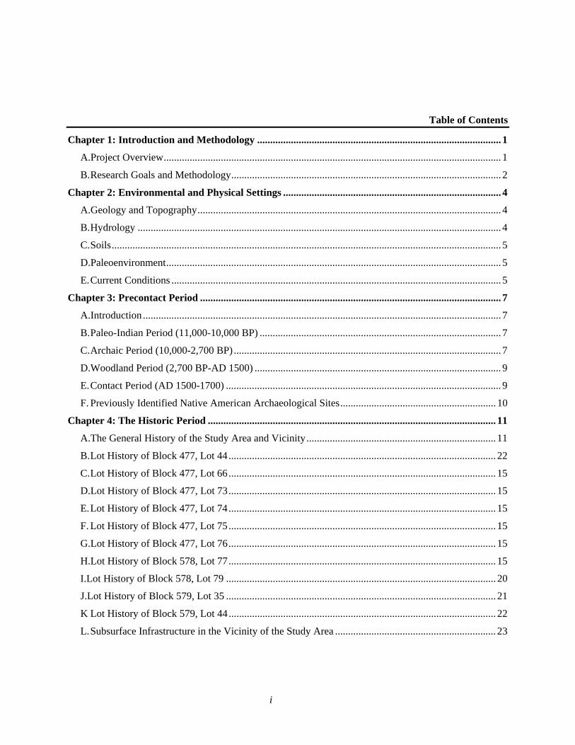
Table of Contents
Chapter 1: Introduction and Methodology .............................................................................................. 1
A.Project Overview .................................................................................................................................. 1
B. Research Goals and Methodology ........................................................................................................ 2
Chapter 2: Environmental and Physical Settings .................................................................................... 4
A.Geology and Topography ..................................................................................................................... 4
B. Hydrology ............................................................................................................................................ 4
C. Soils ...................................................................................................................................................... 5
D.Paleoenvironment ................................................................................................................................. 5
E. Current Conditions ............................................................................................................................... 5
Chapter 3: Precontact Period .................................................................................................................... 7
A.Introduction .......................................................................................................................................... 7
B. Paleo-Indian Period (11,000-10,000 BP) ............................................................................................. 7
C. Archaic Period (10,000-2,700 BP) ....................................................................................................... 7
D.Woodland Period (2,700 BP-AD 1500) ............................................................................................... 9
E. Contact Period (AD 1500-1700) .......................................................................................................... 9
F. Previously Identified Native American Archaeological Sites ............................................................ 10
Chapter 4: The Historic Period ............................................................................................................... 11
A.The General History of the Study Area and Vicinity ......................................................................... 11
B. Lot History of Block 477, Lot 44 ....................................................................................................... 22
C. Lot History of Block 477, Lot 66 ....................................................................................................... 15
D.Lot History of Block 477, Lot 73 ....................................................................................................... 15
E. Lot History of Block 477, Lot 74 ....................................................................................................... 15
F. Lot History of Block 477, Lot 75 ....................................................................................................... 15
G.Lot History of Block 477, Lot 76 ....................................................................................................... 15
H.Lot History of Block 578, Lot 77 ....................................................................................................... 15
I.Lot History of Block 578, Lot 79 ........................................................................................................ 20
J.Lot History of Block 579, Lot 35 ........................................................................................................ 21
K Lot History of Block 579, Lot 44 ....................................................................................................... 22
L. Subsurface Infrastructure in the Vicinity of the Study Area .............................................................. 23
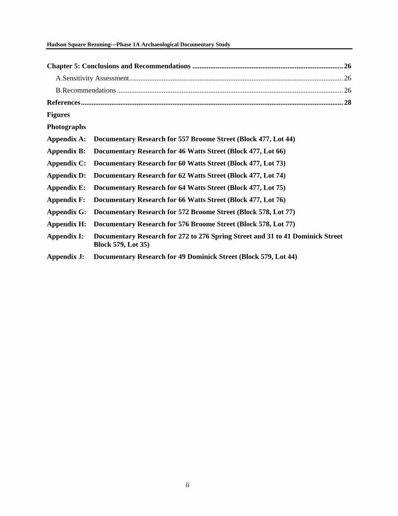
Hudson Square Rezoning—Phase 1A Archaeological Documentary Study
ii
Chapter 5: Conclusions and Recommendations .................................................................................... 26
A.Sensitivity Assessment ....................................................................................................................... 26
B. Recommendations .............................................................................................................................. 26
References .................................................................................................................................................. 28
Figures
Photographs
Appendix A: Documentary Research for 557 Broome Street (Block 477, Lot 44)
Appendix B: Documentary Research for 46 Watts Street (Block 477, Lot 66)
Appendix C: Documentary Research for 60 Watts Street (Block 477, Lot 73)
Appendix D: Documentary Research for 62 Watts Street (Block 477, Lot 74)
Appendix E: Documentary Research for 64 Watts Street (Block 477, Lot 75)
Appendix F: Documentary Research for 66 Watts Street (Block 477, Lot 76)
Appendix G: Documentary Research for 572 Broome Street (Block 578, Lot 77)
Appendix H: Documentary Research for 576 Broome Street (Block 578, Lot 77)
Appendix I: Documentary Research for 272 to 276 Spring Street and 31 to 41 Dominick Street Block 579, Lot 35)
Appendix J: Documentary Research for 49 Dominick Street (Block 579, Lot 44)
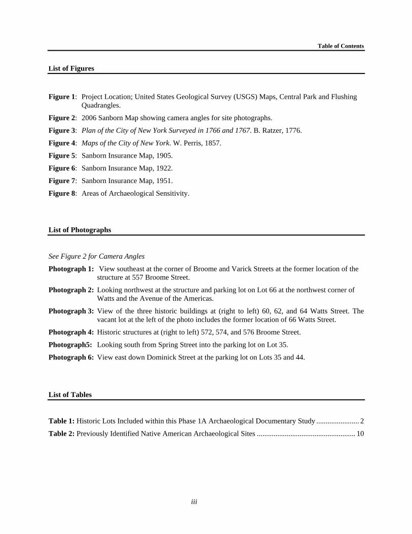
Table of Contents
iii
List of Figures
Figure 1: Project Location; United States Geological Survey (USGS) Maps, Central Park and Flushing Quadrangles.
Figure 2: 2006 Sanborn Map showing camera angles for site photographs.
Figure 3: Plan of the City of New York Surveyed in 1766 and 1767. B. Ratzer, 1776.
Figure 4: Maps of the City of New York. W. Perris, 1857.
Figure 5: Sanborn Insurance Map, 1905.
Figure 6: Sanborn Insurance Map, 1922.
Figure 7: Sanborn Insurance Map, 1951.
Figure 8: Areas of Archaeological Sensitivity.
List of Photographs
See Figure 2 for Camera Angles
Photograph 1: View southeast at the corner of Broome and Varick Streets at the former location of the structure at 557 Broome Street.
Photograph 2: Looking northwest at the structure and parking lot on Lot 66 at the northwest corner of Watts and the Avenue of the Americas.
Photograph 3: View of the three historic buildings at (right to left) 60, 62, and 64 Watts Street. The vacant lot at the left of the photo includes the former location of 66 Watts Street.
Photograph 4: Historic structures at (right to left) 572, 574, and 576 Broome Street.
Photograph5: Looking south from Spring Street into the parking lot on Lot 35.
Photograph 6: View east down Dominick Street at the parking lot on Lots 35 and 44.
List of Tables
Table 1: Historic Lots Included within this Phase 1A Archaeological Documentary Study ....................... 2
Table 2: Previously Identified Native American Archaeological Sites ..................................................... 10
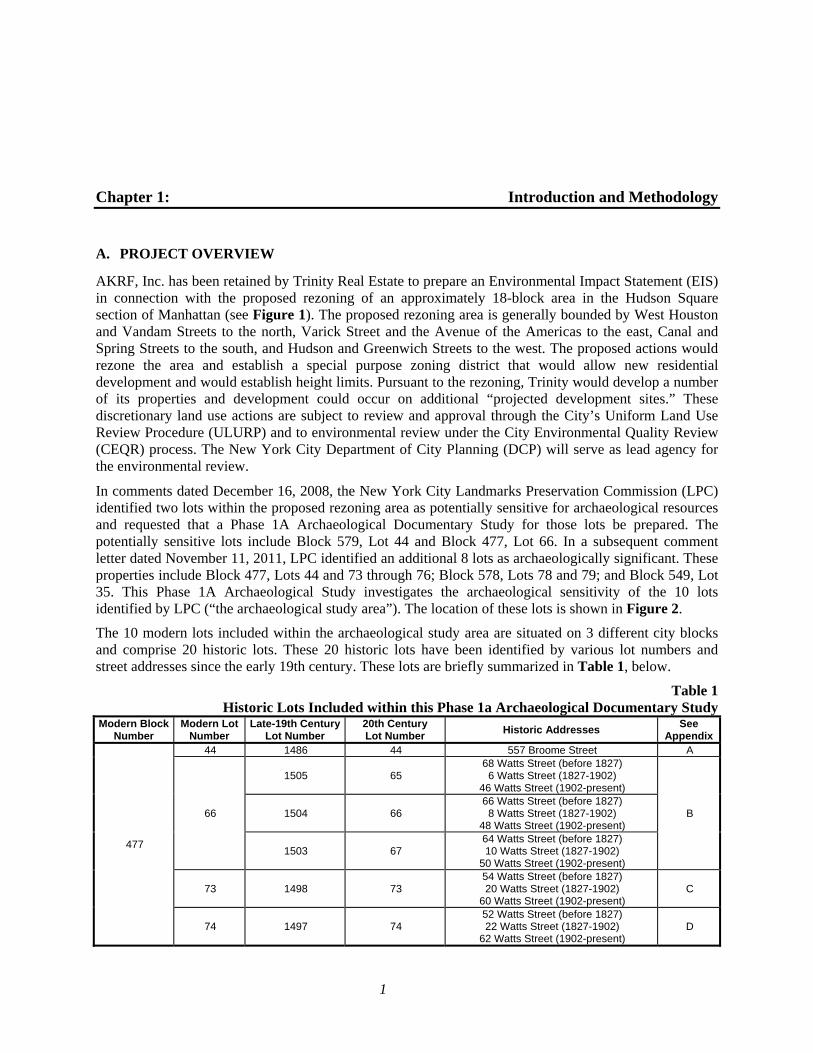
1
Chapter 1: Introduction and Methodology
A. PROJECT OVERVIEW
AKRF, Inc. has been retained by Trinity Real Estate to prepare an Environmental Impact Statement (EIS) in connection with the proposed rezoning of an approximately 18-block area in the Hudson Square section of Manhattan (see Figure 1). The proposed rezoning area is generally bounded by West Houston and Vandam Streets to the north, Varick Street and the Avenue of the Americas to the east, Canal and Spring Streets to the south, and Hudson and Greenwich Streets to the west. The proposed actions would rezone the area and establish a special purpose zoning district that would allow new residential development and would establish height limits. Pursuant to the rezoning, Trinity would develop a number of its properties and development could occur on additional “projected development sites.” These discretionary land use actions are subject to review and approval through the City’s Uniform Land Use Review Procedure (ULURP) and to environmental review under the City Environmental Quality Review (CEQR) process. The New York City Department of City Planning (DCP) will serve as lead agency for the environmental review.
In comments dated December 16, 2008, the New York City Landmarks Preservation Commission (LPC) identified two lots within the proposed rezoning area as potentially sensitive for archaeological resources and requested that a Phase 1A Archaeological Documentary Study for those lots be prepared. The potentially sensitive lots include Block 579, Lot 44 and Block 477, Lot 66. In a subsequent comment letter dated November 11, 2011, LPC identified an additional 8 lots as archaeologically significant. These properties include Block 477, Lots 44 and 73 through 76; Block 578, Lots 78 and 79; and Block 549, Lot 35. This Phase 1A Archaeological Study investigates the archaeological sensitivity of the 10 lots identified by LPC (“the archaeological study area”). The location of these lots is shown in Figure 2.
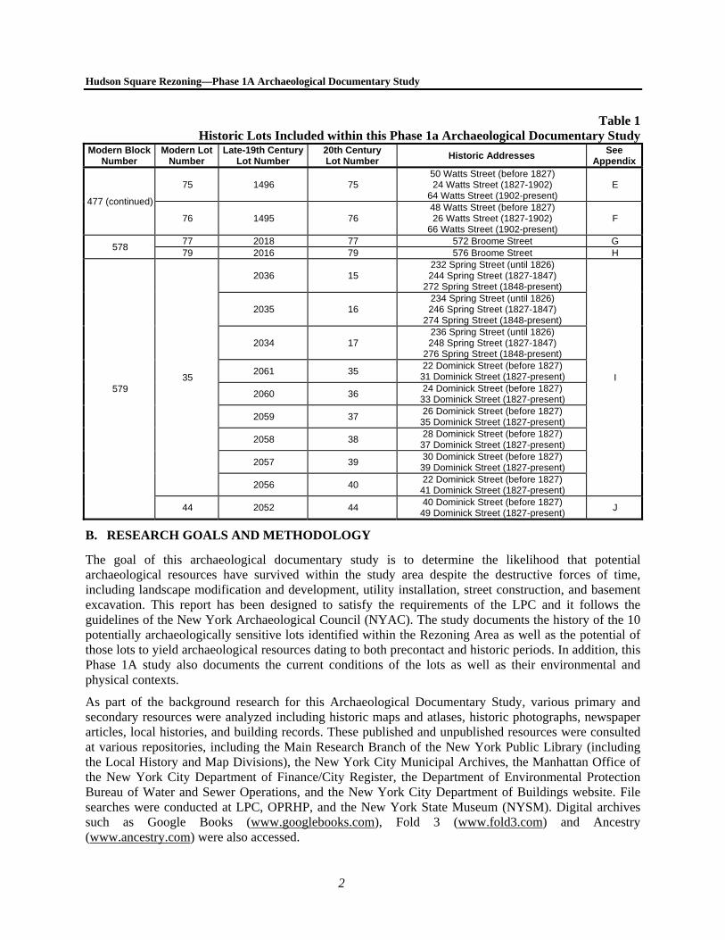
The 10 modern lots included within the archaeological study area are situated on 3 different city blocks and comprise 20 historic lots. These 20 historic lots have been identified by various lot numbers and street addresses since the early 19th century. These lots are briefly summarized in Table 1, below.
Table 1Historic Lots Included within this Phase 1a Archaeological Documentary Study
Modern Block Number
Modern Lot Number
Late-19th Century Lot Number
20th Century Lot Number
Historic Addresses See
Appendix
477
44 1486 44 557 Broome Street A
66
1505 65 68 Watts Street (before 1827) 6 Watts Street (1827-1902)
46 Watts Street (1902-present)
B 1504 66 66 Watts Street (before 1827) 8 Watts Street (1827-1902)
48 Watts Street (1902-present)
1503 67 64 Watts Street (before 1827) 10 Watts Street (1827-1902)
50 Watts Street (1902-present)
73 1498 73 54 Watts Street (before 1827) 20 Watts Street (1827-1902)
60 Watts Street (1902-present) C
74 1497 74 52 Watts Street (before 1827) 22 Watts Street (1827-1902)
62 Watts Street (1902-present) D
Hudson Square Rezoning—Phase 1A Archaeological Documentary Study
2
Table 1Historic Lots Included within this Phase 1a Archaeological Documentary Study
Modern Block Number
Modern Lot Number
Late-19th Century Lot Number
20th Century Lot Number
Historic Addresses See
Appendix
477 (continued)
75 1496 75 50 Watts Street (before 1827) 24 Watts Street (1827-1902)
64 Watts Street (1902-present) E
76 1495 76 48 Watts Street (before 1827) 26 Watts Street (1827-1902)
66 Watts Street (1902-present) F
578 77 2018 77 572 Broome Street G 79 2016 79 576 Broome Street H
579 35
2036 15 232 Spring Street (until 1826) 244 Spring Street (1827-1847)
272 Spring Street (1848-present)
I
2035 16 234 Spring Street (until 1826) 246 Spring Street (1827-1847)
274 Spring Street (1848-present)
2034 17 236 Spring Street (until 1826) 248 Spring Street (1827-1847)
276 Spring Street (1848-present)
2061 35 22 Dominick Street (before 1827)
31 Dominick Street (1827-present)
2060 36 24 Dominick Street (before 1827)
33 Dominick Street (1827-present)
2059 37 26 Dominick Street (before 1827)
35 Dominick Street (1827-present)
2058 38 28 Dominick Street (before 1827)
37 Dominick Street (1827-present)
2057 39 30 Dominick Street (before 1827)
39 Dominick Street (1827-present)
2056 40 22 Dominick Street (before 1827)
41 Dominick Street (1827-present)
44 2052 44 40 Dominick Street (before 1827)
49 Dominick Street (1827-present) J
B. RESEARCH GOALS AND METHODOLOGY
The goal of this archaeological documentary study is to determine the likelihood that potential archaeological resources have survived within the study area despite the destructive forces of time, including landscape modification and development, utility installation, street construction, and basement excavation. This report has been designed to satisfy the requirements of the LPC and it follows the guidelines of the New York Archaeological Council (NYAC). The study documents the history of the 10 potentially archaeologically sensitive lots identified within the Rezoning Area as well as the potential of those lots to yield archaeological resources dating to both precontact and historic periods. In addition, this Phase 1A study also documents the current conditions of the lots as well as their environmental and physical contexts.
As part of the background research for this Archaeological Documentary Study, various primary and secondary resources were analyzed including historic maps and atlases, historic photographs, newspaper articles, local histories, and building records. These published and unpublished resources were consulted at various repositories, including the Main Research Branch of the New York Public Library (including the Local History and Map Divisions), the New York City Municipal Archives, the Manhattan Office of the New York City Department of Finance/City Register, the Department of Environmental Protection Bureau of Water and Sewer Operations, and the New York City Department of Buildings website. File searches were conducted at LPC, OPRHP, and the New York State Museum (NYSM). Digital archives such as Google Books (www.googlebooks.com), Fold 3 (www.fold3.com) and Ancestry (www.ancestry.com) were also accessed.
Chapter 1: Introduction
3
Several criteria were used to determine the archaeological sensitivity of the study area. Historic maps were analyzed to understand the development history for each lot with the most useful and detailed maps being the 1852 and 1857 Perris atlases, the 1885 Robinson-Pidgeon atlas, the 1891 Bromley atlas, and Sanborn maps dating to 1894, 1905, 1922, and 1951. Nearly all of the lots experienced some disturbance during the 19th or 20th centuries as a result of excavation associated with the construction of a building with a basement. If a potentially unexcavated rear or side yard greater than 10 feet in width was identified on a lot during historic map research, that lot was identified as archaeologically sensitive and documentary research was completed to identify the owners and occupants of those lots. If a historic lot was entirely developed with a structure with a basement or if a narrow portion of the lot measuring less than 10 feet in width was left undeveloped, the lot was determined to not have archaeological significance and no additional analysis of that lot was completed.
For those lots that were identified as archaeologically sensitive, additional research into the lot’s occupation history was carried out to identify the lot’s residents between approximately 1818 (the beginning date when records for each property are readily available) and 1900. As part of this research, historic conveyance records dating to between the late 18th century and the 1930s were examined to determine ownership patterns for the study area. Tax assessment ledgers were reviewed examined to gain an understanding of the development of each lot before accurate maps were published beginning circa 1852. Tax assessment ledgers were reviewed for every year between the construction of the first dwellings on each lot and 1830, and for every five years between 1830 and 1850. In some instances, tax assessments could only be researched as far back as 1818 because records preceding that time did not include street addresses, lot numbers, or other descriptive information to enable the identification of the lot in historic records. Historic directories dating to between circa 1820 and 1900 were examined to identify earliest occupants of the 10 lots included within the study area. Finally, census records from the years 1850 through 1900 were examined to gain a greater understanding of the individuals who resided within the archaeologically sensitive lots during the mid-19th century.1 This historic information is briefly summarized below and is included in its entirety in Appendices A through J.
1 The censuses taken in the years 1790 through 1840 only recorded the names of the heads of households and did not
list individual residents or specific information beyond race and age grouping. In addition, they cannot be easily correlated to specific lots and as a result, these documents were not examined as part of this study.

4
Chapter 2: Environmental and Physical Settings
A. GEOLOGY AND TOPOGRAPHY
The island of Manhattan is found within a geographic bedrock region known as the Manhattan Prong of the New England (Upland) Physiographic Province. This region is composed of heavily metamorphic and sedimentary rock (including quartzite, dolomitic marble, marble, schist, and gneiss) that dates to the Cambrian and Ordovician ages (New York State Office for Technology [NYSOFT] 2004), 435 to 500 and 500 to 570 million years ago, respectively (Schuberth 1968).
The vicinity of the project area is composed mostly of metamorphic rock known as Manhattan Schist (Reeds 1925). The bedrock below the “Manhattan Prong [was] tightly folded and metamorphosed primarily during the Taconian Orogeny…about 450 million years ago” (Isachsen, et al. 2000). There are a number of deposits which overlay the bedrock region, but nearly all of Manhattan island is covered by anywhere from 3 to 164 feet of glacial till (NYSOFT 2004). These deposits were left behind by massive glaciers of up to 1,000 feet thick that retreated from the area towards the end of the Pleistocene, which lasted from approximately 1.6 million to 10,000 years ago.
The 1865 Viele map depicting the topography of the island of Manhattan indicates that the majority of the archaeological study area was situated within a large, swampy marsh, as depicted on Bernard Ratzer’s 1776 map depicting New York in the mid 1760s (see Figure 3).1 The swamp was later known as Lispenard’s Meadows, which was a stagnant pool “covered with stunted bushes [and] filled with swamp rubbish and the ‘rotten growth of ages’” (Gratacap 1909: 56). In addition to the layers of glacial sediments they left behind, the retreating glaciers also caused the creation of hundreds of sand hills, or kames, some of which were nearly one hundred feet tall. As seen on the Viele map, the marsh was bordered with tall hills, many of which were cut down and used to fill in the low, swampy areas (Keeney 1865). These hills are especially prominent near Block 579, north of Dominick Street.
A topographical map produced for the New York City Council of Hygiene and Public Health in 1865 (Harriot 1865) shows that the elevation at the intersection of Dominick and Varick Streets was approximately 16 feet 10 inches feet above tide-level, while the elevation of the intersection of Dominick and Varick Streets was 11 feet 10 inches feet above tide level. The elevation near the intersection of Watts and Sullivan Streets (now in the area occupied by modern Sixth Avenue) was approximately 8 feet 7 inches above tide level and at 11 feet at the intersection of Watts and Varick Streets. These appear to be consistent with the elevations presented on the 1865 Viele map. Similar, though not identical, elevations appear in these locations on current maps.
B. HYDROLOGY
Glacial runoff also created many small streams, rivers, and lakes. As temperatures increased and this runoff ceased, many of these small water courses evolved into swamps and marshlands punctuated with brooks and streams while others continued to etch their way through the glacial bedrock. As previously mentioned, the study area is depicted on the 1865 Viele map as being situated within or adjacent to one of these marshy
1 For the purposes of this study, the Ratzer map (Figure 3) was geo-referenced using ArcGIS software to overlay the
current street grid over the historic map with a margin of error of 66 feet.
Chapter 2: Environmental and Physical Settings
5
areas. The tidal swamp that surrounded the archaeological study area was drained by a small stream to the south of the study area which connected the Hudson River with the Collect Pond, a large freshwater pond located to the southeast. A canal was later cut through this area to drain the pond and the marsh (and provided the name for Canal Street, to the south of the study area).
C. SOILS
Soils in this area are defined as urban land and are characterized by wet substratum, 0 to 5 percent slopes, and more than 80 percent covered by impervious pavement or buildings (New York City Soil Survey Staff 2005). These soils are generally found over filled swamp or marsh areas in urban centers (ibid).
D. PALEOENVIRONMENT
Due to the extended glacial period that left the Northeast blanketed in thick ice sheets for thousands of years, the area was not inhabited by humans until approximately 11,000 years ago. As temperatures increased, a variety of flora and fauna spread through the region. At this time, large open forests of spruce, fir, pine, and other tree species expanded across the Northeast, interspersed with open meadows and marshland. A wide variety of animal life could also be found, including large mammals such as mammoth, mastodon, caribou, musk ox, moose, as well as smaller mammals such as fox, beaver, hare, and many kinds of marine animals.
Climate changes continued to re-shape the environment of the Northeast as time progressed. As the climate grew increasingly warmer, jack pine, fir, spruce, and birch trees were replaced with hardwood forests of red and white pine, oak, and beech (Ritchie 1980). Furthermore, a decrease in glacial runoff resulted in the creation of small bodies of water such as lakes as well as, later on, low-lying marshes and swampy areas. By the time of the Early Archaic period, beginning approximately 10,000 BP, there was “considerable environmental diversity, with a mosaic of wetlands, oak stands, and a variety of other plant resources…[making it]…an attractive and hospitable quarter for both human and animal populations” (Cantwell and Wall 2001: 53).
Warmer temperatures forced the herds of large mammals to travel north before eventually dying out. The new surroundings attracted other animals such as rabbit, turkey, waterfowl, bear, turtles, and white-tailed deer. The expanded water courses became home to a variety of marine life, including many varieties of fish, clams, oysters, scallops, seals, and porpoises, among others (Cantwell and Wall 2001).
E. CURRENT CONDITIONS
BLOCK 477, LOT 44
Lot 44 was developed with a 3-story (with basement) structure that was originally constructed on the site in the early 19th century. This structure stood until 2007, when it was demolished (Davies 2010). A small undeveloped rear yard measuring approximately 10 feet in width was located to the south of the building. Sanborn maps (see Figure 2) continue to depict this building on the property, however, it has been demolished and the property is now a grassy, vacant lot that is enclosed by a tall fence (see Photograph 1).
BLOCK 477, LOT 66
Lot 66 is currently occupied by a 2-story (with basement) garage and a paved parking area. The garage is currently occupied by an electrical contractor and is situated on the western 42 feet of Lot 66. The eastern 20 feet of the lot is currently a paved area that is fenced-in and is used for parking (see Photograph 2).
Hudson Square Rezoning—Phase 1A Archaeological Documentary Study
6
BLOCK 477, LOTS 73 TO 75
These three lots are each developed with a 2-story (with basement and attic) structure originally constructed in the early 19th century (see Photograph 3). Each lot has an undeveloped rear yard.
BLOCK 477, LOT 76
This lot was formerly developed with a 2-story (with basement and attic) structure originally constructed in the early 19th century. A large undeveloped rear yard was located to the north of the building. Sanborn maps (see Figure 2) continue to depict this building on the property, however, like Lot 44, it was demolished in 2007 (Davies 2010). The property is now a grassy, vacant lot that is enclosed by a tall fence (see Photograph 3).
BLOCK 578, LOT 77
This lot is currently developed with a 3-story (with basement) structure that was originally constructed in the early 19th century (see Photograph 4). The northern half of the lot is occupied by an undeveloped rear yard.
BLOCK 578, LOT 79
This lot is currently developed with a 4-story (with basement) structure that was originally constructed in the early 19th century (see Photograph 4). The northern third of the lot is occupied by an undeveloped rear yard.
BLOCK 579, LOT 35
This large lot occupies land formerly occupied by nine historic lots (discussed in greater detail below). The lot is currently a paved surface parking lot with no substantial structures (see Photographs 5 and 6).
BLOCK 579, LOT 44
This lot is currently included within the asphalt-paved parking lot that covers Lot 35 (see Photograph 6).
7
Chapter 3: Precontact Period
A. INTRODUCTION
Archaeologists have divided the time between the arrival of the first humans in northeastern North America and the arrival of Europeans more than 10,000 years later into three periods: Paleo-Indian (11,000-10,000 BP), Archaic (10,000-2,700 BP), and Woodland (2,700 BP–AD 1500). These divisions are based on certain changes in environmental conditions, technological advancements, and cultural adaptations, which are observable in the archaeological record.
B. PALEO-INDIAN PERIOD (11,000-10,000 BP)
As mentioned in Chapter 2, human populations did not inhabit the Northeast until the glaciers retreated some 11,000 years ago. These new occupants included Native American populations referred to by archaeologists as Paleo-Indians, the forbearers of the Delaware—also called the Lenape Indians—who would inhabit the land in later years.
The Paleo-Indians most likely exploited all the different resources provided by their environment. It has been suggested that they not only actively hunted the large mammals that roamed about the region (mammoths, mastodons, etc.), but they also hunted and trapped smaller animals and supplemented their diet with fish and gathered plants (Cantwell and Wall 2001).
There was a very distinct Paleo-Indian style of lithic technology, typified by fluted points. These were elaborately detailed stone points that would have been used for a variety of functions, most notably for hunting. They were often made of high-quality imported chert, but were also crafted from local materials. Other stone tools manufactured at this time included knives, scrapers, drills, and gravers. Wood, ivory, and other materials were also used for the manufacture of composite tools, such as hunting spears.
Archaeological evidence suggests that the Paleo-Indians were likely highly mobile hunters and gatherers. They appear to have lived in small groups of fewer than 50 individuals (Dincauze 2000) and did not maintain permanent campsites. In addition, most of the Paleo-Indian sites that have been investigated were located near water sources.
It is because of the close proximity of Paleo-Indian sites to the coastline that so few of them have been preserved in the New York City area. As the glaciers continued to melt, sea levels rose and much of what was once adjacent to the water line became submerged. In fact, only one Paleo-Indian site has been discovered in the entire New York City area—that of Port Mobil, on Staten Island. This location has yielded nothing more than a collection of fluted points and other stone tools characteristic of the period.
C. ARCHAIC PERIOD (10,000-2,700 BP)
The Archaic period has been sub-divided into three chronological segments, based on trends identified in the archaeological record which reflect not only the ecological transformations that occurred during this period, but the cultural changes as well. These have been termed the Early Archaic (10,000–8,000 BP), the Middle Archaic (8,000–6,000 BP) and the Late Archaic (6,000–2,700 BP) (Cantwell and Wall 2001). The Late Archaic is sometimes further divided to include the Terminal Archaic (3,000-2,700 BP).
The aforementioned environmental transformations included a continued post-glacial warming trend, the extension of hardwood forests, and a decrease in glacial runoff which resulted in the creation of lakes and
Hudson Square Rezoning—Phase 1A Archaeological Documentary Study
8
other small bodies of water. There was a subsequent migration of new animal and plant species into the area, while the herds of large mammals traveled north, eventually dying out. The new surroundings attracted smaller animals, such as rabbit, turkey, waterfowl, and white-tailed deer.
As the Archaic period progressed and the number of plant and animal species inhabiting the area increased, the size of the human population did as well. In general, archaeological research has shown that Archaic Native American sites were most often located near water sources. The abundance of food resources which arose during this period allowed the Native Americans to occupy individual sites on a permanent or semi-permanent basis, unlike their nomadic Paleo-Indian predecessors. These individuals migrated on a seasonal basis within specific territories and consistently returned to and reoccupied the same sites.
The arrival of new food sources allowed the human population to expand their subsistence strategies and at the same time forced them to develop different technologies that would allow such resources to be exploited. Perhaps the most important of these developments was the elaboration of Native American fishing technology, which occurred during the Middle Archaic in response to an increasing dependence on the area’s marine resources. This new technology included hooks and stone net sinkers. In addition, the influx of nut- and seed-bearing foliage resulted in the development of stone mortars and pestles in addition to stone axes used to process plant material.
In order to successfully hunt the smaller game animals that had established themselves in the region, narrower spear points and knives were manufactured, along with weighted spear throwers. Domestic technology was advanced at the same time, with the development of a wider variety of hide scrapers and, later in the period, the introduction of bowls made from steatite or soapstone. Tools continued to be crafted in part from foreign lithic materials, indicating that there was consistent trade among Native American groups from various regions in North America throughout the Archaic period.
Rising sea levels coupled with the dominance of coniferous forests created a habitat that was ill-fitted to human habitation (Boesch 1994). Few Early Archaic sites have been identified in New York City. Most of those that have been identified are located on Staten Island; including Ward’s Point, Richmond Hill, the H.F. Hollowell site, and the Old Place site. Sites such as Ward’s Point—a domestic habitation location which due to lowered sea levels was originally inland—tend to be deep and stratified and have yielded stone tools related to cooking, woodworking, and hide processing. Many years of constant Native American occupation caused the artifacts to be deeply buried under more recent debris deposits (Cantwell and Wall 2001). However, at the Old Place Site, the only artifacts which were discovered—stone tool assemblages—were found at relatively shallow depths of around 42 inches (3½ feet) (Ritchie 1980).
There are also few Middle Archaic sites in the region. The majority of these tend to consist of large shell middens, which are often found near major water courses such as the Hudson River, although stone points have also been found in such locations. These sites were in great danger of obliteration because of their proximity to the shrinking coastlines.
Unlike the Early and Middle periods, several Late Archaic sites have been found in the New York City area. Two notable sites, Tubby Hook and Inwood, are located at the northern end of the island of Manhattan. Both sites contain large shell middens, while the Inwood site also features rock shelters that were inhabited by Archaic populations. Both sites were continuously occupied for several thousand years.
In addition, many Terminal Archaic sites from all across the city have provided examples of the Orient culture, which is characterized by its long fishtail stone points and soapstone bowls. Although there are extremely elaborate burial sites attributed to the Orient culture on eastern Long Island, none have been identified in the immediate vicinity of New York City.
Chapter 3: Precontact Period
9
D. WOODLAND PERIOD (2,700 BP-AD 1500)
The Woodland period represents a cultural revolution of sorts for the Northeast. During this time, Native Americans began to alter their way of life, focusing on a settled, agricultural lifestyle rather than one of nomadic hunting and gathering. Social rituals begin to become visible in the archaeological record at this time. Many elaborate human and canine burial sites have been identified from this period. The first evidence of smoking has also been found—stone pipes have been uncovered at Woodland sites—and it was at this time that pottery began to be produced.
In general, a greater emphasis was placed on composite tools during the Woodland period. While stone scrapers, knives, and hammerstones were still in use, there was an increased use of bone, shell, and wood in tool making. Furthermore, the development of bows and arrows revolutionized hunting practices. Many tools were still made from imported materials, indicating that the trade networks established earlier were still being maintained (Cantwell and Wall 2001).
Pottery was introduced into Native American society early in the Woodland period and by the time of European contact in the 1500s, well-crafted and elaborately-decorated pottery was being manufactured. Like the Archaic period, the Woodland has been divided into Early, Middle, and Late sections, which differ mostly based on the style of pottery which was produced at that time. Woodland pottery had simple beginnings; the first examples were coil pots with pointed bases, which were made with grit temper. These were replaced during the Middle Woodland period by shell-tempered vessels bearing a variety of stamped and imprinted decorations. As the period drew to a close, the decorative aspect of the pottery was further augmented with the addition of intricate ornamental rims (Louis Berger Group 2004).
Woodland-era sites across North America indicate that there was an overall shift toward full-time agriculture and permanently settled villages. Sites in New York City, however, suggest that the Native Americans there continued to hunt and forage on a part-time basis. This was most likely due to the incredibly diverse environmental niches that could be found across the region throughout the Woodland period (Cantwell and Wall 2001, Grumet 1995). Nevertheless, Woodland societies were considerably more sedentary than were their predecessors and there was some farming of maize, beans, squash, and tobacco. The development of pottery, increasingly complex burial sites, and the presence of domesticated dogs are all consistent with sedentary societies, which have a close association with a particular territory or piece of land.
E. CONTACT PERIOD (AD 1500-1700)
The Woodland period ended with the arrival of the first Europeans in the early 1500s. The Delaware Indians who occupied lower Manhattan at that time spoke a dialect now referred to as Munsee. They lived in villages consisting of multiple longhouses and practiced some farming, but subsisted mostly on food resources obtained by hunting, gathering, and fishing (Grumet 1995).
With the introduction of European culture into the indigenous society, the way of life once maintained by the Native Americans was thoroughly and rapidly altered. European guns, glass beads, copper kettles, and alcohol soon became incorporated into the Native American economy, while European diseases brought about the demise of huge portions of the population.
Native Americans at first maintained the village sites they had established near water sources and the two groups co-existed. As their trade with European settlers intensified, they became increasingly sedentary and as the European population grew and required more land, the relationship between the two groups turned sour. Fierce wars broke out between the Dutch and the Indians. Being armed with far more guns than the natives, the Dutch quickly forced the Indians out of the region.
Hudson Square Rezoning—Phase 1A Archaeological Documentary Study
10
According to Grumet (1981), most of the Native Americans left lower Manhattan soon after the island was famously “sold” to the Dutch in 1626 in exchange for $24 worth of trade goods. Those who remained in the area (and who managed to survive the violent conflicts with the Dutch that occurred throughout the mid-17th century and the European diseases that ran rampant throughout the native population) had retreated from lower Manhattan before the end of the 18th century (Cantwell and Wall 2001).
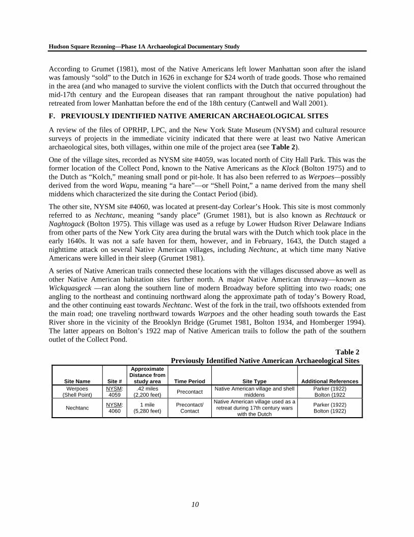
F. PREVIOUSLY IDENTIFIED NATIVE AMERICAN ARCHAEOLOGICAL SITES
A review of the files of OPRHP, LPC, and the New York State Museum (NYSM) and cultural resource surveys of projects in the immediate vicinity indicated that there were at least two Native American archaeological sites, both villages, within one mile of the project area (see Table 2).
One of the village sites, recorded as NYSM site #4059, was located north of City Hall Park. This was the former location of the Collect Pond, known to the Native Americans as the Klock (Bolton 1975) and to the Dutch as “Kolch,” meaning small pond or pit-hole. It has also been referred to as Werpoes—possibly derived from the word Wapu, meaning “a hare”—or “Shell Point,” a name derived from the many shell middens which characterized the site during the Contact Period (ibid).
The other site, NYSM site #4060, was located at present-day Corlear’s Hook. This site is most commonly referred to as Nechtanc, meaning “sandy place” (Grumet 1981), but is also known as Rechtauck or Naghtogack (Bolton 1975). This village was used as a refuge by Lower Hudson River Delaware Indians from other parts of the New York City area during the brutal wars with the Dutch which took place in the early 1640s. It was not a safe haven for them, however, and in February, 1643, the Dutch staged a nighttime attack on several Native American villages, including Nechtanc, at which time many Native Americans were killed in their sleep (Grumet 1981).
A series of Native American trails connected these locations with the villages discussed above as well as other Native American habitation sites further north. A major Native American thruway—known as Wickquasgeck —ran along the southern line of modern Broadway before splitting into two roads; one angling to the northeast and continuing northward along the approximate path of today’s Bowery Road, and the other continuing east towards Nechtanc. West of the fork in the trail, two offshoots extended from the main road; one traveling northward towards Warpoes and the other heading south towards the East River shore in the vicinity of the Brooklyn Bridge (Grumet 1981, Bolton 1934, and Homberger 1994). The latter appears on Bolton’s 1922 map of Native American trails to follow the path of the southern outlet of the Collect Pond.
Table 2Previously Identified Native American Archaeological Sites
Site Name Site #
Approximate Distance from
study area Time Period Site Type Additional References Werpoes
(Shell Point) NYSM: 4059
.42 miles (2,200 feet)
Precontact Native American village and shell
middens Parker (1922) Bolton (1922
Nechtanc NYSM: 4060
1 mile (5,280 feet)
Precontact/ Contact
Native American village used as a retreat during 17th century wars
with the Dutch
Parker (1922) Bolton (1922)
11
Chapter 4: The Historic Period
A. THE GENERAL HISTORY OF THE STUDY AREA AND VICINITY
In 1621, the States-General in the Netherlands chartered the Dutch West India Company (WIC) to consolidate Dutch activities in the Atlantic World. New Amsterdam was an ideal company town; a small, easily defensible outpost at the tip of Manhattan Island, situated at the confluence of the East and North (Hudson) Rivers, and with one of the finest harbors in all of North America. New Amsterdam functioned as the major center for commercial activity from Fort Orange in Albany on the upper Hudson River to the Delaware Bay in the south. Colonists benefitted from trading with the Old World as well as with the Native Americans they encountered in their new home. In exchange for furs, entrepreneurs and government officials supplied Native Americans with a wide range of goods. These included not only conventional adornments such as finger rings, glass beads and wampum, but utilitarian objects such as axes, kettles and cloth. Merchandise from around the world arrived in New Amsterdam destined for Europeans and Native Americans alike (Cantwell and Wall 2001). In 1626, the Dutch purchased the Island of Manhattan from the Munsee for the value of sixty guilders.
In an era of speculation and opportunity, private traders converged on Manhattan after 1640, motivated by personal gain. They became dissatisfied with the WIC’s administration and sought more reliable local protections. On February 2, 1653, New Amsterdam’s municipal charter was officially proclaimed, establishing a city government similar in form and function to that of Amsterdam in Holland. This municipal framework remained unchanged throughout the 17th century. After the English conquest of New Amsterdam in 1664, the colony was renamed New York.
Throughout the early colonial period, the British and Dutch governments conveyed land to settlers in large parcels. The northeastern corner of Block 579 was composed of dry land and was included within a farm once occupied by an English settler named John “Old Jan” Seals circa 1638. After Seals’ death in 1645, the farm was granted by Dutch Director General William Kieft to Tonis Nyssen, Seals’ son-in-law, in 1647. The property subsequently had several Dutch owners and was ultimately incorporated into the land holdings of Trinity Church, which owned (and continues to own) many tracts of land in the area by the mid-18th century (Stokes 1967). According to the “General Statement of Early Title” for Block 579 on file at the Office of the City Register, in the 18th century, the northern portion of Block 579 was leased by the Church to Aaron Burr, who would go on to be the Vice President of the United States.
The remainder of Block 579 (south) and all of Blocks 477 (north) and 578 (north) were included within a large tract of undeveloped swampland that was not conveyed until the early 18th century.1 According to I.N.P. Stokes’ Iconography of Manhattan Island (1967), the swamp was granted to Anthony Rutgers by King George II of England in 1731 and a formal Royal patent was issued two years later with the stipulation that the swamp be drained within one year. However, conveyance records show that Rutgers began purchasing land in the area as early as 1726 (see Appendices A through J).2
1 Block numbers 477, 578, and 579 each represent two city blocks oriented north-south. This discussion only
addresses those portions of each block that include archaeologically sensitive lots. 2 A map of Block 477 included within the index to conveyance libers on file at the office of the Manhattan City
Register (Department of Finance) suggests that only the southern half of Block 477, Lot 66 was originally owned
Hudson Square Rezoning—Phase 1A Archaeological Documentary Study
12
As part of his quest to drain the swampland, Rutgers cut down a significant amount of the brush occupying the meadow. In 1733, he was granted permission by the City’s Common Council to construct a drain not more than 20 feet wide between the Collect Pond, approximately 2,700 feet southeast of the study area, and the Low Water Mark in the Hudson River (Minutes of the Common Council [MCC] 1675-1776 IV: 178). Rutgers agreed to fence in the drain to protect it from “the violence of the ice and storms” but asked for 50 feet of land (rather than the 20 offered by the council) on which to place “proper works and machines for the securing, amending, and repairing the…drain from time to time” (MCC 1675-1776 IV: 466). Rutgers was granted the additional space for a rent of six shillings a year.
The purpose of the drain was to funnel the waters of the Collect Pond out into the River so that they would not remain in the stagnant swamp. This was a popular idea, as the swamp was “filled constantly with standing water” (Stokes 1967 III: 560). It was also thought that the swamp contributed to the poor health of nearby residents and laborers from nearby farms, many of whom fell ill as a result of the “miasmas” produced by the stagnant water (Gratacap 1909). Local farmers were also in favor of removing the swamp, as cattle were frequently trapped and drowned in its waters (ibid).
After Rutgers’ death in 1746, the property was transferred to his daughter, Elsie, and her husband, Leonard Lispenard (Stokes 1967). Lispenard’s residence was to the south of the swamp on the shores of the Hudson River, and it is because of his association with it that the swamp and the surrounding area became known as “Lispenard’s Meadows.” The map published by Bernard Ratzer in 1776 that depicts the island of Manhattan ca. 1766 shows that Lispenard’s Meadows remained swampland, although Rutgers’ drain is visible. The drain and the surrounding swampland appear on maps through the end of the 18th century. While a georeferenced version of Bernard Ratzer’s 1776 map depicting the city as it appeared in 1766-1767 (see Figure 3) suggests that the drain may have entered both Blocks 477 and 578, Stokes’ “Map of Original Dutch Grants,” suggests that the drain ran to the south of the study area and was not situated in either block. 1 The drain and the surrounding swampland appear on maps through the end of the 18th century.
The Taylor-Roberts plan of 1797 is the first to depict streets in the vicinity of the project area, only a portion of which is depicted on the map. At that time, the study area was included within the Eighth Ward of Manhattan and at that time only Spring, Broome (then called Orchard), and Grand (then called Meadow) Streets had been laid out.; neither Watts nor Dominick Street are shown. Both streets were formally laid out by 1811, as depicted in Bridges’ depiction of the Commissioners’ Plan portraying Manhattan’s newly proposed street grid. Watts Street was named after John Watts, who had been the City Recorder and co-founder of the Leake and Watts Orphan Asylum and Dominick Street had been named for George Dominick, a vestryman at Trinity Church (Moscow 1979).
Leonard Lispenard died in 1790, at which time the land was inherited by his son, Anthony. Anthony Lispenard divided Block 579, part of which was made up of dry land rather than marsh, into lots and sold them as individual parcels as early as 1795. Blocks 477 and 578, located entirely within the marsh, were divided into individual lots by 1811. Tax assessment ledgers dating between 1808 and 1815 do not list any properties on Watts Street and Dominick Street is not present in the ledgers until 1817, suggesting that neither area had been fully transformed from a stagnant swamp into solid land and were not yet
by Anthony Rutgers while the northern half was owned by Trinity Church. However, there were no conveyances attributed to this lot that support that statement.
1 For the purposes of this study, the Ratzer map (Figure 3) was georeferenced using ArcGIS software to overlay the current street grid over the historic map. The drain is depicted on that map immediately northeast of the study area, although the georeferencing was completed with a margin of error of approximately 66 feet.

Chapter 4: Historic Period
13
inhabitable. Tax assessment records show that the first structures within the lots included in this study appear to have been erected between circa 1818 and 1827 (see Appendices A through J).
The study area was located within the City’s Eighth Ward during the early and mid-19th century (the specific histories of the historic lots analyzed in this documentary study are described in greater detail below). The population of the ward was quite diverse during that time, with wealthier inhabitants residing in the fashionable neighborhoods below Canal Street, prostitutes living in brothels lining West Broadway and its adjacent blocks, and, as the nineteenth century continued, an increasing number of working-class immigrants who inhabited the Ward’s crowded tenements after the former, mostly American-born, residents left for better neighborhoods elsewhere. Diseases including typhus, typhoid, cholera, scarlet fever, and dysentery ran rampant through the population of the Eighth Ward, although the majority of cases were located in the area bounded by Varick, Wooster, Canal, and Spring Streets, excluding the portion of the study area on Block 579 (Kenney 1865).
Many Eighth Ward neighborhoods had become overcrowded slums by the mid-19th century while others were better off. For example, the property at 49 Dominick (Block 579, Lot 44) was located in one of the better areas and records show that educated or skilled workers, most of whom were American-born, continued to live on the property through most of the 19th century. The three historic lots at the southeast corner of Block 477 (modern Lot 66) were inhabited by a greater number of working-class individuals, although, like the home at 49 Dominick Street, there were few immigrants living there.
Between 1860 and 1865, the population of the Eighth Ward decreased by 25 percent (LPC 1973). As the century continued, the ward became increasingly industrialized, with most of the transformation occurring in areas formerly occupied by slums and brothels. During the late-19th and early-20th centuries, residential structures in the SoHo area continued to be replaced by those used for commercial and industrial purposes. For example, two of the residential structures formerly located within modern Block 477, Lot 66 were torn down in the early 20th century and replaced with an industrial structure that was used as a factory and, later, a garage. However, a short stretch of Dominick Street between Varick and Hudson Streets, along which the homes at 31 to 41 and 49 Dominick Street were located, was one of several sections of the neighborhood that managed to “retain the domestic charm which [they] had more than half a century ago when St. John’s Park, a few blocks below…was a fashionable residential locality” until the 1920s and 1930s (New York Times 1920: RE6).
However, the advent of the automobile had a significant effect on both the Eighth Ward and the lots included within the study area. By 1920, automobile traffic between New York City and New Jersey had become very heavy and the only way to get cars across the Hudson River at the time was by ferry. In order to get cars across the river in a more efficient manner, a subaqueous tunnel was planned. Construction on the Holland Tunnel, the first underwater tunnel of its kind, began in 1920 (Lang 1993). The approach tunnel for the New York side was constructed via the cut-and-cover method in the lots immediately north and east of Lot 44. Therefore, the approach tunnel entered Block 578 between 578 and 582 Broome Street and Block 579 between 41 and 47 Dominick Street and then arced to the west and continued down Spring Street until it reached the Hudson River. The tunnel opened in 1927 (ibid).
The construction of the Holland Tunnel resulted in a huge increase in traffic in Manhattan and as a result, several streets near the entrance to the Holland Tunnel had to be widened and/or realigned to accommodate the influx of motor vehicles. This included the extension of Sixth Avenue (now known as the Avenue of the Americas) through former residential neighborhoods and smaller streets. In the vicinity of the study area, Sixth Avenue was constructed immediately east of Block 477, Lot 66, and as a result, the building at 46 Watts Street—formerly located almost 50 feet west of the intersection of Watts and Sullivan Streets—became the corner building. Although many neighborhood residents resented the road’s extension, both because of the loss of many homes as well as the fear that Watts Street would become a bottleneck for traffic between Sixth Avenue and the Holland Tunnel (New York Times 1926), the
Hudson Square Rezoning—Phase 1A Archaeological Documentary Study
14
construction of Sixth Avenue in the area was also thought of as “New York’s most spectacular piece of street cutting” (Adams 1926: XX3).
In the 1960s, the SoHo neighborhood was redefined with the influx of artists into the area (LPC 1973) although certain areas, especially those near the Holland Tunnel, remained commercial or industrial. By the 1970s and 1980s, many of the lots within the rezoning area were razed and paved for use as parking areas, while others were left untouched and are still occupied by the dwellings that were constructed there in the early 19th century.
B. LOT HISTORY OF BLOCK 477, LOT 44
After Lispenard’s heirs divided his property into lots in 1811, Block 477 was transferred to Alexander L. Stewart, a wealthy merchant who was married to Lispenard’s grand-daughter, Sarah. Stewart sold lots 44 and 45 to John N. Huylar in 1821, the same year that tax assessments indicate the lot was first developed with a house (see Appendix A). Although he and his heirs owned the lot until 1840, Huylar does not appear to have resided on the property. Instead, a succession of mostly working-class tenants inhabited the small lot. Early directories and tax assessments suggest that there was a high rate of turnover among the lot’s early tenants. The man who purchased the lot in 1840, John M. Winant, does appear to have resided on the lot for a short time as members of the Winant family were listed at that address in historic directories in the 1840s. Winant’s heirs sold the property in 1862. During Winant’s ownership, several families occupied the lot for many years. These included the family of Daniel Lovejoy, a New York-born manufacturer of gold pens, who lived at 557 Broome Street from the early 1840s through the early 1850s. The 1850 and 1860 censuses indicate that the majority of the residents during the mid-19th century were native New Yorkers while the remainder was English immigrants. The occupations represented by the property’s residents included shoemaker, plumber, butcher, and clerk.
Winant sold the lot to Samuel White in 1862. White both owned and occupied the lot, although he and his family were not the sole residents, and his heirs sold the land in 1884. The 1870 census (both enumerations) indicate that Samuel White was a “Croton agent,” or a plumber, indicating that he was involved in the installation of the city’s early infrastructure. The White family shared the structure at 557 Broome Street with the family of George Carrick, an English-born engineer. The 1870 census indicate that both men were financially well-off.
After the White family sold Lot 44 in 1884, a variety of individuals owned or occupied the property, although the individuals living on this lot in the late-19th century were tenants. The number of residents recorded in the 1880 and 1900 censuses was much larger than in past years, likely the result of the lot being used as a boarding house. A greater number of immigrants and a wider variety of professions were represented.
The first maps to depict this lot with great accuracy are the 1853 and 1857 Perris maps, which are virtually identical. Both maps show that the lot—which at 21 by 63 feet is slightly smaller than a standard 25 by 100-foot city lot—was developed with a small brick structure that covered the northern half of the lot. The southern half of the lot was an open rear yard with an outbuilding, possibly an outhouse, along the rear lot line. The 1890 and 1905 Sanborn maps (see Figure 5) indicate that both structures stood thorough the end of the 19th century and that the 2-story (with basement and attic) dwelling had been expanded with the addition of a rear extension. Between 1905 and 1911, the lot was redeveloped with a T-shaped 3-story (with basement structure), although the southern 10 to 12 feet of the lot were left undeveloped.
Chapter 4: Historic Period
15
C. LOT HISTORY OF BLOCK 477, LOT 66
Modern Lot 66 was originally divided into three separate historic lots: 65 (46 Watts Street), 66 (48 Watts Street), and 67 (50 Watts Street). These lots are discussed individually below and additional information is provided in Appendix B. Lot 66 was originally located on the interior of the block, although after Sixth Avenue/Avenue of the Americas was widened in the 1920s, Lot 66 was located at the corner of Watts Street and Sixth Avenue/Avenue of the Americas.
46 WATTS STREET
In 1819, Alexander L. Stewart sold the lot to Stephen P. Lemoine, though the land reverted back to Stewart in 1826 and the following year he sold it to Lewis Ludington. No buildings were situated on the property at the time of the 1819 sale, although the conveyance recording the transaction stipulated that any building that would be erected on the lot would have to be “a good brick or brick-fronted house the whole breadth of the…lot and…the easterly and westerly end foundation walls of such house shall be party walls standing one half on the said lot and one half on the lots adjoining,” thus indicating Stewart’s intention to have the entire block developed in short time.
Tax assessment records and historic deeds show that the first structure on the property was constructed circa 1827, during Ludington’s ownership, although he does not appear to have ever lived there during his term of ownership, which ended in 1831. Before the house was built, the lot was known as 68 Watts Street, and after it was constructed the street numbers were reassigned and it was called 6 Watts Street. The first map to depict the property in great detail is Matthew Dripps’ 1852 map of New York City, which shows the dwelling house at the front of the lot and a rear building along the rear lot line, which was 6 feet south of the rear lot line of historic Lot 66, to the west. A narrow alley measuring approximately 6 feet in width ran past the rear of the lot (where modern Lot 57 is located today) providing access to the rear buildings of the nearby lots. Subsequent maps show that the 6-foot wide parcel located between historic Lot 65 and the narrow alley was part of historic Lot 66 (48 Watts Street). Tax assessments suggest that the rear building was in place by at least 1842. The 1857 Perris atlas shows that both structures were made of wood.
The first entries for this property in historic city directories date to 1827 as well, at which time the property was inhabited by at least three families. City directories from the late 1820s indicate that there was a high rate of turnover in the building and that no individuals appear to have lived there for more than one year at a time. A man named Daniel Coakley resided in the house for several years in the early 1830s. Historic directories list his occupation as “rigger” and the 1830 census shows that his household included 8 white individuals as well as 4 free African-Americans. Another individual who resided on the property for more than one year was Micah Purdy, who lived there circa 1837-1838. Purdy was employed as a carter. Members of the Roddam family, including Stephen and William, both bakers, resided on the lot from ca. 1840-1841. A man named Stephen Rodman was included within the 1840 census, which showed that his home was occupied by Rodman, his wife, and their son. At that time, directories and census records show that the home was also inhabited by the family of James young, a smith.
Tax records dating from 1837 through 1855 indicate that the lot was occupied at this time by the family of Reverend Asabel (Asahel) Gilbert. Those tax records show that because he was a minister, he paid less in taxes than his neighbors from at least 1844 through 1850. However, census records show that he did not move to New York City until after 1840 and military records show that he moved to Illinois to live with his son in 1847, so he may not have lived at 46 Watts Street as long as tax records indicate he did. According to Revolutionary War pension records, Gilbert served as the trumpet major in the Connecticut militia in the regiment of Captain Thomas Seymour, and was stationed near Westchester County during the war. According to Gilbert himself, he was the “tutor to the first regular band that General Washington
Hudson Square Rezoning—Phase 1A Archaeological Documentary Study
16
had in the army” while another described him as a travelling minister who was “remarkably vigorous for…his age and of undoubted integrity and honesty and poor” (NARA n.d.).
Gilbert’s poverty is represented in conveyance records, as in 1846, the property (which had not been formally transferred to Gilbert) was foreclosed upon and conveyed to Mott S. Cannon. The following year, Cannon sold the lot to a carman named Jesse Fuller, whose family resided on the property until after 1875 and continued to own the property through the end of the 19th century. Fuller, his wife, and children had all been born in America. The 1850 census shows that other families lived on the property at the time, most of whom were also American-born, although there were several Irish and Scottish immigrants. In 1860 all of the building’s residents were native New Yorkers with the exception of Fuller himself, who had been born in Massachusetts.
By 1885, a smaller wood frame rear structure was constructed in the property’s yard, however, it was demolished before 1891. The 1905 Sanborn map depicts two new 1-story outbuildings in the rear of the lot which continue to appear on Sanborn maps through at least 1986.
48 AND 50 WATTS STREET
Tax assessment records show that the house at 50 Watts Street (historically known as 10 Watts Street and Lot 67) was constructed circa 1818 and the house at 48 Watts Street (historically known as 8 Watts Street and Lot 66) circa 1826. The original wood frame buildings stood on the lots until circa 1914 (New York Times 1914), at which time they were demolished and replaced with a 2-story (with basement) brick industrial structure that still stands there today. Early 20th century maps and atlases show that the building was occupied by various industrial and commercial organizations including the Germania Roofing Company and a service station operated by Chevrolet and, later, Ford. Because the service station was constructed with a basement, it is likely that there has been substantial disturbance to these historic lots and therefore there is a low probability that archaeological resources have survived intact in this area.
D. LOT HISTORY OF BLOCK 477, LOT 73
Tax assessment records show that Lot 73 was first developed with a house before 1818. The 1853 and 1857 Perris atlases show that this lot was developed with a wood frame front dwelling at the front (southern half) of the lot. Both maps depict a rear structure on the property, however the 1853 map depicts it as a 2nd class hazardous structure1 while the 1857 map identifies it as a 1st-class commercial structure2 that also occupied the rear of Lot 72 to the east. Maps continue to depict both structures through the beginning of the 20th century, although later maps indicate that the structure had been covered with brick. The 1905 Sanborn map (see Figure 5) indicates that the dwelling stood 3 stories (with a basement) and that the rear structure was a 4-story shed or stable with no basement. The 1922 Sanborn map (see Figure 6) reflects the demolition of the rear structure. This structure continues to stand on the lot through the present day.
The lot was sold by Alexander Stewart to John N. Nugent in 1818, possibly shortly after a dwelling was constructed on the property. Nugent owned the land for a few years before selling it to William Jones in 1821, who would own it for another 20 years. Jones sold the lot to Roger Pegg in 1841, who owned the
1 Second class structures housed book binders, brass founders, coach makers, cotton presses and mills, iron
founders, livery stables, paper mills, and book and job printers. 2 First class stores included any of the following: bakers, boat builders, brewers, brush manufactories, comb makers,
copper smiths with forges, dyers, floor cloth manufactories, hat manufactories, malt houses, oil manufactories, oil cloth manufactories, private stables, tobacco manufactories, type and stereotype founders, and wheelwrights.
Chapter 4: Historic Period
17
lot until his death and his heirs sold it in 1865. None of these property owners resided on the site. Directories show that the earliest residents of the lot during the 1820s and 1830s included carpenters, a mason, an accountant, a shipmaster, and a widow. During the 1840s, tenants were employed in additional skilled and semi-skilled professions, such as broker, weigher, cabinet maker, and clerk. Most individuals resided on the property for only a few years.
The 1850 census indicates that 5 individuals from two families lived on the property. These families were headed by Sarah Wilson, who was born in Connecticut, and Stephen M. Carney, a Scottish machinist. The 1860 census shows that the population of the dwelling had increased to 11, although the building was still occupied by two families, each of whom lived with a boarder and/or servant. The first family was that of Samuel D. Carpenter, a relatively well-off New York-born cartman who would reside on the lot until at least 1869, and the family of John B. Malin, a cook who had also been born in New York.
Throughout the last four decades of the 19th century, the number of tenants living in the building continued to increase as did the number of unrelated individuals residing on the lot at the same time. The late-19th century tenants of Lot 73 tended to work as store clerks, machinists, dressmakers, tinsmiths, and housekeepers (see Appendix C).
E. LOT HISTORY OF BLOCK 477, LOT 74
Tax assessment records show that Lot 74 was first developed with a house before 1818. The 1853 and 1857 Perris atlases show that this lot was developed with a wood frame front dwelling at the front (southern half) of the lot. Both maps depict a rear structure on the property, however the 1853 map depicts it as a 3rd class hazardous structure1 situated on the rear of Lot 74 only, while the 1857 map identifies it as a 3rd-class commercial structure that also extended to the west to cover the rear portion of Lot 75 (see below). Historically, both lots were bought and sold together between 1817 and 1878 and therefore share similar histories. Maps continue to depict both structures through the beginning of the 20th century, although by the late-19th century, the former wood-frame structure was depicted as being made of brick. The 1905 Sanborn map (see Figure 5) indicates that the dwelling stood 3 stories (with a basement) and that the rear structure was a 4-story shed or stable (which covered the rear yards of both Lots 74 and 75) with no basement. The 1922 Sanborn map (see Figure 6) reflects the demolition of the rear structure. The front dwelling continues to stand on the lot through the present day.
Stewart sold Lot 74 in 1818 to Abraham Jaques, who sold it in 1821 to Frederick A. Tallmadge, a veteran of the War of 1812 and later politician who represented New York State in the House of Representatives (New York Times 1869). During their ownership, numerous tenants resided on the property, although neither owner lived there. In 1822, Tallmadge sold Lot 74 to Asa Holden, who appears to be the first and only owner and occupant of the site, although he only lived there for a few years in the late 1820s. In 1828, the lot was sold to William Gould and David Banks, who co-owned the lot until 1854. Historic directories show that in the first half of the 19th century, many widows resided on this property, as well as many unskilled workers (carpenters, laborers, and cartmen) and skilled workers (accountants, nurse, tailor, and milliner).
Daniel N. Banks purchased the lot in 1854 and maintained ownership for 10 years but did not live there. Two families were recorded as residents of this property in the 1850 census, headed by John A. Bakeran
1 Third class buildings included blind and sash makers, bleaching works, cabinet makers’ work shops, carpenter’s
shops, candle makers, chair maker’s work shops, distillers, gas manufactories, flour mills, ink makers (printer’s ink), India rubber or gutta percha manufacturers, lamp black and ivory black manufacturers, looking glass and picture frame makers, musical instrument makers, omnibus stables, organ workers, piano forte makers, rectifiers of liquors by fire heat, soap makers, tallow melters or chandlers, or wool mills.
Hudson Square Rezoning—Phase 1A Archaeological Documentary Study
18
American saddler, and Samuel D. Carpenter, who would later move next door to Lot 73 (see above). Hellen Fell, a 38-year old woman who lived with the Baker family and whose race is listed on the census as “Black,” was one of the few non-white individuals who resided on any of the 10 lots included within this study. The 1860 census lists three families as residents of the lot; those of J.W. Thompson, an English master carpenter, Cornelius Abb, a German jewler, and David Melhate, an English bookkeeper.
Throughout the remainder of the 19th century, the residents of this lot became increasingly numerous and the number of immigrants and unskilled workers among the building’s tenant s increased (see Appendix D).
F. LOT HISTORY OF BLOCK 477, LOT 75
Tax assessment records show that Lot 75 was first developed with a house before 1818. As mentioned above, Lots 74 and 75 were bought and sold as a pair throughout the 19th century and the ownership and development history described above for Lot 74 is identical to the of Lot 75. While the tenants of the two buildings differed, over the years, the residents of Lot 74 were similar to those of Lot 75. Early directories show that the residents of the lot from the 1820s through the 1850s typically lived in the building for one to five years and included many widows as well as individuals employed as a boatman, a looking-glass maker, a merchant, an ink manufacturer, an accountant, a letter carrier, and a printer.
The 1850 census shows 10 residents of the building, at least one of whom was a boarder living with another family. All were American-born and only one, James T. Stasbury, a boot and shoe salesman, was listed as being employed. Directories suggest that there was a higher rate of turnover among the tenants of this lot in the 1850s and that more were employed in uncommon professions, such as “daguerrian” and “ornamental painter.”
The tenants became less homogenous and more numerous in the 1860s. The 1860 census identifies 16 residents from four families among Lot 75’s tenants. All were born in Germany or New York, had personal estates of $100 to $300, and were employed as laborers, a candy maker, or a master cabinet maker. Directories from the 1860s list many residents at this address who were employed in a variety of skilled and unskilled professions from merchant to liquor dealer to baker.
Throughout the remainder of the 19th century, the residents of this lot became increasingly numerous and the number of immigrants, the majority from Ireland, and unskilled workers among the building’s tenants increased (see Appendix E).
G. LOT HISTORY OF BLOCK 477, LOT 76
A small section of this lot extends to the north and therefore this lot is irregular in shape. Tax assessment records show that Lot 76 was first developed with a house before 1818. The 1853 and 1857 Perris atlases show that this lot was developed with a wood frame front dwelling at the front (southern half) of the lot and a narrow brick outbuilding in the irregular projection along the lot’s northern end, adjacent to an outbuilding behind the lot at 100 Varick Street. Maps continue to depict both structures through the beginning of the 20th century, although later maps indicate that the structure had been covered with a brick facade. The 1905 Sanborn map (see Figure 5) indicates that the dwelling stood 2 stories (with a basement and an attic) and that the rear structure was 1 story with no basement. The same map identifies the outbuilding behind the adjacent property at 100 Varick Street as an outhouse. The 1922 Sanborn map (see Figure 6) reflects the demolition of the outbuilding. The structure on Lot 76 stood until 2007, when it was demolished.
Stewart sold the lot in 1818 to Moses Dodd, who quickly sold it to John Fleming the next year. Fleming owned the lot until 1838, when he sold it to Caleb and Eliza Wildey, who would own the property until 1847. The Wildey family was the first to both own and occupy the site. During the 1820s and 1830s,
Chapter 4: Historic Period
19
many individuals lived on the property, including a marshal, a carpenter, a currier, a drygoods store owner, and a widow.
The Wildey family, headed by Caleb, a drygoods merchant, shared the lot with other tenants. In 1847, they sold the lot to Lewis (also known as Lawrence) and Mary Dufour, who also resided on the lot that they owned. Lewis Dufour was a French mason and the 1850 census shows that he and his family, which included 5 children, shared the lot with three other individuals, although it is not clear if they were boarders or domestic servants. The Dufour family sold the property in 1853 to Frederick Schwartz, who also appears to have lived on this lot as a Jules Swarts is recorded at that address in several directories from the 1850s and 1860s, although the family is not included in the 1860 census entry for this property. That census lists a married couple, Edward Roland, a huckster (contemporary directories indicate that he sold produce), and his English wife, Hannah, and three other unrelated individuals, one of whom was employed as a clerk. Directory entries for this property from the 1860s identify a variety of tenants, including a police officer.
Throughout the remainder of the 19th century, the residents of this lot became increasingly numerous and the number of immigrants, the majority from Ireland, and unskilled workers among the building’s tenants increased (see Appendix F). One long-term tenant, Peter Peuquet, a French brass factory worker and machinist, was recorded as residing on the lot as early as 1870. The Peuquet family resided there for more than 30 years and Peter’s wife, Marie, purchased the property in 1885.
H. LOT HISTORY OF BLOCK 578, LOT 77
Tax assessment records show that Lot 77 was first developed with a house circa 1826 (see Appendix G). The 1853 and 1857 Perris atlases show that this lot was developed with a brick dwelling at the front (southern half) of the lot with a small wood frame rear addition and an undeveloped rear yard. The 1905 Sanborn map (see Figure 5) indicates that the dwelling stood 3 stories (with a basement) and that the small rear addition was 1 story and did not have a basement. The 1951 Sanborn map (see Figure 7) depicts the same structure, although it is identified as a 4-story structure with no basement, although modern Sanborn maps identify the structure as 3 stories with a basement, so the 1951 map may be in error. This dwelling continues to stand on the lot through the present day.
Lot 77 was one of many properties owned by Robert M. Livingston, a wealthy landowner and developer who owned a large amount of property in the area during the early 19th century. After developing his properties on Block 578 in 1826, Livingston sold the lots individually and Lot 77 was purchased by David J. Christie, whose estate would continue to own the property until 1864. Christie did not reside on the property during his ownership and Lot 77 was occupied by numerous tenants during the first half of the 19th century, most of whom resided on the property for several years at a time and do not appear to have shared the home with more than one other family at a time. The earliest documented tenants were all merchants and included T. Thomas Ryan, who lived on Lot 77 for several years in the late 1820s, Henry Miller, who lived there in 1830, and Charles Rhind, who occupied Lot 77 between circa 1831 and 1835. A widow named Catharine Hervey occupied the lot for much of the 1840s, and two men, James Chalmers, a dyer, and Alexander T. Clayton, a stationer, lived on the property between circa 1847 and 1857. Both men were represented at this address in the 1850 census, which indicates that Chalmers, an elderly English immigrant, was a member of the Clayton household. The men lived with Clayton’s wife and daughter and a young Irish woman, possibly their domestic servant. The 1860 census identifies 5 residents of the building, including Frederick Michel, a German flour merchant, and his wife, a Mr. Bruner, a German clerk, and his wife, and a German domestic servant. Directories do not identify any residents of the building other than Frederick Michel for the 1860s.
In 1864, Lot 77 was purchased from Christie’s heirs by A. William Heye, who quickly sold it to Bridget Hopkinson, who would own the lot until 1901. During her ownership, the number of residents of the lot
Hudson Square Rezoning—Phase 1A Archaeological Documentary Study
20
increased substantially, with many unrelated individuals residing on the property at a time. Whereas the lot’s initial residents were all well-off merchants, the residents of the late-19th century were working-class individuals employed in such professions as sewing machine operator, domestic servant, clerk, truck driver, porter, and horse shoer. While many of the residents in the 1870s were of Irish extraction, an increasing number of German immigrants were noted as occupants of this lot in the 1880 and 1900 censuses.
I. LOT HISTORY OF BLOCK 578, LOT 79
Like Lot 77, Lot 79 was also owned and first developed by Robert M. Livingston in 1826 and then sold that same year (see Appendix H). The 1853 and 1857 Perris atlases show that this lot was developed with a brick dwelling at the front (southern half) of the lot with a small wood frame rear addition and an undeveloped rear yard. The Bromley atlas of 1891 shows that the rear addition had been replaced with a larger brick addition that covered most of the eastern half of the rear yard. . The 1905 Sanborn map (see Figure 5) indicates that the dwelling stood 3 stories (with a basement) and that the rear addition was also 3 stories but did not have a basement. The construction of the Holland Tunnel, beginning in 1920, resulted in significant changes to Block 578 and the three lots to the west of Lot 79 were demolished and are currently occupied by the tunnel’s approach ramp. A series of photos dating from between 1927 and 1936 depict the construction of the tunnel to the west of, but not within, Lot 79, and that the lot’s rear yard was protected with a high wall. Therefore, it does not appear that the tunnel’s construction would have impacted Lot 79.1 The 1951 Sanborn map (see Figure 7) continues to depict the structure on Lot 79, although like Lot 77, the building is erroneously identified as a 4-story structure with no basement. This dwelling continues to stand on the lot through the present day.
Livingston sold the lot to Joseph Tucker in 1826 and Tucker continued to own the property until 1837. Tucker did not reside on the property, although directories indicate that he was a mason and lived across the street at 579 Broome Street. The earliest documented tenant of the lot was Daniel Roberts, an attorney, who lived there between circa 1827 and 1831. Other tenants who were identified in historic directories from the 1830s included John P. Schermerhorn, MD and George S. Schermerhorn, who lived there from 1833 to 1834, and Moses Isaacs, an accountant who lived there in 1836. In 1837, the lot was purchased by Louis Loutrel, a wealthy Customs House weigher and later coal merchant who had been born in the West Indies. Loutrel and his large family were the only residents of the property until 1865 (with the exception of boarders and servants), when they sold the land.
In 1865, Loutrel sold Lot 79 to Peter Brunjes, a wealthy German sugar refiner, who lived on the lot with his family and servants until 1873. Brunjes sold the lot to Patrick Foley, a restaurateur, who owned and occupied the lot for only a few months before selling it to Michael Murphy, John McCurdy, and Jacob S. Warden, none of whom resided there and who sold the property to Maurice Ahern in 1883, who does appear to have lived on the lot for a time. Throughout the last decades of the 19th century, the residents of this lot became increasingly numerous and the number of immigrants, the majority from Ireland and Germany, and unskilled workers among the building’s tenants increased (see Appendix H).
In 1995, a field school from City College led by Diana diZerega Wall investigated a large privy on this lot (Martin 1996). Hundreds of artifacts were recovered from the privy, including glass bottles, ceramic fragments, children’s toys, and faunal remains (ibid). A penny dated 1874 was found within the shaft feature, confirming that the privy was not filled in until at least the mid-1870s (ibid). Wall suspects that any cisterns on the property would have been destroyed by the construction of a rear addition to the home,
1 Photos are available at: http://digitalgallery.nypl.org/nypldigital/id?717890F and
http://digitalgallery.nypl.org/nypldigital/id?717891F.
Chapter 4: Historic Period
21
however, there is a possibility that other intact shaft features (i.e. a well) may still be present on this property (Diana diZerega Wall 2012, pers. comm.).
J. LOT HISTORY OF BLOCK 579, LOT 35
Modern Lot 35 was historically composed of 9 historic lots including 272 to 276 Spring Street and 31 to 41 Dominick Street. These lots are summarized below (see Appendix I).
272 TO 276 SPRING STREET
The three historic lots between 272 and 276 Spring Street were first developed with houses prior to 1818. The 1853 and 1857 Perris atlases depict these three lots as developed with wood frame dwellings at the front (northern end) of the lots. The lots at both 272 and 276 Spring Street, the former of which is irregularly shaped, both had wood frame rear buildings as well, while the property at 274 Spring Street was depicted as having two adjacent outbuildings in the rear yard. By 1885, the lots at 272 and 274 Spring Street were redeveloped with brick structures with small undeveloped rear yards while the wood frame building at 276 Spring Street was expanded to connect the front and rear structures, but before 1891 it was also replaced with a larger brick structure that occupied almost the entire lot. The 1905 and 1922 Sanborn maps (see Figures 5 and 6) provide a greater amount of information about these three buildings and show that the structures at 272 and 274 Spring Street were 5-story stores and dwellings (without basements), each of which has a small 1-story outbuilding in the rear yard. The maps depict the property at 276 Spring Street as developed with a 3-story structure (without a basement) with a 2-story rear addition (also without a basement) that is identified as a “hall” on the 1905 map. By the publication of the 1951 Sanborn map, all three structures had been demolished and along with many adjacent lots, paved and converted into a parking lot.
The buildings on these lots were occupied by an extremely large number of individuals during the century that they stood at 272 to 276 Spring Street, far more than any other lot included within the archaeological study area. The high occupancy rate of these three lots was likely the result of the fact that two of the three lots had both front and rear dwellings throughout much of the 19th century. The property at 276 Spring Street was owned by the estate of Duncan Douglas, a wealthy Scottish lumber merchant, between 1809 and 1881 and John Douglass, presumably his son, owned the lot at 274 Spring Street between 1839 and 1872. Both men lived on the lots that they owned during the early 19th century. The property at 272 Spring Street had a variety of owners, some of whom also resided on the property (see Appendix I).
Many of the residents of these properties during the first half of the 19th century were skilled craftsmen, artists, teachers, shipmasters, or doctors. Census records show that many of the residents in the second half of the 19th century were immigrants from a variety of countries, including Germany, Ireland, Scotland, France, and Italy. The individuals residing in the front dwellings worked in more skilled and higher paying jobs, such as clerk and shoemaker, while those residing in the rear building tended to be laborers. Several occupants could not read or write. By 1900, each lot was occupied by nearly 20 families.
31 TO 41 DOMINICK STREET
The narrow historic lots at 31 to 41 Dominick Street (each measured approximately 20 feet by 80 feet) were first developed with structures circa 1824 and 1825. As with other lots within the archaeological study area, they had previously been owned, and likely developed, by Robert M. Livingston. Each lot is depicted on the 1853 and 1857 Perris atlases as developed with a small brick structure, some with a small brick or wood frame rear addition and all with an undeveloped rear yard. Subsequent Sanborn maps, including the 1905 version, depict narrow 1-story outbuildings along the rear lot lines of each of these lots with the exception of the one at 39 Dominick Street.
Hudson Square Rezoning—Phase 1A Archaeological Documentary Study
22
The 1905 Sanborn map (see Figure 5) identifies the structures formerly at 31 through 35 Dominick Street as 3-story dwellings with basements and the buildings formerly at 37 through 41 Dominick Street as 2-story structures with basements and attics. The 1922 Sanborn map (see Figure 6) does not depict any changes to these properties, although it does show that the southern half of the property formerly at 41 Dominick Street (this half of the historic lot is outside modern Lot 35) was included within the area to be disturbed as part of the construction of the Holland Tunnel. The houses at 39 and 41 Dominick Street were demolished in the late 1920s as part of the construction of the Holland Tunnel and the 1951 Sanborn map (see Figure 7) depicts the parking lot that still occupies the site. The demolition of this structure is documented in a 1928 photograph published in the New York Public Library Digital Gallery (http://digitalgallery.nypl.org/nypldigital/id?719329F). The remainder of the homes were demolished in the early 1940s by the American News Company, which had acquired the property making up modern Lot 25 and converted it into a parking lot (New York Times 1942).
Unlike the properties along Spring Street to the north, the houses at 31 to 41 Dominick Street were occupied for long periods of time by smaller numbers of residents, often only one family at a time, many of whom were wealthy. While the earliest owners do not appear to have lived on these properties, many of the lots’ owners did reside on the properties during the 19th century. Many of the early tenants of these lots in the 1820s, 1830s, and 1840s were merchants, doctors, or widows. The second half of the century saw an increase in the number of grocers, druggists, and clerks among the lots’ residents. Census records show that each house was usually occupied by a single family and their domestic servants, many of whom were of Irish extraction. While many of the occupants of these properties had been born in America, many were wealthy immigrants, mostly from Germany. An increasing number of boarders and rental tenants lived with these families towards the turn of the 20th century (see Appendix I).
The longest occupancy among these lots appears to be that of Mrs. Gertrude Fawcett, née Hall, who lived at 35 Dominick Street for more than 80 years (Crane 1941). Her father, John C. Hall, a druggist, had purchased the lot in 1865 and Gertrude Fawcett lived there until she sold the lot to the American News Company in 1941.
K. HISTORY OF 49 DOMINICK STREET (BLOCK 579, LOT 44)
The property at 49 Dominick Street was first developed circa 1823, at which time Azariah Ross owned the land (see Appendix J). The Minutes of the Common Council show that Ross was an assessor in the Eighth Ward in the 1820s and in addition, owned many lots in the area during that time. Tax assessments show that the lot was first developed circa 1823, at which time it contained 2 buildings, both a front and rear dwelling. Later maps and historic documents suggest that the rear building was situated outside of the boundaries of modern Lot 44 and was accessed by a small alleyway in the location of modern Lot 45. The 1853 Perris atlas depicts a small narrow outbuilding located in the rear yard of the lot, although it is most likely that this was a shed or an outhouse. This structure is not depicted on the 1857 Perris map or on any subsequent historic atlas, all of which depict the structure as a 2-story (with basement) brick dwelling. A third story was added to the building in 1872 (New York Times 3/15/1872).
Tax assessments and historic directories show that 49 Dominick Street, which was known as 40 Dominick Street until 1831, was occupied by both Azariah Ross and a man named Thomas Bazen. Little is known about Bazen, although tax assessments show that he was very wealthy with a personal estate valuing approximately $6,000 in 1823. Both Ross and Bazen lived on the property through at least 1824, around which time Ross sold the lot to a woman named Ida Earle. Earle continued to live there for several years with her husband, Sylvester Earle, who ran a grocery store on West Street. Various individuals lived on the lot in the late 1820s and early 1830s, including Henry Vanhoevenbergh, a doctor, Sparkhawk Parsons, a bookseller, and Elijah R. Schreder, whose profession is unknown. Both Schreder and Parsons were included as residents of Dominick Street in the Eighth Ward in the 1830 Federal Census, although
Chapter 4: Historic Period
23
directories suggest that in 1830, Parsons resided at 46 Dominick Street and Schreder resided in the rear building of 49 Dominick Street.
In 1831, Earle sold the lot to Hamilton Morrison, who soon after sold it to Lewis Loutrel, who would later own Block 578, Lot 79, described above. In 1837, Loutrel sold the lot to Henry G. Brees, a merchant. Brees died shortly after the purchase although his wife continued to live on the lot through at least 1839. Tax assessments suggest that around 1840 the house was occupied by the family of Lyon Latens (possibly also spelled Lohens or Latham). This family appears to have owned the home through the late 1860s although it is not clear if any family members resided on the property consistently during this period. Throughout the 1840s, 1850s, and early 1860s, various individuals lived on the property, through most people appeared to reside there for short periods of time, lasting a few years at most. The residents who lived on the property for several years or more included Peter Gordon, a reverend who resided there ca. 1843-1847, Andrew Eadie, a grocer and merchant who lived there ca. 1850-1851, and Abraham Webb, who worked as a booker and a policeman and who resided on the property between ca. 1850 and 1860.The 1850 and 1860 censuses suggest that the individuals who lived on the property alongside the Webbs during this time tended to be mostly American-born individuals who worked a variety of middle and working-class jobs, including accountant, merchant, painter, butcher, tailoress, and peddler.
Through the rest of the 19th century, the same types of people continued to reside on the property: most were American-born and worked a variety of skilled and unskilled professions, including shoe lace maker, jeweler, safe maker, salesman, merchant, vinegar and pickle maker, fireman, and clerk, cashier, and liquor store owner. In the early 20th century, the trend shifted more toward a working-class immigrant population. During that period, many Irish immigrants employed as laborers resided on the property.
The shift in demographics within the population was the result of both the changing neighborhood as well as the influence of the construction of the Holland Tunnel in the lots adjacent to Lot 44. However, maps dating before and after the tunnel’s construction indicate that Lot 44 and its property remained intact while its neighboring lots were cleared to facilitate the tunnel’s construction. Therefore it does not appear that the construction of the approach tunnel would have resulted in the disturbance of Lot 44 However, the years of construction and the introduction of automobile traffic would have made the neighborhood far less desirable, which is reflected in the increase of foreign and working-class residents within the population of Lot 44 The building stood on the site until the 1970s, at which time the Department of Buildings issued demolition permits for the site. The building at 49 Dominick Street was at that time demolished and the land incorporated into the parking lot to the east.
L. SUBSURFACE INFRASTRUCTURE IN THE VICINITY OF THE STUDY AREA
Despite its status as one of America’s largest and most industrial cities, New York did not have a reliable network of water and sewer lines until the mid-19th century. Instead, water and waste management in domestic lots was handled by the use of shaft features such as privies, cisterns, and wells. Public wells were constructed by the city in publicly accessible areas along city streets and early gutters and drains carried waste into Lispenard’s Canal and then into the Hudson River.
As sewer and water lines were not yet consistently available, any buildings constructed within the study area in the late 18th or early 19th century would have relied on shaft features such as cisterns, privies, and wells for the purposes of sanitation and water gathering. Early New Yorkers relied on public wells in the streets for water for drinking and cooking. The first water pipes were installed in the early 19th century by the Manhattan Water Company, the precursor to the Chase Manhattan Bank. These wooden pipes carried water from local sources (i.e. the Collect Pond) to other areas in downtown Manhattan. The Manhattan Water Company began digging wells in the area of Lispenard’s Meadows in the late 18th century to supply the nearby areas with fresh water. This encouraged the occupation of the former swampland, and
Hudson Square Rezoning—Phase 1A Archaeological Documentary Study
24
its population quickly grew. However, standardized municipal networks of water and sewer lines would not be installed until the mid-19th century. The first evidence of water lines in the area is presented on the 1834 Fireman’s Guide, which depicts the presence of fire hydrants (and therefore water lines) along Spring, Hudson, and Canal Streets.
Despite its initial success, the wooden pipe water supply system could not be sustained for very long because local water sources became too polluted. It was not until 1842 that the Croton Aqueduct system brought significant amounts of clean water into Manhattan. A map of the complex distribution system associated with the Croton waterworks published by Endicott in 1842 depicts water lines and stop cocks running through all of the streetbeds surrounding the study area. Although water lines were present by 1842, sewers were not installed in the area until the 1850s and 1860s, after the existing street and storm sewers were overwhelmed by the increase in wastewater brought on by the installation of the Croton Aqueduct (Goldman 1997). In addition, even after the installation of sewers, not all buildings were connected immediately. Even when sewer lines were available in certain areas, the connection fee of $10.00 “reinforced the already inequitable pattern established by the protocol of sewer construction…the city’s poorest could not carry these charges, and absentee property owners did not care to” (ibid). Therefore, the use of privies would have continued on domestic lots until sewer lines were constructed and perhaps even well after. However, in 1854 the city ordered that all buildings in areas with access to sewers must be connected to them and also that all privies, etc. had to be connected as well, although this was not regularly enforced (ibid).
Maps on file at the New York City Department of Environmental Protection (DEP) show that a sewer line was installed in Hudson Street circa 1861 and in Spring Street in 1857 (the handwritten dates on the map are partially illegible for this area). A sewer connection to the Hudson Street sewer line extended partially down Dominick Street. An Annual Report of the Croton Aqueduct Department published in 1857 suggests that the sewer within Hudson Street between Dominick and Broome Streets may have been constructed as early as 1856. If a sewer was installed in Dominick Street in 1855, it would likely have made it possible for the houses at 31 to 41 and 49 Dominick Street to be connected to the sewer network by the mid-1850s. This is supported by the fact that a rear building, possibly an outhouse, was depicted within the rear yard of 49 Dominick Street on the 1853 Perris map but not on the 1857 version. If the home had been connected to sewers and indoor plumbing added, an outdoor privy would have been unnecessary and the rear building, if it was an outhouse, would have been demolished. The 1865 Viele map indicates that all of the streets surrounding Blocks 477, 578, and 579 contained sewers with the exception of Watts Street, although DEP records show that a sewer was installed in that streetbed the following year. DEP records indicate that additional sewer lines were installed in portions of Dominick and Broome Streets in the 20th century.
A report summarizing a sanitary inspection of the Eighth Ward in 1865 noted that 19 of the Ward’s 33 blocks were “in a bad sanitary condition,” mostly due to a deficiency of water and sewer connections in streets without sewers (Keeney 1865: 36). A map accompanying the report (Harriot 1865) shows that Dominick, Broome, and Watts Streets had stormwater sewers that were used to drain the marshland, but it does not indicate if they were also used as sanitary sewers. Therefore, it is possible that the residents of the buildings within the study area would have relied on the use of domestic shaft features such as privies, cisterns, and wells for water gathering and sanitary purposes as late as the 1860s.
In general, privies were located at a distance from both the house and the street, for the purposes of privacy and sanitation (Wheeler 2000). In New York City, privies have been found at depths of up to 13 feet (Cantwell and Wall 2001). For convenience, cisterns and wells would have been located closer to the home than privies. Cisterns are usually located up to 10 feet below the ground surface while wells would be dug to the depth of the water table (ibid). However, given the small size of the rear yards of the lots
Chapter 4: Historic Period
25
within the project area, if shaft features were utilized, they may have been much closer to the houses on the lots.
After the mid-19th century, as clean water was pumped in and waste carried away, the city’s sanitation efforts were greatly improved. The 1879 Bromley atlas depicts numerous fire hydrants lining the streetbeds surrounding the study area, confirming the presence of water lines in the area. The 1891 version of the Bromley Atlas is the first to clearly show the utility lines that ran through the area and it depicts water and sewer lines running through all of the streetbeds surrounding the study area. Subsequent historic maps and atlases depict additional water lines in the streetbeds.
26
Chapter 5: Conclusions and Recommendations
A. SENSITIVITY ASSESSMENT
As part of the background research for this Phase 1A Archaeological Documentary Study, various primary and secondary resources were analyzed, including historic maps and atlases, historic deeds, historic photographs, newspaper articles, local histories, census records, and historic directories. The information provided by these sources was analyzed to reach the following conclusions:
PRECONTACT SENSITIVITY ASSESSMENT
The precontact sensitivity of project sites in New York City is generally evaluated by a site’s proximity to high ground (but not exceeding 12 to 15 percent slopes), fresh water courses, well-drained soils, and previously identified precontact archaeological sites (NYAC 2005). The study area is situated in a portion of Manhattan that was formerly occupied by a large expanse of swampland and it is unlikely that Native American habitation, hunting, or camping sites would have been located within the archaeological study area. In addition, Native American archaeological sites are generally situated at relatively shallow depths. Therefore, because of the extensive development of the area, any Native American resources which may have been present within the portions of the study area that were historically occupied by dry land would likely have been disturbed. Therefore, the study area is determined to have no sensitivity for precontact archaeological resources.
HISTORIC SENSITIVITY ASSESSMENT
All of the 20 historic lots included within the archaeological study area were developed with residential structures before the mid-1820s. Many of the structures that were built at that time are still standing on the lots today. All of the lots have experienced some disturbance as a result of basement excavation, building construction and demolition, or paving. However, despite the extent to which they were developed, all but two of these historic lots featured an undeveloped rear yard measuring at least 10 feet in width. The rear yard areas of these lots are therefore considered to be moderately to highly sensitive for archaeological resources associated with the 19th century residential occupation of those properties. These archaeological resources are expected to include domestic shaft features such as privies, cisterns, and wells in the historic lots’ rear yards which could have been in use beginning circa 1815 through the late-19th century when they were filled.
Archaeological investigations have already taken place at 576 Broome Street, where at least one privy was identified and investigated in 1995. Additional archaeological work is recommended for that property, because of the possibility that additional shaft features may be present. The findings from that investigation, which currently only exist in draft form (Diana diZerega Wall 2012, pers. comm.) should be reviewed prior to any further archaeological investigations of this property. The data recovered from the 1995 investigation should be used as a comparative data set in the event that archaeological resources are located on the other lots included within the study area.
B. RECOMMENDATIONS
As described above, the study area is considered to have low potential for precontact period archaeological deposits. It does, however, have a moderate to high potential for the existence of subsurface historic period archaeological resources within Block 477, Lots 44, 66 (part), 73, 74, 75, and
Chapter 5: Conclusions and Recommendations
27
76; Block 578, Lots 77 and 79; and Block 579, Lots 35 and 44. The resources which may exist within the study area could include 19th century structural remnants and shaft features (privies, cisterns, and wells). Artifacts recovered from shaft features can provide insight into consumption patterns, which are strongly influenced by socioeconomic status, occupation, household composition, and ethnicity. What a person buys and/or uses on a routine basis is behavior that reflects the multiple components of that individual’s life. Archaeological evidence from the former residential lots may provide information on how socioeconomic status influenced consumer choice behavior among middle-class individuals in the early 19th century.
Further investigation in the form of Phase 1B archaeological testing is recommended for the properties that have been identified as archaeologically sensitive in order to further assess the site’s potential to yield such resources. A sensitivity map has been prepared to indicate those areas for which further investigation is recommended (see Figure 8). In advance of testing, an archaeological testing protocol should be prepared in consultation with LPC.
28
References
Adams, Mildred 1926 “Traffic Now Forces Huge Street Cutting. The New York Times September 19, 1926: p. XX3.
Boesch, Eugene 1994 Archaeological Evaluation and Sensitivity Assessment of Staten Island, New York. For: LPC. Bolton, Reginald Pelham 1922 “Indian Paths in the Great Metropolis.” In Indian Notes and Monographs. Miscellaneous #22.
New York: Museum of the American Indian, Heye Foundation. 1934 Indian life of long ago in the city of New York. New York: J. Graham. 1975 New York City in Indian Possession. Museum of the American Indian, Heye Foundation, New
York. Bridges, William 1811 Map of the city of New York and island of Manhattan, as laid out by the commissioners appointed
by the legislature, April 3d, 1807. New York: unknown. Bromley, G.W. and Company 1879 Atlas of the City of New York, Complete in One Volume. New York: George W. Bromley and E.
Robinson. 1891 Atlas of the City of New York, Manhattan Island, From Actual Surveys and Official Plans.
Philadelphia: G.W. Bromley & Co. 1897 Atlas of the City of New York, Manhattan Island, From Actual Surveys and Official Plans.
Philadelphia: G.W. Bromley & Co. 1899 Atlas of the City of New York, Manhattan Island, From Actual Surveys and Official Plans.
Philadelphia: G.W. Bromley & Co. 1911 Atlas of the City of New York, Borough of Manhattan, From Actual Surveys and Official Plans.
Philadelphia: G.W. Bromley & Co. 1916 Atlas of the City of New York, Borough of Manhattan, From Actual Surveys and Official Plans.
Philadelphia: G.W. Bromley & Co. 1930 Land Book of the Borough of Manhattan, City of New York: Desk and Library Edition. New
York: G.W. Bromley & Co. Cantwell, Anne-Marie and Diana diZerega Wall 2001 Unearthing Gotham: The Archaeology of New York City. New Haven: Yale University Press.
Colton, J.H. 1836 Topographical Map of the City and County of New York and the Adjacent Country. New York:
J.H. Colton & Co.
The Common Council of the City of New York 1905 Minutes of the Common Council of the City of New York 1674-1776. In Eight Volumes. New
York: Dodd, Mead and Company published under the authority of the City of New York. 1917 Minutes of the Common Council of the City of New York 1784-1831. In Nineteen Volumes. New
York: The City of New York.
Crane, Frank W. 1941 “Family Home for 81 Years To Be Torn Down in ‘Village.’” The New York Times. October 5,
1941: page RE1.
Croton Aqueduct Department 1856 Annual Report of the Croton Aqueduct Department made to the Common Council of the City of
New York; Board of Aldermen, January 7, 1855. New York: McSpedon & Baker, Printers. 1867 Annual Report of the Croton Aqueduct Department made to the Common Council of the City of
New York for the Year 1866. New York: E. Jones & Co., Printers to the Corporation.
References
29
Davies, Pete 2010 “New Hudson Square Hotel’s Secret Weapon Against Trump: The Sun!” Accessed January 2012:
http://ny.curbed.com/archives/2010/08/30/new_hudson_square_hotels_secret_weapon_against_trump_the_sun.php#varick-ready-to-dig-out-for-hotel-from-morali-5
Desobry, P. under the direction of U. Wenman 1834 “The Fireman’s Guide.” New York: P. Desobry. Republished in Dunshee, K.H. (1952): As You
Pass By. New York: Hastings House. Dincauze, Dena F. 2000 “The Earliest Americans: The Northeast.” Common Ground: Archaeology and Ethnography in
Public Interest. Washington, D.C.: National Park Service (NPS). Dripps, Matthew 1852 Map of the City of New York Extending Northward to Fiftieth St Surveyed and Drawn by John F.
Harrison. New York: M. Dripps. 1867 Plan of New York City from the Battery to Spuyten Duyvil Creek. New York: Matthew Dripps. Endicott 1842 “Map of the Croton Water Pipes With the Stop Cocks.” In Manhattan in Maps, by Paul E. Cohen
and Robert T. Augustyn (1997). New York: Rizzoli. Goldman, Joanne A. 1997 Building New York’s Sewers: Developing Mechanisms of Urban Management. West Lafayette,
Indiana: Purdue University Press.
Gratacap, Louis P. 1909 Geology of the City of New York. New York: Henry Holt & Co. Grumet, Robert S. 1981 Native American Place Names in New York City. New York: Museum of the City of New York. 1995 Historic Contact. Norman, OK: University of Oklahoma Press. Harriot, Hampton, M.D. 1865 “Report of the Third Sanitary District [Section A].” In, Report of the Council of Hygiene and
Public Health of the Citizens’ Association of New York upon the Sanitary Condition of the City. New York: D. Appleton and Co.
Homberger, Eric 1994 The Historical Atlas of New York City. New York: An Owl Book, Henry Holt and Company. Isachsen, Y.W., E. Landing, J.M. Lauber, L.V. Rickard, W.B. Rogers, editors. 2000 Geology of New York: A Simplified Account. Second Edition. New York: New York State
Museum Educational Leaflet 28. Keeney, M. 1865 “Report of the Third Sanitary District [Section B].” In, Report of the Council of Hygiene and
Public Health of the Citizens’ Association of New York upon the Sanitary Condition of the City. New York: D. Appleton and Co.
Louis Berger Group, Inc. 2004 Proposed Fulton Street Transit Center. Prepared for New York City Transit, New York, New
York.
Hudson Square Rezoning—Phase 1A Archaeological Documentary Study
30
Landmarks Preservation Commission, City of New York (LPC) 1973 SoHo Cast Iron Historic District Designation Report. New York: Landmarks Preservation
Commission. Lang, Robie S. 1993 “Holland Tunnel, Draft National Historic Landmark Nomination.” United States Department of
the Interior, National Park Service. Martin, Douglas 1996 “From a Privy’s Depths, Illumination: An Outhouse in SoHo Yields Artifacts of 19th-Century
Life.” The New York Times. August 29, 1996: page B1. Moscow, Henry 1979 The Street Book: An Encyclopedia of Manhattan's Street Names and Their Origins. New York:
Fordham University Press.
National Archives and Records Administration (NARA) n.d. “Revolutionary War Pension and Bounty-Land Warrant Application Files: Connecticut S.32,268.”
Accessed through www.fold3.com. New York City Soil Survey Staff 2005 New York City Reconnaissance Soil Survey. United States Department of Agriculture, Natural
Resources Conservation Service, Staten Island, New York. New York State Office for Technology [NYSOFT] 2004 Draft Generic Environmental Impact Statement (DGEIS) New York Statewide Wireless Network
(SWN). Prepared by Deorsetz Stinziano Gilberti Heintz and Smith, P.C., Spectra Environmental Group, Inc., and CASmith, LLC., New York.
New York Times [NYT] 1869 “Obituary: Hon. Frederick A. Tallmadge.” The New York Times. September 18, 1869: page 4.
New York, NY. 1872 “Alterations in Buildings.” The New York Times. March 15, 1872: page 3. New York, NY. 1914 “The Real Estate Field.” The New York Times. July 10, 1914: page 16. New York, NY. 1920 “Many Lower Greenwich Village Landmarks Doomed by the Jersey Vehicular Tunnel.” The New
York Times. October 10, 1920: page RE6. New York, NY. 1926 “Fight Plaza Change in River Tube Plan.” The New York Times. February 4, 1926: page 8. New
York, NY. 1942 “Extends Holdings in Downtown Area.” The New York Times. June 15, 1942: page 31. New York,
NY.
Parker, Arthur C. 1922 The Archaeological History of New York. Albany: The University of the State of New York. Perris, William 1853 Maps of the City of New York Surveyed Under Directions of Insurance Companies of Said City.
New York: Perris and Browne. 1857 Maps of the City of New York: Third Edition. New York: Perris and Browne.
References
31
Ratzer, Bernard 1776 Plan of the city of New York in North America : surveyed in the years 1766 & 1767 / B. Ratzer,
lieutt. in His Majestys 60th or Royal American Regt. ; Thos. Kitchin, sculpt., engraver to His Late Royal Highness, the Duke of York, &c. London: Jeffrys and Faden.
Reeds, Chester A. 1925 The Geology of New York City and Vicinity. New York: The American Museum of Natural
History Guide Leaflet Series No. 56. Ritchie, William A. 1980 The Archaeology of New York State: Revised Edition. Harrison, New York: Harbor Hill Books. Robinson, Elisha and R.H. Pidgeon 1885 Robinson’s Atlas of the City of New York. New York: E. Robinson.
Sanborn Map Company 1894 Insurance Maps of the City of New York. New York: Sanborn-Perris Map Co. 1905 Insurance Maps of the City of New York. New York: Sanborn-Perris Map Co. 1922 Insurance Maps of the City of New York. New York: Sanborn Map Co. 1951 Insurance Maps of the City of New York. New York: Sanborn Map Co. 1976-1977 Manhattan Land Book of the City of New York. Weehawken, New Jersey: First American Real
Estate Solutions. 1986 Manhattan Land Book of the City of New York. New York: Sanborn Map Co. 2006 Insurance Maps of the City of New York. New York: Sanborn Map Co. Schuberth, Christopher J. 1968 The Geology of New York City and Environs. Garden City, New York: The American Museum of
Natural History, The Natural History Press. Stokes, I.N. Phelps. 1967 (reprint) The Iconography of Manhattan Island, 1498-1909 Volumes I-VI. New York: Robert Dodd. Taylor, Benjamin and John Roberts 1797 “The Taylor-Roberts Plan.” In Manhattan in Maps, by Paul E. Cohen and Robert T. Augustyn
(1997). New York: Rizzoli. United States of America, Bureau of the Census 1790-1930 United States Federal Census. Washington, D.C.: National Archives and Records Administration.
Database on-line at http://www.ancestry.com United States Geological Survey 1979a USGS Digital Raster Graphic (DRG) Quadrangle: Jersey City. 1979b USGS Digital Raster Graphic (DRG) Quadrangle: Brooklyn. Viele, Egbert Ludovicus 1865 Sanitary & Topographical Map of the City and Island of New York. New York: Ferd. Mayer &
Co. Wheeler, Kathleen 2000 “Theoretical and Methodological Considerations for Excavating Privies.” Historical Archaeology
34 (1): 3-19.

Figures
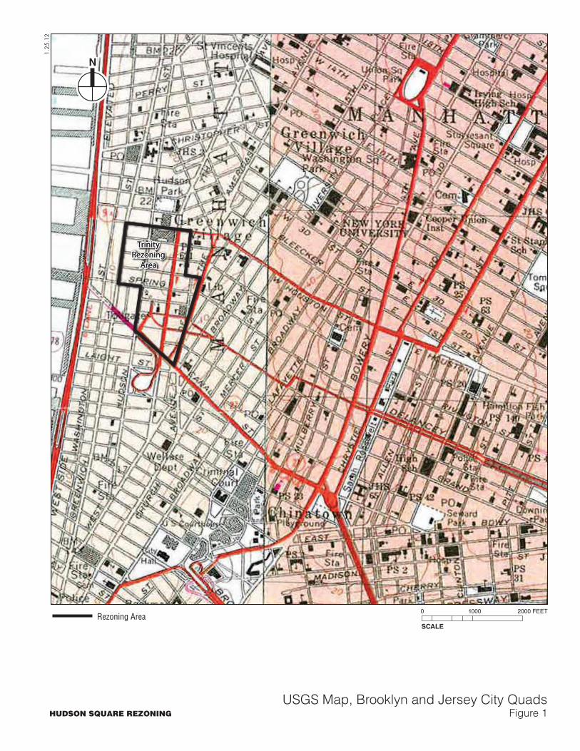
TrinityRezoning
Area
TrinityRezoning
Area
1.25
.12
N
USGS Map, Brooklyn and Jersey City QuadsFigure 1
SCALE
0 1000 2000 FEET
HUDSON SQUARE REZONING
Rezoning Area
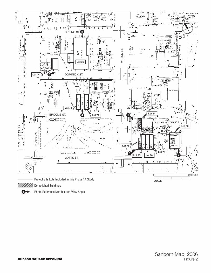
BROOME ST.
DOMINICK ST.
SPRING ST.
WATTS ST.
VAR
ICK
ST.
N
HUDSON SQUARE REZONING
1.25
.12
SCALE
0 200 FEET
Lot 44
Lot 35
Lot 66
Lot 79
Lot 76
Lot 75 Lot 74
Lot 77Lot 44
Lot 73
Sanborn Map, 2006Figure 2
23
1
1
4
6
5
Project Site Lots Included in this Phase 1A Study
Demolished Buildings
Photo Reference Number and View Angle
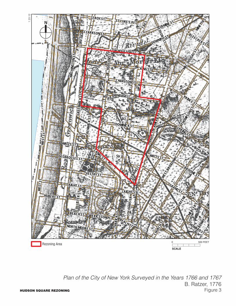
WES
T ST
HUDS
ON S
TVA
RICK
ST
CANAL ST
SPRING ST
GREE
NWIC
H ST
KING STW
ASHI
NGTO
N ST
W HOUSTON ST
BROOME ST
GRAND ST
AV O
F THE
AME
RICA
S
THOM
PSON
ST
WEST B
ROAD
WAY
LAIGHT ST
WATTS ST
VESTRY ST
WOOSTER
ST
VANDAM ST
GREEN
E ST
CHARLTON ST
CLARKSON ST
NORTH MOORE ST
LEROY ST
MERCE
R ST
HUBERT ST
CARMINE ST
MAC DO
UGAL
ST
7 AV
S
DOWNING ST
DOMINICK ST
BLEECKER ST
DESBROSSES ST
BROAD
WAY
RENW
ICK
ST
ST LUKE'S PL
ST JO
HN'S
LA
ERICSSON PL
COLL
ISTE
R ST
MINETTA
ST
BEACH ST
WES
T ST
LAIGHT ST
WATTS ST
SULL
IVAN S
T
PRINCE ST
BEDFORD ST
HOWARD STCHUR
CH ST
BEACH ST
N
HUDSON SQUARE REZONING
Plan of the City of New York Surveyed in the Years 1766 and 1767B. Ratzer, 1776
Figure 3
1.25
.12
SCALE
0 500 FEETRezoning Area
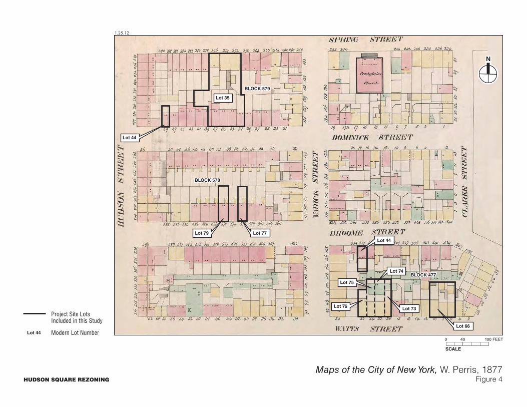
N
HUDSON SQUARE REZONING
1.25.12
Maps of the City of New York, W. Perris, 1877Figure 4
SCALE
0 40 100 FEET
Lot 44
Lot 35
Lot 66
Lot 79
Lot 76
Lot 74
Lot 77
Lot 44
Lot 73
Lot 75
BLOCK 477BLOCK 477
BLOCK 578BLOCK 578
BLOCK 579BLOCK 579
Project Site LotsIncluded in this Study
Modern Lot NumberLot 44
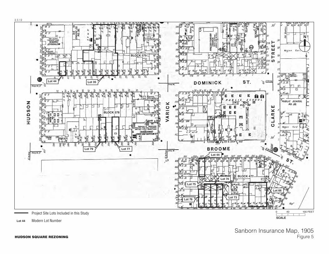
N
HUDSON SQUARE REZONING
2.3.12
Sanborn Insurance Map, 1905Figure 5
SCALE
0 40 100 FEET
Lot 44 Lot 35
Lot 66
Lot 79
Lot 74
Lot 77
Lot 44
Lot 75
BLOCK 477BLOCK 477
BLOCK 578BLOCK 578
BLOCK 579BLOCK 579
Lot 73Lot 76
Project Site Lots Included in this Study
Modern Lot NumberLot 44
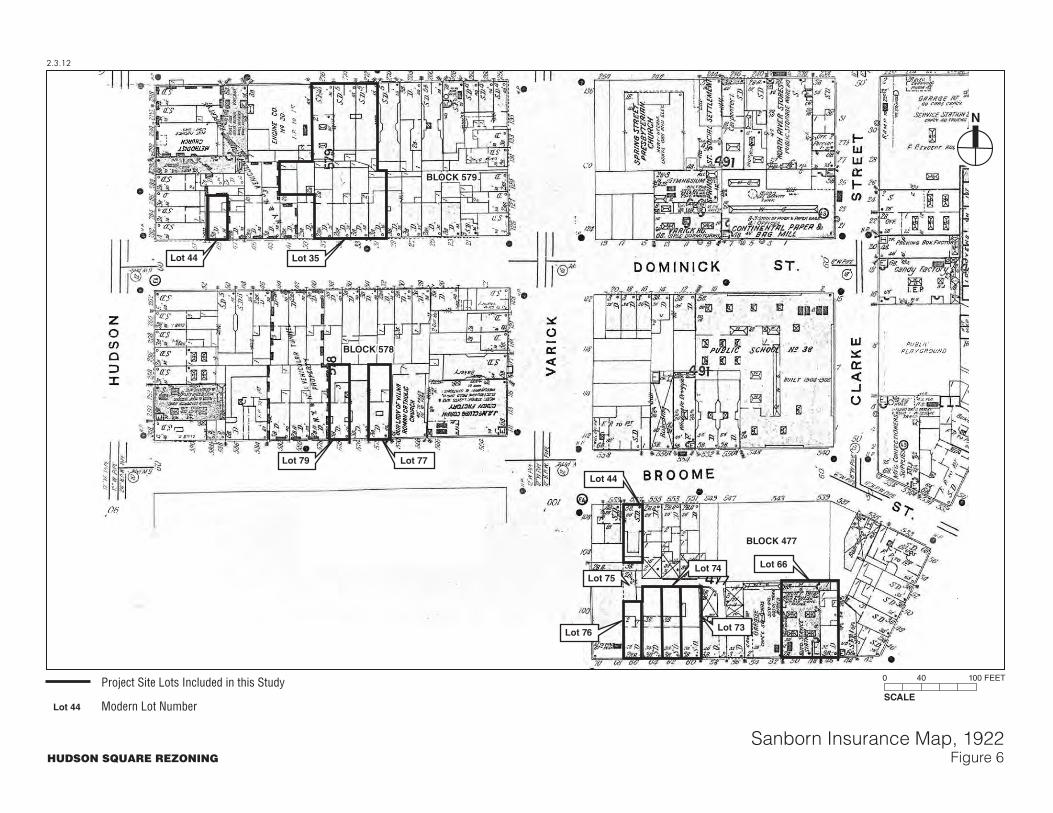
N
HUDSON SQUARE REZONING
2.3.12
Sanborn Insurance Map, 1922Figure 6
SCALE
0 40 100 FEET
Lot 44 Lot 35
Lot 66
Lot 79
Lot 74
Lot 77
Lot 44
Lot 75
BLOCK 477BLOCK 477
BLOCK 578BLOCK 578
BLOCK 579BLOCK 579
Lot 73Lot 76
Project Site Lots Included in this Study
Modern Lot NumberLot 44

N
HUDSON SQUARE REZONING
1.25.12
Sanborn Insurance Map, 1951Figure 7
SCALE
0 40 100 FEET
Lot 44 Lot 35
Lot 66
Lot 79
Lot 74
Lot 77
Lot 44
Lot 75
BLOCK 477BLOCK 477
BLOCK 578BLOCK 578
BLOCK 579BLOCK 579
Lot 73Lot 76
Project Site Lots Included in this Study
Modern Lot NumberLot 44
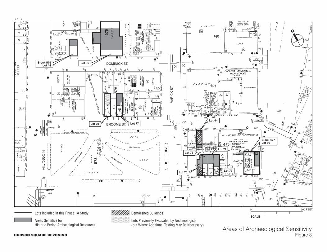
2.3.12
HUDSON SQUARE REZONING
Areas of Archaeological SensitivityFigure 8
Block 477Lot 66
N
SCALE
0 200 FEET
Block 579Lot 44
Lot 35
Lot 44
Lot 74Lot 75
Lot 73Lot 76
Lot 79 Lot 77
Lots included in this Phase 1A Study
Areas Sensitive forHistoric Period Archaeological Resources
Demolished Buildings
Lots Previously Excavated by Archaeologists(but Where Additional Testing May Be Necessary)
DOMINICK ST.
BROOME ST.
VA
RIC
K S
T.

Photographs
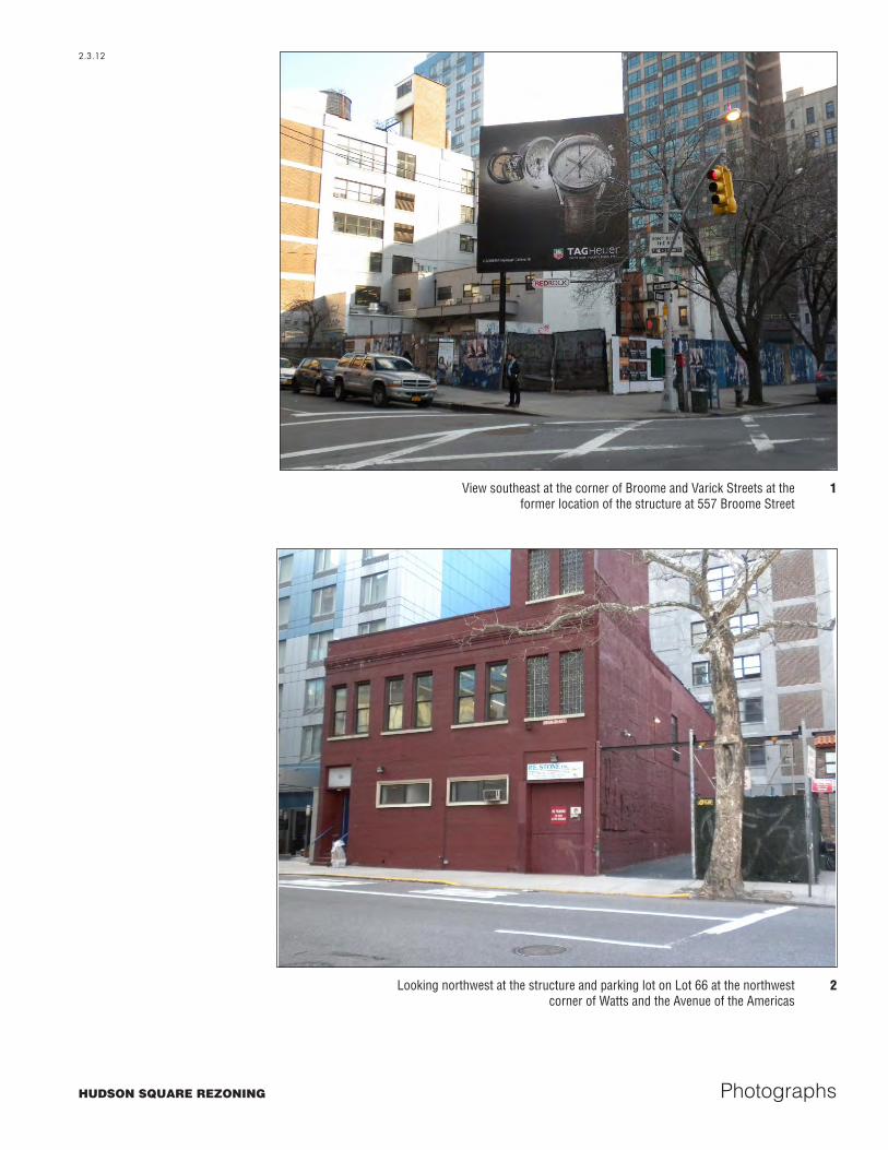
View southeast at the corner of Broome and Varick Streets at theformer location of the structure at 557 Broome Street
1
Looking northwest at the structure and parking lot on Lot 66 at the northwestcorner of Watts and the Avenue of the Americas
2
HUDSON SQUARE REZONING
2.3.12
Photographs
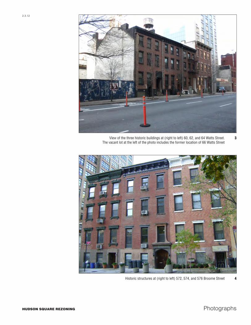
View of the three historic buildings at (right to left) 60, 62, and 64 Watts Street.The vacant lot at the left of the photo includes the former location of 66 Watts Street
3
Historic structures at (right to left) 572, 574, and 576 Broome Street 4
HUDSON SQUARE REZONING
2.3.12
Photographs
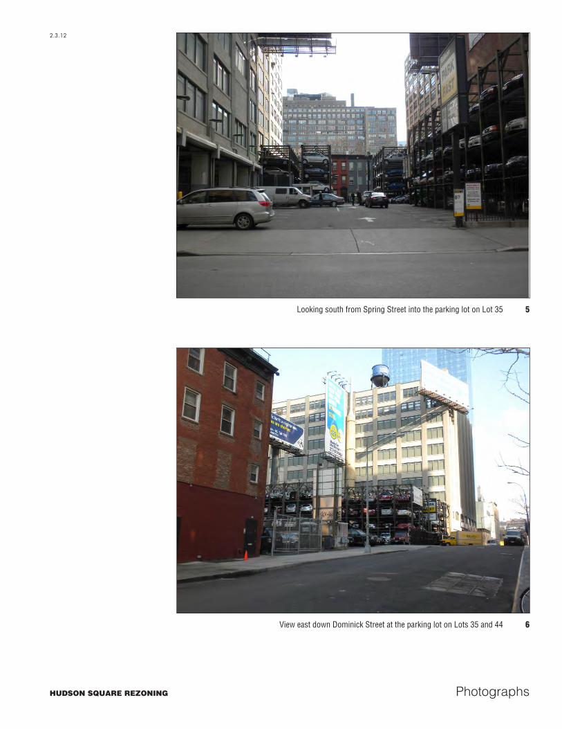
Looking south from Spring Street into the parking lot on Lot 35 5
View east down Dominick Street at the parking lot on Lots 35 and 44 6
HUDSON SQUARE REZONING
2.3.12
Photographs

Appendices

Appendix A-1
Appendix A: Documentary Research for 557 Broome Street (Block 477, Lot 44)
Table A-1Early Conveyances for 557 Broome Street (Block 477, Lot 44)
Lot # Date Grantor Grantee Liber Page Remarks
General Statement of Early Title for Block 477
The northeasterly and southwesterly parcels of this block were included within the Trinity Church farm. The remainder lay within the farm of Anthony Rutgers, who by will (L16 Wills p 12) proved
September 17, 1746 devised his estate to his heirs and devisees, this block lying within the allotment to Leonard Lispenard. The latter devised all his estate by will (L40 Wills p 388) proved September 22, 1806 devised his residual estate to his heirs and devisees. Partition was had in
March 1811, this parcel being in the share of Alexander L. Stewart and Sarah, his wife.
Not Lotted
3/29/1703 William & Sarah Huddleston Richard Hill 25 114 2/14/1726 Richard & Hannah Hill Anthony Rutgers 31 115 2/14/1726 Richard & Hannah Hill Anthony Rutgers 31 116
2/14/1726 Jesse & Jacoba Krersteede &
Francisca Lewis, heirs of Thomas Lewis, Jr.
Anthony Rutgers 31 118
2/15/1726 Leonard Lewis Anthony Rutgers 31 121
2/24/1726 Anthony Rutgers, heir of
Thomas Lewis Anthony Rutgers 31 123
2/26/1726 Thomas Lawrence, heir of
Katherine Lewis Anthony Rutgers 31 125
2/11/1767 Dirck Lefferts Leonard & Elsie Lispenard,
Henry & Mary Barclay 38 105
2/14/1767 Dirck Lefferts Leonard & Elsie Lispenard,
Henry & Mary Barclay 38 110
44, 45 4/13/1821 Alexander L. and Sarah Stewart John N. Huyler 150 121 Examine 46
44 2/5/1840
William and John Jr. Huyler, Catherine Fredericks, Jacob Huyler, Sarah Lyon, David
Huyler, Eliza Von Buskirk, Heirs of John W. Huyler, Eve Aletta,
Magdalen Huyler, Henry Fredericks, Sarah Huyler, Alvon Lyon and John Jr. Von Buskrik
John M. Winant 403 284
44 5/22/1862 Catharine B., Albert S.,
Adolphus B., Winant; heirs of John M, Winant
Samuel White 850 679
44 5/22/1862 John M. Winant (Exrs of) Samuel White 861 10
44 4/4/1884 Frank W. White Heir of Samuel
White and Ella A. White Harriet E. Graham 1783 349
44 4/19/1909 Harris Mandelbaum and Annie,
Fisher and Esther Levine Nathan Bassoff 191 130
44 4/20/1909 Nathan Bassoff Rebeca Shkolnikoff 190 166
44 1/27/1911
Adam Wiener (Referee) Susan Van Praag, Plaintiff against
Nathan Bassoff et al. Defendants
Max Keve 205 136
44 3/2/1911 Max and Sadie Keve Lena Brandenburg 204 320
44 11/18/1914 Lena Brandenburg Giuseppe Russo, James Bianculli
244 43
Notes: Block 477 was not divided into lots until the early 19th century, and therefore conveyance records marked, “not lotted,” may not specifically refer to the lots within the project site.
Sources: Conveyance records and Liber books on file at the Manhattan office of the City Register, New York City Department of Finance.
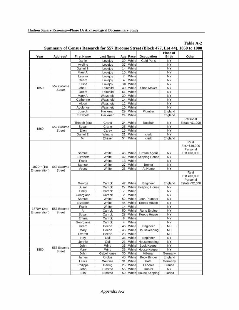
Hudson Square Rezoning—Phase 1A Archaeological Documentary Study
Appendix A-2
Table A-2Summary of Census Research for 557 Broome Street (Block 477, Lot 44), 1850 to 1900
Year Address* First Name Last Name Age Race Occupation Place of
Birth Other
1850 557 Broome
Street
Daniel Lovejoy 39 White Gold Pens NY Aveline Lovejoy 37 White NY
Daniel B. Lovejoy 14 White NY Mary A. Lovejoy 10 White NY Levinia Lovejoy 7 White NY Debra Lovejoy 4 White NY Elisha Lovejoy 5m White NY
John P. Fairchild 40 White Shoe Maker NY Debra Fairchild 61 White NY
Mary A. Waysneid 30 White NY Catherine Waysneid 14 White NY
Albert Waysneid 12 White NY Adolphus Waysneid 10 White NY Joseph Hackman 29 White Plumber England
Elizabeth Hackman 24 White England
1860 557 Broome
Street
Theoph (sic) Crane 34 White butcher NY Personal
Estate=$1,000Susan Crane 25 White NY Ellen Carey 15 White NY
Daniel E. Winans 21 White clerk NY Mr. Eheser 54 White clerk England
1870** (1st Enumeration)
557 Broome Street
Samuel White 46 White Croton Agent NY
Real Est.=$10,000
Personal Est.=$3,000
Elizabeth White 42 White Keeping House NY Frank White 13 White NY
Samuel White 27 White Broker NY Vesey White 23 White At Home NY
George Carrick 47 White Engineer England
Real Est.=$3,000
Personal Estate=$2,000
Susan Carrick 27 White Keeping House NY Emily Carrick 7 White NY
Georgiana Carrick 2 White NY
1870** (2nd Enumeration)
557 Broome Street
Samuel White 52 White Jour. Plumber NY Elizabeth White 44 White Keeps House NY
Frank White 14 White NY A. Carrick 50 White Runs Engine NY
Susan Carrick 28 White Keeps House NY Emma Carrick 8 White NY
Georgiana Carrick 4 White NY
1880 557 Broome
Street
Hiram Beede 46 White Engineer NH Mary Beede 45 White Housekeeping NH
Everett Beede 23 White NH Ray Gull 35 White Engineer NY
Jennie Gull 21 White Housekeeping NY John Wind 35 White Book Keeper NY Mary Wind 36 White House Keeper NY John Gabelhouse 30 White Milkman Germany
James Crolus 40 White Book Binder England Lewis Weldins 31 White Hotel Germany
Philippe Gervig 25 White Laborer France John Brasted 55 White Roofer NY Ella Brasted 50 White House Keeping Florida
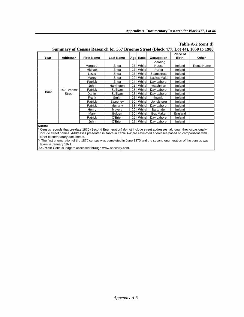
Appendix A: Documentary Research for Block 477, Lot 44
Appendix A-3
Table A-2 (cont’d)Summary of Census Research for 557 Broome Street (Block 477, Lot 44), 1850 to 1900
Year Address* First Name Last Name Age Race Occupation Place of
Birth Other
1900 557 Broome
Street
Margaret Shea 27 WhiteBoarding House Ireland Rents Home
Michael Shea 23 White Porter Ireland Lizzie Shea 25 White Seamstress Ireland Marey Shea 22 White Ladies Maid Ireland Patrick Shea 24 White Day Laborer Ireland John Harrington 21 White watchman Ireland
Patrick Sullivan 28 White Day Laborer Ireland Daniel Sullivan 25 White Day Laborer Ireland Frank Smith 26 White tinsmith Ireland Patrick Sweeney 30 White Upholsterer Ireland Patrick Moriarty 33 White Day Laborer Ireland Henry Meyers 29 White Bartender Ireland Mary Bulgen 30 White Box Maker England
Patrick O'Brien 25 White Day Laborer Ireland John O'Brien 22 White Day Laborer Ireland
Notes: * Census records that pre-date 1870 (Second Enumeration) do not include street addresses, although they occasionally
include street names. Addresses presented in italics in Table A-2 are estimated addresses based on comparisons with other contemporary documents.
** The first enumeration of the 1870 census was completed in June 1870 and the second enumeration of the census was taken in January 1871.
Sources: Census ledgers accessed through www.ancestry.com.
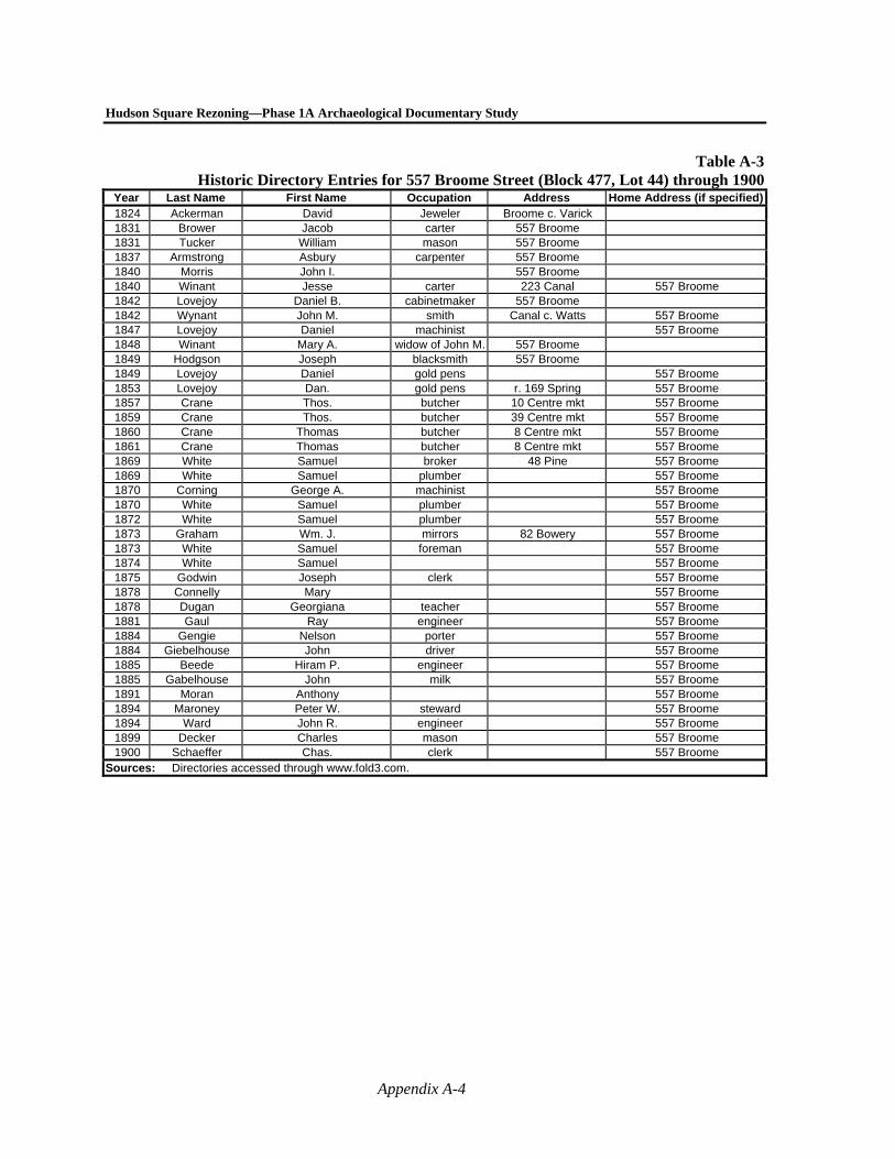
Hudson Square Rezoning—Phase 1A Archaeological Documentary Study
Appendix A-4
Table A-3Historic Directory Entries for 557 Broome Street (Block 477, Lot 44) through 1900
Year Last Name First Name Occupation Address Home Address (if specified)1824 Ackerman David Jeweler Broome c. Varick 1831 Brower Jacob carter 557 Broome 1831 Tucker William mason 557 Broome 1837 Armstrong Asbury carpenter 557 Broome 1840 Morris John I. 557 Broome 1840 Winant Jesse carter 223 Canal 557 Broome 1842 Lovejoy Daniel B. cabinetmaker 557 Broome 1842 Wynant John M. smith Canal c. Watts 557 Broome 1847 Lovejoy Daniel machinist 557 Broome 1848 Winant Mary A. widow of John M. 557 Broome 1849 Hodgson Joseph blacksmith 557 Broome 1849 Lovejoy Daniel gold pens 557 Broome 1853 Lovejoy Dan. gold pens r. 169 Spring 557 Broome 1857 Crane Thos. butcher 10 Centre mkt 557 Broome 1859 Crane Thos. butcher 39 Centre mkt 557 Broome 1860 Crane Thomas butcher 8 Centre mkt 557 Broome 1861 Crane Thomas butcher 8 Centre mkt 557 Broome 1869 White Samuel broker 48 Pine 557 Broome 1869 White Samuel plumber 557 Broome 1870 Corning George A. machinist 557 Broome 1870 White Samuel plumber 557 Broome 1872 White Samuel plumber 557 Broome 1873 Graham Wm. J. mirrors 82 Bowery 557 Broome 1873 White Samuel foreman 557 Broome 1874 White Samuel 557 Broome 1875 Godwin Joseph clerk 557 Broome 1878 Connelly Mary 557 Broome 1878 Dugan Georgiana teacher 557 Broome 1881 Gaul Ray engineer 557 Broome 1884 Gengie Nelson porter 557 Broome 1884 Giebelhouse John driver 557 Broome 1885 Beede Hiram P. engineer 557 Broome 1885 Gabelhouse John milk 557 Broome 1891 Moran Anthony 557 Broome 1894 Maroney Peter W. steward 557 Broome 1894 Ward John R. engineer 557 Broome 1899 Decker Charles mason 557 Broome 1900 Schaeffer Chas. clerk 557 Broome
Sources: Directories accessed through www.fold3.com.

Appendix A: Documentary Research for Block 477, Lot 44
Appendix A-5
Table A-4Tax Assessments for 557 Broome Street (Block 477, Lot 44), 1820 to 1850
Year Address Historic Lot Name of Owner Name of Occupant Description of
Property Assessed Value ($)
Occupant's Personal Estate ($)
1820 2866 Alex. L. Stewart Lot 600 1822 2866 John P. Hylar Daniel Christie House and 1/2 Lot 1800 100
1823 557 Broome 2866 John P. Hylar Jotham Gallbraite
Cornelius Ackerman House and 1/2 Lot 1700 100 100
1824 557 Broome 2866 John P. Hylar Abraham Reiss House and Lot 1700 100 1825 John P. Hylar Abraham Ackerman House and 3/4 Lot 2000 100 1826 2866 John Hilar House and Lot 2000 1827 557 Broome 2866 John Hilar House and 3/4 Lot 2000 1828 557 Broome 2866 John Hilar House and 3/4 Lot 2000 1829 557 Broome John Huylar House and 3/4 Lot 2000 1830 557 Broome 2866 John Huylar House and 3/4 Lot 2200 1835 557 Broome 1657 John Huylar House and Lot 2700 1840 557 Broome 1657 John M. Winant House and Lot 4100 1845 557 Broome 1657 Est. John W. Winant House and 3/4 Lot 3900 1850 557 Broome 1486 Est. J.W. Winant House and 1/2 Lot 3400 Notes: The handwritten tax assessment ledgers do not always appear to be accurately updated from year to year and
therefore contain inconsistent information from year to year. In addition, because the ledgers are handwritten, there may also be transcription inaccuracies in this table.
Sources: Tax assessment rolls on file at the New York City Municipal Archives.
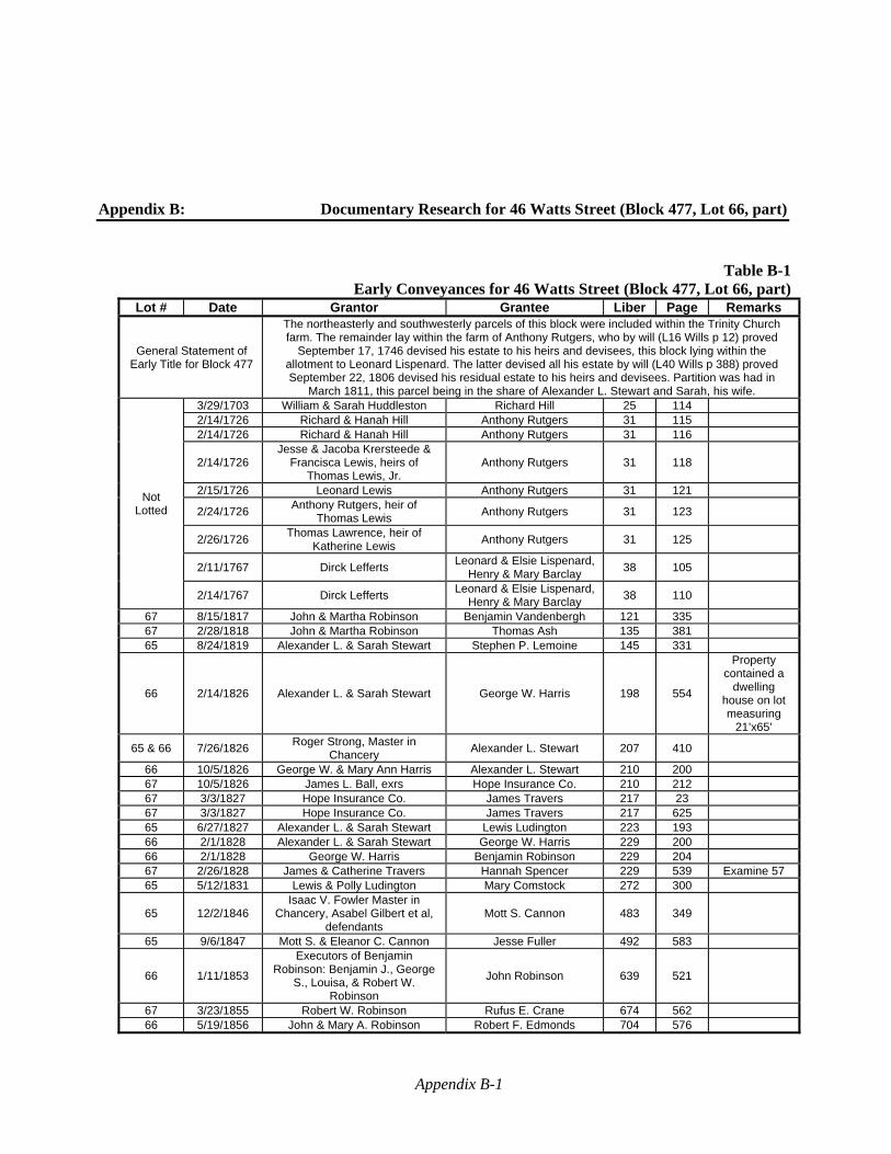
Appendix B-1
Appendix B: Documentary Research for 46 Watts Street (Block 477, Lot 66, part)
Table B-1Early Conveyances for 46 Watts Street (Block 477, Lot 66, part)
Lot # Date Grantor Grantee Liber Page Remarks
General Statement of Early Title for Block 477
The northeasterly and southwesterly parcels of this block were included within the Trinity Church farm. The remainder lay within the farm of Anthony Rutgers, who by will (L16 Wills p 12) proved
September 17, 1746 devised his estate to his heirs and devisees, this block lying within the allotment to Leonard Lispenard. The latter devised all his estate by will (L40 Wills p 388) proved September 22, 1806 devised his residual estate to his heirs and devisees. Partition was had in
March 1811, this parcel being in the share of Alexander L. Stewart and Sarah, his wife.
Not Lotted
3/29/1703 William & Sarah Huddleston Richard Hill 25 114 2/14/1726 Richard & Hanah Hill Anthony Rutgers 31 115 2/14/1726 Richard & Hanah Hill Anthony Rutgers 31 116
2/14/1726 Jesse & Jacoba Krersteede &
Francisca Lewis, heirs of Thomas Lewis, Jr.
Anthony Rutgers 31 118
2/15/1726 Leonard Lewis Anthony Rutgers 31 121
2/24/1726 Anthony Rutgers, heir of
Thomas Lewis Anthony Rutgers 31 123
2/26/1726 Thomas Lawrence, heir of
Katherine Lewis Anthony Rutgers 31 125
2/11/1767 Dirck Lefferts Leonard & Elsie Lispenard,
Henry & Mary Barclay 38 105
2/14/1767 Dirck Lefferts Leonard & Elsie Lispenard,
Henry & Mary Barclay 38 110
67 8/15/1817 John & Martha Robinson Benjamin Vandenbergh 121 335 67 2/28/1818 John & Martha Robinson Thomas Ash 135 381 65 8/24/1819 Alexander L. & Sarah Stewart Stephen P. Lemoine 145 331
66 2/14/1826 Alexander L. & Sarah Stewart George W. Harris 198 554
Property contained a
dwelling house on lot measuring
21’x65’
65 & 66 7/26/1826 Roger Strong, Master in
Chancery Alexander L. Stewart 207 410
66 10/5/1826 George W. & Mary Ann Harris Alexander L. Stewart 210 200 67 10/5/1826 James L. Ball, exrs Hope Insurance Co. 210 212 67 3/3/1827 Hope Insurance Co. James Travers 217 23 67 3/3/1827 Hope Insurance Co. James Travers 217 625 65 6/27/1827 Alexander L. & Sarah Stewart Lewis Ludington 223 193 66 2/1/1828 Alexander L. & Sarah Stewart George W. Harris 229 200 66 2/1/1828 George W. Harris Benjamin Robinson 229 204 67 2/26/1828 James & Catherine Travers Hannah Spencer 229 539 Examine 57 65 5/12/1831 Lewis & Polly Ludington Mary Comstock 272 300
65 12/2/1846 Isaac V. Fowler Master in
Chancery, Asabel Gilbert et al, defendants
Mott S. Cannon 483 349
65 9/6/1847 Mott S. & Eleanor C. Cannon Jesse Fuller 492 583
66 1/11/1853
Executors of Benjamin Robinson: Benjamin J., George
S., Louisa, & Robert W. Robinson
John Robinson 639 521
67 3/23/1855 Robert W. Robinson Rufus E. Crane 674 562 66 5/19/1856 John & Mary A. Robinson Robert F. Edmonds 704 576
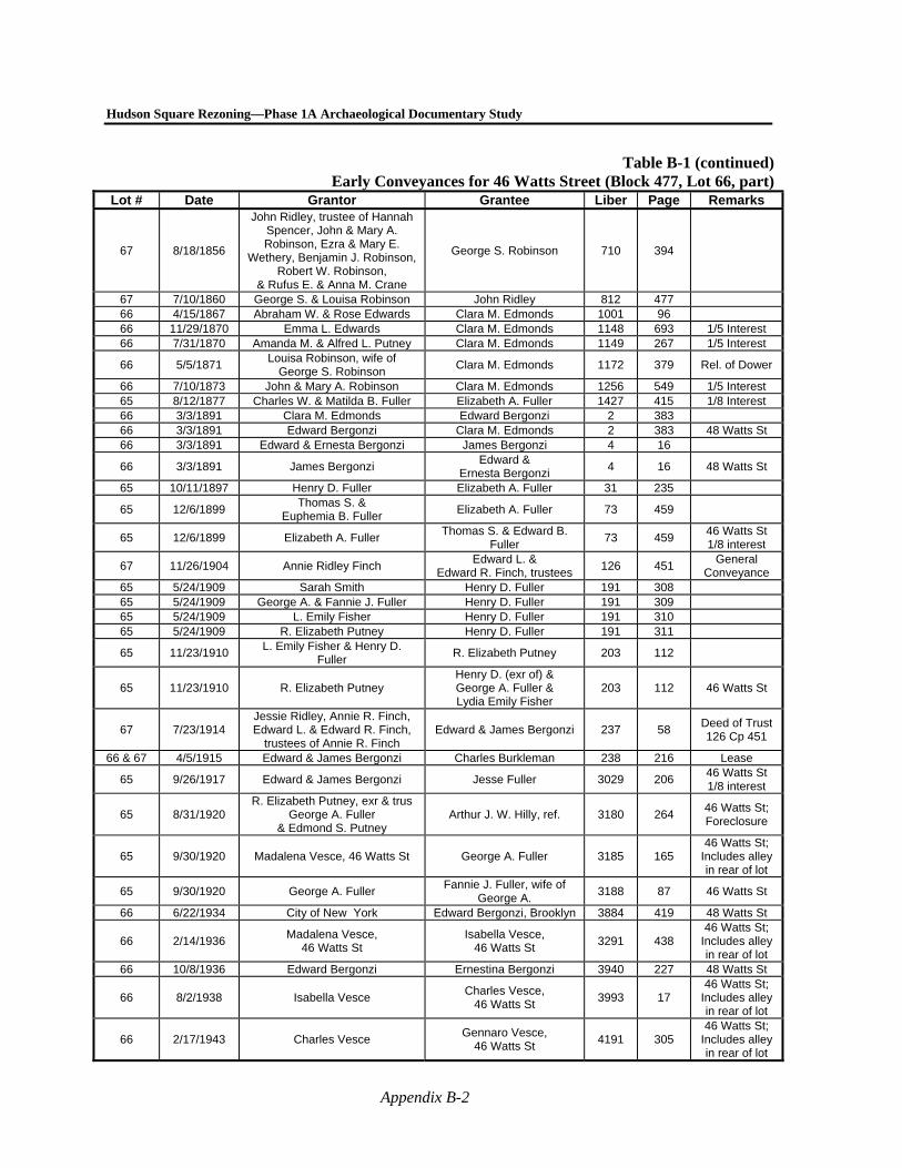
Hudson Square Rezoning—Phase 1A Archaeological Documentary Study
Appendix B-2
Table B-1 (continued)Early Conveyances for 46 Watts Street (Block 477, Lot 66, part)
Lot # Date Grantor Grantee Liber Page Remarks
67 8/18/1856
John Ridley, trustee of Hannah Spencer, John & Mary A. Robinson, Ezra & Mary E.
Wethery, Benjamin J. Robinson, Robert W. Robinson,
& Rufus E. & Anna M. Crane
George S. Robinson 710 394
67 7/10/1860 George S. & Louisa Robinson John Ridley 812 477 66 4/15/1867 Abraham W. & Rose Edwards Clara M. Edmonds 1001 96 66 11/29/1870 Emma L. Edwards Clara M. Edmonds 1148 693 1/5 Interest 66 7/31/1870 Amanda M. & Alfred L. Putney Clara M. Edmonds 1149 267 1/5 Interest
66 5/5/1871 Louisa Robinson, wife of
George S. Robinson Clara M. Edmonds 1172 379 Rel. of Dower
66 7/10/1873 John & Mary A. Robinson Clara M. Edmonds 1256 549 1/5 Interest 65 8/12/1877 Charles W. & Matilda B. Fuller Elizabeth A. Fuller 1427 415 1/8 Interest 66 3/3/1891 Clara M. Edmonds Edward Bergonzi 2 383 66 3/3/1891 Edward Bergonzi Clara M. Edmonds 2 383 48 Watts St 66 3/3/1891 Edward & Ernesta Bergonzi James Bergonzi 4 16
66 3/3/1891 James Bergonzi Edward &
Ernesta Bergonzi 4 16 48 Watts St
65 10/11/1897 Henry D. Fuller Elizabeth A. Fuller 31 235
65 12/6/1899 Thomas S. &
Euphemia B. Fuller Elizabeth A. Fuller 73 459
65 12/6/1899 Elizabeth A. Fuller Thomas S. & Edward B.
Fuller 73 459
46 Watts St 1/8 interest
67 11/26/1904 Annie Ridley Finch Edward L. &
Edward R. Finch, trustees 126 451
General Conveyance
65 5/24/1909 Sarah Smith Henry D. Fuller 191 308 65 5/24/1909 George A. & Fannie J. Fuller Henry D. Fuller 191 309 65 5/24/1909 L. Emily Fisher Henry D. Fuller 191 310 65 5/24/1909 R. Elizabeth Putney Henry D. Fuller 191 311
65 11/23/1910 L. Emily Fisher & Henry D.
Fuller R. Elizabeth Putney 203 112
65 11/23/1910 R. Elizabeth Putney Henry D. (exr of) & George A. Fuller & Lydia Emily Fisher
203 112 46 Watts St
67 7/23/1914 Jessie Ridley, Annie R. Finch, Edward L. & Edward R. Finch,
trustees of Annie R. Finch Edward & James Bergonzi 237 58
Deed of Trust 126 Cp 451
66 & 67 4/5/1915 Edward & James Bergonzi Charles Burkleman 238 216 Lease
65 9/26/1917 Edward & James Bergonzi Jesse Fuller 3029 206 46 Watts St 1/8 interest
65 8/31/1920 R. Elizabeth Putney, exr & trus
George A. Fuller & Edmond S. Putney
Arthur J. W. Hilly, ref. 3180 264 46 Watts St; Foreclosure
65 9/30/1920 Madalena Vesce, 46 Watts St George A. Fuller 3185 165 46 Watts St;
Includes alley in rear of lot
65 9/30/1920 George A. Fuller Fannie J. Fuller, wife of
George A. 3188 87 46 Watts St
66 6/22/1934 City of New York Edward Bergonzi, Brooklyn 3884 419 48 Watts St
66 2/14/1936 Madalena Vesce,
46 Watts St Isabella Vesce,
46 Watts St 3291 438
46 Watts St; Includes alley in rear of lot
66 10/8/1936 Edward Bergonzi Ernestina Bergonzi 3940 227 48 Watts St
66 8/2/1938 Isabella Vesce Charles Vesce,
46 Watts St 3993 17
46 Watts St; Includes alley in rear of lot
66 2/17/1943 Charles Vesce Gennaro Vesce,
46 Watts St 4191 305
46 Watts St; Includes alley in rear of lot
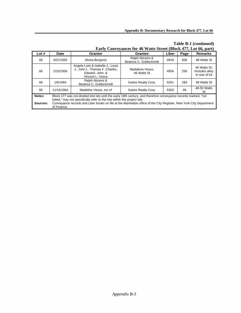
Appendix B: Documentary Research for Block 477, Lot 66
Appendix B-3
Table B-1 (continued)Early Conveyances for 46 Watts Street (Block 477, Lot 66, part)
Lot # Date Grantor Grantee Liber Page Remarks
66 4/21/1955 Alvina Bergonzi Ralph Abrams &
Beatrice C. Goldschmidt 4919 506 48 Watts St
66 2/15/1956
Angela Luisi & Isabella J., Louis J., John L. Thomas F. Charles,
Edward, John, & Vincent L. Vesce
Madalena Vesce, 46 Watts St
4954 256 46 Watts St;
Includes alley in rear of lot
66 1/6/1964 Ralph Abrams &
Beatrice C. Goldschmidt Garlex Realty Corp. 5261 283 48 Watts St
66 11/16/1964 Madeline Vesce, exr of Garlex Realty Corp. 5303 46 48-50 Watts
St Notes: Block 477 was not divided into lots until the early 19th century, and therefore conveyance records marked, “not
lotted,” may not specifically refer to the lots within the project site. Sources: Conveyance records and Liber books on file at the Manhattan office of the City Register, New York City Department
of Finance.

Hudson Square Rezoning—Phase 1A Archaeological Documentary Study
Appendix B-4
Table B-2Census Records for 46 Watts Street (Block 477, Lot 66, part), 1850 through 1900
Year Address* Name Age Occupation Place of
Birth Other
1850 46 Watts Street
Jessey Fuller 47 Cartman Mass. Real Estate =
$9,000 Elisabeth A. Fuller 34 New York Thomas J. Fuller 14 New York Rebecca E. Fuller 9 New York Charles W. Fuller 6 New York Henry D. Fuller 4 New York Sarah A. Fuller 2 New York Ann Codmore 30 Ireland Mrs. Studivant 50 New York
Marinda Studivant 18 New York Elizabeth H. Tay 27 Mass.
Mary Kimball 47 Pennsylvania Ann W. Ogilbie 60 New Jersey
Almenia G. Ayres 40 New Jersey Martha Ayres 35 New Jersey
William Ferguson 31 Shoe Maker Scotland Margaret Ferguson 29 Ireland Margaret Ferguson 7 New York
Georgiannia Ferguson 2 New York William Smith 52 None New York
Ann Smith 51 Scotland
1860 46 Watts Street
James Fuller 57 Cartman Mass. Real Est.=
$7500, Pers. Est. = $1,200
Emily Fuller 43 New York Thomas Fuller 23 New York
Eliza Fuller 19 New York Charles Fuller 16 New York Henry Fuller 14 New York
Sarah Fuller 12 New York
Joseph Fuller 9 New York Elizabeth Fuller 6 New York
Aaron Fuller 3 New York Ellen Fuller 22 New York
Charlotte Fuller 2 New York Rachael Freeman 23 New York
1870 1st
Enum-eration**
46 Watts Street
Henry Whitson 38 Sugar House Prussia Pers. Est= $300 Caroline Whitson 35 Keeping House Prussia Henry Whitson 3 New York John Whitson 2 New York
Mary Costello 40 Keeping House New York Pers. Est=
$1,000 Thomas B. Costello 23 Clerk New York
Samuel Walker 26 Carman New York
Elizabeth Walker 25 Keeping House Connecticut Real Est.=
$1,000, Pers. Est.=$800
Nelly L. Walker 1 New York Martha Danerest 55 Keeping House New Jersey Samuel Danerest 40 Weigher New York
Almina Meyers 60 at home New York George Bentley 29 Book Keeper New York
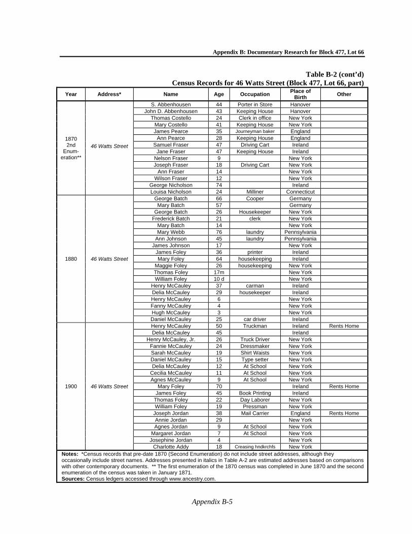
Appendix B: Documentary Research for Block 477, Lot 66
Appendix B-5
Table B-2 (cont’d)Census Records for 46 Watts Street (Block 477, Lot 66, part)
Year Address* Name Age Occupation Place of
Birth Other
1870 2nd
Enum-eration**
46 Watts Street
S. Abbenhousen 44 Porter in Store Hanover John D. Abbenhousen 43 Keeping House Hanover
Thomas Costello 24 Clerk in office New York Mary Costello 41 Keeping House New York James Pearce 35 Journeyman baker England
Ann Pearce 28 Keeping House England Samuel Fraser 47 Driving Cart Ireland
Jane Fraser 47 Keeping House Ireland Nelson Fraser 9 New York Joseph Fraser 18 Driving Cart New York
Ann Fraser 14 New York Wilson Fraser 12 New York
George Nicholson 74 Ireland Louisa Nicholson 24 Milliner Connecticut
1880 46 Watts Street
George Batch 66 Cooper Germany Mary Batch 57 Germany
George Batch 26 Housekeeper New York Frederick Batch 21 clerk New York
Mary Batch 14 New York Mary Webb 76 laundry Pennsylvania
Ann Johnson 45 laundry Pennsylvania James Johnson 17 New York
James Foley 36 printer Ireland Mary Foley 64 housekeeping Ireland
Maggie Foley 26 housekeeping New York Thomas Foley 17m New York William Foley 10 d New York
Henry McCauley 37 carman Ireland Delia McCauley 29 housekeeper Ireland Henry McCauley 6 New York Fanny McCauley 4 New York Hugh McCauley 3 New York Daniel McCauley 25 car driver Ireland
1900 46 Watts Street
Henry McCauley 50 Truckman Ireland Rents Home Delia McCauley 45 Ireland
Henry McCauley, Jr. 26 Truck Driver New York Fannie McCauley 24 Dressmaker New York Sarah McCauley 19 Shirt Waists New York Daniel McCauley 15 Type setter New York Delia McCauley 12 At School New York
Cecilia McCauley 11 At School New York Agnes McCauley 9 At School New York
Mary Foley 70 Ireland Rents Home James Foley 45 Book Printing Ireland
Thomas Foley 22 Day Laborer New York William Foley 19 Pressman New York
Joseph Jordan 38 Mail Carrier England Rents Home Annie Jordan 29 New York Agnes Jordan 9 At School New York
Margaret Jordan 7 At School New York Josephine Jordan 4 New York
Charlotte Addy 18 Creasing hndkrchfs New York Notes: *Census records that pre-date 1870 (Second Enumeration) do not include street addresses, although they occasionally include street names. Addresses presented in italics in Table A-2 are estimated addresses based on comparisons with other contemporary documents. ** The first enumeration of the 1870 census was completed in June 1870 and the second enumeration of the census was taken in January 1871. Sources: Census ledgers accessed through www.ancestry.com.
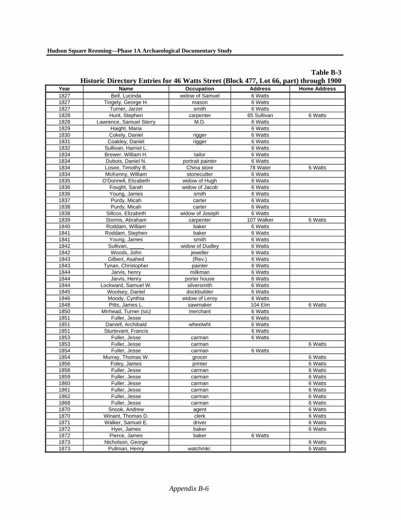
Hudson Square Rezoning—Phase 1A Archaeological Documentary Study
Appendix B-6
Table B-3Historic Directory Entries for 46 Watts Street (Block 477, Lot 66, part) through 1900
Year Name Occupation Address Home Address 1827 Bell, Lucinda widow of Samuel 6 Watts 1827 Tingely, George H. mason 6 Watts 1827 Turner, Jarzel smith 6 Watts 1828 Hunt, Stephen carpenter 65 Sullivan 6 Watts 1828 Lawrence, Samuel Sterry M.D. 6 Watts 1829 Haight, Maria 6 Watts 1830 Cokely, Daniel rigger 6 Watts 1831 Coakley, Daniel rigger 6 Watts 1832 Sullivan, Harriet L. 6 Watts 1834 Brewer, William H. tailor 6 Watts 1834 Dubois, Daniel N. portrait painter 6 Watts 1834 Losee, Timothy B. China store 78 Water 6 Watts 1834 McKenny, William stonecutter 6 Watts 1835 O'Donnell, Elizabeth widow of Hugh 6 Watts 1836 Fought, Sarah widow of Jacob 6 Watts 1836 Young, James smith 6 Watts 1837 Purdy, Micah carter 6 Watts 1838 Purdy, Micah carter 6 Watts 1838 Sillcox, Elizabeth widow of Joseph 6 Watts 1839 Storms, Abraham carpenter 107 Walker 6 Watts 1840 Roddam, William baker 6 Watts 1841 Roddam, Stephen baker 6 Watts 1841 Young, James smith 6 Watts 1842 Sullivan, _____ widow of Dudley 6 Watts 1842 Woods, John jeweller 6 Watts 1843 Gilbert, Asahed (Rev.) 6 Watts 1843 Tynan, Christopher painter 6 Watts 1844 Jarvis, henry milkman 6 Watts 1844 Jarvis, Henry porter house 6 Watts 1844 Lockward, Samuel W. silversmith 6 Watts 1845 Woolsey, Daniel dockbuilder 6 Watts 1846 Moody, Cynthia widow of Leroy 6 Watts 1848 Pitts, James L. sawmaker 104 Elm 6 Watts 1850 Mrrhead, Turner (sic) merchant 6 Watts 1851 Fuller, Jesse 6 Watts 1851 Darvell, Archibald wheelwht 6 Watts 1851 Sturtevant, Francis 6 Watts 1853 Fuller, Jesse carman 6 Watts 1853 Fuller, Jesse carman 6 Watts 1854 Fuller, Jesse carman 6 Watts 1854 Murray, Thomas W. grocer 6 Watts 1856 Foley, James printer 6 Watts 1858 Fuller, Jesse carman 6 Watts 1859 Fuller, Jesse carman 6 Watts 1860 Fuller, Jesse carman 6 Watts 1861 Fuller, Jesse carman 6 Watts 1862 Fuller, Jesse carman 6 Watts 1868 Fuller, Jesse carman 6 Watts 1870 Snook, Andrew agent 6 Watts 1870 Winant, Thomas D. clerk 6 Watts 1871 Walker, Samuel E. driver 6 Watts 1872 Hyer, James baker 6 Watts 1872 Pierce, James baker 6 Watts 1873 Nicholson, George 6 Watts 1873 Pullman, Henry watchmkr. 6 Watts
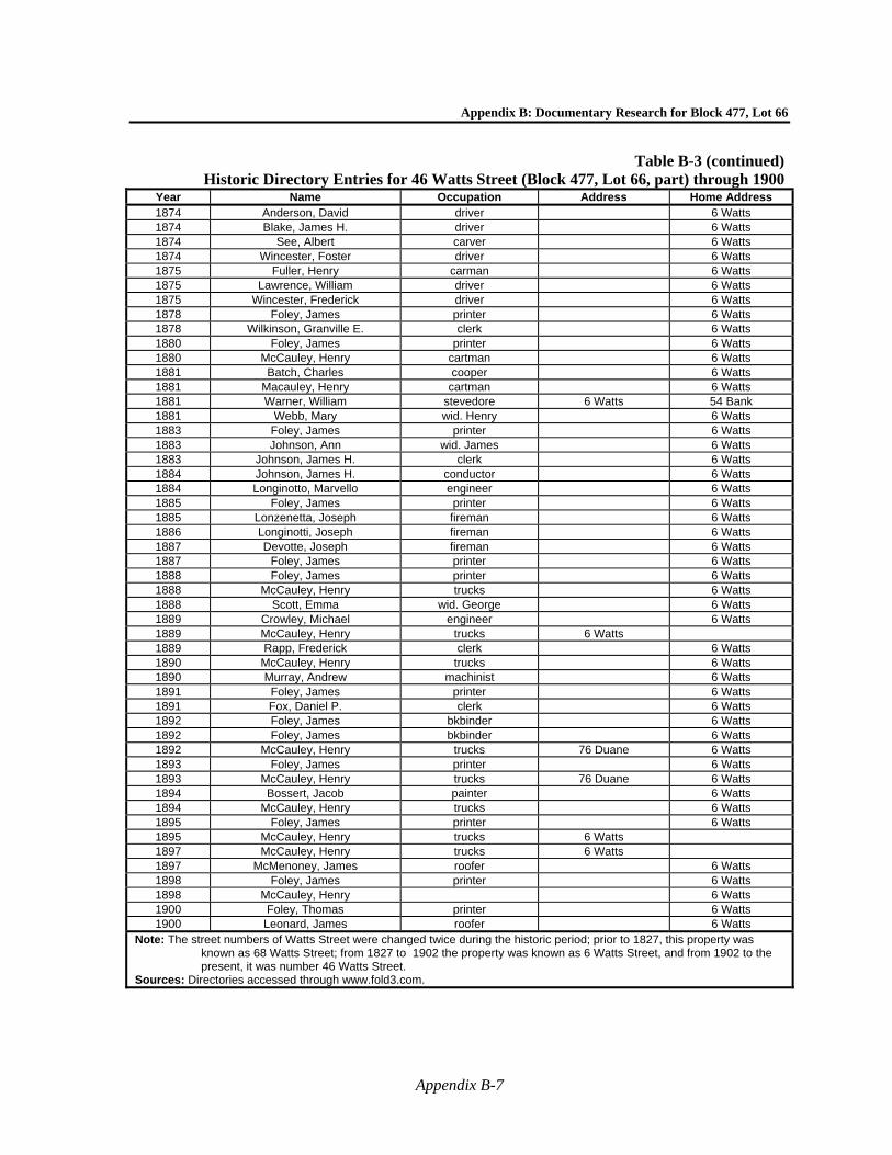
Appendix B: Documentary Research for Block 477, Lot 66
Appendix B-7
Table B-3 (continued)Historic Directory Entries for 46 Watts Street (Block 477, Lot 66, part) through 1900
Year Name Occupation Address Home Address 1874 Anderson, David driver 6 Watts 1874 Blake, James H. driver 6 Watts 1874 See, Albert carver 6 Watts 1874 Wincester, Foster driver 6 Watts 1875 Fuller, Henry carman 6 Watts 1875 Lawrence, William driver 6 Watts 1875 Wincester, Frederick driver 6 Watts 1878 Foley, James printer 6 Watts 1878 Wilkinson, Granville E. clerk 6 Watts 1880 Foley, James printer 6 Watts 1880 McCauley, Henry cartman 6 Watts 1881 Batch, Charles cooper 6 Watts 1881 Macauley, Henry cartman 6 Watts 1881 Warner, William stevedore 6 Watts 54 Bank 1881 Webb, Mary wid. Henry 6 Watts 1883 Foley, James printer 6 Watts 1883 Johnson, Ann wid. James 6 Watts 1883 Johnson, James H. clerk 6 Watts 1884 Johnson, James H. conductor 6 Watts 1884 Longinotto, Marvello engineer 6 Watts 1885 Foley, James printer 6 Watts 1885 Lonzenetta, Joseph fireman 6 Watts 1886 Longinotti, Joseph fireman 6 Watts 1887 Devotte, Joseph fireman 6 Watts 1887 Foley, James printer 6 Watts 1888 Foley, James printer 6 Watts 1888 McCauley, Henry trucks 6 Watts 1888 Scott, Emma wid. George 6 Watts 1889 Crowley, Michael engineer 6 Watts 1889 McCauley, Henry trucks 6 Watts 1889 Rapp, Frederick clerk 6 Watts 1890 McCauley, Henry trucks 6 Watts 1890 Murray, Andrew machinist 6 Watts 1891 Foley, James printer 6 Watts 1891 Fox, Daniel P. clerk 6 Watts 1892 Foley, James bkbinder 6 Watts 1892 Foley, James bkbinder 6 Watts 1892 McCauley, Henry trucks 76 Duane 6 Watts 1893 Foley, James printer 6 Watts 1893 McCauley, Henry trucks 76 Duane 6 Watts 1894 Bossert, Jacob painter 6 Watts 1894 McCauley, Henry trucks 6 Watts 1895 Foley, James printer 6 Watts 1895 McCauley, Henry trucks 6 Watts 1897 McCauley, Henry trucks 6 Watts 1897 McMenoney, James roofer 6 Watts 1898 Foley, James printer 6 Watts 1898 McCauley, Henry 6 Watts 1900 Foley, Thomas printer 6 Watts 1900 Leonard, James roofer 6 Watts
Note: The street numbers of Watts Street were changed twice during the historic period; prior to 1827, this property was known as 68 Watts Street; from 1827 to 1902 the property was known as 6 Watts Street, and from 1902 to the present, it was number 46 Watts Street.
Sources: Directories accessed through www.fold3.com.
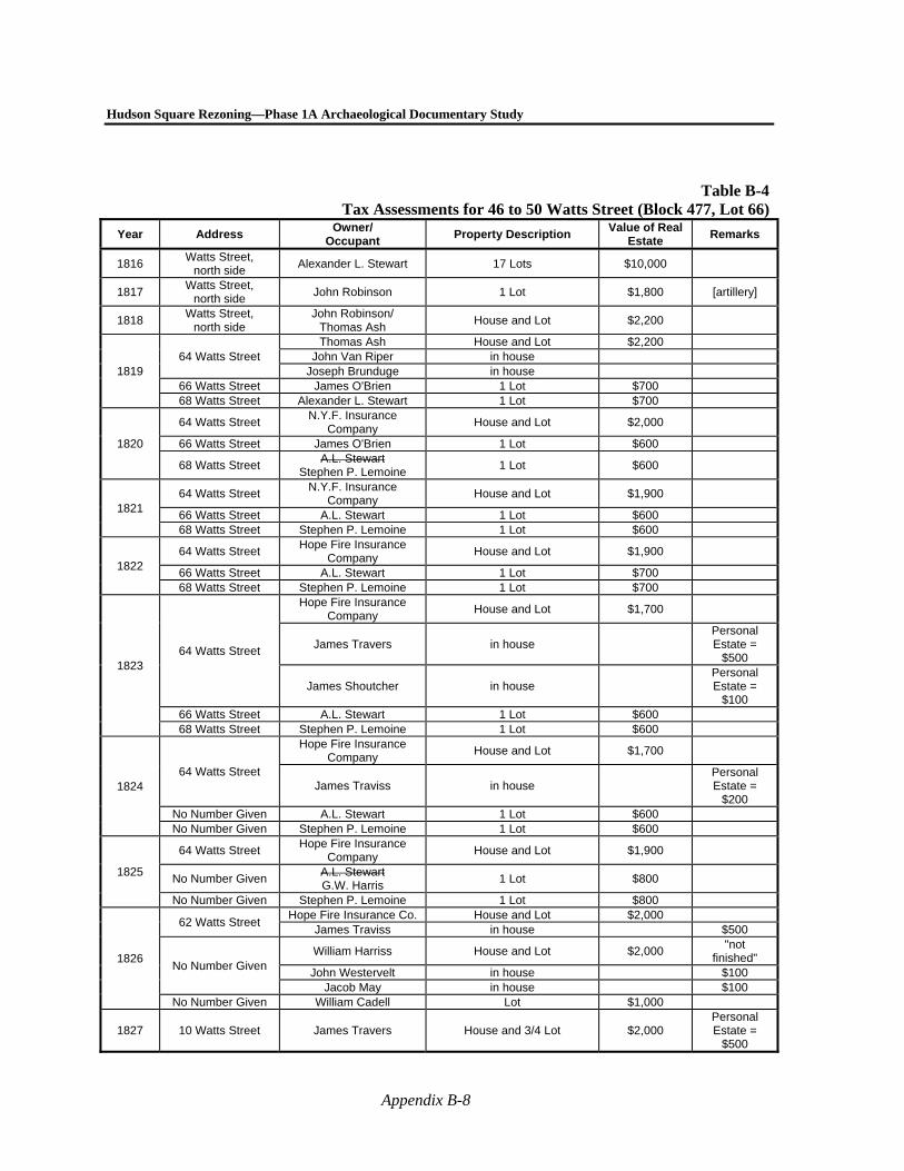
Hudson Square Rezoning—Phase 1A Archaeological Documentary Study
Appendix B-8
Table B-4Tax Assessments for 46 to 50 Watts Street (Block 477, Lot 66)
Year Address Owner/
Occupant Property Description
Value of Real Estate
Remarks
1816 Watts Street,
north side Alexander L. Stewart 17 Lots $10,000
1817 Watts Street,
north side John Robinson 1 Lot $1,800 [artillery]
1818 Watts Street,
north side John Robinson/
Thomas Ash House and Lot $2,200
1819 64 Watts Street
Thomas Ash House and Lot $2,200 John Van Riper in house
Joseph Brunduge in house 66 Watts Street James O'Brien 1 Lot $700 68 Watts Street Alexander L. Stewart 1 Lot $700
1820
64 Watts Street N.Y.F. Insurance
Company House and Lot $2,000
66 Watts Street James O'Brien 1 Lot $600
68 Watts Street A.L. Stewart
Stephen P. Lemoine 1 Lot $600
1821 64 Watts Street
N.Y.F. Insurance Company
House and Lot $1,900
66 Watts Street A.L. Stewart 1 Lot $600 68 Watts Street Stephen P. Lemoine 1 Lot $600
1822 64 Watts Street
Hope Fire Insurance Company
House and Lot $1,900
66 Watts Street A.L. Stewart 1 Lot $700 68 Watts Street Stephen P. Lemoine 1 Lot $700
1823 64 Watts Street
Hope Fire Insurance Company
House and Lot $1,700
James Travers in house Personal Estate =
$500
James Shoutcher in house Personal Estate =
$100 66 Watts Street A.L. Stewart 1 Lot $600 68 Watts Street Stephen P. Lemoine 1 Lot $600
1824 64 Watts Street
Hope Fire Insurance Company
House and Lot $1,700
James Traviss in house Personal Estate =
$200 No Number Given A.L. Stewart 1 Lot $600 No Number Given Stephen P. Lemoine 1 Lot $600
1825
64 Watts Street Hope Fire Insurance
Company House and Lot $1,900
No Number Given A.L. Stewart G.W. Harris
1 Lot $800
No Number Given Stephen P. Lemoine 1 Lot $800
1826
62 Watts Street Hope Fire Insurance Co. House and Lot $2,000
James Traviss in house $500
No Number Given William Harriss House and Lot $2,000
"not finished"
John Westervelt in house $100 Jacob May in house $100
No Number Given William Cadell Lot $1,000
1827 10 Watts Street James Travers House and 3/4 Lot $2,000 Personal Estate =
$500
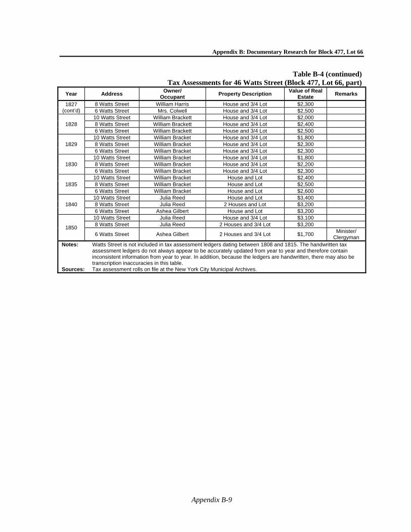
Appendix B: Documentary Research for Block 477, Lot 66
Appendix B-9
Table B-4 (continued)Tax Assessments for 46 Watts Street (Block 477, Lot 66, part)
Year Address Owner/
Occupant Property Description
Value of Real Estate
Remarks
1827 (cont’d)
8 Watts Street William Harris House and 3/4 Lot $2,300 6 Watts Street Mrs. Colwell House and 3/4 Lot $2,500
1828 10 Watts Street William Brackett House and 3/4 Lot $2,000 8 Watts Street William Brackett House and 3/4 Lot $2,400 6 Watts Street William Brackett House and 3/4 Lot $2,500
1829 10 Watts Street William Bracket House and 3/4 Lot $1,800 8 Watts Street William Bracket House and 3/4 Lot $2,300 6 Watts Street William Bracket House and 3/4 Lot $2,300
1830 10 Watts Street William Bracket House and 3/4 Lot $1,800 8 Watts Street William Bracket House and 3/4 Lot $2,200 6 Watts Street William Bracket House and 3/4 Lot $2,300
1835 10 Watts Street William Bracket House and Lot $2,400 8 Watts Street William Bracket House and Lot $2,500 6 Watts Street William Bracket House and Lot $2,600
1840 10 Watts Street Julia Reed House and Lot $3,400 8 Watts Street Julia Reed 2 Houses and Lot $3,200 6 Watts Street Ashea Gilbert House and Lot $3,200
1850
10 Watts Street Julia Reed House and 3/4 Lot $3,100 8 Watts Street Julia Reed 2 Houses and 3/4 Lot $3,200
6 Watts Street Ashea Gilbert 2 Houses and 3/4 Lot $1,700 Minister/
Clergyman Notes: Watts Street is not included in tax assessment ledgers dating between 1808 and 1815. The handwritten tax
assessment ledgers do not always appear to be accurately updated from year to year and therefore contain inconsistent information from year to year. In addition, because the ledgers are handwritten, there may also be transcription inaccuracies in this table.
Sources: Tax assessment rolls on file at the New York City Municipal Archives.
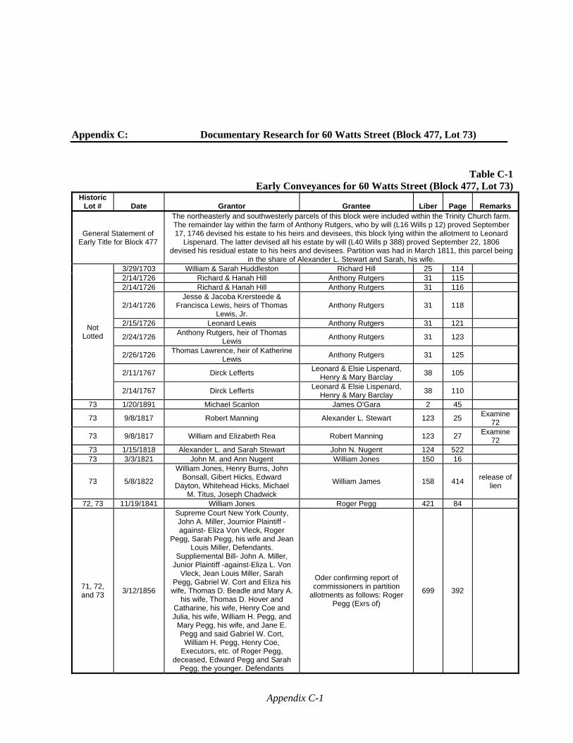
Appendix C-1
Appendix C: Documentary Research for 60 Watts Street (Block 477, Lot 73)
Table C-1Early Conveyances for 60 Watts Street (Block 477, Lot 73)
Historic Lot # Date Grantor Grantee Liber Page Remarks
General Statement of Early Title for Block 477
The northeasterly and southwesterly parcels of this block were included within the Trinity Church farm. The remainder lay within the farm of Anthony Rutgers, who by will (L16 Wills p 12) proved September 17, 1746 devised his estate to his heirs and devisees, this block lying within the allotment to Leonard
Lispenard. The latter devised all his estate by will (L40 Wills p 388) proved September 22, 1806 devised his residual estate to his heirs and devisees. Partition was had in March 1811, this parcel being
in the share of Alexander L. Stewart and Sarah, his wife.
Not Lotted
3/29/1703 William & Sarah Huddleston Richard Hill 25 114 2/14/1726 Richard & Hanah Hill Anthony Rutgers 31 115 2/14/1726 Richard & Hanah Hill Anthony Rutgers 31 116
2/14/1726 Jesse & Jacoba Krersteede &
Francisca Lewis, heirs of Thomas Lewis, Jr.
Anthony Rutgers 31 118
2/15/1726 Leonard Lewis Anthony Rutgers 31 121
2/24/1726 Anthony Rutgers, heir of Thomas
Lewis Anthony Rutgers 31 123
2/26/1726 Thomas Lawrence, heir of Katherine
Lewis Anthony Rutgers 31 125
2/11/1767 Dirck Lefferts Leonard & Elsie Lispenard,
Henry & Mary Barclay 38 105
2/14/1767 Dirck Lefferts Leonard & Elsie Lispenard,
Henry & Mary Barclay 38 110
73 1/20/1891 Michael Scanlon James O'Gara 2 45
73 9/8/1817 Robert Manning Alexander L. Stewart 123 25 Examine
72
73 9/8/1817 William and Elizabeth Rea Robert Manning 123 27 Examine
72 73 1/15/1818 Alexander L. and Sarah Stewart John N. Nugent 124 522 73 3/3/1821 John M. and Ann Nugent William Jones 150 16
73 5/8/1822
William Jones, Henry Burns, John Bonsall, Gibert Hicks, Edward
Dayton, Whitehead Hicks, Michael M. Titus, Joseph Chadwick
William James 158 414 release of
lien
72, 73 11/19/1841 William Jones Roger Pegg 421 84
71, 72, and 73
3/12/1856
Supreme Court New York County, John A. Miller, Journior Plaintiff -against- Eliza Von Vleck, Roger
Pegg, Sarah Pegg, his wife and Jean Louis Miller, Defendants.
Suppliemental Bill- John A. Miller, Junior Plaintiff -against-Eliza L. Von
Vleck, Jean Louis Miller, Sarah Pegg, Gabriel W. Cort and Eliza his
wife, Thomas D. Beadle and Mary A. his wife, Thomas D. Hover and
Catharine, his wife, Henry Coe and Julia, his wife, William H. Pegg, and
Mary Pegg, his wife, and Jane E. Pegg and said Gabriel W. Cort,
William H. Pegg, Henry Coe, Executors, etc. of Roger Pegg,
deceased, Edward Pegg and Sarah Pegg, the younger. Defendants
Oder confirming report of commissioners in partition
allotments as follows: Roger Pegg (Exrs of)
699 392
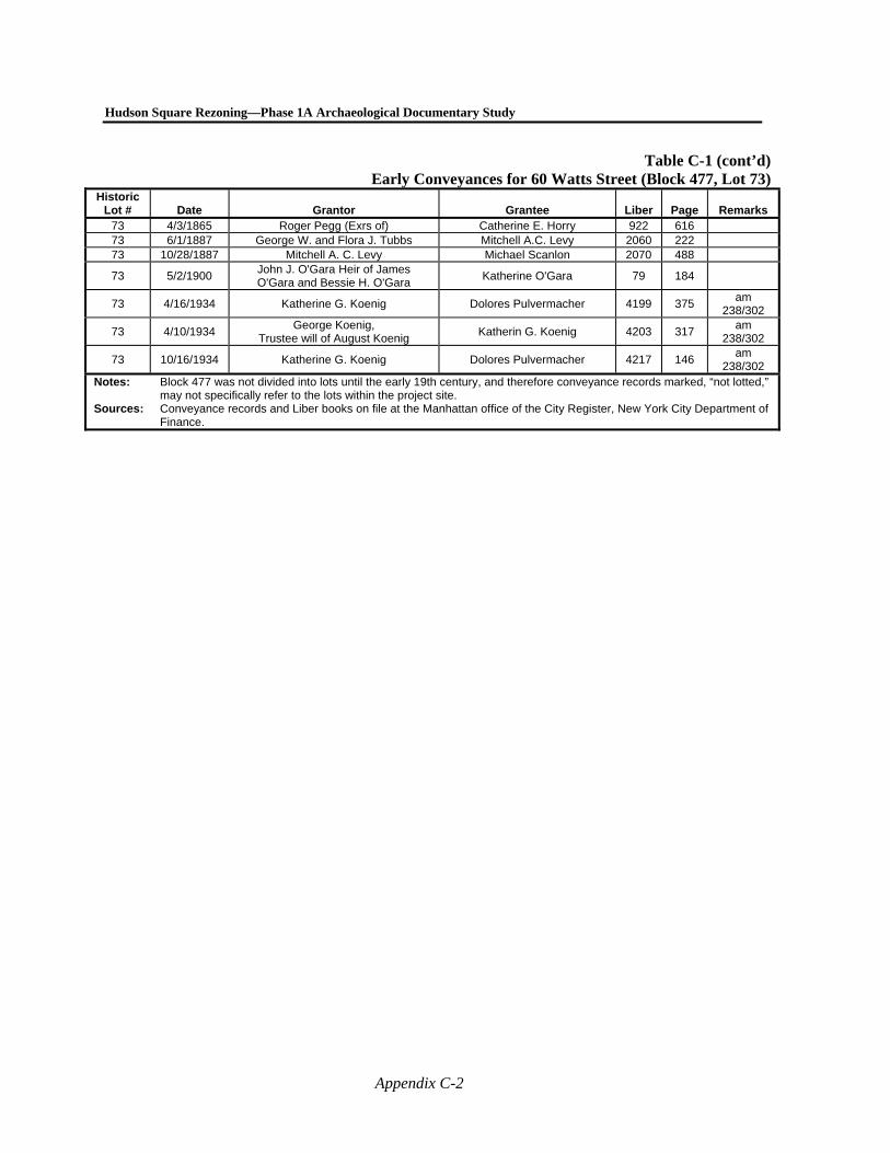
Hudson Square Rezoning—Phase 1A Archaeological Documentary Study
Appendix C-2
Table C-1 (cont’d)Early Conveyances for 60 Watts Street (Block 477, Lot 73)
Historic Lot # Date Grantor Grantee Liber Page Remarks
73 4/3/1865 Roger Pegg (Exrs of) Catherine E. Horry 922 616 73 6/1/1887 George W. and Flora J. Tubbs Mitchell A.C. Levy 2060 222 73 10/28/1887 Mitchell A. C. Levy Michael Scanlon 2070 488
73 5/2/1900 John J. O'Gara Heir of James O'Gara and Bessie H. O'Gara
Katherine O'Gara 79 184
73 4/16/1934 Katherine G. Koenig Dolores Pulvermacher 4199 375 am
238/302
73 4/10/1934 George Koenig,
Trustee will of August Koenig Katherin G. Koenig 4203 317
am 238/302
73 10/16/1934 Katherine G. Koenig Dolores Pulvermacher 4217 146 am
238/302 Notes: Block 477 was not divided into lots until the early 19th century, and therefore conveyance records marked, “not lotted,”
may not specifically refer to the lots within the project site. Sources: Conveyance records and Liber books on file at the Manhattan office of the City Register, New York City Department of
Finance.
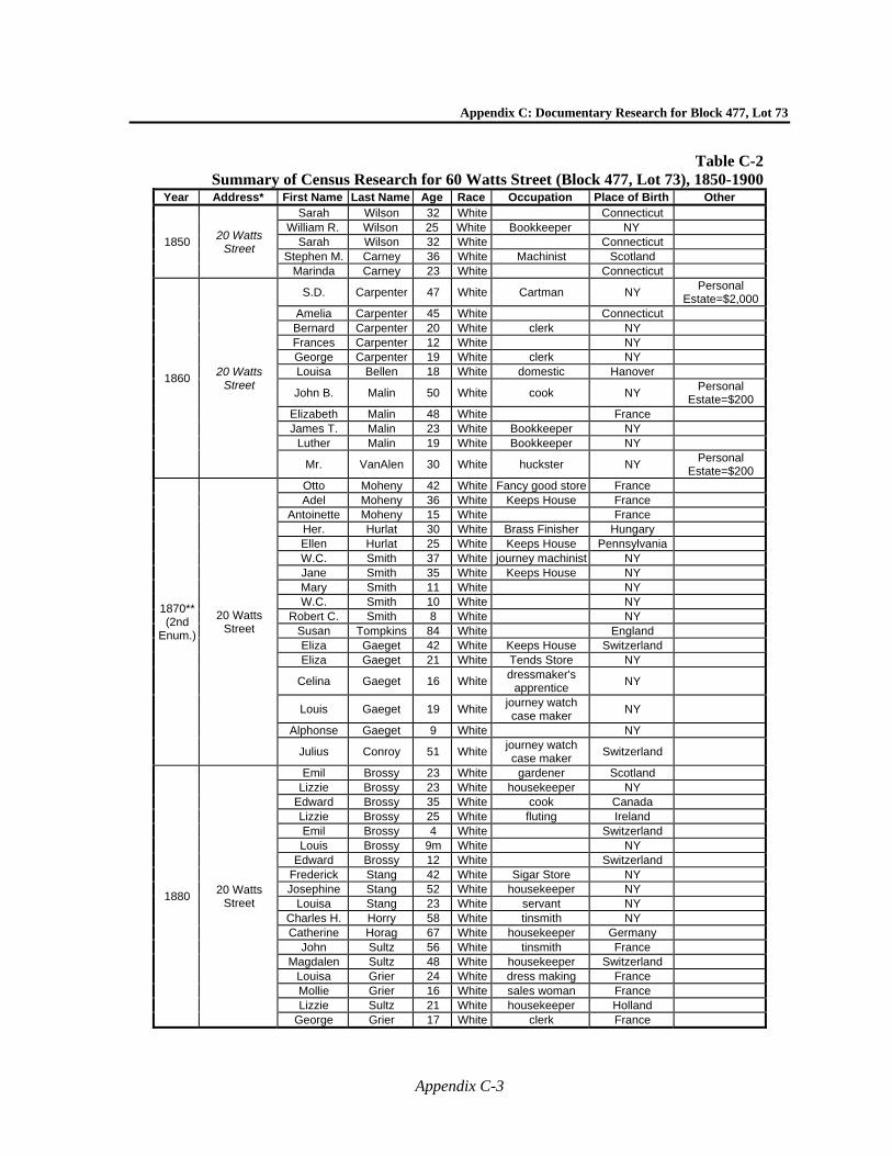
Appendix C: Documentary Research for Block 477, Lot 73
Appendix C-3
Table C-2Summary of Census Research for 60 Watts Street (Block 477, Lot 73), 1850-1900
Year Address* First Name Last Name Age Race Occupation Place of Birth Other
1850 20 Watts
Street
Sarah Wilson 32 White Connecticut William R. Wilson 25 White Bookkeeper NY
Sarah Wilson 32 White Connecticut Stephen M. Carney 36 White Machinist Scotland
Marinda Carney 23 White Connecticut
1860 20 Watts
Street
S.D. Carpenter 47 White Cartman NY Personal
Estate=$2,000Amelia Carpenter 45 White Connecticut Bernard Carpenter 20 White clerk NY Frances Carpenter 12 White NY George Carpenter 19 White clerk NY Louisa Bellen 18 White domestic Hanover
John B. Malin 50 White cook NY Personal
Estate=$200 Elizabeth Malin 48 White France James T. Malin 23 White Bookkeeper NY
Luther Malin 19 White Bookkeeper NY
Mr. VanAlen 30 White huckster NY Personal
Estate=$200
1870** (2nd
Enum.)
20 Watts Street
Otto Moheny 42 White Fancy good store France Adel Moheny 36 White Keeps House France
Antoinette Moheny 15 White France Her. Hurlat 30 White Brass Finisher Hungary Ellen Hurlat 25 White Keeps House Pennsylvania W.C. Smith 37 White journey machinist NY Jane Smith 35 White Keeps House NY Mary Smith 11 White NY W.C. Smith 10 White NY
Robert C. Smith 8 White NY Susan Tompkins 84 White England Eliza Gaeget 42 White Keeps House Switzerland Eliza Gaeget 21 White Tends Store NY
Celina Gaeget 16 Whitedressmaker's
apprentice NY
Louis Gaeget 19 Whitejourney watch case maker
NY
Alphonse Gaeget 9 White NY
Julius Conroy 51 Whitejourney watch case maker
Switzerland
1880 20 Watts
Street
Emil Brossy 23 White gardener Scotland Lizzie Brossy 23 White housekeeper NY
Edward Brossy 35 White cook Canada Lizzie Brossy 25 White fluting Ireland Emil Brossy 4 White Switzerland Louis Brossy 9m White NY
Edward Brossy 12 White Switzerland Frederick Stang 42 White Sigar Store NY Josephine Stang 52 White housekeeper NY
Louisa Stang 23 White servant NY Charles H. Horry 58 White tinsmith NY Catherine Horag 67 White housekeeper Germany
John Sultz 56 White tinsmith France Magdalen Sultz 48 White housekeeper Switzerland
Louisa Grier 24 White dress making France Mollie Grier 16 White sales woman France Lizzie Sultz 21 White housekeeper Holland
George Grier 17 White clerk France
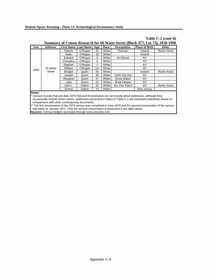
Hudson Square Rezoning—Phase 1A Archaeological Documentary Study
Appendix C-4
Table C-2 (cont’d)Summary of Census Research for 60 Watts Street (Block 477, Lot 73), 1850-1900
Year Address First Name Last Name Age Race Occupation Place of Birth Other
1900 20 Watts
Street
Patrick O'Regan 31 White Fireman Ireland Rents Home Katie O'Regan 32 White Ireland
Edward O'Regan 6 White At School NY Cornelius O'Regan 4 White NY Stephen O'Regan 2 White NY William O'Regan 1m White NY Bridget Quinn 60 White Ireland Rents Home Joseph Quinn 36 White Clerk City Dpt NY
Margaret Quinn 27 White Dress Maker NY Julia Quinn 22 White Book Keeper NY
John L. Dalton 32 White Ins. Fire Patrol NY Rents Home Emma Dalton 22 White New Jersey
Notes: * Census records that pre-date 1870 (Second Enumeration) do not include street addresses, although they
occasionally include street names. Addresses presented in italics in Table C-2 are estimated addresses based on comparisons with other contemporary documents.
** The first enumeration of the 1870 census was completed in June 1870 and the second enumeration of the census was taken in January 1871. Only the second enumeration is presented in the table above.
Sources: Census ledgers accessed through www.ancestry.com.
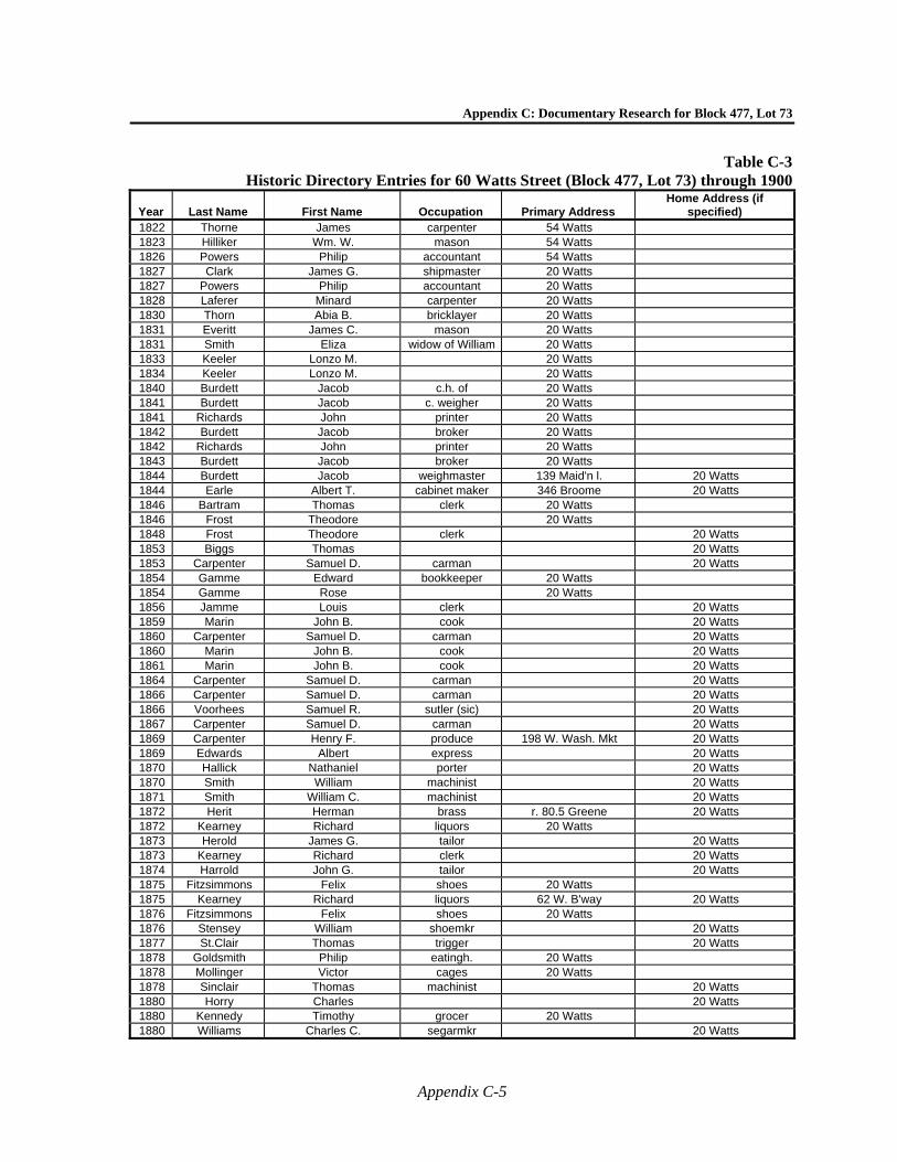
Appendix C: Documentary Research for Block 477, Lot 73
Appendix C-5
Table C-3Historic Directory Entries for 60 Watts Street (Block 477, Lot 73) through 1900
Year Last Name First Name Occupation Primary Address Home Address (if
specified) 1822 Thorne James carpenter 54 Watts 1823 Hilliker Wm. W. mason 54 Watts 1826 Powers Philip accountant 54 Watts 1827 Clark James G. shipmaster 20 Watts 1827 Powers Philip accountant 20 Watts 1828 Laferer Minard carpenter 20 Watts 1830 Thorn Abia B. bricklayer 20 Watts 1831 Everitt James C. mason 20 Watts 1831 Smith Eliza widow of William 20 Watts 1833 Keeler Lonzo M. 20 Watts 1834 Keeler Lonzo M. 20 Watts 1840 Burdett Jacob c.h. of 20 Watts 1841 Burdett Jacob c. weigher 20 Watts 1841 Richards John printer 20 Watts 1842 Burdett Jacob broker 20 Watts 1842 Richards John printer 20 Watts 1843 Burdett Jacob broker 20 Watts 1844 Burdett Jacob weighmaster 139 Maid'n l. 20 Watts 1844 Earle Albert T. cabinet maker 346 Broome 20 Watts 1846 Bartram Thomas clerk 20 Watts 1846 Frost Theodore 20 Watts 1848 Frost Theodore clerk 20 Watts 1853 Biggs Thomas 20 Watts 1853 Carpenter Samuel D. carman 20 Watts 1854 Gamme Edward bookkeeper 20 Watts 1854 Gamme Rose 20 Watts 1856 Jamme Louis clerk 20 Watts 1859 Marin John B. cook 20 Watts 1860 Carpenter Samuel D. carman 20 Watts 1860 Marin John B. cook 20 Watts 1861 Marin John B. cook 20 Watts 1864 Carpenter Samuel D. carman 20 Watts 1866 Carpenter Samuel D. carman 20 Watts 1866 Voorhees Samuel R. sutler (sic) 20 Watts 1867 Carpenter Samuel D. carman 20 Watts 1869 Carpenter Henry F. produce 198 W. Wash. Mkt 20 Watts 1869 Edwards Albert express 20 Watts 1870 Hallick Nathaniel porter 20 Watts 1870 Smith William machinist 20 Watts 1871 Smith William C. machinist 20 Watts 1872 Herit Herman brass r. 80.5 Greene 20 Watts 1872 Kearney Richard liquors 20 Watts 1873 Herold James G. tailor 20 Watts 1873 Kearney Richard clerk 20 Watts 1874 Harrold John G. tailor 20 Watts 1875 Fitzsimmons Felix shoes 20 Watts 1875 Kearney Richard liquors 62 W. B'way 20 Watts 1876 Fitzsimmons Felix shoes 20 Watts 1876 Stensey William shoemkr 20 Watts 1877 St.Clair Thomas trigger 20 Watts 1878 Goldsmith Philip eatingh. 20 Watts 1878 Mollinger Victor cages 20 Watts 1878 Sinclair Thomas machinist 20 Watts 1880 Horry Charles 20 Watts 1880 Kennedy Timothy grocer 20 Watts 1880 Williams Charles C. segarmkr 20 Watts
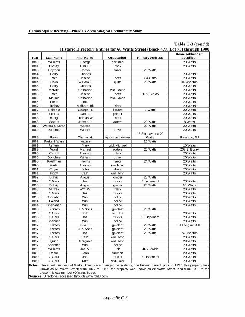
Hudson Square Rezoning—Phase 1A Archaeological Documentary Study
Appendix C-6
Table C-3 (cont’d)Historic Directory Entries for 60 Watts Street (Block 477, Lot 73) through 1900
Year Last Name First Name Occupation Primary Address Home Address (if
specified) 1880 Williams George cartman 20 Watts 1881 Brossy Emil E. cook 20 Watts 1883 Heyman Jacob tailor 20 Watts 1884 Horry Charles 20 Watts 1884 Rath Joseph beer 364 Canal 20 Watts 1884 Shea William J. quilts 20 Watts 48 Charlton 1885 Horry Charles 20 Watts 1885 Melville Catharine wid. Jacob 20 Watts 1885 Rath Joseph beer 56 S. 5th Av 20 Watts 1886 Melber Catharine wid. Jacob 20 Watts 1886 Riess Louis 20 Watts 1887 Lindsay Malborough clerk 20 Watts 1887 Reimers George H. liquors 1 Watts 20 Watts 1888 Forbes James printer 20 Watts 1888 Raleigh Thomas W. clerk 20 Watts 1888 Waters Joseph R. waters 20 Watts 8 Watts 1888 Waters & Keran waters 20 Watts 20 Watts 1889 Donohue William driver 20 Watts
1889 Parke Charles H. liquors and waters18 Sixth av and 20
Watts Pamrapo, NJ 1889 Parke & Wars waters 20 Watts 1889 Rafferty Mary wid. Michael 20 Watts 1889 Ward Michael waters 20 Watts 208 E. B'way 1890 Carroll Thomas clerk 20 Watts 1890 Donohue William driver 20 Watts 1890 Kauffman Heims tailor 24 Watts 20 Watts 1890 Martin Thomas machinist 20 Watts 1891 Coyne John laborer 20 Watts 1891 Pigott Cath. wid. John 20 Watts 1892 Buhrig August grocer 20 Watts 1892 O'Gara Jas. trucks 2 Lispenard 20 Watts 1893 Buhrig August grocer 20 Watts 16 Watts 1893 Mulvey Wm. W. clerk 20 Watts 1893 O'Gara Jas. trucks 20 Watts 1893 Shanahan Wm. police 20 Watts 1894 Foland Wm. police 20 Watts 1894 Shanahan Wm. police 20 Watts 1895 Dickson J. & Sons goldleaf 20 Watts 1895 O'Gara Cath. wid. Jas. 20 Watts 1895 O'Gara Jas. trucks 18 Lispenard 20 Watts 1895 Shannon Wm. police 20 Watts 1897 Dickson Geo. E. goldleaf 20 Watts 31 Long av. J.C. 1897 Dickson J. & Sons goldleaf 20 Watts 1897 Dickson Jas. goldleaf 20 Watts 74 Charlton 1897 O'Gara Cath. wid. John 20 Watts 1897 Quinn Margaret wid. John 20 Watts 1897 Shannon Wm. police 20 Watts 1899 Williams Jos. V. ink 465 G'wich 20 Watts 1900 Dalton John fireman 20 Watts 1900 O'Gara Jas. trucks 5 Lispenard 20 Watts 1900 O'Gara Kate wid. Danl 20 Watts
Notes: The street numbers of Watts Street were changed twice during the historic period; prior to 1827, this property was known as 54 Watts Street; from 1827 to 1902 the property was known as 20 Watts Street, and from 1902 to the present, it was number 60 Watts Street.
Sources: Directories accessed through www.fold3.com.
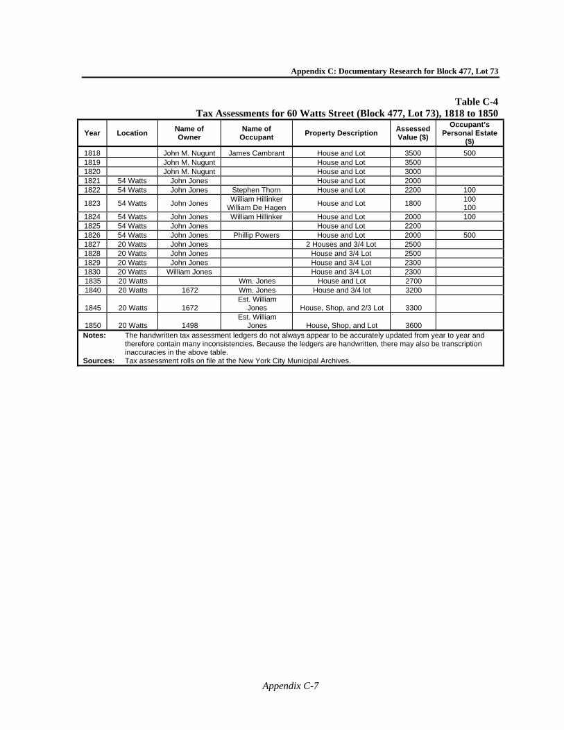
Appendix C: Documentary Research for Block 477, Lot 73
Appendix C-7
Table C-4 Tax Assessments for 60 Watts Street (Block 477, Lot 73), 1818 to 1850
Year Location Name of Owner
Name of Occupant
Property Description Assessed Value ($)
Occupant’s Personal Estate
($)
1818 John M. Nugunt James Cambrant House and Lot 3500 500 1819 John M. Nugunt House and Lot 3500 1820 John M. Nugunt House and Lot 3000 1821 54 Watts John Jones House and Lot 2000 1822 54 Watts John Jones Stephen Thorn House and Lot 2200 100
1823 54 Watts John Jones William Hillinker
William De Hagen House and Lot 1800
100 100
1824 54 Watts John Jones William Hillinker House and Lot 2000 100 1825 54 Watts John Jones House and Lot 2200 1826 54 Watts John Jones Phillip Powers House and Lot 2000 500 1827 20 Watts John Jones 2 Houses and 3/4 Lot 2500 1828 20 Watts John Jones House and 3/4 Lot 2500 1829 20 Watts John Jones House and 3/4 Lot 2300 1830 20 Watts William Jones House and 3/4 Lot 2300 1835 20 Watts Wm. Jones House and Lot 2700 1840 20 Watts 1672 Wm. Jones House and 3/4 lot 3200
1845 20 Watts 1672 Est. William
Jones House, Shop, and 2/3 Lot 3300
1850 20 Watts 1498 Est. William
Jones House, Shop, and Lot 3600 Notes: The handwritten tax assessment ledgers do not always appear to be accurately updated from year to year and
therefore contain many inconsistencies. Because the ledgers are handwritten, there may also be transcription inaccuracies in the above table.
Sources: Tax assessment rolls on file at the New York City Municipal Archives.
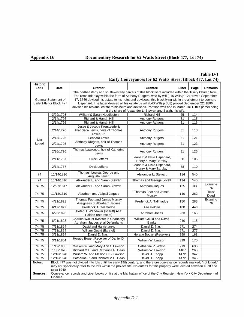
Appendix D-1
Appendix D: Documentary Research for 62 Watts Street (Block 477, Lot 74)
Table D-1Early Conveyances for 62 Watts Street (Block 477, Lot 74)
Historic Lot # Date Grantor Grantee Liber Page Remarks
General Statement of Early Title for Block 477
The northeasterly and southwesterly parcels of this block were included within the Trinity Church farm. The remainder lay within the farm of Anthony Rutgers, who by will (L16 Wills p 12) proved September 17, 1746 devised his estate to his heirs and devisees, this block lying within the allotment to Leonard
Lispenard. The latter devised all his estate by will (L40 Wills p 388) proved September 22, 1806 devised his residual estate to his heirs and devisees. Partition was had in March 1811, this parcel being
in the share of Alexander L. Stewart and Sarah, his wife.
Not Lotted
3/29/1703 William & Sarah Huddleston Richard Hill 25 114 2/14/1726 Richard & Hanah Hill Anthony Rutgers 31 115 2/14/1726 Richard & Hanah Hill Anthony Rutgers 31 116
2/14/1726 Jesse & Jacoba Krersteede &
Francisca Lewis, heirs of Thomas Lewis, Jr.
Anthony Rutgers 31 118
2/15/1726 Leonard Lewis Anthony Rutgers 31 121
2/24/1726 Anthony Rutgers, heir of Thomas
Lewis Anthony Rutgers 31 123
2/26/1726 Thomas Lawrence, heir of Katherine
Lewis Anthony Rutgers 31 125
2/11/1767 Dirck Lefferts Leonard & Elsie Lispenard,
Henry & Mary Barclay 38 105
2/14/1767 Dirck Lefferts Leonard & Elsie Lispenard,
Henry & Mary Barclay 38 110
74 11/14/1816 Thomas, Louisa, George and
Augusta Levett Alexander L. Stewart 114 540
74 11/14/1816 Alexander L. and Sarah Stewart Thomas and George Lovett 114 546
74, 75 12/27/1817 Alexander L. and Sarah Stewart Abraham Jaques 125 38 Examine
76
74, 75 11/18/1819 Abraham and Abigail Jaques Thomas Foot and James
Murray 140 262
Trust Deed
74, 75 4/21/1821 Thomas Foot and James Murray Assignees of Abraham Jaques
Frederick A. Tallmadge 150 283 Examine
76 74, 75 6/19/1822 Frederick A. Tallmadge Asa Holden 160 443
74, 75 6/25/1826 Peter H. Wendover (sheriff) Asa
Holden (Interest of) Abraham Jones 233 165
74, 75 8/21/1828 Charles Walker (Master in Chancery)
Abraham Jaques et al Defendants William Gould and David
Banks 240 115
74, 75 7/11/1854 David and Harriet anks Daniel D. Nash 671 274 74, 75 7/11/1854 William Gould (Exrs of) Daniel D. Nash 671 277 74, 75 3/11/1864 Daniel D. Nash Horatio Bogart (Receiver) 899 168
74, 75 3/11/1864 Horatio Bogert Receiver of Daniel D.
Nash William W. Lawson 899 170
74, 75 1/12/1865 William W. and Mary Ann C.Lawson Catherine P. Walsh 913 636 74, 75 11/8/1878 Richard M.H. and Catharine P. Deas William W. Lawson 1467 266 74, 75 12/16/1878 William W. and Masion C.B. Lawson David H. Knapp 1472 342 74, 75 12/16/1878 Catharine P. and Richard M.H. Deas David H. Knapp 1472 345
Notes: Block 477 was not divided into lots until the early 19th century, and therefore conveyance records marked, “not lotted,” may not specifically refer to the lots within the project site. No entries for this property were located between 1878 and circa 1940.
Sources: Conveyance records and Liber books on file at the Manhattan office of the City Register, New York City Department of Finance.
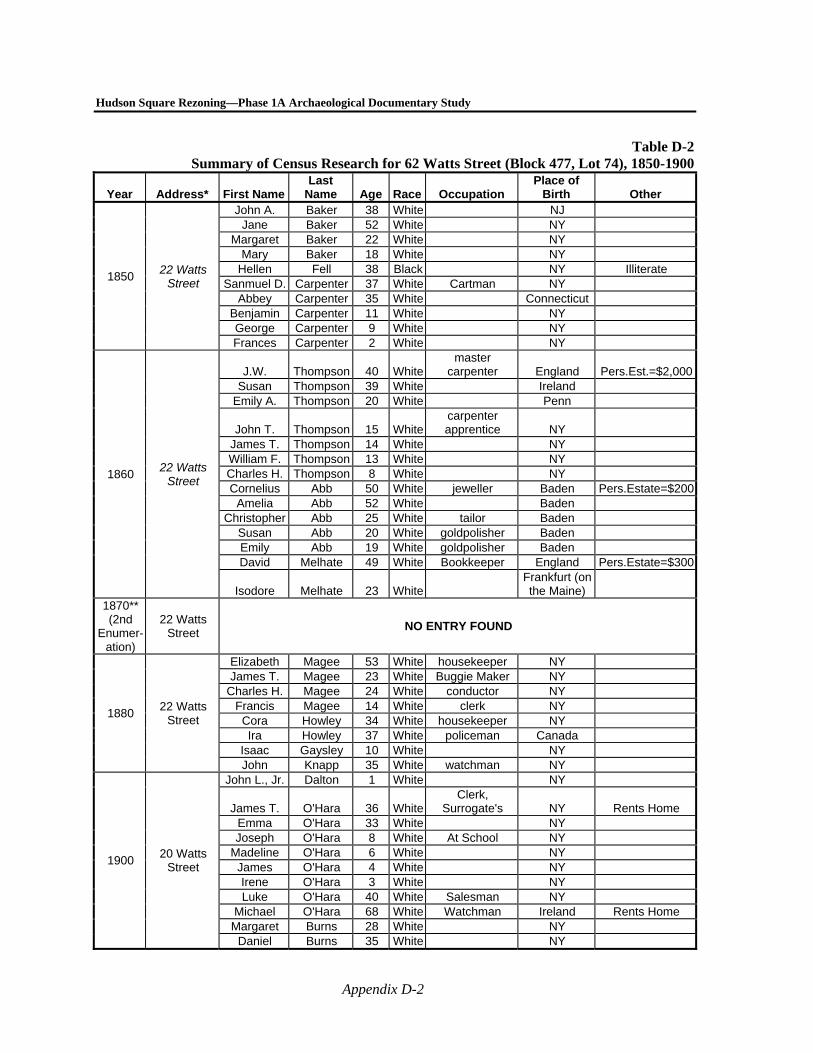
Hudson Square Rezoning—Phase 1A Archaeological Documentary Study
Appendix D-2
Table D-2Summary of Census Research for 62 Watts Street (Block 477, Lot 74), 1850-1900
Year Address* First Name Last
Name Age Race Occupation Place of
Birth Other
1850 22 Watts
Street
John A. Baker 38 White NJ Jane Baker 52 White NY
Margaret Baker 22 White NY Mary Baker 18 White NY
Hellen Fell 38 Black NY Illiterate Sanmuel D. Carpenter 37 White Cartman NY
Abbey Carpenter 35 White Connecticut Benjamin Carpenter 11 White NY George Carpenter 9 White NY Frances Carpenter 2 White NY
1860 22 Watts
Street
J.W. Thompson 40 Whitemaster
carpenter England Pers.Est.=$2,000Susan Thompson 39 White Ireland
Emily A. Thompson 20 White Penn
John T. Thompson 15 Whitecarpenter apprentice NY
James T. Thompson 14 White NY William F. Thompson 13 White NY Charles H. Thompson 8 White NY Cornelius Abb 50 White jeweller Baden Pers.Estate=$200
Amelia Abb 52 White Baden Christopher Abb 25 White tailor Baden
Susan Abb 20 White goldpolisher Baden Emily Abb 19 White goldpolisher Baden David Melhate 49 White Bookkeeper England Pers.Estate=$300
Isodore Melhate 23 WhiteFrankfurt (on the Maine)
1870** (2nd
Enumer- ation)
22 Watts Street
NO ENTRY FOUND
1880 22 Watts
Street
Elizabeth Magee 53 White housekeeper NY James T. Magee 23 White Buggie Maker NY
Charles H. Magee 24 White conductor NY Francis Magee 14 White clerk NY Cora Howley 34 White housekeeper NY Ira Howley 37 White policeman Canada
Isaac Gaysley 10 White NY John Knapp 35 White watchman NY
1900 20 Watts
Street
John L., Jr. Dalton 1 White NY
James T. O'Hara 36 WhiteClerk,
Surrogate's NY Rents Home Emma O'Hara 33 White NY Joseph O'Hara 8 White At School NY
Madeline O'Hara 6 White NY James O'Hara 4 White NY Irene O'Hara 3 White NY Luke O'Hara 40 White Salesman NY
Michael O'Hara 68 White Watchman Ireland Rents Home Margaret Burns 28 White NY
Daniel Burns 35 White NY
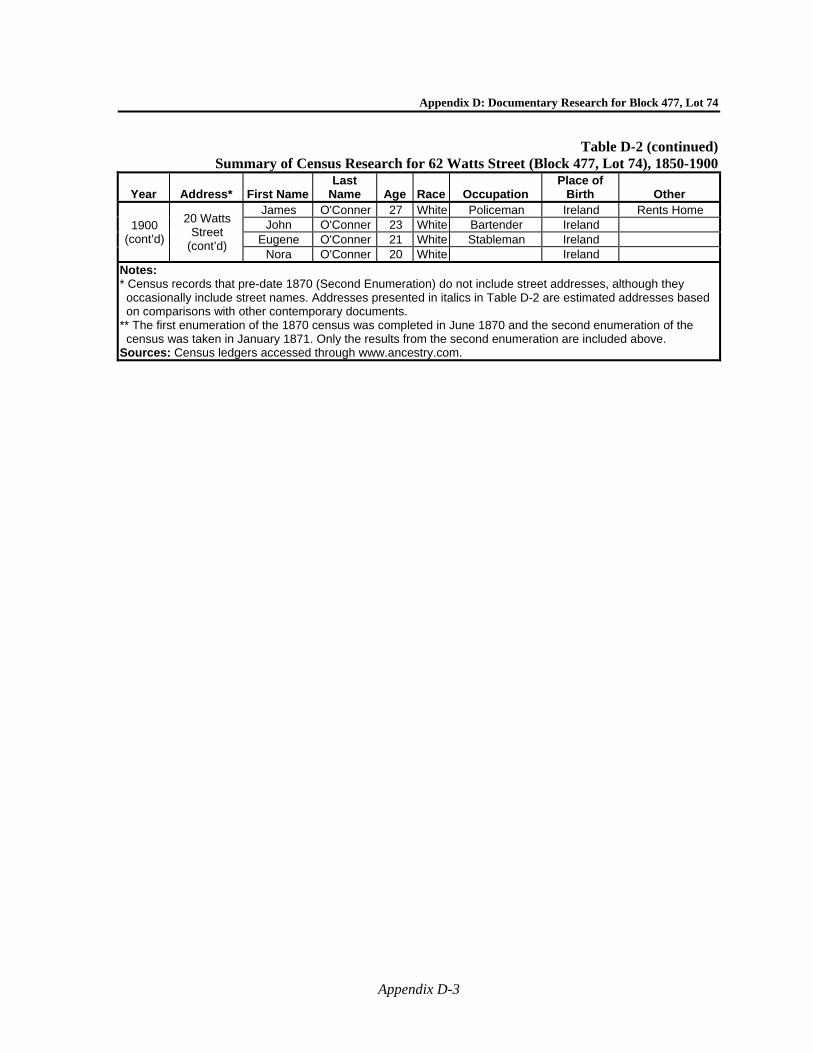
Appendix D: Documentary Research for Block 477, Lot 74
Appendix D-3
Table D-2 (continued)Summary of Census Research for 62 Watts Street (Block 477, Lot 74), 1850-1900
Year Address* First Name Last
Name Age Race Occupation Place of
Birth Other
1900 (cont’d)
20 Watts Street
(cont’d)
James O'Conner 27 White Policeman Ireland Rents Home John O'Conner 23 White Bartender Ireland
Eugene O'Conner 21 White Stableman Ireland Nora O'Conner 20 White Ireland
Notes: * Census records that pre-date 1870 (Second Enumeration) do not include street addresses, although they occasionally include street names. Addresses presented in italics in Table D-2 are estimated addresses based on comparisons with other contemporary documents.
** The first enumeration of the 1870 census was completed in June 1870 and the second enumeration of the census was taken in January 1871. Only the results from the second enumeration are included above.
Sources: Census ledgers accessed through www.ancestry.com.
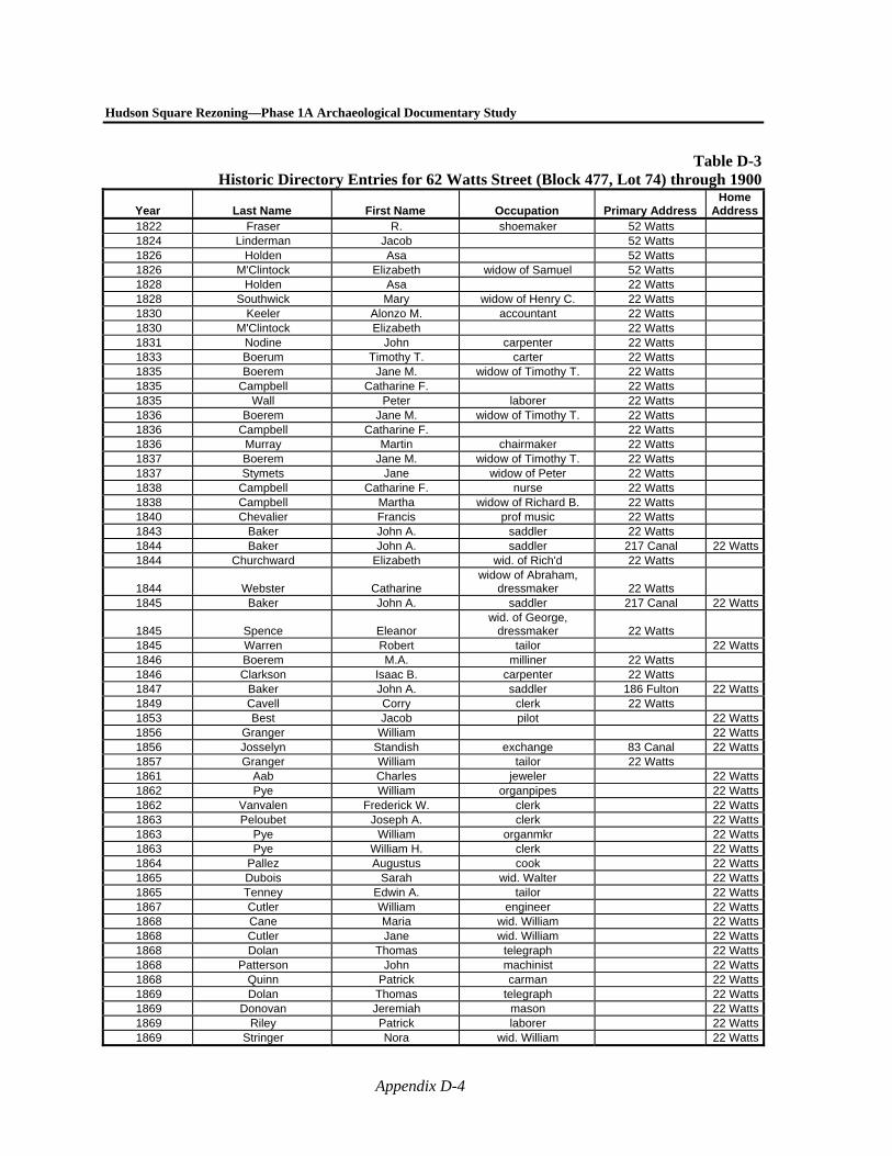
Hudson Square Rezoning—Phase 1A Archaeological Documentary Study
Appendix D-4
Table D-3Historic Directory Entries for 62 Watts Street (Block 477, Lot 74) through 1900
Year Last Name First Name Occupation Primary Address Home
Address1822 Fraser R. shoemaker 52 Watts 1824 Linderman Jacob 52 Watts 1826 Holden Asa 52 Watts 1826 M'Clintock Elizabeth widow of Samuel 52 Watts 1828 Holden Asa 22 Watts 1828 Southwick Mary widow of Henry C. 22 Watts 1830 Keeler Alonzo M. accountant 22 Watts 1830 M'Clintock Elizabeth 22 Watts 1831 Nodine John carpenter 22 Watts 1833 Boerum Timothy T. carter 22 Watts 1835 Boerem Jane M. widow of Timothy T. 22 Watts 1835 Campbell Catharine F. 22 Watts 1835 Wall Peter laborer 22 Watts 1836 Boerem Jane M. widow of Timothy T. 22 Watts 1836 Campbell Catharine F. 22 Watts 1836 Murray Martin chairmaker 22 Watts 1837 Boerem Jane M. widow of Timothy T. 22 Watts 1837 Stymets Jane widow of Peter 22 Watts 1838 Campbell Catharine F. nurse 22 Watts 1838 Campbell Martha widow of Richard B. 22 Watts 1840 Chevalier Francis prof music 22 Watts 1843 Baker John A. saddler 22 Watts 1844 Baker John A. saddler 217 Canal 22 Watts1844 Churchward Elizabeth wid. of Rich'd 22 Watts
1844 Webster Catharine widow of Abraham,
dressmaker 22 Watts 1845 Baker John A. saddler 217 Canal 22 Watts
1845 Spence Eleanor wid. of George,
dressmaker 22 Watts 1845 Warren Robert tailor 22 Watts1846 Boerem M.A. milliner 22 Watts 1846 Clarkson Isaac B. carpenter 22 Watts 1847 Baker John A. saddler 186 Fulton 22 Watts1849 Cavell Corry clerk 22 Watts 1853 Best Jacob pilot 22 Watts1856 Granger William 22 Watts1856 Josselyn Standish exchange 83 Canal 22 Watts1857 Granger William tailor 22 Watts 1861 Aab Charles jeweler 22 Watts1862 Pye William organpipes 22 Watts1862 Vanvalen Frederick W. clerk 22 Watts1863 Peloubet Joseph A. clerk 22 Watts1863 Pye William organmkr 22 Watts1863 Pye William H. clerk 22 Watts1864 Pallez Augustus cook 22 Watts1865 Dubois Sarah wid. Walter 22 Watts1865 Tenney Edwin A. tailor 22 Watts1867 Cutler William engineer 22 Watts1868 Cane Maria wid. William 22 Watts1868 Cutler Jane wid. William 22 Watts1868 Dolan Thomas telegraph 22 Watts1868 Patterson John machinist 22 Watts1868 Quinn Patrick carman 22 Watts1869 Dolan Thomas telegraph 22 Watts1869 Donovan Jeremiah mason 22 Watts1869 Riley Patrick laborer 22 Watts1869 Stringer Nora wid. William 22 Watts
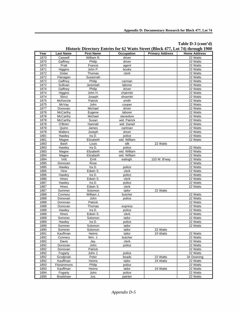
Appendix D: Documentary Research for Block 477, Lot 74
Appendix D-5
Table D-3 (cont’d)Historic Directory Entries for 62 Watts Street (Block 477, Lot 74) through 1900
Year Last Name First Name Occupation Primary Address Home Address 1870 Caswell William R. driver 22 Watts 1870 Gaffney Philip driver 22 Watts 1870 Pratt Francis agent 22 Watts 1871 Higgins John P. books 22 Watts 1872 Dolan Thomas clerk 22 Watts 1872 Flanagan Susannah 22 Watts 1872 Gaffney Philip carman 22 Watts 1872 Sullivan Jeremiah laborer 22 Watts 1874 Gaffney Philip driver 22 Watts 1874 Higgins John H. chairmkr 22 Watts 1874 Stinzi Joseph shoemkr 22 Watts 1875 McKenzie Patrick smith 22 Watts 1875 McVay John cooper 22 Watts 1877 Donovan Michael driver 22 Watts 1878 McCarthy Eugene laborer 22 Watts 1878 McCarthy Michael stevedore 22 Watts 1878 McCarthy Susan wid. Patrick 22 Watts 1878 O'Brien Hannah wid. Daniel 22 Watts 1878 Quinn James cartman 22 Watts 1878 Walters Joseph driver 22 Watts 1881 Hawley Ira D. police 22 Watts 1881 Magee Elizabeth wid. William 22 Watts 1883 Bash Louis silk 22 Watts 1883 Hawley Ira D. police 22 Watts 1883 Magee Elizabeth wid. William 22 Watts 1884 Magee Elizabeth wid. William 22 Watts 1884 Vett Emil eatingh. 103 W. B'way 22 Watts 1885 Donovan Rose 22 Watts 1885 Hawley Ira D. police 22 Watts 1885 Hine Edwin S. clerk 22 Watts 1886 Hawley Ira D. police 22 Watts 1886 Hines Edwin S. clerk 22 Watts 1887 Hawley Ira D. police 22 Watts 1887 Hines Edwin S. clerk 22 Watts 1887 Sommer Solomon tailor 22 Watts 1888 Connery William J. butcher 22 Watts 1888 Donovan John police 22 Watts 1888 Donovan Patrick 22 Watts 1888 Donovan Thomas express 22 Watts 1888 Hawley Ira D. police 22 Watts 1888 Hines Edwin S. clerk 22 Watts 1888 Sommer Solomon tailor 22 Watts 1889 Hawley Ira D. police 22 Watts 1889 Sommer Solomon tailor 22 Watts 1890 Sommer Solomon tailor 22 Watts 1891 Kauffman Heims tailor 24 Watts 22 Watts 1892 Connery Wm. J. butcher 22 Watts 1892 Davis Jas. clerk 22 Watts 1892 Donovan John police 22 Watts 1892 Donovan Patrick 22 Watts 1892 Fogarty John J. police 22 Watts 1892 Grodjinski Peter beads 22 Watts 34 Downing 1892 Kauffman Heims tailor 24 Watts 22 Watts 1893 Fitzsimmons Philip police 22 Watts 1893 Kauffman Heims tailor 24 Watts 22 Watts 1894 Fogarty John police 22 Watts 1895 Bradshaw Jos. painter 22 Watts
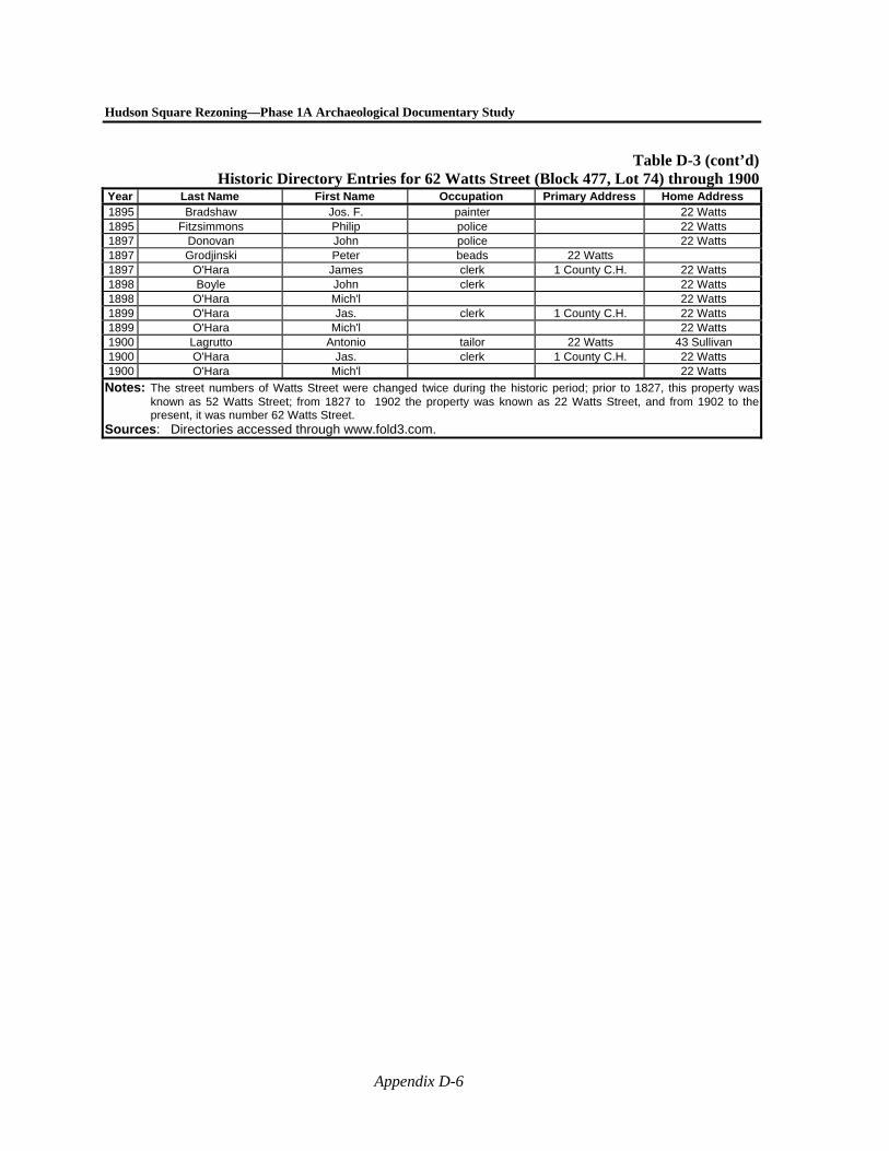
Hudson Square Rezoning—Phase 1A Archaeological Documentary Study
Appendix D-6
Table D-3 (cont’d)Historic Directory Entries for 62 Watts Street (Block 477, Lot 74) through 1900
Year Last Name First Name Occupation Primary Address Home Address 1895 Bradshaw Jos. F. painter 22 Watts 1895 Fitzsimmons Philip police 22 Watts 1897 Donovan John police 22 Watts 1897 Grodjinski Peter beads 22 Watts 1897 O'Hara James clerk 1 County C.H. 22 Watts 1898 Boyle John clerk 22 Watts 1898 O'Hara Mich'l 22 Watts 1899 O'Hara Jas. clerk 1 County C.H. 22 Watts 1899 O'Hara Mich'l 22 Watts 1900 Lagrutto Antonio tailor 22 Watts 43 Sullivan 1900 O'Hara Jas. clerk 1 County C.H. 22 Watts 1900 O'Hara Mich'l 22 Watts
Notes: The street numbers of Watts Street were changed twice during the historic period; prior to 1827, this property was known as 52 Watts Street; from 1827 to 1902 the property was known as 22 Watts Street, and from 1902 to the present, it was number 62 Watts Street.
Sources: Directories accessed through www.fold3.com.
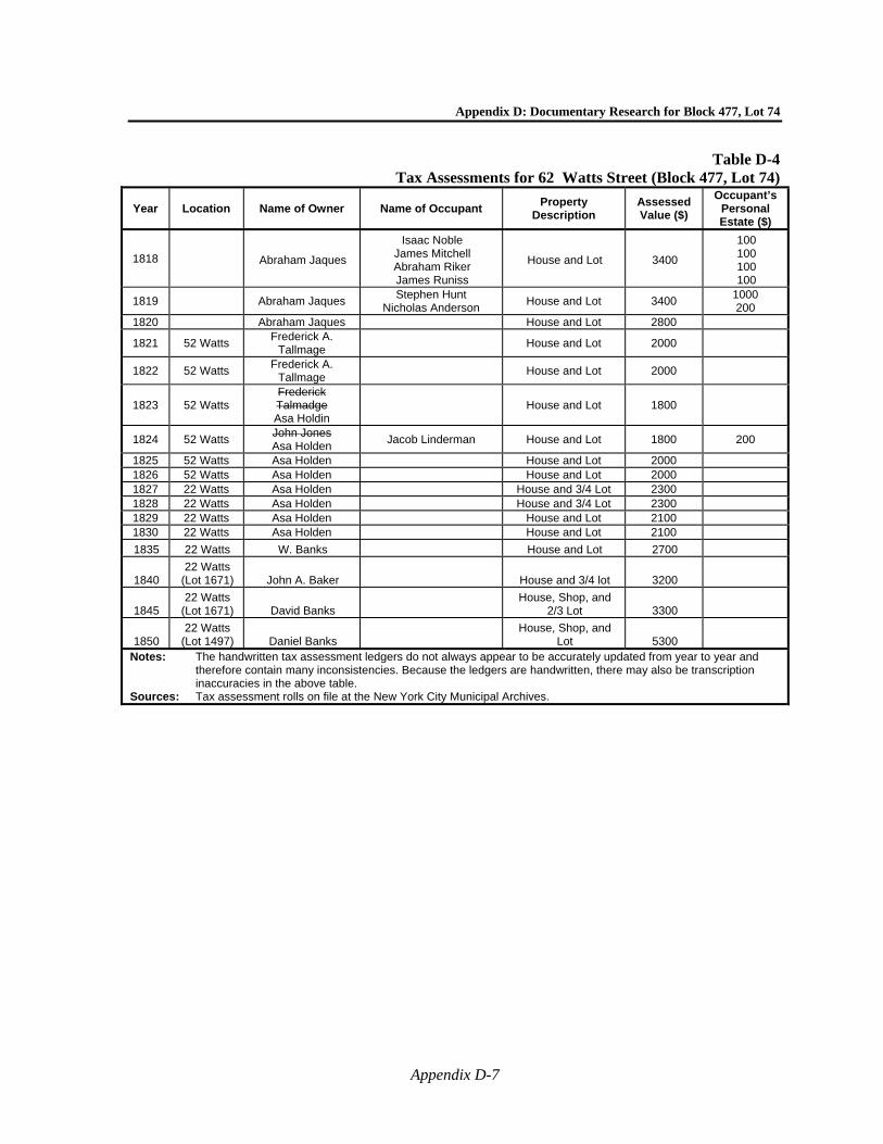
Appendix D: Documentary Research for Block 477, Lot 74
Appendix D-7
Table D-4 Tax Assessments for 62 Watts Street (Block 477, Lot 74)
Year Location Name of Owner Name of Occupant Property
Description Assessed Value ($)
Occupant’s Personal Estate ($)
1818 Abraham Jaques
Isaac Noble James Mitchell Abraham Riker James Runiss
House and Lot 3400
100 100 100 100
1819 Abraham Jaques Stephen Hunt
Nicholas Anderson House and Lot 3400
1000 200
1820 Abraham Jaques House and Lot 2800
1821 52 Watts Frederick A.
Tallmage House and Lot 2000
1822 52 Watts Frederick A.
Tallmage House and Lot 2000
1823 52 Watts Frederick Talmadge Asa Holdin
House and Lot 1800
1824 52 Watts John Jones Asa Holden
Jacob Linderman House and Lot 1800 200
1825 52 Watts Asa Holden House and Lot 2000 1826 52 Watts Asa Holden House and Lot 2000 1827 22 Watts Asa Holden House and 3/4 Lot 2300 1828 22 Watts Asa Holden House and 3/4 Lot 2300 1829 22 Watts Asa Holden House and Lot 2100 1830 22 Watts Asa Holden House and Lot 2100
1835 22 Watts W. Banks House and Lot 2700
1840 22 Watts
(Lot 1671) John A. Baker House and 3/4 lot 3200
1845 22 Watts
(Lot 1671) David Banks House, Shop, and
2/3 Lot 3300
1850 22 Watts
(Lot 1497) Daniel Banks House, Shop, and
Lot 5300
Notes: The handwritten tax assessment ledgers do not always appear to be accurately updated from year to year and therefore contain many inconsistencies. Because the ledgers are handwritten, there may also be transcription inaccuracies in the above table.
Sources: Tax assessment rolls on file at the New York City Municipal Archives.
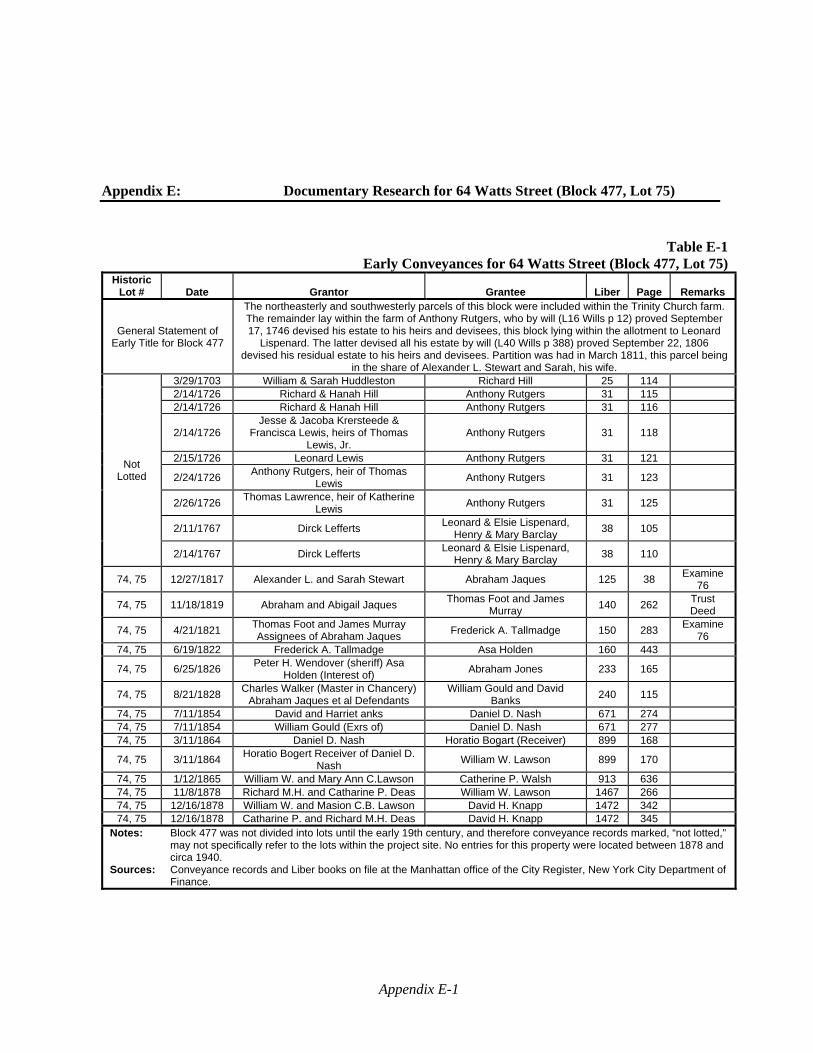
Appendix E-1
Appendix E: Documentary Research for 64 Watts Street (Block 477, Lot 75)
Table E-1Early Conveyances for 64 Watts Street (Block 477, Lot 75)
Historic Lot # Date Grantor Grantee Liber Page Remarks
General Statement of Early Title for Block 477
The northeasterly and southwesterly parcels of this block were included within the Trinity Church farm. The remainder lay within the farm of Anthony Rutgers, who by will (L16 Wills p 12) proved September 17, 1746 devised his estate to his heirs and devisees, this block lying within the allotment to Leonard
Lispenard. The latter devised all his estate by will (L40 Wills p 388) proved September 22, 1806 devised his residual estate to his heirs and devisees. Partition was had in March 1811, this parcel being
in the share of Alexander L. Stewart and Sarah, his wife.
Not Lotted
3/29/1703 William & Sarah Huddleston Richard Hill 25 114 2/14/1726 Richard & Hanah Hill Anthony Rutgers 31 115 2/14/1726 Richard & Hanah Hill Anthony Rutgers 31 116
2/14/1726 Jesse & Jacoba Krersteede &
Francisca Lewis, heirs of Thomas Lewis, Jr.
Anthony Rutgers 31 118
2/15/1726 Leonard Lewis Anthony Rutgers 31 121
2/24/1726 Anthony Rutgers, heir of Thomas
Lewis Anthony Rutgers 31 123
2/26/1726 Thomas Lawrence, heir of Katherine
Lewis Anthony Rutgers 31 125
2/11/1767 Dirck Lefferts Leonard & Elsie Lispenard,
Henry & Mary Barclay 38 105
2/14/1767 Dirck Lefferts Leonard & Elsie Lispenard,
Henry & Mary Barclay 38 110
74, 75 12/27/1817 Alexander L. and Sarah Stewart Abraham Jaques 125 38 Examine
76
74, 75 11/18/1819 Abraham and Abigail Jaques Thomas Foot and James
Murray 140 262
Trust Deed
74, 75 4/21/1821 Thomas Foot and James Murray Assignees of Abraham Jaques
Frederick A. Tallmadge 150 283 Examine
76 74, 75 6/19/1822 Frederick A. Tallmadge Asa Holden 160 443
74, 75 6/25/1826 Peter H. Wendover (sheriff) Asa
Holden (Interest of) Abraham Jones 233 165
74, 75 8/21/1828 Charles Walker (Master in Chancery)
Abraham Jaques et al Defendants William Gould and David
Banks 240 115
74, 75 7/11/1854 David and Harriet anks Daniel D. Nash 671 274 74, 75 7/11/1854 William Gould (Exrs of) Daniel D. Nash 671 277 74, 75 3/11/1864 Daniel D. Nash Horatio Bogart (Receiver) 899 168
74, 75 3/11/1864 Horatio Bogert Receiver of Daniel D.
Nash William W. Lawson 899 170
74, 75 1/12/1865 William W. and Mary Ann C.Lawson Catherine P. Walsh 913 636 74, 75 11/8/1878 Richard M.H. and Catharine P. Deas William W. Lawson 1467 266 74, 75 12/16/1878 William W. and Masion C.B. Lawson David H. Knapp 1472 342 74, 75 12/16/1878 Catharine P. and Richard M.H. Deas David H. Knapp 1472 345
Notes: Block 477 was not divided into lots until the early 19th century, and therefore conveyance records marked, “not lotted,” may not specifically refer to the lots within the project site. No entries for this property were located between 1878 and circa 1940.
Sources: Conveyance records and Liber books on file at the Manhattan office of the City Register, New York City Department of Finance.
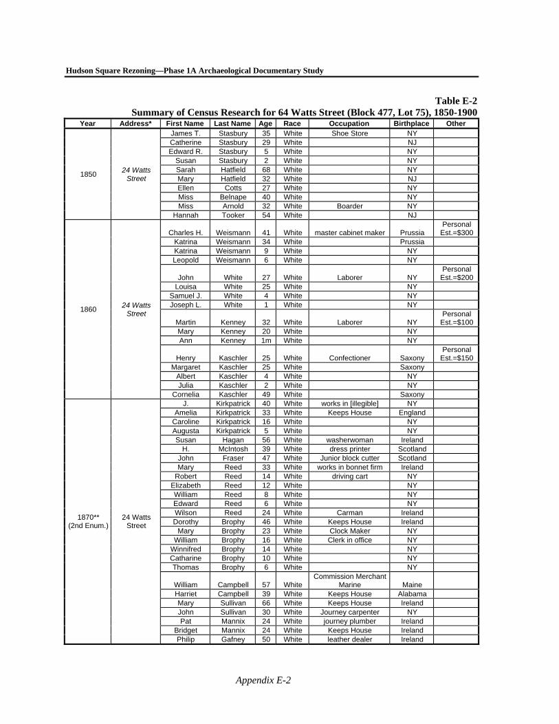
Hudson Square Rezoning—Phase 1A Archaeological Documentary Study
Appendix E-2
Table E-2Summary of Census Research for 64 Watts Street (Block 477, Lot 75), 1850-1900
Year Address* First Name Last Name Age Race Occupation Birthplace Other
1850 24 Watts
Street
James T. Stasbury 35 White Shoe Store NY Catherine Stasbury 29 White NJ Edward R. Stasbury 5 White NY
Susan Stasbury 2 White NY Sarah Hatfield 68 White NY Mary Hatfield 32 White NJ Ellen Cotts 27 White NY Miss Belnape 40 White NY Miss Arnold 32 White Boarder NY
Hannah Tooker 54 White NJ
1860 24 Watts
Street
Charles H. Weismann 41 White master cabinet maker Prussia Personal
Est.=$300 Katrina Weismann 34 White Prussia Katrina Weismann 9 White NY Leopold Weismann 6 White NY
John White 27 White Laborer NY Personal
Est.=$200 Louisa White 25 White NY
Samuel J. White 4 White NY Joseph L. White 1 White NY
Martin Kenney 32 White Laborer NY Personal
Est.=$100 Mary Kenney 20 White NY Ann Kenney 1m White NY
Henry Kaschler 25 White Confectioner Saxony Personal
Est.=$150 Margaret Kaschler 25 White Saxony
Albert Kaschler 4 White NY Julia Kaschler 2 White NY
Cornelia Kaschler 49 White Saxony
1870** (2nd Enum.)
24 Watts Street
J. Kirkpatrick 40 White works in [illegible] NY Amelia Kirkpatrick 33 White Keeps House England
Caroline Kirkpatrick 16 White NY Augusta Kirkpatrick 5 White NY Susan Hagan 56 White washerwoman Ireland
H. McIntosh 39 White dress printer Scotland John Fraser 47 White Junior block cutter Scotland Mary Reed 33 White works in bonnet firm Ireland
Robert Reed 14 White driving cart NY Elizabeth Reed 12 White NY William Reed 8 White NY Edward Reed 6 White NY Wilson Reed 24 White Carman Ireland Dorothy Brophy 46 White Keeps House Ireland
Mary Brophy 23 White Clock Maker NY William Brophy 16 White Clerk in office NY
Winnifred Brophy 14 White NY Catharine Brophy 10 White NY Thomas Brophy 6 White NY
William Campbell 57 White Commission Merchant
Marine Maine Harriet Campbell 39 White Keeps House Alabama Mary Sullivan 66 White Keeps House Ireland John Sullivan 30 White Journey carpenter NY Pat Mannix 24 White journey plumber Ireland
Bridget Mannix 24 White Keeps House Ireland Philip Gafney 50 White leather dealer Ireland
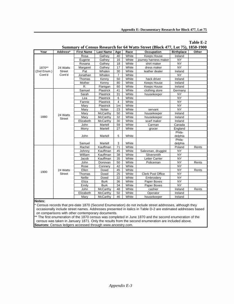
Appendix E: Documentary Research for Block 477, Lot 75
Appendix E-3
Table E-2Summary of Census Research for 64 Watts Street (Block 477, Lot 75), 1850-1900
Year Address* First Name Last Name Age Race Occupation Birthplace Other
1870** (2nd Enum.)
Cont’d
24 Watts Street Cont’d
Rosa Gafney 40 White Keeps House Ireland Eugene Gafney 16 White journey harness maker NY Rosana Gafney 18 White shirt maker NY
Margaret Gafney 17 White dress maker NY Pat Whalen 30 White leather dealer Ireland
Jonathan Whalen 7 White NY Thomas Kenny 50 White hack driver Ireland Mother Kenny 80 White Keeps House Ireland
R. Flanigan 60 White Keeps House Ireland
1880 24 Watts
Street
Samuel Plastrick 41 White clothing store Germany Sarah Plastrick 31 White housekeeper NY Lea Plastrick 6 White NY
Fannie Plastrick 4 White NY Mary Plastrick 1m White NY Mary Nolan 23 White servant NY Mary McCarthy 50 White housekeeper Ireland Mary McCarthy 32 White housekeeper Ireland
Elizabeth McCarthy 30 White scarf maker Ireland John Martell 59 White Carman Canada Morry Martell 27 White grocer England
John Martell 5 White Phila-
delphia
Samuel Martell 3 White Phila-
delphia
1900 24 Watts
Street
Rachel Kauffman 71 White Poland Rents Johnny Kauffman 45 White Salesman, druggist NY William Kauffman 38 White Silversmith NY Jacob Kauffman 35 White Letter Carrier NY John Donovan 50 White Policeman NY Rents Rose Connery 42 White NY Ellen Dowd 45 White NY Rents
Thomas Dowd 25 White Clerk Post Office NY Nellie Dowd 22 White Embroidery NY Eliza Burk 36 White Paper Boxes NY Emily Burk 34 White Paper Boxes NY John McCarthy 48 White cashier Ireland Rents
Elizabeth McCarthy 50 White Operator Ireland Mary McCarthy 46 White housekeeper Ireland
Notes: * Census records that pre-date 1870 (Second Enumeration) do not include street addresses, although they occasionally include street names. Addresses presented in italics in Table D-2 are estimated addresses based on comparisons with other contemporary documents.
** The first enumeration of the 1870 census was completed in June 1870 and the second enumeration of the census was taken in January 1871. Only the results from the second enumeration are included above.
Sources: Census ledgers accessed through www.ancestry.com.
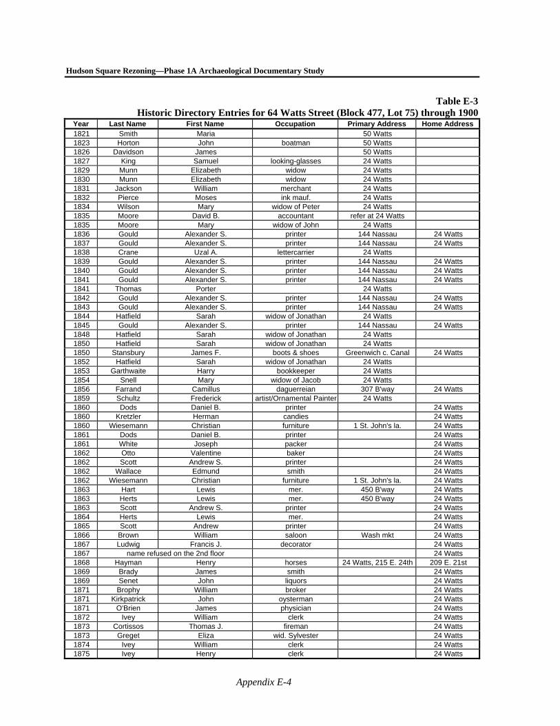
Hudson Square Rezoning—Phase 1A Archaeological Documentary Study
Appendix E-4
Table E-3Historic Directory Entries for 64 Watts Street (Block 477, Lot 75) through 1900
Year Last Name First Name Occupation Primary Address Home Address 1821 Smith Maria 50 Watts 1823 Horton John boatman 50 Watts 1826 Davidson James 50 Watts 1827 King Samuel looking-glasses 24 Watts 1829 Munn Elizabeth widow 24 Watts 1830 Munn Elizabeth widow 24 Watts 1831 Jackson William merchant 24 Watts 1832 Pierce Moses ink mauf. 24 Watts 1834 Wilson Mary widow of Peter 24 Watts 1835 Moore David B. accountant refer at 24 Watts 1835 Moore Mary widow of John 24 Watts 1836 Gould Alexander S. printer 144 Nassau 24 Watts 1837 Gould Alexander S. printer 144 Nassau 24 Watts 1838 Crane Uzal A. lettercarrier 24 Watts 1839 Gould Alexander S. printer 144 Nassau 24 Watts 1840 Gould Alexander S. printer 144 Nassau 24 Watts 1841 Gould Alexander S. printer 144 Nassau 24 Watts 1841 Thomas Porter 24 Watts 1842 Gould Alexander S. printer 144 Nassau 24 Watts 1843 Gould Alexander S. printer 144 Nassau 24 Watts 1844 Hatfield Sarah widow of Jonathan 24 Watts 1845 Gould Alexander S. printer 144 Nassau 24 Watts 1848 Hatfield Sarah widow of Jonathan 24 Watts 1850 Hatfield Sarah widow of Jonathan 24 Watts 1850 Stansbury James F. boots & shoes Greenwich c. Canal 24 Watts 1852 Hatfield Sarah widow of Jonathan 24 Watts 1853 Garthwaite Harry bookkeeper 24 Watts 1854 Snell Mary widow of Jacob 24 Watts 1856 Farrand Camillus daguerreian 307 B'way 24 Watts 1859 Schultz Frederick artist/Ornamental Painter 24 Watts 1860 Dods Daniel B. printer 24 Watts 1860 Kretzler Herman candies 24 Watts 1860 Wiesemann Christian furniture 1 St. John's la. 24 Watts 1861 Dods Daniel B. printer 24 Watts 1861 White Joseph packer 24 Watts 1862 Otto Valentine baker 24 Watts 1862 Scott Andrew S. printer 24 Watts 1862 Wallace Edmund smith 24 Watts 1862 Wiesemann Christian furniture 1 St. John's la. 24 Watts 1863 Hart Lewis mer. 450 B'way 24 Watts 1863 Herts Lewis mer. 450 B'way 24 Watts 1863 Scott Andrew S. printer 24 Watts 1864 Herts Lewis mer. 24 Watts 1865 Scott Andrew printer 24 Watts 1866 Brown William saloon Wash mkt 24 Watts 1867 Ludwig Francis J. decorator 24 Watts 1867 name refused on the 2nd floor 24 Watts 1868 Hayman Henry horses 24 Watts, 215 E. 24th 209 E. 21st 1869 Brady James smith 24 Watts 1869 Senet John liquors 24 Watts 1871 Brophy William broker 24 Watts 1871 Kirkpatrick John oysterman 24 Watts 1871 O'Brien James physician 24 Watts 1872 Ivey William clerk 24 Watts 1873 Cortissos Thomas J. fireman 24 Watts 1873 Greget Eliza wid. Sylvester 24 Watts 1874 Ivey William clerk 24 Watts 1875 Ivey Henry clerk 24 Watts
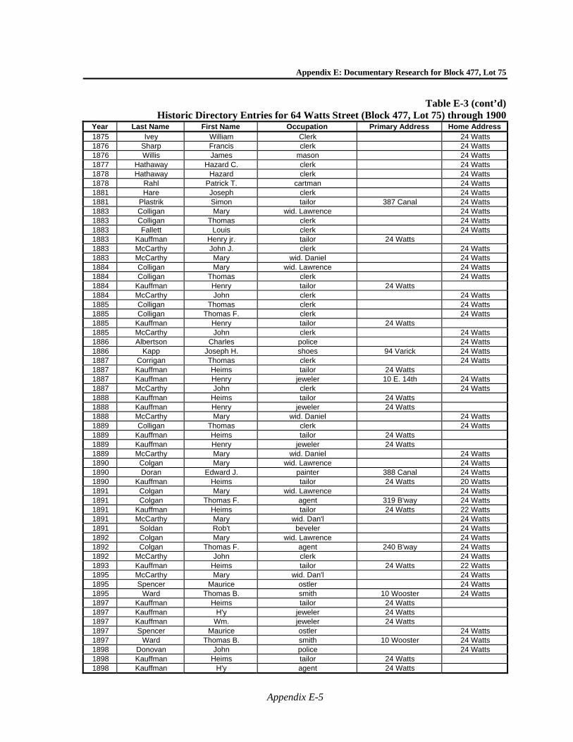
Appendix E: Documentary Research for Block 477, Lot 75
Appendix E-5
Table E-3 (cont’d)Historic Directory Entries for 64 Watts Street (Block 477, Lot 75) through 1900
Year Last Name First Name Occupation Primary Address Home Address 1875 Ivey William Clerk 24 Watts 1876 Sharp Francis clerk 24 Watts 1876 Willis James mason 24 Watts 1877 Hathaway Hazard C. clerk 24 Watts 1878 Hathaway Hazard clerk 24 Watts 1878 Rahl Patrick T. cartman 24 Watts 1881 Hare Joseph clerk 24 Watts 1881 Plastrik Simon tailor 387 Canal 24 Watts 1883 Colligan Mary wid. Lawrence 24 Watts 1883 Colligan Thomas clerk 24 Watts 1883 Fallett Louis clerk 24 Watts 1883 Kauffman Henry jr. tailor 24 Watts 1883 McCarthy John J. clerk 24 Watts 1883 McCarthy Mary wid. Daniel 24 Watts 1884 Colligan Mary wid. Lawrence 24 Watts 1884 Colligan Thomas clerk 24 Watts 1884 Kauffman Henry tailor 24 Watts 1884 McCarthy John clerk 24 Watts 1885 Colligan Thomas clerk 24 Watts 1885 Colligan Thomas F. clerk 24 Watts 1885 Kauffman Henry tailor 24 Watts 1885 McCarthy John clerk 24 Watts 1886 Albertson Charles police 24 Watts 1886 Kapp Joseph H. shoes 94 Varick 24 Watts 1887 Corrigan Thomas clerk 24 Watts 1887 Kauffman Heims tailor 24 Watts 1887 Kauffman Henry jeweler 10 E. 14th 24 Watts 1887 McCarthy John clerk 24 Watts 1888 Kauffman Heims tailor 24 Watts 1888 Kauffman Henry jeweler 24 Watts 1888 McCarthy Mary wid. Daniel 24 Watts 1889 Colligan Thomas clerk 24 Watts 1889 Kauffman Heims tailor 24 Watts 1889 Kauffman Henry jeweler 24 Watts 1889 McCarthy Mary wid. Daniel 24 Watts 1890 Colgan Mary wid. Lawrence 24 Watts 1890 Doran Edward J. painter 388 Canal 24 Watts 1890 Kauffman Heims tailor 24 Watts 20 Watts 1891 Colgan Mary wid. Lawrence 24 Watts 1891 Colgan Thomas F. agent 319 B'way 24 Watts 1891 Kauffman Heims tailor 24 Watts 22 Watts 1891 McCarthy Mary wid. Dan'l 24 Watts 1891 Soldan Rob't beveler 24 Watts 1892 Colgan Mary wid. Lawrence 24 Watts 1892 Colgan Thomas F. agent 240 B'way 24 Watts 1892 McCarthy John clerk 24 Watts 1893 Kauffman Heims tailor 24 Watts 22 Watts 1895 McCarthy Mary wid. Dan'l 24 Watts 1895 Spencer Maurice ostler 24 Watts 1895 Ward Thomas B. smith 10 Wooster 24 Watts 1897 Kauffman Heims tailor 24 Watts 1897 Kauffman H'y jeweler 24 Watts 1897 Kauffman Wm. jeweler 24 Watts 1897 Spencer Maurice ostler 24 Watts 1897 Ward Thomas B. smith 10 Wooster 24 Watts 1898 Donovan John police 24 Watts 1898 Kauffman Heims tailor 24 Watts 1898 Kauffman H'y agent 24 Watts
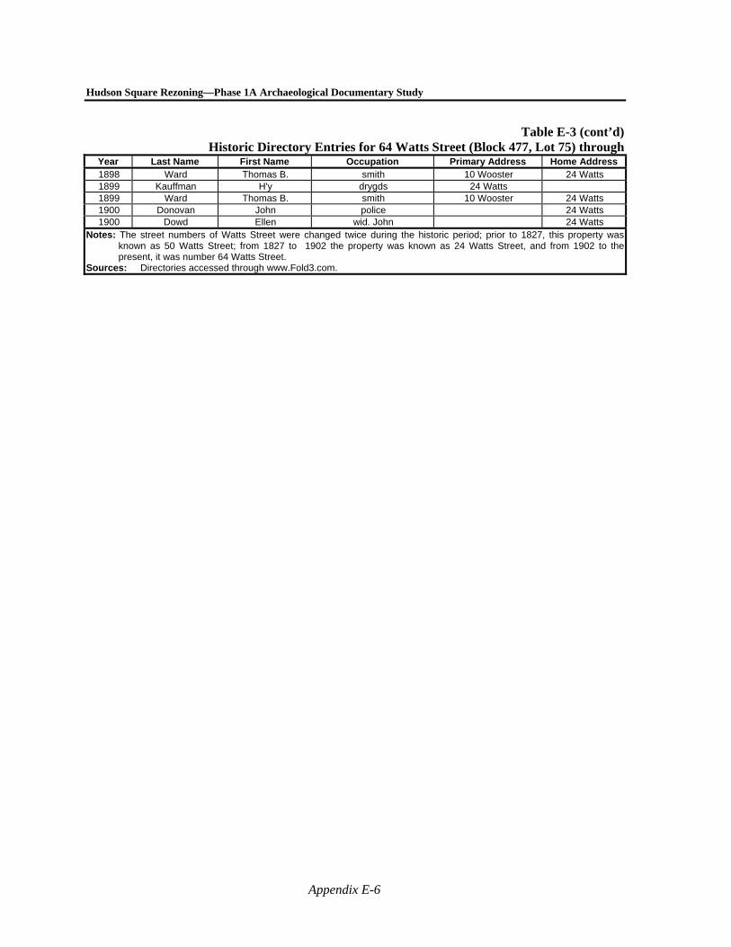
Hudson Square Rezoning—Phase 1A Archaeological Documentary Study
Appendix E-6
Table E-3 (cont’d)Historic Directory Entries for 64 Watts Street (Block 477, Lot 75) through
Year Last Name First Name Occupation Primary Address Home Address 1898 Ward Thomas B. smith 10 Wooster 24 Watts 1899 Kauffman H'y drygds 24 Watts 1899 Ward Thomas B. smith 10 Wooster 24 Watts 1900 Donovan John police 24 Watts 1900 Dowd Ellen wid. John 24 Watts
Notes: The street numbers of Watts Street were changed twice during the historic period; prior to 1827, this property was known as 50 Watts Street; from 1827 to 1902 the property was known as 24 Watts Street, and from 1902 to the present, it was number 64 Watts Street.
Sources: Directories accessed through www.Fold3.com.
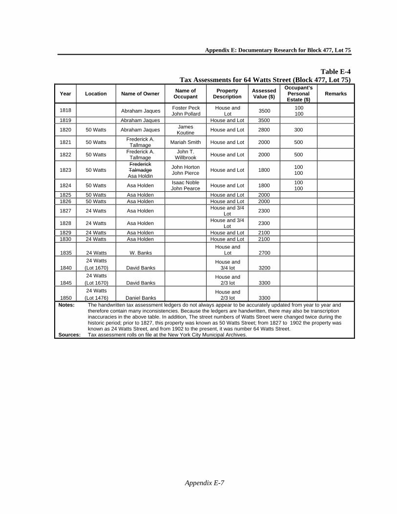
Appendix E: Documentary Research for Block 477, Lot 75
Appendix E-7
Table E-4 Tax Assessments for 64 Watts Street (Block 477, Lot 75)
Year Location Name of Owner Name of
Occupant Property
Description Assessed Value ($)
Occupant’s Personal Estate ($)
Remarks
1818 Abraham Jaques Foster Peck John Pollard
House and Lot
3500 100 100
1819 Abraham Jaques House and Lot 3500
1820 50 Watts Abraham Jaques James Koutine
House and Lot 2800 300
1821 50 Watts Frederick A.
Tallmage Mariah Smith House and Lot 2000 500
1822 50 Watts Frederick A.
Tallmage John T.
Willbrook House and Lot 2000 500
1823 50 Watts Frederick Talmadge Asa Holdin
John Horton John Pierce
House and Lot 1800 100 100
1824 50 Watts Asa Holden Isaac Noble John Pearce
House and Lot 1800 100 100
1825 50 Watts Asa Holden House and Lot 2000 1826 50 Watts Asa Holden House and Lot 2000
1827 24 Watts Asa Holden House and 3/4
Lot 2300
1828 24 Watts Asa Holden House and 3/4
Lot 2300
1829 24 Watts Asa Holden House and Lot 2100 1830 24 Watts Asa Holden House and Lot 2100
1835 24 Watts W. Banks House and
Lot 2700
1840
24 Watts
(Lot 1670) David Banks House and
3/4 lot 3200
1845
24 Watts
(Lot 1670) David Banks House and
2/3 lot 3300
1850
24 Watts
(Lot 1476) Daniel Banks House and
2/3 lot 3300
Notes: The handwritten tax assessment ledgers do not always appear to be accurately updated from year to year and therefore contain many inconsistencies. Because the ledgers are handwritten, there may also be transcription inaccuracies in the above table. In addition, The street numbers of Watts Street were changed twice during the historic period; prior to 1827, this property was known as 50 Watts Street; from 1827 to 1902 the property was known as 24 Watts Street, and from 1902 to the present, it was number 64 Watts Street.
Sources: Tax assessment rolls on file at the New York City Municipal Archives.
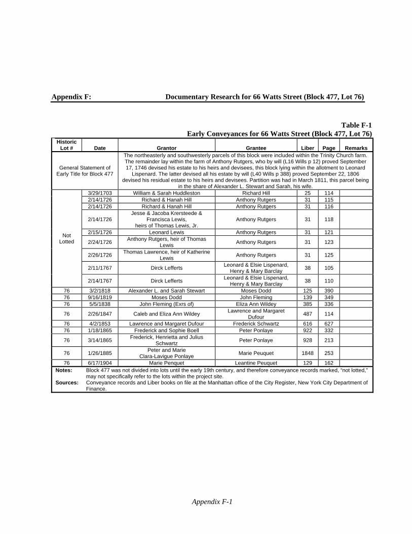
Appendix F-1
Appendix F: Documentary Research for 66 Watts Street (Block 477, Lot 76)
Table F-1Early Conveyances for 66 Watts Street (Block 477, Lot 76)
Historic Lot # Date Grantor Grantee Liber Page Remarks
General Statement of Early Title for Block 477
The northeasterly and southwesterly parcels of this block were included within the Trinity Church farm. The remainder lay within the farm of Anthony Rutgers, who by will (L16 Wills p 12) proved September 17, 1746 devised his estate to his heirs and devisees, this block lying within the allotment to Leonard
Lispenard. The latter devised all his estate by will (L40 Wills p 388) proved September 22, 1806 devised his residual estate to his heirs and devisees. Partition was had in March 1811, this parcel being
in the share of Alexander L. Stewart and Sarah, his wife.
Not Lotted
3/29/1703 William & Sarah Huddleston Richard Hill 25 114 2/14/1726 Richard & Hanah Hill Anthony Rutgers 31 115 2/14/1726 Richard & Hanah Hill Anthony Rutgers 31 116
2/14/1726 Jesse & Jacoba Krersteede &
Francisca Lewis, heirs of Thomas Lewis, Jr.
Anthony Rutgers 31 118
2/15/1726 Leonard Lewis Anthony Rutgers 31 121
2/24/1726 Anthony Rutgers, heir of Thomas
Lewis Anthony Rutgers 31 123
2/26/1726 Thomas Lawrence, heir of Katherine
Lewis Anthony Rutgers 31 125
2/11/1767 Dirck Lefferts Leonard & Elsie Lispenard,
Henry & Mary Barclay 38 105
2/14/1767 Dirck Lefferts Leonard & Elsie Lispenard,
Henry & Mary Barclay 38 110
76 3/2/1818 Alexander L. and Sarah Stewart Moses Dodd 125 390 76 9/16/1819 Moses Dodd John Fleming 139 349 76 5/5/1838 John Fleming (Exrs of) Eliza Ann Wildey 385 336
76 2/26/1847 Caleb and Eliza Ann Wildey Lawrence and Margaret
Dufour 487 114
76 4/2/1853 Lawrence and Margaret Dufour Frederick Schwartz 616 627 76 1/18/1865 Frederick and Sophie Boell Peter Ponlaye 922 332
76 3/14/1865 Frederick, Henrietta and Julius
Schwartz Peter Ponlaye 928 213
76 1/26/1885 Peter and Marie
Clara-Lavigue Ponlaye Marie Peuquet 1848 253
76 6/17/1904 Marie Penquet Leantine Peuquet 129 162 Notes: Block 477 was not divided into lots until the early 19th century, and therefore conveyance records marked, “not lotted,”
may not specifically refer to the lots within the project site. Sources: Conveyance records and Liber books on file at the Manhattan office of the City Register, New York City Department of
Finance.

Hudson Square Rezoning—Phase 1A Archaeological Documentary Study
Appendix F-2
Table F-2Summary of Census Research for 66 Watts Street (Block 477, Lot 76), 1850 to 1900
Year Address* First Name Last
Name Age Race Occupation Place of
Birth Other
1850 26 Watts
Street
Lewis Dufour 44 White Mason France Mary Dufour 43 White France
Margaret Dufour 19 White France Eliza Dufour 15 White NY
Louisa Dufour 9 White NY John W. Dufour 5 White NY Agnes Dufour 1 White NY Anna Betts 40 White NY
Alexander Hall 41 White NY Mary Hall 38 White NY
1860 26 Watts
Street
Edward Rowland 26 White Huckster NY Pers.Est.=$200 Hannah Rowland 23 White England
Mary Davis 24 White NY H.N. Stephens 27 White Clerk NY Kate Ryan 12 White NY
1870** (2nd Enum.)
26 Watts Street
Peter Perquet 43 Whiteworks in brass
factory France Mary Perquet 45 White Keeps House France Justin Perquet 20 White Junior Engineer NY Alfred Perquet 12 White NY
Leontine Perquet 15 White NY Camille Perquet 5 White NY Michael Hausey 38 White Exchange Books NY
Mary Hausey 30 White Keeps House NY Abeline Hausey 12 White NY Hana Coakley 19 White domestic Ireland Mary Busby 53 White Seamstress NJ
1880 26 Watts
Street
Peter Peuquet 54 White batter France Mary Peuquet 55 White housekeeper France
Yeastina Peuquet 29 White clerk NY Leontine Peuquet 23 White dressmaker NY
Alfred Peuquet 22 White housekeeper NY Camilla Peuquet 15 White housekeeper NY Celline Peuquet 24 White housekeeper NY
Abraham Benson 28 White soap maker NY Sarah Benson 20 White housekeeper NY John Deshay 24 White clerk NY Mary Deshay 32 White Dressmaker NY Nellie Deshay 15 White Dressmaker NY
Maggie Deshay 43 White Dressmaker NY
1900 26 Watts
Street
John May 56 White Carpenter NY Rents Home Mary June 58 White NY Marie Peuquet 74 White France Owns Home Justin Peuquet 49 White Wholesale Liquor NY
Leontine Peuquet 44 White NY Alfred Peuquet 41 White Bookkeeper NY
Camille Peuquet 34 White Music Teacher NY Jusin W. Peuquet 24 White Shipping Clerk NY
Annie Price 30 White shirt maker NY Rents Home Notes: * Census records that pre-date 1870 (Second Enumeration) do not include street addresses, although they occasionally include
street names. Addresses presented in italics in Table F-2 are estimated addresses based on comparisons with other contemporary documents.
** The first enumeration of the 1870 census was completed in June 1870 and the second enumeration of the census was taken in January 1871. Only the second enumeration is provided above.
Sources: Census ledgers accessed through www.ancestry.com.

Appendix F: Documentary Research for Block 477, Lot 76
Appendix F-3
Table F-3Historic Directory Entries for 66 Watts Street (Block 477, Lot 76) through 1900
Year Last Name First Name Occupation Primary Address Home Address 1826 Dusenberry Amaziah marshal 48 Watts 1828 Ridley Margaret 26 Watts 1830 Degraw Garrit carpenter rear 89 Gold 26 Watts 1830 Ridley Margaret 26 Watts 1830 Sayer Rebecca 26 Watts 1831 Brown Eliza widow of Richard 26 Watts 1832 Brown Eliza widow of Richard 26 Watts 1832 Degraw Cornelius carpenter 26 Watts 1832 Lockwood Lott currier 9 Jacob 26 Watts 1833 Brown Eliza widow of Richard 26 Watts 1833 Lockwood Lott currier 9 Jacob 26 Watts 1835 Brown Eliza widow of Richard 26 Watts 1835 Smith Samuel R. drygoods 122 Canal 26 Watts 1836 Bicker Nicholas 26 Watts 1840 Wildey Caleb drygoods 203 Greenwich 26 Watts 1841 Wildey Caleb drygoods 203 Greenwich 26 Watts 1842 Wildey Caleb drygoods 203 Greenwich 26 Watts 1847 Guetal George varnisher 26 Watts 1851 Dufour Lawrence mason 26 Watts 1853 Dufour Lawrence mason 26 Watts 1854 Schwartz Jules baker 26 Watts 1855 Jewesson Thomas bookbinder 26 Watts 1855 Sherman Benjamin F. mason 26 Watts 1856 Jewesson Isabella teacher 26 Watts 1856 Watts Frederick baker 26 Watts 1859 Fowler Margaret dressmaker 26 Watts 1859 Reeder Rachel wid. James 26 Watts 1860 Roland Edwin produce 71 Dey 26 Watts 1860 Swartz Jule refused 26 Watts 1861 Rowland Edwin produce 71 Dey 26 Watts 1863 Bogan James Z. 26 Watts 1863 Bogart James Z. police 26 Watts 1864 Bogart James Z. police 26 Watts 1865 Mondon P.V. clerk 26 Watts 1866 Price William D. clerk 26 Watts 1868 Kirker Peter fitter 26 Watts 1868 Scanlon Michael laborer 26 Watts 1869 Audibert Albert Alfred chaser 26 Watts
1869 Bugbee Mary C. wid. Oliver, dressmkr 26 Watts
1869 Rohrman John shoes 26 Watts 1869 Webb Abraham lawyer 125 W. 10th 26 Watts 1870 Peuquet Peter machinist 26 Watts 1870 Sievert Albert engineer 26 Watts 1871 Holly Michael broker 128 Fulton 26 Watts 1872 Lawton William A. chandeliermkr 26 Watts 1872 Perquet Peter brass 26 Watts 1873 Reisner Herman clerk 26 Watts 1874 Perquet Peter 26 Watts 1875 Dunn John clerk 26 Watts 1877 Goodrich Harry teacher 26 Watts 1877 Peuquet Peter porter 26 Watts 1878 Peuquet Peter machinist 26 Watts 1878 Waldron Benjamin printer 26 Watts 1880 McNeely Hugh clerk 26 Watts 1881 Peuquet Peter bartender 26 Watts 1883 Peuquet Peter porter 26 Watts 1884 Peuquet Peter 26 Watts
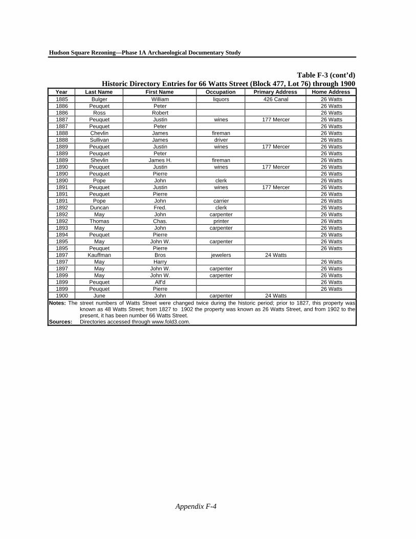
Hudson Square Rezoning—Phase 1A Archaeological Documentary Study
Appendix F-4
Table F-3 (cont’d)Historic Directory Entries for 66 Watts Street (Block 477, Lot 76) through 1900
Year Last Name First Name Occupation Primary Address Home Address 1885 Bulger William liquors 426 Canal 26 Watts 1886 Peuquet Peter 26 Watts 1886 Ross Robert 26 Watts 1887 Peuquet Justin wines 177 Mercer 26 Watts 1887 Peuquet Peter 26 Watts 1888 Chevlin James fireman 26 Watts 1888 Sullivan James driver 26 Watts 1889 Peuquet Justin wines 177 Mercer 26 Watts 1889 Peuquet Peter 26 Watts 1889 Shevlin James H. fireman 26 Watts 1890 Peuquet Justin wines 177 Mercer 26 Watts 1890 Peuquet Pierre 26 Watts 1890 Pope John clerk 26 Watts 1891 Peuquet Justin wines 177 Mercer 26 Watts 1891 Peuquet Pierre 26 Watts 1891 Pope John carrier 26 Watts 1892 Duncan Fred. clerk 26 Watts 1892 May John carpenter 26 Watts 1892 Thomas Chas. printer 26 Watts 1893 May John carpenter 26 Watts 1894 Peuquet Pierre 26 Watts 1895 May John W. carpenter 26 Watts 1895 Peuquet Pierre 26 Watts 1897 Kauffman Bros jewelers 24 Watts 1897 May Harry 26 Watts 1897 May John W. carpenter 26 Watts 1899 May John W. carpenter 26 Watts 1899 Peuquet Alf'd 26 Watts 1899 Peuquet Pierre 26 Watts 1900 June John carpenter 24 Watts
Notes: The street numbers of Watts Street were changed twice during the historic period; prior to 1827, this property was known as 48 Watts Street; from 1827 to 1902 the property was known as 26 Watts Street, and from 1902 to the present, it has been number 66 Watts Street.
Sources: Directories accessed through www.fold3.com.
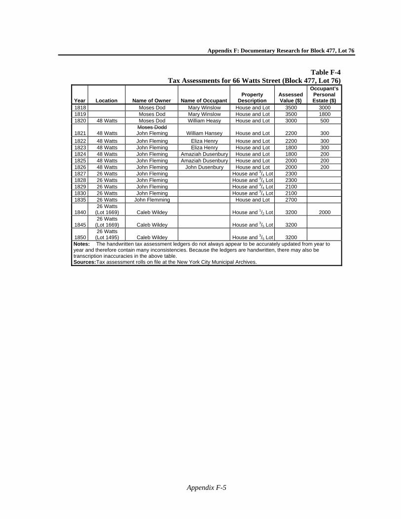
Appendix F: Documentary Research for Block 477, Lot 76
Appendix F-5
Table F-4Tax Assessments for 66 Watts Street (Block 477, Lot 76)
Year Location Name of Owner Name of OccupantProperty
Description Assessed Value ($)
Occupant’s Personal Estate ($)
1818 Moses Dod Mary Winslow House and Lot 3500 3000 1819 Moses Dod Mary Winslow House and Lot 3500 1800 1820 48 Watts Moses Dod William Heasy House and Lot 3000 500
1821 48 Watts Moses Dodd John Fleming William Hansey House and Lot 2200 300
1822 48 Watts John Fleming Eliza Henry House and Lot 2200 300 1823 48 Watts John Fleming Eliza Henry House and Lot 1800 300 1824 48 Watts John Fleming Amaziah Dusenbury House and Lot 1800 200 1825 48 Watts John Fleming Amaziah Dusenbury House and Lot 2000 200 1826 48 Watts John Fleming John Dusenbury House and Lot 2000 200 1827 26 Watts John Fleming House and 3/4 Lot 2300 1828 26 Watts John Fleming House and 3/4 Lot 2300 1829 26 Watts John Fleming House and 3/4 Lot 2100 1830 26 Watts John Fleming House and 3/4 Lot 2100 1835 26 Watts John Flemming House and Lot 2700
1840 26 Watts
(Lot 1669) Caleb Wildey House and 1/2 Lot 3200 2000
1845 26 Watts
(Lot 1669) Caleb Wildey House and 3/5 Lot 3200
1850 26 Watts
(Lot 1495) Caleb Wildey House and 3/5 Lot 3200 Notes: The handwritten tax assessment ledgers do not always appear to be accurately updated from year to year and therefore contain many inconsistencies. Because the ledgers are handwritten, there may also be transcription inaccuracies in the above table. Sources: Tax assessment rolls on file at the New York City Municipal Archives.
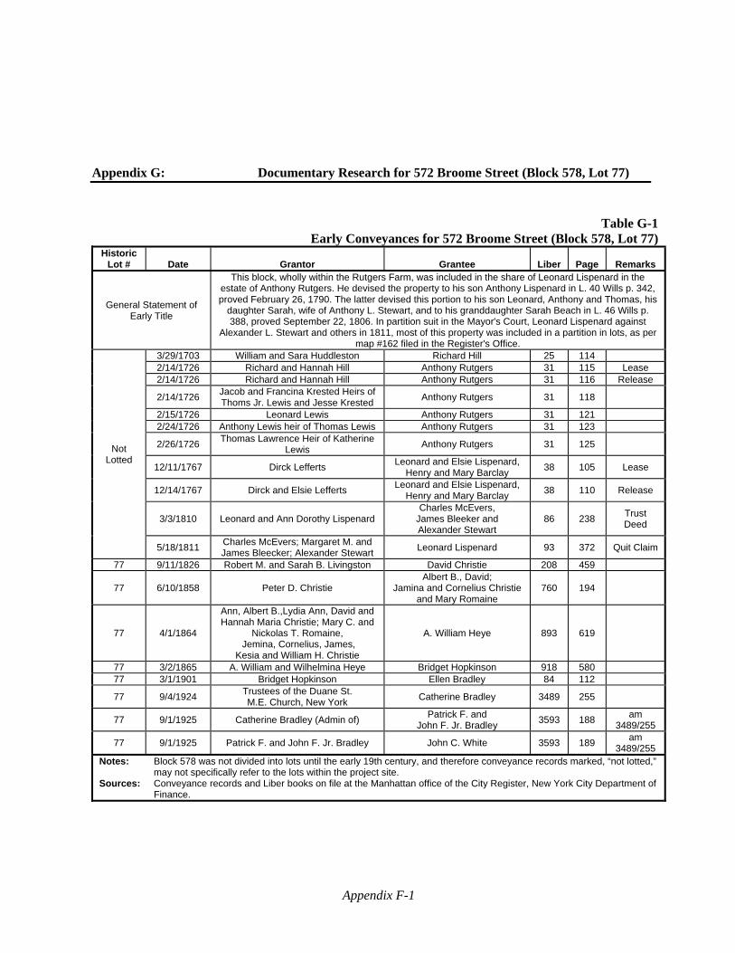
Appendix F-1
Appendix G: Documentary Research for 572 Broome Street (Block 578, Lot 77)
Table G-1Early Conveyances for 572 Broome Street (Block 578, Lot 77)
Historic Lot # Date Grantor Grantee Liber Page Remarks
General Statement of Early Title
This block, wholly within the Rutgers Farm, was included in the share of Leonard Lispenard in the estate of Anthony Rutgers. He devised the property to his son Anthony Lispenard in L. 40 Wills p. 342, proved February 26, 1790. The latter devised this portion to his son Leonard, Anthony and Thomas, his
daughter Sarah, wife of Anthony L. Stewart, and to his granddaughter Sarah Beach in L. 46 Wills p. 388, proved September 22, 1806. In partition suit in the Mayor's Court, Leonard Lispenard against
Alexander L. Stewart and others in 1811, most of this property was included in a partition in lots, as per map #162 filed in the Register's Office.
Not Lotted
3/29/1703 William and Sara Huddleston Richard Hill 25 114 2/14/1726 Richard and Hannah Hill Anthony Rutgers 31 115 Lease 2/14/1726 Richard and Hannah Hill Anthony Rutgers 31 116 Release
2/14/1726 Jacob and Francina Krested Heirs of Thoms Jr. Lewis and Jesse Krested
Anthony Rutgers 31 118
2/15/1726 Leonard Lewis Anthony Rutgers 31 121 2/24/1726 Anthony Lewis heir of Thomas Lewis Anthony Rutgers 31 123
2/26/1726 Thomas Lawrence Heir of Katherine
Lewis Anthony Rutgers 31 125
12/11/1767 Dirck Lefferts Leonard and Elsie Lispenard,
Henry and Mary Barclay 38 105 Lease
12/14/1767 Dirck and Elsie Lefferts Leonard and Elsie Lispenard,
Henry and Mary Barclay 38 110 Release
3/3/1810 Leonard and Ann Dorothy Lispenard Charles McEvers,
James Bleeker and Alexander Stewart
86 238 Trust Deed
5/18/1811 Charles McEvers; Margaret M. and James Bleecker; Alexander Stewart
Leonard Lispenard 93 372 Quit Claim
77 9/11/1826 Robert M. and Sarah B. Livingston David Christie 208 459
77 6/10/1858 Peter D. Christie Albert B., David;
Jamina and Cornelius Christie and Mary Romaine
760 194
77 4/1/1864
Ann, Albert B.,Lydia Ann, David and Hannah Maria Christie; Mary C. and
Nickolas T. Romaine, Jemina, Cornelius, James,
Kesia and William H. Christie
A. William Heye 893 619
77 3/2/1865 A. William and Wilhelmina Heye Bridget Hopkinson 918 580 77 3/1/1901 Bridget Hopkinson Ellen Bradley 84 112
77 9/4/1924 Trustees of the Duane St. M.E. Church, New York
Catherine Bradley 3489 255
77 9/1/1925 Catherine Bradley (Admin of) Patrick F. and
John F. Jr. Bradley 3593 188
am 3489/255
77 9/1/1925 Patrick F. and John F. Jr. Bradley John C. White 3593 189 am
3489/255 Notes: Block 578 was not divided into lots until the early 19th century, and therefore conveyance records marked, “not lotted,”
may not specifically refer to the lots within the project site. Sources: Conveyance records and Liber books on file at the Manhattan office of the City Register, New York City Department of
Finance.
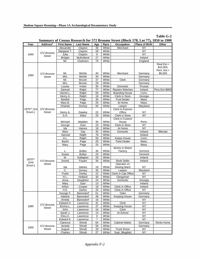
Hudson Square Rezoning—Phase 1A Archaeological Documentary Study
Appendix F-2
Table G-2Summary of Census Research for 572 Broome Street (Block 578, Lot 77), 1850 to 1900
Year Address* First Name Last Name Age Race Occupation Place of Birth Other
1850 572 Broome
Street
Alexander Clayton 39 White Merchant NY Margaret T. Clayton 28 White NY
Julia Clayton 6 White NY Bridget Mulholland 27 White Ireland
Mr. Chalmers 70 White England
1860 572 Broome
Street Mr. Michle 40 White Merchant Germany
Real Est.= $10,000,
Pers. Est.= $5,000
Mrs. Michle 34 White Germany Mr. Bruner 37 White Clerk Germany Mrs. Bruner 29 White Germany
Louisa Vreter 30 White Domestic Prussia
1870** (1st Enum.)
572 Broome Street
Samuel Ralph 77 White Repairs Watches Ireland Pers.Est=$800Harriet L. Ralph 50 White Boarding House Conn. Henry A. Ralph 19 White Clerk in Store Georgia Bartlett Page 30 White Fruit Dealer Mass. Mary B. Page 25 White At Home Mass. Orlando Dorsey 50 White Lawyer Maryland
Henry A. Dawley 22 WhiteClerk in Express
Office NY S.H. Stiles 25 White Clerk in Store NY
Michael Madden 30 WhiteClerk in Custom
House Penn. George Grier 23 White Clerk in Store NY
Ida Haines 18 White At Home NY Mary Say 40 White Domestic Ireland Illiterate
1870** (2nd
Enum.)
572 Broome Street
Samuel Ralph 78 White Ireland H.L. Ralph 50 White Keeps House Conn.
Bauht Page 25 White Twist Dealer Mass. Mary Page 25 White Mass.
L. Bullan 35 WhiteWorks in Watch
Factory Vermont Susan Bullan 23 White Vermont
M. Gallagher 20 White Ireland [none] Foyam 30 White Book Seller Ireland
Ida Haines 19 WhiteOperator on
Sewing Mach NY C. Dorsey 45 White Lawyer Maryland
Frank Dorley 22 White Clerk in Cap Office NY H.L. Holland 30 White Clergyman NY Anna Daughton 24 White Domestic Georgia Mary Dyer 13 White Ireland Arthur Cooper 18 White Clerk in Office Ireland H.E. Darien 20 White Clerk in Office NY
1880 572 Broome
Street
George F. Banesdorf 51 White Tailor Germany Adeline Banesdorf 49 White Keeping House Germany Amelia Banesdorf 16 White NY
Edward H. Lawrence 41 White Clerk NY Emma L. Lawrence 37 White Keeping House NY
John Lawrence 16 White Clerk NY Sarah J. Lawrence 14 White At School NY Eliza A. Lawrence 9 White NY
Edward K. Lawrence 7 White NY
1900 572 Broome
Street
Clarence Shindt 64 White Cabinet Maker Germany Rents Home Jenette Shindt 56 White Germany August Shindt 29 White Truck Driver NY Charles Shindt 27 White Supt. [illegible] NY
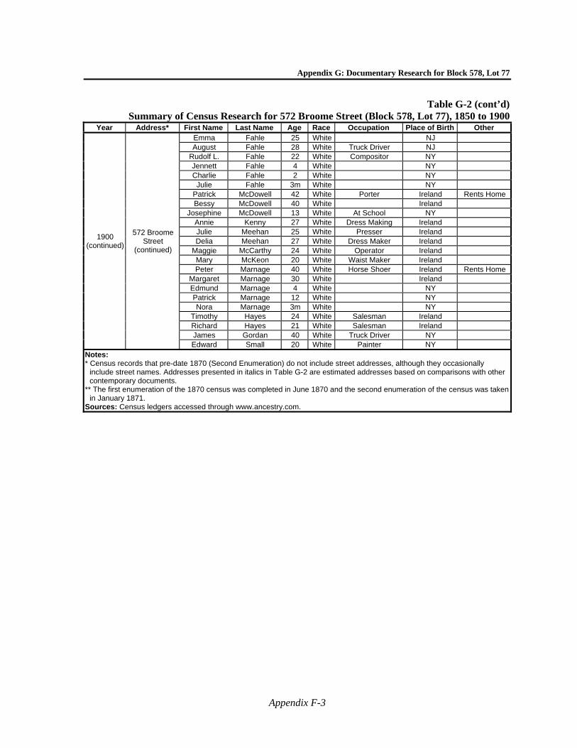
Appendix G: Documentary Research for Block 578, Lot 77
Appendix F-3
Table G-2 (cont’d)Summary of Census Research for 572 Broome Street (Block 578, Lot 77), 1850 to 1900
Year Address* First Name Last Name Age Race Occupation Place of Birth Other
1900 (continued)
572 Broome Street
(continued)
Emma Fahle 25 White NJ August Fahle 28 White Truck Driver NJ
Rudolf L. Fahle 22 White Compositor NY Jennett Fahle 4 White NY Charlie Fahle 2 White NY
Julie Fahle 3m White NY Patrick McDowell 42 White Porter Ireland Rents Home Bessy McDowell 40 White Ireland
Josephine McDowell 13 White At School NY Annie Kenny 27 White Dress Making Ireland Julie Meehan 25 White Presser Ireland Delia Meehan 27 White Dress Maker Ireland
Maggie McCarthy 24 White Operator Ireland Mary McKeon 20 White Waist Maker Ireland Peter Marnage 40 White Horse Shoer Ireland Rents Home
Margaret Marnage 30 White Ireland Edmund Marnage 4 White NY Patrick Marnage 12 White NY Nora Marnage 3m White NY
Timothy Hayes 24 White Salesman Ireland Richard Hayes 21 White Salesman Ireland James Gordan 40 White Truck Driver NY Edward Small 20 White Painter NY
Notes: * Census records that pre-date 1870 (Second Enumeration) do not include street addresses, although they occasionally
include street names. Addresses presented in italics in Table G-2 are estimated addresses based on comparisons with other contemporary documents.
** The first enumeration of the 1870 census was completed in June 1870 and the second enumeration of the census was taken in January 1871.
Sources: Census ledgers accessed through www.ancestry.com.
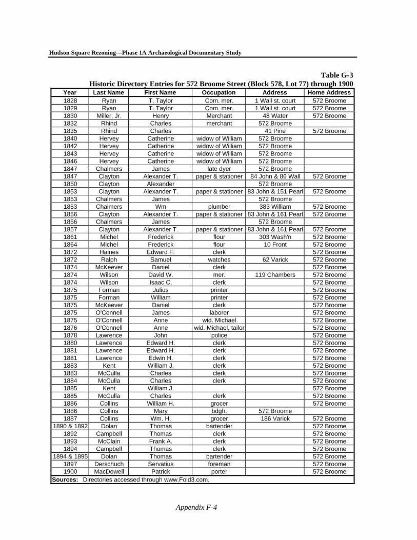
Hudson Square Rezoning—Phase 1A Archaeological Documentary Study
Appendix F-4
Table G-3Historic Directory Entries for 572 Broome Street (Block 578, Lot 77) through 1900
Year Last Name First Name Occupation Address Home Address1828 Ryan T. Taylor Com. mer. 1 Wall st. court 572 Broome 1829 Ryan T. Taylor Com. mer. 1 Wall st. court 572 Broome 1830 Miller, Jr. Henry Merchant 48 Water 572 Broome 1832 Rhind Charles merchant 572 Broome 1835 Rhind Charles 41 Pine 572 Broome 1840 Hervey Catherine widow of William 572 Broome 1842 Hervey Catherine widow of William 572 Broome 1843 Hervey Catherine widow of William 572 Broome 1846 Hervey Catherine widow of William 572 Broome 1847 Chalmers James late dyer 572 Broome 1847 Clayton Alexander T. paper & stationer 84 John & 86 Wall 572 Broome 1850 Clayton Alexander 572 Broome 1853 Clayton Alexander T. paper & stationer 83 John & 151 Pearl 572 Broome 1853 Chalmers James 572 Broome 1853 Chalmers Wm plumber 383 William 572 Broome 1856 Clayton Alexander T. paper & stationer 83 John & 161 Pearl 572 Broome 1856 Chalmers James 572 Broome 1857 Clayton Alexander T. paper & stationer 83 John & 161 Pearl 572 Broome 1861 Michel Frederick flour 303 Wash'n 572 Broome 1864 Michel Frederick flour 10 Front 572 Broome 1872 Haines Edward F. clerk 572 Broome 1872 Ralph Samuel watches 62 Varick 572 Broome 1874 McKeever Daniel clerk 572 Broome 1874 Wilson David W. mer. 119 Chambers 572 Broome 1874 Wilson Isaac C. clerk 572 Broome 1875 Forman Julius printer 572 Broome 1875 Forman William printer 572 Broome 1875 McKeever Daniel clerk 572 Broome 1875 O'Connell James laborer 572 Broome 1875 O'Connell Anne wid. Michael 572 Broome 1876 O'Connell Anne wid. Michael, tailor 572 Broome 1878 Lawrence John police 572 Broome 1880 Lawrence Edward H. clerk 572 Broome 1881 Lawrence Edward H. clerk 572 Broome 1881 Lawrence Edwin H. clerk 572 Broome 1883 Kent William J. clerk 572 Broome 1883 McCulla Charles clerk 572 Broome 1884 McCulla Charles clerk 572 Broome 1885 Kent William J. 572 Broome 1885 McCulla Charles clerk 572 Broome 1886 Collins William H. grocer 572 Broome 1886 Collins Mary bdgh. 572 Broome 1887 Collins Wm. H. grocer 186 Varick 572 Broome
1890 & 1892 Dolan Thomas bartender 572 Broome 1892 Campbell Thomas clerk 572 Broome 1893 McClain Frank A. clerk 572 Broome 1894 Campbell Thomas clerk 572 Broome
1894 & 1895 Dolan Thomas bartender 572 Broome 1897 Derschuch Servatius foreman 572 Broome 1900 MacDowell Patrick porter 572 Broome
Sources: Directories accessed through www.Fold3.com.
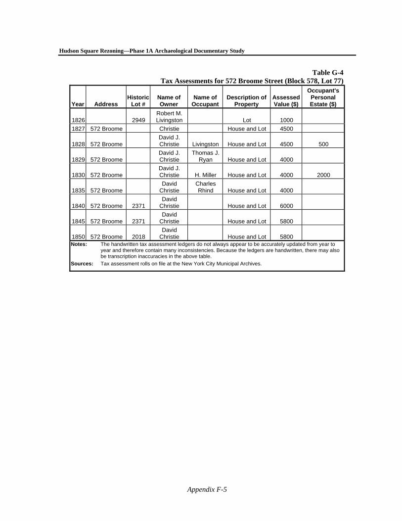
Hudson Square Rezoning—Phase 1A Archaeological Documentary Study
Appendix F-5
Table G-4Tax Assessments for 572 Broome Street (Block 578, Lot 77)
Year Address Historic
Lot # Name of Owner
Name of Occupant
Description of Property
Assessed Value ($)
Occupant's Personal Estate ($)
1826 2949 Robert M. Livingston Lot 1000
1827 572 Broome Christie House and Lot 4500
1828 572 Broome David J. Christie Livingston House and Lot 4500 500
1829 572 Broome David J. Christie
Thomas J. Ryan House and Lot 4000
1830 572 Broome David J. Christie H. Miller House and Lot 4000 2000
1835 572 Broome David
Christie Charles Rhind House and Lot 4000
1840 572 Broome 2371 David
Christie House and Lot 6000
1845 572 Broome 2371 David
Christie House and Lot 5800
1850 572 Broome 2018 David
Christie House and Lot 5800 Notes: The handwritten tax assessment ledgers do not always appear to be accurately updated from year to
year and therefore contain many inconsistencies. Because the ledgers are handwritten, there may also be transcription inaccuracies in the above table.
Sources: Tax assessment rolls on file at the New York City Municipal Archives.
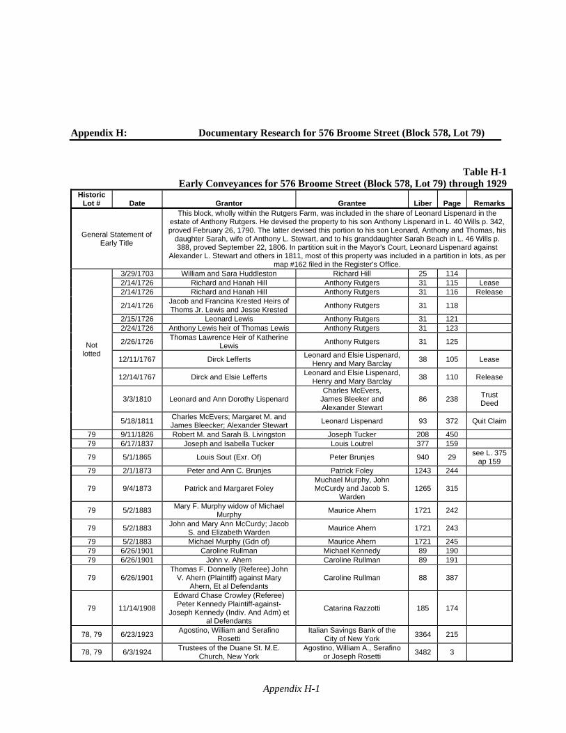
Appendix H-1
Appendix H: Documentary Research for 576 Broome Street (Block 578, Lot 79)
Table H-1Early Conveyances for 576 Broome Street (Block 578, Lot 79) through 1929
Historic Lot # Date Grantor Grantee Liber Page Remarks
General Statement of Early Title
This block, wholly within the Rutgers Farm, was included in the share of Leonard Lispenard in the estate of Anthony Rutgers. He devised the property to his son Anthony Lispenard in L. 40 Wills p. 342, proved February 26, 1790. The latter devised this portion to his son Leonard, Anthony and Thomas, his
daughter Sarah, wife of Anthony L. Stewart, and to his granddaughter Sarah Beach in L. 46 Wills p. 388, proved September 22, 1806. In partition suit in the Mayor's Court, Leonard Lispenard against
Alexander L. Stewart and others in 1811, most of this property was included in a partition in lots, as per map #162 filed in the Register's Office.
Not lotted
3/29/1703 William and Sara Huddleston Richard Hill 25 114 2/14/1726 Richard and Hanah Hill Anthony Rutgers 31 115 Lease 2/14/1726 Richard and Hanah Hill Anthony Rutgers 31 116 Release
2/14/1726 Jacob and Francina Krested Heirs of Thoms Jr. Lewis and Jesse Krested
Anthony Rutgers 31 118
2/15/1726 Leonard Lewis Anthony Rutgers 31 121 2/24/1726 Anthony Lewis heir of Thomas Lewis Anthony Rutgers 31 123
2/26/1726 Thomas Lawrence Heir of Katherine
Lewis Anthony Rutgers 31 125
12/11/1767 Dirck Lefferts Leonard and Elsie Lispenard,
Henry and Mary Barclay 38 105 Lease
12/14/1767 Dirck and Elsie Lefferts Leonard and Elsie Lispenard,
Henry and Mary Barclay 38 110 Release
3/3/1810 Leonard and Ann Dorothy Lispenard Charles McEvers,
James Bleeker and Alexander Stewart
86 238 Trust Deed
5/18/1811 Charles McEvers; Margaret M. and James Bleecker; Alexander Stewart
Leonard Lispenard 93 372 Quit Claim
79 9/11/1826 Robert M. and Sarah B. Livingston Joseph Tucker 208 450 79 6/17/1837 Joseph and Isabella Tucker Louis Loutrel 377 159
79 5/1/1865 Louis Sout (Exr. Of) Peter Brunjes 940 29 see L. 375
ap 159 79 2/1/1873 Peter and Ann C. Brunjes Patrick Foley 1243 244
79 9/4/1873 Patrick and Margaret Foley Muchael Murphy, John McCurdy and Jacob S.
Warden 1265 315
79 5/2/1883 Mary F. Murphy widow of Michael
Murphy Maurice Ahern 1721 242
79 5/2/1883 John and Mary Ann McCurdy; Jacob
S. and Elizabeth Warden Maurice Ahern 1721 243
79 5/2/1883 Michael Murphy (Gdn of) Maurice Ahern 1721 245 79 6/26/1901 Caroline Rullman Michael Kennedy 89 190 79 6/26/1901 John v. Ahern Caroline Rullman 89 191
79 6/26/1901 Thomas F. Donnelly (Referee) John
V. Ahern (Plaintiff) against Mary Ahern, Et al Defendants
Caroline Rullman 88 387
79 11/14/1908
Edward Chase Crowley (Referee) Peter Kennedy Plaintiff-against-
Joseph Kennedy (Indiv. And Adm) et al Defendants
Catarina Razzotti 185 174
78, 79 6/23/1923 Agostino, William and Serafino
Rosetti Italian Savings Bank of the
City of New York 3364 215
78, 79 6/3/1924 Trustees of the Duane St. M.E.
Church, New York Agostino, William A., Serafino
or Joseph Rosetti 3482 3
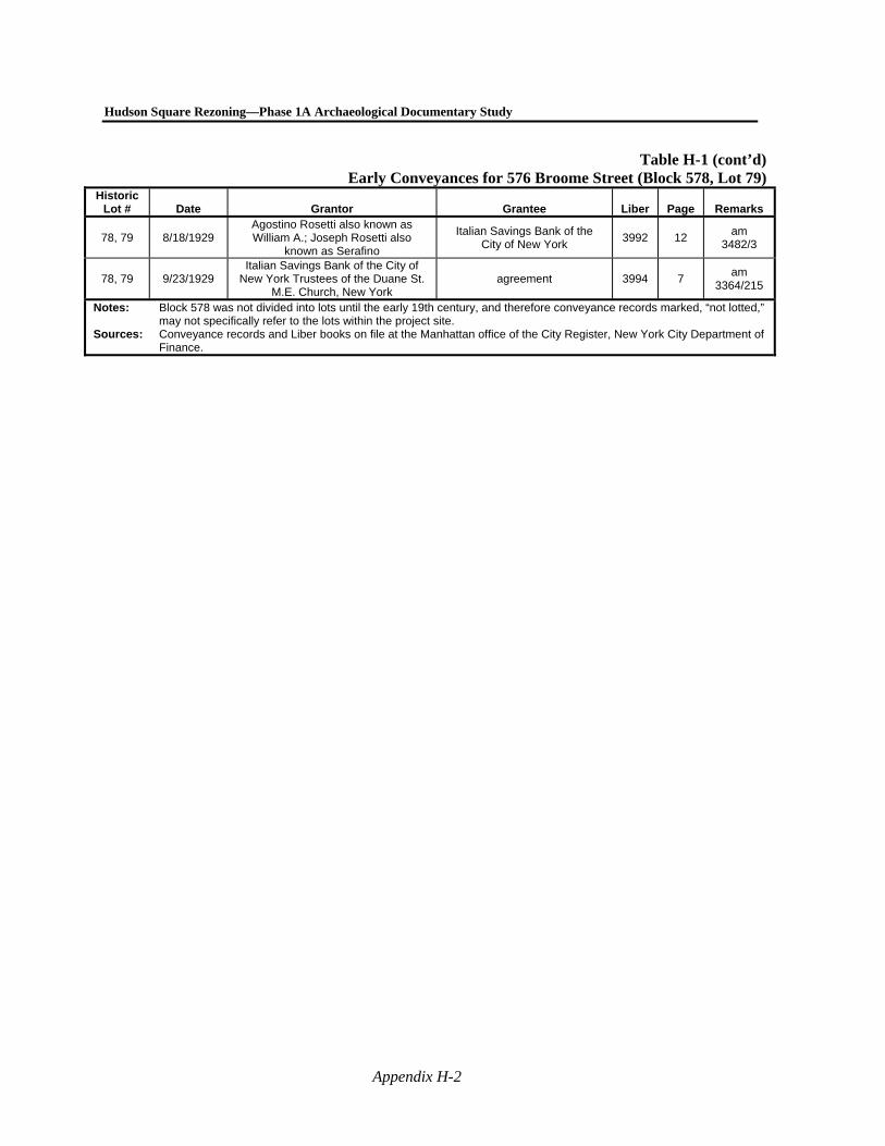
Hudson Square Rezoning—Phase 1A Archaeological Documentary Study
Appendix H-2
Table H-1 (cont’d)Early Conveyances for 576 Broome Street (Block 578, Lot 79)
Historic Lot # Date Grantor Grantee Liber Page Remarks
78, 79 8/18/1929 Agostino Rosetti also known as William A.; Joseph Rosetti also
known as Serafino
Italian Savings Bank of the City of New York
3992 12 am
3482/3
78, 79 9/23/1929 Italian Savings Bank of the City of
New York Trustees of the Duane St. M.E. Church, New York
agreement 3994 7 am
3364/215
Notes: Block 578 was not divided into lots until the early 19th century, and therefore conveyance records marked, “not lotted,” may not specifically refer to the lots within the project site.
Sources: Conveyance records and Liber books on file at the Manhattan office of the City Register, New York City Department of Finance.
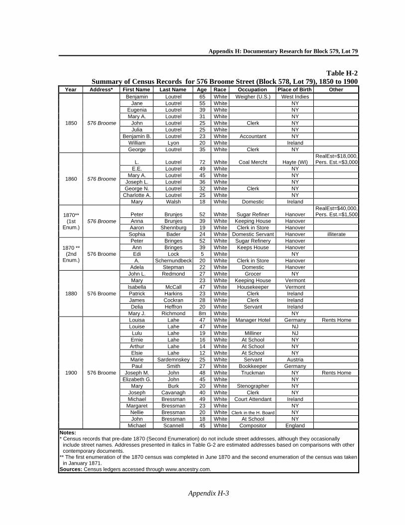
Appendix H: Documentary Research for Block 579, Lot 79
Appendix H-3
Table H-2Summary of Census Records for 576 Broome Street (Block 578, Lot 79), 1850 to 1900
Year Address* First Name Last Name Age Race Occupation Place of Birth Other
1850 576 Broome
Benjamin Loutrel 65 White Weigher (U.S.) West Indies Jane Loutrel 55 White NY
Eugenia Loutrel 39 White NY Mary A. Loutrel 31 White NY
John Loutrel 25 White Clerk NY Julia Loutrel 25 White NY
Benjamin B. Loutrel 23 White Accountant NY William Lyon 20 White Ireland George Loutrel 35 White Clerk NY
1860 576 Broome
L. Loutrel 72 White Coal Mercht Hayte (WI) RealEst=$18,000, Pers. Est.=$3,000
E.E. Loutrel 49 White NY Mary A. Loutrel 45 White NY
Joseph L. Loutrel 36 White NY George N. Loutrel 32 White Clerk NY
Charlotte A. Loutrel 25 White NY Mary Walsh 18 White Domestic Ireland
1870** (1st
Enum.) 576 Broome
Peter Brunjes 52 White Sugar Refiner Hanover RealEst=$40,000, Pers. Est.=$1,500
Anna Brunjes 39 White Keeping House Hanover Aaron Shennburg 19 White Clerk in Store Hanover Sophia Bader 24 White Domestic Servant Hanover illiterate
1870 ** (2nd
Enum.) 576 Broome
Peter Bringes 52 White Sugar Refinery Hanover Ann Bringes 39 White Keeps House Hanover Edi Lock 5 White NY A. Schernundbeck 20 White Clerk in Store Hanover
Adela Stepman 22 White Domestic Hanover
1880 576 Broome
John L. Redmond 27 White Grocer NY Mary 23 White Keeping House Vermont
Isabella McCall 47 White Housekeeper Vermont Patrick Harkins 23 White Clerk Ireland James Cockran 28 White Clerk Ireland Delia Heffron 20 White Servant Ireland
Mary J. Richmond 8m White NY
1900 576 Broome
Louisa Lahe 47 White Manager Hotel Germany Rents Home Louise Lahe 47 White NJ Lulu Lahe 19 White Milliner NJ Ernie Lahe 16 White At School NY Arthur Lahe 14 White At School NY Elsie Lahe 12 White At School NY Marie Sardemnskey 25 White Servant Austria Paul Smith 27 White Bookkeeper Germany
Joseph M. John 48 White Truckman NY Rents Home Elizabeth G. John 45 White NY
Mary Burk 20 White Stenographer NY Joseph Cavanagh 40 White Clerk NY Michael Bressman 49 White Court Attendant Ireland
Margaret Bressman 23 White NY Nellie Bressman 20 White Clerk in the H. Board NY John Bressman 18 White At School NY
Michael Scannell 45 White Compositor England Notes: * Census records that pre-date 1870 (Second Enumeration) do not include street addresses, although they occasionally
include street names. Addresses presented in italics in Table G-2 are estimated addresses based on comparisons with other contemporary documents.
** The first enumeration of the 1870 census was completed in June 1870 and the second enumeration of the census was taken in January 1871.
Sources: Census ledgers accessed through www.ancestry.com.
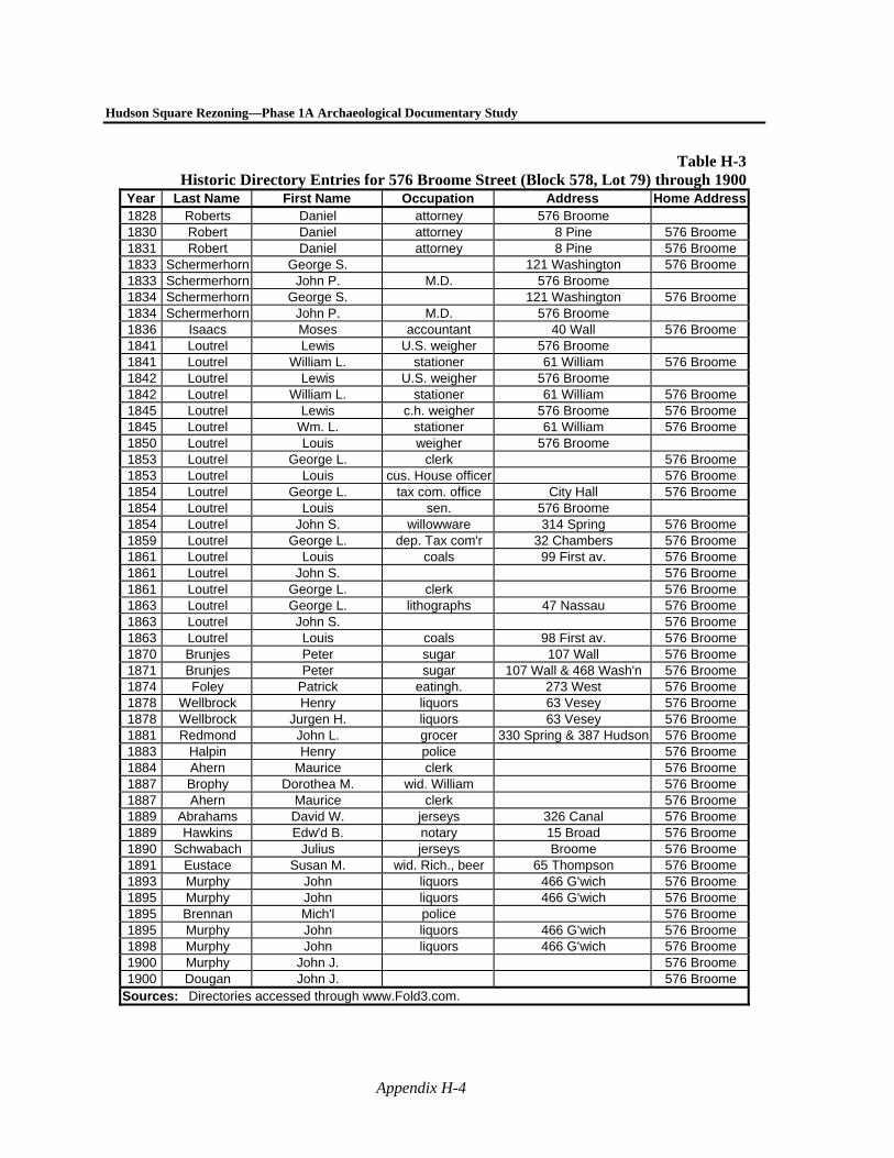
Hudson Square Rezoning—Phase 1A Archaeological Documentary Study
Appendix H-4
Table H-3Historic Directory Entries for 576 Broome Street (Block 578, Lot 79) through 1900
Year Last Name First Name Occupation Address Home Address1828 Roberts Daniel attorney 576 Broome 1830 Robert Daniel attorney 8 Pine 576 Broome 1831 Robert Daniel attorney 8 Pine 576 Broome 1833 Schermerhorn George S. 121 Washington 576 Broome 1833 Schermerhorn John P. M.D. 576 Broome 1834 Schermerhorn George S. 121 Washington 576 Broome 1834 Schermerhorn John P. M.D. 576 Broome 1836 Isaacs Moses accountant 40 Wall 576 Broome 1841 Loutrel Lewis U.S. weigher 576 Broome 1841 Loutrel William L. stationer 61 William 576 Broome 1842 Loutrel Lewis U.S. weigher 576 Broome 1842 Loutrel William L. stationer 61 William 576 Broome 1845 Loutrel Lewis c.h. weigher 576 Broome 576 Broome 1845 Loutrel Wm. L. stationer 61 William 576 Broome 1850 Loutrel Louis weigher 576 Broome 1853 Loutrel George L. clerk 576 Broome 1853 Loutrel Louis cus. House officer 576 Broome 1854 Loutrel George L. tax com. office City Hall 576 Broome 1854 Loutrel Louis sen. 576 Broome 1854 Loutrel John S. willowware 314 Spring 576 Broome 1859 Loutrel George L. dep. Tax com'r 32 Chambers 576 Broome 1861 Loutrel Louis coals 99 First av. 576 Broome 1861 Loutrel John S. 576 Broome 1861 Loutrel George L. clerk 576 Broome 1863 Loutrel George L. lithographs 47 Nassau 576 Broome 1863 Loutrel John S. 576 Broome 1863 Loutrel Louis coals 98 First av. 576 Broome 1870 Brunjes Peter sugar 107 Wall 576 Broome 1871 Brunjes Peter sugar 107 Wall & 468 Wash'n 576 Broome 1874 Foley Patrick eatingh. 273 West 576 Broome 1878 Wellbrock Henry liquors 63 Vesey 576 Broome 1878 Wellbrock Jurgen H. liquors 63 Vesey 576 Broome 1881 Redmond John L. grocer 330 Spring & 387 Hudson 576 Broome 1883 Halpin Henry police 576 Broome 1884 Ahern Maurice clerk 576 Broome 1887 Brophy Dorothea M. wid. William 576 Broome 1887 Ahern Maurice clerk 576 Broome 1889 Abrahams David W. jerseys 326 Canal 576 Broome 1889 Hawkins Edw'd B. notary 15 Broad 576 Broome 1890 Schwabach Julius jerseys Broome 576 Broome 1891 Eustace Susan M. wid. Rich., beer 65 Thompson 576 Broome 1893 Murphy John liquors 466 G'wich 576 Broome 1895 Murphy John liquors 466 G'wich 576 Broome 1895 Brennan Mich'l police 576 Broome 1895 Murphy John liquors 466 G'wich 576 Broome 1898 Murphy John liquors 466 G'wich 576 Broome 1900 Murphy John J. 576 Broome 1900 Dougan John J. 576 Broome
Sources: Directories accessed through www.Fold3.com.
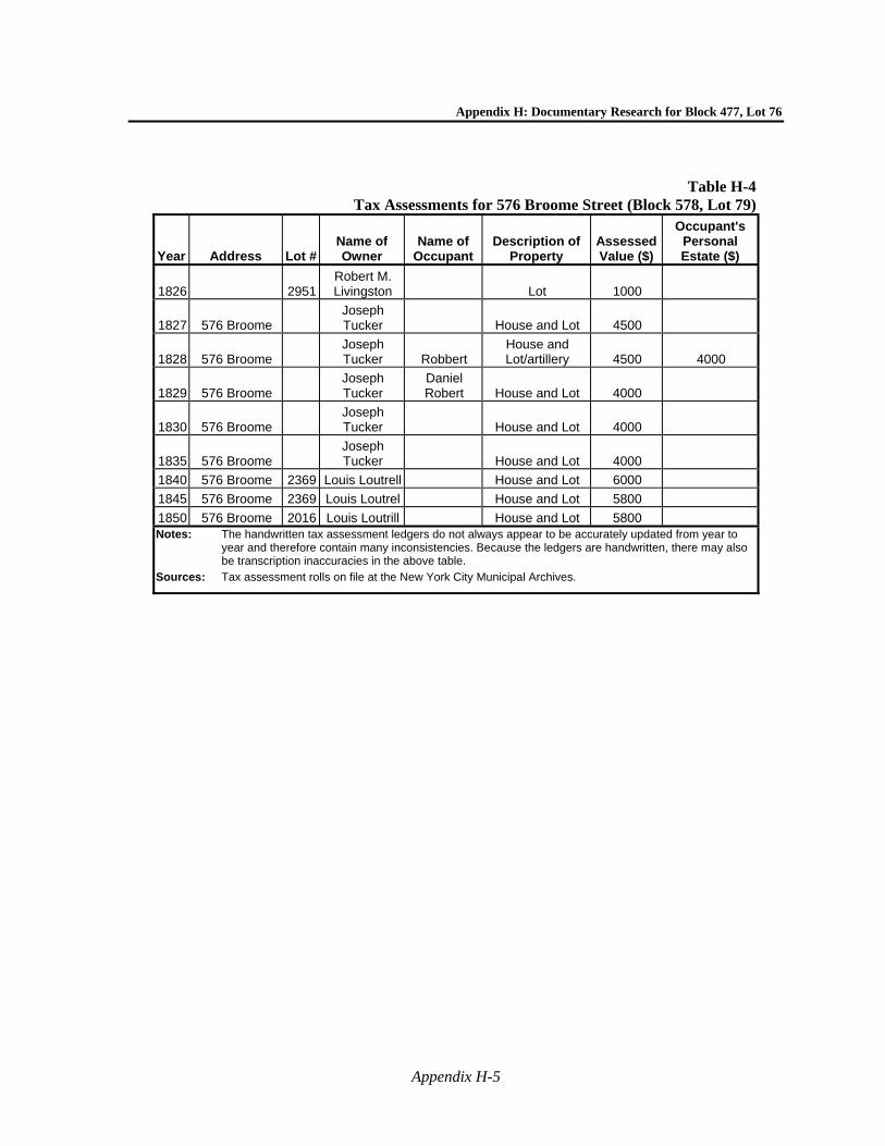
Appendix H: Documentary Research for Block 477, Lot 76
Appendix H-5
Table H-4Tax Assessments for 576 Broome Street (Block 578, Lot 79)
Year Address Lot # Name of Owner
Name of Occupant
Description of Property
Assessed Value ($)
Occupant's Personal Estate ($)
1826 2951 Robert M. Livingston Lot 1000
1827 576 Broome Joseph Tucker House and Lot 4500
1828 576 Broome Joseph Tucker Robbert
House and Lot/artillery 4500 4000
1829 576 Broome Joseph Tucker
Daniel Robert House and Lot 4000
1830 576 Broome Joseph Tucker House and Lot 4000
1835 576 Broome Joseph Tucker House and Lot 4000
1840 576 Broome 2369 Louis Loutrell House and Lot 6000
1845 576 Broome 2369 Louis Loutrel House and Lot 5800
1850 576 Broome 2016 Louis Loutrill House and Lot 5800 Notes: The handwritten tax assessment ledgers do not always appear to be accurately updated from year to
year and therefore contain many inconsistencies. Because the ledgers are handwritten, there may also be transcription inaccuracies in the above table.
Sources: Tax assessment rolls on file at the New York City Municipal Archives.
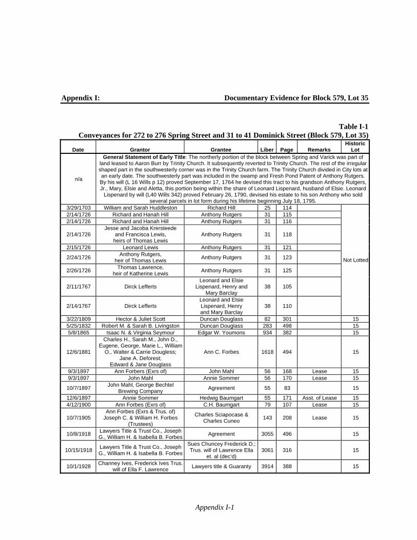
Appendix I-1
Appendix I: Documentary Evidence for Block 579, Lot 35
Table I-1Conveyances for 272 to 276 Spring Street and 31 to 41 Dominick Street (Block 579, Lot 35)
Date Grantor Grantee Liber Page Remarks Historic
Lot
n/a
General Statement of Early Title: The northerly portion of the block between Spring and Varick was part of land leased to Aaron Burr by Trinity Church. It subsequently reverted to Trinity Church. The rest of the irregular shaped part in the southwesterly corner was in the Trinity Church farm. The Trinity Church divided in City lots at an early date. The southwesterly part was included in the swamp and Fresh Pond Patent of Anthony Rutgers. By his will (L 16 Wills p 12) proved September 17, 1764 he devised this tract to his grandson Anthony Rutgers, Jr., Mary, Elsie and Aletta, this portion being within the share of Leonard Lispenard, husband of Elsie. Leonard
Lispenard by will (L40 Wills 342) proved February 26, 1790, devised his estate to his son Anthony who sold several parcels in lot form during his lifetime beginning July 18, 1795.
3/29/1703 William and Sarah Huddleston Richard Hill 25 114
Not Lotted
2/14/1726 Richard and Hanah Hill Anthony Rutgers 31 115 2/14/1726 Richard and Hanah Hill Anthony Rutgers 31 116
2/14/1726 Jesse and Jacoba Krersteede
and Francisca Lewis, heirs of Thomas Lewis
Anthony Rutgers 31 118
2/15/1726 Leonard Lewis Anthony Rutgers 31 121
2/24/1726 Anthony Rutgers,
heir of Thomas Lewis Anthony Rutgers 31 123
2/26/1726 Thomas Lawrence,
heir of Katherine Lewis Anthony Rutgers 31 125
2/11/1767 Dirck Lefferts Leonard and Elsie
Lispenard, Henry and Mary Barclay
38 105
2/14/1767 Dirck Lefferts Leonard and Elsie Lispenard, Henry and Mary Barclay
38 110
3/22/1809 Hector & Juliet Scott Duncan Douglass 82 301 15 5/25/1832 Robert M. & Sarah B. Livingston Duncan Douglass 283 498 15 5/8/1865 Isaac N. & Virginia Seymour Edgar W. Youmons 934 382 15
12/6/1881
Charles H., Sarah M., John D., Eugene, George, Marie L., William
O., Walter & Carrie Dougless; Jane A. Deforest;
Edward & Jane Douglass
Ann C. Forbes 1618 494
15
9/3/1897 Ann Forbers (Exrs of) John Mahl 56 168 Lease 15 9/3/1897 John Mahl Annie Sommer 56 170 Lease 15
10/7/1897 John Mahl, George Bechtel
Brewing Company Agreement 55 83
15
12/6/1897 Annie Sommer Hedwig Baumgart 55 171 Asst. of Lease 15 4/12/1900 Ann Forbes (Exrs of) C.H. Baumgart 79 107 Lease 15
10/7/1905 Ann Forbes (Exrs & Trus. of)
Joseph C. & William H. Forbes (Trustees)
Charles Sciapocase & Charles Cuneo
143 208 Lease 15
10/8/1918 Lawyers Title & Trust Co., Joseph G., William H. & Isabella B. Forbes
Agreement 3055 496
15
10/15/1918 Lawyers Title & Trust Co., Joseph G., William H. & Isabella B. Forbes
Sues Chuncey Frederick D.; Trus. will of Lawrence Ella
et. al (dec’d) 3061 316
15
10/1/1928 Channey Ives, Frederick Ives Trus.
will of Ella F. Lawrence Lawyers title & Guaranty 3914 388
15
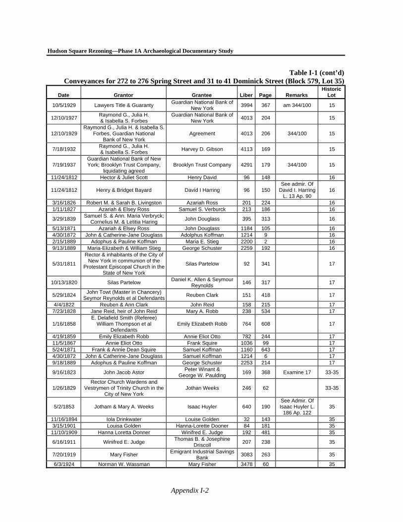
Hudson Square Rezoning—Phase 1A Archaeological Documentary Study
Appendix I-2
Table I-1 (cont’d)Conveyances for 272 to 276 Spring Street and 31 to 41 Dominick Street (Block 579, Lot 35)
Date Grantor Grantee Liber Page Remarks Historic
Lot
10/5/1929 Lawyers Title & Guaranty Guardian National Bank of
New York 3994 367 am 344/100 15
12/10/1927 Raymond G., Julia H. & Isabella S. Forbes
Guardian National Bank of New York
4013 204
15
12/10/1929 Raymond G., Julia H. & Isabella S.
Forbes, Guardian National Bank of New York
Agreement 4013 206 344/100 15
7/18/1932 Raymond G., Julia H. & Isabella S. Forbes
Harvey D. Gibson 4113 169
15
7/19/1937 Guardian National Bank of New York; Brooklyn Trust Company,
liquidating agreed Brooklyn Trust Company 4291 179 344/100 15
11/24/1812 Hector & Juliet Scott Henry David 96 148 16
11/24/1812 Henry & Bridget Bayard David I Harring 96 150 See admir. Of
David I. Harring L. 13 Ap. 90
16
3/16/1826 Robert M. & Sarah B. Livingston Azariah Ross 201 224 16 1/11/1827 Azariah & Elsey Ross Samuel S. Verburck 213 186 16
3/29/1839 Samuel S. & Ann. Maria Verbryck;
Cornelius M. & Letitia Haring John Douglass 395 313
16
5/13/1871 Azariah & Elsey Ross John Douglass 1184 105 16 4/30/1872 John & Catherine-Jane Douglass Adolphus Koffman 1214 9 16 2/15/1889 Adophus & Pauline Koffman Maria E. Stieg 2200 2 16 9/13/1889 Maria-Elizabeth & William Stieg George Schuster 2259 192 16
5/31/1811
Rector & inhabitants of the City of New York in communion of the
Protestant Episcopal Church in the State of New York
Silas Partelow 92 341
17
10/13/1820 Silas Partelow Daniel K. Allen & Seymour
Reynolds 146 317
17
5/29/1824 John Towt (Master in Chancery)
Seymor Reynolds et al DefendantsReuben Clark 151 418
17
4/4/1822 Reuben & Ann Clark John Reid 158 215 17 7/23/1828 Jane Reid, heir of John Reid Mary A. Robb 238 534 17
1/16/1858 E. Delafield Smith (Referee)
William Thompson et al Defendants
Emily Elizabeth Robb 764 608
17
4/19/1859 Emily Elizabeth Robb Annie Eliot Otto 782 244 17 11/5/1867 Annie Eliot Otto Frank Squire 1036 99 17 5/24/1871 Frank & Annie Dean Squire Samuel Koffman 1160 643 17 4/30/1872 John & Catherine-Jane Douglass Samuel Koffman 1214 6 17 9/18/1889 Adophus & Pauline Koffman George Schuster 2253 214 17
9/16/1823 John Jacob Astor Peter Winant &
George W. Paulding 169 368 Examine 17 33-35
1/26/1829 Rector Church Wardens and
Vestrymen of Trinity Church in the City of New York
Jothan Weeks 246 62
33-35
5/2/1853 Jotham & Mary A. Weeks Isaac Huyler 640 190 See Admir. Of Isaac Huyler L.
186 Ap. 122 35
11/16/1894 Iola Drinkwater Louise Golden 32 143 35 3/15/1901 Louisa Golden Hanna-Lorette Dooner 84 181 35
11/10/1909 Hanna Loretta Donner Winifred E. Judge 192 481 35
6/16/1911 Winifred E. Judge Thomas B. & Josephine
Driscoll 207 238
35
7/20/1919 Mary Fisher Emigrant Industrial Savings
Bank 3083 263
35
6/3/1924 Norman W. Wassman Mary Fisher 3478 60 35
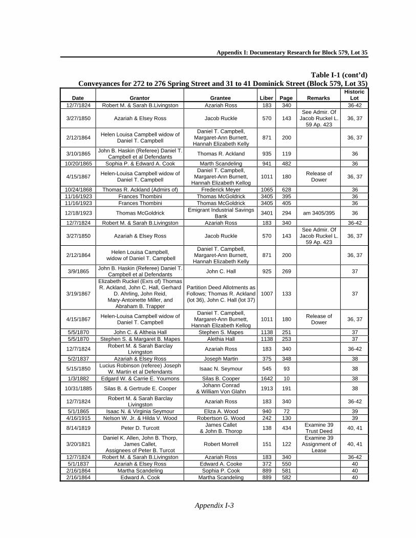
Appendix I: Documentary Research for Block 579, Lot 35
Appendix I-3
Table I-1 (cont’d)Conveyances for 272 to 276 Spring Street and 31 to 41 Dominick Street (Block 579, Lot 35)
Date Grantor Grantee Liber Page Remarks Historic
Lot 12/7/1824 Robert M. & Sarah B.Livingston Azariah Ross 183 340 36-42
3/27/1850 Azariah & Elsey Ross Jacob Ruckle 570 143 See Admir. Of
Jacob Ruckel L. 59 Ap. 423
36, 37
2/12/1864 Helen Louisa Campbell widow of
Daniel T. Campbell
Daniel T. Campbell, Margaret-Ann Burnett, Hannah Elizabeth Kelly
871 200
36, 37
3/10/1865 John B. Haskin (Referee) Daniel T.
Campbell et al Defendants Thomas R. Ackland 935 119
36
10/20/1865 Sophia P. & Edward A. Cook Marth Scandeling 941 482 36
4/15/1867 Helen-Louisa Campbell widow of
Daniel T. Campbell
Daniel T. Campbell, Margaret-Ann Burnett,
Hannah Elizabeth Kellog 1011 180
Release of Dower
36, 37
10/24/1868 Thomas R. Ackland (Admirs of) Frederick Meyer 1065 628 36 11/16/1923 Frances Thombini Thomas McGoldrick 3405 395 36 11/16/1923 Frances Thombini Thomas McGoldrick 3405 405 36
12/18/1923 Thomas McGoldrick Emigrant Industrial Savings
Bank 3401 294 am 3405/395 36
12/7/1824 Robert M. & Sarah B.Livingston Azariah Ross 183 340 36-42
3/27/1850 Azariah & Elsey Ross Jacob Ruckle 570 143 See Admir. Of
Jacob Ruckel L. 59 Ap. 423
36, 37
2/12/1864 Helen Louisa Campbell,
widow of Daniel T. Campbell
Daniel T. Campbell, Margaret-Ann Burnett, Hannah Elizabeth Kelly
871 200
36, 37
3/9/1865 John B. Haskin (Referee) Daniel T.
Campbell et al Defendants John C. Hall 925 269
37
3/19/1867
Elizabeth Ruckel (Exrs of) Thomas R. Ackland, John C. Hall, Gerhard
D. Ahrling, John Reid, Mary-Antoinette Miller, and
Abraham B. Trapper
Partition Deed Allotments as Follows; Thomas R. Ackland (lot 36), John C. Hall (lot 37)
1007 133
37
4/15/1867 Helen-Louisa Campbell widow of
Daniel T. Campbell
Daniel T. Campbell, Margaret-Ann Burnett,
Hannah Elizabeth Kellog 1011 180
Release of Dower
36, 37
5/5/1870 John C. & Altheia Hall Stephen S. Mapes 1138 251 37 5/5/1870 Stephen S. & Margaret B. Mapes Alethia Hall 1138 253 37
12/7/1824 Robert M. & Sarah Barclay
Livingston Azariah Ross 183 340
36-42
5/2/1837 Azariah & Elsey Ross Joseph Martin 375 348 38
5/15/1850 Lucius Robinson (referee) Joseph
W. Martin et al Defendants Isaac N. Seymour 545 93
38
1/3/1882 Edgard W. & Carrie E. Youmons Silas B. Cooper 1642 10 38
10/31/1885 Silas B. & Gertrude E. Cooper Johann Conrad
& William Von Glahn 1913 191
38
12/7/1824 Robert M. & Sarah Barclay
Livingston Azariah Ross 183 340
36-42
5/1/1865 Isaac N. & Virginia Seymour Eliza A. Wood 940 72 39 4/16/1915 Nelson W. Jr. & Hilda V. Wood Robertson G. Wood 242 130 39
8/14/1819 Peter D. Turcott James Callet
& John B. Thorop 138 434
Examine 39 Trust Deed
40, 41
3/20/1821 Daniel K. Allen, John B. Thorp,
James Callet, Assignees of Peter B. Turcot
Robert Morrell 151 122 Examine 39
Assignment of Lease
40, 41
12/7/1824 Robert M. & Sarah B.Livingston Azariah Ross 183 340 36-42 5/1/1837 Azariah & Elsey Ross Edward A. Cooke 372 550 40
2/16/1864 Martha Scandeling Sophia P. Cook 889 581 40 2/16/1864 Edward A. Cook Martha Scandeling 889 582 40

Hudson Square Rezoning—Phase 1A Archaeological Documentary Study
Appendix I-4
Table I-1 (cont’d)Conveyances for 272 to 276 Spring Street and 31 to 41 Dominick Street (Block 579, Lot 35)
Date Grantor Grantee Liber Page Remarks Historic
Lot
9/20/1865 Alexander Douglas Heir of Duncan
Douglass & Harriet Douglass John Douglass 933 641
40
10/20/1865 Marth Scandeling Edward A. Cook 941 480 See will of
Edward A. Cook L. 166 Ap. 428
40
4/24/1874 Sophia P. Cook (Exr. of) Martha Scanlan 1292 80 40
12/28/1888
John L. Redmond, Anna E. O'Neill, Mary T. Howlett; James F., Matilda S., Catharine L., Thomas I. & Emily
A. Redmond. Heirs of James Redmond
Mary T. Redmond 2189 84
40, 41
4/1/1892 Martha Scanlon Elizabeth Hannon 9 97 40
6/1/1904 Elizabeth Hannon John J., William J., Catherin
Bradley 127 173
40
4/11/1904 William J. & Catherine Bradley John J. Bradley 128 272 40 12/30/1904 John J. Bradley Ellen Bradley 135 6 40 12/30/1904 William J. & Catherine Bradley John J. Bradley 131 466 40
10/17/1907 Ellen Bradley Anton & Christine
Dambacher 146 342
40
12/28/1888
John L. Redmond, Anna E. O'Neill, Mary T. Howlett; James F., Matilda S., Catharine L., Thomas I. & Emily
A. Redmond. Heirs of James Redmond
Mary T. Redmond 2189 84
40, 41
Notes: Block 579 was not divided into lots until the early 19th century, and therefore conveyance records marked, “not lotted,” may not specifically refer to the lots within the project site.
Sources: Conveyance records and Liber books on file at the Manhattan office of the City Register, New York City Department of Finance.

Appendix I: Documentary Research for Block 579, Lot 35
Appendix I-5
Table I-2Census Research for 272-276 Spring St. and 31- 41 Dominick St. (Block 579, Lot 35), 1850-1900Year Address* First Name Last Name Age Race Occupation Place of Birth Other
1850 31
Dominick
Benjamin Brenster 33 White Carriage Maker Connecticut Amelia Brenster 32 White Connecticut Mary Brenster 10 White New York
Caroline Brenster 6 White New York Francis A. Brenster 3 White New York
Louisa Brenster 2 White New York Mary Lindsey 53 White Scotland Eliza Breney 16 White New York
1860 31
Dominick
Isaac Huyler 35 White Merchant New Jersey Mary A. Huyler 30 White New Jersey Isaac Huyler 14 White New Jersey Isabel Huyler 10 White New Jersey Ann A. Huyler 16 White New Jersey
Mary O. Ryan 23 White Domestic Ireland Bridget McQuire 27 White Domestic Ireland Illiterate
1870** (1st
Enum.)
31 Dominick
Isaac Huylar 50 White Dealer in Fruit New Jersey Pers. Est. = $2,000Mary A. Huylar 49 White At House New Jersey
Iola Huylar 19 White At Home New York Mary Flynn 20 White Domestic Servant New York Ellen O'Ryan 21 White Domestic Servant Ireland
1870** (2nd
Enum.)
31 Dominick
Isaac Huylar 52 White Speculator in
Marketing New York Mary Huylar 52 White New York Lola Huylar 24 White New York Ann Mackee 22 White Ireland Ellen McMarron 20 White New York
Wallace 20 White Clerk Ins. Co. US
1880 31
Dominick
Isaac Huylar 61 White Fruits +c New Jersey Rheumatism Mary A. Huylar 54 White Keeping House New York
Ida Drinkwater 29 White New York Frank Drinkwater 36 White Clerk Maine
Margaret Power 36 White book binder New York Boarder Susan P. Clark 20 White servant Ireland
1900 31
Dominick Louis Golden 50 White New Jersey
James W. Golden 20 White Foreman New Jersey
1850 33
Dominick
William Martin 30 White Merchant New Jersey Ellen Martin 26 White New York
Ellen F. Martin 2 White New York Ann McCann 36 White Ireland Illiterate
Rosa McCann 16 White Ireland
1860 33
Dominick
J. J. Wickstead 39 White Master Umbrella Mkr New York Pers. Est. = $800 Matilda Wickstead 37 White New York Frank Wickstead 12 White New York Henry Wickstead 10 White New York
Frederick Wickstead 8 White New York Albert Wickstead 6 White New York
William Wickstead 4 White New York Edward Wickstead 1 White New York
Eliza Clark 28 White England Ellen Smith 19 White Domestic Ireland
Elizabeth Foley 18 White Domestic New York
1870** (1st
Enum.)
33 Dominick
Frederick Meyer 44 White Grocer Mrk. Hannover Real Est. =$20,000 Pers. Est. = $5,000
Mary Meyer 31 White At Home Denmark Louisa Meyer 6 White At Home New York Emma Meyer 2 White At Home New York Mary Zoeller 55 White Housekepper Baden Can’t write
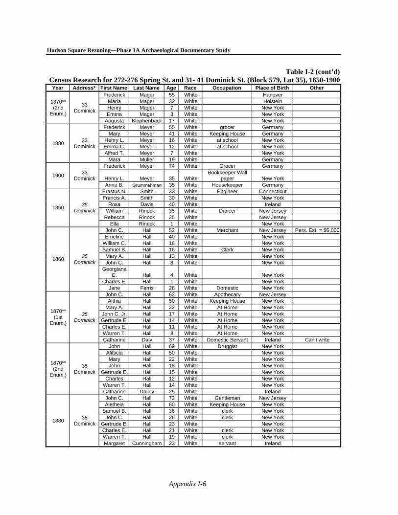
Hudson Square Rezoning—Phase 1A Archaeological Documentary Study
Appendix I-6
Table I-2 (cont’d)Census Research for 272-276 Spring St. and 31- 41 Dominick St. (Block 579, Lot 35), 1850-1900Year Address* First Name Last Name Age Race Occupation Place of Birth Other
1870** (2nd
Enum.)
33 Dominick
Frederick Mager 55 White Hanover Maria Mager 32 White Holstein Henry Mager 7 White New York Emma Mager 3 White New York
Augusta Klophenback 17 White New York
1880 33
Dominick
Frederick Meyer 55 White grocer Germany Mary Meyer 41 White Keeping House Germany
Henry L. Meyer 16 White at school New York Emma C. Meyer 12 White at school New York Alfred T. Meyer 7 White New York
Mara Muller 19 White Germany
1900 33
Dominick
Frederick Meyer 74 White Grocer Germany
Henry L. Meyer 35 White Bookkeeper Wall
paper New York Anna B. Grummehman 35 White Housekeeper Germany
1850 35
Dominick
Erastus N. Smith 33 White Engineer Connecticut Francis A. Smith 30 White New York
Rosa Davis 40 White Ireland William Rinock 35 White Dancer New Jersey
Rebecca Rinock 25 White New Jersey Ella Rineck 1 White New York
1860 35
Dominick
John C. Hall 52 White Merchant New Jersey Pers. Est. = $5,000Emeline Hall 40 White New York
William C. Hall 18 White New York Samuel B. Hall 16 White Clerk New York
Mary A. Hall 13 White New York John C. Hall 8 White New York
Georgiana E. Hall 4 White New York
Charles E. Hall 1 White New York Jane Ferris 28 White Domestic New York
1870** (1st
Enum.)
35 Dominick
John C. Hall 62 White Apothecary New Jersey Althia Hall 50 White Keeping House New York
Mary A. Hall 22 White At Home New York John C. Jr. Hall 17 White At Home New York Gertrude E. Hall 14 White At Home New York Charles E. Hall 11 White At Home New York Warren T. Hall 8 White At Home New York Catharine Daly 37 White Domestic Servant Ireland Can’t write
1870** (2nd
Enum.)
35 Dominick
John Hall 69 White Druggist New York Alitticia Hall 50 White New York Mary Hall 22 White New York John Hall 18 White New York
Gertrude E. Hall 15 White New York Charles Hall 12 White New York
Warren T. Hall 14 White New York Catharine Dailey 25 White Ireland
1880 35
Dominick
John C. Hall 72 White Gentleman New Jersey Aletheia Hall 60 White Keeping House New York
Samuel B. Hall 36 White clerk New York John C. Hall 26 White clerk New York
Gertrude E. Hall 23 White New York Charles E. Hall 21 White clerk New York Warren T. Hall 19 White clerk New York Margaret Cunningham 23 White servant Ireland
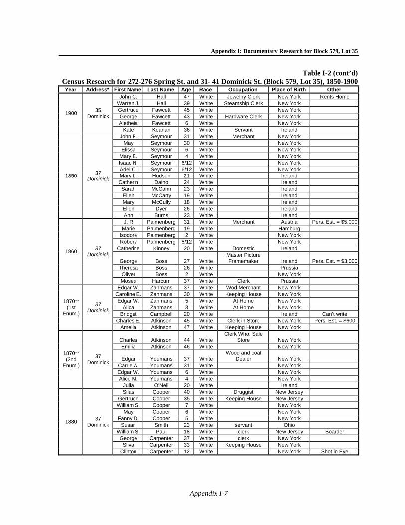
Appendix I: Documentary Research for Block 579, Lot 35
Appendix I-7
Table I-2 (cont’d)Census Research for 272-276 Spring St. and 31- 41 Dominick St. (Block 579, Lot 35), 1850-1900Year Address* First Name Last Name Age Race Occupation Place of Birth Other
1900 35
Dominick
John C. Hall 47 White Jewellry Clerk New York Rents Home Warren J. Hall 39 White Steamship Clerk New York Gertrude Fawcett 45 White New York George Fawcett 43 White Hardware Clerk New York Aletheia Fawcett 6 White New York
Kate Keanan 36 White Servant Ireland
1850 37
Dominick
John F. Seymour 31 White Merchant New York May Seymour 30 White New York
Elissa Seymour 6 White New York Mary E. Seymour 4 White New York Isaac N. Seymour 6/12 White New York Adel C. Seymour 6/12 White New York Mary L. Hudson 21 White Ireland Catherin Daino 24 White Ireland
Sarah McCann 23 White Ireland Ellen McCarty 19 White Ireland Mary McCully 18 White Ireland Ellen Dyer 26 White Ireland Ann Burns 23 White Ireland
1860 37
Dominick
J. R Palmenberg 31 White Merchant Austria Pers. Est. = $5,000Marie Palmenberg 19 White Hamburg
Isodore Palmenberg 2 White New York Robery Palmenberg 5/12 White New York
Catherine Kinney 20 White Domestic Ireland
George Boss 27 White Master Picture Framemaker Ireland Pers. Est. = $3,000
Theresa Boss 26 White Prussia Oliver Boss 2 White New York Moses Harcum 37 White Clerk Prussia
1870** (1st
Enum.)
37 Dominick
Edgar W. Zanmans 37 White Wod Merchant New York Caroline E. Zanmans 30 White Keeping House New York Edgar W. Zanmans 5 White At Home New York
Alica Zanmans 3 White At Home New York Bridget Campbell 20 White Ireland Can’t write
Charles E. Atkinson 45 White Clerk in Store New York Pers. Est. = $600 Amelia Atkinson 47 White Keeping House New York
1870** (2nd
Enum.)
37 Dominick
Charles Atkinson 44 White Clerk Who. Sale
Store New York Emilia Atkinson 46 White New York
Edgar Youmans 37 White Wood and coal
Dealer New York Carrie A. Youmans 31 White New York Edgar W. Youmans 6 White New York Alice M. Youmans 4 White New York
Julia O'Neil 20 White Ireland
1880 37
Dominick
Silas Cooper 40 White Druggist New Jersey Gertrude Cooper 35 White Keeping House New Jersey William S. Cooper 7 White New York
May Cooper 6 White New York Fanny D. Cooper 5 White New York
Susan Smith 23 White servant Ohio William S. Paul 18 White clerk New Jersey Boarder
George Carpenter 37 White clerk New York Sliva Carpenter 33 White Keeping House New York
Clinton Carpenter 12 White New York Shot in Eye
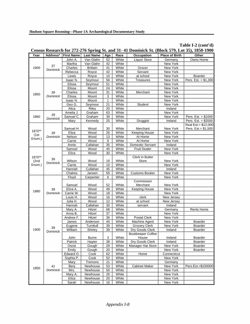
Hudson Square Rezoning—Phase 1A Archaeological Documentary Study
Appendix I-8
Table I-2 (cont’d)Census Research for 272-276 Spring St. and 31- 41 Dominick St. (Block 579, Lot 35), 1850-1900Year Address* First Name Last Name Age Race Occupation Place of Birth Other
1900 37
Dominick
John A. Van Glahn 52 White Liquor Store Germany Owns Home Martha Van Glahn 42 White New York Charles Brittain 41 White Grocer New York Rebecca Royce 42 White Servant New York
Lewis Royce 10 White at school New York Boarder
1850 39
Dominick
Isaac N. Seymour 56 White Treasures New York Pers. Est. = $1,300Elissa Seymour 51 White New York Elissa Mount 24 White New York
Charles Mount 31 White Merchant New York Elissa Mount 3 White New York
Isaac N. Mount 1 White New York Geo G. Seymour 21 White Student New York Alica Riley 20 White Ireland
1860 39
Dominick
Amelia J. Graham 63 White New York Samuel C. Graham 39 White New York Pers. Est. = $1000
Mary Kennedy 25 White Druggist Ireland Pers. Est. = $2000
1870** (1st
Enum.)
39 Dominick
Samuel H. Wood 30 White Merchant New York Real Est.= $12,000Pers. Est.= $1,500
Eliza Wood 26 White Keeping House New York Nelson Wood 13 White At Home New York Carrie Wood 9 White At Home New York Annie Callahan 35 White Domestic Servant Ireland
1870** (2nd
Enum.)
39 Dominick
Samuel Wood 40 White Fruit Dealer New York Eliza Wood 30 White New York
Wilson Wood 16 White Clerk in Butter
Store New York Carrie Wood 10 White New York
Hannah Cullahan 45 White Ireland Chalres Jansen 55 White Customs Booker New York
1880 39
Dominick
Floyd Carpenter 6 White New York
Samuel Wood 52 White Commission
Merchant New York Eliza A. Wood 49 White Keeping House New York
Carrie W. Wood 18 White New York Louis H. Wood 16 White clerk New Jersey Julia H. Wood 12 White at school New Jersey Hannah Callahan 30 White servant Ireland
1900 39
Dominick
Mary A. Hitzel 68 White Germany Rents Home Anna B. Hitzel 37 White New York
Andrew F. Hitzel 36 White Postal Clerk New York James Anderson 40 White Machine Agent New York Boarder Eugene Turnbull 39 White Grocery Clerk New York Boarder William Shirley 39 White Dry Goods Clerk Ireland Boarder
John Burns 3 White Bookkeeper Coffee
House Ireland Boarder Patrick Hayter 38 White Dry Goods Clerk Ireland Boarder Oscie Gough 29 White Manager Hat Store New York Boarder Emily Gough 20 White New York Boarder
1850 41
Dominick
Edward O. Cook 62 White Home Connecticut Sophia P. Cook 52 White New York
Mary Tremons 21 White Germany Benj Newhouse 53 White Cabinet Maker New York Pers.Est.=$150000Mrs. Newhouse 50 White New York
Mary A. Newhouse 26 White New York Eliza Newhouse 20 White New York Sarah Newhouse 16 White New York
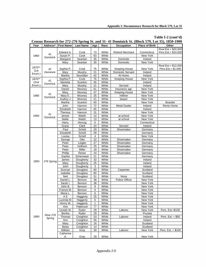
Appendix I: Documentary Research for Block 579, Lot 35
Appendix I-9
Table I-2 (cont’d)Census Research for 272-276 Spring St. and 31- 41 Dominick St. (Block 579, Lot 35), 1850-1900Year Address* First Name Last Name Age Race Occupation Place of Birth Other
1860 41
Dominick
Edward A. Cook 73 White Retired Merchant Connecticut. Real Est.= $20,000Pers.Est.= $10,000
Susan P. Cook 63 White New York Margaret Seanlan 35 White Domestic Ireland
Mary Seanlan 30 White Domestic New York
1870** (1st
Enum.)
41 Dominick
Sophia P. Cook 75 White Keeping House New York Real Est.= $12,000Pers.Est.= $1,000
Mary Murphy 21 White Domestic Servant Ireland Martha Seondlan 42 White At Home Ireland
1870** (2nd
Enum.)
41 Dominick
Sophia P. Cook 76 White Keeping House New York Marietta Scanlon 45 White Ireland
Mary Murphy 21 White Servant Ireland
1880 41
Dominick
Daniel Mooney 61 White Insurance agt. New York Mary Mooney 47 White Keeping House New York
Mary E. Mooney 25 White milliner New York Audrey J Mooney 21 White lawyer New York Martha Scanlon 60 White New York Boarder
1900 41
Dominick
John Hannon 72 White Metal Dealer Ireland Rents Home Elizabeth Hannon 65 White Ireland Theresa Hannon 31 White New York Jennie Walsh 14 White at school New York Nellie Walsh 13 White at school New York Harry Herzog 6 White Connecticut Grace Clark 24 White Servant Ireland
1850 276 Spring
Paul Schell 29 White Shoemaker Germany Elizabeth Schell 29 White Germany
Louisa Schell 4 White New York George Otts 22 White Shoemaker Germany Peter Leigter 27 White Shoemaker Germany Peter Velthem 25 White Shoemaker Germany Peter Miller 18 White Shoemaker Germany Phillip Reiser 24 White Shoemaker Germany Sophia Schemaser 21 White Germany James Dougherty 32 White Ireland Mary Dougherty 25 White Ireland John Dougherty 3 White Ireland
Duncan Douglass 80 White Carpenter Scotland Isabella Douglass 80 White Scotland
Neil Douglass 51 White None Scotland Daniel L. Benson 38 White Police Officer New York Sarah I. Benson 38 White New York John B. Benson 9 White New York
Francis M. Benson 6 White New York Maria L. Benson 6 White New York
1860 Rear 276
Spring
A E Haggerty 25 White New York Lucinda M. Haggerty 6 White New York Henry W. Haggerty 1 White New York
Ann Patterson 77 White New York Uzziah W. Ryder 29 White Laborer New York Pers. Est.=$100
Bertha Ryder 29 White Prussia Thomas Creighton 53 White Laborer Ireland Pers. Est. = $50
Ann Creighton 55 White Ireland Mary Creighton 16 White Scotland Betsy Creighton 14 White Scotland
William Gray 30 White Laborer New York Pers. Est. = $100 Catherine
A. Gray 29 White New York
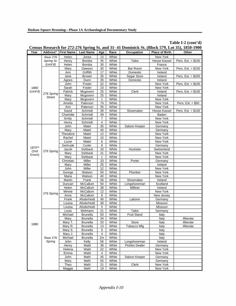
Hudson Square Rezoning—Phase 1A Archaeological Documentary Study
Appendix I-10
Table I-2 (cont’d)Census Research for 272-276 Spring St. and 31- 41 Dominick St. (Block 579, Lot 35), 1850-1900Year Address* First Name Last Name Age Race Occupation Place of Birth Other
1860 (cont’d)
Rear 276 Spring St. (cont’d)
Helen Jones 14 White New York Henry Bomba 45 White Tailor Hesse-Kassel Pers. Est. = $100 Helen Bomba 30 White France
276 Spring Street
Mary Dawson 30 White Bar Room New York Pers. Est. = $150 Ann Griffith 17 White Domestic Ireland Jane Brower 35 White Segar Store Ireland Pers. Est. = $200
Agnes Dunn 35 White Domestic Ireland John Foster 22 White New York Pers. Est. = $100 Sarah Foster 23 White New York Patrick Mcgovern 25 White Clerk Ireland Pers. Est. = $100 Mary Mcgovern 25 White Ireland Mary Mcgovern 1 White New York
Amelia Paterson 74 White New York Pers. Est. = $50 Ann Paterson 35 White New York
David Schmidt 39 White Shoemaker Hesse-Kassel Pers. Est. = $100 Charlotte Schmidt 39 White Baden
Emily Schmidt 7 White New York Henry Schmidt 4 White New York
1870** (2nd
Enum) 276 Spring
John Matel 35 White Saloon Keeper Germany Mary Matel 40 White Germany
Theodore Matel 12 White New York Rachel Matel 10 White New York Lizzie Matel 6 White New York
Gertrude Curler 8 White Germany Jacob Sshback 33 White Huckster Switzerland Mary Sshback 21 White New York Mary Sshback 1 White New York
Christian Miller 33 White Porter Germany Mary Miller 25 White Ireland John Miller 12 White New York
George Watson 50 White Plumber New York Maria Watson 40 White New York
1880
276 Spring
Martin Frank 56 White Shoemaker Ireland Duncan McCallum 50 White Longshoreman Scotland Helen McCallum 38 White Milliner Ireland Minnie McCallum 12 White New York Anne McCallum 8 White New Jersey Frank Afuderheidi 40 White Laborer Germany Louisa Afuderheidi 30 White Missouri Louisa Afuderheidi 5 White Missouri
Rear 276 Spring
Louis Welmann 21 White Tailor Germany Michael Brunella 50 White Fruit Stand Italy
Mary Brunella 34 White Italy Illiterate Mary T. Brunella 20 White Store Italy Illiterate Mary R. Brunella 13 White Tobacco Mfg Italy Illiterate Mary S. Brunella 9 White Italy Mary J. Brunella 4 White Italy Michael Brunella 2m White Italy
John Kelly 56 White Longshoreman Ireland Henry Wald 38 White Pickles Dealer Germany Helena Wald 22 White New York Emma Wald 4 White New York John Mahl 45 White Saloon Keeper Germany Mary Mahl 55 White Germany Theo Mahl 21 White Clerk New York
Maggie Mahl 19 White New York

Appendix I: Documentary Research for Block 579, Lot 35
Appendix I-11
Table I-2 (cont’d)Census Research for 272-276 Spring St. and 31- 41 Dominick St. (Block 579, Lot 35), 1850-1900Year Address* First Name Last Name Age Race Occupation Place of Birth Other
1900 276 Spring
Street
Phillip Kramer 31 White Saloon Keeper Brazil Maria D. Kramer 29 White Portugal
Alfred Kramer 4 White Brazil Theresa Kramer 4 White Brazil
Leonor Kramer
5 mont
hs White New York Charles Smith 24 White Bartender Germany
Charles E. Kohler 37 White Cook Switzerland
1850 274 Spring
Street
John Douglass 45 White ?? Merchant New York Catherine Douglass 36 White New York
John Douglass 17 White New York Eugene Douglass 14 White New York Edward Douglass 13 White New York Charles Douglass 10 White New York George Douglass 8 White New York Amelia Douglass 6 White New York Oscar Douglass 3 White New York Walter Douglass 1 White New York Sarah Margaret 19 White Ireland
John H. Davids 71 White Collector Pennsylvania Mary Davids 64 White New Jersey
William Davids 32 White Hatter New York Emiline Davids 21 White New York Henry Davids 30 White New York
Rittenhouse Davids 27 White New York
Caroline Davids 20 White New York
1860 274 Spring
Street
John Aherm 51 White Clerk in Register's Ofc New York Pers. Est. = $300 Elizabeth Aherm 41 White New Jersey Frederick
W. Aherm 6 White New York Sarah Price 21 White New York David Carmicke 26 White Clerk New York Pers. Est. = $250 Ann Carmicke 24 White New York Jane Carmicke 14 White New York Ann Carmicke 31/2 White New York
Clara Denison 20 White New York
1870** (2nd
Enum)
274 Spring Street
George Mack 46 White Shoemaker Germany Mary Mack 42 White Germany
Pauline Mack 19 White Germany Maria Reau 58 White House Keeper Ireland Louis Reau 32 White New York Ellen Reau 26 White New York Frank Smith 33 White Type Setter Germany Julia Smith 28 White New York Julia Smith 6 White New York
Minnie Smith 4 White New York Catharine Smith 2 White New Jersey
John Franklin 30 White Brick Mover Canada Eliza Franklin 32 White Canada Cleva Franklin 4 White New York Mary Frazer 42 White Virginia Mary Frazer 18 White New Jersey
Archibald Frazer 15 White New York Frances Frazer 12 White New York
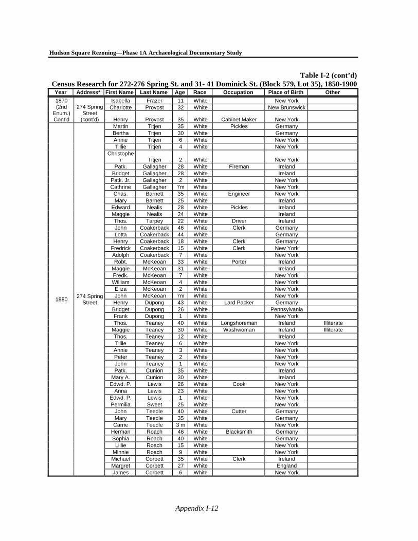
Hudson Square Rezoning—Phase 1A Archaeological Documentary Study
Appendix I-12
Table I-2 (cont’d)Census Research for 272-276 Spring St. and 31- 41 Dominick St. (Block 579, Lot 35), 1850-1900Year Address* First Name Last Name Age Race Occupation Place of Birth Other
1870 (2nd
Enum.) Cont’d
274 Spring Street
(cont’d)
Isabella Frazer 11 White New York Charlotte Provost 32 White New Brunswick
Henry Provost 35 White Cabinet Maker New York
1880 274 Spring
Street
Martin Titjen 35 White Pickles Germany Bertha Titjen 30 White Germany Annie Titjen 6 White New York Tillie Titjen 4 White New York
Christopher Titjen 2 White New York
Patk. Gallagher 28 White Fireman Ireland Bridget Gallagher 28 White Ireland Patk. Jr. Gallagher 2 White New York Cathrine Gallagher 7m White New York
Chas. Barnett 35 White Engineer New York Mary Barnett 25 White Ireland
Edward Nealis 28 White Pickles Ireland Maggie Nealis 24 White Ireland Thos. Tarpey 22 White Driver Ireland John Coakerback 46 White Clerk Germany Lotta Coakerback 44 White Germany Henry Coakerback 18 White Clerk Germany
Fredrick Coakerback 15 White Clerk New York Adolph Coakerback 7 White New York Robt. McKeoan 33 White Porter Ireland
Maggie McKeoan 31 White Ireland Fredk. McKeoan 7 White New York William McKeoan 4 White New York Eliza McKeoan 2 White New York John McKeoan 7m White New York Henry Dupong 43 White Lard Packer Germany Bridget Dupong 26 White Pennsylvania Frank Dupong 1 White New York Thos. Teaney 40 White Longshoreman Ireland Illiterate
Maggie Teaney 30 White Washwoman Ireland Illiterate Thos. Teaney 12 White Ireland Tillie Teaney 6 White New York Annie Teaney 3 White New York Peter Teaney 2 White New York John Teaney 1 White New York Patk. Cunion 35 White Ireland
Mary A. Cunion 30 White Ireland Edwd. P. Lewis 26 White Cook New York
Anna Lewis 23 White New York Edwd. P. Lewis 1 White New York Permilia Sweet 25 White New York
John Teedle 40 White Cutter Germany Mary Teedle 35 White Germany Carrie Teedle 3 m White New York
Herman Roach 46 White Blacksmith Germany Sophia Roach 40 White Germany
Lillie Roach 15 White New York Minnie Roach 9 White New York Michael Corbett 35 White Clerk Ireland Margret Corbett 27 White England James Corbett 6 White New York
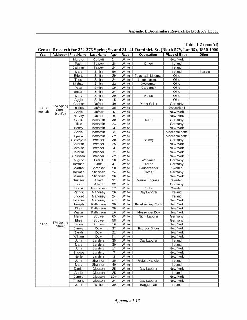
Appendix I: Documentary Research for Block 579, Lot 35
Appendix I-13
Table I-2 (cont’d)Census Research for 272-276 Spring St. and 31- 41 Dominick St. (Block 579, Lot 35), 1850-1900Year Address* First Name Last Name Age Race Occupation Place of Birth Other
1880 (cont’d)
274 Spring Street
(cont’d)
Margret Corbett 2m White New York Patk. Tarpey 28 White Driver Ireland
Cathrine Tarpey 24 White Ireland Mary Smith 56 White Ireland Illiterate
Edwd. Smith 29 White Telegraph Lineman Ohio Thos. Smith 24 White Longshoreman Ohio
Michael Smith 22 White Oysterman Ohio Peter Smith 19 White Carpenter Ohio Susan Smith 24 White Ohio Mary Smith 20 White Nurse Ohio Aggie Smith 15 White Ohio
George Dufner 49 White Paper Seller Germany Rosina Dufner 38 White Switzerland Annie Dufner 5 White New York
Harvey Dufner 6 White New York Chas. Kattstein 30 White Tailor Germany Tillie Kattstein 24 White Germany
Bettsy Kattstein 4 White New York Annie Kattstein 2 White Massachusetts Lyman Kattstein 7m White Massachusetts
Christopher Webber 30 White Bakery Germany Cathrine Webber 25 White New York Caroline Webber 4 White New York Cathrine Webber 2 White New York Christian Webber 2m White New York August Fritzel 18 White Workman Germany
1900 274 Spring
Street
Herman Grote 47 White Tailor Germany Martha Soransan 50 White Housekeeper Sweden Herman Stichweh 24 White Grocer Germany Maurie Stichweh 26 White New York
Gustave Albert 31 White Marine Engineer Sweden Louisa Albert 32 White Germany John A. Augustison 17 White Sailor Sweden Patrick Mahoney 26 White Day Laborer Ireland Bridget Mahoney 24 White Ireland
Johanna Mahoney 9m White New York Joseph Pelletreun 20 White Bookkeeping Clerk New York Ellen Pelletreun 38 White New York
Walter Pelletreun 16 White Messenger Boy New York Henry Struwe 65 White Night Laborer Germany Elise Struwe 58 White Germany Lizzie Struwe 16 White New York James Dow 23 White Express Driver New York Sarah Dow 22 White New York
William Dow 7m White New York John Landers 35 White Day Laborer Ireland Mary Landers 39 White Ireland John Landers 13 White New York
Bridget Landers 7 White New York Nellie Landers 3 White New York John Shannon 35 White Freight Handler Ireland Mary Shannon 40 White Ireland
Daniel Gleason 25 White Day Laborer New York Annie Gleason 25 White Ireland James Gleason 10m White New York
Timothy Gleason 24 White Day Laborer New York John White 30 White Baggerman Ireland
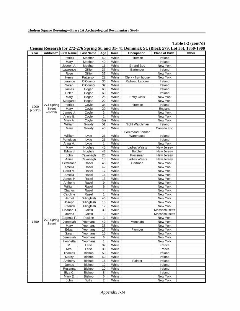
Hudson Square Rezoning—Phase 1A Archaeological Documentary Study
Appendix I-14
Table I-2 (cont’d)Census Research for 272-276 Spring St. and 31- 41 Dominick St. (Block 579, Lot 35), 1850-1900Year Address* First Name Last Name Age Race Occupation Place of Birth Other
1900 (cont’d)
274 Spring Street
(cont’d)
Patrick Meehan 40 White Fireman Ireland Mary Meehan 40 White Ireland
Joseph A. Meehan 16 White Errand Boy New York Lawrence Gillier 37 White Bartender Ireland
Rose Gillier 33 White New York Henry Patterson 22 White Clerk - fruit house New York
Lerance O'Connor 30 White Railroad Laborer Ireland Sarah O'Connor 32 White Ireland James Hogan 60 White Ireland Helen Hogan 60 White Ireland Mary Hogan 25 White Entry Clerk New York
Margaret Hogan 22 White New York Patrick Coyle 34 White Fireman Ireland Mary Coyle 29 White England
James J. Coyle 3 White New York Annie E. Coyle 1 White New York Mary A. Coyle 6m White New York William Gowdy 51 White Night Watchman Ireland Mary Gowdy 40 White Canada Eng
William Lytle 26 White Foremand Bonded
Warehouse Ireland Penelope Lytle 26 White Ireland Anna M. Lytle 1 White New York
Mary Hughes 45 White Ladies Waists New Jersey Edward Hughes 43 White Butcher New Jersey
John Cavanagh 20 White Pressman New Jersey Annie Cavanagh 18 White Ladies Waists New Jersey
1850 272 Spring
Street
Ferdinand Rasel 46 White Cartman New York Amelia Rasel 42 White New York
Harrit M. Rasel 17 White New York Amelia Rasel 15 White New York
James H Rasel 13 White New York Anthony Rasel 9 White New York William Rasel 6 White New York Charles Rasel 4 White New York Caroline Rasel 1 White New York Harriet Dillinglash 45 White New York Joseph Dillinglash 15 White New York Fredrick Dillinglash 12 White New York
Eleanor H. Griffin 39 White Massachusetts Martha Griffin 19 White Massachusetts
Eugenia F. Pauline 3 White New York Jeremiah Yeomans 49 White Merchant New York
Mary Yeomans 33 White New York Edgar Yeomans 17 White Plumber New York Sarah Yeomans 15 White New York
Jeremiah Yeomans 6 White New York Henrietta Yeomans 1 White New York
M. Leise 37 White France Mrs. Leise 30 White France
Thomas Bishop 50 White Ireland Marcy Bishop 40 White Ireland
Anthony Bishop 15 White Painter Ireland James Bishop 12 White Ireland
Rosanna Bishop 10 White Ireland Elza C. Bishop 8 White Ireland Mary E. Bishop 6 White New York
John Wills 2 White New York
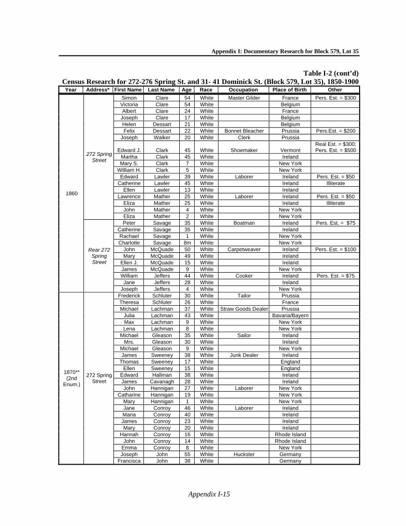
Appendix I: Documentary Research for Block 579, Lot 35
Appendix I-15
Table I-2 (cont’d)Census Research for 272-276 Spring St. and 31- 41 Dominick St. (Block 579, Lot 35), 1850-1900Year Address* First Name Last Name Age Race Occupation Place of Birth Other
1860
272 Spring Street
Simon Clare 54 White Master Gilder France Pers. Est. = $300 Victoria Clare 54 White Belgium Albert Clare 24 White France
Joseph Clare 17 White Belgium Helen Dessart 21 White Belgium Felix Dessart 22 White Bonnet Bleacher Prussia Pers.Est. = $200
Joseph Walker 20 White Clerk Prussia
Edward J. Clark 45 White Shoemaker Vermont Real Est. = $300; Pers. Est. = $500
Martha Clark 45 White Ireland Mary S. Clark 7 White New York
William H. Clark 5 White New York Edward Lawler 39 White Laborer Ireland Pers. Est. = $50
Catherine Lawler 45 White Ireland Illiterate Ellen Lawler 13 White Ireland
Lawrence Mather 25 White Laborer Ireland Pers. Est. = $50 Eliza Mather 25 White Ireland Illiterate John Mather 4 White New York Eliza Mather 2 White New York
Rear 272 Spring Street
Peter Savage 35 White Boatman Ireland Pers. Est. = $75 Catherine Savage 35 White Ireland Rachael Savage 1 White New York Charlotte Savage 8m White New York
John McQuade 50 White Carpetweaver Ireland Pers. Est. = $100 Mary McQuade 49 White Ireland
Ellen J. McQuade 15 White Ireland James McQuade 9 White New York William Jeffers 44 White Cooker Ireland Pers. Est. = $75 Jane Jeffers 28 White Ireland
Joseph Jeffers 4 White New York
1870** (2nd
Enum.)
272 Spring Street
Frederick Schluter 30 White Tailor Prussia Theresa Schluter 26 White France Michael Lachman 37 White Straw Goods Dealer Prussia
Julia Lachman 43 White Bavaria/Bayern Max Lachman 9 White New York Lena Lachman 8 White New York
Michael Gleason 35 White Sailor Ireland Mrs. Gleason 30 White Ireland
Michael Gleason 9 White New York James Sweeney 38 White Junk Dealer Ireland
Thomas Sweeney 17 White England Ellen Sweeney 15 White England
Edward Hallman 38 White Ireland James Cavanagh 28 White Ireland John Hannigan 27 White Laborer New York
Catharine Hannigan 19 White New York Mary Hannigan 1 White New York Jane Conroy 46 White Laborer Ireland Maria Conroy 40 White Ireland James Conroy 23 White Ireland Mary Conroy 20 White Ireland
Hannah Conroy 16 White Rhode Island John Conroy 14 White Rhode Island
Emma Conroy 8 White New York Joseph John 55 White Huckster Germany
Francisca John 38 White Germany
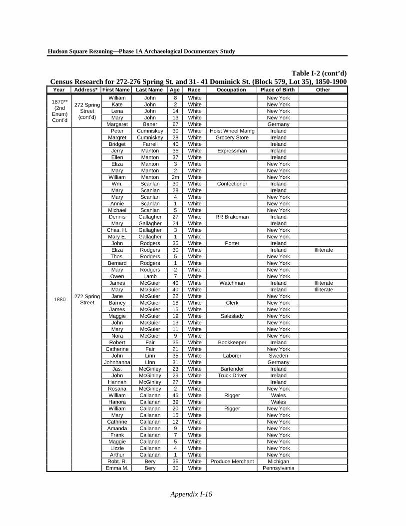
Hudson Square Rezoning—Phase 1A Archaeological Documentary Study
Appendix I-16
Table I-2 (cont’d)Census Research for 272-276 Spring St. and 31- 41 Dominick St. (Block 579, Lot 35), 1850-1900Year Address* First Name Last Name Age Race Occupation Place of Birth Other
1870** (2nd
Enum) Cont’d
272 Spring Street
(cont’d)
William John 8 White New York Kate John 2 White New York Lena John 14 White New York Mary John 13 White New York
Margaret Baner 67 White Germany
1880 272 Spring
Street
Peter Cumniskey 30 White Hoist Wheel Manfg Ireland Margret Cumniskey 28 White Grocery Store Ireland Bridget Farrell 40 White Ireland Jerry Manton 35 White Expressman Ireland Ellen Manton 37 White Ireland Eliza Manton 3 White New York Mary Manton 2 White New York
William Manton 2m White New York Wm. Scanlan 30 White Confectioner Ireland Mary Scanlan 28 White Ireland Mary Scanlan 4 White New York Annie Scanlan 1 White New York
Michael Scanlan 5 White New York Dennis Gallagher 27 White RR Brakeman Ireland Mary Gallagher 24 White Ireland
Chas. H. Gallagher 3 White New York Mary E. Gallagher 1 White New York
John Rodgers 35 White Porter Ireland Eliza Rodgers 30 White Ireland Illiterate Thos. Rodgers 5 White New York
Bernard Rodgers 1 White New York Mary Rodgers 2 White New York Owen Lamb 7 White New York James McGuier 40 White Watchman Ireland Illiterate Mary McGuier 40 White Ireland Illiterate Jane McGuier 22 White New York
Barney McGuier 18 White Clerk New York James McGuier 15 White New York Maggie McGuier 19 White Saleslady New York
John McGuier 13 White New York Mary McGuier 11 White New York Nora McGuier 9 White New York
Robert Fair 35 White Bookkeeper Ireland Catherine Fair 21 White New York
John Linn 35 White Laborer Sweden Johnhanna Linn 31 White Germany
Jas. McGinley 23 White Bartender Ireland John McGinley 29 White Truck Driver Ireland
Hannah McGinley 27 White Ireland Rosana McGinley 2 White New York William Callanan 45 White Rigger Wales Hanora Callanan 39 White Wales William Callanan 20 White Rigger New York Mary Callanan 15 White New York
Cathrine Callanan 12 White New York Amanda Callanan 9 White New York
Frank Callanan 7 White New York Maggie Callanan 5 White New York Lizzie Callanan 4 White New York Arthur Callanan 1 White New York
Robt. R. Bery 35 White Produce Merchant Michigan Emma M. Bery 30 White Pennsylvania
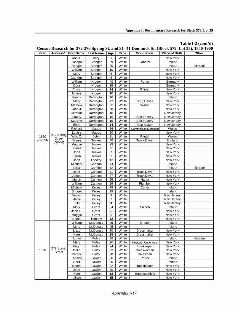
Appendix I: Documentary Research for Block 579, Lot 35
Appendix I-17
Table I-2 (cont’d)Census Research for 272-276 Spring St. and 31- 41 Dominick St. (Block 579, Lot 35), 1850-1900Year Address* First Name Last Name Age Race Occupation Place of Birth Other
1880 (cont’d)
272 Spring Street
(cont’d)
Ann A. Bery 1 White New York Joseph Stringer 39 White Laborer Ireland Bridget Stringer 36 White Ireland Illiterate William Stringer 10 White New York Mary Stringer 8 White New York
Cathrine Stringer 6 White New York William Kruger 40 White Porter Germany Dora Kruger 39 White Germany Chas. Kruger 14 White Printer New York Minnie Kruger 10 White New York Fanny Dorrington 46 White Ireland Mary Dorrington 23 White Drug House New York
Mathew Dorrington 22 White Waiter New York John J. Dorrington 20 White New York
Cathrine Dorrington 18 White New Jersey Fanny Dorrington 16 White Salt Factory New Jersey
Margret Dorrington 15 White Salt Factory New Jersey Ellen Dorrington 14 White Cap Maker New Jersey
Richard Maggs 36 White Commission Merchant Wales Louisa Maggs 30 White New York Wm. C. John 21 White Printer Wales James Tucker 40 White Truck Driver England Maggie Tucker 29 White New York James Tucker 8 White New York John Tucker 7 White New York Sarah Tucker 1 White New York John Falvery 12 White New York
Michael Cannon 74 White Ireland Eliza Cannon 72 White Ireland Illiterate John Cannon 31 White Truck Driver New York
James Cannon 27 White Truck Driver New York Martin Cannon 25 White Hatter New York William Cannon 29 White Plumber New York Michael Kelley 29 White Cutter Ireland Bridget Kelley 29 White Ireland Susan Kelley 9 White New Jersey Mable Kelley 7 White New Jersey Lulu Kelley 4 White New Jersey Mary Grant 34 White Saloon Ireland
John H. Grant 5 White New York Maggie Grant 3 White New York James Tomany 13 White New York
1900 272 Spring
Street
William McDonald 45 White Grocer Ireland Mary McDonald 45 White Ireland Lizze McDonald 20 White Dressmaker New York Kate McDonald 18 White Dressmaker New York Annie Foley 50 White Ireland Illiterate Mary Foley 26 White Designer-Underwear New York Hugh Foley 24 White Bookeeper New York Delia Foley 22 White Saleswoman New York
Patrick Foley 20 White Salesman New York Thomas Lawler 50 White Porter Ireland
Nora Lawler 50 White Ireland Mamie Lawler 22 White Bookbinder New York John Lawler 20 White New York Kate Lawler 18 White Handkerchiefs New York Lillian Lawler 15 White New York
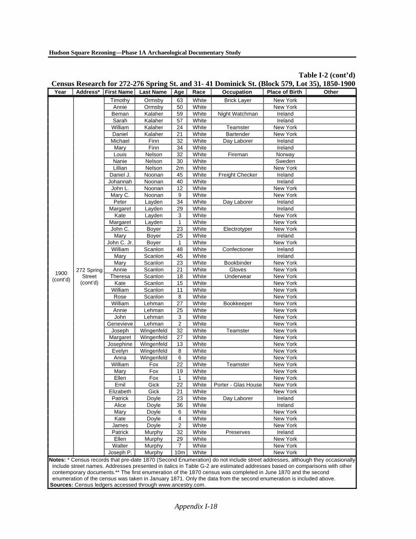
Hudson Square Rezoning—Phase 1A Archaeological Documentary Study
Appendix I-18
Table I-2 (cont’d)Census Research for 272-276 Spring St. and 31- 41 Dominick St. (Block 579, Lot 35), 1850-1900Year Address* First Name Last Name Age Race Occupation Place of Birth Other
1900 (cont’d)
272 Spring Street
(cont’d)
Timothy Ormsby 63 White Brick Layer New York Annie Ormsby 50 White New York
Beman Kalaher 59 White Night Watchman Ireland Sarah Kalaher 57 White Ireland
William Kalaher 24 White Teamster New York Daniel Kalaher 21 White Bartender New York
Michael Finn 32 White Day Laborer Ireland Mary Finn 34 White Ireland Louis Nelson 32 White Fireman Norway Nanie Nelson 30 White Sweden Lillian Nelson 2m White New York
Daniel J. Noonan 45 White Freight Checker Ireland Johannah Noonan 40 White Ireland
John L. Noonan 12 White New York Mary C. Noonan 9 White New York
Peter Layden 34 White Day Laborer Ireland Margaret Layden 29 White Ireland
Kate Layden 3 White New York Margaret Layden 1 White New York John C. Boyer 23 White Electrotyper New York
Mary Boyer 25 White Ireland John C. Jr. Boyer 1 White New York
William Scanlon 48 White Confectioner Ireland Mary Scanlon 45 White Ireland Mary Scanlon 23 White Bookbinder New York Annie Scanlon 21 White Gloves New York
Theresa Scanlon 18 White Underwear New York Kate Scanlon 15 White New York
William Scanlon 11 White New York Rose Scanlon 8 White New York
William Lehman 27 White Bookkeeper New York Annie Lehman 25 White New York John Lehman 3 White New York
Genevieve Lehman 2 White New York Joseph Wingenfeld 32 White Teamster New York
Margaret Wingenfeld 27 White New York Josephine Wingenfeld 13 White New York
Evelyn Wingenfeld 8 White New York Anna Wingenfeld 6 White New York
William Fox 22 White Teamster New York Mary Fox 19 White New York Ellen Fox 1 White New York Emil Gick 22 White Porter - Glas House New York
Elizabeth Gick 21 White New York Patrick Doyle 23 White Day Laborer Ireland Alice Doyle 36 White Ireland Mary Doyle 6 White New York Kate Doyle 4 White New York
James Doyle 2 White New York Patrick Murphy 32 White Preserves Ireland Ellen Murphy 29 White New York
Walter Murphy 7 White New York Joseph P. Murphy 10m White New York
Notes: * Census records that pre-date 1870 (Second Enumeration) do not include street addresses, although they occasionally include street names. Addresses presented in italics in Table G-2 are estimated addresses based on comparisons with other contemporary documents.** The first enumeration of the 1870 census was completed in June 1870 and the second enumeration of the census was taken in January 1871. Only the data from the second enumeration is included above.
Sources: Census ledgers accessed through www.ancestry.com.

Appendix I: Documentary Research for Block 579, Lot 35
Appendix I-19
Table I-3Historic Directory Entries for 272-276 Spring St. and 31-41 Dominick St. (Block 579, Lot 35)
Year Last Name First Name Occupation Address Home Address Historic Lot1822 Broad Amos 232 Spring 15 1823 Carroll John S. Musician 232 Spring 15 1824 Robinson Joseph 232 Spring 15 1826 Robinson Joseph 232 Spring 15 1826 Roobb Mary Antoinette 232 Spring 15 1826 Robb widow 232 Spring 15 1828 Armour John Painter 244 Spring 15 1830 Lozier & Main John Lastmakers 244 Spring 15 1831 Dubois Martin carpenter 244 Spring 15 1831 Norton Nathaniel 244 Spring 15 1833 Norton Nathaniel 244 Spring 15 1833 Deshays David Painter Rear 244 Spring 1834 Fenn Jacob and Martin Whipmakers 244 Spring 15 1834 Fenn Julia teacher 244 Spring 15 1834 Fenn Thomas J. whipmaker 244 Spring 15 1835 Crawford Peter Printer 22 Wall 244 Spring 1835 Bloodgood Sally Widow of Daniel Rear 244 Spring 15 1835 Tyler Samuel Marshal 244 Spring 15 1835 Malia John Upholsterer 244 Spring 15 1836 Grant Stephen carter 244 Spring 15 1836 Tyler Samuel Marshal 244 Spring 15 1836 Crawford Peter Printer 420 Broadway 244 Spring 1837 Jaques Abraham 244 Spring 15 1839 Zimmerman Mary Widow of Peter 244 Spring 15 1840 Orrell Edward reedmaker 244 Spring 15 1841 Bridle George shoemaker 244 Spring 15 1842 Fieldston Armistead reedmaker 244 Spring 15 1842 Vanriper Jacob Carpenter 244 Spring 15 1842 Guy Jacob shoemaker 244 Spring 15 1842 Prusretz Frederick Rear 244 Spring 15 1842 Youmans Jeremiah carman 244 Spring 15 1843 Schnapp Ernst Musician r. 244 Spring 15 1843 Griggs Hannah widow r. 244 Spring 15 1843 Guy Jacob shoemaker 244 Spring 15 1843 Bloodgood Sarah Widow of Daniel Rear 244 Spring 15 1844 Griggs Huldah widow r. 244 Spring 15 1844 Guy Jacob shoemaker 244 Spring 15 1845 Youmans Jeremiah carman 244 Spring 15 1845 Rabel Ferdinand saddler 244 Spring 15 1845 Griggs Huldah widow r. 244 Spring 15 1845 Guy Jacob shoemaker 244 Spring 15 1845 Sammet John A. Sugar refiner r. 244 Spring 15 1846 Lanigan Bridget 244 Spring 15 1846 Guy Jacob Boots 244 Spring 15 1846 West William H. Fish 244 Spring 15 1846 Happel George Bootmaker 244 Spring 15 1846 Youmans Jeremiah carman 244 Spring 15 1847 Youmans Jeremiah carman 244 Spring 15 1847 Bishop Thomas Laborer r. 244 Spring 15 1847 Griggs Huldah widow r. 244 Spring 15 1848 Douglass Duncan 276 Spring 15 1851 Bishop Catharine rear 276 Spring 15 1852 Bishop Catharine rear 276 Spring 15 1853 Bishop Anthony laborer r. 464 Wash. r. 276 Spring 15 1853 Douglas Isabella wid. Duncan 276 Spring 15 1853 Schell Paul bootmaker 276 Spring 276 Spring 15 1853 Schell Paul 276 Spring 15 1853 Wiber Frederick rear 276 Spring 15
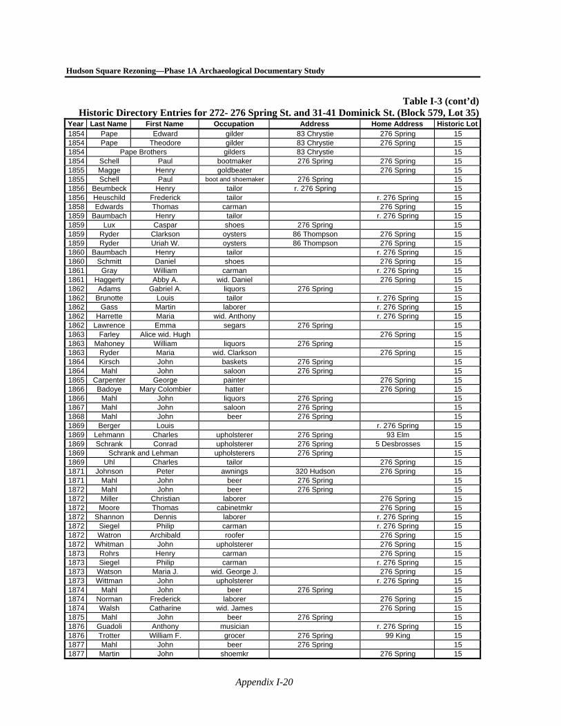
Hudson Square Rezoning—Phase 1A Archaeological Documentary Study
Appendix I-20
Table I-3 (cont’d)Historic Directory Entries for 272- 276 Spring St. and 31-41 Dominick St. (Block 579, Lot 35)
Year Last Name First Name Occupation Address Home Address Historic Lot1854 Pape Edward gilder 83 Chrystie 276 Spring 15 1854 Pape Theodore gilder 83 Chrystie 276 Spring 15 1854 Pape Brothers gilders 83 Chrystie 15 1854 Schell Paul bootmaker 276 Spring 276 Spring 15 1855 Magge Henry goldbeater 276 Spring 15 1855 Schell Paul boot and shoemaker 276 Spring 15 1856 Beumbeck Henry tailor r. 276 Spring 15 1856 Heuschild Frederick tailor r. 276 Spring 15 1858 Edwards Thomas carman 276 Spring 15 1859 Baumbach Henry tailor r. 276 Spring 15 1859 Lux Caspar shoes 276 Spring 15 1859 Ryder Clarkson oysters 86 Thompson 276 Spring 15 1859 Ryder Uriah W. oysters 86 Thompson 276 Spring 15 1860 Baumbach Henry tailor r. 276 Spring 15 1860 Schmitt Daniel shoes 276 Spring 15 1861 Gray William carman r. 276 Spring 15 1861 Haggerty Abby A. wid. Daniel 276 Spring 15 1862 Adams Gabriel A. liquors 276 Spring 15 1862 Brunotte Louis tailor r. 276 Spring 15 1862 Gass Martin laborer r. 276 Spring 15 1862 Harrette Maria wid. Anthony r. 276 Spring 15 1862 Lawrence Emma segars 276 Spring 15 1863 Farley Alice wid. Hugh 276 Spring 15 1863 Mahoney William liquors 276 Spring 15 1863 Ryder Maria wid. Clarkson 276 Spring 15 1864 Kirsch John baskets 276 Spring 15 1864 Mahl John saloon 276 Spring 15 1865 Carpenter George painter 276 Spring 15 1866 Badoye Mary Colombier hatter 276 Spring 15 1866 Mahl John liquors 276 Spring 15 1867 Mahl John saloon 276 Spring 15 1868 Mahl John beer 276 Spring 15 1869 Berger Louis r. 276 Spring 15 1869 Lehmann Charles upholsterer 276 Spring 93 Elm 15 1869 Schrank Conrad upholsterer 276 Spring 5 Desbrosses 15 1869 Schrank and Lehman upholsterers 276 Spring 15 1869 Uhl Charles tailor 276 Spring 15 1871 Johnson Peter awnings 320 Hudson 276 Spring 15 1871 Mahl John beer 276 Spring 15 1872 Mahl John beer 276 Spring 15 1872 Miller Christian laborer 276 Spring 15 1872 Moore Thomas cabinetmkr 276 Spring 15 1872 Shannon Dennis laborer r. 276 Spring 15 1872 Siegel Philip carman r. 276 Spring 15 1872 Watron Archibald roofer 276 Spring 15 1872 Whitman John upholsterer 276 Spring 15 1873 Rohrs Henry carman 276 Spring 15 1873 Siegel Philip carman r. 276 Spring 15 1873 Watson Maria J. wid. George J. 276 Spring 15 1873 Wittman John upholsterer r. 276 Spring 15 1874 Mahl John beer 276 Spring 15 1874 Norman Frederick laborer 276 Spring 15 1874 Walsh Catharine wid. James 276 Spring 15 1875 Mahl John beer 276 Spring 15 1876 Guadoli Anthony musician r. 276 Spring 15 1876 Trotter William F. grocer 276 Spring 99 King 15 1877 Mahl John beer 276 Spring 15 1877 Martin John shoemkr 276 Spring 15
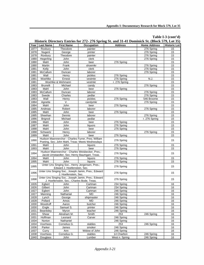
Appendix I: Documentary Research for Block 579, Lot 35
Appendix I-21
Table I-3 (cont’d)Historic Directory Entries for 272- 276 Spring St. and 31-41 Dominick St. (Block 579, Lot 35)
Year Last Name First Name Occupation Address Home Address Historic Lot1877 Roxbury Theodore painter 276 Spring 15 1878 Nugent George printer 276 Spring 15 1878 Roxbury Theodore painter 276 Spring 15 1880 Hegerling John clerk 276 Spring 15 1880 Mahl John beer 276 Spring 15 1880 Martin Frank shoemkr 276 Spring 15 1881 Kelly John clerk 276 Spring 15 1881 McCallum Duncan laborer 276 Spring 15 1881 Wall Henry pickles 276 Spring 15 1881 Woehlke Ernest vestmkr 276 Spring N.J. 15 1881 Woehlke & Wehmann vestmkr r. 276 Spring 15 1883 Brunelli Michael candy 276 Spring 15 1883 Mahl John beer 276 Spring 15 1883 McCallum Duncan laborer 276 Spring 15 1883 Swede Charles pedlar 276 Spring 15 1883 Wall Henry pickles 276 Spring 546 Broome 15 1884 Agnette V. candymkr 276 Spring 15 1884 Mahl John beer 276 Spring 15 1885 Andreas Robert laborer 276 Spring 15 1885 Mahl John beer 276 Spring 15 1885 Sheehan Dennis laborer 276 Spring 15 1886 Brignoli Michael pedlar r. 276 Spring 15 1886 Mahl John beer 276 Spring 15 1887 Mahl John liquors 276 Spring 15 1888 Mahl John beer 276 Spring 15 1888 Schwartz Henry laborer 276 Spring 15 1889 Mahl John beer 276 Spring 15
1890 Hudson Maennerchor - Charles Furrer, Pres; William Poeting, Sec; John Mahl, Treas: Meets Wednesdays
276 Spring
15
1891 Mahl John liquors 276 Spring 15 1893 Mahl John beer 276 Spring 15
1894 Hudson Maennerchor - Charles Weisbecker, Pres.; Jacob Umstaedter, Sec; Henry Baumgart, Treas.
276 Spring
15
1894 Mahl John liquors 276 Spring 15 1895 Mahl John liquors 276 Spring 15
1895 Unter Uns Singing Soc., Henry Jergensen, Pres.;
Edward J. Hoellenstein, Sec. 276 Spring
15
1896 Unter Uns Singing Soc., Joseph Jamin, Pres.; Edward
J. Hoellenstein, Sec. 276 Spring
15
1898 Unter Uns Singing Soc., Joseph Jamin, Pres.; Edward
J. Hoellenstein, Sec.; Charles Bode, Treas. 276 Spring
15
1826 Egbert John Cartman 234 Spring 16 1826 Gilbert John Cartman 234 Spring 16 1827 Egbert John Cartman 246 Spring 16 1827 Manning Nathanial MD 246 Spring 16 1828 Lynch George shipmaster 246 Spring 16 1828 Pollard Amos MD 246 Spring 16 1830 Woodruff Aaron butcher 246 Spring 16 1830 Engle Samuel S. printer 246 Spring 16 1831 Beardsley Myron teacher 246 Spring 16 1831 Shear Abraham M. Smith 253 246 Spring 16 1831 Hoffman Leonard Carver 246 Spring 16 1834 Norton Nathaniel 246 Spring 16 1834 Voorhees Cornelius G. stables 253 246 Spring 16 1836 Parker James smoker 246 Spring 16 1837 Curry Ann Widow of John 246 Spring 16 1838 Voorhees Cornelius G. stables 14 Charlton 246 Spring 16 1840 Douglass John Lumber West n. Spring 246 Spring 16

Hudson Square Rezoning—Phase 1A Archaeological Documentary Study
Appendix I-22
Table I-3 (cont’d)Historic Directory Entries for 272- 276 Spring St. and 31-41 Dominick St. (Block 579, Lot 35)
Year Last Name First Name Occupation Address Home Address Historic Lot1841 Hill Warren Musical inst. Maker 246 Spring 16 1842 Derby Erasmus 246 Spring 16 1842 David John H. Money collector 246 Spring 16 1842 Douglass John Lumber 319 West 246 Spring 16 1843 Derby Erasmus painter 246 Spring 16 1845 Steritt William Painter 246 Spring 16 1845 David John H. collector 246 Spring 16 1846 Douglass John Lumber 317 West 246 Spring 16 1847 David David Silversmith 8 Little Green 246 Spring 16 1847 David John H. collector 246 Spring 16 1848 David Henry silversmith 47 Dey 274 Spring 16 1848 David John H. collector 274 Spring 16 1848 Hamel Octavius J. L. jeweller 274 Spring 16 1849 David Henry silversmith 8 Liberty pl. 274 Spring 16 1849 David John H. collector 274 Spring 16 1849 David William P. hats 274 Spring 16 1853 Ahern John clerk 274 spring 16 1853 Dominge Paul E., Jr. 154 Greenwich 274 Spring 16 1853 Douglass John D. lumber 817 West 274 Spring 16 1854 Ahern John clerk 274 Spring 16 1854 Douglass John D. lumber 317 West 274 Spring 16 1854 Douglass John, Jr. lumber 274 Spring 16 1854 Douglass John, Jr. lumber 274 Spring 16
1855 Ahern John Commissioners of
Deeds 274 Spring & 2 Hall of
Records 16
1856 Ahern John Commissioners of Deeds
274 Spring & 2 Hall of Records
16
1858 Ahern John Commissioners of Deeds
274 Spring & 2 Hall of Records
16
1861 Cormac David clerk 274 Spring 16
1862 Ahern John Commissioner of Deeds & notary
public 2 Hall of Records 274 Spring 16
1862 Brown George B. clerk 274 Spring 16
1863 Ahern John Commissioner of Deeds & notary public 2 Hall of Records 274 Spring 16
1864 Ahern John Commissioner of Deeds & notary public 2 Hall of Records 274 Spring 16
1864 Scott George W. weigher 274 Spring 16 1865 Ahern John com'r 2 Hall of Records 274 Spring 16 1866 Ahern John clerk Hall of Records 274 Spring 16 1866 Ahern John notary 274 Spring 16 1867 Ahern John clerk 274 Spring 16 1867 Ahern John commr 274 Spring 16 1868 Ackerman Ellen wid. Geo., bdgh. 274 Spring 16 1869 Mack George shoes 274 Spring 16 1869 Waters John clerk 274 Spring 16 1870 Behn Maria wid. Stephen 274 Spring 16 1870 Mack George shoes 274 Spring 16 1871 Bain Maria wid. Stephen 274 Spring 16 1871 Franklin John mason 274 Spring 16 1872 Franklin John mason 274 Spring 16 1872 Kerrigan Michael driver 274 Spring 16 1872 Provo Henry laborer 274 Spring 16 1872 Schmidt Frederick printer 274 Spring 16 1872 Zorn Joseph vendor 276 Spring 274 Spring 16 1874 Holtz Robert framer 274 Spring 16 1874 McGrath Hugh laborer 274 Spring 16 1874 Molka Adolph porter 274 Spring 16
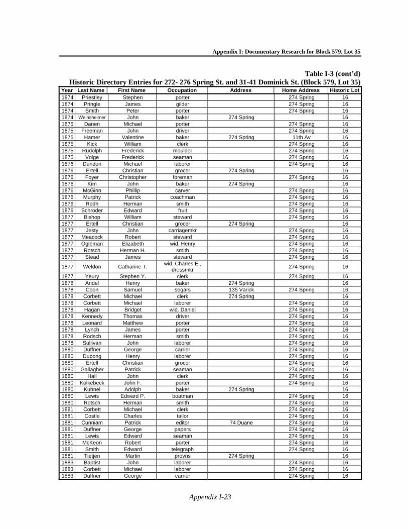
Appendix I: Documentary Research for Block 579, Lot 35
Appendix I-23
Table I-3 (cont’d)Historic Directory Entries for 272- 276 Spring St. and 31-41 Dominick St. (Block 579, Lot 35)
Year Last Name First Name Occupation Address Home Address Historic Lot1874 Priestley Stephen porter 274 Spring 16 1874 Pringle James gilder 274 Spring 16 1874 Smith Peter porter 274 Spring 16 1874 Weinsheimer John baker 274 Spring 16 1875 Danen Michael porter 274 Spring 16 1875 Freeman John driver 274 Spring 16 1875 Hamer Valentine baker 274 Spring 11th Av 16 1875 Kick William clerk 274 Spring 16 1875 Rudolph Frederick moulder 274 Spring 16 1875 Volge Frederick seaman 274 Spring 16 1876 Dundon Michael laborer 274 Spring 16 1876 Ertell Christian grocer 274 Spring 16 1876 Foyer Christopher foreman 274 Spring 16 1876 Kim John baker 274 Spring 16 1876 McGinn Phillip carver 274 Spring 16 1876 Murphy Patrick coachman 274 Spring 16 1876 Rodh Herman smith 274 Spring 16 1876 Schroder Edward fruit 274 Spring 16 1877 Bishop William steward 274 Spring 16 1877 Ertell Christian grocer 274 Spring 16 1877 Jesty John carriagemkr 274 Spring 16 1877 Meacock Robert steward 274 Spring 16 1877 Ogleman Elizabeth wid. Henry 274 Spring 16 1877 Rotsch Herman H. smith 274 Spring 16 1877 Stead James steward 274 Spring 16
1877 Weldon Catharine T. wid. Charles E.,
dressmkr 274 Spring 16
1877 Yeury Stephen Y. clerk 274 Spring 16 1878 Andel Henry baker 274 Spring 16 1878 Coon Samuel segars 135 Varick 274 Spring 16 1878 Corbett Michael clerk 274 Spring 16 1878 Corbett Michael laborer 274 Spring 16 1878 Hagan Bridget wid. Daniel 274 Spring 16 1878 Kennedy Thomas driver 274 Spring 16 1878 Leonard Matthew porter 274 Spring 16 1878 Lynch James porter 274 Spring 16 1878 Rodsch Herman smith 274 Spring 16 1878 Sullivan John laborer 274 Spring 16 1880 Duffner George carrier 274 Spring 16 1880 Dupong Henry laborer 274 Spring 16 1880 Ertell Christian grocer 274 Spring 16 1880 Gallagher Patrick seaman 274 Spring 16 1880 Hall John clerk 274 Spring 16 1880 Kolkebeck John F. porter 274 Spring 16 1880 Kuhnel Adolph baker 274 Spring 16 1880 Lewis Edward P. boatman 274 Spring 16 1880 Rotsch Herman smith 274 Spring 16 1881 Corbett Michael clerk 274 Spring 16 1881 Costle Charles tailor 274 Spring 16 1881 Cunniam Patrick editor 74 Duane 274 Spring 16 1881 Duffner George papers 274 Spring 16 1881 Lewis Edward seaman 274 Spring 16 1881 McKeon Robert porter 274 Spring 16 1881 Smith Edward telegraph 274 Spring 16 1881 Tietjen Martin provns 274 Spring 16 1883 Baptist John laborer 274 Spring 16 1883 Corbett Michael laborer 274 Spring 16 1883 Duffner George carrier 274 Spring 16
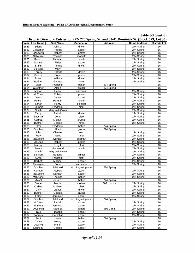
Hudson Square Rezoning—Phase 1A Archaeological Documentary Study
Appendix I-24
Table I-3 (cont’d)Historic Directory Entries for 272- 276 Spring St. and 31-41 Dominick St. (Block 579, Lot 35)
Year Last Name First Name Occupation Address Home Address Historic Lot1883 Edens John V. driver 274 Spring 16 1883 Gallagher Patrick laborer 274 Spring 16 1883 McKeown Robert porter 274 Spring 16 1883 O'Rourke Thomas shoemkr 274 Spring 16 1883 Rotsch Herman smith 274 Spring 16 1883 Schmitt Philip laborer 274 Spring 16 1883 Smith Thomas driver 274 Spring 16 1883 Sullivan Mary 274 Spring 16 1883 Tarpey Patrick driver 274 Spring 16 1884 Baptist John porter 274 Spring 16 1884 Butler William driver 274 Spring 16 1884 Duffner George news 274 Spring 16 1884 Elter Frederick baker 274 Spring 16 1884 Guenther Albert grocer 274 Spring 16 1884 Mason Henry watchman 274 Spring 16 1884 McCune Robert porter 274 Spring 16 1884 Oates James laborer 274 Spring 16 1884 Rotsch Herman smith 274 Spring 16 1884 Schar Henry polisher 274 Spring 16 1884 Shubert Frederick clerk 274 Spring 16 1884 Smith Mary wid. Owen 274 Spring 16 1884 Tarpy Patrick driver 274 Spring 16 1885 Baptiste John clerk 274 Spring 16 1885 Corbett Michael foreman 274 Spring 16 1885 Duffner George news 274 Spring 16 1885 Elter Frederick baker 274 Spring 16 1885 Gunther Albert grocer 274 Spring 16 1885 John Charles artist 274 Spring 16 1885 May Jacob tailor 274 Spring 16 1885 McCallum Duncan seaman 274 Spring 16 1885 McKeon Robert porter 274 Spring 16 1885 Murray Henry H. clerk 274 Spring 16 1885 Roach Hammond smith 274 Spring 16 1885 Smith Mary wid. Owen 274 Spring 16 1885 Sullivan Eugene printer 274 Spring 16 1886 Ayres Frederick clerk 274 Spring 16 1886 Corbett Michael laborer 274 Spring 16 1886 Finnegan John carpenter 274 Spring 16 1886 Gunther Adelheid wid. August, grocer 274 Spring 16 1886 Kennan Robert packer 274 Spring 16 1886 McCallum Duncan laborer 274 Spring 16 1886 McShane Thomas baker 274 Spring 16 1886 Mickel John G. baker 274 Spring 16 1886 Stone Morris clothier 307 Hudson 274 Spring 16 1887 Corbett Michael clerk 274 Spring 16 1887 Daly James driver 274 Spring 16 1887 Duffner George carrier 274 Spring 16 1887 Foley Jeremiah laborer 274 Spring 16 1887 Gunther Adelheid wid. August, grocer 274 Spring 16 1887 McCann Patrick laborer 274 Spring 16 1887 Moriarty Jeremiah laborer 274 Spring 16 1887 O'Connell Frank D. liquors 593 Canal 274 Spring 16 1887 Tate Joseph laborer 274 Spring 16 1887 Twomey Cornelius laborer 274 Spring 16 1887 Zeni Louis baker 274 Spring 16 1888 Calvin Henry laborer 274 Spring 16 1888 Dowling Martin laborer 274 Spring 16 1888 Kennedy George laborer 274 Spring 16
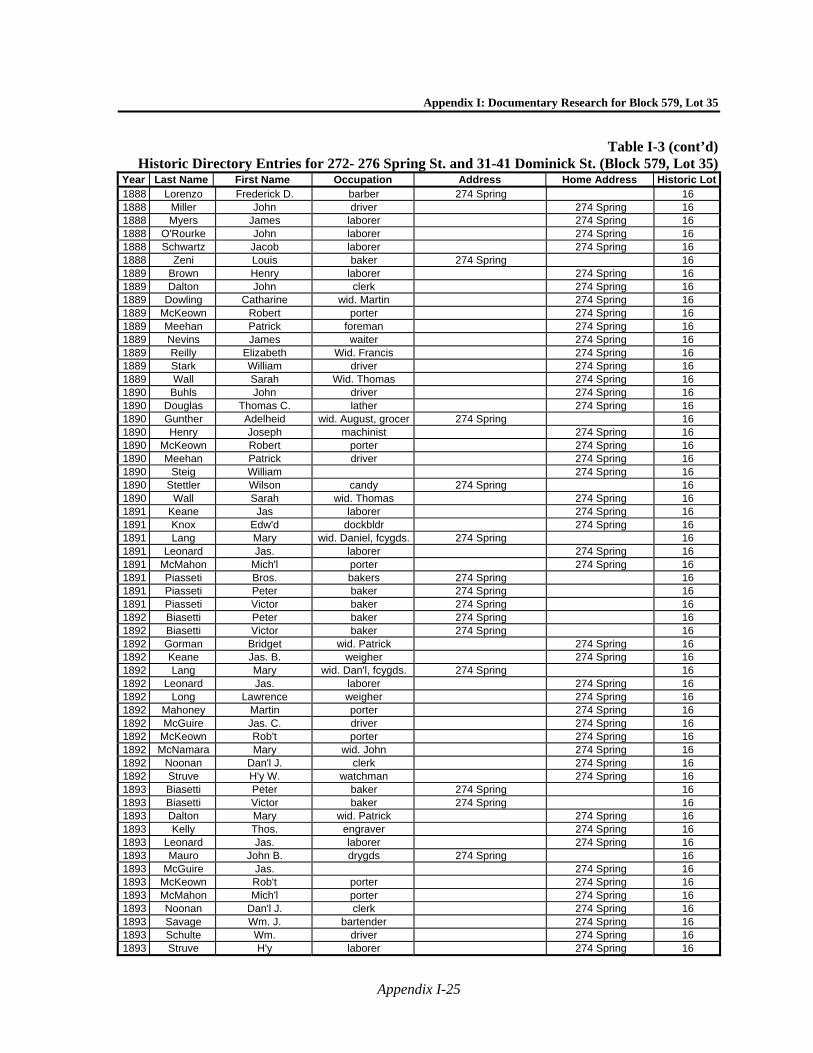
Appendix I: Documentary Research for Block 579, Lot 35
Appendix I-25
Table I-3 (cont’d)Historic Directory Entries for 272- 276 Spring St. and 31-41 Dominick St. (Block 579, Lot 35)
Year Last Name First Name Occupation Address Home Address Historic Lot1888 Lorenzo Frederick D. barber 274 Spring 16 1888 Miller John driver 274 Spring 16 1888 Myers James laborer 274 Spring 16 1888 O'Rourke John laborer 274 Spring 16 1888 Schwartz Jacob laborer 274 Spring 16 1888 Zeni Louis baker 274 Spring 16 1889 Brown Henry laborer 274 Spring 16 1889 Dalton John clerk 274 Spring 16 1889 Dowling Catharine wid. Martin 274 Spring 16 1889 McKeown Robert porter 274 Spring 16 1889 Meehan Patrick foreman 274 Spring 16 1889 Nevins James waiter 274 Spring 16 1889 Reilly Elizabeth Wid. Francis 274 Spring 16 1889 Stark William driver 274 Spring 16 1889 Wall Sarah Wid. Thomas 274 Spring 16 1890 Buhls John driver 274 Spring 16 1890 Douglas Thomas C. lather 274 Spring 16 1890 Gunther Adelheid wid. August, grocer 274 Spring 16 1890 Henry Joseph machinist 274 Spring 16 1890 McKeown Robert porter 274 Spring 16 1890 Meehan Patrick driver 274 Spring 16 1890 Steig William 274 Spring 16 1890 Stettler Wilson candy 274 Spring 16 1890 Wall Sarah wid. Thomas 274 Spring 16 1891 Keane Jas laborer 274 Spring 16 1891 Knox Edw'd dockbldr 274 Spring 16 1891 Lang Mary wid. Daniel, fcygds. 274 Spring 16 1891 Leonard Jas. laborer 274 Spring 16 1891 McMahon Mich'l porter 274 Spring 16 1891 Piasseti Bros. bakers 274 Spring 16 1891 Piasseti Peter baker 274 Spring 16 1891 Piasseti Victor baker 274 Spring 16 1892 Biasetti Peter baker 274 Spring 16 1892 Biasetti Victor baker 274 Spring 16 1892 Gorman Bridget wid. Patrick 274 Spring 16 1892 Keane Jas. B. weigher 274 Spring 16 1892 Lang Mary wid. Dan'l, fcygds. 274 Spring 16 1892 Leonard Jas. laborer 274 Spring 16 1892 Long Lawrence weigher 274 Spring 16 1892 Mahoney Martin porter 274 Spring 16 1892 McGuire Jas. C. driver 274 Spring 16 1892 McKeown Rob't porter 274 Spring 16 1892 McNamara Mary wid. John 274 Spring 16 1892 Noonan Dan'l J. clerk 274 Spring 16 1892 Struve H'y W. watchman 274 Spring 16 1893 Biasetti Peter baker 274 Spring 16 1893 Biasetti Victor baker 274 Spring 16 1893 Dalton Mary wid. Patrick 274 Spring 16 1893 Kelly Thos. engraver 274 Spring 16 1893 Leonard Jas. laborer 274 Spring 16 1893 Mauro John B. drygds 274 Spring 16 1893 McGuire Jas. 274 Spring 16 1893 McKeown Rob't porter 274 Spring 16 1893 McMahon Mich'l porter 274 Spring 16 1893 Noonan Dan'l J. clerk 274 Spring 16 1893 Savage Wm. J. bartender 274 Spring 16 1893 Schulte Wm. driver 274 Spring 16 1893 Struve H'y laborer 274 Spring 16

Hudson Square Rezoning—Phase 1A Archaeological Documentary Study
Appendix I-26
Table I-3 (cont’d)Historic Directory Entries for 272- 276 Spring St. and 31-41 Dominick St. (Block 579, Lot 35)
Year Last Name First Name Occupation Address Home Address Historic Lot1894 Biasetti Peter baker 274 Spring 16 1894 Flannigan Patrick laborer 274 Spring 16 1894 Mauro John B. drygds 274 Spring 16 1894 McKeown Rob't porter 274 Spring 16 1894 Meehan Patrick foreman 274 Spring 16 1894 Noonan Dan'l J. clerk 274 Spring 16 1894 Reaney Thos. porter 274 Spring 16 1894 Savage Wm. bartender 274 Spring 16 1894 Struwe H'y W. laborer 274 Spring 16 1895 Bernstein Benj. drygds 274 Spring 16 1895 Biasetti Peter baker 274 Spring 16 1895 Curtin Jas driver 274 Spring 16 1895 Fawcett Mary wid. Thos. 274 Spring 16 1895 Garity Edw'd fireman 274 Spring 16 1895 Gerrity Edw'd laborer 274 Spring 16 1895 Guenther Adelheid wid. Albert A.,grocer 274 Spring 16 1895 Johnson Emil laborer 274 Spring 16 1895 Kelly Patrick 274 Spring 16 1895 Kelly Thos. E engraver 274 Spring 16 1895 Looney Jas express 64 Broad 274 Spring 16 1895 Meehan Patrick driver 274 Spring 16 1895 Morrissey Jane wid. Jeremiah 274 Spring 16 1895 Noonan Dan'l J. clerk 274 Spring 16 1895 Ralihan Jas. laborer 274 Spring 16 1895 Reaney Thos. clerk 274 Spring 16 1895 Sexton Edw'd cutter 274 Spring 16 1895 Struwe H'y laborer 274 Spring 16 1895 Toormey Walter J. driver 274 Spring 16 1897 Coyle Patrick engineer 274 Spring 16 1897 Coyle Patrick tender 274 Spring 16 1897 Curtin Jas. driver 274 Spring 16 1897 Garrity Edw'd P. oiler 274 Spring 16 1897 Johnson Gustave engineer 274 Spring 16 1897 Looney Jas. express 64 Broad 274 Spring 16 1897 Morrissey Timothy driver 274 Spring 16 1897 Struwe H'y clerk 274 Spring 16 1898 Biasetti Peter baker 274 Spring 280 Spring 16 1898 Gowdey Wm. watchman 274 Spring 16 1898 Reilhan Jas. T. watchman 274 Spring 16 1898 Schwab Matilda grocer 274 Springer 16 1898 Stricker Gustav O. molder 274 Spring 16 1898 Struwe H'y W. 274 Spring 16 1899 Biasetti Peter baker 274 Spring 280 Spring 16 1899 Coyle Patrick moulder 274 Spring 16 1899 Relihan Jas. watchman 274 Spring 16 1900 Biasetti Peter baker 274 Spring 16 1900 Grote Herman tailor 274 Spring 16 1900 Johnson Guatav A. engineer 274 Spring 16 1900 Lytle Wm. foreman 274 Spring 16 1900 Stichweh Herman grocer 274 Spring 16 1900 Struwe Hy paver 274 Spring 16 1821 Bloomer James waterman 236 Spring 17 1821 Douglas Duncan Carpenter 236 Spring 17 1822 Harrison Samuel M. Mason Rear 236 Spring 17 1825 Myers John Mason 236 Spring 17 1830 Hovey Aaron Mason Rear 248 Spring 17 1830 Riker Sarah Widow of Peter 248 Spring 17 1830 Meeks Ann Widow of Peter 248 Spring 17
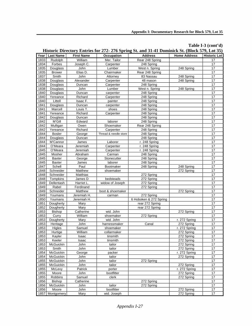
Appendix I: Documentary Research for Block 579, Lot 35
Appendix I-27
Table I-3 (cont’d)Historic Directory Entries for 272- 276 Spring St. and 31-41 Dominick St. (Block 579, Lot 35)
Year Last Name First Name Occupation Address Home Address Historic Lot1833 Rudolph William Mer. Tailor Rear 248 Spring 17 1834 Forbes Joseph C. Carpenter 248 Spring 17 1835 Douglass John Lumber West n. Spring 248 Spring 17 1835 Brower Elias D. Chairmaker Rear 248 Spring 17 1837 Smith John Attorney 83 Nassau 248 Spring 17 1838 Douglass Alexander Carpenter 48 mason 248 Spring 17 1838 Douglass Duncan Carpenter 248 Spring 17 1838 Douglass John Lumber West n. Spring 248 Spring 17 1840 Douglass Duncan carpenter 248 Spring 17 1840 Yereance Richard Carpenter 248 Spring 17 1840 Littell Isaac F. painter 248 Spring 17 1841 Douglass Duncan carpenter 248 Spring 17 1841 Marcell Louis T. shoes 248 Spring 17 1841 Yereance Richard Carpenter 248 Spring 17 1842 Douglass Duncan 248 Spring 17 1842 M’Gill Edward laborer 248 Spring 17 1842 Mulligan Owen Shoemaker Rear 248 Spring 17 1842 Yereance Richard Carpenter 248 Spring 17 1844 Bosler George Thread & needle store 248 Spring 17 1844 Douglass Duncan 248 Spring 17 1844 M’Cannor James Laborer r. 248 Spring 17 1844 O’Meara Jeremiah Carpenter r. 248 Spring 17 1845 O’Meara Jeremiah Carpenter r. 248 Spring 17 1845 Mosher Abraham Carman 248 Spring 17 1845 Baxter George Stonecutter 248 Spring 17 1845 Baxter James laborer 248 Spring 17 1847 Schell Paul Bootmaker 248 Spring 248 Spring 17 1848 Schneider Matthew shoemaker 272 Spring 17 1848 Schneider Matthias 272 Spring 17 1848 Tompkins James D bedsteads 272 Spring 17 1849 Dellentash Harriet L. widow of Joseph 272 Spring 17 1849 Rabel Ferdinand 272 Spring 17 1849 Schneider Matthew boot & shoemaker 272 Spring 17 1849 Youmans Jeremiah H. carman 272 Spring 17 1850 Youmans Jeremiah H. 6 Hoboken & 272 Spring 17 1851 Dougherty Mary rear 272 Spring 17 1852 Dougherty Mary rear 272 Spring 17 1853 Bishop Catherine wid. John 272 Spring 17 1853 Curry William shoemaker 272 Spring 17 1853 Dougherty Mary wid. John r. 272 Spring 17 1853 Heritage John harnessmaker Canal 272 Spring 17 1853 Higles Samuel shoemaker r. 272 Spring 17 1853 Hurtige William collarmaker 272 Spring 17 1853 Kayler Isaac tinsmith 272 Spring 17 1853 Keeler Isaac tinsmith 272 Spring 17 1853 McGuickin John tailor 272 Spring 17 1853 Smith John tailor 272 Spring 17 1854 McGuickin George packer r. 272 Spring 17 1854 McGuickin John tailor 272 Spring 17 1855 McGuickin John tailor 272 Spring 17 1855 McGuickin John tailor 272 Spring 17 1855 McLevy Patrick porter r. 272 Spring 17 1855 Moore John bootfitter 272 Spring 17 1855 Robbins Samuel clerk 272 Spring 17 1856 Bishop Catherine 272 Spring 17 1856 McGuickin John tailor 272 Spring 17 1856 Moore John bootfitter 272 Spring 17 1857 Montgomery Mary wid. Joseph 272 Spring 17
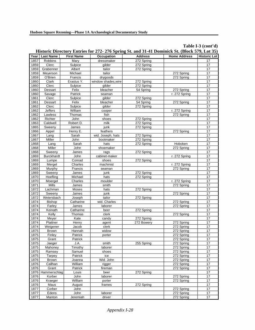
Hudson Square Rezoning—Phase 1A Archaeological Documentary Study
Appendix I-28
Table I-3 (cont’d)Historic Directory Entries for 272- 276 Spring St. and 31-41 Dominick St. (Block 579, Lot 35)
Year Last Name First Name Occupation Address Home Address Historic Lot1857 Robbins Mary dressmaker 272 Spring 17 1859 Clerc Sulpice gilder 272 Spring 17 1859 Grabenner Albert tailor 272 Spring 17 1859 Meyerson Michael tailor 272 Spring 17 1859 O'Brien Francis drygoods 272 Spring 17 1860 Clark Erastus Y. window shades,wire 272 Spring 17 1860 Clerc Sulpice gilder 272 Spring 17 1860 Dessart Felix bleacher 54 Spring 272 Spring 17 1860 Savage Patrick seaman r. 272 Spring 17 1861 Clerc Sulpice gilder 272 Spring 17 1861 Dessart Felix bleacher 54 Spring 272 Spring 17 1862 Clerc Sulpice gilder 272 Spring 17 1862 Jeffers William cooper r. 272 Spring 17 1862 Lawless Thomas fish 272 Spring 17 1862 Richter John shoes 272 Spring 17 1863 Caldwell Robert D. milk 272 Spring 17 1865 Sweeny James junk 272 Spring 17 1866 Appel Henry E. feathers 272 Spring 17 1867 Lang Sarah wid. Joseph, hats 272 Spring 17 1867 Miller John bootmaker 272 Spring 17 1868 Lang Sarah hats 272 Spring Hoboken 17 1868 Miller John shoemaker 272 Spring 17 1868 Sweeny James rags 272 Spring 17 1869 Burckhardt John cabinet-maker r. 272 Spring 17 1869 Lumpe Conrad shoes 272 Spring 17 1869 Mergel Charles machinist r. 272 Spring 17 1869 Murphy Francis seaman 272 Spring 17 1869 Sweeny James junk 272 Spring 17 1870 Hoefling Michael hats 272 Spring 17 1870 Moergel Charles moulder r. 272 Spring 17 1871 Mills James smith 272 Spring 17 1872 Lachman Moses hats 272 Spring 17 1872 Sweeny James junk 272 Spring 17 1872 Weiersbach Joseph tailor 272 Spring 17 1874 Bishop Catharine wid. Charles 272 Spring 17 1874 Farley James laborer 272 Spring 17 1874 Keinath Catharine beer 272 Spring 17 1874 Kelly Thomas clerk 272 Spring 17 1874 Meyer Kate candy 272 Spring 17 1874 Plattner Henry agent 272 Bowery 272 Spring 17 1874 Weigener Jacob clerk 272 Spring 17 1875 Brown Hannah widow 272 Spring 17 1875 Finley Patrick porter 272 Spring 17 1875 Grant Patrick 272 Spring 17 1875 Jaeger J.A. smith 255 Spring 272 Spring 17 1875 Mahoney Timothy laborer 272 Spring 17 1875 Ramsey Samuel shoes 272 Spring 17 1875 Tarpey Patrick ice 272 Spring 17 1876 Brown Joanna Wid. John 272 Spring 17 1876 Callhan William rigger 272 Spring 17 1876 Grant Patrick fireman 272 Spring 17 1876 Hammerschlag Louis beer 272 Spring 17 1876 Korber John laborer 272 Spring 17 1876 Kraeger William porter 272 Spring 17 1876 Maus August frames 272 Spring 17 1877 Corber John 272 Spring 17 1877 Edens John laborer 272 Spring 17 1877 Manton Jeremiah driver 272 Spring 17
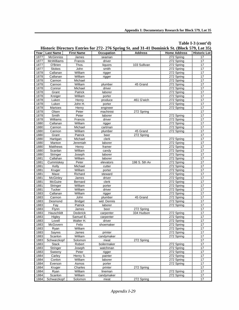
Appendix I: Documentary Research for Block 579, Lot 35
Appendix I-29
Table I-3 (cont’d)Historic Directory Entries for 272- 276 Spring St. and 31-41 Dominick St. (Block 579, Lot 35)
Year Last Name First Name Occupation Address Home Address Historic Lot1877 McGinniss James seaman 272 Spring 17 1877 McWilliams Francis driver 272 Spring 17 1877 O'Brien Thos. liquors 103 Sullivan 272 Spring 17 1877 Stokes John smith 272 Spring 17 1878 Callanan William rigger 272 Spring 17 1878 Callanan William rigger 272 Spring 17 1878 Cannon Michael 272 Spring 17 1878 Cannon William plumber 45 Grand 272 Spring 17 1878 Connor Michael driver 272 Spring 17 1878 Grant Patrick laborer 272 Spring 17 1878 Kreiger William porter 272 Spring 17 1878 Luken Henry produce 461 G'wich 272 Spring 17 1878 Luken John H. porter 272 Spring 17 1878 Martoes Henry engineer 272 Spring 17 1878 Olsen Peter machinist 272 Spring 17 1878 Smith Peter laborer 272 Spring 17 1878 Williams Francis driver 272 Spring 17 1880 Callanan William rigger 272 Spring 17 1880 Cannon Michael cartman 272 Spring 17 1880 Cannon William plumber 45 Grand 272 Spring 17 1880 Grant Patrick beer 272 Spring 17 1880 Hartigan Michael clerk 272 Spring 17 1880 Manton Jeremiah laborer 272 Spring 17 1880 Matthews Henry framer 272 Spring 17 1880 Scanlan William candy 272 Spring 17 1880 Stringer Joseph laborer 272 Spring 17 1881 Callahan William laborer 272 Spring 17 1881 Cummiskey Peter elevators 198 S. 5th Av 272 Spring 17 1881 Kelly Michael cutter 272 Spring 17 1881 Kruger William porter 272 Spring 17 1881 Maxe Richard steward 272 Spring 17 1881 McGinley James driver 272 Spring 17 1881 McGuire Bernard clerk 272 Spring 17 1881 Stringer William porter 272 Spring 17 1881 Tucker William driver 272 Spring 17 1883 Callanan William rigger 272 Spring 17 1883 Cannon John plumber 45 Grand 272 Spring 17 1883 Desmond Bridget wid. Dennis 272 Spring 17 1883 Fay Patrick laborer 272 Spring 17 1883 Flynn James beer 272 Spring 17 1883 Hauschildt Dederick carpenter 334 Hudson 272 Spring 17 1883 Higley Samuel E. carpenter 272 Spring 17 1883 Lovell Walter H. driver 272 Spring 17 1883 McGovern Felix shoemaker 272 Spring 17 1883 Ryan William 272 Spring 17 1883 Sayres James printer 272 Spring 17 1883 Scanlon William candymaker 272 Spring 17 1883 Schwarzkopf Solomon meat 272 Spring 17 1883 Stack Robert boilermaker 272 Spring 17 1883 Stringer Joseph watchman 272 Spring 17 1883 Sweeny Peter rigger 272 Spring 17 1884 Carley Henry S. painter 272 Spring 17 1884 Conlon William laborer 272 Spring 17 1884 Everson Asmos porter 272 Spring 17 1884 Kruger Charles printer 272 Spring 17 1884 Ryan William lineman 272 Spring 17 1884 Scanlon William candymaker 272 Spring 17 1884 Schwarzkopf Solomon meat 272 Spring 17
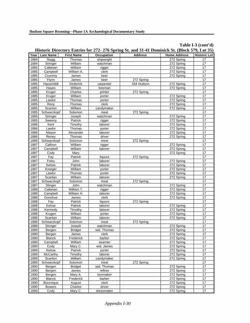
Hudson Square Rezoning—Phase 1A Archaeological Documentary Study
Appendix I-30
Table I-3 (cont’d)Historic Directory Entries for 272- 276 Spring St. and 31-41 Dominick St. (Block 579, Lot 35)
Year Last Name First Name Occupation Address Home Address Historic Lot1884 Stagg Thomas shipwright 272 Spring 17 1884 Stringer William watchman 272 Spring 17 1885 Callanan William rigger 272 Spring 17 1885 Campbell William A. clerk 272 Spring 17 1885 Crummy James beer 272 Spring 17 1885 Flynn James beer 272 Spring 17 1885 Hauschildt Dederick carpenter 334 Hudson 272 Spring 17 1885 Hayes William foreman 272 Spring 17 1885 Kruger Charles printer 272 Spring 17 1885 Kruger William porter 272 Spring 17 1885 Lawlor Thomas porter 272 Spring 17 1885 Reny Thomas clerk 272 Spring 17 1885 Scanlon William candymaker 272 Spring 17 1885 Schwarzkopf Solomon meat 272 Spring 17 1885 Stringer Joseph watchman 272 Spring 17 1885 Sweeny Patrick rigger 272 Spring 17 1886 Kent Timothy laborer 272 Spring 17 1886 Lawlor Thomas porter 272 Spring 17 1886 Mason Alexander laborer 272 Spring 17 1886 Reney Thomas driver 272 Spring 17 1886 Schwarzkopf Solomon meat 272 Spring 17 1887 Callnon William rigger 272 Spring 17 1887 Campbell William laborer 272 Spring 17 1887 Cody Mary 272 Spring 17 1887 Fay Patrick liquors 272 Spring 17 1887 Foley John laborer 272 Spring 17 1887 Kehoe Patrick laborer 272 Spring 17 1887 Kreeger William porter 272 Spring 17 1887 Lawlor Thomas porter 272 Spring 17 1887 Scanlan William laborer 272 Spring 17 1887 Schwarzkopf Solomon meat 272 Spring 17 1887 Stinger John watchman 272 Spring 17 1888 Callanan William T. rigger 272 Spring 17 1888 Campbell William H. laborer 272 Spring 17 1888 Donohue James clerk 272 Spring 17 1888 Fay Patrick liquors 272 Spring 17 1888 Kehoe Patrick laborer 272 Spring 17 1888 Kennedy Timothy laborer 272 Spring 17 1888 Krugen William porter 272 Spring 17 1888 Scanlan William laborer 272 Spring 17 1888 Schwarzkopf Solomon meat 272 Spring 17 1888 Stringer Joseph watchman 272 Spring 17 1889 Bergen Bridget wid. Thomas 272 Spring 17 1889 Bergen James clerk 272 Spring 17 1889 Blanck Frederick barber 272 Spring 17 1889 Campbell William seaman 272 Spring 17 1889 Cody Mary C. wid. James 272 Spring 17 1889 Kehoe Patrick porter 272 Spring 17 1889 McCarthy Timothy laborer 272 Spring 17 1889 Scanlon William candymaker 272 Spring 17 1889 Schwarzkopf Solomon meat 272 Spring 17 1890 Bergen Bridget wid. Thomas 272 Spring 17 1890 Bergen James refiner 272 Spring 17 1890 Bergen Mary A. boxmaker 272 Spring 17 1890 Blanck Frederick barber 272 Spring 17 1890 Bournique August clerk 272 Spring 17 1890 Bowers Charles driver 272 Spring 17 1890 Cody Mary C. dressmaker 272 Spring 17
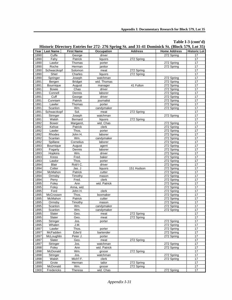
Appendix I: Documentary Research for Block 579, Lot 35
Appendix I-31
Table I-3 (cont’d)Historic Directory Entries for 272- 276 Spring St. and 31-41 Dominick St. (Block 579, Lot 35)
Year Last Name First Name Occupation Address Home Address Historic Lot1890 Cuffe George driver 272 Spring 17 1890 Fahy Patrick liquors 272 Spring 17 1890 Lawlor Thomas porter 272 Spring 17 1890 Roche Herman janitor 272 Spring 17 1890 Schwarzkopf Solomon meat 272 Spring 17 1890 Shiel Charles liquors 272 Spring 17 1890 Springer Joseph watchman 272 Spring 17 1891 Bergen Bridget wid. Thomas 272 Spring 17 1891 Bournique August manager 41 Fulton 272 Spring 17 1891 Bowie Chas driver 272 Spring 17 1891 Connell Dennis laborer 272 Spring 17 1891 Cuff George driver 272 Spring 17 1891 Cunniam Patrick journalist 272 Spring 17 1891 Lawler Thomas porter 272 Spring 17 1891 Scanlon Wm. candymaker 272 Spring 17 1891 Schwarzkopf Sol. meat 272 Spring 17 1891 Stringer Joseph watchman 272 Spring 17 1891 Walsh Bernard liquors 272 Spring 17 1892 Bower Margaret, wid. Chas 272 Spring 17 1892 Kehoe Patrick clerk 272 Spring 17 1892 Lawler Thos. porter 272 Spring 17 1892 Rhodes John H. laborer 272 Spring 17 1892 Scanlan Wm. candymaker 272 Spring 17 1892 Spillane Cornelius laborer 272 Spring 17 1893 Bournique August agent 272 Spring 17 1893 Fogarty Dennis laborer 272 Spring 17 1893 Hopkins Wm. driver 272 Spring 17 1893 Kress Fred. baker 272 Spring 17 1893 Lawlor Thos. porter 272 Spring 17 1894 Blair Rob't C. driver 272 Spring 17 1894 Cotter Jas. J liquors 151 Hudson 272 Spring 17 1894 McMahon Patrick cutter 272 Spring 17 1894 Ormsby Timothy mason 272 Spring 17 1894 Perry Fred. clerk 272 Spring 17 1895 Foley Ann wid. Patrick 272 Spring 17 1895 Foley Anna, wid. 272 Spring 17 1895 Ford John H. clerk 272 Spring 17 1895 McCrossen Thos. boxmaker 272 Spring 17 1895 McMahon Patrick cutter 272 Spring 17 1895 Ormsby Timothy mason 272 Spring 17 1895 Scanlon Wm. candymaker 272 Spring 17 1895 Scanlon Wm. candymaker 272 Spring 17 1895 Slater Geo. meat 272 Spring 17 1895 Slater Geo. meat 272 Spring 17 1895 Stringer Jos. porter 272 Spring 17 1895 Whalen J.M. 272 Spring 17 1897 Lawler Thos. porter 272 Spring 17 1897 McFadden Edw'd bartender 272 Spring 17 1897 McLoughlin Peter J. porter 272 Spring 17 1897 Slater Geo. meat 272 Spring 17 1897 Stringer Jos. watchman 272 Spring 17 1898 Foley Ann wid. Patrick 272 Spring 17 1898 McDonald Wm. grocer 272 Spring 17 1898 Stringer Jos. watchman 272 Spring 17 1898 Walsh Mich'l F. clerk 272 Spring 17 1899 Grote Herman tailor 272 Spring 17 1899 McDonald Wm. grocer 272 Spring 17 1900 Fredericks Theresa wid. Chas 272 Spring 17
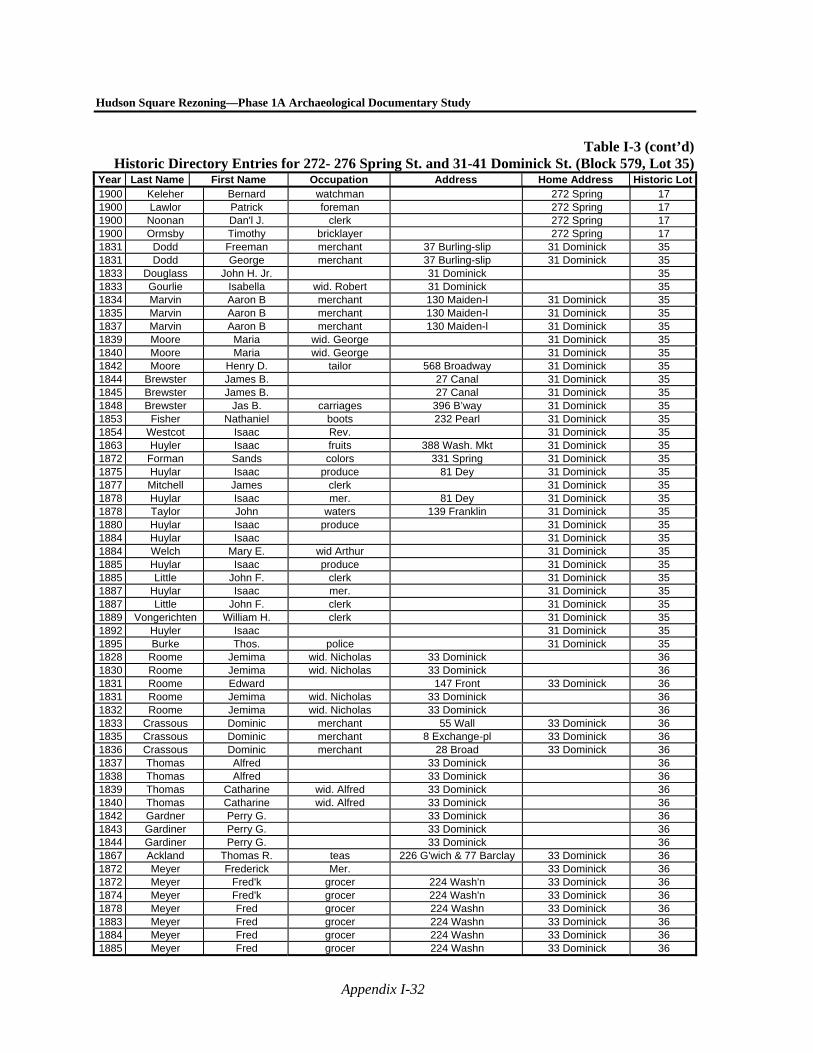
Hudson Square Rezoning—Phase 1A Archaeological Documentary Study
Appendix I-32
Table I-3 (cont’d)Historic Directory Entries for 272- 276 Spring St. and 31-41 Dominick St. (Block 579, Lot 35)
Year Last Name First Name Occupation Address Home Address Historic Lot1900 Keleher Bernard watchman 272 Spring 17 1900 Lawlor Patrick foreman 272 Spring 17 1900 Noonan Dan'l J. clerk 272 Spring 17 1900 Ormsby Timothy bricklayer 272 Spring 17 1831 Dodd Freeman merchant 37 Burling-slip 31 Dominick 35 1831 Dodd George merchant 37 Burling-slip 31 Dominick 35 1833 Douglass John H. Jr. 31 Dominick 35 1833 Gourlie Isabella wid. Robert 31 Dominick 35 1834 Marvin Aaron B merchant 130 Maiden-l 31 Dominick 35 1835 Marvin Aaron B merchant 130 Maiden-l 31 Dominick 35 1837 Marvin Aaron B merchant 130 Maiden-l 31 Dominick 35 1839 Moore Maria wid. George 31 Dominick 35 1840 Moore Maria wid. George 31 Dominick 35 1842 Moore Henry D. tailor 568 Broadway 31 Dominick 35 1844 Brewster James B. 27 Canal 31 Dominick 35 1845 Brewster James B. 27 Canal 31 Dominick 35 1848 Brewster Jas B. carriages 396 B’way 31 Dominick 35 1853 Fisher Nathaniel boots 232 Pearl 31 Dominick 35 1854 Westcot Isaac Rev. 31 Dominick 35 1863 Huyler Isaac fruits 388 Wash. Mkt 31 Dominick 35 1872 Forman Sands colors 331 Spring 31 Dominick 35 1875 Huylar Isaac produce 81 Dey 31 Dominick 35 1877 Mitchell James clerk 31 Dominick 35 1878 Huylar Isaac mer. 81 Dey 31 Dominick 35 1878 Taylor John waters 139 Franklin 31 Dominick 35 1880 Huylar Isaac produce 31 Dominick 35 1884 Huylar Isaac 31 Dominick 35 1884 Welch Mary E. wid Arthur 31 Dominick 35 1885 Huylar Isaac produce 31 Dominick 35 1885 Little John F. clerk 31 Dominick 35 1887 Huylar Isaac mer. 31 Dominick 35 1887 Little John F. clerk 31 Dominick 35 1889 Vongerichten William H. clerk 31 Dominick 35 1892 Huyler Isaac 31 Dominick 35 1895 Burke Thos. police 31 Dominick 35 1828 Roome Jemima wid. Nicholas 33 Dominick 36 1830 Roome Jemima wid. Nicholas 33 Dominick 36 1831 Roome Edward 147 Front 33 Dominick 36 1831 Roome Jemima wid. Nicholas 33 Dominick 36 1832 Roome Jemima wid. Nicholas 33 Dominick 36 1833 Crassous Dominic merchant 55 Wall 33 Dominick 36 1835 Crassous Dominic merchant 8 Exchange-pl 33 Dominick 36 1836 Crassous Dominic merchant 28 Broad 33 Dominick 36 1837 Thomas Alfred 33 Dominick 36 1838 Thomas Alfred 33 Dominick 36 1839 Thomas Catharine wid. Alfred 33 Dominick 36 1840 Thomas Catharine wid. Alfred 33 Dominick 36 1842 Gardner Perry G. 33 Dominick 36 1843 Gardiner Perry G. 33 Dominick 36 1844 Gardiner Perry G. 33 Dominick 36 1867 Ackland Thomas R. teas 226 G'wich & 77 Barclay 33 Dominick 36 1872 Meyer Frederick Mer. 33 Dominick 36 1872 Meyer Fred'k grocer 224 Wash'n 33 Dominick 36 1874 Meyer Fred'k grocer 224 Wash'n 33 Dominick 36 1878 Meyer Fred grocer 224 Washn 33 Dominick 36 1883 Meyer Fred grocer 224 Washn 33 Dominick 36 1884 Meyer Fred grocer 224 Washn 33 Dominick 36 1885 Meyer Fred grocer 224 Washn 33 Dominick 36

Appendix I: Documentary Research for Block 579, Lot 35
Appendix I-33
Table I-3 (cont’d)Historic Directory Entries for 272- 276 Spring St. and 31-41 Dominick St. (Block 579, Lot 35)
Year Last Name First Name Occupation Address Home Address Historic Lot1885 Meyer H'y L. grocer 224 Washn 33 Dominick 36 1886 Meyer Henry L. 33 Dominick 36 1887 Meyer Frederick 33 Dominick 36 1888 Meyer Henry L. shoes 589 Hudson 33 Dominick 36 1890 Meyer Frederick 33 Dominick 36 1898 Meyer Alf'd T. clerk 33 Dominick 36 1898 Meyer Fred. v. pres 115 Chambers 33 Dominick 36 1898 Meyer H'y L. clerk 33 Dominick 36 1826 Newby R.S. Merchant 113 Pearl 26 Dominick 37 1831 Avery Stephen W. M.D. 35 Dominick 37 1831 Newby Robert S merchant 35 Dominick 37 1834 Newby Robert S 35 Dominick 37 1835 Newby Robert S 35 Dominick 37 1836 Newby Robert S 35 Dominick 37 1840 Newby Robert S 35 Dominick 37 1841 Newby Robert S 35 Dominick 37 1842 Newby Robert S 35 Dominick 37 1842 Savage Isaac B. clerk 78 John 35 Dominick 37 1842 Savage Thomas importer 78 John 35 Dominick 37 1846 Newby Robert S. 35 Dominick 37 1847 Newby Robert S 35 Dominick 37 1854 Neall Jonathan R. produce 35 Dominick 37 1863 Hall Jno. C. drugs 50 Cortlandt 35 Dominick 37 1867 Hall John C. drugs 50 Cortlandt 35 Dominick 37 1868 Hall John C. drugs 50 Cortlandt 35 Dominick 37 1870 Hall John C. drugs 50 Cortlandt 35 Dominick 37 1871 Hall John C. drugs 50 Cortlandt 35 Dominick 37 1880 Hall John C. 35 Dominick 37 1883 Hall John C. 35 Dominick 37 1884 Hall John C. 35 Dominick 37 1885 Hall Aletheia wid. John C. 35 Dominick 37 1888 Hall Aletheia wid. John C. 35 Dominick 37 1891 Hall Aletheia wid. John C. 35 Dominick 37 1895 Hall Aletheia wid. John C. 35 Dominick 37 1897 Hall Aletheia wid. John C. 35 Dominick 37 1900 Hall John C. clerk 35 Dominick 37 1826 Roberts E.I. Ed. Nat. Adv. 28 Dominick 38 1827 Roberts E.J. ed. Morn. Chronicle 37 Dominick 38 1828 Piatt William F. M.D. 37 Dominick 38 1831 Hyde Zabdiel 97 Pearl 37 Dominick 38 1833 Hyde Zabdiel drygoods 97 Pearl 37 Dominick 38 1835 Hyde Zabdiel drygoods 180 Pearl 37 Dominick 38 1836 Hyde Zabdiel drygoods 180 Pearl 37 Dominick 38 1837 Martin Joseph grocer 28 1/2 Front 37 Dominick 38 1845 Martin William grocer 4 Front 37 Dominick 38 1846 Martin William grocer 4 Front 37 Dominick 38 1848 Seymour John F. crockery 63 Pearl 37 Dominick 38 1856 Seymour John F. crockery 28 Stone & 63 Pearl 37 Dominick 38 1860 Boos Gabriel frames 264 Canal 37 Dominick 38 1872 Atkinson Charles F. clerk 37 Dominick 38 1873 Atkinson Charles F. clerk 37 Dominick 38 1873 Youmans Edgar W. coal & wood Pier 42½ NR & 483 Wash'n 37 Dominick 38 1878 Atkinson Charles F. clerk 37 Dominick 38 1878 Cooper Silas B drugs 303 Hudson 37 Dominick 38 1883 Cooper Silas B drugs 303 Hudson 37 Dominick 38 1884 Cooper Silas B drugs 303 Hudson 37 Dominick 38 1885 Cooper Silas B drugs 303 Hudson 37 Dominick 38 1888 Vonglahn Wm. liquors 322 Washn 37 Dominick 38
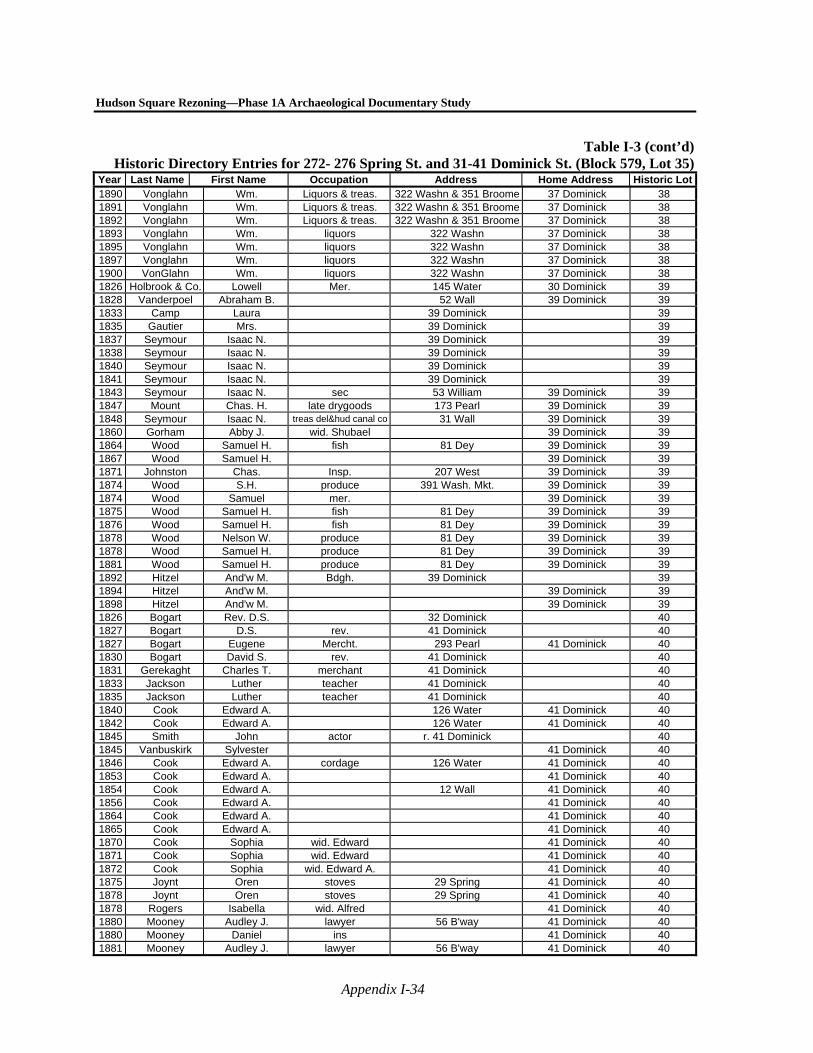
Hudson Square Rezoning—Phase 1A Archaeological Documentary Study
Appendix I-34
Table I-3 (cont’d)Historic Directory Entries for 272- 276 Spring St. and 31-41 Dominick St. (Block 579, Lot 35)
Year Last Name First Name Occupation Address Home Address Historic Lot1890 Vonglahn Wm. Liquors & treas. 322 Washn & 351 Broome 37 Dominick 38 1891 Vonglahn Wm. Liquors & treas. 322 Washn & 351 Broome 37 Dominick 38 1892 Vonglahn Wm. Liquors & treas. 322 Washn & 351 Broome 37 Dominick 38 1893 Vonglahn Wm. liquors 322 Washn 37 Dominick 38 1895 Vonglahn Wm. liquors 322 Washn 37 Dominick 38 1897 Vonglahn Wm. liquors 322 Washn 37 Dominick 38 1900 VonGlahn Wm. liquors 322 Washn 37 Dominick 38 1826 Holbrook & Co. Lowell Mer. 145 Water 30 Dominick 39 1828 Vanderpoel Abraham B. 52 Wall 39 Dominick 39 1833 Camp Laura 39 Dominick 39 1835 Gautier Mrs. 39 Dominick 39 1837 Seymour Isaac N. 39 Dominick 39 1838 Seymour Isaac N. 39 Dominick 39 1840 Seymour Isaac N. 39 Dominick 39 1841 Seymour Isaac N. 39 Dominick 39 1843 Seymour Isaac N. sec 53 William 39 Dominick 39 1847 Mount Chas. H. late drygoods 173 Pearl 39 Dominick 39 1848 Seymour Isaac N. treas del&hud canal co 31 Wall 39 Dominick 39 1860 Gorham Abby J. wid. Shubael 39 Dominick 39 1864 Wood Samuel H. fish 81 Dey 39 Dominick 39 1867 Wood Samuel H. 39 Dominick 39 1871 Johnston Chas. Insp. 207 West 39 Dominick 39 1874 Wood S.H. produce 391 Wash. Mkt. 39 Dominick 39 1874 Wood Samuel mer. 39 Dominick 39 1875 Wood Samuel H. fish 81 Dey 39 Dominick 39 1876 Wood Samuel H. fish 81 Dey 39 Dominick 39 1878 Wood Nelson W. produce 81 Dey 39 Dominick 39 1878 Wood Samuel H. produce 81 Dey 39 Dominick 39 1881 Wood Samuel H. produce 81 Dey 39 Dominick 39 1892 Hitzel And'w M. Bdgh. 39 Dominick 39 1894 Hitzel And'w M. 39 Dominick 39 1898 Hitzel And'w M. 39 Dominick 39 1826 Bogart Rev. D.S. 32 Dominick 40 1827 Bogart D.S. rev. 41 Dominick 40 1827 Bogart Eugene Mercht. 293 Pearl 41 Dominick 40 1830 Bogart David S. rev. 41 Dominick 40 1831 Gerekaght Charles T. merchant 41 Dominick 40 1833 Jackson Luther teacher 41 Dominick 40 1835 Jackson Luther teacher 41 Dominick 40 1840 Cook Edward A. 126 Water 41 Dominick 40 1842 Cook Edward A. 126 Water 41 Dominick 40 1845 Smith John actor r. 41 Dominick 40 1845 Vanbuskirk Sylvester 41 Dominick 40 1846 Cook Edward A. cordage 126 Water 41 Dominick 40 1853 Cook Edward A. 41 Dominick 40 1854 Cook Edward A. 12 Wall 41 Dominick 40 1856 Cook Edward A. 41 Dominick 40 1864 Cook Edward A. 41 Dominick 40 1865 Cook Edward A. 41 Dominick 40 1870 Cook Sophia wid. Edward 41 Dominick 40 1871 Cook Sophia wid. Edward 41 Dominick 40 1872 Cook Sophia wid. Edward A. 41 Dominick 40 1875 Joynt Oren stoves 29 Spring 41 Dominick 40 1878 Joynt Oren stoves 29 Spring 41 Dominick 40 1878 Rogers Isabella wid. Alfred 41 Dominick 40 1880 Mooney Audley J. lawyer 56 B'way 41 Dominick 40 1880 Mooney Daniel ins 41 Dominick 40 1881 Mooney Audley J. lawyer 56 B'way 41 Dominick 40

Appendix I: Documentary Research for Block 579, Lot 35
Appendix I-35
Table I-3 (cont’d)Historic Directory Entries for 272- 276 Spring St. and 31-41 Dominick St. (Block 579, Lot 35)
Year Last Name First Name Occupation Address Home Address Historic Lot1881 Mooney Daniel agent 41 Dominick 40 1883 Mooney Audley J. notary 41 Dominick 40 1883 Mooney Daniel agent 41 Dominick 40 1884 Mooney Audley J. notary 56 B'way 41 Dominick 40 1884 Mooney Daniel agent 41 Dominick 40 1885 Mooney Audley J. lawyer 56 B'way 41 Dominick 40 1885 Mooney Daniel ins 41 Dominick 40 1886 Mooney Audley J. lawyer 56 B'way 41 Dominick 40 1886 Mooney Daniel ins 41 Dominick 40 1887 Mooney Audley J. notary 56 B'way 41 Dominick 40 1887 Mooney Daniel ins 41 Dominick 40 1888 Mooney Audley J. notary 56 B'way 41 Dominick 40 1888 Mooney Daniel broker 41 Dominick 40 1889 Holton George F. seaman 41 Dominick 40 1890 Holton George F. seaman 41 Dominick 40 1895 Hannon John metals 589 G'wich 41 Dominick 40 1898 Hannon John metals 589 G'wich 41 Dominick 40 1900 Hannon John metals 589 G'wich 41 Dominick 40
Notes: Dominick Street was renumbered in 1827. Spring Street was renumbered in 1827 and again in 1848. Source: Directories accessed through www.Fold 3.com.
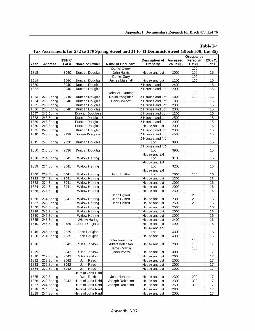
Appendix I: Documentary Research for Block 477, Lot 76
Appendix I-36
Table I-4Tax Assessments for 272 to 276 Spring Street and 31 to 41 Dominick Street (Block 579, Lot 35)
Year Address 19th C. Lot # Name of Owner Name of Occupant
Description of Property
Assessed Value ($)
Occupant's Personal
Est ($) 20th C. Lot #
1818 3040 Duncan Douglas Daniel Geery John Harris House and Lot 2000
100 100 15
1819 3040 Duncan Douglas Daniel Gury
James Marshall House and Lot 2200 100 100 15
1820 3040 Duncan Douglas 2 Houses and Lot 2400 15 1822 3040 Duncan Douglas 2 Houses and Lot 2000 15
1823 236 Spring 3040 Duncan Douglas John W. Hortons David Vangilder 2 Houses and Lot 1800
100 100 15
1824 236 Spring 3040 Duncan Douglas Henry Wilcox 2 Houses and Lot 1800 100 15 1825 236 Spring Duncan Douglas 2 Houses and Lot 2000 15 1826 236 Spring 3040 Duncan Douglas 2 Houses and Lot 2000 15 1827 248 Spring Duncan Douglass 2 Houses and Lot 2200 15 1828 248 Spring Duncan Douglass 2 Houses and Lot 2500 15 1829 248 Spring Duncan Douglass 2 Houses and Lot 2000 15 1830 248 Spring Duncan Douglass House and Lot 2000 15 1835 248 Spring Duncan Douglas 2 Houses and Lot 2300 15 1840 248 Spring 2328 Dunkin Douglass 2 Houses and Lot 4500 15
1845 248 Spring 2328 Duncan Douglas 2 Houses and 4/5
Lot 3900 15
1850 276 Spring 2036 Duncan Douglas 2 Houses and 4/5
Lot 3900 15
1818 234 Spring 3041 Widow Herring House and 3/4
Lot 3100 16
1819 234 Spring 3041 Widow Herring House and 3/4
Lot 3200 16
1820 234 Spring 3041 Widow Herring John Shelton House and 3/4
Lot 2800 100 16 1822 234 Spring 3041 Widow Herring House and Lot 2200 16 1823 234 Spring 3041 Widow Herring House and Lot 2000 16 1824 234 Spring 3041 Widow Herring House and Lot 2000 16 1825 234 Spring Widow Herring House and Lot 2300 16
1826 234 Spring 3041 Widow Herring John Egbert John Gilbert House and Lot 2300
200 200 16
1827 246 Spring Widow Herring John Egbert House and Lot 2500 200 16 1828 246 Spring Widow Herring House and Lot 2500 16 1829 246 Spring Widow Herring House and Lot 2000 16 1830 246 Spring Widow Herring House and Lot 2000 16 1835 246 Spring Widow Haring House and Lot 2400 16 1840 246 Spring 2329 John Douglass House and Lot 4900 16
1845 246 Spring 2329 John Douglas House and 4/5
Lot 4300 16 1850 274 Spring 2035 John Douglas House and Lot 4300 16
1818 3042 Silas Parklow John Vanander Albert Robinson House and Lot 2800
100 100 17
1819 3042 Silas Parklow James Martin John Myers House and Lot 3000
100 100 17
1820 232 Spring 3042 Silas Parklow House and Lot 2600 17 1822 232 Spring 3042 John Reed House and Lot 2000 17 1823 232 Spring 3042 John Reed House and Lot 2000 17 1824 232 Spring 3042 John Reed House and Lot 2000 17
1825 232 Spring Heirs of John Reid
Wm. Robb John Hendrick House and Lot 2300 200 17 1826 232 Spring 3042 Heirs of John Reid Joseph Robinson House and Lot 2300 300 17 1827 244 Spring Heirs of John Reid Joseph Robinson House and Lot 2500 300 17 1828 244 Spring Heirs of John Reid House and Lot 2800 17 1829 244 Spring Heirs of John Reid House and Lot 2000 17
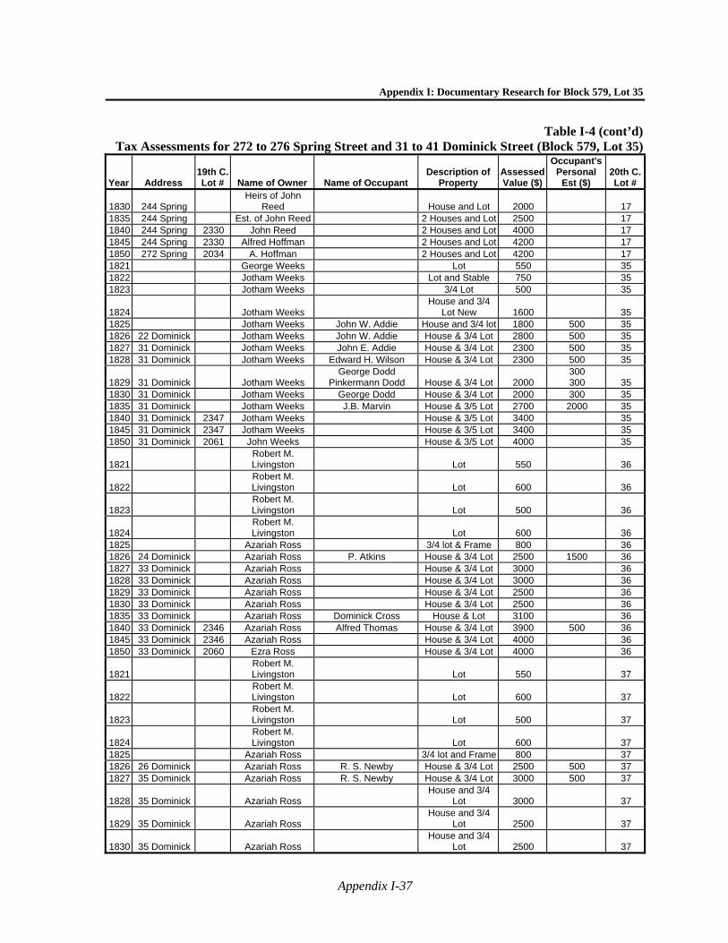
Appendix I: Documentary Research for Block 579, Lot 35
Appendix I-37
Table I-4 (cont’d)Tax Assessments for 272 to 276 Spring Street and 31 to 41 Dominick Street (Block 579, Lot 35)
Year Address 19th C. Lot # Name of Owner Name of Occupant
Description of Property
Assessed Value ($)
Occupant's Personal
Est ($) 20th C. Lot #
1830 244 Spring Heirs of John
Reed House and Lot 2000 17 1835 244 Spring Est. of John Reed 2 Houses and Lot 2500 17 1840 244 Spring 2330 John Reed 2 Houses and Lot 4000 17 1845 244 Spring 2330 Alfred Hoffman 2 Houses and Lot 4200 17 1850 272 Spring 2034 A. Hoffman 2 Houses and Lot 4200 17 1821 George Weeks Lot 550 35 1822 Jotham Weeks Lot and Stable 750 35 1823 Jotham Weeks 3/4 Lot 500 35
1824 Jotham Weeks House and 3/4
Lot New 1600 35 1825 Jotham Weeks John W. Addie House and 3/4 lot 1800 500 35 1826 22 Dominick Jotham Weeks John W. Addie House & 3/4 Lot 2800 500 35 1827 31 Dominick Jotham Weeks John E. Addie House & 3/4 Lot 2300 500 35 1828 31 Dominick Jotham Weeks Edward H. Wilson House & 3/4 Lot 2300 500 35
1829 31 Dominick Jotham Weeks George Dodd
Pinkermann Dodd House & 3/4 Lot 2000 300 300 35
1830 31 Dominick Jotham Weeks George Dodd House & 3/4 Lot 2000 300 35 1835 31 Dominick Jotham Weeks J.B. Marvin House & 3/5 Lot 2700 2000 35 1840 31 Dominick 2347 Jotham Weeks House & 3/5 Lot 3400 35 1845 31 Dominick 2347 Jotham Weeks House & 3/5 Lot 3400 35 1850 31 Dominick 2061 John Weeks House & 3/5 Lot 4000 35
1821 Robert M. Livingston Lot 550 36
1822 Robert M. Livingston Lot 600 36
1823 Robert M. Livingston Lot 500 36
1824 Robert M. Livingston Lot 600 36
1825 Azariah Ross 3/4 lot & Frame 800 36 1826 24 Dominick Azariah Ross P. Atkins House & 3/4 Lot 2500 1500 36 1827 33 Dominick Azariah Ross House & 3/4 Lot 3000 36 1828 33 Dominick Azariah Ross House & 3/4 Lot 3000 36 1829 33 Dominick Azariah Ross House & 3/4 Lot 2500 36 1830 33 Dominick Azariah Ross House & 3/4 Lot 2500 36 1835 33 Dominick Azariah Ross Dominick Cross House & Lot 3100 36 1840 33 Dominick 2346 Azariah Ross Alfred Thomas House & 3/4 Lot 3900 500 36 1845 33 Dominick 2346 Azariah Ross House & 3/4 Lot 4000 36 1850 33 Dominick 2060 Ezra Ross House & 3/4 Lot 4000 36
1821 Robert M. Livingston Lot 550 37
1822 Robert M. Livingston Lot 600 37
1823 Robert M. Livingston Lot 500 37
1824 Robert M. Livingston Lot 600 37
1825 Azariah Ross 3/4 lot and Frame 800 37 1826 26 Dominick Azariah Ross R. S. Newby House & 3/4 Lot 2500 500 37 1827 35 Dominick Azariah Ross R. S. Newby House & 3/4 Lot 3000 500 37
1828 35 Dominick Azariah Ross House and 3/4
Lot 3000 37
1829 35 Dominick Azariah Ross House and 3/4
Lot 2500 37
1830 35 Dominick Azariah Ross House and 3/4
Lot 2500 37
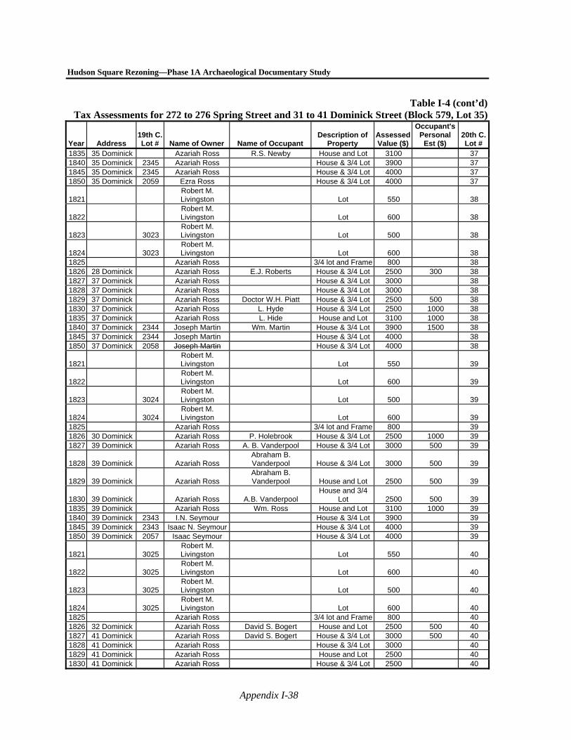
Hudson Square Rezoning—Phase 1A Archaeological Documentary Study
Appendix I-38
Table I-4 (cont’d)Tax Assessments for 272 to 276 Spring Street and 31 to 41 Dominick Street (Block 579, Lot 35)
Year Address 19th C. Lot # Name of Owner Name of Occupant
Description of Property
Assessed Value ($)
Occupant's Personal
Est ($) 20th C. Lot #
1835 35 Dominick Azariah Ross R.S. Newby House and Lot 3100 37 1840 35 Dominick 2345 Azariah Ross House & 3/4 Lot 3900 37 1845 35 Dominick 2345 Azariah Ross House & 3/4 Lot 4000 37 1850 35 Dominick 2059 Ezra Ross House & 3/4 Lot 4000 37
1821 Robert M. Livingston Lot 550 38
1822 Robert M. Livingston Lot 600 38
1823 3023 Robert M. Livingston Lot 500 38
1824 3023 Robert M. Livingston Lot 600 38
1825 Azariah Ross 3/4 lot and Frame 800 38 1826 28 Dominick Azariah Ross E.J. Roberts House & 3/4 Lot 2500 300 38 1827 37 Dominick Azariah Ross House & 3/4 Lot 3000 38 1828 37 Dominick Azariah Ross House & 3/4 Lot 3000 38 1829 37 Dominick Azariah Ross Doctor W.H. Piatt House & 3/4 Lot 2500 500 38 1830 37 Dominick Azariah Ross L. Hyde House & 3/4 Lot 2500 1000 38 1835 37 Dominick Azariah Ross L. Hide House and Lot 3100 1000 38 1840 37 Dominick 2344 Joseph Martin Wm. Martin House & 3/4 Lot 3900 1500 38 1845 37 Dominick 2344 Joseph Martin House & 3/4 Lot 4000 38 1850 37 Dominick 2058 Joseph Martin House & 3/4 Lot 4000 38
1821 Robert M. Livingston Lot 550 39
1822 Robert M. Livingston Lot 600 39
1823 3024 Robert M. Livingston Lot 500 39
1824 3024 Robert M. Livingston Lot 600 39
1825 Azariah Ross 3/4 lot and Frame 800 39 1826 30 Dominick Azariah Ross P. Holebrook House & 3/4 Lot 2500 1000 39 1827 39 Dominick Azariah Ross A. B. Vanderpool House & 3/4 Lot 3000 500 39
1828 39 Dominick Azariah Ross Abraham B. Vanderpool House & 3/4 Lot 3000 500 39
1829 39 Dominick Azariah Ross Abraham B. Vanderpool House and Lot 2500 500 39
1830 39 Dominick Azariah Ross A.B. Vanderpool House and 3/4
Lot 2500 500 39 1835 39 Dominick Azariah Ross Wm. Ross House and Lot 3100 1000 39 1840 39 Dominick 2343 I.N. Seymour House & 3/4 Lot 3900 39 1845 39 Dominick 2343 Isaac N. Seymour House & 3/4 Lot 4000 39 1850 39 Dominick 2057 Isaac Seymour House & 3/4 Lot 4000 39
1821 3025 Robert M. Livingston Lot 550 40
1822 3025 Robert M. Livingston Lot 600 40
1823 3025 Robert M. Livingston Lot 500 40
1824 3025 Robert M. Livingston Lot 600 40
1825 Azariah Ross 3/4 lot and Frame 800 40 1826 32 Dominick Azariah Ross David S. Bogert House and Lot 2500 500 40 1827 41 Dominick Azariah Ross David S. Bogert House & 3/4 Lot 3000 500 40 1828 41 Dominick Azariah Ross House & 3/4 Lot 3000 40 1829 41 Dominick Azariah Ross House and Lot 2500 40 1830 41 Dominick Azariah Ross House & 3/4 Lot 2500 40
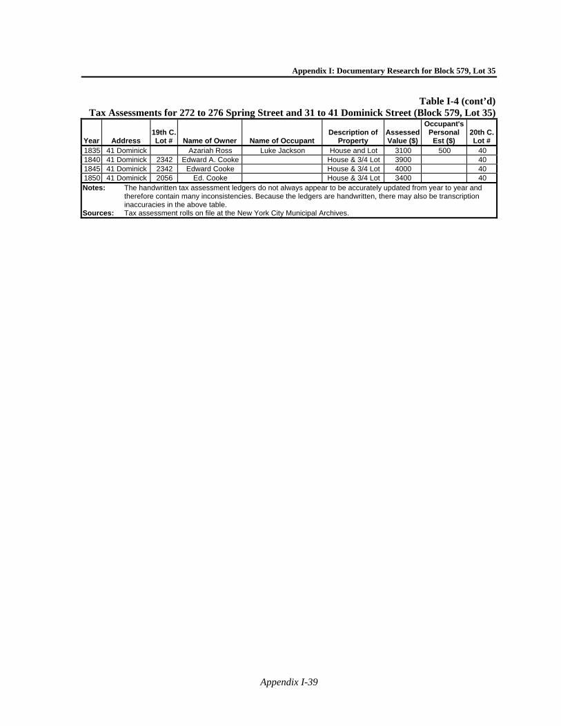
Appendix I: Documentary Research for Block 579, Lot 35
Appendix I-39
Table I-4 (cont’d)Tax Assessments for 272 to 276 Spring Street and 31 to 41 Dominick Street (Block 579, Lot 35)
Year Address 19th C. Lot # Name of Owner Name of Occupant
Description of Property
Assessed Value ($)
Occupant's Personal
Est ($) 20th C. Lot #
1835 41 Dominick Azariah Ross Luke Jackson House and Lot 3100 500 40 1840 41 Dominick 2342 Edward A. Cooke House & 3/4 Lot 3900 40 1845 41 Dominick 2342 Edward Cooke House & 3/4 Lot 4000 40 1850 41 Dominick 2056 Ed. Cooke House & 3/4 Lot 3400 40 Notes: The handwritten tax assessment ledgers do not always appear to be accurately updated from year to year and
therefore contain many inconsistencies. Because the ledgers are handwritten, there may also be transcription inaccuracies in the above table.
Sources: Tax assessment rolls on file at the New York City Municipal Archives.
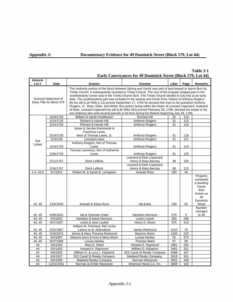
Appendix J-1
Appendix J: Documentary Evidence for 49 Dominick Street (Block 579, Lot 44)
Table J-1Early Conveyances for 49 Dominick Street (Block 579, Lot 44)
Historic Lot # Date Grantor Grantee Liber Page Remarks
General Statement of Early Title for Block 579
The northerly portion of the block between Spring and Varick was part of land leased to Aaron Burr by Trinity Church. It subsequently reverted to Trinity Church. The rest of the irregular shaped part in the southwesterly corner was in the Trinity Church farm. The Trinity Church divided in City lots at an early date. The southwesterly part was included in the swamp and Fresh Pont, Patent of Anthony Rutgers. By his will (L16 Wills p 12) proved September 17, 1764 he devised this tract to his grandson Anthony Rutgers, Jr., Mary, Elsie, and Aletta, this portion being within the share of Leonard Lispenard, husband of Elsie. Leonard Lispenard by will (L40 Wills 342) proved February 26, 1790, devised his estate to his son Anthony who sold several parcels in lot form during his lifetime beginning July 18, 1795.
Not Lotted
3/29/1703 William & Sarah Huddleston Richard Hill 25 114 2/14/1726 Richard & Hanah Hill Anthony Rutgers 31 115 2/14/1726 Richard & Hanah Hill Anthony Rutgers 31 116
2/14/1726
Jesse & Jacoba Krersteede & Francisca Lewis,
heirs of Thomas Lewis, Jr. Anthony Rutgers 31 118 2/15/126 Leonard Lewis Anthony Rutgers 31 121
2/24/1726 Anthony Rutgers, heir of Thomas
Lewis Anthony Rutgers 31 123
2/26/1726 Thomas Lawrence, heir of Katherine
Lewis Anthony Rutgers 31 125
2/11/1767 Dirck Lefferts Leonard & Elsie Lispenard,
Henry & Mary Barclay 38 105
2/14/1767 Dirck Lefferts Leonard & Elsie Lispenard,
Henry & Mary Barclay 38 110 1-4, 43-5 5/7/1822 Robert M. & Sarah B. Livingston Azariah Ross 160 46
44, 45 12/5/1825 Azariah & Elsey Ross Ida Earle 199 52
Property contained a dwelling
house then
known as 40
Dominick Street
44, 45 4/28/1831 Ida & Sylvester Earle Hamilton Morrison 275 5
Number changed
to 49 44, 45 5/3/1832 Hamilton & Maria Morrison Lewis Loutrel 283 298 44, 45 4/27/1837 Lewis & Jane Loutrel Henry G. Brees 375 313
44, 45 3/22/1867 William M. Pritchard, Ref; Acilia
Latens et al, defendants James Redmond 1010 70 44, 45 3/15/1872 James & Mary Theresa Redmond Maurice Ahern 1205 215 44, 45 6/3/1897 Maurice (exrs & trus) & Mary Ahern Louisa Hanley 52 373 44, 45 9/27/1898 Louisa Hanley Thomas Ward 67 58
44 5/5/1925 Mary E. Ward Howard A. Raymond 3481 250 44 5/5/1925 Howard A. Raymond William D. Kilpatrick 3481 251 44 6/9/1925 William D. & Lucy L. Kilpatrick 523 Canal St Realty Company 3488 167 44 8/4/1927 523 Canal St Realty Company Maitland Realty Company. 3618 191 44 6/6/1928 Maitland Realty Company Norman Wassman 3651 438 44 12/22/1931 Norman & Emilie Wassman American News Co, Inc. 3808 160
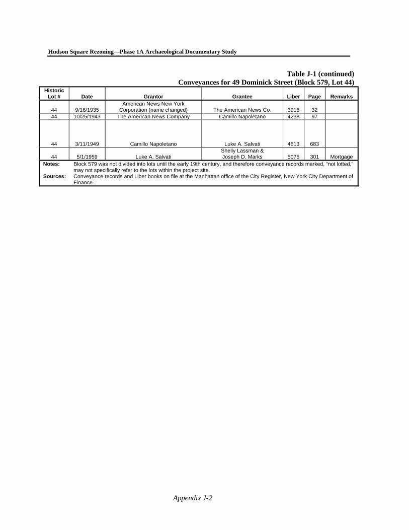
Hudson Square Rezoning—Phase 1A Archaeological Documentary Study
Appendix J-2
Table J-1 (continued)Conveyances for 49 Dominick Street (Block 579, Lot 44)
Historic Lot # Date Grantor Grantee Liber Page Remarks
44 9/16/1935 American News New York
Corporation (name changed) The American News Co. 3916 32 44 10/25/1943 The American News Company Camillo Napoletano 4238 97
44 3/11/1949 Camillo Napoletano Luke A. Salvati 4613 683
44 5/1/1959 Luke A. Salvati Shelly Lassman & Joseph D. Marks 5075 301 Mortgage
Notes: Block 579 was not divided into lots until the early 19th century, and therefore conveyance records marked, “not lotted,” may not specifically refer to the lots within the project site.
Sources: Conveyance records and Liber books on file at the Manhattan office of the City Register, New York City Department of Finance.
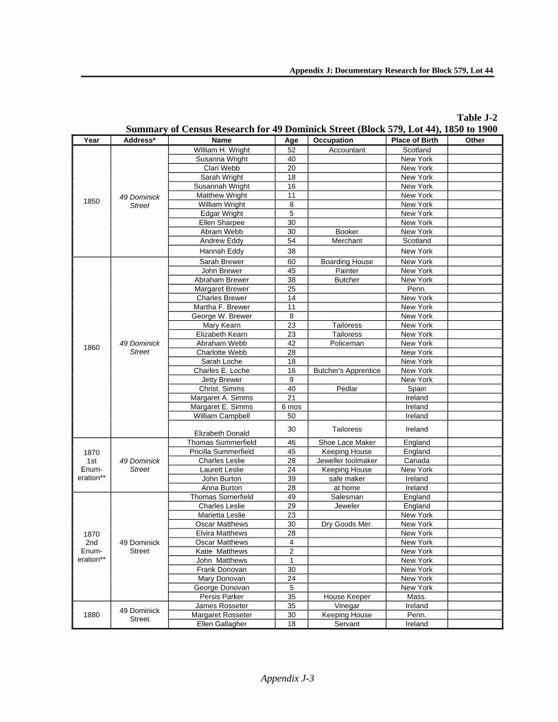
Appendix J: Documentary Research for Block 579, Lot 44
Appendix J-3
Table J-2Summary of Census Research for 49 Dominick Street (Block 579, Lot 44), 1850 to 1900
Year Address* Name Age Occupation Place of Birth Other
1850 49 Dominick
Street
William H. Wright 52 Accountant Scotland Susanna Wright 40 New York
Clari Webb 20 New York Sarah Wright 18 New York
Susannah Wright 16 New York Matthew Wright 11 New York William Wright 8 New York Edgar Wright 5 New York Ellen Sharpee 30 New York Abram Webb 30 Booker New York Andrew Eddy 54 Merchant Scotland
Hannah Eddy 38 New York
1860 49 Dominick
Street
Sarah Brewer 60 Boarding House New York John Brewer 45 Painter New York
Abraham Brewer 38 Butcher New York Margaret Brewer 25 Penn. Charles Brewer 14 New York
Martha F. Brewer 11 New York George W. Brewer 8 New York
Mary Kearn 23 Tailoress New York Elizabeth Kearn 23 Tailoress New York Abraham Webb 42 Policeman New York Charlotte Webb 28 New York
Sarah Loche 18 New York Charles E. Loche 16 Butcher's Apprentice New York
Jetty Brewer 9 New York Christ. Simms 40 Pedlar Spain
Margaret A. Simms 21 Ireland Margaret E. Simms 6 mos Ireland William Campbell 50 Ireland
Elizabeth Donald
30 Tailoress Ireland
1870 1st
Enum-eration**
49 Dominick Street
Thomas Summerfield 46 Shoe Lace Maker England Pricilla Summerfield 45 Keeping House England
Charles Leslie 28 Jeweller toolmaker Canada Laurett Leslie 24 Keeping House New York John Burton 39 safe maker Ireland Anna Burton 28 at home Ireland
1870 2nd
Enum-eration**
49 Dominick Street
Thomas Somerfield 49 Salesman England Charles Leslie 29 Jeweler England Marietta Leslie 23 New York
Oscar Matthews 30 Dry Goods Mer. New York Elvira Matthews 28 New York Oscar Matthews 4 New York Katie Matthews 2 New York John Matthews 1 New York Frank Donovan 30 New York Mary Donovan 24 New York
George Donovan 5 New York Persis Parker 35 House Keeper Mass.
1880 49 Dominick
Street
James Rosseter 35 Vinegar Ireland Margaret Rosseter 30 Keeping House Penn.
Ellen Gallagher 18 Servant Ireland
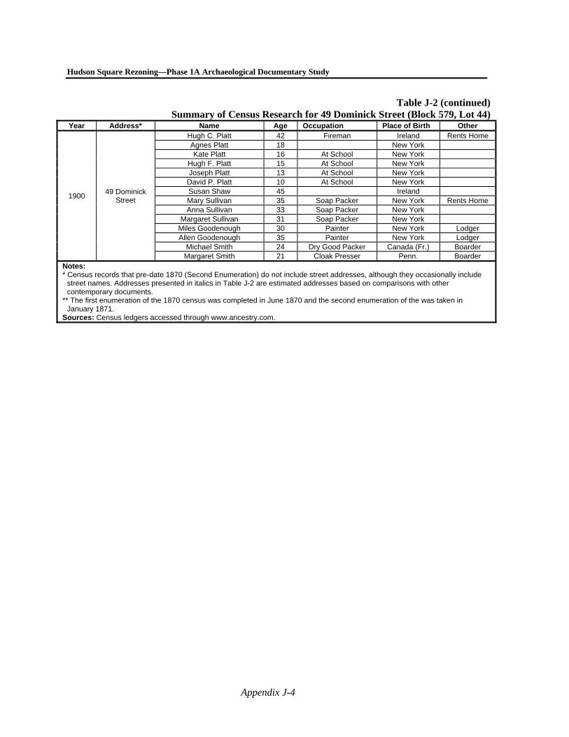
Hudson Square Rezoning—Phase 1A Archaeological Documentary Study
Appendix J-4
Table J-2 (continued)Summary of Census Research for 49 Dominick Street (Block 579, Lot 44)
Year Address* Name Age Occupation Place of Birth Other
1900 49 Dominick
Street
Hugh C. Platt 42 Fireman Ireland Rents Home Agnes Platt 18 New York Kate Platt 16 At School New York
Hugh F. Platt 15 At School New York Joseph Platt 13 At School New York
David P. Platt 10 At School New York Susan Shaw 45 Ireland Mary Sullivan 35 Soap Packer New York Rents Home Anna Sullivan 33 Soap Packer New York
Margaret Sullivan 31 Soap Packer New York Miles Goodenough 30 Painter New York Lodger Allen Goodenough 35 Painter New York Lodger
Michael Smith 24 Dry Good Packer Canada (Fr.) Boarder Margaret Smith 21 Cloak Presser Penn. Boarder
Notes: * Census records that pre-date 1870 (Second Enumeration) do not include street addresses, although they occasionally include
street names. Addresses presented in italics in Table J-2 are estimated addresses based on comparisons with other contemporary documents.
** The first enumeration of the 1870 census was completed in June 1870 and the second enumeration of the was taken in January 1871.
Sources: Census ledgers accessed through www.ancestry.com.
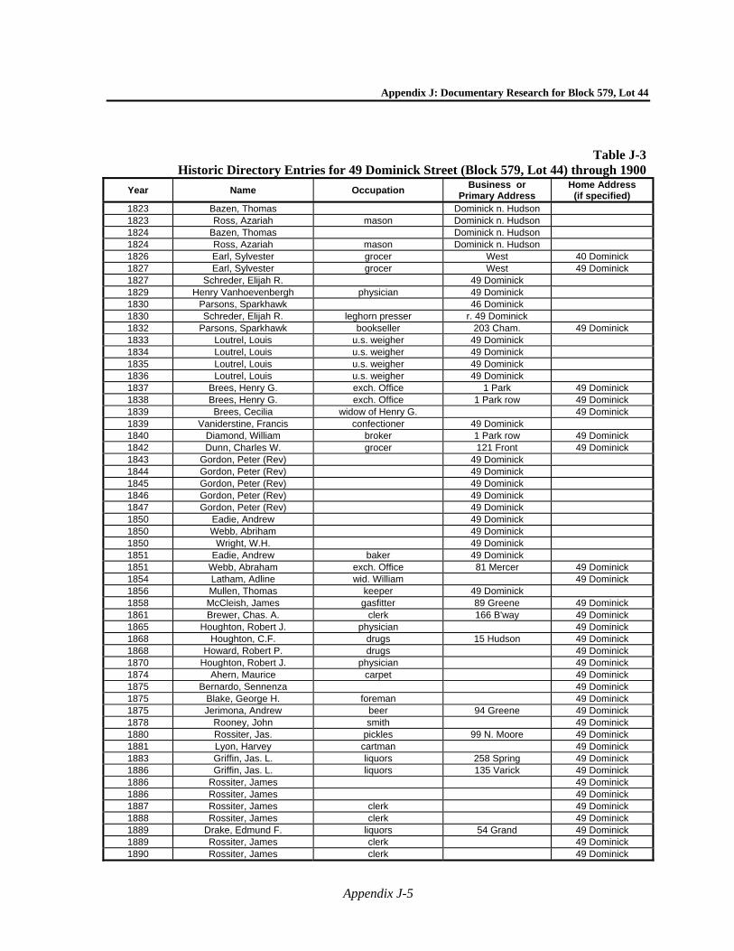
Appendix J: Documentary Research for Block 579, Lot 44
Appendix J-5
Table J-3Historic Directory Entries for 49 Dominick Street (Block 579, Lot 44) through 1900
Year Name Occupation Business or
Primary Address Home Address
(if specified) 1823 Bazen, Thomas Dominick n. Hudson 1823 Ross, Azariah mason Dominick n. Hudson 1824 Bazen, Thomas Dominick n. Hudson 1824 Ross, Azariah mason Dominick n. Hudson 1826 Earl, Sylvester grocer West 40 Dominick 1827 Earl, Sylvester grocer West 49 Dominick 1827 Schreder, Elijah R. 49 Dominick 1829 Henry Vanhoevenbergh physician 49 Dominick 1830 Parsons, Sparkhawk 46 Dominick 1830 Schreder, Elijah R. leghorn presser r. 49 Dominick 1832 Parsons, Sparkhawk bookseller 203 Cham. 49 Dominick 1833 Loutrel, Louis u.s. weigher 49 Dominick 1834 Loutrel, Louis u.s. weigher 49 Dominick 1835 Loutrel, Louis u.s. weigher 49 Dominick 1836 Loutrel, Louis u.s. weigher 49 Dominick 1837 Brees, Henry G. exch. Office 1 Park 49 Dominick 1838 Brees, Henry G. exch. Office 1 Park row 49 Dominick 1839 Brees, Cecilia widow of Henry G. 49 Dominick 1839 Vaniderstine, Francis confectioner 49 Dominick 1840 Diamond, William broker 1 Park row 49 Dominick 1842 Dunn, Charles W. grocer 121 Front 49 Dominick 1843 Gordon, Peter (Rev) 49 Dominick 1844 Gordon, Peter (Rev) 49 Dominick 1845 Gordon, Peter (Rev) 49 Dominick 1846 Gordon, Peter (Rev) 49 Dominick 1847 Gordon, Peter (Rev) 49 Dominick 1850 Eadie, Andrew 49 Dominick 1850 Webb, Abriham 49 Dominick 1850 Wright, W.H. 49 Dominick 1851 Eadie, Andrew baker 49 Dominick 1851 Webb, Abraham exch. Office 81 Mercer 49 Dominick 1854 Latham, Adline wid. William 49 Dominick 1856 Mullen, Thomas keeper 49 Dominick 1858 McCleish, James gasfitter 89 Greene 49 Dominick 1861 Brewer, Chas. A. clerk 166 B'way 49 Dominick 1865 Houghton, Robert J. physician 49 Dominick 1868 Houghton, C.F. drugs 15 Hudson 49 Dominick 1868 Howard, Robert P. drugs 49 Dominick 1870 Houghton, Robert J. physician 49 Dominick 1874 Ahern, Maurice carpet 49 Dominick 1875 Bernardo, Sennenza 49 Dominick 1875 Blake, George H. foreman 49 Dominick 1875 Jerimona, Andrew beer 94 Greene 49 Dominick 1878 Rooney, John smith 49 Dominick 1880 Rossiter, Jas. pickles 99 N. Moore 49 Dominick 1881 Lyon, Harvey cartman 49 Dominick 1883 Griffin, Jas. L. liquors 258 Spring 49 Dominick 1886 Griffin, Jas. L. liquors 135 Varick 49 Dominick 1886 Rossiter, James 49 Dominick 1886 Rossiter, James 49 Dominick 1887 Rossiter, James clerk 49 Dominick 1888 Rossiter, James clerk 49 Dominick 1889 Drake, Edmund F. liquors 54 Grand 49 Dominick 1889 Rossiter, James clerk 49 Dominick 1890 Rossiter, James clerk 49 Dominick
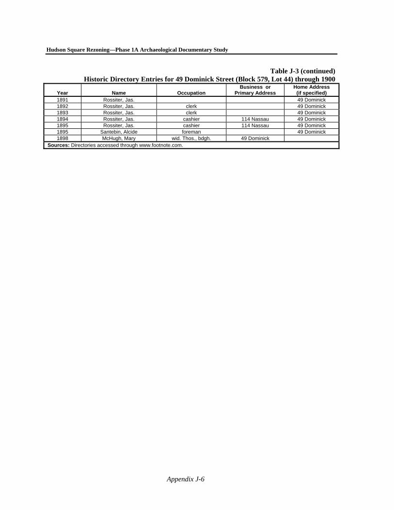
Hudson Square Rezoning—Phase 1A Archaeological Documentary Study
Appendix J-6
Table J-3 (continued)Historic Directory Entries for 49 Dominick Street (Block 579, Lot 44) through 1900
Year Name Occupation Business or
Primary Address Home Address
(if specified) 1891 Rossiter, Jas. 49 Dominick 1892 Rossiter, Jas. clerk 49 Dominick 1893 Rossiter, Jas. clerk 49 Dominick 1894 Rossiter, Jas. cashier 114 Nassau 49 Dominick 1895 Rossiter, Jas. cashier 114 Nassau 49 Dominick 1895 Santebin, Alcide foreman 49 Dominick 1898 McHugh, Mary wid. Thos., bdgh. 49 Dominick
Sources: Directories accessed through www.footnote.com.
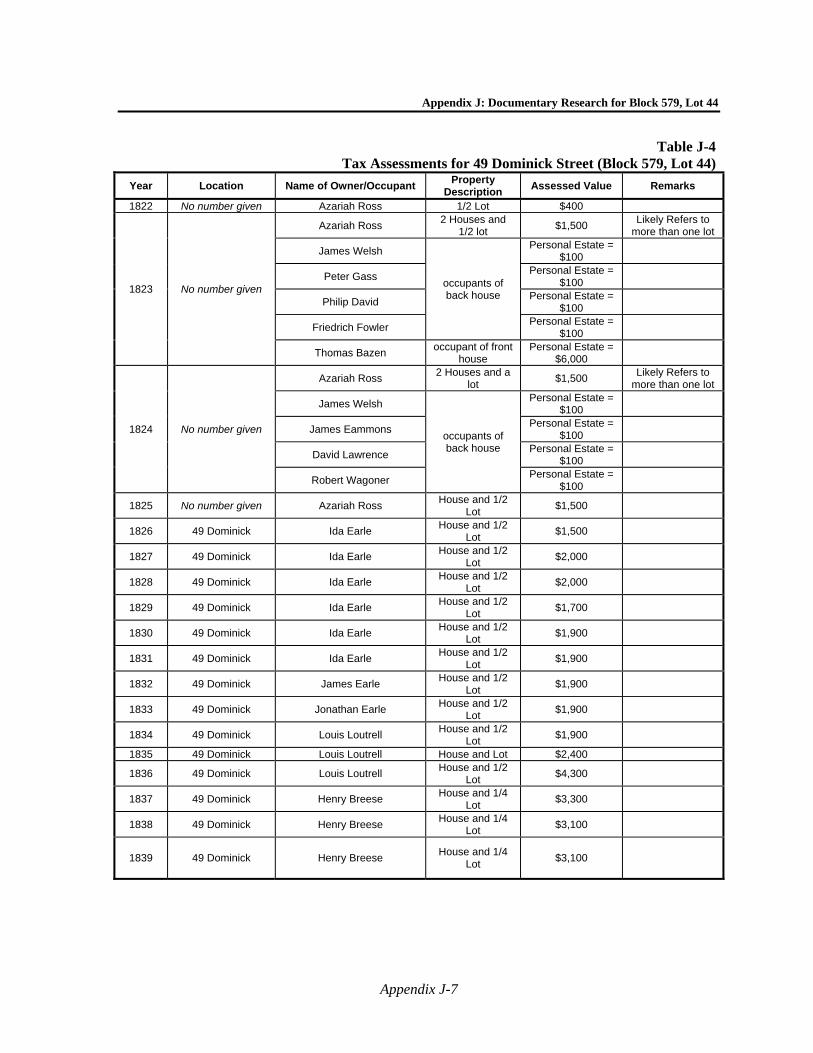
Appendix J: Documentary Research for Block 579, Lot 44
Appendix J-7
Table J-4 Tax Assessments for 49 Dominick Street (Block 579, Lot 44)
Year Location Name of Owner/Occupant Property
Description Assessed Value Remarks
1822 No number given Azariah Ross 1/2 Lot $400
1823 No number given
Azariah Ross 2 Houses and
1/2 lot $1,500
Likely Refers to more than one lot
James Welsh
occupants of back house
Personal Estate = $100
Peter Gass Personal Estate =
$100
Philip David Personal Estate =
$100
Friedrich Fowler Personal Estate =
$100
Thomas Bazen occupant of front
house Personal Estate =
$6,000
1824 No number given
Azariah Ross 2 Houses and a
lot $1,500
Likely Refers to more than one lot
James Welsh
occupants of back house
Personal Estate = $100
James Eammons Personal Estate =
$100
David Lawrence Personal Estate =
$100
Robert Wagoner Personal Estate =
$100
1825 No number given Azariah Ross House and 1/2
Lot $1,500
1826 49 Dominick Ida Earle House and 1/2
Lot $1,500
1827 49 Dominick Ida Earle House and 1/2
Lot $2,000
1828 49 Dominick Ida Earle House and 1/2
Lot $2,000
1829 49 Dominick Ida Earle House and 1/2
Lot $1,700
1830 49 Dominick Ida Earle House and 1/2
Lot $1,900
1831 49 Dominick Ida Earle House and 1/2
Lot $1,900
1832 49 Dominick James Earle House and 1/2
Lot $1,900
1833 49 Dominick Jonathan Earle House and 1/2
Lot $1,900
1834 49 Dominick Louis Loutrell House and 1/2
Lot $1,900
1835 49 Dominick Louis Loutrell House and Lot $2,400
1836 49 Dominick Louis Loutrell House and 1/2
Lot $4,300
1837 49 Dominick Henry Breese House and 1/4
Lot $3,300
1838 49 Dominick Henry Breese House and 1/4
Lot $3,100
1839 49 Dominick Henry Breese House and 1/4
Lot $3,100
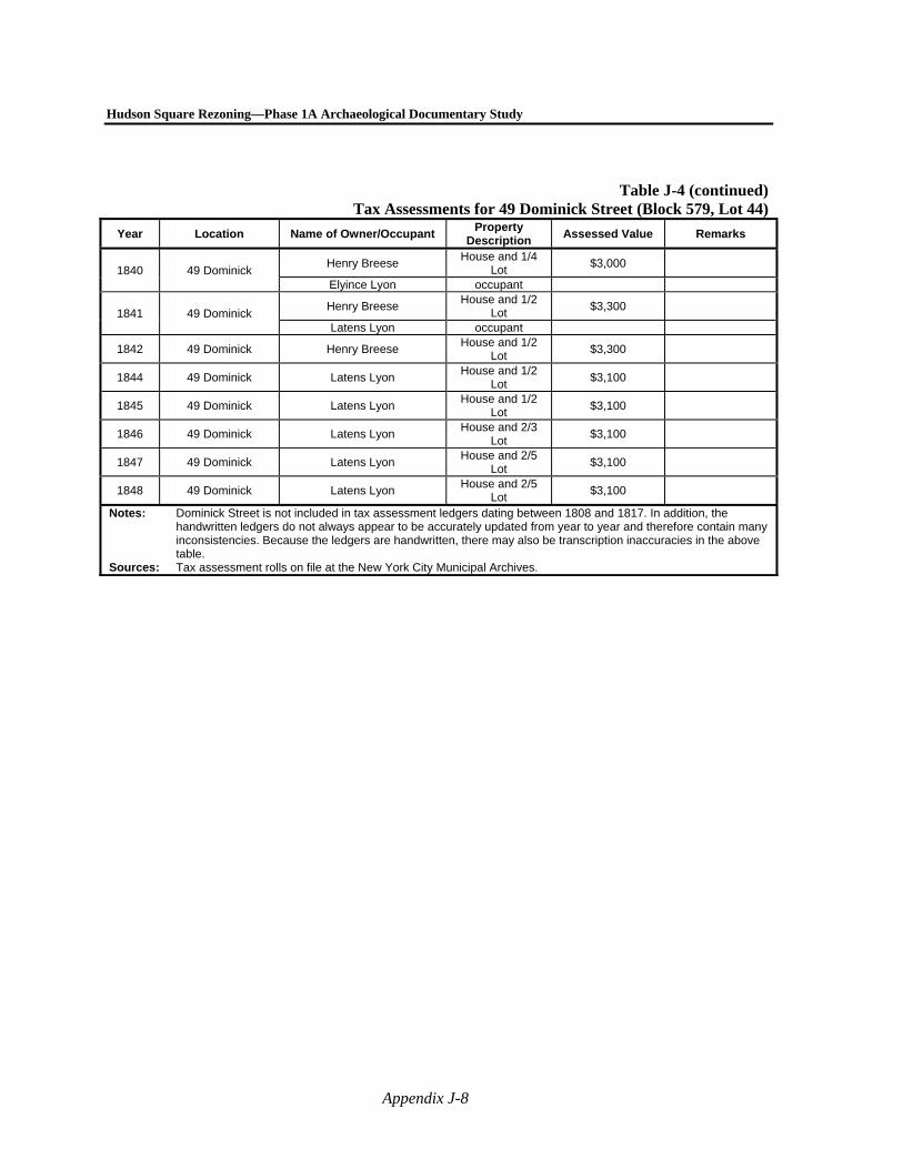
Hudson Square Rezoning—Phase 1A Archaeological Documentary Study
Appendix J-8
Table J-4 (continued)Tax Assessments for 49 Dominick Street (Block 579, Lot 44)
Year Location Name of Owner/Occupant Property
Description Assessed Value Remarks
1840 49 Dominick Henry Breese
House and 1/4 Lot
$3,000
Elyince Lyon occupant
1841 49 Dominick Henry Breese
House and 1/2 Lot
$3,300
Latens Lyon occupant
1842 49 Dominick Henry Breese House and 1/2
Lot $3,300
1844 49 Dominick Latens Lyon House and 1/2
Lot $3,100
1845 49 Dominick Latens Lyon House and 1/2
Lot $3,100
1846 49 Dominick Latens Lyon House and 2/3
Lot $3,100
1847 49 Dominick Latens Lyon House and 2/5
Lot $3,100
1848 49 Dominick Latens Lyon House and 2/5
Lot $3,100
Notes: Dominick Street is not included in tax assessment ledgers dating between 1808 and 1817. In addition, the handwritten ledgers do not always appear to be accurately updated from year to year and therefore contain many inconsistencies. Because the ledgers are handwritten, there may also be transcription inaccuracies in the above table.
Sources: Tax assessment rolls on file at the New York City Municipal Archives.