Version 1.0 Hudson-Raritan Estuary
255
-
Upload
khangminh22 -
Category
Documents
-
view
0 -
download
0
Transcript of Version 1.0 Hudson-Raritan Estuary


June 2016
Volume I
Version 1.0
Hudson-Raritan EstuaryComprehensive Restoration Plan
Inpartnership
with
and

Contributing OrganizationsGovernment
• U.S. Army Corps of Engineers, New York District• The Port Authority of New York & New Jersey• National Park Service• National Oceanic and Atmospheric Administration• U.S. Department of Agriculture, Natural Resources
Conservation Service• U.S. Environmental Protection Agency• U.S. Fish & Wildlife Service• Empire State Development Corporation• New Jersey Department of Environmental
Protection, Division of Fish and Wildlife• New Jersey Department of Transportation• New Jersey Meadowlands Commission• New York State Department of Environmental
Conservation• New York State Department of State, Division of
Coastal Resources• New York City Mayor’s Office• New York City Department of Parks and Recreation• New York City Department of Environmental
Protection• New York City Department of Health • New York City Economic Development Corporation• New York City Soil & Water Conservation District• Middlesex County Planning Department• Hudson County, New Jersey• Union County Planning Department• City of Elizabeth, New Jersey• City of Jersey City, New Jersey• City of Newark, New Jersey• City of New Brunswick Planning Department• Little Ferry Boro, New Jersey• Township of Weehawken, New Jersey
• Village of Ridgefield Park, New Jersey
Academia and Research Foundations• Brooklyn College
• Cary Institute of Ecosystem Studies• City University of New York• Cornell University• Dowling College• Harbor School• Hudson River Foundation• Hunter College• Kean University• Liberty Science Center• Manhattan College• Montclair State University• New Jersey City University• New Jersey Marine Science Consortium• New York-New Jersey Harbor & Estuary Program• Queens College• Rutgers University and Institute of Marine and
Coastal Sciences• State University of New York at Stony Brook• State University of New York – College of
Environmental Science and Forestry• Stevens Institute of Technology• St. John’s University• The New York Academy of Sciences - Harbor Project• Virginia Institute of Marine Science
Non-Profit Organizations
• American Littoral Society
• Bayonne Oyster Gardeners
• Bergen County Audubon
• Brooklyn Botanical Gardens
• Citizens Advisory Committee
• Clean Air Campaign Inc., Open Rivers Project
• Clean Ocean Action
• Clifton Environmental Commission
• Concerned Citizens of Bensonhurst• Crossroads of the American Revolution• Downtown Boathouse• East Coast Greenway
ii Hudson-Raritan Estuary Comprehensive Restoration Plan - Version 1.0 June 2016
• Edison Wetlands• Environmental Defense Fund• Evergreen Environmental, LLC• Friends of Liberty State Park• Gateway Bike & Boathouse• Going Coastal• Gowanus Canal Conservancy• Hackensack Riverkeeper• Highland Park Environmental Commission• Hoboken Cove Community• Hudson River Fishermen’s Association• Hudson River Park• Hutchinson River Restoration Project• Interstate Environmental Commission• Ironbound Community Corporation• Jamaica Bay EcoWatchers• Jamaica Bay Task Force• Jamaica Bay Watershed Protection Plan Advisory
Committee• Lower Passaic Watershed Alliance• National Fish and Wildlife Federation• National Parks Conservation Association• National Parks of New York Harbor Conservancy• Natural Resources Protective Association• New Jersey Audubon Society• New York/New Jersey Baykeeper• New York City Audubon• New York State Museum• Outside New York• Passaic River Boat Club• Passaic River Coalition• Passaic Valley Sewerage Commission• Raritan Baywatcher• Raritan River Initiative• Raritan Riverkeeper• Red Hook Boaters• Regional Plan Association• Rockaway Waterfront Alliance
• Sebago Canoe Club• Sheepshead Bay/Plumb Beach Civic Association• The Gaia Institute• The Natural Areas Conservancy• The Nature Conservancy• Trust for Public Land• Urban Divers Estuary Conservancy• Washington Park Association• Waterfront Alliance• Wildlife Conservation• Wildlife Trust• Working Harbor
Others• AECOM | URS Corporation• AKRF, Inc.• Battelle• Biohabitats• ConocoPhillips• eDesign Dynamics, LLC• ExxonMobil• GEI Consultants, Inc.• Great Ecology & Environment• HDR, Inc.• Hartz Mountain Corporation• Hydroqual, Inc.• Jaffe Communications• Line Design, LLC• Louis Berger• New Jersey Transit• Parsons• Princeton Hydro• Public Service Electric & Gas• PS&S Integrated Solutions• RBA Group• Robins Reef Yacht Club• The Elm Group• Weston
iiiHudson-Raritan Estuary Comprehensive Restoration Plan - Version 1.0 June 2016
Table of ContentsContributing Organizations ..................................................................................................................................................... iiList of Tables ......................................................................................................................................................................... viList of Figures ...................................................................................................................................................................... viiList of Maps .......................................................................................................................................................................... viiiList of Acronyms .................................................................................................................................................................... ixExecutive Summary ...............................................................................................................................................................xii1.0 Introduction ..................................................................................................................................................................1
1.1 Study Background ..................................................................................................................................................................... 21.2 Restoration Goals and Targets .................................................................................................................................................. 61.3 Public Involvement and Achieving Consensus ......................................................................................................................... 10
2.0 Existing Conditions .................................................................................................................................................... 112.1 Study Area ............................................................................................................................................................................... 112.2 History of Habitat Degradation and Losses ............................................................................................................................ 15
2.2.1 Bathymetric Alterations ........................................................................................................................................................................ 152.2.2 Shoreline Modifications ........................................................................................................................................................................ 152.2.3 Hydrodynamic and Hydraulic Changes ................................................................................................................................................. 162.2.4 Water Quality and Sediment Degradation ............................................................................................................................................ 162.2.5 Hurricane Sandy ................................................................................................................................................................................... 18
2.3 HRE Planning Regions ............................................................................................................................................................. 202.3.1 Jamaica Bay .......................................................................................................................................................................................... 202.3.2 Lower Bay ............................................................................................................................................................................................ 242.3.3 Lower Raritan River .............................................................................................................................................................................. 272.3.4 Arthur Kill and Kill Van Kull ................................................................................................................................................................... 282.3.5 Newark Bay, Hackensack River, and Passaic River .............................................................................................................................. 312.3.6 Lower Hudson River ............................................................................................................................................................................. 362.3.7 Harlem River, East River, and Western Long Island Sound .................................................................................................................. 382.3.8 Upper Bay ............................................................................................................................................................................................ 40
2.4 Trends in Environmental Quality .............................................................................................................................................. 422.5 Sea level Rise .......................................................................................................................................................................... 432.6 Restoration Efforts .................................................................................................................................................................. 47
2.6.1 Ongoing Restoration Programs in the HRE ......................................................................................................................................... 482.6.2 Response to Hurricane Sandy .............................................................................................................................................................. 55
3.0 Target Ecosystem Characteristics .............................................................................................................................. 633.1 Habitats ................................................................................................................................................................................... 65
3.1.1 Wetlands ............................................................................................................................................................................................... 653.1.2 Coastal and Maritime Forests ............................................................................................................................................................... 713.1.3 Oyster Reefs ......................................................................................................................................................................................... 803.1.4 Eelgrass Beds ...................................................................................................................................................................................... 87
3.2 Habitat Complexes ................................................................................................................................................................... 923.2.1 Shorelines and Shallows ...................................................................................................................................................................... 933.3.2 Habitat for Fish, Crabs, and Lobsters ................................................................................................................................................ 1013.2.3 Habitat for Waterbirds ........................................................................................................................................................................ 103
3.3 Environmental Support Structures ........................................................................................................................................ 1113.3.1 Tributary Connections ........................................................................................................................................................................ 1113.3.2 Enclosed and Confined Waters ........................................................................................................................................................... 118
3.4 Contamination Issues ............................................................................................................................................................ 1243.4.1 Sediment Contamination .................................................................................................................................................................... 124
iv Hudson-Raritan Estuary Comprehensive Restoration Plan - Version 1.0 June 2016
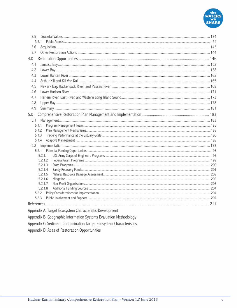
3.5 Societal Values ..................................................................................................................................................................... 1343.5.1 Public Access...................................................................................................................................................................................... 134
3.6 Acquisition ............................................................................................................................................................................. 1433.7 Other Restoration Actions ..................................................................................................................................................... 144
4.0 Restoration Opportunities ....................................................................................................................................... 1464.1 Jamaica Bay ........................................................................................................................................................................... 1524.2 Lower Bay .............................................................................................................................................................................. 1584.3 Lower Raritan River ............................................................................................................................................................... 1624.4 Arthur Kill and Kill Van Kull .................................................................................................................................................... 1654.5 Newark Bay, Hackensack River, and Passaic River................................................................................................................ 1684.6 Lower Hudson River .............................................................................................................................................................. 1714.7 Harlem River, East River, and Western Long Island Sound.................................................................................................... 1734.8 Upper Bay .............................................................................................................................................................................. 1784.9 Summary ............................................................................................................................................................................... 181
5.0 Comprehensive Restoration Plan Management and Implementation ...................................................................... 1835.1 Management .......................................................................................................................................................................... 183
5.1.1 Program Management Team .............................................................................................................................................................. 1855.1.2 Plan Management Mechanisms .......................................................................................................................................................... 1895.1.3 Tracking Performance at the Estuary-Scale ....................................................................................................................................... 1905.1.4 Adaptive Management ....................................................................................................................................................................... 192
5.2 Implementation ...................................................................................................................................................................... 1935.2.1 Potential Funding Opportunities ........................................................................................................................................................ 193
5.2.1.1 U.S. Army Corps of Engineers Programs .................................................................................................................................. 1965.2.1.2 Federal Grant Programs ............................................................................................................................................................ 1995.2.1.3 State Programs .......................................................................................................................................................................... 2005.2.1.4 Sandy Recovery Funds ............................................................................................................................................................... 2015.2.1.5 Natural Resource Damage Assessment ..................................................................................................................................... 2025.2.1.6 Mitigation ................................................................................................................................................................................... 2025.2.1.7 Non-Profit Organizations ........................................................................................................................................................... 2035.2.1.8 Additional Funding Sources ....................................................................................................................................................... 204
5.2.2 Policy Considerations for Implementation .......................................................................................................................................... 2045.2.3 Public Involvement and Support ........................................................................................................................................................ 207
References ......................................................................................................................................................................... 211Appendix A: Target Ecosystem Characteristic DevelopmentAppendix B: Geographic Information Systems Evaluation MethodologyAppendix C: Sediment Contamination Target Ecosystem CharacteristicsAppendix D: Atlas of Restoration Opportunities
vHudson-Raritan Estuary Comprehensive Restoration Plan - Version 1.0 June 2016
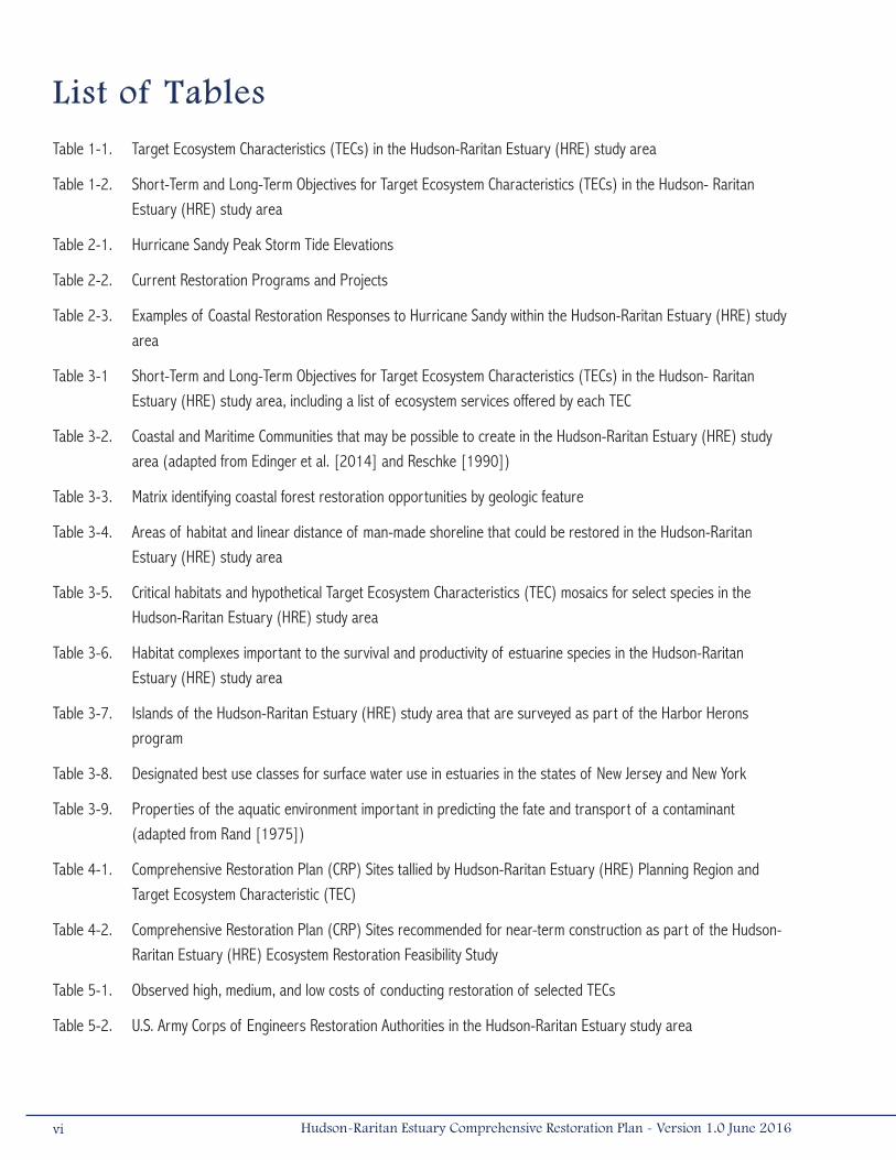
List of Tables
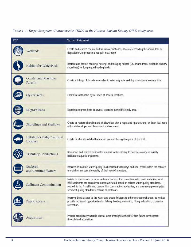
Table 1-1. Target Ecosystem Characteristics (TECs) in the Hudson-Raritan Estuary (HRE) study area
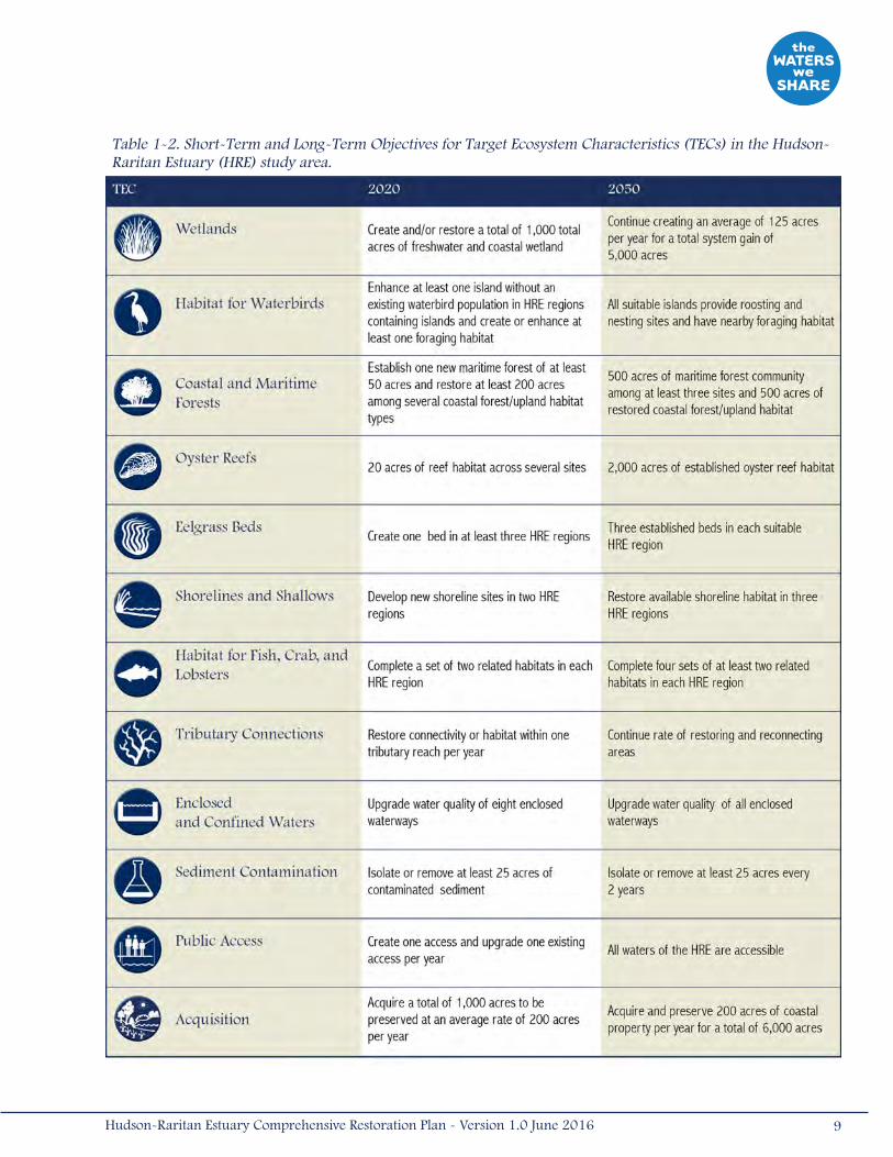
Table 1-2. Short-Term and Long-Term Objectives for Target Ecosystem Characteristics (TECs) in the Hudson- Raritan Estuary (HRE) study area
Table 2-1. Hurricane Sandy Peak Storm Tide Elevations
Table 2-2. Current Restoration Programs and Projects
Table 2-3. Examples of Coastal Restoration Responses to Hurricane Sandy within the Hudson-Raritan Estuary (HRE) study area
Table 3-1 Short-Term and Long-Term Objectives for Target Ecosystem Characteristics (TECs) in the Hudson- Raritan Estuary (HRE) study area, including a list of ecosystem services offered by each TEC
Table 3-2. Coastal and Maritime Communities that may be possible to create in the Hudson-Raritan Estuary (HRE) study area (adapted from Edinger et al. [2014] and Reschke [1990])
Table 3-3. Matrix identifying coastal forest restoration opportunities by geologic feature
Table 3-4. Areas of habitat and linear distance of man-made shoreline that could be restored in the Hudson-Raritan Estuary (HRE) study area
Table 3-5. Critical habitats and hypothetical Target Ecosystem Characteristics (TEC) mosaics for select species in the Hudson-Raritan Estuary (HRE) study area
Table 3-6. Habitat complexes important to the survival and productivity of estuarine species in the Hudson-Raritan Estuary (HRE) study area
Table 3-7. Islands of the Hudson-Raritan Estuary (HRE) study area that are surveyed as part of the Harbor Herons program
Table 3-8. Designated best use classes for surface water use in estuaries in the states of New Jersey and New York
Table 3-9. Properties of the aquatic environment important in predicting the fate and transport of a contaminant (adapted from Rand [1975])
Table 4-1. Comprehensive Restoration Plan (CRP) Sites tallied by Hudson-Raritan Estuary (HRE) Planning Region and Target Ecosystem Characteristic (TEC)
Table 4-2. Comprehensive Restoration Plan (CRP) Sites recommended for near-term construction as part of the Hudson-Raritan Estuary (HRE) Ecosystem Restoration Feasibility Study
Table 5-1. Observed high, medium, and low costs of conducting restoration of selected TECs
Table 5-2. U.S. Army Corps of Engineers Restoration Authorities in the Hudson-Raritan Estuary study area
vi Hudson-Raritan Estuary Comprehensive Restoration Plan - Version 1.0 June 2016

List of Figures
Figure 1-1. Timeline of important events in the Hudson-Raritan Estuary study area
Figure 1-2. The eight planning regions of the Hudson-Raritan Estuary study area
Figure 2-1. Land use in the Hudson-Raritan Estuary study area
Figure 2-2. Historic presence of oysters in the Hudson-Raritan Estuary study area
Figure 2-3. Wildlife Conservation Society’s Welikia Project: The Mannahatta Map depicts the estuary along Manhattan, NY as its pre-colonization self
Figure 2-4. Jamaica Bay Planning Region
Figure 2-5. Lower Bay Planning Region
Figure 2-6. Harbor Seals on Swinburne Island in the Lower Bay Planning Region
Figure 2-7. Lower Raritan River Planning Region
Figure 2-8. Arthur Kill and Kill Van Kull Planning Region
Figure 2-9. A great egret in marsh grasses
Figure 2-10. Newark Bay, Hackensack River, and Passaic River Planning Region
Figure 2-11. Multiple habitats were restored at Lincoln Park West in Jersey City
Figure 2-12. Lower Hudson River Planning Region
Figure 2-13. Harlem River, East River, and Western Long Island Sound Planning Region
Figure 2-14. Upper Bay Planning Region
Figure 2-15. NY District Coastal Storm Risk Management Projects and Studies Map
Figure 3-1. Transplanted eelgrass at Breezy Point, Western Jamaica Bay, April 2009
Figure 3-2a. Continuum of living shoreline habitat possible at low energy sites
Figure 3-2b. Integration of Natural/Nature Based Features (NNBFs) within layers of coastal protection
Figure 3-3. Examples of reconstructed shoreline features
Figure 5-1. Katerli Bounds and Leila Mougoui of New York City Parks Paddle through the Arthur Kill to Pralls Island to restore heron nesting habitat
viiHudson-Raritan Estuary Comprehensive Restoration Plan - Version 1.0 June 2016
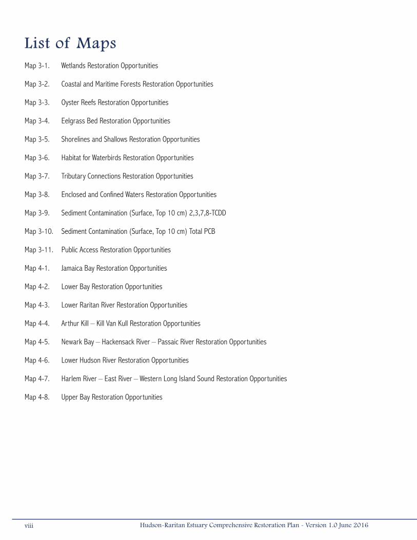
List of MapsMap 3-1. Wetlands Restoration Opportunities
Map 3-2. Coastal and Maritime Forests Restoration Opportunities
Map 3-3. Oyster Reefs Restoration Opportunities
Map 3-4. Eelgrass Bed Restoration Opportunities
Map 3-5. Shorelines and Shallows Restoration Opportunities
Map 3-6. Habitat for Waterbirds Restoration Opportunities
Map 3-7. Tributary Connections Restoration Opportunities
Map 3-8. Enclosed and Confined Waters Restoration Opportunities
Map 3-9. Sediment Contamination (Surface, Top 10 cm) 2,3,7,8-TCDD
Map 3-10. Sediment Contamination (Surface, Top 10 cm) Total PCB
Map 3-11. Public Access Restoration Opportunities
Map 4-1. Jamaica Bay Restoration Opportunities
Map 4-2. Lower Bay Restoration Opportunities
Map 4-3. Lower Raritan River Restoration Opportunities
Map 4-4. Arthur Kill – Kill Van Kull Restoration Opportunities
Map 4-5. Newark Bay – Hackensack River – Passaic River Restoration Opportunities
Map 4-6. Lower Hudson River Restoration Opportunities
Map 4-7. Harlem River – East River – Western Long Island Sound Restoration Opportunities
Map 4-8. Upper Bay Restoration Opportunities
viii Hudson-Raritan Estuary Comprehensive Restoration Plan - Version 1.0 June 2016

°C degrees Celsius
ABU Authorized But Unconstructed
ADA Americans with Disabilities Act
ALS American Littoral Society
BLM Bureau of Land Management
CAC Citizens’ Advisory Committee
CAP Continuing Authorities Program
CARP Contamination Assessment and Reduction
Program
CCMP Comprehensive Conservation Management Plan
CCPR Committee on Climate Preparedness and
Resilience
CEQ Council on Environmental Quality
CERCLA Comprehensive Environmental Response,
Compensation, and Liability Act
CG Construction General
CPG Cooperating Parties Group
CRP Comprehensive Restoration Plan
CSO Combined Sewer Overflow
CSRM Coastal Storm Risk Management
CUES Rutgers Center for Urban Environmental
Sustainability
CUNY City University of New York
CWA Clean Water Act
CWP Comprehensive Waterfront Plan
CY Cubic yards
CYD Cubic yards of debris
CZMA Coastal Zone Management Act
DDT Dichloro-Diphenyl-Trichloroethane
DIN Dissolved inorganic nitrogen
DIP Dissolved inorganic phosphorus
DOI U.S. Department of Interior
DOT U.S. Department of Transportation
EPF Environmental Protection Fund
ERM Effects Range Medium
ERL Effects Range Low
FCCE Flood Control and Coastal Emergencies
FDA U.S. Food and Drug Administration
GI General Investigations
GIS Geographic Information System
HARS Historic Area Remediation Site
HEP New York-New Jersey Harbor & Estuary
Program
HHMT Howland Hook Marine Terminal
HRE Hudson-Raritan Estuary
HRERP Hudson-Raritan Estuary Resources Program
HRF Hudson River Foundation
HTRW Hazardous, Toxic, and Radioactive Waste
HUD U.S. Department of Housing and Urban
Development
HWG Habitat Work Group
List of Acronyms
ixHudson-Raritan Estuary Comprehensive Restoration Plan - Version 1.0 June 2016
IPCC Intergovernmental Panel on Climate Change
JEM Jamaica Bay Eutrophication Model
KCS Known Contaminated Sites
LGNJ Local Government in New Jersey
LTCP Long Term Control Plan
MARSHES Mitigation and Restoration Strategies for
Habitat and Ecological Sustainability
MAST Harbor School’s Marine Science and
Technology
MCY Million cubic yards
MERI Meadowlands Environmental Research Institute
NACCS National Atlantic Coast Comprehensive Study
NEP National Estuary Program
NEPA National Environmental Policy Act
NEPORT National Estuary Program Online Reporting
Tool
NERR National Estuarine Research Reserve
NFWF National Fish and Wildlife Foundation
NGO Non-government organization
NJDEP New Jersey Department of Environmental
Protection
NJDOT New Jersey Department of Transportation
NJMC New Jersey Meadowlands Commission
NJPDES New Jersey Pollutant Discharge Elimination
System
NMFS National Marine Fisheries Service
NNBF Natural/Nature Based Feature
NOAA National Oceanic and Atmospheric
Administration
NPCC New York City Panel on Climate Change
NPS National Park Service
NRCA National Resources Conservation Service
NRDA Natural Resource Damage Assessment
NRG Natural Resources Group of the New York City
Department of Parks and Recreation
NYC New York City
NYC CWP New York City Comprehensive Waterfront Plan
NYCDEP New York City Department of Environmental
Protection
NYCDPR New York City Department of Parks and
Recreation
NYCEDC New York City Economic Development
Corporation
NYC OASIS New York City Open Accessible Space
Information Systems
NWI National Wetlands Inventory
NWS Naval Weapons Station
NYSDOT New York State Department of Transportation
NYSDEC New York State Department of Environmental
Conservation
NYSDOH New York State Department of Health
NYSDOS New York State Department of State
x Hudson-Raritan Estuary Comprehensive Restoration Plan - Version 1.0 June 2016

OMRR&R Operation, maintenance, repair, replacement
and rehabilitation
OPRHP Office of Parks, Recreation & Historic
Preservation
ORIS Oyster Restoration Index Score
ORRP Oyster Restoration Research Partnership
PAH Polycyclic aromatic hydrocarbon
PANYNJ Port Authority of New York and New Jersey
PBDE Polybrominated diphenyl ether
PCB Polychlorinated biphenyl
PCDFs Polychlorinated dibenzofurans
PeCDF Pentachlorodibenzofuran
PFAS perfluoroalkyl and polyfluoroalkyl substance
PRP Potential Responsible Parties
PVSC Passaic Valley Sewerage Commission
RI/FS remedial investigation and feasibility study
RSM Regional Sediment Management
RWG Restoration Work Group
SAGE Systems Approach to Geomorphic Engineering
SCR Structures of Coastal Resilience
SIRR Special Initiative for Rebuilding and Resiliency
SNWA Special Natural Waterfront Area
SRIRC Sandy Regional Infrastructure Resilience
Coordination
STAC Science and Technical Advisory Committee
SWEM System-Wide Eutrophication Model
SWG State Wildlife Grants
TEC Target Ecosystem Characteristic
TCDD Tetrachlorodibenzo-p-dioxin
TSS Total suspended solids
UAO Unilateral Administrative Order
USACE U.S. Army Corps of Engineers
USDA U.S. Department of Agriculture
USEPA U.S. Environmental Protection Agency
USFS U. S. Forest Service
USFWS U.S. Fish and Wildlife Service
USGS U.S. Geological Survey
UWFP Urban Waters Federal Partnership
WEDG Waterfront Edge Design Guidelines
WRDA Water Resources Development Act
WRRDA Water Resources Reform and Development
Act
WRP Waterfront Revitalization Plan
xiHudson-Raritan Estuary Comprehensive Restoration Plan - Version 1.0 June 2016

Executive Summary
The Comprehensive Restoration Plan (CRP) for the Hudson-Raritan Estuary (HRE) is a master plan to guide ecosystem
restoration efforts throughout the estuary. It is intended to be used by all stakeholders (environmental and community
groups, government agencies, and others), thereby allowing the whole region to work toward a series of shared restoration
goals providing benefits to the estuary.
This effort was initiated in 1988 when Congress recognized the New York-New Jersey Harbor as an estuary of national
importance and accepted it into the National Estuary Program (NEP). Following this designation, in March 1996, the
NY-NJ Harbor & Estuary Program (HEP) completed a Comprehensive Conservation and Management Plan (CCMP). CCMP
recommendations included the need to develop a comprehensive strategy for habitat protection and restoration. The
U.S. Army Corps of Engineers (USACE), in partnership with their non-Federal sponsor, the Port Authority of New York and
New Jersey (PANYNJ), joined the process of developing this strategy with the initiation of the HRE Ecosystem Restoration
Feasibility Study.
The Committee on Transportation and Infrastructure of the U.S. House of Representatives authorized the HRE Ecosystem
Restoration Feasibility Study in an April 15, 1999 resolution:
Resolved by the Committee on Transportation and Infrastructure of the United States House of Representatives,
That, the Secretary of the Army is requested to review the reports of the Chief of Engineers on the New York and
New Jersey Channels, published as House Document 133, 74th Congress, 1st Session; the New York and New Jersey
Harbor Entrance Channels and Anchorage Areas, published as Senate Document 45, 84th Congress, 1st Session;
and the New York Harbor, NY Anchorage Channel, published as House Document 18, 71st Congress, 2nd Session,
as well as other related reports with a view to determining the feasibility of environmental restoration and protection
relating to water resources and sediment quality within the New York and New Jersey Port District, including but not
limited to creation, enhancement, and restoration of aquatic, wetland, and adjacent upland habitats.
In 2005, the Hudson River Foundation (HRF) and The Center for the Environment at Cornell University began leading a series
of workshops focused on developing a strategy for restoration planning for this highly urbanized estuary. From the outset,
scientists agreed that the restoration program should emphasize creating and restoring a mosaic of habitats within the
human-dominated landscape.
To achieve this goal, a team of estuarine scientists initially identified 11 measurable objectives for restoration, termed
Target Ecosystem Characteristics (TECs), each defining specific goals for an important ecosystem property or feature of
ecological and/or societal value. In 2012, a twelfth TEC was added in response to public comments emphasizing the need
to highlight the importance of protecting and preserving existing open and undeveloped lands. In addition to updating
certain quantitative objectives, other TECs were revised in 2012 in order to place greater emphasis on valuable habitat,
including coastal forest habitat, freshwater habitat, shorelines and shallows, and foraging habitat for waterbirds. The value of
additional shellfish species, other than oysters, was also emphasized.
xii Hudson-Raritan Estuary Comprehensive Restoration Plan - Version 1.0 June 2016
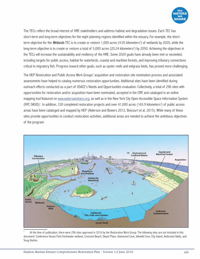
The TECs reflect the broad interest of HRE stakeholders and address habitat and degradation issues. Each TEC has
short-term and long-term objectives for the eight planning regions identified within the estuary. For example, the short-
term objective for the Wetlands TEC is to create or restore 1,000 acres (4.05 kilometers2) of wetlands by 2020, while the
long-term objective is to create or restore a total of 5,000 acres (20.24 kilometers2) by 2050. Achieving the objectives in
the TECs will increase the sustainability and resiliency of the HRE. Some 2020 goals have already been met or exceeded,
including targets for public access, habitat for waterbirds, coastal and maritime forests, and improving tributary connections
critical to migratory fish. Progress toward other goals, such as oyster reefs and eelgrass beds, has proved more challenging.
The HEP Restoration and Public Access Work Groups’ acquisition and restoration site nomination process and associated
assessments have helped to catalog numerous restoration opportunities. Additional sites have been identified during
outreach efforts conducted as a part of USACE’s Needs and Opportunities evaluation. Collectively, a total of 296 sites with
opportunities for restoration and/or acquisition have been nominated, accepted in the CRP, and cataloged in an online
mapping tool featured on www.watersweshare.org, as well as in the New York City Open Accessible Space Information System
(NYC OASIS)1. In addition, 330 completed restoration projects and over 41,000 acres (165.9 kilometers2) of public access
areas have been cataloged and mapped by HEP (Alderson and Bowers 2012, Boicourt et al. 2015). While many of these
sites provide opportunities to conduct restoration activities, additional areas are needed to achieve the ambitious objectives
of the program.
1 At the time of publication, there were 296 sites approved in 2016 by the Restoration Work Group. The following sites are not included in this document: Conference House Park freshwater wetland, Crescent Beach, Depot Place, Hammond Cove, Idlewild Cove, City Island, Ambrosini fields, and Snug Harbor.
xiiiHudson-Raritan Estuary Comprehensive Restoration Plan - Version 1.0 June 2016

A series of Geographic Information Systems (GIS) analyses were conducted to identify additional restoration opportunities.
These estuary-wide analyses aided the planning efforts and helped estimate whether the TEC objectives are achievable. For
each target, existing datasets were used to identify habitat suitability (e.g., appropriate depth, water quality parameters)
as well as potential constraints to ecological restoration. Preliminary findings indicate that sufficient habitat is available for
achieving the TEC objectives throughout the eight planning regions.
There are many challenges to implementing the CRP. Restoration projects and their associated monitoring programs are
costly. Therefore, achieving the objectives will require a substantial dedication of funds and creative funding strategies.
Innovative local financing techniques, combined with state and Federal funding opportunities, will generate the support
necessary to make these projects a reality. Mitigation and/or Natural Resources Damage Assessment (NRDA) funding should
also be considered to support restoration projects. At this stage of planning, accurately estimating project costs for all of
the restoration opportunities would not be possible. The costs to conduct restoration vary greatly by project and by type
of restoration (i.e., TEC). For example, a rough estimate of the costs to achieve the Wetlands objectives range between
$218 and $713 million for the short-term objective and $1.0 to $3.5 billion for the long-term objective, based on average
costs per acre for this type of project. Considering that these are only the costs associated with one of the 12 TECs, funding
to implement all the targets will be difficult to secure. The success of the CRP in improving the estuary’s ecosystem is
dependent upon successful partnering among stakeholders.
Multi-jurisdictional regulatory boundaries present another challenge to restoration planning within the HRE. Resource
management agencies are tasked with balancing multiple, often conflicting goals of resource conservation while providing for
compatible uses of the environment. Examples of policy issues that should be addressed include habitat exchange issues;
placement of fill in water, specifically as it relates to beneficial use of dredged material for habitat restoration; attractive
nuisance issues; and issues affecting management of contaminated sediments.
The CRP is a long-term strategy for restoration in the HRE study area, and thus should be periodically reviewed and updated
to acknowledge successes, outline new restoration and acquisition targets, specify implementation schedules, and reaffirm
commitments to the estuary and its stakeholders. This review, as well as documenting the progress of CRP implementation,
will be carried out by the HEP Restoration Work Group (RWG).
This CRP for the HRE has been prepared by the USACE and the PANYNJ as a part of the HRE Ecosystem Restoration
Feasibility Study. The full report can be downloaded from www.watersweshare.org or http://www.nan.usace.army.mil/Missions/
Environmental/EcosystemRestoration/HREEcosystemRestoration.aspx.
xiv Hudson-Raritan Estuary Comprehensive Restoration Plan - Version 1.0 June 2016

1.0 Introduction
The HRE, located within one of the most urbanized regions in the United States, has undergone centuries of industrial
and residential development. Coincident with extensive navigation and infrastructure improvements, urbanization and
industrialization within the HRE have resulted in extensive degradation of aquatic and terrestrial ecosystems, including
wetlands, stream corridors, island rookeries, and shellfish beds. In March 2009, the Draft CRP, a master plan to guide
ecosystem restoration efforts within the HRE, was published by USACE in partnership with the non-Federal sponsor, PANYNJ,
and HEP. The Draft CRP was the culmination of years of collaborative planning among the region’s stakeholders and
estuarine scientists. Prior to release of the Draft CRP, there was no regional consensus on ecosystem restoration goals or
objectives among Federal, state, municipal, and non-governmental habitat restoration programs within the HRE. As a result,
individual restoration efforts were measured and assessed on a project-specific basis, without considering the benefits
achieved in the context of the entire HRE.
The collaborative planning effort for restoring the HRE was initiated in 1988 when, at the request of the Governors of New
York and New Jersey, the U.S. Environmental Protection Agency (USEPA) designated the New York-New Jersey Harbor (“the
Harbor”) as an estuary of national importance and accepted it into the National Estuary Program. Following this designation,
in March 1996, HEP completed a CCMP, which included a recommendation for the development of a comprehensive strategy
for habitat protection and restoration. In April 1999, U.S. Congress authorized the USACE to conduct the HRE Ecosystem
Restoration Feasibility Study. The USACE and the PANYNJ then initiated the HRE Feasibility Study whose goal was to develop a
long-term strategy to restore and enhance degraded environments within the HRE in partnership with regional stakeholders.
The CRP is the product of a collaborative effort among many agencies and non-governmental organizations (NGOs) to
address the need for a comprehensive master plan for ecological restoration within the HRE study area, broadly defined
as the area within 25 miles (40 kilometers) of the Statue of Liberty. It provides a framework for estuary-wide ecological
restoration and land conservation by presenting restoration targets identified and developed in cooperation with the region’s
stakeholders, outlines a comprehensive strategy for restoration, and presents the opportunity to efficiently and effectively
coordinate separate restoration, acquisition, and habitat improvement projects into a well defined program. Working with
partner programs, the CRP also provides the opportunity to track the progress and challenges of individual projects, thereby
increasing the likelihood for future successes. Finally, the CRP serves as a central source document that can be drawn upon
to foster and mobilize broad public support for diverse HRE restoration efforts.
The CRP consists of two volumes. Volume I provides the broad framework of the plan by introducing the program goal
and objectives, identifying opportunities to meet those objectives, and laying out a strategy for success. Volume II provides
technical guidance to interested stakeholders for planning, evaluating, and conducting individual restoration projects in
support of the Estuary’s TECs. Volume I of the CRP consists of the following:
Chapter 1 IntroductionChapter 2 Existing ConditionsChapter 3 Target Ecosystem CharacteristicsChapter 4 Restoration OpportunitiesChapter 5 Comprehensive Restoration Plan
Appendix A Target Ecosystem Characteristics DevelopmentAppendix B Geographic Information Systems Evaluation MethodologyAppendix C Sediment Contamination Target Ecosystem CharacteristicAppendix D Atlas of Restoration Opportunities
1Hudson-Raritan Estuary Comprehensive Restoration Plan - Version 1.0 June 2016

1.1 Study BackgroundThe CRP is the culmination of decades of planning and outreach efforts among the region’s stakeholders and scientific
community. Comprehensive restoration planning in the HRE was initiated in 1988 following its recognition by the U.S.
Congress as an estuary of national importance and induction into NEP. HEP, which brought together Federal, state, local,
and NGOs interested in improving ecological conditions within the HRE, was formed in conjunction with this designation. HEP
completed a CCMP in March 1996 that documented the condition of environmental resources and proposed a series of
critical actions to address the environmental threats facing these resources. Included among its recommendations was the
development of a comprehensive regional plan to restore and protect habitat within the HRE (HEP 1996).
The CCMP’s recommendation to restore the HRE received support from the region’s stakeholders, including state and
municipal regulators and policy makers, Federal agencies, non-governmental organizations, and the public. In response
to this broad support, the U.S. Congress authorized the USACE to investigate and identify opportunities to implement the
2 Hudson-Raritan Estuary Comprehensive Restoration Plan - Version 1.0 June 2016
What is the harbor estuary Program?
Incorporation of the Hudson-Raritan Estuary (HRE) (the study area) into the National Estuary Program (NEP) required the creation of an organizational structure, the New York-New Jersey Harbor & Estuary Program (HEP), to provide program direction and help carry out key actions. HEP was established in 1988. HEP’s primary program goals were to develop and implement a conservation plan that would curb the harmful effects of pollution and garner public awareness, appreciation, and support for the HRE. HEP’s major accomplishments include preparing the initial conservation strategy for the estuary (CCMP); developing a community based process for nominating sites for acquisition and restoration; providing site information via an online interactive map; developing a contaminant assessment program that will be used to reduce contaminants (Contaminant Assessment and Reduction Program [CARP]); developing the first ever harbor-wide water quality survey; refining and using modeling tools to assess loading reductions for nutrients and pathogens; mapping public access sites and needs; and supporting numerous outreach and stewardship programs. Active participants in the HEP program include:
Federal Government• National Oceanic and Atmospheric Administration
(NOAA)• National Park Service (NPS)• U.S. Army Corps of Engineers (USACE)• U.S. Department of the Interior (DOI) • U.S. Environmental Protection Agency (USEPA)State and Local Governments• Interstate Environmental Commission• New Jersey Department of Environmental Protection
(NJDEP)• New Jersey Sports and Exposition Authority• New York City Department of Environmental
Protection (NYCDEP)• New York City Department of Parks and Recreation
(NYCDPR)• New York City Soil and Water Conservation District
(NYCSWCD)• New York State Department of Environmental
Conservation (NYSDEC)• New York State Department of State• The Port Authority of New York/New Jersey
(PANYNJ)
• State of New Jersey• State of New YorkNon-Government Organizations• Citizens Advisory Committee • Hudson River Foundation (HRF)• National Parks Conservation Association• Science and Technology Advisory Committee • NY/NJ Baykeeper• Waterfront Alliance• The Nature Conservancy• New York City Audubon• New Jersey Audubon• The Trust for Public Land• New York Restoration Project• New Yorkers for Parks• Hackensack Riverkeeper• City Parks Foundation• Rutgers University• New York Harbor School• Geraldine R. Dodge Foundation• and so many more...

CCMP’s habitat goals within the estuary. A
2000 USACE Reconnaissance Study determined
Federal interest in restoration (USACE 2000)
and, in 2001, the HRE Ecosystem Restoration
Feasibility Study was initiated by the USACE in
partnership with the non-Federal sponsor, the
PANYNJ (Figure 1-1).
Since 1994, HEP has worked with hundreds of
organizations, elected officials, and community
proponents to nominate priority acquisition
and restoration sites within the HRE that are
within priority watersheds. This program helps
direct potential project sponsors to ecologically
important lands that are potentially vulnerable
to development. In 2001, the PANYNJ initiated
the Hudson-Raritan Estuary Resources Program
(HRERP), which established a $60 million fund
($30 million for New York and $30 million
for New Jersey) to acquire and preserve
ecologically valuable land in New York and
New Jersey. In addition, HRERP protects and
preserves land parcels that provide important
access to the waterfront and are vulnerable to
development. In 2014, the PANYNJ approved
an additional $30 million authorization each
for the states of New York and New Jersey to
preserve open space throughout the HRE. The
HEP Restoration Work Group (RWG and prior to
formation of the RWG, the Habitat Work Group
[HWG]) identifies the highest priority sites for
acquisition. HRERP was built on the restoration
and land conservation programs identified
by HEP’s HWG. Additional HEP recommended
projects that corresponded to specific priority
watersheds were funded through the New York
State Clean Water/Clean Air Environmental Bond
3Hudson-Raritan Estuary Comprehensive Restoration Plan - Version 1.0 June 2016
Figure 1-1. Timeline of important events in the Hudson-Raritan Estuary study area.
Act of 1997 and Natural Resources Damages funds,
exceeding $100 million.
A Needs and Opportunities Report that added
to the list of existing candidate sites developed
through HEP work groups was also prepared in
the early planning phase of the HRE Ecosystem
Restoration Feasibility Study. In addition to the value
placed on habitat acquisition and preservation,
both the CCMP and the Needs and Opportunities
Report emphasized the need for a coordinated
and comprehensive plan for habitat restoration
and preservation. This was the genesis for what
became the CRP. Starting in 2005, the HRF and the
Center for the Environment at Cornell University
began working with the region’s stakeholders
and scientists to develop a unifying framework
for the CRP. Ultimately, this work established a set
of scientifically credible estuary-wide restoration
targets (e.g., TECs) to guide restoration efforts for
a wide range of estuarine habitats. The TECs form
the scientific foundation and analytical structure of
the CRP. They provide the template for the HRE’s
ecological restoration program and are applied to
identify and design restoration projects and measure
programmatic success.
USACE and the PANYNJ worked with many partners
to develop a CRP that would achieve the objectives
the region’s stakeholders first expressed in the
CCMP. Throughout the planning process, the region’s
stakeholders emphasized the need for collaborative
planning and a regional partnership in which
stakeholders look beyond political boundaries to
focus on estuary-wide issues through science-based
planning. The stakeholders emphasized the need for
a plan that included the acquisition and preservation
of ecologically valuable lands, as well as active
restoration and enhancement of habitat.
4 Hudson-Raritan Estuary Comprehensive Restoration Plan - Version 1.0 June 2016
DeveloPment of the target ecosystem characteristics
As part of the Hudson Raritan Estuary (HRE) Ecosystem Feasibility Study, the Hudson River Foundation (HRF) in cooperation with the Center for the Environment at Cornell University guided the development of the restoration targets for the HRE by defining the program goal, identifying candidate restoration objectives, and defining the initial 11 Target Ecosystem Characteristics (TECs).
In May 2012, the U.S. Army Corps of Engineers (USACE) convened a workshop for the participants at the original TEC workshop to provide an update on the HRE Ecosystem Restoration Program and to obtain consensus about proposed modifications to the Draft CRP. The USACE presented public and stakeholder comments regarding the Draft CRP and led discussion of proposed strategies for responding to the major comments.
Workshop participants agreed to the following major modifications to the TECs:
1. Add a twelfth TEC, “Acquisition.” Acquisition is added to highlight the importance of protection and preservation of existing open and undeveloped lands.
2. Coastal Wetlands are changed to Wetlands in order to be more inclusive of valuable freshwater habitats.
3. Increased emphasis is placed on the importance of Riparian Forest and Stream Restoration in the Tributary Connections TEC.
4. The Habitat for Fish, Crabs, and Lobsters, Wetlands, and Shorelines and Shallows TECs now place additional emphasis on the value of shellfish species other than Oysters.
5. Living shorelines and shellfish restoration are now emphasized in the Shorelines and Shallows TEC.
6. More emphasis is placed on coastal forest in the Coastal and Maritime Forest TEC.
7. The Islands for Waterbirds TEC has been changed to Habitat for Waterbirds in recognition of the value of nearby foraging habitat for breeding waterbird populations.
8. The Habitat for Waterbirds TEC has been modified placing greater emphasis on the importance of Shorelines and Shallows and Coastal and Maritime Forests associated with foraging habitat for shorebirds and seabirds.
The development of the TECs is documented in two reports:
Setting Targets for Restoration of the Hudson-Raritan Estuary: Report of an Interdisciplinary Workshop (2006)
Target Ecosystem Characteristics for the Hudson-Raritan Estuary: Technical Guidance for Developing a Comprehensive Ecosystem Restoration Plan (2007)
To learn more, please visit: www.hudsonriver.org.

The CRP, supported by the actions and public outreach initiatives of HEP, establishes a framework for all stakeholders in
the HRE study area to coordinate, discuss, and plan restoration efforts. Stakeholders have reached a broad consensus
on harbor-wide restoration goals and targets as well as a shared vision of a restored future state. In December 2009,
HEP adopted the Draft CRP as a path forward for restoration within the HRE. In 2010, the RWG was created to facilitate
programmatic restoration efforts in keeping with CRP guidance, to promote and track programmatic success, and to identify
critical sites and the other tasks previously carried out by HEP’s HWG.
Subcommittees charged with restoration planning for individual TECs have also formed to share information and develop
consensus on the future needs for successful projects. To date, Oyster, Tributary Connections, and the Harbor Herons
subcommittees have been established; additional subcommittees may be created to discuss and advocate projects relating to
other TECs. The TEC/CRP framework recommends that all restoration and acquisition programs, regardless of the authority
under which they are conducted, work toward shared estuary-wide goals.
In 2011, HEP updated its geographic
footprint to include the Hudson River
watershed up to the Federal Troy Lock and
Dam, New York, as well as the watersheds
of the Raritan, Passaic, and Hackensack
Rivers in New Jersey. The HRE study area
focuses within the estuarine portion of the
HEP boundary, maintaining the 25-mile (40
kilometer) radius around the Statue of Liberty
(Figure 1-2). Due to the recent expansion
of HEP’s geographic scope, and to continue
managing with the watershed approach, it
is acknowledged that planning efforts of the
Upper Hudson River Basin and upstream
New Jersey tributaries will require greater
coordination. For example, the New York State
Department of Environmental Conservation’s
(NYSDEC) Hudson River Estuary Program
efforts focus on the tidal portion of the
Hudson River up to the Federal Troy Lock and
Dam, New York. The program is guided by an
Action Agenda (NYSDEC 2015) and Hudson
River Estuary Habitat Restoration Plan (Miller
2013), which seeks to protect and improve Figure 1-2. The eight planning regions of the Hudson-Raritan Estuary study area. The Statue of Liberty is represented by the star.
5Hudson-Raritan Estuary Comprehensive Restoration Plan - Version 1.0 June 2016
the natural and scenic Hudson River watershed. In 2016, the Hudson River Habitat Restoration Feasibility Study, which had
been suspended since 2001, was resumed by the USACE in partnership with New York State and the “Partners Restoring the
Hudson.” A comprehensive restoration plan and feasibility study will be prepared from the Tappan Zee Bridge to Federal Troy
Lock and Dam in order to advance the strategy for large-scale restoration of river habitats within the approximate 140-mile
(225 kilometers) study area.
In October 2012, in the midst of planning for ecosystem restoration activities in the HRE, Hurricane Sandy moved up the
coast of New Jersey and New York and drove a catastrophic storm surge onto the coastlines. Storm surge, wave attack,
flooding, and erosion dramatically altered coastal habitats within the HRE and damaged many wastewater treatment plants,
resulting in the discharge of approximately 10.3 billion gallons of untreated and partially treated sewage into New York
and New Jersey waters. The devastating effects of Hurricane Sandy emphasized the need for coastal resilience and climate
adaptation in the HRE study area. In the aftermath of the storm, Federal, state, and municipal assessment and planning
documents emphasized the need for Natural/Nature-Based Features (NNBFs) that would protect the coastline of the HRE
from future storms. Many recommendations of these plans directly coincide with the goals and objectives of the CRP, and
a portion of the funds made available to rebuild after Hurricane Sandy were designated to restore and create resilient
coastal habitats.
1.2 Restoration Goals and TargetsThe HRE has a long history of physical and chemical habitat degradation associated with extensive industrial and residential
development, along with vast navigation and infrastructure improvements. These alterations have resulted in ecosystem-level
changes to the HRE, causing dramatic shifts in ecological community structure and the distribution and resiliency of open-
water, near-shore, and coastal habitats. Ecological restoration, as defined by the Society of Ecological Restoration, is “the
process of assisting with the recovery of an ecosystem that has been degraded, damaged, or destroyed” (SERISPWG 2004).
A plan to assist with the recovery of such an altered ecosystem would require developing new and innovative planning
mechanisms capable of establishing realistic restoration goals based on appropriate scientific information and incorporating
the desires of a diverse stakeholder group. To address these needs in the HRE Ecosystem Restoration Feasibility Study, HRF,
in partnership with the Center for the Environment at Cornell University, sponsored a technical workshop and developed
a restoration planning framework centered on the development of TECs, which were intended to provide the scientific
foundation for a comprehensive restoration of the HRE (Bain et al. 2007). The workshop of regional and national scientific
experts and government agency representatives was followed by several years of additional work by small teams of
scientists and representatives from Federal, state, and local agencies, and non-government organizations. From the outset,
the group acknowledged that the estuary would remain a populous area with a landscape continuously re-shaped by humans.
Therefore, a “renaturing” approach to habitat restoration would be the most realistic for the HRE, designing an ecosystem
where nature and people co-exist, a system wherein environmental and societal needs are equivalent ecosystem elements
(Bain et al. 2007).
6 Hudson-Raritan Estuary Comprehensive Restoration Plan - Version 1.0 June 2016
The group agreed that the restoration program should focus on creating and restoring a variety of habitats with high
ecological value and function interspersed within the human-dominated landscape, as well as support public access to the
waterfront to afford opportunities for communities to appreciate the estuary. The overall CRP Program Goal is:
To develop a mosaic of habitats that provides society with
renewed and increased benefits from the estuary environment.
To define a successful restoration program within the HRE, it was essential to identify specific restoration targets that are
collectively critical to the estuary’s ecological viability. Twelve (12) TECs, representing estuarine-dependent habitat types,
habitat complexes, environmental support structures, contamination issues, and societal values, guide the HRE Ecosystem
Restoration Feasibility Study (Table 1-1).
The TECs reflect solutions to the water resource problems within the estuary, incorporate the habitat and degradation
issues repeatedly emphasized in the past two decades of HEP outreach efforts, and reflect interests of HRE stakeholders.
Increasing the availability of estuarine habitats and enhancing the diversity of species residing therein should improve the
sustainability and resiliency of the HRE’s ecological resources. Detailed information about the development of the TECs is in
Appendix A.
Establishing measurable objectives was the next critical step in defining the restoration program. These objectives will allow
the HRE stakeholders to prioritize actions and track progress in achieving the program goal over time. The TEC working
groups established measureable short-term and long-term objectives for each TEC in the 2009 Draft CRP.
Many large-scale restoration projects have been constructed since the 2009 release of the Draft CRP and many short-
term restoration actions were conducted to assess the feasibility of restoring various habitat types and to measure
performance. Evaluation of successes and challenges encountered while attempting to meet these short-term objectives
provided guidance for adaptively refining and strengthening the short-term and long-term plan outlined in this revised CRP
(Table 1-2).
7Hudson-Raritan Estuary Comprehensive Restoration Plan - Version 1.0 June 2016
8 Hudson-Raritan Estuary Comprehensive Restoration Plan - Version 1.0 June 2016
Table 1-1. Target Ecosystem Characteristics (TECs) in the Hudson-Raritan Estuary (HRE) study area.
9Hudson-Raritan Estuary Comprehensive Restoration Plan - Version 1.0 June 2016
Table 1-2. Short-Term and Long-Term Objectives for Target Ecosystem Characteristics (TECs) in the Hudson-Raritan Estuary (HRE) study area.
1.3 Public Involvement and Achieving ConsensusHRE stakeholders have been involved throughout the development of the program goal and the TECs, along with their
measurable objectives, to ensure that the CRP meets the needs of the region’s interested agencies and NGOs. In the period
between the release of the Draft CRP in 2009 and mid-summer 2012, USACE, HEP, and their partners held public meetings
at each of the HRE planning regions and participated in numerous local and national watershed conferences. The planning
region outreach meetings were attended by representatives from more than 100 different stakeholder organizations. Despite
vastly diverse participant backgrounds and comments that reflected a broad geographic scope of the HRE, strong support
for the CRP was evident at all meetings. Stakeholders highlighted the following as requirements for successful restoration:
maximize the opportunities provided by existing state and Federal programs; ensure science-based decision making;
support education and outreach programs; incorporate all levels of governance; and apply lessons learned from other
initiatives. Workshop participants contributed numerous comments and recommendations concerning the revision and future
implementation of the CRP as a regional restoration strategy.
In May 2012, the USACE convened a workshop for the participants in the 2005-2007 TEC workshops to provide an update
on the Hudson-Raritan Estuary Resources Program and to present public and stakeholder comments regarding the Draft
CRP. At this workshop, the USACE led a discussion with the goal of reaching consensus on how to refine the CRP and TECs
in response to the public’s input and how best to capture the diversity of concerns throughout the estuary (Appendix A).
Workshop participants agreed to several major modifications to the TECs to make them more inclusive and to place additional
emphasis on valuable habitats such as freshwater wetlands, coastal forests, and living shorelines, which are all important
to the resiliency of the HRE. These modifications included the adoption of Acquisition as the twelfth TEC, highlighting the
importance of protection and preservation of existing open and undeveloped lands. In addition to the modifications to the
TECs, several significant modifications were made to TEC short-term and long-term objectives. These changes reflect the
findings from recent research and lessons learned from restoration projects within the HRE since the 2009 Draft CRP. The
revised TECs (Table 1-1) and short-term (2020) and long-term (2050) targets (Table 1-2) represent a regional consensus
on the framework for the HRE’s CRP.
Achieving the goals outlined in the CRP will advance the vision of a World Class Harbor Estuary—where the importance of a
sustainable environment is balanced with the Port’s economic revitalization, navigation and port infrastructure requirements,
and the protection of public safety.
10 Hudson-Raritan Estuary Comprehensive Restoration Plan - Version 1.0 June 2016
2.0 Existing Conditions
2.1 Study AreaThe HRE study area is located within one of the largest estuaries on the east coast of the U.S., encompassing over 1,600
square miles (4,144 kilometers2, USACE 2004a) and almost 1,600 linear miles (2,575 kilometers) of shoreline (USACE
2006a, HEP 2016a). The HRE study area, as identified in the USACE study authorization, is broadly defined by a 25-mile
(40-kilometer) radius from the Statue of Liberty. The HRE spans many political and ecological borders, posing a challenge
to planning for restoration on an estuary-wide scale. To facilitate restoration planning among the diverse habitat types and
stakeholder communities, the HRE study area was delineated into eight planning regions: (1) Jamaica Bay; (2) Lower Bay;
(3) Lower Raritan River; (4) Arthur Kill/Kill Van Kull; (5) Newark Bay, Hackensack River, and Passaic River; (6) Lower Hudson
River; (7) Harlem River, East River, and Western Long Island Sound; and (8) Upper Bay (refer back to Figure 1-2).
The HRE is situated within the northwestern boundary of the New York Bight and consists of those ocean, coastal, and
estuarine waters of the Atlantic Ocean lying south of Long Island, New York, from New York City (NYC) south to Sandy
Hook, New Jersey, including Raritan Bay and its tributaries. The eastern boundary of the HRE study area is Long Island
Sound to the east of Hempstead Harbor, including the Harlem River, the East River, and the Long Island Sound shoreline
of Westchester County (USACE 1999). The study area also includes all tidally influenced portions of rivers flowing into
the Harbor, including the Hudson, Raritan, Hackensack, Passaic, Shrewsbury, and Navesink Rivers (USFWS 1997). The
320-mile (515-kilometer) Hudson River dominates the hydrology of this system, with a watershed of 13,400 miles2
(34,705 kilometers2) and an average flow of 21,000 feet3/second (683 meters3/second). The Hackensack, Passaic,
Raritan, Shrewsbury, and Navesink Rivers collectively account for approximately 13 percent of the flow into the Harbor
(USFWS 1997).
The HRE study area has been shaped by the region’s complex geological and glacial history. The HRE is located at the
convergence of three physiographic provinces: the sand, gravels, and clays of the Atlantic Coastal Plain; the sandstones,
shales, and igneous intrusions of the Piedmont Province; and the metamorphic crystalline rock ridges of the New York-New
Jersey Highlands and Manhattan Hills extensions of the New England Province (USFWS 1997). The HRE study area also
includes the terminal or end moraine of the most recent (Wisconsin) glacial advance (USFWS 1997). Surficial sediments
include both glacial and postglacial deposits, with the most recent glaciation period ending about 21,000 years ago. Surficial
glacial deposits include till and stratified drift. Postglacial deposits consist of sand, marsh deposits, and estuarine silt
(USACE 1999).
The HRE study area is also located where the east-west oriented shoreline of the New England and Long Island coasts meets
the north-south oriented shorelines of the mid-Atlantic coast. This concentrates those species of birds, insects, and fish
that seasonally migrate along the coastline and funnels them into the region, leading to exceptional diversity and numbers
(USFWS 1997). The U.S. Fish and Wildlife Service (USFWS) list almost 400 plant, animal, and fish species of special emphasis
as occurring within the HRE study area (USFWS 1997). Additionally, the Atlantic Flyway, one of four major avian migratory
11Hudson-Raritan Estuary Comprehensive Restoration Plan - Version 1.0 June 2016

routes in North America, passes directly over the HRE study area. The HRE supports residents and migrants of almost
300 species of birds, over 100 species of fishes, diverse plant communities, and many important terrestrial and aquatic
invertebrates (Steinberg et al. 2004, USFWS 1997).
Jamaica Bay, the Hackensack Meadowlands, and Sandy Hook Bay are examples of existing large-scale open space and
habitat complexes within the HRE. Wetlands and open-water habitats in these areas contribute to preservation of the integrity
and productivity of the nearshore zone (Bain et al. 2007). For decades, the islands of the HRE study area have functioned
as rookeries, supporting more than a thousand breeding pairs of long-legged wading birds (Kerlinger 2004). Many critical
natural areas within the HRE study area have been preserved or restored. However, many others represent isolated sites
surrounded by industrialized or densely populated urban areas and are vulnerable to degradation from surrounding land
uses. Some of these degraded habitats continue to support fish and wildlife; however, many ecosystem functions are
impaired due to human encroachment and would benefit significantly from habitat improvements.
The HRE study area is the most densely populated estuary in the U.S., with more than 20.1 million residents in the New York
metropolitan area according to 2014 Census estimates (USOMB 2015) and an estimated 8.5 million residents in NYC alone
(USDOC 2015; Figure 2-1). In addition to residential land use, a large portion of the HRE study area is used for industry
and commerce, and many industries are closely linked to the ports of the HRE study area. Therefore, shipping channels are
Figure 2-1. Land use in the Hudson-Raritan Estuary study area. Source: US Geological Survey, NLCD 2011 Land Cover (2014). North American Datum 1983, 30 m resolution
12 Hudson-Raritan Estuary Comprehensive Restoration Plan - Version 1.0 June 2016
maintained in most waterways and surface waters are used
primarily by commercial boat traffic (USACE 2004a). Many
power plants and other industrial facilities withdraw water
from the HRE study area, and at least 27 major wastewater
treatment plants currently discharge treated and untreated
effluent into the estuary through combined sewer overflows
(CSOs) (NYCDEP 2003).
The HRE study area has suffered extensive losses in wetland
habitat and aquatic vegetation communities such as eelgrass
beds (USACE 2004b, Squires 1992). More than 80 percent of
the harbor’s tidal wetlands have been filled to accommodate
the demands and changing needs of the region (Bain et al.
2007). As a result of this significant decline in the acreage
of coastal and freshwater wetlands, which intercept and
store floodwaters, most of the current overland runoff from
impermeable urban surfaces enters directly into open water
(HEP 1996, Bain et al. 2007). The losses of shoreline aquatic
vegetation have resulted in increased turbidity, shoreline
erosion, and reductions in wildlife breeding and wintering
grounds. Moreover, alterations in tidal exchange and urban
encroachment have converted many of the remaining coastal
wetlands from native plant assemblages to monocultures
of invasive species (USACE 2004a). Nearly all of the
approximately 224,000 acres (906 kilometers2) of freshwater
wetlands that existed in NYC prior to the American Revolution have been filled or otherwise eliminated (PlaNYC 2010, 2012).
Physical and chemical habitat alteration has led to changes in the populations of organisms that use the HRE study area.
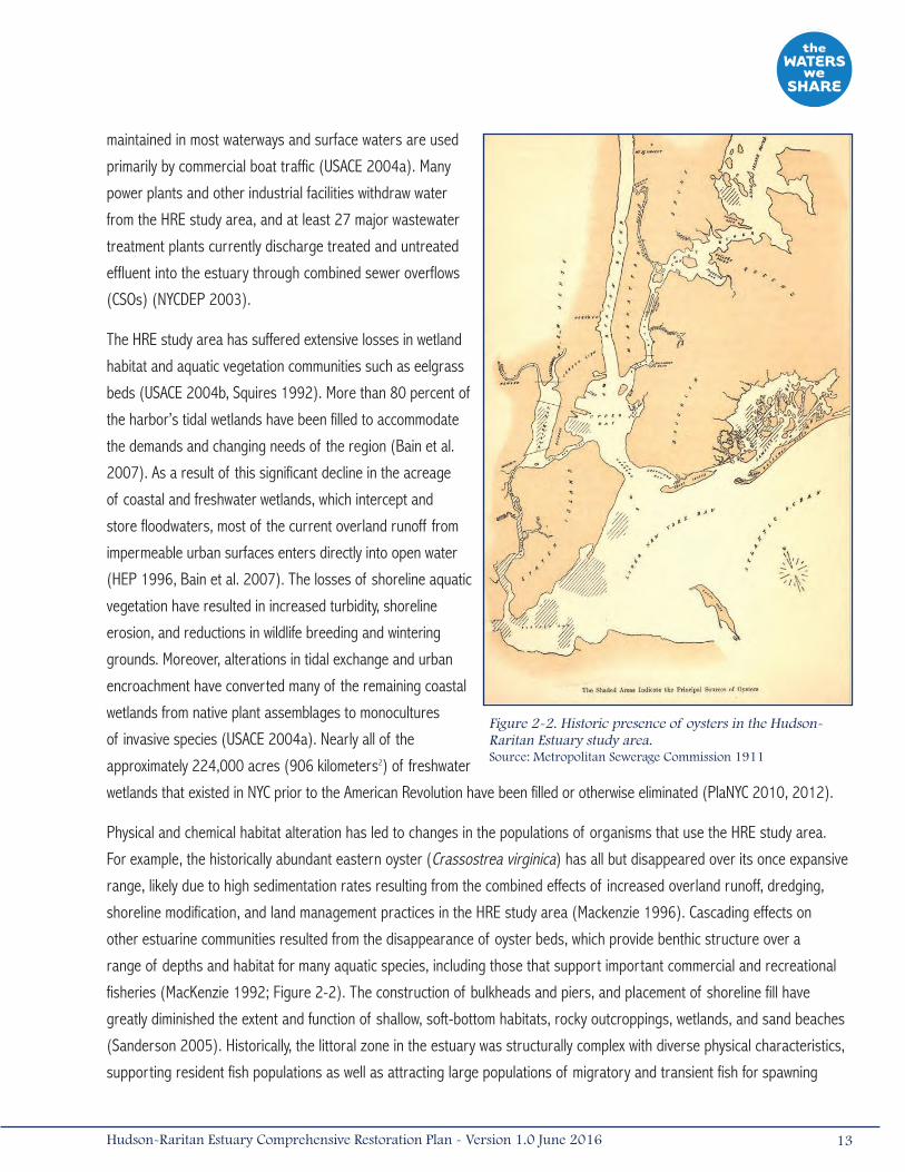
For example, the historically abundant eastern oyster (Crassostrea virginica) has all but disappeared over its once expansive
range, likely due to high sedimentation rates resulting from the combined effects of increased overland runoff, dredging,
shoreline modification, and land management practices in the HRE study area (Mackenzie 1996). Cascading effects on
other estuarine communities resulted from the disappearance of oyster beds, which provide benthic structure over a
range of depths and habitat for many aquatic species, including those that support important commercial and recreational
fisheries (MacKenzie 1992; Figure 2-2). The construction of bulkheads and piers, and placement of shoreline fill have
greatly diminished the extent and function of shallow, soft-bottom habitats, rocky outcroppings, wetlands, and sand beaches
(Sanderson 2005). Historically, the littoral zone in the estuary was structurally complex with diverse physical characteristics,
supporting resident fish populations as well as attracting large populations of migratory and transient fish for spawning
Figure 2-2. Historic presence of oysters in the Hudson-Raritan Estuary study area. Source: Metropolitan Sewerage Commission 1911
13Hudson-Raritan Estuary Comprehensive Restoration Plan - Version 1.0 June 2016
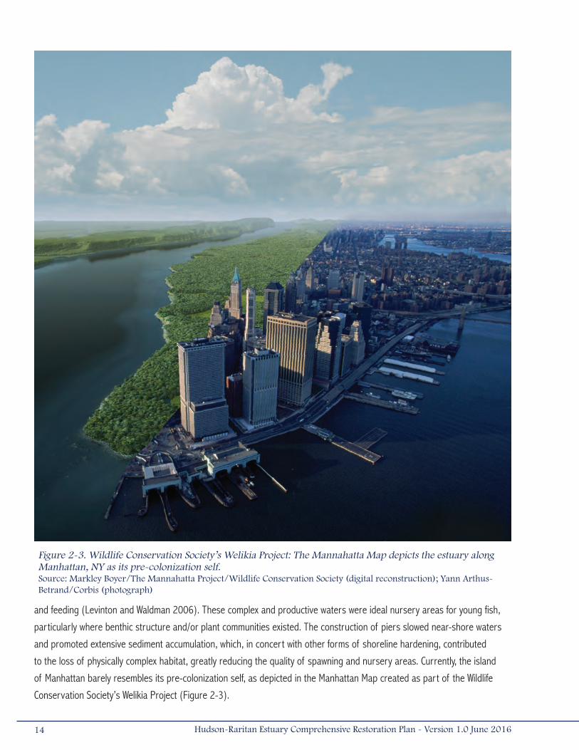
and feeding (Levinton and Waldman 2006). These complex and productive waters were ideal nursery areas for young fish,
particularly where benthic structure and/or plant communities existed. The construction of piers slowed near-shore waters
and promoted extensive sediment accumulation, which, in concert with other forms of shoreline hardening, contributed
to the loss of physically complex habitat, greatly reducing the quality of spawning and nursery areas. Currently, the island
of Manhattan barely resembles its pre-colonization self, as depicted in the Manhattan Map created as part of the Wildlife
Conservation Society’s Welikia Project (Figure 2-3).
Figure 2-3. Wildlife Conservation Society’s Welikia Project: The Mannahatta Map depicts the estuary along Manhattan, NY as its pre-colonization self. Source: Markley Boyer/The Mannahatta Project/Wildlife Conservation Society (digital reconstruction); Yann Arthus-Betrand/Corbis (photograph)
14 Hudson-Raritan Estuary Comprehensive Restoration Plan - Version 1.0 June 2016

2.2 History of Habitat Degradation and LossesDegradation and destruction of habitats in the HRE study area have been the result of human modifications to natural
systems, as well as natural forces. Historically, the types of degradation commonly identified in the HRE study area were
classified as bathymetric alterations, shoreline modifications, hydrodynamic and hydraulic changes, and changes to water and
sediment quality. In addition to human modifications, natural forces such as Hurricane Sandy have also resulted in habitat
loss and degradation.
2.2.1 Bathymetric AlterationsBefore colonial settlement, the HRE study area was a relatively shallow system, with most waters less than 20 feet (6
meters) in depth at mean low water. The completion of the Erie Canal in 1825 along the Mohawk River made passage
between the Great Lakes Region and the Atlantic Ocean possible. This eventually required deepening the natural channel of
the Hudson River and its estuary. While the lower Hudson River and estuary were naturally deep enough to accommodate
most vessels in 1825, as the need for more goods grew and wooden boats were replaced with larger steel ships, a series of
navigation improvement projects was initiated in New York Bay to accommodate these vessels. In 1891, a 30-foot (9-meter)
deep passage was dredged through the Lower Bay, followed by an extensive deepening to 40 feet (12 meters) completed
in 1914 (Parkman 1983). During World War II, the network of channels and supporting berthing areas were deepened
to almost 45 feet (14 meters) and expanded into the Upper, Raritan, and Newark Bays (Parkman 1983). Since then,
navigation channels have been maintained or deepened throughout the HRE’s rivers and bays, resulting in over 250 miles
(400 kilometers) of established channels and associated berthing areas. In 2000, Congress authorized the deepening of
the main shipping channels of the HRE to 50 feet (15 meters) to meet shipping needs and ensure the Harbor’s long-term
economic viability (§101 (a) (2) of Water Resources Development Act (WRDA) 2000, P.L. 106-541). This harbor deepening
effort is scheduled for completion in 2016.
2.2.2 Shoreline ModificationsShortly after European settlement, colonists began developing the shoreline in the HRE study area. By filling and stabilizing
nearshore habitat with soil, rocks, and refuse, colonists protected their homes and industries from flooding, erosion, and
ice, as well as created fast lands (i.e., land created above the high-water mark by shoreline hardening). Most of Manhattan’s
southern shorelines were hardened and approximately 279 acres (1.12 kilometers2) of new land was added onto the island
in an effort to expand the city. At the expense of the shoreline and shallow waters, riprap revetments and bulkheads stabilized
shorelines and allowed for larger vessels to navigate the bays and rivers. By the early 1800s, ship traffic increased and solid-
filled pier bases replaced the more basic stone embankment and timber piling designs. By 1853, there were 112 piers in the
East and lower Hudson Rivers, some of them extending 600 feet (180 meters) into the river (Wise et al. 1997).
Continued population growth and technological improvements called for improved transportation infrastructure. Railroad
causeways were built, fragmenting many wetlands in the Hackensack Meadowlands and surrounding areas. The present-day
LaGuardia, John F. Kennedy, and Newark International Airports were constructed on filled wetlands, as was Floyd Bennett
15Hudson-Raritan Estuary Comprehensive Restoration Plan - Version 1.0 June 2016

Field in Brooklyn. Decks were assembled into Flushing Bay to enlarge LaGuardia Airport by 50 acres (0.20 kilometers2;
HEP 1990). Major shipping terminals were established within the HRE, which currently occupy a total of 755 miles
(1,209 kilometers) of shoreline between New York and New Jersey, with 460 miles (736 kilometers) and 295 miles
(473 kilometers), respectively (USFWS 1997).
Urban and industrial uses currently dominate nearshore areas in the HRE study area, and these uses have eliminated
natural shoreline habitat from much of the estuary. These hardened and often deepened shorelines have replaced the gently
sloping and vegetated natural shorelines. Remaining stretches of natural shoreline within the HRE study area are typically
littered with debris, such as dilapidated piers or abandoned buildings, which suppress the growth of aquatic and terrestrial
vegetation and diminish habitat value and ecosystem function.
2.2.3 Hydrodynamic and Hydraulic ChangesWithin the estuary, most streams and creeks have either been eliminated by filling, redirected through storm sewers, or have
been altered by stormwater runoff or channelization. These modifications have also altered the estuarine salinity gradient
in many of the HRE’s tidal tributaries. Wastewater treatment plants and CSOs increase freshwater inputs to localized areas.
Stormwater runoff into the estuary also brings debris and sediment that can alter nearshore areas by filling or scouring,
depending on the magnitude of flow. Bridges, piers, and roadways have constricted or restricted flow in many locations
(USACE 2004a). Bathymetric alterations in support of navigation have also influenced water circulation and flow patterns. An
increase in ship traffic by larger vessels produces waves and wakes, and large, deep-draft vessels navigating in shallow side
channels results in scoured areas.
In addition to factors within the HRE study area that caused hydrodynamic and hydraulic changes, changes occurring outside
of the study area have also directly affected the estuary. One of the most substantial has been the decrease in freshwater
flow to the estuary. Flow from the Hudson River, the primary source of freshwater to the HRE study area, is significantly
diminished relative to historical conditions due to reservoirs, impoundments, and other water diversions. Impoundments alter
stream flow patterns and encourage upstream siltation that can alter channel structure, benthic substrate, and bank stability
in downstream river reaches. This decrease in freshwater flow to the estuary is exacerbated during low flow periods as flood
tides bring a greater volume of saline water up the Hudson River, influencing community composition and habitat use by
migratory and transient species.
2.2.4 Water Quality and Sediment DegradationFour centuries of human impacts have adversely affected water and sediment quality in the HRE study area. Unchecked and
untreated discharges of human and industrial wastes and debris entered the estuary and its sediments from the time of
European settlement to the establishment of environmental regulations in the 1970s. Although the establishment of water
quality regulations such as the Clean Water Act (CWA) has led to gradual improvements in water quality, the surface waters
are impaired in areas where bathymetry and/or shoreline alterations have affected the natural flows and flushing. In addition,
during large rain events, untreated wastewater enters the estuary through the hundreds of CSOs remaining in the HRE.
The wastewater contains floatable debris, as well as chemical and biological pollutants that include pesticides, fertilizers,
nutrients, metals, organochlorines, pharmaceuticals, pathogens (disease causing microorganisms), and sediment. The
16 Hudson-Raritan Estuary Comprehensive Restoration Plan - Version 1.0 June 2016
nutrients released from the CSOs promote the formation of algal blooms, which upon senescence and decomposition reduce
water column dissolved oxygen concentration and produce noxious odors. Dissolved oxygen levels can be particularly low in
some bays and confined waterways with limited circulation and where sewage treatment plants are the main source of fresh
water, such as the tributaries of Jamaica Bay and the Hackensack and Lower Passaic Rivers (HEP 2012).
Pathogens enter the HRE waterways by way of the sewage released from CSOs. Swimming in sewage-contaminated waters or
consuming tainted shellfish can cause illnesses such as gastroenteritis, typhoid fever, cholera, and hepatitis. As a result, the
actual or suspected presence of pathogens can result in beach closures and restrictions on activities involving contact with
water, as well as shellfish harvest and consumption (HEP 2012).
Urbanization also causes less conspicuous impairments to water quality. Increased paved and impervious surfaces restrict
the amount of water that can be absorbed by the ground surface and increases the amount of stormwater entering surface
waters. During extreme rain events, stormwater entering drainage systems may exceed the storage capacity of municipal
wastewater treatment plants, and a mixture of predominantly stormwater and diluted sewage is discharged, untreated, into
the HRE’s waterways. The prevalence of impervious surfaces in the HRE study area generates large volumes of stormwater,
and even relatively minor storms may result in CSO discharges. Urban runoff can also decrease clarity and alter circulation
patterns in surface waters, affecting sensitive aquatic habitats. Reduced water clarity can also affect foraging by zooplankton
or larval fish, and larger, predatory species.
There are also many point sources and historic discharges of contaminants of concern that have contributed to the legacy
contamination within the sediments and soils of the HRE study area. Implementation of the TECs hinges on removal of
Hazardous, Toxic, and Radioactive Waste (HTRW) contamination from within or near ecosystem restoration sites, and is
paramount to successful long-term restoration (USACE 2014). An HTRW assessment was conducted by USACE in 2014 to
identify, investigate, and assess potential HTRW sites that may influence current and potential restoration opportunities
within the HRE. Per the assessment, 1,386 HTRW sites are located within a 0.5 mile (1 kilometer) buffer of a CRP restoration
opportunity site. There are 50 USEPA Superfund Sites, 62 New York State Department of Environmental Conservation
(NYSDEC) environmental remediation sites, and 1,274 New Jersey Known Contaminated Sites (KCS) near CRP sites (USACE
2014). Most notably, the Lower Passaic River and the Hudson River Superfund Sites have contributed significant levels
of contamination that have been transported throughout the HRE study area. Sediment quality is critical to the estuarine
ecosystem, the success of the TECs, human health and safety, and the port’s economic viability. Any restoration initiative
undertaken in or along a water source draining to the Harbor and any restoration within the HRE is susceptible to impacts
from contaminated sediment (USACE 2014).
The presence of contaminated sediment from discharges or spills in portions of the HRE study area has decreased
the quality of benthic habitat and has led to increased levels of contaminates in many aquatic and terrestrial species.
Sediment and mussel samples from the estuary rank the highest overall in heavy metal, polyaromatic hydrocarbon (PAH),
polychlorinated biphenyl (PCB), pesticide, and dioxin concentrations among the estuaries sampled by the National Status
and Trends Program (NOAA 1995). Major sources of contaminated sediments include, but are not limited to, industrial
17Hudson-Raritan Estuary Comprehensive Restoration Plan - Version 1.0 June 2016

discharges, wastewater treatment plant discharges, CSOs, stormwater runoff, non-point source discharges, atmospheric
deposition, and chemical and oil spills (USFWS 1997). Other active sources of contamination to water and sediment quality
include leachate (i.e., water percolating through landfills), as well as persistent sediment contaminants that are vestiges
from before the CWA (HEP 1996). The Contaminant Assessment and Reduction Project (CARP), which completed the most
comprehensive data sampling and laboratory analysis program of sediments, ambient water, external sources, and biota
for the Harbor, determined that these legacy contaminants are expected to continue influencing sediments throughout the
HRE. In general, CARP model simulations indicate that levels of contaminants will continue to decline even if ongoing loads
remain constant. Ultimately, sediment remediation will likely be the most significant future method of source control (Lodge
et al. 2015).
Other significant indirect economic impacts of sediment and surface water contamination are associated with fisheries
resources. Although the HRE study area has historically supported significant fisheries resources, these benefits are
currently unclaimed due to fish consumption advisories relating to high concentrations of mercury, PCB, dioxin, and dichloro-
diphenyl-trichloroethane (DDT) in fish and shellfish (HEP 2012). Much of the harbor is closed to commercial fishing and
recreational fishing is primarily limited to anglers that practice catch-and-release techniques; however, there remains
significant subsistence consumption of locally caught fish despite health warnings. Contamination issues have limited the
economic benefits that could be achieved through a viable fishery that includes both commercial and recreational fishing
industries.
Contamination of the HRE’s surface waters and sediments has also led to significant indirect economic impacts to the region
through increased costs of port operation. Maintaining the economic viability of the region requires navigational access to
the Port of New York and New Jersey by container ships and vessels. Navigational channels require periodic maintenance and
deepening, and the costs associated with the placement of dredged materials vary with the concentration of contaminants
contained therein. Dredged materials with low concentrations of contaminants can be transported by barge for placement
at the Historic Area Remediation Site (HARS). However, fine-grained, and often contaminated sediments tend to settle in the
navigation channels and when dredged, appropriate placement sites must be identified. Expensive processing of sediments
(e.g., solidification and stabilization) is often required to bind the contaminants prior to the overland transport and ultimate
upland disposal or beneficial use. These processes can exponentially increase the costs associated with navigation channel
maintenance and decrease the overall efficiency of navigation programs (USACE 2008b, Lodge et al. 2015).
2.2.5 Hurricane SandySince the 2009 publication of the Draft CRP for the HRE, a major coastal storm radically altered the coastal habitats within
the HRE. On October 29, 2012, Hurricane Sandy made landfall near Brigantine, New Jersey as a post-tropical cyclone
with hurricane-force winds, driving a catastrophic storm surge into the New Jersey and New York coastlines and affecting
the HRE study area. This surge was accompanied by powerful and damaging waves, especially along the coast of central
and northern New Jersey, Staten Island, and the southern-facing shores of Long Island. Flood depths due to the storm
surge combined with a high tide cycle were as much as 9 feet (3 meters) above the ground surface in Manhattan, Staten
Island, and other low-lying areas within the New York/New Jersey Metropolitan Area. With estimated damages of $65 billion,
Hurricane Sandy was the second costliest hurricane in the nation’s history and the largest storm of its kind to hit the U.S.
18 Hudson-Raritan Estuary Comprehensive Restoration Plan - Version 1.0 June 2016
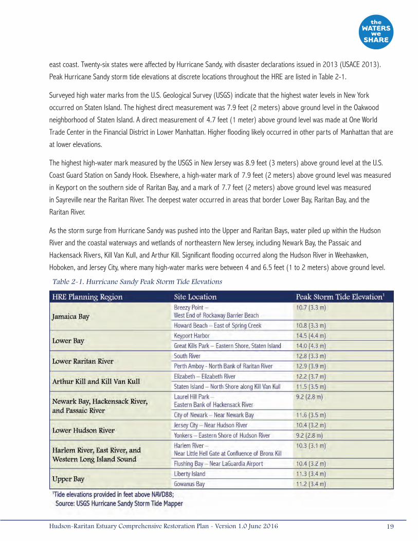
east coast. Twenty-six states were affected by Hurricane Sandy, with disaster declarations issued in 2013 (USACE 2013).
Peak Hurricane Sandy storm tide elevations at discrete locations throughout the HRE are listed in Table 2-1.
Surveyed high water marks from the U.S. Geological Survey (USGS) indicate that the highest water levels in New York
occurred on Staten Island. The highest direct measurement was 7.9 feet (2 meters) above ground level in the Oakwood
neighborhood of Staten Island. A direct measurement of 4.7 feet (1 meter) above ground level was made at One World
Trade Center in the Financial District in Lower Manhattan. Higher flooding likely occurred in other parts of Manhattan that are
at lower elevations.
The highest high-water mark measured by the USGS in New Jersey was 8.9 feet (3 meters) above ground level at the U.S.
Coast Guard Station on Sandy Hook. Elsewhere, a high-water mark of 7.9 feet (2 meters) above ground level was measured
in Keyport on the southern side of Raritan Bay, and a mark of 7.7 feet (2 meters) above ground level was measured
in Sayreville near the Raritan River. The deepest water occurred in areas that border Lower Bay, Raritan Bay, and the
Raritan River.
As the storm surge from Hurricane Sandy was pushed into the Upper and Raritan Bays, water piled up within the Hudson
River and the coastal waterways and wetlands of northeastern New Jersey, including Newark Bay, the Passaic and
Hackensack Rivers, Kill Van Kull, and Arthur Kill. Significant flooding occurred along the Hudson River in Weehawken,
Hoboken, and Jersey City, where many high-water marks were between 4 and 6.5 feet (1 to 2 meters) above ground level.
Table 2-1. Hurricane Sandy Peak Storm Tide Elevations
19Hudson-Raritan Estuary Comprehensive Restoration Plan - Version 1.0 June 2016
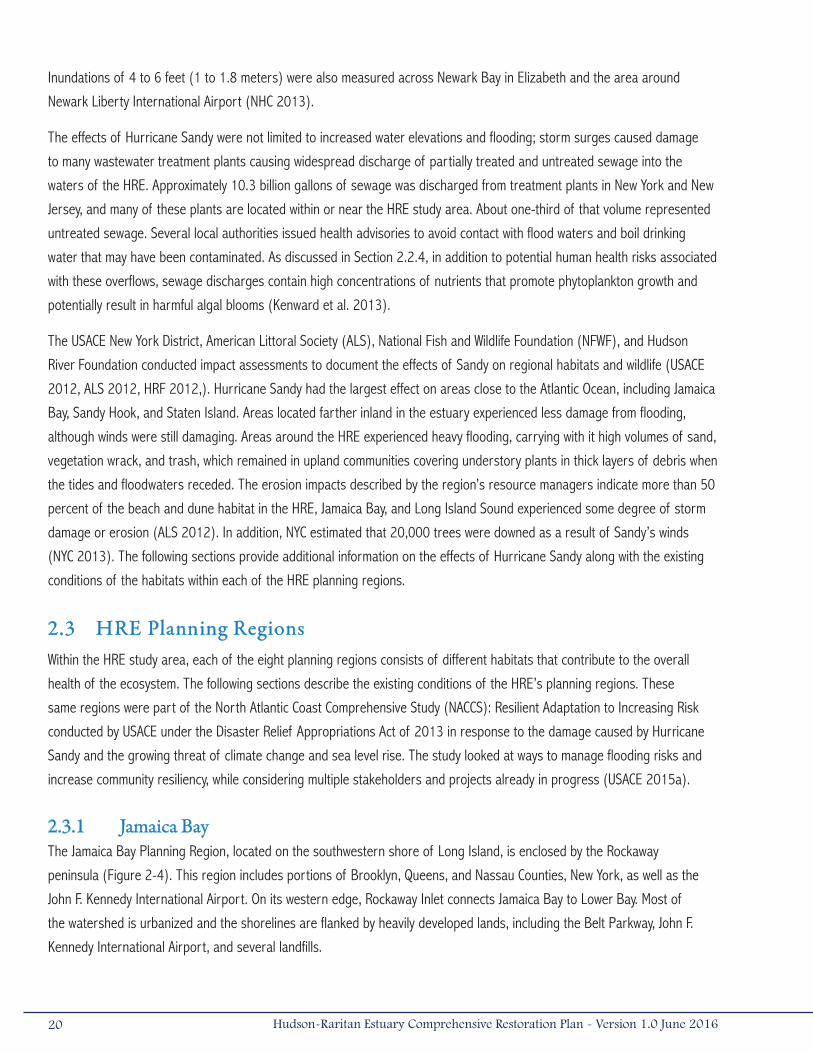
Inundations of 4 to 6 feet (1 to 1.8 meters) were also measured across Newark Bay in Elizabeth and the area around
Newark Liberty International Airport (NHC 2013).
The effects of Hurricane Sandy were not limited to increased water elevations and flooding; storm surges caused damage
to many wastewater treatment plants causing widespread discharge of partially treated and untreated sewage into the
waters of the HRE. Approximately 10.3 billion gallons of sewage was discharged from treatment plants in New York and New
Jersey, and many of these plants are located within or near the HRE study area. About one-third of that volume represented
untreated sewage. Several local authorities issued health advisories to avoid contact with flood waters and boil drinking
water that may have been contaminated. As discussed in Section 2.2.4, in addition to potential human health risks associated
with these overflows, sewage discharges contain high concentrations of nutrients that promote phytoplankton growth and
potentially result in harmful algal blooms (Kenward et al. 2013).
The USACE New York District, American Littoral Society (ALS), National Fish and Wildlife Foundation (NFWF), and Hudson
River Foundation conducted impact assessments to document the effects of Sandy on regional habitats and wildlife (USACE
2012, ALS 2012, HRF 2012,). Hurricane Sandy had the largest effect on areas close to the Atlantic Ocean, including Jamaica
Bay, Sandy Hook, and Staten Island. Areas located farther inland in the estuary experienced less damage from flooding,
although winds were still damaging. Areas around the HRE experienced heavy flooding, carrying with it high volumes of sand,
vegetation wrack, and trash, which remained in upland communities covering understory plants in thick layers of debris when
the tides and floodwaters receded. The erosion impacts described by the region’s resource managers indicate more than 50
percent of the beach and dune habitat in the HRE, Jamaica Bay, and Long Island Sound experienced some degree of storm
damage or erosion (ALS 2012). In addition, NYC estimated that 20,000 trees were downed as a result of Sandy’s winds
(NYC 2013). The following sections provide additional information on the effects of Hurricane Sandy along with the existing
conditions of the habitats within each of the HRE planning regions.
2.3 HRE Planning RegionsWithin the HRE study area, each of the eight planning regions consists of different habitats that contribute to the overall
health of the ecosystem. The following sections describe the existing conditions of the HRE’s planning regions. These
same regions were part of the North Atlantic Coast Comprehensive Study (NACCS): Resilient Adaptation to Increasing Risk
conducted by USACE under the Disaster Relief Appropriations Act of 2013 in response to the damage caused by Hurricane
Sandy and the growing threat of climate change and sea level rise. The study looked at ways to manage flooding risks and
increase community resiliency, while considering multiple stakeholders and projects already in progress (USACE 2015a).
2.3.1 Jamaica BayThe Jamaica Bay Planning Region, located on the southwestern shore of Long Island, is enclosed by the Rockaway
peninsula (Figure 2-4). This region includes portions of Brooklyn, Queens, and Nassau Counties, New York, as well as the
John F. Kennedy International Airport. On its western edge, Rockaway Inlet connects Jamaica Bay to Lower Bay. Most of
the watershed is urbanized and the shorelines are flanked by heavily developed lands, including the Belt Parkway, John F.
Kennedy International Airport, and several landfills.
20 Hudson-Raritan Estuary Comprehensive Restoration Plan - Version 1.0 June 2016
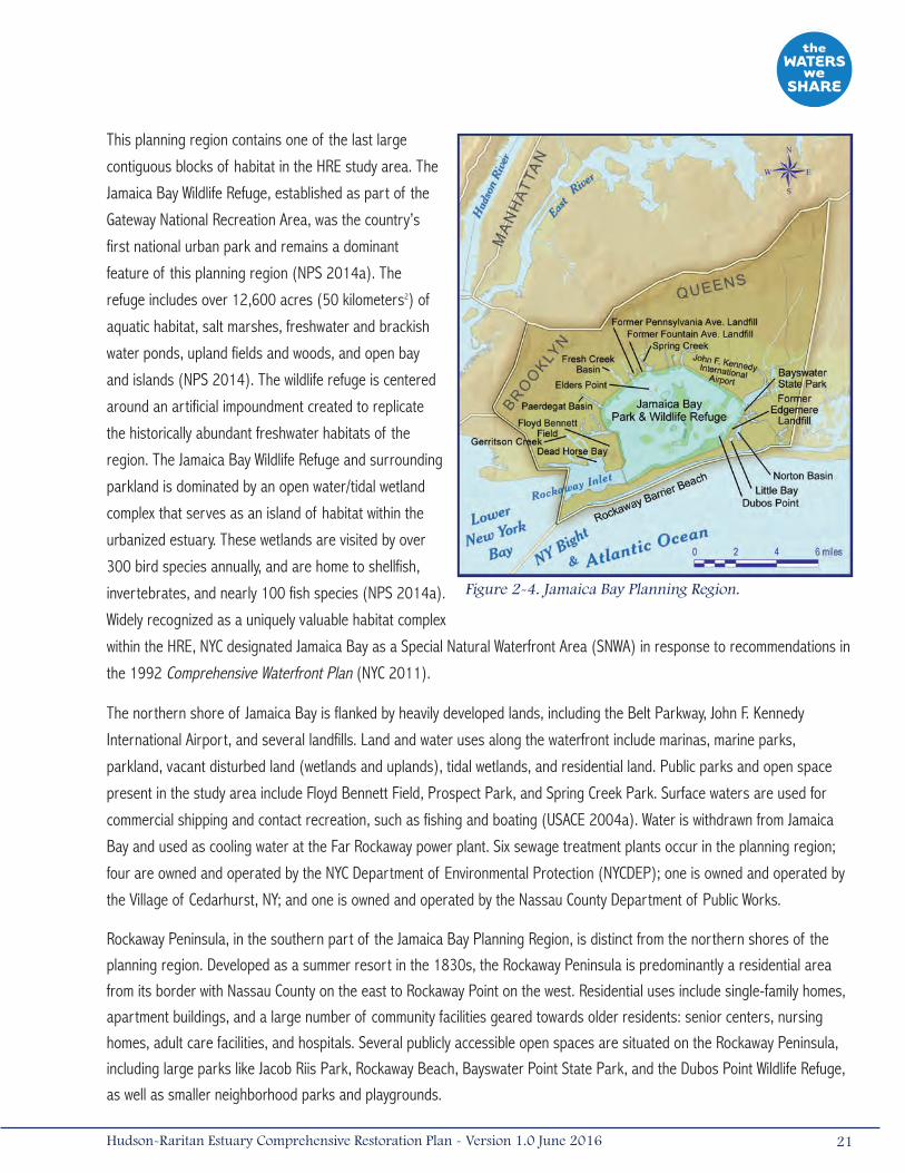
This planning region contains one of the last large
contiguous blocks of habitat in the HRE study area. The
Jamaica Bay Wildlife Refuge, established as part of the
Gateway National Recreation Area, was the country’s
first national urban park and remains a dominant
feature of this planning region (NPS 2014a). The
refuge includes over 12,600 acres (50 kilometers2) of
aquatic habitat, salt marshes, freshwater and brackish
water ponds, upland fields and woods, and open bay
and islands (NPS 2014). The wildlife refuge is centered
around an artificial impoundment created to replicate
the historically abundant freshwater habitats of the
region. The Jamaica Bay Wildlife Refuge and surrounding
parkland is dominated by an open water/tidal wetland
complex that serves as an island of habitat within the
urbanized estuary. These wetlands are visited by over
300 bird species annually, and are home to shellfish,
invertebrates, and nearly 100 fish species (NPS 2014a).
Widely recognized as a uniquely valuable habitat complex
within the HRE, NYC designated Jamaica Bay as a Special Natural Waterfront Area (SNWA) in response to recommendations in
the 1992 Comprehensive Waterfront Plan (NYC 2011).
The northern shore of Jamaica Bay is flanked by heavily developed lands, including the Belt Parkway, John F. Kennedy
International Airport, and several landfills. Land and water uses along the waterfront include marinas, marine parks,
parkland, vacant disturbed land (wetlands and uplands), tidal wetlands, and residential land. Public parks and open space
present in the study area include Floyd Bennett Field, Prospect Park, and Spring Creek Park. Surface waters are used for
commercial shipping and contact recreation, such as fishing and boating (USACE 2004a). Water is withdrawn from Jamaica
Bay and used as cooling water at the Far Rockaway power plant. Six sewage treatment plants occur in the planning region;
four are owned and operated by the NYC Department of Environmental Protection (NYCDEP); one is owned and operated by
the Village of Cedarhurst, NY; and one is owned and operated by the Nassau County Department of Public Works.
Rockaway Peninsula, in the southern part of the Jamaica Bay Planning Region, is distinct from the northern shores of the
planning region. Developed as a summer resort in the 1830s, the Rockaway Peninsula is predominantly a residential area
from its border with Nassau County on the east to Rockaway Point on the west. Residential uses include single-family homes,
apartment buildings, and a large number of community facilities geared towards older residents: senior centers, nursing
homes, adult care facilities, and hospitals. Several publicly accessible open spaces are situated on the Rockaway Peninsula,
including large parks like Jacob Riis Park, Rockaway Beach, Bayswater Point State Park, and the Dubos Point Wildlife Refuge,
as well as smaller neighborhood parks and playgrounds.
Figure 2-4. Jamaica Bay Planning Region.
21Hudson-Raritan Estuary Comprehensive Restoration Plan - Version 1.0 June 2016
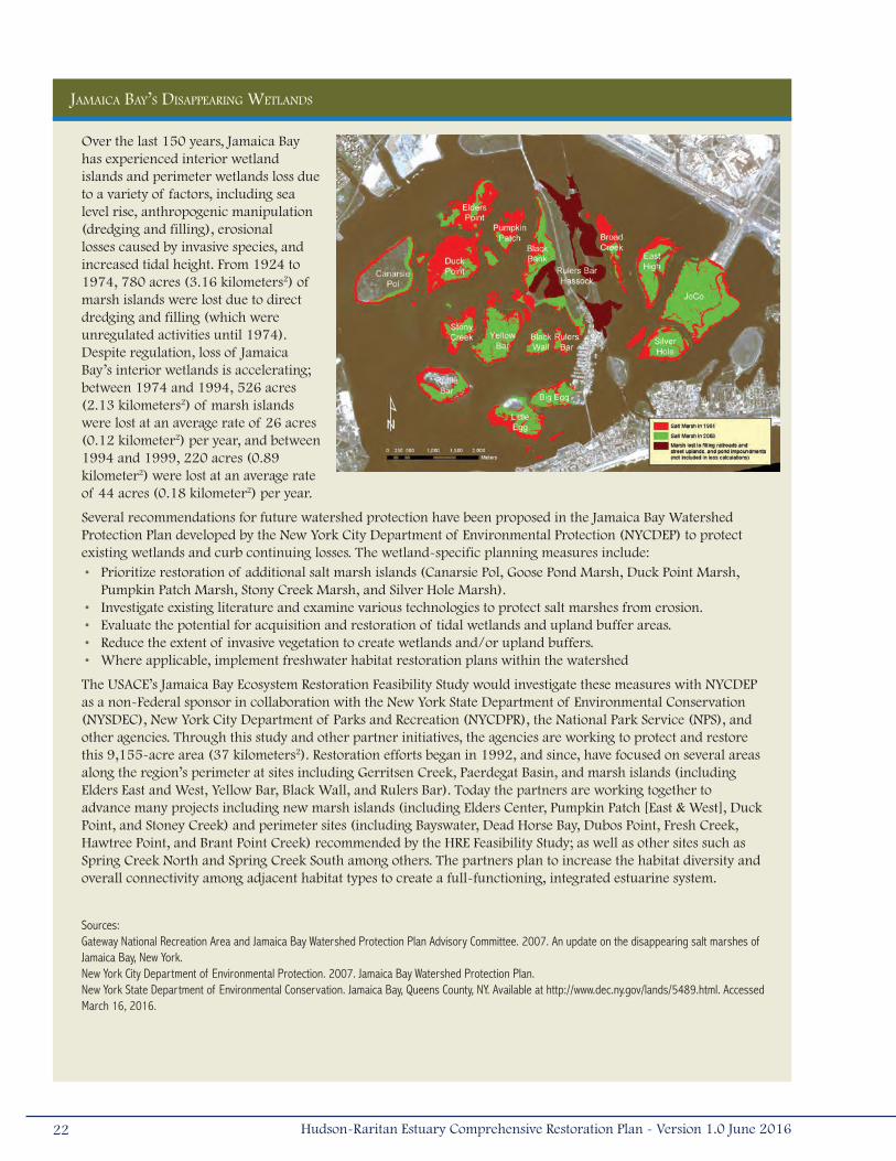
Jamaica Bay’s Disappearing WetlanDs
Over the last 150 years, Jamaica Bay has experienced interior wetland islands and perimeter wetlands loss due to a variety of factors, including sea level rise, anthropogenic manipulation (dredging and filling), erosional losses caused by invasive species, and increased tidal height. From 1924 to 1974, 780 acres (3.16 kilometers2) of marsh islands were lost due to direct dredging and filling (which were unregulated activities until 1974). Despite regulation, loss of Jamaica Bay’s interior wetlands is accelerating; between 1974 and 1994, 526 acres (2.13 kilometers2) of marsh islands were lost at an average rate of 26 acres (0.12 kilometer2) per year, and between 1994 and 1999, 220 acres (0.89 kilometer2) were lost at an average rate of 44 acres (0.18 kilometer2) per year.
Several recommendations for future watershed protection have been proposed in the Jamaica Bay Watershed Protection Plan developed by the New York City Department of Environmental Protection (NYCDEP) to protect existing wetlands and curb continuing losses. The wetland-specific planning measures include:• Prioritize restoration of additional salt marsh islands (Canarsie Pol, Goose Pond Marsh, Duck Point Marsh,
Pumpkin Patch Marsh, Stony Creek Marsh, and Silver Hole Marsh).• Investigate existing literature and examine various technologies to protect salt marshes from erosion.• Evaluate the potential for acquisition and restoration of tidal wetlands and upland buffer areas.• Reduce the extent of invasive vegetation to create wetlands and/or upland buffers.• Where applicable, implement freshwater habitat restoration plans within the watershed
The USACE’s Jamaica Bay Ecosystem Restoration Feasibility Study would investigate these measures with NYCDEP as a non-Federal sponsor in collaboration with the New York State Department of Environmental Conservation (NYSDEC), New York City Department of Parks and Recreation (NYCDPR), the National Park Service (NPS), and other agencies. Through this study and other partner initiatives, the agencies are working to protect and restore this 9,155-acre area (37 kilometers2). Restoration efforts began in 1992, and since, have focused on several areas along the region’s perimeter at sites including Gerritsen Creek, Paerdegat Basin, and marsh islands (including Elders East and West, Yellow Bar, Black Wall, and Rulers Bar). Today the partners are working together to advance many projects including new marsh islands (including Elders Center, Pumpkin Patch [East & West], Duck Point, and Stoney Creek) and perimeter sites (including Bayswater, Dead Horse Bay, Dubos Point, Fresh Creek, Hawtree Point, and Brant Point Creek) recommended by the HRE Feasibility Study; as well as other sites such as Spring Creek North and Spring Creek South among others. The partners plan to increase the habitat diversity and overall connectivity among adjacent habitat types to create a full-functioning, integrated estuarine system.
Sources:Gateway National Recreation Area and Jamaica Bay Watershed Protection Plan Advisory Committee. 2007. An update on the disappearing salt marshes of Jamaica Bay, New York.New York City Department of Environmental Protection. 2007. Jamaica Bay Watershed Protection Plan. New York State Department of Environmental Conservation. Jamaica Bay, Queens County, NY. Available at http://www.dec.ny.gov/lands/5489.html. Accessed March 16, 2016.
22 Hudson-Raritan Estuary Comprehensive Restoration Plan - Version 1.0 June 2016
Islands scattered through the marshes and mudflats support important nesting habitat for colonial waterbirds (USACE
2004a). Upland meadows and shrublands provide habitat for terrestrial species and are important buffer areas. Breezy
Point, at the western tip of Rockaway Barrier Beach, sustains large populations of beach-nesting birds, including one of
the largest nesting colonies of piping plovers (Charadrius melodus) in the New York Bight coastal region (USFWS 1997).
Although fish and wildlife species make use of what habitat remains within the planning region, the wetland habitat within
Jamaica Bay is eroding rapidly and the surrounding land use further diminishes the quality of the habitat (NYSDEC 2001).
Jamaica Bay is threatened by poor water and sediment quality, and habitat loss. CSOs, landfill leaching, municipal waste
discharge, and runoff from the roads and developed areas diminish water quality (USFWS 1997). Chronic erosion in the
bay has sloughed off shorelines and deteriorated the interior islands. Substantial marsh losses were first identified by the
Jamaica Bay Ecowatchers and brought to the attention of Federal and state agencies in 1999. An estimated 1,400 acres
(5.67 kilometers2) of tidal salt marsh have been lost from the marsh islands since 1924, with the system-wide loss rate
rapidly increasing in recent years. From 1994 to 1999, an estimated 220 acres (0.89 kilometer2) of salt marsh were lost at
a rate of 47 acres (0.19 kilometer2) per year. Left alone, the marshes were projected to vanish by 2025, destroying wildlife
habitat and threatening the bay's shorelines (NYSDEC 2001).
About 4,000 acres (16 kilometers2) of the original wetland habitat remains, a reduction of almost 75 percent (RPA 2003).
Dredging and filling of the wetlands accounts for historic habitat losses in this region; these direct impacts were responsible
for approximately 780 acres (3 kilometers2) of marsh loss between 1924 and the passage of the CWA in 1974 (NYSDEC
2001). Remnant borrow pits and channels in the Bay, some as deep as 60 feet (18 meters), are sometimes oxygen-deficient
(hypoxic), affecting habitat suitability for fish and wildlife. These depressions may act as sediment sinks, trapping fine, organic
sediment that otherwise may have been deposited on the surrounding wetlands, and may also alter the hydrodynamics of
Jamaica Bay by increasing the residence time of water as much as three-fold (Hartig et al. 2002, USFWS 1997).
The Jamaica Bay Planning Region experienced extensive damages resulting from the storm surge associated with Hurricane
Sandy. Hardest hit areas in the planning region were the Atlantic shoreline of the Rockaway Peninsula and Breezy Point
and the Howard Beach community (GOSR 2014) within Jamaica Bay. The Atlantic shorefront suffered severe beach erosion
resulting in shoreline retreat of up to 100 feet (30 meters) and lowering dune and berm elevations up to 5 feet (2 meters;
USACE 2012). Storm surge induced inundation of up to 5 feet (2 meters) over the entire inland area. In addition, storm
waves induced runup, overtopping, overwash, and damaged waterfront structures including boardwalks, concrete walls,
residential buildings, roads, and other infrastructure.
Within the interior of Jamaica Bay, coastal wetlands were littered with debris following the storm and wrack deposits were
visible in many marsh areas. Initial reports and damage assessments may have underestimated the amount of wrack
deposited, especially where obscured by dense reed stands or maritime woody vegetation (ALS 2012). The Jamaica Bay
marsh islands, restored prior to Hurricane Sandy by the USACE in partnership with NYSDEC, NYCDEP, PANYNJ, and National
Park Service (NPS), accumulated significant amounts of debris, but experienced relatively little damage to existing plantings;
repairs to vegetation originally planted at Yellow Bar Island in the summer of 2012 were required in the spring of 2014. The
23Hudson-Raritan Estuary Comprehensive Restoration Plan - Version 1.0 June 2016
sand placed on Rulers Bar and Black Wall islands did not experience any damage as a result of the storm. Black Wall and
Rulers Bar were subsequently vegetated through a community based planting effort led by ALS, Jamaica Bay Ecowatchers,
and the Jamaica Bay Guardian funded by NYCDEP in July 2013.
The freshwater East and West Ponds of the Jamaica Bay Wildlife Refuge were breached by the storm surge during Hurricane
Sandy and were inundated with saltwater. Storm waves washed away portions of the berm that separated the ponds from
Jamaica Bay, transforming them into saltwater inlets. The ponds were well known for their abundance of waterfowl and
shorebirds, including snow geese (Chen caerulescens), lesser and greater scaup (Aythya affinis and A. marila), ruddy duck
(Oxyura jamaicensis), ring-necked duck (Aythya collaris), green winged teal (Anas carolinensis), northern pintail (Anas
acuta), American wigeon (Anas americana), and gadwall (Anas strepera). The sudden rise in salinity created an unsuitable
environment for brackish water species, which may ultimately alter foraging habitats (ALS 2012). Proposed repairs to
the primary and secondary breaches include replacement of the wetlands water control structure and installation of a
groundwater well to provide freshwater, which will allow NPS to return West Pond to a more freshwater and resilient condition
that supports a diversity of Jamaica Bay habitats and wildlife (NPS 2016).
Wastewater treatment plants within the Jamaica Bay Planning Region were flooded during Hurricane Sandy, resulting in the
release of partially treated or untreated sewage into the surrounding waterbodies. The Coney Island Wastewater Treatment
Plant on Sheepshead Bay was inundated and released 213 million gallons of raw sewage, and an additional 284 million
gallons of partially treated sewage. The 26th Ward Wastewater Treatment Plant also bypassed 89 million gallons of partially
treated sewage into Jamaica Bay via Hendrix Creek (Kenward et al. 2013).
Significant investments by the partner agencies to identify solutions to future coastal flooding and restoration of the
ecosystem have transpired since Hurricane Sandy devastated the Jamaica Bay Planning Region. Major studies and resiliency
efforts include the Atlantic Coast of New York City, East Rockaway Inlet to Rockaway Inlet and Jamaica Bay Coastal Storm Risk
Management Reformulation Study (USACE 2015a), Howard Beach – New York Rising Reconstruction Plan (GOSR 2014),
NPS Sandy Resilience Projects, and the formation of the Science and Resiliency Institute at Jamaica Bay, coordinated through
a General Management Agreement with the City University of New York (CUNY) and the NPS as part of the NPS Sandy
Resilience Projects. Many of the efforts are collecting significant amounts of baseline information, advancing the state of the
science, and enhancing coordination among partners and stakeholders in order to develop comprehensive strategies for
coastal restoration in the planning region. In addition, these efforts require coordination with the Final General Management
Plan for the “New Vision for a Great Urban National Park Gateway National Recreation Area” (NPS 2014b).
2.3.2 Lower BayThe Lower Bay Planning Region contains an expanse of both deep and shallow open water habitat, including Lower Bay,
Raritan Bay, and Sandy Hook Bay (Figure 2-5). The planning region is bounded on the north by Staten Island and Brooklyn,
on the south by Monmouth County, New Jersey. An artificial transect between Sandy Hook, New Jersey and Rockaway Point,
New York separates Lower Bay from the New York Bight. The Lower Bay Planning Region is predominantly developed with
industrial, commercial, residential, and recreational land uses. Sandy Hook peninsula, and Hoffman and Swinburne Islands
just off Staten Island, are part of the Gateway National Recreation Area. Sandy Hook’s shoreline is interspersed with
public and private marinas, sandy beaches, and riprap shorelines (USACE 1999). Private and public beaches are scattered
24 Hudson-Raritan Estuary Comprehensive Restoration Plan - Version 1.0 June 2016

throughout the region, located in Monmouth County,
New Jersey, and on Coney Island and Staten Island, New
York. The surface waters in this planning region are used
for commercial shipping and recreational boating and
fishing/shellfishing (USACE 2004a). Major waterbodies
in this planning region provide a combination of marine
and estuarine habitats that support diverse ecological
communities (USACE 2004a); Lower Bay generally
provides deeper, marine habitat, while the Raritan Bay –
Sandy Hook Bay complex is generally shallow with much
of the bay’s 69,188 acre-area (280 kilometers2) at less
than 20 feet (6 meters) deep (USFWS 1997). Lower
Bay is influenced by Jamaica Bay, Upper Bay, the Atlantic
Ocean, and dozens of freshwater tributaries. Raritan
Bay receives inputs from the Raritan River and Newark
Bay and its tributaries via the Arthur Kill. Sandy Hook
Bay receives inputs from the Navesink and Shrewsbury
Rivers, which are separated from the Atlantic Ocean by a
barrier beach.
In comparison to other planning regions in the HRE
study area, the Lower Bay’s shoreline retains a more
natural configuration, with salt marshes, extensive mudflats, and sandy beaches providing valuable fish and shellfish habitat,
primarily in Raritan and Sandy Hook Bays (RPA 2003). The (USFWS) National Wetlands Inventory depicts over 4,800 acres (19
kilometers2) of intertidal and subtidal sand flats and mudflats off the shorelines of the bays and western Staten Island (USFWS
1997). Sandy Hook is a 9-mile (15-kilometer) narrow sand spit that has a fairly extensive vegetated dune system and two
distinct maritime forest communities that encompass 285 acres (1 kilometer2).
Soft shoreline habitat, primarily sandy bank, also surrounds Coney Island, with occasional riprap and seawalls (USACE 1999).
Beach habitat provides foraging areas for waterfowl and shorebirds (RPA 2003). Riparian forests of the Atlantic Highlands
occur along the upper reaches of the Navesink and Shrewsbury Rivers (RPA 2003, USACE 2004a, USACE 1999). Raritan Bay
and Sandy Hook Bay also support the greatest variety of state and Federally listed threatened and endangered species in
the HRE study area (USFWS 1997).
Hurricane Sandy caused extensive damage along the Atlantic shoreline, within coastal wetlands and freshwater surface
waters in the Lower Bay Planning Region. The Atlantic shoreline, including Coney Island in New York, Sandy Hook, and areas
south to Manasquan Inlet in New Jersey, experienced changes to the shore profile and loss of beach fill and erosion, with an
Figure 2-5. Lower Bay Planning Region.
25Hudson-Raritan Estuary Comprehensive Restoration Plan - Version 1.0 June 2016
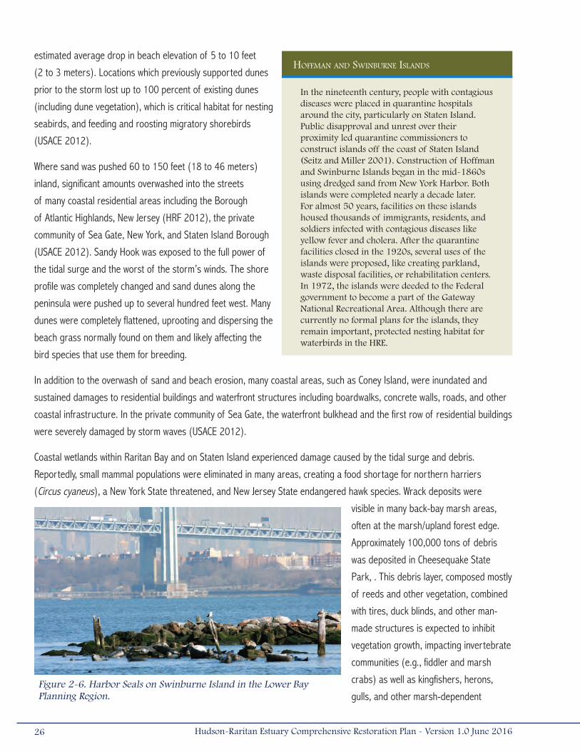
estimated average drop in beach elevation of 5 to 10 feet
(2 to 3 meters). Locations which previously supported dunes
prior to the storm lost up to 100 percent of existing dunes
(including dune vegetation), which is critical habitat for nesting
seabirds, and feeding and roosting migratory shorebirds
(USACE 2012).
Where sand was pushed 60 to 150 feet (18 to 46 meters)
inland, significant amounts overwashed into the streets
of many coastal residential areas including the Borough
of Atlantic Highlands, New Jersey (HRF 2012), the private
community of Sea Gate, New York, and Staten Island Borough
(USACE 2012). Sandy Hook was exposed to the full power of
the tidal surge and the worst of the storm’s winds. The shore
profile was completely changed and sand dunes along the
peninsula were pushed up to several hundred feet west. Many
dunes were completely flattened, uprooting and dispersing the
beach grass normally found on them and likely affecting the
bird species that use them for breeding.
In addition to the overwash of sand and beach erosion, many coastal areas, such as Coney Island, were inundated and
sustained damages to residential buildings and waterfront structures including boardwalks, concrete walls, roads, and other
coastal infrastructure. In the private community of Sea Gate, the waterfront bulkhead and the first row of residential buildings
were severely damaged by storm waves (USACE 2012).
Coastal wetlands within Raritan Bay and on Staten Island experienced damage caused by the tidal surge and debris.
Reportedly, small mammal populations were eliminated in many areas, creating a food shortage for northern harriers
(Circus cyaneus), a New York State threatened, and New Jersey State endangered hawk species. Wrack deposits were
visible in many back-bay marsh areas,
often at the marsh/upland forest edge.
Approximately 100,000 tons of debris
was deposited in Cheesequake State
Park, . This debris layer, composed mostly
of reeds and other vegetation, combined
with tires, duck blinds, and other man-
made structures is expected to inhibit
vegetation growth, impacting invertebrate
communities (e.g., fiddler and marsh
crabs) as well as kingfishers, herons,
gulls, and other marsh-dependent
Hoffman anD sWinBurne islanDs
In the nineteenth century, people with contagious diseases were placed in quarantine hospitals around the city, particularly on Staten Island. Public disapproval and unrest over their proximity led quarantine commissioners to construct islands off the coast of Staten Island (Seitz and Miller 2001). Construction of Hoffman and Swinburne Islands began in the mid-1860s using dredged sand from New York Harbor. Both islands were completed nearly a decade later. For almost 50 years, facilities on these islands housed thousands of immigrants, residents, and soldiers infected with contagious diseases like yellow fever and cholera. After the quarantine facilities closed in the 1920s, several uses of the islands were proposed, like creating parkland, waste disposal facilities, or rehabilitation centers. In 1972, the islands were deeded to the Federal government to become a part of the Gateway National Recreational Area. Although there are currently no formal plans for the islands, they remain important, protected nesting habitat for waterbirds in the HRE.
Figure 2-6. Harbor Seals on Swinburne Island in the Lower Bay Planning Region.
26 Hudson-Raritan Estuary Comprehensive Restoration Plan - Version 1.0 June 2016
birds that feed upon them (ALS 2012). More information is required to assess the impacts to invertebrates, which could
be devastating to marsh-dependent birds. The need for further impact assessment was noted as an important source of
concern by resource managers throughout the planning region (ALS 2012).
In addition to coastal wetlands, Hurricane Sandy’s tidal surge caused saltwater intrusions in freshwater lakes and wetlands
throughout the Lower Bay Planning Region. Several vernal pools in the lowland forest were also destroyed by the storm
surge. Affected species include frogs, toads, and salamanders (ALS 2012). At Hooks Creek Lake in Cheesequake State Park,
the saltwater intrusion was exacerbated by a dam/culvert structure damaged by the storm. Potentially impacted species
include black bass, catfish, sunfish, carp, and crappie (ALS 2012). Brown’s Pond, located on Staten Island, experienced
episodic fish kills as a result of saltwater inundation; impacted species included fish, primarily carp, ducks, and freshwater-
dependent shorebirds.
Maritime holly (Illex opaca) and red cedar (Juniperus virginiana) forests in Sandy Hook survived the storm. However, there
was extensive damage to Atlantic white cedar (Chamaecyparis thyoides) swamp forests in Cheesequake State Park, including
saltwater intrusion, blow-down trees, and the creation of canopy gaps. More than 300 trees were lost, including 100-year
old oaks and numerous Atlantic white cedars.
Hurricane Sandy caused extensive damage to sewage treatment plants in waters surrounding the Lower Bay planning region.
State officials issued water use advisories for surface waters within the Lower Bay Planning Region (ALS 2012).
On June 12, 2015, HEP and Sustainable Raritan River Initiative brought together more than 200 stakeholders from New
Jersey and New York for “Two States: One Bay, bi-state conversation about the future of Raritan Bay.” Discussions centered
on water quality, climate resiliency, habitat conservation and restoration, fish and shellfish management, and public access. A
report published following the event detailed specific insights and opportunities for action for these foci. Particularly relevant
to habitat, opportunities focused on expanding the existing inventory of opportunities, supporting a larger-scale connectivity
analysis, and working across both states to address scientific and management challenges to oyster restoration (HEP 2016b).
2.3.3 Lower Raritan RiverPrimarily located in Middlesex County, New Jersey, the Lower Raritan River is the western-most planning region of the HRE
study area (Figure 2-7). This region contains the lower 6 miles (10 kilometers) of the Raritan River before its confluence
with Raritan Bay (USACE 2004a). Portions of the planning region stretch into Union, Somerset, and Monmouth Counties,
New Jersey.
The shoreline of the Lower Raritan River is flanked with residential or industrial development. Land use changes from
predominantly industrial development with bulkheaded shorelines and piers at the river’s mouth to a mix of industrial,
commercial, and residential development farther upstream (USACE 2004a, USACE 1999). Agricultural lands are located
along the upstream boundary of the planning region (USACE 2004a). Isolated pockets of tidal wetlands occur along the
shore (USACE 2004a, USACE 1999). An unremediated landfill, the former Raritan Arsenal, and the Sayreville and Werner
generating stations are also located along the shoreline (Figure 2-7). Although there are no public bathing areas in the
27Hudson-Raritan Estuary Comprehensive Restoration Plan - Version 1.0 June 2016
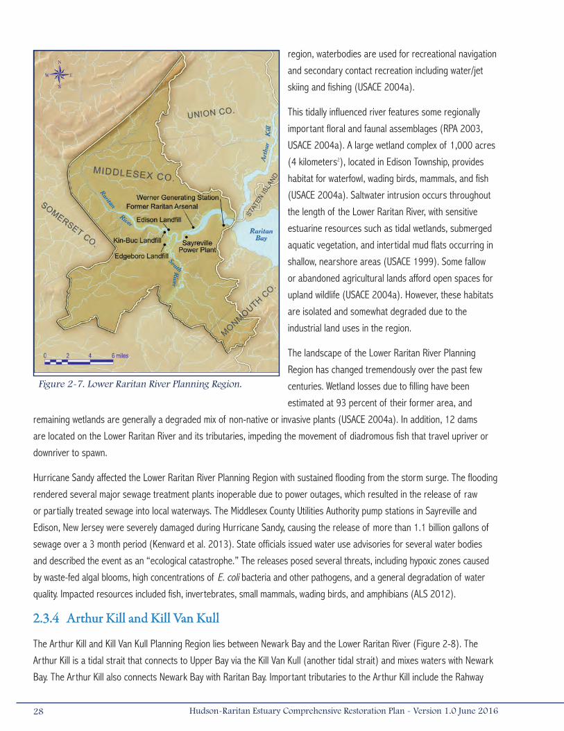
region, waterbodies are used for recreational navigation
and secondary contact recreation including water/jet
skiing and fishing (USACE 2004a).
This tidally influenced river features some regionally
important floral and faunal assemblages (RPA 2003,
USACE 2004a). A large wetland complex of 1,000 acres
(4 kilometers2), located in Edison Township, provides
habitat for waterfowl, wading birds, mammals, and fish
(USACE 2004a). Saltwater intrusion occurs throughout
the length of the Lower Raritan River, with sensitive
estuarine resources such as tidal wetlands, submerged
aquatic vegetation, and intertidal mud flats occurring in
shallow, nearshore areas (USACE 1999). Some fallow
or abandoned agricultural lands afford open spaces for
upland wildlife (USACE 2004a). However, these habitats
are isolated and somewhat degraded due to the
industrial land uses in the region.
The landscape of the Lower Raritan River Planning
Region has changed tremendously over the past few
centuries. Wetland losses due to filling have been
estimated at 93 percent of their former area, and
remaining wetlands are generally a degraded mix of non-native or invasive plants (USACE 2004a). In addition, 12 dams
are located on the Lower Raritan River and its tributaries, impeding the movement of diadromous fish that travel upriver or
downriver to spawn.
Hurricane Sandy affected the Lower Raritan River Planning Region with sustained flooding from the storm surge. The flooding
rendered several major sewage treatment plants inoperable due to power outages, which resulted in the release of raw
or partially treated sewage into local waterways. The Middlesex County Utilities Authority pump stations in Sayreville and
Edison, New Jersey were severely damaged during Hurricane Sandy, causing the release of more than 1.1 billion gallons of
sewage over a 3 month period (Kenward et al. 2013). State officials issued water use advisories for several water bodies
and described the event as an “ecological catastrophe.” The releases posed several threats, including hypoxic zones caused
by waste-fed algal blooms, high concentrations of E. coli bacteria and other pathogens, and a general degradation of water
quality. Impacted resources included fish, invertebrates, small mammals, wading birds, and amphibians (ALS 2012).
2.3.4 Arthur Kill and Kill Van Kull
The Arthur Kill and Kill Van Kull Planning Region lies between Newark Bay and the Lower Raritan River (Figure 2-8). The
Arthur Kill is a tidal strait that connects to Upper Bay via the Kill Van Kull (another tidal strait) and mixes waters with Newark
Bay. The Arthur Kill also connects Newark Bay with Raritan Bay. Important tributaries to the Arthur Kill include the Rahway
Figure 2-7. Lower Raritan River Planning Region.
28 Hudson-Raritan Estuary Comprehensive Restoration Plan - Version 1.0 June 2016

and Elizabeth Rivers, Old Place Creek, Woodbridge Creek, and Fresh Kills Creek (USACE 2004a). The Arthur Kill/Kill Van Kull
Planning Region has a dynamic hydrology due to the variation in tidal velocity, amount of freshwater flow, and bathymetry
among the three connecting bays (i.e., Upper, Newark, and Raritan Bays; USACE 1999).
These waterways exist within a heavily industrialized and developed corridor, with an average population density of almost
5,000 people per square mile (2,000/kilometer2). The New Jersey side of the Arthur Kill is industrialized; large areas of
wetlands are intermingled with industrial facilities on the New York side. On Staten Island, wetlands are located adjacent to
the world’s largest landfill (Fresh Kills) and the Arthur Kill Generating Station. In the southern section, many abandoned
industrial facilities exist along the shoreline (USACE 2004a). The industries of the Arthur Kill and Kill Van Kull waterways
process petroleum and non-petrol chemicals along their shorelines, and occasional oil spills occur (Yozzo et al. 2001,
Steinberg et al. 2004). At least 30 closed landfills and dozens of contaminated brownfields once discharged leachate into
the groundwater in this planning region (USACE 2004a). Although leachate collection systems are now in place on most
of the closed landfills, many contaminants persist in estuarine sediments (USACE 2004a). The Arthur Kill and Kill Van Kull
also have deepwater navigation channels that allow transport of cargo into and out of the Ports of New York and New
Jersey. Howland Hook Marine Terminal (HHMT) is located on Staten Island’s northwestern waterfront along the Arthur
Kill, approximately one mile (1.6 kilometers) west
of Arlington, New York. The area between Arlington
and HHMT is sparsely populated, with large industrial
sites and a few local roadways. Much of the area is
undeveloped and vacant. Prominent land uses around
HHMT include transportation facilities and industrial
sites. Industrial properties south of HHMT include the
PANYNJ’s Gulfport, Visy Paper Plant, R.T. Baker & Sons
(defunct salvage operation), and the former GATX Staten
Island Terminal Property.
The extensive tributary system of the Arthur Kill
supports a mosaic of tidal and freshwater wetlands,
mudflats, and riparian forest. Deeper, open-water
habitats in this planning region support over 60
migratory and resident fish species including species
of commercial or recreational importance such as
winter flounder (Pseudoplueronectes americanus) and
black sea bass (Centropristis striata; RPA 2003, USACE
2004a). Northwest Staten Island and the islands along
the Arthur Kill and Kill Van Kull were designated as a
SNWA by NYC due to the diverse landscape of habitats Figure 2-8. Arthur Kill and Kill Van Kull Planning Region.
29Hudson-Raritan Estuary Comprehensive Restoration Plan - Version 1.0 June 2016
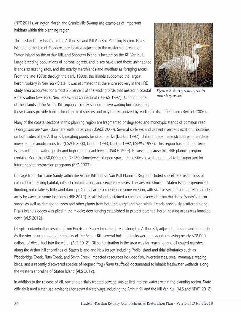
(NYC 2011). Arlington Marsh and Graniteville Swamp are examples of important
habitats within this planning region.
Three islands are located in the Arthur Kill and Kill Van Kull Planning Region. Pralls
Island and the Isle of Meadows are located adjacent to the western shoreline of
Staten Island on the Arthur Kill, and Shooters Island is located on the Kill Van Kull.
Large breeding populations of herons, egrets, and ibises have used these uninhabited
islands as nesting sites, and the nearby marshlands and mudflats as foraging areas.
From the late 1970s through the early 1990s, the islands supported the largest
heron rookery in New York State. It was estimated that the entire rookery in the HRE
study area accounted for almost 25 percent of the wading birds that nested in coastal
waters within New York, New Jersey, and Connecticut (USFWS 1997). Although none
of the islands in the Arthur Kill region currently support active wading bird rookeries,
these islands provide habitat for other bird species and may be recolonized by wading birds in the future (Bernick 2006).
Many of the coastal sections in this planning region are fragmented or degraded and monotypic stands of common reed
(Phragmites australis) dominate wetland parcels (USACE 2000). Several spillways and cement riverbeds exist on tributaries
on both sides of the Arthur Kill, creating ponds for urban parks (Durkas 1992). Unfortunately, these structures often deter
movement of anadromous fish (USACE 2000, Durkas 1993, Durkas 1992, USFWS 1997). This region has had long-term
issues with poor water quality and high contaminant levels (USACE 1999). However, because this HRE planning region
contains More than 30,000 acres (>120 kilometers2) of open space, these sites have the potential to be important for
future habitat restoration programs (RPA 2003).
Damage from Hurricane Sandy within the Arthur Kill and Kill Van Kull Planning Region included shoreline erosion, loss of
colonial bird nesting habitat, oil spill contamination, and sewage releases. The western shore of Staten Island experienced
flooding, but relatively little wind damage. Coastal areas experienced some erosion, with sizable sections of shoreline eroded
away by waves in some locations (HRF 2012). Pralls Island sustained a complete overwash from Hurricane Sandy’s storm
surge, as well as damage to trees and other plants from both the surge and high winds. Debris previously scattered along
Pralls Island’s edges was piled in the middle; deer fencing established to protect potential heron nesting areas was knocked
down (ALS 2012).
Oil spill contamination resulting from Hurricane Sandy impacted areas along the Arthur Kill, adjacent marshes and tributaries.
As the storm surge flooded the banks of the Arthur Kill, several bulk fuel tanks were damaged, releasing nearly 378,000
gallons of diesel fuel into the water (ALS 2012). Oil contamination in the area was far reaching, and oil coated marshes
along the Arthur Kill shorelines of Staten Island and New Jersey, including Pralls Island and tidal tributaries such as
Woodbridge Creek, Rum Creek, and Smith Creek. Impacted resources included fish, invertebrates, small mammals, wading
birds, and a recently discovered species of leopard frog (Rana kauffeldi) documented to inhabit freshwater wetlands along
the western shoreline of Staten Island (ALS 2012).
In addition to the release of oil, raw and partially treated sewage was spilled into the waters within the planning region. State
officials issued water use advisories for several waterways including the Arthur Kill and the Kill Van Kull (ALS and NFWF 2012).
Figure 2-9. A great egret in marsh grasses.
30 Hudson-Raritan Estuary Comprehensive Restoration Plan - Version 1.0 June 2016
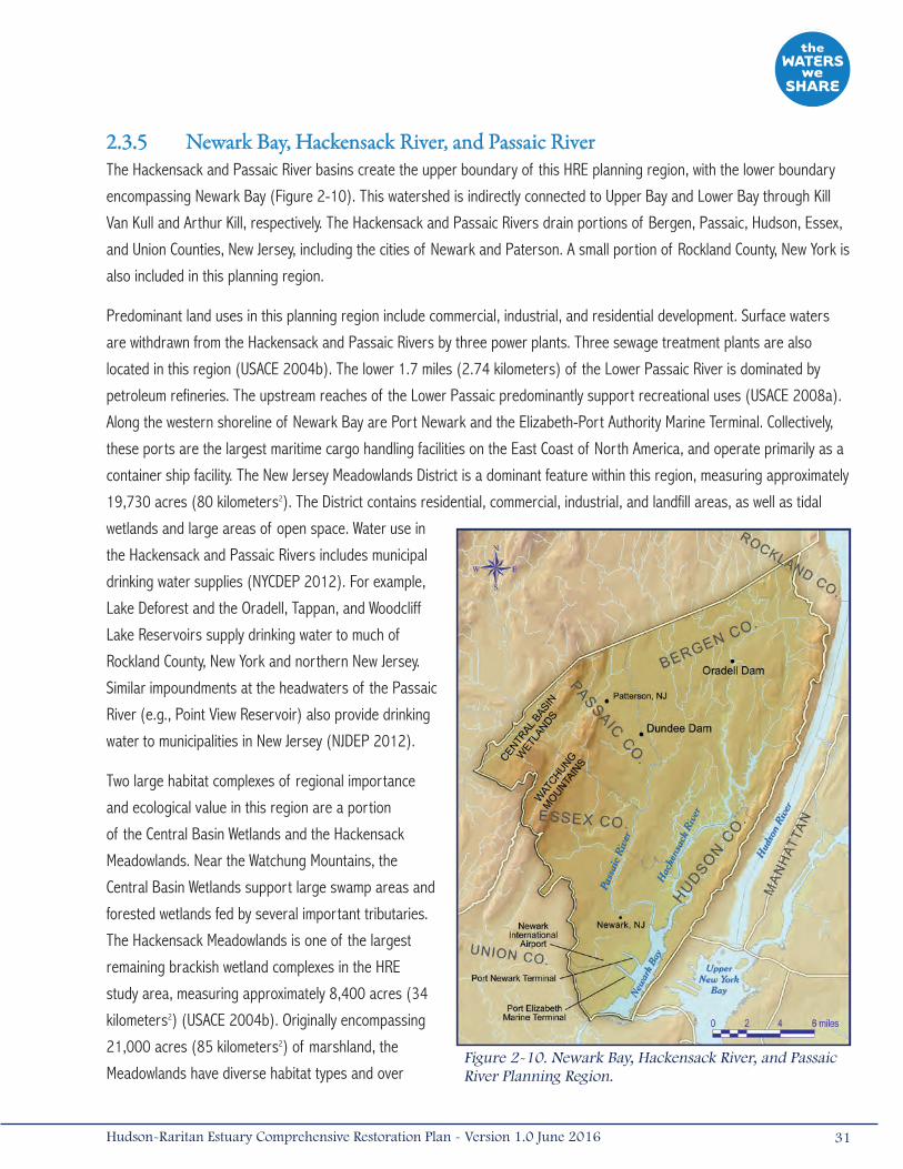
2.3.5 Newark Bay, Hackensack River, and Passaic RiverThe Hackensack and Passaic River basins create the upper boundary of this HRE planning region, with the lower boundary
encompassing Newark Bay (Figure 2-10). This watershed is indirectly connected to Upper Bay and Lower Bay through Kill
Van Kull and Arthur Kill, respectively. The Hackensack and Passaic Rivers drain portions of Bergen, Passaic, Hudson, Essex,
and Union Counties, New Jersey, including the cities of Newark and Paterson. A small portion of Rockland County, New York is
also included in this planning region.
Predominant land uses in this planning region include commercial, industrial, and residential development. Surface waters
are withdrawn from the Hackensack and Passaic Rivers by three power plants. Three sewage treatment plants are also
located in this region (USACE 2004b). The lower 1.7 miles (2.74 kilometers) of the Lower Passaic River is dominated by
petroleum refineries. The upstream reaches of the Lower Passaic predominantly support recreational uses (USACE 2008a).
Along the western shoreline of Newark Bay are Port Newark and the Elizabeth-Port Authority Marine Terminal. Collectively,
these ports are the largest maritime cargo handling facilities on the East Coast of North America, and operate primarily as a
container ship facility. The New Jersey Meadowlands District is a dominant feature within this region, measuring approximately
19,730 acres (80 kilometers2). The District contains residential, commercial, industrial, and landfill areas, as well as tidal
wetlands and large areas of open space. Water use in
the Hackensack and Passaic Rivers includes municipal
drinking water supplies (NYCDEP 2012). For example,
Lake Deforest and the Oradell, Tappan, and Woodcliff
Lake Reservoirs supply drinking water to much of
Rockland County, New York and northern New Jersey.
Similar impoundments at the headwaters of the Passaic
River (e.g., Point View Reservoir) also provide drinking
water to municipalities in New Jersey (NJDEP 2012).
Two large habitat complexes of regional importance
and ecological value in this region are a portion
of the Central Basin Wetlands and the Hackensack
Meadowlands. Near the Watchung Mountains, the
Central Basin Wetlands support large swamp areas and
forested wetlands fed by several important tributaries.
The Hackensack Meadowlands is one of the largest
remaining brackish wetland complexes in the HRE
study area, measuring approximately 8,400 acres (34
kilometers2) (USACE 2004b). Originally encompassing
21,000 acres (85 kilometers2) of marshland, the
Meadowlands have diverse habitat types and over Figure 2-10. Newark Bay, Hackensack River, and Passaic River Planning Region.
31Hudson-Raritan Estuary Comprehensive Restoration Plan - Version 1.0 June 2016

100 species of nesting birds, fish, and shellfish, many of which are state or Federally protected (RPA 2003). Although
degraded, the Meadowlands and surrounding areas in this region represent significant open spaces that continue to provide
ecosystem functions, including flood storage and fish/wildlife habitat, and offer a variety of potential restoration opportunities
(USFWS 1997).
Lower stretches of the Passaic and Hackensack Rivers provide habitat for marine and estuarine fish and invertebrates, while
farther upstream, the rivers support a mix of estuarine and freshwater species (USACE 2004b). Newark Bay’s open water
is used by many fish and invertebrate species as nursery habitat, although its shorelines and river channels have been
greatly modified by bulkheads and riprap. Unfortunately, the hydrology of open river areas has been altered by numerous
flood risk management structures, dams, and debris, which reduce connectivity and freshwater flow to Newark Bay and block
upstream passage by fishes (USFWS 1997). Anadromous fishes make annual spawning runs up the 17-mile (27-kilometer)
tidal stretch of the Passaic River to the Dundee Dam, but are blocked from going farther. The Oradell Reservoir Dam, on the
Hackensack River, blocks passage of American shad (Alosa sapidissima), alewife (A. pseudoharengus), and blueback herring
(A. aestivalis) from reaching upstream segments of the watershed (USACE 2004b). Other smaller dams and inoperable tide
gates in the planning region degrade habitat and impair passage for diadromous species, including American eel (Anguilla
rostrata) (Durkas 1993).
Development in this planning region has contributed to extensive habitat losses. Historic wetland losses and hydrologic
modifications have transformed the Hackensack Meadowlands from a rich combination of fresh and saltwater marshland into
a less diverse, brackish tidal marsh with a 60 percent loss in area (RPA 2003, USACE 2004b). Even at this reduced size,
the Meadowlands still represents, after Jamaica Bay, one of the largest remaining tracts of estuarine wetland habitat in HRE
study area. In the past few years, the Meadowlands have been the subject of large-scale ecosystem restoration projects
through the establishment of mitigation banks and mitigation projects.
Many streams feeding into the Hackensack and Passaic Rivers have been converted to storm sewer drainages. Surrounding
wetlands were filled or ditched in order to control mosquito populations. These actions have resulted in water quality
degradation and have altered native floral and faunal assemblages (USACE 2004b, Yozzo et al. 2001). Shorelines and river
channels have been greatly modified by bulkheads and riprap. Dams and debris reduce connectivity and freshwater flow to
Newark Bay and block upstream and downstream fish passage.
The level of contamination in this region is of great concern to stakeholders. The lower Hackensack River and Passaic River
basins and Newark Bay have been a center of industry since the Industrial Revolution. As a result, hundreds of chemical,
herbicide, paint, and pigment manufacturing plants; petroleum refineries; and other large industrial facilities have been
located along their banks. Unregulated discharges from these facilities have caused severe contamination of sediments in
the rivers. Pathogenic microbial contamination, floatable debris, excessive levels of waterborne nutrients, and non-point
source discharges further impair water quality. Strict consumption advisories are currently in effect for fish and crabs caught
from this region.
Although several petroleum refineries and chemical manufacturing plants continue to operate, the majority of the industrial
facilities in the planning region have been shut down, but their legacy of contaminants still remain in the sediments. Primary
contaminants of concern in the study area include dioxins (2,3,7,8-tetrachlordibenzo-p-dioxin [TCDD]), mercury, lead,
32 Hudson-Raritan Estuary Comprehensive Restoration Plan - Version 1.0 June 2016
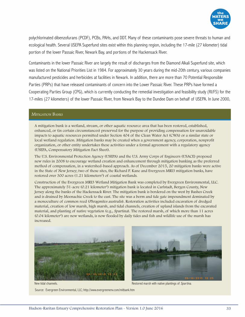
polychlorinated dibenzofurans (PCDF), PCBs, PAHs, and DDT. Many of these contaminants pose severe threats to human and
ecological health. Several USEPA Superfund sites exist within this planning region, including the 17-mile (27 kilometer) tidal
portion of the lower Passaic River, Newark Bay, and portions of the Hackensack River.
Contaminants in the lower Passaic River are largely the result of discharges from the Diamond Alkali Superfund site, which
was listed on the National Priorities List in 1984. For approximately 30 years during the mid-20th century, various companies
manufactured pesticides and herbicides at facilities in Newark. In addition, there are more than 70 Potential Responsible
Parties (PRPs) that have released contaminants of concern into the Lower Passaic River. These PRPs have formed a
Cooperating Parties Group (CPG), which is currently conducting the remedial investigation and feasibility study (RI/FS) for the
17-miles (27 kilometers) of the lower Passaic River, from Newark Bay to the Dundee Dam on behalf of USEPA. In June 2000,
mitigation Banks
A mitigation bank is a wetland, stream, or other aquatic resource area that has been restored, established, enhanced, or (in certain circumstances) preserved for the purpose of providing compensation for unavoidable impacts to aquatic resources permitted under Section 404 of the Clean Water Act (CWA) or a similar state or local wetland regulation. Mitigation banks may be created when a government agency, corporation, nonprofit organization, or other entity undertakes these activities under a formal agreement with a regulatory agency (USEPA, Compensatory Mitigation Fact Sheet).
The U.S. Environmental Protection Agency (USEPA) and the U.S. Army Corps of Engineers (USACE) proposed new rules in 2008 to encourage wetland creation and enhancement through mitigation banking as the preferred method of compensation, in a watershed-based approach. As of December 2015, 20 mitigation banks were active in the State of New Jersey; two of those sites, the Richard P. Kane and Evergreen MRI3 mitigation banks, have restored over 300 acres (1.21 kilometers2) of coastal wetlands.
Construction of the Evergreen MRI3 Wetland Mitigation Bank was completed by Evergreen Environmental, LLC. The approximately 51-acre (0.21 kilometer2) mitigation bank is located in Carlstadt, Bergen County, New Jersey along the banks of the Hackensack River. The mitigation bank is bordered on the west by Bashes Creek and is drained by Moonachie Creek to the east. The site was a berm and tide gate impoundment dominated by a monoculture of common reed (Phragmites australis). Restoration activities included excavation of dredged material, creation of low marsh, high marsh, and tidal channels, creation of upland islands from the excavated material, and planting of native vegetation (e.g., Spartina). The restored marsh, of which more than 11 acres (0.04 kilometer2) are new wetlands, is now flooded by daily tides and fish and wildlife use of the marsh has increased.
New tidal channels. Restored marsh with native plantings of Spartina.
Source: Evergreen Environmental, LLC; http://www.evergreenenv.com/mitbank.htm
33Hudson-Raritan Estuary Comprehensive Restoration Plan - Version 1.0 June 2016

USACE New York District initiated a reconnaissance study to identify and inventory water resources and sediment quality
related problems and needs in the HRE. The reconnaissance study identified the Lower Passaic River as one of the priority
restoration areas within the estuary. In recognition of the coincidental study areas and related roles and responsibilities
of USEPA and USACE, along with the project sponsor (New Jersey Department of Transportation [NJDOT]), the agencies
integrated the USEPA Superfund RI/FS and USACE Feasibility Study into one comprehensive cooperative effort (www.
ourpassaic.org).
This coordinated effort was also a pilot project to coordinate remediation and restoration of degraded urban rivers in the
U.S. under the Urban River Restoration Initiative (URRI). For the purpose of this study, a ‘governmental partnership’ was
formed and includes USEPA, USACE, National Oceanic and Atmospheric Administration (NOAA), USFWS, NJDOT, and the
New Jersey Department of Environmental Protection (NJDEP) to assist in recommending a comprehensive solution for the
Lower Passaic River Basin. While the RI/FS was advancing, USEPA signed an agreement with Occidental Chemical and Tierra
Solutions (Tierra) to remove 200,000 cubic yards (CY) of contaminated sediment from the portion of the Lower Passaic
River adjacent to the former Diamond Alkali facility in Newark. The first phase of the removal (40,000 CY) was completed
in 2012. In 2013, USEPA and the CPG implemented a Time-Critical Removal Action (removal of 16,000 CY with cap) to
address highly contaminated surface sediments in Lyndhurst, which was completed in 2014. A Focused Feasibility Study
and Proposed Plan were released by USEPA in April 2014 (USEPA 2014a). USEPA issued the Record of Decision on the
final cleanup plan for the lower 8.3 miles (13.4 kilometers) of the Passaic River in March 2016 that includes bank to bank
dredging and removal of 3.5 million CY of sediment and subsequent capping (USEPA 2016). The USEPA has also been
studying Newark Bay since 2004 to determine the nature and extent of sediment contamination, determine potential risks of
contamination, and to determine the significant, on-going sources of pollution (USEPA 2014b).
The Lower Passaic River was designated a location for Urban Waters Federal Partnership (UWFP) in February 2013, a
program coordinated by the White House Domestic Policy Council to improve our nation’s water systems and promote their
economic, environmental, and social benefits (www.urbanwaters.gov). USEPA and USACE serve as co-leads with the intent
to reconnect overburdened or economically distressed urban communities with their waterways by improving coordination
among Federal agencies and collaborating with community led revitalization efforts. Specifically, the UWFP program will
enhance the coordination of USEPA’s Superfund program, USACE’s Ecosystem Restoration and Flood Risk Management/
Coastal Restoration Programs, other Federal and state programs, as well as work with the City of Newark, other interested
municipalities, Ironbound Community Corporation (ICC), and other local non-governmental organizations (NGOs).
An example of a program that promotes recreational use in this planning region is the Passaic Valley Sewerage Commission’s
(PVSC) Passaic River Blueway, a 76-mile (122-kilometers) canoe and kayak trail that spans the Passaic River from Fairfield,
New Jersey to Newark Bay. Existing and proposed public access points and facilities along the Passaic River Blueway provide
new opportunities for the community to enjoy and learn about the natural resources in the area.
Berry’s Creek is a tidal tributary to the Hackensack River located within the Meadowlands in Bergen County, New Jersey.
The creek is located in a highly industrial area, and contaminants and discharges from surrounding properties have
led to sediment mercury concentrations greater than what is considered to be protective of wildlife. Berry’s Creek has
historically been associated with mercury contamination originating from the Ventron/Velsicol Superfund site. However, two
34 Hudson-Raritan Estuary Comprehensive Restoration Plan - Version 1.0 June 2016
other USEPA Superfund sites, the Universal Oil Products site and the Scientific Chemical Processing site, as well as several
hazardous waste sites are located in the Berry’s Creek watershed. The USEPA Berry’s Creek study area includes the 6.5-mile
(10-kilometer) Berry’s Creek, its tributaries, the Berry’s Creek canal, and adjacent wetlands. The Berry’s Creek study area
has been the subject of an RI/FS since 2006. The trustees (USFWS and NOAA) completed a pre-assessment screening to
determine the extent of impacts to the watershed in 2014 and they are currently planning for a full NRDA. USEPA is currently
conducting sediment sampling after a recently released preliminary assessment report on the Lower Hackensack River in
Bergen and Hudson Counties outlined potential threats to public health and/or the environment posed by the site, identified
the potential for release of hazardous constituents into the environment, and recommended possible placement of the site
on the National Priorities List (USEPA 2015).
In the fall of 2012, the Newark Bay, Hackensack River, and Passaic River Planning Region sustained damage from Hurricane
Sandy leading to saltwater intrusion, debris, and water use advisories. In the Hackensack Meadowlands, a series of naturally
occurring and man-made earthen berms prevent tidal waters from entering developed areas and freshwater habitats in the
surrounding townships. Most of these berms are at an elevation of less than 6 feet (2 meters) above sea level, and were
not able to prevent Sandy’s 9-foot (2.7-meter) storm surge from reaching developed lands and freshwater habitats (MERI
2013). Some areas along the Hackensack River experienced episodic fish kills potentially due to increases in salinity, with
reports of numerous carp washed up along shorelines. Data collected by the Meadowlands Environmental Research Institute
(MERI) showed a sharp increase in salinity in various areas of the Meadowlands as the storm hit (MERI 2013). Kearny
Marsh, an important breeding site for least bittern (Ixobrychus exilis) was affected by floating islands of common reed
stands pushed inland by the storm surge. As part of the Rebuild By Design competition sponsored by the U.S. Department
of Housing and Urban Development (HUD) and the Hurricane Sandy Rebuilding Task Force, a design has been proposed to
transform parts of the Meadowlands to better protect surrounding communities from future storm surges and floodwaters.
This design, named “New Meadowlands: Productive City + Regional Park” combines ecosystem restoration, technology,
and innovative re-development to help transform the area for multiple benefits to the local communities and economy. This
project, along with other winning designs in the region, is discussed further in Section 2.6.2 "Responses to Hurricane Sandy."
Following Hurricane Sandy, sewage releases prompted state officials to issue water use advisories for several surface waters
within the planning region, including the Passaic and Hackensack Rivers, and Newark Bay. Damage to the PVSC treatment
plant in Newark led to the discharge of 840 million gallons of untreated sewage into Newark Bay in the first few days
following Hurricane Sandy, and approximately 3 billion gallons of partially treated wastewater was released over the next
few weeks following the restoration of secondary wastewater treatment (Kenward et al. 2013). In 2013, PVSC installed
a “muscle wall” barricade system around key infrastructure, providing temporary protection against floodwaters. PVSC
has several mitigation projects on the horizon including a more permanent floodwall, equipment upgrades, and enhanced
emergency response systems (PVSC 2014).
Other natural areas of this planning region sustained little to no impacts during Hurricane Sandy. For example, Lincoln Park in
Jersey City, the subject of a major restoration project completed in 2011, was not visibly impacted by the storm (Figure 2-11).
The Lincoln Park project restored 42 acres (0.17 kilometer2) of freshwater wetland, stream, and salt marsh habitat along the
35Hudson-Raritan Estuary Comprehensive Restoration Plan - Version 1.0 June 2016
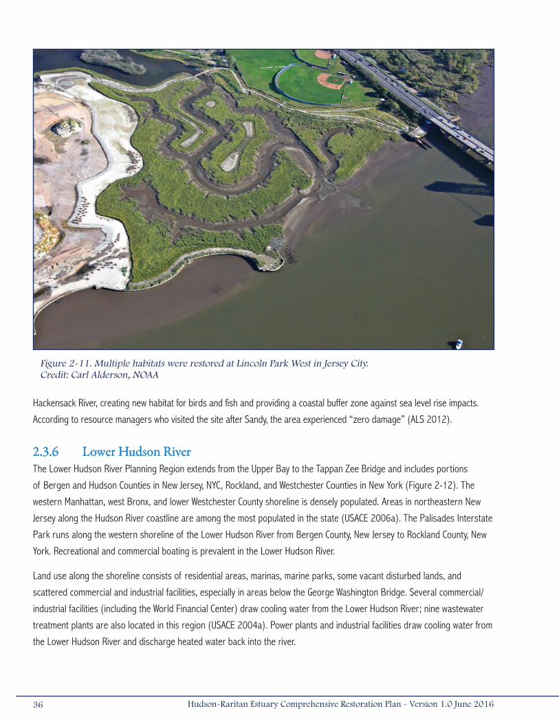
Hackensack River, creating new habitat for birds and fish and providing a coastal buffer zone against sea level rise impacts.
According to resource managers who visited the site after Sandy, the area experienced “zero damage” (ALS 2012).
2.3.6 Lower Hudson RiverThe Lower Hudson River Planning Region extends from the Upper Bay to the Tappan Zee Bridge and includes portions
of Bergen and Hudson Counties in New Jersey, NYC, Rockland, and Westchester Counties in New York (Figure 2-12). The
western Manhattan, west Bronx, and lower Westchester County shoreline is densely populated. Areas in northeastern New
Jersey along the Hudson River coastline are among the most populated in the state (USACE 2006a). The Palisades Interstate
Park runs along the western shoreline of the Lower Hudson River from Bergen County, New Jersey to Rockland County, New
York. Recreational and commercial boating is prevalent in the Lower Hudson River.
Land use along the shoreline consists of residential areas, marinas, marine parks, some vacant disturbed lands, and
scattered commercial and industrial facilities, especially in areas below the George Washington Bridge. Several commercial/
industrial facilities (including the World Financial Center) draw cooling water from the Lower Hudson River; nine wastewater
treatment plants are also located in this region (USACE 2004a). Power plants and industrial facilities draw cooling water from
the Lower Hudson River and discharge heated water back into the river.
Figure 2-11. Multiple habitats were restored at Lincoln Park West in Jersey City.Credit: Carl Alderson, NOAA
36 Hudson-Raritan Estuary Comprehensive Restoration Plan - Version 1.0 June 2016
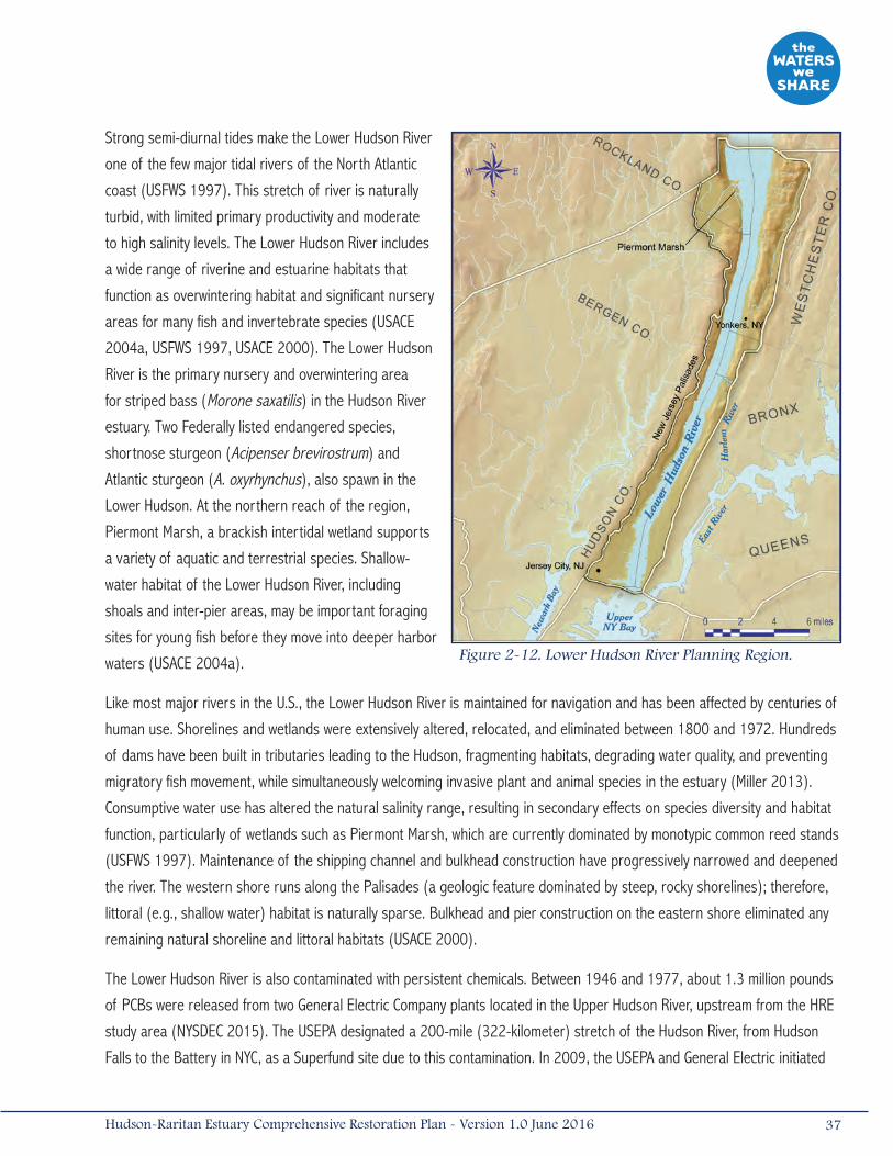
Strong semi-diurnal tides make the Lower Hudson River
one of the few major tidal rivers of the North Atlantic
coast (USFWS 1997). This stretch of river is naturally
turbid, with limited primary productivity and moderate
to high salinity levels. The Lower Hudson River includes
a wide range of riverine and estuarine habitats that
function as overwintering habitat and significant nursery
areas for many fish and invertebrate species (USACE
2004a, USFWS 1997, USACE 2000). The Lower Hudson
River is the primary nursery and overwintering area
for striped bass (Morone saxatilis) in the Hudson River
estuary. Two Federally listed endangered species,
shortnose sturgeon (Acipenser brevirostrum) and
Atlantic sturgeon (A. oxyrhynchus), also spawn in the
Lower Hudson. At the northern reach of the region,
Piermont Marsh, a brackish intertidal wetland supports
a variety of aquatic and terrestrial species. Shallow-
water habitat of the Lower Hudson River, including
shoals and inter-pier areas, may be important foraging
sites for young fish before they move into deeper harbor
waters (USACE 2004a).
Like most major rivers in the U.S., the Lower Hudson River is maintained for navigation and has been affected by centuries of
human use. Shorelines and wetlands were extensively altered, relocated, and eliminated between 1800 and 1972. Hundreds
of dams have been built in tributaries leading to the Hudson, fragmenting habitats, degrading water quality, and preventing
migratory fish movement, while simultaneously welcoming invasive plant and animal species in the estuary (Miller 2013).
Consumptive water use has altered the natural salinity range, resulting in secondary effects on species diversity and habitat
function, particularly of wetlands such as Piermont Marsh, which are currently dominated by monotypic common reed stands
(USFWS 1997). Maintenance of the shipping channel and bulkhead construction have progressively narrowed and deepened
the river. The western shore runs along the Palisades (a geologic feature dominated by steep, rocky shorelines); therefore,
littoral (e.g., shallow water) habitat is naturally sparse. Bulkhead and pier construction on the eastern shore eliminated any
remaining natural shoreline and littoral habitats (USACE 2000).
The Lower Hudson River is also contaminated with persistent chemicals. Between 1946 and 1977, about 1.3 million pounds
of PCBs were released from two General Electric Company plants located in the Upper Hudson River, upstream from the HRE
study area (NYSDEC 2015). The USEPA designated a 200-mile (322-kilometer) stretch of the Hudson River, from Hudson
Falls to the Battery in NYC, as a Superfund site due to this contamination. In 2009, the USEPA and General Electric initiated
Figure 2-12. Lower Hudson River Planning Region.
37Hudson-Raritan Estuary Comprehensive Restoration Plan - Version 1.0 June 2016

dredging a 14-mile (23-kilometer) stretch of the Upper Hudson River in an effort to remove PCBs that were discharged
north of the Federal Troy Lock and Dam (USEPA 2014c). PCBs from the discharge points were transported to the Lower
Hudson River, causing bioaccumulation and contamination of fishery resources throughout the river. Remediation of the
Upper Hudson River is expected to result in the decrease of PCB contamination in the Lower Hudson River over time. At the
end of 2014, approximately 2.4 MCY of PCB-contaminated sediments had been removed (NYSDEC 2015). The project is
expected to be complete in 2016 when the benthic habitat will be restored (USEPA 2014c).
In 1976, the contamination of benthic habitat and fish tissue in the Hudson River led New York State to close the commercial
striped bass fishery throughout the river and to issue consumption warnings for many other important species of the
Hudson River (USEPA 2008, NYSDOH 2014). The New York State Department of Health (NYSDOH) recommends that children
and women under 50 should not eat any fish from the Lower Hudson River, and men over 15 and women over 50 should
consume no more than one meal per month of striped bass collected from the Lower Hudson (NYSDOH 2014).
During Hurricane Sandy, the Yonkers Joint Wastewater Treatment Plant released 1.2 billion gallons of partially treated sewage
into the Lower Hudson River; the North River Wastewater Treatment Plant on the west side of Manhattan released 83 million
gallons of raw sewage into the river in the first few days following the storm (Kenward et al. 2013). The impact of Hurricane
Sandy in the Lower Hudson River region was felt by all counties along the New Jersey shoreline of the Hudson, and in New
York, north of the HRE study area, as far as Albany and Rensselaer Counties (USACE 2015a).
In order to minimize similar impacts in the face of future storm events along the Upper Hudson River, the NYSDEC Hudson
River Estuary Program released a restoration plan in 2013 and the Action Agenda 2015-2020 (Miller 2013, NYSDEC 2014).
These reports, in conjunction with the future Hudson River Comprehensive Restoration Plan and Hudson River Habitat
Restoration Feasibility Study, will complement the HRE CRP for the Hudson River north of the Tappan Zee Bridge.
2.3.7 Harlem River, East River, and Western Long Island SoundThe Harlem River, East River, and Western Long Island Sound planning region contains sections of Manhattan and the Bronx
to the north, and Brooklyn and Queens to the south (Figure 2-13). It extends east to include part of Long Island Sound and
portions of Westchester and Nassau Counties, New York. The East River is an important tidal strait connecting Long Island
Sound and Upper Bay. This system connects to the brackish Lower Hudson River via the Harlem River. A portion of this
planning region has been designated as the Upper East River-Long Island Sound SNWA by NYC due to the extensive marsh
systems in the area, such as those in Alley Pond Park, and islands that support significant populations of nesting shorebirds
(NYC 2011).
Shorelines along the East River are lined with urban residential, commercial, and industrial development. Commercial
ferry terminals, marinas, and parkland are also along the shorelines of this planning region. The waterways are used for
commercial navigation as well as recreational boating, fishing, and water/jet skiing. Public and private beaches, found in the
Upper East River and Western Long Island Sound, are open for bathing except when total coliform concentrations exceed
water quality criteria. This planning region receives treated effluent from six sewage treatment plants, and water is withdrawn
from the East River by four power plants, as well as industrial/commercial interests (USACE 2004a).
38 Hudson-Raritan Estuary Comprehensive Restoration Plan - Version 1.0 June 2016
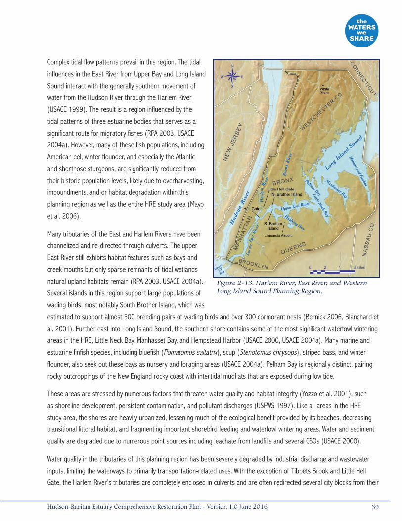
Complex tidal flow patterns prevail in this region. The tidal
influences in the East River from Upper Bay and Long Island
Sound interact with the generally southern movement of
water from the Hudson River through the Harlem River
(USACE 1999). The result is a region influenced by the
tidal patterns of three estuarine bodies that serves as a
significant route for migratory fishes (RPA 2003, USACE
2004a). However, many of these fish populations, including
American eel, winter flounder, and especially the Atlantic
and shortnose sturgeons, are significantly reduced from
their historic population levels, likely due to overharvesting,
impoundments, and or habitat degradation within this
planning region as well as the entire HRE study area (Mayo
et al. 2006).
Many tributaries of the East and Harlem Rivers have been
channelized and re-directed through culverts. The upper
East River still exhibits habitat features such as bays and
creek mouths but only sparse remnants of tidal wetlands
natural upland habitats remain (RPA 2003, USACE 2004a).
Several islands in this region support large populations of
wading birds, most notably South Brother Island, which was
estimated to support almost 500 breeding pairs of wading birds and over 300 cormorant nests (Bernick 2006, Blanchard et
al. 2001). Further east into Long Island Sound, the southern shore contains some of the most significant waterfowl wintering
areas in the HRE, Little Neck Bay, Manhasset Bay, and Hempstead Harbor (USACE 2000, USACE 2004a). Many marine and
estuarine finfish species, including bluefish (Pomatomus saltatrix), scup (Stenotomus chrysops), striped bass, and winter
flounder, also seek out these bays as nursery and foraging areas (USACE 2004a). Pelham Bay is regionally distinct, pairing
rocky outcroppings of the New England rocky coast with intertidal mudflats that are exposed during low tide.
These areas are stressed by numerous factors that threaten water quality and habitat integrity (Yozzo et al. 2001), such
as shoreline development, persistent contamination, and pollutant discharges (USFWS 1997). Like all areas in the HRE
study area, the shores are heavily urbanized, lessening much of the ecological benefit provided by its beaches, decreasing
transitional littoral habitat, and fragmenting important shorebird feeding and waterfowl wintering areas. Water and sediment
quality are degraded due to numerous point sources including leachate from landfills and several CSOs (USACE 2000).
Water quality in the tributaries of this planning region has been severely degraded by industrial discharge and wastewater
inputs, limiting the waterways to primarily transportation-related uses. With the exception of Tibbets Brook and Little Hell
Gate, the Harlem River’s tributaries are completely enclosed in culverts and are often redirected several city blocks from their
Figure 2-13. Harlem River, East River, and Western Long Island Sound Planning Region.
39Hudson-Raritan Estuary Comprehensive Restoration Plan - Version 1.0 June 2016
historic route to allow for building or road construction. In the lower East River, most shorelines have been bulkheaded and
filled, creating a deep, narrow passage. Natural river features that created topographic relief, including rock reefs, mudflats
and sandbars, were dredged or blasted in the late-19th century to create a continuous, navigable channel through Hell Gate
(USACE 1999).
In 2012, Hurricane Sandy caused extensive flooding, damage from wave action, beach erosion, loss of beach nesting
habitat, wind damage, and water advisories in the Harlem River, East River, and Western Long Island Sound Planning Region.
Beach erosion and reductions in beach elevations were observed along Long Island’s north shore beaches, specifically
at Manursing Lake and the Edith G. Read Wildlife Sanctuary in Rye, New York. Beach erosion impacted shorebird nesting
areas, leaving these sites vulnerable to repeated flooding, overwash, and high or neap flooding, as well as storm surges
and wave action from future storms. Impacted species include piping plover, American oystercatcher (Haematopus palliatus),
least tern (Sternula antillarum), and common tern (Sterna hirundo); these species breed and nest on beaches, dunes, and
overwash fans. Migratory shorebirds such as sanderling (Calidris alba), semipalmated sandpiper (C. pusilla), ruddy turnstone
(Arenaria interpres), black-bellied plover (Pluvialis squatarola), and red knot (C. canutus) were also impacted as they are all
beach foragers.
Manursing Lake in Rye, New York was the subject of a major two-part restoration project completed in 2012. Impacts to
this area from Sandy were significant. Sand dunes and vegetation situated between the sound and the lake were destroyed,
with only 200 feet (61 meters) of field and road remaining to prevent further inundation to the salt marsh and lake. A large
quantity of sand and rock was pushed onto fields and access roads, and sections of the salt marsh were buried by sand and
debris. Portions of the lakeshore were eroded, along with cliffs at the north end of the beach.
Wind damage was another impact from Hurricane Sandy reported within this planning region. The New York Botanical Gardens
reported more than 200 trees downed. Soundview Park, located in the Bronx, New York, suffered wind damage and loss of
trees in the Bronx River Forest canopy, providing an opportunity for an influx of invasive species. However, fallen tree branches
created potential habitat in the Bronx River for American eels and other estuarine-dependent fish species (ALS 2012).
Elevated fecal coliform levels were observed in the waters within the planning region following Sandy, potentially due to the
discharge of untreated and partially treated sewage from nearby wastewater treatment plants. The storm surge caused the
Newtown Creek Wastewater Treatment Plant to discharge 143 million gallons of untreated sewage into the creek, and the
Hunts Point Wastewater Treatment Plant discharged 153.8 million gallons of diluted, untreated sewage into the East River
(Kenward et al. 2013).
2.3.8 Upper BayThe Upper Bay Planning Region is centrally located within the HRE study area, connecting five other HRE regions
(Figure 2-14). The Upper Bay begins at the mouth of the Hudson River as it empties into the Lower New York Bay, is
connected to the Newark Bay and Arthur Kill via the Kill Van Kull, and exchanges water with the East River and Long Island
Sound. The Upper Bay, surrounding the Statue of Liberty and Ellis and Governor’s Islands, includes adjacent portions of
Manhattan, Brooklyn, and Staten Island, New York, as well as Hudson County, New Jersey.
40 Hudson-Raritan Estuary Comprehensive Restoration Plan - Version 1.0 June 2016

Land use along the shoreline of the Upper Bay Planning Region is primarily commercial and industrial, with few non-
industrial uses. Two sewage treatment plants discharge effluent into the Upper Bay (USACE 2004a). Industrial and CSO
inputs into tributaries to the Upper Bay, such as the Gowanus Canal and Newtown Creek, have severely degraded water and
sediment quality.
In 2010, the Gowanus Canal was included on the USEPA Superfund sites National Priorities List , as it has become one of
the nation's most extensively contaminated water bodies. In September 2013, the USEPA finalized the cleanup plan for the
Gowanus Canal Superfund site. The plan includes dredging contaminated sediments, capping the dredged areas, and reducing
sewage flows and other land based discharges into the canal. USEPA issued a Unilateral Administrative Order (UAO) to National
Grid and 29 other parties in March 2014 to prepare the remedial design and issued an UAO in May 2014 to NYC relating to
the CSO portion of the remedy (NYCDEP 2016). Newtown Creek was also added to the Superfund site National Priorities List in
2010. The Phase I Remedial Investigation for Newtown Creek Superfund site was completed in 2013 (USEPA 2013).
Sediment and water quality limit the waterways primarily to transportation-related uses. Scattered among the shipping
terminals and marinas are parklands or public promenades, some vacant disturbed land, and small residential areas.
Waterfront parks, including Liberty State Park, provide recreational areas and open spaces but are mostly lined by
bulkheaded shorelines.
Natural shorelines in the Upper Bay are limited. Small
tidal wetlands occur on the west side of Liberty Island.
Remnant mudflats are located along the New Jersey
coastline (USACE 2000, USACE 1999). Sandy shallows
that have been significantly reduced in size over time by
dredging are located within the Bay Ridge Flats, along the
eastern edge of the Bay. These flats provide nursery and
foraging habitat for a variety of fish species. The Upper
Bay also serves as a migratory fish pathway, providing
access to important feeding, overwintering, and nursery
areas within other planning regions (USACE 2004a).
The Upper Bay represents a vital link within the HRE
study area; both influencing and being influenced by
the hydrology, biology, and impairments of the other
planning regions. This region is heavily urbanized along
its perimeter and exhibits extensive shoreline filling
and hardening. The open waters of the Upper Bay are
crowded with ship traffic and large channels requiring
continuous maintenance. Sediment contamination
occurs throughout the Upper Bay as a result of historic Figure 2-14. Upper Bay Planning Region.
41Hudson-Raritan Estuary Comprehensive Restoration Plan - Version 1.0 June 2016
industrial uses, local runoff, and CSO inputs. Shallow sheltered areas and littoral habitats are almost non-existent, and heavy
commercial boat traffic erodes unprotected shorelines (USACE 2004a).
Hurricane Sandy impacted the Upper Bay Planning Region with flooding and elevated levels of bacteria in surface waters.
Newtown Creek and the Gowanus Canal contained “unacceptable” water levels of Enterococcus bacteria three days after the
storm. Enterococcus levels in the Gowanus Canal were 230 times greater than what is considered acceptable for swimming
(ALS 2012).
2.4 Trends in Environmental QualityAlthough the HRE study area has lost a substantial amount of habitat and ecological function and while legacy contaminants
remain in the sediments, policies and programs instituted in the past century have resulted in improved water quality and
a decrease in the rate of habitat destruction. Public concern over drinking water in the 1940s led to the Federal Water
Pollution Control Act and programs to assist states in constructing wastewater treatment facilities. Unfortunately, the limited
scope, enforcement policies, and state-enforced standards generally rendered this legislation ineffective. With the passing of
the CWA in 1972 and its amendments, Congress set national goals to address water quality issues. This legislation regulates
pollutant dischargers, sets water quality standards, specifies effluent limitations for wastewater treatment facilities, protects
wetlands, and addresses issues of non-point source pollution.
In the 40 years since the CWA was implemented, concentrations of contaminants, bacteria, and nutrients have started to
decrease and dissolved oxygen levels in the waters have started to increase (HEP 2012). These water quality improvements
have been substantial but there is significant room for improvement. In most HRE planning regions, legacy chemicals in the
sediments, including mercury, PCBs, DDT, and dioxin, still exceed acceptable levels (Steinberg et al. 2004). Many of these
chemicals, which are readily absorbed in the fat cells of animals, can accumulate to dangerous levels. Currently, all regions
of the HRE study area have consumption advisories in some fish and shellfish species (NYSDOH 2014, NJDEP 2013).
Moreover, the recent rates of decline in contaminants will be difficult to match in the future since current non-point sources
of these chemicals and metals (e.g., overland runoff, atmospheric deposition) will not be as easy to control as point sources
(Steinberg et al. 2004). As previously described, the CARP study shows that legacy sediments continue to be a large source
of contamination. Due to the natural processes in the harbor, burying of contaminated sediments by cleaner sediments may
result in lower surficial sediment concentrations over time. The model, however, did not look at the effect of larger storm
events and their effect on re-suspending deeper layers of contaminated sediments (Lodge et al. 2015).
Water quality programs initiated since the CWA have reduced, treated, and prevented many sources of pollution and
immediate human health threats. Sewage treatment plants in New York and New Jersey have been upgraded and additional
plants were constructed. Further improvements since the late 1980s are the result of improved maintenance and operation
of sewage collection systems, wastewater treatment facilities, and year-round water quality surveillance programs. Regulation
of industrial and treated sewage discharges have reduced concentrations of heavy metals (i.e., mercury, cadmium) dissolved
in the water column by up to 90 percent since the 1970s (Steinberg et al. 2004). The amount of fecal coliform in the waters
decreased significantly between the 1970s and 1990s, and has remained stable since (HEP 2012).
42 Hudson-Raritan Estuary Comprehensive Restoration Plan - Version 1.0 June 2016
In addition to habitat restoration and regulatory programs, government initiatives are also helping to improve the habitat
within the HRE study area by restricting habitat disturbance and the spread of contamination. Federal, state, and local
regulations are, in most cases, restricting losses of valuable aquatic habitats. These agencies’ mitigation programs
are requiring the restoration of increased acreages of habitats to restore ecosystem goods and services. Solid waste
programs at the local, state, and Federal levels have created strict guidelines to protect and preserve public health and the
environment through the introduction of clay and geotextile landfill liners to contain potential contaminants, and leachate
collection, treatment, and disposal systems. Many capped landfills in the HRE study area are being transformed into
recreational areas or natural upland sites, like the Elizabeth Landfill in New Jersey or the former Pennsylvania and Fountain
Avenue Landfills in Jamaica Bay (NYCDEP 2007). As discussed above, in recent years, the USEPA has made major progress
on planning for the remediation of contaminated sediments on several sites on the National Priorities List within the HRE
study area. As the remediation progresses, sediment quality throughout much of the HRE study area will gradually improve.
Given the momentum to improve environmental quality through legislation and habitat restoration programs, it is an
opportune time to coordinate and accelerate the implementation of restoration projects in the HRE study area. HEP updated
and revised their Action Plan in 2011 and intends to update the Action Plan again in 2016. Priority actions for habitat
include preservation and land acquisition, initiating pilot scale restorations that advance the state of the science of each
TEC outlined within the Draft 2009 CRP (updated herein), updating the Harbor Herons conservation plan, advancing the TEC
goals outlined in this CRP, considering climate change in planning habitat restorations, and developing recommendations for
collaborative action on the CRP goals (HEP 2011).
2.5 Sea Level Rise The design and implementation of coastal habitat restoration projects within the HRE will require consideration of the effects
of climate change, including global sea level rise. The foundation for coordinated action on climate change preparedness
and resilience across the Federal government was established by Executive Order 13514 of October 5, 2009, and the
Interagency Climate Change Adaptation Task Force led by the Council on Environmental Quality (CEQ). In October 2011, the
Task Force developed a National Action Plan that provided an overview of the challenges a changing climate presents for the
management of the nation’s freshwater resources. Climate preparedness and resilience actions have also been established
by the USACE, as demonstrated by the annual release of the Climate Change Adaptation Plan, prepared under the direction
of the USACE Committee on Climate Preparedness and Resilience (CCPR) (USACE 2015a). USACE established an overarching
USACE Climate Change Adaptation Policy Statement and a governance structure to support mainstreaming adaptation in
2011, following the release of the Executive Order (USACE 2015a). New York State has established the Sea Level Rise Task
Force, which released a report to the New York State Legislature in 2011 that identified recommendations for an action
plan to protect coastal communities and natural resources from rising sea levels (NYSDEC, 2010). The New York State
Climate Action Council, which assesses how all economic sectors can adapt to climate change, and the NYC’s Climate Change
Adaptation Task Force, which works closely with the NYC Panel on Climate Change (NPCC) to develop adaptation strategies to
secure the City’s infrastructure from the effects of climate change were also established.
43Hudson-Raritan Estuary Comprehensive Restoration Plan - Version 1.0 June 2016
A multi-stakeholder effort, the Rising Waters project, developed and described four different scenarios, outcomes, and
trajectories for preparedness and adaptive capacity within the HRE study area from 2010-2030. The Nature Conservancy
and its partners, the Cary Institute of Ecosystem Studies, Hudson River National Estuarine Research Reserve (NERR),
NYSDEC Hudson River Estuary Program, New York State Water Resources Institute at Cornell University, and Sustainable
Hudson Valley spearheaded the effort. Recommendations based on the likely future impacts of climate change included
adaptation strategies in the Hudson Valley such as improved community planning, communication, and preparedness for
extreme weather threats, and the incorporation of expected changes (e.g., frequent flooding and heat waves) in all land-
use decision-making processes. Recommendations also include actions to reduce and minimize future losses in flood-prone
areas, improved resiliency of shorelines, using NNBFs to reduce community vulnerability to flooding, establishment of
climate-change adaptation funding, and conservation of healthy forests, wetlands, and river ecosystems, and agricultural
resources (The Nature Conservancy 2009).
In 2013, following Hurricane Sandy, the Executive Office of the President released the President’s Climate Action Plan and
Executive Order 13653, Preparing the United States for the Impacts of Climate Change. The Action Plan outlined strategies
to combat and prepare for the impacts of climate change on a national and international stage. The devastation of Hurricane
Sandy and the subsequent release of the Action Plan sparked local and national interest in climate change. Funding became
available for new programs and resources such as the USACE Engineering with Nature Program, the NOAA Ecological Effects
of Sea Level Rise Program and Digital Coast Green Infrastructure Website, the USGS Hurricane Sandy Science Plan, Systems
Approach to Geomorphic Engineering (SAGE), Hudson River Sustainable Shorelines Project, the Structures of Coastal
Resilience (SCR) Project, and the DEC Coastal Green Infrastructure Research Plan for NYC, among many others. Federal
agencies also adopted climate change initiatives such as USACE’s 2014 Climate Change Adaptation Plan which outlines
current activities and future plans to manage significant climate change related risks and build long-term and short-term
resilience.
These initiatives provide avenues to analyze the impacts of sea level rise and the tools necessary to protect existing
infrastructure and improve future resiliency. The primary impact of sea level rise on coastal environments and infrastructure
is the direct loss of land and habitat due to inundation. The inland migration of coastal landforms (retreat) is a secondary
impact. However, in urbanized areas such as NYC, the likelihood of this occurring is severely limited given approximately
three centuries of shoreline development and re-alignment (Titus et al. 2009). Increased salinity in the upper reaches of the
estuary, ultimately resulting in the conversion of freshwater tidal wetlands to brackish salt marshes, is an additional impact of
climate change and sea level rise in the HRE.
Presently, the rate of sea level rise in the HRE area is approximately 0.1 inches (2.7 millimeters) per year, which exceeds
the global average of 0.07 inches (1.8 millimeters) per year (IPCC 2007, Kirshner et al. 2008, Needelman et al. 2012). The
higher observed average rate of sea level rise in the NYC area is partially the result of post-glacial rebound, exacerbating
the amount of observed wetland/shoreline subsidence attributed to eustatic sea level rise, (i.e., an increase in the volume
of the world’s oceans solely due to thermal expansion) (Hartig et al. 2002, Needelman et al. 2012). NPCC estimates that
the rate of sea level rise is increasing and predicts the sea level will be between 4.0 and 11.0 inches (0.1 to 0.3 meter)
above current elevations by the 2020s. By the 2050s, the NPCC predicts that the sea level could be between 11.0 inches
(0.1 meters) and nearly 3 feet (1 meter) above current elevations (NYC 2013).
44 Hudson-Raritan Estuary Comprehensive Restoration Plan - Version 1.0 June 2016

The Intergovernmental Panel on Climate Change (IPCC) has estimated a 0.6 to 1.9 foot (0.18 to 0.56 meter) rise in sea level
independent of ice cap melting. Estimates that consider the contribution of the melting Greenland and Antarctic ice caps
(which contribute a high degree of uncertainty to sea level rise forecasts) range from 3.3 to 6.6 feet (1 to 2 meters) by the
year 2100 (IPCC 2007, Needelman et al. 2012). Along with increases in mean sea level, storm intensity and frequency are
predicted to increase. A shift in storm intensity towards the polar regions is anticipated, with more frequent and damaging
storms expected to occur in the North Atlantic (NWF 2011). These processes are complementary, as an increase in mean
sea level will exacerbate the surge effects associated with more intense and frequent coastal storms.
Tidal range, which varies considerably along the world’s coastlines, is an important factor that has been ignored in
forecasting the response of coastal wetlands to sea level rise. Estuarine and coastal habitats characterized by a micro-tidal
regime (e.g., the U.S. coastline of the Gulf of Mexico) may experience the greatest effects of sea level rise, as native plant
and animal communities are not accustomed to large fluctuations in inundation frequency and depth. In contrast, macro-
tidal systems, such as the Puget Sound region of Washington or estuaries along Maine’s coast, are expected to exhibit a
considerable degree of resilience to changes in sea level, as the plant and animal communities present in these systems
are adapted to wide fluctuations in tides and current regimes. Meso-tidal estuaries, such as the HRE, are likely to exhibit a
moderate degree of resilience in comparison to micro- or macro-tidal systems (Needelman et al 2012).
Non-linear response patterns are an additional source of uncertainty in predicting the effects of climate change and sea
level rise on coastal habitats within the HRE (and elsewhere) (Needelman et al. 2012). Impacts to wetlands and other
coastal habitats are often unobserved until reaching a disturbance threshold, perhaps explaining the rapid and recent loss
of salt marsh islands in Jamaica Bay. Jamaica Bay wetlands were subjected to impacts associated with dredging, coastal
development, and wastewater inputs for several decades before exhibiting tangible degradation. However, once the impact
threshold was reached, perhaps in the late 1990s, the system reached a tipping point, and degradation became readily
discernible (NPS-GNRA 2007). Non-linear responses in coastal systems are not well studied and future restoration programs
in the HRE would benefit substantially from a better understanding of ecological tipping points and disturbance thresholds,
especially with regard to enhancing resiliency in the face of climate change impacts.
Regional variation in response to sea level rise within the HRE will be apparent. For example, Jamaica Bay, a back-barrier
system with limited sediment sources, will likely continue to experience rapid erosion and/or subsidence of wetlands in
the face of rising sea level. In contrast, wetlands associated with a continuous source of alluvial sediments from extensive
riverine drainage basins (e.g., Raritan River wetlands) may persist for a much longer duration before reaching disturbance
thresholds. Anthropogenic activities within estuaries or along coastlines (e.g., dredging, channelization, hydrologic
modifications) exacerbate or accelerate disturbance response times, mainly by altering patterns of sediment distribution
(Needelman et al. 2012). In areas where wetlands are bordered by natural uplands, they will be able to migrate inland, as
uplands are eventually converted to intertidal habitats. However, in developed urban areas, natural shorelines landward of
coastal marshes are rare, and marshes are unable to migrate (Titus et al. 2009). This phenomenon has been previously
45Hudson-Raritan Estuary Comprehensive Restoration Plan - Version 1.0 June 2016
described as “coastal squeeze” and has been implicated in the loss of considerable acreage of salt marsh in the U.S. and
elsewhere (Yozzo et al. 2000, NWF 2011). Existing low-elevation marsh areas will convert to mud or sand flats; some of
these areas may eventually provide suitable habitat for eelgrass colonization or eelgrass restoration efforts.
A proposed solution to “coastal squeeze,” along the U.S. East Coast and elsewhere, is to selectively allow marshes to migrate
landward in the face of rising sea level by abandoning or relinquishing low-lying coastal properties, a strategy referred to as
“managed retreat” or “managed re-alignment.” This is a controversial management approach, but one which has received
increasing attention in recent years as a coastal resource management option (Yozzo et al. 2000). While the idea of promoting
or enhancing the opportunity for coastal wetlands to migrate or retreat in the face of advancing sea level rise is appealing, very
few opportunities exist within the HRE to abandon land to accommodate this process without loss of valuable infrastructure or
public services (e.g., rail or road infrastructure). Also, the current predicted sea level rise rates for the HRE region are likely to
exceed the time frame in which meaningful coastal landform migration can take place (Needelman et al. 2012).
NYC’s Comprehensive Waterfront Plan (NYC CWP; a component of the city’s “Vision 2020”) lists coastal wetland restoration
as one option for the City for increasing resiliency of natural and man-made systems in the face of rising sea level (NYC
2011). Research is underway to better understand sediment accretion rates in coastal wetlands throughout NYC in
comparison to wetlands in adjacent regions. Remote sensing (e.g., LiDAR) datasets are being evaluated to identify potential
areas where migration of wetlands inland can be accommodated or where historic fill can be removed, creating opportunities
for migration and or creation of new wetlands (NYC 2011). Recognizing the success of the Marsh Island Restoration Project
in Jamaica Bay, the City recognizes that the beneficial use of dredged material can be undertaken in other HRE planning
regions to increase the resilience of coastal communities. The approach could be used to restore and reinforce eroding
wetlands, maintain wetlands under threat of submergence due to sea level rise, or create new wetlands in areas that could
benefit from enhanced wave attenuation.
The NYC CWP also emphasizes and encourages non-structural alternatives for the protection of sensitive coastal areas,
including beach and dune construction, and the development of “living shorelines,” which are more resilient and adaptable
under uncertain climate change scenarios (NYC 2011). Living shoreline projects also provide ecosystem functions that
are not available from traditional shoreline armoring techniques. Examples of living shoreline approaches include the
construction of oyster reefs and mussel beds and the use of salt marsh and or riparian plantings along eroding river/estuary
banks (NWF 2011). The feasibility of these techniques needs to be assessed on a site-specific basis prior to implementation
in lieu of traditional shore protection structures.
In its June 2013 report, A Stronger, More Resilient New York, the NYC Special Initiative for Rebuilding and Resiliency (SIRR)
provided specific strategies to minimize future storm damage from wave impacts, including the establishment of natural
features. Storm-surge modeling completed for the SIRR indicates that when placed appropriately, Wetlands, Oyster Reefs,
and living shorelines (including Coastal and Maritime Forests) have wave-attenuating properties. The report recommends
establishing these TECs in Jamaica Bay, Tottenville in Staten Island, Bay Ridge Flats, along the Arthur Kill and Kill Van Kull, and
along Long Island Sound (NYC 2013).
46 Hudson-Raritan Estuary Comprehensive Restoration Plan - Version 1.0 June 2016
Recommendations for large scale wetland restoration in the HRE include prioritizing restoration opportunities that are likely
to survive the upper range of predicted increases in sea level rise by 2100 in order to recoup lost ecosystem services
and function and to enhance sustainability. Individual projects, where feasible, should be designed to allow wetlands and
other coastal landscape features to migrate inland by removing structures and fill or by prohibiting construction on the
landward fringe of restored wetlands (Kirshner et al. 2008, Titus et al. 2009). Efforts should be made to dismantle obsolete
shore protection structures in favor of living shoreline approaches, especially in areas with relatively low population and
infrastructure densities (e.g., city/state/Federal parks and recreation areas). It will also be essential to examine how relatively
undisturbed reference wetlands within the HRE have responded historically to extreme weather events.
2.6 Restoration EffortsEcosystem restoration and conservation programs have existed in the HRE study area for decades and many of these efforts
have been successful. Prior to 1990, restoration programs coordinated by state governments and local organizations focused
on habitat protection by acquiring land with ecologically important habitats and protecting public lands from development.
Land acquisition of wetlands and other valuable open spaces still regularly occur in NYC, Long Island, and northeastern
New Jersey, and some programs are supported through public funding and legal settlements from parties responsible for
discharges and spills (NYSDEC 2008, NJDEP 2008). For example, the Green Acres Program in New Jersey is working to
achieve a system of interconnected open spaces to enhance New Jersey’s natural environment, and in New York, the State
Environmental Protection Fund (EPF) provides funding to purchase lands to be included in state parks and preserves.
In 2001, the PANYNJ established a $60 million program to acquire and preserve ecologically valuable tracts of land around
agency facilities in New York and New Jersey. The program is designed to help the PANYNJ balance its redevelopment plans
with the need to protect critical habitats and waterfront areas for public use. The HRERP has protected approximately 393
acres (1.19 kilometers2) of habitat from development since its inception. In 2014, the PANYNJ reauthorized the HRERP for
the next 10 years and committed $60 million to acquire valuable land.
Between 2009-2014 roughly $240 million was spent on habitat restoration, nearly 500 acres (2.02 kilometers2) were
acquired for conservation and/or public access purposes, and over 500 acres (2.02 kilometers2) of new parks or public
spaces were either designated or opened for public access purposes along the HRE waterfront (Boicourt 2015). However,
much more funding and progress is required to meet 2020 and 2050 goals for all targets. A study by Alderson and Bowers
found that roughly one quarter of restoration projects were paid for through Natural Resource Damages, mitigation, or
other permit requirement or settlement, suggesting that the full picture of habitat gained is more nuanced (Alderson and
Bowers 2012).
47Hudson-Raritan Estuary Comprehensive Restoration Plan - Version 1.0 June 2016
For the past two decades, HRE stakeholders have also adopted a proactive approach to conservation. Current programs
often consist of physically altering areas and re-creating upland, wetland, and aquatic habitat to bring the habitat closer to
its original condition. Several factors have led to an increase in restoration programs in the HRE study area, such as funding
availability, incorporating restoration considerations into resource management programs, the expansion of restoration
ecology and scientific information, and increased stakeholder awareness.
2.6.1 Ongoing Restoration Programs in the HREMany large-scale aquatic restoration programs coordinated by state and Federal agencies and NGOs in the HRE study area
are in the planning stage. Several USACE feasibility studies have evolved from the HRE Ecosystem Restoration Study authority
(1999), including the Lower Passaic River, Hackensack Meadowlands, and Gowanus Canal. Ecosystem Restoration Feasibility
Studies were also initiated on the Bronx River in 2003, Flushing Bay and Creek in 1999, and Jamaica Bay in 1996. With the
exception of the HRE-Gowanus Canal Study, which was suspended following the river’s designation on the Superfund National
Priorities List, each study was advancing with their local sponsors including the NJDOT, the New Jersey Sports & Exposition
Authority (formerly New Jersey Meadowlands Commission [NJMC]), the NYCDEP, NJDEP, the PANYNJ, and Westchester County
Planning. However, through the USACE’s Civil Works Transformation and use of SMART Planning principles, it became
apparent that these studies and their recommendations should be integrated and included in the HRE Ecosystem Restoration
Feasibility Report.
While the above feasibility studies were in progress, the USACE had significant success completing the construction of
key restoration projects at Gerritsen Creek, Soundview Park, and the Jamaica Bay Marsh Islands. The USACE seeks to
beneficially use dredged material from their navigation program to create a variety of habitats including wetlands, upland
habitat, intertidal mudflats, and reefs to the greatest extent possible. Restoration at Elders Point (East and West), Yellow
Bar Hassock, Black Wall, and Rulers Bar Marsh Islands are examples of a successful use of dredged material to counter the
extensive habitat losses in Jamaica Bay.
There are many other encouraging examples of local and regional ecological restoration within the HRE. For example,
the NYC Department of Parks and Recreation’s (NYCDPR‘s) Natural Resources Group (NRG) has several acquisition and
restoration sites throughout the HRE study area, encompassing over 1,000 acres (4 kilometers2) of protected land (NYCDPR
2008). The NYCDEP Office of Ecological Services looks for opportunities to maximize the habitat value of reclaimed lands
and mitigation projects. The office has created diverse upland habitats on former landfill sites and has restored more than
the required acreage of compensatory mitigation projects to increase the success of the restoration efforts. The NY/NJ
Baykeeper offers many programs ranging from habitat restoration to conservation and advocacy programs that protect
or save lands (NY/NJ Baykeeper 2007). Several decades of data collected by the NYC Audubon have been essential to
protecting heron species and their rookeries in the HRE study area (Kerlinger 2004, Bernick 2006). Some examples of
Federal, state, and local restoration programs within the HRE study area are highlighted in Table 2-2.
48 Hudson-Raritan Estuary Comprehensive Restoration Plan - Version 1.0 June 2016
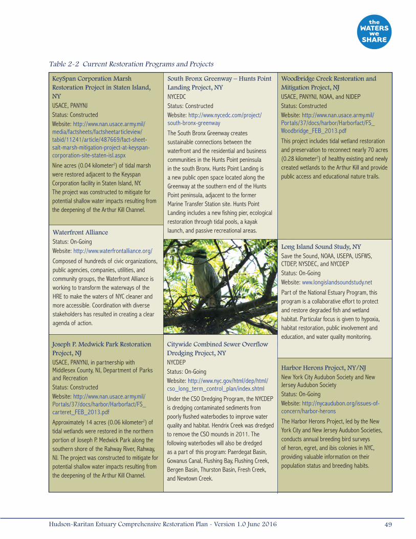
KeySpan Corporation Marsh Restoration Project in Staten Island, NYUSACE, PANYNJStatus: ConstructedWebsite: http://www.nan.usace.army.mil/media/factsheets/factsheetarticleview/tabid/11241/article/487669/fact-sheet-salt-marsh-mitigation-project-at-keyspan-corporation-site-staten-isl.aspx
Nine acres (0.04 kilometer2) of tidal marsh were restored adjacent to the Keyspan Corporation facility in Staten Island, NY. The project was constructed to mitigate for potential shallow water impacts resulting from the deepening of the Arthur Kill Channel.
South Bronx Greenway – Hunts Point Landing Project, NYNYCEDCStatus: ConstructedWebsite: http://www.nycedc.com/project/south-bronx-greenway
The South Bronx Greenway creates sustainable connections between the waterfront and the residential and business communities in the Hunts Point peninsula in the south Bronx. Hunts Point Landing is a new public open space located along the Greenway at the southern end of the Hunts Point peninsula, adjacent to the former Marine Transfer Station site. Hunts Point Landing includes a new fishing pier, ecological restoration through tidal pools, a kayak launch, and passive recreational areas.
Citywide Combined Sewer Overflow Dredging Project, NYNYCDEPStatus: On-GoingWebsite: http://www.nyc.gov/html/dep/html/cso_long_term_control_plan/index.shtml
Under the CSO Dredging Program, the NYCDEP is dredging contaminated sediments from poorly flushed waterbodies to improve water quality and habitat. Hendrix Creek was dredged to remove the CSO mounds in 2011. The following waterbodies will also be dredged as a part of this program: Paerdegat Basin, Gowanus Canal, Flushing Bay, Flushing Creek, Bergen Basin, Thurston Basin, Fresh Creek, and Newtown Creek.
Woodbridge Creek Restoration and Mitigation Project, NJUSACE, PANYNJ, NOAA, and NJDEPStatus: ConstructedWebsite: http://www.nan.usace.army.mil/Portals/37/docs/harbor/Harborfact/FS_Woodbridge_FEB_2013.pdf
This project includes tidal wetland restoration and preservation to reconnect nearly 70 acres (0.28 kilometer2) of healthy existing and newly created wetlands to the Arthur Kill and provide public access and educational nature trails.
Harbor Herons Project, NY/NJNew York City Audubon Society and New Jersey Audubon SocietyStatus: On-GoingWebsite: http://nycaudubon.org/issues-of-concern/harbor-herons
The Harbor Herons Project, led by the New York City and New Jersey Audubon Societies, conducts annual breeding bird surveys of heron, egret, and ibis colonies in NYC, providing valuable information on their population status and breeding habits.
Long Island Sound Study, NYSave the Sound, NOAA, USEPA, USFWS, CTDEP, NYSDEC, and NYCDEPStatus: On-GoingWebsite: www.longislandsoundstudy.net
Part of the National Estuary Program, this program is a collaborative effort to protect and restore degraded fish and wetland habitat. Particular focus is given to hypoxia, habitat restoration, public involvement and education, and water quality monitoring.
Waterfront AllianceStatus: On-GoingWebsite: http://www.waterfrontalliance.org/
Composed of hundreds of civic organizations, public agencies, companies, utilities, and community groups, the Waterfront Alliance is working to transform the waterways of the HRE to make the waters of NYC cleaner and more accessible. Coordination with diverse stakeholders has resulted in creating a clear agenda of action.
Table 2-2 Current Restoration Programs and Projects
Joseph P. Medwick Park Restoration Project, NJ USACE, PANYNJ, in partnership with Middlesex County, NJ, Department of Parks and RecreationStatus: ConstructedWebsite: http://www.nan.usace.army.mil/Portals/37/docs/harbor/Harborfact/FS_carteret_FEB_2013.pdf
Approximately 14 acres (0.06 kilometer2) of tidal wetlands were restored in the northern portion of Joseph P. Medwick Park along the southern shore of the Rahway River, Rahway, NJ. The project was constructed to mitigate for potential shallow water impacts resulting from the deepening of the Arthur Kill Channel.
49Hudson-Raritan Estuary Comprehensive Restoration Plan - Version 1.0 June 2016
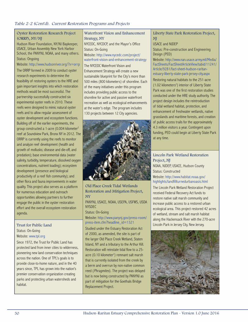
Liberty State Park Restoration Project, NJUSACE and NJDEPStatus: Pre-construction and Engineering Design (PED)Website: http://www.nan.usace.army.mil/Media/FactSheets/FactSheetArticleView/tabid/11241/Article/9281/fact-sheet-hudson-raritan-estuary-liberty-state-park-jersey-city.aspx
Restoring natural habitats to the 251-acre (1.02 kilometers2) interior of Liberty State Park was one of the first restoration studies conducted under the HRE study authority. The project design includes the reintroduction of tidal wetland habitat, protection, and enhancement of freshwater wetlands, native grasslands and maritime forests, and creation of public access trails for the approximately 4.3 million visitors a year. Contingent upon funding, PED could begin at Liberty State Park at any time.
Trust for Public LandStatus: On-GoingWebsite: www.tpl.org
Since 1972, the Trust for Public Land has protected land from inner cities to wilderness, pioneering new land conservation techniques across the nation. One of TPL’s goals is to provide close-to-home nature, and in the 40 years since, TPL has grown into the nation’s premier conservation organization creating parks and protecting urban watersheds and habitat.
Lincoln Park Wetland Restoration Project, NJNOAA, NJDEP, USACE, Hudson CountyStatus: ConstructedWebsite: http://www.habitat.noaa.gov/highlights/landfillturnedurbanoasis.html
The Lincoln Park Wetland Restoration Project received Federal Recovery Act funds to restore native salt marsh community and increase public access to a restored urban ecological area. This project restored 42 acres of wetland, stream and salt marsh habitat along the Hackensack River with the 270-acre Lincoln Park in Jersey City, New Jersey.
Waterfront Vision and Enhancement Strategy, NYNYCEDC, NYCDCP, and the Mayor’s OfficeStatus: On-GoingWebsite: http://www.nycedc.com/project/waterfront-vision-and-enhancement-strategy
The NYCEDC Waterfront Vision and Enhancement Strategy will create a new sustainable blueprint for the City’s more than 500 miles (800 kilometers) of shoreline. Each of the many initiatives under this program includes providing public access to the shoreline for active and passive waterfront recreation as well as ecological enhancements at the water’s edge. The program includes 130 projects between 12 City agencies.
Oyster Restoration Research Project (ORRP), NY/NJHudson River Foundation, NY/NJ Baykeeper, USACE, Urban Assembly New York Harbor School, the PANYNJ, NOAA, and many others.Status: OngoingWebsite: http://www.hudsonriver.org/?x=orrp
The ORRP formed in 2009 to conduct oyster research experiments to determine the feasibility of restoring oysters to the HRE and gain important insights into which restoration methods would be most successful. The partnership successfully constructed six experimental oyster reefs in 2010. These reefs were designed to mimic natural oyster reefs and to allow regular assessment of oyster development and ecosystem functions. Building off of the earlier experiments, the group constructed a 1-acre (0.004 kilometer2
reef at Soundview Park, Bronx NY in 2012. The ORRP is currently using the reefs to monitor and analyze reef development (health and growth of mollusks; disease and die-off, and predation); base environmental data (water salinity, turbidity, temperature, dissolved oxygen concentrations, nutrient loading); ecosystem development (presence and biological productivity of a reef fish community); and other flora and fauna improvements in water quality. This project also serves as a platform for numerous education and outreach opportunities allowing partners to further engage the public in the oyster restoration effort and the overall ecosystem restoration agenda.
Old Place Creek Tidal Wetlands Restoration and Mitigation Project, NYPANYNJ, USACE, NOAA, USEPA, USFWS, USDA NYSDECStatus: On-GoingWebsite: http://www.panynj.gov/press-room/press-item.cfm?headline_id=1321
Studied under the Estuary Restoration Act of 2000, as amended, the site is part of the larger Old Place Creek Wetland, Staten Island, NY and a tributary to the Arthur Kill. Restoration will reinstate tidal flow to a 25-acre (0.10 kilometer2) remnant salt marsh that is currently isolated from the creek by a berm and overrun by non-native common reed (Phragmites). The project was delayed but is now being constructed by PANYNJ as part of mitigation for the Goethals Bridge Replacement Project.
Table 2-2 (Cont'd). Current Restoration Programs and Projects
50 Hudson-Raritan Estuary Comprehensive Restoration Plan - Version 1.0 June 2016
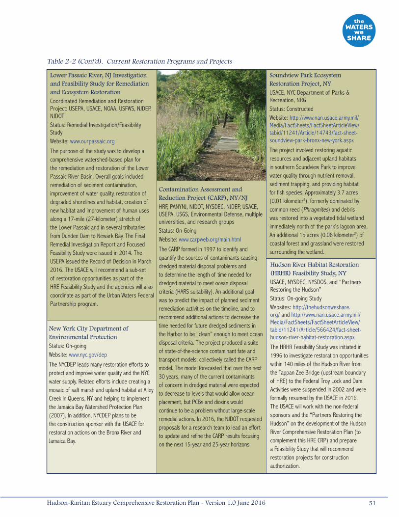
Soundview Park Ecosystem Restoration Project, NYUSACE, NYC Department of Parks & Recreation, NRGStatus: ConstructedWebsite: http://www.nan.usace.army.mil/Media/FactSheets/FactSheetArticleView/tabid/11241/Article/14743/fact-sheet-soundview-park-bronx-new-york.aspx
The project involved restoring aquatic resources and adjacent upland habitats in southern Soundview Park to improve water quality through nutrient removal, sediment trapping, and providing habitat for fish species. Approximately 3.7 acres (0.01 kilometer2), formerly dominated by common reed (Phragmites) and debris was restored into a vegetated tidal wetland immediately north of the park’s lagoon area. An additional 15 acres (0.06 kilometer2) of coastal forest and grassland were restored surrounding the wetland.
Lower Passaic River, NJ Investigation and Feasibility Study for Remediation and Ecosystem Restoration Coordinated Remediation and Restoration Project: USEPA, USACE, NOAA, USFWS, NJDEP, NJDOTStatus: Remedial Investigation/Feasibility StudyWebsite: www.ourpassaic.org
The purpose of the study was to develop a comprehensive watershed-based plan for the remediation and restoration of the Lower Passaic River Basin. Overall goals included remediation of sediment contamination, improvement of water quality, restoration of degraded shorelines and habitat, creation of new habitat and improvement of human uses along a 17-mile (27-kilometer) stretch of the Lower Passaic and in several tributaries from Dundee Dam to Newark Bay. The Final Remedial Investigation Report and Focused Feasibility Study were issued in 2014. The USEPA issued the Record of Decision in March 2016. The USACE will recommend a sub-set of restoration opportunities as part of the HRE Feasibility Study and the agencies will also coordinate as part of the Urban Waters Federal Partnership program.
Contamination Assessment and Reduction Project (CARP), NY/NJHRF, PANYNJ, NJDOT, NYSDEC, NJDEP, USACE, USEPA, USGS, Environmental Defense, multiple universities, and research groupsStatus: On-GoingWebsite: www.carpweb.org/main.html
The CARP formed in 1997 to identify and quantify the sources of contaminants causing dredged material disposal problems and to determine the length of time needed for dredged material to meet ocean disposal criteria (HARS suitability). An additional goal was to predict the impact of planned sediment remediation activities on the timeline, and to recommend additional actions to decrease the time needed for future dredged sediments in the Harbor to be “clean” enough to meet ocean disposal criteria. The project produced a suite of state-of-the-science contaminant fate and transport models, collectively called the CARP model. The model forecasted that over the next 30 years, many of the current contaminants of concern in dredged material were expected to decrease to levels that would allow ocean placement, but PCBs and dioxins would continue to be a problem without large-scale remedial actions. In 2016, the NJDOT requested proposals for a research team to lead an effort to update and refine the CARP results focusing on the next 15-year and 25-year horizons.
Hudson River Habitat Restoration (HRHR) Feasibility Study, NYUSACE, NYSDEC, NYSDOS, and “Partners Restoring the Hudson”Status: On-going StudyWebsites: http://thehudsonweshare.org/ and http://www.nan.usace.army.mil/Media/FactSheets/FactSheetArticleView/tabid/11241/Article/566424/fact-sheet-hudson-river-habitat-restoration.aspx
The HRHR Feasibility Study was initiated in 1996 to investigate restoration opportunities within 140 miles of the Hudson River from the Tappan Zee Bridge (upstream boundary of HRE) to the Federal Troy Lock and Dam. Activities were suspended in 2002 and were formally resumed by the USACE in 2016. The USACE will work with the non-federal sponsors and the “Partners Restoring the Hudson” on the development of the Hudson River Comprehensive Restoration Plan (to complement this HRE CRP) and prepare a Feasibility Study that will recommend restoration projects for construction authorization.
New York City Department of Environmental ProtectionStatus: On-goingWebsite: www.nyc.gov/dep
The NYCDEP leads many restoration efforts to protect and improve water quality and the NYC water supply. Related efforts include creating a mosaic of salt marsh and upland habitat at Alley Creek in Queens, NY and helping to implement the Jamaica Bay Watershed Protection Plan (2007). In addition, NYCDEP plans to be the construction sponsor with the USACE for restoration actions on the Bronx River and Jamaica Bay.
Table 2-2 (Cont'd). Current Restoration Programs and Projects
51Hudson-Raritan Estuary Comprehensive Restoration Plan - Version 1.0 June 2016
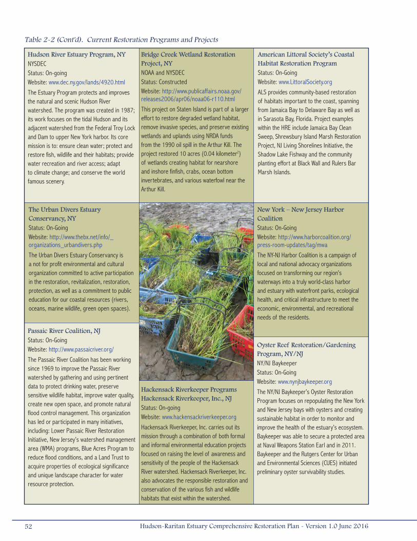
American Littoral Society’s Coastal Habitat Restoration ProgramStatus: On-GoingWebsite: www.LittoralSociety.org
ALS provides community-based restoration of habitats important to the coast, spanning from Jamaica Bay to Delaware Bay as well as in Sarasota Bay, Florida. Project examples within the HRE include Jamaica Bay Clean Sweep, Shrewsbury Island Marsh Restoration Project, NJ Living Shorelines Initiative, the Shadow Lake Fishway and the community planting effort at Black Wall and Rulers Bar Marsh Islands.
The Urban Divers Estuary Conservancy, NYStatus: On-GoingWebsite: http://www.thebx.net/info/_organizations_urbandivers.php
The Urban Divers Estuary Conservancy is a not for profit environmental and cultural organization committed to active participation in the restoration, revitalization, restoration, protection, as well as a commitment to public education for our coastal resources (rivers, oceans, marine wildlife, green open spaces).
Hackensack Riverkeeper Programs Hackensack Riverkeeper, Inc., NJStatus: On-goingWebsite: www.hackensackriverkeeper.org
Hackensack Riverkeeper, Inc. carries out its mission through a combination of both formal and informal environmental education projects focused on raising the level of awareness and sensitivity of the people of the Hackensack River watershed. Hackensack Riverkeeper, Inc. also advocates the responsible restoration and conservation of the various fish and wildlife habitats that exist within the watershed.
Hudson River Estuary Program, NYNYSDEC Status: On-going Website: www.dec.ny.gov/lands/4920.html
The Estuary Program protects and improves the natural and scenic Hudson River watershed. The program was created in 1987; its work focuses on the tidal Hudson and its adjacent watershed from the Federal Troy Lock and Dam to upper New York harbor. Its core mission is to: ensure clean water; protect and restore fish, wildlife and their habitats; provide water recreation and river access; adapt to climate change; and conserve the world famous scenery.
Oyster Reef Restoration/Gardening Program, NY/NJNY/NJ Baykeeper Status: On-GoingWebsite: www.nynjbaykeeper.org
The NY/NJ Baykeeper’s Oyster Restoration Program focuses on repopulating the New York and New Jersey bays with oysters and creating sustainable habitat in order to monitor and improve the health of the estuary’s ecosystem. Baykeeper was able to secure a protected area at Naval Weapons Station Earl and in 2011. Baykeeper and the Rutgers Center for Urban and Environmental Sciences (CUES) initiated preliminary oyster survivability studies.
Bridge Creek Wetland Restoration Project, NYNOAA and NYSDECStatus: ConstructedWebsite: http://www.publicaffairs.noaa.gov/releases2006/apr06/noaa06-r110.html
This project on Staten Island is part of a larger effort to restore degraded wetland habitat, remove invasive species, and preserve existing wetlands and uplands using NRDA funds from the 1990 oil spill in the Arthur Kill. The project restored 10 acres (0.04 kilometer2) of wetlands creating habitat for nearshore and inshore finfish, crabs, ocean bottom invertebrates, and various waterfowl near the Arthur Kill.
Passaic River Coalition, NJStatus: On-GoingWebsite: http://www.passaicriver.org/
The Passaic River Coalition has been working since 1969 to improve the Passaic River watershed by gathering and using pertinent data to protect drinking water, preserve sensitive wildlife habitat, improve water quality, create new open space, and promote natural flood control management. This organization has led or participated in many initiatives, including: Lower Passaic River Restoration Initiative, New Jersey’s watershed management area (WMA) programs, Blue Acres Program to reduce flood conditions, and a Land Trust to acquire properties of ecological significance and unique landscape character for water resource protection.
New York – New Jersey Harbor CoalitionStatus: On-GoingWebsite: http://www.harborcoalition.org/press-room-updates/tag/mwa
The NY-NJ Harbor Coalition is a campaign of local and national advocacy organizations focused on transforming our region’s waterways into a truly world-class harbor and estuary with waterfront parks, ecological health, and critical infrastructure to meet the economic, environmental, and recreational needs of the residents.
Table 2-2 (Cont'd). Current Restoration Programs and Projects
52 Hudson-Raritan Estuary Comprehensive Restoration Plan - Version 1.0 June 2016

PANYNJ Hudson Raritan Estuary Resources ProgramStatus: On-goingWebsite: http://www.panynj.gov/about/coastal-eco-systems.html
In 2001, the PANYNJ established a $60 million fund to acquire and preserve ecologically valuable tracts of land around agency facilities in New York and New Jersey. The program is designed to help the Port Authority balance its redevelopment plans with the need to preserve critical habitats and waterfront areas for public use. The PANYNJ acquired approximately 400 acres, 18 ecologically valuable sites, for preservation within the HRE between 2004 and 2015. In 2014, PANYNJ committed an additional $60 million to acquisition of valuable land.
NYC Department of Parks and Recreation’s Natural Resources Group Restoration ProgramStatus: On-GoingWebsite: www.nycgovparks.org/greening/natural-resources-group/restoration-sites
The Natural Resources Group, which is a division of the Parks Department, has pioneered the field of urban ecological restoration and acquired natural lands, stabilized eroding shorelines, and conducted restoration programs throughout NYC, including on-going maintenance and management of restored sites. Several programs are specifically focused on coastal restoration, and will add and enhance over 200 acres (0.81 kilometer2) of critical estuarine and adjacent habitat. NYCDPR also plans to be the construction sponsor with the USACE for restoration actions on the Bronx River and Jamaica Bay.
Gowanus Canal Community Development Corporation, NYStatus: On-GoingWebsite: www.gowanus.org
The Gowanus Canal Community Development Corporation (GCCDC) is a neighborhood preservation non-profit organization dedicated to the revitalization of the Gowanus Canal area in Brooklyn for the past 29 years. The community-based group has an extensive record of initiatives and involvement in the physical improvement of the Gowanus Canal and the surrounding communities. GCCDC’s efforts are focused on the environmental remediation of the Gowanus Canal, housing, economic development, and commercial revitalization.
Newark Bay, NJ Remedial Investigation and Feasibility StudyUSEPAStatus: Remedial Investigation/Feasibility Study Website: www.epa.gov/region02/superfund
The USEPA has been studying the Newark Bay since 2004 to determine the nature and extent of sediment contamination, determine potential risks of contamination, and to determine the significant, on-going sources of pollution. The Newark Bay Study Area includes the bay and portions of the Hackensack River, the Arthur Kill and the Kill Van Kull.
Gowanus Canal Remedial Investigation and Feasibility Study, NYUSEPAStatus: Remedial Investigation/Feasibility Study Website: www.epa.gov/region2/superfund/npl/gowanus
Investigatory work is underway at the former Fulton MGP and Former Citizens Gas Works MGP and contaminated soils have been removed from the former Metropolitan Gas Light Company MGP. A Feasibility Study was released to the public on December 30, 2011. In September 2013, USEPA issued a Record of Decision to address the contamination in the Canal. Following clean up of the Gowanus Canal by USEPA, ecosystem restoration may take place including wetland creation and water quality improvements in confined waterways.
Table 2-2 (Cont'd). Current Restoration Programs and Projects
53Hudson-Raritan Estuary Comprehensive Restoration Plan - Version 1.0 June 2016
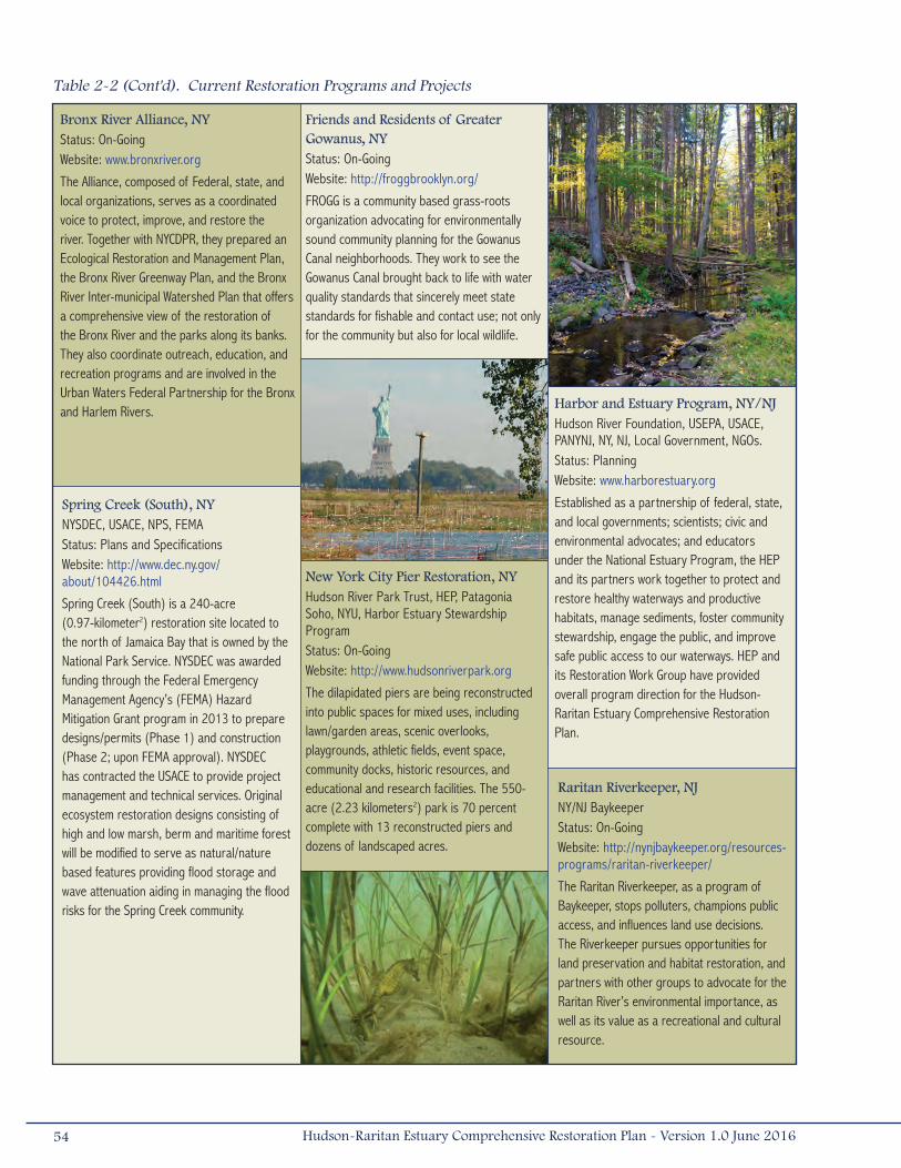
Bronx River Alliance, NYStatus: On-GoingWebsite: www.bronxriver.org
The Alliance, composed of Federal, state, and local organizations, serves as a coordinated voice to protect, improve, and restore the river. Together with NYCDPR, they prepared an Ecological Restoration and Management Plan, the Bronx River Greenway Plan, and the Bronx River Inter-municipal Watershed Plan that offers a comprehensive view of the restoration of the Bronx River and the parks along its banks. They also coordinate outreach, education, and recreation programs and are involved in the Urban Waters Federal Partnership for the Bronx and Harlem Rivers.
Friends and Residents of Greater Gowanus, NYStatus: On-GoingWebsite: http://froggbrooklyn.org/
FROGG is a community based grass-roots organization advocating for environmentally sound community planning for the Gowanus Canal neighborhoods. They work to see the Gowanus Canal brought back to life with water quality standards that sincerely meet state standards for fishable and contact use; not only for the community but also for local wildlife.
Harbor and Estuary Program, NY/NJHudson River Foundation, USEPA, USACE, PANYNJ, NY, NJ, Local Government, NGOs.Status: PlanningWebsite: www.harborestuary.org
Established as a partnership of federal, state, and local governments; scientists; civic and environmental advocates; and educators under the National Estuary Program, the HEP and its partners work together to protect and restore healthy waterways and productive habitats, manage sediments, foster community stewardship, engage the public, and improve safe public access to our waterways. HEP and its Restoration Work Group have provided overall program direction for the Hudson-Raritan Estuary Comprehensive Restoration Plan.
Raritan Riverkeeper, NJNY/NJ BaykeeperStatus: On-GoingWebsite: http://nynjbaykeeper.org/resources-programs/raritan-riverkeeper/
The Raritan Riverkeeper, as a program of Baykeeper, stops polluters, champions public access, and influences land use decisions. The Riverkeeper pursues opportunities for land preservation and habitat restoration, and partners with other groups to advocate for the Raritan River’s environmental importance, as well as its value as a recreational and cultural resource.
New York City Pier Restoration, NYHudson River Park Trust, HEP, Patagonia Soho, NYU, Harbor Estuary Stewardship ProgramStatus: On-Going Website: http://www.hudsonriverpark.org
The dilapidated piers are being reconstructed into public spaces for mixed uses, including lawn/garden areas, scenic overlooks, playgrounds, athletic fields, event space, community docks, historic resources, and educational and research facilities. The 550-acre (2.23 kilometers2) park is 70 percent complete with 13 reconstructed piers and dozens of landscaped acres.
Spring Creek (South), NYNYSDEC, USACE, NPS, FEMA Status: Plans and SpecificationsWebsite: http://www.dec.ny.gov/about/104426.html
Spring Creek (South) is a 240-acre (0.97-kilometer2) restoration site located to the north of Jamaica Bay that is owned by the National Park Service. NYSDEC was awarded funding through the Federal Emergency Management Agency’s (FEMA) Hazard Mitigation Grant program in 2013 to prepare designs/permits (Phase 1) and construction (Phase 2; upon FEMA approval). NYSDEC has contracted the USACE to provide project management and technical services. Original ecosystem restoration designs consisting of high and low marsh, berm and maritime forest will be modified to serve as natural/nature based features providing flood storage and wave attenuation aiding in managing the flood risks for the Spring Creek community.
Table 2-2 (Cont'd). Current Restoration Programs and Projects
54 Hudson-Raritan Estuary Comprehensive Restoration Plan - Version 1.0 June 2016

2.6.2 Response to Hurricane Sandy Immediately after Hurricane Sandy, Federal, state, and local agencies, as well as civic and academic organizations, evaluated
the devastating impacts and provided recommendations to repair the damage and increase resiliency for future storms.
Significant coordination was required to ensure a comprehensive response and eliminate redundancies in current and
proposed programs. Programs developed in response to Hurricane Sandy are summarized in Table 2-3. Responses from
Hurricane Sandy described within this chapter focus on ecological resources within the HRE, not on repairing the extensive
damage to the communities and personal property within the region.
On November 15, 2012, Governor Andrew Cuomo convened the NYS2100 Commission in response to Sandy, Hurricane
Irene, and Tropical Storm Lee. The Commission released a report with recommendations that include identifying and
assessing long-term options for the use of “hard” barriers and natural systems to protect coastal communities (NYS 2013).
In December 2012, NYC Mayor Michael Bloomberg announced the formation of the Special Initiative for Rebuildling and
Resiliancy and charged it with producing a plan to provide additional protection for New York’s infrastructure, buildings,
and communities from the impacts of climate change. The SIRR report acknowledges that the greatest risk to coastal areas
in NYC is storm surge. The report recommends that the strategy for coastal protection focus on 37 specific initiatives and
includes selected locations for each initiative which NYC now tasked the Mayor’s Office of Resiliency and Recovery to advance.
Five of these initiatives were related to ecosystem creation or restoration actions within the HRE.
On January 29, 2013, in response to major damages associated with Sandy, Congress passed The Disaster Relief
Appropriations Act – 2013 (commonly referred to as the Sandy Aid Bill or Public Law [PL] 113-2). The legislation provided
supplemental appropriations to address damages caused by Hurricane Sandy and to reduce future flood risk in ways that
will support the long-term sustainability of coastal ecosystems and communities and reduce the economic costs and risks
associated with large-scale flood and storm events. The Act directed the USACE to:
1. Advance near-term coastal restoration (i.e., replacing sand onto beaches previously engineered by the USACE that
were severely impacted) for “Constructed Projects” or “Projects Under Construction” as outlined in the First Interim
Report (March 11, 2013). The Flood Control and Coastal Emergencies (FCCE) Act, PL 84-99, was used to repair
previously constructed projects (i.e., return the project area to pre-storm conditions) and funds from the Disaster
Relief Act would be used to restore previously constructed projects to their original design profile.
2. Identify and advance studies (either Authorized But Unconstructed [ABU], or ongoing) outlined in Second Interim
Report (May 30, 2013) “for reducing flooding and storm damage risks in the affected area, including updated
construction cost estimates, that are, or would be, consistent with the comprehensive study.”
3. Conduct a comprehensive study known as the NACCS to address the flood risks of vulnerable coastal populations in
areas that were affected by Hurricane Sandy within the boundaries of the North Atlantic Division of the USACE.
55Hudson-Raritan Estuary Comprehensive Restoration Plan - Version 1.0 June 2016
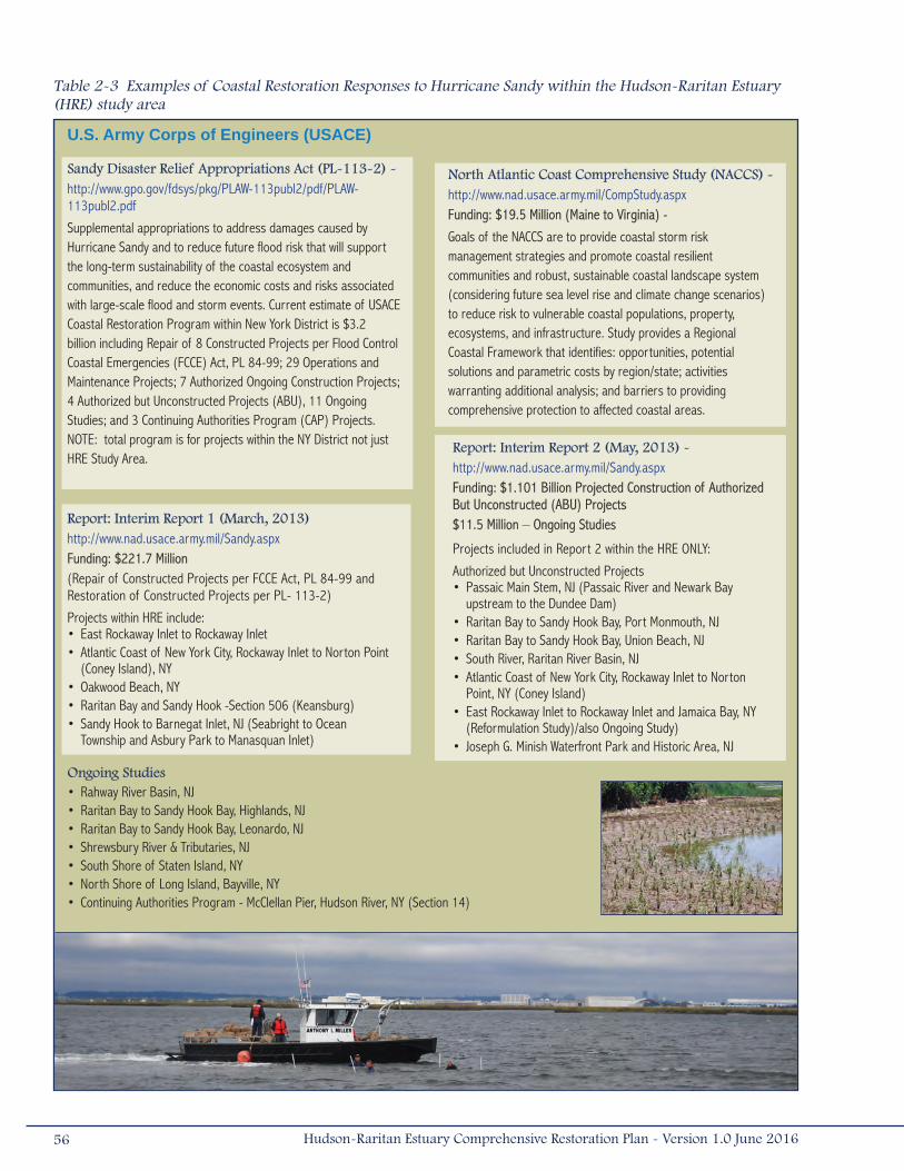
Table 2-3 Examples of Coastal Restoration Responses to Hurricane Sandy within the Hudson-Raritan Estuary (HRE) study area
Sandy Disaster Relief Appropriations Act (PL-113-2) - http://www.gpo.gov/fdsys/pkg/PLAW-113publ2/pdf/PLAW-113publ2.pdf
Supplemental appropriations to address damages caused by Hurricane Sandy and to reduce future flood risk that will support the long-term sustainability of the coastal ecosystem and communities, and reduce the economic costs and risks associated with large-scale flood and storm events. Current estimate of USACE Coastal Restoration Program within New York District is $3.2 billion including Repair of 8 Constructed Projects per Flood Control Coastal Emergencies (FCCE) Act, PL 84-99; 29 Operations and Maintenance Projects; 7 Authorized Ongoing Construction Projects; 4 Authorized but Unconstructed Projects (ABU), 11 Ongoing Studies; and 3 Continuing Authorities Program (CAP) Projects. NOTE: total program is for projects within the NY District not just HRE Study Area.
North Atlantic Coast Comprehensive Study (NACCS) -http://www.nad.usace.army.mil/CompStudy.aspxFunding: $19.5 Million (Maine to Virginia) -
Goals of the NACCS are to provide coastal storm risk management strategies and promote coastal resilient communities and robust, sustainable coastal landscape system (considering future sea level rise and climate change scenarios) to reduce risk to vulnerable coastal populations, property, ecosystems, and infrastructure. Study provides a Regional Coastal Framework that identifies: opportunities, potential solutions and parametric costs by region/state; activities warranting additional analysis; and barriers to providing comprehensive protection to affected coastal areas.
U.S. Army Corps of Engineers (USACE)
Report: Interim Report 1 (March, 2013) http://www.nad.usace.army.mil/Sandy.aspxFunding: $221.7 Million (Repair of Constructed Projects per FCCE Act, PL 84-99 and Restoration of Constructed Projects per PL- 113-2)
Projects within HRE include: • East Rockaway Inlet to Rockaway Inlet • Atlantic Coast of New York City, Rockaway Inlet to Norton Point
(Coney Island), NY• Oakwood Beach, NY • Raritan Bay and Sandy Hook -Section 506 (Keansburg)• Sandy Hook to Barnegat Inlet, NJ (Seabright to Ocean
Township and Asbury Park to Manasquan Inlet)
Report: Interim Report 2 (May, 2013) - http://www.nad.usace.army.mil/Sandy.aspxFunding: $1.101 Billion Projected Construction of Authorized But Unconstructed (ABU) Projects$11.5 Million – Ongoing Studies
Projects included in Report 2 within the HRE ONLY:
Authorized but Unconstructed Projects • Passaic Main Stem, NJ (Passaic River and Newark Bay
upstream to the Dundee Dam)• Raritan Bay to Sandy Hook Bay, Port Monmouth, NJ• Raritan Bay to Sandy Hook Bay, Union Beach, NJ• South River, Raritan River Basin, NJ• Atlantic Coast of New York City, Rockaway Inlet to Norton
Point, NY (Coney Island)• East Rockaway Inlet to Rockaway Inlet and Jamaica Bay, NY
(Reformulation Study)/also Ongoing Study) • Joseph G. Minish Waterfront Park and Historic Area, NJ
Ongoing Studies • Rahway River Basin, NJ• Raritan Bay to Sandy Hook Bay, Highlands, NJ• Raritan Bay to Sandy Hook Bay, Leonardo, NJ• Shrewsbury River & Tributaries, NJ• South Shore of Staten Island, NY• North Shore of Long Island, Bayville, NY • Continuing Authorities Program - McClellan Pier, Hudson River, NY (Section 14)
56 Hudson-Raritan Estuary Comprehensive Restoration Plan - Version 1.0 June 2016
U.S. Department of Interior
Sandy Disaster Relief Appropriations Acthttp://www.doi.gov/news/pressreleases/upload/2013_05_06-Hurricane-Sandy-Plan-Sm.pdfFunding: $271 Million - New York;$42 Million - New Jersey;$104 Million New York & New Jersey
Hurricane Sandy Coastal Resiliency Competitive Grants Program -http://www.nfwf.org/hurricanesandy/Pages/home.aspxFunding: $100 Million (TBD amount within HRE)
National Fish and Wildlife Foundation (NFWF) administered program that supports projects that reduce community’s vulnerability to the growing risks from coastal storms, sea level rise, flooding, erosion and associated threats through strengthening natural ecosystems that also benefit fish and wildlife. National Park Service/Historic Preservation Fund
Funding: $16 Million New York; $16 Million New JerseyFunding for historic preservation grants to States.
National Parks Service/Jamaica Bay Science and Resilience Institute Funding: $3.6 Million New York
Funding supports the Jamaica Bay Science and Resilience Institute to develop innovative approaches and conduct research that will enhance understanding of resilience in the urban, coastal ecosystems. The Institute is led by a Consortium of 9 academic organizations led by City University of NY working with Federal, state, local agency partners and stakeholders.
Hurricane Sandy Rebuilding Task Force - USDOI
DOI’s responsibilities include the restoration of coastal natural systems such as wetlands and barrier dunes, protection of critical infrastructure (water treatment, wastewater, emergency responses, etc), economic revitalization (tourism, beach access), and data sharing to understand impacts and vulnerability of our coastal environment.
Bureau of Safety and Environmental EnforcementFunding: $2.85 Million New Jersey
Funding for repairs and future mitigation measures to prevent or reduce wind and water impacts from future storms at the Ohmsett oil spill research facility in Leonardo, New Jersey.
National Park Service/Construction Funding: $248.6 Million New York; $0.2 Million New Jersey; $74.4 Million New York & New Jersey
Funding for response and recovery for clean up of storm debris and repairs to national park units along the eastern seaboard. Over $150 million of this funding is allocated for storm response and recovery at Gateway National Recreation Area total. Much of this funding is to restore critical park infrastructure, including public access facilities. However, a portion of the funding is allocated to the restoration of natural areas, such removing wreckage and restoring impacted wetland areas and coastlines ($2.7 million) and repairing the breached freshwater West Pond in Jamaica Bay ($1 million).
U.S. Environmental Protection Agency (USEPA)Sandy Disaster Relief Appropriations ActFunding: $340 Million - New York; $229 Million - New Jersey
Funding for 1) infrastructure resiliency upgrades beyond Federal Emergency Management Agency (FEMA) support for infrastructure repair, as part of the Clean Water State Revolving Fund and the Drinking Water State Revolving Fund; 2) water quality monitoring to evaluate the effects of Sandy on water quality in the coastal zones of NJ and sediment monitoring to support the water monitoring program; and 3) assessment and remediation of Leaking Underground Storage Tanks.
U.S. Department of Housing and Urban Development (HUD)Rebuild by Design Competition: Winning Proposals Announced June 2, 2014 - http://www.rebuildbydesign.org
Rebuild by Design is dedicated to create innovative community- and policy-based solutions to protect U.S. cities that are most vulnerable to increasingly intense weather events and future uncertainties. Initiated by HUD and the Hurricane Sandy Rebuilding Task Force, Rebuild by Design’s aim has been to connect the world’s most talented researchers and designers with the Sandy-affected area’s businesses, policymakers and local groups to better understand how to redevelop their communities in environmentally- and economically-healthier ways and to be better prepared.
Table 2-3 (Cont'd). Examples of Coastal Restoration Responses to Hurricane Sandy within the Hudson-Raritan Estuary (HRE) study area
57Hudson-Raritan Estuary Comprehensive Restoration Plan - Version 1.0 June 2016
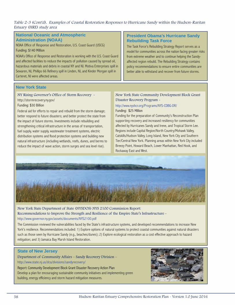
National Oceanic and Atmospheric Administration (NOAA)NOAA Office of Response and Restoration, U.S. Coast Guard (USCG)Funding: $140 Million
NOAA’s Office of Response and Restoration is working with the U.S. Coast Guard and affected facilities to reduce the impacts of pollution caused by spread oil, hazardous materials and debris in coastal NY and NJ. Motiva Enterprises spill in Sewaren, NJ, Phillips 66 Refinery spill in Linden, NJ, and Kinder Morgan spill in Carteret, NJ were affected areas.
New York State
President Obama’s Hurricane Sandy Rebuilding Task ForceThe Task Force’s Rebuilding Strategy Report serves as a model for communities across the nation facing greater risks from extreme weather and to continue helping the Sandy-affected region rebuild. The Rebuilding Strategy contains policy recommendations to ensure entire communities are better able to withstand and recover from future storms.
NY Rising Governor’s Office of Storm Recovery - http://stormrecovery.ny.gov/Funding: $30 Billion
Federal aid for efforts to repair and rebuild from the storm damage; better respond to future disasters; and better protect the state from the impact of future storms. Investments include rebuilding and strengthening critical infrastructure in the areas of transportation, fuel supply, water supply, wastewater treatment systems, electric distribution systems and flood protection systems and building new natural infrastructure (including wetlands, reefs, dunes, and berms to reduce the impact of wave action, storm surges and sea level rise).
New York State Department of State (NYSDOS) NYS 2100 Commission Report: Recommendations to Improve the Strength and Resilience of the Empire State’s Infrastructure - http://www.governor.ny.gov/assets/documents/NYS2100.pdf
The Commission reviewed the vulnerabilities faced by the State’s infrastructure systems, and developed recommendations to increase New York’s resilience. Recommendations included: 1) Explore options of natural systems to protect coastal communities against natural disasters such as those seen by Hurricane Sandy (e.g., beaches/dunes); 2) Explore ecological restoration as a cost effective approach to hazard mitigation; and 3) Jamaica Bay Marsh Island Restoration.
New York State Community Development Block Grant Disaster Recovery Program -
http://www.nyshcr.org/Programs/NYS-CDBG-DR/Funding: $25 MillionFunding for the preparation of Community’s Reconstruction Plan supporting recovery and increased resiliency for communities affected by Hurricanes Sandy and Irene, and Tropical Storm Lee. Regions include Capital Region/North Country/Mohawk Valley, Catskills/Hudson Valley, Long Island, New York City and Southern Tier/Central New York. Planning areas within New York City included Breezy Point, Howard Beach, Lower Manhattan, Red Hook, and Rockaway East and West.
State of New JerseyDepartment of Community Affairs – Sandy Recovery Division - http://www.state.nj.us/dca/divisions/sandyrecovery/
Report: Community Development Block Grant Disaster Recovery Action PlanDevelop a plan for encouraging sustainable community initiatives and implementing green building, energy efficiency and storm hazard mitigation measures.
Table 2-3 (Cont'd). Examples of Coastal Restoration Responses to Hurricane Sandy within the Hudson-Raritan Estuary (HRE) study area
58 Hudson-Raritan Estuary Comprehensive Restoration Plan - Version 1.0 June 2016
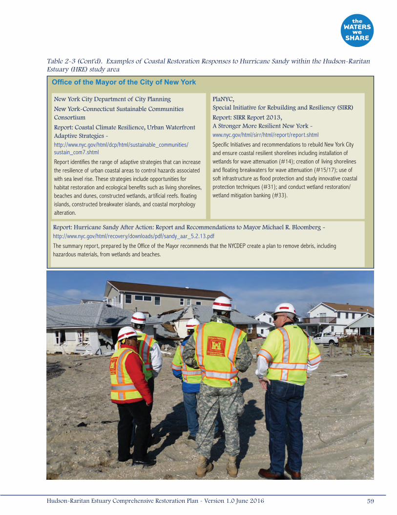
Office of the Mayor of the City of New York
Report: Hurricane Sandy After Action: Report and Recommendations to Mayor Michael R. Bloomberg - http://www.nyc.gov/html/recovery/downloads/pdf/sandy_aar_5.2.13.pdf
The summary report, prepared by the Office of the Mayor recommends that the NYCDEP create a plan to remove debris, including hazardous materials, from wetlands and beaches.
PlaNYC, Special Initiative for Rebuilding and Resiliency (SIRR)
Report: SIRR Report 2013, A Stronger More Resilient New York - www.nyc.gov/html/sirr/html/report/report.shtml
Specific Initiatives and recommendations to rebuild New York City and ensure coastal resilient shorelines including installation of wetlands for wave attenuation (#14); creation of living shorelines and floating breakwaters for wave attenuation (#15/17); use of soft infrastructure as flood protection and study innovative coastal protection techniques (#31); and conduct wetland restoration/wetland mitigation banking (#33).
New York City Department of City Planning
New York-Connecticut Sustainable Communities Consortium
Report: Coastal Climate Resilience, Urban Waterfront Adaptive Strategies - http://www.nyc.gov/html/dcp/html/sustainable_communities/sustain_com7.shtml
Report identifies the range of adaptive strategies that can increase the resilience of urban coastal areas to control hazards associated with sea level rise. These strategies include opportunities for habitat restoration and ecological benefits such as living shorelines, beaches and dunes, constructed wetlands, artificial reefs. floating islands, constructed breakwater islands, and coastal morphology alteration.
Table 2-3 (Cont'd). Examples of Coastal Restoration Responses to Hurricane Sandy within the Hudson-Raritan Estuary (HRE) study area
59Hudson-Raritan Estuary Comprehensive Restoration Plan - Version 1.0 June 2016
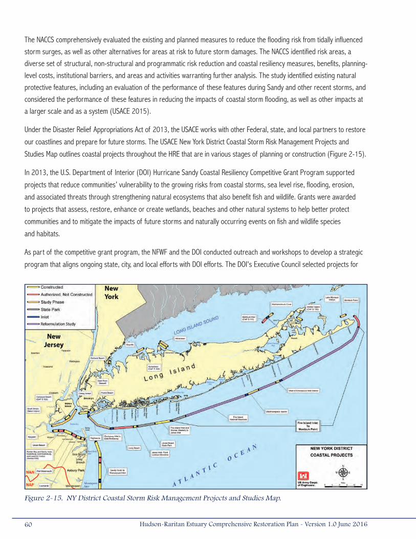
The NACCS comprehensively evaluated the existing and planned measures to reduce the flooding risk from tidally influenced
storm surges, as well as other alternatives for areas at risk to future storm damages. The NACCS identified risk areas, a
diverse set of structural, non-structural and programmatic risk reduction and coastal resiliency measures, benefits, planning-
level costs, institutional barriers, and areas and activities warranting further analysis. The study identified existing natural
protective features, including an evaluation of the performance of these features during Sandy and other recent storms, and
considered the performance of these features in reducing the impacts of coastal storm flooding, as well as other impacts at
a larger scale and as a system (USACE 2015).
Under the Disaster Relief Appropriations Act of 2013, the USACE works with other Federal, state, and local partners to restore
our coastlines and prepare for future storms. The USACE New York District Coastal Storm Risk Management Projects and
Studies Map outlines coastal projects throughout the HRE that are in various stages of planning or construction (Figure 2-15).
In 2013, the U.S. Department of Interior (DOI) Hurricane Sandy Coastal Resiliency Competitive Grant Program supported
projects that reduce communities’ vulnerability to the growing risks from coastal storms, sea level rise, flooding, erosion,
and associated threats through strengthening natural ecosystems that also benefit fish and wildlife. Grants were awarded
to projects that assess, restore, enhance or create wetlands, beaches and other natural systems to help better protect
communities and to mitigate the impacts of future storms and naturally occurring events on fish and wildlife species
and habitats.
As part of the competitive grant program, the NFWF and the DOI conducted outreach and workshops to develop a strategic
program that aligns ongoing state, city, and local efforts with DOI efforts. The DOI's Executive Council selected projects for
Figure 2-15. NY District Coastal Storm Risk Management Projects and Studies Map.
60 Hudson-Raritan Estuary Comprehensive Restoration Plan - Version 1.0 June 2016
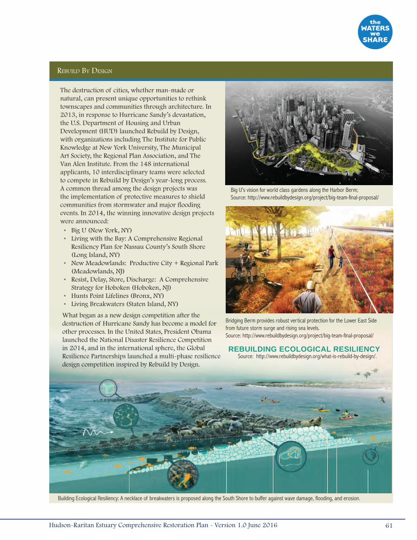
Building Ecological Resiliency: A necklace of breakwaters is proposed along the South Shore to buffer against wave damage, flooding, and erosion.
Big U’s vision for world class gardens along the Harbor Berm;Source: http://www.rebuildbydesign.org/project/big-team-final-proposal/
Bridging Berm provides robust vertical protection for the Lower East Side from future storm surge and rising sea levels.Source: http://www.rebuildbydesign.org/project/big-team-final-proposal/
reBuilD By Design
The destruction of cities, whether man-made or natural, can present unique opportunities to rethink townscapes and communities through architecture. In 2013, in response to Hurricane Sandy’s devastation, the U.S. Department of Housing and Urban Development (HUD) launched Rebuild by Design, with organizations including The Institute for Public Knowledge at New York University, The Municipal Art Society, the Regional Plan Association, and The Van Alen Institute. From the 148 international applicants, 10 interdisciplinary teams were selected to compete in Rebuild by Design’s year-long process. A common thread among the design projects was the implementation of protective measures to shield communities from stormwater and major flooding events. In 2014, the winning innovative design projects were announced:
• Big U (New York, NY)• Living with the Bay: A Comprehensive Regional
Resiliency Plan for Nassau County’s South Shore (Long Island, NY)
• New Meadowlands: Productive City + Regional Park (Meadowlands, NJ)
• Resist, Delay, Store, Discharge: A Comprehensive Strategy for Hoboken (Hoboken, NJ)
• Hunts Point Lifelines (Bronx, NY)• Living Breakwaters (Staten Island, NY)
What began as a new design competition after the destruction of Hurricane Sandy has become a model for other processes. In the United States, President Obama launched the National Disaster Resilience Competition in 2014, and in the international sphere, the Global Resilience Partnerships launched a multi-phase resilience design competition inspired by Rebuild by Design.
REBUILDING ECOLOGICAL RESILIENCYSource: http://www.rebuildbydesign.org/what-is-rebuild-by-design/.
61Hudson-Raritan Estuary Comprehensive Restoration Plan - Version 1.0 June 2016
funding based on criteria and a process developed by DOI's Strategic Sciences Group and project evaluation conducted by
a panel of federal technical experts. The program criteria incorporated infrastructure resilience guidelines recommended by
the Hurricane Sandy Rebuilding Task Force.
In June 2013, HUD and the Hurricane Sandy Rebuilding Task Force also launched the Rebuild by Design competition. Rebuild by
Design was a multi-stage regional design competition to promote resilience for those areas affected by Sandy and innovation
by developing solutions that increase resilience in the region, and to implement selected proposals with public and private
funding dedicated to this effort. The competition also represented a policy innovation as HUD specifically set aside Community
Development Block Grant Disaster Recovery funding to incentivize building the winning projects and proposals. Awarded Rebuild
by Design projects have been allocated over $1.1 billion in Federal funding. The Federal government has continued to invest
in and recognize the innovations that these projects have brought to the region with the recently announced awards from the
National Disaster Resilience Competition. The winning projects were announced in June 2014 (see spotlight project: Rebuild By
Design). Additional recommendations and programs were outlined in the Governors’ Office of Storm Recovery New York Rising
Howard Beach Community Reconstruction Plan.
As noted in many of the post-Sandy recommendations, the regional response to restore coastal resilience and sustainability
includes a combination of NNBFs and hard infrastructure improvements to reduce the risk of coastal storm damage and
contend with the impacts associated with climate change. The restoration opportunities highlighted in the CRP provide
potential locations where ecological restoration can link with engineered projects to support or mimic natural coastal
processes, thereby enhancing shoreline resiliency and sustainability. CRP restoration opportunities could also be used to
meet potential mitigation requirements for construction impacts. The results of an evaluation to determine which of these
sites can serve as NNBFs have been incorporated into the Open Accessible Space Information Systems (OASIS) database.
Greater collaboration among Federal and state agencies and NGOs has been, and always will be, necessary to advance
coastal restoration efforts within the HRE. Post-Sandy, the shared vision by restoration partners (including regulatory and
resource agencies) should facilitate easier synchronization of these ongoing efforts. There are currently many forums to
ensure collaboration and coordination of restoration efforts including the NY/NJ Federal Leadership Resiliency Collaborative,
Sandy Regional Infrastructure Resilience Coordination (SRIRC), the Science and Resilience Institute at Jamaica Bay, HEP, and
the HEP RWG.
62 Hudson-Raritan Estuary Comprehensive Restoration Plan - Version 1.0 June 2016

3.0 Target Ecosystem Characteristics
As discussed in Section 1.1, the purpose of the CRP is to provide a master plan for ecosystem restoration in the HRE. This is
achieved through the use of TECs to focus restoration goals on distinct actions with measurable objectives (Table 3-1). The
TECs were initially developed by a team of estuarine scientists, representatives from Federal, state, and local agencies, and
key stakeholders. The TECs represent a consensus of what is desired and achievable, with short- and long-term goals as a
basis for gauging overall progress.
The process began with a two-day workshop in October 2005, led by the HRF and the Center for the Environment at Cornell
University, to review existing restoration plans and solicit candidate restoration goals and actions (Bain et al. 2007). The
multidisciplinary group was composed of approximately 45 people from various Federal, state, and local agencies, NGOs, and
national and regional estuarine scientists. The group initially proposed 23 habitat restoration and acquisition actions for the
HRE study area.
In early 2006, the group’s efforts were synthesized to be consistent with HEP’s CCMP. Common elements in candidate
restoration actions were merged and actions that would be met indirectly or were actively addressed by other programs
were removed. The final 11 TECs were chosen based upon technical merit, relevance to policies within the HRE study area,
and feasibility. Once these TECs were developed, documented, and justified by the team, the targets were reviewed by
independent scientists and resource or regulatory agency managers. The resulting products were presented at more than
13 workshops and many meetings to further refine each individual TEC. The process of selecting the TECs successfully
demonstrated an effective framework for building consensus and defining broad restoration objectives.
The 11 TECs defined specific habitat types, complexes, contamination issues, or societal values that together contribute to
the overall program goal of restoring the HRE through the establishment of a mosaic of habitats that provide society with
new and increased benefits from the estuary environment. Each TEC was assigned short-term and long-term quantitative
objectives (Table 3-1). Each TEC provides a unique range of ecological services and together, all of the TECs cumulatively
define the critical habitat and societal needs for the HRE and promote increased biotic diversity, sustainable ecosystem
functions, and public access. The TECs provide the basis for a decisive environmental agenda for the estuary as well as
a long-term strategy capable of changing with environmental conditions and human needs (Bain et al. 2007). Detailed
information about the development of the TECs can be found in Appendix A (including workshops, transcripts, presentations,
and technical memoranda).
Once the major objectives were defined, the team searched for potential opportunities to achieve each TEC objective. Coarse
GIS data layers related to each TEC goal were identified and applied in a map overlay procedure to identify broad zones of
opportunities that met the characteristics of each TEC. The data layers included physical parameters, such as bathymetry,
fetch distance, and total suspended solids in the water. Water quality and sediment quality were used for some of the TECs,
and land use constraints were also considered.
63Hudson-Raritan Estuary Comprehensive Restoration Plan - Version 1.0 June 2016
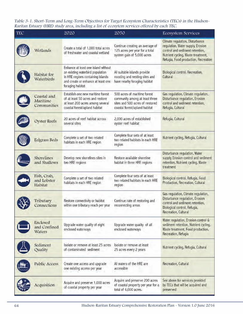
64 Hudson-Raritan Estuary Comprehensive Restoration Plan - Version 1.0 June 2016
Table 3-1. Short-Term and Long-Term Objectives for Target Ecosystem Characteristics (TECs) in the Hudson-Raritan Estuary (HRE) study area, including a list of ecosytem services offered by each TEC.
The data sets used represent the best available spatial data spanning the HRE study area; those data sets that include only
a portion of the HRE study area were not incorporated into this analysis. Many of the data sets used in the analysis were
developed from satellite imagery and aerial photography of varying age and current accuracy. The existing wetlands layer
was developed from the USFWS National Wetlands Inventory (NWI) and incorporates data available as of 2008, although
some areas had not been updated for several decades. For this reason, the analyses are applicable at the watershed and
regional levels, not at the site-specific level. These preliminary analyses should be used to narrow the potential opportunities
and focus attention on the most likely areas for restoring habitat. In many cases, field verification and feasibility investigations
will be necessary before proceeding with site-specific project planning. For example, the NY/NJ Baykeeper in cooperation with
the Rutgers Center for Urban Environmental Sustainability (CUES) conducted a shoreline mapping investigation of the lower
Raritan Bay to identify feasible oyster restoration sites, as described in greater detail below. Additional information on the
methods of the GIS analysis is in Appendix B.
In May 2012, the original TEC workshop participants reconvened to discuss the comments obtained from review of the 2009
Draft CRP, identify changes to the TEC Target Statements, and modify short-term and long-term targets. In 2012, a twelfth
TEC, Acquisition, was added in response to public comments emphasizing the need to highlight the importance of protecting
and preserving existing open and undeveloped lands (Table 3-1). The following sections describe the current status of the
TECs in the HRE study area, present the target statements, specify restoration objectives, and identify potential opportunities
for restoration and acquisition. A detailed discussion of each TEC, including current research needs, and recommendations
for implementation restoration projects and conducting post-construction monitoring, is in Volume II of the CRP.
3.1 HabitatsFour of the TECs represent habitat types that were historically abundant but have been eliminated or significantly reduced in
size in the HRE study area. These habitats were deemed essential to the ecology of the HRE and the purpose of these TECs
is to restore acreage of these valuable habitats in the HRE study area.
3.1.1 WetlandsCoastal and non-tidal freshwater wetlands are critical habitat types providing a variety of functions in the HRE.
Coastal wetlands, defined as tidally influenced wetlands connected to the open waters, are among the most
productive ecosystems on Earth, with measured production rates exceeding those of tropical rain forests and
freshwater wetlands (Good et al. 1982). Non-tidal freshwater wetlands can include riparian forested and emergent wetlands
along watercourses (including Tributaries), fringing wetlands along lakes and ponds, and isolated wetlands associated with
groundwater, seepage, and other hydrologic factors (e.g., vernal pools).
Coastal wetlands are characterized by a distinctive vegetation community. Like many intertidal salt marsh communities today,
smooth cordgrass (Spartina alterniflora) dominates intertidal salt marsh communities in the HRE study area. This species
generally occurs between mean high water and mean sea level and may vary in growth form (i.e., tall, medium, and short),
65Hudson-Raritan Estuary Comprehensive Restoration Plan - Version 1.0 June 2016

depending on tidal flooding frequency and duration. Above the mean high water (high marsh), the floral composition of salt
marshes increases in diversity, with several plant species typically present, including saltmeadow hay (S. patens) and salt
grass (Distichlis spicata). The structure and function of many coastal and freshwater wetlands in the HRE study area have
been altered in recent decades by the proliferation of an aggressive European genotype of common reed (Phragmites
australis) that forms monoculture stands.
Freshwater wetlands can be categorized in terms of the dominant vegetation (e.g., Aquatic Bed, Emergent, Scrub-shrub,
and Forested; Cowardin 1979). Aquatic Bed wetlands include permanently or frequently inundated habitats dominated by
plants that grow on or below the water surface for most of the growing season. These plants may be rooted or free-floating
Emergent wetlands are characterized by the presence of rooted, herbaceous hydrophytes, present throughout the growing
season. Scrub-shrub wetlands are characterized by woody vegetation less than 20 feet (6 meters) in height. This may
include shrubs and small trees stunted by salinity and flooding. Forested wetlands are characterized by woody vegetation
over 20 feet (6 meters) in height, typically with an overstory of trees, an understory of young trees or shrubs, and an
herbaceous ground layer. Some of the characteristic plant species found in freshwater wetlands include rushes (Juncus and
Scirpus spp.), sedges (Carex spp.), duckweeds (Lemma spp.), willows (Salix spp.), ashes (Fraxinus spp.), and white oak
(Quercus bicolor).
Freshwater tidal wetlands and freshwater emergent wetlands occur along tidal freshwater rivers (Tributary Connections);
remnants persist in the Meadowlands (Kiviat and MacDonald 2002), within the tidal freshwater river section in the lower
Passaic River (upstream of River Mile 10) (USACE 2008), Lemon Creek on Staten Island, along the fresh reaches of the
Raritan River basin, the tidal fresh tributaries of the Hudson River, and the Hudson’s main stem from Wappinger Falls north
to the Federal Troy Lock and Dam. For this system, low marsh refers approximately to the lower half of the intertidal zone
or between mean low water and mean sea level, whereas high marsh refers to the upper intertidal zone between mean sea
level and mean high water (USFWS 1997).
Coastal and freshwater wetlands perform a variety of functions including shoreline stabilization, storage of floodwaters,
maintenance of surface water quality, groundwater recharge, and sediment retention, which is important for chemical
detoxification, nutrient retention and recycling, and decomposition processes (Seneca and Broome 1992). The ability
of coastal and freshwater wetlands to retain high levels of nitrogen has important implications for eutrophication and
nitrogen loading to the HRE study area; they also have a role in denitrification, by converting stored mineralized nitrogen
and returning it to the atmosphere as gas. Coastal and freshwater wetlands also provide valuable habitat for a variety of
organisms. Juvenile fish and crustaceans gain refuge from predators and benefit from abundant prey resources in tidal
marshes. Deep pools and channels in non-tidal freshwater wetlands also support a characteristic fish community, typically
comprising of warm-water species. Wetlands are critical habitat for Waterbirds. Wading birds prey upon resident fishes and
invertebrates in wetlands. Migratory waterfowl use wetlands as stopovers during their winter and summer migrations. A
variety of mammals use wetlands for foraging, breeding, and refuge. Coastal and freshwater wetlands can also be important
areas for recreational boating and fishing and offer numerous Public Access and educational opportunities.
Historically, coastal and freshwater wetlands represented a significant habitat complex in the HRE study area. However,
a large portion of the coastal and freshwater wetland habitat in the HRE study area has been degraded or destroyed by
66 Hudson-Raritan Estuary Comprehensive Restoration Plan - Version 1.0 June 2016
human activities. The most devastating losses occurred between World War II and the implementation of CWA, when large
expanses of wetlands were filled, drained, or diked (Wise et al. 1997). In the last 30 years, cumulative wetland losses
have slowed due to the implementation of protective legislation and mitigation (Steinberg et al. 2004). However, acres of
wetlands still disappear and are degraded annually in the HRE study area. Many factors have been suggested as possible
contributors to current wetland habitat loss: sea level rise; alterations in the estuary’s sediment budget; erosion due to
changes in wave energy; smothering caused by sea lettuce blooms; effects of contaminants from landfills and other sources;
changes in hydrologic connectivity; or excessive consumption of marsh grasses by waterfowl (Steinberg et al. 2004).
Nutrient enrichment due to excess nutrient flow (e.g., nitrogen) can result in algal blooms, hypoxia, and fisheries losses, and
drive coastal and freshwater wetland loss (Deegan et al. 2012). Field studies and aerial photograph interpretation suggest
that large sections of wetlands are deteriorating rapidly, particularly in Jamaica Bay, where eutrophication from excess
nutrients may be interacting synergistically with a variety of other factors (Hartig et al. 2002). Other threats arise through
changes in soil chemistry and moisture (e.g., during droughts), such as soil oxidation, soil acidification, and metal toxicity,
which can cause sudden losses of acres of wetlands. Stressed wetlands may be more susceptible to fungal pathogens
and elevated salinities (Lindstedt and Swenson 2006). Polluted runoff from adjacent uplands can degrade coastal and
freshwater wetlands. Runoff from roads and other paved surfaces, and nutrient-rich runoff from fertilized lawns, agricultural
areas, wastewater treatment plants, CSOs, and septic systems can degrade wetlands by encouraging growth of Phragmites
and other invasive species. Hundreds of miles of riparian corridors have been lost to urban development. Many streams
throughout present-day NYC have been filled, re-routed underground, or disconnected from their floodplains (PlaNYC 2012).
Wetland loss is complex and likely a function of many factors, each of which varies in intensity and exposure among regions
of the HRE study area.
Target Statement
The Wetlands TEC aims to create and restore coastal and freshwater wetlands, at a rate exceeding the annual loss or
degradation, to produce a net gain in acreage. The target statements for the Wetlands TEC address acreage and ecosystem
function, unlike many other TECs. Wetland restoration data spanning the last decade were used to determine an attainable
and realistic target. The short-term objective is to create a total of 1,000 acres (4.05 kilometers2) of freshwater and coastal
wetland habitat by 2020. By 2050, the objective is to continue restoring an average of 125 acres (0.10 kilometers2) per
year for a total system gain of 5,000 acres (20.2 kilometers2) of coastal and freshwater wetlands.
Restoration Opportunities (Map 3-1)
Substantial coastal and freshwater wetland restoration opportunities exist within the HRE study area. Identification of
coastal wetland restoration opportunities was based upon major physical requirements of coastal wetlands (land elevation,
bathymetry, and fetch distance) and land use constraints in the estuary (Map 3-1). Two layers are displayed on the map,
coastal wetland creation opportunities and coastal wetlands restoration opportunities. No distinction is made between
the quality of existing wetland habitat (i.e., this layer represents both degraded and non-degraded wetlands), but it can
be assumed that many polygons represent existing degraded coastal wetlands that are dominated by dense stands of
67Hudson-Raritan Estuary Comprehensive Restoration Plan - Version 1.0 June 2016
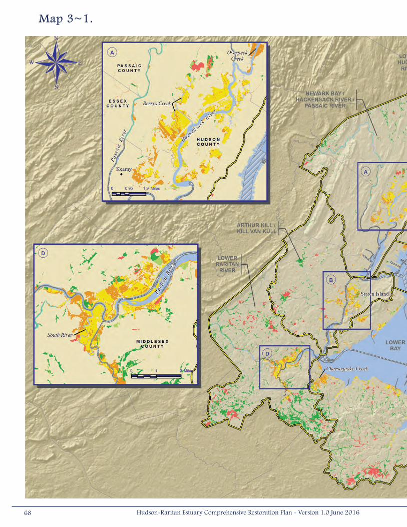
Map 3~1.
68 Hudson-Raritan Estuary Comprehensive Restoration Plan - Version 1.0 June 2016

69Hudson-Raritan Estuary Comprehensive Restoration Plan - Version 1.0 June 2016
Phragmites. Degraded wetlands represent potential wetland restoration opportunities (as opposed to wetland creation
opportunities). Freshwater wetland restoration opportunities were identified using the impaired wetlands information
available in the NWI maps. These wetlands include those listed as either diked or impounded in the NWI dataset. Four layers
are displayed on the map, impaired wetlands, freshwater emergent wetland, freshwater forested/shrub wetland, and riverine.
Existing wetlands adjacent to impaired wetlands represent potential restoration opportunities and are shown (Map 3-1).
In the HRE study area, there are approximately 12,500 acres (50 kilometers2) of existing coastal wetland habitat and
35,000 acres (142 kilometers2) of existing freshwater wetlands. The largest acreages occur along the Hackensack River
(Inset A), along the Arthur Kill and its tributaries (Inset B), in Jamaica Bay (Inset C), and along the Raritan River and its
tributaries (Inset D). Additional large expanses of coastal wetlands exist along Staten Island and the southern shore of the
Lower Bay Planning Region (i.e., Middlesex and Monmouth Counties, New Jersey shorelines), and expanses of freshwater
wetlands exist at the northern end of the Newark Bay, Hackensack River, Passaic River Planning Region, and the southern
portion of the Lower Raritan River Planning Region. The NWI map indicates that approximately 50 percent of the existing
wetlands classified as “estuarine” and 22 percent of existing wetlands classified as “freshwater” in the HRE study area are
impaired in some way (e.g., diked or impounded, drained or ditched, excavated, or have modified substrate). This suggests
that wetland restoration opportunities could contribute significantly to the quality of coastal and freshwater wetland habitat
in the HRE.
Areas adjacent to existing wetlands tend to represent the largest areas for coastal wetland creation opportunities in the
HRE study area. According to the analysis, coastal wetland creation opportunities total 14,000 acres (56.6 kilometers2) in
the HRE study area. This analysis excluded all existing developed lands and parklands; therefore, the actual coastal wetland
creation acreage may be higher if partnerships are made with landowners and parks.
When looking at the restoration opportunities map, several inset maps draw attention to locations where substantial wetland
creation and wetland restoration opportunities may exist.
• Inset A – Sizeable plots of uplands occur between the Hackensack and Passaic Rivers, particularly east of Kearny
and along Berrys Creek. Lands surrounding Overpeck Creek, a tributary of the Hackensack River, may also
represent large coastal wetland creation opportunities. In addition, this planning region includes the New Jersey
Meadowlands, one of the largest expanses of existing estuarine wetlands. According to the NWI maps, about
80 percent of the Meadowlands are impaired. Many of these wetlands have been degraded and are currently
dominated by Phragmites. These wetlands provide an opportunity for restoration, especially at the headwaters
of Berry’s Creek. Two sites located within the Hackensack Meadowlands (Metromedia and Meadowlark) are being
recommended for construction authorization as part of the HRE Feasibility Study.
• Inset B – Opportunities to create coastal wetlands may exist on the islands of the Arthur Kill, including Shooters
Island, Pralls Island, and the Island of Meadows; however, feasibility and cost will play an important role, as these
are fill sites. Other areas of interest are on Staten Island, south and west of Old Place Creek, Saw Mill Creek and
branches of the Fresh Kills. On the New Jersey side of the Arthur Kill, coastal wetland opportunities may exist along
Piles Creek and the Rahway River. Freshwater wetland restoration opportunities also exist in Middlesex County,
inland and west of the Arthur Kill, and in Union County, in New Jersey.
70 Hudson-Raritan Estuary Comprehensive Restoration Plan - Version 1.0 June 2016
• Inset C- In Jamaica Bay, the greatest potential for the restoration of coastal wetlands is continuing the success of
restoring marsh islands using dredged material. Since 2007, more than 160 acres (0.68 kilometers2) of marsh
island habitat have been restored at Elders Point East and West, Yellow Bar Hassock, Black Wall, and Rulers Bar.
Additional marsh islands, including Pumpkin Patch, Duck Point, Elders East/West, and Stoney Point are being
designed as part of the HRE Feasibility Study. In addition, six remaining locations along the periphery of Jamaica
Bay, including Bayswater State Park, Fresh Creek, Brant Point, Dubos Point, Dead Horse Bay, and Hawtree Basin,
are also priority sites to be recommended for construction authorization in the HRE Feasibility Study. Spring
Creek South and North and Idlewild Park sites are also key restoration opportunities within Jamaica Bay that are
advancing through the FEMA Hazard Mitigation Grant Program and the USACE Continuing Authorities Program
(CAP). There are currently no identified potential freshwater wetland restoration opportunities in Jamaica Bay,
though small sites exist in the drainage networks of the former tributaries to the bay, such as Spring Creek.
• Inset D – Coastal and freshwater wetland restoration opportunities exist adjacent to existing coastal wetland habitat
and impaired freshwater habitat along the Raritan River and its main tributary, the South River. Coastal wetland
creation opportunities also exist in the area.
• Other wetland creation opportunities may exist along the southeastern coast of Staten Island, throughout Sandy
Hook, and along Cheesequake Creek, a tributary of the Raritan Bay. Scattered opportunities may exist in other
planning regions, such as Lower Hudson River, Upper Bay (specifically Liberty State Park), and Harlem River, East
River, and Western Long Island Sound.
3.1.2 Coastal and Maritime ForestsThe Coastal and Maritime Forests TEC addresses ecologically rare and unique communities that provide habitat
and food resources to support many bird and wildlife species, as well as attenuate waves, stabilize shorelines,
and provide soil retention (Table 3-2). These systems have become vulnerable to extirpation, both within the
HRE study area and globally.
Maritime plant communities are dynamic systems that occur across a range of fringe seacoast habitats in narrow,
discontinuous bands (National Biological Service 1995). These forests, often described as “strand forests,” are influenced
by strong salt spray, high winds, unstable substrates (e.g., dune deposition/shifting), and have characteristically stunted
and contorted trees (National Biological Service 1995, Yozzo et al. 2003, Edinger et al. 2014). Maritime communities are
perpetually shifting complexes that interchange in response to the dynamics of the substrate. Beach and dune habitats are
the most dynamic of the maritime vegetative communities, being modified by winds and waves, and stabilized by vegetation.
When the dunes are altered, this changes the inland shrub and forested lands, bringing them closer to shore, pushing them
further inland or even periodically eliminating them. Herbaceous and shrub layers thrive on the outskirts of the forest and in
bog areas, behind the dune and swale communities (Bain et al. 2007). Both evergreen and deciduous trees, such as American
holly (Ilex opaca), oaks (Quercus spp.), sassafras (Sassafras albidum), shadbush (Amelanchier canadensis), black tupelo
(Nyssa sylvatica), American beech (Fagus grandifolia), eastern red cedar (Juniperus virginiana), northern bayberry (Myrica
71Hudson-Raritan Estuary Comprehensive Restoration Plan - Version 1.0 June 2016

72 Hudson-Raritan Estuary Comprehensive Restoration Plan - Version 1.0 June 2016
Table 3-2. Coastal and maritime communities that may be possible to create in the Hudson-Raritan Estuary (HRE) study area (adapted from Edinger et al. [2014] and Reschke [1990]). Species status, rare [R], threatened [T], and endangered [E], are detailed.
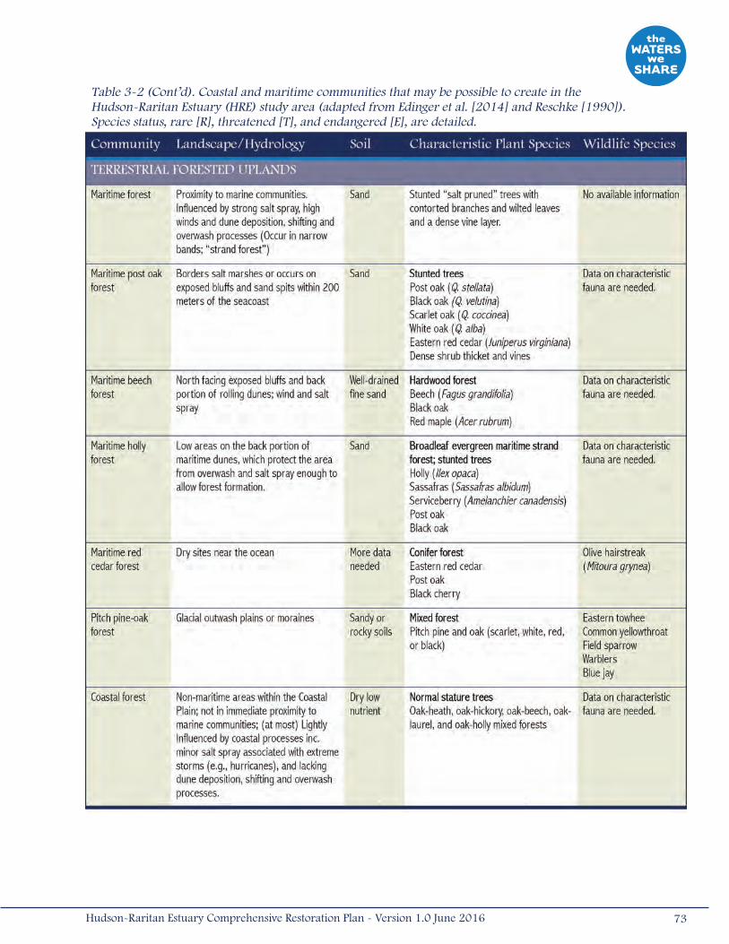
73Hudson-Raritan Estuary Comprehensive Restoration Plan - Version 1.0 June 2016
Table 3-2 (Cont’d). Coastal and maritime communities that may be possible to create in the Hudson-Raritan Estuary (HRE) study area (adapted from Edinger et al. [2014] and Reschke [1990]). Species status, rare [R], threatened [T], and endangered [E], are detailed.
pensylvanica), and beach plum (Prunus maritima), commonly dominate the forest community (Bain et al. 2007). The species
composition can depend upon how connected these communities are to nearby forests on the coastal plain (Bain et al. 2007).
Coastal forests are non-maritime communities found within the coastal plain, but are not exposed to the same intensity of
salt spray, wind, and substrate shifting as maritime communities. This results in trees that are of normal stature and not
contorted or “salt-pruned,” despite the minor salt spray from severe storms like hurricanes (Edinger et al. 2014). Coastal
forests occur on dry, well-drained, low-nutrient soils; do not have dense, vine undergrowth; and have low species diversity
typically dominated by one or two tree species. These communities include oak, hickory (Carya spp.), beech, holly, red maple,
and pitch pine (Pinus rigida) forests (Edinger et al. 2014).
Barrens (i.e., pine barrens) occur on shallow, low-nutrient soils, and are composed of stunted or dwarfed trees that are
generally adapted to a high frequency of fire (Olsvig et al. 1998). These communities occur on stabilized dunes, glacial till,
outwash plains, and rocky soils, and include species such as pitch pine, scrub oak (Quercus ilicifolia), post oak (Quercus
stellata), and blueberry (Vaccinium corymbosum) and huckleberry (Gaylussacia baccata) shrubs. Pine-dominated forests
blend with pine-oak forests as soil composition changes, but species composition generally stays the same, with only
abundance changing. Representative examples outside of the HRE study area include the southern New Jersey Pine Barrens,
and the Long Island Pine Barrens, which occur along the glacial outwash plain of the Ronkonkoma Moraine and along
the Peconic River. Some pitch pine communities do not require fire regimes to persist and would be viable for restoration
in the HRE.
Coastal and maritime forest communities provide a variety of valuable functions to human and natural communities. When
overlying coastal aquifers, they typically function as groundwater recharge areas. By providing a vegetated buffer between
human development and the water, these forests attenuate runoff from developed areas and provide protection from storm
surges and coastal flooding. Coastal areas within the HRE study area are especially vulnerable to threats posed by coastal
surges associated with sea level change and coastal storms. In the aftermath of Hurricane Sandy, Federal, state, and
municipal assessment and planning documents emphasized the need for NNBFs that would protect the coastline of the HRE
from future storms. The NNBFs (e.g., wetlands and dunes) such as those found in coastal and maritime forest communities
could reduce coastal risk (USACE 2013). Coastal and maritime forest restoration opportunities would contribute to coastal
storm protection through wave attenuation, sediment stabilization, and dense vegetation that could slow the advance
of storm surge, enhancing shoreline resiliency and sustainability, and providing coastal risk management benefits for
surrounding communities (USACE 2015b).
These forests provide a self-perpetuating and increasingly effective permanent erosion control (Brennan and Culverwell
2004). Many wildlife species depend on these forests for at least a portion of their life history, with requirements for feeding,
breeding, refuge, and movement/migration. The diamondback terrapin (Malaclemys terrapin) and many shorebirds (e.g.,
plovers, sandpipers, skimmers, terns, and gull species) use sandy soils at the margins of forested habitats inland from
dunes for nesting. Some Waterbird species (e.g., herons and egrets) do not nest in these habitats, but will stage in them
during post-breeding dispersal periods. Many maritime/coastal forest tree species are also fruit bearing and provide an
important food source to avian migrants. Most coastal and maritime forests in the HRE study area have been degraded or
eliminated by timber harvest and development. Recent encroaching development has increasingly affected and fragmented
74 Hudson-Raritan Estuary Comprehensive Restoration Plan - Version 1.0 June 2016
these communities. Many species in these habitat types are opportunistic and can rapidly colonize protected areas, making
restoration of these forest communities in the HRE study area potentially feasible (Yozzo et al. 2003). The Natural Areas
Conservancy and The Nature Conservancy are working together to restore these forests by reducing fragmentation and
threats to maritime forest in Marine Park, Brooklyn. The Nature Conservancy is also working on invasive species removal
and reforestation of maritime forest shrub and tree species in the Jamaica Bay Wildlife Refuge.
Target Statement
Implementing the Coastal and Maritime Forests TEC would create a linkage of forests accessible to avian migrants
and dependent plant communities. The short-term objective of the Coastal and Maritime Forests TEC is to restore or
expand one new maritime forest of at least 50 acres (0.2 kilometers2) and rehabilitate at least 200 additional acres
(0.8 kilometers2) among several coastal forest types by 2020. By 2050, the objective is to have a total of 500 acres
(2 kilometers2) of maritime forest community among at least three sites, potentially at Sandy Hook, Kings/Queens Counties,
and/or Staten Island (Bain et al. 2007). In addition, 500 acres (2 kilometers2) of various coastal forests/upland habitats
should be restored within the HRE study area by 2050.
Adjacent habitats, such as dunes and maritime grasslands, or similarly rare communities, such as barrens, should also be
created or enhanced when appropriate land exists. Maritime communities represent critically rare habitat types; therefore,
they should be targeted for restoration under this TEC.
Restoration Opportunities (Map 3-2)
Opportunities for restoring coastal or maritime forest habitat exist in most planning regions of the HRE study area
(Map 3-2). Several areas within these regions could be appropriate for creating these forest habitats. For instance,
brownfields and closed landfills could serve as potential restoration opportunities, where clean fill material could be placed
over degraded sites to make it suitable. Examples include restoration by NYCDEP of coastal oak, birch and beech forests,
and grassland habitat as part of a comprehensive, long-term restoration program at the Fresh Kills Landfill on Staten Island,
and restoration of coastal grassland and coastal forest habitat at the Pennsylvania and Fountain Avenue Landfill in Brooklyn.
Maritime forest creation opportunities represent areas where new maritime forests could be created without negatively
affecting existing maritime forest habitat. For this reason, the Coastal and Maritime Forests Restoration Opportunities
Map displays existing maritime forest communities along with maritime forest creation opportunities; however, these
maps do not represent all opportunities, as coastal forests are underrepresented in some regions (e.g., NYC). Maritime
forest creation opportunities represent undeveloped land (excludes lawns and developed parks) within 1,000 yards
(914 meters) of the shore, that can be expected to be subject to salt spray due to surrounding high winds and salinity.
A single 64-acre (0.3-kilometers2) plot of existing maritime forest is mapped in the HRE study area on the Sandy Hook
peninsula. There were 1,283 acres (5.2 kilometers2) where maritime forests could potentially be created in the HRE study
area, occurring in the Jamaica Bay and Lower Bay Planning Regions, and a small section in the Harlem River, East River,
75Hudson-Raritan Estuary Comprehensive Restoration Plan - Version 1.0 June 2016
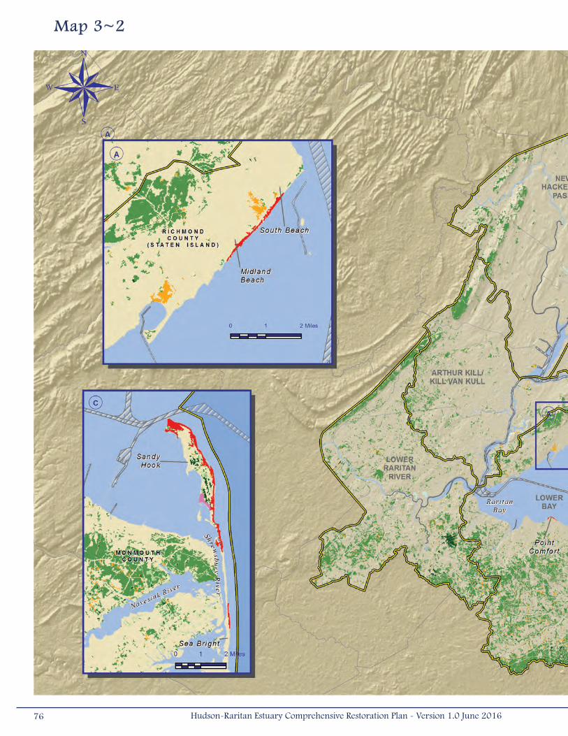
Map 3~2
76 Hudson-Raritan Estuary Comprehensive Restoration Plan - Version 1.0 June 2016

77Hudson-Raritan Estuary Comprehensive Restoration Plan - Version 1.0 June 2016
and Western Long Island Sound Planning Region. The largest areas occurred on exposed shorelines, typically not within
coves or bays, like the Sandy Hook peninsula, the southern coast of Staten Island, and Rockaway Peninsula.
Coastal forest restoration opportunities are generally represented by existing forested land. Forested lands make up
15 percent of the land (124,600 acres; 504 kilometers2) within the HRE study area (826,600 acres; 3,345 kilometers2),
most of which occurs within the coastal plain. Potential sites will need to be field verified to ensure that suitable landscape,
hydrology, and soil conditions exist to re-create the coastal forest community (Table 3-2). Although soils may be augmented
to meet specific habitat requirements, the cost would generally be prohibitive. These lands may be suitable for restoring
coastal forest communities to create habitat linkages with maritime forests as well as barrens and grasslands.
When looking at the restoration opportunities map, three inset maps draw attention to locations where the GIS layering
analysis identified maritime and coastal forest creation opportunities and coastal forest restoration opportunities. Coastal
forest and/or pine barren and grassland restoration opportunities may occur in areas with existing forest and grassland
habitat, respectively. Unvegetated/developed lands represent coastal habitat creation opportunities.
• Inset A – Adjacent to the communities of Midland Beach and South Beach on Staten Island are inland unvegetated/
undeveloped areas that could be appropriate for creating coastal or maritime forest communities. Farther inland on
Staten Island, large tracts of forested land exist that may be appropriate for restoring coastal habitat communities.
It would be appropriate to create communities like pitch pine-scrub oak, coastal oak-heath, and coastal oak-
hickory in low-lying, outwash plains and within sandy hummock areas of Staten Island. An existing grass savannah
community called a serpentine barren is located in the northeastern portion of Staten Island, and there may be
opportunities for enhancement or expansion. Together, the Bluebelt Program and NY Rising’s Enhanced Buyout
Program, which sponsors “buy-outs” of property located in floodplains, have also created new restoration
opportunities for Staten Island’s East Shore floodplain.
• Inset B – A large maritime forest creation opportunity exists on the Rockaway Peninsula, particularly west of Breezy
Point along a relatively undeveloped stretch of coastline. Some of the existing forested land adjacent to these areas
could be restored to form larger plots of forested habitat. A small plot of land within Jamaica Bay, along Hendrix
Creek, was identified as a maritime forest creation opportunity although it may not receive substantial salt spray. A
maritime forest creation opportunity was also identified on Coney Island. However, Coney Island has a popular public
beach with dense inland development and it would probably not be possible to create a maritime forest or restore
adjacent coastal forests here due to residential and commercial development. Coney Island Beach could benefit
from re-establishing dunes, grasses, and shrubland near the boardwalk. Opportunities for coastal forest restoration
may exist on forested lands along many of the creeks in Jamaica Bay and near the Jamaica Bay Wildlife Refuge
Visitor’s Center on Ruler’s Bar Hassock.
• Inset C – Sandy Hook has the only documented plot of existing maritime forest in the HRE study area. The existing
maritime forest is flanked by forest/shrubland to the east, where it may be possible to restore the existing forest or
create new, adjacent maritime forest habitat. Most of Sandy Hook peninsula’s eastern shoreline has been identified
as a maritime forest creation opportunity. This land is not densely populated, and there may be a sufficient area
inland to establish the necessary beach and dune communities to protect any created maritime forest habitat.
However, farther south on the Sandy Hook peninsula, near the community of Sea Bright, substantial shoreline
78 Hudson-Raritan Estuary Comprehensive Restoration Plan - Version 1.0 June 2016
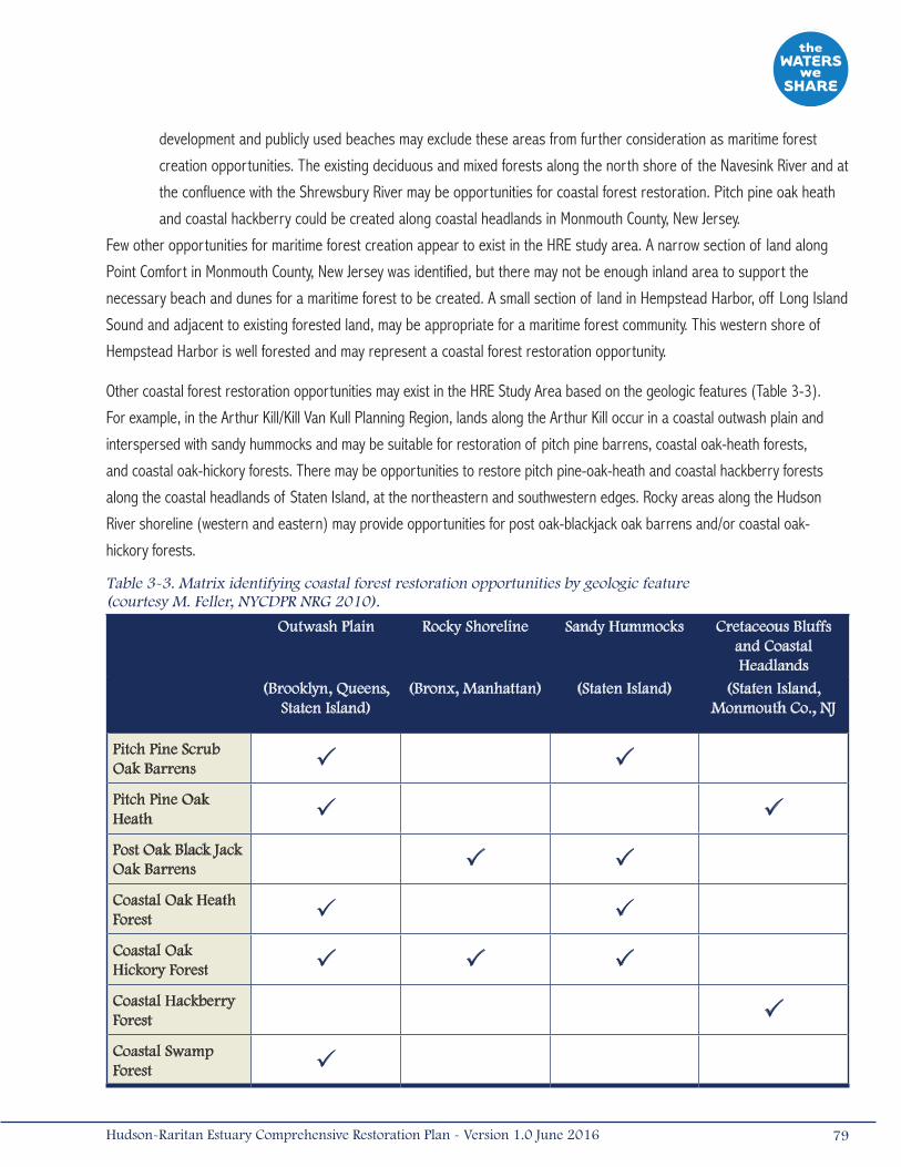
development and publicly used beaches may exclude these areas from further consideration as maritime forest
creation opportunities. The existing deciduous and mixed forests along the north shore of the Navesink River and at
the confluence with the Shrewsbury River may be opportunities for coastal forest restoration. Pitch pine oak heath
and coastal hackberry could be created along coastal headlands in Monmouth County, New Jersey.
Few other opportunities for maritime forest creation appear to exist in the HRE study area. A narrow section of land along
Point Comfort in Monmouth County, New Jersey was identified, but there may not be enough inland area to support the
necessary beach and dunes for a maritime forest to be created. A small section of land in Hempstead Harbor, off Long Island
Sound and adjacent to existing forested land, may be appropriate for a maritime forest community. This western shore of
Hempstead Harbor is well forested and may represent a coastal forest restoration opportunity.
Other coastal forest restoration opportunities may exist in the HRE Study Area based on the geologic features (Table 3-3).
For example, in the Arthur Kill/Kill Van Kull Planning Region, lands along the Arthur Kill occur in a coastal outwash plain and
interspersed with sandy hummocks and may be suitable for restoration of pitch pine barrens, coastal oak-heath forests,
and coastal oak-hickory forests. There may be opportunities to restore pitch pine-oak-heath and coastal hackberry forests
along the coastal headlands of Staten Island, at the northeastern and southwestern edges. Rocky areas along the Hudson
River shoreline (western and eastern) may provide opportunities for post oak-blackjack oak barrens and/or coastal oak-
hickory forests.
Table 3-3. Matrix identifying coastal forest restoration opportunities by geologic feature (courtesy M. Feller, NYCDPR NRG 2010).
Outwash Plain Rocky Shoreline Sandy Hummocks Cretaceous Bluffs and Coastal Headlands
(Brooklyn, Queens, Staten Island)
(Bronx, Manhattan) (Staten Island) (Staten Island, Monmouth Co., NJ
Pitch Pine Scrub Oak Barrens P P
Pitch Pine Oak Heath P P
Post Oak Black Jack Oak Barrens P P
Coastal Oak Heath Forest P P
Coastal Oak Hickory Forest P P P
Coastal Hackberry Forest P
Coastal Swamp Forest P
79Hudson-Raritan Estuary Comprehensive Restoration Plan - Version 1.0 June 2016
3.1.3 Oyster ReefsAmerican oyster (Crassostrea virginica) reefs, or beds, provide spatially complex substrate and benthic structure
that is important for many estuarine organisms. A well-developed oyster reef will typically consist of intricately
layered formations of live oysters on the exterior and layers of old oyster shell forming the base and reef
interior. Deep crevices created by the oyster shell provide refuge for numerous species of small aquatic organisms. Oyster
reefs are also feeding, breeding, and nursery grounds for finfish and large crustaceans, where multi-species congregations
occur (Harding and Mann 1999). Oyster reefs provide attachment sites for the eggs of many small fishes, such as gobies and
blennies, as well as the oyster toadfish (Opsanus tau). Juvenile and adult oysters are important prey for gastropods, whelks,
sea stars, crabs, and boring sponges. Intertidal oyster reefs provide rich feeding grounds for many shorebird species.
Oysters are valuable organisms that can actually promote the growth and viability of other habitats. By filtering particulate
material from the water column, oysters form an important link between the pelagic (i.e., open water) and benthic food
webs (Yozzo et al. 2001). Through water clarity improvements, oysters can enhance other subtidal habitats like eelgrass
by increasing the amount of light that can penetrate the water (Cerco and Noel 2007). Investigators have documented
measureable water quality effects of reefs soon after construction, including removal of nitrogen, particulate phosphorus,
and seston (Dame et al. 1989, Grizzle et al. 2006). In some geographic areas, oyster reefs may develop substantial vertical
relief off the sea floor, altering patterns of current flow and possibly creating or expanding shallow water habitat by trapping
sediments. Oyster reefs can encourage the growth and expansion of salt marshes located inshore of the reefs by functioning
as natural breakwaters (Coen and Luckenbach 2000).
Historical accounts from colonial times document flourishing oyster populations in the estuary. Large expanses of oysters
in upper Raritan Bay stretched a mile in diameter and were referred to as the “Great Beds.” Populations also existed in the
Hudson River and tributaries of Staten Island, although the upstream extent to which they occurred is uncertain (MacKenzie
1992). Historically, oysters were a keystone species in the HRE study area, providing both ecological functions and an
economic role in the region. The oyster fishing industry in the estuary thrived in the mid-late 19th century and was estimated
to cover approximately 200,000 acres (810 kilometers2; Kennish 2002, Bain et al. 2007). By the early 20th century, poor
water quality conditions and incidence of human-transferable diseases resulted in declining harvest and, by 1925, the
oyster industry in the estuary was abandoned (MacKenzie 1992). The loss of historic oyster beds permanently altered the
structure and functions of the estuary’s benthic ecosystem, and eliminated a significant habitat resource for estuarine fish
and invertebrate species that rely on spatially complex submerged structures.
Today, no known oyster reefs exist in the HRE study area. However, scattered live oysters can be found in certain areas,
indicating the presence of isolated populations. The Oyster Reefs TEC addresses important biological and physical
contributions to the estuary and emphasizes the unique role oysters have played in the culture and history of the HRE.
Oyster restoration programs, such as the NY/NJ Baykeeper’s Oyster Restoration and Gardening Program have become
increasingly popular through enthusiastic grassroots participation. Research efforts have evaluated oyster growth and
survivability, susceptibility to disease, natural recruitment, reef designs, and more recently have evaluated concerns
with “habitat tradeoffs” and measured water quality benefits of reefs to guide future, large-scale restoration efforts.
Research initiatives to identify suitable locations for restoration of oyster reefs have been planned and initiated through
80 Hudson-Raritan Estuary Comprehensive Restoration Plan - Version 1.0 June 2016
the cooperative Oyster Restoration Research Partnership (ORRP). In 2009, the HRF, the NY/NJ Baykeeper, Urban Assembly
New York Harbor School, and the USACE led a partnership of more than 30 organizations, not-for-profits, and state and
city agencies in creating and conducting research at a series of oyster reef research sites in the HRE. Through the ORRP
collaborative effort, five experimental reefs were constructed throughout the HRE during 2010-2011, using rock as the reef
base material, covered by a thin veneer of clamshell, followed by live oyster spat settled on to clamshells (“spat-on-shell”)
as the final layer. Each of the ORRP reefs encompasses an area of approximately 538 feet2 (50 meters2), with initial (post-
construction) heights of 12 to 20 inches (30 to 50 centimeters) (Grizzle et al. 2011). Results from the Soundview, Hastings,
and Governors Island reefs initially showed the most promise, based on survival, growth, natural recruitment, and favorable
environmental conditions (e.g., temperature, salinity; Grizzle et al. 2011). Upon the final year of monitoring (2012), the
Soundview site had the best overall development patterns indicating the best prospects for successful restoration; however,
it is emphasized that this does not mean the other sites do not have potential for future restoration (Grizzle et al. 2013).
Examples of recent oyster reef restoration efforts in addition to the ORRP oyster restoration efforts include:
• The NY/NJ Baykeeper, Rutgers CUES, Hackensack Riverkeeper, and the New Jersey Sports and Exposition Authority
are working together to determine locations able to support sustainable long-term development of oyster reef
habitat within the HRE (RERC 2008). The Keyport Reef, constructed in 2009, was removed in 2010 after the state
permit was revoked due to water quality and “attractive nuisance” concerns (see additional information below). In
2011, NY/NJ Baykeeper and the Rutgers CUES initiated preliminary oyster survivability studies at Naval Weapons
Station (NWS) Earle in New Jersey within the Lower Bay, a facility that provides secure waters with minimal risk of
illegal harvest (Rutgers CUES 2012). Baykeeper was granted permits to conduct oyster research and restoration on
just over 10 acres (0.04 kilometers2) within the boundaries of NWS Earle in late 2012. Baykeeper produces juvenile
oysters for oyster restoration projects at the Aquaculture Facility located at the naval station. Hatchery raised oyster
larvae attach, set, and grow on shell substrate. Once oysters have grown for approximately two months, they are
ready for release onto newly established oyster beds, or reefs. The plot is expected to expand based on the data
collected, oyster population research, and evaluation by the HRE Feasibility Study.
• In 2006, prior to the ORRP, NYCDPR NRG began construction of the pilot oyster reef in the Bronx River, off
Soundview Park. Following the promising results under the original NRP pilot and the first ORRP, in 2012 funding
from NOAA’s community restoration grant program was used to expand and monitor the Soundview Reef. The ORRP
– phase 2, Soundview project team constructed an approximately 1-acre [0.004-kilometers2]) reef at the site. One
hundred and twenty five (125) CYs of clam shells imported from Massachusetts and 125,000 transplanted oyster
spat (juvenile oysters) were used to construct and seed the reef (HRF 2013). The combination of these projects
has resulted in the largest oyster reef restoration area within the HRE.
• NYCDEP, in collaboration with Cornell University’s Cooperative Extension Service, constructed pilot oyster reef sites
in Jamaica Bay in late 2010, by establishing a spat-on shell reef at Dubos Point using similar reef construction
methods as ORRP, and placed spat-covered reef balls in Gerritsen Creek. Both sites were monitored through 2012
and exhibited healthy oyster growth and survival, as well as a high degree of utilization by natant macrofauna
(NYCDEP 2012).
81Hudson-Raritan Estuary Comprehensive Restoration Plan - Version 1.0 June 2016
The NYSDEC has requested that restoration practitioners and project sponsors consider the following when preparing an
oyster restoration proposal in New York waters:
• Pilot-scale projects provide the benefit of community involvement.
• Proposals for large-scale projects need to discuss habitat exchange issues.
• Risk management strategies should be discussed.
• All shells must cure out of the water for a year in piles no more than 18 inches (46 centimeters) in height in order
to be considered safe for restoration.
• Spat should only be from New York and northern states because of disease concerns.
• Protection of Waters and Coastal Zone Consistency permits will be required for oyster restoration projects.
• Suggest coordination with the Food and Drug Administration (FDA) and the Interstate Shellfish Sanitation
Conference.
Since 2010, New Jersey has restricted restoration projects for commercially harvestable shellfish in Restricted or Prohibited
waters (i.e., closed to shellfishing) that are not adequately patrolled to prevent illegal harvesting. Due to concerns with
illegal harvest of oysters and associated health risks, the NJDEP and NYSDEC recommend considering the restoration of
shellfish species that have no commercial value in these waters. Presently efforts are being made to coordinate oyster reef
restoration activities within the existing states’ permitting framework. While the goals of the regulations are understandable,
(i.e., avoiding public harm with respect to navigation or the environment, protecting public health, etc.), alternative
mechanisms for achieving them are being considered, including the increased use of “secured” areas. On January 19, 2016,
the Governor of New Jersey signed Bill A3944/S2617 which requires NJDEP to revisit existing Shellfish Rules within one year
after adoption to provide improved and expanded research and restoration opportunities based on comments received from
the public.
Despite the demonstrated success of oyster reef restoration at some locations in the HRE study area, oysters can be
considered an “attractive nuisance” for illegal harvest. Therefore, it may be prudent to consider restoring non-commercial
shellfish species that provide similar ecosystem services, such as ribbed mussels. In 2011, NYCDEP established a
demonstration project of ribbed mussels in Fresh Creek, a tributary to Jamaica Bay. Ribbed mussels are naturally occurring
in the Bay, and throughout the estuary, and filter water. The project is being monitored to determine whether a more robust
population within the center of the channel could remove substantial quantities of impurities from the water, particularly
near CSOs (NYCDEP 2014). By incorporating ribbed mussels, shellfish habitat can be created as part of the Habitat for Fish,
Crab, and Lobsters TEC and along intertidal Shorelines and Shallows. Although the ecological benefits of this species are
less substantial than the ecological benefits provided by oyster reefs, the lower risk of “attractive nuisance” may make these
projects more attractive to regulators.
Target Statement
The Oyster Reefs TEC aims to establish oyster reefs at several locations in the HRE study area (Bain et al. 2007). The short-
term objective for the Oyster Reefs TEC is to create 20 acres (0.08 kilometers2) of self-sustaining and naturally expanding
oyster reef habitat in the HRE study area by 2020. By 2050, the objective is to have 2,000 acres (8 kilometers2) of
established oyster reef habitat.
82 Hudson-Raritan Estuary Comprehensive Restoration Plan - Version 1.0 June 2016
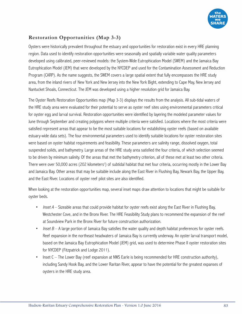
Restoration Opportunities (Map 3-3)
Oysters were historically prevalent throughout the estuary and opportunities for restoration exist in every HRE planning
region. Data used to identify restoration opportunities were seasonally and spatially variable water quality parameters
developed using calibrated, peer-reviewed models: the System-Wide Eutrophication Model (SWEM) and the Jamaica Bay
Eutrophication Model (JEM) that were developed by the NYCDEP and used for the Contamination Assessment and Reduction
Program (CARP). As the name suggests, the SWEM covers a large spatial extent that fully encompasses the HRE study
area, from the inland rivers of New York and New Jersey into the New York Bight, extending to Cape May, New Jersey and
Nantucket Shoals, Connecticut. The JEM was developed using a higher resolution grid for Jamaica Bay.
The Oyster Reefs Restoration Opportunities map (Map 3-3) displays the results from the analysis. All sub-tidal waters of
the HRE study area were evaluated for their potential to serve as oyster reef sites using environmental parameters critical
for oyster egg and larval survival. Restoration opportunities were identified by layering the modeled parameter values for
June through September and creating polygons where multiple criteria were satisfied. Locations where the most criteria were
satisfied represent areas that appear to be the most suitable locations for establishing oyster reefs (based on available
estuary-wide data sets). The four environmental parameters used to identify suitable locations for oyster restoration sites
were based on oyster habitat requirements and feasibility. These parameters are salinity range, dissolved oxygen, total
suspended solids, and bathymetry. Large areas of the HRE study area satisfied the four criteria, of which selection seemed
to be driven by minimum salinity. Of the areas that met the bathymetry criterion, all of these met at least two other criteria.
There were over 50,000 acres (202 kilometers2) of subtidal habitat that met four criteria, occurring mostly in the Lower Bay
and Jamaica Bay. Other areas that may be suitable include along the East River in Flushing Bay, Newark Bay, the Upper Bay,
and the East River. Locations of oyster reef pilot sites are also identified.
When looking at the restoration opportunities map, several inset maps draw attention to locations that might be suitable for
oyster beds.
• Inset A – Sizeable areas that could provide habitat for oyster reefs exist along the East River in Flushing Bay,
Westchester Cove, and in the Bronx River. The HRE Feasibility Study plans to recommend the expansion of the reef
at Soundview Park in the Bronx River for future construction authorization.
• Inset B – A large portion of Jamaica Bay satisfies the water quality and depth habitat preferences for oyster reefs.
Reef expansion in the northeast headwaters of Jamaica Bay is currently underway. An oyster larval transport model,
based on the Jamaica Bay Eutrophication Model (JEM) grid, was used to determine Phase II oyster restoration sites
for NYCDEP (Fitzpatrick and Lodge 2011).
• Inset C – The Lower Bay (reef expansion at NWS Earle is being recommended for HRE construction authority),
including Sandy Hook Bay, and the Lower Raritan River, appear to have the potential for the greatest expanses of
oysters in the HRE study area.
83Hudson-Raritan Estuary Comprehensive Restoration Plan - Version 1.0 June 2016
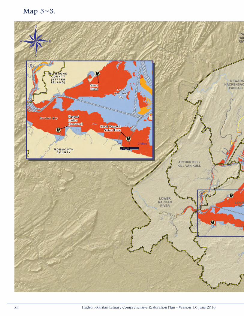
Map 3~3.
84 Hudson-Raritan Estuary Comprehensive Restoration Plan - Version 1.0 June 2016

Habitat Suitability Layers from the System-Wide Eutrophication Model/Jamaica Bay Eutrophication Model (2008 model output): Bathymetry, Salinity, Dissolved oxygen, Total suspended solids
85Hudson-Raritan Estuary Comprehensive Restoration Plan - Version 1.0 June 2016
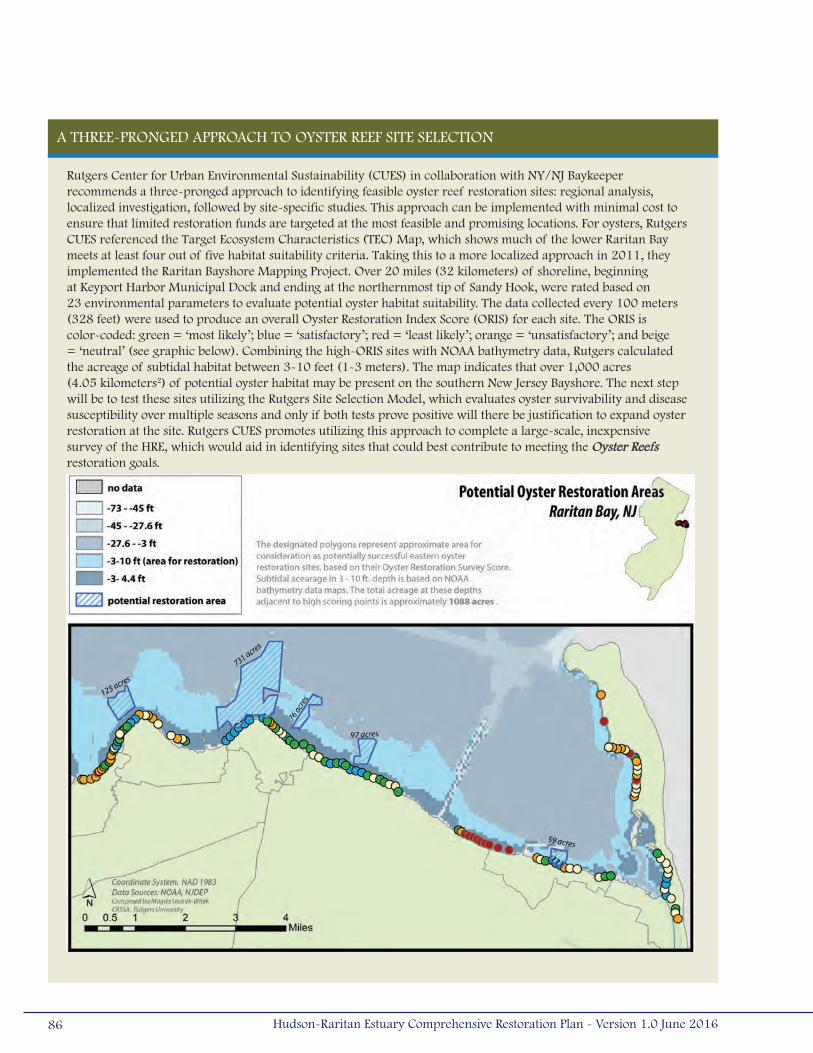
A THREE-PRONGED APPROACH TO OYSTER REEF SITE SELECTION
Rutgers Center for Urban Environmental Sustainability (CUES) in collaboration with NY/NJ Baykeeper recommends a three-pronged approach to identifying feasible oyster reef restoration sites: regional analysis, localized investigation, followed by site-specific studies. This approach can be implemented with minimal cost to ensure that limited restoration funds are targeted at the most feasible and promising locations. For oysters, Rutgers CUES referenced the Target Ecosystem Characteristics (TEC) Map, which shows much of the lower Raritan Bay meets at least four out of five habitat suitability criteria. Taking this to a more localized approach in 2011, they implemented the Raritan Bayshore Mapping Project. Over 20 miles (32 kilometers) of shoreline, beginning at Keyport Harbor Municipal Dock and ending at the northernmost tip of Sandy Hook, were rated based on 23 environmental parameters to evaluate potential oyster habitat suitability. The data collected every 100 meters (328 feet) were used to produce an overall Oyster Restoration Index Score (ORIS) for each site. The ORIS is color-coded: green = ‘most likely’; blue = ‘satisfactory’; red = ‘least likely’; orange = ‘unsatisfactory’; and beige = ‘neutral’ (see graphic below). Combining the high-ORIS sites with NOAA bathymetry data, Rutgers calculated the acreage of subtidal habitat between 3-10 feet (1-3 meters). The map indicates that over 1,000 acres (4.05 kilometers2) of potential oyster habitat may be present on the southern New Jersey Bayshore. The next step will be to test these sites utilizing the Rutgers Site Selection Model, which evaluates oyster survivability and disease susceptibility over multiple seasons and only if both tests prove positive will there be justification to expand oyster restoration at the site. Rutgers CUES promotes utilizing this approach to complete a large-scale, inexpensive survey of the HRE, which would aid in identifying sites that could best contribute to meeting the Oyster Reefs restoration goals.
86 Hudson-Raritan Estuary Comprehensive Restoration Plan - Version 1.0 June 2016
3.1.4 Eelgrass BedsEelgrass (Zostera marina) is a seagrass, not a seaweed, and is one of the few plants that occur almost
exclusively in subtidal waters with marine salinities, utilizing the water column for vertical support (Fonseca
1992). The Eelgrass Beds TEC represents a habitat that is vertically and horizontally complex, attracting
dense and diverse communities of macroinvertebrates, shellfish, and fishes, as well as providing critical nursery habitat for
important fishery species. Eelgrass beds support all trophic levels and provide many ecosystem services to the estuary.
Eelgrass can grow rapidly, producing large quantities of organic matter. This primary production supports a complex
food web that cycles nutrients between sediments and surface waters (Fonseca 1992). Eelgrass plants produce oxygen
and can filter nutrients and contaminants, improving the surrounding water quality (Bain et al. 2007). Eelgrass beds also
provide physical benefits to the ecosystem. Wave and current energy is dissipated through the beds, reducing erosion and
sediment resuspension, and preserving sediment-dwelling bacteria and fungi (Bain et al. 2007, Fonseca 1992). Enhanced
sediment stability increases the accumulation of organic and inorganic materials (Fonseca 1992). The improved conditions
surrounding eelgrass beds enhance their self-sustainability by providing stable sediment and optimal water quality for
eelgrass bed expansion.
In the HRE study area, eelgrass beds were historically abundant along the Raritan Bay shore in north-central New Jersey. A
wide-ranging infestation of the marine slime mold (Labryinthula zosterae) along with declining water quality in many coastal
areas virtually eliminated eelgrass from the HRE and other Atlantic coast estuaries during the 1930s (Bain et al. 2007).
BILLION OYSTER PROjECT
Billion Oyster Project (BOP) is a project of the New York Harbor Foundation, a non profit dedicated to developing and supporting a diverse and environmentally literate network of students, schools and communities working together to restore New York Harbor. BOP is an oyster restoration and education project aimed at restoring one billion oysters to New York Harbor over a twenty-year time horizon, and in doing so, enhancing the environmental literacy and stewardship ethic of New Yorkers, especially public school students. New York Harbor School is the flagship school in this initiative. Harbor School staff and students work alongside Foundation staff to do the hands-on work of oyster cultivation and restoration. Students at Harbor School learn to operate vessels, design and construct reef infrastructure, grow oysters, scuba dive, and conduct research on these reefs. These students are now joined by students at more than 50 partner schools who learn their math and science lessons through the lens of oyster restoration. Their teachers are trained to implement BOP curricula and empowered with water quality monitoring and oysters cultivation equipment. Each of these schools maintains live oysters in an Oyster Restoration Station at a waterfront site near their school.
Harbor Foundation sees the BOP as a means of developing a city-wide constituency of teachers, youth, and families who are Harbor literate; who want to and are able to access the water; and who have a vested interest in a clean, productive Harbor. The BOP comprises a series of oyster survivability, experimental restoration, and education and stewardship initiatives which seek to build upon and expand the work of the multi-partner, collaborative Oyster Restoration Research Project (ORRP). These initiatives include growing oysters in nurseries in the Brooklyn Navy Yard and other locations, deploying accessible, community reefs, growing oysters on Governors Island, testing different oyster reef substrate types and oyster installation strategies on the experimental Governors Island oyster reef; collaborating on the Living Breakwaters Project and other restoration and resiliency initiatives. For further information, please contact Pete Malinowski at 212-4580-800 ext. 6504 [email protected].
87Hudson-Raritan Estuary Comprehensive Restoration Plan - Version 1.0 June 2016

Today, eelgrass has been nearly eliminated from the HRE study area and only a few small beds remain in the Shrewsbury
River between Gunning Island and Oyster Bay.
Target Statement
Restoration of eelgrass beds should initially focus on choosing suitable sites for planting test beds and gaining an
understanding of habitat criteria and feasibility of restoration. The short-term objective is to create one test bed in each
suitable planning region in the HRE study area by 2020. The long-term objective for the Eelgrass Beds TEC is to have at
least three established, self-sustaining, and expanding eelgrass beds in each suitable planning region by 2050. It must be
emphasized that there may be entire planning regions that do not meet the physical requirements (e.g., low wave energy,
high salinity) necessary to sustain healthy eelgrass populations. Test beds should be attempted in areas where there is a
high probability for success and should not be “forced” in unsuitable areas.
Pilot eelgrass restoration projects and their associated monitoring will help to determine whether the creation of larger
eelgrass beds may be possible and will help to increase the likelihood for success of future restoration efforts.
The future of eelgrass restoration in the HRE study area may be advanced through the implementation of the following near-
term actions.
• Conduct pilot-scale projects to guide large-scale restoration programs. Pilot projects should span discrete abiotic
conditions (depths, sediment types, wave energy regimes) and incorporate a variety of seeding/planting techniques
(e.g., adult transplants supplemented by a seed-based program).
• Involve Resource Managers in the eelgrass research/restoration process to better inform and gain support for
research and monitoring.
• Share lessons learned from post-restoration monitoring. Monitoring will refine the suitability criteria and improve
subsequent restoration programs.
• Develop restoration plans for eelgrass by creating a strategic plan that focuses on suitable locations and
sets achievable targets. It may be beneficial to use structural versus functional targets when evaluating
restoration success.
• Identify proponents for eelgrass restoration among the agencies and environmental groups.
In Jamaica Bay, pilot-scale eelgrass beds were planted at several locations between 2008 and 2011 as part of the Jamaica
Bay Watershed Protection Plan, a component of New York City’s PlaNYC program. NYCDEP, in partnership with Cornell
University’s Cooperative Extension Service, evaluated several potential eelgrass transplant sites in 2008, and three of these
(Breezy Point, Floyd Bennett Field, and Little Egg Marsh) were planted the following spring. Subsequent transplant sites
included Dubos Point and an additional Breezy Point site, located to the east of the primary site. In 2010, all transplant
efforts were focused on the most successful of the initial sites at Breezy Point, and an additional pair of sites was added
on the northern shore of Rockaway Inlet, offshore the Kingsborough Community College campus. In 2011, the most recent
set of planting efforts focused entirely on the Breezy Point location, the most promising of the Jamaica Bay pilot sites
(Figure 3-1).
88 Hudson-Raritan Estuary Comprehensive Restoration Plan - Version 1.0 June 2016
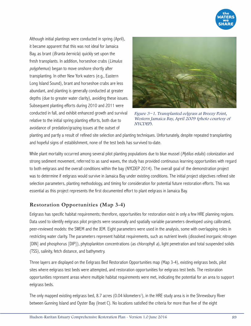
Although initial plantings were conducted in spring (April),
it became apparent that this was not ideal for Jamaica
Bay, as brant (Branta bernicla) quickly set upon the
fresh transplants. In addition, horseshoe crabs (Limulus
polyphemus) began to move onshore shortly after
transplanting. In other New York waters (e.g., Eastern
Long Island Sound), brant and horseshoe crabs are less
abundant, and planting is generally conducted at greater
depths (due to greater water clarity), avoiding these issues.
Subsequent planting efforts during 2010 and 2011 were
conducted in fall, and exhibit enhanced growth and survival
relative to the initial spring planting efforts, both due to
avoidance of predation/grazing issues at the outset of
planting and partly a result of refined site selection and planting techniques. Unfortunately, despite repeated transplanting
and hopeful signs of establishment, none of the test beds has survived to-date.
While plant mortality occurred among several pilot planting populations due to blue mussel (Mytilus edulis) colonization and
strong sediment movement, referred to as sand waves, the study has provided continuous learning opportunities with regard
to both eelgrass and the overall conditions within the bay (NYCDEP 2014). The overall goal of the demonstration project
was to determine if eelgrass would survive in Jamaica Bay under existing conditions. The initial project objectives refined site
selection parameters, planting methodology, and timing for consideration for potential future restoration efforts. This was
essential as this project represents the first documented effort to plant eelgrass in Jamaica Bay.
Restoration Opportunities (Map 3-4)
Eelgrass has specific habitat requirements; therefore, opportunities for restoration exist in only a few HRE planning regions.
Data used to identify eelgrass pilot projects were seasonally and spatially variable parameters developed using calibrated,
peer-reviewed models: the SWEM and the JEM. Eight parameters were used in the analysis, some with overlapping roles in
restricting water clarity. The parameters represent habitat requirements, such as nutrient levels (dissolved inorganic nitrogen
[DIN] and phosphorus [DIP]), phytoplankton concentrations (as chlorophyll a), light penetration and total suspended solids
(TSS), salinity, fetch distance, and bathymetry.
Three layers are displayed on the Eelgrass Bed Restoration Opportunities map (Map 3-4), existing eelgrass beds, pilot
sites where eelgrass test beds were attempted, and restoration opportunities for eelgrass test beds. The restoration
opportunities represent areas where multiple habitat requirements were met, indicating the potential for an area to support
eelgrass beds.
The only mapped existing eelgrass bed, 8.7 acres (0.04 kilometers2), in the HRE study area is in the Shrewsbury River
between Gunning Island and Oyster Bay (Inset C). No locations satisfied the criteria for more than five of the eight
89Hudson-Raritan Estuary Comprehensive Restoration Plan - Version 1.0 June 2016
Figure 3~1. Transplanted eelgrass at Breezy Point, Western Jamaica Bay, April 2009 (photo courtesy of NYCDEP).
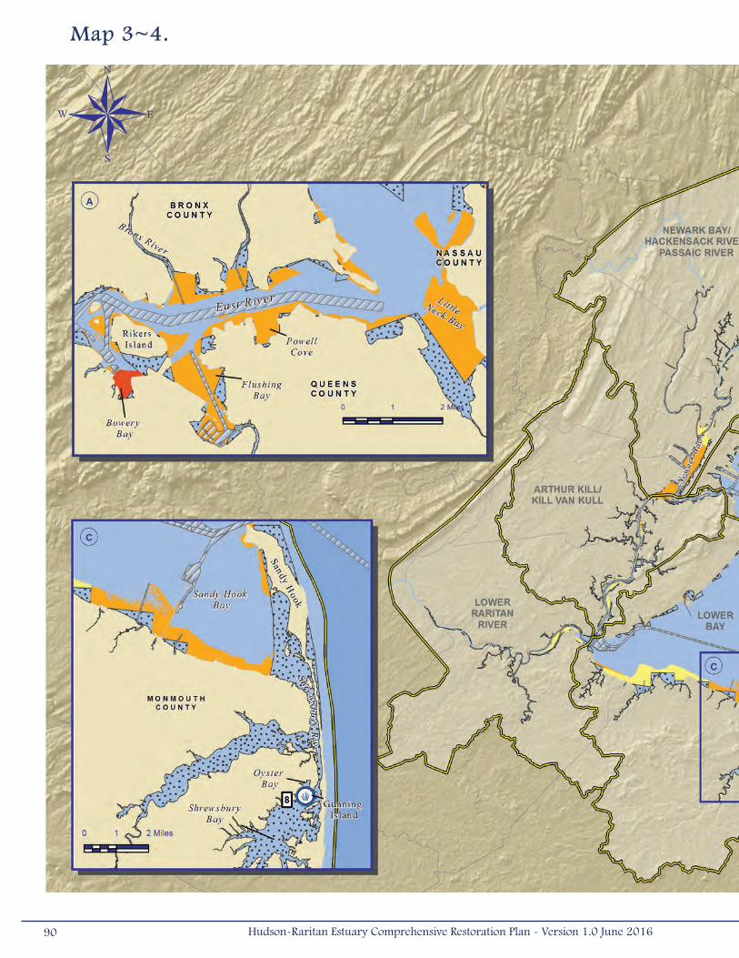
Map 3~4.
90 Hudson-Raritan Estuary Comprehensive Restoration Plan - Version 1.0 June 2016

Habitat Suitability Layers from the System-Wide Eutrophication Model/Jamaica Bay Eutrophication Model (2008 model output): Bathymetry, Salinity, Fetch, Chlorophyll a, Dissolved inorganic nitrogen, Dissolved inorganic phosphorus, Light penetration, Total suspended solids
91Hudson-Raritan Estuary Comprehensive Restoration Plan - Version 1.0 June 2016

parameters, and no waters of the HRE study area met the DIN or DIP criteria. Light also limited the suitable areas, with
only Jamaica Bay having areas with optimal light penetration. There were 1,037 acres (4.2 kilometers2) of subtidal habitat
that met five criteria, occurring mostly in Jamaica Bay. Of the suitable areas identified, most satisfied four criteria, totaling
13,800 acres (56 kilometers2), whereas 5,700 acres (23 kilometers2) met three criteria. When looking at the restoration
opportunities map, several inset maps draw attention to locations that might be suitable for eelgrass test beds.
• Inset A – Most of the areas identified in the bays along the East River satisfied four criteria: bathymetry, salinity, TSS,
and fetch. Bowery Bay satisfied five criteria and could be an appropriate location for an eelgrass test bed; meeting
the chlorophyll a preferences (did not meet DIN, DIP, or light criteria). Other promising locations for test beds
appear to occur in the Bronx River and Westchester Creek estuaries, portions of Flushing Bay, Powell Cove, and
Little Neck Bay. Subtidal areas surrounding Rikers Island satisfied four criteria, though eelgrass test beds are not
recommended for these high velocity areas, even with creative transplanting techniques.
• Inset B – The suitability results suggest Jamaica Bay to be one of the most promising locations for eelgrass test
beds. The five criteria satisfied in portions of Jamaica Bay were light penetration, salinity, TSS, bathymetry, and fetch.
Although sizeable areas that satisfied five criteria were identified, most surrounding islands west of Rulers Bar
Hassock, many of these were eliminated from further consideration following direct observations of water clarity,
substrate, the presence/absence of invertebrate grazers/predators, and other disturbance factors. Large portions
of the Rockaway Inlet satisfied four criteria. Nearshore locations at Breezy Point where no water quality modeling
data were available resulted in test beds with the best establishment and survival of the Jamaica Bay locations.
• Inset C – Portions of Sandy Hook Bay, along Monmouth County and the Sandy Hook Peninsula, met the fetch,
bathymetry, salinity, and TSS criteria. Although modeled data did not exist for the Shrewsbury and Navesink rivers,
the only mapped location of an existing eelgrass bed occurs in this region. Therefore, it is strongly recommended
that these water bodies be further evaluated to determine their suitability as test bed locations.
• Other opportunities – Similar to Shrewsbury and Navesink rivers, many of the inland bays of Long Island Sound
were not included in the SWEM, and therefore, could not be evaluated for this analysis. It is strongly recommended
that the suitability of these bays be investigated. Other areas of the HRE study area that satisfied four criteria are
Newark Bay, the coasts of the Lower Hudson River, and Gravesend Bay, off Brooklyn. These locations may not be
the most appropriate for the initial test beds as light penetration may not be sufficient for eelgrass survival.
3.2 Habitat ComplexesThree of the TECs focus on ensuring the connectivity of different habitat types to provide habitat complexes for species
that require more than one habitat during their life cycle. These habitat complexes are important for organisms that move
between habitats to forage or spawn. Loss of the connectivity of these habitats can have serious consequences, especially
when there are blockages that prevent migration to spawning areas. Many of the TEC habitats described above could be
connected to form habitat complexes. The following sections describe these habitat complexes, the objectives for the TECs,
and potential restoration opportunities within the HRE study area.
92 Hudson-Raritan Estuary Comprehensive Restoration Plan - Version 1.0 June 2016
3.2.1 Shorelines and ShallowsThe Shorelines and Shallows TEC addresses important physical, chemical, and biological services to the
nearshore habitats of estuaries by creating natural sloping shorelines with three contiguous habitat types.
These habitat types are generally comprised of (1) littoral zones that remain inundated with shallow water,
(2) intertidal areas that are regularly submerged during high tides, and (3) riparian zones that are important transitional
habitats between land and water (Steinberg et al. 2004). This TEC targets habitats of 13 feet (4 meters) or less mean low
water, based upon the USEPA’s working definition of shallow waters, where “critical functions such as biological productivity
and ecological balance must be reconciled with human activities” (Reilly et al. 1996).
Subtidal littoral zones typically support high densities of organisms and high species diversity, particularly when vegetated.
Due to high densities of invertebrates, slower current velocities, and available refuge, littoral zones support resident
populations of small fish and crustaceans and provide critical nursery habitat areas for transient species. Larger fish tend
to remain in deeper water habitat, on the outskirts of littoral areas, where they feed on macroinvertebrates and small fishes
that may be carried outward by tidal currents (Findlay, Wigand, and Nieder 2006). In addition, some plants and animals have
evolved adaptations to life in intertidal environments that are alternately flooded and drained twice daily in the HRE study area.
In the HRE study area, many natural shorelines have been replaced with bulkheads, revetments, riprap, and dock/pier
infrastructure. Hardened shorelines, like seawalls, bulkheads, and revetments, in the HRE study area are important and
necessary economic and public safety features that protect against storm surges and protect properties from erosion.
Although necessary, these shoreline structures have eliminated transitional intertidal and littoral areas. Hardened shorelines
amplify wave energy, which can increase erosion and deepen nearshore waters, affecting water quality/clarity and habitat
availability. Pier construction can reduce channel width, reduce current velocities, and increase sedimentation. Increased
sedimentation reduces available water column habitat and buries existing, natural hard substrates. Shading impacts of
shoreline structures on aquatic flora and fauna are increasingly recognized in aquatic resource assessments, and recent
research conducted within the HRE study area has documented fewer species, lower abundances, and fewer feeding
opportunities underneath large over-water structures in comparison to open water, pile fields, or edge habitat (Able and
Duffy-Anderson 2006). The Waterfront Alliance, in coordination with waterfront communities, design experts, and government
agencies, has generated the Waterfront Edge Design Guidelines (WEDG). The goal of WEDG is to make NYC waterfronts more
resilient, environmentally healthy, accessible, and equitable for all. Design guidelines also promote the improvement of water
quality, restoration, and protection of shorefront habitats, and increased resilience to climate change (WA 2015). In addition,
HEP is pursuing efforts to better understand the habitat quality associated with current near-vertical urban shorelines and
lower-impact shoreline stabilization alternatives.
Target Statement
Today, approximately 36 percent of shoreline in the HRE study area has been hardened, according to the 2006 NOAA
National Geodetic Survey (Bain et al. 2007). Three HRE planning regions with the highest percentage of hardened shorelines
are the Harlem River/East River/Western Long Island Sound (46 percent), Lower Hudson River (66 percent), and Upper Bay
93Hudson-Raritan Estuary Comprehensive Restoration Plan - Version 1.0 June 2016

(87 percent). Although shoreline restoration opportunities exist in all planning regions, these three planning regions should
be targeted for restoration under this TEC.
The short-term objective is to establish a new Shorelines and Shallows site in two of the planning regions by 2020, while the
long-term objective aims to restore all available shoreline and shallows sites in the following priority planning regions (Lower
Hudson, Upper Bay, and Harlem/East Rivers/Long Island Sound) and at least two sites in the others planning regions by
2050. Restoration should focus on removing hardened shorelines to create gently sloping areas with three zones: vegetated
riparian, stable intertidal, and illuminated littoral zones. Restored areas should target enhancement of sandy shoreline
habitat for shorebird nesting and intertidal foraging habitat, as well as creation of shallow subtidal habitat to promote the
development of bivalve communities (e.g., blue mussels, hard clams [Mercenaria mercenaria]. Creating shellfish habitat as
part of this and the Habitat for Fish, Crab, and Lobsters may be prudent given the “attractive nuisance” concern associated
with Oysters and the ecological services generally provided by all bivalves (e.g., water filtration, foraging habitat, etc.).
Naturally vegetated shoreline restoration can be employed at low energy sites, like creeks or protected inlets and coves,
through the strategic placement of native vegetation, sand, and organic materials, and if necessary a small amount of
reinforcing structural material (rock, shell, etc.; Figure 3-2a). The term “Living Shoreline” describes this restoration
technique and has been successfully implemented in New Jersey, Maryland, Virginia, North Carolina, and Florida to reduce
coastal erosion and wetland loss along sheltered coastlines (Frizzera 2009). Although restoration of natural shorelines is
ideal, other methods of shoreline softening should be considered in achieving the target conditions, particularly at moderate
to high energy sites where some type of engineered structure would be necessary (Figure 3-2b).
Incorporating structural materials, such as offshore rock or shell breakwaters, would allow restoration of natural shoreline
habitat and promote tidal exchange at moderate energy sites, while physical complexity through the use of tiered or
texturized bulkheads could be added to existing hardened shorelines at high energy sites (Frizzera 2009, Villamagna et al.
2009). In many cases, shoreline restoration and softening techniques can be incorporated into Public Access promenades
and trails.
Shoreline restoration should be carefully planned to incorporate anticipated sea level rise so that estuarine habitats are
preserved or can be restored on available land. Wetland scientists estimate that tidal wetlands can keep pace with rising
water levels up to about 0.08 inches (2 millimeters) of sea level rise per year, by trapping sediments and forming peat as
they expand inland (Climate Change Science Panel 2009). A recent probabilistic model revealed that nearly 70 percent of
diverse coastal landscape in the northeastern U.S. has the capacity to respond (e.g., adapt) dynamically to sea level rise
(Lentz et al. 2016). Increased carbon dioxide gas (CO2) and warming can stimulate marsh elevation gain, counterbalancing
moderate increases in sea level rise; however, the limited positive impact of warming and increased CO2 on wetlands will
be insufficient to compensate the decline of their extent resulting from other human drivers such as land use change (IPCC
2014). For example, when existing land uses prohibit inland migration of intertidal habitat, the habitat becomes submerged
and eventually dies. Local sea level rise is predicted to occur at rates of 0.1 inches (2.8 millimeters) per year at the Battery
in NYC and 0.15 inches (3.9 millimeters) per year at Sandy Hook, New Jersey, which presents concerns for tidal wetlands
(NOAA 2012). Additionally, as sea level rises and coastal storms increase in intensity, coastal erosion and the number of
94 Hudson-Raritan Estuary Comprehensive Restoration Plan - Version 1.0 June 2016
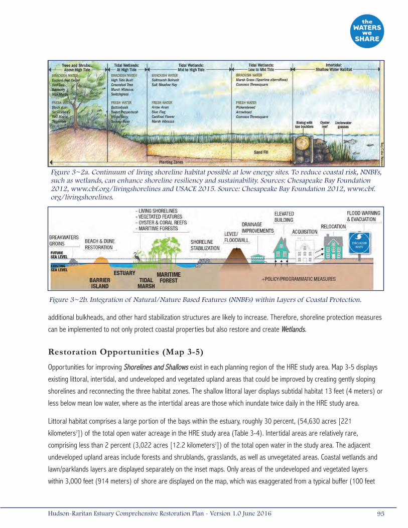
additional bulkheads, and other hard stabilization structures are likely to increase. Therefore, shoreline protection measures
can be implemented to not only protect coastal properties but also restore and create Wetlands.
Restoration Opportunities (Map 3-5)
Opportunities for improving Shorelines and Shallows exist in each planning region of the HRE study area. Map 3-5 displays
existing littoral, intertidal, and undeveloped and vegetated upland areas that could be improved by creating gently sloping
shorelines and reconnecting the three habitat zones. The shallow littoral layer displays subtidal habitat 13 feet (4 meters) or
less below mean low water, where as the intertidal areas are those which inundate twice daily in the HRE study area.
Littoral habitat comprises a large portion of the bays within the estuary, roughly 30 percent, (54,630 acres [221
kilometers2]) of the total open water acreage in the HRE study area (Table 3-4). Intertidal areas are relatively rare,
comprising less than 2 percent (3,022 acres [12.2 kilometers2]) of the total open water in the study area. The adjacent
undeveloped upland areas include forests and shrublands, grasslands, as well as unvegetated areas. Coastal wetlands and
lawn/parklands layers are displayed separately on the inset maps. Only areas of the undeveloped and vegetated layers
within 3,000 feet (914 meters) of shore are displayed on the map, which was exaggerated from a typical buffer (100 feet
95Hudson-Raritan Estuary Comprehensive Restoration Plan - Version 1.0 June 2016
Figure 3~2b. Integration of Natural/Nature Based Features (NNBFs) within Layers of Coastal Protection.
Figure 3~2a. Continuum of living shoreline habitat possible at low energy sites. To reduce coastal risk, NNBFs, such as wetlands, can enhance shoreline resiliency and sustainability. Sources: Chesapeake Bay Foundation 2012, www.cbf.org/livingshorelines and USACE 2015. Source: Chesapeake Bay Foundation 2012, www.cbf.org/livingshorelines.

Map 3~5.
96 Hudson-Raritan Estuary Comprehensive Restoration Plan - Version 1.0 June 2016
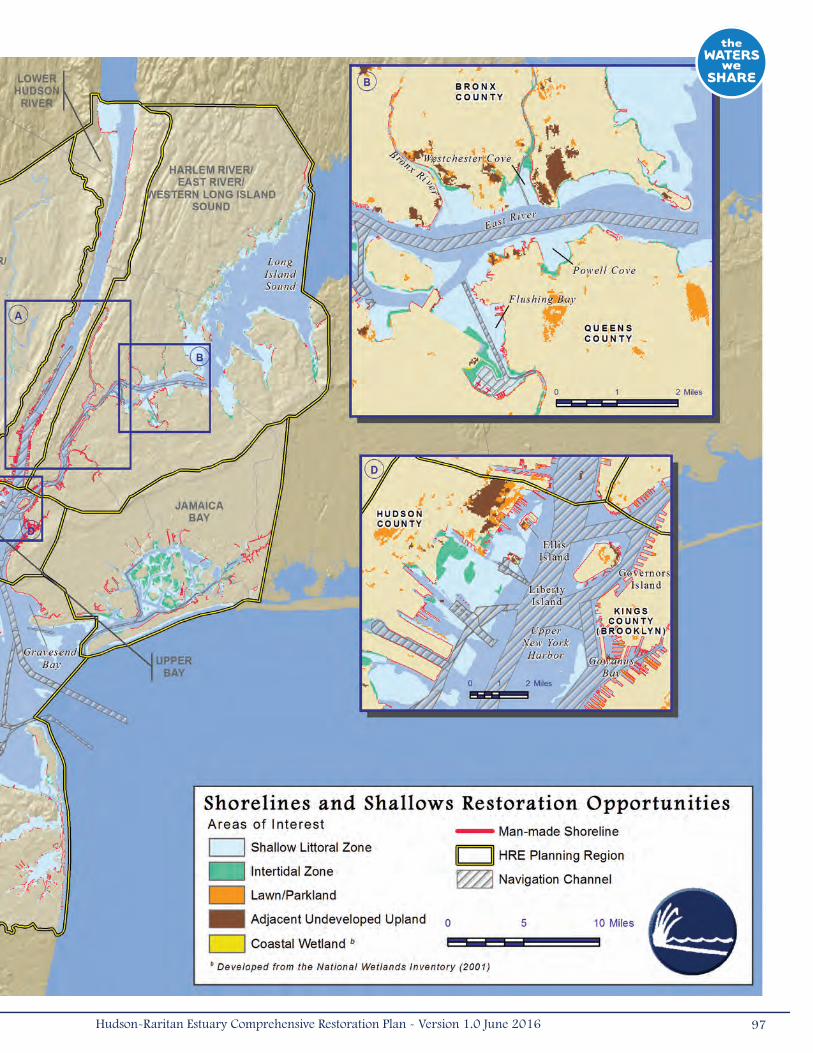
97Hudson-Raritan Estuary Comprehensive Restoration Plan - Version 1.0 June 2016

[91 meters] wide along shore) so that it would be visible on an estuary-wide scale. Lawn/parkland represents almost
13 percent (30,304 acres [123 kilometers2]) of the land within 3,000 feet (914 meters) of shore, whereas adjacent
undeveloped upland and coastal wetlands represent about 9 percent (21,234 acres [86 kilometers2]) and 5 percent
(12,544 acres [51 kilometers2]), respectively.
Map 3-5 also displays man-made shorelines (e.g., bulkheads, piers, wharfs, jetties, and riprap shorelines) that could
be removed to re-create natural shorelines or softened by adding structurally complex features. There are 551 miles
(887 kilometers) of man-made shoreline in the HRE study area, 93 miles (150 kilometers) of which are piers. Many hard
structures on the interior of the harbor cannot be removed because of nearshore development, port activities, or vessel-
induced wakes, and represent opportunities for shoreline enhancement. Some hard structures are no longer necessary or
not functioning properly and may represent a shoreline softening opportunity.
The Shorelines and Shallows Restoration Opportunities map displays several insets, which call out key features and
accompanying restoration opportunities where riparian habitat could be created/restored, hardened shorelines could be
removed/enhanced, intertidal areas could be created, or littoral areas could be improved:
• Inset A – Narrow bands of potential riparian and shallow littoral habitat occur on either shore of the Lower Hudson
River, particularly in Bergen County, New Jersey and Westchester County, New York. There may be opportunities to
develop intertidal habitats along these stretches. Along the west side of Manhattan, there may be opportunities
to soften or enhance the shoreline within inter-pier areas. The Harlem River has fairly continuous hardened
shorelines and no intertidal and almost no littoral habitat, representing a potential opportunity to create intertidal
or littoral habitat.
98 Hudson-Raritan Estuary Comprehensive Restoration Plan - Version 1.0 June 2016
Table 3-4. Areas of habitat and linear distance of man-made shoreline that could be restored in the Hudson-Raritan Estuary (HRE) study area.

• Inset B – This section of the upper East River contains many large subtidal flats, in the mouth of the Bronx River,
Westchester Creek, Flushing Bay, and Powell Cove. In some cases, the adjacent undeveloped land shown is existing
parkland, but in other cases, it may be opportunities to improve the riparian plant community. Upstream segments
of the Bronx River have hardened shorelines and opportunities exist to soften these.
• Inset C – Long stretches of the lower Passaic and Hackensack Rivers are hardened and contain few intertidal areas,
representing areas to soften shorelines, create intertidal habitat, and improve existing littoral habitat.
• Inset D – The Upper Bay may be the most difficult planning region in which to find Shorelines and Shallows
restoration opportunities because of competing uses and tradeoffs. There are substantial subtidal flats located on
the New Jersey shoreline that may be enhanced. As previously mentioned, there may be opportunities to soften
shorelines and restore intertidal habitat along some of the islands including Governors, Liberty, and Ellis Islands.
Areas along Brooklyn, like Gowanus Bay, may also be appropriate for shoreline enhancement.
• Inset E – The Arthur Kill and its tributaries do not have as many hardened shorelines as some water bodies
of the HRE study area, but they still represent areas that would greatly benefit from improved intertidal and
littoral habitats. Derelict structures can be removed and riparian shoreline vegetation can be planted and
encouraged to grow.
• Other opportunities – Other opportunities may exist along the lower Raritan River, where there appears to be a
length of hardened shoreline. Protected areas within Jamaica Bay and Gravesend Bay may also be appropriate
areas for re-creating this habitat complex.
Examples of habitat features that can be incorporated into new waterfront features or reconstructed shorelines include:
• Creating underwater baffles or training walls to redirect flows and maintain desirable depths and exposed substrates
• Increasing light transmission through piers by increasing the height or decreasing the width of piers (Able and
Duffy-Anderson 2006)
• Adding physical complexity to existing hardened shorelines by incorporating WEDG promoted by the Waterfront
Alliance. Concepts include the use of texturized bulkheads or the addition reef-like elements along a shoreline
(Figure 3-3a). The NYCDPR incorporated stepped bulkhead walls to create functional intertidal zones with marsh
habitat and tide pools at a Public Access promenade at the Harlem River Park (Figure 3-3b); and installing an
upland bulkhead and a submerged bulkhead that are divided by new fill and marshland vegetation to reintroduce
habitat to a hardened shoreline (Figure 3-3c). The “Bulking & Tiering Wetland System” (patented by Bionautics, Inc.
of Staten Island, NY) can provide remediation options for shorelines with Contaminated Sediments by capping with
clean fill or dredged material and planting native wetland vegetation (Frizzera 2009).
99Hudson-Raritan Estuary Comprehensive Restoration Plan - Version 1.0 June 2016

100 Hudson-Raritan Estuary Comprehensive Restoration Plan - Version 1.0 June 2016
Figure 3-3. Examples of reconstructed shoreline features: (a) remediation option for shorelines using textured bulkheads and reef-like elements; (b) public access promenade at Harlem River Park; and (c) upland bulkhead and submerged bulkhead separated by new fill and marshland vegetation will help reintroduce habitat to hardened shorelines. Source: 2001 Bionautics, Inc.
a) b)
c)
3.2.2 Habitat for Fish, Crabs, and LobstersThis TEC ensures that suites of habitats will be created to benefit many life stages for a range of resident,
transient, and migratory species (Bain et al. 2007). It calls for the restoration or development of a mosaic
of diverse, quality habitats intermixed throughout the estuary to sustain fish, crab, and lobster populations,
with the understanding that doing so will also benefit numerous other aquatic species with overlapping habitat
requirements (e.g., small finfish, other motile invertebrates). Many important estuarine and marine species are in low or
declining abundance throughout the HRE study area, and the relationships among these habitats are important for many
aquatic species to complete their life history.
This TEC focuses on the spatial arrangement of aquatic and intertidal habitats like oyster reefs, eelgrass beds, and tidal
marshes, which are components of other TECs, as well as non-TEC habitats like soft-bottom, unvegetated mudflats or
hard-bottom substrates. Each fish and crustacean species has specific habitat needs, especially during spawning or early
development, for specific substrates or structural elements. For instance, vegetated or structurally complex habitats provide
refuge from predators, whereas broad, sandy flats may be ideal foraging areas (Bain et al. 2007). The most effective way
to sustain or increase fish and macroinvertebrate populations in the HRE may be to restore and/or create mosaics of critical
habitats, to provide what habitat was historically lost (i.e., intertidal Wetlands, Eelgrass Beds, Oyster Reefs, etc.), as well as
expand upon existing habitats (e.g., subtidal shallows, rocky intertidal).
Target Statement
The short-term goal of this TEC states that one complex of at least two functionally-related habitats should be created in
each HRE planning region by 2020. Further, each region should have four habitat complexes of at least two related habitats
by 2050. Progress will be measured in the number and total area of habitat sets developed in the HRE study area.
The overall intent of this TEC is to promote connectivity among complex habitats. Eight target species have been selected
to represent demersal or benthic fish and large crustaceans of the HRE study area. These species and the habitats that are
critical to their life stages are provided in Table 3-5. The target species are either abundant or economically important, and
all are well-studied. Targeting habitat restoration for these species should also benefit other species in the HRE study area
and be an opportunity to incorporate multiple TECs into a project.
Restoration Opportunities
This TEC should be considered during any habitat restoration project because the ecological benefits of a restoration project
can be increased by creating a variety of habitats designed for target species. The exact spatial arrangements and distances
among habitats have not been specified in the target statement, so as to maintain a degree of flexibility and ensure restored
habitats are based upon target species requirements to optimize restoration success. Some example habitat complexes are
presented in Table 3-6 (from Bain et al. 2007).
101Hudson-Raritan Estuary Comprehensive Restoration Plan - Version 1.0 June 2016
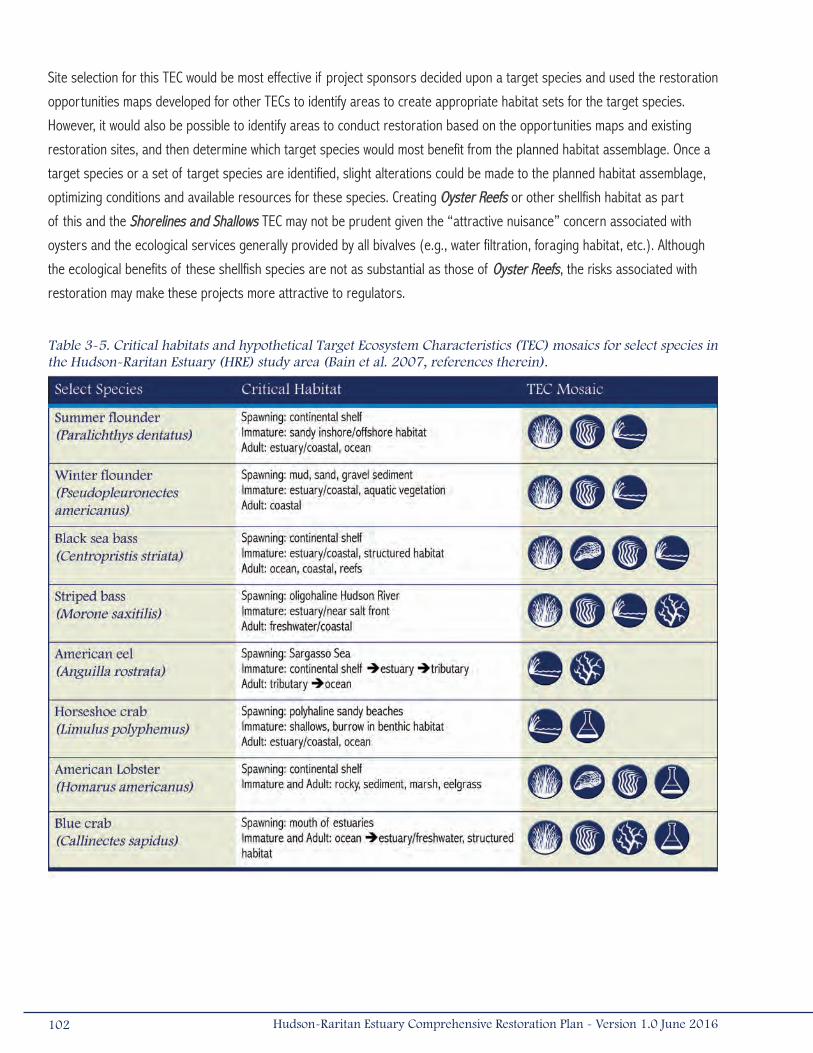
Site selection for this TEC would be most effective if project sponsors decided upon a target species and used the restoration
opportunities maps developed for other TECs to identify areas to create appropriate habitat sets for the target species.
However, it would also be possible to identify areas to conduct restoration based on the opportunities maps and existing
restoration sites, and then determine which target species would most benefit from the planned habitat assemblage. Once a
target species or a set of target species are identified, slight alterations could be made to the planned habitat assemblage,
optimizing conditions and available resources for these species. Creating Oyster Reefs or other shellfish habitat as part
of this and the Shorelines and Shallows TEC may not be prudent given the “attractive nuisance” concern associated with
oysters and the ecological services generally provided by all bivalves (e.g., water filtration, foraging habitat, etc.). Although
the ecological benefits of these shellfish species are not as substantial as those of Oyster Reefs, the risks associated with
restoration may make these projects more attractive to regulators.
Table 3-5. Critical habitats and hypothetical Target Ecosystem Characteristics (TEC) mosaics for select species in the Hudson-Raritan Estuary (HRE) study area (Bain et al. 2007, references therein).
102 Hudson-Raritan Estuary Comprehensive Restoration Plan - Version 1.0 June 2016
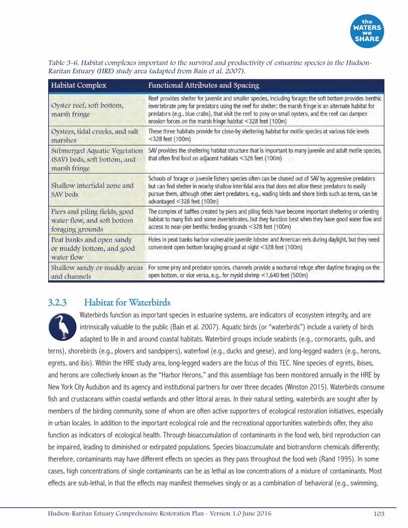
3.2.3 Habitat for WaterbirdsWaterbirds function as important species in estuarine systems, are indicators of ecosystem integrity, and are
intrinsically valuable to the public (Bain et al. 2007). Aquatic birds (or “waterbirds”) include a variety of birds
adapted to life in and around coastal habitats. Waterbird groups include seabirds (e.g., cormorants, gulls, and
terns), shorebirds (e.g., plovers and sandpipers), waterfowl (e.g., ducks and geese), and long-legged waders (e.g., herons,
egrets, and ibis). Within the HRE study area, long-legged waders are the focus of this TEC. Nine species of egrets, ibises,
and herons are collectively known as the “Harbor Herons,” and this assemblage has been monitored annually in the HRE by
New York City Audubon and its agency and institutional partners for over three decades (Winston 2015). Waterbirds consume
fish and crustaceans within coastal wetlands and other littoral areas. In their natural setting, waterbirds are sought after by
members of the birding community, some of whom are often active supporters of ecological restoration initiatives, especially
in urban locales. In addition to the important ecological role and the recreational opportunities waterbirds offer, they also
function as indicators of ecological health. Through bioaccumulation of contaminants in the food web, bird reproduction can
be impaired, leading to diminished or extirpated populations. Species bioaccumulate and biotransform chemicals differently;
therefore, contaminants may have different effects on species as they pass throughout the food web (Rand 1995). In some
cases, high concentrations of single contaminants can be as lethal as low concentrations of a mixture of contaminants. Most
effects are sub-lethal, in that the effects may manifest themselves singly or as a combination of behavioral (e.g., swimming,
103Hudson-Raritan Estuary Comprehensive Restoration Plan - Version 1.0 June 2016
Table 3-6. Habitat complexes important to the survival and productivity of estuarine species in the Hudson-Raritan Estuary (HRE) study area (adapted from Bain et al. 2007).
feeding, predator-prey interactions), physiological (e.g., growth, reproduction, development), biochemical (e.g., enzymatic,
ion levels), or histological (e.g., immune system, genetic, carcinogenic) modifications (Bain et al. 2007).
Long-legged wading birds have experienced a dramatic comeback in the HRE study area since the 1960s, when populations
were nearly extirpated by centuries of hunting, pollution, and habitat loss. With improved water and habitat quality, herons
began populating the uninhabited islands of the Arthur Kill, Kill Van Kull, East River, and Jamaica Bay during the late 1970s
(Steinberg et al. 2004). Eight islands and one mainland roost in the HRE study area currently function as nesting rookeries
for resident and transient waterbirds (Table 3-7; Craig 2013).
Target Statement
The Habitat for Waterbirds TEC focuses on restoring and protecting roosting, nesting, and foraging habitat (e.g., inland trees,
wetlands, shallow littoral habitat) for long-legged wading birds. The short-term objective for this TEC is to enhance at least
one island without an existing waterbird population in the HRE planning regions containing islands and create or enhance
at least one foraging habitat by 2020. The long-term objective of the Habitat for Waterbirds TEC is for all suitable islands
to provide roosting and nesting sites and have nearby foraging habitat by 2050. With the exception of predator control,
restoration activities will be limited to those islands without active breeding waterbird populations or rookeries.
Restoration Opportunities (Map 3-6)
Opportunities for restoring island habitat exist in most planning regions of the HRE study area (Map 3-6). The Habitat for
Waterbirds restoration opportunities map displays areas where existing islands could be restored to provide more nesting
and feeding habitat for target species. The map includes 68 existing islands over 0.25 acres (0.001 kilometers2) in size,
which are represented as color-coded dots, symbolizing the number of waterbird nests observed (excluding cormorant
nests) during the 2013 Harbor Herons Nesting Survey (Craig 2013). Change in waterbird nest numbers is represented as
an overall increase or decrease (or no change) based on overall percent change during surveyed years from 2001 to 2013.
Shallow wetlands are important foraging areas for waterbirds in the HRE study area; therefore, islands are symbolized in the
inset maps to represent the distance to the nearest wetland habitat. Percent tree canopy cover is also displayed on the inset
maps to identify islands where trees and large shrubs currently exist.
For all 68 islands, the average area was approximately 26 acres (0.1 kilometers2). On average, the islands were almost
500 feet (152 meters) from the nearest wetland habitat, ranging from adjacent to 1.1 miles (1.8 kilometers) away from
the islands. Three surveyed islands in the estuary had more than 200 nests identified during 2013: South Brother Island,
Subway Island, and Hoffman Island. Subway Island was the most diverse colony in the harbor in 2013, with six species of
nesting waders present. The greatest total number of nests was observed on Hoffman Island in recent years, although
this island exhibited a 19 percent decline in total nests since 2010 (Craig 2013). Subway Island, and recently restored
Elders Point East, experienced substantial increases (163 percent and 250 percent respectively) in nesting activity, while
nesting activity on Canarsie Pol was entirely absent for the first time in the 14 years this island has been surveyed (Craig
2013). South Brother Island exhibited a substantial decline in nesting activity (-37 percent), Goose Island had been recently
abandoned, and wader nesting on Huckleberry Island continued at very low levels. Recently inactive islands, including the
three islands in the Arthur Kill and Kill Van Kull (Shooters Island, Pralls Island, and Isle of Meadows) and North Brother
Island, continued to exhibit no signs of wader nesting activity in 2013 (Craig 2013).
104 Hudson-Raritan Estuary Comprehensive Restoration Plan - Version 1.0 June 2016
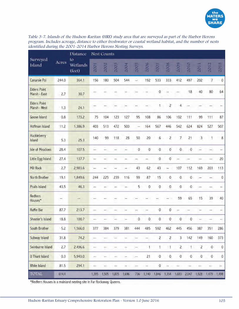
Table 3-7. Islands of the Hudson-Raritan (HRE) study area that are surveyed as part of the Harbor Herons program. Includes acreage, distance to either freshwater or coastal wetland habitat, and the number of nests identified during the 2001-2014 Harbor Herons Nesting Surveys.
105Hudson-Raritan Estuary Comprehensive Restoration Plan - Version 1.0 June 2016

Map 3~6.
106 Hudson-Raritan Estuary Comprehensive Restoration Plan - Version 1.0 June 2016

107Hudson-Raritan Estuary Comprehensive Restoration Plan - Version 1.0 June 2016

Four inset maps on the Habitat for Waterbirds Restoration Opportunities Map draw attention to surveyed islands (excluding
islands inhabited by humans) and foraging habitat. These insets indicate the presence of coastal and freshwater Wetlands,
canopy cover on these islands, and island proximity to wetland habitat. These restoration opportunities are presented in the
Harbor Herons Conservation Plan, which was collaboratively developed to identify and prioritize Harbor Herons conservation
efforts (Harbor Herons Subcommittee 2010).
• Inset A – The Hackensack River watershed, particularly areas of the New Jersey Meadowlands, contain
opportunities to enhance existing wetlands for waterbird foraging habitat. In the last few years, over 300 acres
(1.21 kilometers2) of the Meadowlands have been restored with the completion of the Richard P. Kane and
Evergreen MRI3 Mitigation Banks, and additional opportunities for wetland creation and restorations are being
explored. Studies indicate that nesting waterbirds from the East River travel to the New Jersey Meadowlands
to forage during the nesting season (Harbor Herons Subcommittee 2010). The Kearny Marsh site, a 400-acre
(1.62-kilometers2) parcel acquired by the New Jersey Meadowlands Commission, contains a large freshwater
wetland that is dominated by shallow open water. Since the 1970s, the site has been supporting a large
nighttime roost of egrets and night herons in the post-breeding season (August through October). Enhancement
opportunities exist to reduce contaminants entering the site, remove contaminated sediments, and manage
water levels to encourage re-growth of emergent vegetation. Tidal wetlands along Mill Creek, a tributary of the
Hackensack River in Secaucus, New Jersey, were recently restored by the New Jersey Meadowlands Commission
to increase tidal flow and marsh habitat diversity. Herons and egrets currently forage at the site during summer
months, and black-crowned night heron (Nycticorax nycticorax), a New Jersey state-endangered species, has been
observed nesting at the site. Additional opportunities for Wetland restoration along Mill Creek may be present.
These sites have commonality with HEP acquisition and restoration sites that would benefit waterbirds and provide
ecological benefits to a broader faunal range (Harbor Herons Subcommittee 2010).
• Inset B – The East River contains surveyed islands with the highest number of nests in the HRE study area. A
total of 286 nests on South Brother Island was the third largest nest count during the 2013 survey, however this
population did experience a 37 percent decrease from 2010 (Craig 2013). The areas of North Brother Island that
had previously supported wader nests were searched during the 2013 survey; however, no evidence of wader or
gull nesting was observed. U Thant Island was first surveyed in 2006; approximately the same number of (Double-
crested Cormorant [Phalacrocorax auritus]) nests (31) have been observed annually on this island since the
colony established in 2008 (Craig 2013). A total of 113 wader nests were observed on Mill Rock; a very similar
number to that was observed in 2010 (Craig 2013). Although North and South Brother Islands are relatively close
to existing wetland habitat, U Thant Island is almost 6,000 feet (1,829 meters) from the nearest wetlands and Mill
Rock is almost 3,000 feet (914 meters) from the nearest wetlands. U Thant and Mill Rock Islands have few trees.
NYCDPR planted native trees and shrubs on North Brother Island during 2005 and 2006, and again in 2014 after
a focused invasive plant management effort during the 2014 growing season, which focused on persistent invasive
vines including kudzu (Pueraria spp.) and porcelainberry (Ampelopsis brevipedunculata). On Pralls Island, the
removal of host tree species used by the Asian long-horned beetle (Anoplophora glabripennis) (i.e., box elder
[Acer negundo]) may have impacted the persistence of the colony (Craig 2011). Herons have been documented
to nest in invasive species like oriental bittersweet vines (black-crowned night-herons on North Brother Island) and
108 Hudson-Raritan Estuary Comprehensive Restoration Plan - Version 1.0 June 2016
Phragmites (yellow-crowned night-herons [Nyctanassa violacea]; little blue herons [Egretta caerulea], and glossy
ibises [Plegadis falcinellus]), in other locations. Consequently, removal of some kinds of invasive plants may affect
nesting (Harbor Herons Subcommittee 2010). Early detection surveys for invasive plants and treatment outside of
the breeding and nesting seasons can help reduce disturbance to nesting habitat (Craig 2011).
• Inset C – The peak of waterbird nesting occurred on the islands of the Arthur Kill and Kill Van Kull during the 1970s
through the 1990s (Bernick 2007). However, no successful nesting has been observed on these islands since the
1990s (Kerlinger 2004, Winston 2015). There are substantial coastal and freshwater wetlands near these islands
that are used for foraging and loafing by the Harbor Herons (Tsipoura et al. 2016). Despite extensive baseline
monitoring, causes of waterbird abandonment on these islands are undetermined. Several potential causes of
abandonment at Pralls Island included the Exxon Bayway oil spill in 1990/1991, a die-back of gray birch (Betula
populifolia, the preferred nesting tree), dramatic change in water level in Goethals Bridge Pond, and increased
predator populations (Harbor Herons Subcommittee 2010). Since it was deforested in 2007 to eliminate an Asian
long-horned beetle infestation, NYCDPR has undertaken a long-term strategy to restore native upland plant
communities on Pralls Island through replanting and invasive species management (Harbor Herons Subcommittee
2010). Supported by a grant from HEP, NYCDPR and NYC and New Jersey Audubon are studying the potential for
herons to be socially attracted to new or restored areas, which would support restoration at sites like Pralls Island.
Other waterbird nesting and foraging restoration opportunities in the Arthur Kill and Kill Van Kull are identified
in Inset C based on recommendations of the Harbor Herons Subcommittee (2010). Potter’s Island along the
Rahway River could be acquired and restored as a heron and egret rookery. Potential for salt marsh restoration at
Arlington and Mariner’s Marsh exists as part of compensatory mitigation for disturbance related to the Staten Island
Container Terminal construction. A diversity of wetland habitat types exists along Staten Island, including areas
along Old Place Creek, Gulfport Marsh, and Saw Mill Creek that could be restored. Unfortunately, most of these
areas contain Contaminated Sediments, which will challenge restoration efforts in this area.
• Inset D – Ten (10) islands and one mainland location were identified within the Jamaica Bay region, all within 2,000
feet (610 meters) of wetland habitat. Canarsie Pol has been surveyed regularly by the NYC Audubon Society. The
number of waterbird nests found on Canarsie Pol has ranged between 156 and 544 over the past 14 years, and
202 were found on the island in 2011. Many of Jamaica Bay’s islands have little canopy cover, but this does not
seem to deter nesting activity. Canarsie Pol, which is the largest island surveyed, supported the most diverse
assemblage of nesting waterbirds and some of the highest nest counts during 2007 (Bernick 2007); however,
2015 marked the fifth consecutive year of massive decline in nesting activity on Canarsie Pol and the first year with
no wader activity in the island’s 14-year survey history. The other surveyed islands of Jamaica Bay including Ruffle
Bar, Subway Island, Little Egg Marsh, and Elders Point (East and West) typically have not supported large nesting
populations of waterbirds, although they are thought to have suitable habitat for the target species (Kerlinger
2004). In 2013, however, Elder’s Point Marsh East had a 250 percent increase in nesting activity from 2010. This
increase coincides with the concurrent decline and recent abandonment of Canarsie Pol (Craig 2013). Although
substantial coastal wetland acreage appears in the inset, many of these areas are degraded and represent wetland
109Hudson-Raritan Estuary Comprehensive Restoration Plan - Version 1.0 June 2016
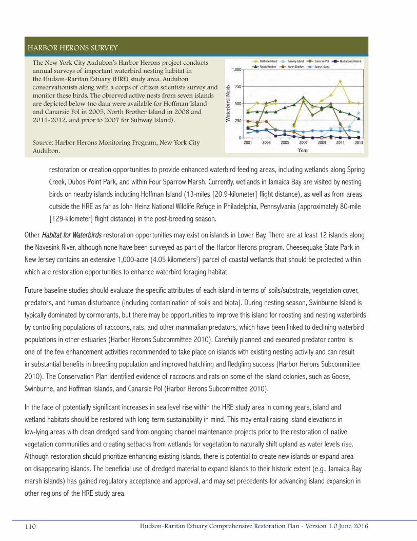
restoration or creation opportunities to provide enhanced waterbird feeding areas, including wetlands along Spring
Creek, Dubos Point Park, and within Four Sparrow Marsh. Currently, wetlands in Jamaica Bay are visited by nesting
birds on nearby islands including Hoffman Island (13-miles [20.9-kilometer] flight distance), as well as from areas
outside the HRE as far as John Heinz National Wildlife Refuge in Philadelphia, Pennsylvania (approximately 80-mile
[129-kilometer] flight distance) in the post-breeding season.
Other Habitat for Waterbirds restoration opportunities may exist on islands in Lower Bay. There are at least 12 islands along
the Navesink River, although none have been surveyed as part of the Harbor Herons program. Cheesequake State Park in
New Jersey contains an extensive 1,000-acre (4.05 kilometers2) parcel of coastal wetlands that should be protected within
which are restoration opportunities to enhance waterbird foraging habitat.
Future baseline studies should evaluate the specific attributes of each island in terms of soils/substrate, vegetation cover,
predators, and human disturbance (including contamination of soils and biota). During nesting season, Swinburne Island is
typically dominated by cormorants, but there may be opportunities to improve this island for roosting and nesting waterbirds
by controlling populations of raccoons, rats, and other mammalian predators, which have been linked to declining waterbird
populations in other estuaries (Harbor Herons Subcommittee 2010). Carefully planned and executed predator control is
one of the few enhancement activities recommended to take place on islands with existing nesting activity and can result
in substantial benefits in breeding population and improved hatchling and fledgling success (Harbor Herons Subcommittee
2010). The Conservation Plan identified evidence of raccoons and rats on some of the island colonies, such as Goose,
Swinburne, and Hoffman Islands, and Canarsie Pol (Harbor Herons Subcommittee 2010).
In the face of potentially significant increases in sea level rise within the HRE study area in coming years, island and
wetland habitats should be restored with long-term sustainability in mind. This may entail raising island elevations in
low-lying areas with clean dredged sand from ongoing channel maintenance projects prior to the restoration of native
vegetation communities and creating setbacks from wetlands for vegetation to naturally shift upland as water levels rise.
Although restoration should prioritize enhancing existing islands, there is potential to create new islands or expand area
on disappearing islands. The beneficial use of dredged material to expand islands to their historic extent (e.g., Jamaica Bay
marsh islands) has gained regulatory acceptance and approval, and may set precedents for advancing island expansion in
other regions of the HRE study area.
HARBOR HERONS SURVEY
The New York City Audubon’s Harbor Herons project conducts annual surveys of important waterbird nesting habitat in the Hudson-Raritan Estuary (HRE) study area. Audubon conservationists along with a corps of citizen scientists survey and monitor these birds. The observed active nests from seven islands are depicted below (no data were available for Hoffman Island and Canarsie Pol in 2005, North Brother Island in 2008 and 2011-2012, and prior to 2007 for Subway Island).
Source: Harbor Herons Monitoring Program, New York City Audubon.
110 Hudson-Raritan Estuary Comprehensive Restoration Plan - Version 1.0 June 2016

In order to gain a better understanding of the spatial relationships between existing nesting areas and available foraging
habitat, it is recommended that telemetry and banding studies be conducted on groups of several birds from each of the
active colonies to determine where they are feeding and the direction/distance they travel. This should be implemented as
a baseline monitoring component at existing rookeries and incorporated into a long-term monitoring program at restored
islands following recolonization by waders.
As indicated in Inset C, an important baseline data component will be to identify the presence of contaminated soils or
biota on the islands, evaluate body burdens for the populations, and determine the effect of contaminants on behavior and
reproductive health of waterbird populations. Beyond the initial baseline characterization, it will be important to monitor
contaminants in soils and biota at restored sites on a long-term basis (years to decades) to be able to evaluate this factor
on the integrity of waterbird populations in the HRE study area relative to improvements in nesting/foraging habitat.
3.3 Environmental Support StructuresTwo of the TECs focus on repairing the environmental degradation associated with infrastructure that restricts the flow of
water. The HRE study area contains many dams that store water for a variety of functions, such as drinking water reservoirs
or recreational ponds. Other structures that are common in the HRE study area were designed to allow the passage of water,
such as culverts under bridges and roadways. These structures can restrict the movement of fish, change natural circulation
or drainage routes, and can result in environmental degradation. The following sections describe the environmental issues
associated with these support structures, the objectives for the TECs, and potential restoration opportunities within the HRE
study area.
3.3.1 Tributary ConnectionsThe purpose of this TEC is to reconnect freshwater streams to the estuary and provide a range of quality
habitats to aquatic organisms. This TEC focuses on restoring connections between, and corridors within,
streams. This includes but is not limited to restoration of natural stream channels, adjacent freshwater
wetlands, riparian uplands, and tributary connections including through barrier removal or fish passage construction.
Streams and rivers are important parts of the landscape as they carry water and sediment from higher elevations to the
estuary. The watershed to these tributaries serves an important role by providing water, sediment, and nutrients, thus
influencing water quality and functioning downstream habitats. It is important to understand the processes that occur at the
watershed scale so that watershed restoration and protection practices can be implemented to support conditions for a
functioning estuary and improving water quality downstream.
A stream and its watershed comprise a dynamic balance where the floodplain, channel, and stream bed evolve through
natural processes that erode, transport, sort, and deposit sediments (Harman et al. 2012). Land use changes in the
watershed, channel straightening, culverts, removal of streambank vegetation, impoundments, and other activities can upset
this balance leading to stream instability and adjustments in channel form (Harman et al. 2012). Stream degradation (scour)
111Hudson-Raritan Estuary Comprehensive Restoration Plan - Version 1.0 June 2016

can result from increased streamflow volume and frequency, while stream aggradation can result from land use practices
that cause increased sediment loads. A new equilibrium may eventually result, but not before the associated aquatic and
terrestrial environment are altered, often severely (Harman et al. 2012). Watershed protection and restoration of stream
functions increases the likelihood of stream stability, thus allowing the watershed and its tributaries to function to transport
water, sediment, and nutrients to the estuary and maintain connections between various quality habitats.
Tidally influenced streams and creeks provide thruways for fish to access habitats across a gradient of abiotic factors
(i.e., salinity, depth, temperature, dissolved oxygen, sediment type). Many migratory or highly mobile fish species require
access to upstream areas to spawn because eggs or larvae have specific life history requirements that are very different
from juvenile or adult life stages. In addition to benefiting native migratory species, like American shad, alewife, blueback
herring, striped bass, and American eel, re-establishing tributary connections may also benefit resident fish and invertebrate
populations by providing greater access to feeding, spawning, and refuge habitats. Several freshwater mussel species (i.e.,
Family Unionidae) may also benefit from improved fish passage, as they are dependent upon fish movement for dispersal
(Peckarsky et al. 1990).
Barriers can be man-made or natural “habitat” barriers. Man-made barriers to fish passage are often the easiest to define,
such as dams, tide gates, and road culverts. Low dams were typically built in the HRE study area to support early American
industry and agriculture. Today, many of these small dams are currently inoperative or no longer needed. However, some
dammed waterbodies provide local communities with water supply, recreation, utilities, or have aesthetic/historic value (Bain
et al. 2007). Reconnecting estuary-tributary pathways can be accomplished by removing derelict or unnecessary barriers,
modifying barriers to promote fish passage (e.g., breaching, notching), or constructing fish passage structures (e.g., fish
ladders, bypass channels). Dams that currently provide a water supply or safety function or small historic dams that may be
regarded as important historical or cultural resources may be candidates for retrofitting with passage structures.
Whether partially or completely closed, tide gates are barriers to all upstream fish migration. The control schedule of existing
tide gates can be modified so that gates remain completely open during upstream fish runs and during downstream juvenile
migrations. New, self-regulating tide gates can be installed in place of conventional gates. These allow normal amplitude
tides to enter and exit, but are designed to close in the event of atypical storm tides, preventing flooding of homes, roads,
and other infrastructure.
Culverts under roads or rail beds can present migration barriers due to an excess drop at the culvert outlet, high velocity or
turbulence within the culvert barrel, inadequate water depths within the culvert barrel, or debris/sediment accumulation at
the culvert inlet or within the barrel (Gibson et al. 2005). Barriers also affect in-stream and riparian habitat, creating a need
to improve tributaries on a system level. For instance, a dam removal project may alter in-stream habitat and riparian zones
adjacent to where the water was previously impounded.
Non-structural barriers to fish passage can include water temperature, dissolved oxygen, turbidity, hydrologic and hydraulic
alterations, and changes to tributary morphology as a result of sediment aggradation or degradation. These barriers can
occur naturally or can be man-made, with water quality impediments often triggered by non-point source or point source
discharges (e.g., erosion from construction activities, wastewater treatment plants, thermal discharges) or changes to
112 Hudson-Raritan Estuary Comprehensive Restoration Plan - Version 1.0 June 2016
riparian cover as a result of clearing and logging. Alteration of watershed hydrology and channel hydraulics can lead to
changes in flow duration (e.g., subsurface flow), while excessive aggradation or degradation can lead to changes to channel
dimension (e.g., high width to depth ratio) and profile (e.g., steep slopes) that may not support fish passage.
Target Statement
The short-term objective for the Tributary Connections TEC is to remove one barrier per year that blocks the free movement
of aquatic life from estuary waters to at least three different inland habitats. The long-term objective is to continue
reconnecting coastal and inland habitats at a rate of one project per year until all near-estuary barriers blocking inland
access have been removed or made passable. Half of the new connections during this period should reach at least three
new habitats. The habitat types that will ultimately be connected to the open waters of the HRE study area include ponds,
lakes, Wetlands, streams, and rivers, which should place emphasis on barriers blocking access to a variety of water bodies.
Restoring in-stream habitat upstream or downstream of a barrier and riparian habitat, such as forested floodplains and
freshwater wetlands, could fulfill the target statements for this TEC. Where possible, projects should attempt to include
multiple components (i.e., in-stream habitat, riparian habitat, barrier removal) to increase the number of functional benefits
and the ecological contribution of the tributary to the estuary. Although projects with multiple components are encouraged,
small projects that aim to restore even one component may also provide substantial benefits and should be conducted.
The measure of performance for this TEC should be the number and types of habitats reconnected to the open waters of the
HRE including riparian natural vegetation areas, floodplain wetlands, and other waterway associated habitats. Although there
are no official metrics for this TEC, stream length and riparian acreage restored could be appropriate metrics for the goal
statement. For restoring habitat under this TEC, the following guidelines should be followed:
• Habitat restoration should focus on riparian habitat that is, or once was, connected to the estuary.
• Tributaries with higher stream orders that are proximal to an estuary body should be targeted for restoration. These
can be freshwater areas with no tidal influence.
• Projects with fish passage components should focus on impediments, which when removed make several miles of
stream passable.
A thorough evaluation of the upstream environment should be conducted to determine the impacts of barrier removal.
The slow moving water found upstream of impoundments, whether natural or man-made, typically supports different
fish communities and shoreline vegetation, and can be highly valued. If these impounded waters provide recreational
sport fishing opportunities to nearby residents, it may be extremely difficult to gain support for a barrier removal project.
Additionally, the shoreline vegetation may include regulated wetland communities that could be affected by a barrier removal.
In scenarios like these, it is important to gain public support during preliminary planning stages.
113Hudson-Raritan Estuary Comprehensive Restoration Plan - Version 1.0 June 2016
Restoration Opportunities (Map 3-7)
Tributary Connections restoration opportunities included in this section focus on allowing fish passage along tributaries
blocked by dams. Restoration opportunities include removal of derelict dams and installation of fish ladders or other fish
passage measures to restore the connectivity. Opportunities for improving tributary habitat and connectivity exist in most
planning regions of the HRE study area, but not within the Upper Bay or Jamaica Bay Planning Regions. Information used
to identify potential restoration opportunities includes: known dam locations, tributary reaches (length and number of
impoundments), freshwater Wetland locations, and percent tree canopy cover.
Map 3-7 displays the Tributary Connections restoration opportunities. The color of the dam represents the total length
of stream impounded or the length of stream to the next upstream dam. Impounded tributary reaches are color coded to
represent the number of dams on a tributary reach (see Inset C, the Lawrence Brook). Restoration practitioners should
focus on reaches with fewer impoundments (e.g., above first dam) and focus on providing the most upstream habitat
possible to benefit migratory species (e.g., blue/black dams with white tributaries). In the HRE study area, there are
60 dams identified on the USACE data set, impounding over 1,000 miles (1,609 kilometers) of stream habitat. Removing or
making only the downstream dams passable would provide access to over 500 miles (805 kilometers) of stream habitat to
migratory species.
• Inset A – Approximately seven impassable dams exist along the lower and middle Bronx River that, if made
passable, would provide access to almost 50,000 feet (15,240 meters) of stream. The 182nd Street Dam fish
passage, designed to allow migratory river herring to access freshwater spawning habitat began operation in
2015. At approximately the same time, the Bronx River Alliance and NYCDPR’s NRG completed an eel pass at
182nd Street Dam in River Park, which provided proof of concept for facilitating American eel migration over dams.
Stone Mill Dam and Bronx Zoo and Dam are all fish passage restoration sites on the portion of the Bronx River
within New York City. Seven additional sites, including Muskrat Cove, River Park/West Farms Rapids Park, Shoelace
Park, Westchester County Center, Bronxville Lake, Crestwood Lake, and Garth Woods/Harney Road are being
recommended for riparian and in-stream restoration construction as part of the HRE Feasibility Study.
• Inset B – Opportunities to improve tributary connectivity may exist in New Jersey along the Arthur Kill, including
impoundments on the Elizabeth River and Morses Creek, with each passable impoundment providing access to
10,000 to 50,000 feet (3,048 to 15,240 meters) each. There may also be opportunities for freshwater restoration
along the Elizabeth River upstream of the impoundment.
• Inset C – Lawrence Brook is a major tributary of the Raritan River. This tributary clearly demonstrates the color-
coding scheme applied to tributary reaches on the map. Multiple dams are located on the Lawrence Brook that
prevent upstream passage for fish. The Lawrence Brook Watershed Partnership was awarded a grant to conduct a
partial feasibility study for fish ladders at Westons Mill Dam and the north side of Westons Arch Dam, the two lowest
dams on the brook. A technical study has been conducted as part of the project and the partnership continues to
monitor water levels and flows as the project moves forward (Lawrence Brook Watershed Partnership 2013).
114 Hudson-Raritan Estuary Comprehensive Restoration Plan - Version 1.0 June 2016
• Inset D – Several tributaries of the Navesink River may be appropriate locations for improving fish passage, such
as the dams at the mouth of the Parley Creek and Swamp Brook. Swimming River, a tributary of the Navesink River
upstream of Red Bank in Monmouth County, New Jersey, may also represent an ideal opportunity to restore fish
passage, as it would provide access to over 170,000 feet (51,816 meters) of stream.
Many other opportunities to restore fish passage exist throughout the HRE study area, specifically at dams that currently
prevent fish passage. For example, in the Newark Bay, Hackensack River, and Passaic River Planning Region, two dams have
been considered for improvements: the Oradell Reservoir Dam on the Hackensack River and the Dundee Lake Dam on the
Passaic River. Installation of a fish ladder at the Oradell Reservoir Dam could provide anadromous fish access to more than
110,000 feet (33,528 meters) upstream, and a fish ladder at the Dundee Dam could provide anadromous fish access to
more than 47,000 feet (14,326 meters) upstream. However, after coordination with USEPA a fish ladder at Dundee Dam was
considered unacceptable due to the potential migration of contaminated fish from the lower Passaic River Superfund Study
Area to areas upstream of the dam.
Where possible, projects should attempt to include multiple components (i.e., in-stream habitat, riparian habitat, and
barrier removal). While dam removal has the potential to provide the greatest number of functional benefits and ecological
contribution of the tributary to the estuary, it could also alter in-stream habitat and riparian zones adjacent to where the
water was previously impounded. Given that the slow moving water found upstream of impoundments, whether natural or
man-made, typically supports different fish communities and shoreline vegetation, and can be highly valued a thorough
evaluation of the upstream environment should be conducted to determine the impacts of barrier removal and improvements
to tributaries must be on a system-level.
115Hudson-Raritan Estuary Comprehensive Restoration Plan - Version 1.0 June 2016
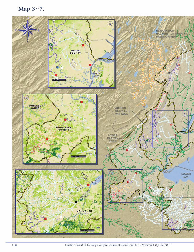
Map 3~7.
116 Hudson-Raritan Estuary Comprehensive Restoration Plan - Version 1.0 June 2016
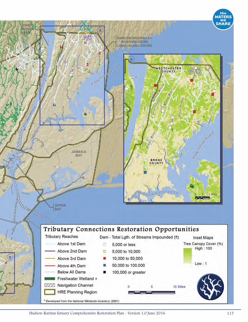
117Hudson-Raritan Estuary Comprehensive Restoration Plan - Version 1.0 June 2016
3.3.2 Enclosed and Confi ned WatersThe Enclosed and Confined Waters TEC focuses on poorly flushed, enclosed, constricted, and over-excavated
subtidal areas of the HRE study area that exhibit periodic or continuous poor water quality. Examples of
enclosed and confined water bodies occurring in the HRE study area include modified tidal creeks, enclosed
basins, and man-made bathymetric depressions with poor circulation. These water bodies are often characterized by a
host of degraded conditions, including contaminated sediments, hypoxic/anoxic water masses, noxious odors, hardened
shorelines, accumulation of fine sediments, and little or no vegetated buffers, creating low quality habitat that is of limited
use for foraging, nursery, or refuge by estuarine organisms.
Dead-end tidal creeks are remnant natural tidal drainage features that have been cut off from their headwaters and partially
filled. Historically, many tidal creeks were present throughout the HRE study area as drainage features associated with
intertidal wetlands. As the estuary became increasingly populated and developed, these water bodies were successively
straightened and or diverted through culverts, or filled throughout their length (Bain et al. 2007). This created narrow,
confined waterways that often exhibit impaired tidal flow, have limited flushing, and are dredged to depths greater than the
surrounding estuary, promoting poor water circulation and stratification (Yozzo et al. 2001, Bain et al. 2007).
Man-made bathymetric depressions are deep holes that were created by removing sediment for on-land construction (i.e.,
borrow pits). Artificial depressions are characterized by impaired water circulation, fine organic sediments, and vertically
stratified temperature and dissolved oxygen concentrations that can be as low as 4o C and 0 to 1 milligrams/liter, respectively,
in the deepest pits of Jamaica Bay (BVA 2005). These bathymetric depressions may also contain debris, such as derelict
vessels or vehicles, construction materials, and pilings.
Enclosed and Confined Waters in the HRE study area often have extremely poor water quality due to years of unregulated
dumping and discharge (Yozzo et al. 2001). These basins have been cut off from their historic creeks and there is limited
tidal flushing from the estuary. Therefore, major inputs to Enclosed and Confined Waters often include stormwater runoff
coupled with human and industrial wastes from CSOs, vessels, and shoreline facilities (Bain et al. 2007). Confined waters
typically exhibit low species diversity and abundance, and are dominated by a few opportunistic species.
Target Statement
The restoration targets for Enclosed and Confined Waters aim to improve the condition of these water bodies to where they
match state-defined designated uses (i.e., shellfishing, bathing, fishing, etc.). The short-term objective is to improve the
water quality of eight enclosed waterways by 2020. The long-term objective statement for this TEC is to improve the water
quality or environmental conditions of all enclosed waterways by 2050. Progress toward the long-term objective could be
measured using interim metrics, such as percent compliance of a confined waterway to a higher designated use because
changing state-designated uses can be difficult. Through restoration efforts, these improvements will lead to improved water
quality and increase the amount of shallow, protected water habitat in the HRE study area.
118 Hudson-Raritan Estuary Comprehensive Restoration Plan - Version 1.0 June 2016

Restoration Opportunities (Map 3-8)
Opportunities for improving Enclosed and Confined Waters exist in each planning region of the HRE study area. Map 3-8
displays these restoration opportunities. Included on the map are areas where dead-end tidal creeks, head-ends of
tributaries, bathymetric depressions, and inter-pier areas do not meet their state designated use. The map also displays the
state-designated best use class (Table 3-8), CSOs, and national superfund sites that occur both in waterways and on land
with the potential to affect adjacent surface waters. The inset maps highlight those waterbodies that have been documented
as not meeting the water quality standards indicated by their designated use (i.e., on the 303(d) List of Impaired Waters).
Also on the inset maps, known bathymetric depressions and basins where environmental dredging projects are in-progress
to improve water quality are delineated.
Most of the HRE study area is designated to support at least fishing and secondary contact recreation, even within the
majority of enclosed or confined water bodies, as defined in this TEC. In New York waters, many of these water bodies are
impacted particularly by pathogens, low dissolved oxygen, and nitrogen pollution. However, they have been removed from the
303(d) List due to requirements to implement controls that are expected to result in attainment of water quality standards
within a reasonable period of time (NYC CSP Consent Order and Nitrogen Consent Judgment). Additionally, other areas do
not meet their designated uses due to aesthetic criteria, such as the presence of floatables; not meeting the criteria for PCBs
or metals; or use as migratory fish corridors. In New Jersey, the scale at which non-attaining waters are defined does not
distinguish enclosed or confined waters from their receiving waters, but many of the large water bodies have contaminants,
metals, or high total suspended solids.
Table 3-8. Designated best use classes for surface water use in estuaries in the states of New Jersey and New York.
119Hudson-Raritan Estuary Comprehensive Restoration Plan - Version 1.0 June 2016
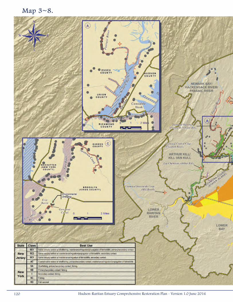
Map 3~8.
120 Hudson-Raritan Estuary Comprehensive Restoration Plan - Version 1.0 June 2016

121Hudson-Raritan Estuary Comprehensive Restoration Plan - Version 1.0 June 2016
There are also 659 CSOs in the HRE study area, 431 in New York and 228 in New Jersey, some causing or contributing to
water quality impairments. Many of the CSOs occur in the Lower Hudson River Planning Region and the Harlem River, East
River, Western Long Island Sound Planning Region. Restoration opportunities for the long-term objective (i.e., those waters
with lower use classifications than their receiving waters) exist in Bergen Basin of Jamaica Bay, the Kill Van Kull of Staten
Island, a few bays in Long Island Sound, and Erie Basin off Red Hook, Brooklyn.
For the short-term objective, the Enclosed and Confined Waters restoration opportunity map displays four insets, which call
out examples of water feature types that could be targeted for restoration (i.e., enclosed basins, dead-end creeks, poorly
flushed bays, and inter-pier areas). The inset displays water bodies not attaining their current best use classification and
areas that may be hypoxic or anoxic during portions of the year based on the known conditions from 2009.
• Inset A – The southern bays of Long Island Sound did not attain their state designated use during 20121. Little Neck
Bay is designated for shellfishing, primary/secondary recreation, and fishing (Class SA), but did not meet this best use
class due to high nitrogen concentrations and presence of pathogens. There are several CSOs that discharge into
the mouth of Little Neck Bay that may be contributing to high nitrogen levels. Manhasset Bay was designated Class
SA and SB throughout much of the bay, whereas the most inland segment was designated Class SC, for fishing. The
bay did not attain its designated use due to PCB contamination in the Tom’s Point area. Hempstead Harbor, which was
designated as Class SA and SB, did not meet its designated use due to pathogens, nitrogen concentrations, and PCB
contamination. Manhasset and Hempstead bays are high priority waters, scheduled for Total Maximum Daily Load/
restoration strategy development and submission for approval to USEPA within the next 2 years (2016-2018). All
three bays may experience low dissolved oxygen conditions during some portion of the year.
• Inset B – Newark Bay, the lower Passaic River, portions of the Hackensack River, and portions of the Kill Van Kull
are intensively industrialized, with hardened shorelines, inter-pier areas, and enclosed basins. There are several
CSOs on the western shore of Bayonne, New Jersey and along both shores of the Kill Van Kull. In addition, dozens
of CSOs along the Passaic River discharge into Newark Bay. Some of the inlets associated with the CSOs, like those
along Constable Hook, New Jersey, are suspected to be hypoxic or anoxic during portions of the year. Both Newark
Bay and the New Jersey side of the Kill Van Kull did not meet their best use during 2012 due to pesticides, PCBs,
PAHs, and dioxins. These water bodies also did not meet the mercury standard for Class SE3, which should support
secondary contact recreation and maintenance and migration of fish and wildlife.
• Inset C – The Upper Bay is intensively developed, with hardened shorelines, inter-pier areas, and enclosed basins.
The New Jersey side of the bay is a functioning port, but several near shore areas may experience periods of
hypoxia or anoxia. Although the New Jersey side of Upper Bay was non-attaining during 2012, this was due to
contaminants such as pesticides, PCBs, PAHs, and dioxins and not necessarily due to poor water quality conditions
caused by confined waters. Inter-pier areas, like those along Brooklyn, are typically well-flushed though they do
modify sedimentation patterns and may be areas of concern under this TEC. Erie Basin, an enclosed waterway just
north of Gowanus Bay, did not meet its designated use of fishing due to high copper levels. Gowanus Canal has
been the target of several improvement projects, and although water quality conditions have improved somewhat,
1 At the time of publication, there was a draft 2014 NYS Section 303(d) List of Impaired/TMDL Waters available; however, this document is based on the data presented in the 2012 NYS Section 303(d) List of Impaired /TMDL Waters.
122 Hudson-Raritan Estuary Comprehensive Restoration Plan - Version 1.0 June 2016
Gowanus Canal did not meet its best use class due to low dissolved oxygen levels. Several CSOs are located along
the Gowanus Canal and inter-pier areas that are contributing to the poor water quality conditions of the Upper
Bay. These issues were being addressed through a 2004 Administrative CSO Consent Order between NYCDEP
and NYSDEC, which calls for a comprehensive watershed-based approach to pollution control (Gibbons and Yuhas
2005). In 2010, the USEPA added the Gowanus Canal to the Agency’s Superfund National Priorities List.
• Inset D – Jamaica Bay contains numerous dead-end tidal creeks and several large bathymetric depressions with
poor circulation. Most of these former tidal creeks have lower use classes then the main bay, not requiring water
quality conditions to support primary contact recreation. Despite this, Jamaica Bay and many of its tidal creeks did
not attain their designated uses during 2012. Hendrix Creek and Bergen Basin had high nitrogen and low dissolved
oxygen. Most of the other basins, such as Paerdegat Basin and Old Mill Creek, which did not meet their use class,
are being addressed through the 2004 CSO Consent Order discussed above. The CSO inputs result in extended
periods of hypoxia or anoxia in these waters. Mill Basin, on the western side of the bay, is an enclosed basin with
a bathymetric depression, and likely experiences hypoxic or anoxic conditions during portions of the year. Grassy
Bay, Norton Basin, and Little Bay also contain bathymetric depressions that have poor circulation and experience
extended periods of hypoxia. The Jo-Co Marsh pit is located approximately 0.3 miles (0.5 kilometers) west of
Bayswater, New York and directly south of John F. Kennedy International Airport. Unlike the Grassy Bay and Norton
Basin/Little Bay pits, this bathymetric depression has not been studied with regard to water/sediment quality, but
is assumed to represent a highly depositional environment and to exhibit hypoxic conditions seasonally (Yozzo et
al. 2001).
123Hudson-Raritan Estuary Comprehensive Restoration Plan - Version 1.0 June 2016
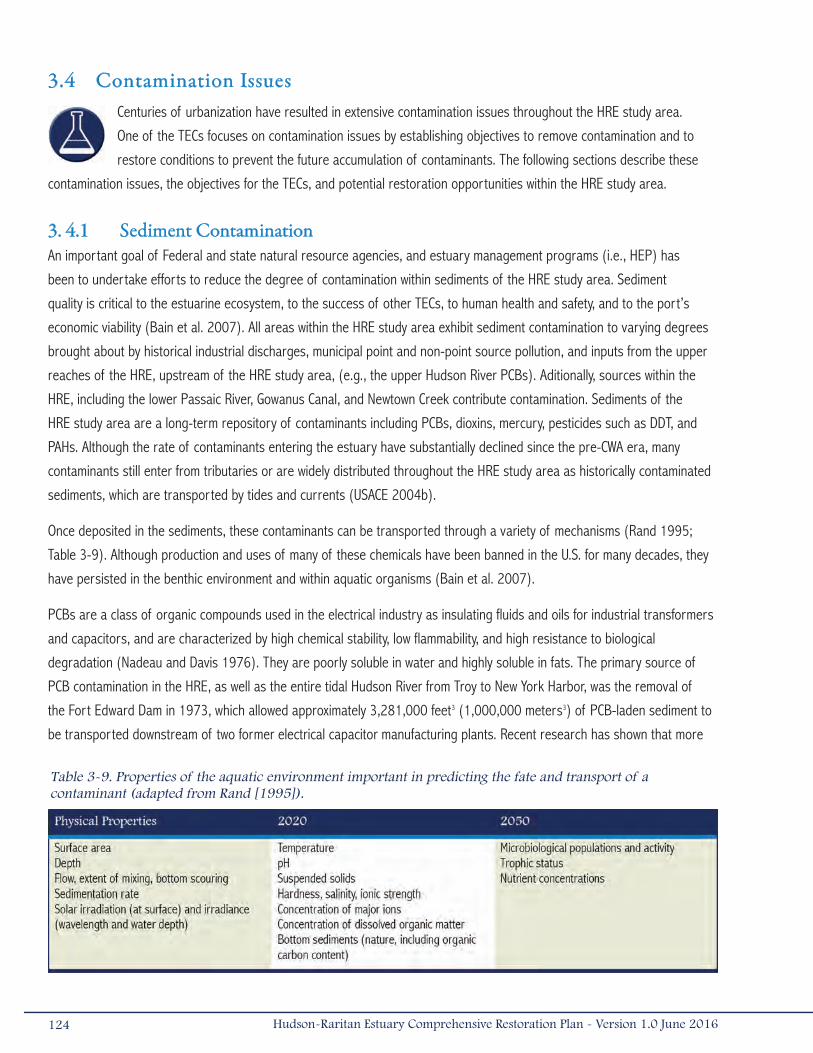
3.4 Contamination IssuesCenturies of urbanization have resulted in extensive contamination issues throughout the HRE study area.
One of the TECs focuses on contamination issues by establishing objectives to remove contamination and to
restore conditions to prevent the future accumulation of contaminants. The following sections describe these
contamination issues, the objectives for the TECs, and potential restoration opportunities within the HRE study area.
3. 4.1 Sediment ContaminationAn important goal of Federal and state natural resource agencies, and estuary management programs (i.e., HEP) has
been to undertake efforts to reduce the degree of contamination within sediments of the HRE study area. Sediment
quality is critical to the estuarine ecosystem, to the success of other TECs, to human health and safety, and to the port’s
economic viability (Bain et al. 2007). All areas within the HRE study area exhibit sediment contamination to varying degrees
brought about by historical industrial discharges, municipal point and non-point source pollution, and inputs from the upper
reaches of the HRE, upstream of the HRE study area, (e.g., the upper Hudson River PCBs). Aditionally, sources within the
HRE, including the lower Passaic River, Gowanus Canal, and Newtown Creek contribute contamination. Sediments of the
HRE study area are a long-term repository of contaminants including PCBs, dioxins, mercury, pesticides such as DDT, and
PAHs. Although the rate of contaminants entering the estuary have substantially declined since the pre-CWA era, many
contaminants still enter from tributaries or are widely distributed throughout the HRE study area as historically contaminated
sediments, which are transported by tides and currents (USACE 2004b).
Once deposited in the sediments, these contaminants can be transported through a variety of mechanisms (Rand 1995;
Table 3-9). Although production and uses of many of these chemicals have been banned in the U.S. for many decades, they
have persisted in the benthic environment and within aquatic organisms (Bain et al. 2007).
PCBs are a class of organic compounds used in the electrical industry as insulating fluids and oils for industrial transformers
and capacitors, and are characterized by high chemical stability, low flammability, and high resistance to biological
degradation (Nadeau and Davis 1976). They are poorly soluble in water and highly soluble in fats. The primary source of
PCB contamination in the HRE, as well as the entire tidal Hudson River from Troy to New York Harbor, was the removal of
the Fort Edward Dam in 1973, which allowed approximately 3,281,000 feet3 (1,000,000 meters3) of PCB-laden sediment to
be transported downstream of two former electrical capacitor manufacturing plants. Recent research has shown that more
124 Hudson-Raritan Estuary Comprehensive Restoration Plan - Version 1.0 June 2016
Table 3-9. Properties of the aquatic environment important in predicting the fate and transport of a contaminant (adapted from Rand [1995]).

than 45 percent of the PCBs entering the Harbor were not from the upstream Hudson River Superfund site, but rather
from sources closer to the Harbor, such as small capacitors (found in household appliances), pigment manufacturing, and
from stormwater runoff and CSOs (source flows suggested to be from landfills and other contaminated sites where PCB
containing products were improperly disposed; NYAS 2008).
Dioxins and furans are chlorinated organic compounds that can be found in the environment due to natural combustion
(e.g., forest fires), but also through waste incineration, fuel combustion, and as a manufacturing by-product. Dioxins were
a by-product of a widely used defoliant in the 1960s (i.e., Agent Orange). Large amounts of dioxins were released into the
lower Passaic River, which have subsequently spread throughout the HRE, with highest concentrations close to the source
in the lower Passaic River, in Newark Bay and portions of the Hackensack River, Arthur Kill, and Kill Van Kull. Following
legacy sediments, the potentially largest remaining sources of dioxin involve uncontrolled combustion processes, which
are extremely difficult to characterize. Fires affecting buildings and landfills may also be contributing sources (NYAS 2008).
An RI/FS to address legacy contamination of dioxins for the 17-miles (27 kilometers) of the lower Passaic River, from
Newark Bay to the Dundee Dam, was conducted by the potential responsible parties on behalf of USEPA. In March
2016, the USEPA issued the Record of Decision on the final cleanup plan for the lower 8.3 miles (13.4 kilometers) of the
Passaic River that includes bank to bank dredging and removal of 3.5 million CY of sediment and subsequent capping
(USEPA 2016).
DDT, one of the first and best-known organic pesticides, was used to control insect-vector diseases and as an agricultural
insecticide. PAHs are primarily created through the incomplete incineration of organic fuels and are therefore tightly linked
to energy production. PAHs can enter the environment through point sources (e.g., oil spills), and non-point sources (e.g.,
atmospheric deposition and overland runoff).
A variety of heavy metals may be present in HRE sediments. Some metals, such as lead, are widely distributed throughout
the HRE study area as a result of atmospheric deposition and other non-point source inputs. Others, such as cadmium,
mercury, chromium, and copper may occur in very high concentrations in specific geographic areas as a result of direct
point-source inputs. Regional economic changes have dramatically reduced cadmium sources to the HRE study area, with
the primary commercial source being nickel-cadmium batteries resulting from increased demand for portable electronic
devices (NYAS 2008). Mercury enters water pathways through CSOs, stormwater runoff, and in WWTPs, there is a high
potential for mercury to be transformed into methylmercury, which is a more toxic form (NYAS 2008).
In addition, endocrine disruptors and emerging contaminants (e.g., polybrominated diphenyl ethers [PBDEs], perfluoroalkyl
and polyfluoroalkyl substances [PFASs]), which are generally defined as any synthetic or naturally occurring chemical or
microorganism that is not commonly monitored in the environment but has the potential to enter the environment and
cause known or suspected adverse ecological and/or human health effects, may have, in some instances, accumulated in
sediments within the HRE study area.
Gowanus Canal and Newtown Creek are also sources of contamination to the HRE study area. These rivers have been
named to the National Priorities List. USEPA has completed RI/FS for Gowanus Canal and released a Proposed Plan in
125Hudson-Raritan Estuary Comprehensive Restoration Plan - Version 1.0 June 2016
December 2012 (USEPA 2012). In July 2011, EPA issued an administrative Order on Consent to six potentially responsible
parties (PRPs), requiring that they perform a RI/FS at Newtown Creek under USEPA oversight.
Currently, every planning region of the HRE study area has exhibited some degree of sediment degradation due to
contamination. The Regional Environmental Monitoring and Assessment Program conducted by the USEPA in 1993-1994
and again in 1998, found that pervasive contamination across chemical groups in the HRE study area had declined (Adams
and Benyi 2003). Contamination can greatly reduce the biological and recreational value of the HRE study area through fish
consumption advisories, human health risks, and economic impacts through restrictions of commercially harvested species.
Sediment contamination also affects navigation and commerce within the HRE study area. The port industry is valued at an
estimated $53.5 billion annually and directly or indirectly supports approximately 336,600 jobs (NYSA 2015). Contaminated
sediments can increase the cost of maintaining navigation channels by as much as four to five times due to the added cost
of transporting and processing the material for disposal or reuse (USACE 2008b).
Although sediment and the pollutants that contaminate sediment originate throughout the HRE study area, management
of sediment has historically taken a highly localized and narrowly focused approach – one that is largely based on the
tightly defined responsibilities of regulatory and resource management agencies and port interests. Sediment management
responsibilities are spread among different agencies (e.g., USEPA, NJDEP, NYSDEC, NOAA, USFWS, and USACE), authorities
(e.g., CERCLA, RCRA, ISRA, and WRDA Section 312, Navigation), and jurisdictions. In addition, there is no existing regional
framework in which to address these cross-jurisdictional issues. As a result, the policy and regulatory framework required to
improve regional sediment management throughout the HRE study area does not exist and many sediment related problems
remain unaddressed or under-addressed.
In 2008, The New York Academy of Sciences undertook a multi-year study to identify and quantify the flows of specific
contaminants into the NY-NJ Harbor from its air and watershed. The project (the Harbor Project) used the methodology
of industrial ecology and emphasized outreach and communication in order to encourage implementation of pollution
prevention strategies for these contaminants (NYAS 2008). To accomplish the project goals, the New York Academy of
Sciences created a regional consortium (the Harbor Consortium), which is able to produce, publish, and promote specific
pollution prevention plans for various contaminants (NYAS 2008). The Harbor Project and Consortium have made strides
to implement regional actions that address contaminant inputs to the HRE study area (NYAS 2008). In some cases, the
recommendations were incorporated into the regulatory process, such as 2002 New York State legislation requiring recycling
of all mercury waste in dental offices, and many New York and New Jersey regulations limiting the purchase of products
containing mercury, as well as regulating their disposal in municipal solid waste facilities. In other instances, industries
were encouraged to implement recommendations on a voluntary basis as a cost-savings measure or to reduce regulatory
oversight. Improved recycling and waste management has been identified as the best approach for industrial stewardship,
such as promoting proper management of rechargeable batteries.
The potential benefits of managing sediment regionally are:
• Cost savings resulting from a reduced need to dredge navigation channels and dredging cleaner sediments which
do not require costly treatment or disposal options;
• Improved habitat quality resulting from the cleanup of contaminated sediments;
126 Hudson-Raritan Estuary Comprehensive Restoration Plan - Version 1.0 June 2016
• Improved availability of habitat based on reintroduction of sediment into “sand starved” littoral systems;
• Shared regional-scale data management systems, models and other scientific tools to help make sediment
management decisions;
• Improved relationships between agencies and the public that produce opportunities for collaboratively leveraging
financial and manpower resources; and
• Improved relationships of the regulatory processes resulting from better intergovernmental collaboration and
coordination (Tavolaro 2008).
Acknowledging the need for a better management approach, the HEP Regional Sediment Management (RSM) Work Group
was formed to develop a plan for a RSM Program that integrates various sediment management activities in the HRE. The
HEP Policy Committee charged the Work Group with developing a scope and structure for the RSM Program that includes a
plan with specific goals and targets to improve the ecosystem, public health and the economy, sustainability in carrying out
future tasks, technical credibility, and regional support.
The RSM Plan (HEP 2008) established a collaborative process that resulted in a plan with three major components: sediment
quality, sediment quantity, and dredged material management. Specific objectives for each major component describe the
challenges it presents, status of current work, and recommended actions. A total of 8 objectives and 45 specific actions
were recommended as the consensus for the Work Group. Primary Sediment Quality Objectives included: ensure new
sediments are clean and new sediments entering the system remain clean, reduce toxic exposure, and reduce transport of
contaminants to other areas. Specific Sediment Quantity Objectives included; ensure sufficient sediment to support healthy
ecosystem and reduce sediment deposition in shipping channels and berths. Dredged Material objectives included the
improvement of dredging operations and dredged material management.
Key recommendations of the RSM Plan include:
• Creation of a RSM advocate at the state level in New York and New Jersey;
• Strengthen regional coordination and consistency on regulatory issues, watershed planning, and dredged material
management (e.g., dredging windows, beneficial uses, identification of upland placement sites, sedimentation
control, etc.);
• Develop a sediment quality map that prioritizes areas for cleanup;
• Focus remedial actions in the Hudson River and lower Passaic River due to the significant impacts contaminated
sediments from these areas have on the HRE study area;
• Identify watersheds with excessive sediment loads and develop plans to reduce loads; and
• Update technical information through research, monitoring, and modeling (e.g., develop sediment transport models
and CARP model updates).
Target Statement
The TEC for sediment quality was developed to be consistent with the goals of the HEP RSM Plan. In addition to the RSM’s
specific objectives and recommended actions, short-term and long-term objectives were established through the TEC
127Hudson-Raritan Estuary Comprehensive Restoration Plan - Version 1.0 June 2016
workshops and subsequent meetings with HEP. The short-term objective for this TEC is to isolate or remove one or more
contaminated sediment zone(s) totaling at least 25 acres (0.10 kilometers2) by 2020. The long-term objective is to isolate
or remove at least 25 acres of contaminated sediment every 2 years until 2050 or until all HRE sediments are considered
uncontaminated resulting in the removal of fish consumption advisories, lower sediment management and restoration costs,
and reduced risk to human health and the environment.
Restoration Opportunities (Maps 3-9 and 3-10)
It has been long documented that the industrial past of the HRE study area has degraded the quality of the sediments.
Contaminated sediments are present throughout the HRE study area and there are many opportunities to improve sediment
quality. The TEC objective for improvement of sediment quality through isolation or removal of contaminated sediments within
the HRE is consistent with the RSM Work Group objectives. A key action recommended by the RSM Plan was to develop a
sediment quality map that prioritizes areas for cleanup.
An initial step of this key action was the evaluation of predictions from the CARP model that allow for an estuary-wide
assessment of chemical concentrations in the top 10 centimeters (4 inches) of the sediments. To display these contaminant
reduction opportunities, current day predictions (or “now-casts”) from the CARP model were incorporated into a GIS
framework to display the aerial extent of surface sediment contamination throughout the HRE study area. Two analytes were
selected as examples of the contaminants of concern for the analysis: 2,3,7,8-TCDD and Total PCB. Additional analytes are
evaluated in Appendix C. The relative concentration of these contaminants throughout the HRE study area is presented
as percentiles on Maps 3-9 and 3-10. Established benchmarks are displayed on the maps to enable interpretation of the
potential risks associated with contaminant levels. These evaluations will be conducted on a more localized basis through
specific follow-up risk assessment activities.
These maps are not at a scale where contaminant “hot spots” can be identified. However, they can be used to understand
the extent of contamination in the sediments, and to identify the large areas with the highest concentrations of surficial
sediments (top 10 centimeters [4 inches]) within the HRE study area. Detailed evaluations of site-specific cores at depth
within individual study areas need to be conducted to identify individual hot spots.
2,3,7,8-TCDD
Map 3-9 displays the predicted concentrations of 2,3,7,8-TCDD for the top 10 centimeters (4 inches) of sediments in
the HRE study area. Although there are no Effects Range Medium (ERM) or Effects Range Low (ERL) benchmarks for
this type of dioxin, the USFWS derived a benchmark based upon the effects of 2,3,7,8-TCDD tissue concentrations on
the egg fertilization and development of eastern oysters (Winterbyer and Cooper 2003). Effects are assumed to occur
at sediment concentrations of 0.0032 parts per billion. Predicted concentrations of 2,3,7,8-TCDD range from 0.0003 to
0.1624 parts per billion throughout the HRE study area. The CARP model predicted that approximately 61.2 percent of the
surface sediments in the HRE study area have concentrations of 2,3,7,8-TCDD that exceed this benchmark. The highest
concentrations were predicted in the lower Passaic River (Inset A) and surrounding waters. The lower Passaic River is the
location of many chemical manufacturing plants that produced DDT and other herbicides during the 20th century. As stated
in Section 2.4, USEPA issued a Proposed Plan in April 2014 to remove and cap contaminated sediments within the lower
128 Hudson-Raritan Estuary Comprehensive Restoration Plan - Version 1.0 June 2016
8.3 miles (13.4 kilometers) of the river. In addition, the most contaminated sediments (40,000 cubic yards of debris [CYD])
adjacent the Diamond Alkali Superfund site had been removed in 2012 and surface sediments (16,000 CYD) were removed
and capped at River Mile 10.9.
Other areas with very high concentrations in the surface sediments (higher than 0.02 parts per billion) include the eastern
portion of Jamaica Bay (Inset C), the Arthur Kill and western Raritan Bay (Inset B). Concentrations above the oyster effects
benchmark are predicted for the entire Lower Bay, Sandy Hook Bay, the East River, and the western portion of Jamaica
Bay (Inset C). The lowest 2,3,7,8-TCDD concentrations were predicted for the Lower Hudson River and western Long
Island Sound.
Total PCB
The Total PCB concentrations predicted for the top 10 centimeters of sediment within the HRE study area are displayed on
Map 3-10. Concentrations were predicted to range between 14.9 and 11,365.1 parts per billion throughout the HRE study
area. PCBs are among the most pervasive contaminant in the HRE study area, with 98.9 percent of the surface sediments
predicted to exceed the ERL for Total PCB of 23 parts per billion, and 89.5 percent of the surface sediments predicted to
exceed the ERM of 180 parts per billion. The highest concentrations (>879 parts per billion) are predicted in the East River,
the Hackensack River (Inset A), the western Raritan River (especially on the shorelines, Inset B) and throughout Jamaica
Bay (Inset C). The only area where the sediments were predicted to be below the ERM for Total PCBs was western Long
Island Sound.
Summary
Surface sediment contamination is pervasive throughout the HRE study area, but the highest concentrations of several
contaminants of concern occur in relatively few places. The Passaic River, Hackensack River, Newark Bay, western Jamaica
Bay, and Raritan Bay have nearly the highest predicted concentrations for each contaminant evaluated. This is a concern
due to the potential effects of interaction among these contaminants, bioaccumulation, and toxicity. These regions represent
opportunities to increase significantly the habitat value by decreasing the effects of contamination. Further evaluation of
sediment contamination should be conducted for human health and ecological risk to inform remedial decision-making. Such
evaluations are completed on the lower Passaic River, Gowanus Canal, and Newtown Creek and continue in Newark Bay
and the Hackensack River. Future evaluation of sediment contamination and recommendations for sediment contaminant
reduction for this TEC should be implemented under the auspices of HEP’s RSM Work Group (or similar group).
129Hudson-Raritan Estuary Comprehensive Restoration Plan - Version 1.0 June 2016
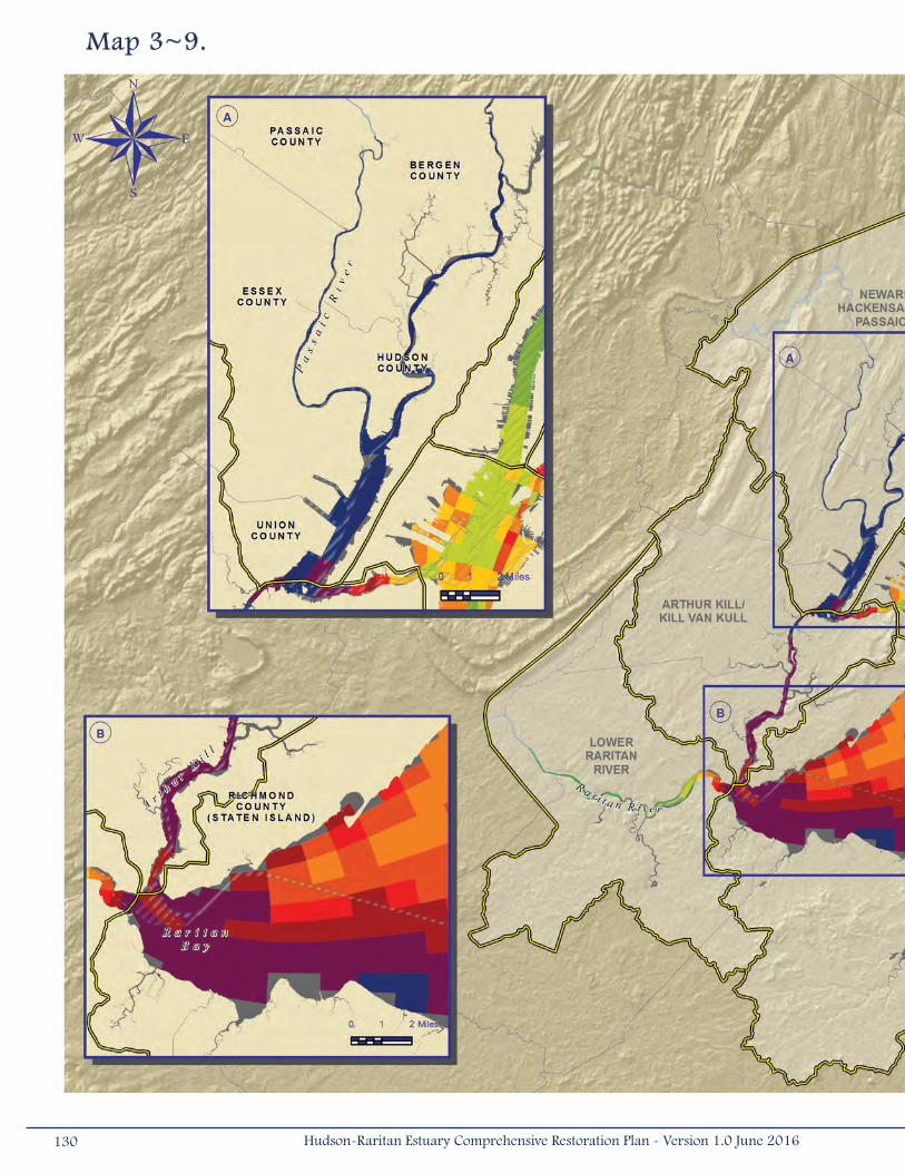
Map 3~9.
130 Hudson-Raritan Estuary Comprehensive Restoration Plan - Version 1.0 June 2016
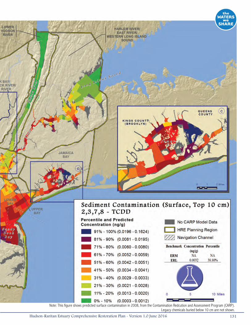
Note: This figure shows predicted surface contamination in 2008, from the Contamination Redcution and Assessment Program (CARP). Legacy chemicals buried below 10 cm are not shown.
131Hudson-Raritan Estuary Comprehensive Restoration Plan - Version 1.0 June 2016
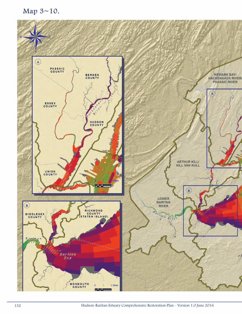
Map 3~10.
132 Hudson-Raritan Estuary Comprehensive Restoration Plan - Version 1.0 June 2016

Note: This figure shows predicted surface contamination in 2008, from the Contamination Redcution and Assessment Program (CARP). Legacy chemicals buried below 10 cm are not shown.
133Hudson-Raritan Estuary Comprehensive Restoration Plan - Version 1.0 June 2016
3.5 Societal ValuesAn important component of this restoration plan is recognition that people are a part of this ecosystem and the plan should
incorporate features that will benefit the public. One TEC was designed to promote access to natural areas for the public.
The following section describes the public access TEC, its objectives, and potential restoration opportunities within the HRE
study area.
3.5.1 Public AccessAccording to the Public Trust Doctrine, public trust lands, waters, and living resources in a state are held by
the state in trust for the benefit of all of the people. The doctrine establishes the right of the public to enjoy
these resources for a wide variety of recognized public uses (NYSDOS 2008, NJDEP 2006). Public access to the
estuary means providing residents of the HRE study area with accessible routes to natural areas and enabling them to enjoy
local scenic, natural, cultural, historic, and recreational resources. Contact with nature can afford numerous public benefits
in the form of educational experiences, relaxation, and improved quality of life (Bain et al. 2007). Types of public access
points include:
• Direct access (e.g., boat launching, swimming, recreational fishing);
• Indirect access (e.g., waterfront promenade);
• Vistas (e.g., scenic overlook); and
• Upland access routes (e.g., pedestrian route, bike path; Bain et al. 2007).
Throughout the HRE’s history, there has been a conflict of interest concerning use of the waterfront. Differing views among
government, local communities, and private industries were rarely able to reach a consensus when deciding between urban
or natural uses, or some combination thereof, for the waterfront. Often, attempts to create parkland during the 19th century
were rejected as inconsistent with economic goals and commercial opportunities for the city. By the mid-20th century, views
had changed and the focus became renewal and revitalization of urban waterfronts (Wise et al. 1997).
Since then, water quality improvements and a reanimation of recreational activities along the waterfront and within water
bodies of the estuary have occurred (Wise et al. 1997). Since the Draft CRP was released in 2009, many collaborative public
access planning initiatives have been developed, spurring the design and construction of innovative new publicly accessible
areas. As part of the Mayor’s Vision 2020 Plan, NYC released its revised CWP in 2011. While the first plan was released
in 1992, the 2011 update reasserts commitments to the priorities of the 1992 plan and expands upon the goals and
recommendations to include enlivening the waterfront with a range of attractive uses integrated with adjacent communities
and pursuing strategies to increase the City’s resilience to climate change and sea level rise.
Between 2009 and 2014, over 500 acres (2.02 kilometers2) of new parks or public spaces were either acquired and
designated or opened for public access purposes along the HRE waterfront (Boicourt et al. 2015). In recent years, in NYC,
parks and greenways on the waterfront have opened, expanding recreational opportunities (NYCDCP 2011). An example
of this expansion is the 65 acres (0.26 kilometers2) of public access developed in Brooklyn Bridge Park (to be 85 acres
[0.34 kilometers2] total ultimately) and the 5-acre (0.02 kilometers2) Paerdegat Basin Ecology Park. In New Jersey, a
12.3-acre (0.05 kilometers2) waterfront property was developed into the Essex County Riverfront Park (Figure 3-4). The
134 Hudson-Raritan Estuary Comprehensive Restoration Plan - Version 1.0 June 2016
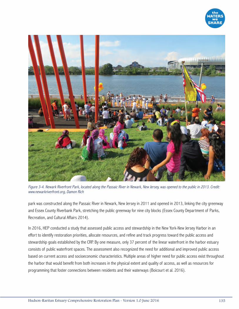
park was constructed along the Passaic River in Newark, New Jersey in 2011 and opened in 2013, linking the city greenway
and Essex County Riverbank Park, stretching the public greenway for nine city blocks (Essex County Department of Parks,
Recreation, and Cultural Affairs 2014).
In 2016, HEP conducted a study that assessed public access and stewardship in the New York-New Jersey Harbor in an
effort to identify restoration priorities, allocate resources, and refine and track progress toward the public access and
stewardship goals established by the CRP. By one measure, only 37 percent of the linear waterfront in the harbor estuary
consists of public waterfront spaces. The assessment also recognized the need for additional and improved public access
based on current access and socioeconomic characteristics. Multiple areas of higher need for public access exist throughout
the harbor that would benefit from both increases in the physical extent and quality of access, as well as resources for
programming that foster connections between residents and their waterways (Boicourt et al. 2016).
Figure 3-4. Newark Riverfront Park, located along the Passaic River in Newark, New Jersey, was opened to the public in 2013. Credit: www.newarkriverfront.org, Damon Rich
135Hudson-Raritan Estuary Comprehensive Restoration Plan - Version 1.0 June 2016
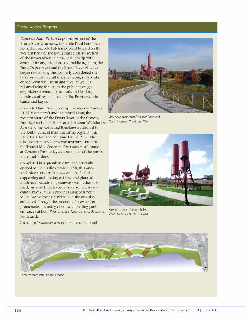
PUBLIC ACCESS PROjECTS
Concrete Plant Park: A capstone project of the Bronx River Greenway, Concrete Plant Park once housed a concrete batch mix plant located on the western bank of the industrial southern section of the Bronx River. In close partnership with community organizations and public agencies, the Parks Department and the Bronx River Alliance began revitalizing this formerly abandoned site by re-establishing salt marshes along riverbanks once strewn with trash and tires, as well as reintroducing the site to the public through organizing community festivals and leading hundreds of residents out on the Bronx river to canoe and kayak.
Concrete Plant Park covers approximately 7 acres (0.03 kilometers2) and is situated along the western shore of the Bronx River in the Crotona Park East section of the Bronx, between Westchester Avenue to the north and Bruckner Boulevard to the south. Cement manufacturing began at this site after 1945 and continued until 1987. The silos, hoppers, and conveyor structures built by the Transit Mix Concrete Corporation still stand at Concrete Park today as a reminder of the park's industrial history.
Completed in September 2009 and officially opened to the public October 30th, this once underdeveloped park now contains facilities supporting and linking existing and planned multi–use pedestrian greenways with other off–road, on-road bicycle/pedestrian routes. A new canoe/kayak launch provides an access point to the Bronx River Corridor. The site was also enhanced through the creation of a waterfront promenade, a reading circle, and inviting park entrances at both Westchester Avenue and Bruckner Boulevard.
Source: http://www.nycgovparks.org/parks/concrete-plant-park
Concrete Plant Park, Phase 1 model.
View down ramp from Bruckner Boulevard. Photo by James M. Mituzas, RLA
View of concrete lounge chairs. Photo by James M. Mituzas, RLA
136 Hudson-Raritan Estuary Comprehensive Restoration Plan - Version 1.0 June 2016
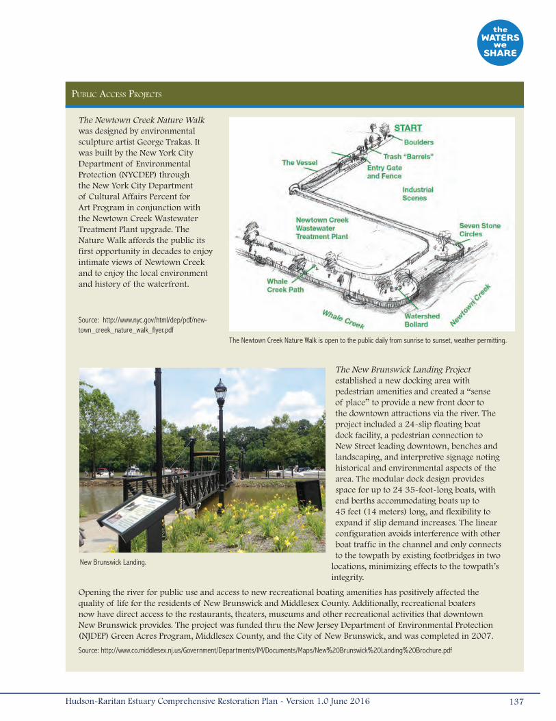
PUBLIC ACCESS PROjECTS
The Newtown Creek Nature Walk was designed by environmental sculpture artist George Trakas. It was built by the New York City Department of Environmental Protection (NYCDEP) through the New York City Department of Cultural Affairs Percent for Art Program in conjunction with the Newtown Creek Wastewater Treatment Plant upgrade. The Nature Walk affords the public its first opportunity in decades to enjoy intimate views of Newtown Creek and to enjoy the local environment and history of the waterfront.
Source: http://www.nyc.gov/html/dep/pdf/new-town_creek_nature_walk_flyer.pdf
The New Brunswick Landing Project established a new docking area with pedestrian amenities and created a “sense of place” to provide a new front door to the downtown attractions via the river. The project included a 24-slip floating boat dock facility, a pedestrian connection to New Street leading downtown, benches and landscaping, and interpretive signage noting historical and environmental aspects of the area. The modular dock design provides space for up to 24 35-foot-long boats, with end berths accommodating boats up to 45 feet (14 meters) long, and flexibility to expand if slip demand increases. The linear configuration avoids interference with other boat traffic in the channel and only connects to the towpath by existing footbridges in two
locations, minimizing effects to the towpath’s integrity.
Opening the river for public use and access to new recreational boating amenities has positively affected the quality of life for the residents of New Brunswick and Middlesex County. Additionally, recreational boaters now have direct access to the restaurants, theaters, museums and other recreational activities that downtown New Brunswick provides. The project was funded thru the New Jersey Department of Environmental Protection (NJDEP) Green Acres Program, Middlesex County, and the City of New Brunswick, and was completed in 2007.
Source: http://www.co.middlesex.nj.us/Government/Departments/IM/Documents/Maps/New%20Brunswick%20Landing%20Brochure.pdf
The Newtown Creek Nature Walk is open to the public daily from sunrise to sunset, weather permitting.
New Brunswick Landing.
137Hudson-Raritan Estuary Comprehensive Restoration Plan - Version 1.0 June 2016

The Public Access TEC may encounter more land use trade-offs than other TECs. Industrial or commercial land uses may
conflict with public access if they create safety issues for direct access or lack aesthetic quality. Access is currently limited
around airports, port terminals, some industrial uses, and other secure areas. Although industrial activity and public access
co-exist on separate lots in the Hackensack Meadowlands, Newtown Creek, and the Bronx River, active ports and maritime
industries impact the creation of new public access points. Through strategic partnerships, vacant lots, brownfields, and
areas shifting from industrial to commercial or residential uses could be restored to offer access opportunities. Similarly,
all natural habitats, except for environmentally sensitive areas (e.g., nesting habitat), should be viewed as opportunities to
create public access. Providing access creates scenic destinations and peaceful retreats from urban life.
In NYC, waterfront zoning requirements, enacted in 1993, were revised in 2009. These zoning modifications now require
new residential and commercial developments on the waterfront to provide both physical and visual access to the water
(NYCDCP 2011). With many projects already constructed, under construction, approved, and planned, approximately
8 miles (12.9 kilometers) of publicly accessible waterfront with walkways and visual corridors will be available in a few
years (NYCDCP 2011). The devastating effects of Hurricane Sandy also resulted in a revision of the zoning laws. On
October 9, 2013, the NYC Council adopted the Flood Resilience Zoning Text Amendment to encourage flood-resilience
building construction throughout designated flood zones. Single-and two-family homes are now required to provide 2 feet
(0.61 meters) of extra protection, meaning significant changes to structures in flood-prone areas, especially those along
the HRE waterfront. Areas like the South Bronx have developed specific plans, such as the South Bronx Greenway that when
fully completed will encompass 1.5 miles (1.6 kilometers) of waterfront greenway, 8.5 miles (14 kilometers) of inland green
streets, and nearly 12 acres (0.05 kilometers2) of new waterfront open space (NYCEDC 2016).
The NJDEP promotes public access to waterways under the state’s Coastal Zone Management rules, last amended on July 15,
2013. The Coastal Management Rules address public access by defining it as the ability of the public to pass physically and
visually to, from, and along lands and waters subject to public trust rights, and to use these lands and waters for activities
such as swimming, sunbathing, fishing, surfing, sport diving, bird watching, walking, and boating (NJAC 2013). These
regulations set specific standards on provisions for site access, without considering protection of natural habitats, security,
fees, parking, liability, and easements along with many other aspects.
Every public access site design should include features to ensure equal enjoyment of the waterfront and waterways
regardless of a person’s physical condition. The American Disability Act’s (ADA) 2010 Standards for Accessible Design are
required for all new or altered facilities and public accommodations, including public access sites. Providing ADA access
would be required on most paved trails, boardwalks, fishing piers, and boat launches. However, it will be more challenging to
provide ADA access to natural areas such as wetlands and stream crossings.
Public access sites must also be consistent with Homeland Security policies and not jeopardize our nation’s security. The
Office of Homeland Security is responsible for protecting our borders within the rivers and coastal waters around the area,
particularly securing the vital economic gateways that handle trade and travel each year (airports, marine ports) and
protecting government operations (e.g., United Nations Headquarters). Where industrial land cuts off upland communities
from the water in the HRE study area, public access has been granted at specific points where it does not infringe on the
activity of the working waterfront or conflict with Homeland Security regulations. Examples in NYC include Barretto Point
Park in Hunts Point in the Bronx; Grand Ferry Park in Williamsburg, Brooklyn; and numerous street-end parks in the South
138 Hudson-Raritan Estuary Comprehensive Restoration Plan - Version 1.0 June 2016

Richmond neighborhood of Staten Island (NYCDCP 2011). On portions of the waterfront where physical access is not feasible
due to security restrictions or other safety factors, the focus should be on creating visual access.
Urban settings, such as NYC, represent unique challenges for restoration. Currently, designers are collaborating with
ecologists and coastal engineers in New York and other seaside cities to introduce ecological function to high priority areas
(e.g., isolated, underutilized, and degraded) (Yozzo et al. 2015). Active collaboration among these disciplines has resulted
in sustainable strategies that integrate the built and natural environments, create opportunities for education, and enrich
the landscape of the city (Yozzo et al. 2015). Brooklyn Bridge Park, the Randall’s Island Salt Marsh Restoration Project,
and the Hunter’s Point South Project integrate a number of ecological design features with features such as public access,
stormwater management, and urban waterfront recreation (Yozzo et al. 2015).
Target Statement
The goal of the Public Access TEC is to improve direct access to and from the water and create linkages to other recreational
areas, as well as provide increased opportunities for fishing, boating, swimming, hiking, education, or passive recreation.
The short-term objective for this TEC is to create one new public access site and one access improvement or upgrade of
an existing access site in each of the eight study areas by 2020. By 2050, the objective is to make waters of the HRE and
tributary rivers accessible to all residents within a short (approximately 20 minute) walk or public transit trip. The creation of
direct access points should be encouraged so that at least 80 percent of access points contain a direct access component
(e.g., boat launch, public bathing area). When restoration programs are initiated, siting of new public access areas could be
integrated with other TECs and provide informational displays related to those restoration actions.
Restoration Opportunities (Map 3-11)
Opportunities for improving existing public access points and creating new public access sites likely exist in every planning
region of the HRE study area. HEP developed a data set that includes known public waterfront spaces (Map 3-11). This map
can be used as an overview that highlights large expanses of shorelines without access points and to show places where
people currently access the water. This data set is available online and includes site-specific information, such as access
type, ownership, and acreage.2
The available public access displayed on Map 3-11 may be in need of upgrades, facilities, or access improvements, including
increases in direct access to and from the water. In the HRE study area, there are 41,078 acres (166.2 kilometers2) of public
waterfront spaces (Boicourt et al. 2016). Fourteen constructed New York City Economic Development Corporation (NYCEDC)
projects are highlighted on the map. The restoration opportunities map has several inset maps that provide examples of the
distribution of access throughout the region and recently constructed projects:
• Inset A – The island of Manhattan is mostly surrounded by waterfront esplanades that have been constructed
and provide an interconnected network of paths, piers, and recreational areas. Areas along the Harlem and East
2 See http://www.harborestuary.org/publicaccess.htm.
139Hudson-Raritan Estuary Comprehensive Restoration Plan - Version 1.0 June 2016
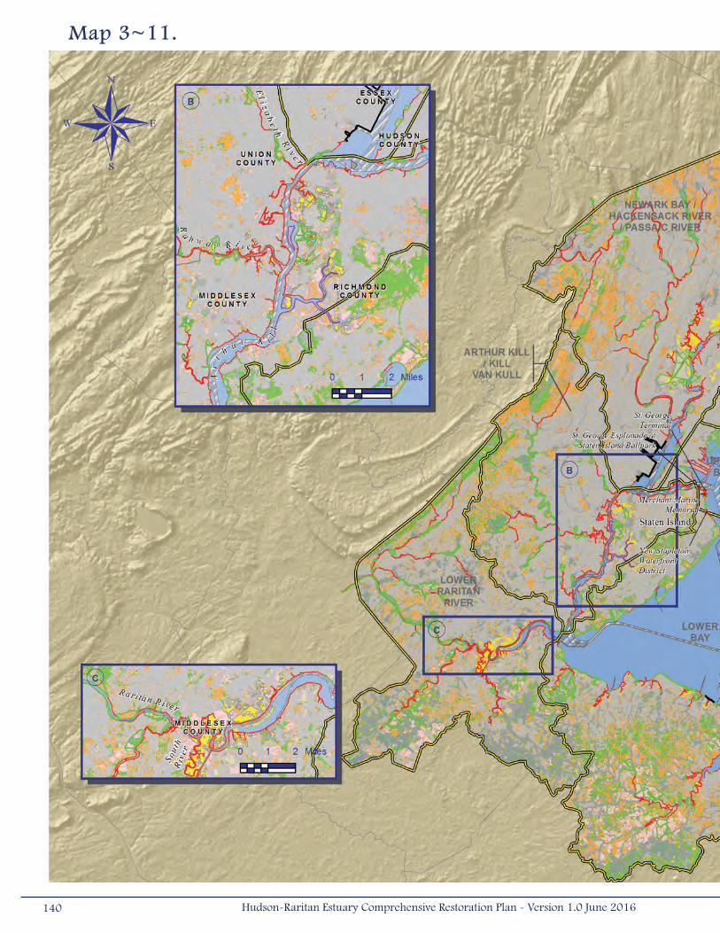
Map 3~11.
140 Hudson-Raritan Estuary Comprehensive Restoration Plan - Version 1.0 June 2016
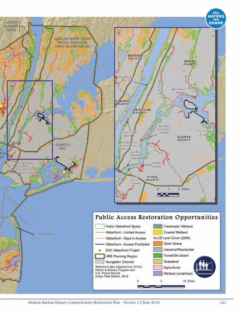
141Hudson-Raritan Estuary Comprehensive Restoration Plan - Version 1.0 June 2016
Rivers and along Newtown Creek in Brooklyn and Flushing Bay in Queens represent gaps in access that could be
created or enhanced to offer additional amenities to the thousands of nearby residents. Despite having many public
waterfront areas, including Hunt’s Point Landing and Soundview Park, the Bronx and Harlem River in particular were
characterized as a higher need area (Boicourt et al. 2016). Safer travel routes should also be considered as many
of these access points are separated from residents by large, impassable highways.
• Inset B – Shorelines of the Arthur Kill and Rahway River have large gaps in public access and areas with limited
access. Dense residential areas are located on the New Jersey side of these rivers and the northern shore of
Staten Island. Due to the lack of access, there are opportunities to develop access and increase the connections to
existing parks. Although the Arthur Kill and mouth of the Rahway River support industrial uses and have relatively
low population densities, important habitats are scattered among them and they may be appropriate for interpretive
signage, nature trails, or birding opportunities.
• Inset C – Similar to the Arthur Kill, the Lower Raritan River, and South River are characterized by large stretches
of gaps in access and are in need of waterfront access development. In particular, growing communities along the
south shore of the Lower Raritan River currently have little access.
142 Hudson-Raritan Estuary Comprehensive Restoration Plan - Version 1.0 June 2016
3.6 AcquisitionIn addition to habitat restoration, another fundamental component of the CRP is the acquisition and preservation of existing
open and undeveloped lands. Given the intensity of development in the HRE study area, even low quality undeveloped lands
should be prioritized for protection.
Target Statement
During the May 2012 TEC meeting, the group agreed to a short-term land acquisition target of 1,000 acres
(4.05 kilometers2) by 2020 to be preserved at an average rate of 200 acres (0.81 kilometers2) per year for a total of
6,000 acres (24.3 kilometers2) by 2050. More than likely, land will initially be acquired at faster rates as known sites are
purchased, with the rate following a non-linear trajectory as successive opportunities with smaller acreage become scarcer.
Therefore, a long-term target has not been developed at this time.
To facilitate progress towards this target, practitioners should seek input from bankers and finance experts to gain better
information on how to fund acquisition and encourage development of green infrastructure. Additionally, local governments
should investigate zoning and/or policy changes that could provide incentives and accelerate habitat acquisition, such as tax
deductions for conservation easements, tradable development rights, or instituting land stewardship zoning. Alternatively,
it may be possible to establish in-lieu fee programs where payments are made to offset disturbance to protected habitats,
such as wetlands, and use these fees for habitat restoration or site acquisition. Priority should be given to parcels that are
adjacent to existing wetlands to allow wetlands to migrate inland and upslope with predicted sea-level rise.
There are local examples of successful acquisition programs in the HRE study area. The PANYNJ has been acquiring properties
through HRERP for 15 years. Under the program, the Port Authority provides funds to not-for-profit or public entities for
the acquisition of property in the estuary identified as suitable for conservation, ecological enhancement, public access, or
environmental mitigation. Between 2001 and 2016, the Port Authority invested $60 million on the acquisition of valuable
properties, and in 2014, they authorized an additional $60 million for future acquisitions. New Jersey has the Green Acres
Program, which seeks to create a system of interconnected open spaces by preserving and enhancing the state’s historic,
scenic, and recreational resources for public use and enjoyment. Within the auspices of the Green Acres Program is the Blue
Acres Program, which converts properties in flood prone areas that have been or may be subject to storm-related damage
into open space. In New York, the state EPF provides funding to the NYSDEC and the State Office of Parks, Recreation and
Historic Preservation (OPRHP) to purchase lands to be included in state parks and preserves. In addition, the EPF provides
funds to local governments and not-for-profit organizations to purchase lands or historic resources for preservation.
In 2016, the USFWS emphasized the need for acquisition sites by promoting a land preservation-only mitigation strategy
for urban settings that focuses on preservation as a restoration strategy in an effort to reduce added contaminant risk to
fish and wildlife resources. There are many land trusts in both New York and New Jersey working to acquire and preserve
land. Additionally, various local and county bonds and taxes have been instituted within the HRE to promote open space
acquisition, which represents a meaningful addition to the overall vision of the HRE study area.
143Hudson-Raritan Estuary Comprehensive Restoration Plan - Version 1.0 June 2016
Restoration Opportunities
Acquisition opportunities are included in the restoration opportunities maps found in Chapter 4. These sites, which are
currently being acquired or have been identified as acquisition sites, highlight the importance of protection and preservation
of existing open and undeveloped lands.
3.7 Other Restoration ActionsAlthough the TECs are the focused targets of the CRP, habitat restoration opportunities that do not address the TECs can still
result in benefits to the HRE study area. For example, there are five vessel graveyards along the Arthur Kill where hundreds
of derelict ships scatter the shorelines of Staten Island along with abandoned wooden piers (USACE 2004a). Although these
vessels provide some form of artificial intertidal habitat to supplement natural nesting, foraging, and refuge areas, they also
smother shoreline vegetation and are a source of dangerous waterborne drift material. Removal of these ships would result
in improved intertidal and shoreline habitat.
The restoration of valuable habitat types not included in the TECs can also provide increased benefits to the HRE study
area. For example, natural grasslands are a quickly disappearing habitat type that provides critical habitat to many species.
The northern harrier (Circus cyaneus), which is listed as threatened in New York and endangered in New Jersey, requires
maritime grasslands for nesting and foraging. Grasslands are successional habitats that often become overgrown with shrubs
and trees unless they are maintained or subject to periodic disturbance. These habitats should be protected and restored
wherever practicable.
Other types of restoration and habitat improvements are necessary and underway in the HRE study area. Some of these
restoration practices are covered under separate programs, such as the USACE Drift Program that provides for removing
abandoned piers, wharves, derelict vessels and debris, and also for repairing in-use deteriorated shore structures
throughout the HRE study area. The NYCDEP Floatables Reduction Program focuses on the reduction of waterborne litter
and debris that entered the estuary through storm drains and sewers. The program includes the use of catch basins to
decrease the amount of floatable debris from entering the waterways and booming and skimming operations to remove
debris from the waters. Their CSO abatement program is also improving the water quality of the HRE through the collection
and treatment of sewage prior to release into the HRE. The PVSC have several initiatives to improve the waters of Newark
Bay and the Passaic River. Their Skimming Program includes one pontoon boat that skims floating debris from the Passaic
River. They also sponsor volunteer cleanup programs and have a dedicated cleanup crew that clears large debris from
the Passaic River, Newark Bay, and their tributaries (PVSC 2008). NJDEP has issued NJPDES permits to CSO communities
requiring the development of CSO Long Term Control Plans (LTCPs). In the HRE region, the permits were issued to Perth
Amboy City, Elizabeth City, Town of Guttenberg, Fort Lee Boro, Ridgefield Park Village, Hackensack City, City of Newark, East
Newark Borough, Harrison Town, Kearny Town, Paterson City, Bayonne Municipal Utilities Authority, Jersey City Municipal
Utilities Authority, Middlesex County Utilities Authority, the Joint Meeting of Essex and Union Counties, North Hudson Sewerage
Authority – Adams Street Sewage Treatment Plant, North Hudson Sewerage Authority – River Road Sewage Treatment Plant,
North Bergen Municipal Utilities Authority, North Bergen Municipal Utilities Authority – Woodcliff Sewage Treatment Plant,
Bergen County Utilities Authority, and the PVSC.
144 Hudson-Raritan Estuary Comprehensive Restoration Plan - Version 1.0 June 2016

The concept of green building design is becoming increasingly popular throughout the country, and the HRE region is
no exception. Many new buildings incorporate features such as rooftop gardens and porous paving blocks that collect
stormwater. These features reduce the amount of stormwater that discharges into waterways. The Office of the Mayor’s
PlaNYC initiative addresses stormwater impacts to the surface waters by incorporating green design features and trees to
collect stormwater. The City launched the MillionTreesNYC initiative in 2007 with the goal of planting one million trees on the
streets of New York City over the next decade. MillionTreesNYC achieved the goal in late 2015, two years ahead of schedule.
PlaNYC also includes incentive programs for the installation of green roofs. The City Council has approved a green parking
lot zoning amendment that includes design regulations for new parking lots, regulating the landscaping, perimeter screening,
and requirements for canopy trees in planting islands in the lots.
To help promote stormwater control through green infrastructure, HEP supported a local group in Elizabeth, New Jersey
in planning and constructing three rain garden demonstrations. These projects were established at local schools where
students could get hands-on training with the intention of building additional rain gardens in other areas. HEP also is a
partner with the NY/NJ Baykeeper and the Interstate Environmental Commission in working with the City of Newark, New
Jersey to identify a location where multiple green technologies can be designed and built. In addition, multiple partners have
formed Municipal CSO Action Teams in Newark, Paterson, Jersey City, and Perth Amboy, New Jersey to identify, implement, and
promote green infrastructure projects and practices for stormwater management.
145Hudson-Raritan Estuary Comprehensive Restoration Plan - Version 1.0 June 2016
4.0 Restoration Opportunities
The overall program goal of the CRP is the restoration of the estuary through the establishment of a mosaic of habitats that
provide society with renewed and increased benefits from the estuary environment. To meet the overall goal of the program,
multiple TECs should be incorporated into a restoration project in order to achieve the greatest ecological benefits at a
single location.
Early in the planning process, several potential restoration sites were identified through HEP’s process of nominating
sites for acquisition and/or restoration and outreach efforts conducted as a part of the USACE’s Needs and Opportunities
evaluation. These sites, now known collectively as the CRP Sites, have been cataloged by the USACE and HEP and are
included in the NYC OASIS database. More than 400 restoration opportunities have been catalogued and reviewed since the
Draft CRP was released in 2009. As of March 2016, a total of 296 CRP Sites have been identified as having opportunities
for restoration and/or acquisition that will help to achieve the TEC objectives. Of those sites, 99 have been identified for both
acquisition and restoration, 194 sites have been identified for restoration, and 3 sites have been identified for acquisition.
Some of the sites are currently undergoing habitat restoration, but most are awaiting funding, collaboration, design, or
permits. While hundreds of CRP Sites have been identified, additional sites must be identified and nominated to ensure
achievement of the ambitious objectives of the TECs.
Each planning region within the HRE was evaluated for potential restoration opportunities, including CRP Sites and those
identified in Chapter 3. The types and quantities of restoration vary greatly among the planning regions, as do the TECs they
support, as evidenced by Table 4-1 and the discussion of the opportunities by planning region below.
The USACE’s HRE Feasibility Study has evaluated a subset of these CRP restoration opportunities in greater detail. The HRE
Feasibility Study sites listed in Table 4-2 reflect the highest priorities of local sponsors and will be recommended for near-
term construction. Wherever near-term HRE Feasibility Study sites are described in this chapter, they are highlighted in blue.
CRP Sites recommended for near-term construction have been identified in the following planning regions: Jamaica Bay;
Newark Bay, Hackensack River, and Passaic River; Harlem River, East River, and Western Long Island; Upper Bay; and Lower
Bay. CRP Sites in the Lower Hudson River, Lower Raritan River, and Arthur Kill and Kill Van Kull Planning Regions were not
recommended for near-term construction as part of the HRE Feasibility Study. Other CRP Sites are highlighted as sponsor
priorities and are advancing within specific programs or are available for future USACE feasibility studies. Together, the
implementation of restoration at these sites will collectively contribute to the overall goal of the CRP.
146 Hudson-Raritan Estuary Comprehensive Restoration Plan - Version 1.0 June 2016
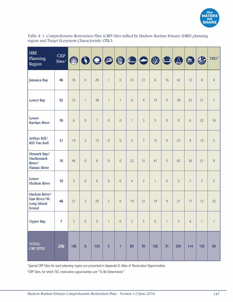
Table 4-1. Comprehensive Restoration Plan (CRP) Sites tallied by Hudson-Raritan Estuary (HRE) planning region and Target Ecosystem Characteristic (TEC).
HRE Planning Region
CRP Sites
1
TBD
2
Jamaica Bay 46 35 0 28 1 0 23 21 6 16 42 12 8 4
Lower Bay 52 33 1 38 1 1 6 4 15 0 38 23 21 7
Lower Raritan River
26 6 0 7 0 0 1 3 5 0 9 6 22 16
Arthur Kill/ Kill Van Kull
31 19 2 15 0 0 5 7 15 0 23 9 15 5
Newark Bay/ Hackensack River/Passaic River
76 46 0 6 0 0 22 31 41 5 62 36 21 9
Lower Hudson River
10 3 0 6 0 0 4 3 1 0 5 7 2 2
Harlem River/East River/W.Long Island Sound
48 21 3 20 2 0 19 21 19 9 21 17 12 25
Upper Bay 7 3 0 0 1 0 3 5 0 1 5 4 1 1
TOTAL CRP SITES 296 166 6 120 5 1 83 95 102 31 205 114 102 69
1Special CRP Sites for each planning region are presented in Appendix D: Atlas of Restoration Opportunities.2CRP Sites, for which TEC restoration opportunities are “To Be Determined.”
147Hudson-Raritan Estuary Comprehensive Restoration Plan - Version 1.0 June 2016
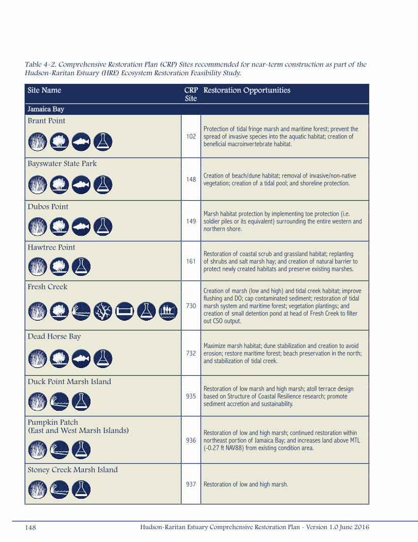
Table 4-2. Comprehensive Restoration Plan (CRP) Sites recommended for near-term construction as part of the Hudson-Raritan Estuary (HRE) Ecosystem Restoration Feasibility Study.
Site Name CRPSite
Restoration Opportunities
Jamaica Bay
Brant Point
102Protection of tidal fringe marsh and maritime forest; prevent the spread of invasive species into the aquatic habitat; creation of beneficial macroinvertebrate habitat.
Bayswater State Park
148 Creation of beach/dune habitat; removal of invasive/non-native vegetation; creation of a tidal pool; and shoreline protection.
Dubos Point
149Marsh habitat protection by implementing toe protection (i.e. soldier piles or its equivalent) surrounding the entire western and northern shore.
Hawtree Point
161Restoration of coastal scrub and grassland habitat; replanting of shrubs and salt marsh hay; and creation of natural barrier to protect newly created habitats and preserve existing marshes.
Fresh Creek
730
Creation of marsh (low and high) and tidal creek habitat; improve flushing and DO; cap contaminated sediment; restoration of tidal marsh system and maritime forest; vegetation plantings; and creation of small detention pond at head of Fresh Creek to filter out CSO output.
Dead Horse Bay
732Maximize marsh habitat; dune stabilization and creation to avoid erosion; restore maritime forest; beach preservation in the north; and stabilization of tidal creek.
Duck Point Marsh Island
935Restoration of low marsh and high marsh; atoll terrace design based on Structure of Coastal Resilience research; promote sediment accretion and sustainability.
Pumpkin Patch (East and West Marsh Islands)
936Restoration of low and high marsh; continued restoration within northeast portion of Jamaica Bay; and increases land above MTL (-0.27 ft NAV88) from existing condition area.
Stoney Creek Marsh Island
937 Restoration of low and high marsh.
148 Hudson-Raritan Estuary Comprehensive Restoration Plan - Version 1.0 June 2016

Table 4-2 (Cont’d). Comprehensive Restoration Plan (CRP) Sites recommended for near-term construction as part of the Hudson-Raritan Estuary (HRE) Ecosystem Restoration Feasibility Study.
Site Name CRP Site
Restoration Opportunities
Elders Center Marsh Island
939 Restoration of low and high marsh; improves sustainability of Elders Marsh complex; and potential area for natural sediment deposition and accretion.
Jamaica Bay
- Restoration of oyster reefs using: oyster beds (shells, gravel, porcelain) and hanging trays/super trays.
Lower Bay
Naval Weapons Station Earle
- Restoration of oyster reefs using: spat on shell, gabion blocks, and reef balls; builds on past success of NY//NJ Baykeeper.
Newark Bay, Hackensack River, and Passaic RiverMeadowlark Marsh
719Re-establishment of wetlands; invasive species removal and native species plantings; restoration/creation of maritime forest habitat; restore existing mudflats/tidal channels and interior marsh.
Metromedia Tract
721Reconnect fragmented areas; introduce new tidal channels and improve existing channels; creation of low marsh, high marsh, scrub-shrub, and maritime upland.
Deferred Site: Kearny Point
865Re-establishment low marsh; new marsh creation; debris and invasive vegetation removal; native plantings; creation of new tidal channels; public overlook; and deepening and/or capping of contaminated sediment.
Deferred Site: Oak Island Yards
866
Restoration and creation of low marsh; creation of tidal channels; debris and invasive vegetation removal; regrading and planting of native vegeta-tion; habitat connectivity along new mudflats/tidal channels; oyster reef habitat; improved public access to water; and deepening and/or capping of contaminated sediment.
Essex County Branch Brook Park
887
Invasive plant removal and planting; channel dredging to restore freshwa-ter stream and floodplain; debris removal and erosion control on banks/shorelines with stormwater control; and support to ongoing public access projects.
Dundee Island Park
900 Debris removal; natural bank vegetation preservation; bank stabilization and shoreline softening; restoration of riparian vegetation.
149Hudson-Raritan Estuary Comprehensive Restoration Plan - Version 1.0 June 2016

Table 4-2 (Cont’d). Comprehensive Restoration Plan (CRP) Sites recommended for near-term construction as part of the Hudson-Raritan Estuary (HRE) Ecosystem Restoration Feasibility Study.
Site Name CRPSite
Restoration Opportunities
Clifton Dundee Canal Green Acres Purchase and Dundee Island Preserve
902
Debris and invasive vegetation removal; regrading and planting of native emergent wetland; planting with native trees and shrubs for waterbird habitat creation; restoration/stabilization of riparian forest; reconnecting riparian buffers and floodplains to the estuary; shallow water habitat improvement; and installation of sediment basin to treat stormwater runoff.
Harlem River, East River, and Western Long Island Sound
Shoelace Park (233rd to 211th Street)
113
Restoration of Bronx River reach to pre-industrialization conditions; channel modification with instream structures; bank stabilization; select native plantings; sediment load reduction; and public access to the river.
Flushing Creek
188Restoration of open water; regrade existing common reed-domi-nated areas to create low salt marsh; and preserve existing upland forest.
Bronxville Lake (1 Garrett Ave, Tuckahoe)
851
Native planting of upland trees and shrubs; riprap forebay upstream of lake; channel bed restoration; creation of emergent wetlands forested scrub/shrub wetlands; modification of existing rock weir to facilitate fish passage; removal of invasive vegetation; sediment load reduction; and improved public access to water.
Crestwood Lake
852
Native planting of upland trees and shrubs; invasive species removal; construction of two riprap forebays with access roads; channel realignment; creation of emergent wetlands; modification of existing rock weir to facilitate fish passage; and improved public access.
Westchester County Center
854
Channel modification, excavation and replacement of bed material; creation of emergent wetlands; construction of in-stream sediment basins and channel plugs; planting of upland trees and shrubs; removal of invasive vegetation; and bank stabilization.
River Park/West Farm Rapids Park (North of 180th to 177th Street)
860
Creation of woodland area; shoreline softening; creation of emergent wetlands; river bed restoration between the dam and 180th Street; removal of invasive species; replacement with native upland shrubs and herbaceous vegetation; debris removal; and improved public access.
150 Hudson-Raritan Estuary Comprehensive Restoration Plan - Version 1.0 June 2016
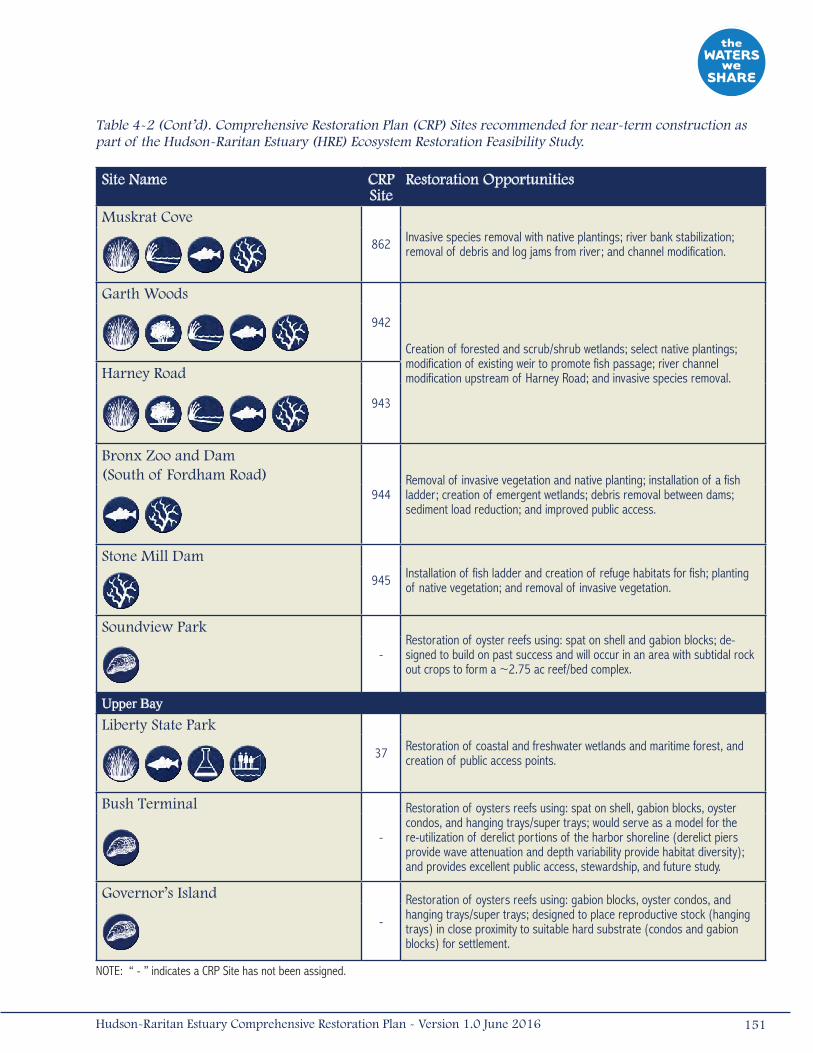
Table 4-2 (Cont’d). Comprehensive Restoration Plan (CRP) Sites recommended for near-term construction as part of the Hudson-Raritan Estuary (HRE) Ecosystem Restoration Feasibility Study.
Site Name CRP Site
Restoration Opportunities
Muskrat Cove
862 Invasive species removal with native plantings; river bank stabilization; removal of debris and log jams from river; and channel modification.
Garth Woods
942
Creation of forested and scrub/shrub wetlands; select native plantings; modification of existing weir to promote fish passage; river channel modification upstream of Harney Road; and invasive species removal.
Harney Road
943
Bronx Zoo and Dam (South of Fordham Road)
944Removal of invasive vegetation and native planting; installation of a fish ladder; creation of emergent wetlands; debris removal between dams; sediment load reduction; and improved public access.
Stone Mill Dam
945 Installation of fish ladder and creation of refuge habitats for fish; planting of native vegetation; and removal of invasive vegetation.
Soundview Park
-Restoration of oyster reefs using: spat on shell and gabion blocks; de-signed to build on past success and will occur in an area with subtidal rock out crops to form a ~2.75 ac reef/bed complex.
Upper BayLiberty State Park
37 Restoration of coastal and freshwater wetlands and maritime forest, and creation of public access points.
Bush Terminal
-
Restoration of oysters reefs using: spat on shell, gabion blocks, oyster condos, and hanging trays/super trays; would serve as a model for the re-utilization of derelict portions of the harbor shoreline (derelict piers provide wave attenuation and depth variability provide habitat diversity); and provides excellent public access, stewardship, and future study.
Governor’s Island
-
Restoration of oysters reefs using: gabion blocks, oyster condos, and hanging trays/super trays; designed to place reproductive stock (hanging trays) in close proximity to suitable hard substrate (condos and gabion blocks) for settlement.
NOTE: “ - ” indicates a CRP Site has not been assigned.
151Hudson-Raritan Estuary Comprehensive Restoration Plan - Version 1.0 June 2016
4.1 Jamaica BayThe Jamaica Bay Planning Region has tremendous potential for the creation and restoration of a variety of habitats, including
wetlands, oyster reefs, eelgrass beds, islands for waterbirds, and coastal and maritime forests. Centered by a national park,
Jamaica Bay includes a complex of shallow littoral and intertidal areas as well as marine habitats that offer the potential for
aquatic and wetland habitat improvements. Upland restoration opportunities include improvements to island habitats and
coastal and maritime forests. In this region, there is potential to reduce the effects of human disturbance by improving water
and sediment quality in former tidal creeks that are now enclosed basins and in the bathymetric depressions that experience
seasonal hypoxic conditions. Forty-six (46) CRP Sites are within the Jamaica Bay Planning Region; 8 sites have been
identified for both acquisition and restoration and 38 have been identified solely for restoration (Table 4-1; Map 4-1).
In the last several years, the Jamaica Bay Planning Region has been the subject of many restoration projects such as pilot
projects for eelgrass and oyster bed establishment and the restoration of approximately 160 acres (0.65 kilometers2) of
marsh island habitat (see spotlight project: Jamaica Bay Marsh Islands). Jamaica Bay has also benefited from improved
coordination resulting from the creation of Science and Resiliency Institute at Jamaica Bay. However, there are still significant
opportunities to increase and improve habitat throughout Jamaica Bay, and 32 of the CRP Sites within this planning region
have identified opportunities for coastal wetland restoration and creation. Many of these sites are marshes within the main
body of Jamaica Bay. Some of the restoration opportunities located to the east of the main bay include marshes in Idlewild
Park (Brookville) (#105), Hook Creek (#601), and Thurston Basin (#634). Others, located along former tidal creeks to the
west and north of the main bay, include Hendrix Creek (#168) and Mill Basin (#200).
Idlewild Park (#105) is a complex of nearly 200 acres (0.81 kilometers2) of wetlands located at the headwaters of Jamaica
Bay, containing the largest expanse of high-quality salt marshes that are among the best opportunities to address marsh
retreat in the face of sea level rise. Restoration opportunities at this site include restoration of approximately 18 acres (0.07
kilometers2) of coastal wetlands and approximately 8 acres (0.03 kilometers2) of maritime forest as a result of the beneficial
use of dredged material. Additional restoration opportunities include improving tributary connections and regrading creeks
to restore hydrology.
Mill Basin (#200), located along tidal creeks to the west of the main bay, includes: 1 acre (0.004 kilometers2) of fringe
wetlands and mudflats; softening of approximately 950 feet (290 meters) of shoreline; improvements to the intertidal area;
potential placement of complex structures along approximately 1 acre (0.004 kilometers2) of existing habitat; 4 acres (0.02
kilometers2) of maritime shrubs and dunes; and bathymetric re-contouring of 2,500 feet (762 meters) of the channel. This
project would complement the wetland restoration efforts completed at Four Sparrow Marsh, which consisted of several
restoration components including 3 acres (0.01 kilometers2) of salt marsh restoration, 1 acre (0.004 kilometers2) of
adjacent woodlands and restoration of tidal flow to previously filled areas (NYCDPR 2014).
Restoration opportunities at Paerdegat Basin (#731), White Island, and Marine Park are Action Agenda Projects listed in the
Vision 2020: NYC CWP. Between 2007 and 2010, the NYCDEP completed several coastal wetland restoration projects that
included fill removal and plantings in Paerdegat Basin. Additional opportunities at Paerdegat Basin (#731) include potential
stream daylighting of Paerdegat Creek, regrading of approximately 6,500 feet (1,981 meters) of the basin to improve water
quality and tidal circulation, and potential remediation of contaminated sediments.
152 Hudson-Raritan Estuary Comprehensive Restoration Plan - Version 1.0 June 2016
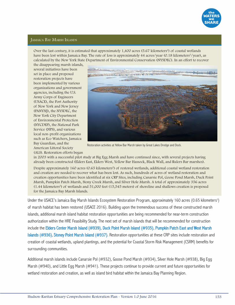
Jamaica Bay marsh islands
Over the last century, it is estimated that approximately 1,400 acres (5.67 kilometers2) of coastal wetlands have been lost within Jamaica Bay. The rate of loss is approximately 44 acres/year (0.18 kilometers2/year), as calculated by the New York State Department of Environmental Conservation (NYSDEC). In an effort to recover the disappearing marsh islands, several initiatives have been set in place and proposed restoration projects have been implemented by various organizations and government agencies, including the U.S. Army Corps of Engineers (USACE), the Port Authority of New York and New Jersey (PANYNJ), the NYSDEC, the New York City Department of Environmental Protection (NYCDEP), the National Park Service (NPS), and various local non-profit organizations such as Eco Watchers, Jamaica Bay Guardian, and the American Littoral Society (ALS). Restoration efforts began in 2003 with a successful pilot study at Big Egg Marsh and have continued since, with several projects having already been constructed (Elders East, Elders West, Yellow Bar Hassock, Black Wall, and Rulers Bar marshes).
Despite approximately 160 acres (0.65 kilometers2) of restored wetlands, additional coastal wetland restoration and creation are needed to recover what has been lost. As such, hundreds of acres of wetland restoration and creation opportunities have been identified at six CRP Sites, including Canarsie Pol, Goose Pond Marsh, Duck Point Marsh, Pumpkin Patch Marsh, Stony Creek Marsh, and Silver Hole Marsh. A total of approximately 356 acres (1.44 kilometers2) of wetlands and 51,000 feet (15,545 meters) of shoreline and shallows creation is proposed for the Jamaica Bay Marsh Islands.
Restoration activities at Yellow Bar Marsh taken by Great Lakes Dredge and Dock.
Under the USACE’s Jamaica Bay Marsh Islands Ecosystem Restoration Program, approximately 160 acres (0.65 kilometers2)
of marsh habitat has been restored (USACE 2016). Building upon the tremendous success of these constructed marsh
islands, additional marsh island habitat restoration opportunities are being recommended for near-term construction
authorization within the HRE Feasibility Study. The next set of marsh islands that will be recommended for construction
include the Elders Center Marsh Island (#939), Duck Point Marsh Island (#935), Pumpkin Patch East and West Marsh
Islands (#936), Stoney Point Marsh Island (#937). Restoration opportunities at these CRP sites include restoration and
creation of coastal wetlands, upland plantings, and the potential for Coastal Storm Risk Management (CSRM) benefits for
surrounding communities.
Additional marsh islands include Canarsie Pol (#932), Goose Pond Marsh (#934), Silver Hole Marsh (#938), Big Egg
Marsh (#940), and Little Egg Marsh (#941). These projects continue to provide current and future opportunities for
wetland restoration and creation, as well as island bird habitat within the Jamaica Bay Planning Region.
153Hudson-Raritan Estuary Comprehensive Restoration Plan - Version 1.0 June 2016
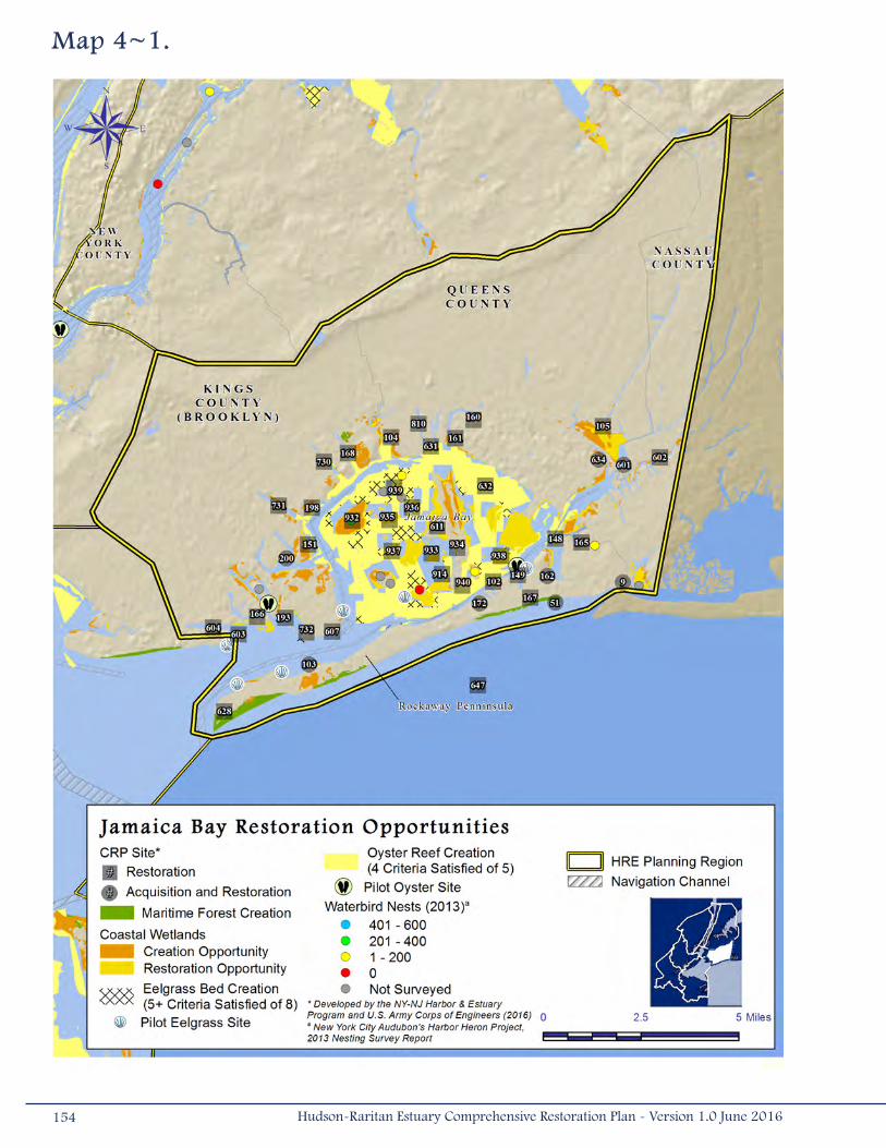
Map 4~1.
154 Hudson-Raritan Estuary Comprehensive Restoration Plan - Version 1.0 June 2016

Jamaica Bay also appears to be one of the most suitable regions for oyster and eelgrass restoration projects within the HRE
study area. Most of the open waters of Jamaica Bay meet some of the habitat requirements of eelgrass, oysters, and oyster
larvae. Although eelgrass restoration has not been identified at the Jamaica Bay CRP Sites and only three sites are identified
for oyster restoration, there is potential to include an oyster restoration component or eelgrass restoration component to
create multi-TEC habitat complexes suitable for fish, shellfish, and crustaceans (i.e., Fish, Crabs, and Lobsters TEC). The HRE
Feasibility Study plans to recommend an oyster reef restoration project within Jamaica Bay, expanding NYCDEP’s current
pilot project.
The NYC CWP lists two Action Agenda Projects within the Jamaica Bay Planning Region: a ribbed mussel pilot study and
an eelgrass restoration project. The ribbed mussel pilot, located within Fresh Creek, was initiated by NYCDEP to evaluate
the potential for ribbed mussels to improve water quality within Jamaica Bay. Fresh Creek (#730) involves 93 acres (0.38
kilometers2) of coastal wetland restoration, maritime forest and shrubland creation, restoration of shallow water habitats,
and recontouring of the basin at the mouth of Fresh Creek to improve circulation and decrease the depths of a borrow pit
located at the southern portion of the creek.
The eelgrass restoration project was initiated to improve the ecology and water quality of Jamaica Bay. As part of the project,
a pilot study was launched at Breezy Point involving the planting of 3,000 eelgrass plants. The initial planting effort was
conducted in 2009 and an additional 8,000 plants were planted and monitored in subsequent years as part of the on going
effort. Eelgrass in Jamaica Bay continues to experience significant environmental and physical stress, and although the pilot
study did not establish a sustainable eelgrass community, it provided a learning opportunity for the overall conditions within the
bay. Continued evaluation of the restoration sites will determine the long-term success of the study and feasibility for eelgrass
restoration in Jamaica Bay (NYCDEP 2012). The pilot study is proximate to the Breezy Point CRP Site (#103). Restoration
opportunities at Breezy Point include approximately 25 acres (0.10 kilometers2) of beach and dune habitat for shorebirds and
wildlife; removal of debris and existing bulkhead along approximately 5,700 feet (1,737 meters) of shoreline; and sediment
analysis. The proximity of Action Agenda pilot studies to the CRP sites demonstrates that opportunities to incorporate or pair
oyster and eelgrass restoration components with CRP Sites are present within the Jamaica Bay Planning Region.
A relatively rare opportunity to establish maritime forest communities within the HRE study area appears to be possible in the
Jamaica Bay Planning Region (Figure 4-1). Breezy Point (#103) and other areas along the Rockaway barrier beach could
provide these opportunities. The restoration opportunity at Plumb Beach (#603) was listed as an Action Agenda Project in
the NYC CWP and was completed in November 2012. The restoration involved the beneficial use of sand dredged from the
NY/NJ Harbor Deepening Project to restore vegetated dunes and sand berms, and marine habitat improvement. The sand
was placed on-site days before Hurricane Sandy hit the region, which provided critical protection to the Belt Parkway and
NYCDPR infrastructure.
Many of the CRP Sites identify the possibility for maritime forest or other coastal community restoration on uplands adjacent
to coastal wetland opportunities. This type of habitat also serves as an important NNBF providing both ecosystem benefits
and CSRM benefits to the surrounding communities. Example sites that include both coastal wetlands and associated upland
155Hudson-Raritan Estuary Comprehensive Restoration Plan - Version 1.0 June 2016
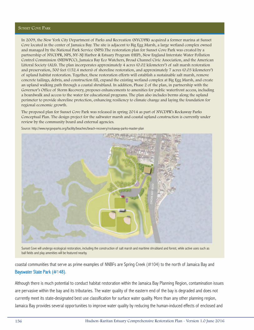
sunset cove Park
In 2009, the New York City Department of Parks and Recreation (NYCDPR) acquired a former marina at Sunset Cove located in the center of Jamaica Bay. The site is adjacent to Big Egg Marsh, a large wetland complex owned and managed by the National Park Service (NPS).The restoration plan for Sunset Cove Park was created by a partnership of NYCDPR, NPS, NY-NJ Harbor & Estuary Program (HEP), New England Interstate Water Pollution Control Commission (NEIWPCC), Jamaica Bay Eco Watchers, Broad Channel Civic Association, and the American Littoral Society (ALS). The plan incorporates approximately 4 acres (0.02 kilometers2) of salt marsh restoration and preservation, 500 feet (152.4 meters) of shoreline restoration, and approximately 7 acres (0.03 kilometers2) of upland habitat restoration. Together, these restoration efforts will establish a sustainable salt marsh, remove concrete tailings, debris, and construction fill, expand the existing wetland complex at Big Egg Marsh, and create an upland walking path through a coastal shrubland. In addition, Phase 2 of the plan, in partnership with the Governor’s Office of Storm Recovery, proposes enhancements to amenities for public waterfront access, including a boardwalk and access to the water for educational programs. The plan also includes berms along the upland perimeter to provide shoreline protection, enhancing resiliency to climate change and laying the foundation for regional economic growth.
The proposed plan for Sunset Cove Park was released in spring 2014 as part of NYCDPR’s Rockaway Parks Conceptual Plan. The design project for the saltwater marsh and coastal upland construction is currently under review by the community board and external agencies.
Source: http://www.nycgovparks.org/facility/beaches/beach-recovery/rockaway-parks-master-plan
Sunset Cove will undergo ecological restoration, including the construction of salt marsh and maritime shrubland and forest, while active uses such as ball fields and play amenities will be featured nearby.
coastal communities that serve as prime examples of NNBFs are Spring Creek (#104) to the north of Jamaica Bay and
Bayswater State Park (#148).
Although there is much potential to conduct habitat restoration within the Jamaica Bay Planning Region, contamination issues
are pervasive within the bay and its tributaries. The water quality of the eastern end of the bay is degraded and does not
currently meet its state-designated best use classification for surface water quality. More than any other planning region,
Jamaica Bay provides several opportunities to improve water quality by reducing the human-induced effects of enclosed and
156 Hudson-Raritan Estuary Comprehensive Restoration Plan - Version 1.0 June 2016
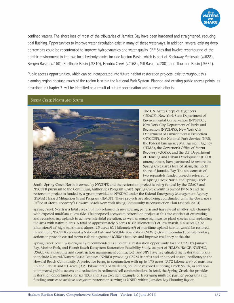
confined waters. The shorelines of most of the tributaries of Jamaica Bay have been hardened and straightened, reducing
tidal flushing. Opportunities to improve water circulation exist in many of these waterways. In addition, several existing deep
borrow pits could be recontoured to improve hydrodynamics and water quality. CRP Sites that involve recontouring of the
benthic environment to improve local hydrodynamics include Norton Basin, which is part of Rockaway Peninsula (#628),
Bergen Basin (#160), Shellbank Basin (#810), Hendrix Creek (#168), Mill Basin (#200), and Thurston Basin (#634).
Public access opportunities, which can be incorporated into future habitat restoration projects, exist throughout this
planning region because much of the region is within the National Park System. Planned and existing public access points, as
described in Chapter 3, will be identified as a result of future coordination and outreach efforts.
sPring creek north and south
The U.S. Army Corps of Engineers (USACE), New York State Department of Environmental Conservation (NYSDEC), New York City Department of Parks and Recreation (NYCDPR), New York City Department of Environmental Protection (NYCDEP), the National Park Service (NPS), the Federal Emergency Management Agency (FEMA), the Governor’s Office of Storm Recovery (GOSR), and the U.S. Department of Housing and Urban Development (HUD), among others, have partnered to restore the Spring Creek area located along the north shore of Jamaica Bay. The site consists of two separately funded projects referred to as Spring Creek North and Spring Creek
South. Spring Creek North is owned by NYCDPR and the restoration project is being funded by the USACE and NYCDPR pursuant to the Continuing Authorities Program (CAP). Spring Creek South is owned by NPS and the restoration project is funded by a grant provided to NYSDEC under the Federal Emergency Management Agency (FEMA) Hazard Mitigation Grant Program (HMGP). These projects are also being coordinated with the Governor’s Office of Storm Recovery’s Howard Beach New York Rising Community Reconstruction Plan (March 2014).
Spring Creek North is a tidal creek that has retained its meandering pattern and has several smaller side channels with exposed mudflats at low tide. The proposed ecosystem restoration project at this site consists of excavating and recontouring uplands to achieve intertidal elevation, as well as removing invasive plant species and replanting the area with native plants. A total of approximately 8 acres (0.03 kilometers2) of low marsh, 5.5 acres (0.02 kilometers2) of high marsh, and almost 25 acres (0.1 kilometers2) of maritime upland habitat would be restored. In addition, NYCDPR received a National Fish and Wildlife Foundation (NFWF) Grant to conduct complementary actions to provide coastal storm risk management (CSRM) features and improve resiliency at the site.
Spring Creek South was originally recommended as a potential restoration opportunity for the USACE’s Jamaica Bay, Marine Park, and Plumb Beach Ecosystem Restoration Feasibility Study. As part of FEMA’s HMGP, NYSDEC, USACE (as a planning and construction management contractor), and NPS have reevaluated the restoration plans to include Natural/Nature Based Features (NNBFs) providing CSRM benefits and enhanced coastal resiliency to the Howard Beach Community. A protective berm, in conjunction with up to 178 acres (0.72 kilometers2) of maritime upland habitat and 51 acres (0.21 kilometers2) of wetlands, could be restored at Spring Creek South, in addition to improved public access and reduction in sediment/soil contamination. In total, the Spring Creek site provides restoration opportunities for six TECs and is an excellent example of leveraging multiple partner programs and funding sources to achieve ecosystem restoration serving as NNBFs within Jamaica Bay Planning Region.
157Hudson-Raritan Estuary Comprehensive Restoration Plan - Version 1.0 June 2016
4.2 Lower BaySimilar to Jamaica Bay, the Lower Bay Planning Region appears to be suitable for the restoration of a variety of habitats,
including oyster reefs, wetlands, eelgrass beds, and coastal and maritime forests. The extensive shallow littoral, marine, and
intertidal habitats have the potential to offer numerous opportunities for aquatic habitat restoration along southeastern
Staten Island and southwestern Brooklyn in New York, and Monmouth County, New Jersey. This region also contains coastal
forest restoration opportunities and the potential to reverse the effects of human disturbance. Fifty-two (52) of the CRP
Sites are within the Lower Bay Planning Region; 20 sites have been identified for both acquisition and restoration, 31 have
been identified for restoration only, and 1 has been identified as acquisition (Table 4-1; Map 4-2).
Large expanses of the Lower Bay meet many of the physical and water quality properties to support the growth of oysters.
Oyster restoration projects previously identified in Lower Bay included Matawan Creek/Keyport Harbor (#802), Raritan Bay
(Oyster Bed Restoration) (#594), and various other sites in New Jersey. Currently, however, only one oyster restoration
project is being conducted in New Jersey, at NWS Earle, due to concerns that oysters from contaminated waters would
enter the human food chain. In late 2012 however, the NY/NJ Baykeeper was granted permits to conduct oyster research
and restoration within a 10-acre (0.04-kilometers2) area at NWS Earle since public access to these waters is restricted and
poaching is unlikely. The expansion of the oyster reef at NWS Earle is being evaluated through the HRE Feasibility Study (see
spotlight project: Oyster Restoration and Research Partnership). In January 2016, the Governor of New Jersey passed bill
S2617, requiring NJDEP to revisit existing Shellfish Rules within one year after adoption to provide additional research and
restoration opportunities based on public comments.
Many areas within the Lower Bay Planning Region meet several of the habitat requirements of eelgrass beds. Historically,
eelgrass beds were found throughout this planning region, but currently only anecdotal reports of remnant beds exist in the
tidal rivers of the Shrewsbury River Watershed. Two (2) CRP Sites (Shrewsbury River Watershed [#118] and Shrewsbury/
Navesink Rivers [#591]) are located in the Shrewsbury and Navesink Rivers. Currently, eelgrass restoration is not proposed
as part of these projects; however, opportunities at the Shrewsbury and Navesink River sites are still under evaluation and
eelgrass restoration could be a restoration component based upon future findings. Only one CRP Site (Mt. Loretto [#800])
currently contains opportunities to explore the presence/absence of eelgrass and the potential to develop an eelgrass
community.
Substantial coastal wetland creation and restoration opportunities exist along the shorelines of numerous tidal creeks and
rivers, harbors, and protected coastlines of Lower Bay. Thirty-four (34) of the CRP Sites in this planning region include plans
for coastal wetland restoration.
Due to the variety of aquatic and intertidal habitat types that could be restored in the Lower Bay Planning Region, there is
potential to restore habitat complexes to support target fish, crustacean, and shellfish species. There are also opportunities
to create two or more complementary habitat types or to restore complementary habitats adjacent to existing wetlands. For
example, there are many possibilities for the restoration of oyster or other shellfish beds near coastal wetland restoration
opportunities, and in some areas, it may also be possible to incorporate eelgrass restoration into the project. The
incorporation of a rock reef or other structural features into other aquatic restoration plans can also increase the benefits
of the project. These types of structural features are included in CRP Site plans for Raritan Bay (Submerged Rock Bed
158 Hudson-Raritan Estuary Comprehensive Restoration Plan - Version 1.0 June 2016
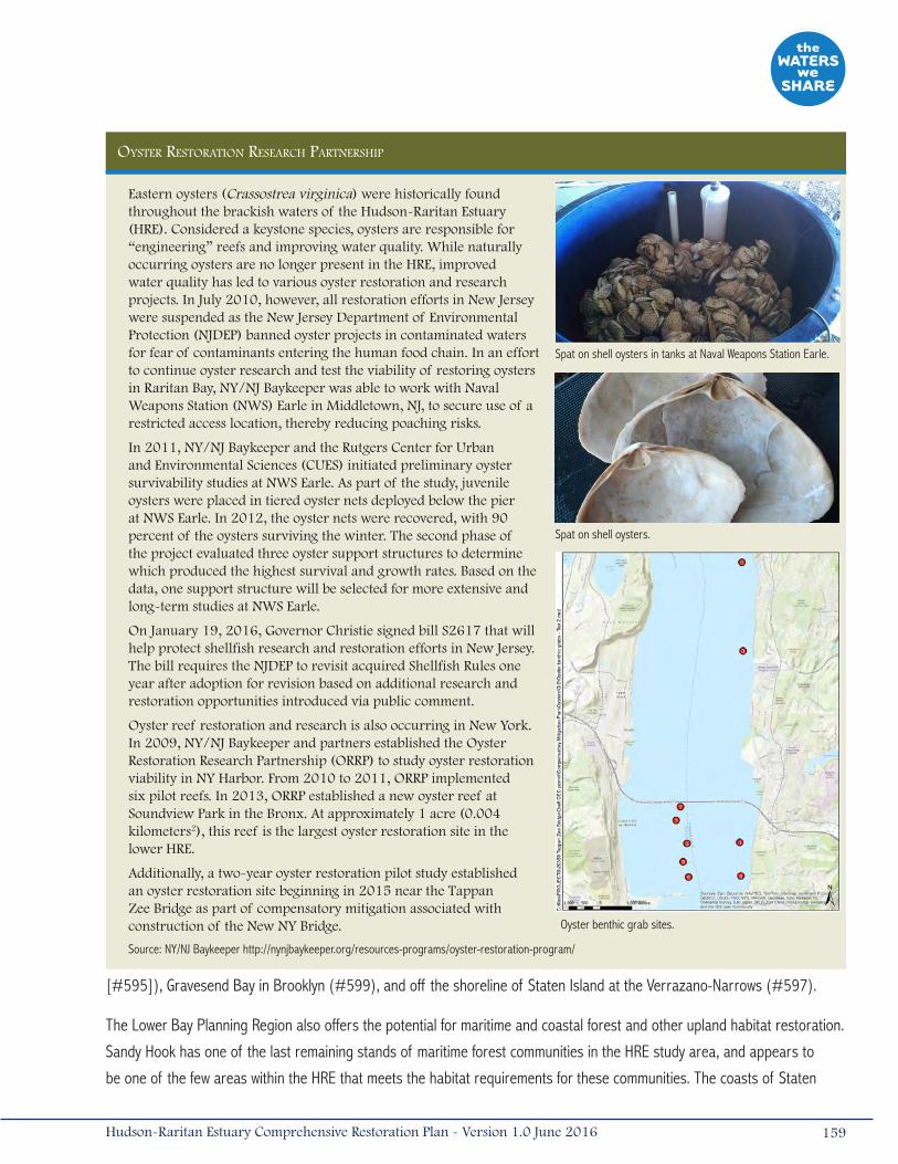
oyster restoration research PartnershiP
Eastern oysters (Crassostrea virginica) were historically found throughout the brackish waters of the Hudson-Raritan Estuary (HRE). Considered a keystone species, oysters are responsible for “engineering” reefs and improving water quality. While naturally occurring oysters are no longer present in the HRE, improved water quality has led to various oyster restoration and research projects. In July 2010, however, all restoration efforts in New Jersey were suspended as the New Jersey Department of Environmental Protection (NJDEP) banned oyster projects in contaminated waters for fear of contaminants entering the human food chain. In an effort to continue oyster research and test the viability of restoring oysters in Raritan Bay, NY/NJ Baykeeper was able to work with Naval Weapons Station (NWS) Earle in Middletown, NJ, to secure use of a restricted access location, thereby reducing poaching risks.
In 2011, NY/NJ Baykeeper and the Rutgers Center for Urban and Environmental Sciences (CUES) initiated preliminary oyster survivability studies at NWS Earle. As part of the study, juvenile oysters were placed in tiered oyster nets deployed below the pier at NWS Earle. In 2012, the oyster nets were recovered, with 90 percent of the oysters surviving the winter. The second phase of the project evaluated three oyster support structures to determine which produced the highest survival and growth rates. Based on the data, one support structure will be selected for more extensive and long-term studies at NWS Earle.
On January 19, 2016, Governor Christie signed bill S2617 that will help protect shellfish research and restoration efforts in New Jersey. The bill requires the NJDEP to revisit acquired Shellfish Rules one year after adoption for revision based on additional research and restoration opportunities introduced via public comment.
Oyster reef restoration and research is also occurring in New York. In 2009, NY/NJ Baykeeper and partners established the Oyster Restoration Research Partnership (ORRP) to study oyster restoration viability in NY Harbor. From 2010 to 2011, ORRP implemented six pilot reefs. In 2013, ORRP established a new oyster reef at Soundview Park in the Bronx. At approximately 1 acre (0.004 kilometers2), this reef is the largest oyster restoration site in the lower HRE.
Additionally, a two-year oyster restoration pilot study established an oyster restoration site beginning in 2015 near the Tappan Zee Bridge as part of compensatory mitigation associated with construction of the New NY Bridge.
Source: NY/NJ Baykeeper http://nynjbaykeeper.org/resources-programs/oyster-restoration-program/
Spat on shell oysters in tanks at Naval Weapons Station Earle.
Spat on shell oysters.
Oyster benthic grab sites.
[#595]), Gravesend Bay in Brooklyn (#599), and off the shoreline of Staten Island at the Verrazano-Narrows (#597).
The Lower Bay Planning Region also offers the potential for maritime and coastal forest and other upland habitat restoration.
Sandy Hook has one of the last remaining stands of maritime forest communities in the HRE study area, and appears to
be one of the few areas within the HRE that meets the habitat requirements for these communities. The coasts of Staten
159Hudson-Raritan Estuary Comprehensive Restoration Plan - Version 1.0 June 2016
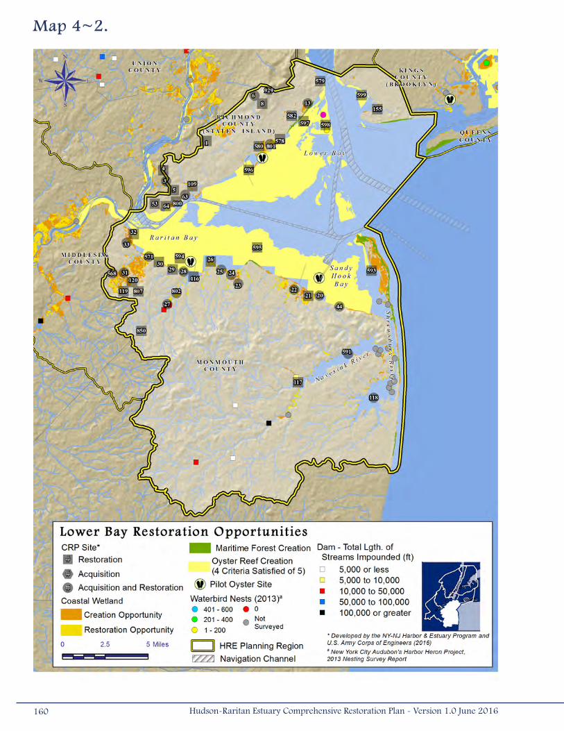
Map 4~2.
160 Hudson-Raritan Estuary Comprehensive Restoration Plan - Version 1.0 June 2016
Island and Brooklyn within the Lower Bay Planning Region also appear to meet the habitat requirements for maritime
forest communities. CRP Sites within this planning region that include plans for the restoration of coastal forest and upland
communities are located on the shoreline of Raritan Bay (Treasure Lake [#28], Marquis Creek [#30], Old Morgan Landfill/
Raritan Bay Waterfront Park [#32], and South Amboy [#33]), near Cheesequake Creek in Monmouth County, New Jersey
(Global Landfill [#568]), and on Staten Island, New York (Fort Wadsworth Beach [#579], Crookes Point [#596], and Great
Kills Park [#801]).
Restoration opportunities at Oakwood Beach (#578) offer the potential to provide CSRM benefits to surrounding
communities and coordination with the Sandy South Shore Island project. Over the past 40-50 years, the shoreline has been
subjected to significant erosion and major storm damage, including flood damage and loss of property. NY Rising’s Enhanced
Buyout Program, which sponsors “buy-outs” of property located in sections of Staten Island’s East Shore floodplain, will
result in restoration opportunities for Oakwood Beach communities. In addition to coastal wetland restoration that would
reduce stormwater damage, invasive species removal will also occur at this CRP Site.
Fish passage in the Lower Bay Planning Region could be improved on several tidal rivers impacted by dams, improper
culverts, or antiquated tide gates. Several CRP Sites include plans to improve the ability of anadromous fish to swim to
upstream spawning areas. These sites include projects such as the installation of a fish ladder at Shadow Lake Dam (#117),
and the removal of low-head dams on the Shrewsbury River that would allow for upstream movement of the American eel
(#118). An additional opportunity, installation of a fish passage structure on the Swimming River Reservoir dam on Robins
Swamp Brook (a tributary to the Navesink River), would provide anadromous fish access to more than 170,000 feet (51,816
meters) of upstream habitat.
Other identified restoration opportunities in this planning region include habitat improvements for the waterbirds on
Hoffman-Swinburne Islands (#598) and the restoration of freshwater wetlands near the shore of Raritan Bay (#28 and
#33). Shoreline softening opportunities have also been identified in Staten Island (#801), the Shrewsbury River (#118),
Natco Lake and Thorns Creek in Monmouth County (#23), and the Navesink River in Redbank, New Jersey. The shoreline
softening opportunity along the Navesink River involves replacing debilitated bulkheads at several municipal properties with
living shorelines. This shoreline project is being spearheaded by American Littoral Society (ALS), which has collaborated with
NOAA to secure project funds though Hurricane Sandy grants. Stevens Institute of Technology assisted ALS by designing the
living shoreline.
Many of the habitat creation and improvement opportunities described above, including the living shoreline project proposed
along the Navesink River in Redbank, will offer the potential to incorporate a public access component or to improve an
existing access point. Planned and existing public access points, as described in Chapter 3, will be identified as a result of
future coordination and outreach efforts.
It is important to note that although the Lower Bay Planning Region offers abundant habitat restoration opportunities, the
region also has extensive contamination issues. The sediments of Raritan Bay, and to a lesser extent Sandy Hook Bay and
Lower Bay, contain relatively high concentrations of DDT, PCBs, dioxins, and furans when compared to other areas in the HRE.
161Hudson-Raritan Estuary Comprehensive Restoration Plan - Version 1.0 June 2016
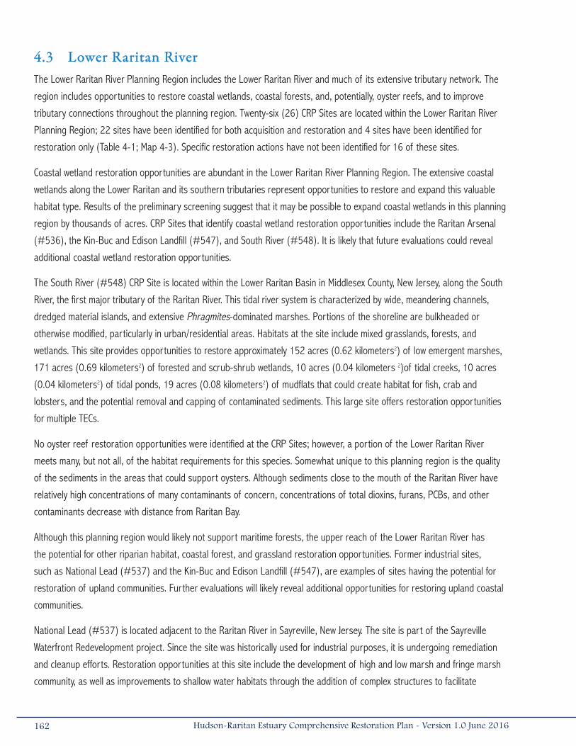
4.3 Lower Raritan RiverThe Lower Raritan River Planning Region includes the Lower Raritan River and much of its extensive tributary network. The
region includes opportunities to restore coastal wetlands, coastal forests, and, potentially, oyster reefs, and to improve
tributary connections throughout the planning region. Twenty-six (26) CRP Sites are located within the Lower Raritan River
Planning Region; 22 sites have been identified for both acquisition and restoration and 4 sites have been identified for
restoration only (Table 4-1; Map 4-3). Specific restoration actions have not been identified for 16 of these sites.
Coastal wetland restoration opportunities are abundant in the Lower Raritan River Planning Region. The extensive coastal
wetlands along the Lower Raritan and its southern tributaries represent opportunities to restore and expand this valuable
habitat type. Results of the preliminary screening suggest that it may be possible to expand coastal wetlands in this planning
region by thousands of acres. CRP Sites that identify coastal wetland restoration opportunities include the Raritan Arsenal
(#536), the Kin-Buc and Edison Landfill (#547), and South River (#548). It is likely that future evaluations could reveal
additional coastal wetland restoration opportunities.
The South River (#548) CRP Site is located within the Lower Raritan Basin in Middlesex County, New Jersey, along the South
River, the first major tributary of the Raritan River. This tidal river system is characterized by wide, meandering channels,
dredged material islands, and extensive Phragmites-dominated marshes. Portions of the shoreline are bulkheaded or
otherwise modified, particularly in urban/residential areas. Habitats at the site include mixed grasslands, forests, and
wetlands. This site provides opportunities to restore approximately 152 acres (0.62 kilometers2) of low emergent marshes,
171 acres (0.69 kilometers2) of forested and scrub-shrub wetlands, 10 acres (0.04 kilometers 2)of tidal creeks, 10 acres
(0.04 kilometers2) of tidal ponds, 19 acres (0.08 kilometers2) of mudflats that could create habitat for fish, crab and
lobsters, and the potential removal and capping of contaminated sediments. This large site offers restoration opportunities
for multiple TECs.
No oyster reef restoration opportunities were identified at the CRP Sites; however, a portion of the Lower Raritan River
meets many, but not all, of the habitat requirements for this species. Somewhat unique to this planning region is the quality
of the sediments in the areas that could support oysters. Although sediments close to the mouth of the Raritan River have
relatively high concentrations of many contaminants of concern, concentrations of total dioxins, furans, PCBs, and other
contaminants decrease with distance from Raritan Bay.
Although this planning region would likely not support maritime forests, the upper reach of the Lower Raritan River has
the potential for other riparian habitat, coastal forest, and grassland restoration opportunities. Former industrial sites,
such as National Lead (#537) and the Kin-Buc and Edison Landfill (#547), are examples of sites having the potential for
restoration of upland communities. Further evaluations will likely reveal additional opportunities for restoring upland coastal
communities.
National Lead (#537) is located adjacent to the Raritan River in Sayreville, New Jersey. The site is part of the Sayreville
Waterfront Redevelopment project. Since the site was historically used for industrial purposes, it is undergoing remediation
and cleanup efforts. Restoration opportunities at this site include the development of high and low marsh and fringe marsh
community, as well as improvements to shallow water habitats through the addition of complex structures to facilitate
162 Hudson-Raritan Estuary Comprehensive Restoration Plan - Version 1.0 June 2016

connectivity with the fringe marsh and establish
habitat for fish, crab, and lobsters.
A substantial portion of the upper reaches of the
Lower Raritan River shoreline has been hardened,
which may present restoration opportunities.
Shorelines throughout this planning region should
be evaluated to determine the possibility of
softening the shorelines or incorporating engineered
structures to improve aquatic habitat. Shoreline
and shallows restoration opportunities have been
identified at the Raritan Arsenal site (#536).
There are also several opportunities to improve
fish passage and connect habitats along tributaries
throughout the Lower Raritan River Planning
Region. For example, the installation of fish passage
structures on the Duhernal Dam on the South River
could open over 170,000 feet (51,816 meters) of
stream for fish migration. There are six other dams
in this planning region, each of which may present
the opportunity to open between 20,000 feet (6,096
meters) and 30,000 feet (9,144 meters) of stream
for fish passage. These dams include the Davidsons
Mill Pond Dam, New Markets Pond Dam, Tennets
Brook Dam, the Farrington Dam, Westons Mill Pond
Dam, and Westons Mill Arch Dam.
This planning region represents a substantial
opportunity to bring the public to the waterfront.
Restoration plans within this planning region should
incorporate public access points, such as kayak
and canoe launches, nature trails, interpretational
materials, and picnicking opportunities. Planned and
existing public access points, as described in Chapter
3, will be identified as a result of future coordination
and outreach efforts.
lawrence Brook Fish Passage
In 2011, through a project funded by the New York-New Jersey Harbor & Estuary Program (HEP) in partnership with New England Interstate Water Pollution Control Commission (NEIWPCC), the Lawrence Brook Watershed Partnership (LBWP) began initial investigations into the possibility of fish passage over two obstructions, Westons Mill Pond Dam and Westons Mill Arch Dam. These obstructions on Lawrence Brook, a tributary to the Raritan River, impound a drinking water supply reservoir owned and operated by the City of New Brunswick. While removal was not seen as viable due to their current function, the installation of fish passage over these dams would open up 3 miles (5 kilometers) of habitat to American shad (Alosa sapidissima), blueblack herring (Alosa aestivalis), and American eel (Anguilla rostrata). If passage were also provided on other upstream blockages, an additional 9 miles (14 kilometers) could be added in the future, for a total of 12 miles (19 kilometers). Furthermore, fish passage has also been proposed for inclusion as part of the City of New Brunswick’s developing Municipal Public Access Plan.
Initial fish passage investigations, considering topography, hydrology, safe yield, and habitat, recommended a Denil fish passage structure be considered further. These passage structures are seen as suitable, particularly given the limited space available and desire to provide passage to shad upstream. After the installation of gages and initial readings, LBWP continues to monitor the station for water quality and will be working with partners, including the City of New Brunswick and HEP, to seek opportunities for the next phase of feasibility investigation.
Westons Mill Pond Dam. Photo courtesy of Kate Boicourt.
163Hudson-Raritan Estuary Comprehensive Restoration Plan - Version 1.0 June 2016
Map 4~3.
164 Hudson-Raritan Estuary Comprehensive Restoration Plan - Version 1.0 June 2016

4.4 Arthur Kill and Kill Van KullThe Arthur Kill and Kill Van Kull Planning Region appears to offer substantial opportunities to restore coastal wetlands,
shorelines and shallows, tributary connections, and waterbird habitat. There are large expanses of coastal wetlands along
the tributaries to the Arthur Kill that could benefit from restoration activities, and adjacent areas may be appropriate for
the creation of additional coastal wetland acreage. The islands of this planning region once supported large colonies of
waterbirds, but currently do not support any nesting activities. There are also opportunities within this planning region to
reverse human-induced alterations that have led to habitat degradation. Thirty-one (31) CRP Sites are within the Arthur Kill
and Kill Van Kull Planning Region; 14 sites have been identified for both acquisition and restoration, 16 have been identified
solely for restoration, and 1 has been identified as acquisition (Table 4-1; Map 4-4).
Coastal wetland restoration opportunities are abundant in the Arthur Kill and Kill Van Kull Planning Region. Tidal creeks and
rivers on both the New Jersey and New York sides of the Arthur Kill could benefit from the establishment and expansion of
native salt marsh vegetation. Twenty-one (21) of the CRP Sites include a coastal wetland component, many of which are
located along the Rahway River (e.g., Potter’s Island [#131] and Rahway Riverfront Park [#694]), and smaller tributaries
in Middlesex County, New Jersey (e.g., Morses Creek [#34] and Piles Creek [#35]). The northwest portion of Staten Island
also has several tidal creeks and streams identified as CRP Sites (e.g., Gulfport Marsh [#194] and Graniteville Swamp
Woods [#50]). Additional opportunities may be available for coastal wetland creation and restoration in this planning region.
Since the 1990s, waterbird populations no longer use Pralls Island, Shooters Island, or the Isle of Meadows, which once had
established colonies of waterbirds in the hundreds. These islands represent an opportunity to restore the habitat in an effort
to attract nesting waterbirds again. Current plans on Pralls Island (#101) include restoration of fringe marsh around the
perimeter of the entire island, erosion control, restoration of Phragmites-dominated wetlands, potential removal and capping
of contaminated sediments, restoration of upland forest patches to improve heron habitat, and potential for placement of
complex structures to improve habitat connectivity for fish, crab and lobsters, as well as the removal of fill and placement of
sand and/or shell to promote waterbird nesting throughout the island. Since the site was nominated as a CRP Site, however,
much of the vegetation has been removed in response to an infestation by the Asian longhorned beetle. Restoring the
canopy of tree coverage on Pralls Island is part of NYC MillionTrees Initiative and was funded in part by HEP along with a
study to facilitate restoration of the island as a nesting habitat for long-legged and wading birds.
Restoration plans at Shooters Island (#712) call for the creation of wetlands along the edges of the island and creation
of islands for waterbirds, as well as creation of coastal wetlands and placement of a geotextile tube to control erosion.
Additional opportunities for the site include creation of habitat for fish, crustaceans, and lobsters and potential dredging and
capping of contaminated sediments. Potter’s Island on the Rahway River in Middlesex County, New Jersey (#131) has been
identified as another opportunity to enhance habitat for waterbirds, including egrets and heron. Other islands in this planning
region may provide opportunities for creating and restoring habitat for waterbirds.
165Hudson-Raritan Estuary Comprehensive Restoration Plan - Version 1.0 June 2016
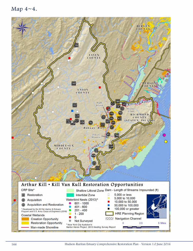
Map 4~4.
166 Hudson-Raritan Estuary Comprehensive Restoration Plan - Version 1.0 June 2016
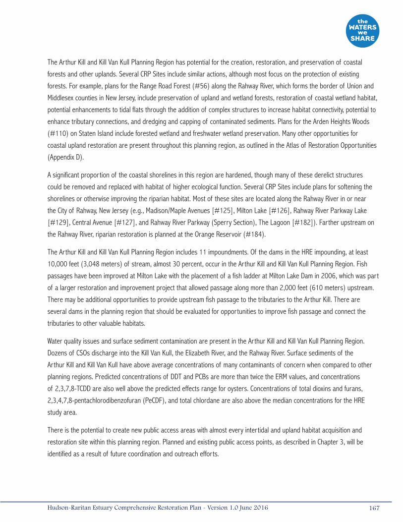
The Arthur Kill and Kill Van Kull Planning Region has potential for the creation, restoration, and preservation of coastal
forests and other uplands. Several CRP Sites include similar actions, although most focus on the protection of existing
forests. For example, plans for the Range Road Forest (#56) along the Rahway River, which forms the border of Union and
Middlesex counties in New Jersey, include preservation of upland and wetland forests, restoration of coastal wetland habitat,
potential enhancements to tidal flats through the addition of complex structures to increase habitat connectivity, potential to
enhance tributary connections, and dredging and capping of contaminated sediments. Plans for the Arden Heights Woods
(#110) on Staten Island include forested wetland and freshwater wetland preservation. Many other opportunities for
coastal upland restoration are present throughout this planning region, as outlined in the Atlas of Restoration Opportunities
(Appendix D).
A significant proportion of the coastal shorelines in this region are hardened, though many of these derelict structures
could be removed and replaced with habitat of higher ecological function. Several CRP Sites include plans for softening the
shorelines or otherwise improving the riparian habitat. Most of these sites are located along the Rahway River in or near
the City of Rahway, New Jersey (e.g., Madison/Maple Avenues [#125], Milton Lake [#126], Rahway River Parkway Lake
[#129], Central Avenue [#127], and Rahway River Parkway (Sperry Section), The Lagoon [#182]). Farther upstream on
the Rahway River, riparian restoration is planned at the Orange Reservoir (#184).
The Arthur Kill and Kill Van Kull Planning Region includes 11 impoundments. Of the dams in the HRE impounding, at least
10,000 feet (3,048 meters) of stream, almost 30 percent, occur in the Arthur Kill and Kill Van Kull Planning Region. Fish
passages have been improved at Milton Lake with the placement of a fish ladder at Milton Lake Dam in 2006, which was part
of a larger restoration and improvement project that allowed passage along more than 2,000 feet (610 meters) upstream.
There may be additional opportunities to provide upstream fish passage to the tributaries to the Arthur Kill. There are
several dams in the planning region that should be evaluated for opportunities to improve fish passage and connect the
tributaries to other valuable habitats.
Water quality issues and surface sediment contamination are present in the Arthur Kill and Kill Van Kull Planning Region.
Dozens of CSOs discharge into the Kill Van Kull, the Elizabeth River, and the Rahway River. Surface sediments of the
Arthur Kill and Kill Van Kull have above average concentrations of many contaminants of concern when compared to other
planning regions. Predicted concentrations of DDT and PCBs are more than twice the ERM values, and concentrations
of 2,3,7,8-TCDD are also well above the predicted effects range for oysters. Concentrations of total dioxins and furans,
2,3,4,7,8-pentachlorodibenzofuran (PeCDF), and total chlordane are also above the median concentrations for the HRE
study area.
There is the potential to create new public access areas with almost every intertidal and upland habitat acquisition and
restoration site within this planning region. Planned and existing public access points, as described in Chapter 3, will be
identified as a result of future coordination and outreach efforts.
167Hudson-Raritan Estuary Comprehensive Restoration Plan - Version 1.0 June 2016
4.5 Newark Bay, Hackensack River, and Passaic RiverThe Newark Bay, Hackensack River, and Passaic River Planning Region offers substantial opportunities to restore coastal and
freshwater wetlands, create and restore coastal upland habitats, and repair human induced habitat degradation. In recent
years, hundreds of acres of coastal wetland habitat have been restored to serve as mitigation banks and projects in this
planning region. The Evergreen MRI3 Wetland Mitigation Bank was constructed in 2012. The 51-acre (0.21-kilometers2)
mitigation bank is adjacent to a newly restored 17-acre (0.07-kilometers2) mitigation project resulting in about 68 acres
(0.28 kilometers2) of contiguous coastal wetland habitat along the Hackensack River. The Richard P. Kane Mitigation Bank
was also constructed in 2012 and consists of 240 acres (0.97 kilometers2) of contiguous coastal wetland and open water
habitat. Although significant progress has been made, there are still many more opportunities to restore degraded habitats.
Seventy-six (76) of the CRP Sites are located within the Newark Bay, Hackensack River, and Passaic River Planning Region;
21 sites have been identified for both acquisition and restoration, 54 sites have been identified for restoration only, and 1
site was identified as acquisition (Table 4-1; Map 4-5).
Preliminary screening indicates that this planning region offers more than 2,000 acres (8.09 kilometers2) of coastal wetland
creation opportunities. Thirty-seven (37) coastal wetland restoration opportunities were identified within CRP Sites. Most of
these sites are within the Meadowlands District and along the Hackensack River, examples of which include Penhorn Creek
(#38), Kearny Marsh (Freshwater) (#39), Berry’s Creek Marsh (#803), Bellman’s Creek (#42), Anderson Creek Marsh
(#715), Lyndhurst Riverside Marsh (#718), Steiners Marsh (#728), and Oritani Marsh (#723). The Meadowlark Marsh
(#719) and Metromedia Tract (#721) are sites that are being recommended for near-term construction authorization as
part of the HRE Feasibility Study.
Contamination issues in this planning region are pervasive. Dozens of CSOs are located along the lower Passaic River and
within Newark Bay, and poor water quality in Newark Bay fails to meet the NJDEP best use classification for the waterbody.
The surface sediments in this planning region have among the highest concentrations of the contaminants of concern
evaluated in Chapter 3 and Appendix C, and numerous USEPA Superfund Sites are located within the planning region. Habitat
restoration plans will need to take contaminant concentrations, the potential for the transport of contaminants, and attractive
nuisance issues into consideration prior to construction.
The restoration opportunities within the lower Passaic River have specific implementation challenges since the river is part
of the Diamond Alkali Superfund Site. Restoration opportunities need to be coordinated with USEPA in order to appropriately
sequence implementation with remedial investigations and actions. Of the 53 restoration opportunities within the lower
Passaic River and tributaries, 28 are located in the lower 14 miles of the lower Passaic River mainstem and are considered
“deferred sites,” meaning the river must be remediated before the sites can advance. Sites that could advance (without
remediation required) and plan to be recommended for near-term construction as part of the HRE Feasibility Study include
Essex County Branch Brook Park (#887), Dundee Island Park/Pulaski Park (#900), and Clifton Dundee Canal Green Acres
Purchase and Dundee Island Preserve (#902). Restoration opportunities at these sites primarily include removal of invasive
species, native plantings, and debris removal.
Other opportunities have been identified along the lower Passaic River (e.g. Kearny Point [#865]. Unnamed Tidal Creek – NJ
Turnpike [#868], Path Rail Fringe Marsh [#871] and Kearny Marsh (Cedar Creek Marsh) [#869]), and on the shoreline
168 Hudson-Raritan Estuary Comprehensive Restoration Plan - Version 1.0 June 2016
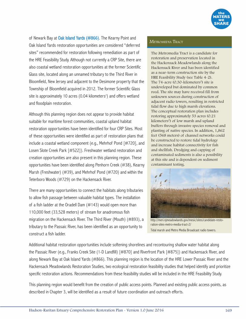
metromedia tract
The Metromedia Tract is a candidate for restoration and preservation located in the Hackensack Meadowlands along the Hackensack River and has been identified as a near-term construction site by the HRE Feasibility Study (see Table 4-2). The 74-acre (0.30-kilometers2) site is undeveloped but dominated by common reed. The site may have received fill from unknown sources during construction of adjacent radio towers, resulting in restricted tidal flow due to high marsh elevations. The conceptual restoration plan includes restoring approximately 53 acres (0.21 kilometers2) of low marsh and upland buffers through invasive species removal and planting of native species. In addition, 1,862 feet (568 meters) of channel networks could be constructed to restore tidal hydrology and increase habitat connectivity for fish and shellfish. Dredging and capping of contaminated sediments is also a possibility at this site and is dependent on sediment contaminant testing.
Tidal marsh and Metro Media Broadcast radio towers.
http://meri.njmeadowlands.gov/mesic/sites/candidate-resto-ration-sites-metro-media-tract-2/
of Newark Bay at Oak Island Yards (#866). The Kearny Point and
Oak Island Yards restoration opportunities are considered “deferred
sites” recommended for restoration following remediation as part of
the HRE Feasibility Study. Although not currently a CRP Site, there are
also coastal wetland restoration opportunities at the former Scientific
Glass site, located along an unnamed tributary to the Third River in
Bloomfield, New Jersey and adjacent to the Desimone property that the
Township of Bloomfield acquired in 2012. The former Scientific Glass
site is approximately 10 acres (0.04 kilometers2) and offers wetland
and floodplain restoration.
Although this planning region does not appear to provide habitat
suitable for maritime forest communities, coastal upland habitat
restoration opportunities have been identified for four CRP Sites. Most
of these opportunities were identified as part of restoration plans that
include a coastal wetland component (e.g., Mehrhof Pond [#720], and
Losen Slote Creek Park [#522]). Freshwater wetland restoration and
creation opportunities are also present in this planning region. These
opportunities have been identified along Penhorn Creek (#38), Kearny
Marsh (Freshwater) (#39), and Mehrhof Pond (#720) and within the
Teterboro Woods (#729) on the Hackensack River.
There are many opportunities to connect the habitats along tributaries
to allow fish passage between valuable habitat types. The installation
of a fish ladder at the Oradell Dam (#143) would open more than
110,000 feet (33,528 meters) of stream for anadromous fish
migration on the Hackensack River. The Third River (Mouth) (#893), a
tributary to the Passaic River, has been identified as an opportunity to
construct a fish ladder.
Additional habitat restoration opportunities include softening shorelines and recontouring shallow water habitat along
the Passaic River (e.g., Franks Creek Site (1-D Landfill) [#870] and Riverfront Park [#875]) and Hackensack River, and
along Newark Bay at Oak Island Yards (#866). This planning region is the location of the HRE Lower Passaic River and the
Hackensack Meadowlands Restoration Studies, two ecological restoration feasibility studies that helped identify and prioritize
specific restoration actions. Recommendations from these feasibility studies will be included in the HRE Feasibility Study.
This planning region would benefit from the creation of public access points. Planned and existing public access points, as
described in Chapter 3, will be identified as a result of future coordination and outreach efforts.
169Hudson-Raritan Estuary Comprehensive Restoration Plan - Version 1.0 June 2016

Map 4~5.
170 Hudson-Raritan Estuary Comprehensive Restoration Plan - Version 1.0 June 2016
4.6 Lower Hudson RiverThe Lower Hudson River Planning Region includes the brackish and marine waters of the Hudson River, bounded by an
extensive shoreline from the Tappan Zee Bridge to lower Manhattan and Hudson County, New Jersey. Coastal wetland
and oyster restoration opportunities exist along the Lower Hudson River. The high density urban development along
the shorelines in this planning region may offer opportunities to enhance shoreline structures and adjacent waters by
incorporating habitat features and structures into their designs. Relatively few CRP Sites are located in this planning region.
Ten (10) CRP Sites are within the Lower Hudson River Planning Region; 2 have been identified as both acquisition and
restoration and 8 have been identified solely for restoration (Table 4-1; Map 4-6). Eight (8) of these sites are located along
the Manhattan and Bronx shorelines in New York, and two are located in New Jersey. Specific restoration actions have not
been planned for the sites located in New Jersey.
Shorelines of existing parkland in Manhattan and the Bronx have been identified as opportunities to create and restore
coastal wetlands. Wetlands near Riverdale Park in the Bronx (#159) provide a wetland restoration opportunity, and it may
be possible to create wetlands along the shorelines of Inwood Park (#189), Fort Tryon Park (#190), and Spuyten Duyvil
(#191). While specific restoration actions are to be determined at the Hudson/Bergen County Waterfront (#556) in Hudson
County, New Jersey, potential plans include creation and restoration of fringe marsh and tidal flats, enhancements to habitat
for fish, crab, and lobsters, dredging and capping of contaminated sediments, and construction of a waterfront walkway.
Most of these restoration sites are located adjacent to or within parkland, so there is also the potential to restore coastal
upland habitat adjacent to the wetlands. In addition to the opportunities identified in the CRP Sites, opportunities to restore
and create coastal wetlands may be available adjacent to Piermont Marsh, Rockland County, New York. Plans for restoration
of this marsh are proposed as mitigation for the New NY Bridge Project that is being constructed to replace the Tappan
Zee Bridge.
The Lower Hudson River Planning Region may offer opportunities for oyster restoration projects. Much of the shallow
waters on the western shoreline of the Lower Hudson River meet the chemical and physical parameters for oyster habitat.
Opportunities to soften shorelines in this planning region, or to otherwise improve the shoreline habitat for fish and
crustacean species, should be further investigated.
The surface sediments of the Lower Hudson Planning Region have the lowest concentrations of nearly all of the
contaminants of concern within the HRE study area. Sediment quality is expected to improve as a result of the dredging of
PCB contaminated sediments from the Upper Hudson River. However, contaminated sediments are present in localized areas
such as interpier basins and around CSOs. Improvements to sediment quality are proposed at most of the CRP Sites within
this planning region.
Public access to the waterfront is a very important TEC in this densely populated region. Planned and existing public access
points, as described in Chapter 3, will be identified as a result of future coordination and outreach efforts.
171Hudson-Raritan Estuary Comprehensive Restoration Plan - Version 1.0 June 2016
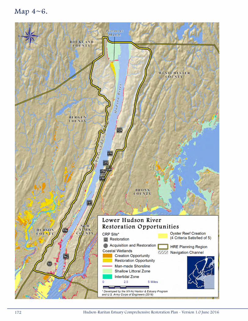
Map 4~6.
172 Hudson-Raritan Estuary Comprehensive Restoration Plan - Version 1.0 June 2016
hudson river Park estuarine sanctuary
Hudson River Park is located along the western waterfront of Manhattan from Battery Place to 59th Street.The park provides public waterfront access and is home to gardens, scenic overlooks, playgrounds, athletic fields, historic resources, and educational and river research facilities. In the area of the park, the Hudson River experiences a mixing zone of freshwater from the river and seawater from the Hudson Estuary. The area is a regionally significant nursery and wintering habitat for a number of anadromous, estuarine, and marine fish species, and is a migratory and feeding area for birds and fish.
The majority of the shoreline is lined with bulkhead, but the bottom surfaces of the interpier zones are relatively flat and gently sloping. The interpier areas offer opportunities for creating shallow and gradually sloping shorelines and enhancing habitat for fish and other aquatic species. Interpier habitat enhancement and creation includes preservation of high quality habitat at remnant pier structures and placement of rock rip-rap along the water edge to add complex surfaces for cover-seeking fish. Approximately 14 acres (0.06 kilometers2) of interpier habitat could be created or enhanced and 1,940 feet (591 meters) of gradual sloping shoreline can be created by re-grading at Piers 97, 76, 57, 54, and 40, as well as at Gansevoort Peninsula.
In addition to habitat enhancement and creation, the project offers opportunities to enhance public access at all the piers where interpier habitat is proposed. This would include continuation of the waterfront esplanade, sports and recreation facilities, open and event space, gardens, and commercial revenue generating development, as well as an estuary museum and other educational opportunities.
4.7 Harlem River, East River, and Western Long Island SoundThe Harlem River, East River, and Western Long Island Sound Planning Region offers a variety of opportunities to create
and restore each of the TEC habitats. This planning region has extensive shallow littoral and subtidal waters that provide
the opportunity to create a variety of aquatic habitat types. Many islands exist within this planning region, representing
the potential to improve habitat for waterbirds. There are also many opportunities to reverse human-induced habitat
degradation. Forty-eight (48) CRP Sites are located within the Harlem River, East River, and Western Long Island Sound
Planning Region; 11 sites have been identified for both acquisition and restoration, and 37 sites have been identified solely
for restoration (Table 4-1; Map 4-7).
Of the 48 sites within this planning region, 10 are being recommended for near-term construction authorization as part
of the HRE Feasibility Study. Nine (9) sites are on the Bronx River, including Stone Mill Dam/Anadromous Fish Passage 2
(#945), Bronx Zoo and Dam/Anadromous Fish Passage 1 (#944), Shoelace Park (#113), Muskrat Cove (#862), River
Park (#860), Westchester County Center (#854), Bronxville Lake (#851), Crestwood Lake (#852), Garth Woods (#942),
and Harney Road (#943). One site within Flushing Creek (#188) will also be recommended for construction authorization.
A common theme among the restoration opportunities at these CRP Sites includes fish passage and shoreline softening,
invasive species removal, and native plantings. Coastal wetland creation opportunities are abundant in this planning region.
Results of the GIS analyses presented in Chapter 3 suggest that more than 1,000 acres (4.04 kilometers2) of coastal
wetlands could be created. Fourteen (14) of the CRP Sites in this region include a coastal wetland restoration or creation
component. These sites include areas located along Pugsley Creek (#175), the Harlem River at Sherman Creek (#663), the
Hutchinson River (e.g., Palmer Inlet [#153] and Pelham Bay Park/Tallapoosa West [#179]), on the shoreline of City Island
173Hudson-Raritan Estuary Comprehensive Restoration Plan - Version 1.0 June 2016

Map 4~7.
174 Hudson-Raritan Estuary Comprehensive Restoration Plan - Version 1.0 June 2016
Wetlands (#52), in Brooklyn at Bushwick Inlet (#676), and the coves and harbors of western Long Island Sound (e.g.,
Hempstead Harbor [#669], Alley Creek Northeast and Hart Island [#650]).
Pugsley Creek Park (#175) is located in the Bronx along Pugsley Creek, a tributary to the East River. The Pugsley Creek
Park Project is an Action Agenda Project listed in the NYC CWP and involves the complete restoration of tidal wetlands,
including excavation work, sand placement, and the planting of saltmarsh grasses. NYCDPR restored wetlands along the
eastern side of the creek, but there are more than 10 acres (0.04 kilometers2) of degraded upland and wetland habitat that
could be restored on the western side of the creek; implementation is planned for 2017.
In addition to wetland restoration, many of the opportunities, such as Flushing Creek (#188), Tibbetts Brook (#680), and
several sites listed above, include a coastal upland habitat restoration component. Tibbetts Brook (#680), which drains
approximately 2,300 acres (9.30 kilometers2) of parts of Westchester County and the Bronx, currently drains into the
combined sewer system and thus contributes to CSOs to the Harlem River. In the existing floodplains of the brook, there
are stream and wetland restoration and creation opportunities that extend from Tibbetts Brook Park in Yonkers to Van
Cortlandt Park in the Bronx. There is also an opportunity for restoration of coastal forests in the floodplain fringe. The
forest community would link to the existing established upland forest to create a larger and more contiguous forest stand.
Other restoration opportunities at Tibbetts Brook include wetland restoration and daylighting a section of stream within
Van Cortlandt Park, a planning project that is currently in the contracting phase with NYCDPR. The long-term vision is to
remove the brook from the combined sewer system and reconnect it to the Harlem River. This reconnection, through stream
daylighting where possible, would improve overall awareness of urban streams, improve downstream water quality, and serve
as a model project for daylighting other streams in the HRE.
Alley Creek also provides both wetland and coastal forest restoration opportunities. The site is located within Alley Pond Park
in northeast Queens, between the LIRR and Northern Boulevard to the east of Alley Creek. Although not currently a CRP
Site, opportunities at the site include approximately five acres (0.02 kilometers2) of coastal forest restoration and four acres
(0.016 kilometers2) of salt marsh restoration. The site is dominated by low elevation concrete and asphalt fill and is suitable
for low marsh restoration through the removal of fill materials and Phragmites.
The Pelham Bay Park/Tallapoosa West Site (#179) provides wetland restoration opportunities along an inlet located south
of the Pelham Bay Landfill in Eastchester Bay. Opportunities include coastal wetland restoration, including Phragmites
removal, replanting with Spartina, and regrading wetland elevations along approximately 1.7 acres (0.006 kilometers2) of
existing wetlands. Additional opportunities exist to restore tributary connections and flushing to a brook that was diverted,
dredge the inlet, and remove debris along approximately 1,288 feet (392 meters) of the brook to restore flow, and a
potential opportunity to dredge and cap contaminated sediments.
Although only two CRP Sites (Hempstead Harbor [#669] and Sherman Creek [#663]) include plans for oyster restoration
and eelgrass restoration within this planning region, there are opportunities to create these habitats. Areas protected
from wave action and navigation channels along the upper East River have physical and chemical properties that meet
175Hudson-Raritan Estuary Comprehensive Restoration Plan - Version 1.0 June 2016
requirements for oyster habitat. A large-scale (one-acre [0.004 kilometer2]) oyster restoration pilot study was constructed
off the shore of Soundview Park. This study is an Action Agenda Project listed in the NYC CWP and involves oyster planting,
evaluating ecological and water quality effects resulting from oyster restoration, and determining the feasibility of large scale
oyster restoration projects within the HRE. In addition, the expansion of the oyster reef at Soundview Park is planned to be
recommended for near-term construction as part of the HRE Feasibility Study. It may also be possible to include an oyster
restoration component to current restoration plans in Bowery Bay (#170). Eelgrass restoration opportunities may exist in
many of these areas as well. Restoring two or more complementary habitat types for fish, shellfish, and crustacean appears
to be possible in the upper East River and western Long Island Sound.
The majority of islands in the HRE study area are located within the Harlem River, East River, and Western Long Island Sound
Planning Region. Uninhabited islands in the East River include North and South Brother Islands, Mill Rock, Roosevelt Island,
and U Thant Island. Islands in western Long Island Sound include David’s Island, Huckleberry Island, Pea Island, Hart Island,
City Island, and Goose Island. Reports of invasive vine and tree species on many of these islands suggest that there are
numerous opportunities to improve habitat for roosting and nesting waterbirds. The CRP Sites that include opportunities
to restore island habitat for waterbirds include South Brother Island (#10), Hart Island (#650), and Huckleberry Island
(#12). There are likely additional opportunities to restore waterbird habitat in this planning region that will be identified
during future evaluations.
Opportunities to improve the connectivity of habitats along tributaries and to improve the ability for fish to move between
these habitats exist in this planning region. The Hutchinson River Marsh Restoration (#678) includes plans for the
installation of a fish ladder to allow passage for anadromous fish. There are also four dams in this planning region that may
block access to more than 10,000 feet (3,048 meters) of upstream waters. In particular, the Bronx River Double-Dam Fish
Passage (see spotlight project: Bronx River Double-Dam Fish Passage) and Stone Mill Dam may represent an opportunity
to restore fish passage to more than 63,000 feet (19,202 meters) of stream. Freshwater wetland restoration opportunities
have been identified at Meadow Lake and are being implemented (#107).
This planning region provides opportunities to improve water quality in the bays and harbors of western Long Island Sound.
The surface waters of Flushing Bay, Little Neck Bay, Manhasset Bay, and Hempstead Harbor fail to meet the water quality
requirements for their state-designated best use classifications. CSOs line the shorelines of eastern Manhattan, along
Brooklyn, as well as many rivers draining into the upper East River and western Long Island Sound. Two CRP Sites include
plans to improve local water quality habitat: Sherman Creek (#663) and Newtown Creek (#675). Newtown Creek was
listed as a Superfund Site on the NPL in 2010. Potential restoration opportunities at Newtown Creek (#675) will be on hold
until site remediation is completed by USEPA and water quality is improved through CSO regulations and upgrades. Future
evaluations will likely identify many more opportunities to improve water quality in this planning region.
Surface sediment contamination issues are pervasive along the East River in this planning region. In particular, predicted
concentrations of PCBs in the sediments along the entire East River are among the highest in the HRE study area. Relatively
high concentrations (above the ERL) of benzo(a)pyrene were also predicted for the upper East River. Predicted dioxin and
furan concentrations were also high when compared to the Lower Hudson and Lower Raritan River Planning Regions.
176 Hudson-Raritan Estuary Comprehensive Restoration Plan - Version 1.0 June 2016

Bronx river dams Fish Passage
Dams on the Bronx River create a series of impediments to anadromous fish passage. The dams have caused a significant buildup of sediments and the formation of a bar within the channel that is dominated by invasive species. Upstream of the dams in the Bronx Zoo, the Bronx River channel has lost most of the natural riverine geomorphology and has formed a lacustrine community surrounded by steep banks with several point sources of sediment and areas of bank instability. Restoration potential at the site includes the removal of invasive plants and replanting with native species within the upland buffers and floodplain to increase bank stability, as well as the installation of in-stream structures to increase fish habitat function. To improve habitat connectivity, a fish ladder is proposed at the Bronx Zoo Dam to extend anadromous fish passage and use of riverine habitat by approximately 0.67 miles (1.0 kilometers). Another fish ladder is proposed at the Stone Mill Dam, to extend fish passage upstream approximately 7 more miles (11 kilometers) into Westchester. Several dams are located farther upstream in Westchester; therefore, it is recommended that fish passages be constructed at all the dams for the system to be most effective. These two sites at Bronx Zoo and Stone Mill Dam will be recommended for near-term construction authorization with New York City Department of Parks and Recreation (NYCDPR) (non-Federal sponsor) as part of the HRE Feasibility Study.
Bronx Zoo Dam. Photo courtesy of New York City Department of Parks and Recreation.
177Hudson-Raritan Estuary Comprehensive Restoration Plan - Version 1.0 June 2016
4.8 Upper BayThe Upper Bay Planning Region is the smallest and among the most urbanized of the HRE planning regions. Seven (7)
CRP Sites are within the Upper Bay Planning Region; one has been identified for both acquisition and restoration and six
sites have been identified solely for restoration only (Table 4-1; Map 4-8). Despite the fact that so few CRP Sites are in this
planning region, opportunities exist for many TECs.
The northeastern shoreline of Staten Island, the shorelines of Hudson County, New Jersey, Governor’s Island, and a portion
of Brooklyn (including Red Hook) are within this planning region. Shallow littoral and intertidal habitat occurs along the
western shorelines, and there are existing coastal wetlands on the New Jersey side of this planning region. Restoration
opportunities for shorelines and shallows exist at Bush Terminal/Brooklyn Sunset Park (#154) and Governor’s Island
(#864). The shorelines of the region are heavily lined with piers and bulkheads, and a network of navigation channels runs
throughout the subtidal waters of this planning region. In addition, habitat restoration opportunities for fish, crabs, and
lobster have been identified for this planning region at all CRP Sites except Gowanus Canal (#503).
In addition to the CRP Sites discussed above, the Lincoln Park Restoration Project has been successful in restoring a native
salt marsh community in an urban ecological area. Restoration of the tidal wetland hydrology at the site was accomplished by
excavating previously placed fill material and re-contouring the site to create intertidal habitat and tidal creeks. This project
restored 42 acres (0.17 kilometers2) of wetland, stream, and salt marsh habitat along the Hackensack River. The tidal
marsh, which was originally designed to offset damage from a 1990 oil spill in the Arthur Kill channel, has been incorporated
into the 270-acre (1.09-kilometers2) site. Some additional wetland restoration opportunities currently exist in the park.
Existing coastal wetlands are relatively rare within the Upper Bay Planning Region, occurring in only a few areas in Bayonne
and Jersey City, New Jersey. One CRP Site includes plans for coastal wetland creation, Liberty State Park (#37). The major
restoration action planned for Liberty State Park includes more than 224 acres (0.91 kilometers2) of restoration with a more
than 40-acre (0.16- kilometers2) tidal marsh complex. Plans to improve upland coastal habitat (including a maritime forest
community) and freshwater wetlands are also included in this project (USACE 2004c). This will substantially increase the
overall acreage of habitat available in this planning region.
The shallow littoral waters of the planning region may have the potential to support oyster reefs. These regions meet the
physical and chemical parameters necessary for oyster habitat. One CRP Site at Governors Island (#864) has been identified
as an oyster restoration opportunity. A pilot study for oyster growing has been initiated with hopes of increasing the size
of the project and the volume of oysters grown, based on the success of the pilot. Further evaluations of the Upper Bay
Planning Region may demonstrate that more oyster restoration opportunities are feasible in the areas where relatively
shallow waters occur. The expansion of oyster pilots at Bush Terminal/Brooklyn Sunset Park (#154) and Governors Island
(#864) are recommended for near-term construction authorization for the HRE Feasibility Study.
Water quality in the Upper Bay is somewhat degraded and does not meet its best use classification for either New York or
New Jersey surface water quality standards. Although surface sediment contamination is present throughout the HRE study
area, sediments in the middle of Upper Bay generally have contaminant concentrations below the median for the HRE study
area. However, predicted total DDT concentrations are well above the ERM of 46 parts per billion on the eastern side of
178 Hudson-Raritan Estuary Comprehensive Restoration Plan - Version 1.0 June 2016

Map 4~8.
179Hudson-Raritan Estuary Comprehensive Restoration Plan - Version 1.0 June 2016
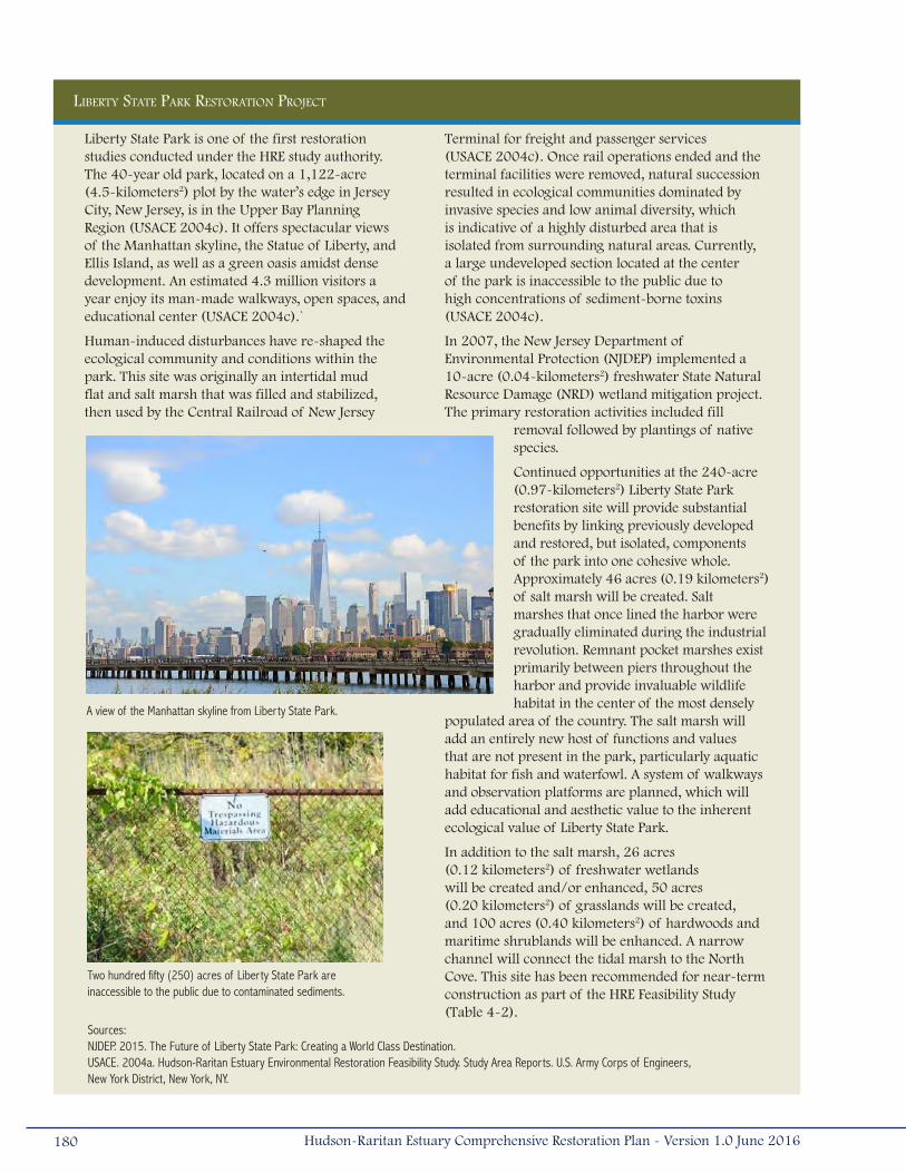
Liberty State Park is one of the first restoration studies conducted under the HRE study authority. The 40-year old park, located on a 1,122-acre (4.5-kilometers2) plot by the water’s edge in Jersey City, New Jersey, is in the Upper Bay Planning Region (USACE 2004c). It offers spectacular views of the Manhattan skyline, the Statue of Liberty, and Ellis Island, as well as a green oasis amidst dense development. An estimated 4.3 million visitors a year enjoy its man-made walkways, open spaces, and educational center (USACE 2004c).`
Human-induced disturbances have re-shaped the ecological community and conditions within the park. This site was originally an intertidal mud flat and salt marsh that was filled and stabilized, then used by the Central Railroad of New Jersey
Terminal for freight and passenger services (USACE 2004c). Once rail operations ended and the terminal facilities were removed, natural succession resulted in ecological communities dominated by invasive species and low animal diversity, which is indicative of a highly disturbed area that is isolated from surrounding natural areas. Currently, a large undeveloped section located at the center of the park is inaccessible to the public due to high concentrations of sediment-borne toxins (USACE 2004c).
In 2007, the New Jersey Department of Environmental Protection (NJDEP) implemented a 10-acre (0.04-kilometers2) freshwater State Natural Resource Damage (NRD) wetland mitigation project. The primary restoration activities included fill
removal followed by plantings of native species.
Continued opportunities at the 240-acre (0.97-kilometers2) Liberty State Park restoration site will provide substantial benefits by linking previously developed and restored, but isolated, components of the park into one cohesive whole. Approximately 46 acres (0.19 kilometers2) of salt marsh will be created. Salt marshes that once lined the harbor were gradually eliminated during the industrial revolution. Remnant pocket marshes exist primarily between piers throughout the harbor and provide invaluable wildlife habitat in the center of the most densely
populated area of the country. The salt marsh will add an entirely new host of functions and values that are not present in the park, particularly aquatic habitat for fish and waterfowl. A system of walkways and observation platforms are planned, which will add educational and aesthetic value to the inherent ecological value of Liberty State Park.
In addition to the salt marsh, 26 acres (0.12 kilometers2) of freshwater wetlands will be created and/or enhanced, 50 acres (0.20 kilometers2) of grasslands will be created, and 100 acres (0.40 kilometers2) of hardwoods and maritime shrublands will be enhanced. A narrow channel will connect the tidal marsh to the North Cove. This site has been recommended for near-term construction as part of the HRE Feasibility Study (Table 4-2).
liBerty state Park restoration ProJect
A view of the Manhattan skyline from Liberty State Park.
Two hundred fifty (250) acres of Liberty State Park are inaccessible to the public due to contaminated sediments.
Sources: NJDEP. 2015. The Future of Liberty State Park: Creating a World Class Destination. USACE. 2004a. Hudson-Raritan Estuary Environmental Restoration Feasibility Study. Study Area Reports. U.S. Army Corps of Engineers, New York District, New York, NY.
180 Hudson-Raritan Estuary Comprehensive Restoration Plan - Version 1.0 June 2016
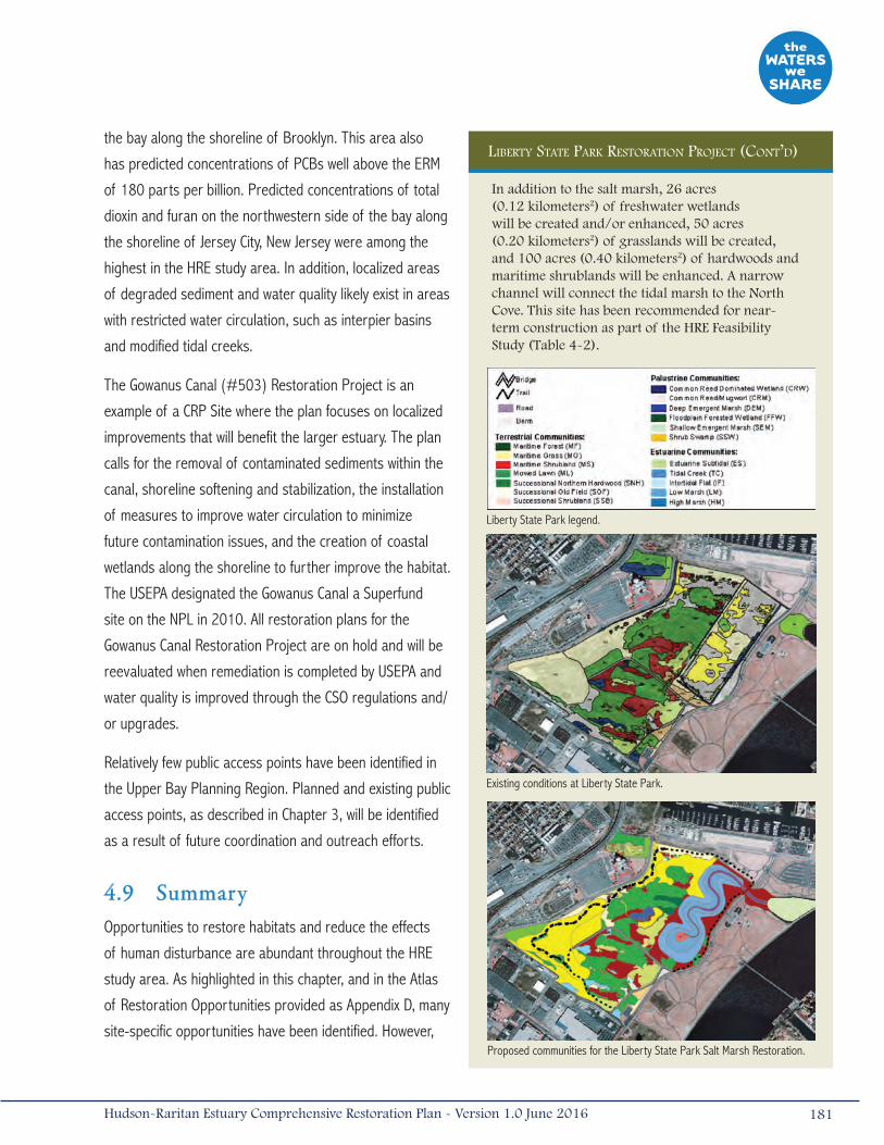
the bay along the shoreline of Brooklyn. This area also
has predicted concentrations of PCBs well above the ERM
of 180 parts per billion. Predicted concentrations of total
dioxin and furan on the northwestern side of the bay along
the shoreline of Jersey City, New Jersey were among the
highest in the HRE study area. In addition, localized areas
of degraded sediment and water quality likely exist in areas
with restricted water circulation, such as interpier basins
and modified tidal creeks.
The Gowanus Canal (#503) Restoration Project is an
example of a CRP Site where the plan focuses on localized
improvements that will benefit the larger estuary. The plan
calls for the removal of contaminated sediments within the
canal, shoreline softening and stabilization, the installation
of measures to improve water circulation to minimize
future contamination issues, and the creation of coastal
wetlands along the shoreline to further improve the habitat.
The USEPA designated the Gowanus Canal a Superfund
site on the NPL in 2010. All restoration plans for the
Gowanus Canal Restoration Project are on hold and will be
reevaluated when remediation is completed by USEPA and
water quality is improved through the CSO regulations and/
or upgrades.
Relatively few public access points have been identified in
the Upper Bay Planning Region. Planned and existing public
access points, as described in Chapter 3, will be identified
as a result of future coordination and outreach efforts.
4.9 SummaryOpportunities to restore habitats and reduce the effects
of human disturbance are abundant throughout the HRE
study area. As highlighted in this chapter, and in the Atlas
of Restoration Opportunities provided as Appendix D, many
site-specific opportunities have been identified. However,
liBerty state Park restoration ProJect (cont’d)
Liberty State Park legend.
Existing conditions at Liberty State Park.
Proposed communities for the Liberty State Park Salt Marsh Restoration.
In addition to the salt marsh, 26 acres (0.12 kilometers2) of freshwater wetlands will be created and/or enhanced, 50 acres (0.20 kilometers2) of grasslands will be created, and 100 acres (0.40 kilometers2) of hardwoods and maritime shrublands will be enhanced. A narrow channel will connect the tidal marsh to the North Cove. This site has been recommended for near-term construction as part of the HRE Feasibility Study (Table 4-2).
181Hudson-Raritan Estuary Comprehensive Restoration Plan - Version 1.0 June 2016
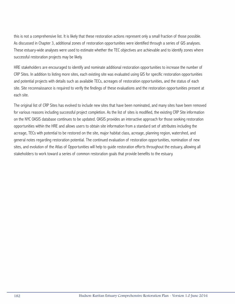
this is not a comprehensive list. It is likely that these restoration actions represent only a small fraction of those possible.
As discussed in Chapter 3, additional zones of restoration opportunities were identified through a series of GIS analyses.
These estuary-wide analyses were used to estimate whether the TEC objectives are achievable and to identify zones where
successful restoration projects may be likely.
HRE stakeholders are encouraged to identify and nominate additional restoration opportunities to increase the number of
CRP Sites. In addition to listing more sites, each existing site was evaluated using GIS for specific restoration opportunities
and potential projects with details such as available TECs, acreages of restoration opportunities, and the status of each
site. Site reconnaissance is required to verify the findings of these evaluations and the restoration opportunities present at
each site.
The original list of CRP Sites has evolved to include new sites that have been nominated, and many sites have been removed
for various reasons including successful project completion. As the list of sites is modified, the existing CRP Site information
on the NYC OASIS database continues to be updated. OASIS provides an interactive approach for those seeking restoration
opportunities within the HRE and allows users to obtain site information from a standard set of attributes including the
acreage, TECs with potential to be restored on the site, major habitat class, acreage, planning region, watershed, and
general notes regarding restoration potential. The continued evaluation of restoration opportunities, nomination of new
sites, and evolution of the Atlas of Opportunities will help to guide restoration efforts throughout the estuary, allowing all
stakeholders to work toward a series of common restoration goals that provide benefits to the estuary.
182 Hudson-Raritan Estuary Comprehensive Restoration Plan - Version 1.0 June 2016
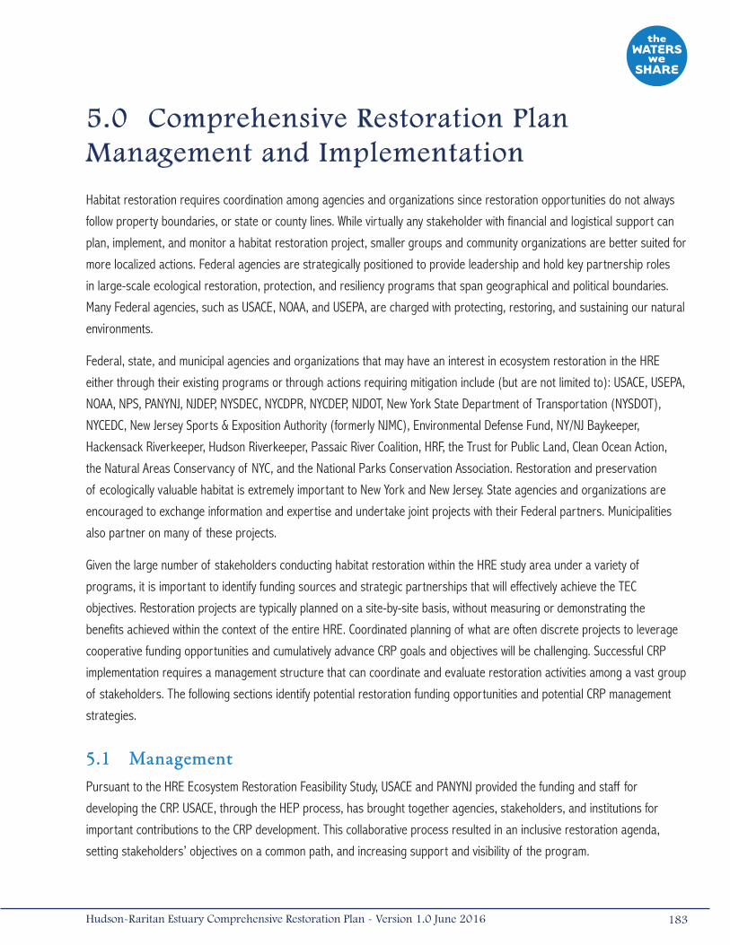
5.0 Comprehensive Restoration Plan Management and Implementation
Habitat restoration requires coordination among agencies and organizations since restoration opportunities do not always
follow property boundaries, or state or county lines. While virtually any stakeholder with financial and logistical support can
plan, implement, and monitor a habitat restoration project, smaller groups and community organizations are better suited for
more localized actions. Federal agencies are strategically positioned to provide leadership and hold key partnership roles
in large-scale ecological restoration, protection, and resiliency programs that span geographical and political boundaries.
Many Federal agencies, such as USACE, NOAA, and USEPA, are charged with protecting, restoring, and sustaining our natural
environments.
Federal, state, and municipal agencies and organizations that may have an interest in ecosystem restoration in the HRE
either through their existing programs or through actions requiring mitigation include (but are not limited to): USACE, USEPA,
NOAA, NPS, PANYNJ, NJDEP, NYSDEC, NYCDPR, NYCDEP, NJDOT, New York State Department of Transportation (NYSDOT),
NYCEDC, New Jersey Sports & Exposition Authority (formerly NJMC), Environmental Defense Fund, NY/NJ Baykeeper,
Hackensack Riverkeeper, Hudson Riverkeeper, Passaic River Coalition, HRF, the Trust for Public Land, Clean Ocean Action,
the Natural Areas Conservancy of NYC, and the National Parks Conservation Association. Restoration and preservation
of ecologically valuable habitat is extremely important to New York and New Jersey. State agencies and organizations are
encouraged to exchange information and expertise and undertake joint projects with their Federal partners. Municipalities
also partner on many of these projects.
Given the large number of stakeholders conducting habitat restoration within the HRE study area under a variety of
programs, it is important to identify funding sources and strategic partnerships that will effectively achieve the TEC
objectives. Restoration projects are typically planned on a site-by-site basis, without measuring or demonstrating the
benefits achieved within the context of the entire HRE. Coordinated planning of what are often discrete projects to leverage
cooperative funding opportunities and cumulatively advance CRP goals and objectives will be challenging. Successful CRP
implementation requires a management structure that can coordinate and evaluate restoration activities among a vast group
of stakeholders. The following sections identify potential restoration funding opportunities and potential CRP management
strategies.
5.1 ManagementPursuant to the HRE Ecosystem Restoration Feasibility Study, USACE and PANYNJ provided the funding and staff for
developing the CRP. USACE, through the HEP process, has brought together agencies, stakeholders, and institutions for
important contributions to the CRP development. This collaborative process resulted in an inclusive restoration agenda,
setting stakeholders’ objectives on a common path, and increasing support and visibility of the program.
183Hudson-Raritan Estuary Comprehensive Restoration Plan - Version 1.0 June 2016
In 2010, following release of the 2009 Draft CRP, HEP formed the RWG, whose mission incorporated the role of what
had been the Habitat Work Group, to steer development and implementation of the CRP per the management framework
described in Section 5.2. The RWG also provides guidance for HEP’s research and actions regarding restoration, acquisition,
and habitats that address priorities in HEP’s Action Plan, CCMP, and this CRP (described herein).
The success of the CRP in improving the estuary ecosystem directly relates to and depends upon continued successful
collaboration and cooperation among stakeholders. CRP management must accommodate the dynamic process of long-
term environmental restoration. Ecological changes brought about by CRP implementation, as well as ongoing changes to
the physical and chemical environment from sea level rise and human activities, will require adjustments to the CRP. The CRP
management framework must accommodate the major roles of the plan:
• Tracking Progress. The HEP RWG will continue to play a key role in advising activities of the CRP implementation.
This includes its significant contributions to CRP development, evaluating goals or targets, and reviewing conceptual
plans for acquisition and restoration sites. Lessons learned will be documented as restoration projects advance and
move toward achieving TEC objectives. Successes and failures provide information that can improve restoration in
the HRE study area at existing sites through adaptive management as well as aid in the design and construction of
new sites. The RWG will also track progress toward achieving goals by providing regular updates of progress toward
the specific restoration objectives and recommend or redirect efforts or change management strategies to more
effectively meet restoration targets.
• Approving New CRP Restoration Opportunities. The RWG will identify and approve new CRP sites proposed by
partners and regional stakeholders through the HEP nomination process.
• Advancing TEC Science. Environmental restoration within the HRE study area is an emerging science that will evolve
as the CRP is implemented. Data, insights gained, and challenges overcome through implementing the restoration
objectives (i.e., TECs) in the HRE study area should be readily available to restoration practitioners and provide a
valuable resource to all stakeholders. The RWG should continue to monitor HEP’s CRP and CCMP planning efforts
and strive to close information gaps regarding the successful implementation of restoration projects in the region.
The lessons learned and practical experience gained from ongoing and completed restoration projects have already
led to advances in restoration and to modification of such TECs as Oyster Reefs, Habitat for Waterbirds, Wetlands,
and Tributary Connections. Continued revisions to the TECs, based on advances in restoration, will contribute to the
success of the CRP and improving the estuary ecosystem.
• Streamlining Policy and Management. As described in Section 5.2.2, policy considerations affect implementation
of the TECs, specifically as they pertain to habitat exchange, beneficial use of dredged material, attractive
nuisances, and sediment contamination (among others). The RWG can provide a forum to advance relevant
policy and regulatory or management concerns that affect restoration, acquisition, species, and habitat. Through
targeted meetings with regulatory agencies, it may be possible to improve overall success and provide for regional
consistency in implementation.
• Identifying Funding Strategies. Funding for restoration projects has been primarily envisioned as a partnering
process, but many sources of funding are needed to achieve major progress. The role of the RWG is to identify and
leverage resources and programs to advance priority environmental restoration and acquisition opportunities.
184 Hudson-Raritan Estuary Comprehensive Restoration Plan - Version 1.0 June 2016

• Prioritizing Restoration Projects. The RWG must work together to develop strategies and approaches to prioritize
CRP acquisition and restoration sites in order to inform stakeholders of the relative importance and value of each
CRP site within each planning region and within the overall HRE study area.
• Public Involvement. Long-term support for the program can be achieved if stakeholders and the public have direct
involvement and strong awareness of the plan’s progress. Management and implementation of the CRP should be
an inclusive process and should foster this dedicated support.
5.1.1 Program Management TeamMembers of the HEP RWG represent organizations or agencies with a broad geography and expertise within the HRE.
Current RWG participants include representatives from the following agencies and organizations:
• New York-New Jersey Harbor & Estuary Program
• U.S. Army Corps of Engineers
• National Oceanic and Atmospheric Administration
• The Port Authority of New York and New Jersey
• New Jersey Department of Environmental Protection
• New York State Department of Environmental Conservation
• New York City Department of Parks and Recreation
• New York City Department of Environmental Protection
• New York/New Jersey Baykeeper
• Hudson River Foundation
• National Park Service
• The Nature Conservancy
• The Trust for Public Land
• New Jersey Harbor Dischargers Group
Among the organizations directly involved in the RWG, those listed below have a major stake in guiding or managing aspects
of the CRP’s implementation:
New York-New Jersey Harbor & Estuary Program (HEP)
HEP was authorized in 1987 by USEPA and had been located at the USEPA Region 2 office in NYC for over 25 years. In 2013,
USEPA selected HRF as the new host for HEP in order to enhance the program’s opportunities for partnerships and align it
with the organization of estuary programs throughout the country. HEP is comprised of stakeholders from agency groups,
scientists, citizens, business interests, and non-government organizations. The program represents a multi-year effort
to develop and implement a plan to protect, conserve, and restore the HRE. Over the years, HEP has played an integral
role in the development of the CRP working with USACE and PANYNJ, and continues to play a major role in environmental
stakeholder coordination within the HRE study area, enabling these organizations to advance their objectives. HEP’s work
185Hudson-Raritan Estuary Comprehensive Restoration Plan - Version 1.0 June 2016
groups consist of representatives from local, state, and Federal agencies, scientists, citizens, business interests, and
environmentalists, among others. These work group meetings and additional outreach meetings have helped develop and
advance implementation of the CRP by providing tools to understand stakeholders’ interests and needs. HEP has partnered
with the CUNY, which manages a centralized, online information center, the NYC OASIS database, whereby stakeholders can
obtain information on activities at CRP sites throughout the HRE study area.
HEP is poised to oversee the long-term management and implementation of the CRP. In December of 2009, the HEP
Policy Committee agreed to adopt the CRP as the blueprint and regional agenda for future restoration in the HRE study
area. Additionally, the HEP Policy Committee, Management Committee, and the active work groups (Restoration, Water
Quality [formerly Nutrients, Pathogens, Toxics, and TMDL], and Public Access) maintain a list of goals and priority actions
in the estuary. The Citizens Advisory Committee (CAC) shares program-specific information with the public. The HEP Policy
Committee is comprised of representatives from USEPA, USACE, NJDEP, NYSDEC, NYCDEP, PANYNJ, a representative of local
government in New Jersey (LGNJ), the Citizens Advisory Committee, the Science and Technical Advisory Committee (STAC),
and the HRF or host entity. The RWG provides direction for site acquisition and restoration in the HRE study area. The Harbor
Herons and Oyster Restoration sub-committees fall under the RWG. HEP also distributes mini-grants to applicants annually,
supporting HRE-specific programs. Many of these grant-funded programs focus on environmental education and providing
stewardship opportunities, while others seek to gain information for planning public access and open spaces in the estuary.
Regulatory Agencies
Through their permitting authorities, regulatory agencies (e.g., USACE, NOAA, USFWS, NYSDEC, NYCDEP, and NJDEP) have
been working to conserve and protect natural resources from degradation. Over time, these programs have created an
essential baseline for environmental restoration. Regulatory programs have improved water quality, stopped the loss of
wetland and other shoreline habitats, and regulated activities that in the past degraded the estuary. Regulatory agencies will
play a critical and multifaceted role implementing the CRP through their permitting of individual restoration projects, ongoing
efforts to address residual pollution and contamination, management of aquatic resources, and technical expertise applied
directly to restoration projects.
Regulatory agencies also play an integral part in the management of aquatic habitats through their mitigation programs.
These programs dictate and enforce the creation or restoration of habitat to mitigate for filling or dredging activities. Future
mitigation projects should be consistent with the goals of the CRP. Restoration opportunities identified through the CRP
process could be advanced through mitigation.
Beyond these standard programs implemented by the respective state and Federal agencies, many of these agencies
have a non-regulatory environmental restoration mission and funding mechanisms to support the CRP. Having appointed
representatives on the RWG provides added benefit by providing technical expertise on the state of the science, regulatory
expertise needed to permit certain restoration activities, and awareness of restrictions that may be hindering restoration
activities, as well as funds allocated to advance projects. For example, USACE has mechanisms to utilize Federal funding and
has an established history of conducting large-scale habitat restoration projects in the HRE and throughout the country.
Alternative funding for a bi-state management effort would require complex political action for implementation. NYCDPR and
186 Hudson-Raritan Estuary Comprehensive Restoration Plan - Version 1.0 June 2016
its NRG division are important partners in the HRE study area. NRG is the steward of 12,000 acres (48.57 kilometers2)
of natural areas within NYC’s park system across the five boroughs and implements many stewardship, preservation, and
restoration programs.
Hudson River Foundation (HRF)
HRF was established in 1981 under the terms of an agreement among environmental groups, government regulatory
agencies, and utility companies seeking resolution of a series of legal controversies concerning the environmental impacts
of power plants on the Hudson River. HRF’s mission is to make science-based decisions that support the stewardship of the
Hudson River and its watershed. HRF has been sponsoring ecological research focused on the Hudson River and HRE study
area and providing technical information for all segments of the environmental community. Under HEP’s direction, HRF has
coordinated major environmental investigations such as the CARP, and the development of the TECs (in coordination with the
Center for the Environment at Cornell University funded by USACE and PANYNJ from the HRE Ecosystem Restoration Feasibility
Study) as a science-based method for identifying the ecological objectives of the CRP. HRF had brought together technical
teams to help refine the TECs. These teams represented diverse expertise that provided guidance in achieving each of the
TECs and will continue to participate with technical aspects of restoration as well as administering grant funding in the HRE
study area. In 2013, USEPA selected the HRF as the new host for HEP. As the new host, HRF has assumed a leadership
role within HEP and will continue a long history of collaboration with HEP and its many partners on numerous programs
to support stewardship of the Harbor Estuary and improve the scientific understanding of issues that directly impact
management decisions and policies.
Other Stakeholders
Various local organizations are active in many aspects of environmental protection and restoration in the HRE study area.
These groups may represent local areas and issues, lobby and petition for regulatory change, acquire and manage areas
with important ecological values, and actively undertake restoration efforts. These groups have diverse objectives and are
comprised of individuals with different experiences, needs, values, and beliefs, but collectively have an interest in improving
environmental conditions.
The Waterfront Alliance is an umbrella organization representing more than 900 entities and has become a focal point for
many stakeholder groups in the HRE study area. The organization represents all facets of interest in the waterfront, with
particular attention paid to waterfront development and opening the waterfront for public access and recreational use of the
water. In order to integrate restoration, public access, resiliency, and environmental sustainability within the planning and
development of NY and NJ’s waterfront and coastal shorelines, the Waterfront Alliance’s involvement in CRP management will
be critical. The Waterfront Alliance’s efforts on the WEDG program is an example of this important integration (WA 2015).
The New York-New Jersey Harbor Coalition is a campaign of local and national advocacy organizations focused on improving
the New York-New Jersey Harbor. The coalition works to raise awareness and public support for the harbor and to advocate
187Hudson-Raritan Estuary Comprehensive Restoration Plan - Version 1.0 June 2016
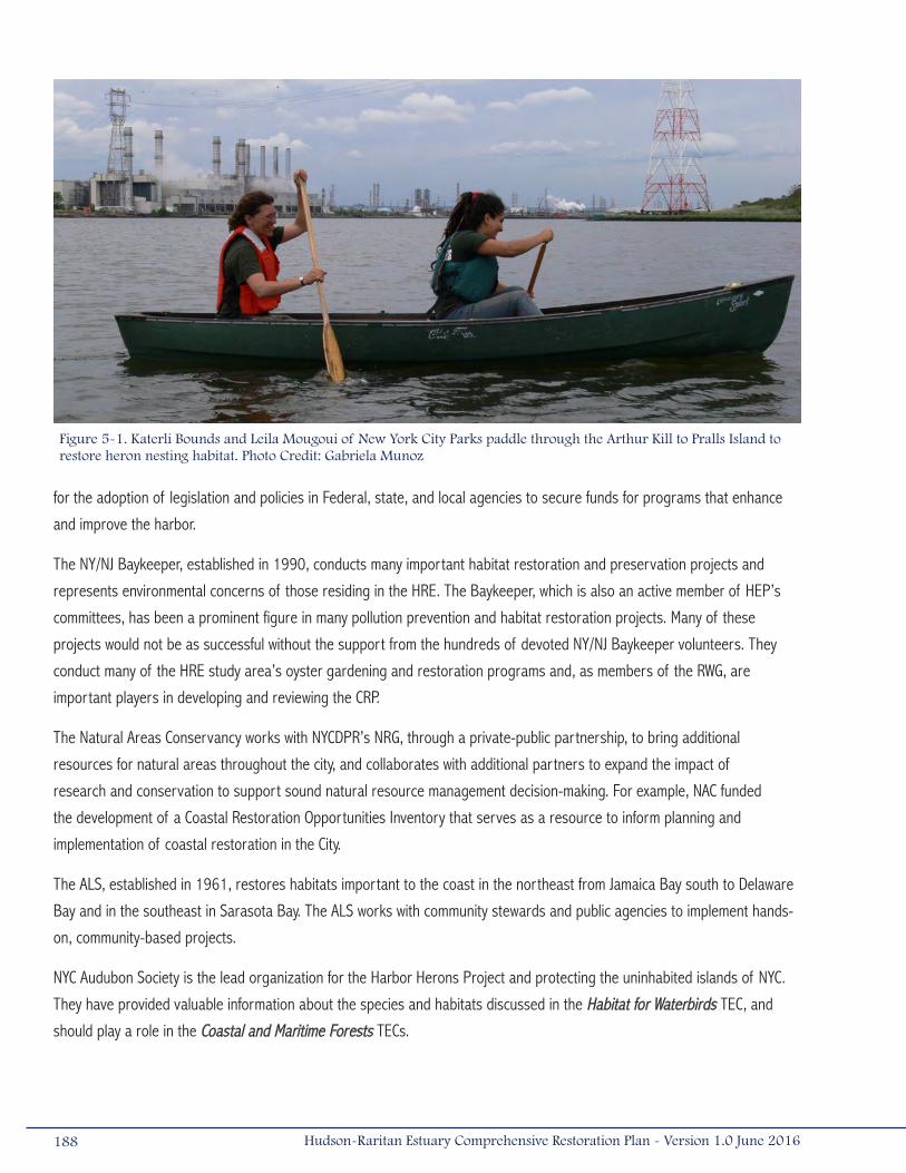
for the adoption of legislation and policies in Federal, state, and local agencies to secure funds for programs that enhance
and improve the harbor.
The NY/NJ Baykeeper, established in 1990, conducts many important habitat restoration and preservation projects and
represents environmental concerns of those residing in the HRE. The Baykeeper, which is also an active member of HEP’s
committees, has been a prominent figure in many pollution prevention and habitat restoration projects. Many of these
projects would not be as successful without the support from the hundreds of devoted NY/NJ Baykeeper volunteers. They
conduct many of the HRE study area’s oyster gardening and restoration programs and, as members of the RWG, are
important players in developing and reviewing the CRP.
The Natural Areas Conservancy works with NYCDPR’s NRG, through a private-public partnership, to bring additional
resources for natural areas throughout the city, and collaborates with additional partners to expand the impact of
research and conservation to support sound natural resource management decision-making. For example, NAC funded
the development of a Coastal Restoration Opportunities Inventory that serves as a resource to inform planning and
implementation of coastal restoration in the City.
The ALS, established in 1961, restores habitats important to the coast in the northeast from Jamaica Bay south to Delaware
Bay and in the southeast in Sarasota Bay. The ALS works with community stewards and public agencies to implement hands-
on, community-based projects.
NYC Audubon Society is the lead organization for the Harbor Herons Project and protecting the uninhabited islands of NYC.
They have provided valuable information about the species and habitats discussed in the Habitat for Waterbirds TEC, and
should play a role in the Coastal and Maritime Forests TECs.
188 Hudson-Raritan Estuary Comprehensive Restoration Plan - Version 1.0 June 2016
Figure 5-1. Katerli Bounds and Leila Mougoui of New York City Parks paddle through the Arthur Kill to Pralls Island to restore heron nesting habitat. Photo Credit: Gabriela Munoz
The National Parks Conservation Association is a national non-profit organization committed to protecting the country’s
national parks. The northeast regional office, located in NYC, has taken a prominent role in improving parks in the HRE
study area, including those within the Gateway National Recreation Area (i.e., Sandy Hook, Jamaica Bay). The National Parks
Conservation Association will continue their role in refining the TECs and assist in their implementation.
Dozens of community-based organizations take an active role in environmental outreach, environmental improvement, and
stewardship within the HRE study area. These organizations represent a collective voice of the local communities, and it is
important they support the restoration agenda of the CRP. These organizations include the Bronx River Alliance, Friends of
Liberty State Park, Lower Passaic Watershed Alliance, Passaic River Coalition, Riverkeeper, Rockaway Waterfront Alliance, the
River Project, and the Waterkeeper Alliance, among others.
Several universities and colleges have played large roles in the development and refinement of the TECs and may continue
their high levels of involvement by monitoring individual projects or evaluating progress of the TECs. For instance, the Center
for the Environment at Cornell University and the HRF helped develop and write the TECs and coordinated workshops to
gather local input and acceptance (Bain et al. 2007). Many academic institutions have participated in the TEC development
process: Cornell University, Rutgers University, Virginia Institute of Marine Science, City University of New York (Manhattan
College, Brooklyn College, Queens College, Hunter College), and State University of New York (College of Environmental
Science and Forestry, Stony Brook University), among others. More recently, the Consortium of the Science and Resilience
Institute at Jamaica Bay, comprised of several academic institutions, is advancing the state of the science in resiliency in
Jamaica Bay that may be applied throughout the HRE.
5.1.2 Plan Management MechanismsThe many environmental agencies and groups referenced in this report provide a diverse and complex set of management
skills and options to implement the CRP. To be effective, agency personnel must be organized in a way that takes advantage
of their respective skills and builds on their interests, authorities, mandates, expertise, and availability. The management
framework of the involved agencies must have mechanisms built around the major roles (i.e., tracking progress, approving
restoration opportunities, advancing science, streamlining policy, identifying financial strategies, and public involvement)
of the CRP that can operate with long-term continuity. The management framework must accommodate change over time,
as the CRP is intended to be a “living document” that will continue to evolve as it is periodically reviewed and additional
information is collected from its implementation.
For the management strategy to be successful, it should be implemented by the existing program management team
(e.g., RWG), with roles and responsibilities of each team member clearly defined. The management team must work together
to ensure that the CRP will continue to address changes in technical knowledge, funding sources, and regulatory climate. CRP
management must also have a mechanism to track progress in meeting program goals and to document lessons learned
during implementation.
189Hudson-Raritan Estuary Comprehensive Restoration Plan - Version 1.0 June 2016
HEP’s RWG provides an organization that can work together to ensure projects identified in the CRP are implemented in a
coordinated manner and track progress. The HEP has directly addressed objectives of the CCMP and now also addresses
the specific restoration objectives represented by the TECs. Regulatory agencies, while dealing with aquatic resource
management for many decades, have recently recognized the need for mechanisms to approve permit applications specific
to the CRP objectives or to proactively integrate TECs into permit applications. Most stakeholder groups have limited staff
or are staffed by volunteers and do not typically address harbor-wide restoration efforts. Permanent staff associated with
larger organizations in the RWG are best equipped to manage CRP implementation and could give the CRP permanence
and prominence by managing aquatic and terrestrial resources in the HRE study area. Achieving the CRP’s objectives could
bring profound changes to the ecology of the estuary; change of this magnitude cannot be attained and managed without a
dedicated staff.
Federal funding, with local partnering, is supporting ongoing restoration work in the HRE study area. This mechanism is
expected to be a major source of funding for future large-scale restoration projects. In the future, some project sponsors
may obtain funding independently, but others may need alternative funds to implement their projects. CRP management must
provide guidance on funding opportunities to potential project sponsors and will need to emphasize the critical need to fund
projects on an ongoing basis. The RWG has committed to developing and managing an annual budget that will be used to
competitively award grants and contracts.
A significant advantage of HEP and the RWG for leadership in CRP management is their well-established history of
coordinating stakeholders and gaining public support. HEP’s former HWG is the foundation of the CRP; the CRP furthers the
goals of establishing and maintaining a healthy ecosystem with full beneficial uses, as defined in HEP’s CCMP. The HEP has
identified restoration sites and provided funding for the acquisition of sites for protection and restoration. Many programs
and work groups in HEP have already played and will continue to play major roles in furthering the restoration agenda
of the CRP.
The HEP RWG, comprised of senior staff from Federal, state, bi-state, and municipal agencies and non-profit organizations,
has membership with specific expertise in the HRE study area and a willingness to spend time and effort reviewing
documents and addressing critical issues. RWG bylaws lend additional transparency to this organization. These bylaws include
membership roles and responsibilities, and affirm that they are active participants in CRP management and are to comment
on the program and disseminate information to their agencies and organizations. The RWG was integral in the evolution
of the CRP, and members will be tasked with helping identify new acquisition and restoration sites, successes and lessons
learned, and potential regulatory hurdles; develop strategies to prioritize acquisition and restoration sites; and periodically
re-evaluate the appropriateness of the program goals. The RWG will help guide the management of the CRP going into the
future and will be integrated into the adaptive management strategy for the CRP.
5.1.3 Tracking Performance at the Estuary-ScaleThe TECs provide a means to measure existing and future environmental conditions in the HRE study area. Tracking TEC
performance and maintaining an accurate, comprehensive database of project sites and estuary-wide changes should
190 Hudson-Raritan Estuary Comprehensive Restoration Plan - Version 1.0 June 2016

be a priority of the CRP management team. However, collecting and tracking project specific data depends on restoration
practitioners voluntarily providing information and project updates to a central location. To ensure that information is
collected, the management team also needs to actively seek and retrieve information.
To effectively track and provide environmental data, the RWG should solicit, summarize, and make information from
restoration practitioners available to the broader community. HEP’s annual report process can be modified to track CRP
progress. HEP currently gathers and compiles information from regional organizations involved in restoration or acquisition,
producing a yearly update that tracks progress toward achieving program goals compared to the prior year. As the HEP
collects annual information for the National Estuary Program Online Reporting Tool (NEPORT), reporting progress toward
CRP goals will join this annual cycle. The RWG anticipates the annual reporting cycle will include annual requests for
information, compilation of site lists with acreages, fact-checking, and wide distribution of the annual report. The acreages
will be categorized by near-term (2020) and long-term objectives (2050). When possible, TECs will be tracked quantitatively.
For example, Wetlands, Coastal and Maritime Forests and Oyster Reefs will be tracked in acres created/restored per year,
while TECs like Habitat for Waterbirds, Enclosed and Confined Waters, Public Access, and Acquisition will be tracked in number
of sites established or enhanced per year. Details of sites per planning region for each TEC will also be reported. Other
projects to be tracked include mitigation banks, mitigation projects, and acquisition sites.
Similar to all CRP sites within the database, additional information for each project would include (if available):
• Project location and, if possible, a mapped perimeter with GPS coordinates;
• TECs and restoration actions proposed or implemented;
• Total project cost;
• Assessing functions and values provided over pre-restoration conditions;
• Status updates: Planning/Feasibility, Construction, Post-Construction Monitoring, Construction Completed, and
Acquisition Completed. Projects will not be counted toward the TEC objective until construction is completed; and
• Project Sponsors.
Ideally, restoration practitioners would also be able to provide photographs, data, graphics, or any reports generated from
the construction or monitoring phases. Guidelines may be established to standardize the data collection and reporting
process to facilitate comparability among different programs and their many datasets. These reports would be highly
valuable to those interested in conducting restoration and seeking guidance. This type of documentation would also help the
CRP management team determine project success and assess functional performance of the TECs, thus assisting in planning
further restoration efforts.
Regular reporting of acreages restored per TEC by planning region, as well as a cumulative total per TEC for the HRE study
area, will help maintain interest in the program and track success in meeting its short and long-term goals. The reporting
process will be designed to be easily reviewed and understood by the public. Regular reports will help determine if current
actions and resources are sufficient and how the HRE study area is contributing to national restoration efforts.
191Hudson-Raritan Estuary Comprehensive Restoration Plan - Version 1.0 June 2016
Data from the environmental monitoring programs should be summarized periodically in “Health of the Harbor” reports
for the estuary, similar to the ones published in 2004 and in 2012. Generating reports helps to identify data gaps and
information needs. Currently, determining trends in environmental health in the HRE study area is difficult or impossible
for some categories, most of which correspond to a TEC, because detailed information is incomplete. Future monitoring
programs may help to fill these gaps, especially if government or stakeholder programs are initiated on an estuary-wide
scale and data collection methods are kept consistent throughout the program.
The OASIS database will be an end-point for placing any new or updated restoration and acquisition information, and will be
expanded to more completely include the data for coastal New Jersey counties in the HRE study area and for Westchester
County, New York.
As described above, programmatic monitoring will address planning region and estuary-wide trends, evaluating whether TEC
target statements and objectives are being met, and determining what steps should be taken to achieve them. Programmatic
monitoring can also include communicating work group and committee activities, outreach activities completed, research
and restoration milestones, the amount of committee funding spent, and changes in public awareness and perception of
the program (USEPA 2005). It may be beneficial to monitor whether partners follow through on their commitments and what
might be preventing them from doing so (USEPA 2005).
General recommendations to consider during plan implementation include:
• Build upon existing monitoring efforts, and use the HEP RWG and possibly other HEP work groups or organizations
as a coordinating body to fill data gaps;
• Adopt monitoring protocols to provide a consistent means for comparing information across geographical and
temporal scales; and
• Continue efforts to develop an estuarine-wide database from which to share data.
5.1.4 Adaptive ManagementAdaptive management, based on the approach of “learning by doing” (Walters and Holling 1990), has been an important
planning and assessment tool in ecosystem restoration. Adaptive management is critical to success in a developing science
that depends on many factors that may be unpredictable. Adaptive management requires monitoring the condition of the
system using selected indicators, assessing progress using previously established goals and performance criteria, and
making decisions when corrective actions are needed. When the goals or performance criteria are not met, corrective
actions based on the monitoring should be implemented. Other actions include doing nothing or modifying the goal to a
different but equally acceptable state. The final component of an adaptive management program involves incorporating
successful techniques and lessons learned into successive projects within the same program or geographic range. Adaptive
management recognizes and prepares for uncertain outcomes and, if established early in the planning phase and correctly
implemented through the assessment phase, adaptive management can be a valuable tool for efficiently improving program
performance.
Adaptive management can also help reduce potential adverse effects of restoration. Adverse effects may be present because
restoration involves the alteration or enhancement of existing habitats in the effort to restore or enhance selected species
192 Hudson-Raritan Estuary Comprehensive Restoration Plan - Version 1.0 June 2016

and habitat types. Although existing habitats may be degraded, they do support some level of aquatic life production.
Adaptive management can be used to reduce adverse effects of implementing selected restoration actions through
refinement of restoration techniques and increasing the knowledge applied to selecting acquisition and restoration sites.
All facets of the CRP and TEC implementation can be adaptively managed. Each restoration project implemented as part of
the CRP should incorporate a monitoring element sufficient to support adaptive management options. This approach will
ensure the highest probability of success and verify that sites have been set on a trajectory to meet the project’s goals. By
employing these corrective measures at future acquisition and restoration sites throughout the estuary, the likelihood of
success will be improved (compared to no action) and lessons learned can be used to improve success of the next project,
thereby bringing the HRE study area closer to its restoration goal more quickly and efficiently.
5.2 Implementation
5.2.1 Potential Funding OpportunitiesMeeting the restoration targets described in Chapters 3 and 4 depends upon planning, constructing, and monitoring many
restoration projects. These efforts will have substantial costs. Economies of scale will benefit from larger, coordinated
efforts where the average unit cost decreases as the project size increases or where cumulative benefits from adjacent
areas add to the overall restoration value. Volunteers can also help reduce costs, typically through assistance with planting
and monitoring. For example, the ALS regularly engages hundreds of volunteers in habitat restoration activities, such as
removing debris from smothered marshes, planting native dune plants, removing invasive plants, and bagging shell for
oyster reef restoration. In June 2013, the ALS, EcoWatchers, and the Jamaica Bay Guardian mobilized volunteers and planted
30 acres (0.13 kilometers2) of wetlands at the Black Wall and Rulers Bar Marsh Islands within Jamaica Bay.
For projects that depend upon Federal or state funding mechanisms, it should be recognized that Congress and State
Legislatures’ funding decisions are made over a period of months or years following plan adoption. The recommendations
made in this plan have been crafted to recognize these limitations.
Even when restoration practitioners efficiently and resourcefully plan their projects, the thousands of acres of upland,
intertidal, and subtidal habitat necessary to meet the short- and long-term TEC goals will require a large investment
(Table 5-1). For example, the cost to meet the short-term objective for the Wetlands TEC (i.e., creation and restoration of
1,000 acres [4.05 kilometers2] by 2020) is estimated at between $218 and $713 million. Meeting the long-term objective
(i.e., creation of 5,000 acres [20.24 kilometers2] by 2050) is estimated to cost $1.0 to $3.5 billion. Considering that these
are only the costs associated with one of the twelve TECs, funding to implement all TECs will be difficult to secure over the
timeframes identified. It is therefore important to take great care to ensure these projects are in the best interest of the
local community. Investing in natural resources brings major returns to the region as ecosystem services, by promoting the
region’s culture, and by benefiting local economies.
193Hudson-Raritan Estuary Comprehensive Restoration Plan - Version 1.0 June 2016
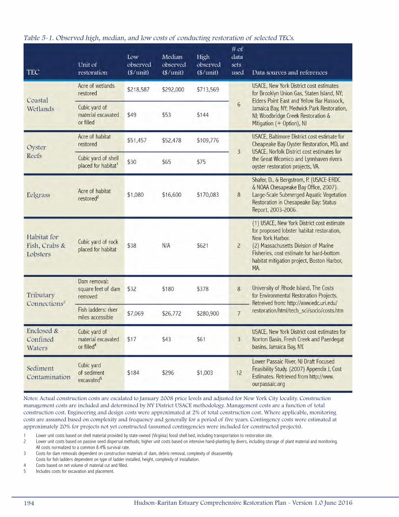
Table 5-1. Observed high, median, and low costs of conducting restoration of selected TECs.
1 Lower unit costs based on shell material provided by state-owned (Virginia) fossil shell bed, including transportation to restoration site.2 Lower unit costs based on passive seed dispersal methods; higher unit costs based on intensive hand-planting by divers, including storage of plant material and monitoring.
All costs normalized to a common 8.4% survival rate.3 Costs for dam removals dependent on construction materials of dam, debris removal, complexity of disassembly.
Costs for fish ladders dependent on type of ladder installed, height, complexity of installation.4 Costs based on net volume of material cut and filled.5 Includes costs for excavation and placement.
Notes: Actual construction costs are escalated to January 2008 price levels and adjusted for New York City locality. Construction management costs are included and determined by NY District USACE methodology. Management costs are a function of total construction cost. Engineering and design costs were approximated at 2% of total construction cost. Where applicable, monitoring costs are assumed based on complexity and frequency and generally for a period of five years. Contingency costs were estimated at approximately 20% for projects not yet constructed (assumed contingencies were included for constructed projects).
194 Hudson-Raritan Estuary Comprehensive Restoration Plan - Version 1.0 June 2016
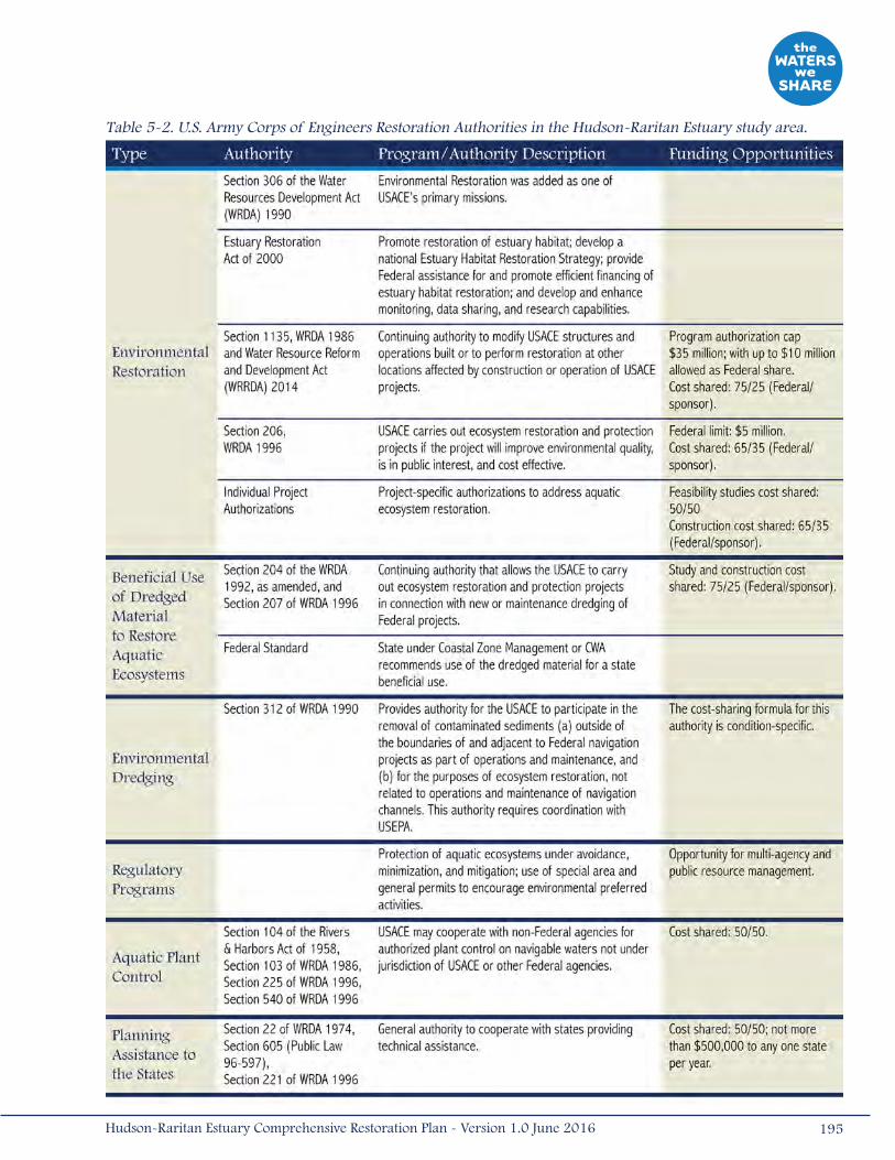
195Hudson-Raritan Estuary Comprehensive Restoration Plan - Version 1.0 June 2016
Table 5-2. U.S. Army Corps of Engineers Restoration Authorities in the Hudson-Raritan Estuary study area.
Finance planning is time-consuming but necessary for long-term success and progress toward the CRP’s goal and
restoration targets. Securing funds to support program operations and implement restoration programs represents a
challenge, but one that may be facilitated by the CRP as it provides for the first time a common restoration agenda that
the region can collectively support. It is important to establish base funding sources to support ongoing programmatic
components (e.g., newsletters, website, and data management, tracking progress) and to later enhance and expand the
program by increasing the base funding. Moreover, funding to implement the CRP should not interfere or conflict with existing
restoration efforts by drawing money away from successful programs. Instead, a complementary finance plan should be
developed to identify and evaluate:
• Funding sources for managing and implementing restoration in the HRE study area;
• How these mechanisms will be executed; and
• During what time period implementation should occur (USEPA 2005).
A variety of Federal, state, local, and private funding opportunities should be evaluated when developing the finance plan.
For many endeavors, it may be beneficial to develop strategic partnerships with other organizations, whether formal or
informal. Examples of these partnerships include the Long Island Sound Habitat Restoration Initiative, HEP, and the Urban
Waters Federal Partnerships on the Lower Passaic, Bronx, and Harlem Rivers, which include a combination of Federal,
state, and local partners. Developing cost-sharing agreements and partnerships can result in larger programs that benefit
from economies of scale. Several funding opportunities that may be used for habitat restoration in the HRE study area are
described below.
5.2.1.1 U.S. Army Corps of Engineers ProgramsThere are partnering opportunities with the USACE to restore habitats through the Continuing Authorities Program (CAP),
General Investigation (GI) studies, and Construction General (CG) funds. These programs require a cost-share agreement
between the USACE and the non-Federal sponsor. The non-Federal share can be contributed with matching funds or as in-
kind products or services (Table 5-2).
Continuing Authorities Program and General Investigation Studies
• Under the CAP, small-scale ecosystem restoration projects can be conducted under several standing authorities,
including the beneficial use of dredged material (Sections 204 of WRDA 1992 and 207 of WRDA 1996),
environmental restoration (Sections 206 of WRDA 1996 and 1135 of WRDA 1986), and estuary habitat restoration
(Sections 102-110 of the Estuary Restoration Act of 2000). These projects are undertaken by the USACE at the
request of local partners, such as state agencies, county governments, and municipalities. CAP projects are cost-
shared between the Federal government and a non-Federal sponsor, and are generally funded with 65 percent to
75 percent Federal funds.
• GI studies are the common way for the USACE to help a community solve a complex or large-scale water resource
problem such as habitat restoration within a large system. Specific Congressional authorization and appropriations
are necessary, such as the HRE Ecosystem Restoration Study resolution and appropriations under which this
report was developed. The costs for those feasibility studies are evenly shared between the Federal and non-
196 Hudson-Raritan Estuary Comprehensive Restoration Plan - Version 1.0 June 2016

Federal partners, while project implementation is typically funded with 65 percent Federal funds. Recommendations
stemming from the feasibility studies must then be approved by Congress and funded for construction via
CG accounts.
Both CAP and GI studies require formal requests for assistance from a non-Federal project sponsor. All potential non-Federal
partners must be able to provide any required lands, easements, rights-of-way, relocations, and dredged or excavated
material disposal areas. Depending on the program and type of project, a non-Federal partner can be:
• A legally constituted public body with full authority and capability to perform the terms of its agreement;
• A national non-profit organization that is capable of undertaking future requirements for operation, maintenance,
repair, replacement, and rehabilitation (OMRR&R); or
• Any non-profit organization if there is no future requirement for OMRR&R.
Construction General Funds
Demonstration projects are eligible for funding through USACE’s Engineer Research and Development Center (formerly, the
Waterways Experiment Station) in Vicksburg, Mississippi. The Center annually issues requests for proposals for research
and demonstration projects, with a funding limit of approximately $200,000, which approximates the estimated construction
cost. In addition, smaller projects can be nominated to an interagency committee for funding under the National Estuary
Restoration Act, implemented by USACE and NOAA, such as the creation of wetlands, oysters and seagrass beds within Cedar
Beach Creek in Suffolk County with the Cornell Extension Station as grantee and Suffolk County Parks as landowner.
Beneficial use of dredged material for habitat restoration, a primary goal of the USACE Dredged Material Management Plan
(USACE 2008b), is another potential strategy to decrease overall project costs. Large-scale projects in the HRE study area
use dredged material for a number of projects that contribute to the TECS, such as offshore reefs, capping contaminated
sediments and restoring coastal Wetland habitat (e.g., the Lincoln Park West Wetland Restoration Project in Jersey City,
New Jersey), and restoring vanishing marsh islands (e.g., Jamaica Bay Marsh Islands), as well as recreation and beach
nourishment, and remediation (USACE 2008a). Diverting uses of dredged materials to restore habitat is a valuable, cost-
effective method that can also reduce the need for mining virgin materials to complete these restoration projects.
The NY/NJ Harbor Deepening Project presented a well-timed, ample supply of dredged material for beneficial use around
the estuary (USACE 2008b), placing more than 60,000,000 CY of dredged material in the region. Managing future
dredged material during the operations and maintenance (O&M) of the 50-foot (15-meter) channels will be a challenge.
Several considerations and challenges in the beneficial use of O&M dredged material include the need to assess demand,
relative benefits, timing of availability, ability for the local sponsor to pay 100 percent of any increased differential costs,
synchronizing the need and placement of sites with O&M projects, developing suitable plans, and specification and
negotiations of contributed funds agreements with sponsors. Although most aquatic restoration projects require relatively
little material, recontouring subaqueous borrow pits, creating upland habitat, creating artificial reefs, and restoring wetland
islands present opportunities in the estuary to use large amounts of clean dredged material and rock for restoration.
197Hudson-Raritan Estuary Comprehensive Restoration Plan - Version 1.0 June 2016
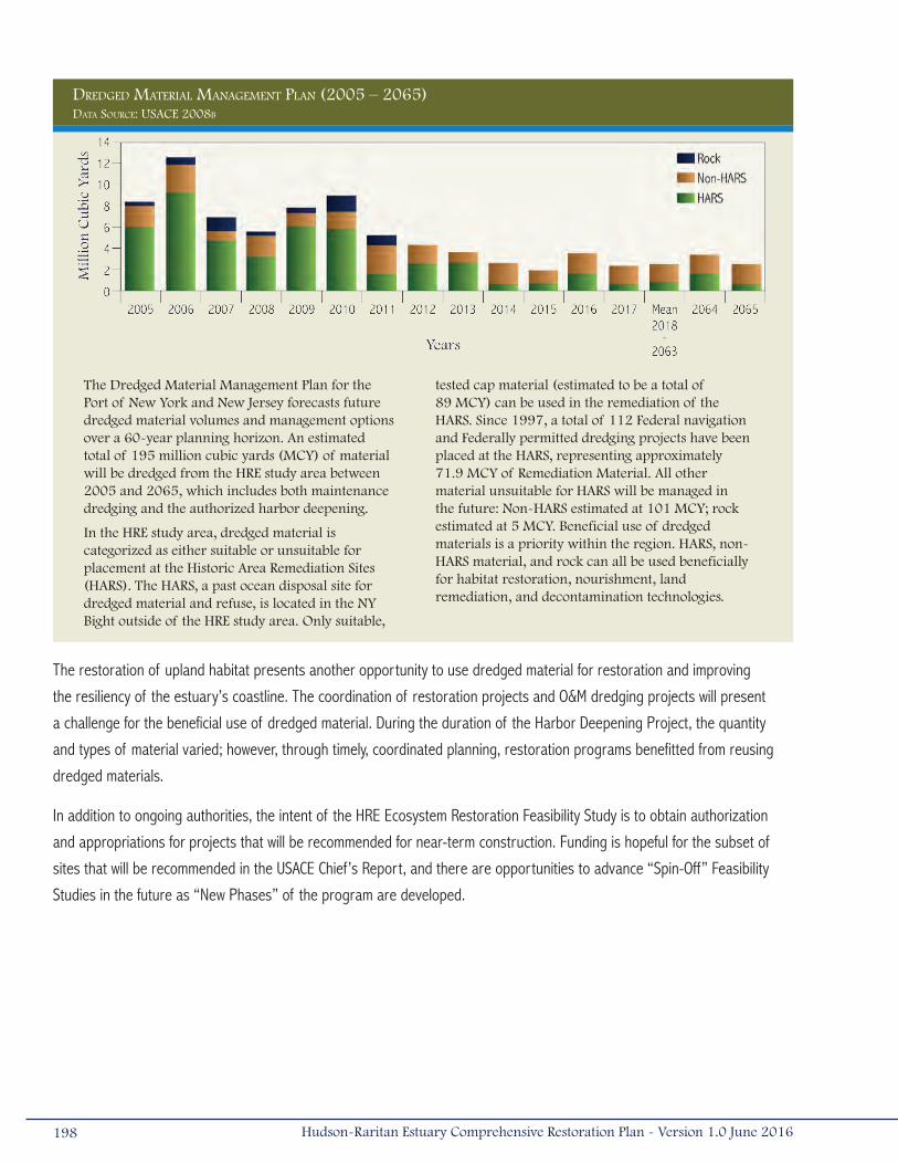
The restoration of upland habitat presents another opportunity to use dredged material for restoration and improving
the resiliency of the estuary’s coastline. The coordination of restoration projects and O&M dredging projects will present
a challenge for the beneficial use of dredged material. During the duration of the Harbor Deepening Project, the quantity
and types of material varied; however, through timely, coordinated planning, restoration programs benefitted from reusing
dredged materials.
In addition to ongoing authorities, the intent of the HRE Ecosystem Restoration Feasibility Study is to obtain authorization
and appropriations for projects that will be recommended for near-term construction. Funding is hopeful for the subset of
sites that will be recommended in the USACE Chief’s Report, and there are opportunities to advance “Spin-Off” Feasibility
Studies in the future as “New Phases” of the program are developed.
198 Hudson-Raritan Estuary Comprehensive Restoration Plan - Version 1.0 June 2016
DreDgeD Material ManageMent Plan (2005 – 2065)
The Dredged Material Management Plan for the Port of New York and New Jersey forecasts future dredged material volumes and management options over a 60-year planning horizon. An estimated total of 195 million cubic yards (MCY) of material will be dredged from the HRE study area between 2005 and 2065, which includes both maintenance dredging and the authorized harbor deepening.
In the HRE study area, dredged material is categorized as either suitable or unsuitable for placement at the Historic Area Remediation Sites (HARS). The HARS, a past ocean disposal site for dredged material and refuse, is located in the NY Bight outside of the HRE study area. Only suitable,
tested cap material (estimated to be a total of 89 MCY) can be used in the remediation of the HARS. Since 1997, a total of 112 Federal navigation and Federally permitted dredging projects have been placed at the HARS, representing approximately 71.9 MCY of Remediation Material. All other material unsuitable for HARS will be managed in the future: Non-HARS estimated at 101 MCY; rock estimated at 5 MCY. Beneficial use of dredged materials is a priority within the region. HARS, non-HARS material, and rock can all be used beneficially for habitat restoration, nourishment, land remediation, and decontamination technologies.
Data Source: uSace 2008b

5.2.1.2 Federal Grant ProgramsMany Federal grant programs can assist with funding restoration. The following sections describe examples of these programs.
U.S. Environmental Protection Agency (USEPA)
USEPA has many grant programs that can aid in implementation of restoration:
• The NEP provides grants in support of habitat restoration projects. These grants are provided through the CWA and
require a match commitment from a local sponsor;
• Wetlands Program Development Grants in support of developing new or refining existing comprehensive wetland
protection, management, or restoration programs;
• Community Action for a Renewed Environment is a competitive grant program offering financial and technical
assistance to communities to reduce pollution in their local environment;
• The Environmental Justice Small Grant Programs assists local organizations to identify and/or address
environmental/public health issues in their community;
• The Environmental Education Grants Program supports environmental education projects that increase the
public awareness about environmental issues and increase people’s ability to make informed decisions that affect
environmental quality;
• The Five Star Restoration Program brings together various stakeholder groups (e.g., students, citizen groups,
corporations, landowners, government agencies) to provide environmental education and training through projects
that restore wetlands and streams;
• The Clean Water State Revolving Fund assists states wanting to implement water quality protection projects for
wastewater treatment, non-point source pollution control, and watershed and estuary management;
• Section 319 of the CWA provides grants to states with comprehensive watershed projects aimed at protecting or
enhancing water quality from non-point source pollution. The Section 319 Nonpoint Source Management Program
currently awards over $200 million annually to watersheds nationwide. While generally not applied to habitat
restoration, they are instrumental in setting the stage for establishing the water criteria necessary for restoration
project success; and
• The Targeted Watershed Grants Program encourages successful community-based approaches and management
techniques to return real environmental results in improved and sustained water quality.
National Oceanic and Atmospheric Administration (NOAA)
NOAA is dedicated to improving and preserving coastal and riverine habitats throughout the nation. NOAA offers funding
opportunities through several of their programs.
• The Community-based Restoration Program provides funding to local communities from NOAA-Fisheries. These
grants require 1:1 matching funds or in-kind services on restoration projects. There are a few spin-offs of this
program, where partnerships have been formed with the NEP and with the National Association of Counties. The
199Hudson-Raritan Estuary Comprehensive Restoration Plan - Version 1.0 June 2016
NEP/Community-based Restoration Partnership funds citizen-driven habitat restoration projects within watersheds
of the NEPs.
• NOAA’s National Sea Grant Program offers funding for marine and estuarine research programs. Sea Grant is NOAA’s
primary university-based program in support of coastal resource use and conservation. The New York Sea Grant,
administered from the State University of New York, focuses on coastal-dependent businesses, fisheries, seafood
products, coastal hazards and processes, coastal water quality, coastal habitats, and aquatic nuisance species. The
New Jersey Sea Grant is managed by the New Jersey Marine Science Consortium. The program supports research,
education, and information sharing to foster sustainable use of marine resources and provide solutions to coastal
management and policy issues. Other NOAA programs include the Estuary Habitat Restoration Program, the Climate
Program, and the Marine Debris Prevention and Removal Program.
U.S. Fish and Wildlife Service (USFWS)
The USFWS funds restoration and conservation under many separate programs, including:
• The National Coastal Wetlands Conservation Grants, which are available to state agencies;
• The Coastal Program provides incentives for voluntary species protection;
• The Partners for Fish and Wildlife Program assists private landowners with habitat improvement projects that benefit
Federal Trust Species (e.g., migratory birds, inter-jurisdictional fish, threatened and endangered species);
• Restoration programs specific to enhancing marine or anadromous fisheries, including constructing artificial
reefs, salt marshes, and freshwater habitats, can be funded through the 1988 USFWS Federal Aid in Sport Fish
Restoration Act, 16 U.S.C. Sec. 777; and
• Further fisheries restoration support from the Wallop-Breaux Act amendments, in which an excise tax was extended
to previously untaxed fishing equipment.
U.S. Department of Agriculture (USDA)
The U.S. Department of Agriculture-Natural Resources Conservation Service offers technical assistance and up to 75 percent
cost-share assistance to establish and improve fish and wildlife habitat through its Wildlife Habitat Incentives Program. These
funds are available to private landowners, agencies, and non-government organizations.
5.2.1.3 State ProgramsBoth New York and New Jersey offer a funding mechanism to implement ecosystem restoration that can be used to advance
the HRE goals.
New York
The NYSDEC offers a number of assistance programs to their municipalities and community-based organizations, including
ecological restoration, brownfields restoration, and water quality improvement projects. Many of these programs are
appropriated through the 1996 Clean Water/Clean Air Bond Act, which provides millions of dollars each year for qualified
restoration programs in New York. Other New York grant programs were established through different means.
200 Hudson-Raritan Estuary Comprehensive Restoration Plan - Version 1.0 June 2016

NYSDEC also manages the Hudson River Estuary Program, whose mission is to conserve the river’s natural resources,
promote full public use and enjoyment of the river, and clean up the pollution that affects our ability to use and enjoy it. The
Estuary Program implements its Hudson River Estuary Action Agenda through numerous partners in government, the non-
profit and business sectors, and concerned citizens (NYSDEC 2013), as well as the NYSDEC Habitat Restoration Plan (Miller
2013). In addition, NYSDEC and New York State Department of State (NYSDOS) are local sponsors for the recently resumed
USACE Hudson River Restoration Feasibility Study. This study is also anticipated to result in new construction authorization
and appropriations for restoration above the Tappan Zee Bridge to the Federal Troy Lock and Dam.
In fall 2001, Federal legislation established the State Wildlife Grants (SWG) program to provide funds from offshore oil and
gas leasing to state wildlife agencies for conservation of fish and wildlife species and their associated habitats in greatest
need of conservation. In New York, this program is implemented by NYSDEC’s Division of Fish, Wildlife and Marine Resources
with funding from “Teaming with Wildlife,” a national organization dedicated to fish and wildlife conservation.
The SWG program is unique in that it provides funds for conservation of species not traditionally hunted or fished. Within the
geographic extent of the HRE, there are 267 species of greatest conservation need eligible for funding through the New York
SWG program.
New Jersey
The NJDEP maintains several grant and loan programs under the themes of environmental regulation, land use management,
brownfields restoration, and natural and historic resources, among others. Through these programs, the state offers low-
interest loans for dam restorations, assists municipalities in implementing Forestry Management Plans, and offers funds to
develop and maintain trails and trail facilities.
New Jersey Department of Transportation/Office of Maritime Resources manages the National Boating Infrastructure Grant
Program, funded by the DOI, USFWS, are distributed annually to states “to construct, renovate, and maintain tie-up facilities”
for recreational vessels. With these funds, there are numerous opportunities to develop purposeful and objective projects to
fulfill the program’s mission and enhance New Jersey’s Public Access facilities.
5.2.1.4 Sandy Recovery FundsThe emergency Federal funding allocated as part of the Hurricane Sandy Recovery effort will be shared among several
Federal and state agencies to aid in current recovery and future flood protection projects. These projects include
infrastructure repairs, upgrades, and maintenance; construction of coastal storm risk management projects; restoring and
increasing resiliency of coastal communities; monitoring; and research. Many of the CRP sites outlined in this document can
serve as NNBFs that should be integrated into ongoing and future Coastal Storm Risk Management projects. A detailed list of
funding opportunities supporting coastal restoration efforts is in Chapter 2.
201Hudson-Raritan Estuary Comprehensive Restoration Plan - Version 1.0 June 2016
5.2.1.5 Natural Resource Damage AssessmentThe Natural Resource Damage Assessment (NRDA) process pursuant to the Comprehensive Environmental Response,
Compensation and Liability Act (CERCLA or Superfund) can also provide opportunities and funding for Federal and state
agencies and private entities to implement ecosystem restoration projects. NOAA and USFWS have programs to provide funds
for habitat restoration in areas that have experienced environmental degradation as a result of oil spills and other losses of
ecological resources. These funds derive from litigation and financial settlement with the responsible parties, with oversight
of a committee of trustees pursuant to CERCLA/Superfund. In New Jersey, the Natural Resource Restoration is administered
by the Office of Natural Resource Restoration, which was established to ameliorate environmental injury caused by multiple
oil spills and discharges. The Commissioner of the NJDEP is the designated “trustee” charged with administering and
protecting the State’s natural resources. In New York State, the Governor has designated the NYSDEC as the trustee for New
York trust resources.
In addition to seeking funding from “natural resource damage” claims from natural resource trustees, it may also be possible
to coordinate with PRPs of Superfund sites to identify habitat restoration actions. Implementation of potential restoration
opportunities, restoring specific natural resource losses, could fulfill a PRP’s liability with the Federal and state trustees. In all
cases, projects should attempt to maximize the ecological value of the site and be designed to be self-maintaining. A recent
example of a NRDA project that resulted in a net increase of habitat is the Lincoln Park West Wetland Restoration Project,
which resulted in the creation of 32 acres (0.13 kilometers2) of intertidal and coastal Wetland habitat.
5.2.1.6 MitigationFor several TECs, it may be possible to obtain mitigation funding to support restoration projects. Agencies (e.g., USACE,
PANYNJ, NJDOT, NYCDEP, and NYCEDC) and private entities are often required to mitigate for unavoidable project impacts.
The USACE and USEPA 2008 Final Compensatory Mitigation Rule emphasizes that the process of selecting locations for
compensation sites should be driven by a watershed approach and watershed needs identified within the analysis (USACE
and USEPA 2008). Specific wetland creation, restoration, preservation, and protection projects should best address those
needs. Mitigation actions could be selected based on recommendations within the CRP to ensure that the mitigation projects
benefit the HRE watershed while also meeting mitigation requirements. Sites identified through the HEP nomination process
could also be considered as mitigation sites.
The 2008 Mitigation Rule also indicates a preference for mitigation banking in order to fulfill a permitee’s mitigation
requirements. Mitigation banks are sites where a wetland has been created by a public or private entity and permit applicants
purchase credits (corresponding to a specific wetland type and area) to offset project impacts. These banks are generally
larger in scale than permittee-responsible mitigation projects and they provide large expanses of contiguous habitat. This
provides greater certainty for long-term ecological success and eliminates the temporal loss of wetland habitat that can
occur before a permittee-responsible mitigation site is constructed or achieves its performance standards. As discussed in
Section 2.4, two mitigation banks were established in the Hackensack Meadowlands, along the Hackensack River within the
Newark Bay, Hackensack River, Passaic River Planning Region in 2012. Additionally, NYCEDC has initiated planning for the Saw
Mill Creek Wetland Bank under the Mitigation and Restoration Strategies for Habitat and Ecological Sustainability (MARSHES)
initiative in the Arthur Kill/Kill Van Kull planning region. The restoration opportunities identified within the CRP could focus site
202 Hudson-Raritan Estuary Comprehensive Restoration Plan - Version 1.0 June 2016
selection for the creation of one or more additional wetland mitigation banks within the HRE. In addition to mitigation banks,
in-lieu fee fund management and other fund management strategies should be among the options explored.
In the HRE study area, mitigation banks are uniquely positioned to provide programmatic benefits for the CRP. Mitigation
banks offer opportunities for interagency collaboration during the project-planning phase; agencies work together to develop
standardized functional assessment and sampling methodologies as well as standardized measures of restoration success.
For example, the NYCEDC’s proposed mitigation bank will be used as a platform to establish regional mitigation monitoring
and success criteria in NYC through consensus-building with USACE-New York District, NYSDEC Region 2, and several city
agencies, including NYCDPR. The standardized requirements will be designed to be realistic, without putting undue hardship
on the project sponsor, and can serve as the blueprint for other TECs being implemented in the HRE study area.
While banks offer a relatively simple solution to the mitigation needs in the HRE, the market price for credits is steep and
will continue to increase as credits become scarce. Project sponsors can reduce their mitigation needs by implementing the
TECs and incorporating restoration measures and approved design and development guidelines in the planning, design, and
pre-application phases of a project. For example, NYC’s Waterfront Revitalization Plan (WRP), updated in 2016, provides
opportunities to incorporate restoration into the planning and permitting framework of a project. To more effectively
implement the city’s waterfront planning goals, several policies were created, including policy four of the WRP, which is
specific to the protection and restoration of ecological systems within the coastal area. Project sponsors can also benefit
from adopting a new approach to design by utilizing tools such as the Waterfront Alliance’s WEDG. WEDG provides a set of
guidelines and an incentive-based ratings system intended for developing waterfront properties in a way that promotes
ecological restoration, access, and resiliency. Additional information and examples of projects that proactively incorporate
restoration in the early phases of project planning and design are discussed in Chapter 2.
5.2.1.7 Non-Profit OrganizationsCoordination with non-profit organizations actively engaged in restoration/preservation activities may be another opportunity
to raise funds for restoration. Non-profit organizations are ideally suited to receive contributions from the public and private
sectors and disburse funds for research studies, environmental monitoring, and educational programs. It may also be
possible to solicit non-profit organizations to identify actions they can implement that would correspond to their missions. In
addition, several non-profit organizations have grant programs, including:
• HRF awards grants that focus on capital construction, development, and improvement, including public access
facilities, habitat preservation/restoration, and educational facilities.
• American Rivers is a non-profit organization that funds many community-based environmental restoration programs
ranging from restoring natural river function (including barrier removal projects), floodplains, and wetlands to
establishing public access opportunities near rivers.
• NFWF has keystone initiatives that focus on bird conservation, fish conservation, marine and coastal conservation,
and wildlife and habitat conservation. The NFWF also has many special grant programs that range from water
203Hudson-Raritan Estuary Comprehensive Restoration Plan - Version 1.0 June 2016

quality improvements to innovative conservation practice, in addition to the significant grant funding provided as
part of the Hurricane Sandy Coastal Resiliency Competitive Grant Program, which supports projects that reduce
communities’ vulnerability to coastal storms, sea level rise, flooding, and erosion through strengthening natural
ecosystems and benefitting fish and wildlife.
5.2.1.8 Additional Funding SourcesPrivate partnerships, such as Coastal America’s Corporate Wetlands Partnership, provide another avenue for project funding.
Through these partnerships, private companies help their communities make the required local match for Federal funds
for community-based restoration projects. Other creative methods for funding implementation projects can occur through
affinity credit cards, specialty license plate fees (e.g., Conserve Wildlife license plates), capital giving campaigns, or utility fees
(USEPA 2005).
5.2.2 Policy Considerations for ImplementationAs an organization, agency, municipality, or other group begins the process of conducting restoration within the HRE study
area, there may be critical policy considerations that should be discussed with regulatory agencies to improve overall
success and encourage consistency in operation. Some critical policy issues include:
• Habitat Exchange
• Placement of Fill (for creation of wetlands and shallow water habitat)
• Beneficial Use of Dredged Material
• Attractive Nuisances
• Oyster Reef Creation/Restoration
• Lobster Habitat Creation
• Sediment Contamination
Overarching Regulatory Issues
Currently, there are differences in the regulatory approach and policies among agencies with the statutory authority to
regulate restoration activities. The CRP provides an opportunity to open a dialogue among these agencies. Limited funding
and staff have been ongoing challenges for regulatory agencies as they attempt to accomplish their goals within mandated
administrative procedures and project review times. Setting the administrative issues aside, there are broad policy issues
that should be addressed.
The HRE is a highly urbanized environment with significant legacy impacts (e.g., chemical contaminants, sedimentation,
and loss of habitat). The current regulatory framework is geared to protect existing resources and is likely to dominate
management of the HRE’s ecological resources in the future. However, as environmental restoration is incorporated into
habitat management, goals for the protection of existing resources and the restoration of the ecosystem should converge.
This convergence could be facilitated with policies that integrate environmental protection, ecosystem restoration, and
economic development. Some proponents for restoration argue that restoration projects should have priority during
regulatory actions and that policies should be changed to favor restoration. However, this action may require legislative
204 Hudson-Raritan Estuary Comprehensive Restoration Plan - Version 1.0 June 2016

action resulting in changes in New York and New Jersey state laws. One purpose of the CRP is to identify such issues and
encourage dialogue among regulatory agencies and restoration practitioners in an effort to facilitate practical policy changes
and developments.
Habitat Exchange
While there is no specific regulation stating that habitat exchange (creating one type of habitat in an area that is presently a
functional habitat of another type) cannot be permitted, regulatory agencies interpret their rules regarding the placement of
fill and/or dredging to encompass the habitat exchange issue. This generally occurs because some alteration of the physical
environment, through either filling or dredging, has to take place in order to change the habitat type. NYSDEC, NJDEP,
NYSDOS, and USACE all have jurisdiction in regulating these types of activities.
All of these policies and their supporting laws have implications when initiating a restoration effort that may involve
exchanging one habitat type for another. This may be most prevalent in the case of the Wetland TEC, the Shorelines and
Shallows TEC, and the Oyster TEC. Regulatory agencies tend to place preservation of existing aquatic habitat above its
alteration, possibly due to uncertainty of success or the absence of an overriding comprehensive plan. Current regulations
require alternatives analyses, studies or modeling of existing habitat quality or diversity, justification for the proposed
exchange of habitats, and monitoring the success of the restoration effort if permitted. Mitigation for the impacts associated
with habitat restoration can also be required. All of this is reasonable if the evaluations occur with an open mind and in the
context of the larger restoration agenda. Cooperation with the regulatory agencies through the CRP should encourage an
appreciation of the need for a diversity of habitat types and the desire to support potential actions that at first may appear
to be undesirable changes. It is important to note that habitat distribution and vulnerability may change over time with sea
level rise and events associated with climate change. In addition to improving habitat diversity, this bigger-picture approach
should aid the restoration community in achieving the TEC goals identified in this CRP.
Placement of Fill
While there may be opportunities when fill placement would have a positive effect on the aquatic environment, many
regulatory agencies routinely view this type of effort negatively. Fill placement activities can be involved in the creation
of Wetlands (such as in the Jamaica Bay Marsh Islands), Shorelines and Shallows, and Oyster Reefs (including Rebuild
By Design’s Living Breakwater off the coast of Staten Island), all of which advance the TECs and may serve as NNBFs by
providing coastal storm risk management benefits. Another example of “fill” is the placement of new pile fields, such as
those in the Hudson River at the Hudson River Park. This activity has the potential to create foraging habitat for fish, shield
juvenile fish from predators, and provide habitat for sessile invertebrate species. NYSDEC, NJDEP, NYSDOS, and USACE have
jurisdiction in regulating these types of activities. The applicants worked extensively with these agencies, along with the
NOAA-Fisheries, to obtain the requisite permits. In a similar manner, an extensive interagency team worked with NYSDEC
to permit the fill of shallow water/mudflat habitat to create marshes that were being lost at an accelerating rate. These
examples suggest a growing trend or at least willingness to examine this important issue on individual merit.
205Hudson-Raritan Estuary Comprehensive Restoration Plan - Version 1.0 June 2016

Placement of dredged material has become a policy issue over the years. According to the 2008 Dredged Material
Management Plan, the beneficial use of dredged material is a priority for the NY/NJ Regional Dredging Team. Policy issues for
using dredged materials are similar to those raised for the placement of fill and are regulated by NYSDEC, NJDEP, NYSDOS,
and USACE. While there have been opportunities to use dredged material for restoration projects (e.g., Jamaica Bay Marsh
Islands) and projects that provide coastal storm risk management (e.g., Plumb Beach), use of the material is limited based
on the specific policies of the agencies involved.
Attractive Nuisances
An attractive nuisance is something that causes, or is perceived to cause, an unintended problem. Attractive nuisance
problems pose human health or ecological health risk due to exposure to unacceptable levels of contaminants or pathogens.
An attractive nuisance (e.g., area, habitat, or feature) has, or has the potential to have, waste or contaminants on site that
are harmful to plants or animals. Therefore, an attractive nuisance can potentially cause harm to wildlife and subsequently
humans, if an exposure pathway exists from contaminants or pathogens on site that could directly harm wildlife or could
then travel up the food chain. Several types of attractive nuisances affect the HRE throughout its regions. These nuisances
present themselves within restoration opportunities such as Wetland restoration and creation, creation of shellfish habitat
including Oyster Reefs, and creation of habitat for wildlife such as Habitat for Waterbirds and Fish, Crab, and Lobster Habitat.
Coastal wetland restoration can become an attractive nuisance in areas where tidal waters have a legacy of contamination.
These waters carry suspended sediments and contaminants downstream that eventually settle out of the water column. Any
uplands or areas newly opened to tidal exchange would be exposed to these contaminants, which would then accumulate in
the restored tidal wetland. The accumulation of contaminated sediments opens exposure pathways for vegetation and wildlife
initially through direct exposure and eventually through consumption. Human exposure pathways are unlikely, as entry into
restoration areas and harvesting food sources is prohibited.
In the states of New York and New Jersey, creation of both Oyster Reefs and artificial reefs for lobsters (i.e., Fish, Crab,
and Lobster Habitat) has regulatory implications, as oyster restoration in prohibited or specially restricted waters creates
an attractive nuisance that can lead to human exposure pathways. While New York has regulatory policies that reflect an
understanding that the ecological benefits of having sustainable populations in these waters outweighs the potential health
risks of consuming poached oysters, oyster restoration in New Jersey is currently permitted only in closed waters with
continuous security to prevent poaching (e.g., NY/NJ Baykeeper’s reef at Naval Weapons Station Earle). There are concerns
about the potential for economic repercussions that may affect the rest of the shellfish industry if tainted oysters were to be
consumed. With regard to oysters and lobsters, there is concern that fishing could lead to consumption of shellfish that are
unsafe to eat. This would result in the need to restrict harvesting or fishing in these areas and lead to greater enforcement
needs and increased costs to the regulatory agencies. However, the ban may be lifted in the near future, as bill S2617 was
signed in early 2016. The bill requires NJDEP to adopt new Shellfish Rules to provide improved and expanded research
and restoration opportunities by September 2016. Other potential policy issues stemming from creation of reefs would be
considered under both the habitat exchange and placement of fill sections. The NYSDEC, NJDEP, NYSDOS, and USACE have
jurisdiction in regulating these types of activities. Blanket restrictions on oyster reef restoration will prevent implementation
of the Oyster Reefs TEC and achieving the agreed upon TEC goals. The CRP and its comprehensive evaluation of habitat
206 Hudson-Raritan Estuary Comprehensive Restoration Plan - Version 1.0 June 2016
will encourage future dialogue on this issue to encourage integration of safety and economic needs and not oppose
any TEC goal.
Attracting wildlife to areas where it may create hazards for public safety is another serious concern. For example, migratory
and nesting birds in the region are a concern to airport operators, particularly within a five-mile (eight-kilometer)radius
of airports (FAA 2007). Increasing the amount of habitat near airports could attract birds and other animals that are
particularly hazardous to aircraft, resulting in an increased number of strikes by planes. Bird and animal strikes are a
serious economic and public safety issue in the aviation industry. These concerns are often addressed through cooperative
interagency policies, like Wildlife Hazard Management Plans, that detail preventive measures to reduce wildlife attractants,
minimize hazards, and identify responsible parties. This guidance should be an integral component of community land-
use planning within a five-mile (eight-kilometer) radius of airports and any restoration actions should be planned with full
realization and compliance with these plans to maximize the safety of the flying public.
Sediment Contamination
Sediment contaminant activities are also regulated by USEPA, NYSDEC, NJDEP, NYSDOS, and USACE. While removing or
capping contaminated sediments is an important part of HRE restoration, there is no definition of how clean the sediments
must be for the restoration to be considered successful. Due to the urban nature of the HRE, it is unlikely that the entire
estuary would be cleaned up to acceptable risk guidance benchmarks. These benchmarks are defined by the USEPA and
other regulatory agencies as levels of contaminants that are known to cause harmful effects in plants or animals. Restoration
implementation in the HRE requires that agencies discuss the concept of “acceptable” for this urban estuary. While policy
makers and restoration practitioners realize that it is impossible to remove all contaminated sediments from the HRE study
area, the level of residual contamination in acquisition and restoration sites or the recontamination of the sites due to
surrounding sediment and water quality needs to be addressed.
There are many policy issues that should be considered when planning a restoration project. The appropriate regulatory
agency should be consulted early in the planning process in order to resolve issues and work toward a mutually agreeable
restoration plan. More importantly, the resolution of these policy considerations is critical to implement the CRP and achieve
the consensus restoration goals set forth by the regional stakeholders.
5.2.3 Public Involvement and SupportThe public has been an important proponent and source of support for an aquatic resources restoration agenda for the HRE
study area. To maintain their interests and “hands-on” involvement, any public involvement program should (1) make the
public’s desires, needs, and concerns known to decision-makers and incorporate them into the CRP; (2) provide a forum for
consultation prior to reaching planning decisions; (3) inform the public about proposed restoration activities (especially on a
site specific basis); and (4) consider the public’s views in restoration plans. Participation in the CRP public outreach should
occur on three levels: elected officials, stakeholders/organizations, and the general public.
207Hudson-Raritan Estuary Comprehensive Restoration Plan - Version 1.0 June 2016
The region’s stakeholders, such as the NY/NJ
Harbor Coalition, should reach out to elected
officials and engage them in the planning process.
These relationships should be forged as a means
to solidify a commitment to restoration in the
HRE study area and could translate into funding
opportunities for program implementation,
especially as it relates to individual constituencies.
Environmental stakeholder groups have been active
participants in the HEP and have taken a variety
of individual actions to strengthen environmental
protection regulations and initiate restoration
programs for selected species and local sites.
Continued coordination with well-established
stakeholder groups in the HRE study area will
increase program visibility and support, as well as
increase the number of sites that might help meet TEC goals.
In the transition of the CRP to an action plan, it is essential to promote the program and raise the public awareness
necessary to achieve long-term plan objectives. The Waterfront Alliance, NY/NJ Harbor Coalition, and HEP represent existing
advocacy organizations and work groups that can provide an outlet and forum for environmental restoration discussions by
focusing on the estuary and the waterfront. Since the Draft CRP was released in 2009, these organizations have promoted
the CRP’s restoration goals, with the Waterfront Alliance partnering and promoting common objectives (e.g., Public Access,
Shorelines and Shallows), and HEP through its newsletters and biannual restoration conference. The HEP’s Restoration
Conference is a recurring event open to the public that highlights the advancement of restoration, acquisition, and public
access efforts throughout the harbor estuary. Implementation of the CRP has also drawn on professional public outreach
expertise to extend interest in environmental restoration beyond the stakeholders already engaged in HRE study area-
specific issues. This has been initiated through branding, with the Waters We Share logo, website (http://www.harborestuary.
org/watersweshare/index.htm), and brochures.
Public support for the CRP is more engaged in habitat restoration programs and outreach at the local level. Restoration
of Wetlands and Oyster Reefs and environmental education programs, which have been underway in the HRE study area
for many years, are attempts to reverse the degradation of the estuary’s aquatic resources. Many of these efforts are
conducted independently as isolated, local activities and are not perceived as constituent elements in a larger framework to
restore the entire estuarine ecosystem. A public involvement campaign should attempt to connect these “isolated” programs
and demonstrate the potential estuary-wide benefits of collective restoration activities.
Strong public interest in habitat restoration and coastal resiliency is evident from participation in various waterfront and
restoration programs in the estuary. This interest has been communicated to resource management agencies. The public
208 Hudson-Raritan Estuary Comprehensive Restoration Plan - Version 1.0 June 2016
goal: iMPleMent crP
Our goal is to inspire everyone reading this document to become actively involved in implementing the CRP and ensuring the restoration as well as the long-term health and preservation of the estuary. Restoration efforts as ambitious as the ones described herein can be costly and will require commitment and funding from multiple sources, including government programs and grants, large donors, local municipalities, corporate sponsorship programs, and many more. We encourage each person to take ownership of their role in implementing the CRP by contacting their elected officials to voice support for the restoration plan, volunteering within the HRE with one of the many stakeholder organizations supporting the CRP, and identifying restoration, acquisition, or public access opportunities by nominating new sites using the online form. To find out how else you can support restoration and to see what activities are taking place near you, visit www.TheWatersWeShare.org.
needs to be aware of the potential long-term benefits of a comprehensive approach to ecosystem restoration and how it can
support that effort. This is especially critical, as the CRP is a long-term program that will need continuing funding.
The following components could improve public participation and support.
• Newsletters, brochures, and fact sheets should document the status of the CRP. Written materials provide continuity
to the planning process for participants and help to maintain interest and hold public attention during the intervals
between outreach events. The HEP newsletter, the Tidal Exchange, provides estuary-wide and region/site-specific
information in an engaging format with many graphics. Photographs of work in progress and interviews with
community leaders involved in projects also provide planning region identification and demonstrate involvement
at the local level. For the foreseeable future, the HEP newsletter will function as the CRP newsletter and will be
distributed quarterly. Brochures and fact sheets can describe the history and goals of the program or be single-
topic discussions on individual acquisition and restoration sites or on technical matters, such as contaminated
sediments management. The format and graphic look of all materials should be consistent with the CRP to maintain
estuary-wide identification with the project and project materials. As funding permits, these publications should also
be translated into the languages of prominent minority groups (e.g., Spanish) to promote public participation of
all socioeconomic groups in the HRE study area. An introductory brochure developed for the CRP and updates like
the 2014 Restoration Report are available for download on the Waters We Share website. New brochures should
be developed to acknowledge important milestones, and fact sheets or other promotional materials should be
developed and posted to the Waters We Share website.
• The Waters We Share website should be managed regularly to serve as a two-way communication vehicle, as well as
an electronic newsletter to disseminate project-related materials. The internet is an immediate source of information
for the public and may become the first exposure residents of the HRE study area have to the program. The website
is currently seamlessly accessible from HEP’s website.
• The NYC OASIS program is an online, interactive mapping tool that offers an engaging format that relays specific
information on jurisdictional boundaries, land use (including wetlands, parks, and protected areas), and locations
of acquisition and restoration sites to the public. With support from HEP and the USACE, the HRE study area will be
integrated into this mapping tool to help communicate project-related information and will continue to be updated.
The OASIS database can serve as the restoration mapping clearinghouse for the CRP.
• Periodically, TEC-specific workshops should be conducted to discuss lessons learned and include stakeholder
groups in the decision-making process. These workshops will be held on an as-needed basis, based on stakeholder
interest, to advance near-term objectives. Because stakeholder groups will be initiating many restoration programs,
their input is imperative after the initial restoration strategy is approved and throughout the CRP implementation.
Technical members should be invited to provide information on the latest research developments. However, the
selection of workshop topics could be driven by the regional areas of the CRP and the specific acquisition and
restoration sites/needs. Regional area boundaries correspond to watershed drainage basins and jurisdictional
boundaries, and may not reflect the way communities define themselves. For the purpose of public outreach,
planning region-specific programs should reflect the most appropriate way to reach local communities and therefore
209Hudson-Raritan Estuary Comprehensive Restoration Plan - Version 1.0 June 2016
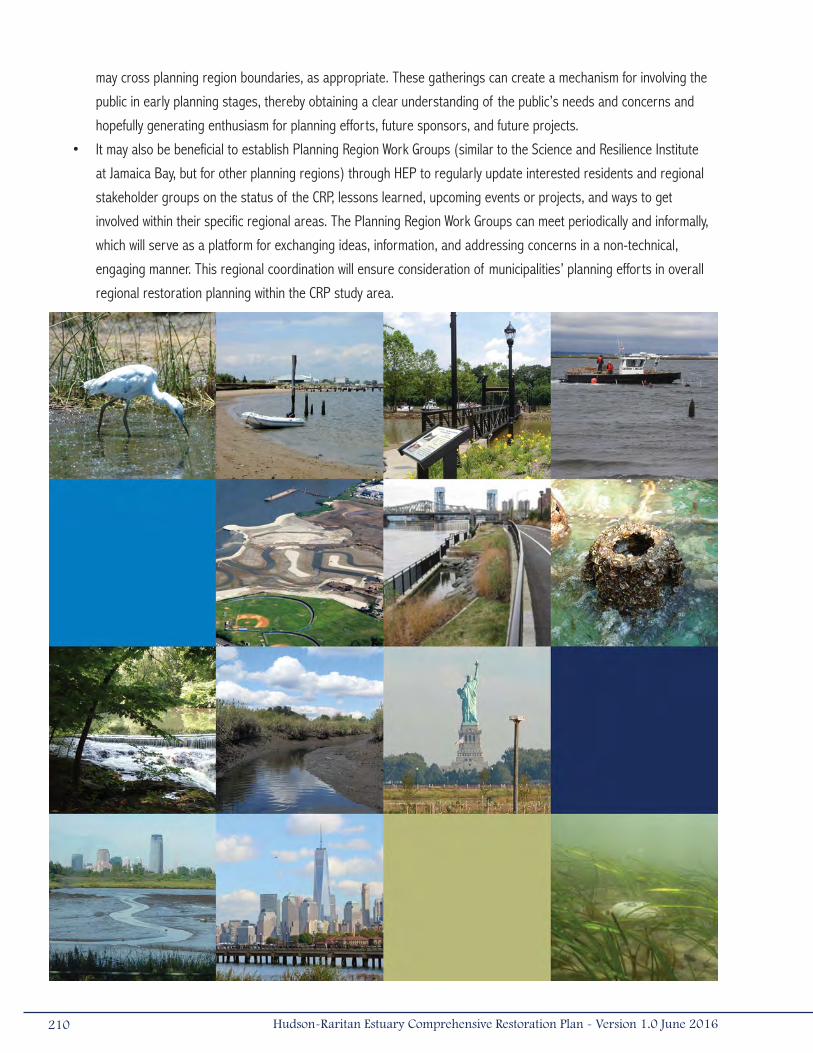
may cross planning region boundaries, as appropriate. These gatherings can create a mechanism for involving the
public in early planning stages, thereby obtaining a clear understanding of the public’s needs and concerns and
hopefully generating enthusiasm for planning efforts, future sponsors, and future projects.
• It may also be beneficial to establish Planning Region Work Groups (similar to the Science and Resilience Institute
at Jamaica Bay, but for other planning regions) through HEP to regularly update interested residents and regional
stakeholder groups on the status of the CRP, lessons learned, upcoming events or projects, and ways to get
involved within their specific regional areas. The Planning Region Work Groups can meet periodically and informally,
which will serve as a platform for exchanging ideas, information, and addressing concerns in a non-technical,
engaging manner. This regional coordination will ensure consideration of municipalities’ planning efforts in overall
regional restoration planning within the CRP study area.
210 Hudson-Raritan Estuary Comprehensive Restoration Plan - Version 1.0 June 2016
ReferencesAble, K.W., and J.T. Duffy-Anderson. 2006. Impacts of piers on juvenile fishes in the Lower Hudson River. Pages 428-440 in
Levinton, J. S., and J. R. Waldman, editors. The Hudson River Estuary. Cambridge University Press, Cambridge, NY.
Adams, D., and S. Benyi. 2003. Sediment quality of the NY/NJ Harbor system : A 5 year revisit. U.S. Environmental Protection Agency. Final Report. EPA/902-R-03 2003.
Alderson, W., and J. Bowers. 2012. Restoration of the New York/New Jersey Harbor-Harbor History Database. NOAA unpublished manuscript.
ALS (American Littoral Society) 2012. Prepared for the National Fish and Wildlife Foundation. Assessing the Impacts of Hurricane Sandy on Coastal Habitats.
Bain, M., J. Lodge, D.J. Suszkowski, D. Botkin, A. Brash, C. Craft, R. Diaz, K. Farley, Y. Gelb, J.S. Levinton, W. Matuszeski, F. Steimle, and P. Wilber. 2007. Target Ecosystem Characteristics for the Hudson Raritan Estuary: Technical Guidance for Developing a Comprehensive Ecosystem Restoration Plan. A report to the Port Authority of NY/NJ. Hudson River Foundation, New York, NY.
Barbour, M.G., J.H. Burk, W.D. Pitts, F.S. Gilliam, and M.W. Schwartz. 1999. Terrestrial plant ecology. Third edition. Benjamin/Cummings, an imprint of Addison Wesley Longman, Inc., Menlo Park, CA.
Bernick, A.J. 2006. New York City Audubon’s Harbor Herons Project: 2006 Interim Nesting Survey. New York City Audubon Society. New York, NY.
Bernick, A.J. 2007. New York City Audubon’s Harbor Herons Project: 2007 Nesting Survey. Prepared for the New York City Audubon Society. New York, NY.
Blanchard, P.P., P. Kerlinger, and M.J. Stein. 2001. An islanded nature: Natural area conservation and restoration in Western Staten Island, including the Harbor Herons Region. The Trust for Public Land and the New York City Audubon Society.
Boicourt, K., L. Baron, and R. Pirani. 2015. Restoring the New York – New Jersey Harbor Estuary: Ensuring Ecosystem Resilience and Sustainability in a Changing Environment. New York – New Jersey Harbor & Estuary Program, Hudson River Foundation. New York, NY.
Boicourt, K., R. Pirani, and M. Johnson; E. Svendsen; and L. Campbell. 2016. Connecting with Our Waterways: Public Access and Its Stewardship in the New York – New Jersey Harbor Estuary. New York – New Jersey Harbor & Estuary Program, Hudson River Foundation. New York, NY.
Brennan, J.S., and H. Culverwell. 2004. Marine Riparian: An Assessment of Riparian Functions in Marine Ecosystems. Published by Washington Sea Grant Program, Copyright 2005, UW Board of Regents, Seattle, WA.
BVA (Barry A. Vittor & Associates, Inc.). 2005. Ecological Profile of the Hudson River National Estuarine Research Reserve.
Cerco, C.F., and M.R. Noel. 2007. Can oyster restoration reverse cultural eutrophication in Chesapeake Bay? Estuaries and Coasts, 30(2): 331-343.
Coen, L.D., and M.W. Luckenbach. 2000. Developing success criteria and goals for evaluating oyster reef restoration: Ecological function or resource exploitation? Ecological Engineering 15(3-4):323-343.
Costanza R., R. d’Arge, R. de Groot, S. Farber, M. Grasso, B. Hannon, K. Limburg, S. Naeem, R.V. O’Neill, J. Paruelo, R.G. Raskin, P. Sutton, and M. van den Belt. 1997. The value of the world’s ecosystem services and natural capital. Nature 387:253-260.
211Hudson-Raritan Estuary Comprehensive Restoration Plan - Version 1.0 June 2016
Cowardin, L.M. 1979. Classification of Wetlands and Deepwater Habitats of the United States. U.S. Fish and Wildlife Service. Performed for U.S. Department of the Interior. Fish and Wildlife Service. Office of Biological Services. Washington, DC.
Craig, E. 2013. New York City Audubon’s Harbor Herons Project: 2013 Nesting Survey Report. New York City Audubon Society, New York, NY.
CUES (Rutgers Center for Urban Environmental Sustainability). 2012. NY/NJ Baykeeper Eastern Oyster Reintroduction Feasibility Study.
Dame, R.F., J.D. Spurrier, and T.G. Wolaver. 1989. Carbon, nitrogen and phosphorus processing by an oyster reef. Marine ecology progress series. Oldendorf, 54(3): 249 256.
Deegan, L.A., D.S. Johnson, R.S. Warren, B.J. Peterson, J.W. Fleeger, S. Fagherazzi, and W.M.. Wollheim. 2012. Coastal eutrophication as a driver of salt marsh loss. Nature, 490(7420): 388-392.
Department of City Planning. 2006. New York City population projections by age/sex and borough, 2000-2030. Briefing booklet by the City of New York, NY.
Durkas, S.J. 1992. Impediments to the spawning success of anadromous fish in tributaries of the NY/NJ Harbor watershed. A report prepared for the American Littoral Society Baykeeper, Sandy Hook Highlands, NJ.
Durkas, S.J. 1993. A guideline to restore anadromous fish runs in selected tributaries of the NY/NJ Harbor watershed. A report prepared for the American Littoral Society Baykeeper, Sandy Hook Highlands, NJ.
Edinger, G.J., D.J. Evans, S. Gebauer, T.G. Howard, D.M. Hunt, and A.M. Olivero (editors). 2014. Ecological Communities of New York State. Second Edition. A revised and expanded edition of Carol Reschke’s Ecological Communities of New York State. New York Natural Heritage Program, New York State Department of Environmental Conservation, Albany, NY.
FAA (Federal Aviation Administration, U.S. Department of Transportation). 2007. Hazardous wildlife attractants on or near airports. Advisory Circular: 150/5200-33B.
Findlay, S., C. Wigand, and W.C. Nieder. 2006. Submersed macrophyte distribution and function in the tidal freshwater Hudson River. Pages 230-241 in Levinton, J. S., and J. R. Waldman, editors. The Hudson River Estuary. Cambridge University Press, Cambridge, NY.
Fitzpatrick, J., J. Lodge, and J. McLaughlin. 2012. Oyster Restoration-Feasibility and Water Quality Benefits in a Highly Urbanized Bay. Jamaica Bay Oyster Sustainability Model Update.
Fonseca, M.S., W.J. Kenworthy, and G.W. Thayer. 1998. Guidelines for the conservation and restoration of seagrasses in the United States and adjacent waters. NOAA Coastal Ocean Program Decision Analysis Series No. 12. NOAA Coastal Ocean Office, Silver Spring, MD.
Fonseca, M.S. 1992. Restoring seagrass systems in the United States. In: Thayer, G.W. (Ed.), Restoring the Nation d.),ms in the United S Maryland Sea Grant College, College Park, Md.,Publ. UM-SG-TS-92-06.
Fonseca, M.S., W.J. Kenworthy, D.R. Colby, K.A. Rittmaster, and G.W. Thayer. 1990. Comparisons of fauna among natural and transplanted eelgrass Zostera marina meadows: criteria for mitigation. Marine Ecology Progress Series 65:251-264.
Frizzera, D. 2009. Mitigating Shoreline Erosion along New Jersey’s Sheltered Coast: Overcoming Regulatory Obstacles to Allow for Living Shorelines. Office of Coastal Management. New Jersey Department of Environmental Protection.
Gibbons, S., and C. Yuhas. 2005. Combined Sewer Overflows: What’s happening in New York City. The Tidal Exchange. Autumn 2005. NY/NJ Harbor Estuary Program.
212 Hudson-Raritan Estuary Comprehensive Restoration Plan - Version 1.0 June 2016
Gibson, R.J., R.L. Haedrich, and C.M. Wernerheim. 2005. Loss of fish habitat as a consequence of inappropriately constructed stream crossings. Fisheries 30(1): 10-17.
Good, R.E., N.F. Good, and B.R. Frasco. 1982. A review of primary production and decomposition dynamics of the belowground marsh component. pp. 139-157 in: V.S. Kennedy, Ed., Estuarine Comparisons. Academic Press, NY.
GOSR. 2014. Governor’s Office of Storm Recovery. http://stormrecovery.ny.gov/
Grizzle, R.E., J.K. Greene, M.W. Luckenbach, and L.D. Coen. 2006. A new in situ method for measuring seston uptake by suspension-feeding bivalve mollusks. Journal of Shellfish Research, 25:643-649.
Grizzle, R.E., K. Ward, J. Lodge, K. Mosher-Smith, K. Kalchmayr, and P. Malinowski. 2011. Oyster Restoration Research Project (ORRP) Technical Report. ORRP Phase I: Experimental Oyster Reef Development and Performance Results.
Grizzle, R.E., K. Ward, J. Lodge, D. Suszkowski, K. Mosher-Smith, K. Kalchmayr, and P. Malinowski. 2013. Oyster Restoration Research Project (ORRP) Final Technical Report. ORRP Phase I: Experimental Oyster Reef Development and Performance Results, 2009-2012.
Harbor Herons Subcommittee. 2010. Harbor Herons Conservation Plan- NY/NJ Harbor Region. S. B. Elbin and N.K. Tsipoura (Editors). NY-NJ Harbor Estuary Program.
Harding, J.M., and R. Mann. 1999. Fish species richness in relation to restored oyster reefs, Piankatank River, Virginia. Bulletin of Marine Science 65(1): 289-300.
Harman, W., R. Starr, M. Carter, K. Tweedy, M. Clemmons, K. Suggs, and C. Miller. 2012. A Function-Based Framework for Stream Assessment and Restoration Projects. US Environmental Protection Agency, Office of Wetlands, Oceans, and Watersheds, Washington, DC EPA 843-K-12-006.
Hartig, E.K., V. Gornitz, A. Koker, F. Mushacke, and D. Fallon. 2002. Anthropogenic and Climate-Change Impacts on Salt Marshes of Jamaica Bay, New York City. Wetlands 22:71-89.
HEP (New York-New Jersey Harbor & Estuary Program). 1990. Nearshore wildlife habitats and populations in the New York/New Jersey Estuary. Written by D.F. Squires and J.S. Barclay. November 1990. New York, NY.
HEP. 1996. Final Comprehensive Conservation and Management Plan. New York/New Jersey Harbor Estuary Program, New York, NY.
HEP. 2008. Regional Sediment Management Plan for the NY/NJ Harbor Estuary.
HEP. 2012. The State of the Estuary 2012: Environmental Health and Trends of the New York-New Jersey Harbor Estuary.
HEP. 2016a. Connecting with Our Waterways: Public Access and its Stewardship in the New York-New Jersey Harbor Estuary.
HEP. 2016b. New York-New Jersey Harbor & Estuary Program and the Sustainable Raritan River Initiative. 2016. Two States – One Bay: A Bi-State Conversation About the Future of Raritan Bay. Hudson River Foundation. New York, NY.
Homziak, J., M.S. Fonseca, and W.J. Kenworthy. (1982). Macrobenthic community structure in a transplanted eelgrass meadow. Marine Ecology Progress Series 9: 211-21.
HRF (Hudson River Foundation). 2012. Rapid Assessment of Habitat and Wildlife Losses from Hurricane Sandy in the Hudson Raritan Estuary. New York, NY.
213Hudson-Raritan Estuary Comprehensive Restoration Plan - Version 1.0 June 2016
Hudson River Estuary Program. 2009. New York State Department of Environmental Conservation. Accessed January 4, 2009. http://www.dec.ny.gov/lands/4920.html
Hudson River Foundation (HRF). 2013. Shells Fly in the Bronx as the Largest Oyster Restoration Project Ever Attempted in New York Harbor Commences. Hudson River Foundation. 24 June 2013. Web.
IPCC (Intergovernmental Panel on Climate Change). 2007: Climate Change 2007: Impacts, Adaptation and Vulnerability. Contribution of Working Group II to the Fourth Assessment Report of the Intergovernmental Panel on Climate Change, M.L. Parry, O.F. Canziani, J.P. Palutikof, P.J. van der Linden and C.E.Hanson, Eds., Cambridge University Press, Cambridge, UK.
IPCC. 2014. Climate Change 2014: Impacts, Adaptation, and Vulnerability. Part A: Global and Sectoral Aspects. Contribution of Working Group II to the Fifth Assessment Report of the Intergovernmental Panel on Climate Change [Field, C.B., V.R. Barros, D.J. Dokken, K.J. Mach, M.D. Mastrandrea, T.E. Bilir, M. Chatterjee, K.L. Ebi, Y.O. Estrada, R.C. Genova, B. Girma, E.S. Kissel, A.N. Levy, S. MacCracken, P.R. Mastrandrea, and L.L. White (eds.)]. Cambridge University Press, Cambridge, United Kingdom and New York, NY, USA, pp. 1-32.
Kemp, M.W., R. Batiuk, R. Bartleson, P. Bergstrom, V. Carter, C.L. Gallegos, W. Hunley, L. Karrh, E.W. Koch, J.M. Landwehr, K.A. Moore, L. Murray, M. Naylor, N.B. Rybicki, J.C. Stevenson, and D.J. Wilcox. 2004. Habitat requirements for submerged aquatic vegetation in Chesapeake Bay: water quality, light regime, and physical-chemical factors. Estuaries 27(3):363-377.
Kennish, M.J. 2002. Environmental threats and environmental future of estuaries. Environmental Conservation 29(1):78-107.
Kenward A., D. Yawitz, and U. Raja. 2013. Sewage Overflows From Hurricane Sandy. Climate Central.
Kerlinger, P. 2004. New York City Audubon Society’s Harbor Herons Project: 2004 Nesting Survey. New York City Audubon Society. New York, NY.
Kirshen, P., C. Watson, E. Douglas, A. Gonitz, J. Lee, and Y. Tian. 2008. Coastal Flooding in the Northeastern United States due to Climate Change. Mitigation and Adaptation Strategies for Global Change (Special issue: Assessment of Climate Change, Impacts, and Solutions in the Northeast United States) 13(5-6):437-451.
Kiviat, E. and K. MacDonald. 2002. Hackensack Meadowlands, New Jersey, biodiversity: A review and synthesis. Hackensack Meadowlands partnership.
Kreske, D.L. 1996. Environmental Impact Statements: A practical guide for agencies, citizens, and consultants. John Wiley & Sons, Inc., New York, NY.
Lawrence Brook Watershed Partnership, Inc. 2013. Fish Ladder Feasibility Study 2011-2013.
Lentz, E.E., E.R. Thieler, N.G. Plant, S.R. Stippa, R.M. Horton, and D.B. Gesch. 2016. Evaluation of dynamic coastal response to sea-level rise modifies inundation likelihood. Nature Clim. Change, early on-line, doi: 10.1038/nclimate2957.
Leslie, L.L., C.E. Velez, and S.A. Bonar. 2004. Utilizing volunteers on fisheries projects: benefits, challenges, and management techniques. Fisheries 29(10): 10-14.
Levinton, J.S., and J.R. Waldman. 2006. The Hudson River Estuary. Cambridge University Press, Cambridge, NY.
Lindstedt, D.M., and E.M. Swenson. 2006. The case of the dying marsh grass. Louisiana Department of Natural Resources. In partial fulfillment of DNR Interagency Agreement No. 2512-05-12.
214 Hudson-Raritan Estuary Comprehensive Restoration Plan - Version 1.0 June 2016

Lodge, J., R.E. Landeck Miller, D. Suszkowski, S. Litten, and S. Douglas. 2015. Contamination Assessment and Reduction Project. Summary Report. Hudson River Foundation, New York, NY.
MacKenzie, C.L. 1992. The Fisheries of Raritan Bay. Rutgers University Press, New Brunswick, NJ.
Mayo, R., F. Serchuk, and E. Holmes. 2006. Status of fishery resources off the Northeastern United States. NOAA’s National Marine Fisheries Service Northeast Fisheries Science Center. http://www.nefsc.noaa.gov/sos/
MERI (Meadowlands Environmental Research Institute). 2013. Real-Time Sensor-Based Superstorm Sandy Surge and Inundation Model for Moonachie, Carlstadt, and Little Ferry: Bergen County, New Jersey. New Jersey Meadowlands Commission.
Miller, D.E., 2013. Hudson River Habitat Restoration Plan. New York State Department of Environmental Conservation, Hudson River Estuary Program.
Nadeau, R.J., R.A. Davis. 1976. Polychlorinated biphenyls in the Hudson River (Hudson Falls Fort Edward, New York State). Bulletin of Environmental Contamination and Toxicology, 16(4): 436-444.
National Biological Service. 1995. Ecology of maritime forests of the southern Atlantic coast: A community profile. U.S. Department of the Interior, Biological Report 30. National Research Council. 1992. Restoration of Aquatic Ecosystems: Science, Technology, and Public Policy. National Academy Press, Washington, DC.
Nature Conservancy. 2009. Rising Waters: Helping Hudson River Communities Adapt to Climate Change, Scenario Planning 2010-2030, Executive Summary.
Neckles, H. and M. Dionne. (1999). Regional standards to identify and evaluate tidal wetland restoration in the Gulf of Maine. A GPAC Workshop, June 2-3, 1999. Wells National Estuarine Research Reserve, Wells, ME.
Needelman, B.A., S. Crooks, C.A. Shumway, J.G. Titus, R. Takacs, and J.E. Hawkes. 2012. Restore-Adapt-Mitigate: Respoding to Climate Change Through Coastal Habitat Restoration. B.A. Needelman, J. Benoit, S. Bosak, and C. Lyons (eds.). Restore America’s Estuaries, Washington DC.
NHC (National Hurricane Center). 2013. National Hurricane Center. www.nhc.noaa.gov
Niedowski, N.L. 2000. New York State Salt Marsh Restoration and Monitoring Guidelines. A report prepared for the New York State Department of State, Division of Coastal Resources and New York State Department of Environmental Conservation.
NJAC (New Jersey Administrative Code). 2013. New Jersey Administrative Code (NJAC). N.J.A.C. 7:7E Coastal Zone Management Rules.
NJDEP (New Jersey Department of Environmental Protection). 2006. Public Access in New Jersey: The Public Trust Doctrine and Practical Steps to Enhance Public Access. Coastal Management Office, New Jersey Department of Environmental Protection.
NJDEP. 2008. Fish Smart Eat Smart NJ http://www.state.nj.us/dep/dsr/njmainfish.htm
NJDEP. 2012. http://www.state.nj.us/dep/
NJDEP. 2015. The Future of Liberty State Park: Creating a World Class Destination.
215Hudson-Raritan Estuary Comprehensive Restoration Plan - Version 1.0 June 2016
NOAA (National Oceanic and Atmospheric Administration). 2012. Global Sea Level Rise Scenarios for the United States National Climate Assessment.
NOAA. 2014. Berry’s Creek Watershed. Damage, Assessment, Remediation, and Restoration Program. https://darrp.noaa.gov/hazardous-waste/berrys-creek-watershed NOAA.
NOAA. 2015. NOAA National Status and Trends Program. Silver Spring, MD.
NPS (U.S. National Park Service). 2014. U.S. National Park Service (NPS). 2014. https://www.nycgovparks.org/parks/jamaica-bay-park/history
NPS. 2016. https://www.nps.gov
NPS-GNRA. 2007. U.S. National Park Service (NPS), Gateway National Recreation Area (GNRA) and Jamaica Bay Watershed Protection Plan Advisory Committee. An update on the disappearing salt marshes of Jamaica Bay, New York.
NWF (National Wildlife Federation). 2011. Practical Guidance for Coastal Climate-Smart Conservation Project in the Northeast: Case Examples for Coastal Impoundments and Living Shorelines. National Wildlife Federation.
NYAS (New York Academy of Sciences). 2008. Safe Harbor: Brining People and Science Together to Improve the New York/New Jersey Harbor: Collaborative Problem Solving Using An Industrial Ecology Approach. New York Academy of Sciences Harbor Consortium.
NYC (The City of New York). 2011. Vision 2020: New York City Comprehensive Waterfront Plan. The City of New York Department of City Planning.
NYC. 2013. NYC Hurricane Sandy After Action Report.
NYCDCP (New York City Department of City Planning). 2007. PlaNYC A Greener Greater New York. The City of New York: Mayor Michael R. Bloomberg.
NYCDCP. 2011. Zoning Handbook, 2011 Edition.
NYCDEP (New York City Department of Environmental Protection). 2003. New York Harbor Water Quality Regional Summary. New York City, NY.
NYCDEP. 2004. New York Harbor Water Quality Regional Summary. New York City, NY.
NYCDEP. 2007. Jamaica Bay Watershed Protection Plan.
NYCDEP. 2014. Jamaica Bay Watershed Protection Plan. 2014 Update.
NYCDEP. 2016. Gowanus Canal. http://www.nyc.gov/html/dep/html/harborwater/gowanus_canal_superfund.shtml. Accessed May 2016.
NYCDPR (New York City Department of Parks and Recreation). 2008. Natural Resources Group. http://www.nycgovparks.org/sub_about/parks_divisions/nrg/nrg_home.html
NYCDPR. 2014. Four Sparrow Marsh. https://www.nycgovparks.org/parks/four-sparrow-marsh/highlights/11224
NYCEDC (New York City Economic Development Corporation). 2016. South Bronx Greenway. http://www.nycedc.com/project/south-bronx-greenwayNew York State Department of Environmental Conservation. 2001. Tidal wetland losses, Jamaica Bay, Queens County, NY. http://www.dec.ny.gov/lands/5489.html.
216 Hudson-Raritan Estuary Comprehensive Restoration Plan - Version 1.0 June 2016
NYSA (New York Shipping Association). 2015. The Economic Impact of the New York-New Jersey Port/Maritime Industry. 2015. A. Strauss-Wieder, Inc. for New York Shipping Association, Inc.
NYSDEC (New York State Department of Environmental Conservation). 2008. http://www.dec.state.ny.us/
NYSDEC. 2009. Hudson River Estuary Program. http://www.dec.ny.gov/lands/4920.html
NYSDEC. 2010. New York State Sea Level Rise Task Force. Report to Legislature.
NYSDEC. 2015. Draft Hudson River Estuary Action Agenda 2015-2020.
NYSDOH (New York State Department of Health). 2008. 2008-2009 Health Advisories on eating sportfish. http://www.health.state.ny.us/environmental/outdoors/fish/fishengl.htm
NYSDOH. 2014. Health Advice on Eating Sportfish and Game. https://www.health.ny.gov/publications/2800.pdf
NYSDOS (New York State Department of State). 2008. Public Trust Doctrine. http://www.nyswaterfronts.com/waterfront_public_trust.asp
Olsvig, L.S., J.F. Cryan, and R.H. Whittaker. 1998. Vegetational gradients of the pine plains and barrens of Long Island, New York. pp. 265-282 in: R.T.T. Forman, ed. Pine Barrens: Ecosystem and landscape. Rutgers University Press, New Brunswick, NJ.
Orth, R.J., M. Luckenbach, and K.A. Moore. 1994. Seed dispersal in a marine macrophyte: implications for colonization and restoration. Ecology 75:1927-39.
Parkman, A. 1983. History of the waterways of the Atlantic Coast of the United States. National Waterways Study, U.S. Army Corps of Engineers Water Resources Support Center, Institute for Water Resources. Navigation History NWS-83-10.
Pastorok, R.A., A. MacDonald, J.R. Sampson, P. Wilber, D.J. Yozzo, and J.P. Titre. 1997. An ecological decision framework for environmental restoration projects. Ecological Engineering 9:89-107.
Peckarsky, B.L., P.R. Fraissinet, M.A. Penton, and D.J. Conklin, Jr. 1990. Freshwater macroinvertebrates of Northeastern North America. Cornell University Press. Ithaca, NY.
Pickerell, C.H., S. Schott, and S. Wyllie-Echeverria. 2005. Buoy deployed seeding: Demonstration of a new eelgrass (Zostera marina L.) planting method. Ecological Engineering 25:127-136.
PlaNYC. 2010. Progress Report 2010: A Greener, Greater New York.
PlaNYC. 2012. Progress Report 2012: A Greener, Greater New York.
PVSC (Passaic Valley Sewerage Commission). 2008. River Restoration. http://www.pvsc.com/rr/about.htm
PVSC. 2014. Recovering from Superstorm Sandy.
Rand, G.M., P.G. Wells, and L.S. McCarty. Introduction to aquatic toxicology. G.M. Rand (Ed.), Fundamentals of Aquatic Toxicology: Effects , Environmental Fate, and Risk Assessment, Taylor and Francis, New York (1995), pp. 1-67.
Reilly, F.J., R.J. Spagnolo, and E. Ambrogio. 1996. Marine and estuarine shallow water science and management. Estuaries 19(2A):165-168.
217Hudson-Raritan Estuary Comprehensive Restoration Plan - Version 1.0 June 2016
RERC (Rutgers Environmental Research Clinic). 2008. Benthic Habitat Restoration. http://rerc.rutgers.edu/benthic/index.html.
Reschke, C. 1990. Ecological Communities of New York State. New York Natural Heritage Program, New York Department of Environmental Conservation, Latham, NY. 96p. +xi.
RPA (Regional Plan Association). 2003. Needs and Opportunities for Environmental Restoration in the Hudson-Raritan Estuary.
Sanderson, E.W. 2005. Urban Legend: Discovering Mannahattan’s wetlands. National Wetlands Newsletter 27(1).
Seitz, S., and S. Miller. 2001. The Other Islands of New York City: A history and guide. Second edition. The Countryman Press, Woodstock, VT.
Seneca, E.D., and S.W. Broome. 1992. Restoring tidal marshes in North Carolina and France. Pages 53-78 in G. W. Thayer, editor. Restoring the nation’s marine environment. Maryland Sea Grant College, College Park, MD.
SERISPWG (Society for Ecological Restoration, Science & Policy Working Group). 2004. SER International Primer on Ecological Restoration. (Version 2, October 2004) (1).
Short, F.T., L.K. Muehlstein, and D. Porter. 1987. Eelgrass wasting disease: Cause and recurrence of a marine epidemic. Biological Bulletin 173:557-62.
Simenstad, C.A., W.G. Hood, R.M. Thom, D.A. Levy, and D.L. Bottom. 2000. Landscape structure and scale constraints on restoring estuarine wetlands for Pacific coast juvenile fishes. Pages 597-630 in M. P. Weinstein and D. A. Kreeger, editors. Concepts and controversies in tidal marsh ecology. Kluwer Academic Publishers, Dordrecht, Netherlands.
Smith, I., M.S. Fonseca, J.A. Rivera, and K.A. Rittmaster. 1989. Habitat value of natural versus recently transplanted eelgrass, Zostera marina, for the bay scallop, Argopecten irradians. Fishery Bulletin 87:189-96.
Squires, D.F. 1992. Quantifying anthropogenic shoreline modification of the Hudson River and estuary from European contact to modern time. Coastal Management 20:343-354.
Stanley, J.G., and R. DeWitt. 1983. Species Profiles: Life Histories and Environmental Requirements of Coastal Fishes and Invertebrates (Mid-Atlantic) – Hard Clam. U.S. Fish & Wildlife Service Biological Report 82 (11.41). U.S. Army Corps of Engineers, Waterways Experiment Station, Vicksburg MS. Technical Report EL-82-4.
Steinberg, N., D.J. Suszkowski, L. Clark, and J. Way. 2004. Health of the Harbor: The first comprehensive look at the state of the NY/NJ Harbor Estuary. A report to the NY/NJ Harbor Estuary Program. Hudson River Foundation, New York, NY.
Tavolaro, J.F. 2008. Regional Sediment Management Plan. New York-New Jersey Harbor Estuary Program.
Thayer, G.W., S.M. Adams, and M.W. LaCroix. 1975. Structural and functional aspects of a recently established Zostera marina community. pp. 518-540 in: L.E. Cronin (Ed.) Estuarine Research. Academic Press, New York.
The New York/New Jersey Baykeeper. 2007. http://www.nynjbaykeeper.org/
The New York Waterfront: Evolution and building culture of the Port and Harbor. 1997. Kevin Bone, ed. Monacelli Press, Inc., New York.
The Regional Plan Association. 2003. Needs and Opportunities for Environmental Restoration in the Hudson-Raritan Estuary. Unpublished report submitted by the Regional Planning Association to the U.S. Army Corps of Engineers, New York District, New York, NY.
The Tidal Exchange. 1990. Newsletter of the NY/NJ Harbor Estuary Program & NY Bight Restoration Plan. Winter 1990.
218 Hudson-Raritan Estuary Comprehensive Restoration Plan - Version 1.0 June 2016
Thom, R.M. 1990. A review of eelgrass (Zostera marina L.) transplanting projects in the Pacific Northwest. The Northwest Environmental Journal 6:121-37.
Titus, J.G., K.E. Anderson, D.R. Cahoon, D.B. Gesch, S.K. Gill, B.T. Gutierrez, E.R. Thieler, and S.J. Williams, for the Climate Change Science Program (CCSP). 2009. Coastal Sensitivity to Sea Level Rise: A Focus on the Mid-Atlantic Region. U.S. Environmental Protection Agency, Washington DC.
Tsipoura, N., S. Elbin, and J. Brzorad. 2016. Texting While Flying? NO PROBLEM!. New Jersey Audubon.
U.S. Census Bureau. 2005. Population Estimates Program. www.census.gov.
USACE (U.S. Army Corps of Engineers). 1999. Environmental Impact Statement for the New York and New Jersey Harbor Navigation Study. Final Report. U.S. Army Corps of Engineers, New York District, New York, NY.
USACE. 2000. Draft Expedited Reconnaissance Study: Hudson-Raritan Estuary Environmental Restoration.
USACE. 2004a. Hudson-Raritan Estuary Environmental Restoration Feasibility Study. Study Area Reports. U.S. Army Corps of Engineers, New York District, New York, NY.
USACE. 2004b. Meadowlands Environmental Site Investigation Compilation (MESIC): Hudson-Raritan Estuary, Hackensack Meadowlands, New Jersey. Final Report. U.S. Army Corps of Engineers, New York District, New York, NY.
USACE. 2004c. Liberty State Park Environmental Resources Inventory. Draft Report. U.S. Army Corps of Engineers, New York District, New York, NY.
USACE. 2005. Restoration authorities of the U.S. Army Corps of Engineers: A Discussion Paper. Environmental Advisory Board of the U.S. Army Corps of Engineers.
USACE. 2006a. Hudson-Raritan Estuary Ecosystem Restoration Study: Building a world-class estuary. Brochure. U.S. Army Corps of Engineers, New York District, New York, NY.
USACE. 2006b. Stemming the Tide of Marsh Loss in Jamaica Bay With $13M Urban Wetlands Project. http://www.nan.usace.army.mil/news/newsrels/marsh.pdf
USACE. 2008a. Lower Passaic River Commercial Navigation Analysis. U.S. Army Corps of Engineers, New York District, New York, NY. www.ourpassaic.org
USACE. 2008b. Dredged material management plan for the Port of New York and New Jersey: Volume I. 2008 Update. U.S. Army Corps of Engineers, New York District, New York, NY.
USACE. 2012. Emergency Rehabilitation Assistance Project Information Report, Atlantic Coast of New York City East Rockaway Inlet to Rockaway Inlet and Jamaica Bay Hurricane Shore Protection Project (HSPP). Kings County, NY. U.S. Army Corps of Engineers, New York District, New York, NY.
USACE. 2013. Coastal Risk Reduction and Resilience: Using the Full Array of Measures. U.S. Army Corps of Engineers, Directorate of Civil Works.
USACE 2014. Cultural Resources Overview for Hudson-Raritan Estuary Comprehensive Restoration Plan: Appendix G. U.S. Army Corps of Engineers, New York District, New York, NY.
219Hudson-Raritan Estuary Comprehensive Restoration Plan - Version 1.0 June 2016
USACE. 2015a. Climate Change Adaptation Plan. U.S. Army Corps of Engineers. U.S. Army Corps of Engineers Climate Preparedness and Resilience Steering Committee.
USACE. 2015b. Use of Natural and Nature-Based Features (NNBF) for Coastal Resilience. Final Report. U.S. Army Corps of Engineers, Washington, DC.
USDOC. 2015. U.S. Department of Commerce. https://www.commerce.gov
USEPA (U.S. Environmental Protection Agency). 2005. Chapter 5: Implementing the Management Plan. Community-based watershed management: Lessons from the National Estuary Program. EPA 842-B-05-003.
USEPA. 2008. Hudson River PCB’s. http://www.epa.gov/hudson/
USEPA. 2015. Lower Hackensack River Bergen and Hudson Counties New Jersey. Preliminary Assessment. U.S. Environmental Protection Agency. Region II. New York, NY.
USEPA. 2016. Record of Decision. Lower 8.3 Miles of the Lower Passaic River. Part of the Diamond Alkali Superfund Site. Essex and Hudson Counties, New Jersey. U.S. Environmental Protection Agency, Region II, New York, NY.
USEPA and USACE, 2008. Compensatory Mitigation for Losses of Aquatic Resources. Federal Register: April 10, 2008. Volume 73, Number 70.
USFWS. 1997. Significant Habitats and Habitat Complexes of the New York Bight Watershed. Coastal Ecosystem Program. U.S. Fish and Wildlife Service.
USFWS (U.S. Fish and Wildlife Service). 2014. Preassessment Screen Determination for the Berry’s Creek Watershed, Bergen County, NJ.
USOMB (U.S. Office of Management and Budget). 2015. https://www.whitehouse.gov/omb
Villamagna, A., D. Strayer, and S. Findlay. 2009. Effects of surface roughness on ecological function: Implications for engineered structures in the Hudson River shore zone. Section III: 25pp. In S.H. Fernald, D. Yozzo and H. Andreyko (eds.), Final Reports of the Tibor T. Polgar Fellowship Program, 2008. Hudson River Foundation.
Vittor & Associates. 2005. Norton Basin/Little Bay technical summary report: 2000-2003 baseline surveys. Prepared for New York District, U.S. Army Corps of Engineers, New York, NY. Barry A. Vittor & Associates, Inc, Lake Katrine, NY.
WA (Waterfront Alliance). 2015. Introducing Waterfront Edge Design Guidelines Brochure: Shape Your Waterfront, How to promote access, resiliency, and ecology at the water’s edge. https://brooklynbridgepark.s3.amazonaws.com/p/2137/WEDG%20MWA%20Brochure.pdf
Weinstein, M.P., J.H. Balletto, J.M. Teal, and D.F. Ludwig. 1997. Success criteria and adaptive management for a large-scale wetland restoration project. Wetlands Ecology and Management 4:111-127.
Winston, T. 2015. New York City Audubon’s Harbor Herons Project: 2014 Nesting Survey Report. New York City Audubon, New York, NY.
Wintermyer M. and K. Cooper, 2003. “Dioxin/Furan and PCB concentrations in eastern oyster (Crassostrea virginica, Gmelin) tissues and the effects on egg fertilization and development.” Journal of Shellfish Research. 22(3):737-746.
Wise, M.Z., W. Woods, and E. Bone. 1997. Evolving purposes: the case of the Hudson River waterfront. The New York Waterfront: Evolution and Building Culture of the Port and Harbor. pp.193-233. Monacelli Press Inc., New York, NY.
220 Hudson-Raritan Estuary Comprehensive Restoration Plan - Version 1.0 June 2016

Yozzo, D., and J. Sexton. 1996. Planning and evaluating restoration of aquatic habitats from an ecological perspective. IWR Report 96-EL-4. Prepared for the U.S. Army Corps of Engineers, Waterways Experiment Station, MS and Institute for Water Resources, VA.
Yozzo, D.J., J.M. Rhoads, P. Wilber, W. Nuckols, L. Hollen, and R. Will. 2001. Beneficial uses of dredged material for habitat creation, enhancement, and restoration in NY/NJ Harbor. U.S. Army Corps of Engineers, New York District, New York, NY.
Yozzo, D.J., J.E. Davis, and P.T. Cagney. 2003. Coastal Engineering for Environmental Enhancement. Chapter V – 7: in: L. Vincent and Z. Demirbilek, (eds.), Coastal Engineering Manual, EM-1110-2-1100, U.S. Army Corps of Engineers, Washington, DC.
Yozzo, D.J., P. Wilber, and R.J. Will. 2004. Beneficial use of dredged material for habitat creation, enhancement, and restoration in New York-New Jersey Harbor. Journal of Environmental Management 73:39-52.
Yozzo, D.J., C. Howe, and M.S. Laska. 2015. Coastal Habitat Restoration in New York City: Integrating Ecology with Landscape Architecture and Urban Design.
Zieman, J.C. 1982. The ecology of seagrasses of south Florida: a community profile. U.S. Fish and Wildlife Service USFWS/OBS-82/25.
221Hudson-Raritan Estuary Comprehensive Restoration Plan - Version 1.0 June 2016
Hudson-Raritan Estuary Comprehensive Restoration Plan
Version 1.0 Contributing Authors
The Port Authority of NY & NJRosalie Siegel
Christopher Zeppie
New York - New Jersey Harbor & Estuary ProgramRobert Nyman, USEPA, Former HEP Coordinator
Katherine Boicourt, Restoration Program Manager
Hudson River FoundationJames Lodge
Dennis Suszkowski
Special Acknowledgements Cornell UniversityMark Bain, in Memoriam
HEP Restoration Work Group and Other Reviewers (in addition to above)
HDR Inc.Jennifer CurranLaura McLeanDavid Yozzo
Kevin VerWeireRonald Alevras
Margaret WellinsKrista Matatt
Lauren Alleman, The Nature Conservancy Pete Malinowski, NY Harbor School
Meredith Comi, NY/NJ Baykeeper Debbie Mans, NY/NJ Baykeeper
Scott Dvorak, Trust for Public Land Kim Morrill, Cornell University Cooperative Extension of Suffolk County
Susan Elbin, NYC Audubon Chris Pickerell, Cornell University Cooperative Extension of Suffolk County
Mike Feller, NYCDP&R (retired) Beth Ravit, Rutgers University
Grace Jacob, NJDEP Ashley Slagle, Passaic Valley Sewerage Commission
Marit Larsen, NYCDPR Nellie Tsipoura, NJ Audubon
John McLaughlin, NYCDEP Steve Zahn, NYSDEC
U.S. Army Corps of EngineersLisa Baron, Chair of HEP Restoration Work Group
Peter WepplerJeffrey CusanoGail WoolleyDiana Kohtio
URS CorporationJohn Dromsky-Reed
Sherri AlbrechtAlbert Macaulay
222 Hudson-Raritan Estuary Comprehensive Restoration Plan - Version 1.0 June 2016
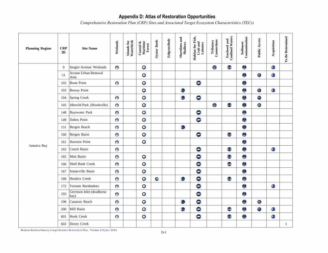
D-1
Planning Region
CRP ID
Site Name
Wet
land
s
Isla
nds
for
Wat
erbi
rds
Coa
stal
&
Mar
itim
e Fo
rest
Oys
ter
Ree
fs
Eel
gras
s Bed
s
Shor
elin
es a
nd
Shal
low
s
Hab
itat f
or F
ish,
C
rab
and
Lob
ster
s
Tri
buta
ry
Con
nect
ions
Enc
lose
d an
d C
onfin
ed W
ater
s
Sedi
men
t C
onta
min
atio
n
Publ
ic A
cces
s
Acq
uisi
tion
To
Be
Det
erm
ined
Jamaica Bay
9 Seagirt Avenue Wetlands
51 Arvene Urban Renewal Area
102 Brant Point 103 Breezy Point 104 Spring Creek 105 Idlewild Park (Brookville) 148 Bayswater Park 149 Dubos Point 151 Bergen Beach 160 Bergen Basin 161 Hawtree Point 162 Conch Basin 165 Mott Basin 166 Shell Bank Creek 167 Somerville Basin 168 Hendrix Creek 172 Vernam Barabadoes
193 Gerritsen Inlet (deadhorse bay)
198 Canarsie Beach 200 Mill Basin 601 Hook Creek 602 Doxey Creek 1
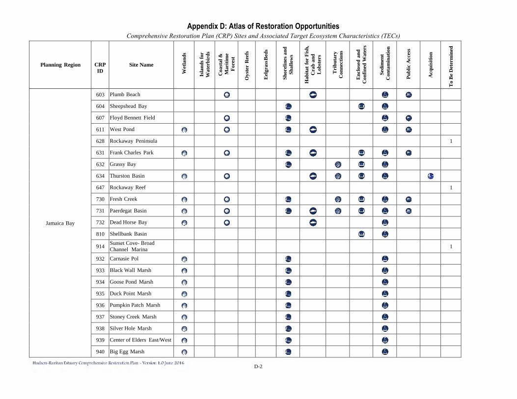
D-2
Planning Region
CRP ID
Site Name
Wet
land
s
Isla
nds
for
Wat
erbi
rds
Coa
stal
&
Mar
itim
e Fo
rest
Oys
ter
Ree
fs
Eel
gras
s Bed
s
Shor
elin
es a
nd
Shal
low
s
Hab
itat f
or F
ish,
C
rab
and
Lob
ster
s
Tri
buta
ry
Con
nect
ions
Enc
lose
d an
d C
onfin
ed W
ater
s
Sedi
men
t C
onta
min
atio
n
Publ
ic A
cces
s
Acq
uisi
tion
To
Be
Det
erm
ined
Jamaica Bay
603 Plumb Beach 604 Sheepshead Bay 607 Floyd Bennett Field 611 West Pond 628 Rockaway Peninsula 1
631 Frank Charles Park 632 Grassy Bay 634 Thurston Basin 647 Rockaway Reef 1
730 Fresh Creek 731 Paerdegat Basin 732 Dead Horse Bay 810 Shellbank Basin
914 Sunset Cove- Broad Channel Marina 1
932 Carnasie Pol 933 Black Wall Marsh 934 Goose Pond Marsh 935 Duck Point Marsh 936 Pumpkin Patch Marsh 937 Stoney Creek Marsh 938 Silver Hole Marsh 939 Center of Elders East/West 940 Big Egg Marsh

D-3
Planning Region
CRP ID
Site Name
Wet
land
s
Isla
nds
for
Wat
erbi
rds
Coa
stal
&
Mar
itim
e Fo
rest
Oys
ter
Ree
fs
Eel
gras
s Bed
s
Shor
elin
es a
nd
Shal
low
s
Hab
itat f
or F
ish,
C
rab
and
Lob
ster
s
Tri
buta
ry
Con
nect
ions
Enc
lose
d an
d C
onfin
ed W
ater
s
Sedi
men
t C
onta
min
atio
n
Publ
ic A
cces
s
Acq
uisi
tion
To
Be
Det
erm
ined
Jamaica Bay 941 Little Egg Marsh Jamaica Bay Total 46 N/A 35 0 28 1 0 23 21 6 16 42 12 8 4
Lower Bay
1 Additons to Arden Woods 3 Canada Hill Forest
4 Charleston/Kreischer Hill Woods
5 North Mount Loretto Woods
6 Northern Sea View 8 Pouch Camp
13 South Beach Wetlands, Northern Section
20 Leonardo (Middletown Township)
21 Ware Creek 22 Compton Creek 23 Natco Lake/Thorns Creek 24 East Creek 25 Flat Creek 26 Conaskonk Point 27 Matawan Creek 28 Treasure Lake
29 Whale Creek/Long Neck Creek
30 Marquis Creek 31 Cheesequake Marsh
32 Old Morgan Landfill/Raritan Bay Waterfront Park
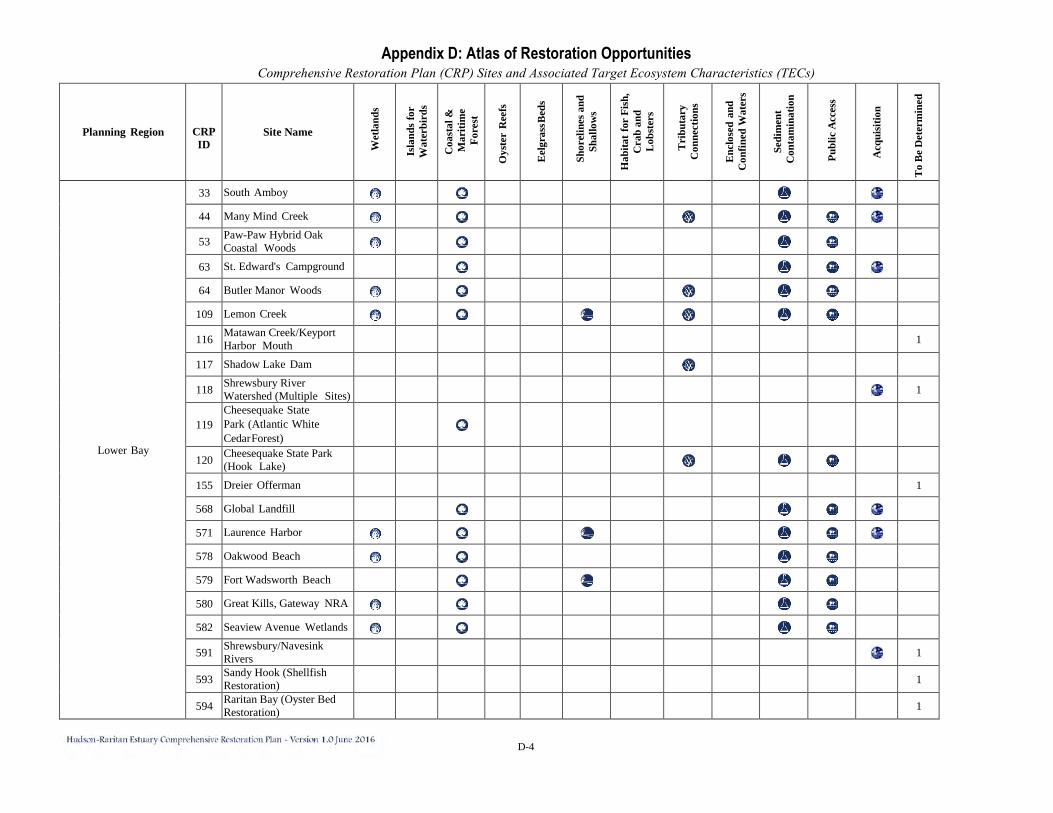
D-4
Planning Region
CRP ID
Site Name
Wet
land
s
Isla
nds
for
Wat
erbi
rds
Coa
stal
&
Mar
itim
e Fo
rest
Oys
ter
Ree
fs
Eel
gras
s Bed
s
Shor
elin
es a
nd
Shal
low
s
Hab
itat f
or F
ish,
C
rab
and
Lob
ster
s
Tri
buta
ry
Con
nect
ions
Enc
lose
d an
d C
onfin
ed W
ater
s
Sedi
men
t C
onta
min
atio
n
Publ
ic A
cces
s
Acq
uisi
tion
To
Be
Det
erm
ined
Lower Bay
33 South Amboy 44 Many Mind Creek
53 Paw-Paw Hybrid Oak Coastal Woods
63 St. Edward's Campground 64 Butler Manor Woods
109 Lemon Creek
116 Matawan Creek/Keyport Harbor Mouth 1
117 Shadow Lake Dam
118 Shrewsbury River Watershed (Multiple Sites) 1
119 Cheesequake State Park (Atlantic White Cedar Forest)
120 Cheesequake State Park (Hook Lake)
155 Dreier Offerman 1
568 Global Landfill 571 Laurence Harbor 578 Oakwood Beach 579 Fort Wadsworth Beach 580 Great Kills, Gateway NRA 582 Seaview Avenue Wetlands
591 Shrewsbury/Navesink Rivers 1
593 Sandy Hook (Shellfish Restoration) 1
594 Raritan Bay (Oyster Bed Restoration) 1
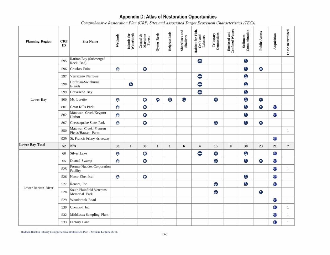
D-5
Planning Region
CRP ID
Site Name
Wet
land
s
Isla
nds
for
Wat
erbi
rds
Coa
stal
&
Mar
itim
e Fo
rest
Oys
ter
Ree
fs
Eel
gras
s Bed
s
Shor
elin
es a
nd
Shal
low
s
Hab
itat f
or F
ish,
C
rab
and
Lob
ster
s
Tri
buta
ry
Con
nect
ions
Enc
lose
d an
d C
onfin
ed W
ater
s
Sedi
men
t C
onta
min
atio
n
Publ
ic A
cces
s
Acq
uisi
tion
To
Be
Det
erm
ined
Lower Bay
595 Raritan Bay (Submerged Rock Bed)
596 Crookes Point 597 Verrazano Narrows
598 Hoffman-Swinburne Islands
599 Gravesend Bay 800 Mt. Loretto 801 Great Kills Park
802 Matawan Creek/Keyport Harbor
807 Cheesequake State Park
850 Matawan Creek: Freneau Fields/Hauser Farm 1
929 St. Francis Friary driveway Lower Bay Total 52 N/A 33 1 38 1 1 6 4 15 0 38 23 21 7
Lower Raritan River
60 Silver Lake 65 Dismal Swamp
525 Former Nuodex Corporation Facility 1
526 Hatco Chemical 527 Renora, Inc.
528 South Plainfield Veterans Memorial Park
529 Woodbrook Road 1
530 Chemsol, Inc. 1
532 Middlesex Sampling Plant 1
533 Factory Lane 1
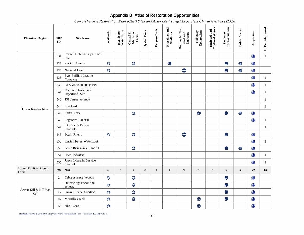
D-6
Planning Region
CRP ID
Site Name
Wet
land
s
Isla
nds
for
Wat
erbi
rds
Coa
stal
&
Mar
itim
e Fo
rest
Oys
ter
Ree
fs
Eel
gras
s Bed
s
Shor
elin
es a
nd
Shal
low
s
Hab
itat f
or F
ish,
C
rab
and
Lob
ster
s
Tri
buta
ry
Con
nect
ions
Enc
lose
d an
d C
onfin
ed W
ater
s
Sedi
men
t C
onta
min
atio
n
Publ
ic A
cces
s
Acq
uisi
tion
To
Be
Det
erm
ined
Lower Raritan River
534 Cornell Dubilier Superfund Site 1
536 Raritan Arsenal 537 National Lead
538 Evor Phillips Leasing Company 1
539 CPS/Madison Industries 1
541 Chemical Insectiside Superfund Site 1
543 131 Jersey Avenue 1
544 Iron Leaf 1
545 Kents Neck 546 Edgeboro Landfill 1
547 Kin-Buc & Edison Landfills 1
548 South Rivers 552 Raritan River Waterfront 1
553 South Brunswick Landfill 554 Fried Industries 1
555 Jones Industrial Service Landfill 1
Lower Raritan River Total 26 N/A 6 0 7 0 0 1 3 5 0 9 6 22 16
Arthur Kill & Kill Van Kull
2 Cable Avenue Woods
7 Outerbridge Ponds and Woods
15 Sawmill Park Addition 16 Merrill's Creek 17 Neck Creek
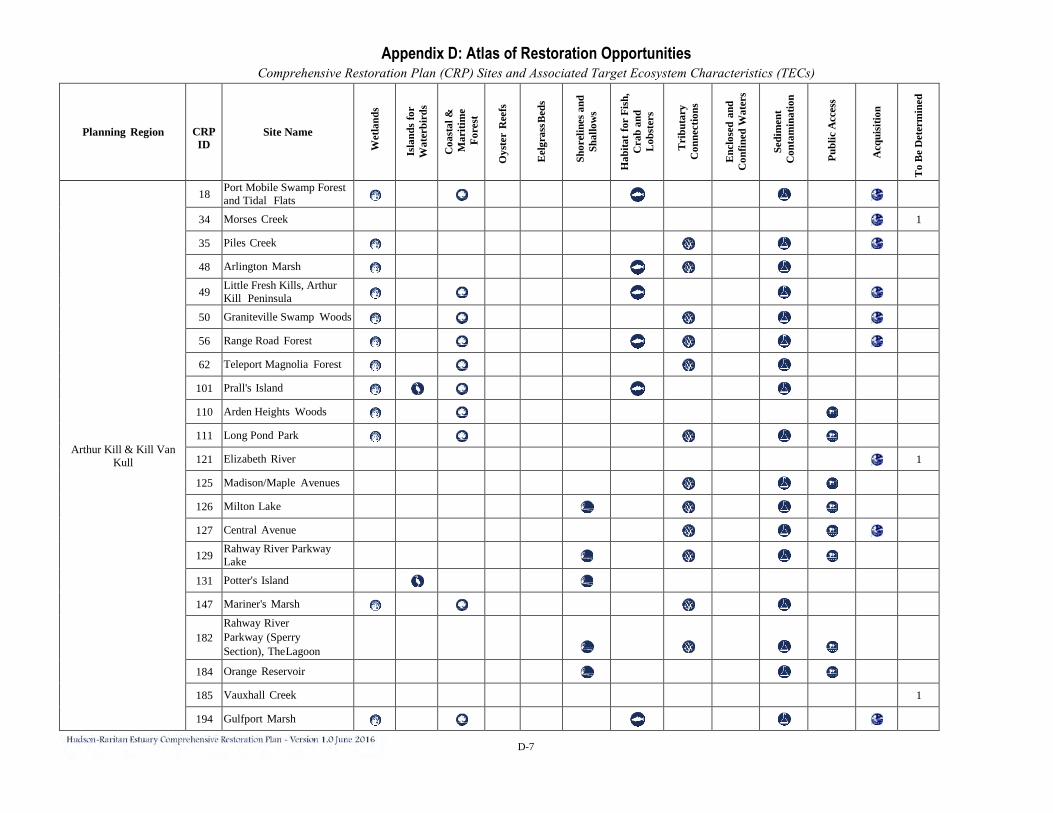
D-7
Planning Region
CRP ID
Site Name
Wet
land
s
Isla
nds
for
Wat
erbi
rds
Coa
stal
&
Mar
itim
e Fo
rest
Oys
ter
Ree
fs
Eel
gras
s Bed
s
Shor
elin
es a
nd
Shal
low
s
Hab
itat f
or F
ish,
C
rab
and
Lob
ster
s
Tri
buta
ry
Con
nect
ions
Enc
lose
d an
d C
onfin
ed W
ater
s
Sedi
men
t C
onta
min
atio
n
Publ
ic A
cces
s
Acq
uisi
tion
To
Be
Det
erm
ined
Arthur Kill & Kill Van Kull
18 Port Mobile Swamp Forest and Tidal Flats
34 Morses Creek 1
35 Piles Creek 48 Arlington Marsh
49 Little Fresh Kills, Arthur Kill Peninsula
50 Graniteville Swamp Woods 56 Range Road Forest 62 Teleport Magnolia Forest
101 Prall's Island 110 Arden Heights Woods 111 Long Pond Park 121 Elizabeth River 1
125 Madison/Maple Avenues 126 Milton Lake 127 Central Avenue
129 Rahway River Parkway Lake
131 Potter's Island 147 Mariner's Marsh
182 Rahway River Parkway (Sperry Section), The Lagoon
184 Orange Reservoir 185 Vauxhall Creek 1
194 Gulfport Marsh
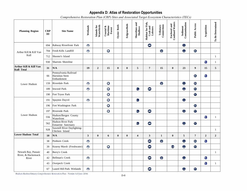
D-8
Planning Region
CRP ID
Site Name
Wet
land
s
Isla
nds
for
Wat
erbi
rds
Coa
stal
&
Mar
itim
e Fo
rest
Oys
ter
Ree
fs
Eel
gras
s Bed
s
Shor
elin
es a
nd
Shal
low
s
Hab
itat f
or F
ish,
C
rab
and
Lob
ster
s
Tri
buta
ry
Con
nect
ions
Enc
lose
d an
d C
onfin
ed W
ater
s
Sedi
men
t C
onta
min
atio
n
Publ
ic A
cces
s
Acq
uisi
tion
To
Be
Det
erm
ined
Arthur Kill & Kill Van Kull
694 Rahway Riverfront Park 704 Fresh Kills Landfill 712 Shooter's Island 1
930 Sharrots Shoreline 1
Arthur Kill & Kill Van Kull Total 31 N/A 19 2 15 0 0 5 7 15 0 23 9 15 5
Lower Hudson
66 Pennsylvania Railroad Harsimus Stem Embankment
159 Riverdale Park 189 Inwood Park 190 Fort Tryon Park
Lower Hudson
191 Spuyten Duyvil 196 Fort Washington Park 197 Riverside Park
556 Hudson/Bergen County Waterfront 1
562 Hudson River Park Estuarine Sanctuary
928 Sawmill River Daylighting- Chicken Island 1
Lower Hudson Total 10 N/A 3 0 6 0 0 4 3 1 0 5 7 2 2
Newark Bay, Passaic River, & Hackensack
River
38 Penhorn Creek 39 Kearny Marsh (Freshwater) 40 Berry's Creek 1
42 Bellman's Creek 43 Overpeck Creek 1
67 Laurel Hill Park Wetlands
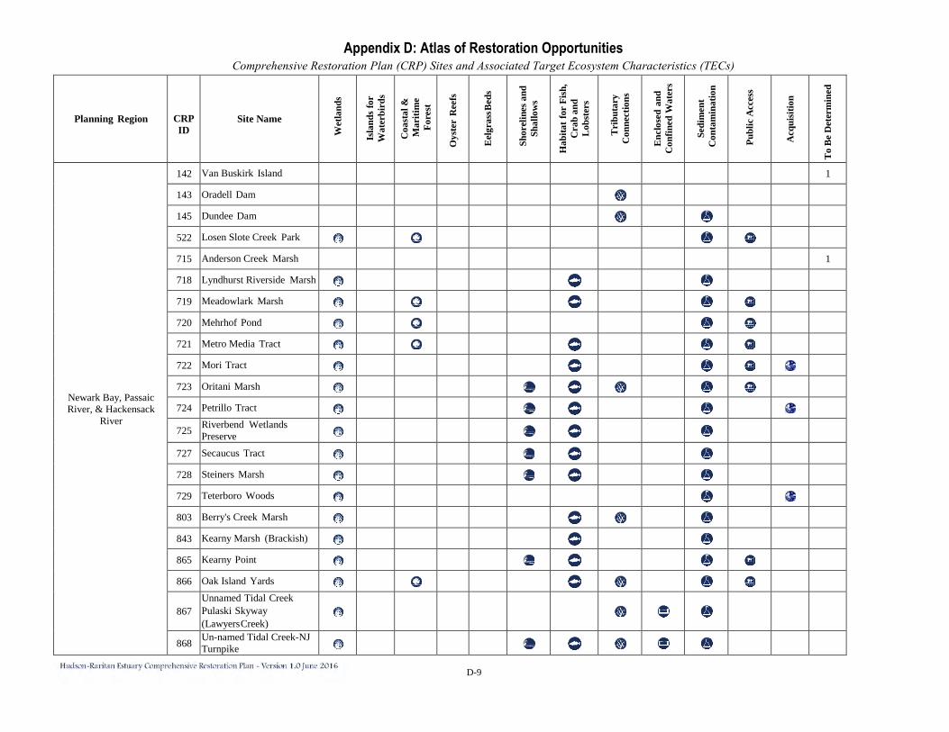
D-9
Planning Region
CRP ID
Site Name
Wet
land
s
Isla
nds
for
Wat
erbi
rds
Coa
stal
&
Mar
itim
e Fo
rest
Oys
ter
Ree
fs
Eel
gras
s Bed
s
Shor
elin
es a
nd
Shal
low
s
Hab
itat f
or F
ish,
C
rab
and
Lob
ster
s
Tri
buta
ry
Con
nect
ions
Enc
lose
d an
d C
onfin
ed W
ater
s
Sedi
men
t C
onta
min
atio
n
Publ
ic A
cces
s
Acq
uisi
tion
To
Be
Det
erm
ined
Newark Bay, Passaic River, & Hackensack
River
142 Van Buskirk Island 1
143 Oradell Dam 145 Dundee Dam 522 Losen Slote Creek Park 715 Anderson Creek Marsh 1
718 Lyndhurst Riverside Marsh 719 Meadowlark Marsh 720 Mehrhof Pond 721 Metro Media Tract 722 Mori Tract 723 Oritani Marsh 724 Petrillo Tract
725 Riverbend Wetlands Preserve
727 Secaucus Tract 728 Steiners Marsh 729 Teterboro Woods 803 Berry's Creek Marsh 843 Kearny Marsh (Brackish) 865 Kearny Point 866 Oak Island Yards
867 Unnamed Tidal Creek Pulaski Skyway (Lawyers Creek)
868 Un-named Tidal Creek-NJ Turnpike

D-10
Planning Region
CRP ID
Site Name
Wet
land
s
Isla
nds
for
Wat
erbi
rds
Coa
stal
&
Mar
itim
e Fo
rest
Oys
ter
Ree
fs
Eel
gras
s Bed
s
Shor
elin
es a
nd
Shal
low
s
Hab
itat f
or F
ish,
C
rab
and
Lob
ster
s
Tri
buta
ry
Con
nect
ions
Enc
lose
d an
d C
onfin
ed W
ater
s
Sedi
men
t C
onta
min
atio
n
Publ
ic A
cces
s
Acq
uisi
tion
To
Be
Det
erm
ined
Newark Bay, Passaic River, & Hackensack
River
869 Kearny Marsh (Cedar Creek Marsh)
870 Franks Creek Site (1-D Landfill)
871 Path Rail Fringe Marsh
872 Harrison Shoreline Redevelopment
873 Newark Riverbank Park/Joe G. Minish Park (Portion)
874 Gateway Park/ Joseph G. Minish Park (Portion)
875 Riverfront Park 876 Clay Street Lot
877 Franklin- Burlington Plastics
878 Frank Vincent Park and Boat Ramp
879 Kearny Riverbank Park 880 Jacobus Avenue-Kearny 1
881 PSE&G Shoreline 1
882 Saddle River Ox Bow
883 Saddle River Felician College South
884 Saddle River Lodi Cemeteries
885 Saddle River Arcola Pool Site
886 Saddle River County Park
887 First River Branchbrook Park
888 Second River Passaic/ Belleville
889 Second River Bloomfield
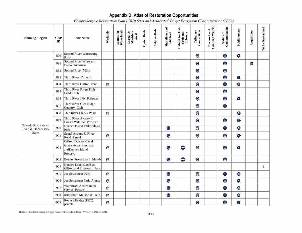
D-11
Planning Region
CRP ID
Site Name
Wet
land
s
Isla
nds
for
Wat
erbi
rds
Coa
stal
&
Mar
itim
e Fo
rest
Oys
ter
Ree
fs
Eel
gras
s Bed
s
Shor
elin
es a
nd
Shal
low
s
Hab
itat f
or F
ish,
C
rab
and
Lob
ster
s
Tri
buta
ry
Con
nect
ions
Enc
lose
d an
d C
onfin
ed W
ater
s
Sedi
men
t C
onta
min
atio
n
Publ
ic A
cces
s
Acq
uisi
tion
To
Be
Det
erm
ined
Newark Bay, Passaic River, & Hackensack
River
890 Second River Watsessing Park
891 Second River Wigwam Brook Industrial
892 Second River Mills 893 Third River (Mouth) 894 Third River Clifton Pond
895 Third River Forest Hills Field Club
896 Third River JFK Parkway
897 Third River Glen Ridge Country Club
898 Thid River Clarks Pond
899 Third River Alonzo F. Bonsal Wildlife Preserve
900 Dundee Island Park/Pulaski Park
901 Semel Avenue & River Road Parcel
902
Clifton Dundee Canal Green Acres Purchase and Dundee Island Preserve
903 Botany Street Small Islands 904 Dundee Lake Islands at
Clifton and Elmwood Park 1
905 Joe Sesselman Park 906 Joe Sesselman Park Annex
907 Waterfront Access in the City of Passaic
908 Rutherford Memorial Field
909 Route 3 Bridge (PRC) parcels
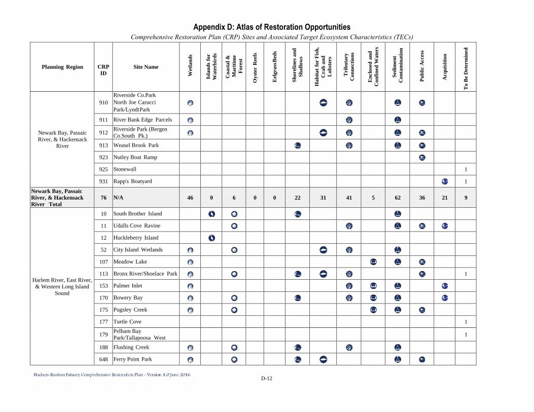
D-12
Planning Region
CRP ID
Site Name
Wet
land
s
Isla
nds
for
Wat
erbi
rds
Coa
stal
&
Mar
itim
e Fo
rest
Oys
ter
Ree
fs
Eel
gras
s Bed
s
Shor
elin
es a
nd
Shal
low
s
Hab
itat f
or F
ish,
C
rab
and
Lob
ster
s
Tri
buta
ry
Con
nect
ions
Enc
lose
d an
d C
onfin
ed W
ater
s
Sedi
men
t C
onta
min
atio
n
Publ
ic A
cces
s
Acq
uisi
tion
To
Be
Det
erm
ined
Newark Bay, Passaic River, & Hackensack
River
910 Riverside Co.Park North Joe Carucci Park/Lyndt Park
911 River Bank Edge Parcels
912 Riverside Park (Bergen Co.South Pk.)
913 Weasel Brook Park 923 Nutley Boat Ramp 925 Stonewall 1
931 Rapp's Boatyard 1
Newark Bay, Passaic River, & Hackensack River Total
76 N/A 46 0 6 0 0 22 31 41 5 62 36 21 9
Harlem River, East River, & Western Long Island
Sound
10 South Brother Island 11 Udalls Cove Ravine 12 Huckleberry Island 52 City Island Wetlands
107 Meadow Lake 113 Bronx River/Shoelace Park 1
153 Palmer Inlet 170 Bowery Bay 175 Pugsley Creek 177 Turtle Cove 1
179 Pelham Bay Park/Tallapoosa West 1
188 Flushing Creek 648 Ferry Point Park
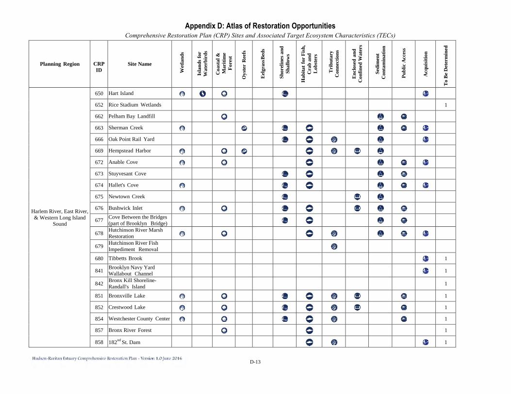
D-13
Planning Region
CRP ID
Site Name
Wet
land
s
Isla
nds
for
Wat
erbi
rds
Coa
stal
&
Mar
itim
e Fo
rest
Oys
ter
Ree
fs
Eel
gras
s Bed
s
Shor
elin
es a
nd
Shal
low
s
Hab
itat f
or F
ish,
C
rab
and
Lob
ster
s
Tri
buta
ry
Con
nect
ions
Enc
lose
d an
d C
onfin
ed W
ater
s
Sedi
men
t C
onta
min
atio
n
Publ
ic A
cces
s
Acq
uisi
tion
To
Be
Det
erm
ined
Harlem River, East River, & Western Long Island
Sound
650 Hart Island 652 Rice Stadium Wetlands 1
662 Pelham Bay Landfill 663 Sherman Creek 666 Oak Point Rail Yard 669 Hempstead Harbor 672 Anable Cove 673 Stuyvesant Cove 674 Hallet's Cove 675 Newtown Creek 676 Bushwick Inlet 677 Cove Between the Bridges
(part of Brooklyn Bridge)
678 Hutchinson River Marsh Restoration
679 Hutchinson River Fish Impediment Removal
680 Tibbetts Brook 1
841 Brooklyn Navy Yard Wallabout Channel 1
842 Bronx Kill Shoreline- Randall's Island 1
851 Bronxville Lake 1
852 Crestwood Lake 1
854 Westchester County Center 1
857 Bronx River Forest 1
858 182nd St. Dam 1
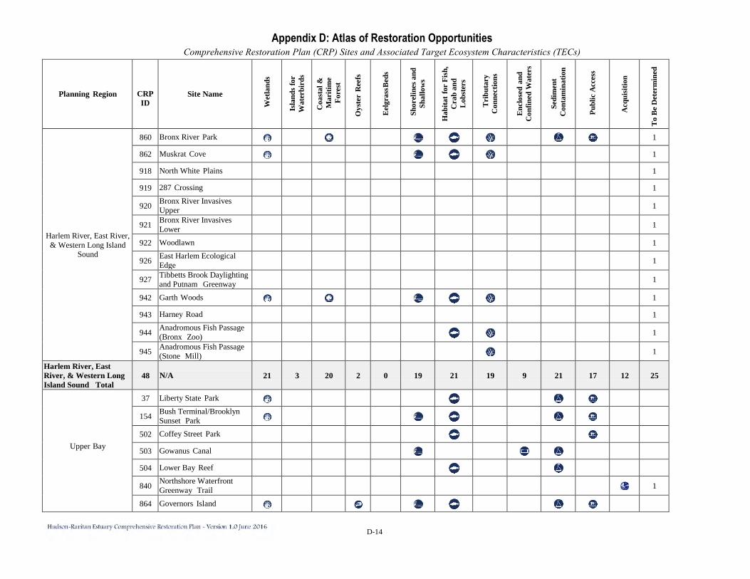
D-14
Planning Region
CRP ID
Site Name
Wet
land
s
Isla
nds
for
Wat
erbi
rds
Coa
stal
&
Mar
itim
e Fo
rest
Oys
ter
Ree
fs
Eel
gras
s Bed
s
Shor
elin
es a
nd
Shal
low
s
Hab
itat f
or F
ish,
C
rab
and
Lob
ster
s
Tri
buta
ry
Con
nect
ions
Enc
lose
d an
d C
onfin
ed W
ater
s
Sedi
men
t C
onta
min
atio
n
Publ
ic A
cces
s
Acq
uisi
tion
To
Be
Det
erm
ined
Harlem River, East River, & Western Long Island
Sound
860 Bronx River Park 1
862 Muskrat Cove 1
918 North White Plains 1
919 287 Crossing 1
920 Bronx River Invasives Upper 1
921 Bronx River Invasives Lower 1
922 Woodlawn 1
926 East Harlem Ecological Edge 1
927 Tibbetts Brook Daylighting and Putnam Greenway 1
942 Garth Woods 1
943 Harney Road 1
944 Anadromous Fish Passage (Bronx Zoo) 1
945 Anadromous Fish Passage (Stone Mill) 1
Harlem River, East River, & Western Long Island Sound Total
48 N/A 21 3 20 2 0 19 21 19 9 21 17 12 25
Upper Bay
37 Liberty State Park
154 Bush Terminal/Brooklyn Sunset Park
502 Coffey Street Park 503 Gowanus Canal 504 Lower Bay Reef
840 Northshore Waterfront Greenway Trail 1
864 Governors Island
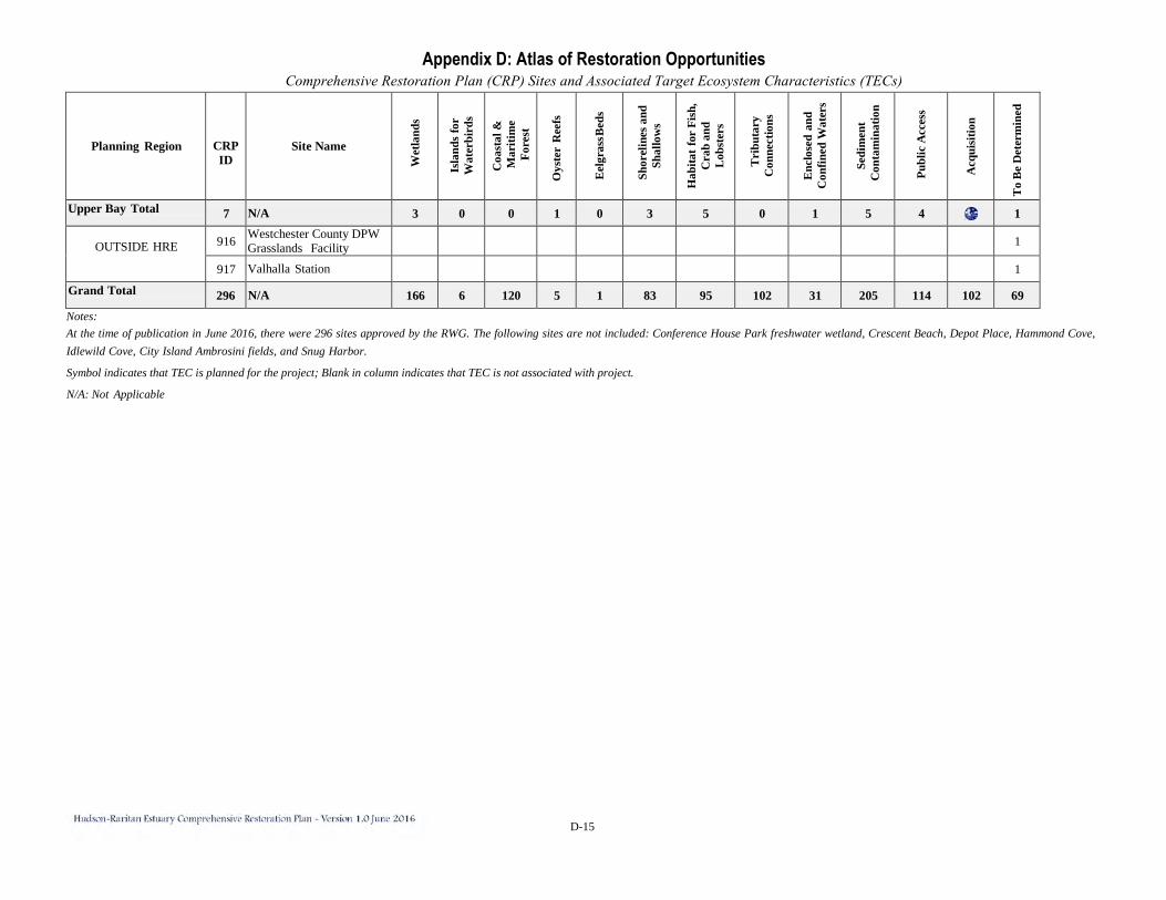
D-15
Planning Region
CRP ID
Site Name
Wet
land
s
Isla
nds
for
Wat
erbi
rds
Coa
stal
&
Mar
itim
e Fo
rest
Oys
ter
Ree
fs
Eel
gras
s Bed
s
Shor
elin
es a
nd
Shal
low
s
Hab
itat f
or F
ish,
C
rab
and
Lob
ster
s
Tri
buta
ry
Con
nect
ions
Enc
lose
d an
d C
onfin
ed W
ater
s
Sedi
men
t C
onta
min
atio
n
Publ
ic A
cces
s
Acq
uisi
tion
To
Be
Det
erm
ined
Upper Bay Total 7 N/A 3 0 0 1 0 3 5 0 1 5 4 1
OUTSIDE HRE
916 Westchester County DPW Grasslands Facility 1
917 Valhalla Station 1
Grand Total 296 N/A 166 6 120 5 1 83 95 102 31 205 114 102 69 Notes: At the time of publication in June 2016, there were 296 sites approved by the RWG. The following sites are not included: Conference House Park freshwater wetland, Crescent Beach, Depot Place, Hammond Cove, Idlewild Cove, City Island Ambrosini fields, and Snug Harbor.
Symbol indicates that TEC is planned for the project; Blank in column indicates that TEC is not associated with project.
N/A: Not Applicable