Report on Urban Flood Management: Drainage and Planning
66
Action for Disaster Resilient and Inclusive Development National Institute of Disaster Management India Water Partnership DECEMBER 2020
-
Upload
khangminh22 -
Category
Documents
-
view
1 -
download
0
Transcript of Report on Urban Flood Management: Drainage and Planning
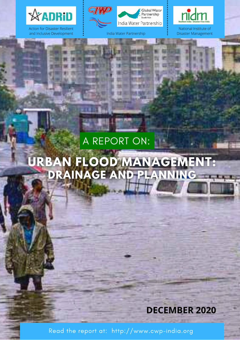
A REPORT ON:
Action for Disaster Resilientand Inclusive Development
National Institute ofDisaster ManagementIndia Water Partnership
Read the report at: http://www.cwp-india.org
DECEMBER 2020
INDIA WATER PARTNERSHIP
Address: 76-C, Sector-18, Institutional Area,Gurgaon, 122 015 (Haryana)
Tel.: (+91-124) 2348022 (D); (+91-124) 2399421, Extn: 1404Fax: (+91-124) 2397392
E-mail: [email protected]; [email protected];
www.cwp-india.org
ORGANISATION AT A GLANCE:Societies Registration Act of Government of Haryana: 2391 dated 20.11,2001 underHaryana Societies Registration Act 1860 and HR 018201300867 dated 14th August, 2013under Haryana Societies Registration Act, 2012
Cover Page Source: PTI

Report on Urban Flood Management: Drainage and Planning
1
C O N T E N T S
Acknowledgement 2
I. Background 3
II. The Research Study 4
III. Main Objectives 4
IV. Results 4
4.1 Narrative Reporting on Results 4
4.2 Webinar No. 1- Urban Flooding: Challenges to Solutions- 9th October, 2020 5 4.3 Webinar No.2- Urban Flooding : A Paradox of Too Much Water, Too Less Water - 28th December, 2020 8 4.4 Outputs 11 4.5 Delays in Implementation 11 4.6 Resources 11 Annex-I : Approach Paper on Building Awareness on Urban Flooding 12 Appendix-I: Case Study I: Patna Floods of September, 2019 57 Appendix-II: Case Study II: Gurugram Waterlogging in Rainy Seasons (2020) 61

Report on Urban Flood Management: Drainage and Planning
2
ACKNOWLEDGEMENT
Frequent flooding in Indian cities has become a regular phenomenon due to fast urbanization,
industrialization, population growth and intensive economic activities. Most of the major cities
and towns in India have witnessed recurring floods over the past two decades. It is projected
that the risks of urban flooding in the cities will further worsen with the on-going global climate
change. The issue of waterlogging and flooding across several Indian cities, amid the continuing
Covid-19 pandemic, has also created several complex situations warranting all the stakeholders'
urgent attention for urban flood management.
We convey our earnest gratitude to Smt. Debashree Mukherjee, I.A.S, Additional Secretary,
Ministry of Jal Shakti, Government of India, Shri Kumar Ravi, I.A.S, District Magistrate, Patna,
Prof. Mahua Mukherjee, Head, Centre of Excellence in Disaster Mitigation and Management
(CoEDMM), Indian Institute of Technology Roorkee, Er. Avinash C Tyagi, Vice-President, IWP,
Prof. Kapil Gupta, IIT, Mumbai, Dr Sanjay Srivastava, Chief of DRR, UNESCAP- Asia & Pacific and
Shri K.K Bhugra, Head, Flood Protection Committee, GMDA, Government of Haryana for their
active participation and valuable inputs and suggestions provided in the two webinars
organized by IWP and NIDM on 9th October, 2020 and 28th December, 2020 based on which an
Approach Paper has been developed by Er. Avinash C Tyagi on “Building Awareness about
Urban Flooding”.
We place on record the whole-hearted support and cooperation provided by Major General
Manoj K Bindal, VSM, Executive Director, NIDM, Prof. Santosh Kumar, Head, GIDRR & CCDRR,
NIDM and Ms. Mohana Manna, Young Professional, NIDM, Mr. Onkareshwar Pandey, Executive
Director, ADRID and Mr. Deelip Kumar, Project Coordinator, ADRID for playing the pivotal role
for success of this research study from inception to completion.
Lastly we are thankful to Global Water Partnership, South Asia (GWP-SAS) for allocating part of
the Regional fund to India Water Partnership which enabled us to undertake this research
study.
Dr. Veena Khanduri, Executive Secretary-cum-Country Coordinator
In view of the above scenario, India Water Partnership undertook a Research Study on “Urban
Flood Management: Drainage and Planning” in collaboration with National Institute of Disaster
Management (NIDM), Ministry of Home Affairs, Government of India and Action for Disaster
Resilient & Inclusive Development (ADRID).

Report on Urban Flood Management: Drainage and Planning
3
I. Background
Urban flooding is not a new phenomenon. It is known to all of us how the ancient civilization of Harappa & Mohenjo-Daro famous for the town planning and urban centres got wiped out due to flooding and climate change, an attribute confirmed in a recent research. Since time immemorial, many civilizations developed at the river banks but perished due to onslaughts and inundation by floods. The threat of urban flooding will increase in India in the near future due to excessive unplanned urbanization, development without disaster mainstreaming and climate change. The risk of urban flooding has already been aggravated due to poor drainage system, shoddy land use planning, ignoring flood plain zoning and aging infrastructure in the cities. The world is moving towards an uncertain scenario due to COVID-19 and all activities of disaster management will now have to be insulated with COVID-19 related response. The 17 Sustainable Development Goals of the United Nations and Sendai Framework of Action (2015-30) of Disaster Risk Reduction (DRR) have greater role to achieve resilience in all aspects of Disaster Risk Management and Climate Change Adaptation through mainstreaming and enhanced civil society participation in all developmental planning. The Prime Minister’s 10 point agenda of DRR is also a suggestive national framework to move from risk to resilience by promoting DRR in all developmental initiatives.
The flooding of Indian cities has now become a regular phenomenon owing to the rapid urbanization and population growth. The issues has particularly increased over the last two decades as the natural land cover of the earth’s surface and vegetation are being replaced by built-up structures, roads and other impervious surfaces leading to increased runoff. Most of the major cities and towns in India like that of Kolkata, Chennai, Surat, Bangalore and Hyderabad have witnessed repeated instances of flooding over the previous decades. The risks of urban flooding in these cities are projected to further worsen with the ongoing global climate change and increasing urbanization in the country. Most of the flood prone cities in India face the issue of water scarcity in dry seasons clearly representing a major paradox in the present mechanism of urban water management in the country. The traditional engineering approaches of urban management system are developed to get rid of storm water at the earliest resulting in increased imperviousness. The urban dwellers thus face the dual issues of waterlogging and depleting groundwater tables. Real estate-driven developments and poor city planning further compound the problem by encroaching and blocking the natural drainage channels, filling up of natural water bodies and exploitation of reservoirs. For instance, the increasing encroachment in the city of Bengaluru and Chennai has blocked their drainage system of inter-locked water bodies and reservoirs turning them into flooding hotspots in every monsoon. The increasing development has created a similar scenario in the city of Hyderabad resulting in extinction of 375 lakes. Without strict adherence to land use planning and construction guidelines, most of the cities are unable to facilitate adequate drainage infrastructure to tackle heavy rainfall over a short span of time. The development of the city of Gurugram is an evidence to that which has been developed in a low-lying area without adequate drainage infrastructure.

Report on Urban Flood Management: Drainage and Planning
4
To address the concern, the approach of slow, spread, sink and store runoff needs to be integrated in the urban drainage system. Coordinated water and land-use planning can mitigate the risks of flooding in urban areas. Concepts like Water Sensitive Urban Designs (WSUD) and Low Impact Development (LID) needs to be adopted by citizens to increase the storm water infiltration facilitating the storage of excess floodwaters in dry seasons and reducing waterlogging in monsoons. These approaches need to be mainstreamed and integrated in the land use and drainage planning of the urban areas.
II. The Research Study
To build awareness about urban flooding phenomenon among various stakeholders (urban
planners, flood and drainage experts, local civic authorities and other local development
agencies, disaster management authorities etc.) including public at large;
To study the urban storm water drainage and planning system;
Study two recent urban flood areas (case study) and develop an Approach Paper based on
the status and challenges involved in their management; and,
To recommend a set of solutions for reducing risks of urban flooding.
IV. Results 4.1 Narrative Reporting on Results Under this research study a detailed literature review on urban flooding, its causes and challenges was carried out. Further two case studies on 2019 urban floods in Patna (Bihar) and 2020 urban floods in Gurugram (Haryana) were prepared to identify the various reasons for the urban flooding. Under this study, two webinars were also organized jointly by IWP and NIDM on 9th October, 2020 and 28th December, 2020 to know the views of experts on urban flooding and take their suggestions and inputs for future planning to reduce the risk of flooding in the urban cities.
To advocate and mainstream the concept of utilizing excess floodwater in urban land use and drainage planning, India Water Partnership (IWP) collaborated with National Institute of Disaster Management (NIDM), Ministry of Home Affairs, Government of India and Action for Disaster Resilient Inclusive Development (ADRID) for a research study outlined in the Prime Minister’s Agenda of 1, 5 and 8. The research study entitled “Urban Flood Management: Drainage and Planning” was undertaken during October-December, 2020. The research focused on how excess flood runoff water can be utilized as an asset for mitigating the risks of both floods and water-scarcity in an urban scenario. The study also encompasses the existing risks of urban floods and highlights several challenges in urban land use and drainage planning. III. Main Objectives The main objectives of the research study were:
Report on Urban Flood Management: Drainage and Planning
5
Taking inputs and suggestions of the water, climate change and flood disaster management experts in the first webinar a Draft Approach Paper on “Building Awareness about Urban Flooding” was developed by Er. Avinash C Tyagi, Vice-President, IWP. The Draft Approach Paper was presented in the second webinar for the detailed discussions. After taking the suggestions of experts and recommendations of the webinar, the Approach Paper was fine-tuned and refined. The Approach Paper is enclosed as Annex-I containing two case studies on urban flooding, Patna (Bihar) in 2019 and Grugugram (Haryana) in 2020 as Appendix-I and Appendix-II respectively in this report. The details of two webinars are as under: 4.2 Webinar No.1 -Urban Flooding : Challenges to Solution - 9th October, 2020 This webinar was organized on 9th October, 2020 by IWP and NIDM with the purpose to highlight the prevalent issues of existing drainage infrastructure and water management system in the Indian cities. The key objectives of the webinar were:
To advocate the utilization of excess floodwater as an asset for risk mitigation of flooding water scarcity in urban areas;
To mainstream and integrate water sensitive urban designs and low impact; development in urban drainage and land use planning;
To sensitize all the stakeholders and designers about the utilization of excess flood runoff;
To analyse the exiting urban flooding challenges and deliberate on solutions to address these challenges; and,
To integrate real-time flood modelling with Decision Support System (DSS) for improving local mile connectivity.
The webinar was initiated by Prof. Santosh Kumar, Head, G&IDRR Division, NIDM with
programme overview and remarks. Smt. Debashree Mukherjee, I.A.S., Additional Secretary,
Dept. of Water Resources, River Development & Ganga Rejuvenation, Ministry of Jal Shakti,
Government of India graced the webinar with her Special Address. The sessions were
conducted by Shri Kumar Ravi, I.A.S., District Magistrate, Patna; Prof. Mahua Mukherjee, Head,
Centre of Excellence in Disaster Mitigation and Management (CoEDMM), Indian Institute of
Technology Roorkee; Prof. Kapil Gupta, Department of Civil Engineering, Indian Institute of
Technology, Bombay and Er. Avinash C Tyagi, Vice-President, IWP. The webinar was concluded
with the remarks by Dr.Veena Khanduri, Executive Secretary-cum-Country Coordinator, IWP.
Ms. Mohana Manna, Young Professional, NIDM coordinated the webinar. A total number of
169 persons attended the webinar.

Report on Urban Flood Management: Drainage and Planning
6
Prof. Santosh Kumar during his opening remarks highlighted how the Indian cities are now grappling with dual issues of water scarcity and flooding at the same time. He further stressed that these issues are further getting aggravated with the impacts of climate change. He then shared his field visit experience of the Patna Floods of 2019. He emphasized the need of storm water management and drainage issues in the urban areas and how the vulnerability to flooding has increased even in small and medium towns like Jamshedpur, Patna, etc. He also pointed out the several practices like encroachment of water bodies, unplanned disposal of solid waste, unregulated land use planning, etc. accumulates the risk of urban flooding.
Shri Kumar Ravi shared his ground level experiences of management of Patna Floods in 2019. He cited that the major cause behind urban flooding was the incessant rains and the high level

Report on Urban Flood Management: Drainage and Planning
7
of adjacent rivers around the city. He added that there were a lot of gaps in storm water management in the urban areas. He further discussed how the needs of the victims in the urban areas during the flooding is entirely different from that of rural areas and needs pre-emptive planning for management. He also shared the difficulty of rescue and relief distribution through boats in urban areas instead of roads. He recommended that special maps needs to be developed for relief distribution in water inundated areas. He further shared the challenges of network and communication and the psychological stress faced by the urban residents during flooding. Several risks of epidemic and water-related infectious diseases were also emerging in the aftermath of the floods. Cases of theft and robbery were also reported and police personnel were deputed to monitor the situation.
Smt. Debashree Mukherjee during her special address stated that the major challenges between urban flooding are extreme weather-related events and the unregulated pattern of urbanization. She stressed that the pattern of urbanization at the present scenario are encroaching the urban water bodies and rivers. She emphasized that the water bodies needs to be an integral part of spatial planning and needs to be protected by involving communities. She further stressed on the need of balance of maintenance of green cover and the use of permeable materials for built-up areas for facilitating ground water recharging.
Prof. Mahua Mukherjee during her session focused on how the challenges of urban flooding can be developed into opportunities through blue-green infrastructure and ecosystem-based planning. She emphasized the approaches of Integrated Water Resources Management in the traditional and indigenous approaches of development. She further addressed the complexities and the risks in urban areas that are leading to multi-hazards proneness in the Indian cities. She listed several solutions for urban flooding and ground water recharging like bio swales, retention of ponds, reuse of wastewater among several others. She also stressed on the need of collaboration of multi-stakeholders and the linkages of developmental practices with the urban livelihood schemes. Prof. Kapil Gupta focused on the mitigation measures of urban flooding in his session. He highlighted the changing characteristics of rainfall where the intensity of rainfall is increasing due to climate change. He emphasized on the need of water sensitive urban designing instead of traditional retrofitting of urban drainage systems. He covered various structural and non-structural controls like porous pavement, rooftop rainwater harvesting tanks, detention of ponds, underground storage, etc. for urban flood risk management.
Er. Avinash C Tyagi stressed on the need of involvement of public in flood risk management in urban areas. He also stressed that the deigning of urban drainage needs to consider the varying intensity of rainfall. He highlighted the need for continuous trilogue between the government processes, scientific process and the society processes for mainstreaming communities in urban flood risk management. He further summarized that water is the central element of all the developmental activities and hence, needs to be considered in the planning and development of all sectors.

Report on Urban Flood Management: Drainage and Planning
8
The sessions were followed by an open-house discussion addressing the queries of the participants by the experts. Dr. Veena Khanduri concluded the webinar with her closing remarks by stating that water needs to be core of all development sectors. She stressed the need of optimum utilization of excess floodwater runoff by incorporating several water-sensitive design measures and reclamation of wetlands and water bodies.
Major Recommendations
The webinar advocated and mainstreamed the concept of utilizing excess floodwater in urban
landuse and drainage planning and pave the way forward for technical solutions. Some of the
key recommendations of this webinar were:
Water should be the central theme of urban development and planning;
The developmental practices and approach must incorporate flood plain zoning;
Geo-tagging of water bodies and reservoirs could be implemented for protection and
reclamation of these entities;
The idea of reusing wastewater and storing rainwater needs to be mainstreamed and
integrated in developmental policies and practices;
Focus must be given on measures for maintaining the balance between biodiversity and
water bodies;
Measures for enhancing groundwater recharge should be emphasized;
The planning and management of water in urban areas needs to have a multi-stakeholders
approach instead of segregated one;
The local challenges must be incorporated in the management of urban flood risks; and,
The communities need to be sensitized and engaged for management of urban storm
water and flood risks. 4.3 Webinar No.2 - Urban Flooding : A paradox of too much water, too less water – 28th December, 2020 This webinar was also jointly organized by IWP and NIDM on 28th December, 2020 with a view to gather the technical as well as governing perspectives regarding the challenges in mitigation and management of urban flooding. A draft Approach Paper prepared by Er. Avinash C Tyagi, Vice-President, IWP was presented by him in this webinar. Prof. Santosh Kumar, Head, G&IDRR, NIDM started the webinar with the programme overview and Dr. Veena Khanduri, Executive Secretary-cum-Country Coordinator gave the opening remarks. Panelists in the webinar were Prof. Kapil Gupta, Department of Civil Engineering, IIT, Bombay; Mr. K K Bhugra, Head, Flood Protection Committee, GMDA, Government of Haryana
Report on Urban Flood Management: Drainage and Planning
9
and Shri Sanjay Srivastava, Chief, DRR, UN – ESCAP. A number of 358 persons participated and gained knowledge to reduce the risk of urban flooding. Prof. Santosh Kumar in his opening remarks highlighted the increasing nature of risks in urban areas and talked about the cascading impacts of urban disasters. He also underlined the issue of urban development taking place in ecologically sensitive areas increasing the exposure of urban residents to disasters like urban flooding. He emphasized that to make our cities sustainable and safe for future generations, we need to address and mitigate the urban risks reducing the challenges like flooding and other disasters in cities. Dr. Veena Khanduri began her remarks by giving a brief overview of IWP and about the research study. She emphasized that the issue of urban flooding needs to be mitigated holistically with multi-disciplinary approach. She recommended the use of excess flood runoff as an asset. Er. Avinash C Tyagi gave a brief overview of the Approach Paper on Urban Flood Management which focuses on building awareness among communities. He said that the approach paper was written holistically to provide technical as well as administrative inputs for management of urban flooding including planning and designing of urban drainage, capacity development and community awareness. He gave a brief overview of understanding the phenomenon of urban flooding and its causes and then addressed the challenges associated with it. Some of the key highlights of his presentation were contamination of storm water due to urbanization, need for segregation of storm water and waste water, development of integrated multi-stakeholder floodwater management and challenges of developing WSUDs (Water-Sensitive Urban Designs) in Indian scenario. Prof. Kapil Gupta deliberated on the key measures that can be undertaken to tackle the challenges of urban flooding management with the changing climate. He advocated on recommending the National Disaster Management Guidelines on “Management of Urban Flooding” for dealing this issue. Some of the measures that Prof. Gupta recommended during his session are installation of automated rain gauges, use of porous pavements, mainstreaming the concept of green roof, source-control rainwater harvesting system, installing rainwater tanks, building detention ponds, etc. He also suggested incorporating these measures and linking those with SMART City and AMRUT Missions. Shri Sanjay Srivastava highlighted the challenges of urban flooding that has particularly emerged in the ongoing COVID-19 scenario. He highlighted how the increased digital dependency in the COVID-19 crisis can lead to challenges in occurrence of urban flooding. He further stressed on the cascading impacts of urban flooding amid the pandemic. He suggested that the three blocks of risk governance: people, mechanism of risks management and risk finance, would get highly affected and therefore a new framework needs to be adopted to deal with the crisis. He further recommended that risk-sensitive land use planning is the way forward. Shri K K Bhugra listed all the issues that are faced in the outbreak of flood situation in urban areas. He emphasized on how the new towns or satellite towns can be planned and developed
Report on Urban Flood Management: Drainage and Planning
10
to minimize the issue of urban flooding. He highlighted that one of the major reason for flooding is the reducing water tanks and reservoirs in the urban areas as well as peri-urban and rural areas. He further stressed on the issues of unplanned colonies are coming up in low-lying areas with inadequate drainage systems. He also recommended that the storm water drainage needs to be prioritized as an important infrastructure like that of roads, electricity and water supply. He recommended that legal norms should come up for filling up of private lands and water bodies even in the rural areas. Key Recommendations With the increasing impacts of climate change and extreme weather events, the issues of urban flooding has become a predominant challenge especially in the ongoing COVID-19 scenario due to cascading impacts. To deal with the emerging complexities, the following are the key recommendations that have been deliberated upon during the webinar: Need for segregation of storm water and waste water at source to avoid contamination and
promote reuse of storm water runoff;
Mainstreaming WSUD measures and interlinking them with the ongoing SMART Cities Mission and AMRUT Mission;
Raising awareness among the communities for the individual measures that needs to be taken for minimizing the impact of urban floods;
Risk-sensitive land use planning and sectoral approach for water management needs to be adopted in urban, peri-urban as well as rural areas; and,
Legal guidelines/norms need to be formulated for filling up of ponds, water tanks and private lands in the country.

Report on Urban Flood Management: Drainage and Planning
11
Based on the suggestions of experts and key recommendations of this webinar the Approach Paper was finalized. 4.4 Outputs Outputs of the research study were: (i) Major recommendations emerged from the two webinars on urban flood management;
(ii) Two case studies on urban flooding in Patna, Bihar (2019) & Gurugran, Haryana (2020);
and,
(iii) An Approach Paper on building awareness about urban flooding. 4.5 Delays in Implementation There was no unusual delay in undertaking this research study. All the sub-activities were undertaken as scheduled. 4.6 Resources The National Institute of Disaster Management (NIDM), Ministry of Home Affairs, Government of India joined hands with IWP for this research study as a knowledge partner and provided the services of technical experts as kind contribution in the two webinars.
----- xxxxx-----

Report on Urban Flood Management: Drainage and Planning
12
Annex-I
AN APPROAH PAPER ON
BUILDING AWARENESS ABOUT URBAN FLOODING
Report on Urban Flood Management: Drainage and Planning
13
Registered in 2001 under Haryana Societies Registration Act 1860 and re-registered as per new Haryana Registration and Regulation of Societies Act 2012, India Water Partnership (IWP) is an Indian non-profit organization with the goal of propagating, promoting and supporting Integrated Water Resources Management (IWRM) in India. IWP serves as an independent voice on water management issues outside the government’s ambit and has been pursuing activities that influence policy and enhance stakeholders’ participation through critical and unbiased analysis of issues, stimulating public awareness and understanding and promoting dialogue and exchange of information between the individuals, agencies and government departments within the country. IWP has also been accredited by Global Water Partnership (GWP) headquartered in Stockholm, Sweden. Thus also known as GWP-India.
GWP is a diverse network of 3,000-plus institutional partners with the convening power and deep technical expertise to improve the way communities and countries manage water. GWP supports countries to ensure that every person has clean water to lead healthy lives, to protect communities from water-related threats, and to harness the productive power of water for sustainable growth while protecting ecosystems. GWP supports work on the policies and investment plans that help countries resolve water-related trade-offs inherent in achieving the SDGs.
The Action for Disaster Resilient and Inclusive Development {ADRID} is a non-profit charitable trust supporting the advancement of safer communities and sustainable development through innovative tools and new knowledge base in the sector. ADRID helps in building sustainable institutional capacities for disaster risk management reduction, frameworks and mechanisms, and supporting the government and other stakeholders in developing implementable pragmatic solutions. ADRID is dedicated for policy planning , advocacy, research, knowledge management, training and capacity development as its key focus areas.
The National Institute of Disaster Management (NIDM), Ministry of Home Affairs, Government of India was constituted under an Act of Parliament with a vision to play the role of a premier institute for capacity development in India and the region. The efforts in this direction that began with the formation of the National Centre for Disaster Management (NCDM) in 1995 gained impetus with its redesignation as the National Institute of Disaster Management (NIDM) for training and capacity development. Under the Disaster Management Act 2005, NIDM has been assigned nodal responsibilities for human resource development, capacity building, training, research, documentation and policy advocacy in the field of disaster management.
NIDM provides Capacity Building support to various National and State level agencies in the field of Disaster Management & Disaster Risk Reduction. The Institute's vision is to create a Disaster Resilient India by building the capacity at all levels for disaster prevention and preparedness.

Report on Urban Flood Management: Drainage and Planning
14
Urban Flood Management An Approach Paper for Building Awareness about Urban Flooding
Table of Contents
Preface Abbreviations Acknowledgement Definition of Terms Executive Summary
1. Introduction 1.1 Urban storm water drainage
1.2 Urban flood management
1.3 Scope and objective of the paper
2. Understanding urban flooding 2.1 Urban Hydrology
2.2 Types of flooding
2.2.1 Pluvial Flooding
2.2.2 Fluvial Flooding
2.2.3 Coastal Flooding
2.3 Storm water drainage
2.3.1 Storm water hydraulics
2.3.2 Polluted runoff
2.4 Understanding linkages
2.4.1 Hydrologic cycle
2.4.2 Urban planning
2.4.3 Urban water management
2.4.4 Urban infrastructure
2.5 Understanding urban flood risks
3. Urban drainage planning and design 3.1 Brief historical perspective
3.1.1 Urban flood management
3.1.2 Design practices of storm water drainage
3.2 Sustainable development and adaptation to climate change
3.2.1 Sustainable development
3.2.2 Adaptation to climate change
3.3 Recent urban drainage design trends
3.4 Sustainable Urban Drainage System (SUDS)
3.5 Challenges of adopting SUDS in India
3.5.1 Unorganized city development
3.5.2 Institutional shortcomings of Urban Local Bodies
3.5.3 Lack of capacity among local stakeholders

Report on Urban Flood Management: Drainage and Planning
15
4 Capacity development for urban drainage and flood risks 4.1 Urban planners
4.2 Disaster managers
4.3 Public works functionaries and maintenance agencies
4.4 Property owners
4.5 Public at large
5 The proposed plan of action 5.1 Professional skill development
5.2 Water literacy of stakeholders
5.3 Community education
5.4 Plan of action
5.4.1 Need for E-Learning program in water domain
5.4.2 Proposed WE-Learning program
5.4.2.1 Objectives of the program
5.4.2.2 Scope and target audience of WE-Learning program
5.4.2.3 The mechanism: WE-learning foundation
5.5 Conclusion
List of Figures
Fig. 1 Elements of urban hydrology
Fig. 2 Impacts of urbanization on hydrology
Fig. 3 Total Water Cycle Management Concept
Fig. 4 Construct of flood risks
Fig. 5 Integrated flood risk management framework
Fig. 6 SUDS Triangle
Fig. 7 Framework for Capacity Development
Fig. 8 WE-Learning Course Structure
List of Boxes
Box 1: Types of flood losses
Box 2: List of Vocational Training Areas
Case Studies
Case Study I: Patna Floods of September 2019
Case Study II: Gurugram waterlogging in the rainy season, 2020
__________________

Report on Urban Flood Management: Drainage and Planning
16
PREFACE
Urban flooding is one of the critical issues facing a majority of cities in the country. It jeopardizes the economic
activities of these cities, causing increasing flood losses with a direct or indirect ripple effect on the national
economy. Due to the safety and security risks posed by frequent flooding, global economic centres such as
Mumbai, Chennai, Patna, Hyderabad, Kolkata, Gurugram, etc. impair their business competitiveness and
causes national embarrassment.
The prevention of urban flood risks is a function of the urban storm water drainage infrastructure's efficacy
and efficiency. In a developing country like India, with many priorities seeking the exchequer's attention, storm
water drainage infrastructure has lagged the development pace of the cities. The fast pace of demographic
shift from rural to urban areas is only partially planned, with most cities and towns undergoing semi-planned
or unplanned development. The urban storm water infrastructure is also subjected to additional strain due to
changing rainfall patterns due to climate change.
Municipalities and other Urban Local Bodies are responsible for urban storm water systems and urban flood
risk management under the constitutional arrangement. They lack the financial, institutional, technical, and
human capacity to deal with the subject due to various reasons virtually. Increasingly active involvement of all
the stakeholders who have the responsibility to act in unison to provide the services and the users is
considered as a viable option for sustainable development. Notably, for efficient management of storm water
system under an uncertain climate, the new approach of Sustainable Urban Drainage Systems calls for the
users' active participation in solving the related distributed solutions.
The present publication highlights the importance of building awareness, skills and knowledge among all the
stakeholders. It addresses the upskilling of the management of ULBs to enable them to use the new and
innovative tools and technologies, filling the skill gaps of their field staff and impart skills in civil society
functionaries through awareness building. It is hoped that the publication will lead to further discussions
among various potential partners leading to the setting up of a Consortium to spearhead a Water E-Learning
program. It would start with the issues related to Urban Flood Risk Management and is expected to expand
later, incorporating various other aspects of Water Resources Management with the long-term vision of
setting up a Skill Development Council for Water under Pradhan Mantri Kaushal Vikas Yojana (PMKVY).
R. K. Gupta President,
India Water Partnership

Report on Urban Flood Management: Drainage and Planning
17
ACKNOWLEDGEMENT
Frequent flooding in Indian cities has become a regular phenomenon due to fast urbanization, population
growth and intensive economic activities. Most of the major cities and towns in India have witnessed recurring
floods over the past two decades. It is projected that the risks of urban flooding in the cities will further
worsen with the on-going global climate change. The issue of waterlogging and flooding across several Indian
cities, amid the continuing Covid-19 pandemic, has also created several complex situations warranting all the
stakeholders' urgent attention for urban flood management.
The Approach Paper has been developed based on the detailed discussions in the two Webinars organized on
9th
October and 28th
December 2020 and inputs and suggestions received from Mr Kumar Ravi, IAS, District
Magistrate, Patna, Prof. Mahua Mukherjee, Centre of Excellence in Disaster Mitigation and Management
(CoEDMM), IIT Roorkee, Prof. Kapil Gupta, Dept. of Civil Engineering, IIT Bombay, Mr Amit Khatri, Deputy
Commissioner, Gurugram, Govt. of Haryana and Dr Sanjay Srivastava, Chief, DRR, UN – ESCAP. The Approach
Paper will help build awareness among the urban community to cope-up and take remedial & mitigation
measures during floods in the urban landscape.
We convey our earnest gratitude to Prof. Kapil Gupta, IIT, Mumbai, Dr Sanjay Srivastava, Chief of DRR,
UNESCAP- Asia & Pacific and Prof. Biswa Bhattacharya IHE DELFT, the Netherlands, for reviewing this Approach
Paper and providing their valuable inputs and suggestions for finalization.
We place on record the whole-hearted support and cooperation provided by Major General Manoj K Bindal,
VSM, Executive Director, NIDM and Prof. Santosh Kumar, Head, GIDRR & CCDRR, NIDM. They played a pivotal
role in the success of this activity from inception to completion.
We gratefully acknowledge the support of the National Institute of Disaster Management (NIDM), Ministry of
Home Affairs, Government of India and Action for Disaster Resilient and Inclusive Development (ADRID) for
collaborating in this activity, providing their technical support, including organizing two webinars.
We extend our sincere thanks to Er. Avinash Chand Tyagi, our Vice-President & Former Secretary-General
International Commission on Irrigation & Drainage, for developing this Approach Paper. Finally, we express our
gratitude to GWP South Asia for providing funds to enable us to undertake this activity on "Urban Flood
Management: Drainage & Planning". This Approach Paper is one of the outcomes of this activity.
Dr Veena Khanduri, Executive Secretary-cum-Country Coordinator
India Water Partnership

Report on Urban Flood Management: Drainage and Planning
18
ABBREVIATIONS
ADRID: The Action for Disaster Resilient and Inclusive Development
APFM: Associated Program on Flood Management
AR: Assessment Report
BIS: Bureau of Indian Standards
CBO: Community Based Organizations
CE: Community Education
CFMC: Community Flood Management Committee
CoEDMM: Centre of Excellence in Disaster Mitigation and Management
CPHEEO: Central Public Health and Environment Engineering Organization
CPWD: Central Public Works Department
GDP: Gross Domestic Product
GI: Green Infrastructure
GIS: Geographic Information System
GPS: Global Positioning System
IAS: Indian Administrative Services
IFM: Integrated Flood Management
IHE Delft: Institute for Water Education
IIT: Indian Institute of Technology
IMD: Indian Meteorological Department
IPCC: Inter-government Panel on Climate Change
IT: Information Technology
IWRM: Integrated Water Resources Management
JNNURM: Jawaharlal Nehru National Urban Renewal Mission
LID: Low Impact Development
LIUDD: Low Impact Urban Design and Development
MHRD: Ministry of Human Resources Development
MLD: Million Litres per Day
MoUD: Ministry of Urban Development
NCR: National Capital Region
NDMA: National Disaster Management Authority
NGO: Non-Government Organization
NIDM: National Institute of Disaster Management
NPTEL: National Program on Technology Enhanced Learning
NSDC: National Skill Development Corporation
PHE: Public Health Engineering
Report on Urban Flood Management: Drainage and Planning
19
PMC: Patna Municipal Corporation
PMKVY: Prime Minister Kaushal Vikas Yojana
PWD: Public Works Department
RBA: Rashtriya Barh Aayog (National Flood Commission)
RBO: River Basin Organization
RWA: Resident Welfare Association
RWH: Rain Water Harvesting
SDCW: Skill Development Council on Water
SDG: Sustainable Development Goals
SOP: Standard Operating Procedure
SUDS: Sustainable Urban Drainage System
SuDS: Sustainable Drainage System
TCPO: Town and Country Planning Organization of India
TWCM: Total Water Cycle Management
UFRM: Urban Flood Risk Management
ULB: Urban Local Body
UN ESCAP: United Nations Economic and Social Commission for Asia and the Pacific
UNISDR: United Nation International Strategy for Disaster Reduction
US-EPA: The United States Environment Protection Agency
VO: Voluntary Organizations
WMO: World Meteorological Organization
WSUD: Water Sensitive Urban Design
--------------------------

Report on Urban Flood Management: Drainage and Planning
20
TERMS USED IN THE PAPER
Aquifer Recharge: Infiltration or injection of natural waters, or the recycled waters into an aquifer, replenishing the
groundwater resource.
Best Management Practice (BMP): Structural measures used to store or treat urban storm water runoff to reduce flooding,
remove pollution, or provide other amenities.
Catchment: Topographically defined area drained by a stream such that all the outflow is directed to a single point.
Channel: The bed and banks of a stream or constructed drain.
Detention Basins: A basin designed to detain temporarily storm or floodwaters to attenuate peak flows downstream to
acceptable levels.
Disaster: A disaster is the result of a hazard that has struck the community. Effects of disaster depending on how
vulnerable the community is to a particular hazard, or its inability to withstand it or respond to it.
Disaster Prevention: Measure taken to prevent a hazard from turning into a disaster.
Discharge: The volume of flow passing a predetermined section in a unit time.
Drainage Network: A system of channels, pipes and overland-flow pathways, which drain the catchment area. Networks
typically comprise a main drain, branch drains, and collector drains.
Drought: Period (months or years) during which a part of the land suffers from lack of rain, causing severe damage to the
soil, crops, animals, and even people, sometimes causing death.
Filter: A layer of granular material designed to intercept fine particulate material. It may be used as part of a subsoil drain
or a structure to treat surface runoff before recharge of groundwater or discharge to a drain.
Flood: The building up of large quantities of water, generally caused by heavy rains that the soil cannot absorb.
Flooding: Overflowing of water from the normal confines of a stream or other water bodies or an accumulation of drainage
water over areas that are generally not submerged.
Flood Risk Map: A drawing or model that shows the critical elements of a community, such as schools, hospitals, town hall,
and other important buildings, as well as farmland and parks. It also shows potentially dangerous places or areas such as
rivers and other sources of floods.
Floodway: Corridor of land identified as a major storm water flow path.
Grey water: A combination of wastewater from the laundry, bathroom and kitchen.
Hazard: A phenomenon caused by natural or human forces which endangers a group of people, their belongings and their
environment when they have not taken precautions. For instance, if you live near a volcano, the eruptions are a hazard
even though they may not occur for many years.
Impermeable or Impervious Surface: The catchment part surfaced with materials that prevent rainwater infiltration into
the underlying soil and groundwater.
Infiltration Pit, Trench, or Basin: It is a stone-filled pit, trench or detention basin designed to enhance infiltration of the
intercepted runoff.
Integrated Flood Management: A process that uses an integrated, rather than fragmented, approach to flood
management - integrating land and water resources development in a river basin within the context of Integrated Water
Resources Management - to maximize the net benefits from flood plains, while minimizing loss of life from flooding.
Irrigation: Watering of crops, pasture, golf courses, parks, gardens and open spaces that may involve using various
applications (e.g. drip, trickle, spray and flood).
Mitigation: Measures to reduce vulnerability to hazards.
Report on Urban Flood Management: Drainage and Planning
21
Multiple Use: Facilities meeting a range of functions, e.g. urban waterways accommodating drainage, pollution
interception, landscape, recreation and water supply functions.
Non-Potable Purposes: Use of Water for purposes other than drinking, cooking, bathing and laundry: for example,
irrigation of gardens, lawns and toilet flushing.
Permeable (Porous) Pavement: Pavements comprising materials that facilitate rainwater infiltration and transfer to the
underlying sub-soil.
Recycled Water: Treated storm water, grey water or black water suitable for a range of uses, e.g. toilet flushing, irrigation,
industrial processing or other appropriate applications.
Residual Flood Risks: The amount of risk associated with occupying flood-prone areas remaining after construction of
embankments etc., (that can be associated with flooding due to breach of embankments due to structural failure or
occurrence of a flood of magnitude higher than the design flood).
Risk: The probability of a hazard (earthquake, hurricane, etc.) turning into a disaster, with serious economic, social and
environmental consequences.
Risk Management: Ability developed by a community to handle hazards properly so that they do not necessarily become
disasters.
Runoff: The portion of precipitation on a drainage area or surface that is discharged from the drainage area to drainage.
Sedimentation: The physical process of settling down of suspended particulates under forces of gravity. The sedimentation
efficiency is a function of eddy forces in the settling basin and its detention period.
Sewage: The used water of community or industry, containing dissolved and suspended matter.
Storm water: All surface water runoff from rainfall predominantly in urban catchments. Such areas may include rural
residential zones.
Sustainable Development: It is the development that allows current needs to be met without endangering the needs of
future generations. In other words, that does not turn nature into a hazard for human beings, nor human beings into a
threat to the ecosystem.
Swales: A grassed open channel designed to intercept and convey surface runoff to a drainage network inlet, promote
infiltration, promote interception of particulate material by the vegetation, and to provide a landscape element.
Total Urban Water Cycle Management: Integrated management of all hydrological cycle components within urban areas -
surface water, soil interflow, groundwater, water supply, recycled wastewater and the landscape - to secure a range of
social, economic and environmental benefits.
Urban Heat Island: Urban heat islands occur when cities replace the natural land cover with dense pavement, buildings,
and other surfaces that absorb and retain heat. This effect increases energy costs (e.g., for air conditioning), air pollution
levels, and heat-related illness and mortality.
Vulnerability: The inability of people and communities to withstand a hazardous phenomenon or the failure to respond
after a disaster has occurred.
Wastewater: The used Water of community, industry, or agriculture, containing dissolved and suspended matter.
Water Quality: The chemical, physical and biological condition of Water.
Water Resource: The sources of supply of ground and surface water in a given area.
Water Sensitive Urban Design: Design of subdivisions, buildings and landscape, enhancing the opportunities for at-source
conservation of Water, rainfall detention and use, infiltration, and interception of pollutants in surface runoff from the
block.
Wetlands (Artificial): Shallow pool of water characterized by extensive areas of emergent aquatic plants designed to
support a diverse range of micro-organisms and the plants associated with the breakdown of organic material. Wetlands
may be designed as permanent wet basins (perennial), or alternating between dry and wet basins (temporary), or
combining these two systems (extended detention).

Report on Urban Flood Management: Drainage and Planning
22
Urban Flood Management An Approach Paper for Building Awareness about Urban Flooding
EXECUTIVE SUMMARY
With the increase in the number of frequent flooding and consequent disruption of economic activities, damages to life and property have posed a difficult challenge before city managers. Besides, flooding due to the overflow of urban storm water drainage is responsible for the degradation of the urban built environment and interferes with various other urban systems. Every monsoon increasing number of Indian cities confront the embarrassing breakdown of economic activities for two to three days. During the last twenty years, many major urban flooding events have had a devastating impact on the population. At least one of the megacities and many state capitals are affected by floods each year. In recent years, frequent flooding of Mumbai (2008,2009 and 2020), India's economic capital, has caused direct and indirect financial losses running into hundreds of billion rupees.
Due to the excessive population density and high economic value of properties and infrastructures exposed, financial losses due to urban floods are increasing exponentially. Urban flooding not only cause damages to structures and urban equipment but also devaluate areas subjected to inundation, induce losses associated with paralyzed businesses and services, and interrupt the IT services and transport systems. Urban areas are becoming increasingly complex and high-tech, with sensitive infrastructures influencing economic activities in larger regions other than the area directly exposed to flooding.
While more frequent and intense rainfall due to climate change has been the leading cause of frequent urban flooding, largely unplanned urbanization has aggravated the situation with complete disregard to its impact on the area's hydrology. Further, in the absence of proper solid waste management, the urban water bodies: lakes, rivers, and drains have become dumping grounds of city garbage and construction waste.
Urban storm water drainage infrastructure that is expected to evacuate the city's excess storm water runoff is one of the most neglected urban infrastructures in almost all Indian cities. However, with the progressively intensive urbanization, the space for drains has shrunk. The prevalent philosophy of design of urban storm water drainage systems, which is based on the principle of the fast evacuation of storm water, has failed to keep pace with the expansive and intensive urbanization. Since cities have become the engines of national development, we cannot afford to get our urban flood management strategy wrong.
Recent trends of urban drainage that are based on the philosophy of replicating the natural hydrologic cycle are sustainable and getting popular the world over. They can be implemented incrementally and provide multiple benefits. These recent design trends, bundled as the Sustainable Urban Drainage Systems (SUDS) approach in this paper, improve the city’s social environment's quality and health and benefit the ecological health of physical space by enhancing biodiversity. SUDS approach attempts to arrest the water where it falls through various features that help rainwater harvesting, recharge groundwater and rejuvenate water bodies. SUDS offers a sustainable and green solution to reducing the flood peak flows, mitigating the flood risks, and rejuvenating the city's depleted groundwater resources.
Implementing the SUDS approach requires extensive coordination between various disciplines, such as landscape architecture, urban planning, road transport, and public health engineering. It also requires engagement with multiple stakeholder groups such as social scientists, ecologists, civil society, and city residents. Simultaneously, to cope with the residual risks of urban flooding when the rainfall exceeds the storm water drainage systems' design capacity, the effective implementation of flood emergency management plans (preparedness, response, and recovery) becomes inevitable. The ordinary citizen, who is the first respondent in a flooding situation, needs to be facilitated to participate in such disaster management plans actively. Therefore, the active participation of policymakers, urban planners, developers, water managers, self-

Report on Urban Flood Management: Drainage and Planning
23
governing entities, civil society actors, and citizens – practically every citizen - is essential for mitigating urban flood risks and making our cities more liveable.
The SUDS approach and flood disaster management require extensive coordination between various Urban Local Bodies (ULBs) agencies. They have the principal constitutional responsibility for urban water supply, storm water management, and flood risk management. The High-Powered Expert Committee Report (2011) on the Urban Infrastructure and Services pointed out the lack of capacity in ULBs since most of them are inadequately staffed with out-dated knowledge. There exist wide gaps in the knowledge about the nature and magnitude of the inter-linkages between various urban development activities on the urban flood risks. Ignorance of the impacts of urbanization on drainage is prevalent among technical specialists and the general public. Skilling and up-skilling, in hard and soft skills, are required for professionals involved in urban drainage, flood risk management and professionals working on water issues in allied sectors and stakeholders at various levels. It has been realized at the highest political level (Prime Minister in his Independence Day Speech, 2019) that "water conservation campaigns should be launched, creating awareness in the common citizens about water". Water literacy, among all the citizens, is the need of the hour. There is a need to change the people's mind set so that they stop considering the water bodies as dumping grounds for all the refuge. There is a need for children and youth to be ingrained with water consciousness. User communities through Resident Welfare Associations (RWAs), civil society need to be engaged in building water sensitization and awareness program.
Water sensitization and awareness building is a continuous process. Given the enormity of training needs and awareness building requirements to cover various stakeholders spread across the country, shortage of staff in the ULBs to spare their services for off-site training, and lack of financial resources with ULBs for the purpose, e-learning assumes the clear choice. Further, in the context of the COVID-19 crisis, interest and access to mobile learning technologies has grown exponentially. It is proposed to develop a water e-learning (WE-Learning) program, initially starting with urban flooding, storm water drainage management and flood risk management. The program goal is to produce the skill development materials for technical skills, soft skills, water education and water awareness with the long-term objective to establish a professional certification for urban storm water management. The contents of the modules would be tailored to the needs of urban planners, PHE professionals, PWD professionals engaged in road construction and maintenance; technicians involved in rainwater harvesting, plumbers, solid waste managers, Resident Welfare Associations (RWAs), NGO volunteers, self-help groups and people involved in disaster preparedness and planning. As such, the target group for skill development in the water sector consists of every Indian citizen. The WE-Learning is proposed to be implemented through a consortium of government and non-government institutions engaged in multiple facets of urban flooding, urban planning, storm water drainage management and disaster management duly supported by educational institutions. It could serve as the core from which a full-fledged water literacy program could be developed under the Skill Development Program of the Government of India.
------------------------
Report on Urban Flood Management: Drainage and Planning
24
Urban Flood Management An Approach Paper for Building Awareness about Urban Flooding
1. Introduction________________________________________________
Today, with rapid urbanization, there are more than 53 cities with a population above one million. In most Indian cities, urban growth has been mostly informal, unplanned, uncontrolled, and urban occupation sprawled. In order to meet rapid urbanization with limited expansion on agricultural land, densification of existing urban areas has become the dominating urban planning strategy. Impermeabilization of the soil and removal of plant cover for urbanization is responsible for recurrent flooding, landslides in hilly areas, and insufficient recharging of aquifers. The urbanization process that strongly alters the natural hydrologic cycle and the responses of the fluvial systems on the built environment modifies the natural drainage system within an urban area.
1.1 Urban storm water drainage
Most of the cities in the country have evolved from a mostly unplanned development due to the population dynamics. The storm water drainage systems, which get the least priority in urban development issues, wherever they exist, largely function unsatisfactorily. Consequently, urban flooding frequency has increased in recent years, leaving its adverse impacts on socio-economic activities. Apart from the fast pace of urbanization, the absence of adequately engineered storm water drainage infrastructures is responsible for this deteriorating situation. Little maintenance of the existing drainage systems and the dilapidated condition of the drainage infrastructure in big megapolises further complicates the situation. Additionally, lack of social awareness among citizens resulting in the natural drainage systems' encroachment and garbage dumping into the drainage systems has rendered the situation hopeless. Even normal rainfall events often lead to traffic snarls and disruption in urban life (for example, during floods in Delhi in 2020, Gurugram in 2018, Chennai 2015 and Mumbai 2005) and cause substantial economic losses.
Although drainage has been part of the urban planning process since ancient times, it got impetus after the industrial revolution, particularly in India, in the early twentieth century. In the last many decades, India's urban planning process has not given storm water drainage its due importance and has led us to the present situation, where the frequency of urban flooding is getting more critical due to its enormous economic, social and environmental impacts. While riverine flooding has got due attention from policymakers, urban flooding has been left to urban local bodies and planners' discretion. Despite facing numerous urban floods, significantly more frequent during the current millennium (see section 3.1), urban flood risk management in India had drawn little attention till recently.
1.2 Urban flood management
While the many benefits of organized and efficient cities are well understood, rapid and unplanned urbanization could lead to profound social instability, risks to critical infrastructure, potential water crises, and disease spread. Urban planning is a multi-disciplinary, multi-sectoral and multi-stakeholder process that involves negotiations, compromises and mutual concessions. How effectively these risks are addressed will increasingly be determined by how well cities are governed. A clear understanding of these risks, including flood risks the city faces, need to be fully comprehended. Making cities more resilient to extreme weather events should be a priority. Urban

Report on Urban Flood Management: Drainage and Planning
25
flood management is often marked by a narrow view of floods, concentrating on hydraulic and engineering solutions while ignoring spatial and ecological and socio-economic aspects and risks. Usually, the attempt to avoid or to absolutely control flooding is unrealistic. The effectiveness of flood risk management strategies to reduce vulnerabilities and build disaster-resilient communities can be ensured by identifying and understanding the underlying factors contributing to the urban flood risks.
Urban economic activities are subject to various man-made and natural risks and, if not factored in the urban planning process, are likely to impact citizens' quality of life adversely. The increased concentration of people, physical assets, infrastructure and economic activities means that risks at the city level have the potential to disrupt society like never before. The adverse impacts can spread across cities, regions and even nations.
A green infrastructure1 approach towards sustainable urban drainage system (SUDS) is being advocated and adopted in many countries, which is based on the principle of developing a culture of prevention and preparedness and reducing vulnerability. Manual issued by the Government of India2 on storm water drainage systems also recommends adopting the sustainable urban drainage systems approach. SUDS approach, which also helps minimize existing flooding risks in the spirit of Sendai Framework for Disaster Risk Reduction3 (2015-2030), underlines the need to investing in resilient infrastructure.
1.3 Scope and objective of the paper
The 74th Constitutional Amendment Act of 1992, urban flood risk management falls within the jurisdiction of Urban Local Bodies (ULB). However, it is recognized that in India, there is a general lack of capacity in ULBs4 to comprehend these risks and factor them in the urban planning process.
Most of the ULBs are inadequately staffed, overwhelmed by additional tasks and carry out-dated knowledge. Urban flood risk management is based on the principle of reducing vulnerability through building resilience and developing a culture of prevention through preparedness rather than reactive responses alone. Among others, it requires the active and informed participation of all stakeholders, including general citizenry. Choices made by citizens in their everyday activities have an enormous impact on the quantity of surface runoff generated (magnitude of flooding) and storm water runoff quality. Citizens need to understand the repercussions of these actions and work together with the ULBs to mitigate the adverse impacts of urbanization and urban activities. There are specific prerequisites for ensuring a continued, sustainable and successful participation of stakeholders in societal decision-making and taking responsibility for their actions. This approach paper explores the ways and means of exploring these prerequisites, building awareness about urban drainage among all the stakeholders, and involving them in flood risk reduction and management of the urban drainage systems. It is an effort to draw attention to the
1 US-EPA “What is Green Infrastructure” ttps://www.epa.gov/green-infrastructure/what-green-infrastructure
2 CPHEEO, 2019, "Manual on Storm Water Drainage System", Vol. I, Part A – Engineering Design, New Delhi
3 UNISDR, 2015, “Sendai Framework for Disaster Risk Reduction, 2015 – 2030”, Geneva
4 NIUA, 2015, “A Study to Qualitatively Assess the Capacity Building Needs of Urban Local Bodies (ULBs)”, Min of Urban
Development. https://niti.gov.in/writereaddata/files/document_publication/report-ULB_0.pdf

Report on Urban Flood Management: Drainage and Planning
26
need to build awareness of policymakers to adopt the SUDS approach to make the infrastructure green, sustainable, and climate-resilient while constructing new urban drainage systems or rehabilitating and retrofitting the old systems. The approach paper suggests an Action Plan for water literacy in urban flood risk management. The program, if implemented, will help:
upgrade the skills of ULB professionals - the water utility managers, the public health engineers and road transport engineers;
develop skills of technicians (level III and level IV personnel) to enable them to render better services to the citizens;
develop support material for school teachers to facilitate water education among students;
equip the civil society organizations and NGOs with skills in rainwater harvesting to empower them to act as catalytic agents;
bring water awareness among all citizens; and
serve as the core program for water literacy in the entire water domain.
The scope of this paper is limited in the context of risk reduction due to pluvial flooding. However, when implemented, the proposed action plan will lay the foundation for furthering the cause of disaster resilient infrastructure, integrated water resources management and attaining the Sustainable Development Goal5 (SDG) 6 on water and sanitation and SDG 11 on making cities safe resilient and sustainable.
2. Understanding urban flooding _________________________________
"Flooding", signifying the effects of a flood as distinct from the flood itself, is defined6 as Overflowing by the water of the usual confines of a stream or other body of water, or accumulation of water by drainage over areas that are not usually submerged. Urban flooding occurs when intense rainfall within towns and cities creates rapid runoff from paved and built-up areas, exceeding storm water drainage systems' capacity.
The urbanization process strongly alters the natural hydrologic cycle and the fluvial systems' responses to the built environment. The natural drainage system within an urban area gets highly modified, and its hydraulic characteristics are affected by day-to-day activities. It is essential to appreciate the characters and sources of urban flooding, which can be due to overflow of the storm water drainage systems, drainage congestion, overflow of the river, storm surges and high tides. In order to understand the risks of urban flooding, linkages between urban hydrology and various urban developments and activities such as urban infrastructure including urban water services need to be understood.
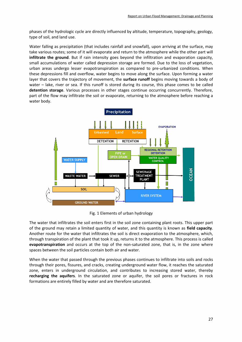
2.1 Urban Hydrology
The hydrologic cycle consists of a continuous transport of water masses from the ocean to the atmosphere and from it once more to the sea through precipitation, surface runoff and underground flow. Urban hydrology is the interdisciplinary science of water and its interrelationships of the hydrologic cycle with the urban development process, water regime, and water quality in urbanized areas. On a local scale, the quantity of water and the speed at which it circulates through the different
5 UN, 2015, A/Res/70/1, “Transforming Our World: The 2030 Agenda for Sustainable Development”
6 WMO, 1992, International Glossary of Hydrology (WMO No. 385, 1992)
Report on Urban Flood Management: Drainage and Planning
27
phases of the hydrologic cycle are directly influenced by altitude, temperature, topography, geology, type of soil, and land use.
Water falling as precipitation (that includes rainfall and snowfall), upon arriving at the surface, may take various routes; some of it will evaporate and return to the atmosphere while the other part will infiltrate the ground. But if rain intensity goes beyond the infiltration and evaporation capacity, small accumulations of water called depression storage are formed. Due to the loss of vegetation, urban areas undergo lesser evapotranspiration as compared to pre-urbanized conditions. When these depressions fill and overflow, water begins to move along the surface. Upon forming a water layer that covers the trajectory of movement, the surface runoff begins moving towards a body of water – lake, river or sea. If this runoff is stored during its course, this phase comes to be called detention storage. Various processes in other stages continue occurring concurrently. Therefore, part of the flow may infiltrate the soil or evaporate, returning to the atmosphere before reaching a water body.
Fig. 1 Elements of urban hydrology
The water that infiltrates the soil enters first in the soil zone containing plant roots. This upper part of the ground may retain a limited quantity of water, and this quantity is known as field capacity. Another route for the water that infiltrates the soil is direct evaporation to the atmosphere, which, through transpiration of the plant that took it up, returns it to the atmosphere. This process is called evapotranspiration and occurs at the top of the non-saturated zone, that is, in the zone where spaces between the soil particles contain both air and water.
When the water that passed through the previous phases continues to infiltrate into soils and rocks through their pores, fissures, and cracks, creating underground water flow, it reaches the saturated zone, enters in underground circulation, and contributes to increasing stored water, thereby recharging the aquifers. In the saturated zone or aquifer, the soil pores or fractures in rock formations are entirely filled by water and are therefore saturated.

Report on Urban Flood Management: Drainage and Planning
28
2.2 Types of flooding
Urban settlements often experience pluvial flooding or a combination of pluvial flooding with riverine (fluvial) or coastal flooding. In certain coastal cities such as Mumbai and Chennai, all the three, pluvial, riverine, and coastal flooding, does occur, often in combination. Although the scope of the present paper is restricted to pluvial flooding, it is essential to understand the various forms of flooding that urban centres can experience.
2.2.1 Pluvial flooding
Pluvial flooding refers to flooding events generated locally by the overload of the urban storm water drainage system by extreme rainfall. Such floods occur when the ground cannot absorb rainwater effectively or storm water drainage systems are overwhelmed by excessive runoff. Cities have a large percentage of impervious areas that prevent significant infiltration of rainfall into soil. Increasingly dense urban development intensifies the incidents of pluvial flooding. Pluvial flooding also occurs when the ground is saturated by melting snow, and therefore has low absorbing capacity.
2.2.2 Fluvial and riverine flooding
Fluvial floods are usually generated at a much larger rural catchment scale draining into a river, lake or wetland and are generally slow-rising floods. Riverine flooding, the most common fluvial flooding, occur in large rivers with large catchment areas. In riverine flooding, relatively high-water levels overtop the natural or artificial banks of a stream or river. Rapid flooding due to flash floods occurs more often on smaller rivers, rivers with steep valleys, rivers that flow for much of their length over impervious terrain, or normally-dry channels. The nature of riverine flooding can vary significantly in terms of cause, timing and depth between different locations. Floods due to river overbank flow occur when the river level rises above river banks. Excessive river levels are typically the result of high runoff from upstream and the backwater effect of high tides at the river mouth. Embankments protecting cities may sometime breach due to increased flood levels and cause severe flooding of hitherto protected areas.
2.2.3 Coastal flooding
In general, coastal flooding is different from riverine (from the river) and pluvial (from intense rainfall). Generally, cities in coastal areas are located in low lying areas where high tides or storm surges can hamper flood drainage to the sea and cause prolonged flooding. As climate change continues and the sea level rises, concerns regarding coastal flooding will continue to grow. Estuarine floods are caused by the interaction between the seaward flow of river water and seawater's landward flow during high tides leading to a water build-up. Frequently, the funnel shape characteristic of many estuaries causes an increase in high water levels in the upper, narrowing reaches of the associated river.
2.3 Storm water drainage
A storm water drainage system is an infrastructure designed to drain the excess rainwater from paved streets, parking lots, footpaths, sidewalks, and rooftops. It receives water through inlets and conveys it to a safe disposal point called the outfall, a water body - river or the sea. Storm water pollution reduces the assimilative capacity of water bodies. Since citizens' everyday activities cause polluted storm water runoff, the citizens themselves need to understand the repercussions of their actions and work together to prevent it.

Report on Urban Flood Management: Drainage and Planning
29
2.3.1 Storm water hydraulics
Surface runoff drains to the lowest point and, in moving across the road surface, forms a layer of water of varying thickness as sheet flow that slowly gathers into rivulets. On reaching the lowest point, runoff is channelled along the pavement edge via kerbing/kerb and channelling or discharged over the shoulders to a suitable collection system such as a natural watercourse, drain or piped drainage system, finally out falling into a river or the sea. A storm water drainage system is a network of surface drains, termed tertiary, secondary and primary drains, constructed as open or covered drains with a suitable gradient. Storm drains vary in design from small tertiary drains in residential areas to large municipal primary drains and can be open or piped. For ordinary conditions, storm drains are sized to flow practically full under design discharge but not under pressure. The storm water drains may overflow if it receives more than its design discharge or high water levels obstruct its outlet in the river or the sea.
Many storm water drainage systems are gravity drains. However, the drainage system may encounter situations where gravity flow conditions may not be feasible either due to the topographical configuration of low lying or tidal areas. Gravity flow conditions are also not viable where the water level of receiving water bodies is higher than the water level of the outfall. In coastal cities where the surrounding sea and estuaries influence outfalls, tidal gates are provided at the outfall to seal the channel to prevent seawater's backflow during high tide, sea-level rise, and storm surges. Under such situations, it is imperative to resort to storm water pumping to avoid flooding and waterlogging.
2.3.2 Polluted runoff
Storm water can carry various pollutants, including litter, soil, organic matter, grease, oil and metals collected from roads and properties; fertilizers and pesticides from gardens and faecal material; bacteria from pet wastes and failing septic systems, among other pollutants. Besides, the precipitation in urban areas may itself be contaminated while still in the atmosphere. Precipitation or the surface runoff over the undeveloped or grassy areas, such as parks and lawns, get filtered and ultimately replenishes aquifers or flows into streams and rivers.
On steeper slopes, the increased flow velocity aided by the lack of significant vegetative cover results in the transportation of a large quantity of sediment. Further, construction sites with loose soil produce 50 to 200 times the amount of sediment and particulate pollution produced by completed urban areas. Deposition of such eroded sediments inflicts severe problems in the drainage channels in the areas located downstream, resulting in frequent flooding. Further, urban drainage aims to remove all unwanted water that includes grey water (sullage), in domestic wastewater predominantly from baths, basins and washing machines, and the black water (sewerage) and the storm water. Storm water drains are expected to be separate from sanitary sewer systems to avoid discharging untreated sewage into the water bodies and prevent sewage treatment plants from becoming overwhelmed during a rainstorm and increasing treatment costs. In most Indian cities the two systems often interfere with each other.
2.4 Understanding linkages
Urbanization changes land use from forest or agricultural uses to urban areas. Creation of impervious surfaces, in the process of urbanization, profoundly affects how water moves both above and below the ground during and following storm events. The impacts of land-use change and construction of roads, cutting across natural drainage systems, significantly affect the urban catchment's hydrologic response. At the same time, flooding due to the overflow of storm water

Report on Urban Flood Management: Drainage and Planning
30
systems has enormous impacts on the necessary urban infrastructure for urban water management and economic activities. These linkages are discussed in brief.
2.4.1 Hydrologic cycle
Urbanization alters the hydrologic cycle variables – slopes, the geology of the terrain, infiltration rates of the soil, vegetation cover, and modifying the local hydrologic characteristics. Urbanization also removes existing vegetation in watersheds that are replaced by impermeable areas (asphalt roads, concrete sidewalks, roofs, parking lots, etc.).
Fig. 2 Impacts of urbanization on hydrology
The removal of vegetation, the increasing imperviousness, and the introduction of an artificial drainage system modify the hydrology significantly, producing larger flow volumes and peak flows, reducing the base flow discharges and the time of the concentration of the basin (Fig. 2).
With the construction of roads and buildings, the natural channels and water-bodies that have controlled outflows in the basin/ sub-basin for centuries are obstructed or diverted through man-made pathways. At the time of unprecedented rainfall events, the water overflows these man-made watercourses and flood large areas. The drainage problems in Gurugram (Case Study II) is a befitting example, where natural drains have almost been obliterated.
2.4.2 Urban planning
The policymakers fully recognize the importance of cities as vehicles of economic growth and development. Still, in most Indian cities, in recent decades, urban growth has been mostly informal, not controlled, urban occupation is sprawled and has inadequate infrastructure. The scarcity of affordable housing drives the poor and some lower middle class to informal settlements7 - with modalities ranging from squatting to informal rental housing. Besides, informal settlements can be a form of real estate speculation for all income levels of urban residents, affluent and poor. These settlements, often situated in geographically and environmentally hazardous areas, usually do not comply with planning and building regulations and are generally deprived of essential services.
7 UN-Habitat (2015), “Informal Settlements “Habitat-III, Informal Papers, 22, New York
http://uploads.habitat3.org/hb3/Habitat-III-Issue-Paper-22_Informal-Settlements-2.0.pdf

Report on Urban Flood Management: Drainage and Planning
31
Town and Country Planning Organization of India (TCPO) drafted the Model Town and Country Planning Act in 1962 to guide states. According to the TCPO guidelines, cities were expected to integrate open spaces in their Master Plans, duly linking them with natural drainage and wetlands. Reclaiming large tracts of land for the roads and buildings has left many cities bereft of wetlands and water bodies that could absorb urban outflows during the monsoon. As a result, there is a degradation of the urban environment in large parts of the cities almost everywhere.
The process of urbanization demands continued efforts to satisfy the growing demand for housing and a variety of infrastructure, which requires revisiting the master plans. Presently, most of the Master Plans, wherever they exist, are often out-dated and are more frequently bypassed than followed due to political pressure from various stakeholder groups. There is an urgent need to integrate water management with a broader planning system that calls for closer integration of flood management plans and land use plans by factoring flood risks into land-use planning regulations and by-laws.
Urban lakes, water bodies and natural drainages are the first victims of urbanization. Their conservation and restoration are essential for healthy and sustainable urban development. The Ministry of Urban Development to conserve/restore urban lakes/water bodies has issued advisory for the guidance of State Governments and ULBs8. The advisory falls far short of the need to preventing or rejuvenating encroachments of water bodies and natural drainage. A proper legal framework for notifying all the natural drainages, wetlands and lakes is called for.
The issue of encroachments on the drainage areas, the flood plains and the riverbeds constitute a significant issue. Unfortunately, it has been mired in politics with the law, where ever it exists, playing little part in managing the problem. For example, The Patna Municipal Corporation Act, 1951, contains elaborate provisions regarding the construction and maintenance of drains in the municipal areas and empowers the CEO to permit or otherwise for erecting a new building, wall or structure or for the construction of a street or railway over a municipal drain. Similarly, The Andhra Pradesh Rivers Conservancy Act, 1884, provides for the conservancy of rivers. It aims to prevent the unauthorized action of private individuals in obstructing the flow of rivers. The Act empowers the state to determine which river requires protection and survey the specified rivers or drainages and define the limits within which the Act can be applied. A review of the existing legal provision for urban drainage is urgently required at the central and state level.
2.4.3 Urban water management
Storm water drainage is intricately linked with urban water management, including drinking water supply, wastewater disposal and storm water removal. For economic and environmental reasons, there is a need to deal more explicitly with these overlapping parts between the three primary urban water management fields in totality. For example, many large Indian cities have to source water from long distances ranging from 50 to 200 km due to exhaustion or pollution of nearby sources. New challenges of climate change, growing populations, and over-tapped rivers and aquifers constrain traditional water supplies. Groundwater levels are declining in many parts of the nation, reaching 100-200 feet below historic levels in some cities. Wells and streambeds are running dry, and water quality decreases, putting a strain on the drinking water sources. Simultaneously, storm water can adequately meet many of the city demands for water if harvested and stored.
8 CPHEEO, 2013, “Advisory on conservation and restoration of water bodies in urban areas”, MoUD, New Delhi

Report on Urban Flood Management: Drainage and Planning
32
Total Water Cycle Management9 (TWCM) is described as a management concept that recognizes that all water cycle elements are interdependent and applied to decrease water demand, reduce storm water runoff, and improve pollutant wash-off from urban catchments. It calls for all water cycle elements, infrastructure, land use planning, and social, environmental and economic issues to be considered in an integrated manner (Fig. 3).
Fig. 3 Total Water Cycle Management
The TWCM approach is necessary to effectively and efficiently plan and manage urban water and wastewater system. Rainwater harvesting, grey water reuse, and groundwater recharge decreases water demand, reduces storm water runoff, and improve pollutant wash-off from urban catchments.
2.4.4 Urban Infrastructure
Failure of drainage system often occurs due to deficiency in maintenance and defects in design or construction of inlets to drains. Due to inadequate camber provision at the time of road construction or carrying repairs of the utilities crossing the roads, pools of water are formed, resulting in the weakening and undermining of the pavement strength leading to formations of potholes in the streets. They cause skidding of vehicles, or plain splashing of water, which creates a nuisance for other vehicles and road-users, resulting in snarling traffics, often causing jumbo traffic jams and disruption in urban life.
Inadequate provision of footpaths and storm water drain or subsequent encroachment by commercial establishments, street vendors, and on-street parking due to poor enforcement of the existing regulations restricts the storm water flow from entering into the drainage system. The open tertiary drains provided are also encroached and illegally covered, making it inconvenient/impossible to be desilted and cleaned.
Most of the cities, including megacities, face acute problems related to solid waste management. Poor solid waste management is a significant factor contributing to unsanitary conditions in all water bodies, including lakes and drains.
9 Chanan, A. and Woods, P., 2005. Managing the Water Cycle in Sydney Metropolitan: Local Governments Do Matter! In:
Khan, S.J., Schäfer, A.I. and Muston, M.H. [Eds.]. Integrated Concepts in Water Recycling, http://www.uow.edu.au/science/chem/aquarec/icwr/x/Chanan.pdf
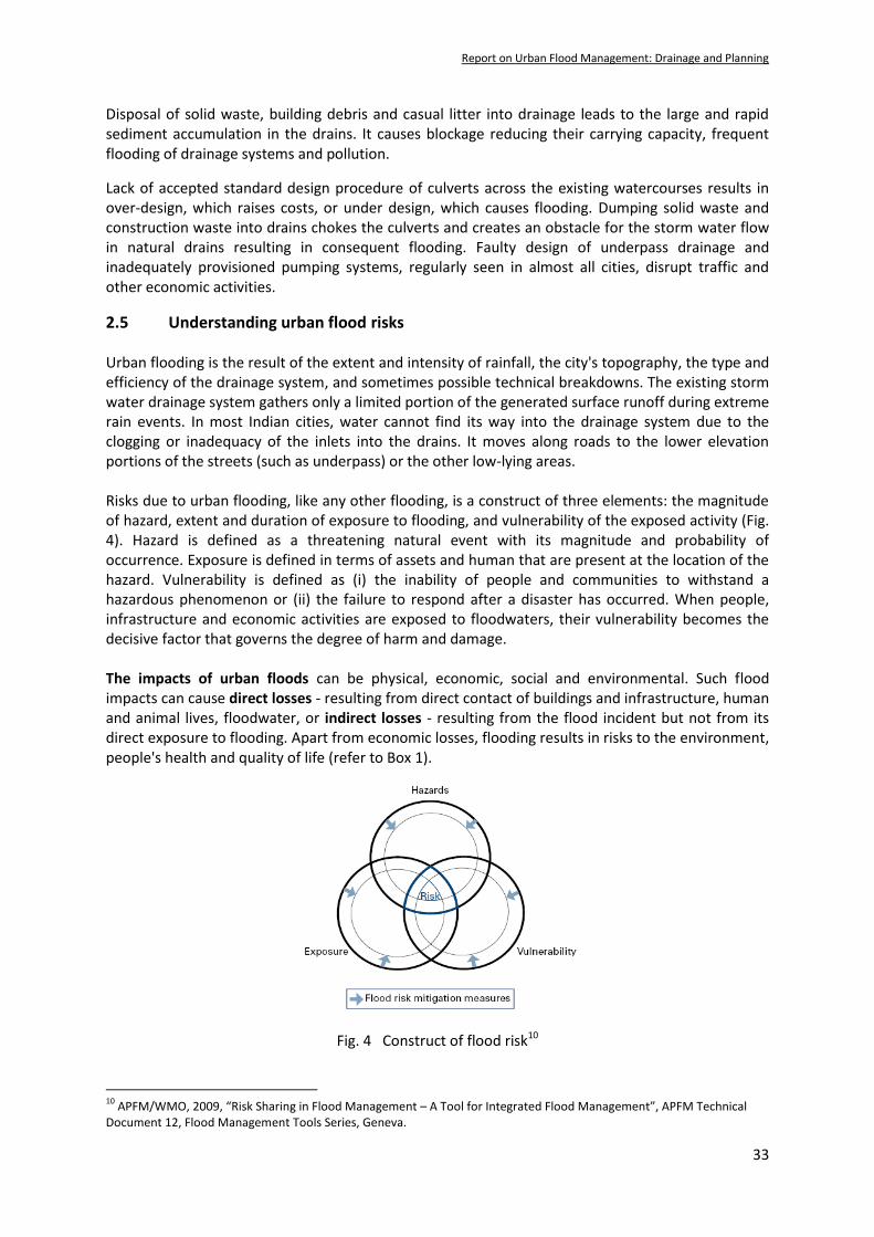
Report on Urban Flood Management: Drainage and Planning
33
Disposal of solid waste, building debris and casual litter into drainage leads to the large and rapid sediment accumulation in the drains. It causes blockage reducing their carrying capacity, frequent flooding of drainage systems and pollution.
Lack of accepted standard design procedure of culverts across the existing watercourses results in over-design, which raises costs, or under design, which causes flooding. Dumping solid waste and construction waste into drains chokes the culverts and creates an obstacle for the storm water flow in natural drains resulting in consequent flooding. Faulty design of underpass drainage and inadequately provisioned pumping systems, regularly seen in almost all cities, disrupt traffic and other economic activities.
2.5 Understanding urban flood risks Urban flooding is the result of the extent and intensity of rainfall, the city's topography, the type and efficiency of the drainage system, and sometimes possible technical breakdowns. The existing storm water drainage system gathers only a limited portion of the generated surface runoff during extreme rain events. In most Indian cities, water cannot find its way into the drainage system due to the clogging or inadequacy of the inlets into the drains. It moves along roads to the lower elevation portions of the streets (such as underpass) or the other low-lying areas. Risks due to urban flooding, like any other flooding, is a construct of three elements: the magnitude of hazard, extent and duration of exposure to flooding, and vulnerability of the exposed activity (Fig. 4). Hazard is defined as a threatening natural event with its magnitude and probability of occurrence. Exposure is defined in terms of assets and human that are present at the location of the hazard. Vulnerability is defined as (i) the inability of people and communities to withstand a hazardous phenomenon or (ii) the failure to respond after a disaster has occurred. When people, infrastructure and economic activities are exposed to floodwaters, their vulnerability becomes the decisive factor that governs the degree of harm and damage. The impacts of urban floods can be physical, economic, social and environmental. Such flood impacts can cause direct losses - resulting from direct contact of buildings and infrastructure, human and animal lives, floodwater, or indirect losses - resulting from the flood incident but not from its direct exposure to flooding. Apart from economic losses, flooding results in risks to the environment, people's health and quality of life (refer to Box 1).
Fig. 4 Construct of flood risk10
10
APFM/WMO, 2009, “Risk Sharing in Flood Management – A Tool for Integrated Flood Management”, APFM Technical Document 12, Flood Management Tools Series, Geneva.

Report on Urban Flood Management: Drainage and Planning
34
Due to the high population density and high economic value of properties and infrastructures exposed, financial losses due to urban floods are increasing exponentially11 . Large quantities of water may flood buildings and cut off transport systems. Flooding of major roads and streets leads to change in the capacity of roads, delay of movement, volume and speed of vehicles and driver's behaviour on the road. Excessive water on the pavement, whether ponded or flowing, can represent a real risk of skidding vehicles.
Flooded buildings with sensitive equipment such as electrical and IT systems may have overwhelming societal effects. Moreover, since sensitive infrastructure systems are usually connected and interdependent, effects may cascade to other systems and over a much larger area than those directly exposed. The infrastructure is often critical for society's function to work correctly and deliver essential services and supplies, such as fresh water and electricity, to its inhabitants. Moreover, vital societal functions, such as hospitals, may not be able to tolerate interruptions in water supply and electricity.
At the same time, since urban areas are becoming increasingly complex and high-tech with sensitive infrastructures influencing economic activities in greater regions other than the area directly exposed to flooding, the indirect financial losses can be substantial. Additionally, some of the adverse impacts may occur during the flooding. In contrast, others may materialize later, making it difficult to assess a flood event's overall effects on society. Four out of seven targets under the Sendai Framework12: reducing global disaster mortality, reducing the number of affected people, reducing disaster economic loss to GDP, reducing damage to critical infrastructure, and disrupting essential health and educational services have a direct bearing on how we manage our urban flood risks.
There are known and tested urban flood risk management measures, typically classified as structural or engineered measures, and non-structural management techniques. The traditional approach to protecting urban areas against flooding includes constructing protection embankments and storm water drainage systems to evacuate the excess water as fast as possible. This approach tends to increase the downstream flood risks and harm the riverine ecosystems.
11
A. Kaźmierczak and G. Cavan (2011). Surface water flooding risk to urban communities: Analysis of vulnerability, hazard and exposure, Landscape and Urban Planning, 103(2): 185-197, ISSN 0169-2046 https: //doi.org/10.1016/j.landurbplan .2011.07.008 12
UNISDR, 2015, “Sendai Framework for Disaster Risk Reduction, 2015 – 2030”, Geneva https://www.undrr.org/publication/sendai-framework-disaster-risk-reduction-2015-2030

Report on Urban Flood Management: Drainage and Planning
35
The Integrated Flood Management13 (IFM) approach under the broader umbrella of Integrated Water Resources Management14 (IWRM) is accepted worldwide to be most successful in reducing flood risks. The IFM approach adopts a mix of strategies based on risk management principles and integrating land and water management. It uses the basin as a planning unit and treats floods as part of the water cycle, duly recognizing that floods serve as an essential natural resource. While the urban catchment is the basis for designing a storm water drainage system, planning for effective urban flood risk management has to consider the flood risks in the entire catchment. Urban flood risk management aims at mitigating flood risk by lowering any one or more of the risk elements: hazard, exposure or vulnerability (Fig. 4). It has to be undertaken within a well-defined framework that recognizes and uses the potential synergies that could be achieved through coordinated actions and addresses the conflicting requirements that arise often. Three general concepts that provide the basic framework for urban flood risk management are Integrated Flood Management (IFM), Total Water Cycle Management (TWCM), and Land-use or Spatial Planning. IFM embraces systemic risk management principles.
Based on a comprehensive risk assessment and analysis, three strategies are adopted for flood risk management: risk reduction, risk retention, and as a last resort, risk transfer or risk-sharing. As part of the risk reduction strategy, the peak urban storm water runoff can be modulated and delayed if the runoff is arrested at the source. If this run-off is stored appropriately and subjected to minimal treatment according to the use, it can serve as a vital source of water during the non-monsoon season. Water can also be retained in the landscape in detention/ retention ponds, stored in surface storages or deposited underground through groundwater recharge. Judicious land-use planning, duly factoring in various risks, including flood risks, can mitigate both direct and indirect potential primary and secondary losses. The land-use planners should not only be aware of the existing risks but also the potential of a particular land use aggravating the existing risks. For example, the impact of reclaiming a flood-prone area or a wetland on the enhance flooding risks upstream or downstream.
Fig. 5 Integrated urban flood risk management framework15
13
WMO/APFM, 2009, “Integrated Flood Management - Concept paper”, WMO No. 1047, Geneva 14
Global Water Partnership, 2000, “Integrated Water Resources Management”, TAC TEC Paper No. 4, Stockholm. 15
WMO/APFM, 2008, “Urban Flood Risk Management – A tool for Integrated Flood Management”, Geneva.
LAND USE PLANNING
Flood Management Plans
Principales Risk Management Sustainable Urban
Drainage Systems
Plans
Concepts
Total Water Cycle
Management Integrated Flood
Management
IWRM
Plans
SPATIAL PLANNING
Coastal Zone
Management
Basin Flood Management
Plans

Report on Urban Flood Management: Drainage and Planning
36
It is evident for economic reasons that absolute protection against all floods is a myth. One of the best means of reducing these residual flood risks is to avoid exposure to flooding during rainfall events of magnitude higher than the design rainfall by implementing flood emergency management plans consisting of a sequence of preparedness, response and recovery. Emergency management plans have to be based on comprehensive flood risk maps and their effective risk communication. Flood risk maps enable users to identify the most endangered areas and neighbourhoods (WMO, 2008). They provide information on the flooding probability, the water level, flow velocity, sediment transport etc., at all vulnerable points. They provide essential input to the disaster managers to prepare rescue plans: the location of rescue shelters, rescue routes and the most vulnerable sections of the society needing attention. Detailed guidance on the preparedness and response to urban flooding is provided in the NDMA guidelines on Urban Flooding16 (2010). These guidelines call for multi-disciplinary and multi-sector efforts at various levels. Various departments of ULBs such as transport, health, electricity, water, and disaster management have to establish a well-oiled coordinated mechanism. Each department and functionary is fully aware of his/her responsibility in a given situation. They have to be made aware of the characteristic of flooding, its causes and their impacts.
3 Urban drainage planning and design _____________________________
3.1 Brief historical perspective
3.1.1 Urban flood management
In recent years, the frequency of urban flooding has increased, and the issue is getting more severe day-by-day due to its enormous economic, social and environmental impacts. While riverine flooding has been adversely impacting rural areas in last many decades, urban areas started getting affected noticeably by flooding during the 70s as manifested through flooding, e.g., in Patna 1975, Delhi 1977 and 1978, Kolkata 1978. Markedly, most of these floods were essentially riverine floods.
Since the late 80s pluvial flooding has been consistently impacting urban life, some of these events recalled from the present millennium are floods of Hyderabad (2000, 2001, 2012 and 2020), Ahmedabad in 2001, Delhi (2002, 2003, 2009, 2010 and 2011), Chennai (2004 and 2015), Mumbai (2005, 2008, 2009 and 2020), Surat (2006), Kolkata (2007), Jamshedpur (2008), Guwahati (2010), Jaipur (2012), Srinagar (2014) etc. During the very active monsoon of 2020, almost all state capitals in the country suffered extensive flooding of rural and urban areas. Life came to a standstill in many urban centres such as Bangalore, Hyderabad, Mumbai, Nagpur, and many other Class II cities.
Beginning with the National Program of Flood Management in 1954, the Central government has taken various flood management initiatives. Rashtriya Barh Ayog (RBA) or the National Flood Commission (1980) reviewed the effectiveness of various structural measures of flood control such as dams, embankments, and drainage channels non-structural methods like flood forecasting and flood hazard mapping. The main focus of RBA was on riverine floods. The Task Force on Flood Management/Erosion control set up in 2004 was no exception.
After the 2005 Mumbai floods, the National Disaster Management Authority (NDMA) paid attention to urban floods and issued urban flood management guidelines.
16
NDMA, 2010, “Management of Urban Flooding”, National Disaster Management Guidelines, New Delhi.

Report on Urban Flood Management: Drainage and Planning
37
The guidelines identify the institutional framework required to tackle urban flooding and make recommendations for enhancing urban flood management capabilities, improving the urban storm water drainage systems, including sustainable drainage practices, and improving the techno-legal regime, response actions, capacity development and implementation strategies. Later, following the Chennai floods of 2015, the Ministry of Housing and Urban Affairs has issued a standard operating procedure17 (SOP) outlining the mitigation strategies for urban flood risks. These SOPs identify nodal agencies for early warning and set a framework for city-level action plans, including establishing the emergency operations centre and other related measures.
3.1.2 Design practices of storm water drainage
The sanitary hygiene concept foresees rapid expulsion of waters from the city to preserve the health of the population and eliminate any discomfort the water could cause. Urban drainage planning traditionally aims 'to transport the storm water as rapidly as possible from our urban areas to the nearest waterways'. Nevertheless, what was not foreseen in this effort for channelling is the impact it causes downstream.
There are two components of the storm water design. The first component comprises the calculation of the total discharge that the system will require to drain off. The second entails fixing the dimensions of the drain to have adequate capacity to carry the discharge. Intensity, duration and frequency of rainfall, together with the size and type of area contributing to the runoff, determine the quantity of runoff. Design is usually based on the rainfall intensity of short and intense storms occurring during the south-west monsoon, which generally overload the drainage system more than the steady but low rainfall which occurs during the north-east monsoon.18
Urban storm water drainage infrastructure gets priority behind drinking water supply and sewerage projects in the majority of the Indian cities. No Indian city has a drainage system that can effectively deal with intense south-west monsoon rainfalls. In most cities, rainfall of even light or medium intensity causes urban flooding. The megacities in their central core zones have underground drainage facilities that are usually century old and consist of brick masonry ducts. In many cities, the drains are either non-existent or are undersized mainly because of a lack of funds allocated to the storm water drainage.
Until recently, the storm drains were designed for a rainfall intensity of 12–20 mm hr−1 as recommended in the Manual on Sewerage and Sewage Treatment Systems19, 1993 (revised in 2013). This design criterion has been one of the main reasons why the storm water drains in many Indian cities are undersized. Further, due to the non-availability of space for road widening, many of the existing drains have been encroached upon, reduced in size, and had piers of bridges and metro lines constructed in them.
Recently, Central Public Health & Environmental Engineering Organization (CPHEEO) has issued the first dedicated Manual on Storm water Drainage System20 in 2019, which covers the Engineering aspects in Part A and Operations and Maintenance aspects in Part B. Management of the storm water drainage systems that include public awareness, capacity development, institutional arrangement and financial sustainability are dealt with in Part C of the manual.
17
Ministry of Urban Development, 2010, “Urban Flooding – Standard Operating Procedure”, New Delhi. 18
Kadave, P T, et al, 2016, “Mumbai Floods, Reasons and Solutions”, in International Journal of Scientific and Research Publications, Volume 6, Issue 3. 19
CPHEEO, 2013, “Manual on Sewerage and Sewage Treatment Systems”, Part A Engineering, Chapter 3 Design and Construction of Sewers, New Delhi 20
CPHEEO, 2019, "Manual on Storm Water Drainage System", Vol. I, Part A – Engineering Design, New Delhi

Report on Urban Flood Management: Drainage and Planning
38
The manual recommends that the drainage of urban catchments need not be designed for rare storm events of 25 or 50 years or higher recurrence period; instead, it is necessary to provide adequate protection against frequent flooding.
Absolute protection from flooding is technically infeasible and economically and environmentally unviable21. Based on techno-economic and risk considerations and to avoid vast dimensions of underground drains, the system is typically designed for a design storm of 10 years recurrence period or less. More extreme events are deliberately allowed to generate inundation of selected areas such as streets, infrastructure, and building basements, which has to be accepted as once in a while inconvenience. However, in such situations, the disaster preparatory measures as specified by 'National Disaster Management Guidelines, published in September 2010.
3.2 Sustainable development and adaptation to climate change
3.2.1 Sustainable development
The United Nations-sponsored World Commission on Environment and Development in Our Common Future (1987) identified sustainability as a major concern. Planners have their task cut out to balance the conflicting demands of social equity, economic growth, environmental sensitivity, and aesthetic appeal. Water is central to economic, social and cultural development and well-being, and urban development recognized as the driver of economic growth and development. Urban water management occupies a crucial role in realizing Sustainable Development Goals22.
Almost all the SDGs are impacted by the way we manage our water. Goal 6: Ensure availability of water and sanitation for all, is closely linked to Goal 1: End poverty; Goal 2: End hunger and achieve food security; Goal 3: Ensure healthy lives and promote well-being; Goal 11: Sustainable cities and communities; and Goal 15: Protect and restore terrestrial ecosystems. Under Goal 11, Make cities and human settlements safe, resilient and sustainable – three out of seven targets set are closely linked to the Urban Flood Management. Target 11.4, reduce the adverse effects of natural disasters - sets to significantly reduce the number of deaths and substantially decrease the direct economic losses caused by disasters; Target 11.5, reduce the environmental impact of cities - aims at reducing the adverse environmental impact of cities, including waste management; and Target 11.6, provision of access to safe and inclusive green and public spaces.
It is recognized that achieving the 2030 Agenda for Sustainable Development will only be possible through an integrated approach, working across sectors, ministries and various administrative levels and geographical scales. All the stakeholders need to understand the inter-linkages between various goals and maximize synergies and minimize trade-offs by working across traditional institutional structures.
3.2.2 Adaptation to climate change23
Global warming has intensified the global water cycle, making weather less predictable, rains more uncertain, and heavy storm rainfalls more likely. Changes in extreme weather and climate events, an excessive increase in high sea levels and an increase in the number of heavy precipitation events in several regions have been observed over the last seventy years. Increased episodes of high-intensity rainfall events are being experienced in shorter periods.
21
WMO/APFM 2006, “Integrated Flood Management – Concept Paper”. 22
UN, 2015, A/Res/70/1, “Transforming Our World: The 2030 Agenda for Sustainable Development” 23
IPCC, 2014: “Climate Change 2014: Synthesis Report”. Contribution of WGs I, II and III to 5th AR of IPCC,

Report on Urban Flood Management: Drainage and Planning
39
Heavy thunderstorms appear to have increased in frequency. Further, growing urban areas, due to their' urban heat island' effect, may increase energy and water requirements for cooling. The latest IPCC Special Report on Oceans and Cryosphere24 has indicated that the sea-level is rising at a much faster level than estimated earlier, exposing the coastal cities to increased risk from flooding.
Climate change will amplify existing risks and create unknown risks for natural and human systems. However, adaptation can reduce the chances of climate change impacts. Taking a longer-term perspective in the context of sustainable development increases the likelihood that more immediate adaptation actions will also enhance future preparedness.
While mitigation – that involves reducing the greenhouse gases, adaptation involves adjusting to expected future climate. Effective institutions and governance underpin adaptation and mitigation responses, investments in environmentally sound infrastructure, and behavioural and lifestyle, among others. Our commitment to SDGs makes it imperative that we seek opportunities to link mitigation, adaptation and other societal objectives through integrated responses. However, successful implementation will rely on relevant tools, suitable governance structures, and the stakeholders' enhanced capacity to respond.
Of late, green infrastructure has been viewed as a development imperative, especially for creating liveable, environmentally sustainable and efficient cities. Green infrastructure25 (GI) refers to natural or semi-natural ecosystems that aid water resource management by partially introducing the natural water cycle into urban environments. It offers practical measures to reduce risks from urban flooding, water supply and quantity regulation while generating multiple environmental benefits. When appropriately planned, designed and managed, GI has the potential to mitigate and adapt to the effects of climate change.
3.3 Recent urban drainage design trends
Following the 1992 Earth Summit, where the international community adopted sustainable development as the means to address pressing problems of the world, the management of the urban storm water system and the urban water cycle more broadly has seen significant new trends. The emphasis is shifting from mostly single objective interventions of reducing flooding to an integrated approach with multiple objectives and distributed actions over the basin. They attempt to retain/ recover flow patterns similar to those that occurred before urbanization.
This broad approach has been attempted under various names26. Low Impact Development (LID) used in the USA and Canada and Low Impact Urban Design and Development (LIUDD) in New Zealand. The original intent of LID is to achieve 'natural' hydrology, i.e., the balance of pre-development runoff, infiltration, and evapotranspiration volumes, through a "functionally equivalent hydrologic landscape" using site layout and integrated control measures. Similarly, Sustainable Urban Drainage Systems (SUDS) or the Sustainable Drainage System (SuDS) introduced in the United Kingdom and Water Sensitive Urban Design (WSUD) initiated in Australia has developed a holistic approach to urban storm water drainage design.
24
IPCC, 2019: “IPCC Special Report on the Ocean and Cryosphere in a Changing Climate”, Geneva. 25
Suresh Kumar Rohilla et al., 2017, “Green Infrastructure: A Practitioner’s Guide”, Centre for Science and Environment, New Delhi 26
Tim D Fletcher et al, 2015, “SUDS, LID, BMPs, WSUD and more – The evolution and application of terminology surrounding urban drainage”, Urban Water Journal, 2015 Vol. 12, No. 7, 525–542, http://dx.doi.org/10.1080/1573062X.2014.916314

Report on Urban Flood Management: Drainage and Planning
40
Subtle distinctions between different approaches are presented by Tim Fletcher et al.27. Regardless of the name, these recent trends in storm water design attempt to balance diverse variables of the hydrologic cycle and their effects on the watersheds.
Besides, these recent trends in the management of urban storm water drainage systems address water quality concerns and establish rainwater as a resource to be harnessed for supplementing the urban water supply needs. Droughts are increasingly threatening large cities. In the recent past, cities like Cape Town, Mexico City, Jakarta, Chennai and Mumbai, have faced drought conditions leading to the unprecedented water crisis. Due to urbanization, the water cycle imbalance has become so great that we are no longer replenishing the groundwater supplies, depleting the groundwater table at alarming rates in many cities and our green spaces are increasingly moisture depleted. To rejuvenate groundwater, it serves as a dependable fall-back option in years of drought and to sustain green spaces in our cities. We have to design more infiltration in our cities.
3.4 Sustainable Urban Drainage System
Fig 6. SUDS Triangle
In response to increasing extreme rainfall events due to climate change, Sustainable Urban Drainage System (SUDS) provides an alternative approach to the urban drainage problems, sustainable, adaptive and incremental. The green infrastructure for the storm water drainage partially reintroduces the natural water cycle into the urban environment and provides practical measures to manage pluvial (urban runoff or surface water) flooding. Green infrastructure is a cost-effective, resilient approach to addressing extreme weather impacts that provide many community benefits. While conventional piped drainage and water treatment systems move urban storm water away from the built environment, green infrastructure reduces and treats storm water at its source while delivering environmental, social, and economic benefits.
The SUDS triangle consists of water quantity, water quality and biodiversity, as shown in Fig 6. For a detailed SUDS approach, National Disaster Management Guidelines to Urban Flooding, and the CPHEEO manual, may be referred. The goals of SUDS are:
Quantitative control of surface runoff;
Improvement in the quality of water from surface runoff;
Conservation of natural characteristics of water bodies; and
Balance of hydrological variables in watersheds.

Report on Urban Flood Management: Drainage and Planning
41
SUDS is implemented through features that mimic the natural ecosystem's ways of handling storm water runoff. In order to reduce the quantity of storm runoff reaching the storm water drains, a portion of the storm water can be stored/percolated by introducing suitable techniques such as:
In-situ storage/percolation within or around premises
Storage of runoff in nearby pond/water tank Percolation of storm water inside/outside the drains along its stretch Spreading water for recharge in low lying areas and park/gardens etc. Disposal to reservoir/water body
Examples of SUDS features: SUDS have a general design approach that works explicitly across all scales and is characterized by features that control the runoff right at the source, recharge the groundwater. In contrast, the runoff flows towards the drainage system and retain or detain it in natural or artificial depressions/storages.
Source control and prevention features: ‒ Green roofs, permeable and semipermeable pavements, rainwater harvesting,
and infiltration trenches, rooftop reservoirs, micro reservoirs, and underground reservoirs;
Permeable conveyance features: ‒ Filter drains, infiltration gullies; infiltration trenches; and swales
Passive treatment features: ‒ Detention basins, retention ponds, wetlands etc,.
A combination of SUDS features can improve the quality and health of the social environment in the city. They benefit the ecological health, enhance the biodiversity and vegetation within the cityscape. They can improve the local microclimate quality by delivering ecosystem services such as air-purifying and filtration, etc. In some areas, managed aquifer recharge for storage can be an alternative to other storage options.
On a new site, there are choices, and the planner can make generous provision for green areas and open public spaces, where she/he can appropriately provide green features of SUDS. In dense built-up environments, the emphasis is on integrating rooftop rainwater harvesting and recharge systems to augment the existing storm water drainage system. Existing open spaces can be retrofitted with some of the SUDS elements
Like all storm water infrastructure, the green infrastructures also requires regular inspections and maintenance to assure proper function. They need more labour and less heavy equipment than the upkeep of covered drainage infrastructure. For example, maintenance of swales and detention basins require a monthly site visit to undertake grass cutting, litter picking and inlet/outlet inspections. The permeable paving requires biannual suction sweeping.
3.5 Challenges of adopting SUDS in India
The 74th Constitutional Amendment Act of 1992 envisaged the creation of vibrant Urban Local Bodies (ULB) equipped with funds, functions and functionaries. ULBs have the principal constitutional responsibility of providing urban water supply services, urban flood risk management, and managing urban drainage infrastructure, among others28.
28
https://niti.gov.in/writereaddata/files/document_publication/report-ULB_0.pdf

Report on Urban Flood Management: Drainage and Planning
42
SUDS approach that deals with the risk due to excess rainwater requires extensive coordination between various disciplines such as architects, town planners, social scientists and ecologists and engaging diverse stakeholder groups. Lack of coordination among multiple stakeholders and departments on the one hand and the lack of capacity to deal with multi-disciplinary activities, as discussed in the following paragraphs, pose challenges in implementing the SUDS approach, which need to be overcome.
3.5.1 Unorganized city development
The quality of a city’s infrastructure is central to the quality of life, social inclusion and economic opportunities in the city. The main challenge to urbanization in the country stems from the inability of ULBs to provide appropriately serviced sites for the multitudes streaming into the towns and cities. A rapidly increasing population density creates severe problems since planning efforts can’t cope with the influx of new inhabitants. In most Indian cities, there is a lack of vision, no town planning and no provision of services. ULBs struggle with infrastructure to provide employment, housing, education, health and transportation, and put flood risk management and storm water infrastructure on the back burner.
Poor and even lower-middle-income migrants to the cities in urban and semi-urban settlements seek space where they can construct a hut or a semi pucca room from their limited financial resources. In the absence of an organized and planned approach to the urbanization process, they land up in informal settlements (slums) such as Dharavi Slum in Mumbai, Bhalswa Slum in Delhi, Nochikuppam Slum in Chennai, Basanti Slum in Kolkata, and Rajendra Nagar Slum in Bangalore and many more. Dharavi is considered to be one of Asia's largest slums, with an area of just over 2.1 square kilometres and a population of about ten lakhs. Such settlements generally come about almost invariably without permission of the city authorities.
In the absence of proper services, the (informal) drainage system quickly becomes the recipient of waste of all kinds, including water, faeces and solid waste. Even when the local authority accepts the existence of an informal settlement, the fact that it is usually illegal – at least to start with – means that they are reluctant to provide much apart from some "basic" services. Provision of drainage services in such slum areas takes considerable skill as it usually requires the shifting of shacks/built-up areas to open up drainage routes. Such an effort, in turn, has to be a collaborative effort of government officials and the community and requires lots of effective and practical negotiations.
In formal new settlements, the local government generally focus on the delivery of houses and essential services such as roads, electricity, water, sewerage, storm water drainage and solid waste removal are pushed to lower priority in that order. Even in better-resourced municipalities, the provision of services to informal settlements is often frustrated by the fragmentation of service delivery responsibility into several departments that do not always work together or even communicate well.
3.5.2 Institutional shortcomings of Urban Local Bodies
Governance of Urban Local Bodies is the weakest and most crucial link that needs to be repaired to bring about India's urban transformation29. Despite the 74th Constitutional Amendment Act (74th CAA), which has only been implemented partially, subjects like urban planning, land use and socio-
29
High Powered Expert Committee, 2011, “Report on Urban Infrastructure and Services”, Ministry of Urban Development, Govt of India. http://cpheeo.gov.in/upload/uploadfiles/files/FinalReport_hpec09.pdf

Report on Urban Flood Management: Drainage and Planning
43
economic development are yet to be transferred to the city governments as mandated under the Act30.
The governance structure within the ULBs also remains ambiguous, with the balance of power unequally divided between the elected wing and executive wing alluding to a joint development goal for the city. The roles and responsibilities of various constituents need to be clearly defined at all levels within the spirit of the 74th CAA. The High-Powered Expert Committee (2011) has pointed out that ULBs suffer from a fragmented management structure. Within the executive wing of the ULBs, there is a need for establishing better coordination mechanism between various departments.
The ULBs are mostly understaffed, leaving the staff with no luxury to update their knowledge and skills. The departments generally outsource significant activities to contractors who themselves do not have adequately trained technical staff. Upgrading managers' skills by providing short and focused courses in urban planning, infrastructure financing, contractual management is essential. In order for the managers and technicians to be able to use new technology tools, such as IT software, mobile phones, GPS, GIS etc., ULBs should upskill their technicians on these and other skills on a continuous basis. For example, airborne laser terrain mapping (ALTM) is an active remote sensing technology that employs light detection and ranging to measure topography at a high spatial resolution over large areas. It can serve as a crucial tool in urban planning and developing flood risk maps.
There is also a strong case for motivating the staff for acquiring new skills or upgrading their existing skills by introducing appropriate incentives. For example, the Jawaharlal Nehru National Urban Renewal Mission (JNNURM) provided for capacity building of ULBs on-demand but found few takers. The state governments and ULBs need to rebuild the local government institutions' basic structure by putting the staff in place at the ULB level and preparing the training infrastructure.
In addition to the institutional deficiencies, the main reasons for the local government's failure to provide sustainable urban drainage to its citizens are resource constraints, both financial and human.
3.5.3 Lack of capacity among local stakeholders
SUDS is implemented within the overall urban flood risk management framework, consisting of IWRM, IFM, and TCWM approaches, emphasising active stakeholder participation. Urban flood risk management is based on the principle of reducing vulnerability through building resilience and developing a culture of prevention through preparedness rather than reactive responses alone. The multidimensional nature of sustainable urban drainage options due to constraints, risks, uncertainties, and conflicting objectives poses challenges and opportunities for the participatory approach towards decision-making. Such options should not only be technically appropriate but should also address broader socio-environment concerns. Multi-stakeholder engagement is key to the success of urban flood risk management.
In addition to the ministries/ departments/ agencies of the central/ state/ local government, scientific institutions, registered NGOs, voluntary organizations, citizens are the core stakeholders. The behaviour of citizens influences the intensity of runoff from the urbanized areas and the performance of urban drainage systems affecting flooding in the cities. The active involvement of citizens who interact with and are benefiting from various SUDS elements on a day-to-day basis will determine the success of the approach.
30
NIUA, 2015, “A Study to Qualitatively Assess the Capacity Building Needs of Urban Local Bodies (ULBs)”, Min of Urban Development. https://niti.gov.in/writereaddata/files/document_publication/report-ULB_0.pdf

Report on Urban Flood Management: Drainage and Planning
44
NGOs can influence stakeholders' behaviour, particularly basin communities, by building awareness and disseminating information and can help flood-prone communities organize themselves. Technical NGOs can provide information about the complex and uncertain state of knowledge and processes to the man on the street in readily understandable language and help them voice their concerns. They can also provide important input by presenting unbiased scientific studies. In flood emergencies, several humanitarian and voluntary organizations come forward and play a crucial role during emergency response. Similarly, the private sector, directly or indirectly affected by flooding, is an important stakeholder.
The general creation of awareness among citizens is now recognized as an essential input to infrastructure projects, wherein citizens' actions could enhance or hamper the green infrastructure's functioning. Storm water drains prone to be used as dumping ground for all sorts of garbage need to be prevented to ensure the proper functioning of storm water drains through awareness building. Similarly, the water recharge structures need due care and regular maintenance to function appropriately and efficiently. There is a need to increase stakeholders' knowledge and understanding of rainwater harvesting and flooding as phenomena and flood risks.
4 Capacity development for urban drainage and flood risks ___________
Capacity development for urban flood risk management (UFRM) aims to develop all stakeholder groups' capability to understand various facets of the development issues involved. Capacity development is mostly referred to at three levels - individual, institution, and organizational environment or system (Fig. 7).
The system level's capacity refers to the environment that influences an institutions role, goals, and performance. Institutional capacity-development aims to align the institutions' function to fulfil their goals and societal aspirations in the changing environment. It offers the conditions necessary for proving capacity at the individual level. Capacity at the institutional level includes physical resources (facilities, equipment, materials); intellectual resources; inter-institutional linkage (network, partnership); organizational culture and leadership; and incentive and reward systems. The capacity at the organization level also determines how individual capabilities are utilized and strengthened. ULBs suffer from a lack of capacity at all three levels31. However, keeping in view the scope of this paper, the discussion in the following sections is confined to individual capacity development.
Fig. 7 Capacity development framework
31
High Powered Expert Committee, 2011, “Report on Urban Infrastructure and Services”, Ministry of Urban Development, Govt of India. http://cpheeo.gov.in/upload/uploadfiles/files/FinalReport_hpec09.pdf
Report on Urban Flood Management: Drainage and Planning
45
The capacity development on an individual level requires the development of conditions that allow an individual to contribute to the best of one’s potential. It includes knowledge, skills, value, attitude, awareness, and motivation. It is a continuous process and requires review and upgrading of the existing capabilities in light of the evolving goals of the organization and advances in technology. Most of the ULBs are inadequately staffed, overwhelmed by additional tasks and carry out-dated knowledge. They are often called upon to perform the duties on behalf of the colleagues with the requirement of expertise from other departments without any formal training in that discipline. In order to meet such situations, they must be formally exposed to various disciplines through skill development programs through re-skilling and up-skilling in urban planning, disaster management and public works maintenance. Individual capacity-building needs to focus on creating opportunities for those already playing a pivotal role in different departments of ULBs and enable them to develop their understanding, knowledge base and leadership skills. It is acknowledged that different stakeholder’s groups need different skill sets depending on the roles they are expected to play. Skill enhancement through formal training programmes, study tours, attachments, and internships in other similar organizations can achieve the desired objective.
In the water domain, including UFRM, where every citizen is a stakeholder, the community capacity-building through a collective skill enhancement of civil society organizations or non-government organizations and mass awareness is imperative. For example, in flood risk management, the capacity-development starts with identifying a community's perceptions of risk, kindling their cooperative attitude and social behaviour is necessary. It focuses on building awareness of flood risks in a catchment, local environmental issues and floodplain management activities are taken to mitigate flood hazards. It requires putting people first.
At all stages – regional, national and local – it is critical to building capacity to manage the organizational aspects of stakeholders' participation and form partnerships. On account of the number of people to be trained, the competencies of personnel required to ensure service delivery standards, and the spread across regions and to need to engage people in their languages and local context, the task is enormous. Requirements for capacity development in terms of the demand-supply gap are massive. Changing technology presents significant challenges as well as opportunities.
4.1 Urban planners
Of all human activities, urbanization produces the most significant local changes in urban hydrologic processes. Practically all urban activities lead to deforestation or ground preparation for new construction work and negatively impact watershed behaviour. Engineering infrastructure works generally cause changes in water cycle variables such as the rate of infiltration, evaporation, and runoff. Additionally, spatial planners have to adequately deal with various risks in the physical, social, and environmental systems of urban areas. In order to deal with urban flood risks, urban planners require knowledge of not only town and country planning but also transport engineering, sanitation, water supply, sewerage and flood management.
Although ULBs are supposed to undertake urban planning, most of the state governments are yet to delegate them adequate powers and equip them with appropriate capacity.
Report on Urban Flood Management: Drainage and Planning
46
While state-level urban planners develop spatial plans, ULBs coordinate and execute various projects or schemes, including the storm water drainage schemes and water engineering works on rivers, lakes, and oceans for the city's planned development. Given the multi-disciplinary nature of these solutions, urban managers have to explore and implement them. There is a need to review the educational qualifications and on-job training requirements for urban planners, managers and technicians. New skills on integrated green infrastructures and urban risk management would be needed to be developed at a much larger scale.
The Smart Cities Mission32 of Government of India, designed to drive economic growth and improve people's quality of life by harnessing technology in local area development, provides an opportunity to integrate storm water drainage management into the various sectors such as housing, transport, recreation or economic development. The mission emphasizes digital solutions for area-based development and provides an opportunity to transform (retrofit and redevelop) existing urban zones, including slums, into better-planned zones.
4.2 Disaster managers
We cannot stop natural hazards, but we can prevent them from turning into disasters through risk mitigation, preparedness, and prudently responding to them. Unfortunately, there are insufficient understanding and appreciation of the capacities required to bring about risk reduction and the methods to build them. The Concise Guide on Strategic Approach33 to Capacity Development for Disaster Risk Reduction emphasizes the strengthening of organizational and institutional structures, fostering a more conducive risk reduction environment, and improving mind-set and disaster risk reduction modalities through capacity development. It also observes that there is much room for enhancing individuals' knowledge and skills. Training and education can help raise awareness of risk factors, impart the knowledge required to act appropriately and effectively, and enable appropriate technical and administrative skills.
Since management of urban flooding is the responsibility of the ULB at the local level, they also are responsible for early warning, preparedness, mitigation, rescue, relief and restoration. They need to prepare City Disaster Management Plans following the Guidelines of NDMA34. For example, ULB is responsible for developing step by step procedures and actions to be taken under each flood management strategy. Once the flood event materializes, the associated flood SOP35s must be immediately initiated under the overall charge of ULB.
ULBs will be responsible for converting the historical flooding information supported by appropriate models into flood hazard maps. Determining the likely flood-prone areas due to localized flooding must be undertaken with a greater understanding of various flooding processes affecting the drainage systems. It requires engaging experts in flood hazard mapping with whom the disaster managers in ULBs should be able to interact.
ULBs need to set up workable warning dissemination systems to publicize time-sensitive information about flood risk to the communities at risk, emergency responders and other stakeholders. The success of such a system is closely related to people's awareness of flood risk and their familiarity with emergency response procedures.
32
GoI, Smart City Mission http://smartcities.gov.in/content/innerpage/what-is-smart-city.php 33
UN ISDR, 2019, “Strategic Approach to Capacity Development for Implementation of the Sendai Framework for Disaster Risk Reduction – Concise Guide” 34
NDMA, 2010, “Management of Urban Flooding”, National Disaster Management Guidelines, New Delhi. 35
Ministry of Urban Development, 2010, “Urban Flooding – Standard Operating Procedure”, Govt of India, New Delhi

Report on Urban Flood Management: Drainage and Planning
47
4.3 Public works functionaries
Adequate drainage is a primary requirement for maintaining the structural soundness and functional efficiency of a road. Because of inadequate surface and subgrade drainage, the structural stability of pavement is undermined. In most of our cities, as part of recarpeting of roads surface profile is not maintained correctly hampering its quick drainage. Pools of water may form pothole formation, undermining the pavement course strength, leading to skidding, or splashing water, which is a nuisance to other vehicles and road-users. Public Works Department personnel have to be sensitized to the need to maintain designed slopes and camber on roads so that the average surface runoff does not accumulate on roads.
PWD functionaries need to be made aware of the impact of their construction activities on the hydrologic characteristic of the catchment and its consequences on the functioning of the drainage system. For example, in the city of Patna, construction activities rendered the drainage system non-functional at multiple places, which resulted in waterlogging. They led to damage to the existing drainage system, leading to water accumulation in the city (refer to Case Study I). Road construction and maintenance technicians need to be made aware of the importance of the slopes that are required to be maintained for the excess drainage flows to be appropriately guided to the drain holes and the drainage systems.
Failure of drains occurs both due to defect in design or due to deficiency in maintenance by desilting, cutting of weeds, clearing of obstruction, debris and blockage. Therefore, it is necessary to ensure that the drains keep their shape and slope and retain their full cross-section, particularly for the monsoons. It is also essential to ensure that the drains retain their entire cross-section and timely repairing of lining carried out immediately at the commencement of damage or deterioration. Before the monsoon onset, all the drains shall be thoroughly de-silted manually or using suitable mechanical devices. The wet waste collected from the desilting of drains remains by the side of the drainage to find its way back into the drains with the first monsoon shower. Personnel in these maintenance activities need to be skilled to use modern equipment.
Generally, a city is divided into administrative wards and further divided into health wards for solid waste management. Most health wards are under the private contract system in some cities, and other neighbourhoods are managed through municipal workers. Workers tend to dispose of the collected litter into the nearby drain. Disposal of solid waste into drainage leads to the large and rapid accumulation of sediments in the drains. Dumping of solid waste and construction waste into drains also reduce the capacity of culverts which creates a hurdle for the storm water flow. There is a lack of supervision and oversight in such activities. Difficulty in maintenance is also caused by a lesser degree of consciousness/civic sense. All users, roadside business establishments, street vendors, and pedestrians need to be aware of their civic responsibilities through awareness-building programs.
4.4 Property owners
In urban areas, rainwater available from rooftops of buildings, paved and unpaved areas goes to waste. Many techniques of rooftop rainwater harvesting in urban areas are described in CPWD Manual36 and BIS Codes37. Rainwater harvesting combined with filtration, infiltration and irrigation can reduce runoff volumes for the vast majority of storm events to close to pre-development levels. It also helps restore base flows, return natural soil moisture levels and increase the amount of time it takes for storm water to reach stream channels, thereby reducing the flood peaks.
36
CPWD, 2002, Rainwater harvesting and conservation – Manual”, CSO, CPWD, New Delhi. 37
BIS, 2008, “Roof top rainwater harvesting – Guidelines”, IS 15797, WRD3, Bureau of Indian Standards, New Delhi.
Report on Urban Flood Management: Drainage and Planning
48
The rainwater harvesting (RWH) system needs to be appropriately designed, keeping in view the ultimate use of the water collected, such as watering gardens, flushing toilets in bathrooms, washing sidewalks, etc. They need to be constructed so that they do not occupy large space for the collection and the retaining rainwater. Nevertheless, the challenges that must be overcome for the efficient performance of RWH systems is their regular maintenance and upkeep, which needs to be carried out regularly. All property owners need to be made conscious of the needs of rainwater harvesting and routine maintenance of RWH structures.
Challenges such as utilizing stored storm water that requires treatment to remove the harmful pollutants, lack of space to store the captured storm water during a storm, and the infrequent use of necessary infrastructure for water storage to be used only intermittently; thereby increasing the per unit capital cost, shall have to be overcome. As roof-top RWH is essentially carried out at individual household level or community level, the availability of qualified technicians to undertake construction and regular maintenance of these systems pose a recurring challenge. Regulatory provisions should be made to ensure that only certified RWH technicians undertake these works. As RWH is increasingly being made compulsory by almost all major cities, there is a need for many RWH technicians to be trained and skilled.
4.5 Public at large
Stakeholders need to increase their understanding of how flooding may affect the public infrastructure in these places and how the effects spread from one system to another. In order to facilitate multi-stakeholder planning, all relevant stakeholders in a given area must be identified, and forums created to exchange experiences and communicate information about specific interests. Enabling environment for the participation of all the stakeholders need to be created through legal instruments and supported by capacity development.
Every city dweller is a drainage service user and is likely to suffer due to flood hazard. To reduce his vulnerability to flooding, he has to support SUDS and increase his preparedness towards flood emergencies likely to be presented if the rainfall intensity is beyond the designed capacity. Every citizen needs to be aware of the water resource one uses, increased drainage runoff due to construction of his house and business, measures to conserve water, and flood risks around the city. Multi-stakeholder engagement is key to the success of urban flood risk management as it ensures strong stakeholder support and is a catalyst for their proactive engagement. Capacity-building has to be made an integral part of SUDS and urban flood risk management. Because of the enormous quantities generated every day, the management of municipal solid waste in India has surfaced as a severe problem not only because of environmental and aesthetic concerns but also its adverse impact on the urban drainage that has emerged as one of the most crucial factors in the urban flooding due to drainage congestion. The management of municipal solid waste is one of the main functions of the ULBs required to plan, implement and monitor all systems of urban service delivery. Solid Waste Management (SWM) Rules, 201638 stipulate that the local authorities shall “prepare a solid waste management plan as per state policy and strategy on solid waste management”. Many of the municipal authorities are still to develop in-house capabilities to govern their solid waste independently. In the absence of solid waste management services, most solid waste finds its way from streets to storm water drains.
38
http://www.indiaenvironmentportal.org.in/files/file/Solid%20Waste%20Management%20Rules,%202016.pdf

Report on Urban Flood Management: Drainage and Planning
49
The Municipal Solid Waste Management (MSWM) requires39 institutional strengthening, human resources development, technical capacity development, community participation, legal framework, and enforcement mechanisms. Therefore, various sections of the stakeholders need to be made fully aware of their responsibilities, thereby avoiding cluttering of the drainage systems with solid waste generated from households, small and medium businesses, the construction industry, and street litter. Communities with a good understanding of the risks they are exposed to, often join together to influence risk management and mitigation decisions. They seek ways to continually improve their knowledge and participation skills by forming Community Flood Management Committees (CFMCs) in the flood-affected areas and play an essential role in flood emergency management activities. CFMCs use flood forecasts, together with flood hazard maps, to plan and execute flood emergency plans. Flood managers and disaster management functionaries have to enable CFMCs and provide them with the necessary technical support. At the same time, disaster managers should be equipped with the required skills to interact and communicate with the communities.
5 The proposed plan of action ___________________________________ Urban Local Bodies have the constitutional responsibility for providing urban water supply services, urban flood risk management, solid waste management and managing urban drainage infrastructure. The 74th CAA envisaged the creation of vibrant urban local bodies equipped with funds, functions and functionaries. However, as discussed in the above sections, most of the ULBs in the country40 suffer from specific capacity gaps. Gaps in institutional level, organization level and individual level have been discussed in section 4 above. A water literacy program for urban flood risk management that consists of science and hydrologic system’s knowledge, hydro-social knowledge and local knowledge41 is proposed to be established. At a later stage, it could form the core of a Skill Development Program in the water domain under the Skill India initiative of the Government of India. In its present shape, the program addresses capacity gaps for the personnel of ULBs and developing a campaign that addresses the attitude and values, the individual action and the collective action of the stakeholders, mainly ULB’s clients and the general public. The plan includes improvement in professional and technical skills, development of soft skills among professionals, knowledge of conflict resolution mechanisms, water literacy that provides education for children and youth and general water awareness in one and all.
5.1 Professional skill development Skill development for water professionals must go beyond the technical knowledge of hydrological sciences, water resources assessment, planning, design and construction of urban water systems, plumbing, laying water supply and sewer networks etc. Shortcomings in the individual level capacity of professionals and technicians are categorised under three heads:
Limited availability of personnel with adequate skillsets to execute projects sustainably;
Inadequate skills and capacity of the personnel at all levels; and
Lack of facilities for supporting continuous skill up-gradation.
39
CPHEEO, 2016, “Municipal Solid Waste Management Manual”, Part II, Government of India Ministry of Urban Development http://moud.gov.in 40
A Study to Qualitatively Assess the Capacity Building Needs of Urban Local Bodies (ULBs) conducted by National Institute of Urban Affairs 41
Meghan McCarroll and Hillary Hamann, “What We Know about Water: A Water Literacy Review”, Water 2020, 12, 2803, https://www.mdpi.com/journal/water

Report on Urban Flood Management: Drainage and Planning
50
For effective urban management, the professionalization of the urban cadre is the need of the hour. At present, most personnel engaged in the management of urban affairs and municipal services are not trained. There is an acute shortage of trained workforce at every level to deliver effective services. Many of the functionaries of the ULBs have never received any training in their entire career. Even simple water supply and treatment projects cannot be planned appropriately in utilities with inadequate technical expertise. As such, the existing plant and equipment are maintained inefficiently. Given the lack of overall capacity, the smaller ULBs are generally not in a position to even articulate their demand for training. The current training and capacity building efforts show that they are not evenly distributed. Some of these concerns are addressed currently through JNNURM and initiatives taken by some of the States. However, this addresses only the need for a small number of ULBs and within them only a smaller number of people. The problem is indeed acute in smaller ULBs who are not so pro-active and also not exposed to all types of training programmes being provided. Thus, there is an overall need to match supply with demand. Given these challenges, upskilling and re-skilling of the personnel in the latest technological tools in water supply, wastewater treatment, solid waste management and disaster management is essential. Social, interpersonal and people skills, also known as soft skills, are crucial for communicating with users, persuasiveness in implementing and building a relationship with the users. Personnel engaged in facilitating community participation, such as disaster managers, are often required to organize public consultations on specific programs or activities, build awareness on preparedness plans, manage emergency evacuations, and mediate with warring water user groups. While a project manager could engage a social scientist for project-specific stakeholder consultations, managers equipped with soft skills can confidently deal with such situations on a day-to-day basis.
5.2 Water literacy of stakeholders Water issues are particularly challenging due to their interdisciplinary nature. While much of the hydrologic basis of water systems represent scientific literacy, the country's prevailing water crisis also involves impacts and actions by both individuals and society. It requires cross-disciplinary literacy to encourage knowledgeable citizenry. It is imperative that citizens from all walks of life: businessmen, workers, commuters, construction workers, municipal workers, road workers, including state and central governments, agencies, institutions, civil society organizations, municipalities, involved in planning, development and maintenance of drainage infrastructure understand how hydrologic cycle interacts with various development activities, and how the water systems work. There is a need to start a national campaign on water literacy to develop various stakeholders' capacity, starting with students. Students must be ingrained with the system knowledge, local knowledge, hydro-social knowledge and functional knowledge. They need to be helped to understand better and conceptualize water issues, particularly the unseen elements of hydrologic systems (e.g., groundwater) and hydro-social systems (e.g., water pollution). Such an understanding is likely to impact water-related attitudes, values and behavioural changes of water users and water services beneficiaries.

Report on Urban Flood Management: Drainage and Planning
51
Water education should form a significant component of the school curriculum to develop community civil sense, water ethos, helping attitudes and ingrain good water preservation habits in young minds. Water-topics should be taught in accessible ways using values-driven education and innovative methods, field trips and school life activities. It will make curricula more effective in changing students' attitudes and behaviour towards water conservation. Although formal education systems should be the primary focus, other informal initiatives need to be considered, such as developing water-related activities in children's eco-clubs, sports clubs, and explorer groups. Updating the school curricula by including water awareness should be the first step in this direction. The program would improve teachers and informal educators' capacity to understand better various topics that offer comprehensive coverage of the broad topic of water, such as flood and drainage issues at the local, regional and national scales. Concerted efforts are required to provide water education materials appropriate for different age groups and regions (made available in regional languages). Educators will also be provided with training at all levels, formal and non-formal, to approach children with objective, experiential, science-based water education. For example, promoting water, flood and drainage awareness through informal water education is essential for all the stakeholders. The scientific and social understanding of the flood issues is necessary for a healthy debate on various options to develop resilience against flood risks. Simultaneously, the communities need to understand the critical role of water bodies in risk reduction. Communities can be more actively involved in flood preparedness if they are adequately informed and organized.
5.3 Community education
Through Community education (CE), citizens can develop a relationship with the environment around them, relate to natural resources such as water resources, and equip themselves with problem-solving skills to solve the challenges they face. For example, developing communication that educates drainage/water issues to land-use planners, urban planners, flood disaster managers, and the public is a vital strategy utilized in disaster management and rainwater harvesting. Distributed community-based involvements in rainwater harvesting has the potential to reduce the flood hazard magnitude. There is a need to conserve rainwater and recharge aquifers in urban areas through water harvesting structures using rooftops and open spaces. Harvesting rainwater in urban areas reduces the possibility of flooding. It decreases the community's dependence on groundwater for domestic uses, reduces urban flooding, and avoids water overloading in sewage treatment plants. Through civil society organizations such as Resident Welfare Associations (RWAs), user communities need to build water sensitization and awareness programs. There is a need to change the people's mind-set to stop considering the water bodies as dumping grounds for litter, waste and refuse. Instead, these water bodies need to be maintained and rejuvenated through community efforts. Educating people on where rainwater and snowmelt flow on their property and why it gets absorbed or doesn't get infiltrated into the ground is the first essential step. Implementing best management practices to reduce runoff and ensure that it is clean when it leaves one’s property requires the public’s informed participation in community activities. These could be: adopting a water body or waterway, drain marking, mass media campaigns to prevent storm water pollution and storm water pollution. Existing on-going and water-related development programs should strengthen capacity development
Report on Urban Flood Management: Drainage and Planning
52
activities. For example, reducing storm water pollution through litter reduction can be successfully aligned with the Swatch Bharat Abhiyan. Formal and informal learning opportunities have to be sought for residents of all ages in various community settings such as fairs, sports and social events etc. Developing information material, organizing the events and sustaining them, mostly by citizens themselves, requires professional skilling. Simultaneously, community awareness of flood and other risks is essential while creating a disaster management plan or rainwater harvesting intervention.
5.4 Plan of action
The use of digital technologies for learning has generated interest for some years. Distance learning or e-learning is a formalized teaching and learning system specifically designed to be carried out remotely using electronic communication. It has become more affordable, accessible and flexible. In referring to a post-COVID world, technology is a formidable tool and a source of innovation and expanded potentials. Lightweight and portable digital devices have liberated learning from being restricted to fixed and predetermined locations. It is a versatile instructive tool that can reach remotest parts of the country and many trainees simultaneously, effectively contributing towards achieving community education goals. The method is based on building knowledge through self-learning and interactive learning, thereby encouraging developing skills, values and attitudes, and cutting-edge technology. E-learning, the most efficient way to study at one’s schedule, at own pace, and from own place, has been chosen as a skill development tool, raising water literacy among the masses and community education.
5.4.1 Need for E-learning programs in the water domain
The E-learning facility for the engineering and core science courses in India has been established under a project funded by the Ministry of Human Resource Development (MHRD) named the National Program on Technology Enhanced Learning (NPTEL)42. It provides free online Web and Video courses in Advanced Hydraulic, Advanced Hydrology, Computational Hydraulics, Design of Hydraulic Structures, Ground Water Hydrology, Waste Water Management, Water Resources Engineering, Watershed Management etc. In designing these courses, NPTEL adheres to All India Council for Technical Education's syllabi and the slightly modified major affiliating universities' curricula.
Apart from this, CEPT University43 also offers a paid certificate course of 6-month duration on Water Resources Planning and management with 12 modules: Water and Environment, Water Resources Planning and Decision Making, Watershed Management and Public Participation, Water Harvesting, Ground Water Management and Artificial Recharge, Urban Flood Management, Water Budgeting, Wastewater Treatment, Recycle and Reuse, etc. Many other national and international institutes44 , foreign universities, and professional NGO like International Water Association45 have developed courses to impart higher technical education.
42
https://nptel.ac.in/about_nptel.html 43
https://www.cept.ac.in 44
https://www.un-ihe.org/online-course-urban-drainage-and-sewerage 45
https://iwa-network.org/iwa-learn-self-paced-courses

Report on Urban Flood Management: Drainage and Planning
53
5.4.2 Proposed WE-Learning program
Given the enormous training requirements to cover the country and differential capabilities of training institutions around the country, the objective of capacity development at the individual level is proposed to be met primarily through distance learning.
It is proposed to develop a WE-Learning program (e-Learning program for the water domain ) dealing with various facets of the water sector, starting with a broad spectrum of storm water drainage, urban flooding and disaster management. Created by water professionals, WE-Learning courses will allow the learner to study from the comfort of their own home or office. At a later stage, the WE-Learning program will form the core of a Skill Development initiative for the water domain.
5.4.2.1 Objectives of the program
The goal of WE-Learning program is to develop the skill development materials for technical skills, soft skills, water education and water awareness with the long-term objective of
“establishing a professional certification program in urban storm water drainage management and making it accessible to the common man”.
WE-Learning is planned to advance:
Awareness building: making various stakeholders aware of the issues facing water resource;
Growth of scientific understanding: using basic scientific knowledge to solve problems;
Technical competencies: providing technical skills to operators in collaboration with the vocational training through industry placement;
Social perceptiveness: being aware of others' needs and issues;
Informed decision making: considering the relative pros and cons of potential actions to choose the most appropriate option;
Problem-solving: identifying problems and reviewing related information to develop and evaluate options and implement solutions;
Active learning: understanding the implications of new information for both current and future problem-solving and decision-making; and
Instructing: training the trainers.
5.4.2.2 Scope and target audience of the program
The program proposes to address various areas of Urban Water Management, Sustainable Urban Drainage Systems, Urban Flood Risk Management, Disaster Management, and Rainwater harvesting in the initial stages. Each area will be covered through a number of modules explaining the basic concepts, practical examples, case studies presented through pictures, videos and infographics. Each module will be followed by assignments and quizzes (Fig. 8). At the end of each module, an online examination system is proposed to be put in place to assess the trainee's understanding of the topic.

Report on Urban Flood Management: Drainage and Planning
54
Fig. 8 WE-Learning course structure
The WE-Learning programs training modules may be designed to meet the ordinary person's needs interested in the subject and can just read and use smartphones. It will contain practical methods, applications, lessons, case studies, and assignments. A combination of appropriate e-learning modules and vocational training in collaboration with the private partners could lead to professional certification in trades such as those listed in Box 2. Certificate programs are bundles of courses that allow the learner to dive deeper into a specific topic.
The modules will help one and all, starting from the common person, workers involved in the water and environment sector, civil society functionaries, journalists, lawyers, and social scientists. Learners can choose the module which best suits their interest at self-paced speed and can be scheduled around work and family commitments. Given the wide range of the target audience, the modules may be designed for various groups of learners with a progressive level of details and competence and multiple topics related to urban flood risk management, including urban storm water management.
5.4.2.3 The mechanism: WE-Learning foundation
The proposal focuses on open licensing and open access policies that facilitate no-cost use, reuse, repurposing and adaption. Open educational resources would be prioritized since public education cannot be dependent on digital platforms provided by private companies. Therefore, the Water e-Learning Foundation is proposed to be established to create a Virtual Learning Center (or a network
Report on Urban Flood Management: Drainage and Planning
55
of centres) to enhance national capacities for the development and implementation of sustainable urban storm water drainage in India.
To begin with, the WE-Learning is proposed to be a platform run by a consortium of institutions, both government and non-government, engaged in various facets of urban flooding, storm water drainage management and disaster management. The Foundation would function through a Memoranda of Understanding (MoUs) with institutions such as (to name a few) Administrative Staff College of India (ASCI), National Disaster Management Institute (NDMI), National Institute of Hydrology (NIH), National Institute of Urban Affairs (NIUA), National Water Academy (NWA), Rajiv Gandhi National Ground Water Training and Research Institute (RGNGWTRI), CEPT University, Centre for Science and Environment (CSE), The Energy Research Institute (TERI), Management Development Institute (MDI), Centre for Good Governance (CGG), Tata Institute for Social Sciences (TISS), All India Institute of Local Self-Government (AIILSG), Centre for Urban Studies of IIPA, the Human Settlements Management Institute (HSMI) of HUDCO, Institute of Urban Transport (IUT) or some of the other state-level institutes which have the capacity to serve the needs. Educational and training institutions will duly support the consortium.
The consortium would be a loosely bound partnership, to begin with, formalized at a later stage if required. The platform will be run through a Scientific Committee composed of representatives from the participating institutions and other interested organizations. Members of the Scientific Committee will also participate voluntarily. Subject matter experts (SMEs) from various fields will help create the outlines for each module, provide content (including ideas for graphics) and review the final product. It will have the responsibility to establish the online program curriculum and deals with the certification process. Crowdsourcing of contents makes the entire exercise a platform of exchange of information, experiences and knowledge. Partner institutions and individual experts having interest and expertise in the related disciplines are expected to participate voluntarily.
India Water Partnership is willing to serve as the Foundation's secretariat until a formal arrangement is made. The process can later be dovetailed with the Skill India Program of the Government of India.
5.5 Conclusion Urban flood risk management, which falls within the jurisdiction of the urban local governing bodies or ULBs, requires a multi-disciplinary approach that calls for inter-departmental coordination and collaboration together with citizens’ active participation. ULBs are known to suffer from a severe lack of necessary capabilities and capacities at organizational and individual levels. At the same time, the increasing uncertainties in the flood hazards due to changing climate and the need to address environmental concerns, active and informed participation of all stakeholders, particularly citizens who are the beneficiaries of the services provided, call for upgrading the technical and social skills of the urban managers and service providers. The ad-hoc approach adopted so far in this direction falls far short of the requirements both in terms of the scope and extent of the training needs. The skill development program for urban flood risk management needs to be comprehensive and develop awareness, understanding and proficiency through hard and soft skills. Realizing the country's skill gap, vital to improving the people's productivity and living standards, National Skills Development Corporation (NSDC) established under Pradhan Mantri Kaushal Vikas Yojana (PMKVY)46, has established Skill Development Councils for various sectors/industries.
46
Ministry of Skill Development, “Pradhan Mantri Kaushal Vikas Yojna: Guidelines 2016-2020”, Government of India. http://pmkvyofficial.org/App_Documents/News/PMKVY%20Guidelines%20(2016-2020).pdf

Report on Urban Flood Management: Drainage and Planning
56
Given the country's water security challenges, the need for a focused approach to skill development in the water domain by establishing a Skill Development Council for Water Domain (SDCW) has been felt for quite some time. Such a Council would build a human resource base: trainers, researchers and water management professionals with multi-disciplinary skills and technicians to successfully tackle the future water management challenges in the country duly supported by users and other stakeholders through informed participation. The proposal for the WE-Learning program, presented here, is limited to urban storm water flood risk management, which can work as a nucleus and further be developed into a full-fledged SDCW. In order to initiate this early phase, a few institutions would have to come together and raise the necessary resources.
Report on Urban Flood Management: Drainage and Planning
57
Appendix-I
Case Study I: Patna Floods of September 2019
Geographic and the drainage system of Patna
Patna, a city with more than 20 million inhabitants and the total geographical area of 99 sq. km, is bound by water bodies on three sides. It is exceptionally vulnerable to riverine flooding as three major rivers flank it: Ganga in the north, Punpun in the south and Sone in the west. It is situated at a lower slope than the surrounding water bodies, in the shape of a saucer sloping from north to south. The general level of Patna, excepting old Patna city, is lower than the moderate to high flood levels in River Ganges. During monsoon, when the water level reaches high flood level in the River Ganges, floodwater from the river Ganges enters into the city. Also, water backflow occurs from the river Ganges through the Punpun river and floods the low lying areas of the southern part of the city.
In the eastern part of the city, there is no well-defined drainage system due to narrow streets. The area drainage in the northern part of this zone occurs through 18 km long Agamkuan Nullah, which leads to Pahari pumping station and discharges into River Ganga. In the western part, there are many small drains and old channels of the Ganges, which have been turned into drains such as Boring Canal, S K Puri drain and Kurji drain. They have a pumping station at their outfall into the Ganges. In the central part, again some drains are out falling into the Ganges. The drainage system of the southern part of the city outfalls into river Punpun with massive pumping systems. In the absence of natural gravity slopes, the pumping has to be resorted to evacuate drainage water, mainly when the drainage systems' outfalls are in high spate. There is a provision of some 39 pumping stations that pump out water from the low-lying areas.
Both Rajendra Nagar and Kankerbagh localities face waterlogging every monsoon since the 1970s. Many slum areas in this part of the city have no drainage system at all. As such, the city faces the double threat of riverine flooding from river Ganges and Punpun and pluvial flooding and suffers rain-induced waterlogging almost every year.
The meteorological situation during September 2019
Earlier India Meteorological Department (IMD), the national weather forecaster, in its midrange forecast on 19 September 2019 warned that Bihar would experience above-normal rainfall during the fortnight. It resulted from a long trough (elongated low-pressure area) extending across the Indo-Gangetic plain with two embedded cyclonic circulations. The IMD issued a forecast on 27, and 28 September for widespread rainfall with isolated heavy to very heavy falls for the next three days across Bihar. Moreover, the national forecaster also warned about the likelihood of extremely heavy falls on Sunday.
Patna experienced 98 mm and 152 mm rains on 29th and 30th September and 92 mm on 1 October, totalling 341.5 mm in three days. The one-day rainfall of 152 mm is the second-highest in the last decade after the maximum precipitation recorded 158 on 3 September 2013. Three-day rain was also the second-highest after 1997. Unfortunately, most residents complained that they had received no alert that it would rain so heavily in Patna. Otherwise, they would have taken safety measures in advance. However, the disaster management department agrees to receive an alert of heavy rains but did not expect it to come true.

Report on Urban Flood Management: Drainage and Planning
58
Flood situation in September 2019
Due to the disappearance of natural drainage and increase in the impervious surface, with no way to seep into the earth, the persistent and heavy rainfall stayed right on to the roads, caused waterlogging, and more often than not entered houses, buildings and other infrastructure. Further, due to widespread rainfall in their respective catchments both the rivers Ganga and Punpun were flowing in high levels, thereby obstructing the outfall of most of the drains. Various construction activities going on in the city have rendered the drainage system non-functional at multiple places. It also resulted in waterlogging and led to damage of the previous drainage system by breaking drainage pipes, creating maintenance holes, puddles, and ditches that lead to the accumulation of water in the city.
The slum areas of Rajendra Nagar, Ramakrishna Nagar, Kankarbagh, Boring Road, Nala Road, and Gandhi Maidan were among the worst-affected localities. The Pataliputra Colony and Kurji were also severely waterlogged. These slums faced severe flooding; causing damages to the houses and remained inhabitable for many days afterwards. NMCH premises were under three feet of water. Many other parts of the city were under 2 to 4 feet, with some parts under 5 feet of water. In all, more than 2,25,000 people were affected.
Non-availability of electricity was one of the main problems since affected people sitting in the dark got confined to their hoses and cut-off from the world due to lack of communication as there was no TV nor any mobile network. This lack of communication affected the economically weaker and underprivileged population as daily earners suffered a loss in wages. Due to the inundation of property and cars, people suffered a heavy loss of property. Due to health and sanitation issues, the older people, women and children faced grave inconvenience. Animal deaths and the removal of bodies posed a grave health hazard. Law and order situation also deteriorated as there was a steep rise in the number of theft cases reported.
Rescue and relief efforts
Twenty-four teams of National Disaster Response Force (NDRF) and State Disaster Response Force (SDRF) deployed in Patna used Choppers to deliver relief material and evacuated tens of thousands of people. NDRF teams evacuated more than 800 patients during heavy rains as the water flooded the hospitals, including their ICUs. Authorities brought relief material using tractors, and food packets were being airdropped for those still trapped. They distributed water, milk, and dry ration and started community kitchens for slum residents. Hundreds of students, patients, senior citizens, and women were rescued by the NDRF teams.
After flooding, the disaster management authorities found that the city's 30 out of 38 pump houses were not functioning for various reasons. The choked drainage system and idle pumps lead to the stagnation of water in these localities. Apart from the smaller sump houses the big ones in Jogipur, Saidpur and the NBCC sumps in Kankarbagh, with a combined power of 22,645 HP, could have pumped out 10,689 million litres per day (MLD), were also non-functional. It took more than 6-8 days to dewater some parts of the city.
Disaster management authorities responsible for preparing for the flooding situations, were found wanting on many fronts, including organizing pre-monsoon flood preparedness drills and organizing coordination meetings with the concerned departments to assess the preparedness. It is alleged that when officials initiated the work of clearing the choked sewage network – they could not even locate the map of the serpentine drainage system.
Report on Urban Flood Management: Drainage and Planning
59
The urban planning of the city
A large part of Patna city was planned during the pre-independence period, and the then administrators decided to select low lying areas. Unfortunately, subsequent state governments continued with the initial faulty urban plan. The state government approved the first Master Plan 1961-1981 for the city in 1969. Master Plan 2001-2021, submitted by MCP in 2008 to the state government, envisaged catering to 4 million people's needs. Govt of Bihar notified Patna Master Plan 203147 in October 2016, making the following provision regarding storm water drainage.
“Proposed storm water drainage is proposed to synchronize with existing storm water drainage network. The storm water canal is proposed in the Centre of the spine of 80 m wide road, few of the 60 m & 45 wide roads will have a canal running along the road depending upon the design of the drainage line. These would help drain the surface water to the river and reduce floodwater to some extent.”
Patna is a city built on its reclaimed ponds. Patna had 1,022 water bodies and ponds 30 years ago. Now the number has reduced to 500. They were encroached to pave the way for construction. These ponds stored a significant amount of water during floods. In later years, the government and developers constructed schools, colleges and hospitals in the same areas. The government- built Tara Mandal, Indira Gandhi Institute of Medical Sciences (IGIMS), Nalanda Medical College and Hospital (NMCH) and the newly built colonies such as Hanuman Nagar, Rajiv Nagar etc. are all built on filled up ponds and wetlands. Further, Patna Bus Stand at Mithapur, National Institute of Fashion Technology (NIFT), Chanakya National Law University (CNLU), Aryabhatta Knowledge University, and Chandra Gupta Institute of Management (CIMP) are all built on now disappeared Mithapur wetlands.
Patna is reeling under population pressure, and situations like the current water logging expose the city's weakness. The city has been under a perpetual phase of construction since the 90s. A network of flyovers and roads, under construction, turned the city into a messy construction site. The city is a massive construction site contributing to pollution and endless traffic jams.
The urban drainage system
The recurring instances of waterlogging in Patna are mostly contributed by the haphazard planning of its drainage system. Conscious of the saucer-like shape of the city, where constructing a robust sewerage system would incur a considerable cost, the state government had proposed many schemes to streamline its drainage system in the past decade. The urban development department had started work on a Rs 64-crore drainage network, but the work did not complete.
In 2012, the Bihar Urban Infrastructure Development Corporation (BUIDCO) proposed Rs 2,200 crore drainage network along with five sewerage treatment plant (STP) under the Jawaharlal Nehru National Urban Renewal Mission (JNNURM) as it did not get the formal approval from the Centre. The Patna Municipal Corporation (PMC) has started work on the first significant sewerage and drainage system in 2017, including five STPs and their network, sanctioned under Namami Gange project at an estimated cost of Rs 2,025 crore. Sewer pipelines are being laid in the entire city under this scheme for wastewater management in Patna. A 1,140 km long pipeline system is being laid to treat 350 million litres of water. The project, however, is still incomplete.
47
Govt of Bihar, 2016, “Patna Master Plan 2031”, Town and Country Planning Organisation Urban Development & Housing Department, Patna, Bihar
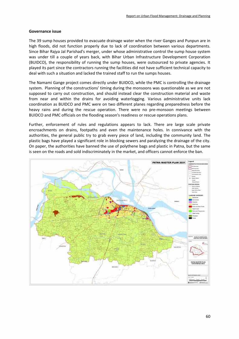
Report on Urban Flood Management: Drainage and Planning
60
Governance issue
The 39 sump houses provided to evacuate drainage water when the river Ganges and Punpun are in high floods, did not function properly due to lack of coordination between various departments. Since Bihar Rajya Jal Parishad's merger, under whose administrative control the sump house system was under till a couple of years back, with Bihar Urban Infrastructure Development Corporation (BUIDCO), the responsibility of running the sump houses, were outsourced to private agencies. It played its part since the contractors running the facilities did not have sufficient technical capacity to deal with such a situation and lacked the trained staff to run the sumps houses.
The Namami Gange project comes directly under BUIDCO, while the PMC is controlling the drainage system. Planning of the constructions' timing during the monsoons was questionable as we are not supposed to carry out construction, and should instead clear the construction material and waste from near and within the drains for avoiding waterlogging. Various administrative units lack coordination as BUIDCO and PMC were on two different planes regarding preparedness before the heavy rains and during the rescue operation. There were no pre-monsoon meetings between BUIDCO and PMC officials on the flooding season's readiness or rescue operations plans.
Further, enforcement of rules and regulations appears to lack. There are large scale private encroachments on drains, footpaths and even the maintenance holes. In connivance with the authorities, the general public try to grab every piece of land, including the community land. The plastic bags have played a significant role in blocking sewers and paralyzing the drainage of the city. On paper, the authorities have banned the use of polythene bags and plastic in Patna, but the same is seen on the roads and sold indiscriminately in the market, and officers cannot enforce the ban.

Report on Urban Flood Management: Drainage and Planning
61
Appendix-II
Case Study II: Gurugram waterlogging in rainy season (2020)
Geographical setting
Gurugram is located in the foothills of Aravali Range. The average annual rainfall in the district is about 550 mm. In Gurugram Distt the drainage is mainly to the north where the floodwaters accumulate in Najafgarh Jheel. The district's drainage pattern is typical of arid and semi-arid areas and comprises large depressions and seasonal streams. From Ghatta in the Aravalli hills to the Najafgarh Jheel, there is a level difference about 60 to 70 meters. The area had a natural drainage system with three major natural drains — Nathupur drain, L2 drain and Badshahpur drain — covering 47 sq. km. They cross five railway line culverts (New Delhi – Rewari section), and five highway culverts are crossing National Highway no. 48 and finally fall into Najafgarh Jheel. The Jheel would drain out to the Yamuna through an irregular channel known as the Sahibi river (nalla) crossing New Delhi. Traditionally, the 7 km long L2 drain used to flow from Jharsa, through Sectors 9, 10, 12, 14 and 15. Rainwater from the Golf Course Road and Sectors 27, 28, 43, 45 and 46 used to flow into the 10 km long Nathupur drain. In the southern part of the city, Badshahpur drain, a 30 km. long natural drain, gathers water from Ghata, Golf Course Extension Road and the adjoining areas.
During the early twentieth century, the British built 118 check dams in the Aravali hills creating natural lakes in Gurugram, Faridabad, Mewat and surrounding areas to control flooding during monsoons and recharge groundwater. Presently, there are four reservoirs in the city — Ghata (50 ft), Nathupur (30 ft), Chakarpur (12 ft) and Jharsa. According to the records of the Haryana Irrigation Department, till 1998, Gurugram never experienced flooding.
Flood situation
Gurugram had the worst monsoon nightmare on July 28, 2016, when with just 55 mm of rainfall had caused a traffic jam of more than 18 hours on Delhi-Jaipur Highway, and the entire city came to a standstill. Hundreds of vehicles were stranded for hours as the biggest traffic jam of the National Capital Region (NCR) called 'Gurujam' got international coverage.
On Friday, August 3, 2019, a moderate rainfall of 33 mm again left major roads in the city completely waterlogged and affected traffic movement. Similarly, on Wednesday, August 19, 2020, Gurugram received over 95 mm of rainfall, one-fifth of the total rain that the city receives annually flooded the newly commissioned Golf Course Road filling its underpasses. The city which professes to be one of the shimmering examples of a 'millennium city' came to a standstill and left many localities submerged.
The reservoirs and check dams traditionally used to store rainwater, recharge groundwater and prevent water-logging have long become useless. According to a CSE study, Gurugram has lost around 137 of its water bodies.
Urbanization process
Gurgaon's urbanization has been buoyed by an uneven process of land acquisition, exemption and rural transformation. Haryana Development and Regulation of Urban Areas Act (HDRUA) allowed landowners to acquire development licenses from the State government to develop the land. After 1979, permissions were granted to the private sector, initiating private sector‐led urban development.

Report on Urban Flood Management: Drainage and Planning
62
While the HDRUA's initial purpose was to introduce a formal land development system to be managed and regulated by Haryana Urban Development Authority (HUDA), centralized politically controlled authorization of these licenses, lead to Gurugram being developed in patches by builders.
During the infrastructure boom that started in 1987, the capacity of natural drains reduced by 40 per cent. These natural channels, which once provided easy drainage of storm water from Aravalli hills have either been acquired by builders, converted into roads, encroached upon or have become dumping grounds of sewage, silt and construction waste. Though the three main drains still exist hundreds of smaller natural drains, which emptied the flow from the Aravalli hills and the low-lying regions into the three main drains, have disappeared. By the time civic authorities finally stepped in, it was too late. There were no records of storm water drains, and in the late 2000s, everything had to be identified from scratch. Without any long-term vision for the city, for the real estate developers driving the urbanization process in the area, drainage was never a priority. Waterlogging was the result of the way the city was developed—without any long-term vision.
It is not only the drainage system, that has been the casualty of professional planning, but even the basic need for drinking water supply also was not provisioned. The lack of adequate water supply infrastructure means that over 30,000 bore wells have been dug, resulting in a rapidly receding water table. Depletion of groundwater and improper disposal of industrial-waste has caused widespread water contamination. According to a study, Gurugram citizens will have only 48 litres per capita per day of water available to them by 2021, the international standard is 130 litres. The depletion of groundwater in Gurgaon and its adjoining areas is alarming, creating high water scarcity conditions. The district's groundwater storage is not getting replenished due to the scanty rainfall and concretization of the land surface.
Only after the Municipal Corporation Gurugram (MCG) came into existence in 2009, the Badshahpur drain was developed as the city's storm water drainage system. As per the 1983 Gurugram gazetteer, width of the Badshahpur drain was once 45 metres. Today this 28-kilometre drain has reduced to 8-10 metres in width at specific points, heavily compromising its drainage capacity leading to urban flooding. The drain was supposed to resolve the water-logging problem. However, it is relatively narrow, and water overflows every time it rains.
Proposed comprehensive drainage plan
Badshahpur drain has always been blamed for flooding and waterlogging in the city. It was cited as the key reason for the mega jam in 2016, and probably for the first-time encroachment on the drain and eventual reduction in its capacity came to light. The drain could not carry the design discharge of 2,000 cusecs, as the capacity had reduced to as low as 500 cusecs. After the floods of 2016, the Haryana Shahari Vikas Pradhikaran (HSVP), constructed the 28 km long Badshahpur drain as a box-type concrete structure to prevent waterlogging. However, a 30 metre stretch of the drain, through the Khandsa village, could not be built due to legal dispute over acquisition of some land.
After 2019 flooding, the Gurugram Metropolitan Development Authority (GMDA) has started the process of drawing a new comprehensive drainage plan and has commissioned a survey for the purpose. As per the survey, 80 per cent of rainwater flows into the city's storm water drains. The survey has also highlighted that the expressway (NH 38) was built over an earlier rainwater drainage channel, which explains water-logging on the stretch every year.

Report on Urban Flood Management: Drainage and Planning
63
Functional Plan (FP) for NCR recommends that the local authorities design internal and peripheral drains of the urban storm water drainage system for maximum rainfall of the five-year frequency storm and the main drains for a ten-year frequency storm. It also emphases the holistic planning and development of the drainage system instead of the piecemeal approach. Accordingly, the comprehensive plan proposes to the rejuvenate some of the critical water bodies and ponds. The Ghata Jheel alone has the potential of storing 12 billion litres - but only if its catchment is treated and prevented from encroachments. Village ponds can hold another 90 million litres. If a part of Aravali is protected as a water sanctuary, it can harness yet another 21.6 billion litres. Such measures can also contribute significantly to local water security in Gurugram.
The comprehensive plan suggests creating water harvesting structures, increasing the area covered by ponds, channelling natural creeks, and completing the fourth leg of the drainage system from the Vatika Chowk to the railway culvert number 61. There is also a proposal for the construction of recharge wells from the Southern Peripheral Road to culvert number 61. The plan also envisages creating water harvesting structures at eight locations in Sectors 42 to 55 along the Golf Course Road. The GMDA proposes to construct check dams in the Aravalli hills to help deal with the Badshahpur drain.
The comprehensive drainage plan for Gurugram, estimated cost of over Rs 200 crore, is still under discussions with various stakeholders.
---------------------

https://www.facebook.com/iwp01/
https://twitter.com/IWPindia01
https://www.linkedin.com/in/iwpindia/
https://www.flickr.com/photos/iwpindia/
SOCIAL MEDIA


![.Noah's Flood WTJ2004[1]](https://static.fdokumen.com/doc/165x107/631c39e73e8acd997705cf6b/noahs-flood-wtj20041.jpg)