Remote Sensing for Assessment of Water budget in Wadies Zabid &Rima
76
Second draft Report for Dr. Ayoub Almhab, PhD: Remote Sensing Sana’a - November 2011 Understanding analysis the Water Balance of the Wadies Zabeed and Rima western wadies - Yemen Remote Sensing for Assessment of Water budget in Wadies Zabid &Rima
-
Upload
teknologimalaysia -
Category
Documents
-
view
0 -
download
0
Transcript of Remote Sensing for Assessment of Water budget in Wadies Zabid &Rima

Second draft Report for
Dr. Ayoub Almhab, PhD: Remote Sensing
Sana’a - November 2011
Understanding analysis the Water Balance of the Wadies Zabeed and Rima western wadies - Yemen
Remote Sensing for Assessment of Water budget in Wadies Zabid &Rima

Second draft Report for Remote Sensing for Assessment of Water budget in Wadies Zabid &Rima Dr Ayoub Almhab
Second draft Report for Remote Sensing for Assessment of Water budget in Wadies Zabid &Rima Dr Ayoub Almhab 1
TABLE OF CONTENTS
TABLE OF CONTENT.................................................................................. 1 DEFINITIONS RELATED TO EVAPOTRANSPIRATION…..….......... 2 1. INTRODUCTION ........................................................................................3 4. METHODOLOGY.....................................................................………….22
4.1 PRECIPITATION ESTIMATION BASED TRMM …….............22 4.2 EVAPOTRANSPIRATION USING M-SEBAL………………23 4.3 LAND USE CCLASSIFICATION ........................................….24 4.4 FIELD WORK .............................................................................25 4.5 CLASSIFICATION PROEDURES ...........................................25
5. WADIES ZABEED AND RIMA’A WTER MNAGEMENT................27 5.1 PRECIPITATION .......................................................................27 5.2 ACTUAL EVAPOTRANSPIRATION .....................................30 5.3 LAND USE ...................................................................................33 5.4 WATER USE................................................................................37 5.5 WATER BALANCE....................................................................40
6. CONCLUSIONS ....................................................................................... 42 7. FINDING SATELLITE IMAGES ON THE WEB......................................43 8. REFERENCES ........................................................................................... 44 LIST OF APPENDICES ...............................................................................47 A. A SCIENTIFIC VALIDATION OF TRMM IMAGES FOR YEMEN..47 B. A SCIENTIFIC DESCRIPTION OF M-SEBAL PROCEDURE........47

Second draft Report for Remote Sensing for Assessment of Water budget in Wadies Zabid &Rima Dr Ayoub Almhab
Second draft Report for Remote Sensing for Assessment of Water budget in Wadies Zabid &Rima Dr Ayoub Almhab 2
DEFINITIONS RELATED TO EVAPOTRANSPIRATION
ETact actual evapotranspiration
Evapotranspiration that occurs from plant and soil under actual field conditions. In
this study ETact is calculated spatially using satellite images and the SEBAL
algorithm.
ETpot potential evapotranspiration
Evapotranspiration that maximally occurs from plant and soil under actual field and
optimal soil water conditions.
ETpot is calculated spatially using satellite images and the SEBAL algorithm.
ETrain evapotranspiration as result from rainfall
Actual evapotranspiration that occurs from rainfed areas, i.e. areas where rainfall is the
only water source.
ETirr evapotranspiration as result from irrigation
Incremental actual evapotranspiration that occurs from irrigated agricultural
areas and irrigation practices in excess of ET that originates from rainfall.
ETgross gross evapotranspiration
Gross evapotranspiration is equal to actual evapotranspiration of a certain non-
homogeneous area that is composed of irrigated and non-irrigated land It is
the sum of evapotranspiration from rainfall and evapotranspiration from
irrigation:
ETgross = ETrain + ETirr

Second draft Report for Remote Sensing for Assessment of Water budget in Wadies Zabid &Rima Dr Ayoub Almhab
Second draft Report for Remote Sensing for Assessment of Water budget in Wadies Zabid &Rima Dr Ayoub Almhab 3
1. INTRODUCTION
In recent years, water resources management has become an important issue. This is
especially true with the increased demand and competition for fresh water between different
users and climate change. Consequently, monitoring the consumption of water has become
one of the most popular issues regarding water resources management (almhab, 2009). Water
strategy requires scientifically sound information on water availability which includes the
quantification of spatial and temporal changes of water balance components like rainfall and
evapotranspiration. These components are inextricably linked with climate, so the prospect of
global climate change has serious implications for water balance partially in arid and semi
arid regions. In order to investigate the best methodology input data to hydrological and
water energy balance models that are the central support for hydrological decision making
(mamo, 2010).
Precipitation (P) and Evapotranspiration (ET) are the main parameter to estimation of
water balance; they give highlight information on water availability. Currently remote
sensing data which available free online with different algorithms and models was develop is
widely used for estimation of these two parameters. Models and data source selection for
accurate estimate of P and ET from remote sensing observation are also continuously
improving. The data for this paper were two Satellite product from MODIS and TRMM and
14 ground metrological station (Y-NWRA) on the study area Yemen. In this study that
rainfall estimation from TRMM images and ET was estimated from MODIS satellite images
and ground based data using M-SEBAL (Modified -Surface Energy Balance Algorithm for
Land) model. Daily P and ET for Yemen using satellite image and ground metrological
station was comparison. In addition the performance of M-SEBAL model over different land
cover classes was tested by comparison of daily ET from the model with ETa estimation from
ground metrological station over different land cover. Finally climatologically water balance
estimation “Precipitation minus evapotranspiration” was carried out over rainfed crop land
during study period Jane to December 2007using rainfall product from TRMM images and
daily ET estimated by M-SEBAL model from MODIS images.
The objectives of this research are to estimate of precipitation, evapotranspiration and
climatology water balance. (Precipitation minus evapotranspiration” in large area by
combined used of remote sensing and based meteorological data.

Second draft Report for Remote Sensing for Assessment of Water budget in Wadies Zabid &Rima Dr Ayoub Almhab
Second draft Report for Remote Sensing for Assessment of Water budget in Wadies Zabid &Rima Dr Ayoub Almhab 4

Second draft Report for Remote Sensing for Assessment of Water budget in Wadies Zabid &Rima Dr Ayoub Almhab
Second draft Report for Remote Sensing for Assessment of Water budget in Wadies Zabid &Rima Dr Ayoub Almhab 5
4. METHODOLOGY
This chapter introduces the main techniques used to identify the Precipitations based
TRMM satellite images, Evapotranspiration and water balance for wadi Zabeed and wadi
Rema in wester wadie’s in Yemen. The algorithm used to map the water consumption is the
Modified Surface Energy Balance Algorithm for Land (M-SEBAL). The M-SEBAL
algorithm uses as main input satellite and weather data for predicting evapotranspiration (ET)
from data from the Moderate Resolution Imaging Spectrometer (MODIS) on the Terra
satellite and ground meteorological data was developed in the Republic of Yemen.
Figure 14 diagram summarize the methodology applied in this study for estimation of water balance in Wasi’s Zabeed & Rima Yemen
4.1 PRECIPITATION ESTIMATION BASED TRMM SATELLITE
Satellite-based precipitation estimation has quite long story and became one of the
more intense research topics in the discipline of satellite meteorology. The major problem of
all methods is the in-direct relation between the precipitation on the ground and the measured
satellite signal; therefore various studies have been carried out to address and solve these
issues. This part will give a brief explanation of the main types of rainfall retrievals from
space using VIS/IR, PMW, active sensors and blending techniques.
Rainfall data for daily periods from January 2010 to December 2010, measured and
collected by the National Water Resources Authority (NWRA) Republic of Yemen, were
used to prepare the monthly accumulated rainfall data. The monthly TRMM 3B43(V6)
accumulated rainfall( 0.25°×0.25°) product acquired from TRMM Online Visualization and
Analysis System (TOVAS) is used to prepare it satellite database.
Wadi
Recharge = I (deliveries + seepage) + P + Trib_to_GW
– Surf Returns – GW discharge – dStorage - ET
Not everything can be measured
Hydrology is simplified at river basin scale (Degree of over-exploitation)
Over-exploitation occurs if: ET > P and ΔS < 0
Otherwise there is outflow P > ET
Simply

Second draft Report for Remote Sensing for Assessment of Water budget in Wadies Zabid &Rima Dr Ayoub Almhab
Second draft Report for Remote Sensing for Assessment of Water budget in Wadies Zabid &Rima Dr Ayoub Almhab 6
In this study the monthly rainfall product of TRMM 3B43, which is the combination
of TRMM Precipitation Radar (PR) and TRMM Microwave Imager (TMI), was compared
with the values of ground-based NWRAGS (rain gauges) throughout Yemen. Although
Tropical Rainfall Measuring Mission (TRMM) precipitation products have been extensively
validated at ground sites around the world, none of these sites lies in Yemen, therefore in the
paper (Almhab and Tol,2010) has been tried to validated TRMM (3B43 product) annually,
monthly and daily periods in order to using TRMM satellite data in Yemen meteorological
studies. For a more technical description of validation the TRMM data for Yemen see
Appendix 1
Figure 15 TRMM data processingand products
4.2 EVAPOTRANSPIRATION ESTIMATION USING M-SEBAL MODEL
M-SEBAL model was develop by introducing some changes into the existing SEBAL
model which developed from (Bastiaanssen. et. al, 1998) .Notably, the inclusion of terrain,
mountains and deserts effect in to calculations of surface radiation.

Second draft Report for Remote Sensing for Assessment of Water budget in Wadies Zabid &Rima Dr Ayoub Almhab
Second draft Report for Remote Sensing for Assessment of Water budget in Wadies Zabid &Rima Dr Ayoub Almhab 7
The M-SEBAL model was calculated using model builder in ERDAS IMAGINE 8.5
image processing package. All model parameters are programmed in to the model builder and
values are computed automatically based on the input data. The general flowchart for the
modified SEBSL model is shown by Figure 14.
The method uses the energy budget equation to calculate each pixel λ(ETins) (instant
latent heat loss) at the time of the satellite over flight.
HGRET nins Eq. 1
Where: λ(ETins) is the instant latent heat loss (w/m2) , which is calculated as a residual of the
energy budget, λ is the latent heat (i.e. the heat needed to evaporate unit mass of water), ETins
is the rate of evapotranspiration at the time of the satellite overflight, Rn is net solar raids
(w/m2), G is soil heat flux into the soil (w/m2), H is the sensible heat flux into the air (w/m2).
The M-SEBAL algorithm can be used to compute maps of actual evapotranspiration ,
crop coefficient (Kc) and crop water requirement (CWR) . In the current project the main
focus lies on actual evapotranspiration (ET). The key input data for M-SEBAL consists of
raster values of spectral radiance in the visible, near-infrared and thermal infrared part of the
spectrum and DEM images. Hence, the measurements are unique for every pixel.
Figure 14 the general flowchart of the M-SEBAL model Satellite radiances will be converted first into land surface characteristics such as surface
albedo, leaf area index, vegetation index and surface temperature.The land surface
characteristics can be derived from different types of satellites in this study derived from
Start
Input data: satellite data, local weather data
Data preprocessing: geometric
Generation of DEM: slop/aspect and theta
Calculation of surface reflectance
Generating model parameters
Determination of radiations
Calculation of ET: daily, monthly
End

Second draft Report for Remote Sensing for Assessment of Water budget in Wadies Zabid &Rima Dr Ayoub Almhab
Second draft Report for Remote Sensing for Assessment of Water budget in Wadies Zabid &Rima Dr Ayoub Almhab 8
Landsat 7 ETM images and MODIS (MODerate resolution Imaging Spectroradiometer)
images. For a more technical description of M-SEBAL model see Appendix 2.
2.4 Theory 2.4.1 Net Radiation (Rn) : The radiation balance at the Earth’s surface is composed of four spectral radiant fluxes, the incoming short wave (0.14 to 4 µm) radiation that arrives from the sun (Rs), the amount of this energy that is reflected from the surface (Rs), the incoming long wave (> 4 µm) radiation from the atmosphere (RL), and the amount of long wave radiation emitted from the surface (RL). Thus the net radiation is:
LLssn RRRRR Eq. 2
The instantaneous net amount of radiation received by a surface can be written in the form:
441 ssaasn TTRR Eq. 3
where Rs is the incoming short-wave solar radiation, α is the surface short-wave albedo, σ is the Stefan–Boltzmann constant (5.67 x 10⁻⁸ W m-2 K-4), Ta is the air temperature measured at the wet pixel (K), Ts derived from a remotely sensed radiometric surface temperature (K), εa is the air emissivity taking as [Bastiaanssen, 1995]:
εa=1.08(−lnτsw) 0.265 Eq. 4
where τsw is two way atmospheric transmissivity [τsw = 0.75+2x10⁻⁵ z],z is elevation meter. where s= surface emissivity which is calculated from normalized vegetation index (NDVI) using the logarithmic relation of Van de Griend and Owe (1993) as:
s = 1.0094 + 0.047*ln (NDVI) Eq. 5
The weighting factors for each band are the proportions of solar radiation incident at the earth surface in each segment. This approach was adopted here to derive from narrow bands. α is calculated by the equation in Tasume et al. (2000)for LANDSAT surface reflectance data.
TOA =0.2931TOA + 0.274 2TOA + 0.233 3TOA +0.157 4TOA + 0.033 5TOA + 0.0117TOA
Eq. 6a
i is the reflectance for LANDSAT data band i. We adopted the equation of Chemin et al. (2000) for NOAA-AVHRR surface reflectance data.
TOA =0.035+0.05451TOA + 0.32 2TOA Eq. 6b
i is the reflectance for NOAA-AVHRR data band i. The incoming short wave radiation (Rs) was computed in this study, by equation (7) as follows (Fu 1998, Tasuni et al. 200) in which the diffuse radiation was neglected:

Second draft Report for Remote Sensing for Assessment of Water budget in Wadies Zabid &Rima Dr Ayoub Almhab
Second draft Report for Remote Sensing for Assessment of Water budget in Wadies Zabid &Rima Dr Ayoub Almhab 9
Where Gsc is the solar constant(1367 w/m2), dr is inverse squared relative distance earth-sun (dimensionless) calculated by dr=1+0.033cos{[2π(DOY)]/365}, cosθ is cosine of the solar zenith angle calculated by cosθ=cos(π/2-) where is sun elevation angle in radians (in the flat area) in the slop and mountain terrain areas (like our case study) solar incident angle changes with surface slope and aspect. Therefore the equation suggested by Duffie and Bekman,(1991) is applied.
cos = sin()sin()cos(s) - sin()cos()sin(s)cos()+ cos()cos()cos(s)cos()
+ cos()sin()sin(s)cos()cos()
Eq. 8
Where: is solar declination(rad); is geographic latitude of the pixel ( rad); s is ground slope ( rad); γ is the surface aspect angle ( rad); ω is the hour angle of the sun(rad).
2.4.2 Soil Heat Flux (G):
Soil heat flux is usually measured with sensors buried just beneath the soil surface. A remote measurement of G is not possible but several studies have shown that the day time ratio of G/Rn is related to among other factors, such as the normalized difference vegetation index(NDVI). In this study equation (9) is adapted with the regression equation.
G as an empirical fraction of the net radiation using surface temperature, surface albedo () and NDVI and was adopted here to compute G as:
2715.02207.04005.0 2 NDVINDVIRG n Eq. 9
Where Ts is the surface temperature, NDVI is the normalized difference vegetation index. is calculated as the following:
NDVI = (R4 - R3) / (R4 + R3) Eq. 10
where R4 and R3 are the reflectance data of bands 4 and 3 in LANDSAT and bands 2 and 1 in NOAA-AVHRR respectively. 2.4.3 Sensible Heat Flux (H):
For the sensible heat flux calculation, two pixels are chosen in the satellite data. One pixel is a wet pixel that is a well-irrigated crop surface with full cover and the surface temperature (Ts) close to air temperature (Ta) The second pixel is a dry bare agricultural field where λE is assumed to be 0. The two pixels tie the calculations for all other pixels between these two points. At the dry pixel, assume λE =0, then according to equation (1) and the definition of specific heat capacity
nH R G Eq. 11
cos2r
SCs d
GR Eq. 7

Second draft Report for Remote Sensing for Assessment of Water budget in Wadies Zabid &Rima Dr Ayoub Almhab
Second draft Report for Remote Sensing for Assessment of Water budget in Wadies Zabid &Rima Dr Ayoub Almhab 10
p
ah
dc TH
r
Eq. 12
Where is the air density (mol m-3
), cp is the specific heat of air (29.3 J mol-1 ºC-1), dT is the near surface temperature difference (K), rah is the aerodynamic resistance to heat transport m/s, where
kuzz
rah *1
2ln
Eq. 13
z1 is a height just above the zero displacement distance height of plant canopy set to 0.1 m for each pixel, and z2 is the reference height just above the plant canopy set to 2 m for each pixel, u* is the friction velocity (m/s), and k is the von Karman constant (0.4).
)ln(
)(
mzdzkzuu
Eq.14
Where u(z) is the wind speed at height of z, d is the zero displacement height (m, d=0.65h), h is the plant height (m), and z
m is the roughness length (m, zm=0.1h)[Campbell and Norman
1998]. According to equations 13-14 and the input data, dT dry, dT at the dry spot can be calculated. At the wet spot, assume H=0 and dTwet =0 (dT at the wet spot). Then according to the surface temperature at the dry and wet spots (Tsdry and Tswet), we can get one linear equation for each pixel (wing et al, 2006),
wetswetsdrys
wetdrys
wetsdrys
wetdry TTT
dTdTT
TTdTdT
dT
Eq. 15
Then, according to the equation, the H each pixel can be calculated according to equations 11-14. We assumed at 200 m the wind speed is the same for each pixel and the wind speed at 200 m is calculated for the weather station first, and then u* can be solved for each pixel (equation 14). The parameter d in equation 14 is set to 0 which is negligible when z =200 m. The zm for each pixel is calculated by a regression equation according to the pixel value. The equation is obtained by three pairs of known values of mz and NDVI .
Due to the fact that atmospheric stability may have effects on H, the atmospheric correction is conducted (16). First the u* and wind speed at 200 m at the local weather station are calculated. Then the z
m, u* and dT for each pixel are computed. Then the rah and H
without the atmospheric correction are obtained. For atmospheric correction, the stability parameter, the Obukhove length, L (m) is
calculated. Then using the stability parameter, u*, rah and H are corrected. Then an iteration is conducted for L,u*,rah and H calculation until H does not change more than 10%. The correction equation is as follows (Campbell and Norman 1998; Stull 2001).
kgHTuL s
3
Eq. 16
When L<0, H is positive and heat is transferred from the ground surface to the air, under unstable condition; when L>0, H is negative and heat is transferred from air to ground

Second draft Report for Remote Sensing for Assessment of Water budget in Wadies Zabid &Rima Dr Ayoub Almhab
Second draft Report for Remote Sensing for Assessment of Water budget in Wadies Zabid &Rima Dr Ayoub Almhab 11
surface, under stable condition; when L=0, no heat flux occurs, and is under neutral condition, because the satellite over flight occurred at local noon time, the atmosphere should have been unstable. Thus, when a stable condition occurred, we forced L=0 (neutral). After H is corrected by the atmospheric effects, λ(ETins) for each pixel is calculated using equation 1. 2.4.4 Regional ET model:
The actual 24 hour ET can be estimated from the instantaneous evaporative fraction EF, and the daily averaged net radiation, Rn,24 (Tasumi, et al, 2000):
ET24= EF{Rn,24[106(2.501−0.002361Ts)]} Eq. 17 where ET24 is the actual 24-hour evaporation (mm/day), Rn,24 is the 24-h net radiation (W/m2), Ts the surface temperature (°C). The EF is the instantaneous evaporative fraction calculated as:
EF= λ ET /( Rn- G) Eq. 18 where Rn is the instantaneous net radiation and G is the instantaneous soil heat flux. Finally, the instantaneous latent heat of evapotranspiration (λ ET) may be computed as the residual of the surface energy balance equation (Eq. 1). However, in order to facilitate comparison with the sensible heat flux, is use made of the instantaneous evaporative fraction EF, defined as follows :
EF =(Rn – G)- H/(Rn –G) Eq. 19 Assuming that the evaporative fraction (EF) is constant over the day the daily average sensible heat (H24) can be derived from EF and the daily average net radiation (Rn24) as follows :
H24= (1- EF )Rn,24 ((W/m2)) Eq. 20 The improved daily net radiation parameterization scheme and daily actual evapotranspiration. The daily net radiation can be expressed as:
242424 )1( Lsn RRR ((W/m2)) Eq. 21 Where Rs24 is the daily solar radiation and RL24 is the daily net long wave radiation (wm-2). As the mountain and terrain of our study area is complex with undulations, the impact topography, the impact of slope and azimuth of surface on available radiation shod be considered pixel by pixel in the calculated instantaneous and daily net radiation, the shaded areas (pixels) were excluded from imageries with the model maker in ERDAS imagine software brakeage. Through importing parameters of solar azimuth and solar elevation at the satellite overpass time. The daily net radiation is estimated by an integral of equation (7) transmittance for one-way transmittance τ with (c+dn/N):
dsbadG
NndcR
r
scs sin.sin.sincos.cos.cos.sin)( 224
Eq. 22
2
1224 sin.sin.sincos.cos.cos.sin)(
dsbadG
NndcR
r
scs
Eq. 23
121212224 coscoscossin.sinsinsincos..sin.2
).(
sbad
GNndcR
r
sca
Eq. 24

Second draft Report for Remote Sensing for Assessment of Water budget in Wadies Zabid &Rima Dr Ayoub Almhab
Second draft Report for Remote Sensing for Assessment of Water budget in Wadies Zabid &Rima Dr Ayoub Almhab 12
cos.sinsincoscoscos.sincoscossin
ssbssa
)(12 12 N
Eq. 25
Where: c and d are coefficients of the solar radiation depending on the latitude climate and other factors of study area, respectively; c+d is the fraction of exterritorial radiation reaching the earth on clear sky days. n is the actual sunshine duration, N the potential sunshine duration, ω1 and ω2 are the sunrise and sunset angle, respectively. The difficulty in retrieval of the daily solar radiation focuses on calculation of the sunrise and sunset angle for the tilted surfaces. The sunrise and sunset angles for horizontal surfaces are given by Fu (1983) and Tasumi et al. (2000)
tan.tancos 1 H Eq. 26
The sunrise and sunset angle for tilted surfaces can be obtained by simple mathematical manipulation from equation (8) by setting cosθ=0, leading to
2
221
1tan11sin.sintan..
cosa
asba
Eq. 27
The positive or negative sign of equation (above) in the numerator are determined by equation:
2
221
1tan11tan.sin.sin.
sina
absa
Eq. 28
Let ωs1 and ωs2 be the roots of ω, respectively, and ωs1 > ωs2 . Note the surface receives the solar radiation only if cos θ in equation (8) is greater than 0. several relationships are given below to determine the sunrise and sunset angles (ω1 , ω2 ), - if ωs1 ≤ ω≤ωs2 and cosθ ≥0, then ωs1 ≥ ωs2, ωs2 ≤ ωs1 ; - if ω ≤ ωs1 , ωs1 >ωs2 and cos>=0 then ω1 ≤ ωs1,ω2 ≥ ωs2. - Meanwhile, the sunrise and sunset angles for tilted surfaces must also satisty the condition that sunrise is no earlier and sunset is no later than those for horizontal surfaces. Namely ω1≥ -│ωH│, ω2≥ ωs2 ≤ │ωH│. Daily net long wave radiation:
4424 ssaaL sTTR Eq. 29
Where εa is the daily average atmospheric emissivity (Campbell and Norman, 1998) and Ta is the daily mean atmospheric temperature (k). due to the surface temperature obtain at 10h30, it could represent the daily average surface temperature for estimation of the surface daily long wave radiation (granger, 2000).

Second draft Report for Remote Sensing for Assessment of Water budget in Wadies Zabid &Rima Dr Ayoub Almhab
Second draft Report for Remote Sensing for Assessment of Water budget in Wadies Zabid &Rima Dr Ayoub Almhab 13
4.3 LAND USE CLASSIFICATION
A land use classification is the result of the process of converting raw satellite images
into a map with meaningful classes. The basis for the discrimination between different classes
is that land cover types often differ in reflective behaviour. However, there always some
overlap between classes. If for example, the crop has no full ground cover the resulting
spectral behaviour is also dependent of the soil, the specific reflectance which can be
attributed to the vegetation is more difficult to extract. In addition, during certain periods of
the crop development, the spectral reflectance can be similar for different crops.
In case crops have the same spectral reflectance at a certain time they are indistinguishable. If
on an earlier or later date the spectral behaviour is different it is possible to differentiate
between the two by using another satellite image. This type of multi-temporal classifications
generally yields higher accuracies. (Pelgrum. et al, 2009).
Field work is necessary to compliment the image classification. By sampling a large
number of fields with different crops at different dates it is possible to use this a priori
information to enhance the land use classification. Also at a later stage these part or all of the
field data can be used to assess the quality of the land use classification.
Figure 14 some air photo for the study area in wadi Zabeed

Second draft Report for Remote Sensing for Assessment of Water budget in Wadies Zabid &Rima Dr Ayoub Almhab
Second draft Report for Remote Sensing for Assessment of Water budget in Wadies Zabid &Rima Dr Ayoub Almhab 14
4.4 FIELD WORK
Shortly after the acquisitions of the Landsat images a field visit will organize to
each area. Based on the information and patterns on the image, suitable areas will select. In
general 10 to 30 sites will select for each image to visit. At each site several fields, ranging
from 10 to 150, will identified on the images and the crop type noted. During the subsequent
visits 64 sites will visit in wadi’s Zabeed, and Rima. Figure 15 below gives an example of the
sites to will be visit in Zabeed during the field campaign in …….future 2011. During the first
field work campaigns it became clear that a typical growing season does not exist
Figure 15 gives an example of the sites to will be visit in Zabeed and Rima during the field
work

Second draft Report for Remote Sensing for Assessment of Water budget in Wadies Zabid &Rima Dr Ayoub Almhab
Second draft Report for Remote Sensing for Assessment of Water budget in Wadies Zabid &Rima Dr Ayoub Almhab 15
4.5 CLASSIFICATION PROCEDURES
The first approach to the discrimination of different classes is through the visual
inspection of the satellite images. In Figure 18 the same image is displayed as RGB:3,2,1 and
RGB:3,4,2 (RGB is the combination of bands represented by Red, Green and Blue). The first
one is very useful for the visual differentiation between the vegetated and non vegetated
areas. The second one is the most useful combination for the visual discrimination between
crops. The classification is independent of the display combinations.
Figure 18 the same image is displayed as RGB:3,2,1 and RGB:3,4,2 (RGB is the combination of bands)

Second draft Report for Remote Sensing for Assessment of Water budget in Wadies Zabid &Rima Dr Ayoub Almhab
Second draft Report for Remote Sensing for Assessment of Water budget in Wadies Zabid &Rima Dr Ayoub Almhab 16
5. WADI ZABEED AND WADI RIMA (water management RESULT)
General
This chapter gives an overview of the result of different types of satellite imagery
used. Also a listing of the acquisition dates of the imagery is given. One of the requests in the
tender document leading to this report was to provide a level of detail of 30 m multispectral
bands. In the discussions leading towards the project inception, all parties agreed that the crop
water use analysis would be done based on a 30 m resolution Landsat7 ETM+, DEM 30m &
250m images, MODIS Images 250 m and TRMM 0.25 degree images (=250m) dataset.
5.1 PRECIPITATION
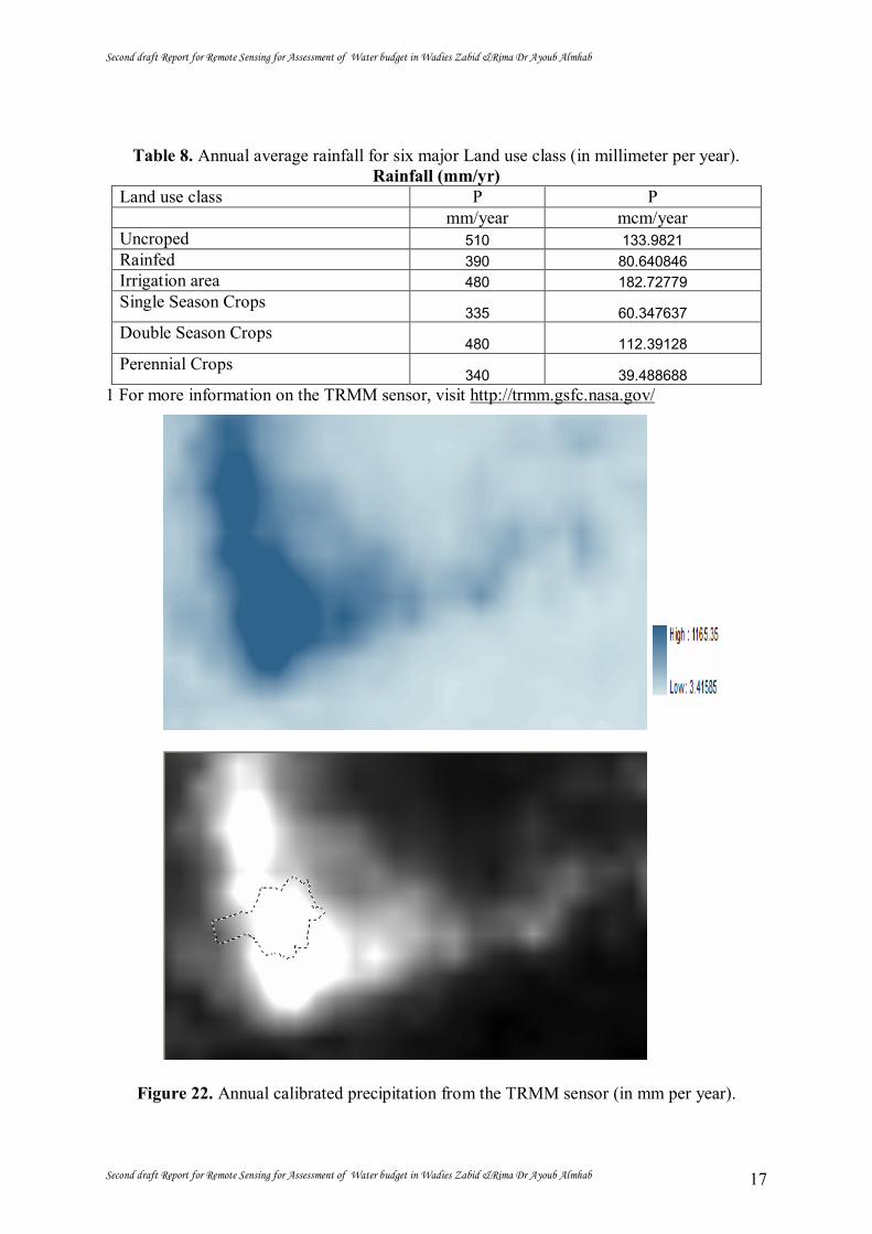
Precipitation is derived from the Tropical Rainfall Measuring Mission (TRMM)
sensor1. The product used in this study is the calibrated monthly rainfall (43b4) which is
available worldwide in a 0.25-degree by 0.25-degree spatial resolution. Figure 19, 20, 22
depicts average daily , monthly and annualy rainfall for a large area in Yemen’s plains
covering all irrigation schemes investigated. Rainfall is absent or marginal during January to
April and in November/December. The rains start in May/June, but the majority of the annual
rain is measured in July (120 mm) and August (118 mm). Total annual rainfall is 363 mm for
the entire area, but differs significantly between the irrigation schemes (see also Figure 23).
Annual rainfall in Zabeed areas. is as high as 492, while average annual rainfall in Zabeed
Extension is only 238 mm.
Figure 19. Daily calibrated precipitation from the TRMM sensor /4/2010 (in mm per day).
Figure 20. Average monthly precipitation in 2010 measured by the TRMM sensor (in mm per month).
.
Figure 21. Monthly calibrated precipitation from the TRMM sensor (in mm per month).
Second draft Report for Remote Sensing for Assessment of Water budget in Wadies Zabid &Rima Dr Ayoub Almhab
Second draft Report for Remote Sensing for Assessment of Water budget in Wadies Zabid &Rima Dr Ayoub Almhab 17
Table 8. Annual average rainfall for six major Land use class (in millimeter per year). Rainfall (mm/yr)
Land use class P P mm/year mcm/year Uncroped 510 133.9821 Rainfed 390 80.640846 Irrigation area 480 182.72779 Single Season Crops
335 60.347637 Double Season Crops
480 112.39128 Perennial Crops
340 39.488688 1 For more information on the TRMM sensor, visit http://trmm.gsfc.nasa.gov/
Figure 22. Annual calibrated precipitation from the TRMM sensor (in mm per year).

Second draft Report for Remote Sensing for Assessment of Water budget in Wadies Zabid &Rima Dr Ayoub Almhab
Second draft Report for Remote Sensing for Assessment of Water budget in Wadies Zabid &Rima Dr Ayoub Almhab 18
Figure 23. Annual calibrated precipitation for Wadi Zabeed &Rema areas using the TRMM
sensor (in mm per year) Range is 3 to 1060 mm/yr

Second draft Report for Remote Sensing for Assessment of Water budget in Wadies Zabid &Rima Dr Ayoub Almhab
Second draft Report for Remote Sensing for Assessment of Water budget in Wadies Zabid &Rima Dr Ayoub Almhab 19
5.2 ACTUAL EVAPOTRANSPIRATION
The actual evapotranspiration has been calculated using the M-SEBAL algorithm
which converts the satellite measured spectral radiances into surface energy balances
including evapotranspiration. The algorithm is collect independent and uses satellite data with
a thermal infrared sensor. In this study MODIS satellite images and Landsat7 ETM images
were used. Meteorological data were the additional inputs besides the remote sensing data.
Meteorological data were obtained from the NWRA gage stations. The output from the M-
SEBAL analysis consists of 12 maps of total monthly actual evapotranspiration. The maps
have a resolution of 250*250 m and actual evapotranspiration is expressed in millimeter per
month. Since the 250*250 m area related to irrigated fields and other land use classes,
evapotranspiration is an equivalent layer that applies to a mixed land use. The gross actual
evapotranspiration in Million cubic meters (MCM) was derived by multiplying the monthly
average equivalent evapotranspiration (in millimeter) with the gross irrigated area. The
results are presented in the figures 24 and table 9 below.
Average actual evapotranspiration for gross irrigated areas in Zabeed areas is between 452
mm and 2107 mm/year. It must be emphasized here that these layer-wise evapotranspiration
results are averages from MODIS pixels that are flagged as irrigated land. Real crop
evapotranspiration from irrigated land will be higher as the average values from MODIS
pixels include non-irrigated land.
Monthly evapotranspiration values are high in July/September for all study area, but strongly
decrease in the winter and spring period. The Zabeed area depict high monthly
evapotranspiration rates throughout the year and peak values between 80 and 100 mm/month
can be found in July/September. In the non irrigation area monthly evapotranspiration is
between 10 to 30 mm/month from January to July (see Figure 24)
Finally, the evapotranspiration as result from irrigation (ETirr) is calculated by determining
annual evapotranspiration from a rainfed non-irrigated area adjacent to the irrigation scheme
(ETrain) and deducting this amount from the gross evapotranspiration (ETgross). Depending
on the surrounding land use/vegetation and the amount of precipitation, the amount of water
evapotranspiring from non-irrigated land differs. Figure 25 the ET using Landsat ETM
images shows that ET from non-irrigated land ranges between 167 and 252 mm/year and that
the effective rainfall factor (defined as the evapotranspiration from non-irrigated land divided
by the gross precipitation) is higher (±0.9) at lower rainfall rates than at higher rainfall rates
(0.5).

Second draft Report for Remote Sensing for Assessment of Water budget in Wadies Zabid &Rima Dr Ayoub Almhab
Second draft Report for Remote Sensing for Assessment of Water budget in Wadies Zabid &Rima Dr Ayoub Almhab 20
Figure 24. Monthly gross actual evapotranspiration in 12 months 2010 for the study areas
Wdi Zabeed and Rema, using M-SEBAL model and MODIS images.
Figure 25. Monthly actual evapotranspiration calculated by M-SEBAL model and Landsat ETM images at July/October 2010

Second draft Report for Remote Sensing for Assessment of Water budget in Wadies Zabid &Rima Dr Ayoub Almhab
Second draft Report for Remote Sensing for Assessment of Water budget in Wadies Zabid &Rima Dr Ayoub Almhab 21
Figure 26. Annual actual evapotranspiration in 2010 for the study ara using M-SEBAL Range from 0 to 1890 mm/yr
Table 9. Monthly gross actual evapotranspiration (in mm/year) in 2010 for the Zabeed areas, averaged for the gross irrigated area.
Land use class ET ET ET ET mm/day mcm/day mm/year mcm/year Uncroped 2 0.52542 73 19.177 Rainfed 3.5 0.7237 651 134.608 Irrigation area 11 4.187 967 368.120 Single Season Crops
6 1.080 706 127.180 Double Season Crops
10 2.341 1117 261.543 Perennial Crops
9 1.045 1087 126.247

Second draft Report for Remote Sensing for Assessment of Water budget in Wadies Zabid &Rima Dr Ayoub Almhab
Second draft Report for Remote Sensing for Assessment of Water budget in Wadies Zabid &Rima Dr Ayoub Almhab 22
5.3 LAND USE
Spate irrigation is a type of water management unique to semi-arid environments.
Flood water from mountain catchments is diverted from Wadi's and spread over large areas.
Spate irrigation is very risk prone, due to the unpredictability of the wadi floods and frequent
changes in the course of the wadi from which the water is diverted. Due to uncertainty of
floods, the amount of water available for irrigation can differ greatly from year to year.
Groundwater irrigation uses a more reliable source of water: groundwater. With pumps the
groundwater can be pumped to the surface, where it can be used to irrigate the agricultural
fields. It can be used on demand and there is no reliance on weather or flood events. The
major issue with groundwater irrigation is the necessity to use the groundwater in a
sustainably way. Overexploitation of groundwater can lead to a number of negative
consequences, like increasing soil salinity, water quality detoriation, depletion of available
water resources. This can lead to serious socio-economical problems. Drinking water for the
domestic sector could for instance be at threat. Fields in Wadi Zabeed that are cropped in
April, October and December are irrigated by means of groundwater because spates only
occur during the rainy and flood season.
Google Earth image Landsat emage RGB: 4, 3,2 in 21/10/2010
Figure 27: Example of spate irrigation in upper Wadi Zabeed
Figure 27 shows an example of spate irrigation from the upper Wadi Zabeed. The blue track
is the course of the Wadi. The dark fields are freshly ploughed or harrowed fields with a
higher soil moisture content. some fields are very dark indicating an irrigation application
with residual tailwater ponding at the lower end of the field.the October image most fields
show a healthy crop although within the fields there is a large difference between the upper
and lower part of the fields. While most fields are harvested on the December.

Second draft Report for Remote Sensing for Assessment of Water budget in Wadies Zabid &Rima Dr Ayoub Almhab
Second draft Report for Remote Sensing for Assessment of Water budget in Wadies Zabid &Rima Dr Ayoub Almhab 23
Google Earth image Landsat emage RGB: 4, 3,2 in 21/10/2010
Figure 28: Example of rainfed agriculture and groundwater irrigation in the plain
Groundwater irrigation is practised on the plain between the two Wadi's. These fields are
visible as the bright red fields on October image of Figure 28. The image the area appears
reddish indicating a rainfed crop with partial vegetation cover.
Google Earth image Landsat emage RGB: 4, 3,2 in 21/10/2010
Figure 29: Example of groundwater irrigation in Wadi Zabeed
Because of the inability to discern different crop types, agricultural land use classes have
been classified instead of individual crops. The land use classification divided the land use
with regard to the management practices. The classes defined are:
Uncropped (including water bodies, cities and plain areas)
Rainfed Agriculture
Single Season Crops
Double Season Crops
Perennial Crops
The land use classification cannot distinguish spate and groundwater irrigation in the Wadi
Zabeed area. It is quite certain however that perennial crops and double season crops must be
irrigated by groundwater outside the flood season. When spate irrigation is applied is

Second draft Report for Remote Sensing for Assessment of Water budget in Wadies Zabid &Rima Dr Ayoub Almhab
Second draft Report for Remote Sensing for Assessment of Water budget in Wadies Zabid &Rima Dr Ayoub Almhab 24
something which cannot be inferred from satellite imagery.Table 10 shows the area covered
by the different agricultural land use in the Zabeed area.
Table10: Agricultural Land Use in the Zabeed area. The total area agrees with the area of the Landsat 7 image depicted.
Land use class Area (ha) % of total area
% of cropped area
Uncroped 26271 0.1902871 0.235006
Rainfed 20677.14 0.1497694 0.184966
Irrigation area 38068.29 0.2757376 0.340538 Single Season Crops 18014.22 0.1304813 0.161145 Double Season Crops 23414.85 0.1695993 0.209456 Perennial Crops 11614.32 0.0841253 0.103895
Table 10 contains the total irrigated area expressed as single season crops, double season
crops and perennial crops. Approximately half of all cropped area is rainfed agriculture and
the other half is irrigated agriculture. The distinction between rainfed and irrigated agriculture
has been made using the amount of rainfall in 2010 as mapped by the TRMM satellite. If the
actual evapotranspiration from a cropped field was less than the yearly rainfall than that field
was identified as rainfed agriculture. By using the TRMM rainfall map the spatial variability
of the rainfall was taken into account.
The two Landsat ETM images have been used to calculate the Normalized Difference
Vegetation Index (NDVI). Pixels with a high NDVI have a large amount of fresh green
vegetation. Pixels with a low NDVI have sparse vegetation being either crops or natural
vegetation. By comparing the four NDVI images at different dates it was possible to discern
fields with a constant high NDVI (perennial crops), fields with a single peak in the NDVI
(single season crops) and fields with two peaks in different times of the year (double season
crops). The amount of area for both perennial crops (2%) and double season crops (1%) is
limited for Zabeed. The majority of the irrigation activities (ca 80%) is applied only for one
growing season, and is thus essentially a spate irrigation system.

Second draft Report for Remote Sensing for Assessment of Water budget in Wadies Zabid &Rima Dr Ayoub Almhab
Second draft Report for Remote Sensing for Assessment of Water budget in Wadies Zabid &Rima Dr Ayoub Almhab 25
Figure 30: classification result in Wadies Zabeed and Rema colour composite is shown.
Figure 30 shows the detail as land use classifications show season crops. Spate irrigation is
limited to a single crop per year. The lower parts of the fields receive most of the water. The
upper part of the field is usually classified as rainfed agriculture, which actually is a good
reflection of the reality.
Fieldwork must be taken in Zabeed at four different times in different seasons. Because of the
shift in classification from specific crops to agricultural land data to perform an assessment
on the accuracy of the classification. The most straightforward assessment is whether the
distinction between cropped area and uncropped area is sufficient. The field data the
fieldwork will also mapping as crop area. This provides an accuracy of 97% for mapping
cropped area.

Second draft Report for Remote Sensing for Assessment of Water budget in Wadies Zabid &Rima Dr Ayoub Almhab
Second draft Report for Remote Sensing for Assessment of Water budget in Wadies Zabid &Rima Dr Ayoub Almhab 26
5.4 WATER USE
The actual and potential evapotranspiration (ET) have been calculated using the M-
SEBAL algorithm. Actual ET represent crop water consumption and potential ET crop water
demand. Annual ET is obtained from the 12 MODIS satellite images Figure 24. The available
Landsat data have been used to downscale the results to a resolution of 30 m. For a map of
actual ET for the whole Zabeed area Figure 32, for a map of potential ET for the whole
Zabeed area see figure 33. From the ET maps it can be seen that there is a clear decreasing
trend in ET from the mountains towards the Red Sea Coast. The two Wadi's can be clearly
identified with high ET values due to the heat from the surrounding desert in combination
with wet irrigated soils. Also the natural vegetation in the mountains have a high
evapotranspiration, mainly caused by rainfall in the mountains originating from storms in the
Red Sea. The runoff of these mountains is used to harvest water in the plains for spate
irrigation in the Wadi's. The Wadi's display a large amount of variability of actual ET. This is
due to the different management practices. Fields with groundwater irrigation can use water
throughout the whole year, whereas the spate irrigation fields have limited access to water.
The rainfed agriculture is only able to use approximately 470 mm per year, which is the
average rainfall for the Zabeed region.
Figure 32 and 33 shows the actual and potential ET of an area with rainfed agriculture and
groundwater irrigation. The irrigated fields consume considerably more water than the
rainfed agriculture, which are corresponding high ET values. The area in Figure 34 These
fields must be irrigated with groundwater.
Figure35 shows the actual and potential ET of an area with spate irrigation. All fields with
spate irrigation have a heterogeneous distribution of ET values. The lower lying areas in the
field receive more water than the higher lying areas. This can be seen at the triangular shapes
on the ET image. This phenomenon is related to the geographical nature of these fields. In
general the ET values of fields with spate irrigation are lower than with groundwater
irrigation. Also the fields show a less homogeneous distribution of water.

Second draft Report for Remote Sensing for Assessment of Water budget in Wadies Zabid &Rima Dr Ayoub Almhab
Second draft Report for Remote Sensing for Assessment of Water budget in Wadies Zabid &Rima Dr Ayoub Almhab 27
Figure 32 for Actual ET for the Zabeed area&Fig 33 the potential ET for the whole Zabeed area
Figure 34 fields must be irrigated with groundwater.
In Table 12 the mean potential and actual ET values for the different agricultural land use
classes are summarized. Also the standard deviation is given for the different classes.
Table 12: Potential and Actual annual ET values for all agricultural land use classes in the Zabeed area.
Land use class Actual evapotranspiration Potential evapotranspiration mm/yr mcm/yr mm/yr mcm/yr Uncroped 73 19.17783 2089 548.8012 Rainfed 651 134.6081814 1922 397.4146 Irrigation area 967 368.1203643 1870 711.877 Single Season Crops
706 127.1803932 2055 370.1922

Second draft Report for Remote Sensing for Assessment of Water budget in Wadies Zabid &Rima Dr Ayoub Almhab
Second draft Report for Remote Sensing for Assessment of Water budget in Wadies Zabid &Rima Dr Ayoub Almhab 28
Double Season Crops 1117 261.5438745 1952 457.0579
Perennial Crops 1087 126.2476584 1932 224.3887
Table 13 gives an estimate how much irrigation water has been applied. The assumption has
been made that an irrigation efficiency of 55% holds. This means that 55% of applied water
is consumed by the plants (in addition to ET originating from rainfall). The remainder of the
irrigation water applied goes either to surface runoff, drainage or groundwater recharge and is
not available for the plant. The ET from the rainfed crops is taken as the ET which is due to
rainfall. The following definitions are used in Table 13:
Table 13 Irrigation supply for agricultural land use classes in wadis Zabeed and Rimaa areas Land use Area Actual
ET Potential ET
Net Irrigatio supply
Gross Irrigation supply
He mm/yr mm/yr mm/yr mcm/yr mm/yr Mcm/yr Cross basin area Uncropped 26271 73 2089 0 Rainfed 20677.14 651 1922 0 Irrigated areas 38068.29 967 1870 903 Single season Crop 18014.22 706 2055 Double Season Crop 23414.85 1117 1952 Perennial Crop 11614.32 1087 1932 The total ET of an irrigated crop:
ETactual = ETrain + ETirrigated. ETrain = ET of Rainfed Agriculture Net Irrigation Supply = ETirrigated Gross Irrigation Supply = Net Irrigation Supply / Efficiency
From Table 13 it can be seen that although the Single Season crops apply less irrigation water
per unit of land the total volumetric amount of irrigation water applied is with,….. mcm/yr….

Second draft Report for Remote Sensing for Assessment of Water budget in Wadies Zabid &Rima Dr Ayoub Almhab
Second draft Report for Remote Sensing for Assessment of Water budget in Wadies Zabid &Rima Dr Ayoub Almhab 29
5.5 WATER BALANCE
Monthly precipitation and actual evapotranspiration are depicted for the study area in
Figure 35. Only during July and October there is sufficient precipitation to meet the crop’s
water demand. In the other months, irrigation water is required.
Table 14 show the yearly water availability by precipitation and water diversion.
Land use class P-ET P-ET MM/YR MCM/YR Cross basin area -1955.02 -546.801 Uncropped -1841.36 -393.915 Rainfed -1687.27 -700.877 Irrigated areas -1994.65 -364.192 Single season Crop -1839.61 -447.058 Double Season Crop -1892.51 -215.389 Perennial Crop -1955.02 -546.801
Figurev35 show the yearly water availability by precipitation and water diversion
In figure 35. P – ET . Including surface water diversions, groundwater abstractions range from -1450 to +633 mm/yr
Even though agricultural activities are absent during May-July, considerable amounts of
water are diverted if the numbers are correct. Also during the winter and spring season, the
amounts of water diversion exceed ETgross by up to 4.6 times the ETgross. In August

Second draft Report for Remote Sensing for Assessment of Water budget in Wadies Zabid &Rima Dr Ayoub Almhab
Second draft Report for Remote Sensing for Assessment of Water budget in Wadies Zabid &Rima Dr Ayoub Almhab 30
sufficient water is available to agriculture due to the rainfall, but in the following months the
water supply is much lower than the demand. (It must be noted that groundwater pumping for
irrigation is not included as a potential water source.) Similar trends are also depicted in
Figure 36 where the monthly gross irrigation demands (ETirr divided by an irrigation water
supply efficiency of 55%) are related to the water diversions from official statistics. The
oversupply in the winter/summer period and the shortage during September to October
indicates that irrigation water supply does not match with the demand at all.
Because the water balance in the wide areas show mines result and the runoff and the flood
irrigated areas is centralizes in the mean valley so we have select three areas to study the
water balance every pixel , this thee study areas as showing in the figures 36 bellow it is wadi
Zabeed irrigated areas and Almujilees areas and wadi Rimaa irrigated areas , the tables 15 to
24 is showing the actual ET , potential or reference ET, Precipitation and water balance in
every selected site .
Figurev35 show the thee study areas as case studies

Second draft Report for Remote Sensing for Assessment of Water budget in Wadies Zabid &Rima Dr Ayoub Almhab
Second draft Report for Remote Sensing for Assessment of Water budget in Wadies Zabid &Rima Dr Ayoub Almhab 31
Tables show the actual and reference evapotranspirations in wadi Zabeed
WadiZabeed actual et
WadiZabeed refernce et
No. pixel
actual ET valu
histogram
Area Hectar
No. pixel
rferencel ET valu
histogram
Area Hectar
0 1200 7500 0 1200 7500
1 5.79535
6 0 0 1 8.092256 0 0
2 11.5907
1 0 0 2 16.18451 0 0
3 17.3860
7 0 0 3 24.27677 0 0
4 23.1814
3 0 0 4 32.36902 0 0
5 28.9767
8 0 0 5 40.46128 0 0
6 34.7721
4 0 0 6 48.55353 0 0
7 40.5674
9 0 0 7 56.64579 0 0
8 46.3628
5 0 0 8 64.73804 0 0
9 52.1582
1 0 0 9 72.8303 0 0
10 57.9535
6 0 0 10 80.92256 0 0
11 63.7489
2 0 0 11 89.01481 0 0
12 69.5442
8 0 0 12 97.10707 0 0
13 75.3396
3 0 0 13 105.1993 0 0
14 81.1349
9 0 0 14 113.2916 0 0
15 86.9303
4 0 0 15 121.3838 0 0 16 92.7257 0 0 16 129.4761 0 0
17 98.5210
6 0 0 17 137.5683 0 0
18 104.316
4 0 0 18 145.6606 0 0
19 110.111
8 0 0 19 153.7529 0 0
20 115.907
1 0 0 20 161.8451 0 0
21 121.702
5 0 0 21 169.9374 0 0
22 127.497
8 0 0 22 178.0296 0 0
23 133.293
2 0 0 23 186.1219 0 0
24 139.088
6 0 0 24 194.2141 0 0
25 144.883
9 0 0 25 202.3064 0 0
26 150.679
3 0 0 26 210.3986 0 0

Second draft Report for Remote Sensing for Assessment of Water budget in Wadies Zabid &Rima Dr Ayoub Almhab
Second draft Report for Remote Sensing for Assessment of Water budget in Wadies Zabid &Rima Dr Ayoub Almhab 32
27 156.474
6 0 0 27 218.4909 0 0 28 162.27 0 0 28 226.5832 0 0
29 168.065
3 0 0 29 234.6754 0 0
30 173.860
7 0 0 30 242.7677 0 0 31 179.656 0 0 31 250.8599 0 0
32 185.451
4 0 0 32 258.9522 0 0
33 191.246
8 0 0 33 267.0444 0 0
34 197.042
1 0 0 34 275.1367 0 0
35 202.837
5 0 0 35 283.2289 0 0
36 208.632
8 1 6.25 36 291.3212 0 0
37 214.428
2 1 6.25 37 299.4135 0 0
38 220.223
5 1 6.25 38 307.5057 0 0
39 226.018
9 0 0 39 315.598 0 0
40 231.814
3 0 0 40 323.6902 0 0
41 237.609
6 1 6.25 41 331.7825 0 0 42 243.405 0 0 42 339.8747 0 0
43 249.200
3 0 0 43 347.967 0 0
44 254.995
7 0 0 44 356.0592 0 0 45 260.791 0 0 45 364.1515 0 0
46 266.586
4 1 6.25 46 372.2438 0 0
47 272.381
7 0 0 47 380.336 0 0
48 278.177
1 1 6.25 48 388.4283 0 0
49 283.972
5 2 12.5 49 396.5205 0 0
50 289.767
8 1 6.25 50 404.6128 0 0
51 295.563
2 2 12.5 51 412.705 0 0
52 301.358
5 1 6.25 52 420.7973 0 0
53 307.153
9 0 0 53 428.8895 0 0
54 312.949
2 1 6.25 54 436.9818 0 0
55 318.744
6 1 6.25 55 445.0741 0 0 56 324.54 2 12.5 56 453.1663 0 0
57 330.335
3 2 12.5 57 461.2586 0 0 58 336.1302 12.5 58 469.3508 0 0
Second draft Report for Remote Sensing for Assessment of Water budget in Wadies Zabid &Rima Dr Ayoub Almhab
Second draft Report for Remote Sensing for Assessment of Water budget in Wadies Zabid &Rima Dr Ayoub Almhab 33
7 59 341.926 3 18.75 59 477.4431 0 0
60 347.721
4 3 18.75 60 485.5353 0 0
61 353.516
7 3 18.75 61 493.6276 0 0
62 359.312
1 2 12.5 62 501.7198 0 0
63 365.107
4 3 18.75 63 509.8121 0 0
64 370.902
8 0 0 64 517.9044 0 0
65 376.698
2 1 6.25 65 525.9966 0 0
66 382.493
5 3 18.75 66 534.0889 0 0
67 388.288
9 3 18.75 67 542.1811 0 0
68 394.084
2 3 18.75 68 550.2734 0 0
69 399.879
6 6 37.5 69 558.3656 0 0
70 405.674
9 4 25 70 566.4579 0 0
71 411.470
3 3 18.75 71 574.5501 0 0
72 417.265
7 4 25 72 582.6424 0 0 73 423.061 2 12.5 73 590.7347 0 0
74 428.856
4 3 18.75 74 598.8269 0 0
75 434.651
7 3 18.75 75 606.9192 0 0
76 440.447
1 5 31.25 76 615.0114 0 0
77 446.242
4 5 31.25 77 623.1037 0 0
78 452.037
8 5 31.25 78 631.1959 0 0
79 457.833
1 5 31.25 79 639.2882 0 0
80 463.628
5 3 18.75 80 647.3804 0 0
81 469.423
9 6 37.5 81 655.4727 0 0
82 475.219
2 4 25 82 663.565 0 0
83 481.014
6 4 25 83 671.6572 0 0
84 486.809
9 8 50 84 679.7495 0 0
85 492.605
3 4 25 85 687.8417 0 0
86 498.400
6 4 25 86 695.934 0 0 87 504.196 6 37.5 87 704.0262 0 0
88 509.991
4 3 18.75 88 712.1185 0 0

Second draft Report for Remote Sensing for Assessment of Water budget in Wadies Zabid &Rima Dr Ayoub Almhab
Second draft Report for Remote Sensing for Assessment of Water budget in Wadies Zabid &Rima Dr Ayoub Almhab 34
89 515.786
7 7 43.75 89 720.2107 0 0
90 521.582
1 6 37.5 90 728.303 0 0
91 527.377
4 9 56.25 91 736.3953 0 0
92 533.172
8 11 68.75 92 744.4875 0 0
93 538.968
1 5 31.25 93 752.5798 0 0
94 544.763
5 6 37.5 94 760.672 0 0
95 550.558
8 3 18.75 95 768.7643 0 0
96 556.354
2 9 56.25 96 776.8565 0 0
97 562.149
6 3 18.75 97 784.9488 0 0
98 567.944
9 5 31.25 98 793.041 0 0
99 573.740
3 3 18.75 99 801.1333 0 0
100 579.535
6 12 75 100 809.2256 0 0 101 585.331 7 43.75 101 817.3178 0 0
102 591.126
3 11 68.75 102 825.4101 0 0
103 596.921
7 3 18.75 103 833.5023 0 0
104 602.717
1 5 31.25 104 841.5946 0 0
105 608.512
4 6 37.5 105 849.6868 0 0
106 614.307
8 4 25 106 857.7791 0 0
107 620.103
1 6 37.5 107 865.8713 0 0
108 625.898
5 3 18.75 108 873.9636 0 0
109 631.693
8 4 25 109 882.0559 0 0
110 637.489
2 8 50 110 890.1481 0 0
111 643.284
5 3 18.75 111 898.2404 0 0
112 649.079
9 4 25 112 906.3326 0 0
113 654.875
3 5 31.25 113 914.4249 0 0
114 660.670
6 3 18.75 114 922.5171 0 0 115 666.466 5 31.25 115 930.6094 0 0
116 672.261
3 5 31.25 116 938.7016 0 0
117 678.056
7 3 18.75 117 946.7939 0 0 118 683.852 4 25 118 954.8862 0 0
119 689.647
4 5 31.25 119 962.9784 0 0
Second draft Report for Remote Sensing for Assessment of Water budget in Wadies Zabid &Rima Dr Ayoub Almhab
Second draft Report for Remote Sensing for Assessment of Water budget in Wadies Zabid &Rima Dr Ayoub Almhab 35
120 695.442
8 9 56.25 120 971.0707 0 0
121 701.238
1 5 31.25 121 979.1629 0 0
122 707.033
5 8 50 122 987.2552 0 0
123 712.828
8 8 50 123 995.3474 0 0
124 718.624
2 4 25 124 1003.44 0 0
125 724.419
5 11 68.75 125 1011.532 0 0
126 730.214
9 5 31.25 126 1019.624 0 0
127 736.010
2 5 31.25 127 1027.716 0 0
128 741.805
6 6 37.5 128 1035.809 0 0 129 747.601 5 31.25 129 1043.901 0 0
130 753.396
3 6 37.5 130 1051.993 0 0
131 759.191
7 10 62.5 131 1060.085 0 0 132 764.987 6 37.5 132 1068.178 0 0
133 770.782
4 5 31.25 133 1076.27 0 0
134 776.577
7 7 43.75 134 1084.362 0 0
135 782.373
1 10 62.5 135 1092.455 0 0
136 788.168
5 8 50 136 1100.547 0 0
137 793.963
8 5 31.25 137 1108.639 0 0
138 799.759
2 4 25 138 1116.731 0 0
139 805.554
5 6 37.5 139 1124.824 0 0
140 811.349
9 8 50 140 1132.916 0 0
141 817.145
2 8 50 141 1141.008 0 0
142 822.940
6 7 43.75 142 1149.1 0 0
143 828.735
9 9 56.25 143 1157.193 0 0
144 834.531
3 16 100 144 1165.285 0 0
145 840.326
7 11 68.75 145 1173.377 0 0 146 846.122 10 62.5 146 1181.469 0 0
147 851.917
4 7 43.75 147 1189.562 0 0
148 857.712
7 12 75 148 1197.654 0 0
149 863.508
1 9 56.25 149 1205.746 0 0
150 869.303
4 9 56.25 150 1213.838 0 0

Second draft Report for Remote Sensing for Assessment of Water budget in Wadies Zabid &Rima Dr Ayoub Almhab
Second draft Report for Remote Sensing for Assessment of Water budget in Wadies Zabid &Rima Dr Ayoub Almhab 36
151 875.098
8 11 68.75 151 1221.931 0 0
152 880.894
2 8 50 152 1230.023 0 0
153 886.689
5 16 100 153 1238.115 0 0
154 892.484
9 11 68.75 154 1246.207 0 0
155 898.280
2 9 56.25 155 1254.3 0 0
156 904.075
6 13 81.25 156 1262.392 0 0
157 909.870
9 4 25 157 1270.484 0 0
158 915.666
3 13 81.25 158 1278.576 0 0
159 921.461
6 7 43.75 159 1286.669 0 0 160 927.257 11 68.75 160 1294.761 0 0
161 933.052
4 6 37.5 161 1302.853 0 0
162 938.847
7 11 68.75 162 1310.945 0 0
163 944.643
1 11 68.75 163 1319.038 0 0
164 950.438
4 12 75 164 1327.13 0 0
165 956.233
8 6 37.5 165 1335.222 0 0
166 962.029
1 7 43.75 166 1343.314 0 0
167 967.824
5 12 75 167 1351.407 0 0
168 973.619
9 14 87.5 168 1359.499 0 0
169 979.415
2 10 62.5 169 1367.591 0 0
170 985.210
6 11 68.75 170 1375.683 0 0
171 991.005
9 5 31.25 171 1383.776 0 0
172 996.801
3 7 43.75 172 1391.868 0 0
173 1002.59
7 12 75 173 1399.96 0 0
174 1008.39
2 14 87.5 174 1408.052 0 0
175 1014.18
7 9 56.25 175 1416.145 0 0
176 1019.98
3 5 31.25 176 1424.237 0 0
177 1025.77
8 12 75 177 1432.329 0 0
178 1031.57
3 10 62.5 178 1440.421 0 0
179 1037.36
9 7 43.75 179 1448.514 0 0
180 1043.16
4 13 81.25 180 1456.606 0 0

Second draft Report for Remote Sensing for Assessment of Water budget in Wadies Zabid &Rima Dr Ayoub Almhab
Second draft Report for Remote Sensing for Assessment of Water budget in Wadies Zabid &Rima Dr Ayoub Almhab 37
181 1048.95
9 9 56.25 181 1464.698 0 0
182 1054.75
5 10 62.5 182 1472.791 0 0 183 1060.55 7 43.75 183 1480.883 0 0
184 1066.34
6 13 81.25 184 1488.975 0 0
185 1072.14
1 11 68.75 185 1497.067 0 0
186 1077.93
6 3 18.75 186 1505.16 0 0
187 1083.73
2 9 56.25 187 1513.252 0 0
188 1089.52
7 12 75 188 1521.344 0 0
189 1095.32
2 9 56.25 189 1529.436 0 0
190 1101.11
8 14 87.5 190 1537.529 0 0
191 1106.91
3 9 56.25 191 1545.621 0 0
192 1112.70
8 12 75 192 1553.713 0 0
193 1118.50
4 14 87.5 193 1561.805 0 0
194 1124.29
9 11 68.75 194 1569.898 0 0
195 1130.09
4 14 87.5 195 1577.99 0 0 196 1135.89 9 56.25 196 1586.082 0 0
197 1141.68
5 7 43.75 197 1594.174 0 0
198 1147.48
1 7 43.75 198 1602.267 0 0
199 1153.27
6 7 43.75 199 1610.359 0 0
200 1159.07
1 6 37.5 200 1618.451 0 0
201 1164.86
7 7 43.75 201 1626.543 0 0
202 1170.66
2 8 50 202 1634.636 0 0
203 1176.45
7 6 37.5 203 1642.728 0 0
204 1182.25
3 6 37.5 204 1650.82 0 0
205 1188.04
8 3 18.75 205 1658.912 0 0
206 1193.84
3 7 43.75 206 1667.005 0 0
207 1199.63
9 2 12.5 207 1675.097 0 0
208 1205.43
4 3 18.75 208 1683.189 0 0
209 1211.22
9 5 31.25 209 1691.281 0 0
210 1217.02
5 4 25 210 1699.374 0 0 211 1222.82 1 6.25 211 1707.466 0 0

Second draft Report for Remote Sensing for Assessment of Water budget in Wadies Zabid &Rima Dr Ayoub Almhab
Second draft Report for Remote Sensing for Assessment of Water budget in Wadies Zabid &Rima Dr Ayoub Almhab 38
212 1228.61
6 4 25 212 1715.558 0 0
213 1234.41
1 4 25 213 1723.65 0 0
214 1240.20
6 4 25 214 1731.743 0 0
215 1246.00
2 5 31.25 215 1739.835 0 0
216 1251.79
7 5 31.25 216 1747.927 0 0
217 1257.59
2 3 18.75 217 1756.019 0 0
218 1263.38
8 3 18.75 218 1764.112 0 0
219 1269.18
3 2 12.5 219 1772.204 0 0
220 1274.97
8 2 12.5 220 1780.296 0 0
221 1280.77
4 2 12.5 221 1788.388 0 0
222 1286.56
9 3 18.75 222 1796.481 0 0
223 1292.36
4 3 18.75 223 1804.573 0 0 224 1298.16 3 18.75 224 1812.665 0 0
225 1303.95
5 2 12.5 225 1820.758 0 0
226 1309.75
1 3 18.75 226 1828.85 0 0
227 1315.54
6 3 18.75 227 1836.942 0 0
228 1321.34
1 3 18.75 228 1845.034 0 0
229 1327.13
7 7 43.75 229 1853.127 0 0
230 1332.93
2 2 12.5 230 1861.219 0 0
231 1338.72
7 4 25 231 1869.311 0 0
232 1344.52
3 3 18.75 232 1877.403 0 0
233 1350.31
8 4 25 233 1885.496 10 62.5
234 1356.11
3 1 6.25 234 1893.588 58 362.5
235 1361.90
9 2 12.5 235 1901.68 79 493.75
236 1367.70
4 5 31.25 236 1909.772 71 443.75
237 1373.49
9 7 43.75 237 1917.865 54 337.5
238 1379.29
5 5 31.25 238 1925.957 27 168.75 239 1385.09 3 18.75 239 1934.049 56 350
240 1390.88
6 4 25 240 1942.141 75 468.75
241 1396.68
1 2 12.5 241 1950.234 79 493.75 242 1402.470 0 242 1958.326 49 306.25

Second draft Report for Remote Sensing for Assessment of Water budget in Wadies Zabid &Rima Dr Ayoub Almhab
Second draft Report for Remote Sensing for Assessment of Water budget in Wadies Zabid &Rima Dr Ayoub Almhab 39
6
243 1408.27
2 2 12.5 243 1966.418 40 250
244 1414.06
7 2 12.5 244 1974.51 28 175
245 1419.86
2 1 6.25 245 1982.603 15 93.75
246 1425.65
8 0 0 246 1990.695 41 256.25
247 1431.45
3 1 6.25 247 1998.787 41 256.25
248 1437.24
8 0 0 248 2006.879 62 387.5
249 1443.04
4 3 18.75 249 2014.972 53 331.25
250 1448.83
9 1 6.25 250 2023.064 64 400
251 1454.63
4 0 0 251 2031.156 93 581.25 252 1460.43 0 0 252 2039.248 77 481.25
253 1466.22
5 0 0 253 2047.341 85 531.25 254 1472.02 1 6.25 254 2055.433 42 262.5
255 1477.81
6 1 6.25 255 2063.525 1 6.25

Second draft Report for Remote Sensing for Assessment of Water budget in Wadies Zabid &Rima Dr Ayoub Almhab
Second draft Report for Remote Sensing for Assessment of Water budget in Wadies Zabid &Rima Dr Ayoub Almhab 40
Table showing the precipitations and the surface water balance without the runoff of the valley in wadi Zabee Areas
WadiZabeed presepitation
surface water balance (SWB)
No. pixel
rainfall p valu histogram Area Hectar P - ETa
0 1200 7500
1 2.120414 0 0 -
3.67494
2 4.240827 0 0 -
7.34989
3 6.361241 0 0 -
11.0248
4 8.481654 0 0 -
14.6998
5 10.60207 0 0 -
18.3747
6 12.72248 0 0 -
22.0497
7 14.84289 0 0 -
25.7246
8 16.96331 0 0 -
29.3995
9 19.08372 0 0 -
33.0745
10 21.20414 0 0 -
36.7494
11 23.32455 0 0 -
40.4244
12 25.44496 0 0 -
44.0993
13 27.56538 0 0 -
47.7743
14 29.68579 0 0 -
51.4492
15 31.8062 0 0 -
55.1241
16 33.92662 0 0 -
58.7991 17 36.04703 0 0 -62.474 18 38.16744 0 0 -66.149
19 40.28786 0 0 -
69.8239
20 42.40827 0 0 -
73.4989
21 44.52868 0 0 -
77.1738
22 46.6491 0 0 -
80.8487
23 48.76951 0 0 -
84.5237
24 50.88993 0 0 -
88.1986
25 53.01034 0 0 -
91.8736 26 55.13075 0 0 -

Second draft Report for Remote Sensing for Assessment of Water budget in Wadies Zabid &Rima Dr Ayoub Almhab
Second draft Report for Remote Sensing for Assessment of Water budget in Wadies Zabid &Rima Dr Ayoub Almhab 41
95.5485
27 57.25117 0 0 -
99.2235
28 59.37158 0 0 -
102.898
29 61.49199 0 0 -
106.573
30 63.61241 0 0 -
110.248
31 65.73282 0 0 -
113.923
32 67.85323 0 0 -
117.598
33 69.97365 0 0 -
121.273
34 72.09406 0 0 -
124.948
35 74.21447 0 0 -
128.623
36 76.33489 0 0 -
132.298
37 78.4553 0 0 -
135.973
38 80.57571 0 0 -
139.648
39 82.69613 0 0 -
143.323
40 84.81654 0 0 -
146.998
41 86.93696 0 0 -
150.673
42 89.05737 0 0 -
154.348
43 91.17778 0 0 -
158.023
44 93.2982 0 0 -
161.697
45 95.41861 0 0 -
165.372
46 97.53902 0 0 -
169.047
47 99.65944 0 0 -
172.722
48 101.7799 0 0 -
176.397
49 103.9003 0 0 -
180.072
50 106.0207 0 0 -
183.747
51 108.1411 0 0 -
187.422
52 110.2615 0 0 -
191.097
53 112.3819 0 0 -
194.772
54 114.5023 0 0 -
198.447
55 116.6227 0 0 -
202.122

Second draft Report for Remote Sensing for Assessment of Water budget in Wadies Zabid &Rima Dr Ayoub Almhab
Second draft Report for Remote Sensing for Assessment of Water budget in Wadies Zabid &Rima Dr Ayoub Almhab 42
56 118.7432 0 0 -
205.797
57 120.8636 0 0 -
209.472
58 122.984 0 0 -
213.147
59 125.1044 0 0 -
216.822
60 127.2248 0 0 -
220.497
61 129.3452 0 0 -
224.172
62 131.4656 0 0 -
227.846
63 133.5861 0 0 -
231.521
64 135.7065 0 0 -
235.196
65 137.8269 0 0 -
238.871
66 139.9473 0 0 -
242.546
67 142.0677 0 0 -
246.221
68 144.1881 0 0 -
249.896
69 146.3085 0 0 -
253.571
70 148.4289 0 0 -
257.246
71 150.5494 0 0 -
260.921
72 152.6698 0 0 -
264.596
73 154.7902 0 0 -
268.271
74 156.9106 0 0 -
271.946
75 159.031 0 0 -
275.621
76 161.1514 0 0 -
279.296
77 163.2718 0 0 -
282.971
78 165.3923 0 0 -
286.646 79 167.5127 0 0 -290.32
80 169.6331 0 0 -
293.995 81 171.7535 0 0 -297.67
82 173.8739 0 0 -
301.345 83 175.9943 0 0 -305.02
84 178.1147 0 0 -
308.695 85 180.2352 0 0 -312.37
86 182.3556 0 0 -
316.045

Second draft Report for Remote Sensing for Assessment of Water budget in Wadies Zabid &Rima Dr Ayoub Almhab
Second draft Report for Remote Sensing for Assessment of Water budget in Wadies Zabid &Rima Dr Ayoub Almhab 43
87 184.476 0 0 -319.72
88 186.5964 0 0 -
323.395 89 188.7168 0 0 -327.07
90 190.8372 0 0 -
330.745 91 192.9576 0 0 -334.42
92 195.078 0 0 -
338.095 93 197.1985 0 0 -341.77
94 199.3189 0 0 -
345.445 95 201.4393 0 0 -349.12
96 203.5597 0 0 -
352.795
97 205.6801 0 0 -
356.469
98 207.8005 0 0 -
360.144
99 209.9209 0 0 -
363.819
100 212.0414 0 0 -
367.494
101 214.1618 0 0 -
371.169
102 216.2822 0 0 -
374.844
103 218.4026 0 0 -
378.519
104 220.523 0 0 -
382.194
105 222.6434 0 0 -
385.869
106 224.7638 0 0 -
389.544
107 226.8842 0 0 -
393.219
108 229.0047 0 0 -
396.894
109 231.1251 0 0 -
400.569
110 233.2455 0 0 -
404.244
111 235.3659 0 0 -
407.919
112 237.4863 0 0 -
411.594
113 239.6067 0 0 -
415.269
114 241.7271 0 0 -
418.943
115 243.8476 0 0 -
422.618
116 245.968 0 0 -
426.293
117 248.0884 0 0 -
429.968 118 250.2088 0 0 -

Second draft Report for Remote Sensing for Assessment of Water budget in Wadies Zabid &Rima Dr Ayoub Almhab
Second draft Report for Remote Sensing for Assessment of Water budget in Wadies Zabid &Rima Dr Ayoub Almhab 44
433.643
119 252.3292 0 0 -
437.318
120 254.4496 0 0 -
440.993
121 256.57 0 0 -
444.668
122 258.6905 0 0 -
448.343
123 260.8109 0 0 -
452.018
124 262.9313 0 0 -
455.693
125 265.0517 0 0 -
459.368
126 267.1721 0 0 -
463.043
127 269.2925 0 0 -
466.718
128 271.4129 0 0 -
470.393
129 273.5333 0 0 -
474.068
130 275.6538 0 0 -
477.743
131 277.7742 0 0 -
481.417
132 279.8946 0 0 -
485.092
133 282.015 0 0 -
488.767
134 284.1354 0 0 -
492.442
135 286.2558 0 0 -
496.117
136 288.3762 0 0 -
499.792
137 290.4967 0 0 -
503.467
138 292.6171 0 0 -
507.142
139 294.7375 0 0 -
510.817
140 296.8579 0 0 -
514.492
141 298.9783 0 0 -
518.167
142 301.0987 0 0 -
521.842
143 303.2191 0 0 -
525.517
144 305.3396 0 0 -
529.192
145 307.46 0 0 -
532.867
146 309.5804 0 0 -
536.542
147 311.7008 0 0 -
540.217

Second draft Report for Remote Sensing for Assessment of Water budget in Wadies Zabid &Rima Dr Ayoub Almhab
Second draft Report for Remote Sensing for Assessment of Water budget in Wadies Zabid &Rima Dr Ayoub Almhab 45
148 313.8212 0 0 -
543.892
149 315.9416 0 0 -
547.566
150 318.062 0 0 -
551.241
151 320.1824 0 0 -
554.916
152 322.3029 0 0 -
558.591
153 324.4233 0 0 -
562.266
154 326.5437 0 0 -
565.941
155 328.6641 0 0 -
569.616
156 330.7845 0 0 -
573.291
157 332.9049 0 0 -
576.966
158 335.0253 0 0 -
580.641
159 337.1458 0 0 -
584.316
160 339.2662 0 0 -
587.991
161 341.3866 0 0 -
591.666
162 343.507 0 0 -
595.341
163 345.6274 0 0 -
599.016
164 347.7478 0 0 -
602.691
165 349.8682 0 0 -
606.366 166 351.9886 0 0 -610.04
167 354.1091 0 0 -
613.715 168 356.2295 0 0 -617.39
169 358.3499 0 0 -
621.065 170 360.4703 0 0 -624.74
171 362.5907 0 0 -
628.415 172 364.7111 0 0 -632.09
173 366.8315 0 0 -
635.765 174 368.952 0 0 -639.44
175 371.0724 0 0 -
643.115 176 373.1928 0 0 -646.79
177 375.3132 0 0 -
650.465 178 377.4336 0 0 -654.14
179 379.554 0 0 -
657.815 180 381.6744 0 0 -661.49

Second draft Report for Remote Sensing for Assessment of Water budget in Wadies Zabid &Rima Dr Ayoub Almhab
Second draft Report for Remote Sensing for Assessment of Water budget in Wadies Zabid &Rima Dr Ayoub Almhab 46
181 383.7949 0 0 -
665.165 182 385.9153 0 0 -668.84
183 388.0357 0 0 -
672.515
184 390.1561 0 0 -
676.189
185 392.2765 0 0 -
679.864
186 394.3969 0 0 -
683.539
187 396.5173 0 0 -
687.214
188 398.6377 0 0 -
690.889
189 400.7582 0 0 -
694.564
190 402.8786 0 0 -
698.239
191 404.999 0 0 -
701.914
192 407.1194 0 0 -
705.589
193 409.2398 0 0 -
709.264
194 411.3602 0 0 -
712.939
195 413.4806 0 0 -
716.614
196 415.6011 0 0 -
720.289
197 417.7215 1 6.25 -
723.964
198 419.8419 4 25 -
727.639
199 421.9623 5 31.25 -
731.314
200 424.0827 8 50 -
734.989
201 426.2031 12 75 -
738.663
202 428.3235 16 100 -
742.338
203 430.4439 20 125 -
746.013
204 432.5644 22 137.5 -
749.688
205 434.6848 23 143.75 -
753.363
206 436.8052 25 156.25 -
757.038
207 438.9256 28 175 -
760.713
208 441.046 34 212.5 -
764.388
209 443.1664 33 206.25 -
768.063
210 445.2868 34 212.5 -
771.738

Second draft Report for Remote Sensing for Assessment of Water budget in Wadies Zabid &Rima Dr Ayoub Almhab
Second draft Report for Remote Sensing for Assessment of Water budget in Wadies Zabid &Rima Dr Ayoub Almhab 47
211 447.4073 34 212.5 -
775.413
212 449.5277 34 212.5 -
779.088
213 451.6481 31 193.75 -
782.763
214 453.7685 32 200 -
786.438
215 455.8889 33 206.25 -
790.113
216 458.0093 33 206.25 -
793.788
217 460.1297 34 212.5 -
797.463
218 462.2502 34 212.5 -
801.138
219 464.3706 39 243.75 -
804.812
220 466.491 37 231.25 -
808.487
221 468.6114 35 218.75 -
812.162
222 470.7318 31 193.75 -
815.837
223 472.8522 24 150 -
819.512
224 474.9726 22 137.5 -
823.187
225 477.093 17 106.25 -
826.862
226 479.2135 15 93.75 -
830.537
227 481.3339 14 87.5 -
834.212
228 483.4543 15 93.75 -
837.887
229 485.5747 12 75 -
841.562
230 487.6951 11 68.75 -
845.237
231 489.8155 13 81.25 -
848.912
232 491.9359 14 87.5 -
852.587
233 494.0564 15 93.75 -
856.262
234 496.1768 16 100 -
859.937
235 498.2972 17 106.25 -
863.612
236 500.4176 19 118.75 -
867.286
237 502.538 18 112.5 -
870.961
238 504.6584 17 106.25 -
874.636
239 506.7788 18 112.5 -
878.311 240 508.8993 19 118.75 -

Second draft Report for Remote Sensing for Assessment of Water budget in Wadies Zabid &Rima Dr Ayoub Almhab
Second draft Report for Remote Sensing for Assessment of Water budget in Wadies Zabid &Rima Dr Ayoub Almhab 48
881.986
241 511.0197 18 112.5 -
885.661
242 513.1401 19 118.75 -
889.336
243 515.2605 17 106.25 -
893.011
244 517.3809 18 112.5 -
896.686
245 519.5013 17 106.25 -
900.361
246 521.6217 16 100 -
904.036
247 523.7421 17 106.25 -
907.711
248 525.8626 15 93.75 -
911.386
249 527.983 16 100 -
915.061
250 530.1034 17 106.25 -
918.736
251 532.2238 16 100 -
922.411
252 534.3442 16 100 -
926.086
253 536.4646 13 81.25 -
929.761
254 538.585 10 62.5 -
933.435 255 540.7055 7 43.75 -937.11

Second draft Report for Remote Sensing for Assessment of Water budget in Wadies Zabid &Rima Dr Ayoub Almhab
Second draft Report for Remote Sensing for Assessment of Water budget in Wadies Zabid &Rima Dr Ayoub Almhab 49
Tables show the actual and reference Evapotranspirations in Almujilees Area actual et refernce et No. pixel
actual ET valu histogram Area Hectar
No. pixel rferencel ET valu histogram
Area Hectar
0 52 325 0 52 325 1 9.001037598 0 0 1 8.310074806 0 0 2 18.0020752 0 0 2 16.62014961 0 0 3 27.00311279 0 0 3 24.93022442 0 0 4 36.00415039 0 0 4 33.24029922 0 0 5 45.00518799 0 0 5 41.55037403 0 0 6 54.00622559 0 0 6 49.86044884 0 0 7 63.00726318 0 0 7 58.17052364 0 0 8 72.00830078 1 6.25 8 66.48059845 0 0 9 81.00933838 0 0 9 74.79067326 0 0
10 90.01037598 0 0 10 83.10074806 0 0 11 99.01141357 0 0 11 91.41082287 0 0 12 108.0124512 0 0 12 99.72089767 0 0 13 117.0134888 0 0 13 108.0309725 0 0 14 126.0145264 0 0 14 116.3410473 0 0 15 135.015564 0 0 15 124.6511221 0 0 16 144.0166016 0 0 16 132.9611969 0 0 17 153.0176392 2 12.5 17 141.2712717 0 0 18 162.0186768 1 6.25 18 149.5813465 0 0 19 171.0197144 0 0 19 157.8914213 0 0 20 180.020752 0 0 20 166.2014961 0 0 21 189.0217896 0 0 21 174.5115709 0 0 22 198.0228271 0 0 22 182.8216457 0 0 23 207.0238647 4 25 23 191.1317205 0 0 24 216.0249023 0 0 24 199.4417953 0 0 25 225.0259399 0 0 25 207.7518702 0 0 26 234.0269775 3 18.75 26 216.061945 0 0 27 243.0280151 0 0 27 224.3720198 0 0 28 252.0290527 2 12.5 28 232.6820946 0 0 29 261.0300903 2 12.5 29 240.9921694 0 0 30 270.0311279 4 25 30 249.3022442 0 0 31 279.0321655 1 6.25 31 257.612319 0 0 32 288.0332031 1 6.25 32 265.9223938 0 0 33 297.0342407 2 12.5 33 274.2324686 0 0 34 306.0352783 0 0 34 282.5425434 0 0 35 315.0363159 2 12.5 35 290.8526182 0 0 36 324.0373535 0 0 36 299.162693 0 0 37 333.0383911 0 0 37 307.4727678 0 0 38 342.0394287 1 6.25 38 315.7828426 0 0 39 351.0404663 1 6.25 39 324.0929174 0 0 40 360.0415039 0 0 40 332.4029922 0 0 41 369.0425415 2 12.5 41 340.7130671 0 0 42 378.0435791 2 12.5 42 349.0231419 0 0 43 387.0446167 2 12.5 43 357.3332167 0 0 44 396.0456543 1 6.25 44 365.6432915 0 0 45 405.0466919 1 6.25 45 373.9533663 0 0 46 414.0477295 1 6.25 46 382.2634411 0 0 47 423.0487671 2 12.5 47 390.5735159 0 0

Second draft Report for Remote Sensing for Assessment of Water budget in Wadies Zabid &Rima Dr Ayoub Almhab
Second draft Report for Remote Sensing for Assessment of Water budget in Wadies Zabid &Rima Dr Ayoub Almhab 50
48 432.0498047 1 6.25 48 398.8835907 0 0 49 441.0508423 4 25 49 407.1936655 0 0 50 450.0518799 0 0 50 415.5037403 0 0 51 459.0529175 0 0 51 423.8138151 0 0 52 468.0539551 1 6.25 52 432.1238899 0 0 53 477.0549927 2 12.5 53 440.4339647 0 0 54 486.0560303 0 0 54 448.7440395 0 0 55 495.0570679 0 0 55 457.0541143 0 0 56 504.0581055 0 0 56 465.3641891 0 0 57 513.0591431 1 6.25 57 473.674264 0 0 58 522.0601807 1 6.25 58 481.9843388 0 0 59 531.0612183 1 6.25 59 490.2944136 0 0 60 540.0622559 2 12.5 60 498.6044884 0 0 61 549.0632935 1 6.25 61 506.9145632 0 0 62 558.0643311 0 0 62 515.224638 0 0 63 567.0653687 2 12.5 63 523.5347128 0 0 64 576.0664063 1 6.25 64 531.8447876 0 0 65 585.0674438 1 6.25 65 540.1548624 0 0 66 594.0684814 0 0 66 548.4649372 0 0 67 603.069519 1 6.25 67 556.775012 0 0 68 612.0705566 1 6.25 68 565.0850868 0 0 69 621.0715942 1 6.25 69 573.3951616 0 0 70 630.0726318 3 18.75 70 581.7052364 0 0 71 639.0736694 0 0 71 590.0153112 0 0 72 648.074707 4 25 72 598.325386 0 0 73 657.0757446 2 12.5 73 606.6354609 0 0 74 666.0767822 2 12.5 74 614.9455357 0 0 75 675.0778198 0 0 75 623.2556105 0 0 76 684.0788574 2 12.5 76 631.5656853 0 0 77 693.079895 0 0 77 639.8757601 0 0 78 702.0809326 0 0 78 648.1858349 0 0 79 711.0819702 0 0 79 656.4959097 0 0 80 720.0830078 1 6.25 80 664.8059845 0 0 81 729.0840454 0 0 81 673.1160593 0 0 82 738.085083 1 6.25 82 681.4261341 0 0 83 747.0861206 1 6.25 83 689.7362089 0 0 84 756.0871582 3 18.75 84 698.0462837 0 0 85 765.0881958 1 6.25 85 706.3563585 0 0 86 774.0892334 2 12.5 86 714.6664333 0 0 87 783.090271 0 0 87 722.9765081 0 0 88 792.0913086 0 0 88 731.2865829 0 0 89 801.0923462 1 6.25 89 739.5966578 0 0 90 810.0933838 1 6.25 90 747.9067326 0 0 91 819.0944214 2 12.5 91 756.2168074 0 0 92 828.095459 0 0 92 764.5268822 0 0 93 837.0964966 0 0 93 772.836957 0 0 94 846.0975342 2 12.5 94 781.1470318 0 0 95 855.0985718 2 12.5 95 789.4571066 0 0 96 864.0996094 1 6.25 96 797.7671814 0 0 97 873.100647 2 12.5 97 806.0772562 0 0 98 882.1016846 2 12.5 98 814.387331 0 0 99 891.1027222 0 0 99 822.6974058 0 0

Second draft Report for Remote Sensing for Assessment of Water budget in Wadies Zabid &Rima Dr Ayoub Almhab
Second draft Report for Remote Sensing for Assessment of Water budget in Wadies Zabid &Rima Dr Ayoub Almhab 51
100 900.1037598 2 12.5 100 831.0074806 0 0 101 909.1047974 0 0 101 839.3175554 0 0 102 918.105835 0 0 102 847.6276302 0 0 103 927.1068726 0 0 103 855.937705 0 0 104 936.1079102 0 0 104 864.2477798 0 0 105 945.1089478 0 0 105 872.5578547 0 0 106 954.1099854 0 0 106 880.8679295 0 0 107 963.1110229 0 0 107 889.1780043 0 0 108 972.1120605 0 0 108 897.4880791 0 0 109 981.1130981 0 0 109 905.7981539 0 0 110 990.1141357 1 6.25 110 914.1082287 0 0 111 999.1151733 1 6.25 111 922.4183035 0 0 112 1008.116211 0 0 112 930.7283783 0 0 113 1017.117249 0 0 113 939.0384531 0 0 114 1026.118286 1 6.25 114 947.3485279 0 0 115 1035.119324 1 6.25 115 955.6586027 0 0 116 1044.120361 0 0 116 963.9686775 0 0 117 1053.121399 0 0 117 972.2787523 0 0 118 1062.122437 0 0 118 980.5888271 0 0 119 1071.123474 1 6.25 119 988.8989019 0 0 120 1080.124512 0 0 120 997.2089767 0 0 121 1089.125549 0 0 121 1005.519052 0 0 122 1098.126587 0 0 122 1013.829126 0 0 123 1107.127625 0 0 123 1022.139201 0 0 124 1116.128662 1 6.25 124 1030.449276 0 0 125 1125.1297 0 0 125 1038.759351 0 0 126 1134.130737 0 0 126 1047.069426 0 0 127 1143.131775 1 6.25 127 1055.3795 0 0 128 1152.132813 0 0 128 1063.689575 0 0 129 1161.13385 0 0 129 1071.99965 0 0 130 1170.134888 0 0 130 1080.309725 0 0 131 1179.135925 1 6.25 131 1088.6198 0 0 132 1188.136963 0 0 132 1096.929874 0 0 133 1197.138 0 0 133 1105.239949 0 0 134 1206.139038 0 0 134 1113.550024 0 0 135 1215.140076 0 0 135 1121.860099 0 0 136 1224.141113 1 6.25 136 1130.170174 0 0 137 1233.142151 0 0 137 1138.480248 0 0 138 1242.143188 1 6.25 138 1146.790323 0 0 139 1251.144226 0 0 139 1155.100398 0 0 140 1260.145264 0 0 140 1163.410473 0 0 141 1269.146301 0 0 141 1171.720548 0 0 142 1278.147339 0 0 142 1180.030622 0 0 143 1287.148376 0 0 143 1188.340697 0 0 144 1296.149414 0 0 144 1196.650772 0 0 145 1305.150452 0 0 145 1204.960847 0 0 146 1314.151489 0 0 146 1213.270922 0 0 147 1323.152527 0 0 147 1221.580997 0 0 148 1332.153564 0 0 148 1229.891071 0 0 149 1341.154602 0 0 149 1238.201146 0 0 150 1350.15564 0 0 150 1246.511221 0 0 151 1359.156677 0 0 151 1254.821296 0 0

Second draft Report for Remote Sensing for Assessment of Water budget in Wadies Zabid &Rima Dr Ayoub Almhab
Second draft Report for Remote Sensing for Assessment of Water budget in Wadies Zabid &Rima Dr Ayoub Almhab 52
152 1368.157715 0 0 152 1263.131371 0 0 153 1377.158752 0 0 153 1271.441445 0 0 154 1386.15979 0 0 154 1279.75152 0 0 155 1395.160828 0 0 155 1288.061595 0 0 156 1404.161865 0 0 156 1296.37167 0 0 157 1413.162903 0 0 157 1304.681745 0 0 158 1422.16394 0 0 158 1312.991819 0 0 159 1431.164978 0 0 159 1321.301894 0 0 160 1440.166016 0 0 160 1329.611969 0 0 161 1449.167053 0 0 161 1337.922044 0 0 162 1458.168091 0 0 162 1346.232119 0 0 163 1467.169128 0 0 163 1354.542193 0 0 164 1476.170166 0 0 164 1362.852268 0 0 165 1485.171204 0 0 165 1371.162343 0 0 166 1494.172241 0 0 166 1379.472418 0 0 167 1503.173279 0 0 167 1387.782493 0 0 168 1512.174316 0 0 168 1396.092567 0 0 169 1521.175354 0 0 169 1404.402642 0 0 170 1530.176392 0 0 170 1412.712717 0 0 171 1539.177429 0 0 171 1421.022792 0 0 172 1548.178467 0 0 172 1429.332867 0 0 173 1557.179504 0 0 173 1437.642941 0 0 174 1566.180542 0 0 174 1445.953016 0 0 175 1575.18158 0 0 175 1454.263091 0 0 176 1584.182617 0 0 176 1462.573166 0 0 177 1593.183655 0 0 177 1470.883241 0 0 178 1602.184692 0 0 178 1479.193316 0 0 179 1611.18573 0 0 179 1487.50339 0 0 180 1620.186768 0 0 180 1495.813465 0 0 181 1629.187805 0 0 181 1504.12354 0 0 182 1638.188843 0 0 182 1512.433615 0 0 183 1647.18988 0 0 183 1520.74369 0 0 184 1656.190918 0 0 184 1529.053764 0 0 185 1665.191956 0 0 185 1537.363839 0 0 186 1674.192993 0 0 186 1545.673914 0 0 187 1683.194031 0 0 187 1553.983989 0 0 188 1692.195068 0 0 188 1562.294064 0 0 189 1701.196106 0 0 189 1570.604138 0 0 190 1710.197144 0 0 190 1578.914213 0 0 191 1719.198181 0 0 191 1587.224288 0 0 192 1728.199219 0 0 192 1595.534363 0 0 193 1737.200256 0 0 193 1603.844438 0 0 194 1746.201294 0 0 194 1612.154512 0 0 195 1755.202332 0 0 195 1620.464587 0 0 196 1764.203369 0 0 196 1628.774662 0 0 197 1773.204407 0 0 197 1637.084737 0 0 198 1782.205444 1 6.25 198 1645.394812 0 0 199 1791.206482 1 6.25 199 1653.704886 0 0 200 1800.20752 0 0 200 1662.014961 0 0 201 1809.208557 0 0 201 1670.325036 0 0 202 1818.209595 0 0 202 1678.635111 0 0 203 1827.210632 0 0 203 1686.945186 0 0

Second draft Report for Remote Sensing for Assessment of Water budget in Wadies Zabid &Rima Dr Ayoub Almhab
Second draft Report for Remote Sensing for Assessment of Water budget in Wadies Zabid &Rima Dr Ayoub Almhab 53
204 1836.21167 0 0 204 1695.25526 0 0 205 1845.212708 0 0 205 1703.565335 0 0 206 1854.213745 0 0 206 1711.87541 0 0 207 1863.214783 0 0 207 1720.185485 0 0 208 1872.21582 0 0 208 1728.49556 0 0 209 1881.216858 0 0 209 1736.805634 0 0 210 1890.217896 0 0 210 1745.115709 0 0 211 1899.218933 0 0 211 1753.425784 0 0 212 1908.219971 0 0 212 1761.735859 0 0 213 1917.221008 0 0 213 1770.045934 0 0 214 1926.222046 0 0 214 1778.356009 0 0 215 1935.223083 0 0 215 1786.666083 0 0 216 1944.224121 0 0 216 1794.976158 0 0 217 1953.225159 0 0 217 1803.286233 0 0 218 1962.226196 1 6.25 218 1811.596308 0 0 219 1971.227234 3 18.75 219 1819.906383 0 0 220 1980.228271 1 6.25 220 1828.216457 0 0 221 1989.229309 0 0 221 1836.526532 0 0 222 1998.230347 0 0 222 1844.836607 0 0 223 2007.231384 0 0 223 1853.146682 0 0 224 2016.232422 0 0 224 1861.456757 0 0 225 2025.233459 0 0 225 1869.766831 0 0 226 2034.234497 0 0 226 1878.076906 0 0 227 2043.235535 0 0 227 1886.386981 0 0 228 2052.236572 0 0 228 1894.697056 0 0 229 2061.23761 0 0 229 1903.007131 0 0 230 2070.238647 0 0 230 1911.317205 0 0 231 2079.239685 0 0 231 1919.62728 0 0 232 2088.240723 0 0 232 1927.937355 0 0 233 2097.24176 0 0 233 1936.24743 0 0 234 2106.242798 0 0 234 1944.557505 0 0 235 2115.243835 1 6.25 235 1952.867579 0 0 236 2124.244873 0 0 236 1961.177654 0 0 237 2133.245911 0 0 237 1969.487729 0 0 238 2142.246948 0 0 238 1977.797804 0 0 239 2151.247986 1 6.25 239 1986.107879 0 0 240 2160.249023 0 0 240 1994.417953 1 6.25 241 2169.250061 0 0 241 2002.728028 4 25 242 2178.251099 0 0 242 2011.038103 1 6.25 243 2187.252136 0 0 243 2019.348178 5 31.25 244 2196.253174 0 0 244 2027.658253 5 31.25 245 2205.254211 0 0 245 2035.968328 2 12.5 246 2214.255249 0 0 246 2044.278402 3 18.75 247 2223.256287 0 0 247 2052.588477 4 25 248 2232.257324 0 0 248 2060.898552 5 31.25 249 2241.258362 0 0 249 2069.208627 10 62.5 250 2250.259399 0 0 250 2077.518702 10 62.5 251 2259.260437 0 0 251 2085.828776 20 125 252 2268.261475 0 0 252 2094.138851 18 112.5 253 2277.262512 0 0 253 2102.448926 15 93.75 254 2286.26355 1 6.25 254 2110.759001 9 56.25 255 2295.264587 1 6.25 255 2119.069076 5 31.25

Second draft Report for Remote Sensing for Assessment of Water budget in Wadies Zabid &Rima Dr Ayoub Almhab
Second draft Report for Remote Sensing for Assessment of Water budget in Wadies Zabid &Rima Dr Ayoub Almhab 54
Table showing the precipitations and the surface water balance in Almujilees Area almujilees presepitation (SWB) surface water
balance No. pixel rainfall p
valu histogram Area
Hectar P - ETa
0 52 325 1 1.057151 0 0 -7.94389 2 2.114301 0 0 -15.8878 3 3.171452 0 0 -23.8317 4 4.228602 0 0 -31.7755 5 5.285753 0 0 -39.7194 6 6.342904 0 0 -47.6633 7 7.400054 0 0 -55.6072 8 8.457205 0 0 -63.5511 9 9.514355 0 0 -71.495
10 10.57151 0 0 -79.4389 11 11.62866 0 0 -87.3828 12 12.68581 0 0 -95.3266 13 13.74296 0 0 -103.271 14 14.80011 0 0 -111.214 15 15.85726 0 0 -119.158 16 16.91441 0 0 -127.102 17 17.97156 0 0 -135.046 18 19.02871 0 0 -142.99 19 20.08586 0 0 -150.934 20 21.14301 0 0 -158.878 21 22.20016 0 0 -166.822 22 23.25731 0 0 -174.766 23 24.31446 0 0 -182.709 24 25.37161 0 0 -190.653 25 26.42877 0 0 -198.597 26 27.48592 0 0 -206.541 27 28.54307 0 0 -214.485 28 29.60022 0 0 -222.429 29 30.65737 0 0 -230.373 30 31.71452 0 0 -238.317 31 32.77167 0 0 -246.26 32 33.82882 0 0 -254.204 33 34.88597 0 0 -262.148 34 35.94312 0 0 -270.092 35 37.00027 0 0 -278.036 36 38.05742 0 0 -285.98 37 39.11457 0 0 -293.924 38 40.17172 0 0 -301.868 39 41.22887 0 0 -309.812 40 42.28602 0 0 -317.755 41 43.34317 0 0 -325.699 42 44.40033 0 0 -333.643 43 45.45748 0 0 -341.587 44 46.51463 0 0 -349.531 45 47.57178 0 0 -357.475 46 48.62893 0 0 -365.419 47 49.68608 0 0 -373.363

Second draft Report for Remote Sensing for Assessment of Water budget in Wadies Zabid &Rima Dr Ayoub Almhab
Second draft Report for Remote Sensing for Assessment of Water budget in Wadies Zabid &Rima Dr Ayoub Almhab 55
48 50.74323 0 0 -381.307 49 51.80038 0 0 -389.25 50 52.85753 0 0 -397.194 51 53.91468 0 0 -405.138 52 54.97183 0 0 -413.082 53 56.02898 0 0 -421.026 54 57.08613 0 0 -428.97 55 58.14328 0 0 -436.914 56 59.20043 0 0 -444.858 57 60.25758 0 0 -452.802 58 61.31473 0 0 -460.745 59 62.37189 0 0 -468.689 60 63.42904 0 0 -476.633 61 64.48619 0 0 -484.577 62 65.54334 0 0 -492.521 63 66.60049 0 0 -500.465 64 67.65764 0 0 -508.409 65 68.71479 0 0 -516.353 66 69.77194 0 0 -524.297 67 70.82909 0 0 -532.24 68 71.88624 0 0 -540.184 69 72.94339 0 0 -548.128 70 74.00054 0 0 -556.072 71 75.05769 0 0 -564.016 72 76.11484 0 0 -571.96 73 77.17199 0 0 -579.904 74 78.22914 0 0 -587.848 75 79.2863 0 0 -595.792 76 80.34345 0 0 -603.735 77 81.4006 0 0 -611.679 78 82.45775 0 0 -619.623 79 83.5149 0 0 -627.567 80 84.57205 0 0 -635.511 81 85.6292 0 0 -643.455 82 86.68635 0 0 -651.399 83 87.7435 0 0 -659.343 84 88.80065 0 0 -667.287 85 89.8578 0 0 -675.23 86 90.91495 0 0 -683.174 87 91.9721 0 0 -691.118 88 93.02925 0 0 -699.062 89 94.0864 0 0 -707.006 90 95.14355 0 0 -714.95 91 96.2007 0 0 -722.894 92 97.25786 0 0 -730.838 93 98.31501 0 0 -738.781 94 99.37216 0 0 -746.725 95 100.4293 0 0 -754.669 96 101.4865 0 0 -762.613 97 102.5436 0 0 -770.557 98 103.6008 0 0 -778.501 99 104.6579 0 0 -786.445
100 105.7151 0 0 -794.389

Second draft Report for Remote Sensing for Assessment of Water budget in Wadies Zabid &Rima Dr Ayoub Almhab
Second draft Report for Remote Sensing for Assessment of Water budget in Wadies Zabid &Rima Dr Ayoub Almhab 56
101 106.7722 0 0 -802.333 102 107.8294 0 0 -810.276 103 108.8865 0 0 -818.22 104 109.9437 0 0 -826.164 105 111.0008 0 0 -834.108 106 112.058 0 0 -842.052 107 113.1151 0 0 -849.996 108 114.1723 0 0 -857.94 109 115.2294 0 0 -865.884 110 116.2866 0 0 -873.828 111 117.3437 0 0 -881.771 112 118.4009 0 0 -889.715 113 119.458 0 0 -897.659 114 120.5152 0 0 -905.603 115 121.5723 0 0 -913.547 116 122.6295 0 0 -921.491 117 123.6866 0 0 -929.435 118 124.7438 0 0 -937.379 119 125.8009 0 0 -945.323 120 126.8581 0 0 -953.266 121 127.9152 0 0 -961.21 122 128.9724 0 0 -969.154 123 130.0295 0 0 -977.098 124 131.0867 0 0 -985.042 125 132.1438 0 0 -992.986 126 133.201 0 0 -1000.93 127 134.2581 0 0 -1008.87 128 135.3153 0 0 -1016.82 129 136.3724 0 0 -1024.76 130 137.4296 0 0 -1032.71 131 138.4867 0 0 -1040.65 132 139.5439 0 0 -1048.59 133 140.601 0 0 -1056.54 134 141.6582 0 0 -1064.48 135 142.7153 0 0 -1072.42 136 143.7725 0 0 -1080.37 137 144.8296 0 0 -1088.31 138 145.8868 0 0 -1096.26 139 146.9439 0 0 -1104.2 140 148.0011 0 0 -1112.14 141 149.0582 0 0 -1120.09 142 150.1154 0 0 -1128.03 143 151.1725 0 0 -1135.98 144 152.2297 0 0 -1143.92 145 153.2868 0 0 -1151.86 146 154.344 0 0 -1159.81 147 155.4011 0 0 -1167.75 148 156.4583 0 0 -1175.7 149 157.5154 0 0 -1183.64 150 158.5726 0 0 -1191.58 151 159.6297 0 0 -1199.53 152 160.6869 0 0 -1207.47 153 161.744 0 0 -1215.41

Second draft Report for Remote Sensing for Assessment of Water budget in Wadies Zabid &Rima Dr Ayoub Almhab
Second draft Report for Remote Sensing for Assessment of Water budget in Wadies Zabid &Rima Dr Ayoub Almhab 57
154 162.8012 0 0 -1223.36 155 163.8583 0 0 -1231.3 156 164.9155 0 0 -1239.25 157 165.9726 0 0 -1247.19 158 167.0298 0 0 -1255.13 159 168.0869 0 0 -1263.08 160 169.1441 0 0 -1271.02 161 170.2012 0 0 -1278.97 162 171.2584 0 0 -1286.91 163 172.3155 0 0 -1294.85 164 173.3727 0 0 -1302.8 165 174.4298 0 0 -1310.74 166 175.487 0 0 -1318.69 167 176.5442 0 0 -1326.63 168 177.6013 0 0 -1334.57 169 178.6585 0 0 -1342.52 170 179.7156 0 0 -1350.46 171 180.7728 0 0 -1358.4 172 181.8299 0 0 -1366.35 173 182.8871 0 0 -1374.29 174 183.9442 0 0 -1382.24 175 185.0014 0 0 -1390.18 176 186.0585 0 0 -1398.12 177 187.1157 0 0 -1406.07 178 188.1728 0 0 -1414.01 179 189.23 0 0 -1421.96 180 190.2871 0 0 -1429.9 181 191.3443 0 0 -1437.84 182 192.4014 0 0 -1445.79 183 193.4586 0 0 -1453.73 184 194.5157 0 0 -1461.68 185 195.5729 0 0 -1469.62 186 196.63 0 0 -1477.56 187 197.6872 0 0 -1485.51 188 198.7443 0 0 -1493.45 189 199.8015 0 0 -1501.39 190 200.8586 0 0 -1509.34 191 201.9158 0 0 -1517.28 192 202.9729 0 0 -1525.23 193 204.0301 0 0 -1533.17 194 205.0872 0 0 -1541.11 195 206.1444 0 0 -1549.06 196 207.2015 0 0 -1557 197 208.2587 0 0 -1564.95 198 209.3158 0 0 -1572.89 199 210.373 0 0 -1580.83 200 211.4301 0 0 -1588.78 201 212.4873 0 0 -1596.72 202 213.5444 0 0 -1604.67 203 214.6016 0 0 -1612.61 204 215.6587 0 0 -1620.55 205 216.7159 0 0 -1628.5 206 217.773 0 0 -1636.44
Second draft Report for Remote Sensing for Assessment of Water budget in Wadies Zabid &Rima Dr Ayoub Almhab
Second draft Report for Remote Sensing for Assessment of Water budget in Wadies Zabid &Rima Dr Ayoub Almhab 58
207 218.8302 0 0 -1644.38 208 219.8873 0 0 -1652.33 209 220.9445 0 0 -1660.27 210 222.0016 0 0 -1668.22 211 223.0588 0 0 -1676.16 212 224.1159 0 0 -1684.1 213 225.1731 0 0 -1692.05 214 226.2302 0 0 -1699.99 215 227.2874 0 0 -1707.94 216 228.3445 0 0 -1715.88 217 229.4017 0 0 -1723.82 218 230.4588 0 0 -1731.77 219 231.516 0 0 -1739.71 220 232.5731 0 0 -1747.66 221 233.6303 0 0 -1755.6 222 234.6874 0 0 -1763.54 223 235.7446 0 0 -1771.49 224 236.8017 0 0 -1779.43 225 237.8589 0 0 -1787.37 226 238.916 0 0 -1795.32 227 239.9732 0 0 -1803.26 228 241.0303 0 0 -1811.21 229 242.0875 0 0 -1819.15 230 243.1446 0 0 -1827.09 231 244.2018 0 0 -1835.04 232 245.2589 0 0 -1842.98 233 246.3161 0 0 -1850.93 234 247.3732 0 0 -1858.87 235 248.4304 0 0 -1866.81 236 249.4875 0 0 -1874.76 237 250.5447 0 0 -1882.7 238 251.6018 0 0 -1890.65 239 252.659 0 0 -1898.59 240 253.7161 0 0 -1906.53 241 254.7733 0 0 -1914.48 242 255.8304 4 25 -1922.42 243 256.8876 6 37.5 -1930.36 244 257.9447 9 56.25 -1938.31 245 259.0019 9 56.25 -1946.25 246 260.059 10 62.5 -1954.2 247 261.1162 14 87.5 -1962.14 248 262.1733 10 62.5 -1970.08 249 263.2305 12 75 -1978.03 250 264.2877 11 68.75 -1985.97 251 265.3448 10 62.5 -1993.92 252 266.402 7 43.75 -2001.86 253 267.4591 6 37.5 -2009.8 254 268.5163 5 31.25 -2017.75 255 269.5734 4 25 -2025.69

Second draft Report for Remote Sensing for Assessment of Water budget in Wadies Zabid &Rima Dr Ayoub Almhab
Second draft Report for Remote Sensing for Assessment of Water budget in Wadies Zabid &Rima Dr Ayoub Almhab 59
Tables show the actual and reference Evapotranspirations in Wadi Rimaa Area
WadiRimaa actual et
WadiRimaa refernce et
No. pixel
actual ET valu histogram
Area Hectar
No. pixel rferencel ET valu histogram
Area Hectar
0 2196 13725 0 2196 13725 1 4.861699 0 0 1 8.200598717 0 0 2 9.723397 0 0 2 16.40119743 0 0 3 14.5851 0 0 3 24.60179615 0 0 4 19.44679 0 0 4 32.80239487 0 0 5 24.30849 0 0 5 41.00299358 0 0 6 29.17019 0 0 6 49.2035923 0 0 7 34.03189 0 0 7 57.40419102 0 0 8 38.89359 0 0 8 65.60478973 0 0 9 43.75529 0 0 9 73.80538845 0 0
10 48.61699 0 0 10 82.00598717 0 0 11 53.47868 0 0 11 90.20658588 0 0 12 58.34038 0 0 12 98.4071846 0 0 13 63.20208 0 0 13 106.6077833 0 0 14 68.06378 0 0 14 114.808382 0 0 15 72.92548 0 0 15 123.0089808 0 0 16 77.78718 0 0 16 131.2095795 0 0 17 82.64888 0 0 17 139.4101782 0 0 18 87.51058 0 0 18 147.6107769 0 0 19 92.37227 0 0 19 155.8113756 0 0 20 97.23397 0 0 20 164.0119743 0 0 21 102.0957 0 0 21 172.2125731 0 0 22 106.9574 0 0 22 180.4131718 0 0 23 111.8191 0 0 23 188.6137705 0 0 24 116.6808 0 0 24 196.8143692 0 0 25 121.5425 0 0 25 205.0149679 0 0 26 126.4042 0 0 26 213.2155666 0 0 27 131.2659 0 0 27 221.4161654 0 0 28 136.1276 0 0 28 229.6167641 0 0 29 140.9893 0 0 29 237.8173628 0 0 30 145.851 0 0 30 246.0179615 0 0 31 150.7127 0 0 31 254.2185602 0 0 32 155.5744 0 0 32 262.4191589 0 0 33 160.4361 0 0 33 270.6197577 0 0 34 165.2978 0 0 34 278.8203564 0 0 35 170.1595 0 0 35 287.0209551 0 0 36 175.0212 0 0 36 295.2215538 0 0 37 179.8828 0 0 37 303.4221525 0 0 38 184.7445 0 0 38 311.6227512 0 0 39 189.6062 0 0 39 319.82335 0 0 40 194.4679 0 0 40 328.0239487 0 0 41 199.3296 0 0 41 336.2245474 0 0 42 204.1913 0 0 42 344.4251461 0 0 43 209.053 0 0 43 352.6257448 0 0 44 213.9147 0 0 44 360.8263435 0 0 45 218.7764 0 0 45 369.0269423 0 0 46 223.6381 0 0 46 377.227541 0 0 47 228.4998 0 0 47 385.4281397 0 0

Second draft Report for Remote Sensing for Assessment of Water budget in Wadies Zabid &Rima Dr Ayoub Almhab
Second draft Report for Remote Sensing for Assessment of Water budget in Wadies Zabid &Rima Dr Ayoub Almhab 60
48 233.3615 0 0 48 393.6287384 0 0 49 238.2232 0 0 49 401.8293371 0 0 50 243.0849 0 0 50 410.0299358 0 0 51 247.9466 0 0 51 418.2305346 0 0 52 252.8083 0 0 52 426.4311333 0 0 53 257.67 0 0 53 434.631732 0 0 54 262.5317 0 0 54 442.8323307 0 0 55 267.3934 0 0 55 451.0329294 0 0 56 272.2551 3 18.75 56 459.2335281 0 0 57 277.1168 0 0 57 467.4341269 0 0 58 281.9785 0 0 58 475.6347256 0 0 59 286.8402 0 0 59 483.8353243 0 0 60 291.7019 0 0 60 492.035923 0 0 61 296.5636 0 0 61 500.2365217 0 0 62 301.4253 0 0 62 508.4371204 0 0 63 306.287 0 0 63 516.6377192 0 0 64 311.1487 2 12.5 64 524.8383179 0 0 65 316.0104 1 6.25 65 533.0389166 0 0 66 320.8721 0 0 66 541.2395153 0 0 67 325.7338 2 12.5 67 549.440114 0 0 68 330.5955 1 6.25 68 557.6407127 0 0 69 335.4572 0 0 69 565.8413115 0 0 70 340.3189 0 0 70 574.0419102 0 0 71 345.1806 1 6.25 71 582.2425089 0 0 72 350.0423 2 12.5 72 590.4431076 0 0 73 354.904 1 6.25 73 598.6437063 0 0 74 359.7657 0 0 74 606.844305 0 0 75 364.6274 2 12.5 75 615.0449038 0 0 76 369.4891 2 12.5 76 623.2455025 0 0 77 374.3508 0 0 77 631.4461012 0 0 78 379.2125 2 12.5 78 639.6466999 0 0 79 384.0742 1 6.25 79 647.8472986 0 0 80 388.9359 0 0 80 656.0478973 0 0 81 393.7976 2 12.5 81 664.2484961 0 0 82 398.6593 2 12.5 82 672.4490948 0 0 83 403.521 0 0 83 680.6496935 0 0 84 408.3827 1 6.25 84 688.8502922 0 0 85 413.2444 2 12.5 85 697.0508909 0 0 86 418.1061 3 18.75 86 705.2514896 0 0 87 422.9678 1 6.25 87 713.4520884 0 0 88 427.8295 4 25 88 721.6526871 0 0 89 432.6912 1 6.25 89 729.8532858 0 0 90 437.5529 2 12.5 90 738.0538845 0 0 91 442.4146 3 18.75 91 746.2544832 0 0 92 447.2763 1 6.25 92 754.4550819 0 0 93 452.138 3 18.75 93 762.6556807 0 0 94 456.9997 6 37.5 94 770.8562794 0 0 95 461.8614 2 12.5 95 779.0568781 0 0 96 466.7231 2 12.5 96 787.2574768 0 0 97 471.5848 2 12.5 97 795.4580755 0 0 98 476.4465 2 12.5 98 803.6586742 0 0 99 481.3082 3 18.75 99 811.859273 0 0

Second draft Report for Remote Sensing for Assessment of Water budget in Wadies Zabid &Rima Dr Ayoub Almhab
Second draft Report for Remote Sensing for Assessment of Water budget in Wadies Zabid &Rima Dr Ayoub Almhab 61
100 486.1699 6 37.5 100 820.0598717 0 0 101 491.0316 2 12.5 101 828.2604704 0 0 102 495.8933 5 31.25 102 836.4610691 0 0 103 500.755 1 6.25 103 844.6616678 0 0 104 505.6167 2 12.5 104 852.8622665 0 0 105 510.4784 6 37.5 105 861.0628653 0 0 106 515.3401 4 25 106 869.263464 0 0 107 520.2018 2 12.5 107 877.4640627 0 0 108 525.0635 5 31.25 108 885.6646614 0 0 109 529.9252 1 6.25 109 893.8652601 0 0 110 534.7868 3 18.75 110 902.0658588 0 0 111 539.6485 3 18.75 111 910.2664576 0 0 112 544.5102 6 37.5 112 918.4670563 0 0 113 549.3719 9 56.25 113 926.667655 0 0 114 554.2336 1 6.25 114 934.8682537 0 0 115 559.0953 2 12.5 115 943.0688524 0 0 116 563.957 3 18.75 116 951.2694511 0 0 117 568.8187 2 12.5 117 959.4700499 0 0 118 573.6804 8 50 118 967.6706486 0 0 119 578.5421 6 37.5 119 975.8712473 0 0 120 583.4038 4 25 120 984.071846 0 0 121 588.2655 7 43.75 121 992.2724447 0 0 122 593.1272 6 37.5 122 1000.473043 0 0 123 597.9889 9 56.25 123 1008.673642 0 0 124 602.8506 5 31.25 124 1016.874241 0 0 125 607.7123 5 31.25 125 1025.07484 0 0 126 612.574 5 31.25 126 1033.275438 0 0 127 617.4357 7 43.75 127 1041.476037 0 0 128 622.2974 5 31.25 128 1049.676636 0 0 129 627.1591 5 31.25 129 1057.877234 0 0 130 632.0208 2 12.5 130 1066.077833 0 0 131 636.8825 1 6.25 131 1074.278432 0 0 132 641.7442 10 62.5 132 1082.479031 0 0 133 646.6059 3 18.75 133 1090.679629 0 0 134 651.4676 9 56.25 134 1098.880228 0 0 135 656.3293 5 31.25 135 1107.080827 0 0 136 661.191 5 31.25 136 1115.281425 0 0 137 666.0527 9 56.25 137 1123.482024 0 0 138 670.9144 6 37.5 138 1131.682623 0 0 139 675.7761 10 62.5 139 1139.883222 0 0 140 680.6378 6 37.5 140 1148.08382 0 0 141 685.4995 7 43.75 141 1156.284419 0 0 142 690.3612 8 50 142 1164.485018 0 0 143 695.2229 7 43.75 143 1172.685616 0 0 144 700.0846 9 56.25 144 1180.886215 0 0 145 704.9463 8 50 145 1189.086814 0 0 146 709.808 7 43.75 146 1197.287413 0 0 147 714.6697 4 25 147 1205.488011 0 0 148 719.5314 7 43.75 148 1213.68861 0 0 149 724.3931 6 37.5 149 1221.889209 0 0 150 729.2548 2 12.5 150 1230.089808 0 0 151 734.1165 8 50 151 1238.290406 0 0

Second draft Report for Remote Sensing for Assessment of Water budget in Wadies Zabid &Rima Dr Ayoub Almhab
Second draft Report for Remote Sensing for Assessment of Water budget in Wadies Zabid &Rima Dr Ayoub Almhab 62
152 738.9782 5 31.25 152 1246.491005 0 0 153 743.8399 12 75 153 1254.691604 0 0 154 748.7016 6 37.5 154 1262.892202 0 0 155 753.5633 6 37.5 155 1271.092801 0 0 156 758.425 12 75 156 1279.2934 0 0 157 763.2867 8 50 157 1287.493999 0 0 158 768.1484 8 50 158 1295.694597 0 0 159 773.0101 9 56.25 159 1303.895196 0 0 160 777.8718 10 62.5 160 1312.095795 0 0 161 782.7335 9 56.25 161 1320.296393 0 0 162 787.5952 13 81.25 162 1328.496992 0 0 163 792.4569 8 50 163 1336.697591 0 0 164 797.3186 9 56.25 164 1344.89819 0 0 165 802.1803 4 25 165 1353.098788 0 0 166 807.042 10 62.5 166 1361.299387 0 0 167 811.9037 12 75 167 1369.499986 0 0 168 816.7654 13 81.25 168 1377.700584 0 0 169 821.6271 10 62.5 169 1385.901183 0 0 170 826.4888 8 50 170 1394.101782 0 0 171 831.3505 14 87.5 171 1402.302381 0 0 172 836.2122 4 25 172 1410.502979 0 0 173 841.0739 8 50 173 1418.703578 0 0 174 845.9356 5 31.25 174 1426.904177 0 0 175 850.7973 13 81.25 175 1435.104775 0 0 176 855.659 7 43.75 176 1443.305374 0 0 177 860.5207 8 50 177 1451.505973 0 0 178 865.3824 13 81.25 178 1459.706572 0 0 179 870.2441 5 31.25 179 1467.90717 0 0 180 875.1058 8 50 180 1476.107769 0 0 181 879.9675 11 68.75 181 1484.308368 0 0 182 884.8292 16 100 182 1492.508966 0 0 183 889.6908 11 68.75 183 1500.709565 0 0 184 894.5525 7 43.75 184 1508.910164 0 0 185 899.4142 7 43.75 185 1517.110763 0 0 186 904.2759 10 62.5 186 1525.311361 0 0 187 909.1376 8 50 187 1533.51196 0 0 188 913.9993 10 62.5 188 1541.712559 0 0 189 918.861 9 56.25 189 1549.913157 0 0 190 923.7227 7 43.75 190 1558.113756 0 0 191 928.5844 3 18.75 191 1566.314355 0 0 192 933.4461 8 50 192 1574.514954 0 0 193 938.3078 3 18.75 193 1582.715552 0 0 194 943.1695 7 43.75 194 1590.916151 0 0 195 948.0312 7 43.75 195 1599.11675 0 0 196 952.8929 5 31.25 196 1607.317348 0 0 197 957.7546 7 43.75 197 1615.517947 0 0 198 962.6163 7 43.75 198 1623.718546 0 0 199 967.478 4 25 199 1631.919145 0 0 200 972.3397 7 43.75 200 1640.119743 0 0 201 977.2014 2 12.5 201 1648.320342 0 0 202 982.0631 2 12.5 202 1656.520941 0 0 203 986.9248 0 0 203 1664.721539 0 0

Second draft Report for Remote Sensing for Assessment of Water budget in Wadies Zabid &Rima Dr Ayoub Almhab
Second draft Report for Remote Sensing for Assessment of Water budget in Wadies Zabid &Rima Dr Ayoub Almhab 63
204 991.7865 2 12.5 204 1672.922138 0 0 205 996.6482 1 6.25 205 1681.122737 0 0 206 1001.51 2 12.5 206 1689.323336 0 0 207 1006.372 6 37.5 207 1697.523934 0 0 208 1011.233 1 6.25 208 1705.724533 0 0 209 1016.095 1 6.25 209 1713.925132 0 0 210 1020.957 3 18.75 210 1722.125731 0 0 211 1025.818 2 12.5 211 1730.326329 0 0 212 1030.68 0 0 212 1738.526928 0 0 213 1035.542 1 6.25 213 1746.727527 0 0 214 1040.404 1 6.25 214 1754.928125 0 0 215 1045.265 2 12.5 215 1763.128724 0 0 216 1050.127 0 0 216 1771.329323 0 0 217 1054.989 0 0 217 1779.529922 0 0 218 1059.85 2 12.5 218 1787.73052 0 0 219 1064.712 2 12.5 219 1795.931119 0 0 220 1069.574 1 6.25 220 1804.131718 0 0 221 1074.435 0 0 221 1812.332316 0 0 222 1079.297 1 6.25 222 1820.532915 0 0 223 1084.159 3 18.75 223 1828.733514 0 0 224 1089.02 3 18.75 224 1836.934113 0 0 225 1093.882 1 6.25 225 1845.134711 0 0 226 1098.744 2 12.5 226 1853.33531 0 0 227 1103.606 0 0 227 1861.535909 0 0 228 1108.467 3 18.75 228 1869.736507 0 0 229 1113.329 1 6.25 229 1877.937106 0 0 230 1118.191 1 6.25 230 1886.137705 0 0 231 1123.052 1 6.25 231 1894.338304 0 0 232 1127.914 0 0 232 1902.538902 0 0 233 1132.776 0 0 233 1910.739501 0 0 234 1137.637 1 6.25 234 1918.9401 0 0 235 1142.499 2 12.5 235 1927.140698 0 0 236 1147.361 0 0 236 1935.341297 0 0 237 1152.223 0 0 237 1943.541896 0 0 238 1157.084 0 0 238 1951.742495 0 0 239 1161.946 1 6.25 239 1959.943093 0 0 240 1166.808 0 0 240 1968.143692 1 6.25 241 1171.669 0 0 241 1976.344291 14 87.5 242 1176.531 1 6.25 242 1984.544889 21 131.25 243 1181.393 0 0 243 1992.745488 25 156.25 244 1186.254 2 12.5 244 2000.946087 30 187.5 245 1191.116 1 6.25 245 2009.146686 37 231.25 246 1195.978 0 0 246 2017.347284 52 325 247 1200.84 0 0 247 2025.547883 72 450 248 1205.701 0 0 248 2033.748482 72 450 249 1210.563 0 0 249 2041.94908 137 856.25 250 1215.425 0 0 250 2050.149679 130 812.5 251 1220.286 1 6.25 251 2058.350278 120 750 252 1225.148 0 0 252 2066.550877 66 412.5 253 1230.01 0 0 253 2074.751475 17 106.25 254 1234.871 1 6.25 254 2082.952074 9 56.25 255 1239.733 2 12.5 255 2091.152673 3 18.75

Second draft Report for Remote Sensing for Assessment of Water budget in Wadies Zabid &Rima Dr Ayoub Almhab
Second draft Report for Remote Sensing for Assessment of Water budget in Wadies Zabid &Rima Dr Ayoub Almhab 64
Table showing the precipitations and the surface water balance in Wadi Rimaa Area
WadiRimaa presepitation
No. pixel rainfall p valu histogram
Area Hectar P - ETa
0 2196 13725
1 2.019911766 0 0 -
2.84179
2 4.039823532 0 0 -
5.68357
3 6.059735298 0 0 -
8.52536
4 8.079647064 0 0 -
11.3671
5 10.09955883 0 0 -
14.2089
6 12.1194706 0 0 -
17.0507
7 14.13938236 0 0 -
19.8925
8 16.15929413 0 0 -
22.7343
9 18.17920589 0 0 -
25.5761
10 20.19911766 0 0 -
28.4179
11 22.21902943 0 0 -
31.2597
12 24.23894119 0 0 -
34.1014
13 26.25885296 0 0 -
36.9432 14 28.27876472 0 0 -39.785
15 30.29867649 0 0 -
42.6268
16 32.31858826 0 0 -
45.4686
17 34.33850002 0 0 -
48.3104
18 36.35841179 0 0 -
51.1522 19 38.37832355 0 0 -53.994
20 40.39823532 0 0 -
56.8357
21 42.41814709 0 0 -
59.6775
22 44.43805885 0 0 -
62.5193
23 46.45797062 0 0 -
65.3611
24 48.47788239 0 0 -
68.2029
25 50.49779415 0 0 -
71.0447
26 52.51770592 0 0 -
73.8865

Second draft Report for Remote Sensing for Assessment of Water budget in Wadies Zabid &Rima Dr Ayoub Almhab
Second draft Report for Remote Sensing for Assessment of Water budget in Wadies Zabid &Rima Dr Ayoub Almhab 65
27 54.53761768 0 0 -
76.7282 28 56.55752945 0 0 -79.57
29 58.57744122 0 0 -
82.4118
30 60.59735298 0 0 -
85.2536
31 62.61726475 0 0 -
88.0954
32 64.63717651 0 0 -
90.9372 33 66.65708828 0 0 -93.779
34 68.67700005 0 0 -
96.6208
35 70.69691181 0 0 -
99.4625
36 72.71682358 0 0 -
102.304
37 74.73673534 0 0 -
105.146
38 76.75664711 0 0 -
107.988 39 78.77655888 0 0 -110.83
40 80.79647064 0 0 -
113.671
41 82.81638241 0 0 -
116.513
42 84.83629417 0 0 -
119.355
43 86.85620594 0 0 -
122.197
44 88.87611771 0 0 -
125.039 45 90.89602947 0 0 -127.88
46 92.91594124 0 0 -
130.722
47 94.935853 0 0 -
133.564
48 96.95576477 0 0 -
136.406
49 98.97567654 0 0 -
139.248
50 100.9955883 0 0 -
142.089
51 103.0155001 0 0 -
144.931
52 105.0354118 0 0 -
147.773
53 107.0553236 0 0 -
150.615
54 109.0752354 0 0 -
153.456
55 111.0951471 0 0 -
156.298 56 113.1150589 0 0 -159.14
57 115.1349707 0 0 -
161.982 58 117.1548824 0 0 -
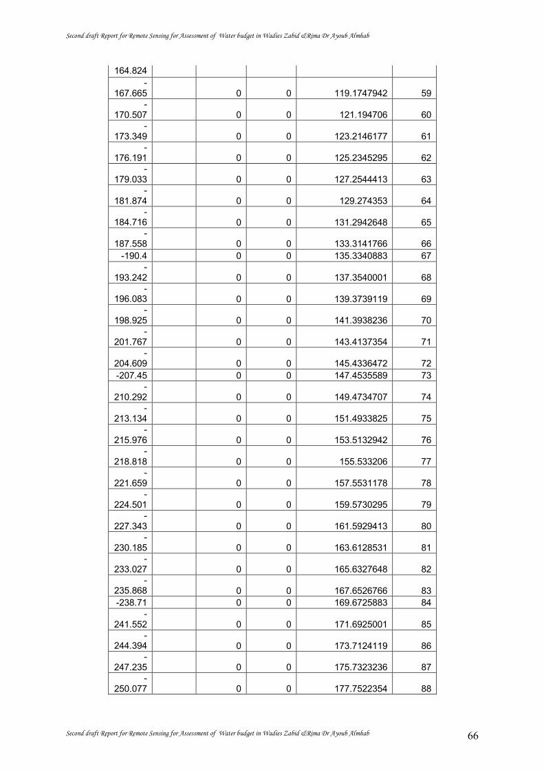
Second draft Report for Remote Sensing for Assessment of Water budget in Wadies Zabid &Rima Dr Ayoub Almhab
Second draft Report for Remote Sensing for Assessment of Water budget in Wadies Zabid &Rima Dr Ayoub Almhab 66
164.824
59 119.1747942 0 0 -
167.665
60 121.194706 0 0 -
170.507
61 123.2146177 0 0 -
173.349
62 125.2345295 0 0 -
176.191
63 127.2544413 0 0 -
179.033
64 129.274353 0 0 -
181.874
65 131.2942648 0 0 -
184.716
66 133.3141766 0 0 -
187.558 67 135.3340883 0 0 -190.4
68 137.3540001 0 0 -
193.242
69 139.3739119 0 0 -
196.083
70 141.3938236 0 0 -
198.925
71 143.4137354 0 0 -
201.767
72 145.4336472 0 0 -
204.609 73 147.4535589 0 0 -207.45
74 149.4734707 0 0 -
210.292
75 151.4933825 0 0 -
213.134
76 153.5132942 0 0 -
215.976
77 155.533206 0 0 -
218.818
78 157.5531178 0 0 -
221.659
79 159.5730295 0 0 -
224.501
80 161.5929413 0 0 -
227.343
81 163.6128531 0 0 -
230.185
82 165.6327648 0 0 -
233.027
83 167.6526766 0 0 -
235.868 84 169.6725883 0 0 -238.71
85 171.6925001 0 0 -
241.552
86 173.7124119 0 0 -
244.394
87 175.7323236 0 0 -
247.235
88 177.7522354 0 0 -
250.077

Second draft Report for Remote Sensing for Assessment of Water budget in Wadies Zabid &Rima Dr Ayoub Almhab
Second draft Report for Remote Sensing for Assessment of Water budget in Wadies Zabid &Rima Dr Ayoub Almhab 67
89 179.7721472 0 0 -
252.919
90 181.7920589 0 0 -
255.761
91 183.8119707 0 0 -
258.603
92 185.8318825 0 0 -
261.444
93 187.8517942 0 0 -
264.286
94 189.871706 0 0 -
267.128 95 191.8916178 0 0 -269.97
96 193.9115295 0 0 -
272.812
97 195.9314413 0 0 -
275.653
98 197.9513531 0 0 -
278.495
99 199.9712648 0 0 -
281.337
100 201.9911766 0 0 -
284.179 101 204.0110884 0 0 -287.02
102 206.0310001 0 0 -
289.862
103 208.0509119 0 0 -
292.704
104 210.0708237 0 0 -
295.546
105 212.0907354 0 0 -
298.388
106 214.1106472 0 0 -
301.229
107 216.130559 0 0 -
304.071
108 218.1504707 0 0 -
306.913
109 220.1703825 0 0 -
309.755
110 222.1902943 0 0 -
312.597
111 224.210206 0 0 -
315.438 112 226.2301178 0 0 -318.28
113 228.2500296 0 0 -
321.122
114 230.2699413 0 0 -
323.964
115 232.2898531 0 0 -
326.805
116 234.3097649 0 0 -
329.647
117 236.3296766 0 0 -
332.489
118 238.3495884 0 0 -
335.331
119 240.3695002 0 0 -
338.173

Second draft Report for Remote Sensing for Assessment of Water budget in Wadies Zabid &Rima Dr Ayoub Almhab
Second draft Report for Remote Sensing for Assessment of Water budget in Wadies Zabid &Rima Dr Ayoub Almhab 68
120 242.3894119 0 0 -
341.014
121 244.4093237 0 0 -
343.856
122 246.4292355 0 0 -
346.698 123 248.4491472 0 0 -349.54
124 250.469059 0 0 -
352.382
125 252.4889708 0 0 -
355.223
126 254.5088825 0 0 -
358.065
127 256.5287943 0 0 -
360.907
128 258.5487061 0 0 -
363.749
129 260.5686178 0 0 -
366.591
130 262.5885296 0 0 -
369.432
131 264.6084414 0 0 -
372.274
132 266.6283531 0 0 -
375.116
133 268.6482649 0 0 -
377.958
134 270.6681767 0 0 -
380.799
135 272.6880884 0 0 -
383.641
136 274.7080002 0 0 -
386.483
137 276.7279119 0 0 -
389.325
138 278.7478237 0 0 -
392.167
139 280.7677355 0 0 -
395.008 140 282.7876472 0 0 -397.85
141 284.807559 0 0 -
400.692
142 286.8274708 0 0 -
403.534
143 288.8473825 0 0 -
406.376
144 290.8672943 0 0 -
409.217
145 292.8872061 0 0 -
412.059
146 294.9071178 0 0 -
414.901
147 296.9270296 0 0 -
417.743
148 298.9469414 0 0 -
420.584
149 300.9668531 0 0 -
423.426 150 302.9867649 0 0 -

Second draft Report for Remote Sensing for Assessment of Water budget in Wadies Zabid &Rima Dr Ayoub Almhab
Second draft Report for Remote Sensing for Assessment of Water budget in Wadies Zabid &Rima Dr Ayoub Almhab 69
426.268 151 305.0066767 0 0 -429.11
152 307.0265884 0 0 -
431.952
153 309.0465002 0 0 -
434.793
154 311.066412 0 0 -
437.635
155 313.0863237 0 0 -
440.477
156 315.1062355 0 0 -
443.319
157 317.1261473 0 0 -
446.161
158 319.146059 0 0 -
449.002
159 321.1659708 0 0 -
451.844
160 323.1858826 0 0 -
454.686
161 325.2057943 0 0 -
457.528
162 327.2257061 0 0 -
460.369
163 329.2456179 0 0 -
463.211
164 331.2655296 0 0 -
466.053
165 333.2854414 0 0 -
468.895
166 335.3053532 0 0 -
471.737
167 337.3252649 0 0 -
474.578 168 339.3451767 0 0 -477.42
169 341.3650885 0 0 -
480.262
170 343.3850002 0 0 -
483.104
171 345.404912 0 0 -
485.946
172 347.4248238 0 0 -
488.787
173 349.4447355 0 0 -
491.629
174 351.4646473 0 0 -
494.471
175 353.4845591 0 0 -
497.313
176 355.5044708 0 0 -
500.154
177 357.5243826 0 0 -
502.996
178 359.5442944 0 0 -
505.838 179 361.5642061 0 0 -508.68
180 363.5841179 0 0 -
511.522

Second draft Report for Remote Sensing for Assessment of Water budget in Wadies Zabid &Rima Dr Ayoub Almhab
Second draft Report for Remote Sensing for Assessment of Water budget in Wadies Zabid &Rima Dr Ayoub Almhab 70
181 365.6040297 0 0 -
514.363
182 367.6239414 0 0 -
517.205
183 369.6438532 5 31.25 -
520.047
184 371.663765 7 43.75 -
522.889
185 373.6836767 8 50 -
525.731
186 375.7035885 9 56.25 -
528.572
187 377.7235003 8 50 -
531.414
188 379.743412 9 56.25 -
534.256
189 381.7633238 9 56.25 -
537.098 190 383.7832355 8 50 -539.94
191 385.8031473 9 56.25 -
542.781
192 387.8230591 9 56.25 -
545.623
193 389.8429708 9 56.25 -
548.465
194 391.8628826 10 62.5 -
551.307
195 393.8827944 9 56.25 -
554.148 196 395.9027061 9 56.25 -556.99
197 397.9226179 9 56.25 -
559.832
198 399.9425297 8 50 -
562.674
199 401.9624414 10 62.5 -
565.516
200 403.9823532 10 62.5 -
568.357
201 406.002265 11 68.75 -
571.199
202 408.0221767 11 68.75 -
574.041
203 410.0420885 12 75 -
576.883
204 412.0620003 13 81.25 -
579.725
205 414.081912 13 81.25 -
582.566
206 416.1018238 16 100 -
585.408 207 418.1217356 16 100 -588.25
208 420.1416473 20 125 -
591.092
209 422.1615591 21 131.25 -
593.933
210 424.1814709 19 118.75 -
596.775
211 426.2013826 18 112.5 -
599.617

Second draft Report for Remote Sensing for Assessment of Water budget in Wadies Zabid &Rima Dr Ayoub Almhab
Second draft Report for Remote Sensing for Assessment of Water budget in Wadies Zabid &Rima Dr Ayoub Almhab 71
212 428.2212944 16 100 -
602.459
213 430.2412062 13 81.25 -
605.301
214 432.2611179 12 75 -
608.142
215 434.2810297 10 62.5 -
610.984
216 436.3009415 12 75 -
613.826
217 438.3208532 9 56.25 -
616.668 218 440.340765 11 68.75 -619.51
219 442.3606768 10 62.5 -
622.351
220 444.3805885 9 56.25 -
625.193
221 446.4005003 11 68.75 -
628.035
222 448.4204121 9 56.25 -
630.877
223 450.4403238 9 56.25 -
633.718 224 452.4602356 10 62.5 -636.56
225 454.4801474 7 43.75 -
639.402
226 456.5000591 11 68.75 -
642.244
227 458.5199709 9 56.25 -
645.086
228 460.5398827 8 50 -
647.927
229 462.5597944 10 62.5 -
650.769
230 464.5797062 7 43.75 -
653.611
231 466.599618 10 62.5 -
656.453
232 468.6195297 11 68.75 -
659.295
233 470.6394415 7 43.75 -
662.136
234 472.6593533 11 68.75 -
664.978 235 474.679265 11 68.75 -667.82
236 476.6991768 8 50 -
670.662
237 478.7190886 12 75 -
673.503
238 480.7390003 13 81.25 -
676.345
239 482.7589121 11 68.75 -
679.187
240 484.7788239 20 125 -
682.029
241 486.7987356 17 106.25 -
684.871
242 488.8186474 17 106.25 -
687.712

Second draft Report for Remote Sensing for Assessment of Water budget in Wadies Zabid &Rima Dr Ayoub Almhab
Second draft Report for Remote Sensing for Assessment of Water budget in Wadies Zabid &Rima Dr Ayoub Almhab 72
243 490.8385592 18 112.5 -
690.554
244 492.8584709 19 118.75 -
693.396
245 494.8783827 17 106.25 -
696.238 246 496.8982944 14 87.5 -699.08
247 498.9182062 14 87.5 -
701.921
248 500.938118 11 68.75 -
704.763
249 502.9580297 11 68.75 -
707.605
250 504.9779415 10 62.5 -
710.447
251 506.9978533 8 50 -
713.289 252 509.017765 6 37.5 -716.13
253 511.0376768 4 25 -
718.972
254 513.0575886 4 25 -
721.814
255 515.0775003 4 25 -
724.656

Second draft Report for Remote Sensing for Assessment of Water budget in Wadies Zabid &Rima Dr Ayoub Almhab
Second draft Report for Remote Sensing for Assessment of Water budget in Wadies Zabid &Rima Dr Ayoub Almhab 73
6. CONCLUSIONS
MODIS satellite images were used to classify the gross major irrigated areas in
Zabeed Area in Yemen. The resolution of the MODIS satellite images is 250 by 250 meter
and does not allow to distinguish individual fields. The actual irrigated area is lower and was
determined by multiplying the gross irrigated area with an irrigated fraction that was derived
from Landsat satellite images that have a spatial resolution of 30 by 30 meter. The actual
irrigated area is estimated 71,304 ha.
The annual average total system efficiency for Zabeed is 47%. Monthly discharge data are
highly questionable because the flow data do not match with the gross irrigation requirements
based on SEBAL and TRRM precipitation, and the agricultural seasons monitored with
MODIS. Nevertheless, a monthly water balance is provided, which suggests that groundwater
is abstracted in September to November.
The land use classification has been ground truthed, and the average accuracy
appeared to be 83%. Such performance is in agreement with similar studies conducted
outside Yemen. Because of these accuracies and acceptable results on water use, it is
concluded that satellite remote sensing has potential.

Second draft Report for Remote Sensing for Assessment of Water budget in Wadies Zabid &Rima Dr Ayoub Almhab
Second draft Report for Remote Sensing for Assessment of Water budget in Wadies Zabid &Rima Dr Ayoub Almhab 74
8. REFERENCES
Almhab, Ayoub and Ibrahim Busu (2009). Estimation of evapotranspiration using fused remote sensing image data and energy balance model for improving water management in arid area. Computer Engineering and Technology, 2009. Volume 2, 22-24 Jan. 2009 Page(s):529 - 533 . http://ieeexplore.ieee.org/stamp/stamp.jsp?tp=&arnumber=4769659&isnumber=4769538
Almhab, Ayoub and Ibrahim Busu (2008). Estimation of Evapotranspiration with modified SEBAL model using landsat-TM and NOAA-AVHRR images in arid mountains area, Asian Modeling and Simulation (AMS) 2008, IEEE computer society ,pp350-355, 2008 IEEE. http://ieeexplore.ieee.org/iel5/4530427/4530428/04530501.pdf?tp=&arnumber=4530501&isnumber=4530428
Almhab, A. and Ibrahim Busu (2008). the approaches for oasis desert vegetation information abstraction based on medium -resolution Lansat TM image: A case study in desert wadi Hadramut Yemen, Asian Modeling and Simulation Asian Modeling and Simulation (AMS) 2008, IEEE computer society ,pp356-360, 2008 IEEE,. http://ieeexplore.ieee.org/iel5/4530427/4530428/04530502.pdf?tp=&arnumber=4530502&isnumber=4530428
Almhab A., Ibrahim B., (2008), Regional Water Balance Visualization Using Remote Sensing And Gis Techniques with Application to the Arid Watershed Area . ACRS2008, Sere lank.
Almhab A., Ibrahim B., (2008), Remote sensing of available solar energy modelling in mountainous areas. Post graduate seminar alam bena 2008,UTM, Skudai Johor, Malaysia.
Almhab A., Ibrahim B., (2008), Application of remote sensing data for environmental monitoring in semiarid mountain areas: a case study in yemen mountains. post graduate seminar alam bena 2008,UTM, Skudai Johor, Malaysia.
Almhab A., Ibrahim B., (2008), Regional Water Balance Visualization Using Remote Sensing And Gis Techniques with Application to the Arid mountain basin area . IPGCES 2008,UTM, Skudai Johor, Malaysia. (
Almhab Ayoub, Ibrahim Busu (2008). Decision Support System for Estimating Actual crop Evapotranspiration using Remote Sensing, GIS and Hydrological Models, Malaysia Remote Sensing Society (MRSS)2008, Kula Lumpur , Malaysia.
Almhab A. A., C. V.Tol (2010). VALIDATION OF ESTIMATED TRMM RAINFALL DATA BY RAIN GAUGES IN YEMEN, 31st Asian Conference on Remote Sensing (ACRS) 1st – 5th of November 2010, at the, Hanoi, Vietnam.
Almhab A. A. (2011).Assessment of Crop Water Requirement and annual planning of water allocation in Yemen using remote sensing dada and M-SEBAL MODEL, ISNET/ RJGC Workshop on application of satellite technology in water resources management , 18 -22/9/2011. Amman, Jordan.
Almhab A. A. (2010). Predicting Evapotranspiration From MODIS And M-SEBAL Model In Arid Regions, ITC, Enshgedai, The Netherlands .
Askary. G.H., S.M. Pourbagher, A.M. Noorian, J.B. Jamali, S. Javanmard , 2007, validation of estimated TRMM rainfall data by rain gauges in Iran, ACRS 2007, Kula lumpor , Malaysia.
Bastiaanssen, W.G.M., Menenti, M., Feddes, R.A. and Holtslag, A.A.M., 1998, A remote sensing surface energy balance algorithm for land (SEBAL) 1,2. Formulation. Journal Hydrology 212/213, 198–212.
Nazrul Islam, Md., Uyeda, H. 2006. Use of TRMM in determining the climatic characteristics of rainfall over Bangladesh. Remote Sensing of Environment, 108, pp.264–276.
Surface Water Resources, Vol IV, High Water Cuncil, 1992 Tihamah Basin Water Resources Study, Technical Report 3, Groundwater, Final, DHV Consulting
Engineers, April 1988. Tihamah Basin Water Resources Study (TBWRS), ain Report, Final, DHV Consulting Engineers,
April 1988. Tihamah Basin Water Resources Study, Technical Report 3, Groundwater, Annexes 3,6,8, Final,
DHV Consulting Engineers, April 1988.

Second draft Report for Remote Sensing for Assessment of Water budget in Wadies Zabid &Rima Dr Ayoub Almhab
Second draft Report for Remote Sensing for Assessment of Water budget in Wadies Zabid &Rima Dr Ayoub Almhab 75
TNO- DGV Institute of Applied Geo-Siences Annex 2a, Data on geologicaly or geovisically logged boreholes.
Appendix 1 Precipitation validation
See : Almhab A. A., C. V.Tol (2010). VALIDATION OF ESTIMATED TRMM RAINFALL DATA BY RAIN GAUGES IN YEMEN, 31st Asian Conference on Remote Sensing (ACRS) 1st – 5th of November 2010, at the, Hanoi, Vietnam.
Appendix 2 M-SEBAL model See : Almhab, Ayoub and Ibrahim Busu (2008). Estimation of Evapotranspiration with
modified SEBAL model using landsat-TM and NOAA-AVHRR images in arid mountains area, Asian Modeling and Simulation (AMS) 2008, IEEE computer society ,pp350-355, 2008 IEEE. http://ieeexplore.ieee.org/iel5/4530427/4530428/04530501.pdf?tp=&arnumber=4530501&isnumber=4530428
Appendix 3. Land Use Map Zabeed
Appendix 4. Actual Evapotranspiration
Appendix 5. Potential Evapotranspiration Zabeed