RAVIWAR PETH - NTNU
61
NTNU RAVIWAR PETH
-
Upload
khangminh22 -
Category
Documents
-
view
0 -
download
0
Transcript of RAVIWAR PETH - NTNU

N T N U
RAVIWAR PETH

Fieldwork in Pune, India – Fall 2017AAR4525 - Urban Action PlanningDepartment of Architecture and PlanningFaculty of Architecture and Design
RAVIWAR PETH
AUTHORSGroup 5 - André Kraemer Góes
Astrid MoenJulianti Putri SetiawanSolomon Quarm
Group 6 - Cinthia Freire StecchiniHåkon Carlsen VetlesenSai Varsha Akavarapu
TECHNICAL SUPPORTChaitanya ParachotillVrushabh Gudade
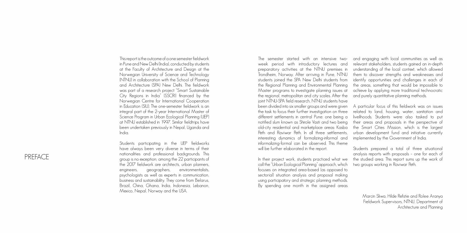
This report is the outcome of a one semester fieldwork in Pune and New Delhi (India), conducted by students at the Faculty of Architecture and Design at the Norwegian University of Science and Technology (NTNU) in collaboration with the School of Planning and Architecture (SPA) New Delhi. The fieldwork was part of a research project “Smart Sustainable City Regions in India” (SSCRI) financed by the Norwegian Centre for International Cooperation in Education (SIU). The one-semester fieldwork is an integral part of the 2-year International Master of Science Program in Urban Ecological Planning (UEP) at NTNU established in 1997. Similar fieldtrips have been undertaken previously in Nepal, Uganda and India.
Students participating in the UEP fieldworks have always been very diverse in terms of their nationalities and professional backgrounds. This group is no exception; among the 22 participants of the 2017 fieldwork are architects, urban planners, engineers, geographers, environmentalists, psychologists as well as experts in communication, business and sustainability. They come from Belarus, Brazil, China, Ghana, India, Indonesia, Lebanon, Mexico, Nepal, Norway and the USA.
PREFACE
The semester started with an intensive two-week period with introductory lectures and preparatory activities at the NTNU premises in Trondheim, Norway. After arriving in Pune, NTNU students joined the SPA New Delhi students from the Regional Planning and Environmental Planning Master programs to investigate planning issues at the regional, metropolitan and city scales. After the joint NTNU-SPA field research, NTNU students have been divided into six smaller groups and were given the task to focus their further investigation on three different settlements in central Pune: one being a notified slum known as Shirole Vasti and two being old-city residential and marketplace areas: Kasba Peth and Raviwar Peth. In all three settlements, interesting dynamics of formalizing-informal and informalizing-formal can be observed. This theme will be further elaborated in the report.
In their project work, students practiced what we call the “Urban Ecological Planning” approach, which focuses on integrated area-based (as opposed to sectorial) situation analysis and proposal making using participatory and strategic planning methods. By spending one month in the assigned areas
and engaging with local communities as well as relevant stakeholders, students gained an in-depth understanding of the local context, which allowed them to discover strengths and weaknesses and identify opportunities and challenges in each of the areas, something that would be impossible to achieve by applying more traditional technocratic and purely quantitative planning methods.
A particular focus of this fieldwork was on issues related to land, housing, water, sanitation and livelihoods. Students were also tasked to put their areas and proposals in the perspective of the Smart Cities Mission, which is the largest urban development fund and initiative currently implemented by the Government of India.
Students prepared a total of three situational analysis reports with proposals – one for each of the studied area. This report sums up the work of two groups working in Raviwar Peth.
Marcin Sliwa, Hilde Refstie and Rolee AranyaFieldwork Supervisors, NTNU, Department of
Architecture and Planning

There are many people and organizations who contributed to this work and we would like to express our immense appreciation for their support. First and foremost, we would like to thank the Norwegian Centre for International Cooperation in Education (SIU) for providing financial support for this project. We are particularly thankful for the assistance given by the faculty at the School of Planning and Architecture (SPA) New Delhi: Prof. N. Sridharan, Ass. Prof. Arunava Dasgupta, Prof. Vinita Yadav and Prof. Meenakshi Dhote; as well as the students from the Urban Design, Regional Planning and Environmental Planning Master’s programs. We would like to give our special thanks to Prof. Pratap Rawal from the Dept. of Town Planning at the College of Engineering, Pune (COEP) for his hospitality, logistic support, and in-depth knowledge in the field. Our field investigation would not be possible without the assistance in translation by the COEP students involved in the project.
We would like to express our gratitude to Mr. Sharad Mahajan from the Maharashtra Social Housing and Action League (MASHAL), Arch. Jui Tawade and Arch. Sharvey Dhongde from the Indian National Trust for Art and Cultural Heritage
ACKNOWLEDGEMENTS ACRONYMS
(INTACH) Pune Chapter, as well as Dr. Meera Bapat and Arch. Prasanna Desai for sharing with us their local expertise and relevant information.
Our gratitude is also conveyed to Mr. Harshvardhan Kadam, from the Inkbrushnme art studio, and Ms. Chaaya Bhanagi and Ms. Isha Panse, both from COEP, who have taken part of their valuable time to share their expertise and present us different perspectives on Raviwar Peth, Pune and the Indian society.
Last but not least, we would like to thank all the local communities in Pune for taking their time to participate in our project and welcoming us in their homes and neighbourhoods.
IT Information Technology
PMC Pune Municipal Corporation
INTACH Indian National Trust for Art and Cultural Heritage
PMRDA Pune Metropolitan Region Development Authority
FSI Floor Space Index
FCI Facility Condition Index
IAS Indian Administrative Service
NGO Non-Governmental Organisation
MLA Member of Legislative Assembly
INDEX
Preface 4 Acknowledgements 6Acronyms 7Index 8
Introduction India;Maharashtra State 10Pune 12Raviwar Peth 14
Group 5 18-65Situation Analysis 20 Methods 21
Existing Condition, Present Situation 29Regulation and Future Developments 46
SWOT Analysis 51Proposal 55
Group 6 66-105About The Area 67 Methodology 70 Situation Analysis 72Comprehensive Study 77Proposal 90 Discussion 102
Conclusion 104Peferences And Bibliography 112

INTRODUCTION
10 11
India: Maharashtra stateIndia is the largest country in Southern Asia and the seventh largest in the world by area. The country has the status of the largest democratic nation, with a population of over 1.3 billion people, second only to China’s but expected to overtake it in 2028. It is a diverse country, with vast differences in geography, climate, culture, language and ethnicity across its 29 states and seven union territories. During the past 70 years, India achieved socio-economic progress and became self-sufficient in agriculture production. It is now one of the top industrialized countries in southern Asia and an important regional power, but is also facing huge social, economic and environmental problems.
Maharashtra, the country’s most industrialized state, attracts industrial investments from domestic and foreign institutions. Thus, the state emerged as the leading automobile production and a major Information Technology (IT) growth center (India Brand Equity Foundation [IBEF], 2017) and is also a pioneer in small scale industries. Mumbai, the state’s capital, is the most populous city in India. It is a commercial, financial, and entertainment hub and one of the world’s top ten centres of commerce in positions of global financial flow (according to Times of India).
Pune, the state’s second largest city, is situated 150 km south-east of Mumbai, and the two cities are linked through an express highway. It is both an industrial and educational hub, attracting migrants from all over the world. Although the city has acquired a cosmopolitan identity in the past decades, its core still preserves a lot of its history and traditions. As a secondary city growing at a fast rate, Pune is facing several problems that demand focus and attention from urban planners (Krishnamurthy, Mishra & Desouza, 2016).
This report presents the results of a two-month fieldwork that took place in Pune. Two workgroups analyzed and made proposals for Raviwar Peth, one of the oldest commercial areas in the city. It is organized in a way that, first, Pune’s historical background will be presented, followed by an overview of its present situation and challenges. Then, a summary of Raviwar Peth’s history and a general situation analysis will be given. After that, each of the two groups responsible for this report will present their specific work areas in detail, as well as a proposal for urban intervention. Historical background: from City of Peths towards attaining megacity status. A peth, in Marathi language, means a locality or an area, and Pune was once known as the “City of Peths”. Although there are no historical records about the origins of the city, it is known to have existed since 937 AD and that it started in Kasba Peth, which was formed by three villages of fishermen and farmers. The town grew as new peths were settled outside of Kasba. In 1610, four peths constituted the town: Malkapur (now Raviwar Peth); Murtazabad (Shaniwar Peth); Shahpura (Somwar Peth); and the original Kasba Peth (Diddee & Gupta, 2000). During the 18th century, the Peshwa family made the city the administrative center of their territories and Pune
became politically influential in India. By then, the country faced a major urbanization phase. Pune followed this trend and reached both its economic and cultural development peak for this period, with a total of 18 peths. To set up a peth, the ruler would issue a permission to an individual delegating rights and duties, such as building roads, dividing plots, inviting settlers and initiating economic activity. Although there was an overall planning, peths grew organically and the building of houses was free and improvised. The leftover spaces between them became lanes and by-lanes, and community spaces were created according to the settlers’ will. During the Peshwa period, old peths were also revitalized. Even though each peth had its own composition and identity, the way they were organized created an unified town fabric. There was also a reasonable amount of heterogeneity in their demographic composition, with a mixture of different castes, classes and professions. In 1818, this organic growth of the city was interrupted by the British conquest and a different form of urban development began. The city acquired a dual identity: the core, formed by the peths and their narrow lanes and innumerous houses, shops and temples; and the British Poona, with a grid pattern layout and sophisticated buildings (Diddee & Gupta, 2000). Under the British rule, authority transfer of the city began and
Map 1. India and location of Maharashtra

12 13
Map 2. The District of Maharashtra
more attention was given to economic growth and development (Krishnamurthy et al., 2016).
After the Independence, the old city was improved through the provision of better infrastructure due to a democratic municipal administration. In the 1960s, Pune’s situation began to change as Mumbai became saturated and too expensive for residents and industries. Due to the proximity of both cities, the industries were then attracted to Pune. With its later upgrade to a Municipal Corporation, there were more investments on infrastructure and a large flow of migrants were attracted to the existing job opportunities.
In the 1990s, the introduction of a liberalization policy, opened up the Indian economy to global trade and investment, which led to big investments on the IT sector and in manufacturing industries. The city soon became a hub for these, again attracting migrants from all over. Pune also attracts students due to its strong educational sector. By 2030, the city is expected to grow and achieve 10 million inhabitants, becoming a megacity (Sankhe, as cited in Krishnamurthy et al., 2016). This demographic growth, however, leads to increasing demands for residential and industrial space, as well as services and amenities.
PuneCurrently, Pune is the second largest city in Maharashtra State, with Mumbai being the first. Pune city has a population of about 3.1 million, out of the estimated 5 million from Pune Metropolitan Region (Census, 2011), which makes it the ninth most populous city in India. The increase from about 450,000 inhabitants in 1950 to today’s 3.1 million can be related to industrialization, urbanization, massive rural-urban migration and its proximity to Mumbai. The sectors that mostly attract workers and students from other states of India and from different countries are IT, manufacturing and service industries, and education.
Due to the growth of IT and automobile sectors, Pune has established global connections and attracted foreign investments (Krishnamurthy et al., 2016). The presence of large scale industries has also resulted in the production of a variety of goods, including automotive, pharmaceuticals, processed food, and agricultural produce, making Pune one of the most important market destinations in the country. As throughout its history Pune has been a trading city, it has good communication and banking facilities and is well connected to the rest of the country. These factors together have created 21.5% soar in jobs in Pune (Sawant & Gole, 2011) and led the city to achieve an important place in the economic development of India (Mahajan, 2000).
The city is also known as “Oxford of the East”, as there are over 100 educational institutions and nine universities (PMC, 2012). The large student population, thus, has impacted the average literacy rate of Pune city, improving from 77% in 2001 to 91.61% in 2011 (Census, 2011). Transformation and urbanization has also led the city to several challenges. The inflow of migrant workers, for example, resulted in an increase in the percentage of people living in slums from 15% in 1961 to 40% in 2001 (Pune Municipal Corporation [PMC], 2013b). With growth, there’s a straining in the city’s critical
infrastructures (Krishnamurthy et al., 2016) and their management becomes complicated (Roy, 2009) as it creates stress on environment, social cohesion and basic amenities (Cohen, 2006).
To address the challenges the city is facing, the main governmental administrative structure is the Pune Municipal Corporation (PMC), established in 1950. It is headed by an Indian Administrative Service (IAS) officer chosen by the Maharashtra State Government. The mayor, publicly elected, is the head of the elected corporators and is responsible mainly for the infrastructural and developmental work in the city, although he/she has few executive powers. Pune is divided into 48 wards, and the mayor is responsible for their management. Another important administrative structure for the city is the Pune Metropolitan Region Development Authority (PMRDA), established in April, 2015 to outline and implement a development plan for Pune district, acting on a regional level. The authority deals with the provision of urban facilities.
In 2012, PMC approved a development draft plan for the period of 20 years (2007-2027). Some of the guidelines include developing metro lines; expanding main roads; building low-income houses with the goal of achieving a “slum-free city with
14 15
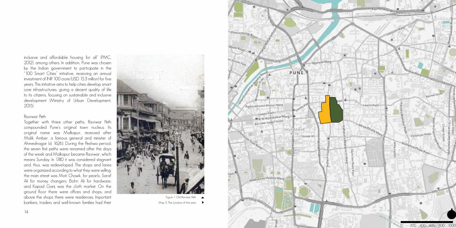
Figure 1 Old Raviwar Peth
inclusive and affordable housing for all” (PMC, 2012); among others. In addition, Pune was chosen by the Indian government to participate in the “100 Smart Cities” initiative, receiving an annual investment of INR 100 crore (USD 15.3 million) for five years. This initiative aims to help cities develop smart core infrastructures, giving a decent quality of life to its citizens, focusing on sustainable and inclusive development (Ministry of Urban Development, 2015). Raviwar PethTogether with three other peths, Raviwar Peth compounded Pune’s original town nucleus. Its original name was Malkapur, received after Malik Amber, a famous general and minister of Ahmednagar (d. 1626). During the Peshwa period, the seven first peths were renamed after the days of the week and Malkapur became Raviwar, which means Sunday. In 1740 it was considered stagnant and, thus, was redeveloped. The shops and lanes were organized according to what they were selling: the main street was Moti Chowk, for pearls; Saraf Ali for money changers; Bohri Ali for hardware; and Kapad Ganj was the cloth market. On the ground floor there were offices and shops, and above the shops there were residences. Important bankers, traders and well-known families had their Map 3. The Location of the area
0 200 400 600 800 1000m

16 17
Figure 2. Raviwar Peth Present Situation
homes in Raviwar Peth. One example is the Bohri Ali merchants, who were specialized in hardware, iron and tin and are still in the area today. Raviwar Peth was always known to be a commercial peth and it was densely populated by different castes and communities. At its peak, in the 1790’s, there were about 1500 houses – a number that was reduced to only 666 in 1830, after the British colonization (Diddee & Gupta, 2000).
Present Day Raviwar PethModern day Raviwar Peth houses a diverse nature of culture and lifestyles. It is an affluent business center, influenced largely by its early trade activities and the nature of its past peculiar buildings. Most of the built structures are old, and all have about the same height, facing the streets, with narrow entrances and an open space within the buildings. Shops are on the ground floor and the subsequent floors are used for storage or residential purposes.The wholesale market is divided into many parts and boast of different trade at various lanes. There are, for example, the Marwaris in textiles; Sindhis in building construction; Bohris in hardware. The peth is also known for the quality of gold and silver jewels that are sold. At the end of each street with a specific trade activity, a Ganesh Temple marks the end of that trade and the beginning of another.
Shops are mostly open from 9 am to 8 pm every day except for Sundays, when most shop owners take the day off – an irony, knowing that the meaning of Raviwar Peth is ‘‘Sunday market’’. The presence and activities of street vendors is evident, and functions as an organic market. Their activities differ in terms of location and the nature of goods traded. Some vendors are stationed at specific places, usually where the traffic is high, while others move around the streets with their products in baskets, pushcarts or tricycles. Those who sell fruits and vegetables work during the day and, in the evening, street food sellers are more active. The nature of goods traded also changes when festivals approach: specific decoration items for each festivity are sold in different times of the year. Street Vendors also play an indirect role in keeping an eye on the city and positively add to the livelihood of places, as they bring identity, safety, life and variety to the city.
As continuity of business must be ensured, most shops of deceased or elderly owners are operated by their sons or members of the family. The affluent shop owners want their children to continue their operation, which has resulted to most shops being generationally passed on. This situation is distinct from that of the street vendors, as most of them see their trade only as means of subsistence and
therefore wish their children to engage in other occupations that can provide better earnings. Shop owners, street vendors and residents, together with customers, are the constant users of the peth, and the ones who are most affected by it or by any changes that might take place there. Because of its historical importance for the city of Pune, the Indian National Trust for Art and Cultural Heritage (INTACH) plays an important role in preserving the areas and buildings categorized as heritage. On a broader level, Raviwar Peth is subject to the plans made and implemented by PMC, who is also responsible for providing and managing facilities and amenities. The mediation of people and the PMC is done by the three ward Nagar Sevaks, who are elected every five years.
Figure 3. Street vendors selling fruit in Mirza Galib Rd.
GROUP 5

20 21
S I T U AT I O NA N A LY S I S
Figure 4. In the streets of Raviwar Peth
METHODS USED DURING THE FIELDWORK
Observation
Our first approach towards Raviwar Peth was through observation. This method was used throughout the period of the fieldwork, and is of obvious importance to our work. However, we noticed that to properly benefit from this method of work, it is necessary to calibrate one’s eyes to go beyond the superficial, obvious perception of a passer-by, so to be able to perceive the particularities and peculiarities of an area. This calibration of perception is a long, potentially never-ending process, specially in a complex area as Raviwar Peth. It is also an important exercise to help us break our own prejudices. Proof of that is the fact that in our last afternoon at the area, we were still discovering new paths, shops and people.
Spontaneous Interaction
Figure 6 Interaction with kids in the areaFigure 5. Observing the area by night
Interacting with Raviwar Peth’s quotidien by experiencing everyday life at the area, hanging out there at different hours of the day, as well as eating and doing shopping - that is, experiencing Raviwar Peth as a Punekar, was also part of our strategy to understand the area. While having an open and positive attitude, it also served as the very first ice-breaking method for approaching people. Our contrasting biotype brought us much curiosity and many looks, which when answered with a smile could result in a nice conversation. As the locals in the area started to recognize our appearance in the area day after day, their curiousness increased. We ended our fieldwork with this gratifying sensation of wishing to stay longer there.
22 23
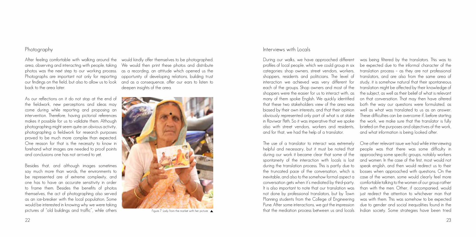
After feeling comfortable with walking around the area, observing and interacting with people, taking photos was the next step to our working process. Photographs are important not only for reporting our findings on the field, but also to allow us to look back to the area later.
As our reflections on it do not stop at the end of the fieldwork, new perceptions and ideas may come during while reporting and proposing an intervention. Therefore, having pictorial references makes it possible for us to validate them. Although photographing might seem quite an obvious activity, photographing a fieldwork for research purposes proved to be much more complex than expected. One reason for that is the necessity to know in forehand what images are needed to proof points and conclusions one has not arrived to yet.
Besides that, and although images sometimes say much more than words, the environments to be represented are of extreme complexity, and one has to have an accurate sensitivity in order to frame them. Besides the benefits of photos themselves, the act of photographing also served as an ice-breaker with the local population. Some would be interested in knowing why we were taking pictures of “old buildings and traffic”, while others
would kindly offer themselves to be photographed. We would then print these photos and distribute as a recording, an attitude which opened us the opportunity of developing relations, building trust and as a consequence, offer our ears to listen to deepen insights of the area.
Photography
Figure 7. Lady from the market with her picture
During our walks, we have approached different profiles of local people, which we could group in six categories: shop owners, street vendors, workers, shoppers, residents and politicians. The level of interaction we achieved was very different for each of the groups. Shop owners and most of the shoppers were the easier for us to interact with, as many of them spoke English. We quickly identified that these two stakeholders view of the area was biased by their own interests, and that their opinion obviously represented only part of what is at stake in Raviwar Peth. So it was imperative that we spoke also with street vendors, workers and residents, and for that, we had the help of a translator.
The use of a translator to interact was extremely helpful and necessary, but it must be noted that during our work it became clear that some of the spontaneity of the interaction with locals is lost during the translation process. This is partly due to the truncated pace of the conversation, which is inevitable, and also to the somehow formal aspect a conversation gets when it’s mediated by third-party. It is also important to note that our translation was not done by professional translators, but by Town Planning students from the College of Engineering Pune. After some interactions, we got the impression that the mediation process between us and locals
Interviews with Locals
was being filtered by the translators. This was to be expected due to the informal character of the translation process – as they are not professional translators, and are also from the same area of study, it is somehow natural that their spontaneous translation might be affected by their knowledge of the subject, as well as their belief of what is relevant on that conversation. That may then have altered both the way our questions were formulated, as well as what was translated to us as an answer. These difficulties can be overcome if, before starting the work, we make sure that the translator is fully briefed on the purposes and objectives of the work, and what information is being looked after.
One other relevant issue we had while interviewing people was that there was some difficulty in approaching some specific groups, notably workers and women. In the case of the first, most would not speak english, and then would redirect us to their bosses when approached with questions. On the case of the women, some would clearly feel more comfortable talking to the women of our group rather than with the men. Other, if accompanied, would just redirect the attention to whichever man that was with them. This was somehow to be expected due to gender and social inequalities found in the Indian society. Some strategies have been tried

Figure 9. Street vendor selling fruit in Jadhe Prahasad Rd. every day
24 25
On the course of our work, we also talked to experts of different areas of knowledge, such as urban renewal and slum rehabilitation (notably Mr. Prasanna Desai), architectural heritage (Ms. Jui Tawade and Mr. Sharvey Dhongde – INTACH), street art (Mr. Harshvardhan – Inkbrushnme), as well as officers from Pune Municipal Corporation (PMC) and Pune Metropolitan Region Development Authority (PMRDA).
The usefulness of these interviews varied a lot. Some did not provide much information on the area we are working on, others provided us with an outsider, yet deep perspective of Pune and Raviwar Peth, as well as the Indian society as a whole.
One very important observation at this point is that the productivity of those interviews varied according to how clear the pertinence of the interviewee’s opinion was for us – something that was much easier at the end than at the beginning of the fieldwork, as well as the interviewee’s own interest in cooperating with the work. Sometimes making a call for checking the professional’s availability, or sending an e-mail with preliminary questions, not only us but also the interview objects precious worktime.
Interviews with Experts
to overcome this resistance - like approaching workers outside of their working hours, or having the interviews conducted solely by the female group members. However, the number of working-class and female interviewees we managed to approach was still smaller than we would like, and how to fully overcome that, however, still remains a question.
But even with the mentioned constraints, having a translator was of extreme importance, and brought us to a whole deeper comprehension of the area, making this the most relevant and powerful method of research during the fieldwork, which brought us valuable insights of Raviwar Peth.
Figure 8. Street vendor sharing his experiences
Although our focus had always been kept on the qualitative aspects, our group has applied surveys with the locals. Those were not census-style questionnaires, but an attempt to make people rank and grade their perception of different issues of the area, in order to validate some of the perceptions we had formed.
But although most people were very open to answer informal questions and to orally relate their impression on Raviwar Peth, we were surprised to have found some resistance from them to fill in this questionnaire, notably among the street vendors. The justifications we found for that could be that some were not able to read (although the questionnaire was both in Marathi and English), as well as the perception that our research could be related to some kind of governmental intervention, which could negatively impact their activities. The fact that our translator was not available at the moment we were applying the questionnaire made it more difficult to break people’s resistance to it. We also concluded a more intuitive formulary could have helped, as well as that we should have visually emphasized that the results were for academic purposes (by adding NTNU’s logo, for example).
Surveying

26 27
Another strategy we used was systematizing information through the production of maps. The analysis of those maps as well as the comparison of their results with our field observations helped us validate impressions and perceptions. To gather information, we used both the classical pen and paper, as well as GPS tracking softwares on smartphones. This helped us register different information about the area, notably: the presence og trees, the distribution of street vendors, the boundaries between different commercial activities, the presence of garbage, the availability of public infrastructure (such as public toilets, benches).
Besides mapping objective information, we also made an attempt to represent on maps our own perceptions of the area – like which areas are quieter and which are busier. These maps and their resulting analysis will be presented later on this section.
Mapping
Figure 11. One of the featured we mapped was trees in the area.
Figure 10. Questionnaire survey with a street vendor selling decorations for
Diwali fastival

0 50 100
200m
LAXMI ROAD
JEDH
E PRA
SAD
RD.
JEDH
E PRA
SAD
RD.
JEDH
E PRA
SAD
RD.
RAWAL PETH
THAKURDAS RD.
MIRZA GALIB RD.
BHUT
KAR H
AUD
MAR
G
HONA
JI BAL
A PE
TH
NC KELKAR RD.1
2
43
5
6
7
Map 4. The Overview of the area
29
Area Understanding
Using methods coherent to Urban Ecological Plan-ning, like observing, interacting and interviewing, our group has approached Raviwar Peth with the first objective of understanding the “down-to-the-ground” reality of that place. Beginning by obser-ving and living the area’s real life at the beginning, we found an instigating, very rich neighbourhood, with a flourishing and diverse commercial activity, though with very intense, sometimes aggressive traffic flow.
To deepen our understanding of the area, we have talked to its people, conducting structured and se-mi-structured interviews, as well as informal conver-sations, with residents, shoppers, shop owners and street vendors, as well as politically affiliated indivi-duals. These conversations, which began with citi-zens presenting superficial impressions on Raviwar Peth, ended up revealing relevant information about the area’s history, its current situation, strengths and weaknesses, as well as its future perspectives, from the eyes of their stakeholders. Imprescindible for that deeper insight was being able to approach people using their own language, with the help of a local translator. By having a work group compo-sed of people with different technical and cultural backgrounds, each of our members has also richly
EXSITING CONDITION,PRESENT SITUATION
contributed with a vastness of observations and “readings” of the Peth. Maps were also produced with the intent to systematize information about re-levant issues on our area of studies, like for instan-ce the dynamics of street vendors in the area. And when a more technical, expert approach was ne-eded, we had the chance to interview professionals on the fields of Architecture - like Ms. Jui Tawade, Art - as Mr. Harshvardhan Karam, and Urban Plan-ning - mainly Ms. Isha Panse.
The amount of information collected, as well as the varied reflections and discussions that arose from them, would be enough to fill a number of volumes. On the next pages though, we will present an ef-fort of extracting the most relevant from what we have produced from our fieldwork, and that mostly influenced our proposal, which is presented on the next chapter.
The activities in our area of study are distributed in a spontaneously sectorized way, with commercial activities occupying the front of the blocks, shops for similar products agglomerated together, and residential areas mostly occurring inside the blocks. Due to these specifics, we will present the results of our field research following this pattern.
L E G E N D
Dagduseth TempleShaniwar WadaLaxmi RoadTamboli MasjidProstitution AreaMandai MarketSaifee Bohri MosqueFuture Pune Metro LineFuture Metro Station
1234567

Figure 13 Hunaji Bala Path. In this area you can even hear the bird sing sometimes
30 31
Bagade Road / Jedhe Prasad Road (formerly known as Bohri Ali)
Perpendiculars to the Laxmi Rd - one of the most important commercial streets in Pune - Bagade Rd and Jedhe Prasad Rd (Bori Ali) are also highly commercial. The character of the shops on this street, however, is quite different. While Laxmi Rd’s main characteristic is its varied retail, Jedhe Prasad Rd concentrates shops on jewellery and hardware, as well as wholesale. Having specific sectors concentrated on the same area is very characteristic of traditional commercial areas in medium and big cities.
This pattern is easily noticeable with a quick walk on the street. While the blocks from NC Kelkar Rd to Rawal Path are overtaken by jewellery stores, from Rawal Path to Thakurdas Rd there is a clearer prevalence of hardware shops, followed by wholesale shops of a variety of goods, until reaching Mirza Galib Rd. Though still noticeable and present, this shop specialization tendency, mentioned by many of the interviewee’s as something traditional and linked to the history of the city, was also reported to be diminishing along the last years. The most mentioned reason for this change was the shift of higher income customers to shopping malls, making shop owners follow the same path. We did not get access to data that could prove this tendency, but there seems to be a growing offer
(and demand) for wholesale disposable goods, as well as other cheap plastic and paper products, meaning therefore a shift on the profile of customers.The way commercial activities are distributed along the street has clear impacts on its characteristics and use. Jewellery shops attract a smaller - though wealthier - number of customers, meaning less general traffic. It was easy to notice that the two blocks where this kind of shops was concentrated were also the ones with the best overall atmosphere - having the most trees, shadow, as well as the best preserved sidewalks. Walking towards the hardware shops, one can easily notice a grading rise on the concentration of people, as well as a decreasing quality of the urban environment. Trees are inexistent, and sidewalks gradually disappear, overtaken mostly by parking, but also by street vendors. Pedestrians then have to walk among the cars and motorcycles, and the already intense traffic then becomes chaotic, especially at interesections. The issues on traffic were especially visible during the period of our fieldwork, as most of our visits to the area occurred during the pre-Diwali period. It reached a point were, due to traffic congestion, pedestrians would have to go on a slower than normal walking pace, as the amount of vehicles would prevent them from walking faster. This situation had its peak at the intersection between
Jedhe Prasad Rd and Thakurdas Rd. Air and noise pollution due to this intense traffic was clearly an issue as well, see by the amount of particulate that would be deposited over the stores’ stocks. It was curious to note some of the stakeholders’ perception of this street. While most of the shop owners would mention traffic and lack of parking space as the biggest problems of the area, shoppers would mention the noise and the lack of walking space, while residents would mention avoiding this street on their daily routes.
Figure 12. Jedhe Prasad Rd. where a variety of products for purchase can be found.
Honaji Bala Path
Nicknamed by the group as “the quiet street”, Honaji Bala Path surprised us as soon as we turned at its corner the first time. Having an extension of only one-block, “trapped” between Thakurdas and Rawal Path, which are less busy than other streets in Raviwar Peth, this street is a calm realm inside Raviwar Peth. This is enhanced by the presence of trees, creating shadow (something most of the area lacks). It is mainly a residential area, with only a few shops, mostly close to its corners. It also holds the office of a political party.

32 33
Bhutkar Haud Marg
Although loading and unloading operations happen all over our study area with no apparent rule or restriction, the heaviest of it is concentrated on the one block of this street that is part of our research. This function has a clear dominance over other uses, and the activities that happen on this street made us believe of Bhutkar Haud Marg as being a “backyard” of Jedhe Prasad Road.Both streets are connected through by the Laxmi Narayan and Hati Mahal Markets (which are presented in the sequence), making the transfer of goods from one side to the other uncomplicated. It was also possible to see a considerable amount of people having lunch at this street, which reinforces its role as a supporting area for the rest.
The few shops we found here were mainly low aggregated value retail or wholesale, and not as vibrant as the ones on other streets, as access to them tend to be made difficult due to number and the size of the vehicles parked in front of them. Two other characteristics of Bhutkar Haud Marg are important to be mentioned: it holds a police station on one of its corners and, on its next block towards Laxmi Road, it is possible to find a low-profile red light area. Although outside our area of fieldwork, this prostitution area clearly has an important influence on the surroundings. It might well be one
of the reasons this street was left to the not so noble function of loading/unloading. Its existence was also mentioned by a significant number of residents as something “terrible” or “very bad”, and seems to affect their self-esteem, as some reported feeling ashamed of saying they live in that area. One of the residents we talked to even thought this was the reason why many people chose to move out of Raviwar Peth.
Figure 14. Trucks unloading create a bad urban environment onBhutkar Haud Marg,
Mirza Galib Road
Highly influenced by Mahatma Jyotiba Phule Mandai (the fruit market), Mirza Galib Rd works as an extension of it, not only for our area of analysis, but even beyond. Therefore, an enormous concentration of vegetables and fruits vendors is to be found along this street, making it difficult to walk around the area. But nothing as in the section of Jedhe Prasad Rd mentioned before, though still putting pedestrians once again struggling for space
among the passing vehicles.
It was interesting to notice that there was some symbiosis between street vendors and shops in this area. While most of the vendors sold raw ingredients for food preparation, many of the shops behind them would sell spices and other more sophisticated ingredients, as well as home appliances - pans, cutlery, tableware and other kitchen equipment.
Figure 15. Mirza Galip Rd, street vendors and shops stay bussy during the whole day

Figure 17. Takhurdas Rd seen from a roof top
34 35
Laxmi Narayan Market
An area that attracted much of our attention, the Laxmi Narayan Market consists of two vibrant commercial alleys, one leading to the entrance of a residential complex, the other connecting Jedhe Prasad Rd (the main commercial road) to Bhutkar Haud Marg (the loading/unloading area). This market attracted our attention due to some reasons:
first, its alleys have a very good scale for pedestrian use (although are also used by motorcycles for displacement, as well as parking). Second, it offers the area a variety of shops that is not present on its streets, including perfumery and stationery shops. Third, it creates a grading transition, a buffer zone from the busy roads to the residences.
Figure 16. The market area on the first level and residents in second, third and forth levels
Differently from the Laxmi Narayan Market, this is an open area, constituted mostly by a mosque, one shopping gallery and residences, which are the main use found at the place. In front of this shopping gallery, there is a vast paved open space. During Diwali, it was intensively used for parking and was constantly jammed due to people looking for parking spaces, making it hard for pedestrians (mostly residents) to move around.
After Diwali, however, this place became a little less crowded and therefore showed more of its potential as a public space, with kids playing around and adults chatting over a cup of chai. It was also mentioned to us that, during the Ramadan period, it is one of the mains focus areas for which was defined to us as a night “street food festival” oriented to the Muslims that fast during the day. We will go further on this “festival” on the next section of this report, in the proposal.
One other interesting thing we found in this area was a group of houses owned by the adjacent Muslim community and rented to low-income families at lower prices. This initiative emphasized the importance of the religious communities on Raviwar Peth.
Takhurdas Rd and Rawal Path can be considered secondary shopping areas, comparatively to Jedhe Prasad and Mirza Galib Rd. This makes them less congested and therefore more pedestrian friendly, but at the same time they do not enjoy the same vitality of that. Its sortiment of shops follows mostly the same patterns as the adjacent areas of Jedhe Prasad Rd, that is, mainly hardware, but also house utilities.
Hati Mahal Market Takhurdas Road And Rawal Path

While interviewing people in the area, we heard many different - and even contrasting - perceptions of it, as follows:
Shop owners: most have their families running businesses in Raviwar Peth for almost a century and, if asked spontaneously about the place, would say that see it as with no significant problems, as well as very good place for profit. However, as we went deeper into the conversation, most of them would mention traffic as being the main issue there, and demand wider roads and parking-buildings as a solution for it. In one of the interviews, after hearing about the purposes of our work, the owner of a wholesale hardware store made us a very symbolic comment: “you should go do this work M. G. Road That’s a smart neighborhood!”, clearly showing that he did not see his own area as a very prominent one.
Shop workers: as already mentioned before while discussing the dynamics of the interviews, approaching shop workers was specifically difficult. However, it was easy to see how integrated they were to the area, with many of them remaining in Raviwar Peth for some hours after work, interacting with each other around street food vendors settlements.
Shoppers: though recognizing the advantages of shopping in the Peth - mainly due to its location, lower prices and the variety of available goods - it was unanimous that moving around the area was a big challenge to all of them - and a special one for the elderly, the phisically challenged, or those with children.
Residents: the people who lived in Raviwar Peth, with their tighten connections to the area, were the ones brought us the deepest insights from the place. While some of them felt very happy and lucky to live there (especially those with apparent lower income), the ones who had been living for longer there had quite a different view. They mentioned
Figure 18. Meeting with Mr. Udaykant Andekar
the decay of the area in the last decades and a certain shame in mentioning they resided in that area, mainly due to the presence of the Red Light area on it.
Politicians: We had interviews with one of the PMC elected representatives of the area, Mr. Udaykant Andekar, as well as the opposition party to gain an insight on the political dynamics in the area. The ‘Nagar Sevak’ (which is a title given to an elected representative of the PMC) was elected in 2017 and is expected to serve five years in office. Talking to politicians emphasized the existence of contradicting views over Raviwar Peth. Mr. Andekar, to whom we talked to through a personal secretary, was said to see the substitution of older, architecturally valuable buildings for new, “smart” ones, as inevitable for the development of the area and the enhancement of its life quality. It must be said that this politician’s interview was conducted inside a real estate developer’s office.
The other group, belonging to a party opposed to the first one which served two terms in office from 2002-2012, showed up a very contrasting view on Raviwar Peth. They opposed the implementation of Pune metro line, as they were worried about the impacts it might have on the area’s heritage. Their
main focus was on education, having built a school for the children from the women of the prostitution area. They emphasized that the existing community links on the area were mainly based on religion (a pattern that can be seen as creating a Muslim/Hindu division). This group also mentioned there is a lack of interest by the PMC in solving urban issues in the area, to which their main example was the unpredictability of the waste collection services.
Isha Panse, PhD student on street vendors at the College of Engineering Pune: Ms. Panse’s PhD work is focused on the impact of street vendors on Pune’s urban infrastructure. She gave us some important subsidy on the legal framework on street vending in India, as well as what has been done by the government until now. It was mentioned that there were already intents to centralize street vendor activity in markets built by the municipality, but they did not succeed, mainly because they contradict the essence and advantage of street vending, which is their mobility, and also because these structures were located outside the city centers. Ms. Panse also told us about the different forms of pressure street vendors live under. Although there is recognized legitimity in their activity, the lack of regulation on that legislation makes them depend on policemen or politicians
36 37
Perception of the Stakeholders

for ensuring the continuity of their activity, mostly through bribing. But the biggest pressure they live under is the lack of proper space for their activity. On that issue, she identifies that there is an excess of public area dedicated to vehicles, especially to parking - which is not a very noble, nor social purpose. That makes street vendors struggle with pedestrians for a place on the sidewalks. But what might be seen as a harassment actually does not impact the perception citizens have of vendors, as the majority seems to support their activity. Vendors are also seen as important to the safety of places, as their presence on the streets is constant.Harshvardhan Kadam, street artist from the Inkbrushnme studio: Mr. Kadam has been working on Pune’s streets for many years, being responsible for significant artistic urban interventions in the city. He told us about the evolution of Raviwar Peth, emphasizing the changes it has been through on the last twenty years, following the recent boost in the growth of Pune. His main perspectives about the area were around the fact that it has lost its sense of identity and now suffers with the evasion of residents.
Questioned about the negative consequences of traffic in the area, Mr. Kadam pointed out one of the biggest impacts of it, and a very remarkable
characteristic of Raviwar Peth, which is the absolute lack of silence. This, he mentioned, together with the accelerated pace affects people’s state of mind, preventing them from properly experiencing and enjoying the area and to appropriate themselves from it. This lack of appropriation has the main effect of a neglective posture towards the physical environment, resulting in depreciation and miscare. One last thing Mr. Kadam mentioned is that the new rooftops that the area now has, built over the new buildings that are substituting the old, traditional Wadas, could also have the potential of bringing the citizens a new perspective of the area.
Figure 19. Vendor selling vegetables0 50 100
LAXMI ROAD
JEDH
E PRA
SAD
RD.
JEDH
E PRA
SAD
RD.
JEDH
E PRA
SAD
RD.
RAWAL PETH
THAKURDAS RD.
MIRZA GALIB RD.
BHUT
KAR H
AUD
MAR
G
HONA
JI BAL
A PE
TH
NC KELKAR RD.
38 39
Solid waste generation and management was an issue observed during our visit even though most stakeholders we spoke to expressed improvement in the situation. Raviwar Peth is both residential and commercial of which waste generated were in large quantities. Large volume of different types of fruits, vegetables, cooked food, plastic, glass, paper, etc. which originates from activities of people who operate in the area. The behaviour of residents as well as vendors and shop owners together contribute to the filthiness of the area. The absence of waste bins at vantage places gives room for littering which was a major contributor to garbage scattered in Raviwar Peth.
Much as one would appreciate the great effort that the waste collectors are putting in to curb the situation through the daily collection, transportation and disposal of garbage, the situation tend to worsen as the day goes by. The waste collected does not correspond with the volume of waste generated daily and so substantial amount of the waste go uncollected thereby impacting negatively on the environment.
Solid Waste Management
Map 5. Mapping of garbage points, trash bins and urinal
Garbage PointTrash BinUrinal

0 50 100
LAXMI ROAD
JEDH
E PRA
SAD
RD.
JEDH
E PRA
SAD
RD.
JEDH
E PRA
SAD
RD.
RAWAL PETH
THAKURDAS RD.
MIRZA GALIB RD.
BHUT
KAR H
AUD
MAR
G
HONA
JI BAL
A PE
TH
NC KELKAR RD.
40 41
Jewelry ShopsHardware ShopsPlastic ShopsDecoration ShopsHouse Utilities
TreeShadow
Pedestrian ConditionGoodAverageBad
Urban Environment and Distribution of Shops
Map 6. Dispersion of Shop, Trees and Shadows, Pedestrian Path Quality.
Figure 20 a. Section through Jedhe Prasad Rd
Figure 20 b Section through Mirza Galib Rd.
Figure 20 c. Section through Bhutkar Haud Rd.
The map on the previous page shows the distribution of trees and other structures that provide shadow (i.e. projections of the buildings). As one can see, they are concentrated on the northern section of the area (Jedhe Prasad Rd./Bagade Rd), while the middle and the southern parts barely have any protection from sun and rain.
It is interesting to note that the pattern follows the distribution of the kinds of shops in the area, meaning that areas with shops selling more expensive goods have a better shopping environment than the areas occupied by street vendors and shops that sell products with lower aggregated value.

42 43
Food and Beverage
Fruit and Vegetable
Seasonal Goods
Other Goods
Map 7 Observation of street vendords at night and two different days
Street vendors are a part of India’s urban life, playing an important role on the logistics of supplying people with a variety of food, as well as other goods, and also significantly responsible for the liveliness and character of neighbourhoods.
Being such a commercially active area, the street vendor dynamics in Raviwar Peth was one of the things that mostly captured our attention during the fieldwork. To understand these dynamics, we mapped the distribution of their activities on different days and periods of the day. This is represented on the maps on the previous page. As can be easily identified, the activities of street vendors in Raviwar Peth are concentrated on food - both raw and prepared. Raw food vendors concentrate themselves on Mirza Galib Rd, forming what could be considered as an extension of Mahatma Jyotiba Phule Mandai - the fruits and vegetables market. These street vendors work in a somehow mutualistic relation with shop owners from that street, whose commercial activities are mostly related to household utilities. As the maps show, these vendors are active only during the day. A few interviews conducted with some of them revealed that each street vendor’s selling spot is fixed, as a result of decades of occupying that area. Though not having a formal association, this revealed a sense
of organization, and even hierarchy, among these informal businessmen and women. Street vendors for ready-to-eat food presented another dynamics. Most of them did not work on fixed spots inside the area, moving around with their carts or baskets according to the demand. Some would also move to other areas of the city on different hours of the day. It was interesting to note that this kind of street vendors would mainly stand at the most open street intersections of our study area, on wider streets, or which had some available sidewalk, so that their clients could have more comfort. Another relevant aspect of their activity is how it shifts from day to night. After shops close, the quantity of street food vendors increases, attending the increased demand from workers just released from their duties.
Street vendors selling non-edible goods also had a particular dynamic, being the ones who would most move from place to place, with no fixed selling spot. Differently from street food vendors, they would avoid quieter places, giving preference to exposing their products on the busiest, more crowded spots. Thus, it is clear to see their concentration on the busiest section of Jedhe Prasad Rd. Their presence was particularly intense during the period preceding Diwali, what can be seen comparing the two bottom maps of their during-the-day activities.
Street Vendors

44 45
Building Typology
Heterogeneous nature of buildings exist in Reviwar Peth. Its classification can be done according to the different purpose it serves which include residential, commercial or mixed use. Variations also exist in conditions of old buildings and emerging new ones.
The presence of old historical residential building known as Wadas in the area depicts traditional form of Maharashtra Architecture. It is typically two to three stories, with rooms around open courtyards built at the beginning of 1900. Newly constructed
residential buildings in the area generally have three to five storey. The commercial buildings are mostly newly constructed with four or five stories and sometimes equipped with basement or semi-basement. The idea of keeping a shophouse with elongated building shape (4-6m width) is no longer a preference but a wider building of which the ground and first floor is mostly used for commercial activities with the remaining floors serving as storage room. These types of buildings can be found at Jedhe Prasad Road, the main road.
Figure 21 a and b. The prinsiple of a plan of a wada. 21a shows first plan, 21b shows second plan.
Figure 22. The prinsiple of a historical building with commercial activities on the 1st floor, and residential fasilities in 2nd and 3rd floor
Majority of the buildings in the area are mixed use buildings, and serve as commercial and residential use concurrently. These types are mostly three or four stories with commercial use only on the ground floor, and residential use on the upper floors. Most of the mixed-use buildings gradually change into commercial purpose because of a tendency of people moving out of the area.
Intermingling of shophouse dating back to 1900 and present day buildings are eminent on Jedhe Prasad Rd., Thakurdas Rd. and Rawal Path. Noticeably,old buildings in Mirza Galib Rd. and Honaji Bala Path are mostly of two storey older buildings, whiles Bhutkar Haud Marg mostly consists of new and taller structures. As of the time we studied the area, the older buildings had less attention with respect to maintenance leading to its dilapidated condition.
The old wadas were mainly constructed of locally obtainable materials including stones, wood and bricks consisting of mud and limestone, while the new structures are mainly constructed of concrete. It is important to note that toilet facilities, water and electricity in the core city area were present in these existing structures. Figure 23. A prinsiple of a newer structure with a parking basement,
commercial activities on the 1st and 2nd floor, and storage space, or residents on 3rd and 4th floor

0 50 100
Tukaram Nagar
Bhosari
Kasarwadi
Phugewadi
Dapodi
Bopodi
Khadki
Hill Range
Shivajinagar
ASI
PMC
Deccan Gymkhana
Anand Nagar
Nal Stop
Garware College
Ideal Colony
Vinaz
Budhwar Peth
Mandal
Swar Gate
Pune Railway Station
Ruby Hall
Bund Garden
Yerwada
Kalyani Nagar
Ramwadi
Civil Court
MangalawePeth
Line 1 (Chincwad - Swargate)Elevated
Line 2 (Vanaz-Ramwadi)ElevatedUnderground
Pune Metro Rail Station
46
Pune Metro Project
Pune Metro is rail based rapid transit system planned to be under construction soon and expected to be completed by December 2021. The project was proposed already in 2007, but has been delayed due to bureaucracy. When Chief Minister Devendre Fadnavis came to power in 2014, he promised fast implementation of the project. However, the Nagpur metro got its approval before Pune which again sat the project on hold.
Two routes are identified for the first phase: Line one: Chinchwad – Pimpri – Swargate, via Agriculture college, 6.5 km, elevated/underground from Range Hills (marked in green on the map on the next page) and Line two: Vanaz – Ramwadi, via Deccan Gymkhana, Yerwada, 14.9 km, elevated (marked in red on the map on the next page). Line one will have a station in Budhwar Peth which is close to our area, Raviwar Peth. The metro system will impact the area in multiple ways; it will make the area more available. Today, the traffic in and around the area is congested, and there is lack of parking spaces. The metro will possibly decrease the amount of vehicle traffic in the area, and also decrease the preassure on parking spaces. But another aspect we have to take into consideration is the preservation of the old heritage buildings in the old city center. The metro might not interfer physically
with the heritage structures, but it might effect them in other ways. Sharvey Dhongde, co-convenor of INTACH, Pune states ”The Metro per se would not cause any problems physically. But what might prove to be a problem would be the FSI of four in the Metro areas, which will make the developement in the area hight density. This problem is not merley due to the Metro, but also other commercial aspects. This high FCI in the main city (Peth) areas also causes pressure on other infrastructure such as traffic congestion and so on. The three national monuments will be protected under the central act itself, but the local monuments will face a problem. It is as the sites will stand in isolation, where it is actually the overall fabric of the area that gives the heritage feeling. Moreover, with such a high FSI, incentivising people for protection of the sites which are privately owned will be difficult.”
On the other hand, Sham Dhawale, PMC heritage cell head, thinks that the metro will attract more attention to the area because of its availability. He states that ”The metro is important for development and it coming close to these heritage sites will rather gather more of a crowd there. This will benefit the sites as they will be paid more attetion; vandalism would stop and beautification work will be stepped up.” (Phadnis, 2016)
REGULATION AND FUTURE DEVELOPMENTSMap 8
48 49
Rent Control Act and Heritage Issues
As mentioned by Sharvey Dhongde (INTACH), “Bohri Ali market is considered as Heritage Area because of the historical buildings, but also because of the activities happening in the area.” However, this area is not included on PMC Heritage list through which it has the capacity to preserve and conserve buildings. Therefore, owners and the community play a significant role to determine the aspect of this area. This heritage site is threatened due to lack of maintenance of old building and also because of real estate especulation.
In Raviwar Peth, we found many tenants who pay incredibly small rents to their landlords. The rates varied from 5 to 200 rupees per month, something surprising due to the area’s strategic location. Experts say this happened due to the implementation of Maharashtra Rent Control Act which has freezed rent rates, only allowing small increases annually. Maharashtra Rent Control Act was implemented in 1999 aiming to control the rental costs from sudden increases or monopoly by the private companies, as stated in the preamble of it:
“This Act has been enacted to unify, consolidate and amend the law relating to the control of rent
and repairs of certain premises and eviction and for encouraging the construction of new houses by assuring a fair return on the investment by lands and to provide for matters connected with the purpose aforesaid.”
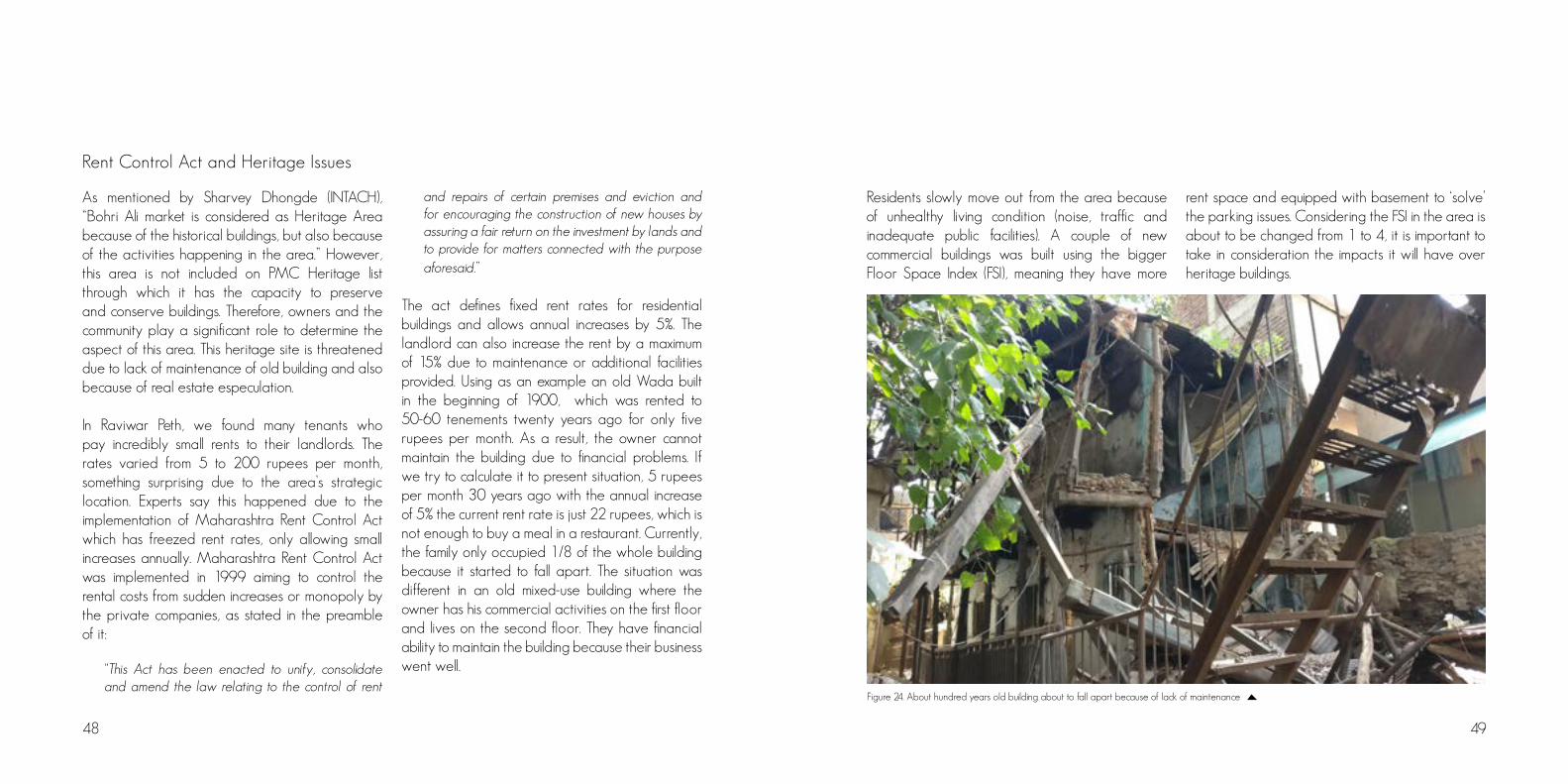
The act defines fixed rent rates for residential buildings and allows annual increases by 5%. The landlord can also increase the rent by a maximum of 15% due to maintenance or additional facilities provided. Using as an example an old Wada built in the beginning of 1900, which was rented to 50-60 tenements twenty years ago for only five rupees per month. As a result, the owner cannot maintain the building due to financial problems. If we try to calculate it to present situation, 5 rupees per month 30 years ago with the annual increase of 5% the current rent rate is just 22 rupees, which is not enough to buy a meal in a restaurant. Currently, the family only occupied 1/8 of the whole building because it started to fall apart. The situation was different in an old mixed-use building where the owner has his commercial activities on the first floor and lives on the second floor. They have financial ability to maintain the building because their business went well.
Residents slowly move out from the area because of unhealthy living condition (noise, traffic and inadequate public facilities). A couple of new commercial buildings was built using the bigger Floor Space Index (FSI), meaning they have more
rent space and equipped with basement to ‘solve’ the parking issues. Considering the FSI in the area is about to be changed from 1 to 4, it is important to take in consideration the impacts it will have over heritage buildings.
Figure 24. About hundred years old building about to fall apart because of lack of maintenance

50 51
Raviwar Peth and the100 Smart Cities Programme
Pune is one of the focus cities of the 100 Smart Cities Programme promoted by the Indian Central Government. Its objective is “to provide for the aspirations and needs of Indian citizens” by providing urban infrastructure. This Programme represents a shift in the way urban planning was until now done in India, as it brings direct intervention from the national government on urban planning and infrastructure, breaking the traditional hierarchy of work in the country, which usually follows the federative centre-state-municipality flow for such initiatives. The plan presented by Pune on its Smart City initiative included projects ranging from river conservation to the enhancement of tax control.
As relevant to our area of study, we could mention mainly mention the Pune Sustainable Transport Initiatives, which include:
Smart Street Project / Street Redesigning, which introduced “Urban Street Design Guidelines”, and proposes the redesign of 100 km of streets in the city - Laxmi Rd among them - by “eminent urban designers”, aiming at equitable allocation of road space for a pedestrian friendly street and an “international quality experience for shoppers”.
Pune Cycling Plan, which aims to make “whatever it
takes to make cycling safe and attractive in pune”, and includes better cycling infrastructure and the implementation of a public bicycle system and wishes to raise the share of cyclists in Pune from 9% to 25%.
Streets for All, which states that “parking is not a right, but a commodity”, aiming to reduce the use of personal vehicles, raising the use of public transportation and therefore releasing at least 10% of street parking area to public uses - “our streets must be designed for all uses they support, capturing the essence of the surrounding locality”.
Most of the projects concretly proposed until now under the 100 Smart Cities Initiative are to be implemented on the proeminent Aundh-Baner-Balewadi corridor - an area in which infrastructure levels are already above the Punekar average. However, if the Programme follows its directives and expands these initiative to all the city, we believe they are integrally aligned with our views for the future of the area, as well as with the intervention proposed by our group.
SWOT ANALYSIS
Diversity of goods and servicesThe area offers a diverse selection of shops and services including jewellery, hardware, festivities equipment, spices, ceramics, kitchen appliances, as well as street vendors selling fruits, vegetables, chai and street food. This makes it vivid and interesting. LocationLocated in the core of the city, it is crossed by the famous Laxmi Rd and accessible from all over Pune. Streets nearby also offer a great variety of clothing, and the Mandai market is just one block away. Beautiful ArchitectureThere are many old buildings of architectural significance in the area. However, some of them are badly maintained, and tend to be torn down if the character these edifications bring to the area is not valorized. (Apparent) Hospitality and HarmonyAs from the people we talked with and interviewed in the area, including residents, shop owners, street vendors, police officer and shoppers, the area seems to be more or less free of crime except from some pocket thiefs now and then. We got the impression that the people living and working in the area had little or non-conflicts with each other. Even the
street vendors selling the exact same goods right besides each other seemed to be good buddies, even sharing teas and lunch with each other. The fact that the area has a high concentration of street vendors keeping an eye on the street day and night is a big contribution for making the area safe and sound - Jane Jacobs’ ”eyes of the street”. Satisfactory Utility Service ProvisionThere were absolutely no complaints about water, sewage and electricity during our interviews. Apparently, there were issues with utility service provision a couple of years ago, and however, over the last two years infrastructure in the neighborhood has improved significantly.
Strengths
Weaknesses
Traffic CongestionTraffic jams were a common sight especially in Jedhe Prasad Rd. and its intersections, this affected vehicle speed such that vehicles move slower than a normal person’s walking pace. Loading and unloading operations are conducted without time restriction.

52 53
DensityThe Floor Space Index (FSI) will increase to four when the metro is implemented. Besides its more obvious view as a threat, the raise of density density could also be seen as an opportunity to valorize Raviwar Peth, as well as an strategy to increase residential use of it.
Pune metroThe planned implementation of the Pune metro will make Raviwar Peth more accessible, reducing the need for motorized transportation to reach it. It might also attract new people to the area.
Opportunities
Public transportationAs of time of visit, the public transportation system in the area was unsatisfactory. There were some bus lines serving the vicinity of Raviwar Peth, but its operation was inadequate and the vehicles in service were in very bad condition. If the public transportation would have been better, the area might not experience so much traffic and its consequences.
Excessive area used as parkingThe very few open spaces existing in the area are usually occupied either by traffic, or by parked vehicles, rickshaw or motor bikes. This makes it even harder for pedestrians to walk through the streets. Those are spaces that could potentially be used as playground for kids and for social and community meeting as well as green spaces. Noise and air pollutionThe area’s intense traffic generates a lot of noise, with the constant sound of cars, motorcycles and rickshaw, as well as its honks, making it exhausting to stay in the area over a longer period of a time. The air pollution originated from these same vehicles is very intense, posing health risks to commuters and residents.
GarbageThough PMC supposedly collects garbage every morning, shop owners and residents have no place to keep the garbage during the day, which makes them pile it haphazardly on the streets. This is negative not only for the aesthetic of the street, but also for the environment in the area, due to peasants, flies and others.
Evasion of residentsResidents tend to move out of the area due to the heavy traffic and chaos in the area. Residences are not well maintained, and when people have to decide whether they want to spend money maintaining the old building they live in, or move out to a new developed area, they rather chose to move. An improvement in the environmental qualities in the area for residents might make the neighbourhood more attractive and make people stay. This would include a holistic approach to solving the problems that exist.
Threats
Decaying environment for shoppingAlthough the commercial character of the area is one of its strengths, the poor environment for shopping due to the previously related problems may reduce people’s interest in shopping on Raviwar Peth. The expansion of closed shopping centres is a reality in Pune.
DensityReal estate speculation might improve pressure over the area, especially over older buildings with architectural significance, which are already threatened due. Besides that, raising density might bring more traffic to the area if shoppers do not adhere to using the metro.
Red Light districtMostly seen as a threat, the role of this prostitution zone located close to our area is controversial. Although it reportedly affects the image of the area and the self-esteem of its residents, when going deeper on the issue, the fact that its existent actually adds to the safety of the area was somehow surprising to us. This is mostly due to the fact that having people around almost 24h a day keeps constant eyes on the streets.
Pedrestialisation of Laxmi RdLaxmi Rd is planned to be car free, meaning that this concept could be extended to more of the area. Considering that the roads in our area are not connecting roads in terms of the city as a whole, and that most of traffic in the area is local, we believe it would not lead to major problems to the surroundings. However, parking outside the pedestrian streets would still be an issue.

55
P R O P O S A L
Figure 25. Illustration showing how Jedhe Prasad Rd. could look like
56 57
to make these streets better places for one to be on a day-to-day basis. To make it more green, to provide it more shadow and protection from rain, so that people can interact or contemplate life. Like it already happens, in an improvised way, on the corners of Bagade Rd.
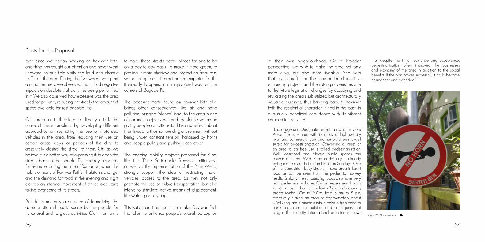
The excessive traffic found on Raviwar Peth also brings other consequences, like air and noise pollution. Bringing “silence” back to the area is one of our main objectives – and by silence we mean giving people conditions to think and reflect about their lives and their surrounding environment without being under constant tension, harassed by horns and people pulling and pushing each other.
The ongoing mobility projects proposed for Pune, like the “Pune Sustainable Transport Initiatives”, as well as the implementation of the Pune Metro, strongly support the idea of restricting motor vehicles’ access to the area, as they not only promote the use of public transportation, but also intend to stimulate active means of displacement, like walking or bicycling.
This said, our intention is to make Raviwar Peth friendlier; to enhance people’s overall perception
Ever since we began working on Raviwar Peth, one thing has caught our attention and never went unaware on our field visits: the loud and chaotic traffic on the area. During the five weeks we spent around the area, we observed that it had negative impacts on absolutely all activities being performed in it. We also observed how excessive was the area used for parking, reducing drastically the amount of space available for rest or social life.
Our proposal is therefore to directly attack the cause of these problems by developing different approaches on restricting the use of motorised vehicles in the area, from reducing their use on certain areas, days, or periods of the day, to absolutely closing the street to them. Or, as we believe it is a better way of expressing it: to open the streets back to the people. This already happens, for example, during the time of Ramadan, when the habits of many of Raviwar Peth’s inhabitants change, and the demand for food in the evening and night creates an informal movement of street food carts taking over some of its streets.
But this is not only a question of formalizing the appropriation of public space by the people for its cultural and religious activities. Our intention is
Basis for the Proposal
of their own neighbourhood. On a broader perspective, we wish to make the area not only more alive, but also more liveable. And with that, try to profit from the combination of mobility-enhancing projects and the raising of densities due to the future legislation changes, by occupying and revitalizing the area’s sub-utilized but architecturally valuable buildings, thus bringing back to Raviwar Peth the residential character it had in the past, in a mutually beneficial coexistence with its vibrant commercial activities.
“Encourage and Designate Pedestrianisation in Core Area; The core area with its array of high density retail and commercial uses and narrow streets is well suited for pedestrianization. Converting a street or an area to car-free use is called pedestrianisation. Well- designed and placed public spaces can enliven an area. M.G. Road in the city is already being made as a Pedestrian Plaza on Sundays. One of the pedestrian busy streets in core area is Laxmi road as can be seen from the pedestrian survey results. Similarly the surrounding roads also have very high pedestrian volumes. On an experimental basis vehicles may be banned on Laxmi Road and adjoining streets (within 50m to 200m) from 8 am to 8 pm, effectively turning an area of approximately about 0.5~1.0 square kilometers into a vehicle-free zone to ease the chronic air pollution and traffic jams that plague the old city. International experience shows
that despite the initial resistance and acceptance, pedestrianisation often improved the businesses and economy of the area in addition to the social benefits. If the ban proves successful, it could become permanent and extended.”
Figure 26. No horns sign

58 59
Bogota opens its streets to the people every Sunday from 7 am to 2 pm. 76 miles of streets are open for the Ciclovía, a program the local government started in 1974. An activist named Jamie Ortiz Marino organized the cities cyclists in 1974 and persuaded city officials to prohibit cars in two central streets. Nowadays, it is not just about cycling, and Bogota has been gradually pedestrianizing streets in the historic center.
During the late 1990s and the beginning of the 2000s, Ciclovía movement went even further under Bogota Mayor Enrique Penalosa and his brother Gil Penalosa who was the commissioner of parks and recreation. They increased the route from 8 miles and 140 000 riders each Sunday to 70 miles and about 2 million riders on average every week. The Ciclovía movement from Bogota sets an example in which other countries soon followed. More than 400 cities around the world have made attempts to make their own radical acts of car traffic suppression. Health researchers say that these programs makes people more active than they would have been otherwise. The program also makes people interact more, with neighboors and other people in the area, as it invites them to come outside, insted of staying indoors all day.
Bogota - The Ciclovía Oslo - Car Free City Centre 2019
Oslo Council had a car-free city centre on their agenda for the election in 2015, and it was decided that until 2019, the centre of Oslo, that is, within Ring 1, shall be a car-free zone. The intention with the project is to create a more stimulating city. The removal of parking spaces and opening of the roads will create space for human-based activities. The area within Ring 1 is 1,9 square kilometers.
The background for the project Bilfri bylivliv is the big city life survey conducted in 2014 in Oslo, which documented the areas in the city where there was a lot of life, but also a lack of activity. The politicians wanted to create more city life to make Oslo a better place to live, and started the Living Oslo project. In extension to this, the new city council has commissioned a comprehensive action program for increased urban life with a ten-year time horizon, car-free city life included as part of this. ”At first many people were skeptical to the project. But when the actors have put forward their views and discussed the solutions, most of them are more positive”, says Hans Edvardsen who is the project director of Bilfritt byliv (ByplanOslo, 2017).
Reference Projects
Street Food ”Festival”, Raviwar PethHappy Street Campaign, India
During our visits to Raviwar Peth, it was mentioned that during the nights of the Rahmadan period, the streets of Raviwar Peth hold what could be considered as a big street food festival.
This happens due to the gathering of street food vendors on the streets of this predominantly muslim area, which move to the area after the sunset to serve the big demand for food from those who have fastened during the day.
The amount of people that join this ”festival” is said to be so large that it prevents the entrance of vehicles, promoting the reunion of the comunitiy by making Raviwar Peth’s streets car-free for at least a period of time.
Happy Street is an initiative by The Times of India which encourages people to come out onto the streets to socialize every Sunday morning. The selected road is open to people for 3-4 hours in the morning, turning it into a free space where anyone can play, walk, jog, and do any kind of activities that they would love to do.
This movement aims to highlight problems which experienced by any city - traffic congestion, air pollution, decreasing number of pedestrian and cyclist.
At that time there will be no honking vehicles, no cars, and two-wheelers passed by. The commercial street will be owned only by pedestrian.
Figure 28 A wide varaity of dises at the street food festivalFigure 27. Happy Street India
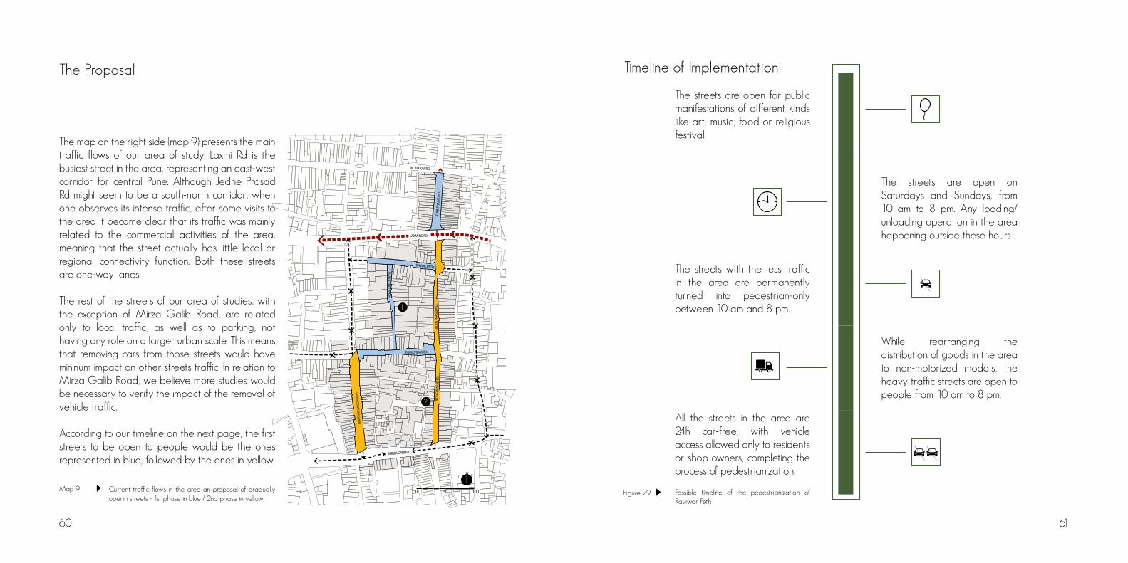
0 50 100
1
2
LAXMI ROAD
JEDH
E PRA
SAD
RD.
JEDH
E PRA
SAD
RD.
JEDH
E PRA
SAD
RD.
RAWAL PETH
THAKURDAS RD.
MIRZA GALIB RD.
BHUT
KAR H
AUD
MAR
G
HONA
JI BAL
A PE
TH
NC KELKAR RD.
Timeline of Implementation
60 61
The Proposal
Map 9 Current traffic flows in the area an proposal of gradually openin streets - 1st phase in blue / 2nd phase in yellow
The map on the right side (map 9) presents the main traffic flows of our area of study. Laxmi Rd is the busiest street in the area, representing an east-west corridor for central Pune. Although Jedhe Prasad Rd might seem to be a south-north corridor, when one observes its intense traffic, after some visits to the area it became clear that its traffic was mainly related to the commercial activities of the area, meaning that the street actually has little local or regional connectivity function. Both these streets are one-way lanes.
The rest of the streets of our area of studies, with the exception of Mirza Galib Road, are related only to local traffic, as well as to parking, not having any role on a larger urban scale. This means that removing cars from those streets would have mininum impact on other streets traffic. In relation to Mirza Galib Road, we believe more studies would be necessary to verify the impact of the removal of vehicle traffic.
According to our timeline on the next page, the first streets to be open to people would be the ones represented in blue, followed by the ones in yellow.
The streets are open for public manifestations of different kinds like art, music, food or religious festival.
The streets are open on Saturdays and Sundays, from 10 am to 8 pm. Any loading/unloading operation in the area happening outside these hours .
The streets with the less traffic in the area are permanently turned into pedestrian-only between 10 am and 8 pm.
While rearranging the distribution of goods in the area to non-motorized modals, the heavy-traffic streets are open to people from 10 am to 8 pm.
All the streets in the area are 24h car-free, with vehicle access allowed only to residents or shop owners, completing the process of pedestrianization.
Figure 29. Possible timeline of the pedestrianization of Raviwar Peth

62 63
Action Strategies
As part of our strategy, the needs of the shops must be considered, as they are important for most of the character of the area. Therefore, reorganizing the loading and unloading process while conducting traffic restrictions is one of our challenges as well. Bhutkar Haud Marg can continue concentrating these activities, with good being distributed from there to other places with handcarts - which could have small electric engines to assist the conductor.
To implement this idea, it is important to think on two other strategies: how to convince shop owners about the benefits of our proposal, as they tend to be very conservative in terms of accepting structural changes which might affect their businesses; and how to make the people of the place - especially the residents - embrace and appropriate from the idea.
Strategies to convince shop owners
Foot traffic is one of the most important measures when it comes to running a shop in a commercial area. As the area is made free from cars on various days and time chosen, more foot traffic means more opportunities for sales and customer engagement, which in turn leads to higher revenues. Most often, traffic situation as a result of vehicular activities
create an atmosphere of excluding people from trading. Atmosphere for shopping will be improved as customer time to observe what is actually being offered for sale is always shortened because they have already spent much time in traffic. After the closure, the road will becomes a more peaceful and prettier place than before as a result of less car traffic on the roads. Customers will have the opportunity to stop and make purchases during their walk knowing there is no need to bother about incoming or outgoing vehicles. Right of citizens and customers will be enhanced creating more mobility and better accessibility to the city centre therefore more efficient use of space. An all-inclusive customer base will be given a boost as children, elderly people and physically impaired customers with the fear of being knocked by moving vehicles can have the opportunity to trade during these periods.
The road will become a large pedestrian area where festivals, art shows and kids play events will be commonly held and make pedestrians go out to enjoy the area leading to a large market base for shops. The removal of cars from the city centre will create a cleaner and safer car-free space which will improve the quality of life for everyone, for those living and working in the city centre as well as pedestrians.
Strategies to promote appropriation of the initiative - creation of a participatory council that will manage the decision on the street use.
We believe it is of extreme importance for the success of this proposal that all stakeholders in Raviwar Peth take part on the process of pedestrianization from its beginning. This means that our intention with this project is to present alternatives for the area, but the final decision about when, where, how and for what street openings should happen has to belong to the community, which will also constantly evaluate the success of the initiative and decide on whether to expand it or not.
Participatory planning enhancing a democratic dialogue and inclusion of all stakeholders will be encouraged. With ideals of inclusion and democracy not resulting in urban space wars, participation will go the extra mile of not only including the same few and relatively strong, consensus-seeking citizens but rather broadening out the perspective to include the voices of children or other traditionally excluded citizens. A holistic approach to attainment of what the area actually portray which is economic, cultural and historical perspective ideas will be sorted. A consultation exercise will be undertaken with all stakeholders in the area. Public meetings with local
groups will be held. The meetings will be use to emphasise the need to consider the longer term benefits of reduced traffic and reduced pollution in the area.
For that, we propose the creation of a participatory council that will manage the decision on the street uses on a democratic and balanced basis, as follows:• 3 representative from the business class• 1 representative from the workers• 3 representative from the residents• 1 representative from the PMC• 1 representative from Civil Society / Academia
The team will be responsible for the success of the street opening thereby ensuring measures that will monitor all possible aspects of the situation before, during and after any trial or first phase. They will be willing and prepared to share all information and consider making a member of the team communications officer for the project to aid in publicity. The team will give careful ear to both positive support and criticism, be prepared to be flexible and make modification in the light of all feedback.
The effective implantation of these ideas will lead

64
to transmogrified vehicle oriented streets into pedestrianised public spaces creating a room for social interaction and economic development. We also believe this strategy could introduce back the sense of community and maybe even expand the roles and attributions of this council towards other spheres of Raviwar Peth’s social life.
Strategies to finance the proposalOpening streets to people is not an initiative that requires much money, with its biggest challenges being actually the appropriation of the proposal, as well as the enforcement of it. Theusrefore, we believe that in order to be able achieve our cause, collaboration with institutions, individuals, associations and philanthropic organizations would be valuable. Acquiring sponsorship from agencies or organisation that have vested interest in our objective will be ideal. Also, to serve and benefit all persons across the city, we will put in place a fund raising and project replication plan to ensure other areas and streets also receive such interventions. The plan will be an annual fundraising from individuals, civic clubs and organizations, corporate funding contributions. This initiative could also be easily inserted in the 100 Smart Cities Initiative, as already mentioned above.
Figure 30. Illustration showing how Thakurdas Rd. could look like

67
ABOUT THE AREA
Pune, a city of major significance for the Maratha History, has grown into a 243 km² municipal corporation from a mere 5 km² region over a span of 166 years (1851 – 2017). From being the birthplace of guerrilla warfare that helped secure the city from foreign invaders and being called a war capital, to becoming today’s ‘Oxford of the East’ Pune has encountered innumerous challenges over the last century. In the present, one of the major tasks at hand is that of managing what remains from the past. Specially to manage what is of historic and cultural importance in the core areas of the city, where the major market places are located as well as slums and squatter settlements. One such area is Raviwar Peth, a wholesale market that thrived as an affluent business center during the time of the Peshwas. It is an urban space shared by diverse communities of professionals with different religious backgrounds, and it is struggling to balance its historical significance, the technological progress, and the unplanned growth. All these issues need an integrated approach involving the known, unknown and the hidden stakeholders. This study aims to capture this very aspect, focusing on the social and spatial dynamics between people and urban space.
Raviwar Peth has been experiencing structural and spatial changes since the 19th century, caused by the influx of new and diverse businesses in the
market nuclei, the market has been gradually changing its typology. New floors have been added to the old constructions through incremental processes, with the purpose of housing or storage, and the busy commercial streets seem to generate an out migration of its residents – becoming even more commercial. During one of the group’s first walk in the area, however, we stumbled on a quiet
Photo 2: Cinthia Stecchini
Photo 1: Håkon C. Vetlesen
GROUP 6

68
residential colony – Durjan Singh Paga. . As a group we were intrigued by this area as it exists in contrast with the fuzziness of the peth, and is not included in any of the available official data. The official map by PMC, for example, shows it as two large residential plots neglecting its smaller plot divisions. The community was very open and welcoming, facilitating our first contacts and further interactions. Through them, we understood that the land is owned by PMC and, although the residents have won the right to live there, none had a regulated tenure situation. The community sense was strong, yet their perceptions of the place and understandings of their situation were diverse; most of the residents had little to no information on their actual situation or rights. This lack of information results in a lack of political voice, making them more vulnerable to manipulation and less able to seek and achieve improvements for their quality of life.
Acknowledging Pune’s history and actual growth, with its resulting problems, traditional urban planning has proven to be unable to cope with the rapid changes and made the city a more chaotic place (Diddee & Gupta, 2000). New aproaches are necessary in order to consider local strengths and diversity, as well as the organicity of spaces and its position in the formal-informal continuum, in a way that the planner can act as a facilitator for social and spatial change.
In this chapter, we will present our study area in Raviwar Peth and, more specifically, Durjan Singh Paga: its history, physical-infrastructural aspects, social organization, as well as its strengths and weaknesses. In India, inadequate provision in sanitation is a frequent problem, and although some improvement has been observed over the last decades, its conditions remain far from satisfactory (Tewari, 2011). This constitutes also the main tangible problem identified in Durjan Singh Paga and, thus, is the focus of our proposal. Through a concrete intervention – the construction of community toilets – our aim is to empower the community, enhancing social awareness and promoting integration with the broader context.
3
5
6 78
1
2
4
9
LAXMI ROAD
JED
HE PR
ASAD
RD.
MIRZA GALIB RD.
MO
ULAN
A A
.K. AZ
AD R
OAD
50m0 100m
SITUATION MAP:
1 : DHARMASHALA 2 : SHRI KRISHNA TEMPLE3 : TAMBOLI MOSQUE4 : SOMESHWAR TEMPLE5 : LAXMI NARAYAN TEMPLE6 : CHATURSHURNGE TEMPLE7 : McDINA MOSQUE8 : BAGHBAN MOSQUE9 : DURJAN SINGH PAGA Map 1.
SITUATION MAP:

70 71
METHODOLOGY
During the preliminary visits to the area, we conducted surveys in order to gain an overall impression and to identify possible conflict points. We also researched about Raviwar Peth’s history and characteristics in available literature and conducted interviews. We mainly spoke to residents and shopkeepers, but we included persons from INTACH and from the municipality. The area was mapped considering land use; nature and dis-tribution of commercial activities; and buildings’ heights. Shopkeepers and street vendors were interviewed with the support of Hindi and Marathi translators. The interviews were semi-structured with questions about their religious and caste/community background; how long the shop/activity has been functioning; where they live; and what their perceptions of the area were.
Once Durjan Singh Paga was defined as the focus of the study, we realized that there was no data on the area, nor was it included on any of the maps prepared by PMC, ArcGIS Server Maps, or Bhuvan, the Indian Government’s satellite mapping system. In initial exploratory walks, interaction with the dwellers was facilitated by their curiosity towards us as visibly obvious foreigners. As there was no previous knowledge on who the residents were, starting from these first contacts the group used the snowball sampling technique to contact others. This method has practical advantages when
the research is qualitative and aims to explore and describe a population (Atkinson & Flint, 2001). Through this, some key actors in the community were identify and interviewed: the president and the vice-president of trust; a former activist for the rights of the Paga, who made the Census of the area in the period of 1971-1991; and a doctor who also played an important role in defending the community. Semi-structured interviews were conducted with these persons and other residents, exploring the community’s history, organization, and relations to the broader contexts; as well as the re-sident’s profile and personal history, focusing on his/her relation to Durjan Singh Paga.
The information and stories collected about the Paga were often contradictory. In order to validate it, a collective strategy was adopted. Separated groups of women, men and youngsters were invited to draw a timeline of the community’s events. This method enabled us to record the changes in a community over time and gave a wider historical context to the issues in discussion (Thomas, 2002). The activity, however, didn’t evolve as planned. A great number of children gathered around the group and it became impossible to draw and discuss. The solution found was to focus, instead, on personal timelines of the residents, recording the main events that occurred to the individual and his/her
family since they came to Durjan Singh Paga. Children and other residents were also present in these occasions and contributed to the person’s narrative. This approach enabled a more complete understanding of the community and its relations, and we were able to ask about structural issues in the Paga as well.
In the next sections, the analysis of the data collected will be presented. Since all the communication was done with the support of a translator, it is important to note that some sentences reproduced might not represent an exact translation of the resident or the interviewee.
Photo 4: Cinthia Stecchini
Photo 3: Cinthia Stecchini

72 73
The land use map (Map 2) is based on the official PMC map that was digitalized by the students of COEP. It defines the formal functionality of the area and shows the legal existence of a property. The map showed a diversity of land use. The area has a mix of purely commercial buildings, public buildings and mixed use. The later meaning buildings that are commercial and residential. A distinction was made by the group between the religious and other public buildings to highlight the presence of temples and mosques spread in the area. There are three mosques, as seen in the situation map (Map 1), while all the others are Hindu temples. Their location, however, is not followed by a higher con-centration of these religious communities in their sur-roundings, and the interviews showed that there’s no predominance of any religious group in a specific area although it is inhabited and used by Hindu, Jain, Bohri and Sunni communities.
Raviwar Peth’s boundaries have remained unaltered since its beginning, the market area has grown vertically through the incremental addition of new floors. This has been a constant change over the past century, while the plot limits remained the same: given the physical and legal constraints there is little room for intervention. Based on the built blocks present in the area, a map showing built and vacant space as well as the heights of the buildings (Map 3) was prepared to understand how the area
around Moulana A. K. Azad road is composed and has evolved over time. Originally, cities in India were designed for little or no automobile use and, in the 17th century, the space designed for lanes was minimal as horses, palanquins and hand carts were the main medium of transportation. This characteristic has remained over time and can be observed in the map: the streets are narrow, and the blocks are densely occupied. In present times, with the use of automobiles, the streets in the area suffer from high traffic congestion.
SITUATION ANALYSIS
: Commercial : Public : Residential
50m 100m25m0
: Mixed : Religous Buildings
Map 2: Land Use Map
Photo 5: Cinthia Stecchini
50m 100m25m0
: Single Storey : 2-Storey : 3-Storey
: 4-Storey : 5-Storey : 6-Storey
Map 3: Hights, Mass And Void Map
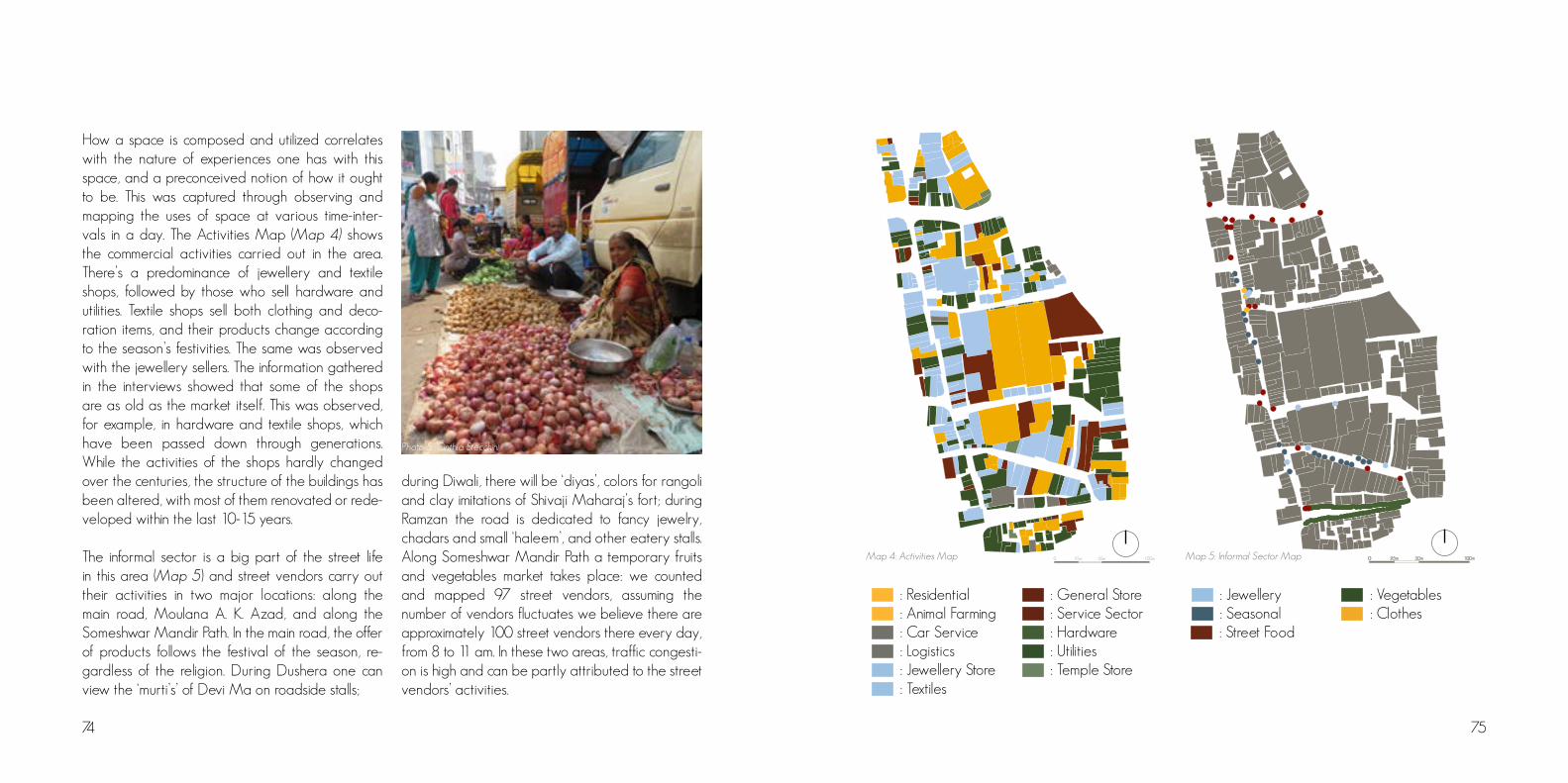
74 75
How a space is composed and utilized correlates with the nature of experiences one has with this space, and a preconceived notion of how it ought to be. This was captured through observing and mapping the uses of space at various time-inter-vals in a day. The Activities Map (Map 4) shows the commercial activities carried out in the area. There’s a predominance of jewellery and textile shops, followed by those who sell hardware and utilities. Textile shops sell both clothing and deco-ration items, and their products change according to the season’s festivities. The same was observed with the jewellery sellers. The information gathered in the interviews showed that some of the shops are as old as the market itself. This was observed, for example, in hardware and textile shops, which have been passed down through generations. While the activities of the shops hardly changed over the centuries, the structure of the buildings has been altered, with most of them renovated or rede-veloped within the last 10-15 years.
The informal sector is a big part of the street life in this area (Map 5) and street vendors carry out their activities in two major locations: along the main road, Moulana A. K. Azad, and along the Someshwar Mandir Path. In the main road, the offer of products follows the festival of the season, re-gardless of the religion. During Dushera one can view the ‘murti’s’ of Devi Ma on roadside stalls;
during Diwali, there will be ‘diyas’, colors for rangoli and clay imitations of Shivaji Maharaj’s fort; during Ramzan the road is dedicated to fancy jewelry, chadars and small ‘haleem’, and other eatery stalls. Along Someshwar Mandir Path a temporary fruits and vegetables market takes place: we counted and mapped 97 street vendors, assuming the number of vendors fluctuates we believe there are approximately 100 street vendors there every day, from 8 to 11 am. In these two areas, traffic congesti-on is high and can be partly attributed to the street vendors’ activities.
: Street Food
50m 100m25m0
: Vegetables : Clothes
: Jewellery : Seasonal
Map 5: Informal Sector Map50m 100m25m0
: Residential : Animal Farming : Car Service : Logistics
: General Store : Service Sector : Hardware : Utilities
: Jewellery Store : Textiles
: Temple Store
Map 4: Activities Map
Photo 5: Cinthia Stecchini

77
DURJAN SINGH PAGA
During the group’s first visits to Durjan Singh Paga, reconnaissance surveys were conducted mainly through transect walks. The group tried to establish connections with people and gather information on the reasons why this community did not exist on maps. When questioned directly, residents classified the Paga as a ‘residential colony’, as opposed to the informal status suggested by its absence in official reports. Initial meetings resulted in very diverse opinions being told about the history of the Paga and the way things work there. Given how closely knit the community appeared to be, this diversification confused the group. These different perceptions, however, started to make sense when, together with the group, timelines of events were drawn by various families and individuals on a sheet of paper, and the changes in the community were recorded based on their personal histories down to generations (Thomas, 2002).
The area was named after Durjan Singh, one of the Peshwa Sardars (commander) who owned an equestrian facility and cavalry on the site. Since then, Paga has had three landowners. About 120 years ago, Mr Tapre and Nagarkar purchased the area from the Marathas and turned it into a full-fledged residential colony to goldsmiths and soldiers. In the early 1900’s, the land was sold to Lohia Seth, a goldsmith who started to collect a rent of one rupee from people residing there.
In the early 1960’s, the corporation acquired this land to build a public hospital and a playground for the Urdu School, located right next to the Paga. The corporation then faced a strong opposition from the residents. For the first time, they formed an association and, with the help of a local Member of Legislative Assembly (MLA), petitioned in court against their eviction. After over three years of judicial processes, the corporation was adjudged to find alternate areas for those plans and to let the people remain in the place. That time, the corporation imposed a monthly property tax of one or two rupees which grew over the years to 25 rupees, being the whole amount – 1.500 rupees – collected every five years. Since it was a large amount, people couldn’t pay it. Therefore, some have never paid the rent in over 20 years.
Rent remains a controversial issue. While some don’t pay it, the amount paid by others, directly to PMC, varies from 25 to 300 rupees. The amount is apparently random, we saw no connection with architectural features or socio-economic conditions. In 2010 after paying nothing in rent for years, one of the individuals we interviewed was asked to pay 57 rupees or be evicted. Additionally, they were charged a 20000 rupee fee. Why the corporation treats the residents differently is unknown, but the treatment of this family shows that there’s some recognition of the community’s existence.Photo 6: Håkon C. Vetlesen
COMPREHENSIVE STUDY
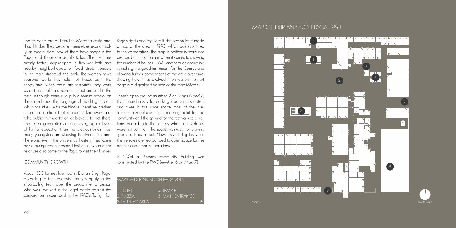
78
XX
XX
1
2
3
3
4
5
5
5
1
Map 6.
MAP OF DURJAN SINGH PAGA 1993
The residents are all from the Maratha caste and, thus, Hindus. They declare themselves economical-ly as middle class. Few of them have shops in the Paga, and those are usually tailors. The men are mostly textile shopkeepers in Raviwar Peth and nearby neighborhoods, or food street vendors in the main streets of the peth. The women have seasonal work; they help their husbands in the shops and, when there are festivities, they work as artisans making decorations that are sold in the peth. Although there is a public Muslim school on the same block, the language of teaching is Urdu, which has little use for the Hindus. Therefore, children attend to a school that is about 4 km away, and take public transportation or bicycles to get there. The recent generations are achieving higher levels of formal education than the previous ones. Thus, many youngsters are studying in other cities and, therefore, live in the university’s hostels. They come home during weekends and festivities, when other relatives also come to the Paga to visit their families.
COMMUNITY GROWTH
About 300 families live now in Durjan Singh Paga, according to the residents. Through applying the snowballing technique, the group met a person who was involved in the legal battle against the corporation in court back in the 1960’s. To fight for
Paga’s rights and regulate it, this person later made a map of the area in 1993, which was submitted to the corporation. The map is neither in scale nor precise, but it is accurate when it comes to showing the number of houses – 162 – and families occupying it, making it a good instrument for the Census and allowing further comparisons of the area over time, showing how it has evolved. The map on the next page is a digitalized version of this map (Map 6).
There’s open ground (number 2 on Maps 6 and 7) that is used mostly for parking food carts, scooters and bikes. In this same space, most of the inte-ractions take place: it is a meeting point for the community and the ground for the festival’s celebra-tions. According to the settlers, when such vehicles were not common, the space was used for playing sports such as cricket. Now, only during festivities the vehicles are reorganized to open space for the dances and other celebrations.
In 2004 a 2-storey community building was constructed by the PMC (number 6 on Map 7),
Not to scale
MAP OF DURJAN SINGH PAGA 2017: 1: TOILET 4: TEMPLE 2: PIAZZA 5: MAIN ENTRANCE3: LAUNDRY AREA

80
1
2
3
6
4
5
5
5
14
Map 7.
MAP OF DURJAN SINGH PAGA 2017
and is used only by the men. The ground floor functions both as storage and cooking place for the street food vendors. It is very dirty, and no resident ever cleans it. On the second floor there are gambling games throughout the day. The rooftop attracts lots of pigeons, which are fed and taken care of by the dwellers. Access to the second floor and the rooftop is made through a side open stair.
Although there is no official data on the demographic growth of the Paga, the lack of space seems to hinder it from happening in a visible scale. According to the residents we interacted with, new families only move in when a house or room becomes vacant. As the families grow, however, they continue to live in the Paga: it’s common that three different generations share the same house. This constitutes the most significant reason for the population growth and to house expansion.
To accommodate the new members, incremental housing is built: a new floor is added to the original construction. Thus, the community has grown more vertically than horizontally since 1993. This has happened both in formal and informal frameworks: some residents went through a process in the PMC when they were about to build it, while most of them did not. Besides this, some new constructions were added on the ground. This results in most of the single-storey houses being formal, while about
MAP OF DURJAN SINGH PAGA 2017: 1: TOILET 4: TEMPLE 2: PIAZZA 5: MAIN ENTRANCE3: LAUNDRY AREA 6: PUBLIC HOUSE
Diagram 1: The evolution of the families and the housing over the generations – the growth of informality.
Not to scale

82 83
building, others – specially the youngsters – believed that the new Durjan Singh Paga would have a mall and leisure areas, including a swimming pool. The plans were old and, although deadlines had been established, there was no sign of execution. The group, then, decided to investigate this issue by asking different individuals about it. The first thing that we found out is that it is not – and has never been – an official PMC plan. The redevelopment plans were introduced to the residents before the elections for the Nagar Sevaks, by the candidates themselves. The elections happen every five years, and the promises for redevelopment came in this same frequency. Residents with a higher level of education or those who are more critical realize that this is just a bargain for votes. The Nagar Sevaks are the intermediators between the PMC and the community and, thus, are Paga’s resident’s main direct link to the city’s governance structure. Realizing that their main intervention in the Paga only happens before elections, using the community as a vote bank, shows how Durjan Singh Paga is neglected even by local governmental authorities.
The relationship with PMC is ambiguous: the land is publicly owned, and the residents won the right to stay there. Yet, the corporation has neglected the place ever since, and there seems to be no interest in acknowledging its status, whether by emitting a slum notification or regulating the existent buildings
and their settler’s tenure condition. The community lies in an undefined situation of formal informality, or of informal formality.
This ambiguity of formal-informal becomes yet more confusing when the provision of infrastructure and facilities is analyzed. Although there’s no legal acceptance of the Paga – the place does not exist administratively – water, electricity and garbage collection are provided. The electric connections are metered, consisting of the resident’s proof that they live in the area. During times of elections, the corporation has also built some facilities: toilets, the community building and a temple.
half of the two-storey and all the three-storey houses are informal. The choice of expanding the house depends on their relation to PMC: if the residents have been paying the rent, they choose to build. The incremental construction is done by hired constructors and is poorly built in the cases the expansion is not formalized through PMC.
The residents also hope for better housing conditions from the PMC: through a state scheme, Punarvasa, affordable housing would be provided to every family who has provenly lived in the area for at least 15 years. According to the scheme, the new building would be constructed on the same site and the area would be equipped with basic infrastructure and facilities. The apartments would have an area 4.5 larger than the original resident’s house: for this, as well, the resident must be able to document the ownership and occupancy of the area, meaning that second and third floors built informally would not be considered.
RELATION TO PMC
This is the story about a neglected present and a promised future. The plans for redevelopment through the housing scheme intrigued the group: families and individuals had different information on what would be provided and when. While some only expected the construction of an apartment
Almost 70% of the residents of Paga, have con-structed incrementally over a period 10-15 years without seeking permission from the PMC. A 2.flo-or, which was already informal, was turned into a 2 floor typology, with families expanding over the years - making the constructions illegal, irrespe-ctive of the number of floors that have been built inside the Paga.
Certain residents of the PAGA, acquired permission from the PMC (1-2 years ago) by paying a certain amount to construct another storey.
Diagram 3: The informal vertical incremental expansion of the typology
Diagram 2: The formalised 2. floor typology
Photo 7: Cinthia Stecchini

84 85
SANITATION
Sanitation appeared as the main complaint to the residents we interacted with. They were not satisfied with the cleanliness of the toilets, which are managed by the PMC. The doctor (Photo 8), a former resident of the Paga who now lives close by, and who was frequently mentioned by the actual residents as someone we should meet, told us that the precarious sanitation conditions are preoccupying. The lack of adequate sanitation and hygiene conditions has brought diseases to the community, such as dengue and other epidemics.
water nor sewage systems, making it necessary for the individuals to discharge their waste in the public toilets. These are, therefore, directly or indirectly used by all the residents.
There are water cranes in all streets of the Durjan Singh Paga, usually at a low height, close to ground, and over a drain. In the mornings, men would walk only covered in towels, carrying a bucket, to shower in these cranes. Water is available from 5 to 10 in the morning, and from 5 to 8 in the evening. The residents interviewed consider that the supply is sufficient for their needs and they have found different ways of storing it for daily use. It is also in the morning that the laundry pool is filled with water and women gather around it to wash clothes. Around 10 a.m., the pool is already empty.
Garbage collection trucks don’t come to the Paga. The residents must gather the garbage themselves and carry it to a dump yard in a street nearby.
The corporation built public toilets in 1984 as part of an electoral promise. The real needs of the residents, however, were not considered: the number of toilets was insufficient to attend the population and, even though demographic growth is small, the demand would continue to rise. In 2008, again as a result from an electoral promise, the toilets were renovated.
There are 20 toilet cabins in total, distributed in two buildings(Photo 9), each of them with gender separation and no electricity. The toilets consist of holes on the ground, with no connection to water or sewage systems, and depend on being cleaned daily to function adequately. The residents need to bring a bucket of water to flush the toilets. For the cleaning, the PMC hired one person who should come daily to the Paga. This person, however, hardly appears to do his/her job and there’s no official control of the quality of the work.
During our visits to the area, it was observed that the smell of the toilets was strong, and, because of that, residents would often tell us not to be so close to the buildings. Small children would rather defecate on the ground than enter the toilet buildings, afraid of the dark and bad-smelling cabins. Some families have started to make their own toilets in their homes. The system, however, is not different from the one that already exists: although there’s a more private space for defecation, it is neither connected to
This dump yard is not officially recognized by the PMC but, as the lanes are narrow, the truck is only able to drive in the main roads of Raviwar Peth, thus the corporation has hired individuals to collect the garbage from these informal points and take them to the main roads.
SOCIAL ORGANISATION
In Durjan Singh Paga the sense of community is strong: the residents the group interacted with consider themselves as a big family in which one is always ready to help another. When asked about what they like the most about the Paga, or what is its strongest point, the answer would always be the same: the community sense.
Although there are no declared community leaders, some organization is observed in the planning and realization of festivals, which is done by the local trust. The women play an important role organizing and managing the finances of the Paga through saving schemes. These two organizations are responsible for the main activities and functioning of the community life. The trust also establishes social links between the community and its larger contexts: Raviwar Peth, more immediately, and Pune.
The strength and quality of the interpersonal relations is evident inside Durjan Singh Paga. Photo 8: Håkon C. Vetlesen
Photo 9: Cinthia Stecchini

86 87
However, although the trust and the saving schemes discuss the community problems at some level, there’s not a common organization that incorporates all the different voices to understand better the community and struggle for improvements. In a formal political sense, the link between the residents and the municipality is weak, made mainly through the Nagar Sevaks.
THE TRUST
The Ganesh Seva Mandal trust is responsible for the planning and organization of the festivities. They are also the first to be contacted in case there is any problem in the Paga: if it is not possible to solve it within the community, the Nagar Sevaks are then contacted. The trust is subdivided into two other trusts, with a total of 12 members each, being four of them common for both: the president, two vice presidents, and the treasure holder. Elections for these roles and for the admission of new members should happen every five years but that has not happened since the year 2000, when the actual president and board assumed. New members are selected only when one from the current group resigns. Instead of having a democratic process for the selection, the actual members select the new one based on his popularity and on his activities performed in the community, such as volunteering for different tasks. All the members are over 40
To help with their promotion and maintenance, the trust has also provided services for larger events in special occasions, such as providing food for guests when the Prime Minister of Culture visited Pune; and providing financial and human resources for the cleaning of the city’s Golden Temple. The most important festivals they organize, which are joined by people from the whole Raviwar Peth, are the Republic Day, on January 26th, and the Gyaneshwar Maharaj’s Pravachana’s in November.
SAVING’S SCHEMES
The women in Durjan Singh Paga are responsible for the savings schemes, which are organized in three different levels: personal, smaller groups and communitarian. The personal schemes are done directly with a bank, which gives about 60 to 80 thousand rupees to the women at lesser interest rates. This is done according to the women’s and her families’ needs and possibilities. The women are also organized in smaller groups of five, who collect money with a monthly goal of 1000 to 2000 rupees. There are seven of these groups, formed accordingly to where they live. They meet weekly to discuss the money collection and management, as well as possible problems encountered. In this case, the savings don’t go through a bank and the money is given to the woman who most needs it in the end of the month. In case there are no specific
needs, the choice is done through lottery. The communitarian saving scheme has the goal of collecting around 600-700 rupees monthly and the collected money goes for the whole Paga to be used according to possible problems that appear. This scheme works in the Janlaxmi’s savings scheme model, which goes through a bank.
THE NAGAR SEVAKS AND PMC
The Nagar Sevaks are corporators and act as mediators between the PMC and the people. Raviwar Peth, together with Rasta Peth, elects three
years old, there’s no participation from the youngsters. Women are only accepted temporarily as a member of the trust: during the organization of the Gyaneshwar Maharaj’s Pravachana’s, that occurs annually for two weeks starting in the first Sunday of November. Women can participate, however, assuming different tasks during the festivals – something that is open for all Paga residents, who are also invited to propose ideas that, if accepted by the trust, will be incorporated during the cele-brations.
The trust and the festivals are financed by the money collected in Raviwar Peth. Residents and shopkeepers, regardless of their religious background, contribute with different amounts.
Photo 10: Håkon C. Vetlesen
Photo 11: Håkon C. Vetlesen

88 89
corporators every five years. The latest elections happened this year, in 2017, and the residents reported that the current Nagar Sevaks were very active before the election, but ever since it has been difficult to contact them, and nothing has been done in the community. One of the reasons for the Nagar Sevaks’ unavailability, according to the residents, is that they don’t live close to the Paga. Moreover, the residents receive frequent promises regarding the redevelopment of the area before every election: throughout the years, candidates have presented different housing schemes and their execution plans with deadlines for the next five or ten years. However, once they are elected, these plans cease to be discussed. As mentioned previously, this year’s promised housing scheme was the Punarvasa. The most frequent complaint by the residents is about the cleanliness of the public toilets, which were supposed to be cleaned daily by one person hired by the PMC. This worker, however, has been to the Paga only every second or third day, and the quality of the work is poor. The community has contacted the Nagar Sevaks about this, but no measures were taken.
THE PRESENT VS. THE FURURE
When asked about their perceptions of the Paga, the residents’ responses were always the same: “we like it in here”. The community sense was pointed
out as their main strength, followed by a sense of freedom that life in the community gives them. Besides the complaints about the cleanliness of the toilets, there was nothing they considered as bad or that could be improved. Some conversations were, however, contradictory:
Group: - What is good about the Paga?
Youngster: - The community sense.
Group: - Is there anything that could be
improved?
Youngster: - No, it is good as it is.
Group: - What are your plans for the
future?
Youngster: - To find a good job and move
out from this mess.
corporators every five years. The latest elections happened this year, in 2017, and the residents reported that the current Nagar Sevaks were very active before the election, but ever since it has been difficult to contact them, and nothing has been done in the community. One of the reasons for the Nagar Sevaks’ unavailability, according to the residents, is that they don’t live close to the Paga. Moreover, the residents receive frequent promises regarding the redevelopment of the area before every election: throughout the years, candidates
This same youngster mentioned that about 25 years ago the community was chaotic, but things have started to improve because the new generations are becoming gradually more educated. In other conversations, this was confirmed as most of the youngsters are studying to get their bachelor’s degree – differently than their parents and grandparents, who had, at most, basic education. Once they graduate, their plan is to move somewhere else as they consider that good job opportunities cannot be found in the area. As culturally the families continue together throughout life, parents we interviewed were willing to move out to provide better opportunities for their children, even though all their life and relations were consolidated in the Paga. Investigating further this, it
became clear that what triggers this will to move out is not directly related to job opportunities, as Raviwar Peth is well located and Pune has been growing at fast rate. There is, however, a will to change life quality standards. Comparisons with the “developed world” were frequent in their speeches, especially because one of the group members is from Europe. “Developed world” or western culture standards are the ones they get from different communication media and are, therefore, the ones they long to have and live in.
Nevertheless, they were very proud of their history, culture and values; meaning that a whole substituti-on of lifestyle is not what they want. The youngsters were very critical and acknowledge that there are means to improve which are misused, as could be summed up in a phrase said by one of them:
- Why does the PMC want to
build a SmartCity when they
can’t even provide good toilets?
Photo 12: Cinthia Stecchini

90 91
Durjan Singh Paga is a calm and yet lively area, immersed in and contrasting with the busy commercial lanes of Raviwar Peth. The community sense is strong, and the residents have good relations with each other. Although historically there has been an activist identity in the Paga, nowadays they are politically isolated from broader contexts and, as the shopping areas around are losing their residential character, the community functions as a vote bank for corporators. Their relation to PMC is weak and confusing and the lack of information on the area, by the residents themselves, makes them more vulnerable to manipulation and hinders an active search towards improvements. For the community to strengthen its positive aspects and improve the negative ones, it is important that the residents gain more confidence and take respon-sibility for solving the problems they recognize. How to enhance social awareness and empower DSP residents? How to mobilize their strengths – such as the community sense, their place identity, the activist past, the youngster’s ideas – to achieve impro-vements and make Durjan Singh Paga seem more attractive to the newer generations, as well as to enable and enhance political voice? Our proposal approaches these questions through proposing small, incremental interventions – the rehabilitation of the community toilets – that could trigger change and enable community empowerment.
Sanitation and, more specifically, the toilets were chosen as the object of intervention as this was the main palpable complaint from the residents. Differently than what is seen in precarious and informal settlements, where the toilets are fixed to enable a cleaner environment, in Durjan Singh Paga the environment is clean, but the toilets are not. Residents have started to come up with solutions themselves, such as having a toilet home. These are, however, not satisfactory. The fact that PMC built and still manages these facilities leads to a lack of feeling of belonging and problems relating to them are not solved within the community: PMC’s intervention is requested and expected, sometimes taking a long time until a solution is found. The toilets are, thus, considered public, not communitarian.
PMC acknowledges sanitation as one of Pune’s main problems. About 24.000 properties in the city do not have access to a toilet within walking distance. In 2011 the city proposed the construction of new toilets and maintence of the existing ones, but funding was limited (PMC,2011). To supplement funding PMC enaged external actors, such as Aadhar Poonawala, a private organization that has previously supplemented PMC’s work through the Clean Pune Initiative; and the NGO Shelter Associates, that has previously worked to empower and bring communities together through the building and management of toilets (Hobson, 2000).
Our proposal aims to empower the residents by bringing the ownership of the toilets back to them, as the perception of ownership can bring positive synergies for the future (Kumala Sari, 2004). The proposal is presented as a plan which includes the participatory design, building and establishment
of a maintenance plan for the toilets. The upgrade of the Paga should start with initiatives from the residents, and upgrading the sanitation conditions can trigger further actions and strengthen their organization which, consequently, can enable them to fight for more rights.
Photo 13: Cinthia Stecchini
PROPOSAL

92 93
COMMUNITY SENSE
Elder residents from Durjan Singh Paga proudly tell about how the area was before, how close the families and individuals were and how promptly they would help each other. The sense of community remains and is still pointed out by the settlers as their biggest strength. What they have today is probably a result of these past experiences and, especially, of their previous common struggles such as the activism observed in the 1960’s. The community feeling is, perhaps, their most prominent strength. Mobilizing this force is advantageous to successfully implement the sanitation project. As a consequence, the fight for their rights could tighten even more bonds. Through working towards a common goal, they can build something greater together.
By being the residents the main leaders and managers of the process, our goal is to bring the ownership back to them, securing that the settlers take care of the toilets and, through this, they come even closer to each other.
OWNERSHIP AND SHARED RESPONSIBILITY
The magic of toilets is that everyone uses them and, therefore, everyone has an opinion about them. The situation in the Paga is precarious when it comes to hygiene and sanitation. The toilets’ maintenance is poor because of the PMC’s neglect and the settlers’ habits. To improve life quality, the rehabilitation of the toilets must be done in such a way that the residents get a sense of ownership of it (Patel, 2004). The cleaning, organization and management of the toilets should be done by themselves, since it is those who use the toilet that know how the present situation is (Photo 15) and how it can be improved for the future. Therefore, the residents should take responsibility for their environment. It could be hard to establish a thought that their sanitation blocks doesn’t need to be dirty, but if they are clean and well-cared for, they become points of congregation. The next step is the realization that the whole Paga does not have to be a dirty place, but it has the potential to be a beautiful community for its people in which there is enough space for everyone to live in, including the upcoming generations.
Our proposal is a draft project that contains general guidelines, which are affordable and realistic, to empower the residents of Durjan Singh Paga. They will work together to rehabilitate or reconstruct the sanitation blocks. The main actors are the residents themselves, who will assume the roles of leaders and managers, and whose participation is essential for the project to be sustainable and impact the community generating long-term results. An organization – named here as Durjan Singh Paga Sanitation Company – is proposed to plan and manage the implementation and maintenance of the project, even after the building process is completed. Specialists in some areas – such as urban planning, sanitation, business, urban rights – can participate in different stages providing support for the residents and organizing workshops to build and strengthen the residents’ knowledges and skills, thus acting as facilitators. For the project and for the company, we identified possible financial funding and we envision the possibility for them to grow further and constitute other businesses. Through the project it is also expected that the relationship with PMC will be consolidated and the formal-informal ambiguity can be solved.
In this draft project, the key elements and concepts will first be presented, followed by three identified funding sources. We also present two conceptual design proposals for the sanitation blocks.
It is important to note that the proposal was elaborated based on the data collected and analyzed so far, and it hasn’t been validated with the residents – something essential for the project to succeed.
EMPOWERMENT
The rehabilitation and development of the toilet to new standards will be planned and built together with and within the budget of the people in the Paga. As they work as initiators, they can apply the knowledge and experience gained in this project to further implement other similar initiatives for the community. Some of the expected outcomes are: to allow people to work together; to include the women in decision making; to lift the practical and money handling skills in the community; to make way for the people to enjoy the results of common work; and to improve their sanitation conditions.
Photo 14: Cinthia Stecchini
Photo 15: Cinthia Stecchini
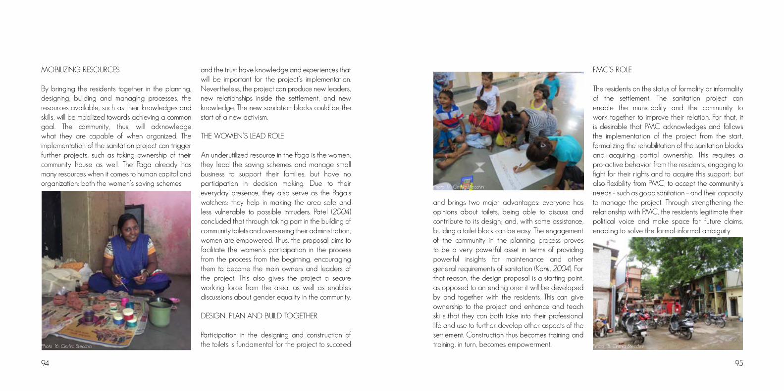
94 95
MOBILIZING RESOURCES
By bringing the residents together in the planning, designing, building and managing processes, the resources available, such as their knowledges and skills, will be mobilized towards achieving a common goal. The community, thus, will acknowledge what they are capable of when organized. The implementation of the sanitation project can trigger further projects, such as taking ownership of their community house as well. The Paga already has many resources when it comes to human capital and organization: both the women’s saving schemes
and the trust have knowledge and experiences that will be important for the project’s implementation. Nevertheless, the project can produce new leaders, new relationships inside the settlement, and new knowledge. The new sanitation blocks could be the start of a new activism.
THE WOMEN’S LEAD ROLE
An underutilized resource in the Paga is the women: they lead the saving schemes and manage small business to support their families, but have no participation in decision making. Due to their everyday presence, they also serve as the Paga’s watchers: they help in making the area safe and less vulnerable to possible intruders. Patel (2004) concluded that through taking part in the building of community toilets and overseeing their administration, women are empowered. Thus, the proposal aims to facilitate the women’s participation in the process from the process from the beginning, encouraging them to become the main owners and leaders of the project. This also gives the project a secure working force from the area, as well as enables discussions about gender equality in the community.
DESIGN, PLAN AND BUILD TOGETHER
Participation in the designing and construction of the toilets is fundamental for the project to succeed
and brings two major advantages: everyone has opinions about toilets, being able to discuss and contribute to its design; and, with some assistance, building a toilet block can be easy. The engagement of the community in the planning process proves to be a very powerful asset in terms of providing powerful insights for maintenance and other general requirements of sanitation (Kanji, 2004). For that reason, the design proposal is a starting point, as opposed to an ending one: it will be developed by and together with the residents. This can give ownership to the project and enhance and teach skills that they can both take into their professional life and use to further develop other aspects of the settlement. Construction thus becomes training and training, in turn, becomes empowerment.
PMC’S ROLE
The residents on the status of formality or informality of the settlement. The sanitation project can enable the municipality and the community to work together to improve their relation. For that, it is desirable that PMC acknowledges and follows the implementation of the project from the start, formalizing the rehabilitation of the sanitation blocks and acquiring partial ownership. This requires a pro-active behavior from the residents, engaging to fight for their rights and to acquire this support; but also flexibility from PMC, to accept the community’s needs – such as good sanitation – and their capacity to manage the project. Through strengthening the relationship with PMC, the residents legitimate their political voice and make space for future claims, enabling to solve the formal-informal ambiguity.
Photo 16: Cinthia Stecchini
Photo 17: Cinthia Stecchini
Photo 18: Cinthia Stecchini

96 97
FINANCIAL FUNDING
Financial resources are necessary to start and finalize the project, as well as to ensure its continuity once the sanitation blocks have been constructed. For that, three possibilities have been identified (Diagram 4): the women’s savings schemes, which can further develop new enterprises related to sanitation and thus raise the money collection, a renting system for the residents and support from PMC. The project can succeed with only one of these resources, but with the three funding will be safe and secure.
Diagram 4: The management of the toilets on a partial ownership agree-ment between the Women – The Durjan Singh Paga Sanitation Company, the residents and the PMC
PMC
It is suggested that the residents’ form a sanitation board to manage the sanitation blocks. This can further develop to the ‘Durjan Singh Paga Sanitation Company’, with the possibility to invest in other businesses as well as to open the toilets for public use through the collection of a fee.
WOMEN’S SAVINGS SCHEMES
The project can benefit from the women’s seven saving schemes groups: there’s already an established democratic system that can be further developed and expanded. The management of the project can be organized through a system in which the seven groups are represented (Diagram 5). Each group will have one seat in the sanitation board, managing the implementation and maintenance of the project. The women become, therefore, shareholders and owners of the sanitation blocks. Moreover, a ‘Durjan Singh Paga Sanitation Company’ can be stablished to enable the development of other businesses related to hygiene by the women, such as production and sale of soaps or consultancy for other communities who have a similar situation to the Paga’s in the presence. The savings schemes allow them to take the risk required, providing them with financial security. A possible outcome could be that the business can evolve and become a shop or another creative enterprise.
RENTING SYSTEM FOR THE RESIDENTS
The women can take a monthly fee for the use of the toilet. In the slum Shirole Vasti the dwellers pay a monthly fee of 75 rupees per house to an external company that cleans the toilet. A similar system can be stablished in the Paga, where each house pays a stablished amount to the sanitation board, securing an income that can maintain the toilets. There will be transparency and trust, as the residents know the ones they are paying to and how the money is used. This system enables a direct quality control
DURJANSINGH PAGASANITATIONCOMPANY
Diagram 5: The Social Organisation of the Inclusion of “The Mahila Bachath Program” into the Durjan Singh Paga Sanitation Company
by the users. Once the system is stablished and functioning, according to the inner demand and the board’s management capacity the toilets can be opened for public use at a charge defined by the sanitation board.
SUPPORT FROM PMC
Today, PMC is paying a person from outside the community to wash the toilets every day. This person, however, does not attend to work and there’s no control of the quality of what is done. The community can argue on that, convincing the PMC that the salary paid is not evolving into any work or result, and thus it would be a better investment to pay directly to the residents of the Paga to do the work instead.
Photo 19: Cinthia Stecchini

98 99
BETTER TOILTES, BETTER QUALITY OF LIFE
The United Nations Human Rights Council (2010) recognized water and sanitation as a basic human right, inextricably related to the right to life and human dignity. The provision of such, however, constitutes a major problem in developing countries, as well as maintaining them to certain standards and ensuring long-term functionality. In Durjan Singh Paga the toilets are one of the biggest concerns, both because they are not connected to water and sewage systems and because of its cleanliness and maintenance. Children also defecate more often on open ground rather than use the available cabins.
SANITATION 2017
The key issues identified as unsatisfactory by the youngsters in the Paga were the sanitation and their undeveloped offer. Cleaner and better facilities is what most of the people say they miss and the residents want facilities that can provide them with modern and adequate sanitation.
What are modern facilities and how can they help make people want to stay in the area? A minimum demand is water facilities that should be offered 24/7, but the youth demands more. Most papers about public sanitation only concern toilets.
However, in a modern world where we always see pictures from all over the world, we get a perception of what is modern and for a lot of people shower is the demand for good sanitation. In the Paga, men would use the water taps to shower themselves with the help of a bucket. This made us aware of the need for a satisfying washing area and, thus, question ourselves: is it possible to offer shower facilities as well?
CONCEPT
Our design proposal is not a final draft, rather we present two possible floor plans (Prototypes 1 and 2) for the rehabilitation or reconstruction of the sanitation blocks. These two possibilities should be presented to the residents and discussed with them, for further development of the design. This will function as a starting point to a participatory process leading to a final design. The two design drafts will be used as a checklist for how it can be arranged. To make a project that is successful requires that we can bring the population in the design process and, therefore, it’s important to stablish an adequate framework.
The proposed conceptual sanitation block is a two-storey building with a water tank and collector on the rooftop. This will be built on the same site as the present toilets, which will have their conditions
0 1m 2m
0 1m 2m
SANITATION BLOCK PROTOTYPE 1
Separate entrances and stairs to the genders.
Plan 2. Floor.
Plan 1. Floor.
0 1m 2m
0 1m 2m
Plan 2. Floor.
Plan 1. Floor.
SANITATION BLOCK PROTOTYPE 2
Common stair into the showers for both genders.
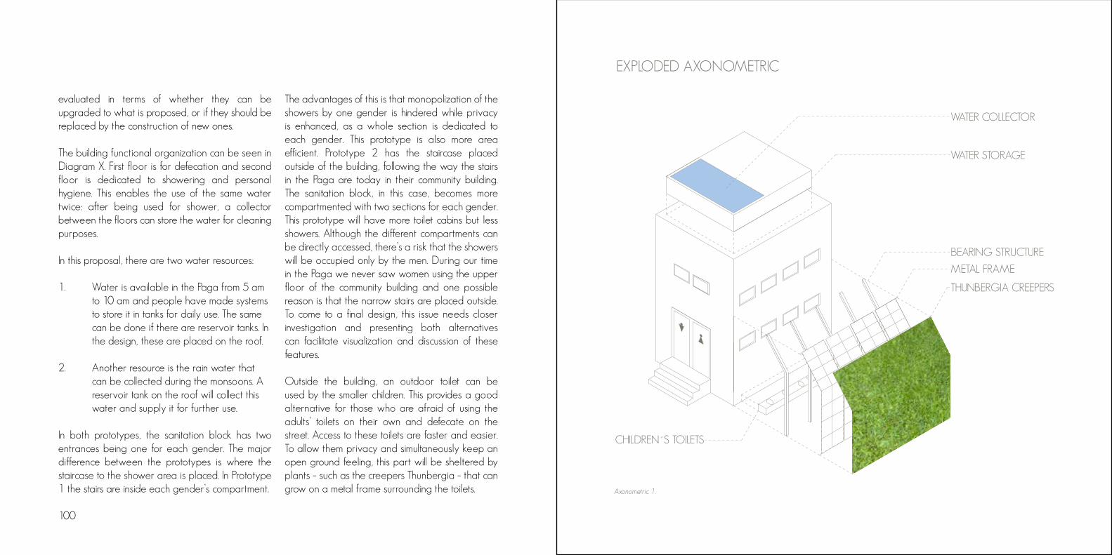
100
WATER COLLECTOR
WATER STORAGE
BEARING STRUCTURE
METAL FRAME
CHILDREN´S TOILETS
THUNBERGIA CREEPERS
EXPLODED AXONOMETRIC
Axonometric 1.
evaluated in terms of whether they can be upgraded to what is proposed, or if they should be replaced by the construction of new ones.
The building functional organization can be seen in Diagram X. First floor is for defecation and second floor is dedicated to showering and personal hygiene. This enables the use of the same water twice: after being used for shower, a collector between the floors can store the water for cleaning purposes.
In this proposal, there are two water resources:
1. Water is available in the Paga from 5 am to 10 am and people have made systems to store it in tanks for daily use. The same can be done if there are reservoir tanks. In the design, these are placed on the roof.
2. Another resource is the rain water that can be collected during the monsoons. A reservoir tank on the roof will collect this water and supply it for further use.
In both prototypes, the sanitation block has two entrances being one for each gender. The major difference between the prototypes is where the staircase to the shower area is placed. In Prototype 1 the stairs are inside each gender’s compartment.
The advantages of this is that monopolization of the showers by one gender is hindered while privacy is enhanced, as a whole section is dedicated to each gender. This prototype is also more area efficient. Prototype 2 has the staircase placed outside of the building, following the way the stairs in the Paga are today in their community building. The sanitation block, in this case, becomes more compartmented with two sections for each gender. This prototype will have more toilet cabins but less showers. Although the different compartments can be directly accessed, there’s a risk that the showers will be occupied only by the men. During our time in the Paga we never saw women using the upper floor of the community building and one possible reason is that the narrow stairs are placed outside. To come to a final design, this issue needs closer investigation and presenting both alternatives can facilitate visualization and discussion of these features.
Outside the building, an outdoor toilet can be used by the smaller children. This provides a good alternative for those who are afraid of using the adults’ toilets on their own and defecate on the street. Access to these toilets are faster and easier. To allow them privacy and simultaneously keep an open ground feeling, this part will be sheltered by plants – such as the creepers Thunbergia – that can grow on a metal frame surrounding the toilets.

102
Axonometric 2.
Our proposal is based on the data collected and analyzed during the two months of the fieldwork. As there was no official data on Durjan Singh Paga and time was limited, our approach was rather qualitative than quantitative. Most assumptions are, therefore, based on the residents’ stories and perceptions. Cultural differences and language also appeared as a limitation. The support from a translator, although made our work possible, results in possible losses in communication and interpretation.
Nevertheless, it was possible to realize that the way urban planning is conducted in Pune, especially as the city grows fast, is insufficient to deal with all the problems that appear. This was very well captured by the youngster who questioned the meaning of the Smart City Mission when basic infrastructure and services are not provided. Smaller communities, as Durjan Singh Paga, function as vote banks and don’t have their basic needs fulfilled. Despite their historical value, they also risk disappearing. A closer approach – area based – is necessary to address this communities and facilitate their empowerment, giving them political voice. The formal-informal relation is also very confusing in India, and the polarization of both is far from enough to capture the nuances: the Paga is owned by the PMC; the residents have the right to live there; some infrastructure and facilities are formally
by the PMC; the residents have the right to live there; some infrastructure and facilities are formally provided; but the tenure remains informal. Having a clearer understanding of the functioning of this ambiguity enables empowerment of the residents and their further engagement in struggling for their rights.
In the Paga, a start point for this discussion was identified in sanitation, the focus of our proposal. Although we present a draft, with general guidelines, our intention is to mobilize the resources already available in the community to facilitate their autonomy in the struggle for rights and fulfilment of their needs. The proposal is, thus, humble and general, as we acknowledge that our role should be that of facilitators in this process. Therefore, it is desirable that this draft could be validated through discussions with the residents of the Paga before becoming a final plan.
DISCUSSION

Figure 31. View from the roof of Hotel Staywell
CONCLUSION

106 107
The works presented are the result of two months of fieldwork in two areas that, although adjacent, complemented each other and showed relevant differences. On a traditional technocratic urban planning approach, these differences would probably become a number on spreadsheets, or be dissolved as a blur on its large scale maps. But Urban Ecological Planning (UEP) proposes we, urban planners, should approach it differently. We believe that Urban Planning must be done not only from offices, but through field visits, thorough observation and real interaction with the communities we are willing to work on. We must also go beyond approaching urban issues by looking at them as pieces of a puzzle, in a sectorial way, in which you have expert teams working in their specialties, where housing is seen as a separate issue from mobility, as an example. Planning must be done by people with different approaches to urban situations working together.
This may not be the easiest approach, but cities of today have become very complex structures, formed mostly by a formal-informal continuum that does not allow planners to think of them simply as a cartesian mechanism. Thus, approaching cities as an organism, something under constant formation through human action, has become necessary to be able to pinpoint the urban issues, so to understand their problems in a structural, deep-to-
the-roots way. Through real interaction, reaching realistic, down-to-earth solutions for urban issues is also easier, and allows us to go beyond the traditional, technocratic proposals. It is a fact that the UEP approach is not an obvious one in a world where we got used to promises of big, impacting solutions for our quotidien problems. It is not a coincidence that these promises are usually made by the ones our communities feel abandoned by - the municipalities and the politicians.
A proof of that lack of obviousness of the approach is that, if we had left Raviwar Peth with our initial impressions on the area, we would have kept with very superficial impressions of the area - that it is an unsolvable, chaotic traffic jam. But some time of interaction, and after adjusting our points of view, our understanding over it expanded itself radically.
Day after day we collected new information, discovered places, and listened to stories from people with a variety of backgrounds and relations with the area. Week after week we were able to identify range of issues that affected these people and their daily lives, and that would go from local sanitation needs through city-wide changes in residential and shopping dynamics. Our perception of Raviwar Peth gradually expanded, and after two months of work, we can definitely say that it is very different from the initial perception.
One thing that must be mentioned is that this exercise of understanding our area of studies was simultaneously an exercise of taking ourselves out of the box. Being in touch with a different urban environment than we are not used to, dealing with a community with values, structures and a language to which we were not used to was an everyday challenge. This made us reflect very frequently about our previous working experiences, our personal values and, most important, about what is our role as professionals, and how we position ourselves to put it into practice. And this is maybe one of the biggest exercises we had, which was to step out the traditional specialist-centered position of proposing, to a community-centered approach.
This community-centered approach could also be called a bottom-up approach - in contradiction to the traditional top-down approach we are used to, that is, when the government puts itself in the role of deciding for the community. A bottom-up approach, though sometimes more complex due to the necessity of involving different stakeholders on the process, has the enormous potential of bringing area-based solutions, that actually fit the context they were thought for. It also promotes appropriation from the users for that solution, as well as it helps build a sense of community among them. It is important to mention that there were also limitations during the process, as was already
commented in this report. Approaching communities is not easy especially for the purposes we had, as there is a lack of trust over external interventions, which we could say is probably due to frustration with previous governmental approaches that might had no or bad results. This is especially true when we talk about communities which are economically and socially more fragile. Each group has thus achieved different levels of interaction with different stakeholders of the community on its area.
Beyond the above mentioned differences, it was common to both groups that the language and the cultural barriers were certainly our biggest limitation. The first limitation was partially overcome with the use of a translator. However, on the questions of culture, for example, there was a recurrent difficulty in approaching women for interviews, what makes the results of our research stratified to the point of view of men. We have the feeling that, with a more comprehensive understanding not only of Raviwar Peth, but also of the Indian society, we could have gone deeper on our situational analysis as well as formulated a proposal that could promote an even bigger sense of appropriation. We also left the field with the sensation that more could have been extracted of it, but considering our lack of experience with the UEP approach, we now see that we might have been able to organize ourselves better. Some additional time to validate
108 109
our proposals in situ would have also been of high value. These limitations serve, however, for us to understand the challenges that we will face in our professional lives during which the conditions of work tend to always be away from an ideal.
The questions our analysis has identified in Raviwar Peth are not new, and also do not happen exclusively in Pune, nor in India. The emptying of city centers and the decaying of its residential structures has been a global issue for many decades, especially due to the search for quieter, “cleaner” neighbourhoods, potentialized by the more and more facilitated access to private transportation, in a phenomenon called suburbanization. This has led to a range of consequences easy to be seen. Traffic conditions are constantly worsening, while we face the substitution of quality space for socialization in city centres for parking. Air pollution and noise levels raise constantly, transforming the experience of being in a city centre in something exhausting. The economic decayment of the central areas, especially the residential ones, leads to an informalization of the habitat, adapting houses to formats that are inadequate to live in - with sanitary issues coming in consequence of that.
But during this process, city centres never lost its main attractiveness: location. And this is also why despite all the decay, they continue being hubs
for services and commercial activities, as well as having a higher than average offer of jobs.
With the belief that these qualities can actually potentialize the quality of life, we used the UEP approach to elaborate an area and community-based proposal on how to enhance life quality in city centres and the attractivity of Raviwar Peth not only as a shopping area, but also as a place to live. More important than that, we tried to think about solutions that improve community feeling and empower people to look for continuous improvement of their neighbourhoods.
It is important to note that choosing what to propose was also defying to us. Community centres, parklets, playgrounds - variety of demands is to be found on the field, as we are talking about communities and areas that suffer from decades of lack of public investment. As we have produced separate Situational Analysis, with each group reporting over a different part of Raviwar Peth, the paths we followed towards our proposal was also different.
Group 5 reached the conclusion that opening the streets to people will create a pedestrian friendly environment, resulting in a long term reduction in air and noise pollution, while also improving the quality of life for everyone. As putting an end to evasion of residents is the group’s priority, opening
up the streets also allows residents and pedestrians to realise the beautiful architecture and brings a sense of accomplishing a social value as well. Although the proposal intends to create belonging, it will certainly be confronted with various forms of resistance, especially from shop owners. But the group believes that an all-inclusive approach can result in an increase of revenue and creation of a wider market. To ensure the proposal is executed successfully, the group proposes the creation of a participatory council to include all stakeholders on the monitoring of all aspects of the situation before, during and after, and also ready to make amendments when necessary. Its feasibility is also assured by the fact that, besides its implementation being inexpensive, it can easily attract interest from different institutions, like businesses and philanthropic organizations, as well as it can be implemented through governmental programs, like the 100 Smart Cities Mission.
Meanwhile, Group 6 concluded that, although the interpersonal relations were strong in Durjan Singh Paga, resulting in an impressive sense of community, they were isolated from the broader contexts of the city, and lacked political voice. Therefore, the proposal aims to empower the residents through implementing small incremental changes that could trigger social awareness and strengthen their relations within and outside the community. As
sanitation was the main palpable complaint they had, especially regarding the cleanliness of the existing toilets due to a lack of sense of ownership, the group proposed a plan for the design and construction of new sanitation blocks that will be led and managed by the residents, bringing the ownership back to them.
As can be seen, these proposals vary in form, scale and range of impact. While one goes in the direction of an implementation of policies for enhancing the area’s urban environment in a more general way, the other presents a draft plan that tackles a concrete problem presented by the community as the starting point for social and spatial change. And while the first tends to impact the whole area, the second addresses a specific group.
But no matter how different they might seem, there is absolutely no contradiction between both these proposals. The two of them adhere to the list of values Urban Ecological Planning addresses, build a community sense, promote empowerment of its people and propose tangible, realistic solutions to issues that the citizens themselves have identified. This shows the potential of the UEP approach in bringing tailored solutions to the complex variety of problems our cities face nowadays.

110 111
The fieldwork has challenged us in many ways academically, professionally and personally. It has triggered questions and enhanced our reflections about the social role of a planner/architect on a complex urban context and on how to work together with those who are often left unheard and thus lack political voice, such as the urban poor.
Our main learnings come from this: the interactions we had and the relations we created. Studying a strong but neglected community such as Durjan Singh Paga allowed us to see how people find ways to live in precarious conditions and, yet, establish a good way of living, struggling for improvements – they showed us resilience in practice. By welcoming and allowing us to ask even what could be considered
These have been two months of intense work. But with intensity also comes learning. And how we have learned about living and working close together as a group, about how urban planning works (or does not), about India and its people, about ourselves.
To deal with colleagues with a diverse professional and cultural backgrounds in our group was somehow a challenge, but one that potentialized the results of our work by bringing in a variety of inputs that would be impossible in an homogenous group. The friendship we built with each other motivated us to accomplish our task with maximum zeal, and to look for the best ways of solving the few missunderstan-dings that occured during our groupwork.
Working and living in completely different conditions than the ones we are used to has been challenging, but also incredible rewarding. We would never be able to learn so much inside the walls of a university. And learning by doing has made us reach a new level of comprehension of our professional role.
Reaching the end of this task, we have the rewarding sense we have accomplished a lot, more than we expected. But we are absolutely sure that this is only the beginning of our professional path. And for that, we are very grateful to our professors, to the experts we had the opportunity to learn from and most of all, we are grateful to all the people we met and learned from in the field. You have made this an experience we will never forget.
by them as obvious questions, we learned about their strengths and needs. Through this, they also learned about their strengths and needs as they were able to ask themselves those same questions. This in turn triggered a change in their perceptions on what was once taken for granted, enhancing critical thinking and the search for better conditions.
We believe that this openness for the other and the exchange of experiences makes it possible to promote changes together. We are very grateful for this opportunity to come to India and do this project with the residents of the Paga, who were very open to us and even when they had very few material resources they would happily offer us tea and food.

Appendices
Sample of survey sheet 115
Timeline 1 116
Timeline 2 117
Sample of survey sheet
112 113

Timeline 1 Timeline 2
114 115

Archinomy. (n.d.). Traditional dwelling: Wada in Maharashtra, India. Retrieved from http://www.archinomy.com/case-studies/684/traditional-dwel-ling-wada-in-maharashtra-india
Atkinson, R. & Flint, J. (2001). Accessing hidden and hard-to-reach populations: Snowball research strategies. Social Research Update, 33. Brown, C., Neves-Silva, P. & Heller, L. (2016). The human right to water and sanitation: a new perspective for public policies. Ciência & Saúde Coletiva, 21(3), 661-670.
ByplanOslo. (2017). Verdensrekord I bilfritt byliv. Retrieved from http://byplanoslo.no/content/ver-densrekord-i-bilfritt-byliv
Census of India (2011). Pune District: Census 2011 data. Retrieved November 6, 2017, from http://www.census2011.co.in/census/district/359-pune.html
CityShor. (n.d.). Iftar in Kausar Baug: Quest for the best Haleem & desserts. Retrieved from http://www.cityshor.com/pune/iftar-in-kausar-baug-quest-for-the-best-haleem--desserts/
Cohen, B. (2006). Urbanization in developing countries: Current trends, future projections, and key challenges for sustainability. Technology in Society, 28(1), 63–80. Diddee, J. & Gupta, S. (2000). Pune: Queen of Deccan. Pune, India: Elephant Design. Directorate General. (2013). Handbook of conservation of heritage buildings. New Delhi, India: Directorate General, Central Public Works Department.
Gehl, J., & Rogers, L. R. (2013). Cities for People. Washington DC: Island Press.
India Brand Equity Foundation. (2017). New Delhi India: Industrial Development and Economic Growth in Maharashtra. Retrieved from http://www.ibef.org/archives/reports/654/2017 Institute for Transportation and Development Policy. (2016). Thank you, 2016. Welcome, 2017! Retrieved from http://itdp.in/thank-you-2016-welcome-2017/
Jacobs, J. (2011). The death and life of great American cities. New York: Modern Library.
REFERENCES AND BIBLIOGRAPHY
Kanji, N. (2004, October). Reflections on gender and participatory development. Participatory Learning and Action - Critical reflections, future directions, 50. Krishnamurthy, R., Mishra, R. & Desouza, K. (2016). City profile: Pune, India. Cities, 53, pp. 98-109.
Kumala Sari, P. P. (2004). Participatory monitoring of sanitation: Wotawati Hamlet, Indonesia. Participatory Learning and Action - Critical reflections, future directions, 50.
Lerner, J. (2016). Urban Acupuncture: Celebrating Pinpricks of Change that Enrich City Life. Washington: Island Press.
Mahajan, S. (2000). Pune City, its history, growth and development (758 to 1998 AD): A bibliography of information sources. Pune, India: Mahajan Prakashan.
Ministry of Urban Development. (2015). Smart City: Mission statement & guidelines. Delhi, India: Government of India.
Montgomery, C. (2015) Happy City: Transforming our lives through urban design. Great Britain: Clays Ltd, St Ives plc.
Patel, S. (2004, October). Tools and methods for empowerment developed by Slum and Pavement Dwellers’ Federations in India. Participatory Learning and Action - Critical reflections, future directions, 50. Patra, S. (2015, December). Here in my city with love [Blog post]. https://subhashreewrites.wordpress.com/2015/12/13/here-in-my-city-with-love/
Phadnis, M. (2016, September). Metro causes heritage scare. Pune Mirror. Retrieved from http://punemirror. indiatimes.com/pune/civic//articleshow/54432532.cms
Pune Metro. (n.d.-a). History. Retrieved from http://www.punemetro.co.in/ Pune Metro. (n.d.-b). Plan. Retrieved from http://www.punemetro.co.in/index.php/plan
Pune Municipal Corporation. (2011). Pune City Sanitation Plan. Pune, India: Author.

Pune Municipal Corporation. (2012). Revised City Development Plan for Pune. Pune, India: Author.
Pune Municipal Corporation. (2013a). Draft development control regulations for development plan Pune. Pune, India: Author.
Pune Municipal Corporation. (2013b). Draft development plan for old PMC limit (2007–2027) published u/s 26(1) of MR&TP Act 1966. RetrieQ ved from https://pmc.gov.in/en/draft-develope-ment-plan-old-pmc-limit-2007-2027-published-us-261-mr-and-tp-act-1966-0
Pune Municipal Corporation. (2016). Pune metro rail project. Retrieved from https://www.pmc.gov.in/en/pune-metro-rail-project
Pune Municipal Corporation. (2017). Development control and promotion regulations for Pune Municipal Corporation (DCPR-2017). Pune, India: Author.
Roy, A. (2009). Why India cannot plan its cities: informality, insurgence and the idiom of urbanization. Planning Theory, 8(1), 76–87.
Sawant, S. & Gole, S. (2011, March 26). Pune is top employment generator: Assocham. The Times of India. Retrieved from http://timesofindia.indiatimes.com/city/pune/Pune-is-top-employment-genera-tor-Assocham/articleshow/7796111.cms
Sushmi, D. (2017, June). India fares poorly in protecting childhood. The Times of India. Retrieved from https://timesofindia.indiatimes.com/india/india-fares-poor-ly-in-protecting-childhood/articleshow/58937261.cms Tewari, V. (2011). Managing urban infrastructure and services in India. In Birch, E. & Wachter, S. (Eds.), Global Urbanization (pp. 255-275). Philadelphia, PA: University of Pennsylvania. The Maharashtra Rent Control Act 1999. (2000, March 31). Retrieved from https://housing.maharashtra.gov.in/Sitemap/housing/pdf/actsrules/the_maharashtra_rent_control_act.pdf
Thomas, S. (2002). What is Participatory Learning and Action (PLA): An Introduction. Wolverhampton, United Kingdom: University of Wolverhampton.