R 731 - Defense Technical Information Center
102
•^ ,YÄjr -m^msißmn ao ^ ^ Technical Report R 731 SEAFLOO« FOUNDATIONS: ANALYSIS OF CASE HISTORIES •>:•:•:•:•:•: mmmm «i^^ä June 1971 X DÖ"C PUflE! AVC IS Wl lEEED U S B Sponsored by NAVAL FACILITIES ENGINEERING COMMAND NAVAL CIVIL ENGINEERING LABORATORY Port Hueneme, California 93043 Approwd for public rilww; dlttribution unlimiMd. NATION^TICWAL INFORMATION SERVICE lPfln,fl.ld, V.. »MM ^
-
Upload
khangminh22 -
Category
Documents
-
view
1 -
download
0
Transcript of R 731 - Defense Technical Information Center

•^
,YÄjr -m^msißmn
ao
^■^ Technical Report
R 731 SEAFLOO« FOUNDATIONS: ANALYSIS OF CASE
HISTORIES
•>:•:•:•:•:•:
mmmm
«i^^ä
June 1971
X DÖ"C PUflE!
AVC IS Wl
lEEED U S B
Sponsored by
NAVAL FACILITIES ENGINEERING COMMAND
NAVAL CIVIL ENGINEERING LABORATORY
Port Hueneme, California 93043
Approwd for public rilww; dlttribution unlimiMd.
NATION^TICWAL INFORMATION SERVICE
lPfln,fl.ld, V.. »MM ^

Undwrifijd SrcMhly CU»»ific»lioii
DOCUMENT CONTROL DATA ■ R i D (Srrurtty rl»*tilirminHt ot tl(l; body ot mbntrmtl *ttd indrMinf *mnoimUut\ mu-i 6f inlmtrd »hin th» uvrtatl rgggw l_n rlatitUid)
I OniOINATtNO AC Tl VI TV fCorpOMl^ iuthot)
Naval Civil Engineering Laboratory Port Hueneme, California 93043
19. «trOWT ICCUniTV C L ASftFir * TION
Unclassified th. anour
I »font riTLt
SEAFLOOR FOUNDATIONS: ANALYSIS OF CASE HISTORIES
». DIICKI'TIVC HOI tt iTrp* »I Mfl *** l*ClMf **!••)
Not final; Decembw 1969-June 1970 t «u TMomiiVfiMt M—. SBBK IKIIM, SB mSS)
D. G. Anderson and H. G. Herrmann
• MVeBf eZri
June 1971 7«. TOTAL NO OP »*OCS
84 i» NO or Hera
111 •«. CONTHACT OK «KANT NO
». »KOJCCT NO. 3.1310-1 TR-731
OTH(« KIPOKT MOItl (Aur "Dl»' Ml« •»^•rt>
mmhtrm »ml mtmy h* «••IjnX
Approved for public release; distribution unlimited.
It tPONIOniNa MILITAHV ACTIVITY
Naval Facilities Engineering Command Washington, D. C. 20390
The characteristics, basic foundation design parameters, and foundation performance of a number of saaf loor installations are summarized. These installations include offshore towers, habi- tats, acoustic arrays, and numerous other objects located in water depths from 20 to 12,000 feet. A number of case histories are analyzed. Some findings indicate behavioral problems not normally considered during foundation design. Sevei'al unique foundation configurations are documented which have been devised and utilized by a few to overcome the conditions imposed by the unique seafloor environment.—Refults of this study reveal that a number of foundation failures and near failures have occurred. Of the approximately 400 installations studied, 4% had experienced per- formance problems and an additional 3% had experienced failure. The causes, or probable causes, of several failures are examined.^Jhe value of foundation performance monitoring, both to the operation of an installation and to the field of seafloor foundation design, and the value and need for continued cooperation in the sharing of such information and experience are discussed.
r
DD,'r..t473 '"«" S/N 0101.807.6801
Unclassified Sccurilv Clattirication

SEAFLOOR FOUNDATIONS: ANALYSIS OF CASE HISTORIES
Technical Report R-731
3.1310-1
by
D. G. Anderson and H. G. Herrmann
ABSTRACT
The characteristics, basic foundation design parameters, and foundation performance of a number of seaf loor installations are summarized. These instal- lations include offshorr towers, habitats, acoustic arrays, and numerous other objects located in water depths from 20 to 12,000 feet. A number of case his- tories are analyzed. Some findings indicate behavioral problems not normally considered during foundation design. Several unique foundation configurations are documented which have been devised and utilized by a few to overcome the conditions imposed by the unique seaf loor environment. Results of this study reveal that a number of foundation failures and near failures have occurred. Of the approximately 400 installations studied, 4% had experienced performance problems and an additional 3% had experienced failure. The causes, or probable causes, of several failures are examined. The value of foundation performance monitoring, both to the operation of an installation and to the field of seaf loor foundation design, and the value and need for continued cooperation in the sharing of such information and experience are discussed.
«CCESSiOT i«
tftn DOC
■:, ttsi
wi in sario»
a sK
jf.,RM'iD« miuninf «Hü
BISi. miL ana u »&*
Approvad for public release; distribution unlimited.
Copies available at the National Technical Information Service (NTISI, Sills Building, 528S Port Royal Road. Springfield, Va. 22151

cufily ClM»liic« ReüHir Cln»tftc«tIon
KI« «OHO« »OL» «1
Sasf loor foundations
Ocean-bottom facilities
Undersea installations
Offshore towers
Offshore platforms
Habitats
Acoustic arrays
Deep-sea oonstructkn
Manned underwater stations
Foundation performance
Seafloor soils engineering
DD (PAGE 2)
Unclassified Sacurlly Cla««iflc*lion

CONTENTS page
INTRODUCTION 1
Objective 1
Scope 1
Background 1
EVALUATION OF FOUNDATION PERFORMANCE 2
CASE STUDIES 8
Acoustic Arrays 9
Miscellaneous Submerged Structures 24
Habitats 39
Offshore Towersand Platforms 57
ANALYSIS OF CASE STUDIES 68
Foundation Performance Problems 68
Unique Foundation Features 71
SUMMARY AND CONCLUSIONS 73
RECOMMENDATIONS 75
ACKNOWLEDGMENT 75
REFERENCES 75
in

INTRODUCTION
Objective
The objective of this effort was to collect and summarize all available information on the performance of seatlcor foundations. This information, along with an analysis, was directed at understanding the parameters which affect performance and establishing guidelines for more effective foundation design.
Scope
This summary of foundation performance is incomplete, because the collection and analysis efforts are to be continued. Often the only available knowledge of performance is that the foundation exists and tha' it either did or did not apparently function satisfactorily. Efforts are continuing in the collection of more detailed information on installations discussed here and additional information on installations which may have been missed 'n this initial study.
Background
The Navy is currently utilizing numerous ocean-bottom installations which depend upon the seafloor soils for their support (positive, negative, and lateral). These installations include offshore towers, habitats, and bottom-sitting test structures en the continental shelves. Test structures and a surprisingly large number of acoustic arrays and similar devices located in the deeper oceans constitute the remaining portion of seafloor installntions. All of these seafloor structures, or installations, require some form of founda- tion through which vertical and horizontal forces are transmitted to, and resisted by, the seafloor.
A number of the foundations now in use have experienced difficulties- performance was sufficiently unsatisfactory to impair the mission of the installation. A few foundations have been involved in failures which have required remedial measures.

Numerous other foundations have been overdesigned with what were thought to be large factors of safety to ensure satisfactory performance. This was typically a successful, but usually expensive, approach. All of the systems were designed with what was thought to be an adequate factor of safety. In a few cases, however, because all of the performance parameters were not thor- oughly understood, one was neglected. In such cases, when poor performance occurred in that parameter, the overall safety factor of the system became less than one.
As the national interest requires, and as the technology is developed, the Navy is planning more numerous and larger installations for the ocean bottom. With this increased activity on the seafloor, and with the increasing sensitivity of many of these installations (such as manned installations, which require a high degree of confidence in the design, since any unsatisfactory per- formance may endanger human life), there isa need to (1) improve the capability for designing seafloor foundations which will perform satisfactorily, (2) increase the confidence level in these procedures, and (3) use designs which are econom- ically consistent with safety.
For these reasons, the Navy has undertaken research that will develop design guidelines for seafloor foundations. The overall development of this design capability can be significantly improved by the study of past successes and failures. The results of such a study can be used directly as design guide- lines (a strictly empirical approach); or, more appropriately, they can be used to point out past problems (leading to the delineation and understanding of additional design parameters) and to act as test cases against which various proposed design rules may be compared and evaluated.
EVALUATION OF FOUNDATION PERFORMANCE
Satisfactory foundation performance can be defined in several ways. However, satisfactory performance basically is performance that permits the installation to complete its mission as intended.
Specific performance parameters contribute to this overall behavior. These parameters often include the following: (1) stability relative to bearing capacity; (2) stability relative to overturning; (3) stability relative to lateral motion; (4) tolerable differential settlements; (5) tolerable total settlements; and (6) sufficient rigidity (stiffness) to prevent motion. These parameters must consider dynamic (such as earthquake) as well as static (such as sub- merged weight) situations and soil behavior (such as compression or rupture) as well as other environmental influences (such as undermining, current scour- ing action, or slope instability).

niM^ iniiwi.iyinjimi^iiniiii.M'.P.^: '^i1'* ■"T-'T' ■ ■»■■*■■■■
^
In addition, for each of these parameters there are different scales of satisfactory performance. For example, manned installations require a high degree of confidence in their stability and, therefore, can tolerate very little motion; whereas, unmanned and relatively insensitive seafloor installations are often capable of tolerating larger settlements without impairment of their mission. In the extreme case, an installation involving numerous identical structures (each of which is unmanned and duplicates to some degree the mission of the others) may be capable of tolerating (for the sake of economy) some failures. In a situation such as this, the scale of performance behavior may be such that fewer than two failures (in the overall installation involving a large number of individual 'mplants) may be considered satisfactory.
The scale of performance may also be influenced by factors such as soil or sediment province, physical environment (such as water depth, current velocity, and biologic activity), and design life of the installation. In spite of the wishes or needs of the owner or operator of an installation, such factors may force a shift of performance scales. For example, performance satisfac- tory at 6,000 feet may be unacceptable at 60 feet. Such a shift is, in essence, attributable to the state-of-the-art of certain technologies which limit or restrict performance.
To ascertain the scale of performance and the parameters affecting performance, the behavior of the in-situ foundation must be monitored. The monitoring of foundation performance serves six purposes: (1) it initially focuses objective thought on the type of performance which is required, on the level of performance which is satisfactory, and on the parameters which should be considered for satisfactory performance; (2) it keeps the operators informed of the condition of the installation so that remedial steps can be taken if they become necessary; (3) it evaluates the success of the foundation design procedure and the assumptions made therein; (4) it points out behavior parameters which may not have been considered at the time of the design; (5) it begins to give a statistical view of foundation behavior and failure; and (6) it forms a library of past experience or case histories, which can be used in future analyses and comparisons.
Such monitoring of foundations on land has been common throughout the ages. Earliest design techniques were based strictly on observations and experience (the empirical approach). More recently, the need for performance monitoring, as a means of improving foundation design capabilities, has been pointed out in prominent technical literature (Casagrande, 1965; Feld, 1965).
As discussed earlier, a variable and dissimilar number of behavior parameters collectively (and often mutually exciusivj} contribute to an instal- lation's degree of satisfactory behavior. The parameters which are most commonly important, and thus worth monitoring, are (in probable decreasing

order of importance) the following. (1) total vertical penetration or settlement into the seafloor; (2) differential vertical motions (differential settlement! or rotation; (3) lateral motion (skidding); (4) soil behavior in the vicinity of the installation (such as excess pore pressure and location of soil strain resulting in installation movement); and (5) dislocation of soil mass (such as scour, fill, or mass movement—slope instability) in the vicinity of the installation. Applicable monitoring techniques are in use on land for all of these.
These techniques can, and have been, modified for use on the seaf loor for submerged installations. For observing immediate, large-scale movements of an installation shortly after deployment, simply visual (direct or by closed- circuit television) observations by divers, submersible, or some remote observation system [CURV (Cable-Controlled Underwater Research Vehicle), for example] have been successfully employed. Similar visual methods can be employed for monitoring smaller movements (or other behavior phenomena) over longer periods of time if some form of referencing foundation position is added.
Another technique for monitoring smaller movements involves the usage of mechanical and fluid measuring systems such as shown in Figures 1 and 2. The mechanical system references movement to a vertically stable reference rod (isolated from surface movements) while the fluid system relates movement to a constant-elevation fluid interface. NCEL (Naval Civil Engineer- ing Laboratory) divers have monitored the performance of several model foundations which employ mechanical and fluid referencing techniques (Figures 1 and 2) in up to 130 feet of water. The fluid system concept has also been utilized to measure differential vertical movement of a structure. These measurements were made by attaching the reference stand to one end of a .itructure and locating the sighting tube (Figure 2) at the opposite end. The accuracy of measurements for the mechanical and fluid referencing sys- tems is typically in the order of 0.125 inch.
The periodic monitoring of installations in deeper water could be accomplished by employing the same measuring systems and a small submer- sible; however, it is typically more economical to use some sort of automated data collection system. The LOBSTER (Long-Term Ocean Bottom Settlement Test for Engineering Research) employs such a method. This device (Figures 3 and 4) uses the same mechanical reference system as shown in Figure 1; how- ever, data are automatically taken (rate is variable from once every 7 seconds to once per hour) from three sensors which measure totil settlement (accuracy about 0.02 inch) and footing tilt (differential settlement) in two perpendicular planes (accuracy about 0.5 degree). The LOBSTER is deployable in water depths to 6,000 feet for durations of up to 1 year. All data are stored inter- nally on digital tapes which are recovered at the end of the deployment.

measuring rod (carried by diver)
NCEL LOBSTER concrete footing
Twr
.*_ reference rod (with cone tip) V
Figure 1. Mechanical reference system (cross-section view).
fluid Interface light fluid (oil)
heavy fluid (colored water)
sighting tube (transparent)
measuring rod 1 \
fluid interface
— 30"
reference footing' ^_ base
Figure 2. Fluid reference system.

PINGER /TRANSPONDER
ISOLATING TUBE AND REFERENCE PROBE
RELEASE TIMER
RECOVERY FLOATATION COLLAR
FOOTING
ATTITUDE SENSOR
DIGITAL TAPE RECORDERS
DATA CONDITIONING
EQUIPMENT
SURFACE ACTUATED RADIO BEACON
ACOUSTIC COMMAND RECEIVER
XENON FLASHER
SETTLEMENT SENSOR RELEASE COMMAND
DECODER
Figure 3. Artist's conception of NCEL automated performance monitoring device, LOBSTER.
Another automated monitoring device is the NCEL Foundation Performance Monitoring System (FPMS) (Figures 5 and 6). The FPMS, which is composed of a Foundation Monitor and an Amplification Modulo, is designed for general use on a structure of any size, shape, and type (such as mat, spread footings, or piles). The system monitors vertical movement (settlement) by sensing the change in pressure head between the Foundation Monitor and the Amplification Module as the Foundation Monitor settles relative to the Amplification Module. The Amplification Module is physically isolated from the effects of the structure (by a distance of about 30 feet). The Foundation Monitor also records the differential movement of the struc-ture by utilizing two tilt transducers mounted at right angles to each other within the Foundation Monitor. As the structure tilts or rotates, the Foun-dation Monitor and tilt transducers undergo a similar movement. Precision of vertical settlement readings is better than 0.05 inch, while precision of ti lt readings is better than 2 minutes. The Foundation Monitor, which can be deployed in up to 6,000 feet of water, senses the tilt and pressure transducers at various time increments (short during initial phase; longer during latter phase). Once the appropriate transducers are sensed, the Foundation Monitor conditions and stores the digitized data on magnetic tape for later processing.
6

Figure 4. NCEL automated monitoring device, LOBSTER.
The devices mentioned in the previous paragraphs are currently being used to monitor the performance of seafloor structures. These devices, and others not mentioned, succeed in answering some of the questions concerning the scale of foundation performance and the parameters affecting foundation performance and design. However, two points must be emphasized. A need still exists for other, new devices capable of monitoring parameters (such as earthquake response and pore pressure dissipation) presently not being moni-tored. Some of these devices will have to be sophisticated and expensive; therefore, only foundations which justify a high degree of performance monitoring will be able to afford them. Other devices can he inexpensive and permit low-cost foundation monitoring. The second, and perhaps most important, need is for an increase in the number of foundations being moni-tored. Whether the monitoring devices are sophisticated (such as LOBSTER) or unsophisticated (such as visual observations), much valuable design data are gained by recording some or all of the in-situ foundation behavior. By
7

establishing a broad program of monitoring performance, it is probable that the reliability of future systems will be increased while the cost of construct ing and placing the same system will decrease.
Mwf loor initallation
«nall-diamattr .wataMHM
HIM Ampllflcrtlon Moduto,
f Itxibi« mambraM.
Figure 5. NCEL Foundation Performance Monitoring System (FPMS).
CASE STUDIES
Information has been gathered on the characteristics and performance of approximately 200 foundations which have been used on the seafloor. These case histories have been divided into four categories. The first three categories, Acoustic Arrays, Miscellaneous Structures, and Habitats, include all of the totally submerged structures. The fourth category. Offshore Platforms and Towers, includes the structures which extend to and above the ocean surface. The fourth category also summarizes information on over 300 offshore struc- tures for which specific performance information was unavailable.

Figure 6. FPMS being rpadied for deployment.
Acoustic Arrays
A number of underwater ranges, most operating as three-dimensional acoustic tracking systems for training and testing of the Fleet and of various weapons systems, are listed in Table 1. These ranges are located in the nor-thern hemisphere (from Bermuda to Hawaii) and are utilized almost exclusively by the Navy and its contractors.
The ranges are all similar in makeup; consequently, foundation requirements are much the same. The differences in seafloor conditions at the various range sites impose differing restrictions on foundation design. Soil conditions at the sites vary from sand with rock outcroppings to what is described as a silt-ooze.
9

These underwater ranges utilize a number of hydrophones (varying from 5 to over 200) placed on the seafloor in a specific pat- tern. The ranges cover areas which vary from several square miles to as large as 200 square miles. The sound created by any object (or of a pinger attached to an object) within the range is received by thesa hydrophones at slightly different times, depending on the distance from the object to the particular hydrophone. The resulting electrical impulses are usually carried by underwater cable to a submerged termination chamber. In the termination chamber all signals are gathered, and, in some instances, con- ditioned. From the termination chamber, the data are carried through the surf zone by a smaller number of heavier cables, designed to withstand con- ditions in this most severe transition zone, to shore-based equipment for final conditioning and analysis.
The underwater termination chambers are usually located in shallow water (60- to 80-foot depths) and are usually larger and heavier than the hydrophone structures which are designed simply to support one or more small hydrophones in a relatively fixed position on the deep-ocean seafloor. The hydrophones are located in water depths from 600 to 12,000 feet. Some individual underwater ranges vary in depth by as much as 9,000 feet. The hydrophone structures, which are usually identical within each range, have heights from 15 to 50 feet, mean lateral dimensions from 4 to 50 feet, and submerged weights from 300 to over 1,000 pounds. Although the basic nature of these structures is such that relatively small loads are involved, their foundations must still minimize settlement, tilt, and lateral movements. The foundation system in combination with the structure also must be designed for easy installation at a rather precise location. Design life for these systems is in the 5- to 20-year category. Some ranges now in existence are as much as 12 years old; most, however, are more recent.
A number of foundation types have been utilized to support hydrophone structures. These include (in general chronological order of development and use) deadweight anchors, simple spread footings, multiple spread footings, and ring footings. Designers of earlier systems liberally employed universal joints and buoyancy elements to overcome the effects of differential foundation settlement. In this configuration, ocean-bottom currents can disrupt the performance of the hydrophones and, at one range, the system was modified to use a series of universal joints which were locked after a short period of time (Green, 1969; Daniels, 1969). The larger portions
10

'wmi n»!»" IPI'P'F P^JI

-r> i 'ff*»— ' ■ ,-' i^- w inr •»'^■^ »■■■"^* r^
Table 1. Underwater Acoustic Arrays
Name Operator Installation
Year Depth
(ft) Location
Structure Wt (lb) In Water, W. or Air, A
MeanL
Type No. Dimer
AUTEC
Navy (Naval Under-
water Weapons Station, Naval Ordnance Station), Newport, R. 1.
1967 4.000 to 6,000 Bahamas hydrophones 55 400 (W)
12-ft< circle of
diaml
tubii
BARSTUR
Navy (Pacific Missile Range), Point Mugu, Calif.
1967
2200 to 5,500
65
Kauai,
Hawaii
hydrophones
junction box
37
1
360 (W)
• 1000 (W) and moored with grouted-in stakes
12-ft.d circle of
diaml
tubir
4x2C
Bermuda Ranije
Navy (Naval Underwater
Sound Labora- tory), New London, Conn.
1965 and 1966
3000 to 12000
3000 Bermuda
hydrophones
DOBAGS
miscellaneous
200+
1
10+
35000(A)
varies
3x3
25 ft in i
varie
Canadian Range Navy (Naval Torpedo Station), Keyport, Wash.
1965 • 1,350
Straits of Georgia, British
Columbia, Canada
hydrophones 6 10000 (Ai three 3x
Daybob Bay Range
Navy (Naval Torpnrto Station), Keyport, WMh.
1958 650 Hood Canal,
Wash. hydrophone» 15 1,000(W) 4x41
SCARF A. C. Electronics
General Motors Corp., Goleta, Calif.
1965
4,200
60
Santa Cruz Island, Calif.
hydrophones
junction chamber
5
1
385 (W)
ballasted to compensate for 15,000-lb positive
buoyancy
12-ft-di,
circle of 1 diamP"
tubinj
Sandia Facility Sandia Corp., Albuquerque, N. M.
1965 2,400
Santa Cruz Island adja-
cent to SCARF
hydrophones 6 385 (W)
12-ft-dii
circle of 2 diam P\
tubing
St. Crolx Range Navy 1964 3,000 St. Croix,
Virgin Islands hydrophones 11 3x3fl

Table 1. Underwater Acoustic Arrays
Structure Wt (lb) in Water, W, or Air, A
Mean Lateral Dimension
Foundation
Type
Foundation Bearing
Pressure (psf)
Sediment
Type Settlement Remarks
Type No.
hydrophones 55 400 (Wl
12-ft-diam circle of 2-in.-
diam PVC tubing
ring footing • 127
silt size carbonate material
no sliding or excessive settlement
Observed from submersible.
1 yd ro phone»
unction box
37
1
360 (W)
»1.000 (W) and moored with grouted-in stakes
12-ft-di8m circle of 2-in.-
dlam PVC tubing
4x20 ft
ring footing
spread footing
«115
unknown
thin veneer
of sand
unknown Performing as
anticipated.
lydrophones
DOBAGS
liscellaneous
200+
1
10+
35000 (A)
varies
3x3ft
25 ft in diam
varies
frame
tubular
frame
frames and pads
unknown
unknown
unknown
assumed
tobe coral
material
unknown Proolems with
DO BAGS.
/drophcnes 6 10000(A) three 3x3 ft tripod
apparatus on three footings
unknown siliceous
ooze • 1 ft
Tilting has occurred after clamping of
hydrophone.
rdrophones 15 IjOOO(W) 4x4ft concrete
blocks 62.5
silty sediment
no settle-
ment noted
■drophones
:lon chamber
5
1
385 (W)
ballasted to compensate
for IBAXJ-lb positive buoyancy
12-ft-diam circle of 2-in.-
diam PVC tubing
ring footing
four legs
• 123
unknown
sand
no evidence of soil fail-
ure
Structure atti-
tude corrected by submersi- ble, DOWB.
I Jrophonei 6 385 (W)
12-ft-diam circle of 2-in.-
diam PVC tubing
ring footing • 123 no problems
reported
I ro phones 11 3x3ft concrete
blocks and open boxes
unknown silty
sand
no settle-
ment noted
Structure slid
down slope.
continued
11

Table 1. Continuet
Name Operator Installation
Year Depth
(ft) Location Structure
Wt (lb) in Wa Type No.
OUier Range» University of Miami, Coral Gables. Fla.
Lockheed Ocean Laboratory, San Diego, Calif.
Woods Hole Oceanographic Institute. Woods Hole, Man.*
Columbia University. New York,N.Y.*
Bedford Institute of Oceanography. Dartmouth. Nova Scotia, Canada*
Project CAESAR*
early 1960's
Straits of Florida
San Clemente Island
hydrophores
transducer
hydrophone
2
1
1
lowi
* No data availat >le.

Table 1. Continued
jcation Structure
Wt (lb) in Water, W, or Air, A Mean Lateral Dimension
Foundation Type
Foundation Bearing
Pressure (psfl
Sediment Type
Settlement Remarks ! Type No.
raits of lorida
Clemente Island
hydrophones
transducer
hydrophone
2
1
1
low weights
12

# t-ttn r*Ä«-fB
A
■ ^ W--""- 4 ^
'>■
J
> i
-S ; '
.
.:
b «
5;iH
H ■ :
1 ;
->■■ .fefr-
1
^sr—- •a'-

of differential settlement were presumed to occur before the systems were locked. The locking process prevented subsequent movement due to current drag. At another range, a simple spread footing slid down a shallow slope (Linger, 1969). This problem was prevented on later foundations by using footings with cutting edges designed to key the footing Into the underlying soil and, thereby, prevent lateral movement.
More recent trends in structural design have been toward the use of simpler configurations. This change was facilitated to a degree by advances in fields related to range design and layout. The change has resulted in the use of lower total weights and larger widths on the footing systems. This more recent and now somewhat standardized design, the ring footing, has experienced no known foundation performance difficulties during use In several diverse soil types.
The following sections summarize the characteristics of several acoustic ranges. Information includes structural aspects (size, weight, con- figuration) of the system, environmental data (soil parameters, depth of water, currents, terrain) at the site, and performance (settlement, sliding) of the structure with respect to foundation behavior. Data on the systems were generally sketchy; therefore, only an empirical performance investigation can be attempted.
AUTEC Range. The Atlantic Undersea Test and Evaluation Center (AUTEC) was completed in early 1967 (Jackson and Grant, 1967; Busby, 1965 and 1969; Covey, 1967; Austin, 1964). In addition to providing three- dimensional tracking, the range conducts temperature, salinity, and pressure measurements. AUT EC Is located about 180 miles southeast of West Palm Beach, Florida, in the Tongue-of-the-Ocean (TOTO)—a sheltered expanse of water parallel to Andros Island in the Bahama Islands. The body of water is approximately 100 nautical miles long by 15 nautical miles wide and hasa depth which varies from 3,600 feet in the south to 6,600 feet in the north.
The tracking system is composed of weapons, acoustic, and sonar ranges. The Weapons Range occupies an area 5 miles wide by 35 miles long off the southern end of Andros Island. Three-dimensional tracking is pro- vided by 55 individual hydrophones geometrically arranged Into two separate groups at opposite ends of the range. The Acoustic Range is located between the Weapons Range and New Providence Island. Two hydrophones occupy this 5- by 5-mile area. The Sonar Range, scheduled for later completion, will include -onar transponders accurately located on the seaf loor.
13

During 1961 and 1962, approximately 100 sediment cores were taken by the Naval Oceanographic Office (NAVOCEANO). The constituents of the TOTO bottom sediments were predominantly silt size, skeletal and nonskeletal carbonate particles representing both shallow- and deep-water environments (Huddel et al., 1965). Organic carbon content of the sediment ranged from 1% to 2%. The general variations of water content, void ratio, density, and undrained strength with depth in the soil profile all indicated a normally consolidated soil profile. Coarse-grained materials, which formed more than 50% of some of the cores, were attributed to deposition by turbidity currents. Sediment undrained shear strength (vane shear strength) in the northern area ranged from 1 to 3 psi over the length of the cores. In the southern area, strength averaged less than 1 psi. Sediment sensitivity varied from slightly insensitive to slightly quick. Bottom photographs show an almost feature- less ooze with a few benthic organisms. In the central northern portion of the channel at a water depth of 6,000 feet, there is a series of cavities and depressions. /
The hydrophone structures are designed with the hydrophone attached to the top of a 15-foot-tall conical frame. The 12-foot-diameter base is con- structed of 2-inch-diameter polyvinyl chloride (PVC) tubing. Figure 7 shows an almost identical hydrophone structure. Weight of the entire apparatus in water is about 400 pounds.
Visual performance observations were made 6 months and again 3 years after the system was installed. The observations were made from the submersibles Aluminaut and Alvin. No unusual activities or problems (sliding or excessive settlement) were noticed (Austin, 1964).
BARSTUR. During the spring of 1967, the Navy established a highly instrumented three-dimensional underwater tracking range in Hawaiian waters (Prince, 1968; Okura, 1969). The site is located in the north central Kaulakahi Channel (Kaulakahi Channel separates the Island of Kauai from the Island of Niihau to the west) (Garrison, 1965).
Barking Sands Tactical Underwater Range (BARSTUR), composed of an underwater communications system (UQC) and 37 tracking hydrophones, is located in a 5- by 10-mile area (Figure 8). Water depths within the range vary from 2,200 to 5,500 feet. Each hydrophone is located with respect to a center hydrophone, which, in turn, is referenced (within a 175-foot-diameter circle) to shore facilities. An underwater junction box, located beyond the surf zone in 65 feet of water, forms a terminus for connecting the smaller individual phone cables to a single, multiconductor, heavily armored cable.
14

Figure 7. Typical dual hydrophone structure, SCARF range. (From Momsen, 1970. Photo courtesy of AC Electronics.)
15

21° 1»
— if to
-Wm
-w»«'
Figure 8. Hydrophone locations for Barking Sands Tactical Underwater Range (BARSTUR). (From NPOLA, 1969.)
Specific seafloor studies were made by NAVOCEANO and others during 1964 (Belshe' 1967). Records from the seven sediment cores (from water depths of 2,400 to 6,000 feet) and various underwater photographs indicated that a thin veneer of sand covered nearly 70% of the seafloor at the site. Outcrops of basaltic rock accounted for most of the other 30%. About two-thirds of the seafloor at the site had a slope of 5 degrees or less. Nearshore investigations indicated patches of sand distributed in pockets formed in the bedrocks. The greatest thickness of sediment measured in the nearshore region was 18 inches. Maximum relief in the area was 3 feet.
Each hydrophone structure, weighing 360 pounds in water, supports a single hydrophone. These structures are similar to the units used at AUTEC. The detailed configuration is shown in Figure 9.
The 4-foot-wide by 20-foot-long by 1-foot-high junction box rests directly on the seafloor and is secured by five grouted-in stakes.
16

Weight in Air 6021b Weight in Water 3601b Hydrophone Height Above Baee 16ft Diameter of Bate Ring 12ft CG. Above Bate in Air 32.46 in. CG. Above Ba«e in Water 30.63 in. Yoke Pivot Above Bate 34.0 in. Free Fall Velocity 2.86 ft/«
yoke (aluminum) (inuppoaition)
The yoke it horizontal when the .utembly it inttelled ir weter.
BARSTUR has performed satisfactorily to date (Okura, 1969). Difficulties have been experienced with only two hydrophones. One hydrophone has become inoperative and will be replaced. A second hydro- phone is experiencing a shadow effect which may possibly be caused by the proximity of a rock outcropping or ledge. Neither difficulty appears attributable to unsatisfactory foun- dation performance. Tracking is still good in the rest of the range; however, a shift of more than 20 feet would have been required before variations would be noticed. A detailed survey and inspection were planned tor the fall of 1969, but have been postponed. Some difficulty has also been expe- rienced with the hydrophone cables at the junction box (Good, 1970). During the winter storms of 1969- 1970, several were torn loose from their bottom securing system (dead- weight bags) and became entangled about the junction box (Black, Bruce, and Herrmann, 1970). Remedial steps were taken during the summer of 1970.
Figure 9. BARSTUR hydrophone assembly. (From NPOLA,
)
Bermuda Range. An acoustic range was established in 1961 by the Navy near the Island of Eleuthera in the Bahamas (Moothart, 1969). Water
depths at the site vary from 3,000 to 12,000 feet. Although no sediment records are available, nearshore material was assumed to be coral, and offshore sediments were assumed to be even harder. The bermuda system is composed of numerous acoustic arrays supported by a variety of footings.
Difficulties with the Deep Ocean Basin Acoustic Cable Source (DOBACS) have been reported. These prob'ems are apparently not the result of unsatisfac- to y foundation performance. The DOBACS, which weighs 35,000 pounds in oir and is approximately 25 feet in diameter by 50 feet high, was positioned at a water depth of 3,000 feet on a relatively small, steeply sloped (30 degrees) plateau. The plateau is approximately 200 by 400 yards in area. The struc ture was leveled by a gimbal system after placement.
17

Canadian Range. The Navy maintains an acoustic range in the Straits of Georgia, northeast of Nanaimo, British Columbia, Canada (Green, 1969; Daniels, 1969). The range, established in 1965, contains six hydrophones located in approximately 1,350 feet of water. Bathymetry in the area is relatively flat, and sediments are predominantly siliceous oozes.
Two configurations have been used for supporting the acoustic instrumentation. The older hydrophones are attached to buoyant spheres ond anchored to the bottom. This configuration is flexible, and bottom cur- rents of about 0.1 knot cause undesirable hydrophone movements. The newer and more successful supporting structures consist of a 50-foot tripod apparatus with each corner supported on a 3- by 3-foot concrete footing. The entire apparatus weighs approximately 10,000 pounds in air.
Since sediments in the area were extremely soft, a unique device was designed to minimize attitude change due to differential footing settlement. A universal joint was placed between the hydrophone and the tripod, and a buoyant sphere was attached to the hydrophone. If the base settles differen- tially into the sediment so that the tripod tilts, the buoyant sphere moves the hydrophone back to a vertical position by rotating the system about the flexible joint. The entire system remains flexible for approximately 2 weeks, after which time the hydrophone's position is fixed rigidly relative to the tripod.
The magnitude of settlement during the first 2 weeks was approximately 1 foot. This value varied according to the buoyant force supplied by the sphere and the properties of the bottom sediments at the specific location. Although some further tilting has been noted subsequent to clamping of the hydrophones, operation of the range has been satisfactory.
Daybob Bay Range. In 1958, the Navy established an acoustic range west of Seattle, Washington, in Daybob Bay (Green, 1969; Daniels, 1969). Fifteen hydrophones were placed in approximately 650 feet of water on a silty sediment. Each hydrophone is attached to a 15-foot length of pipe atop a 4- by 4-foot concrete anchor block. A buoyant sphere and two universal joints maintain vertical position. No unusual performance problems have been noted with the 1,000-pound negatively buoyant configuration.
SCARF. The Santa Cruz Island Acoustic Range Facility (SCARF) is a three-dimensional acoustic tracking range belonging to General Motors Cor- poration's A.C. Electronics—Defense Research Laboratory (A.C. Electronics, 1968; Chalfant and Buck, 1968; Engstrom, 1969; Momsen, 1970). The hydro- phone arrays were implanted in 1965 at an average water depth of 4,200 feet some 6 miles south of Santa Cruz Island (Figure 10).
18

■ I HHHWWII iWl.l ll^W^HII» .,—p,....,...!». , ■ .. —'" »■■■--» "■ » ■■—^
Figure 10. SCARF and Sandia underwater ranges. (From Momsen, 1970. Photo courtesy of AC Electronics.)
19

The submerged portion of the facility consists of four dual tracking hydrophones, a string of three noise-measurement hydrophones, and a UQC. The tracking and communication hydrophones are supported on 15-foot-tall by 12-foot-diameter aluminum conical frames each weighing 385 pounds in water (Figures 7 and 11, respectively). The noise-measurement string includes three hydrophones attached to a buoyed cable. All sea cables are connected to an underwater termination chamber in approximately 60 feet of water, 1/2 mile offshore. The 6-foot-diameter bw 12-foot-tall cylinder is supported on a sandy bottom by four legs. Ballast is used to overcome the 15,000 pounds of positive buoyancy developed by the chamber.
Slight reception problems at one of the four hydrophone structures led to the performance of an inspection of the entire range by the General Motors submersible, DOWB (Deep Ocean Work Boat), in late 1968 and early 1969 (Engstrom, 1969). As a result of this inspection it was discovered that several structures were lying on their sides. This was determined not to have been the result of soil-related problems.
The structures were righted during the summer of 1969 using the DOWB (Figure 12). Output from the tracking hydrophones indicates that the foundations have performed satisfactorily since that time.
It is interesting to note that for all but one of the structures there was no obvious indication of improper orientation of the structures. The range inspection and subsequent remedial actions resulted in an overall improvement of the range effectiveness.
Sandia Facility. In 1965, an acoustic range was installed adjacent to SCARF for the Sandia Corporation by the owner and operators of SCARF (Engstrom, 1969). The six hydrophones are located in approximately 2,400 feet of water (Figure 9). Other physical and mechanical characteristics of the system are similar to those at SCARF. A common underwater cable-termination chamber is used by the two ranges. No foundation problems have been reported.
Saint Croix Range. The Applied Physics Laboratory (APL) at the University of Washington designed and installed for the Navy an underwater tracking range off the west coast of Saint Croix in the Virgin Islands (Garrison, 1963; Rooney, Eppert, Huddel, 1965; Linger, 1969). Four hydrophone struc- tures were emplaced in 1964 at a water depth of approximately 3,000 feet. The range was enlarged to 11 hydrophone structures in 1967.
Sediment investigations were made at the site in 1962 and 1965 by NAVOCEANO and in 1963 by APL. Typical sediment properties as deter- mined by NAVOCEANO were as follows:
20

Total unit weight 103to105pcf
Specific gravity 2.73 to 2.76
Water content 50% to 80%
Void ratio 1.40 to 1.90
Unconfinedcompressive strength 1.0to4.3psi
The seafloor topography was relatively smooth with slopes varying from 3 to 20 degrees.
Each hydrophone structure included: (1) an open space-frame, with a major lateral dimension of 30 feet, for supporting the individual hydrophones; (2) a universal joint and buoyant sphere for maintaining the hydrophones on the space-frame in a fixed, stable plane; and (3) a base for anchoring the con- figuration. The bases for the first structures were concrete cubes with 3-foot sides. The newer hydrophone structures have a 3-foot-square open box base.
Immediately after the first structures were placed, difficulties were noted with one (Linger, 1969). An anchoring base and its attached frame slid down a 10- to 15-degree slope dragging an umbilical cable. A lateral distance of approximately 1,000 feet was traversed. The possibility of sliding was reduced on the seven more recent structures by designing the base with a hol- low interior and open bottom so that the perimeter became a cutting edge. During emplacement of these seven, the bases were dropped from approxi- mately 50 feet above the seaf loor in order to increase penetration into the sediments. It was intended that any downslope motion would be resisted by the lateral stress mobilized against these "keying edges." No subsequent dif- ficulties with foundation performance have been reported.
Other Acoustic Ranges. The University of Miami installed a transducer and two receivers for measuring environmental fluctuations in the Straits of Florida between Miami and the Island of Bimini (Sykes, 1969; Steinberg, 1969). Bottom sediments were hard, and equipment weights were low. No foundation performance problems have been reported.
The Lockheed Ocean Laboratory, San Diego, installed a hydrophone system off San Clemente Island in the early 1960's (Inderbitzen, 1969). The purpose of the range was to demonstrate the Laboratory's ability to perform oceanographic work. A concrete block base held the hydrophone array in place for 3 months without incident.
Other similar structures have been used by Woods Hole Oceanographic Institute, Columbia University, Bedford Institute of Oceanography, and on Project CAESAR. No foundation problems have been reported; however, in these cases, the only information available is that the structures exist.
21

Figure 11. SCARF communications hydrophone (UQC) structure. (From Momsen, 1970. Photo courtesy of AC Electronics.)
22
LIFTING LINE
Figure 12. SCARF hydrophone structure during righting by submersible, DOWB. (From Momsen, 1970. Photo courtesy of AC Electronics.)
23

Miscellaneous Submerged Structures
A great number of structures other than acoustic arrays and habitats have been placed on the seafloor (Table 2). Many of the structures included in this category are scientific or experimental devices and packages. Some of the structures are installed semipermanently, while others are deployed many times but only for short durations. The foundation types include both pile and footing configurations.
NCEL DOT IPOS System. The NCEL DOTIPOS (Deep Ocean Test-ln-Place and Observation System) is a tethered, bottom-sitting plat-form (Figure 13) with observation systems, control mechanisms, power source, and data telemetry (Kretschmer, 1969; Padilla, 1969 and 1970).
Figure 13. NCEL DOTIPOS.
DOTIPOS has a pyramidal frame with an 18-foot-square base and an overall height of approximately 16 feet. The platform is supported by three 4-foot-square pads. The total submerged weight varies from 1,900 to 4,000 pounds, depending upon the type of accessories attached. At maximum
24

submerged weight, the bearing pads apply a stress of 85 psf. Short-term settlements from 0.5 to 1.5 inches have been observed in soft cohesive sedi- ments. No foundation performance difficulties have been experienced during more than 30 deployments on the seafloor '-> water depths to 5,600 feet.
ESSA Bottom-Sitting Observation Stand. The Seattle, Washington, Division of the Environmental Science Services Administration (ESSA) used an observation stand equipped with a camera and current meter array to observe ocean-bottom currents' in the Tasman Sea (Ryan, 1969). The device, which weighs 200 to 300 pounds in water, is pyramidal with a 12- by 12-foot base fabricated from 1-inch-diameter pipe. Water depths at test locations varied from 2,600 to 15,000 feet. Sediments were predominantly calcareous oozes. Although bottom penetration and settlement varied from site to site, no foun- dation performance difficulties were experienced. Performance data are being assembled by ESSA for future publication.
ESSA Plate Load Device. Two series of plate bearing tests were performed by Harrison and Richardson on sandy marine sediments in the shallow waters of lower Chesapeake Bay (Fiyure 14) (Harrison and Richardson, 1967; Harrison, 1969). The behavior of the sediments was compared to the theoretical behavior as predicted by the Terzaghi and Taylor equations for terrestrial soil.
A load frame (Figure 15), which weighed 82,000 pounds in air and was estimated to weigh 48,000 pounds in water, supplied the reaction for each of the in-situ load tests. The frame had a bearing area of approximately 48 square feet (giving an applied stress of 1,000 psf). A 20,000-pound calibrated hydraulic jack on the frame was used to apply loads to the 12-, 19-, and 24- inch-diameter plates.
Before tests were performed, soil at the site was evaluated for grain size, void ratio, density, and wet unit weight. A series of triaxial tests, con- ducted in the laboratory, established the sediment's angle of internal friction.
When the load frame was slowly placed on the seafloor, the frame settled 1-1/2 to 3 inches into the sediment at Site A and 1 inch at Site B. Once SCUt A divers had instrumented the frame, the plate bearing tests were performed. Values of ultimate in-situ bearing capacity as determined by this procedure were found to be generally higher (by factors of 2 to 3) than pre- dicted by theory. The amount of settlement under a given stress increased as the plate diameter increased, as predicted by existing terrestrial theory.
NOEL LOBSTER. The NCEL LOBSTER (Long-Term Ocean Bottom Settlement Test for Engineering Research) was designed to measure the in-situ long-term compression of soft sediment under typical foundation loads.
25

■
26

ll|Hp.H.»HliH|l.lipl|WHI,f,T>,HJl,Mlll|y,W^Wlip 111,111 II JJI || winil,!- _.. ,,.. —„

Table 2. Miscellaneous Submerged Structures
i Name Operator Initial
Installation Year
No. of Structures or
Deployments
Depth (ft)
Location Wt (lb) in Water, W, or Air, A Later«
Dimensi (ft)
NCEL DOTIPOS (Deep Ocean Test- In-Place and Observation System)
NCEL (Naval Civil Engineering Laboratory)
1967 • 30 0 to 5,600 off Southern
California coast
1,900 to 4000 (W) 18x1
ESSA Bottom- Sitting Observation Stand
ESSA (Environ- mental Science Services Admini- stration), Seattle, Wash.
«1966 numerous 2,600 to 15,000 Tasman Sea 200 to 300 (W) 12x1
ESSA Plate Load Device
ESSA, Norfolk Va.
1966 2 20 Chesapeake
Bay 82000(A) 48000 (W)
5x3
NCEL LOBSTER (Long-Term Ocean Bottom Settlement Test for Engineer- ing Research)
NCEL 1967 9 4to1,200 off Southern
Californ a coast
1,300 (W) 6-ftdl
NCEL Plate Bearing Device
NCEL 1965 • 100 120 to 6000 off Southern
Californ a coast
3,000 to 6,000 (W) fits In; 12-ft-d
circl
NASL Deep-Sea Exposure Array
NASL (Naval Applied Science Laboratory)
1967 2 4500 Tongue-of- the-Ocean, Bahamas
650(A) lOx
NCEL STU (Submersible Test Unit)
NCEL 1963 8 120 to 6,780 off Southern
Californ a coast
•5,000 (A) • 10»
NRL'sSTU NRL (Naval Research Laboratory)
1962
1961
1961
3
1
1
5300
300
500
Bahamas
near Fort Lauderda e,
Fla.
near Fort Lauderda e,
Fla.
200 to 300 (A)
200 to 300 (A)
1,000 (A)
6x
3x
5x2(1
NUSL Transponder Block
NUSL (Naval Underwater Sound Laboratory)
1 60
Long Island Sound, New
London, Conn.
•730 (W) 3*
/r

Miscellaneous Submerged Structures
Wt (lb) In Water, W, or Air, A Lateral
Dimension
(ftl
Foundation
Type
Foundation Bearing
Pressure (psf)
Sedimen,
Type Selllement Remarks 1
1
1 500 to 4.000 (Wl 18x18 three 4-ft-
square spread footings
40 to 85 soft cohesive
sediments 0.5 to 1.5 in
ln-situ vane shear ! strength and cone penetration avail-
able. ;
200 to 300 IW) 12x12 12x12-f1
base of 1-in.-
diam pipe 50 to 75
predominantly
calcareous
ooze
varies No diflicultles
■jncountered. j
82000 (A) 48,000 (W)
5x32 two 5 x 5-ft
spread footings 1,000
sandy marine sediments
1 to 3 in. ln-situ load-versus
deflection curves available.
1
1,300 (Wl 6-ft diam circular spread
footing 100
soft cohesive
sediments 1 to 8 in.
ln-situ settlement-
versus-time record available.
i
3,000 to 6«» (W) fits inside 12-ft-diam
circle
three 2 x 5-ft strip footings
100 to 200 cohesionless and cohesive
0 to 3 in. ln-situ load-versus- deflection curves,
available.
650(A) 10x10 lOxlO-ftbase of 1-1/2-in.
angle
lessthan 130 silts no excessive settlement
Shear strengths
available.
•5,000 (A) •10x10 two strip
footings 110
sands and silty clays
to clayey silts
0 to 8 in.
Settlement esti-
mates based upon mudline markings.
200 to 300 (A)
200 to 300 (A)
1,000 (A)
6<6
3x4
5x2 (diam)
6 x 6-ft base of
1-in. pipe
spread footing
deactivated mine
lessthan 150
less than 25
lessthan 100
silt size
calcareous sands
calcareous
sand
calcareous
ooze
thought to be lessthan 1 ft
no sinking
noted
no settlement
noted
Settlement esti-
mates based upon mudline iiarkings.
Observed with television.
«730 (W) 3x3 spread footing 81 predominantly
sands
base was par- tially covered
with sand
Observed with
divers.
continued
27

Table 2. Continued
Name Operator Initial
Installation Year
No. of Structures or
Deployments
Depth (ft)
Location Wt (lb) in Water, W, or Air,/)
NUC Pop-Up Test Site
NUC (Naval Undersea Research and Development Center), Pasadena, Calif.
1958
1960
1
1
2
21
115
170
165
170
Wilson Cove, San Clamente Island, Calif.
Wilson Cove, San Clemente Island, Calif,
Wilson Cove, San Clemente Island, Calif.
Wilson Cove, San Clemente Island. Calif.
up to 400,000 (W)
up to 700,000 (W)
unknown
unknown
St. Andrews Bay Model Studies
ESSA. Miami Beach, Fla.
1961 3 17 St. Anc'jws
Bay, Fla. 2,100 each (W)
Miscellaneous Petroleum Companies
-20 varies varies varies •'
University of Miami's Reflector and Cameras
Institute of Marine Science, University of Miami, Coral Gables, Fla.
1964 1
numerous
85
50 to 100
near Miami, Fla.
FORAC Stations
APL (Applied Physics Labora- tory), University of Washington, Seattle, Wash.
varies 100 to 2,600 varies
Pipe Sections University of Rhode Island, Kingston, R. 1.
»1968

' """ -' " 'I I ■■«...< .. .
Table 2. Continued
Location Wt (lb) In Water, W. or Air. A Lateral
Dimension «ft
Foundation Type
Foundation Bearing
Pressure (psf 1
Sediment Type
Settlement Remarks j
Wilson Cove. San Clemente Island. Calif.
Wilson Cove, San Clemente Island. Calif.
Wilson Cove. San Clemente Island. Calif.
Wilson Cove. San Clemente Island. Calif.
up to 400,000 IW)
up to 700,000 (W)
unknown
unknown
30-ft diam
20x20
24-in diam
24-in. diam
30-ft-diam mat foundat on
four 14-in.- diam pi es embedded
65 ft
24-in.-diam piles embedded
36n
24-in.-diam piles embedded
36 ft
850
loose coarse sand atop
dense sand over bedrock
loose coarse sand atop
dense sand over bedrock
loose coarse sand atop
dense sand over bedrock
loose coarse sand atop
dense sand over bedrock
no problems noted
no problems noted
no problems noted
latera deflection •
1/2 in. at 50 POO-lb load
Differential move- ment of 1/8-in. would have been detected. 1
Resist a maximum of 410,000 ft-b.
Ran lateral-load- | versus-deflect<on test. |
St. Andrews Bay. F a.
2,100 each (W) 2x7 3x3
4-ft diam
strip footing spread footing spread footing
164 246 166
silty clay to silty sand
6 to 37 n.
Predicted depth of penetration from bearing capac ty equation.
varies varies varies usually mat loundation
unknown varies unknown
1
near Miami. Fla.
three 12-n.- diam pipe piles
driven 20 ft
spread footings
unknown calcareous
sand
dense granular material
no sett lament noted
no settlements noted
» varies unknown unknown unknown unknown
unknown bay sediments j
28


« SALVAGER ' C L E V I S ! PADS
b C R A N E PADS c S N U B B I N G PADS d i A C K I N G PLATE e BARS 4" * V j " * 4' 4" I I BEAM 10WF60 9 1 B E A M 10 W F 33 h I B E A M 6 W F 1 5 5
CROSS BARS (On cODCiet« b l o c k i ) 5 "x ' / . *
25' 0" 1 7 6 9 m )
4 '0 " (1 23m)
IQT (0 2bm)
m,7m U OBm)
2' 6" ( 0 77m»
•^//^////^ Jm • A' 1Cr l\ 40
31' 8 " ' ( 9 5*
Figure 15. Load frame for ESSA plate bearing tests. Top: drawing and specifications. Bottom: photograph of frame being transferred (by crane) from wharf to suspension cables of U.S.S. Salvager. ( F r o m H a r r i s o n a n d R i c h a r d s o n , 1 9 6 7 . © U n i v e r s i t y o f I l l i n o i s Press.
U s e d b y pe rm i ss i on . )
29

• »—LOBSTER footing
Concrete blocks, 48 inches in diameter, which apply 100 psf to the sediment surface, are employed as the standard footings during the LOBSTER tests. Settlement is measured relative to a stationary reference rod extending 10 feet into the sediment. The reference rod is protected from intermediate settlement by a 9-fooMong outer casing or isolating tube. In one test (Figure 16) multiple reference rods were utilized to monitor soil compressions at var- ious depths. Movement is recorded by either SCUBA divers (Figures 1 and 2) or an automated electronics package (Figure 3). Nine long-term tests (duration of observation up to 2 years) have been performed at sites near Port Hueneme, California, in water depths varying from 4 to 1,200 feet. The soils in all cases were soft cohesive materials with grain sizes predominantly in the silt and clay ranges. The sediments' vane shear strengths at a depth of 12 inches varied from 0.2 to 0.5 psi.
In general, the settlement data generated by these deployments (Figure 17, typical example) have confirmed analytical predictions based upon the magnitude of pri- mary consolidation measured during laboratory consolidation tests. Settle- ment predicted in this manner typically varied from 1 to 3 inches. However, the in-situ results also indicated a sur- prisingly large amount of continuing long-term settlement, apparently caused by secondary compression (about 4 inches in one case). Results of the in-situ deployments also indi- cated that undermining of the foundation by burrowing animals and hydraulic scour can cause large settlement and, in some instances, render the foundation useless. These two effects have caused up to 7 and 8 inches of foundation settlement at one particular site. In the latter case,
7 inches of settlement caused by scour was accompanied by a tilting of about 20 degrees. This tilting is equivalent to a differential settlement of about 18 inches. A more typical value of differential settlement, resulting from primary and secondary compression only, was 1 inch.
Figure 16. Early, shallow-water LOBSTER structure and reference systems for investigation of long- term foundation behavior on the seaf loor.
30

1 ■■• I —————-"" - I rw^p'""'■■■■■■
§ 6
7
8
9
10
Settlement of Model Seefloor Footings
Muflu Lagoon Q Q
•nimali undermlni
footing
imel«^^' lining \
k
1.0 10 Log Tim« (dayi)
100 1,000
Figure 17. Typical settlement data from LOBSTER tests.
NCEL Plate Bearing Device. The NCEL plate bearing device (Figure 18) was developed in 1965 to determine the short-term in-situ bearing pres- sure and settlement response of marine sediments (Kretschmer, 1967). The tripod frame is approximately 7 feet tall and has overall lateral dimensions which allow it to fit within a 12-foot-diameter circle. Three articulated sup- port pads (each approximately 2 feet by 5 feet) connected to the legs of the framework transfer the weight of the device to the seafloor. Total pad bear- ing pressure when fully loaded is approximately 200 psf.
Circular and square bearing plates, ranging in diameter from 6 to 18 inches, transfer loads of 0 to 5,500 pounds to the sediment during a controlled penetration-rate test. About 100 tests have been performed in water depths from 120 to 6,000 feet, at a number of sites off the Southern California coast. No difficulties have been experienced with the foundation system for the devicp Results of the individual in-situ plate tests are discussed in detail by Kretschmer (1967), Kretschmer and Lee (1970), and Taylor (1970).
NASL Deep-Sea Exposure Arrays. The Naval Applied Science Laboratory (NASL) placed two specimen racks in the TOTO as part of a material evaluation program (Macander, 1969). The racks, which were installed
31

in early 1967, were 13 feet tall and had a 10-foot-square base. The bearing surface area was approximately 15 square feet; the total weight of the struc-tures in air was 650 pounds. The tests were conducted in 4,500 feet of water Sediments at the site were predominantly silts with shear strengths of 1 to 3 psi. One unit was removed in 1968, and the other will be removed later. No excessive settlement was noted on the recovered rack.
Figure 18. NCEL plate bearing device.
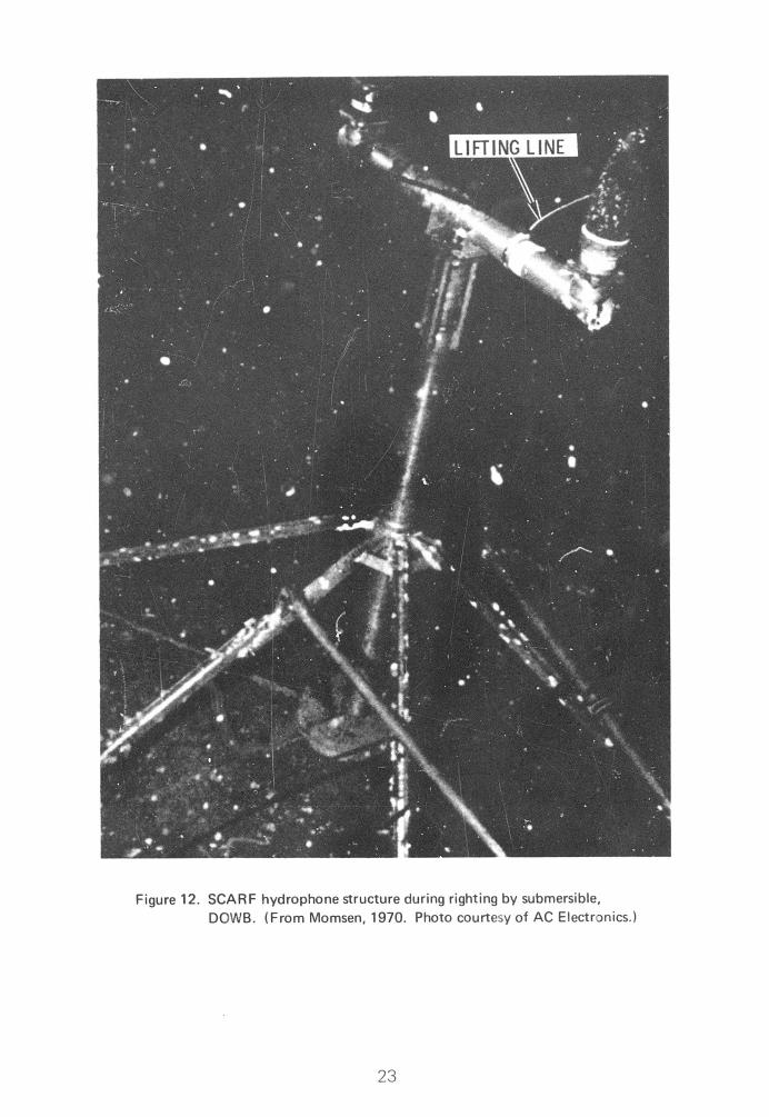
NCEL Submersible Test Unit. Seven Submersible Test Units (STUs) (Figure 19), which expose material specimens to the seafloor environment at and just above the sediment line, have been placed by NCEL in watc. depths of 2,370 to 6,780 feet (Jones, 1965; Hironaka, 1966; Reinhart, 1969). An eighth STU was placed in 120 feet of water. The test units have remained on the bottom for intervals of 4 to 24 months.
In most cases, the STUs were supported by two strip footings. The footings applied approximately 110 psf to the sediments. Sediments gener-ally varied between silty clays and clayey silts. The soil at the shallow-water location was predominantly sand size.
32
Figure 19. NCEL STU
Estimates of total settlement were determined from mudline markings on test specimens. Total penetration values varied between negligible and 8 inches. No distinctions couid be made between dynamic, immediate, and long-term settlement processes.
Naval Research Laboratory STUs. In 1961, a cooperative program of deep-sea test panel exposures was initiated in TOTO by the Naval Oceano-graphic Office, the Naval Research Laboratory, and the Naval Underwater Ordnance Station (De Palma, 1962 and 1969; Hersey, 1969). Three test units were placed in 5,800 feet of water about 3 miles off Andros Island, in the Bahamas. The 200- to 300-pound pyramidal arrays, supported on a silt-size calcareous ooze, were constructed of 1 -inch-diameter pipe with a 6-foot-square base. Of the three units placed in the spring of 1962, one was recovered 3 months later, another 34 months later, and the last has yet to be recovered. Settlement for the two recovered arrays was thought to be less than 1 foot, since test plates located above that elevation showed no effects from burial in the sediment.
33
The Naval Research Laboratory also has placed submerged test units at Iwo shallow-water sites. During 1961, a cagelike structure was recovered monthly from a water depth of 300 feet near Fort Lauderdale, Florida. The array, which had a 3- by 4-foot concrete base weighing 200 to 300 pounds, was placed on a calcareous sand bottom. Nosinking was ever noted. Another unit was deployed near Fort Lauderdale in 500 feet of water for 12 months. Sediments at the site were calcareous oozes. The unit, which used a deacti- vated mine for a base, weighed approximately 1,000 pounds. No settlement was noted when observed with television camera just prior to recovery.
NUSL Transponder Block. A small transponder block was placed in the Long Island Sound near New London, Connecticut, by the Naval Under- water Sound Laboratory (NUSL). The water depth at thejlte was approximately 60 feet, while sediments in the area were predominantly sJB| Divers observed that the 3- by 3- by 1 -foot concrete block base and the acoüfc«; relay cables have been partially covered with sand (Moothart, 1969). jf "T
NUC Pop-Up Test Site. Two foundation types haveBfen used by the Naval Undersea Research and Development Center (NUC), flBadena (formerly Naval Ordnance Test Station), for pop-up tests conducted off the northwest tip of San Clemente Island (Gardner et al., 1969; Sutton, 1969; Ridlon, 1969). The first foundation was installed in 1958 to test Polaris-Xype missiles. The foundation, which was in 115 feet of water, employed a 30-foot-diameter by 9-foot-high concrete-filled steel caisson. This caisson was embedded 7 feet into the soil. The soil profile consisted of 8 feet of loose coarse sand atop a 6-foot layer of dense sand. A fractured andesite with pockets of gravel lay beneath the sand. This foundation supported a 400,000-pound launcher; additional dynamic compression loadings as large as 140,000 pounds resulted during individual tests. No foundation problems were reported.
In 1960, a more complex launch system (Figure 20) was installed in 170 feet of water at a nearby site. The soil profile was essentially the same. This system had a static weight of over 700,000 pounds and resisted dynamic compression loads of up to 220,000 pounds during individual tests. The test structure was supported on four 14-inch-diameter by 65-fooMong drilled-in, grout-filled, pipe piles. Over 200 simulated launchings have been performed. Although no foundation monitoring was provided, it is known that the thresh- old sensitivity of other electronic equipment mounted on the structure (differential movement of less than 1/8 inch) was not exceeded.
Two camera mounting piles, which extend to the ocean surface, have also been installed at the Pop-Up Test Site. These 24-inch-diameter piles were drilled in 36 feet and filled with grout. The piles werp designed primarily to resist a maximum overturning moment of 410,000 ft-lb caused by wind and wave forces. The two structures have exhibited no serious foundations pro- blems.
34
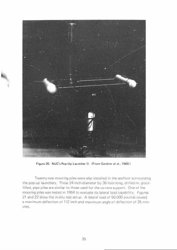
Figure 20. NUC's Pop-Up Launcher II. (From Gardner et al., 1969.)
Twenty-one mooring piles were also installed in the seafloor surrounding the pop-up launchers. These 24-inch-diameter by 36-foot-long, drilled-in, grout-filled, pipe piles are similar to those used for the camera support. One of the mooring piles was tested in 1964 to evaluate its lateral load capability. Figures 21 and 22 show the in-situ test setup. A lateral load of 50,000 pounds caused a maximum deflection of 1/2 inch and maximum angle of deflection of 25 min-utes.
35

tobarg«
AkMd call
3/4-in.-d)amatar wir« ropa*
haight indicator,
potantiomatert existing peg-top chain to
removed from pile
instrument mounting stand
four-part line
11
Pile no. 16^; (24-in. 00) Jo.
Figure 21. Pop-Up Site pile load test. (After Sutton, 1969.)
St. Andrews Bay Model Studies. In 1961, Keller (1964 and 1969) placed three concrete blocks on the shallow seatloor (water depth averaged 17 feet) to study the bearing capacity of spread footing foundations. Two test sites in St. Andrews Bay, Florida, were used during the investigation.
Tti concrete blocks were rectangular, square, and circular in o'an (Figure 23). Each weighed approximately 2,100 pounds in water. Apolied pressures ranged from 164 to 246 psf. The soil at each site was sampled and evaluated. It varied from a silty clay to a silty sand classification and, in all cases, would be considered a weak and compressible cohesive soil. Results of the laboratory study were then used to estimate the bearing capacity at various levels of object pe/ietration.
Laboratory data indicated that the undisturbed strength of the soil could not support the blocks at the soil surface; thus, a bearing capacity failure was expected. The extent of block penetration was predicted by determining the depth at which the bearing capacity, based upon undis- turbed soil strength, had increased enough (assuming soil strength increased with depth) to support the block. However, the blocks penetrated beyond the estimated depths. Subsequent e nalysis of the data has shown that use of
36

«I !'" Ml
remolded strength values in the bearing capacity equation predicts fairly closely the observed depth of penetration. The strains imposed on the soil mass as a result of the initial bearing capacity failure pos ibly caused remold- ing and the reduction in soil strength.
3/4-in.-diameter mire rop%-^..^^ four-part line s^^s- '
^s" to pile no. 15 height indicator
potentiometers
instrument mounting 1-1/4-in.-diameter wire rope
pile no. 1
instrument orientation line (1 M-in.-diameter rope)
to pile no. 21
Figure 22. Pop-Up Site mooring pile load test setup. (After Sutton, 1969.)
Submerged Petroleum Production Facility. The petroleum companies maintain a few totally submerged structures. At least 20 production facilities (flow-line manifolds, separators, heat treaters, oil storage tankage, gas compres- sors, etc.) are currently in use on the seafloor. Most of these facilities utilize mat foundation systems. Mat foundations were generally selected because of the extremely weak soil conditions and because this type of foundation pro- vides good resistance to scour effects. No foundation performance difficulties have been reported.
University of Miami Reflector and Cameras. The Institute of Marine Science at the University of Miami has been using a reflector and various pad- mounted cameras on the seafloor periodically for the past 5 years (Kronengold, 1969). The reflector is 24 feet in diameter and is supported by three 12-inch- diameter pipe piles driven to refusal (approximately 20 feet). The water depth
37

.,, .-,....
at the site is 85 feet; sediments are calcareous sand. No settlement has been noted. The cameras, supported on flat pads, were placed in 50 to 100 feet of water. Sediments at the site were a dense granular material. No settle- ments were observed.
Rectangular Block
Weight in air. 3,974 lb
Weight in water: 2,219 lb
Bearing pressure in water: 1.14 psi
Square Block
Weight in air: 3,6 0 lb
Weight in water: 2,214 1b
Bearing pressure in water: 1.71 psi
Circular Block
Weight in air: 3,700 lb
Weight in water: 2.076 lb
Bearing pressure in water: 1.15 psi
Figure 23. Dimensions and weights of concrete blocks used in St. Andrew's Bay model studies. (After Keller, 1964.)
Other Structures. The Applied Physics Laboratory (APL), a division of the University of Washington, maintains F0RAC stations at various localities (Linger, 1969). The devices, placed in 100 to 2,600 feet of water, consist of tripods with transducers. No indication of unsatisfactory performance has been reported.
38

The University of Rhode Island has observed the settlement of simulated pipe sections on bay sediments. Res(Vr jre to be compared to predicted values (Nacci, 1969).
Habitats
A number of manned habitats (Table 3) have been deployed on the seaf loor. General observations of their performance are available. Other habi- tats are in the design or fabrication stages. In these cases, the details of the selected foundation systems are useful as case histories, since the systems display the thinking of the designer relative to his past experience and knowledge of foundation performance.
Habitats represent a somewhat specialized set of case histories for several reasons. To date, the deepest deployment of a habitat for which any information is available has been 328 feet. Site selection for such deployments is usually heavily influenced by the requirement for good diver visibility. This requirement typically results in selection of sandy sites. In addition, considera- tion of the consequences of any sort of foundation failure (in terms of possible loss of human life) usually leads to an extremely conservative approach to site selection and foundation design. The following sections summarize some of the pertinent characteristics of various habitats.
Conshelf One. During September of 1962, an 8-foot-diameter by 17-fooMong steel cylinder was anchored horizontally in the Mediterranean near Marseilles, France (Cousteau, 1963). Conshelf One (Continental Shelf Station One) became Captain Jacques Yves Cousteau's first in a series of manned underwater habitats. The station, which housed a crew of two men for a week at a water depth of 33 feet, experienced no foundation problems.
Conshelf Two. Cousteau placed his second underwater manned station, Conshelf Two (Figure 24), in June of 1963 (Cousteau, 1964). Con- shelf Two was located in the Red Sea approximately 5 miles northeast of Port Sudan. The main structure. Starfish House, sheltered five men for a month at a depth of 36 feet. Five telescopic legs with 4- by 4-foot bearing plates sup- ported Starfish House on a coral sand ledge. Lead ballast of 200,000 pounds was added to the habitat to provide negative buoyancy. During Conshelf Two, Deep Cabin, a 20-foot-long rocket-shaped underwater chamber, housed a two-man crew for a week at a depth of 80 feet. Although three telescopic legs with bearing plates were intended for support, extremely steep rocky terrain precluded their use. Instead, the Deep Cabin was anchored on the steep slope. A third structure, the diving saucer hangar, allowed Cousteau's diving saucer to operate from a dry base 36 feet below the water surface.
39

The round hangar was supported by three 3- by 3-foot bearing plates on telescopic legs. Negative buoyancy was established by 120,000 pounds of lead. Except for the required revision of the foundation system for the Deep Cabin, no foundation difficulties were reported.
Conshelf Three. A third station, Conshelf Three, was placed near Villefranche, France, in October 1965 (Cousteau, 1966). The 18-foot- diameter steel sphere was occupied at a water depth of 328 feet by a six-man crew for 3 weeks. The sphere weighed 280,000 pounds and rested on a 48- by 28-foot chassis that held 154,000 pounds of ballast, ballast tanks, and reservoirs of helium, oxygen, and compressed air (Figure 25). The entire assembly was supported by four legs with sediment bearing plates. Crew members obtained undisturbed sediment cores by forcing water cans into the bottom sediments. At the project's completion, minor difficulties were encountered in breaking Ine feet free from the bottom. Several anxious minutes were required before breakout occurred.
Sealabl. On July 18,1964, the Office of Naval Research, in conjunction with other Navy activities, placed a manned undersea habitat next to Argus Island, approximately 27 miles south of Bermuda (O'Neal et al., 1965; Groves, 1965). Sealab I (Figure 26) was lowered by the Argus Island crane from the water surface 193 feet to the very dense coral sand bottom. The bottom, which was leveled prior to the deployment, exhibited a mini- mum amount of loose, soft material. The 9-foot-diameter by 40-fooMong station was fabricated by the Naval Ship Research and Development Labora- tory (NSRDL) (formerly Mine Defense Laboratory) at Panama City, Florida, from two mine sweeper floats. The Sealab's 3,000 pounds of negative buoy- ancy were supported by two 3- by 40-foot rectangular bins which doubled as ballast tanks (Figure 26). The habitat housed a crew of four men for 11 days. No foundation problems were recorded.
Sealab II. Sealab II was the Navy's second major step in a continuing man-undersea research program. Three 10-man teams occupied Sealab II for approximately 15 days each (Pauli and Clapper, 1967). Habitation occurred between August and October of 1965, 3,000 feet off Scripps Pier at La Jolla, California, in 205 feet of water (Fehl, 1969; Tolbert, 1969).
The habitat was essentially a nonpropelled submarine built to withstand an internal working pressure of 125 psi. The hull was constructed of 1-inch-thick mild steel, 12 feet in diameter and 57-1/2 feet long. When on the bottom, Sealab II was 26,000 pounds negatively buoyant. The bearing surfaces, two 3- by 18-foot pads extending fore and aft, were designed to provide a maximum bearing stress of 300 psf.
40

if
.FF ^ir •^»^•~
;U^^

Table 3. Habitats
Name Operator Year No. of Structures Depth
(ft) Location Wt (lb) in Water, W, or Air. A
Foundation Type
Conshelf One Jacques Cousteau 1962 1 33 Mediterranean near Marseilles, France
anchored
Conshelf Two Jacques Cousteau 1963 3
36
80
36
Red Sea
Red Sea
Red Sea
five bearing pads
anchored
three bearing pads
Conshelf Three
Jacques Cousteau 1965 1 328 near Villefrtiche,
France four bearing pads
Sealab 1 ONRIOfficeof Naval Research)
1964 1 193 Argus Island, near Bermuda
3,000 (W) strip footings
Sealab II ONR 1965 1 205 off Scripps pier at
La Jolla, Calif. 26000 (W) bearing pads
Hydrolab Florida Atlantic University
1967
1969
1
1
50
50
near Palm Baach, Fla.
near Riviera Beach, Fla.
37200 (W)
37200 (W)
mat footing concrete
mat footing concrete
Makai Habitat II (Aegir)
Oceanic Enterprises, Inc.
1969 1 200 Makapuu Oceanic
Center, Hawaii 80,000 (W) strip footings
Tektlte 1
Navy, Department of Interior, NASA, and General Electric Co.
1969 1 58 Lameshur Bay,
St. Johns, Virgin Islands
20,000 (W) mat footing
Chernomer 1 Russia 1969 1 33 Golubaya Bay,
Black Sea 125,000 (A)
hydraulic base supports
Chernomer II Russia 1 115 144000(A) four legs
Deutsche, Babcock, and Wilcox (Germany)
1968 1 33 East Sea four bearing pads
EDALHAB University of New Hampshire
1 26 Alton Bay, N.H. two anchors, 6,000 lb each
German 1969 1 75 off Helgoland in North Sea two strip footings
Sprut Russia 1967-70 several 30 to 40 Black Sea anchored

-wirrr^- rw-TT»"-»-"'»»-.!"
Table 3. Habitats
n Wt (IblinWater.W.or Air, A Foundation
Type Foundation
Size (H)
Foundation Bearing
Pressure (psf)
Sediment Type
Settlement Remarks
n near ranee
anchored unknown No foundation problems.
i
i
i
five bearing pads
anchored
three bearing pads
4x4
3x3
unknown
unknown
coral sand
rocky
No foundation problems.
Terrain too rough for planned footing founda- tion.
No foundation problems.
iche. four bearing pads •5x5 unknown
Encountered minor breakout problem.
id, Ida
3,000 (W) strip footings two 3 x 40 12.5 dense coral
sand No foundation problems.
«rat lif.
26ßOO (W) bearing pads two 3x18 300 very fine silty sand
Oto 153 in. of
differential settlement
Extensive soils investigation performed.
ach,
each.
37200 (W)
37200 (W)
mat footing concrete
•nat footing concrete
20.66x18
20.66x18
100
100
coarse calcareous
sand
dense sand
no movement detected
differential movement
Pcour and fill.
Movement attributed co extensive scour and fill.
anic aii
80,000 (W) strip footings two 9 x 70 >63 No foundation problems.
IV,
is 20,000 (W) mat footing 15x37 36 coral sand No foundation problems.
V. 125,000 (A) hydraulic
base supports unknown
Used large surface buoy for support. Gale lifted and moved habitat.
144,000 (A) four legs unknown
four bearing pads 5-ft diam unknown
H. twr ?nchors, 6,00.) lb each
unknown
i two strip footings 2x30 unknown
Has adjustable legs to compensate for uneven bottom.
anchored unknown Buoyant tent.
continued
41

Table 3. Continued
Name Operator Year No. of Structures Depth
(ft) Location Wt (lb) in Water, W, or Air. A
F
Sea Igloo E.A. Lnk 1964 1 33 Caribbean (
Subllmnos 1969 1 30 Great Lakes 1
Atlantis University of Miami and Chrysler Corp.
planned 0 up to 1,000
continental shelf 64,000 (W) spn
MUS NCEL planned 0 up to 6,000
• 12,000 (W) four
Santa Barbara City College
planned 0 30 to 40
Seaiablll ONR planned 1 610 Wilson Cove, Sfm Clemente Island, Calif.
•2(:„000 (W) r
VI
< V
Seause planned 0 120 Ccbb Seemount, Pacific (near state of Washington)
appears similar to Makai Habitat
si Mat
Tektite II same as Tektite 1
same as Tektite 1
1970
1970
1
1
50
100
Virgin Islands
Virgin Islands
similar to Tektite 1 si
1

m"|«""ii^»»fn«"^"iiw*wwww"" ■"" ■"■"" -™-~nn .
Table 3. Continued
Location Wt (lb>lnWater,W,orAir,A Foundation
Type Foundation
Size (H)
Foundation Bearing
Pressure (psf)
Sediment Type
Settlement Remarks
Caribbean anchored unknown Buoyant tent.
Great Lakes four pads four 2x2 unknown cohesive soils No foundation problems.
ontinental shelf 64.000 (W) spread footing two 17 x 33 57
soils with bearing
capacity > 72 psf
' »^.OOO (W) four bearing pads 12-ftdiam «26
soils with bearing
capacity > 144 psf
1
Wilson Cove, San Clemente Island, Calif.
•26,000 (W) modified version of Sealabll
similar to Sealab II
«300 dense, well- graded sand
tobb Seemount, acific (near state of Washington)
appears similar to Makai Habitat
similar to Makai Habitat
similar to Makai Habitat
«63
Virgin Islands
Virgin Islands
similar to Tektite 1 similar to Tektite 1
similar to Tektite 1
«36 similar to Tektite 1
42
.'J>V..-'.V^^--^W...^ ^-..I^.-. ;. ■■ ;■.. ■■..■■ ■..—. '- -*- ^,| fin« -■ .^.«Hu.j.ii—n^yaiMMiMa—JIM—iMMMMJ

t
1
wtKKtK**^ ^rnmmm
0 .^U* ■ -■-' ■
v* :■-
■
; - ■•.,!
«t*
V .-, ■. ■
■Us
' - - ■:
* J-,
il
- ^
r
--: "y
I i ill i
i-
! .I
>;*
-t.i.<o*^-.T
^vi^Jis^ . :■ ., -■.■^.'jv.-'*-

43

CAP FERRAT LIGHTHOUSE
VILLEFRANCHEj
"V&AWisaiaasB Power and communication cables
H from Cap Ferrat lighthouse hang from steel-drum buoys.
•> LABOR
ESPADON
Buoy exerts 3-1/2-ton upward thrust to keep guide cable taut.
PHYSALIE
'CONSHELF THREE dangles safely beneath surface waves during
\ V . prepjratian for descent. Telephone line speeds orders from diving saucer, undersea eyes of the operation.
P LABOR lowers sea house. pNylon guy from PHYSALIE stradiesCONSHELF THREE
H o n guide cable.
IGUIDE CABLE! Bobbing column of buoys
descends with the station. Sea pressure forces water into the diums' air pockets and reduces their buoyancy, gently lowering the power and communication cables.
CONSHELF THREE reaches final position 20 m inu tes^^ after descent began^^^f l
DIVING SAUCEF
i ANCHOR
OIL-WELL HEAD
F igu re 2 5 . Conshe l f Three . (From Cousteau, 1966. Painting by Davis Meltzer.
©Na t iona l Geographic Society. Used by permission.)
44


$
a o
3 & E p
2
I i
1
46

Corner spades, 15 inches in depth, increased resistance to lateral movements (Figure 27). Sediment in the vicinity of Sealab II was a dark- gray, micaceous, very fine silty sand with few marine animals and a trace of clay. Analysis of surface cores indicated that the material contained 81% sand, 19% silt and clay. Median diameter of the material was approximately 0.004 inch. Laboratory tests of sediment engineering properties gave the following results: angle of internal friction, 22 degrees; vane shear strength, 1.4 psi; buoyant unit weight, 52 pcf. In-situ tests of the seafloor indicated a minimum soil bearing capacity of 1,300 psf. A safety factor of three was used to minimize settlement. The seafloor at the site sloped to the southeast at approximately 8 degrees. Typical microrelief was of the order of 4 inches. When Sealab II was positioned, instrumentation showed a 10-degree trim by the stern and a list to the port of 3 degrees. The habitat was then lifted about 10 feet from the bottom, rotated, and replaced. A check indicated a port list of 6.54 degrees and a bow-up pitch of 5.96 degrees; these angles did not change appreciably during the three weeks of occupancy. Since Sealab 11 was sitting at a lesser slope than the terrain, differential settlement was assumed to have occurred. Measurements on the footings indicated the following settlements, starboard aft, 9 inches; starboard forward, 15.8 inches; port aft, 9.2 inches; port forward, negligible. Later measurements found little additional settle- ment; therefore, settlement apparently occurred on impact or almost immediately thereafter.
Hydrolab. During October of 1967, Florida Atlantic University placed an underwater research laboratory in approximately 50 feet of water, 3,100 feet offshore of Palm Beach, Florida (Stephan, 1969; Perry Oceano- graphies, 1970). The 12-foot-diameter by 20-fooMong habitat, which was designed and fabricated by Perry Oceanographies, was supported on a pre- stressed concrete foundation, 18 feet by 20 feet 8 inches (Figures 28 and 29). Bearing pressure exerted on the coarse calcareous sand bottom was approxi- mately 60 psf. Hydrolab remained in position for 11 months. During this period, no movement was detected. Scour and fill were noticeable but not large enough to cause undermining of the Hydrolab foundation.
This habitat was modified to operate as a one-atmosphere, lock-in/ lock-out facility, and it was placed on the seafloor in 50 feet of water off Riviera Beach, Florida, during July 1969. The soil in the area was a dense sand. The same concrete base, with f loodable ballast chambers, was used. In this instance, four 4-foot-diameter metal "cookie-cutter"-type keys extended 1 foot below the concrete base.
During October 1969, four men spent 2 days living in the Hydrolab during Project Powercel (Ocean Industry, Jan. 1970, p. 23). At the beginning of this project, no scour problems were noted; however, by the end of the
47

2 days, undermining of the concrete slab along a major portion of one side and a corne'' was obvious (Hallanger, 1970). The resulting pit was estimated to be 3 feet deep and to extend 3 to 5 feet under the foundation slab. Only a small portion of this pit extended beyond the slab. Bottom currents estimated at 3/4 knot were prevalent during the 2-day project. This strong bottom cur- rent obviously contributed to the undermining. Marine animals inhabiting the area may also have contributed to the pit's existence and extent. An additional external effect may have resulted when a support ship was moored to one corner of the slab. Dynamic action of the mooring line might have caused an up-down movement of the habitat, resulting in a pumping action in the sediment. However, this movement was not noted by inhabitants. A slight increase in the inclination of the Hydrolab was observed by at least one of the aquanauts during the habitation. The inclination apparently had no adverse effect on the overall experiment.
Makai Habitat II (Aeglr). Aegir is a submersible habitat designed to support six men on missions for 14 days in water depths to 580 feet (Fahlman, 1968). The 400,000-pound, three-section habitat is made up cf two 9-1/2- foot-diameter by 17-foot-long cylinders which connect axially to a central 10-foot-diameter sphere. This structure is mounted athwart two large flood- able pontoons. The pontoons are 9 feet in diameter by 70 feet in length and rest directly on the seafloor during use.
The structure is designed to be towed on the surface to the site, where ballast tanks are flooded. Two anchored lines are used as lowering guides. A third and fourth anchor block are suspended beneath the habitat complex and supply the additional weight required to make the complex negatively buoyant. Once these blocks are on the bottom, the complex becomes positively buoyant and must be winched down to the bottom. Additional ballast tanks, which are flooded after the complex is on the bottom, give a total negative buoyancy of 80,000 pounds. The system was designed to include four hydraulically oper- ated legs for leveling on slopes up to 10 degrees.
Aegir underwent its first sea trial during November of 1969 when five men spe, it 2 days on the seafloor in 200 feet of water (Ocean Industry, Feb. 1970). Since no large difficulties were encountered during the overall test, it is assumed that the foundation performed adequately.
Tektite I Program. The Tektite I habitat was placed on the ocean floor at Lameshur Bay, St. Johns, Virgin Islands, as a joint effort involving the Navy, Department of Interior, NASA (National Aeronautics and Space Administration), and General Electric Company (Pauli, 1969; General Elec- tric, 1969; Stevenson, 1969; and Pauli and Cole, 1970). A four-man crew occupied the habitat for 60 days beginning in February of 1969.
48

Figure 28. Hydrolab Habitat. (From Perry Oceanographies, 1970. ©Perry Oceanographies, Inc. Used by permission.)
The habitat was positioned in 53 feet of water on a 10-foot layer of coral sand. Bedrock underlies the sand. The sand surface at the habitat site was leveled using a bolted steel frame with a diver-manipulated traveling screed. This technique established a flat bearing surface within 2 degrees of horizontal.
The undersea habitat structure consisted of two pressure hulls connected by a pressurized crossover tunnel and attached to a rigid base. Each pressure hull, a vertical cylinder with domed head, was 12-1/2 feet in diameter and 18 feet long (Figure 30). A reinforced rectangular box with approximate dimensions of 15 by 37 by 6 feet formed the rigid base.
After jetting embedment anchors in at the site, the 5,000-pound positively buoyant habitat structure was to be jacked down to these anchors. However, this plan was abandoned in favor of a deadweight anchor technique, primarily because no reliable embedment anchor performance data could be obtained. Four 2,500-pound steel clumps were used as anchors. Once the habitat structure was on the seafloor, ballast tanks were flooded, and addi-tional weights were added. The total resultant load, 20,000 pounds of negative buoyancy, was applied to the seafloor over the 555-square-foot bearing surface. No foundation problems were experienced.
49

•N 0 -
&>
2lT c |i ij •'
.tJUJLfJlsJ Irv-r-.-jriir»-)
' l' " 11 'l 'I •I I1 ll i II II ll I II (I ll I
L«JLSJL?JL?J
■»r.-iriys-i ll " I I I II I I I ll 'l
ll ll I I II ll L»_lL»JL«JLJJ
I
l«5 1 1 ! • i 1 1
'4J i i ■ i i i i i
00
• i
1 1 1 1 1 1
• 1 1 1
'
fill ^
50


Other Deployed Habitats. Although a number of additional habitats have been used on the seaf loor, little information exists on their performance.
During the spring and summer of 1969, Chernomer I, a Russian habitat, was placed in 33 feet of water at Golubaya Bay in the Black Sea (Hydrospace, 1969). The 125,000-pound habitat utilized a large efface buoy for support. During a gale, the habitat was reported, in one instance, to have been lifted 3 feet off the seaf loor—presumably by the surface support buoy. The habitat then dropped, and "bounced on hydraulic base supports." As a result of this treatment, the habitat assumed a cant of 40 degrees.
Chernomer II was designed for use in water depths to 115 feet (Hydrospace, 1969). This habitat, which was to be nearly independent of surface support, is 10 feet in diameter by 25 feet long, weighs 144,000 pounds, and is supported on four legs.
The German company of Deutsche, Babcock, and Wilcox deployed a habitat in 33 feet of water in the East Sea during the fall of 1968 and the sum- mer of 1969 (Ocean Industry, Jan. 1970, p. 12). The habitat was manned for 14 days and remained on the seaf loor for 2-1/2 months. From photographs, the habitat appears to be supported on four footings. The footings are about 5 feet in diameter, and each is rigidly attached to a stiff leg.
Students and faculty at the University of New Hampshire fabricated and deployed the 8-foot-diameter by 12-foot-long habitat, EDALHAB (Engi- neering Design and Analysis Laboratory Habitat), in Alton Bay, New Hampshire (University of New Hampshire, 1967; Undersea Technology, 1970). EDALHAB supported four men for 48 hours at a depth of 26 feet. The EDALHAB struc- ture is slightly buoyant. The foundation consisted of two 6,000-pound anchors.
A second German habitat was deployed in 75 feet of water off Helgoland in the North Sea during the summer of 1969 (Hydrospace, 1969). Three teams of aquanauts spent a total of 22 days in the habitat. The habitat, which was left in place on the seaf loor for use during the summer of 1970, is 8 feet in diameter, 30 feet long, and has a design depth capability of 330 feet. A large surface support buoy, moored by three anchors, provides required breathing gases and power. The foundation for the habitat consists of two strip footings, each approximately 2 feet wide by 30 feet long. The habitat is supported on footings by four adjustable legs designed to compensate for uneven seaf loor topography.
On several occasions during the past 3 years, the Russians have used a hemispherical fabric tent with a wooden floor as a habitat (Hydrospace, 1969). These habitats, called Sprut, have been used in the Black Sea to sup- port two men for 2 days at water depths of 30 to 40 feet. The fabric tents are buoyant and are anchored to the seaf loor. In at least one instance, Sprut was secured to two submerged rocks.
52

Link demonstrated a similar rubber-walled habitat, Sea Igloo, in 1964. The rubber habitat supported a man for 24 hours in 33 feet of water (Link, 1964).
An underwater diver rest station, named Sublimnos, has been used at 30-foot water depths in the Great Lakes (Somers, 1970). The 8-foot-diameter by 8-foot-long vertical cylinder is ballasted for negative buoyancy. The foun- dation consists of four pads, each about 2 feet square. This structure has been successfully located on cohesive soils.
1. maximum bottom currents of 5 knots
2. soil bearing capacity of 72 psf
3. a maximum slope of 5 degrees
Each spread footing is connected to the superstructure by a hydraulic leveling system.
Preliminary designs for a similar manned underwater station (MUS) were developed by NCELand several contractors (General Dynamics, 1968). The selected concept consisted of two vertical cylinders; one containing a nuclear power generator and the other housing six men. The habitat would be capable of 30-day missions in water depths to 6,000 feet (Figures 32 and 33). The structure was designed to be slightly buoyant until the addition of a 12,000-pound anchor clump. This clump would be placed on the seafloor and the station winched down to it. Upon approaching the seafloor, four boom-mounted footing pads would swing out and stabilize the station in a vertical position on slopes as steep as 15 degrees and in currents as large as 1 knot. The design was such that negligible loads would be applied to the seafloor soil by the 12-foot-diameter bearing pads. Design criteria assumed a soil bearing capacity of 144 psf. In the most critical situation, a current- induced overturning moment would be resisted by a single boom-mounted footing pad. In this situation, a vertical force of 12,000 pounds (108 psf) and a horizontal force of 12,600 pounds would be transmitted by the pad to the seafloor. The circular pads were to be made of a permeable screen to
53
Other Planned Habitats. Atlantis was a joint planned program between the University of Miami and Chrysler Corporation (University of Miami, 1968; Chrysler Corporation, 1968; Breckenridge, 1969). The two organizations intended to emplacea 1-atmosphere manned laboratory on the continental shelf (to 1,000-foot water depths). The tentative habitat consisted of a horizontal cylinder, 12 feet in diameter by 80 feet long, applying a nega- tive buoyancy of 64,000 pounds to the seaflocr through two 17-foot by 33-foot spread footings (Figure 31). Static bearing pressures would equal 57 psf. The overall design was based on the following criteria:
-; "tfofrfBtmiiia

*
reduce the breakout forces. The pads were also to have a circumferential ring to protect against scour and presumably to act as a key to resist the horizontal forces.
hydraulic package
baiaplata Itvalar
SactionA-A typical both
Figure 31. Project Atlantis manned Station. (From Chrydar Corporation, 1968.
©Univinity of Miami and Chrytlar Corporation. Uaad by parminion.)
Santa Barbara City College is fabricating an ambient pressure structure for temporarily sheltering several men (Hallanger, 1970). The structure, which will be deployed in 30 to 40 feet of water, will include a tower that extends above the air-sea interface.
Three other habitats have been fabricated and will be utilized in the near future. Sealab III, the first of these habitats, is basically a modified ver- sion of the habitat used in Sealab II (Eager, 1968; Dowling, 1969; Hallanger, 1970; Huh, 1969; Stiles, 1969). It was designed to be deployed in 610 feet of water near Wilson Cove on San Clemente Island, California. The seaf loor at the site was investigated extensively by NAVOCEANO and was found to be basically a dense, well-graded sand with occasional larger rocks. Average slope at the site was 3 degrees.
54

Figure 32. Artist's conception of NCEL Manned Underwater Station.
55
.«.J«u^t.:^.u»,,^w,to>__u,_ij,i—,„»-

Figure 33. Model of NCEL Manned Underwater Station
The second habitat wili be used durirn Project Seause (Battelle et al., 1968; Breckenridge, 1969). This project will study in detail Cobb Seamount, in the Pacific Ocean off the state of Washington. The rock summit of the sea-mount, which reaches to within 120 feet of the sea surface, has been studied indirectly with various types of instrumentation and directly by SCUBA divers. A habitat has been designed for use at the site. This habitat appears to be simi-lar to the Makai Habitat 11 (Aegir).
The third habitat, a modified version of Tektite I, was used during the summer of 1970 in the Tektite 11 program (Ocean Industry, 1969). The same site in the Virgin Islands was utilized for a period of approximately 7 months A new, two-man habitat, located at a 100-foot water depth, was also employed during a portion of the program.
56

Offshore Towers and Platforms
Offshore towers and platforms differ from totally submerged structures in three major ways:
1. They are currently used only in the shallow portion of the continental shelf.
2. They extend through the air—water interface and are thus subjected to large wave forces.
3. They are often large and massive because of the magnitude of environmental factors encountered.
Several hundred offshore platforms are in existence (Howe, 1967). These structures are located in water depths of up to 370 feet, have total weights in excess of 3,500,000 pounds, and use pile or caisson foundations almost exclusively as their permanent foundation systems (Figure 34).
Platforms in shallower waters are often constructed on site, beginning with pile driving and continuing upward. For the larger offshore platform, the underwater substructure, which doubles as a guide for the pile driving, is usually prefabricated, towed to the site, and positioned on the bottom. The substruc- ture typically utilizes a spread footing or shallow caisson configuration for temporary support while the piles are being driven and grouted. These plat- forms are founded on soils ranging from sand to soft clayey silt. As much as 300 feet of pile penetration and as many as sixteen 56-inch-diameter piles may be required to resist the loads of larger platforms.
In addition to these relatively permanent structures, there are about 100 drill rigs of the jack-up variety (Howe, 1969a). These rigs use large caissons, pads, or mats as their foundation system. The structures are movable and have been used in water depths to 300 feet. Total weights of the jack-up rigs range from 1,000,000 to 10,000,000 pounds. Maximum lateral dimensions may exceed 240 feet. Foundation pads or mats range from 20 to 120 feet in major lateral dimension (Figure 35).
Specific information is available on a limited number of offshore platforms and towers (Table 4). Most information is considered proprietary and is. therefore, available only in generalized form. Generalizations concern- ing performance of petroleum structures (information collected from a number of sources) are summarized in the following paragraphs along with available specific performance information.
Argus Island. Argus Island was constructed in the summer of 1960 as a Navy research platform (McDermott, 1960). This structure, which is similar to oil well drilling platforms, supports a two-story, 85- by 85- by
57
■'-*'■**■*—'"'iiifcri-.Hfift iniMMMfctf^*

20' water dtpth 1,200 ton«
340' watar depth 6.510 tons
Figure 34. Typical offshore platforms for shailojv and deep water. (From Schmid, 1969.)
24-foot-high building. The site is located 27 miles south of Bermuda in 193 feet of water. Sediments are dense coral sands. The platform is supported on four 30-inch-diameter by 5/8-inch-thick steel piles drilled approximately 50 feet into the sedi- ment and then grouted. No foundation problems have been reported.
Khazzan Dubai I. Khazzan Dubai I is a large submerged oil storage tank with a capacity of 1/2 million barrels (Chicago Bridge and Iron, 1969). Pumping and control facilities extend above the water surface. Its physical appearance is that of an inverted funnel, 270 feet in diameter and 205 feet high (Fig- ure 36 and 37). Khazzan Dubai I was installed in August 1969,58 miles off the shore of Dubai in the Arabian Gulf. The 30,000,000- pound open-bottom structure rests on a perimeter footing in 160 feet of water. The perimeter footing also contains guides for 30 anchor piles spaced around the perimeter. These 36-inch-diameter piles pene- trate 90 feet into the seaf loor. The structure-foundation interface was designed to withstand the scouring action caused by a 3-knot bottom current. No problems have been reported to date.
NSRDL Towers. The Naval Ship Research and Develop- ment Laboratory in Panama City, Florida, has operated two oceano- graphic towers off the coast of
Florida since 1957 (Mine Defense
58

Laboratory, 1964; Toske, 1969). The larger tower, Stage One, is located in 100 feet of water and has overall dimensions of 105 by 105 feet. The struc- ture is supported by sixteen 30-inch-diameter piles embedded 60 feet into a medium dense to very dense gray silty sand. Pile capacity is 760,000 pounds.
Stage Two, the smaller tower, is 60 by 84 feet and is located in 60 feet of water. Eight 24-inch-diameter steel piles arranged in a 60- by 60-foot square support the structure. The upper 50 feet of sediment at the site contain medium dense blue, green, and gray coarse sands. Below that depth is a dense gray silty sand. Each pile, which has a capacity of 540,000 pounds, is embedded approxi- mately 70 feet. No foundation problems have been reported.
NELC Tower. An oceanographic research tower was constructed for Naval Electronics Laboratory Center (formerly the Navy Electronics Labora- tory, San Diego) in 1959 (LaFond, 1965), The tower is located in 60 feet of water off Mission Bay, San Diego. The main tower extends 90 feet above the waterline. Four 12-3/4-inch-diameter open-end steel piles support the struc- ture. Maximum load on each leg is 140,000 pounds compression and 115,000 pounds tension.
Subsurface exploration with probing and drilling techniques was utilized at the site to establish sediment logs {Dames and Moore, 1959). Water-jet probing reached 63 feet below the seafloor. A weathered conglom- erate was encountered at that depth. Borings were made approximately 10 feet from the probings. A log of one of the borings is shown in Figure 38. Undisturbed samples were taken and tested. In addition to routine tests for soil engineering properties, the laboratory study established friction charac- teristics between soil and steel. An effective angle of friction of 21 degrees was measured between steel and medium- to coarse-grained sands with shells (material found in the upper 30 feet), and a value of 19 degrees was measured between steel and loam and fine-grained sands (material found below 30-foot depth). No foundation performance problems have been reported.
Tektite I Pile Guide System. During the on-site preparation phase of the Tektite I program, a pile foundation system was used in 32 feet of water for stabilizing and guiding a habitat-transporting barge (General Electric, 1969; Hallanger, 1970). After the barge was flooded and lowered, the habitat was to be floated off. A steel pile (about 21 inches in diameter) was driven to refusal through each of the four corner guides on the barge. The barge was left moored and floating in this condition overnight with plans to commence the controlled flooding and lowering operation the following morning. Seas were reported to be calm during the night; however, the next morning it was found that all four piles had snapped off at the mudline. Subsequently, the piles were redriven, and the flooding and lowering operation commenced immediately. This approach was successful.
59

tratisvene Aid carriftge
longitudinal Aid
carriage
.derrick
helicopter deck
Mat and Drilling Platform
^ ~~
drilling area.
outline of platform
! 1 i i i i i
■^
Figure 35. Typical jack-up rig with mat foundation. (From Schmid, 1969.
60


•m'lmmrjm
Table 4. Offshore Towers and Platforms
j Name Operator Installation
j Year No. of Structures
Depth (ft)
Location Foundation
Type
Load Per Foundation
Member
Foi
Argus Island Navy 1960 1 193 27 miles south of
Bermuda piles four
Khazzan Dubai 1 1969 1 160 near Dubai
Arabian Gulf footing and
piles
27 foe Pil
arour
NSRDL Towers NSRDL (Naval Ship Research and Devel- opment Laboratory)
1957
1
1
100
60
off west coast of Florida
similar
piles
piles
760,000-lb capacity
540,000-lb capacity
sixtee
eight
NELC Tower NELC (Naval Electronics Labora- tory Center)
1959 1 60 Mission Bay near
San Diego piles
140,000-lb compression 115,000-lb tension
four
Tektite 1 (Pile Guide System)
Navy, Department of Interior, NASA, General Electric
1969 1 32 Lameshur Bay, Virgin Islands
piles four
Texas Towers Air Force 1955 and
1956 3
55
55
180
St. George's Bank east of Oaf- Cod
off Nantucket Shoal
75 miles southeast of
New York Hart»
caissons
caissons
caissons
5,300,000-lb compression 720j000-lb horizontal
1 BO0PO0 ft-lb bending moment
7,100WWb vertical 1,100/JOG-lb horizontal
33.000,000 ft-lb bending moment
6300W0-lb vertical 820,000-lb horizontal
negligible bending moment
thre«
threi
thre

■
Dffshore Towers and Platforms
tetion
pe
Load Per Foundation
Member
Foundation Size
Embedment Depth
(ft)
Sediment Type
Bearing Capacity (psf)
Remarks
les four 30-in.-diam 50 dense coral
sand No foundation problems.
gand es
270-ft-di8m footing with piles spaced
around perimeter
90 No foundation problems.
es
as
760,000-lb capacity
540XXD0-)b capacity.
sixteen 30-in.-diam
eight 24-in.-diam
60
70
very dense gray silty sand
medium dense blue-green
coarse sand
No foundation problems.
No foundation problems.
» 140,000-lb compression 115 XXXVIb tension
four12-3/4-in.- diam
63
medium to coarse sand above black silty loam
No foundation problems.
IS four 21-in.-diam driven to
refusal coral sand
Piles snapped off during night.
>ns
)ns
ins
53X)X)00-lb compression 720X)00-lb horizontal
1300XX» ft-lb bending moment
7,100 WO-lb vertical
1100iXXWb horizontal 33J0O0J0O0HAb bending moment
6300^00-lb vertical 820,000-lb horizontal
negligible bending moment
three 15-ft-diam
three 14-ft-diam
three 12-1/2-ft- diam
48
60
loose sand above dense
and
similar to above
«24,000 at 30-ft penetration
Dismantled.
Dismantled.
Destroyed by sea-action, structural failure.
61

,
, .
I
0 -^f-
.■ ■■ v >■ ■M
■ ■
.-*=•: \
L_:a
tl
i*. -;,. .
■-'fjrrjrt^'Ä; '^*Ää^^/,"'"'s^;ir;i
■■rffciii.i" II^I IIIIIIIIII
! i ; ■ !
■■.■-• —
d «KB

PRECEDING PAGE BLANK 63

Figure 37. Khazzan Dubai I being towed to site. (From Chicago Bridge and Iron, 1969. Photo courtesy of Chicago Bridge and Iron Company.)
64

*mfr dapth—57 ft« it 12 noon, D«. 22,1968
10. indlcttM number ofblowtofi360
pound buoyant weight dropping 24 Inch«, for \ 1 foot of twnplar pane- ' _
tration XU
20-
| 30-
40-
S0-
60.
40D
SD
260
300
rvrr
A
£^a' ItiiÜa
browniih-grav madium to coma und with many ihall fragmant«
black tllty loam with layer» of ihall fragments
(grading intarbaddad layer» of »ilty loam, »oft tilty clay, and fine «ndl
brownieh-gray nnd with tome mud contamination
weathered conglomerate
70-
Figure 38. Boring log at NELC tower site. (From Dames and Moore, 1959.)
65
..■.-.«... ■!-;,,.c,,^.*i«kt,H*twr

Texas Towers. During 1955 and 1956, three offshore radar platforms, Texas Towers, were installed along the East Coast of the United States as part of an Air Force early warning defense system (Anderson et al., 1954; Rutledge, 1956 and 1969).
The first tower was constructed in the summer of 1955. It was located on St. George's Bank approximately 95 miles east of Cape Cod, Massachusetts. The mean depth to the seaf loor was 55 feet. Bottom sediments at the location consisted of 10 feet of loose s< nd underlain by over 150 feet of dense sand. Scattered through the area were pockets of organic clays and silty clays. The bearing capacity of the sand at a depth of 30 feet or more below the sea bot- tom was estimated at 24,000 psf. The three legs, each 15 feet in diameter at the base, were sunk as caissons 48 feet into the seaf loor. Maximum design loads for each caisson were: 5,300,000 pounds vertical compression, 720,000 pounds horizontal force, and a bending moment of 1,800,000 ft-lb.
The second Texas Tower was located off Nantucket Shoal approximately 45 miles southeast of Cape Cod. Foundation conditions were essentially the same as were found at St. George's Bank. The tower was supported by three 14-foot-diameter legs sunk as caissons to a depth of 60 feet. Each caisson was designed for maximum vertical loads of 7,100,000 pounds, maximum horizon- tal force of 1,100,000 pounds, and maximum moment at the seaf loor of 33,000,000 ft-lb.
The location of the third Texas Tower was approximately 75 miles southeast of New York Harbor in water 180 feet deep. The structure was designed with 12-1/2-foot-diameter legs and an underwater bracing system. The three legs were sunk simultaneously as caissons. Each caisson was designed for maximum vertical force of 6,800,000 pounds, maximum horizontal force of 820,000 pounds, and negligible bending moment.
On January 15,1961, the radar tower off New York was destroyed by sea action. Cause of failure was attributed simply to "structural failure of the supporting system." Subsequently, the two remaining towers were dismantled.
General Petroleum Experience. The vast majority of offshore platforms belong to the petroleum corporations and related companies. As a result, spe- cific information on design or performance is often considered proprietary and therefore not available. Much information of a more general nature and of great value to a study such as this is, however, available (Noorany, 1969; Reese, 1969; Smoots, 1969; Kochler, 1969).
Of several hundred offshore permanent platforms, only a few failures are known (Howe, 1968 and 1969; McClelland, 1969; Lubinsky, 1969). These failures have usually occurred during severe storms. Several failures not related to storms have also occurred however.
66

During placement of the platform substructures, which typically utilize footing or caisson configurations for temporary support, penetrations of up to 8 feet have been recorded. In some instances the actual penetration, or imme- diate settlement, has been as much as 3 feet more than expected.
After the piles have been driven and grouted in, settlements have occurred in many instances. At several locations where the soil profile was considered competent and r</ther firm, total settlements of up to 3/4 inch and differential settlements of up to 1/2 inch occurred over periods ranging from 1/2 to 2 years (Busher, 1969).
Of the more than 100 mobile jack-up rigs fabricated, at least 30 have been involved in major mishaps (Howe, 1968). Six of these mishaps have been attributed to foundation or soil problems. In one incident, a rig utilizing a 65- by 97-foot mat and applying a pressure of 180 psf to the sedi- ments was involved in a bearing capacity failure and was subsequently lost. At the time of this failure (1958), it was apparently the accepted practice of many operators to forego detailed soil investigations at each specific work site. Since most operators worked primarily in one area, for which their rigs and foundation systems had in many cases been specifically designed, the expense of additional soil investigations was considered unjustifiable. The usual practice was to move onto a site, jack the rig up, and then preload the foundation for a period of time before commencing actual drilling operations. The rig involved in this failure penetrated as much as 9 feet into the soft Gulf of Mexico soils during preloading (Beaupre, 1969).
For other jack-up rigs, some of which use caisson configurations with diameters ranging from 20 to 50 feet, penetrations of up to 30 feet have been experienced before adequate bearing capacity was achieved. Pilelike con- figurations have been used on some similar jack-up rigs, but penetrations in several cases were considered excessive. Two rig losses have been attributed to excessive penetration of piles. To overcome excessive penetration, spud cans have been added to the piles on some of these rigs to increase their bearing area (Howe, 1968).
As a result of these and other incidents, more attention is being paid to in-situ investigations and foundation analyses for such rigs. It is known that in at least one case the insurance underwriters now require sampling at the site, laboratory evaluation of the unconf ined compressive strength of the soil, and a satisfactory calculation of a suitable factor of safety.
Another problem for such rigs is scouring action caused by bottom currents or surge. Scouring is assumed to be a major problem only in water depths of 400 feet or less. Massive steps are sometimes necessary to prevent undermining of the foundations by this phenomenon. Rip-rap and other materials are used to form a protective blanket in some instances. In other cases, scour curtains have been built into the periphery of mat foundations.
67
^"tow» .tm-jMrt i ^xiajS-

■
1
. ■
■
Mats have bee. i designed with a streamlined configuration to reduce scour effects. Mats currently in use range up to 185 by 200 feet in size. Spud piles are sometimes built in to increase lateral stability; peripherial scour curtains help in this regard also. These foundations have been exposed to tropical storms and hurricanes in at least 82 instances; and in only three cases were horizontal displacements detectable.
ANALYSIS OF CASE STUDIES
Foundation Performance Problems
The seaf loor structures discussed in the Case Studies section have encountered performance problems in the following three areas: soil behav- ior, environmental conditions, and deployment techniques. Unsatisfactory performance in each of these areas has been of sufficient magnitude to impair the performance of an entire structure. In several cases, a minor initial perfor- mance problem generated other, more serious performance difficulties. In almost all cases the unsatisfactory performance could have been prevented or minimized if environmental parameters had been properly measured and effectively used before design or during deployment. It is hoped that a sum- marization of the major problems encountered by existing seaf loor structures will be helpful in reducing the number and degree of future unsatisfactory performances.
In almost three-fourths of the situations involving foundation problems, the structure or object was placed on the seaf loor before an ade- quate investigation of the sediment properties had been performed. In many cases, no sediment samples were taken at the site. The design engineer, conse- quently, did not know whether the foundation was being placed on, for example, soft cohesive clay, medium dense sand, or fractured rock. The resulting founda- tion design reflected the obvious lack in data.
When sediment samples were taken at a site before the foundation was designed, the percentage of successful performances increased. However, foun- dation difficulties such as excessive settlement or tilting were still experienced. These difficulties were attributed to either the failure of data obtained from the soil sample to represent conditions at the entire site or the inability of analytical techniques to predict performance.
The soil sample fails to represent conditions at the entire site when (1) the soil properties vary vertically and laterally from the point of investi- gation, (2) methods for obtaining the samples alter the properties of the material, or (3) laboratory testing techniques cannot adequately reproduce
68
behavioral parameters. In many foundation designs, the validity of the sample with respect to actual conditions was never established. A single core was often assumed to represent the material surrounding the site. Neither sample disturbance nor areal variability was considered in analysis. Conse- quently, structures located near the site did not always perform as expected. Some laboratory analyses consisted solely of classifying the soil according to grain size and mineral constituents. Design was based strictly upon the expected performance of the soil type. Since the range in behavior for a soil type was large, a conservative design technique was employed. More sophisticated laboratory testing techniques often failed to consider the low effective strengths of the soil. Early attempts at performing consolidation
tests missed the behavior of the soil in the low pressure ranges. Even when relatively undisturbed representative samples were
evaluated for strength and consolidation characteristics, in-situ behavior often deviated from analytical predictions. In most cases, the difficulties were attributed to the inability of analytical techniques to predict perfor- mance. For example, the bearing capacity of cohesive soils has been found to be lower than often anticipated. Keller's model footings penetrated to a depth greater than predicted by calculations based upon the undisturbed strength of the soil. However, calculations employing the remolded strength of the soil predicted the depth of penetration rather closely. Apparently the penetrating blocks progressively remolded the soil. Jack-up rigs designed to apply a bearing pressure of less than 200 psf have failed in the underconsoli- dated soils of the Mississippi Delta area. The factors of safety against bearing capacity failure (undisturbed strength) for these soils were thought to be signi- ficantly greater than one. Ho -vever, at other sites traditional bearing capacity estimating techniques are sometimes conservative. Results from the NCEL plate bearing device and the ESSA plate load device indicate that the bearing capacity for cohesionless materials is larger than predicted by methods sug- gested by Torzaghi and Peck (1964). Foundation designs based upon these latter calculations are conservative from a soils standpoint.
Techniques for predicting the settlement of a structure have also been found to differ from in-situ performance. The LOBSTER tests con- ducted by NCEL suggested that a large amount of secondary compression occurs in seaf loor soils. A settlement analysis based on laboratory consoli- dation tests therefore underestimated settlement.
In other case histories, no reliable analytical technique was found to be applicable to the particular condition in question. The Tektite project, for example, abandoned the use of embedment anchors as a foundation for the Tektite habitat when performance data were found to be nonexistent. An acoustic array in the St. Croix Range slid nearly 1,000 feet down a gentle slope
69

because the surface strength of the soil was insufficient to resist the lateral component of the structure's weight. The sliding problem was not anticipated, since slopes were between 10 and 15 degrees. Now that a foundation failure of this type has occurred and there is general awareness of this problem, spe- cial footing configurations have been fabricated to minimize the possibility of future occurrences. However, an analytical technique for designing such fea- tures has not been established. Foundation breakout has proven to be a problem of concern in at least one case. Conshelf Three personnel experienced anxious moments on the bottom when the habitat refused to break free after ballast was released. Several of these areas (breakout, anchor capacity) are currently being investigated. Once a reliable analytical technique for predicting perfor- mance is developed, it will be essential to verify the technique with field experience.
The second major cause of foundation problems involves the effects of various environmental factors. Many of the problems are associated with wave forces; however, other factors such as marine life and topography have influenced the integrity of certain systems. In shallow-water areas (less than 400 feet), the seafloor surge resulting from surface waves has caused exten- sive scour and fill about some footings. Up to 50% of the area beneath some LOBSTER footings and about 25% of the area beneath the Hydrolab were undermined. In the case of the LOBSTER footings, large differential settle- ments followed as the footing tipped into the scour pit. Fill caused by current action has, in turn, deposited several inches of material over the NUSL trans- ponder block. The same wave forces have disrupted the normal arrangement of cables for acoustic arrays at the BARSTUR range. Surface waves also affected the performance of one and possibly two other structures. Four piles driven through the corners of a floating barge into the sediment at the Tektite site failed in fatigue after being subjected to the oscillatory motion of a barge floating in the water. In another instance, a mooring line attached between a surface ship and the Hydrolab may have permitted the motion of the ship to transmit an oscillatory force to the habitat. The resultant force variation could result in a partial liquefaction of the sandy material beneath the foundation.
In deep water, the seafloor surge action caused by surface waves decreases; however, a more uniform current may still affect the integrity of the structure. In addition to causing scour or fill about an object, the currents may impart significant lateral loads to the side of the structure. At the Cana- dian Range, the lateral loads, in turn, caused excessive differential movements of the structure.
Another rather unusual parameter which led to the unsatisfactory performance of a foundation was tne undermining action by marine life. Animals which burrowed beneath a few of the LOBSTER footings caused
70

substantial differential settlements. Results of another experiment at the same site (Muraoka, 1970) suggested that U-shaped worrnholes in the area may have contributed to excessive footing settlements.
Rough topography has also caused unsatisfactory performance of several seafloor foundations. Rock terrain near the Conshelf Two site pre- vented use of the conventional bearing pad foundation. The large slope at the Sealab II site was the cause of the habitat tilting.
The last major area of consideration involves deployment techniques. The number of foundation difficulties associated with this parameter seems to vary with structural size and depth of deployment. Small structures such as the SCARF hydrophone arrays havo apparently been tipped over during the installation phase. Another problem often associated with the deploy- ment technique involves the final location of the device. In several situations, the final position of the object was substantially removed from the area of the soil's investigation. Properties and surface consistencies varied between the two locations.
Unique Foundation Features
These performance problems generated several new approaches to design and deployment. Of greatest apparent benefit has been the reali- zation that performance problems do occur and that, if performance is to be satisfactory, some form of analysis should be performed before deployment. More accurate site surveys, which include better soil analysis, and updating of analytical techniques have been two other more immediate results. Several unique foundation designs for combatting the more unusual performance pro- blems also evolved. In some cases these unique designs were based upon the results of analytical calculations. However, in most cases an empirical approach to design was employed. Regardless of their origin, these unique designs, sum- marized in the following paragraphs, have increased the performance reliability of some seafloor structures. The design engineer should, therefore, consider incorporating some of these preventive actions if soil, environmental, or deployment difficulties are anticipated.
The bearing capacity problems associated with the low-strength, cohesive materials of river deltas and deep-sea areas have been avoided by decreasing the net bearing pressure on the soil. Various buoyant objects such as syntactic foam modules or buoyancy chambers have been attached to the structure to decrease the total unit weight. This approach is typically employed on smaller, lightweight structures since the amount of buoyancy achieved varies directly with the amount of fluid displaced and the module's weight. Two typi- cal seafloor systems employing this buoyancy concept are the Canadian and St. Croix hydrophone arrays and the manned habitats (Sealabs, Conshelfs).
71

...
Several different techniques were used to avoid bearing capacity problems when structural loads were large. Typically the organizations involved in design recommended larger bearing surfaces or pile group support. If these measures failed to prevent performance difficulties, the spud-can tech- nique was employed. This procedure consisted of counteracting immediate penetration by installing large-diameter bases to the lower end of cylindrical legs. The large-diameter legs were forced into the sediment as the structure was deployed until sufficient load capabilities were developed to support the structure.
Problems involving excessive total and differential settlements have been handled in several ways. The petroleum industry found that total settle- ments of mat foundations could be minimized by preloading the foundation. This technique involved subjecting the foundation to excessive loads for an extended period of time. Before actual operations began, the foundation loads were reduced. This concept assumes that all settlements would occur during the period of preloading. Since loads are reduced prior to commenc- ing actual work, any subsequent settlement is thought to be small.
Differential settlements have been controlled by employing universal joint systems. For example, the hydrophone arrays at the Canadian Range are located between a buoyant sphere and a universal joint. As the structure settles differentially, the sphere rotates the hydrophone about the universal joint back into a vertical orientation. A second technique for reducing differ- ential settlement involves the use of a wide spread on the footing. The larger spread tends to reduce the rotational movements developed by a differen- tially settling structure. Some proposed seafloor structures (MUS, for example) will incorporate level-compensating devices to control differential movements.
The lateral stability problems encountered by APL in the St. Croix Range were overcome by designing subsequent foundations with keying edges. These structures, which had perimeter cutting edges attached to their bottoms, were dropped from above the seafloor to increase the depth of key penetration. Sealabs II and III incorporated a similar keying edge on each of the bearing pads. Since ring- or box-type keys (such as those employed at the St. Croix Range) also function as hydrostatic anchors during removal, NCEL engineers have proposed the use of screens or slotted keys for dissipating the immediate breakout forces.
Several unique designs have been developed for handling environmental problems. Foundations located in shallow water were streamlined to minimize the turbulent motion of bottom currents about the footings. This action reduced, in turn, the degree of undermining by scour. In another case, a pro- tective blanket of coarse-grained material was spread about the foundation. Since bottom currents were not of sufficient magnitude to displace the coarse
72

73
particles, scour was controlled. A third technique for controlling scour involved perimeter curtains around the foundations. These curtains extended the depth of scour necessary for causing structural undermining. The latter two techniques also could be effectively used to prevent undermining by marine animals.
The other environmental problem which necessitated unique foundation designs involved the irregular topography of the seafloor. Pro- posed habitats (MUS) will incorporate adjustable, articulated legs for leveling the structure on uneven slopes and maintaining bearing contact. The Tektite and Sealab I projects avoided some problems associated with irregular topo- graphy by physically leveling the sites. A screed-type apparatus removed the high points and filled in the low points before the habitats were placed.
Deployment problems were generally related to the handling of the structure at the surface and the correct positioning of the structure on the bot- tom. Handling problems have been reduced by equipping the various habitats with buoyancy tanks. These tanks permitted the habitats to be floated to the site. By flooding the tanks, negative buoyancy was achieved, and the habitats sank to the bottom. Positioning problems have been reduced by employing either cable or pile guides. The rate of descent was controlled during deploy- ment by hanging weights beneath the structure (Makai Habitat). Once the weights came in contact with the bottom, the net negative buoyancy was decreased. The rate of descent was thereby reduced to a more controllable level.
SUMMARY AND CONCLUSIONS
This report describes a number of seafloor installations with respect to basic foundation design parameters and foundation performance. These installations include offshore towers, manned habitats, acoustic arrays, and various research test units. All of these seafloor structures, or installations, require some form of foundation through which vertical and horizontal forces are transmitted to, and resisted by, the seafloor.
Performance problems have been encountered by a number of these foundations, and failures have occurred in a few cases. Of the approximately 400 installations for which information was found to be available, 4% experi- enced performance prcblems and an additional 3% failed. Numerous other seafloor foundations performed satisfactorily, but the factors of safety incor- porated in their design were very nigh so that the cost of fabrication and deployment may have been excessive.
s ■---■ i:-.*«*.',,,.. . , ^MtefcMM*1

The objective of this effort was, therefore, to collect and summarize all available information on the performance of seafloor foundations. This information, along with appropriate analysis, could be expected to contrib- ute significantly to improving the capability for designing safe, reliable, and economical seafloor foundations.
It was not possible to satisfy totally this objective because of a general lack of available detailed knowledge concerning design and perfor- mance of existing seafloor foundations. However, based on the available general information, it is possible to make the lollowing generalizations concerning foundation design parameters:
1. On cohesive soils, excessive total or differential settlements have been the causes of inadequate performance much more often than have bear- ing capacity failures.
2. Bearing pressures as low as 180 psf have caused bearing capacity failures in cohesive soils. Known installations supplying pressures in the 40- to 100-psf range have experienced no such failures although, in some cases, they have been subject to large settlements and other performance problems such as undermining resulting from scour or biological activity, downslope skidding, and improper installation.
3. On granular soils, vliere static bearing capacities are much larger, other factors have been the source of most performance problems—these factors have included scour due to bottom currents or surge, errors or unfore- seen difficulties during installation and construction, excessive current or surge forces, inadequate knowledge of topography, and biological activity.
The general analysis of the experience to date with seafloor foundations has pointed out foundation systems which have been success- ful and those which have not been. This analysis has also drawn attention to conditions unique to the seafloor environment which must be considered in the design of foundations. As a result of this analysis, the following three general conclusions have been reached:
1. In many cases there has been insufficient, or total lack of, reference to foundation design principles.
2. Although most foundation performance problems have not resulted in catastrophic failures of the installation, they have often necessitated very expensive remedial actions.
3. The number and sophistication of seafloor installations are increasing; therefore, the importance of improving the reliability of foun- dation performance is becoming more critical.
74

■
RECOMMENDATIONS
Results of this study suggest several areas for additional effort.
1. Efforts should be made to draw attention to foundation engineering principles which have been determined for the seaf loor (see, for example, Hironakaand Hoffman, 1970; or Herrmann, 1971) so that these can be utilized in all seafloor foundation designs.
2. Foundation performance monitoring should be increased. Devices such as the Foundation Performance Monitoring System should be employed when- ever possible; however, less sophisticated techniques (such as photographs or diver observations) also provide valuable information and should be utilized when the mission of the installation cannot justify specialized monitoring equipment.
3. Efforts should continue to develop and improve guidelines for seafloor foundation design. Particular attention should be given to the deep ocean, because costs are much higher in this area. These efforts should include in-situ sampling and testing, soil analysis, and development of the proper analytical models of soil behavior required for the foundation design pro- cess.
4. New concepts for seafloor foundations and their emplacement should be developed.
5. The effort to collect, analyze, and summarize case studies of seafloor foundation performance should continue.
ACKNOWLEDGMENT
The cooperation and assistance of numerous Navy activities, federal agencies, private corporations, and individuals are gratefully acknowledged; without such cooperation, a summary such as this would not be possible.
REFERENCES
AC Electronics-Defense Research Laboratories, General Motors Corporation (1968). Report No. S68-07: Santa Cruz acoustic range facility (SCARF). Goleta, Calif., July 1968.
75
■ SfcäMrf»

■
■
Anderson-Nichols and Company (1954). Report on Contract NOy-82761: Feasibility report on Texas Towers, pt. 1. Boston, Mass., Oct. 1954. (Pre- pared in association with Moran, Proctor, Mueser & Rutledge, New York)
Austin, R. (1969). Naval Officers School, Newport, R. I. Personal commonications.
Battelle Memorial Institute; Honeywell, Inc.; Oceanic Foundation; University of Washington (1968). PROJECT SEA USE—Cobb Seamount. Apr. 24, 1968.
Beaupri, C. J. (1969). Dresser Offshore Services, Inc., New Orleans, La. Personal communications.
Belshe, J. C. (1967). Seafloor studies in the Kaulakahi Channel, Hawaii. University of Hawaii, Hawaii Institute of Geophysics, Report HIG-67-8, Honolulu, Hawaii, June 1967.
Black, S. A., Bruce, R. A., and Herrmann, H. G. (1970). Investigation of underwater cable entanglement at Pacific Missile Range, Barking Sands Facil- ity. Naval Civil Engineering Laboratory, Letter Report, Port Hueneme, Calif., Aug. 1970. (Enclosure to NCEL Itr L42/HGH/lh Ser 1153 of 12 Aug 1970)
Breckenridge, R. A. (1969). Naval Civil Engineering Laboratory, Port Hueneme, Calif., Personal communications.
Busby, R. F. (1965). "Navy's AUTEC approaches operational status," UnderSea Technology, vol. 6, no. 7, July 1965, pp. 38-42.
(1969). Naval Oceanographic Off ice, Washington, D. C. Personal communications.
Busher, W. F. (1969). Standard Oil Company of California, San Francisco, Calif., Personal communications.
Casagrande, A. (1965). "Role of the calculated risk in earthwork and founda- tion engineering," American Society of Civil Engineers, Proceedings, Journ.'H of the Soil Mechanics and Foundations Division, vol. 91, no. SM4, July 1965, pp. 1-40.
Chalfant, D. A. and Buck, 8. M. (1968). "Establishment of a deep-water test facility at Santa Cruz Island," Journal of Ocean Technology, vol. 2, no. 4, Oct. 1968, pp. 5-10.
Chicago Bridge and Iron (1969). Bulletin 8034A: Successful submergence for Khazzan Dubai I. Oak Brook, III., 1969.
Chrysler Corporation. Space Division. (1968) Atlantis; industrial contractors mid-term report (Phase B). New Orleans, La., Aug. 1968.
76

Cousteau, J. Y. (1963). The living sea. New York, Harper and Row, 1963, pp. 314-325.
. (1964) "At home in the sea," National Geographic, vol. 125, no. 4, Apr. 1964, pp. 465-507.
. (1966) "Workingfor weeks on the sea floor," National Geographic, vol. 129, no. 4, Apr. 1966, pp. 498-537.
Covey, C. W. (1967). "AUTEC is commissioned," UnderSea Technology, vol. 8, no. 4, Apr. 1967, pp. 22-23.
Damesand Moore (1959). Report on Contract NBy-11721; Report of foundation investigation, installation of acoustic oceanographic tower 4,000 feet offshore from Mission Beach Amusement Center, San Diego, California. Los Angeles, Calif., Jan. 1959.
Daniels, R. (1969). Naval Torpedo Station, 3-D Range Branch, Keyport, Wash. Personal communications.
DePalma, J. (1962). Marine fouling and boring organisms in the Tongue-of- the-Ocean, Bahamas—Exposure II, Naval Oceanographic Off ice, Informal Manuscript Report IMR-0-64-62. Washington, D. C.,Oct. 1962.
. (1969) Naval Oceanographic Office, Washington, D. C. Personal communications.
Dowling, G. (1969). Naval Ship Research and Development Laboratory, Panama City, Fla. Personal communications.
Eager, W. J. (1968). "Sealab II complex," UnderSea Technology, vol. 9, no. 8, Aug. 1968, pp. 28-29, 33,45,48.
Engstrom, J. (1969). AC Electronics-Defense Research Laboratories, General Motors Corporation, Goleta, Calif., Personal communications.
Fahimen, G. H. (1968). "Makai Undersea Test Range," paper presented at American Society of Mechanical Engineers Winter Annual Meeting, New York, Dec. 1-5, 1968. (ASME paper no. 68-WA/Unt-9)
Fehl, F. (1969). Naval Undersea Research and Development Center, Pasadena, Calif. Personal communications.
Feld, J. (1965). "Tolerance of structures to settlement," American Society of Civil Engineers, Proceedings, Journal of the Soil Mechanics and Foundations Division, vol. 91, no. SM3, May 1965, pp. 63-77.
Gardner, T. N., Klein, G. H., and Sutton, L. L. (1969). "Dynamic evaluation of the Poseidon underwater test facility," in Proceedings of the Ocean Test Range and Instrumentation Conference, Honolulu, Hawaii, June 3-7,1968. Palos Verdes Estates, Calif., M. J. Richardson Inc., 1968, pp. 373-437.
77

Garrison, G. R. (1963). Photographs of the seafloor off the west coast of St. Croix, Virgin Islands, University of Washington, Applied Physics Laboratory, Report APL-UW-6318, Seattle, Wash., Oct. 1963. (Contract NOw-62-0579-d)
: (1965) Oceanographic evaluation of a fleet range site off the west coast of Kauai, Hawaii, University of Washington, Applied Physics Laboratory, Report APL-UW-6513, Seattle, Wash., Jan. 1965.
General Dynamics Corporation. Electric Boat Division (1968). Concept development of manned underwater station. Naval Civil Engineering Labora- tory, Contract Report CR 68.012, Port Hueneme, Calif., July 1968. 2 vols. (Contract N62399-67-C-0044) (vol. 1. AD841546L; vol. 2, AD841350L)
General Electric Company. Missile and Space Division (1969). Tektite I, Advanced Development Operation, V, PIB-A-36, Philadelphia, Pa., 1969.
: (1970) Tektite II, press kit, Philadelphia, Pa., 1970.
Good, E. (1970). Director, Underwater Systems Division, Pacific Missile Range, Point Mugu, Calif. Personal communications.
Green, J. (1969). Naval Torpedo Station, 3-D Range Branch, Keyport, Wash. Personal communications.
Groves, D. (1965). "Sealab I," U. S. Naval Institute, Proceedings, vol. 91, no.2, Feb. 1965, pp. 64-71.
Hallanger, L. (1970). Naval Civil Engineering Laboratory, Port Hueneme, Calif. Personal communications.
Harrison, W. (1969). Land and Sea Interaction Laboratory, Institute for Oceanography, ESSA, Norfolk, Va. Personal communications.
and Richardson, A. M. "Plate-load tests on sandy marine sediments, Lower Chesapeake Bay," in Marine geotechnique, edited by A. F. Richards. Urbane, III., University of Illinois Press, 1967, pp. 274-290.
Herrmann, H. G. (1971). Foundations for small seafloor installations, Naval Civil Engineering Laboratory, Port Hueneme, Calif. (TO BE PUBLISHED)
Hersey, J. B. (1969). Naval Research Laboratory, Maury Center for Marine Science, Washington, D. C. Personal communications.
Hironaka, M. C. (1966). Engineering properties of marine sediments near San Miguel Island, California, Naval Civil Engineering Laboratory, Technical Report R-503, Port Hueneme, Calif., Dec. 1966. (AD 644192)
78

and Hoffman, W. E. (1970). Site surveying for ocean floor construction. Naval Civil Engineering Laboratory, Technical Report R-691, Port Hueneme, Calif., Aug. 1970. (AD 712753)
Howe, R.J.(1967). "Evolutionof offshore mobile drilling units and the principles of offshore drilling," paper presented at American Society of Mechanical Engineers, Underwater Technology Conference, Hampton, Va., Apr. 30-May3,1967.
. (1968) "The history and current status of drilling units," Ocean Industry, vol. 3, no. 7, July 1968, pp. 38-61.
. (1969) Esso Production Research Company, Houston, Tex. Personal communications.
Huddel, E., et al. (1965) A summary of engineering properties, size and composition analyses of cores from Exuma Sound, May 1965, Naval Oceano- graphic Office, Laboratory Item LI-262, Washington, D. C, Sept. 1965.
Huh, 0. (1969). Naval Oceanographic Off ice, Washington, D.C. Personal communications.
Hydrospace (1969). "International oceanics," vol. 2, no. 4, Dec. 1969, p. 10.
Inderbitzen, A. (1969). Lockheed Ocean Laboratory, San Diego, Calif. Personal communications.
Jackson, L. L. and Grant, J. C. (1967). "Fleet systems test and evaluation by AUTEC," Naval Engineers Journal, vol. 79, no. 3, June 1967, pp. 455-461.
Jones, R. E. (1965). Design, placement, and retrieval of submersible test units at deep-ocean test sites, Naval Civil Engineering Laboratory, Technical Report R-369, Port Hueneme, Calif., May 1965. (AD 615769)
Keller, G. H. (1964). "Investigation of the application of standard soil mechanics techniques and principles to bay sediments," in Proceedings, 1st U. S. Navy Symposium on Military Oceanography, June 17-19,1964. Washing- ton, D. C, Naval Oceanographic Office. 1964, pp. 329-360.
. (1969) Institute for Oceanography, ESSA, Miami, Fla. Personal communications.
Kochler, A. (1969). Brown and Root, Houston, Tex. Personal communications.
Kretschmer, T. R. (1967). In-situ sea-floor plate bearing device: A performance evaluation; including data on the short-term load-settlement response of cohesive and noncohesive bottom sediments. Naval Civil Engineering Laboratory, Techni- cal Report R-537, Port Hueneme, Calif., June 1967. (AD 654714)
79 ■•
. , ****

. (1969) Naval Civil Engineering Laboratory. Personal communications,
and Lee, H. J. (1970). Plate bearing tests on seafloor sediments, Naval Civil Engineering Laboratory, Technical Report R-694, Port Hueneme, Calif., Sept. 1970. (AD 712495)
Kronengold, M. (1969). University of Miami, Institute of Marine Science. Coral Gables, Fla. Personal communications.
LaFond, E. C. (1965). The U. S. Navy Electronic Laboratory'soceanographic research tower; its development and utilization. Navy Electronics Laboratory, Report 1342, San Diego, Calif., Dec. 1965.
Linger, E. H. (1969). University of Washington, Applied Physics Laboratory, Seattle, Wash. Personal communications.
Link, E. A. (1964). "Tomorrow on the deep frontier," National Geographic, vol. 125, no. 6, June 1964, pp. 778-801.
Lubinsky, A. (1969). Pan American Oil Research Company, Tulsa, Okla. Personal communications.
Macander, A. (1969). Naval Applied Science Laboratory, Brooklyn, N. Y. Personal communications.
McClelland, B. (1969). McClelland Engineers, Inc., Houston, Tex. Personal communications.
J. Ray McDermott and Company, Inc. (1960). Report on Contract NBy-26853 (A&E): Preliminary engineering report on research platform at sea. New Orleans, La., Mar. 1960.
Momsen, C. B. (1970). AC Electronics-Defense Research Laboratories, General Motors Corporation, Goleta, Calif. Personal communications.
Moothart, K. (1969). Naval Underwater Sound Laboratory, New London, Conn. Personal communications.
Muraoka, J. S. (1970). Animal undermining of Naval seafloor installations. Naval Civil Engineering Laboratory, Technical Note N-1124, Port Hueneme, Calif., Nov. 1970. (AD 715618)
Nacci, V. (1969). University of Rhode Island, Department of Civil Engineering, Kingston, R. I. Personal communications.
Naval Purchasing Office, Los Angeles (1969). Work statement for services of an underwater vehicle and surface support vessel at BARSTUR. NPOLA, 0322:mj, Schedule 70-0161, 24 July 1969.
80

Nav*; Mine Defense Laboratory (1964). Reportno. 244: The Mine Defense
Laboratory as an oceanographic center. Panama City, Fla., Oct. 1964.
Noorany, 1.(1969). San Diego State College, San Diego, Calif. Personal
communications.
Ocean Industry (1969). "Tektite II program will last 7 months," vol. 4, no. 12, Dec. 1969, pp. 33-34.
(1970a) "Germany's underwater habitat and observatory," vol. 5,
no. I.Jan. 1970, pp. 12-13.
(1970b) "Sea-floor fuel cell powers habitat during 2-day mission,' vol. 5, no. 1, Jan. 1970, p. 23.
. (1970c) "Makai Range habitat gives faultless performance," vol. 5, no.2. Feb. 1970, pp. 42-43.
Okura.S. (1969). Pacific Missile Range, Point Mugu, Calif. Personal communications.
O'Neal, H. A., et al. (1965). Project Sealab summary report; an experimental eleven-day undersea saturation dive at 193 feet. Office of Naval Research, Report ACR-108, Washington, D. C, June 1965.
Padilla, J. R. (1969). Naval Civil Engineering Laboratory, Port Hueneme, Calif. Personal communications.
. (1970) DOTIPOS size, a preliminary engineering evaluation, Naval Civil Engineering Laboratory, Letter Report, Port Hueneme. Calif., May 1970.
Pauli, D. C. (1969). Office of Naval Research, Washington, D. C. Personal communications.
and Clapper, G. P., eds. (1967). Project Sealab report; an experimental 45-day undersea saturation dive at 205 feet, by Sealab 11 Project Group, Office of Naval Research, Report ACR-124, Washington, D.C.. Mar. 1967. (AD 652374)
and Cole, H. A., eds. (1970). Summary report on Project Tektite I; a multiagency 60-day saturated dive conducted by the U. S. Navy, the National Aeronautics and Space Administration, the Department of the Interior, and General Electric Company, Office of Naval Research, Report DR-153-S, Washington, D. C, Jan. 1970.
Perry Oceanographies. Inc. (1970). Riviera Beach, Fla. Personal communi- cations.
81
s \
&M>to**«fei -^ _»■.(•■■ M "

■
■ .
Prince, J. K. (1968). Hawaiian Islandsand the Barking Sands Tactical Underwater Range facilities: Geographic background, Pacific Missile Range, Technical Note PMR-TN-67-2, Point Mugu, Calif., Feb. 1968.
Reese, L. C. (1969). University of Texas, Austin, Tex. Personal communi- cations.
Reinhart, F. (1969). Naval Civil Engineering Laboratory, Port Hueneme, Calif. Personal communications.
Ridlon, J. (1969). Naval Undersea Research and Development Center, Pasadena, Calif. Personal communications.
Rooney, R. F., Eppert, H. C, and Huddel, H. D. (1965). A summary of engineering properties, size and composition of cores from St. Croix and Puerto Rico, October 1965, Nava! Oceanographic Office, Laboratory Iterr, Ll-280, Washington, D.C.
Rutledge, P. C. (1956). "Design of Texas Towers offshore radar station," in Proceedings of the 8th Texas Conference or Soil Mechanics and Foundation Engineering, Sept. 14-15,1956. University of Texas, Bureau of Engineering Research, Special Publication no. 29, Austin, Tex., 1956, 24 pgs.
. (1969) Mueser, Rutledge, Wentworth and Johnson, New York, N. Y. Personal communications.
Ryan, T. (1969). ESSA, Seattle, Wash. Personal communications.
Schmid, W. E. (1969). Penetration of objects into the ocean bottom (the state-of-the-art). Naval Civil Engineering Laboratory, Contract Report CR 69.030, Port Hueneme, Calif., Mar. 1969. (Contract N62399-68-C-0044) (AD 695484)
Smoots, V. A. (1969). Dames and Moore, Los Angeles, Calif. Personal communications.
Somers, L. H. (1970). "Underwater habitats and science," Undercurrents, Jan. 1970, pp. 17-21.
Steinberg, J. (1969). University of Miami, Coral Gables, Fla. Personal communications.
Stephan, C. (1969). Florida Atlantic University, Boca Raton, Fla. Personal communications.
Stevenson, S. (1969). Naval Civil Engineering Laboratory, Port Hueneme, Calif. Personal communications.
82

Stiles, N. T. (1969). Naval Oceanographic Office, Washington, D. C. Personal Communications.
Sutton, L. L. (1969). Naval Undersea Research and Development Center, Pasadena, Calif. Personal communications.
Sykes, R. 0. (1969). Office of Naval Research, Washington, D. C. Personal communications.
Taylor, R. J. (1970). Analysis of the SDS site at San Clemente Island, Naval Civil Engineering Laboratory, Letter Report, Port Hueneme, Calif., Mar. 1970.
Terzaghi, K. and Peck, R. B. (1964). Soil mechanics in engineering practice. New York, Wiley. 1964.
Tolbert, W. H. (1969). Naval Ship Research and Development Laboratory, Panama City, Fla. Personal communications.
Toske, W. H. (1969). Naval Ship Research and Development Laboratory, Panama City, Fla. Personal communications.
UnderSea Technology (1970). "University pioneers new training techniques," vol. 11, no. 2, Feb. 1970, pp. 30-31.
University of Miami. Institute of Marine Science (1968). Atlantis program, vols. 1-3. Coral Gables, Fla., Dec. 1968.
University of New Hampshire (1967). Engineering Design and Analysis Laboratory. Report no. 100: University sealab: Design and analysis of a saturation diving facility for the national oceanographic community. Durham, N.H.Jan. 1967. (AD 654159)
83
f * **^*^tNrf'.«MVW|<1,*,;_J-, .. .^ilfafr^-AA*