public hearing document of eia/emp for batura opencast project
34
(PUBLIC HEARING DOCUMENT) Summary of EIA/EMP for Batura OC 3.0 MTPA Page - 1 PUBLIC HEARING DOCUMENT OF EIA/EMP FOR BATURA OPENCAST PROJECT (Sohagpur Area) Village:Rampur, Belia&Kanda;Tahsil: Annuppur&jaitahri District: Annuppur & Shahdol; State: Madhya Pradesh; Capacity: 2.0 MTY Normative & 3.0 MTY Peak Project area: 967.473Ha. South Eastern Coalfields Limited (A Mini Ratna Company) APRIL -2018 Central Mine Planning & Design Institute Limited Regional Institute – V SECL Complex, Post Box No. 22, BILASPUR (C.G.)
-
Upload
khangminh22 -
Category
Documents
-
view
2 -
download
0
Transcript of public hearing document of eia/emp for batura opencast project

(PUBLIC HEARING DOCUMENT)
Summary of EIA/EMP for Batura OC 3.0 MTPA
Page - 1
PUBLIC HEARING DOCUMENT OF EIA/EMP
FOR BATURA OPENCAST PROJECT
(Sohagpur Area)
Village:Rampur, Belia&Kanda;Tahsil: Annuppur&jaitahri District: Annuppur & Shahdol; State: Madhya Pradesh;
Capacity: 2.0 MTY Normative & 3.0 MTY Peak Project area: 967.473Ha.
South Eastern Coalfields Limited (A Mini Ratna Company)
APRIL -2018
Central Mine Planning & Design Institute Limited Regional Institute – V
SECL Complex, Post Box No. 22, BILASPUR (C.G.)

(PUBLIC HEARING DOCUMENT)
Summary of EIA/EMP for Batura OC 3.0 MTPA
Page - 2
1.0 INTRODUCTION:
1.1 Purpose of the project:
Batura OC is a green field coal mining project for a normative production
capacity of 2.00 Mty. SECL board approved the project for a normative
capacity of 2.00 Mty and a peak production capacity of 3.00 Mty on
09/09/2008 with an initial capital of Rs.203.82 Crores. The proposed new
project falls under the administrative control of Sohagpur Area of SECL.The
Project Report is based on the “Geological Report on Batura Block” prepared
by CMPDI in Feb 2007.
Total four coal horizons with average thickness varying from 0.1m to 4.63m
have been considered in the Project report. Total extractable reserves have been
estimated as 33.44 Mty and OB as 307.09 Mty. The average stripping ratio
works out to 9.18 Cum/tonne.
To fulfil the countries need of power generation, CIL has to produce coal of 1
BT in 2019-20 in which the contribution of SECL has been planned as 239
Mte. For the purpose of meeting coal demand, Batura opencast project has
been identified as one of the project that can provide for the increased coal
demands of the nation by providing a coal production of normative 2.00
Million tons per year and peak 3.00 Million tons per year.
.
1.2 Location:
The Batura OC Block located in the western part of Sohagpur Coalfield; lies in
Village- Khanda, Tahsil- Annuppur, District- Annuppur and about 12 Km north
of Annuppur town and about 55Km south-west of Shahdol, the district
headquarters.
Sharda OC is the nearest working mine situated at a distance of 6 Km on the
west of the block. The block is situated on the eastern side of the Son River
where only the seams have been proved in detail. The area is bounded
approximately by
North latitudes 230 12’ 10’’ and 23
0 14’ 10’’
East longitude 810 41’28’’ and 81
0 43’ 20’’.
The area is covered in the Survey of India Toposheet No. 64 E/12 (RF 1:
50,000)

(PUBLIC HEARING DOCUMENT)
Summary of EIA/EMP for Batura OC 3.0 MTPA
Page - 3
1.3 Communication:
The area is well connected by rail and road. The Bilaspur- Katni branch line of
S.E.C Railway passes mostly through the southern part of Sohagpur Coalfield.
The nearest railhead, Anuppur, is a junction from where the Anuppur- Bilaspur
& Anuppur- Bishrampur lines branch off, and is about 12 Km south of Batura-I
block. A metalled road branching off from Shahdol- Manendragarh State
Highway No. 14 at a distance of approx. 8 Km from Anuppur, runs almost
south to north direction from the central part of the Block.
1.4 Scope of the study:
GSI and CMPDI have carried out detailed geological exploration in the block.
In total 141 boreholes have been drilled in 8.651 sq. Km of the block with
borehole density of 16.3 boreholes / Sq. km.
Baseline environmental data in respect of micro meteorological data, air, water,
soil quality data, and noise level data have been generated by M/s Edward Food
Research and Analysis Centre (EFRAC), Kolkata (A MoEF & CC Recognized
and NABL Accredited Environment Laboratory).
.
Meteorological and rainfall data are based upon Umaria Meteorological
Observatory, Umaria and Central water Commission Station, Manendragarh
respectively.
The socio economic data in respect of population statistics, economic profile,
work force pattern, civic amenities, land use pattern etc. is based upon data
generated by M/s SARDA Consultants, Ramgarh .Ranchi Jharkhand.
The Flora and fauna details in core and buffer zone is based upon data
generated by M/s/ VRDS Consultants, Chennai.
The ground water data have been collected from District Groundwater Survey
Unit, Shahdol, at the nearest permanent hydrograph stations, Burhar and Patna
villages.
1.2 Project description:
1.2.1 Need for the Project:
Liberation of power sector by Govt. of India has generated wide spread
interests private & public sector investments in power generation and other
industrial development. As such, there is an appreciable increase in the number
of upcoming new projects as well as expansion of existing projects. The
demand projection of coal nationally as well as from CIL/SECL is increasing
rapidly. Hence, a road map has been prepared to meet the demand. CIL has to
produce nearly 1 billion ton in 2019-20 in which SECL has to share 239 MT.

(PUBLIC HEARING DOCUMENT)
Summary of EIA/EMP for Batura OC 3.0 MTPA
Page - 4
1.2.3 Description of Coal Seams:
A study of drill hole data reveals presence of three coal seams viz. Seam-III,
Seam-II & Seam-I in the Batura OC block in descending order. Out of these
three coal seams, Seam-III (combined) is found to occur in few areas confined
to the central part of the block.
However, a split in Seam III as Top, Middle, Bottom, is observed in few areas
in north-eastern part of the block of unworkable thickness. However, coal
seams II & I are persistent throughout the block in cropping in the southern
most part extending almost E-W. Seam-II & I got workable thickness in the
entire block. In addition to the aforesaid coal seams few local coal bands have
been found developed in the upper part of Seam-II & I and named as L1 & L2
respectively.
1.2.4 Reserve:
The total mineable reserves within the quarry have been estimated as 33.44Mt
with a corresponding O.B. volume of 307.08 Mcum. The sector-wise mineable
reserves, volume of OBR and stripping ratio are summarised in the following
table Table-1.1
Coal SEC 1 SEC 2 SEC 3 SEC 4 SEC 5 SEC 6 SEC 7 TOTAL
IIIB 0.13 0.67 0.06 0.07 0.12 1.05
L1 0.07 0.20 0.50 0.26 0.48 0.18 1.69
II 0.04 1.32 1.98 3.86 2.10 2.93 2.93 15.16
I 0.37 0.82 1.36 3.98 2.37 3.44 3.20 15.54
Total Coal 0.41 2.21 3.67 9.01 4.79 6.92 6.43 33.44
OB
TOPOB 7.07 13.14 20.85 33.28 19.77 27.77 32.13 154.01
Parting bet.
IIIB-L1 1.38 5.42 1.56 4.79 4.04 17.19
Parting bet.
L1-II 1.01 3.84 7.39 2.94 6.77 7.45 29.40
Parting bet.
II-I 0.18 7.97 13.03 22.95 14.29 22.79 25.28 106.48
Total OB 7.25 22.12 39.10 69.04 38.56 62.12 68.90 307.08
SR 17.68 10.01 10.65 7.66 8.05 8.98 10.72 9.18
1.2.5 Geo-mining characteristics:
The geological and mining characteristics of the quarry have been summarised
in table-1.2.

(PUBLIC HEARING DOCUMENT)
Summary of EIA/EMP for Batura OC 3.0 MTPA
Page - 5
TABLE No. -1.2
GEOLOGICAL AND MINING CHARACTERISTICS
Sl. No. Particulars Unit Value
I: COAL SEAMS
1. Thickness: (Excluding bands):
Seam-III Metre 0.75-2.45
Seam-L1 Metre 0.10-0.97
Seam-II Metre 0.27-4.63
Seam-I Metre 0.89-3.75
2. Dip Degree 1o - 5 o
3. Specific Gravity :
Seam-III 1.58
Seam-L1 1.42
Seam-II 1.47
Seam-I 1.47
4. Excavation Category of Coal Assumed III
Sl. No. Particulars Unit Value
II: OVERBURDEN / PARTINGS
1. Thickness :
Top O.B. Metre
Between Seam-III & band L1 Metre 15.72-26.67
Between band L1 & Seam-II Metre 0.70-11.87
Between Seam-II & Seam-I Metre 12.73-17.81 2. Specific Gravity Assumed 2.40
3. Excavation Category Assumed 50% III +
50% IV
III: QUARRY PARAMETERS 1. Maximum Width Along Strike :
ˆ At Surface Kilometre 2.5
ˆ At Floor Kilometre 2.4
2 Minimum width Along Strike:
ˆ At Surface Kilometre 1.20
ˆ At Floor Kilometre 1.16
3. Maximum Length Along Dip :
ˆ At Surface Kilometre 3.73
ˆ At Floor Kilometre 3.67
4. Maximum Depth Metre 68.58
5. Minimum Depth Metre 14
6. Maximum Lift Metre 60
7. Area of Excavation :
ˆ At Surface SqKm 7.88
ˆ At Floor SqKm 7.38
1.2.6 Method of mining:
Considering geo-mining parameters of the quarry, Surface Miner has been
proposed to work for coal winning. Both coal production and OB removal will
be done through outsourcing.

(PUBLIC HEARING DOCUMENT)
Summary of EIA/EMP for Batura OC 3.0 MTPA
Page - 6
The work involves loading and transportation of coal to dumping site as per
guidelines of the project authorities or otherwise to suit local conditions. All
activities involving the loading and transportation have been proposed to be
done by outside agencies. All statutory rules , regulation and applicable laws
are to be followed including those related to Govt. licenses , workmen
compensation , insurance etc. by the agency to whom the job has been
awarded. Coal has to be transported to and from the site as decided by the
project authorities from time to time in accordance with the requirement of the
project.
It is proposed to produce coal by using surface miner and then transport the
same by using hired trucks up to CHP on surface. Conventional drilling and
blasting method will be used at places where surface miner may not be able to
be deployed due to which bigger lumps may be produced, so crushing
arrangement is required. It is presumed that surface miner can produce (-) 100
mm size coal lumps. It is proposed to dispatch (-) 100 mm size coal to distant
consumers by rail and to local & misc. consumers by road.
To meet the above requirement a CHP with coal receiving station, crushing
arrangement, storage, wagon loading arrangement, truck loading facility,
weighing arrangement would be constructed.
1.3 Description of the environment:
1.3.1 Study Area, Period, Components & Methodology:
Study area is considered area within 10 km radius from the periphery of the
project as all the base line data have already been studied and assessed within
this definition of ambit of the study area.
1.3.1.1 Components:
As mentioned in point no.3.1.1 of EIA/EMP.
1.3.1.2 Methodology:
1.3.1.3 Socio-economic study:

(PUBLIC HEARING DOCUMENT)
Summary of EIA/EMP for Batura OC 3.0 MTPA
Page - 7
Referring to Census 2011 the socioeconomic study has been made.
1.3.1.4 Land Use pattern:
Referring to Census data-2011, the Land Use pattern study has been
considered.
1.3.2 Ambient Air Quality Study:
Methodology:The Ambient Air monitoring encompasses the results and
statistical evaluation of the data monitored at six locations in the Batura OC
project site. The study includes baseline monitoring for ambient air for three
Months from Sept 2015 to Dec 2015. The AAQM Stations were selected in
such a way that One should be in Upwind, Two in Down Wind, One in Core
Zone & Two in Predominant wind direction. Different parameters like SPM,
PM10, PM2.5, Oxides of Sulphur, Oxides of Nitrogen, Ozone, Ammonia,
CO, Lead, Nickel, Arsenic, Benzene, Benzo (a) Pyrine, Mercury, Chromium
and Cadmium were monitored for representing the baseline status of ambient
air quality within the study area. The following standard methods for
collection, analysis & interpretation of data have been considered.
1.3.3 Water Quality Study:
A. Sampling Methodology:To assess the water quality of the project area, two
locations were selected for drinking water sampling, two ponds from two
villages viz. Batura, Rampur Kodaili Hand pump, Bichia & Kalohai,
Khamrudh, village were selected for surface water sampling &River Water
from Khamrudh, Pond Water, Rampur were collected for water quality
assessment throughout the period. The quality of drinking water samples
were compared with respect to IS 10500:2012 specification, the surface water
quality was compared with respect to IS 2296: 1982 Class C, the effluent
water quality was compared with respect to GSR no 422(E) of part A (Class-
A) Bacterial examination was also carried out to find out the coliform
contamination in drinking water sources.
1.3.4 Noise Quality Study:
A. Sampling Methodology: To know the background ambient noise level at the
project and surrounding environment, noise level were measured at all the
ambient air monitoring stations. The Day time & Night time Noise Level data
are given in tabular formats as well as in graphical way for easy interpretation.
Day Time means 06:00 am to 10:00 pm & Night Time means 10:00 pm to
06:00 am.

(PUBLIC HEARING DOCUMENT)
Summary of EIA/EMP for Batura OC 3.0 MTPA
Page - 8
B. Noise Level Monitoring: “Protocol for Ambient Level Noise Monitoring,
CPCB July 2015” was followed to collect and analyse the Ambient Noise
level surrounding the Project Site.
Table – 1.3
Parameters Standard Methods Analytical
Instruments
Make &
Model
Leq
Protocol for Ambient Level
Noise
Monitoring, CPCB July 2015
Noise Level
Meter
HTC, 1352
1.3.5 Soil Quality Study:
A. Methodology: “Indian Standard Method of Test for Soils (IS: 2720)” & “Soil
Chemical Analysis by M. L. Jackson” for the analysis of soil sample in the
laboratory have been followed. pH of Soil is analysed by pH Meter after
overnight shaking of 10% soil solution. Electrical conductivity of Soil is
determined by Conductivity Meter of the same soil solution. SAR is
determined by mathematical calculation after the analysis of Na, Ca, Mg, K in
soil by Atomic Absorption Spectrophotometer (AAS). Water Holding
Capacity is determined gravimetrically by taking a measured amount of soil
sample and by using Whatman 42 filter paper. WHC is actually the amount of
water which is absorbed by the measured amount of soil sample. Specific
gravity is measured gravimetrically by calibrated pyknometer with respect to
the density of Water. Ammoniacal Nitrogen is measured by digesting soil with
freshly prepared NaOH solution and absorbed in borate buffer & indicating
boric acid solution and then titrating against 0.01N sulphuric acid. Phosphorus
is measured in UV Visible spectrometer at 430 nm by developing colour with
molybdovenadate reagent. Potas (as K2O) is calculated from the concentration
of available potassium by AAS. Cotion exchange capacity is calculated by
measuring the sodium content of 10% of the solution by AAS by adding 25 ml
of 1.0 M sodium acetate solution and by centrifuging it at 2000 rpm and after
getting the sample whose EC is below 40 mS/cm. Mechanical soil analysis
(Soil Texture) is determined by hydrometer by taking 10 gm of soil sample
and by giving 10 ml of sodium hexametaphosphate solution to break down
the soil aggregates by taking the hydrometer readings in a room temperature in
different time intervals like 40 sec and 2 hour. Organic carbon is calculated by
digesting 1 gm of the soil with conc. H2SO4 and 1 N K2Cr2O7 solution in
digester and by titrating against ferrous ammonium sulphate solution with
ferroin indicator.
1.3.6 Study of Socio -Economic Profile:
Socio-economic study including demographic, economic, workforce, civic
amenities and basic & civic amenities within 10 km. radius of the project is
based on 2011 census data was carried out by M/s SARDA.
(PUBLIC HEARING DOCUMENT)
Summary of EIA/EMP for Batura OC 3.0 MTPA
Page - 9
A. Methodology:
The study of Socio-economic environment is an integral part of Environmental
Impact Assessment (EIA). The study includes the Social profile, Economic,
Infrastructure facilities, Occurrence of historical / Archaeological sites and
presence of important features of the study area (Core zone and Buffer zone
10 Km radius from mine lease area). Census 2011 Village boundary map is
used as a reference for identifying the villages. All the information is collected
from the census and reported in this report.
In order to validate the census data, house hold survey of 256 households was
made by floating questionnaire to the residence and local people/Village head
(Mukhia/Sarpanch) of different project affected villages. House Hold data
was collected in the presence of representative of South Eastern Coalfields
Ltd. Sample size varies as per need, time and convenience. Occupational
health status of the above for the different age group and sex was also
collected.
B. Rationale behind sampling:
Villages were chosen as per convenience of team and response of localities.
Also accessibility to the villages was considered. Project affected villages
were selected for House Hold Survey to know the effect of the project on
them.
1.3.7 Land use distribution:
Land use and land management practices have a major impact on natural
resources, including water, soil, nutrients, plants and animals.Landuse
information can be used to develop solutions for Natural Resource
Management. Pre-mining, existing mining land use pattern of core zone is
given below and the land use pattern of buffer area is covered in annexure –
IV of EIA/EMP.
A. Core Zone Land use:
It is estimated that 967.473 Ha. of land will be required for Batura Opencast
Project including land for quarry, external dumps, industrial and residential
complex, road, safety zone and rehabilitation colonies. The land use plan of
Mine Area (Core Zone) is shown in Plate VII. The break-up that of is given
below in Table.

(PUBLIC HEARING DOCUMENT)
Summary of EIA/EMP for Batura OC 3.0 MTPA
Page - 10
Table-1.4a.
Break up of land (In Ha)
land use details : Pre-mining
Land Use Area (Hectare) Remarks
Total Land Involved in the Project 967.473
Hectare
Core Zone Area lies in Beliya
and Rampur and Khanda
Village of Shahdol district.
101.440 hectare of forest land
is involved in the project.
Land use details of Beliya
Rampur and Khanda village
are attached in the annexure.
Tenancy Land 727.757
Hectare
Government Land 138.276
Hectare
Total Forest Land 101.440
Hectare
S.N. LANDUSE Within ML
Area (ha)
Outside ML Area
(ha)
TOTAL
1. Agricultural Land 570.558 132.519 703.077
2. Forest Land 76.840 24.600 101.440
3. Waste Land 107.920 8.554 116.474
4. Grazing Land 3.030 0.000 3.030
5. Surface water bodies 16.842 1.930 18.772
6. Settlements 24.410 0.270 24.680
7. Others (specify) 0.000 0.000 0.000
TOTAL 799.600 167.873 967.473
Table 1.4b: Post-Mining Land use Pattern of ML/Project Area (ha)
S.N. Land use during
Mining
Land Use (ha)
Plantation Water
Body
Public Use Undisturbed TOTAL
1. External OB Dump
(with Top soil
spreading)
26.816 0.00 0.00 0.00 26.816
2. Reclaimed internal
dump (with Top soil
spreading)
689.24 0.00 0.00 0.00 689.24
3. Excavation 0.00 110.36 0.00 0.00 110.36
4. Roads 0.00 0.00
59.007
0.00
59.007 4. Built up area 0.00 0.00 0.00
5. Green Belt 57.45 0.00 0.00 0.00 57.45
6. Undisturbed Area 24.60 0.00 0.00 0.00 24.60
TOTAL 798.106 110.36 59.007 0.00 967.473
TOTAL (%) 82.5 0.00 100

(PUBLIC HEARING DOCUMENT)
Summary of EIA/EMP for Batura OC 3.0 MTPA
Page - 11
B. Buffer zone Area
The detailed land use map is prepared based on topo-sheets and then
supplemented by information collected from Forest Department, revenue
department and mouza maps of the neighbouring villages as shown in
Plate-II.
Census data of 2011 have been collected and utilized for knowing the land-
use pattern. Village wise land-use pattern is given in Annexure -V and
shown in Figure 7b Summarised details are in Table-1.4c c Table-1.4 c
Type of Land Use Buffer Zone Core Zone TOTAL
Study Area
(Hectare) (Hectare) (Hectare)
Forest Area 9605.69 1080.97 19021.31
Area under Non-
Agricultural Uses
4299.75 110.95 2959.31
Barren & Un-
cultivable Land Area
1591.91 9 2571.91
Permanent Pastures
and Other Grazing
Land Area
1998.8 25.7 1443.2
Land Under
Miscellaneous Tree
Crops etc. Area
516.11 0 97.23
Cultivable Waste
Land Area
3655.09 418.83 5647.13
Fallows Land other
than Current Fallows
Area
3761.57 31.68 1847.79
Current Fallows
Area
4977.26 23.3 2756.68
Net Area Sown 23701.6 871.03 15364.1
Total Irrigated Land
Area
974.2 83.24 1954.47
Total Un-irrigated
Land Area
22727.4 787.79 13409.63
1.3.8 Meteorological Trend:
The meteorological data with respect to temperature for 1996 to 2016 are
available so far from the IMD at Umaria, which is situated approximately 80
km. from the project. The average annual rainfall as per rainfall data of Central
Water commission Station, Manendragarh for 1996 to 2016 is 1076.86 mm.

(PUBLIC HEARING DOCUMENT)
Summary of EIA/EMP for Batura OC 3.0 MTPA
Page - 12
Looking into general trend of rainfall, differences are within normal cyclic
pattern and cannot be attributed to mining activity in the area. The temperature
varies from 0.40C to 46.9
0C .There is slight temperature variation in its annual
cycle. The variation is normal and cannot be attributed to mining operations.
1.3.9 Micro-meteorological Study:
A) Location & Rationale of Sampling:
A Micro-meteorological station was installed in the core zone of the Block
with a view to record wind velocity & direction, temperature, relative
humidity, cloudiness, rainfall and barometric pressure on hourly basis for the
period from Oct. 2015 to Dec. 2015. The data, thus collected at the station
have been considered for a representative of the prevailing
Micro-meteorological aspects of the study area. Location is shown in Plate
VIII (a) to VIII (d).
Method followed and Parameters to be monitored, period and frequency of
monitoring are given as in Table-3.10a.of EIA/EMP report.
B) Weather Monitoring:Weather monitoring would help in keeping track of
different parameters like temperature, humidity, rainfall, wind direction, wind
speed & barometric pressure. Real time meteorological data is used to support
a number of programs including public aviation, agricultural activity, disaster
management etc. In the present study, the “ambient temperature, relative
humidity, wind speed, wind direction, barometric pressure, cloud cover” at the
proposed project area are monitored.
1.3.10 Ambient air quality:
The locations for air sampling were selected on the basis of “joint site survey”,
“examination of topo sheet of the project area”, “secondary
micrometeorological data analysis”, historical wind direction pattern” and
“availability of resources” for ambient air quality monitoring &
micrometeorological monitoring. A synopsis about the locations is as follows:
Table – 1.5
Sl.
No.
Location Distance
(km)
Direction
Reasons for selection
(w.r.t. periphery of core
zone)
1.0 Bichia
Village (A1)
0.8 North- East To assess up-wind areas of the
proposed project activity..
2.0 Batura
village (A2)
- North- East To assess background environmental
status at the proposed project area

(PUBLIC HEARING DOCUMENT)
Summary of EIA/EMP for Batura OC 3.0 MTPA
Page - 13
3.0 Rampur
Village (A3)
- Core Zone To assess the base line environmental
status in the core zone
4.0 Kodaili
village(A4)
1.8 North- East To assess the base line environmental
status in the downwind areas of the
proposed project.
5.0 Khamrudh
village(A5)
- North- East To assess the base line environmental
status in the downwind areas of the
proposed project.
6.0 Kalahari
Village (A6)
- North- East To assess the base line environmental
status & to know the increase of the
pollutant at the cross-wind areas of the
project activity.
AAQM Monitoring Stations: Six Ambient Air Quality Monitoring stations were
selected as per the Guidelines mentioned in IS: 5182 (Part14): 2000 for Rapid
Environmental Impact Assessment in the project area. On the basis of wind rose
pattern, these AAQM stations were so selected that one would be at upwind direction,
two at downwind direction, two at crosswind direction & one at the core zone. All the
selected stations were situated within the 1.0 to 3.0 km from periphery of the core
zone.
Table-1.5a
Summerised Air Quality Data
(Values are in µgm/m3)
SPM RPM SO2 NOx
Monitoring
Location
No. of
Samples
Drawn.
Category*
(R,I, S)
Min Max Min Max Min Max Min Max
Core zone
1)L1 144 I 33 98 71 214 12 55 <5.0 19.4
Buffer Zone
2) L2 144 R 33 98 71 227 11 53 <5.0 19.2
3) L3 144 R 36 99 78 222 15 60 <5.0 21
4) L4 144 R 45 105 92 237 11 51 <5.0 20.3
5) L5 144 R 36 111 85 218 11 68 <5.0 18
6) L6 144 R 31 97 79 214 13 54 <5.0 19.8
*R = Residential; I = Industrial;
Ambient air quality has been satisfactory in the locations with the parameters
recorded within the limits prescribed by MOEF during the study period.
HoweverSome values are found exceptional at L4 ,L5 Station
1.3.11 Water quality:
A) Inventory of existing water pollution sources:
Sources of pollution are given as in table-1.8.

(PUBLIC HEARING DOCUMENT)
Summary of EIA/EMP for Batura OC 3.0 MTPA
Page - 14
Table-1.5b
Sl. No. Sources Major Pollutants
1 Mine Water Coal fines/ suspended solid
2 Effluents from CHP/
Workshop Suspended solids, oil & grease & COD
3 Domestic waste water
discharge Suspended solid and organic pollutants.
B) Sampling Station & their Rationale: Table-1.5c
Sl.
No
Location Reasons for selection
01 Batura, Hand pump Water (D/W-1) To assess the ground water quality in
the village area
02 Bichia, Hand pump Water (D/W-2) To assess the ground water quality in
the village area.
03 Khamrudh, Hand pump Water (D/W-3) To assess the ground water quality in
the village area.
04 Kalohari, Hand Pump Water (D/W-4) To assess the ground water quality.
05 Rampur Hand pump Water (D/W-5) To assess the ground water quality.
06 Kodali Hand Pump Water (D/W-6) To assess the ground water quality.
The above locations/stations have been chosen in such a way so as to cover the
Core and Buffer zone area of the mine. This will enable to obtain a comprehensive
idea of water quality in and around the mining area.
1.3.12 Noise level:
At LI location i.e. Bichia, average day time noise was found to be 52.5 dB(A) & at
night time it was 47.4dB(A).
At Batura the average value of Leq at day time was observed as 51.7 dB(A) & at night
time it was 48.3 dB(A).
Similarly at all other locations viz. Rampur, Kodaili, Khamrudh & Kalahari the
average noise level at day time was observed as around 47-59,46-54,46-60 & 46-55
dB(A) and at night time it was 46-50,4550,45-50 dB(A) respectively. It is easily
concluded that all the Leq values, for all the locations, both for Day & Night time
were within the CPCB prescribed Limits.
*** Remarks: Sampling & analysis of noise level had been carried out as per standard
methodology for the range under the Scope of NABL & MoEF & CC.

(PUBLIC HEARING DOCUMENT)
Summary of EIA/EMP for Batura OC 3.0 MTPA
Page - 15
Table-1.5 d
NOISE LEVEL REPORT
Name of Monitoring Station
Sound Pressure Level dB(A)
Min Max Mean Min Max Mean
BICHIA L1 46.2 58 52.5 45 50.3 47.4
BATURA- L2 47 54.8 51.7 45.8 50.8 48.3
RAMPUR L3 47.2 58.4 52.5 46.1 50.6 47.7
KODAILI L4 46.6 54.2 51.3 45.7 50.1 47.4
KHAMRUDH L5 46.7 59.6 52.9 45.4 50.1 47.5
KOLHARI L6 46.7 55.1 52.2 46.6 49.6 47.4
Permissible
limit {in dB(A)}
RESIDENTIAL AREA -55 dB(A) RESIDENTIAL AREA -45 dB(A)
28
1.3.13 Soil Quality:
pH value of 10% Soil solution was found in the range of 5.95 to 7.7.
Electrical conductivity was found was in the range of 7.32 to 32.7µs/cm.
Water holding capacity was found in the range of 28.6 to 27.5 %. The
Specific gravity of the soil was in the range of 2.27 to 2.2 gm/cc. Available
Nitrogen was found in the range of 10 to 27.98 kg/ha.
**** Remarks: All the soil parameters mentioned above had been sampled &
tested as per standard methodology for the range & specific test methods
which are under the Scope of MoEF & CC.
Analysis: The soil quality of all the locations is supportive for vegetation.
1.3.14 Forest flora & fauna:
A. Baseline status of flora:
Flora of the project areas is classified into Terrestrial and Aquatic flora.
B. Terrestrial Flora: Terrestrial flora consists of the following:
(i) Agriculture crops cultivated (cereals, pulses and vegetables) during rainy
season (Kharif) and post rainy moths of winter season (Rabi);
(ii) Commercial crops;
(iii) Natural vegetation of Forest type includes endemic species/ endangered
spe-cies.
(iv) Plantations and Agro-forestry species.
(v) Grass lands.

(PUBLIC HEARING DOCUMENT)
Summary of EIA/EMP for Batura OC 3.0 MTPA
Page - 16
1.3.15 Hydrogeology:
Annual Groundwater Recharge:
Rainfall is the major recharge source to groundwater. This area experiences in
average annual rainfall of about 1184 mm. The mine water discharge into
local drainage and irrigation water, with 25% return flow, also augments the
groundwater recharge.
a. Ground water Recharge:
The total study area is 384.83 sq. km. As recommended, in recharge
estimates, the hilly/high ground area (15.81 sq.km.) with slopes>20% was
deducted from the total geographical area of the buffer zone. Thus, the area
considered for recharge estimates is 369.02 sq. km. Most of this area is
covered with sedimentary rocks and only 5 sq.km area is covered with
volcanic rocks. As reported in GEC Report, 1997, the groundwater recharge
was estimated by the two recommended methods: i.e. Rainfall infiltration
method and Water table fluctuation method.
b. Rainfall infiltration method:
Based on the rainfall-infiltration method, the ground water recharge in the
buffer zone (study area) was estimated. As reported in GEC Report 1997, for
sandstone a rainfall infiltration factor of 12% and 8% for hard rock were
considered. Recharge from water body (Canals area, Tanks and Ponds)
contributes to about 1.12 M.Cum recharge annually to the ground water
system. Thus, the gross ground water recharge in the area was estimated as
53.31 M.Cum. The natural losses were considered as 10% of the total
recharges (i.e. 5.33 M.Cum.). Thus, the net recharge in the study area was
arrived as 47.98 M.Cum

(PUBLIC HEARING DOCUMENT)
Summary of EIA/EMP for Batura OC 3.0 MTPA
Page - 17
1.4 Anticipated Environmental Impact & Mitigation Measures:
1.4.1 Socio economic Impact:
Table-1.6
1.00 Impact on Socio-economic
1.01 Population Growth & In-migration
1.02 Human Settlement & Resettlement / Rehabilitation
1.03 Transport & Communication
1.04 Income & Employment
1.05 Civic Amenities& Community Development
1.06 Educational facilities & Literacy Drive
1.07 Economic growth
1.08 Growth of Financial Revenues- State & Central
1.09 Social status growth
The above impacts are discussed below.
Table-1.7
Sl.
No.
Impact on Impact
1 Population
Growth & In-
migration
Population growth in the project area as well as in the
buffer zone is already accelerated owing to immigration of
people from outside resulting in increased job and income
opportunities.
2 Human
Settlement &
Resettlement/
Rehabilitation
The incoming population to the project is already moved in
search of jobs; and thereby, a problem of new human
settlement come into existence, and additional worker
colonies start growing in. In view of that the existing civic
amenities such as water supply, power supply etc. is in
improvement with the progress of the project.
About 1870 Project Affected Families will be there and
project affected persons numbering 825 have been
estimated to be affected by acquisition of tenancy land.
3 Transport &
Communication
Due to increase industrial activities and population growth
in the area, the existing transport and communication
system will have to be improved with a view to catering to
increased traffic volume and frequency.
4 Income &
Employment
Coal mining project forms the basic sector of employment.
With increase in income opportunities and employment
potentialities in this sector as the mining activities increase,
the other economic sectors starts gaining in momentum.
New avenues of employment in the sectors such as
construction, trade & commerce and service is also getting
on the move resulting in shooting up demand of workers
and others.
(PUBLIC HEARING DOCUMENT)
Summary of EIA/EMP for Batura OC 3.0 MTPA
Page - 18
Sl.
No.
Impact on Impact
5. Civic
Amenities&
Community
Development
Due to the infrastructural facilities will be created and the
consequent migrational happenings in the project area and
nearby, socio-cultural interaction has will resulted amongst
population consisting of people from different areas. With
added educational, medical and communication facilities
developed in the areas, the standard of living has improved.
With ongoing of mining activities additional facilities for
local population by way of better communication, postal
services, educational facilities, advanced medical services
etc. are on in the area.
6 Educational
facilities &
Literacy Drive
A number of educational institutes are already existing in
the buffer zone. This has attracted nearby villages to avail
such facilities which in turn has increased literacy level in
the area.
An action plan for achieving 100% literacy among workers
in the SECL, was launched in the year 1992. Under the
same scheme, workers of Dipka project will be covered to
achieve 100% literacy level.
7 Economic
growth
The mining activities have accelerated the economic
transformation and urbanization in the region with the
creation of new employment opportunities. This has
boosted or will boost the economic growth of the region.
8 Growth of
Financial
Revenues- State
& Central
State Government is benefited through financial revenues
in crores of rupees by way of royalty, sales tax GST and
IGST etc. from the direct and indirect operations in the
project area. Central exchequer is also getting financial
revenues by way of Income tax, Central Sales Tax etc.
9 Social status
growth
There is a marked change in social status of the areawith
opening of the project.
1.4.2 Impact on land use:
Table - 1.8
Sl
No.
Parameters Impact Assessment
Within mining area Outside mining
area
1.00 Topography In the quarry area, the
dump area and the mining
equipment area, there will
be a marked change in
topography.
No appreciable
damage is
envisaged.
2.0 Change in Landscape
and Land use pattern
than pre-mining
scenario such as visual
impact-loss of aesthetic
beauty, ugly scar on
Total scenario of land-
scape and land use pattern
will undergo a stark
change.
Landscape and land
use pattern will
change where
erection and
development of
plants, service /allied

(PUBLIC HEARING DOCUMENT)
Summary of EIA/EMP for Batura OC 3.0 MTPA
Page - 19
land; deforestation-loss
of surface soil and
vegetation cover
services buildings
are established.
3.0 Change in Surface
Drainage
There will be a stark
change in surface drainage;
rather a new pattern
drainage will be developed.
Surface drainage is
likely to change
where construction
of colony, roads and
drains is to be
executed.
1.4.3 Impact on environment:
A. Air environment:-
Table - 1.9
Sl
No. Parameters Impact Assessment
1.00 Meteorological
condition
Coal dumps are susceptible to fire, and combustion
may occur therein; hence there may be a likely change
in ambient temperature, wind speed and direction to
somewhat extent.
2.00 Ambient air quality Type Impact
2.01 Direct
Minimal increase in dust & noxious
emission to the air owing to transport
vehicles, Blasting, coal & dump handling
causing to slight increase in the ambient
SPM and CO levels.
2.02 Indirect
Surface coal transport & dump handling &
Workshop will generate indirect impact in
the long run
2.03 Short
term
Drilling and Blasting may be attributed to
slight increase in the ambient SPM and CO
levels
2.04 Long
term
Surface coal transport, dump handling &
Workshop will produce long term impact
upon the air quality
B. Water environment : -
Table - 1.10
Sl.
No.
Parameters Impacts Assessment
1.00 Hydro-geological-Ground water
1.01 Topography
& Drainage
Topography and drainage by developing micro basins
1.02 Aquifer geometry Changes in aquifer geometry, water level in the vicinity
of the mine and disturb ground water flow direction. This
can also create secondary fractures and higher
permeability zones within the aquifer. After the mining
activity, the aquifer restores its original water level and

(PUBLIC HEARING DOCUMENT)
Summary of EIA/EMP for Batura OC 3.0 MTPA
Page - 20
mined out area acts as a good reservoir. The project is
deeper opencast mine, the impact of mining activity on
unconfined aquifer will be to a maximum of 462 m.
1.03 Water levels .
2.00 Water Quality- Physico-Chemical and Bacteriological ones
2.01 Ground Water
Quality
2.02 Surface Water
Quality
C. Noise environment :-
Table – 1.11
Sl. No. Parameters Impacts Assessment
1.00 Increase in Noise
Levels at drilling and
blasting
May have impact upon the workers and the
nearby habitants. The impact of noise more
than permissible dosage may cause Annoyance
and irritation, Mental and Physical fatigue,
Interference in normal activities, Health
hazards resulting from impaired hearing. In
extreme cases, cardio-vascular diseases etc.,
Task interference, Interference with
communication i.e., masking.
2.00 Increase in Noise
Levels at Operation of
HEMMs like shovel,
dumper, dozer,
excavator etc.
Do
3.00 Increase in Noise
Levels at Operation of
equipment in CHP,
workshop etc
Do
4.00 Increase in Noise
Levels due to transport
system
Do
D. Soil Environment:
Table - 1.12
Sl.No. Parameters Impact Assessment
1.00 pH Existing pH of the soil level 5.95 to 7.76is
alkaline indicative and the mining activities are
mainly opencast, therefore, the likely effect on
surface soil quality will be to a few extent.
2.00 Electrical
conductivity(EC)
Existing EC being 7.32 to 32.7µs/cm is not
going to an appreciable change as the mining
activities are mainly opencast, therefore, the
likely effect on surface soil quality will be to
some extent. It will hardly attain harmful
germination condition level of EC in this
project.
3.00 N, K & P The mining activities are mainly opencast,

(PUBLIC HEARING DOCUMENT)
Summary of EIA/EMP for Batura OC 3.0 MTPA
Page - 21
therefore, dump leachate may have likely some
extent of effect on surface soil quality.
4.00 Soil characteristics,
erosion aspects and
engineering
parameters such as
Textural class, Bulk
density, Liquid limit,
Field capacity, Wilting
coefficient and Water
storage capacity
The mining activities are mainly opencast,
therefore, the likely effect on surface soil
quality will be to a few extent.
E. Solid Waste:
Table - 1.13
Sl No. Pollution
source
Impact Assessment
1.00 External
dumps.
Maximum height of the OB dump would be 30m in two
tear 15 m each above the general topography as per
specified ToR. This will cause obstruction to the surface
drainage pattern.
Source of air & water pollution due to wind & water
erosion until vegetative cover has not been grown up on
the dump surface.
2.00 Internal dumps Same as above
3.00 Top soil dumps Same as above
F. Health Environment:
Table - 1.14
Sl
No.
Health affecting
factors
Impact assessment
1.00 Air pollution borne Slight expected increase of SPM/PM 10, PM 2.5 can
cause minor problems like bronchitis, bissynosis,
throat infections, lung infections, etc. among
workers within mines premises, but, the increase is
expected to be nominal being it an opencast project.
2.00 Water pollution
borne
Water quality affected by mining activities and if not
treated will give rise to gastro-intestinal disorders
among people if they take in polluted water.
3.00 Noise pollution
borne
Workers working near higher level noise emitting
mining equipment are likely to get affected with
annoyance and irritation, mental and physical
fatigue, interference in normal activities, health
hazards resulting from impaired hearing, in extreme
cases, cardio-vascular diseases etc., task
interference, interference with communication i.e.
masking, Hypertension and higher blood cholesterol.
(PUBLIC HEARING DOCUMENT)
Summary of EIA/EMP for Batura OC 3.0 MTPA
Page - 22
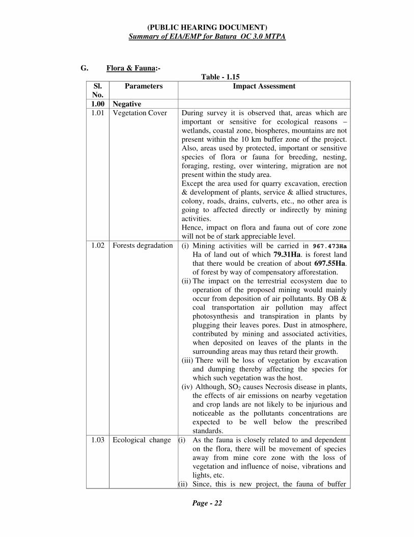
G. Flora & Fauna:-
Table - 1.15
Sl.
No.
Parameters Impact Assessment
1.00 Negative
1.01 Vegetation Cover During survey it is observed that, areas which are
important or sensitive for ecological reasons –
wetlands, coastal zone, biospheres, mountains are not
present within the 10 km buffer zone of the project.
Also, areas used by protected, important or sensitive
species of flora or fauna for breeding, nesting,
foraging, resting, over wintering, migration are not
present within the study area.
Except the area used for quarry excavation, erection
& development of plants, service & allied structures,
colony, roads, drains, culverts, etc., no other area is
going to affected directly or indirectly by mining
activities.
Hence, impact on flora and fauna out of core zone
will not be of stark appreciable level.
1.02 Forests degradation (i) Mining activities will be carried in 967.473Ha
Ha of land out of which 79.31Ha. is forest land
that there would be creation of about 697.55Ha.
of forest by way of compensatory afforestation.
(ii) The impact on the terrestrial ecosystem due to
operation of the proposed mining would mainly
occur from deposition of air pollutants. By OB &
coal transportation air pollution may affect
photosynthesis and transpiration in plants by
plugging their leaves pores. Dust in atmosphere,
contributed by mining and associated activities,
when deposited on leaves of the plants in the
surrounding areas may thus retard their growth.
(iii) There will be loss of vegetation by excavation
and dumping thereby affecting the species for
which such vegetation was the host.
(iv) Although, SO2 causes Necrosis disease in plants,
the effects of air emissions on nearby vegetation
and crop lands are not likely to be injurious and
noticeable as the pollutants concentrations are
expected to be well below the prescribed
standards.
1.03 Ecological change (i) As the fauna is closely related to and dependent
on the flora, there will be movement of species
away from mine core zone with the loss of
vegetation and influence of noise, vibrations and
lights, etc.
(ii) Since, this is new project, the fauna of buffer

(PUBLIC HEARING DOCUMENT)
Summary of EIA/EMP for Batura OC 3.0 MTPA
Page - 23
Sl.
No.
Parameters Impact Assessment
zone will not be so disturbed due to enhancement
of proposed mining activities.
(iii)Pollution of surrounding water bodies and the
nalla flowing adjacent to the core zone, may
affect the aquatic bodies to some extent due to
leaching from overburden dumps and pollutants
from other activities.
1.04 Hydro-geological
aspects
Owing to opencast project, water level and draw
down are likely to be affected to a nominal value;
ground water and surface water on which the flora
and fauna of the area directly or indirectly depend
upon are not going to be affected to an appreciable
and discernible level.
2.00 Positive
2.01 Plantation work and
forest & wild life
conservation
(i) Plantation work & conservation in reclaimed areas
will develop habitat for flora & fauna
(ii) Conservation of forest & wild life in a scientific
way by project authorities will take care of flora &
fauna to revive in the area.
H. Impact on Meteorology:
Meteorological data with respect to temperature for 1996 to 2016have been
collected from nearest IMD station at Umaria. The annual month-wise average
rainfall for 1996 to 2016 has been collected from rain gauge station at
Manendragarh. Average rainfall is 1490.2 mm. Maximum rainfall is received
during monsoon months of June to September. During summer season, the
temperature rises to a maximum of more than 46.9oC with daily maximum and
minimum temperatures averaging about 44oC and 27.6
oC respectively. In
winter, daily maximum and minimum temperatures averaging at about 27oC
and 7.50C respectively.
Looking into general trend of rainfall, differences are within normal cyclic
pattern and cannot be attributed to mining activity in the area. There is slight
temperature variation in its annual cycle. The variation is normal and cannot
be attributed to mining operations.
I. Impact on Hazards:
1.4.4 Environmental Control Measures:
A. Control measures for air pollution:

(PUBLIC HEARING DOCUMENT)
Summary of EIA/EMP for Batura OC 3.0 MTPA
Page - 24
Following activities for air pollution control measures are will be performed
within the mining area and at coal handling plants and railway siding site in
Batura Project Sohagpur Area:
1. Water spraying by water Sprinkler will be done regularly on approach roads
within the mining area to minimise the dust generation.
2. Water sprinkling arrangement will be provided at the transfer point of coal.
3. Intensive plantation of adequate width all along the haul road and other road
will be raised to minimise transport generated pollutants.
4. Crusher house of CHP will be provided with dust extraction arrangements.
5. Minimising the transport of coal from the crusher house to silo loading
system, belt conveyor has been provided.
6. Coal transportation to the Railway siding will be done in covered trucks.
7. Exposed overburden dumps will be covered through an appropriate
plantation
8. Optimum blast hole geometry will be followed to reduce the dust during
blasting.
9. Regular monitoring of ambient air quality of project area.
B. Water Conservation:
The waste water recycling after due treatment for the purpose mentioned above
will enable conservation of water. Storage of conserved water in mine pits will
be given due emphasis to provide water round the year and quality of water
will be maintained before and after storage.
Domestic effluent from the colony will be treated in a conventional septic tank
and soak pit arrangement. Such arrangement will be constructed for different
groups of blocks.
C. Control measures for Noise:
The present noise levels are below the prescribed limits. If the impulsive noise
levels increase due to mining operation, sufficient measures will be adopted to
maintain the noise level within permissible limits at working zone. The
following measures are being adopted and will be continued:
1. Every year extensive plantation is planned to be done both on plain and
dump area by MP Van Vikas Nigam (a state government organization) .
2. Reduced quantity of blasting will result in lower noise levels.
3. Lined chutes in Silo to reduce noise.
4. Surface miner deployed to eliminate coal crushing will reduce noise.
(PUBLIC HEARING DOCUMENT)
Summary of EIA/EMP for Batura OC 3.0 MTPA
Page - 25
5. Provision of ear muffs/ear plugs to workers subjected to noise level above
recommended limits.
6. Regular monitoring of noise level of project area.
7. Routine maintenance schedules for HEMM and other machineries to
eliminate noise as far as possible.
D. Green Belt Development:
In the directions where natural forest does not exist, green belt of adequate width
on acquired land are being developed around the periphery of mining area. The
trees planted in the green belt area shall act as buffers and shock absorber against
dusts, noise and stone flying. The trees in the green belt will be tall, wind firm,
broad leaved and evergreen.
1.4.5 Mine closure planning:
Although, the mining activities may last a few decades, but they are liable to
leave a long lasting impacts on the landscape, ecology and on local inhabitants.
The objective of mine closure plan is aimed at restoration / reclamation of
disturbed area, which should be acceptable to local community as well as
regulatory authority.
Mine closure is not something that happens at the end of a mine’s life, rather
mine closure is an ongoing series of activities starting from the planning stage of
a mine and ending with a suitably restored site that can be returned to the
community. The mine closure is planned in two phases.
a) Progressive Mine closure Plan:-The first phase/progressive site specific
closure plan includes the various activities to be implemented over the life of
the mine. The progressive mine closure plan of the project has been approved
along with its mining plan. As per the guidelines of the MoC, the cost of the
mine closure is to be computed based on the basis of the total project area
involved in the project.
In Batura OCP 2.0 MTY Project, 967.473 Ha of land is involved as total
project area. So, the closure cost is to be computed considering a total area
of 967.473 Ha. and wholesale price index as 182.8 as on 30/09/2016, the
updated cost of the mine closure is estimated to be Rs. 8.463 lakhs per
hectare including admissible escalation over Rs. 6.00 lakh per Ha as on
August 2009.
Total Final mine closure cost @ Rs.8.463/Ha. Rs. 8187.741 lakhs (Approximately)
(PUBLIC HEARING DOCUMENT)
Summary of EIA/EMP for Batura OC 3.0 MTPA
Page - 26
b) Final Mine Closure Plan:-This plan mentioned and incorporated changes
depending upon the actual site condition during implementation, legal &
societal requirements in future, availability of additional coal reserves, etc. As
such a detailed final closure plan will be prepared five years before the
actual/scheduled closure time of the mine. This plan will be the culmination
of the activities given under progressive plan.
1.4.6 Air Quality Impact Prediction (AQIP)*
(a) AAQ modelling based on FDM, USEPA has been used for assessment of
impact on ambient air quality at 6 locations termed as receptors, namely, SA1,
SA2, SA3, SA4, SA5 & SA6 (Refer Plate X due to coal production of 2.0
(Normative) and 3.0 MTY (peak) for Batura OCP. Refer AQIP output data in
Section - C of EIA/EMP
The air quality modelling for Batura OCP has been taken up for its peak
capacity i.e. 3.0 MTY. The Batura OCP is a fresh project. The pollution load
at the receptor locations because of the various activities during the coal
extraction of 3.0 MTY is modelled.
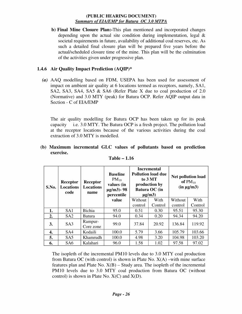
(b) Maximum incremental GLC values of pollutants based on prediction
exercise.
Table – 1.16
S.No.
Receptor
Locations
code
Receptor
Locations
name
Baseline
PM10
values (in
µg/m3)- 98
percentile
value
Incremental
Pollution load due
to 3 MT
production by
Batura OC (in
µg/m3)
Net pollution load
of PM10
(in µg/m3)
Without
control
With
Control
Without
control
With
Control
1. SA1 Bichia 95.0 0.51 0.30 95.51 95.30
2. SA2 Batura 94.0 0.34 0.20 94.34 94.20
3. SA3 Rampur-
Core zone 99.0 37.84 20.92 136.84 119.92
4. SA4 Kodaili 100.0 5.79 3.66 105.79 103.66
5. SA5 Khamrudh 100.0 4.98 3.20 104.98 103.20
6. SA6 Kalahari 96.0 1.58 1.02 97.58 97.02
The isopleth of the incremental PM10 levels due to 3.0 MTY coal production
from Batura OC (with control) is shown in Plate No. X(A) –with mine surface
features plan and Plate No. X(B) – Study area. The isopleth of the incremental
PM10 levels due to 3.0 MTY coal production from Batura OC (without
control) is shown in Plate No. X(C) and X(D).

(PUBLIC HEARING DOCUMENT)
Summary of EIA/EMP for Batura OC 3.0 MTPA
Page - 27
1.5 Analysis of Alternatives:
A. Selection of Technology alternatives:
Method of work to be adopted for any seam depends on many aspects such
as depth of occurrence, thickness and gradient of the seam, parting between
the seams, structure, gassiness of the seam, geological disturbances etc. In
addition the presence of village, built up area and other surface features play
an important role in deciding the method of work.
Underground Mining:
Keeping in view the disposition of coal seams in the area, cover over the
seams and occurrence of thick of seams it does not suit underground
mining.
Opencast Mining:
Considering geo-mining parameters of the quarry, Surface Miner has been
proposed to work for coal winning. Both coal production and OB removal
will be done through outsourcing. Keeping in view techno-economic
viability and environmental consequences of each system the disposition of
coal seam in the area does not suit underground mining techno-
economically. Considering cover over the seam and occurrence of thick of
seams, opencast mining has been proposed.
1.6 Environmental Monitoring Program:
Monitoring Schedule:
A monitoring schedule for Air, Water, and Noise levels will be in operation as
per Standards of MOEF vide GSR 742 (E) dated 25.9.2000 & G.S.R-826 (E),
dated 16/11/2009.
Ambient Air: Parameters will be monitored are SPM, PM10, PM2.5, SO2,
and NOx at the frequency mentioned in GSR 742 (E) dated
25.9.2000 & G.S.R-826 (E), dated 16/11/2009. Monitoring of
heavy metal contents such as lead, chromium, arsenic, nickel
etc. in ambient air quality is being done half yearly.
Water: For effluent & surface water the parameters will be monitored
for pH, Chemical Oxygen Demand, Total Suspended Solid, Oil
& Grease at every fortnight and all parameters once in a year.
For drinking water, monitoring will be done as per
IS.10500 once in a month.

(PUBLIC HEARING DOCUMENT)
Summary of EIA/EMP for Batura OC 3.0 MTPA
Page - 28
For Surface Water, Monitoring will be done on monthly basis
as per IS: 2296: Part C
Noise: Noise is being monitored during day & night at every
fortnight.
Monitoring data thus generated are being submitted to SPCB by end of the following
month.
1.7 Additional Studies:
1.7.1 Public consultation:
To ascertain the concern of local affected persons and others who have a
plausible stake in environmental impacts due to opening of the new greenfield
project / activity for 2.00(Normative) to 3.00 MTPA (Peak) capacity
production, public consultation will be conducted and proceedings will be
included in final EIA/EMP and submitted to MoEF & CC for seeking EC.
1.8 Project Benefits:
1.8.1 Secondary Employment opportunities:
With the expansion of the project, there will be further improvement of the
socio-economic status of the adjoining areas and will help to meet the energy
demand of the nation. Project will lead to development of ancillary industries
and an overall economic growth of nearby towns to supplement the population
of the area.
The project is likely to give a boost to the economy of the area and providing
primary and secondary employment to local people. There will be
improvement in infrastructure facilities like drinking water, medical,
educational, schools etc. There will be overall gain with respect to
improvement in social and economic aspect. This will lead to the overall
development of the society.
There will be spontaneous economic stimulus in the area with the expansion of
opencast mine. Traders and private enterprises will grow in the area with this
economic growth. Besides, the State exchequer will derive financial revenues
through levy of royalty, sales tax etc. and Central Government will also be
benefited by way of Central Sales Tax, Income Tax, Cess‘s etc.
1.9 Environmental Cost Benefit Analysis:
MOEF while issuing TOR has not specifically indicated for carrying out ‘ Cost
Benefit analysis‘, hence the same has not been carried out.
1.10 Environmental Management Plan:

(PUBLIC HEARING DOCUMENT)
Summary of EIA/EMP for Batura OC 3.0 MTPA
Page - 29
1.10.1 Socio Economic Measures:
A. Rehabilitation & Resettlement plan:
The following details would be provided in R&R.
• Land of 3 villages - Belia, Khanda and Rampur involved
• Number of PAFs
PAFs to be resettled : 1870
Project affected persons : 825
• Rehabilitation package based upon M.P State Govt& CIL policy.
• R&R Colony will be constructed.
1.10.2 Land Restoration:
Land reclamation of mined out areas is the prime need. It not only involves
backfilling of overburden into the excavated voids but also includes operations
required to bring the land to some productive use, i.e. agricultural, forestry or
recreational purposes. Dump reclamation is continuous process and a major
activity of progressive as well as final mine closure plan. Reclamation involves
the following processes which include systematic handling, removal, storage,
preservation and re-distribution of top soil after completion of technical
reclamation. Finally biological reclamation with proper plantation technique is
carried out.
1.10.3 Monitoring of Land Restoration / Reclamation:
Land is the most natural resource which embodies soil, water, flora, fauna
and total ecosystem. All human activities are based on the land which is the
most scarce natural resource in our country. Mining is a site specific
industry and it could not be shifted anywhere else from the location where
mineral occurs. It is a fact that surface mining activities do affect the land
environment due ground breaking. Therefore, there is an urgent need to
reclaim and restore the mined out land for its productive use for sustainable
development of the area. This will not only mitigate environment
degradation, but would also help in creating a more congenial environment
for land acquisition by mining companies in future.
Keeping above in view, CIL issued a work order vide letter no.
CIL/WBP/Env/2009/2428 dated 29/12/2009 to CMPDI for monitoring land
reclamation. Status of all the opencast coal mines having 5 Mcum / annum
(coal + OB) based on remote sensing satellite data, regularly on annual basis
for sustainable development of mining. Another work order vide letter no.
CIL/WBP/Env./2011 dated 23/08/2011 was issued by CIL for monitoring of
less than 5 M Cum / (Coal + OB) annum (Coal + OB) capacity projects from

(PUBLIC HEARING DOCUMENT)
Summary of EIA/EMP for Batura OC 3.0 MTPA
Page - 30
the year 2011 at interval of 3 years. Further a revised work order was issued
vide letter no. CIL/WBP/Env./2011/4706 dated 12/10/2012 from CIL for
2012 – 13 to 2016 – 17.
Objective: Objective of the land restoration/reclamation monitoring is to
assess the area under back filling, plantation, social forestry, active mining
area, water bodies, and distribution of waste land, agricultural land and
forest in the leasehold area of the project. This will help in assessing the
progressive status of mined land reclamation and to take up remedial
measures, if any, required for environment protection.
1.10.4 Flora and Fauna Conservation Plan:
The land requirement of Mine Area (Core Zone) is 967.473Ha. in which forest
land is 101.40Ha. The forest cover in buffer zone is about 6187.05 Ha.(
6266.36Ha in the study area). In the absence of scientific management in the
past, these forests have suffered from heavy felling. Biotic pressure put exerted
by human beings and domestic animals of surrounding areas is also
tremendous.Dust in atmosphere, contributed by mining and associated
activities, when deposited on leaves of the plants in the surrounding areas
may thus retard their growth. There will be loss of vegetation by excavation
and dumping thereby affecting the species for which such vegetation was the
host.Care will be taken to plant native and other suitable species. As it is
difficult to regenerate sal on OB dumps, the other forest species – Salai, Saja,
Sisoo, Babool etc will be planted in addition to other suitable species. However
an attempt will be made to introduce Sal, the native species of the area on the
OB dumps. The other fruit bearing trees recommended are Mahuwa, Jamun,
Bargad, Pipal, Gular, Aonla, Ber, Imli, Kusum, etc. Grass species will be
planted along with the fruit trees on the slopes. On the top surface of the dumps
the lower storey will include grasses & fruit trees. The abundance of fruit trees
(about 50% of all tree species to be planted) will ensure availability of food to
faunal species like sloth beer, & fox. Grass species will support smaller
herbivores like Hare. Logs of dead trees will be preserved in the vegetated areas
to restore key habitats of the insects of the area. The trees of Ficus species will
support python.
Among the faunal groups avifauna of terrestrial inhabitants of passerine
category birds are conspicuous in grass lands (degraded forest) and forests
present within the study area of the project.
The domesticated animals like Goat (Capra aegagrus); Buffalo
(Bubalusbubalis); Cow (Bosprimigenius); and Dog (Canis lupus familaris)
were found in villages. The aquatic habitats consist of River, Nalla, Ponds;
Ditches and water logged areas were represented by fin-fish (fishes), shell-fish
(mollusk) and prawns (crustaceans) of seasonal varieties.

(PUBLIC HEARING DOCUMENT)
Summary of EIA/EMP for Batura OC 3.0 MTPA
Page - 31
As the fauna is closely related to and dependent on the flora, there will be
movement of species away from mine core zone with the loss of vegetation and
influence of noise, vibrations and lights, etc.
However, Plantation work & conservation in reclaimed areas will develop habitat for
flora & fauna. Conservation of forest & wild life in a scientific way by project
authorities will take care of flora & fauna to revive in the area.
Details of flora & fauna present in study area have been shown in Chapter – III of
EIA/EMP, which are all important from conservation point of view. SECL will take
the following measures for their protection.
1.10.5 Protection measures:
With the help of the local people and employees watch will be kept on hunting
of these animals. Forest and police department will be informed if such
incident happens to take action against the offenders. If necessary help of
Forest dept. will be taken to shift any such stranded animal to a safer place.
Care will be taken to stop undue biotic pressure (both man and its animal) in
core and buffer zone. SECL, under the condition stipulated in forest land
clearance, provides funds to Forest department for fencing the forest falling out
of core zone. The fencing will further strengthen our attempt towards
conservation efforts. In addition, while under taking bio-reclamation of over
burden dumps care will be taken to plant fruit trees.
1.10.6 Strengthening of water bodies:
a. Through Community development work in villages existing in the area
existing water sources particularly the village tanks will be improved to
provide drinking water to the local community so that biotic pressure on
water resources used by fauna is gradually reduced. Snakes being a water
loving animal will be greatly benefited by this program.
b. The topography of the qurriable and adjoining area shows that rainwater
from the north-eastern side of the area of quarry will not be disturbed and
will reach the Son River. To protect any spill over from adjacent Katnanala
into mine workings, the banks will be strengthened as per DGMS norms.
By discharge of mine water into the adjacent Katnanala, is being a fourth
order stream with, the mine discharge will not make any variation in its
carrying capacity. Thereby, the drainage system will not be disturbed
1.10.7 Afforestation:
(PUBLIC HEARING DOCUMENT)
Summary of EIA/EMP for Batura OC 3.0 MTPA
Page - 32
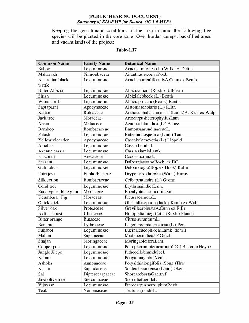
Keeping the geo-climatic conditions of the area in mind the following tree
species will be planted in the core zone (Over burden dumps, backfilled areas
and vacant land) of the project:
Table-1.17
Common Name Family Name Botanical Name
Babool Leguminosae Acacia nilotica (L.) Willd ex Delile
Maharukh Simroubaceae Ailanthus excelsaRoxb.
Australian black
wattle
Leguminosae Acacia auriculiformisA.Cunn ex Benth.
Bitter Albizia Leguminosae Albiziaamara (Roxb.) B.Boivin
Sirish Leguminosae Albizialebbeck (L.) Benth
White sirish Leguminosae Albiziaprocera (Roxb.) Benth.
Saptaparni Apocynaceae Alstoniascholaris (L.) R.Br.
Kadam Rubiaceae Anthocephaluschinensis (Lamk)A. Rich ex Walp
Jack tree Moraceae ArtocarpusheterophyllusLam.
Neem Meliaceae Azadirachtaindica (L.) A.Juss.
Bamboo Bombacaceae BambusaarundinaceaeL.
Palash Leguminosae Buteamonosperma (Lam.) Taub.
Yellow oleander Apocynaceae Cascabelathevetia (L.) Lippold
Amaltas Leguminosae Cassia fistula L.
Avenue cassia Leguminosae Cassia siamiaLamk.
Coconut Arecaceae CocosnuciferaL.
Seasam Leguminosae DalbergiasissooRoxb. ex DC
Gulmohur Leguminosae Delonixregia(Boj. ex Hook) Raffin
Putrajevi Euphorbiaceae Drypetusroxburghii (Wall.) Hurus
Silk cotton Bombacaceae Ceibapentandra (L.) Gaertn
Coral tree Leguminosae ErythrinaindicaLam.
Eucalyptus, blue gum Myrtaceae Eucalyptus teriticornisSm.
Udumbara, Fig Moraceae FicusracemosaL.
Quick stick Leguminosae Gliricidiasepium (Jack.) Kunth ex Walp.
Silver oak Proteaceae GrevillearobustaA.Cunn ex R.Br.
Avli, Tapasi Ulmaceae Holopteliaintegrifoila (Roxb.) Planch
Bitter orange Rutaceae Citrus aurantiumL.
Banaba Lythraceae Lagerstroemia speciosa (L.) Pers
Subabol Leguminosae Lucinaleucophloea(Lamk) de wit
Mahua Sapotaceae MadhucaindicaJ F Gmel
Shajan Moringaceae MoringaoleiferaLam.
Copper pod Leguminosae Peltophorumpterocarpum(DC) Baker exHeyne
Jungle Jilepe Leguminosae PithecellobiumdulceL.
Karanj Leguminosae PongamiaglabraVent.
Ashoka Annonaceae Polyalthialongifolia (Sonn.)Thw.
Kusum Sapindaceae Schleicheraoleosa (Lour.) Oken.
Sal Dipterocarpaceae ShorearobustaGaertn f
Java olive tree Sterculiaceae SterculiafoetidaL.
Vijaysar Leguminosae PterocarpusmarsupiumRoxb.
Teak Verbenaceae TectonagrandisL.

(PUBLIC HEARING DOCUMENT)
Summary of EIA/EMP for Batura OC 3.0 MTPA
Page - 33
Arjun Combretaceae Terminaliaarjuna (Roxb. ex DC.) Wight&Arn.
Bastard almond, Combretaceae TerminaliacatappaL.
Portia tree Malvaceae Thespesiapopulnea(Linn) Soland ex corr
Planting of such fruit and fruit bearing trees will improve the habitat of these
animals, and will attract birds, insects etc.
1.10.8 Control of forest fire, fire in coal seam and coal stock.
Fire can destroy the entire habitats (micro and macro) and its life supporting
potential in a forest area. Fire does not spare fauna also. SECL will implement
the existing DGMS stipulated fire protection norms on coal seams and coal
stock. This will ensure that a congenial atmosphere is created and fire does not
affect the fauna and flora as well.
SECL will also encourage its employees and villagers to report forest fires (if
any) to Forest/Police department. SECL will also extend its firefighting
capabilities whenever needed to forest department for fighting forest fires.
1.10.9 Funds for Conservation efforts:
In the EMP funds have been committed under capital & revenue heads for
afforestation, reclamation and other miscellaneous expenditure. These funds
will be utilized for conservation efforts. However any additional requirement
for conservation plan will be met from the normal revenue expenditure of the
opencast project.
1.11 Disclosure of Consultants Engaged:
Central Mine Planning & Design Institute Limited. Briefly, it is generally
called as CMPDI. It is an ISO 9001 Company. It is QCI/NABET Accredited
Environmental Consultancy organization [vide Minutes of Accreditation
Committee Meeting No. 76 for Re-Accreditation held on Jan. 13, 2016.
Its registered corporate office is situated at Gondwana Place, Kanke Road,
Ranchi-834 008, a capital city of Jharkhand state. It operates through seven
strategically located Regional Institutes over six states territories of India.
These Regional Institutes are engaged in exploration , planning & design works
of other subsidiary companies of CIL, namely , ECL, BCCL, CCL,MCL, NCL,
WCL,SECL and NECL.
The company was formerly known as Coal Mines Authority Limited. And, the
Central Mine Planning & Design Institute Limited (herein after called as
CMPDI) is a planning & design division of Coal India Limited (hereinafter
called as CIL) as per Memorandum of Association of the company. The CIL is

(PUBLIC HEARING DOCUMENT)
Summary of EIA/EMP for Batura OC 3.0 MTPA
Page - 34
a holding company since November 01, 1975, and the CMPDIL is one of its
subsidiaries since then. It is under Ministry of Coal, Government of India.
The environmental laboratory of CMPDI is recognized by NABL and
accredited with ISO-9001 & OHASAS 18001 certification. It undertakes
baseline environmental data generation, EIA, EMP and monitoring various
factors related environment. It has obtained NABL Accreditation {Certificate
No.-T-2968} valid from 24.05.16 to 23.05.18 for the lab located at CMPDI, RI-
V, Bilaspur.
============