
EIA for development drilling of hydrocarbons at Khoraghat ...
211
EIA for development drilling of hydrocarbons at Khoraghat Extension ML Block Draft EIA Report Prepared for: Oil and Natural Gas Corporation Limited Prepared by: SENES Consultants India Pvt. Ltd. December 2013
-
Upload
khangminh22 -
Category
Documents
-
view
0 -
download
0
Transcript of EIA for development drilling of hydrocarbons at Khoraghat ...

EIA for development drilling of hydrocarbons at Khoraghat Extension ML Block
Draft EIA Report
Prepared for:
Oil and Natural Gas Corporation Limited
Prepared by:
SENES Consultants India Pvt. Ltd.
December 2013

EIA for development drilling of hydrocarbons at Khoraghat Extension ML Block
SENES/K-20199/ December 2013 b ONGC
DRAFT REPORT
Oil and Natural Gas Corporation Limited
EIA for development drilling of
hydrocarbons at Khoraghat Extension ML
Block
For on and behalf of SENES Consultants India Ltd
Approved by Mr. Salil Das
Signed by
Position held NABET-QCI Accredited EIA Coordinator
for Offshore & Onshore Oil and Gas
Exploration Development and Production
Date December 10th
2013
The EIA report preparation have been undertaken in compliance with the approved ToR
issued by MoEF vide letter no. ToR vide letter J-11011/563/2011-IA II (I) dated 28th
May,
2012.Information and content provided in the report is factually correct for the purpose and
objective for such study undertaken.

EIA for development drilling of hydrocarbons at Khoraghat Extension ML Block
SENES/K-20199/ December 2013 c ONGC
Abbreviation
ALARP As Low As Reasonably Practicable
BOD Biological Oxygen Demand
BOP Blow out Preventor
Block Khoraghat Extension ML Block
Cd Cadmium
CGWB Central Ground Water Board
COD Chemical Oxygen Demand
CPCB Central Pollution Control Board
Cr Chromium
CSR Corporate Social Responsibility
Cu Copper
DG Diesel Generator
DGH Directorate General of Hydrocarbons
DMP Disaster Management Plan
DO Dissolved Oxygen
EC Environmental Clearance
EIA Environmental Impact Assessment
EMP Environment Management Plan
ETP Effluent Treatment Plant
FC Forest Clearance
GGS Group Gathering Station
GLC Ground Level Concentrations
GoI Government of India
HC Hydrocarbon
HDPE High Density Polyethylene
HSD High Speed Diesel
HSE Health, Safety and Environmental
IMD Indian Meteorological Department
IUCN International Union for Conservation of Nature & Natural Resources
KLD Kilo Liter per Day

EIA for development drilling of hydrocarbons at Khoraghat Extension ML Block
SENES/K-20199/ December 2013 d ONGC
KW Kilo Watt
MoEF Ministry of Environment and Forests
NAAQS National Ambient Air Quality Standards
NABET National Accreditation Board for Education and Training
NABL National Accreditation Board for Testing and Calibration Laboratories
NELP New Exploration Licensing Policy
NH National Highway
NOx Oxides of Nitrogen
OCS Oil Collection Station
O&G Oil & Gas
ONGC Oil and Natural Gas Corporation Limited
OSHA Occupational Safety and Health Administration
Pb Lead
PEL Petroleum Exploration License
PM Particulate Matter
PPE Personnel Protective Equipments
PSC Production Sharing Contract
PUCC Pollution Under Control Certificate
QCI Quality Council of India
QRA Quantitative Risk Assessment
RF Reserved Forest
SO2 Sulphur Dioxide
SPCB State Pollution Control Board
SPL Sound Pressure Level
TDS Total Dissolved Solid
TG Tea Garden
TSS Total Suspended Solids
VOC Volatile Organic Compound
WBM Water Based Mud
WLS Wild Life Sanctuary

EIA for development drilling of hydrocarbons at Khoraghat Extension ML Block
SENES/K-20199/ December 2013 i ONGC
Executive Summary
INTRODUCTION
The Khoraghat Extension ML Block part of Assam-Arakan Basin is located in Golaghat
District of Assam. Oil and Natural Gas Corporation Limited (ONGC) plans to drills two
development wells in Khoraghat Extension ML Area. ONGC already has existing facilities
like production wells, two Group Gathering Stations (GGS) and interconnecting pipelines in
the Block.
SENES Consultants India Pvt. Ltd. (SENES) a NABET-QCI Accredited firm has been
entrusted to conduct an Environmental Impact Assessment (EIA) for the proposed activities
in the Khoraghat Extension ML Block. The EIA study comprised of initial scoping & site
visit, environmental monitoring & surveys, preparation of draft EIA-EMP report for Public
Hearing (PH).
PROJECT DESCRIPTION
Block Location & Accessibility
Khoraghat Extension ML area is 83 square kilometer and located in Golaghat District,
Assam, close to Nagaland Hills. The Block is flanked by Dayang River flowing in the East
and Rengma River through the central part of the Block. The confluence of Dayang and
Rengma lies at the north of the Block. The Block is topographically represented in Survey of
India’s 83 M/3, 83 M/7 and 83 M/11 toposheets. Three wells (KHDD, KHDE and KHDF) are
proposed to be located in Haldhibari village. KHDD and KHDE will be drilled at new
locations in agricultural fields and KHDF is proposed to be drilled at an existing facility of
Khoraghat GGS-1 of ONGC.
The Khoraghat ML Block can be accessed by road from the district town of Golaghat. The
route is via NH-36 till Shilanijan and then via. rural roads through Barpathar, Sarupathar,
Uriamghat and finally to the site. Sarupathar is the nearest railway station (approx. 24 km)
and is part of North-East Frontier Railways connecting Guwahati with Dibrugarh. The closest
Airport is at Dimapur, Nagaland, approximately 60 km from the Block.
Land Lease
The Khoraghat ML Block is located on forest lands of Dayang Reserve Forest and Rengma
Reserve Forest. Approximately 2.25 hectare of land will be required per drill sites and an
approximate 0.02 ha is required for approach road for KHDD and KHDE. Both the proposed
development wells are located at Rengma Reserve Forest. Entire forest land in the block is
encroached and presently used for agricultural practices. As per Forest (Conservation) Act
1980, ONGC will take forest clearance from Center/State for diversion of forest land. ONGC
has already obtained permission for the conversion of Forest land for KHDF drill site, which
is located within existing Khoraghat GGS-1. Applications for the conversion of forest land
for the new development well sites KHDD and KHDE has already been submitted to the
Forest Department.

EIA for development drilling of hydrocarbons at Khoraghat Extension ML Block
SENES/K-20199/ December 2013 ii ONGC
Since the forest land is used for agricultural purpose, ONGC will give the crop compensation
as ONGC’s policy of leasing land. On the culmination of the activities, the land will be
restored to its original state and returned to their previous users.
Project Activities
This activity involves
well site preparation, construction of access roads,
Well drilling and testing.
Site closure and decommissioning of wells not indicative of potential hydrocarbon
reserves.
Construction Drill site
Both the drill sites are connected with site access road. A small approach road needs to be
constructed for KHDE drill site. The construction of drill site will involve top soil scraping
and storage for future use, elevating the drill platform by locally available fill material,
construction of High Density Polyethylene (HDPE) lined pits for storage of drill cutting,
waste mud and drilling wash water, construction of suitable storm water drainage system with
oil trap.
Drilling & Testing
The drilling of the wells is expected to be up to a depth of 2500 meters. Standard Land Rig
or Mobile Land Rig with standard water based drilling fluid treatment system will be used for
drilling. Drill cuttings generated will be collected and separated using a solid control system
and temporarily stored on-site in HDPE lined pits. Drilling and wash wastewater generated
will also be stored at an onsite HDPE lined pit. The water will be adequately treated in a
mobile Effluent Treatment Plant (ETP) to ensure conformance to the CPCB onshore oil and
gas extraction industry effluent standards before disposal.
Site closure and decommissioning
The drill sites will be properly reclaimed and rehabilitated if no commercial reserve has been
established. This process will involve decommissioning of rigs and all machineries; disposal
of drilling waste as per CPCB guidelines, disposal of fill materials, top soil restoration.
Project Utilities and Resource Requirements
Power
The power requirement for each drill sites will be met through the DG sets. One DG set of
750 KW will be used during site construction. Two DG sets of 750 KW will be
simultaneously operable and one will be kept as standby during drilling operation and one for
lighting and other power requirements. It is estimated that 6 KLD of diesel will be required
during drilling phase alone. Reserve Fuel will be stored as per Petroleum Rules 2002.

EIA for development drilling of hydrocarbons at Khoraghat Extension ML Block
SENES/K-20199/ December 2013 iii ONGC
Water
Water demand during peak construction period is estimated to be 5KLD for construction and
3 KLD for workers at each well site. During the drilling operation, water requirement at site
to meet the industrial requirements is 20 KLD. Total water requirement at each well site
during drilling activities is estimated to be 1200 KL, considering a total of 60 days of drilling
operation (including testing & contingency period). The water requirement at the drilling
sites during construction and drilling phase will be met through procurement of
surface/ground water from approved local sources/suppliers and partly through re-cycling of
treated water from ETP.
Manpower
During peak construction phase (including site preparation), approximately 40-50 personnel
will be engaged including skilled and unskilled labour at each well site. Both locals and
labours from outside will be engaged depending on skills and project requirements.
25-30 personnel will be employed at the drill site at each shift. Provisions for drinking water
and water for other purposes, sewage disposal will be provided at drill site and campsite.
Kitchen facility will be provided at the campsite.
Pollution Sources and Characterization
Noise
Construction equipments and drilling activities generate noise ranging from 79-103 dBA.
Air Emissions
DG set, fugitive dust emission and flaring activities are the major sources of air pollution.
Liquid Waste
9KLD of Drilling and Wash Wastewater and 2.4KLD of Domestic wastewater will be
generated peak drilling period.
Solid and Hazardous Waste
The major solid waste generated during peak drilling period will be 212-225m3of mud
cuttings.
BASELINE ENVIRONMENTAL STATUS
The study of the baseline environmental status helps in assessing the existing environmental
conditions and identifying the critical environmental attributes. The study of the physical,
biological and socio-economic environment of the Block and an area within a radius of 10
km from two development wells (study area) comprises of the baseline environment. Primary
and secondary data were collected for conducting the EIA study.

EIA for development drilling of hydrocarbons at Khoraghat Extension ML Block
SENES/K-20199/ December 2013 iv ONGC
Physical Environment
Climate and Meteorology
The study area experiences a humid and warm sub-tropical climate throughout the year
except for a cold winter in December till February. Hourly micro-meteorological data
collected during the pre-monsoon reveals that the pre-dominant wind direction is from South-
East with an average speed of 0.80 m/s.
Air Quality
The ambient air quality representing Particulate Matter (PM10), Sulfur Dioxide (SO2),
Nitrogen Dioxide (NO2) was monitored at eight different locations for 24 hours twice a week
during April-June, 2013.Volatile Organic Carbons (VOCs), Methane (CH4), non-methane
hydrocarbons (NMHCs) were monitored once a week for the same period. All the parameters
were found to be below the National Ambient Air Quality Standards (NAAQS), 2009. The
average 24 hourly PM10 at the monitoring locations ranged between 50.21-70.07µg/m3
(NAAQS-100 µg/m3). The average 24 hourly NO2 at the monitoring locations ranged
between 19.79-24.21 µg/m3
(NAAQS-80 µg/m3). The average 24 hourly SO2 at the
monitoring locations were found to below 4µg/m3
(NAAQS-80 µg/m3). Mean values for
methane and non-methane hydrocarbon ranged between 1.29-2.9 ppm and 0.2-0.7 ppm,
respectively. Mean values of VOC varied between 0.55-2.9 ppm.
Noise Quality
The noise quality was monitored for 24 hours at eight locations close to the drill sites. The
ambient noise quality at day and night was in compliance to the Noise Limits set for the
residential area as per Noise Pollution (Control and Regulations), 2000. The maximum
daytime noise level was detected at 46dBA and the maximum nighttime noise level was
detected at 37dBA.
Physiography
The Khoraghat Block lies in the Brahmputra Valley, drained by Dayang and Rengma rivers.
The Block comprises of alluvial deposits of the rivers that flows down from Naga Patkoi
range. The land slopes from South to North. A continuous belt of piedmont and foothills
extends all along the southern margin of the study area that is undulating in nature.
Geology
The Block lies on different formations of Neogene (Moran, Tipam and Bokabil) and
Paleogene (Barails, Kopili, Sylhet and Tura) sequences. The pay sands are mainly confined
between Barial top conformity and an erosional surface above lower Bokabil.
Hydrogeology
The unconsolidated formations of the sandstone, shale, limestone including conglomerate of
the Coenozoic, Mesozoic and Upper Paleozoic era in the Brahmaputra Basin are significant

EIA for development drilling of hydrocarbons at Khoraghat Extension ML Block
SENES/K-20199/ December 2013 v ONGC
ground water reservoirs. The cumulative thickness of aquifer zones has the tendency to
increase towards the North and southeastern parts. The potential yield of groundwater from
tubewell extending to a depth of 30-50m ranges from 30 to 35m3/hr. and the yield from the
deep tubewell varies from place to place depending on the aquifer. As calculated by Central
Ground Water Board, the total annual groundwater draft is 22143 of which 19751ham is
expended for irrigation and 2391ham for domestic and industrial purposes.
Groundwater Quality
Groundwater was collected and analysed as per IS: 10500 from four locations in the study
area. All the parameters analysed was under the acceptable and permissible limit of IS: 10500
except turbidity and iron that was found to be high in all the samples. Heavy metals were
found to be below detection limit. Faecal coliform was detected in the two samples collected
from dug wells.
Watershed and Drainage
The Block lies in the watershed of Dhansiri River. River Dayang (tributary of Dhansiri River)
and Rengma (tributary of Dayang River) are the Principle Rivers that drains the Block.
Surface Water Quality
Surface water was sampled from upstream and downstream of Dayang and Rengma Rivers.
The water samples were analysed and compared with the Designated Best Use Classification
of Surface Waters as per CPCB. The quality of Dayang River (upstream and downstream)
was found suitable for Class A as the total coliform ranged between 9-14 MPN/100ml, pH
ranged between 6.8-7.4, DO ranged between 3.5 and 6.7 mg/l and BOD was less than 2mg/l
except for 1 sample of Rengma river. The water quality of River Rengma upstream is suitable
for Class B as DO is less than 5.4 and total coliform count is 80 MPN/100ml whereas water
quality at downstream is suitable for Class E as pH is 6.8, EC is 137.75 micromhos/cm, SAR
is 0.64 and Boron is less than 1mg/l.
Land Use
The Khoraghat ML Block is included under the Dayang Reserve Forest and Rengma Reserve
Forest. Currently the forested areas are deforested and used for agricultural activities and
human habitation.
The Block land cover data showed majority of the land (about 64%) in the area is used for
agriculture purpose with paddy as the primary produce. Settlements comprise about 33% of
the total area of the Block. River Rengma and Dayang comprise of 1.3% of the total Block
area. Drill pads, GGS etc. facilities of ONGC comprise 0.05% of the total area.
Soil Quality
Primarily two types of soil – Inceptisol (Old alluvial) and Entisols (Recent Alluviums) can be
seen in Golaghat District. The primary analyses of the soil sampled from agricultural field at
5 locations in the study area shows that the soils are acidic in nature, either sandy loam or
EIA for development drilling of hydrocarbons at Khoraghat Extension ML Block
SENES/K-20199/ December 2013 vi ONGC
clayey, high in available nitrogen content. The micronutrient levels observed in the soil
samples do not indicate any extraordinary enrichment of metals or contamination from any
external sources.
Natural Hazards
The study area lies in Zone V of the Bureau of Indian Standard (BIS) 2000 which might
encounter earthquakes of maximum intensity. Floods are common in the few parts of the
Khoraghat Extension ML Block but not at locations proximal to the proposed activities.
Biological Environment
The Khoraghat Extension ML Block lies in the Rengma, Dayang and Nambor Reserve Forest
areas. The reserve forests within the Khoraghat Extension ML Block have totally lost its tree
cover due to extensive deforestation. Presently the whole area is under cultivation and not a
single tree will be felled for the proposed activities. However, Golaghat district is rich in
biodiversity and has a number of ecologically sensitive areas like wildlife sanctuaries,
National Parks and Elephant Reserves. None of these ecological habitats lie within the study
area and hence will not be impacted by the Project.
Socioeconomic Environment
Golaghat District in Assam has 1125 villages under eight administrative Blocks. As per 2011
Census, the total population of the district is 1,058,674 with a percent decadal growth rate of
11.88. The sex ratio of is 961 and the population density is 305.
Socioeconomic profile
Twenty three villages within the study area were selected for developing the socioeconomic
profile of the area. It was seen from the Census Data of 2001, Bidyapur Village has the
highest population (1555 persons). The overall demography shows that the 0.02% and
14.65% of the population of the study area villages belongs to Scheduled Caste and
Scheduled Tribe, respectively. The highest literacy rate (74.68%) was observed in Majgaon
and the least was found in Madhupur No.2 (14.31%). The total working population varies
from 15.60% (Chetiagon No.2 Village) to 69.77% (Majhgaon Village). Mono-cropping is
practiced in the study area where 74% of the population depends on agriculture.
Socioeconomic Infrastructure
The socioeconomic infrastructures of the Golaghat district as per 2011 District Handbook
have been outlined here. There is 1 Civil Hospital, 1 sub-divisional hospital, 38 Primary
health Centers, 1 first Referral Units, 5 Community Health Center and 144 sub centers. There
are 864 Primary, 194 Middle and 173 Secondary and 23 Senior Secondary Schools. Drinking
water facility exists in the premises of 46.1% of households. Power supply is present in
36.6% of households.

EIA for development drilling of hydrocarbons at Khoraghat Extension ML Block
SENES/K-20199/ December 2013 vii ONGC
On consultation with the local people, the following facts were revealed
Primary schools are present in almost all the villages in the study area
Majority of the people are farmers, the area is mostly monocropped and paddy is the
major crop
Electrical connection is present in all the villages though frequent power failure has
been reported
Dugwell forms the major source of groundwater
Villagers are not satisfied with the health facility as the tertiary referral center is less
in this District
ENVIRONMENTAL IMPACT ASSESSMENT
The potential impacts of the project on different components of the environment was
systematically identified and evaluated for significance. The principal concerns that emerged
are:
Impact on Air Quality
The operation of DG sets, movement of vehicles and machineries during construction and
drilling at drill sites will result in the generation of air pollutants viz. PM, NOx and SOx which
may affect the ambient air quality temporarily. Air pollutants like NOx will also be generated
as a result of flaring of natural gas.
Impact on Noise Quality
Operation of heavy machinery/equipments and vehicular movement during site preparatory
and road strengthening/construction activities may result in the generation of increased noise
levels. Operational phase noise impacts are anticipated from operation of drilling rig and
ancillary equipment viz. shale shakers, mud pumps and diesel generators.
Impact on Soil Quality
Stripping of top soil will affect the soil fertility of the well sites. Potential impact on soil
quality may result from storage and handling of fuel, lubricants and from storage and
handling of drilling mud and drill cuttings.
Impact on Topography and drainage
Elevating the land to about 1 m from the ground level during site preparation may lead to
alteration of onsite micro-drainage pattern. This might lead to the flow of untreated waste
water and excess rain water to the adjoining agricultural land thereby adversely impacting the
fertility of the soil.
Impact on Water Quality and Hydrology
The surface run off from drilling waste (cuttings and drilling mud), hazardous waste (waste
oil, used oil etc) and chemical storage facilities on open soil is likely to contaminate if

EIA for development drilling of hydrocarbons at Khoraghat Extension ML Block
SENES/K-20199/ December 2013 viii ONGC
allowed to flow into nearby water bodies viz. natural drainage channels, ponds etc. Possibility
of contamination of subsurface and unconfined aquifers may exist if the casing and
cementing of the well is not carried out properly leading to infiltration or seeping of drilling
chemicals or mud into porous aquifer region.
Impact on Biological Environment
There is no demarcated and sensitive wildlife habitat or Schedule I species within the Block
or its adjacent area. The area is free from any migratory route or corridors (daily and seasonal
movement) for animals. However, noise generated from drilling activities, lighting at well
site, traffic movement will cause of disturbance to local fauna.
Impact on Socio economic Environment
The proposed well site KHDD and KHDE is located in land currently used for agricultural
(monocropped) purpose. ONGC will take this land through private negotiation. Necessary
payments will be made against purchase and crop compensation to concerned land owners.
As the proposed well KHDF will be located within the existing GGS land procurement would
not take place. The proposed project would not require any displacement of villagers.
The project will benefit the people living in the neighboring villages by giving preference to
them in relation to direct & indirect employment associated with the various project activities
and boosts the local economy. The proposed project will therefore involve the improvement
of existing road and/or bridge condition thereby enabling the transportation of drilling rig and
ancillary equipment.
Quantitative Risk Assessment
The quantitative risk assessment has been done to provide a systematic analysis of the major
risks associated with onshore development drilling activities in Khoraghat Extension ML
Block. Oil spills, loss of well control/blow-out and process leaks constitute the major
potential hazards of onshore drilling. Based on Frequency Analysis Method, it has been
estimated that the likelihood of a blowout is Occasional/Rare at a rate of 2.25X10⁻²
.
Even on blowout, the probability of ignition is approximately 0.0015% i.e. negligible. The
consequence analysis of Blowout assessed by using ALOHA shows settlements like
Chetanapur and part of Haldhibari that are close to KHDE and KHDF might be impacted by
pool fire and natural gas release.
ENVIRONMENTAL MANAGEMENT PLAN
Site-specific Environment Management Plans (EMP) has been developed to prevent and
mitigate significant adverse impacts and accentuate beneficial impacts will be implemented
by ONGC for the proposed project. The key mitigation measures specific for each
management plan have been discussed in the Table below:

EIA for development drilling of hydrocarbons at Khoraghat Extension ML Block
SENES/K-20199/ December 2013 ix ONGC
Sl.
No
Environment
Management
Plan
Key Mitigation Measures
1 Pollution
Prevention and
Abatement Plan
The top soil generated from site clearance activities will be stored in
designated area and stabilized to prevent fugitive dust emissions
Preventive maintenance of DG sets to be undertaken as per
manufacturers schedule to ensure compliance with Sl No 95 GSR
371(E) dated 17.5.2002.
All vehicles, equipment and machinery used for construction will be
subjected to preventive maintenance as per manufacturer norms.
Flaring will be undertaken in accordance with the CPCB Guidelines
S No. 72 B. for Discharge of Gaseous Emissions for Oil & Gas
Extraction Industry.
High combustion efficiency, smokeless flare/burner will be used.
Installation of acoustic enclosures and mufflers on engine exhaust of
DG sets to ensure compliance with generator noise limits specified
by Sl No 94 GSR 371(E) dated 17.5.2002.
Effective noise barrier at the fence-line of the sites.
Install and maintain effective run-off controls, including silt traps,
straw barriers etc so as to minimize erosion.
Fuel and chemical storage areas will be paved and properly bunded.
Proper casing and cementing of drilling well will be done to prevent
contamination of sub-surface aquifers.
Water based mud to be used as a drilling fluid or else eco-friendly
synthetic based mud in necessary conditions
2 Waste
Management Plan
Use of low toxicity chemicals for the preparation of drilling fluid.
Management of drill cuttings, waste drilling mud, waste oil and
domestic waste will be made in accordance with S No. 72 C.1.a
Schedule I Standards for Emission or Discharge of Environmental
Pollutants from Oil Drilling and Gas Extraction Industry of CPCB as
modified in 2005Necessary spill prevention measures viz. spill kit
will be made available at the hazardous material storage area
The hazardous waste (waste and used oil) will be managed in
accordance with Hazardous Waste (Management, Handling &
Transboundary Movement) Rules, 2008
The hazardous waste so stored (not more than 3 months) to be
periodically sent to ASPCB registered used and/or waste oil
recyclers/ facilities.
Proper manifest as per HWMH Rules, 2008 to be maintained during
storage
The kitchen waste will be disposed in nearest municipal dumping
site on a daily basis through approved waste handling contractors
The sewage generated will be treated in a combination of septic tank
and soak pit.
Used batteries will be recycled through the vendors supplying lead
acid batteries as required under the Batteries (Management &

EIA for development drilling of hydrocarbons at Khoraghat Extension ML Block
SENES/K-20199/ December 2013 x ONGC
Sl.
No
Environment
Management
Plan
Key Mitigation Measures
Handling) Rules, 2001.
Recyclables will be periodically sold to local waste recyclers.
3 Wild Life
Management Plan
The drill site will be properly fenced (chain-linked) to avoid straying
of any outsider as well as wildlife;
No temporary electric supply connection line from the grid will be
laid for the proposed project activity. All electric requirements will
be supplied from the internal DG sets.
Noise Levels at the drill site will be controlled through selection of
low noise generating equipment and installation of sufficient
engineering controls viz. mufflers, silencers etc.
Movement of heavy vehicles will be restricted at night time
4 Road Safety &
Traffic
Management Plan
Project vehicular movement involved in sourcing and transportation
of borrow material will be restricted to defined access routes.
Precautions will be taken to avoid damage to the public access routes
including highways during vehicular movement.
Clear signs, flagmen & signal will be set up at major traffic junctions
and near sensitive receptors viz. primary schools in discussion with
Gram Panchayat and local villagers.
Movement of vehicles during night time will be restricted. Speed
limits will be maintained by vehicles involved in transportation of
raw material and drilling rig.
A Traffic Management Plan will be formulated and implemented by
the contractor to control construction and operational phase traffic.
Routine maintenance of project vehicles will be ensured to prevent
any abnormal emissions and high noise generation.
Adequate training on traffic and road safety operations will be
imparted to the drivers of project vehicles. Road safety awareness
programs will be organized in coordination with concerned
authorities to sensitize target groups viz. school children, commuters
on traffic safety rules and signage.
5 Occupational
Health & Safety
Management Plan
All machines to be used in the construction will conform to the
relevant Indian Standards (IS) codes, will be kept in good working
order, will be regularly inspected and properly maintained as per IS
provisions and to the satisfaction of the site Engineer.
Contractor workers involved in the handling of construction
materials viz. borrow material, cement etc. will be provided with
proper PPEs viz. safety boots, nose masks etc.
No employee will be exposed to a noise level greater than 85 dB(A)
for a duration of more than 8 hours per day. Provision of ear plugs,
ear muffs etc. and rotation of workers operating near high noise
generating areas.
All chemicals and hazardous materials storage container will be
properly labeled and marked according to national and

EIA for development drilling of hydrocarbons at Khoraghat Extension ML Block
SENES/K-20199/ December 2013 xi ONGC
Sl.
No
Environment
Management
Plan
Key Mitigation Measures
internationally recognized requirements and standards. Materials
Safety Data Sheets (MSDS) or equivalent data/information in an
easily understood language must be readily available to exposed
workers and first-aid personnel.
The workplace must be equipped with fire detectors, alarm systems
and fire-fighting equipments. Equipments shall be periodically
inspected and maintained to keep good working condition.
Adequate sanitation facilities will be provided onsite for the
operational workforce both during construction and operational
phase of the project.
Training programs will be organized for the operational workforce
regarding proper usage of PPEs, handling and storage of fuels and
chemicals etc.
6 Management of
Social issues and
concerns
People from adjoining areas especially given job preference through
local contractors according to the skill sets possessed.
Prior to the commencement of the proposed activity, a consultation
program will be conducted by ONGC with the target groups and
local authorities. The primary objective of such consultation will be
to share with the concerned villagers/stakeholders the objective of
the proposed project associated impacts and their mitigation.
ONGC will give more emphasis and priority on periphery
development, development of health facilities and provision for
drinking water facility as per Corporate Social Responsibility (CSR)
Plan.
During the drilling phase and for the rest of the project activities
proper safety measures will be undertaken both for transportation as
well as the other operations.
The drill site would be fenced and gates would be constructed so that
the children are refrained from straying into the site.
7 Emergency
Response Plan
Drilling rig and related equipments to be used for development
drilling will be conformed to international standards specified for
such equipment.
Blow-out preventers and related well control equipment shall be
installed, operated, maintained and tested generally in accordance
with internationally recognized standards.
Appropriate gas and leak detection system will be made available at
each of the drilling location.
Adequate fire-fighting equipment shall be provided at each drilling
site
Sl.
No
Environment
Management
Plan
Key Mitigation Measures
1 Pollution
Prevention and
The top soil generated from site clearance activities will be stored in
designated area and stabilized to prevent fugitive dust emissions.

EIA for development drilling of hydrocarbons at Khoraghat Extension ML Block
SENES/K-20199/ December 2013 xii ONGC
Sl.
No
Environment
Management
Plan
Key Mitigation Measures
Abatement Plan Preventive maintenance of DG sets to be undertaken as per
manufacturers schedule to ensure compliance with CPCB specified
generator exhaust.
All vehicles, equipment and machinery used for construction will be
subjected to preventive maintenance as per manufacturer norms.
Flaring will be undertaken in accordance with the CPCB Guidelines
for Discharge of Gaseous Emissions for Oil & Gas Extraction
Industry.
High combustion efficiency, smokeless flare/burner will be used.
Installation of acoustic enclosures and mufflers on engine exhaust of
DG sets to ensure compliance with generator noise limits specified
by CPCB.
Setup effective noise barrier at the fence-line of the site.
Install and maintain effective run-off controls, including silt traps,
straw barriers etc so as to minimize erosion.
Fuel and chemical storage areas will be paved and properly bunded.
Run-off discharges to natural drainage channels/water bodies to
conform to CPCB Inland Water Discharge Standards.
Proper casing and cementing of drilling well will be done to prevent
contamination of sub-surface aquifers.
Water based mud to be used as a drilling fluid
2 Waste
Management Plan
Use of low toxicity chemicals for the preparation of drilling fluid.
Storage of drill cuttings in impervious HDPE lined pits
Disposal of drilling wastewater will be achieved either through solar
evaporation or necessary treatment to comply with the CPCB
onshore effluent discharge standard for oil and gas industry.
Necessary spill prevention measures viz. spill kit will be made
available at the hazardous material storage area
The hazardous waste (waste and used oil) will be managed in
accordance with Hazardous Waste (Management, Handling &
Transboundary Movement) Rules, 2008
The hazardous waste so stored (not more than 3 months) to be
periodically sent to ASPCB registered used and/or waste oil
recyclers/ facilities.
Proper manifest as per HWMH rules to be maintained during storage
The kitchen waste will be disposed in nearest municipal dumping
site on a daily basis through approved waste handling contractors
The sewage generated will be treated in a combination of septic tank
and soak pit.
Used batteries will be recycled through the vendors supplying lead
acid batteries as required under the Batteries (Management &
Handling) Rules, 2001.

EIA for development drilling of hydrocarbons at Khoraghat Extension ML Block
SENES/K-20199/ December 2013 xiii ONGC
Sl.
No
Environment
Management
Plan
Key Mitigation Measures
Recyclables will be periodically sold to local waste recyclers.
3 Wild Life
Management Plan
The drill site will be properly fenced (chain-linked) to avoid straying
of any outsider as well as wildlife;
No temporary electric supply connection line from the grid will be
laid for the proposed project activity. All electric requirements will
be supplied from the internal DG sets.
Noise Levels at the drill site will be controlled through selection of
low noise generating equipment and installation of sufficient
engineering controls viz. mufflers, silencers etc.
Movement of heavy vehicles will be restricted at night time
In case of any accidental injuries to any wild animal by any project
related activity, a Veterinary Doctor’s help will be taken
4 Road Safety &
Traffic
Management Plan
Project vehicular movement involved in sourcing and transportation
of borrow material will be restricted to defined access routes.
Precautions will be taken to avoid damage to the public access routes
including highways during vehicular movement.
Clear signs, flagmen & signal will be set up at major traffic junctions
and near sensitive receptors viz. primary schools in discussion with
Gram Panchayat and local villagers.
Movement of vehicles during night time will be restricted. Speed
limits will be maintained by vehicles involved in transportation of
raw material and drilling rig.
A Journey Management Plan will be formulated and implemented by
the contractor to control construction and operational phase traffic.
Routine maintenance of project vehicles will be ensured to prevent
any abnormal emissions and high noise generation.
Adequate training on traffic and road safety operations will be
imparted to the drivers of project vehicles. Road safety awareness
programs will be organized in coordination with concerned
authorities to sensitize target groups viz. school children, commuters
on traffic safety rules and signage.
5 Occupational
Health & Safety
Management Plan
All machines to be used in the construction will conform to the
relevant Indian Standards (IS) codes, will be kept in good working
order, will be regularly inspected and properly maintained as per IS
provisions and to the satisfaction of the site Engineer.
Contractor workers involved in the handling of construction
materials viz. borrow material, cement etc. will be provided with
proper PPEs viz. safety boots, nose masks etc.
No employee will be exposed to a noise level greater than 85 dB(A)
for a duration of more than 8 hours per day. Provision of ear plugs,
ear muffs etc. and rotation of workers operating near high noise
generating areas.
All chemicals and hazardous materials storage container will be

EIA for development drilling of hydrocarbons at Khoraghat Extension ML Block
SENES/K-20199/ December 2013 xiv ONGC
Sl.
No
Environment
Management
Plan
Key Mitigation Measures
properly labeled and marked according to national and
internationally recognized requirements and standards. Materials
Safety Data Sheets (MSDS) or equivalent data/information in an
easily understood language must be readily available to exposed
workers and first-aid personnel.
The workplace must be equipped with fire detectors, alarm systems
and fire-fighting equipments. Equipments shall be periodically
inspected and maintained to keep good working condition.
Adequate sanitation facilities will be provided onsite for the
operational workforce both during construction and operational
phase of the project.
Training programs will be organized for the operational workforce
regarding proper usage of PPEs, handling and storage of fuels and
chemicals etc.
6 Management of
Social issues and
concerns
People from adjoining areas especially given job preference through
local contractors according to the skill sets possessed.
Prior to the commencement of the proposed activity, a consultation
program will be conducted by ONGC with the target groups and
local authorities. The primary objective of such consultation will be
to share with the concerned villagers/stakeholders the objective of
the proposed project associated impacts and their mitigation.
ONGC will give more emphasis and priority on periphery
development, development of health facilities and provision for
drinking water facility as per Corporate Social Responsibility
(CSR) Plan.
During the drilling phase and for the rest of the project activities
proper safety measures will be undertaken both for transportation as
well as the other operations.
The drill site would be fenced and gates would be constructed so that
the children are refrained from straying into the site.
7 Emergency
Response Plan
Drilling rig and related equipments to be used for development
drilling will be conformed to international standards specified for
such equipment.
Blow-out preventers and related well control equipment shall be
installed, operated, maintained and tested generally in accordance
with internationally recognized standards.
Appropriate gas and leak detection system will be made available at
each of the drilling location.
Adequate fire-fighting equipment shall be provided at each drilling
site

EIA for development drilling of hydrocarbons at Khoraghat Extension ML Block
SENES/K-20199/ December 2013 xv ONGC
The EMP has been designed with a flexibility so that it can be monitored and adapted to future
changes in project design, scope, or the environment and be seamlessly integrated and
implemented by ONGC.
Project Cost
An estimated Rs.75 Crore INR will be expended for the drilling of three development wells.
The budget for implementation of the Environment Management Plans is 0.34 crores.

EIA for development drilling of hydrocarbons at Khoraghat Extension ML Block
SENES/K-20199/ December 2013 i ONGC
Table of Contents
1 Introduction ....................................................................................................................1
1.1 Background ....................................................................................................................1
1.2 Objective of the Study ...................................................................................................1
1.3 Scope of the Study .........................................................................................................2
1.4 Structure of the EIA report ............................................................................................2
2 Project Description.........................................................................................................7
2.1 Overview ........................................................................................................................7
2.2 Objectives and Benefits of Proposed Development Drilling Activities ........................7
2.3 Block Location ...............................................................................................................7
2.4 Accessibility ...................................................................................................................8
2.5 Khoraghat Extension ML Block ..................................................................................13
2.5.1 Environmental Settings of the Block ...........................................................................13
2.5.2 Salient Features ............................................................................................................13
2.5.3 Existing Activity in Oil Field .......................................................................................16
2.5.4 Environmental Compliance .........................................................................................16
2.6 Well Locations and Environmental Settings................................................................16
2.6.1 Location of Wells .........................................................................................................16
2.6.2 Environmental Settings ................................................................................................16
2.7 Project Activities and Schedule ...................................................................................21
2.7.1 Pre-drilling Activity .....................................................................................................21
2.7.2 Drilling Activity ...........................................................................................................24
2.7.3 Well Decommissioning ................................................................................................29
2.8 Utilities & Resource Requirements .............................................................................30
2.8.1 Power Supply ...............................................................................................................30
2.8.2 Fuel Consumption ........................................................................................................30
2.8.3 Water Consumption and Supply ..................................................................................31
2.8.4 Effluent Treatment .......................................................................................................32
2.8.5 Manpower / Employment ............................................................................................32
2.9 Pollution Sources and Characterization .......................................................................33
2.9.1 Noise and Vibrations....................................................................................................33
2.9.2 Air Emissions ...............................................................................................................34
2.9.3 Liquid Wastes ..............................................................................................................34
2.9.4 Solid and Hazardous Waste Streams ...........................................................................35
2.10 Drilling Hazards ...........................................................................................................35

EIA for development drilling of hydrocarbons at Khoraghat Extension ML Block
SENES/K-20199/ December 2013 ii ONGC
2.11 Project Cost ..................................................................................................................36
2.12 HSE Policy ...................................................................................................................36
3 Description of the Environment ...................................................................................37
3.1 Physical Environment ..................................................................................................37
3.1.1 Climate & Meteorology ...............................................................................................37
3.1.2 Ambient Air Quality ....................................................................................................40
3.1.3 Ambient Noise Quality ................................................................................................44
3.1.4 Physiography and Geology ..........................................................................................47
3.1.5 Hydrogeology ..............................................................................................................49
3.1.6 Ground Water Quality..................................................................................................49
3.1.7 Watershed and Drainage ..............................................................................................56
3.1.8 Surface Water Quality..................................................................................................58
3.1.9 Land-Use ......................................................................................................................60
3.1.10 Soil Quality ..................................................................................................................63
3.1.11 Natural Hazards ...........................................................................................................67
3.2 Biological Environment ...............................................................................................70
3.2.1 Introduction ..................................................................................................................70
3.2.2 Methodology ................................................................................................................70
3.2.3 Primary Survey ............................................................................................................71
3.2.4 Terrestrial Ecosystem...................................................................................................72
3.2.5 Floral Diversity ............................................................................................................73
3.2.6 Endemic, Threatened & Endangered Floral Species ...................................................73
3.2.7 Wildlife Habitat ...........................................................................................................74
3.2.8 Faunal Distribution ......................................................................................................79
3.2.9 Endemic, Endangered & Threatened Fauna ................................................................79
3.2.10 Aquatic Ecosystem.......................................................................................................80
3.3 Agricultural Diversity ..................................................................................................81
3.4 Livestock ......................................................................................................................81
3.5 Socioeconomic Environment .......................................................................................82
3.5.1 Methodology ................................................................................................................82
3.5.2 General Socioeconomic Profile ...................................................................................83
3.5.3 Demographic Profile ....................................................................................................84
3.5.4 Socioeconomic Infrastructure ......................................................................................86
3.6 Cultural and Historical Sites ........................................................................................88
4 Environmental Impact Assessment ..............................................................................89

EIA for development drilling of hydrocarbons at Khoraghat Extension ML Block
SENES/K-20199/ December 2013 iii ONGC
4.1 Impact Assessment Methodology ................................................................................89
4.1.1 Impact Criteria and Ranking ........................................................................................89
4.1.2 Impact Significance .....................................................................................................90
4.2 Impact Assessment.......................................................................................................93
4.2.1 Visual Impacts & Aesthetics ........................................................................................93
4.2.2 Impacts on Air Quality.................................................................................................94
4.2.3 Impact on Noise Quality ............................................................................................101
4.2.4 Potential Impact Transport and Traffic ......................................................................103
4.2.5 Potential Impact on Land Use ....................................................................................104
4.2.6 Impact on Soil Quality ...............................................................................................105
4.2.7 Impact on Topography & Drainage ...........................................................................107
4.2.8 Impact on Surface Water Quality ..............................................................................108
4.2.9 Impact on Hydrogeology & Ground Water Quality ..................................................109
4.2.10 Impact on Biological Environment ............................................................................110
4.2.11 Impact on Socioeconomic Environment ....................................................................111
4.2.12 Impact on Occupational Health and Safety ...............................................................114
5 Quantitative Risk Assessment (QRA) .......................................................................116
5.1 Objective of the QRA Study ......................................................................................116
5.2 Risk Assessment Methodology ..................................................................................117
5.2.1 Hazard Identification .................................................................................................118
5.2.2 Frequency Analysis ....................................................................................................119
5.2.3 Consequence Analysis ...............................................................................................120
5.2.4 Risk Evaluation ..........................................................................................................122
5.3 Risk Assessment of Identified Project Hazards .........................................................123
5.3.1 Blow Outs/Loss of Well Control ...............................................................................123
5.4 Disaster Management Plan ........................................................................................138
5.4.1 Objective ....................................................................................................................138
5.4.2 Purpose .......................................................................................................................139
5.4.3 Emergency Classification ..........................................................................................139
5.4.4 Level 1 - Emergency ..................................................................................................140
5.4.5 Level 2 - Emergency ..................................................................................................140
5.4.6 Level 3 - Emergency ..................................................................................................141
5.4.7 ONGC Disaster Management Plan ............................................................................141
6 Environmental Management Plan & Monitoring Framework ...................................151
6.1 Environment Management Plans ...............................................................................153

EIA for development drilling of hydrocarbons at Khoraghat Extension ML Block
SENES/K-20199/ December 2013 iv ONGC
6.1.1 Pollution Prevention and Abatement Plan (PPAP) ....................................................153
6.1.2 Waste Management Plan............................................................................................158
6.1.3 Site Closure Plan ........................................................................................................162
6.1.4 Storm Water Management Plan .................................................................................163
6.1.5 Wildlife Management Plan ........................................................................................164
6.1.6 Road Safety & Traffic Management Plan ..................................................................165
6.1.7 Occupational Health & Safety Management Plan .....................................................167
6.1.8 Management of Social Issues and Concerns ..............................................................168
6.2 EMP Budget ...............................................................................................................169
6.3 Environmental Monitoring Program ..........................................................................175
7 Disclosure of Consultants ..........................................................................................181

EIA for development drilling of hydrocarbons at Khoraghat Extension ML Block
SENES/K-20199/ December 2013 v ONGC
List of Tables
Table 1-1: Compliance to MoEF ToR .......................................................................................3
Table 2-1: Coordinates of the Khoraghat Extension ML Block ................................................8
Table 2-3: Coordinates of Tentative Well Locations ...............................................................16
Table 2-4: Power requirement Break Ups ...............................................................................30
Table 2-5: Water Requirement Per Well .................................................................................31
Table 2-6: Typical Noise Emissions from Construction Machinery .......................................33
Table 2-7: Drilling Rig & Equipment Noise Levels ................................................................33
Table 2-8: Liquid Wastes Generated during Drilling and their Disposal ................................34
Table 2-9: Waste Streams Generated during Drilling and Their Disposal ..............................35
Table 3-1: Average Hydrocarbon and VOC Monitoring Data ................................................43
Table 3-2: Groundwater monitoring Results ...........................................................................53
Table 3-3: Surface Water Quality Results ...............................................................................59
Table 3-4: Soil Analysis Results ..............................................................................................65
Table 3-5: Significant Earthquakes in Assam ..........................................................................67
Table 3-6: Flood history of Assam ..........................................................................................68
Table 3-7: Scheduled Animal Species in the Study Area ........................................................80
Table 3-8: List of the Study Area Villages in the Block ..........................................................85
Table 3-9: Educational Facilities of Golaghat District ............................................................87
Table 4-1: Impact Prediction Criteria ......................................................................................90
Table 4-2: Criteria based Significance of Impacts ...................................................................91
Table 4-3: Impact Identification Matrix ..................................................................................92
Table 4-4: Input Parameters Considered for Monitoring .........................................................95
Table 4-5: Predicted GLCs for Air Pollutants .........................................................................96
Table 4-6: Impact Significance Matrix (with mitigation) ......................................................115
Table 5-1: Frequency Categories And Criteria ......................................................................120
Table 5-2: Severity Categories and Criteria ...........................................................................121
Table 5-3: Risk Matrix ...........................................................................................................122
Table 5-4: Risk Criteria and Action Requirements................................................................122
Table 5-5: Blow Out Cause Distribution for Failures during Drilling Operations ................125
Table 5-6: Pool Fire Modeling Scenarios ..............................................................................128
Table 5-7: Pool Fire Diameter & Steady State Burning Area ...............................................129
Table 5-8: Distance to Thermal Radiation Threshold Levels ................................................132
Table 5-9: Natural Gas Release Modeling Scenarios ............................................................133
Table 5-10: Zone of Flammable Vapour Cloud – Natural Gas Release Scenarios ...............136

EIA for development drilling of hydrocarbons at Khoraghat Extension ML Block
SENES/K-20199/ December 2013 vi ONGC
Table 5-11: Pool Diameter for Oil Spill Risk Scenarios........................................................137
Table 5-12: ONGC On-Site Disaster Management Team Profile ........................................143
Table 6-1: Tentative Budget for EMP Implementation .........................................................169
Table 6-2: Environmental Management Matrix ....................................................................172
Table 6-3: Proposed Monitoring Requirements of the Project ..............................................176
List of Figures
Figure 2-1: Regional Setting Map of Khoraghat Extension ML Block .....................................9
Figure 2-2: Khoraghat Extension ML Block on Toposheet .....................................................10
Figure 2-3: Khoraghat Extension ML Block on Satellite Imagery ..........................................11
Figure 2-4: Khoraghat Extension ML Block Accessibility Map .............................................12
Figure 2-5: Environmental Settings of Khoraghat Extension ML Block ...............................15
Figure 2-6: Location of Proposed Wells ..................................................................................20
Figure 2-7: Typical Drilling Rig Configuration.......................................................................25
Figure 2-8: Typical Drilling Fluid Circulation System ............................................................27
Figure 2-9: Drilling Waste Management .................................................................................28
Figure 2-10: Water Balance Diagram ......................................................................................32
Figure 3-1: Wind Rose Diagram for Pre-Monsoon Season .....................................................39
Figure 3-2: Wind Class Frequency Distribution ......................................................................39
Figure 3-3: Average NO2 Values at the Monitoring Locations ..............................................42
Figure 3-4: Average NO2 Values at the Monitoring Locations ...............................................43
Figure 3-5: Day and Night Time Equivalent Noise Levels .....................................................45
Figure 3-6: Location of Air, Noise, Meteorology and Traffic Monitoring Locations within
the Khoraghat Extension ML Block ............................................................................46
Figure 3-7: Topographic Map of Khoraghat Extension ML Block .........................................48
Figure 3-8: Location of Groundwater, Surface Water and Soil Monitoring Locations
within the Khoraghat Extension ML Block .................................................................55
Figure 3-9: Drainage map ........................................................................................................57
Figure 3-10: Percentage Land Cover Distribution of the Block ..............................................61
Figure 3-11: Percentage Land Cover Distribution of the Study area (10 km around the
Block) ...........................................................................................................................61
Figure 3-12: Land Use-Land Cover Map of Khoraghat Extension ML Block ........................62
Figure 3-13: Seismic Zone Map of India .................................................................................67
Figure 3-14: Flood Prone Areas of Khoraghat Extension ML Block ......................................69
Figure 3-15: Ecological Sensitivity Map .................................................................................76

EIA for development drilling of hydrocarbons at Khoraghat Extension ML Block
SENES/K-20199/ December 2013 vii ONGC
Figure 3-16: Showing three Herds of Elephant in Golaghat District and the Block ...............77
Figure 3-17: Elephant Corridors of Golaghat District .............................................................78
Figure 4-1: Predicted NOX Concentration Plot (2 X 750 KW DG Set) ...................................97
Figure 4-2: Predicted PM Concentration Plot (2 X 750 KW DG Sets) ...................................98
Figure 4-3: Predicted SO2 Concentration Plot (2 X 750 KW DG Sets) ..................................99
Figure 4-4: Predicted HC Concentration Plot (2 X 750 KW DG Sets) .................................100
Figure 4-5: Noise Attenuation Plot ........................................................................................103
Figure 5-1: Risk Assessment Methodology ...........................................................................118
Figure 5-2: Blow Out Frequencies in Oil & Gas Industry .....................................................126
Figure 5-3: Ignition Probability Vs Release Rate ..................................................................127
Figure 5-4: KHDE Well Site - Pool Fire Risk Contour Map .................................................130
Figure 5-5: KHDF Well Site - Pool Fire Risk Contour Map .................................................131
Figure 5-6: KHDE Well Site – Risk Contour Map for Natural Gas Release ........................134
Figure 5-7: KHDF Well Site – Risk Contour Map for Natural Gas Release .........................135
Figure 5-8: Emergency Classification “Decision Tree” ........................................................140
Figure 5-9: Emergency Response Levels .............................................................................141
List of Photos
Photo 2.1: Agricultural lands within the Block .......................................................................14
Photo 2.2: Degraded forest areas in the Block .........................................................................14
Photo 2.3:Rengma River ..........................................................................................................14
Photo 2.4:Dayang River ...........................................................................................................14
Photo 2.5: Khoraghat GGS 1 ...................................................................................................14
Photo 2.6: Khoraghat GGS 2 ...................................................................................................14
Photo 2.7: Proposed well side KHDE ......................................................................................17
Photo 2.8: Approach Road to KHDE well ...............................................................................17
Photo 2.9: Location of KHDF well- inside Khoraghat GGS1 .................................................18
Photo 2.10: Approach Road to KHDF well .............................................................................18
Photo 3.1: Meteorological Monitoring at Uriamghat ..............................................................40
Photo 3.2: Air Monitoring at Gholapani ..................................................................................43
Photo 3.3: Groundwater sampling at Haldhibari .....................................................................52
Photo 3.4: Groundwater sampling from Chetanapur ...............................................................52
Photo 3.5: Groundwater sampling at Gholapani ......................................................................52
Photo 3.6: Groundwater sampling from Haldhibari Bamchuk Primary School ......................52

EIA for development drilling of hydrocarbons at Khoraghat Extension ML Block
SENES/K-20199/ December 2013 viii ONGC
Photo 3.7: Surface water sampling at Dayang River ...............................................................60
Photo 3.8: Surface water sampling at Rengma River ..............................................................60
Photo 3.9: Soil sampling near KHDE well site........................................................................66
Photo 3.10: Soil sampling near KHDF well site ......................................................................66
Photo 3.11: Consultation at Haldhibari Village .......................................................................88
Photo 3.12: Consultation at Gholapani ....................................................................................88

EIA for development drilling of hydrocarbons at Khoraghat Extension ML Block
SENES/K-20199/ December 2013 1 ONGC
1 Introduction
1.1 BACKGROUND
The Khoraghat Extension ML Block part of the oil rich Assam-Arakan Basin is located in the
Sarupathar Circle of Golaghat District in Assam. The Block is included under the
hydrocarbon production areas of Oil and Natural Gas Corporation Limited (ONGC). ONGC
already has existing facilities like exploratory wells, production wells, Group Gathering
Stations (GGS) and interconnecting pipelines in the Block.
ONGC is planning to drill two development wells in the Khoraghat Extension ML area I
Golaghat District, Assam. The development and testing of hydrocarbons proposed in
Khoraghat Extension ML Block is included under activities specified in Schedule (Activity
1b) of the new EIA Notification dated 14th
September 2006. It requires Environmental
Clearance (EC) from the Ministry of Environment and Forests (MoEF)..
ONGC has submitted Form-1 of the EIA Notification, along with a draft Terms of Reference
(ToR) for EIA study to MoEF. MoEF has issued approved ToR vide letter J-11011/563/2011-
IA II (I) dated 28th
May, 2012. The approved ToR is attached as Annex 1.1 and is in
compliance as per ToR is presented in Table 1.1.
SENES India has been entrusted by ONGC to undertake an Environmental Impact
Assessment (EIA) for the proposed project. Additionally, as a part of ONGC’s Corporate
HSE Policy, an EIA study will play an important role in formulating appropriate
environmental management response for the proposed development drilling project. In this
perspective SENES has strived to fulfill the project objectives delineated in the section
below.
1.2 OBJECTIVE OF THE STUDY
The objectives of the EIA study are as follows:
To establish the prevailing environmental and socio-economic condition of the
Kasomarigaon Block and its surroundings along with the needs for environmental
approvals to carry out development wells for extraction of hydrocarbons;
To assess environmental and socioeconomic impacts arising out of the proposed
development testing activities;
To recommend appropriate preventive and mitigation measures to eliminate or
minimize pollution, environmental and social disturbances during the life-cycle of the
project, ensuring compliance with environmental laws and regulation as applicable;
To identify and propose alternative action in terms of good practices that may help in
abating environmental or socio-economic impacts due to the project;

EIA for development drilling of hydrocarbons at Khoraghat Extension ML Block
SENES/K-20199/ December 2013 2 ONGC
1.3 SCOPE OF THE STUDY
The basic scope for this study involves conducting an EIA study to understand the
environmental and social impacts of the Project and recommend suitable
preventive/mitigative actions through the Environmental Management Plan (EMP). The
scope for the study finalized in ToR has been summarized below:
Undertake site visits for collection of primary and secondary information on
environmental and social setting;
Formulate environmental monitoring plan and supervision of the onsite monitoring
program as per plan;
Conduct public consultation;
Assess environmental and social impacts; and
Formulate EMP
1.4 STRUCTURE OF THE EIA REPORT
The EIA report documents results and findings of the EIA study conducted by SENES. The
subsequent sections of the report present description of project activities, environmental and
social baseline scenario, impact and risk assessment that might arise during the lifecycle of
the Project. Consequently, the environmental management plan along with mitigation
measures has been put forth to combat the adverse impacts on the environment. The content
of the report is structured as follows:
Executive Summary
Chapter 1: Introduction
Chapter 2: Description of the Environment
Chapter 3: Description of the Environment
Chapter 4: Impact Assessment
Chapter 5: Quantitative Risk Assessment
Chapter 6: Environmental Management Plan
Chapter 7: EIA Preparers
List of annexure provided below forms a part of the draft EIA report and has been
incorporated at the end of the report as an easy cross-reference.

EIA for development drilling of hydrocarbons at Khoraghat Extension ML Block
SENES/K-20199/ December 2013 3 ONGC
TABLE 1-1: COMPLIANCE TO MOEF TOR
Sl.
No ToR Points Issued Addressed at EIA
1. Executive summary of a project Will be provided after finalization of the report
2. Project description, project objectives and
project benefits.
Refer Chapter 2 of the EIA Report. Project
objectives and benefits provided at Section 2.2
3. Site details within 1 km of the each proposed
well, any habitation, any other
installation/activity, flora and fauna,
approachability to site, other activities
including agriculture/land, satellite imagery
for 10 km area.
Refer Section 2.6
4. Details of forest land involved in the
proposed project. A copy of forest clearance
letter, if applicable.
The project is located in forest land; Forest
Clearance for KHDF already obtained.
Application of forest clearance of KHDE
submitted to Assam Forest Department (Refer
Section 2.7.1)
5. A copy of forest clearance for the KHDF.
Forest clearance for KHDF already obtained
by ONGC (Refer Section 2.7.1)
6. Status of land acquisition for the location
KHDE
Application of forest clearance of KHDE
submitted to Assam Forest Department (Refer
Section 2.7.1)
7. Permission from the State Forest Department
regarding the impact of the proposed plant on
the surrounding National Park/Wild life
Sanctuary/Reserve Forest/Eco sensitive area,
if any. Approval obtained from the
State/Central Government under Forest
(Conservation Act, 1980 for the forestland
shall be submitted.
The Block is located at a distance more than
20 km from any Wildlife Sanctuary or any
Eco-sensitive Areas. ONGC has already
obtained Forest Clearance from the State
Forest Department for KHDF well and applied
for Forest Clearance for KHDE Well (Refer
Section 2.7.1).
8. Distance from nearby critically/severely
polluted area as per Notification dated 13th
January, 2010, if applicable.
Not Critically Polluted area located within 10
km of the Block (Refer Section 2.5.1)
9. Details of all the environmental clearance
obtained for the block alongwith
pointwise compliance report.
Refer Section 2.1 for EC obtained for the
Block. Point wise EC compliance reports are
submitted twice a year to Assam Pollution
Control Board
10. Details of facilities (GGS, OCS, disposal
of produced water, treatment facility etc)
to be developed/has been developed for
the project.
GGS at Khoraghat already exists. Drill pad for
all the development wells will be prepared.
11. Does proposal involves rehabilitation and
resettlement? If yes, details thereof.
The project will not require resettlement of
any household (Refer Section 2.7.1)
12. Details of project cost. Refer Section 2.11
13. Environmental considerations in the
selection of the drilling locations for which
environmental clearance is being sought.
Refer Section 2.6.2

EIA for development drilling of hydrocarbons at Khoraghat Extension ML Block
SENES/K-20199/ December 2013 4 ONGC
Sl.
No ToR Points Issued Addressed at EIA
Present any analysis suggested for
minimizing the foot print giving details of
drilling and development options considered.
14. Baseline data collection for air, water and
soil for one season leaving the monsoon
season in an area of 10 km radius with centre
of Oil Field as its centre covering the area of
all proposed drilling wells.
Refer Chapter 3 Baseline Environment
Air Quality: Section 3.1.2
Water Quality: Sections 3.1.6 and 3.1.8
(i) Topography of the project site. Section 3.1.4
(ii) Ambient Air Quality monitoring at 8
locations for PM10, SO2, NOx, VOCs,
Methane and non-methane HC.
Refer Section 3.1.2
(iii) Soil sample analysis (physical and
chemical properties) at the areas located at 5
locations.
Refer Section 3.1.10
(iv) Ground and surface water quality in the
vicinity of the proposed wells site.
Refer Sections 3.1.6 and 3.1.8
(v) Climatology and Meteorology
including wind speed, wind direction,
temperature rainfall relative humidity etc.
Refer Section 3.1.1
(vi) Measurement of Noise levels within 1
km radius of the proposed wells.
Refer Section 3.1.2
(vii) Vegetation and land use; Animal
resources
Refer Section 3.1.9 for Land use. Refer
Section 3.4 for animal resources
15. Incremental GLC as a result of DG set
operation.
Refer Table 4.6 Predicted GLC for air
pollutants
16. Potential environmental impact envisages
during various stages of project activities
such as site activation, development,
operation/ maintenance and
decommissioning.
Refer Chapter 4 Impact Assessment
17. Actual source of water and ‘Permission’ for
the drawl of water from the Competent
Authority. Detailed water balance, waster
water generation and discharge.
Surface water sourced from authorized dealers
will be used to meet the water demand. Tender
notice will be floated before the
commencement of the project.
18. Noise abatement measures and measures to
minimize disturbance due to light and visual
intrusions in case coastally located.
Block is not located in Coastal Area. Noise
abatement measures and measures due to light
and visual intrusion is given in Section 4.2.3
19. Treatment and disposal of waste water. Refer Waste Management Plan at Section
6.1.2
20. Treatment and disposal of solid waste
generation.
Refer Waste Management Plan at Section
6.1.2
21. Disposal of spent oil and loose. The spent oil and loose will be sold to
authorized Vendors. Refer Waste Management

EIA for development drilling of hydrocarbons at Khoraghat Extension ML Block
SENES/K-20199/ December 2013 5 ONGC
Sl.
No ToR Points Issued Addressed at EIA
Plan at Section 6.1.2
22. Storage of chemicals and diesel at site. Refer Section 2.8.2 Fuel Consumption
23. Commitment for the use of WBM only Water based mud will only be used. But eco-
friendly synthetic mud will also be used if
required. Refer Mud Systems and Cuttings
Section 2.7.2
24. Mud make up and mud and cutting disposal
– all options considered shall be listed with
selective option.
The mud will be made up partly with recycled
water from Rig wash and fresh water and mud
cutting will be temporarily stored at HDPE
lined pits at the site. Later it will be disposed
according to its hazardous and non-hazardous
nature. Refer Waste Management Plan at
Section 6.1.2
25. Hazardous material usage, storage
accounting and disposal.
Refer Waste Management Plan at Section
6.1.2
26. Disposal of packaging waste from site. The packaging waste will be given to the local
vendors. Refer Waste Management Plan at
Section 6.1.2
27. Oil spill emergency plans in respect of
recovery/ reclamation.
Refer Oil spill action plan in Disaster
Management Plan Section 5.4.7
28. H2S emissions control. Earlier exploration shows the absence of H2S
in these Blocks as given in Sec. 2.9.2. Though
a H2S contingency plan exists for ONGC that
will come into action on detecting H2S at any
stage of drilling.
29. Produced oil handling and storage. Stored temporarily in Oil Pits and later
transferred through tankers to the nearest GGS
Refer Well testing Section 2.7.2
30. Details of scheme for oil collection system
alongwith process flow diagram and its
capacity.
Stored temporarily in Oil Pits and later
transferred through tankers to the nearest GGS
as given in Sec.2.7.2
31. Details of control of air, water and noise
pollution in oil collection system.
Not Applicable
32. Disposal of produced/formation water. Refer Waste Management Plan at Section
6.1.2
33. Whether any burn pits being utilized for well
test operations.
Burn pits will not be utilized for the project.
34. Restoration and decommissioning plans
which shall include mud pits and wastage
restoration also and documentation and
monitoring of site recovery.
Refer Section 6.1.3 Site Closure plan
35. Measures to protect ground water and
shallow aquifers from contamination.
Refer Section 4.2.9 Impact on Hydrogeology
and Groundwater Quality
36. Risk assessment and disaster management
plan for independent reviews of well
Refer Chapter 5 Quantitative Risk Assessment

EIA for development drilling of hydrocarbons at Khoraghat Extension ML Block
SENES/K-20199/ December 2013 6 ONGC
Sl.
No ToR Points Issued Addressed at EIA
designed construction etc. for prevention of
blow out.
37. Environmental management plan. Refer Chapter 6 Environmental Management
Plan and Monitoring Framework
38. Documentary proof of membership of
common disposal facilities, if any.
Not Available
39. Details of environmental and safety related
documentation within the company including
documentation and proposed occupational
health and safety Surveillance Safety
Programme for all personnel at site. This
shall also include monitoring programme for
the environmental.
Regular health check up of ONGC personnel
conducted as per ONGC HSE Policy.
Surveillance safety programs carried at regular
intervals and documented.
40. Total capital and recurring cost for
environmental control measures.
Refer Table 6.1; budget to be included after
discussion with ONGC
41. A copy of Corporate Environment Policy of
the ONGC as per the Ministry’s O.M. No. J-
11013/41/2006-IA.II(I) dated 26th April,
2011 available on the Ministry’s website.
Refer Box 6.1, Chapter 6
42. Any litigation pending against the project
and or any direction/order passed by any
court of law against the project. If so details
thereof.
No litigation is pending against the project.
43. Public hearing issues raised and
commitments made by the project proponent
on the same shall be included separately in
EIA/EMP Report in the form of tabular chart
with financial budget for complying with the
commitments made.
To be provided after Public Hearing
44. A tabular chart with index for point-wise
compliance of above TORs.
Provided in Chapter 1, Table 1.1

EIA for development drilling of hydrocarbons at Khoraghat Extension ML Block
SENES/K-20199/ December 2013 7 ONGC
2 Project Description
2.1 OVERVIEW
Assam – Arakan Valley situated in the North-eastern part of India is enriched with
hydrocarbon owing to its geological formations. Since the inception of ONGC in 1956, there
has been an extensive proliferation in exploration and development in the Assam – Arakan
basin. The oil and gas fields in the Borholla (in Kasomarigaon), Khoraghat and Nambor in
the Dhansiri valley are situated on the south eastern slope of Brahmaputra arch and lie in a
belt bordering the Naga thrust. ONGC intends to drill new development wells in Khoraghat
Extension ML Block. During the current program ONGC is planning for development
drilling in 2 onshore wells in Khoraghat Extension ML Block.
2.2 OBJECTIVES AND BENEFITS OF PROPOSED DEVELOPMENT DRILLING ACTIVITIES
After the analysis of geological formation of the Oil Fields, ONGC now plans for
development drilling of 3 wells (KHDD, KHDF & KHDE) to determine the prospect of the
potential hydrocarbon sources.
Project Objectives
Objectives of the proposed drilling activities are summarized below:
To drill and evaluate hydrocarbons’ prospects safely
To decide optimum locations of next few wells to be drilled based on geological
models and Geotechnical investigations and Geological mapping.
To construct facilities for hydrocarbon processing and transportation
Project Benefits
The project will benefit in exploration and extraction of hydrocarbon resources which will
support the national energy demand. The project will benefit people living in neighboring
villages in relation to direct & indirect employment associated with various project activities
and will boost the local economy. The proposed project will also result in the improvement of
existing infrastructure.
2.3 BLOCK LOCATION
Khoraghat Extension ML area lies in the Sarupathar Circle of Golaghat District of Assam.
The Block encompasses an area of 83 sq. km. Regional setting of the Oil Field is shown in
Figure 2.1. The geographic location of the Khoraghat Extension ML Block is included
within the Survey of India’s Topo- Sheet No. 83 M/3, 83 M/7 and 83 M/11. The eastern
boundary of the Block is located at immediate proximity (<0.5 km) to Nagaland- Assam
border. The closest town Uriamghat is approximately 12 km by road. The Co-ordinates of the
Khoraghat Extension ML Block are given below in Table 2.1. The Khoraghat Block location
D

EIA for development drilling of hydrocarbons at Khoraghat Extension ML Block
SENES/K-20199/ December 2013 8 ONGC
map superimposed on toposheet (1:250000) and satellite imagery is shown in Figure 2.2 and
2.3 respectively.
TABLE 2-1: COORDINATES OF THE KHORAGHAT EXTENSION ML BLOCK
Points Latitude (North) Longitude (East)
Deg. Min. Sec. Deg. Min. Sec.
A 26 05 47.57 93 53 12.37
B 26 09 23.07 93 56 06.58
C 26 09 12.44 93 59 55.55
D 26 02 25.57 93 58 17.54
E 26 02 31.29 93 55 37.36
F 26 03 25.27 93 56 03.89
G 26 04 05.34 93 56 52.89
H 26 04 46.23 93 56 07.45
A 26 05 47.57 93 53 12.37
2.4 ACCESSIBILITY
The Block is approximately 310 km away from Guwahati, the state capital and 60 km away
from Golaghat town, the district’s headquarter. The major roadway for accessing the site will
be through NH-36 from Guwahati till Shilanijan from where the rural roads offshoots and
winds through Barpathar, Sarupathar, Chukiapathar, Uriamghat and finally to the site. The
site is approximately 60 km away from Dimapur town in Nagaland. From Dimapur the site
could be accessed by travelling upto Shilanijan via NH-36 and then following the same route
as mentioned above. The two major roads within the Khoraghat Extension ML Block are the
PWD road connecting Uriamghat and Haldhibari Village and the PWD road connecting
Bidyapur via. Lakhinagar.
The closest railway station is in Sarupathar approximately 24km by road, part of North-East
Frontier Railways connects Guwahati with Dibrugarh. It takes 30 min train travel time from
Sarupathar.
The nearest airport is at Dimapur, Nagaland, about 60 km from the Block. Jorhat airport
(also known as Rowriah) is approximately 122 km from the Block. The accessibility of the
Block is shown in Figure 2.4.

EIA for development drilling of hydrocarbons at Khoraghat Extension ML Block
SENES/K-20199/ December 2013 9 ONGC
FIGURE 2-1: REGIONAL SETTING MAP OF KHORAGHAT EXTENSION ML BLOCK

EIA for development drilling of hydrocarbons at Khoraghat Extension ML Block
SENES/K-20199/ December 2013 10 ONGC
FIGURE 2-2: KHORAGHAT EXTENSION ML BLOCK ON TOPOSHEET

EIA for development drilling of hydrocarbons at Khoraghat Extension ML Block
SENES/K-20199/ December 2013 11 ONGC
FIGURE 2-3: KHORAGHAT EXTENSION ML BLOCK ON SATELLITE IMAGERY

EIA for development drilling of hydrocarbons at Khoraghat Extension ML Block
SENES/K-20199/ December 2013 12 ONGC
FIGURE 2-4: KHORAGHAT EXTENSION ML BLOCK ACCESSIBILITY MAP

EIA for development drilling of hydrocarbons at Khoraghat Extension ML Block
SENES/K-20199/ December 2013 13 ONGC
2.5 KHORAGHAT EXTENSION ML BLOCK
2.5.1 Environmental Settings of the Block
The Khoraghat Extension ML Block is located in Golaghat District of Assam and spreads
over an area of about 83 sq. km. The Field is located in areas of Sarupathar Revenue Circle of
Golaghat district. The key physical features (Refer Figure 2.5) of Khoraghat Extension ML
Block Field have been described below:
The Block is polygonal in shape having approximate longitudinal dimensions of 9.79
and 12.85 km at its widest and lengthiest point.
The Block lies in the watershed of Dhansiri River. However, the proposed wells
within the Block lie within the micro-watershed of Dayang and Rengma rivers.
Dayang River, a tributary of Dhansiri River, runs alongside the hilly area bordering
Nagaland on the eastern margin. Rengma River flowing through the central part of the
Project area is a tributary of Dayang River is on the western margin. The land is criss-
crossed by meandering courses of Dayang and Rengma rivers longitudinally on both
of its sides in the South-North Direction. The confluence of Dayang and Rengma
rivers lies at the north of the Block. The remnants of dried ox-bow lakes are dotted on
the landscape.
The Naga hills are present on the eastern and southern margin of the Block. The
rivulets flowing down the hills feed water to the above-mentioned rivers throughout
the year. They also cause flash floods in these areas.
The land within the Block is under Rengma Reserve Forest but devoid of any
vegetation cover. The entire forest area had been encroached and settlements,
agricultural land had been developed by deforestation of Rengma Reserved Forest.
The current land cover within the Block included primarily of agricultural lands with
settlements and homestead plantation. Uriamghat is the major town within the Block.
There are about 38 nos of settlements within the Block.
The Block is included under the existing oil and gas producing area of ONGC.
Production well sites, two Gas Compressor Stations (GGS) and interconnecting
pipelines are located within the Block
No critically or severely polluted area is located within 10 km of the proposed Block.
2.5.2 Salient Features
The water consumption, generation of drill cuttings and drilling fluid is determined by depth
and type of well as presented in Table 2.2.
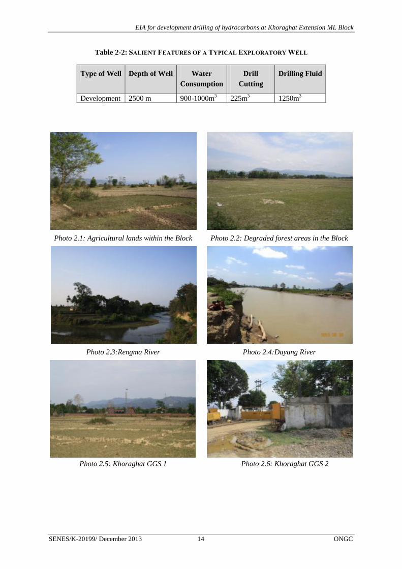
EIA for development drilling of hydrocarbons at Khoraghat Extension ML Block
SENES/K-20199/ December 2013 14 ONGC
Table 2-2: SALIENT FEATURES OF A TYPICAL EXPLORATORY WELL
Photo 2.1: Agricultural lands within the Block Photo 2.2: Degraded forest areas in the Block
Photo 2.3:Rengma River Photo 2.4:Dayang River
Photo 2.5: Khoraghat GGS 1 Photo 2.6: Khoraghat GGS 2
Type of Well Depth of Well Water
Consumption
Drill
Cutting
Drilling Fluid
Development 2500 m 900-1000m3 225m
3 1250m
3

EIA for development drilling of hydrocarbons at Khoraghat Extension ML Block
SENES/K-20199/ December 2013 15 ONGC
FIGURE 2-5: ENVIRONMENTAL SETTINGS OF KHORAGHAT EXTENSION ML BLOCK

EIA for development drilling of hydrocarbons at Khoraghat Extension ML Block
SENES/K-20199/ December 2013 16 ONGC
2.5.3 Existing Activity in Oil Field
The Khoraghat Extension ML Block is included under producing field of ONGC which is
being operated since 1989. The main activities conducted by ONGC at the Block are
Development and Production well drilling
Production of hydrocarbons from producing wells
Transportation of oil and gas to respective Group Gathering Stations (GGS) via.
interconnecting pipelines
2.5.4 Environmental Compliance
Khoraghat Extension ML Block is an operational Block of ONGC. The Block was granted
Environmental Clearance (EC) from MoEF vide letter nos. F. No. J-11011/625/2007- IA II
(I) dated October 22, 2007 (Annex 2.1).
2.6 WELL LOCATIONS AND ENVIRONMENTAL SETTINGS
2.6.1 Location of Wells
The proposed well sites were selected based on environmental considerations viz. location of
sensitive ecological habitats, settlements, schools/ hospitals, water bodies etc. Care had been
taken to located wells distantly from these receptors. Agricultural lands were selected for
current well drilling program.
Total 2 development wells are proposed in the Khoraghat Extension ML Block during the
plan period. Tentative well coordinates are provided in Table 2.3and the locations of the
wells at Khoraghat Extension ML Block are shown in Figure 2.6.
TABLE 2-3: COORDINATES OF TENTATIVE WELL LOCATIONS
Location Latitude (Northing) Longitude (Easting)
KHDE 26⁰05/07.106
// 93⁰57
/10.66
//
KHDF 26⁰04/45.708
// 93⁰56
/55.91
//
KHDD 26°03' 50.75" N 93°56'41.79" E
2.6.2 Environmental Settings
Environmental setting around one km radius area (referred as study area) of each well site
was carried out during field survey and the same has been checked with satellite imagery.
Location of wells were finalized keeping in mind the following considerations sensitive
ecological habitats, settlements, schools, hospitals etc. Well wise environmental settings are
described below.

EIA for development drilling of hydrocarbons at Khoraghat Extension ML Block
SENES/K-20199/ December 2013 17 ONGC
KHDE
The proposed well site KHDE is located at the agricultural land of Haldhibari village. This
well site is close to (approximately 150-200 m) the existing temporarily abandoned well site
namely CLAA18 of ONGC, located at the West. The nearest village of Haldhibari (around
500-700m) lies in a linear alignment along North-East to South-East. Settlements of
Haldhibari and Gholapani villages are located at the west of the well site. The proposed well
site could be accessed by NH-39 via. Sarupathar, Barapathar and Uriamghat towns. From
Uriamghat an 11 km stretch of dilapidated PWD road connects the well site. Settlements of
Haldhibari village are located close to the approach road. Dayang River flows on the eastern
part of the site lies within 2 km from the site.
Photo 2.7: Proposed well side KHDE Photo 2.8: Approach Road to KHDE well

EIA for development drilling of hydrocarbons at Khoraghat Extension ML Block
SENES/K-20199/ December 2013 18 ONGC
KHDF
The proposed well site lies at the existing facility GGS-1 of ONGC. KHDF well site is
located around 0.9 km north east of KHDE well site and could be accessed by the same
approach road as that of KHDE upto Haldhibari- Tiniali. A rural road (pitch and stone mix)
connects the proposed well site with Haldhibari Tiniali. This facility lies very close to (100m)
Chetanapur on west-west-south and 400 m from village Haldhibari stretching from South-
East to South. The other settlement within 1 km of the site on the East is Bidyapur.
Photo 2.9: Location of KHDF well- inside
Khoraghat GGS1
Photo 2.10: Approach Road to KHDF well

EIA for development drilling of hydrocarbons at Khoraghat Extension ML Block
SENES/K-20199/ December 2013 19 ONGC
KHDD
The proposed well site lies within agricultural field of Gholapani village. The well site is
located about 100 m from the village road connecting Gholapani with Sankarpur village.
There are no perennial waterbodies within 1km of the proposed well site.

EIA for development drilling of hydrocarbons at Khoraghat Extension ML Block
SENES/K-20199/ December 2013 20 ONGC
FIGURE 2-6: LOCATION OF PROPOSED WELLS

EIA for development drilling of hydrocarbons at Khoraghat Extension ML Block
SENES/K-20199/ December 2013 21 ONGC
2.7 PROJECT ACTIVITIES AND SCHEDULE
The lifecycle of project activities for the exploration project has been divided into distinct
steps and each is described in detail in the subsequent sections and will take approximately
three-four months to complete drilling and testing activity at each well site.
The project lifecycle has been classified into three phases:
Pre-drilling activity
Site selection
Land acquisition
Site access road and drill site construction
Pre-drilling activities, mobilization and Rigging up
Initial well construction
Drilling activity
Drilling of wells
Well testing
Well decommissioning
Well abandonment
Site closure and decommissioning
Site Restoration
2.7.1 Pre-drilling Activity
The pre-drilling phase will involve the following activities:
Site Selection
The major consideration for the site selection is geological formation. All locations were
selected by ONGC’s drilling department based on geological data available. A preliminary
site survey was already undertaken by the ONGC drilling team. Suitable drilling locations
were selected based on the physical (terrain and access) and technical suitability. Based on
above geological consideration, the following environmental considerations were adopted
during selection of drill site
Away from organized human habitats.
Easy access to area of interest

EIA for development drilling of hydrocarbons at Khoraghat Extension ML Block
SENES/K-20199/ December 2013 22 ONGC
Land Acquisition
Land for the KHDF drill site is already in possession with ONGC and is located within the
premises of Khoraghat GGS-1. Land acquisition for KHDD and KHDE is under progress.
Forest Land and Forest Clearance
Both the proposed well sites are included within the Rengma Reserve Forest, as per Forest
(Conservation) Act, 1980. ONGC has already taken Forest Clearance for KHDF well site.
Application for Forest Clearance for KHDD and KHDE has been submitted to DFO,
Golaghat and is currently being processed.
As described in the earlier section entire forest is deforested and presently used for
agriculture and human settlement. The people residing at the Block are a mixture of tribal and
non-tribal and their livelihood is dependent on these diverted forest land. Agriculture is
extensively practiced by the inhabitants over several decades in these areas. Therefore as per
provision of The Scheduled Tribes and other Traditional Dwellers (Recognition of Forest
Rights) Act 2006, ONGC has taken the proposed land (long term lease) from the villagers
who are presently cultivating the land. The villagers will be adequately compensated for the
above-mentioned period of activity. Crop compensation would also be provided to the land
owners. The estimated land required for KHDD and KHDE is approximately 3.38 ha.
Though located within reserved forest areas, absence of vegetation cover at the well sites will
not render adverse impacts on flora and fauna of the area. The details of the ecological impact
assessment are provided at Chapter 4.
Human Settlement and R&R Issue
The existing land use map and ground verification clearly shows that only forest land will be
utilized for construction of developmental drilling activities. No human settlement will be
affected by proposed activity and no human settlement area also would be required to
rehabilitate. In case of Khoraghat Block R&R issues is not applicable to this project.
Access Road and Site Construction
Construction of Access Road
The well site KHDF is located at the existing site of GGS-1 which already has a paved access
road. The road will be strengthened for transporting the rig and ancillary equipments. A 50 m
approach road will be constructed for KHDE and the existing road towards CLAA18 will be
strengthened. Approximately, 0.02 ha [(50 m) length x 4.0m width] land will be required for
construction new approach road for KHDD and KHDE. These lands are forest land but
presently deforested and used for agriculture. As the proposed land is a forest land, ONGC
has to take forest clearance as per Forest (Conservation) Act, 1980 and villagers are
dependent on these forest land (agriculture), ONGC has to be adequately compensated for
taking long tern lease and crop compensation. The preliminary alignment of the proposed
new road reveals that, there is no tree or settlement. Therefore construction of new approach
road will not required any tree felling or resettlement of any household.

EIA for development drilling of hydrocarbons at Khoraghat Extension ML Block
SENES/K-20199/ December 2013 23 ONGC
Culverts and drainage channel will be strengthened during site preparation as required. The
approach road will be constructed by a contractors appointed by ONGC.
Construction of Drill Site
As described in the earlier section KHDF will be drilled within the existing Khoraghat GGS-
1. As, KHDF drill site was already constructed. Therefore, no site construction will be
required for above mentioned well. However, KHDD and KHDE are new drill sites; site
construction will be required for the well. The proposed well site does not have any tree and
any other structure. Therefore, tree felling and any demolition will not be required. The
following sub-activity will be carried out for construction of new drill sites:
Fencing: The proposed well site & campsite will be duly fenced to a height of about 2 m
using chain link and barbed wires to restrict unlawful entry into the site.
Top Soil Scraping: The depth of the top soil of the entire drill site will be gauged, scraped and
stored in designated top soil storage site for future use (site reclamation and rehabilitation).
The preservation of top soil on site is described in detail at Chapter 6.
Construction of Drill Platform Once the top soil removal process is completed, the entire drill
site will be elevated and leveled and compacted. The drill site may require filling of earth to
elevate the drilling platform based on local topography and High Flood Level (HFL).
Quantity of fill material required for each drill sites depends upon the site elevation and HFL.
Fill material will be met from excavated material for pit required for drill site and balance
amount will be sourced from authorized quarry area. Pits will be required for storage of mud,
drill cutting, waste water, formation water, etc. These are as follows:
Construction of Drill Pad: A flat rectangular/square drilling site (pad) of 15X15 m
(approximate) at site to facilitate drilling and testing of hydrocarbons will be required.
Reinforced Cement Concrete (RCC) will be used for the construction of foundation system.
For the construction of a drill site, a total of about 100 tonnes of cement, 100 tonnes of sand,
and 100 tonnes of stones will be procured from local dealers.
Excavation of Pits:
A backhoe will be used for all excavation and cutting activities (for construction of pits) on
site. The following pits would be excavated within the well site
Construction of cellar pit 3m X 3m X 3 m for installation of well head and BOP
Construction of 2 HDPE lined pit of dimensions 30’X 33’X 5’ at well site for
temporary storage and disposal of drill cutting
Construction of 2 HDPE lined pit of dimensions, 38’X 33’X 5’ and 23’X 20’X 5’for
temporary storage and disposal of drilling mud.
Construction of 1 Oil pit of dimension of 3’X 3’X 4’

EIA for development drilling of hydrocarbons at Khoraghat Extension ML Block
SENES/K-20199/ December 2013 24 ONGC
Soak pits will be constructed to dispose the domestic wastewater and sewage at the
drill site.
Construction of Bunds & Strom Water Drains: The soil excavated from the pits will be used
to build a raised bund/embankment bordering the periphery of the drill site. A storm water
drain is constructed before the bund. Oil-water separator and silt-trap will be constructed at
one end of the storm water drain.
30-40 truckloads of material are expected to be sourced to the well site during site
construction. The transport of rig including ancillary equipments and camp facilities to the
site are expected to comprise around 50-60 trailer loads. Though the rig and related
equipments will be directly brought to site, spares, chemicals and other materials will be
received at the warehouse located at Jorhat. Materials will be intermittently supplied from
warehouse to the drilling site, during operations; a provision will be kept for temporary
storage of materials at the drilling site itself.
Rig Mobilization and Rigging up
A rig building process will follow the site preparation activities. This process involves
transport of rig including auxiliary equipments and camp facilities, assembling of various rig
parts and equipment to drill a well. The rig including auxiliary equipments and camp
facilities will comprise of around 50-60 trailer loads. Once the drilling rig is assembled,
thorough rig inspection will be carried out to check equipment working capability and quality
standards. The rig will have various allied equipments like mud tanks, mud pumps,
compressors, fuel tank, DG sets etc.
Well spudding is the start of drilling activity. Top-hole section will be drilled to a desired
depth based on well design. After drilling top-hole section, it will be cased with a pipe called
“Casing”. Casing provides support to hole wall and secures hole section. Other than that, it
isolates problematic hole sections such as loss zones, shale sections, over pressurized
formations etc. After running casing, space between hole wall and “Casing” will be
cemented. This process of drilling and casing the hole section continues until the final well
depth (target) is achieved.
Lengths and diameters of each section of the well are determined prior to drilling and are
dependent on the geological conditions through which the well is to be drilled. Once each
section of the well is completed, the drill string is lifted and protective steel pipe or casing
lowered into the well and cemented into place.
2.7.2 Drilling Activity
To support the drilling operation, the following systems and services will be included at the
rig package:
Environmental Protection – Blow Out Prevention (BOP) system, wastewater
treatment unit, cuttings handling equipment.

EIA for development drilling of hydrocarbons at Khoraghat Extension ML Block
SENES/K-20199/ December 2013 25 ONGC
Drilling of Well
The exploitation of hydrocarbons requires the construction of a conduit between the surface
and the reservoir. This is achieved by the drilling process. The exploration well will be
drilled using a standard land rig or a “Mobile Land Rig” with standard water based drilling
fluid treatment system. This rig will be suitable for drilling up to the desired depth of 2500-
3000 metres as planned for the project. The typical configuration of a Drilling Rig is shown
in the Figure 2.7. Drilling is a temporary activity which will continue for about 45-60 days
for each well in the block. The rigs are self-contained for all routine jobs. Once the drilling
operations are completed, and if sufficient indications of hydrocarbons are noticed while
drilling, the well is tested by perforation in the production casing. This normally takes 2-3
days. If the well is found to be a successful hydrocarbon bearing structure, it is sealed off for
future development, if any. Additionally, there will be other ancillary facilities like Drilling
mud system, ETP, Cuttings disposal, Drill Cementing equipment etc. and utilities to supply
Power (DG sets), water, fuel (HSD) to the drilling process and will be set up as a part of the
project.
FIGURE 2-7: TYPICAL DRILLING RIG CONFIGURATION

EIA for development drilling of hydrocarbons at Khoraghat Extension ML Block
SENES/K-20199/ December 2013 26 ONGC
Mud System and Cuttings
During drilling operations a fluid known as drilling fluid (or ‘mud’) is pumped through the
drill string down to the drilling bit and returns between the drill pipe –casing annulus up to
surface back into the circulation system after separation of drill cuttings /solids through solids
control equipment. Drilling fluid is essential to the operation and helps in controlling
downhole pressure, lift soil/rock cuttings to the mud pit, prevent cuttings from settling in the
drill pipe, lubricate, cool and clean the drill bit amongst other functions.
An uniform water-based mud system will be used in all the development drilling activities.
Unlike an oil-based mud system, usage of water-based mud will not pose higher risk of
contamination to subsurface formations, but disposal of the fluid and cuttings will be less
problematic. Though for formations where water based mud will not be suitable, eco-friendly
synthetic based mud will be used.
The ingredient of water based drilling fluid is given in Annex 2.2. The special additives and
their functions in water-based drilling fluids is presented in Annex 2.3.
Mud used during the operation will flush out formation cuttings from the well hole. These
cuttings will be separated from the drilling mud by thoroughly washing. Cuttings will then be
stored in the HDPE lined pits (of approximately 2 X 140 m3 capacity) and after completion of
the drilling activities, cuttings will be tested for hazardous nature and based on nature of the
drill cuttings, final disposal pathway will be finalized by ONGC as per Sl No 72 C of GSR
546 (E) dated 30th
August, 2005. The total amount of cuttings produced during the entire
drilling period is projected to be about 212-225 m3.
Once the cuttings have been separated, the drilling fluid will be reused or processed after
further treatment in a Chemically Enhanced Dewatering (CED) system designed to remove
suspended solids that are too fine for mechanical separation in solids control package
producing inlet particles called ‘flocs’. The flocs will be removed in the decanting centrifuges
and the resultant sludge disposed off in High Density Polyethylene (HDPE) lined pit (of
approximately 2 X 140 m3 area). The cleaned waste water will also be stored in HDPE lined
pits and disposed off, after testing and any necessary treatment, to meet the regulatory
requirements.
The whole process by which the drilling fluid will be reused during the drilling operation and
is commonly known as a “closed loop system”. This system is ideal for drilling operations in
sensitive environments as it cuts down immensely on the total water consumption for the
formulation of drilling mud and also saves on the consumption of chemicals. Figure 2.8
shows the drilling fluid circulation system which is designed to enable the drilling fluid to be
recycled and maintained in good condition throughout the operation. Figure 2.9 shows the
schematic layout of the drilling waste management.
Various components of the drilling mud will be selected carefully to be able to provide
desired properties to the mud. Mud chemicals will be added to the uniform mud system to

EIA for development drilling of hydrocarbons at Khoraghat Extension ML Block
SENES/K-20199/ December 2013 27 ONGC
adjust the mud properties and ensure fluid loss control/circulation, lubricity, shale inhibition,
pH control and pressure control in the well during drilling.
Chemicals required for the preparation of drilling fluid will be centrally stored in Jorhat.
Additionally, some chemicals will also be stored in the drill site. The storage area will be
paved and bunded and will be provided with a shed.
FIGURE 2-8: TYPICAL DRILLING FLUID CIRCULATION SYSTEM

EIA for development drilling of hydrocarbons at Khoraghat Extension ML Block
SENES/K-20199/ December 2013 28 ONGC
FIGURE 2-9: DRILLING WASTE MANAGEMENT
Cementing Programme
Cementing is a necessary aspect of drilling oil and gas wells. Cement is used to
Secure/support casing strings
Isolate zones for production purposes
Solve various hole problems
Cementing generally utilizes Portland Cement (API Class G Oil Well Cement) with various
additives in small quantities as accelerators/retarders, density adjusters, dispersants, fluid loss
additives, anti gas migration additives, etc.
Well Testing
Between the drilling operations for different zones, logging operations are undertaken to
provide information on the potential type and quantities of hydrocarbons present in the target
formations. Technicians employed by ONGC/ specialist Logging Service Company will be
entrusted with the job of undertaking well logging. Logging instruments (sensors) will be
attached to the bottom of a wire line and lowered to the bottom of the well. They are then
slowly brought back, the devices reading different data as they pass each formation and
recording it on graphs, which can be interpreted by the geologist, geophysicist and drilling
engineer. There are no emissions to the environment associated with wire line logging

EIA for development drilling of hydrocarbons at Khoraghat Extension ML Block
SENES/K-20199/ December 2013 29 ONGC
operations. The radioactive source required for well logging operations will be kept in
specially designed container. Oil produced during testing activities or during development
phases will be stored at the oil pit and will be transferred to the nearest GGS by Oil tankers.
2.7.3 Well Decommissioning
Well Abandonment
After the development activities the well will be sealed with a series of cement plugs, all the
wellhead equipment will be removed leaving the surface clear of any debris and site will be
restored.
Site Closure and Decommissioning
After completion of the drilling activity, partial de-mobilisation of the drilling rig and
associated infrastructure will be initiated. As discussed earlier, well testing may be carried
out immediately after the drilling is completed or about 3 months depending on initial
evaluation timing. The complete de-mobilisation of the facilities at site will happen after
well-testing has been completed. This will involve the dismantling of the rig, all associated
equipments and the residential camp, and transporting it out of the project area. It is expected
that demobilization phase will last about 10 days and will involve the trucking away of
materials, equipments and other materials from site to bring it back to original condition. It is
estimated that about 50 truckloads will be transported out of site during this period.
Subsequently, following steps will be typically involved to restore and rehabilitate the area:
The wellhead and all casing string will be cut off to a minimum depth of 3 m (10
ft) below ground level.
All concrete structures will be broken up, and the debris disposed off as per the
regulatory requirements.
Drill cuttings and drill mud will be treated as per G.S.R 546 (E) dated 30th
August
2005 to render them harmless.
Drilling wastewater including drill cuttings wash water shall be collected in
HDPE lined disposal pit, evaporated and treated and shall comply with the S No.
72, Schedule I-Standards for Emission or Discharge of Environmental Pollutants
from various industries.
All fencing and access gates will be removed.
All pits whose contents will show regulatory compliance for on-site disposal, at
the time of site closure, will be backfilled and closed out as per the legal
requirements.
Restoration of unusable portion of the access track, removal of pilings and
Landscaping.

EIA for development drilling of hydrocarbons at Khoraghat Extension ML Block
SENES/K-20199/ December 2013 30 ONGC
Site Restoration
All abandoned drill sites will be restored back to its near original condition. After
decommissioning of site, it will be de-compacted and stored top soil will be overlaying on the
de-compacted site with certain moisture conservation measures and seeding of leguminous
plant for restoration soil nutrient level naturally.
2.8 UTILITIES & RESOURCE REQUIREMENTS
2.8.1 Power Supply
The drilling process requires movement of drill bit through the draw works which require
power. The power requirement of the drilling rig will be met by using the six AC-SCR Diesel
Generator Sets with a diesel consumption of about 6 KLD. The exhaust stacks of the DG sets
are likely to vent the emissions. Power requirement for the drill sites is provided below;
TABLE 2-4: POWER REQUIREMENT BREAK UPS
Activity Power requirement No. of DG set
During site construction AC-SCR DG set of 750 KW 1
During drilling operation AC-SCR DG set of 750 KW 2 operable 1 standby
Lighting and other power
requirement AC-SCR DG set of 750 KW 1
The power requirements at the site preparation and construction phase for the drill site will be
met by 750 KW DG Sets. Although drilling operations will be continuous, power
requirement will vary depending on activities being carried out. It is anticipated that four DG
sets with a power rating of 750 KW each will be required for drilling purposes of which one
will be kept standby. Lighting and other power requirements at drill sites will be met through
one 750 KW DG sets.
2.8.2 Fuel Consumption
Fuel consumed during the drilling phase will mainly be diesel used by rig used for
development drilling, various equipments and vehicles operating to transport goods and
supplies to site. It is estimated that about 1-1.5 KLD diesel per day will be required to power
the off-road construction equipment and vehicles during site preparation phase.
During the drilling phase, consumption about 6 KLD of High Speed Diesel will be required.
Fuel will be supplied onsite by local supplier through mobile tankers. Out of this, a major
part comprising about 85% will be consumed by the rig (also include the DG sets) and about
15% will be required for the campsite. In case the storage exceeds the threshold limits
specified in the Petroleum Rules, 2002, ONGC will comply with the relevant provision of
such rules.

EIA for development drilling of hydrocarbons at Khoraghat Extension ML Block
SENES/K-20199/ December 2013 31 ONGC
2.8.3 Water Consumption and Supply
The water requirement in a drilling rig is mainly meant for preparation of drilling mud apart
from washings and domestic use. While the former consumes the majority of water
requirement, the water requirement for domestic and wash use is very less. The daily water
consumption will be 20 m3/day of which 10 m
3/d will be used for rig washing, 10 m
3/d will
be used for mud preparation.
Water will be sourced from contractors after validating their proper withdrawal permission
from concerned authorities. The water requirement per well is shown in Table 2.4.
TABLE 2-5: WATER REQUIREMENT PER WELL
A provision for storage of about 140 KLD of water (5 days water requirement during peak
period) will be made on site. Potable water requirement at site will be met through filtered
bore well water and some packaged drinking water.
Total water requirement for the drill site preparation and construction phase of the project is
estimated to be about 10 KL. With average time requirement for site preparation being
approximately 20 days, about 0.5 KLD of water will be consumed daily, on an average. In
addition, a water storage pit of around 1000 KL is proposed to store water for fire water
supply the likely source being surface water.
The water balance diagram is provided at Figure 2.10.
Description Quantity
Total Water Requirement for Drilling (KL) 900-1200
No. of Days on well 45-60
Average drilling water consumption per day (KLD) 20

EIA for development drilling of hydrocarbons at Khoraghat Extension ML Block
SENES/K-20199/ December 2013 32 ONGC
FIGURE 2-10: WATER BALANCE DIAGRAM
2.8.4 Effluent Treatment
The drilling waste water around 1000 -1200 m3 will be generated during the entire drilling
period from rig wash and dewatering of spent drilling mud. A mobile ETP of a capacity of
125m3/day will be installed to treat the waste water.
2.8.5 Manpower / Employment
The drilling rig will be operated by approx 25-30 persons on the rig at anytime. The
manpower will operate in two shifts with continuous operations on the rig. This will include
technical experts (including expats), who will be responsible for various drilling related
activities and some local workmen who will be hired from nearby villages for the entire
duration of the project. Technical staff will be housed in the Drilling Camp Site which will be
adequately supported by facilities like kitchen, wash rooms, laundry, etc.
10
m3/d
9
m3/d
10 m
3/d
Treated at ETP to conform with CPCB
discharge standards
Rig wash Mud
Preparation
HDPE lined
Pit
Water sourced from surface water source
(20m3/day)
Reuse and
Recycle

EIA for development drilling of hydrocarbons at Khoraghat Extension ML Block
SENES/K-20199/ December 2013 33 ONGC
2.9 POLLUTION SOURCES AND CHARACTERIZATION
2.9.1 Noise and Vibrations
Noise will be emitted from development drill site during site preparation, drilling and
decommissioning phases. The major noise generating operations from the proposed activity
during drilling, testing are operation of rotary drilling equipment as part of rig, diesel engines
for power generation, mud pumps and operation of vehicles. Noise during the site preparatory
phase will primarily be contributed by heavy construction machinery operating on site and
vehicular sources. Average noise emission ranges for different types of construction
machinery are shown in the Table 2.5.
As drilling activity is continuous, part of the noise associated with functioning of the rig and
ancillaries will be generated throughout day and night. Noise generated from rig and ancillary
equipments is shown in Table 2.6.
TABLE 2-6: TYPICAL NOISE EMISSIONS FROM CONSTRUCTION MACHINERY
Equipment Sound Level At Operator (in decibels)
Average Range
A. Earth Moving Equipment
Front End Loader 88.0 85-91
Back Hoe 86.5 79-89
Bull Dozer 96.0 89-103
Roller 90.0 79-93
Truck 96.0 89-103
B. Material Handling Equipment
Concrete Mixer <85.0 -
Crane/Hydra <85.0 -
Derrick 100 97-102
Source: British Columbia, “Construction Noise,” Workers Compensation Board of BC
TABLE 2-7: DRILLING RIG & EQUIPMENT NOISE LEVELS1
Equipment Equivalent noise levels in dB(A)
Average Range
Drilling Rig 96.9 88.0-103.0
Mud Pumps 76.9 73.3 -80.5
Diesel Generators 72.7 71.8-73.7
Shale Shakers 76.6 -
1 “Noise Report on Drilling Operation” – British Drilling & Freezing Ltd – Prepared by K A Worthington; AEC
Report: P852-2; 17th
October 2002;

EIA for development drilling of hydrocarbons at Khoraghat Extension ML Block
SENES/K-20199/ December 2013 34 ONGC
2.9.2 Air Emissions
Air emissions from point sources expected from the proposed development drilling will be
mainly from combustion of diesel in the diesel engines and power generators which will be
operated to meet power requirement of the drilling rig and the campsite. The principal
pollutants will comprise of Particulate Matter (SPM), Sulphur and Nitrogen dioxides (SO2
and NO2) and other hydrocarbons (HC). The quantity of diesel consumed during drilling will
be in order of 6 KL /day/drilling site.
Additionally, the flaring and burning of oil during the testing of the well will also lead to the
release of some pollutants including un-burnt hydrocarbons to the atmosphere. Some fugitive
emissions of dust and air pollutants from vehicular exhaust will also happen during the
project lifecycle, mostly during the construction and decommissioning activities.
Additionally, there will be re-entrainment of dust from the approach road leading to the site
mainly during the dry season.
Analysis of natural gas generated from the earlier well sites revealed the absence of hydrogen
sulfide from these formations of Assam-Arakan Basin. If at all hydrogen sulfide is emitted,
ONGC will apply industry best practices to minimize the effect of the same to ambient
environment.
2.9.3 Liquid Wastes
During the drilling operations, drilling wastewater generated (approximately 9 m3 per day) as
a result of rig wash and dewatering of spent mud, effluents from washing of drill cuttings,
floor washings, pump, seal leakages, spillages will comprise of chemical ingredients of
drilling fluid thereby rendering effluent to be polluted. The characteristics of drilling and
wash wastewater will be primarily dependent on type and composition of drilling fluid used
for drilling. As ONGC is proposing the use of water-based drilling mud, the potential for
contamination of such waste water is significantly lower. The drilling wastewater will contain
spent drilling fluid generated as a result of washings. The rig wash water and drilling
wastewater generated is proposed to be collected in a wastewater pit (of capacity 800 m3)
constructed at the drilling site. Domestic waste water generated (about 8 KLD for the drilling
camp) will be treated through a soak pit/septic tank arrangement.
The quantities of the liquid wastes, their characteristics and anticipated disposal methods are
given in Table 2.7.
TABLE 2-8: LIQUID WASTES GENERATED DURING DRILLING AND THEIR DISPOSAL
Waste Type Quantity Disposal
Drilling and wash
Wastewater 10 m
3 per day
The water will be adequately treated in an ETP to
ensure conformance to the CPCB onshore oil and
gas extraction industry effluent standards
Domestic Wastewater 2.4 m
3 per day from
drilling site Septic tank followed by soak pit

EIA for development drilling of hydrocarbons at Khoraghat Extension ML Block
SENES/K-20199/ December 2013 35 ONGC
2.9.4 Solid and Hazardous Waste Streams
The different solid and hazardous waste streams generated during drilling and their disposal
methodology has been presented in Table 2.8.
TABLE 2-9: WASTE STREAMS GENERATED DURING DRILLING AND THEIR DISPOSAL
Waste Type Quantity Characteristics Disposal
Kitchen Waste 10 – 20 kg
per day
Organic waste
(Non HW)
Will be stored in compost pits on
daily basis.
Drill Cuttings 212-225
m3/ well
Mainly Inert material
Consisting of shales,
sands and clay; about
1% of drilling mud.
(Non HW)
Drill cuttings will be disposed off in
a well designed pit lined with
impervious liner located on site as
per S No. 72 C.1.a Schedule I
Standards for Emission or Discharge
of Environmental Pollutants from Oil
Drilling and Gas Extraction Industry
of CPCB as modified in 2005.
Waste Drilling
Mud
(Fluid)
4 m3
Barite, Bentonite and
Traces of
Heavy metals (HW)
The mud will be tested for hazardous
contaminants and will be disposed as
per S No. 72 C.1.a Schedule I
Standards for Emission or Discharge
of Environmental Pollutants from Oil
Drilling and Gas Extraction Industry
of CPCB as modified in 2005
Acid – Lead
Batteries
2 – 3
Batteries
per
drilling of
well
Lead – Acid (HW)
Will be recycled through the vendors
supplying acid – lead batteries as
required under the Batteries
(Management & Handling) Rules,
2001.
Oily waste-
used oil &
spent Oil and
loose
0.3 m3
5-10 Kg Used & Waste oil
Will be collected in metal drums kept
in secured dyked area & Disposed as
per Used oil rules in approved used
oil recycling facility
Recyclables
viz. paper,
plastic,
packaging
wastes
Depending
on usage
- Proper segregation and storage of
recyclable waste in designated bins
onsite. Recyclables will be
periodically sold to local waste
recyclers.
2.10 DRILLING HAZARDS
Loss of well control / blow-out, fire, explosion and oil spills are the major potential hazards
associated with drilling for oil and gas. Effective response plans to foreseeable emergencies
will be developed by ONGC and communicated to the project teams. A risk assessment to be
carried out as part of this EIA will also contribute towards identification of hazards, risks and
formulating management plans for emergency response, blowout, oil spills.
EIA for development drilling of hydrocarbons at Khoraghat Extension ML Block
SENES/K-20199/ December 2013 36 ONGC
2.11 PROJECT COST
Based on ONGCs previous experience of drilling in the area, cost for drilling for of 3 wells
(including well site construction and site decommissioning) will be approximately INR 75
crores. The cost of drilling will depend on the depth of the well to be drilled.
2.12 HSE POLICY
ONGC is committed to protecting environment, health and safety of the people who may be
affected, directly or indirectly by its operations. The Drilling Management System (DMS)
framework lays down the corporate Health, Safety and Environment Policy for the entire
organization and the range of operations it undertakes as a part of oil and gas exploration.
The overall corporate health environmental safety policy of ONGC may be supplemented by
a local policy document whenever so required. It is understood that ONGC will try to
formulate a local site level policy taking from the parent corporate policy of ONGC to
adequately address the environmental impacts of the proposed drilling projects in Khoraghat
Extension ML Block Field through the DMS.

EIA for development drilling of hydrocarbons at Khoraghat Extension ML Block
SENES/K-20199/ December 2013 37 ONGC
3 Description of the Environment
This chapter describes the existing environmental settings in the Khoraghat Extension ML
Block and its immediate surroundings. This includes the physical environment comprising
air, water and land components, the biological environment, and socio-economic
environment. Attributes of the physical environment like air, water, soil, and noise quality in
the surrounding area were assessed primarily through monitoring and analysis of samples
collected from field. Air, traffic and noise monitoring was carried out by Cleenviron Private
Limited (CPL), Rourkela (a NABL certified laboratory); water and soil monitoring were
conducted by Mitra S. K Pvt. Ltd (also a NABL certified laboratory). All monitoring at field
were undertaken under the guidance and supervision of SENES personnel during the pre-
monsoon season of April 2013-June 2013. Information about geology, hydrology, prevailing
natural hazards like floods, earthquakes etc. have been collected from literature reviews and
authenticated information made available by government departments. Surveys were carried
out to understand and record the biological environment prevailing in the area and the same
was verified against published information and literature. The socioeconomic environment
has been studied through consultations with various stakeholders in the villages within the
Khoraghat Extension ML Block. Additionally, socioeconomic data have been obtained from
the Census of India reports.
3.1 PHYSICAL ENVIRONMENT
3.1.1 Climate & Meteorology
Climate and meteorology of a place can play an important role in the implementation of any
developmental project. Meteorology (weather and climate) plays a key role in understanding
local air quality as there is an essential relationship between meteorology and atmospheric
dispersion involving the wind speed/direction, stability class and other factors. The block
falls under the humid sub tropical climate zone.
Based on primary meteorological monitoring conducted during April-June 2013 at
Uriamghat within the Block the temperature profile, rainfall pattern relative humidity, wind
speed and wind direction of the region have been discussed below.
Interpretation of Primary Baseline Data
Temperature
Micrometeorological data obtained for temperature as part of baseline monitoring undertaken
for the proposed project during pre-monsoon season revealed the daily maximum and
minimum temperature at 21.82°C and 40.27 °C respectively. The micrometeorological values
recorded for temperature have been provided in Annex 3.1.

EIA for development drilling of hydrocarbons at Khoraghat Extension ML Block
SENES/K-20199/ December 2013 38 ONGC
Relative Humidity
Daily maximum and minimum Relative Humidity (RH) was recorded at 31.95% and 98.81%
respectively during the primary monitoring study. The hourly variation of average relative
humidity has been listed in Annex 3.1.
Rainfall
About 112.8 mm of total rainfall was recorded during primary monitoring period. Twenty
two rainy days were recorded with 38.4 mm being the maximum rainfall value recorded. The
micrometeorological values recorded for rainfall have been provided in Annex 3.1 for
reference.
Wind Speed and Wind Direction
The wind speed and wind direction of an area influences the dispersal of pollutants from a
point and non point sources. As the proposed drilling and testing activities involve the
operation of both point (DG sets) and non point pollutant emissions sources, analysis of wind
speed and direction data is considered important for predicting the air quality impacts based
on pollutant dispersion.
Hourly micro-meteorological data collected during primary monitoring has been analyzed to
generate the post monsoon and winter season wind rose. The predominant wind direction
was observed to be from South East for the study period. The average wind speed for the
months was 0.80 m/s. The wind speed was observed primarily in the range 0.5 – 2.1 m/s for
the monitoring period. The calm frequency was recorded as 40.8%. The wind rose diagram
generated for the primary monitoring study period and wind class frequency distribution have
been presented in Figures 3.1 and 3.2 and wind speed & wind direction data have been
provided as Annex 3.1 for reference.

EIA for development drilling of hydrocarbons at Khoraghat Extension ML Block
SENES/K-20199/ December 2013 39 ONGC
FIGURE 3-1: WIND ROSE DIAGRAM FOR PRE-MONSOON SEASON
FIGURE 3-2: WIND CLASS FREQUENCY DISTRIBUTION

EIA for development drilling of hydrocarbons at Khoraghat Extension ML Block
SENES/K-20199/ December 2013 40 ONGC
3.1.2 Ambient Air Quality
Primary monitoring of the existing air environment was undertaken in the Field to establish
existing ambient air quality within the proposed Field. Location of the proposed wells and the
predominant wind direction is important in selection of the ambient air quality sampling
stations as any gaseous and particulate emission from the project activities will disperse
based on the predominant wind directions and affect to the receptors located at that end. Thus
the analyzed values for the pre project environment can be compared during and after the
project activities. The major industrial sources of air emission at the Field are from
hydrocarbon exploration and production of ONGC.
Ambient air quality monitoring was conducted at 8 representative locations during April-June
2013. The number of monitoring stations and parameters for monitoring were based on the
approved ToR obtained from MoEF. The ambient air quality locations are shown in Figure
3.6 rationale for selection of the monitoring locations is presented in Annex 3.2.
Air quality monitoring was carried out for 2 months at the pre-monsoon season, 24 hours a
day twice a week for PM10, Sulphur Dioxide (SO2), Nitrogen di oxide (NO2), once a week for
Volatile Organic Carbon (VOCs), methane and non methane hydrocarbon. A respiratory dust
sampler (APM 460 DX, Envirotech Instruments Pvt. Ltd) was used for sampling of PM10,
SO2 and NO2. Benzene sampler (AAS 172, Ecotech Instruments) was used for sampling of
VOC, methane and non-methane hydrocarbon.
Rationale for selection of air monitoring stations
The ambient air quality monitoring locations have been selected based on topography and
prevailing micro-meteorological conditions (downwind, upwind and crosswind directions) to
Photo 3.1: Meteorological Monitoring at Uriamghat

EIA for development drilling of hydrocarbons at Khoraghat Extension ML Block
SENES/K-20199/ December 2013 41 ONGC
establish baseline ambient air quality in areas likely to be affected the exhaust emissions from
DG sets, movement of vehicles, fugitive emissions from material stockpiles and from
sourcing & transportation of raw materials during project construction phase. Flaring of gases
under emergency situation during operational phase has also been considered in this regard.
A screening model was run before the selection of the station with SCREEN 3 and it was
found that the maximum GLC was found to be within 2 km of the well sites considering all
stability classes. Monitoring locations were selected based on upwind, downwind and
crosswind directions within 2 km of the proposed well sites at receptors that are likely to be
affected by the drilling operations. Two monitoring locations Padampathar and Jamuguri was
selected outside the block to capture the effect of movement of vehicles and other activities
within the Block. Other considerations like location of receptors (settlements), accessibility to
the monitoring location, availability of stable electric connection for running of RDS and
safety and security of machine and monitoring personnel were also considered while
selecting the monitoring locationsThe concentrations of various pollutants were processed for
different statistical parameters like arithmetic mean, minimum concentration, maximum
concentration and percentile values. The detailed ambient air quality results are presented in
Annex 3.3.
Interpretation of Air Quality Results
Particulate Matter (PM 10): The average of 24 hourly PM 10 at the monitoring locations ranged
between 50.21-70.07 μg/m3 (Figure 3.3). The average PM10 concentrations were observed to
be in compliance to the NAAQS (100 μg/m3) at all air quality monitoring locations. The results
of PM10 levels at the monitoring stations have been represented in Annex 3.3.

EIA for development drilling of hydrocarbons at Khoraghat Extension ML Block
SENES/K-20199/ December 2013 42 ONGC
FIGURE 3-3: AVERAGE NO2 VALUES AT THE MONITORING LOCATIONS
Nitrogen dioxide (NO2): The average NO2 values at the monitoring locations were observed in
the range of 19.79-24.21 μg/m3 (Refer Figure 3.4). The average values complied with the
NAAQS (80 μg/m3) specified for nitrogen dioxide. The results of PM10 levels at the monitoring
stations have been represented in Annexure 3.3.
Sulfur dioxide (SO2): Sulfur dioxide concentrations at all locations was found to be below
detectable limit i.e. <4 μg/m3 (Refer Annex 3.3). Low values of SO2 can be attributed to the
primarily rural setting of the block.
Methane and Non- Methane Hydrocarbon: Mean values for methane and non methane
hydrocarbons at the sampling stations varied between 1.29-2.97 ppm and 0.26-0.73 ppm
respectively. Hydrocarbon contents at the ambient air samples were higher at all the stations as
the stations are within the producing hydrocarbon fields. The average methane and non
methane hydrocarbon values at the monitoring stations are provided at Table 3.1.
Volatile Organic Carbon (VOCs): Mean values of VOC varied between 0.18-2.96 ppm. Higher
mean values were recorded for Lakhinagar, Bidyapur, Jamuguri and Padampathar. The average
volatile organic carbon at the monitoring stations is provided at Table 3.1.
Detailed results are presented at Annex 3.3.
0
20
40
60
80
100
120
Near
Haldibari
Secondary School
Haldibari
Village
Near Haldibari
Bamchuk
Primary School
Gholapani
Village
Lakhinagar
Village
Bidyapur
Village
Padampathar
Village
Jamuguri
Village
mic
rogr
ams
pe
r cu
bic
me
ter
Monitoring Locations
PM10 (µg/m3) NAAQS

EIA for development drilling of hydrocarbons at Khoraghat Extension ML Block
SENES/K-20199/ December 2013 43 ONGC
FIGURE 3-4: AVERAGE NO2 VALUES AT THE MONITORING LOCATIONS
Photo 3.2: Air Monitoring at Gholapani
TABLE 3-1: AVERAGE HYDROCARBON AND VOC MONITORING DATA
Sl.
No Monitoring Locations
Methane
hydrocarbon
(ppm)
Non-methane
hydrocarbon
(ppm)
VOC
(ppm)
1 Near Haldhibari Secondary School 2.13 0.63 0.55
2 Haldhibari Village 1.29 0.26 0.18
3 Near Haldhibari Bamchuk Primary School 1.94 0.50 1.15
4 Gholapani Village 2.11 0.50 1.59
5 Lakhinagar 2.75 0.73 2.96
6 Bidyapur Village 2.27 0.49 2.26
0
10
20
30
40
50
60
70
80
90
Near
Haldibari
Secondary School
Haldibari
Village
Near
Haldibari
Bamchuk Primary
School
Gholapani
Village
Lakhinagar
Village
Bidyapur
Village
Padampathar
Village
Jamuguri
Village
mic
ro
gra
ms
per c
ub
ic m
ete
r
Monitoring Locations
NO2 (µg/m3) NAAQS

EIA for development drilling of hydrocarbons at Khoraghat Extension ML Block
SENES/K-20199/ December 2013 44 ONGC
Sl.
No Monitoring Locations
Methane
hydrocarbon
(ppm)
Non-methane
hydrocarbon
(ppm)
VOC
(ppm)
7 Padampathar Village 2.47 0.52 2.11
8 Jamuguri Village 2.97 0.58 2.06
3.1.3 Ambient Noise Quality
The ambient noise monitoring was conducted during the pre-monsoon season at 6 locations
within the Khoraghat Extension ML Block. Noise stations were selected near to the proposed
well locations to understand the baseline noise levels that could be impacted upon by the
proposed drilling activities at the Field. Noise monitoring was conducted at Bidyapur (NQ 1),
Gholapani (NQ 2), Near Haldhibari Bamchuk Primary School (NQ 3), Haldhibari Village
(NQ 4), Near Haldhibari Secondary School (NQ 5) and Chetanapur (NQ 6).
Sound pressure level (SPL) measurements in dB (A) were recorded for every hour
continuously for 24 hours at 15 minutes interval for the monitoring stations and equivalent
noise levels in the form of Leq day and Leq night was computed. The results obtained were
compared with the standard specified in Schedule III, Rule 3 of Environmental Protection
Rules2. The ambient noise quality monitoring locations within the study area are shown in
Figure 3.6 and the rationale for selection of the stations has been presented in Annex 3.2.
Interpretation of Noise Quality Results
The day time equivalent noise levels at the monitored stations were found to be ranging
between 44.3-47.3 dBA and in compliance to the day time noise standards (55 dBA) for
residential areas (Refer Figure 3.5). The night time noise levels for the sites (maximum 37
dBA) were also found to be within the night time standards specified for residential area (45
decibels). The detailed noise monitoring results are presented in Annex 3.4.
Low noise levels at all the monitoring stations were primarily due to existing rural settings of
the locations. The monitoring location in proximity to Khoraghat GGS-1 (Chetanapur) and
GGS-2 (Gholapani) also did not reveal higher noise values.
2 Sound Level Meter: SL 4001, Lutron & SLM 100, Envirotech CPL-4, 11

EIA for development drilling of hydrocarbons at Khoraghat Extension ML Block
SENES/K-20199/ December 2013 45 ONGC
FIGURE 3-5: DAY AND NIGHT TIME EQUIVALENT NOISE LEVELS
0.0
10.0
20.0
30.0
40.0
50.0
60.0
Bidyapur Gholapani Near Haldhibari Bamchuk
Primary School
Haldhibari Village
Near Haldhibari Secondary
School
Chetanapur
Equ
ival
ent
No
ise
Leve
ls in
db
A
Monitoring Locations
Ld Ln Daytime standard Nighttime standard

EIA for development drilling of hydrocarbons at Khoraghat Extension ML Block
SENES/K-20199/ December 2013 46 ONGC
FIGURE 3-6: LOCATION OF AIR, NOISE, METEOROLOGY AND TRAFFIC MONITORING LOCATIONS WITHIN THE KHORAGHAT EXTENSION ML BLOCK
EIA for development drilling of hydrocarbons at Khoraghat Extension ML Block
SENES/K-20199/ December 2013 47 ONGC
3.1.4 Physiography and Geology
The physical features and geology are closely related. Based on the physical features and
geology, the north east of India and more specifically, the State of Assam can be divided into
following physical divisions (structural units):
Brahmaputra valley - The Brahmaputra Valley is of the nature of a “ramp” valley
developed during the simultaneous upheaval of the Himalayas on the north and north
east and the Patkai ranges on the south and south east. The vast alluvial plains of
Brahmaputra valley occupy most of the North Assam covering Goalpara, Kokrajhar,
Dhubri, Kamrup, Nalbari, Barpeta, Nagaon, Darrang, Sonitpur, Sibsagar, Jorhat,
Golaghat, Lakhimpur and Dibrugarh districts. The Brahmaputra valley is bounded by
Arunachal Himalaya in the north and northeast, Patkai – Naga - Lushai range of
Nagaland and the Shillong Plateau in the south and southeast.
Central Assam Hills -The Central Assam which essentially is a hilly terrain comprised
of Mikir Hill in Karbi Anglong and North Cachar Hill districts.
Barak valley - The hilly and alluvial terrain in the south covering the Cachar and
Karimganj districts in the Barak (Surma) valley.
Golaghat district lying in the Brahmaputra Valley is surrounded by the river Brahmaputra to
the north, the state of Nagaland to the south, Jorhat district to the east and Karbi Anglong and
Nagaon district to the west. Physiographically, Golaghat district shows a plain topography
towards north and southeast, while the southwestern part of the area represents an undulating
topography. The general elevation of the area is around 100 meters above Mean Sea
Level(MSL) and low lying areas show altitude about 80 m above MSL. Maximum height of
about 128 m above MSL is observed in the southern parts of the district, where it merges with
the hills of the Nagaland as well as Karbi-Anglong district of Assam. The slope of the district
is towards north east from south. The Khoraghat Extension ML Block also has an undulating
topography (Figure 3.7). The general slope of the Block is from South to North. The rivers
Dayang and Rengma flow from south to north.
Geology
The State of Assam is occupied by rocks belonging to, (a) Proterozoic Gneissic Complex, (b)
Shillong Group of Meso-Palaeo Proterozoic age, (c ) Granite Plutons of Neo-Proterozoic-
Lower Palaeozoic age, (d) Lower Gondwana sedimentary rocks of Permo-carboniferous age
(e) Alkali Complexes of Samchampi, Borpung and volcanic rocks represented by Sylhet Trap
of Cretaceous age, (f) Lower Tertiary (Paleocene-Eocene) shelf sediments of the Jaintia
Group extending along the southern and eastern flanks of Mikir Hills and geosynclinals
sediments of Disang Group in parts of the North Cachar Hills, (g) Upper Tertiary (Oligocene
to Pliocene) shelf and geosynclinal sediments covering the southern flanks of Mikir Hills, the
North Cachar Hills and the hills of the Cachar district in the Surma valley area. These rocks
are also exposed along the northern foothills of Naga-Patkai range bordering the southern

EIA for development drilling of hydrocarbons at Khoraghat Extension ML Block
SENES/K-20199/ December 2013 48 ONGC
margin of Sibsagar, Jorhat and Dibrugrah districts. Along the southern foothills of Eastern
Himalaya facing the northern border of Assam a narrow strip of Siwalik rocks are exposed
(h) the Quaternary deposits comprising of Older and Newer Alluvium occur in flood plains
and terraces of the Brahmaputra valley, Surma valley and other river basins of Assam.
Geological Setting of the Block
The Khoraghat field lies in the southern fringe of Upper Assam in Dhansiri Valley. Previous
drilling activities of ONGC penetrated from Alluvium to Basement through Neogene (Moran,
Tipam and Bokabil) and Paleogene (Barails, Kopili, Sylhet and Tura) sequences. Bokabil
formation lying unconformably above the Batail group of late Eocene to Oligocene age
represents the Surma Group, in Dhansiri valley. In this area, all the pay sands are mainly
confined between Barail top unconformity and an erosional surface above lower Bokabil.
FIGURE 3-7: TOPOGRAPHIC MAP OF KHORAGHAT EXTENSION ML BLOCK

EIA for development drilling of hydrocarbons at Khoraghat Extension ML Block
SENES/K-20199/ December 2013 49 ONGC
3.1.5 Hydrogeology
The hydrogeological environment and ground water regime conditions in the Brahmaputra
basin indicate the existence of potential aquifers having enormous fresh ground water
reserves. The area is covered by alluvial sediments of river basins constituting the
unconsolidated formations of sandstone, shale, limestone including conglomerate of the
Coenozoic, Mesozoic and Upper Palrozoic era in the Brahmaputa Basin. These are very
significant ground water reservoirs for large scale and extensive development. Ground water
occurs under water table to confined conditions. Depth to water level in major parts of
Golaghat district varies from 2 to 5 m. In the extreme southern and southwestern parts close
to hills, the water level is found to be deeper and generally rests within 5 to 7 m. The
movement of ground water is from south to north. The water level trend shows that there is
gradual rising of water level in the district.
(Source: Dynamic Ground Water Resources in India, as on 31st March, 2009, CGWB; Ground water quality in
Shallow aquifers of India, 2010)
Ground Water Resources
Assam is one of the rich states of the country in term of the ground water development
potentiality. The entire Brahmaputra valley covers more than 70 per cent of the total
geographical area of the state, containing prolific aquifer system with water table lying within
5 m of land surface. The district possesses good potentiality for ground water development.
Bestowed with high incidence of rainfall and covered by a thick pile of porous sediments,
these ground water reservoirs get replenished every year and are being used heavily. In these
areas, in addition to the Annual Replenishable Ground Water Resources available in the zone
of Water Level Fluctuation (Dynamic Ground Water Resource), there exists a huge ground
water reserve in the deeper passive recharge zone below the zone of fluctuation as well as in
the deeper confined aquifers which is nearly unexplored.
3.1.6 Ground Water Quality
Groundwater is primarily tapped by tube wells from depths ranging mostly between 20-35 m.
The analytical report of water ground water samples collected by CGWB revealed that
ground water is suitable for domestic, irrigation and industrial purposes. Ground water from
shallow aquifer is slightly alkaline whereas ground water from deeper aquifer is slightly
acidic in nature. High concentration of iron and arsenic beyond permissible limit in ground
water in some areas in Golaghat District was also reported.
(Source: Dynamic Ground Water Resources in India, as on 31st March, 2009, CGWB; Ground water quality in
Shallow aquifers of India, 2010)
Primary monitoring of ground water quality was considered important in order to understand
the probable impacts of the proposed project activities on the sub surface aquifers. Due to
rocky nature of the area groundwater is primarily extracted from the dug wells in the Block.
Potential pollution of subsurface and unconfined aquifers may occur due to improper casing
EIA for development drilling of hydrocarbons at Khoraghat Extension ML Block
SENES/K-20199/ December 2013 50 ONGC
and cementing of well leading to infiltration or seeping of drilling chemicals or mud into
nearby aquifer. Contamination of aquifers may also occur from disposal of drilling waste and
mud in an open/unpaved pit.
A monitoring network consisting of 4 locations for groundwater was selected and
representative sampling was carried out at each of the locations (Refer Figure 3.8) and the
detailed results of ground water analysis are presented in Table 3.2.
Ground Water Sampling Points
A total of four ground water samples were collected from dug wells and tube well located in
proximity to the proposed drill sites. The samples were collected from Haldhibari Village,
Gholapani Village, Chetanapur Village and Haldhibari Bamchuk Primary School. Samples
were analyzed for physicochemical and bacteriological parameters and results compared with
IS: 10500: 2012 drinking water standards to identify and interpret any deviation in the
statutory limits set for parameters under this standard.
Interpretation of Ground Water Quality Results
pH
pH of the groundwater sample collected from Haldhibari village (6.4) was found to be
slightly lower than the IS:10500 limit of 6.5. However, pH values of all the other
groundwater samples (6.9-7.2) were found to be in compliance to the limit of IS:10500:2012
standard (6.5-8.5).
Colour and Odour
All the groundwater samples were found to be colourless in nature and revealed colour values
less that 1 Hazen unit which were in compliance to the acceptable limit of 5 Hazen unit. All
the samples revealed unobjectionable odour values.
Turbidity
Turbidity values for ground water samples varied between 8.2-56.2 NTU and exceeded both
desirable and permissible (in absence of an alternate source) limits specified under this
standard i.e. 5 NTU and 10 NTU respectively. High turbidity therefore could possibly result
in the decrease in the acceptability of such water for potable purposes.
Chlorides and Total Dissolved Solids
With respect to IS: 10500 standards the desirable limit of chloride is 250 mg/l while the
permissible limit of the said parameter (in absence of alternate source) is 1000 mg/l. At
concentration above 250 mg/l chlorides renders a salty taste to water which may be
considered to be objectionable in terms of human consumption.
The chloride concentration in the ground water samples of the study area villages have been
found to be well within the stipulated standards ranging from 3.8 mg/l at Gholapani and 34.2
mg/l at Haldhibari Village.
EIA for development drilling of hydrocarbons at Khoraghat Extension ML Block
SENES/K-20199/ December 2013 51 ONGC
The concentration of total dissolved solids (TDS) in ground water is a measure of its
suitability for domestic use. In general, TDS values at 500 mg/l or below is considered to be
most desirable for such purpose being specified under IS: 10500 drinking water standard. The
TDS values for the ground water samples analyzed varies in the range of 102.26 mg/l
(Chetanapur) to 202.16 mg/l (Gholapani) thereby conforming to the desirable limit of this
ground water parameter.
Total Hardness
Hardness of water is considered to be an important parameter in determining the suitability of
water for domestic uses particularly washing. Hardness of water is correlated to the presence
of bivalent metallic ions viz. calcium and magnesium. Total hardness values for the ground
water samples analyzed ranged between 62.4 mg/l (Chetanapur) to 145.6 mg/l (Haldhibari
Bamchuk Primary School) and were found to be within the stipulated standard of 200 mg/l
specified under IS: 10500. Further as discussed above, the hardness values recorded at each
ground water monitoring station was found to be in correlation with the calcium and
magnesium ions analyzed for such samples. The concentration of calcium and magnesium
ions was found to be within both desirable and permissible limits specified for the aforesaid
parameters as per IS: 10500 standards.
Iron and Fluoride
Iron is considered to be an important ground water parameter since at higher concentration it
interferes with laundering operations and imparts objectionable stains. Iron concentration of
all the ground water samples (1.06-7.03 mg/l) were found to be exceeding the limit specified
at the IS:10500, 2012. High iron content recorded at the groundwater samples is probably due
to local geological features and was also reported by CGWB Groundwater Booklet for
Golaghat District. Fluoride contents in the ground water samples were found to be in
compliance to the desirable limit of the drinking water standard of 1.0 mg/l.
Heavy Metals
The presence of heavy metals like mercury (< 0.001 mg/l), arsenic (< 0.01 mg/l), copper (<
0.02 mg/l), lead (<0.005 mg/l), hexavalent chromium (<0.05 mg/l) and cadmium (< 0.002
mg/l), in the ground water samples of all the four sources were found to be below detection
limits.
Total Coliforms
Coliforms are indicators of contamination from sewage and faecal matter. Total coliforms
were present in all collected samples and in the concentration of 50 MPN/100ml in
Haldhibari Village, 160 MPN/100ml in Chetanapur, 50 MPN/100ml in Gholapani and
130MPN/100ml in Haldhibari Bamchuk Primary School. Faecal coliforms were also detected
in 2 out of 4 samples for Haldhibari Village and Chetanapur. The dug well at Chetanapur did
not have a parapet. There is a chance of runoff from other areas reaching the well, which
could be the case of very high total coliform and presence of faecal coliform in that well.

EIA for development drilling of hydrocarbons at Khoraghat Extension ML Block
SENES/K-20199/ December 2013 52 ONGC
The analyzed groundwater samples reveal higher turbidity values and iron contents. The
samples were also found to reveal presence of organic pollution reflected by the presence of
faecal coliform (except Haldhibari Bamchuk Primary School) and high total coliform content
in all samples. People in the area generally filter (viz. with sand filter) and boil the water
before consumption. It was revealed during discussion with local villagers that stomach
related problem is common in the area.
Photo 3.3: Groundwater sampling at Haldhibari Photo 3.4: Groundwater sampling from Chetanapur
Photo 3.5: Groundwater sampling at Gholapani Photo 3.6: Groundwater sampling from Haldhibari
Bamchuk Primary School

EIA for development drilling of hydrocarbons at Khoraghat Extension ML Block
SENES/K-20199/ December 2013 53 ONGC
TABLE 3-2: GROUNDWATER MONITORING RESULTS
Sl No. Parameters Unit
IS: 10500: 2012 Monitoring Locations
Required
(Acceptable
Limit)
Permissible
limit in the
absence of
alternative
source
Dug well
Haldhibari
village
Dugwell at
Chetanapur
Tube well
Gholapani
village
Dug well
Haldhibari
Bamchuk
Primary
School
1. pH at 250C
---- 6.5-8.5 No relaxation 6.4 7.1 7.2 6.9
2. Colour Hazen 5 15 <1.0 <1.0 <1.0 <1.0
3. Odour ---- Agreeable Agreeable Unobjectionable Unobjectionable Unobjectionable Unobjectionable
4. Turbidity NTU 1 5 15.2 56.2 21.5 8.2
5. Total Hardness as
CaCO3 mg/l 200 600 137.28 62.4 133.12 145.6
6. Calcium as Ca mg/l 75 200 19.97 4.99 23.3 19.97
7. Magnesium as Mg mg/l 30 100 20.96 11.98 17.96 22.96
8. Alkalinity mg/l 200 600 90 49.5 189 103.5
9. Chlorides as Cl mg/l 250 1000 34.2 15.2 3.8 23.99
10. Sulphate as SO4 mg/l 200 400 29.7 11 <1.0 13.7
11. Nitrate as NO3 mg/l 45 No relaxation 7.67 <0.5 0.81 1.38
12. Copper as Cu mg/l 0.05 1.5 <0.02 <0.02 <0.02 <0.02
13. Iron as Fe mg/l 0.3 1.06 5.65 2.53 7.03
14. Fluoride as F mg/l 1.0 1.5 0.17 0.15 0.43 0.16
15. Zinc as Zn mg/l 5 15 <0.02 <0.02 0.029 <0.02
16. Phenolic Compound
as C6H5OH mg/l 0.001 0.002 <0.001 <0.001 <0.001 <0.001

EIA for development drilling of hydrocarbons at Khoraghat Extension ML Block
SENES/K-20199/ December 2013 54 ONGC
Sl No. Parameters Unit
IS: 10500: 2012 Monitoring Locations
Required
(Acceptable
Limit)
Permissible
limit in the
absence of
alternative
source
Dug well
Haldhibari
village
Dugwell at
Chetanapur
Tube well
Gholapani
village
Dug well
Haldhibari
Bamchuk
Primary
School
17. Mercury as Hg mg/l 0.001 No relaxation <0.001 <0.001 <0.001 <0.001
18. Cadmium as Cd mg/l 0.003 No relaxation <0.002 <0.002 <0.002 <0.002
19. Arsenic as As mg/l 0.01 0.05 <0.01 <0.01 <0.01 <0.01
20. Lead as Pb mg/l 0.01 No relaxation <0.005 <0.005 <0.005 <0.005
21. Hexavalent
Chromium as Cr+6
mg/l
0.05 (for
Total
Chromium)
No relaxation <0.05 <0.05 <0.05 <0.05
22. Total Dissolved
Solids mg/l 500 2000 190.97 102.26 202.16 162.4
23. Total Coliform
Organism (MPN/100ml)
Shall not be detectable in any 100
ml sample 50 160 50 130
24. Faecal Coliform In 100ml Shall not be detectable in any 100
ml sample Present Present Absent Absent

EIA for development drilling of hydrocarbons at Khoraghat Extension ML Block
SENES/K-20199/ December 2013 55 ONGC
FIGURE 3-8: LOCATION OF GROUNDWATER, SURFACE WATER AND SOIL MONITORING LOCATIONS WITHIN THE KHORAGHAT EXTENSION ML BLOCK

EIA for development drilling of hydrocarbons at Khoraghat Extension ML Block
SENES/K-20199/ December 2013 56 ONGC
3.1.7 Watershed and Drainage
The Golaghat District is situated at the plans of the Brahmaputra Valley. The entire eastern
boundary of the District is flanked by the Naga Patkoi hills. These hills form the bed for the
origin of several streams due to the high rainfall in these regions. The streams flow down to
the plains of the district and join to form several rivulets and rivers that ultimately join River
Dhansiri which is a major tributary of River Brahmaputra. Other rivers and rivulet flowing in
the district are Kakodonga, Mokrong, Dayang etc. These rivers have meandering courses
with abandoned channels in the form of bils and ox-bow lakes along their courses. The
Khoraghat Block lies in the catchment of Dhansiri though it does not pass through the Block.
The major rivers traversing the Khoraghat Block are Dayang and Rengma. The drainage
pattern of the major rivers traversing the study area is discussed below.
Dhansiri River
River Brahmaputra and its tributary Dhansiri are the main rivers of the Golaghat District. The
catchment area of Dhansiri River is 1220 km². It originates from Laisang peak of Nagaland. It
flows through a distance of 352 km from south to north before joining the Brahmaputra on its
south bank. Dayang, Nambor, Doigrung and Kalioni are the four major tributaries of the
Dhansiri. Dhansiri River flows in the western part of the study area and the closest distance
from the Block is approximately 7 km.
Dayang
It is the longest and the largest river in the Lotha- Naga area. It runs through the foot hills of
the Japhu Mountain, the highest mountain range in Nagaland, across the western part of
Lotha area, and flows down to the plains of Assam. The Dayang River flows along the
eastern boundary of the Block from south to north.
Rengma River
Rengma River is the main tributary of Dayang River. It also originates from the Naga-Patkai
hills and enters the Block from the south. It flows along the western side of the Block from
south to north and meets Dayang River about 3 km north of the Block.
All these major channels are perennial in nature and were found to contain water even at the
summer period. There are also several small channels which contribute to these channels but
majority of them were found dry during the survey period. These surface water channels
within the Block are primarily used for irrigation, bathing, washing and for catching fish.
Surface water runoff and discharge of drilling wastewater from the proposed developmental
well sites are most likely to reach the Rengma River and also Dayang River via. some minor
surface water channels and have the potential to affect the water quality of these channels.
The drainage map of the study area is presented in Figure 3.9

EIA for development drilling of hydrocarbons at Khoraghat Extension ML Block
SENES/K-20199/ December 2013 57 ONGC
FIGURE 3-9: DRAINAGE MAP

EIA for development drilling of hydrocarbons at Khoraghat Extension ML Block
SENES/K-20199/ December 2013 58 ONGC
3.1.8 Surface Water Quality
Primary monitoring of surface water quality was given importance during scoping of the EIA
study as the effluent generated during the development well drilling operations are likely to
be discharged to nearby surface water bodies/natural drainage channels/rivers after ensuring
that it meets prescribed norms of CPCB. Further, an effort has been made to establish the
baseline quality of the existing major watersheds to identify any possible contamination due
to any current industrial activities. A monitoring network consisting of 4 locations for
surface water monitoring were selected and representative sampling was carried out in each
of the locations. Water sampling and analysis3 was done following CPCB standard guidelines
for physical, chemical and bacteriological parameters. The monitoring locations are shown in
Figure 3.8.
Surface Water Sampling Points
Surface water samples were collected from Dayang and Rengma Rivers to get an overview of
the surface water quality of the study area. Two samples each were taken from both the
rivers. One sample was taken upstream (south) to the proposed well sites and another was
taken downstream (north) of the proposed well sites. Surface water quality was finally
assessed against water quality criteria as per CPCB guidelines for water resources. Results of
surface water samples have been discussed below.
Interpretation of Surface Water Quality Results
The pH of the surface water samples varied from 6.8-7.5. The DO levels at the Dayang River
Samples varied between 6.7-7.4 mg/l indicating favorable conditions for the growth and
reproduction of normal population of fish and other aquatic organisms. However, samples
collected from the Rengma River showed lesser DO values, 5.5 mg/l in Rengma-upstream
sample and 3.5 mg/l at Rengma-downstream sample.
BOD values in all the surface water samples were detected at concentration below 2.00 mg/l
for all the samples excepting Rengma-downstream sample (4.7 mg/l). Such low BOD values
confirmed the presence of low concentrations of biologically oxidizable organic matter in the
receiving water bodies. Higher BOD values at the Rengma-downstream sample (4.7 mg/l)
could be due to mud laden surface run-off received by the stream from the local catchment
areas. COD values for all the surface water samples were found to be less than 4 mg/l
excepting the Rengma-downstream sample which showed COD value of 23.4 mg/l.
Electrical conductivity values of the samples ranged between 137.75-197.6 millisiemens/cm,
sodium absorption ratio varied between 0.39-0.64. Free ammonia contents of all the samples
were found to be less than 0.1 mg/l.
3 http://www.cpcb.nic.in/latest/guidelines-water.doc

EIA for development drilling of hydrocarbons at Khoraghat Extension ML Block
SENES/K-20199/ December 2013 59 ONGC
The total coliform count of the surface water samples varied between 14 MPN/100ml at
Dayang-upstream, 9 MPN/100ml at Dayang-downstream, 80 MPN/100 ml in Rengma-
upstream and 130 MPN/100 ml in Rengma-downstream sample.
The presence of contaminants in the form of oil and grease and heavy metals viz. lead, iron,
arsenic, chromium and mercury in the surface waters of all sources were found to be
negligible. The toxic organic component, phenol, was also found be below detectable limit
(<0.001 mg/l) in all the surface water samples.
Detailed surface water analysis results have been provided at Table 3.3.
As discussed in the previous section the channels from which samples were taken and
analyzed were primarily used for irrigation, bathing, cleaning and for catching fish. The
analyzed values of the river water samples after comparing with the CPCB Water Use
Criteria (Class B, Class D, Class E) (Refer Annex 3.5) justifies their use in compliance to
water use criteria.
TABLE 3-3: SURFACE WATER QUALITY RESULTS
Sl.
No. Test Parameters Unit
Dayang
River
Upstream
Dayang
River
Down
stream
Rengma
River
Upstream
Rengma
River
Downstream
1. Temperature 0C 25 28 31 28
2. Free Ammonia as
NH3
mg/l
<0.1 <0.1 <0.1 <0.1
3. pH ---- 7.4 7.5 7.3 6.8
4. Dissolved Oxygen mg/l 6.7 7.4 5.5 3.5
5. BOD ( 3 days at
27⁰C ) mg/l <2.0 <2.0 <2.0 4.7
6. COD mg/l <4.0 <4.0 <4.0 23.4
7. Electrical
Conductivity at
25⁰C
µs/cm 164.16 161.03 197.6 137.75
8. Sodium
Adsorption Ratio ---- 0.39 0.4 0.39 0.64
9. Boron as B mg/l <1.0 <1.0 <1.0 <1.0
10. Oil & Grease mg/l <1.4 <1.4 <1.4 <1.4
11. Total Dissolved
Solids as TDS mg/l 102.83 101.14 126.56 86.67
12. Total Suspended
Solids as TSS mg/l 87.6 80 423.2 3017.2
13. Dissolved
Phosphate as PO4
mg/l <0.15 <0.15 <0.15 <0.15

EIA for development drilling of hydrocarbons at Khoraghat Extension ML Block
SENES/K-20199/ December 2013 60 ONGC
Photo 3.7: Surface water sampling at Dayang River Photo 3.8: Surface water sampling at Rengma River
3.1.9 Land-Use
The land-use and land-cover of the Block and 10 km from the centre of the Block (study
area) have been interpreted from the satellite data (LANDSAT Imagery), toposheet of the
area (1:250000 scale), and subsequently by ground truthing during field surveys. The Block
is included under the Dayang R. F, Rengma R. F and Nambor R. F. Currently the forested
areas are deforested and used for agricultural activities and human habitation. The land cover
of the Block as conceive currently has been described below;
The Block land cover data showed majority of the land (about 64%) in the area is used for
agriculture purpose with paddy as the primary produce. Settlements comprise about 33% of
the total area of the Block. River Rengma and Dayang comprise of 1.3% of the total Block
area. Roads including PWD roads and other village roads comprise 0.49% of the total Block
area. Drill pads, GGS etc. facilities of ONGC comprise 0.05% of the total area.
Percentage land cover data for the study area revealed 50.6% agriculture land and about 23%
settlement area. About 23% of the study area comprise of forest land, however the entire
stretch of forest land is located outside the Block and in the state of Nagaland. River and
water bodies comprise of about 2.6% of the total study area.
14. Nitrate as NO3 mg/l 1.42 2.02 1.81 1.68
15. Chloride as Cl mg/l 3.99 3.99 1.99 1.99
16. Sulphate as SO4 mg/l 4.2 17 <1.0 <1.0
17. Iron as Fe mg/l 6.56 7.48 26.01 107.3
18. Total Chromium
as Cr mg/l <0.01 <0.01 <0.01 <0.01
19. Phenolic
Compound as
C6H5OH
mg/l <0.001 <0.001 <0.001 <0.001
20. Total Coliform
Organism (MPN/100ml) 14 9 80 130

EIA for development drilling of hydrocarbons at Khoraghat Extension ML Block
SENES/K-20199/ December 2013 61 ONGC
The percentage distribution categories of land cover of the Block and study area have been
shown in Figures 3.10 and 3. 11 and the land use map are presented in Figure 3.12.
FIGURE 3-10: PERCENTAGE LAND COVER DISTRIBUTION OF THE BLOCK
FIGURE 3-11: PERCENTAGE LAND COVER DISTRIBUTION OF THE STUDY AREA (10 KM AROUND
THE BLOCK)
Out of 2 development wells, KHDE will be located on Rengma Reserve Forest currently used
for agriculture and KHDF will be located within the premise of existing Khoraghat GGS 1
(also in Rengma R. F) of ONGC.
64.16
33.17
0.05 1.30 0.49
0.82
Agriculture Settlement Industry River Road Waterbody
50.65
0.02
23.30
22.98
0.03 2.00 0.38 0.64
Agriculture Canal Forest Settlement Industry River Road Waterbody

EIA for development drilling of hydrocarbons at Khoraghat Extension ML Block
SENES/K-20199/ December 2013 62 ONGC
FIGURE 3-12: LAND USE-LAND COVER MAP OF KHORAGHAT EXTENSION ML BLOCK

EIA for development drilling of hydrocarbons at Khoraghat Extension ML Block
SENES/K-20199/ December 2013 63 ONGC
3.1.10 Soil Quality
The major portions of the soils of Assam belong to Inceptisols (49.3%) followed by Entisols
(32.3%), Alfisols (12.3%) and Ultisols (6.1%). The texture of Assam soils varies
considerably depending on the agro climatic conditions and physiographic units. The most
typical characteristics of Assam soil is its acidity. The major parts of the soils of Assam are
acidic in nature having pH ranges 4.2 to 5.8.The soil of flood plains have slightly high pH
(6.0-6.5). The soils of hill zone have higher pH ranging from 6.0 to 7.1. The organic matter
content of Assam soils is medium to high. The available N content has been rated low to
medium in three zones whereas it is medium in the hill zone. The available phosphorus
content ranged from low to medium in three zones of the Brahmaputra valley zone, medium
to high in the Barak valley zone and low in the hill zone. The available potassium content in
the soils varies from low to medium in different zones. High variability in fertility status is
observed between upper and lower Brahmaputra valley. Wide spectrum of fertility status of
the region, in turn, results in vegetative growth potentials in general and cropping pattern in
agriculture pattern in particular, attributing to inherent diversity traits of the region.
The soil of Golaghat district mostly of two types, inceptisol (Old alluvial) and Entisol (recent
alluvial).The texture of surface soil ranges from fine loamy, coarse silty and fine soil. 58% of
total are categorized under fine loamy soil under Inceptisol. The major part of the soils of
Golaghat district is acidic in nature. The organic matter content of soil is medium to high.
The available N is medium and available P and K is low to medium.
(Source: Ground Water Information Booklet Golaghat District, Assam, Ministry of Water Resources,
Guwahati, 2008).
As discussed above, since soils of the Brahmaputra Valley, of which the Block is a part is
characterized by fertile alluvium the implementation of the proposed project may lead to the
temporary change/loss of soil fertility at the drilling site. The understanding of soil quality
therefore assumes significance considering the block soil fertility characteristics and also
given the responsibility of the proponent to restore the site back to its original condition
following decommissioning. An effort has been therefore been made to establish the soil
quality of the block through primary monitoring study as discussed in the section below.
Primary Soil Sampling and Analysis
The soil characteristics within the study area, especially the physical quality and fertility of
the soil have been characterized by analyzing the soil samples collected from agricultural
lands at 5 locations at Chetanapur near GGS-1, Gholapani, near Haldhibari Chariali,
agricultural land near proposed KHDE site and Agricultural land in Haldhibari village. As
described in Section 2.5 that proposed KHDE well will be drilled in agricultural land
emphasis has been given in selection of soil quality monitoring locations in agricultural land.
Primary soil monitoring includes analysis of the heavy metals with the objective of
establishing baseline values for such contaminants. The soil sampling location points are
shown in Figure 3.8.

EIA for development drilling of hydrocarbons at Khoraghat Extension ML Block
SENES/K-20199/ December 2013 64 ONGC
Interpretation of Soil Analysis Results
The textures of all soil samples collected from agricultural land were found to be clayey in
nature. The sand percentages of the samples were found to be ranging between 15.9-25.8%,
whereas silt percentages of the collected samples were found to be 13.5-22.9%. On the other
hand clay percentages of the soil samples were found to be between 51.3-70.6%. The pH
level in soil samples between 4.69-5.22 indicating strongly acidic soils as per standard soil
classification. Electrical conductivity is used to estimate the soluble salt concentration in soil,
and is commonly used as a measure of salinity. The EC values for soil samples varied
between 57.94-138.27 microsiemens/cm.
The soil samples showed moderate organic carbon content ranging between 0.69-1.15%. The
soil samples revealed high available nitrogen content (317.24-421.01 mg/kg), which is
suitable for paddy cultivation. However, the soil is low in available phosphorus and
potassium content.
Heavy metals viz. iron, copper, zinc and manganese are important soil micronutrients being
considered essential for the normal growth of plants. Deficiencies of micronutrient drastically
affect the plant growth and metabolism. The micronutrient levels of iron (447.22-1070.4
mg/kg), copper (10.94-19.34 mg/kg), zinc (40.78-61.68 mg/kg) and manganese (70-278
mg/kg) observed in the soil samples do not indicate any extraordinary enrichment of metals
or contamination from any external sources and the concentrations agree to the general
natural composition of soils.
The sodium hazard of soil usually is expressed as the Sodium Adsorption Ratio (SAR). Soils
with high levels of exchangeable sodium may cause dispersion of soil particles leading to the
replacement of major cations (calcium and magnesium) adsorbed on the soil. This could
possibly to lead to deterioration of soil structures and water infiltration problems. The SAR
values in the soil samples were found to be varying between 0.07-0.1 which is suitable for
cultivation. Further, soil analysis results exhibits higher concentration of calcium (490-980
mg/kg) ions compared to sodium (80-140 mg/kg). Higher Ca2+
values observed in the
samples are indicative of good soil permeability and structure.
The detailed soil analysis results have been provided at Table 3.4.

EIA for development drilling of hydrocarbons at Khoraghat Extension ML Block
SENES/K-20199/ December 2013 65 ONGC
TABLE 3-4: SOIL ANALYSIS RESULTS
Factors Unit
Agricultural
land
Near
Chetanapur
Agricultural
land
Near
Gholapani
Agricultural
land
near
Haldhibari
Chariali
Agricultural
land near
proposed
KHDE well
site
Agricultu
ral
land near
Haldhiba
ri
Texture ---- Clay Clay Clay Clay Clay
Moisture % 17.27 20.62 18.62 24.15 20.12
Sand % 23.4 20.4 15.9 19.3 25.8
Silt % 21.7 14.1 13.5 17.5 22.9
Clay % 54.9 65.5 70.6 63.2 51.3
Organic
matter % 1.38 1.55 1.98 1.5 1.19
Alkalinity
as CaCO3 mg/kg 19.2 19.2 19.2 19.2 19.2
Acidity as
CaCO3 mg/kg Nil Nil Nil Nil Nil
Sp.Gravity ---- 2.21 2.29 2.51 2.42 2.37
pH (1:2.5)
at 260C
---- 4.74 5.01 4.69 5.22 5.08
Electrical
Conductivit
y at 25⁰C
us/cm 138.27 75.87 73.26 64.57 57.94
Available
Nitrogen mg/kg 317.24 346.08 346.08 421.01 390.94
Available
Phosphorou
s
mg/kg <3 <3 <3 <3 <3
Available
Potassium mg/kg 20 60 40 20 20
Calcium as
Ca mg/kg 490 490 980 686 588
Magnesium
as Mg mg/kg 4116 2940 4704 3586.8 2446
Chlorides
as Cl mg/kg 220.43 97.97 48.98 48.98 48.98
Sulphate as
SO4 mg/kg 425.86 165.77 256.51 263.87 262.88
Total
Organic
Carbon
% 0.8 0.9 1.15 0.87 0.69
Iron as Fe mg/kg 447.22 724.45 1070.4 722.9 621.26

EIA for development drilling of hydrocarbons at Khoraghat Extension ML Block
SENES/K-20199/ December 2013 66 ONGC
Factors Unit
Agricultural
land
Near
Chetanapur
Agricultural
land
Near
Gholapani
Agricultural
land
near
Haldhibari
Chariali
Agricultural
land near
proposed
KHDE well
site
Agricultu
ral
land near
Haldhiba
ri
Copper as
Cu mg/kg 10.94 17.24 19.32 15.86 12.14
Zinc as Zn mg/kg 45.38 49.23 61.68 50.48 40.78
Lead as Pb mg/kg 13.8 19 20.4 15.8 13.8
Manganese
as Mn mg/kg 112 278 91.5 92 70
Boron as B mg/kg 0.78 0.54 0.94 <0.5 <0.5
Sodium as
Na mg/kg 140 80 100 120 100
Sodium
Adsorption
Ratio
---- 0.08 0.07 0.07 0.1 0.1
Photo 3.9: Soil sampling near KHDE well site Photo 3.10: Soil sampling near KHDF well site

EIA for development drilling of hydrocarbons at Khoraghat Extension ML Block
SENES/K-20199/ December 2013 67 ONGC
3.1.11 Natural Hazards
A natural disaster during the life cycle of the
project can have a significant effect on the
functioning of the project in addition to
affecting the local environment in the area and
stressing the availability of resources for the
project. Such disasters also sometimes create
difficulties in access through disruption of
transportation links.
Seismicity & Earthquakes
The study area is located in Zone V as shown in
the Bureau of Indian Standards (BIS) 2000
seismic zone map for India (refer Figure 3.13).
Zone V is defined as region which might
encounter earthquakes of maximum intensity.
The region has experienced a large number of
earthquakes of tectonic origin. The risk probabilities of earthquake are less over the entire
Brahmaputra valley. Two major earthquakes of magnitude 8.7 (occurred in 1897) and 8.6 (in
1950) causing large scale damage to lives and properties in this region. The details of the
earthquakes are given in Table 3.5.
TABLE 3-5: SIGNIFICANT EARTHQUAKES IN ASSAM
Date of
Quake
Location of
Epicentre Remarks
12 June 1897 Near Rangjoli,
Assam
Magnitude M 8.0. This was one of the most powerful
earthquakes in the Indian sub-continent. The quake wreaked
havoc across the present states of Assam and Meghalaya. 1500
people were killed and hundreds more hurt.
15-Aug-50 Indo-China
Border Region
Magnitude M 8.6. This "Independence Day" earthquake was the
6th largest earthquake of the 20th century. Though it hit in a
mountainous region along India's international border with
China, 1500 people were killed and the drainage of the region
was greatly affected.
[Source : Amateur Seismic Centre www.asc-india.org]
Floods
One of the most serious problems of Assam is the occurrence of frequent and widespread
floods. The Brahmaputra and the Barak are the two main rivers, which causes major problem
during the monsoon period every year in the form of floods thereby resulting in bank erosion
and drainage congestion. Large areas are inundated by floods causing heavy loss in terms of
life and property; and also cause extensive damage to standing crops thereby affecting local
livelihood. The flood history of Assam is given in Table 3.6.
FIGURE 3-13: SEISMIC ZONE MAP OF
INDIA

EIA for development drilling of hydrocarbons at Khoraghat Extension ML Block
SENES/K-20199/ December 2013 68 ONGC
TABLE 3-6: FLOOD HISTORY OF ASSAM
Year Affected Area (lakh ha) Affected Population
(Lakh)
Total Damage (in
Crores INR)
1990 0.488 1.692 74.56
1991 0.997 5.307 191.15
1992 0.213 0.974 26.56
1993 1.348 5.261 0.215
1994 0.053 0.177 0.20
1998 0.972 4.698 700.00
2000 1.000 3.900 244.06
2001 0.200 0.540 11.14
2002 1.960 6.960 210.95
2004 All of the 27 districts,
worst affected districts, Karimganj,
Cachar, Nagaon and Golpara
122.0 NA
It was revealed from the Disaster Management Plan of Golaghat District (2011) that the
entire district if Flood prone. Flood mainly occurs from May to September. The Flood Hazard
Maps of Golaghat District (1998-2007) prepared by National Remote Sensing Agency
(NRSA) showed that Flood primarily occurs in areas abutting the courses of Brahmaputra
and Dhansiri Rivers. Part of the Khoraghat Extension ML Block particularly adjacent to
Rengma River was also shown as flood prone (Figure 3.14). However, both the proposed
development wells were not located at flood prone zones. Consultation with locals also
revealed that occurrence of flood is not pronounced at locations in proximity to these well
sites.

EIA for development drilling of hydrocarbons at Khoraghat Extension ML Block
SENES/K-20199/ December 2013 69 ONGC
FIGURE 3-14: FLOOD PRONE AREAS OF KHORAGHAT EXTENSION ML BLOCK
EIA for development drilling of hydrocarbons at Khoraghat Extension ML Block
SENES/K-20199/ December 2013 70 ONGC
3.2 BIOLOGICAL ENVIRONMENT
3.2.1 Introduction
The Golaghat district is rich in biodiversity and has a number of sensitive ecological habitat
like wildlife sanctuary, National Park, Elephant Reserve. The region falls within the Indo-
Burma Hotspot as delineated by the International Union for Conservation of Nature &
Natural Resources (IUCN) and thereby has been accorded international status in terms of
conservation of biodiversity (Refer Box 3.1).
The primary objectives of the biological environment study are:
Assess the vegetation types
Identify common flora & fauna in the study area
Find out rare and endangered floral and faunal species (if any)
Evaluate wildlife habitat of the area and assess impact of the proposed project on
wildlife & their habitats.
Assess impact of the proposed project on agriculture and domestic livestock.
3.2.2 Methodology
Desktop Review and Reconnaissance Survey
A desktop review (published document etc.) was conducted to determine the forest area
(Toposheet and Satellite imagery), vegetation type (Champion and Seth, 1962), floral and
faunal assemblage in the study area. A site reconnaissance visit was conducted on 19th
-20th
April 2013 to identify different ecological habitats, sensitive ecological habitat and also to
identify the targeted study area for baseline survey.
Baseline Survey
Baseline survey was carried out to determine the existing ecological conditions and was
designed to fill any data gaps, and to facilitate an adequate assessment of the project’s
impacts upon ecology and the development of appropriate mitigation measures. Baseline
survey was conducted on 26th
and 28th
May, 2013 for habitat survey, flora & faunal
assemblage, in the study area. Baseline survey has two part- (i) Secondary data collection and
(ii) Primary Survey.
Secondary Data Collection
Secondary baseline data regarding sensitive ecological habitat (National Park, Sanctuary,
Ecological Sensitive Area, Migratory Corridor, etc.), flora & fauna in the study area, forest
cover was collected for Forest Department’s website; and other publish and unpublished
documents. Stakeholder consultations (Forest Department, Local People, Panchayat, etc)
were also carried out to understand the major flora & fauna in the study area, pressure on
forest resources, presence of any Schedule I species.

EIA for development drilling of hydrocarbons at Khoraghat Extension ML Block
SENES/K-20199/ December 2013 71 ONGC
3.2.3 Primary Survey
Primary survey was carried out the targeted study area for habitat (terrestrial and aquatic),
flora and faunal survey (terrestrial and aquatic). Special attention was paid to those areas,
which will be directly impacted by proposed oil & gas drilling activity.
Box 3.1: Biodiversity of Indo-Burma Hotspot
The proposed oil field falls under Indo- Burma hotspot, which is one of the twenty-five richest biodiversity
hotspots of the world. The Indo-Burma hotspot comprises about 2
million square kilometers of tropical Asia, east of the Indian sub-
continent. The region includes all of Cambodia, Laos, nearly the
entire territories of Thailand, Myanmar and Bhutan, parts of Nepal,
far eastern India and extreme south China, Hanian Islands in South
China sea and Andman Islands. The region is still revealing its
biological treasurers.
A wide diversity of ecosystem is represented in this hotspot
including mixed wet evergreen, dry evergreen, deciduous, and
montane forests. There are also patches of shrub lands some
coastal areas. In addition, a wide variety of distinctive, localized
vegetation formations occur in Indo-Burma, including lowland
floodplain swamps, mangroves, and seasonally inundated grasslands.
A conservative estimate of total plant diversity in the hotspot
reveals about 13,500 vascular plant species, of which about 7,000
(52 percent) are endemic. Among the flora of the Indo-Burma
Hotspot are a wide array of orchid and ginger species and many
tropical hardwood trees, including commercially valuable
dipterocarp species and teak (Tectona grandis).
There are about 430 mammal species in the hotspot; more than 70
species and seven genera are endemic. Six large mammal species
have been discovered in the last 12 years. Indo-Burma hosts many
endemic primate species, including three species of douc.
Nearly 520 reptile species are found in the hotspot; 12 genera
and over 200 species are endemic. Nine of the endemic genera
are represented by a single species. Indo-Burma also supports
probably the highest diversity of freshwater turtles in the
world: 53 species, representing one-fifth of the world's species
There are more than 280 amphibian species in the Indo-Burma
hotspot, over 150 of which are endemic. However, high
endemism does not extend to the genus level; only three of 46
genera are restricted to the hotspot.
Indo-Burma has a remarkable freshwater fish fauna, with more than 1,260 documented species, or about 10
percent of the world’s freshwater fishes. More than 560 of these species are endemic.
The Hoolock Gibbon (Bunopithecus hoolock) is the only ape species in India, is the western most of the nine
species of lesser apes in South-east Asia. Its distribution is restricted to the monsoon and evergreen rain forests
of Northeast India south of Brahmaputra River, Bangladesh, Southern Yunnan and Myanmar up to the river
Chindwin. Gibbons inhabit primary evergreen and less seasonal parts of semi-evergreen rain forest, and very
rarely semi- deciduous forests.

EIA for development drilling of hydrocarbons at Khoraghat Extension ML Block
SENES/K-20199/ December 2013 72 ONGC
3.2.4 Terrestrial Ecosystem
Forest Resources
Forest Resources: The Khoraghat Extension ML Block (approximately 83 sq. km) falls under
Golaghat district. Golaghat district has 525 sq. km under the forest cover, i.e. 14.99 percent
of its total geographical area (Source: State of Forest Report 2011, FSI). The forest cover of
the district comprises of 6.0 km2 very dense forest, 122 km2 moderately dense forest and 397
sq. km of open forest.
The original forest area in the Golaghat district is 1334.08 km2 of the 3588 km
2 of total
geographical area of the district. Kaziranga National Park (380 km2) and the Panbari RF (12
km2) are well protected. Reserve forests like Dayang, Rengma, Diphu, and Nambor South,
have been totally deforested and encroached during 1974-2004 and currently only 3.38% of
forest cover exists in Dayang RF, 4.86% in Rengma RF, 1.97% in Diphu RF and 0.07% in
Nambor South RF (Source: A Geo-Spatial Assessment of Habitat Loss of Asian Elephants in Golaghat
District of Assam, Gajah 28 (2008) 25-30).
The Khoraghat Extension ML Block falls under Dayang Reserve Forest, Rengma R. F and
Nambor South R. F. However, entire forest area was deforested and encroached; currently
land has been used for human habitation and agriculture and other amenities and
infrastructure. There is no natural forest in the entire Block.
Forest Land for Proposed Activity
The proposed wells are located in the Rengma Reserve Forest area. During survey, no natural
forest vegetation was observed; the proposed lands were either used for agriculture or are
ONGC’s existing facility (GGS 1 for KHDF). The construction of drill site and approach
road (from access road to drill site) would not required any tree felling. However, ONGC has
already submitted the forest diversion proposal to Forest Department as per Forest
(Conservation) Act, 1980.
Vegetation Types
The entire Block has no natural forest vegetation cover, through included under Dayang,
Rengma and Nambor South R. F. However, the foothill of Nagaland side has some natural
forest. The important forest types found in study area (Source: Forest Types of India 1962 by
Champion and Seth) are:
Moist semi-evergreen forests
Moist Mixed Deciduous forests
Moist Semi-evergreen forests are widely prevalent in the study area and have commercially
important species like Badam, Amari, Cham, Tita Sopa, Nahar, Bhelu, Gomari, Poma,
Bonsum, Dhuna, Myrobalans, Bhola, etc.

EIA for development drilling of hydrocarbons at Khoraghat Extension ML Block
SENES/K-20199/ December 2013 73 ONGC
Moist Mixed Deciduous Forests have Haldu, Bohera, Simul, Ghogra, Azhar, odal, Outenga
etc. in the top canopy.
A number of plant species were also recorded in the block. Tree species in these sites are
mostly planted and few are natural. The village woodlot, road side plantation and riparian
vegetation were recorded in the study area, these are as follows:
Village Woodlot: Naturally or planted trees on community or private land. Bamboo and
timber woods are planted in this area. Some important tree species are Mangifera indica,
Aegle mermelos, Delonix regia, Dalberjia sisso, Ficus religiosa, Ficus bengalensis, Gmelina
arborea etc.
Road side Plantation: Trees planted along the major roads in the study area. Some important
tree species are Alistonia scholaris, Anthrocephalus sinensis, Azadirchta indica, Acacia
auriculoformis, Artocarpus heterophyllus, Delonix regia, Phyllanthus embilica, Ficus
religiosa, Mangifera indica.
Riparian Vegetation: Vegetation along river bank, major plant species are Anthocephalus
sinensis, Alistonia scholaris, Bombax ceiba, Terminalia arjuna, etc.
3.2.5 Floral Diversity
There are different varieties of flora and fauna in the forests of the state of Assam. The north-
east including Assam has 6000-7000 plant species identified so far. Plant resources of Assam
are concentrated mainly in the tropical and semi-evergreen forests, grasslands, wet deciduous
and riverside forests. There are at least 100 varieties of orchids available in Assam.
The important plant species recorded in the study area were Albizia lebbeck, Aegle marmelos,
Areca catechu, Titachapa (Michelia champaca), Sonaru (Cassia fistula), Simul (Bombax
ceiba), Dillenia indica, Gmelina arborea, Phyllanthus embilica, Terminalia arjuna, Bhelu
(Tetrameles nudiflora). Various types of bamboos, cane groves, tall grasses and other
herbaceous and shrubby vegetations are found in the study area.
During the terrestrial plant survey, about 106 numbers of plant species was recorded,
which includes 51 species of trees, 27 species of shrubs, 19 species of herbs and 9 species
of climbers. The detailed listing of floral species recorded in the study area is given in Annex
3.6.
3.2.6 Endemic, Threatened & Endangered Floral Species
The Wildlife (Protection) Act 1972 prohibits picking, uprooting, damaging, destroying,
acquiring or collecting six species of plants from forest land and any area specified, by
notification, by the Central Government [Clause 17A of Chapter IIIA (Protection of Specified
Plants), page 346 of Handbook Vol. 1]. The six species are: Beddome’s cycad (Cycas
beddomei), Blue Vanda (Vanda coerulea), Kuth (Sassurea lappa), Ladies slipper orchids
(Paphiopedilum spp.), Pitcher plant (Nepenthes khasiana), Red Vanda (Rananthera
imshootiana). None of these species is recorded in the forests of the study area during the
EIA.

EIA for development drilling of hydrocarbons at Khoraghat Extension ML Block
SENES/K-20199/ December 2013 74 ONGC
3.2.7 Wildlife Habitat
A habitat survey was carried out both in the Khoraghat Extension ML Block and its
immediate vicinity. Assam is home to a number of charismatic mammalian fauna Rhino,
Elephant, Tiger, Pygmy hog, Hispid hare, Golden langur, Leopard, Golden Cat, Clouded
leopard, Himalaya palm civet, Binturong, Himalayan black bear, Sloth bear, Gaur, Water
buffalo, Sambar, Hog deer, Barking deer, Swamp deer, etc. Wildlife in Assam is given
protection through a network of five National Park, 18 Wildlife Sanctuaries (2 proposed
Wildlife Sanctuaries), three Tiger Reserves and five Elephant Reserves.
The Golaghat and adjoining Karbi Anglong districts represent very rich biodiversity. The
Kaziranga National Park lies in Golaghat and Karbi Anglong district. The Nambor-Doigrung
Wildlife Sanctuary (97.15 km2), Garampani Wildlife Sanctuary (6 km
2), Nambor Wildlife
Sanctuary (37 km2) are located in Golaghat and Karbi Anglong districts. These Sanctuaries
are also a part of Kaziranga-Karbi Anglong Elephant Reserve declared on 17-04-2003 within
an area 3270 km2. However the, Khoraghat Block is not located within 10 km of these
sanctuaries and Kaziranga National Park. No other ecological sensitive area is located within
10 km of the Block boundary (Figure 3.15).
Elephant Habitat
The forest of Golaghat and adjacent district of Karbi-Anglong, namely Diphu, Rengma,
Dayang, Nambor North, Nambor South, Upper Doigurung and Lower Doigurung covering
308.89 km2
(excluding Kaziranga National park) is a key landscape for elephant habitat.
The Golaghat district of Assam was once famous for its thick forest cover and also as a prime
habitat of the endangered Asian elephant (Choudhury, 1999). However, the loss of primary
elephant habitats and subsequent encroachments and alteration of forest land causes decline
of elephant population from more than 500 (excluding Kaziranga National Park) in 1973 to
about 160-190 at present.
Out of 1037.94 km2
hectare of forest areas in 1872 (excluding Kaziranga National Park)
almost 85% are encroached and deforested to date. The Khoraghat Extension ML Block is
located within the Dayang R. F, Rengma R. F and Nambor South R. F. However, entire forest
land in the Block was deforested and encroached, land use also changed from forest to
agriculture and settlement and village infrastructure.
The elephant population in the Golaghat district is now recorded at Deopahar area, Bijuli
Reserve forest area and Nambor Reserve Forest area (Source: Multi-dimensional Mitigation
Initiatives to Human-Elephant Conflicts in Golaghat and adjoining area of Karbi-Anglong District, Assam,
Aaranyak, 2007). In the recent time there is no record of elephant population the Block. The
elephant population map also shows that the Khoraghat Extension ML Block is
approximately 20 km away from recorded Nambor Reserve Forest area. The consultations
with local villagers also confirm that, any straying of elephant is not noticed by the villagers.

EIA for development drilling of hydrocarbons at Khoraghat Extension ML Block
SENES/K-20199/ December 2013 75 ONGC
Consultation with villagers during field visit
During the field visit extensive consultations were conducted with the villagers of Haldhibari,
Gholapani, Bidyapur, Lakhinagar, Lachit Gaon etc. The discussion revealed that the entire
land within the villages were included under the Rengma Reserved Forest. During British
period the R.F. areas were deforested and settlements and agricultural lands were developed.
The villagers are given land rights from the forest department for undertaking cultivation and
development of settlements. Discussion with villagers revealed wild animals are generally not
spotted in the area. Large mammals like elephants and leopard were also not reported from
the area for a long time.
Consultation with Forest Department Officials of Golaghat
Discussion with Forest official of Golaghat Divisional Forest Office revealed that the entire
area of the Block is under Dayang R. F, Rengma R. F and Nambor South R. F. The Forest
Official reported that the Forest Working Plan for the Division is being prepared and detailed
checklist of flora and fauna within the division is not available with the Forest Department.
The officials also reported that ONGC has also taken Forest Clearance for the well sites
KHDF located within the Block and applied for Forest Clearance for KHDE site.

EIA for development drilling of hydrocarbons at Khoraghat Extension ML Block
SENES/K-20199/ December 2013 76 ONGC
FIGURE 3-15: ECOLOGICAL SENSITIVITY MAP

EIA for development drilling of hydrocarbons at Khoraghat Extension ML Block
SENES/K-20199/ December 2013 77 ONGC
FIGURE 3-16: SHOWING THREE HERDS OF ELEPHANT IN GOLAGHAT DISTRICT AND THE BLOCK

EIA for development drilling of hydrocarbons at Khoraghat Extension ML Block
SENES/K-20199/ December 2013 78 ONGC
Elephant Corridor
There is no established elephant corridor within the Khoraghat Extension ML Block. The
established elephant corridors in the Golaghat and its adjacent Karbi Anglong district has
been described below [Source: Right of Passage: Elephant Corridor of India; WTI, 2004]
and is presented in Figure 3.15.
Kalapahar-Daigurung: This corridor lies between the Kalapahar Unclassified State Forest
(Nambor West block, East Karbi Anglong Division) with Daigurung part of the Daigurung-
Nambor Wildlife Sanctuary (Nambor North block, Golaghat Division). The length and width
of the corridor is 2.0km and 2.0 km respectively. The frequency of usage of the corridor by
elephant is regular used throughout the year. The distance of the corridor from the block
boundary is approximately 30 km.
Aaraynak also prepared a elephant habitat and corridor map for central Golaghat district,
which shows that the elephant movement is restricted in from Kaziranga National Park to
Deopahar area, Bijuli Reserve forest area and Nambor Reserve Forest area. This corridor and
elephant habitat is 30 km from the block boundary.
FIGURE 3-17: ELEPHANT CORRIDORS OF GOLAGHAT DISTRICT
(Source: Aaranyak)

EIA for development drilling of hydrocarbons at Khoraghat Extension ML Block
SENES/K-20199/ December 2013 79 ONGC
Primate Habitat
The tropical wet evergreen forests of the area provide an ideal habitat for primate species.
The predominant land use in the Block is agriculture land, this is followed by human
settlements with some village woodlot, road. This type of environmental settings is not likely
to provide habitat for primates. The Wildlife Sanctuaries like Nambor-Doigrung WLS,
Garampani WLS, Nambor WLS has the habitat for Hoolock Gibbon and other primates.
Carnivores
The lesser carnivores like, jungle cat (Felis chaus) the large Indian civet (Viverra zibetha),
the small Indian civet (Viverricula indica), the Indian fox (Vulpes bengalensis), the common
mongoose (Herpestes edwardsi), the small Indian mongoose (Herpestes auropunctatus) etc.
was reported in the block and its surrounding areas from the secondary sources.
3.2.8 Faunal Distribution
Mammals: Altogether 230 forms of including species and subspecies have been recorded or
are likely to be found in Assam (Choudhary, 1997). This is one of the highest diversity of
mammals in any of the Indian states i.e. 60% of the total mammalian species found in India.
Mammals within the study area are represented by 10 species of large and smaller mammals.
The checklist of mammals in the study area is given in Annex 3.7. There is no record of large
herbivores and carnivores in the study area. The Asiatic Jackal, Small Indian civet, Small
Indian mongoose, Indian Grey Mongoose are major wildlife in the study area.
Avifauna: About 958 species and subspecies of birds have so far been recorded or likely to
occur in Assam. This is the highest diversity of birds in any of the Indian states. Arunachal
Pradesh comes next with more than 750. Of the 20 orders of birds found in Assam, 12
contain threatened and 11 near threatened species.
Avifauna in the study area represents by the Myna, swifts, drongo, egret, woodpecker, shrike,
barbet etc. A total of 41 species of avi-fauna were recorded from the study area. The detailed
checklist of avi-fauna has been presented in Annex 3.8.
Reptilian Species: At least 187 species have been recorded or likely to be found in Assam.
This includes two species of crocodiles, 21 turtles and tortoise, 46 lizards and 118 snakes
(including three species of monitors). The presence of diverse reptilian species is highest in
any of the Indian states.
Reptilian fauna in the study area represents by the Indian cobra, skink, lizard, gecko etc. A
total of 12 reptilian species were recorded from the study area. The detailed checklist of
reptilian species has been presented in Annex 3.9.
3.2.9 Endemic, Endangered & Threatened Fauna
The Block area forms the habitat of some species which are listed in the Schedule II of the
Indian Wildlife (Protection) Act, 1972 and amendment in 1991. There is no Schedule I

EIA for development drilling of hydrocarbons at Khoraghat Extension ML Block
SENES/K-20199/ December 2013 80 ONGC
species in the study area, eight species of Schedule II animals were recorded from the study
area. Out of eight Schedule II species, five species belong to mammals and three species
belong to reptiles (Refer Table 3.8).
TABLE 3-7: SCHEDULED ANIMAL SPECIES IN THE STUDY AREA
Wildlife Schedule Sl. No. Scientific Name Common Name
A. Schedule II
A.1 : Mammals
A.1.1 Macaca assamensis Assamese Macaque
A.1.2 Macaca mulatta Rhesus Macaque
A.1.3 Viverricula indica Small Indian Civet
A.1.4 Vulpes bengalensis Indian Fox
A.1.5 Canis aureus Jackal
A.2 : Reptiles
A 2.1 Naja naja Indian cobra
A 2.2 Ptyas mucosus Rat snake
A 2.3 Varanus bengalensis Common Indian monitor
3.2.10 Aquatic Ecosystem
Aquatic Habitat
The Block falls under the watershed of Dhansiri River. The major tributaries and sub-
tributaries of Dhansiri River are Dayang and Rengma that traverses through the Block. There
are also numbers of seasonal rivers and nalas in the Block. All these rivers and nalas form
the aquatic ecosystem. Riparian vegetation was also recorded from the banks of these rivers.
Following aquatic ecological groups has been studied.
Macrophytes
Seasonal wetlands and marshy lands are suitable habitat for aquatic macrophytes. The most
dominant macrophytes are Phragmites karka, Alternantha sessilis, Cyperus rotundus,
Hydrilla verticillata, Lemna natans, Pistia stratiotes. A total of 13 species of aquatic
macrophytes were recorded from these aquatic ecosystems (Annex 3.10).
Fishes
Freshwater fish species in the wetlands of Assam has been well represented. Major fish fauna
of fresh water bodies include catla, rohu, mrigala, bata, punti, titpunti, maurala, chela, boal,
lata, shole, kholse, pancal, tangra, etc. A total of 23 species of fishes were recorded from
these aquatic ecosystems. (Annex 3.11).

EIA for development drilling of hydrocarbons at Khoraghat Extension ML Block
SENES/K-20199/ December 2013 81 ONGC
Amphibia
Of the 206 amphibian species known from India, only 7 species were recorded from this area
during the study period (Annex 3.12).
Aquatic reptiles: The survey recorded 2 species of aquatic reptiles (Annex 3.13)
Aquatic Birds: The survey results show 9 species of aquatic birds in the study area (Annex
3.14).
Aquatic Mammals: The survey results show one species of aquatic mammal, common otter
(Lutra lutra) from the study area.
Endemic, Threatened & Endangered Species
The wetland areas are the habitat of some threatened species which are listed in the Schedule
II of the Indian Wildlife (Protection) Act. No Schedule I faunal species was recorded in the
aquatic ecosystem in the study area.
3.3 AGRICULTURAL DIVERSITY
The Golaghat district falls under Eastern Himalayan Region (II) agro-climatic zone, where
the annual rainfall is approximately 1990 mm. Predominant soil cover in the district as well
as the Block is Alluvial soil. Net sown area of the district is 143.79 thousand hectare out of
which 36.7% of the net sown area is doubled cropped. Only 11.34% of the net sown area is
under irrigation (tank and open well). Most part of the Block is mono-cropped.
Major crop in the district is paddy. Other important crops are rapeseed/mustard and
horticultural crops like pineapple, banana and lemon. Vegetables like cabbage, tomato, potato
etc. also cultivated in the field during Rabi season. During field visit (April-May) cultivation
of paddy was observed at few places, where the irrigation facility was available. Consultation
with local people revealed that the farmers are cultivating the improved varieties in the field,
the traditional varieties has not been cultivated in the recent times. The proposed KHDE drill
site is located in mono-crop agriculture land where only paddy is cultivated during the
monsoon.
3.4 LIVESTOCK
Livestock like cattle, buffalo, goat sheep, duck, and pig are reared for dairy products, meat,
egg and for agriculture purpose. Majority of cattle are of local variety. Backyard poultry
farms are mostly common in this area.
Livestock use in agriculture field during the off-season as a seasonal grazing field, and their
source of drinking water is surface water (ponds and stream). As the proposed drilling site is
monocropped area and there is no water body, therefore due to the proposed project there will
be no direct impact on domesticated animals. But due to discharge of waste water from the
drilling activity the nearby surface water (stream) may be chemically polluted and affect one
of the drinking water resources for domesticated animals.

EIA for development drilling of hydrocarbons at Khoraghat Extension ML Block
SENES/K-20199/ December 2013 82 ONGC
3.5 SOCIOECONOMIC ENVIRONMENT
This section discusses the baseline socio-economic environment of the Khoraghat Extension
ML Block in the Golaghat district of Assam with respect to ONGC’s proposed development
drilling operations. The following section discusses the methodology used for the socio-
economic assessment. The subsequent sections discuss the baseline profile of the district and
the villages within the Khoraghat Extension ML Block. The information provided has been
primarily derived from the secondary sources (Census of India and District Statistical
Handbook). In addition primary information was also collected during the discussions at the
villages with the local community members. The informal public discussions have been used
to validate the Census 2001 data. The village-wise secondary data (obtained from Census,
2001 and presented) has been taken into consideration for analyzing the socio-economic
profile in a comparative manner for the Block. As the study area defined for the proposed
project encompasses Golaghat district of Assam, the profiling of the project socioeconomic
environment has focused primarily on the villages located in the aforesaid district.
3.5.1 Methodology
A socio economic assessment of the positive and negative impacts on the people likely to be
directly and indirectly affected by the project was conducted along with other studies during
the EIA study. An assessment was conducted for understanding of the needs, demands,
preferences, capacities and constraints of the people in the vicinity of the project operation. It
was undertaken primarily to enhance the understanding of other relevant factors such as
social organizations and networks, livelihood patterns, social infrastructure etc. and thus
helped prioritise ONGC’s commitment towards the CSR initiatives. Inputs from the social
assessment into the design phase facilitated in:
Tracking potential adverse effects over different time frames and different activities
Reviewing options to eliminate such negative impacts through design changes or
mitigate them through specific social protection or mitigation measures
Reviewing options to extend or enhance benefits for the population in the vicinity of
the project site.
The social assessment was primarily based on the analysis of the secondary data obtained
from the census survey (2001 and district level provisional data of 2011) and stakeholder
consultations. Considering the nature of the project operations and understanding of the
demographic characteristics of the area from the secondary data the following tools was used
for the gathering information and validating the secondary data to carry out the assessment.
Stakeholders Identification
At the beginning of the EIA process, the SENES team conducted a preliminary identification
of probable stakeholders. An inventory of actual / potential stakeholders, including local
groups and individuals, local institutions like the Panchayat which may be directly or

EIA for development drilling of hydrocarbons at Khoraghat Extension ML Block
SENES/K-20199/ December 2013 83 ONGC
indirectly affected by the project or with interest in the development activities of the region.
This inventory was arrived through discussions with ONGC personnel and members of the
local community. The local communities which would primarily be affected were identified
based on the location of the tentative developmental drilling operations as proposed by
ONGC. The villages were selected within the Block of the proposed well location
considering the fact that there might be potential impacts on the socio-economic-cultural and
environment of the local communities residing in these villages. For further assessment of
socioeconomic issues and impacts on different stakeholders, detailed consultations with the
community were planned. The discussions focused on the issues of population/demography,
education profile, medical facilities and amenities like drinking water, transport and
communication and also on primary and secondary occupation of the villagers.
Consultations
Consultations with key stakeholders are a continuous process that was carried all through the
EIA process. The stakeholder analysis was followed by discussions with some of the key
stakeholders to identify their dependence on the affected or shared resources, the extent of
impact on them and measure, which will be undertaken to mitigate these impacts.
Issues like land and resource damage, social disturbance, severance and increased congestion,
noise and air pollution, employment opportunities, need for development of basic
infrastructure, safe drinking water, sanitation facilities in the surrounding villages were
discussed during the consultations so that they can be adequately addressed through the
environment management plans. The consultations also helped in developing preliminary
understanding of the requirement of social development initiatives, which are required in the
project village and may be undertaken as part of the ONGC’s CSR activity.
3.5.2 General Socioeconomic Profile
The Khoraghat Extension ML Block study area falls in the Golaghat district of Assam.
Assam accounts for nearly 2.57% of the country’s population as per the Provisional
Population Totals of Census 2011. Out of the total population, 87% is still rural. In fact
Assam is the most populous state in the North-Eastern region and the provisional figures of
Census 2011 shows an increase in the population density from 340 in 2001 to 397. The 2001
Census represents the sex ratio of Assam as 935 females per 1,000 males. The provisional
figure of Census 2011 shows an improvement in the sex ratio which is presently 954 females
per 1000 males. The Scheduled caste and Scheduled tribe population were 1.83 million
(6.86%) and 3.31 million (12.41 %) respectively (Census 2001). As per Census 2001, Assam
had a total of 4914823 households and the average household size was 5.4 persons per
household. The gross decadal migrants as a percentage of total urban population in 2001 were
7.12. While the gross decadal inter-state migration was insignificant, the gross decadal intra-

EIA for development drilling of hydrocarbons at Khoraghat Extension ML Block
SENES/K-20199/ December 2013 84 ONGC
state migration of males and females as a percentage of total male and female urban
population in 2001 was 5.75 and 6.22 respectively (Mitra 2008)4. According to a study by
Nath, 20125, there has been undocumented migration in Assam especially in the districts
bordering Bangladesh. The reduction in the migration figures during the last decade points is
mainly due Assam Accord where the Assam state government along with the Government of
India had played an important role in checking the immigration from the bordering country.
The Golaghat district of Assam comprises of 8 administrative blocks. There are 12 nos.
police stations and 6 outposts, 102 Gram Panchayats in the district. The geographical area of
Golaghat district is 3502 sq. km. The total population of the district as per 2001 census is
946,279 which has increased to 1066888 (provisional figures of Census 2011) indicating a
decadal growth of 12.75%. The present decadal growth rate is lower than that of the previous
decadal rate of 14.27%. Population density of Golaghat district for 2011 is 305
individuals/sq. km. which increased from 270 individuals /sq. km. in 2001. The sex ratio has
improved from 930 (Census 2001) to 964 (provisional figures 2011). Average literacy rate of
Golaghat in 2011 were 77.43 compared to 69.38 of 2001. If things are looked out at gender
wise, male and female literacy were 83.56 and 71.09 respectively. For 2001 census, same
figures stood at 77.14 and 60.99 in Golaghat District. Total literate in Golaghat District were
721,764 of which male and female were 396,475 and 325,289 respectively.
3.5.3 Demographic Profile
The study area for socio economic profiling was defined within block and surrounding areas
based on the proposed location of development wells and its proximity to the village and
professional judgment. Of the study area defined, the baseline study focuses on thirty three
villages within the block. All the villages fall within Golaghat district. Majority of the
selected villages (29) lies within Sorupathar sub-district, and rest of the villages (4) lies in
Golaghat sub-district. The list of villages has been provided in the Table 3.9 below.
4 Mitra A., et. al (2008), Rural to Urban Migration: A District Level Analysis for India; IDE Discussion Paper.
No. 137. 2008.3; available at http://hdl.handle.net/2344/729
5 Nath B.K., et.al. (2012), Undocumented Migration in the state of Assam in Northeast India estimates since
1971 to 2001, Asian Journal of Applied Sciences, Vol. 5 Issue 3, pp. 164-173.

EIA for development drilling of hydrocarbons at Khoraghat Extension ML Block
SENES/K-20199/ December 2013 85 ONGC
TABLE 3-8: LIST OF THE STUDY AREA VILLAGES IN THE BLOCK
District Sub-district/Tehsil Villages
Golaghat Golaghat Majgaon, Santipur No.2, Goroibil, Majgaon
Sorupathar Bil Gaon, Pan Jan, Barijan, Kathonipur, Madhupur No.1,
Madhupur No.2, Kamalpur,, Ranipukhuri, Chetonapur,
Lakhinagar No.1, Lakhinagar No.2, Bidyapur, Janakpur,
Bordondi No.2,, Goroibil, Dhonpur No.2, Lotapur, Haldhibari,
Jordolong No.1, Lachit Gaon No.2, Lachit Gaon No.1,Santipur
No.2, Majgaon, Chetiagaon No.1, Chetiagaon No.2, Jordolong
No.1, Ranipukhuri, Majgaon, Santipur No.2
The study area for socio economic assessment was defined within the Block around the 2
development wells and is based primarily on reconnaissance surveys, census data
information, toposheet maps, understanding of the project and professional judgment.
The demographic profile in terms of total population, household size, sex-ratio of the selected
villages in the block has been summarized in the sections below, while the detailed
demographic profile of the study area villages has been provided in Annex 3.15-3.17.
However, the village level demography, literacy, work class and socioeconomic data of the
2011 census is yet to be available so the sections below have been interpreted from the old
data of 2001 Census.
Population and Household Size
Bidyapur (1555) was having the highest population among the study area villages followed
by Chetiagaon No.1 (1390) and Madhupur No.2 (1335). The lowest populations were
recorded for Bil Gaon (40). All of the above mentioned villages lie in Sorupathar sub-district.
The household size of the study area villages generally ranged within 4.42 to 6.67 with an
average household size of 5.64.
Sex Ratio
The average sex ratio of 944 recorded for the study area villages and is higher than the state
averages of Assam (935).The highest sex ratio is recorded for Barijan and Jordolong No.1
both having sex ratio of 1130 followed by Majgaon (1068) village. Of all the villages within
the study area, 63.63% of the villages have a sex-ratio of more than 900 and the lowest sex-
ratio was been recorded at Madhupur No.1 (768).
Scheduled Caste (SC) & Scheduled Tribes (ST)
The overall demographic data of study area villages shows only 14.65% of the population to
be under ST category whereas 0.02% population belongs to scheduled caste category. The
highest percentage of schedule tribe population was observed for Majgaon (99.83%) whereas
the highest population of schedule caste population was observed for Santipur No.2 (0.99%).

EIA for development drilling of hydrocarbons at Khoraghat Extension ML Block
SENES/K-20199/ December 2013 86 ONGC
Education & Literacy
The study of the education and literacy profile in the region is relevant in order to have an
understanding whether the proposed project can utilize skilled human resources available
within the area.
Average literacy rate of Golaghat in 2011 were 77.43 compared to 69.38 of 2001. As of 2011
the literacy rate of Golaghat is higher than literacy rate of Assam (72.19%) The average
literacy rate of the study area villages observed as 47.82% which is well below the state
literacy rate (72.19%). The highest literacy rate was observed in Majgaon (74.68%) and the
lowest in Madhupur No.2 (14.31%). Average male and female literacy rate in the study area
was recorded at 56.06% and 39.05% which were much lower than the Golaghat district
average of 77.14 % and 60.99% respectively as well as state average of 75.23 % and 51.85%
respectively.
Economic Activity & Livelihood Pattern
The relevance of economic activity and livelihood pattern is important in the context of the
study since depending on the existing situation one can predict the impact of the project
activity on the economy of the region.
The total working population in the study area villages varied from 15.60% to 69.77%. Of the
total workforce, Majgaon village revealed the highest percentage of workforce with 69.77%
workers while Chetiagaon No.2 revealed the lowest workforce percentage (15.60%).
Major portion (74%) of the population in the study area villages is dependent on cultivation
as possible source of livelihood. The study area mainly comprises of mono-cropped land with
paddy being the major agricultural produce. The “Agriculture Labour” category contribute
next highest workforce category constituting about 19.11% of the study area population.
3.5.4 Socioeconomic Infrastructure
Medical Facilities
In Golaghat district there is 1 Civil hospital 1 sub divisional hospitals, 38 Primary Health
Centers, 1 First Referral Unit, 5 Community Health Center and 144 sub-centers. In the
villages located within the Block primary health centres are present. The nearest Block
Primary Health Centre is at Sorupathar.
Educational Facilities
The study area possesses necessary educational infrastructure to cater to the educational
needs of the population. There are 864 primary schools in Golaghat. The educational
facilities of Golaghat district is provided below;

EIA for development drilling of hydrocarbons at Khoraghat Extension ML Block
SENES/K-20199/ December 2013 87 ONGC
TABLE 3-9: EDUCATIONAL FACILITIES OF GOLAGHAT DISTRICT
Educational Institution Numbers
Degree Collages 9
Engineering Colleges 1
Technical Institution/Industrial School/Training School 1
Higher Secondary School 23
High School 172
Medium/Senior Basic School 194
Primary/Junior Basic School 864
Source: www.golaghat.gov.in
In almost all the villages of the study area in Golaghat district there exists educational
facilities in the form of primary schools. Haldhibari village also have Secondary School.
However, there is no training/industrial school within 10 kms from the villages.
Drinking Water facilities
The 2011 District Handbook of Assam reveals that drinking water facility exits in the
premises of 46.1 % and close to 28.6 % of 224853 households in the form of tubewell and
dug wells in Golaghat District.
Transport & Communication
The National Highway-39, PWD roads connecting Sarupathar, Barpathar, Uriamghat road are
the major way of transportation for the local people.
Power Supply
Electricity is available in 36.6% of households in the Golaghat district. Reconnaissance
survey revealed that electricity connection is present in almost all the villages within the
Block through a stable 220V electricity supply adequate for domestic, agricultural and other
purposes.
Primary socio-economic study
In addition to the collection and collation of secondary socio-economic data from census
surveys primary level socio-economic information was obtained through stakeholder
consultations and group discussions with village people. The summary findings of the
consultations carried out have been discussed below:
Majority of the people in the area are cultivators and paddy is the major agricultural
produce.
Majority of the houses in the rural and urban areas have electrical connections.
However frequent power failures were reported by the locals during the consultation.

EIA for development drilling of hydrocarbons at Khoraghat Extension ML Block
SENES/K-20199/ December 2013 88 ONGC
Water requirement is catered through household dug well facility in the village areas.
It was reported during consultations that majority of the parents send their children to
the primary school. Almost every village has a primary school; however, percentage
of students pursuing higher education is comparatively less.
The medical facilities in the area are also not satisfactory. During the public
consultations the household members expressed their concern about the health
facilities. According to them although there exists primary health centers, doctors are
infrequent and moreover since transportation facilities are poor, sometimes they find
it hard to mobilize serious patients to Golaghat.
Photo 3.11: Consultation at Haldhibari Village Photo 3.12: Consultation at Gholapani
Proceedings of Public Meetings within the Block is provided at Annexure 3.18
3.6 CULTURAL AND HISTORICAL SITES
There are no designated archaeological sites within the Khoraghat Extension ML Block. As is
typical of rural India settlements, each village in the block has some cultural sites or sites of
religious significance, like temples, mosques, graveyards etc. Some of them are of
significance for the community. Sometimes their significance is related during specific
seasons/or time of the year.

EIA for development drilling of hydrocarbons at Khoraghat Extension ML Block
SENES/K-20199/ December 2013 89 ONGC
4 Environmental Impact Assessment
The impact assessment section of the EIA study systematically identifies, characterizes and
evaluates the potential impacts arising out of the project and prioritizes them through a semi-
quantitative system so that they can be effectively addressed by Environment Management
Plans. Potential environmental impacts may arise out of various sequential activities (as
discussed in section 2.6 of this report) to be undertaken as part of proposed project
development drilling operations.
4.1 IMPACT ASSESSMENT METHODOLOGY
An environmental impact identification matrix has been developed to present an overview of
possible interactions between project aspects and components of the environment which may
get affected. The matrix structure takes into account physical, biological and socioeconomic
components of the environment on one axis (X axis) and activities / aspects of the proposed
developmental well drilling project on the other side (Y axis). Aspects (based on phases of
activities like pre-drilling activities, drilling, decommissioning and potential accidental
events) and impacts on environmental components that have been taken into consideration
were in line with standard environment management system terminology. Environmental and
socioeconomic components were identified based on reviewing of applicable legislation and
baseline environment, site reconnaissance visits, discussions with stakeholders and SENES’
professional judgment.
Potential environmental and socio-economic impacts that may result from any of the
identified project aspects has been identified in a matrix based on activity-component
interaction and has subsequently been used to develop an impact evaluation matrix that list
evaluation scores based on significance criteria delineated in section 4.1.2.
4.1.1 Impact Criteria and Ranking
Once all project environmental aspects were comprehensively identified for the different
activities of the project, the level of impact that may result from each of the activity-
component interactions has been assessed based on subjective criteria.
For this, three key elements have been taken into consideration based on standard
environmental assessment methodologies:
Severity of Impact Degree of damage that may be caused to the environmental
components concerned;
Extent of Impact : Geographical spread of impact around project location and
corridors of activities; and
Duration of Impact: Time for which impact lasts taking project lifecycle into account.
These elements have been ranked in three levels viz. 1 (low), 2 (moderate) and 3 (high) based
on the following criteria provided in Table 4.1 below:

EIA for development drilling of hydrocarbons at Khoraghat Extension ML Block
SENES/K-20199/ December 2013 90 ONGC
TABLE 4-1: IMPACT PREDICTION CRITERIA
Impact
Elements Criteria Ranking
Severity Regional impact resulting in long term and/ or medium damage to
the natural environment.
Major impact on community and occupational health (e.g. serious
injury, loss of life) on account of accidental events viz. well blow-
outs and related operational activities.
Adverse national media attention.
3
Local scale impact resulting in short term change and / or damage to
the natural environment.
Temporary loss of land, livelihood source of affected communities
Local scale impact on terrestrial habitat, endangered species,
drainage pattern and community resources.
Moderate impact on occupation and community health & well being
(e.g. noise, light, odour, dust, injuries to individuals)
Complaints from the public, authorities and possible local media
attention.
2
Limited local scale impact causing temporary loss of some species
etc
Limited impact on human health and well-being (e.g. occasional
dust, odour, light, and traffic noise).
Public Perception/Concern
1
Extent Regional scale impact and including impacts to physical, biological
and socio-economic environment of the Block
3
Largely local level impact limited to immediate vicinity of the
developmental well site
2
Impact not discernible on a local scale 1
Duration The impact is likely to occur during the entire project life cycle and
beyond.
3
The impact is likely to occur in some phases of project life under
normal operating conditions.
2
The impact is very unlikely to occur at any time during project life
cycle but may occur in exceptional circumstances.
1
A positive or beneficial impact that may result from this project has not been ranked and has
been depicted in the form of ++.
4.1.2 Impact Significance
The significance of impact has been adjudged based on a multiplicative factor of three
element rankings. The Table 4.2 (below) depicts impact significance in a scale of LOW-
MEDIUM-HIGH and will be used for delineation of preventive actions, if any, and
management plans for mitigation of impacts.

EIA for development drilling of hydrocarbons at Khoraghat Extension ML Block
SENES/K-20199/ December 2013 91 ONGC
Impact significance has been determined taking into account measures which have been
factored in the design and planning phase of the project. Legal issues have been taken into
account, wherever appropriate in the criterion sets, to aid in ONGC’s effort to comply with
all relevant legislation and project HSE requirements. Additionally, the results of
quantitative impact prediction exercise, wherever undertaken, have also been fed into the
process.
TABLE 4-2: CRITERIA BASED SIGNIFICANCE OF IMPACTS
Severity of Impact (A) Extent of Impact
(B)
Duration of Impact
(C)
Impact Significance
(A X B X C)
1 1 1 1
Low
1 1 2 2
1 2 1 2
1 1 2 2
2 1 2 4
1 2 2 4
3 1 2 6
Medium
1 3 2 6
2 2 2 8
1 3 3 9
3 1 3 9
3 3 1 9
3 2 2 12
2 3 2 12
2 2 3 12
3 3 2 18
High 3 2 3 18
2 3 3 18
3 3 3 27
- Beneficial Impact - ++
To assist in determining and presenting significance of an impact, an impact evaluation
matrix (Table 4.3) has been developed based on the one developed for the impact
identification exercise. In case an environmental component to be impacted by more than one
project activity, higher impact significance ranking has been taken as the significance ranking
for subject receptor. Impacts that have been determined to be having high significance
ranking of “>18” are considered significant and hence require examination in terms of
preventive actions and/or additional mitigation to reduce level of the potential impact.
Recommended additional mitigation measures and management plans are presented in
Chapter 6. A second evaluation matrix presents significance of impacts after considering
that proposed mitigation measures will be implemented (Table 4.6).
The identified impacts are further discussed in detail in the following section with discussion
focusing on impacts of higher significance. This is followed by a point wise outline of
mitigation measures recommended.
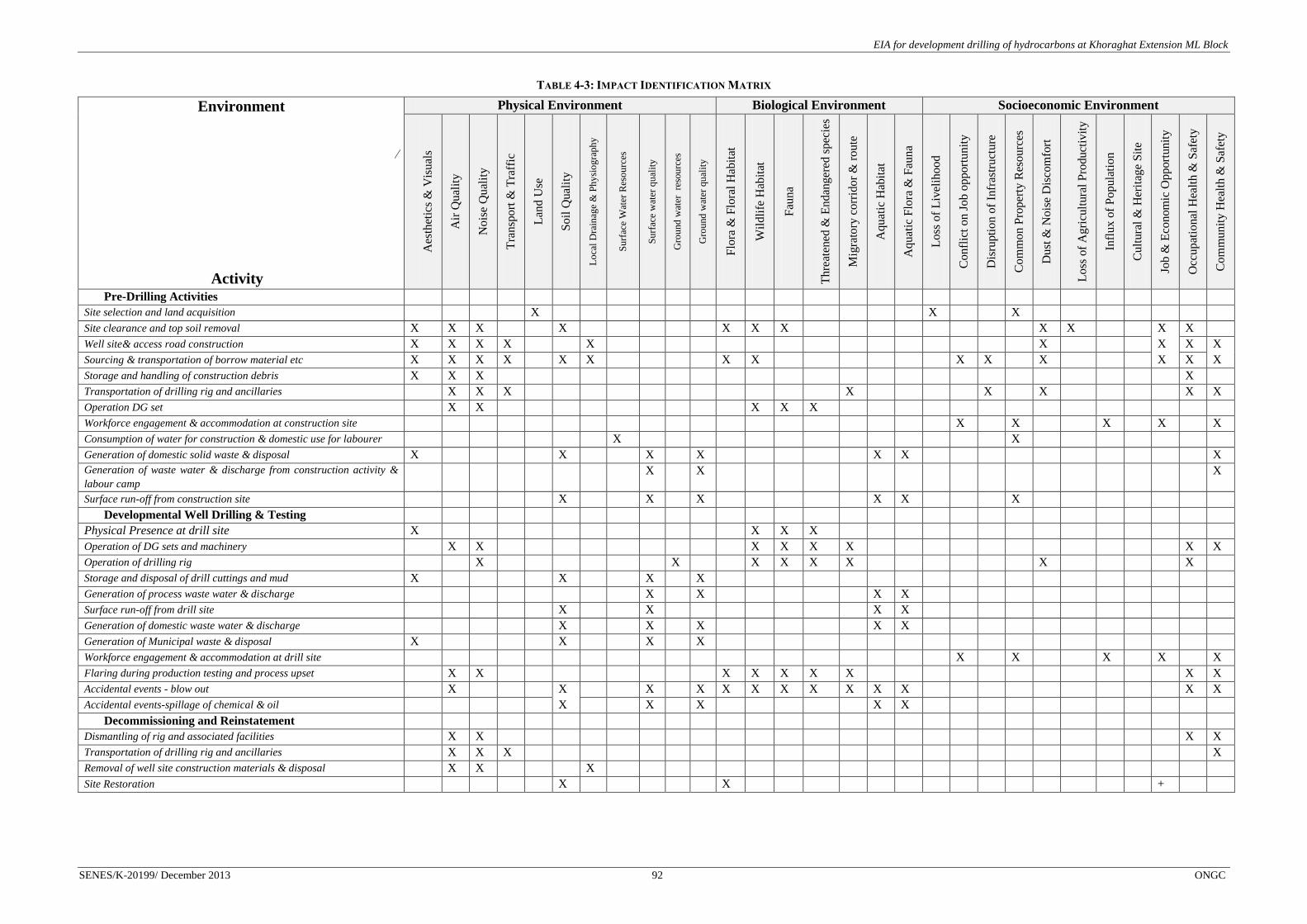
EIA for development drilling of hydrocarbons at Khoraghat Extension ML Block
SENES/K-20199/ December 2013 92 ONGC
TABLE 4-3: IMPACT IDENTIFICATION MATRIX
Environment
∕
Activity
Physical Environment Biological Environment Socioeconomic Environment
Aes
thet
ics
& V
isu
als
Air
Qu
alit
y
No
ise
Qu
alit
y
Tra
nsp
ort
& T
raff
ic
Lan
d U
se
So
il Q
ual
ity
Lo
cal
Dra
inag
e &
Ph
ysi
og
raph
y
Su
rfac
e W
ater
Res
ou
rces
Su
rfac
e w
ater
qu
alit
y
Gro
und
wat
er
reso
urc
es
Gro
und
wat
er q
ual
ity
Flo
ra &
Flo
ral
Hab
itat
Wil
dli
fe H
abit
at
Fau
na
Th
reat
ened
& E
nd
ang
ered
sp
ecie
s
Mig
rato
ry c
orr
ido
r &
ro
ute
Aq
uat
ic H
abit
at
Aq
uat
ic F
lora
& F
aun
a
Lo
ss o
f L
ivel
iho
od
Co
nfl
ict
on
Jo
b o
pp
ort
un
ity
Dis
rupti
on
of
Infr
astr
uct
ure
Co
mm
on
Pro
per
ty R
eso
urc
es
Du
st &
No
ise
Dis
com
fort
Lo
ss o
f A
gri
cult
ura
l P
roduct
ivit
y
Infl
ux
of
Po
pula
tio
n
Cu
ltura
l &
Her
itag
e S
ite
Job
& E
con
om
ic O
pp
ort
un
ity
Occ
up
atio
nal
Hea
lth
& S
afet
y
Co
mm
un
ity
Hea
lth
& S
afet
y
Pre-Drilling Activities
Site selection and land acquisition
X
X
X
Site clearance and top soil removal X X X
X
X X X
X X
X X
Well site& access road construction X X X X
X
X
X X X
Sourcing & transportation of borrow material etc X X X X
X X
X X
X X
X
X X X
Storage and handling of construction debris X X X
X
Transportation of drilling rig and ancillaries
X X X
X
X
X
X X
Operation DG set
X X
X X X
Workforce engagement & accommodation at construction site
X
X
X
X
X
Consumption of water for construction & domestic use for labourer
X
X
Generation of domestic solid waste & disposal X
X
X X
X X
X Generation of waste water & discharge from construction activity &
labour camp
X X
X
Surface run-off from construction site
X
X X
X X
X
Developmental Well Drilling & Testing
Physical Presence at drill site X
X X X
Operation of DG sets and machinery
X X
X X X X
X X
Operation of drilling rig
X
X
X X X X
X
X
Storage and disposal of drill cuttings and mud X
X
X X
Generation of process waste water & discharge
X X
X X
Surface run-off from drill site
X
X
X X
Generation of domestic waste water & discharge
X
X X
X X
Generation of Municipal waste & disposal X
X
X X
Workforce engagement & accommodation at drill site
X
X
X
X
X
Flaring during production testing and process upset
X X
X X X X X
X X
Accidental events - blow out
X
X
X X X X X X X X X
X X
Accidental events-spillage of chemical & oil
X
X X
X X
Decommissioning and Reinstatement
Dismantling of rig and associated facilities
X X
X X
Transportation of drilling rig and ancillaries
X X X
X
Removal of well site construction materials & disposal
X X
X
Site Restoration
X
X
+

EIA for development drilling of hydrocarbons at Khoraghat Extension ML Block
SENES/K-20199/ December 2013 93 ONGC
4.2 IMPACT ASSESSMENT
This section discusses the impacts of the project activities (development drilling) on the
environmental receptors that stand to get affected adversely by the project. It discusses
probable impacts during various phases of the project lifecycle on the environmental and
socioeconomic components. Rankings for every activity – component interaction is based on
the criterion set earlier and resulting environmental significance with necessary justification
that has been recorded below for every set of impacts and the same has been represented in
evaluation matrices. In broader context, it is however important to remember that operations
related to development well drilling, testing and completion activities also include positive
socioeconomic impacts in terms of increase in local business opportunities and on a larger
perspective, by providing potential energy security at a national level.
4.2.1 Visual Impacts & Aesthetics
Khoraghat Extension ML Block is an operating oil and gas field, which has number of
producing wells, GGS etc. Visual impacts during proposed drilling operations is anticipated
from site clearance and well site preparation, vehicles involved in transportation of raw
materials and personnel, material stockpiles and physical presence and operation of drilling
rig and associated facilities.
During drilling site preparation nearly 3.38 ha land is to be cleared for construction of drill
site. Vegetation clearance will not be required for drill site construction as the site KHDE
does not have any trees and KHDF is located within existing GGS-2 of Khoraghat. Again
during site construction activity, dust will be generated from transport of construction
material, machinery and personnel, haphazard dumping of construction waste, domestic
waste from labour camp may cause visual and aesthetic impacts. Such impacts are likely to
be particularly experienced by communities residing in villages (particularly in Haldhibari)
located in the vicinity of KHDE well. As. KHDF will be located within the facility boundary
of GGS-2 visual impacts due to the well alone in unlikely.
Visual impact due to the operation of drilling rig and presence of base camp is not considered
significant given the temporary nature of drilling activities (about 45-60 days) provided the
well is not indicative of any commercial hydrocarbon reserve. Also with drilling waste and
process waste water likely to be temporary stored in impervious pits no visual impact to this
regard is envisaged. Some visual impacts are also envisaged from light generated from
emergency flaring events. However such activity is likely to be of intermittent in nature, to
occur only during process upset and production testing. Reinstatement of well site not
indicative of any commercially exploitable hydrocarbon reserve is also likely to positively
contribute to the site visual aesthetic.
Severity of Impact 1 Extent of Impact 2 Duration of Impact 2
Impact Significance = 4 i.e. Low

EIA for development drilling of hydrocarbons at Khoraghat Extension ML Block
SENES/K-20199/ December 2013 94 ONGC
Mitigation Measures
All the construction activity will be restricted within the designated site
Dust nuisance from construction site will be suppressed through periodical water
spraying at disturbance area;
On completion of work all temporary structures, surplus materials and wastes will be
completely removed;
Construction wastes and municipal solid waste temporarily stored at the sites will be
transported to the designated disposal site/facility at regular intervals;
After decommissioning of rig and associated facilities, drill sites will be restored –
drill platform will be removed, pits & garland drains will be filled up, construction
material will be removed & disposed;
Site will be rehabilitated through laying of top soil.
4.2.2 Impacts on Air Quality
Operation of vehicles and construction machinery
Exhaust emission from operation of construction machinery is likely to contribute to air
pollutant load (primarily particulate matter, NO2, SO2 etc.) in the ambient air near well sites.
However, considering localized nature of impacts, temporary nature of construction and
necessary mitigation measures likely to be adopted by ONGC (viz. water spraying at site and
approach roads, using vehicles and machineries with valid pollution control certificate etc.)
the impact is considered to be of low significance. The mitigation measures for controlling air
pollution from operation of vehicles and construction machinery have been described at the
end of this sub-section.
Severity of Impact 1 Extent of Impact 2 Duration of Impact 2
Impact Significance = 4 i.e. Low
Construction material transport, storage and handling
During construction phase it is estimated that about 500 m3 of borrow material and 1000 m
3
of aggregates will be required per well site location for road construction/strengthening and
site preparatory activities. Fugitive emission is therefore anticipated from transportation,
storage and handling of borrow materials by contractor personnel. However, generation of
such fugitive dust is likely to be governed by micro-meteorological conditions (wind speed
and direction) and the transportation route condition. Considering the drilling activity will be
carried out in dry season and majority of internal roads are kutcha or degraded in condition
such impacts are envisaged. However, the construction activity, rig mobilization and
decommissioning activity is a temporary and limited movement of project vehicles (50-60
nos. /well) during drilling phase, adopting specific mitigation measures during construction
and decommissioning phase (viz. water spraying at site and approach roads etc.) the impact

EIA for development drilling of hydrocarbons at Khoraghat Extension ML Block
SENES/K-20199/ December 2013 95 ONGC
was considered to be of low significance. The mitigation measures for controlling air
pollution from fugitive dust emission have been described at the end of this sub-section.
Severity of Impact 2 Extent of Impact 2 Duration of Impact 2
Impact Significance = 8 i.e. Medium
Operation of Diesel Generator (DG) Sets during Drilling Period
The proposed project will involve the operation of diesel driven 2 X 750 KW generators for
drilling of developmental well. The operation of DG sets will therefore result in the
generation of air pollutants viz. PM, SO2 NOx, and HC thereby affecting the ambient air
quality. The dispersion of these air pollutants may affect the receptors viz. village settlements
located in near vicinity of the well site only under exceptional combination of meteorological
conditions. It has been already mentioned in Section 3.1.2 that PM10, SO2 and NOx
concentrations in ambient air is well within the NAAQS specified limits. Moreover,
considering the temporary nature of drilling phase (approx 45- 60 days), wet and humid
conditions prevalent in the Block region and provision of adequate DG set stack height for
effective dispersion of air pollutants, no significant impact to this regard is envisaged.
Additionally the proponent also plans to adopt and implement necessary mitigation measures
as discussed in the subsequent section to effectively address potential air quality impacts
from DG set operation.
In order to predict the Ground Level Concentrations (GLCs) at various distances from the
source of the above mentioned pollutants, an air modeling exercise has been undertaken and
is discussed in the impact prediction section below. The following input parameters (Refer
Table 4.4) have been considered in the impact prediction modeling undertaken using ISC 3.
TABLE 4-4: INPUT PARAMETERS CONSIDERED FOR MONITORING
Source
Stack
Height
(m)
Stack
Dia(m)
Stack gas
temp (K)
Stack gas
velocity
(m/s)
Emission Rate
(g/sec)
PM NOx SO2 HC
750 KW DG 9 0.30 773 17.0 0.008 1.3 0.003 0.002
Though, ISC3 is a refined model, the model run was carried out based on micro- meteorology
to predict air quality impacts for a average 24 hr period that may be caused by peak power
utilization at the drill site. The model was run considering operation of three 750 KW DG
sets simultaneously and operation of three 750 KW DG and flaring in combination.
Maximum ground level concentrations for the pollutants are provided below (Refer Table
4.5).

EIA for development drilling of hydrocarbons at Khoraghat Extension ML Block
SENES/K-20199/ December 2013 96 ONGC
TABLE 4-5: PREDICTED GLCS FOR AIR POLLUTANTS
Pollutants
Predicted Maximum GLC (μg/m3)
Incremental
Concentration
Distance from Well
(km) Direction
3 X 750 KW DG sets
NO2 (μg/m3) 25.442 2.213 NW
PM (μg/m3) 0.156 2.213 NW
SOx (μg/m3) 0.024 2.213 NW
HC (μg/m3) 0.0088 2.213 NW
For spatial mapping of pollutants, the GLCs revealing worst case scenarios were
superimposed on land use (5km x 5 km area) abutting KHDF.
The incremental Ground Level Concentration (GLCs) of the pollutants (as discussed above),
do not exhibit any appreciable decrease in air quality. The impact on ambient air quality is
due to operation of DG set is thus considered to be of low significance.
Severity of Impact 1 Extent of Impact 2 Duration of Impact 2
Impact Significance = 4 i.e. Low
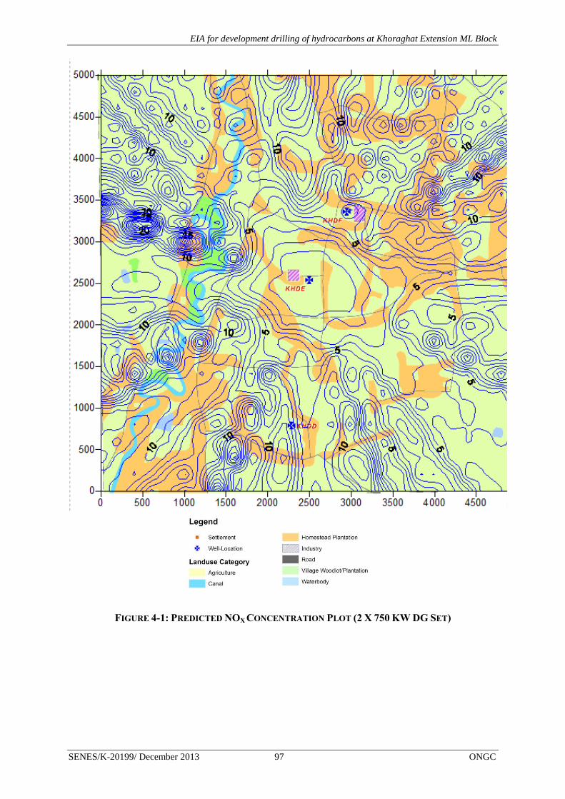
EIA for development drilling of hydrocarbons at Khoraghat Extension ML Block
SENES/K-20199/ December 2013 97 ONGC
FIGURE 4-1: PREDICTED NOX CONCENTRATION PLOT (2 X 750 KW DG SET)

EIA for development drilling of hydrocarbons at Khoraghat Extension ML Block
SENES/K-20199/ December 2013 98 ONGC
FIGURE 4-2: PREDICTED PM CONCENTRATION PLOT (2 X 750 KW DG SETS)

EIA for development drilling of hydrocarbons at Khoraghat Extension ML Block
SENES/K-20199/ December 2013 99 ONGC
FIGURE 4-3: PREDICTED SO2 CONCENTRATION PLOT (2 X 750 KW DG SETS)
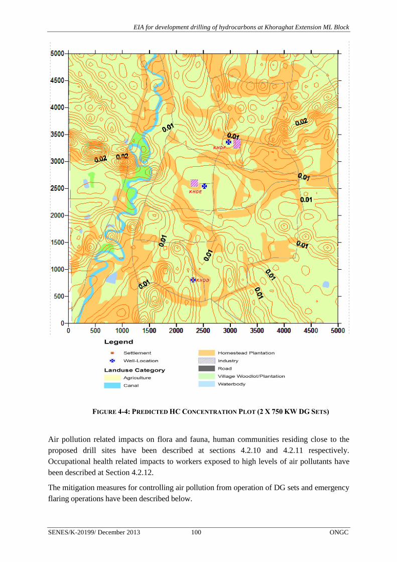
EIA for development drilling of hydrocarbons at Khoraghat Extension ML Block
SENES/K-20199/ December 2013 100 ONGC
Air pollution related impacts on flora and fauna, human communities residing close to the
proposed drill sites have been described at sections 4.2.10 and 4.2.11 respectively.
Occupational health related impacts to workers exposed to high levels of air pollutants have
been described at Section 4.2.12.
The mitigation measures for controlling air pollution from operation of DG sets and emergency
flaring operations have been described below.
FIGURE 4-4: PREDICTED HC CONCENTRATION PLOT (2 X 750 KW DG SETS)

EIA for development drilling of hydrocarbons at Khoraghat Extension ML Block
SENES/K-20199/ December 2013 101 ONGC
Mitigation measures for controlling impacts on air quality:
All vehicles used for transportation of loose and friable materials will not be loaded
over the freeboard limit and will be covered.
Water spraying will be done on the access roads to control re-entrained dust during
dry season;
Equipment, machinery and vehicles having inbuilt pollution control devices will be
considered as a measure for prevention of air pollution at source
Engines and exhaust systems of all vehicles and equipment used for the project will
be maintained so that exhaust emissions are low and do not breach statutory limits set
for that vehicle/equipment type.
DG set with appropriate stack height will be utilized.
Personnel Protective Equipments (PPEs) like mask will be provided to workers at site.
The detailed plans for controlling impacts to ambient air quality due to the proposed
developmental drilling activities have been provided at Chapter 6.
4.2.3 Impact on Noise Quality
Potential impact on noise quality is anticipated from vehicular movement, operation of
construction machinery during well site preparation and access road strengthening and during
operation of drilling rig.
Operation of construction machinery/equipments
Operation of heavy machinery/equipments and vehicular movement during site preparatory
and road strengthening/construction activities may result in the generation of increased noise
levels. The noise generated from construction machineries generally varies in the range of
88-95 dB (A) as specified in the Table 2.5. The baseline noise level- day time and night time
(Section 3.3) in the villages in proximity to the proposed drill sites were found to be in
compliance to the noise standards for residential areas. The noise related disturbance is likely
to be experienced by communities particularly residing in Haldhibari, Chetanapur, Bidyapur
etc. in proximity of the well construction site and along material transportation routes. The
environmental setting of well sites reveals that settlements are very close (about 50-75 m) to
the proposed well site and site access road. Considering the construction phase activities to be
of temporary nature, limited daily movement of project vehicles (3-4 nos. vehicle for
transportation of personnel and 8-10 nos. for material transport) and adequate mitigation
measures (viz. equipment maintenance etc.) to be implemented by the project proponent,
impact is considered to be of medium significance.
Severity of Impact 2 Extent of Impact 2 Duration of Impact 2
Impact Significance = 8 i.e. Medium

EIA for development drilling of hydrocarbons at Khoraghat Extension ML Block
SENES/K-20199/ December 2013 102 ONGC
Operation of drilling rig
As already mentioned in the previous section that the villages close to the proposed drill sites
revealed baseline noise levels in compliance to the standards prescribed for residential areas.
Operational phase noise impacts are anticipated from operation of drilling rig and ancillary
equipment viz. shale shakers, mud pumps and diesel generators. Studies indicated that noise
generated from operation of drilling rig generally varies in the range of 88-103 dB(A). Other
contributors of high noise level at the developmental well site include shale shakers, mud
pumps and diesel generators. The average equivalent noise levels of drilling rig and ancillary
equipment has been provided in the Table 2.6 for reference.
Further, considering drilling to be a continuous operation, noise generated from aforesaid
equipments has the potential to cause discomfort to the local communities residing in
proximity (within 50 m) of the well site boundary. Occupational health and safety impacts
viz. Noise Induced Hearing Loss (NIHL) is also anticipated on personnel working close to
such noise generating equipment. However, duration of drilling period is short (approx 45-60
days) and necessary noise prevention and control measures viz. use of acoustic barriers,
provisions for proper PPEs, regular preventive maintenance of equipments etc. will be
implemented by ONGC to minimize the impact.
Noise related impacts on flora and fauna, human communities residing close to the proposed
drill sites have been described at sections 4.2.10 and 4.2.11 respectively. Occupational health
related impacts to workers exposed to high noise levels have been described at Section
4.2.12.
Noise Level Prediction
A noise modeling exercise has been undertaken based on standard noise attenuation equations
(refer Annex 4.1) to predict noise levels from drilling rig near sensitive receptors. A noise
attenuation plot has been developed considering natural attenuation by distance with noise
level predictions only expected to help in planning and decision making.
The cumulative noise generated from rig, mud pump, DG and Shale Shaker was calculated to
be 95.0 dB(A). Noise attenuation equations (without any noise barrier) show that the normal
attenuated noise at any receptor points located at a distance of about 100 m and 200 m from
the fence-line of the rig, will be in the range of about 75.0 dB(A) and 69.0 dB(A)
respectively. In the absence of an acoustic barrier, the predicted noise levels were found to
exceed the day time noise standard of i.e. 55 dB (A) leading to discomfort to neighbouring
communities. However, with the introduction of a noise barrier at the fence-line with a height
of 4 m the noise level may be controlled. This control measure will be enough to decrease
noise levels near sensitive receptors at 200m to about 55.98 dB (A). However a detailed noise
modelling exercise to look at option of noise reductions will be conducted at the design stage
to determine the barrier specifications. The noise attenuation plot with and without acoustic
barrier is presented in Figure 4.5 below.

EIA for development drilling of hydrocarbons at Khoraghat Extension ML Block
SENES/K-20199/ December 2013 103 ONGC
FIGURE 4-5: NOISE ATTENUATION PLOT
Severity of Impact 2 Extent of Impact 2 Duration of Impact 2
Impact Significance = 8 i.e. Medium
Mitigation measures for controlling impacts on noise quality
Typical mitigation measures for controlling noise quality impacts will include the following:
Installation of sufficient engineering control on equipment and machinery (like
mufflers & noise enclosures for DG sets and PC pumps) to reduce noise emission
levels at source, carrying out proper maintenance and subjecting them to rigid noise
and vibration control procedures.
Re-locating noise sources to less sensitive areas to take advantage of distance and
shielding
Providing Personnel Protective Equipments (PPEs) like ear plugs/muffs to workers at
site.
Undertaking preventive maintenance of vehicles and machinery to reduce noise
levels.
The detailed plans to control impacts on noise quality due to the proposed developmental
drilling activities have been provided at Chapter 6.
4.2.4 Potential Impact Transport and Traffic
The drill site access roads (i.e. PWD road, village road) are not located on busy vehicular
route. The traffic survey data shows that 128 nos. (22 nos. heavy vehicles) recorded at
0.00
10.00
20.00
30.00
40.00
50.00
60.00
70.00
80.00
90.00
100.00
10
20
30
40
50
60
70
80
90
10
0
11
0
12
0
13
0
14
0
15
0
16
0
17
0
18
0
19
0
20
0
21
0
22
0
23
0
24
0
25
0
No
ise
Le
vel d
B(A
)
Distance (m)
Predicted Noise Level with & without attenuation
Noise Level of Machinery with Base Noise and without Attenuation
Noise Level of Machinery with Base Noise and with Attenuation

EIA for development drilling of hydrocarbons at Khoraghat Extension ML Block
SENES/K-20199/ December 2013 104 ONGC
Haldhibari –Uriamghat road and 211 nos. (54 nos. heavy vehicles) vehicles recorded on
Uriamghat-Bidyapur Road.
Movement of heavy vehicles estimated to about 60 truck/trailer load (from Jorhat to the
Block) is anticipated during both site construction and decommissioning phases. During
drilling phase 5-6 medium to small vehicles will be used for transportation of personnel to the
drill sites. Transportation of vehicles during various projects phases particularly during site
construction and decommissioning is likely to cause disturbance to the villages in the access
routes. In the transport route, few schools viz. Haldhibari Secondary School, Haldhibari
Bamchuk Primary School are also located. Disturbance to traffic movement during school
hours is therefore anticipated from additional traffic load during project activity. With respect
to increase in traffic movement the impact is considered to be of medium significance. As,
discussed in Section 3.1.12 the access roads within the Block are already in dilapidated
condition, transportation of heavy vehicles will deteriorate the road condition further and
cause disruption of local infrastructure.
Severity of Impact 2 Extent of Impact 2 Duration of Impact 2
Impact Significance = 8 i.e. Medium
The detailed traffic management plan for the proposed developmental drilling activities has
been provided at Chapter 6.
4.2.5 Potential Impact on Land Use
Approximately 3.38 ha of agricultural land will be required for construction of drill site
KHDE, while KHDF is located within ONGC existing Khoraghat GGS-2 where no additional
land will be required. Both the proposed well sites are located within Rengma Reserve Forest.
ONGC has taken Forest Clearance (FC) for the KHDF site and applied for FC for KHDD and
KHDE to Assam Forest Department.
As discussed earlier, as the land for KHDD and KHDE is currently being used for agriculture
purpose, ONGC will have to take the land in long term lease from the local panchayat. In
long term lease land will be converted from forest land to industrial land. The land for KHDF
is already under ONGC’s possession in long-term lease (10 year) from the land-owner. After
the completion of the lease period the land will be reinstated and converted to agricultural
land before handing over to the panchayat. Additionally with necessary measures to be
adopted by ONGC through provision of adequate compensation against loss of standing crops
and reinstatement of well site in accordance to defined post closure plan and regulatory
requirements the impact is considered to be of medium significance.
Severity of Impact 2 Extent of Impact 2 Duration of Impact 3
Impact Significance = 12 i.e. Medium
EIA for development drilling of hydrocarbons at Khoraghat Extension ML Block
SENES/K-20199/ December 2013 105 ONGC
Mitigation Measures
Obtain necessary permission for KHDD and KHDE from the Forest Department and
subsequent implementation of permit conditions.
Provide adequate compensation to landowners against loss of standing crops.
4.2.6 Impact on Soil Quality
Potential impact on soil quality is envisaged in the form of increase in soil erosion and loss of
soil fertility resulting from site clearance and top soil stripping for well site preparation
(particularly in KHDF and KHDE) and accidental spillage resulting from storage and
handling of mud chemicals Soil quality impacts so identified have been assessed and
evaluated in the section below.
Site clearance and stripping of top soil
As discussed in the baseline section 3.1.9, the soil of the area abutting the proposed wells is
characterized by fertile alluvial soil thereby contributing to the agricultural productivity of the
region. Stripping of top soil during site preparation of KHDE and KHDD is therefore likely
to affect the soil fertility of the site. It is estimated that about 3375 m3 of top soil will be
removed per well site having an area of 2.25 ha considering 15 cm top soil. However, such
impact is considered to be temporary taking into account the fact the proper reinstatement of
site will be undertaken by the proponent after the development activities. Necessary surface
run-off control measures need to be adopted by the proponent during construction phase to
prevent contamination of abutting agricultural land from discharge of surface run-off
characterized by increased sediment load. Further specific mitigation measures will be
implemented by the proponent to stabilize the top soil to preserve their fertility characteristics
during site restoration. The impact is therefore considered to be of low significance.
Severity of Impact 1 Extent of Impact 2 Duration of Impact 2
Impact Significance = 4 i.e. Low
Sourcing of borrow material
Site preparatory activities will involve the sourcing of earth-fill from borrow areas. Such sourcing
activity may lead to direct and indirect long-term major adverse impacts on the environment due
to loss of productive top soil if located on agricultural land or virgin forest land. The loss of top
soil may also enhance the soil erosion potential of the area resulting in increased sediment load in
surface run-off. Since most of the construction materials would be available from existing
quarries nearby, relatively few new borrow areas will be required. Considering above
scenario the impact is considered to be of low significance.
Severity of Impact 1 Extent of Impact 2 Duration of Impact 2
Impact Significance = 4 i.e. Low

EIA for development drilling of hydrocarbons at Khoraghat Extension ML Block
SENES/K-20199/ December 2013 106 ONGC
Storage and disposal of drill cuttings and drilling mud
It is estimated that nearly about 212-225 m3
of drill cuttings and waste drilling mud is likely
to be generated from each well during developmental drilling operation. Improper storage
and disposal of such process waste on open soil or unlined areas may therefore lead to the
contamination of soil onsite and abutting land if not properly managed. Construction of a
HDPE lined impervious pits of capacity 2 X 140 m3 each for temporary storage of drill
cuttings and drilling mud respectively and their disposal in accordance with S No. 72 C.1.a
Schedule I Standards for Emission or Discharge of Environmental Pollutants from Oil
Drilling and Gas Extraction Industry of CPCB as modified in 2005 will be ensured by
ONGC. Further with the proponent catering to the use of water based mud the drill cuttings
and waste drilling mud generated are likely to be non-hazardous in nature and is not
anticipated to pose any potential threat to the soil environment. The impact is therefore
considered to be of low significance.
Severity of Impact 1 Extent of Impact 2 Duration of Impact 2
Impact Significance = 4 i.e. Low
Storage and handling of fuel and chemicals
Contamination of soil can result from the project activities if certain operations like storage of
chemicals and fuels, spent oil and lubricants are not managed efficiently. Storage of
chemicals and fuels, spent lubricants on unpaved surfaces also have potential for
contamination of soil. Accidentally, if chemicals, oil and lubricants are spilled, either during
transportation or handling, on open soil may contribute to soil contamination. However,
considering that appropriate spill prevention and control measures (referred below) to be
implemented by the proponent the impact is considered to be of low significance.
Severity of Impact 2 Extent of Impact 2 Duration of Impact 1
Impact Significance = 4 i.e. Low
Mitigation measures for reducing impacts on soil quality
Restricted project and related activities during monsoon season;
Carrying out adequate restoration of soil after drilling, to the extent possible;
Implementing adequate sediment control measures to prevent discharge of untreated
surface run-off characterized by increased sediment load to abutting agricultural land.
Ensuring proper storage of drill cutting and waste mud in HDPE lined impervious pits
to prevent any potential contamination from spillage.
All chemical and fuel storage areas, process areas will have proper bunds, an oil-
water separator will be provided at the storm water drainage outlet so that
contaminated run-off cannot escape into the neighbouring agricultural lands.

EIA for development drilling of hydrocarbons at Khoraghat Extension ML Block
SENES/K-20199/ December 2013 107 ONGC
The detailed plans for management of impacts related to soil quality due to the proposed
developmental drilling activities have been provided at Chapter 6.
4.2.7 Impact on Topography & Drainage
Potential impact on drainage and topography viz. alteration of drainage pattern, water logging
etc. are anticipated during well site preparation, widening/strengthening of access roads and
restoration of developmental well facilities. The impact details have been discussed below:
Site preparation and road construction/strengthening
Potential impact on drainage is primarily anticipated in the form of disruption of natural
drainage pattern during site preparation and approach road construction. Since site
preparation involves raising of acquired/leased land to about 1 m from the ground level it
may lead to alteration of onsite micro-drainage pattern leading to potential problems of water
logging in the agricultural land and settlements abutting the drill site. This problem is likely
to be further aggravated due to heavy rainfall experienced by Golaghat district throughout the
year (Refer section 3.1.2).
About 50 m site approach will be constructed for KHDE and KHDD while KHDF already
have an approach road. However, strengthening and widening of existing access roads will be
required for effective transportation of drilling rig and heavy equipments to the well site.
Widening/ new construction of roads could therefore result in the alteration of drainage along
water crossings and may lead to water-logging of adjacent lands and settlements if not
properly managed. However considering the provision of cross drainage structures viz.
culverts etc. at road embankments and stream crossings by the proponent to ensure
uninterrupted drainage flow the impact is considered to be of medium significance.
Severity of Impact 2 Extent of Impact 2 Duration of Impact 2
Impact Significance = 8 i.e. Medium
Well site restoration
Site restoration will be initiated for well site not indicative of any commercially exploitable
hydrocarbon reserves (or after the production phase if the well site is kept for development
drilling). Unplanned restoration may lead to the long term disruption in natural drainage
pattern and water logging in neighbouring agricultural land abutting the site. However,
adequate care will be taken by the proponent to restore the site back to its original condition
based on the originally existing contours and predominant slope to prevent any such adverse
drainage impacts. The impact is considered to be of medium significance with onsite drainage
being dependent on the proper site restoration.
Severity of Impact 2 Extent of Impact 2 Duration of Impact 2
Impact Significance = 8 i.e. Medium
EIA for development drilling of hydrocarbons at Khoraghat Extension ML Block
SENES/K-20199/ December 2013 108 ONGC
Mitigation measures for reducing the impact on site topography and drainage
Leveling and grading operations will be undertaken with minimal disturbance to the
existing contour, thereby maintaining the general slope of areas abutting the well site;
Disruption/alteration of micro-drainage pattern will be minimized to the extent
possible.
Loss of micro- drainage, if any, is to be compensated through provision of alternate
drainage.
4.2.8 Impact on Surface Water Quality
Impact on surface water quality of natural drainage channels and community water bodies
may arise from discharge of contaminated surface run-off, sewage and process waste water
generated during various phases of the proposed project. As discussed in Section 3.1.8. The
surface water bodies close to the proposed well sites are used for bathing, washing, fishing
and for irrigation purposes. It has been already discussed in Section 3.1.8 that surface water
discharge from the proposed well sites are most likely to reach the Rengma River and also in
Dayang River via. some minor surface water channels.
Surface run-off discharge
As discussed under section 4.2.4, site clearance and stripping of top soil during site
construction will result in an increase in soil erosion potential leading to an increased
sediment load in the surface run-off during monsoon. Also, surface run off from drilling
waste, hazardous waste (waste oil, used oil etc) and chemical storage areas on open soil is
likely to be contaminated leading to the pollution of receiving water bodies viz. natural
drainage channels, ponds etc. This situation is likely to be more pronounced considering
rainfall records of Golaghat district (Refer section 3.1.2). However, taking into account the
provision of onsite drainage system and sediment control measures to be implemented by the
proponent in compliance with the S No. 72 A.1.a Schedule I Standards for Emission or
Discharge of Environmental Pollutants from Oil Drilling and Gas Extraction Industry of
CPCB as modified in 2005, the impact is considered to be of low significance.
Severity of Impact 1 Extent of Impact 2 Duration of Impact 2
Impact Significance = 4 i.e. Low
Discharge of drilling wash water
It is estimated that nearly about 9 m3/day of drilling wash water is likely to be generated during
drilling operation. The drilling wash water so generated may be characterized by the presence of
oil & grease, barites and heavy metal which on discharge to nearby natural drainage channels
and/or rivers may lead to possible surface water contamination. However considering usage of
water based mud for the proposed project, temporarily storage of drilling waste in an HDPE lined
pit and subsequent treatment to ensure conformance with CPCB Industry Specific
Standards for Oil Drilling & Gas Extraction Industry and guidelines provided by the MoEF under

EIA for development drilling of hydrocarbons at Khoraghat Extension ML Block
SENES/K-20199/ December 2013 109 ONGC
the Hazardous Wastes (Management, Handling & Transboundary Movement) Rules, 2008 the
impact is not considered to be of significance.
Severity of Impact 2 Extent of Impact 2 Duration of Impact 1
Impact Significance = 4 i.e. Low
Mitigation measures for controlling potential surface water impacts
Following mitigation measures will be implemented for water pollution control:
Proper treatment of all wastewater and produced water discharges will be made to
ensure that they comply with CPCB Discharge Standard of Oil and Gas Industry
Drainage and sediment control systems at the well site will be efficiently designed
Construction activities viz. stripping, excavation etc during monsoon season will be
restricted to the extent possible.
All chemical and fuel storage areas, process areas will have proper bunds so that
contaminated run-off cannot escape into the storm-water drainage system. An oil-
water separator will be provided at the storm water drainage outlet, to prevent
discharge of contaminated run-off.
4.2.9 Impact on Hydrogeology & Ground Water Quality
Potential impacts on groundwater quality could arise as a result of the proposed drilling
activities as a result of the following activities:
Ground water extraction
During the initial stages of boring before successful insertion of casing groundwater may be
released leading to the depletion of the groundwater resource. Taking into account drilling to
be a temporary activity (approx 45-60 days) and release of groundwater prior to first casing and
cementing program (2-3 days) impact on ground water resource is considered to be of low
significance.
Severity of Impact 2 Extent of Impact 2 Duration of Impact 1
Impact Significance = 4 i.e. Low
Storage of drill cuttings and waste drilling mud
Possibility of contamination of subsurface and unconfined aquifers may exist if the casing
and cementing of the well is not carried out properly leading to infiltration or seeping of
drilling chemicals or mud into porous aquifer region. However with the project proponent
catering to the use of water based mud and storage of drill cuttings and waste drilling mud in
an HDPE lined pit, impact is considered to be of low significance.
EIA for development drilling of hydrocarbons at Khoraghat Extension ML Block
SENES/K-20199/ December 2013 110 ONGC
Severity of Impact 2 Extent of Impact 2 Duration of Impact 1
Impact Significance = 4 i.e. Low
Mitigation measures for controlling impacts to groundwater quality
Proper engineering controls will be used for drilling and cementing operations
Water based, non hazardous type of drilling mud will be utilized for drilling operation
Drill cuttings & mud will be stored in HDPE lined pits
4.2.10 Impact on Biological Environment
The potential impacts on ecological habitat of the Block region due to proposed development
drilling operations are discussed below:
Loss of flora and floral habitat
KHDE and KHDD will be located on agricultural land where there is no prominent
vegetation except seasonal crops. Reviewing of ecological conditions of the Block reveals no
flora or floral assemblages that are unique to the site or are listed as protected or threatened
plant species. Taking drilling activity into account, drill site will be restored to near original
condition and its impact on flora and floral habitat is considered to be of low significance. As
KHDF is located within the existing GGS no impact is envisaged from the loss of flora of
floral habitat.
Severity of Impact 1 Extent of Impact 2 Duration of Impact 2
Impact Significance = 4 i.e. Low
Impact of Fauna & Faunal Habitat
KHDE will be located on agricultural land with no prominent vegetation and KHDF is
located within the existing GGS are not ideal habitats for larger fauna. However, noise
generated from drilling activity, lighting at well site, traffic movement will cause of
disturbance to local fauna. It has been already discussed in the “Biological Environment”
section of Chapter 3 no protected ecological habitats are present within 10 km of the
proposed well sites (nearest Wildlife Sanctuary Nambor Wildlife Sanctuary is located at a
distance of more than 20 km from the Block Boundary) and also Schedule I species are not
reported from the area. Few Schedule II species, few mammals, birds, reptiles and
amphibians are reported from the Block areas that can temporarily relocate to places distantly
located from the wells to minimize the impact (of noise and light) the impact is considered to
be of low significance.
Severity of Impact 1 Extent of Impact 2 Duration of Impact 2
Impact Significance = 4 i.e. Low

EIA for development drilling of hydrocarbons at Khoraghat Extension ML Block
SENES/K-20199/ December 2013 111 ONGC
Impact on Endangered/Threatened Flora and Fauna
Noise, vibration and light generated during drilling (operation of the rig) are expected to
cause impact on faunal species. However, no threatened or endangered fauna is reported
within 10 km areas of the well sites, with few reported Schedule II species the impact is
considered to be of low significance
Severity of Impact 1 Extent of Impact 2 Duration of Impact 2
Impact Significance = 4 i.e. Low
Impact on Migratory Corridor & Route
As discussed in the biological environmental section of the report, the nearest established
elephant corridor (Kalapahar-Daigurung) is located more than 30 km from the well sites and
absence of any other migratory route and corridor in the vicinity of the well sites no impact
on the migratory or corridor is envisaged.
Aquatic Habitat, Aquatic Flora & Fauna
The major rivers viz. Dayang River and Rengma River forms the aquatic ecosystem in the
study area. It has been established in the baseline studies, that existing water quality of the
surface water bodies is favorable to support diverse range of aquatic fauna and flora.
Therefore, in case of any discharge of untreated waste water from development drilling site
may result in the possible contamination of receiving streams and their ecological habitat.
Surface runoff during monsoon from the construction site of the wells has the potential to
contaminate receiving surface water bodies thereby impacting their aquatic ecology. Again,
all such process water to be discharged offsite will be undergoing adequate treatment to
comply with discharge standards specified by regulatory authorities. Adequate treatment
coupled with dilution factor of receiving water bodies will thus significantly contribute in
preventing any deleterious effect on the aquatic ecological habitat.
Severity of Impact 2 Extent of Impact 2 Duration of Impact 1
Impact Significance = 4 i.e. Low
Detailed plans to mitigate impacts on biological environment due to the proposed
developmental drilling activities have been provided at Chapter 6.
4.2.11 Impact on Socioeconomic Environment
Based on the nature and type of impacts, the assessment has been divided into broad
categories namely (i) Adverse impacts and (ii) Positive impacts.
Adverse Impact
Loss of Livelihood
Approximately, 2.25 ha land will be required for drilling of each KHDD and KHDE well
currently in agricultural land. The agricultural lands are mono-crop land. ONGC will take

EIA for development drilling of hydrocarbons at Khoraghat Extension ML Block
SENES/K-20199/ December 2013 112 ONGC
this land through private negotiation. In all cases, necessary payments will be made against
purchase and crop compensation to concerned land owners. The proposed project would not
require any displacement of villagers. The impact on livelihood is considered to be of medium
significance. As KHDF will be located on existing GGS land procurement and loss of livelihood
would not take place.
Severity of Impact 1 Extent of Impact 2 Duration of Impact 3
Impact Significance = 6 i.e. Medium
Conflicts on Job Opportunity
Primary survey and public consultation showed that the local people desired to work in the
ONGC. Involvement of outside workers in proposed activity may possibly create conflict
with the local people, as most of the villagers are small scale cultivators, daily labours, small
businessmen. Local people strongly objected to outsiders, and demanded that major
proportion of workers be involved from surrounding villages. As majority of the workers
involved in well site construction, approach road construction and strengthening will be
sourced from the local villages conflicts due to job opportunity will be considered to be of
low significance.
Severity of Impact 2 Extent of Impact 2 Duration of Impact 1
Impact Significance = 4 i.e. low
Disruption on Infrastructure
Main roads within the Block are weathered black top roads and internal village roads are
Kutcha road. Transportation of borrow materials, drilling rig and associated facilities could
deteriorate the road conditions if not properly maintained. The impact in this respect is
considered to be of medium significance
Severity of Impact 2 Extent of Impact 2 Duration of Impact 2
Impact Significance = 8 i.e. Medium
Dust and Noise Discomfort
Both the proposed wells are located in close proximity to settlement. Inhabitants residing
close to access roads will get affected due to noise and dust generated from vehicular
movement during site preparation, setting up of rig and associated facilities,
decommissioning of rig and associated facilities. Again, during drilling operation, inhabitants
residing close to drill sites (particularly at Haldhibari and Chetanapur) will get affected due to
noise and emissions from DG sets and occasional flaring activity. Considering proximity of
human settlement and short term activity with proper mitigation measures, impact will be of
Medium significance.

EIA for development drilling of hydrocarbons at Khoraghat Extension ML Block
SENES/K-20199/ December 2013 113 ONGC
Severity of Impact 2 Extent of Impact 2 Duration of Impact 2
Impact Significance = 8 i.e. Medium
Ecological Productivity of Agricultural Fields
Ecological productivity of the agricultural land taken up for drilling of KHDE well will affect
during the entire lifecycle of the project. Reinstatement of ecological productivity will be
dependent on successful restoration of soils, their structure, chemistry drainage characteristics
and possibly other physical factors, such as micro-topography. These will provide a basis for
successful recovery of ecological populations, whether allowed to occur naturally or aided by
seeding and cultivation. However, considering necessary mitigation measures like top soil
preservation, process water treatment etc. will be implemented by the proponent. During
various project phases any impact in this regard is considered to be of low significance.
Severity of Impact 2 Extent of Impact 2 Duration of Impact 1
Impact Significance = 4 i.e. Low
Influx of Population
Influx of population is anticipated in all stages of the project cycle particularly during both
development drilling. The drill site will involve the operation of about 30 onsite workers.
Hence there might be an impact on the local communities due to the sharing of common
resources like space, drinking water, roads etc. Interaction between workers with villagers of
nearby areas might give rise to various issues like conflict of workers with the local
population, nuisance caused by workers due to improper sanitation facilities, etc. However,
taking into account that workforce is likely to be sourced from nearby villages and adequate
sanitation facilities will be provided chances of such conflicts are negligible.
Severity of Impact 1 Extent of Impact 2 Duration of Impact 1
Impact Significance = 2 i.e. Low
Cultural & Heritage Site
Impact on cultural environment may occur due to site preparation, operation of drilling rig
and also during vehicular movement with respect to the proposed exploration activities.
There are no designated historical or cultural spots within Khoraghat Extension ML Block.
The project will however be adopting following mitigation measures to prevent any adverse
impact to properties/remains of cultural and historical significance of any such remains
accidentally encountered during aforesaid activities.
Prior to commencement of site construction activities, location of cultural important
properties will be communicated to the contractor; and reporting of chance find of any
properties/remains of archeological significance by the contractor to the proponent. Thus any
significant impact due to project activities on cultural environment of the block is unlikely.
Severity of Impact 1 Extent of Impact 2 Duration of Impact 1
Impact Significance = 2 i.e. Low

EIA for development drilling of hydrocarbons at Khoraghat Extension ML Block
SENES/K-20199/ December 2013 114 ONGC
Employment opportunities: Project will benefit people living in the neighboring villages by
giving preference to them in relation to direct & indirect employment associated with the
various project activities. Site preparation phase will involve certain number of labourers and
there is a possibility that local people can be engaged for this purpose and hence improve
existing employment scenario of the region. Drilling process will involve a number of skilled
and unskilled workers. However, most jobs will comprise technical involvement. Hence
villagers can possibly be employed only in certain non-technical or casual labor jobs and that
too for a limited duration. It is proposed that first preference be given to people whose land is
acquired and to their relations. Next preference will be given to the poorer people and
subsequently the other villagers.
Detailed plans to mitigate impacts on socio-economic environment due to the proposed
developmental drilling activities have been provided at Chapter 6.
4.2.12 Impact on Occupational Health and Safety
Occupational injuries and ill-health have huge socio-economic implications on individuals,
their families and communities. They also have economic impacts in form of direct and
indirect costs for society as a whole. Major occupational health risks encountered in proposed
drilling activity include noise from drilling activity, operation of heavy vehicles and
machinery, handing of chemicals.
However, the proponent will adopt necessary control measures through implementation of
mitigation measures (viz. safety training to workers, provision of proper PPEs etc.) to prevent
and/or mitigate adverse health related impacts. Hence any possible occupational health
impact from exposure to such fugitive dust is not likely to be of major significance.
Severity of Impact 2 Extent of Impact 2 Duration of Impact 2
Impact Significance = 8 i.e. Medium
Community Health & Safety: Community health and safety of inhabitants residing close to
the drilling site stands to get affected from frequent heavy vehicular movement along village
access roads and due to noise from drilling rig operations. Health and safety impact arising
from technological emergencies viz. well blow outs, explosions will be dealt separately in the
Quantitative Risk Assessment section (Chapter 5). Although the aforesaid activities are
temporary in nature it may not adversely affect community health and safety and hence is
considered to be of medium significance.
Severity of Impact 2 Extent of Impact 2 Duration of Impact 2
Impact Significance = 8 i.e. Medium
Impact Significance = ++ i.e. POSITIVE

EIA for development drilling of hydrocarbons at Khoraghat Extension ML Block
SENES/K-20199/ December 2013 115 ONGC
TABLE 4-6: IMPACT SIGNIFICANCE MATRIX (WITH MITIGATION)
Environment
Activity
Physical Environment Biological Environment Socioeconomic Environment
Aes
thet
ics
& V
isu
als
Air
Qu
alit
y
No
ise
Qu
alit
y
Tra
nsp
ort
& T
raff
ic
Lan
d U
se
So
il Q
ual
ity
Lo
cal
Dra
inag
e &
Ph
ysi
og
raph
y
Su
rfac
e W
ater
Res
ou
rces
Su
rfac
e w
ater
qu
alit
y
Gro
und
wat
er R
eso
urc
es
Gro
und
wat
er q
ual
ity
Flo
ra &
Flo
ral
Hab
itat
Wil
dli
fe H
abit
at
Fau
na
Th
reat
ened
& E
nd
ang
ered
spec
ies
Mig
rato
ry c
orr
ido
r &
ro
ute
Aq
uat
ic H
abit
at
Aq
uat
ic F
lora
& F
aun
a
Lo
ss o
f L
ivel
iho
od
Co
nfl
ict
on
Jo
b o
pp
ort
un
ity
Dis
rupti
on
of
Infr
astr
uct
ure
Co
mm
on
Pro
per
ty R
eso
urc
es
Du
st &
No
ise
Dis
com
fort
Lo
ss o
f A
gri
cult
ura
l
Pro
du
ctiv
ity
Infl
ux
of
Po
pula
tio
n
Cu
ltura
l &
Her
itag
e S
ite
Job
& E
con
om
ic O
pp
ort
un
ity
Occ
up
atio
nal
Hea
lth
& S
afet
y
Co
mm
un
ity
Hea
lth
& S
afet
y
Pre-Drilling Activities
Site selection and land acquisition
M
M
L
Site clearance and top soil removal L L M
L
L L L
L L
+ L
Well site& access road construction L L M M
M
L
+ L L
Sourcing & transportation of borrow material etc L M M M
M M
L L
L M
M
+ M M
Storage and handling of construction debris L L
L
Transportation of drilling rig and ancillaries
L M M
L
M
M
M M
Operation DG set
L L
L L L
Workforce engagement & accommodation at construction site
L
L
L
+
L
Consumption of water for construction & domestic use for labourer
L
L
Generation of domestic solid waste & disposal L
L
L L
L L
L Generation of waste water & discharge from construction activity &
labour camp
L
L
L
Surface run-off from construction site
L
L L
L L
L
Development Well Drilling & Testing
Physical Presence at drill site L
L L L
Operation of DG sets and machinery
L M
L L L L
M M
Operation of drilling rig
M
L
L L L L
M
M
Storage and disposal of drill cuttings and mud L
M
M M
Generation of process waste water & discharge
M L
L L
Surface run-off from drill site
L
L
L L
Generation of domestic waste water & discharge
L
L L
L L
Generation of Municipal waste & disposal L
L
L L
Workforce engagement & accommodation at drill site
L
L
L
+
M
Flaring during production testing and process upset
L M
M L L L L
M M
Accidental events - blow out
L
M
M M M L L L L L L
M M
Accidental events-spillage of chemical & oil
M
M M
L L
Decommissioning and Reinstatement
Dismantling of rig and associated facilities
L M
M M
Transportation of drilling rig and ancillaries
L M M
M
Removal of well site construction materials & disposal
L M
M
Site Restoration
+
+
+

EIA for development drilling of hydrocarbons at Khoraghat Extension ML Block
SENES/K-20199/ December 2013 116 ONGC
QRA as a part of integrated risk management process for the proposed project consists of the
following iterative steps:
Identification of hazards
Setting Acceptance Standards for the defined risks
Evaluation of likelihood and consequences and risks of possible events.
Confirmation of arrangements to mitigate the events and respond to the same on occurrence.
Establishment of performance standards
Establishment of continuous monitoring, review and auditing of arrangements
5 Quantitative Risk Assessment (QRA)
This section on Quantitative Risk Assessment (QRA) aims to provide a systematic analysis of
the major risks that may arise as a result of onshore development drilling activities by ONGC
in Khoraghat Extension ML Block. The QRA process outlines rational evaluations of the
identified risks based on their significance and provides the outline for appropriate preventive
and risk mitigation measures. Results of the QRA provides valuable inputs into the overall
project planning and the decision making process for effectively addressing the identified
risks. This will ensure that the project risks stay below As Low As Reasonably Practicable
(ALARP) levels at all times during project implementation. In addition, the QRA will also
help in assessing risks arising from potential emergency situations like a blow out and
develop a structured Emergency Response Plan (ERP) to restrict damage to personnel,
infrastructure and the environment.
BOX 5.1: QRA – INTEGRATED RISK MANAGEMENT PROCESS
The risk study for the onshore exploration activities has considered all aspects of operation of
the drilling rig and other associated activities during the development phase. Oil spills, loss of
well control / blow-out and process leaks constitute the major potential hazards that may be
associated with the proposed onshore development drilling of hydrocarbons in Khoraghat
Extension ML Block.
The following section describes objectives, methodology of the risk assessment study and
then presents the assessment for each of the potential risk separately. This includes
identification of major hazards, hazard screening and ranking, frequency and consequence
analysis for major hazards. The hazards have subsequently been quantitatively evaluated
through a criteria based risk evaluation matrix. Risk mitigation measures to reduce significant
risks to acceptable levels have also been recommended as a part of the risk assessment study.
5.1 OBJECTIVE OF THE QRA STUDY
The overall objective of this QRA with respect to the proposed project involves identification
and evaluation of major risks, prioritizing risks identified based on their hazard consequences
and formulating suitable risk reduction/mitigation measures in line with the ALARP
principle. Hence in order to ensure effective management of any emergency situations (with

EIA for development drilling of hydrocarbons at Khoraghat Extension ML Block
SENES/K-20199/ December 2013 117 ONGC
potential individual and societal risks) that may arise during the development drilling
activities, following specific objectives need to be achieved.
Identify potential risk scenarios that may arise out of proposed drilling and other
associated activities like operation of ancillary facilities and equipment’s, mud
chemicals storage and handling etc.
Analyze the possible likelihood and frequency of such risk scenarios by reviewing
historical accident related data for onshore & offshore oil and gas industries.
Predict the consequences of such potential risk scenarios and if consequences are
high, establish the same by through application of quantitative simulations.
Recommend feasible preventive and risk mitigation measures as well as provide
inputs for drawing up of Emergency Management Plan (EMP) for the project.
5.2 RISK ASSESSMENT METHODOLOGY
The risk assessment process is primarily based on likelihood of occurrence of the risks
identified and their possible hazard consequences particularly being evaluated through
hypothetical accident scenarios. With respect to the proposed project, major risks viz. blow
outs, process leaks and fires, non-process fires etc. have been assessed and evaluated through
a risk matrix generated to combine the risk severity and likelihood factor. Risk associated
with the development drilling activities have been determined semi- quantitatively as the
product of likelihood/probability and severity/consequence by using order of magnitude data
(risk ranking = severity/consequence factor X likelihood/probability factor). Significance of
such project related risks was then established through their classification as high, medium,
low, very low depending upon risk ranking.
The risk matrix is a widely accepted as standardized method of quantitative risk assessment
and is preferred over purely quantitative methods, given that its inherent limitations to define
a risk event is certain. Application of this tool has resulted in the prioritization of the potential
risks events for the development drilling operations thus providing the basis for drawing up
risk mitigation measures and leading to formulation of plans for risk and emergency
management. The overall approach is summarized in the Figure 5.1

EIA for development drilling of hydrocarbons at Khoraghat Extension ML Block
SENES/K-20199/ December 2013 118 ONGC
FIGURE 5-1: RISK ASSESSMENT METHODOLOGY
5.2.1 Hazard Identification
Hazard identification for the purposes of this QRA comprised of a review of the project and
associated activity related information provided by ONGC as part of its Emergency Response
Plan. In addition, guidance provided by knowledge platforms/portals of the upstream oil &
gas industry including OGP, ITOPF and DNV, Norwegian Petroleum Directorate etc. are
used to identify potential hazards that can arise out of proposed project activities.
Taking into account the applicability of different risk aspects in context of the drilling
operations to be undertaken in the Khoraghat Extension ML Block, there are three major
categories of hazards that can be associated with proposed project which has been dealt with
in detail. This includes:
Blowouts leading to pool fires/jet fires and oil spills
Process leaks and fires
Non-process fires / explosions

EIA for development drilling of hydrocarbons at Khoraghat Extension ML Block
SENES/K-20199/ December 2013 119 ONGC
Well control incident covers a range of events which have the potential of leading to blow-
outs but are generally controlled by necessary technological interventions. Hence, such
incidents are considered of minor consequences and as a result not well documented. Other
possible hazard scenarios like mud chemical spills, falls, etc. has also not been considered for
detailed assessment as preliminary evaluation has indicated that the overall risk that may
arise out of them would be low. In addition, it is understood that, causative factors and
mitigation measures for such events can be adequately taken care of through exiting safety
management procedures and practices of ONGC.
It must also be noted here that many hazards identified are sometimes interrelated with one
hazard often having the ability to trigger off another hazard through a domino effect. For
example, a large oil spill in most instances is caused by another hazardous incident like a
blowout or process leak. This aspect has been considered while drawing up hazard mitigation
measures and such linkages (between hazards) has also been given due importance for
managing hazards and associated risks in a composite manner through ONGC’s Health,
Safety & Environmental Management System (HSEMS) and through the Emergency
Management Plan, if a contingency situation so arises.
5.2.2 Frequency Analysis
Frequency analysis involves estimating the likelihood of each of the failure cases identified
during the hazard identification stage. The analysis of frequencies of occurrences for the key
hazards that has been listed out is important to assess the likelihood of such hazards to
actually unfold during the lifecycle of the project. The frequency analysis approach for the
proposed project is based primarily on historical accident frequency data, event tree analysis
and judgmental evaluation. Major oil and gas industry information sources viz. statistical
data, historical records and global industry experience were considered during the frequency
analysis of the major identified risks6.
For QRA for the proposed project, various accident statistics and published oil industry
databases have been consulted for arriving at probable frequencies of identified hazards.
However, taking into account the absence of representative historical data/statistics with
respect to onshore operations7, relevant offshore accident databases have been considered in
the frequency analysis of identified hazards. The same has been recommended in the “Risk
Assessment Data Directory” published by the International Association of Oil & Gas
Producers (OGP). Key databases/reports referred as part of the QRA study includes
Worldwide Offshore Accident Databank (WOAD), Outer Continental Shelf (OCS) Reports,
6 It is to be noted that the frequency of occurrences are usually obtained by a combination of component
probabilities derived on basis of reliability data and /or statistical analysis of historical data.
7 Although Alberta Energy & Utilities Board (EUB) maintains a database for onshore incidents for the period
1975-1990 the same has not been considered in the context of the present study as the Alberta wells are believed
to be sour with precaution being taken accordingly to minimize the likelihood of release.

EIA for development drilling of hydrocarbons at Khoraghat Extension ML Block
SENES/K-20199/ December 2013 120 ONGC
Norwegian Petroleum Directorate Directives, Offshore Reliability Data (OREDA)
Handbook, HSE Offshore Incident Database, SINTEF Offshore Blowout Database etc.
Based on the range of probabilities arrived at for different potential hazards that may be
encountered during the proposed drilling activities, following criteria for likelihood rankings
have been drawn up as presented in the Table 5.1.
TABLE 5-1: FREQUENCY CATEGORIES AND CRITERIA
Likelihood Ranking Criteria Ranking
(cases/year) Frequency Class
5 >1.0 Frequent
4 >10-1
to <1.0 Probable
3 >10-3
to <10-1
Occasional/Rare
2 >10-5
to <10-3
Not Likely
1 >10-6
to <10-5
Improbable
5.2.3 Consequence Analysis
In parallel to frequency analysis, hazard prediction / consequence analysis exercise assesses
resulting effects in instances when accidents occur and their likely impact on project
personnel, infrastructure and environment. In relation to the proposed project, estimation of
consequences for each possible event has been based either on accident experience,
consequence modeling or professional judgment, as appropriate.
Given the high risk perception associated with blow outs in context of onshore drilling
operation, a detailed analysis of consequences has been undertaken for blow outs taking into
account physical factors and technological interventions. Consequences of such accidental
events on the physical, biological and socio-economic environment have been studied to
evaluate the potential of the identified risks/hazards. In all, the consequence analysis takes
into account the following aspects:
Nature of impact on environment and community;
Occupational health and safety;
Asset and property damage;
Corporate image
Timeline for restoration of environmental and property damage
Restoration cost for environmental and property damage
The following criterion for consequence rankings (Table 5.2) is drawn up in context of the
possible consequences of risk events that may occur during proposed development drilling
activities:

EIA for development drilling of hydrocarbons at Khoraghat Extension ML Block
SENES/K-20199/ December 2013 121 ONGC
TABLE 5-2: SEVERITY CATEGORIES AND CRITERIA
Consequence Ranking Criteria Definition
Catastrophic 5 Multiple fatalities/Permanent total disability to more
than 50 persons
Severe violations of national limits for environmental
emission
More than 5 years for natural recovery
Net negative financial impact of >10 crores
Long term impact on ecologically sensitive areas
International media coverage
National stakeholder concern and media coverage
Major 4 Single fatality/permanent total disability to one or more
persons
Major violations of national limits for environmental
emissions
2-5 years for natural recovery
Net negative financial impact of 5 -10 crores
Significant impact on endangered and threatened floral
and faunal species
Loss of corporate image and reputation
Moderate 3 Short term hospitalization & rehabilitation leading to
recovery
Short term violations of national limits for
environmental emissions
1-2 years for natural recovery
Net negative financial impact of 1-5 crores
Short term impact on protected natural habitats
State wide media coverage
Minor 2 Medical treatment injuries
1 year for natural recovery
Net negative financial impact of 0.5 – 1 crore
Temporary environmental impacts which can be
mitigated
Local stakeholder concern and public attention
Insignificant 1 First Aid treatment with no Lost Time Incidents (LTIs)
Natural recovery < 1year
Net negative financial impact of <0.5 crores.
No significant impact on environmental components
No media coverage
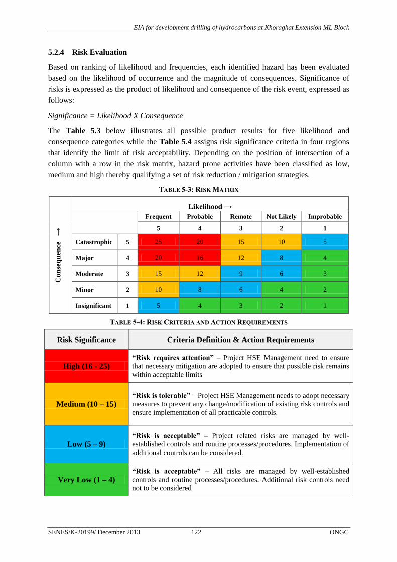
EIA for development drilling of hydrocarbons at Khoraghat Extension ML Block
SENES/K-20199/ December 2013 122 ONGC
5.2.4 Risk Evaluation
Based on ranking of likelihood and frequencies, each identified hazard has been evaluated
based on the likelihood of occurrence and the magnitude of consequences. Significance of
risks is expressed as the product of likelihood and consequence of the risk event, expressed as
follows:
Significance = Likelihood X Consequence
The Table 5.3 below illustrates all possible product results for five likelihood and
consequence categories while the Table 5.4 assigns risk significance criteria in four regions
that identify the limit of risk acceptability. Depending on the position of intersection of a
column with a row in the risk matrix, hazard prone activities have been classified as low,
medium and high thereby qualifying a set of risk reduction / mitigation strategies.
TABLE 5-3: RISK MATRIX
Con
seq
uen
ce →
Likelihood →
Frequent Probable Remote Not Likely Improbable
5 4 3 2 1
Catastrophic 5 25 20 15 10 5
Major 4 20 16 12 8 4
Moderate 3 15 12 9 6 3
Minor 2 10 8 6 4 2
Insignificant 1 5 4 3 2 1
TABLE 5-4: RISK CRITERIA AND ACTION REQUIREMENTS
Risk Significance Criteria Definition & Action Requirements
High (16 - 25) “Risk requires attention” – Project HSE Management need to ensure
that necessary mitigation are adopted to ensure that possible risk remains
within acceptable limits
Medium (10 – 15) “Risk is tolerable” – Project HSE Management needs to adopt necessary
measures to prevent any change/modification of existing risk controls and
ensure implementation of all practicable controls.
Low (5 – 9) “Risk is acceptable” – Project related risks are managed by well-
established controls and routine processes/procedures. Implementation of
additional controls can be considered.
Very Low (1 – 4) “Risk is acceptable” – All risks are managed by well-established
controls and routine processes/procedures. Additional risk controls need
not to be considered

EIA for development drilling of hydrocarbons at Khoraghat Extension ML Block
SENES/K-20199/ December 2013 123 ONGC
5.3 RISK ASSESSMENT OF IDENTIFIED PROJECT HAZARDS
As already discussed in the previous section, three major categories risk have identified in
relation to proposed development drilling activities. A comprehensive risk assessment study
has been undertaken to assess and evaluate significance of identified risks in terms of severity
of consequences and likelihood of occurrence. Risk assessment study details have been
summarized in the subsequent sections below:
5.3.1 Blow Outs/Loss of Well Control
Blow out is an uncontrolled release of well fluid (primarily hydrocarbons viz. oil and/or gas
and may also include drilling mud, completion fluid, water etc) from a development well.
Blow outs are the result of failure to control a kick and regain pressure control and are
typically caused by equipment failure or human error. The possible blow out cause events
occurring in isolation or in combination have been listed below:
Formation fluid entry into well bore
Loss of containment due to malfunction (viz. wire lining)
Well head damage (e.g. by fires, storms, dropped object etc)
Rig forced off station (e.g. by anchor failure) damaging Blow Out Preventor (BOP) or
wellhead
The most common cause of blow out can be associated with the sudden/unexpected
entry/release of formation fluid into well bore that may arise as a result of the following
events as discussed in the Box 5.2 below.

EIA for development drilling of hydrocarbons at Khoraghat Extension ML Block
SENES/K-20199/ December 2013 124 ONGC
BOX 5.2: PRIMARY CAUSES OF BLOW OUTS
Shallow gas
In shallow formations there may be pockets of shallow gas. In these instances there is often insufficient
mud density in the well and no BOP is in place. If the hole strikes shallow gas the gas may be released on
the drilling rig very rapidly. Typical geological features which suggest the presence of shallow gas can
then be detected. Historically, striking of shallow gas has been one of the most frequent causes of
blowouts in drilling.
Swabbing
As the drill pipe is pulled upwards during trips out of the hole or upward movement of the drill string, the
pressure in the hole beneath the drill bit is reduced, creating a suction effect. Sufficient drilling mud must
be pumped down-hole to compensate for this effect or well fluids may enter the bore. Swabbing is also a
frequent cause of drilling blowouts.
High formation pressure
Drilling into an unexpected zone of high pressure may allow formation fluids to enter the well before mud
weight can be increased to prevent it.
Insufficient mud weight
The primary method of well control is the use of drilling mud; in correct operation, the hydrostatic
pressure exerted by the mud prevents well fluids from entering the well bore. A high mud weight
provides safety against well fluids in-flows. However, a high mud weight reduces drilling speed,
therefore, mud weight is calculated to establish weight most suitable to safely control anticipated
formation pressures and allows optimum rates of penetration. If the required mud weight is incorrectly
calculated then well fluid may be able to enter the bore.
Lost Circulation
Drilling mud circulation can be lost if mud enters a permeable formation instead of returning to the rig.
This reduces the hydrostatic pressures exerted by the mud throughout the well bore, and may allow well
fluids from another formation to enter the bore.
Gas cut mud
Drilling fluids are denser than well fluids; this density is required to provide the hydrostatic pressure
which prevents well fluids from entering the bore. If well fluids mix with the mud then its density will be
reduced. As mud is circulated back to surface, hydrostatic pressure exerted by the mud column is reduced.
Once gas reaches surface it is released into the atmosphere.
Source: A Guide to Quantitative Risk Assessment for Offshore Installations; John Spouge – DNV Technica
Publication 99/100a
For better understanding, causes of blow outs have been systematically defined in terms of
loss of pressure control (failure of primary barrier), uncontrolled flow of fluid or failure of
secondary barrier (BOP). The blow out incidents resulting from primary and secondary
failures for proposed operations as obtained through comprehensive root cause analysis of the

EIA for development drilling of hydrocarbons at Khoraghat Extension ML Block
SENES/K-20199/ December 2013 125 ONGC
Gulf Coast (Texas, OCS and US Gulf of Mexico) Blow Outs8 during 1960-1996 have been
presented in the Table 5.5 below.
TABLE 5-5: BLOW OUT CAUSE DISTRIBUTION FOR FAILURES DURING DRILLING OPERATIONS
Sl. No Causal Factors Blow Out Incidents (nos.)
A Primary Barrier
1 Swabbing 77
2 Drilling Break 52
3 Formation breakdown 38
4 Trapped/expanding gas 09
5 Gas cut mud 26
6 Low mud weight 17
7 Wellhead failure 05
8 Cement setting 05
B Secondary Barrier
1 Failure to close BOP 07
2 Failure of BOP after closure 13
3 BOP not in place 10
4 Fracture at casing shoe 03
5 Failure to stab string valve 09
6 Casing leakage 06
Thus, underlying blowout causes as discussed in the above table can be primarily attributed
to swabbing as the primary barrier failure which is indicative of insufficient attention given to
trip margin and controlling pipe movement speed. Also, it is evident from the above table that
lack of proper maintenance, operational failures and absence of BOPs as secondary barrier
contributed to majority of blowout incidents (approx 30 nos.) is recorded.
Blowout Frequency Analysis
Blow out frequency estimates are obtained from a combination of incident experience and
associated exposure in a given area over a given period. For the purpose of calculation of
blow out frequency analysis in context of the present study involving drilling and
development operations, blow out frequencies per well drilled have been considered.
However due to the lack of availability of representative data on onshore blow out incidents
relevant offshore accident database viz. SINTEF Offshore Blowout Database, OGP Risk
Assessment Data Directory (RADD) and Scandpower which have been referred. The blow
8 “Trends extracted from 1200 Gulf Coast blowouts during 1960-1996” – Pal Skalle and A.L.Podio

EIA for development drilling of hydrocarbons at Khoraghat Extension ML Block
SENES/K-20199/ December 2013 126 ONGC
out frequency per operation as calculated is based on the SINTEF Offshore Blowout
Database for oil and gas extraction industry has been presented in the Figure 5.2 below.
FIGURE 5-2: BLOW OUT FREQUENCIES IN OIL & GAS INDUSTRY
With respect to the proposed project, the blow out occurrence frequency as based on analysis
of historical data9 has been considered to be 7.5 X 10
-3 per well drilled. Based on the given
frequency and information provided by ONGC on the proposed project development drilling
program the blow out frequency is calculated as follows:
No of development wells to be drilled = 3 (A)
Blow out frequency for drilling = 7.5 X 10⁻³
per well drilled (B)
Frequency of blow out occurrence for the proposed project = (A X B) = 3 X 7.5 X 10-3
= 2.25 X 10⁻²
per well drilled
Thus, the blow out frequency for the proposed project is calculated at 2.25 X 10⁻²
per well
drilled i.e. the likelihood of its occurrence is “Occasional/Rare”
9 Analysis of the SINTEF database for the US GoM OCS/North Sea for the period 1980-92 by Scandpower
(1995)

EIA for development drilling of hydrocarbons at Khoraghat Extension ML Block
SENES/K-20199/ December 2013 127 ONGC
Blowout Ignition Probability
Review of SINTEF database indicates that a rounded ignition probability of 0.3 has been
widely used for the purpose of quantitative risk analysis arising from blow outs. As per this
database generally ignition occurred within first 5 minutes in approximately 40% of the
blowouts leading to either pool and/or jet fire. Blow out leading to flammable gas release has
a greater probability of ignition compared to liquid releases10
(Figure 5.3).
FIGURE 5-3: IGNITION PROBABILITY VS RELEASE RATE
Further on analysis of the ignition trends over the years it is observed that there has been a
decline in ignition probability hence an average ignition probability of 0.1 (Holand) has been
considered for QRA of the proposed development drilling project.
No of development wells to be drilled = 3 (A)
Blow out frequency for development drilling = 7.5 X 10⁻³
per well drilled (B)
Blow out ignition probability = 0.1 (C)
Probability of Blow out ignition for the proposed project = (A X B X C) = 3 X 7.5 X 10-3
X 0.1
= 2.25 X 10-3
= ~ 0.0015%
Hence based on the aforesaid calculation the probability of ignition of blow out releases of
hydrocarbons for the proposed development drilling project will be about ~0.0015% and can
be considered to be as negligible.
10 Fire and Explosion – Fire Risk Analysis by Daejun Change, Division of Ocean System and Engineering

EIA for development drilling of hydrocarbons at Khoraghat Extension ML Block
SENES/K-20199/ December 2013 128 ONGC
Blowout Consequence Analysis
Blow out from a hydrocarbon development well may lead to the following possible risk
consequences:
Pool fires and smoke plumes resulting from ignited oil blow outs
Jet fires resulting from ignited gas blow outs
Oil slicks resulting from un-ignited oil pools.
Most crude oils are more than 95 percent carbon and hydrogen, with small amounts of sulfur,
nitrogen, oxygen, and traces of other elements. Crude oils contain lightweight straight-
chained alkanes (e.g., hexane, heptane); cycloalkanes (e.g., cyclyohexane); aromatics (e.g.,
benzene, toluene); cycloalkanes; and heavy aromatic hydrocarbons (e.g., polycyclic aromatic
hydrocarbons [PAHs], asphaltines). Based on the above discussion and also given the
limitation of ALOHA software with respect to risk modeling of crude oil releases, n-heptane
has been considered as the representative substitute of crude oil for ALOHA based risk
modeling for hydrocarbon releases for the proposed development drilling project. For natural
gas releases leading to jet fire, modeling has been based considering methane which has been
identified as the principal constituent (~ 95%) of natural gas.
Pool fire
A pool fire is a turbulent diffusion fire burning above a pool of vaporizing hydrocarbon fuel
where the fuel vapor has negligible initial momentum. The probability of occurrence of pool
fires for oil and gas exploration and development is high due to continuous handling of heavy
hydrocarbons. The evaporation of hydrocarbons from a pool forms a cloud of vapor above
the pool surface which, on ignition, leads to generation of pool fire.
For the purpose of consequence modeling for pool fires resulting from blow outs, following
hypothetical scenarios in terms of hydrocarbon (particularly crude oil) release rates (Table
5.6) have been considered based on DNV Technica’s FLARE program.
TABLE 5-6: POOL FIRE MODELING SCENARIOS
Scenario Release Rate (kg/s) Release Type
Scenario - I 1 Small
Scenario - II 10 Medium
Scenario – III (Worst Case) 50 Large
The release rates as specified for the aforesaid scenarios have been utilized in the computing
the pool fire diameter utilizing the following equation and input parameters:
D = √4Q/πb
Where D = pool diameter (m)
Q = release rate (kg/s)
b = burning rate (kg/m2s)

EIA for development drilling of hydrocarbons at Khoraghat Extension ML Block
SENES/K-20199/ December 2013 129 ONGC
The mass burning rate for crude oil has been considered to be 0.05 kg/m2s
Based on above equation, the pool fire diameter and the steady study burning areas computed
for various release types have been presented in the Table 5.7 below.
TABLE 5-7: POOL FIRE DIAMETER & STEADY STATE BURNING AREA
Scenario Release Rate
(kg/s) Release Type
Pool fire
diameter (m)
Steady State Burning
Area (m2)
Scenario - I 1 Small 5.05 6.37
Scenario - II 10 Medium 15.96 63.69
Scenario - III 50 Large 35.69 318.47
The risk scenarios viz. pool fire as discussed in above for the proposed project has been
modeled using ALOHA11
and interpreted in terms of Thermal Radiation Level of Concern
(LOC). Predominant local meteorological conditions as specified in the baseline chapter have
been considered in modeling the safety risks/hazards using ALOHA.
Thermal Radiation Level of Concern (LOC) is a threshold level of thermal radiation, usually
the level above which a hazard may exist. For each LOC chosen, ALOHA estimates a threat
zone where the thermal radiation is predicted to exceed that LOC at some time after a release
begins. These zones are displayed on a single Threat Zone plot displayed as red, orange and
yellow with red representing the worst hazard. The threat zone displayed by ALOHA
represent thermal radiation levels and also indicates the effects on people who are exposed to
those thermal radiation levels but are able to seek shelter within one minute. ALOHA uses
three threshold values (measured in kilowatts per square meter) to create the default threat
zones:
Red: 10 kW/ (sq m) -- potentially lethal within 60 sec;
Orange: 5 kW/ (sq m) -- second-degree burns within 60 sec; and
Yellow: 2 kW/ (sq m) -- pain within 60 sec
The impact zone for long duration fires is conveniently described by overlaying the thermal
radiation contours of worst case scenario (50 kg/s of crude oil release) on the land use map of
the each development well site. These risk contour maps will prove to be of assistance to
ONGC to identify villages and other sensitive receptors, which may fall within the potential
threat zone thereby ensuring better preparedness in terms of risk control and mitigation
during planning stage itself. Well site risk contour maps for worst case scenario prepared
based on ALOHA modeling of pool fire risks has been presented in Figure 5.4-5.5 below.
11 ALOHA is a public domain computer code that is part of a system of software that is known as the Computer-Aided
Management of Emergency Operations (CAMEO) that was developed by the United States Environmental Protection
Agency (EPA), through its Chemical Emergency Preparedness and Prevention Office (CEPPO) to plan for and respond to
chemical emergencies

EIA for development drilling of hydrocarbons at Khoraghat Extension ML Block
SENES/K-20199/ December 2013 130 ONGC
FIGURE 5-4: KHDE WELL SITE - POOL FIRE RISK CONTOUR MAP
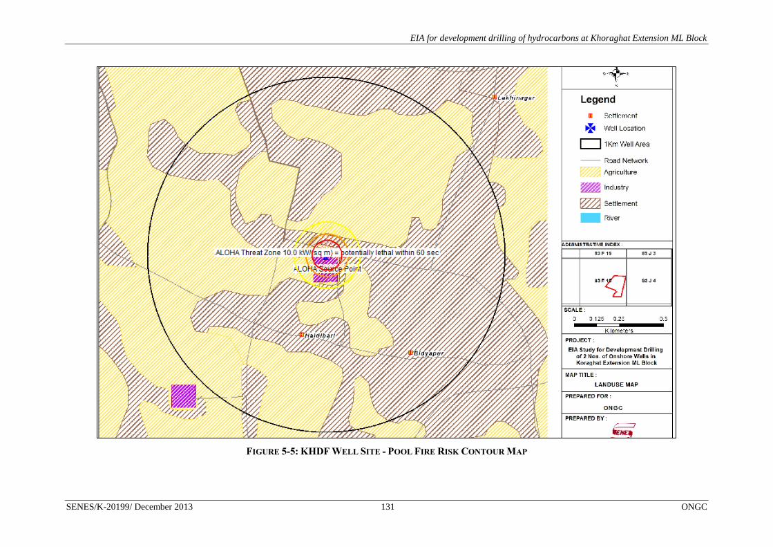
EIA for development drilling of hydrocarbons at Khoraghat Extension ML Block
SENES/K-20199/ December 2013 131 ONGC
FIGURE 5-5: KHDF WELL SITE - POOL FIRE RISK CONTOUR MAP

EIA for development drilling of hydrocarbons at Khoraghat Extension ML Block
SENES/K-20199/ December 2013 132 ONGC
In case of well site KHDD the pool fire risk contour map would also be similar in nature of
Figures 5.4-5.5.The thermal radiation threshold values (measured in kilowatts per square
meter) defined for crude oil pool fire consequence modeling for various hypothetical
scenarios as discussed in the earlier section is provided in Table 5.8 below:
TABLE 5-8: DISTANCE TO THERMAL RADIATION THRESHOLD LEVELS
Release
Type
Pool fire
diameter (m)
Pool fire area
(m2)
Distance to
10.0 kW/m2
(m)
Distance to 5.0
kW/m2 (m)
Distance to
2.0 kW/m2
(m)
Small 5.05 6.37 11 17 28
Medium 15.96 63.69 37 55 87
Large 35.69 318.47 84 120 187
The worst hazard for release and ignition of crude oil release at a rate of 50kg/s for a thermal
radiation intensity of 10.0 kW/m2 is likely to be experienced to a maximum distance of 84m
from the source with potential lethal effects experienced within 1 min. Interpretation of the
well site risk contour maps reveals that few settlements of Chetanapur village is falling in the
“Red” Threat Zone with respect to the KHDF development well site. Hence additional care
needs to be taken by ONGC to enhance emergency management preparedness the aforesaid
development well sites in accordance to the Disaster Management Plan.
Risk Ranking – Blowout Pool Fire (Worst Case Scenario)
Likelihood ranking 3 Consequence ranking 4
Risk Ranking & Significance = 12 i.e. “Medium”
Ignition of Flammable Gas Release leading to Jet Fire
Jet fires are burning jet of gas or sprays of atomized liquids resulting from gas and
condensate release from high pressure equipment and blow outs. Jet fires may also result in
the release of high pressure liquid containing dissolved gas due to gas flashing off and
turning the liquid into a spray of small droplets. In context of the present study, formation of
jet fires can be attributed by the high pressure release and ignition of natural gas if
encountered during exploration of block hydrocarbon reserves.
Natural gas as recovered from underground deposits primarily contains methane (CH4) as a
flammable component, but it also contains heavier gaseous hydrocarbons such as ethane
(C2H6), propane (C3H8) and butane (C4H10). Other gases such as CO2, nitrogen and hydrogen
sulfide (H2S) are also often present. Methane is typically 70-90 percent, ethane 5-15 percent,
propane and butane, up to 5 percent. Thus, considering higher percentage of methane in
natural gas, the thermo-chemical properties of the same has been utilized in the jet fire blow
out consequence modeling. The following risk scenarios (Table 5.9) have been considered
for nature gas release consequence modeling:

EIA for development drilling of hydrocarbons at Khoraghat Extension ML Block
SENES/K-20199/ December 2013 133 ONGC
TABLE 5-9: NATURAL GAS RELEASE MODELING SCENARIOS
Scenario Release Rate (kg/s) Release Type
Scenario - I 1 Small
Scenario - II 5 Medium
Scenario – III (Worst Case) 10 Large
As in the case of pool fire, modeling of nature gas releases has also been carried out using
ALOHA. A Flammable Level of Concern approach has been utilized for assessing safety risk
associated with the release of flammable gases (here methane) from well blow outs.
In ALOHA, a flammable Level of Concern (LOC) is a threshold concentration of fuel in the
air above which a flammability hazard may exist. While modeling the release of a flammable
gas that may catch on fire—but which is not currently burning—ALOHA can predict the
flammable area of the vapor cloud so that flammability hazard can be established.
The flammable area is the part of a flammable vapor cloud where the concentration is in the
flammable range, between the Lower and Upper Explosive Limits (LEL and UEL). These
limits are percentages that represent the concentration of the fuel (that is, the chemical vapor)
in the air. If the chemical vapor comes into contact with an ignition source (such as a spark),
it will burn only if its fuel-air concentration is between the LEL and the UEL—because that
portion of the cloud is already pre-mixed to the right mixture of fuel and air for burning to
occur. If the fuel-air concentration is below the LEL, there is not enough fuel in the air to
sustain a fire or an explosion—it is too lean. If the fuel-air concentration is above the UEL,
there is not enough oxygen to sustain a fire or an explosion because there is too much fuel—it
is too rich.
When a flammable vapor cloud is dispersing, the concentration of fuel in the air is not
uniform; there will be areas where the concentration is higher than the average and areas
where the concentration is lower than the average. This is called concentration patchiness.
Because of concentration patchiness, there will be areas (called pockets) where the chemical
is in the flammable range even though the average concentration has fallen below the LEL.
Because of this, ALOHA's default flammable LOCs are each a fraction of the LEL, rather
than the LEL itself. ALOHA uses 60% of the LEL as the default LOC for the red threat
zone, because some experiments have shown that flame pockets can occur in places where
the average concentration is above that level. Another common threat level used by
responders is 10% of the LEL, which is ALOHA's default LOC for the yellow threat
zone. The flammable LOC threat zones for methane release are as follows:
Red : 26,400 ppm = 60% LEL = Flame Pockets
Yellow: 4,400 ppm = 10% LEL
Well site risk contour maps for worst case scenario prepared based on ALOHA modeling of
natural gas releases for flammable vapour cloud has been presented in Figure 5.6-5.7 below.

EIA for development drilling of hydrocarbons at Khoraghat Extension ML Block
SENES/K-20199/ December 2013 134 ONGC
FIGURE 5-6: KHDE WELL SITE – RISK CONTOUR MAP FOR NATURAL GAS RELEASE

EIA for development drilling of hydrocarbons at Khoraghat Extension ML Block
SENES/K-20199/ December 2013 135 ONGC
FIGURE 5-7: KHDF WELL SITE – RISK CONTOUR MAP FOR NATURAL GAS RELEASE

EIA for development drilling of hydrocarbons at Khoraghat Extension ML Block
SENES/K-20199/ December 2013 136 ONGC
In case of well site KHDD the risk contour map for natural gas release would also be similar
in nature of Figures 5.6-5.7.The zone of flammable vapour cloud calculated for hypothetical
natural gas release under risk scenarios discussed in the earlier sections have been presented
in the Table 5.10 below.
TABLE 5-10: ZONE OF FLAMMABLE VAPOUR CLOUD – NATURAL GAS RELEASE SCENARIOS
Release Type Release Rate (kg/s) Red – 60% LEL (m) Yellow -10% LEL (m)
Small 1 53 161
Medium 5 124 325
Large 10 178 419
Hence for a worst case scenario (10kg/s) the flammable vapor cloud zone/flame pockets’
resulting from accidental release of natural gas will be covering a radial zone of 178m from
source with the flammable gas concentration within this zone being 26,400 ppm. This is of
particular significance for both the development wells where community settlements are
observed to fall within this “flame pocket” zone (Refer Figure 5.6 & 5.7) thereby posing
potential community safety risks in event of an ignition.
Risk Ranking – Blowout Natural Gas Release (Worst Case Scenario)
Likelihood ranking 3 Consequence ranking 4
Risk Ranking & Significance = 12 i.e. “Medium”
Oil Spill
Crude oil spills resulting from blow out may result in the formation of un-ignited pools of
liquid the spreading of which is governed by physical factors viz. wind speed, sea currents
(for offshore spills), release rates and spilled chemical characteristics viz. density. Near to the
source of a continuous release, the spreading is dominated by gravity and limited by internal
forces with thickness generally varying within 10-20mm. The spill movement is then resisted
by the viscous shear forces which then continue until the spill thickness is about 1.0mm.
Subsequently, surface tension takes over as the dominant spreading mechanism and it
continues until the thickness has reduced to 0.01 – 0.1mm which may take about 7-10 days
for a large spill depending on various factors as discussed earlier.
With respect to the QRA study hypothetical release rates of 1.0kg/s, 5.0 kg/s and 10.0 kg/s
for 1 day, 4days and 7days respectively have been considered as the possible risk scenarios
for modeling the spread of oil spill following a blow-out incident. The diameter of the pool in
the first phase of an unignited continuous release is obtained by the following equation:
D = 2 [g X Q/ρL 2π] t3/4
Where
D = pool diameter (m)

EIA for development drilling of hydrocarbons at Khoraghat Extension ML Block
SENES/K-20199/ December 2013 137 ONGC
g = acceleration due to gravity (m/s2)
Q = release rate (kg/s)
ρL = liquid density (kg/m3) (crude oil density is 790 kg/ m
3)
t = time since start of release (s)
The pool diameter so calculated for the aforesaid risk scenarios have been presented in the
Table 5.11 below.
TABLE 5-11: POOL DIAMETER FOR OIL SPILL RISK SCENARIOS
Release Type Release Rate (kg/s) Release Time (s) Oil Spill Pool Diameter (m)
Small 1 86400 19.9
Medium 5 259200 226.9
Large 10 432000 665.7
Hence, for a worst case spill scenario involving a crude oil release rate of 10kg/s for a period
of 7 days the pool diameter for an un-ignited continuous release is predicted to be about
665.7 m. The ignition of the oil pool may lead to the formation of pool fires - consequences
of which have been discussed earlier under the risk related to pool fires. Although the un-
ignited pool is not considered to be of major significance, it may gain significance based on
the environmental impacts that may result from it depending on sensitive receptors identified
abutting the proposed project development well sites.
Risk Ranking – Blowout Oil Spills (Worst Case Scenario)
Likelihood ranking 3 Consequence ranking 4
Risk Ranking & Significance = 12 i.e. “Medium”
Preventive and Mitigation Measures
Blowouts being events which may be catastrophic to any well operation, it is essential to take
up as much a preventive measures as feasible. This includes:
Necessary active barriers (eg. Well-designed Blowout Preventor) be installed to
control or contain a potential blowout.
Weekly blow out drills be carried out to test reliability of BOP and preparedness of
drilling team.
Close monitoring of drilling activity be done to check for signs of increasing pressure,
like from shallow gas formations.
Installation of hydrocarbon detectors.

EIA for development drilling of hydrocarbons at Khoraghat Extension ML Block
SENES/K-20199/ December 2013 138 ONGC
Periodic monitoring and preventive maintenance be undertaken for primary and
secondary barriers installed for blow out prevention, including third party inspection
& testing
An appropriate Emergency Response Plan be finalized and implemented by ONGC.
Marking of hazardous zone (500 meters) around the well site and monitoring of
human movements in the zone.
Training and capacity building exercises/programs be carried out for onsite drilling
crew on potential risks associated with development drilling and their possible
mitigation measures.
Installation of mass communication and public address equipment.
Good layout of well site and escape routes.
Additionally, ONGC will be adopting and implementing the following Safe Operating
Procedures (SOPs) developed as part of its Onsite Emergency Response Plan to prevent and
address any blow out risks that may result during drilling and work over activities:
Blow Out Control Equipment
Choke lines and Choke Manifold Installation with Surface BOP
Kill Lines and Kill Manifold Installation with Surface BOP
Control System for Surface BOP stacks
Testing of Blow Out Prevention Equipment
BOP Drills
5.4 DISASTER MANAGEMENT PLAN
5.4.1 Objective
The primary objective of the DMP is to provide a safe, timely, effective and coordinated
response by the onsite Emergency Response Team (ERT), along with the other local and
government agencies/departments to prevent or minimize any major emergencies that may
arise from possible failures/risks viz. blow outs, oil spill, fire & explosion etc. associated with
development drilling.
The main objectives of this plan are:
To minimize the risk for human life, environment and common property resources, by
means of an effective and efficient intervention;
Protection of the environment;
Protection of public safety;

EIA for development drilling of hydrocarbons at Khoraghat Extension ML Block
SENES/K-20199/ December 2013 139 ONGC
To initiate the early and efficient response throughout the utilization of all available
resources.
5.4.2 Purpose
The purpose of the DMP is to effectively manage and control the emergencies occurring
during project operations. This DMP ensures,
emergency response group is effective & adequate;
clear roles and responsibilities of key personnel & support groups;
availability and adequacy of emergency infrastructure & resources; and
efficient emergency communication
5.4.3 Emergency Classification
Due consideration is given to the severity of potential emergency situation that may arise as a
result of storage tank and pipeline accident events as discussed in the Quantitative Risk
Analysis (QRA) study. Not all emergency situations call for mobilization of same resources
or emergency actions and therefore, the emergencies are classified into three levels
depending on their severity and potential impact, so that appropriate emergency response
procedures can be effectively implemented by the ONGC Emergency/Crisis Management
Team. The emergency levels/tiers defined with respect to this project based on their severity
have been discussed in the subsequent sections with 'decision tree' for emergency
classification being depicted in Figure 5.8.

EIA for development drilling of hydrocarbons at Khoraghat Extension ML Block
SENES/K-20199/ December 2013 140 ONGC
FIGURE 5-8: EMERGENCY CLASSIFICATION “DECISION TREE”
5.4.4 Level 1 - Emergency
An event that can be dealt with by on-site/location personnel and resources; the event does
not have any effect outside the site and external agencies are unlikely to be involved. There is
unlikely to be danger to life, to the environment, or to Company assets or reputation. The
Disaster Management Plan and relevant procedures are activated; the Site Head is notified.
5.4.5 Level 2 - Emergency
It is an event which may be dealt by the ONGC Emergency/Crisis Management Team but
requires involvement of wider Company support and external services. The initial event may
be “on-site”, having some effects outside the site or be “off-site”, and external emergency
services will be involved. There is likely to be a danger to life, the environment, or company
assets or reputation. The Disaster Management Plan and relevant procedures are activated;
EMERGENCY
Activate Disaster Management Plan
Mobilization of equipment/human
resources available onsite is sufficient
to contain the emergency
Containment of emergency requires
involvement of additional resources
and local emergency responder group’s
viz. local police, fire brigade etc
NO
YES LEVEL 1
EMERGENCY
YES LEVEL 2
EMERGENCY
Management of emergency requires the
involvement of District/State Disaster
Management Team
NO
YES LEVEL 3
EMERGENCY

EIA for development drilling of hydrocarbons at Khoraghat Extension ML Block
SENES/K-20199/ December 2013 141 ONGC
local administrative bodies and Emergency Response Groups including ONGC Corporate are
notified.
5.4.6 Level 3 - Emergency
It is a major event which requires the involvement of District or State Crisis Management
Group. For Company this may result from insufficient local resources and/or because the
incident has broader implications such as reputation, legal prosecution, financial loss etc.
Under such circumstances, the Disaster Management Plan is activated; ONGC Corporate,
District/State Administrative Authorities and other Emergency Response Groups are notified.
The criterion for classification of various levels of emergencies and associated response has
been presented in the Figure 5.9 below.
FIGURE 5-9: EMERGENCY RESPONSE LEVELS
Level Type Criteria for Classification
Level 1 Small Minor medical or injury case requiring no external support
Equipment damage without any significant impact on operation
Minor fire without any personnel injury or plant damage
Net negative financial impact of <1 crores.
Small operational spills
No potential impact on flora and fauna of identified eco-sensitive areas.
Local stakeholder concern and public attention
Level 2 Medium Fire and explosion which requires external assistance
Requires evacuation of injured personnel and locals through assistance from
local emergency groups.
Loss of corporate image and reputation
Adverse impact on environmental sensitivities (if any) within a radius of 1km.
Medium sized spills
Net negative financial impact of 1 - 5crore
Level 3 Large Incident leading to multiples injuries or fatalities
Requires assistance from District/State emergency responding groups.
Adverse impact on environmental sensitivities (if any) within a radius of >1km.
Major oil spills
State/nationwide media coverage
Net negative financial loss of >5crore
5.4.7 ONGC Disaster Management Plan
ONGC has in place a Disaster Management Plan which has been developed to set up the
appropriate mechanism and course of action to mitigate the impact of an Emergency event
viz. blow out, fire, explosion etc. The plan provides a procedure allowing all those involved
in and outside ONGC to mobilize their resources in an orderly manner and react effectively
in time. The plan therefore, aims at immediate response to an Emergency event to prevent
escalation to a Disaster and also the response in the event of such escalation. The plan will be
updated as and when necessary, but at least once in every year by Basin HSE in consultation

EIA for development drilling of hydrocarbons at Khoraghat Extension ML Block
SENES/K-20199/ December 2013 142 ONGC
with Surface Team, Sub surface Team, Drilling Services and Well Services Group. Also
ONGC has been accredited with ISO 9001:2008; 14001:2004 and OHSAS 18001.
The roles and responsibilities of both ONGC emergency response team to combat with any
emergency situation as discussed in the earlier section are presented in the Table 5.16 below
while the details of the resources available onsite with the Crisis Management Team to
control key emergency events particularly blow outs has been presented in Annex 5.1.

EIA for development drilling of hydrocarbons at Khoraghat Extension ML Block
SENES/K-20199/ December 2013 143 ONGC
TABLE 5-12: ONGC ON-SITE DISASTER MANAGEMENT TEAM PROFILE
Sl.
No.
Response
Team/Resource Location Facilities Functions
1 Site Control
Room
In case of Emergency at Site, a
Site Control Room will be set
up at a safe distance near the
Site.
Emergency vehicle, Communication
facilities, Mobile Van, Ambulance,
Lighting arrangement and Food shall
be provided at the SCR in the minimum possible time.
Assessment of situation and requirements, tor mobilization of equipment / resources etc.
To pass on the information regarding latest
positions to Emergency Control Room
To keep record of all decisions and messages
received
To keep records of all materials received at site
during Emergency.
2 Emergency
Control Room (ECR)
The control room will function
from Drilling Services (DBC) Control Room, Jorhat
To be equipped with good
communication facilities like
Telephone (2 nos.), Radio
Equipment, Wall Chart showing
Locations of Installations, fire
station, copy of the Disaster Management Plan.
Command and Control of entire Operations.
Round the clock monitoring and flow of
information to & from the site of Emergency.
Maintenance of running record of events and
action taken Casualty list and information to next if Kin.
Preparation of Management Report on the
situation at every 12 Hrs. interval.
Co-ordination with the key personnel's for
guidance and assistance required at site.
Co-ordination with other Oil companies
Co-ordination with Local authorities — Police,
Civil Administration, Hospital & Fire.
Sanction and procurement of the items required
during Emergency.
Arrangement of food, water, shelter, medicine&
logistics etc.,
Information to Public.
Co-ordination -with Regions / Projects and Head
— Quarter.

EIA for development drilling of hydrocarbons at Khoraghat Extension ML Block
SENES/K-20199/ December 2013 144 ONGC
Sl.
No.
Response
Team/Resource Location Facilities Functions
Co-ordination with fire brigade & fire tender
facilities available with different organizations
nearby.
3 On Scene
Commander (OSC)
At initial stage, someone close
enough to the scene of
Emergency (Installation
manager / DIG / senior most
person) will exercise as On
Scene Coordinator. He will take
the charge of the situation immediately.
- Initial assessment at the spot and need for mobilization of sources.
Inform Emergency Control Room in case, the
communication is lost due to disaster. Seek
assistance from nearby rig or installation for
communication.
In case of fire, commands the firefighting
operations till tire service assistance reaches on the scene.
Arrange Ambulance & doctor if required.
4 Chief Emergency
Coordinator
The Head of the concerned
Operational Group will be the
Chief Emergency Coordinator
and will exercise control
through ECR.
- Will keep record of messages and decisions taken to
control the Emergency. He will also appraise the
Basin Manager from time to time on steps taken to control the situation and status of Emergency.
5 Regional Crisis
Management Team (RCMT)
Regional Crisis Management
Team comprises of officers
having experience in handling
major emergency. The RCMT
is expected to be informed
within 30 minutes of
occurrence of incident by the
Mines Manager / Emergency
Control Room. The Team will
immediately proceed to the
location and take action to bring
the situation under control.
- Familiarize itself thoroughly with the manual and its implications
To plan strategies for different Crisis situation so
that all necessary inputs can be mobilized without
loss of time. Frequent mock drill be carried out.
In the event of Crisis, go to the scene of
Emergency, assess the situation and take over all
fronts out and / or fire up o the point of normalizing the well.
Determine the type of assistance required for
handling the Emergency.
To seek guidance and assistance from coordinator

EIA for development drilling of hydrocarbons at Khoraghat Extension ML Block
SENES/K-20199/ December 2013 145 ONGC
Sl.
No.
Response
Team/Resource Location Facilities Functions
group.
Updating the action plan of Disaster management
on the basis of their experience.
Keep them well informed of the technical
development through various journals /
magazines, suggest scope of improvement in
equipment and practices.
6 Support Services
Group
The Support Services Group
will comprise of coordinators
from Central Workshop,
Electrical, Civil, Logistics,
E&T, Health Services and
P&A, Geology and Reservoir
etc. They will provide all
necessary help required by
emergency control room / Site
Control Room / RCMT and be
in constant touch with
Emergency Control Room and
may have to stay at the site of
Emergency
- Support Manager
To identify location of relief camp at a safe
distance from the affected area and arrangement for shelter (tent, cot, chair, blanket etc.)
To arrange food, drinking water, beverage at
relief camp
Maintenance of record of Casualties
Co-ordinate with local Authorities.
Fire Services
Mobilize firefighting person and equipment
onsite.
Information & Communication’s Manager
Ensure Communication facilities
Set up Emergency communication (Walkie-talkie,
VHF etc.) at the Site Control Room.
Electrical
Arrangement of Emergency Gen. Set and Flame
proof lighting at the site.
Logistics

EIA for development drilling of hydrocarbons at Khoraghat Extension ML Block
SENES/K-20199/ December 2013 146 ONGC
Sl.
No.
Response
Team/Resource Location Facilities Functions
Arrangement of transport facilities, cranes, moles
etc for man and material.
Material Management
To assist in issuing of materials
Arrangement of equipment, materials, expertise
etc., as per requirement of Emergency Control Room / RCMT.
Civil
Civil jobs such as construction of temporary road,
control of Oil spread by sand bags or digging of pits, water pumping and storage arrangement etc.
Security
Deployment of Security personals at vulnerable
locations.
Cordoning off the affected site.
Police Help
Sub surface Team (Geology & Reservoir)
To assist in Geological / Reservoir information
about the well
Medical Services
Mobilize first — aid team with adequate medical
facility and ambulance at Emergency site.
Corporate Communication (PRO)
Press briefing with approval of Basin Manager

EIA for development drilling of hydrocarbons at Khoraghat Extension ML Block
SENES/K-20199/ December 2013 147 ONGC
For Level 3 emergency (refer Table 5.16) apart from the mobilization of onsite Emergency
Response Team as referred above ONGC also need to activate the off-site Disaster Plan to
safeguard the lives and properties of nearby communities with the assistance/support from
local/district authorities
Local/District Authorities – Roles and Responsibilities
I. Deputy Commissioner/ Addl. Deputy Commissioner
Take overall responsibility for combating the Off-site Emergency,
Declare an area of 2 km around the site as Emergency zone.
Direct the District Police, Fire services for warning and evacuating the public.
Direct the team of Doctors headed by the District Medical Officer to attend the
affected people.
Direct the Revenue Officer of the District to provide safe shelter, food and other life
sustaining requirements for the evacuees.
Direct the District Transport Officer to arrange for transportation of victims and
evacuation of the people trapped within the Emergency zone.
II. Superintendent of Police
Mobilize force to the site of Emergency on receipt of instruction from DC / Addl. DC
to cordon off the affected site / area and disperse the unwanted crowd for easy fire
fighting operation / rescue operation.
Post adequate nos. of Police personnel in the following places.
In all the evacuated areas to provide security to the properties of the evacuees.
In the entire Road junction outside the emergency zone to control traffic and priority
for movement of fire tender ambulance etc.
Warning and advising the affected population through unambiguous, reliable and
rapid announcement by the SDIPRO/DIPRO. The information to be given to the
public should be the nature of the incident, the degree of the incident; the steps taken
to control the situation and the Emergency counter measures. The announcement shall
be both in Assamese and Hindi.
Liaison with the Medical co-coordinator for post mortem of the dead bodies, if any,
Any other action as desired by the Dy. Commissioner.
III. District Transport Officer
On receipt of the request from Emergency Control Room, ONGC, the Transport Officer shall
arrange for the dispatch of vehicle to reach the Emergency site immediately. The dispatched

EIA for development drilling of hydrocarbons at Khoraghat Extension ML Block
SENES/K-20199/ December 2013 148 ONGC
vehicle shall be at the disposal of ONGC until the release order is issued. He also takes up the
action as directed by the Dy. Commissioner / Addl. Dy. Commissioner.
IV. District Medical & Health Officer
On receipt of information form Dy. Commissioner / Addl. Dy. Commissioner about the
Emergency, the District Medical Officer shall extend the facilities available at the Hospital
and make the services of the trained Doctors to provide necessary medical care for
Emergency medical cases. He shall ensure that the Primary Health Centers & Municipal
Dispensaries are equipped with required quantities of drugs & equipments.
V. District Fire Officer
Shall assist in Fire Fighting in case of Off-site Emergency and rescue operations in the
affected area with the help of Civil defense / Home guards etc.
VI. Officer in-charge of Relief Camp
An officer in the cadre of Revenue Inspector shall be the In-charge of the Relief camps. He
shall maintain a record of the evacuees under the headmen, women and children. The
department concerned at the Relief Camps shall provide the following facilities.
Sanitation: This is very important at the Relief Camps. A team of Sanitary Inspector shall
attend the camp round the clock. Latrine facilities shall be provided.
Water: Municipal Board shall arrange storage of Water.
Lights: Assam Electricity Beard shall arrange Electric Lights at the Camp.
VII. District Veterinary & Animal Husbandry Officer
Shall depute as many persons as required (taking in to account the number of Cattle
especially milking animals in the affected areas) to look after the welfare of the cattle and
protect their lives by applying precautionary measures. He shall also be responsible for
arranging food for the Cattle during Emergency.
VIII. District Agriculture Officer
Will prepare an action plan to protect the food grains / standing crops in the Emergency
affected area and will take action accordingly.
IX. Station Director (Door-Darshan)
On receipt of the message from the Superintendent of Police, he will immediately telecast the
Emergency message as given by the Police authority, if required. Similarly, he will also
arrange to telecast periodic review message and completion of Emergency / all clear message.
The section below highlights the sequential action to be performed by the ONGC Emergency
Response Team along with drilling personnel under various emergency situations viz. blow
outs, fire and explosion etc.

EIA for development drilling of hydrocarbons at Khoraghat Extension ML Block
SENES/K-20199/ December 2013 149 ONGC
Action Plan – In event of Blow Outs
The following actions shall be taken by the Shift — in charge to bring the situation under
control.
(A) On experiencing Kick, following safety actions to be taken, it BOP fails to seal Well
Mouth
1 Alert Crew to ensure escape if situation worsens
Action : Shift I/C
2 Divert flow partially, intermittently or fully to waste pit (safe distance)
Action : Drilling Crew
3 Send SOS message (i) By EPABX (ii) By Emergency Vehicle
Action Shift I/ C
4 Switch off all Engines / Generators
Action: I/C Mech. / Elect.
5 Remove all inflammable material away
Action: Rig Crew (Drilling / Mech. / Elect.)
6 Remove important Records to Safe place
Action: Rig Crew (Drilling / Mech. / Elect.)
7 Remove costly instruments / equipments to safe place
Action: Rig Crew (Drilling / Mech. / Elect.)
(B) If the Blow out is sudden and massive while initial safety action could not be performed.
1 Carry out rescue operation for Top man and move other Rig Crew to safe distance.
Action : Shift I/C
2 Send SOS message by Phone and by Emergency vehicle
Action : Shift I/C
3 Reorganize to try operations like BOP, Diversion of flow etc., as listed in (A), if
situation permits,
Action : Shift I/C
4 If heavy spillage occurs, try to contain in the restricted area
Action : Shift I/C
5 Alert the inhabitants, if private residence is near
Action : Geologist / Chemist
As soon as an Emergency is declared and the site is evacuated, Site Control Room will be
established near the Drill site at a safe distance.
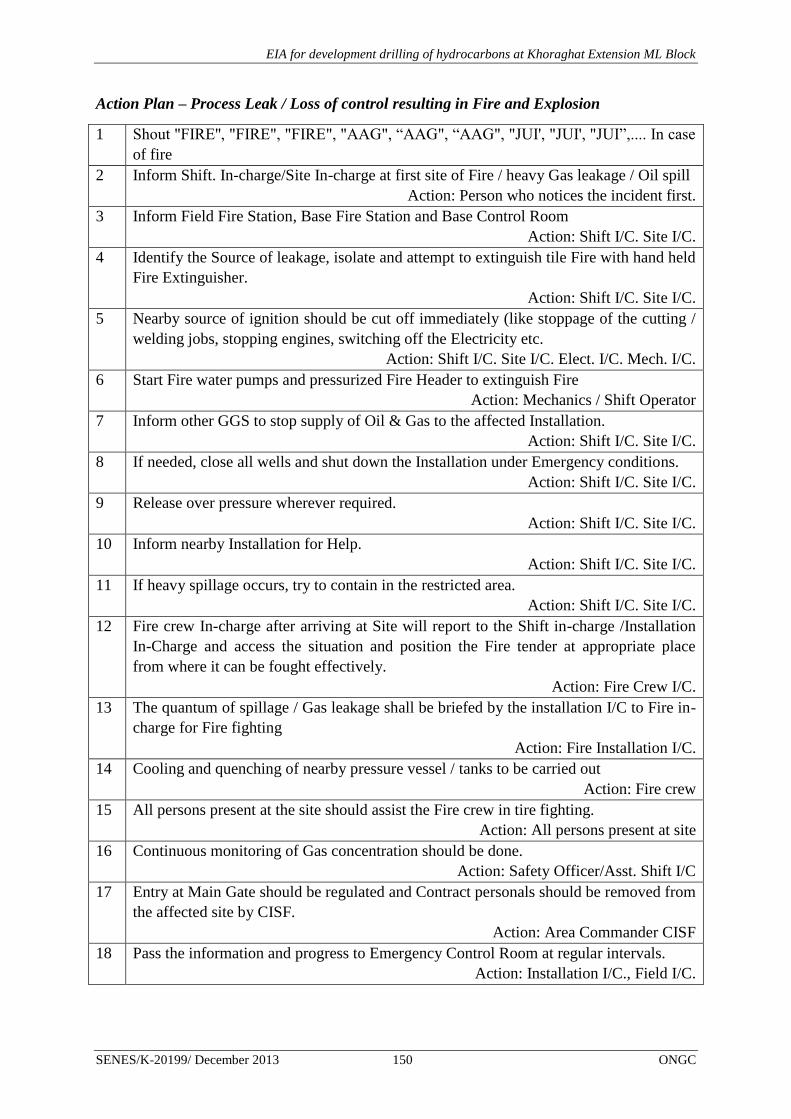
EIA for development drilling of hydrocarbons at Khoraghat Extension ML Block
SENES/K-20199/ December 2013 150 ONGC
Action Plan – Process Leak / Loss of control resulting in Fire and Explosion
1 Shout "FIRE'', "FIRE", "FIRE", "AAG", “AAG", “AAG", "JUI', "JUI', "JUI”,.... In case
of fire
2 Inform Shift. In-charge/Site In-charge at first site of Fire / heavy Gas leakage / Oil spill
Action: Person who notices the incident first.
3 Inform Field Fire Station, Base Fire Station and Base Control Room
Action: Shift I/C. Site I/C.
4 Identify the Source of leakage, isolate and attempt to extinguish tile Fire with hand held
Fire Extinguisher.
Action: Shift I/C. Site I/C.
5 Nearby source of ignition should be cut off immediately (like stoppage of the cutting /
welding jobs, stopping engines, switching off the Electricity etc.
Action: Shift I/C. Site I/C. Elect. I/C. Mech. I/C.
6 Start Fire water pumps and pressurized Fire Header to extinguish Fire
Action: Mechanics / Shift Operator
7 Inform other GGS to stop supply of Oil & Gas to the affected Installation.
Action: Shift I/C. Site I/C.
8 If needed, close all wells and shut down the Installation under Emergency conditions.
Action: Shift I/C. Site I/C.
9 Release over pressure wherever required.
Action: Shift I/C. Site I/C.
10 Inform nearby Installation for Help.
Action: Shift I/C. Site I/C.
11 If heavy spillage occurs, try to contain in the restricted area.
Action: Shift I/C. Site I/C.
12 Fire crew In-charge after arriving at Site will report to the Shift in-charge /Installation
In-Charge and access the situation and position the Fire tender at appropriate place
from where it can be fought effectively.
Action: Fire Crew I/C.
13 The quantum of spillage / Gas leakage shall be briefed by the installation I/C to Fire in-
charge for Fire fighting
Action: Fire Installation I/C.
14 Cooling and quenching of nearby pressure vessel / tanks to be carried out
Action: Fire crew
15 All persons present at the site should assist the Fire crew in tire fighting.
Action: All persons present at site
16 Continuous monitoring of Gas concentration should be done.
Action: Safety Officer/Asst. Shift I/C
17 Entry at Main Gate should be regulated and Contract personals should be removed from
the affected site by CISF.
Action: Area Commander CISF
18 Pass the information and progress to Emergency Control Room at regular intervals.
Action: Installation I/C., Field I/C.

EIA for development drilling of hydrocarbons at Khoraghat Extension ML Block
SENES/K-20199/ December 2013 151 ONGC
6 Environmental Management Plan & Monitoring Framework
This Environmental Management Plan and Monitoring Framework is a site specific
document for the development drilling of hydrocarbons that has been developed to ensure
that ONGC can implement the project in an environmentally conscious manner and where all
contractors, understand the potential environmental risks arising out of the proposed project
and take appropriate actions to properly manage such risk.
This EMP will be an overview document that will guide environment management of all
aspects of ONGC’s activities within the Block. This EMP will be backed up by more specific
Environmental Action Plans, Procedures and Bridging Documents with the progress of the
well site preparation, development drilling, well testing and site decommissioning activities.
The EMP describes the actions to be adopted in terms of:
National Policies and Regulations
Best Practices and guides
Local Environmental and Social Sensitivities
The Environment Policy of ONGC is presented at Box 6.1.

EIA for development drilling of hydrocarbons at Khoraghat Extension ML Block
SENES/K-20199/ December 2013 152 ONGC
Box: 6.1: ONGC Corporate Environment Policy

EIA for development drilling of hydrocarbons at Khoraghat Extension ML Block
SENES/K-20199/ December 2013 153 ONGC
6.1 ENVIRONMENT MANAGEMENT PLANS
The Environment Management Plan details out the mitigation measures to be implemented
by both ONGC and the Contractors during various stages of development drilling of
hydrocarbons within the Khoraghat Extension ML Block. The following environmental
management plans have been formulated in line with the proposed project activities viz. site
preparation development drilling, well testing and decommissioning
Pollution Prevention and Abatement Plan
Waste Management Plan
Storm Water Management Plan
Wildlife Management Plan
Community Management Plan
Site Closure Plan
Road Safety and Traffic Management Plan
Occupational Health & Safety Management Plan
ONGC will ensure communication and implementation of the aforesaid management plans
prior to the commencement of site preparation and development well drilling operations in
the Block. In addition, the mitigation measures for social issues and concerns are also
separately presented in this report. An Emergency Response Plan to address technological
emergency situations viz. blow outs, fires, oil spill etc. etc. that may arise out of drilling
operations has already been discussed in previous chapter. In cases, where there are possible
overlaps, the plans have been cross-referenced to avoid repetition. Additional mitigation
measures to ensure effective management of identified environmental aspects during various
phases of the proposed project have been discussed under the aforesaid plans in the
subsequent sections and summarized in Table 6.1 for ease of reference.
6.1.1 Pollution Prevention and Abatement Plan (PPAP)
Scope
The Pollution Prevention and Abatement Plan (PPAP) is applicable for and encompasses both
construction and operational phase activities for the proposed project which has the potential
to adversely impact ambient air and noise quality, surface and ground water quality and soil
quality of the Khoraghat Extension ML Block .
Purpose
The PPAP establishes specific measures and guidelines aimed at effectively addressing and
mitigating the air, noise, water and soil quality impacts that may arise as result of well site
preparation and access road construction/strengthening, drilling operations and
decommissioning/site closure. The plan also details out roles and responsibilities of ONGC
and the contractors to ensure effective implementation of the plan.

EIA for development drilling of hydrocarbons at Khoraghat Extension ML Block
SENES/K-20199/ December 2013 154 ONGC
Mitigation Measures & Strategies
The following mitigation measures need to be adopted and implemented by ONGC and its
contractors during various phases of the proposed project to prevent and control air emissions
(both point and fugitive), high noise generation, soil contamination and fertility loss,
contamination of ground water resources and storm water discharge.
A. Control of fugitive and point source emissions
Project Phase Mitigation measures
Construction Vehicles delivering raw materials like soil and fine aggregates will
be covered to prevent fugitive emissions.
Storage and handling of raw material and debris will be carefully
managed to prevent generation of fugitive dust.
Sprinkling of water on earthworks, material haulage and
transportation routes on a regular basis during dry season.
All vehicles, equipment and machinery used for construction will be
subjected to preventive maintenance as per manufacturer norms.
All vehicles utilized in transportation of raw material and personnel
will have valid Pollution under Control Certificate (PUC). Vehicular
exhaust will be complying with the Bharat Stage III specified
emission norms for heavy diesel vehicles.
The top soil generated from site clearance activities will be stored in
designated area and stabilized to prevent fugitive dust emissions.
Drilling and well testing Flaring will be undertaken in accordance with the S No. 72 B.1.a
Schedule I Standards for Emission or Discharge of Environmental
Pollutants from Oil Drilling and Gas Extraction Industry of CPCB.
Locations of flare stack will be governed by the presence of
habitation and sensitive receptors. Care will be taken as all the
proposed exploratory and development wells and GGS are located
very close (less than 200 m) to human settlement.
Duration of flaring will be minimized by careful planning;
High combustion efficiency, smokeless flare/burner will be used.
An efficient test flare burner head equipped with an appropriate
combustion enhancement system will be selected to minimize
incomplete combustion, black smoke, and hydrocarbon fallout.
Volumes of hydrocarbons flared will be recorded.
Exhausts of engines on the drilling rig diesel generators will be
positioned at a sufficient height to ensure dispersal of exhaust
emissions; engines will not be left running unnecessarily.
Preventive maintenance of DG sets will be undertaken as per
manufacturers schedule to ensure compliance with Sl No 95 GSR
371(E) dated 17.5.2002.
Decommissioning/Site
Closure
Mitigation measures to address the air quality impacts resulting from
vehicular movement, operation of heavy construction machinery and
material handling are similar to those discussed above

EIA for development drilling of hydrocarbons at Khoraghat Extension ML Block
SENES/K-20199/ December 2013 155 ONGC
B. Control of Noise and Vibration
Project Phase Mitigation measures
Construction Selection and use of low noise generating equipment equipped with
engineering controls viz. mufflers, silencers etc
All vehicles utilized in transportation of raw material and personnel
will have valid Pollution under Control Certificate (PUC)
All high noise generating equipments will be identified and
subjected to periodic preventive maintenance.
No night time operation of vehicles and construction activities will
be undertaken.
Engines of vehicles and construction equipment will be turned off
when not in use for long periods.
Drilling Installing acoustic enclosures and muffler on engine exhaust of DG
sets to ensure compliance with generator noise limits specified by
CPCB in accordance with Sl No 94 GSR 371(E) dated 17.5.2002.
Setup effective noise barrier at the fence-line of the site;
Restrict all noise generating operations ,except drilling, to daytime;
Periodic monitoring of noise levels on site and nearby receptors to
ensure compliance with Noise Pollution (Regulation & Control)
Rules 2000.
Decommissioning/Site
Closure
Management measures to address noise impacts with respect to operation
of heavy equipments/machinery and movement of vehicles during
decommissioning/site closure phase are similar to those discussed in the
“Construction Phase” of this section
C. Prevention and Control of Soil Quality Impacts
Project Phase Mitigation measures
Construction Site preparation and road strengthening/widening activities will be
restricted within defined boundaries.
Avoid construction activities during monsoon season as moist soil is
most susceptible to compaction.
Use appropriate machinery and/or protective boarding during top
soil stripping.
Debris and excavated material generated during construction
activities will be stockpiled in designated areas onsite. No material
will be disposed in adjacent land surrounding the site boundary.
For cleared areas, retain top soil in stockpile where possible on
perimeter of site for subsequent re-spreading onsite during
restoration.
Provide embankment all around the heap of excavated top soil and
cover it with jute mats to avoid erosion by the action of rains/strong
winds.
Install and maintain effective run-off controls, including silt traps,

EIA for development drilling of hydrocarbons at Khoraghat Extension ML Block
SENES/K-20199/ December 2013 156 ONGC
Project Phase Mitigation measures
straw barriers etc. so as to minimize erosion.
Drip trays to be used during vehicular/equipment maintenance and
during refueling operations.
In case of a spill, the spilled soil is to be removed and stored in
hazardous waste storage area
Drilling All chemical and fuel storage areas will be designed considering
HFL
Fuel and chemical storage areas will be paved and properly bunded.
Bunded areas will be designed to accommodate 110% of the volume
of spilled material.
Spill kits will be made available at all fuel and chemical storage
areas. All spills/leaks contained, reported and cleaned up
immediately.
Drip pans/trays will be used in areas identified having spillage
potential but not limited to drill rig engine; electric generator
engine; pumps or other motors; maintenance areas; fuel transfer
areas.
In case of a spill, the spilled soil is to be removed and stored in
hazardous waste storage area
Management of drill cuttings, waste drilling mud, waste oil and
domestic waste will be made in accordance with “Waste
Management Plan”
Decommissioning/Site
Closure
Decommissioning at the end of project life/drilling will have some
adverse impacts in terms of increase in soil erosion and would require
adequate mitigation measures to minimize any adverse impacts. The
mitigation measures will be similar to those outlined for construction
phase activities as discussed earlier.
D. Prevention and Control of Surface Water Quality Impacts
Project Phase Mitigation measures
Construction Minimize clearing and construction activities during monsoon
season (as far as practicable).
During site preparation and construction, surface water run-off will
be managed through implementation of proper drainage system and
silt trap and sedimentation tank onsite.
Sediment filters and oil-water interceptor will be installed by the
Contractor to intercept run-off and remove sediment before it enters
water courses.
Regular inspection of surface water drainage/diversion system and
sediment controls will be undertaken.
Drilling Run-off from vehicular wash and chemical storage areas will be
channeled through closed drainage system provided with an oil-
water separator prior to silt trap and sedimentation tank to disposal
to nearby drainage channels/surface water bodies. Spill kits will be
made available in these areas.

EIA for development drilling of hydrocarbons at Khoraghat Extension ML Block
SENES/K-20199/ December 2013 157 ONGC
Project Phase Mitigation measures
Drip trays will be used during preventive maintenance of vehicles
and machinery.
Hazardous chemicals and fuel drum will be stored in bunded and
lined area equipped with proper spill control equipment.
Management of drill cuttings, waste drilling mud, waste oil and
domestic waste will be made in accordance with S No. 72 C.1.a
Schedule I Standards for Emission or Discharge of Environmental
Pollutants from Oil Drilling and Gas Extraction Industry of CPCB
as modified in 2005.
Decommissioning/Site
Closure
No significant impact to surface water quality can be associated with
activities during decommissioning/site closure phase. Any possible
impacts that may arise due to surface run-off will be mitigated in manner
similar to that discussed during construction phase activities.
E. Prevention and Control of Ground Water Quality Impacts
Project Phase Mitigation measures
Construction No significant impact on the ground water quality can be associated
with the construction phase activities
Drilling The development wells will be sited at a sufficient distance away
from an existing tube well or open well.
Proper casing and cementing of developmental well will be done to
prevent contamination of sub-surface aquifers.
Water based mud to be used as a drilling fluid for the proposed
project
Selection of low toxicity chemicals/additives in the preparation of
water based mud.
Periodic monitoring of ground water quality will be carried out for
village wells located outside the project boundary to assess the level
of ground water contamination, if any.
Storage and disposal of drill cutting and waste mud to be made in
accordance with S No. 72 C.1.a Schedule I Standards for Emission
or Discharge of Environmental Pollutants from Oil Drilling and Gas
Extraction Industry of CPCB as modified in 2005”
Decommissioning/Site
Closure
No significant impacts to ground water quality can be associated with
activities during decommissioning/site closure phase

EIA for development drilling of hydrocarbons at Khoraghat Extension ML Block
SENES/K-20199/ December 2013 158 ONGC
6.1.2 Waste Management Plan
Scope
The Waste Management Plan (WMP) is applicable for all process and non-process waste
streams which are generated during various phases of ONGC’s proposed development
drilling of hydrocarbons in Khoraghat Extension ML Block. The major waste streams
covered under this plan includes drill cuttings, waste drilling mud, wash water, kitchen waste
and sewage. In addition, waste oil and lead acid batteries generated from the proposed project
operations have also been dealt in this plan.
Purpose
The WMP establishes specific measures to ensure proper collection, storage, treatment and
disposal of the identified process and non-process waste streams in accordance with the
applicable national regulations and guidelines12
and also to ensure compliance with ONGC’s
corporate HSE Policy. The plan also outlines roles and responsibilities of both ONGC and the
contractors involved in the implementation of the plan.
Mitigation Measures
The following mitigation measures need to be adopted and implemented by ONGC and its
contractors for the major waste streams identified in the plan.
Waste Quantity Mitigation Measure
Drill Cuttings 212-225
m3/well
Drill cuttings separated from drilling fluid will be
adequately washed and temporarily stored and disposed
in an impervious pit lined by HDPE.
The drilling cuttings pit will be bunded and kept covered
using tarpaulin sheets during monsoon.
Periodic monitoring and analysis of drill cuttings will be
undertaken to establish its nature and characteristics.
Earlier test reports of drill cuttings from AAA Basin has
shown the absence of hazardous nature of the soil
The waste pit after it is filled up will be covered with
impervious liner over which a thick layer of native top
soil with proper top slope will be provided.
Feasibility study for use of drill cuttings for lining or
capping of landfill sites, or as a road construction
material in consultation with nodal authorities
Waste Drilling Mud 10 Use of water based mud as the drilling fluid.
12 “Guidelines for Disposal of Waste – CPCB Oil & Gas Extraction Industry Standard” – EPA Notification
[GSR 176(E), April 1996]
“Guidelines for disposal of Solid Waste, Drill Cuttings and Drilling Fluids for Offshore & Onshore Drilling
Operation” –MoEF Notification, 30th
August 2005

EIA for development drilling of hydrocarbons at Khoraghat Extension ML Block
SENES/K-20199/ December 2013 159 ONGC
Waste Quantity Mitigation Measure
and Drill wash water m3/day/well Use of low toxicity chemicals for the preparation of
drilling fluid.
Barite used in the preparation of drilling fluid shall not
contain Hg>1mg/kg and Cd>3mg/kg
Recycling of drilling mud will be ensured to the
maximum extent possible.
Temporary storage of drilling fluid and wash waste water
will be done in an impervious pit lined with HDPE.
The drilling fluid pit will be bunded to prevent water
overflow during heavy monsoon.
Drilling wash water will be treated through onsite
Effluent Treatment Plant (ETP) to comply with the S
No.72 A(ii) Standard for Liquid effluents of CPCB
effluent discharge standard for oil drilling and gas
extraction industry for reuse and recycling purpose.
Formation water will be stored in HDPE lined pits and
will be injected in injection wells
Kitchen Waste 10-20
kg/day/well The waste will be segregated and stored in designated
waste bins.
All such waste bins will be properly labeled and covered.
The kitchen waste will be disposed in nearest municipal
dumping site on a daily basis through approved waste
handling contractors
Waste oil
Used oil
As generated The hazardous waste (waste and used oil) will be
managed in accordance with Hazardous Waste
(Management, Handling & Transboundary Movement)
Rules, 2008.
The hazardous waste will be stored in properly labeled
and covered bins located in paved and bunded area.
Necessary spill prevention measures viz. spill kit will be
made available at the hazardous material storage area
Storage details of onsite hazardous waste generated will
be maintained and periodically updated.
Adequate care will be taken during storage and handling
of such waste viz. use of proper PPEs by personnel
The hazardous waste so stored (not more than 3 months)
to be periodically sent to ASPCB registered used and/or
waste oil recyclers/ facilities.
Proper manifest as per HWMH Rules, 2008 to be
maintained during storage, transportation and disposal of
hazardous waste.
Sewage 2.4 m3/day
per well The sewage generated will be treated in a combination of
septic tank and soak pit.
Regular supervision will be undertaken for the domestic

EIA for development drilling of hydrocarbons at Khoraghat Extension ML Block
SENES/K-20199/ December 2013 160 ONGC
Waste Quantity Mitigation Measure
waste treatment system to report any overflows, leakage,
foul odour etc.
Lead Acid Batteries 2-3 batteries
per well Will be recycled through the vendors supplying lead acid
batteries as required under the Batteries (Management &
Handling) Rules, 2001.
Proper manifest will be maintained as per Batteries
(Management & Handling) Rules, 2001.
Recyclables viz.
paper, plastic,
packaging waste etc.
Depending
on usage Proper segregation and storage of recyclable waste in
designated bins onsite.
Recyclables will be periodically sold to local waste
recyclers.
In addition to the management measures specified for the major waste stream, ONGC will
prepare and update periodically a waste management inventory of all waste streams identified
for the proposed project. Necessary measure will also be taken by ONGC to incorporate
appropriate waste management and handling procedures in the contractor work document and
conduct periodic training of personnel involved in waste handling onsite to ensure proper
implementation of the WMP. In this regard, necessary inspection, record keeping, training
program and monitoring procedures will be established by ONGC and made operational to
achieve proper management of all wastes generated on site.
A typical layout of the environment management plans in a well site is given in Figure 6.1.
The salient features of measures taken to safeguard the environment are given below:
The drill pad will be elevated and concretized
The top soils will be heaped and bounded by a retaining wall
The Waste pits (refer Sec 2.7.1) will be bunded to prevent the overflow of wastewater
ETP will be installed
Oil spill kits will be available near Drill pad and Oil storage area
Fluid and chemicals will be stored in enclosed houses with restricted access
The Hazardous waste will be separated from Non-hazardous waste and stored
separately in enclosed area
Recyclable and non-recyclable waste will be collected and stored separately
Sufficient lighting will be provided
A garland drain will be constructed within the external boundary of the site that will
have a sedimentation tank with oil and water separator

EIA for development drilling of hydrocarbons at Khoraghat Extension ML Block
SENES/K-20199/ December 2013 161 ONGC
FIGURE 6-1: ENVIRONMENT MANAGEMENT MEASURES AT DRILL SITE

EIA for development drilling of hydrocarbons at Khoraghat Extension ML Block
SENES/K-20199/ December 2013 162 ONGC
6.1.3 Site Closure Plan
The site closure plan for will identify all the activities which would be performed during the
restoration of a particular site in case the well is not economically viable and no further use of
that particular well bore is envisaged. Along with the well site the approach road connecting
the well will be restored accordingly.
Chronological inventory of activities which would be performed during the closure of the site
are detailed in this section
The following activities have been considered in the closure plan:
Plugging & Abandonment of well: Close the well head properly to prevent any further
leakage
Decommissioning Phase : Removal of the materials form the site
Waste/mud pit closure and reclamation
Reinstatement Phase: regeneration of the land
Handover Phase : Returning the land to the original owner
Plugging & Abandonment of well
As and when the well will be declared as non productive, plugging of the well will be
performed to close and abandon the well to prevent any leakage of oil or gas.
Decommissioning
The decommissioning phase includes activities dismantling and removal of surface facilities
from the well site, removal of construction fill material form site and storage in the Material
Dumping Area. The activities which are envisaged during this phase are:
Waste Management: clean up the site and remove all waste materials e.g. HDPE
liners, any waste material etc. The waste will be dumped in the designated area as per
the guidelines of local pollution control board.
Removing & Dumping of Fill Materials: The fill materials (aggregates, morrum etc)
should be removed mechanically from the site. It will be used for the local road
preparation or dumped in the designated area as filling material.
Road Restoration: The fill materials should be removed and restore the site or it may
be left for further local community use as per the agreement with community.
Waste and mud pit closure and reclamation
Following decommissioning and abandonment of the well site the waste and mud pits (4-5
nos) will be subject to closure through onsite burial of solids in accordance with lease and
landowner obligations and with local, state and national regulations. Reclamation of closed
pits or any other temporary retaining pits, including reserve pits, will be carried out within a

EIA for development drilling of hydrocarbons at Khoraghat Extension ML Block
SENES/K-20199/ December 2013 163 ONGC
period of one year from well closure/abandonment. As Golaghat district in Assam is
frequented by rains all such reclamation activities will be carried out based on the climatic
conditions and will be in accordance with reasonable landowner's wishes, and/or resemble
and contour of the adjoining lands.
Reinstatement
The reinstatement phase includes all activities for preparation of the soil for agriculture use.
Reinstatement of agricultural land
Sub soil preparation: All stones and other foreign material which are visible on the
ground would be removed. The sub soil would be tilled till a depth of 6” to de-
compaction the soil.
Overlaying of Topsoil: The topsoil would be spread evenly on each of the terraces as
per the thickness specified by the applicable guidelines.
Top soil preparation: The bio manure will be mixed with the top soil to increase its
fertility (if required). Regular water with mulching will be carried out for more
effective soil preparation.
If the preserved top soil volume found less than the required volume than make up top
soil will be out sourced from soil from pond bottom etc.
Seeding of Soil: Seeds of Leguminous crops would be sown on the plots to
continuously improve fertility of the soil.
Testing of fertility: The soil would be tested for fertility as per the standard procedure
of ICAR and compared to the fertility values done during the Pre Project Baseline
Environment Assessment.
Laying of Plot Dividers: The Plot dividers would be put in place as it was before
operation. Sub soil would be used for preparation of the dividers and would be seeded
with grass to hold it in place.
6.1.4 Storm Water Management Plan
Scope
The Storm Water Management Plan (SWMP) refers to the proper management of surface
run-off generated during monsoons for various phases of activities involved in the project.
Purpose
The purpose of Storm Water Management Plan (SWMP) is to ensure prevent and control any
adverse impact of discharge of storm water from the well site and road
widening/strengthening areas to nearby natural drainage channels and community water
bodies. Proper management of storm water runoff will minimize damage to public and
private property, reduce effects of development on land, control stream channel erosion,
pollution and sediment deposition and also reduce local flooding.
EIA for development drilling of hydrocarbons at Khoraghat Extension ML Block
SENES/K-20199/ December 2013 164 ONGC
Mitigation Measures
Pipe drainages will be provided for diversion roads constructed for the construction of
new bridges and culverts.
Storm water from all longitudinal and cross drainage works will be connected to the
natural drainage courses.
Necessary measures will be undertaken during construction phase to prevent earth and
stone material from blocking cross drainage structures.
Periodic cleaning will be undertaken to cross drainage structures and road drainage
system to maintain uninterrupted storm water flow.
Obstructions that may cause temporary flooding of local drainage channels, during
construction phase will be removed.
Oil traps will be used to separate oil from runoff water
Sediment control measures in the form of silt traps and sedimentation tank will be
provided to treat surface run-off before disposal
6.1.5 Wildlife Management Plan
Scope
The proposed development drilling of hydrocarbons in Khoraghat Extension ML Block may
impart potential impact on local plant and animal species close to the drill sites and access
roads within the Khoraghat Extension ML Block. The likely impacts of the project activities
on the ecological habitat have been addressed in a Wildlife Management Plan prepared to
safeguard local floral and faunal component.
Purpose
The purpose of Wildlife Management Plan is to minimize the impact on natural habitat and
control any adverse impact due to air and noise pollution from drilling and well testing
activities, discharge of untreated waste water from drilling operation, storm water runoff from
the well site and road widening/strengthening activities. The Management Plan details out the
mitigation measures and strategies to be adopted by ONGC and the Contractors during each
phase of the project, at the same time establishing a monitoring network to investigate the
effective implementation of the Management Plan.
Mitigation measures
The drill site will be properly fenced (chain-linked) to avoid straying of any outsider
as well as wildlife;
No temporary electric supply connection line from the grid will be laid for the
proposed project activity. All electric requirements will be supplied from the internal
DG sets.
EIA for development drilling of hydrocarbons at Khoraghat Extension ML Block
SENES/K-20199/ December 2013 165 ONGC
Noise Levels at the drill site will be controlled through selection of low noise
generating equipment and installation of sufficient engineering controls viz. mufflers,
silencers etc.
Movement of heavy vehicles will be restricted at night time
The borrow areas and quarries will be located away from forests and ecologically
sensitive areas.
Care would be taken while disposal drill cutting & other drilling waste and discharge
of waste water from the drilling site.
The following measures and strategies needs to be adopted to safeguard the natural habitat
from the possible impacts resulting from the project and its related activities. An
Environment Management Cell (EMC) will be developed for implementation of
environmental mitigation & management plan. Forest personnel and veterinary doctor will be
taken into the management cell for implementing the wildlife management plan. The
environment cell would look after the following measures:
Any wild animal species if trapped during site development or operation of drilling
would be released into suitable habitat;
Proper monitoring of indicator species will be carried out and compared to baseline to
understand any negative impacts;
In case of any accidental injuries to any wild animal by any project related activity,
the EMC’s Veterinary Doctor’s help will be taken
All sightings of sensitive species in and around the project site will be reported and
adequate steps will be taken with the help of forest personnel to reduce conflict
between such animals and project activities or people working at site.
The Environment Compliance Officer will hold training program for all the ONGC
employees and sub-contractor on the applicable practice and mitigation measures
contained within the Wildlife Management Plan.
6.1.6 Road Safety & Traffic Management Plan
Scope
The Road Safety & Traffic Management Plan is applicable to all operation pertaining to
ONGC and contractor vehicular movement viz. vehicle involved in the transportation of raw
materials, project and contractor personnel, drilling rig and heavy equipment transportation to
well site and decommissioning.
Purpose
The Road Safety & Traffic Management Plan outlines specific measures to be adopted and
implemented by ONGC to mitigate any potential impact on community health and safety that

EIA for development drilling of hydrocarbons at Khoraghat Extension ML Block
SENES/K-20199/ December 2013 166 ONGC
may arise out of movement of vehicles and transportation of drilling rig and heavy
equipments during site preparation, drilling and decommissioning activities.
Mitigation Measures
Project vehicular movement involved in sourcing and transportation of borrow
material will be restricted to defined access routes to be identified in consultation with
locals and concerned authorities.
Proper signage will be displayed at important traffic junctions along the predefined
access routes to be used by construction and operational phase traffic. The signage
will serve to prevent any diversion from designated routes and ensure proper speed
limits are maintained near village residential areas.
The condition of roads and bridges identified for movement of vehicles and drilling
rig will be assessed by ONGC to ensure their safe movement.
Precautions will be taken to avoid damage to the public access routes including
highways during vehicular movement.
Safe and convenient passage for vehicles, pedestrians and livestock to and from side
roads and property accesses connecting the project road will be provided. Work that
affects the use of side roads and existing accesses will not be undertaken without
providing adequate provisions.
Parking of project vehicles along village access roads prohibited. Signposted parking
facilities will be utilized for such purpose.
Any road diversions and closure will be informed in advance to the villagers who are
accessing the defined routes
Traffic flows will be scheduled wherever practicable during period of increased
commuter movement.
Personnel will be deployed at major traffic intersection for control of traffic
Clear signs, flagmen & signal will be set up at major traffic junctions and near
sensitive receptors viz. primary schools in discussion with Gram Panchayat and local
villagers.
Movement of vehicles during night time will be restricted. Speed limits will be
maintained by vehicles involved in transportation of raw material and drilling rig.
Regular supervision will be done by contractor to control vehicular traffic movement
along defined traffic routes particularly near identified sensitive receptors
A Journey Management Plan will be formulated and implemented by the contractor
to control construction and operational phase traffic.
Routine maintenance of project vehicles will be ensured to prevent any abnormal
emissions and high noise generation.

EIA for development drilling of hydrocarbons at Khoraghat Extension ML Block
SENES/K-20199/ December 2013 167 ONGC
Adequate training on traffic and road safety operations will be imparted to the drivers
of project vehicles. Road safety awareness programs will be organized in coordination
with concerned authorities to sensitize target groups viz. school children, commuters
on traffic safety rules and signage.
In addition, ONGC will ensure that all vehicles transporting hazardous substances (fuel oil,
chemicals, etc.) will be properly labeled in accordance with the specifications of the Motor
Vehicles Rules.
6.1.7 Occupational Health & Safety Management Plan
Scope
The Occupation Health & Safety Management Plan (OHSMP) is applicable for all project
operations which have the potential to adversely affect the health and safety of contractors’
workers and onsite ONGC personnel.
Purpose
The Occupation Health & Safety Management Plan (OHSMP) has been formulated to
address the occupational health and safety related impacts that may arise from proposed
project activities viz. development drilling and testing operation of construction
machinery/equipments, storage and handling of fuel and chemicals, operation of drilling rig
and associated equipment, during drilling and decommissioning/site closure.
Mitigation Measures
All machines to be used in the construction will conform to the relevant Indian
Standards (IS) codes, will be kept in good working order, will be regularly inspected
and properly maintained as per IS provisions and to the satisfaction of the site
Engineer.
Contractor workers involved in the handling of construction materials viz. borrow
material, cement etc. will be provided with proper PPEs viz. safety boots, nose masks
etc.
No employee will be exposed to a noise level greater than 85 dB(A) for a duration of
more than 8 hours per day. Provision of ear plugs, ear muffs etc. and rotation of
workers operating near high noise generating areas.
Hazardous and risky areas, installations, materials, safety measures, emergency exits,
etc. shall be appropriately marked.
All chemicals and hazardous materials storage container will be properly labeled and
marked according to national and internationally recognized requirements and
standards. Materials Safety Data Sheets (MSDS) or equivalent data/information in an
easily understood language must be readily available to exposed workers and first-aid
personnel.
EIA for development drilling of hydrocarbons at Khoraghat Extension ML Block
SENES/K-20199/ December 2013 168 ONGC
The workplace must be equipped with fire detectors, alarm systems and fire-fighting
equipments. Equipments shall be periodically inspected and maintained to keep good
working condition.
Health problems of the workers will be taken care of by providing basic health care
facilities through health centres temporarily set up for drilling base camp.
The sewage system for the camp must be properly designed, built and operated so that
no health hazard occurs.
Adequate sanitation facilities will be provided onsite for the operational workforce
both during construction and operational phase of the project.
Garbage bins will be provided in the camp and regularly emptied and the garbage
disposed off in a hygienic manner.
Training programs will be organized for the operational workforce regarding proper
usage of PPEs, handling and storage of fuels and chemicals etc.
6.1.8 Management of Social Issues and Concerns
Mitigation measure have been outlined to address project related social issues and concerns
in order for ONGC to take proactive steps and adopt best practices, which are sensitive to the
socio-cultural setting of the region.
Providing Job Opportunities
During site construction non technical jobs will be generated. Most of the people employed
during this stage would be semi-skilled. People from adjoining areas especially given
preference through local contractors according to the skill sets possessed.
Ensuring Public Safety
Since the project involves the movement of heavy vehicles and machinery in the area, the
issue of public safety of the villagers, especially children, is an important concern. During the
drilling phase and for the rest of the project activities proper safety measures will be
undertaken both for transportation as well as the other operations. The drill site would be
fenced and gates would be constructed so that the children are refrained from straying into
the site.
The movement of traffic is also likely to disrupt access conditions of the inhabitants residing
close to the approach road. The increase in traffic will have implications on their safety too,
as well as create congestion, potential delays and inconvenience for pedestrians. The
mitigative measures in this regard have been discussed in detail under the Road Safety &
Traffic Management Plan (Section 6.1.5).
Common Property Resources
During the project tenure there might be some sharing of resources viz. land, water, access
routes etc. by the villagers and the contractor workforce. Prior to the commencement of the

EIA for development drilling of hydrocarbons at Khoraghat Extension ML Block
SENES/K-20199/ December 2013 169 ONGC
proposed activity, a consultation program will be conducted by ONGC with the target groups
and local authorities. The primary objective of such consultation will be to share with the
concerned villagers/stakeholders the objective of the proposed project associated impacts and
their mitigation. The movement of heavy vehicles and machinery might lead to conditions
like disruption of electric wires and telephone wires in the site area and along transportation
routes. These public utilities will be restored back to normal conditions, at the earliest.
Fencing of the well site will lead to in some cases the temporary loss of shortest foot track
routes for the villagers to their agricultural fields. Consultation with villagers will be carried
out in such cases to assist them in finding alternative foot track routes.
Corporate Social Responsibility
Welfare of society has been integral part of ONGC’s commitment. A purview of ONGC’s
social welfare activities pursued in the Financial Year 2012-13 will provide an insight
towards their commitment. Rs. Seventy five lakhs, sixty-seven thousands, three hundred and
sixty-two INR has been spent as Corporate Social Responsibility in Assam-Arakan Basin
where the spending focused on Education, Infrastructure, Sports, Sponsorship, Relief from
Natural calamity, Arts & Culture and Health. The fraction of money spent for Golaghat
District is Eleven Lakhs, thirty-nine thousands and five hundred only. Part of this amount was
spent for tubewell, toilet and furniture for Hatidubi LP School and furniture for Indrapur
Ajarguri School in Uriamghat the closest town to the Khoraghat Extension ML Block. The
entire welfare activities in Assam-Arakan Basin have been attached as Annex 6.1.
The Environmental Management Plan Matrix for the proposed project has been presented in
the Table 6.1.
6.2 EMP BUDGET
The tentative budget for implementation of the environmental management plans was
estimated per year for 2 development wells and provided at the table below:
TABLE 6-1: TENTATIVE BUDGET FOR EMP IMPLEMENTATION
Sl.
No. Particulars of Work
Budget (in lakh
Rs.)
1 Air Quality Management Plan
a. Dust suppression through water sprinkling in the internal unpaved roads
(@Rs. 10000 per month x 9 months x 1 year) 3.47
b. Maintenance of paved internal road and transport route (budgetary
provision is included in operational cost of drilling) 0.00
c. Ambient Air Quality Monitoring -3 monitoring location x 2 wells x
once per month x 12 months (@ Rs. 5000 x 6 samples x 12 months ) 3.60
d. Stack emission monitoring (@ 5000 per sample x 2 sites x 4 stacks x
twice during drilling) 0.80
2 Noise Monitoring

EIA for development drilling of hydrocarbons at Khoraghat Extension ML Block
SENES/K-20199/ December 2013 170 ONGC
Sl.
No. Particulars of Work
Budget (in lakh
Rs.)
a. Ambient Noise Monitoring – (@Rs. 2500 per location x 2 locations x 2
wells x 6 months) 0.60
b. Workplace noise monitoring -(@Rs.2500 per location x 5 locations x 2
wells x 6 months) 1.50
3 Water Quality
a.
Surface Water Quality Monitoring (@ Rs. 5000 x 4 samples from
natural drainages for four seasons, 2 from ETP and 1 from oil/water
separator from 2 wells once each during drilling)
1.40
4
Soil Quality Monitoring (@ Rs. 5000 x 2 samples x once each after
decommissioning and for emergency sampling during accidental
spill over during Site construction and drilling)
0.30
5 Road Safety & Traffic Management
a. Signage in the transport route & its maintenance (Rs. 100,000 + Rs.
10,000 ) 1.10
b. Deployment of traffic personnel in sensitive area – 10 persons (@ Rs.
6000 per month x 12 months ) 7.20
6 Surface Runoff & Soil Erosion Control
a. Two chamber sedimentation tank at each drill site (Budgetary provision
is already included in the infrastructure development cost) 0.00
7 Municipal Solid Waste
a. Provision of two chambered covered collection bins at well site – 2 nos 0.20
b. Transport arrangement of waste from well sites to dumping area 0.50
8 Hazardous waste management
a.
Construction of dedicated hazardous storage area and record
maintenance (construction included under project cost; only
maintenance included n this budget)
0.50
b. Drill Cutting, waste mud and washwater pits; HDPE lined (budgetary
provision in operation cost of drilling) 0.00
9 Surface and Ground Water Protection and Management
a. Surface runoff control measures for chemical storage area, fuel storage
area (budgetary provision is already taken care in earlier section) 0.00
b.
Paved /impervious storage area for chemical storage area, fuel &
lubricant storage area (Budgetary provision is already included in the
infrastructure development cost)
0.00
c. Domestic waste water treatment facility through septic tank & soak pits
at the drill sites (budgetary provision in operation cost of drilling) 0.00
d Commissioning and operational cost of ETP (commissioning cost 10
lakhs for 1 ETP; cost; operational cost Rs. 100000 per well X2 sites) 10.40

EIA for development drilling of hydrocarbons at Khoraghat Extension ML Block
SENES/K-20199/ December 2013 171 ONGC
Sl.
No. Particulars of Work
Budget (in lakh
Rs.)
10 Occupational Health & Safety Management 0.00
a. Provision of appropriate PPE to all workers and its maintenance
(budgetary provision is included in operational cost of drilling) 0.00
b. Provision of drinking water, sanitation facility for all workers
(budgetary provision is included in operational cost of drilling) 0.00
c Provision First aid facility (budgetary provision is included in
operational cost of drilling) 0.00
d Provision of Ambulance facility ONGC has its own ambulance facility 0.00
e Regular health checkup facility provided by ONGC for workers 0.00
f Regular occupational health & safety training 2.00
Total Cost of Implementation of EMP 33.57
It was revealed from the discussion with the locals that there is demand for better road
infrastructure, drinking water facilities and health facilities in the area. ONGC will undertake
a need assessment for development of infrastructure in the areas that public demanded. The
CSR activities of ONGC within the Block will involve;
1. Improvement of road infrastructure
2. Development of surface water based drinking water facilities
3. Provision of health facilities for the local villagers
The cost for the CSR activity will be determined after the need assessment studies conducted
at the Block.

EIA for development drilling of hydrocarbons at Khoraghat Extension ML Block
SENES/K-20199/ December 2013 172 ONGC
Table 6-2: Environmental Management Matrix
Sl.
No Activity Potential Impact Mitigation
A. Pre-drilling Activities
A1 Siting of well site facility Potential adverse impact on environment in
the vicinity of the drill site
Potential safety issues to local people related
to drill site preparation and drilling operation
Selection of drill site taken into account of local environmental vulnerability
Sufficient distance maintained in between site and nearest habitation
A2 Procurement of land for well sites
and related facilities Loss of agricultural land and crop productivity
Loss of livelihood for affected communities
Provide of compensation for standing crops
Finalization of compensation package in consultation with local communities
Minimal felling of trees and removal of vegetation through proper and careful selection
of site.
A3 Site preparation and road
strengthening/widening Loss of top soil and increase in soil erosion
potential
Alternation in onsite drainage pattern
Minimal felling of trees and removal of vegetation through proper and careful selection
of site.
Site preparation and road strengthening/widening activities to be restricted within
defined boundaries.
Avoidance of construction activities during monsoon season.
Top soil stockpiles to be stabilized and stored in designated areas
Provision of onsite drainage onsite.
A4 Sourcing and transportation of raw
materials Generation of fugitive emission
Community health and safety concerns
Contractor to source raw materials from approved/licensed quarries.
Proper covering of raw material during transportation to be ensured
Periodic water sprinkling along haulage routes near sensitive receptors
Project vehicular movement to be restricted to defined access routes to be identified in
consultation with locals and concerned authorities.
Proper signage to be displayed at important traffic junctions along the predefined access
routes.
Night time movement of vehicles to be restricted
A5 Operation of construction
machinery/equipments Fugitive emissions and high noise generation
Occupational health and safety concerns
Selection of low noise generating equipment
Installation of engineering controls viz. silencers, mufflers
Rotation of workers operating in high noise generating areas

EIA for development drilling of hydrocarbons at Khoraghat Extension ML Block
SENES/K-20199/ December 2013 173 ONGC
Sl.
No Activity Potential Impact Mitigation
Use of proper PPEs viz. ear plugs, ear muffs.
Periodic preventive maintenance of machinery/equipments
A6 Transportation of drilling rig and
ancillaries Generation of fugitive emission
Community health and safety concerns
Disruption of public utilities
Community health and safety concerns
Periodic water sprinkling along haulage routes near sensitive receptors
Project vehicular movement to be restricted to defined access routes to be identified in
consultation with locals and concerned authorities.
Proper signage to be displayed at important traffic junctions along the predefined access
routes.
Night time movement of vehicles to be restricted
The public utilities viz. telephone and electrical wire to be restored to its original
condition at the earliest.
Movement of rig and heavy equipments to be carried out in accordance with the Road
Safety & Traffic Management Plan formulated.
A7 Discharge of surface run-off Increase in sediment load contributing to
turbidity of receiving water bodies Provision of onsite sediment control measures viz. silt traps, sedimentation tank
Construction work close to the streams or water bodies be avoided during monsoon
Run-off discharges to natural drainage channels/water bodies made to conform to CPCB
Inland Water Discharge Standards.
B. Drilling and Testing
B1 Physical presence of drilling rig and
ancillaries
Temporary change in visual characteristics of
the area Restoration of site to its original condition following decommissioning/site closure
B2 Operation of DG sets and machinery
and developmental drilling Air emissions and high noise generation
Occupational health and safety concerns
Community discomfort
Siting of drilling rig and facilities away from sensitive receptors
Installing acoustic enclosures and muffler on engine exhaust of DG sets
Setting up effective noise barrier at the fence-line of the site;
Exhausts of engines on the drilling rig diesel generators be positioned at a sufficient
height
Preventive maintenance of DG sets to be undertaken as per manufacturer’s schedule.
B3 Casing & cementing of development
well
Damage to subsurface aquifer
Use of low toxicity chemicals
Periodic monitoring of ground water quality be carried out for village wells located
outside the project boundary to assess the level of ground water contamination, if any

EIA for development drilling of hydrocarbons at Khoraghat Extension ML Block
SENES/K-20199/ December 2013 174 ONGC
Sl.
No Activity Potential Impact Mitigation
B4 Storage and disposal of drill cuttings,
mud and process wastewater
Soil and ground /surface water contamination
Use of water based mud as the drilling fluid.
Use of low toxicity chemicals for the preparation of drilling fluid.
Recycling of drilling mud to be ensured to the maximum extent possible.
Use of HDPE lined pit for disposal of drill cuttings, process wastewater
Disposal of drill cuttings in accordance with CPCB and MoEF guidelines on
management of drilling wastes
B5 Discharge of surface run-off Soil and surface water contamination Run-off from vehicular wash and chemical storage areas to be channeled through closed
drainage system provided with an oil-water separator.
Drip trays to be used during preventive maintenance of vehicles and machinery.
Hazardous chemicals and fuel drum be stored in bunded and lined area equipped with
proper spill control equipment.
Drill cuttings and mud pit be bunded and kept covered during monsoon.
B6 Sewage treatment Occupational health problems of operational
workforce Sewage to be treated using a combination of septic and soak pits
The sewage treatment system (septic tank & soak pit) to be regularly monitored for any
possible overflows, leakages etc.
B7 Flaring during production testing and
process upset
Air emission leading to discomfort to nearby
communities Siting of flare stack considering nearest habitation and sensitive receptor.
Elevated flaring to be undertaken as per guidelines issued by CPCB for Oil & Gas
Extraction Industry.
Duration of flaring to be minimized by careful planning;
C. Decommissioning/Site Closure
C1 Dismantling of rig and associated
facilities
High noise generation and fugitive emissions
causing discomfort to locals Rotation of workers operating in high noise generating areas
Use of proper PPEs viz. ear plugs, ear muffs.
C2 Transportation of drilling rig and
ancillaries
Same as in A6 Same as in A6
EIA for development drilling of hydrocarbons at Khoraghat Extension ML Block
SENES/K-20199/ December 2013 175 ONGC
6.3 ENVIRONMENTAL MONITORING PROGRAM
Monitoring is one of the most important components of a management system. Continuous
monitoring needs to be carried out for regulatory requirements, to monitor the environmental
quality and to determine performance of proposed mitigation measures. Monitoring
indicators have been developed for each of the activity considering the mitigation measures
proposed. Indicators have been developed for ascertaining the environmental quality and
performance of the EMP implementation through Environmental Quality Indicators (EQI’s)
and Environmental Performance Indicators (EPI’s) respectively which focus not only on
quantifying or indexing activity-environment interactions that may potentially impact the
environment but at the same time also help in comparing different components of
environmental quality against previously established baseline values. Monitoring results will
be to be documented, analyzed and reported internally to Head - HSE. Monitoring
requirements have been described in the following Table 6.3. Frequency of monitoring and
responsibility of carrying out the monitoring have also been presented in the table below.

EIA for development drilling of hydrocarbons at Khoraghat Extension ML Block
SENES/K-20199/ December 2013 176 ONGC
TABLE 6-3: PROPOSED MONITORING REQUIREMENTS OF THE PROJECT
A) Environmental Performance Monitoring
EPI
No.
Environmental Performance
Indicator (EPI) Monitoring Parameter Location Period & Frequency Responsibility
A. Design & Planning
A.1 Proximity of sensitive
environmental habitat
Distance between the drill site and sensitive
environmental habitat
Site Once in project lifecycle Civil supervisor
A.2 Proximity of nearest habitation Distance between the drill site and nearest
habitation
Site Once in project lifecycle Civil supervisor
A.3 Flood History HFL at site
Return period of major floods
Site Once in project lifecycle Civil supervisor
A.4 Location and Size of Land Leased Number of land owners affected
Total area leased for drill site (Ha)
Site Once in project lifecycle Civil Supervisor
A.5 Present Crop Cycle Crop period (in months) Site Once in project lifecycle Environmental Supervisor
A.6
Approval / Authorization of
quarries
Validity of the Approval / Authorization Quarry Once in project lifecycle Civil Supervisor
A.7
Land use Land use Type Quarry/ Borrow
Area
Once in project lifecycle Civil Supervisor
A.8 Haul Routes Distance of quarry / borrow area from project site
Condition of haul road
Quarry / Borrow
Area
Once in project lifecycle Civil Supervisor
A.9 Borrowing practices % of contractors sensitized on best practices and
relevant EMP provisions
Borrow Area During site planning HSE Manager & HSE Supervisor
A.10 Undisrupted flow of water in
drainage channels
Number of cross drainage structures planned to
number of actual stream crossings
Site & Road Once in project lifecycle Civil Supervisor
B Approach Road & Site
Development
B.1 Topsoil Area occupied for topsoil storage/ Area planned
for topsoil storage
Site Once during each site
preparation
HSE Supervisor

EIA for development drilling of hydrocarbons at Khoraghat Extension ML Block
SENES/K-20199/ December 2013 177 ONGC
EPI
No.
Environmental Performance
Indicator (EPI) Monitoring Parameter Location Period & Frequency Responsibility
B.2 Local drainage pattern Number of Cross Drainage structures constructed
to actual number of cross drainage structures
designed
Site & road Once in project lifecycle Civil Supervisor
B.3 Fugitive emission of dust during
site preparation
Visual observation of dust in air by haziness Site & approach
roads
Daily during site
preparation
HSE Supervisor with Vehicular / Civil
Contractors
B.4 Air emissions from vehicles and
machinery
PM 2.5, PM10, NOx, SO2, CO, HC, VOC based
on emission factors
Visual observation of emissions (black signifying
more pollution)
% of vehicles possessing valid PUC Certificates
Exhausts Once in project lifecycle
Daily
Once in project life cycle
HSE Supervisor with Civil Supervisor,
Drilling/Civil Supervisor through HSE
Supervisor
Drilling/Civil Supervisor through
Drilling/Civil Supervisor through HSE
Supervisor, Contractors operating vehicles
B.5 Noise emissions from vehicles and
machinery
Noise pressure level in dB(A) near noise sources
(5m)
Site & approach
road
Daily during site
preparation
HSE Supervisor
B.6 Supervision of material transport
Number of vehicles reported with overloaded
material / uncovered material
Site Daily during site
preparation
HSE Supervisor with Vehicular / Civil
Contractors
B.7 Accident reporting
Number of casualties / Number of fatalities
Site & Haul
Routes
During life cycle of
project
HSE Supervisor
B.8 Fugitive emission of dust during
material handling and storage
Visual observation of dust in air by haziness Near stockpiles
and storages
Daily during the entire
project life-cycle
HSE Supervisor
C Drilling & Testing
C.1 Gaseous pollutant emissions from
DG Set
Pollutant concentrations in gaseous emissions and
maintenance parameters (air, fuel filters & air-
fuel ratio) of DG sets influencing air emissions
Visual observation of exhaust smoke
characteristics
DG Stack Monthly during drilling &
testing
Daily during drilling &
testing
HSE Supervisor through Drilling
contractor

EIA for development drilling of hydrocarbons at Khoraghat Extension ML Block
SENES/K-20199/ December 2013 178 ONGC
EPI
No.
Environmental Performance
Indicator (EPI) Monitoring Parameter Location Period & Frequency Responsibility
C.2 Noise emission from DG Sets Noise pressure level in dB(A) Near noise
sources (5m)
Monthly during the entire
project life-cycle
HSE Supervisor through Drilling
contractor
C.3 Noise emission from rig
Noise pressure level in dB(A)
Number of cases of workers not using PPE
On the rig floor
Near noise
sources (5m)
Site
Monthly during drilling
Monthly during drilling
HSE Supervisor through Drilling
contractor
C.4 Accident reporting
Number of casualties / Number of fatalities
Site
As and when accident
occurs
HSE Supervisor through Drilling
contractor
C.5 Spilled Chemicals/Oil Area of Spill / Quantity Spilled / Severity of Spill
/ Characterization of Spilled Substances for
Contaminants (Heavy Metals, Toxics, etc.)
Site As and when spills occur HSE Supervisor through Drilling
contractor
C.6 Fugitive emission of cement dust
during handling and storage
Visual observation of cement dust in air by
haziness
Near stockpiles
and storages
Daily during the entire
project life-cycle
HSE Supervisor
C.7 Runoff from temporary storage
areas
Supervision of functioning of conduits / drains,
channels
Site Fortnightly during drilling
phase
HSE Supervisor
C.8 Emissions from Flaring Total CO, total hydrocarbon, Non-Methane
Hydrocarbons, NOx emission estimates based on
emission factors
Flare Stack As and when flaring
occurs
HSE Supervisor through Drilling
contractor
C.9 Waste water quantity & quality
(Process water viz. rig wash,
formation water etc)
Volume estimate
CPCB General discharge parameters and Oil &
Gas Extraction Industry Standards
At discharge
point
Weekly during drilling
Quarterly during drilling
HSE Supervisor through Drilling
contractor
C.10 Storm water/wash down water
discharge
CPCB General discharge parameters and Oil &
Gas Extraction Industry Standards
At discharge
point
Depending on generation
particularly during
monsoon
HSE Supervisor through Drilling
contractor
C.11 Drill cutting storage and disposal Total volume generated
Concentration of hazardous constituents as per
Hazardous Waste Management and Handling
At storage
location
Once during drilling
period
HSE Supervisor through Drilling
contractor

EIA for development drilling of hydrocarbons at Khoraghat Extension ML Block
SENES/K-20199/ December 2013 179 ONGC
EPI
No.
Environmental Performance
Indicator (EPI) Monitoring Parameter Location Period & Frequency Responsibility
Rules
CPCB Onshore discharge standards for Oil & Gas
Extraction Industry
D Decommissioning/ Site Closure
D.1 Noise pressure level in dB(A) Near noise sources (5m) Site & Approach
road
Once per site HSE Supervisor through Drilling & Civil
contractor
D.2 Air emissions from vehicles PM10, PM2.5, NOx, SO2, CO, HC based on
emission factors
Visual observation of emissions (black signifying
more pollution)
Exhausts Once in project lifecycle
Daily
HSE Supervisor through Vehicle/Civil
contractor
D.3 Fugitive emission of dust during
transport of drilling facilities
Visual observation of dust in air by haziness Near stockpiles
and storages
Daily during the entire
activity
HSE Supervisor
D.4 Site restoration Visual observation of :
Clearing of decommissioning waste
Leveling of site
Relaying of top soil
Regeneration of top soil
Site Daily during
decommissioning
Civil Supervisor with HSE Supervisor
B) Environmental Quality Monitoring
EQI No
Environmental Quality Indicator (EQI)
Monitoring Parameter Location Period & Frequency Responsibility
A Approach Road & Site Development
A1 Soil Fertility Fertility parameters like pH, NPK ratio, Total
Carbon, etc.
Site & adjacent areas Once before site preparation HSE Supervisor
A2 Quality of water Analysis of Parameters as per CPCB Use-class Natural drainage channel
receiving run-off discharges
Monthly during site and
road works
HSE Supervisor
A4 Ambient Air Quality Measurement of PM10, PM2.5, NOx, SO2, CO,
HC using ambient air sampler
At Surrounding receptor
points
Monthly during site and
road works
HSE Supervisor

EIA for development drilling of hydrocarbons at Khoraghat Extension ML Block
SENES/K-20199/ December 2013 180 ONGC
EQI No
Environmental Quality Indicator (EQI)
Monitoring Parameter Location Period & Frequency Responsibility
A5 Ambient noise quality Hearing / perception
Measurement of Noise Pressure Level in dB(A)
At surrounding receptor
points
Daily site and road works
Monthly site and road
works
HSE Supervisor
A6 Soil Contamination Analysis for suite of contaminants (heavy
metals, TPH, organics, pesticides).
Site, adjacent areas and
Waste disposal site
In event of spills over an
area of 10 sq.m
HSE Supervisor
B Drilling & Testing
B1 Ambient Air Quality Measurement of PM10, PM2.5, NOx, SO2, CO,
HC , using ambient air sampler
At Surrounding receptor
points
Monthly during drilling and
testing
HSE Supervisor
B2 Ambient noise quality Hearing / perception
Measurement of Noise Pressure Level in dB(A)
At surrounding receptor
points
Daily during drilling and
testing
Monthly during drilling and
testing
HSE Supervisor
B3 Soil Contamination Analysis for suite of contaminants (heavy
metals, TPH, organics, pesticides).
Site, adjacent areas and
Waste disposal site
In event of spills over an
area of 10 sq.m
HSE Supervisor
B4
Quality of water Analysis of Parameters as per CPCB Use-class Natural drainage channel
receiving run-off discharges
Monthly during drilling &
testing
HSE Supervisor
C Decommissioning / Closure
C1 Ambient noise quality Hearing / perception
Measurement of Noise Pressure Level in dB(A)
At surrounding receptor
points
Daily during
decommissioning
Monthly during
decommissioning
HSE Supervisor
C2
Quality of water
Analysis of Parameters as per CPCB Use-class Natural drainage channel
receiving run-off discharges
Once after
decommissioning
HSE Supervisor
C3 Ambient Air Quality Measurement of PM10, PM2.5, NOx, SO2, CO,
HC , using ambient air sampler
At Surrounding receptor
points
Monthly during
decommissioning
HSE Supervisor
C4 Soil Fertility Fertility parameters like pH, NPK ratio, Total
Carbon, etc.
Site & adjacent areas Once after site restoration HSE Supervisor

EIA for development drilling of hydrocarbons at Khoraghat Extension ML Block
SENES/K-20199/ December 2013 181 ONGC
7 Disclosure of Consultants
SENES Consultants India Private Limited (SENES India) is a professionally managed,
fast growing, wholly owned subsidiary of SENES Consultants Limited (SENES), Canada.
SENES specializes in the fields of energy, nuclear, environmental and social sciences with
offices spread across Canada, the United States, South America and India. SENES has been
operational in India for more than ten years having Head Office in New Delhi with branch
offices in Kolkata, Hyderabad and Mumbai with all supportive infrastructure necessary for
project implementation.
SENES India has accumulated a wide body of knowledge from its National and International
Oil and Gas experience worldwide, including the EIAs for upstream oil & gas projects for
Ensearch Petroleum in Jordan, Premier Oil in Assam, Geopetrol in Andhra Pradesh, Eni India
in Andaman Sea, ONGC in Mizoram, Cairn Energy in Rajasthan and Gujarat, British
Petroleum in West Bengal, etc.
SENES India was responsible for carrying out the EIA for development drilling of
hydrocarbons at Khoraghat Extension ML Block. The team deployed for the proposed project
is provided below:
Salil Das: EIA Coordinator
Mangesh Dakhore: Risk Assessment Expert
Dhritiman Ray: Water Quality Expert
Avinandan Taron :Socioeconomic Expert
Abhishek Roy Goswami: Ecology and Biodiversity Expert
Indrani Ghosh: Air and Noise Quality Expert
Subhradeb Pramanik: Risk Assessment Specialist
Debabrata Ghosh: Environmental Specialist
Sk. Nasiruddin Rahman: GIS and Mapping Specialist
The EIA report preparation have been undertaken in compliance with approved MoEF ToR
and the information and content provided in the report is factually correct for the purpose and
objective for such study undertaken.
SENES has already obtained QCI Accreditation under the QCI-NABET Scheme for
Accreditation of EIA Consultant Organizations vide certificate no: NABET/ EIA/ 1013/043
dated 9th October 2010. The QCI/NABET accreditation certification is provided in the
following page.

EIA for development drilling of hydrocarbons at Khoraghat Extension ML Block
SENES/K-20199/ December 2013 182 ONGC

EIA for development drilling of hydrocarbons at Khoraghat Extension ML Block
SENES/K-20199/ December 2013 183 ONGC

EIA for development drilling of hydrocarbons at Khoraghat Extension ML Block
SENES/K-20199/ December 2013 184 ONGC