From geochemical prospecting to international geochemical mapping: a historical overview
Upload
khangminh22Category
view
1download
0
_______________________________________________________________________________________ Digby Wells and Associates (South Africa) (Pty) Ltd (Subsidiary of Digby Wells & Associates (Pty) Ltd). Co. Reg. No. 2010/008577/07. Fern Isle, Section 10, 359 Pretoria Ave Randburg Private Bag X10046, Randburg, 2125, South Africa Tel: +27 11 789 9495, Fax: +27 11 789 9498, [email protected], www.digbywells.com _______________________________________________________________________________________ Directors: AR Wilke, DJ Otto, GB Beringer, LF Koeslag, AJ Reynolds (Chairman) (British)*, J Leaver*, GE Trusler (C.E.O) *Non-Executive _______________________________________________________________________________________
Rietfontein Prospecting EMP,
Rietfontein 101IS, 2629AD Bethal,
Mpumalanga Province
Notification of Intent to Develop
Project Number:
APM2880
Prepared for:
Rustenburg Platinum Mines (Pty) Ltd
October 2014
Notification of Intent to Develop
Rietfontein Prospecting EMP, Rietfontein 101IS, 2629AD Bethal, Mpumalanga Province
APM2880
Digby Wells Environmental ii
This document has been prepared by Digby Wells Environmental.
Report Type: Notification of Intent to Develop
Project Name: Rietfontein Prospecting EMP, Rietfontein 101IS, 2629AD
Bethal, Mpumalanga Province
Project Code: APM2880
Name Responsibility Signature Date
Natasha Higgitt
Assistant Heritage
Consultant: Archaeology
Specialist
ASAPA No.: 335
Methodology, Cultural
Heritage Baseline
Description, Sources of
Risk, Conclusion and
recommendations
16 October 2014
Justin du Piesanie
Heritage Consultant:
Archaeology Specialist
ASAPA No.: 270
1st reviewer
25 September 2014
Johan Nel
HRM Unit Manager
ASAPA membership no:
95
2nd
reviewer
25 September 2014
This report is provided solely for the purposes set out in it and may not, in whole or in part, be used for any other purpose
without Digby Wells Environmental prior written consent.

Notification of Intent to Develop
Rietfontein Prospecting EMP, Rietfontein 101IS, 2629AD Bethal, Mpumalanga Province
APM2880
Digby Wells Environmental iii
EXECUTIVE SUMMARY
This Notification of Intent to Develop (NID) is submitted in accordance with subsections (2)
and (8) of section 38 of the National Heritage Resources Act, 1999 (Act 25 of 1999) (NHRA).
Introduction
Digby Wells Environmental (Digby Wells) was appointed by Rustenburg Platinum Mines
Limited (RPM), a subsidiary of Anglo American Platinum Limited (AAP) for the compilation
and submission of an Environmental Management Plan (EMP) and Consultation Report. The
EMP was conducted in support of a Prospecting Right Application (Ref No.
MP30//5/1/1/2/11683PR). The Prospecting Right application is for numerous portions, and
remaining extents of portions of the farm Rietfontein 101 IS, in the Magisterial District of
Bethal. The EMP and associated Public Consultation was compiled in accordance with the
requirements of Section 16 of the Minerals and Petroleum Resources Development Act,
2002 (Act No. 28 of 2002) (MPRDA) and Regulations in terms of the MPRDA (GN R. 527 of
23 April 2004). This Heritage study follows the HRM process in terms of the National
Heritage Resources Act, 1999 (Act 25 of 1999) (NHRA).
Project Activities
Prospecting activities will be undertaken over a period of five (5) years and the application is
for both invasive and non-invasive methods. Invasive methods are activities that result in
land disturbances and comprise diamond core drilling, sampling and sample storage. It is
anticipated that one (1) borehole, with a cleared area measuring 20 m x 20 m and respective
access roads, will be drilled each year and each hole will be rehabilitated immediately after
drilling has ended.
Identified
Project
Activity
Description Development as
defined in NHRA
Trigger
for HIA
Sources
of risk to
heritage
resources
Project
Phase
Ground
clearance
for access
roads
Ground cover
vegetation will be
cleared for the
construction of
access roads
This activity
constitutes
development as
defined in terms of
NHRA Section (s)
2(viii) (a) construction,
alteration, demolition,
removal or change of
use of a place or a
structure at a place.
s.38 (1) a
Potential
destruction
and
damage to
sub-
surface
heritage
resources
Construction
Ground
clearance
for
A total of five areas
measuring
20 m x 20 m each
This activity
constitutes
development as
s.38 (8)
Potential
destruction
and
Construction

Notification of Intent to Develop
Rietfontein Prospecting EMP, Rietfontein 101IS, 2629AD Bethal, Mpumalanga Province
APM2880
Digby Wells Environmental iv
Identified
Project
Activity
Description Development as
defined in NHRA
Trigger
for HIA
Sources
of risk to
heritage
resources
Project
Phase
prospecting
drill sites
(total 0.2 ha) will be
cleared for
prospecting drill sites
defined in terms of
NHRA s. 2 (viii) (e)
and (f) any change to
the natural or existing
condition or
topography of land;
and any removal or
destruction of trees,
or removal of
vegetation or topsoil.
damage to
sub-
surface
heritage
resources
NHRA Section 38 Triggers
The following activities require a Heritage Impact Assessment (HIA) in terms of Section 38 of
the NHRA.
NHRA Section 38 (1) Activities / Triggers Summary description
(E.g. 500 m conveyor belt, open cast pit, etc.)
a Any linear development or barrier
>300 m Ground clearance for access roads
b Any bridge or similar structure >50 m
c Any development or activity that will
change the character of a site:
i ≥5 000m2 in extent
ii Involving ≥3 existing erven/
subdivisions
iii
Involving ≥3 or more erven/
divisions consolidated within
past 5 years.
d Rezoning of a site ≥10 000m
2 in
extent.
8
Other triggers, e.g.: in terms of other
legislation, (i.e.: National
Environment Management Act, etc.)
MPRDA

Notification of Intent to Develop
Rietfontein Prospecting EMP, Rietfontein 101IS, 2629AD Bethal, Mpumalanga Province
APM2880
Digby Wells Environmental v
Additional Impact Assessment Process
The following impact assessment processes were undertaken for the proposed project.
Legislation, i.e. NEMA, MPRDA, etc. MPRDA,
Consenting Authority that has/will
receive information
Department of Mineral Resources (DMR) and
Mpumalanga Department of Economic Development,
Environment and Tourism (MDEDET)
Reference Number MP30//5/1/1/2/11683PR
Present phase of process at
Authority, e.g. Draft Scoping Report Draft Basic Assessment Report
Identified/known heritage resources and potential impacts
The following categories of heritage resources as defined in Section 3 of the NHRA are
known to occur within the proposed project area.
3(2)(a)
Places, buildings, structures and equipment of cultural significance
Description of resource: On a site specific scale, historical resources are located
within the project area
Potential impact: The historical resources should not be impacted on by prospecting
activities
3(2)(b)
Places to which oral traditions are attached or which are associated with living
heritage
Description of resource: Oral traditions of mistreatment of farmworkers
Potential impact: The oral traditions should not be impacted on by the prospecting
activities
3(2)(c)
Historical settlements and townscapes
Description of resource: None
Potential impact: None
3(2)(d)
Landscapes and natural features of cultural significance
Description of resource: None
Potential impact: None
3(2)(e)
Geological resources of scientific or cultural importance
Description of resource: None
Potential impact: None
3(2)(f)
Archaeology and/or palaeontology (Including archaeological sites and
material, fossils, rock art, battlefields & wrecks)
Description of resource: On a regional scale, Later Iron Age (LIA) sites have been
identified. On a site specific scale the Vryheid formation is present within the project
area and a number of Iron Age and Historical sites have been identified within the
project area.
Notification of Intent to Develop
Rietfontein Prospecting EMP, Rietfontein 101IS, 2629AD Bethal, Mpumalanga Province
APM2880
Digby Wells Environmental vi
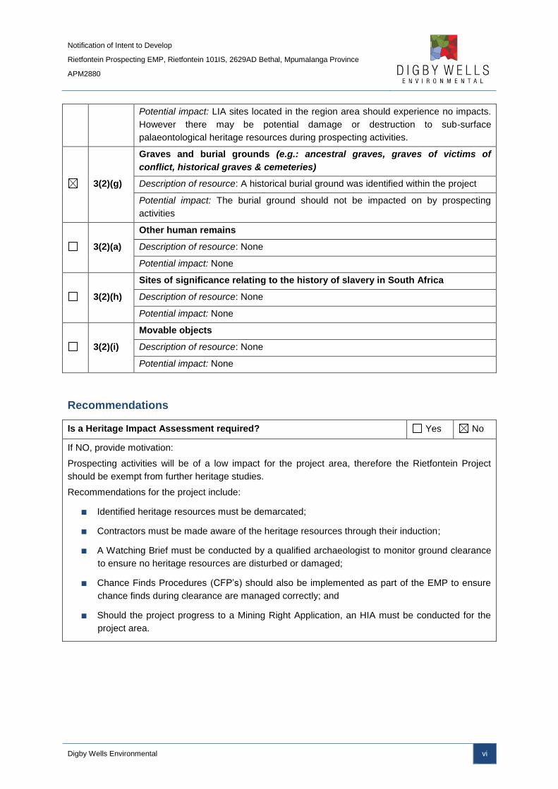
Potential impact: LIA sites located in the region area should experience no impacts.
However there may be potential damage or destruction to sub-surface
palaeontological heritage resources during prospecting activities.
3(2)(g)
Graves and burial grounds (e.g.: ancestral graves, graves of victims of
conflict, historical graves & cemeteries)
Description of resource: A historical burial ground was identified within the project
Potential impact: The burial ground should not be impacted on by prospecting
activities
3(2)(a)
Other human remains
Description of resource: None
Potential impact: None
3(2)(h)
Sites of significance relating to the history of slavery in South Africa
Description of resource: None
Potential impact: None
3(2)(i)
Movable objects
Description of resource: None
Potential impact: None
Recommendations
Is a Heritage Impact Assessment required? Yes No
If NO, provide motivation:
Prospecting activities will be of a low impact for the project area, therefore the Rietfontein Project
should be exempt from further heritage studies.
Recommendations for the project include:
■ Identified heritage resources must be demarcated;
■ Contractors must be made aware of the heritage resources through their induction;
■ A Watching Brief must be conducted by a qualified archaeologist to monitor ground clearance
to ensure no heritage resources are disturbed or damaged;
■ Chance Finds Procedures (CFP’s) should also be implemented as part of the EMP to ensure
chance finds during clearance are managed correctly; and
■ Should the project progress to a Mining Right Application, an HIA must be conducted for the
project area.

Notification of Intent to Develop
Rietfontein Prospecting EMP, Rietfontein 101IS, 2629AD Bethal, Mpumalanga Province
APM2880
Digby Wells Environmental vii
TABLE OF CONTENTS
1 Project background ........................................................................................................... 1
1.1 Introduction ............................................................................................................. 1
1.2 Terms of Reference ................................................................................................. 1
1.3 Scope of Work ......................................................................................................... 1
1.4 Project Description .................................................................................................. 1
1.5 Project Activities ...................................................................................................... 2
1.6 Client, Consultant and Landowner Contact Details .................................................. 2
1.7 Expertise of Specialists ........................................................................................... 3
2 Policy and Legal Framework ............................................................................................. 4
2.1 MPRDA ................................................................................................................... 4
2.2 NHRA ...................................................................................................................... 4
3 HRM methodology ............................................................................................................ 5
3.1 Definition of the study areas .................................................................................... 5
3.2 Data Collection ........................................................................................................ 9
3.2.1 Desktop and Text-Based Data Collection ......................................................... 9
3.3 Historical Layering ................................................................................................. 10
3.4 Site Naming ........................................................................................................... 11
3.5 Constraints and Limitations ................................................................................... 11
4 Cultural Heritage Baseline Description ........................................................................... 11
4.1 Introduction ........................................................................................................... 11
4.2 Regional Study Area ............................................................................................. 12
4.2.1 Stone Age....................................................................................................... 12
4.2.2 Iron Age .......................................................................................................... 12
4.2.3 Colonial and Historical Period ......................................................................... 14
4.3 Local Study Area ................................................................................................... 14
4.3.1 Geology and Palaeontology ............................................................................ 14
4.3.2 Stone Age....................................................................................................... 15
4.3.3 Iron Age .......................................................................................................... 16

Notification of Intent to Develop
Rietfontein Prospecting EMP, Rietfontein 101IS, 2629AD Bethal, Mpumalanga Province
APM2880
Digby Wells Environmental viii
4.3.4 Colonial and Historical Period ......................................................................... 16
4.3.5 Development Context ..................................................................................... 16
4.4 Site-Specific Study Area ........................................................................................ 18
5 Summary of Impacts / Sources of Risk ........................................................................... 23
5.1 Ground clearance phase ....................................................................................... 24
5.2 Drilling Phase ........................................................................................................ 24
5.3 Rehabilitation Phase ............................................................................................. 24
5.4 Cumulative Impacts ............................................................................................... 24
6 Conclusion and Recommendations ................................................................................ 25
7 References ...................................................................................................................... 26
LIST OF FIGURES
Figure 3-1: Regional Study Area of the Rietfontein Project ................................................... 6
Figure 3-2: Local Study Area of the Rietfontein Project ......................................................... 7
Figure 3-3: Site Specific Study Area of the Rietfontein Project .............................................. 8
Figure 4-1: Palaeo-Sensitivity map of the study area, with the approximate extent of the
Rietfontein Project area (adapted from SAHRIS, 2014). Areas that are shaded pink indicate
a very high palaeo-sensitivity, while green is moderate and blue is of a low sensitivity. ...... 15
Figure 4-2: Identified Heritage Resources within the Rietfontein Project area in red (van
Schalkwyk, 2003) ................................................................................................................ 18
Figure 4-3: 1902 view of the Rietfontein Project area (Major Jackson Sheet 27) ................. 19
Figure 4-4: 1954 historical imagery of the Rietfontein project (The yellow rings indicate
identified structures) ............................................................................................................ 20
Figure 4-5: 1968 historical imagery of the Rietfontein project .............................................. 20
Figure 4-6: 1975 historical imagery of the Rietfontein Project .............................................. 21
Figure 4-7: Identified heritage resources within the Rietfontein Project area Summary ....... 22
Notification of Intent to Develop
Rietfontein Prospecting EMP, Rietfontein 101IS, 2629AD Bethal, Mpumalanga Province
APM2880
Digby Wells Environmental ix
LIST OF TABLES
Table 1-1: Location Data ....................................................................................................... 2
Table 1-2: Expected project activities .................................................................................... 2
Table 1-3: Rietfontein project manager contact details .......................................................... 2
Table 1-4: Digby Wells project manager contact details ........................................................ 3
Table 1-5: Landowner contact details (Owner of Rietfontein 101IS, Portion 1-5 and Re) ...... 3
Table 3-1: Relevant reviewed published sources .................................................................. 9
Table 3-2: Relevant reviewed heritage studies .................................................................... 10
Table 3-3: Cartographic sources relevant to the Rietfontein project .................................... 10
Table 4-1: List of periods forming part of cultural heritage baseline ..................................... 11
Table 4-2: Stone walling clusters associated with the CCP ................................................. 13
Table 4-3: Common ceramic found in Mpumalanga ............................................................ 14
Table 4-4: Average monthly household income for the ELM (Statistics South Africa, 2011) 17
Table 5-1: Identified sources of risk ..................................................................................... 23
LIST OF APPENDICES
Appendix A: CV of Specialists

Notification of Intent to Develop
Rietfontein Prospecting EMP, Rietfontein 101IS, 2629AD Bethal, Mpumalanga Province
APM2880
Digby Wells Environmental x
LIST OF ABBREVIATIONS AND GLOSSARY OF TERMS
ANC African National Congress
ASAPA Association of Southern African Archaeologists
AAP Anglo American Platinum
BA Bachelor of Arts
CCP Central Cattle Pattern
CFP's Chance Find Procedures
ELM Emalahleni Local Municipality
EMP Environmental Management Plan
ESA Early Stone Age
GIS Geographic Information System
HIA Heritage Impact Assessment
HRA Heritage Resources Authority
HRM Heritage Resources Management
IDP Integrated Development Plan
LA's Listed Activities
LIA Late Iron Age
LSA Later Stone Age
MDEDET Mpumalanga Department of Economic Development, Environment and Tourism
MPHRA Mpumalanga Provincial Heritage Resources Authority
MPRDA Minerals and Petroleum Development Act, 2002 (Act 28 of 2002)
MPRDAB Mineral and Petroleum Resources Development Amendment Bill, 2013 (Bill 13 of 2013)
MSA Middle Stone Age
NAAIRS National Automated Archival Information Retrieval System
Notification of Intent to Develop
Rietfontein Prospecting EMP, Rietfontein 101IS, 2629AD Bethal, Mpumalanga Province
APM2880
Digby Wells Environmental xi
NDM Nkangala District Municipality
NHRA National Heritage Resources Act, 1999 (Act 25 of 1999)
NID Notification of Intent to Develop
PGMs Platinum Group Metals
RPM Rustenburg Platinum Mines
SAHRA South African Heritage Resources Agency
SAHRIS South African Heritage Resources Information System
Sow Scope of Work
Stats SA Statistics South Africa
WITS University of the Witwatersrand
Notification of Intent to Develop
Rietfontein Prospecting EMP, Rietfontein 101IS, 2629AD Bethal, Mpumalanga Province
APM2880
Digby Wells Environmental xii
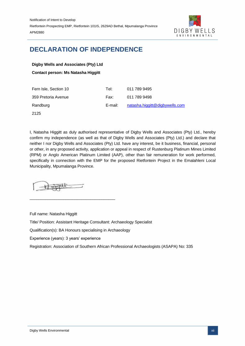
DECLARATION OF INDEPENDENCE
Digby Wells and Associates (Pty) Ltd
Contact person: Ms Natasha Higgitt
Fern Isle, Section 10
359 Pretoria Avenue
Randburg
2125
Tel:
Fax:
E-mail:
011 789 9495
011 789 9498
I, Natasha Higgitt as duly authorised representative of Digby Wells and Associates (Pty) Ltd., hereby
confirm my independence (as well as that of Digby Wells and Associates (Pty) Ltd.) and declare that
neither I nor Digby Wells and Associates (Pty) Ltd. have any interest, be it business, financial, personal
or other, in any proposed activity, application or appeal in respect of Rustenburg Platinum Mines Limited
(RPM) or Anglo American Platinum Limited (AAP), other than fair remuneration for work performed,
specifically in connection with the EMP for the proposed Rietfontein Project in the Emalahleni Local
Municipality, Mpumalanga Province.
______________________________________
Full name: Natasha Higgitt
Title/ Position: Assistant Heritage Consultant: Archaeology Specialist
Qualification(s): BA Honours specialising in Archaeology
Experience (years): 3 years’ experience
Registration: Association of Southern African Professional Archaeologists (ASAPA) No: 335

Notification of Intent to Develop
Rietfontein Prospecting EMP, Rietfontein 101IS, 2629AD Bethal, Mpumalanga Province
APM2880
Digby Wells Environmental 1
1 Project background
1.1 Introduction
Digby Wells Environmental (Digby Wells) was appointed by Rustenburg Platinum Mines
Limited (RPM), a subsidiary of Anglo American Platinum Limited (AAP) for the compilation
and submission of an Environmental Management Plan (EMP) and Consultation Report. The
EMP was conducted in support of a Prospecting Right Application (Ref No.
MP30//5/1/1/2/11683PR). The Prospecting Right Application is for numerous portions of the
farm Rietfontein 101 IS in the Magisterial District of Bethal. The EMP and associated Public
Consultation was compiled in accordance with the requirements of Section (s) 16 of the
Minerals and Petroleum Resources Development Act, 2002 (Act No. 28 of 2002) (MPRDA)
and Regulations in terms of the MPRDA (GN R. 527 of 23 April 2004). This Heritage study
follows the Heritage Resources Management (HRM) process in terms of the National
Heritage Resources Act, 1999 (Act 25 of 1999) (NHRA).
1.2 Terms of Reference
RPM has requested Digby Wells to complete an EMP in support of the Prospecting Right
Application inclusive of relevant specialist studies.
1.3 Scope of Work
The required HRM process was inclusive of a Notification of Intent to Develop (NID) that was
informed by baseline information. The Scope of Work (SoW) included:
■ Gather baseline information to provide heritage and historical context for the project
area;
■ Review of available heritage studies completed in the project area;
■ Completing historical layering for the project area; and
■ Collating information into an NID report including recommendations for any additional
heritage studies, if deemed necessary.
1.4 Project Description
The prospecting activities will take place on Rietfontein 101 IS portions 1-5 and remaining
extent (See Table 1-1 for location details).
Prospecting activities will be undertaken over a period of five (5) years. The application is for
both invasive and non-invasive methods, these are described separately below:
■ Invasive methods are activities that result in land disturbances and comprise diamond
core drilling, sampling and sample storage;
■ Non-invasive methods are methods that do not cause disturbances to the land and
include desktop research and detailed geophysical surveys.

Notification of Intent to Develop
Rietfontein Prospecting EMP, Rietfontein 101IS, 2629AD Bethal, Mpumalanga Province
APM2880
Digby Wells Environmental 2
It is anticipated that one (1) borehole will be drilled each year and each hole will be
rehabilitated immediately after drilling has ended. Each borehole will comprise of a cleared
area measuring 20 m x 20 m and respective access roads. Minerals that would be
prospected for include Platinum Group Metals (PGMs) (palladium, rhodium, iridium, osmium
and platinum), gold, copper, nickel, cobalt, silver and chrome.
Table 1-1: Location Data
Province Mpumalanga Province
Magisterial District / Local Authority Bethal Magisterial District
District Municipality Nkangala District Municipality (NDM)
Local municipality Emalahleni Local Municipality (ELM)
Nearest Town Kriel (8 km), Kinross (18 km), Bethal (24 km)
Property Name and Number Rietfontein 101 IS
1: 50 000 Map Sheet 2629AC Evander
GPS Co-ordinates
(relative centre point of study area)
-26.344939
29.252819
1.5 Project Activities
Expected project activities associated with the proposed Rietfontein Project are listed in
Table 1-2 below.
Table 1-2: Expected project activities
Activity NHRA Trigger Description
Ground clearance s. 38 (1) a Access roads will be cleared for prospecting
activities
Prospecting s. 38 (8) A total of five prospecting boreholes will be drilled
over five years
Rehabilitation of drill
sites n/a
Prospecting drill sites will be rehabilitated upon
completion of the borehole
1.6 Client, Consultant and Landowner Contact Details
Contact details for the RPM and Digby Wells project managers, and relevant landowners are
provided in Table 1-3 to Table 1-5 below.
Table 1-3: Rietfontein project manager contact details
Company Rustenburg Platinum Mines (RPM)
Contact person Barry Jones

Notification of Intent to Develop
Rietfontein Prospecting EMP, Rietfontein 101IS, 2629AD Bethal, Mpumalanga Province
APM2880
Digby Wells Environmental 3
Tel no 083 484 9925
E-mail address [email protected]
Table 1-4: Digby Wells project manager contact details
Company Digby Wells Environmental
Contact person Duncan Pettit
Tel no 011 789 9495
Fax no 011 789 9498
E-mail address [email protected]
Postal address Private Bag X10046, Randburg, 2125
Table 1-5: Landowner contact details (Owner of Rietfontein 101IS, Portion 1-5 and Re)
Directly Affected Portions Landowners Telephone no. Postal address
Rietfontein 101 Portion 1 & 2 Anglo Operations
(Pty) Ltd
(Dirk Kitching)
(013) 6915685 n/a
Rietfontein 101 Portion 3, 4, 5 Karen Breytenbach (011) 313 3911 PO Box 40111, Moreleta
Park, 0044
Rietfontein 101 Portion 3, 4, 5 Mr Johannes
Cornelius Greyling
(011) 445 7748 PO Box 40111, Moreleta
Park, 0044
1.7 Expertise of Specialists
The following specialists provided input for the NID for the Rietfontein Project:
Natasha Higgitt has obtained her Bachelor of Arts (BA) with majors in Archaeology and
Geography in 2008, and a BA Honours degree in Archaeology in 2010 from the University of
Pretoria. She currently holds the position of Assistant Heritage Consultant: Archaeology
Specialist at Digby Wells. She has more than three years’ experience in archaeological
survey and gained further generalist heritage experience since her appointment at Digby
Wells in South Africa and Liberia. Natasha is a professional member of the Association of
Southern African Archaeologists (ASAPA) (Member No: 335)
The curriculum vita of the specialist is attached as Appendix A.
Notification of Intent to Develop
Rietfontein Prospecting EMP, Rietfontein 101IS, 2629AD Bethal, Mpumalanga Province
APM2880
Digby Wells Environmental 4
2 Policy and Legal Framework
The NHRA is the overarching legislation that protects heritage resources and regulates their
management. The HRM process completed for the Rietfontein Project was done in
accordance with s. 38(8), where impacts on heritage are assessed in terms of other
legislation – the MPRDA in this instance.
2.1 MPRDA
The MPRDA stipulates under s. 5(4) no person may prospect for or remove, mine, conduct
technical co-operation operations, reconnaissance operations, explore for and produce any
mineral or petroleum or commence with any work incidental thereto on any area without (a)
an approved environmental management programme or approved environmental
management plan, as the case may be.
Furthermore, the Mineral and Petroleum Resources Development Amendment Bill, 2013 (Bill
13 of 2013) (MPRDAB) stipulates under s. 16 that “any person who wishes to apply to the
Minister for a prospecting right, must simultaneously apply for an environmental
authorisation”.
2.2 NHRA
The HRM approach developed and implemented by Digby Wells is founded on s. 38(1) and
38(2) of the NHRA. These sections of the Act require that Heritage Resources Authorities
(HRA’s), in this case the South African Heritage Resources Agency (SAHRA) and
Mpumalanga Provincial Heritage Resources Authority (MPRHA), be notified as early as
possible of any developments that may exceed certain minimum thresholds. The heritage
specialist is required to provide SAHRA and MPHRA with sufficient information regarding the
proposed development in order to determine whether a comprehensive Heritage Impact
Assessment (HIA) is required. SAHRA and MPRHA should respond within 14 days whether
or not a HIA is required, and if required should state which specialist studies should be
included.
The NHRA furthermore affords general and formal protection of certain categories of
heritage resources, including:
■ Formal protection:
National and provincial heritage sites under s. 27;
Certain types of protected areas under s. 28; and
Heritage areas under s. 32.
■ General protection:
Certain structures under s. 34;
Archaeological and palaeontological resources, and meteorites under s. 35;

Notification of Intent to Develop
Rietfontein Prospecting EMP, Rietfontein 101IS, 2629AD Bethal, Mpumalanga Province
APM2880
Digby Wells Environmental 5
Certain categories of burial grounds and graves under s. 36; and
All public monuments and memorial under s. 37.
Any activity that will result in the change of the status quo of any heritage resources
protected in terms of the above sections of the Act may, must be considered as a permitted
activity. Changes to such resources will therefore require authorisation through permits
issued by either SAHRA or MPRHA.
3 HRM methodology
3.1 Definition of the study areas
Given that no individual identified heritage resource can exist in isolation to the wider natural,
social, cultural and heritage landscape, three concentric study areas were defined for the
purposes of this study. Defining these ‘zones of influence’ had a two-fold purpose:
■ First, it provided the context within which identified heritage resources need to be
interpreted and understood to determine cultural significance; and
■ Second, assessing the significance of impacts on heritage resources corresponding to
the three impact categories listed above.
The three zones of influence are as follows:
The Tertiary Zone of Influence (also referred to as the regional study area): This area was
defined as the district municipality. Where necessary, the regional study area was extended
outside the boundaries of the district municipality to include much wider regional expressions
of specific types of heritage resources and historical events. The regional study area,
depicted in Figure 3-1 also provided the regional development and planning context that may
contribute to cumulative impacts.
The Secondary Zone of Influence (also referred to as local study area): This area was
defined as the immediate surrounding properties / farms, as well as the affected local
municipality. The local study area was specifically examined to provide a backdrop to the
socio-economic conditions within which the proposed development will occur. The local
study area furthermore provided the local development and planning context that may
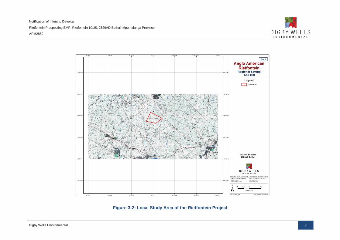
contribute to cumulative impacts. The local study area is depicted in Figure 3-2.
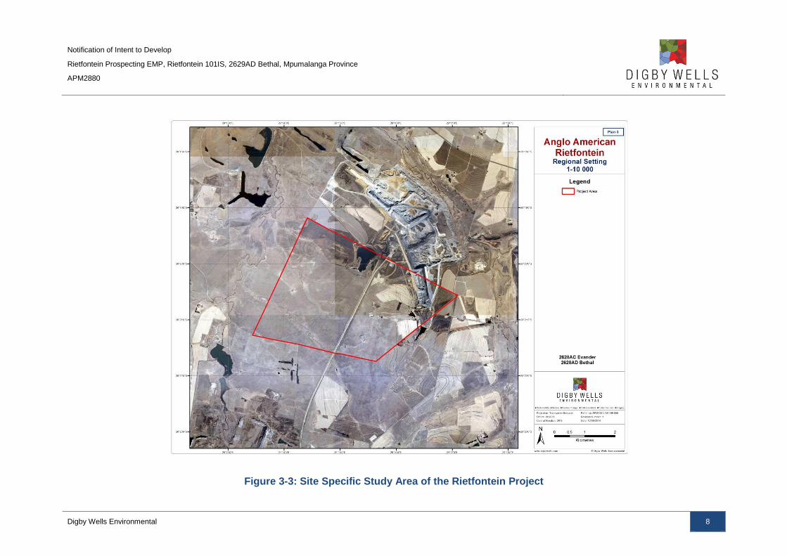
Primary Zone of Influence (also referred to as the site-specific study area): This area was
defined as the bounded project area i.e. the farm portions, within which the development will
physically intrude through the construction of project infrastructure and project-related
activities. The affected farm portions are listed in Table 1-1 and the site-specific study area
depicted in Figure 3-3.

Notification of Intent to Develop
Rietfontein Prospecting EMP, Rietfontein 101IS, 2629AD Bethal, Mpumalanga Province
APM2880
Digby Wells Environmental 6
Figure 3-1: Regional Study Area of the Rietfontein Project
Notification of Intent to Develop
Rietfontein Prospecting EMP, Rietfontein 101IS, 2629AD Bethal, Mpumalanga Province
APM2880
Digby Wells Environmental 7
Figure 3-2: Local Study Area of the Rietfontein Project
Notification of Intent to Develop
Rietfontein Prospecting EMP, Rietfontein 101IS, 2629AD Bethal, Mpumalanga Province
APM2880
Digby Wells Environmental 8
Figure 3-3: Site Specific Study Area of the Rietfontein Project
Notification of Intent to Develop
Rietfontein Prospecting EMP, Rietfontein 101IS, 2629AD Bethal, Mpumalanga Province
APM2880
Digby Wells Environmental 9
3.2 Data Collection
3.2.1 Desktop and Text-Based Data Collection
Data collection was aimed at information gathering relating to known heritage resources
within and surrounding the proposed area for development. Information was obtained
through intensive research using a variety of primary and secondary sources such as
academic journals, textbooks and records, national and provincial websites, archaeological
field guides, national guidelines, maps, photographs and plans.
Published literature including academic papers, books and planning documents were
collated and analysed to determine their relevance to this NID. Sources that were used to
inform the findings are fully referenced under Section 7 of this report, and are briefly listed in
below.
Table 3-1: Relevant reviewed published sources
Palaeontology ■ Bamford, 2011;
■ Council for GeoScience, 2014;
■ Lavin, 2013;and
■ Plumstead, 1962.
Stone Age ■ Deacon & Deacon, 1999;
■ Esterhuysen & Smith, 2007;
■ Korsman & Plug, 1994;
■ Potgieter, 1955; and
■ Turner & Wadley, 1987.
Iron Age ■ Huffman, 2007;
■ Maggs, 1976;
■ Maggs, 2008; and
■ Makhura, 2007.
Historical and Colonial Period ■ Britannica, 2014;
■ Holden & Mathabatha, 2007; and
■ Raper, 1987.
Planning documents ■ Emalahleni Local Municipality, 2014/15.
General ■ Mucina & Rutherford, 2006; and
■ Statistics South Africa, Local Municipality, 2011.
Previously completed heritage studies that were conducted in the surrounding areas were
reviewed to expand on the background information discussed. The findings provide

Notification of Intent to Develop
Rietfontein Prospecting EMP, Rietfontein 101IS, 2629AD Bethal, Mpumalanga Province
APM2880
Digby Wells Environmental 10
evidence-based inferences to be made with regard to the potential for, and description of
heritage resources that are likely to occur in the project region. Heritage cases and reports
found to be relevant are listed in Table 3-2 below, and fully referenced under Section 7.
Table 3-2: Relevant reviewed heritage studies
Author Report type Area / property / project
van Schalkwyk, 2003 Scoping Report Kriel Mine Extension
Van Schalkwyk, 2003 AIA Bethal Region
An archive and database survey was conducted by consulting the following repositories:
■ National Automated Archival Information Retrieval System (NAAIRS);
■ Statistics South Africa (Stats SA)
■ South African Heritage Resources Information System (SAHRIS); and
■ The University of the Witwatersrand (WITS) Archaeology Site Database.
3.3 Historical Layering
Historical layering is a process whereby diverse cartographic sources from various time
periods are layered chronologically using Geographic Information System (GIS). The
rationale behind historical layering is threefold, as it:
■ Enables a virtual representation of changes in the land use of a particular area over
time;
■ Provides relative dates based on the presence/absence of visible features; and
■ Identifies potential locations where heritage resources may exist within an area.
Cartographic sources referred to in this report include are listed in Table 3-3.
Table 3-3: Cartographic sources relevant to the Rietfontein project
Historical maps
Map series Name / number Date
Major Jackson Bethal Sheet 27 June 1902
Aerial photographs
Job no. Flight plan Photo no. Map ref. Area Date Reference
340 009 16465 2629 Bethal 1954 1954/340
548 008 00968 2629 2630 Bethal 1968 1968/548

Notification of Intent to Develop
Rietfontein Prospecting EMP, Rietfontein 101IS, 2629AD Bethal, Mpumalanga Province
APM2880
Digby Wells Environmental 11
750 005 00175 2628 2629 Bethal 1975 1975/750
3.4 Site Naming
Sites may be identified based on previous relevant reports. The relevant SAHRA report
number will be followed by the relevant heritage resource type suffixed with the site name
and / or number that was used in the original reports. For example, a heritage resource
identified in Roodt (1999) described as an Iron Age site and numbered Site 1 in that report
will be: 1999-SAHRA-0021/IA Site 1
This number may be shortened on any plans or maps to the site number used in that report.
If the SAHRA report number is unavailable, the author and date of the report will be followed
by the reference to the relevant heritage resources type suffixed with the site name and/or
number that was used in the original reports. For example, Roodt-1999/IA Site 1
Sites identified during field surveys are prefixed by the SAHRIS case number assigned to
the study followed by the map sheet number, relevant heritage resources type and site
number. For example: 6392/2629AC/IA-001
This number may be shortened on any plans or maps to the relevant heritage resources type
suffixed with the site number used in that report. For example: IA-001
3.5 Constraints and Limitations
The following restrictions and limitations were encountered:
■ No site screening visit was completed due to site access constraints.
4 Cultural Heritage Baseline Description
4.1 Introduction
The cultural heritage baseline consists of several periods in the history of the regional, local
and site specific areas within and surrounding the Rietfontein Project area. These periods
are discussed to provide context for any identified heritage within and around the project so
as to better assess their significance and the level of impact caused by the proposed project.
The following time periods are discussed in this cultural heritage baseline (See Table 4-1).
Table 4-1: List of periods forming part of cultural heritage baseline
1 Palaeontological and geological
Precambrian to late Pleistocene (1.2 billion to late 20 000 years ago)
2 Indigenous
Early Stone Age (3 million to 300 00ya) (ESA)
Notification of Intent to Develop
Rietfontein Prospecting EMP, Rietfontein 101IS, 2629AD Bethal, Mpumalanga Province
APM2880
Digby Wells Environmental 12
Middle Stone Age (c 300 000 to 30 000 ya) (MSA)
Later Stone Age (c 30 000 to 2000 ya) (LSA)
Late Iron Age (1500’s to 1850’s) (LIA)
3 Colonial
British colony (1814 -1910)
4 Historical
Union of South Africa (1911-1961)
4.2 Regional Study Area
4.2.1 Stone Age
The Stone Age is represented by the presence of ESA, MSA and LSA sites throughout the
Mpumalanga-Highveld region. The ESA can be dated between ± 2 Million years BP and 250
000 years BP is defined by the occurrence of large hand axes and cleavers produced from
coarse-grained material (Esterhuysen & Smith, 2007). The MSA is characterised by the
presence of blades and points manufactured from good quality raw material dated to
between ±250 000 years to ±20 000 years BP. Bone tools, shell beads and pendants, as
well as the use of ochre are also present in the MSA (Deacon & Deacon, 1999). The LSA
lithic assemblage contains microlithic technology and composite tools like bows and arrows
and can be dated to approximately 20 000 years BP. The LSA shows strong signs of ritual
practises and complex societies, as well as rock art. Herders or pastoralists emerge towards
the end of the LSA, with ceramics and domesticated stock (Deacon & Deacon, 1999).
The Highveld region of Mpumalanga is scattered with surface occurrences of Stone Age
material with little evidence of in situ deposit. One may find in situ deposit within caves and
shelters where LSA material and rock art are usually evident. Examples of such sites include
Bushman Rock Shelter (150 km south-east from the project area) that shows evidence of a
long occupation sequence that dates back to 26 000-14 000 years ago. Both MSA and LSA
tools are present, bone tools and beads made from ostrich eggshell, land snail and bone
(Plug 1981). Approximately 75 km north-east from the project area, lies the Honingklip
Shelter, which has examples of rock art and LSA remains such as scrapers, adzes and awls,
and other artefacts such as beads and Early Iron Age potsherds (Korsman & Plug, 1994).
Other areas were LSA artefacts may be found are around the many natural pans that are
spread across the Highveld region, such as the Chrissiesmeer area. Bushmen have been
recorded to have lived on and around pans in the Chrissiesmeer region, approximately
50 km north from the project area (Potgieter, 1955).
4.2.2 Iron Age
The Stone Age is followed by the Iron Age in southern Africa. This period is consists of the
Early, Middle and Late Iron Ages (LIA) and follows the spread of Bantu speaking people.

Notification of Intent to Develop
Rietfontein Prospecting EMP, Rietfontein 101IS, 2629AD Bethal, Mpumalanga Province
APM2880
Digby Wells Environmental 13
LIA sites are found within the Mpumalanga region. A key indicator of LIA sites is the
presence of stone-walled settlements. Stone-walled settlement patterns can be divided into
two primary clusters known as the Moor Park and Ntsuanatsatsi within the main Central
Cattle Pattern (CCP) (Huffman, 2007), summarised in Table 4-2 below.
Table 4-2: Stone walling clusters associated with the CCP
Central Cattle Pattern
Moor Park Cluster Ntsuanatsatsi Cluster
Moor Park 14th-16
th Century Type N 15
th-17
th Century
Melora 16th Century - ? Badfontein 16
th Century
KwaMaza 18th Century – Historic Doornspruit 19
th Century
Klipriviersberg 19th Century
Type V 19th Century
Molokwane 19th Century
Type Z 19th Century
Type B 19th Century
Tukela 19th Century
A sub-group of the Moor Park Cluster is that of the KwaMaza settlement pattern. This is
commonly found throughout Mpumalanga, and consists of characteristics such as beehive
huts, cattle kraals, a central court, and a side chamber for a small court (Huffman, 2007).
Another settlement pattern found in the region is the Type V settlement pattern. This type
consists of the standard core of cattle enclosures surrounded by beehive huts. Additionally, it
is believed that it is also within this type corbelled huts evolved (Maggs, 1976)
Another settlement type the Badfontein type associated with the baKoni group. The baKoni
had circular settlements that consist of cattle lanes and terrace walls (Huffman, 2007).The
baKoni chiefdom lies in a corridor that extends from Ohrigstad to Carolina with several
branches heading out the Komati Valley and some sections of the Crocodile river, with a
small cluster to the west fo the Steelpoort Valley (Maggs, 2008).
Associated artefacts with the stone walled settlements are the material culture of the people
who once occupied the site, which would be the ceramics. Artefacts that are commonly
found in once occupied Iron Age sites are the ceramic material culture that was used in
everyday life, both functionally for storage and cooking, and for ritual purposes.
Through a process of ceramic typology, it is possible to trace Iron Age groups based on the
decoration of the ceramics (Huffman, 2007). The more common ceramic found in
Mpumalanga are summarised in Table 4-3.

Notification of Intent to Develop
Rietfontein Prospecting EMP, Rietfontein 101IS, 2629AD Bethal, Mpumalanga Province
APM2880
Digby Wells Environmental 14
Table 4-3: Common ceramic found in Mpumalanga
Facies Period Key Characteristics
Mzonjani 450 BC - 750 BC Punctates on rim, spaced motif on shoulder
Uitkomst 1650 BC – 1820 BC Stamped arcades, appliqué and blocks of parallel incisions,
stamping and chord impressions
Rooiberg 1650 BC – 1750 BC Stamped rim band, mixture of stamped and incised bands,
arcades and triangles in the neck
Icon 1300 BC – 1500 BC Multiple incised bands separated by colour and lip decorations
on bowls
Madikwe 1500 BC – 1700 BC Multiple bands of cord impressions, incisions, stabs and
punctates separated by colour
Diamant 750 BC – 1000 BC Tapered rims with broadly incised herringbone
Eiland 1000 BC – 1300 BC Fine herringbone with ladder stamping
Letaba 1600 BC – 1840 BC Hatched bands on shoulder, below black and red triangles
Doornkop 750 BC – 1000 BC Multiple herringbone bands in neck
Klingbeil 1000 BC – 1200 BC Triangles in neck bordered with slashes, punctates on shoulder
4.2.3 Colonial and Historical Period
The Mpumalanga region experienced a great deal of chaos and turmoil of groups during the
18th and 19th centuries due to the Mfecane. The Mfecane was a period of significant
population movement and displacement of interior groups as the Zulu Kingdom expanded.
As a result of the unrest, large settlements of the Bantu-speakers are uncommon and refuge
sites are evident as groups could not settle permanently (Makhura, 2007).
The Boers or Afrikaans farmers began to move into the interior during the latter part of the
19th century. As the Bantu-speakers were displaced due to the Mfecane, the Boers believed
they were moving into uninhabited areas and began to claim large portions of lands for
themselves. They began to exploit the natural resources of the interior and gained a strong
foothold in areas (Makhura, 2007).
4.3 Local Study Area
4.3.1 Geology and Palaeontology
The project area falls within the Vryheid Formation. This formation consists of deltaic
mudstones and sandstones with occasional coal seams (Lavin, 2013). Fossil plants are the
predominant palaeontological resources that have been found in this region of South Africa.
The fossil plants that have previously been recorded include lycopods, rare ferns and
horsetails, abundant glossopterids, cordaitaleans, conifers and ginkgoaleans (Bamford,

Notification of Intent to Develop
Rietfontein Prospecting EMP, Rietfontein 101IS, 2629AD Bethal, Mpumalanga Province
APM2880
Digby Wells Environmental 15
2011). Other fossils that are expected to occur include trace fossils, rare insects, possible
conchostracans, non-marine bivalves and fish scales (Lavin, 2013).
Fossil plants such as Breytenia were identified approximately 46 km east in similar
sandstone ridges during the palaeontological field survey for the Msobo Coal (Pty) Ltd
Consbrey Colliery (SAHRIS Case ID: 1722). Previously, only one other specimen was
recorded in the 1950’s by Edna Plumstead and therefore any subsequent finds of this fossil
plant would be highly valued (Plumstead, 1962).
According to the PalaeoSensitivity map on SAHRIS, the project area falls within a very high,
moderate and low sensitivity zone (Council for GeoScience, 2014) (See Figure 4-1).
However, as the project area is located within a coal field, the high palaeo-sensitivity is
inherent.
Figure 4-1: Palaeo-Sensitivity map of the study area, with the approximate extent of
the Rietfontein Project area (adapted from SAHRIS, 2014). Areas that are shaded pink
indicate a very high palaeo-sensitivity, while green is moderate and blue is of a low
sensitivity.
4.3.2 Stone Age
In Mpumalanga, the majority of Stone Age sites are identified as surface scatters and within
shelters (Esterhuysen & Smith, 2007). According to van Schalkwyk (2003a), numerous MSA

Notification of Intent to Develop
Rietfontein Prospecting EMP, Rietfontein 101IS, 2629AD Bethal, Mpumalanga Province
APM2880
Digby Wells Environmental 16
and LSA surface occurrences are evident in the surrounding areas such as the areas around
Kriel. The sites that he identified are surface scatters and out of context as they are eroding
out of dongas and riverbeds.
Three substantial LSA sites are located in the local study area. These include Hope Hill
Shelter, Leslie Falls Shelter and Horos Cave approximately 32 km west from the project area
(Turner & Wadley, 1987). These shelters were occupied approximately 4 400 years before
present, with small informal assemblages of LSA stone lithics and some bone points and link
shafts. The sites were most probably used as hunting camps on a seasonal basis.
4.3.3 Iron Age
As stated in section 4.2.2, Type V stone-walled settlements and other settlement patterns
associated with the baKoni are to be expected in the surrounding study areas. The baKoni
corridor is located approximately 50 km east of the project area.
Three Type V settlements have been recorded between 8 km and 16 km of the project area
(van Schalkwyk, 2003a; Van Schalkwyk, 2003b).
4.3.4 Colonial and Historical Period
The towns closest to the project area include Bethal, Kinross and Kriel. Kriel (also known as
Ga-Nala) was established in 1973 to house the workers at the Kriel Power Station. The town
grew substantially from 1982 to 1989 and was declared a municipality in 1990 (Emalahleni
Local Municipality, 2014/15). Kinross was proclaimed as a village in 1915, and gained
municipal status in 1965. The town was established due to the construction of the Springs-
Breyten rail route (Raper, 1987).
Bethal is the oldest of the towns near the project area. It was established in 1880 on the farm
Blessbokspruit and was named after the wives of the owners of that farm (Elizabeth du
Plooy and Alida Naude) (Raper, 1987). The town started to expand once the rail route from
Springs to the coast was built. The presence of the railway, increased trade and
development and gained municipal status by 1921 (Govan Mbeki Local Municipality, 2013).
During the 1940’s, the farms surrounding Bethal were investigated due to allegations of
mistreatment of farmworkers. The story was investigated between 1947 and 1959 by Ruth
First and assisted by Gert Sibande. Gert went undercover to uncover the truth (Holden &
Mathabatha, 2007). The story came to a tipping point, when in August 1959; the ANC
planned a massive boycott of the farms around Bethal. This was known as the “Potato
Boycott” and it lasted for two months. It served as an inspiration for resistance movement
against the Apartheid government. (Holden & Mathabatha, 2007).
4.3.5 Development Context
The development and planning context in which the proposed Rietfontein Project will operate
was summarised from the following sources:

Notification of Intent to Develop
Rietfontein Prospecting EMP, Rietfontein 101IS, 2629AD Bethal, Mpumalanga Province
APM2880
Digby Wells Environmental 17
■ Stats SA (Statistics South Africa, 2011); and
■ ELM Draft Integrated Development Plan (IDP) 2014/14.
The ELM covers an area of approximately 2 677 km2.The total population is estimated at
395 466 with a density of 148 persons per square kilometre (Statistics South Africa, 2011). A
total of 138 548 of the population is economically active and 20.6 % of the economically
active population is employed in the mining sector (Emalahleni Local Municipality, 2014/15).
Income levels of the economically active population are depicted in Table 4-4.
Table 4-4: Average monthly household income for the ELM (Statistics South Africa,
2011)
Income Percentage
No income 13,5%
R1 - R4,800 3,2%
R4,801 - R9,600 5%
R9,601 - R19,600 11,1%
R19,601 - R38,200 16,8%
R38,201 - R76,400 17,5%
R76,401 - R153,800 13,5%
R153,801 - R307,600 10,5%
R307,601 - R614,400 6,1%
R614,001 - R1,228,800 2%
R1,228,801 - R2,457,600 0,5%
R2,457,601+ 0,3%
The average annual household income in the ELM shows that the largest percentage of the
economically active population (53.6 %) is earning less than R 76 400.00 per year, while
13.5 % of the population does not earn an income.
According to the ELM IDP, the mining sector is the largest potential contributor to the
economy of the municipality to stimulate economic growth in 2009 with 49.8% (Emalahleni
Local Municipality, 2014/15). The challenges of environmental degradation and pollution
associated with a high amount of mining projects in the municipality were highlighted in the

Notification of Intent to Develop
Rietfontein Prospecting EMP, Rietfontein 101IS, 2629AD Bethal, Mpumalanga Province
APM2880
Digby Wells Environmental 18
IDP and there was a call for special focus on the green economy (Emalahleni Local
Municipality, 2014/15).
The ELM IDP does state that there are numerous heritage sites located within the municipal
area that are currently under threat due to the rapid rate of development. The industrial
heritage of the municipality is also recognised citing the many power stations as heritage
resources (Emalahleni Local Municipality, 2014/15).
While the ELM is developing at an increasing rate, with mining at the forefront of the
expansion, there is a need for balance between industrial projects and more environmentally
friendly projects, as well as the protection of heritage resources such as power stations.
4.4 Site-Specific Study Area
According to (van Schalkwyk, 2003a), there appears to be a number of Iron Age sites within
the project area, however it is unclear of the exact location of the sites as no coordinates
were supplied. The estimated location of the project area in relation to these possible sites is
depicted in Figure 4-2 below (Iron Age Sites are depicted in red). Please refer to Figure 4-7
for all identified heritage resources within the Rietfontein Project area.
Figure 4-2: Identified Heritage Resources within the Rietfontein Project area in red
(van Schalkwyk, 2003)
Notification of Intent to Develop
Rietfontein Prospecting EMP, Rietfontein 101IS, 2629AD Bethal, Mpumalanga Province
APM2880
Digby Wells Environmental 19
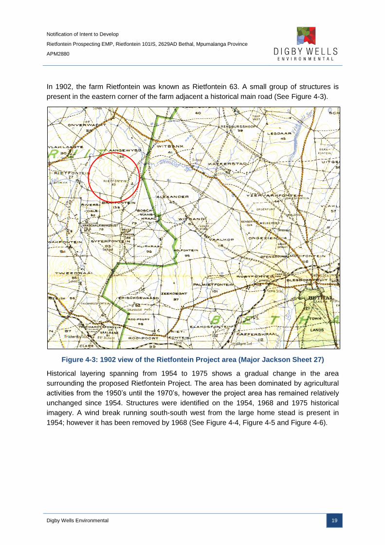
In 1902, the farm Rietfontein was known as Rietfontein 63. A small group of structures is
present in the eastern corner of the farm adjacent a historical main road (See Figure 4-3).
Figure 4-3: 1902 view of the Rietfontein Project area (Major Jackson Sheet 27)
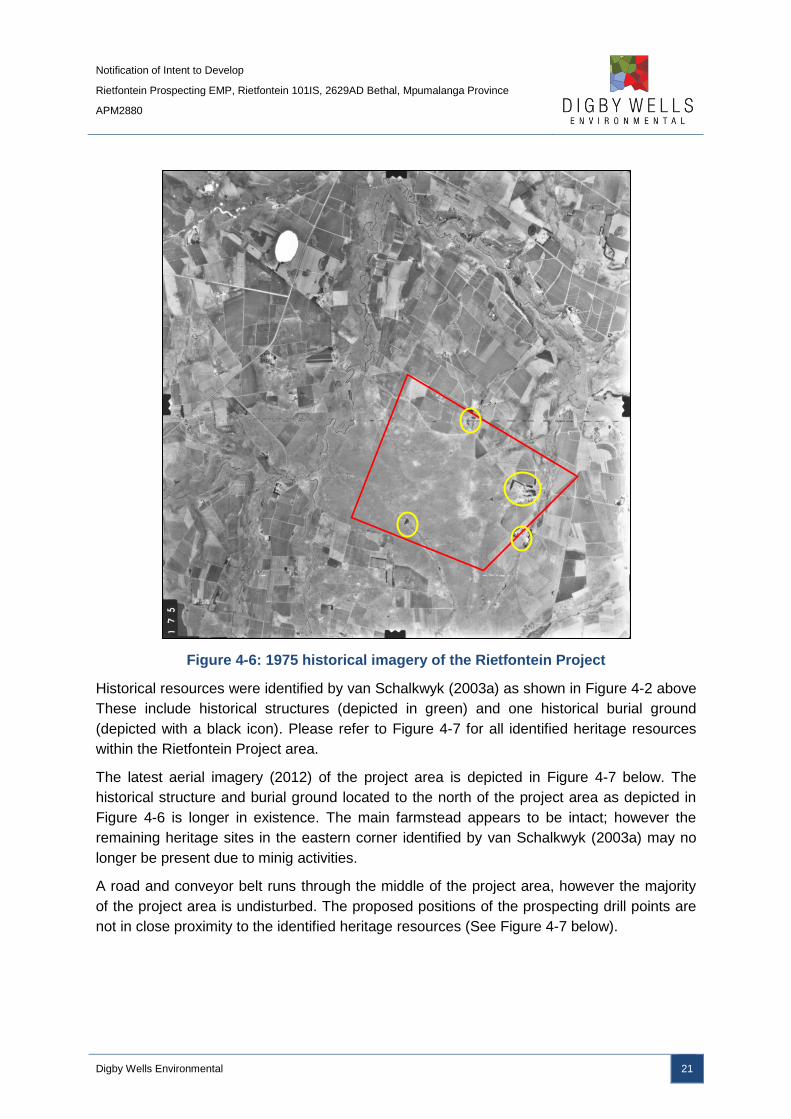
Historical layering spanning from 1954 to 1975 shows a gradual change in the area
surrounding the proposed Rietfontein Project. The area has been dominated by agricultural
activities from the 1950’s until the 1970’s, however the project area has remained relatively
unchanged since 1954. Structures were identified on the 1954, 1968 and 1975 historical
imagery. A wind break running south-south west from the large home stead is present in
1954; however it has been removed by 1968 (See Figure 4-4, Figure 4-5 and Figure 4-6).

Notification of Intent to Develop
Rietfontein Prospecting EMP, Rietfontein 101IS, 2629AD Bethal, Mpumalanga Province
APM2880
Digby Wells Environmental 20
Figure 4-4: 1954 historical imagery of the Rietfontein project (The yellow rings
indicate identified structures)
Figure 4-5: 1968 historical imagery of the Rietfontein project
Notification of Intent to Develop
Rietfontein Prospecting EMP, Rietfontein 101IS, 2629AD Bethal, Mpumalanga Province
APM2880
Digby Wells Environmental 21
Figure 4-6: 1975 historical imagery of the Rietfontein Project
Historical resources were identified by van Schalkwyk (2003a) as shown in Figure 4-2 above
These include historical structures (depicted in green) and one historical burial ground
(depicted with a black icon). Please refer to Figure 4-7 for all identified heritage resources
within the Rietfontein Project area.
The latest aerial imagery (2012) of the project area is depicted in Figure 4-7 below. The
historical structure and burial ground located to the north of the project area as depicted in
Figure 4-6 is longer in existence. The main farmstead appears to be intact; however the
remaining heritage sites in the eastern corner identified by van Schalkwyk (2003a) may no
longer be present due to minig activities.
A road and conveyor belt runs through the middle of the project area, however the majority
of the project area is undisturbed. The proposed positions of the prospecting drill points are
not in close proximity to the identified heritage resources (See Figure 4-7 below).

Notification of Intent to Develop
Rietfontein Prospecting EMP, Rietfontein 101IS, 2629AD Bethal, Mpumalanga Province
APM2880
Digby Wells Environmental 22
Figure 4-7: Identified heritage resources within the Rietfontein Project area Summary

Notification of Intent to Develop
Rietfontein Prospecting EMP, Rietfontein 101IS, 2629AD Bethal, Mpumalanga Province
APM2880
Digby Wells Environmental 23
5 Summary of Impacts / Sources of Risk
Sources of risk were determined considering the project activities that may impact on heritage resources (See Table 5-1).
Table 5-1: Identified sources of risk
Identified
Project Activity Description Development as defined in NHRA Trigger for HIA
Sources of risk
to heritage
resources
Project Phase
Ground
clearance for
access roads
Ground cover vegetation will be
cleared for the construction of
access roads
This activity constitutes
development as defined in terms of
NHRA s. 2(viii) (a) construction,
alteration, demolition, removal or
change of use of a place or a
structure at a place.
s.38 (1) a
Potential
destruction and
damage to sub-
surface heritage
resources
Construction
Ground
clearance for
prospecting drill
sites
A total of five areas measuring
20 m x 20 m each (total 0.2 ha) will
be cleared for prospecting drill sites
This activity constitutes
development as defined in terms of
NHRA s. 2 (viii) (e) and (f) any
change to the natural or existing
condition or topography of land;
and any removal or destruction of
trees, or removal of vegetation or
topsoil.
s.38 (8)
Potential
destruction and
damage to sub-
surface heritage
resources
Construction
Notification of Intent to Develop
Rietfontein Prospecting EMP, Rietfontein 101IS, 2629AD Bethal, Mpumalanga Province
APM2880
Digby Wells Environmental 24
5.1 Ground clearance phase
As the proposed project activities are to be of a low impact, no direct impact is expected
during the construction phase. However, un-identified and sub-surface heritage resources
may be directly impacted upon. The highest likelihood of negative impacts on un-identified
and sub-surface heritage resources to occur is associated with activities that will be
undertaken during construction phase of the proposed project.
For the Rietfontein Project, project activities identified as sources of risk during construction
include:
■ Ground clearance for the access roads and drill sites.
Ground clearance and excavation for the construction of the access roads and prospecting
drill sites may disturb or damage any sub-surface heritage resources. However, excavations
may uncover bedrock or rocky outcrops that may contain palaeontological resources. In this
instance, they may be a positive impact as the excavation may identify unknown fossil
heritage in the area.
5.2 Drilling Phase
During the operational phase of the proposed project, sources of risk to heritage resources
are limited. The primary risk during the operational phase will be associated with the indirect
impacts that may occur due to accidental damage or vandalism.
5.3 Rehabilitation Phase
No sources of risk to heritage resources are envisaged for the decommissioning phase of
the project.
5.4 Cumulative Impacts
Some cumulative impacts that may occur include:
■ The cumulative effect of site clearance will over time create a cumulative area of 1 ha
i.e. 0.2 ha x 5;
■ Another significant cumulative impact is the increased presence over time of
contractors Therefore there is a higher potential of accidental damage or deliberate
vandalism to tangible heritage resources, including historical structures that are
unoccupied, burial grounds etc.

Notification of Intent to Develop
Rietfontein Prospecting EMP, Rietfontein 101IS, 2629AD Bethal, Mpumalanga Province
APM2880
Digby Wells Environmental 25
6 Conclusion and Recommendations
Based on the findings of this report, heritage resources are present within the Rietfontein
project area. These include Iron Age sites, historical structures and burial grounds. However,
the proposed positions of the boreholes and the relative low intensity of the prospecting
activities will not significantly impact on heritage resources and direct impact on any heritage
resources can be avoided.
Digby Wells is therefore of the opinion that RPM be exempted from all addition heritage
assessments for the Rietfontein Project provided that the following mitigation and
management measures are included in the EMP and implemented:
■ Identified heritage resources must be clearly demarcated and avoided during the
prospecting phase by the following measures:
Burial grounds and graves, historical structures and Iron Age sites must be given
a buffer of 50 m to ensure no accidental damage occurs;
RPM must ensure that contractors are made aware of the heritage through
training that must be included in their induction and contractors pack.
■ A Watching Brief must be implemented when drill sites are prepared and access
routes to such sites are created.
This entails the on-site supervision of a qualified archaeologist during ground
clearance for access roads and drill sites to ensure no heritage resources are
accidently damaged; and
■ Chance Finds Procedures (CFP’s) must be compiled and implemented as part of the
EMP to be followed in the event that any heritage resources are identified during any
site clearance and when access routes are created;
■ When prospecting is completed and RPM wishes to apply for a Mining Right and
Environmental Approval, an HIA must be completed. The HIA should include:
An Archaeological Impact Assessment;
A Built Heritage Assessment; and
NHRA Regulations Chapter XI consultation regarding burial grounds.

Notification of Intent to Develop
Rietfontein Prospecting EMP, Rietfontein 101IS, 2629AD Bethal, Mpumalanga Province
APM2880
Digby Wells Environmental 26
7 References
Bamford, M. (2011). Palaeontology Desktop Study - Empangeni to Ermelo Powerline,
Johannesburg. University of the Witwatersrand: BPI Palaeontology.
Council for GeoScience. (2014). PalaeoSensitivity Map. Retrieved Febraruy 7, 2014, from
The South African Heritage Resources Agency: http://www.sahra.org.za/map/palaeo
Deacon, H. J., & Deacon, J. (1999). Human Beginnings in South Africa: Uncovering the
Secrets of the Stone Age. Walnut Creek: Rowman Altamira.
Emalahleni Local Municipality. (2014/15). Emalahleni Local Municipality Draft IDP. Witbank:
Emalahleni Local Municipality.
Esterhuysen, A., & Smith, J. (2007). Chapter 2: Stories in Stone. In P. Delius (Ed.),
Mpumalanga: History and Heritage (pp. 41-68). Durban: University of Kwa-Zulu Natal
Press.
Govan Mbeki Local Municipality. (2013). Govan Mbeki Spatial Development Framework
2013. Govan Mbeki Local Municipality.
Holden, P., & Mathabatha, S. (2007). The politics of resistance: 1948-1990. In P. Deluis,
Mpumalanga: History and Heritage (pp. 393-461). Scottsville: University of KwaZulu-
Natal Press.
Huffman, T. N. (2007). A Handbook to the Iron Age: The Archaeology of Pre-Colonial
Farming Societies in Southern Africa. Durban: University of KwaZulu-Natal Press.
Huffman, T. N. (2007). Handbook to the Iron Age: The Archaeology of the Pre-Colonial
Farming Societies in Southern Africa. Cape Town: University of KwaZulu-Natal
Press.
Korsman, S., & Plug, I. (1994). Two Later Stone Age Sites on the Farm Honingklip in the
Eastern Transvaal. The South African Archaeological Bulletin, 49 (159), 24-32.
Lavin, J. (2013, October 10). Vryheid Formation. Retrieved May 27, 2014, from SAHRIS:
http://www.sahra.org.za/fossil-layers/vryheid-formation
Maggs, T. M. (1976). Iron Age Communities of the Southern Highveld. Occasional
Publication 2. Pietermaritzburg: Natal Museum.
Maggs, T. M. (2008). The Mpumalanga Escarpment settlements: some answers, many
questions. In P. Bonner, A. Estherhuysen, & N. Swanepoel, Five Hundred Years
Rediscovered: Southern African Precedents and Prospects (pp. 169-182).
Johannesburg: WITS University Press.
Makhura, T. (2007). Early inhabitants. In P. Delius (Ed.), Mpumalanga: History and Heritage
(pp. 91-135). Pietermaritsburg: Univeristy of KwaZulu-Natal Press.
Mucina, L., & Rutherford, M. C. (2006). The Vegetation of South Africa, Lesotho and
Swaziland. Pretoria: Strelitzia: South African National Biodiversity Institute.

Notification of Intent to Develop
Rietfontein Prospecting EMP, Rietfontein 101IS, 2629AD Bethal, Mpumalanga Province
APM2880
Digby Wells Environmental 27
Plumstead, E. P. (1962). Possible angiosperms from Lower Permian coal of the Transvaal.
Nature, 194, 594-595.
Potgieter, E. F. (1955). The disappearing Bushmen of Lake Chrissie: a preliminary survey.
Pretoria: Van Schaik.
Raper, R. E. (1987). Dictionary of Southern African Place Name. Johannesburg: Lowry
Publishers.
Statistics South Africa. (2011). Local Municipality. Retrieved May 27, 2014, from Statistics
South Africa: http://beta2.statssa.gov.za/?page_id=993&id=emakhazeni-municipality
Turner, G., & Wadley, L. (1987). Hope hill shelter a later stone age site in the southern
transvaal south africa. South African Journal Of Science, 98-105.
van Schalkwyk, J. (2003a). Kriel Mine Extension, Mpumalanga: Archaeological and Cultural
Historical Survey and Impact Assessment. Sunnyside: National Cultural History
Museum.
Van Schalkwyk, J. (2003b). Archaeological Survey of a Section of the Secunda-Mozambique
Gas Pipeline, Bethal and HIghveld Ridge Districts, Mpumalanga. Pretoria: Natural
Cultural Hisotry Museum.

Notification of Intent to Develop
Rietfontein Prospecting EMP, Rietfontein 101IS, 2629AD Bethal, Mpumalanga Province
APM2880
Appendix A: CV of Specialists

Notification of Intent to Develop
Rietfontein Prospecting EMP, Rietfontein 101IS, 2629AD Bethal, Mpumalanga Province
APM2880
Copyright © 2022 FDOKUMEN