Prospecting for safe (low fluoride) groundwater in the Eastern African Rift: the Arumeru District...
28
HESSD 6, 7321–7348, 2009 Prospecting for safe (low fluoride) groundwater in the eastern African Rift G. Ghiglieri et al. Title Page Abstract Introduction Conclusions References Tables Figures Back Close Full Screen / Esc Printer-friendly Version Interactive Discussion Hydrol. Earth Syst. Sci. Discuss., 6, 7321–7348, 2009 www.hydrol-earth-syst-sci-discuss.net/6/7321/2009/ © Author(s) 2009. This work is distributed under the Creative Commons Attribution 3.0 License. Hydrology and Earth System Sciences Discussions This discussion paper is/has been under review for the journal Hydrology and Earth System Sciences (HESS). Please refer to the corresponding final paper in HESS if available. Prospecting for safe (low fluoride) groundwater in the eastern African Rift: a multidisciplinary approach in the Arumeru District (northern Tanzania) G. Ghiglieri 1 , R. Balia 2 , G. Oggiano 3 , and D. Pittalis 1 1 Department of Territorial Engineering, Desertification Research Group (NRD), University of Sassari, Sassari, Italy 2 Department of Territorial Engineering, University of Cagliari, Cagliari, Italy 3 Department of Botanical, Ecological and Geological Sciences, Desertification Research Group (NRD), University of Sassari, Sassari, Italy Received: 21 October 2009 – Accepted: 1 November 2009 – Published: 27 November 2009 Correspondence to: G. Ghiglieri ([email protected]) Published by Copernicus Publications on behalf of the European Geosciences Union. 7321
Transcript of Prospecting for safe (low fluoride) groundwater in the Eastern African Rift: the Arumeru District...

HESSD6, 7321–7348, 2009
Prospecting for safe(low fluoride)
groundwater in theeastern African Rift
G. Ghiglieri et al.
Title Page
Abstract Introduction
Conclusions References
Tables Figures
J I
J I
Back Close
Full Screen / Esc
Printer-friendly Version
Interactive Discussion
Hydrol. Earth Syst. Sci. Discuss., 6, 7321–7348, 2009www.hydrol-earth-syst-sci-discuss.net/6/7321/2009/© Author(s) 2009. This work is distributed underthe Creative Commons Attribution 3.0 License.
Hydrology andEarth System
SciencesDiscussions
This discussion paper is/has been under review for the journal Hydrology and EarthSystem Sciences (HESS). Please refer to the corresponding final paper in HESSif available.
Prospecting for safe (low fluoride)groundwater in the eastern African Rift: amultidisciplinary approach in theArumeru District (northern Tanzania)G. Ghiglieri1, R. Balia2, G. Oggiano3, and D. Pittalis1
1Department of Territorial Engineering, Desertification Research Group (NRD),University of Sassari, Sassari, Italy2Department of Territorial Engineering, University of Cagliari, Cagliari, Italy3Department of Botanical, Ecological and Geological Sciences, Desertification ResearchGroup (NRD), University of Sassari, Sassari, Italy
Received: 21 October 2009 – Accepted: 1 November 2009 – Published: 27 November 2009
Correspondence to: G. Ghiglieri ([email protected])
Published by Copernicus Publications on behalf of the European Geosciences Union.
7321

HESSD6, 7321–7348, 2009
Prospecting for safe(low fluoride)
groundwater in theeastern African Rift
G. Ghiglieri et al.
Title Page
Abstract Introduction
Conclusions References
Tables Figures
J I
J I
Back Close
Full Screen / Esc
Printer-friendly Version
Interactive Discussion
Abstract
This research was aimed at finding fresh and safe groundwater easily deliverable toan area, located in northern Tanzania, within the western branch of the Rift Valley.The study area suffers from water shortage, moreover, due to widespread alkalinevolcanism, high fluoride contents (F− up to 70 mg/l) affects the groundwater.5
The achievement of this goal has been pursued through a multidisciplinary researchconsisting of geological, hydrogeological, hydro-chemical, geophysical and hydrologi-cal investigations.
The study area stretches over 440 km2 and lies in the northern part of the ArumeruDistrict, approximately 50 km from Arusha, the capital of the region. The Mount Meru10
(4565 m a.s.l.) and the Arusha National Park mark the boundary of the area, whichincludes 9 villages belonging to the Oldonyo Sambu and Ngarenanyuki Wards. Theclimate is semi-arid, with dry and relatively rainy seasonal alternance.
Four principal hydrogeological complexes have been identified within different litholo-gies. They occur within volcanic formations, singularly or superimposed on each other.15
Subordinate perched aquifers are present in sedimentary formations with local occur-rence. The groundwater flow system has been interpreted on the basis of springsspatial distribution combined with lithological and the geometrical reconstruction of theaquifers. The dominant pattern, consisting of multidirectional flow from the higher el-evation area in the south towards the lower area in the north, is complicated by the20
occurrence of structures such as grabens, faults, lava domes and tholoids. After theidentification of the main fluoride source, an interference pattern among groundwaterand high F surface water was drawn. Finally, some VES (Vertical Electrical Sounding)were performed that allowed an aquifer to be individuated within a structural high wherethe fluoride input is prevented. The drilling of a well, able to supply at least 3.8 l/s of25
low fluoride, drinkable water, successfully concluded the methodological approach forprospecting safe water in a semi-arid, naturally fluoride polluted region.
7322

HESSD6, 7321–7348, 2009
Prospecting for safe(low fluoride)
groundwater in theeastern African Rift
G. Ghiglieri et al.
Title Page
Abstract Introduction
Conclusions References
Tables Figures
J I
J I
Back Close
Full Screen / Esc
Printer-friendly Version
Interactive Discussion
1 Introduction
Due to water shortage in the wards of Ngarenanyuki and Oldonyosambu (ArumeruDistrict, northern Tanzania), the average per capita daily water consumption is 8 litres.The availability goes down to 3–4 litres in the dry seasons when most of the populationcannot resort to using seasonal ponds or streams, being so compelled to concentrating5
around the few perennial water points. This datum is quite far from the MillenniumDevelopment Goal (MDGs) objectives that foresee a quantity of at least 20 l/d/p (litresper day per person) for the Developing Countries population, by 2015 (United Nations,2000). Besides water availability, serious problems are related to water quality. In fact,the scarce water resources are affected by high fluoride contents that characterises10
both surface water and groundwater. This circumstance affects the entire East AfricaRift System due to the widespread alkaline volcanism (Tekle-Haimanot et al., 2006;Jaroslav and Annukka, 2007).
Nevertheless, within the Rift, the fluoride level of the groundwater can exhibit mean-ingful variations, even at local scale (Tekle-Haimanot et al., 2006), depending on the15
influence that different geological features exert on the geochemical composition; inaddition the low scale variability of the climate factors, which are typical of the RiftValley, also contribute in modifying fluoride levels.
It is generally accepted that groundwater is enriched with fluoride by prolongedwater-rock interaction (Banks et al., 1995; Gizaw, 1996; Frengstad et al., 2001; Carrillo-20
Rivera et al., 2002). Lithology, therefore, is regarded as an important factor in deter-mining the fluoride concentration of groundwater. Previous studies show that fluorideis generally enriched in groundwater from bedrock aquifers in alkaline magmatic rocksand metamorphic rocks (Banks et al., 1995; Dowgiałło, 2000; Botha and van Rooy,2001; Shanker et al., 2003). Common natural sources responsible of F release are25
minerals, such as fluorspar, fluorapatite, amphiboles (e.g. horneblende, tremolite) andsome micas.
7323

HESSD6, 7321–7348, 2009
Prospecting for safe(low fluoride)
groundwater in theeastern African Rift
G. Ghiglieri et al.
Title Page
Abstract Introduction
Conclusions References
Tables Figures
J I
J I
Back Close
Full Screen / Esc
Printer-friendly Version
Interactive Discussion
Since an excessive consumption of fluoride can cause serious pathologies classifiedas dental fluorosis and skeletal fluorosis (Moller et al., 1970; Tekle-Haimanot et al.,2006), consumption of high-F water in the Rift Valley caused the endemism of thesepathologies in several Northeast and East African countries, notably Ethiopia (Lester,1974; Tekle-Haimanot et al., 1987; Kloos and Tekle-Haimanot,1999), Sudan (Smith5
et al., 1953), Tanzania (Kilham and Hecky, 1973), Korean Peninsula (Kangjoo and GiYoung, 2005). The highest fluoride levels have been reported in the Kenyan lakesElementaita (1640 mg/l) and Nakuru (2800 mg/l) (Tekle-Haimanot et al., 2006).
On this account, the World Health Organization has imposed a limit of 1.5 mg/l offluoride (WHO, 2006), but the Tanzanian government has been forced to raise this limit10
from 4 to 8 mg/l, just in order to overcome the widespread problem of water shortage.In order to find safe and fresh groundwater, this multidisciplinary study of a critical
rural area within a semi-arid microenvironment, dominated by alkaline volcanic rocks,was carried out with the aim of identifing:
1. the main local source of fluoride;15
2. possible aquifers spared by fluoride infiltration/release;
3. the best way to exploit eventual safe groundwater.
2 Study area
2.1 Location, climatic and physiographic setting
The project involved one portion of the District of Arumeru, that belongs to the Region20
of Arusha, with an area of 2966 km2. The District is administratively divided into 6 Di-visions, 37 Wards and 133 Villages. The district of Arumeru is situated in northernTanzania, between Mount Kilimanjaro on the east, Mount Meru on the south, the roadthat joins Arusha (Tanzania) with Nairobi (Kenya) on the west and the National Park
7324

HESSD6, 7321–7348, 2009
Prospecting for safe(low fluoride)
groundwater in theeastern African Rift
G. Ghiglieri et al.
Title Page
Abstract Introduction
Conclusions References
Tables Figures
J I
J I
Back Close
Full Screen / Esc
Printer-friendly Version
Interactive Discussion
of Amboseli (Kenya) on the north (Fig. 1). In particular, the working area (440 km2)is located in the northern part of the District, around 50 km from the city of Arusha, isbounded by Mount Meru (4565 m a.s.l.) and the Arusha National Park, and includes9 villages belonging to the Oldonyo Sambu and Ngarenanyuki Wards. Three main eth-nic groups are present: the Wameru, which are farmers, Waarusha and Maasai, which5
are cattlemen.Despite its proximity to the equator, the study area enjoys an Afro-Alpine semi-arid
climate, characterized by two distinct seasonal weather patterns. The main wet seasonextends from June to September and contributes to about 70% of the total annualrainfall. A minor rainy season from mid February to mid May contributes the rest of10
the moisture in the region. The remaining months of the year are more or less dry,at times with occasional, erratic showers. The lowest and the highest annual averagetemperatures are 20.6◦C and 28.5◦C, respectively, and the average annual rainfall is535.3 mm (AA.VV., 2000; Gea, 2005).
As shown in Fig. 1, the topography of the area is dominated by the volcanic cone15
of Mt. Meru (4565 m a.s.l.); its slopes cover most of the area. The remaining landis overlain by alluvial fans, which, with gentle slopes, are fed by Mt. Meru. Recentsmall volcanic cones are preserved in the NW part of Meru and small maar-type flatcraters occur. Permanent saline water characterises the Big Momela lake and theSmall Momela alkaline lakes, both inside the Arusha National Park, east of Meru.20
The drainage pattern around the Meru is clearly radial, but downhill the streamcourses are modified by tilting and capture. East and north-east of Mt. Meru, the onlyperennial stream is the Engare Nanyuki river, the waters of which have very high fluo-ride content as it is mainly fed by a spring with a yield of about 5 l/s and a F− contentof 60 ppm. This stream flows northwards into the inner Amboseli Basin allowing local25
irrigation.
7325

HESSD6, 7321–7348, 2009
Prospecting for safe(low fluoride)
groundwater in theeastern African Rift
G. Ghiglieri et al.
Title Page
Abstract Introduction
Conclusions References
Tables Figures
J I
J I
Back Close
Full Screen / Esc
Printer-friendly Version
Interactive Discussion
2.2 Geological and hydrogeological setting
The following, general geological descriptions are based on the Geological Sheet“Arusha”, Quarter Degree Sheet 55, 1983, scale 1:125 000 – Geological Survey ofTanzania, while the hydrogeological setting is based on results from this research.
The age of the volcano-sedimentary sequences of the study area is Cenozoic: in5
particular, the older ones go back to Miocene-Pliocene, whereas, the most recent aresub-actual. The dominant lithology is represented by volcanic rocks and, subordinately,by alluvial deposits (Fig. 2). The crystalline basement does not outcrop in the area,however, it has been found at a shallow depth, a few kilometers north of the studyarea.10
Mt. Meru can be considered an active volcano, representative of the alkaline mag-matic activity that characterises the east Africa rift system. Its last eruption dates backto 1910, when small amounts of black ash were ejected for a few days from the AshCone. Most of the recent lava activity took place during the half-century prior to theash eruption in the form of lava domes. Up to 1954, significant fumarolic activity was15
recorded in the Ash Cone area. In 1974, a careful survey showed neither fumarolicactivity nor anomalous soil temperature.
Major rift faults are present in the NW of the research area. Linear features andbenches are frequent on the flanks of Meru and it is highly probable that the earlyvolcanic structure has been block-faulted. In the central area, the faults trend N-S to20
NNE-SSW (Uwiro graben); in the NW area the trend is NW-SE (parasitic cone align-ment). However, thick mantling ash and other younger formations make it difficult tomap faults with confidence. The age of this faulting must lie between that of the floodlavas (2.3 million years BP) and that of parasitic cones (1.7 million years BP), some ofwhose lavas cover the fault scarp. This is consistent with the fault-phase found else-25
where about of 2.1 million years BP (AA.VV., 1983).The hydrogeological setting has been compiled by combining an existing geological
map (AA.VV., 1983) with new hydrogeological and geophysical surveys carried out
7326

HESSD6, 7321–7348, 2009
Prospecting for safe(low fluoride)
groundwater in theeastern African Rift
G. Ghiglieri et al.
Title Page
Abstract Introduction
Conclusions References
Tables Figures
J I
J I
Back Close
Full Screen / Esc
Printer-friendly Version
Interactive Discussion
during the course of this work. In this way, a broad reconstruction of hydrogeologicalparameters like aquifer geometry, storage capacity, permeability, recharge areas, etc.of the study area, have been assessed.
The main aquifer systems are made up of volcanic formations, occurring singularly orsuperimposed on each other. Subordinate perched aquifers are present in sedimentary5
formations, with some of these aquifer systems having been localized.The thickness of the volcanic rocks is known only approximately because of the un-
certainties associated with the geologic and geomorphologic events during the Ceno-zoic. However, it is clear that all these events exerted a strong control on the geometryof the aquifers, on the recharge and discharge areas and on the groundwater qual-10
ity. Moreover, the scale of the map and the amount of available data does not allowa detailed mapping of all these parameters. From a hydrogeological point of view, thelitho-stratigraphic formations can be grouped into two main hydrogeologic units, namelya Volcanic unit and a Sedimentary unit (Fig. 2).
2.2.1 Volcanic hydrogeologic unit15
This unit is divided into four hydrogeologic complexes:
– Meru west Group (Nvm);
– Lahars of various age (Nzd1), Ngare Nanyuki lahars (Nzd2), Momella Lahar(Nzd3);
– Main cone group (Nvm), Ash cone group (Nvn);20
– Mantling ash (Nvf);
Meru west Group (Nvm) complex
This formation, that belongs to the “older extrusive”, is exposed into the west of Mt.Meru. The rock are essentially nephelinite lavas and breccias that contain dominant
7327

HESSD6, 7321–7348, 2009
Prospecting for safe(low fluoride)
groundwater in theeastern African Rift
G. Ghiglieri et al.
Title Page
Abstract Introduction
Conclusions References
Tables Figures
J I
J I
Back Close
Full Screen / Esc
Printer-friendly Version
Interactive Discussion
phonolite clasts. The aquifer hosted in this formation has a fractured permeability.
Lahars of various age (Nzd1, Nzd2, Nzd3) complex
From a hydrogeologic point of view, all these lahars can be grouped into a uniquecomplex. Lahars (Nzd1) of considerable extension were commonly formed interbeddedwith sedimentary sequences. These lahars are characterised by large and abundant5
boulders, of feldsparphyric phonolite with alkali feldspar phenocrysts, in a differentlyhardened fine-grained matrix. Nzd2 and Nzd3 are exposed North-East and East of thevolcano. The former near Ngare Nanyuki and Uwiro graben and the latter near theMomella Lakes. The aquifers hosted in these rocks have a double permeability as theyare both fractured and, at some extent porous.10
Main cone group (Nvm) complex
The Meru volcano became active in a period ranging about 200 000–80 000 years BP.The volcanic activity built up the main cone to an altitude of at least 4877 m a.s.l., per-haps considerably higher at one time. The Main Cone group (Nvm) and Little Merugroup (Nvp) materials are predominantly volcanic breccias and tuffs of all grain sizes,15
but phonolitic and nephelinitic (Nv) lavas are intercalated sporadically. The aquiferhosted in these rocks presents double permeability (fractured and porous). In this sys-tem, the elevation difference between recharge and discharge areas allows the infiltra-tion of rain water, particularly where the permeability is high (intensive fracturing). Thisevidence, along with the considerable number of springs with important yield, leads to20
effective groundwater circulation with short residence time. Another feature of the MainCone group is the common occurrence of viscous domes or tholoids (Nvg), usually ofa feldsparphyric phonolite composition. These may occur at all levels, but there is azone of especially large adventitious tholoids on the northern flanks (i.e. M. Songe).The occurrence of domes constitutes a lateral hydrogeological impermeable limit, that25
controls the groundwater circulation.
7328

HESSD6, 7321–7348, 2009
Prospecting for safe(low fluoride)
groundwater in theeastern African Rift
G. Ghiglieri et al.
Title Page
Abstract Introduction
Conclusions References
Tables Figures
J I
J I
Back Close
Full Screen / Esc
Printer-friendly Version
Interactive Discussion
Mantling ash (Nvf) complex
Thick ash, pumice and tuff deposits overlie large areas in the foothills of Mount Meru,especially on the western slope. In the study area, the complex crops out near OldonyoSambu, and Kisimiri (North of Meru). This formation, due to fine-grained nature andclay alteration, is practically impermeable, so no springs occur within it. Sometimes5
this complex underlies or surrounds an aquifer.
2.2.2 Sedimentary hydrogeologic unit
This unit is made up of fine-grained alluvial and lacustrine sediments, hence it is char-acterised by low transmissivity. The occurrence of these sediments characterises aswampy flatland crossed by the Engare Nanyuki river, which terminates towards the10
west in an area scattered with alkaline lakes. A perched aquifer occurs in this forma-tion with a low productivity: few springs are present with poor yield.
3 Materials and methods
3.1 Hydrogeological surveys
The hydrogeological surveys have been extended outside the limits of the two Wards:15
dealing with identification and census of 52 water points and 46 springs (30 in theNgarenanyuki, 16 in the Oldonyosambu ward) and includes 6 surface water samples(rivers and lakes).
For each water point, the following parameters were collected: elevation, geographiccoordinates, pH, electric conductivity, temperature, fluoride content, yield (estimated20
values) hydrogeological characteristics and spring classification (Tables 1 and 2).Every water point was identified with an alphanumeric code and for each the follow-
ing parameters were collected: elevation, geographic coordinates and hydrogeologicalcharacteristics. A global position system (GPS, Garmin – Geko) was used to locate
7329

HESSD6, 7321–7348, 2009
Prospecting for safe(low fluoride)
groundwater in theeastern African Rift
G. Ghiglieri et al.
Title Page
Abstract Introduction
Conclusions References
Tables Figures
J I
J I
Back Close
Full Screen / Esc
Printer-friendly Version
Interactive Discussion
each feature. Analyses of groundwater samples including fluoride, pH, electric con-ductivity, and temperature were carried out in situ. Fluoride was measured with aFluoride LR Photometer (Hanna Instrument HI 93739). Temperature, pH and electricalconductivity at 25◦C were measured with a portable pH-conductivity meter (HI 98130HANNA Instruments).5
These parameters were acquired during an hydrological year, i.e. both in the dry andin the wet season with the aim to design a feature monitoring network.
For each water point, a monographic data sheet was completed; after which the datawere organized in a digital database and GIS, using ArcView 9.2 and the open sourcesoftware gvSIG.10
The locality of all water points were plotted in order to have the immediate distributionof all the parameters, particularly the fluoride content (Fig. 2).
3.2 Geophysical surveys
Geophysical surveys have been carried out in the two wards of Ngarenanyuki andOldonyosambu, with the aim of evaluating the potential of the two areas with respect15
to groundwater resources. Measurements have been performed by means of the VES(Vertical Electrical Sounding) technique with a Schlumberger electrode array, and anABEM Terrameter SAS 300 as an acquisition system. The apparent resistivity curveshave been interpreted using a computer software based on the linear digital filteringmethod (e.g. see Koefoed, 1972, 1979; O’Neill and Merrick, 1984) as is well known,20
modern software packages based on this method can cope with even extreme resis-tivity contrasts and deal with a large number of layers. On the whole, 15 soundingsin the Oldonyosambu Ward and 33 in the Ngarenanyuki Ward were acquired. In theOldonyosambu Ward, the results were rather disappointing, since no clear sign of ex-ploitable groundwater was found in the apparent resistivity curves and respective in-25
terpretations. Conversely, in the Ngarenanyuki Ward, the VES campaign allowed thelocation of several areas potentially interesting for groundwater and, therefore, onlysoundings pertaining to this ward will be discussed. The VES position map for the
7330

HESSD6, 7321–7348, 2009
Prospecting for safe(low fluoride)
groundwater in theeastern African Rift
G. Ghiglieri et al.
Title Page
Abstract Introduction
Conclusions References
Tables Figures
J I
J I
Back Close
Full Screen / Esc
Printer-friendly Version
Interactive Discussion
Ngarenanyiuki Ward is shown in Fig. 3.
4 Results
As shown in Fig. 2 and Table 1, most of the springs with low fluoride content (belowthe Tanzanian standard for rural water) outpour from unaltered lavas, either basalticor phonolitc, mainly located in a lofty position within the Main Cone Group Complex5
in Mount Meru and, to a less extent, in its northern lower slope. Particularly, fluorideseems to concentrate in water flooding from lahars and lacustrine deposits. A mean-ingful exception is represented by the spring 26 Eng (Fig. 2) located within the Merucone at 2502 m a.s.l. of altitude. This spring, considering the temperature (22.4◦C) andlocation is of hydrothermal origin, feeds the Engarenanyuky River with a yield of 6 l/s10
with an exceptionally high fluoride content ranging between 59 and 68 mg/l. Such awater can be considered a pollutant for the river and, consequently, for the aquifers inhydraulic communication with it. Particularly the area of structural low within the Uwirograben where some epiclastite-hosted aquifers can be fed by the river.
Epiclastite and also proximal lahars are separated by paleosoils (Fig. 4) that can15
concentrate and release fluoride due to the anionic exchange capacity of both phillosil-icates and zeolites occurring as a byproduct of the ash matrix.
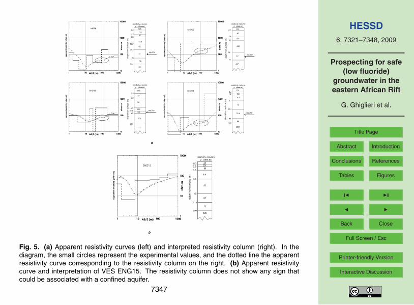
As for the geophysical survey, the most soundings exhibit a typical feature consist-ing of a low resistivity layer confined between two relatively high resistivity layers. Fig-ure 5a shows four among the most promising apparent resistivity curves acquired in the20
Ngarenanyuki Ward, and the corresponding interpretations. In the figure, the portion ofthe apparent resistivity curve corresponding to the anomaly, which can be interpretedas a confined or semi-confined aquifer, is evidence with an ellipse, and the presumedaquifer layer is indicated with an arrow in the respective resistivity column obtainedthrough the inversion process.25
The consequent deduction is that in the sub-area, including the above discussedsoundings the occurrence of a layer, associated with a confined or semi-confined
7331

HESSD6, 7321–7348, 2009
Prospecting for safe(low fluoride)
groundwater in theeastern African Rift
G. Ghiglieri et al.
Title Page
Abstract Introduction
Conclusions References
Tables Figures
J I
J I
Back Close
Full Screen / Esc
Printer-friendly Version
Interactive Discussion
aquifer, at a depth of 20–36 m from the ground surface with noticeable thickness, ishighly plausible.
For comparison, the result pertaining to sounding ENG15 is shown in Fig. 5b: as canbe seen, apart from the low values associated with the clayey, more or less wet, topsoil, the resistivity increases continuously and anomalies that could be associated with5
a confined aquifer are missing.On the basis of the resistivity curves and taking into account the geological and
hydrogeological features, several homogeneous sub-areas have been distinguishedand marked with capital letters in the map of Fig. 3; in detail:
– Sub-area A: soundings ENG30 and ENG09 with possible groundwater at depths10
ranging from a few metres to a maximum of 35 m;
– Sub-area B: the Uwiro Graben with ENG10, ENG08, ENG07, ENG13, ENGnew1soundings. All these soundings exhibit a column with very low resistivity values(even 3–4 ohm-m) from surface to a depth of at least 90 m. Undoubtedly ground-water occur, possibly at different levels in a multi-layer aquifer;15
– Sub-area C: soundings ENG05, ENG06, ENG17 indicate that aquifers could bepresent in the first 30–60 m from surface;
– Sub-area D: soundings Eng 14, Eng 20, Eng 21. Besides the first few metersfrom surface, these soundings show a resistivity curve interpretable in the sameway as the soundings discussed before.20
This area is relatively far from the Engarenanyuki River and is crossed by severalephemeral streams coming from the surroundings hills;
– Sub-area E1: includes soundings MK01, MK02, MK03, MK05 and MK05b. Allthese soundings are located in a structural high with respect to the Uwiro Grabenso that no influx of Engarenaniyuki River is expected. The sounding indicates25
groundwater at 30 m from surface; deeper aquifers could be found at a relativelylarge depth (at least 100–200 m);
7332

HESSD6, 7321–7348, 2009
Prospecting for safe(low fluoride)
groundwater in theeastern African Rift
G. Ghiglieri et al.
Title Page
Abstract Introduction
Conclusions References
Tables Figures
J I
J I
Back Close
Full Screen / Esc
Printer-friendly Version
Interactive Discussion
– Sub-area E2: is the most promising for groundwater and includes soundingsENG00, ENG01, ENG02, MK04, ENG18, ENG03b. As seen, these soundingsshow very similar and rather interesting characteristics: a first conductive layer,extending from a few metres to a maximum of 15 m from surface; a relatively re-sistive layer, superimposed on a second conductive layer whose top is situated at5
depths of 36 m from the surface. The latter could be associated with an aquiferwith a thickness ranging from 40 to 150 m.
5 Discussion and prospecting strategy
The hydrogeological issues, including the census of springs and the relative fluoridecontent, evidenced as water pouring out from unaltered volcanic rocks such as phono-10
lite, basalt, piroclastites – generally located at a relatively high elevation on the Mt.Meru slope – are those affected by low content of fluoride. Two reasons can accountfor this characteristic:
1. the short resident time of the groundwater responsible for the relative low water-rock interaction;15
2. the absence of byproducts such as paleosoils, which conversely are widespreadwithin the lahars. Moreover no calcrete and lacustrine salty deposits with saltysoils and scooped magadi (Nielsen, 1999) occur in the area. All these easy leach-able products, instead occur in the Uwiro Graben and elsewhere in the distal andflat part of the volcanic building.20
The occurrence of groundwater, evident by the sounding executed also according tosocial factors such as the needs of the population settled in the area, is synthesizedin Table 3. The third and fourth columns of Table 3 indicate the “drilling suitability” andthe suggested “maximum drilling depth”, respectively. The “drilling suitability” rangesfrom 0 (zero) to 5, with the following meaning: 0=“do not drill at all”; 5=”area particu-25
7333

HESSD6, 7321–7348, 2009
Prospecting for safe(low fluoride)
groundwater in theeastern African Rift
G. Ghiglieri et al.
Title Page
Abstract Introduction
Conclusions References
Tables Figures
J I
J I
Back Close
Full Screen / Esc
Printer-friendly Version
Interactive Discussion
larly suitable for drilling”. The “Maximum drilling depth” has the meaning: “if drilling isdecided, do not drill below that depth”.
This table shows the drilling suitability of productive aquifers regardless of the qualityof water. Some indications on this basic aspect can nevertheless be derived fromgeological and hydrogeological considerations. In fact, if the water flooding from lahars5
and from the superficial lacustrine sediments show fluoride values systematically above10 ppm with maxima of 68 ppm. It can be argued that the aquifers of the entire areabetween Uwiro and Momela Lakes would be affected by high-F water. This area isalso crossed by the only perennial river of the district, fed by at least one hydrothermalspring (Eng 26), that contribute to the dramatic increase of the fluoride values (34 ppm)10
of its water. These considerations is sufficient to exclude this lowland with the sub-areas A, B, C and D from any exploitation project due to the high risk of drilling naturallypolluted aquifers. Conversely, the uplifted area, NW of the fault zone marked by theNNE trending cones alignment (Fig. 2), not only is out of the Engarenanyuky influence,but also exhibits a wide outcrop of basalt flood pertaining to the relatively old NVj15
volcanic suite, which can host a productive ‘”unpolluted” groundwater reservoir. Onthis basis, the area E2 was chosen as that which best fits the local needs (Maasaisettlement) and the hydrogeological conditions for safe water so suitable for a pilotborehole drilling.
5.1 The borehole20
The drilling operation, lithological log (drill cuttings were collected every one metre),well design, well completion and development joined to a pumping test have beencarried out by the Tanzanian Company “Water Solutions Drilling Company” on Jan-uary 2008. During the drilling, water samples were collected in order to measure thechemical-physical parameters and the fluoride content. In Figs. 2 and 6 the borehole,25
named Ichnusa Well1, is shown. Technical data are reported in Fig. 6d. The IchnusaWell1 has provided a detailed stratigraphy of the Mkuru area. In particular, the pres-ence of a buried formation, which does not outcrop in the area, was observed. It was
7334

HESSD6, 7321–7348, 2009
Prospecting for safe(low fluoride)
groundwater in theeastern African Rift
G. Ghiglieri et al.
Title Page
Abstract Introduction
Conclusions References
Tables Figures
J I
J I
Back Close
Full Screen / Esc
Printer-friendly Version
Interactive Discussion
crossed from 38 m to 59 m below g.l. (Fig. 6); it consists of scoriaceous, autobrecciatedbasalt, that hosts a confined aquifer with high permeability. After drilling, the pumpingtest at a constant rate (drawdown log-time test) was carried out (18, 19, 20 January2008) in order to estimate the hydraulic parameters (transmissivity and storativity). Indetail, due to the limited pumping rate (3.8 l/s) allowed by the available submersible5
pump (lowered down the borehole at 60 m below g.l.), it was not possible to estimatethe maximum pumping rate. Hence, also the evaluation of the well efficiency by meansof SDT (Step Drawdown Test) was not possible. At the allowed pumping rate, themaximum drawdown was only 45 cm: such conditions permitted just a constant yield-pumping test.10
Drawdown versus time measurement were collected during 48 h at a constant pump-ing rate of 3.8 l/s. The pumping test (Theis Method) showed a transmissivity of9.12×10−3 m2/s and a storativity of 6.30×10⁻². No kind of barrier boundary or rechargeeffect has been highlighted during the pumping test. This allows us to state that themaximum pumping rate of Ichnusa Well1 is definitely greater than 3.8 l/s. During the15
test, in situ fluoride analyses evidenced a constant value of 3.1 mg/l. This value is byfar the lowest found all over the study area and it falls below the Tanzania security limit.
6 Conclusions
In the volcanic district represented by the northern Mount Meru slope, shallow anddeep circulating groundwater has been distinguished. Shallow groundwater, which oc-20
curs in perched aquifers hosted in unconsolidated or semi-unconsolidated sediments,is scarce. These aquifers exhibit limited extension, in fact shallow groundwater hasbeen evident only within sandy river beds and paleo-lakes superficial sedimentary de-posits. Intermediate and deep groundwater circulation systems occur in areas wherethe permeability of the aquifers and the elevation difference between recharge and dis-25
charge areas allows relatively deep infiltration. Deeper infiltration takes place wherefracturing and faulting affect brittle rocks over wide areas. In such cases, a large
7335

HESSD6, 7321–7348, 2009
Prospecting for safe(low fluoride)
groundwater in theeastern African Rift
G. Ghiglieri et al.
Title Page
Abstract Introduction
Conclusions References
Tables Figures
J I
J I
Back Close
Full Screen / Esc
Printer-friendly Version
Interactive Discussion
recharge area joined with substantial rainfall can also result in good yielding wells andsprings (e.g. Main cone group complex Nvm).
The groundwater regional flow system has been found as generally controlled bythe morphology, and involving a multidirectional flow with the dominant pattern fromthe higher elevation area in the south, towards the lower area in the north. Recharge5
occurs by direct infiltration (rainfall), by infiltration following runoff, and through lateralsystems where some groundwater can flow laterally between different hydrogeologicunit. In particular, the second occurrence is typical of volcanic uplands, especially incorrespondence of slope changes (decrease in drainage density); the third case is thatof Mkuru area, where an aquifer hosted in the weathered and scoriaceous basalts, at10
a depth of about 40–60 m, is fed by the groundwater, which infiltrates at high elevationin the main cone group and Tholoid phonolites.
Fractured or autobrecciated lava-flows are aquifers with low release of fluoride eitherfor their high trasmissivity, which reduce the residence time of groundwater, or for theabsence of weathering-derived products or salty deposits that, conversely, come in15
contact with groundwater mainly hosted within lahars or even in superficial lacustrinesediments. Also the Engarenaniuky River, mainly fed by the high fluoride hydrothermalspring 26 Eng, contributes to polluting the aquifers in hydraulic communication with itin the lowland within the Uwiro Graben.
Geo-structural and hydrogeological data (geometry and hydraulic properties of the20
aquifer systems, boundary conditions, spring flow, streamflow, etc.) of the whole in-vestigated area are not enough to allow the definition of a correct water balance, thatshould be necessary for computing runoff, actual infiltration and groundwater recharge.
Undoubtedly, all the above data represent the basis for planning interventions aimedat improving the access to unpolluted water. As an example, the data acquired and25
interpreted in the frame of this work allow to evaluate, for different sub-areas, whetherthe water supply problem could be better faced by means of more drilled wells orby improving the springs catchment or, yet, with a combination of both. However, theabove-said interventions cannot be planned only on the basis of technical results, since
7336

HESSD6, 7321–7348, 2009
Prospecting for safe(low fluoride)
groundwater in theeastern African Rift
G. Ghiglieri et al.
Title Page
Abstract Introduction
Conclusions References
Tables Figures
J I
J I
Back Close
Full Screen / Esc
Printer-friendly Version
Interactive Discussion
social and economical factors also play a relevant role. The development plans alreadyapproved by local Authorities and the expectations of local people must lead any furtherresearch.
Acknowledgements. This research was done as part of a project funded by OIKOS Institute(Italy), Charity and Defence of Nature Fund(private foundation) and Sardinia local Government5
(Italy) (Regional Law 19/96: cooperation with developing countries). Thanks are due also toFondazione Banco di Sardegna for the financial support to Mr. D. Pittalis. For the purposeof the research, thanks are due to OIKOS EAST-AFRICA for technical and logistic support inTanzania.
References10
AA.VV.: Geological map: Arusha – Quarter Degree Sheet 55 scale 1:125000 Geological Sur-vey of Tanzania, 1983.
AA.VV.: Arusha Region water master plan. Final Report – United Republic of Tanzania, UnitedNation Development Programme, 2000.
Banks, D., Reimann, C., Røyset, O., Skarphagen, H., and Sæther, O. M.: Natural con-15
centrations of major and trace elements in some Norwegian bedrock groundwaters, Appl.Geochem., 10, 1–16, 1995.
Botha, F. S. and Van Rooy, J. L.: Affordable water resource development in the northernprovince, South Africa, J. African Earth Sci., 33, 687–692, 2001.
Carrillo-Rivera, J. J., Cardona, A., and Edmunds, W. M.: Use of abstraction regime and20
knowledge of hydrogeological conditions to control high-fluoride concentration in abstractedgroundwater: San Luis Potosı́ basin, Mexico J. Hydrogeol., 261, 24–47, 2002.
Dowgiałło, J.: Thermal water prospecting results at Jelenia Go’ra-Cieplice (Sudetes, Poland)versus geothermometric forecasts, Environ. Geol., 39, 433–436, 2000.
Frengstad, B., Banks, D., and Siewers, U.: The chemistry of Norwegian groundwaters: IV.25
The ependence of element concentrations in crystalline bedrock groundwaters, Sci. TotalEnviron., 277, 101–117, 2001.
Gea, F.: Analysis of issues connected with water supplying in Maasai pasturelands around thevillage of Uwiro (Arusha, Tanzania), Graduation Thesis University of Torino (Italy), 149 pp.,2005.30
7337

HESSD6, 7321–7348, 2009
Prospecting for safe(low fluoride)
groundwater in theeastern African Rift
G. Ghiglieri et al.
Title Page
Abstract Introduction
Conclusions References
Tables Figures
J I
J I
Back Close
Full Screen / Esc
Printer-friendly Version
Interactive Discussion
Gizaw, B.: The origin of high bicarbonate and fluoride concentration in waters of the MainEthiopian Rift Valley, East African Rift system, J. African Earth Sci., 22, 391– 402, 1996.
Jaroslav, V. and Annukka, L.: Groundwater Resources Sustainability Indicators – Unesco,IAEA, IAH, United Nations Educational, Scientific and Cultural Organization, IHP/2007/GW-14, 115 pp., 2007.5
Kangjoo, K. and Gi Young, J.: Factors influencing natural occurrence of fluoride-rich ground-waters: a case study in the southeastern part of the Korean Peninsula, Chemosphere, 58,1399–1408, 2005.
Kilham, P. and Hecky, R. E.: Fluoride: geochemical and ecological significance in East Africanwaters and sediments, Limnol. Oceanogr., 18, 932–945, 1973.10
Kloos, H. and Tekle-Haimanot, R.: Distribution of fluoride and fluorosis in Ethiopia andprospects for control, Tropical Medicine and International Health, 4, 355–364, 1999.
Koefoed, O.: A note on the linear filter method of interpreting resistivity sounding data, Geo-phys. Prospect., 20, 403–405, 1972.
Koefoed, O.: Geosounding Principles, 1: Resistivity Sounding Measurements, Elsevier Science15
Publ. Co. Inc., 276 pp., 1979.Lester, F.: Fluoride myelopathy, with a review of literature, Ethiop. Med. J., 12, 39–49, 1974.Moller, I. J., Pindborg, J. J., Gedalia, I., and Roed-Peterson, B.: The prevalence of dental
fluorosis in the people of Uganda, Arch. Oral Biol., 15, 213–55, 1970.Nielsen, J. M.: East African magadi (trona): fluoride concentration and mineralogical composi-20
tion, J. African Earth Sci., 29, 423–428, 1999.O’Neill, D. J. and Merrick, N. P.: A digital linear filter for resistivity sounding with a generalized
electrode array, Geophys. Prospect., 32, 105–123, 1984.Shanker, R., Thussu, J. L., and Prasad, J. M.: Geothermal studies at Tattapani hot spring area,
Sarguja district, central India, Geothermics, 16, 61–76, 2003.25
Smith, D. A., Harris, H. A., and Kirk, R.: Fluorosis in the Butan, Sudan. J. Trop. Med. Hyg., 8,57–80, 1953.
Tekle-Haimanot, R., Fekadu, A., and Bushra, B.: Endemic fluorosis in the Ethiopian Rift Valley,Trop. Geogr. Med., 39, 209–217, 1987.
Tekle-Haimanot, R., Melaku, Z., Kloos, H., Reimann, C., Fantaye, W., Zerihun, L., and Bjorvatn,30
K.: The geographic distribution of fluoride in surface and groundwater in Ethiopia with anemphasis on the Rift Valley, Sci. Total Environ., 367, 182–190, 2006.
United Nation: United Nation Millennium Declaration, United Nation General Assembly,
7338

HESSD6, 7321–7348, 2009
Prospecting for safe(low fluoride)
groundwater in theeastern African Rift
G. Ghiglieri et al.
Title Page
Abstract Introduction
Conclusions References
Tables Figures
J I
J I
Back Close
Full Screen / Esc
Printer-friendly Version
Interactive Discussion
A/RES/55/2, United Nation, New York, 2000.WHO: Guidelines for drinking-water quality, First addendum to third edition, Vol. 1 – Recom-
mendations, 595 pp., 2006.
7339
HESSD6, 7321–7348, 2009
Prospecting for safe(low fluoride)
groundwater in theeastern African Rift
G. Ghiglieri et al.
Title Page
Abstract Introduction
Conclusions References
Tables Figures
J I
J I
Back Close
Full Screen / Esc
Printer-friendly Version
Interactive Discussion
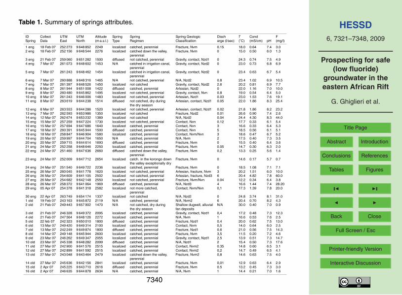
Table 1. Summary of springs attributes.
ID Collect UTM UTM Altitude Spring Spring Spring Geologic Disch T Cond FSpring Data East North (m a.s.l.) Type Regimen Classification arge (l/sec) (◦C) (mS/cm) pH (mg/l)
1 eng 18 Feb 07 252 273 9 648 852 2249 localized catched, perennial Fracture, Nvm 0.15 18.0 0.64 7.4 3.02 eng 18 Feb 07 252 156 9 648 544 2276 localized catched down the valley, Fracture, Nvm 0 15.0 0.50 6.0 1.3
perennial3 eng 21 Feb 07 259 060 9 651 282 1500 diffused not catched, perennial Gravity, contact, Nzd1 0 24.3 0.74 7.5 4.94 eng 7 Mar 07 261 073 9 648 602 1453 N/A catched in irrigation canal, Gravity, contact, Nzd2 0 23.0 0.73 6.8 6.9
perennial5 eng 7 Mar 07 261 243 9 648 462 1454 localized catched in irrigation canal, Gravity, contact, Nzd2 0 23.4 0.63 6.7 5.4
perennial6 eng 7 Mar 07 260 888 9 648 316 1465 N/A not catched, perennial N/A, Nzd2 0.8 23.4 1.02 6.9 10.57 eng 7 Mar 07 261 397 9 648 526 1450 localized not catched Gravity, contact, Nzd2 2.6 20.2 0.81 6.9 7.78 eng 8 Mar 07 261 944 9 651 008 1422 diffused catched, perennial Artesian, Nzd2 0 22.0 1.16 7.0 10.09 eng 8 Mar 07 260 480 9 645 862 1495 localized not catched, perennial Gravity, contact, Nvn 0.8 19.0 0.54 6.4 5.010 eng 8 Mar 07 261 243 9 646 006 1483 localized not catched, perennial Artesian, Nzd1 0.03 23.0 1.53 7.6 19.111 eng 8 Mar 07 263 619 9 644 238 1514 diffused not catched, dry during Artesian, contact, Nzd1 0.05 22.0 1.86 8.3 25.4
the dry season12 eng 8 Mar 07 263 553 9 644 286 1520 localized not catched, perennial Artesian, contact, Nzd1 0.02 21.8 1.86 8.2 23.213 eng 7 Mar 07 262 593 9 653 986 1350 localized not catched Fracture, Nzd2 0.01 26.6 0.90 7.4 2.614 eng 12 Mar 07 262 674 9 653 232 1389 localized not catched N/A, Nzd2 0.04 24.4 4.30 8.3 44.015 eng 15 Mar 07 257 259 9 647 224 1730 localized not catched, perennial Contact, Nvn 0.12 17.7 0.33 6.1 5.416 eng 15 Mar 07 257 694 9 647 686 1640 localized catched, perennial Contact, Nvn 3 16.6 0.33 6.4 5.317 eng 18 Mar 07 260 391 9 645 944 1500 diffused catched, perennial Contact, Nvn 5 18.5 0.56 6.1 5.118 eng 18 Mar 07 258 847 9 646 904 1580 localized catched, perennial Contact, Nvm/Nvn 3 18.6 0.47 6.7 5.219 eng 20 Mar 07 259 997 9 644 704 1650 N/A catched, perennial N/A, Nvm 2 17.5 0.40 7.3 3.520 eng 20 Mar 07 259 715 9 644 614 1693 diffused catched, perennial Fracture, Nvm 0 15.5 0.40 6.4 3.621 eng 24 Mar 07 252 258 9 648 646 2250 localized catched, perennial Fracture, Nvm 0.05 14.7 0.30 6.3 2.022 eng 24 Mar 07 251 460 9 647 636 2660 diffused catched down the valley, Fracture, Nvm 0.2 13.3 0.25 5.6 1.4
perennial23 eng 24 Mar 07 252 009 9 647 712 2654 localized catch. in the korongo down Fracture, Nvm 0 14.6 0.17 5.7 0.7
the valley exceptionally dry24 eng 24 Mar 07 251 540 9 649 722 2236 localized catched, perennial Fracture, Nvm 0 18.5 1.08 7.1 7.125 eng 26 Mar 07 260 045 9 641 778 1620 localized not catched, perennial Artesian, fracture, Nvm 3 20.2 1.51 6.0 10.026 eng 26 Mar 07 254 609 9 641 105 2502 localized not catched, perennial Artesian, fracture, Nzd3 6 20.4 4.82 7.8 60.027 eng 26 Mar 07 254 682 9 642 148 2550 localized not catched, perennial Fracture, Nvm/Nvn 0.04 12.2 0.34 6.4 3.828 eng 26 Mar 07 258 372 9 641 064 1969 diffused catched, perennial N/A, Nzd3 4 16.6 1.44 7.4 28.2029 eng 05 Apr 07 254 378 9 641 318 2582 localized not more catched, Contact, Nvm/Nvn 0,1 17.3 1.39 7.8 20.0
perennial30 eng 22 Apr 07 263 749 9 654 174 1337 localized not catched N/A, Nzd2 0 24.8 3.74 8.1 31.01 old 19 Feb 07 243 163 9 645 872 2119 N/A catched, perennial N/A, Nvm2 6 20.4 0.70 8.2 4.32 old 21 Feb 07 249 443 9 657 902 1470 N/A not catched, dry during Shallow dugwell, alluvial N/A 30.0 0.40 7.0 0.9
the dry season fan deposits3 old 21 Feb 07 246 328 9 649 372 2095 localized catched, perennial Gravity, contact, Nzd1 0,4 17.2 0.48 7.3 12.34 old 21 Feb 07 247 564 9 648 126 2272 localized catched, perennial N/A, Nvm 1 16.6 0.53 7.6 2.55 old 22 feb 07 242 323 9 650 010 1800 diffused catched, perennial Fracture, Nzd1 0.4 20.0 0.62 7.5 13.06 old 13 Mar 07 249 420 9 649 314 2100 localized catched, perennial Contact, Nvm 0,5 14.0 0.64 6.0 2.57 old 13 Mar 07 242 249 9 649 874 1800 diffused catched, perennial Fracture, Nzd1 0.6 21.0 0.56 7.5 14.38 old 14 Mar 07 249 148 9 645 944 2600 localized catched, perennial Fracture, Nvm 3,5 11.5 0.20 7.2 4.69 old 23 Mar 07 246 262 9 649 347 2055 localized catched, perennial Gravity, contact, Nzd1 2.5 13.9 0.51 7.3 14.710 old 23 Mar 07 245 338 9 648 282 2099 diffused catched, perennial N/A, Nzd1 2 15.4 0.50 7.3 17.611 old 27 Mar 07 242 900 9 641 576 2515 localized catched, perennial Contact, Nvm2 0.35 14.8 0.60 6.5 3.112 old 27 Mar 07 242 899 9 641 592 2515 localized catched, perennial Contact, Nvm2 0,2 14.7 0.49 6.5 4.113 old 27 Mar 07 243 048 9 643 464 2479 localized catched down the valley, Fracture, Nvm2 0,8 14.6 0.63 7.5 4.0
perennial14 old 27 Mar 07 245 636 9 642 156 2841 localized catched, perennial Fracture, Nvm 0,01 12.9 0.63 6.4 2.915 old 2 Apr 07 245 225 9 643 710 2616 diffused catched, perennial Fracture, Nvm 0.5 13.2 0.45 7.3 3.016 old 2 Apr 07 246 635 9 644 878 2634 N/A catched, perennial N/A, Nvm 1 14.4 0.21 7.0 1.6
7340

HESSD6, 7321–7348, 2009
Prospecting for safe(low fluoride)
groundwater in theeastern African Rift
G. Ghiglieri et al.
Title Page
Abstract Introduction
Conclusions References
Tables Figures
J I
J I
Back Close
Full Screen / Esc
Printer-friendly Version
Interactive Discussion
Table 2. Summary of rivers attributes interesting for groundwater and, therefore, only sound-ings pertaining to this ward will be discussed. The VES position map for the NgarenanyiukiWard is shown in Fig. 3.
ID Collect UTM UTM Altitude T Cond FRiver/Lake Data East North (m a.s.l.) (◦C) (mS/cm) pH (mg/l)
1 River 7 Mar 07 265 220 9 656 432 1282 26.6 1.08 8.5 28.02 River 12 Mar 07 262 671 9 653 238 1386 23.2 1.67 8.2 14.03 River 12 Mar 07 261 987 9 651 728 1417 22.8 1.21 7.6 6.24 River 12 Mar 07 260 664 9 651 158 1456 24.5 0.96 7.2 5.415 River 14 Mar 07 247 450 9 647 930 2280 19.0 0.43 7.3 1.929 River 22 Mar 261 137 9 642 677 1572 19.1 2.07 8.5 22.821 River 21 Mar 07 261 297 9 647 032 1469 25.4 1.89 8.1 13.023 River 19 Mar 07 262 096 9 649 314 1441 23.6 2.06 8.4 26.224 River 19 Mar 07 263 053 9 651 684 1405 25.0 2.40 8.8 26.822 River 19 Mar 07 261 639 9 647 560 1455 23.3 1.74 8.4 23.226 River 22 Mar 07 261 387 9 643 697 1537 20.4 1.78 8.4 29.430 River 21 Mar 07 243 477 9 644 073 2467 14.6 7.80 0.6 3.128 River 26 Mar 07 261 072 9 642 508 1583 17.9 2.12 8.5 28.01 Lake 23 Apr 07 265 699 9 643 622 1440 26.1 7.10 9.8 149.12 Lake 23 Apr 07 267 261 9 643 727 1440 25.8 N/A 10.3 528.0
7341

HESSD6, 7321–7348, 2009
Prospecting for safe(low fluoride)
groundwater in theeastern African Rift
G. Ghiglieri et al.
Title Page
Abstract Introduction
Conclusions References
Tables Figures
J I
J I
Back Close
Full Screen / Esc
Printer-friendly Version
Interactive Discussion
Table 3. Operative synthesis of the survey results. The sub-areas in the second column areshown in Fig. 3.
Ward Sub-area Drilling Maximumsuitability (0–5) drilling depth (m)
Ngarenanyuki A 1 40B 2 100C 1 80D 3 80E1 2 50E2 5 100
7342

HESSD6, 7321–7348, 2009
Prospecting for safe(low fluoride)
groundwater in theeastern African Rift
G. Ghiglieri et al.
Title Page
Abstract Introduction
Conclusions References
Tables Figures
J I
J I
Back Close
Full Screen / Esc
Printer-friendly Version
Interactive Discussion
Fig. 1. The study area.
7343

HESSD6, 7321–7348, 2009
Prospecting for safe(low fluoride)
groundwater in theeastern African Rift
G. Ghiglieri et al.
Title Page
Abstract Introduction
Conclusions References
Tables Figures
J I
J I
Back Close
Full Screen / Esc
Printer-friendly Version
Interactive Discussion
Fig. 2. Geological-Hydrogeological map with water location points.
7344

HESSD6, 7321–7348, 2009
Prospecting for safe(low fluoride)
groundwater in theeastern African Rift
G. Ghiglieri et al.
Title Page
Abstract Introduction
Conclusions References
Tables Figures
J I
J I
Back Close
Full Screen / Esc
Printer-friendly Version
Interactive Discussion
Fig. 3. Position map of the electrical soundings in the Ngarenanyuki Ward. Sub-areas definedon the basis of the results (see Table 3). For the geological legend, see Fig. 2.
7345

HESSD6, 7321–7348, 2009
Prospecting for safe(low fluoride)
groundwater in theeastern African Rift
G. Ghiglieri et al.
Title Page
Abstract Introduction
Conclusions References
Tables Figures
J I
J I
Back Close
Full Screen / Esc
Printer-friendly Version
Interactive Discussion
Fig. 4. Clayey level (paleosoil) between lahars and mantling ash.
7346
HESSD6, 7321–7348, 2009
Prospecting for safe(low fluoride)
groundwater in theeastern African Rift
G. Ghiglieri et al.
Title Page
Abstract Introduction
Conclusions References
Tables Figures
J I
J I
Back Close
Full Screen / Esc
Printer-friendly Version
Interactive Discussion
Fig. 5. (a) Apparent resistivity curves (left) and interpreted resistivity column (right). In thediagram, the small circles represent the experimental values, and the dotted line the apparentresistivity curve corresponding to the resistivity column on the right. (b) Apparent resistivitycurve and interpretation of VES ENG15. The resistivity column does not show any sign thatcould be associated with a confined aquifer.
7347

HESSD6, 7321–7348, 2009
Prospecting for safe(low fluoride)
groundwater in theeastern African Rift
G. Ghiglieri et al.
Title Page
Abstract Introduction
Conclusions References
Tables Figures
J I
J I
Back Close
Full Screen / Esc
Printer-friendly Version
Interactive Discussion
Fig. 6. (a) Geolocical-Hydrogeological cross section A-A’ (vertical exaggeration about x4).(b) Detail of the area surrounding the Ichnusa Well 1. (c) Geological-Hydrogeological crosssection B-B’ (Vertical exaggeration about x7) (d) – Ichnusa Well 1: lithological log and wellconstruction report. Comparison between the stratigraphy and the resistivity column of theelectrical sounding MK04.
7348