proposed local government inventory and heritage list
736
DEVELOPMENT COMMITTEE MEETING TUESDAY 20 NOVEMBER 2018 ATTACHMENT TO ITEM DV18.170 PROPOSED LOCAL GOVERNMENT INVENTORY AND HERITAGE LIST
-
Upload
khangminh22 -
Category
Documents
-
view
0 -
download
0
Transcript of proposed local government inventory and heritage list

DEVELOPMENT COMMITTEE MEETING
TUESDAY 20 NOVEMBER 2018
ATTACHMENT TO ITEM DV18.170
PROPOSED LOCAL GOVERNMENT INVENTORY AND HERITAGE LIST
LOCAL GOVERNMENT INVENTORY OF HERITAGE PLACES
2018
DV18.170 - ATTACHMENT 1 OF 5 - LOCAL GOVERNMENT INVENTORY REVISED

Local Government Inventory
2018 1
TABLE OF CONTENTS
TABLE OF CONTENTS ........................................................................................................................................ 1
TABLE OF FIGURES ............................................................................................................................................ 2
EXECUTIVE SUMMARY ...................................................................................................................................... 3
PLACES RECOMMENDED FOR LOCAL GOVERNMENT INVENTORY .................................................... 4
PLACES RECOMMENDED FOR INCLUSION ON THE SCHEME HERITAGE LIST ...................................... 8
1.0 METHODOLOGY AND TERMINOLOGY ............................................................................................... 11
2.0 STUDY AREA ........................................................................................................................................... 13
3.0 MANAGEMENT CATEGORIES .............................................................................................................. 14
4.0 THEMATIC FRAMEWORK ...................................................................................................................... 15
4.1 GEOGRAPHY ................................................................................................................................ 16
4.2 ABORIGINAL HISTORIES (PRE AND POST EUROPEAN SETTLEMENT) ......................................... 17
4.3 1829-1879 EARLY EUROPEAN SETTLERS AND THE ROMAN CATHOLIC CHURCH .................. 21
4.4 1880-1919 RAILWAYS, SUBDIVISIONS AND SUBURBAN SETTLEMENT ....................................... 29
4.5 1920-1949 GARDEN SUBURBS AND MODEL HOMES ................................................................ 39
4.6 1950 TO THE PRESENT [2018] POST WAR DEVELOPMENT ......................................................... 49
4.7 BIBLIOGRAPHY ............................................................................................................................. 60
5.0 SUMMARY TABLES ................................................................................................................................. 62
PLACES ASSESSED BY MANAGEMENT CATEGORY .............................................................................. 62
PLACE NOMINATIONS ............................................................................................................................ 66
6.0 PLACE RECORD FORMS ....................................................................................................................... 68
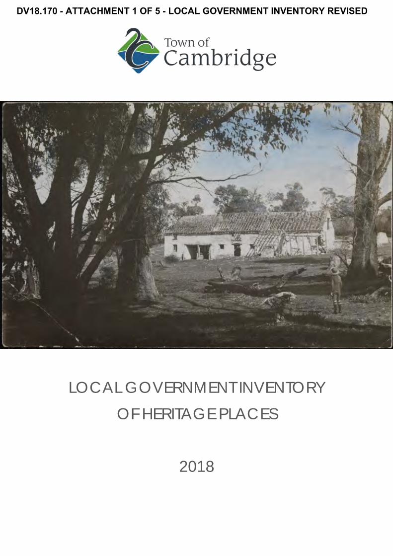
Cover Page: Joseph Perry’s Homestead at old Lime Kilns, c1916, Picture Cambridge image PH0885-01

Local Government Inventory
2018 2
TABLE OF FIGURES
Figure 1 Plan showing the Boundaries of the Town of Cambridge and Suburbs ................................... 13 Figure 2 Aerial view showing Town of Cambridge and Suburbs ............................................................... 16 Figure 3 Plan showing approximate boundaries of the Whadjuk Dialectical Groups .......................... 17 Figure 4 Place names and territories as told to Robert Lyon by Yagan in 1832. .................................... 18 Figure 5 Aboriginal Camp at Lake Monger north of Grantham Street Wembley, 1923. ...................... 19 Figure 6 Plan Swan 40, 1838 showing grants to William Leeder. ................................................................ 21 Figure 7 Portion of the plan showing the ‘Ribbon’ Grants in the Swan River Colony, 1839. ................ 22 Figure 8 Plan Swan 40, Showing grants near Herdsman’s Lake, 1842. ..................................................... 23 Figure 9 Abattoir at Bold Park built by Walter Padbury, c1860. ................................................................. 25 Figure 10 Giles expedition party at Perth, 1875 ............................................................................................... 26 Figure 11 Plan Swan 120, 1878 showing grants near Herdsman’s Lake. ..................................................... 27 Figure 12 Leederville Railway Station, c1900. .................................................................................................. 30 Figure 13 Real Estate Plan for Leeder Estate, c1890. ..................................................................................... 31 Figure 14 Laying of the Leederville Post Office Foundation Stone, 3 May 1897, ...................................... 32 Figure 15 Home of the Good Shepherd, 1915................................................................................................. 33 Figure 16 View of Railway Parade, Leederville with railway station at left, 1905 ..................................... 34 Figure 17 Postcard of Monger’s Lake, 1911 ..................................................................................................... 35 Figure 18 Plan showing survey of road from Subiaco Railway Station to the coast. ............................... 35 Figure 19 Promotional poster for the Church Lands Estate, c1915. ............................................................. 37 Figure 20 Plan showing extent of Endowment Lands c1894. ....................................................................... 41 Figure 21 Plank Road completed 1918 on path of Oceanic Drive ............................................................. 42 Figure 22 Cleared track of the future Boulevard to City Beach, 1927. ...................................................... 43 Figure 23 City Beach, 1926. ................................................................................................................................. 44 Figure 24 City Beach Life saving club 1927. ..................................................................................................... 44 Figure 25 Opening of Model Homes, Floreat Park. ......................................................................................... 45 Figure 26 Portion of plan showing tram routes in Perth, 1939. ...................................................................... 46 Figure 27 Wembley Hotel, n.d. ........................................................................................................................... 47 Figure 28 Laying the Foundation Stone for the Wembley Methodist Church, 1941. ............................... 48 Figure 29 335 Cambridge Street Wembley, 1952 ........................................................................................... 49 Figure 30 Plan showing progressive development of Floreat Park, 1953-1969. ........................................ 50 Figure 31 Plan showing progressive development of City Beach 1953-1968. ........................................... 50 Figure 32 Aerial view of Floreat, 1953. ............................................................................................................... 51 Figure 33 Aerial view of Floreat, 1965. ............................................................................................................... 52 Figure 34 Floreat Forum, 1966. ............................................................................................................................ 53 Figure 35 Games Village Gates, 1962. .............................................................................................................. 54 Figure 36 Games Village Gates, 1962. .............................................................................................................. 54 Figure 37 Arrival of HRH Prince Philip to open the Games, 1962.................................................................. 55 Figure 38 Demolition of Perry Lakes Stadium, 2012. ....................................................................................... 55 Figure 39 22 Lifford Road, Floreat, Schmidt-Lademann House. 1958: ........................................................ 56 Figure 40 Building the Quarry Amphitheatre, 1986. ........................................................................................ 57

Local Government Inventory
2018 3
EXECUTIVE SUMMARY The rich history of the Town of Cambridge is embedded in the fabric of the Town’s many heritage buildings and places. The Town's vision is for these buildings and places to be protected, enhanced and celebrated. The Town of Cambridge is committed to conserving and promoting its local heritage to ensure that its history is preserved for generations to come.
Local Government Inventories (LGI) identify local heritage places in a systematic fashion, and provide the base information needed for local heritage planning to achieve consistency, strategic direction, and community support.
The Heritage of Western Australia Act 1990 requires all local government authorities in Western Australia to compile, and periodically update and review their Municipal Heritage Inventories. 1
The relevant Section (45) of the Heritage of Western Australia Act 1990 states that:
1) A local government shall compile and maintain an inventory of buildings within its district which in its opinion are, or may become, of cultural heritage significance.
2) The inventory required by Subsection (1) shall be compiled no later than 4 years from the commencement of this Act and shall be (a) updated annually; and (b) reviewed every 4 years after compilation.
3) A local government shall provide the [Heritage] Council with a copy of the Inventory compiled pursuant to this section.
4) A local government shall ensure that the inventory required by this section is compiled with proper public consultation.
The Town of Cambridge adopted its first Municipal Inventory in 1997, and since then the Council has considered a number of heritage related matters but no systematic review has been undertaken.
The Town of Cambridge commissioned consultants to review the 1997 Local Government Inventory with a comprehensive community engagement. This document is the culmination of the review process and includes the following key elements
• Review of the documentary and physical evidence for the places currently on the LGI; • New documentary and physical evidence for places nominated for inclusion on the LGI; • Allocation of a management category for all places (current and new) in accordance with
the current Heritage Council of Western Australia guidelines; and • Summary tables of the review findings.
1 State Heritage Office Basic Principles for Local Government Inventories March 2012,
www.stateheritageoffice.wa.gov.au accessed May 2012.

Local Government Inventory
2018 4
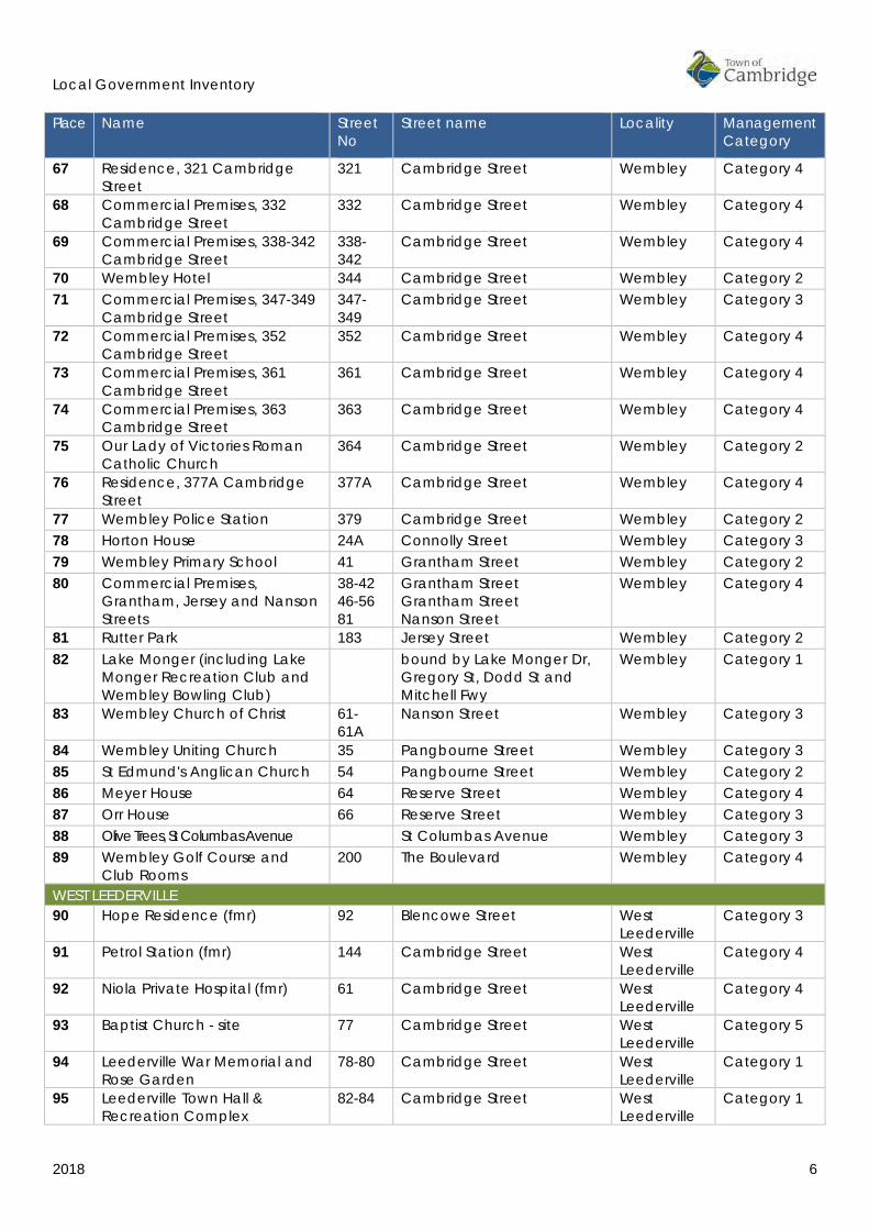
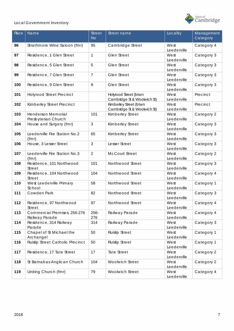
PLACES RECOMMENDED FOR LOCAL GOVERNMENT INVENTORY The following places have been recommended for inclusion on the Local Government Inventory of Heritage Places for their cultural heritage values. Refer to Section 6.0 for details of each place.
Place Name Street No
Street name Locality Management Category
CITY BEACH 1 Maxwell House 3 Asten Road City Beach Category 2 2 Residences, 4, 10 and 19
Branksome Gardens 4, 10, 19
Branksome Gardens City Beach Category 4
3 St Paul's Church and Hall 57 Brompton Road City Beach Category 3 4 Kapinara Primary School 2 Catesby Street City Beach Category 3 5 South City Beach Kiosk Challenger Parade City Beach Category 2 6 Floreat Beach and Groyne Challenger Parade City Beach Category 3 7 Floreat Kiosk Challenger Parade City Beach Category 2 8 Wright House 24 Dilkara Way City Beach Category 2 9 Tomich House 7 Dorking Road City Beach Category 2 10 British Empire and
Commonwealth Games Village (fmr)
bound by Dupont Ave, Oban Rd, Tilton Tce, Gifford Gdns, Pandora Dr and The Boulevard
City Beach Category 4
11 City Beach Ovals 20 Fred Burton Way City Beach Category 4 12 Beecroft Park 32 Gayton Road City Beach Category 3 13 House, 17 Hovea Crescent 17 Hovea Crescent City Beach Category 4 14 Happy Tree Hovea Crescent City Beach Category 2 15 City Beach High School (fmr) 20 Kalinda Drive City Beach Category 3 16 Holy Spirit Catholic Church 2 Keaney Place City Beach Category 1 17 Holy Spirit Parish Complex 2 Keaney Place City Beach Category 4 18 City Beach Primary School 30 Marapana Road City Beach Category 3 19 Ryan Residence (fmr) 14 Marimba Crescent City Beach Category 4 20 Booth House 59 Oban Road City Beach Category 4 21 Quarry Amphitheatre 145 Oceanic Drive City Beach Category 1 22 City Beach, Groyne and
Lookout Tower Challenger Parade City Beach Category 3
23 Bold Park bound by The Boulevard, Bold Park Dr, Perry Lakes Dr, Stephenson Ave, West Coast Hwy, Challenger Pde, Oceanic Dr and Kalinda Dr
City Beach Category 2
24 Lisle House 9 Pindari Road City Beach Category 3 25 Templetonia Park Templetonia Crescent City Beach Category 4 26 St Christopher's Anglican
Church 25 Templetonia Crescent City Beach Category 3
27 City Beach Civic Centre 33 Templetonia Crescent City Beach Category 4 28 Murphy House 14 Tranmore Way City Beach Category 2 29 Ocean Village Park bound by Brompton Rd,
Yaltara Rd, Hale Rd & Kilpa Ct City Beach Category 4
30 Roberts Residence 12 Yanagin Crescent City Beach Category 2 FLOREAT 31 Schenberg House 4 Alyth Road Floreat Category 2 32 St Nicholas' Anglican Church 45 Berkeley Crescent Floreat Category 2 33 All Saints Uniting Church and
Crawford Hall 48 Berkeley Crescent Floreat Category 4

Local Government Inventory
2018 5
Place Name Street No
Street name Locality Management Category
34 Floreat Oval 39 Chandler Avenue West Floreat Category 4 35 Floreat Park Primary School 38 Chandler Avenue West Floreat Category 2 36 Residence, 32 Donegal Road 32 Donegal Road Floreat Category 2 37 Floreat Forum Shopping
Centre 5 Howtree Place Floreat Category 4
38 Iwanoff House 16 Lifford Road Floreat Category 2 39 Schmidt-Lademann House 22 Lifford Road Floreat Category 2 40 St Cecilia's Roman Catholic
Church 47 Peebles Road Floreat Category 2
41 Perry Lakes Reserve Perry Lakes Drive Floreat Category 2 42 Perry House 167 Perry Lakes Drive Floreat Category 2 43 Perry Lakes Scoreboard 1 Stadium Drive Floreat Category 2 44 Avenue of Trees, The
Boulevard The Boulevard (btwn
Cambridge St & Chipping Rd)
Floreat/City Beach
Category 4
45 McLean Park The Boulevard Floreat Category 4 46 Model Timber Home 12 The Boulevard Floreat Category 1 47 Paganin House (fmr) 165 The Boulevard Floreat Category 4 48 Model Brick Home 6 The Boulevard Floreat Category 1 49 Dempster House 82 The Boulevard Floreat Category 4 50 St Nicholas Church Hall 84 The Boulevard Floreat Category 5 JOLIMONT 51 Henderson Park 99 Jersey Street Jolimont Category 2 52 Matthews Netball Centre 199 Salvado Road Jolimont Category 3 SUBIACO 53 St John of God Hospital 12 Salvado Road Subiaco Category 5 WEMBLEY 54 Catherine McAuley Centre 18 Barrett Street Wembley Category 1 55 St Vincent's Foundling Home (fmr) 18 Barrett Street Wembley Category 1 56 Olive Trees, Barrett Street 18 Barrett Street Wembley Category 1 57 Benedictine Stables (fmr) 18 Barrett Street Wembley Category 1 58 Wembley Theatre and
Gardens (fmr) 202 Cambridge Street Wembley Category 3
59 Commercial Premises, 284 Cambridge Street
284 Cambridge Street Wembley Category 4
60 Commercial Premises, 286 Cambridge Street
286 Cambridge Street Wembley Category 3
61 Commercial Premises, 288 Cambridge Street
288 Cambridge Street Wembley Category 2
62 Commercial Premises, 294 Cambridge Street
294 Cambridge Street Wembley Category 3
63 Commercial Premises, 296 Cambridge Street
296 Cambridge Street Wembley Category 4
64 Residence, 316 Cambridge Street
316 Cambridge Street Wembley Category 3
65 Commercial Premises, 318 Cambridge Street
318 Cambridge Street Wembley Category 4
66 Residence, 319A Cambridge Street
319A Cambridge Street Wembley Category 4
Local Government Inventory
2018 6
Place Name Street No
Street name Locality Management Category
67 Residence, 321 Cambridge Street
321 Cambridge Street Wembley Category 4
68 Commercial Premises, 332 Cambridge Street
332 Cambridge Street Wembley Category 4
69 Commercial Premises, 338-342 Cambridge Street
338-342
Cambridge Street Wembley Category 4
70 Wembley Hotel 344 Cambridge Street Wembley Category 2 71 Commercial Premises, 347-349
Cambridge Street 347-349
Cambridge Street Wembley Category 3
72 Commercial Premises, 352 Cambridge Street
352 Cambridge Street Wembley Category 4
73 Commercial Premises, 361 Cambridge Street
361 Cambridge Street Wembley Category 4
74 Commercial Premises, 363 Cambridge Street
363 Cambridge Street Wembley Category 4
75 Our Lady of Victories Roman Catholic Church
364 Cambridge Street Wembley Category 2
76 Residence, 377A Cambridge Street
377A Cambridge Street Wembley Category 4
77 Wembley Police Station 379 Cambridge Street Wembley Category 2 78 Horton House 24A Connolly Street Wembley Category 3 79 Wembley Primary School 41 Grantham Street Wembley Category 2 80 Commercial Premises,
Grantham, Jersey and Nanson Streets
38-42 46-56 81
Grantham Street Grantham Street Nanson Street
Wembley Category 4
81 Rutter Park 183 Jersey Street Wembley Category 2 82 Lake Monger (including Lake
Monger Recreation Club and Wembley Bowling Club)
bound by Lake Monger Dr, Gregory St, Dodd St and Mitchell Fwy
Wembley Category 1
83 Wembley Church of Christ 61-61A
Nanson Street Wembley Category 3
84 Wembley Uniting Church 35 Pangbourne Street Wembley Category 3 85 St Edmund's Anglican Church 54 Pangbourne Street Wembley Category 2 86 Meyer House 64 Reserve Street Wembley Category 4 87 Orr House 66 Reserve Street Wembley Category 3 88 Olive Trees, St Columbas Avenue St Columbas Avenue Wembley Category 3 89 Wembley Golf Course and
Club Rooms 200 The Boulevard Wembley Category 4
WEST LEEDERVILLE 90 Hope Residence (fmr) 92 Blencowe Street West
Leederville Category 3
91 Petrol Station (fmr) 144 Cambridge Street West Leederville
Category 4
92 Niola Private Hospital (fmr) 61 Cambridge Street West Leederville
Category 4
93 Baptist Church - site 77 Cambridge Street West Leederville
Category 5
94 Leederville War Memorial and Rose Garden
78-80 Cambridge Street West Leederville
Category 1
95 Leederville Town Hall & Recreation Complex
82-84 Cambridge Street West Leederville
Category 1
Local Government Inventory
2018 7
Place Name Street No
Street name Locality Management Category
96 Strathmore Wine Saloon (fmr) 95 Cambridge Street West Leederville
Category 4
97 Residence, 1 Glen Street 1 Glen Street West Leederville
Category 3
98 Residence, 5 Glen Street 5 Glen Street West Leederville
Category 3
99 Residence, 7 Glen Street 7 Glen Street West Leederville
Category 3
100 Residence, 9 Glen Street 9 Glen Street West Leederville
Category 3
101 Holyrood Street Precinct Holyrood Street (btwn Cambridge St & Woolwich St)
West Leederville
Precinct
102 Kimberley Street Precinct Kimberley Street (btwn Cambridge St & Woolwich St)
West Leederville
Precinct
103 Henderson Memorial Presbyterian Church
101 Kimberley Street West Leederville
Category 2
104 House and Surgery (fmr) 3 Kimberley Street West Leederville
Category 3
105 Leederville Fire Station No.2 (fmr)
65 Kimberley Street West Leederville
Category 3
106 House, 3 Lesser Street 3 Lesser Street West Leederville
Category 3
107 Leederville Fire Station No.3 (fmr)
2 McCourt Street West Leederville
Category 2
108 Residence, 101 Northwood Street
101 Northwood Street West Leederville
Category 3
109 Residence, 104 Northwood Street
104 Northwood Street West Leederville
Category 4
110 West Leederville Primary School
58 Northwood Street West Leederville
Category 1
111 Cowden Park 82 Northwood Street West Leederville
Category 3
112 Residence, 97 Northwood Street
97 Northwood Street West Leederville
Category 4
113 Commercial Premises, 256-276 Railway Parade
256-276
Railway Parade West Leederville
Category 4
114 Residence, 314 Railway Parade
314 Railway Parade West Leederville
Category 3
115 Chapel of St Michael the Archangel
50 Ruislip Street West Leederville
Category 1
116 Ruislip Street Catholic Precinct 50 Ruislip Street West Leederville
Category 1
117 Residence, 17 Tate Street 17 Tate Street West Leederville
Category 2
118 St Barnabas Anglican Church 104 Woolwich Street West Leederville
Category 2
119 Uniting Church (fmr) 79 Woolwich Street West Leederville
Category 4

Local Government Inventory
2018 8
PLACES RECOMMENDED FOR INCLUSION ON THE SCHEME HERITAGE LIST The following places are recommended for inclusion on the Scheme Heritage list.
The Scheme Heritage List is those places compiled under the Town’s Town Planning Scheme for which planning approval will be required for demolition, alterations or other development affecting the cultural heritage significance of the place.
The Scheme Heritage Lists must be compiled with regard to the Local Government Inventory, but do not necessarily include all places in the Inventory. It is recommended the Town includes all places on the Local Government Inventory with a Management Category of 1, 2 and 3 on the Scheme Heritage list.
Place No.
Name House No.
Road Name Locality
CATEGORY 1 16 Holy Spirit Catholic Church 2 Keaney Place City Beach 21 Quarry Amphitheatre 145 Oceanic Drive City Beach 46 Model Timber Home 12 The Boulevard Floreat 48 Model Brick Home 6 The Boulevard Floreat 54 Catherine McAuley Centre 18 Barrett Street Wembley 55 St Vincent's Foundling Home (fmr) 18 Barrett Street Wembley 56 Olive Trees, Barrett Street 18 Barrett Street Wembley 57 Benedictine Stables (fmr) 18 Barrett Street Wembley 82 Lake Monger (including Lake Monger
Recreation Club and Wembley Bowling Club)
bound by Lake Monger Dr, Gregory St, Dodd St and Mitchell Fwy
Wembley
94 Leederville War Memorial and Rose Garden 78-80 Cambridge Street West Leederville 95 Leederville Town Hall & Recreation Complex 82-84 Cambridge Street West Leederville 110 West Leederville Primary School 58 Northwood Street West Leederville 115 Chapel of St Michael the Archangel 50 Ruislip Street West Leederville 116 Ruislip Street Catholic Precinct 50 Ruislip Street West Leederville CATEGORY 2
1 Maxwell House 3 Asten Road City Beach 5 South City Beach Kiosk Challenger Parade City Beach 7 Floreat Kiosk Challenger Parade City Beach 8 Wright House 24 Dilkara Way City Beach 9 Tomich House 7 Dorking Road City Beach 14 Happy Tree Hovea Crescent City Beach 23 Bold Park bound by The
Boulevard, Bold Park Dr, Perry Lakes Dr, Stephenson Ave, West Coast Hwy, Challenger Pde, Oceanic Dr and Kalinda Dr
City Beach
28 Murphy House 14 Tranmore Way City Beach 30 Roberts Residence 12 Yanagin Crescent City Beach 31 Schenberg House 4 Alyth Road Floreat 32 St Nicholas' Anglican Church 45 Berkeley Crescent Floreat

Local Government Inventory
2018 9
Place No.
Name House No.
Road Name Locality
35 Floreat Park Primary School 38 Chandler Avenue West
Floreat
36 Residence, 32 Donegal Road 32 Donegal Road Floreat 38 Iwanoff House 16 Lifford Road Floreat 39 Schmidt-Lademann House 22 Lifford Road Floreat 40 St Cecilia's Roman Catholic Church 47 Peebles Road Floreat 41 Perry Lakes Reserve Perry Lakes Drive Floreat 42 Perry House 167 Perry Lakes Drive Floreat 43 Perry Lakes Scoreboard 1 Stadium Drive Floreat 51 Henderson Park 99 Jersey Street Jolimont 61 Commercial Premises, 288 Cambridge Street 288 Cambridge Street Wembley 70 Wembley Hotel 344 Cambridge Street Wembley 75 Our Lady of Victories Roman Catholic
Church 364 Cambridge Street Wembley
77 Wembley Police Station 379 Cambridge Street Wembley 79 Wembley Primary School 41 Grantham Street Wembley 81 Rutter Park 183 Jersey Street Wembley 85 St Edmund's Anglican Church 54 Pangbourne Street Wembley 103 Henderson Memorial Presbyterian Church 101 Kimberley Street West Leederville 107 Leederville Fire Station No.3 (fmr) 2 McCourt Street West Leederville 117 Residence, 17 Tate Street 17 Tate Street West Leederville 118 St Barnabas Anglican Church 104 Woolwich Street West Leederville CATEGORY 3
3 St Paul's Church and Hall 57 Brompton Road City Beach 4 Kapinara Primary School 2 Catesby Street City Beach 6 Floreat Beach and Groyne Challenger Parade City Beach 12 Beecroft Park 32 Gayton Road City Beach 15 City Beach High School (fmr) 20 Kalinda Drive City Beach 18 City Beach Primary School 30 Marapana Road City Beach 22 City Beach, Groyne and Lookout Tower Challenger Parade City Beach 24 Lisle House 9 Pindari Road City Beach 26 St Christopher's Anglican Church 25 Templetonia Crescent City Beach 52 Matthews Netball Centre 199 Salvado Road Jolimont 58 Wembley Theatre and Gardens (fmr) 202 Cambridge Street Wembley 60 Commercial Premises, 286 Cambridge Street 286 Cambridge Street Wembley 62 Commercial Premises, 294 Cambridge Street 294 Cambridge Street Wembley 64 Residence, 316 Cambridge Street 316 Cambridge Street Wembley 71 Commercial Premises, 347-349 Cambridge
Street 347-349
Cambridge Street Wembley
78 Horton House 24A Connolly Street Wembley 83 Wembley Church of Christ 61-
61A Nanson Street Wembley
84 Wembley Uniting Church 35 Pangbourne Street Wembley 87 Orr House 66 Reserve Street Wembley 88 Olive Trees, St Columbas Avenue St Columbas Avenue Wembley 90 Hope Residence (fmr) 92 Blencowe Street West Leederville
Local Government Inventory
2018 10
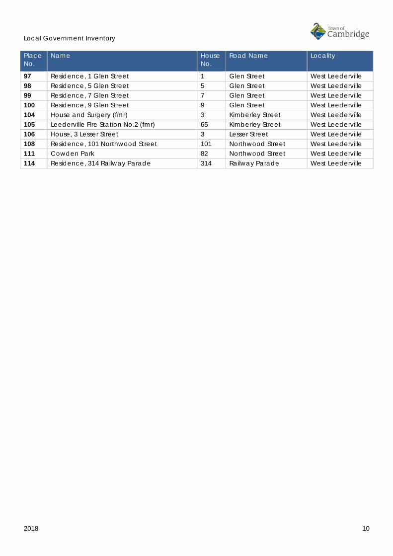
Place No.
Name House No.
Road Name Locality
97 Residence, 1 Glen Street 1 Glen Street West Leederville 98 Residence, 5 Glen Street 5 Glen Street West Leederville 99 Residence, 7 Glen Street 7 Glen Street West Leederville 100 Residence, 9 Glen Street 9 Glen Street West Leederville 104 House and Surgery (fmr) 3 Kimberley Street West Leederville 105 Leederville Fire Station No.2 (fmr) 65 Kimberley Street West Leederville 106 House, 3 Lesser Street 3 Lesser Street West Leederville 108 Residence, 101 Northwood Street 101 Northwood Street West Leederville 111 Cowden Park 82 Northwood Street West Leederville 114 Residence, 314 Railway Parade 314 Railway Parade West Leederville
Local Government Inventory
2018 11
1.0 METHODOLOGY AND TERMINOLOGY The preparation of this Local Government Inventory was undertaken with reference to the Guidelines prepared by the Heritage Council of Western Australia of Western Australia in consultation with the Town of Cambridge. The key documents all available from the Heritage Council of Western Australia website2 are:
• Heritage Council of Western Australia, Criteria for the Assessment of Local Heritage Places and Areas, March 2012.
• Heritage Council of Western Australia, Basic Principles for Local Government Inventories, March 2012.
• Heritage Council of Western Australia, Local Planning Policies Practice Notes and Examples, March 2012.
For clarity, the term ‘place’, as defined in The Burra Charter3 as:
Place Means site, area, building or other work, group of buildings or other works together with associated contents and surrounds.
In the proposed Heritage Bill 2015 the term place is defined as follows;
(1) In this Act — place means a defined or readily identifiable area of land.
(2) For the purposes of subsection (1) — (a) the area of land may be contiguous or may comprise any number of non-contiguous
parts; (b) the area of land may be comprised in separate titles and in different ownership; and (c) the area of land includes as much of the land beneath the surface as is required for the
purposes of conservation; and (d) it is immaterial that water covers the land at any particular time or at all times.
(3) Any of the following things at a place can be regarded as forming part of a place — (a) archaeological remains; (b) buildings, structures and other built forms and their surrounds; (c) equipment, furniture, fittings or other objects (whether fixed or not) that are historically
or physically associated or connected with the place; (d) gardens, man-made parks or sites; (e) a tree or group of trees (whether planted or naturally occurring) in, or adjacent to, a
man-made setting.4
From this information values are ascribed using the following criteria:
Aesthetic Value It is significant in exhibiting particular aesthetic characteristics. 2 Heritage Council and State Heritage Office website, http://www.heritage.wa.gov.au/ 3 The Burra Charter: The Australia ICOMOS Charter for Places of Cultural Significance 1999,
http://australia.icomos.org/publications/charters/ accessed December 2015. 4 Heritage Bill 2015 (Exposure Draft), WA Parliament, 12 August 2015, Parliament of WA,
www.parliament.wa.gov.au accessed December 2015.

Local Government Inventory
2018 12
Historic Value It is significant in the evolution or pattern of the history of the local district.
Research Value It has demonstrable potential to yield information that will contribute to an understanding of the natural or cultural history of the local district.
It is significant in demonstrating a high degree of technical innovation or achievement.
Social Value It is significant through association with a community or cultural group in the local district for social, cultural, educational or spiritual reasons.
Rarity It demonstrates rare, uncommon or endangered aspects of the cultural heritage of the local district.
Representativeness It is significant in demonstrating the characteristics of a class of cultural places or environments in the local district.
Condition The current state of the place in relation to the values for which that place has been assessed, and is generally graded on the scale of Good, Fair or Poor.
Integrity The extent to which a building retains its original function, generally graded on a scale of High, Medium or Low.
Authenticity The extent to which the fabric is in its original state, generally graded on a scale of High, Medium or Low.
In accordance with the Heritage Council of Western Australia Guidelines, the assessment process consisted of a site visit to photograph the place, and to record the condition of the physical fabric with reference to the surrounding streetscape and environment. The accuracy of the land information and historical information for each place was checked and added to where necessary.
For new nominations a short history of each place was prepared in addition to the physical evidence relating to the place.
Once each place was documented the level of significance and management category were ascribed. The management category is a tool for the Town of Cambridge when assessing individual development applications and for forward planning.
Local Government Inventory
2018 13
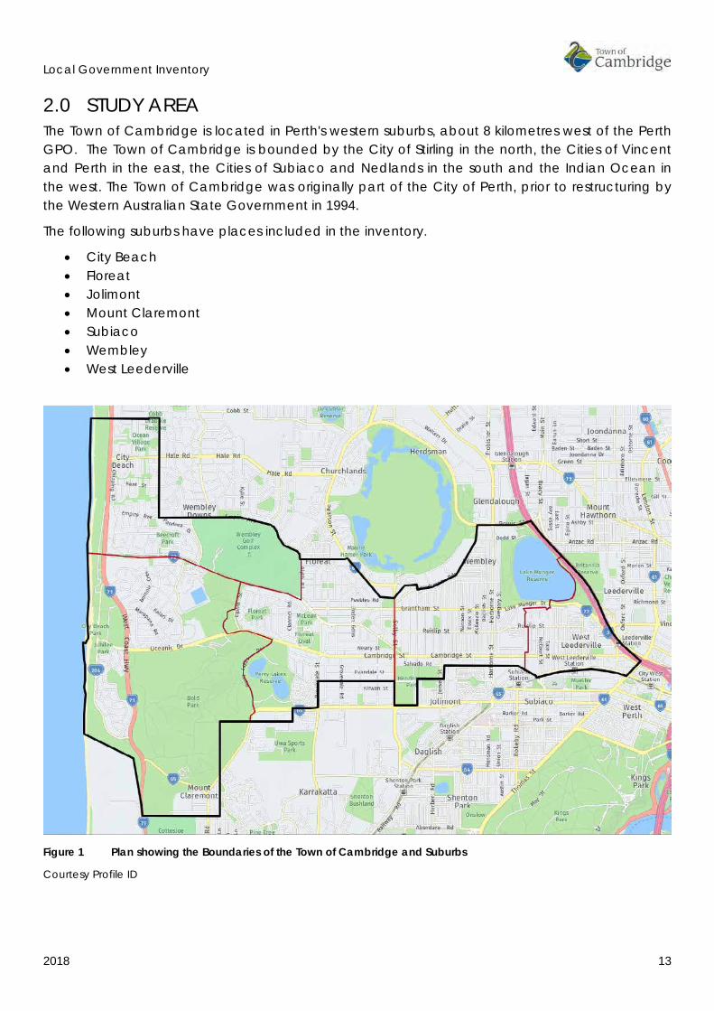
2.0 STUDY AREA The Town of Cambridge is located in Perth's western suburbs, about 8 kilometres west of the Perth GPO. The Town of Cambridge is bounded by the City of Stirling in the north, the Cities of Vincent and Perth in the east, the Cities of Subiaco and Nedlands in the south and the Indian Ocean in the west. The Town of Cambridge was originally part of the City of Perth, prior to restructuring by the Western Australian State Government in 1994.
The following suburbs have places included in the inventory.
• City Beach • Floreat • Jolimont • Mount Claremont • Subiaco • Wembley • West Leederville
Figure 1 Plan showing the Boundaries of the Town of Cambridge and Suburbs
Courtesy Profile ID

Local Government Inventory
2018 14
3.0 MANAGEMENT CATEGORIES The following categories are consistent with the Heritage Council of Western Australia document Criteria for Assessment of Local Heritage Places and Areas.
The management categories assigned in this draft report are recommendations only.
CATEGORY LEVEL OF SIGNIFICANCE DESIRED OUTCOME 1 Exceptional Significance
Essential to the heritage of the locality. Rare or outstanding example. Recommended for inclusion on the State Register of Heritage Places.
The place should be retained and conserved unless there is no feasible and prudent alternative to doing otherwise.
Any alterations or extensions should reinforce the significance of the place, and be in accordance with a Conservation Plan (if one exists for the place).
Include on the Town Planning Scheme No 1 Heritage List.
2 Considerable Significance
Very important to the heritage of the locality.
High degree of integrity/authenticity
Conservation of the place is highly desirable. Any alterations or extensions should reinforce the significance of the place.
Include on the Town Planning Scheme No 1 Heritage List.
3 Some/Moderate Significance
Contributes to the heritage of the locality. Has some altered or modified elements, not necessarily detracting from the overall significance of the item
Conservation of the place is desirable.
Any alterations or extensions should reinforce the significance of the place, and original fabric should be retained wherever feasible.
Include on the Town Planning Scheme No 1 Heritage List.
4 Little significance
Contributes to the understanding of the history of the Town of Cambridge.
Photographically record prior to major development or demolition.
Recognise and interpret the site if possible.
Do not include on the Town Planning Scheme No 1 Heritage List.
5 Historic Site
Site relevant to a past event, group or individual which contributes to the understanding of the history of the Town of Cambridge.
Recognise and interpret the site if possible.
Do not include on the Town Planning Scheme No 1 Heritage List.
Local Government Inventory
2018 15
4.0 THEMATIC FRAMEWORK The aim of this thematic history is to provide a context for the review of the Town of Cambridge’s Local Government Inventory. This framework is essential to understanding and recognising the cultural heritage significance of places within the Town of Cambridge and ensuring the Local Government Inventory is as representative as possible.
This section therefore looks specifically at the establishment and growth of the Town of Cambridge; dating from pre-European history up to the present day (2018). Its purpose is not to provide a social or local history of the area; these can be found elsewhere. Rather, it is to write a broad overview of the evolution of the Town in order to identify turning points in its history, the main periods of its development, and key stories, themes and influential factors that have all shaped the Town of Cambridge’s distinctive character.
The historical material in this section has been compiled primarily from the earlier Municipal Heritage Inventory and Townscape Precinct Study prepared by Heritage and Conservation Professionals in 1997. Acknowledgement is extended to the authors of that document.
• Rosemary Rosario • Wendy Brady • Annette Green • Gaye Nayton • Philip Palmer
A complete list of the references used to compile the earlier thematic history has been included in the bibliography and added to where appropriate. Where direct quotes have been used they have been identified.
The thematic history has been divided into time periods, which correspond to important developments in the district although it is acknowledged these time frames are arbitrary and therefore trends do flow across time periods. Every effort has been made to address the indigenous history of the Town of Cambridge throughout the history although it is important to acknowledge that indigenous sites are protected under the Aboriginal Heritage Act 1972.5
• Aboriginal Histories (Pre and Post European Settlement • 1829-1879 – Early European Settlers and the Roman Catholic Church • 1880-1919 – Railways, Subdivisions and Suburban Settlement • 1920-1949 – Garden Suburbs and Model Homes • 1950 to the present – Post War Development and the Empire Games
5 Aboriginal Heritage Act (1972), State Law Publisher, https://www.slp.wa.gov.au

Local Government Inventory
2018 16
4.1 GEOGRAPHY The Town of Cambridge was established on 1 July 1994 through the restructuring of the City of Perth which led to the creation of four suburban municipalities.
The Town of Cambridge is located in Perth's western suburbs, about 8 kilometres west of the Perth GPO. The Town of Cambridge is bounded by the City of Stirling in the north, the Cities of Vincent and Perth in the east, the Cities of Subiaco and Nedlands in the south and the Indian Ocean in the west. The Town of Cambridge is a predominantly residential area, with significant parklands and recreational areas.
The Town of Cambridge includes Lake Monger, at its eastern end, which was a major component of the area of lakes and swamps located to the north of the original Perth settlement and originally known as the Great Lakes. This area was partially drained in the 1880s in order to facilitate residential settlement. The town stretches across the sandy coastal plains to the ocean and includes the reserve of natural bushland known as Bold Park. The area includes the natural limestone ridge which separates West Leederville, Wembley and Floreat from the coastal suburb of City Beach.
Figure 2 Aerial view showing Town of Cambridge and Suburbs
Courtesy Profile ID

Local Government Inventory
2018 17
4.2 ABORIGINAL HISTORIES (PRE AND POST EUROPEAN SETTLEMENT) The histories of Aboriginal people in what is now the local government area of the Town of Cambridge cannot be defined as neatly and easily as boundaries and streets. Instead, Aboriginal people’s histories relate to social organisation, land relationships, events and experiences in the area.
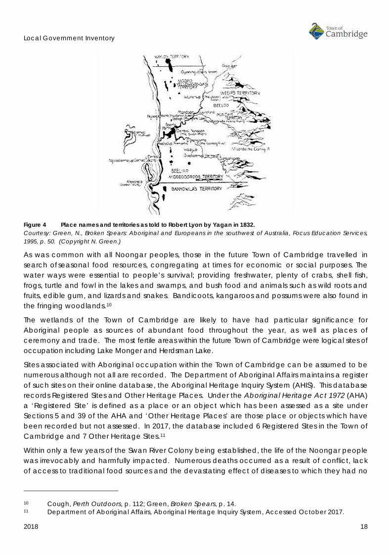
The Aboriginal peoples who occupied the lands in the south west corner of Western Australia are collectively known as the Noongar peoples.6 The future Town of Cambridge falls within the region of the Whadjuk dialectical groups.7 The major cities and towns within the Whadjuk region include Perth, Fremantle, Joondalup, Armadale, Toodyay, Wundowie, Bullsbrook and Chidlow.8
Figure 3 Plan showing approximate boundaries of the Whadjuk Dialectical Groups Courtesy http://www.noongarculture.org.au/whadjuk/
In 1832, the early settler Robert Menli Lyon, with the help of Yagan, then a prisoner on Carnac Island, compiled a list of Aboriginal groups in contact with the Swan River settlement. This information was published in the Perth Gazette in 1833.9 A rough plan of the groups around the Swan River is shown in Figure 4.
6 There are many spellings for Noongar, including, Nyoongar, Nyoongah, Nyungah, Nyugah, Yungar
and Noongah. This document uses the spelling Noongar as used by the South West Aboriginal Land & Sea Council.
7 South West Aboriginal Land & Sea Council, ‘Connection to Country’, Kaartdijin Noongar – Noongar Knowledge website, accessed March 2017.
8 South West Aboriginal Land & Sea Council, ‘Whadjuk’, Kaartdijin Noongar – Noongar Knowledge website, accessed March 2017.
9 Perth Gazette, 20 April 1833.
Local Government Inventory
2018 18
Figure 4 Place names and territories as told to Robert Lyon by Yagan in 1832. Courtesy: Green, N., Broken Spears: Aboriginal and Europeans in the southwest of Australia, Focus Education Services, 1995, p. 50. (Copyright N. Green.)
As was common with all Noongar peoples, those in the future Town of Cambridge travelled in search of seasonal food resources, congregating at times for economic or social purposes. The water ways were essential to people’s survival; providing freshwater, plenty of crabs, shell fish, frogs, turtle and fowl in the lakes and swamps, and bush food and animals such as wild roots and fruits, edible gum, and lizards and snakes. Bandicoots, kangaroos and possums were also found in the fringing woodlands.10
The wetlands of the Town of Cambridge are likely to have had particular significance for Aboriginal people as sources of abundant food throughout the year, as well as places of ceremony and trade. The most fertile areas within the future Town of Cambridge were logical sites of occupation including Lake Monger and Herdsman Lake.
Sites associated with Aboriginal occupation within the Town of Cambridge can be assumed to be numerous although not all are recorded. The Department of Aboriginal Affairs maintains a register of such sites on their online database, the Aboriginal Heritage Inquiry System (AHIS). This database records Registered Sites and Other Heritage Places. Under the Aboriginal Heritage Act 1972 (AHA) a ‘Registered Site’ is defined as a place or an object which has been assessed as a site under Sections 5 and 39 of the AHA and ‘Other Heritage Places’ are those place or objects which have been recorded but not assessed. In 2017, the database included 6 Registered Sites in the Town of Cambridge and 7 Other Heritage Sites.11
Within only a few years of the Swan River Colony being established, the life of the Noongar people was irrevocably and harmfully impacted. Numerous deaths occurred as a result of conflict, lack of access to traditional food sources and the devastating effect of diseases to which they had no
10 Cough, Perth Outdoors, p. 112; Green, Broken Spears, p. 14. 11 Department of Aboriginal Affairs, Aboriginal Heritage Inquiry System, Accessed October 2017.
Local Government Inventory
2018 19
natural immunity. Relationships with the land were all but destroyed through expansion of European settlement.12
The basis of Noongar traditions was also undermined as Aborigines were drawn into the political economy of settler society. As early as 1833, Aboriginal labour was employed in a variety of occupations. By 1848, estimates put the number of Aborigines employed by the colonists at 540.13
Relationships between the settlers and indigenous lead to changes in the population, by 1900, there was a gradual increase in the part-Aboriginal population of the south-west of Western Australia.
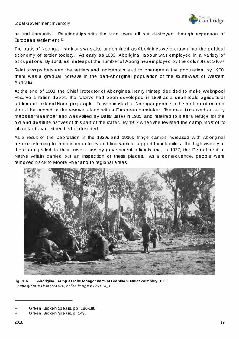
At the end of 1903, the Chief Protector of Aborigines, Henry Prinsep decided to make Welshpool Reserve a ration depot. The reserve had been developed in 1899 as a small scale agricultural settlement for local Noongar people. Prinsep insisted all Noongar people in the metropolitan area should be moved to the reserve, along with a European caretaker. The area is marked on early maps as "Maamba" and was visited by Daisy Bates in 1905, and referred to it as "a refuge for the old and destitute natives of this part of the state". By 1912 when she revisited the camp most of its inhabitants had either died or deserted.
As a result of the Depression in the 1920s and 1930s, fringe camps increased with Aboriginal people returning to Perth in order to try and find work to support their families. The high visibility of these camps led to their surveillance by government officials and, in 1937, the Department of Native Affairs carried out an inspection of these places. As a consequence, people were removed back to Moore River and to regional areas.
Figure 5 Aboriginal Camp at Lake Monger north of Grantham Street Wembley, 1923. Courtesy State Library of WA, online image b1960151_1
12 Green, Broken Spears, pp. 186-188. 13 Green, Broken Spears, p. 143.

Local Government Inventory
2018 20
The Noongar who remained on the fringes of settlements, such as Lake Monger, are believed to have been able to do so by building relationships with European settlers. They often worked for these families as servants and manual labourers whilst being ‘permitted’ to live on what remained of earlier camping places and food sources at the edges of rivers and swamps.
By the late 20th century, the Aboriginal population of the south-west had recovered so that (in 1984) they were again one of the largest identifiable Aboriginal populations in Australia, with an estimated 12,000 men, women and children claiming Noongar descent.14
It is apparent that contemporary Noongar people consider the Town of Cambridge as Noongar land. In the late 20th century and early 21st century the Town of Cambridge have undertaken steps to recognise the Noongar community of the past and the present in order to build a future where all community members feel welcomed and acknowledged. As part of the Perry Lakes redevelopment in 2012 an interpretive trail was installed with the stories and culture of Aboriginal people. The intention of telling these stories, as stated by Cambridge Mayor Simon Withers was, “to make Aboriginal people visible, and to help build understanding and respect in the communities in which we work”.15
INDICATIVE PLACES
Department of Aboriginal Affairs – Aboriginal Heritage Inquiry System
Registered Aboriginal Sites
• Place ID 3318 Lake Monger NW & W • Place ID 3323 Lake Monger Velodrome • Place ID 3734 Stephenson Avenue • Place ID 3736 Jolimont Swamp • Place ID 3788 Lake Monger • Place ID 20178 Bold Park
Other Heritage Places
• Place ID 3160 Lake Monger South • Place ID 3202 Tranmore Way • Place ID 3735 Perry Lakes • Place ID 3756 Trigg to Fremantle • Place ID 19262 Bold Park Scarred Tree • Place ID 20059 Underwood Avenue FS4 • Place ID 32766 Site Area G
14 Green, Broken Spears, pp. 188-189. 15 Landcorp, Reconciliation Action Plan 2012-13, p. 5.
Local Government Inventory
2018 21
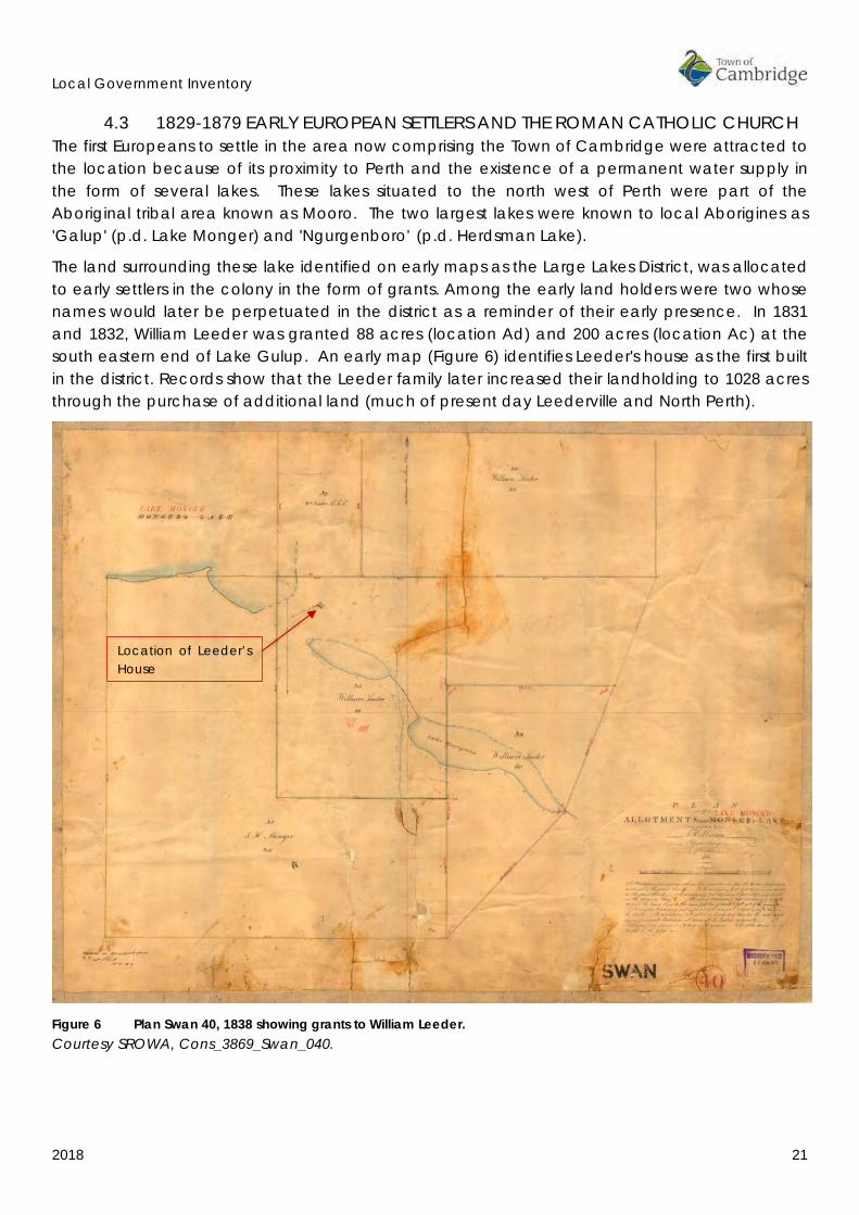
4.3 1829-1879 EARLY EUROPEAN SETTLERS AND THE ROMAN CATHOLIC CHURCH The first Europeans to settle in the area now comprising the Town of Cambridge were attracted to the location because of its proximity to Perth and the existence of a permanent water supply in the form of several lakes. These lakes situated to the north west of Perth were part of the Aboriginal tribal area known as Mooro. The two largest lakes were known to local Aborigines as 'Galup' (p.d. Lake Monger) and 'Ngurgenboro’ (p.d. Herdsman Lake).
The land surrounding these lake identified on early maps as the Large Lakes District, was allocated to early settlers in the colony in the form of grants. Among the early land holders were two whose names would later be perpetuated in the district as a reminder of their early presence. In 1831 and 1832, William Leeder was granted 88 acres (location Ad) and 200 acres (location Ac) at the south eastern end of Lake Gulup. An early map (Figure 6) identifies Leeder's house as the first built in the district. Records show that the Leeder family later increased their landholding to 1028 acres through the purchase of additional land (much of present day Leederville and North Perth).
Figure 6 Plan Swan 40, 1838 showing grants to William Leeder. Courtesy SROWA, Cons_3869_Swan_040.
Location of Leeder’s House

Local Government Inventory
2018 22
Figure 7 Portion of the plan showing the ‘Ribbon’ Grants in the Swan River Colony, 1839. Courtesy SLWA, portion of plan ‘The colony of Western Australia from the surveys of John Septimus Roe Esq. Surveyor Genl. and from other official documents in the Colonial Office and Admiralty’ compiled by John Arrowsmith. 1839
Adjoining Leeder's location Ad was a 200 acre grant taken up by John Monger on the southern side of the Lake which was to bear his name. Others to receive grants of land in this area were Thomas Helms, 367 acres (location Aq) Thomas Hunt, 100 acres (location Ab) and Henry Burgess 200 acres (location Ag) At the same time as the new settlers were taking up land grants an attempt was made to set land aside for the local Aborigines and in 1833 a reserve and food depot was established at Lake Monger.
A short distance west of Monger's Lake lay the present day Herdsman Lake. Land grants were allocated in this area to the Surveyor General, John Septimus Roe (location Ak), James G. Austin (location Am) and Henry Trigg (location AI). The western boundary of Trigg's property ran along the top of a ridge containing a large quantity of limestone (p.d. Reabold Hill). Building materials were in great demand in the new colony and Trigg, a master builder, was able to utilise this resource by establishing a quarry and lime burning works on the property. Over time as a consequence of this activity the property became known as the Limekilns. Trigg's business prospered and he was able to purchase Roe's land and further increase his limestone reserves.
In 1844, Walter Padbury and his new bride Charlotte (nee Nairn) acquired location Am and settled on the 426 acres adjacent to Trigg's property on the western side of Herdsman Lake. Three years later Padbury was able to purchase the Limekilns Estate from Henry and Amelia Trigg for £350. The combined properties (Am & AI) now totalled 1,234 acres. It consisted of a large area of blue gum flats and other good grazing land, all permanently watered by lakes and lagoons (p.d.

Local Government Inventory
2018 23
Perry Lakes). The north eastern boundary of the property had access to Herdsman Lake and the property incorporated the limestone quarry and lime kilns.
Figure 8 Plan Swan 40, Showing grants near Herdsman’s Lake, 1842. Courtesy SROWA, Cons_3869_Swan_045.
Over the next twenty years Walter Padbury was able to build the Limekilns into a very successful property. Adapting to varying circumstances he undertook a number of different ventures. During the depressed 1840s when the price of livestock fell, he established a slaughterhouse and boiling down works to produce tallow. Some tallow was exported; some was used locally in the production of soap and candles. A tannery was also set up on the property to process bullock hides and kangaroo skins.

Local Government Inventory
2018 24
The introduction of convict transportation in 1850 created more opportunities for Padbury. In this period he established a large scale butchering business on the property after successfully tendering to supply 500lbs of meat a day to the colonial government. The Limekilns property was ideally situated for these enterprises. It was within easy distance of Perth and was connected to the town by a well-established track, which became known as the Lime Kiln Road (p.d. Salvado Road).
Another track from the Limekilns led north around the western edge of Herdsman's Lake joining up with a track to the east of Mongers Lake which became the main route north to Champion Bay (now Geraldton). Along this track sheep and cattle could be brought south to pasture on the flats at the Limekilns, prior to sale or butchering. A further track south connected the estate with the Port of Fremantle.
In the twenty years of his occupancy Padbury made considerable improvements to the property. A newspaper advertisement for its sale at a later date records some of the property's specific features:
"...There is a paddock of about 900 acres separately fenced in, on which stands a six roomed dwelling house, built of stone. A two-storey building also of stone, used as a barn, stable for six horses, carriage and cart shed, men's bed-room, a hay loft, under one roof, newly shingled. There are also 50 acres of splendid soil under a good state of cultivation, separately fenced in. There is a small paddock of about 200 acres, part of Location Ak, also separately fenced in, and 21 acres adjoining, which is first class quality, separately fenced in and cleared. A slaughter house and appliances. A road branching of the Perth-Champion Bay Road, one chain wide runs to the West boundary of Location AI. A never-failing supply of water for the stock is afforded by the lagoons and lakes on or near the property. There is valuable growth of timber trees, and large quantities of firewood may be cut on the lands. The whole forming a most desirable premises, as providing within a few miles of the capital a station for stock, run, paddocks, and slaughter house for the operations of a butchering establishment on an extensive scale."16
16 The Inquirer, 4 October 1879, p.2.
Local Government Inventory
2018 25
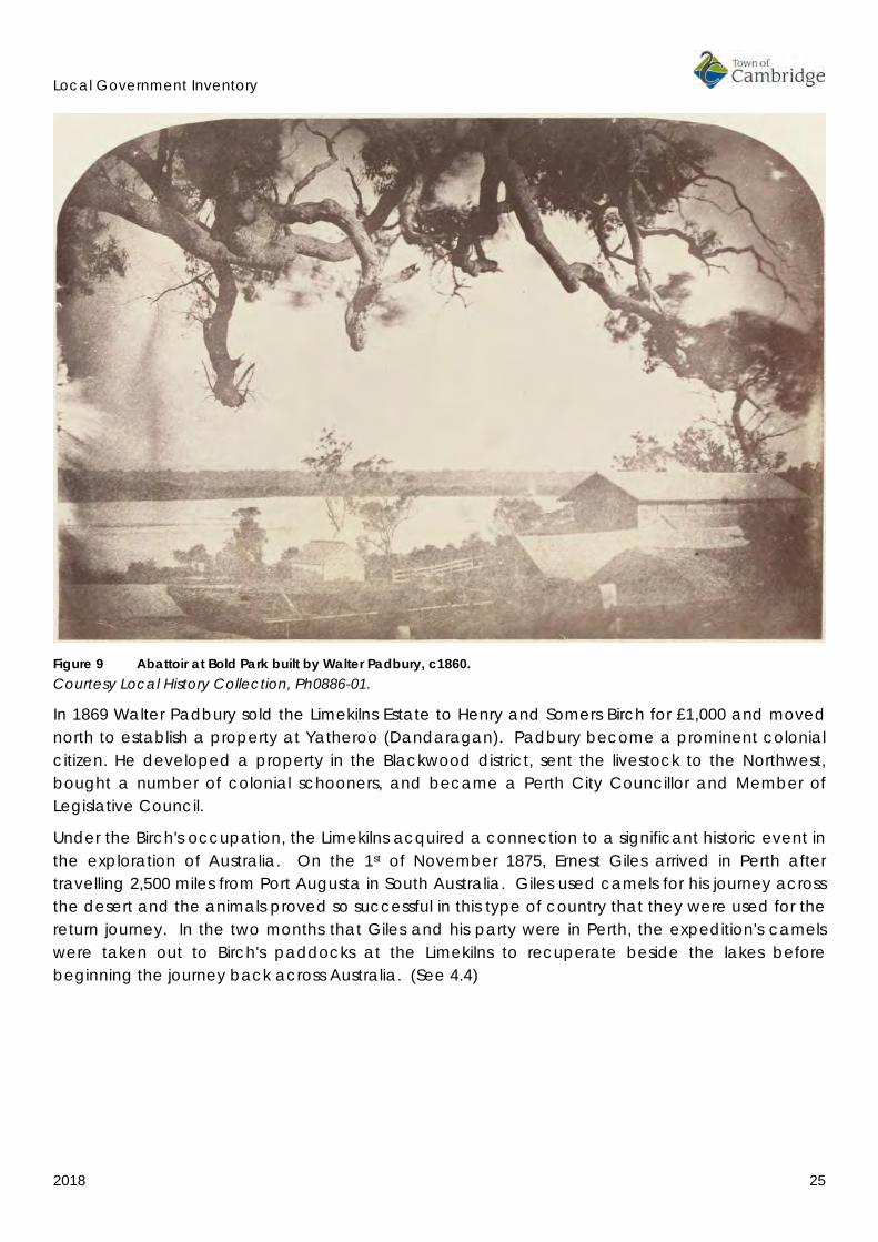
Figure 9 Abattoir at Bold Park built by Walter Padbury, c1860. Courtesy Local History Collection, Ph0886-01.
In 1869 Walter Padbury sold the Limekilns Estate to Henry and Somers Birch for £1,000 and moved north to establish a property at Yatheroo (Dandaragan). Padbury become a prominent colonial citizen. He developed a property in the Blackwood district, sent the livestock to the Northwest, bought a number of colonial schooners, and became a Perth City Councillor and Member of Legislative Council.
Under the Birch's occupation, the Limekilns acquired a connection to a significant historic event in the exploration of Australia. On the 1st of November 1875, Ernest Giles arrived in Perth after travelling 2,500 miles from Port Augusta in South Australia. Giles used camels for his journey across the desert and the animals proved so successful in this type of country that they were used for the return journey. In the two months that Giles and his party were in Perth, the expedition's camels were taken out to Birch's paddocks at the Limekilns to recuperate beside the lakes before beginning the journey back across Australia. (See 4.4)

Local Government Inventory
2018 26
Figure 10 Giles expedition party at Perth, 1875 Back row: Peter Nicholls, Alec Ross, Saleh Mahomet; Middle row: Jesse Young, Ernest Giles, W.H. Tietkens; Front: Tommy Oldham.
Courtesy State Library of WA, online image 000829D, call number 1009B/3
In the decades that Walter Padbury was busy developing the Limekilns into a major property in the east of the district, development of the land around Monger's Lake proceeded slowly. The major land holders, William Leeder, John Monger, and Thomas Helms, were all involved in a number of business ventures in the colony and do not appear to have lived on their land for any length of time. William and Hannah Leeder were the proprietors of a hotel on the site of former Palace Hotel, St Georges Terrace Perth (The building remains but have been converted to offices). Leeder's Hotel was a superior establishment frequented by Perth’s gentry who gathered there to celebrate occasions like the King's birthday. William died in 1845 and Hannah, in conjunction with raising a family of eleven children, continued to operate the hotel.
John Henry Monger was also in the hospitality industry. He owned a licensed inn in Fremantle and was a contractor of sawn timber. In 1837, he moved to York where he established himself as a publican and merchant and opened a steam flour mill. Thomas Helms had various business interests and lived in the town.
Conditions applied to all early land grants. It was required that certain improvements be undertaken within a specified time. Failure to comply with these conditions could result in forfeiture. In order to retain their grants it is probable that these men leased out their land to others to undertake improvements and so comply with these conditions.
While some held on to their landholdings for its future potential, others chose or where forced by circumstances to sell. Among the sales were location Ah and As which were purchased by the
Local Government Inventory
2018 27
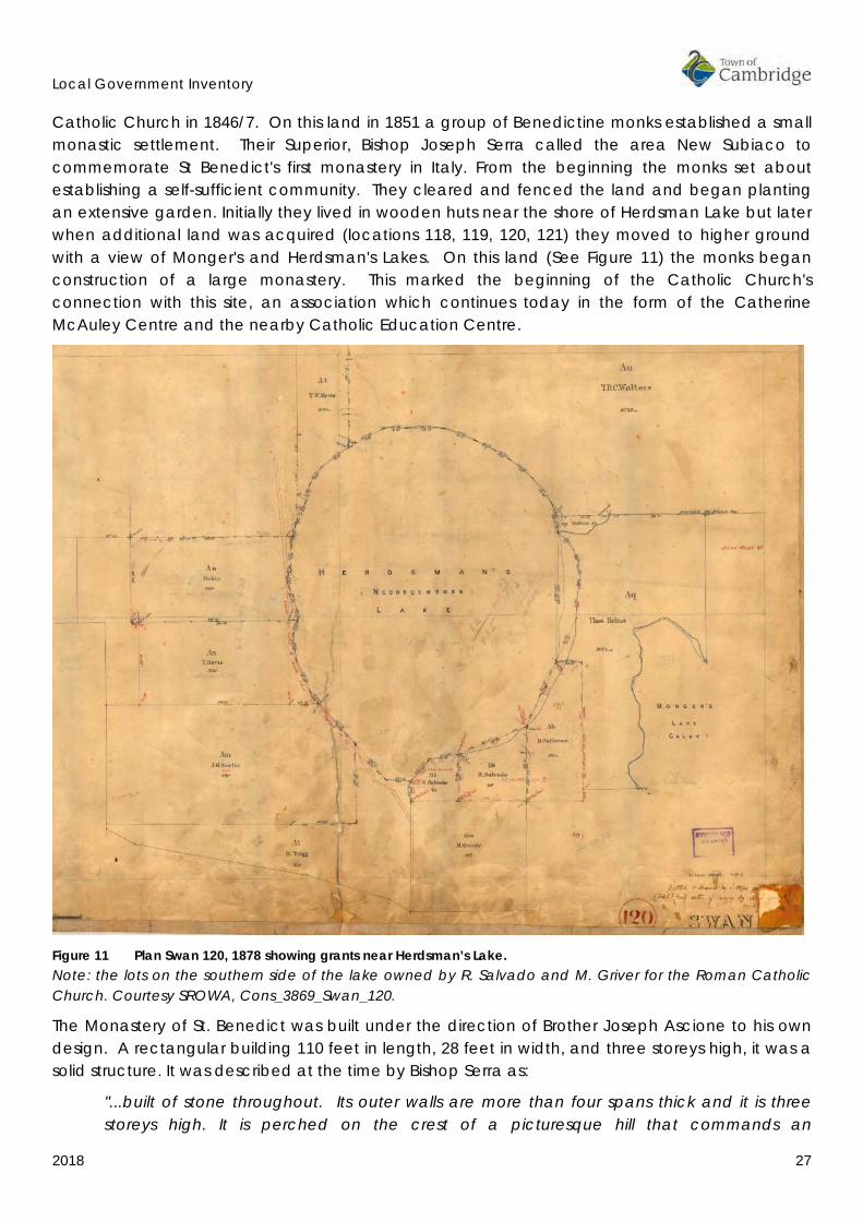
Catholic Church in 1846/7. On this land in 1851 a group of Benedictine monks established a small monastic settlement. Their Superior, Bishop Joseph Serra called the area New Subiaco to commemorate St Benedict's first monastery in Italy. From the beginning the monks set about establishing a self-sufficient community. They cleared and fenced the land and began planting an extensive garden. Initially they lived in wooden huts near the shore of Herdsman Lake but later when additional land was acquired (locations 118, 119, 120, 121) they moved to higher ground with a view of Monger's and Herdsman's Lakes. On this land (See Figure 11) the monks began construction of a large monastery. This marked the beginning of the Catholic Church's connection with this site, an association which continues today in the form of the Catherine McAuley Centre and the nearby Catholic Education Centre.
Figure 11 Plan Swan 120, 1878 showing grants near Herdsman’s Lake. Note: the lots on the southern side of the lake owned by R. Salvado and M. Griver for the Roman Catholic Church. Courtesy SROWA, Cons_3869_Swan_120.
The Monastery of St. Benedict was built under the direction of Brother Joseph Ascione to his own design. A rectangular building 110 feet in length, 28 feet in width, and three storeys high, it was a solid structure. It was described at the time by Bishop Serra as:
"...built of stone throughout. Its outer walls are more than four spans thick and it is three storeys high. It is perched on the crest of a picturesque hill that commands an

Local Government Inventory
2018 28
uninterrupted view of two majestic lakes, and is separated by only three miles from Perth, the Capital city of the colony."17
Stone for the building came from the quarry at the Limekilns and was transported along a track which later became known as the Lime Kiln Road. Still later this road would be given the surname of the Benedictine bishop, Rosendo Salvado. Timber for the upper storeys of the monastery was supplied from saw pits in the area.
On the land surrounding the Monastery the monks developed an extensive orchard, a vineyard containing 20,000 vines and a large acreage of olive groves. Planted around the monastery and down the hillside to the edge of Lake Monger, these olive trees continued to supply award winning olive oil for many years after the departure of the Benedictines. A few of the original olive trees remain today in the grounds of the Catherine McAuley Centre. Nearby streets also have olive trees as street trees which are likely to originate with the early plantings.
By the mid-1860s the majority of the monks had left New Subiaco to establish a mission settlement at New Norcia. The monastery they left behind remained the most substantial and prominent building in the area for several decades. For some years the Monastery remained empty but in 1872 it was taken over by St Vincent de Paul Society for use as an orphanage for boys. A lightning strike on the building in 1879 resulted in one boy being killed and several others injured. The building was also extensively damaged. In order, to raise funds for its reconstruction Father Matthew Gibney journeyed to the eastern states on a speaking tour to canvas donations. While in Victoria he became an accidental participant in a significant event in Australia's history. Father Gibney was passing through Glenrowan on the morning the police confronted the Ned Kelly Gang. He was called on to hear the confession of the wounded Ned Kelly and his attempt to save some of the outlaws from the burning Glenrowan Hotel were reported throughout Australia.
For the few women living in the district during this pioneering period, life was often hard and lonely. There were no community facilities and neighbours had to rely on each other in times of need. While Charlotte Padbury may well have had servants to ease her workload, many other women were required to work alongside their husbands on their properties. An ever present concern for all women was that their children would wander off and become lost in the bush. A newspaper report of one such incident relates how two children under four years of age, wandered away while their parents were absent from the home. Fortunately in this instance, the story had a happy ending, the children heard the sound of cattle bells and followed the stock to the Padbury's limekiln estate, where a contemporary newspaper related:
"… every care was taken of them by Mrs. Padbury. The mother...distracted at discovering their absence, (had) employed the greater, part of the night, accompanied with some natives in searching for them. On the following morning she renewed the search, when she met Mr. Padbury returning her little ones."18
This period in the Town's history can be identified as one of pioneering. A period in which early settlers like William and Hannah Leeder, Henry and Amelia Trigg, Henry and Mary Monger, William and Charlotte Padbury, the Benedictine monks and many unnamed others, all worked to establish a diverse range of agricultural enterprises. Events over the next two decades began a
17 Spillman, K. Identity Prized: A History of Subiaco, UWA Press. 1985, p. 43. 18 Inquirer, 19 June 1850.
Local Government Inventory
2018 29
process of gradual change which eventually resulted in this sparsely inhabited, predominantly rural district, becoming a populated inner suburban area.
INDICATIVE PLACE
• Lake Monger • Perry Lakes • Henderson Park • Old Benedictine Stables • Olive Trees, Catherine McCauley Centre • Olive Trees, St Columbas Avenue, Wembley
4.4 1880-1919 RAILWAYS, SUBDIVISIONS AND SUBURBAN SETTLEMENT In the last two decades of the 19th century two factors shaped the pattern of settlement in the district, the arrival of the railway and the discovery of gold in the 1880s and 1890s. The opening of the Fremantle-Perth-Guildford Railway in 1881 had a marked effect on the areas immediately abutting the line. Accessibility to Perth via the railway made land close to the line eminently suitable for housing when pressure for housing was being acutely felt. The discovery of gold in Western Australia in the 1880 and 1890s resulted in a huge increase in the state's population creating an increased demand for housing. To accommodate the demand, rural allotments close to Perth were gradually subdivided, allowing expansion to the west and north of Perth.
In 1891, land held by the family of W.H. Leeder consisting of locations I, Ac, Ad, Ax, Ay were offered for sale by tender. The land was described as 'adapted for subdividing and offering a splendid investment for capitalists'.19 Portions of this land were subdivided and later progressively released for sale. The parcels of land contained a mix of various sized residential blocks and were regularly advertised by real estate companies from as early as 1892. Promoted under names like Leeder Estate, Lake View Estate and Leederville Station Estate, advertisements stressed the special features of the area, its proximity to Perth, Lake Monger and later the Leederville train station built in 1897, renamed West Leederville in 1913.
19 The West Australian, 14 August 1891, p. 8.

Local Government Inventory
2018 30
Figure 12 Leederville Railway Station, c1900. Courtesy State Library of WA, online image 004506d
However for many the price of the land was the great incentive to purchase. Prices varied according to the size of the blocks. Very small blocks, particularly in the early releases were sold for as little as £10 per block or on terms of £1.10.0. down and ten payments of £1. Smaller blocks, in the area of Carlton, Brighton, Antrim and parts of Woolwich and Tower Streets, were among the first to be settled.

Local Government Inventory
2018 31
Figure 13 Real Estate Plan for Leeder Estate, c1890. Courtesy State Library of WA, online image 55/16/13, call number b4636842_1.
The residences built in this area, were in the main modest timber and iron two room cottages. Land sales in the late 1890s extended settlement to the newly subdivided area from Kimberley Street west to McCourt Street. Residential blocks close to Cambridge Street and the railway line were the first to be taken, settlement then spread north toward Mongers Lake.
Further to the west there was another change in ownership of the Limekilns Estate. In 1880, the property was bought by Joseph Perry. In earlier years Perry had been Perth's herdsman. This role required him to collect stock from Perth properties and take them to the town common west of the city each day. Later he became involved in catching, breaking in and selling wild horses. In the 1880s, he conducted a Horse Bazaar in Forrest Place on the site of the current Perth General Post Office. Under Perry's ownership sandstone continued to be extracted from the quarry. On the flats adjacent to the lakes at the foot of one-tree hill (p.d. Reabold Hill) horses were pastured. This stock included the horses of several identities linked to horse racing in the early days of the colony. These included keen horseman Mr Stephen Henry Parker later Member of Parliament, Lord Mayor
Local Government Inventory
2018 32
of Perth and Judge of the Supreme Court, and his brother George. A training track on the property is thought to have been used for horse racing up until the turn of the century.
Aside from horses, camels were also kept at the Limekilns estate. The successful use of camels during Ernest Giles's expeditions in the 1870s demonstrated the suitability of these animals for travelling in the dry interior of the state. After some consideration a decision was made to import the animals into Western Australia. Importations commenced in 1887 and several areas throughout the state were set aside to quarantine the new arrivals. One of these is identified in the records as being at 'Perry's Limekiln Paddock'. Camel Lake, within the present day Bold Park, indicates this area was the original camel quarantine station.
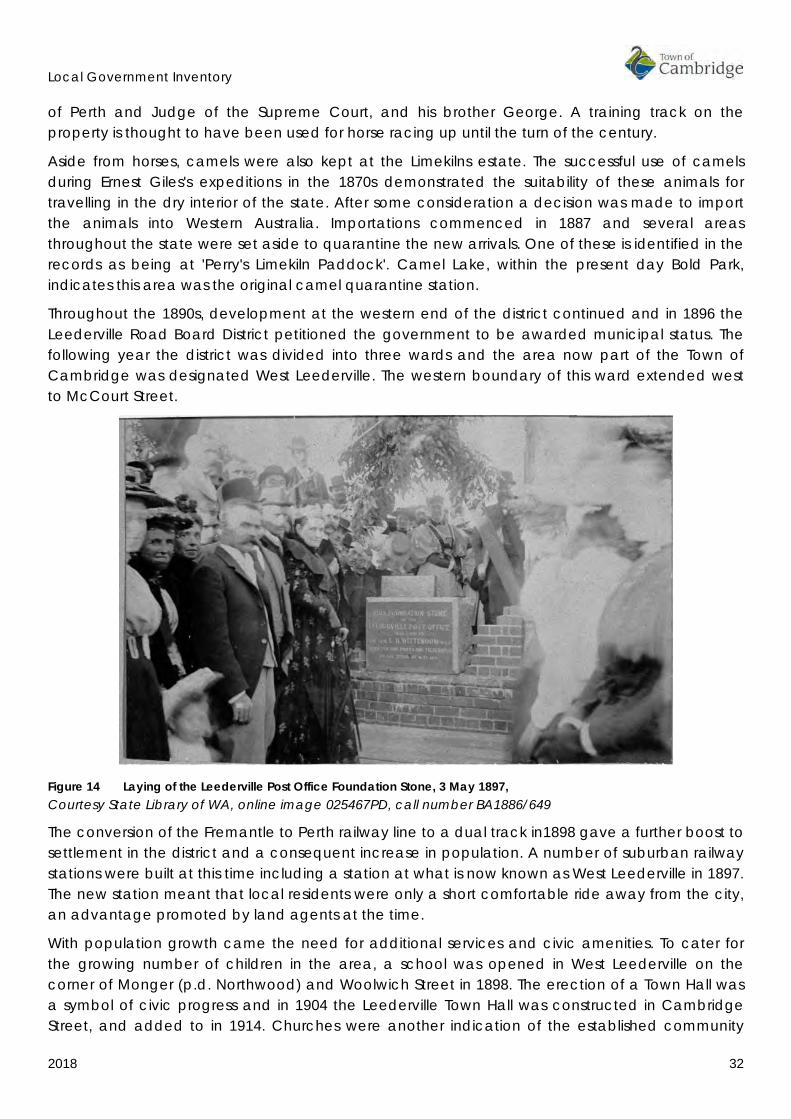
Throughout the 1890s, development at the western end of the district continued and in 1896 the Leederville Road Board District petitioned the government to be awarded municipal status. The following year the district was divided into three wards and the area now part of the Town of Cambridge was designated West Leederville. The western boundary of this ward extended west to McCourt Street.
Figure 14 Laying of the Leederville Post Office Foundation Stone, 3 May 1897, Courtesy State Library of WA, online image 025467PD, call number BA1886/649
The conversion of the Fremantle to Perth railway line to a dual track in1898 gave a further boost to settlement in the district and a consequent increase in population. A number of suburban railway stations were built at this time including a station at what is now known as West Leederville in 1897. The new station meant that local residents were only a short comfortable ride away from the city, an advantage promoted by land agents at the time.
With population growth came the need for additional services and civic amenities. To cater for the growing number of children in the area, a school was opened in West Leederville on the corner of Monger (p.d. Northwood) and Woolwich Street in 1898. The erection of a Town Hall was a symbol of civic progress and in 1904 the Leederville Town Hall was constructed in Cambridge Street, and added to in 1914. Churches were another indication of the established community

Local Government Inventory
2018 33
and a great deal of effort went into the establishment of churches, of various denominations, during this period.
Medical services were provided by local doctors and the Sisters of St. John of God. In 1897, the Sisters purchased 7 acres of land in Cambridge Street for the construction of a hospital. A 35 bed hospital opened in April 1898, at the site of the present day St John of God Hospital complex. There is no evidence remaining of the earlier structures on this site which has been constantly upgraded to form the complex and sophisticated facility which it is today [2018].
The Roman Catholic Church was also involved in the establishment of several institutions in the district catering to the welfare needs of women and children. Between 1872 and 1901, the old monastery of St. Benedict housed the St. Vincent's boy’s orphanage. When the boys were moved to St Joseph’s Boys Orphanage (now Clontarf Aboriginal College) in 1901, the Sisters of Mercy took over the buildings which then became St Joseph's Girls Orphanage. Alongside St Joseph's the Sisters established St Vincent's foundling home for the care of orphaned or relinquished infants in 1914. This building, now used for other purposes remains in the grounds of the Catherine McCauley Centre. St Joseph's Orphanage, the old Monastery, was demolished in 1979. The former monastery stables is the only remaining physical evidence of the Benedictine occupation of the site.
In 1903, on another piece of church land in Ruislip Street, (location L20) a convent was constructed for the Sisters of the Good Shepherd (Figure 15). In 1909, the Sisters opened a reformatory for the care of 'erring women and delinquent girls'. A laundry which operated in conjunction with the reformatory has been demolished but the former convent building now houses the Catholic Education Centre of Western Australia.
Figure 15 Home of the Good Shepherd, 1915. Courtesy State Library of WA, online image 011619PD, call number b4751833_1

Local Government Inventory
2018 34
The growing population in the West Leederville district created a demand for commercial services. While the main shopping area in Leederville was located in Oxford Street, small stores began to appear in the growing West Leederville area during the 1890s. Small corner stores scattered throughout the district catered to customers in the immediate vicinity. Chinese market gardeners hawked their vegetables door to door and milk was delivered from local dairies. Around the turn of the century other commercial enterprises were established along the main arterial roads, at the eastern end of Cambridge Street and on Railway Parade near the railway station.
Figure 16 View of Railway Parade, Leederville with railway station at left, 1905 Courtesy State Library of WA, online image 000504d
Mongers Lake provided a central focus for recreation in the district during this period. In 1902, the Monger's Lake Board was established to control and manage Monger's Lake. Under the board's stewardship many improvements were made to the area. Play grounds were established and a jetty and bandstand were constructed near the junction with St Leonard Avenue. Bathing sheds and a jetty were built on the western shore. These facilities enabled families and local groups, churches, social clubs and schools to gather at the lake for picnic days and general recreation. Boating was a pastime that could be enjoyed by all. For children this often meant paddling in homemade tin canoes, for some it was rowing boats and for the wealthier members of the community, yacht races. In 1908, the Waverley Boat Club was formed and regular yachting regattas were held using 12 foot Skim dish yachts, particularly suited to lake sailing. In 1902, fish were introduced into the lake and after 1904 fishing became a popular sport for young and old.
Local Government Inventory
2018 35
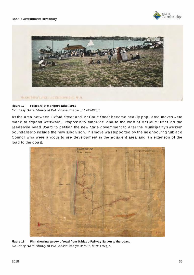
Figure 17 Postcard of Monger’s Lake, 1911 Courtesy State Library of WA, online image _b1943460_1
As the area between Oxford Street and McCourt Street become heavily populated moves were made to expand westward. Proposals to subdivide land to the west of McCourt Street led the Leederville Road Board to petition the new State government to alter the Municipality's western boundaries to include the new subdivision. This move was supported by the neighbouring Subiaco Council who were anxious to see development in the adjacent area and an extension of the road to the coast.
Figure 18 Plan showing survey of road from Subiaco Railway Station to the coast. Courtesy State Library of WA, online image 3/7/21, b1861153_1.

Local Government Inventory
2018 36
In 1909, negotiations commenced between the Municipality of Leederville, Bishop Gibney on behalf of the Roman Catholic Church, and John Nanson, a landowner proposing to subdivide his property. Nanson's initial proposal was to subdivide a portion of location Aq to the boundary of what was then called the ‘Glendalough Land’. During negotiations this area was referred to as the Subiaco Estate. The extension of the boundaries was achieved by 1911. It included the newly subdivided area west of McCourt Street as far as Government Road (p.d. Selby Street), the area known today as Wembley.
The first area to be subdivided was the land owned by the Catholic Church. The subdivision was called Church Lands Estate, (not to be confused with the present day suburb of Churchlands further to the west and outside the boundaries of the Town of Cambridge). The estate was put on the market by Hyem, Hester & Co. Ltd., Auctioneers and Estate Agent who advertised the subdivision as being only three hundred yards from the Subiaco Station, providing excellent fishing, boating and views of Mongers and Herdsman Lakes. Blocks were priced at approximately £50 each, with cheaper land located further to the west. (See Figure 19)
Applications to build houses in the Church Lands Estate were received by the Leederville Council from 1912. An application for a residence on lot 368 Cambridge Street represents the earliest recorded, and this house was probably the first house to be constructed in the area. Applications were mostly for timber and iron cottages often consisting of only two rooms. Applications were received to construct weatherboard cottages in Nanson, McKenzie, Gregory and Cambridge Streets. Many residences were designed to be added on to, at a later date. However, strict standards were set for construction of residences. No tents were allowed, and in the case of ‘lean-tos' the general rule was to issue a special licence with a time limit in order to permit the construction of a more substantial residence.

Local Government Inventory
2018 37
Figure 19 Promotional poster for the Church Lands Estate, c1915. Courtesy State Library of WA, online image 3/7/21, b1861153_1.
The subdivision of the Perthshire Estate and Emerald Hill Estates (Locations 117 and 388) at the western end of present day Wembley, followed the subdivision of the Church Lands Estate. In their advertising material promoters of the Perthshire Estate listed the many advantages this land offered.
"Lovely High and Healthy Positions. Only three mile from Perth Town Hall and three miles from Ocean Beach. Electric Light now on the Estate. The extension of the Tramway System through this Estate must come immediately, Trams along Cambridge Street to be constructed to your door. Secure Large profits which must come with the tram."20
The trams did not come immediately. The tramway was not constructed until 1927, and then it only reached as far as Nanson Street. At this date there was no road to the beach and a road around Monger's Lake was not built until the 1930s. As a consequence the area remained relatively isolated.
20 Perthshire Estate, Real Estate maps, Battye Library Map Collection.

Local Government Inventory
2018 38
The subdivisions of Church Lands, Perthshire and Emerald Hill Estates were significantly different from the adjacent areas of Leederville and Subiaco. The areas of subdivision were large compared to earlier subdivisions, the blocks were larger and there was a greater homogeneity of lot sizes. Despite the subdivisions that appeared on the map clearing and construction of many the proposed roads and laneways had not be completed and the character of the area remained substantially rural. Some of the land was purchased by potential residents but other lots were bought on a speculative basis and not settled until later. Much of the land remained in the hands of the Catholic Church.
In the first decade of the new century, W.E. Bold, the Perth City Council town clerk, proposed a scheme to amalgamate the City of Perth and its suburbs. It was argued that amalgamation would result in greater efficiency in the provision of public facilities. In a referendum held in 1910, 84% of Leederville ratepayers endorsed the Greater Perth Scheme, and with North Perth, united with the Perth City Council. This was undertaken under the provisions of the Municipal Corporations Act of 1906 and later validated in retrospect by the City of Perth Act of 1914.
At the time of amalgamation the boundaries of the Leederville district extended from Oxford Street in the east, to Selby Street in the west. Patterns of development differed widely within this area. The eastern end of the district contained the bulk of the population. It had well-established roads, piped water had been installed by 1911 and it contained amenities like schools, a Town Hall, and a hospital. The western end of the district, despite the efforts of developers to promote sales, remained largely undeveloped and isolated. The only road connections between West Leederville and the Church Lands Estate were Cambridge Street and Salvado Road. There was still no direct route around Monger's Lake, many of the roads in the new subdivision remained barely defined sand tracks and the closest public transport was the train station at Subiaco. All this was to change in the 1920s with the return of the soldiers from the First World War.
INDICATIVE PLACES
• Perry House (1919), Oceanic Drive, Floreat Park • Perry House Precinct (Archaeological sites), Oceanic Drive, Floreat Park • Uniting Church (Fmr Methodist Church) and Hall (1900), Woolwich St, Leederville • West Leederville Primary School (1898), 58 Northwood St, Leederville • Leederville Town Hall (1904 and 1914), Cambridge Street Leederville • Former Leederville Fire Station (c1904), 65 Kimberley St, Leederville • St Joseph's Orphanage chapel and schoolroom (1894), (Catherine McAuley Centre;
Leederville) • St Vincent's Foundlings Home (1914) (Catherine McAuley Centre; Leederville) • Home of the Good Shepherd (Catholic Education Centre), (1903) 50 Ruislip St, Leederville

Local Government Inventory
2018 39
4.5 1920-1949 GARDEN SUBURBS AND MODEL HOMES In 1918, the area known generally as the Church Lands and Emerald Hill Estates (now Wembley) represented the extent of subdivision in the area to the west of Perth. Many of the roads were unsealed and the closest public transport was the train station at Subiaco. Despite these factors a strong community had developed. The West Leederville Progress Association had been established for some time but a distinct Church Lands Progress Association was established by 1920 and was generally consulted for views on decisions affecting the area.
Until the early 1920s the Church Lands Estate was still officially part of West Leederville an issue which caused a number of practical problems for the early residents due to the remoteness of the area. It was considered logical to identify the new area as separate from West Leederville however the name Church Lands Estate was not considered appropriate as the church had no direct influence over the area the association being historic rather than current. Initially the consideration of a new name involved consideration of a name for the whole area between Leederville and the coast.
In November 1923, a resident of Gregory Street made the following recommendation for the area between the Catherine McCauley Centre (formerly St Joseph's Orphanage) and the coast:
"From the Orphanage to the ocean is a new district, why not perpetuate the name KANGAROO, then divide the district into two, then divide the Kangaroo, calling the first half of the district Kangavale and the other half Rooville. Ocean Beach, or Rooville Beach, which would give it a distinction from all other watering places, then the railway station could be designated Subiaco and Kangavale."21
The reference to a name for the beach area related to the issue concerning the establishment of a beach side resort in the area now known as City Beach. Although the rather bizarre name proposal seems to have received little serious attention, the issue was quickly resolved with the Perth City Council adopting the name of Wembley Park for the area in February 1924. The name Wembley Park was taken from the London suburb of the same name which was in the news at the time due to the British Empire Exhibition which was held in Wembley, London in 1924. The name represented an expression of new and modern ideas in design and living for the British Empire in the 1920s and would have seemed appropriate to the Perth City Council who were proposing the introduction of new ideas in suburban planning in the area to the west of Wembley Park.
Originally Wembley Park was to include a portion of Leederville to the west of Kimberley Street. However both the residents of the area and the Church Lands Progress Association suggested McCourt Street as a more appropriate eastern boundary, this being the boundary of the original Church Lands Estate Subdivision. Accordingly the boundary became McCourt Street and the name was officially adopted after publication in the Government Gazette on 4th July 1924. The notice read as follows:
"His Excellency the Administrator in Executive Council has been pleased to approve under Section 7 of "The Land Act 1898" of that portion of Leederville situated West of McCourt
21 Perth City Council file 1924/42 Church Lands Estate.
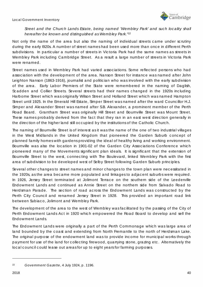
Local Government Inventory
2018 40
Street and the Church Lands Estate, being named 'Wembley Park' and such locality shall hereafter be known and distinguished as Wembley Park."22
Not only the name of the area but also the naming of individual streets came under scrutiny during the early I920s. A number of street names had been used more than once in different Perth subdivisions. In particular a number of streets in Victoria Park had the same names as streets in Wembley Park including Cambridge Street. As a result a large number of streets in Victoria Park were renamed.
Street names used in Wembley Park had varied associations. Some reflected persons who had association with the development of the area. Nanson Street for instance was named after John Leighton Nanson (1863-1916), journalist and politician who was involved with the early subdivision of the area. Early Labor Premiers of the State were remembered in the naming of Daglish, Scadden and Collier Streets. Several streets had their names changed in the 1920s including Harborne Street which was originally Wilson Street and Holland Street which was named Hampton Street until 1925. In the Emerald Hill Estate, Simper Street was named after the ward Councillor H.J. Simper and Alexander Street was named after S.B. Alexander, a prominent member of the Perth Road Board. Grantham Street was originally Hill Street and Bournville Street was Mount Street. These names probably derived from the fact that they ran in an east west direction generally in the direction of the higher land still occupied by the institutions of the Catholic Church.
The naming of Bournville Street is of interest as it was the name of the one of two industrial villages in the West Midlands in the United Kingdom that pioneered the Garden Suburb concept of planned family homes with gardens providing the ideal of healthy living and working environment. Bournville was also the location in 1901-02 of the Garden City Associations Conference which pioneered many of the Movements significant plan ideals. It is significant that the extension of Bournville Street to the west, connecting with The Boulevard, linked Wembley Park with the first area of subdivision to be developed west of Selby Street following Garden Suburb principles.
Several other changes to street names and minor changes to the town plan were necessitated in the 1920s, as the area became more populated and linkages to adjacent suburbs were required. In 1926, Jersey Street terminated at Jolimont Terrace on the southern side of the Leederville Endowment Lands and continued as Annie Street on the northern side from Salvado Road to Herdsman Parade. The section of road across the Endowment Lands was constructed by the Perth City Council and renamed Jersey Street in 1928. This provided an important road link between Subiaco, Jolimont and Wembley Park.
The development of the area to the west of Wembley was facilitated by the passing of the City of Perth Endowment Lands Act in 1920 which empowered the Road Board to develop and sell the Endowment Lands.
The Endowment Lands were originally a part of the Perth Commonage which was large area of land bounded by the coast and extending from North Fremantle to the north of Herdsman Lake. The original purpose of the endowment land was to provide income for municipal works through payment for use of the land for collecting firewood, quarrying stone, grazing etc. Alternatively the local council could lease out areas for up to eight years for farming purposes.
22 Government Gazette, 4 July 1924, p. 1196.
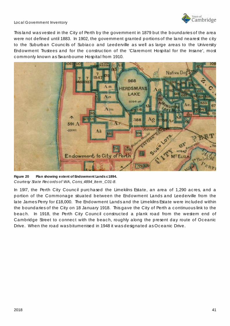
Local Government Inventory
2018 41
This land was vested in the City of Perth by the government in 1879 but the boundaries of the area were not defined until 1883. In 1902, the government granted portions of the land nearest the city to the Suburban Councils of Subiaco and Leederville as well as large areas to the University Endowment Trustees and for the construction of the 'Claremont Hospital for the Insane', most commonly known as Swanbourne Hospital from 1910.
Figure 20 Plan showing extent of Endowment Lands c1894. Courtesy State Records of WA, Cons_4894_Item_C01-8.
In 19I7, the Perth City Council purchased the Limekilns Estate, an area of 1,290 acres, and a portion of the Commonage situated between the Endowment Lands and Leederville from the late James Perry for £18,000. The Endowment Lands and the Limekilns Estate were included within the boundaries of the City on 18 January 1918. This gave the City of Perth a continuous link to the beach. In 1918, the Perth City Council constructed a plank road from the western end of Cambridge Street to connect with the beach, roughly along the present day route of Oceanic Drive. When the road was bitumenised in 1948 it was designated as Oceanic Drive.
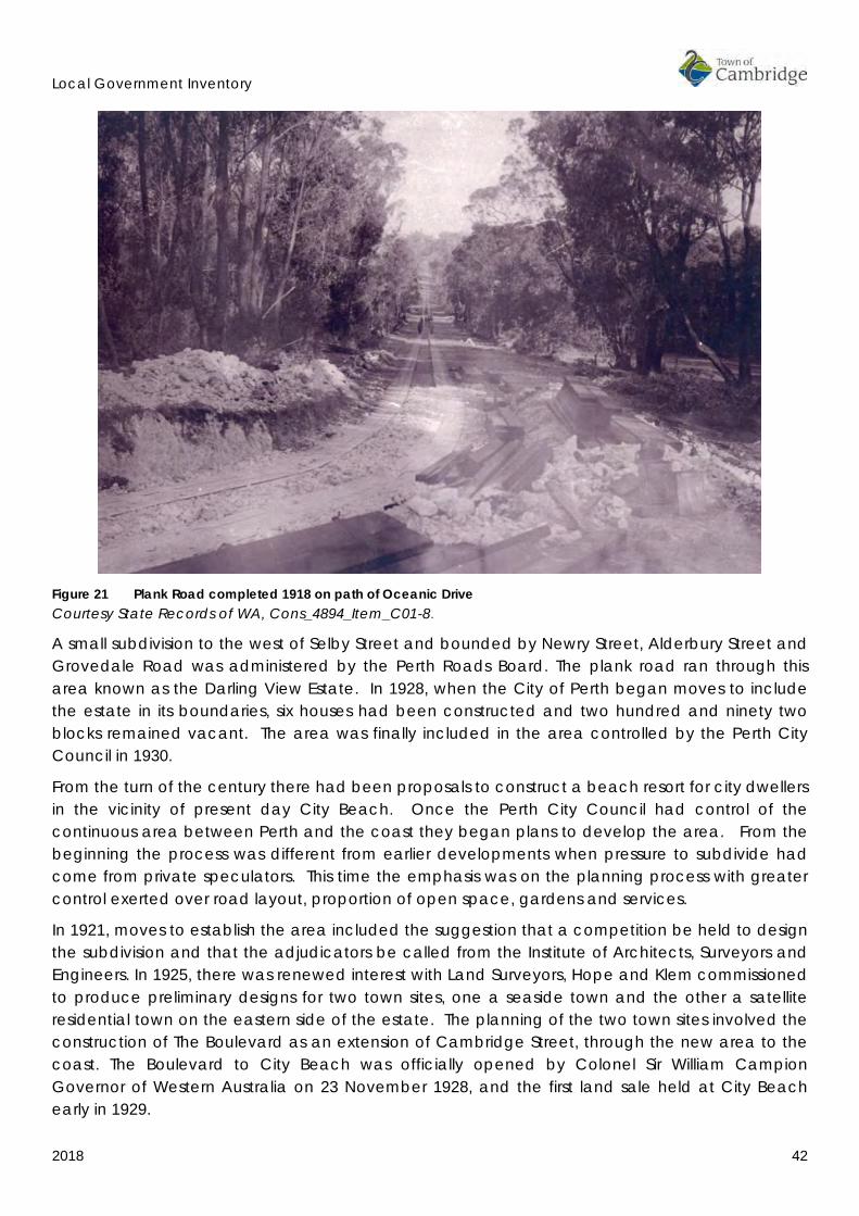
Local Government Inventory
2018 42
Figure 21 Plank Road completed 1918 on path of Oceanic Drive Courtesy State Records of WA, Cons_4894_Item_C01-8.
A small subdivision to the west of Selby Street and bounded by Newry Street, Alderbury Street and Grovedale Road was administered by the Perth Roads Board. The plank road ran through this area known as the Darling View Estate. In 1928, when the City of Perth began moves to include the estate in its boundaries, six houses had been constructed and two hundred and ninety two blocks remained vacant. The area was finally included in the area controlled by the Perth City Council in 1930.
From the turn of the century there had been proposals to construct a beach resort for city dwellers in the vicinity of present day City Beach. Once the Perth City Council had control of the continuous area between Perth and the coast they began plans to develop the area. From the beginning the process was different from earlier developments when pressure to subdivide had come from private speculators. This time the emphasis was on the planning process with greater control exerted over road layout, proportion of open space, gardens and services.
In 1921, moves to establish the area included the suggestion that a competition be held to design the subdivision and that the adjudicators be called from the Institute of Architects, Surveyors and Engineers. In 1925, there was renewed interest with Land Surveyors, Hope and Klem commissioned to produce preliminary designs for two town sites, one a seaside town and the other a satellite residential town on the eastern side of the estate. The planning of the two town sites involved the construction of The Boulevard as an extension of Cambridge Street, through the new area to the coast. The Boulevard to City Beach was officially opened by Colonel Sir William Campion Governor of Western Australia on 23 November 1928, and the first land sale held at City Beach early in 1929.
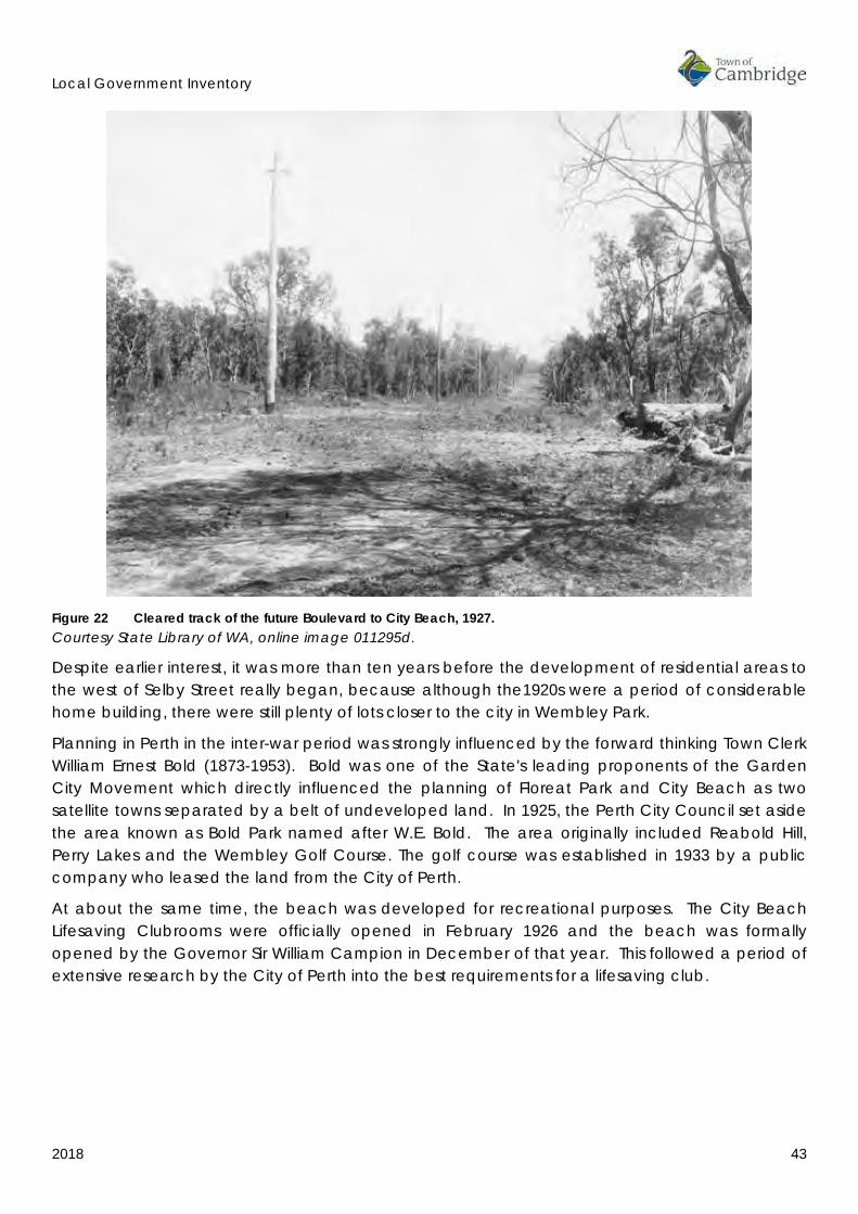
Local Government Inventory
2018 43
Figure 22 Cleared track of the future Boulevard to City Beach, 1927. Courtesy State Library of WA, online image 011295d.
Despite earlier interest, it was more than ten years before the development of residential areas to the west of Selby Street really began, because although the1920s were a period of considerable home building, there were still plenty of lots closer to the city in Wembley Park.
Planning in Perth in the inter-war period was strongly influenced by the forward thinking Town Clerk William Ernest Bold (1873-1953). Bold was one of the State's leading proponents of the Garden City Movement which directly influenced the planning of Floreat Park and City Beach as two satellite towns separated by a belt of undeveloped land. In 1925, the Perth City Council set aside the area known as Bold Park named after W.E. Bold. The area originally included Reabold Hill, Perry Lakes and the Wembley Golf Course. The golf course was established in 1933 by a public company who leased the land from the City of Perth.
At about the same time, the beach was developed for recreational purposes. The City Beach Lifesaving Clubrooms were officially opened in February 1926 and the beach was formally opened by the Governor Sir William Campion in December of that year. This followed a period of extensive research by the City of Perth into the best requirements for a lifesaving club.

Local Government Inventory
2018 44
Figure 23 City Beach, 1926. Courtesy State Library of WA, online image slwa_b2160222, call number 3538B/6
Figure 24 City Beach Life saving club 1927. Courtesy State Library of WA, online image 050,121PD
In 1927, interest in planning and the emphasis on parks and public open space prompted the Wembley Park Progress Association to ask for additional recreational space in the district. The original subdivision plan was drawn up without much consideration for public open space and the nearest park or recreation area was Monger's Lake. As a result, Henderson Park was established on the old Leederville Endowment Lands in Jersey Street. Rutter Park in Jersey Street was established later in 1945 through the purchase of residential lots.
The depression years of the late 1920s and early 1930s were characterised by a major slump in the building industry. In order to promote renewed confidence in home building, the industry
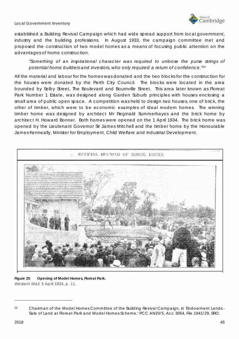
Local Government Inventory
2018 45
established a Building Revival Campaign which had wide spread support from local government, industry and the building professions. In August 1933, the campaign committee met and proposed the construction of two model homes as a means of focusing public attention on the advantages of home construction.
"Something of an inspirational character was required to unloose the purse strings of potential home builders and investors, who only required a return of confidence."23
All the material and labour for the homes was donated and the two blocks for the construction for the houses were donated by the Perth City Council. The blocks were located in the area bounded by Selby Street, The Boulevard and Bournville Street. This area later known as Floreat Park Number 1 Estate, was designed along Garden Suburb principles with houses enclosing a small area of public open space. A competition was held to design two houses, one of brick, the other of timber, which were to be economic examples of ideal modern homes. The winning timber home was designed by architect Mr Reginald Summerhayes and the brick home by architect H. Howard Bonner. Both homes were opened on the 1 April 1934. The brick home was opened by the Lieutenant Governor Sir James Mitchell and the timber home by the Honourable James Kenneally, Minister for Employment, Child Welfare and Industrial Development.
Figure 25 Opening of Model Homes, Floreat Park. Western Mail, 5 April 1934, p. 11.
23 Chairman of the Model Homes Committee of the Building Revival Campaign, in 'Endowment Lands -
Sale of Land at Floreat Park and Model Homes Scheme,' PCC AN20/5, Acc 3054, File 1941/29, SRO.

Local Government Inventory
2018 46
During the promotion of the model homes, land in the Floreat Park area was advertised for sale and development in the area commenced. The Workers Homes Board purchased the area bounded by Grantham Street, Selby Street, Seymour Avenue and The Boulevard and private developers began construction elsewhere. The area to the east of the future Floreat Forum was subdivided and released for development in the period prior to World War II. The area to the west of the future Floreat Forum and north of Grantham Street was released in the period following World War II.
One of the reasons for the delayed development of Wembley and Floreat Park was the lack of public transport in the period before private car ownership was widespread. In 1917, a public meeting was held at the Leederville Town Hall to discuss the issue of construction of a tramway to the beach. Despite extensive negotiation construction did not proceed and in October 1922 a Special Meeting of Ratepayers was held to urge the construction of the tramway to Cambridge Street. In 1923, due to the delays in the construction of the tramway the Church Lands Progress Association successfully petitioned Council to subsidise a motorbus service. The tramway was eventually constructed to the Cambridge Street, Nanson Street intersection in 1927.
Figure 26 Portion of plan showing tram routes in Perth, 1939. Courtesy University of Melbourne Library online image https://digitised-collections.unimelb.edu.au/handle/11343/23943?show=full
The Wembley Hotel was constructed on the corner of Alexander and Cambridge Streets in 1932 and the tramway was extended to Alexander Street by 1935. The extension of the tramlines to the beach was never constructed as by the end of the 1930s the tram services had been eclipsed by

Local Government Inventory
2018 47
the introduction of trolley buses. Wembley Park had a trolley bus service along Cambridge Street to Selby Street and a second route via Gregory and Grantham Streets to Selby Streets by 1939.
Figure 27 Wembley Hotel, n.d. Courtesy Cambridge Library ref from Peard Real Estate website.
As the area was settled there was a gradual transition in the types of businesses that were established and in opportunities for leisure activities. As late as 1941 there was a dairy in Wembley at the western end of Cambridge Street. Throughout its history, Cambridge Street has been a focus for businesses in the district. The eastern end of the street tended to attract more shops and commercial uses with service stations and light industry located further west. By the 1940s however a number of shops had developed in the area adjacent to the Wembley Hotel.
The Wembley Picture Theatre and the Wembley Picture Gardens opened in 1937 on the corner of Cambridge and Station Streets and the Cameo Picture Gardens were further west on the corner of Pangbourne and Cambridge Streets. The Wembley Picture Theatre could seat over 800 patrons and comprised an upstairs gallery, projection room and an interior lavishly decorated with plaster scrolls designed to cleverly conceal windows that could be opened on hot nights. The adjacent Picture Gardens had a capacity of 800 with seating in canvas deck chairs. There was also a picture theatre in West Leederville near to the Kimberley Street intersection.
The Wembley Primary School was established on the corner of Grantham and Simper Streets in 1936.
Churches were a focus of community life and the various denominations were established in West Leederville and in Wembley by the inter war period. Church sites were allocated as part of the layout of Floreat Park subdivisions.
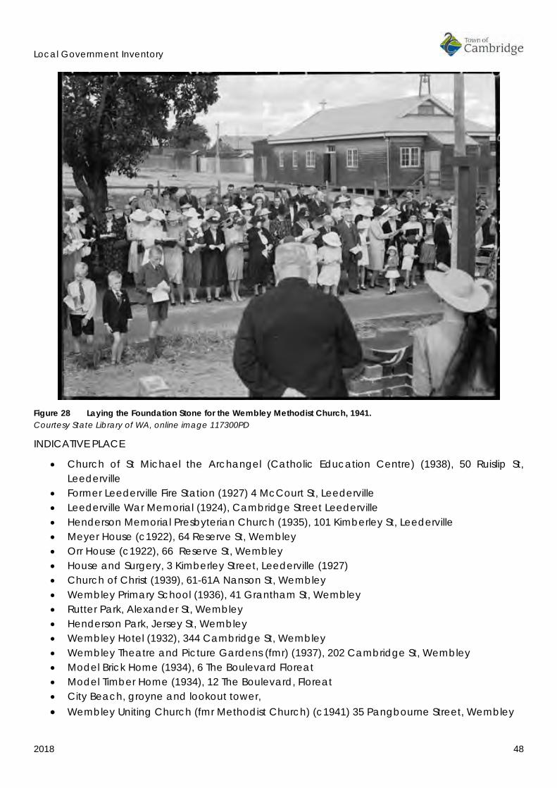
Local Government Inventory
2018 48
Figure 28 Laying the Foundation Stone for the Wembley Methodist Church, 1941. Courtesy State Library of WA, online image 117300PD
INDICATIVE PLACE
• Church of St Michael the Archangel (Catholic Education Centre) (1938), 50 Ruislip St, Leederville
• Former Leederville Fire Station (1927) 4 McCourt St, Leederville • Leederville War Memorial (1924), Cambridge Street Leederville • Henderson Memorial Presbyterian Church (1935), 101 Kimberley St, Leederville • Meyer House (c1922), 64 Reserve St, Wembley • Orr House (c1922), 66 Reserve St, Wembley • House and Surgery, 3 Kimberley Street, Leederville (1927) • Church of Christ (1939), 61-61A Nanson St, Wembley • Wembley Primary School (1936), 41 Grantham St, Wembley • Rutter Park, Alexander St, Wembley • Henderson Park, Jersey St, Wembley • Wembley Hotel (1932), 344 Cambridge St, Wembley • Wembley Theatre and Picture Gardens (fmr) (1937), 202 Cambridge St, Wembley • Model Brick Home (1934), 6 The Boulevard Floreat • Model Timber Home (1934), 12 The Boulevard, Floreat • City Beach, groyne and lookout tower, • Wembley Uniting Church (fmr Methodist Church) (c1941) 35 Pangbourne Street, Wembley

Local Government Inventory
2018 49
4.6 1950 TO THE PRESENT [2018] POST WAR DEVELOPMENT The 1950s was a period of significant expansion in Floreat Park. The land was released for sale as a series of small estates and purchasers were subject to a number of restrictions regarding what could and could not be built. These regulations were specific to development in Floreat Park and City Beach. Development was restricted to one dwelling per lot with regulations governing building materials, setbacks, fencing, signage etc. The increase in the number of private cars was a significant influence on the development of the suburbs and therefore there was a growth of service stations in the post war period.
Figure 29 335 Cambridge Street Wembley, 1952 Courtesy State Library of WA, 240,327PD
The planning of Floreat Park had included the concept of a town centre including community and commercial facilities and open recreation areas and parkland. Land had been allocated for a school, Civic centre, post office, shopping centre, ovals, tennis courts and other sporting facilities. The concept included the idea of The Boulevard as a promenade through the centre of the area. The aim was to plan for all the needs of the community.

Local Government Inventory
2018 50
Figure 30 Plan showing progressive development of Floreat Park, 1953-1969. Courtesy SROWA Cons_5697_Item_101-1 Floreat
Figure 31 Plan showing progressive development of City Beach 1953-1968. Courtesy SROWA Cons_5697_Item_100-1 City Beach.
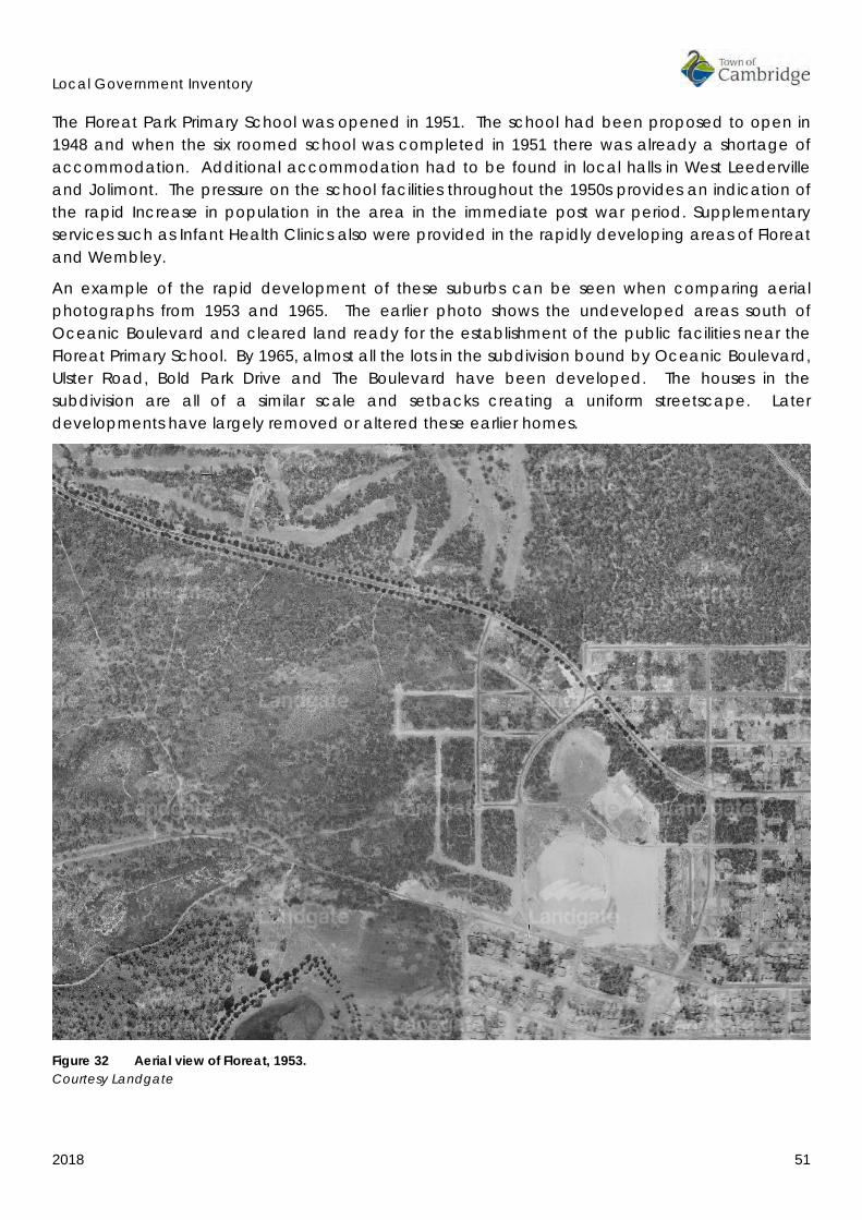
Local Government Inventory
2018 51
The Floreat Park Primary School was opened in 1951. The school had been proposed to open in 1948 and when the six roomed school was completed in 1951 there was already a shortage of accommodation. Additional accommodation had to be found in local halls in West Leederville and Jolimont. The pressure on the school facilities throughout the 1950s provides an indication of the rapid Increase in population in the area in the immediate post war period. Supplementary services such as Infant Health Clinics also were provided in the rapidly developing areas of Floreat and Wembley.
An example of the rapid development of these suburbs can be seen when comparing aerial photographs from 1953 and 1965. The earlier photo shows the undeveloped areas south of Oceanic Boulevard and cleared land ready for the establishment of the public facilities near the Floreat Primary School. By 1965, almost all the lots in the subdivision bound by Oceanic Boulevard, Ulster Road, Bold Park Drive and The Boulevard have been developed. The houses in the subdivision are all of a similar scale and setbacks creating a uniform streetscape. Later developments have largely removed or altered these earlier homes.
Figure 32 Aerial view of Floreat, 1953. Courtesy Landgate

Local Government Inventory
2018 52
Figure 33 Aerial view of Floreat, 1965. Courtesy Landgate
In 1963 work commenced on the construction of the Floreat Forum shopping centre. This was one of the first Perth suburban shopping centres designed around a central arcade or courtyard space instead of along a shopping street although a strip shopping area is shown on early plans of the area.

Local Government Inventory
2018 53
Figure 34 Floreat Forum, 1966. Courtesy State Library of WA, online image 268,246PD
Churches developed in the area in the 1950s and 1960s. St Cecilia's Roman Catholic Church was blessed in 1962 and St Nicholas Anglican Church in Berkeley Crescent in the same year.
Although the first residents settled in City Beach in the 1930s, there was little substantial development until the 1960s with the main impetus the opening of lands for residential subdivisions following the 1962 British Empire and Commonwealth Games.
In the 1950s, Perth was successful in being selected to host the 1962 Empire Games. There followed an intense period of development to hold the events and house the competitors. The City of Perth allocated an area of land to the north of The Boulevard and east of Oban Road for the construction of the Games Village. A competition was held to design the layout of the village and was won by Mr K. Thomas and Mr H. Walker. The village as constructed consisted of two areas of housing grouped around a central spine which incorporated an area of natural vegetation, a recreation hall, dining rooms, administration building and shops.
A second competition was held to design the Games Village houses and forty Western Australian architects submitted a total of 166 designs. The winning design was submitted by Silver, Fairbrother and Associates. The village was constructed using a selection of the competition designs to develop a village representing the best of West Australian contemporary architecture.
Initially it was proposed that the Games Village homes would be handed to the State Housing Commission for disposal at the completion of the Games, however in the event the homes were renovated where necessary and sold privately through the Rural and Industries Bank. Six months after the last athletes moved out all were occupied by private residents.
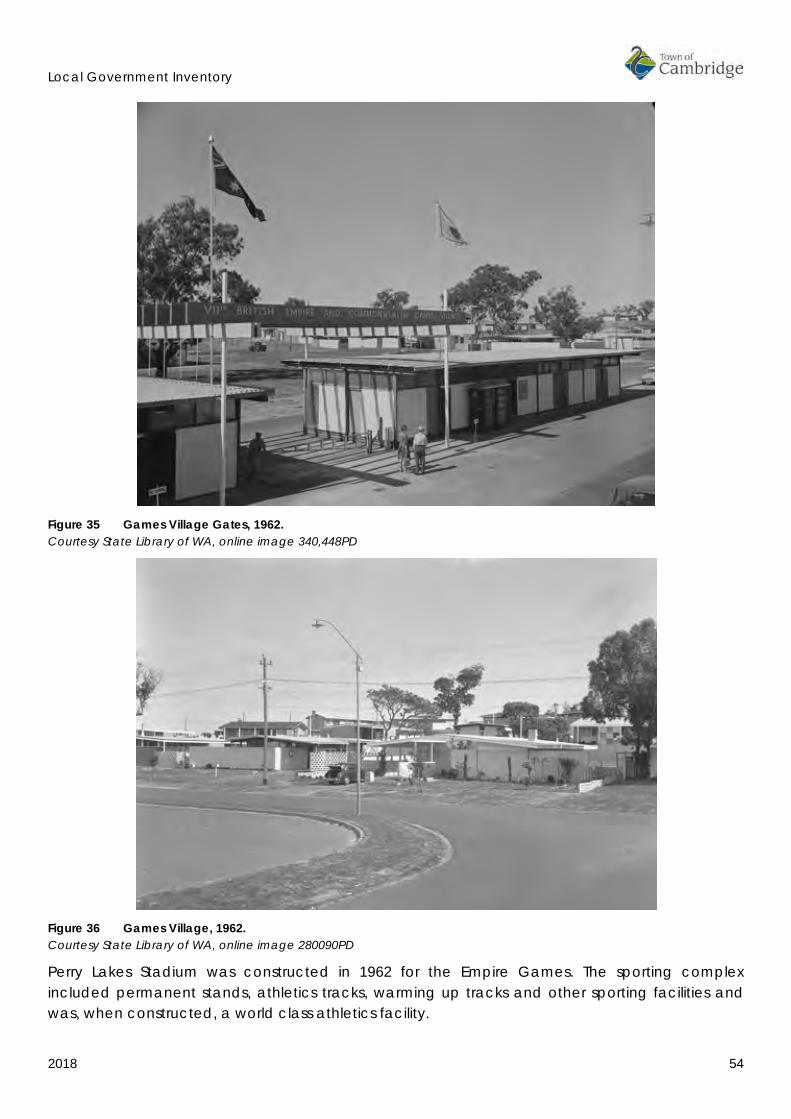
Local Government Inventory
2018 54
Figure 35 Games Village Gates, 1962. Courtesy State Library of WA, online image 340,448PD
Figure 36 Games Village, 1962. Courtesy State Library of WA, online image 280090PD
Perry Lakes Stadium was constructed in 1962 for the Empire Games. The sporting complex included permanent stands, athletics tracks, warming up tracks and other sporting facilities and was, when constructed, a world class athletics facility.

Local Government Inventory
2018 55
The Empire Games was significant in the development of Perth and Western Australia’s identity in a national and international context.
Figure 37 Arrival of HRH Prince Philip to open the Games, 1962. Courtesy State Library of WA, online image 257,005PD
The Perry Lakes Stadium provided Perth with a substantial sporting asset until its demolition in 2012. It was resolved to retain the scoreboard in the new residential development which occupies the site in recognition of the significance of the stadium to the community.
Figure 38 Demolition of Perry Lakes Stadium, 2012. Courtesy OnePerth website, 20 August 2012 www.oneperth.com.au/
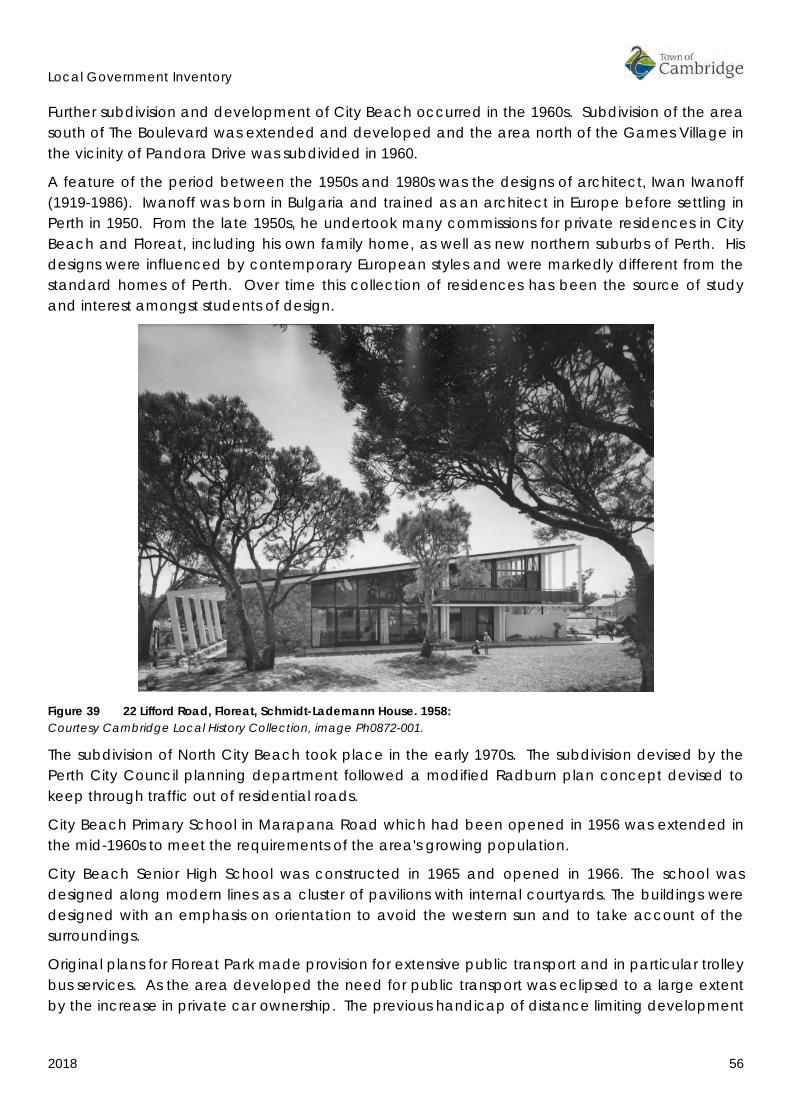
Local Government Inventory
2018 56
Further subdivision and development of City Beach occurred in the 1960s. Subdivision of the area south of The Boulevard was extended and developed and the area north of the Games Village in the vicinity of Pandora Drive was subdivided in 1960.
A feature of the period between the 1950s and 1980s was the designs of architect, Iwan Iwanoff (1919-1986). Iwanoff was born in Bulgaria and trained as an architect in Europe before settling in Perth in 1950. From the late 1950s, he undertook many commissions for private residences in City Beach and Floreat, including his own family home, as well as new northern suburbs of Perth. His designs were influenced by contemporary European styles and were markedly different from the standard homes of Perth. Over time this collection of residences has been the source of study and interest amongst students of design.
Figure 39 22 Lifford Road, Floreat, Schmidt-Lademann House. 1958: Courtesy Cambridge Local History Collection, image Ph0872-001.
The subdivision of North City Beach took place in the early 1970s. The subdivision devised by the Perth City Council planning department followed a modified Radburn plan concept devised to keep through traffic out of residential roads.
City Beach Primary School in Marapana Road which had been opened in 1956 was extended in the mid-1960s to meet the requirements of the area's growing population.
City Beach Senior High School was constructed in 1965 and opened in 1966. The school was designed along modern lines as a cluster of pavilions with internal courtyards. The buildings were designed with an emphasis on orientation to avoid the western sun and to take account of the surroundings.
Original plans for Floreat Park made provision for extensive public transport and in particular trolley bus services. As the area developed the need for public transport was eclipsed to a large extent by the increase in private car ownership. The previous handicap of distance limiting development
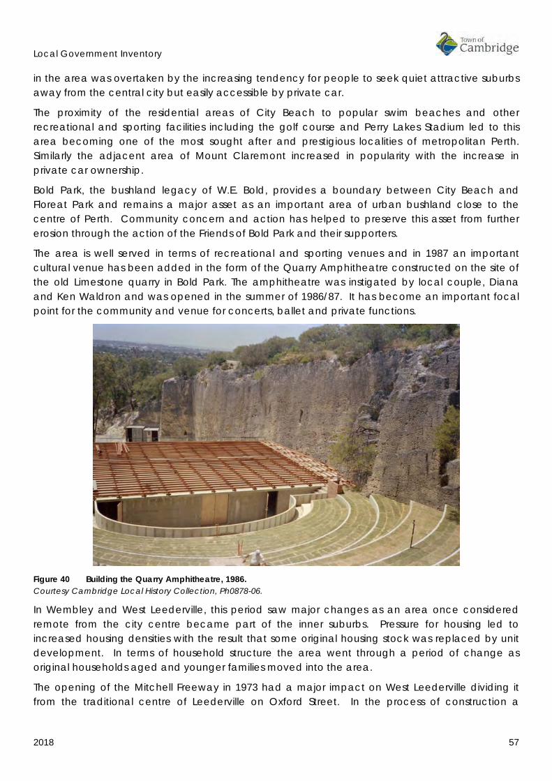
Local Government Inventory
2018 57
in the area was overtaken by the increasing tendency for people to seek quiet attractive suburbs away from the central city but easily accessible by private car.
The proximity of the residential areas of City Beach to popular swim beaches and other recreational and sporting facilities including the golf course and Perry Lakes Stadium led to this area becoming one of the most sought after and prestigious localities of metropolitan Perth. Similarly the adjacent area of Mount Claremont increased in popularity with the increase in private car ownership.
Bold Park, the bushland legacy of W.E. Bold, provides a boundary between City Beach and Floreat Park and remains a major asset as an important area of urban bushland close to the centre of Perth. Community concern and action has helped to preserve this asset from further erosion through the action of the Friends of Bold Park and their supporters.
The area is well served in terms of recreational and sporting venues and in 1987 an important cultural venue has been added in the form of the Quarry Amphitheatre constructed on the site of the old Limestone quarry in Bold Park. The amphitheatre was instigated by local couple, Diana and Ken Waldron and was opened in the summer of 1986/87. It has become an important focal point for the community and venue for concerts, ballet and private functions.
Figure 40 Building the Quarry Amphitheatre, 1986. Courtesy Cambridge Local History Collection, Ph0878-06.
In Wembley and West Leederville, this period saw major changes as an area once considered remote from the city centre became part of the inner suburbs. Pressure for housing led to increased housing densities with the result that some original housing stock was replaced by unit development. In terms of household structure the area went through a period of change as original households aged and younger families moved into the area.
The opening of the Mitchell Freeway in 1973 had a major impact on West Leederville dividing it from the traditional centre of Leederville on Oxford Street. In the process of construction a

Local Government Inventory
2018 58
number of the oldest homes in the area, many of them timber cottages dating from the 1880s and 1990s, were demolished to make way for the new road system.
The construction of the railway to Joondalup also had an impact on the area through its effect on the Lake Monger environment.
The Town of Cambridge was created in July 1994 when the City of Perth was divided into four Local Government Authorities. The opening of the new Town of Cambridge Council Chambers in June 1996 represented the transition to a new stage in the history of the administration and development of the area.
Since 1997, the Town of Cambridge has become more densely settled with infill development of the more established suburbs. Commercial development on Cambridge Street has intensified in the last decade with multi-storey developments now a feature.
The provision of community facilities has continued in recent years, with one of the most significant being the redevelopment of City Beach foreshore in 2015.
In October 2003, Floreat Forum was reopened following major additions and alterations including a new town square and health club. These works had begun in 2001 and included the removal of the distinctive circus style roof which had been a feature since its construction. These works also included the new Cambridge Library and the Boulevard Centre which is an active community hub.
In 2004, the WA Ecology Centre at Bold Park was opened by the State Minister for the Environment, Dr Judy Edwards. The centre incorporated environmental design principles in its construction and provides a venue for environment workshops, research and display.
In 2005, the Mayor of Cambridge, Marlene Anderton opened the ‘Mum-boy-yet jinnung’ boardwalk from City Beach to Floreat Beach. This timber boardwalk enables beach visitors to walk along the beach without harming the fragile dune vegetation. The name is a Noongar sentence meaning "Looking out to where the sea meets the sky”.
In 2011, works commenced on the redevelopment of the Matthews Netball Centre and the completed centre was opened in September 2013. This project was part of a wider program of works at the sports grounds in Selby Street that enhance the sporting facilities for a number of sporting groups.
In 2015, the redevelopment Bold Park Aquatic centre was opened with many new additional facilities from the original 1975 public pool.
INDICATIVE PLACES
• Perry Lakes Stadium Scoreboard, (1962), Perry Lakes Drive, Floreat • Perry Lakes Reserve • St Edmund's Anglican Church, (1952) (Consecrated 1956), 50 Pangboume Street, Wembley • Our Lady of Victories Roman Catholic Church (1953) 360-362 Cambridge Street, Wembley • St Cecilia's Roman Catholic Church (Blessed 1962), 40 Grantham Street, Floreat • Floreat Forum Shopping Centre (1963/4), The Boulevard, Floreat • Floreat Park Primary School and grounds (1951), Chandler Avenue, Floreat • Empire Games Village(fmr) (1962), Oceanic Drive, City Beach

Local Government Inventory
2018 59
• Holy Spirit Roman Catholic School (1965) and War Memorial Church. (1974) 2 Keaney Place, City Beach
• City Beach High School (fmr) (1966), Kalinda Drive, City Beach • Happy Tree, Hovea Crescent, City Beach • City Beach Primary School (1929), Marapana Road, City Beach • Kapinara Primary School, Catesby Street, City Beach • Quarry Amphitheatre, (1986/87), Oceanic Drive, City Beach.

Local Government Inventory
2018 60
4.7 BIBLIOGRAPHY The following list has been reproduced from the Town of Cambridge Municipal Heritage Inventory and Townscape Precinct Study prepared in 1997. Some additional sources have been included as a result of research undertaken for the 2018 review.
Armstrong, Francis. 1979. “Manners and Habits of the Aborigines of Western Australia.” In Nyungar - The People: Aboriginal customs in the southwest of Australia, by Neville Green, 181. Perth: Central Book Agency.
Boersma, Ian Lawrence. 1995. Two Rockingham Cottages Thorpe and Thomas Cottages Historic Places Assessment Forms. Architectural Dissertation, Perth: National Trust of Australia (WA).
Bourke, D. F. 1979. The History of the Catholic Church in Western Australia, 1829-1979. Vanguard Press.
1946. Centenary of the Catholic Church in Western Australia, 1846-1946. Perth, WA: Service Printing Co Ltd.
City of Perth. 1992. Lake Monger Management Plan. Perth, WA: City of Perth.
Cough, David. 1992. Perth Outdoors. Perth: CALM.
De Burgh, W. J. 1986. The Old North Road. Perth, WA: UWA Press.
Department of Aboriginal Affairs. 2017. Aboriginal Heritage Inquiry System. State of Western Australia : Department of Aboriginal Affairs. Accessed October 15, 2014. http://maps.dia.wa.gov.au/AHIS2/.
Department of the Environment and Energy. 2017. “Australian Heritage Database.” Department of the Environment and Energy. February. http://www.environment.gov.au/cgi-bin/ahdb/search.pl?mode=search_form;list_code=RNE.
Erickson, Rica (ed). 1988. The Bicentennial Dictionary of Western Australians. Perth, WA: UWA Press.
Gill, B., and B. Gay. 1988. West Leederville Primary School, 1898-1988. A. G. O'Keefe & Son.
Green, Neville. 1984. Broken Spears : Aborigines and Europeans in the southwest of Australia. Perth, Western Australia: Focus Education Services.
Local Studies Cambridge Library. 2011. The Old Plank Road. August. https://cambridgelocalstudies.wordpress.com/2014/08/11/the-old-plank-road/.
Lyon, Robert Menli. 1979. “A Glance at the Manners and Language of the Aboriginal Inhabitants of Western Australia: with a short vocabulary.” In Nyungar - The People: Aboriginal customs in the southwest of Australia, by Neville Green, 176. Perth : Central Book Agency.
McLay, A. 1992. Women Out of their Sphere: a History of the Sisters of Mercy in Western Australia. Perth WA: Vanguard Press.
Perth Gazette and Western Australian Journal. 1833-1847.
Phillimore, Jack. 1995. City of Rockingham Municipal Inventory: Historical Thematic Framework. Rockingham: Prepared for the City of Rockingham and the Heritage Council of Western Australia.
Local Government Inventory
2018 61
Putt, Margaret. 1990? Wembley Its People and Its Past. City of Perth.
Rosario, R. 1993. “Wembley: A geographical study of developing suburban identity in the 1920's and 1930's.” M.Phil Dissertation, University of Western Australia.
Royal Western Australian . 1936. “Volume 2.” Early Days Journal of the Royal Western Australian Historical Society.
South West Aboriginal Land and Sea Council. 2017. About the Whadjuk Region. South West Aboriginal Land and Sea Council. Accessed March 1, 2017. http://www.noongarculture.org.au.
Spillman, Ken. 1985. Identity Prized: A History of Subiaco. City of Subiaco.
Stannage, C. T. 1979. The People of Perth: A Social History of Western Australian's Capital City . City of Perth.
Stannage, C.T. 1981. A New History of Western Australia. Nedlands, WA: UWA Press.
1833-2014. “The West Australian.” (West Australian Newspapers Ltd).
The Western Australian Post Office Directories. 1893-1949.
1885-1955. “The Western Mail.” (West Australian Newspapers).
Western Australian Government. 1878-1989. “Government Gazette of Western Australia.” (Government Printer).
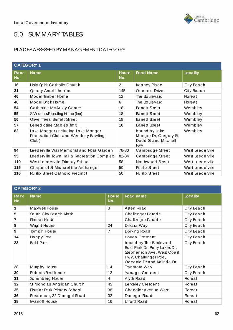
Local Government Inventory
2018 62
5.0 SUMMARY TABLES PLACES ASSESSED BY MANAGEMENT CATEGORY
CATEGORY 1
Place No.
Name House No.
Road Name Locality
16 Holy Spirit Catholic Church 2 Keaney Place City Beach 21 Quarry Amphitheatre 145 Oceanic Drive City Beach 46 Model Timber Home 12 The Boulevard Floreat 48 Model Brick Home 6 The Boulevard Floreat 54 Catherine McAuley Centre 18 Barrett Street Wembley 55 St Vincent's Foundling Home (fmr) 18 Barrett Street Wembley 56 Olive Trees, Barrett Street 18 Barrett Street Wembley 57 Benedictine Stables (fmr) 18 Barrett Street Wembley 82 Lake Monger (including Lake Monger
Recreation Club and Wembley Bowling Club)
bound by Lake Monger Dr, Gregory St, Dodd St and Mitchell Fwy
Wembley
94 Leederville War Memorial and Rose Garden 78-80 Cambridge Street West Leederville 95 Leederville Town Hall & Recreation Complex 82-84 Cambridge Street West Leederville 110 West Leederville Primary School 58 Northwood Street West Leederville 115 Chapel of St Michael the Archangel 50 Ruislip Street West Leederville 116 Ruislip Street Catholic Precinct 50 Ruislip Street West Leederville
CATEGORY 2
Place No.
Name House No.
Road name Locality
1 Maxwell House 3 Asten Road City Beach 5 South City Beach Kiosk Challenger Parade City Beach 7 Floreat Kiosk Challenger Parade City Beach 8 Wright House 24 Dilkara Way City Beach 9 Tomich House 7 Dorking Road City Beach 14 Happy Tree Hovea Crescent City Beach 23 Bold Park bound by The Boulevard,
Bold Park Dr, Perry Lakes Dr, Stephenson Ave, West Coast Hwy, Challenger Pde, Oceanic Dr and Kalinda Dr
City Beach
28 Murphy House 14 Tranmore Way City Beach 30 Roberts Residence 12 Yanagin Crescent City Beach 31 Schenberg House 4 Alyth Road Floreat 32 St Nicholas' Anglican Church 45 Berkeley Crescent Floreat 35 Floreat Park Primary School 38 Chandler Avenue West Floreat 36 Residence, 32 Donegal Road 32 Donegal Road Floreat 38 Iwanoff House 16 Lifford Road Floreat

Local Government Inventory
2018 63
CATEGORY 2
Place No.
Name House No.
Road name Locality
39 Schmidt-Lademann House 22 Lifford Road Floreat 40 St Cecilia's Roman Catholic Church 47 Peebles Road Floreat 41 Perry Lakes Reserve Perry Lakes Drive Floreat 42 Perry House 167 Perry Lakes Drive Floreat 43 Perry Lakes Scoreboard 1 Stadium Drive Floreat 51 Henderson Park 99 Jersey Street Jolimont 61 Commercial Premises, 288 Cambridge
Street 288 Cambridge Street Wembley
70 Wembley Hotel 344 Cambridge Street Wembley 75 Our Lady of Victories Roman Catholic
Church 364 Cambridge Street Wembley
77 Wembley Police Station 379 Cambridge Street Wembley 79 Wembley Primary School 41 Grantham Street Wembley 81 Rutter Park 183 Jersey Street Wembley 85 St Edmund's Anglican Church 54 Pangbourne Street Wembley 103 Henderson Memorial Presbyterian
Church 101 Kimberley Street West Leederville
107 Leederville Fire Station No.3 (fmr) 2 McCourt Street West Leederville 117 Residence, 17 Tate Street 17 Tate Street West Leederville 118 St Barnabas Anglican Church 104 Woolwich Street West Leederville
CATEGORY 3
Place No.
Name House No.
Road name Locality
3 St Paul's Church and Hall 57 Brompton Road City Beach 4 Kapinara Primary School 2 Catesby Street City Beach 6 Floreat Beach and Groyne Challenger Parade City Beach 12 Beecroft Park 32 Gayton Road City Beach 15 City Beach High School (fmr) 20 Kalinda Drive City Beach 18 City Beach Primary School 30 Marapana Road City Beach 22 City Beach, Groyne and Lookout
Tower Challenger Parade City Beach
24 Lisle House 9 Pindari Road City Beach 26 St Christopher's Anglican Church 25 Templetonia Crescent City Beach 52 Matthews Netball Centre 199 Salvado Road Jolimont 58 Wembley Theatre and Gardens (fmr) 202 Cambridge Street Wembley 62 Commercial Premises, 294
Cambridge Street 294 Cambridge Street Wembley
64 Residence, 316 Cambridge Street 316 Cambridge Street Wembley 71 Commercial Premises, 347-349
Cambridge Street 347-349
Cambridge Street Wembley
78 Horton House 24A Connolly Street Wembley 83 Wembley Church of Christ 61-
61A Nanson Street Wembley
84 Wembley Uniting Church 35 Pangbourne Street Wembley

Local Government Inventory
2018 64
CATEGORY 3
Place No.
Name House No.
Road name Locality
87 Orr House 66 Reserve Street Wembley 88 Olive Trees, St Columbas Avenue St Columbas Avenue Wembley 90 Hope Residence (fmr) 92 Blencowe Street West Leederville 97 Residence, 1 Glen Street 1 Glen Street West Leederville 98 Residence, 5 Glen Street 5 Glen Street West Leederville 99 Residence, 7 Glen Street 7 Glen Street West Leederville 100 Residence, 9 Glen Street 9 Glen Street West Leederville 104 House and Surgery (fmr) 3 Kimberley Street West Leederville 105 Leederville Fire Station No.2 (fmr) 65 Kimberley Street West Leederville 106 House, 3 Lesser Street 3 Lesser Street West Leederville 108 Residence, 101 Northwood Street 101 Northwood Street West Leederville 111 Cowden Park 82 Northwood Street West Leederville 114 Residence, 314 Railway Parade 314 Railway Parade West Leederville
CATEGORY 4
Place No.
Name House No.
Road name Locality
2 Residences, 4, 10 and 19 Branksome Gardens
4, 10, 19
Branksome Gardens City Beach
10 British Empire and Commonwealth Games Village (fmr)
bound by Dupont Ave, Oban Rd, Tilton Tce, Gifford Gdns, Pandora Dr and The Boulevard
City Beach
11 City Beach Ovals 20 Fred Burton Way City Beach 13 House, 17 Hovea Crescent 17 Hovea Crescent City Beach 17 Holy Spirit Parish Complex 2 Keaney Place City Beach 19 Ryan Residence (fmr) 14 Marimba Crescent City Beach 20 Booth House 59 Oban Road City Beach 25 Templetonia Park Templetonia Crescent City Beach 27 City Beach Civic Centre 33 Templetonia Crescent City Beach 29 Ocean Village Park bound by Brompton Rd,
Yaltara Rd, Hale Rd and Kilpa Ct
City Beach
33 All Saints Uniting Church & Crawford Hall 48 Berkeley Crescent Floreat 34 Floreat Oval 39 Chandler Avenue West Floreat 37 Floreat Forum Shopping Centre 5 Howtree Place Floreat 44 Avenue of Trees, The Boulevard The Boulevard (btwn
Cambridge St & Chipping Rd)
Floreat/City Beach
45 McLean Park The Boulevard Floreat 47 Paganin House (fmr) 165 The Boulevard Floreat 49 Dempster House 82 The Boulevard Floreat 59 Commercial Premises, 284
Cambridge Street 284 Cambridge Street Wembley
63 Commercial Premises, 296 Cambridge Street
296 Cambridge Street Wembley

Local Government Inventory
2018 65
CATEGORY 4
Place No.
Name House No.
Road name Locality
65 Commercial Premises, 318 Cambridge Street
318 Cambridge Street Wembley
66 Residence, 319A Cambridge Street 319A Cambridge Street Wembley 67 Residence, 321 Cambridge Street 321 Cambridge Street Wembley 68 Commercial Premises, 332
Cambridge Street 332 Cambridge Street Wembley
69 Commercial Premises, 338-342 Cambridge Street
338-342
Cambridge Street Wembley
72 Commercial Premises, 352 Cambridge Street
352 Cambridge Street Wembley
73 Commercial Premises, 361 Cambridge Street
361 Cambridge Street Wembley
74 Commercial Premises, 363 Cambridge Street
363 Cambridge Street Wembley
76 Residence, 377A Cambridge Street 377A Cambridge Street Wembley 80 Commercial Premises, Grantham,
Jersey and Nanson Streets 38-42 46-56 81
Grantham Street Grantham Street Nanson Street
Wembley
86 Meyer House 64 Reserve Street Wembley 89 Wembley Golf Course and Club
Rooms 200 The Boulevard Wembley
91 Petrol Station (fmr) 144 Cambridge Street West Leederville 92 Niola Private Hospital (fmr) 61 Cambridge Street West Leederville 96 Strathmore Wine Saloon (fmr) 95 Cambridge Street West Leederville 109 Residence, 104 Northwood Street 104 Northwood Street West Leederville 112 Residence, 97 Northwood Street 97 Northwood Street West Leederville 113 Commercial Premises, 256-276
Railway Parade 256-276
Railway Parade West Leederville
119 Uniting Church (fmr) 79 Woolwich Street West Leederville
CATEGORY 5
Place No.
Name House No.
Road name Locality
50 St Nicholas Church Hall 84 The Boulevard Floreat 53 St John of God Hospital 12 Salvado Road Subiaco 93 Baptist Church - site 77 Cambridge Street West Leederville
PRECINCTS
Place No.
Name Area Locality
101 Holyrood Street Precinct Holyrood Street (btwn Cambridge St & Woolwich St)
West Leederville Precinct
102 Kimberley Street Precinct Kimberley Street (btwn Cambridge St & Woolwich St)
West Leederville Precinct

Local Government Inventory
2018 66
PLACE NOMINATIONS
The following places were new nominations put forward for the review process from a variety of sources including the Heritage Council of Western Australia inHerit database, community nominations, and the Town of Cambridge officers. They were not recommended for inclusion in the Local Government Inventory for the stated reasons.
NEW NOMINATIONS Place No.
Name Street No.
Street Name Locality Comments / Recommendation
(1997 MHI #28)
St Joseph's Roman Catholic Church
9 Salvado Road Wembley Do not include – no longer within Cambridge boundaries
(1997 MHI #29)
St Joseph's Roman Catholic Church Presbytery
1 Salvado Road Wembley Do not include – no longer within Cambridge boundaries
(1997 MHI #5)
West Leederville Railway Station Footbridge
Railway Parade West Leederville
Do not include – partially demolished & no longer within Cambridge boundaries
Olive Tree, Abbotsford Street
9 Abbotsford Street West Leederville
Do not include – minimal heritage value & unproven origin
'War' bunker in park area
Cnr Bournville Street and The Boulevard
Floreat Do not include – unsubstantiated & location could not be confirmed
Shop and Residence 139 Cambridge Street West Leederville
Do not include – demolished
Commercial Premises, 298 Cambridge Street
298 Cambridge Street Wembley Do not include – no heritage value
Commercial Premises, 343 Cambridge Street
343 Cambridge Street Wembley Do not include – no heritage value
Norwood House 8 Chidley Road City Beach Do not include – major alterations, minimal heritage value
Residence, 3 Donegal Road
3 Donegal Road Floreat Do not include – no heritage value
Residence, 83 Evandale Street
83 Evandale Street Floreat Do not include – no heritage value
Iwanoff House Glengariff Drive Floreat Do not include – location could not be confirmed
Uniting Church Manse
228 Jersey Street Wembley Do not include – no heritage value
Early House 106 Kimberley Street West Leederville
Do not include – demolished
Manse 27 Kincardine Crescent Floreat Do not include – no heritage value
House, 59 Lake Monger Drive
59 Lake Monger Drive Wembley Do not include – demolished
St John of God McCourt Street Subiaco Include in St John of God

Local Government Inventory
2018 67
Convent Chapel - site place entry House 49 Newry Street Floreat Do not include – minimal
heritage value Residence, 98
Northwood Street 98 Northwood Street West
Leederville Do not include – minimal heritage value
House 43 Southport Street West Leederville
Do not include – demolished
Floreat Subdivision bound by The Boulevard, Oceanic Dr, Bold Park Dr and Ulster Rd
Floreat Do not include – variable building stock, road layout better retained through planning policy
Endowment Lands Various City Beach/ Floreat
Do not include – variable building stock, road layout better retained through planning policy
Garden Suburb Various City Beach/ Floreat
Do not include - more appropriately addressed through Thematic History & Planning Policy
Tram/trolleybus route Woolwich Street West Leederville
Do not include - more appropriately addressed through Thematic History
Local Government Inventory
2018 68
6.0 PLACE RECORD FORMS

L o c a l G o v e r n m e n t I n v e n t o r y
2 0 1 8 6 9
Maxwell House, City Beach Place No: 1
SITE INFORMATION Place Name: Maxwell House Other Names: Residence, 3 Asten Road Street Address: 3 Asten Road Locality City Beach HERITAGE LISTING SHO inHerit database Other Listings PLACE TYPE Individual building or group Original Use: Residential: Single storey residence Current Use: Residential: Single storey residence Other Use: LAND INFORMATION Lot: 289 Survey: Plan 8759 Reserve No: ------ C/T: 15-133A Property Number: 17887 Land Number: 6482

L o c a l G o v e r n m e n t I n v e n t o r y
2 0 1 8 7 0
CONSTRUCTION DETAILS Construction Date: 1967 Walls: Concrete: block Roof: Metal: Colorbond Architectural Style: Late 20th Century International Physical Description: A distinctive single storey house with gently sloping skillion roofline across the full width of the façade. As with all Iwanoff Houses, Maxwell House presents with a unique and distinctive frontage incorporating decorative concrete panels. In this instance, the panel is perforated concrete creating a projecting screen over the façade of the house. The entrance is located in a recessed position in the centre of the façade consisting of single panel door with large adjacent window. As with many of the Iwanoff designs a unique letterbox was designed by Iwanoff to complement the residence. Condition: Good Integrity: High Authenticity: High
HISTORICAL INFORMATION Historical Notes: Iwan Nickolow Iwanoff (1919-1986) was born in Kusstendil, Bulgaria. After studying architecture in Munich at the Technische Hochschule from 1941, Iwanoff worked for Emil Freymuth with the pair winning second prize in the competition to rebuild the central area of Munich. Migrating to Australia as part of the International Refugee Organization resettlement scheme, Iwanoff and his wife arrived at Fremantle, on 2 March 1950. He worked with architecture firm Kranz and Sheldon and also Yuncken and Freeman in Melbourne. In 1963, he established his own practice, The Studio of Iwanoff.

L o c a l G o v e r n m e n t I n v e n t o r y
2 0 1 8 7 1
A gifted architect, Iwanoff had exceptional drawing abilities, an innovative `expressionistic’ approach to design and detailing and, above all, a conviction that architecture was an art. In 1963-86 his small office produced work of high quality, including numerous houses. He also designed shop fronts and interiors in central Perth, and one larger project, the civic administration centre and public library at Northam (1969-74). His creative use of concrete blocks is a noted feature of his work. Many of the Iwanoff residences designed in the 1960s and 1970s were in the new northern suburbs of Perth where there was often minimal surrounding development and often a clientele willing to explore new styles and techniques. Plans for this residence were prepared by Iwanoff’s office in 1967 for a client designated as Maxwell and electoral rolls confirm that civil servant, Ronald John Maxwell and his wife Patricia Ethel Maxwell were living at this address in 1972. Aerial photographs indicate that the form and extent of the original design has changed little since construction. The current owners [2018] supplied the information that the original asbestos roof cladding has been replaced. Historic Theme: Demographic Settlement and Mobility: settlements
Occupations: Domestic activities People: Innovators
Associations: Iwan Iwanoff Sources: Aerial photographs, 1953-2016, Landgate.
Goad, Philip; Willis, Julie 'The Encyclopaedia of Australian Architecture', Cambridge University Press, 2012, p. 357. Duncan Richards, 'Iwanoff, Iwan (1919–1986)', Australian Dictionary of Biography, National Centre of Biography, Australian National University, http://adb.anu.edu.au/biography/iwanoff-iwan-12685/text22867, published first in hardcopy 2007, accessed online 5 October 2017. State Library of WA, Iwan Iwanoff Collection. MN1401, Acc 4400A. Information from the current [2018] owners
SIGNIFICANCE Statement of Significance: • The place has aesthetic value as an intact example of the late 20th
century International style. • This residence and other examples of Iwanoff's work are a
comprehensive and notable group of buildings which demonstrate a specific design style and period.
• The place has historic value for its association with prominent architect, Iwan Iwanoff who was influential in Western Australian practice for his non traditional approach to design and materials drawn from European trends.
• The place has historic value for its association with the 1960s which was characterised as a period of affluence which was teamed with a willingness to experiment with new styles and materials.
• The place has social value as the house and others of Iwanoff's design are the source of study and interest amongst members of the community.
Level of Significance: Considerable Very important to the heritage of the locality. High degree of integrity/authenticity
Management Category: Category 2 Conservation of the place is highly desirable. Any alterations or extensions should reinforce the significance of the place Include on the Town Planning Scheme No 1 Heritage List.

L o c a l G o v e r n m e n t I n v e n t o r y
2 0 1 8 7 2
ADDITIONAL PHOTOGRAPHS

L o c a l G o v e r n m e n t I n v e n t o r y
2 0 1 8 7 3
Residences, 4, 10 and 19 Branksome Gardens, City Beach Place No: 2
10 Branksome Gardens SITE INFORMATION Place Name: Residences, 4, 10 and 19 Branksome Gardens Other Names: Street Address: 4, 10 and 19 Branksome Gardens Locality City Beach HERITAGE LISTING SHO inHerit database Other Listings PLACE TYPE Individual building or group Original Use: Residential: Single storey residence Current Use: Residential: Single storey residence Other Use: LAND INFORMATION Lot: 17; 20; 46 Survey: Plan 5609 Reserve No: ------- C/T: 1056-383; 1059-683; 1106-253 Property Number: 16697; 16698; 16671 Land Number: 5392; 5393; 5360
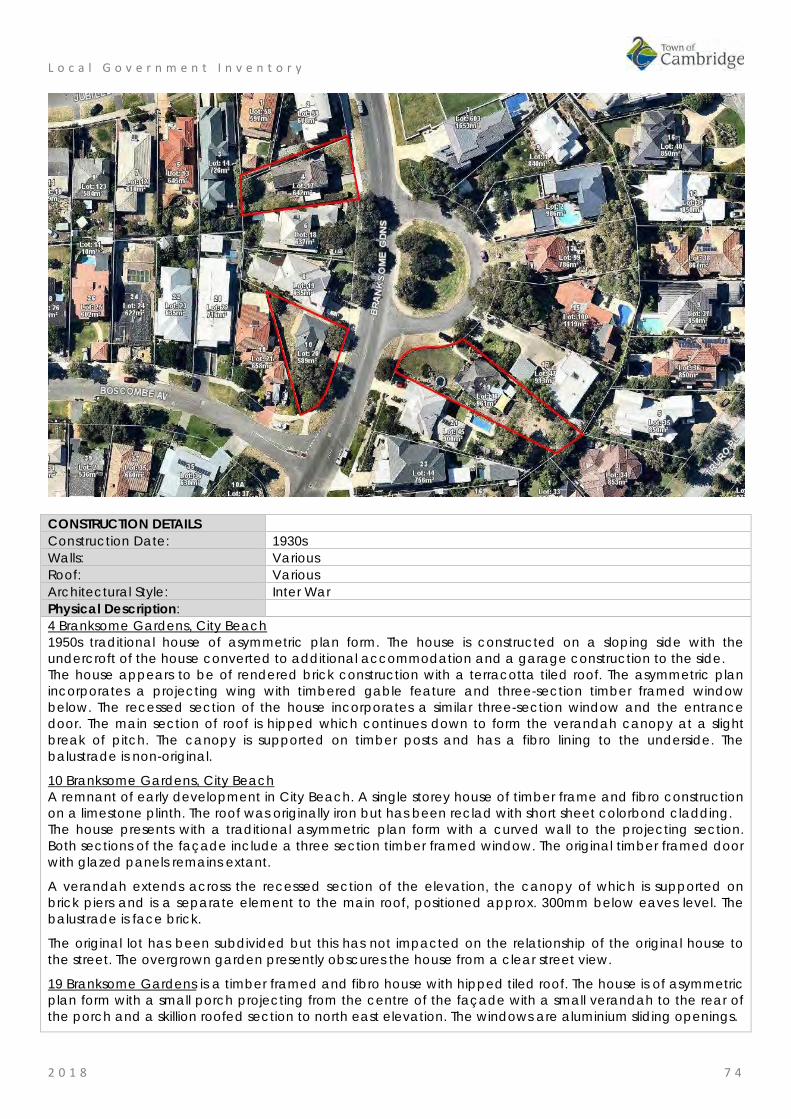
L o c a l G o v e r n m e n t I n v e n t o r y
2 0 1 8 7 4
CONSTRUCTION DETAILS Construction Date: 1930s Walls: Various Roof: Various Architectural Style: Inter War Physical Description: 4 Branksome Gardens, City Beach 1950s traditional house of asymmetric plan form. The house is constructed on a sloping side with the undercroft of the house converted to additional accommodation and a garage construction to the side. The house appears to be of rendered brick construction with a terracotta tiled roof. The asymmetric plan incorporates a projecting wing with timbered gable feature and three-section timber framed window below. The recessed section of the house incorporates a similar three-section window and the entrance door. The main section of roof is hipped which continues down to form the verandah canopy at a slight break of pitch. The canopy is supported on timber posts and has a fibro lining to the underside. The balustrade is non-original.
10 Branksome Gardens, City Beach A remnant of early development in City Beach. A single storey house of timber frame and fibro construction on a limestone plinth. The roof was originally iron but has been reclad with short sheet colorbond cladding. The house presents with a traditional asymmetric plan form with a curved wall to the projecting section. Both sections of the façade include a three section timber framed window. The original timber framed door with glazed panels remains extant.
A verandah extends across the recessed section of the elevation, the canopy of which is supported on brick piers and is a separate element to the main roof, positioned approx. 300mm below eaves level. The balustrade is face brick.
The original lot has been subdivided but this has not impacted on the relationship of the original house to the street. The overgrown garden presently obscures the house from a clear street view.
19 Branksome Gardens is a timber framed and fibro house with hipped tiled roof. The house is of asymmetric plan form with a small porch projecting from the centre of the façade with a small verandah to the rear of the porch and a skillion roofed section to north east elevation. The windows are aluminium sliding openings.
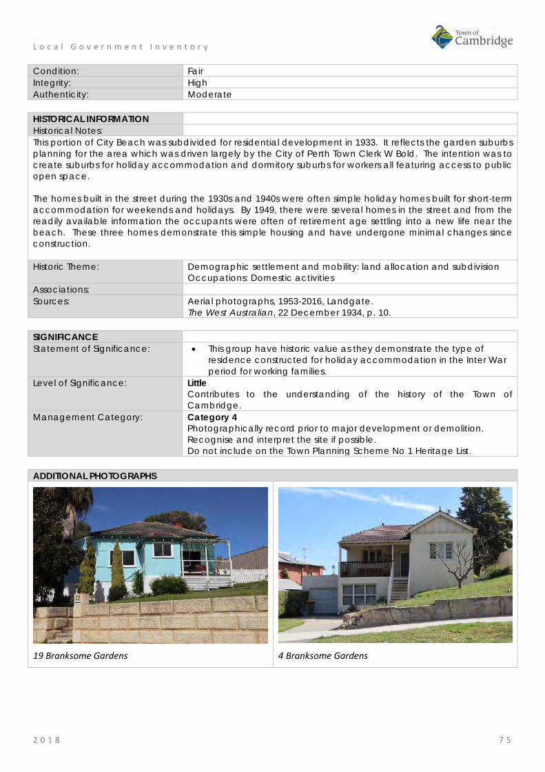
L o c a l G o v e r n m e n t I n v e n t o r y
2 0 1 8 7 5
Condition: Fair Integrity: High Authenticity: Moderate HISTORICAL INFORMATION Historical Notes: This portion of City Beach was subdivided for residential development in 1933. It reflects the garden suburbs planning for the area which was driven largely by the City of Perth Town Clerk W Bold. The intention was to create suburbs for holiday accommodation and dormitory suburbs for workers all featuring access to public open space. The homes built in the street during the 1930s and 1940s were often simple holiday homes built for short-term accommodation for weekends and holidays. By 1949, there were several homes in the street and from the readily available information the occupants were often of retirement age settling into a new life near the beach. These three homes demonstrate this simple housing and have undergone minimal changes since construction. Historic Theme: Demographic settlement and mobility: land allocation and subdivision
Occupations: Domestic activities Associations: Sources: Aerial photographs, 1953-2016, Landgate.
The West Australian, 22 December 1934, p. 10. SIGNIFICANCE Statement of Significance: • This group have historic value as they demonstrate the type of
residence constructed for holiday accommodation in the Inter War period for working families.
Level of Significance: Little Contributes to the understanding of the history of the Town of Cambridge.
Management Category: Category 4 Photographically record prior to major development or demolition. Recognise and interpret the site if possible. Do not include on the Town Planning Scheme No 1 Heritage List.
ADDITIONAL PHOTOGRAPHS
19 Branksome Gardens
4 Branksome Gardens

L o c a l G o v e r n m e n t I n v e n t o r y
2 0 1 8 7 6
St Paul's Church and Hall, City Beach Place No: 3
SITE INFORMATION Place Name: St Paul's Church and Hall Other Names: St Paul's Anglican Church;
Anglican Church of St Paul; St Paul The Apostle Anglican Church
Street Address: 57 Brompton Road Locality City Beach HERITAGE LISTING SHO inHerit database 11489 Other Listings Anglican Church Inventory PLACE TYPE Individual building or group Original Use: Religious: Church Current Use: Religious: Church Other Use: Religious: Church Hall LAND INFORMATION Lot: 1 Survey: Diagram 43818 Reserve No: ---------- C/T: 1387-485 Property Number: 15033 Land Number: 3840

L o c a l G o v e r n m e n t I n v e n t o r y
2 0 1 8 7 7
CONSTRUCTION DETAILS Construction Date: 1976; 1990 Walls: Brick: painted Roof: Metal: Colorbond Architectural Style: Late 20th century Ecclesiastical Physical Description: St Paul’s is a late 20th century church of pale brick construction with clip lock skillion roofs. The place consists of church and parish centre separated by a central enclosed hallway. The church consists of predominantly blank walls, enlivened only by a small number of windows. The main feature of the church is an increased height brick and glass tower, further emphasised by a large timber cross located on the south east corner of the church. The ‘tower’ is glazed to the east elevation with three full height windows separated by brick columns. The south aspect of the ‘tower’ presents with plain brickwork with angled parapet wall with the name of the church and the cross as the only elements of decoration. The attached church hall is of equally simple presentation with a blank elevation to Brompton Road and mainly glazed elevation facing northwards over the garden. The main entrance to the church is via a pathway through the gardens from Brompton Road, leading to the central entrance. A further pathway is to the rear of the church providing access to the car park. The church is located to the east of the Ocean Village shopping centre and to the south of the park, in a predominantly residential area. Condition: Good Integrity: High Authenticity: High
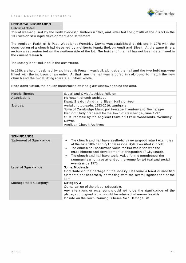
L o c a l G o v e r n m e n t I n v e n t o r y
2 0 1 8 7 8
HISTORICAL INFORMATION Historical Notes: This lot was acquired by the Perth Diocesan Trustees in 1972, and reflected the growth of the district in the 1960s which saw rapid development and settlement. The Anglican Parish of St Paul, Woodlands-Wembley Downs was established at this site in 1976 with the construction of a church hall designed by architects, Krantz Sheldon Arndt and Silbert. At the same time a rectory was constructed on the northern side of the lot. The builder of the hall has not been determined in the current research. The rectory is not included in the assessment. In 1990, a church designed by architect Iris Rossen, was built alongside the hall and the two buildings were linked with the inclusion of an entry. At that time the hall was reroofed in colorbond to match the new church and the two buildings create a uniform whole. Since construction, the church has installed stained glass windows behind the altar. Historic Theme: Social and Civic Activities: Religion Associations: Iris Rossen, church architect
Krantz Sheldon Arndt and Silbert, Hall architect Sources: Aerial photographs, 1953-2016, Landgate.
Town of Cambridge Municipal Heritage Inventory and Townscape Precinct Study prepared for the Town of Cambridge, June 1997. St Paul's profile by the Anglican Parish of St Paul, Woodlands - Wembley Downs Anglican Church Archives
SIGNIFICANCE Statement of Significance: • The church and hall have aesthetic value as good intact examples
of the Late 20th century Ecclesiastical style executed in brick. • The church hall has historic value for its association with the
establishment and development of this portion of City Beach. • The church and hall have social value for the members of the
community who have attended the venue for spiritual and social events since 1976.
Level of Significance: Some/Moderate Contributes to the heritage of the locality. Has some altered or modified elements, not necessarily detracting from the overall significance of the item.
Management Category: Category 3 Conservation of the place is desirable. Any alterations or extensions should reinforce the significance of the place, and original fabric should be retained wherever feasible. Include on the Town Planning Scheme No 1 Heritage List.
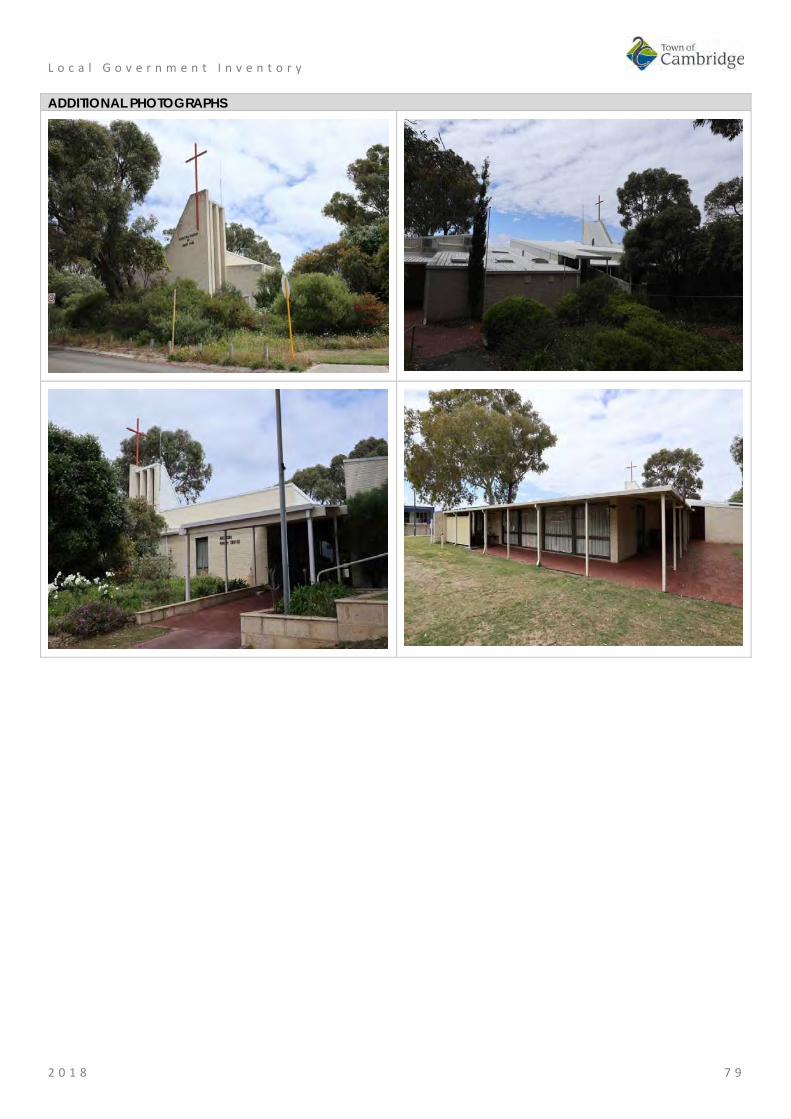
L o c a l G o v e r n m e n t I n v e n t o r y
2 0 1 8 7 9
ADDITIONAL PHOTOGRAPHS
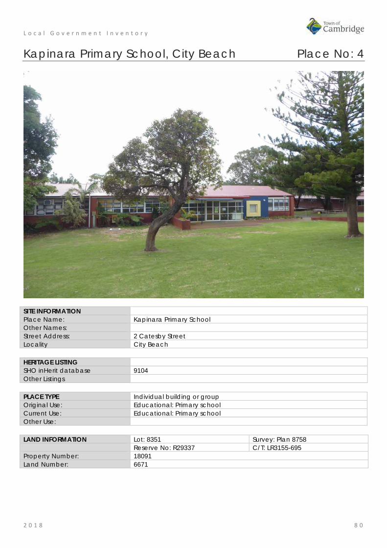
L o c a l G o v e r n m e n t I n v e n t o r y
2 0 1 8 8 0
Kapinara Primary School, City Beach Place No: 4
SITE INFORMATION Place Name: Kapinara Primary School Other Names: Street Address: 2 Catesby Street Locality City Beach HERITAGE LISTING SHO inHerit database 9104 Other Listings PLACE TYPE Individual building or group Original Use: Educational: Primary school Current Use: Educational: Primary school Other Use: LAND INFORMATION Lot: 8351 Survey: Plan 8758 Reserve No: R29337 C/T: LR3155-695 Property Number: 18091 Land Number: 6671

L o c a l G o v e r n m e n t I n v e n t o r y
2 0 1 8 8 1
CONSTRUCTION DETAILS Construction Date: 1967; 2013 Walls: Brick: Common Roof: Metal: Colorbond Architectural Style: Late 20th Century academic Physical Description: Kapinara Primary School is a single and double storey brick and Colorbond school positioned in the south western corner of a large site which includes two ovals and hard courts, surrounded by peripheral planting. The main entrance is along Catesby Street to the south, which is set at a slightly lower level than the road. There are two car parks on the site, the original on the eastern side. The school is of brick construction, divided into a regular rhythm of bays, each with aluminium framed windows. The school has a traditional academic aesthetic with a simple utilitarian presentation. The school is arranged in ranges, each interconnecting with each other and forming a series of quads and semi-enclosed spaces. Condition: Good Integrity: High Authenticity: High

L o c a l G o v e r n m e n t I n v e n t o r y
2 0 1 8 8 2
HISTORICAL INFORMATION Historical Notes: Kapinara Primary School was opened in 1967. The school is located adjacent to the former Empire Games Village constructed in 1962. At the completion of the games, the village houses were rapidly sold and occupied. Other subdivisions quickly followed and City Beach quickly developed, with many young families settling in the area. Kapinara Primary School was built to provide for this growing school age population located between the existing City Beach Primary School and Wembley Downs Primary School. Since its foundation the school facilities developed to accommodate the growing population and adapted and added to in response to the evolution of education practice. The school’s peak enrolment period was in the 1970’s, with nearly 700 students attending. After a period of population decline and stabilisation, many young families have returned to the area and enrolments have steadily grown over recent years. Current [2018] enrolments are approximately 380 (Yr K-6). The original Pre Primary was situated offsite in Bendigo Way, which in later years became the Kindergarten. In 2007 the Kindergarten was moved to the main school site. The Public Works Department oversaw the design and construction of the original school. In subsequent years private architecture firms, White & Winning Partners and McDonald Whitaker & Partners were responsible for additions to the school buildings. Additions and alterations have included a new library, an art and music block and major landscaping in 2009. In c2013 the original tile roof of the school was replaced with colorbond cladding. Three new nature playgrounds have been added to the school grounds between 2014 and 2016 and in 2017 a new toilet block was constructed. Historic Theme: Social and Civic Activities: Education and Science
Demographic Settlement and Mobility: Land allocation and subdivision Associations: White & Winning Partners
McDonald Whitaker & Partners Sources: Aerial photographs, 1953-2016, Landgate.
Town of Cambridge Municipal Heritage Inventory and Townscape Precinct Study prepared for the Town of Cambridge, June 1997. Wise's Post Office Directories for the City of Perth, 1925-1949, State Library of WA www.slwa.wa.gov.au Kapinara Primary School website http://www.kapinaraps.wa.edu.au/ Information from Kapinara Primary School 2018.
SIGNIFICANCE Statement of Significance: • The place has aesthetic value as a largely intact example of a late
20th century complex of educational buildings that feature the style and detail of the period.
• The place has historic significance representing the history of settlement of the local area and also the provision of education to the new community in City Beach and Wembley Downs.
• The place has social value for the members of the local community, particularly past students and staff.
Level of Significance: Some/moderate Contributes to the heritage of the locality. Has some altered or modified elements, not necessarily detracting from the overall significance of the item.
Management Category: Category 3 Conservation of the place is desirable. Any alterations or extensions should reinforce the significance of the place, and original fabric should be retained wherever feasible. Include on the Town Planning Scheme No 1 Heritage List.

L o c a l G o v e r n m e n t I n v e n t o r y
2 0 1 8 8 3
ADDITIONAL PHOTOGRAPHS

L o c a l G o v e r n m e n t I n v e n t o r y
2 0 1 8 8 4
South City Beach Kiosk, City Beach Place No: 5
SITE INFORMATION Place Name: South City Beach Kiosk Other Names: DJ's Surf City Street Address: Challenger Parade Locality City Beach HERITAGE LISTING SHO inHerit database 9108 Other Listings PLACE TYPE Individual building or group Original Use: Social Recreational: Kiosk Current Use: Social Recreational: Kiosk Other Use: Commercial: shop LAND INFORMATION Lot: 2301 Survey: Plan 220077 Reserve No: --------- C/T: LR3044-272 Property Number: 10785 Land Number: 11015
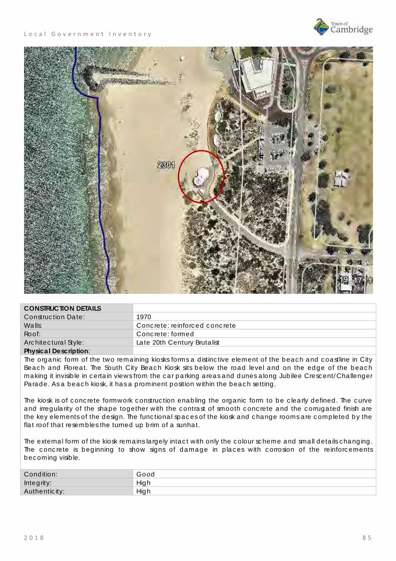
L o c a l G o v e r n m e n t I n v e n t o r y
2 0 1 8 8 5
CONSTRUCTION DETAILS Construction Date: 1970 Walls: Concrete: reinforced concrete Roof: Concrete: formed Architectural Style: Late 20th Century Brutalist Physical Description: The organic form of the two remaining kiosks forms a distinctive element of the beach and coastline in City Beach and Floreat. The South City Beach Kiosk sits below the road level and on the edge of the beach making it invisible in certain views from the car parking areas and dunes along Jubilee Crescent/Challenger Parade. As a beach kiosk, it has a prominent position within the beach setting. The kiosk is of concrete formwork construction enabling the organic form to be clearly defined. The curve and irregularity of the shape together with the contrast of smooth concrete and the corrugated finish are the key elements of the design. The functional spaces of the kiosk and change rooms are completed by the flat roof that resembles the turned up brim of a sunhat. The external form of the kiosk remains largely intact with only the colour scheme and small details changing. The concrete is beginning to show signs of damage in places with corrosion of the reinforcements becoming visible. Condition: Good Integrity: High Authenticity: High

L o c a l G o v e r n m e n t I n v e n t o r y
2 0 1 8 8 6
HISTORICAL INFORMATION Historical Notes: The suburb of City Beach had sporadic and modest development until the 1960s. The 1962 Empire Games in Perth which saw the development of lands in Perry Lakes for Games Village Houses led to adjacent landholdings being released for residential subdivision. The subdivisions alongside the coast in City Beach were largely created in the late 1960s.
In the 1930s, basic timber buildings had been erected at popular beaches as tea rooms and change rooms. These facilities were no longer adequate in the late 1960s with more residents in the area and car ownership enabling those more distant from the beach to visit more frequently.
The 1960s also saw the popularity and growth of surfing and the associated ‘surf culture’. Although not new to Western Australia, surfing and beach going became more popular and were closely associated with younger generations. The late 1960s can also be seen as a period of experimentation and rejection of past practices and attitudes. It was in the context of a newly established suburb providing for a young population keen to embrace new styles and technologies that the City Beach kiosks were built. It is therefore not surprising that an innovative approach was taken in the design of the new kiosks.
Until 1994, the City of Perth was the local government authority responsible for the suburb of City Beach. During the 1960s, an influential figure in the offices of the City of Perth was architect and planner Paul Ritter. Ritter was a controversial and colourful figure in Western Australia in this period. He was trained in England and was brought to the City of Perth to advance local knowledge and philosophies of planning and design. Appointed as the City of Perth's first City Planner in 1965 he was dismissed in 1967 but engendered significant public support which led to his election as a City of Perth councillor from 1968 to 1986.
Following his dismissal, Ritter established his own practice and was well known for exploring new techniques and philosophies, particularly in relation to art and design in the public realm. In 1969, his design of a wavy retaining wall in local Toodyay stone was built at City Beach. The design was influenced by the adjacent waves and sand dunes and was part of a larger Master Plan for City Beach prepared during his tenure at the City of Perth.
The City of Perth subsequently engaged architecture firm Forbes and Fitzhardinge to design three new kiosks to serve City Beach. Architect Tony Brand was responsible for the organic design of the concrete kiosks which used corrugated iron as formwork for the walls and reinforced concrete for the roof structure. The use of concrete was a practical solution for this harsh environment but is also associated with brutalist design popular in this period.
The name, Brutalism, does not refer to a harsh appearance, but derives from French for raw concrete (beton - brut) and was a style that focussed on affordable and functional public buildings. Tony Brand was an enthusiastic exponent of the style and many of his public buildings in Western Australia during the 1960s and 1970s demonstrate the style. However the organic curved style of the kiosks differs from the classic block Brutalist form.
Tony Brand is understood to have designed the kiosks in response to Paul Ritter’s curved wall and the landscape. It is proposed by Geoffrey London that the roofs of the kiosks are representation of an inverted beach shell.
Ritter was also an enthusiastic exponent of the use of formed concrete in the public realm and undertook several public projects in this material and wrote extensively on its application and the philosophy underpinning its use.
During 1970/1971 the City of Perth spent $375,829 on works at City Beach including the new kiosks and change rooms, and the City of Perth Surf Club House. The decision to hold the Australian National Surf Life Saving Competitions at City Beach in 1971 would have been a significant impetus to complete the works. In the City of Perth Annual Report for that year it was noted that;
During the year the facilities and conditions at City Beach were highly praised by both competitors and spectators at the Australian National Surf Championships. More than 1,400 lifesavers from all Australian states and a team from South Africa competed during the April carnival. Blending man-made feature and amenities into the natural beach scene will continue to enhance City Beach’s wide popularity.
At the time of construction the concrete of the buildings were left unfinished as seen in the 1971
L o c a l G o v e r n m e n t I n v e n t o r y
2 0 1 8 8 7
photographs. This finish was likely to have been the origin of the reference to the blending of man-made features into the natural beach scene.
The kiosk north of the groyne located at the main City Beach was demolished in 2000 and the current restaurant and change rooms were built throughout 2001. Floreat Kiosk remains largely in its original form.
The South City Beach Kiosk has been largely unchanged since construction. Painting of the external surfaces appears to have been undertaken on several occasions. Aerial photographs indicate the roof was treated with a black bituminised product in the early 2000s which has subsequently been replaced or overlaid.
The South City Beach kiosk has been closed since 2014 and in late 2015 the public toilets were closed following the completion of new amenities nearby. Since that time there has been significant media coverage and community interest in the future of the building. Consequently, the Town of Cambridge have undertaken community engagement to determine the level of community interest in the future of the building.
In April 2017, Peritas Engineers undertook a structural assessment of the building for the Town of Cambridge. Their conclusions were as follows:
Overall the structure is in average condition. The load bearing walls and columns are in good condition and are showing no signs of structural damage. The top of the roof is in good condition, only requiring minor maintenance work.
The area with significant structural damage is the slab soffit which is exposed to the environment. The delamination survey highlighted that concrete degradation due to corrosion of the reinforcement has taken place to over sixty percent of this area.
In September 2017 the place is closed but continues to be maintained by the Town of Cambridge.
Historic Theme: Social and Civic Activities: Sport, recreation and entertainment Occupations: Hospitality industry and tourism Occupations: Commercial services and industries
Associations: Tony Brand Paul Ritter Forbes and Fitzhardinge
Sources: Landgate land information and aerial photographs. London, Geoffrey and Bingham-Hall, Patrick A Short History of Perth Architecture Pesaro Publishing, 2002. Town of Cambridge, Municipal Heritage Inventory, Heritage and Conservation Professionals, 1996. Gregory, Jenny City of Light A History of Perth since the 1950s City of Perth 2003. Ritter, Paul ‘Concrete Fit for People: A Practical Approach to a Bio-Functional Eco-Architecture for the Third Millenium A.D. 1980. City of Perth Annual Report 1970-71, pp 4-8, from the Town of Cambridge Local History Collection, item T520.
SIGNIFICANCE Statement of Significance: • The place has aesthetic value as a rare intact example of a
concrete building exhibiting Late 20th century Brutalist influences in an organic style;
• Together with the remaining Floreat Kiosk, the pair has aesthetic value as landmarks on the beach front which exhibit unusual form and construction;
• The place has historic value for its association with a period of innovation and experimentation in building design in the 1960s;
• The place has historic value for its association with prominent architects in Western Australia during the 1960s and 1970s; Paul Ritter

L o c a l G o v e r n m e n t I n v e n t o r y
2 0 1 8 8 8
and Tony Brand; • The place has social value for many members of the community
from the Town of Cambridge and the wider Perth metropolitan area for its association with visits to the beach since 1970.
Level of Significance: Considerable Very important to the heritage of the locality. High degree of integrity/authenticity
Management Category: Category 2 Conservation of the place is highly desirable. Any alterations or extensions should reinforce the significance of the place Include on the Town Planning Scheme No 1 Heritage List.
ADDITIONAL PHOTOGRAPHS
City Beach Kiosk, 1971 courtesy State Library, image 160025PD

L o c a l G o v e r n m e n t I n v e n t o r y
2 0 1 8 8 9
Floreat Beach and Groyne, City Beach Place No: 6
SITE INFORMATION Place Name: Floreat Beach and Groyne Other Names: Wembley Beach; North City Beach Street Address: Challenger Parade Locality City Beach HERITAGE LISTING SHO inHerit database 9108 Other Listings PLACE TYPE Landscape Original Use: Park/reserve Current Use: Park/Reserve Other Use: LAND INFORMATION Lot: 6000; 2301 Survey: Plan 74241, Plan 220077 Reserve No: 16921 C/T: 2801-298, 3044-272 Property Number: 10784, 20988 Land Number: 14228, 11015

L o c a l G o v e r n m e n t I n v e n t o r y
2 0 1 8 9 0
CONSTRUCTION DETAILS Construction Date: N/A Walls: N/A Roof: N/A Architectural Style: N/A Physical Description: Extensive area of beach with dunes, native vegetation and landscaping. The area of beach between Floreat and City Beach is connected not only by the beach but through purpose built boardwalks and coastal paths. The dunes and natural vegetation aesthetic is interspersed with formal landscaping of lawned areas and plantings softening the hard landscaping of the carparks. Facilities include kiosks, surf clubrooms, restaurants, picnic and BBQ areas and children’s play areas. Condition: Good Integrity: High Authenticity: High HISTORICAL INFORMATION Historical Notes: The popularity of different beaches in the Perth metropolitan area was dependent on transport in the first decades of the 20th century. Those beaches close to the train line were most well patronised until the Inter War years when road access was improved. In February 1918, a timber plank road was completed in built between the city and the beach along the alignment of the present day Oceanic Drive. The beach where the road terminated became known as 'City Beach' and was formally designated as that in c1925. Life Saving Clubs had been established at Cottesloe and North Cottesloe, and in December 1924 members

L o c a l G o v e r n m e n t I n v e n t o r y
2 0 1 8 9 1
of the City of Perth Amateur Swimming Club formed Western Australia’s third Surf Life Saving Club at City Beach. In 1927, a new road to the beach was cleared along the route of what is now, The Boulevard. This road provided access to the northern parts of City Beach, now Floreat Beach. A club now known as the Floreat Surf Life Saving Club was first formed by a band of young men in 1947 under the name of North City Surf Life Saving Club. Prior to 1947, members of the City of Perth Club, at City Beach occasionally patrolled Floreat Beach, then known as Wembley or North City Beach. The members misbehaving or being slack in carrying out club duties did this patrolling as a punishment detail - City members called it the Sahara. The City of Perth built basic timber clubrooms and public facilities at the beach. In 1958, the name Floreat Beach came into common usage with the Surf Life Saving Club adopting the name. In 1958/59, the Floreat groyne was built to provide protection for swimmers at City Beach as well as resolved some of the issues of erosion which had been experienced at City Beach. Maintenance and management of the beaches and groynes have been an ongoing task for the Town of Cambridge and prior to 1994, the City of Perth. The 1960s also saw the popularity and growth of surfing and the associated ‘surf culture’. Although not new to Western Australia, surfing and beach going became more popular and were closely associated with younger generations. In 1962, the Perth City Council built a multipurpose building within the area which could be utilised during the 1962 Empire Games and the Floreat club thereafter. The Council built a clubrooms on the hill, closer to the main and popular area near the groyne. This location enabled easy patrolling of all the Floreat Beach, and a good position to keep watch for potential dangers. Those clubrooms were extended on two occasions (1966 & 1972) to give the club more storage area for gear and extra administration and utility areas. The late 1960s can also be seen as a period of experimentation and rejection of past practices and attitudes. It was in the context of a newly established suburb providing for a young population keen to embrace new styles and technologies that the City of Perth provided new facilities at Floreat and City Beach. In 1971, City Beach was the host of the Australian Surf Life Saving Championships which saw the City of Perth undertake major works at the beach. In 1970, architects Forbes and Fitzhardinge were engaged to design three kiosks at the beach. Architect Tony Brand oversaw the design and he prepared an organic design in concrete which responded to the seaside setting. Only two of these kiosks remain in-situ at Floreat Beach and South City Beach. In 1978, Cyclone Alby hit the metropolitan coastline and accelerated the erosion of Floreat Beach which undermined the surf clubrooms. The buildings had to be demolished and subsequently new buildings were completed further back from the ocean and opened in January 1981. Architects Johnston & Crystal designed the new clubrooms in conjunction with members of the Floreat Surf Life Saving Club. Since the completion of the new clubrooms, the facilities at Floreat Beach continue to be maintained and improved with increased parking, pathways and controlled access to the beach through the sand dunes to protect the native vegetation. In 2005, a boardwalk was constructed between Floreat Beach and City Beach to assist in the maintenance and restoration of the sand dunes. Historic Theme: Social and Civic Activities: Sport, recreation and entertainment
Demographic settlement and mobility: Government policy Associations: Tony Brand
Forbes and Fitzhardinge Johnston & Crystal
Sources: Aerial photographs, 1953-2016, Landgate. Floreat Surf Life Saving Club website, http://floreatslsc.com.au

L o c a l G o v e r n m e n t I n v e n t o r y
2 0 1 8 9 2
SIGNIFICANCE Statement of Significance: • Floreat Beach has aesthetic value as a large stretch of beach and
foreshore that is well maintained and in good condition. • The place has historic value for its association with the establishment
and development of the adjacent suburb of City Beach from a holiday destination in the 1920s to its development in the 1960s as part of the greater metropolitan area.
• The place has historic value for its demonstration of the evolution in the development of public facilities with the remaining kiosk the earliest structure on the site through to contemporary structures.
• The groyne has potential research value as they demonstrate methods of construction in the mid 20th century which may prove instructive to future projects;
• The place has social value for many members of the community from the Town of Cambridge and the wider Perth metropolitan area who have visited the beach for formal and informal recreation.
Level of Significance: Some/moderate Contributes to the heritage of the locality. Has some altered or modified elements, not necessarily detracting from the overall significance of the item.
Management Category: Category 3 Conservation of the place is desirable. Any alterations or extensions should reinforce the significance of the place, and original fabric should be retained wherever feasible. Include on the Town Planning Scheme No 1 Heritage List.
ADDITIONAL PHOTOGRAPHS

L o c a l G o v e r n m e n t I n v e n t o r y
2 0 1 8 9 3
Floreat Kiosk, City Beach Place No: 7
SITE INFORMATION Place Name: Floreat Kiosk Other Names: The Kiosk
Floreat Beach Toilets and Change Rooms Street Address: Challenger Parade Locality City Beach HERITAGE LISTING SHO inHerit database 9108 Other Listings PLACE TYPE Individual building or group Original Use: Social Recreational: Kiosk Current Use: Social Recreational: Kiosk Other Use: Commercial: shop LAND INFORMATION Lot: 6000 Survey: Plan 74241 Reserve No: --------- C/T: 2801-298 Property Number: 10784 Land Number: 14228

L o c a l G o v e r n m e n t I n v e n t o r y
2 0 1 8 9 4
CONSTRUCTION DETAILS Construction Date: 1970 Walls: Concrete: reinforced concrete Roof: Concrete: formed Architectural Style: Late 20th Century Brutalist Physical Description: The organic form of the two remaining kiosks forms a distinctive element of the beach and coastline in City Beach and Floreat. The Floreat Kiosk has a visible presence from Challenger Parade as well as being visible from the beach. The kiosk is of concrete formwork construction enabling the organic form to be clearly defined. The curve and irregularity of the shape together with the contrast of smooth concrete and the corrugated finish are they key elements of the design. The functional spaces of the kiosk and change rooms are completed by the flat roof that resembles the turned up brim of a sunhat. The external form of the kiosk remains largely intact with only the colour scheme and small details changing. The awnings which surround the structure are removable as is the lightweight partitioning on the seaward side. The concrete is beginning to show signs of damage in places with corrosion of the reinforcements becoming visible. Condition: Good Integrity: High Authenticity: High
HISTORICAL INFORMATION Historical Notes: The suburb of City Beach had sporadic and modest development until the 1960s. The 1962 Empire Games in Perth which saw the development of lands in Perry Lakes for Games Village Houses led to adjacent

L o c a l G o v e r n m e n t I n v e n t o r y
2 0 1 8 9 5
landholdings being released for residential subdivision. The subdivisions alongside the coast in City Beach were largely created in the late 1960s. In the 1930s, basic timber buildings had been erected at popular beaches as tea rooms and change rooms. These facilities were no longer adequate in the late 1960s with more residents in the area and car ownership enabling those more distant from the beach to visit more frequently. The 1960s also saw the popularity and growth of surfing and the associated ‘surf culture’. Although not new to Western Australia, surfing and beach going became more popular and were closely associated with younger generations. The late 1960s can also be seen as a period of experimentation and rejection of past practices and attitudes. It was in the context of a newly established suburb providing for a young population keen to embrace new styles and technologies that three kiosks were built at City Beach and Floreat Beach. An innovative approach was taken in the design of the new kiosks by architect Tony Brand. Until 1994, the City of Perth was the local government authority responsible for the suburb of City Beach. During the 1960s, an influential figure in the offices of the City of Perth was architect and planner Paul Ritter. Ritter was a controversial and colourful figure in Western Australia in this period. He was trained in England and was brought to the City of Perth to advance local knowledge and philosophies of planning and design. Appointed as the City of Perth's first City Planner in 1965 he was dismissed in 1967 but engendered significant public support which led to his election as a City of Perth councillor from 1968 to 1986. Following his dismissal, Ritter established his own practice and was well known for exploring new techniques and philosophies, particularly in relation to art and design in the public realm. In 1969, his design of a wavy retaining wall in local Toodyay stone was built at City Beach. The design was influenced by the adjacent waves and sand dunes and was part of a larger Master Plan for City Beach prepared during his tenure at the City of Perth. The City of Perth subsequently engaged architecture firm Forbes and Fitzhardinge to design three new kiosks to serve City Beach. Architect Tony Brand was responsible for the organic design of the concrete kiosks which used corrugated iron as formwork for the walls and reinforced concrete for the roof structure. The use of concrete was a practical solution for this harsh environment but is also associated with brutalist design popular in this period. The name, Brutalism, does not refer to a harsh appearance, but derives from French for raw concrete (beton - brut) and was a style that focussed on affordable and functional public buildings. Tony Brand was an enthusiastic exponent of the style and many of his public buildings in Western Australia during the 1960s and 1970s demonstrate the style. However the organic curved style of the kiosks differs from the classic block Brutalist form. Tony Brand is understood to have designed the kiosks in response to Paul Ritter’s curved wall and the landscape. It is proposed by Geoffrey London that the roofs of the kiosks are representation of an inverted beach shell. Ritter was also an enthusiastic exponent of the use of formed concrete in the public realm and undertook several public projects in this material and wrote extensively on its application and the philosophy underpinning its use. During 1970/1971 the City of Perth spent $375,829 on works at City Beach including the new kiosks and change rooms, and the City of Perth Surf Club House. The decision to hold the Australian National Surf Life Saving Competitions at City Beach in 1971 would have been a significant impetus to complete the works. In the City of Perth Annual Report for that year it was noted that;
During the year the facilities and conditions at City Beach were highly praised by both competitors and spectators at the Australian National Surf Championships. More than 1,400 lifesavers from all Australian states and a team from South Africa competed during the April carnival. Blending man-made feature and amenities into the natural beach scene will continue to enhance City Beach’s wide popularity.
L o c a l G o v e r n m e n t I n v e n t o r y
2 0 1 8 9 6
At the time of construction the concrete of the buildings were left unfinished as seen in the 1971 photographs. This finish was likely to have been the origin of the reference to the blending of man-made features into the natural beach scene. The kiosk north of the groyne located at the main City Beach was demolished in 2000 and the current restaurant and change rooms were built throughout 2001. Floreat Kiosk remains largely in its original form. Aerial photographs show that landscaping works were undertaken c2000 and in the following year the awnings which are a feature of the place were first installed. These are a seasonal feature and are erected as required. The light weight removable partitioning on the seaward side of the building are believed to have been installed at approximately the same time for the café tenancy. Historic Theme: Social and Civic Activities: Sport, recreation and entertainment
Occupations: Hospitality industry and tourism Occupations: Commercial services and industries
Associations: Tony Brand Paul Ritter Forbes and Fitzhardinge
Sources: Landgate land information and aerial photographs. London, Geoffrey and Bingham-Hall, Patrick A Short History of Perth Architecture Pesaro Publishing, 2002. Town of Cambridge, Municipal Heritage Inventory, Heritage and Conservation Professionals, 1996. Gregory, Jenny City of Light A History of Perth since the 1950s City of Perth 2003. Ritter, Paul ‘Concrete Fit for People: A Practical Approach to a Bio-Functional Eco-Architecture for the Third Millenium A.D. 1980. City of Perth Annual Report 1970-71, pp 4-8, from the Town of Cambridge Local History Collection, item T520.
SIGNIFICANCE Statement of Significance: • The place has aesthetic value as a rare intact example of a
concrete building exhibiting Late 20th century Brutalist influences in an organic style;
• together with the remaining South City Beach Kiosk, the pair has aesthetic value as landmarks on the beach front which exhibit unusual form and construction;
• the place has historic value for its association with a period of innovation and experimentation in building design in the 1960s;
• the place has historic value for its association with prominent architects in Western Australia during the 1960s and 1970s, Pal Ritter and Tony Brand;
• the place has social value for many members of the community from the Town of Cambridge and the wider Perth metropolitan area for its association with visits to the beach since 1970.
Level of Significance: Considerable Very important to the heritage of the locality. High degree of integrity/authenticity
Management Category: Category 2 Conservation of the place is highly desirable. Any alterations or extensions should reinforce the significance of the place Include on the Town Planning Scheme No 1 Heritage List.
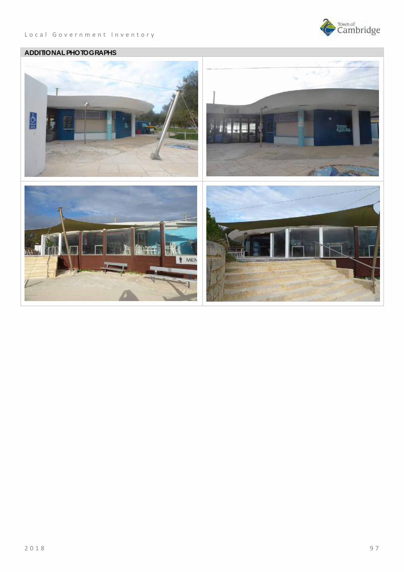
L o c a l G o v e r n m e n t I n v e n t o r y
2 0 1 8 9 7
ADDITIONAL PHOTOGRAPHS

L o c a l G o v e r n m e n t I n v e n t o r y
2 0 1 8 9 8
Wright House, City Beach Place No: 8
SITE INFORMATION Place Name: Wright House Other Names: Residence, 24 Dilkara Way Street Address: 24 Dilkara Way Locality City Beach HERITAGE LISTING SHO inHerit database Other Listings PLACE TYPE Individual building or group Original Use: Residential: Single storey house Current Use: Residential: Single storey house Other Use: LAND INFORMATION Lot: 36 Survey: Plan 10632 Reserve No: C/T: 1361/728 Property Number: 15171 Land Number: 3968
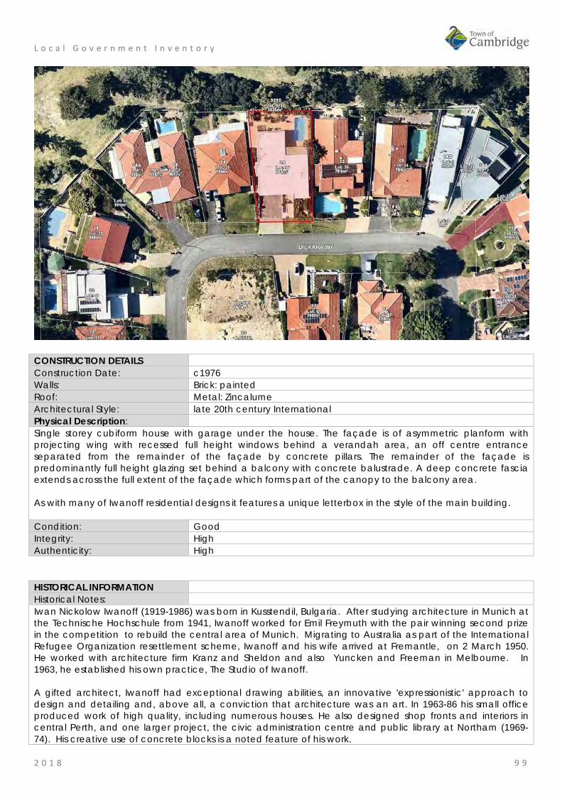
L o c a l G o v e r n m e n t I n v e n t o r y
2 0 1 8 9 9
CONSTRUCTION DETAILS Construction Date: c1976 Walls: Brick: painted Roof: Metal: Zincalume Architectural Style: late 20th century International Physical Description: Single storey cubiform house with garage under the house. The façade is of asymmetric planform with projecting wing with recessed full height windows behind a verandah area, an off centre entrance separated from the remainder of the façade by concrete pillars. The remainder of the façade is predominantly full height glazing set behind a balcony with concrete balustrade. A deep concrete fascia extends across the full extent of the façade which forms part of the canopy to the balcony area. As with many of Iwanoff residential designs it features a unique letterbox in the style of the main building. Condition: Good Integrity: High Authenticity: High
HISTORICAL INFORMATION Historical Notes: Iwan Nickolow Iwanoff (1919-1986) was born in Kusstendil, Bulgaria. After studying architecture in Munich at the Technische Hochschule from 1941, Iwanoff worked for Emil Freymuth with the pair winning second prize in the competition to rebuild the central area of Munich. Migrating to Australia as part of the International Refugee Organization resettlement scheme, Iwanoff and his wife arrived at Fremantle, on 2 March 1950. He worked with architecture firm Kranz and Sheldon and also Yuncken and Freeman in Melbourne. In 1963, he established his own practice, The Studio of Iwanoff. A gifted architect, Iwanoff had exceptional drawing abilities, an innovative 'expressionistic' approach to design and detailing and, above all, a conviction that architecture was an art. In 1963-86 his small office produced work of high quality, including numerous houses. He also designed shop fronts and interiors in central Perth, and one larger project, the civic administration centre and public library at Northam (1969-74). His creative use of concrete blocks is a noted feature of his work.

L o c a l G o v e r n m e n t I n v e n t o r y
2 0 1 8 1 0 0
Many of the Iwanoff residences designed in the 1960s and 1970s were in the new northern suburbs of Perth where there was often minimal surrounding development and often a clientele willing to explore new styles and techniques. Plans for this residence were prepared for the client designated as ‘Wright’ by Iwanoff’s office in 1975 and construction was undertaken in the late 1970s. No detail of these original owners or occupants has been found in this research although it is understood the Wright family are still associated with this place. Since construction the façade, form and extent of the place have not changed significantly although internal alterations are likely to have occurred. The roof cladding has been changed from asbestos to colorbond. Historic Theme: Occupations: domestic activities
People: Innovators Associations: Iwan Iwanoff Sources: Aerial photographs, 1953-2016, Landgate.
Goad, Philip; Willis, Julie 'The Encyclopaedia of Australian Architecture', Cambridge University Press, 2012, p. 357. Duncan Richards, 'Iwanoff, Iwan (1919–1986)', Australian Dictionary of Biography, National Centre of Biography, Australian National University, http://adb.anu.edu.au/biography/iwanoff-iwan-12685/text22867, published first in hardcopy 2007, accessed online 5 October 2017. State Library of WA, Iwan Iwanoff Collection. MN1401, Acc 4400A
SIGNIFICANCE Statement of Significance: • The place has aesthetic value as an intact example of the late 20th
century international style and as a landmark in the streetscape. • This residence and other examples of Iwanoff's work are a
comprehensive and notable group of buildings which demonstrate a specific design style and period.
• The place has historic value for its association with prominent architect, Iwan Iwanoff who was influential in Western Australian practice for his non traditional approach to design and materials drawn from European trends.
• The place has historic value for its association with the early 1970s which was characterised as a period of affluence which was teamed with a willingness to experiment with new styles and materials.
• The place has social value as the house and others of Iwanoff's design are the source of study and interest amongst members of the community.
Level of Significance: Considerable Very important to the heritage of the locality. High degree of integrity/authenticity
Management Category: Category 2 Conservation of the place is highly desirable. Any alterations or extensions should reinforce the significance of the place Include on the Town Planning Scheme No 1 Heritage List.

L o c a l G o v e r n m e n t I n v e n t o r y
2 0 1 8 1 0 1
ADDITIONAL PHOTOGRAPHS
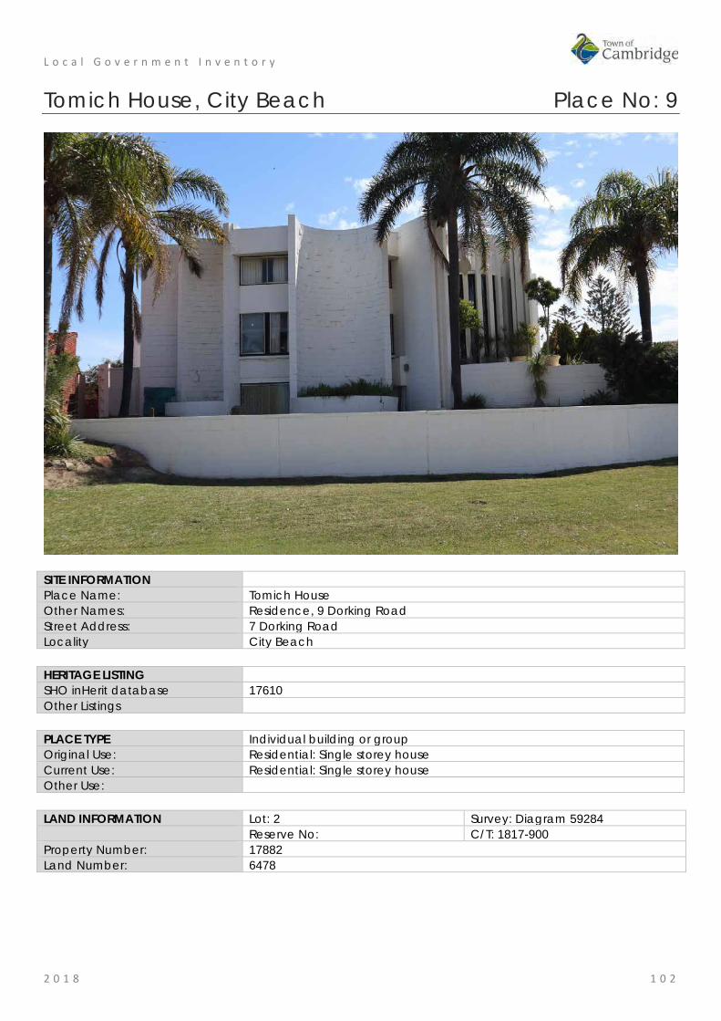
L o c a l G o v e r n m e n t I n v e n t o r y
2 0 1 8 1 0 2
Tomich House, City Beach Place No: 9
SITE INFORMATION Place Name: Tomich House Other Names: Residence, 9 Dorking Road Street Address: 7 Dorking Road Locality City Beach HERITAGE LISTING SHO inHerit database 17610 Other Listings PLACE TYPE Individual building or group Original Use: Residential: Single storey house Current Use: Residential: Single storey house Other Use: LAND INFORMATION Lot: 2 Survey: Diagram 59284 Reserve No: C/T: 1817-900 Property Number: 17882 Land Number: 6478

L o c a l G o v e r n m e n t I n v e n t o r y
2 0 1 8 1 0 3
CONSTRUCTION DETAILS Construction Date: 1972 Walls: Concrete: block Roof: Metal: decking Architectural Style: Late 20th Century Brutalist Physical Description: The Tomich House is one of a number of Iwanoff houses constructed in the area in the 1960s/1970s. This example stands three stories high and has a distinctive and intricate façade of curves. The house is of concrete block construction painted white. The windows are of varying dimensions and styles, with a combination of aluminium and timber frames reflecting different programs of work. The entry feature consists of a full height curved element containing five full height narrow strip windows separated by concrete pilasters. There are a lot of blank elements to the visible elevations of the house but due to their curved nature, the house presents as a dynamic form. Later additions to the place have continued the original style and detail of the residence although compromises to the original structure are evident. As was common with many of Iwanoff designs it features an individually designed letterbox which is consistent with the overall design. Condition: Good Integrity: High Authenticity: High
HISTORICAL INFORMATION Historical Notes: Iwan Nickolow Iwanoff (1919-1986) was born in Kusstendil, Bulgaria. After studying architecture in Munich at the Technische Hochschule from 1941, Iwanoff worked for Emil Freymuth with the pair winning second prize in the competition to rebuild the central area of Munich. Migrating to Australia as part of the International Refugee Organization resettlement scheme, Iwanoff and his wife arrived at Fremantle, on 2 March 1950. He worked with architecture firm Kranz and Sheldon and also Yuncken and Freeman in Melbourne. In 1963, he established his own practice, The Studio of Iwanoff.
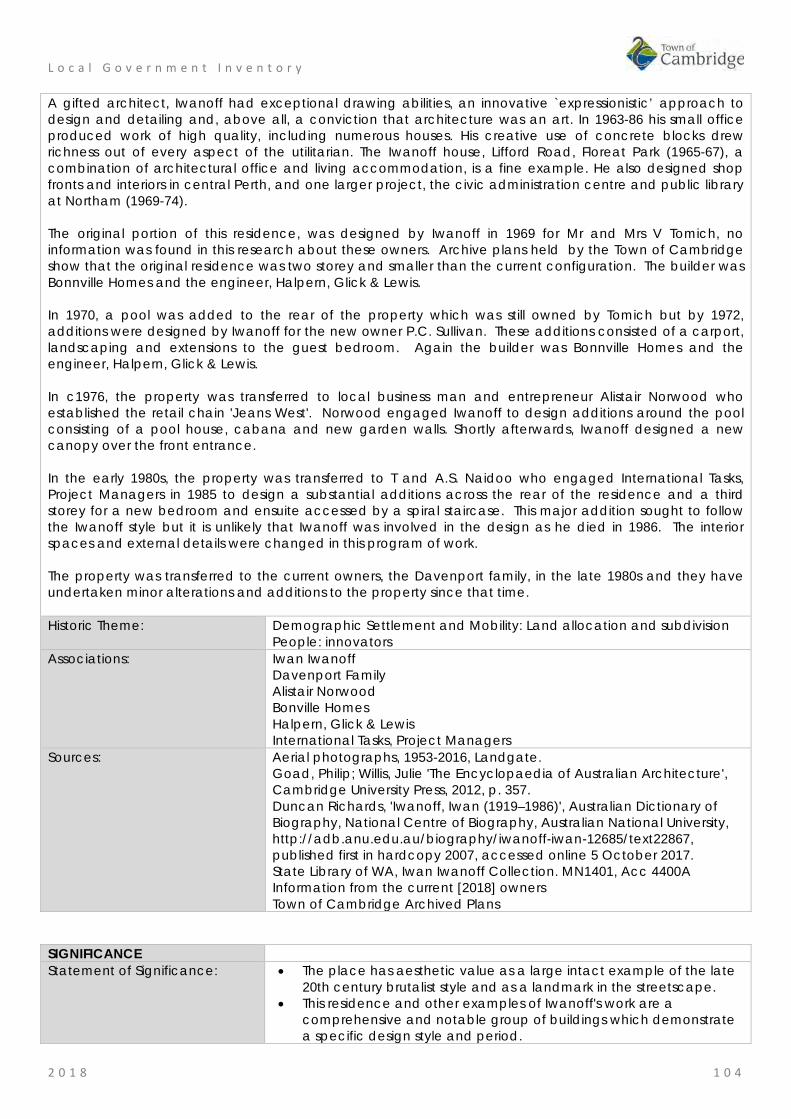
L o c a l G o v e r n m e n t I n v e n t o r y
2 0 1 8 1 0 4
A gifted architect, Iwanoff had exceptional drawing abilities, an innovative `expressionistic’ approach to design and detailing and, above all, a conviction that architecture was an art. In 1963-86 his small office produced work of high quality, including numerous houses. His creative use of concrete blocks drew richness out of every aspect of the utilitarian. The Iwanoff house, Lifford Road, Floreat Park (1965-67), a combination of architectural office and living accommodation, is a fine example. He also designed shop fronts and interiors in central Perth, and one larger project, the civic administration centre and public library at Northam (1969-74). The original portion of this residence, was designed by Iwanoff in 1969 for Mr and Mrs V Tomich, no information was found in this research about these owners. Archive plans held by the Town of Cambridge show that the original residence was two storey and smaller than the current configuration. The builder was Bonnville Homes and the engineer, Halpern, Glick & Lewis. In 1970, a pool was added to the rear of the property which was still owned by Tomich but by 1972, additions were designed by Iwanoff for the new owner P.C. Sullivan. These additions consisted of a carport, landscaping and extensions to the guest bedroom. Again the builder was Bonnville Homes and the engineer, Halpern, Glick & Lewis. In c1976, the property was transferred to local business man and entrepreneur Alistair Norwood who established the retail chain 'Jeans West'. Norwood engaged Iwanoff to design additions around the pool consisting of a pool house, cabana and new garden walls. Shortly afterwards, Iwanoff designed a new canopy over the front entrance. In the early 1980s, the property was transferred to T and A.S. Naidoo who engaged International Tasks, Project Managers in 1985 to design a substantial additions across the rear of the residence and a third storey for a new bedroom and ensuite accessed by a spiral staircase. This major addition sought to follow the Iwanoff style but it is unlikely that Iwanoff was involved in the design as he died in 1986. The interior spaces and external details were changed in this program of work. The property was transferred to the current owners, the Davenport family, in the late 1980s and they have undertaken minor alterations and additions to the property since that time. Historic Theme: Demographic Settlement and Mobility: Land allocation and subdivision
People: innovators Associations: Iwan Iwanoff
Davenport Family Alistair Norwood Bonville Homes Halpern, Glick & Lewis International Tasks, Project Managers
Sources: Aerial photographs, 1953-2016, Landgate. Goad, Philip; Willis, Julie 'The Encyclopaedia of Australian Architecture', Cambridge University Press, 2012, p. 357. Duncan Richards, 'Iwanoff, Iwan (1919–1986)', Australian Dictionary of Biography, National Centre of Biography, Australian National University, http://adb.anu.edu.au/biography/iwanoff-iwan-12685/text22867, published first in hardcopy 2007, accessed online 5 October 2017. State Library of WA, Iwan Iwanoff Collection. MN1401, Acc 4400A Information from the current [2018] owners Town of Cambridge Archived Plans
SIGNIFICANCE Statement of Significance: • The place has aesthetic value as a large intact example of the late
20th century brutalist style and as a landmark in the streetscape. • This residence and other examples of Iwanoff's work are a
comprehensive and notable group of buildings which demonstrate a specific design style and period.
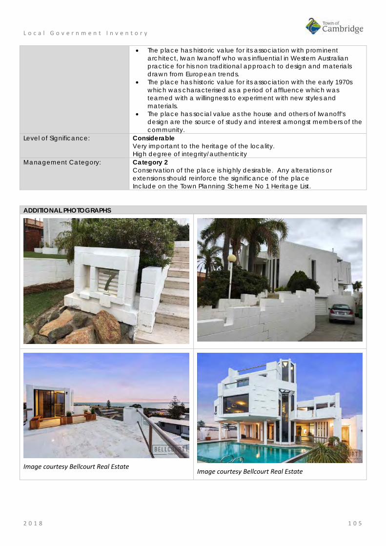
L o c a l G o v e r n m e n t I n v e n t o r y
2 0 1 8 1 0 5
• The place has historic value for its association with prominent architect, Iwan Iwanoff who was influential in Western Australian practice for his non traditional approach to design and materials drawn from European trends.
• The place has historic value for its association with the early 1970s which was characterised as a period of affluence which was teamed with a willingness to experiment with new styles and materials.
• The place has social value as the house and others of Iwanoff's design are the source of study and interest amongst members of the community.
Level of Significance: Considerable Very important to the heritage of the locality. High degree of integrity/authenticity
Management Category: Category 2 Conservation of the place is highly desirable. Any alterations or extensions should reinforce the significance of the place Include on the Town Planning Scheme No 1 Heritage List.
ADDITIONAL PHOTOGRAPHS
Image courtesy Bellcourt Real Estate
Image courtesy Bellcourt Real Estate

L o c a l G o v e r n m e n t I n v e n t o r y
2 0 1 8 1 0 6
British Empire and Commonwealth Games Village (fmr), City Beach Place No: 10
SITE INFORMATION Place Name: British Empire and Commonwealth Games Village (fmr) Other Names: Games Village Precinct, Commonwealth Games Village Precinct Street Address: Area bound by Dupont Avenue, Oban Road, Tilton Terrace, Gifford
Gardens, Pandora Drive and The Boulevard Locality City Beach HERITAGE LISTING SHO inHerit database 9107 Other Listings PLACE TYPE Individual building or group Original Use: Residential: Single storey residence Current Use: Residential Other Use: Park/Reserve LAND INFORMATION Lot: Various Survey: Various Reserve No: ---------- C/T: Various Property Number: Various Land Number: Various

L o c a l G o v e r n m e n t I n v e n t o r y
2 0 1 8 1 0 7
CONSTRUCTION DETAILS Construction Date: 1962 Walls: Various Roof: Various Architectural Style: Post War International style Physical Description: Empire Village was constructed to house the athletes competing in the Empire and Commonwealth Games. The winning entry for the village considered of curved streets and a central area of natural vegetation. Basic houses were constructed together with temporary buildings including shops and dining hall. The Mess and the central are of natural vegetation are the main elements that remain extant. The central area was converted to a park, Beecroft Park, and the Mess has been converted to a shopping centre. The Road layout remains similar to the 1960s plan. Many of the houses have been redeveloped but the retained subdivision of the land has enabled some of the original character of the area to be retained. Interpretation has been erected both on the parkland and in the shopping centre celebrating the games. Condition: Various Integrity: High Authenticity: Moderate/Low HISTORICAL INFORMATION Historical Notes: In 1958, Perth was announced as the successful bidder to host the 1962 Commonwealth Games. At that time Perth was a modest town with minimal infrastructure or sporting facilities. Planning for the games began swiftly and many new projects were quickly undertaken in readiness for the games. The Games were held in Perth from 22nd November to 1st December 1962. With a new £640,000 aquatic centre, a £500,000 stadium and a village of 150 homes for the athletes, the 1962 Games set a new high standard for the series. At the first Games, held in 1930 in Hamilton, Canada, the athletes' village for the 400 participants was a school next to the stadium, and they slept 24 to a classroom. Perth would in fact be the first host city to build

L o c a l G o v e r n m e n t I n v e n t o r y
2 0 1 8 1 0 8
a village especially for the Commonwealth Games. The village as constructed consisted of two areas of housing in the suburb of City Beach, grouped around a central spine which incorporated an area of natural vegetation, recreation hall, dining rooms, administration building & shops. Numerous games village houses remain, though most have been extensively modified. The 'central spine' of the parkland (Beecroft Park) has been retained. The games village was bounded by The Boulevard (south), Dupont Avenue (west), Tilton Road (north) and Pandora Drive (east). The plan was to build a dedicated Athletes Village consisting of 150 new houses in a garden setting that would be converted to private housing post-Games. The northern coastal area had been laid out some forty years previously by Klem and Hope's 1925 master-plan for organic dormitory communities collected around open green spaces and shared facilities. The master-plan's garden-city model was realised in the layout of the Athletes Village with its a sinuous road pattern across the sandy contours of the site, grouping two main zones of housing around a central node of temporary facilities. The design layout for the village was the result of a competition which was won by Mr K Thomas and Mr H Walker. The urban form of the village was very much influenced by post-war British Modernism. Individual blocks were wider and shorter than the traditional suburban lot. A second competition was held to design the Games Village houses and forty West Australian architect submitted a total of 166 designs. The winning design was submitted by Silver, Fairbrother and Associates and the village was constructed using a selection of ten of the competition designs. Silver, Fairbrother and Associates experimented with low maintenance, innovative materials and minimising of construction systems. These modern demonstration homes were met with much public interest and both positive and negative responses. Some cheerfully labelled the scheme Sunlight Village, while others likened the houses to cheap public conveniences and shearing sheds. After the Games, some 20,000 people came to visit the display, and within a few months all houses were sold and subsequently absorbed into the streetscape. But after remaining relatively intact for a number of decades, rising land values and growth in expectations of house sizes and amenities led to many Games Village houses being demolished or severely altered in the 1990s and following decades. In 1962 the Games Village stood in stark contrast to standard subdivision and building practice of the time, but its influence on the subsequent development of City Beach, and the wider City of Perth, is such that it has probably become the most enduring legacy of the Games' building programme. The designs and layout are now familiar, elements of Perth's urban fabric, the current dispersed, character of the city's newer suburbs being strongly grounded in the planning and architectural models exemplified by the Games Village. Historic Theme: Demographic Settlement and Mobility: Land allocation and subdivision
Social and civic activities: sport, recreation and entertainment Social and civic activities: community services and utilities Outside influences: tourism
Associations: Silver, Fairbrother and Associates; Architects K Thomas and H Walker, Planners
Sources: Aerial photographs, 1953-2016, Landgate. Town of Cambridge Municipal Heritage Inventory and Townscape Precinct Study prepared for the Town of Cambridge, June 1997. Wise's Post Office Directories for the City of Perth, 1925-1949, State Library of WA www.slwa.wa.gov.au Commonwealth Games Athlete's Village, Australia for Everyone Perth, website, http://myperthapp.com.au/games-village.html, accessed September 2017. Submissions from current property owners in 2018.

L o c a l G o v e r n m e n t I n v e n t o r y
2 0 1 8 1 0 9
SIGNIFICANCE Statement of Significance: • The layout of the former games village has aesthetic value for its gentle
curves which accommodate the landform, the generous street frontages of the lots and provision of green public spaces.
• The layout of the former games village has historic value as an influential example of urban planning in Western Australia that followed new trends of the 1960s which had a significant impact on future planning in metropolitan Perth.
• The few remaining houses from the original games village have aesthetic value as they demonstrate new trends in residential design in Western Australian architecture in the early 1960's.
• The few remaining houses from the original games village have historic value for their demonstration of the scale and size of homes considered to be standard in the 1960s.
Level of Significance: Little Contributes to the understanding of the history of the Town of Cambridge.
Management Category: Category 4 Photographically record prior to major development or demolition. Recognise and interpret the site if possible. Do not include on the Town Planning Scheme No 1 Heritage List.
ADDITIONAL PHOTOGRAPHS
Empire Games Village 1965, State Library image 280090PD
Display board near Empire shopping Centre
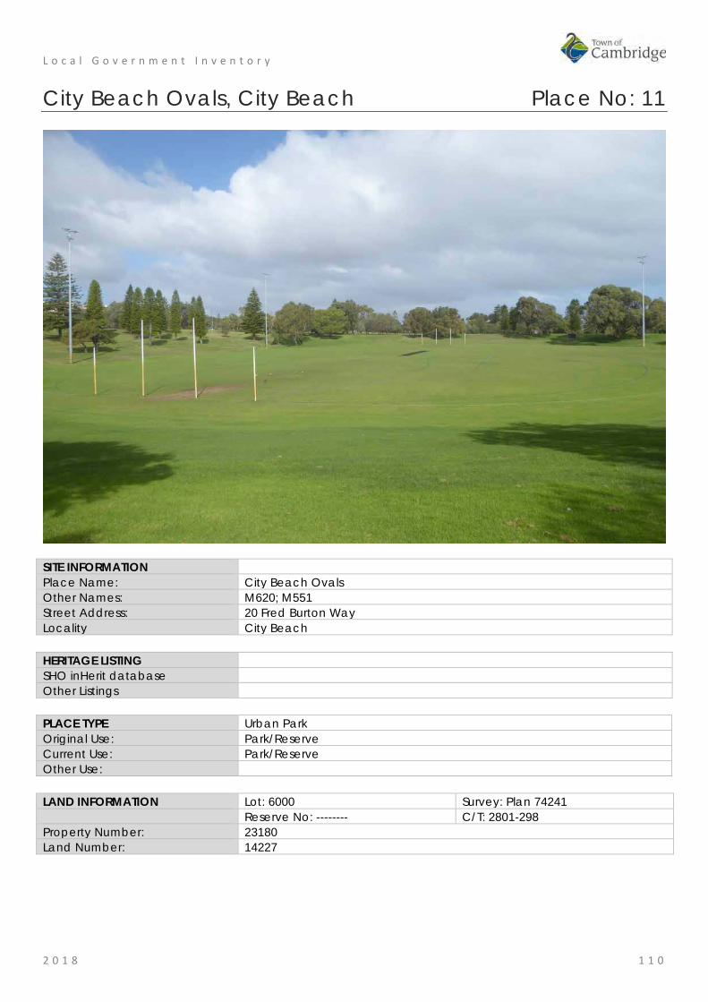
L o c a l G o v e r n m e n t I n v e n t o r y
2 0 1 8 1 1 0
City Beach Ovals, City Beach Place No: 11
SITE INFORMATION Place Name: City Beach Ovals Other Names: M620; M551 Street Address: 20 Fred Burton Way Locality City Beach HERITAGE LISTING SHO inHerit database Other Listings PLACE TYPE Urban Park Original Use: Park/Reserve Current Use: Park/Reserve Other Use: LAND INFORMATION Lot: 6000 Survey: Plan 74241 Reserve No: -------- C/T: 2801-298 Property Number: 23180 Land Number: 14227

L o c a l G o v e r n m e n t I n v e n t o r y
2 0 1 8 1 1 1
CONSTRUCTION DETAILS Construction Date: Walls: N/A Roof: N/A Architectural Style: N/A Physical Description: Two ovals adjoining each other adjacent to the beach and the residential development of City Beach. The ovals clearly demonstrate the changing topography of the area with the main oval behind the clubhouse being at a lower level to the northern oval. The southern oval therefore has a natural seating arrangement utilising the grassed embankments around the oval. The ovals have a sense of enclosure created by the peripheral planting around the entire site. Condition: Good Integrity: High Authenticity: High
HISTORICAL INFORMATION Historical Notes: The ovals at City Beach were graded and established by the City of Perth in the early 1960s. Clubrooms were built on the site shortly after and the oval has been the venue for cricket, AFL and other organised sports since the 1960s. The facilities and grounds have been added to and modified as required since its establishment.
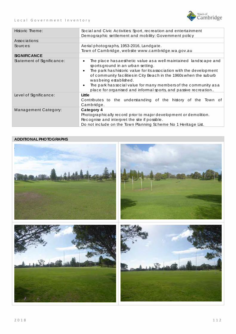
L o c a l G o v e r n m e n t I n v e n t o r y
2 0 1 8 1 1 2
Historic Theme: Social and Civic Activities: Sport, recreation and entertainment Demographic settlement and mobility: Government policy
Associations: Sources: Aerial photographs, 1953-2016, Landgate.
Town of Cambridge, website www.cambridge.wa.gov.au SIGNIFICANCE Statement of Significance: • The place has aesthetic value as a well maintained landscape and
sports ground in an urban setting. • The park has historic value for its association with the development
of community facilities in City Beach in the 1960s when the suburb was being established.
• The park has social value for many members of the community as a place for organised and informal sports, and passive recreation..
Level of Significance: Little Contributes to the understanding of the history of the Town of Cambridge.
Management Category: Category 4 Photographically record prior to major development or demolition. Recognise and interpret the site if possible. Do not include on the Town Planning Scheme No 1 Heritage List.
ADDITIONAL PHOTOGRAPHS

L o c a l G o v e r n m e n t I n v e n t o r y
2 0 1 8 1 1 3
Beecroft Park, City Beach Place No: 12
SITE INFORMATION Place Name: Beecroft Park Other Names: M601 Street Address: 32 Gayton Road Locality City Beach HERITAGE LISTING SHO inHerit database Other Listings PLACE TYPE Urban Park Original Use: Park/Reserve Current Use: Park/Reserve Other Use: LAND INFORMATION Lot: 8 Survey: Diagram 29031 Reserve No: -------- C/T: 1810-495 Property Number: 18024 Land Number: 6609

L o c a l G o v e r n m e n t I n v e n t o r y
2 0 1 8 1 1 4
CONSTRUCTION DETAILS Construction Date: 1960s Walls: N/A Roof: N/A Architectural Style: N/A Physical Description: Beecroft Park is a mid sized urban park situated among residential development and formed part of the original Empire Village in 1962. The park is mainly open grass with dense tree planting around the periphery. The topography is mainly flat with a slight incline towards Tilton Terrace. The park is laid out for football and also has a small children’s play area at the southern end of the space. Interpretation relating to the Empire Village is located at the southern boundary, opposite the shopping centre. Condition: Good Integrity: High Authenticity: High
HISTORICAL INFORMATION Historical Notes: This park was established in the early 1960s as part of the development of City Beach for the 1962 Empire and Commonwealth Games. This portion of City Beach was developed as the Games Village which provided accommodation for competitors and officials. The park was named in recognition of Councillor Bertha Beecroft (c1906-1996). Mrs Bertha Beecroft MBE

L o c a l G o v e r n m e n t I n v e n t o r y
2 0 1 8 1 1 5
was a tireless community worker, long-serving member of Perth City Council 1954-84 and the council's first woman deputy lord mayor 1976-77. She had 30 years of continuous service on the council before her resignation in May 1984. She was also the first woman Chair of the Lotteries Commission of WA, appointed in June 1975, she remained Chair until her retirement in June 1976. She was a member of the Board since 1968. She was also chairman of the Endowment Lands Committee, a member of the board of visitors of Claremont Hospital and chairman of the board of visitors of Heathcote Hospital. She was on the board of management of Mosman Park's School for the Deaf and was president of the State women's council of the Liberal Party. Mrs Beecroft was also a member of the Board WA Opera Society, 1976 and president, WA Ladies Hockey Association 1976. For recreation, she pursued interests in golf, lawn bowls and tennis. In 1972 she was made a Member of the Order of the British Empire (MBE) for her services to the community. In 2014, the adjacent group of shops on The Boulevard were seriously damaged by fire, subsequently the shops have undergone major redevelopment under the name of the 'Empire Village Shops'. Since that redevelopment there has been greater community interest and activity in Beecroft Park. Historic Theme: Social and Civic Activities: Sport, recreation and entertainment
Demographic settlement and mobility: Government policy People: local heroes and battlers
Associations: Bertha Beecroft Sources: Aerial photographs, 1953-2016, Landgate.
National Library of Australia
SIGNIFICANCE Statement of Significance: • The place has aesthetic value as a well maintained landscape and
sports ground in an urban setting. • The park has historic value for its association with the development
of community facilities in City Beach in the 1960s when this portion of the suburb was being developed as a consequence of the decision to hold the 1962 British Empire and Commonwealth Games in Perth.
• The place has historic value for its association with Bertha Beecroft a committed worker for her community in many areas.
• The park has social value for many members of the community as a place for organised and informal sports, and passive recreation.
Level of Significance: Some/Moderate Contributes to the understanding of the history of the Town of Cambridge.
Management Category: Category 3 Conservation of the place is desirable. Any alterations or extensions should reinforce the significance of the place, and original fabric should be retained wherever feasible. Include on the Town Planning Scheme No 1 Heritage List.
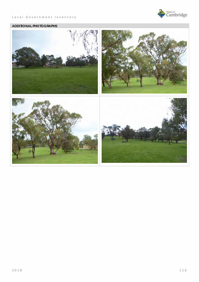
L o c a l G o v e r n m e n t I n v e n t o r y
2 0 1 8 1 1 6
ADDITIONAL PHOTOGRAPHS

L o c a l G o v e r n m e n t I n v e n t o r y
2 0 1 8 1 1 7
House, 17 Hovea Crescent, City Beach Place No: 13
SITE INFORMATION Place Name: House, 17 Hovea Crescent Other Names: Street Address: 17 Hovea Crescent Locality City Beach HERITAGE LISTING SHO inHerit database 17623 Other Listings PLACE TYPE Individual building or group Original Use: Residential: Two storey residence Current Use: Residential: Two storey residence Other Use: LAND INFORMATION Lot: 43 Survey: Plan 5153 Reserve No: -------- C/T: 1721-699 Property Number: 17613 Land Number: 6235

L o c a l G o v e r n m e n t I n v e n t o r y
2 0 1 8 1 1 8
CONSTRUCTION DETAILS Construction Date: c1939 Walls: Brick: rendered Roof: Metal: colorbond Architectural Style: Inter War Functionalist Physical Description: A two storey house of rendered brick construction demonstrating elements of the Inter War Functionalist style. The house has a dual relationship with the angled entrance facing the intersection of both Elimatta Way and Hovea Crescent. The house is situated approximately in the middle of the lot with open gardens to the front. The south east elevation facing Elimatta Way incorporates curved elements with glass block openings, a small balcony above the entrance and tall windows. The Hovea Crescent elevation is more angular in its presentation with a single storey north section abutting the two storey main section of the house. This single storey portion is a later addition although demonstrating similar form and detail. The two storey portion of the residence contains a recessed upper section with balcony incorporating a shallow curved canopy supported on masonry columns and positioned beneath a tiered parapet. The distinguished block decoration around the top of the parapet has been continued on the single storey section. All the windows visible from the street have been replaced and other elements of the exterior have been altered since the original construction. No internal inspection of the property was made at the time of assessment. Condition: Good Integrity: High Authenticity: Low
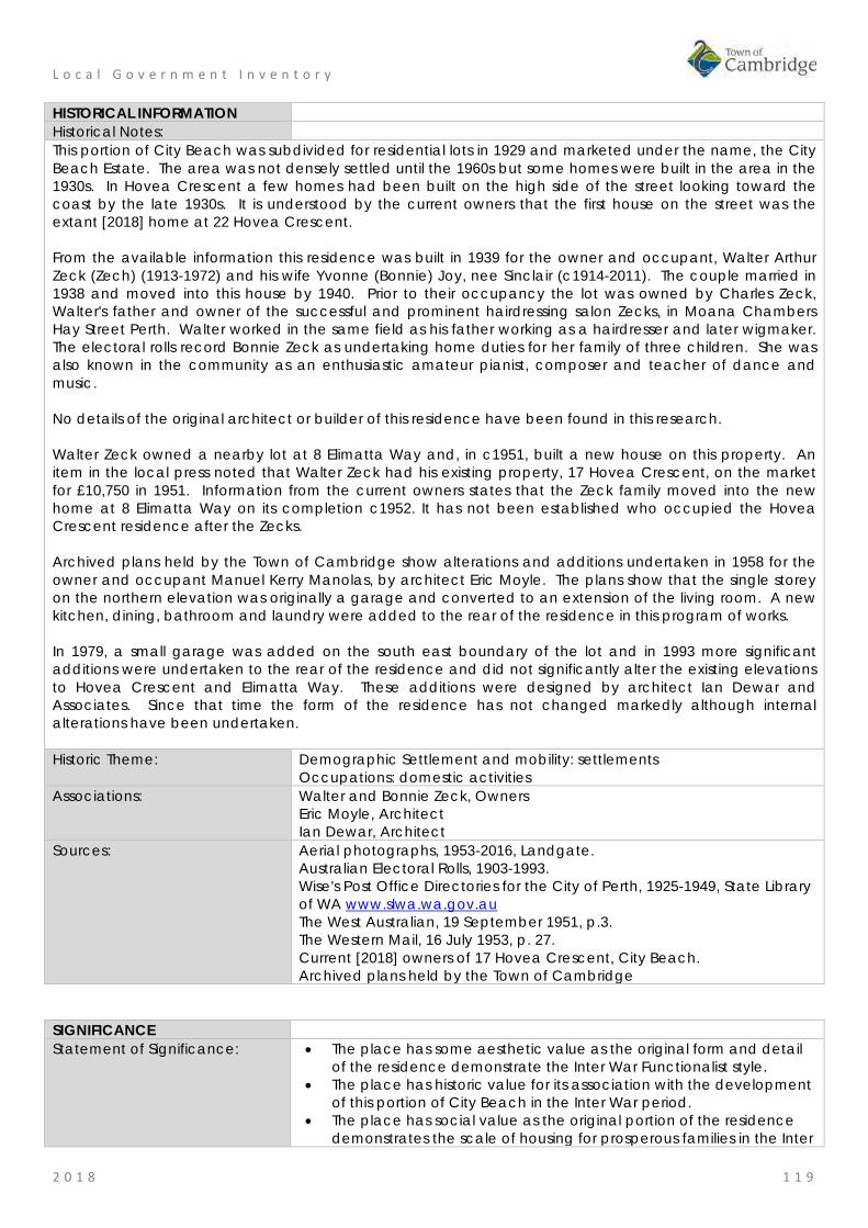
L o c a l G o v e r n m e n t I n v e n t o r y
2 0 1 8 1 1 9
HISTORICAL INFORMATION Historical Notes: This portion of City Beach was subdivided for residential lots in 1929 and marketed under the name, the City Beach Estate. The area was not densely settled until the 1960s but some homes were built in the area in the 1930s. In Hovea Crescent a few homes had been built on the high side of the street looking toward the coast by the late 1930s. It is understood by the current owners that the first house on the street was the extant [2018] home at 22 Hovea Crescent. From the available information this residence was built in 1939 for the owner and occupant, Walter Arthur Zeck (Zech) (1913-1972) and his wife Yvonne (Bonnie) Joy, nee Sinclair (c1914-2011). The couple married in 1938 and moved into this house by 1940. Prior to their occupancy the lot was owned by Charles Zeck, Walter's father and owner of the successful and prominent hairdressing salon Zecks, in Moana Chambers Hay Street Perth. Walter worked in the same field as his father working as a hairdresser and later wigmaker. The electoral rolls record Bonnie Zeck as undertaking home duties for her family of three children. She was also known in the community as an enthusiastic amateur pianist, composer and teacher of dance and music. No details of the original architect or builder of this residence have been found in this research. Walter Zeck owned a nearby lot at 8 Elimatta Way and, in c1951, built a new house on this property. An item in the local press noted that Walter Zeck had his existing property, 17 Hovea Crescent, on the market for £10,750 in 1951. Information from the current owners states that the Zeck family moved into the new home at 8 Elimatta Way on its completion c1952. It has not been established who occupied the Hovea Crescent residence after the Zecks. Archived plans held by the Town of Cambridge show alterations and additions undertaken in 1958 for the owner and occupant Manuel Kerry Manolas, by architect Eric Moyle. The plans show that the single storey on the northern elevation was originally a garage and converted to an extension of the living room. A new kitchen, dining, bathroom and laundry were added to the rear of the residence in this program of works. In 1979, a small garage was added on the south east boundary of the lot and in 1993 more significant additions were undertaken to the rear of the residence and did not significantly alter the existing elevations to Hovea Crescent and Elimatta Way. These additions were designed by architect Ian Dewar and Associates. Since that time the form of the residence has not changed markedly although internal alterations have been undertaken. Historic Theme: Demographic Settlement and mobility: settlements
Occupations: domestic activities Associations: Walter and Bonnie Zeck, Owners
Eric Moyle, Architect Ian Dewar, Architect
Sources: Aerial photographs, 1953-2016, Landgate. Australian Electoral Rolls, 1903-1993. Wise's Post Office Directories for the City of Perth, 1925-1949, State Library of WA www.slwa.wa.gov.au The West Australian, 19 September 1951, p.3. The Western Mail, 16 July 1953, p. 27. Current [2018] owners of 17 Hovea Crescent, City Beach. Archived plans held by the Town of Cambridge
SIGNIFICANCE Statement of Significance: • The place has some aesthetic value as the original form and detail
of the residence demonstrate the Inter War Functionalist style. • The place has historic value for its association with the development
of this portion of City Beach in the Inter War period. • The place has social value as the original portion of the residence
demonstrates the scale of housing for prosperous families in the Inter

L o c a l G o v e r n m e n t I n v e n t o r y
2 0 1 8 1 2 0
War period. Level of Significance: Little
Contributes to the understanding of the history of the Town of Cambridge.
Management Category: Category 4 Photographically record prior to major development or demolition. Recognise and interpret the site if possible. Do not include on the Town Planning Scheme No 1 Heritage List.
ADDITIONAL PHOTOGRAPHS
Plan supplied by the Town of Cambridge

L o c a l G o v e r n m e n t I n v e n t o r y
2 0 1 8 1 2 1
Happy Tree, City Beach Place No: 14
SITE INFORMATION Place Name: Happy Tree Other Names: Eucalyptus gomphocephala Street Address: Hovea Crescent (located in road reserve adjacent to 9 Hovea Crescent) Locality City Beach HERITAGE LISTING SHO inHerit database 9109 Other Listings

L o c a l G o v e r n m e n t I n v e n t o r y
2 0 1 8 1 2 2
PLACE TYPE Tree Original Use: Tree Current Use: Tree Other Use: LAND INFORMATION Lot: Survey: Reserve No: Road Reserve C/T: Property Number: Land Number: 13770
CONSTRUCTION DETAILS Construction Date: c1978 (first carving) Walls: N/A Roof: N/A Architectural Style: N/A Physical Description: The Happy Tree is a large multi-trunked Tuart tree located on the verge outside no. 9 Hovea Crescent, City Beach. The natural nooks in the tree have been filled with toys, supplemented by platforms and steps with other creatures and fantasy figures attached all around the tree. A commemorative plaque celebrating the Happy Tree has been erected alongside a plaque from its creator, Ralph Soderlund that says “The Happy Tree stands tall and free, a gift from God for all to see, its happiness is there to share, take some to others to show you care”. Condition: Good Integrity: High Authenticity: High

L o c a l G o v e r n m e n t I n v e n t o r y
2 0 1 8 1 2 3
HISTORICAL INFORMATION Historical Notes: The Happy Tree was the initiative of Ralph Soderlund and his wife Phyllis who built their home at 9 Hovea Crescent in 1961. In 1978, Walter Ralph Soderlund (c1921-2013), a retired orchardist carved and painted his first character, Mr Gnome, into this tree on the verge of their property. In every subsequent year, other characters were added to the tree. The inspiration for the tree was Ola Cohn's Fairies Tree in Fitzroy Gardens, Melbourne. An annual event was held at the tree in which local children were invited to a Happy Tree Party where they would listen to stories about the characters in the tree, written by Ralph Soderlund and illustrated by his wife Phyllis Ivy Soderlund (c1923-2013). Ralph Soderlund began the tradition in 1988 and would put on a top hat for the story telling event. The tradition has continued with a carved top hat added to the tree in 2016. In April 2000, the Town of Cambridge continued the tradition of hosting the annual community event and the new owners of the property at 9 Hovea Crescent assisted with the hosting from 2013. Historic Theme: People: local heroes and battlers
Social and Civic activities: sport, recreation and entertainment Social and Civic activities: Cultural activities
Associations: Ralph and Phyllis Soderlund Sources: Aerial photographs, 1953-2016, Landgate.
Town of Cambridge Municipal Heritage Inventory and Townscape Precinct Study prepared for the Town of Cambridge, June 1997. Wise's Post Office Directories for the City of Perth, 1925-1949, State Library of WA www.slwa.wa.gov.au Post Community News, 30 January 2016, p.54, Cambridge Notes, Town of Cambridge Local Studies Centre http://www.cambridge.wa.gov.au/Cambridge-Library/Local-Studies/Cambridge-Notes
SIGNIFICANCE Statement of Significance: • The Happy Tree has a aesthetic value as a mature and well
established tuart tree which has been adorned with carved characters.
• The Happy tree has aesthetic value as a landmark in the street and the community. for its contribution and continuity in the streetscape since 1978.
• The Happy tree has historic value for its association with the development of the City Beach community in the 1970s when the first characters were added to the tree.
• The Happy tree has historic value for its association with Ralph and Ivy Soderlund who lived at this house from 1961 until the 2000s and for their contribution to the community in creating the tree carvings and the associated books and annual story telling event.
• The Happy tree has social value for the members of the City Beach community who have attended storytelling events at the tree since 1978 and for its contribution to the sense of place.
Level of Significance: Considerable Very important to the heritage of the locality. High degree of integrity/authenticity
Management Category: Category 2 Conservation of the place is highly desirable. Any alterations or extensions should reinforce the significance of the place Include on the Town Planning Scheme No 1 Heritage List.

L o c a l G o v e r n m e n t I n v e n t o r y
2 0 1 8 1 2 4
ADDITIONAL PHOTOGRAPHS

L o c a l G o v e r n m e n t I n v e n t o r y
2 0 1 8 1 2 5
City Beach High School (fmr), City Beach Place No: 15
SITE INFORMATION Place Name: City Beach High School (fmr) Other Names: International School of Western Australia Street Address: 20 Kalinda Drive Locality City Beach HERITAGE LISTING SHO inHerit database 9105 Other Listings PLACE TYPE Individual building or group Original Use: Education: Secondary School Current Use: Education: Secondary School Other Use: LAND INFORMATION Lot: 14203 Survey: Plan 27391 Reserve No: R29923 C/T: LR3166-561 Property Number: 12508 Land Number: 1482

L o c a l G o v e r n m e n t I n v e n t o r y
2 0 1 8 1 2 6
CONSTRUCTION DETAILS Construction Date: 1966; 1968; 1980; 2001 Walls: Brick: Common Roof: Metal: Colorbond Architectural Style: Late 20th century academic Physical Description: The school was constructed in the mid 1960s in the natural bushland in City Beach. The low ranges of the school are mainly hidden from clear view of the street behind landscaped gardens along Kalinda Drive. The school buildings are predominantly arranged in a series of east-west ranges with a number of open spaces between each block. The blocks are single and double storey brick construction with pebbledash render in placed and all incorporate shallow pitched colorbond roofs. Windows are timber framed sashes and highlight windows. The reception block and access into other areas of the school is via a high brick wall with an integrated entrance, the brickwork being enlivened by the aboriginal mural across the full extent of the wall. Condition: Good Integrity: High Authenticity: High

L o c a l G o v e r n m e n t I n v e n t o r y
2 0 1 8 1 2 7
HISTORICAL INFORMATION Historical Notes: City Beach underwent significant development in the early 1960s following subdivision of the area for residential occupation. The 1962 Empire, or Commonwealth, Games in Perth and the main stadium at Perry Lakes was a major influence on the development of the area. City Beach High School was constructed in 1965 and opened in 1966. The school was designed by the Public Works Department along modern lines as a cluster of pavilions with internal courtyards. The buildings were designed with an emphasis on orientation to avoid the western sun and to take account of the surroundings. In 1981, a hall was built on the site however the school population dwindled following the initial development of the area in the 1960s and 1970s. By 1997, there were only 350 students enrolled, mostly in the years 8 to 10. The Bold Park Kindergarten which was originally located on the site, moved in 1998 to new premises in Wembley. In 2000, the school initiated a series of innovative program to cater for students from around the state who had difficulty fitting into larger schools. In 2001, a group of buildings were constructed on the northern side of the site. These buildings are believed to currently [2018] be used for residential accommodation for boarders. The school closed in December 2005 as at that time there were only 87 students at the school from Years 8 to 10. In 2006, a privately funded school, the International School of WA occupied the property and catered for residential students. The school was officially opened by Premier Alan Carpenter on 8th November 2007. Since then the buildings have been adapted and added to in accordance with their requirements and changing education approaches. The most significant additions since then was the addition of new teaching blocks in 2014 and in 2017 a new building residential college was approved for construction. The school will be relocating to new premises in 2019. Historic Theme: Social and Civic Activities: Education and science
Demographic Settlement and Mobility: settlements Associations: Sources: Aerial photographs, 1953-2016, Landgate.
Town of Cambridge Municipal Heritage Inventory and Townscape Precinct Study prepared for the Town of Cambridge, June 1997. Cambridge Notes, Local Studies Collection, Town of Cambridge, items T235, T236. Local Studies Collection, Interview with Barry Goddard regarding construction of the City Beach High School. 'City Beach International School of WA on the Move', Stirling Times, 18 October 2016, http://www.communitynews.com.au/stirling-times/news/city-beach-international-school-of-wa-on-the-move/
SIGNIFICANCE Statement of Significance: • The layout of the campus and the original buildings from the mid
1960s have aesthetic value as they demonstrate the form and style of the period and illustrate a greater sophistication in public buildings when designing for the climate and landscape in Western Australia.
• The place has historic value as it demonstrates the settlement and rapid growth of City Beach in the 1960s and the government's response to this new community.
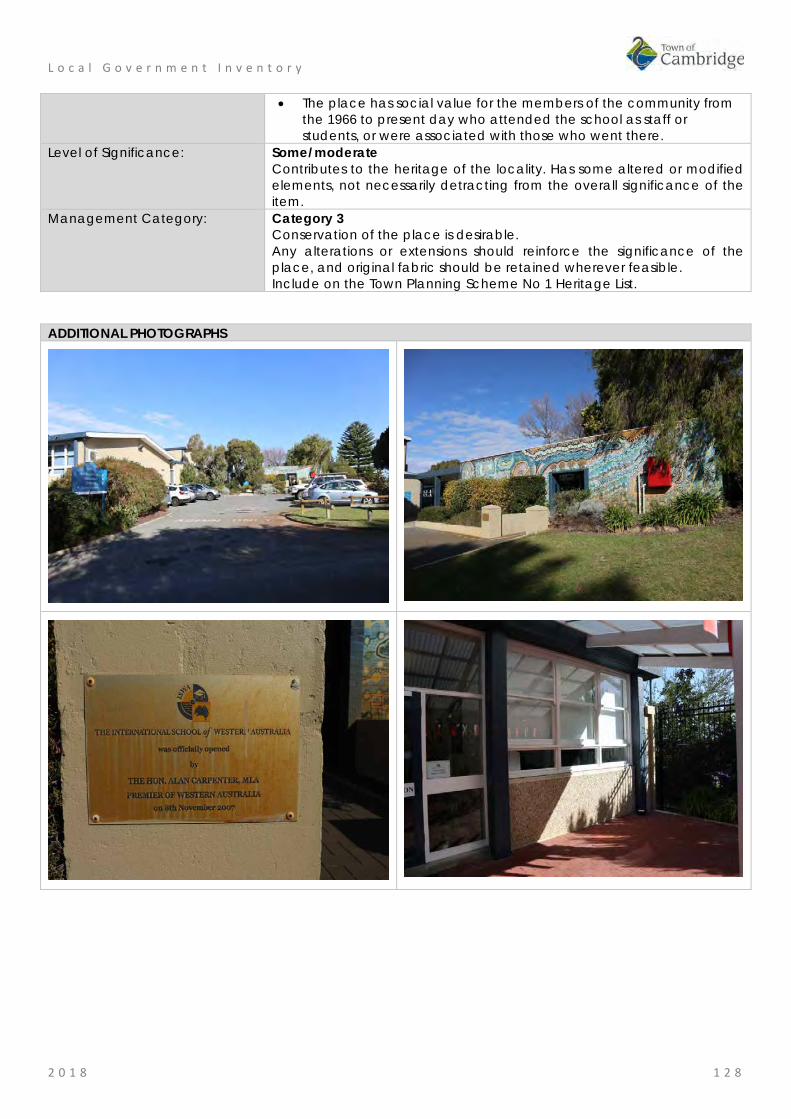
L o c a l G o v e r n m e n t I n v e n t o r y
2 0 1 8 1 2 8
• The place has social value for the members of the community from the 1966 to present day who attended the school as staff or students, or were associated with those who went there.
Level of Significance: Some/moderate Contributes to the heritage of the locality. Has some altered or modified elements, not necessarily detracting from the overall significance of the item.
Management Category: Category 3 Conservation of the place is desirable. Any alterations or extensions should reinforce the significance of the place, and original fabric should be retained wherever feasible. Include on the Town Planning Scheme No 1 Heritage List.
ADDITIONAL PHOTOGRAPHS

L o c a l G o v e r n m e n t I n v e n t o r y
2 0 1 8 1 2 9
Holy Spirit Catholic Church, City Beach Place No: 16
SITE INFORMATION Place Name: Holy Spirit Catholic Church Other Names: Holy Spirit Church
Holy Spirit War Memorial Church Street Address: 2 Keaney Place Locality City Beach HERITAGE LISTING SHO inHerit database 13020 Other Listings State Register of Heritage Places
Catholic Church Inventory Aboriginal Heritage Sites Register
PLACE TYPE Individual building or group Original Use: Religious: Church Current Use: Religious: Church Other Use: LAND INFORMATION Lot: 1 Survey: Diagram 27431 Reserve No: --------- C/T: 1264-590 Property Number: 15032 Land Number: 3839

L o c a l G o v e r n m e n t I n v e n t o r y
2 0 1 8 1 3 0
CONSTRUCTION DETAILS Construction Date: 1973-4; 1994-5 Walls: Brick: Common Roof: Tile: Terracotta Architectural Style: Late 20th Century Organic Physical Description: The Holy Spirit Memorial Church is one element of the Holy Spirit complex which also includes the Administration Centre, Presbytery and Primary School. The Church is the major feature of the site and is a landmark in a range of views across City Beach. The church is of buff brick construction with a prominent curved aesthetic. The church has a blank curved elevation to Keaney Place with an increasingly enlivened elevation as it curves around the driveway. The entrance is located to the southern aspect of the building with stepped entrance to double aluminium doors and a small canopy supported on broad circular brick column. The church continues to curve around with brick elevations and highlight aluminium framed openings until it reaches the blank brick elevation facing the street. The feature aspect of the building is the sloping visible roof form culminating in a fanned window, parapet wall and feature cross. This aspect of the church can be seen in long views across City Beach. The church is a landmark feature, bearing a resemblance to a shell and is dedicated to Australians who served in the various conflicts. Condition: Good Integrity: High Authenticity: High HISTORICAL INFORMATION Historical Notes: As this part of the metropolitan area developed in the period following World War II, the Roman Catholic Church recognised the need to establish facilities for members of their community. In 1960, Archbishop Prendiville sent Father Thomas Phelan to establish the new Roman Catholic Parish of City Beach and in 1963 this site was purchased.

L o c a l G o v e r n m e n t I n v e n t o r y
2 0 1 8 1 3 1
At the time of the inauguration of the Parish there was a Catholic population of only fifty five families. Infrastructure development was very slow and there was no access to the Church site for a few years. Much of the preparatory work for the buildings on the site was done by donation. Holy Spirit Presbytery was built during 1964 and survey work for the location of the future buildings was undertaken by new architecture graduate, Mike Fitzhardinge who also designed the school. In 1965, five classrooms were completed and the Holy Spirit school was opened and these rooms served the community as a church until the completion of the church in 1974. Holy Spirit Church was designed by Forbes and Fitzhardinge Architects Holy Spirit Catholic Church, City Beach was designed in 1972 to reflect the shift in Catholic theology and liturgical practice following the Second Vatican Council of the 1960s, in which church layout was to be amended to allow for greater interaction between the congregation and the sacred elements of the mass administered by priests . The design also sought to minimise the impact of strong westerly winds off the ocean, and its use of steel-reinforced curved brickwork, which resulted in the finished building receiving the 1975 Clay Brick Award. The Holy Spirit Church was blessed and opened for worship by Archbishop Goody on Sunday March 31st 1974. At the ceremony were the Attorney General for Ireland, Declan Costello who happened to be on an official Government visit to Australia and Canon Riley of the St. Christopher’s Anglican Parish in City Beach. After nearly twenty years of transforming a school into a church each week-end people appreciated the new structure and the comfort for Sunday worship which ensued. Since the completion of the church by contractors, G. Robinson, there has been little change to the building apart from ongoing maintenance. The tiles on the Church were replaced with tiles from France which resolved an ongoing problem with water ingress. The ceiling was subsequently resprayed. The Church includes a number of finely designed artworks, including a wheat and grapes design on the silver tabernacle door, Madonna and Child mosaic, ‘Last Supper’ tapestry, stained glass windows, a sculpture of Jesus on the Cross, and Stations of the Cross, all of which were placed in the building in consultation with the original architect. Some of the works were provided by local artists and others were sourced internationally. Historic Theme: Occupations: Intellectual activities: Arts and crafts
Social and Civic Activities: Religion Associations: Mike Fitzhardinge, Forbes & Fitzhardinge
Fr Thomas Phelan G. Robinson
Sources: Aerial photographs, 1953-2016, Landgate. Town of Cambridge Municipal Heritage Inventory and Townscape Precinct Study prepared for the Town of Cambridge, June 1997. State Register Documentation Place 13020. Holy Spirit City Beach website; http://www.holyspiritcitybeach.com/history/detailed-history/
SIGNIFICANCE Statement of Significance: Holy Spirit Catholic Church, City Beach, comprising a Late Twentieth
Century Organic style brick church (1973-74), including original fittings and furnishings of high design quality, grotto (1994-95), and ancillary structures has cultural heritage significance for the following reasons: • the place is a striking landmark constructed to a unique sculptural
design, with its dramatic external form, high quality interior spaces, and finely designed sanctuary fittings and furnishings;
• the place is a good example of a church designed to facilitate liturgical and theological changes in the Catholic church following the Second Vatican Council, with its open interior layout, clear site lines, placement of altar and baptistery, and lack of barriers to the sanctuary area;
• the place is a very fine representative example of Late Twentieth

L o c a l G o v e r n m e n t I n v e n t o r y
2 0 1 8 1 3 2
Century Organic style architecture, featuring sweeping curved brick walls and an overall irregular curved floor plan;
• the place demonstrates technical proficiency in its use of steel reinforced curved brickwork, and the finished building receiving the 1975 Clay Brick Award; and
• the place was designed by the prominent 1950s-1980s Western Australian architectural firm Forbes & Fitzhardinge, who were leading exponents of contemporary late twentieth century architecture.
The Presbytery (1964) and Parish Centre (2006) are of little significance. The Grotto (1994-95) is of some significance.
Level of Significance: Exceptional Essential to the heritage of the locality. Rare or outstanding example. Recommended for inclusion on the State Register of Heritage Places.
Management Category: Category 1 The place should be retained and conserved unless there is no feasible and prudent alternative to doing otherwise. Any alterations or extensions should reinforce the significance of the place, and be in accordance with a Conservation Plan (if one exists for the place). Include on the Town Planning Scheme No 1 Heritage List.
ADDITIONAL PHOTOGRAPHS
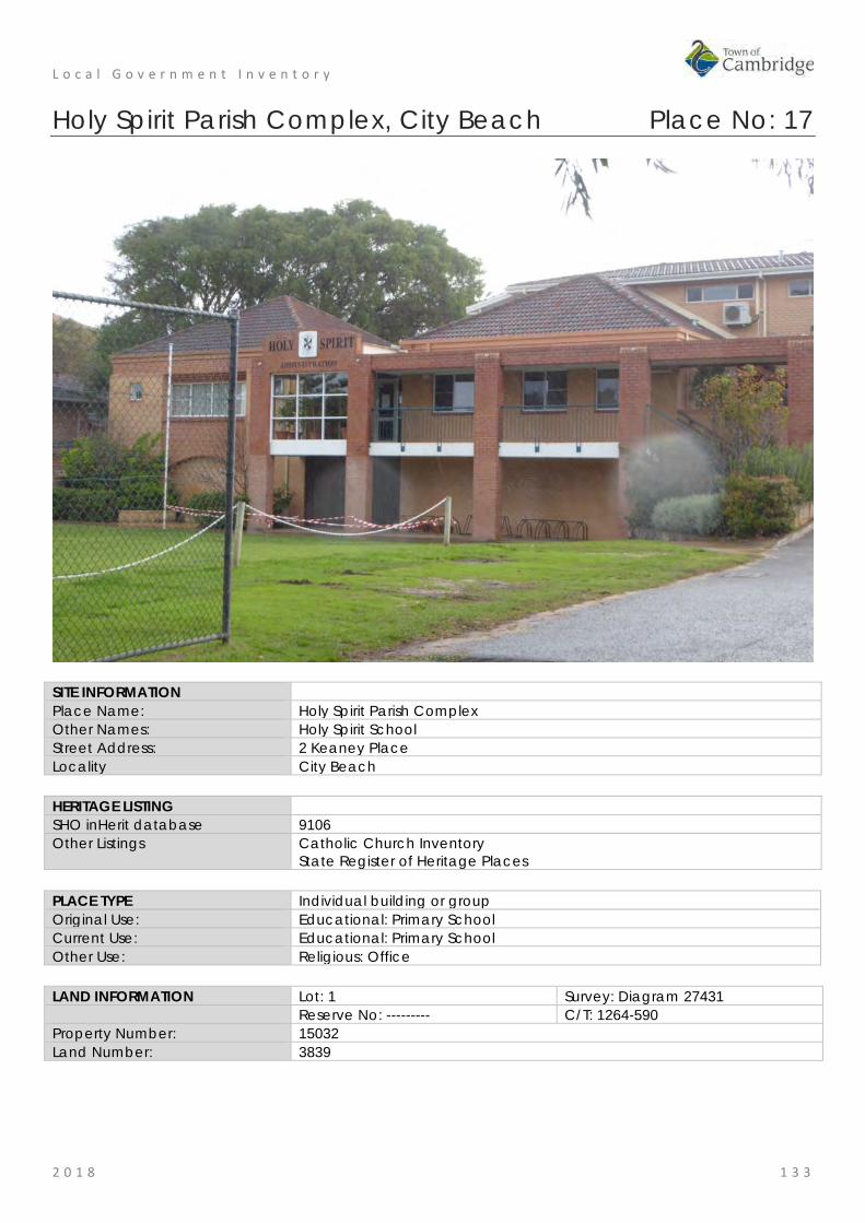
L o c a l G o v e r n m e n t I n v e n t o r y
2 0 1 8 1 3 3
Holy Spirit Parish Complex, City Beach Place No: 17
SITE INFORMATION Place Name: Holy Spirit Parish Complex Other Names: Holy Spirit School Street Address: 2 Keaney Place Locality City Beach HERITAGE LISTING SHO inHerit database 9106 Other Listings Catholic Church Inventory
State Register of Heritage Places PLACE TYPE Individual building or group Original Use: Educational: Primary School Current Use: Educational: Primary School Other Use: Religious: Office LAND INFORMATION Lot: 1 Survey: Diagram 27431 Reserve No: --------- C/T: 1264-590 Property Number: 15032 Land Number: 3839

L o c a l G o v e r n m e n t I n v e n t o r y
2 0 1 8 1 3 4
CONSTRUCTION DETAILS Construction Date: 1964; 2006 Walls: Brick: common Roof: Tile: terracotta Architectural Style: Late 20th Century Organic;
Late 20th century international Physical Description: The Holy Spirit complex includes the Administration Centre, Presbytery and Primary School in addition to the prominent Holy Spirit Church. The Church is the major feature of the site. The primary school and parish centre are largely brick and tile constructions. Condition: Good Integrity: High Authenticity: High HISTORICAL INFORMATION Historical Notes: As this part of the metropolitan area developed in the period following World War II, the Roman Catholic Church recognised the need to establish facilities for members of their community. In 1960, Archbishop Prendiville sent Father Thomas Phelan to establish the new Roman Catholic Parish of City Beach and in 1963 this site was purchased. At the time of the inauguration of the Parish there was a Catholic population of only fifty five families. Infrastructure development was very slow and there was no access to the Church site for a few years. Brompton Road divided two council; Perth City and Stirling but eventually both councils combined to build part of Brompton Road. Much of the preparatory work for the buildings on the site was done by donation. Holy Spirit Presbytery was built during 1964, having been designed, free of cost, by an architect from the Public Works Department. Survey work for the location of the future buildings was undertaken by new architecture graduate, Mike Fitzhardinge who also designed the school.
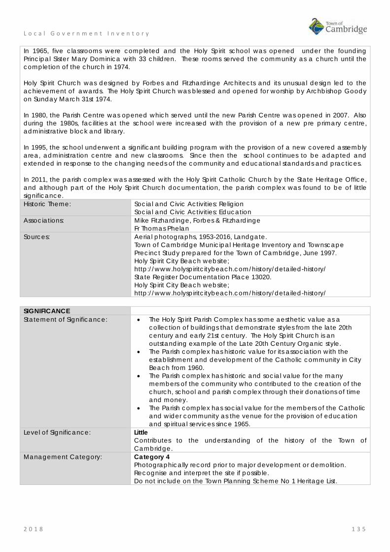
L o c a l G o v e r n m e n t I n v e n t o r y
2 0 1 8 1 3 5
In 1965, five classrooms were completed and the Holy Spirit school was opened under the founding Principal Sister Mary Dominica with 33 children. These rooms served the community as a church until the completion of the church in 1974. Holy Spirit Church was designed by Forbes and Fitzhardinge Architects and its unusual design led to the achievement of awards. The Holy Spirit Church was blessed and opened for worship by Archbishop Goody on Sunday March 31st 1974. In 1980, the Parish Centre was opened which served until the new Parish Centre was opened in 2007. Also during the 1980s, facilities at the school were increased with the provision of a new pre primary centre, administrative block and library. In 1995, the school underwent a significant building program with the provision of a new covered assembly area, administration centre and new classrooms. Since then the school continues to be adapted and extended in response to the changing needs of the community and educational standards and practices. In 2011, the parish complex was assessed with the Holy Spirit Catholic Church by the State Heritage Office, and although part of the Holy Spirit Church documentation, the parish complex was found to be of little significance. Historic Theme: Social and Civic Activities: Religion
Social and Civic Activities: Education Associations: Mike Fitzhardinge, Forbes & Fitzhardinge
Fr Thomas Phelan Sources: Aerial photographs, 1953-2016, Landgate.
Town of Cambridge Municipal Heritage Inventory and Townscape Precinct Study prepared for the Town of Cambridge, June 1997. Holy Spirit City Beach website; http://www.holyspiritcitybeach.com/history/detailed-history/ State Register Documentation Place 13020. Holy Spirit City Beach website; http://www.holyspiritcitybeach.com/history/detailed-history/
SIGNIFICANCE Statement of Significance: • The Holy Spirit Parish Complex has some aesthetic value as a
collection of buildings that demonstrate styles from the late 20th century and early 21st century. The Holy Spirit Church is an outstanding example of the Late 20th Century Organic style.
• The Parish complex has historic value for its association with the establishment and development of the Catholic community in City Beach from 1960.
• The Parish complex has historic and social value for the many members of the community who contributed to the creation of the church, school and parish complex through their donations of time and money.
• The Parish complex has social value for the members of the Catholic and wider community as the venue for the provision of education and spiritual services since 1965.
Level of Significance: Little Contributes to the understanding of the history of the Town of Cambridge.
Management Category: Category 4 Photographically record prior to major development or demolition. Recognise and interpret the site if possible. Do not include on the Town Planning Scheme No 1 Heritage List.
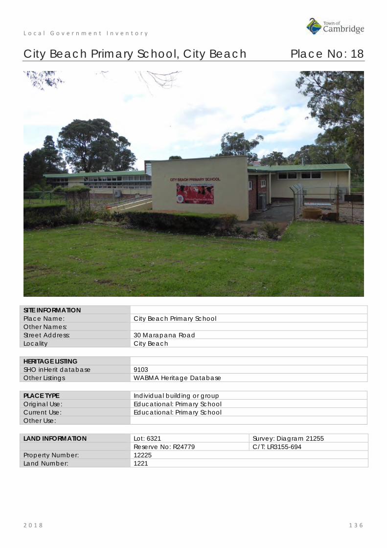
L o c a l G o v e r n m e n t I n v e n t o r y
2 0 1 8 1 3 6
City Beach Primary School, City Beach Place No: 18
SITE INFORMATION Place Name: City Beach Primary School Other Names: Street Address: 30 Marapana Road Locality City Beach HERITAGE LISTING SHO inHerit database 9103 Other Listings WABMA Heritage Database PLACE TYPE Individual building or group Original Use: Educational: Primary School Current Use: Educational: Primary School Other Use: LAND INFORMATION Lot: 6321 Survey: Diagram 21255 Reserve No: R24779 C/T: LR3155-694 Property Number: 12225 Land Number: 1221
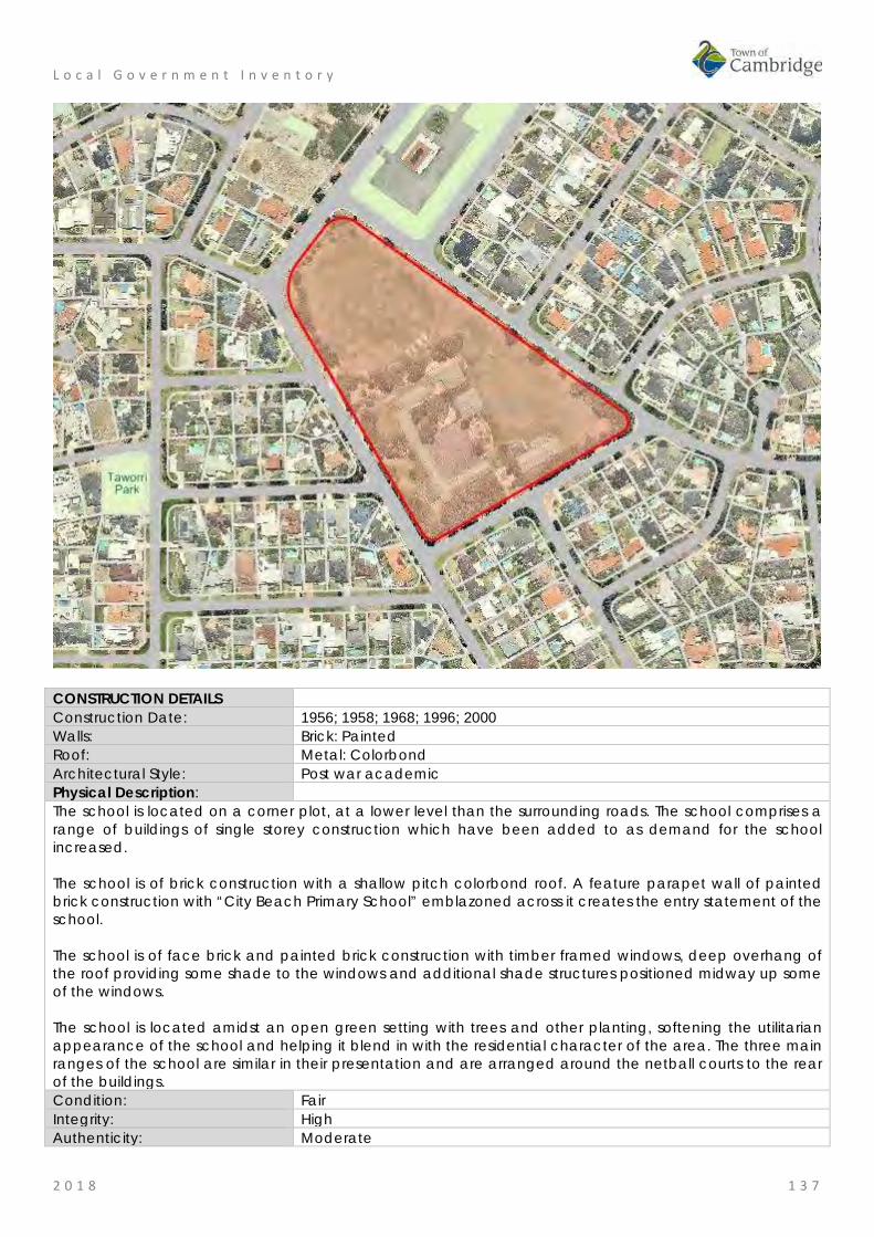
L o c a l G o v e r n m e n t I n v e n t o r y
2 0 1 8 1 3 7
CONSTRUCTION DETAILS Construction Date: 1956; 1958; 1968; 1996; 2000 Walls: Brick: Painted Roof: Metal: Colorbond Architectural Style: Post war academic Physical Description: The school is located on a corner plot, at a lower level than the surrounding roads. The school comprises a range of buildings of single storey construction which have been added to as demand for the school increased. The school is of brick construction with a shallow pitch colorbond roof. A feature parapet wall of painted brick construction with “City Beach Primary School” emblazoned across it creates the entry statement of the school. The school is of face brick and painted brick construction with timber framed windows, deep overhang of the roof providing some shade to the windows and additional shade structures positioned midway up some of the windows. The school is located amidst an open green setting with trees and other planting, softening the utilitarian appearance of the school and helping it blend in with the residential character of the area. The three main ranges of the school are similar in their presentation and are arranged around the netball courts to the rear of the buildings. Condition: Fair Integrity: High Authenticity: Moderate
L o c a l G o v e r n m e n t I n v e n t o r y
2 0 1 8 1 3 8
HISTORICAL INFORMATION Historical Notes: The City Beach Primary School, consisting of 3 classrooms, was opened in 1957 and the formal proceedings were accompanied by a fete. When the school opened there was no electricity or sealed playgrounds. Water was provided from overhead tanks. Power was not installed until subdivision of the land surrounding the school at the beginning of 1961 and connection to the water mains only occurred on 19 May 1966.
The school's enrolment grew steadily with enrolments reaching a peak in 1969 of over 480 children. This population growth was consistent with the rapid settlement of the area in the 1960s following the 1962 Empire/Commonwealth Games which resulted in opening up of lands for residential subdivision.
Between 1959 and 1967, 5 new classrooms were constructed to meet the demands of increasing enrolments. On 19 July 1967 an Extraordinary General Meeting of the P&C Association was held at the Floreat Surf Club. At this meeting a motion was approved giving authority to the Executive Committee to proceed with the building of a Hall / Library / Canteen complex on the school site. The School Library and Canteen were funded and the building arranged by the P&C in 1968. The new library was used for the first time on 18 June 1968. On 8 July 1968 another school milestone was reached when the Canteen opened for business, 350 lunch orders were placed.
In 1996, two rooms were renovated for the commencement of the new Fulltime 5 year old pre-primary unit. An internal wall was removed to make a larger room and a kitchenette installed. In 1997 the fulltime 5 year old pre-primary class commenced at the school site, moving from the premises on Boronia Crescent.
All asbestos roofing was removed during the summer break between December 1997 and January 1998. The school's Undercover Assembly area was officially opened by Dr E Constable MLA on 16 October 2000.
Since that time the school has undergone additions and alterations as required in accordance with the demands of the population and the evolution of teaching practice and standards. In 2009, a library and three new classrooms were constructed and in 2011 the administration block was extended and upgraded. In 2017, a new brick classroom block was constructed and transportable buildings were added to the site. It is currently proposed that a Japanese School will relocate to City Beach Primary School.
The three original classrooms and administration area are still extant on the campus. Historic Theme: Social and Civic activities: Education and science
Demographic settlement and mobility: settlements Associations: Sources: Aerial photographs, 1953-2016, Landgate.
Town of Cambridge Municipal Heritage Inventory and Townscape Precinct Study prepared for the Town of Cambridge, June 1997. History of our School, City Beach Primary School website, http://www.citybeachps.com.au , accessed September 2017.
SIGNIFICANCE Statement of Significance: • The place has aesthetic value for the remaining form and detail of a mid
20th century complex of educational buildings which continues to evolve and represent subsequent styles.
• The place has historic significance representing the history of settlement of City Beach in the period following World War II and the rapid population growth in the 1960s.
• The place has social value for the members of the local community, particularly past students and staff who attended the school.
Level of Significance: Some/moderate Contributes to the heritage of the locality. Has some altered or modified elements, not necessarily detracting from the overall significance of the item.
Management Category: Category 3 Conservation of the place is desirable. Any alterations or extensions should reinforce the significance of the place, and original fabric should be retained wherever feasible. Include on the Town Planning Scheme No 1 Heritage List.

L o c a l G o v e r n m e n t I n v e n t o r y
2 0 1 8 1 3 9
ADDITIONAL PHOTOGRAPHS
City Beach Primary School, 1957 from City Beach Primary School website

L o c a l G o v e r n m e n t I n v e n t o r y
2 0 1 8 1 4 0
Ryan Residence (fmr), City Beach Place No: 19
SITE INFORMATION Place Name: Ryan Residence (fmr) Other Names: Residence, 14 Marimba Crescent Street Address: 14 Marimba Crescent Locality City Beach HERITAGE LISTING SHO inHerit database Other Listings PLACE TYPE Individual building or group Original Use: Residential: Single storey house Current Use: Residential: Single storey house Other Use: LAND INFORMATION Lot: 523 Survey: Plan 7180 Reserve No: C/T: 1290-307 Property Number: 11135 Land Number: 1081
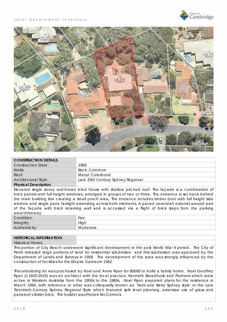
L o c a l G o v e r n m e n t I n v e n t o r y
2 0 1 8 1 4 1
CONSTRUCTION DETAILS Construction Date: 1966 Walls: Brick: Common Roof: Metal: Colorbond Architectural Style: Late 20th Century Sydney Regional Physical Description: Elevated single storey red/brown brick house with shallow pitched roof. The façade is a combination of brick panels and full height windows, arranged in groups of two or three. The entrance is set back behind the main building line creating a small porch area. The entrance includes timber door with full height side window and single pane fanlight extending across both elements. A paved verandah extends around part of the façade with brick retaining wall and is accessed via a flight of brick steps from the parking area/driveway. Condition: Fair Integrity: High Authenticity: Moderate HISTORICAL INFORMATION Historical Notes: This portion of City Beach underwent significant development in the post World War II period. The City of Perth released large portions of land for residential subdivision and this subdivision was approved by the Department of Lands and Surveys in 1959. The development of the area was strongly influenced by the construction of facilities for the Empire Games in 1962. This undulating lot was purchased by Noel and Anne Ryan for $5000 to build a family home. Noel Geoffrey Ryan (c1933-2016) was an architect with the local practice, Kenneth Broadhurst and Partners which were active in Western Australia from the 1950s to the 1980s. Noel Ryan prepared plans for the residence in March 1965, with reference to what was colloquially known as 'Nuts and Berry Sydney style' or the Late Twentieth-Century Sydney Regional Style which featured split level planning, extensive use of glass and panels of clinker brick. The builder was Patrick McCormick.

L o c a l G o v e r n m e n t I n v e n t o r y
2 0 1 8 1 4 2
When the lot was purchased the land was well covered with native vegetation which was retained where possible and the planting still reflects the original landscape. The Ryan family lived at the home until 2014. Following the transfer of the property to the current owner, renovations and alterations have been undertaken. These have included the replacement of the original roof cladding and ceiling. The current owner has provided information that the original building fabric is poor condition although this has not been sighted in this assessment. Historic Theme: Occupations: Domestic Activities
People: Innovators Associations: Noel Ryan
Patrick McCormick Ryan Family
Sources: Aerial photographs, 1953-2016, Landgate. Information from Anne Ryan in conversation with Hocking Heritage Studio, June 2017. Information from current owner, September 2018.
SIGNIFICANCE Statement of Significance: • The place has aesthetic value as a good representative example of
the Late 20th Century Sydney Regional style in its original landscaped setting.
• The place has historic value for its association with the development of City Beach in the 1960s which saw many families settling in the area.
• The place has historic value as an example of the period in the 1960s when there was considerable experimentation with traditional design principles that were being expressed in many areas, including architecture.
• The place has historic value for its association with architect Noel Ryan who designed this residence for his family.
Level of Significance: Little Contributes to the understanding of the history of the Town of Cambridge.
Management Category: Category 4 Photographically record prior to major development or demolition. Recognise and interpret the site if possible. Do not include on the Town Planning Scheme No 1 Heritage List.
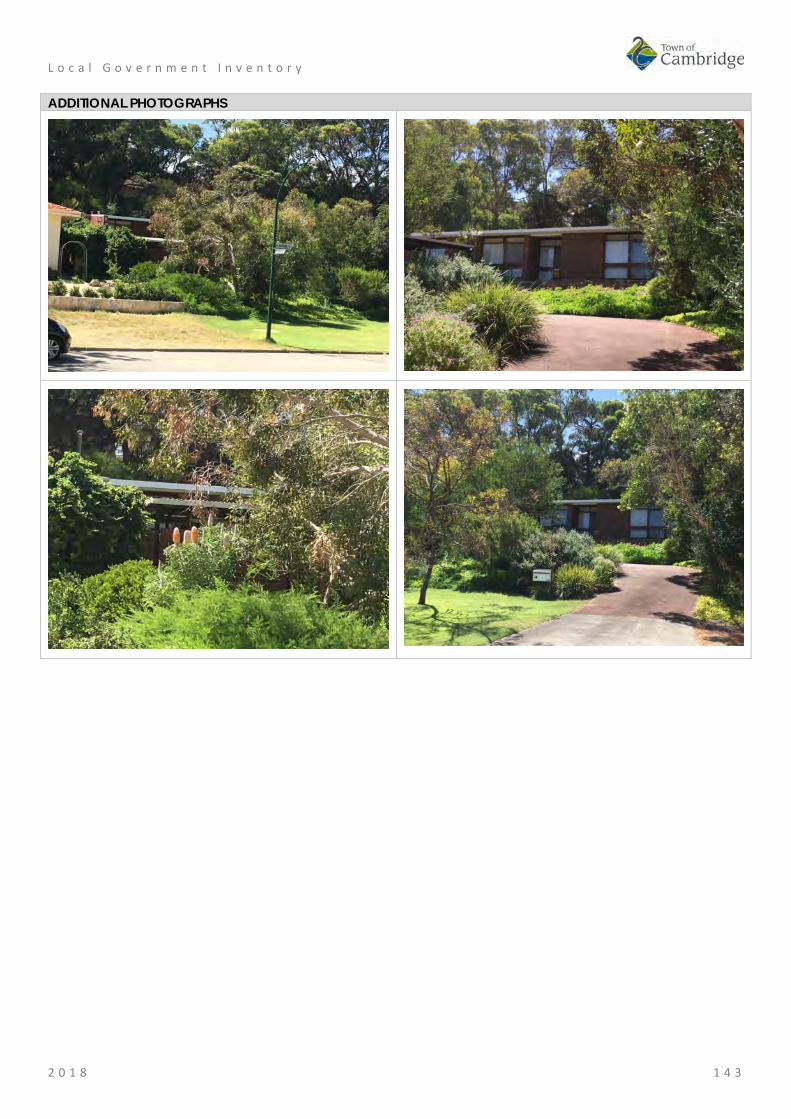
L o c a l G o v e r n m e n t I n v e n t o r y
2 0 1 8 1 4 3
ADDITIONAL PHOTOGRAPHS

L o c a l G o v e r n m e n t I n v e n t o r y
2 0 1 8 1 4 4
Booth House, City Beach Place No: 20
SITE INFORMATION Place Name: Booth House Other Names: Residence, 59 Oban Road Street Address: 59 Oban Road Locality City Beach HERITAGE LISTING SHO inHerit database Other Listings PLACE TYPE Individual building or group Original Use: Residential: Single storey residence Current Use: Residential: Single storey residence Other Use: LAND INFORMATION Lot: 345 Survey: Plan 8758 Reserve No: -------- C/T: 59-82A Property Number: 17816 Land Number: 6419
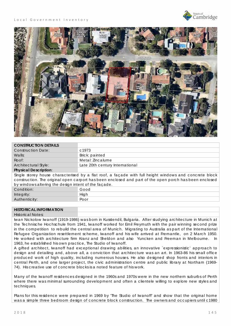
L o c a l G o v e r n m e n t I n v e n t o r y
2 0 1 8 1 4 5
CONSTRUCTION DETAILS Construction Date: c1973 Walls: Brick: painted Roof: Metal: Zincalume Architectural Style: Late 20th century International Physical Description: Single storey house characterised by a flat roof, a façade with full height windows and concrete block construction. The original open carport has been enclosed and part of the open porch has been enclosed by windows altering the design intent of the façade. Condition: Good Integrity: High Authenticity: Poor HISTORICAL INFORMATION Historical Notes: Iwan Nickolow Iwanoff (1919-1986) was born in Kusstendil, Bulgaria. After studying architecture in Munich at the Technische Hochschule from 1941, Iwanoff worked for Emil Freymuth with the pair winning second prize in the competition to rebuild the central area of Munich. Migrating to Australia as part of the International Refugee Organization resettlement scheme, Iwanoff and his wife arrived at Fremantle, on 2 March 1950. He worked with architecture firm Kranz and Sheldon and also Yuncken and Freeman in Melbourne. In 1963, he established his own practice, The Studio of Iwanoff. A gifted architect, Iwanoff had exceptional drawing abilities, an innovative `expressionistic’ approach to design and detailing and, above all, a conviction that architecture was an art. In 1963-86 his small office produced work of high quality, including numerous houses. He also designed shop fronts and interiors in central Perth, and one larger project, the civic administration centre and public library at Northam (1969-74). His creative use of concrete blocks is a noted feature of his work. Many of the Iwanoff residences designed in the 1960s and 1970s were in the new northern suburbs of Perth where there was minimal surrounding development and often a clientele willing to explore new styles and techniques. Plans for this residence were prepared in 1969 by 'The Studio of Iwanoff' and show that the original home was a simple three bedroom design of concrete block construction. The owners and occupiers until c1980

L o c a l G o v e r n m e n t I n v e n t o r y
2 0 1 8 1 4 6
were social workers, John Warren Booth and Susan Betty Booth. In 1971, a swimming pool was constructed in the rear of the lot and in 1973, a large extension was added to the rear of the residence on the western side which changed the plan form of the residence to a 'L' shape. By 1987, the property was transferred to owners Barry and Nanette Bennett who engaged builders, Summit Homes, to redesign the interior layout of the residence to create an additional bedroom and family room. These additions resulted in the removal of portion of the rear terrace. In 1989, the Bennett's engaged Burke & Gaynor Homes to design a new entry and dining room at the front of the residence. Since that time the carport has been enclosed with a double garage door. These later additions have altered the presentation of the house to the street. Historic Theme: Demographic settlement and mobility: settlements
Occupations: domestic activities People: Innovators
Associations: Iwan Iwanoff Booth Family Bennett Family
Sources: Aerial photographs, 1953-2016, Landgate. Goad, Philip; Willis, Julie 'The Encyclopaedia of Australian Architecture', Cambridge University Press, 2012, p. 357. Duncan Richards, 'Iwanoff, Iwan (1919–1986)', Australian Dictionary of Biography, National Centre of Biography, Australian National University, http://adb.anu.edu.au/biography/iwanoff-iwan-12685/text22867, published first in hardcopy 2007, accessed online 5 October 2017. State Library of WA, Iwan Iwanoff Collection. MN1401, Acc 4400A Archive plans held by the City of Perth
SIGNIFICANCE Statement of Significance: • The place has some aesthetic value for the remnant elements and form of
the late 20th century International style. • The place has historic value for its association with prominent architect,
Iwan Iwanoff who was influential in Western Australian practice for his non traditional approach to design and materials drawn from European trends.
• The place has historic value for its association with the late 1960s which was characterised as a period of affluence which was teamed with a willingness to experiment with new styles and materials.
• The place has social value as the house and others of Iwanoff's design are the source of study and interest amongst members of the community.
Level of Significance: Little Contributes to the understanding of the history of the Town of Cambridge.
Management Category: Category 4 Photographically record prior to major development or demolition. Recognise and interpret the site if possible. Do not include on the Town Planning Scheme No 1 Heritage List.

L o c a l G o v e r n m e n t I n v e n t o r y
2 0 1 8 1 4 7
ADDITIONAL PHOTOGRAPHS
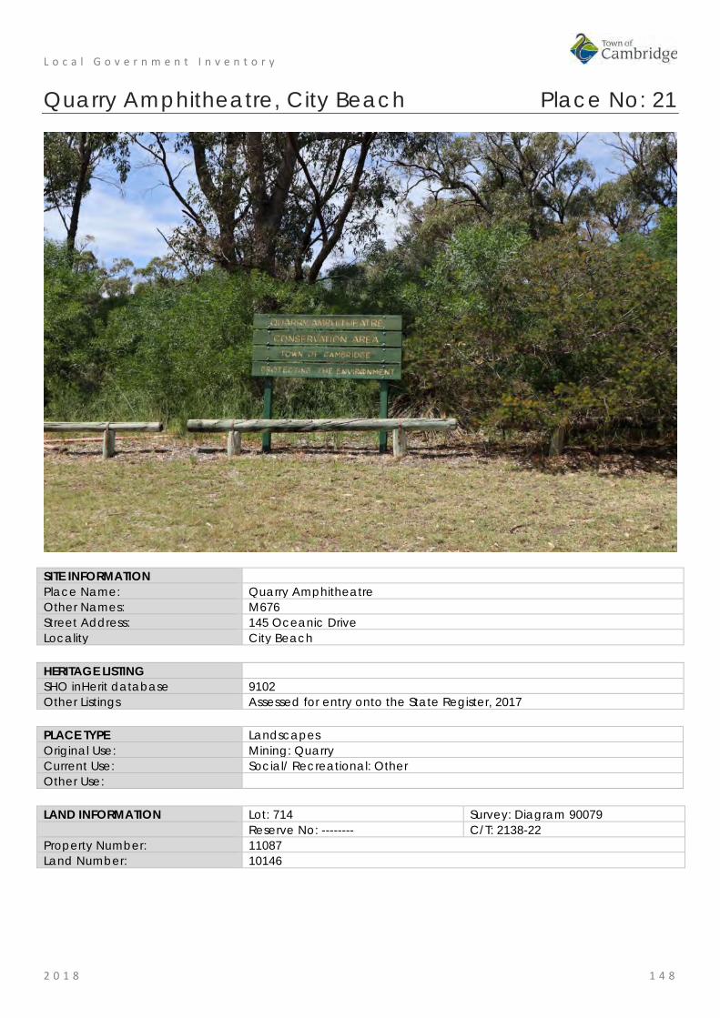
L o c a l G o v e r n m e n t I n v e n t o r y
2 0 1 8 1 4 8
Quarry Amphitheatre, City Beach Place No: 21
SITE INFORMATION Place Name: Quarry Amphitheatre Other Names: M676 Street Address: 145 Oceanic Drive Locality City Beach HERITAGE LISTING SHO inHerit database 9102 Other Listings Assessed for entry onto the State Register, 2017 PLACE TYPE Landscapes Original Use: Mining: Quarry Current Use: Social/ Recreational: Other Other Use: LAND INFORMATION Lot: 714 Survey: Diagram 90079 Reserve No: -------- C/T: 2138-22 Property Number: 11087 Land Number: 10146

L o c a l G o v e r n m e n t I n v e n t o r y
2 0 1 8 1 4 9
CONSTRUCTION DETAILS Construction Date: 1894 to 1986 Walls: N/A Roof: N/A Architectural Style: N/A Physical Description: Quarry Amphitheatre sits on northern slopes of Bold Park, accessed via Waldron Drive or Scenic Drive. The place consists of a former limestone quarry that has been adapted to form a theatre space, consisting of an Entrance, Auditorium, Stage, Backstage and rear area, set between two limestone faces. The Auditorium consists of a number of grassed tiers orientated in a southerly direction looking back towards the stage. The tiers are edged with concrete pavers and are divided into two sections by a central paved aisle. The Stage is a rectangular timber floor set on a steel frame with timber deck. The Backstage area is located below the stage Condition: Good Integrity: High Authenticity: High
HISTORICAL INFORMATION Historical Notes: Following the foundation of Perth in August 1829, the townsite was laid out between Mount Eliza and what was to later become Heirisson Island. Limestone was in great demand for construction in the new colony. The earliest lime kilns in Western Australia were established at the initial settlement sites of Fremantle and Albany in the 1830s, where settlers had access to local supplies of limestone. During the early expansion of the Swan River colony, small kilns were established at Cottesloe, Peppermint Grove and Claremont from the 1850s to the 1890s. Henry Trigg, a carpenter and master builder from Gloucester, England arrived in the new colony of Western

L o c a l G o v e r n m e n t I n v e n t o r y
2 0 1 8 1 5 0
Australia in 1829. In I 834, Trigg was granted 500 acres of land, which lay south of modern day Grantham Street, stretching from Floreat to the coastal sand hills. The western boundary of Trigg's land ran along the top of a limestone ridge. As a builder, Trigg recognised the value of this limestone outcropping and set up a quarrying and lime burning business. Trigg's business which became known as the 'Limekilns' prospered. In 1839, Trigg purchased neighbouring land to the south, including what is now Perry Lakes and One Tree Hill, (now known as Reabold Hill). In the same year, Trigg was appointed Superintendent of Public Works, and in this role was responsible for overseeing the erection of many early government buildings in Perth. In 1844, Walter Padbury, a pastoralist, acquired 426 acres of land adjacent to Trigg's property and later purchased Trigg's land including the Limekilns business for 2350, forming a 1,234 acre landholding which became known as the 'Limekilns Estate'. For the next 20 years Padbury built the Estate into a successful property, including the retention of the quarrying operations. At the height of operations, more than 50 men were employed at the quarry and lime kiln site. In 1869, brothers Henry and Somers Birch purchased the Limekilns Estate from Walter Padbury for £1,000. On 1 November 1875, during their ownership of the property, the explorer Ernest Giles arrived in Perth after his 2,500 mile journey from Port Augusta. During the 1890s, the Limekilns Estate served as a temporary quarantine station for camels imported to Western Australia to provide transport to the goldfields, with a lake on the property becoming known as Camel Lake. The Estate remained in the Birch's ownership until, 1880 when it was purchased by Joseph Perry for the sum of £1300. During his ownership, Perry kept the Quarry and limekilns in operation. Many of Perth's early public buildings, including the foundations of the Perth Town Hall (1870) were constructed using limestone from the quarry and kilns. In 1880, a portion of the Limekilns property was rented to Charles Ball. In an advertisement in the West Australian in May 1880, Ball offered to supply lime which was described as the most superior in the colony, from lime kilns of 30 years standing. Stone from the quarry was transported by a light narrow gauge horse drawn railway through the bush (roughly along the route of the present day Salvado Road) to Jolimont and then on to the Subiaco Railway Station. Private quarrying ceased operation in 1906 and the Limekilns Quarry remained disused for many years. Changes to the rural nature of the area came about with the subdivision of land owned by the Catholic Church in 1911. This subdivision was called the Church Lands Estate, and the first house was constructed in 1912. In September 1916, construction began on a plank road to provide access to the quarry on the Lime Kilns Estate. On 30 November 1917, the West Australian reported that the new municipal quarry, formerly known as the Limekilns Quarry, on the recently purchased Perry's Estate had been officially opened. In 1917, the Perth City Council purchased the 1290-acre Limekilns Estate from Perry for £18,000 and it linked to the Endowment Lands bestowed on the Perth City Council by the State Government in 1902. In January 1918, the Limekilns Estate was included within the boundaries of the City of Perth, and adjoined a further 2281 acres of Endowment Lands. The exact date that the municipal quarry ceased operation is not known, but it is likely that operations ceased in the 1920s with the beginning of the development of the area for housing. During the middle decades of the 20th century the quarry was unused and largely inaccessible. In the early 1980s, local City Beach resident Diana Waldron, the Artistic Director of the Perth City Ballet Company, conceived the idea of converting the old quarry into an amphitheatre for stage productions. Diana's husband, Keri Waldron, an architect, drew up plans for the proposed Amphitheatre. Ken Waldron was one of the Hills 5 Architects who during the 1960s and 1970s were renowned for their 'organic" approach to architecture that responded sympathetically to the environment Influenced by the likes of Frank Lloyd Wright and the Chicago School of Architecture, the Hills 5 Architects included Gene Mapp, Wallace Greenham, Bill Keirath, KW John White, and Ray Lefroy.
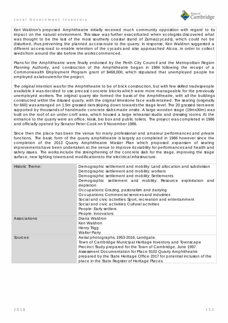
L o c a l G o v e r n m e n t I n v e n t o r y
2 0 1 8 1 5 1
Keri Waldron's proposed Amphitheatre initially received much community opposition with regard to its impact on the natural environment. This issue was further exacerbated when ecologists discovered what was thought to be the last of the most southerly coastal stand of Zamia(cycads), which could not be disturbed, thus preventing the planned access route to the quarry. In response, Ken Waldron suggested a different access road to enable retention of the cycads and also approached Alcoa, in order to collect seeds from around the site before the works commenced. Plans for the Amphitheatre were finally endorsed by the Perth City Council and the Metropolitan Region Planning Authority, and construction of the Amphitheatre began in 1984 following the receipt of a Commonwealth Employment Program grant of $468,000, which stipulated that unemployed people be employed as labourers for the project. The original intention was for the Amphitheatre to be of brick construction, but with few skilled tradespeople available it was decided to use precast concrete blocks which were more manageable for the previously unemployed workers. The original quarry site formed the basis of the Amphitheatre, with all the buildings constructed within the disused quarry, with the original limestone face walls retained. The seating (originally for 660) was arranged on 1.5m grassed tiers sloping down towards the stage level. The 20 grassed tiers were supported by thousands of handmade concrete slabs made onsite. A large wooden stage (19mx30m) was built on the roof of an under croft area, which housed a large rehearsal studio and dressing rooms. At the entrance to the quarry were an office, kiosk, bio box and public toilets. The project was completed in 1986 and officially opened by Senator Peter Cook on 9 November 1986. Since then the place has been the venue for many professional and amateur performances and private functions. The basic form of the quarry amphitheatre is largely as completed in 1986 however since the completion of the 2013 Quarry Amphitheatre Master Plan which proposed expansion of seating improvements have been undertaken at the venue to improve its viability for performances and health and safety issues. The works include the strengthening of the concrete slab for the stage, improving the stage surface, new lighting towers and modifications to the electrical infrastructure. Historic Theme: Demographic settlement and mobility: Land allocation and subdivision
Demographic settlement and mobility: workers Demographic settlement and mobility: Settlements Demographic settlement and mobility: Resource exploitation and depletion Occupations: Grazing, pastoralism and dairying Occupations: Commercial services and industries Social and civic activities: Sport, recreation and entertainment Social and civic activities: Cultural activities People: Early settlers People: Innovators
Associations: Diana Waldron Ken Waldron Henry Trigg Walter Parry
Sources: Aerial photographs, 1953-2016, Landgate. Town of Cambridge Municipal Heritage Inventory and Townscape Precinct Study prepared for the Town of Cambridge, June 1997. Assessment Documentation for Place 9102 Quarry Amphitheatre prepared by the State Heritage Office 2017 for potential inclusion of the place in the State Register of Heritage Places.
L o c a l G o v e r n m e n t I n v e n t o r y
2 0 1 8 1 5 2
SIGNIFICANCE Statement of Significance: Quarry Amphitheatre, City Beach comprising a 556 seat open air
Amphitheatre located high upon Reabold Hill in City Beach with panoramic views of Bold Park towards the City, within a former limestone quarry, in a natural bushland setting, has cultural heritage significance for the following reasons: • the place is unique in Western Australia as a former limestone quarry
that has been adapted for re-use as an amphitheatre; • the place is rare as an extant inner Perth metropolitan quarry
associated with the development of the limestone quarrying industry in the late nineteenth century;
• the stone from the quarry was used in some of Perth's early buildings including the foundations of Perth Town Hall;
• the place is significant for its associations with prominent settlers Walter Padbury and Henry Trigg, who were significant figures in the early development of Western Australia;
• the place has aesthetic value for its bushland setting and unobstructed views of the city;
• the place has social significance to the local and wider community having been a venue for concerts, ballet and other cultural events since 1986;
• and the place is associated with Diana Waldron, founder of Perth City Ballet, who with her husband architect, Ken Waldron, was responsible for the inception, fundraising and construction of the Quarry.
The administration building, toilets, kiosk and storage sheds and access areas north of the stage are of little significance.
Level of Significance: Exceptional Essential to the heritage of the locality. Rare or outstanding example. Recommended for inclusion on the State Register of Heritage Places.
Management Category: Category 1 The place should be retained and conserved unless there is no feasible and prudent alternative to doing otherwise. Any alterations or extensions should reinforce the significance of the place, and be in accordance with a Conservation Plan (if one exists for the place). Include on the Town Planning Scheme No 1 Heritage List.

L o c a l G o v e r n m e n t I n v e n t o r y
2 0 1 8 1 5 3
ADDITIONAL PHOTOGRAPHS
State Library image 000538d Perry's hill quarry 1913
Town of Cambridge image Ph0878-06 Building Quarry Amphitheatre, October 1986
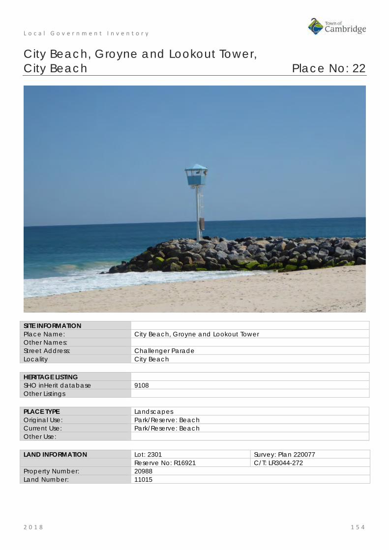
L o c a l G o v e r n m e n t I n v e n t o r y
2 0 1 8 1 5 4
City Beach, Groyne and Lookout Tower, City Beach Place No: 22
SITE INFORMATION Place Name: City Beach, Groyne and Lookout Tower Other Names: Street Address: Challenger Parade Locality City Beach HERITAGE LISTING SHO inHerit database 9108 Other Listings PLACE TYPE Landscapes Original Use: Park/Reserve: Beach Current Use: Park/Reserve: Beach Other Use: LAND INFORMATION Lot: 2301 Survey: Plan 220077 Reserve No: R16921 C/T: LR3044-272 Property Number: 20988 Land Number: 11015

L o c a l G o v e r n m e n t I n v e n t o r y
2 0 1 8 1 5 5
CONSTRUCTION DETAILS Construction Date: 1935; 1969; 1970; 2016 Walls: Various Roof: Various Architectural Style: N/A Physical Description: Extensive area of beach with dunes, native vegetation and landscaping. Boardwalks and coastal paths are located in the sand dunes connecting City Beach with the beaches to the north and south. The two groynes roughly define the boundaries of City Beach. The dunes and natural vegetation aesthetic is interspersed with formal landscaping of lawned areas and plantings softening the hard landscaping of the carparks. Facilities include the Restaurants, Kiosk, City Beach Surf Lifesaving Club and volley ball courts, picnic and BBQ areas and children’s play areas. Located on the City Beach Groyne, the Look Out Tower is a simple form comprising a slender steel column with ladder leading to an octagonal lookout shelter that provides 360° visual access. Condition: Good Integrity: High Authenticity: High
L o c a l G o v e r n m e n t I n v e n t o r y
2 0 1 8 1 5 6
HISTORICAL INFORMATION Historical Notes: The popularity of different beaches in the Perth metropolitan area was dependent on transport in the first decades of the 20th century. Those beaches close to the train line were most well patronised until the Inter War years when road access was improved. In February 1918, a timber plank road was completed in built between the city and the beach along the alignment of the present day Oceanic Drive. The beach where the road terminated became known as 'City Beach' and was formally designated as that in c1925. Life Saving Clubs had been established at Cottesloe and North Cottesloe, and in December 1924 members of the City of Perth Amateur Swimming Club formed Western Australia’s third Surf Life Saving Club at City Beach. The City of Perth undertook an extensive programme of research into the establishment of appropriate facilities for a Lifesaving Clubroom at City Beach. The Lord Mayor of Perth opened the timber clubrooms in February 1926 and the beach was officially opened by the Governor Sir William Campion in December of that year. In addition to the clubrooms basic timber facilities were provided by the City of Beach for the numbers of visitors on weekends and holiday periods. In 1927, a new road to the beach was cleared along the route of what is now, The Boulevard. This road provided access to the northern parts of City Beach, now Floreat Beach. In 1935, the southern groyne was built at City Beach to control sand drift and help to 'square' the surf line to the beach. The construction was overseen by the City Engineer with a budget of £3000 and was initially approximately 60m long. The huge diorite boulders, weighing up to 8 tons, were brought from the Municipal Quarry in the Darling Ranges. A shark lookout tower with an alarm was positioned on the end of the groyne. In 1938, more substantial accommodation for the City Beach Life Saving Club were built and these and basic public facilities were available at the beach until the 1960s when the region underwent significant development following the 1962 Empire Games in Perth which saw adjacent landholdings being released for residential subdivision. The 1960s also saw the popularity and growth of surfing and the associated ‘surf culture’. Although not new to Western Australia, surfing and beach going became more popular and were closely associated with younger generations. In 1963, City Beach Surf Riders, WA's oldest surf-board riding club was established. The northern groyne at City Beach was built sometime between 1958/59 and provided protection for swimmers at City Beach as well as resolved some of the issues of erosion which had been experienced at City Beach. Maintenance and management of the beaches and groynes have been an ongoing task for the Town of Cambridge and prior to 1994, the City of Perth. The late 1960s can also be seen as a period of experimentation and rejection of past practices and attitudes. It was in the context of a newly established suburb providing for a young population keen to embrace new styles and technologies that the City of Perth provided new facilities at City Beach. During the 1960s, an influential figure in the offices of the City of Perth was architect and planner Paul Ritter. Ritter was a controversial and colourful figure in Western Australia in this period. He was trained in England and was brought to the City of Perth to advance local knowledge and philosophies of planning and design. Appointed as the City of Perth's first City Planner in 1965 he was dismissed in 1967 but engendered significant public support which led to his election as a City of Perth councillor from 1968 to 1986. Following his dismissal, Ritter established his own practice and was well known for exploring new techniques and philosophies, particularly in relation to art and design in the public realm. In 1969, his design of a wavy retaining wall in local Toodyay stone was built at City Beach. The design was influenced by the adjacent waves and sand dunes and was part of a larger Master Plan for City Beach prepared during his tenure at the City of Perth. In 1971, City Beach was the host of the Australian Surf Life Saving Championships which saw the City of Perth undertake major works at the beach. In 1970, architects Forbes and Fitzhardinge were engaged to design three kiosks on the beach. Architect Tony Brand oversaw the design and he prepared an organic design in concrete which responded to the wavy wall designed by Paul Ritter and the seaside setting. Only two of these kiosks remain insitu at Floreat Beach and South City Beach. New Clubrooms were also built for the

L o c a l G o v e r n m e n t I n v e n t o r y
2 0 1 8 1 5 7
City Beach Life Saving Club for the championships. The provision of extensive car parking at City Beach was also undertaken during this period. During 1970/1971 the City of Perth spent $375,829 on works at City Beach including the new kiosks and change rooms, and the City of Perth Surf Club House. The decision to hold the Australian National Surf Life Saving Competitions at City Beach in 1971 would have been a significant impetus to complete the works. In the City of Perth Annual Report for that year it was noted that; During the year the facilities and conditions at City Beach were highly praised by both competitors and spectators at the Australian National Surf Championships More than 1,400 lifesavers from all Australian States and a team from South Africa competed during the April Carnival. Blending man-made features and amenities into the natural beach scene will continue to enhance City Beach's wide popularity. The clubrooms were replaced in 2016 as part of a major program of works which included the new clubrooms, three restaurants, amphitheatre, beachside promenade, shaded spaces for families and public art installations. Architects Christou Design Group prepared the designs for the new works and the project was successful in receiving a public architecture award in 2016. Historic Theme: Social and Civic Activities: Community services and utilities
Social and Civic Activities: Sport, recreation and entertainment Associations: Paul Ritter
Tony Brand Christou Design Group
Sources: Aerial photographs, 1953-2016, Landgate. Town of Cambridge Municipal Heritage Inventory and Townscape Precinct Study prepared for the Town of Cambridge, June 1997. Cambridge Notes, Town of Cambridge Local History Collection, Item T74; T126; T216. Town of Cambridge, Latest News, June 2016, 'City Beach Precinct Opens', https://www.cambridge.wa.gov.au/Town-Council/News/Latest-News/2016/City-Beach-precinct-opens The Daily News, 17 January 1942, p. 13.
SIGNIFICANCE Statement of Significance: • City Beach has aesthetic value as a large stretch of beach and
foreshore that is well maintained and in good condition. • The place has historic value for its association with the establishment
and development of the suburb of City Beach from a holiday destination in the 1920s to being part of the wider Perth metropolitan area.
• The place has historic value for its demonstration of the evolution in the development of public facilities with the remaining kiosk the earliest structures on the site through to contemporary structures completed in 2016.
• The place has historic value for its association with prominent architects in Western Australia during the 1960s and 1970s; Paul Ritter and Tony Brand;
• The groyne has potential research value as they demonstrate methods of construction in the mid 20th century which may prove instructive to future projects;
• The place has social value for many members of the community from the Town of Cambridge and the wider Perth metropolitan area who have visited the beach for formal and informal recreation.
Level of Significance: Some/moderate Contributes to the heritage of the locality. Has some altered or modified elements, not necessarily detracting from the overall significance of the item.
Management Category: Category 3 Conservation of the place is desirable.
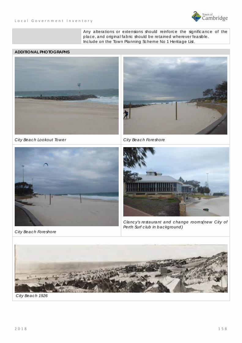
L o c a l G o v e r n m e n t I n v e n t o r y
2 0 1 8 1 5 8
Any alterations or extensions should reinforce the significance of the place, and original fabric should be retained wherever feasible. Include on the Town Planning Scheme No 1 Heritage List.
ADDITIONAL PHOTOGRAPHS
City Beach Lookout Tower
City Beach Foreshore
City Beach Foreshore
Clancy's restaurant and change rooms(new City of Perth Surf club in background)
City Beach 1926

L o c a l G o v e r n m e n t I n v e n t o r y
2 0 1 8 1 5 9
Bold Park, City Beach Place No: 23
SITE INFORMATION Place Name: Bold Park Other Names: Bush Forever Sit No.312 Street Address: Area bound by The Boulevard, Bold Park Drive, Kalinda Drive and Oceanic
Drive; Perry Lakes Drive, Stephenson Avenue, Rochdale Road and West Coast Highway; Rochdale Road, McClemans Road, West Coast Highway, Challenger Parade and the City Beach coastline.
Locality City Beach HERITAGE LISTING SHO inHerit database 4499 Other Listings Registered Aboriginal Site No.20178
National Trust of Australia (WA) Register of the National Estate
PLACE TYPE Landscape Original Use: Park/Reserve Current Use: Park/Reserve Other Use: LAND INFORMATION Lot: 12965; 12968; 3000 Survey: Plans 21069; 90078; 54590 Reserve No: R45409 C/T: 311-271; 3111-274; 3166-564 Property Number: 11636; 22427; 18352; 22424 Land Number: 10640; 13055; 13056; 6919; 15113

L o c a l G o v e r n m e n t I n v e n t o r y
2 0 1 8 1 6 0
CONSTRUCTION DETAILS Construction Date: N/A Walls: N/A Roof: N/A Architectural Style: N/A Physical Description: Bold Park is an extensive area of natural environment, parklands and bush, bounded by Oceanic Drive, West Coast Highway, Perry Lakes Drive and Rochdale Road, totalling 437 hectares and is the largest remaining bushland within the urban area of the Swan Coastal Plain. The portion of land to the south of Rochdale Road bordered by West Coast Highway to the west can be considered part of the original landholding and its physical form, fauna and flora are consistent with Bold Park. A further section of Bold Park is found to the north of Oceanic Drive, extending along Bold Park Drive and bordered by The Boulevard to the north and Kalinda Drive (not including the International School site or the Town of Cambridge Administration Centre)
The park contains a number of features including Camel Lake, Pine Plantation, Reabold Hill and various heritage trails and nature walks and together with a number of lookouts providing long views across the City and out towards the Indian Ocean. The park also contains Perry House built in the early 1900s for the caretaker of the park (see separate entry).
The parcel of land south of Rochdale Road is more informal in nature with no facilities such as graded paths or signage. Condition: Good Integrity: High

L o c a l G o v e r n m e n t I n v e n t o r y
2 0 1 8 1 6 1
Authenticity: High
HISTORICAL INFORMATION Historical Notes: The area now defined as Bold Park has been registered as Aboriginal Site place 20178 and recognised for the following associations; historical, mythological, camp, hunting place, plant resource, and lookout point.
Following the foundation of Perth in August 1829, the townsite was laid out between Mount Eliza and what was to later become Heirisson Island. Limestone was in great demand for construction in the new colony. The earliest lime kilns in Western Australia were established at the initial settlement sites of Fremantle and Albany in the 1830s, where settlers had access to local supplies of limestone.
Henry Trigg, a carpenter and master builder from Gloucester, England arrived in the new colony of Western Australia in 1829. In I 834, Trigg was granted 500 acres of land, which lay south of modern day Grantham Street, stretching from Floreat to the coastal sand hills. The western boundary of Trigg's land ran along the top of a limestone ridge. As a builder, Trigg recognised the value of this limestone outcropping and set up a quarrying and lime burning business. Trigg's business which became known as the 'Limekilns' prospered.
In 1839, Trigg purchased neighbouring land to the south, including what is now Perry Lakes and One Tree Hill, (now known as Reabold Hill). In the same year, Trigg was appointed Superintendent of Public Works, and in this role was responsible for overseeing the erection of many early government buildings in Perth.
In 1844, Walter Padbury, a pastoralist, acquired 426 acres of land adjacent to Trigg's property and later purchased Trigg's land including the Limekilns business for 2350, forming a 1,234 acre landholding which became known as the 'Limekilns Estate'. For the next 20 years Padbury built the Estate into a successful property, including the retention of the quarrying operations. At the height of operations, more than 50 men were employed at the quarry and lime kiln site.
In 1869, brothers Henry and Somers Birch purchased the Limekilns Estate from Walter Padbury for £1,000. On 1 November 1875, during their ownership of the property, the explorer Ernest Giles arrived in Perth after his 2,500 mile journey from Port Augusta. His camels were rested at the Limekilns Estate and later in the 1890s, the Limekilns Estate served as a temporary quarantine station for camels imported to Western Australia to provide transport to the goldfields, with a lake now within Bold Park becoming known as Camel Lake.
The Estate remained in the Birch's ownership until, 1880 when it was purchased by Joseph Perry for the sum of £1300. During his ownership, Perry kept the Quarry and limekilns in operation. Many of Perth's early public buildings, including the foundations of the Perth Town Hall (1870) were constructed using limestone from the quarry and kilns.
In 1880, a portion of the Limekilns property was rented to Charles Ball who offered to supply lime which was described as the most superior in the colony, from lime kilns of 30 years standing. Private quarrying ceased operation in 1906 and the Limekilns Quarry (Quarry Amphitheatre) remained disused for many years. Changes to the rural nature of the area came about with the subdivision of land owned by the Catholic Church in 1911. This subdivision was called the Church Lands Estate, and the first house was constructed in 1912.
In 1917, the Perth City Council purchased the 1290-acre Limekilns Estate from Perry for £18,000 and it linked to the Endowment Lands bestowed on the Perth City Council by the State Government in 1902. In January 1918, the Limekilns Estate was included within the boundaries of the City of Perth, and adjoined a further 2281 acres of Endowment Lands. The City envisioned opening out the quarries and using the limestone in the construction of city roads but also setting a portion of the land aside for a public park on the site of Perry's couch paddock and One Tree Hill (Reabold Hill).
The exact date that the municipal Quarry ceased operation is not known, but it is likely that operations ceased in the 1920s with the beginning of the development of the area for housing. During the middle decades of the 20th century the quarry was unused and largely inaccessible.
In 1919, One Tree Hill was renamed Reabold Hill after F. R Rea, the Mayor of Perth at the time the property was acquired by the City of Perth and W. E. Bold, the town clerk. By this time the lone Tuart tree that had previously sat atop the 286 ft. high hill, and given the place its name had disappeared.
In 1925, an area of land of approximately 1000 acres was set aside as a place of recreation and was named Bold Park in honour of William Ernest Bold (1873-1953), the retiring town clerk. Bold was one of the State's leading advocates of the Garden City Movement, which had developed in the United Kingdom in

L o c a l G o v e r n m e n t I n v e n t o r y
2 0 1 8 1 6 2
the early 1900s in response to improving residential amenities for workers in nineteenth century industrial cities. The definition of a Garden City as a town designed for healthy living, surrounded by a rural belt of land owned or held in trust for the community directly influenced the planning of Floreat Park and City Beach as two satellite towns separated by a belt of undeveloped land (Bold Park). Other sources have designated that the naming occurred in 1936.
Over the years, the City of Perth maintained Bold Park and Reabold Hill as places of recreation. By the 1960s, the area was surrounded by suburban housing.
In 1987, the Friends of Bold Park Bushland Inc. was established to protect and conserve the park. Their role as a lobby group was significant in the decision to declare Bold Park an A-class reserve on 10 August 1998 for its high conservation, landscape and recreation values and vested with the Botanic Gardens and Parks Authority for management.
Volunteers from the group work on regeneration projects, raise community awareness and provide free guided walks through the bushland.
The Western Australian Ecology Centre is located on Perry Lakes Drive, City Beach. Bold Park visitor information is displayed at the building entry. Officially opened in August 2004, the Western Australian Ecology Centre was initiated as a key strategy in the inaugural Bold Park Environmental Management Plan 2000-2005 to provide a venue to assist community groups, environmental practitioners and educators to undertake their activities, and to provide office space for staff involved in Bold Park's ongoing management.
The park continues to be used for passive recreation with walk paths, playgrounds and activities for a wide range of community members. The parcel of land south of Rochdale Road which has a similar physical form and historical use has not been developed by the Town of Cambridge. Historic Theme: Occupations: Grazing, pastoralism and dairying
Occupations: Commercial services and industries Social and Civic activities: Sport, recreation and entertainment
Associations: Henry Trigg Walter Parry Joseph Perry William Ernest Bold
Sources: Aerial photographs, 1953-2016, Landgate. Town of Cambridge Municipal Heritage Inventory and Townscape Precinct Study prepared for the Town of Cambridge, June 1997. Botanic Gardens and Parks Authority website, www.bhpa.wa.gov.au Assessment Documentation for Place 9102 Quarry Amphitheatre prepared by the State Heritage Office 2017 for potential inclusion of the place in the State Register of Heritage Places.
SIGNIFICANCE Statement of Significance: • The place has aesthetic value as a large well maintained parkland within
a suburban setting that is accessible to the community. • The place has historic value as a remnant of the coastal bushland in the
metropolitan area that has remained intact since the early 19th century. • The place has historic value for its associations with prominent settlers
Walter Padbury, Henry Trigg and Joseph Perry, who were significant figures in the early development of Western Australia;
• The place has historic value for its association with William Ernest Bold who was an influential leader in the City of Perth who shaped the development of this portion of the Town of Cambridge in the early 20th century;
• The place has research value as the largest remaining bushland remnant in the urban area of the Swan Coastal Plain. The tuart-banksia woodlands and limestone heaths support a number of habitats for wildlife.
• The place has social value for the members of the community who access the place for passive recreation and research.
• The place has social value as demonstrated by the formation of the Friends of Bold Park Bushland Inc., a community group dedicated to the

L o c a l G o v e r n m e n t I n v e n t o r y
2 0 1 8 1 6 3
ongoing care and maintenance of the park. Level of Significance: Considerable
Very important to the heritage of the locality. High degree of integrity/authenticity
Management Category: Category 2 Conservation of the place is highly desirable. Any alterations or extensions should reinforce the significance of the place Include on the Town Planning Scheme No 1 Heritage List.
ADDITIONAL PHOTOGRAPHS
William Ernest Bold, Town Clerk PCC, 1902, State Library image 3242B_102. Cambridge Collection Ph0355-01

L o c a l G o v e r n m e n t I n v e n t o r y
2 0 1 8 1 6 4
Lisle House, City Beach Place No: 24
SITE INFORMATION Place Name: Lisle House Other Names: House, 9 Pindari Road Street Address: 9 Pindari Road Locality City Beach HERITAGE LISTING SHO inHerit database 25101 Other Listings PLACE TYPE Individual building or group Original Use: Residential: Double storey house Current Use: Residential: Double storey house Other Use: LAND INFORMATION Lot: 609 Survey: Plan 7094 Reserve No: ---------- C/T: 1309-302 Property Number: 12265 Land Number: 1258

L o c a l G o v e r n m e n t I n v e n t o r y
2 0 1 8 1 6 5
CONSTRUCTION DETAILS Construction Date: c1965 Walls: Brick: Render Roof: Metal: Colorbond Architectural Style: Late 20th Century Organic Physical Description: A two storey house situated in an elevated position on the west side of Pindari Road. The house is highly distinctive, constructed in an almost complete donut shape, with a central garden in the void. The house is of painted brick construction with a flat roof, the brick walls enlivened by an abundance of windows that advocated cross ventilation as a natural cooling process.
In contrast to the stark white of the main house, the garage is of rock faced stone construction which abuts the main house creating a completely private inner garden behind.
The windows are mainly large openings and are a major feature of the aesthetic qualities of the building. The main windows are three panes high and three to four panes wide, occupying great sections of the wall. Shade is provided by a small overhanging canopy.
The house is positioned on an elevated site with lawns to the front. Condition: Good Integrity: High Authenticity: High
HISTORICAL INFORMATION Historical Notes: The suburb of City Beach had sporadic and modest development until the 1960s. The 1962 Empire Games in Perth which saw the development of lands in Perry Lakes for Games Village Houses led to adjacent landholdings being released for residential subdivision. The subdivisions alongside the coast in City Beach were largely created in the late 1960s.
The subdivision of City Beach on which this property is located was approved for subdivision in 1958. By 1965,

L o c a l G o v e r n m e n t I n v e n t o r y
2 0 1 8 1 6 6
there was some development of the lots and the nearby City Beach Primary School had been built. By 1974, this lot and the majority of the surrounding lots had been built on.
This residence was designed by architect, Raymond Alfredo Daniel Jones (1925- ), born in Geelong Victoria he trained at the University of Melbourne after serving with the Australian Navy during World War Two. He was particularly influenced by the works of Robin Boyd and as reflected in the spatial continuity between building and landscape, as well as his environmental design philosophy.
Jones relocated to Western Australia in the 1950s and was an influential practitioner through the works of his own practice and as a mentor. He had ongoing interests and passions in ecological design, through the use of skillion roofing and courtyard spaces as well as passive ventilation and site orientation. Jones is also attributed to the innovative use of concrete raft slabs and swimming pools to suburban housing, in controlling interior temperatures.
This residence built in the late 1960s although designed in 1964 is identified as the Lisle home in the list of notable projects prepared for a retrospective exhibition in 2011. No details of the owners/occupants, the Lisles has been found in the current research.
Since construction there has been little change to the form or extent of the residence although the asbestos roof cladding has been removed and replaced by colorbond. Historic Theme: Occupations: domestic activities
People: Innovators Associations: Raymond Jones Sources: Aerial photographs, 1953-2016, Landgate.
Ahead of the Pack in Architectural Thinking, ABC News, 29 March 2011. www.abc.net.au/news/2011-03-23/ahead-of-the-pack-in-architectural-thinking/2646700 Goad, Philip; Willis, Julie [eds] The Encyclopaedia of Australian Architecture, Cambridge University Press, 2012, p. 375.
SIGNIFICANCE Statement of Significance: • The place has aesthetic value as an intact example of the late 20th
century organic style and as a landmark in the streetscape. • The place has historic value for its association with prominent architect,
Raymond Jones who was influential in Western Australian practice for his non traditional approach to design and materials.
• The place has historic value for its association with the early 1970s which was characterised as a period of affluence which was teamed with a willingness to experiment with new styles and materials.
Level of Significance: Some/moderate Contributes to the heritage of the locality. Has some altered or modified elements, not necessarily detracting from the overall significance of the item.
Management Category: Category 3 Conservation of the place is desirable. Any alterations or extensions should reinforce the significance of the place, and original fabric should be retained wherever feasible. Include on the Town Planning Scheme No 1 Heritage List.
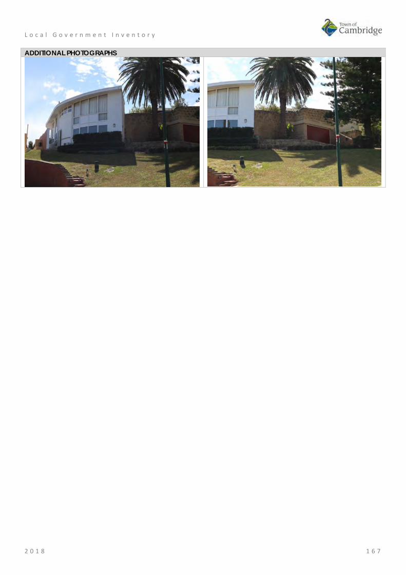
L o c a l G o v e r n m e n t I n v e n t o r y
2 0 1 8 1 6 7
ADDITIONAL PHOTOGRAPHS

L o c a l G o v e r n m e n t I n v e n t o r y
2 0 1 8 1 6 8
Templetonia Park, City Beach Place No: 25
SITE INFORMATION Place Name: Templetonia Park Other Names: M645
Bush Forever Site 310 Street Address: Templetonia Crescent Locality City Beach HERITAGE LISTING SHO inHerit database Other Listings PLACE TYPE Urban Park Original Use: Park/Reserve Current Use: Park/Reserve Other Use: LAND INFORMATION Lot: 6000 Survey: Plan 74241 Reserve No: --------- C/T: 2801-298 Property Number: 17507 Land Number: 14229

L o c a l G o v e r n m e n t I n v e n t o r y
2 0 1 8 1 6 9
CONSTRUCTION DETAILS Construction Date: Walls: N/A Roof: N/A Architectural Style: N/A Physical Description: Templetonia Park is a park predominantly of bushland bound by The Boulevard, West Coast Highway, Lowanna Way, Dampier Avenue and Templetonia Crescent. The park is mainly open grass interspersed with a few mature trees and native bushland. A small children’s play area is located towards the western boundary of the site. The park extends along The Boulevard westwards to West Coast Highway and forms part of the green edge to the highway. Condition: Good Integrity: High Authenticity: High
HISTORICAL INFORMATION Historical Notes: This portion of City Beach was largely developed in the 1960s. As part of the development the alignment of The Boulevard was changed to create a straight line to the coast. The former alignment of The Boulevard forms one of the tracks through the park. At the time of the residential subdivisions nearby in the mid 1960s, aerial photographs show the park as a cleared sandy area. Regeneration of the park with native species has slowly occurred with little apparent intervention. The children's playground was built in the early 1990s although the grassed area had been established previously. The park is designated as a Bush Forever Site. Historic Theme: Social and Civic Activities: Sport, recreation and entertainment
Demographic settlement and mobility: Government policy Associations: Sources: Aerial photographs, 1953-2016, Landgate.
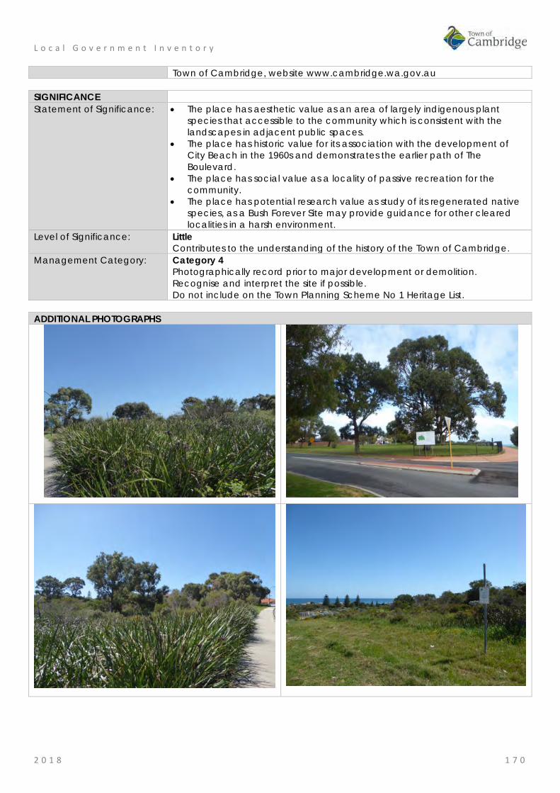
L o c a l G o v e r n m e n t I n v e n t o r y
2 0 1 8 1 7 0
Town of Cambridge, website www.cambridge.wa.gov.au SIGNIFICANCE Statement of Significance: • The place has aesthetic value as an area of largely indigenous plant
species that accessible to the community which is consistent with the landscapes in adjacent public spaces.
• The place has historic value for its association with the development of City Beach in the 1960s and demonstrates the earlier path of The Boulevard.
• The place has social value as a locality of passive recreation for the community.
• The place has potential research value as study of its regenerated native species, as a Bush Forever Site may provide guidance for other cleared localities in a harsh environment.
Level of Significance: Little Contributes to the understanding of the history of the Town of Cambridge.
Management Category: Category 4 Photographically record prior to major development or demolition. Recognise and interpret the site if possible. Do not include on the Town Planning Scheme No 1 Heritage List.
ADDITIONAL PHOTOGRAPHS

L o c a l G o v e r n m e n t I n v e n t o r y
2 0 1 8 1 7 1
St Christopher's Anglican Church, City Beach Place No: 26
SITE INFORMATION Place Name: St Christopher's Anglican Church Other Names: St Christopher's Church Street Address: 25 Templetonia Crescent Locality City Beach HERITAGE LISTING SHO inHerit database 11487 Other Listings PLACE TYPE Individual building or group Original Use: Religious: Church Current Use: Religious: Church Other Use: LAND INFORMATION Lot: 187 Survey: Plan 31498 Reserve No: ------- C/T: 2525-518 Property Number: 12281 Land Number: 1272

L o c a l G o v e r n m e n t I n v e n t o r y
2 0 1 8 1 7 2
CONSTRUCTION DETAILS Construction Date: 1967; c1980; 2003 Walls: Brick: Common, painted and face brick Roof: Metal: Colorbond Architectural Style: Late 2oth century ecclesiastical Physical Description: St Christopher’s Anglican Church is set back from Templetonia Crescent, on top of a grassy embankment and partially obscured from clear view by a brick wall and trees. Due to the layout of the area, the church has an angled relationship with Templetonia Crescent. The building is single storey to the principal façade and is of brick construction painted white. The entrance is set behind a small section of covered driveway. The presentation is simple, reflective of the era of development and contains sections of blank brick walls. The butterfly roof of the south west corner makes a feature element of the building. The Tamala Road elevation is elevated, built on brick retaining with a dog leg staircase to the entrance doors. The main section of elevation is a rendered blank wall enlivened only the Church signage and flanked by recessed windows. The roof to the main section of the building is a shallow pitch gable roof, with skillion canopies to Templetonia Crescent elevation and to the rear. The church is positioned to the rear of lawned gardens with flower beds, shrubbery and trees. Vehicular access to the front entrance is via an informal grassed driveway accessed from Yalgun Road with the main access from the car park to Tamala Road. The rectory is not included in this assessment. Condition: Good Integrity: High Authenticity: High HISTORICAL INFORMATION Historical Notes:

L o c a l G o v e r n m e n t I n v e n t o r y
2 0 1 8 1 7 3
City Beach underwent significant development in the early 1960s following subdivision of the area for residential occupation. The 1962 Empire, or Commonwealth, Games in Perth and the main stadium at Perry Lakes was a major influence on the development of the area. This area of City Beach was subdivided for residential development in 1958. Aerial photographs indicate there was little development in the vicinity until the intense building of the early 1960s. The Anglican Church built the first stage of this church c1967 and it has been extended and developed in several programs of work since then. The architect and builder of the church buildings have not been determined in this research. The driving force of the establishment of the new church in City Beach is understood to be Canon Jack Watts who joined the Anglican parish of Wembley in 1952. He oversaw the construction of the new St Edmunds Church in Wembley and established St Nicholas Church in Floreat as well as St Christopher's Church in City Beach. The rectory was built in 2003. A garden of remembrance was established in 1985 and consecrated by the Assistant Bishop of Perth, M. B. Challen. Historic Theme: Social and Civic Activities: Religion
Demographic settlement and mobility: Settlements Associations: Canon Jack Watts Sources: Aerial photographs, 1953-2016, Landgate.
Town of Cambridge Municipal Heritage Inventory and Townscape Precinct Study prepared for the Town of Cambridge, June 1997. St Christopher's Anglican Church City Beach, website http://www.stchristopherscitybeach.org/ Town of Cambridge, Local History Collection, Cambridge Notes, item T222
SIGNIFICANCE Statement of Significance: • The church has aesthetic value as a good intact example of the post war
International style executed in brick that is set within its original landscaped setting.
• St Christopher's Anglican Church complex of buildings are a landmark in the streetscape for their continuity of presence in the community since the development of the suburb on this elevated site.
• The church has historic value for its association with the establishment and development of City Beach in the 1960s.
• The place has historic value for its association with the provision of services to the Anglican and wider community since 1967.
• The place has social value for the members of the City Beach and wider community who have attended the place for social and religious events since 1967.
Level of Significance: Some/moderate Contributes to the heritage of the locality. Has some altered or modified elements, not necessarily detracting from the overall significance of the item.
Management Category: Category 3 Conservation of the place is desirable. Any alterations or extensions should reinforce the significance of the place, and original fabric should be retained wherever feasible. Include on the Town Planning Scheme No 1 Heritage List.

L o c a l G o v e r n m e n t I n v e n t o r y
2 0 1 8 1 7 4
ADDITIONAL PHOTOGRAPHS
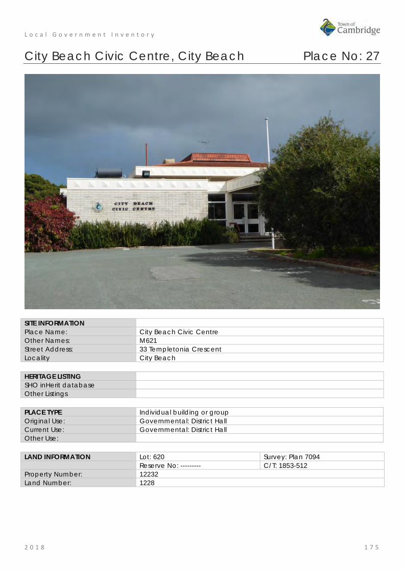
L o c a l G o v e r n m e n t I n v e n t o r y
2 0 1 8 1 7 5
City Beach Civic Centre, City Beach Place No: 27
SITE INFORMATION Place Name: City Beach Civic Centre Other Names: M621 Street Address: 33 Templetonia Crescent Locality City Beach HERITAGE LISTING SHO inHerit database Other Listings PLACE TYPE Individual building or group Original Use: Governmental: District Hall Current Use: Governmental: District Hall Other Use: LAND INFORMATION Lot: 620 Survey: Plan 7094 Reserve No: --------- C/T: 1853-512 Property Number: 12232 Land Number: 1228

L o c a l G o v e r n m e n t I n v e n t o r y
2 0 1 8 1 7 6
CONSTRUCTION DETAILS Construction Date: c1970 Walls: Brick: common Roof: Tile: terracotta Architectural Style: Late 20th century International Physical Description: Predominantly single storey with increased height central section. The Civic Centre is of brick construction with terracotta tiled roof. The brick is grey with decorative metal fascia's. The main entrance is located to the north east elevation, with aluminium doors protected by a port cochere allowing for a covered vehicular drop off into the building. The Templetonia Crescent elevation is divided into bays each with a full height window ensemble consisting of three panes and a solid lower panel. A deep verandah extends across the elevation with an elevated deck. The roof to the main building is hipped with and elevated centred central section. The skillion form of the verandah canopy is obscured by the deep metal fascias. The building is surrounding by car parking with two vehicular access points: one on Templetonia Crescent and the other through the gardens leading off from Yanagin Crescent. Condition: Good Integrity: High Authenticity: High

L o c a l G o v e r n m e n t I n v e n t o r y
2 0 1 8 1 7 7
HISTORICAL INFORMATION Historical Notes: The suburb of City Beach had sporadic and modest development until the 1960s. The 1962 British Empire and Commonwealth Games held in Perth saw the development of lands in City Beach for the Games Village Houses lead to adjacent landholdings being released for residential subdivision. The subdivisions alongside the coast in City Beach were largely created in the late 1960s. The 1960s also saw the popularity and growth of surfing and the associated ‘surf culture’. Although not new to Western Australia, surfing and beach going became more popular and were closely associated with younger generations. The late 1960s can also be seen as a period of experimentation and rejection of past practices and attitudes. It was in the context of a newly established suburb providing for a young population keen to embrace new styles and technologies. The City Beach Civic Centre was built c1970 by the City of Perth to provide for the residents and its design is consistent with the period. The architect and builder have not been determined in this research. It is noted that many local government administration centres had similar styles and details in this period. Since the construction of the Civic Centre the form and extent of the structure has not changed although internally there is likely to have modifications to accommodate current standards. The civic centre has had a range of occupants and uses since the 1970s and continues be used for community groups and activities. Historic Theme: Social and Civic Activities: community services and utilities
Demographic Settlement and Mobility: settlements Associations: Sources: Aerial photographs, 1953-2016, Landgate.
Town of Cambridge, website www.cambridge.wa.gov.au
SIGNIFICANCE Statement of Significance: • The Civic Centre has aesthetic value as a demonstration of late 20th
century international style executed in brick and tile featuring original details.
• The place has historic value for its association with the establishment and development of City Beach in the 1960s and 1970s,
• The place has social value for members of the City Beach and wider community who have attended events and activities at this place since the 1970s.
Level of Significance: Little Contributes to the understanding of the history of the Town of Cambridge.
Management Category: Category 4 Photographically record prior to major development or demolition. Recognise and interpret the site if possible. Do not include on the Town Planning Scheme No 1 Heritage List.

L o c a l G o v e r n m e n t I n v e n t o r y
2 0 1 8 1 7 8
ADDITIONAL PHOTOGRAPHS

L o c a l G o v e r n m e n t I n v e n t o r y
2 0 1 8 1 7 9
Murphy House, City Beach Place No: 28
SITE INFORMATION Place Name: Murphy House Other Names: Residence, 14 Tranmore Way Street Address: 14 Tranmore Way Locality City Beach HERITAGE LISTING SHO inHerit database 17609 Other Listings PLACE TYPE Individual building or group Original Use: Residential: Single storey house Current Use: Residential: Single storey house Other Use: LAND INFORMATION Lot: 64 Survey: Plan 9378 Reserve No: -------- C/T: 1582-456 Property Number: 14873 Land Number: 3696
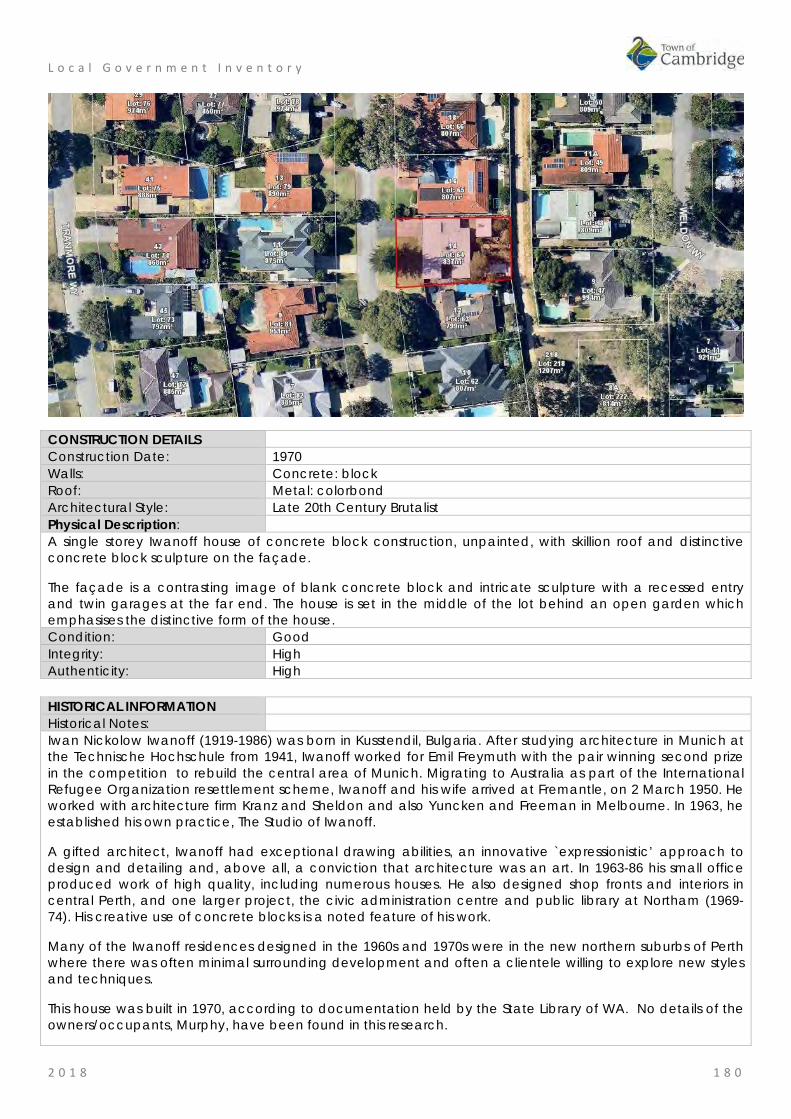
L o c a l G o v e r n m e n t I n v e n t o r y
2 0 1 8 1 8 0
CONSTRUCTION DETAILS Construction Date: 1970 Walls: Concrete: block Roof: Metal: colorbond Architectural Style: Late 20th Century Brutalist Physical Description: A single storey Iwanoff house of concrete block construction, unpainted, with skillion roof and distinctive concrete block sculpture on the façade.
The façade is a contrasting image of blank concrete block and intricate sculpture with a recessed entry and twin garages at the far end. The house is set in the middle of the lot behind an open garden which emphasises the distinctive form of the house. Condition: Good Integrity: High Authenticity: High HISTORICAL INFORMATION Historical Notes: Iwan Nickolow Iwanoff (1919-1986) was born in Kusstendil, Bulgaria. After studying architecture in Munich at the Technische Hochschule from 1941, Iwanoff worked for Emil Freymuth with the pair winning second prize in the competition to rebuild the central area of Munich. Migrating to Australia as part of the International Refugee Organization resettlement scheme, Iwanoff and his wife arrived at Fremantle, on 2 March 1950. He worked with architecture firm Kranz and Sheldon and also Yuncken and Freeman in Melbourne. In 1963, he established his own practice, The Studio of Iwanoff.
A gifted architect, Iwanoff had exceptional drawing abilities, an innovative `expressionistic’ approach to design and detailing and, above all, a conviction that architecture was an art. In 1963-86 his small office produced work of high quality, including numerous houses. He also designed shop fronts and interiors in central Perth, and one larger project, the civic administration centre and public library at Northam (1969-74). His creative use of concrete blocks is a noted feature of his work.
Many of the Iwanoff residences designed in the 1960s and 1970s were in the new northern suburbs of Perth where there was often minimal surrounding development and often a clientele willing to explore new styles and techniques.
This house was built in 1970, according to documentation held by the State Library of WA. No details of the owners/occupants, Murphy, have been found in this research.

L o c a l G o v e r n m e n t I n v e n t o r y
2 0 1 8 1 8 1
Aerial photographs indicate the form and extent of the house have not changed since construction although the original asbestos roof cladding was replaced in 1996 with colorbond. Two stand alone buildings have also been constructed in the rear of the lot within a landscaped back yard. Historic Theme: Occupations: Domestic activities
People: Innovators Associations: Iwan Iwanoff Sources: Aerial photographs, 1953-2016, Landgate.
Town of Cambridge Municipal Heritage Inventory and Townscape Precinct Study prepared for the Town of Cambridge, June 1997. Goad, Philip; Willis, Julie 'The Encyclopaedia of Australian Architecture', Cambridge University Press, 2012, p. 357. Duncan Richards, 'Iwanoff, Iwan (1919–1986)', Australian Dictionary of Biography, National Centre of Biography, Australian National University, http://adb.anu.edu.au/biography/iwanoff-iwan-12685/text22867, published first in hardcopy 2007, accessed online 5 October 2017.
SIGNIFICANCE Statement of Significance: • The place has aesthetic value as an intact example of the late 20th
century brutalist style and as a landmark in the streetscape. • This residence and other examples of Iwanoff's work are a comprehensive
and notable group of buildings which demonstrate a specific design style and period.
• The place has historic value for its association with prominent architect, Iwan Iwanoff who was influential in Western Australian practice for his non traditional approach to design and materials drawn from European trends.
• The place has historic value for its association with the early 1970s which was characterised as a period of affluence which was teamed with a willingness to experiment with new styles and materials.
• The place has social value as the house and others of Iwanoff's design are the source of study and interest amongst members of the community.
Level of Significance: Considerable Very important to the heritage of the locality. High degree of integrity/authenticity
Management Category: Category 2 Conservation of the place is highly desirable. Any alterations or extensions should reinforce the significance of the place Include on the Town Planning Scheme No 1 Heritage List.
ADDITIONAL PHOTOGRAPHS

L o c a l G o v e r n m e n t I n v e n t o r y
2 0 1 8 1 8 2
Ocean Village Park, City Beach Place No: 29
SITE INFORMATION Place Name: Ocean Village Park Other Names: M664 Street Address: bound by Brompton Road, Yaltara Road, Hale Road and Kilpa Court Locality City Beach HERITAGE LISTING SHO inHerit database Other Listings PLACE TYPE Urban Park Original Use: Park/Reserve Current Use: Park/Reserve Other Use: LAND INFORMATION Lot: 241; 9292 Survey: Plan 11424, Plan 10632 Reserve No: R33396 C/T: 2024-470, 3155-696 Property Number: 15130 Land Number: 3930; 3929
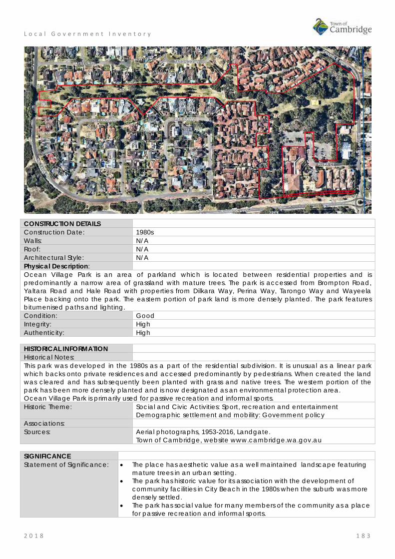
L o c a l G o v e r n m e n t I n v e n t o r y
2 0 1 8 1 8 3
CONSTRUCTION DETAILS Construction Date: 1980s Walls: N/A Roof: N/A Architectural Style: N/A Physical Description: Ocean Village Park is an area of parkland which is located between residential properties and is predominantly a narrow area of grassland with mature trees. The park is accessed from Brompton Road, Yaltara Road and Hale Road with properties from Dilkara Way, Perina Way, Tarongo Way and Wayeela Place backing onto the park. The eastern portion of park land is more densely planted. The park features bitumenised paths and lighting. Condition: Good Integrity: High Authenticity: High HISTORICAL INFORMATION Historical Notes: This park was developed in the 1980s as a part of the residential subdivision. It is unusual as a linear park which backs onto private residences and accessed predominantly by pedestrians. When created the land was cleared and has subsequently been planted with grass and native trees. The western portion of the park has been more densely planted and is now designated as an environmental protection area. Ocean Village Park is primarily used for passive recreation and informal sports. Historic Theme: Social and Civic Activities: Sport, recreation and entertainment
Demographic settlement and mobility: Government policy Associations: Sources: Aerial photographs, 1953-2016, Landgate.
Town of Cambridge, website www.cambridge.wa.gov.au SIGNIFICANCE Statement of Significance: • The place has aesthetic value as a well maintained landscape featuring
mature trees in an urban setting. • The park has historic value for its association with the development of
community facilities in City Beach in the 1980s when the suburb was more densely settled.
• The park has social value for many members of the community as a place for passive recreation and informal sports.
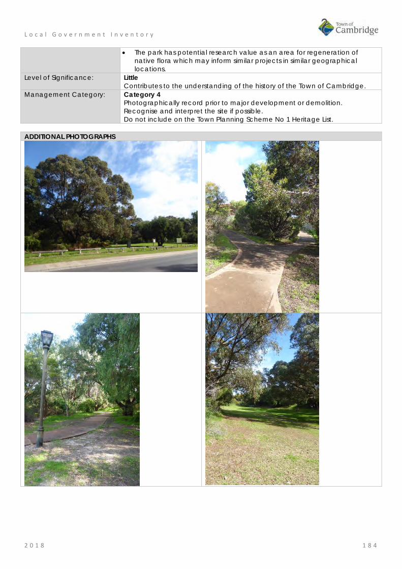
L o c a l G o v e r n m e n t I n v e n t o r y
2 0 1 8 1 8 4
• The park has potential research value as an area for regeneration of native flora which may inform similar projects in similar geographical locations.
Level of Significance: Little Contributes to the understanding of the history of the Town of Cambridge.
Management Category: Category 4 Photographically record prior to major development or demolition. Recognise and interpret the site if possible. Do not include on the Town Planning Scheme No 1 Heritage List.
ADDITIONAL PHOTOGRAPHS

L o c a l G o v e r n m e n t I n v e n t o r y
2 0 1 8 1 8 5
Roberts Residence, City Beach Place No: 30
SITE INFORMATION Place Name: Roberts Residence Other Names: Street Address: 12 Yanagin Crescent Locality City Beach HERITAGE LISTING SHO inHerit database Other Listings PLACE TYPE Individual building or group Original Use: Residential: Two storey residence Current Use: Residential: Two storey residence Other Use: LAND INFORMATION Lot: 613 Survey: Plan 7094 Reserve No: ------- C/T: 1680-902 Property Number: 12257 Land Number: 1250

L o c a l G o v e r n m e n t I n v e n t o r y
2 0 1 8 1 8 6
CONSTRUCTION DETAILS Construction Date: 1967 Walls: Concrete: block Roof: Metal: colorbond Architectural Style: Late 20th Century Brutalist Physical Description: A two storey Iwanoff house of concrete block construction. The activated façade is characterised by the concrete blockwork arranged in an abstract manner which shield much of the façade from clear view but still allows light into the house. Beyond the blockwork there is a high degree of glazing to the façade, a balcony to part of the upper level and a verandah to the lower level.
A single storey garage to the north east corner of the house provides a private garden area for the recessed section of the house.
The house is built on an elevated position which emphasises the angular nature of the design. Condition: Good Integrity: High Authenticity: High
L o c a l G o v e r n m e n t I n v e n t o r y
2 0 1 8 1 8 7
HISTORICAL INFORMATION Historical Notes: Iwan Nickolow Iwanoff (1919-1986) was born in Kusstendil, Bulgaria. After studying architecture in Munich at the Technische Hochschule from 1941, Iwanoff worked for Emil Freymuth with the pair winning second prize in the competition to rebuild the central area of Munich. Migrating to Australia as part of the International Refugee Organization resettlement scheme, Iwanoff and his wife arrived at Fremantle, on 2 March 1950. He worked with architecture firm Kranz and Sheldon and also Yuncken and Freeman in Melbourne. In 1963, he established his own practice, The Studio of Iwanoff.
A gifted architect, Iwanoff had exceptional drawing abilities, an innovative `expressionistic’ approach to design and detailing and, above all, a conviction that architecture was an art. In 1963-86 his small office produced work of high quality, including numerous houses. He also designed shop fronts and interiors in central Perth, and one larger project, the civic administration centre and public library at Northam (1969-74). His creative use of concrete blocks is a noted feature of his work.
Many of the Iwanoff residences designed in the 1960s and 1970s were in the new northern suburbs of Perth where there was often minimal surrounding development and often a clientele willing to explore new styles and techniques.
This residence was built in 1967 for the client identified as Roberts, no detail of this occupant or owner have been found in this research.
Aerial photographs indicate that the form and extent of the original building have not been altered since construction although the garage located on the northern side of the building is a later construction. Historic Theme: Occupations: Domestic activities
People: Innovators Associations: Iwan Iwanoff Sources: Aerial photographs, 1953-2016, Landgate.
Town of Cambridge Municipal Heritage Inventory and Townscape Precinct Study prepared for the Town of Cambridge, June 1997. Goad, Philip; Willis, Julie 'The Encyclopaedia of Australian Architecture', Cambridge University Press, 2012, p. 357. Duncan Richards, 'Iwanoff, Iwan (1919–1986)', Australian Dictionary of Biography, National Centre of Biography, Australian National University, http://adb.anu.edu.au/biography/iwanoff-iwan-12685/text22867, published first in hardcopy 2007, accessed online 5 October 2017.
SIGNIFICANCE Statement of Significance: • The place has aesthetic value as an intact example of the late 20th
century brutalist style and as a landmark in the streetscape. • This residence and other examples of Iwanoff's work are a comprehensive
and notable group of buildings which demonstrate a specific design style and period.
• The place has historic value for its association with prominent architect, Iwan Iwanoff who was influential in Western Australian practice for his non traditional approach to design and materials drawn from European trends.
• The place has historic value for its association with the early 1970s which was characterised as a period of affluence which was teamed with a willingness to experiment with new styles and materials.
• The place has social value as the house and others of Iwanoff's design are the source of study and interest amongst members of the community.
Level of Significance: Considerable Very important to the heritage of the locality. High degree of integrity/authenticity
Management Category: Category 2 Conservation of the place is highly desirable. Any alterations or extensions should reinforce the significance of the place Include on the Town Planning Scheme No 1 Heritage List.
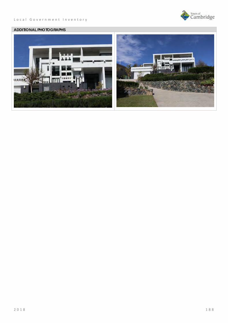
L o c a l G o v e r n m e n t I n v e n t o r y
2 0 1 8 1 8 8
ADDITIONAL PHOTOGRAPHS

L o c a l G o v e r n m e n t I n v e n t o r y
2 0 1 8 1 8 9
Schenberg House, Floreat Place No: 31
SITE INFORMATION Place Name: Schenberg House Other Names: Residence, 4 Alyth Road Street Address: 4 Alyth Road Locality Floreat HERITAGE LISTING SHO inHerit database Other Listings PLACE TYPE Individual building or group Original Use: Residential: Single storey residence Current Use: Residential: Single storey residence Other Use: LAND INFORMATION Lot: 1815 Survey: Plan 7286 Reserve No: C/T: 1236-761 Property Number: 13065 Land Number: 2003
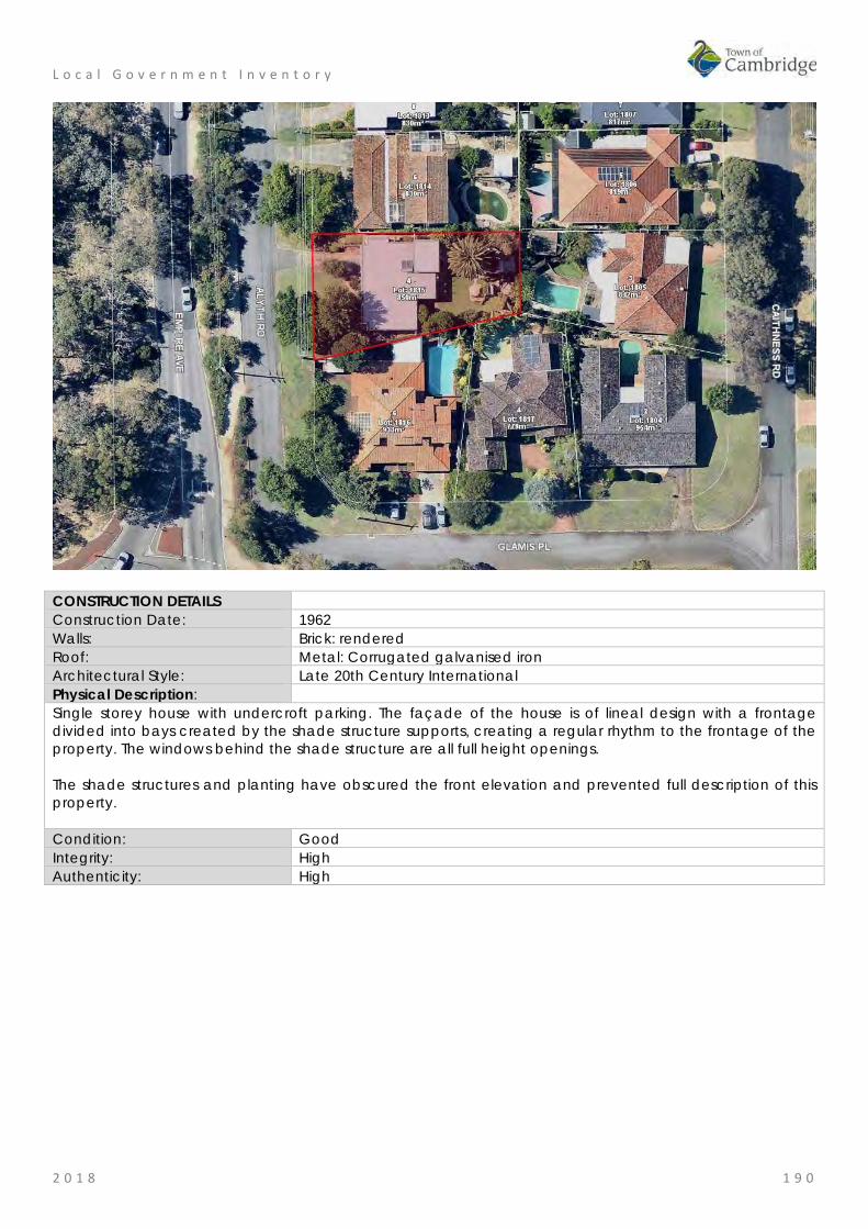
L o c a l G o v e r n m e n t I n v e n t o r y
2 0 1 8 1 9 0
CONSTRUCTION DETAILS Construction Date: 1962 Walls: Brick: rendered Roof: Metal: Corrugated galvanised iron Architectural Style: Late 20th Century International Physical Description: Single storey house with undercroft parking. The façade of the house is of lineal design with a frontage divided into bays created by the shade structure supports, creating a regular rhythm to the frontage of the property. The windows behind the shade structure are all full height openings. The shade structures and planting have obscured the front elevation and prevented full description of this property. Condition: Good Integrity: High Authenticity: High

L o c a l G o v e r n m e n t I n v e n t o r y
2 0 1 8 1 9 1
HISTORICAL INFORMATION Historical Notes: Iwan Nickolow Iwanoff (1919-1986) was born in Kusstendil, Bulgaria. After studying architecture in Munich at the Technische Hochschule from 1941, Iwanoff worked for Emil Freymuth with the pair winning second prize in the competition to rebuild the central area of Munich. Migrating to Australia as part of the International Refugee Organization resettlement scheme, Iwanoff and his wife arrived at Fremantle, on 2 March 1950. He worked with architecture firm Kranz and Sheldon and also Yuncken and Freeman in Melbourne. In 1963, he established his own practice, The Studio of Iwanoff. A gifted architect, Iwanoff had exceptional drawing abilities, an innovative `expressionistic’ approach to design and detailing and, above all, a conviction that architecture was an art. In 1963-86 his small office produced work of high quality, including numerous houses. He also designed shop fronts and interiors in central Perth, and one larger project, the civic administration centre and public library at Northam (1969-74). His creative use of concrete blocks is a noted feature of his work. Many of the Iwanoff residences designed in the 1960s and 1970s were in the new northern suburbs of Perth where there was often minimal surrounding development and often a clientele willing to explore new styles and techniques. Plans for this residence were prepared by Iwanoff’s office in 1962 for Schenberg and electoral rolls confirm that pharmacist David Schenberg and his wife Esther were living at the residence in 1963. Aerial photographs indicate a small addition has been added to at the rear of the place although the form and extent of the original construction can still be determined. Historic Theme: Demographic Settlement and Mobility: settlements
Occupations: Domestic activities People: Innovators
Associations: Iwan Iwanoff Sources: Aerial photographs, 1953-2016, Landgate.
Goad, Philip; Willis, Julie 'The Encyclopaedia of Australian Architecture', Cambridge University Press, 2012, p. 357. Duncan Richards, 'Iwanoff, Iwan (1919–1986)', Australian Dictionary of Biography, National Centre of Biography, Australian National University, http://adb.anu.edu.au/biography/iwanoff-iwan-12685/text22867, published first in hardcopy 2007, accessed online 5 October 2017. State Library of WA, Iwan Iwanoff Collection. MN1401, Acc 4400A
SIGNIFICANCE Statement of Significance: • The place has aesthetic value as an intact example of the late 20th
century International style. • This residence and other examples of Iwanoff's work are a
comprehensive and notable group of buildings which demonstrate a specific design style and period.
• The place has historic value for its association with prominent architect, Iwan Iwanoff who was influential in Western Australian practice for his non traditional approach to design and materials drawn from European trends.
• The place has historic value for its association with the early 1960s which was characterised as a period of affluence which was teamed with a willingness to experiment with new styles and materials.
• The place has social value as the house and others of Iwanoff's design are the source of study and interest amongst members of the community.
Level of Significance: Considerable Very important to the heritage of the locality.

L o c a l G o v e r n m e n t I n v e n t o r y
2 0 1 8 1 9 2
High degree of integrity/authenticity Management Category: Category 2
Conservation of the place is highly desirable. Any alterations or extensions should reinforce the significance of the place Include on the Town Planning Scheme No 1 Heritage List.
ADDITIONAL PHOTOGRAPHS

L o c a l G o v e r n m e n t I n v e n t o r y
2 0 1 8 1 9 3
St Nicholas' Anglican Church, Floreat Place No: 32
SITE INFORMATION Place Name: St Nicholas' Anglican Church Other Names: Sportsmen's Church
St Nich's Church Street Address: 45 Berkeley Crescent Locality Floreat HERITAGE LISTING SHO inHerit database 11508 Other Listings Anglican Church Inventory PLACE TYPE Individual building or group Original Use: Religious: Church Current Use: Religious: Church Other Use: Residential: single storey residence LAND INFORMATION Lot: 641, 642 Survey: Plan 6279 Reserve No: -------- C/T: 2156-761 Property Number: 15567 Land Number: 4339; 4340
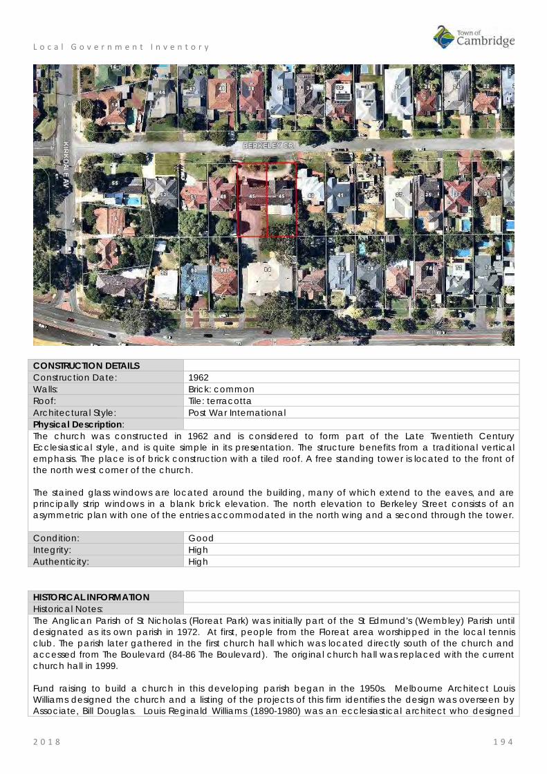
L o c a l G o v e r n m e n t I n v e n t o r y
2 0 1 8 1 9 4
CONSTRUCTION DETAILS Construction Date: 1962 Walls: Brick: common Roof: Tile: terracotta Architectural Style: Post War International Physical Description: The church was constructed in 1962 and is considered to form part of the Late Twentieth Century Ecclesiastical style, and is quite simple in its presentation. The structure benefits from a traditional vertical emphasis. The place is of brick construction with a tiled roof. A free standing tower is located to the front of the north west corner of the church. The stained glass windows are located around the building, many of which extend to the eaves, and are principally strip windows in a blank brick elevation. The north elevation to Berkeley Street consists of an asymmetric plan with one of the entries accommodated in the north wing and a second through the tower. Condition: Good Integrity: High Authenticity: High
HISTORICAL INFORMATION Historical Notes: The Anglican Parish of St Nicholas (Floreat Park) was initially part of the St Edmund's (Wembley) Parish until designated as its own parish in 1972. At first, people from the Floreat area worshipped in the local tennis club. The parish later gathered in the first church hall which was located directly south of the church and accessed from The Boulevard (84-86 The Boulevard). The original church hall was replaced with the current church hall in 1999. Fund raising to build a church in this developing parish began in the 1950s. Melbourne Architect Louis Williams designed the church and a listing of the projects of this firm identifies the design was overseen by Associate, Bill Douglas. Louis Reginald Williams (1890-1980) was an ecclesiastical architect who designed
L o c a l G o v e r n m e n t I n v e n t o r y
2 0 1 8 1 9 5
churches throughout the country, particularly in Victoria, primarily Anglican but also Methodists, Presbyterians, Lutherans and Christian Scientists. Williams was probably the major church architect in Australia in the Arts and Crafts tradition from the 1920s to the 1970s. The church was consecrated by Archbishop of Perth, Robert Moline, on 20th October 1962 and cost £34,400. As part of the ceremony the church was 'dedicated in honour of Australian Sportsmen who have played an important role in strengthening international relationships and goodwill'. The association with Sports was heightened because the Empire or Commonwealth Games were being held in 1962 and many events at the new Perry Lakes stadium nearby. Many sporting organisations donated the jarrah pews which were chosen to blend with the jarrah flooring. It was noted in the West Australian, that enamelled plaques bearing the insignia of sporting and athletic associations are fixed to the pews of the church. In addition, England Test cricketer, the Rev David Sheppard, preached at Evensong in the new church. The church features an original organ built by Paul F. Hufner and installed in 1962. The stained glass windows were added after the church's initial construction. Archbishop Roger Herft consecrated the icons of Jesus Christ Pantocrator and St Nicholas of Myra during at the 50th anniversary of the consecration of the church building in October 2012. Historic Theme: Social and Civic Activities: Religion Associations: Dr Robert WH Moline
Louis Reginald Williams Bill Douglas
Sources: Aerial photographs, 1953-2016, Landgate. Town of Cambridge Municipal Heritage Inventory and Townscape Precinct Study prepared for the Town of Cambridge, June 1997. Wise's Post Office Directories for the City of Perth, 1925-1949, State Library of WA www.slwa.wa.gov.au St Nicholas' Anglican Church Floreat Park website, http://floreat.perth.anglican.org accessed September 2017. The Organ Society of Western Australia, Western Australian Pipe Organs, St Nicholas Anglican Church, webpage, http://www.oswa.org.au/WAOrgans/FloreatStNicholas.html accessed September 2017 Sermon by The Most Reverend Roger Herft, Archbishop of Perth, 21 October 2012. Goad, Philip; Willis, Julie [eds] The Encyclopaedia of Australian Architecture, Cambridge University Press, 2012, pp765-6. G.M. Moore, louis Reginald Williams, Masters of Planning and Design, University of Melbourne, 2001.
SIGNIFICANCE Statement of Significance: • The church has aesthetic value as a good intact example of the
post war international style executed in brick and tile featuring stained glass and original internal features.
• The church has aesthetic value as a landmark in the street and district.
• The place has historic value for its association with the development of Floreat Park in the 1950s and 1960s and with the acceleration of settlement following the Empire/Commonwealth Games in 1962.
• The place has historic value for its identification with the sportsmen and women which reflected the enthusiasm for sports in the early 1960s when Perth held the Commonwealth Games.
• The place has social value for the members of the community who have attended the place for social and religious occasions since 1962.
Level of Significance: Considerable

L o c a l G o v e r n m e n t I n v e n t o r y
2 0 1 8 1 9 6
Very important to the heritage of the locality. High degree of integrity/authenticity
Management Category: Category 2 Conservation of the place is highly desirable. Any alterations or extensions should reinforce the significance of the place Include on the Town Planning Scheme No 1 Heritage List.
ADDITIONAL PHOTOGRAPHS
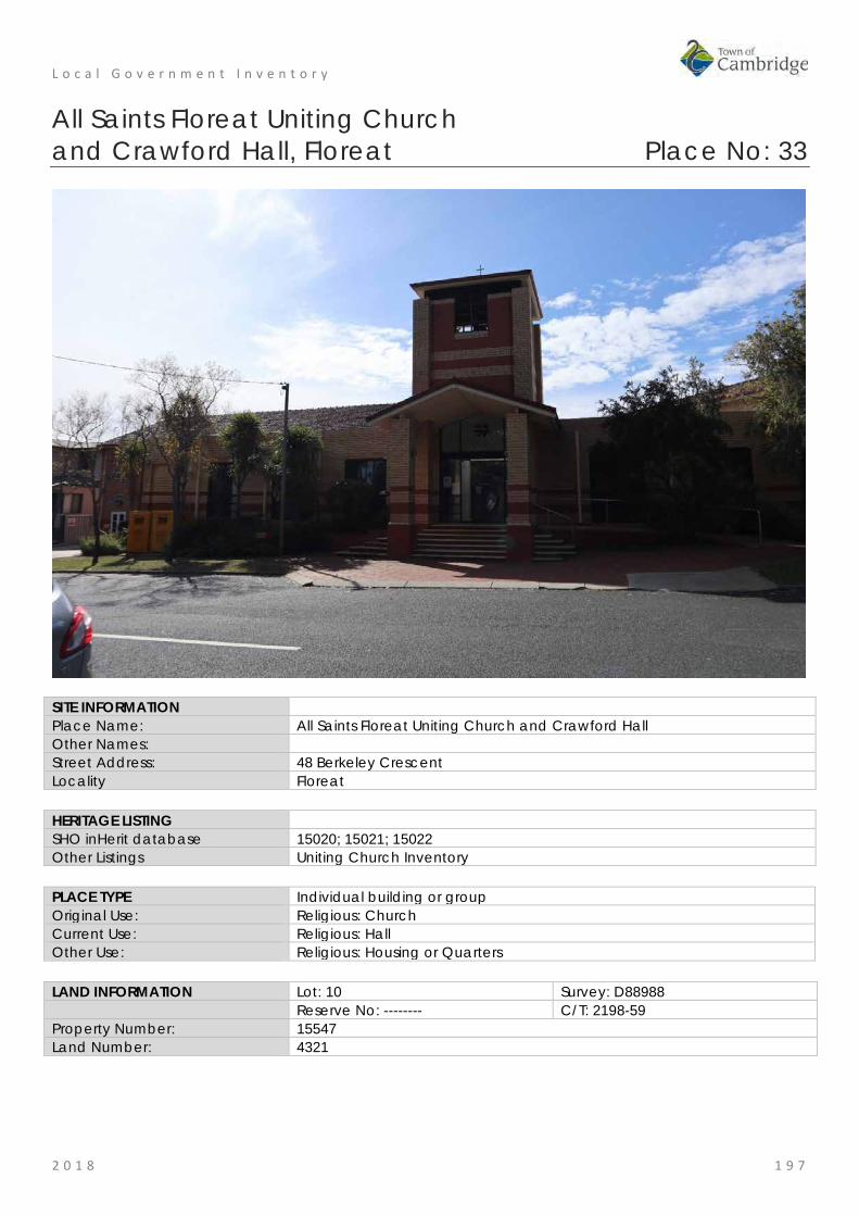
L o c a l G o v e r n m e n t I n v e n t o r y
2 0 1 8 1 9 7
All Saints Floreat Uniting Church and Crawford Hall, Floreat Place No: 33
SITE INFORMATION Place Name: All Saints Floreat Uniting Church and Crawford Hall Other Names: Street Address: 48 Berkeley Crescent Locality Floreat HERITAGE LISTING SHO inHerit database 15020; 15021; 15022 Other Listings Uniting Church Inventory PLACE TYPE Individual building or group Original Use: Religious: Church Current Use: Religious: Hall Other Use: Religious: Housing or Quarters LAND INFORMATION Lot: 10 Survey: D88988 Reserve No: -------- C/T: 2198-59 Property Number: 15547 Land Number: 4321

L o c a l G o v e r n m e n t I n v e n t o r y
2 0 1 8 1 9 8
CONSTRUCTION DETAILS Construction Date: 1956; c1963; c1995 Walls: Brick: common Roof: Tile: terracotta Architectural Style: Late 20th century Ecclesiastical; Post War International Physical Description: All Saints comprises a church and adjoining administration/ church hall spaces. The hall was constructed in the 1950s and has been incorporated into a late 1980s development comprising the church and bell tower. The development is set back behind a deep grass verge at the intersection of Kirkdale Avenue and Berkeley Crescent. The earlier section of the development was constructed from a combination of pale and red brick which has been carried through into the later developments creating some unity to the buildings. The church is a contemporary pale and red brick building with precast concrete panels and distinctive curved wall with integral glass cross facing the intersection. The main entrance is located along Berkeley Street underneath the belltower. The bell tower is a double height feature, constructed from the two contrasting brick types, raised hipped roof and an unglazed opening to each elevation. The church has a tiled hipped roof. The church is built behind the curved wall and is at an angle, facing the intersection of the two roads. The increased height of the church building creates delineation from the adjoining hall facilities due to the single storey link between the church and bell tower. Crawford Hall is a predominantly single storey building dating from the 1950s which due to the changing land levels incorporates a lower ground floor level at the western end. The place is of brick construction with red brick to the lower courses and pale brick to the upper two thirds. Timber framed French doors provide access to the undercroft with paired timber framed arched windows to the upper level windows. The roof is tiled, with gables to the east and west ends. The Manse is not included in this assessment. Condition: Good Integrity: High Authenticity: High

L o c a l G o v e r n m e n t I n v e n t o r y
2 0 1 8 1 9 9
HISTORICAL INFORMATION Historical Notes: At the inauguration of the Uniting Church in Australia on 22 June 1977, five congregations formed the Wembley-Floreat Park Parish. They were the four Methodist congregations (Wembley, ‘Forum’ of Floreat, Wembley Downs and West Leederville) plus the Floreat Park Presbyterian Church, ‘All Saints’. On 1 July 1988, the Presbytery of Perth agreed to a re-grouping of the parishes in the area and the new Parish of Floreat Park was inaugurated, with the two congregations of ‘All Saints’ in Peebles Road and the ‘Forum’ on the corner of Brookdale Street (now Kirkdale Avenue) and Berkeley Crescent becoming one congregation. After much deliberation the buildings in Peebles Road and the church in Berkeley Crescent were demolished. The decommissioning service was held on Friday 13 August, 1993. The Peebles Road property was sold and building began on the new church complex in Berkeley Crescent on the corner of Kirkdale Avenue. In May 1995, the All Saints Floreat Uniting Church was officially opened by Moderator, Lillian Hadley on the site of the Forum Uniting Church in Berkeley Crescent Floreat. The new building integrated the existing Crawford Hall which was built c1956 and included an earlier Page Room, built in 1953. The single storey brick manse located on the northern side of the site was demolished in 1995 as part of the program of works. A new two storey manse was built on the site and continues to be used as accommodation for the minister. It does not form part of this assessment. Historic Theme: Social and Civic Activities: Religion Associations: Sources: Aerial photographs, 1953-2016, Landgate.
Town of Cambridge Municipal Heritage Inventory and Townscape Precinct Study prepared for the Town of Cambridge, June 1997. The Uniting Church in Australia, Synod of Western Australia, Heritage Inventory, Volume Two, A National Estate Study, Hocking Planning & Architecture, 1996. Information from All Saints Chair Council, September 2018.
SIGNIFICANCE Statement of Significance: • The place has some aesthetic value as a landmark in the
streetscape demonstrating late 20th century ecclesiastical style integrated with Crawford Hall built in the Post War style.
• The Church has historic value as a demonstration of the coming together of different faiths to form the Uniting Church in 1977 and subsequently building this single complex of hall and church in the parish.
• The place has historic value a demonstration of the growth of the community in Floreat in the post war period and the establishment of the All Saints Presbyterian Church.
• The place has social value as the location of many religious and social events for members of the community since 1956.
Level of Significance: Little Contributes to the understanding of the history of the Town of Cambridge.
Management Category: Category 4 Photographically record prior to major development or demolition. Recognise and interpret the site if possible. Do not include on the Town Planning Scheme No 1 Heritage List.
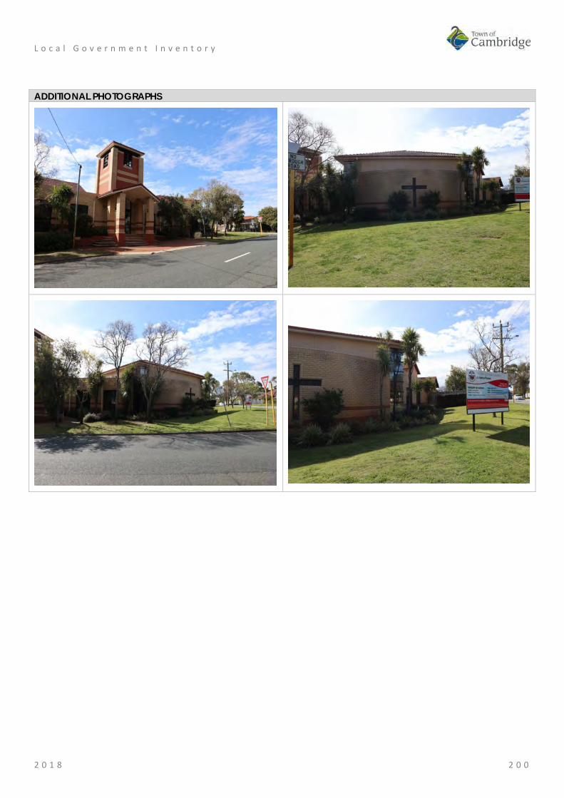
L o c a l G o v e r n m e n t I n v e n t o r y
2 0 1 8 2 0 0
ADDITIONAL PHOTOGRAPHS

L o c a l G o v e r n m e n t I n v e n t o r y
2 0 1 8 2 0 1
Floreat Oval, Floreat Place No: 34
SITE INFORMATION Place Name: Floreat Oval Other Names: Street Address: 39 Chandler Avenue West Locality Floreat HERITAGE LISTING SHO inHerit database Other Listings PLACE TYPE Urban Park Original Use: Park/Reserve Current Use: Park/Reserve Other Use: LAND INFORMATION Lot: 1752 Survey: Plan 6153 Reserve No: ---------- C/T: 1128-552 Property Number: 12831 Land Number: 1785
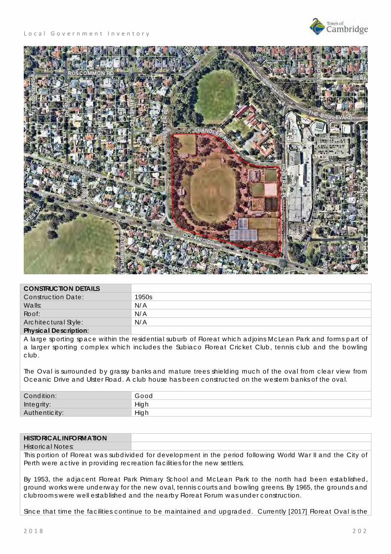
L o c a l G o v e r n m e n t I n v e n t o r y
2 0 1 8 2 0 2
CONSTRUCTION DETAILS Construction Date: 1950s Walls: N/A Roof: N/A Architectural Style: N/A Physical Description: A large sporting space within the residential suburb of Floreat which adjoins McLean Park and forms part of a larger sporting complex which includes the Subiaco Floreat Cricket Club, tennis club and the bowling club. The Oval is surrounded by grassy banks and mature trees shielding much of the oval from clear view from Oceanic Drive and Ulster Road. A club house has been constructed on the western banks of the oval. Condition: Good Integrity: High Authenticity: High
HISTORICAL INFORMATION Historical Notes: This portion of Floreat was subdivided for development in the period following World War II and the City of Perth were active in providing recreation facilities for the new settlers. By 1953, the adjacent Floreat Park Primary School and McLean Park to the north had been established, ground works were underway for the new oval, tennis courts and bowling greens. By 1965, the grounds and clubrooms were well established and the nearby Floreat Forum was under construction. Since that time the facilities continue to be maintained and upgraded. Currently [2017] Floreat Oval is the

L o c a l G o v e r n m e n t I n v e n t o r y
2 0 1 8 2 0 3
home ground for several local clubs including; cricket, AFL, and lacrosse. Surrounding the oval are the facilities for tennis, bowls and croquet. Historic Theme: Social and Civic Activities: Sport, recreation and entertainment
Demographic settlement and mobility: Government policy Associations: Sources: Aerial photographs, 1953-2016, Landgate.
Town of Cambridge, website www.cambridge.wa.gov.au SIGNIFICANCE Statement of Significance: • The place has aesthetic value as a well maintained greened
landscape and sports grounds in an urban setting. • The park has historic value for its association with the development
of community facilities in Floreat in the 1950s. • The park has social value for many members of the community as a
place for organised and informal sports, passive recreation and social events since the 1950s
Level of Significance: Little Contributes to the understanding of the history of the Town of Cambridge.
Management Category: Category 4 Photographically record prior to major development or demolition. Recognise and interpret the site if possible. Do not include on the Town Planning Scheme No 1 Heritage List.
ADDITIONAL PHOTOGRAPHS

L o c a l G o v e r n m e n t I n v e n t o r y
2 0 1 8 2 0 4
Floreat Park Primary School, Floreat Place No: 35
SITE INFORMATION Place Name: Floreat Park Primary School Other Names: Street Address: 38 Chandler Avenue West Locality Floreat HERITAGE LISTING SHO inHerit database 8897 Other Listings PLACE TYPE Individual building or group Original Use: Educational: Primary School Current Use: Educational: primary School Other Use: LAND INFORMATION Lot: 8498 Survey: Plan 6135 Reserve No: ---------- C/T: 2649-557 Property Number: 12785 Land Number: 1742
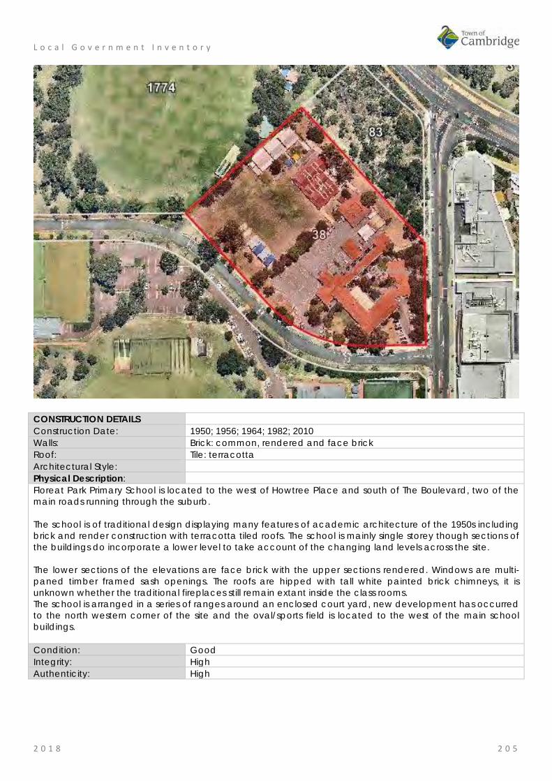
L o c a l G o v e r n m e n t I n v e n t o r y
2 0 1 8 2 0 5
CONSTRUCTION DETAILS Construction Date: 1950; 1956; 1964; 1982; 2010 Walls: Brick: common, rendered and face brick Roof: Tile: terracotta Architectural Style: Physical Description: Floreat Park Primary School is located to the west of Howtree Place and south of The Boulevard, two of the main roads running through the suburb. The school is of traditional design displaying many features of academic architecture of the 1950s including brick and render construction with terracotta tiled roofs. The school is mainly single storey though sections of the buildings do incorporate a lower level to take account of the changing land levels across the site. The lower sections of the elevations are face brick with the upper sections rendered. Windows are multi-paned timber framed sash openings. The roofs are hipped with tall white painted brick chimneys, it is unknown whether the traditional fireplaces still remain extant inside the class rooms. The school is arranged in a series of ranges around an enclosed court yard, new development has occurred to the north western corner of the site and the oval/sports field is located to the west of the main school buildings. Condition: Good Integrity: High Authenticity: High
L o c a l G o v e r n m e n t I n v e n t o r y
2 0 1 8 2 0 6
HISTORICAL INFORMATION Historical Notes: Planning for Floreat Park Primary School occurred when expenditure was approved by State Government for a new school on 22nd February 1949 at a cost of £28,000. Departmental action on the construction of Floreat Park Primary School was initiated in December 1948, when it was considered that a six roomed school would meet the district’s educational requirements for a considerable period of time. In January 1951, the school was opened for the first enrolments and an item in the local press described the new school as follows:
The building consists of five classrooms, a headmaster's room, medical room, stores and large library. An undercroft has been used to provide lavatories, cloakrooms and shelters. In designing the school particular attention was paid to natural lighting, ventilation and acoustics. The class rooms are considerably larger than the old-type to provide space for the new tubular school furniture.
By the time of completion the school was already too small for the demands for enrolment. In 1953, 4 prefabricated classrooms were added and within a further 12 months, another 4 prefabricated classrooms were added and two brick classrooms were built. In 1955, a verandah was constructed on the north-eastern side of one of the units for protection from the sun. Since the 1950s, the school buildings and facilities have been added to or modified as the population has changed and in accordance with changing education practices. A common practice over the decades has been the addition and removal of transportable classrooms when the school population changed. Recent changes include in 2009 the addition of two classrooms and a music and art block, while the existing buildings were upgraded and a new shade structure was built. In 2011 and 2016, more classrooms were added to serve the growing population in the area and a specialised early childhood education building was constructed on site. Historic Theme: Social and Civic Activities: Education and Science
Demographic Settlement and Mobility: Land allocation and subdivision Associations: Sources: Aerial photographs, 1953-2016, Landgate.
Town of Cambridge Municipal Heritage Inventory and Townscape Precinct Study prepared for the Town of Cambridge, June 1997. Floreat Park Primary School website. www.floreatparkps.wa.edu.au Wise's Post Office Directories for the City of Perth, 1925-1949, State Library of WA www.slwa.wa.gov.au The West Australian, 11 January 1951, p. 5.
SIGNIFICANCE Statement of Significance: • The place has aesthetic value as a largely intact example of a Post
World War II complex of educational buildings that feature the style and detail of the period.
• The place has historic significance for its association with the settlement of Floreat and the provision of education to the community of Floreat Park.
• The place has social value for the members of the local community, particularly past students and staff.
Level of Significance: Considerable Very important to the heritage of the locality. High degree of integrity/authenticity
Management Category: Category 2 Conservation of the place is highly desirable. Any alterations or extensions should reinforce the significance of the place Include on the Town Planning Scheme No 1 Heritage List.

L o c a l G o v e r n m e n t I n v e n t o r y
2 0 1 8 2 0 7
ADDITIONAL PHOTOGRAPHS

L o c a l G o v e r n m e n t I n v e n t o r y
2 0 1 8 2 0 8
Residence, 32 Donegal Road, Floreat Place No: 36
SITE INFORMATION Place Name: Residence, 32 Donegal Road Other Names: Toschkoff Residence Street Address: 32 Donegal Road Locality Floreat HERITAGE LISTING SHO inHerit database Other Listings PLACE TYPE Individual building or group Original Use: Residential: Single storey residence Current Use: Residential: Single storey residence Other Use: LAND INFORMATION Lot: 1330 Survey: Plan 6371 Reserve No: -------- C/T: 1627-767 Property Number: 12720 Land Number: 1681

L o c a l G o v e r n m e n t I n v e n t o r y
2 0 1 8 2 0 9
CONSTRUCTION DETAILS Construction Date: c1958 Walls: Brick: common Roof: Metal: Zincalume Architectural Style: late 20th century International Physical Description: Single storey brick and stone house with flat, or very shallow pitched, roof. The front of the house is characterised by the full height windows positioned to either end of the elevation with the centre of the façade being dominated by a random stone wall which supports a flat roof verandah canopy. Condition: Good Integrity: High Authenticity: High
HISTORICAL INFORMATION Historical Notes: Iwan Nickolow Iwanoff (1919-1986) was born in Kusstendil, Bulgaria. After studying architecture in Munich at the Technische Hochschule from 1941, Iwanoff worked for Emil Freymuth with the pair winning second prize in the competition to rebuild the central area of Munich. Migrating to Australia as part of the International Refugee Organization resettlement scheme, Iwanoff and his wife arrived at Fremantle, on 2 March 1950. He worked with architecture firm Kranz and Sheldon and also Yuncken and Freeman in Melbourne. In 1963, he established his own practice, The Studio of Iwanoff. A gifted architect, Iwanoff had exceptional drawing abilities, an innovative `expressionistic’ approach to design and detailing and, above all, a conviction that architecture was an art. In 1963-86 his small office produced work of high quality, including numerous houses. He also designed shop fronts and interiors in central Perth, and one larger project, the civic administration centre and public library at Northam (1969-74). His creative use of concrete blocks is a noted feature of his work. Many of the Iwanoff residences designed in the 1960s and 1970s were in the new northern suburbs of Perth where there was minimal surrounding development and often a clientele willing to explore new styles and techniques. This residence was designed in 1958 and the plans held by the Town of Cambridge do not designate the

L o c a l G o v e r n m e n t I n v e n t o r y
2 0 1 8 2 1 0
architect or designer of the residence. Information from the current owner states that the residence was built for Bulgarian migrant Dimiter Toschkoff (1919-2003) and his wife Rita. The Toschkoffs were friends of Iwanoff and shared their country of origin. Dimiter (Jim) Toschkoff arrived in the Western Australia in 1950, the same year as Iwanoff, and possibly through the same International Refugee Organization resettlement scheme. The electoral rolls for 1958 show that Toschkoff recorded his occupation as a draughtsman. It is possible that Jim Toschkoff designed the residence whilst working for Iwanoff or at least under the guidance of his friend Iwanoff prior to the later establishment of 'The Studio of Iwanoff'. In later years, Rita Toschkoff assisted Iwanoff by driving him around Perth to his various projects. Aerial photographs show the place has changed minimally in form and extent since its construction in the late 1950s. Historic Theme: Demographic Settlement and Mobility: Land allocation and subdivision
People: innovators Associations: Iwan Iwanoff
Toschkoff Family Sources: Aerial photographs, 1953-2016, Landgate.
Goad, Philip; Willis, Julie 'The Encyclopaedia of Australian Architecture', Cambridge University Press, 2012, p. 357. Duncan Richards, 'Iwanoff, Iwan (1919–1986)', Australian Dictionary of Biography, National Centre of Biography, Australian National University, http://adb.anu.edu.au/biography/iwanoff-iwan-12685/text22867, published first in hardcopy 2007, accessed online 5 October 2017. State Library of WA, Iwan Iwanoff Collection. MN1401, Acc 4400A Information from the current owner, 2018.
SIGNIFICANCE Statement of Significance: • The place has aesthetic value as an intact example of the late 20th
century international style and as a landmark in the streetscape. • This residence and other examples of Iwanoff's work are a
comprehensive and notable group of buildings which demonstrate a specific design style and period.
• The place has historic value for its association with prominent architect, Iwan Iwanoff who was influential in Western Australian practice for his non traditional approach to design and materials drawn from European trends.
• The place has historic value for its association with the late 1950s to the 1970s which was characterised as a period of affluence which was teamed with a willingness to experiment with new styles and materials.
• The place has social value as the house and others of Iwanoff's design are the source of study and interest amongst members of the community.
Level of Significance: Considerable Very important to the heritage of the locality. High degree of integrity/authenticity
Management Category: Category 2 Conservation of the place is highly desirable. Any alterations or extensions should reinforce the significance of the place Include on the Town Planning Scheme No 1 Heritage List.
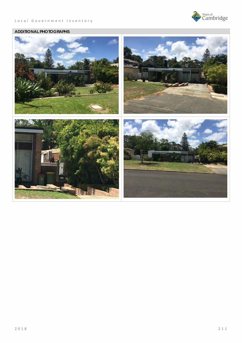
L o c a l G o v e r n m e n t I n v e n t o r y
2 0 1 8 2 1 1
ADDITIONAL PHOTOGRAPHS

L o c a l G o v e r n m e n t I n v e n t o r y
2 0 1 8 2 1 2
Floreat Forum Shopping Centre, Floreat Place No: 37
SITE INFORMATION Place Name: Floreat Forum Shopping Centre Other Names: Street Address: 5 Howtree Place Locality Floreat HERITAGE LISTING SHO inHerit database 8899 Other Listings PLACE TYPE Individual building or group Original Use: Commercial: Shopping Complex Current Use: Commercial: Shopping Complex Other Use: LAND INFORMATION Lot: 100 Survey: Plan 27735 Reserve No: -------- C/T: 2217-70 Property Number: 15592 Land Number: 4364

L o c a l G o v e r n m e n t I n v e n t o r y
2 0 1 8 2 1 3
CONSTRUCTION DETAILS Construction Date: 1963/4; ongoing Walls: Brick: Common Roof: Metal: other Architectural Style: Late 20th century Physical Description: The centre is single storey construction with stored facing into open walkways and a covered shopping centre. The centre has an inward character with blank elevation to Howtree Place and all the activation taking place within the centre. An active frontage is visible from Floreat Avenue which also provides access into the roof top car park. Condition: Good Integrity: High Authenticity: Low
HISTORICAL INFORMATION Historical Notes: Floreat Forum shopping centre was constructed throughout 1963 and 1965 and opened by Premier David Brand on 20 September 1965. The adjacent suburbs underwent significant development in the early 1960s, particularly following the Commonwealth Games at Perry Lakes in 1962. Originally the centre featured a distinctive conical roof structure which covered the first enclosed 'American Style' shopping centre. This style of shopping centre was new to Western Australia and was subsequently followed in many suburbs in the metropolitan area. Since its construction the shopping centre has undergone many additions and alterations. The distinctive

L o c a l G o v e r n m e n t I n v e n t o r y
2 0 1 8 2 1 4
roof structure was removed in c2002 and the complex was remodelled to achieve its current form and extent. The complex now features several levels, integrates a community centre, hotel and multi level car park. Historic Theme: Occupations: Commercial services and industries Associations: David Brand Sources: Aerial photographs, 1953-2016, Landgate.
Town of Cambridge Municipal Heritage Inventory and Townscape Precinct Study prepared for the Town of Cambridge, June 1997. Wise's Post Office Directories for the City of Perth, 1925-1949, State Library of WA www.slwa.wa.gov.au Floreat Forum website
SIGNIFICANCE Statement of Significance: • The place has historic value as the first example of the 'American
Style' enclosed shopping mall in metropolitan Perth. • The place has aesthetic value as a landmark in the district which is
visible from many directions as it is located at a junction of several major roads.
• The place has social value to the members of the community as it has been a popular and successful retail complex and venue for social gatherings since 1965.
Level of Significance: Little Contributes to the understanding of the history of the Town of Cambridge.
Management Category: Category 4 Photographically record prior to major development or demolition. Recognise and interpret the site if possible. Do not include on the Town Planning Scheme No 1 Heritage List.
ADDITIONAL PHOTOGRAPHS
Floreat Forum 1968, State Library image 260,653PD

L o c a l G o v e r n m e n t I n v e n t o r y
2 0 1 8 2 1 5
Iwanoff House, Floreat Place No: 38
SITE INFORMATION Place Name: Iwanoff House Other Names: House, 16 Lifford Road Street Address: 16 Lifford Road Locality Floreat HERITAGE LISTING SHO inHerit database 17608 Other Listings PLACE TYPE Individual building or group Original Use: Residential: Double storey house Current Use: Residential: Double storey house Other Use: LAND INFORMATION Lot: 1575 Survey: Plan 6559 Reserve No: --------- C/T: 1753-589 Property Number: 12667 Land Number: 1631

L o c a l G o v e r n m e n t I n v e n t o r y
2 0 1 8 2 1 6
CONSTRUCTION DETAILS Construction Date: 1966 Walls: Concrete block Roof: Metal: Colorbond Architectural Style: Late 20th Century International Physical Description: 16 Lifford Road was architect Iwan Iwanoff’s own house and studio. The studio was located on the ground floor with the living accommodation on the upper level. The house is of concrete block construction with a continuous band of windows across the upper section of façade with angled block sills and a smaller band of similar windows to the lower level. The stark nature of the concrete blockwork has been enlivened by decorative concrete panels between windows and the entrance door at ground level. The house is built below road level with much of the house obscured from view through dense planting. Condition: Excellent Integrity: High Authenticity: High
HISTORICAL INFORMATION Historical Notes: Iwan Nickolow Iwanoff (1919-1986) was born in Kusstendil, Bulgaria. After studying architecture in Munich at the Technische Hochschule from 1941, Iwanoff worked for Emil Freymuth with the pair winning second prize in the competition to rebuild the central area of Munich. Migrating to Australia as part of the International Refugee Organization resettlement scheme, Iwanoff and his wife arrived at Fremantle, on 2 March 1950. He worked with architecture firm Kranz and Sheldon and also Yuncken and Freeman in Melbourne. In 1963, he established his own practice, The Studio of Iwanoff. A gifted architect, Iwanoff had exceptional drawing abilities, an innovative `expressionistic’ approach to design and detailing and, above all, a conviction that architecture was an art. In 1963-86 his small office
L o c a l G o v e r n m e n t I n v e n t o r y
2 0 1 8 2 1 7
produced work of high quality, including numerous houses. He also designed shop fronts and interiors in central Perth, and one larger project, the civic administration centre and public library at Northam (1969-74). His creative use of concrete blocks is a noted feature of his work. Many of the Iwanoff residences designed in the 1960s and 1970s were in the new northern suburbs of Perth where there was often minimal surrounding development and often a clientele willing to explore new styles and techniques. This residence was designed by Iwanoff as a combination of architectural office and living accommodation for himself and his family. Aerial photographs indicate the form and extent of the place have not changed significantly since construction although internal modifications are likely to have been undertaken. Historic Theme: Occupations: domestic activities
People: Innovators Associations: Iwan Iwanoff Sources: Aerial photographs, 1953-2016, Landgate.
Goad, Philip; Willis, Julie 'The Encyclopaedia of Australian Architecture', Cambridge University Press, 2012, p. 357. Duncan Richards, 'Iwanoff, Iwan (1919–1986)', Australian Dictionary of Biography, National Centre of Biography, Australian National University, http://adb.anu.edu.au/biography/iwanoff-iwan-12685/text22867, published first in hardcopy 2007, accessed online 5 October 2017. State Library of WA, Iwan Iwanoff Collection. MN1401, Acc 4400A
SIGNIFICANCE Statement of Significance: • The place has aesthetic value as an intact example of the late 20th
century international style and as a landmark in the streetscape. • This residence and other examples of Iwanoff's work are a
comprehensive and notable group of buildings which demonstrate a specific design style and period.
• The place has historic value for its association with prominent architect, Iwan Iwanoff who was influential in Western Australian practice for his non traditional approach to design and materials drawn from European trends.
• The place has historic value for its association with the early 1970s which was characterised as a period of affluence which was teamed with a willingness to experiment with new styles and materials.
• The place has social value as the house and others of Iwanoff's design are the source of study and interest amongst members of the community.
Level of Significance: Considerable Very important to the heritage of the locality. High degree of integrity/authenticity
Management Category: Category 2 Conservation of the place is highly desirable. Any alterations or extensions should reinforce the significance of the place Include on the Town Planning Scheme No 1 Heritage List.

L o c a l G o v e r n m e n t I n v e n t o r y
2 0 1 8 2 1 8
ADDITIONAL PHOTOGRAPHS

L o c a l G o v e r n m e n t I n v e n t o r y
2 0 1 8 2 1 9
Schmidt-Lademann House, Floreat Place No: 39
SITE INFORMATION Place Name: Schmidt-Lademann House Other Names: Residence, 22 Lifford Street Street Address: 22 Lifford Road Locality Floreat HERITAGE LISTING SHO inHerit database Other Listings PLACE TYPE Individual building or group Original Use: Residential: Double storey house Current Use: Residential: Double storey house Other Use: LAND INFORMATION Lot: 1593 Survey: Plan 6559 Reserve No: -------- C/T: 1848-943 Property Number: 12649 Land Number: 1614

L o c a l G o v e r n m e n t I n v e n t o r y
2 0 1 8 2 2 0
CONSTRUCTION DETAILS Construction Date: 1958 Walls: Brick: Painted Roof: Metal: Colorbond Architectural Style: Late 20th Century International Physical Description: Part single storey part double storey house with distinctive skillion roofline extending across the full width of the house, terminating in an extensive balcony to the side elevation with tall concrete columns presenting in a stark angular form. A further balcony extends across part of the façade with timber balustrade. The façade is dominated by full height glazed panels and characteristic rubble stone panel wall. Condition: Excellent Integrity: High Authenticity: High
HISTORICAL INFORMATION Historical Notes: Iwan Nickolow Iwanoff (1919-1986) was born in Kusstendil, Bulgaria. After studying architecture in Munich at the Technische Hochschule from 1941, Iwanoff worked for Emil Freymuth with the pair winning second prize in the competition to rebuild the central area of Munich. Migrating to Australia as part of the International Refugee Organization resettlement scheme, Iwanoff and his wife arrived at Fremantle, on 2 March 1950. He worked with architecture firm Kranz and Sheldon and also Yuncken and Freeman in Melbourne. In 1963, he established his own practice, The Studio of Iwanoff. A gifted architect, Iwanoff had exceptional drawing abilities, an innovative 'expressionistic' approach to design and detailing and, above all, a conviction that architecture was an art. In 1963-86 his small office produced work of high quality, including numerous houses. He also designed shop fronts and interiors in central Perth, and one larger project, the civic administration centre and public library at Northam (1969-

L o c a l G o v e r n m e n t I n v e n t o r y
2 0 1 8 2 2 1
74). His creative use of concrete blocks is a noted feature of his work. Many of the Iwanoff residences designed in the 1960s and 1970s were in the new northern suburbs of Perth where there was often minimal surrounding development and often a clientele willing to explore new styles and techniques. Plans and specifications for this residence were prepared by Iwanoff’s studio in 1958 for Siegfried Schmidt-Lademann who was appointed as German consul in Perth in 1957. The residence was designed for private living for Siegfried and Jutta Schmidt-Lademann and their family, and for formal receptions. The house was built in 1958 however in 1959 the consulate in Perth was closed and the house was sold. Since construction the place has had minor additions and alterations in 2001 and 2003 but the form and extent of the original construction is clear. Historic Theme: Demographic settlement and mobility: settlements
Occupations: domestic activities People: Innovators
Associations: Iwan Iwanoff Sources: Aerial photographs, 1953-2016, Landgate.
Goad, Philip; Willis, Julie 'The Encyclopaedia of Australian Architecture', Cambridge University Press, 2012, p. 357. Duncan Richards, 'Iwanoff, Iwan (1919–1986)', Australian Dictionary of Biography, National Centre of Biography, Australian National University, http://adb.anu.edu.au/biography/iwanoff-iwan-12685/text22867, published first in hardcopy 2007, accessed online 5 October 2017. State Library of WA, Iwan Iwanoff Collection. MN1401, Acc 4400A The Schmidt-Lademann House http://www.schmidt-lademann.de/perth_lifford22/
SIGNIFICANCE Statement of Significance: • The place has aesthetic value as an intact example of the late 20th
century international style and as a landmark in the streetscape. • This residence and other examples of Iwanoff's work are a
comprehensive and notable group of buildings which demonstrate a specific design style and period.
• The place has historic value for its association with prominent architect, Iwan Iwanoff who was influential in Western Australian practice for his non traditional approach to design and materials drawn from European trends.
• The place has historic value for its association with the late 1950s to the 1970s which was characterised as a period of affluence which was teamed with a willingness to experiment with new styles and materials.
• The place has social value as the house and others of Iwanoff's design are the source of study and interest amongst members of the community.
Level of Significance: Considerable Very important to the heritage of the locality. High degree of integrity/authenticity
Management Category: Category 2 Conservation of the place is highly desirable. Any alterations or extensions should reinforce the significance of the place Include on the Town Planning Scheme No 1 Heritage List.

L o c a l G o v e r n m e n t I n v e n t o r y
2 0 1 8 2 2 2
ADDITIONAL PHOTOGRAPHS

L o c a l G o v e r n m e n t I n v e n t o r y
2 0 1 8 2 2 3
St Cecilia's Roman Catholic Church, Floreat Place No: 40
SITE INFORMATION Place Name: St Cecilia's Roman Catholic Church Other Names: Street Address: 47 Peebles Road Locality Floreat HERITAGE LISTING SHO inHerit database 8896 Other Listings Catholic Church Inventory PLACE TYPE Individual building or group Original Use: Religious: Church Current Use: Religious: Church Other Use: LAND INFORMATION Lot: 1 Survey: Diagram 96635 Reserve No: -------- C/T: 2204-352 Property Number: 15447 Land Number: 4231

L o c a l G o v e r n m e n t I n v e n t o r y
2 0 1 8 2 2 4
CONSTRUCTION DETAILS Construction Date: 1961; 1968; 1987; 2000 Walls: Concrete Panels Roof: Metal: Colorbond Architectural Style: Late 20th century ecclesiastical Physical Description: The early 1960s church is of concrete panel construction with a distinctive glazed façade incorporating large panels of coloured glass. The church comes under the late 20th century ecclesiastical architectural design where traditional church design gave way to a more flexible design approach that was reflective of changing liturgical practices. St Cecilia’s is a five sided building with each face incorporating a shallow pitched gable roof creating a dynamic roofline resulting in a landmark building in the streetscape. The roof is clad in colorbond with skylights along the ridgeline of the western roof section. The principal façade is positioned at a slight angle facing the intersection of Grantham Street and Kenmore Crescent. The façade consists of three main bays of intersection glass and concrete panels flanked by angled glazed and concrete walls. The remaining elevations are a mix of plain concrete panelled walls and glazed and concrete panels walls. There is an element of transparency through the building courtesy of the abundance of windows. The church adjoins the Newman College site and is surrounded by both hard and soft landscaping. Condition: Good Integrity: High Authenticity: High

L o c a l G o v e r n m e n t I n v e n t o r y
2 0 1 8 2 2 5
HISTORICAL INFORMATION Historical Notes: By the late 1950's, it became apparent that another parish was needed to cope with the ever increasing numbers of Catholics moving into the areas beyond Wembley. Some years earlier the Perth City Council had allocated to the Archdiocese of Perth land bounded by Grantham & Brookdale Streets and Peebles Road and Kenmore Crescent. The initial four blocks were sold to the Brigidine Sisters and were used by them to build a secondary school. On the 20th March 1960, the parish of St. Cecilia's, Floreat was created. Initially, weekend masses were celebrated in the Floreat Park State School. The Church is named after St. Cecilia who was a Roman patrician, virgin, martyr, and patron saint of musicians who lived in the second and third centuries. The architectural design for the new church in Floreat was completed in May 1961 by local architect Raymond Jones. Raymond Alfredo Daniel Jones (1925- ), born in Geelong Victoria, trained at the University of Melbourne after serving with the Australian Navy during World War Two. He was particularly influenced by the works of Robin Boyd and as reflected in the spatial continuity between building and landscape, as well as his environmental design philosophy. Jones relocated to Western Australia in the 1950s and was an influential practitioner through the works of his own practice and as a mentor. He had ongoing interests and passions in ecological design, through the use of skillion roofing and courtyard spaces as well as passive ventilation and site orientation. Building of the church commenced in 1961 and completed within the year. The new church was blessed and dedicated by Archbishop Prendiville on 26th February 1961. The original presbytery was built alongside the church soon after. The Stations of the Cross, carved in wood in Genoa, Italy were donated to the parish and erected in the church in November 1964. The parking area for cars was completed in May 1966. Alterations to the sanctuary to facilitate the celebration of mass with the priest facing the congregation and the concrete and glass screen behind the altar were carried out over the course of 1968. In 1977, the confessional used for the Sacrament of Penance was modified to permit the option of "open" confession. Two years later, the Baptismal Font was relocated to the sanctuary. The altar rails were removed in 1982 to facilitate the congregation receiving communion standing up. During the course of 1986, specifications were drawn up for the purchase of a new pipe organ and construction of the organ began in February 1987. On 20 November 1987, St Cecilia's Church was solemnly dedicated by Archbishop Foley. The feast of St. Cecilia in 1988, marked the blessing of the organ by Bishop Healy and the inaugural recital by organist John Beaverstock, accompanied by a 17 piece chamber orchestra. The amalgamation of the two former separate parishes, Floreat and Wembley, took place in 1990. By 1998, the condition of the original presbytery had deteriorated to the extent that it was no longer habitable . Plans were developed for a new presbytery [with accommodation for two priests], parish offices, meeting rooms, and a hall with kitchen facilities and toilets. The new buildings, designated as the parish centre were constructed and occupied in 2000. In the second half of 2003, the sanctuary area of St. Cecilia's was significantly renovated with a marble floor being laid, a new Baptismal Font, the provision of additional lighting on the sanctuary, one confessional being converted to storage for musical instruments and related equipment and with the walls on either side of the altar being rendered. In November and December 2010, the sacristies were refurbished with new cupboards/storage facilities, some new tiling and blinds installed. The main lobby of the church was also re-carpeted. The roof of the Church, Parish Centre and presbytery were replaced in early 2012 having been damaged
L o c a l G o v e r n m e n t I n v e n t o r y
2 0 1 8 2 2 6
by a severe storm the previous year. To mark the 50th Anniversary of St Cecilia's Church in 2012, local sculptor Peter Graham, designed a sculptures in the form of a harp with a palm branch signifying St. Cecilia as patron of music and a martyr of the church. The sculpture is located in the courtyard between St. Cecilia's church and the Parish Centre. Historic Theme: Social and Civic activities: Religion
People: Innovators Associations: Raymond Jones Sources: Aerial photographs, 1953-2016, Landgate.
Town of Cambridge Municipal Heritage Inventory and Townscape Precinct Study prepared for the Town of Cambridge, June 1997. Floreat Wembley Catholic Parish website http://www.floreatwembleyparish.org.au/ Ahead of the Pack in Architectural Thinking, ABC News, 29 March 2011. http://www.abc.net.au/news/2011-03-23/ahead-of-the-pack-in-architectural-thinking/2646700 Goad, Philip; Willis, Julie [eds] The Encyclopaedia of Australian Architecture, Cambridge University Press, 2012, p. 375.
SIGNIFICANCE Statement of Significance: • St Cecilia's church has aesthetic value as an intact example of the
Late 20th Century Ecclesiastical style and as a landmark in the streetscape.
• The place has historic value for its association with prominent architect, Raymond Jones who was influential in Western Australian practice for his non traditional approach to design and materials.
• The place has historic value for its association with the early 1960s which was characterised as a period of affluence which was teamed with a willingness to experiment with new styles and materials.
• The church complex has social value for the members of the Floreat and wider metropolitan community who have attended the venue for social, religious and musical events since 1961.
Level of Significance: Considerable Very important to the heritage of the locality. High degree of integrity/authenticity
Management Category: Category 2 Conservation of the place is highly desirable. Any alterations or extensions should reinforce the significance of the place Include on the Town Planning Scheme No 1 Heritage List.

L o c a l G o v e r n m e n t I n v e n t o r y
2 0 1 8 2 2 7
ADDITIONAL PHOTOGRAPHS
St Cecilia 1962 State Library image 214906PD

L o c a l G o v e r n m e n t I n v e n t o r y
2 0 1 8 2 2 8
Perry Lakes Reserve, Floreat Place No: 41
SITE INFORMATION Place Name: Perry Lakes Reserve Other Names: Alderbury/Perry Lakes Reserve (M609) (M550) Street Address: Perry Lakes Drive Locality Floreat HERITAGE LISTING SHO inHerit database 9008 Other Listings PLACE TYPE Urban Park Original Use: Park/Reserve Current Use: Park/Reserve Other Use: Farming/pastoral LAND INFORMATION Lot: 720 Survey: Plan 21069 Reserve No: --------- C/T: 2138-16 Property Number: 11668 Land Number: 5388
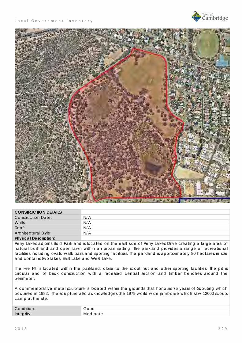
L o c a l G o v e r n m e n t I n v e n t o r y
2 0 1 8 2 2 9
CONSTRUCTION DETAILS Construction Date: N/A Walls: N/A Roof: N/A Architectural Style: N/A Physical Description: Perry Lakes adjoins Bold Park and is located on the east side of Perry Lakes Drive creating a large area of natural bushland and open lawn within an urban setting. The parkland provides a range of recreational facilities including ovals, walk trails and sporting facilities. The parkland is approximately 80 hectares in size and contains two lakes, East Lake and West Lake. The Fire Pit is located within the parkland, close to the scout hut and other sporting facilities. The pit is circular and of brick construction with a recessed central section and timber benches around the perimeter. A commemorative metal sculpture is located within the grounds that honours 75 years of Scouting which occurred in 1982. The sculpture also acknowledges the 1979 world wide jamboree which saw 12000 scouts camp at the site. Condition: Good Integrity: Moderate

L o c a l G o v e r n m e n t I n v e n t o r y
2 0 1 8 2 3 0
Authenticity: Moderate HISTORICAL INFORMATION Historical Notes: The area now defined as Perry Lakes has been identified by the Department of Aboriginal Affairs, Aboriginal Heritage Inquiry System as Heritage Place 3735 as a former camp and hunting place. As a wetland it is logical this place was used by the Whadjuk Noongar peoples for a range of functions prior to and following establishment of the Swan River colony in 1829. Following the foundation of Perth, the townsite was laid out and limestone was in great demand for construction in the new colony. The earliest lime kilns in Western Australia were established at the initial settlement sites of Fremantle and Albany in the 1830s, where settlers had access to local supplies of limestone. Henry Trigg, a carpenter and master builder from Gloucester, England arrived in the new colony of Western Australia in 1829. In I834, Trigg was granted 500 acres of land, which lay south of modern day Grantham Street, stretching from Floreat to the coastal sand hills. The western boundary of Trigg's land ran along the top of a limestone ridge. As a builder, Trigg recognised the value of this limestone outcropping and set up a quarrying and lime burning business. Trigg's business which became known as the 'Limekilns' prospered. In 1839, Trigg purchased neighbouring land to the south, including what is now Perry Lakes and One Tree Hill, (now known as Reabold Hill). In the same year, Trigg was appointed Superintendent of Public Works, and in this role was responsible for overseeing the erection of many early government buildings in Perth. In 1844, Walter Padbury, a pastoralist, acquired 426 acres of land adjacent to Trigg's property and later purchased Trigg's land including the Limekilns business for 2350, forming a 1,234 acre landholding which became known as the 'Limekilns Estate'. For the next 20 years Padbury built the Estate into a successful property, including the retention of the quarrying operations. At the height of operations, more than 50 men were employed at the quarry and lime kiln site. In 1869, brothers Henry and Somers Birch purchased the Limekilns Estate from Walter Padbury for £1,000. On 1 November 1875, during their ownership of the property, the explorer Ernest Giles arrived in Perth after his 2,500 mile journey from Port Augusta. His camels were rested at the Limekilns Estate and later in the 1890s, the Limekilns Estate served as a temporary quarantine station for camels imported to Western Australia to provide transport to the goldfields, with a lake now within Bold Park becoming known as Camel Lake. The Estate remained in the Birch's ownership until, 1880 when it was purchased by Joseph Perry for the sum of £1300. During his ownership, Perry kept the Quarry and limekilns in operation. Many of Perth's early public buildings, including the foundations of the Perth Town Hall (1870) were constructed using limestone from the quarry and kilns. In 1880, a portion of the Limekilns property was rented to Charles Ball who offered to supply lime which was described as the most superior in the colony, from lime kilns of 30 years standing. Private quarrying ceased operation in 1906 and the Limekilns Quarry (Quarry Amphitheatre) remained disused for many years. Changes to the rural nature of the area came about with the subdivision of land owned by the Catholic Church in 1911. This subdivision was called the Church Lands Estate, and the first house was constructed in 1912. In 1917, the Perth City Council purchased the 1290-acre Limekilns Estate from Perry for £18,000 and it linked to the Endowment Lands bestowed on the Perth City Council by the State Government in 1902. In January 1918, the Limekilns Estate was included within the boundaries of the City of Perth, and adjoined a further 2281 acres of Endowment Lands. The City envisioned opening out the quarries and using the limestone in the construction of city roads but also setting a portion of the land aside for a public park on the site of Perry's couch paddock and One Tree Hill (Reabold Hill). The exact date that the municipal Quarry ceased operation is not known, but it is likely that operations ceased in the 1920s with the beginning of the development of the area for housing. During the middle decades of the 20th century the quarry was unused and largely inaccessible.
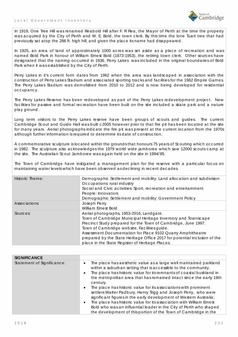
L o c a l G o v e r n m e n t I n v e n t o r y
2 0 1 8 2 3 1
In 1919, One Tree Hill was renamed Reabold Hill after F. R Rea, the Mayor of Perth at the time the property was acquired by the City of Perth and W. E. Bold, the town clerk. By this time the lone Tuart tree that had previously sat atop the 286 ft. high hill, and given the place its name had disappeared. In 1925, an area of land of approximately 1000 acres was set aside as a place of recreation and was named Bold Park in honour of William Ernest Bold (1873-1953), the retiring town clerk. Other sources have designated that the naming occurred in 1936. Perry Lakes was included in the original boundaries of Bold Park when it was established by the City of Perth. Perry Lakes in it's current form dates from 1962 when the area was landscaped in association with the construction of Perry Lakes Stadium and associated sporting tracks and facilities for the 1962 Empire Games. The Perry Lakes Stadium was demolished from 2010 to 2012 and is now being developed for residential occupancy. The Perry Lakes Reserve has been redeveloped as part of the Perry Lakes redevelopment project. New facilities for passive and formal recreation have been built on the site included a skate park and a nature play ground. Long term visitors to the Perry Lakes reserve have been groups of scouts and guides. The current Cambridge Scout and Guide Hall was built c2005 however prior to that fire pit has been located at the site for many years. Aerial photographs indicate the fire pit was present at the current location from the 1970s although further information is required to determine its date of construction. A commemorative sculpture is located within the grounds that honours 75 years of Scouting which occurred in 1982. The sculpture also acknowledges the 1979 world wide jamboree which saw 12000 scouts camp at the site. The Australian Scout Jamboree was again held on the site in 1994/95. The Town of Cambridge have instigated a management plan for the reserve with a particular focus on maintaining water levels which have been observed as declining in recent decades. Historic Theme: Demographic Settlement and mobility: Land allocation and subdivision
Occupations: rural industry Social and Civic activities: Sport, recreation and entertainment People: Innovators Demographic Settlement and mobility: Government Policy
Associations: Joseph Perry William Ernest Bold
Sources: Aerial photographs, 1953-2016, Landgate. Town of Cambridge Municipal Heritage Inventory and Townscape Precinct Study prepared for the Town of Cambridge, June 1997. Town of Cambridge website, Facilities guide. Assessment Documentation for Place 9102 Quarry Amphitheatre prepared by the State Heritage Office 2017 for potential inclusion of the place in the State Register of Heritage Places.
SIGNIFICANCE Statement of Significance: • The place has aesthetic value as a large well maintained parkland
within a suburban setting that is accessible to the community. • The place has historic value for its remnants of coastal bushland in
the metropolitan area that has remained intact since the early 19th century.
• The place has historic value for its associations with prominent settlers Walter Padbury, Henry Trigg and Joseph Perry, who were significant figures in the early development of Western Australia;
• The place has historic value for its association with William Ernest Bold who was an influential leader in the City of Perth who shaped the development of this portion of the Town of Cambridge in the

L o c a l G o v e r n m e n t I n v e n t o r y
2 0 1 8 2 3 2
early 20th century; • The place has social value for the members of the community who
access the place for passive recreation and research. • The reserve has social value for current and former scouts, guides
and their leaders who have attended group activities at the site, especially the large jamboree's held in 1979 and 1994/5.
Level of Significance: Considerable Very important to the heritage of the locality. High degree of integrity/authenticity
Management Category: Category 2 Conservation of the place is highly desirable. Any alterations or extensions should reinforce the significance of the place Include on the Town Planning Scheme No 1 Heritage List.
ADDITIONAL PHOTOGRAPHS

L o c a l G o v e r n m e n t I n v e n t o r y
2 0 1 8 2 3 3
Perry House, Floreat Place No: 42
SITE INFORMATION Place Name: Perry House Other Names: Peregrine House Street Address: 167 Perry Lakes Drive Locality Floreat HERITAGE LISTING SHO inHerit database 9101 Other Listings PLACE TYPE Individual building or group Original Use: Residential: Single storey house Current Use: Residential: Single storey house Other Use: LAND INFORMATION Lot: 12965 Survey: Plan 21069 Reserve No: -------- C/T: LR3111-271 Property Number: 11636 Land Number: 10640

L o c a l G o v e r n m e n t I n v e n t o r y
2 0 1 8 2 3 4
CONSTRUCTION DETAILS Construction Date: 1919 Walls: Brick/Stone: tuckpointed/ limestone Roof: Tile: terracotta Architectural Style: Federation bungalow Physical Description: Single storey brick and stone house with hipped terracotta tiled roof and surrounding verandah to three sides of the former house. The house has a semi-elevated position with brick steps leading up to the verandah. The façade is of symmetrical presentation with a centrally placed entrance door with fanlight flanked by single timber framed sash windows. All openings and the corner edges of the elevations are enlivened by brick quoining. The red brickwork has been finished with tuckpointing whilst the stone element of the construction has been skimmed with plaster and scored with tuck pointing to look like dressed stone. The side and rear elevations have been altered by way of brick additions within the verandah line and present with a lower level of authenticity than the façade. Condition: Good Integrity: Moderate Authenticity: Moderate
HISTORICAL INFORMATION Historical Notes: Perry House was built by the Perth City Council in 1919 following the purchase of the Limekilns Estate from Joseph Perry (c1841-1920) in 1917. The house was constructed for the caretaker of the Endowment Lands adjacent to the site of Perry's earlier house and stone from this building was incorporated into the new structure Remnants of the earlier building and associated structures were evident at the site in 1996.

L o c a l G o v e r n m e n t I n v e n t o r y
2 0 1 8 2 3 5
The duties of the caretaker were described in an advertisement for the position in January 1919. Caretaker required for the City Endowment Lands and Limekilns Estate, to attend to depasturing of stock,
prevent removal of timber, keep fences in order, protect property of the Council, and generally act as Caretaker of the Estate, at £3 per week and quarters. Apply stating age, experience, and enclosing copies of testimonials to the Town Clerk Perth.
The Town Clerk designated in the advertisement was William Ernest Bold who was a driving force in the establishment of the parks within this area. Bold was one of the State's leading advocates of the Garden City Movement, which had developed in the United Kingdom in the early 1900s in response to improving residential amenities for workers in nineteenth century industrial cities. The definition of a Garden City as a town designed for healthy living, surrounded by a rural belt of land owned or held in trust for the community directly influenced the planning of Floreat Park and City Beach as two satellite towns separated by a belt of undeveloped land (Bold Park). The building continued to be used as the caretaker's premises for many decades and is now the premises for volunteer groups; Friends of Bold Park Bushland, Wildflower Society of WA and Birdlife Australia. The form and extent of the building have not been significantly altered since the mid 20th century. The date of the enclosure of the verandahs has not been determined. Historic Theme: Demographic Settlement and mobility: Land allocation and subdivision
Occupations: rural industry Social and Civic activities: Sport, recreation and entertainment People: Innovators Demographic Settlement and mobility: Government Policy
Associations: Joseph Perry William Ernest Bold
Sources: Aerial photographs, 1953-2016, Landgate. Town of Cambridge Municipal Heritage Inventory and Townscape Precinct Study prepared for the Town of Cambridge, June 1997. Wise's Post Office Directories for the City of Perth, 1925-1949, State Library of WA www.slwa.wa.gov.au The Daily News, 20 January 1919, p. 1. Assessment Documentation for Place 9102 Quarry Amphitheatre prepared by the State Heritage Office 2017 for potential inclusion of the place in the State Register of Heritage Places.
SIGNIFICANCE Statement of Significance: • The place has aesthetic value as a good. largely intact example of
a Federation Bungalow residence built in stone, brick and iron. • The place has historic value for its association with the commitment
by the City of Perth to manage the large landholding, known as the Endowment Lands as future parklands
• The place has historic value for its association with innovative and influential City of Perth Town Clerk, William Ernest Bold who developed the plan to retain these large parklands and oversee their management.
• The place has social value as an illustration of government housing for a skilled tradesman and his family in the early 20th century when this locality would have been a remote posting.
• The place has social value for the members of the Volunteer groups which now occupy the premises which provide a service to the wider community.
Level of Significance: Considerable Very important to the heritage of the locality. High degree of integrity/authenticity

L o c a l G o v e r n m e n t I n v e n t o r y
2 0 1 8 2 3 6
Management Category: Category 2 Conservation of the place is highly desirable. Any alterations or extensions should reinforce the significance of the place Include on the Town Planning Scheme No 1 Heritage List.
ADDITIONAL PHOTOGRAPHS
Old Perry House 1916, State Library image b3036687_22

L o c a l G o v e r n m e n t I n v e n t o r y
2 0 1 8 2 3 7
Perry Lakes Scoreboard, Floreat Place No: 43
SITE INFORMATION Place Name: Perry Lakes Scoreboard Other Names: Perry Lakes Sporting Complex (fmr) Street Address: 1 Stadium Drive Locality Floreat HERITAGE LISTING SHO inHerit database 25872;
9100 Other Listings PLACE TYPE Individual building or group Original Use: Social / Recreational: Scoreboard Current Use: Social / Recreational: Community centre Other Use: Vacant LAND INFORMATION Lot: 230 Survey: DP73849 Reserve No: --------- C/T: 2806/344 Property Number: 24298 Land Number: 14293

L o c a l G o v e r n m e n t I n v e n t o r y
2 0 1 8 2 3 8
CONSTRUCTION DETAILS Construction Date: 1962 Walls: Brick: common Roof: Metal: zincalume Architectural Style: Post war International Physical Description: Perry Lakes Scoreboard is the last remaining element of the former sporting facilities erected for the commonwealth games in 1962. The scorecard sits in a prominent elevated position amidst contemporary townhouse developments which has resulted in a loss of context for the structure.
The scoreboard is a three storey structure of pale brick construction to the ground level and side elevations. The upper levels of the façade are glazed with a glazed parapet topped with four flagpoles.
The façade of the building has been altered with the double height glazing replacing the scoreboard, the removal of the balcony and the replacement of the small openings at ground level with full height window and door arrangements. Whilst the structure still makes a statement in the landscape, the integrity and authenticity of the structure has been degraded through the redevelopment of the site and adaptation of the scoreboard.
Condition: Good Integrity: Low Authenticity: Moderate

L o c a l G o v e r n m e n t I n v e n t o r y
2 0 1 8 2 3 9
HISTORICAL INFORMATION Historical Notes: The Perry Lakes Scoreboard is the last element remaining from the former Perry Lakes Sporting Complex built in 1962 for the British Empire and Commonwealth Games. The facilities at the site were based around the athletics track and field ground and the associated stadium. When constructed the capacity of the stadium was 30,000 and the scoreboard was located at the southern end of the track. When constructed the scoreboard featured the latest technology in displays. An array of light globes were located across the front face of the scoreboard, letters and numbers were depicted in the lights and was a vast improvement on previous techniques which used either chalked boards or a series of numeric cards, flipped by the scorer. Perry Lakes Stadium was the venue for many events since 1962, notably annual school athletic sports carnivals, Country Week opening and closing ceremonies, rugby, soccer and concerts. For many decades basketball was played in covered courts to the west of the track and field stadium. The future of the site had been under discussion for many years as the facilities began to deteriorate and other venues took on the hosting of specific sports. Specifically the construction of the Western Australian Athletics Stadium in 2009 in nearby Underwood Avenue meant Perry Lakes was no longer used for athletics. Proposals to develop the site for residential occupancy were finalised c2009 and demolition of the stadium began in 2010,the grandstand was demolished in September 2012. Development of the site was the source of community discussion and it was resolved to retain the scoreboard at the site in recognition of the cultural heritage significance of the venue. The development also acknowledged the former use by using road names that reflected the sporting associations with the place. Current proposals indicate the scoreboard will be used only for community purposes for the occupants of the adjacent strata development. Together with modifications for community purposes, it has been proposed that the former scoreboard face will be clad with photovoltaic cells to power the common areas. Historic Theme: Social and Civic activities: sport, recreation and entertainment
Social and Civic Activities: government and politics Associations: Sources: Aerial photographs, 1953-2016, Landgate.
Town of Cambridge Municipal Heritage Inventory and Townscape Precinct Study prepared for the Town of Cambridge, June 1997. Austadiums, Australian Stadiums and Sport website, http://www.austadiums.com accessed October 2017 Cambridge Local Studies, Life of a Scoreboard, August 2014. Assessment Documentation for Place 9102 Quarry Amphitheatre prepared by the State Heritage Office 2017 for potential inclusion of the place in the State Register of Heritage Places.
SIGNIFICANCE Statement of Significance: • The scoreboard has aesthetic value as an intact demonstration of
the Post War International style executed in brick. • The scoreboard has aesthetic value as a landmark in the
streetscape as it is a unique element in a residential complex that is well known to many members of the community.
• The scoreboard has historic value for its association with the 1962 Empire and Commonwealth Games that were a significant event in the Perth community.
• The scoreboard has social value for the community for its association with past sporting and social events shared by large sections of the community.
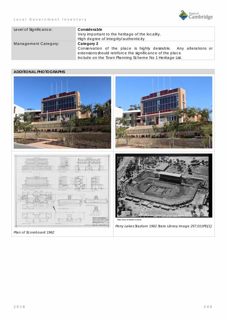
L o c a l G o v e r n m e n t I n v e n t o r y
2 0 1 8 2 4 0
Level of Significance: Considerable Very important to the heritage of the locality. High degree of integrity/authenticity
Management Category: Category 2 Conservation of the place is highly desirable. Any alterations or extensions should reinforce the significance of the place Include on the Town Planning Scheme No 1 Heritage List.
ADDITIONAL PHOTOGRAPHS
Plan of Scoreboard 1962
Perry Lakes Stadium 1962 State Library image 257,011PD[1]
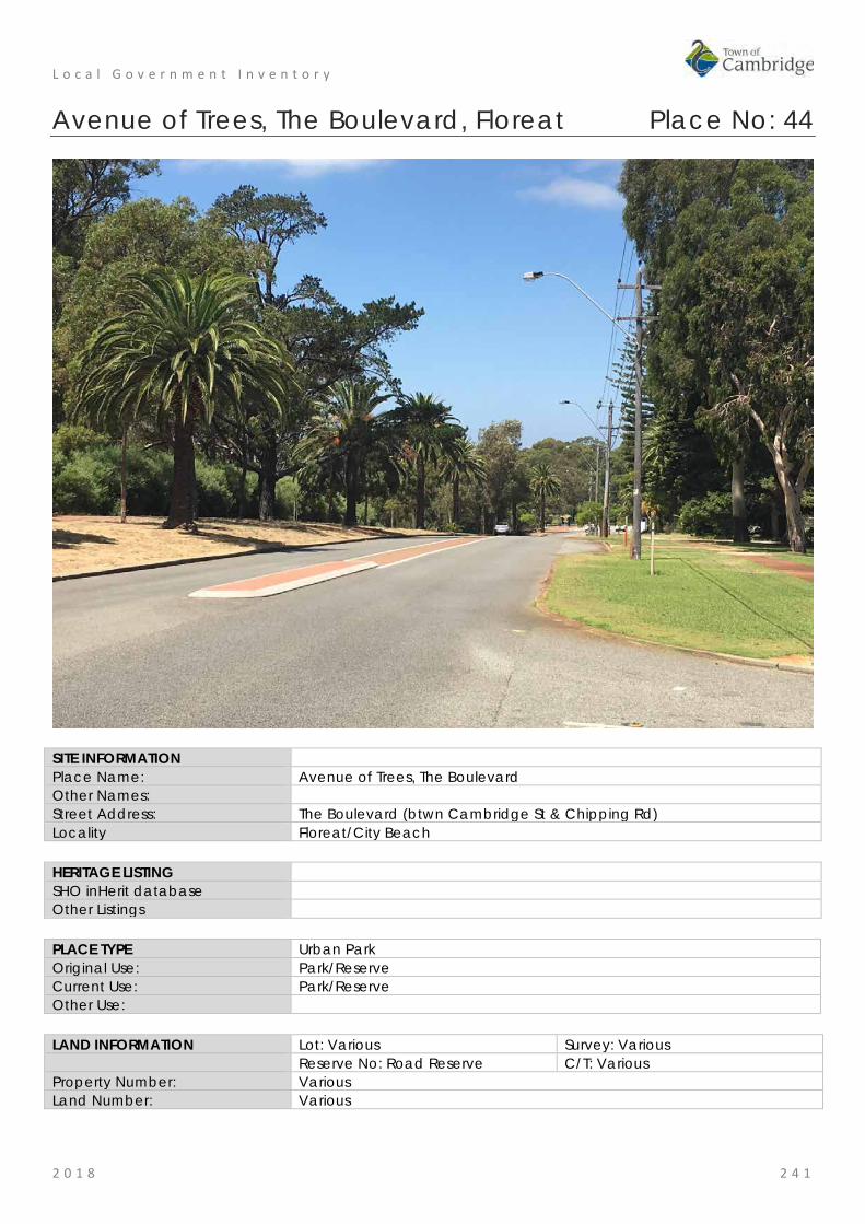
L o c a l G o v e r n m e n t I n v e n t o r y
2 0 1 8 2 4 1
Avenue of Trees, The Boulevard, Floreat Place No: 44
SITE INFORMATION Place Name: Avenue of Trees, The Boulevard Other Names: Street Address: The Boulevard (btwn Cambridge St & Chipping Rd) Locality Floreat/City Beach HERITAGE LISTING SHO inHerit database Other Listings PLACE TYPE Urban Park Original Use: Park/Reserve Current Use: Park/Reserve Other Use: LAND INFORMATION Lot: Various Survey: Various Reserve No: Road Reserve C/T: Various Property Number: Various Land Number: Various

L o c a l G o v e r n m e n t I n v e n t o r y
2 0 1 8 2 4 2
CONSTRUCTION DETAILS Construction Date: 1929 Planted; 1940s additions Walls: N/A Roof: N/A Architectural Style: N/A Physical Description: The trees along The Boulevard between the intersection with Cambridge Street and Chipping Road are located within the deep grassy verges and are a variety of species including pine, palm trees and gums. The trees create a clearly defined green edge to the road and provide some separation between the public and private realms. Condition: Good Integrity: High Authenticity: Moderate
HISTORICAL INFORMATION Historical Notes: The trees which remain on the verges of The Boulevard in Floreat and City Beach are those remaining from a ceremonial planting in recognition of the foundation of the colony in 1829. The City of Perth undertook to plant 365 trees on The Boulevard in part as a contrast to the ceremony in 1829 which cut down a tree in central Perth. The ceremony took place on 26th July 1929, and was performed by his Excellency the Governor (Sir William Campion) and Lady Campion, assisted by the Mayor of Perth (Mr. J. T. Franklin, M.L.C.) and Mrs. Franklin, members of the State Ministry and their wives, ex-Mayors, city councillors and civic officers and their wives. As described in the local press, The Boulevard, which curves north-westward from Cambridge-street, and is four miles long, will be planted
with an avenue of trees. On each side of the roadway a line of Pinus insignis, with alternating palms and flowering gums in the foreground, will edge the drive, the present macadamized width of which will be doubled. Half a mile of the drive was planted yesterday, starting from the city end. Each lady who planted a tree received as a souvenir a miniature spade bearing Perth’s coat of arms. The planting done, the guests were given tea in a marquee, where speeches were made'.
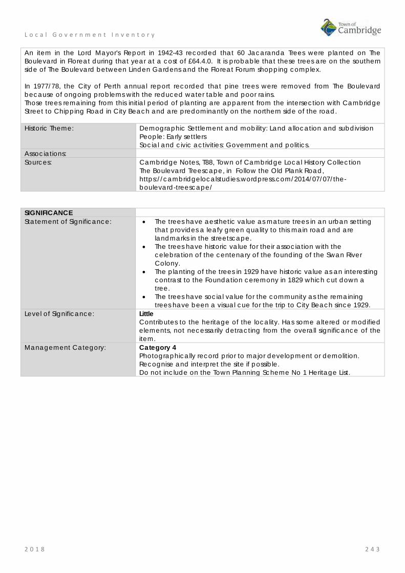
L o c a l G o v e r n m e n t I n v e n t o r y
2 0 1 8 2 4 3
An item in the Lord Mayor's Report in 1942-43 recorded that 60 Jacaranda Trees were planted on The Boulevard in Floreat during that year at a cost of £64.4.0. It is probable that these trees are on the southern side of The Boulevard between Linden Gardens and the Floreat Forum shopping complex. In 1977/78, the City of Perth annual report recorded that pine trees were removed from The Boulevard because of ongoing problems with the reduced water table and poor rains. Those trees remaining from this initial period of planting are apparent from the intersection with Cambridge Street to Chipping Road in City Beach and are predominantly on the northern side of the road. Historic Theme: Demographic Settlement and mobility: Land allocation and subdivision
People: Early settlers Social and civic activities: Government and politics.
Associations: Sources: Cambridge Notes, T88, Town of Cambridge Local History Collection
The Boulevard Treescape, in Follow the Old Plank Road, https://cambridgelocalstudies.wordpress.com/2014/07/07/the-boulevard-treescape/
SIGNIFICANCE Statement of Significance: • The trees have aesthetic value as mature trees in an urban setting
that provides a leafy green quality to this main road and are landmarks in the streetscape.
• The trees have historic value for their association with the celebration of the centenary of the founding of the Swan River Colony.
• The planting of the trees in 1929 have historic value as an interesting contrast to the Foundation ceremony in 1829 which cut down a tree.
• The trees have social value for the community as the remaining trees have been a visual cue for the trip to City Beach since 1929.
Level of Significance: Little Contributes to the heritage of the locality. Has some altered or modified elements, not necessarily detracting from the overall significance of the item.
Management Category: Category 4 Photographically record prior to major development or demolition. Recognise and interpret the site if possible. Do not include on the Town Planning Scheme No 1 Heritage List.

L o c a l G o v e r n m e n t I n v e n t o r y
2 0 1 8 2 4 4
ADDITIONAL PHOTOGRAPHS

L o c a l G o v e r n m e n t I n v e n t o r y
2 0 1 8 2 4 5
McLean Park, Floreat Place No: 45
SITE INFORMATION Place Name: McLean Park Other Names: M555 Street Address: The Boulevard Locality Floreat HERITAGE LISTING SHO inHerit database Other Listings PLACE TYPE Urban Park Original Use: Park/Reserve Current Use: Park/Reserve Other Use: LAND INFORMATION Lot: 1774 Survey: Plan 6135 Reserve No: ---------- C/T: 1128-557 Property Number: 12786 Land Number: 1743
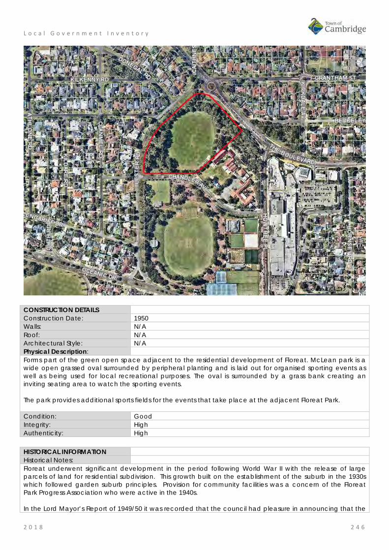
L o c a l G o v e r n m e n t I n v e n t o r y
2 0 1 8 2 4 6
CONSTRUCTION DETAILS Construction Date: 1950 Walls: N/A Roof: N/A Architectural Style: N/A Physical Description: Forms part of the green open space adjacent to the residential development of Floreat. McLean park is a wide open grassed oval surrounded by peripheral planting and is laid out for organised sporting events as well as being used for local recreational purposes. The oval is surrounded by a grass bank creating an inviting seating area to watch the sporting events. The park provides additional sports fields for the events that take place at the adjacent Floreat Park. Condition: Good Integrity: High Authenticity: High HISTORICAL INFORMATION Historical Notes: Floreat underwent significant development in the period following World War II with the release of large parcels of land for residential subdivision. This growth built on the establishment of the suburb in the 1930s which followed garden suburb principles. Provision for community facilities was a concern of the Floreat Park Progress Association who were active in the 1940s. In the Lord Mayor’s Report of 1949/50 it was recorded that the council had pleasure in announcing that the

L o c a l G o v e r n m e n t I n v e n t o r y
2 0 1 8 2 4 7
10 acre reserve to the north of the site designated for a community centre in Floreat Park was to be named McLean Park in recognition of the work of Councillor Herbert McDonald McLean (c1901-1991) in promoting the requests of the Floreat Park Progress Association. The report further described the grading, levelling, planting and watering undertaken to establish the standard size oval so it would be fit for the winter of 1951. The oval was also planned to be an adjunct for the Floreat Park Primary School. Since the creation of the oval it has been the venue for a range of organised sport and passive recreation. Facilities at the park have been constantly added to and improved since the establishment of the park. Historic Theme: Social and Civic Activities: Sport, recreation and entertainment
People: Local heroes and battlers Demographic settlement and mobility: Government policy
Associations: Herbert McDonald McLean Sources: Aerial photographs, 1953-2016, Landgate.
Town of Cambridge, Local History, Cambridge Notes, item T687 The Daily News, 1 May 1947, p. 9.
SIGNIFICANCE Statement of Significance: • The place has aesthetic value as a well maintained grassed
landscape featuring mature trees in an urban setting. • The park has historic value for its association with the development
of community facilities in Floreat in the 1950s when the suburb was more densely settled.
• The park has historic value for its association with City of Perth councillor, Herbert McLean who was active in the delivery of services and facilities for the Floreat community in the post war period.
• The park has social value as the venue for many formal and informal sports since the 1950s which have been attended by many members of the community, and as an adjunct to the Floreat Park Primary School.
Level of Significance: Little Contributes to the understanding of the history of the Town of Cambridge.
Management Category: Category 4 Photographically record prior to major development or demolition. Recognise and interpret the site if possible. Do not include on the Town Planning Scheme No 1 Heritage List.
ADDITIONAL PHOTOGRAPHS
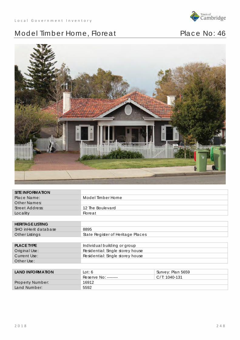
L o c a l G o v e r n m e n t I n v e n t o r y
2 0 1 8 2 4 8
Model Timber Home, Floreat Place No: 46
SITE INFORMATION Place Name: Model Timber Home Other Names: Street Address: 12 The Boulevard Locality Floreat HERITAGE LISTING SHO inHerit database 8895 Other Listings State Register of Heritage Places PLACE TYPE Individual building or group Original Use: Residential: Single storey house Current Use: Residential: Single storey house Other Use: LAND INFORMATION Lot: 6 Survey: Plan 5659 Reserve No: -------- C/T: 1040-131 Property Number: 16912 Land Number: 5592

L o c a l G o v e r n m e n t I n v e n t o r y
2 0 1 8 2 4 9
CONSTRUCTION DETAILS Construction Date: 1934 Walls: Timber: weatherboard Roof: Tile: Terracotta Architectural Style: Inter-war Californian Bungalow Physical Description: Model Timber Home located at 12 The Boulevard Floreat, comprises a single storey, painted Jarrah weatherboard and tile residence. The front elevation of the house is set back from the front boundary and located towards the eastern side of the lot with a pathway down the western side of the house. The front and side boundaries are defined by a low non-original picket fence. The front garden features many original plants including a tall poplar tree on the eastern side of the house, rose beds and borders of various flowering shrubs typical of gardens from the inter-war period. Fixed to the side of the house is the foundation stone laid by the Hon. J. J. Kenneally MLA, Minister for Employment and Industries, on 5 November 1933, on behalf of the Model Homes Committee. The house comprises the original section constructed in 1933 and a modest addition at the rear constructed in 1977. External walls are of painted Jarrah weatherboard on brick footings. The roof is moderately pitched and hipped with a feature gable over the front verandah. The roof is clad with terracotta tiles and the gable features vertically hung timber shingles which have been retained unpainted and stained, with a circular roof vent which is painted white. The eaves are wide and generally lined, apart from the eaves of the front gable which are battened. The eaves are finished with a timber facia board and ogee profile gutters. There are two chimneys, which are rendered and painted brick with a simple ridge detail to the tops with terracotta pots. The front verandah ring beam is supported on a series of circular tapered columns designed to give a classical effect, with a timber balustrade featuring vertical balusters and a central feature panel with a criss-cross design.

L o c a l G o v e r n m e n t I n v e n t o r y
2 0 1 8 2 5 0
Windows are timber framed double hung casements with timber framed fly screens fixed externally. The sashes are divided into small panes with leadlight and have obscure glass borders. Windows to the front elevation have ornamental shutters with diamond shaped cut-outs and window boxes. The front door is timber with three vertical panels to the lower section and one glazed leadlight panel of obscure uncoloured glass. The door has matching side panels with sidelights. A steel mesh security screen is not original. The gardens are in good condition with original features, trees and plants. Condition: Good Integrity: High Authenticity: High
HISTORICAL INFORMATION Historical Notes: In the nineteenth century the area to the north west of Perth known as the Large Lakes District was sparsely settled for agricultural purposes. The area currently known as Floreat comprised Locations Ak, to the west, and Al, in which Model Brick Home and Model Timber Home is currently located. Henry Trigg, builder and businessman acquired approximately 800 acres of this land and established a quarrying and lime burning enterprise on the property. In 1844 the property, known as the Limekilns Estate, was purchased by Walter Padbury and in 1869, the Limekilns Estate was sold to Henry and Somers Birch in for £1,000 and in 1880 to Joseph Perry for £1,950. The limekilns operated throughout the 1880s and 1890s and, until their closure in 1906, provided building materials for the developing residential areas of Subiaco and Leederville. The area between the Limekilns Estate and the coast remained crown land until 1855 when it was proclaimed the Endowment Lands. The Endowment Lands were originally part of the Perth Commonage, a large area bounded by the coast and extending from North Fremantle to north of Herdsman Lake. The purpose of the land was to provide income for municipal works through payment for use of the land for timber and stone. The Endowment Lands were vested in the Perth City Council in 1883, who were empowered to lease the land for a maximum of ten years. Settlement in the area between the City of Perth and the Limekilns Estate (present day West Leederville and Wembley) developed outwards from the city in a westerly direction in the period from the late nineteenth century to World War One. In 1917, the Limekilns Estate, which by this time comprised 1,290 acres (522 hectares), was purchased from Joseph Perry by the City of Perth for £18,000. This gave the City of Perth control of a continuous area of land from the city to the coast. The City of Perth Endowment Lands Act of 1920 enabled the City of Perth to develop and sell the previously allocated land. From the early 1900s, there had been proposals to construct a beach resort for city dwellers in the vicinity of present day City Beach. The emphasis, however, on development in this area differed from earlier development patterns, which had been dominated by speculation in land values with pressure exerted by private speculators. In the 1920s, the focus was put on the planning process with control exerted over road layout, proportion of open space, gardens and community service. The proponent for this was influential City of Perth Town Clerk, W. E. Bold. Bold was one of the State’s leading exponents of the Garden City Movement which had a direct influence on the planning of Floreat Park and City Beach. The United Kingdom's Housing and Planning Act of 1909 was recognition of the development of the discipline of Town Planning, which emerged as an outcome of the Garden Cities Movement in the early 1900s. The Garden Cities Movement developed in the UK in response to necessary improvements to residential amenities for workers in nineteenth century industrial cities. In 1910, the Royal Institute of British Architects held an inaugural Town Planning Conference in London. Copies of papers given at the conference were received in Perth together with a proposal that a lecture series be conducted in Australia by representatives of the Garden Cities and Town Planning Association. The

L o c a l G o v e r n m e n t I n v e n t o r y
2 0 1 8 2 5 1
issue was promoted by W E Bold and, in 1914, lectures were presented in Perth, Fremantle and Boulder by W R Davridge of the London County Council. Subsequently the first Australian Town Planning Conference and Exhibition was held in Adelaide in October 1917. These ideas influenced Bold to promote the development of two satellite towns in the area west of Selby Street to be separated by a belt of undeveloped land. In 1925, the Perth City Council set aside the area known as Bold Park for this purpose. The area originally included Reabold Hill, Perry Lakes and the Wembley Golf Course. In 1925, the City of Perth commissioned Land Surveyors Hope and Klem to design two town sites, one located on the former Endowment Lands and the other on the eastern side of the former Limekilns Estate. The result was two plans with extensive use of curved roads. The eventual subdivisions, however, were modifications of the Hope and Klem designs. A direct outcome of the scheme was the construction of the Boulevard as an extension of Cambridge Street, from Selby Street, through the new area to the coast. The Boulevard was officially opened by Governor Sir William Campion on 23 November 1928. The sale of land in City Beach commenced in early 1929. By the late 1920s, the effects of the international economic depression were felt by Western Australia's building industry. In order to promote renewed confidence in home building, the industry established a Building Revival Committee which had widespread support from local government, industry and the professionals. The committee proposed the construction of two model homes, one of brick and one of timber, as a means of focusing attention on the advantages of home construction. It aimed to demonstrate to the public the extent to which labour was employed and the widespread dispersal of wages which would result from home building; thus revitalising the building industry and economy in general. As a result the Model Homes Committee of the Building Revival Campaign was formed with representatives from the Royal Institute of Architects, Master Builders and Contractors Association, Brick Manufacturers, Sawmillers Association, Economic Council, Hardware Association and the Perth sub-branch of Returned Services League (RSL). The committee hoped that material and labour would be donated, and it was decided that all profits would be used to provide relief from unemployment, particularly for youths. In the West Australian of 30 August 1933, the Secretary of the RIA, Mr. Reg Summerhayes, called for competitive designs for the houses with the commitment that the Institute would reimburse the winners for the preparation of drawings, specifications and architectural supervision. The houses were to be economical examples of ideal modern homes; the one of brick to cost no more than £850, and the one of timber to cost no more than £600. By the second meeting of the Model Homes Committee on 31 August 1933, the Perth City Council had agreed to donate two blocks of land in the satellite suburb of Floreat Park surveyed several years before. Although the Committee had twelve other blocks from which to choose, it selected the City of Perth offer. The winning designs were selected in the first week of November 1933. The winning entry for the timber home was by architect Mr Reg Summerhayes, R.I.A.. Explaining the salient features of his plan, Mr. Summerhayes said;
"… that a simple compact plan had been arrived at, designed essentially for convenience and economy in the working of the home. The main living rooms - lounge and dining room - were located at the front of the house, with an ample front verandah to take advantage of the southwest summer winds....[the lounge had doors] leading off to a terrace...Hall and passage space had been kept to a minimum consistent with convenience and direct access to all rooms. Cupboards were provided for linen, coats etc. The kitchen was conveniently located and opened onto the back porch in which was the laundry. Plenty of cupboards were provided in the kitchen to accommodate food, china, pots and pans, etc..., all conveniently placed for efficient and comfortable working. The bedroom wing was self-contained, comprising two bedrooms, sleep-out and bathroom.
Provision had been made behind the house for a large drying ground and a vegetable garden on one side of the block, and a formal garden with pool, paths and rose pergolas, etc., on the other side. The natural trees on the site would be retained as far as possible; and it is hoped that the layout of the garden at the back as suggested would encourage the adoption of this feature, set in natural surroundings. The exterior

L o c a l G o v e r n m e n t I n v e n t o r y
2 0 1 8 2 5 2
of the house had been kept quite simple, with a brick foundation, weatherboard walls and tile roof, with a definite Georgian feeling in the design, which was very adaptable to our conditions. The weatherboarding and other external timbers would be painted cream with the exception of the window shutters, which would be an apple-green. The gable would be green with split wood shingles, also painted." Messrs. H. W. Ennis and H. Pilgrim were nominated by the Master Builders and Contractors' Association to undertake the work of supervising construction, in cooperation with the architects. Materials and labour for the model homes, including shrubs for the gardens, were all donated. This was also extended to include the remission of sales tax on donations, and the Commissioner of Railways transported bricks over the government lines free of freight charge. The ceremony to lay the foundation stones (also donated) was held on Sunday 5 November 1933. The Lord Mayor of Perth, MR J T Franklin, officiated at the ceremony. Lieutenant Governor Sir James Mitchell and the Minister for Employment Mr. J. J. Kenneally laid the stones for the brick and timber houses respectively. Both model homes were opened at ceremonies held on 1 April 1934, again by the Lieutenant Governor and the Hon. J. J. Kenneally. The brick home was furnished, but the timber home was not. After the ceremony, the houses were opened to the public on various days, with afternoon tea provided by the Children's Hospital Women's Auxiliary. During the promotion of the model homes, land in the Floreat Park area was advertised for sale and development of the area soon commenced. In the first land auction held at Floreat Park on 14 April 1934, blocks sold for between £45 and £75. Model Timber Home and land was bought from the City of Perth by solicitor Douglas George Horley, on 23 August 1934. During World War Two, Douglas Horley was Senior Company Commander of the 2nd 16th Battalion and was killed in action in Syria on 13 June 1941. From 1941, Mrs Horley raised her three children in the home. In 1977, a modest addition was constructed to provide additional accommodation. This included two bedrooms, a new bathroom and a family room. The Horley family were associated with the home until the 2000s. Historic Theme: Demographic settlement and mobility: Land allocation and subdivision
Demographic settlement and mobility: Depression and boom Occupations: domestic activities
Associations: William Ernest Bold Reginald Summerhayes
Sources: Aerial photographs, 1953-2016, Landgate. Town of Cambridge Municipal Heritage Inventory and Townscape Precinct Study prepared for the Town of Cambridge, June 1997. Assessment Documentation for Place 889 Model Timber Home for its inclusion in the State Register of Heritage Places, 2001.
SIGNIFICANCE Statement of Significance: The following statement is taken from the State Register Entry for Place
8895 Model Timber Home prepared in 2001 by the State Heritage Office. Model Timber Home, a single-storey Jarrah weatherboard and tile residence in the Inter-War Californian Bungalow style set in original landscaped gardens and built as a model home in 1934, has cultural heritage significance for the following reasons: • the place was one of two winning designs in the competition run by
the Model Homes Committee as part of the Building Revival Campaign, an initiative to promote and stimulate employment in the home building industry during the economic depression of the 1930s;
• the place is a significant example of the work of architect Reg Summerhayes who was a prominent member of the architectural

L o c a l G o v e r n m e n t I n v e n t o r y
2 0 1 8 2 5 3
profession in Western Australia during the inter-war period; • the place is a rare example of a home which has remained
substantially unchanged with original fittings, furnishings and garden layout since its construction in 1934;
• the place was one of the first two homes built in the Floreat Park No 1 Estate, which was planned as a Garden Suburb by the City of Perth under the influence of Town Clerk WE Bold who promoted the principles of the Garden City Movement in Western Australia in the 1920s and 30s; and,
• the place has associations with J J Kenneally, Minister for Employment, who laid the foundation stone and who subsequently opened the house.
Level of Significance: Exceptional Essential to the heritage of the locality. Rare or outstanding example. Recommended for inclusion on the State Register of Heritage Places.
Management Category: Category 1 The place should be retained and conserved unless there is no feasible and prudent alternative to doing otherwise. Any alterations or extensions should reinforce the significance of the place, and be in accordance with a Conservation Plan (if one exists for the place). Include on the Town Planning Scheme No 1 Heritage List.
ADDITIONAL PHOTOGRAPHS

L o c a l G o v e r n m e n t I n v e n t o r y
2 0 1 8 2 5 4
Paganin House (fmr), Floreat Place No: 47
SITE INFORMATION Place Name: Paganin House (fmr) Other Names: Residence, 165 The Boulevard Street Address: 165 The Boulevard Locality Floreat HERITAGE LISTING SHO inHerit database 17607 Other Listings PLACE TYPE Historic site Original Use: Residential: Single storey house Current Use: Residential: Single storey house Other Use: LAND INFORMATION Lot: 8 Survey: Diagram 61756 Reserve No: --------- C/T: 1652-732 Property Number: 12683 Land Number: 1647

L o c a l G o v e r n m e n t I n v e n t o r y
2 0 1 8 2 5 5
CONSTRUCTION DETAILS Construction Date: 1965, burnt 2015, reconstructed 2017/8 Walls: Concrete block Roof: Metal: colorbond Architectural Style: Late 20th century Brutalist Physical Description: The original house designed by Iwanoff burnt down and is currently [2018] being rebuilt to the original plans. Condition: Good Integrity: High Authenticity: None
HISTORICAL INFORMATION Historical Notes: Iwan Nickolow Iwanoff (1919-1986) was born in Kusstendil, Bulgaria. After studying architecture in Munich at the Technische Hochschule from 1941, Iwanoff worked for Emil Freymuth with the pair winning second prize in the competition to rebuild the central area of Munich. Migrating to Australia as part of the International Refugee Organization resettlement scheme, Iwanoff and his wife arrived at Fremantle, on 2 March 1950. He worked with architecture firm Kranz and Sheldon and also Yuncken and Freeman in Melbourne. In 1963, he established his own practice, The Studio of Iwanoff. A gifted architect, Iwanoff had exceptional drawing abilities, an innovative `expressionistic’ approach to design and detailing and, above all, a conviction that architecture was an art. In 1963-86 his small office produced work of high quality, including numerous houses. He also designed shop fronts and interiors in central Perth, and one larger project, the civic administration centre and public library at Northam (1969-74). His creative use of concrete blocks is a noted feature of his work.

L o c a l G o v e r n m e n t I n v e n t o r y
2 0 1 8 2 5 6
Many of the Iwanoff residences designed in the 1960s and 1970s were in the new northern suburbs of Perth where there was often minimal surrounding development and often a clientele willing to explore new styles and techniques. The Paganin family sold timber and marble, which encouraged extensive use of both materials throughout the house by Iwan Iwanoff, including a notable marble front verandah. The four-bedroom home has an open, practical layout, and according to the then president of the Western Australian chapter of the Australian Institute of Architects, Phil Griffiths, is "very expressionistic, very creative, and quite brilliant". Construction was completed in 1965. The house was recommended for listing in the State Heritage Register in 2006 (place number 17607). The property's original features were maintained and restored, and it was sold at auction by its second owner for $2.2 million in April 2013. In December 2015, the house was destroyed by fire. The owners are rebuilding the home to the original plans. Historic Theme: Occupations: Domestic activities
People: Innovators Associations: Iwan Iwanoff Sources: Aerial photographs, 1953-2016, Landgate.
Town of Cambridge Municipal Heritage Inventory and Townscape Precinct Study prepared for the Town of Cambridge, June 1997. Goad, Philip; Willis, Julie 'The Encyclopaedia of Australian Architecture', Cambridge University Press, 2012, p. 357. Duncan Richards, 'Iwanoff, Iwan (1919–1986)', Australian Dictionary of Biography, National Centre of Biography, Australian National University, http://adb.anu.edu.au/biography/iwanoff-iwan-12685/text22867 published first in hardcopy 2007, accessed online 5 October 2017.
SIGNIFICANCE Statement of Significance: • The place has aesthetic value as a reconstructed residence built
from the original Iwanoff plans. • The place has aesthetic value as a reconstruction of the late 20th
century brutalist style and as a landmark in the streetscape. • This reproduced residence and other examples of Iwanoff's work are
a comprehensive and notable group of buildings which demonstrate a specific design style and period.
• The place has historic value for its association with prominent architect, Iwan Iwanoff who was influential in Western Australian practice for his non traditional approach to design and materials drawn from European trends.
• The place has historic value for its association with the early 1970s which was characterised as a period of affluence which was teamed with a willingness to experiment with new styles and materials.
• The place has social value as the house and others of Iwanoff's design are the source of study and interest amongst members of the community.
Level of Significance: Little Contributes to the understanding of the history of the Town of Cambridge.
Management Category: Category 4 Photographically record prior to major development or demolition. Recognise and interpret the site if possible. Do not include on the Town Planning Scheme No 1 Heritage List.

L o c a l G o v e r n m e n t I n v e n t o r y
2 0 1 8 2 5 7
ADDITIONAL PHOTOGRAPHS
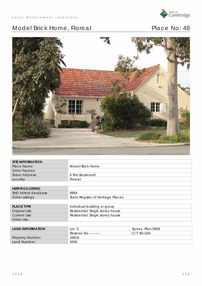
L o c a l G o v e r n m e n t I n v e n t o r y
2 0 1 8 2 5 8
Model Brick Home, Floreat Place No: 48
SITE INFORMATION Place Name: Model Brick Home Other Names: Street Address: 6 The Boulevard Locality Floreat HERITAGE LISTING SHO inHerit database 8894 Other Listings State Register of Heritage Places PLACE TYPE Individual building or group Original Use: Residential: Single storey house Current Use: Residential: Single storey house Other Use: LAND INFORMATION Lot: 3 Survey: Plan 5659 Reserve No: --------- C/T: 90-10A Property Number: 16916 Land Number: 5595

L o c a l G o v e r n m e n t I n v e n t o r y
2 0 1 8 2 5 9
CONSTRUCTION DETAILS Construction Date: 1934 Walls: Brick: common Roof: Tile: terracotta Architectural Style: Inter-war Californian Bungalow Physical Description: Model Brick Home located at 6 The Boulevard Floreat, comprises a single storey, rendered brick and tile residence which, together with the Model Timber Home located at 12 The Boulevard Floreat, was one of the first two homes constructed in Floreat Park No 1 Estate, a residential subdivision designed on the principles of a Garden Suburb. Model Brick Home is located on The Boulevard, one of the major roads in Floreat. Adjacent homes are of similar age, proportions and style, and apart from Model Timber Home, are brick or rendered brick and tile. All houses are of approximately equal setback with landscaped front gardens and an avenue of mature street trees. At the rear of the property, a gate from the back garden opens onto a laneway which accesses an area of public open space. This area, which has no street frontage, is landscaped with trees and shrubs and provides an additional recreational area for the houses which back onto it. Two grassed laneways access Selby Street. Model Brick Home is sited on a rectangular residential lot. The front elevation of the house is set back approximately 7.5m from the front boundary and located towards the eastern side of the lot, with a driveway down the western side of the house to the garage at the rear. There is a curved entrance driveway at the front of the house on the western side. The front garden area on the eastern side features a concrete slab retaining wall which separates the driveway from the garden. The house comprises the original section constructed in 1933 and additions constructed in 1995. The extension has been designed to complement the original in terms of roof pitch, materials and finish and is

L o c a l G o v e r n m e n t I n v e n t o r y
2 0 1 8 2 6 0
not visible from the street. External fabric of Model Brick Home features painted rendered masonry walls on limestone footings. The roof is steeply pitched (approximately 45º) and gabled with a prominent gabled wall to the front elevation with a rectangular timber vent at the apex. This wall extends in a prominent curve beyond the edge of the house to the eastern site boundary. There is a rendered banded detail to the top edge of the curved wall. An arched opening in the eastern side of the front elevation provides access to the side of the house through a timber garden gate. The roof is clad with terracotta tiles. Square profile gutters and downpipes are not original and the original chimney has been removed. There is an open terrace with low walls at the front of the house accessed by five front steps. The terrace and steps are clad with slate which is not original. Two timber pergolas which have been constructed over the front verandah are not original. The original foundation stone is extant on the front wall of the house. Original windows are timber framed six paned casements with timber mullions. The front door is timber with an elaborate diamond panel in the centre and original brass door handle. The French doors to the front terrace have aluminium frames and are not original. The same roof line and wall details have been continued for the 1995 extension. There have been no significant alterations to the place since the 1995 additions. Condition: Good Integrity: High Authenticity: High
HISTORICAL INFORMATION Historical Notes: In the nineteenth century the area to the north west of Perth known as the Large Lakes District was sparsely settled for agricultural purposes. The area currently known as Floreat comprised Locations Ak, to the west, and Al, in which Model Brick Home and Model Timber Home is currently located. Henry Trigg, builder and businessman acquired approximately 800 acres of this land and established a quarrying and lime burning enterprise on the property. In 1844 the property, known as the Limekilns Estate, was purchased by Walter Padbury and in 1869, the Limekilns Estate was sold to Henry and Somers Birch in for £1,000 and in 1880 to Joseph Perry for £1,950. The limekilns operated throughout the 1880s and 1890s and, until their closure in 1906, provided building materials for the developing residential areas of Subiaco and Leederville.
The area between the Limekilns Estate and the coast remained crown land until 1855 when it was proclaimed the Endowment Lands. The Endowment Lands were originally part of the Perth Commonage, a large area bounded by the coast and extending from North Fremantle to north of Herdsman Lake. The purpose of the land was to provide income for municipal works through payment for use of the land for timber and stone. The Endowment Lands were vested in the Perth City Council in 1883, who were empowered to lease the land for a maximum of ten years.
Settlement in the area between the City of Perth and the Limekilns Estate (present day West Leederville and Wembley) developed outwards from the city in a westerly direction in the period from the late nineteenth century to World War One.
In 1917, the Limekilns Estate, which by this time comprised 1,290 acres (522 hectares), was purchased from Joseph Perry by the City of Perth for £18,000. This gave the City of Perth control of a continuous area of land from the city to the coast. The City of Perth Endowment Lands Act of 1920 enabled the City of Perth to develop and sell the previously allocated land.
From the early 1900s, there had been proposals to construct a beach resort for city dwellers in the vicinity of present day City Beach. The emphasis, however, on development in this area differed from earlier development patterns, which had been dominated by speculation in land values with pressure exerted by private speculators. In the 1920s, the focus was put on the planning process with control exerted over road layout, proportion of open space, gardens and community service. The proponent for this was influential City of Perth Town Clerk, W. E. Bold.
Bold was one of the State’s leading exponents of the Garden City Movement which had a direct influence on the planning of Floreat Park and City Beach. The United Kingdom's Housing and Planning Act of 1909 was

L o c a l G o v e r n m e n t I n v e n t o r y
2 0 1 8 2 6 1
recognition of the development of the discipline of Town Planning, which emerged as an outcome of the Garden Cities Movement in the early 1900s. The Garden Cities Movement developed in the UK in response to necessary improvements to residential amenities for workers in nineteenth century industrial cities.
In 1910, the Royal Institute of British Architects held an inaugural Town Planning Conference in London. Copies of papers given at the conference were received in Perth together with a proposal that a lecture series be conducted in Australia by representatives of the Garden Cities and Town Planning Association. The issue was promoted by W E Bold and, in 1914, lectures were presented in Perth, Fremantle and Boulder by W R Davridge of the London County Council. Subsequently the first Australian Town Planning Conference and Exhibition was held in Adelaide in October 1917.
These ideas influenced Bold to promote the development of two satellite towns in the area west of Selby Street to be separated by a belt of undeveloped land. In 1925, the Perth City Council set aside the area known as Bold Park for this purpose. The area originally included Reabold Hill, Perry Lakes and the Wembley Golf Course.
In 1925, the City of Perth commissioned Land Surveyors Hope and Klem to design two town sites, one located on the former Endowment Lands and the other on the eastern side of the former Limekilns Estate. The result was two plans with extensive use of curved roads. The eventual subdivisions, however, were modifications of the Hope and Klem designs. A direct outcome of the scheme was the construction of the Boulevard as an extension of Cambridge Street, from Selby Street, through the new area to the coast. The Boulevard was officially opened by Governor Sir William Campion on 23 November 1928. The sale of land in City Beach commenced in early 1929.
By the late 1920s, the effects of the international economic depression were felt by Western Australia's building industry. In order to promote renewed confidence in home building, the industry established a Building Revival Committee which had widespread support from local government, industry and the professionals. The committee proposed the construction of two model homes, one of brick and one of timber, as a means of focusing attention on the advantages of home construction. It aimed to demonstrate to the public the extent to which labour was employed and the widespread dispersal of wages which would result from home building; thus revitalising the building industry and economy in general.
As a result the Model Homes Committee of the Building Revival Campaign was formed with representatives from the RIA, Master Builders and Contractors Association, Brick Manufacturers, Sawmillers Association, Economic Council, Hardware Association and the Perth sub-branch of Returned Services League (RSL). The committee hoped that material and labour would be donated, and it was decided that all profits would be used to provide relief from unemployment, particularly for youths.
In the West Australian of 30 August 1933, the Secretary of the RIA, Mr. Reg Summerhayes, called for competitive designs for the houses with the commitment that the Institute would reimburse the winners for the preparation of drawings, specifications and architectural supervision. The houses were to be economical examples of ideal modern homes; the one of brick to cost no more than £850, and the one of timber to cost no more than £600. By the second meeting of the Model Homes Committee on 31 August 1933, the Perth City Council had agreed to donate two blocks of land in the satellite suburb of Floreat Park surveyed several years before. Although the Committee had twelve other blocks from which to choose, it selected the City of Perth offer.
The winning designs were selected in the first week of November 1933. The winning entry for the brick home was by architect H. Howard Bonner. Explaining the salient features of his plan, Mr. H. Howard Bonner said;
"…. that he planned the accommodation so as to segregate the living, sleeping and cooking portions of the house into separate units. Access from the kitchen to the front door was given without passing through any room. Each bedroom was situated next to the bathroom. The service to the dining room from the kitchen through the servery should be quick and efficient and at the same time prevent cooking odours from the kitchen permeating the dining room. In case meals were served on the terrace a door leading from the kitchen to the terrace was provided. Entrance to the front door was gained from a small flagged court with a flower bed as a central feature and the sleeping-out verandah was accessible from both bedrooms. The living-room opened out onto a flagged terrace topped by a pergola. Built-in features included a seat and writing desk in the living-room and shelves for silver and crockery in the servery. In the kitchen there were cupboards over and under the draining board and a tradesman's hatch in a handy position. A hinged board over the trough in the laundry provided an ironing table. The layout of the land, he continued, provided for a separate service yard, screened off from the house by hedges, paved paths

L o c a l G o v e r n m e n t I n v e n t o r y
2 0 1 8 2 6 2
enclosed by hedges on the other side leading respectively to a central pool enclosed by a garden, and a small summer house and garden seat."
Messrs. H. W. Ennis and H. Pilgrim were nominated by the Master Builders and Contractors' Association to undertake the work of supervising construction, in cooperation with the architects.
Materials and labour for the model homes, including shrubs for the gardens, were all donated. This was also extended to include the remission of sales tax on donations, and the Commissioner of Railways transported bricks over the government lines free of freight charge. The ceremony to lay the foundation stones (also donated) was held on Sunday 5 November 1933. The Lord Mayor of Perth, MR J T Franklin, officiated at the ceremony. Lieutenant Governor Sir James Mitchell and the Minister for Employment Mr. J. J. Kenneally laid the stones for the brick and timber houses respectively.
Both model homes were opened at ceremonies held on 1 April 1934, again by the Lieutenant Governor and the Hon. J. J. Kenneally. The brick home was furnished, but the timber home was not. After the ceremony, the houses were opened to the public on various days, with afternoon tea provided by the Children's Hospital Women's Auxiliary.
During the promotion of the model homes, land in the Floreat Park area was advertised for sale and development of the area soon commenced. In the first land auction held at Floreat Park on 14 April 1934, blocks sold for between £45 and £75.
Model Brick Home and land was bought from the City of Perth by Arthur Reginald Wright, salesman, on 12 September 1934. The ownership of the property changed hands a number of times since this original purchase.
Alterations to Model Brick Home were carried out in 1951. These comprised construction of a room 14ft (4.26m) x 8 ft. (2.43m) on the north western side of the building, and a concrete driveway with a carport in front of an existing garage on the western side of the property. Further additions were carried out in 1995/96. These included the rear addition of a family room, two bedrooms, laundry, bathroom and terrace, as well as the replacement of the earlier garage and carport with a garden shed/workshop and garage. The 1951 extension was removed at this time.
The current owner provided information in 2018 that the internal and external condition of the place has deteriorated in recent years largely through water ingress.
Historic Theme: Demographic settlement and mobility: Land allocation and subdivision Demographic settlement and mobility: Depression and boom Occupations: domestic activities
Associations: William Ernest Bold Howard Bonner
Sources: Aerial photographs, 1953-2016, Landgate. Town of Cambridge Municipal Heritage Inventory and Townscape Precinct Study prepared for the Town of Cambridge, June 1997. Assessment Documentation for Place 8894 Model Brick Home for its inclusion in the State Register of Heritage Places, 2001. Information from current [2018] owner
SIGNIFICANCE Statement of Significance: The following statement is taken from the State Register Entry for Place
8894 Model Brick Home prepared in 2001 by the State Heritage Office. Model Brick Home, a single-storey brick and tile residence in a simplified version of the Inter-War Old English style set in landscaped gardens and built as a model home in 1934, has cultural heritage significance for the following reasons: • the place was one of two winning designs in the competition run by
the Model Homes Committee as part of the Building Revival Campaign, an initiative to promote and stimulate employment in the home building industry during the economic depression of the 1930s;

L o c a l G o v e r n m e n t I n v e n t o r y
2 0 1 8 2 6 3
• designed by architect Howard Bonner, the place is a fine example of an architect designed home from the inter-war period, exhibiting their influence of a simplified form of the Inter-War Old English architectural style characterised by the dominant steeply pitched gabled roof and distinctive curved line of the front elevation; and
• the place was one of the first two homes built in the Floreat Park No. 1 Estate, which was planned as a Garden Suburb by the City of Perth under the influence of Town Clerk, W. E. Bold, who promoted the principles of the Garden City Movement in Western Australia in the 1920s and 30s.
Level of Significance: Exceptional Essential to the heritage of the locality. Rare or outstanding example. Recommended for inclusion on the State Register of Heritage Places.
Management Category: Category 1 The place should be retained and conserved unless there is no feasible and prudent alternative to doing otherwise. Any alterations or extensions should reinforce the significance of the place, and be in accordance with a Conservation Plan (if one exists for the place). Include on the Town Planning Scheme No 1 Heritage List.
ADDITIONAL PHOTOGRAPHS
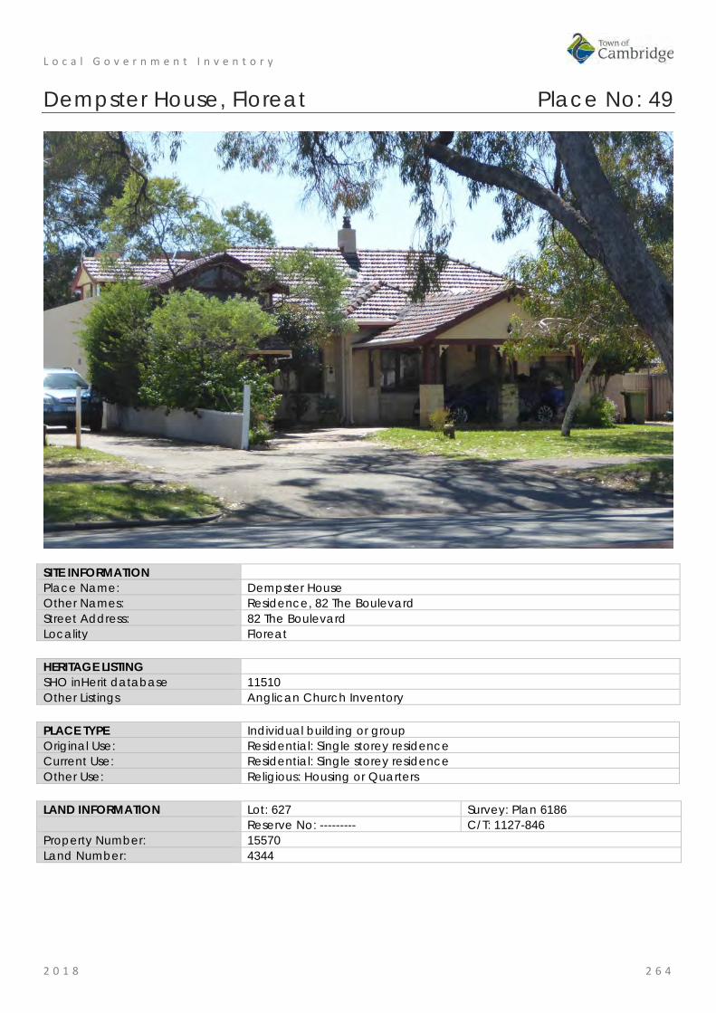
L o c a l G o v e r n m e n t I n v e n t o r y
2 0 1 8 2 6 4
Dempster House, Floreat Place No: 49
SITE INFORMATION Place Name: Dempster House Other Names: Residence, 82 The Boulevard Street Address: 82 The Boulevard Locality Floreat HERITAGE LISTING SHO inHerit database 11510 Other Listings Anglican Church Inventory PLACE TYPE Individual building or group Original Use: Residential: Single storey residence Current Use: Residential: Single storey residence Other Use: Religious: Housing or Quarters LAND INFORMATION Lot: 627 Survey: Plan 6186 Reserve No: --------- C/T: 1127-846 Property Number: 15570 Land Number: 4344

L o c a l G o v e r n m e n t I n v e n t o r y
2 0 1 8 2 6 5
CONSTRUCTION DETAILS Construction Date: 1950s; 1990s Walls: Brick: Common Roof: Tile: Terracotta Architectural Style: Post War Physical Description: The place is a single storey dwelling that has undergone some alteration to the façade which has impacted on the authenticity and presentation of the place. The house is of brick, render and tile construction with an asymmetrical plan form to the façade. The central projecting bay has been extended to provide an increased covered entrance and two storey parking and accommodation element has been constructed to the western side of the façade. The house is set behind lawned gardens with additional plantings. Condition: Good Integrity: High Authenticity: Moderate
HISTORICAL INFORMATION Historical Notes: Dempster House was built in the late 1950s as the aerial photographs for late 1953 show no evidence of the building and the style of the residence is consistent with this period. It is not known if this place was built by the Wembley Parish or was acquired later for its use. The origin of the name 'Dempster House' is not known.

L o c a l G o v e r n m e n t I n v e n t o r y
2 0 1 8 2 6 6
The Anglican Parish of St Nicholas (Floreat Park) was initially part of the St Edmunds (Wembley) Parish and became a parish in its own right in 1972. At first, people from the Floreat area worshipped in the local tennis club. The congregation later gathered in the first church hall which was on the adjacent site (HN84-86 The Boulevard) in 1953. The church hall building project was organised by Rev Jack Watts, the Rector of the Wembley Parish. It is noted that Jack Watts and his wife lived in Pangbourne Street Wembley in the 1950s and 1960s.
It is possible that this residence was acquired when the new parish was created in 1972 and used by the Floreat Parish priest. With the construction of the new parish hall in 1998/9, this property was sold to a private owner.
Photographs of the building in 1996 show the place was originally face brick work. The current rendered finish appears to date from the late 1990s when it was transferred to the current owner.
Historic Theme: Occupations: Domestic activities Social and Civic Activities: Religion
Associations: Rev Jack Arthur Cecil Watts Sources: Aerial photographs, 1953-2016, Landgate.
St Nicholas' Anglican Church Floreat Park website, http://floreat.perth.anglican.org accessed September 2017. Cambridge Notes, Cambridge Local Studies Centre, Item T265.
SIGNIFICANCE Statement of Significance: • The place has some aesthetic value as a largely intact example of
the post war International style executed in brick and tile. • The place has historic value for its association with the establishment
and development of the Anglican Church in the district in the period following World War Two.
• The place has social value for members of the community who have attended the premises in its role with the Anglican Community and for its continuity in the streetscape.
Level of Significance: Little Contributes to the understanding of the history of the Town of Cambridge.
Management Category: Category 4 Photographically record prior to major development or demolition. Recognise and interpret the site if possible. Do not include on the Town Planning Scheme No 1 Heritage List.
ADDITIONAL PHOTOGRAPHS

L o c a l G o v e r n m e n t I n v e n t o r y
2 0 1 8 2 6 7
St Nicholas' Church Hall, Floreat Place No: 50
SITE INFORMATION Place Name: St Nicholas' Church Hall Other Names: Street Address: 84 The Boulevard Locality Floreat HERITAGE LISTING SHO inHerit database 11507 Other Listings Anglican Church Inventory PLACE TYPE Historic site Original Use: Religious: Church Hall Current Use: Religious: Church Hall Other Use: LAND INFORMATION Lot: 11 Survey: Diagram 97372 Reserve No: --------- C/T: 2156-760 Property Number: 15568 Land Number: 4341
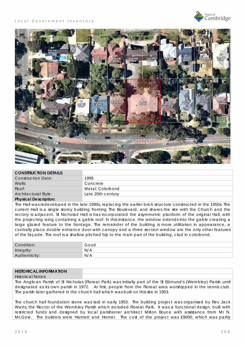
L o c a l G o v e r n m e n t I n v e n t o r y
2 0 1 8 2 6 8
CONSTRUCTION DETAILS Construction Date: 1999 Walls: Concrete Roof: Metal: Colorbond Architectural Style: Late 20th century Physical Description: The Hall was redeveloped in the late 1990s, replacing the earlier brick structure constructed in the 1950s. The current Hall is a single storey building fronting The Boulevard, and shares the site with the Church and the rectory is adjacent. St Nicholas' Hall is has incorporated the asymmetric planform of the original Hall, with the projecting wing containing a gable roof. In this instance, the window extends into the gable creating a large glazed feature to the frontage. The remainder of the building is more utilitarian in appearance, a centrally place double entrance door with canopy and a three section window are the only other features of the façade. The roof is a shallow pitched hip to the main part of the building, clad in colorbond. Condition: Good Integrity: N/A Authenticity: N/A
HISTORICAL INFORMATION Historical Notes: The Anglican Parish of St Nicholas (Floreat Park) was initially part of the St Edmund's (Wembley) Parish until designated as its own parish in 1972. At first, people from the Floreat area worshipped in the tennis club. The parish later gathered in the church hall which was built on this site in 1953. The church hall foundation stone was laid in early 1953. The building project was organised by Rev Jack Watts, the Rector of the Wembley Parish which included Floreat Park. It was a functional design, built with restricted funds and designed by local parishioner architect Milton Boyce with assistance from Mr N. McGow. The builders were Harnett and Horner. The cost of the project was £9000, which was partly

L o c a l G o v e r n m e n t I n v e n t o r y
2 0 1 8 2 6 9
covered by a loan from the Diocesan Trustees for £5,500 and a gift from the Church Office of £1,500. The remaining £2,000 was fund raised by the local parishioners. On 6 December 1953, the completed St Nicholas Church Hall was consecrated by Archbishop Moline. The name was chosen by a small committee of ladies led by Mrs Carter and honours St Nicholas the patron saint of children. Fund raising to build a church in this developing parish began in the 1950s and the new church, St Nicholas' was completed just prior to the 1962 British Empire and Commonwealth Games. The church hall continued to provide a service to the community until it was no longer viable and the new building was opened in 1999. Dempster House located on the adjoining lot 82 The Boulevard and was used as the rectory for the parish. The three buildings have continued to provided a service to the community since the mid 20th century. Historic Theme: Social and Civic Activities: Religion Associations: Milton Boyce
Rev Jack Watts Harnett and Horner
Sources: Aerial photographs, 1953-2016, Landgate. St Nicholas' Anglican Church Floreat Park website, http://floreat.perth.anglican.org accessed September 2017. Cambridge Notes, Cambridge Local Studies Centre, Item T265.
SIGNIFICANCE Statement of Significance: • The site has historic value for its association with the first building
constructed in the Wembley Parish by the Anglican Community. • The site has social value for the community as the place continues
to be used as a church hall which has been ongoing since 1953 Level of Significance: Historic Site
Site relevant to a past event, group or individual which contributes to the understanding of the history of the Town of Cambridge.
Management Category: Category 5 Recognise and interpret the site if possible. Do not include on the Town Planning Scheme No 1 Heritage List.
ADDITIONAL PHOTOGRAPHS

L o c a l G o v e r n m e n t I n v e n t o r y
2 0 1 8 2 7 0
Henderson Park, Jolimont Place No: 51
SITE INFORMATION Place Name: Henderson Park Other Names: Leederville Endowment Lands Street Address: 99 Jersey Street Locality Jolimont HERITAGE LISTING SHO inHerit database 8888 Other Listings PLACE TYPE Urban Park Original Use: Current Use: Park/Reserve Other Use: LAND INFORMATION Lot: 9000 Survey: Plan 404549, Deposited
Plan 70583 Reserve No: ------- C/T: 2890-8 Property Number: 10694 Land Number: 14823
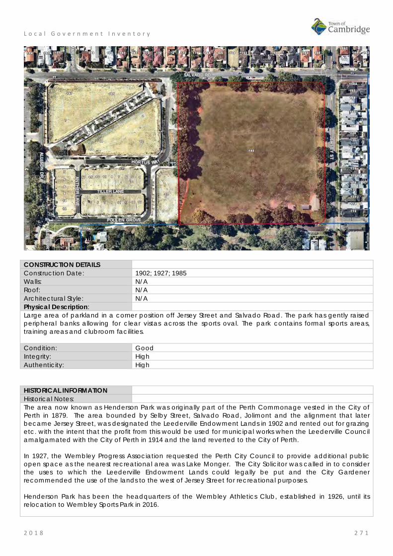
L o c a l G o v e r n m e n t I n v e n t o r y
2 0 1 8 2 7 1
CONSTRUCTION DETAILS Construction Date: 1902; 1927; 1985 Walls: N/A Roof: N/A Architectural Style: N/A Physical Description: Large area of parkland in a corner position off Jersey Street and Salvado Road. The park has gently raised peripheral banks allowing for clear vistas across the sports oval. The park contains formal sports areas, training areas and clubroom facilities. Condition: Good Integrity: High Authenticity: High
HISTORICAL INFORMATION Historical Notes: The area now known as Henderson Park was originally part of the Perth Commonage vested in the City of Perth in 1879. The area bounded by Selby Street, Salvado Road, Jolimont and the alignment that later became Jersey Street, was designated the Leederville Endowment Lands in 1902 and rented out for grazing etc. with the intent that the profit from this would be used for municipal works when the Leederville Council amalgamated with the City of Perth in 1914 and the land reverted to the City of Perth. In 1927, the Wembley Progress Association requested the Perth City Council to provide additional public open space as the nearest recreational area was Lake Monger. The City Solicitor was called in to consider the uses to which the Leederville Endowment Lands could legally be put and the City Gardener recommended the use of the lands to the west of Jersey Street for recreational purposes. Henderson Park has been the headquarters of the Wembley Athletics Club, established in 1926, until its relocation to Wembley Sports Park in 2016.

L o c a l G o v e r n m e n t I n v e n t o r y
2 0 1 8 2 7 2
Henderson Park was named in recognition of Hugh Murray Henderson (c1882-1970) a Perth City Councillor, Builder and official of the Wembley Athletics Club. Henderson established 'Henderson Homes' a local building company with many local employees, originally located on Cambridge Street near the corner of Corboy Street, which relocated to 9 Bishop Street Jolimont after World War II. Hugh Henderson had many sporting interests which he supported personally and professionally. He helped to establish and build the Wembley Golf Course, assisted in the construction of the City of Perth and Scarborough Surf Clubs and was Vice-President of the West Perth Football Club. The section of Jersey Street adjacent to Henderson Park, linking Jolimont and Wembley was constructed at the same time and gazetted in 1928. It is probable that the trees on the perimeter of the park were planted at this time. Henderson Park has continued to be used for a variety of sports since its establishment. Currently the lawn area is used for AFL, cricket, baseball, soccer and other team sports. Picnic and barbecue facilities and children's play equipment are also present at the park. Historic Theme: Social and Civic Themes: Sport, recreation and entertainment Associations: Hugh Murray Henderson Sources: Aerial photographs, 1953-2016, Landgate.
Town of Cambridge Municipal Heritage Inventory and Townscape Precinct Study prepared for the Town of Cambridge, June 1997. The Mirror, 4 March 1933, p. 10. Henderson Park, description, Town of Cambridge website, www.cambridge.wa.gov.au Information from community submission, September 2018.
SIGNIFICANCE Statement of Significance: • The park has aesthetic value as a well maintained landscaped park
in a largely built up environment which features a group of mature trees
• The place has historic value for its association with the early 20th century in which this area was used for agricultural purposes as demonstrated by the decision to allocate this land for grazing.
• The place has historic value for its association with the establishment and growth of the Wembley district in the Inter War period when this land was set aside for recreational purposes
• The place has social value for the many members of the community who have attended organised and informal events at the park, in addition to the many passive recreation users.
Level of Significance: Considerable Very important to the heritage of the locality. High degree of integrity/authenticity
Management Category: Category 2 Conservation of the place is highly desirable. Any alterations or extensions should reinforce the significance of the place Include on the Town Planning Scheme No 1 Heritage List.

L o c a l G o v e r n m e n t I n v e n t o r y
2 0 1 8 2 7 3
ADDITIONAL PHOTOGRAPHS

L o c a l G o v e r n m e n t I n v e n t o r y
2 0 1 8 2 7 4
Matthews Netball Centre, Jolimont Place No: 52
SITE INFORMATION Place Name: Matthews Netball Centre Other Names: Wembley Sports Park; M556 Street Address: 199 Salvado Road Locality Jolimont HERITAGE LISTING SHO inHerit database 1613 Other Listings PLACE TYPE Urban Park Original Use: Social/Recreational: Sports ground Current Use: Social/Recreational: Sports ground Other Use: LAND INFORMATION Lot: 9000 Survey: Plan 404549, Plan 73717 Reserve No: C/T: 2890-8 Property Number: 11659 Land Number: 14729

L o c a l G o v e r n m e n t I n v e n t o r y
2 0 1 8 2 7 5
CONSTRUCTION DETAILS Construction Date: 1961; 2011-14 Walls: N/A Roof: N/A Architectural Style: N/A Physical Description: The Matthews Netball Centre has been home to netball since 1961 however the original building no longer exists. This site is now the location of the State Netball Centre, managed by the State Government and the Matthews Netball Centre owned and managed by the Town of Cambridge. The two new facilities were constructed in 2013. Condition: Good Integrity: High Authenticity: High
HISTORICAL INFORMATION Historical Notes: The beginning of netball (known as Women’s Basketball until 1970) was initiated in WA through the YWCA, under the leadership of Miss Marjorie Black in 1924.
Maude Matthews, President of the Western Australia Women’s Basket Ball Association (WAWBBA) from 1939-1942 and 1945-1962, worked closely with the Western Australian Government and Councillors from the Perth

L o c a l G o v e r n m e n t I n v e n t o r y
2 0 1 8 2 7 6
City Council to set aside this site bounded by Salvado Road and Selby Street for the establishment of a netball centre. The venue was subsequently named the ‘Matthews Basketball Centre’ in honour of her contribution.
The first building was erected on the site in 1961 together with the provision of four hard stand courts and 46 grass courts and was officially opened in April of that year. The Centre became known as the ‘most outstanding’ Netball Centre in the Southern Hemisphere.
In 1961 all teams in the metropolitan area played under the banner of Western Australian Basketball Association as there were no other metropolitan associations. With the inception of the Matthews’ Centre it was also possible to ‘house’ the staff of the State Body in one building to supervise and oversee all matches from the one location.
In 1967 the Centre was host to the 1967 World Women's Basketball Tournament, and at the same time hosted the 1967 Australian National Titles.
In 1971 ‘basketball’ was changed to ‘netball’ to bring Australia and New Zealand in line with the rest of the world. With the change in the sport’s name, the name of the centre was also changed to Matthews Netball Centre.
As the numbers of netballers grew many other metropolitan associations came into operation as Matthews could not possibly take the number of teams wanting to participate. Associations including Fremantle, Midland, Southern Districts and Wanneroo came into force and are still in operation today.
In 1990 the State Body left the Matthews’ Netball Centre to establish its headquarters away from any domestic competition, moving to various sites over time (until moving back again into its own building in 2015). At this time a strong group of volunteers met and formed the Perth Netball Association (Inc.) who continue to organise netball at the Matthews’ Netball Centre.
After working with the Perth City Council for many years the centre came under the jurisdiction of the Town of Cambridge in 1994.
In 2011, the Town of Cambridge endorsed the Wembley Sports Park Master Plan and work commenced on redevelopment of the site. The redevelopment consisted of the construction of a two new facilities, the State Netball Centre for the State Government and the Matthews Netball Centre for the Town of Cambridge. The building was finished and opened in 2013 and in addition to the undercover courts, provides offices a canteen for competition days, change rooms and storage space for clubs, and rooms for first aid and training courses. Currently [2018] Matthews Netball Centre has 48 courts.
Historic Theme: Social and Civic Activities: Sport, recreation and entertainment
People: local heroes and battlers Social and Civic Activities: Community services and utilities
Associations: Maude Matthews Sources: Aerial photographs, 1953-2016, Landgate.
Netball WA website, www.wa.netball.com.au Perth Netball Association website, www.perthnetball.com.au
SIGNIFICANCE Statement of Significance: • The place has historic value for its association with the development
of netball, formerly Women's basketball, in the 1950s and 1960s from an amateur sport to its current status as a well organised professional sports organisation.
• The place has historic value for its association with the development of Jolimont in the 1960s which was sparsely settled in the mid 20th century when land was set aside for the sports grounds.
• The place has historic value as the location of the second World Netball Championships in August 1967 which demonstrated the international recognition of Western Australia as a venue for sports at the highest level since the 1962 Empire Games.
• The place has historic value for its association with Maude Matthews

L o c a l G o v e r n m e n t I n v e n t o r y
2 0 1 8 2 7 7
who was President of the Women's Basketball Association when these courts were established in 1961. Her contribution is recognised in the naming of the courts in her honour.
• The place has social value for the many members of the community who have attended the place since 1961 as players, spectators or officials. The widespread popularity of the game has meant a significant portion of the Perth and wider Western Australian community have visited this place.
Level of Significance: Some/moderate Contributes to the historic value of the locality. Has no original elements.
Management Category: Category 3 Conservation of the place is desirable. Any alterations or extensions should reinforce the significance of the place, and original fabric should be retained wherever feasible. Include on the Town Planning Scheme No 1 Heritage List.
ADDITIONAL PHOTOGRAPHS
Matthews Netball Centre, 1964, State Library 006957d
Netball World championships 1967 opening ceremony, State Library image 261,046PD

L o c a l G o v e r n m e n t I n v e n t o r y
2 0 1 8 2 7 8
St John of God Hospital, Subiaco Place No: 53
SITE INFORMATION Place Name: St John of God Hospital Other Names: St John of God Convent Street Address: 12 Salvado Road
1-19 McCourt Street Locality Subiaco HERITAGE LISTING SHO inHerit database 2228 Other Listings Register of the National Estate
national Trust of Australia (Classified) PLACE TYPE Individual building or group Original Use: Religious: Convent Current Use: Health: Hospital Other Use: Health: Administration LAND INFORMATION Lot: 800; 2 Survey: D64642; P411840 Reserve No: --------- C/T: 2929/331; 1705/333 Property Number: 21550; 22465; 18669 Land Number: 15480; 1548; 7213
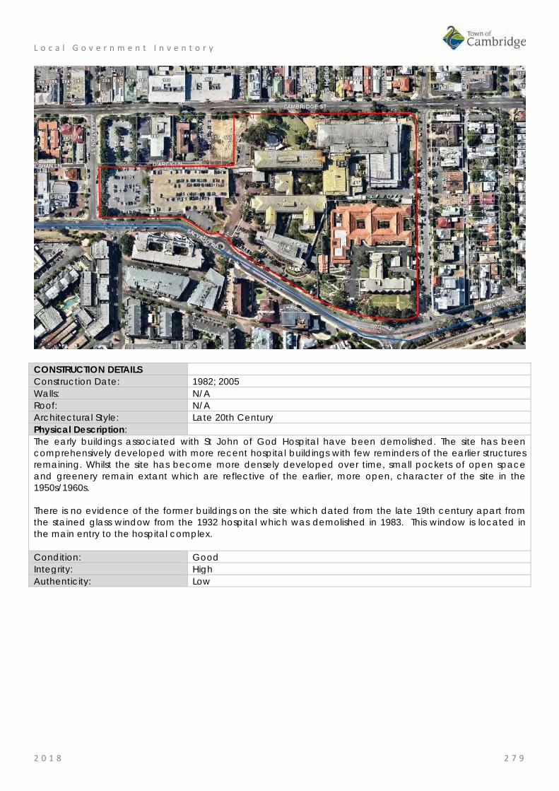
L o c a l G o v e r n m e n t I n v e n t o r y
2 0 1 8 2 7 9
CONSTRUCTION DETAILS Construction Date: 1982; 2005 Walls: N/A Roof: N/A Architectural Style: Late 20th Century Physical Description: The early buildings associated with St John of God Hospital have been demolished. The site has been comprehensively developed with more recent hospital buildings with few reminders of the earlier structures remaining. Whilst the site has become more densely developed over time, small pockets of open space and greenery remain extant which are reflective of the earlier, more open, character of the site in the 1950s/1960s. There is no evidence of the former buildings on the site which dated from the late 19th century apart from the stained glass window from the 1932 hospital which was demolished in 1983. This window is located in the main entry to the hospital complex. Condition: Good Integrity: High Authenticity: Low

L o c a l G o v e r n m e n t I n v e n t o r y
2 0 1 8 2 8 0
HISTORICAL INFORMATION Historical Notes: The Congregation of the Sisters of St John of God was founded in Wexford, Ireland, in 1871. Inspired by the work of their patron saint work, St John of God, they nursed those in poverty. As the Congregation of the Sisters of St John of God expanded, Bishop Matthew Gibney of Perth invited the Sisters to Western Australia to help care for the sick. The first group of eight Sisters arrived in Perth in late 1895 and began visiting the sick in their homes and established a convent hospital. Within two years, they were also running hospitals on the Eastern Goldfields at Coolgardie (1896-1898) and Kalgoorlie (1897). In 1898, the Sisters opened a convent, hospital and school in the Perth suburb of Subiaco on the 7 acre parcel of land. The Sisters also established a number of schools at this time and over the following decades hospitals in Western Australia, Victoria and New South Wales. Since its foundation, St John of God Hospital in Subiaco has undergone many changes. Buildings have been constructed and demolished as requirements and standards have changed. The buildings on the site date from the 1980s. From 1962, when a new 85 bed maternity hospital was built, the hospital has been the leading private maternity hospital. During the 1970s and 1980s, the hospital established its prestigious surgical and medical teaching units and undertook a major rebuild. The hospital continues to be a leading teaching and research facility in Western Australia. The only element retained from a former buildings is a stained glass window from the 1932 hospital (demolished 1983) which was originally located at the top of a marble staircase. This window was dedicated to Dr Jeremiah McCauliffe SJG (c1862-1922) in 1933. When the building was demolished it was relocated to the Blessed Sacrament Chapel until this building was demolished in 2005 and the window is now located at the undercover entry to the hospital. On the relocation of the window it was rededicated to all members of the McAuliffe family by Fr Dado Haber OSCam on 7th October 2006. St John of God Health Care was formed in 1989 when nine hospitals and other services of the Sisters of St John of God in Western Australia, Victoria and New South Wales were brought together as a single entity. St John of God Hospital Subiaco provides medical services to a large sector of the community and is a significant employer of medical and support staff. Historic Theme: Social and Civic Activities: Religion
Social and civic activities: Community services and utilities Social and Civic activities: Education and science
Associations: Sources: St John of God Hospital Subiaco website, https://www.sjog.org.au/our-
locations/st-john-of-god-subiaco-hospital/about/history Aerial photographs, 1953-2016, Landgate. Town of Cambridge Municipal Heritage Inventory and Townscape Precinct Study prepared for the Town of Cambridge, June 1997
SIGNIFICANCE Statement of Significance: • The place has historic value for its association with the provision of
medical services at this site for the Western Australian community since 1898.
• The place has historic value as the first permanent facility established by the Sisters of St John of God in Australia.
• The place has social value to the Western Australian community as it has been the location of medical services which impact on the lives of many individuals, families and groups.
• St John of God Hospital, Subiaco has social value as a large employer of a diverse range of people who come together daily to provide services and in doing so generate a rich community at this place.
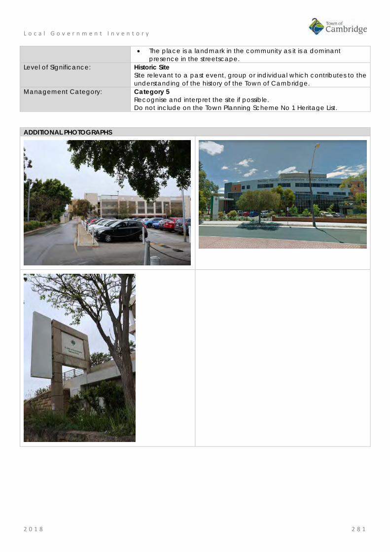
L o c a l G o v e r n m e n t I n v e n t o r y
2 0 1 8 2 8 1
• The place is a landmark in the community as it is a dominant presence in the streetscape.
Level of Significance: Historic Site Site relevant to a past event, group or individual which contributes to the understanding of the history of the Town of Cambridge.
Management Category: Category 5 Recognise and interpret the site if possible. Do not include on the Town Planning Scheme No 1 Heritage List.
ADDITIONAL PHOTOGRAPHS

L o c a l G o v e r n m e n t I n v e n t o r y
2 0 1 8 2 8 2
Catherine McAuley Centre, Wembley Place No: 54
SITE INFORMATION Place Name: Catherine McAuley Centre Other Names: New Subiaco, Benedictine Monastery, St Vincent's, Orphanage &
Foundling Home, St Joseph's Orphanage Catherine McCauley Family Centre MercyCare
Street Address: 18 Barrett Street Locality Wembley HERITAGE LISTING SHO inHerit database 2231 Other Listings State Register of Heritage Places
Register of the National Estate National Trust of Australia (Classified)
PLACE TYPE Individual building or group Original Use: Religious: other Current Use: Educational: Pre Primary centre Other Use: Residential: Institutional housing LAND INFORMATION Lot: 100 Survey: Diagram 97244 Reserve No: ------- C/T: 2160-511 Property Number: 18615 Land Number: 7164

L o c a l G o v e r n m e n t I n v e n t o r y
2 0 1 8 2 8 3
CONSTRUCTION DETAILS Construction Date: c1858; 1890s; 1893; 1910; 1914; 1918; 1925; 1928; 1950s; 1979; 1994; 1990s; Walls: Brick: common Roof: Tile: terracotta Architectural Style: Physical Description: The Catherine McCauley Centre is an elevated site in Wembley containing aged care facilities, children’s welfare facilities and disability services. The site contains a mix of purpose built accommodation and facilities as well as the historic buildings that formed part of the early occupation of the site. Together with the more contemporary developments on the site, the Catherine McCauley forms a precinct of structures and landscape elements developed by the Sisters of Mercy for religious and social welfare purposes. The main vehicular access to the services part of the site is from Barrett Street with additional access to the residential component from Ruislip Street. The site is a mix of buildings, hard landscaping/parking and soft landscaping with trees, other plantings and lawned areas. The historic elements of the site comprise:
• Former Benedictine stables • Olive Trees • Remnants of Cemetery • Old School building • St Rich's • Former Laundry building • St Vincent’s Foundling Home (fmr) • Kindergarten building • Nursery building • St Gerard’s Hospital
L o c a l G o v e r n m e n t I n v e n t o r y
2 0 1 8 2 8 4
Condition: Integrity: Moderate Authenticity: Moderate
HISTORICAL INFORMATION Historical Notes: The first Spanish Benedictine priests, Joseph Serra and Rosendo Salvado, arrived in Western Australia in 1846, together with 25 missionaries (including six members of the Order of the Sisters of Mercy). Dr Brady, the newly appointed Bishop of Perth, brought the missionaries to Western Australia following a visit to Rome. Serra and Salvado soon established a mission and school for Aboriginal people at New Norcia and in 1848 Serra travelled to Europe, seeking new missionaries to help with the work in Western Australia. He returned with 39 recruits, including 32 Benedictine monks and an Irish Trappist, Dominic Urquhart.
Serra was appointed Bishop c.1850 after Dr Brady left Western Australia. On behalf of the Perth Diocese, Serra purchased all the lands owned by Dr Brady, including Locations Ag and Ah, comprising 300 acres, adjoining Herdsmen Lake and Lake Monger. Serra named the area ‘New Subiaco’, after the original St Benedictine’s monastery in Italy. Bishop Serra established the Benedictine monks beside Herdsman Lake at New Subiaco (in what is now Glendalough), where bush pole and timber chapel and monastery buildings were constructed. The cleared land was planted with olives, grape vines and fruit trees.
In 1858, following Serra’s visit to Europe (1853-55), construction of a permanent Benedictine Monastery at New Subiaco commenced. The Monastery building was completed on June 1859. There was ‘a luscious vineyard with sixty thousand vines, and an extensive orchard: olives, oranges, lemons, figs, pears, apples and almonds, etc.’ A smaller olive plantation was planned abutting the southern wall of the monastery, with more olive trees in the adjacent garden.
On the 1864 map of New Subiaco, shows the former stable and a burial ground was identified although no records have been located of any burials taking place during the Benedictine occupation of the site.
In April 1859, the Vatican separated New Norcia and Perth into two administrations, with Bishop Serra in charge of Perth and Salvado in charge at New Norcia. The monks were given a choice as to whether they lived at New Norcia or in Perth. Following Serra’s resignation in 1862, Father Martin Griver was appointed Apostolic Administrator, with Father Matthew Gibney as his Vicar General. Griver and Gibney were responsible for the administration of the Benedictine Monastery at New Subiaco. However, by 1867, all of the monks had transferred to New Norcia and the New Subiaco Monastery was empty.
In the early 1870s, when Perth had one orphanage, a government run institution in Goderich Street referred to as The Home, or the Poor House, Father Gibney requested Governor Hampton that the Catholic children in The Home be housed in Catholic institutions. On 2 February 1872, 12 Catholic boys from The Home moved into the empty Benedictine Monastery. Known as St Vincent’s Orphanage for Boys, as the result of work by the St Vincent de Paul Society, the place was the first non-Government orphanage for boys in Western Australia.
In 1876, the Sisters of Mercy assumed control of the institution. They replaced the existing staff with three Sisters, two female assistants and a maintenance man. Catherine McAuley (1778-1841) had founded the Order of the Sisters of Mercy in Dublin in 1831, for the relief of the poor, sick, underprivileged and the dying.
In February 1877, there were 39 boys at St Vincent’s. Father Gibney’s 1883 report to the Colonial Secretary stated that as well as schooling, the occupations of the boys included printing the Catholic weekly, The Record, carpentry, gardening and olive oil manufacturing. During the period in which the property had been vacant the vines and fruit trees had died, but the olive trees had survived. The boys worked at producing olive oil from the olives they harvested.
In the 1890’s, the Sisters of Mercy established a cemetery on, or near, the site of the burial ground set aside by the Benedictine monks. The Cemetery was a rectangular plot, situated to the left (west) of the Barrett Street entrance to the property. The first burial took place on 21 June 1891, and the last on 20 June 1913. Twenty-one Sisters of Mercy, three nuns of other Orders and six priests are still interred in the Cemetery, but a number of others were exhumed and reburied at Karrakatta when that cemetery opened. The graves in the Cemetery were generally marked with cast-iron crosses. Other markers and mementoes were often moved by the girls at the Orphanage, sometimes being found elsewhere and replaced. In the 1950s, it was decided to remove all remaining markers, as the sight of the cemetery frightened some of the young girls.
L o c a l G o v e r n m e n t I n v e n t o r y
2 0 1 8 2 8 5
The Orders who had members buried in the Cemetery were notified of the removal and many graves were photographed beforehand. Following removal of the grave markers, the Cemetery ground was grassed and a rose bed planted. A monument listing those still buried there was erected at the southern edge of the cemetery in the 1980s. There is no other indication that the site is a burial ground.
A school building was constructed for St Vincent’s Orphanage in 1892. Situated in front of the Monastery, the building commonly called the Old Chapel was opened on 22 January 1893 (now the Martin Kelly Centre). The architect was Signor Stombuco, of Perth, and the builder Mr. David Gray.
Andrea Giovanni Stombuco was described as architect, builder, sculptor and monumental mason in Melbourne in 1858. He worked as a building contractor in Victoria and Brisbane between 1858 and 1887, and then operated as Stombuco and Son. His work included the first stage of St Peters and Pauls Old Cathedral in Goulburn, NSW (early 1870s), Main Building of All Hallows School, Brisbane (1881-82), and many residences in Brisbane. In 1893 and 1894, the partnership of Stombuco and Moran is recorded as operating in Perth. Circa 1891, Stombuco moved to Western Australia to escape the depressed conditions in the eastern states and take advantage of the buoyant economic situation in Perth brought about by the gold boom. His wife and son remained in Brisbane. In 1896, A. Stombuco called for tenders for several buildings in Perth, including shops in Murray Street for Joseph Parry and several brick houses for E. J. Moran MLA in Hay Street West. He died in Fremantle in 1907 aged 82.
The Old School was probably not intended to serve both as school and chapel when it was constructed, as there is certainly no mention of the latter function in the report of the opening. The chapel situated on the upper floor of the Benedictine Monastery probably continued to be used for some time.
A brick and tile cottage, known as St Rochs, was possibly built c.1900.
In November 1897, a group of Christian Brothers arrived in Western Australia from Sydney, and took over management of St Vincent’s Orphanage for Boys from the Sisters of Mercy. In September 1901, they moved the boys to new buildings at Clontarf, Waterford.
On 21 November 1901, St Joseph’s Orphanage for Girls was moved from Victoria Square to take up residence in the Monastery, under the care of six Sisters. At that time there were about 79 girls at the Orphanage listed as wards of the State and 12 privately funded by family and charitable donations. The number of girls at St Joseph’s increased rapidly and, in 1908, a two-storey brick extension was constructed at the eastern end of the Monastery. The extension comprised reception and dining rooms on the ground floor and dormitories on the first floor.
In 1909, there were 148 girls and eight Sisters at the Orphanage. As well as attending school the older girls worked in the Laundry or assisted with the production of olive oil. Girls over fourteen were trained for domestic work. This involved cookery, dressmaking, art, needlework and knitting, caring for poultry, vegetable gardening, soap making, and baking. Some girls, who were considered intellectually capable, undertook secondary study at the Orphanage or at Mercedes College.
It is not known when the Old School began to be used for religious services, but it is likely that the building was called in to service as a chapel as the numbers at St Joseph’s grew.
The Laundry, a substantial brick and iron building situated at the western end of the administration block, may have been constructed c.1910. The Laundry employed twelve older girls and two Sisters, and the mothers in St Margaret’s Hostel. It met the laundry needs of the Orphanage, the Victoria Square convent and, later, St Anne’s Mercy Hospital, Maylands. The Laundry was extended over the years as its workload grew.
The Sisters of Mercy established the St Vincent’s Foundling Home in 1914 to provide accommodation and care for deserted or homeless infants. Archbishop Clune laid the foundation stone for St Vincent’s Foundling Home on 10 September 1914. The architect for the project was George McMullen (c1861-1924), and the builder was Frederick Edward Sedgley (c1877-1958).
George McMullen trained as an architect in Victoria and was elected a fellow of the Royal Victorian Institute of Architects in 1890. By 1894, Mullen had moved to Western Australia where the Public Works Department (PWD) employed him as a draftsman. He appears to have been in private practice from about 1902, with several houses in Highgate, Perth and West Perth being attributed to him between 1905 and 1909. In 1910, he was responsible for the additions to the Children’s Hospital and, from 1913, lived at Bagot Road, Subiaco.
L o c a l G o v e r n m e n t I n v e n t o r y
2 0 1 8 2 8 6
St Vincent’s Foundling Home was opened on 13 December 1914, by the Governor Sir Harry Barron. The opening ceremony was preceded by a procession involving societies from the various parishes including Children of Mary, Catholic Young Men, St Vincent de Paul Society, Hibernians, Foresters, Sacred Heart Sodalities, Oblate Fathers and Redemptorists. The building was blessed by Archbishop Clune. Photographs published at the time of opening show a substantial building, with the east and west wings forming a ‘U’ shape. The west wing appears to have contained the kitchen, and possibly the dining room, while the east wing contained toilet and bathroom facilities.
The Foundling Home catered for both boys and girls from birth to six years. Babies were often left on the verandah of the Home, or under the hedge at the Orphanage. It was soon found that some accommodation for expectant mothers was also needed and another wing was added to the Home. Archbishop Clune opened the additions on 17 February 1918. The total cost of the Foundling Home was built for £12000 with much of the costs borne by donations.
In 1918, the Foundling Home was extended and appears to have been the building, seen on various site plans, which ran east to west behind the ‘U’ shaped 1914 structure, effectively creating a courtyard between the original wings at the rear of the Home. This addition provided accommodation for mothers following child birth. This addition was removed during the 1994 renovations.
St Rochs was refurbished, with verandahs added to match those of the Foundling Home and possibly a tile roof to replace an original iron roof c.1915.
By 1925, there were 110 children at St Vincent’s Foundling Home. Further additions were made to cater for the growing numbers. The additions comprised two separate buildings, situated on the eastern side of the Home. They were the Kindergarten (1925) and the Nursery (1928). Local benefactors, Stuart and Eileen Patterson funded both buildings.
Thomas Stuart Patterson and Bridget Eileen Coake were married in Albany on 27 September 1898. Patterson, a Presbyterian, was born in Sydney in 1866, and Bridget was an Irish Catholic migrant. The Patterson's had one daughter who died young, a factor that may have influenced their generosity towards young children in need of care.
The building plans for the Kindergarten are signed by G.J. Douglas Sanders, while the building application was submitted to Perth City Council by J.W. Sanders. From 1910 into the 1920s, a James D. Sanders is listed in Wise’s Post Office Directories as a contractor, while a James W. Sanders appears in the listing of architects in 1924. As no tender advertisements were located for the Kindergarten, it possible that J.D. Sanders, the contractor, was also responsible for its construction.
The Kindergarten was opened by Archbishop Clune on 3 May 1925. Total cost of building and equipment was £2,160. The Kindergarten was equipped with the ‘apparatus of the Montessori method’. Also opened on 3 May 1925, was St Joseph’s Orphanage Chapel (no longer extant). The growth of the Foundling Home, and increases in the number of girls at the Orphanage, severely taxed the accommodation available for the Sisters as well as the capacity of the existing chapel (Old Chapel). St Joseph’s Orphanage Chapel, was a two-storey building with a community room and eight bedrooms on the upper floor, and the chapel below. St Joseph’s Orphanage Chapel was also designed by G.J. Douglas Sanders.
The Nursery, also known as the Stuart Patterson Wing, was designed by Cavanagh & Cavanagh, and built by L. Libovich and S. Barker. The partnership of Cavanagh & Cavanagh consisted of brothers Michael Francis and James Charles, sons of John Cavanagh, a builder and supervisor of public works in South Australia. Michael trained in South Australia and in London (1885-88). By 1891 he was working in private practice in Adelaide. He came to Perth in 1895 to establish a branch office under the management of his younger brother, but remained in Perth himself, becoming an active member of the newly formed WA Institute of Architects. James Cavanagh joined his brother in Perth in 1900.
The Nursery, comprising a dormitory, infirmary, and a bathroom, kitchenette and nurse’s room, was designed to accommodate infants less than two years of age. The building was opened on 29 April 1928 by Archbishop Clune and cost between £4,500 and £5,000. It featured ‘ultra-modern’ concepts in ventilation and fly and mosquito proofing.
From 1938, St Rochs Cottage was used as the night duty residence for staff at St Gerard’s Hospital.
The foundation stone for St Gerard’s Hospital, a single-storey red brick and tile building, situated immediately east of the Nursery and north of St Rochs, was laid on 17 October 1938 by Archbishop Prendiville. World War II intervened in its development, however, and it did not take in patients until 1944. The Lotteries Commission

L o c a l G o v e r n m e n t I n v e n t o r y
2 0 1 8 2 8 7
provided funds, and Archbishop Prendiville himself paid for a maternity nurse.
It was a natural progression from looking after children of unmarried mothers, to looking after the needs of the mothers themselves. Accommodation after child birth was first provided in the 1918 Foundling Home extension. Later, St Margaret’s Hostel was established on the upper floor of the Orphanage kitchen block to accommodate expecting mothers. St Gerard’s Hospital facilitated the next step, which was to provide the women with full medical facilities during childbirth to avoid their having to attend a public hospital where staff and other patients were not always sympathetic to their situation.
St Gerard’s could house sixteen mothers and infants and, during its operating life, delivered 845 babies. St Gerard’s operated until 1972, when it was considered no longer needed because of other facilities in the community.
In 1940, St Joseph’s Orphanage and St Vincent’s Foundling Home housed 264 children, and there were 25 Sisters living and working on site. About half the children were supported by charity and whatever parents could afford, while the other half were wards of the State. In the 1950s, another extension was made to the Foundling Home in the form of two-storey addition at the northern end of the ablution block. This addition provided accommodation for mothers and their newborn babies.
By the mid 1960s, St Vincent’s Foundling Home was also acting as a day-care centre for young children on the site. One dormitory was closed, with 30 children between three and five still in residence.
By the 1970s, social needs and concepts of social welfare were changing. More emphasis was being placed on social welfare for the family unit. The Sisters of Mercy determined to redevelop the Orphanage and Foundling Home institutions and, in late 1971, the centre was renamed Catherine McAuley Centre. In 1989 the site was renamed Catherine McAuley Family Centre.
It was planned to keep the environment of the Centre as close as possible to that of a family in a community setting, and to keep the numbers catered for to 100 children from babies to teenagers. Children were to be sent to local schools instead of being educated on site, and natural brothers and sisters were to be kept together. Short-term crisis care and family support services would also be provided.
To accommodate the changes, the buildings underwent some alterations. In 1970, the Nursery had an extension added on the west side comprising a dining room, food preparation area and extra bathroom facilities. The original kitchen and nurse’s room were converted into linen and clothes storerooms. The verandahs were closed in with extensive glazing to form play areas, visitors’ waiting room, solarium, and staff room. The work was designed by Oldham, Boas, Ednie-Brown & Partners, and paid for with a $15,000 State grant. In 1971, the Kindergarten verandahs were closed in with asbestos and glass and the toilet facilities on the back verandah were upgraded. The work on the Kindergarten was carried out by builder Norm Power.
A family group of twelve children was established in St Margaret’s Hostel, on the upper floor of the Orphanage kitchen block. St Gerard’s Hospital was remodelled for another group, and the Monastery was divided into a number of ‘fairly autonomous’ units.
In October 1977, a new complex for ‘out of home care’ for difficult to place children was opened. Each was staffed by ‘cottage parents’. The group houses were spread over the northern section of the property and were accessed off Ruislip Street. Their construction resulted in the removal of most of the remaining olive grove in this area.
Development was restricted to the eighteen acres of the site that had been transferred to the ownership of the Sisters of Mercy around 1910, prior to subdivision of the bulk of the Church’s New Subiaco landholding. This meant that some of the existing buildings had to be demolished, including the Presbytery, the Benedictine Monastery, Orphanage Extension, St Joseph’s Orphanage Chapel, timber stables (not the 1858 structure), some of the outbuildings, and part of the Laundry (the westernmost accretions and extension to the north) were demolished.
A new administration block was constructed on the site of the Benedictine Monastery in the early 1980s. At the same time, as the family services were being developed, a nursing home and units for the aged were also under construction.
Between 1975 and 1988, day care numbers doubled to 104 full-time, 25 part-time, 40 after-school care, 50 vacation care and 16 nursery places.
In 1989, some restoration work was carried out to the Old School including fitting clear acrylic panels over the damaged windows to provide some protection and weatherproofing while allowing light into the

L o c a l G o v e r n m e n t I n v e n t o r y
2 0 1 8 2 8 8
building. The original iron roof was replaced with steel decking which resulted in the removal of the dormer ventilators, and some of the timber floors were replaced with concrete. The Old School was renamed the Martin Kelly Centre on 11 July 1989, in recognition of Sister Martin Kelly whose contribution to childcare in Western Australia was significant.
Photographs of the former Benedictine Stables taken in the 1970s and 1980s, show a deteriorating building with a rusting iron roof which, when removed, uncovered the original timber shingles, also in a state of deterioration. In 1991, a conservation report was prepared and the work that resulted halted deterioration of the building, while a later conservation report of 1996 continued the restoration work.
In 1994, St Vincent’s Foundling Home buildings were upgraded by Santelli Holbrook Architects. The work on the Foundling Home involved general upgrading of facilities, and the removal of the 1918 addition. The original 1914 building, and the two-storey 1950s addition remained.
During development of the Catherine McAuley Centre site in the 1970s and 1980s, the olive grove on the south side of the Monastery was reduced to the remaining two dozen or so trees. The larger olive groves that existed to the north gradually succumbed to residential subdivision after 1910, but their existence is noted in the name of one street, The Grove, which angles between Ruislip Street and Lake Monger Drive and which may, together with neighbouring St Columbas Street, indicate the orientation of the rows of the original olive plantation.
The centre is constantly being upgraded to provide for the community and in 2003/4 1154 units and a community centre were built on the site. Whilst new works have been implemented conservation works are continued, the most recent in 2016/17.
Currently [2018] St Vincent’s Foundling Home is still utilised for Child Day Care, but some of the external playground areas have been changed or been improved as a result of the Retirement Village works completed in the mid 2000s. Child day care programmes have been expanded over the decade and some refurbishments were undertaken to allow this to occur.
Historic Theme: Social and Civic Activities: Religion
Social and Civic Activities: Institutions Associations: Sisters of Mercy
Benedictine Order Joseph Serra St Vincent de Paul Society Andrea Giovanni Stombuco David Gray Thomas Stuart Patterson and Bridget Eileen Patterson
Sources: Aerial photographs, 1953-2016, Landgate. Town of Cambridge Municipal Heritage Inventory and Townscape Precinct Study prepared for the Town of Cambridge, June 1997. Wise's Post Office Directories for the City of Perth, 1925-1949, State Library of WA www.slwa.wa.gov.au Heritage Trail: A journey through the history of Mercy Care, Mercy Care, 2007 Register of Heritage Places, Assessment Documentation for Place 2231, Catherine McCauley Centre.
SIGNIFICANCE Statement of Significance: The following statement is taken from the Register Entry for place 2231
Catherine McCauley Centre included on a permanent basis on the State Register of Heritage Places in 2012.
Catherine McAuley Centre, comprising Benedictine Stables (fmr) (c. 1858, 1890s, 1990s); Olive Trees (c.1858); Cemetery (1891-1913); Old School(1893); St Rochs (c.1900); former Laundry (c.1910); St Vincent’s Foundling Home (fmr) which includes the Foundling Home (1914, 1918, 1950s, 1994), Kindergarten (1925, 1971, 1994) and Nursery (1928, 1970,

L o c a l G o v e r n m e n t I n v e n t o r y
2 0 1 8 2 8 9
1994); and, St Gerard’s Hospital (fmr) (1938), has cultural heritage significance for the following reasons: • the Benedictine Stables (fmr) has rarity value as it is one of few
agrarian buildings dating from the 1850s still in existence in the metropolitan area and is the only remaining structure from the early Benedictine occupation of the site;
• the various elements illustrate the evolution of the site from an agrarian beginning, with stables and olive groves, to a facility dealing with the needs of urban family life, and reflect the rapid development and changing social environment of Perth and Western Australia, since the 1850s;
• the place contributes to the aesthetic qualities of the landscape particularly through the Old School, which has landmark value when approached from the south entrance of the site and provides a focus for the historic group of buildings at the place. St Vincent’s Foundling Home (fmr) contains decorative timber work, terracotta finials and brick work with render banding; the various elements of the place contribute to the community’s sense of place;
• the Benedictine Stables (fmr) and Olive Trees are evidence of the Catholic Benedictine Order who occupied the site from 1852 to 1864, and also with Bishop Serra, under whose authority the site was developed. The Old School is a reminder of the ongoing religious associations of the site;
• St Vincent’s Foundling Home (fmr) and Old Chapel are evidence of the work of the Sisters of Mercy, and the services to children in need which they have provided on the site since 1876;
• the Benedictine Stables (fmr) and Olive Trees are a reminder of the olive oil industry conducted by the Sisters of Mercy, and which helped provide funds for the ongoing operation of the orphanage and foundling home. The olive oil manufactured at St Joseph’s Orphanage won first prize at several Royal Perth shows;
• the place is illustrative of the institutional approach to the care and training of children which prevailed in the late 19th century and into the first six decades of the 20th century; and,
• when opened in 1925, the Kindergarten was one of the first to use the Montessori teaching method and aspects of design in Western Australia. The nursery still displays the ventilated and mosquito proofed verandah, which was considered modern at the time of construction.
Level of Significance: Exceptional Essential to the heritage of the locality. Rare or outstanding example. Recommended for inclusion on the State Register of Heritage Places.
Management Category: Category 1 The place should be retained and conserved unless there is no feasible and prudent alternative to doing otherwise. Any alterations or extensions should reinforce the significance of the place, and be in accordance with a Conservation Plan (if one exists for the place). Include on the Town Planning Scheme No 1 Heritage List.
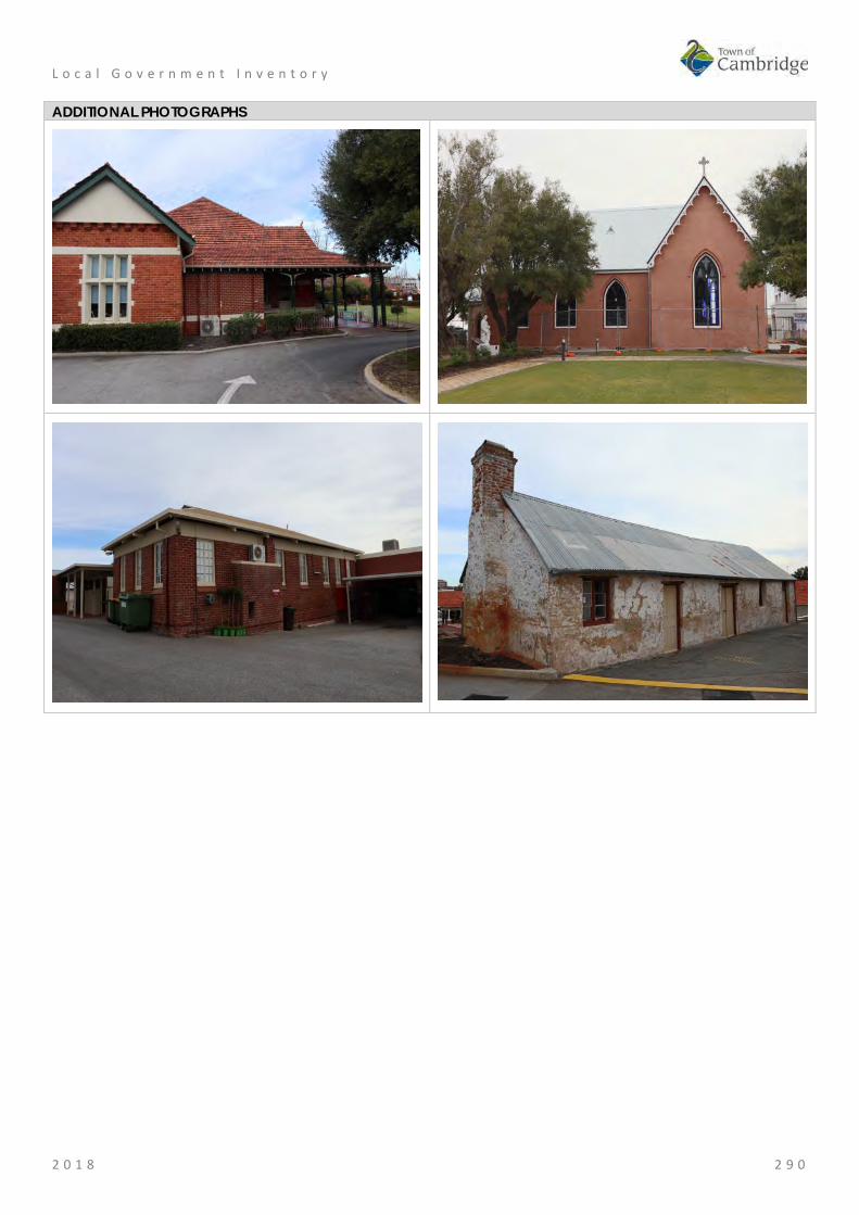
L o c a l G o v e r n m e n t I n v e n t o r y
2 0 1 8 2 9 0
ADDITIONAL PHOTOGRAPHS

L o c a l G o v e r n m e n t I n v e n t o r y
2 0 1 8 2 9 1
St Vincent's Foundling Home (fmr), Wembley Place No: 55
SITE INFORMATION Place Name: St Vincent's Foundling Home (fmr) Other Names: Street Address: 18 Barrett Street Locality Wembley HERITAGE LISTING SHO inHerit database 23830 Other Listings State Register of Heritage Places
Register of National Estate Classified by the National Trust
PLACE TYPE Individual building or group Original Use: Religious: Other Current Use: Religious: Other Other Use: LAND INFORMATION Lot: 100 Survey: Diagram 97244 Reserve No: ------- C/T: 2160-511 Property Number: 18615 Land Number: 7164

L o c a l G o v e r n m e n t I n v e n t o r y
2 0 1 8 2 9 2
CONSTRUCTION DETAILS Construction Date: 1914; 1918; 1950s; 1994 Walls: Brick: Tuckpointed Roof: Tile: Terracotta Architectural Style: Federation Queen Anne Physical Description: The Foundling Home is a predominantly single storey red brick building with a clay tiled roof. The complex roof over the U-shaped plan form comprises a mix of hipped and gabled forms and feature gablets. Terracotta finials, including a central cross, have been placed at some of the apices and face brick chimneys that widen at the top, punctuate the roof forms. The roof pitch is lower over the verandah around the outer edge of the building. The Foundling Home is representative of the Federation Queen Anne style displaying some complexity in the decorative elements of the roof and timberwork. A verandah wraps around the south (front) elevation of the building but has been enclosed at the southeast corner and along the east elevation. The concrete verandah floor is approximately at ground level adjacent to the car park along the western edge but the fall in the site reveals a base of coursed, squared rubble limestone beneath floor level on the east side of the building. The principal entrance to the place is located centrally in the south elevation and is defined by gables in

L o c a l G o v e r n m e n t I n v e n t o r y
2 0 1 8 2 9 3
the verandah roof and main roof form above. Both these gables exhibit a half-timber effect in the infill. In addition, a plaque reading ‘St Vincent’s Foundling Home’ is evident beneath the main gable. The verandah timberwork is moderately elaborate with curved brackets and carved panels fixed to the square timber posts supporting the roof. The close spacing of the exposed rafter ends, apparent beneath the ogee profile gutter, establishes a frieze which with the contrasting colours of the paintwork accentuates the decorative effect. A metal balustrade spanning between the posts has been introduced. The square panels of the valance, between the grouped posts at the corners, appear to have a carved timber ‘S’ imposed over a hollow ‘M’. This refers to SIHS (Greek meaning Jesus Christ Son of God & Saviour) and HIS (Latin meaning Jesus saviour of men). Walls of the building have been constructed in red, colonial bond face brickwork with a contrasting cream mortar. Bands of cream render are evident at windowsill and head height and also in the outer gablets in the roof above. Vertical strips in the brickwork of these gablet infills allow ventilation to the roof space. The infill of the west gable is supported on a frieze of brick corbels. Other brickwork bonds are apparent around the building providing evidence of different periods of construction. A Foundation Plaque laid on 10 September 1914 identifying the architect and contractor is located on the south face of the extruding west gable of the building. Windows and doors are principally of timber construction. Many of the openings exhibit an unusual form of ‘Lifting Window’ with sliding glazed upper sashes and a three panelled timber sash below. Large windows prominent in the south and west elevations are composed of narrow panes in timber frames between masonry mullions and exhibit rendered quoining. Sliding aluminium windows are located in the area where the verandah has been enclosed. Condition: Good Integrity: High Authenticity: Exceptional
HISTORICAL INFORMATION Historical Notes: The first Spanish Benedictine priests, Joseph Serra and Rosendo Salvado, arrived in Western Australia in 1846, together with 25 missionaries (including six members of the Order of the Sisters of Mercy). Dr Brady, the newly appointed Bishop of Perth, brought the missionaries to Western Australia following a visit to Rome. Serra and Salvado soon established a mission and school for Aboriginal people at New Norcia and in 1848 Serra travelled to Europe, seeking new missionaries to help with the work in Western Australia. He returned with 39 recruits, including 32 Benedictine monks and an Irish Trappist, Dominic Urquhart.
Serra was appointed Bishop c.1850 after Dr Brady left Western Australia. On behalf of the Perth Diocese, Serra purchased all the lands owned by Dr Brady, including Locations Ag and Ah, comprising 300 acres, adjoining Herdsmen Lake and Lake Monger. Serra named the area ‘New Subiaco’, after the original St Benedictine’s monastery in Italy. Bishop Serra established the Benedictine monks beside Herdsman Lake at New Subiaco (in what is now Glendalough), where bush pole and timber chapel and monastery buildings were constructed. The cleared land was planted with olives, grape vines and fruit trees.
In 1858, following Serra’s visit to Europe (1853-55), construction of a permanent Benedictine Monastery at New Subiaco commenced. The Monastery building was completed on June 1859. There was ‘a luscious vineyard with sixty thousand vines, and an extensive orchard: olives, oranges, lemons, figs, pears, apples and almonds, etc.’. A smaller olive plantation was planned abutting the southern wall of the monastery, with more olive trees in the adjacent garden.
On the 1864 map of New Subiaco, shows the former stable and a burial ground was identified although no records have been located of any burials taking place during the Benedictine occupation of the site.
In April 1859, the Vatican separated New Norcia and Perth into two administrations, with Bishop Serra in charge of Perth and Salvado in charge at New Norcia. The monks were given a choice as to whether they lived at New Norcia or in Perth. Following Serra’s resignation in 1862, Father Martin Griver was appointed

L o c a l G o v e r n m e n t I n v e n t o r y
2 0 1 8 2 9 4
Apostolic Administrator, with Father Matthew Gibney as his Vicar General. Griver and Gibney were responsible for the administration of the Benedictine Monastery at New Subiaco. However, by 1867, all of the monks had transferred to New Norcia and the New Subiaco Monastery was empty.
In the early 1870s, when Perth had one orphanage, a government run institution in Goderich Street referred to as The Home, or the Poor House, Father Gibney requested Governor Hampton that the Catholic children in The Home be housed in Catholic institutions. On 2 February 1872, 12 Catholic boys from The Home moved into the empty Benedictine Monastery. Known as St Vincent’s Orphanage for Boys, as the result of work by the St Vincent de Paul Society, the place was the first non-Government orphanage for boys in Western Australia.
In 1876, the Sisters of Mercy assumed control of the institution. They replaced the existing staff with three Sisters, two female assistants and a maintenance man. Catherine McAuley (1778-1841) had founded the Order of the Sisters of Mercy in Dublin in 1831, for the relief of the poor, sick, underprivileged and the dying.
In February 1877, there were 39 boys at St Vincent’s. Father Gibney’s 1883 report to the Colonial Secretary stated that as well as schooling, the occupations of the boys included printing the Catholic weekly, The Record, carpentry, gardening and olive oil manufacturing. During the period in which the property had been vacant the vines and fruit trees had died, but the olive trees had survived. The boys worked at producing olive oil from the olives they harvested.
A school building was constructed for St Vincent’s Orphanage in 1892. Situated in front of the Monastery, the building commonly called the Old Chapel was opened on 22 January 1893. (now the Martin Kelly Centre).
In November 1897, a group of Christian Brothers arrived in Western Australia from Sydney, and took over management of St Vincent’s Orphanage for Boys from the Sisters of Mercy. In September 1901, they moved the boys to new buildings at Clontarf, Waterford.
On 21 November 1901, St Joseph’s Orphanage for Girls was moved from Victoria Square to take up residence in the Monastery, under the care of six Sisters. At that time there were about 79 girls at the Orphanage listed as wards of the State and 12 privately funded by family and charitable donations.
In 1909, there were 148 girls and eight Sisters at the Orphanage. As well as attending school the older girls worked in the Laundry or assisted with the production of olive oil. Girls over fourteen were trained for domestic work. This involved cookery, dressmaking, art, needlework and knitting, caring for poultry, vegetable gardening, soap making, and baking. Some girls, who were considered intellectually capable, undertook secondary study at the Orphanage or at Mercedes College.
The Sisters of Mercy established the St Vincent’s Foundling Home in 1914 to provide accommodation and care for deserted or homeless infants. Archbishop Clune laid the foundation stone for St Vincent’s Foundling Home on 10 September 1914. The architect for the project was George McMullen (c1861-1924), and the builder was Frederick Edward Sedgley (c1877-1958).
George McMullen trained as an architect in Victoria and was elected a fellow of the Royal Victorian Institute of Architects in 1890. By 1894, Mullen had moved to Western Australia where the Public Works Department (PWD) employed him as a draftsman. He appears to have been in private practice from about 1902, with several houses in Highgate, Perth and West Perth being attributed to him between 1905 and 1909. In 1910, he was responsible for the additions to the Children’s Hospital and, from 1913, lived at Bagot Road, Subiaco.
St Vincent’s Foundling Home was opened on 13 December 1914, by the Governor Sir Harry Barron. The opening ceremony was preceded by a procession involving societies from the various parishes including Children of Mary, Catholic Young Men, St Vincent de Paul Society, Hibernians, Foresters, Sacred Heart Sodalities, Oblate Fathers and Redemptorists. The building was blessed by Archbishop Clune, who said in his speech that:
"Under [the] aegis [of the Catholic Church] a system of charitable institutions had been established… Catholics felt that, however excellent their institutions were, there was still something lacking… That which was lacking was an institution like St Vincent’s Foundling Home, where the destitute children from birth to school age might be received, and where infant life might be safeguarded. The work of safeguarding and preserving child life was… doubly valuable at the present time when war was making a drain upon adult life in the battlefields of Europe, and when it was likely that immigration would probably be checked for some

L o c a l G o v e r n m e n t I n v e n t o r y
2 0 1 8 2 9 5
years to come. Housed in a building set upon a healthy site, and equipped according to a most exacting hygienic standard, the children would be under the care of the Sisters of Mercy, whose success in a kindred department was phenomenal."
Photographs published at the time of opening show a substantial building, with the east and west wings forming a ‘U’ shape. The west wing appears to have contained the kitchen, and possibly the dining room, while the east wing contained toilet and bathroom facilities. A contemporary description stated:
It is a spacious building, well laid out, its several parts very finely proportioned, with every ward and every room equipped according to the most modern ideas. The wards and the infirmary, which open on to large and very well-designed verandahs, are admirably ventilated and roomy. There are special cells for the Sisters in charge of these wards. Nor is the portion of the institution set apart for the nursing staff neglected. Each nurse will have a pretty and neatly furnished room, as well as the general sitting and dining room set apart for the nursing staff. Beside the various accessories usually attached to such an establishment, a special feature of the new home is its up-to-date electrical fittings. Radiators are installed in almost every apartment, while there is attached to the wards special electrical apparatus by which, in case of urgency or at night, food may be conveniently and speedily heated. But the department of the building which deserves special attention is the beautifully equipped kitchen which experts have pronounced to be second to none in Australia… It is furnished with a splendid range and coppers, wash-up contrivances, and it is so admirably arranged that hot water may be conveyed therefrom to any portion of the whole building."
The Foundling Home catered for both boys and girls from birth to six years. Babies were often left on the verandah of the Home, or under the hedge at the Orphanage. It was soon found that some accommodation for expectant mothers was also needed and another wing was added to the Home. Archbishop Clune opened the additions on 17 February 1918 and in his opening address stated;
"The additions just completed would afford a greater chance of classification and isolation, if necessary, and would enable a mother’s care to be given to the little ones during their infancy. At present nearly 70 children were being cared for by the Sisters… The new wing consists of a large dormitory for twelve mothers and their infants. There are commodious balconies on either side. The lavatories, etc., are most up-to-date in design, a large dining-room for the mothers and a day nursery for the infants, are most admirable adjuncts. St Vincent’s Foundling Home is growing. Already it is a compact block of buildings and a picturesque object to the eye. The building, as it stands today, has been planned by Mr McMullen and carried out under his supervision. The total cost of the Foundling Home, including the additions, is £12,000."
Special thanks were given to the Ugly Men’s Association, and doctors and staff of the Children’s Hospital. Donations for the additions were also obtained by two Sisters who travelled throughout the Perth Archdiocese visiting each household.
In 1918, the Foundling Home was extended and appears to have been the building, seen on various site plans, which ran east to west behind the ‘U’ shaped 1914 structure, effectively creating a courtyard between the original wings at the rear of the Home. This addition provided accommodation for mothers following child birth. This addition was removed during the 1994 renovations.
By 1925, there were 110 children at St Vincent’s Foundling Home. Further additions were made to cater for the growing numbers. The additions comprised two separate buildings, situated on the eastern side of the Home. They were the Kindergarten (1925) and the Nursery (1928). Local benefactors, Stuart and Eileen Patterson funded both buildings.
Thomas Stuart Patterson and Bridget Eileen Coake were married in Albany on 27 September 1898. Patterson, a Presbyterian, was born in Sydney in 1866, and Bridget was an Irish Catholic migrant. The Patterson's had one daughter who died young, a factor that may have influenced their generosity towards young children in need of care.
In 1940, St Joseph’s Orphanage and St Vincent’s Foundling Home housed 264 children, and there were 25 Sisters living and working on site. About half the children were supported by charity and whatever parents could afford, while the other half were wards of the State. In the 1950s, another extension was made to the Foundling Home in the form of two-storey addition at the northern end of the ablution block. This addition provided accommodation for mothers and their newborn babies.
By the mid 1960s, St Vincent’s Foundling Home was also acting as a day-care centre for young children on

L o c a l G o v e r n m e n t I n v e n t o r y
2 0 1 8 2 9 6
the site. One dormitory was closed, with 30 children between three and five still in residence.
By the 1970s, social needs and concepts of social welfare were changing. More emphasis was being placed on social welfare for the family unit. The Sisters of Mercy determined to redevelop the Orphanage and Foundling Home institutions and, in late 1971, the centre was renamed Catherine McAuley Centre. In 1989 the site was renamed Catherine McAuley Family Centre.
In October 1977, a new complex for ‘out of home care’ for difficult to place children was opened. Each were staffed by ‘cottage parents’. The group houses were spread over the northern section of the property and were accessed off Ruislip Street. Their construction resulted in the removal of most of the remaining olive grove in this area.
Between 1975 and 1988, day care numbers doubled to 104 full-time, 25 part-time, 40 after-school care, 50 vacation care and 16 nursery places. In 1994, St Vincent’s Foundling Home buildings were upgraded by Santelli Holbrook Architects. The work on the Foundling Home involved general upgrading of facilities, and the removal of the 1918 addition. The original 1914 building, and the two-storey 1950s addition remained. A wall plaque in the entrance hall of the Foundling Home reads:
"Catherine McAuley Family Centre. Restoration and refurbishment of the Child Day Care buildings. In appreciation of the support provided by the Congregation of the Sisters of Mercy and The Lotteries Commission of Western Australia.
Santelli Holbrook Architects P/L. Project Architect A Santelli. June 1994."
Above the plaque is a painting of the Foundling Home executed by Al Santelli and donated to the Home.
Currently [2018] St Vincent’s Foundling Home is still utilised for Child Day Care, but some of the external playground areas have been changed or been improved as a result of the Retirement Village works completed in the mid 2000s. Child day care programmes have been expanded over the decade and some refurbishments were undertaken to allow this to occur.
Historic Theme: Social and Civic Activities: Religion Social and Civic Activities: Institutions Social and Civic Activities: Education and science
Associations: Sisters of Mercy Benedictine Order Joseph Serra St Vincent de Paul Society George McMullen Frederick Edward Sedgley Santelli Holbrook Architects
Sources: Aerial photographs, 1953-2016, Landgate. Town of Cambridge Municipal Heritage Inventory and Townscape Precinct Study prepared for the Town of Cambridge, June 1997, Wise's Post Office Directories for the City of Perth, 1925-1949, State Library of WA www.slwa.wa.gov.au Heritage Trail: A journey through the history of Mercy Care, Mercy Care, 2007. Register of Heritage Places, Assessment Documentation for Place 2231, Catherine McCauley Centre.

L o c a l G o v e r n m e n t I n v e n t o r y
2 0 1 8 2 9 7
SIGNIFICANCE Statement of Significance: The following statement is taken from the Register Entry for place 2231
Catherine McCauley Centre included on a permanent basis on the State Register of Heritage Places in 2012.
Catherine McAuley Centre, comprising Benedictine Stables (fmr) (c. 1858, 1890s, 1990s); Olive Trees (c.1858); Cemetery (1891-1913); Old School(1893); St Rochs (c.1900); former Laundry (c.1910); St Vincent’s Foundling Home (fmr) which includes the Foundling Home (1914, 1918, 1950s, 1994), Kindergarten (1925, 1971, 1994) and Nursery (1928, 1970, 1994); and, St Gerard’s Hospital (fmr) (1938), has cultural heritage significance for the following reasons: • the Benedictine Stables (fmr) has rarity value as it is one of few
agrarian buildings dating from the 1850s still in existence in the metropolitan area and is the only remaining structure from the early Benedictine occupation of the site;
• the various elements illustrate the evolution of the site from an agrarian beginning, with stables and olive groves, to a facility dealing with the needs of urban family life, and reflect the rapid development and changing social environment of Perth and Western Australia, since the 1850s;
• the place contributes to the aesthetic qualities of the landscape particularly through the Old School, which has landmark value when approached from the south entrance of the site and provides a focus for the historic group of buildings at the place. St Vincent’s Foundling Home (fmr) contains decorative timber work, terracotta finials and brick work with render banding; the various elements of the place contribute to the community’s sense of place;
• the Benedictine Stables (fmr) and Olive Trees are evidence of the Catholic Benedictine Order who occupied the site from 1852 to 1864, and also with Bishop Serra, under whose authority the site was developed. The Old School is a reminder of the ongoing religious associations of the site;
• St Vincent’s Foundling Home (fmr) and Old Chapel are evidence of the work of the Sisters of Mercy, and the services to children in need which they have provided on the site since 1876;
• the Benedictine Stables (fmr) and Olive Trees are a reminder of the olive oil industry conducted by the Sisters of Mercy, and which helped provide funds for the ongoing operation of the orphanage and foundling home. The olive oil manufactured at St Joseph’s Orphanage won first prize at several Royal Perth shows;
• the place is illustrative of the institutional approach to the care and training of children which prevailed in the late 19th century and into the first six decades of the 20th century; and,
• when opened in 1925, the Kindergarten was one of the first to use the Montessori teaching method and aspects of design in Western Australia. The nursery still displays the ventilated and mosquito proofed verandah, which was considered modern at the time of construction.
Level of Significance: Exceptional Essential to the heritage of the locality. Rare or outstanding example. Recommended for inclusion on the State Register of Heritage Places.
Management Category: Category 1 The place should be retained and conserved unless there is no feasible and prudent alternative to doing otherwise. Any alterations or extensions should reinforce the significance of the place, and be in accordance with a Conservation Plan (if one exists for the place).
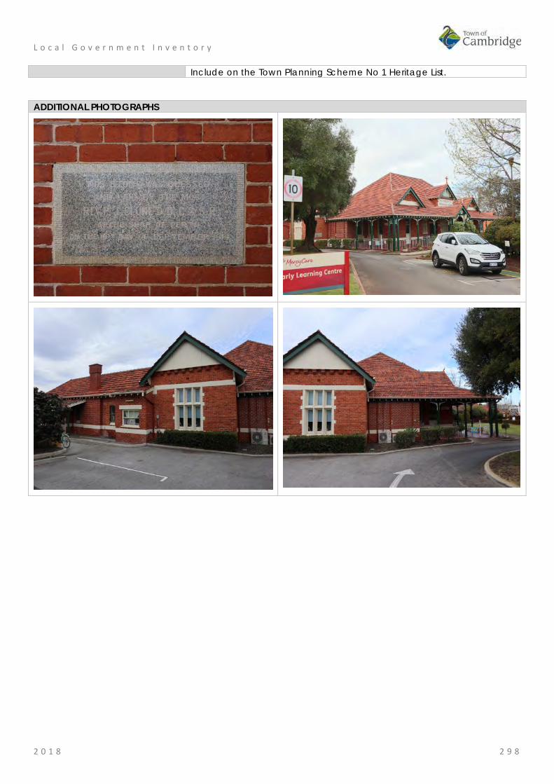
L o c a l G o v e r n m e n t I n v e n t o r y
2 0 1 8 2 9 8
Include on the Town Planning Scheme No 1 Heritage List.
ADDITIONAL PHOTOGRAPHS
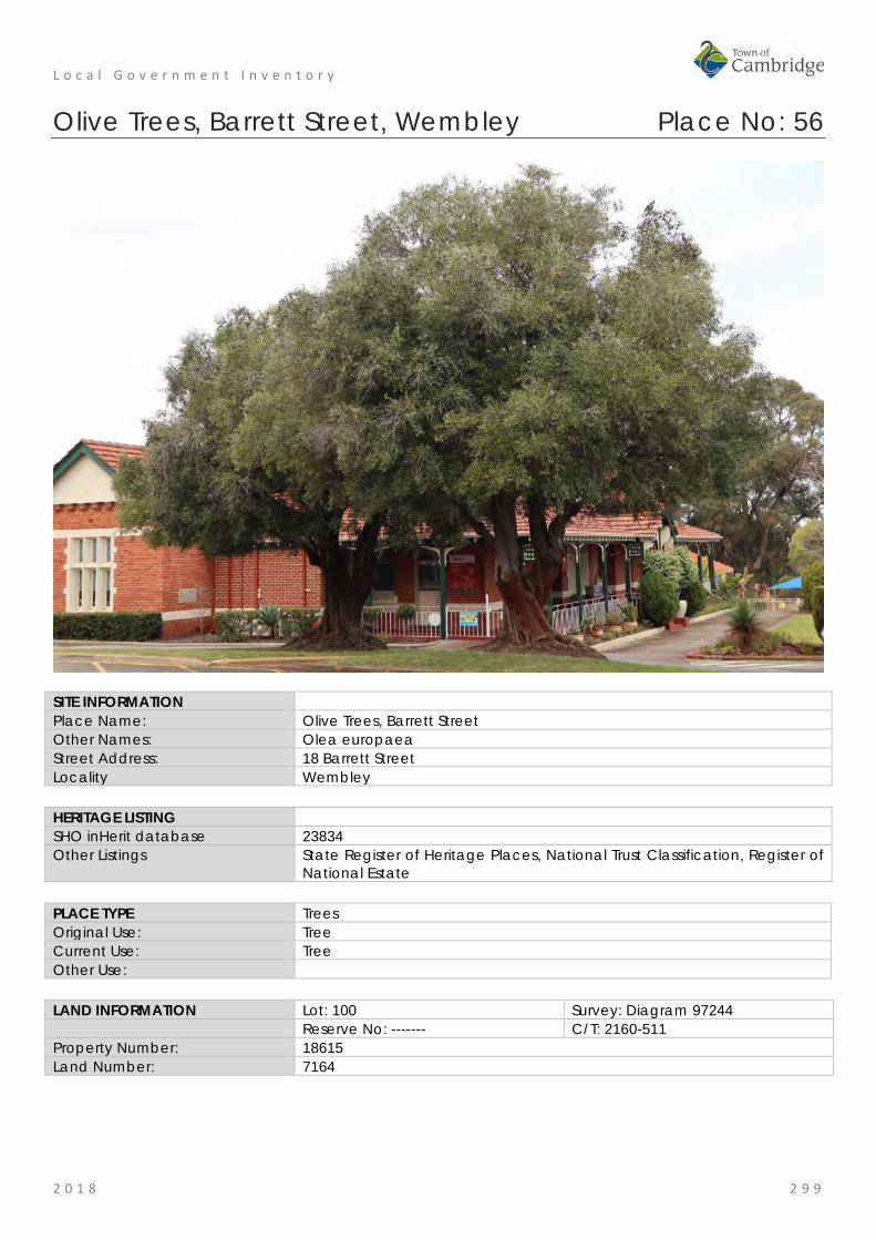
L o c a l G o v e r n m e n t I n v e n t o r y
2 0 1 8 2 9 9
Olive Trees, Barrett Street, Wembley Place No: 56
SITE INFORMATION Place Name: Olive Trees, Barrett Street Other Names: Olea europaea Street Address: 18 Barrett Street Locality Wembley HERITAGE LISTING SHO inHerit database 23834 Other Listings State Register of Heritage Places, National Trust Classification, Register of
National Estate PLACE TYPE Trees Original Use: Tree Current Use: Tree Other Use: LAND INFORMATION Lot: 100 Survey: Diagram 97244 Reserve No: ------- C/T: 2160-511 Property Number: 18615 Land Number: 7164

L o c a l G o v e r n m e n t I n v e n t o r y
2 0 1 8 3 0 0
CONSTRUCTION DETAILS Construction Date: c1858 Walls: N/A Roof: N/A Architectural Style: N/A Physical Description: The mature olive trees on the site are in good condition and located near the entrance to the administration building and on the eastern side of the property. Condition: Good Integrity: High Authenticity: High
HISTORICAL INFORMATION Historical Notes: The olive trees in the grounds of the Catherine McCauley Centre were first planted by the Benedictine Monks in the mid-1850s, prior to the completion of the monastery in 1858-9. Records indicate that the first olive oil was produced by the monks in the mid-1850s while the building was under construction. Two groves were planted, a large grove to the north of the building and a smaller one abutting the south wall. In 1864, when the Monks relocated to New Norcia, the vines and orchards were left to die. Only the olive trees

L o c a l G o v e r n m e n t I n v e n t o r y
2 0 1 8 3 0 1
survived out of all the cultivation and there is no record of how many of the original trees survived.
From 1876, when Father Gibney was Chair of the Board of Governance for St Vincent's Boys Orphanage there are records of oil production with the boys harvesting the olives under the guidance of John Prendergast. Mr Dale, Inspector of Charitable Institutions reported at his visit in 1881 that over 100 gallons of olive oil had been produced at the orphanage that year. At the Indian and Colonial Exhibition in London in 1886 the oil received high commendation and often took first prize at the Royal Show.
The first mention of sale of the oil was made in 1897 when the Christian brothers moved to the site for a short time. They left in 1901 with the Sisters of Mercy moving back in. The girls in their care harvested the olives and helped with the production of the oil. The purification of the oil took place in the east room of the building now designated as, Benedictine Stables (fmr).
In 1902, sale of olive oil manufactured at the Orphanage netted £2/8/9. The girls of the Orphanage exhibited their oil at the Royal Perth Show each year, where it was often awarded first prize. In 1909, there were 148 girls and eight Sisters at the Orphanage. As well as attending school the older girls worked in the Laundry or assisted with the production of olive oil. In 1921, sales amounted to £140/5/2.
It is not known how long olive oil production continued at the site. References to the production of olive oil are made in the local press in 1934 and in 1950. Although the later date refers to preparation for a fete rather than commercial sales.
An aerial photograph of the site in 1964 shows many trees on the property but by this time the focus of the organisation had shifted with less children living on the site. One dormitory was closed, with 30 children between three and five still in residence.
In October 1977, a new complex for ‘out of home care’ for difficult to place children was opened. Each were staffed by ‘cottage parents’. The group houses were spread over the northern section of the property and were accessed off Ruislip Street. Their construction resulted in the removal of most of the remaining olive grove in this area.
Between the Catherine McCauley Centre and Lake Monger is a residential development in which one of the roads has been named 'The Grove'. It is speculated that this name reflects the former grove of Olive Trees in this location. Residential properties in this area have olive trees in their gardens which may originate with the original plantings.
In 1999, six trees in front of the administration building were successfully transplanted and in 2004 two additional trees were transplanted. Unfortunately some trees could not be successfully relocated and their wood was culled for use in the organisation. The remaining olive trees on the site are clustered near the administration building and on the eastern side of the property.
Historic Theme: Social and Civic Activities: Religion Social and Civic Activities: Institutions Occupations: Manufacturing and processing
Associations: Sisters of Mercy Benedictine Order Joseph Serra St Vincent de Paul Society
Sources: Aerial photographs, 1953-2016, Landgate. Town of Cambridge Municipal Heritage Inventory and Townscape Precinct Study prepared for the Town of Cambridge, June 1997. Wise's Post Office Directories for the City of Perth, 1925-1949, State Library of WA www.slwa.wa.gov.au Heritage Trail: A journey through the history of Mercy Care, Mercy Care, 2007. Register of Heritage Places, Assessment Documentation for Place 2231, Catherine McCauley Centre. The West Australian, 26 May 1934, p. 19. The Daily News, 11 November 1950, p. 24.
L o c a l G o v e r n m e n t I n v e n t o r y
2 0 1 8 3 0 2
SIGNIFICANCE Statement of Significance: The following statement is taken from the Register Entry for place 2231
Catherine McCauley Centre included on a permanent basis on the State Register of Heritage Places in 2012.
Catherine McAuley Centre, comprising Benedictine Stables (fmr) (c. 1858, 1890s, 1990s); Olive Trees (c.1858); Cemetery (1891-1913); Old School(1893); St Rochs (c.1900); former Laundry (c.1910); St Vincent’s Foundling Home (fmr) which includes the Foundling Home (1914, 1918, 1950s, 1994), Kindergarten (1925, 1971, 1994) and Nursery (1928, 1970, 1994); and, St Gerard’s Hospital (fmr) (1938), has cultural heritage significance for the following reasons: • the Benedictine Stables (fmr) has rarity value as it is one of few
agrarian buildings dating from the 1850s still in existence in the metropolitan area and is the only remaining structure from the early Benedictine occupation of the site;
• the various elements illustrate the evolution of the site from an agrarian beginning, with stables and olive groves, to a facility dealing with the needs of urban family life, and reflect the rapid development and changing social environment of Perth and Western Australia, since the 1850s;
• the place contributes to the aesthetic qualities of the landscape particularly through the Old School, which has landmark value when approached from the south entrance of the site and provides a focus for the historic group of buildings at the place. St Vincent’s Foundling Home (fmr) contains decorative timber work, terracotta finials and brick work with render banding; the various elements of the place contribute to the community’s sense of place;
• the Benedictine Stables (fmr) and Olive Trees are evidence of the Catholic Benedictine Order who occupied the site from 1852 to 1864, and also with Bishop Serra, under whose authority the site was developed. The Old School is a reminder of the ongoing religious associations of the site;
• St Vincent’s Foundling Home (fmr) and Old Chapel are evidence of the work of the Sisters of Mercy, and the services to children in need which they have provided on the site since 1876;
• the Benedictine Stables (fmr) and Olive Trees are a reminder of the olive oil industry conducted by the Sisters of Mercy, and which helped provide funds for the ongoing operation of the orphanage and foundling home. The olive oil manufactured at St Joseph’s Orphanage won first prize at several Royal Perth shows;
• the place is illustrative of the institutional approach to the care and training of children which prevailed in the late 19th century and into the first six decades of the 20th century; and,
• when opened in 1925, the Kindergarten was one of the first to use the Montessori teaching method and aspects of design in Western Australia. The nursery still displays the ventilated and mosquito proofed verandah, which was considered modern at the time of construction.
Level of Significance: Exceptional Essential to the heritage of the locality. Rare or outstanding example. Recommended for inclusion on the State Register of Heritage Places.
Management Category: Category 1 The place should be retained and conserved unless there is no feasible and prudent alternative to doing otherwise. Any alterations or extensions should reinforce the significance of the place, and be in accordance with a Conservation Plan (if one exists for the place).

L o c a l G o v e r n m e n t I n v e n t o r y
2 0 1 8 3 0 3
Include on the Town Planning Scheme No 1 Heritage List.
ADDITIONAL PHOTOGRAPHS
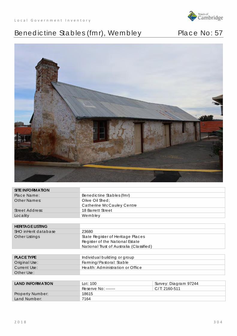
L o c a l G o v e r n m e n t I n v e n t o r y
2 0 1 8 3 0 4
Benedictine Stables (fmr), Wembley Place No: 57
SITE INFORMATION Place Name: Benedictine Stables (fmr) Other Names: Olive Oil Shed;
Catherine McCauley Centre Street Address: 18 Barrett Street Locality Wembley HERITAGE LISTING SHO inHerit database 23680 Other Listings State Register of Heritage Places
Register of the National Estate National Trust of Australia (Classified)
PLACE TYPE Individual building or group Original Use: Farming/Pastoral: Stable Current Use: Health: Administration or Office Other Use: LAND INFORMATION Lot: 100 Survey: Diagram 97244 Reserve No: ------- C/T: 2160-511 Property Number: 18615 Land Number: 7164

L o c a l G o v e r n m e n t I n v e n t o r y
2 0 1 8 3 0 5
CONSTRUCTION DETAILS Construction Date: c1858; 1890s; 1990s Walls: Stone Roof: Metal: Corrugated galvanised iron Architectural Style: Victorian rural vernacular Physical Description: Single storey stone range with brick chimney and gabled roof clad in short sheet corrugated iron. The stonework has previously been lime washed which is now wearing off in places. The building has undergone previous works but is showing further signs of wear with a rusted roof. The south elevation is mainly blank stone apart from two small timber framed openings positioned directly under the eaves. The brick and stone chimney is positioned at the eastern end of the range and stands proud of the east wall. The north elevation is the most activated of the walls incorporating three doors (two single door and a central double door) and two timber framed windows. Bitumen has been laid to the north elevation whilst the south sits on a stone retaining wall. Condition: Fair Integrity: Moderate Authenticity: High

L o c a l G o v e r n m e n t I n v e n t o r y
2 0 1 8 3 0 6
HISTORICAL INFORMATION Historical Notes: The first Spanish Benedictine priests, Joseph Serra and Rosendo Salvado, arrived in Western Australia in 1846, together with 25 missionaries (including six members of the Order of the Sisters of Mercy). Dr Brady, the newly appointed Bishop of Perth, brought the missionaries to Western Australia following a visit to Rome. Serra and Salvado soon established a mission and school for Aboriginal people at New Norcia and in 1848 Serra travelled to Europe, seeking new missionaries to help with the work in Western Australia. He returned with 39 recruits, including 32 Benedictine monks and an Irish Trappist, Dominic Urquhart.
Serra was appointed Bishop c.1850 after Dr Brady was persuaded to leave Western Australia. On behalf of the Perth Diocese, Serra purchased all the lands owned by Dr Brady, including Locations Ag and Ah, comprising 300 acres, adjoining Herdsmen Lake and Lake Monger. Serra named the area ‘New Subiaco’, after the original St Benedictine’s monastery in Italy. Bishop Serra established the Benedictine monks beside Herdsman Lake at New Subiaco (in what is now Glendalough), where bush pole and timber chapel and monastery buildings were constructed. The cleared land was planted with olives, grape vines and fruit trees.
In 1858, following Serra’s visit to Europe (1853-55), construction of a permanent Benedictine Monastery at New Subiaco commenced. The Monastery building was completed on June 1859. There was ‘a luscious vineyard with sixty thousand vines, and an extensive orchard: olives, oranges, lemons, figs, pears, apples and almonds, etc.’. A smaller olive plantation was planned abutting the southern wall of the monastery, with more olive trees in the adjacent garden.
The Benedictine Stables, a three-roomed building with timber floors, each with a separate entrance from the outside is believed to be one of the original outbuildings constructed around the Benedictine Monastery and the only structure remaining from this period. An 1864 map of the site describes the outbuilding, numbered ‘5’, as stalla, paglijo e luogo pel carro, which has been translated as ‘stable, straw stack and place for the cart’. Over the years, there has been some debate as to whether this building was used as a stable, as the doorways are too low for a horse to have passed through. The rooms also have timber floors, although these could have been added at a later date, and the doorways could have been altered.
In April 1859, the Vatican separated New Norcia and Perth into two administrations, with Bishop Serra in charge of Perth and Salvado in charge at New Norcia. The monks were given a choice as to whether they lived at New Norcia or in Perth. Following Serra’s resignation in 1862, Father Martin Griver was appointed Apostolic Administrator, with Father Matthew Gibney as his Vicar General. Griver and Gibney were responsible for the administration of the Benedictine Monastery at New Subiaco. However, by 1867, all of the monks had transferred to New Norcia and the New Subiaco Monastery was empty.
In the early 1870s, when Perth had one orphanage, a government run institution in Goderich Street referred to as The Home, or the Poor House, Father Gibney requested Governor Hampton that the Catholic children in The Home be housed in Catholic institutions. On 2 February 1872, 12 Catholic boys from The Home moved into the empty Benedictine Monastery. Known as St Vincent’s Orphanage for Boys, as the result of work by the St Vincent de Paul Society, the place was the first non-Government orphanage for boys in Western Australia.
In 1876, the Sisters of Mercy assumed control of the institution. They replaced the existing staff with three Sisters, two female assistants and a maintenance man. Catherine McAuley (1778-1841) had founded the Order of the Sisters of Mercy in Dublin in 1831, for the relief of the poor, sick, underprivileged and the dying. Branch Houses were established throughout the world, and the House established in Western Australia in 1846.
In February 1877, there were 39 boys at St Vincent’s. Father Gibney’s 1883 report to the Colonial Secretary stated that as well as schooling, the occupations of the boys included printing the Catholic weekly, The Record, carpentry, gardening and olive oil manufacturing. During the period in which the property had been vacant the vines and fruit trees had died, but the olive trees had survived. The boys worked at producing olive oil from the olives they harvested. The former Benedictine Stables were used as an olive oil bottling shed, while the crushing of the olives was carried out in another building.
A school building was constructed for St Vincent’s Orphanage in 1892. Situated in front of the Monastery, the building commonly called the Old Chapel was opened on 22 January 1893.
In November 1897, a group of Christian Brothers arrived in Western Australia from Sydney, and took over management of St Vincent’s Orphanage for Boys from the Sisters of Mercy. In September 1901, they moved
L o c a l G o v e r n m e n t I n v e n t o r y
2 0 1 8 3 0 7
the boys to new buildings at Clontarf, Waterford.
On 21 November 1901, St Joseph’s Orphanage for Girls was moved from Victoria Square to take up residence in the Monastery, under the care of six Sisters. At that time there were about 79 girls at the Orphanage listed as wards of the State and 12 privately funded by family and charitable donations. The girls at St Joseph’s continued olive oil production on the site utilising the former stables. It is thought that the east room with the fire place was added in the 1890s. The east room is known to have been used for purifying and bottling olive oil and the west room for incubating chickens and the centre room as a store.
In 1902, sale of olive oil manufactured at the Orphanage netted £2/8/9. In 1921, sales amounted to £140/5/2. The girls of the Orphanage exhibited their oil at the Royal Perth Show each year, where it was often awarded first prize.
In 1909, there were 148 girls and eight Sisters at the Orphanage. As well as attending school the older girls worked in the Laundry or assisted with the production of olive oil. Girls over fourteen were trained for domestic work. This involved cookery, dressmaking, art, needlework and knitting, caring for poultry, vegetable gardening, soap making, and baking. Some girls, who were considered intellectually capable, undertook secondary study at the Orphanage or at Mercedes College.
Photographs of the former Benedictine Stables taken in the 1970s and 1980s, show a deteriorating building with a rusting iron roof which, when removed, uncovered the original timber shingles, also in a state of deterioration. In 1991, a conservation report was prepared by Rob McK. Campbell and Ingrid van Bremen. The work that resulted halted deterioration of the building, while a later conservation report of 1996 continued the restoration work.
In the mid 2000s, remedial works were undertaken to drain water away from the limestone footings of the Benedictine Stables. In 2010, the former stables were used for storage.
In 2016/17, conservation works were undertaken at the stables to prevent further deterioration.
Historic Theme: Social and Civic Activities: Religion Social and Civic Activities: Institutions Occupations: Manufacturing and processing
Associations: Sisters of Mercy Benedictine Order Joseph Serra St Vincent de Paul Society
Sources: Aerial photographs, 1953-2016, Landgate. Town of Cambridge Municipal Heritage Inventory and Townscape Precinct Study prepared for the Town of Cambridge, June 1997. Wise's Post Office Directories for the City of Perth, 1925-1949, State Library of WA www.slwa.wa.gov.au Heritage Trail: A journey through the history of Mercy Care, Mercy Care, 2007 Register of Heritage Places, Assessment Documentation for Place 2231, Catherine McCauley Centre.
SIGNIFICANCE Statement of Significance: The following statement is taken from the Register Entry for place 2231
Catherine McCauley Centre included on a permanent basis on the State Register of Heritage Places in 2012. Catherine McAuley Centre, comprising Benedictine Stables (fmr) (c. 1858, 1890s, 1990s); Olive Trees (c.1858); Cemetery (1891-1913); Old School(1893); St Rochs (c.1900); former Laundry (c.1910); St Vincent’s Foundling Home (fmr) which includes the Foundling Home (1914, 1918, 1950s, 1994), Kindergarten (1925, 1971, 1994) and Nursery (1928, 1970, 1994); and, St Gerard’s Hospital (fmr) (1938), has cultural heritage significance for the following reasons: • the Benedictine Stables (fmr) has rarity value as it is one of few
L o c a l G o v e r n m e n t I n v e n t o r y
2 0 1 8 3 0 8
agrarian buildings dating from the 1850s still in existence in the metropolitan area and is the only remaining structure from the early Benedictine occupation of the site;
• the various elements illustrate the evolution of the site from an agrarian beginning, with stables and olive groves, to a facility dealing with the needs of urban family life, and reflect the rapid development and changing social environment of Perth and Western Australia, since the 1850s;
• the place contributes to the aesthetic qualities of the landscape particularly through the Old School, which has landmark value when approached from the south entrance of the site and provides a focus for the historic group of buildings at the place. St Vincent’s Foundling Home (fmr) contains decorative timber work, terracotta finials and brick work with render banding; the various elements of the place contribute to the community’s sense of place;
• the Benedictine Stables (fmr) and Olive Trees are evidence of the Catholic Benedictine Order who occupied the site from 1852 to 1864, and also with Bishop Serra, under whose authority the site was developed. The Old School is a reminder of the ongoing religious associations of the site;
• St Vincent’s Foundling Home (fmr) and Old Chapel are evidence of the work of the Sisters of Mercy, and the services to children in need which they have provided on the site since 1876;
• the Benedictine Stables (fmr) and Olive Trees are a reminder of the olive oil industry conducted by the Sisters of Mercy, and which helped provide funds for the ongoing operation of the orphanage and foundling home. The olive oil manufactured at St Joseph’s Orphanage won first prize at several Royal Perth shows;
• the place is illustrative of the institutional approach to the care and training of children which prevailed in the late 19th century and into the first six decades of the 20th century; and,
• when opened in 1925, the Kindergarten was one of the first to use the Montessori teaching method and aspects of design in Western Australia. The nursery still displays the ventilated and mosquito proofed verandah, which was considered modern at the time of construction.
Level of Significance: Exceptional Essential to the heritage of the locality. Rare or outstanding example. Recommended for inclusion on the State Register of Heritage Places.
Management Category: Category 1 The place should be retained and conserved unless there is no feasible and prudent alternative to doing otherwise. Any alterations or extensions should reinforce the significance of the place, and be in accordance with a Conservation Plan (if one exists for the place). Include on the Town Planning Scheme No 1 Heritage List.

L o c a l G o v e r n m e n t I n v e n t o r y
2 0 1 8 3 0 9
ADDITIONAL PHOTOGRAPHS

L o c a l G o v e r n m e n t I n v e n t o r y
2 0 1 8 3 1 0
Wembley Theatre and Gardens (fmr), Wembley Place No: 58
SITE INFORMATION Place Name: Wembley Theatre and Gardens (fmr) Other Names: Wembley Picture Theatre
Wembley Lodge; Lifecare
Street Address: 202 Cambridge Street Locality Wembley HERITAGE LISTING SHO inHerit database 3611 Other Listings Classified by the National Trust
Art Deco Society of WA PLACE TYPE Individual building or group Original Use: Social/Recreational: Cinema Current Use: Health: Physiotherapy Other Use: Commercial: Restaurant LAND INFORMATION Lot: 161, 162 Survey: Plan 3232 Reserve No: --------- C/T: 129-125A Property Number: 18540 Land Number: 10893
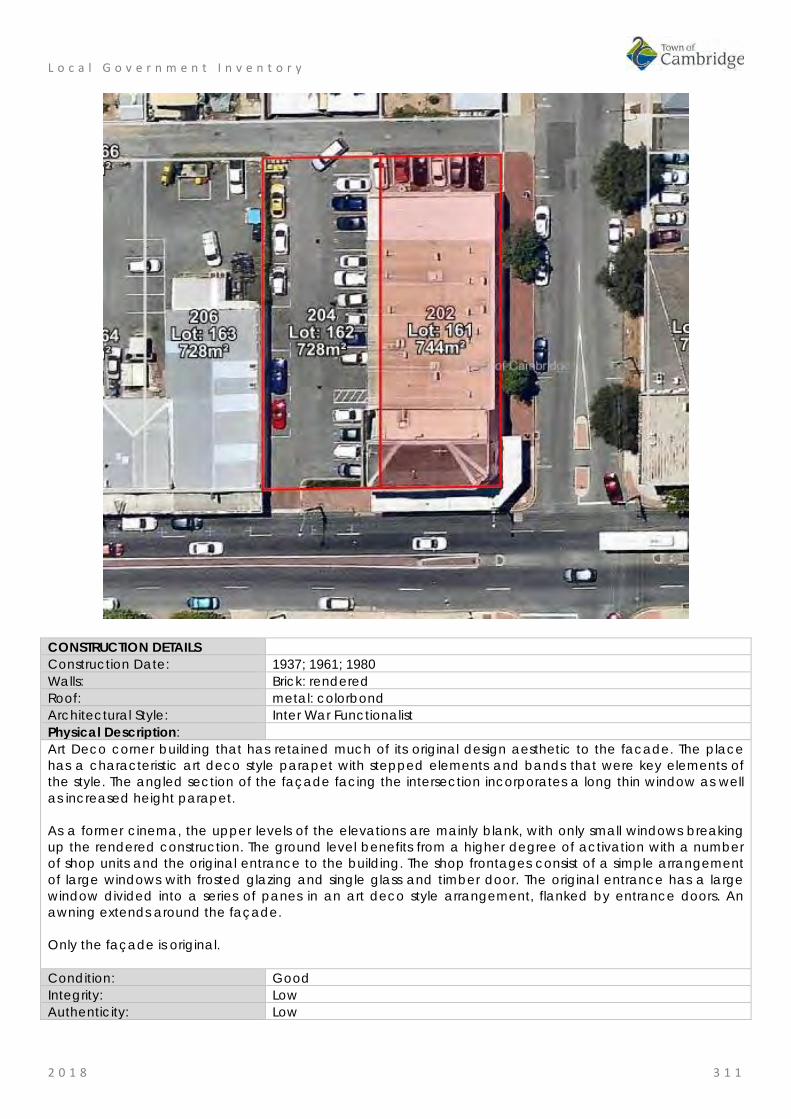
L o c a l G o v e r n m e n t I n v e n t o r y
2 0 1 8 3 1 1
CONSTRUCTION DETAILS Construction Date: 1937; 1961; 1980 Walls: Brick: rendered Roof: metal: colorbond Architectural Style: Inter War Functionalist Physical Description: Art Deco corner building that has retained much of its original design aesthetic to the facade. The place has a characteristic art deco style parapet with stepped elements and bands that were key elements of the style. The angled section of the façade facing the intersection incorporates a long thin window as well as increased height parapet. As a former cinema, the upper levels of the elevations are mainly blank, with only small windows breaking up the rendered construction. The ground level benefits from a higher degree of activation with a number of shop units and the original entrance to the building. The shop frontages consist of a simple arrangement of large windows with frosted glazing and single glass and timber door. The original entrance has a large window divided into a series of panes in an art deco style arrangement, flanked by entrance doors. An awning extends around the façade. Only the façade is original. Condition: Good Integrity: Low Authenticity: Low

L o c a l G o v e r n m e n t I n v e n t o r y
2 0 1 8 3 1 2
HISTORICAL INFORMATION Historical Notes: In 1937 the Wembley Theatre and Gardens, each holding about 800 seats, were built for Mervyn Lambert to a design by architect Frank Coote. This was a bad time to invest capital, and Lambert was unable to keep up payments on the loan, so shortly afterwards the venue was bought by Hatfields Pictures. The cinema had an ingenious method of transferring the projectors across from one venue to the other, both bio-boxes were built in the middle of the venue, above the ground on pillars, with a rail track joining them. The projectors had only to be disconnected from the power, pushed along the track and re-connected, the whole process taking only a few minutes. The theatre on the corner site, had a central staircase in the downstairs foyer giving access to the lounge above. A small confectionary shop was located on the street corner, within the theatre building, but with no access from the theatre side theatre patrons exited the theatre and entered the shop through the same entrance on the street front as the passing trade. The ticket box was located inside the foyer, on the left, serving patrons for both theatre and gardens, and entrance to the gardens was through the side wall of the theatre foyer, exit from the gardens was on the street wall. In the gardens, there was a central deckchair section, surrounded by a low wall, and the rest of the space was filled with less comfortable wooden chairs. Films continued to be screened in both theatre and gardens until after television arrived in Perth. In 1962, £17,000 was spent on conversion into a reception house, known as Wembley Lodge. The conversions were undertaken by contractors, J.L.C. Zelinski for Messrs Howawicz and Zen. The picture gardens were demolished at part of the works. The building was gutted by fire in September 1980, and when rebuilt contained little of the interior of the original theatre, though the façade was still clearly recognisable. Historic Theme: Social and Civic activities: Sport, recreation and entertainment
Occupations: commercial services and industries Associations: Frank Coote
Mervyn Lambert Hatfield Pictures J.L.C. Zellinski Messrs Horawicz and Zen
Sources: Aerial photographs, 1953-2016, Landgate. Town of Cambridge Municipal Heritage Inventory and Townscape Precinct Study prepared for the Town of Cambridge, June 1997. Wise's Post Office Directories for the City of Perth, 1925-1949, State Library of WA www.slwa.wa.gov.au Western Australian Cinemaweb, Wembley Theatre and Gardens webpage, http://www.ammpt.asn.au/CinemaWEB/SITE/view.php?rec_id=0000000497
SIGNIFICANCE Statement of Significance: • The place has aesthetic value for its remnant elements of the Inter
War Functionalist style on the Cambridge Street façade and portion of the Station Street façade.
• The place has historic value for its association with the development of the community in the Inter War period.
• The place has historic value for its association with the widespread popularity of cinemas in metropolitan Perth in the Inter War period.
• The place has social value for the members of the community who attended the place as a cinema from 1937 to 1962 and for its later function as a restaurant.

L o c a l G o v e r n m e n t I n v e n t o r y
2 0 1 8 3 1 3
Level of Significance: Some/Moderate Contributes to the heritage of the locality. Has some altered or modified elements, not necessarily detracting from the overall significance of the item.
Management Category: Category 3 Conservation of the place is desirable. Any alterations or extensions should reinforce the significance of the place, and original fabric should be retained wherever feasible. Include on the Town Planning Scheme No 1 Heritage List.
ADDITIONAL PHOTOGRAPHS

L o c a l G o v e r n m e n t I n v e n t o r y
2 0 1 8 3 1 4
Commercial Premises, 284 Cambridge Street, Wembley Place No: 59
SITE INFORMATION Place Name: Commercial Premises, 284 Cambridge Street Other Names: Street Address: 284 Cambridge Street Locality Wembley HERITAGE LISTING SHO inHerit database Other Listings PLACE TYPE Individual building or group Original Use: Commercial: Shop/retail store Current Use: Commercial: Shop/retail store Other Use: LAND INFORMATION Lot: 538 Survey: Plan 3232 Reserve No: -------- C/T: 1929-350 Property Number: 13752 Land Number: 2656

L o c a l G o v e r n m e n t I n v e n t o r y
2 0 1 8 3 1 5
CONSTRUCTION DETAILS Construction Date: c1929 Walls: Brick: rendered, painted Roof: Metal: Colorbond Architectural Style: Inter War Physical Description: A single storey inter-war corner commercial property with dual frontages to Cambridge Street and Essex Street.
The place is of brick construction which has been rendered and painted. The hipped iron roof is hidden behind a low parapet wall. A contemporary skillion verandah canopy supported on wall brackets extends around the entire frontage to both elevation. The south west portion of the elevation is not original but has been successfully tied into the original section of the building.
Both sections of the elevation are enlivened by full height windows with double glass doors to the Cambridge Street elevation and the main angled entrance. Condition: Good Integrity: Moderate Authenticity: Moderate
HISTORICAL INFORMATION Historical Notes: This place is one of a number of buildings constructed in the late 1920s to serve the growing community in the district. As was common practice the original building was a combined shop and residence. Its location on the corner of Cambridge and Essex Streets was valuable exposure for the business.
The shop portion of the building was divided into two premises. Initially one of the shops was occupied by Alfred L Trotter who operated a store from the premises, presumably a mixed business store. Later the other
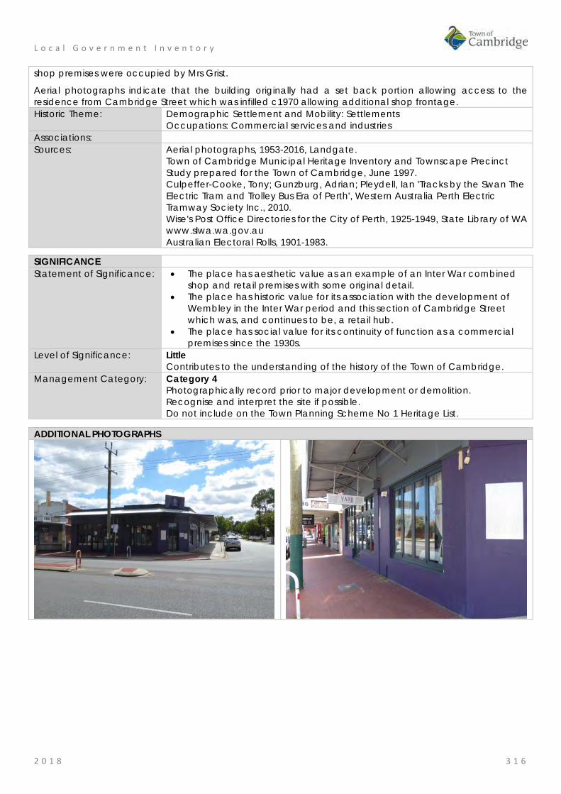
L o c a l G o v e r n m e n t I n v e n t o r y
2 0 1 8 3 1 6
shop premises were occupied by Mrs Grist.
Aerial photographs indicate that the building originally had a set back portion allowing access to the residence from Cambridge Street which was infilled c1970 allowing additional shop frontage. Historic Theme: Demographic Settlement and Mobility: Settlements
Occupations: Commercial services and industries Associations: Sources: Aerial photographs, 1953-2016, Landgate.
Town of Cambridge Municipal Heritage Inventory and Townscape Precinct Study prepared for the Town of Cambridge, June 1997. Culpeffer-Cooke, Tony; Gunzburg, Adrian; Pleydell, Ian 'Tracks by the Swan The Electric Tram and Trolley Bus Era of Perth', Western Australia Perth Electric Tramway Society Inc., 2010. Wise's Post Office Directories for the City of Perth, 1925-1949, State Library of WA www.slwa.wa.gov.au Australian Electoral Rolls, 1901-1983.
SIGNIFICANCE Statement of Significance: • The place has aesthetic value as an example of an Inter War combined
shop and retail premises with some original detail. • The place has historic value for its association with the development of
Wembley in the Inter War period and this section of Cambridge Street which was, and continues to be, a retail hub.
• The place has social value for its continuity of function as a commercial premises since the 1930s.
Level of Significance: Little Contributes to the understanding of the history of the Town of Cambridge.
Management Category: Category 4 Photographically record prior to major development or demolition. Recognise and interpret the site if possible. Do not include on the Town Planning Scheme No 1 Heritage List.
ADDITIONAL PHOTOGRAPHS

L o c a l G o v e r n m e n t I n v e n t o r y
2 0 1 8 3 1 7

L o c a l G o v e r n m e n t I n v e n t o r y
2 0 1 8 3 1 8
Commercial Premises, 286 Cambridge Street, Wembley Place No: 60
SITE INFORMATION Place Name: Commercial Premises, 286 Cambridge Street Other Names: Street Address: 286 Cambridge Street Locality Wembley HERITAGE LISTING SHO inHerit database Other Listings PLACE TYPE Individual building or group Original Use: Commercial: Shop/retail store Current Use: Commercial: Shop/retail store Other Use: LAND INFORMATION Lot: 539 Survey: Plan 3232 Reserve No: --------- C/T: 1346-485 Property Number: 13762 Land Number: 2665

L o c a l G o v e r n m e n t I n v e n t o r y
2 0 1 8 3 1 9
CONSTRUCTION DETAILS Construction Date: c1930 Walls: Brick: Rendered, painted Roof: Metal: Corrugated iron Architectural Style: Inter War Physical Description: A row of inter-war single storey commercial shops consisting of three units, tied together with a single verandah awning. The three shops have undergone some decorative alteration but the original design intent remains clearly evident. Above the verandah canopy, the buildings present with a unified aesthetic consisting of a parapet. The central section of the parapet is the dominant section with the two flanking sections being slightly subservient in terms of scale and decoration. The shop frontages present in a symmetrical manner. The two flanking shop units each have a single entrance door positioned on the outer edge of the façade, recessed behind the large shop window with a traditional angled arrangement. The central shop has a centrally placed entrance with double doors and windows to either side. The windows appear to be boarded over and evidence of the highlights extending across the top of the elevation remain evident. Condition: Fair Integrity: High Authenticity: Moderate
HISTORICAL INFORMATION Historical Notes: This place is one of a number of buildings constructed in the late 1920s to serve the growing community in the district. As was common practice the original building was a combined shop and residence. The shop portion of the building was divided into three premises.

L o c a l G o v e r n m e n t I n v e n t o r y
2 0 1 8 3 2 0
When the premises were first occupied in 1931 two of the shops was vacant, the other was occupied by Firth Moody, a bookmaker. Aerial photographs indicate the form and extent of the building has not changed significantly since the mid 20th century. The roof cladding of the verandah has changed from red corrugated iron to its current Zincalume. Historic Theme: Demographic Settlement and Mobility: Settlements
Occupations: Commercial services and industries Associations: Sources: Aerial photographs, 1953-2016, Landgate.
Town of Cambridge Municipal Heritage Inventory and Townscape Precinct Study prepared for the Town of Cambridge, June 1997. Culpeffer-Cooke, Tony; Gunzburg, Adrian; Pleydell, Ian 'Tracks by the Swan The Electric Tram and Trolley Bus Era of Perth', Western Australia Perth Electric Tramway Society Inc., 2010. Wise's Post Office Directories for the City of Perth, 1925-1949, State Library of WA www.slwa.wa.gov.au Australian Electoral Rolls, 1901-1983.
SIGNIFICANCE Statement of Significance: • The place has aesthetic value as an example of an Inter War
combined shop and retail premises with original detail. • The place has historic value for its association with the development
of Wembley in the Inter War period and this section of Cambridge Street which was, and continues to be, a retail hub.
• The place has social value for its continuity of function as a commercial premises since the 1930s.
Level of Significance: Some/Moderate Contributes to the heritage of the locality. Has some altered or modified elements, not necessarily detracting from the overall significance of the item.
Management Category: Category 3 Conservation of the place is desirable. Any alterations or extensions should reinforce the significance of the place, and original fabric should be retained wherever feasible. Include on the Town Planning Scheme No 1 Heritage List.
ADDITIONAL PHOTOGRAPHS

L o c a l G o v e r n m e n t I n v e n t o r y
2 0 1 8 3 2 1
Commercial Premises, 288 Cambridge Street, Wembley Place No: 61
SITE INFORMATION Place Name: Commercial Premises, 288 Cambridge Street Other Names: Street Address: 288 Cambridge Street Locality Wembley HERITAGE LISTING SHO inHerit database Other Listings PLACE TYPE Individual building or group Original Use: Commercial: Shop/retail store Current Use: Commercial: Shop/retail store Other Use: LAND INFORMATION Lot: 540 Survey: Plan 3232 Reserve No: --------- C/T: 1628-918 Property Number: 13761 Land Number: 2664

L o c a l G o v e r n m e n t I n v e n t o r y
2 0 1 8 3 2 2
CONSTRUCTION DETAILS Construction Date: c1929 Walls: Brick: Rendered, painted Roof: Metal: Corrugated Architectural Style: Inter War Physical Description: A single storey inter-war commercial building with elaborate parapet with distinctive pyramid ornamentation. The parapet is of rendered brickwork construction, left in a natural colour whilst the render of the shop has been painted. The boxed awning is cantilevered with awning ties above and a broad profile corrugated metal lined canopy. The roof cannot be seen from the street frontage. The shops present as a symmetrical frontage. The treatments have changed over the years but the original design intent of the façade remains visible, the two units being separated by a broad masonry pilaster. The retail units each have a large plain glass window to the street and a smaller angled window leading to the recessed access doors. The doors are double timber framed glass doors with fanlight above. The fanlight in both instances has been boarded up. The highlights above the main shop windows have also been boarded up although the separate panels remain visible. Condition: Fair Integrity: High Authenticity: Moderate
HISTORICAL INFORMATION Historical Notes: This place is one of a number of buildings constructed in the late 1920s to serve the growing community in the district. As was common practice the original building was a combined shop and residence. The shop portion of the building was divided into two premises.

L o c a l G o v e r n m e n t I n v e n t o r y
2 0 1 8 3 2 3
When the premises were first occupied in 1930 only one of the premises was occupied by real estate agent, J.H. Glen. The following year the two premises were occupied by; Mrs Amelia Formiatti a dressmaker, and butcher Frank Stephens. Aerial photographs indicate that the form and extent of the building has not changed significantly since the mid 20th century. The roof cladding of the verandah has changed from red corrugated iron to its current Zincalume. Historic Theme: Demographic Settlement and Mobility: Settlements
Occupations: Commercial services and industries Associations: Sources: Aerial photographs, 1953-2016, Landgate.
Town of Cambridge Municipal Heritage Inventory and Townscape Precinct Study prepared for the Town of Cambridge, June 1997. Culpeffer-Cooke, Tony; Pleydell, Ian 'Tracks by the Swan The Electric Tram and Trolley Bus Era of Perth', Western Australia Perth Electric Tramway Society Inc., 2010. Wise's Post Office Directories for the City of Perth, 1925-1949, State Library of WA www.slwa.wa.gov.au Australian Electoral Rolls, 1901-1983.
SIGNIFICANCE Statement of Significance: • The place has aesthetic value as a good intact example of an Inter
War combined shop and retail premises with original detail. • The place has historic value for its association with the development
of Wembley in the Inter War period and this section of Cambridge Street which was, and continues to be, a retail hub.
• The place has social value for its continuity of function as a commercial premises since the 1930s
Level of Significance: Considerable Very important to the heritage of the locality. High degree of integrity/authenticity
Management Category: Category 2 Conservation of the place is highly desirable. Any alterations or extensions should reinforce the significance of the place Include on the Town Planning Scheme No 1 Heritage List.
ADDITIONAL PHOTOGRAPHS
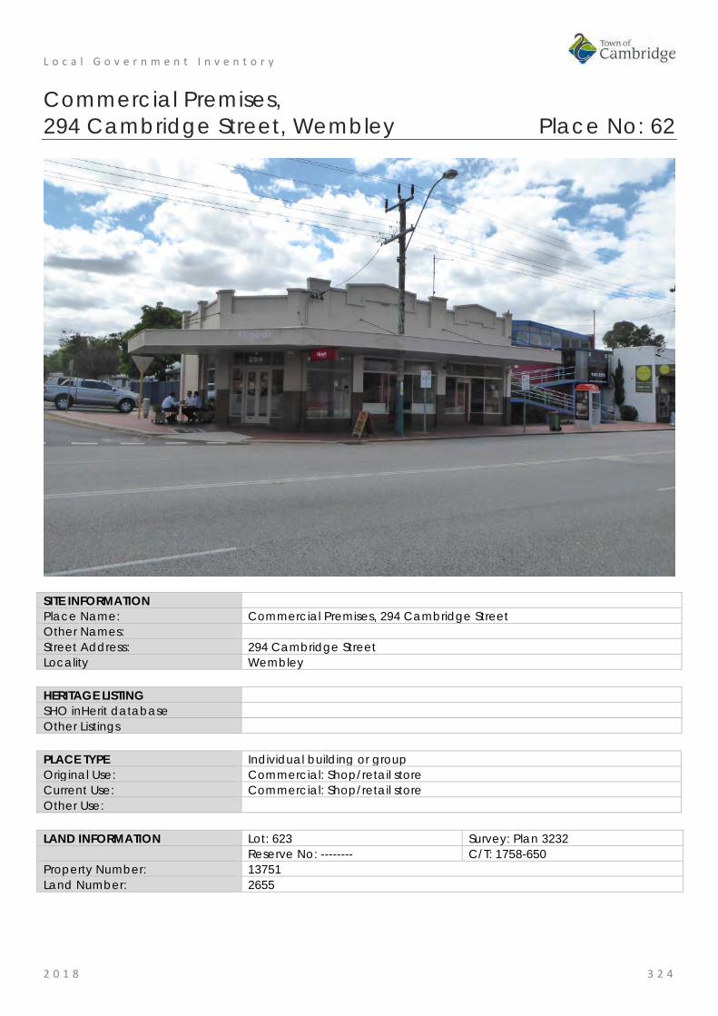
L o c a l G o v e r n m e n t I n v e n t o r y
2 0 1 8 3 2 4
Commercial Premises, 294 Cambridge Street, Wembley Place No: 62
SITE INFORMATION Place Name: Commercial Premises, 294 Cambridge Street Other Names: Street Address: 294 Cambridge Street Locality Wembley HERITAGE LISTING SHO inHerit database Other Listings PLACE TYPE Individual building or group Original Use: Commercial: Shop/retail store Current Use: Commercial: Shop/retail store Other Use: LAND INFORMATION Lot: 623 Survey: Plan 3232 Reserve No: -------- C/T: 1758-650 Property Number: 13751 Land Number: 2655

L o c a l G o v e r n m e n t I n v e n t o r y
2 0 1 8 3 2 5
CONSTRUCTION DETAILS Construction Date: 1930 Walls: Brick: Rendered Roof: Metal: Corrugated Architectural Style: Inter War Physical Description: A single storey inter-war commercial building located on the corner of Cambridge Street and Nanson Street. The place consists of three separate units, each presenting in a similar manner tied together by the painted rendered finish and the face brickwork to the lower section of the shop frontages. The roof cladding over the former residence is a product known as Decramastic (Decromastic) which was a galvanised steel metal roof cladding with a tile profile. There is evidence of concrete corrosion and cracking in the parapet to all three shop premises. The verandah canopy is in poor condition due to regular collisions with vehicles. The rear of the property demonstrates poor structural integrity as evidenced by failing mortar and cracking. Condition: Fair Integrity: Moderate Authenticity: Moderate

L o c a l G o v e r n m e n t I n v e n t o r y
2 0 1 8 3 2 6
HISTORICAL INFORMATION Historical Notes: This place is one of a number of buildings constructed in the late 1920s to serve the growing community in the district. As was common practice the original building was a combined shop and residence. Its location on the corner of Cambridge and Nanson Streets was valuable exposure for the business.
Plans dated 1930 are held by the Town of Cambridge which indicate the original form and detail of the building are still evident. The plans are noted with the name of local builder J H Glenn, identified in additional research as William Luitpold John Henry Glenn (1898-1972). Glenn was a well-known local builder who lived at 308 Cambridge Street with his wife and two children. It is likely that Glenn designed, as well as constructed the premises.
Glenn may have been a competent builder but was not a good business man, who also enjoyed gambling, leading to several appearances in local courts and bankruptcy in 1937. Glenn served during the Second World War with the Australian Imperial Force and avoided another legal issue over contracts with the Workers Home Board undertaken when he was still bankrupt.
When the premises were first occupied in 1931 one of the premises was vacant and the others were occupied by, hairdresser Frederick Holland, and draper Joseph W Bateman. The owner of the property has not been identified in this research.
Aerial photographs indicate that the form and extent of the building has not changed significantly since the mid 20th century although the lot was subdivided c2007 allowing the construction of a car park at the rear of the lot accessed from Nanson Street. A site visit in August 2018 indicated that the internal arrangement of the spaces has been altered and the rear portion of the building is in poor condition.
Historic Theme: Demographic Settlement and Mobility: Settlements Occupations: Commercial services and industries
Associations: William Luitpold John Henry Glenn, builder Sources: Aerial photographs, 1953-2016, Landgate.
Town of Cambridge Municipal Heritage Inventory and Townscape Precinct Study prepared for the Town of Cambridge, June 1997. Culpeffer-Cooke, Tony; Pleydell, Ian 'Tracks by the Swan The Electric Tram and Trolley Bus Era of Perth', Western Australia Perth Electric Tramway Society Inc., 2010. Wise's Post Office Directories for the City of Perth, 1925-1949, State Library of WA www.slwa.wa.gov.au Australian Electoral Rolls, 1901-1983. The West Australian 9 September 1937, p.3; 25 June 1940, p. 10.
SIGNIFICANCE Statement of Significance: • The place has aesthetic value as a good example of an Inter War
combined shop and retail premises with original form and detail despite evidence of poor structural integrity.
• The place has historic value for its association with the development of Wembley in the Inter War period and this section of Cambridge Street which was, and continues to be, a retail hub.
• The place has social value for its continuity of function as a commercial premises since the 1930s.
Level of Significance: Some/Moderate Contributes to the heritage of the locality. Has some altered or modified elements, not necessarily detracting from the overall significance of the item.
Management Category: Category 3 Conservation of the place is desirable. Any alterations or extensions should reinforce the significance of the place, and original fabric should be retained wherever feasible. Include on the Town Planning Scheme No 1 Heritage List.

L o c a l G o v e r n m e n t I n v e n t o r y
2 0 1 8 3 2 7
ADDITIONAL PHOTOGRAPHS
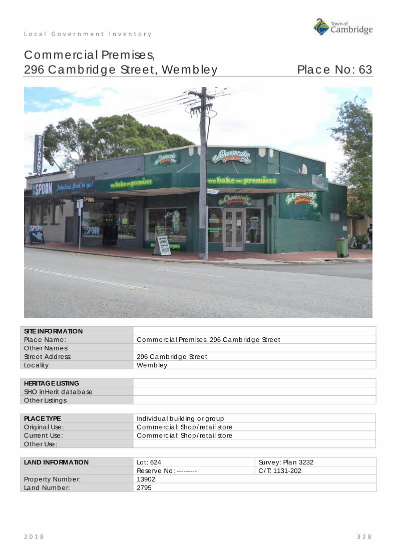
L o c a l G o v e r n m e n t I n v e n t o r y
2 0 1 8 3 2 8
Commercial Premises, 296 Cambridge Street, Wembley Place No: 63
SITE INFORMATION Place Name: Commercial Premises, 296 Cambridge Street Other Names: Street Address: 296 Cambridge Street Locality Wembley HERITAGE LISTING SHO inHerit database Other Listings PLACE TYPE Individual building or group Original Use: Commercial: Shop/retail store Current Use: Commercial: Shop/retail store Other Use: LAND INFORMATION Lot: 624 Survey: Plan 3232 Reserve No: --------- C/T: 1131-202 Property Number: 13902 Land Number: 2795

L o c a l G o v e r n m e n t I n v e n t o r y
2 0 1 8 3 2 9
CONSTRUCTION DETAILS Construction Date: c1928 Walls: Brick: Common rendered, painted Roof: Metal: Corrugated iron Architectural Style: Inter War Physical Description: A pair of single storey commercial premises located on the western corner of Nanson Street and Cambridge Street. The former residence to the rear is also used as a commercial premises. The units are of painted brick construction below the awning and rendered masonry above to the plain parapet walls. The corner unit has an angled entrance with timber framed glass double doors and flaking windows with a large shop window to Cambridge Street. The fanlights above have been boarded up. The adjoining shop has replaced the windows and doors but still presents in a semi-traditional manner with full height windows to the awning. The fanlight above the double entrance doors remains albeit not original. A boxed awning extends across the full extent of both retail units. The former residence has a tiled roof and rendered walls with remaining original timber front door and timber casement windows. Condition: Fair Integrity: Moderate Authenticity: Moderate

L o c a l G o v e r n m e n t I n v e n t o r y
2 0 1 8 3 3 0
HISTORICAL INFORMATION Historical Notes: This place is one of a number of buildings constructed in the late 1920s to serve the growing community in the district. As was common practice the original building was a combined shop and residence. Its location on the corner of Cambridge and Nanson Streets was valuable exposure for the business. The shop portion of the building was divided into two premises. When the premises were first occupied in 1929 the two premises were occupied by; storekeeper O.M.E Wearne and Mrs Nellie Blakely, a stationer. Aerial photographs indicate that the form and extent of the building has not changed significantly since the mid 20th century. Historic Theme: Demographic Settlement and Mobility: Settlements
Occupations: Commercial services and industries Associations: Sources: Aerial photographs, 1953-2016, Landgate.
Town of Cambridge Municipal Heritage Inventory and Townscape Precinct Study prepared for the Town of Cambridge, June 1997. Culpeffer-Cooke, Tony; Pleydell, Ian 'Tracks by the Swan The Electric Tram and Trolley Bus Era of Perth', Western Australia Perth Electric Tramway Society Inc., 2010. Wise's Post Office Directories for the City of Perth, 1925-1949, State Library of WA www.slwa.wa.gov.au Australian Electoral Rolls, 1901-1983.
SIGNIFICANCE Statement of Significance: • The place has aesthetic value as an example of an Inter War
combined shop and retail premises with some original detail. • The place has historic value for its association with the development
of Wembley in the Inter War period and this section of Cambridge Street which was, and continues to be, a retail hub.
• The place has social value for its continuity of function as a commercial premises since the 1930s.
Level of Significance: Little Contributes to the understanding of the history of the Town of Cambridge.
Management Category: Category 4 Photographically record prior to major development or demolition. Recognise and interpret the site if possible. Do not include on the Town Planning Scheme No 1 Heritage List.

L o c a l G o v e r n m e n t I n v e n t o r y
2 0 1 8 3 3 1
ADDITIONAL PHOTOGRAPHS
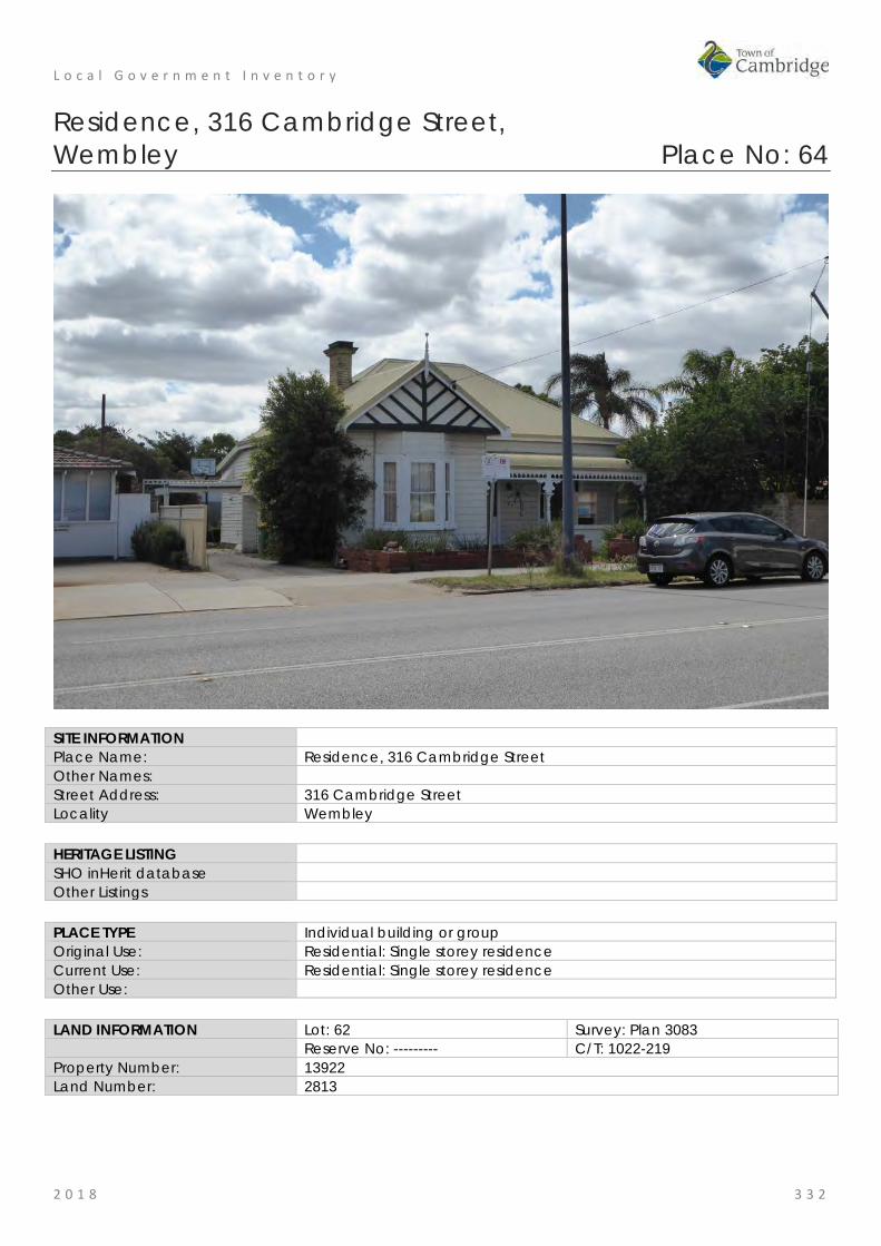
L o c a l G o v e r n m e n t I n v e n t o r y
2 0 1 8 3 3 2
Residence, 316 Cambridge Street, Wembley Place No: 64
SITE INFORMATION Place Name: Residence, 316 Cambridge Street Other Names: Street Address: 316 Cambridge Street Locality Wembley HERITAGE LISTING SHO inHerit database Other Listings PLACE TYPE Individual building or group Original Use: Residential: Single storey residence Current Use: Residential: Single storey residence Other Use: LAND INFORMATION Lot: 62 Survey: Plan 3083 Reserve No: --------- C/T: 1022-219 Property Number: 13922 Land Number: 2813

L o c a l G o v e r n m e n t I n v e n t o r y
2 0 1 8 3 3 3
CONSTRUCTION DETAILS Construction Date: c1927 Walls: Weatherboards Roof: Metal: Colorbond Architectural Style: Inter War Californian Bungalow Physical Description: Inter-war weatherboard cottage of asymmetrical plan form. The projecting section of the façade contains a three sectioned bay window with timber framed sashes and weatherboard cladding above and below the window. The gable above has roughcast render with timber batten detailing and turned timber finial.
The recessed section of the house contains a further three section timber framed window with sashes and the main entrance which has fanlight and sidelights.
The high hipped and gabled roof together with the bullnose verandah canopy have been reclad with colorbond. The verandah also contains non-original decorative brackets and frieze. The balustrade is rendered masonry.
A tall brick chimney with elaborate corbelling is positioned on the west side of the roof behind the gable.
A site visit in 2018 demonstrated that the original room arrangments, timber floors and details were still in evidence.
Condition: Good Integrity: Moderate Authenticity: Moderate
HISTORICAL INFORMATION Historical Notes: This residence was constructed c1927 and the first occupant was truck examiner, Frederick Sunderland (c1888- 1961) and his wife Ruby Leah Sunderland, nee Myers (c1889- 1966). A later occupant was Edward Scales.
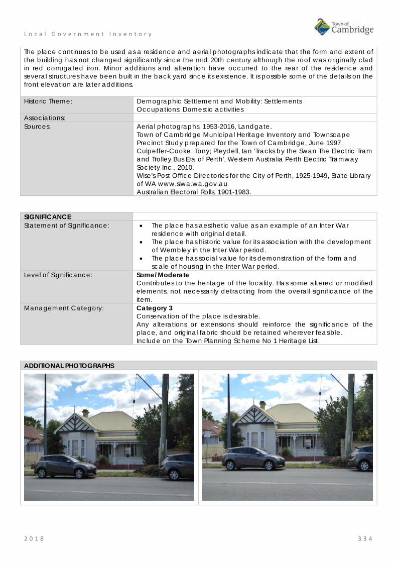
L o c a l G o v e r n m e n t I n v e n t o r y
2 0 1 8 3 3 4
The place continues to be used as a residence and aerial photographs indicate that the form and extent of the building has not changed significantly since the mid 20th century although the roof was originally clad in red corrugated iron. Minor additions and alteration have occurred to the rear of the residence and several structures have been built in the back yard since its existence. It is possible some of the details on the front elevation are later additions. Historic Theme: Demographic Settlement and Mobility: Settlements
Occupations: Domestic activities Associations: Sources: Aerial photographs, 1953-2016, Landgate.
Town of Cambridge Municipal Heritage Inventory and Townscape Precinct Study prepared for the Town of Cambridge, June 1997. Culpeffer-Cooke, Tony; Pleydell, Ian 'Tracks by the Swan The Electric Tram and Trolley Bus Era of Perth', Western Australia Perth Electric Tramway Society Inc., 2010. Wise's Post Office Directories for the City of Perth, 1925-1949, State Library of WA www.slwa.wa.gov.au Australian Electoral Rolls, 1901-1983.
SIGNIFICANCE Statement of Significance: • The place has aesthetic value as an example of an Inter War
residence with original detail. • The place has historic value for its association with the development
of Wembley in the Inter War period. • The place has social value for its demonstration of the form and
scale of housing in the Inter War period. Level of Significance: Some/Moderate
Contributes to the heritage of the locality. Has some altered or modified elements, not necessarily detracting from the overall significance of the item.
Management Category: Category 3 Conservation of the place is desirable. Any alterations or extensions should reinforce the significance of the place, and original fabric should be retained wherever feasible. Include on the Town Planning Scheme No 1 Heritage List.
ADDITIONAL PHOTOGRAPHS
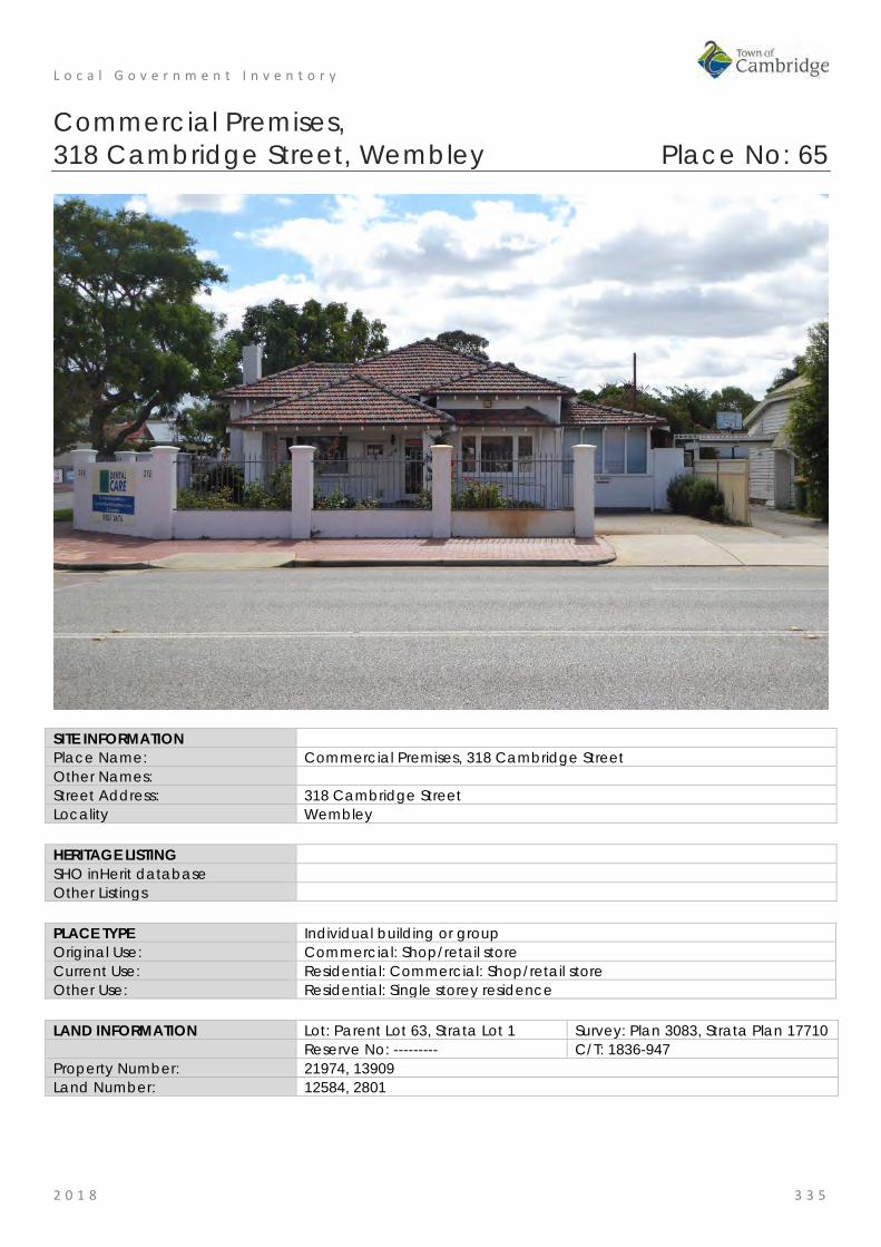
L o c a l G o v e r n m e n t I n v e n t o r y
2 0 1 8 3 3 5
Commercial Premises, 318 Cambridge Street, Wembley Place No: 65
SITE INFORMATION Place Name: Commercial Premises, 318 Cambridge Street Other Names: Street Address: 318 Cambridge Street Locality Wembley HERITAGE LISTING SHO inHerit database Other Listings PLACE TYPE Individual building or group Original Use: Commercial: Shop/retail store Current Use: Residential: Commercial: Shop/retail store Other Use: Residential: Single storey residence LAND INFORMATION Lot: Parent Lot 63, Strata Lot 1 Survey: Plan 3083, Strata Plan 17710 Reserve No: --------- C/T: 1836-947 Property Number: 21974, 13909 Land Number: 12584, 2801

L o c a l G o v e r n m e n t I n v e n t o r y
2 0 1 8 3 3 6
CONSTRUCTION DETAILS Construction Date: c1946 Walls: Brick: common, painted Roof: Tile: terracotta Architectural Style: Post War Physical Description: This entry relates only to the former residence on Strata Lot 1.
A single storey brick and tiled inter-war residence that has been extended along the eastern side of the house and converted for non-commercial use.
The brickwork has been painted and possibly rendered to the lower sections of the façade. Some original windows have been retained and where they have been replaced, the openings have not been enlarged. Both original and non-original windows are timber framed.
The roof is a complex arrangement of hips with separate hips to the projecting wing and the verandah, an elevated roof line to the central apex of the roof before it drops down to the western ridge. A tall rendered chimney extends from the western plane of the roof. The verandah is located towards the western half of the façade, the tiled canopy supported on square masonry columns with a non-original steel balustrade.
The property is located on a corner site with the garden converted to hard standing for parking, enclosed by a low boundary wall with tall rendered piers and palisade style fencing panels.
Condition: Good Integrity: Moderate Authenticity: Moderate

L o c a l G o v e r n m e n t I n v e n t o r y
2 0 1 8 3 3 7
HISTORICAL INFORMATION Historical Notes: This place was built by the owner Cyril Stanley Fletcher (c1898-1979) as a residence and premises for his practice as a dentist. It is probable that the professional rooms were accessed separately from Pangbourne Street. The architect and builder for the place have not been determined in this research. Aerial photographs indicate that the original form and extent of the building have not changed significantly since the mid 20th century and the lot was subdivided c1990 to enable the construction of a new premises in the rear of the lot. The place continues to be used as professional rooms for a dentist. Historic Theme: Demographic Settlement and Mobility: Settlements
Occupations: Commercial services and industries Associations: Cyril Fletcher and family Sources: Aerial photographs, 1953-2016, Landgate.
Town of Cambridge Municipal Heritage Inventory and Townscape Precinct Study prepared for the Town of Cambridge, June 1997. Culpeffer-Cooke, Tony; Pleydell, Ian 'Tracks by the Swan The Electric Tram and Trolley Bus Era of Perth', Western Australia Perth Electric Tramway Society Inc., 2010. Wise's Post Office Directories for the City of Perth, 1925-1949, State Library of WA www.slwa.wa.gov.au Australian Electoral Rolls, 1901-1983.
SIGNIFICANCE Statement of Significance: • The place has aesthetic value as an example of an Inter War
residence with original detail. • The place has historic value for its association with the development
of Wembley in the Inter War period. • The place has social value for its demonstration of the practice of
combining a residence with professional rooms. Level of Significance: Little
Contributes to the understanding of the history of the Town of Cambridge.
Management Category: Category 4 Photographically record prior to major development or demolition. Recognise and interpret the site if possible. Do not include on the Town Planning Scheme No 1 Heritage List.

L o c a l G o v e r n m e n t I n v e n t o r y
2 0 1 8 3 3 8
ADDITIONAL PHOTOGRAPHS

L o c a l G o v e r n m e n t I n v e n t o r y
2 0 1 8 3 3 9
Residence, 319A Cambridge Street, Wembley Place No: 66
SITE INFORMATION Place Name: Residence, 319A Cambridge Street Other Names: Street Address: 319A Cambridge Street Locality Wembley HERITAGE LISTING SHO inHerit database Other Listings PLACE TYPE Individual building or group Original Use: Residential: Single storey residence Current Use: Residential: Single storey residence Other Use: LAND INFORMATION Lot: Parent Lot 59, Strata Lot 1 Survey: Plan 3083, Strata Plan 19131 Reserve No: ---------- C/T: 1874-293 Property Number: 21920, 18063 Land Number: 12525, 563

L o c a l G o v e r n m e n t I n v e n t o r y
2 0 1 8 3 4 0
CONSTRUCTION DETAILS Construction Date: c1929 Walls: Brick: Common Roof: Tiles: terracotta Architectural Style: Inter War Physical Description: This entry relates only to the former residence on Strata Lot 1. Single storey brick and tiled residential property of asymmetric plan form. The house contains Federation styled features although is an inter-war property. The place is of face brick construction to the lower half of the elevations with render to the top half. The verandah/porch columns are all render, apart from a brick detail at the top, providing a contrast to the brick balustrade. The verandah/porch entry is located to the south east corner of the façade, accessed via brick steps to a brick paved deck. The south and west walls both form part of the main house with the east wall being a mid-height solid brick balustrade. The verandah/porch area has a separate tiled gable roof with timbered gable, supported on twin rendered masonry columns. The projecting wing section of façade equates to approximately two-thirds of the front elevation and contains a boxed bay with four casement windows and a smaller boxed window close to the verandah. Both windows are protected by a tiled window awning. The roof is a combination of hipped and gabled elements. The roof above the projecting wing is gabled with fibre cement cladding with battens, similar to the gable over the verandah. The main roof is hipped

L o c a l G o v e r n m e n t I n v e n t o r y
2 0 1 8 3 4 1
with broad based chimneys to the east and west planes of the roof. A contemporary carport has been constructed to the front of the property, replicating the design features of the original house. The lot has been subdivided with a long driveway extending along the eastern boundary of the site to the rear property. Condition: Fair Integrity: High Authenticity: Moderate
HISTORICAL INFORMATION Historical Notes: This place was built c1929 as a residence and the first occupant was noted in the Post Office Directories as Mrs Lucky G Glen and rates book indicate the owner was Charlotte Hannan. A later long term occupant was engineer Harold Henry Strickfuss (c1898-1948). The lot was subdivided c1990 and a new residence was constructed in the rear of the lot. A new carport was constructed in the front portion of the lot at that time and the original residence was extended. Aerial photographs indicate that the form of the original residence can still be determined. The current owner has provided information that much of the original detail has been replaced with contemporary finishes. Historic Theme: Demographic Settlement and Mobility: Settlements
Occupations: Domestic activities Associations: Sources: Aerial photographs, 1953-2016, Landgate.
Town of Cambridge Municipal Heritage Inventory and Townscape Precinct Study prepared for the Town of Cambridge, June 1997. Culpeffer-Cooke, Tony; Pleydell, Ian 'Tracks by the Swan The Electric Tram and Trolley Bus Era of Perth', Western Australia Perth Electric Tramway Society Inc., 2010. Wise's Post Office Directories for the City of Perth, 1925-1949, State Library of WA www.slwa.wa.gov.au Australian Electoral Rolls, 1901-1983. Information from the current [2018] owner.
SIGNIFICANCE Statement of Significance: • The place has aesthetic value as an example of an Inter War
residence with original detail. • The place has historic value for its association with the development
of Wembley in the Inter War period. • The place has social value for its demonstration of the form and
scale of housing in the Inter War period. Level of Significance: Little
Contributes to the understanding of the history of the Town of Cambridge.
Management Category: Category 4 Photographically record prior to major development or demolition. Recognise and interpret the site if possible. Do not include on the Town Planning Scheme No 1 Heritage List.
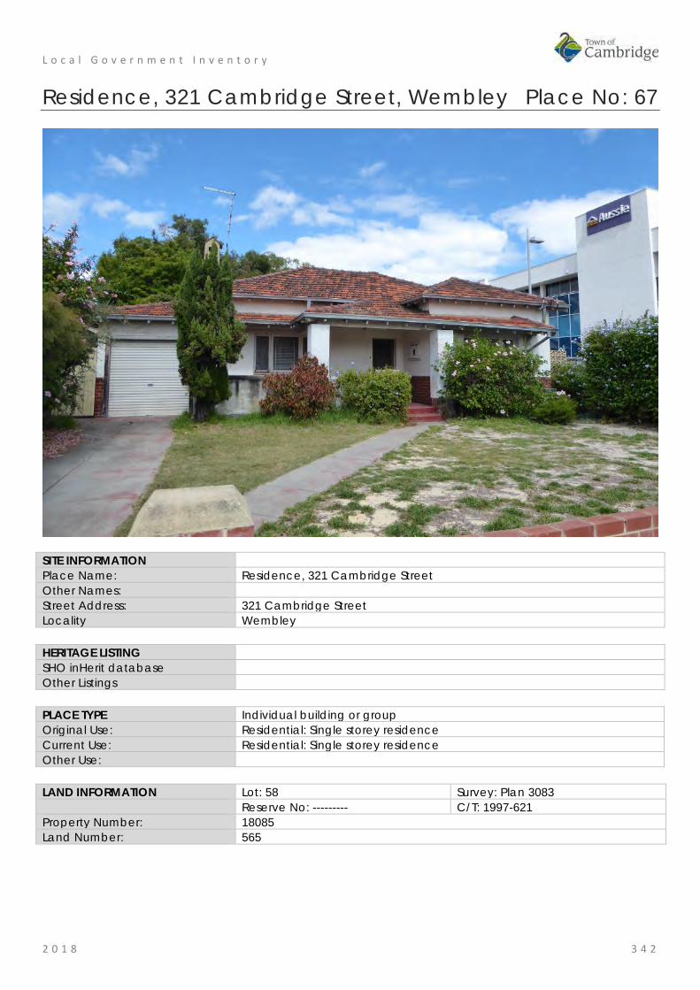
L o c a l G o v e r n m e n t I n v e n t o r y
2 0 1 8 3 4 2
Residence, 321 Cambridge Street, Wembley Place No: 67
SITE INFORMATION Place Name: Residence, 321 Cambridge Street Other Names: Street Address: 321 Cambridge Street Locality Wembley HERITAGE LISTING SHO inHerit database Other Listings PLACE TYPE Individual building or group Original Use: Residential: Single storey residence Current Use: Residential: Single storey residence Other Use: LAND INFORMATION Lot: 58 Survey: Plan 3083 Reserve No: --------- C/T: 1997-621 Property Number: 18085 Land Number: 565

L o c a l G o v e r n m e n t I n v e n t o r y
2 0 1 8 3 4 3
CONSTRUCTION DETAILS Construction Date: c1938 Walls: Brick: Common Roof: Tile: terracotta Architectural Style: Inter War Physical Description: Single storey brick and tiled residential property of traditional asymmetric plan form. The house is a simple example of an interwar Californian bungalow in a mixed-use street. The house has a generous setback and is located in the front third of the lot behind a lawned garden area with a low brick boundary wall. The lot has not been subdivided. The house is of brick construction which is rendered to the upper two-thirds of the elevation and face brick to the lower third. A small verandah/porch area is located to the centre of the façade with a tiled canopy that extends across the projecting wing portion of the façade. The canopy is supported on broad rendered columns. The deck is painted concrete. The main roof is hipped with additional hips to the projecting wing, the verandah area and the adjoining garage, all at the same pitch. The two windows to the front elevation are both casement ensembles comprising side hung panes flanking a central fixed pane. Condition: Fair Integrity: High Authenticity: Moderate

L o c a l G o v e r n m e n t I n v e n t o r y
2 0 1 8 3 4 4
HISTORICAL INFORMATION Historical Notes: This residence was constructed c1938 and first occupied by Frank G Burrows and later by Alfred Spooner and his wife Elizabeth. Information from the current [2018] owner states that the place was built by builder J H Glenn and the lot was owned by his wife Edith May Glenn. Additional research has determined that William Luitpold John Henry Glenn (1898-1972) was a builder who undertook many small building projects in the district. It is probable that the land was purchased by Glenn and his wife who built the home for immediate sale. This type of small development project was not uncommon. Glenn may have been a competent builder but was not a good business man, who also enjoyed gambling, leading to several appearances in local courts and bankruptcy in 1937. The construction of this house by Glenn after 1937 seems unusual given his bankruptcy but as the client was his wife this may not have been a formal contract. Glenn served during the Second World War with the Australian Imperial Force and avoided another legal issue over contracts with the Workers Home Board undertaken when he was still bankrupt. Aerial photographs indicate the form and extent of the premises have not changed significantly since the mid 20th century. Historic Theme: Demographic Settlement and Mobility: Settlements
Occupations: Domestic activities Associations: William Luitpold John Henry Glenn, builder Sources: Aerial photographs, 1953-2016, Landgate.
Town of Cambridge Municipal Heritage Inventory and Townscape Precinct Study prepared for the Town of Cambridge, June 1997. Culpeffer-Cooke, Tony; Pleydell, Ian 'Tracks by the Swan The Electric Tram and Trolley Bus Era of Perth', Western Australia Perth Electric Tramway Society Inc., 2010. Wise's Post Office Directories for the City of Perth, 1925-1949, State Library of WA www.slwa.wa.gov.au Australian Electoral Rolls, 1901-1983. The West Australian 9 September 1937, p.3; 25 June 1940, p. 10. Information from the current [2018] owner
SIGNIFICANCE Statement of Significance: • The place has aesthetic value as an example of an Inter War
residence with original detail. • The place has historic value for its association with the development
of Wembley in the Inter War period. • The place has social value for its demonstration of the form and
scale of housing in the Inter War period. Level of Significance: Little
Contributes to the understanding of the history of the Town of Cambridge.
Management Category: Category 4 Photographically record prior to major development or demolition. Recognise and interpret the site if possible. Do not include on the Town Planning Scheme No 1 Heritage List.

L o c a l G o v e r n m e n t I n v e n t o r y
2 0 1 8 3 4 5
Commercial Premises, 332 Cambridge Street, Wembley Place No: 68
SITE INFORMATION Place Name: Commercial Premises, 332 Cambridge Street Other Names: Wearns Wembley Newsagency Street Address: 332 Cambridge Street Locality Wembley HERITAGE LISTING SHO inHerit database Other Listings PLACE TYPE Individual building or group Original Use: Commercial: Shop/retail store Current Use: Commercial: Shop/retail store Other Use: LAND INFORMATION Lot: 69 Survey: Plan 3083 Reserve No: --------- C/T: 1279-169 Property Number: 16321 Land Number: 5037

L o c a l G o v e r n m e n t I n v e n t o r y
2 0 1 8 3 4 6
CONSTRUCTION DETAILS Construction Date: c1935 Walls: Brick: common, rendered and painted Roof: Iron to commercial premises Terracotta tiles to fmr residence Architectural Style: Inter War Physical Description: 332 Cambridge Street consists of three shops attached to a rear residential property that extends along Jersey Street. The shop frontages to each unit has been altered but the design intent remains visible. The units are unified by the rendered parapet that wraps around to the Jersey Street frontage of the corner unit. Due to the change in land levels, the verandah is stepped to allow for full height windows in each unit. The Corner unit has an extensive glazed frontage with windows to both Cambridge Street and Jersey Street as well as to the angled wall which incorporates the glazed entrance door. A seven-section highlight extends above all the windows and the door creating a continuous glazed frontage. The adjoining units have both undergone minor adaptations to the presentation of the original shop frontages. Both have retained the metal framed high level windows above the main strip windows although the east unit has adapted the central window to accommodate an air conditioning unit. The western unit has changed the shop doors to a single door with narrow side light. All three frontages are rendered brickwork with the plinth painted a contrasting colour. Condition: Good Integrity: Moderate Authenticity: Moderate
L o c a l G o v e r n m e n t I n v e n t o r y
2 0 1 8 3 4 7
HISTORICAL INFORMATION Historical Notes: This place was constructed as a shop and premises c1935 and the first occupant was newsagent Leonard Albert Wearn (c1908-1987). The architect and builder for this building have not been determined in this research. Its location on the corner of Cambridge and Jersey Streets was valuable exposure for the business. Wearn's Wembley Newsagency operated from these premises until at least the mid 1950s. Leonard and his wife Ethel relocated to premises in Essex Street Wembley in the 1960s. In c1978, two new commercial premises were constructed in the rear of the lot facing Jersey Street. A small carport was created in the space between the old and new building. In recent years the front façade of the original shop has been altered. The shop front windows have been replaced with aluminium framed windows and the original front door has also been replaced. The original parapet has been obscured with metal sheeting. The elevation of the original residential premises to Jersey Street cannot be readily determined because of a high brick wall. Historic Theme: Demographic Settlement and Mobility: Settlements
Occupations: Commercial services and industries Associations: Leonard Wearn and family Sources: Aerial photographs, 1953-2016, Landgate.
Town of Cambridge Municipal Heritage Inventory and Townscape Precinct Study prepared for the Town of Cambridge, June 1997. Culpeffer-Cooke, Tony; Pleydell, Ian 'Tracks by the Swan The Electric Tram and Trolley Bus Era of Perth', Western Australia Perth Electric Tramway Society Inc., 2010. Wise's Post Office Directories for the City of Perth, 1925-1949, State Library of WA www.slwa.wa.gov.au Australian Electoral Rolls, 1901-1983.
SIGNIFICANCE Statement of Significance: • The place has aesthetic value as an example of an Inter War
combined shop and retail premises with some original detail. • The place has historic value for its association with the development
of Wembley in the Inter War period and this section of Cambridge Street which was, and continues to be, a retail hub.
• The place has social value for its continuity of function as a commercial premises since the 1930s.
Level of Significance: Little Contributes to the understanding of the history of the Town of Cambridge.
Management Category: Category 4 Photographically record prior to major development or demolition. Recognise and interpret the site if possible. Do not include on the Town Planning Scheme No 1 Heritage List.

L o c a l G o v e r n m e n t I n v e n t o r y
2 0 1 8 3 4 8
ADDITIONAL PHOTOGRAPHS
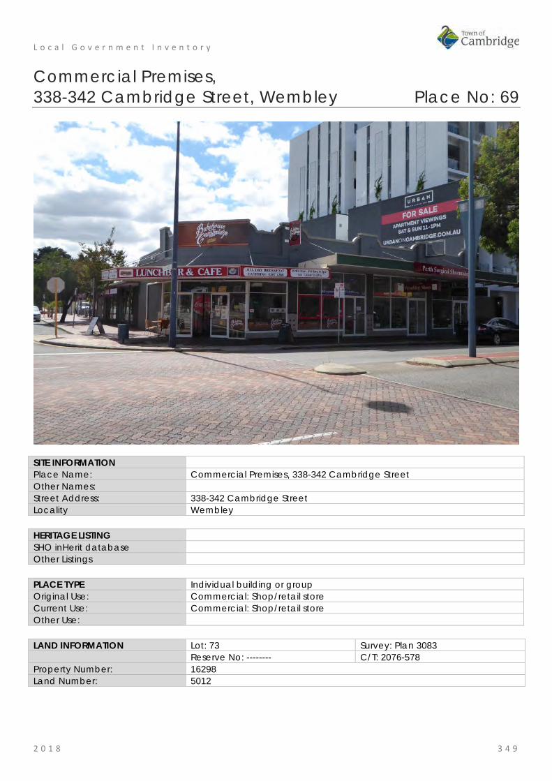
L o c a l G o v e r n m e n t I n v e n t o r y
2 0 1 8 3 4 9
Commercial Premises, 338-342 Cambridge Street, Wembley Place No: 69
SITE INFORMATION Place Name: Commercial Premises, 338-342 Cambridge Street Other Names: Street Address: 338-342 Cambridge Street Locality Wembley HERITAGE LISTING SHO inHerit database Other Listings PLACE TYPE Individual building or group Original Use: Commercial: Shop/retail store Current Use: Commercial: Shop/retail store Other Use: LAND INFORMATION Lot: 73 Survey: Plan 3083 Reserve No: -------- C/T: 2076-578 Property Number: 16298 Land Number: 5012
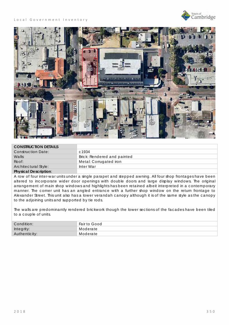
L o c a l G o v e r n m e n t I n v e n t o r y
2 0 1 8 3 5 0
CONSTRUCTION DETAILS Construction Date: c1934 Walls: Brick: Rendered and painted Roof: Metal: Corrugated iron Architectural Style: Inter War Physical Description: A row of four inter-war units under a single parapet and stepped awning. All four shop frontages have been altered to incorporate wider door openings with double doors and large display windows. The original arrangement of main shop windows and highlights has been retained albeit interpreted in a contemporary manner. The corner unit has an angled entrance with a further shop window on the return frontage to Alexander Street. This unit also has a lower verandah canopy although it is of the same style as the canopy to the adjoining units and supported by tie rods. The walls are predominantly rendered brickwork though the lower sections of the facades have been tiled to a couple of units. Condition: Fair to Good Integrity: Moderate Authenticity: Moderate

L o c a l G o v e r n m e n t I n v e n t o r y
2 0 1 8 3 5 1
HISTORICAL INFORMATION Historical Notes: This place is one of a number of buildings constructed in the mid 1930s to serve the growing community in the district. As was common practice the original building was a combined shop and residence. Its location on the corner of Cambridge and Alexander Streets was valuable exposure for the business. The shop portion of the building was divided into four premises. The first occupants of the shops in 1936 were; A. Shackletoy, Butcher; Christie, Tobacconist; Edward John Hill, Grocer and in the following year they were joined by Fishmonger Keith Spinks. The residence behind the shops was accessed from Alexander Street and this building was demolished c1982. A new grouping of retail premises were constructed on the site that was roughly consistent with the original building envelope. The shop premises have not changed significantly in form and extent since the mid 20th century. Historic Theme: Demographic Settlement and Mobility: Settlements
Occupations: Commercial services and industries Associations: Sources: Aerial photographs, 1953-2016, Landgate.
Town of Cambridge Municipal Heritage Inventory and Townscape Precinct Study prepared for the Town of Cambridge, June 1997. Culpeffer-Cooke, Tony; Pleydell, Ian 'Tracks by the Swan The Electric Tram and Trolley Bus Era of Perth', Western Australia Perth Electric Tramway Society Inc., 2010. Wise's Post Office Directories for the City of Perth, 1925-1949, State Library of WA www.slwa.wa.gov.au Australian Electoral Rolls, 1901-1983.
SIGNIFICANCE Statement of Significance: • The place has aesthetic value as an example of an Inter War
combined shop and retail premises with some original detail. • The place has historic value for its association with the development
of Wembley in the Inter War period and this section of Cambridge Street which was, and continues to be, a retail hub.
• The place has social value for its continuity of function as a commercial premises since the 1930s.
Level of Significance: Little Contributes to the understanding of the history of the Town of Cambridge.
Management Category: Category 4 Photographically record prior to major development or demolition. Recognise and interpret the site if possible. Do not include on the Town Planning Scheme No 1 Heritage List.
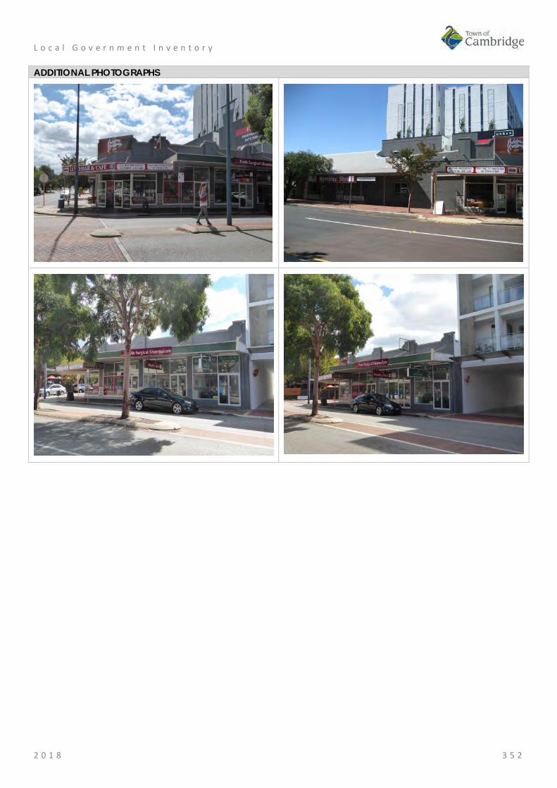
L o c a l G o v e r n m e n t I n v e n t o r y
2 0 1 8 3 5 2
ADDITIONAL PHOTOGRAPHS

L o c a l G o v e r n m e n t I n v e n t o r y
2 0 1 8 3 5 3
Wembley Hotel, Wembley Place No: 70
SITE INFORMATION Place Name: Wembley Hotel Other Names: Wembley Park Hotel Street Address: 344 Cambridge Street Locality Wembley HERITAGE LISTING SHO inHerit database 2226 Other Listings Classified by National Trust
Register of the National Estate Art Deco Significant Building Survey Statewide Hotel Survey
PLACE TYPE Individual building or group Original Use: Commercial: Hotel Current Use: Commercial: Hotel Other Use: LAND INFORMATION Lot: 7 Survey: Plan 18586 Reserve No: -------- C/T: 2070-600 Property Number: 16231 Land Number: 4941

L o c a l G o v e r n m e n t I n v e n t o r y
2 0 1 8 3 5 4
CONSTRUCTION DETAILS Construction Date: 1932; 1989 Walls: Brick: Common brick Roof: Tile: Terracotta Architectural Style: Inter War Mediterranean Physical Description: Substantial rendered brick and tile building constructed in an ‘L’ shape with dual frontages to Cambridge Street and Alexander Street. A drive through bottle shop has been constructed at the western end of the building, presenting with the same detailing as the main hotel. The façade is divided into a series of bays with feature gable sections to both elevations and a main corner entrance that has become obscured by trees. This entrance no longer has direct access from the street due to the construction of a boundary wall around the garden area. The ground level bays to Cambridge Street provide service access for deliveries with flush shutter doors whilst the upper bays were once hotel accommodation with direct access to the balcony that wraps around the façade. The bays to the Alexander Street elevation presents in a more traditional manner with both the ground and upper level elevation being recessed behind the verandah and balcony. The ground floor level is part of the public bar/restaurant area. Whereas the Cambridge Street elevation has been painted in muted tones with all traces of the face brickwork being obscured, the Alexander Street elevation has retained the brickwork providing a contrast with the rendered gables, fascias and upper level elevation. Other materials include timber balustrade to the balcony with square timber posts, open eaves, terracotta tiled roofs with corbelled brick chimneys, and timber framed windows.
L o c a l G o v e r n m e n t I n v e n t o r y
2 0 1 8 3 5 5
The place has undergone alteration but still clearly reflects the design intent of the place. Condition: Good Integrity: High Authenticity: Moderate
HISTORICAL INFORMATION Historical Notes: The building was designed for the owner Michael Francis Cranley (c1889-1979) by architect E le B Henderson and constructed by local builders Messrs Snooks & Sons in 1932 for the price of £7998. The hotel became a landmark on Cambridge Street as the end of the tramline and also the departing point for expeditions along the plank road to the beach. The hotel was owned by the Cranley family until the late 1980's when it was sold and extended to incorporate a shopping centre and a drive through bottle shop. These works required the demolition of the original beer garden. The hotel continues to be altered and added to in response to the changing needs and requirements of its patrons. Historic Theme: Demographic Settlement and Mobility: Settlements
Occupations: Commercial services and industries Associations: E. Le B Henderson
Snooks & Sons Cranley family
Sources: Aerial photographs, 1953-2016, Landgate. Town of Cambridge Municipal Heritage Inventory and Townscape Precinct Study prepared for the Town of Cambridge, June 1997. Culpeffer-Cooke, Tony; Pleydell, Ian 'Tracks by the Swan The Electric Tram and Trolley Bus Era of Perth', Western Australia Perth Electric Tramway Society Inc., 2010. Wise's Post Office Directories for the City of Perth, 1925-1949, State Library of WA www.slwa.wa.gov.au
SIGNIFICANCE Statement of Significance: • The place has aesthetic value as a good intact example of the Inter
War Mediterranean style executed in brick and tile demonstrating many intact external and internal details.
• The place has landmark value in Wembley and the Cambridge Streetscape as a prominent feature since 1932.
• The place has historic value for its association with the development of Wembley in the 1930s.
• The place has historic value for its association with prominent local architect, Edgar Le B Henderson, builders Snook and Sons and owners, the Cranley family.
• The place has social value to the community as a place of gathering for many social and formal events since the 1930s.
Level of Significance: Considerable Very important to the heritage of the locality. High degree of integrity/authenticity
Management Category: Category 2 Conservation of the place is highly desirable. Any alterations or extensions should reinforce the significance of the place Include on the Town Planning Scheme No 1 Heritage List

L o c a l G o v e r n m e n t I n v e n t o r y
2 0 1 8 3 5 6
ADDITIONAL PHOTOGRAPHS

L o c a l G o v e r n m e n t I n v e n t o r y
2 0 1 8 3 5 7
Commercial Premises, 347-349 Cambridge Street, Wembley Place No: 71
SITE INFORMATION Place Name: Commercial Premises, 347-349 Cambridge Street Other Names: Street Address: 347-349 Cambridge Street Locality Wembley HERITAGE LISTING SHO inHerit database Other Listings PLACE TYPE Individual building or group Original Use: Commercial: Shop/retail store Current Use: Commercial: Shop/retail store Other Use: LAND INFORMATION Lot: 46; 47 Survey: Plan 3083 Reserve No: -------- C/T: 2036-219; 2036-218 Property Number: 16508 Land Number: 430; 431

L o c a l G o v e r n m e n t I n v e n t o r y
2 0 1 8 3 5 8
CONSTRUCTION DETAILS Construction Date: 1950s Walls: Brick: Common, painted Roof: Metal: Corrugated iron Architectural Style: Post War Physical Description: 347 Cambridge Street (Lot 47) is a post war single storey retail unit with art deco inspired motif to the parapet. The building is of brick construction rendered to the façade and painted brickwork to the side. The parapet contains a central rendered fin and rendered capping, both painted in contrasting colour to add emphasis to the detail. The shop has retained the recessed entrance and angled shop windows with highlights across the entire façade. Although alterations have occurred, the original design intent of the buildings remains extant. Adjoining at 349 Cambridge Street (Lot 64) is a post war single storey brick commercial premises originally containing three retail units. The internal planning has been altered resulting in the amalgamation of two units to create Lawleys and the subdivision of the adjacent unit to create two small retail outlets. Despite the alterations to the frontages, they have retained an air of the traditional retail unit with large shop windows and glazed doors. The highlight windows have been retained though boarded over to the central shop units. The units are of brick construction which has not been painted. A verandah awning extends across the façade supported on tied rods and has pressed metal lining to the underside.

L o c a l G o v e r n m e n t I n v e n t o r y
2 0 1 8 3 5 9
Condition: Good Integrity: Moderate Authenticity: Moderate
HISTORICAL INFORMATION Historical Notes: These premises were built in the 1950s and are representative of the population growth in the district following World War II. The architect and builder of the premises have not been determined in this research. This group of retail premises were built in stages although in rapid succession. The shop premises at 349 Cambridge Street was constructed prior to 1953 and was the premises of Wembley Real Estate Agency for many years. The premises at 347 Cambridge Street originally consisted of three premises which have subsequently been reduced to two tenancies. Aerial photographs indicate that the form and extent of the buildings have not changed significantly since that time. Historic Theme: Demographic Settlement and Mobility: Settlements
Occupations: Commercial services and industries Associations: Sources: Aerial photographs, 1953-2016, Landgate.
Town of Cambridge Municipal Heritage Inventory and Townscape Precinct Study prepared for the Town of Cambridge, June 1997. Culpeffer-Cooke, Tony; Pleydell, Ian Tracks by the Swan The Electric Tram and Trolley Bus Era of Perth, Western Australia Perth Electric Tramway Society Inc., 2010. Wise's Post Office Directories for the City of Perth, 1925-1949, State Library of WA www.slwa.wa.gov.au
SIGNIFICANCE Statement of Significance: • The place has aesthetic value as an example of a Post War
combined shop and retail premises with original detail. • The place has historic value for its association with the development
of Wembley in the Post War period and this section of Cambridge Street which was, and continues to be, a retail hub.
• The place has social value for its continuity of function as a commercial premises since the 1950s.
Level of Significance: Some/Moderate Contributes to the heritage of the locality. Has some altered or modified elements, not necessarily detracting from the overall significance of the item.
Management Category: Category 3 Conservation of the place is desirable. Any alterations or extensions should reinforce the significance of the place, and original fabric should be retained wherever feasible. Include on the Town Planning Scheme No 1 Heritage List.
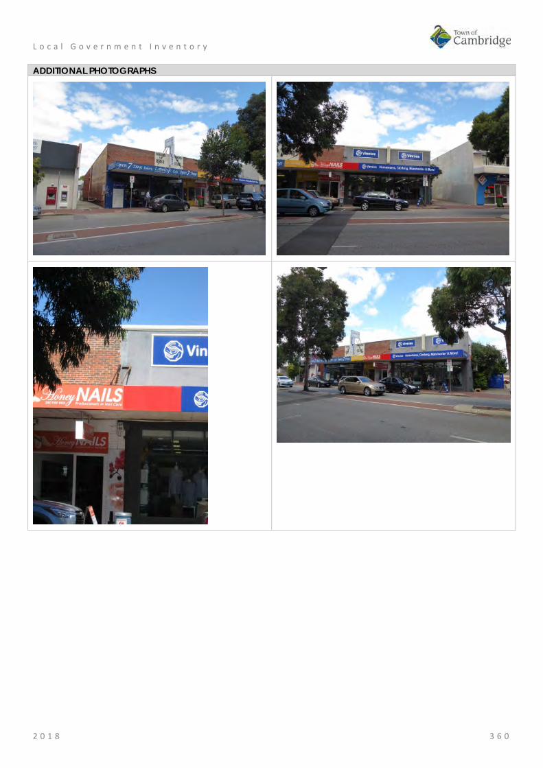
L o c a l G o v e r n m e n t I n v e n t o r y
2 0 1 8 3 6 0
ADDITIONAL PHOTOGRAPHS

L o c a l G o v e r n m e n t I n v e n t o r y
2 0 1 8 3 6 1
Commercial Premises, 352 Cambridge Street, Wembley Place No: 72
SITE INFORMATION Place Name: Commercial Premises, 352 Cambridge Street Other Names: Street Address: 352 Cambridge Street Locality Wembley HERITAGE LISTING SHO inHerit database Other Listings PLACE TYPE Individual building or group Original Use: Commercial: Shop/retail store Current Use: Commercial: Shop/retail store Other Use: LAND INFORMATION Lot: 78 Survey: Plan 3083 Reserve No: --------- C/T: 1204-292 Property Number: 16227 Land Number: 4937

L o c a l G o v e r n m e n t I n v e n t o r y
2 0 1 8 3 6 2
CONSTRUCTION DETAILS Construction Date: c1950 Walls: Brick: Common, painted Roof: Metal: Corrugated iron Architectural Style: Post War Physical Description: Single storey brick building with high parapet and bullnose verandah. The shop's windows have been replaced which impacts on its traditional aesthetic. The centrally placed single door is of traditional presentation with timber lower panel and glazed upper panel with a glazed side light. The verandah canopy is a replacement bullnose supported on tapered cylindrical columns on top of a masonry plinth. The entire façade has been painted. Condition: Integrity: Moderate Authenticity: Low
HISTORICAL INFORMATION Historical Notes: These premises were constructed c1950 and are representative of the population growth in the district following World War II. The architect and builder of the buildings have not been determined in this research. The original buildings on the lot consisted of a linked shop and residence although it has not been established if the two were constructed at the same time although the stylistic elements suggest they were. The number of retail premises originally within this building appears to be only one. In the mid 1950s, advertising for electrical retailers, Blakes Pty Ltd, refers to their premises as 352 Cambridge Street indicating that no other tenancies occupied this place. Aerial photographs indicate that the addition of the brick awning detail for the restaurant dates from the early 1980s. A series of additions have been made to the rear of the restaurant tenancy on the eastern side

L o c a l G o v e r n m e n t I n v e n t o r y
2 0 1 8 3 6 3
of the lot. A two storey residence was constructed in the rear of the lot between 1965 and 1974 which is integrated into the original residence. Historic Theme: Demographic Settlement and Mobility: Settlements
Occupations: Commercial services and industries Associations: Sources: Aerial photographs, 1953-2016, Landgate.
Town of Cambridge Municipal Heritage Inventory and Townscape Precinct Study prepared for the Town of Cambridge, June 1997. Culpeffer-Cooke, Tony; Pleydell, Ian Tracks by the Swan The Electric Tram and Trolley Bus Era of Perth, Western Australia Perth Electric Tramway Society Inc., 2010. Wise's Post Office Directories for the City of Perth, 1925-1949, State Library of WA www.slwa.wa.gov.au Australian Electoral Rolls, 1901-1983. The Mirror, 25 February 1956, p. 3.
SIGNIFICANCE Statement of Significance: • The place has some aesthetic value as an example of a Post-World
War II combined shop and retail premises. • The place has historic value for its association with the development
of Wembley in the Post War period and this section of Cambridge Street which was, and continues to be, a retail hub.
• The place has social value for its continuity of function as a commercial premises since the 1950s.
Level of Significance: Little Contributes to the understanding of the history of the Town of Cambridge.
Management Category: Category 4 Photographically record prior to major development or demolition. Recognise and interpret the site if possible. Do not include on the Town Planning Scheme No 1 Heritage List.

L o c a l G o v e r n m e n t I n v e n t o r y
2 0 1 8 3 6 4
ADDITIONAL PHOTOGRAPHS

L o c a l G o v e r n m e n t I n v e n t o r y
2 0 1 8 3 6 5
Commercial Premises, 361 Cambridge Street, Wembley Place No: 73
SITE INFORMATION Place Name: Commercial Premises, 361 Cambridge Street Other Names: Street Address: 361 Cambridge Street Locality Wembley HERITAGE LISTING SHO inHerit database Other Listings PLACE TYPE Individual building or group Original Use: Commercial: Shop/retail store Current Use: Commercial: Shop/retail store Other Use: LAND INFORMATION Lot: 40 Survey: Plan 3083 Reserve No: -------- C/T: 1178-760 Property Number: 16750 Land Number: 452

L o c a l G o v e r n m e n t I n v e n t o r y
2 0 1 8 3 6 6
CONSTRUCTION DETAILS Construction Date: c1938 Walls: Brick: Common, painted Roof: Metal: Iron Architectural Style: Inter War Physical Description: Single storey inter-war commercial units of altered presentation. The arrangements of the shop frontages remains extant to the unit 361B but doors and windows have been replaced. The shop frontage to Units 361 and 361A have been completely remodelled with aluminium doors and windows which are flush to the street, removing the traditional recessed entrance and angled shop window. The building has a tall parapet wall which is obscured with signage and a verandah canopy supported on tie rods. The place is of brick construction which has subsequently been painted. Condition: Good Integrity: Moderate Authenticity: Low
HISTORICAL INFORMATION Historical Notes: This place is one of a number of buildings constructed in the 1930s to serve the growing community in the district. As was common practice the building combined shops and residence. The shop portion of the building was divided into three premises. The first occupants of the premises were; 361 William J Bryant, Chemist; 361A Miss Elsie Elverd, hairdresser; and 361B D. McClaren, draper. These uses continued for many years and a chemist is still associated with the place.

L o c a l G o v e r n m e n t I n v e n t o r y
2 0 1 8 3 6 7
During the mid 1950s, one of the tenancies was occupied by Wembley Home Appliances which retailed records. Aerial photographs indicate that the form and extent of the premises have not changed significantly since the mid 1960s. Historic Theme: Demographic Settlement and Mobility: Settlements
Occupations: Commercial services and industries Associations: Sources: Aerial photographs, 1953-2016, Landgate.
Town of Cambridge Municipal Heritage Inventory and Townscape Precinct Study prepared for the Town of Cambridge, June 1997. Culpeffer-Cooke, Tony; Pleydell, Ian Tracks by the Swan The Electric Tram and Trolley Bus Era of Perth, Western Australia Perth Electric Tramway Society Inc., 2010. Wise's Post Office Directories for the City of Perth, 1925-1949, State Library of WA www.slwa.wa.gov.au Australian Electoral Rolls, 1901-1983. The West Australian, 21 January 1954, p. 6.
SIGNIFICANCE Statement of Significance: • The place has aesthetic value as an example of an Inter War
combined shop and retail premises with some original detail. • The place has historic value for its association with the development
of Wembley in the Inter War period and this section of Cambridge Street which was, and continues to be, a retail hub.
• The place has social value for its continuity of function as a commercial premises since the 1930s.
Level of Significance: Little Contributes to the understanding of the history of the Town of Cambridge.
Management Category: Category 4 Photographically record prior to major development or demolition. Recognise and interpret the site if possible. Do not include on the Town Planning Scheme No 1 Heritage List.
ADDITIONAL PHOTOGRAPHS
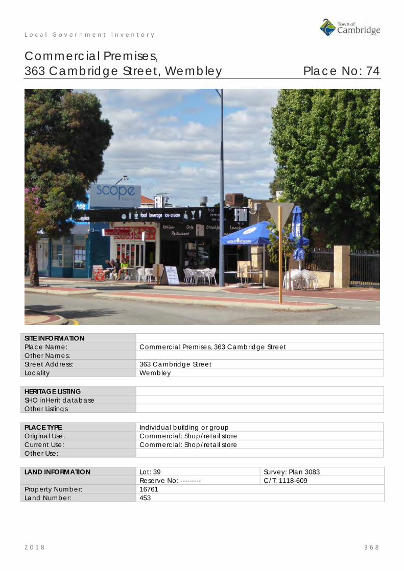
L o c a l G o v e r n m e n t I n v e n t o r y
2 0 1 8 3 6 8
Commercial Premises, 363 Cambridge Street, Wembley Place No: 74
SITE INFORMATION Place Name: Commercial Premises, 363 Cambridge Street Other Names: Street Address: 363 Cambridge Street Locality Wembley HERITAGE LISTING SHO inHerit database Other Listings PLACE TYPE Individual building or group Original Use: Commercial: Shop/retail store Current Use: Commercial: Shop/retail store Other Use: LAND INFORMATION Lot: 39 Survey: Plan 3083 Reserve No: --------- C/T: 1118-609 Property Number: 16761 Land Number: 453

L o c a l G o v e r n m e n t I n v e n t o r y
2 0 1 8 3 6 9
CONSTRUCTION DETAILS Construction Date: 1934; c1970 Walls: Brick: Common Roof: Iron: Not visible from street (commercial premises) Iron: rear fmr
residential premises Architectural Style: Inter War Physical Description: Single storey commercial building of brick construction with shallow parapet. The building has been altered to the front but remains in keeping with the commercial character of the street. The shop windows have been made operable, opening up into the internal café spaces. The adjoining unit has similar operable windows across the majority of the façade. The units are of simple presentation. The original inter-war house that is set behind the retail units cannot be seen from Cambridge Street. The shop units were constructed in the mid-1970s. Condition: Good (commercial premises only) Integrity: Moderate (commercial premises only) Authenticity: Moderate (commercial premises only)
HISTORICAL INFORMATION Historical Notes: This place consists of a residence and a group of retail premises built later in front of the residence facing Cambridge Street. The residence was built c1934 and was occupied and owned by printer Robert Harold Miller (c1909-1981). The retail premises were added to the front of the premises sometime between 1965 and 1974. Since that time the form and extent of the building has not changed significantly although it is apparent that the front elevation has been adapted and added to as occupants and requirements have changed.
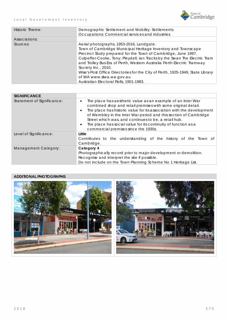
L o c a l G o v e r n m e n t I n v e n t o r y
2 0 1 8 3 7 0
Historic Theme: Demographic Settlement and Mobility: Settlements Occupations: Commercial services and industries
Associations: Sources: Aerial photographs, 1953-2016, Landgate.
Town of Cambridge Municipal Heritage Inventory and Townscape Precinct Study prepared for the Town of Cambridge, June 1997. Culpeffer-Cooke, Tony; Pleydell, Ian Tracks by the Swan The Electric Tram and Trolley Bus Era of Perth, Western Australia Perth Electric Tramway Society Inc., 2010. Wise's Post Office Directories for the City of Perth, 1925-1949, State Library of WA www.slwa.wa.gov.au Australian Electoral Rolls, 1901-1983.
SIGNIFICANCE Statement of Significance: • The place has aesthetic value as an example of an Inter War
combined shop and retail premises with some original detail. • The place has historic value for its association with the development
of Wembley in the Inter War period and this section of Cambridge Street which was, and continues to be, a retail hub.
• The place has social value for its continuity of function as a commercial premises since the 1930s.
Level of Significance: Little Contributes to the understanding of the history of the Town of Cambridge.
Management Category: Category 4 Photographically record prior to major development or demolition. Recognise and interpret the site if possible. Do not include on the Town Planning Scheme No 1 Heritage List.
ADDITIONAL PHOTOGRAPHS
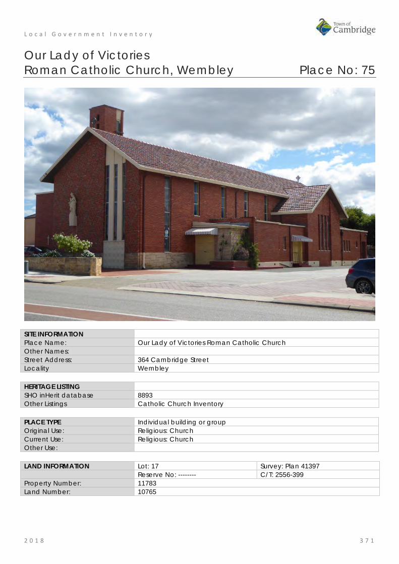
L o c a l G o v e r n m e n t I n v e n t o r y
2 0 1 8 3 7 1
Our Lady of Victories Roman Catholic Church, Wembley Place No: 75
SITE INFORMATION Place Name: Our Lady of Victories Roman Catholic Church Other Names: Street Address: 364 Cambridge Street Locality Wembley HERITAGE LISTING SHO inHerit database 8893 Other Listings Catholic Church Inventory PLACE TYPE Individual building or group Original Use: Religious: Church Current Use: Religious: Church Other Use: LAND INFORMATION Lot: 17 Survey: Plan 41397 Reserve No: -------- C/T: 2556-399 Property Number: 11783 Land Number: 10765

L o c a l G o v e r n m e n t I n v e n t o r y
2 0 1 8 3 7 2
CONSTRUCTION DETAILS Construction Date: 1954 Walls: Brick: common Roof: Tile: terracotta Architectural Style: Post War Ecclesiastical Physical Description: Substantial brick and tile church demonstrating the post-war ecclesiastical architectural style. The building is principally of cruciform plan form with the main body of the church extending on a north-south axis and gabled wings to the east and west elevations. Additional flat roof single storey accommodation of a more utilitarian design extends around the church on the east and north sides and to the rear of the west wing, although the principal design features of the main body of the church have been followed in these single storey sections the windows are smaller and the plinth is rendered. To the south of the west wing a double height area forms the main entrance into the church with large multi-paned window above the doorway. The bell tower is a tall narrow square tower with little adornment. The church is predominantly of brick construction with polychromatic patterned brickwork to the south elevation overlooking Cambridge Street and a stone plinth laid as uncoursed rubble with stones of varying sizes laid in irregular positions. A full height window extends up the eastern corner of the façade with rendered mullions and a patterned blockwork base. Windows to the east and west elevations are narrow strip windows of varying heights but each divided into a series of panes. Condition: Good Integrity: High Authenticity: High

L o c a l G o v e r n m e n t I n v e n t o r y
2 0 1 8 3 7 3
HISTORICAL INFORMATION Historical Notes: The Wembley Parish was formed in 1947, its founding Parish Priest was Father John Brosnan. Through the work of the parish, and support from the Diocese of Perth, funds were raised to build a school and subsequently a church to serve the Wembley Parish. The school was opened in November 1948 and was named Our Lady of Victories School. The community grew rapidly in the post war years and with constant fundraising the parish was able to employ architect Reginald Summerhayes to draw the plans for a new church in 1953. The design featured the first prestressed concrete arches used in Western Australia. Our Lady of Victories Church was opened and blessed by Archbishop Prendiville in August 1954. Since its construction the church has been the focal point for the parish of Wembley. The Wembley parish merged with the neighbouring parish of Floreat in 1990. In c2002, the church undertook a redevelopment of the site and demolished the school and the church buildings on the corner of Marlow and Cambridge Streets. These portions of the site are now used for residential and commercial uses. The church has undergone very little change since construction. Historic Theme: Social and civic activities: Religion Associations: Father John Brosnan: Parish Priest
Reginald Summerhayes: Architect Archbishop Prendiville
Sources: Aerial photographs, 1953-2016, Landgate. Town of Cambridge Municipal Heritage Inventory and Townscape Precinct Study prepared for the Town of Cambridge, June 1997. Wise's Post Office Directories for the City of Perth, 1925-1949, State Library of WA www.slwa.wa.gov.au Australian Electoral Rolls, 1901-1983. Our Lady of Victories Roman Catholic Church, Wembley Conservation Plan 2002 compiled for David Barnao & Co on behalf of the Floreat/Wembley Parish.
SIGNIFICANCE Statement of Significance: • The place has aesthetic value as an intact and good example of
the Post-War ecclesiastical style executed in brick and concrete and as a landmark in the streetscape.
• The place has research value as the first example of prestressed concrete arches used in Western Australia and may provide information relating to the evolution of this technique.
• The place has historic value for its association with the development of the Wembley community in the period following World War Two.
• The place has social value for the members of the Wembley and wider community who have attended social and religious occasions at this church since 1954.
• The place has social value for the members of the Wembley Catholic community who were active in organising the construction of the church following the formation of the parish in 1947.
Level of Significance: Considerable Very important to the heritage of the locality. High degree of integrity/authenticity
Management Category: Category 2 Conservation of the place is highly desirable. Any alterations or extensions should reinforce the significance of the place Include on the Town Planning Scheme No 1 Heritage List

L o c a l G o v e r n m e n t I n v e n t o r y
2 0 1 8 3 7 4
ADDITIONAL PHOTOGRAPHS

L o c a l G o v e r n m e n t I n v e n t o r y
2 0 1 8 3 7 5
Residence, 377A Cambridge Street, Wembley Place No: 76
SITE INFORMATION Place Name: Residence, 377A Cambridge Street Other Names: Street Address: 377A Cambridge Street Locality Wembley HERITAGE LISTING SHO inHerit database Other Listings PLACE TYPE Individual building or group Original Use: Residential: Single storey residence Current Use: Residential: Single storey residence Other Use: LAND INFORMATION Lot: Parent Lot 6; Strata Lot 3 Survey: Plan 79965; Strata Plan 33809 Reserve No: -------- C/T: 2207-541 Property Number: 2228; 10987 Land Number: 12993; 10057

L o c a l G o v e r n m e n t I n v e n t o r y
2 0 1 8 3 7 6
CONSTRUCTION DETAILS Construction Date: c1935; 1990s Walls: Brick: common Roof: Tile: terracotta Architectural Style: Inter War Physical Description: This entry relates only to the residence on Strata Lot 3. Single storey brick and tile interwar house of traditional asymmetric plan form. The house cannot be clearly seen from the street due to a high wall, gates and planting and therefore its contribution to the street is negligible. A carport has been constructed in the front setback opening directly onto the street which further compromises the contribution to the place to the character of the street. From the limited visual access obtained from the street, it appears the house is little altered with face brickwork, flat canopy to the windows across the recessed section of the elevation, separate hip to the verandah canopy supported on brick columns with rendered balustrade. The main roof is a tiled hipped form with tall brick chimneys. Condition: Good Integrity: High Authenticity: Moderate

L o c a l G o v e r n m e n t I n v e n t o r y
2 0 1 8 3 7 7
HISTORICAL INFORMATION Historical Notes: This residence was constructed for the owner and occupier Simon Wright and his wife Mabel Victoria Wright. The couple lived at the until 1953 when they advertised the property for sale as the 'owners were going east'. Simon Wright recorded his occupation as a contractor so he may have been involved in the construction of the residence.
The place continued to be used as a residence and in the late 1990s the lot was subdivided enabling the construction of two new residences at the rear of the lot. At this time the former grey, possibly concrete, tiles on the roof, were replaced with red tiles and a new carport was constructed on the front of the lot.
Historic Theme: Demographic Settlement and Mobility: Settlements Occupations: Domestic activities
Associations: Wright Family Sources: Aerial photographs, 1953-2016, Landgate.
Town of Cambridge Municipal Heritage Inventory and Townscape Precinct Study prepared for the Town of Cambridge, June 1997. Culpeffer-Cooke, Tony; Pleydell, Ian 'Tracks by the Swan The Electric Tram and Trolley Bus Era of Perth', Western Australia Perth Electric Tramway Society Inc., 2010. Wise's Post Office Directories for the City of Perth, 1925-1949, State Library of WA www.slwa.wa.gov.au Australian Electoral Rolls, 1901-1983. The West Australian, 30 January 1953, p. 28.
SIGNIFICANCE Statement of Significance: • The place has aesthetic value as an example of an Inter War
residence with original detail. • The place has historic value for its association with the development
of Wembley in the Inter War period. • The place has social value for its demonstration of the form and
scale of housing in the Inter War period. Level of Significance: Little
Contributes to the understanding of the history of the Town of Cambridge.
Management Category: Category 4 Photographically record prior to major development or demolition. Recognise and interpret the site if possible. Do not include on the Town Planning Scheme No 1 Heritage List.
ADDITIONAL PHOTOGRAPHS

L o c a l G o v e r n m e n t I n v e n t o r y
2 0 1 8 3 7 8
Wembley Police Station, Wembley Place No: 77
SITE INFORMATION Place Name: Wembley Police Station Other Names: Street Address: 379 Cambridge Street
188 Salvado Road Locality Wembley HERITAGE LISTING SHO inHerit database 18798 Other Listings PLACE TYPE Individual building or group Original Use: Governmental: Police Station Current Use: Governmental: Police Station Other Use: LAND INFORMATION Lot: 9997 Survey: Plan 3083 Reserve No: R36181 C/T: LR3048-153 Property Number: 16254 Land Number: 406
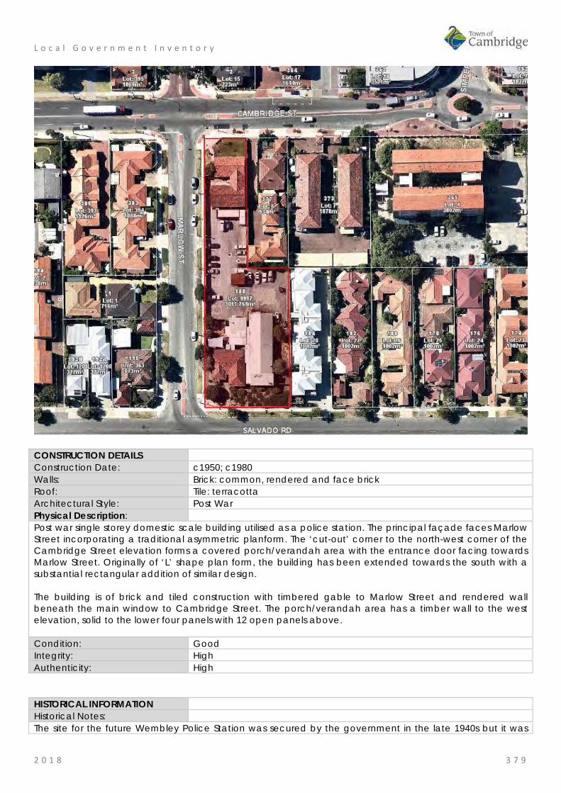
L o c a l G o v e r n m e n t I n v e n t o r y
2 0 1 8 3 7 9
CONSTRUCTION DETAILS Construction Date: c1950; c1980 Walls: Brick: common, rendered and face brick Roof: Tile: terracotta Architectural Style: Post War Physical Description: Post war single storey domestic scale building utilised as a police station. The principal façade faces Marlow Street incorporating a traditional asymmetric planform. The ‘cut-out’ corner to the north-west corner of the Cambridge Street elevation forms a covered porch/verandah area with the entrance door facing towards Marlow Street. Originally of ‘L’ shape plan form, the building has been extended towards the south with a substantial rectangular addition of similar design. The building is of brick and tiled construction with timbered gable to Marlow Street and rendered wall beneath the main window to Cambridge Street. The porch/verandah area has a timber wall to the west elevation, solid to the lower four panels with 12 open panels above. Condition: Good Integrity: High Authenticity: High
HISTORICAL INFORMATION Historical Notes: The site for the future Wembley Police Station was secured by the government in the late 1940s but it was

L o c a l G o v e r n m e n t I n v e n t o r y
2 0 1 8 3 8 0
not until 1955 that the station was built. Tenders were called for the construction of the building from 1951 until 1954, the delay in going ahead with the project has not been determined. An addition to the station was made c1980 almost doubling the size of the original building. Parking and landscaping have continually been upgraded since the original construction and the premises continued to be used for their original function in the community. Historic Theme: Social and civic activities: Law and order Associations: Sources: Aerial photographs, 1953-2016, Landgate.
Town of Cambridge Municipal Heritage Inventory and Townscape Precinct Study prepared for the Town of Cambridge, June 1997. Culpeffer-Cooke, Tony; Pleydell, Ian 'Tracks by the Swan The Electric Tram and Trolley Bus Era of Perth', Western Australia Perth Electric Tramway Society Inc., 2010. Wise's Post Office Directories for the City of Perth, 1925-1949, State Library of WA www.slwa.wa.gov.au Australian Electoral Rolls, 1901-1983. The West Australian, 30 November 1954, p. 3. Government Gazettes.
SIGNIFICANCE Statement of Significance: • The place has aesthetic value as a good intact example of a post
war residential scaled police station executed in brick and tile which retains many original details.
• The place has historic value for its association with the development of Wembley in the post World War Two period and the government response to these demands for services.
• The place has social value for the members of the community as the police station has been an ongoing presence since the mid 1950s.
Level of Significance: Considerable Very important to the heritage of the locality. High degree of integrity/authenticity
Management Category: Category 2 Conservation of the place is highly desirable. Any alterations or extensions should reinforce the significance of the place Include on the Town Planning Scheme No 1 Heritage List.
ADDITIONAL PHOTOGRAPHS
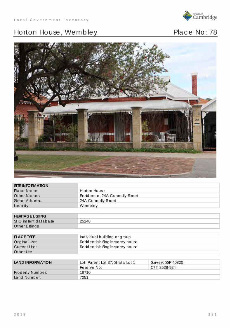
L o c a l G o v e r n m e n t I n v e n t o r y
2 0 1 8 3 8 1
Horton House, Wembley Place No: 78
SITE INFORMATION Place Name: Horton House Other Names: Residence, 24A Connolly Street Street Address: 24A Connolly Street Locality Wembley HERITAGE LISTING SHO inHerit database 25240 Other Listings PLACE TYPE Individual building or group Original Use: Residential: Single storey house Current Use: Residential: Single storey house Other Use: LAND INFORMATION Lot: Parent Lot 37; Strata Lot 1 Survey: SSP 40820 Reserve No: C/T: 2528-924 Property Number: 18710 Land Number: 7251

L o c a l G o v e r n m e n t I n v e n t o r y
2 0 1 8 3 8 2
CONSTRUCTION DETAILS Construction Date: 1912 Walls: Brick: Tuckpointed Roof: Metal: Corrugated Architectural Style: Federation Queen Anne Physical Description: Single storey traditional brick and iron house. The house incorporates an asymmetric planform with shallow projecting bay with full height timber framed sash windows, extending from ground level to the verandah canopy. Two rendered bands extend around the façade creating the traditional blood and bandages character that was popular in this era. The main roof is a complex hip with a gable to the bay and gablets to the south side of the roof. Tall brick chimneys with rendered moulding are positioned around the roof. The entrance is located on the south side of the building, set back behind the main building frontage. Condition: Good Integrity: High Authenticity: Moderate
HISTORICAL INFORMATION Historical Notes: An historical title search shows that the land on which Horton House now sits was part of the greater area of land originally owned by the Roman Catholic Bishop Joseph Serra, and was then transferred to Roman Catholic Bishop Matthew Gibney in 1860.
The land remained in the ownership of the Roman Catholic Bishop of Perth until 1911, after which time it was transferred to Harry and Lydia Kidd. Harry Kidd, born in Yorkshire UK, settled in Queensland for some years before he relocated to Western Australia with his wife Lydia, nee Sowden and their four children. Harry Kidd had a 25 year long career with the Metropolitan Water Supply, Sewerage and Drainage Department. The electoral roles record his occupation as a bricklayer so he may have been involved in the construction of

L o c a l G o v e r n m e n t I n v e n t o r y
2 0 1 8 3 8 3
his family home.
Information from the owners which is consistent with the Post Office Directories is that the residence was built in 1912. The name 'Horton House' appears to originate with the Kidd family as the name is used for one of the sons of Harry and Lydia Kidd. Annie Lydia Kidd, the daughter of Harry and Lydia, lived on in the house until the late 1970s.
Approval for a strata plan was granted in 2002 and a new residence was constructed at the rear of the lot in 2003.
Aerial photographs indicate the form and extent of the residence have not changed significantly since the mid 20th century.
Historic Theme: Demographic settlement and mobility: settlements Occupations: domestic activities
Associations: Kidd family Sources: Aerial photographs, 1953-2016, Landgate.
Town of Cambridge Municipal Heritage Inventory and Townscape Precinct Study prepared for the Town of Cambridge, June 1997. Wise's Post Office Directories for the City of Perth, 1925-1949, State Library of WA www.slwa.wa.gov.au The West Australian, 17 September 1935, p. 17.
SIGNIFICANCE Statement of Significance: • The place has aesthetic value as a good and intact example of the
Federation Queen Anne style. • The place has historic value for its association with the early
settlement of the Cambridge area in c1860s by the Roman Catholic Church who acquired several parcels of land in the area.
• The place has social value for its demonstration of the form and style of home built for a skilled tradesman and his family
Level of Significance: Some/moderate Contributes to the heritage of the locality. Has some altered or modified elements, not necessarily detracting from the overall significance of the item.
Management Category: Category 3 Conservation of the place is desirable. Any alterations or extensions should reinforce the significance of the place, and original fabric should be retained wherever feasible. Include on the Town Planning Scheme No 1 Heritage List.
ADDITIONAL PHOTOGRAPHS
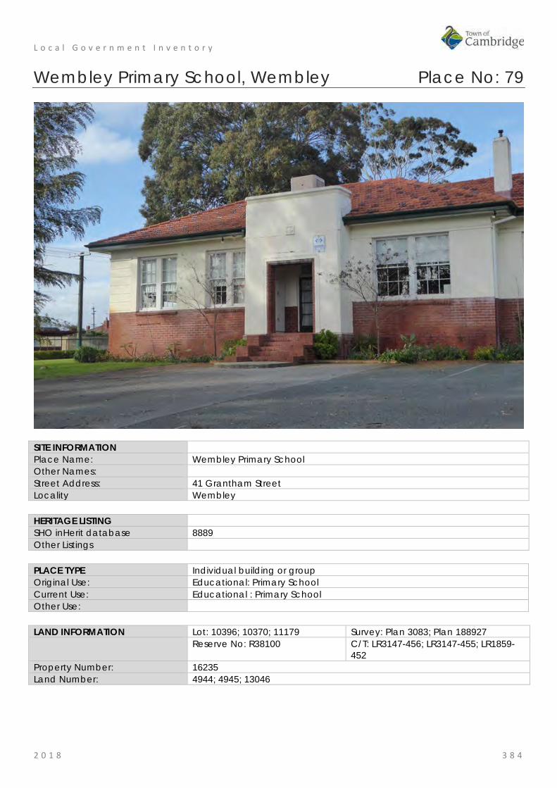
L o c a l G o v e r n m e n t I n v e n t o r y
2 0 1 8 3 8 4
Wembley Primary School, Wembley Place No: 79
SITE INFORMATION Place Name: Wembley Primary School Other Names: Street Address: 41 Grantham Street Locality Wembley HERITAGE LISTING SHO inHerit database 8889 Other Listings PLACE TYPE Individual building or group Original Use: Educational: Primary School Current Use: Educational : Primary School Other Use: LAND INFORMATION Lot: 10396; 10370; 11179 Survey: Plan 3083; Plan 188927 Reserve No: R38100 C/T: LR3147-456; LR3147-455; LR1859-
452 Property Number: 16235 Land Number: 4944; 4945; 13046
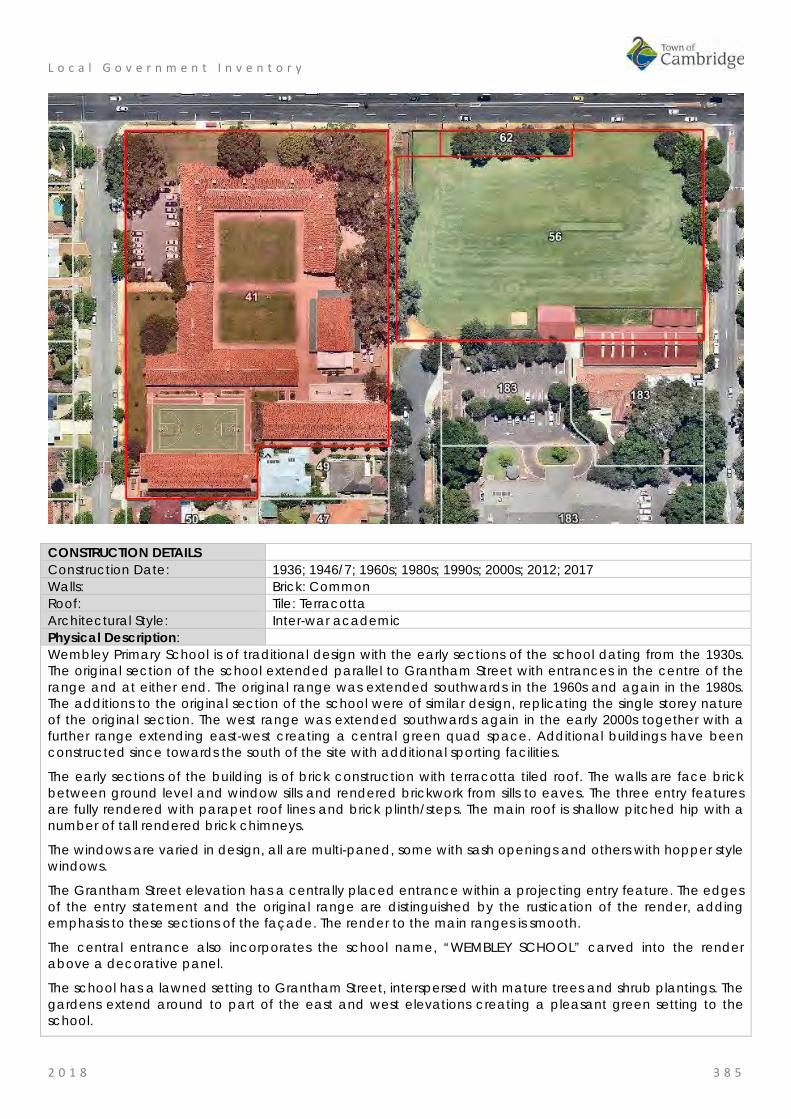
L o c a l G o v e r n m e n t I n v e n t o r y
2 0 1 8 3 8 5
CONSTRUCTION DETAILS Construction Date: 1936; 1946/7; 1960s; 1980s; 1990s; 2000s; 2012; 2017 Walls: Brick: Common Roof: Tile: Terracotta Architectural Style: Inter-war academic Physical Description: Wembley Primary School is of traditional design with the early sections of the school dating from the 1930s. The original section of the school extended parallel to Grantham Street with entrances in the centre of the range and at either end. The original range was extended southwards in the 1960s and again in the 1980s. The additions to the original section of the school were of similar design, replicating the single storey nature of the original section. The west range was extended southwards again in the early 2000s together with a further range extending east-west creating a central green quad space. Additional buildings have been constructed since towards the south of the site with additional sporting facilities.
The early sections of the building is of brick construction with terracotta tiled roof. The walls are face brick between ground level and window sills and rendered brickwork from sills to eaves. The three entry features are fully rendered with parapet roof lines and brick plinth/steps. The main roof is shallow pitched hip with a number of tall rendered brick chimneys.
The windows are varied in design, all are multi-paned, some with sash openings and others with hopper style windows.
The Grantham Street elevation has a centrally placed entrance within a projecting entry feature. The edges of the entry statement and the original range are distinguished by the rustication of the render, adding emphasis to these sections of the façade. The render to the main ranges is smooth.
The central entrance also incorporates the school name, “WEMBLEY SCHOOL” carved into the render above a decorative panel.
The school has a lawned setting to Grantham Street, interspersed with mature trees and shrub plantings. The gardens extend around to part of the east and west elevations creating a pleasant green setting to the school.

L o c a l G o v e r n m e n t I n v e n t o r y
2 0 1 8 3 8 6
Condition: Good Integrity: High Authenticity: High
HISTORICAL INFORMATION Historical Notes: Wembley Primary School was opened in 1936 to support the growing community in the region. In this inter war period many new family homes were built in the surrounding area. The school was designed by the Public Works Department of WA under the direction of the chief architect, Albert Ernest Clare. On 4th July 1936, the Minister for Education, Mr Millington performed the opening ceremony for the school with the Director of Education Mr Klein also in attendance.
Initially the school was only two rooms catering for the 'infants', years 1 and 2 under the direction of Miss M. Wellwood. It was soon apparent that additional facilities would be needed and additional classes were added in the 1940's with major improvements to the grounds in 1946/7.
Since then the school has been constantly upgraded and improved in response to changes in population and the evolution of education practices.
In the early 1980s, a large parcel of land was acquired to the east on Grantham Street to create additional playground space and an oval for the school. Subsequently in the late 1990s further works took place creating a large new classroom block on the south of the school site. In 2010, the oval was redeveloped and in 2012 and 2017 further additions and alterations were undertaken on the site.
Historic Theme: Social and civic activities: Education and science Demographic Settlement and Mobility: Settlements
Associations: Sources: Aerial photographs, 1953-2016, Landgate.
Town of Cambridge Municipal Heritage Inventory and Townscape Precinct Study prepared for the Town of Cambridge, June 1997. Wise's Post Office Directories for the City of Perth, 1925-1949, State Library of WA www.slwa.wa.gov.au Wembley Primary School, website http://www.wembleyps.wa.edu.au The Daily News, 1 July 1936, p. 7.
SIGNIFICANCE Statement of Significance: • The school buildings have aesthetic value as a cohesive group of
brick educational buildings that demonstrate the form and detail of the Inter War period and subsequent periods.
• Wembley Primary School has historic significance for its association with the period in which the area was established and developed. The periods of development on the site are consistent with the growth of the community.
• The school has social significance for the local community and in particular the present and past students and staff of the school.
Level of Significance: Considerable Very important to the heritage of the locality. High degree of integrity/authenticity
Management Category: Category 2 Conservation of the place is highly desirable. Any alterations or extensions should reinforce the significance of the place Include on the Town Planning Scheme No 1 Heritage List.

L o c a l G o v e r n m e n t I n v e n t o r y
2 0 1 8 3 8 7
ADDITIONAL PHOTOGRAPHS
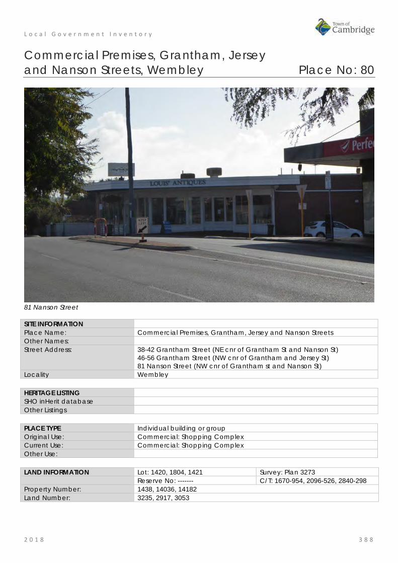
L o c a l G o v e r n m e n t I n v e n t o r y
2 0 1 8 3 8 8
Commercial Premises, Grantham, Jersey and Nanson Streets, Wembley Place No: 80
81 Nanson Street SITE INFORMATION Place Name: Commercial Premises, Grantham, Jersey and Nanson Streets Other Names: Street Address: 38-42 Grantham Street (NE cnr of Grantham St and Nanson St)
46-56 Grantham Street (NW cnr of Grantham and Jersey St) 81 Nanson Street (NW cnr of Grantham st and Nanson St)
Locality Wembley HERITAGE LISTING SHO inHerit database Other Listings PLACE TYPE Individual building or group Original Use: Commercial: Shopping Complex Current Use: Commercial: Shopping Complex Other Use: LAND INFORMATION Lot: 1420, 1804, 1421 Survey: Plan 3273 Reserve No: ------- C/T: 1670-954, 2096-526, 2840-298 Property Number: 1438, 14036, 14182 Land Number: 3235, 2917, 3053

L o c a l G o v e r n m e n t I n v e n t o r y
2 0 1 8 3 8 9
CONSTRUCTION DETAILS Construction Date: c1960 Walls: Brick: painted Roof: Metal: zincalume Architectural Style: Inter War Physical Description: The commercial premises form two short ranges of shops between Griffiths Lane and Jersey Street and Gaynor Lane and Berresford Lane. All the units are of single storey construction and were constructed in the 1950s and 1960s but have been modified since resulting in the loss of original detail and subsequently the original aesthetic. The shops on the corners of Jersey Street and Nanson Street have angled frontages facing the intersections and were generally the earlier developments. Some of the shops have retained the original form of the shop windows including the highlight windows though the majority of the frontages are no longer original.
46-56 Grantham Street No. 48 Grantham Street presents with a traditional shop frontage which incorporates the recessed entrance with angled window and large window with highlight windows to the street frontage. Nos. 48 and 46 both have retained the awning canopy across the frontages and around to the side elevation.
81 Nanson Street No. 81 Nanson Street, on the corner of Grantham Street and Nanson Street appears to have either been substantially remodelled in the late 1960s/early 1970s or was rebuilt. The corner unit incorporates the angled frontage relating to the intersection and has an extensive glazed frontage addressing both streets. The place is of brick construction with a flat roof and deep flat canopy above the shop frontages.
38-42 Grantham Street Nos. 38-42 Grantham Street were constructed in the early 1960s with the majority of the shop frontages having undergone alteration in the form of recladding, replacement windows and doors which has impacted the authenticity of these buildings.
Condition: Fair Integrity: Moderate Authenticity: Little
HISTORICAL INFORMATION Historical Notes: These premises were built in the period between 1953 and 1964 and are representative of the population growth in the district following World War Two. The architect and builder of the premises have not been determined in this research.
The clustering of small shops at intersections enabled most households to walk to their local suppliers. The occupants of these shops have changed since their construction from the provision of household goods to

L o c a l G o v e r n m e n t I n v e n t o r y
2 0 1 8 3 9 0
more specialist retailers.
Since their construction the form and extent of these premises have not changed significantly although internally the has been ongoing modifications to suit changing requirements.
Historic Theme: Occupations: Commercial services and industries Associations: Sources: Aerial photographs, 1953-2016, Landgate.
SIGNIFICANCE Statement of Significance: • This group of shops have historic value for their association with the
growth of the Wembley area in the post war period. • This group of shops have some aesthetic value for the remaining
form and detail demonstrating the Post War International style. Level of Significance: Little
Contributes to the understanding of the history of the Town of Cambridge.
Management Category: Category 4 Photographically record prior to major development or demolition. Recognise and interpret the site if possible. Do not include on the Town Planning Scheme No 1 Heritage List.
ADDITIONAL PHOTOGRAPHS
38-42 Grantham Street
81 Nanson Street
38-42 Grantham Street
46 & 48 Grantham Street
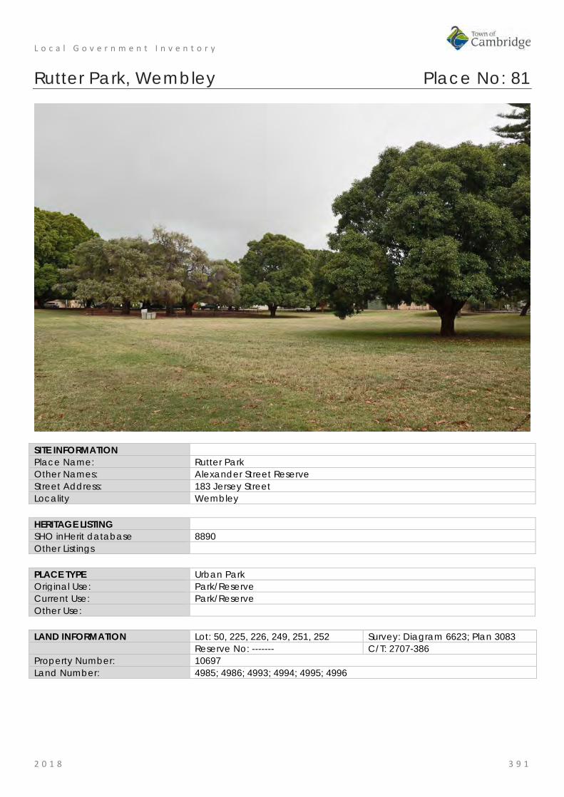
L o c a l G o v e r n m e n t I n v e n t o r y
2 0 1 8 3 9 1
Rutter Park, Wembley Place No: 81
SITE INFORMATION Place Name: Rutter Park Other Names: Alexander Street Reserve Street Address: 183 Jersey Street Locality Wembley HERITAGE LISTING SHO inHerit database 8890 Other Listings PLACE TYPE Urban Park Original Use: Park/Reserve Current Use: Park/Reserve Other Use: LAND INFORMATION Lot: 50, 225, 226, 249, 251, 252 Survey: Diagram 6623; Plan 3083 Reserve No: ------- C/T: 2707-386 Property Number: 10697 Land Number: 4985; 4986; 4993; 4994; 4995; 4996

L o c a l G o v e r n m e n t I n v e n t o r y
2 0 1 8 3 9 2
CONSTRUCTION DETAILS Construction Date: c1929; 1939 Walls: N/A Roof: N/A Architectural Style: N/A Physical Description: A suburban park extending between Alexander Street and Jersey Street and located to the south of the Wembley Community Centre. The park has a central open grassed area with peripheral tree plantings. BBQ facilities, public art and children’s play area also contribute to the social nature of the space. Condition: Good Integrity: High Authenticity: High
HISTORICAL INFORMATION Historical Notes: This portion of Wembley was subdivided for residential occupation in 1909 however there was sparse settlement in the area until the late 1920s. Originally known as Emerald Hill Estates and part of West Leederville, the name Wembley Park was formally approved in 1924. The name was taken from Wembley Park in London where the British Empire Exhibition was being held in 1924 and receiving much attention. The name was applied to the land west of McCourt Street.

L o c a l G o v e r n m e n t I n v e n t o r y
2 0 1 8 3 9 3
From the available information the Alexander Street Reserve was in existence in 1929 when Perth City Council allocated funds for playground equipment. However the park may have been established prior to that date. Wembley Park had a strong and active Progress Association which lobbied effectively for better services for the district. The Chairman of the Progress Association was Angus Wallis Rutter (c1883-1945) and the park was named in 1935 in recognition of his work. In 1939, the Perth City Council announced the works undertaken in the previous year in Perth's Open Spaces. Rutter Park, an area of four acres, was cleared, grassed, reticulated and planted with trees. In addition, a section with 'apparatus for games had been set aside for the smaller children'. The Council agreed at that time that a portion of the ground could be allocated for the Children's Protection Society for the erection of a clinic for the district. The Wembley Community Centre was built north of the park c1990 and facilities at the park continue to be updated as required. The park continues to be largely an informally landscaped area dominated by large trees. Historic Theme: Social and Civic Activities: Sport, recreation and entertainment
People: Local heroes and battlers Associations: Angus Wallis Rutter Sources: Aerial photographs, 1953-2016, Landgate.
Town of Cambridge Municipal Heritage Inventory and Townscape Precinct Study prepared for the Town of Cambridge, June 1997. Wise's Post Office Directories for the City of Perth, 1925-1949, State Library of WA www.slwa.wa.gov.au The West Australian, 9 July 1929, p14; 22 May 1935, p. 7; 5 January 1939; p. 14.
SIGNIFICANCE Statement of Significance: • The place has aesthetic value as an area of mature, green
landscape in this built up suburban area which is valued for passive and organised recreation.
• The place has historic value for its association with the establishment and development of Wembley in the 1930s.
• The place has historic value for its association with Angus Rutter who was an active campaigner to improve the facilities in the Wembley district.
• The place has social value for the community as the venue for formal and informal events since the 1930s.
Level of Significance: Considerable Very important to the heritage of the locality. High degree of integrity/authenticity
Management Category: Category 2 Conservation of the place is highly desirable. Any alterations or extensions should reinforce the significance of the place Include on the Town Planning Scheme No 1 Heritage List.

L o c a l G o v e r n m e n t I n v e n t o r y
2 0 1 8 3 9 4
ADDITIONAL PHOTOGRAPHS
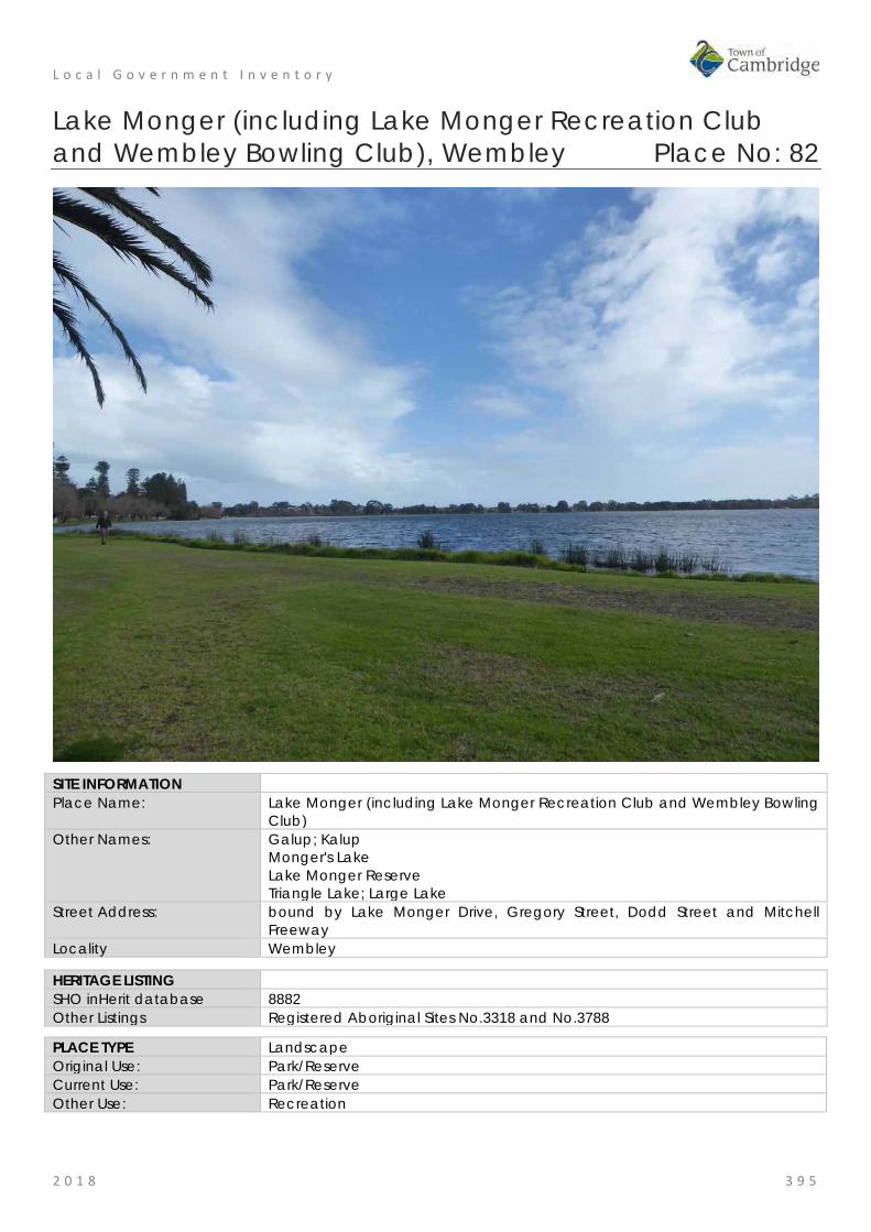
L o c a l G o v e r n m e n t I n v e n t o r y
2 0 1 8 3 9 5
Lake Monger (including Lake Monger Recreation Club and Wembley Bowling Club), Wembley Place No: 82
SITE INFORMATION Place Name: Lake Monger (including Lake Monger Recreation Club and Wembley Bowling
Club) Other Names: Galup; Kalup
Monger's Lake Lake Monger Reserve Triangle Lake; Large Lake
Street Address: bound by Lake Monger Drive, Gregory Street, Dodd Street and Mitchell Freeway
Locality Wembley
HERITAGE LISTING SHO inHerit database 8882 Other Listings Registered Aboriginal Sites No.3318 and No.3788
PLACE TYPE Landscape Original Use: Park/Reserve Current Use: Park/Reserve Other Use: Recreation
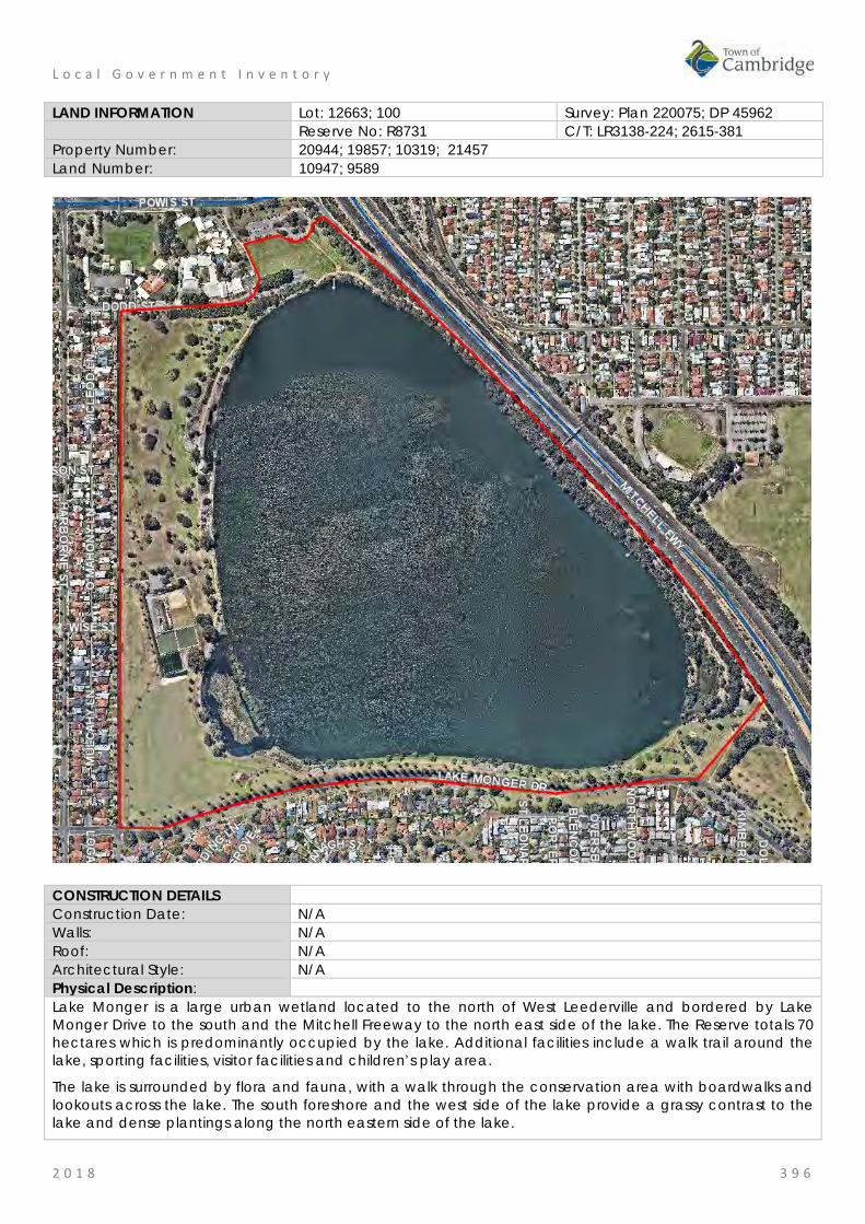
L o c a l G o v e r n m e n t I n v e n t o r y
2 0 1 8 3 9 6
LAND INFORMATION Lot: 12663; 100 Survey: Plan 220075; DP 45962 Reserve No: R8731 C/T: LR3138-224; 2615-381 Property Number: 20944; 19857; 10319; 21457 Land Number: 10947; 9589
CONSTRUCTION DETAILS Construction Date: N/A Walls: N/A Roof: N/A Architectural Style: N/A Physical Description: Lake Monger is a large urban wetland located to the north of West Leederville and bordered by Lake Monger Drive to the south and the Mitchell Freeway to the north east side of the lake. The Reserve totals 70 hectares which is predominantly occupied by the lake. Additional facilities include a walk trail around the lake, sporting facilities, visitor facilities and children’s play area.
The lake is surrounded by flora and fauna, with a walk through the conservation area with boardwalks and lookouts across the lake. The south foreshore and the west side of the lake provide a grassy contrast to the lake and dense plantings along the north eastern side of the lake.

L o c a l G o v e r n m e n t I n v e n t o r y
2 0 1 8 3 9 7
The buildings within the grounds are representative of the post war period.
Condition: Good Integrity: High Authenticity: High
HISTORICAL INFORMATION Historical Notes: Prior to European settlement, the indigenous inhabitants of the south-west of Western Australia, were the Noongar, and Whadjuk is the name of the dialectal group from the Perth area. Given the abundance of wildlife and flora the lake was a hunting ground and campsite for the Whadjuk Noongar. As with most water bodies in the region the lake is associated with the Wagyl mythology. The myth describes the track of a serpent being who in his journey towards the sea, deviates from his route and emerges from the ground which gives rise to Lake Monger. The lake and a significant part of the reserve are registered with the Department of Indigenous Affairs as an Aboriginal heritage site. Previous research has indicated the area was called Keiermulu which translates to 'the home fires or camp' and the lake was Galup or Kalup.
After European settlement, it became known as either Large Lake or Triangle Lake (based on its roughly triangular shape). By 1832, the lands around the lake had been subdivided into eight lots: a southern one was acquired by John Henry Monger and described as 200 acres [81 hectares] of Perthshire Location Ae abutting Lake Monger. Monger and his family left the landholding in 1836 and settled in York.
In the latter half of the 20th century as the population increased with the arrival of convicts and later with the discoveries of gold in the colony, the land around the lake was used for market gardens. This was a common practice for the low lying swampy lands in the metropolitan region.
While the swampy lands around the lake were utilised for market gardens the body of water was regularly used for recreation. Tragically several deaths occurred in the 19th and 20th century as a result of boating or swimming accidents.
In 1902, the Leederville Council appointed a board to manage the lake. In 1908, the Waverley Boat Club was formed for sailing on the lake and in 1909, a drain was completed which connected the lake with the Swan River which allowed the water level to be managed and this drain is still [2018] in operation.
In the early years of the 20th century the lake was popular for picnics and boating. A jetty and a bandstand was located near the junction with St Leonards Avenue. This jetty was later adopted by the Rover Scouts until boating ceased in 1938.
In 1917, the lake and its surrounds were put under the administration of the City of Perth for use as a public park. Thereafter the Chinese market gardens and dairies which were operating around the lake were acquired by the City for public lands. By 1928, the gardeners were gone and by 1930, 50 hectares was under the control of the City of Perth to be developed as the Lake Monger Reserve.
In 1932, dredging works began to reclaim land from the swamp and by June 1933. 110,000 tons (90718 tonnes) of silt had been pumped from the lake allowing 4.8 hectares of land to be reclaimed. As a reflection of the attitudes to swamp land at that time much of the fringing vegetation was removed and replaced with lawns. The southern shore of the lake was developed with a kiosk, bathing sheds, boat house and a jetty. At the completion of these works a celebration was held with a swim through, canoe race, a picnic and bonfires. The lake was used extensively for picnicking, yachting, swimming and fishing and further dredging was undertaken to enable more successful yachting. The Norfolk Island Pine Trees (Araucaria heterophylla) and Date Palms (Phoenix dactylifera which border the northern side of Lake Monger Drive are remnants from this beautification program.
Reclamation of land continued into the 1930s with dumping of rubbish and raw sewage on the north east side of the lake. Not surprisingly by 1936 the quality of the water had deteriorated and infestations of midges were recorded.
In the late 1930s, a series of drownings led to the decision to ban boating and swimming was discouraged.
In the late 1950s, the 1955 Stephenson plan guided the decision to allocate a portion of the reserve for the future Mitchell Freeway which was built in the 1970s.
During the 1960s a more widespread understanding of the environmental affect of past practices lead to

L o c a l G o v e r n m e n t I n v e n t o r y
2 0 1 8 3 9 8
the decision to build a small island in the south west corner of the lake to attract bird life back to the lake. Since then the lake and surrounding parklands have been managed more sensitively although issues of fertiliser run off from the surrounding suburbs is one of many issues which continue to be a challenge.
In 1994, Lake Monger came under the management of the Town of Cambridge. The lake is now a popular destination for passive recreation and is well known for its regular and large population of black swans which are popular with tourists.
Another popular feature of the lake are the Norfolk Island Pines aligning the northern boundary of Lake Monger Drive. For many decades, one of these large pine trees near the corner with Gregory Street is strung with lights to mark the festive season in December and January.
Historic Theme: Occupations: Grazing, pastoralism and dairying Occupations: Rural industry and market gardening Demographic settlement and mobility: Aboriginal occupation Demographic settlement and mobility: Land allocation and subdivision Social and civic activities: Sport, recreation and entertainment Social and civic activities: Government and Politics Social and civic activities: Environmental awareness
Associations: John Henry Monger and Monger family Sources: Aerial photographs, 1953-2016, Landgate.
Town of Cambridge Municipal Heritage Inventory and Townscape Precinct Study prepared for the Town of Cambridge, June 1997. Wise's Post Office Directories for the City of Perth, 1925-1949, State Library of WA www.slwa.wa.gov.au Collard, L.; Revell, G.; Palmer, D.; Leonard, L. (1999). Noongar Placenames associated with the Goordandalup (Crawley bay) area of the Gabee Derbalor Derbal Yaragan Beloo (Swan River). The West Australian, 27 September 1937. Stannage, C.T. (1979) The People of Perth, Perth City Council. Department of Aboriginal Affairs, Aboriginal Heritage Inquiry System R. P. Wright, 'Monger, John Henry (1831–1892)', Australian Dictionary of Biography, National Centre of Biography, Australian National University, http://adb.anu.edu.au/biography/monger-john-henry-4221/text6805 , published first in hardcopy 1974, accessed online 22 September 2017. The West Australian, 8 August 1936, p. 18.
SIGNIFICANCE Statement of Significance: • The place has aesthetic value as a large, well maintained
landscape in the metropolitan area which is a landmark in the district.
• The place has historic and social value for the Whadjuk Noongar peoples who used the place for food, shelter and spiritual reasons.
• The place has historic value for its association with the early settlement of the district in the 1830s and particularly with the Monger family who leased this lake and its surrounds and provided the origin for the name.
• The place has historic value for its association with market gardens which operated close to the city of Perth in the 19th and 20th century.
• The place has historic value for its association with sports and recreation on the lake from the 19th century.
• The place has ongoing social value for the members of the community who have enjoyed the lake and its surrounds for passive recreation for many decades.
Level of Significance: Exceptional Essential to the heritage of the locality. Rare or outstanding example. Recommended for inclusion on the State Register of Heritage Places.

L o c a l G o v e r n m e n t I n v e n t o r y
2 0 1 8 3 9 9
Management Category: Category 1 The place should be retained and conserved unless there is no feasible and prudent alternative to doing otherwise. Any alterations or extensions should reinforce the significance of the place, and be in accordance with a Conservation Plan (if one exists for the place). Include on the Town Planning Scheme No 1 Heritage List.
ADDITIONAL PHOTOGRAPHS

L o c a l G o v e r n m e n t I n v e n t o r y
2 0 1 8 4 0 0
Wembley Church of Christ, Wembley Place No: 83
SITE INFORMATION Place Name: Wembley Church of Christ Other Names: Westcity Church of Christ 63 Nanson Street Street Address: 61 & 61A Nanson Street Locality Wembley HERITAGE LISTING SHO inHerit database 2229 Other Listings PLACE TYPE Individual building or group Original Use: Religious: Church Current Use: Religious: Church Other Use: LAND INFORMATION Lot: 1 Survey: Diagram 56193 Reserve No: -------- C/T: 1527-651 Property Number: 13522, 23350 Land Number: 2430
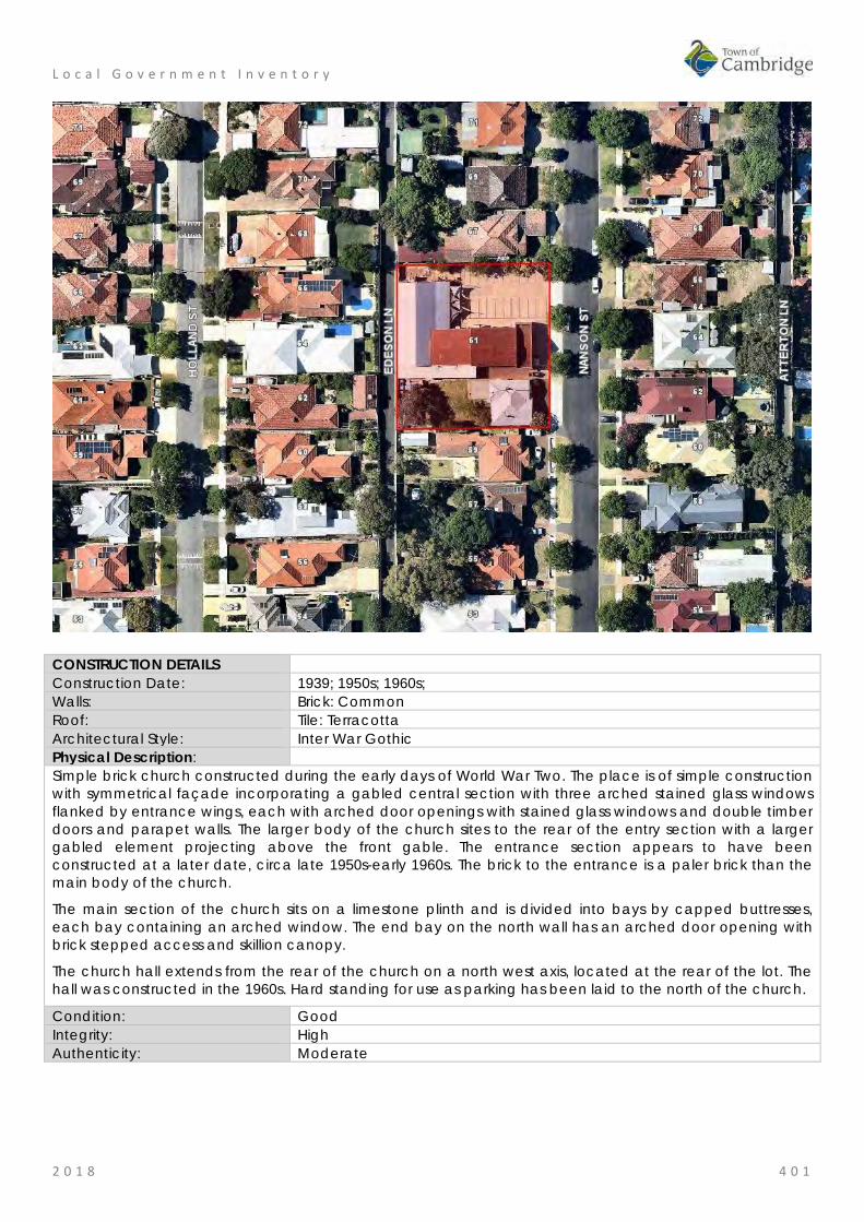
L o c a l G o v e r n m e n t I n v e n t o r y
2 0 1 8 4 0 1
CONSTRUCTION DETAILS Construction Date: 1939; 1950s; 1960s; Walls: Brick: Common Roof: Tile: Terracotta Architectural Style: Inter War Gothic Physical Description: Simple brick church constructed during the early days of World War Two. The place is of simple construction with symmetrical façade incorporating a gabled central section with three arched stained glass windows flanked by entrance wings, each with arched door openings with stained glass windows and double timber doors and parapet walls. The larger body of the church sites to the rear of the entry section with a larger gabled element projecting above the front gable. The entrance section appears to have been constructed at a later date, circa late 1950s-early 1960s. The brick to the entrance is a paler brick than the main body of the church.
The main section of the church sits on a limestone plinth and is divided into bays by capped buttresses, each bay containing an arched window. The end bay on the north wall has an arched door opening with brick stepped access and skillion canopy.
The church hall extends from the rear of the church on a north west axis, located at the rear of the lot. The hall was constructed in the 1960s. Hard standing for use as parking has been laid to the north of the church.
Condition: Good Integrity: High Authenticity: Moderate
L o c a l G o v e r n m e n t I n v e n t o r y
2 0 1 8 4 0 2
HISTORICAL INFORMATION Historical Notes: The Church of Christ had a presence in the Wembley community since the 1930s. A Church of Christ Sunday School was established at the Wembley School in 1937. This portion of Wembley was being steadily developed in the Inter War years and the Church of Christ acquired three lots in Nanson Street for their community. The building of the church was driven by David Moffat Wilson (c1860-1943) who at 80 years of age, laid the foundation stone of the church on 2nd September 1939 and was the first Secretary for the church. The first evening preacher was A.G. Elliott. The expected cost of construction was £1000 and overseen by builder Mr F Nash. The stained glass windows were made by Mr Whittome. No architect has been identified in this research. The Church did not have a dedicated minister for the parish until 1945 when Mr A.G. Whiting was appointed to the church. The porch entry to the church is a later addition as is the addition to the rear of the brick church is apparent in a 1953 aerial photograph. By 1964, the large hall across the rear of the lot was present. The roof form of the hall and church extension were of a lower pitch to the main church and appeared to be roofed in asbestos. There have been few changes to the extent and form of the buildings on the site since the mid 20th century. A narrow addition was constructed on the southern elevation of the hall and church addition in c1990, and in mid 2009 the roof cladding of these later additions were changed to red colorbond sheeting. In early 2016, the hall roof was reclad with zincalume. The original church form and extent do not appear to have been significantly altered since construction although as noted previously the light brick addition to the porch does not appear to be original. The residence to the south of the church appears to be the premises for the minister of the church. Historic Theme: Social and Civic activities: Religion
Demographic settlement and mobility: settlements Associations: F Nash
Mr Whittome A. G Whiting David Moffat Wilson
Sources: Aerial photographs, 1953-2016, Landgate. Town of Cambridge Municipal Heritage Inventory and Townscape Precinct Study prepared for the Town of Cambridge, June 1997. Wise's Post Office Directories for the City of Perth, 1925-1949, State Library of WA www.slwa.wa.gov.au The West Australian, 4 September 1939, p. 4; 27 January 1945, p. 4.
SIGNIFICANCE Statement of Significance: • The place has aesthetic value as a simple expression of the Inter
War Gothic style expressed in brick and tile. • The place is a landmark in the community and streetscape for its
continuity of presence and function since the 1939. • The place has historic value for its association with the establishment
and development of the Wembley community in the Inter War years • The place has social value to the members of the Wembley Church
of Christ and the wider community who have attended services and social events at the venue since 1939.
Level of Significance: Some/moderate Contributes to the heritage of the locality. Has some altered or modified elements, not necessarily detracting from the overall significance of the item.

L o c a l G o v e r n m e n t I n v e n t o r y
2 0 1 8 4 0 3
Management Category: Category 3 Conservation of the place is desirable. Any alterations or extensions should reinforce the significance of the place, and original fabric should be retained wherever feasible. Include on the Town Planning Scheme No 1 Heritage List.
ADDITIONAL PHOTOGRAPHS

L o c a l G o v e r n m e n t I n v e n t o r y
2 0 1 8 4 0 4
Wembley Uniting Church, Wembley Place No: 84
SITE INFORMATION Place Name: Wembley Uniting Church Other Names: Wembley Methodist Church Street Address: 35 Pangbourne Street Locality Wembley HERITAGE LISTING SHO inHerit database 8891 Other Listings Uniting Church Inventory PLACE TYPE Individual building or group Original Use: Religious: Church Current Use: Religious: Church Other Use: LAND INFORMATION Lot: 314 Survey: Plan 3083 Reserve No: --------- C/T: 682-23 Property Number: 13450 Land Number: 2361

L o c a l G o v e r n m e n t I n v e n t o r y
2 0 1 8 4 0 5
CONSTRUCTION DETAILS Construction Date: 1941; 1955; 1992 Walls: Brick: Common Roof: Tile: Terracotta Architectural Style: Inter War Gothic Physical Description: A brick and tile church with distinctive frontage. The church is single storey with steep pitched roof and double height parapet wall to the Pangbourne Street elevation. The main feature of the wall is the arched window with herringbone brick detailing. The front porch section of the church is a later addition, it consists of a single storey section with parapet wall and flat roof. The central section contains a glass brick window, flanked by slightly recessed walls each with a small glazed window. The side elevations of the main body of the church are divided into bays by brick columns with each bay containing a stained glass casement window. A brick addition has been constructed to the rear to provide hall facilities, presenting with a similar design aesthetic incorporating high brick parapet walls with concrete capping and few adornments. Condition: Good Integrity: High Authenticity: Moderate

L o c a l G o v e r n m e n t I n v e n t o r y
2 0 1 8 4 0 6
HISTORICAL INFORMATION Historical Notes: The first Methodist Church in Wembley was held in a private home in 1917. In 1921, the timber Bullfinch Methodist Church building was purchased for £50 plus 7% interest, and railed to the site. The building was erected on the site throughout 1922 with volunteer labour and opened in February 1923. This building was built to the rear of the lot and functioned as the church until the growth of the congregation demanded a larger building. The Wembley Methodist Church resolved to build a new church on the front of the lot and plans were prepared by parishioner Ronald Escort Turner (1911-1985). The plans were submitted to the City of Perth and that document states the builders were Sampson & Kempin. Ron Turner was identified as the architect on these plans but he designated his occupation as an architectural surveyor in the Electoral Rolls of 1937 and 1943. It is probable that he was not a registered architect but an experienced builder. It is recorded in the history of the church that 'Mr Ron Turner, a church member and a contract builder, unselfishly gave up six months of his accrued long service leave to organise the building of the church'. It is not clear what role building contractors Sampson & Kempin took in this project. On 15th March 1941, a foundation stone for a new church was laid by Miss Mildred Grigg who had started the Wembley Sunday School in 1917. An account in the local press stated that the new brick church would accommodate 200 people. Fundraising for the new church was undertaken by the local community and Miss Mildred Grigg was prominent in this effort, notably organising musical evenings in the existing church. On 31 May 1941, the Wembley Methodist Church was opened and dedicated. The opening was undertaken by Mrs W.G.Hyde, the widow of Rev W.G.Hyde, a former conference president associated with Wembley. The dedication was performed by Rev R.H. Mason representing the President of the conference. In this news item it was noted that the church would seat 150 so perhaps plans for the size of the church changed during construction. At the time of construction the main entry was at the front of the porch, facing Pangbourne Street. In 1955, the original timber church was demolished and a new brick hall and minister's vestry were built. These new structures were linked to the church. Sometime after these additions, the entry to the church was moved to the south side of the porch. In 1992, the front porch was further altered to provide a larger foyer area and an additional 'baby's room' at the side of the foyer. Since that time the form and extent of the church building has not been altered significantly. In 1977, three Australian churches came together, Presbyterian, Methodist and Congregational churches as the Uniting Church in Australia. This church was renamed the Wembley Uniting Church following this union. Historic Theme: Social and civic Activities: Religion Associations: Mildred Grigg
Ronald Turner Architect and Builder Sources: Aerial photographs, 1953-2016, Landgate.
Town of Cambridge Municipal Heritage Inventory and Townscape Precinct Study prepared for the Town of Cambridge, June 1997. Wise's Post Office Directories for the City of Perth, 1925-1949, State Library of WA www.slwa.wa.gov.au The West Australian, 17 March 1941, p. 2; 20 May 1941, p. 3. Centenary History of the Wembley Uniting Church, John Meyer June 2017. Accessed from the Wembley Uniting Church website, https://unitingchurchwa.org.au/wembley/about-us/ Information from the Wembley Uniting Church supplied September 2018. A Church in Retrospect: the story of 75 years of worship and witness in Wembley Uniting (formerly Methodist) Church 1917-1992.

L o c a l G o v e r n m e n t I n v e n t o r y
2 0 1 8 4 0 7
SIGNIFICANCE Statement of Significance: • The place has aesthetic value for the remaining form and detail of
its original construction in 1941 in the Inter War Gothic style. • The place has aesthetic value as a landmark in the streetscape
since 1941. • The place has historic value for its association with the Methodist
Church and later the Uniting Church in the developing residential areas of Wembley throughout the 20th century.
• The place has social value for the members of the community who attended the place as the Methodist and Uniting Church throughout the 20th century for social or religious occasions.
Level of Significance: Some/moderate Contributes to the heritage of the locality. Has some altered or modified elements, not necessarily detracting from the overall significance of the item.
Management Category: Category 3 Conservation of the place is desirable. Any alterations or extensions should reinforce the significance of the place, and original fabric should be retained wherever feasible. Include on the Town Planning Scheme No 1 Heritage List.
ADDITIONAL PHOTOGRAPHS

L o c a l G o v e r n m e n t I n v e n t o r y
2 0 1 8 4 0 8
St Edmund's Anglican Church, Wembley Place No: 85
SITE INFORMATION Place Name: St Edmund's Anglican Church Other Names: St Edmund's Church;
Jack Watts Memorial Hall Street Address: 54 Pangbourne Street Locality Wembley HERITAGE LISTING SHO inHerit database 8892 Other Listings Anglican Church Inventory PLACE TYPE Individual building or group Original Use: Religious: Church Current Use: Religious: Church Other Use: LAND INFORMATION Lot: 357, 358, 359 Survey: Plan 3083 Reserve No: -------- C/T: 1053-291 Property Number: 13462 Land Number: 2373, 2374; 2375;

L o c a l G o v e r n m e n t I n v e n t o r y
2 0 1 8 4 0 9
CONSTRUCTION DETAILS Construction Date: 1952; 1955 Walls: Brick: Common Roof: Tile: Terracotta Architectural Style: Post War Ecclesiastical Physical Description: Large brick church located in a residential street and close to another church on the same road. The church makes a striking contribution to the streetscape through design, siting and scale. The place is of red brick construction with hipped roof to the main body of the church and faceted hip to the apse. A square tower of brick construction with turrets is constructed to the south west corner of the façade. The tower is mainly a blank brick elevation with only three very narrow leaded windows and an 'arrow slit' above recessed door and louver breaking up the brickwork. The faceted apse is the main feature of the Pangbourne Street façade, creating an interesting feature in the streetscape. The rose window is on the east elevation and can be seen from Crofts Lane, and demonstrates the traditional use of tracery in the design. Condition: Good Integrity: High Authenticity: High
L o c a l G o v e r n m e n t I n v e n t o r y
2 0 1 8 4 1 0
HISTORICAL INFORMATION Historical Notes: The first Anglican Church in Wembley was constructed in 1917 of timber on land overlooking Herdsman Lake between Marlowe and Simper Streets. A new timber church was constructed in 1930 in Pangbourne Street (now the site of a nursing home). A new parish of Jolimont-Wembley was formed in 1943. A new church was designed by architect Louis Williams of Melbourne, however it was not constructed until 1954/5 due to financial difficulties. A foundation stone was laid by Archbishop Dr R.W.H. Moline on Sunday 24 August 1952. Delays in building were also affected by the difficulties in sourcing building materials in the post war period for non essential construction. Louis Reginald Williams (1890-1980) was an ecclesiastical architect who designed churches throughout the country, particularly in Victoria, primarily Anglican but also Methodists, Presbyterians, Lutherans and Christian Scientists. Williams was probably the major church architect in Australia in the Arts and Crafts tradition from the 1920s to the 1970s. A description of the church in the local press in June 1954 stated that the church would cost £35,000. A second stage of a tower and chapel on the north of the church was estimated to cost between £8000 and £9000. St Edmunds was consecrated in 1956 by the Archbishop of Perth Cr Moline. The name of St Edmund's Church originates with Saint Edmund, king of East Anglia, born about 840; died at Hoxne, Suffolk, 20th November, 870. The Anglican Diocese of Perth secured four lots in Pangbourne Street for the property with the intent that the adjacent lots would be used for a hall and rectory. The church hall was built to the north of the church c1970 and the rectory on the south of the church was built at approximately the same time as the church. Since construction the form and extent of the church building has not changed significantly. In 2004, the church hall was renamed the Jack Watts Memorial Hall in honour of Canon Jack Watts (1952-1975) who oversaw the construction of St Edmund's Church. The hall is not included in the assessment. Historic Theme: Social and Civic Activities: Religion
Social and civic activities: Community services and utilities Associations: Louis Reginald Williams
Dr R.W.G. Moline Jack Watts
Sources: Aerial photographs, 1953-2016, Landgate. Town of Cambridge Municipal Heritage Inventory and Townscape Precinct Study prepared for the Town of Cambridge, June 1997. Wise's Post Office Directories for the City of Perth, 1925-1949, State Library of WA www.slwa.wa.gov.au St Edmund's Anglican Church website, http://wembley.perth.anglican.org
SIGNIFICANCE Statement of Significance: • The church has aesthetic value as a good intact example of the
post war international style executed in brick and tile featuring stained glass and original internal features.
• The church has aesthetic value as a landmark in the street and district.
• The place has historic value for its association with the development of Wembley in the 1950s.
• The place has historic value for its association with the development of the Anglican community in Wembley since 1917.
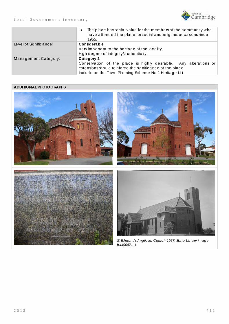
L o c a l G o v e r n m e n t I n v e n t o r y
2 0 1 8 4 1 1
• The place has social value for the members of the community who have attended the place for social and religious occasions since 1955.
Level of Significance: Considerable Very important to the heritage of the locality. High degree of integrity/authenticity
Management Category: Category 2 Conservation of the place is highly desirable. Any alterations or extensions should reinforce the significance of the place Include on the Town Planning Scheme No 1 Heritage List.
ADDITIONAL PHOTOGRAPHS
St Edmunds Anglican Church 1957, State Library image b4490871_1

L o c a l G o v e r n m e n t I n v e n t o r y
2 0 1 8 4 1 2
Meyer House, Wembley Place No: 86
SITE INFORMATION Place Name: Meyer House Other Names: Street Address: 64 Reserve Street Locality Wembley HERITAGE LISTING SHO inHerit database 8887 Other Listings PLACE TYPE Individual building or group Original Use: Residential: Double storey house Current Use: Residential: Double storey house Other Use: LAND INFORMATION Lot: 442, 443 Survey: Plan 3185 Reserve No: -------- C/T: 2228-779 2228-780 Property Number: 15886 Land Number: 4626; 4627

L o c a l G o v e r n m e n t I n v e n t o r y
2 0 1 8 4 1 3
CONSTRUCTION DETAILS Construction Date: c1922 Walls: Brick: Render Roof: Tile: cement Architectural Style: Inter-war Old English Physical Description: A large house which presents as single storey with additional accommodation in the roof space. The house has a symmetrical façade with a centrally placed entrance flanked by timber framed 3-section windows. The roof is gabled, clad in a dark tile with two large dormer windows which is not an original feature of the house. The roof is steeply pitched which continues down to form the verandah canopy at the same pitch. The verandah extends across the full extent of the façade with the canopy supported on masonry piers with timber posts. The house is sited in an elevated position. Condition: Good Integrity: High Authenticity: Moderate HISTORICAL INFORMATION Historical Notes: When land in the Perthshire Estate (Wembley) was advertised for sale, it was promoted as an area with views over Herdsman Lake. Accordingly higher land on the eastern side of Reserve Street was more prestigious affording views of the lake. From the available information this lot was not developed until a residence was built on this large land parcel of two lots for Paul Albert Meyer and his wife Elfrieda Agnes, nee Hufner. Paul Meyer was a piano mechanic or tuner and he worked with the family company Meyer and Orr which sold and repaired pianos in Western Australia in the first half of the 20th century. The house adjacent to this (66 Reserve St) was owned and occupied by business partner William Orr. No details of the architect or builder of this place have been found in this research.

L o c a l G o v e r n m e n t I n v e n t o r y
2 0 1 8 4 1 4
Paul and Elfrieda Meyer lived at the house until the mid 1950s. Aerial photographs indicate the form and extent of the residence has not changed significantly since the mid 20th century. The tennis court has been evident on the property since that time. The most significant changes occurred in the period between 1985 and 1995 when a new garage was built on the front property boundary and the roof cladding was changed from terracotta tile to the current dark tile. This change in roof cladding was undertaken when new dormers were added to the roof to the front and rear. The original roof included only one dormer central to the main elevation. Historic Theme: Demographic settlement and mobility: settlements
Occupations: domestic activities Associations: Meyer Family Sources: Aerial photographs, 1953-2016, Landgate.
Town of Cambridge Municipal Heritage Inventory and Townscape Precinct Study prepared for the Town of Cambridge, June 1997. Wise's Post Office Directories for the City of Perth, 1925-1949, State Library of WA www.slwa.wa.gov.au Australian Electoral Rolls, 1903-1983.
SIGNIFICANCE Statement of Significance: • The place has aesthetic value as a good intact example of the Inter
War Old English style executed in brick which has retained original details
• The place has historic value for its association with the establishment and development of this part of Wembley in the Inter War years.
• The place has social and historic value as an example of a home for a professional man and his family in the Inter War period.
Level of Significance: Little Contributes to the understanding of the history of the Town of Cambridge.
Management Category: Category 4 Photographically record prior to major development or demolition. Recognise and interpret the site if possible. Do not include on the Town Planning Scheme No 1 Heritage List.
ADDITIONAL PHOTOGRAPHS
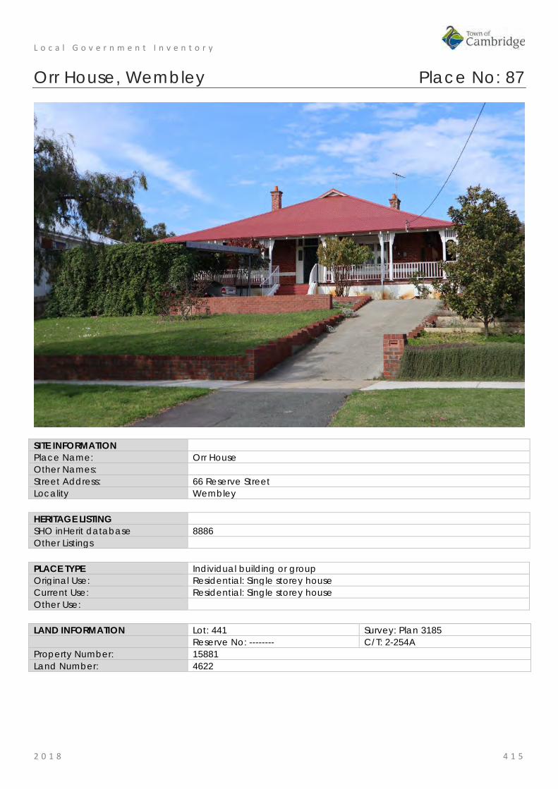
L o c a l G o v e r n m e n t I n v e n t o r y
2 0 1 8 4 1 5
Orr House, Wembley Place No: 87
SITE INFORMATION Place Name: Orr House Other Names: Street Address: 66 Reserve Street Locality Wembley HERITAGE LISTING SHO inHerit database 8886 Other Listings PLACE TYPE Individual building or group Original Use: Residential: Single storey house Current Use: Residential: Single storey house Other Use: LAND INFORMATION Lot: 441 Survey: Plan 3185 Reserve No: -------- C/T: 2-254A Property Number: 15881 Land Number: 4622

L o c a l G o v e r n m e n t I n v e n t o r y
2 0 1 8 4 1 6
CONSTRUCTION DETAILS Construction Date: c1922 Walls: Brick: Tuckpointed Roof: Metal: Colorbond Architectural Style: Inter-war Arts and Crafts Physical Description: Single storey brick house of traditional design and planform. The hipped roof has been reclad with colorbond, retaining the two red brick chimneys. The roof continues down with a slight break of pitch to form the verandah canopy. The verandah extends around the house, accessed via steps from the front and supported on a rendered masonry retaining wall. The deck is timber, with a simple timber balustrade and timber posts supporting the canopy. The house has a symmetrical façade, the centrally placed entrance consists of single door with side panels and lights and fanlight across the entire in a traditional form. The entrance is flanked by three-section timber framed windows with integral highlight panes Condition: Good Integrity: High Authenticity: Moderate
HISTORICAL INFORMATION Historical Notes: When land in the Perthshire Estate (Wembley) was advertised for sale, it was promoted as an area with views over Herdsman Lake. Accordingly higher land on the eastern side of Reserve Street was more prestigious affording views of the lake. From the available information this lot was not developed until a residence was built c1922 for William Joseph Orr (1882-1926) and his wife Isabella Reed, nee Spowart and their five children. William Orr was a piano mechanic or tuner and he worked with the family company Meyer and Orr which sold and repaired pianos in Western Australia in the first half of the 20th century. The house adjacent to this (64 Reserve St) was owned and occupied by business partner Paul Meyer. No details of the architect or builder of this place have been found in this research.

L o c a l G o v e r n m e n t I n v e n t o r y
2 0 1 8 4 1 7
William Orr died in 1926 and his widow Isabella lived on in the house until the late 1960s. It is noted that a member of the Orr family lived at 62 Reserve Street for some years. Aerial photographs indicate that the form and extent of the residence have not changed since the mid 20th century although minor changes are apparent in the property grounds. Historic Theme: Demographic settlement and mobility: settlements
Occupations: domestic activities Associations: Orr Family Sources: Aerial photographs, 1953-2016, Landgate.
Town of Cambridge Municipal Heritage Inventory and Townscape Precinct Study prepared for the Town of Cambridge, June 1997. Wise's Post Office Directories for the City of Perth, 1925-1949, State Library of WA www.slwa.wa.gov.au Australian Electoral Rolls, 1903-1983.
SIGNIFICANCE Statement of Significance: • The place has aesthetic value as a good intact example of the Inter
War Arts and Crafts style executed in brick which has retained original details
• The place has historic value for its association with the establishment and development of this part of Wembley in the Inter War years.
• The place has social and historic value as an example of a home for a professional man and his family in the Inter War period.
Level of Significance: Some/moderate Contributes to the heritage of the locality. Has some altered or modified elements, not necessarily detracting from the overall significance of the item.
Management Category: Category 3 Conservation of the place is desirable. Any alterations or extensions should reinforce the significance of the place, and original fabric should be retained wherever feasible. Include on the Town Planning Scheme No 1 Heritage List.
ADDITIONAL PHOTOGRAPHS

L o c a l G o v e r n m e n t I n v e n t o r y
2 0 1 8 4 1 8
Olive Trees, St Columbas Avenue, Wembley Place No: 88
SITE INFORMATION Place Name: Olive Trees, St Columbas Avenue Other Names: Olea europaea Street Address: St Columbas Avenue (located in road reserve adjacent to 1 St Columbas Ave) Locality Wembley HERITAGE LISTING SHO inHerit database 8885 Other Listings PLACE TYPE Tree Original Use: Tree Current Use: Tree Other Use: Road Reserve LAND INFORMATION Lot: Survey: Reserve No: Road Reserve C/T: Property Number: 13454 Land Number: 22540

L o c a l G o v e r n m e n t I n v e n t o r y
2 0 1 8 4 1 9
CONSTRUCTION DETAILS Construction Date: 1850s Walls: N/A Roof: N/A Architectural Style: N/A Physical Description: There are several trees on this small triangular road reserve at the junction of St Columbas Avenue and Gregory Street. The two olive trees are large and appear to be in good condition. A plaque is located at the base of the largest tree on the apex of the triangle which denotes the origin of the trees. A second interpretive sign provides some history for the development of the area under the name of the 'Church Lands Estate'. Condition: Good Integrity: High Authenticity: High
HISTORICAL INFORMATION Historical Notes: These olive trees are believed to be remnants of the plantings in the grounds of the Catherine McCauley Centre first planted by the Benedictine Monks in the mid-1850s, prior to the completion of the monastery in 1858-9. The founder of the Monastery, Bishop Serra wrote of twenty thousand vines and hundreds of fruit trees being planted, including oranges, lemons, fits, apples, pears and almonds. Many acres of olive trees were planted around the monastery and down the hillside to the edge of Lake Monger.

L o c a l G o v e r n m e n t I n v e n t o r y
2 0 1 8 4 2 0
Records indicate that the first olive oil was produced by the monks in the mid-1850s while the building was under construction. In 1864, when the Monks relocated to New Norcia, the vines and orchards were left to die. Only the olive trees survived out of all the cultivation and there is no record of how many of the original trees survived. From 1876 when Father Gibney was Chair of the Board of Governance for St Vincent's Boys Orphanage there are records of oil production with the boys harvesting the olives under the guidance of John Prendergast. Mr Dale, Inspector of Charitable Institutions reported at his visit in 1881 that over 100 gallons of olive oil had been produced at the orphanage that year. At the Indian and Colonial Exhibition in London in 1886 the oil received high commendation and often took first prize at the Royal Show. The first mention of sale of the oil was made in 1897 when the Christian brothers moved to the site for a short time. They left in 1901 with the Sisters of Mercy moving back in. The girls in their care harvested the olives and helped with the production of the oil. The purification of the oil took place in the east room of the building now designated as, Benedictine Stables (fmr). In 1902, sale of olive oil manufactured at the Orphanage netted £2/8/9. The girls of the Orphanage exhibited their oil at the Royal Perth Show each year, where it was often awarded first prize. In 1909, there were 148 girls and eight Sisters at the Orphanage. As well as attending school the older girls worked in the Laundry or assisted with the production of olive oil. In 1921, sales amounted to £140/5/2. It is not known how long olive oil production continued at the site. References to the production of olive oil are made in the local press in 1934 and in 1950. Although the later date refers to preparation for a fete rather than commercial sales. The land between Lake Monger and the current Catherine McCauley centre was subdivided for sale from the 1930s and these trees probably survived because of their location on the road reserve. Other trees may survive within the grounds of private properties. Historic Theme: Social and Civic Activities: Religion
Social and Civic Activities: Institutions Occupations: Manufacturing and processing
Associations: Sisters of Mercy Benedictine Order Joseph Serra St Vincent de Paul Society
Sources: Aerial photographs, 1953-2016, Landgate. Town of Cambridge Municipal Heritage Inventory and Townscape Precinct Study prepared for the Town of Cambridge, June 1997. Wise's Post Office Directories for the City of Perth, 1925-1949, State Library of WA www.slwa.wa.gov.au Heritage Trail: A journey through the history of Mercy Care, Mercy Care, 2007. Register of Heritage Places, Assessment Documentation for Place 2231, Catherine McCauley Centre. The West Australian, 26 May 1934, p. 19. The Daily News, 11 November 1950, p. 24. Plaque installed at the site by the Town of Cambridge
SIGNIFICANCE Statement of Significance: • The trees have aesthetic value as large mature trees in good
condition which contribute to the leafy character of the streetscape and are landmarks on this prominent corner;
• The trees have historic value for their association with the foundation of the monastery at 'New Subiaco' in the 1850s.
• The trees have historic value for their association with the olive oil industry conducted by the Sisters of Mercy, and which helped

L o c a l G o v e r n m e n t I n v e n t o r y
2 0 1 8 4 2 1
provide funds for the ongoing operation of the orphanage and foundling home located at what is now the Catherine McCauley Centre. The olive oil manufactured at St Joseph’s Orphanage won first prize at several Royal Perth shows.
• The trees have social value for their contribution to the streetscape and are valued by the community as demonstrated by their inclusion in the Local Government Inventory
Level of Significance: Some/moderate Contributes to the heritage of the locality. Has some altered or modified elements, not necessarily detracting from the overall significance of the item.
Management Category: Category 3 Conservation of the place is desirable. Any alterations or extensions should reinforce the significance of the place, and original fabric should be retained wherever feasible. Include on the Town Planning Scheme No 1 Heritage List.
ADDITIONAL PHOTOGRAPHS

L o c a l G o v e r n m e n t I n v e n t o r y
2 0 1 8 4 2 2
Wembley Golf Course and Club Rooms, Wembley Place No: 89
SITE INFORMATION Place Name: Wembley Golf Course and Club Rooms Other Names: Fairway Tavern Street Address: 200 The Boulevard Locality Wembley HERITAGE LISTING SHO inHerit database Other Listings PLACE TYPE Individual building or group Original Use: Social/Recreational: Sports Building Current Use: Social/Recreational: Sports Building Other Use: Social/Recreational: Golf Course LAND INFORMATION Lot: 2000 Survey: Plan 73159;
Diagrams 16637 and 54860 Reserve No: --------- C/T: 2790-665; 1150-279; 1522-898 Property Number: 12512, 12513, 17499, 18166, 21209, 21210, 22339, 22340 Land Number: 1488; 1489; 14087

L o c a l G o v e r n m e n t I n v e n t o r y
2 0 1 8 4 2 3
CONSTRUCTION DETAILS Construction Date: 1932; 1940s; 1959; 1960s; 2016 Walls: N/A Roof: N/A Architectural Style: Contemporary Physical Description: The original Wembley Golf Course opened in 1932 and since that time the club and courses have significantly expanded and developed.
The new club house and enhanced facilities are in the centre of a luxuriously landscaped golfing environment offering a range of courses.
Condition: Good Integrity: High Authenticity: Golf course: high
Facilities: low
HISTORICAL INFORMATION Historical Notes: The Wembley Downs Golf Course Ltd was registered as a company in 1933 and was granted a lease of land of 150 acres north of the Boulevard on the edge of the City Beach Estate part of the Endowment Lands/Limekilns Estate. The lease was for 10 years and the company was to pay a peppercorn rent. Authority was given to proceed at once to clear the land and the City Engineer to widen the plank road (now the Boulevard) to 15 feet.
Prior to the formalisation of the lease a course was established on the site in 1932 and continues to be used today [2018] and follows the original route. In 1959, a new course commenced development with the completion of the first nine of 'The Tuart Course'. Since then the final nine holes have been implemented.
In the 1960s, the Fairway Tavern was built on the site to supplement facilities for members. This tavern was a popular venue for members of the Wembley and wider Perth community. In 2015, the Fairway Tavern was

L o c a l G o v e r n m e n t I n v e n t o r y
2 0 1 8 4 2 4
demolished and new facilities designed by architects Gresley Abas were constructed and completed in 2016. The golf course remained intact throughout the works. Historic Theme: Social and Civic Activities: Sport, recreation and entertainment
Demographic settlement and mobility: settlements Associations: Gresley Abas Sources: Western Suburbs Weekly, 14 November 2016
Gresley Abas Architects, website http://www.gresleyabas.com.au SIGNIFICANCE Statement of Significance: • The place has aesthetic value as a well maintained landscaped
environment which has integrated native vegetation with the introduced golf course plantings.
• The place has historic value as the club was established at this site in 1932 and has grown and developed into a sophisticated business which is evident in the facilities on the site.
• The place has social value for the many members of the community how use the golf course and the facilities since 1932.
Level of Significance: Little Contributes to the understanding of the history of the Town of Cambridge.
Management Category: Category 4 Photographically record prior to major development or demolition. Recognise and interpret the site if possible. Do not include on the Town Planning Scheme No 1 Heritage List.
ADDITIONAL PHOTOGRAPHS

L o c a l G o v e r n m e n t I n v e n t o r y
2 0 1 8 4 2 5
Hope Residence (fmr), West Leederville Place No: 90
SITE INFORMATION Place Name: Hope Residence (fmr) Other Names: Residence, 92 Blencowe Street Street Address: 92 Blencowe Street Locality West Leederville HERITAGE LISTING SHO inHerit database Other Listings PLACE TYPE Individual building or group Original Use: Residential: Single storey residence Current Use: Residential: Single storey residence Other Use: LAND INFORMATION Lot: 8 Survey: Diagram 16210 Reserve No: ------- C/T: 1196-279 Property Number: 20079 Land Number: 8561

L o c a l G o v e r n m e n t I n v e n t o r y
2 0 1 8 4 2 6
CONSTRUCTION DETAILS Construction Date: c1913 Walls: Brick: common Roof: Tile: terracotta Architectural Style: Federation Bungalow Physical Description: Substantial Federation Queen Anne house of brick and tile construction located on a corner lot. The design of the house takes full advantage of its location with three principal elevations to the street along Blencowe Street, Ruislip Street and the intersection of the two roads. The house is of red brick construction with rendered detailing, terracotta tiled roofs and decorative redbrick and rendered chimneys. The roof is a complex form of hips and gablets with a later addition dormer. The gables are lined with battened fibro panelling. The verandah extends around the front of the house, positioned under the eaves. The house has been extended to the rear which does not impact on the presentation of the house. Condition: Good Integrity: High Authenticity: Moderate
HISTORICAL INFORMATION Historical Notes: The Municipalities of Leederville and North Perth were incorporated into the City of Perth in November 1914. As part of the amalgamation some of the road names were rationalised to avoid confusion. Northwood Street was formerly Monger Street, and Ruislip Street was formerly Ruby Street. This area of West Leederville had been approved for subdivision as residential lots in 1901. There is no information to suggest the lots were occupied in any form until purchased by Percy George Samuel Hope (1885-1979) partner in firm Hope & Klem influential planners and surveyors. Percy Hope married Catherine Dickson in 1913 and this residence was the couple's first family home. The couple had three children and lived at this place until the late 1920s. No details of the architect or builder of this place have been found in the current research. Hope & Klem were significant in the development of town planning in Western Australia and particularly influential in the creation of urban plans on garden suburb principles that were significant in the planning of Floreat and City Beach within the Town of Cambridge.

L o c a l G o v e r n m e n t I n v e n t o r y
2 0 1 8 4 2 7
Aerial photographs indicate that the form and extent of the original residence can still be determined although additions have been undertaken in 1998, 2006 and 2013. Historic Theme: Occupations: Domestic activities
People: Innovators Associations: Percy George Samuel Hope Sources: Aerial photographs, 1953-2016, Landgate.
Town of Cambridge Municipal Heritage Inventory and Townscape Precinct Study prepared for the Town of Cambridge, June 1997. Wise's Post Office Directories for the City of Perth, 1925-1949, State Library of WA www.slwa.wa.gov.au
SIGNIFICANCE Statement of Significance: • The place has aesthetic value as a large and well maintained
Federation Bungalow style residence built of brick and tile that features many original details.
• The place has historic value for its association with the establishment and development of this area of West Leederville for professional men and their families in the early 20th century.
• The place has historic value for its association with Percy George Samuel Hope, an influential figure in the development of town planning in Western Australia in the early 20th century.
• The place has social value for its demonstration of the scale and form of housing for professional men and their families in the early 20th century.
Level of Significance: Some/moderate Contributes to the heritage of the locality. Has some altered or modified elements, not necessarily detracting from the overall significance of the item.
Management Category: Category 3 Conservation of the place is desirable. Any alterations or extensions should reinforce the significance of the place, and original fabric should be retained wherever feasible. Include on the Town Planning Scheme No 1 Heritage List.
ADDITIONAL PHOTOGRAPHS
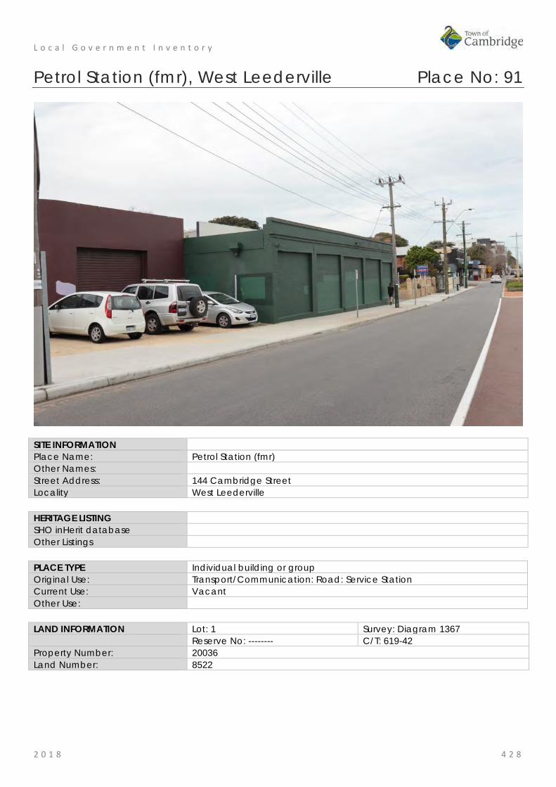
L o c a l G o v e r n m e n t I n v e n t o r y
2 0 1 8 4 2 8
Petrol Station (fmr), West Leederville Place No: 91
SITE INFORMATION Place Name: Petrol Station (fmr) Other Names: Street Address: 144 Cambridge Street Locality West Leederville HERITAGE LISTING SHO inHerit database Other Listings PLACE TYPE Individual building or group Original Use: Transport/Communication: Road: Service Station Current Use: Vacant Other Use: LAND INFORMATION Lot: 1 Survey: Diagram 1367 Reserve No: -------- C/T: 619-42 Property Number: 20036 Land Number: 8522

L o c a l G o v e r n m e n t I n v e n t o r y
2 0 1 8 4 2 9
CONSTRUCTION DETAILS Construction Date: c1922 Walls: Brick: painted Roof: Metal: corrugated iron Architectural Style: Inter War Physical Description: The petrol station (fmr) appears to consist of two buildings which have both been altered and no longer reflect their original functions. Both buildings are of brick construction with rendered elements. The eastern most building sits directly on the pavement, the five bays have all been bricked up but due to the recessed brickwork, the rhythm of the bays remains visible. The western building is set behind the adjoining structure which allowed for the forecourt function. Part of the petrol station has been removed but the curved element and mechanics access remain extant. The art deco style design influences remain discernible but the overall design aesthetic has been compromised by the alterations. Condition: Fair Integrity: Moderate Authenticity: Low
HISTORICAL INFORMATION Historical Notes: These commercial premises have been used for services relating the motor industry since c1922 when the available records indicate these premises were first constructed. The first occupant is designated as John Billings in the Post Office Directories and later entries record motor engineer, garage and tyre re-treading. No details of the builder or architect have been found in this research. City of Perth Rates books show the owner was James Maher. Building a garage at this location in the Inter War years was consistent with the development that was occurring in Leederville and further to the west in Floreat and City Beach. The growth in private car

L o c a l G o v e r n m e n t I n v e n t o r y
2 0 1 8 4 3 0
ownership was also a feature of this period which lead to a demand for petrol stations and mechanics. Since the mid 20th century the place has not changed significantly in form and extent apart from the awning over the bitumenised area facing Cambridge Street. This awning was removed c2005 and since that time there has been minimal change to the structure. Historic Theme: Transport and Communications: Road: Service station Associations: Sources: Aerial photographs, 1953-2016, Landgate.
Town of Cambridge Municipal Heritage Inventory and Townscape Precinct Study prepared for the Town of Cambridge, June 1997. Wise's Post Office Directories for the City of Perth, 1925-1949, State Library of WA www.slwa.wa.gov.au
SIGNIFICANCE Statement of Significance: • The place has some aesthetic value for its remnant elements of form
and detail demonstrating the Inter War style. • The place has historic value for its association with the development
of the district in the Inter War period. • The place has historic value for its association with the growth of
motor vehicle travel and ownership by private individuals. Level of Significance: Little
Contributes to the understanding of the history of the Town of Cambridge.
Management Category: Category 4 Photographically record prior to major development or demolition. Recognise and interpret the site if possible. Do not include on the Town Planning Scheme No 1 Heritage List.
ADDITIONAL PHOTOGRAPHS

L o c a l G o v e r n m e n t I n v e n t o r y
2 0 1 8 4 3 1
Niola Private Hospital (fmr), West Leederville Place No: 92
SITE INFORMATION Place Name: Niola Private Hospital (fmr) Other Names: Abbotsford Private Hospital;
St Gerard's Private Hospital Street Address: 61 Cambridge Street Locality West Leederville HERITAGE LISTING SHO inHerit database Other Listings PLACE TYPE Individual building or group Original Use: Health: Hospital Current Use: Health: Hospital Other Use: Residential: single storey residential LAND INFORMATION Lot: 181 Survey: Diagram 84657 Reserve No: ---------- C/T: 1999-574 Property Number: 19720 Land Number: 8208

L o c a l G o v e r n m e n t I n v e n t o r y
2 0 1 8 4 3 2
CONSTRUCTION DETAILS Construction Date: c1917; 2012 Walls: Brick: painted Roof: Metal: zincalume Architectural Style: Federation Bungalow Physical Description: Single storey brick building that has been incorporated into the larger hospital function. The original building has a slightly elevated position above Cambridge Street and due to the dense planting around the perimeter, the place cannot be seen clearly. The place is of brick construction which has been painted white. The verandah extends around the front and side elevations with the original main entrance facing Cambridge Street accessed via the verandah. The roof is hipped with vented gablet and feature gables above the entrance. The original door configuration appears to have been retained with traditional timber and glazed door with matching side panels and fanlights. Condition: Good Integrity: Moderate Authenticity: Moderate
HISTORICAL INFORMATION Historical Notes: The earliest building on this site was constructed c1917 and occupied two lots on the corner of Cambridge Street and Abbotsford Street. From the available information, the building was constructed for use as a hospital. No details of the architect or builder have been found in the current research. This area of Perth was developing as a centre for the provision of medical services in the early 20th century. The nearby St John of God Hospital had been established in 1898 and the two Catholic Institutions, now the Catherine McCauley Centre and the Home of the Good Shepherd, now the Catholic Education Centre
L o c a l G o v e r n m e n t I n v e n t o r y
2 0 1 8 4 3 3
provided medical services. In 1917, the property was owned by James Lamont and the place was designated for use as a hospital and managed by Nurses Molly and Madge Ryan. The hospital seemed to be primarily a maternity hospital and the name St Gerard's, the patron Saint of expectant mothers, supports that conclusion. Many family notices in the local press indicate that mothers from around the state came to the hospital. In 1919, the WA Catholic Record, included the following item. "St Gerard's Hospital, Cambridge Street Leederville is a fine roomy and well equipped establishment. Nurse Ryan who is matron of the institution, is up-to-date in hospital management, and gives the closest attention to the needs of patients." By 1923, the place had transferred to new owners; brothers John Henry Prowse and Albert Edward Cornwall Prowse and their wives. The hospital was managed by their sister Matilda Adelaide Prowse (1879-1958). At this time the place was renamed Niola Private Hospital. The Prowse family had a long association with the place, in 1936 Miss Hazel Prowse assumed control of the hospital which offered medical and surgical services. The hospital was functioning at the premises until the late 1940s and Matilda Prowse was living there in 1954. However it has not been determined if there has been an unbroken use as a hospital since the late 1940s. In the 1954 electoral rolls, Matilda Prowse is undertaking home duties whilst living at the place. In 1974, the place commenced operations as a private psychiatric hospital under the name Niola Private Hospital. In 2010 the hospital commenced operation under the name Abbotsford Private Hospital. In 2012, a major addition was constructed at the rear of the building which saw the demolition of approximately half of the original building. The front portion and western side of the building has remained intact and has the same roof form. The new addition across the rear has not adversely affected the view of the original building from Cambridge Street. In 2017, the hospital was acquired by Health Care Australia and it continues to operate in 2018 under the name Abbotsford Private Hospital providing inpatient and day patient facilities. Historic Theme: Social and Civic Activities: Community Services and utilities
Demographic Settlement and Mobility: settlements Associations: Nurse Matilda Prowse
Nurse Hazel Prowse Nurses Madge and Molly Ryan Prowse family
Sources: Aerial photographs, 1953-2016, Landgate. Town of Cambridge Municipal Heritage Inventory and Townscape Precinct Study prepared for the Town of Cambridge, June 1997. Wise's Post Office Directories for the City of Perth, 1925-1949, State Library of WA www.slwa.wa.gov.au Australian Electoral Rolls, 1901-1983. City of Perth Rates Books, Leederville Ward, 1916-1924. The West Australian, 31 may 1918, p.19; 20 May 1922, p.16; 16 November 1936, p.14. Niola Private Hospital (fmr) Heritage Advice Report, Palassis Architects, August 2018.
SIGNIFICANCE Statement of Significance: • The place has aesthetic value for the remaining form and detail of a
Federation Bungalow style hospital. • The place has historic value for its association with the provision of
medical services to the members of the Leederville and wider community since 1917.
• The place has historic value for its association with the development

L o c a l G o v e r n m e n t I n v e n t o r y
2 0 1 8 4 3 4
of the Leederville community and the growth of the medical sector in the vicinity.
• The place has social value for the members of the community who worked, were patients or were associated with those groups at these premises through the 20th century.
• The place has social value for those remaining elements which demonstrate the type of health care available in the early to mid 20th century.
Level of Significance: Little Contributes to the understanding of the history of the Town of Cambridge.
Management Category: Category 4 Photographically record prior to major development or demolition. Recognise and interpret the site if possible. Do not include on the Town Planning Scheme No 1 Heritage List.
ADDITIONAL PHOTOGRAPHS

L o c a l G o v e r n m e n t I n v e n t o r y
2 0 1 8 4 3 5
Baptist Church - site, West Leederville Place No: 93
Leederville Baptist Church, 1981.
SITE INFORMATION Place Name: Baptist Church - site Other Names: Leederville Baptist Church Street Address: 77 Cambridge Street Locality West Leederville HERITAGE LISTING SHO inHerit database 2194 Other Listings PLACE TYPE Historic site Original Use: Religious: church Current Use: Residential: conjoined residences Other Use: LAND INFORMATION Lot: 138 Survey: P4413 Reserve No: --------- C/T: Property Number: 21033 Land Number: 10155; 12403

L o c a l G o v e r n m e n t I n v e n t o r y
2 0 1 8 4 3 6
CONSTRUCTION DETAILS Construction Date: 1902; demolished c1990 Walls: N/A Roof: N/A Architectural Style: N/A Physical Description: N/A Condition: N/A Integrity: None Authenticity: None
HISTORICAL INFORMATION Historical Notes: In 1902, the Leederville Baptist Church built a brick and stone church on this site. The church was built by contractors Paterson and Ross but the architect is not known. The building was demolished in c1990 and a residential until complex was built on the site. Members of the Baptist Church in Leederville have been served by adjacent parishes. Historic Theme: Social and Civic Activities: Religion Associations: Sources: Aerial photographs, 1953-2016, Landgate.
Town of Cambridge Municipal Heritage Inventory and Townscape Precinct Study prepared for the Town of Cambridge, June 1997 Wise's Post Office Directories for the City of Perth, 1925-1949, State Library of WA www.slwa.wa.gov.au The West Australian, 16 May 1902, p. 2. The Western Mail, 1 February 1902, p.43.

L o c a l G o v e r n m e n t I n v e n t o r y
2 0 1 8 4 3 7
SIGNIFICANCE Statement of Significance: • The site has historic value for its association with the Leederville
Baptist Church which was formerly located at this site and provided a religious and social services to the community.
Level of Significance: Historic Site Site relevant to a past event, group or individual which contributes to the understanding of the history of the Town of Cambridge.
Management Category: Category 5 Recognise and interpret the site if possible. Do not include on the Town Planning Scheme No 1 Heritage List.

L o c a l G o v e r n m e n t I n v e n t o r y
2 0 1 8 4 3 8
Leederville War Memorial and Rose Garden, West Leederville Place No: 94
SITE INFORMATION Place Name: Leederville War Memorial and Rose Garden Other Names: Street Address: 78-80 Cambridge Street Locality West Leederville HERITAGE LISTING SHO inHerit database 23872 Other Listings PLACE TYPE Landscape Original Use: Park/Reserve: War Memorial Current Use: Park/Reserve: War Memorial Other Use: LAND INFORMATION Lot: 95, 96 Survey: Plan 4413, Diagram 12280 Reserve No: --------- C/T: 2030-203 1081-331 Property Number: 10690, 21291 Land Number: 9900; 9901

L o c a l G o v e r n m e n t I n v e n t o r y
2 0 1 8 4 3 9
CONSTRUCTION DETAILS Construction Date: 1927; 1990s Walls: N/A Roof: N/A Architectural Style: N/A Physical Description: The War Memorial garden is located to the east of the town hall, creating a soft landscaped setting to the town hall buildings. The garden consists of the War Memorial constructed of rock faced granite, concrete plinth and carved stone lions; the rose garden; pergola and other plantings. The Memorial is set back from the road but can be clearly seen in its open setting. Condition: Good Integrity: High Authenticity: High
HISTORICAL INFORMATION Historical Notes: The Leederville War Memorial was unveiled by the Governor, Sir Francis Newdegate on Sunday 25 May 1924. The memorial was an initiative of the people of Leederville in memory of those from the district who enlisted and died on active service. At the time of unveiling the memorial included 88 names. The construction of the memorial was funded by donations from the local citizens. The design and construction was undertaken by well known local sculptor, Pietro Giacomo Porcelli.

L o c a l G o v e r n m e n t I n v e n t o r y
2 0 1 8 4 4 0
In his speech at the unveiling ceremony, the Governor stated there were three reasons for its erection. 1. Affection for those who had fallen; 2. Respect an sympathy for those who had gone and returned and for the relatives of those who had not; and 3. A lasting object-lesson of the patriotism and duty of the people of Leederville. Plaques have subsequently been added to the memorial to honour those who served in later conflicts. Aerial photographs indicate that the grounds around the memorial were largely open grass with a few mature trees until the late 20th century. The perimeter planting and formal garden beds around a rotunda appear to have been established c1990 and maintained and developed since then. No date for the dedication of the rose gardens has been determined in this research. The Leederville Memorial is the venue for regular memorial services including the well attended ANZAC Day dawn service. Historic Theme: Outside influences: World Wars and other wars
People: Local heroes and battlers Associations: Pietro Giacomo Porcelli Sources: Aerial photographs, 1953-2016, Landgate.
Town of Cambridge Municipal Heritage Inventory and Townscape Precinct Study prepared for the Town of Cambridge, June 1997. Wise's Post Office Directories for the City of Perth, 1925-1949, State Library of WA www.slwa.wa.gov.au The West Australian, 26 May 1924, p.6. State Register Documentation for Place 2195 prepared in 2003 for inclusion in the State Register of Heritage Places.
SIGNIFICANCE Statement of Significance: The following statement has been taken from the State Register Entry for
Place 2195 prepared in 2003.
Leederville Town Hall & Recreation Complex, a pair of single storey classically planned face brickwork, stucco walls and Colorbond custom orb roof buildings in the Federation Free Classical style, together with a rough hewn granite obelisk memorial with sculpted marble lions, memorial rose garden, bowling greens, and mature trees and setting, has cultural heritage significance for the following reasons: • the place is a fine example of two successive buildings designed in
the Federation Free Classical Style architecture; • the bowling greens, established in 1906, are one of the oldest
bowling greens in Western Australia still operating on their original site;
• the place was designed by A. E. Clarke, a prominent architect in Victoria and Western Australia, and built by well-known local builder, W. H. Roberts;
• the place has social value to the community of the immediate district of West Leederville, and the wider community, through its continuous use since 1904;
• the place is a civic landmark in the largely residential environment of West Leederville, and the palms flanking the monument are a distinctive element in the vicinity;
• the Leederville War Memorial was designed by Pietro Porcelli, the first local sculptor in Western Australia to be noted for public artwork; and,
• the place is representative of the development and rapid growth of

L o c a l G o v e r n m e n t I n v e n t o r y
2 0 1 8 4 4 1
Leederville in the pre-World War One period; and marks a phase in the establishment of municipal buildings in the suburb.
The bowling clubrooms, the 1955 addition to the rear of the bowling clubrooms, the 1955 addition to the rear of the hall, and the landscape treatments immediately around the west, north and east sides of the hall are of little significance. The hard landscaped area in front of the hall is intrusive.
Level of Significance: Considerable Very important to the heritage of the locality. High degree of integrity/authenticity
Management Category: Category 1 The place should be retained and conserved unless there is no feasible and prudent alternative to doing otherwise. Any alterations or extensions should reinforce the significance of the place, and be in accordance with a Conservation Plan (if one exists for the place). Include on the Town Planning Scheme No 1 Heritage List.
ADDITIONAL PHOTOGRAPHS

L o c a l G o v e r n m e n t I n v e n t o r y
2 0 1 8 4 4 2
Leederville Town Hall and Recreation Complex, West Leederville Place No: 95
SITE INFORMATION Place Name: Leederville Town Hall and Recreation Complex Other Names: West Leederville Town Hall;
Council Chambers, Masonic Hall; Excelsior Masonic Lodge; Leederville Bowling Club
Street Address: 82-84 Cambridge Street (extending across 78, 80, 82, 84, 86 Cambridge St) Locality West Leederville HERITAGE LISTING SHO inHerit database 2195 Other Listings Statewide War Memorial Survey PLACE TYPE Original Use: Social/Recreational: Town Hall Current Use: Social/Recreational: Sports Building Other Use: Monument LAND INFORMATION Lot: 93, 94, 95, 96 Survey: Plan 4413, Diagram 12280 Reserve No: --------- C/T: 2030-203, 1081-331 Property Number: 10688, 10689, 10690, 10691 Land Number: 9898, 9899, 9900, 9901

L o c a l G o v e r n m e n t I n v e n t o r y
2 0 1 8 4 4 3
CONSTRUCTION DETAILS Construction Date: 1904; 1906; 1914; 1924; 1927; 1959; 1990s Walls: Brick: render Roof: Metal: Corrugated iron Architectural Style: Federation Free Classical Physical Description: The Leederville Town Hall comprises two buildings, both of which are in the Federation Free Classical architectural style. The two buildings are of brick construction finished with tuckpointing to the facades and face brick to the side elevations. Both facades are enlivened by rendered elements, painted in bright white, including pilasters, fascias, pediments, window sills and decorative motifs. Both buildings are of similar design, each incorporating a central entrance flanked by windows. For the main hall, the entry consists of double timber doors with segmented arch fanlight, flanked by rendered pillars and has the word ‘HALL’ above the entry. The entry to the second hall, which is set back behind the main building, is of similar design albeit the actual entrance doors are to the rear of the covered entry which is secured by metal gates, this entrance is not as ornate as the main entrance but the similarity of design can be seen in the two. Windows are timber framed sashes to both buildings. Brick additions have been added to both buildings but these cannot be seen in the street view. The roofs to the halls are both hipped with gablets to the street elevation, both obscured from clear view at street level due to the parapet walls across the facades. The roofs are clad in a green/grey Colorbond. Leederville Town Hall is located within a park setting with Holyrood Park to the west, the Memorial Garden to the east and the bowling club to the north.

L o c a l G o v e r n m e n t I n v e n t o r y
2 0 1 8 4 4 4
The bowling club is located to the rear of the War Memorial Gardens. The clubhouse is an unassuming single storey structure of pale brick construction with colorbond roof. The building footprint has not been enlarged since it was originally constructed in the early 1960s with the only visible alterations from the street frontage being the recladding of the roof and the addition of the ramped access. The façade has two distinct characters: to the east of the main entrance, the windows are placed in a regular rhythm with five openings between the door and the end of the building. Each window consists of a large fixed pane window with three highlight windows above. To the west of the main entrance, the façade consists of an irregular placement of windows and doors of differing styles and dimensions. The characters reflect the different uses of the internal spaces. The name “LEEDERVILLE SPORTING CLUB” has been placed above the eastern windows of the façade. The bowling greens are laid out to the side and rear of the building. Condition: Good Integrity: High Authenticity: High
HISTORICAL INFORMATION Historical Notes: The Leederville Town Hall and its adjunct, Lesser hall, were built in two stages in the early 20th century. In 1904 when the town of Leederville was expanding as a suburb of Perth. A new hall was built to meet the needs of the district. An item in the local press at the opening ceremony in September 1904 stated that the buildings, the main hall and lesser hall cost £1200. The architect was Wallace Watkins, builder Alfred Wilks and decorator Albert Card. Funds for the building were supplied by the Excelsior Masonic Lodge and Sir Walter Scott Lodge. At the time of construction efforts were made to install 'the very best floor for dancing' and the lighting installed was the 'Kitson' Light. The main hall could seat approximately 500 and the lesser hall or supper room approximately 150. The hall was used for a wide variety of functions for the Leederville community. Plans for a bowling green and a croquet lawn were an early initiative and in November 1905, the newly laid greens and lawn were opened by MLA Henry Daglish and his wife Edith Daglish following the first meeting of the club in July 1905. In 1914, a new hall was built adjoining the Masonic Hall. The completion of the hall coincided with the amalgamation of the Municipalities of Leederville and North Perth within the City of Perth. The new Town Hall was opened by the Governor on 19 September 1914. A description of the hall in the local press described the hall as follows:
"The hall is a substantially built brick structure containing a public hall of fine dimensions, 72ft x 45ft with seating accommodation for 600 persons. The end is temporarily enclosed so as to be easily extended with a view to the future extension of the stage accommodation. The entrance from Cambridge Street is 10ft wide with an ante-room on each side 16ft 9ins x 12ft and over the entrance is a fire proof lantern operating room. At the rear of the hall are two dressing rooms and also means of connecting with the old existing Masonic Hall, the back of which can be used as a supper room in connection with the new hall. The old Masonic Hall has been altered internally and is now used for municipal offices. The Town Clerk's room is 18ft x 12ft, health officer 12ft x 10ft, general office 35ft x 25ft and having a large strong room, public counter, etc. At the back of the offices is the municipal council chamber 35ft x 22ft 6in, with an ante-room adjoining."
This larger portion of the Leederville Town Hall was built by well-known local builder, W. H. Roberts and designed by A. E. Clarke, a prominent architect in Victoria who emigrated to Western Australia in the late 1890s. From the available information the remaining structure consists of the original Masonic Hall (1904) on the east, set back from Cambridge Street and the larger town hall (1914) built closer to Cambridge Street.

L o c a l G o v e r n m e n t I n v e n t o r y
2 0 1 8 4 4 5
In 1954, the floor in the main hall was replaced with a wandoo timber floor taken from the UWA ballroom as the existing floor was worn from the many dances held in the venue. The Caretaker of the place during most of the inter-war period and through World War Two was Mr Haimes, and the Caretaker’s Residence was built on the western side of the main hall to accommodate him and his family in 1924. This is now the location of the No.86 Youth Centre. The bowling club was the first sporting facility established on the site and was developed in association with the Excelsior Masonic Lodge, occupiers of the Masonic Hall. Over the years the bowling green has been extended to occupy the ground of the former tennis courts, picture gardens and the original croquet lawn. The current club rooms on the site were built c1959 and continue to be well patronised by the community. In 1980, Leederville Bowling Club incorporated with other local sporting clubs to become Leederville Sporting Club Inc. The Leederville Bowling club was one of the earliest clubs established in Western Australia. The Fallen Soldier’s Memorial was designed and executed in 1924 by Pietro Porcelli, Western Australia’s first local sculptor, who arrived in Australia in 1898. The gardens surrounding the memorial have been slowly established since the 1990s. Historic Theme: Social and civic activities: Community services and utilities
Social and civic activities: Sport, recreation and entertainment Outside influences: World wars and other wars
Associations: W.H. Roberts A.E. Clarke Wallace Watkins, Alfred Wilks
Sources: Aerial photographs, 1953-2016, Landgate. Town of Cambridge Municipal Heritage Inventory and Townscape Precinct Study prepared for the Town of Cambridge, June 1997. Wise's Post Office Directories for the City of Perth, 1925-1949, State Library of WA www.slwa.wa.gov.au State Register Documentation for Place 2195 prepared in 2003 for inclusion in the State Register of Heritage Places. The West Australian, 15 September 1904, p. 3; 9 November 1905, p.6; 21 September 1914, p. 6. Cambridge Notes, Town of Cambridge Local Studies Centre, item T209, T494
SIGNIFICANCE Statement of Significance: The following statement has been taken from the State Register Entry for
Place 2195 prepared in 2003.
Leederville Town Hall & Recreation Complex, a pair of single storey classically planned face brickwork, stucco walls and Colorbond custom orb roof buildings in the Federation Free Classical style, together with a rough hewn granite obelisk memorial with sculpted marble lions, memorial rose garden, bowling greens, and mature trees and setting, has cultural heritage significance for the following reasons: • the place is a fine example of two successive buildings designed in
the Federation Free Classical Style architecture; • the bowling greens, established in 1906, are one of the oldest
bowling greens in Western Australia still operating on their original site;
• the place was designed by A. E. Clarke, a prominent architect in Victoria and Western Australia, and built by well-known local builder, W. H. Roberts;
• the place has social value to the community of the immediate
L o c a l G o v e r n m e n t I n v e n t o r y
2 0 1 8 4 4 6
district of West Leederville, and the wider community, through its continuous use since 1904;
• the place is a civic landmark in the largely residential environment of West Leederville, and the palms flanking the monument are a distinctive element in the vicinity;
• the Leederville War Memorial was designed by Pietro Porcelli, the first local sculptor in Western Australia to be noted for public artwork; and,
• the place is representative of the development and rapid growth of Leederville in the pre-World War One period; and marks a phase in the establishment of municipal buildings in the suburb.
The bowling clubrooms, the 1955 addition to the rear of the bowling clubrooms, the 1955 addition to the rear of the hall, and the landscape treatments immediately around the west, north and east sides of the hall are of little significance. The hard landscaped area in front of the hall is intrusive.
Level of Significance: Exceptional Essential to the heritage of the locality. Rare or outstanding example. Recommended for inclusion on the State Register of Heritage Places.
Management Category: Category 1 The place should be retained and conserved unless there is no feasible and prudent alternative to doing otherwise. Any alterations or extensions should reinforce the significance of the place, and be in accordance with a Conservation Plan (if one exists for the place). Include on the Town Planning Scheme No 1 Heritage List.

L o c a l G o v e r n m e n t I n v e n t o r y
2 0 1 8 4 4 7
ADDITIONAL PHOTOGRAPHS

L o c a l G o v e r n m e n t I n v e n t o r y
2 0 1 8 4 4 8
Strathmore Wine Saloon (fmr), West Leederville Place No: 96
SITE INFORMATION Place Name: Strathmore Wine Saloon (fmr) Other Names: J B O'Reilly's Pub Street Address: 95-99 Cambridge Street Locality West Leederville HERITAGE LISTING SHO inHerit database Other Listings PLACE TYPE Individual building or group Original Use: Commercial: Shop and residence Current Use: Commercial: Hotel, tavern or Inn Other Use: LAND INFORMATION Lot: 101 Survey: Diagram 67623 Reserve No: --------- C/T: 1702-833 Property Number: 19537 Land Number: 8034
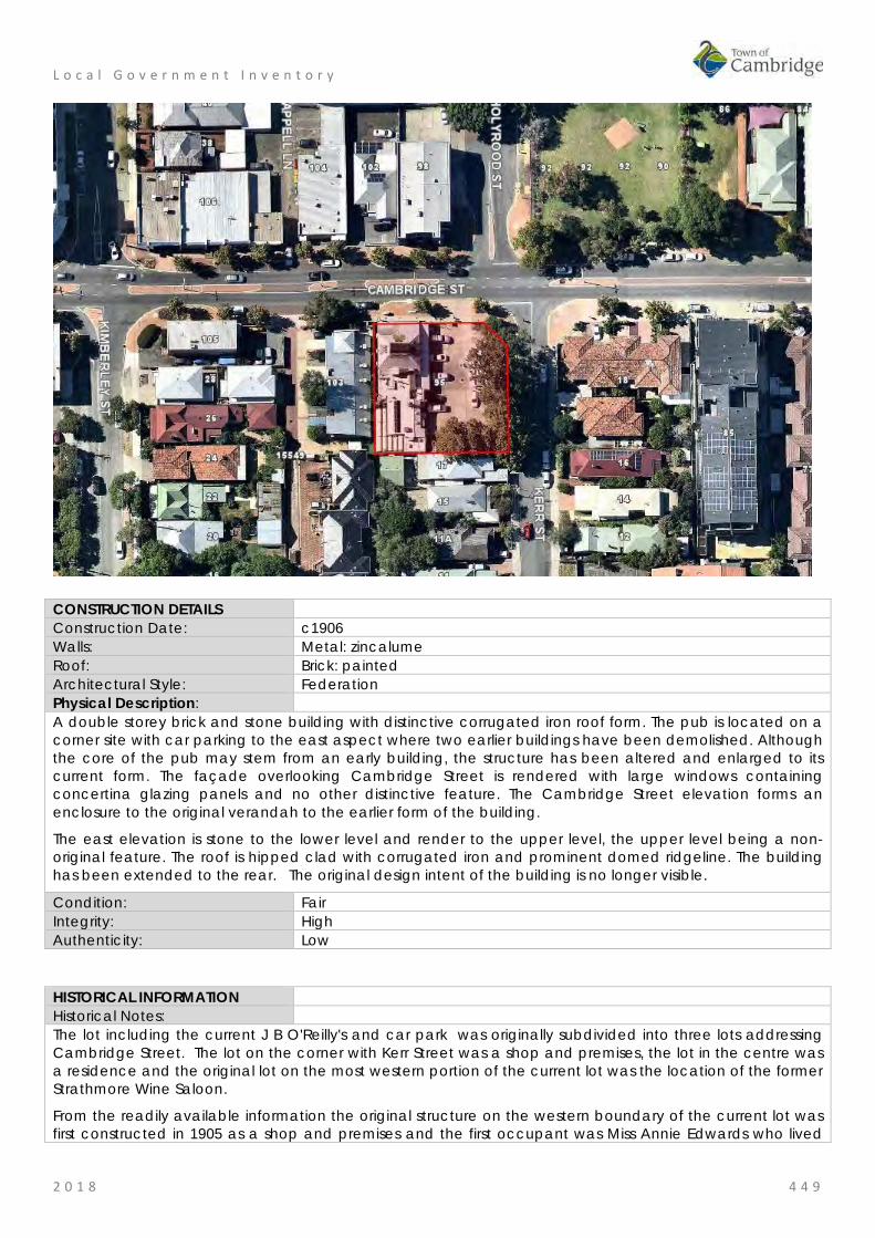
L o c a l G o v e r n m e n t I n v e n t o r y
2 0 1 8 4 4 9
CONSTRUCTION DETAILS Construction Date: c1906 Walls: Metal: zincalume Roof: Brick: painted Architectural Style: Federation Physical Description: A double storey brick and stone building with distinctive corrugated iron roof form. The pub is located on a corner site with car parking to the east aspect where two earlier buildings have been demolished. Although the core of the pub may stem from an early building, the structure has been altered and enlarged to its current form. The façade overlooking Cambridge Street is rendered with large windows containing concertina glazing panels and no other distinctive feature. The Cambridge Street elevation forms an enclosure to the original verandah to the earlier form of the building.
The east elevation is stone to the lower level and render to the upper level, the upper level being a non-original feature. The roof is hipped clad with corrugated iron and prominent domed ridgeline. The building has been extended to the rear. The original design intent of the building is no longer visible.
Condition: Fair Integrity: High Authenticity: Low
HISTORICAL INFORMATION Historical Notes: The lot including the current J B O'Reilly's and car park was originally subdivided into three lots addressing Cambridge Street. The lot on the corner with Kerr Street was a shop and premises, the lot in the centre was a residence and the original lot on the most western portion of the current lot was the location of the former Strathmore Wine Saloon.
From the readily available information the original structure on the western boundary of the current lot was first constructed in 1905 as a shop and premises and the first occupant was Miss Annie Edwards who lived

L o c a l G o v e r n m e n t I n v e n t o r y
2 0 1 8 4 5 0
there and operated a confectioner's shop on the premises. In c1918, the place began its long association with the hospitality industry as wine saloon run by Miss Eliza Kemp and in 1923, the wine licence for the place was transferred from Mary Krug to Annie Louisa Spurrier. In the application the place was referred to as the Strathmore Café.
The name Strathmore Saloon appears to have been applied to the place from this time until at least the 1950s. In c1982, the last of the buildings which were on the corner lots, which is now the car park, were removed. In 1985, the three lots were combined into the current lot 101.
Aerial photographs indicate that the original building which included a shop front and premises were significantly altered and added to since the mid 20th century. It is not clear how much of the original building fabric remains in the present structure. Major works were undertaken after 1985 when the lots were amalgamated.
The current owners state that the redeveloped property was first known as 'Milk Jacksons', later 'The Hare and Hound' and from 1993 the current business 'J.B.O'Reilly's' was opened on the site. Since then the form and extent of the place has not changed although it is probable there have been many adaptations and additions to the interior.
Historic Theme: Occupations: Hospitality industry and tourism Associations: Sources: Aerial photographs, 1953-2016, Landgate.
Town of Cambridge Municipal Heritage Inventory and Townscape Precinct Study prepared for the Town of Cambridge, June 1997. Wise's Post Office Directories for the City of Perth, 1925-1949, State Library of WA www.slwa.wa.gov.au The Daily News, 13 March 1923, p. 1.
SIGNIFICANCE Statement of Significance: • The place has historic value for its association with the ongoing
provision of hospitality and retail services to the Leederville community since the early 20th century.
• The place has historic value for its association with the development of the West Leederville district in the early 1900s.
Level of Significance: Little Contributes to the understanding of the history of the Town of Cambridge.
Management Category: Category 4 Photographically record prior to major development or demolition. Recognise and interpret the site if possible. Do not include on the Town Planning Scheme No 1 Heritage List.
ADDITIONAL PHOTOGRAPHS

L o c a l G o v e r n m e n t I n v e n t o r y
2 0 1 8 4 5 1
Residence, 1 Glen Street, West Leederville Place No: 97
SITE INFORMATION Place Name: Residence, 1 Glen Street Other Names: Street Address: 1 Glen Street Locality West Leederville HERITAGE LISTING SHO inHerit database Other Listings PLACE TYPE Individual building or group Original Use: Residential: Single storey residence Current Use: Residential: Single storey residence Other Use: LAND INFORMATION Lot: 283 Survey: Plan 29167 Reserve No: ------- C/T: 1761-64 Property Number: 19780 Land Number: 8274

L o c a l G o v e r n m e n t I n v e n t o r y
2 0 1 8 4 5 2
CONSTRUCTION DETAILS Construction Date: c1912 Walls: Timber: Weatherboard Roof: Metal: zincalume Architectural Style: Federation vernacular Physical Description: A single storey timber framed and weatherboard cottage. The asymmetric plan incorporates a projecting wing with timbered gable feature and a simple timber 1-over-1 sash window below. The recessed section of the cottage incorporates a similar simple sash window and the entrance door. The main section of the roof is hipped with a separate verandah canopy. The verandah detail includes turned timber posts and a timber deck and the verandah is accessed by steps.
The extension to the rear of the original cottage has been undertaken in timber and clad with weatherboards to match the original. The front garden has been raised and retained with a rendered masonry wall, topped with a timber fence with regularly spaced brick piers.
Condition: Good Integrity: High Authenticity: Moderate HISTORICAL INFORMATION Historical Notes: This portion of West Leederville was subdivided for residential occupancy in the early 20th century. Often a single cottage or small groups of cottages were built as investment properties. In Glen Street, cottages were only built on the western side of the street for many decades.
From the readily available information this residence was built c1912 and the first occupants were Edwin Henry Wakefield (c1874-1950) and his wife Charlotte Elizabeth, nee Leonard (c1873-1953). The couple married in 1897 and had at least four children when they moved to this residence. Edwin Wakefield worked for the WA Government Railways and the close location of the West Leederville Railway Station to the residence must have influenced the decision of the Wakefields to purchase and settle at this location. It is probable that the Wakefields organised the construction of the house however no details of the designer or builder were found in this research.
In 1916, at the age of 43, Edwin Wakefield joined the AIF and served in France before being wounded in

L o c a l G o v e r n m e n t I n v e n t o r y
2 0 1 8 4 5 3
1917 and returning to Australia. The Wakefields lived at this home until the 1950s.
Aerial photographs indicate the place has been extended to the rear however the form and extent of the original cottage can still be determined despite the later additions.
Historic Theme: Demographic Settlement and Mobility: Settlements Occupations: domestic activities
Associations: Wakefield family Sources: Aerial photographs, 1953-2016, Landgate.
Town of Cambridge Municipal Heritage Inventory and Townscape Precinct Study prepared for the Town of Cambridge, June 1997. Wise's Post Office Directories for the City of Perth, 1925-1949, State Library of WA www.slwa.wa.gov.au Australia WWI Service Records, NAA.
SIGNIFICANCE Statement of Significance: • The original portion of the place has aesthetic value as a
demonstration of a simple timber workers cottage built in the early 20th century featuring original form and detail.
• This place and the adjacent timber cottages (5, 7 and 9 Glen Street) are a cohesive group of timber cottages that make a positive contribution to the streetscape.
• The place has historic value for its association with the settlement and development of Leederville in the early 20th century for working families.
• The original portion of the cottage has social value as a demonstration of the scale and form of housing for working families in the early 20th century.
Level of Significance: Some/moderate Contributes to the heritage of the locality. Has some altered or modified elements, not necessarily detracting from the overall significance of the place.
Management Category: Category 3 Conservation of the place is desirable. Any alterations or extensions should reinforce the significance of the place, and original fabric should be retained wherever feasible. Include on the Town Planning Scheme No 1 Heritage List.
ADDITIONAL PHOTOGRAPHS

L o c a l G o v e r n m e n t I n v e n t o r y
2 0 1 8 4 5 4
Residence, 5 Glen Street, West Leederville Place No: 98
SITE INFORMATION Place Name: Residence, 5 Glen Street Other Names: Street Address: 5 Glen Street Locality West Leederville HERITAGE LISTING SHO inHerit database 3448 Other Listings PLACE TYPE Individual building or group Original Use: Residential: Single storey house Current Use: Residential: Single storey house Other Use: LAND INFORMATION Lot: 11925 Survey: Plan 191283 Reserve No: --------- C/T: 2038-872 Property Number: 19779 Land Number: 11149

L o c a l G o v e r n m e n t I n v e n t o r y
2 0 1 8 4 5 5
CONSTRUCTION DETAILS Construction Date: c1908 Walls: Timber: Weatherboard Roof: Metal: other Architectural Style: Federation vernacular Physical Description: Single storey timber frame and weatherboard cottage with hipped roof clad with Decromastic cladding, a metal cladding made to look like tiles. The bullnose verandah canopy has been reconstructed with corrugated cladding whilst the verandah detail includes turned timber posts and a timber deck. The verandah deck has been truncated to accommodate on site parking. The windows are timber framed 1-over-1 sashes flanking a central entrance door with fanlight. Condition: Good Integrity: High Authenticity: Moderate
HISTORICAL INFORMATION Historical Notes: This portion of West Leederville was subdivided for residential occupancy in the early 20th century. Often a single cottage or small groups of cottages were built as investment properties. In Glen Street, cottages were only built on the western side of the street for many decades. From the readily available information this residence was built c1908 and the first occupant and owner was labourer Arthur Powell (c1865-1940) with his widowed mother Ann Powell. Arthur Powell married Ellen Grub Turnbull in 1913 and the couple had two children. Sadly Ellen died in 1917 leaving Arthur with two small children to raise as his mother died in 1913. Arthur Powell married again in 1922, to Elizabeth Ann, nee Ward (c1881-1963). Following Arthur's death in 1940, Elizabeth lived in the cottage until the 1950s.

L o c a l G o v e r n m e n t I n v e n t o r y
2 0 1 8 4 5 6
Aerial photographs indicate that the original simple square form of the place can still be determined. Additions have occurred across the rear of the cottage throughout the 20th century, the most significant in c2008. The cottage was originally clad with corrugated iron which appears to have been replaced in the 1970s. Historic Theme: Demographic Settlement and Mobility: Settlements
Occupations: domestic activities Associations: Powell Family Sources: Aerial photographs, 1953-2016, Landgate.
Town of Cambridge Municipal Heritage Inventory and Townscape Precinct Study prepared for the Town of Cambridge, June 1997. Wise's Post Office Directories for the City of Perth, 1925-1949, State Library of WA www.slwa.wa.gov.au The West Australian, 24 April 1940, p. 1. The Daily News, 28 November 1917, p.1
SIGNIFICANCE Statement of Significance: • The original portion of the place has aesthetic value as a
demonstration of a simple timber workers cottage built in the early 20th century featuring original form and detail.
• This place and the adjacent timber cottages (1, 7 and 9 Glen Street) are a cohesive group of timber cottages that make a positive contribution to the streetscape.
• The place has historic value for its association with the settlement and development of Leederville in the early 20th century for working families.
• The original portion of the cottage has social value as a demonstration of the scale and form of housing for working families in the early 20th century.
Level of Significance: Some/moderate Contributes to the heritage of the locality. Has some altered or modified elements, not necessarily detracting from the overall significance of the item.
Management Category: Category 3 Conservation of the place is desirable. Any alterations or extensions should reinforce the significance of the place, and original fabric should be retained wherever feasible. Include on the Town Planning Scheme No 1 Heritage List.
ADDITIONAL PHOTOGRAPHS
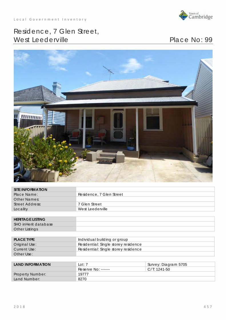
L o c a l G o v e r n m e n t I n v e n t o r y
2 0 1 8 4 5 7
Residence, 7 Glen Street, West Leederville Place No: 99
SITE INFORMATION Place Name: Residence, 7 Glen Street Other Names: Street Address: 7 Glen Street Locality West Leederville HERITAGE LISTING SHO inHerit database Other Listings PLACE TYPE Individual building or group Original Use: Residential: Single storey residence Current Use: Residential: Single storey residence Other Use: LAND INFORMATION Lot: 7 Survey: Diagram 5705 Reserve No: ------- C/T: 1241-50 Property Number: 19777 Land Number: 8270

L o c a l G o v e r n m e n t I n v e n t o r y
2 0 1 8 4 5 8
CONSTRUCTION DETAILS Construction Date: c1914 Walls: Timber: Weatherboard Roof: Metal: zincalume Architectural Style: Federation vernacular Physical Description: Single storey timber frame and weatherboard cottage with hipped roof clad with zincalume. The flat verandah canopy has been reconstructed with corrugated cladding whilst the verandah detail includes turned timber posts and a timber deck accessed by a flight of centrally located steps. The verandah deck has been truncated to accommodate on site parking. The windows are timber framed 1-over-1 sashes flanking a central entrance door with fanlight. The majority of the area in front of the cottage has been paved with concrete. Additions were constructed on the rear of the original cottage in 2001 which featured a two storey portion that is visible from the street. The roof form and materials of the additions are consistent with the original cottage. Condition: Good Integrity: High Authenticity: Moderate
HISTORICAL INFORMATION Historical Notes: This portion of West Leederville was subdivided for residential occupancy in the early 20th century. Often a single cottage or small groups of cottages were built as investment properties. In Glen Street, cottages were only built on the western side of the street for many decades. From the readily available information this cottage was built c1914 and the place was occupied by a series of tenants indicating the place was an investment property. In 2000 and 2001, additions were constructed at the rear of the original cottage designed by building
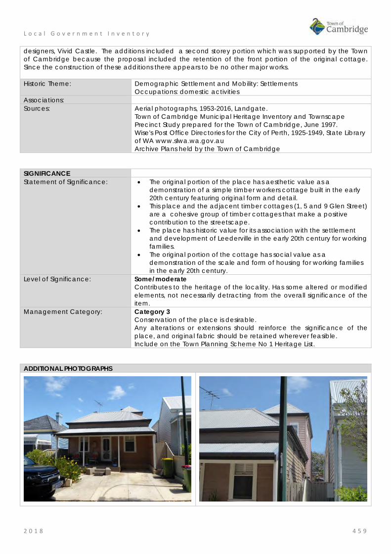
L o c a l G o v e r n m e n t I n v e n t o r y
2 0 1 8 4 5 9
designers, Vivid Castle. The additions included a second storey portion which was supported by the Town of Cambridge because the proposal included the retention of the front portion of the original cottage. Since the construction of these additions there appears to be no other major works. Historic Theme: Demographic Settlement and Mobility: Settlements
Occupations: domestic activities Associations: Sources: Aerial photographs, 1953-2016, Landgate.
Town of Cambridge Municipal Heritage Inventory and Townscape Precinct Study prepared for the Town of Cambridge, June 1997. Wise's Post Office Directories for the City of Perth, 1925-1949, State Library of WA www.slwa.wa.gov.au Archive Plans held by the Town of Cambridge
SIGNIFICANCE Statement of Significance: • The original portion of the place has aesthetic value as a
demonstration of a simple timber workers cottage built in the early 20th century featuring original form and detail.
• This place and the adjacent timber cottages (1, 5 and 9 Glen Street) are a cohesive group of timber cottages that make a positive contribution to the streetscape.
• The place has historic value for its association with the settlement and development of Leederville in the early 20th century for working families.
• The original portion of the cottage has social value as a demonstration of the scale and form of housing for working families in the early 20th century.
Level of Significance: Some/moderate Contributes to the heritage of the locality. Has some altered or modified elements, not necessarily detracting from the overall significance of the item.
Management Category: Category 3 Conservation of the place is desirable. Any alterations or extensions should reinforce the significance of the place, and original fabric should be retained wherever feasible. Include on the Town Planning Scheme No 1 Heritage List.
ADDITIONAL PHOTOGRAPHS

L o c a l G o v e r n m e n t I n v e n t o r y
2 0 1 8 4 6 0
Residence, 9 Glen Street, West Leederville Place No: 100
SITE INFORMATION Place Name: Residence, 9 Glen Street Other Names: Street Address: 9 Glen Street Locality West Leederville HERITAGE LISTING SHO inHerit database Other Listings PLACE TYPE Individual building or group Original Use: Residential: Single storey residence Current Use: Residential: Single storey residence Other Use: LAND INFORMATION Lot: 8 Survey: Diagram 5705 Reserve No: ------- C/T: 698-96 Property Number: 19776 Land Number: 8268

L o c a l G o v e r n m e n t I n v e n t o r y
2 0 1 8 4 6 1
CONSTRUCTION DETAILS Construction Date: c1915 Walls: Timber: Weatherboard Roof: Metal: zincalume Architectural Style: Federation vernacular Physical Description: Single storey timber frame and weatherboard cottage with gable roof clad with zincalume. The bullnose verandah canopy has been reconstructed with corrugated cladding whilst the verandah detail includes turned timber posts and a timber deck. The verandah deck has been truncated to accommodate on site parking. The windows are timber framed 1-over-1 sashes flanking a central entrance door with fanlight. The verandah is accessed by simple timber steps. The majority of the area in front of the property has been paved for parking. Condition: Good Integrity: High Authenticity: Moderate
HISTORICAL INFORMATION Historical Notes: This portion of West Leederville was subdivided for residential occupancy in the early 20th century. Cottages were only built on the western side of the street for many decades. Often small groups of cottages were built as investment properties. From the readily available information this cottage was built c1915 and the place was occupied by a series of tenants indicating the place was an investment property. In the early 1940s the place was transferred to Henrietta Maria Chester (c1911-2011) who lived there until the 1980s with her relative Leslie Colin Chester. This cottage and its garden originally included the lot to the north until c2014 when the site was cleared except for the original cottage which appears to be only two rooms and a centrally located hallway. A large addition was constructed to the rear of the simple cottage and a new residence was built on the lot
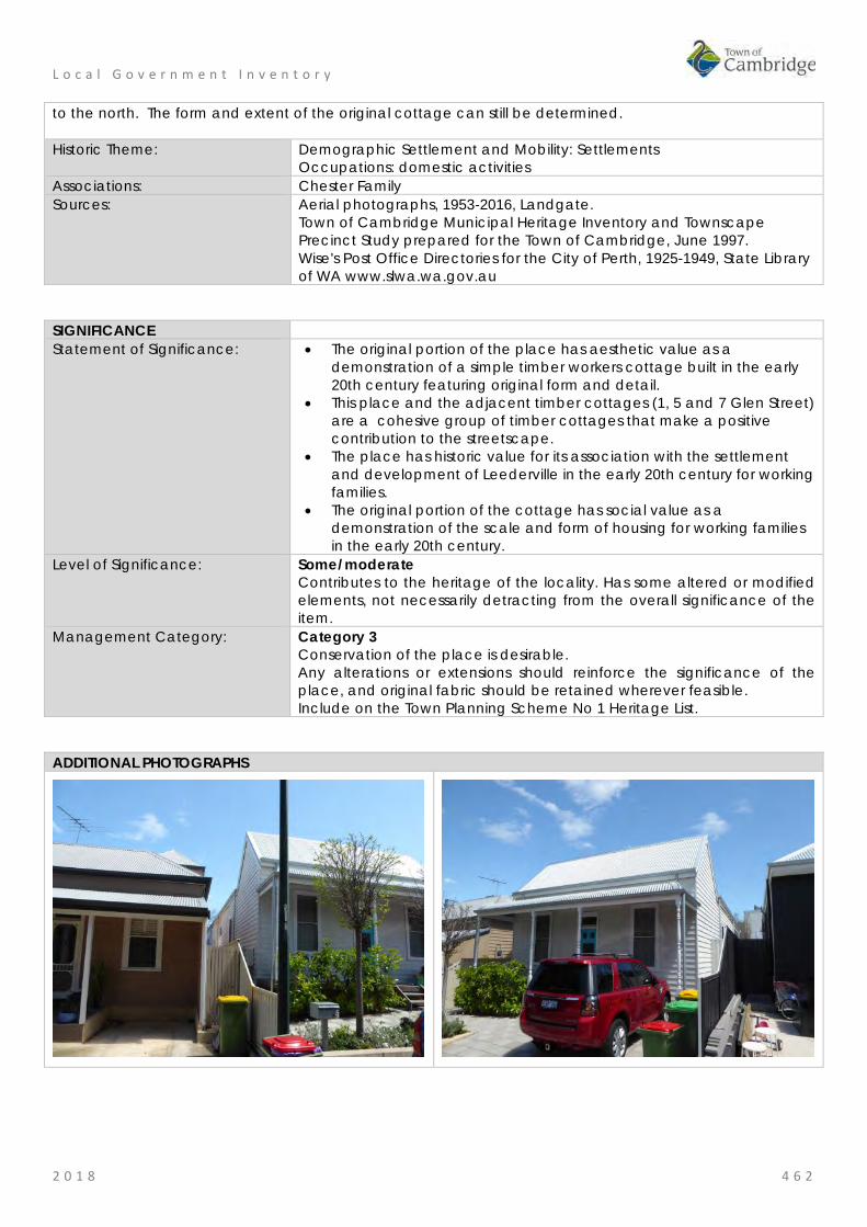
L o c a l G o v e r n m e n t I n v e n t o r y
2 0 1 8 4 6 2
to the north. The form and extent of the original cottage can still be determined. Historic Theme: Demographic Settlement and Mobility: Settlements
Occupations: domestic activities Associations: Chester Family Sources: Aerial photographs, 1953-2016, Landgate.
Town of Cambridge Municipal Heritage Inventory and Townscape Precinct Study prepared for the Town of Cambridge, June 1997. Wise's Post Office Directories for the City of Perth, 1925-1949, State Library of WA www.slwa.wa.gov.au
SIGNIFICANCE Statement of Significance: • The original portion of the place has aesthetic value as a
demonstration of a simple timber workers cottage built in the early 20th century featuring original form and detail.
• This place and the adjacent timber cottages (1, 5 and 7 Glen Street) are a cohesive group of timber cottages that make a positive contribution to the streetscape.
• The place has historic value for its association with the settlement and development of Leederville in the early 20th century for working families.
• The original portion of the cottage has social value as a demonstration of the scale and form of housing for working families in the early 20th century.
Level of Significance: Some/moderate Contributes to the heritage of the locality. Has some altered or modified elements, not necessarily detracting from the overall significance of the item.
Management Category: Category 3 Conservation of the place is desirable. Any alterations or extensions should reinforce the significance of the place, and original fabric should be retained wherever feasible. Include on the Town Planning Scheme No 1 Heritage List.
ADDITIONAL PHOTOGRAPHS

L o c a l G o v e r n m e n t I n v e n t o r y
2 0 1 8 4 6 3
Holyrood Street Precinct, West Leederville Place No: 101
SITE INFORMATION Place Name: Holyrood Street Precinct Other Names: Derby Street Street Address: Holyrood Street between Cambridge Street and Woolwich Street
(includes properties from No.3 to No.31 Holyrood Street, No.169 Tower Street, and No.77 Woolwich Street)
Locality West Leederville HERITAGE LISTING SHO inHerit database None Other Listings Town of Cambridge Town Planning Scheme No.1 - Conservation Area PLACE TYPE Precinct Original Use: Residential: Single storey residence Current Use: Residential: Single storey residence Other Use: LAND INFORMATION Lot: Various Survey: Various Reserve No: ------- C/T: Various Property Number: Various Land Number: Various

L o c a l G o v e r n m e n t I n v e n t o r y
2 0 1 8 4 6 4
CONSTRUCTION DETAILS Construction Date: c1900-1914 Walls: Various Roof: Various Architectural Style: Federation Physical Description: The Holyrood Precinct extends along both sides of Holyrood Street between Cambridge Street in the south and Woolwich Street in the north. The precinct is lined with mature Morton Bay Fig trees and the south east portion of the street abuts Holyrood Park. Within the largely grassed Holyrood Park is a playground and a community hall, the Holyrood Pavilion. Building setbacks vary along the length of Holyrood Street, but all are well under 6.0 metres. Front verandahs are located as close as 2.4 and as great as 4.8 metres from the front boundary and some main structure walls as close as 4.6 metres from the front boundary, with houses at the northern end of the street typically being set back more than those at the southern end of the street. The majority of houses are set within the 4-5 metre range from front boundary to main house wall. Side setbacks vary with the width of lots but generally do not exceed 0.9 metres. The building stock within the street is predominantly late nineteenth and early twentieth century, single storey residences and their associated buildings, with one or two residences that have been adapted in
L o c a l G o v e r n m e n t I n v e n t o r y
2 0 1 8 4 6 5
recent times to add a second storey. The residences are predominantly weatherboard with metal roofs although some brick residences and tiled roofs exist in the precinct. Those residences built in the Federation period demonstrate the style and detail of the period particularly on the front elevations. Elements of Holyrood Street which are of high importance to the street include all of the original fabric of the house at 23 Holyrood Street and all houses on the western side of the street, number 20 Holyrood Street on the eastern side of the street, together with 77 Woolwich Street. Condition: Good Integrity: High Authenticity: Moderate
HISTORICAL INFORMATION Historical Notes: The area known as Leederville takes its name from William Leeder and his family, who selected land in the vicinity in the 1830s. In this period, and through until the late nineteenth century, the district was predominantly rural, and mainly used for agricultural and pastoral purposes. The opening of the Eastern Railway from Fremantle to Perth in 1881, encouraged development along the line of small settlements in proximity to the line, which gradually grew into towns. In the 1880s, sub-division of the rural allotments to the north and west of Perth commenced, including the first sub-divisions in the Leederville district. However, there was little residential development in the Leederville area until the mid to late 1890s, when the suburbs of Perth expanded rapidly in the wake of the Gold Boom. In June 1895, the Leederville Roads Board was officially gazetted, and due to the rapid expansion in the district, the Municipality of Leederville was declared on 1 April 1896. The construction of a railway station at Leederville (now West Leederville) and a dual track to Fremantle encouraged further development in the district, which grew rapidly in the late 1890s and early 1900s. The streets in proximity to the railway line and to Cambridge Street were the first to be developed for residential purposes, including Tower, Woolwich, and a little later, Derby Street, as Holyrood Street was named at that period. By 1903, all of this area had been sub-divided for residential purposes and a number of dwellings erected. As many of the lots in Leederville were smaller and cheaper than in some suburbs, together with the absence of restrictions or discouragement regarding the use of timber for construction, it was more affordable for working class people. During this period in which the street was developed, 1899-1914, the Municipality of Leederville had grown rapidly. In December 1914, the Municipality was amalgamated with the City of Perth. Subsequently, in October 1915, Derby Street was re-named Holyrood Street, as part of a programme under which various streets in the City were re-named to overcome the confusion of two or more streets with the same name. The name Holyrood either originates with the word for the Christian True Cross on which Christ was crucified (made up of holy and rood); or it relates to Holyrood House the official home of the monarch of Scotland since the 16th century. Since many road names in the vicinity have a Scottish association it is likely to be the latter origin. Occupants of the residences in Holyrood Street during the early decades of the 20th century were largely trades or semi skilled workers and their families. In 1910, the following occupants were listed in the Post Office Directories and their occupations taken from the Electoral Rolls for that year. (Those even numbered properties are no longer extant and are now part of Holyrood Park)
2 - Alfred E. O'Loughlin, Printer 4 - David J Simcock, Fruiterer 6 - William C.W. Jamieson, Railway Employee 8 - Samuel Jackson, Railway Employee 10 - Miss M. Jennings, not found in Electoral Rolls 3 - Collins Family, members of the family worked as Fruiterer, bootmaker, dressmaker 5 - George Debnam 'Linton', Painter
L o c a l G o v e r n m e n t I n v e n t o r y
2 0 1 8 4 6 6
7 - Patrick McCormack, bootmaker 9 - William Tipping, Locomotive Driver 11 - William Lewis, Railway Employee 13 - Henry Turner, Civil Servant 15 - Thomas H Stephens, 'Inniskillen', Civil Servant 17 - George Fletcher, Engine Driver 21 - George W. Birch, Clerk 25 - James Henry Buzza, Wheelwright 27 - James W. Watson, Railway Employee 29 - Miss L. Hill, Music Teacher and Emily A Campbell, widow
The above sample of occupants demonstrates a large proportion who worked for the Railways. The close proximity to the West Leederville station, or Leederville at the time made it an attractive place to settle for these workers. In the latter part of the twentieth century, the demographic composition of the area underwent considerable change, with the influx of European immigrants from the 1950s, many of whom took up residence in the North Perth, Subiaco, and Leederville areas which were close to transport services and to the city. Subsequently, from the 1970s, with the purchase and up grading of a number of the residences by white-collar workers and professionals, the suburb has undergone further change and a change in demographics. Throughout most of their histories, the majority of the residences have been owner occupied. The Town of Cambridge developed Design Guidelines for Holyrood Street in 2002 which have been valuable for development within the precinct. Historic Theme: Demographic Settlement and mobility: Settlements
Occupations: Domestic Activities Associations: Sources: Aerial photographs, 1953-2016, Landgate.
Town of Cambridge Municipal Heritage Inventory and Townscape Precinct Study prepared for the Town of Cambridge, June 1997. Wise's Post Office Directories for the City of Perth, 1925-1949, State Library of WA www.slwa.wa.gov.au Australian Electoral Rolls, 1910. Holyrood Street Heritage Development and Design Guidelines, Prepared for the Town of Cambridge by Considine and Griffiths Architects Pty Ltd January 2002. Town of Cambridge, Local Studies, Holyrood Street Lights, https://www.cambridge.wa.gov.au/Cambridge-Library/Local-Studies/Holyrood-Street-Heritage-Lights#Overview-1
SIGNIFICANCE Statement of Significance: • Holyrood Street Precinct has aesthetic value as a tree lined, almost
complete and reasonably intact example of a late nineteenth and early twentieth century streetscape, notwithstanding the changes to fences, gardens and the modern finishes in the road reserve.
• Holyrood Street Precinct, consisting of the western side of the street, 20 Holyrood Street and 77 Woolwich Street, has aesthetic and historic value as a predominantly late nineteenth and early twentieth century, formerly working class streetscape which demonstrates the core period of development of the Municipality and suburbanisation of the area in the years 1899-1914.
• Holyrood Street has social value for the people of West Leederville as evidenced by its continuity of occupancy, and its continuing popularity as a residential street in its Federation scale and form.
• Holyrood Street has social value as demonstrated by the decision by

L o c a l G o v e r n m e n t I n v e n t o r y
2 0 1 8 4 6 7
the Town of Cambridge to develop design guidelines to manage the future development of the street whilst managing its heritage values.
Level of Significance: Considerable Very important to the heritage of the locality. High degree of integrity/authenticity
Management Category: Precinct Conservation of the place is highly desirable. Any alterations or extensions should reinforce the significance of the place Include on the Town Planning Scheme No 1 Heritage List.
ADDITIONAL PHOTOGRAPHS

L o c a l G o v e r n m e n t I n v e n t o r y
2 0 1 8 4 6 8
Kimberley Street Precinct, West Leederville Place No: 102
SITE INFORMATION Place Name: Kimberley Street Precinct Other Names: Street Address: Kimberley Street between Cambridge Street and Woolwich Street
(includes properties from No.38 to No.66 Kimberley Street) Locality West Leederville HERITAGE LISTING SHO inHerit database Other Listings PLACE TYPE Precinct Original Use: Residential: Single storey house Current Use: Residential: Single storey house
Residential: Two storey house Other Use: LAND INFORMATION Lot: Various Survey: Various Reserve No: C/T: Various Property Number: Various Land Number: Various
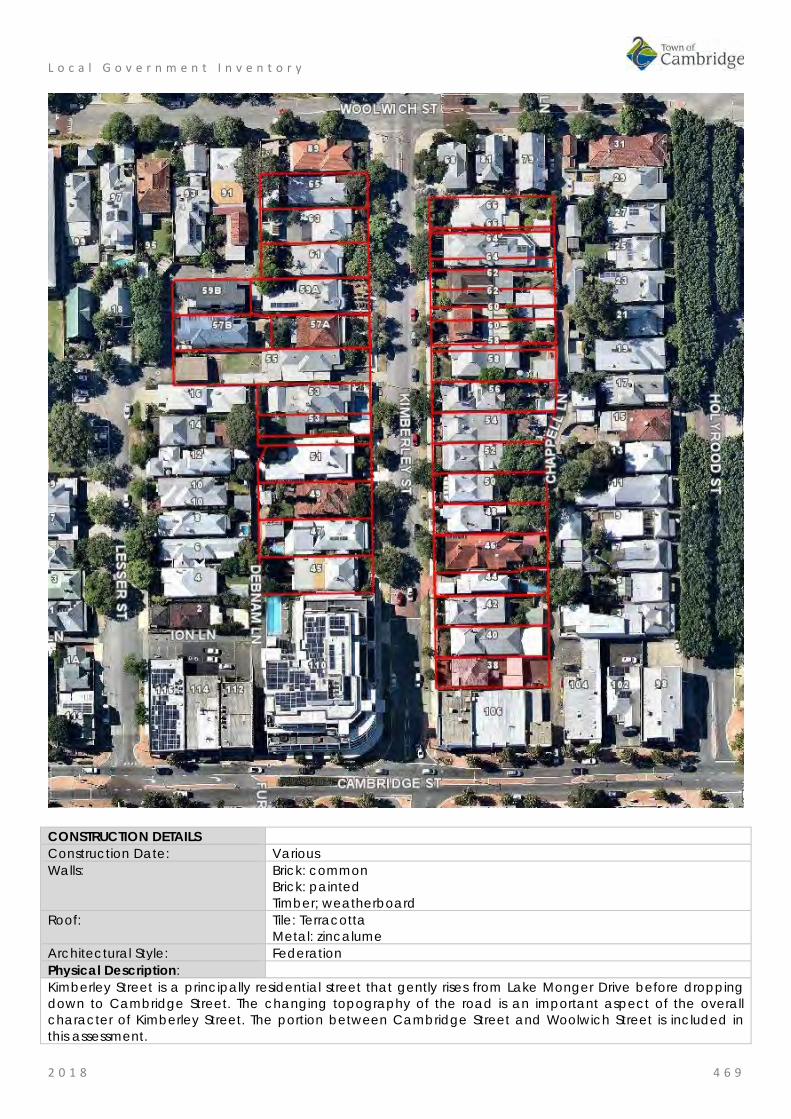
L o c a l G o v e r n m e n t I n v e n t o r y
2 0 1 8 4 6 9
CONSTRUCTION DETAILS Construction Date: Various Walls: Brick: common
Brick: painted Timber; weatherboard
Roof: Tile: Terracotta Metal: zincalume
Architectural Style: Federation Physical Description: Kimberley Street is a principally residential street that gently rises from Lake Monger Drive before dropping down to Cambridge Street. The changing topography of the road is an important aspect of the overall character of Kimberley Street. The portion between Cambridge Street and Woolwich Street is included in this assessment.
L o c a l G o v e r n m e n t I n v e n t o r y
2 0 1 8 4 7 0
The original housing stock dates from the early 1900s and inter-war periods. A number of original houses remain extant, exhibiting varying designs and are of brick and weatherboard construction with hipped and gabled roofs. Some of the original houses are small weatherboard cottages with little decoration or ornamentation whilst others were more substantial brick federation style bungalows with asymmetric facades and complex hipped roofs. All had verandahs across the façades. Although a large number of original houses remain extant others have been redeveloped with entirely modern two storey houses or have adapted an original house by adding a second storey. There is no standard setback with some houses being built much closer to the pavement boundary and others having more substantial gardens but the original subdivision pattern has been retained. Although there is variation in the width of the lots, the majority are with a range of 9-12m. There are a range of boundary treatments though many have continued with the traditional timber picket fence on top of a limestone or brick boundary wall. These are both original features and modern interpretations of the traditional fence. As the topography of the street changes, some houses are built in an elevated position to take account of the changing land levels resulting in steeper driveways and retaining walls along the pavement boundary. The changing levels of the houses, together with the varied architectural styles seen along the road, creates an interesting and diverse roof scape, enhanced by tall and decorative chimneys. The character of the road is further enhanced by the street trees which helps break up the built form and add an element of greenery to the streetscape. The single storey domestic scale character of the street is interrupted by the multi-storey mixed use building at the junction of Kimberley Street and Cambridge Street. Condition: Good Integrity: High Authenticity: Moderate
HISTORICAL INFORMATION Historical Notes: The gold discoveries in Western Australian in the 1890s led to an influx of people and investment into the colony. Localities close to the city of Perth were subdivided to accommodate the growing population and Leederville was a desirable location for working families as it was less expensive than the established suburbs but still had access to the railway line. In August, 1897 the residents north of the railway line at Subiaco (Leederville) formally petitioned the Inspector General of Education for a school and West Leederville Primary School opened in 1898. The population grew rapidly and by 1902 the Leederville School needed increased accommodation with 314 students on the roll. In 1897 the West Australian carried an advertisement for 21 lots in the Lakeside Estate which was located between Kimberley Street and Monger Street (now Northwood Street). These lots, 50ft x 190ft were valued at £30 each. This may not include the designated area of Kimberley Street but gives an indication of the price of the land. The portion of Kimberley Street between Cambridge Street and Woolwich was subdivided for residential development between 1897 and 1899. The lots were taken up by investors and home occupiers. The 1902 Post Office Directory records 7 residences were present in this section of Kimberley Street. An item in The West Australian in 1902 notes that lot 62 in Kimberley Street, (which was presumably vacant sold for £85 which suggests the properties in the area had increased in value. Tracking the occupancy of this portion of Kimberley Street through the Post Office Directories shows that the street was most intensively developed in the mid-1900s, as by 1910 there were 22 residences. The street was largely developed by World War One. From the available information the street was occupied by skilled tradesmen and their families. Often there

L o c a l G o v e r n m e n t I n v e n t o r y
2 0 1 8 4 7 1
was quick turnover in the occupancy suggesting that the cottages were investment properties. Some indication of the occupations of the residents can be determined through the project recording the servicemen in the Town of Cambridge during World War One. A sample of occupations include a miner, blacksmith, engine fitter, farrier, sign writer and grocer’s assistant. Since the settlement of the street there have been changes to the properties, many have been extended to the rear and internal alterations undertaking. Carports have been added to the front of several properties. Historic Theme: Demographic Settlement and Mobility: settlements
Occupations: domestic activities Associations: Sources: Aerial photographs, 1953-2016, Landgate.
Town of Cambridge Municipal Heritage Inventory and Townscape Precinct Study prepared for the Town of Cambridge, June 1997. Wise's Post Office Directories for the City of Perth, 1925-1949, State Library of WA www.slwa.wa.gov.au
SIGNIFICANCE Statement of Significance: • This portion of Kimberley Street has aesthetic value as a tree lined,
almost complete and reasonably intact example of an early twentieth century streetscape, notwithstanding the changes to fences, gardens and the modern finishes in the road reserve.
• Kimberley Street Precinct, between Cambridge and Woolwich Streets, has aesthetic and historic value as a predominantly early twentieth century, formerly working class streetscape which demonstrates the core period of development of the Municipality and suburbanisation of the area in the years 1901-1914.
• This portion of Kimberley Street has social value for the people of West Leederville as evidenced by its continuity of occupancy, and its continuing popularity as a residential street in its Federation scale and form.
Level of Significance: Some/moderate Contributes to the heritage of the locality. Has some altered or modified elements, not necessarily detracting from the overall significance of the item.
Management Category: Precinct Conservation of the place is desirable. Any alterations or extensions should reinforce the significance of the place, and original fabric should be retained wherever feasible. Include on the Town Planning Scheme No 1 Heritage List.

L o c a l G o v e r n m e n t I n v e n t o r y
2 0 1 8 4 7 2
ADDITIONAL PHOTOGRAPHS

L o c a l G o v e r n m e n t I n v e n t o r y
2 0 1 8 4 7 3
Henderson Memorial Presbyterian Church, West Leederville Place No: 103
SITE INFORMATION Place Name: Henderson Memorial Presbyterian Church Other Names: Street Address: 101 Kimberley Street Locality West Leederville HERITAGE LISTING SHO inHerit database 2205 Other Listings PLACE TYPE Individual building or group Original Use: Religious: Church Current Use: Religious: Church Other Use: LAND INFORMATION Lot: 4, 5 Survey: Plan 2464 Reserve No: -------- C/T: 451-169, 329-147 Property Number: 20311 Land Number: 8791; 8792

L o c a l G o v e r n m e n t I n v e n t o r y
2 0 1 8 4 7 4
CONSTRUCTION DETAILS Construction Date: 1935 Walls: Brick: Common Roof: Tile: Terracotta Architectural Style: Inter-war Ecclesiastical Physical Description: A small red brick church with steeply pitched terracotta tiled roof. The church occupies a corner lot with its main entrance facing Kimberley Street. The entrance is in the centre of the east elevation consisting of traditional double timber doors with additional glazed doors inserted behind and herringbone brickwork to the arched panel above. The door is flanked by simple timber framed arched openings with obscured glazing. The north and south elevations are divided into a series of bays by brick pilasters creating a regular rhythm of brickwork and windows. Each of the four bays contains two timber framed windows, each window divided into three panes with yellow obscured glazing. A small rear porch follows similar design principles to the main body of the church. The Church Hall has been constructed to the rear of the church, facing Ruislip Street and whilst the Hall has been constructed with a timber frame and fibro cladding, the design principles are similar to the church including the steep pitched roof and the small porch to the south elevation. Condition: Good Integrity: High Authenticity: Moderate
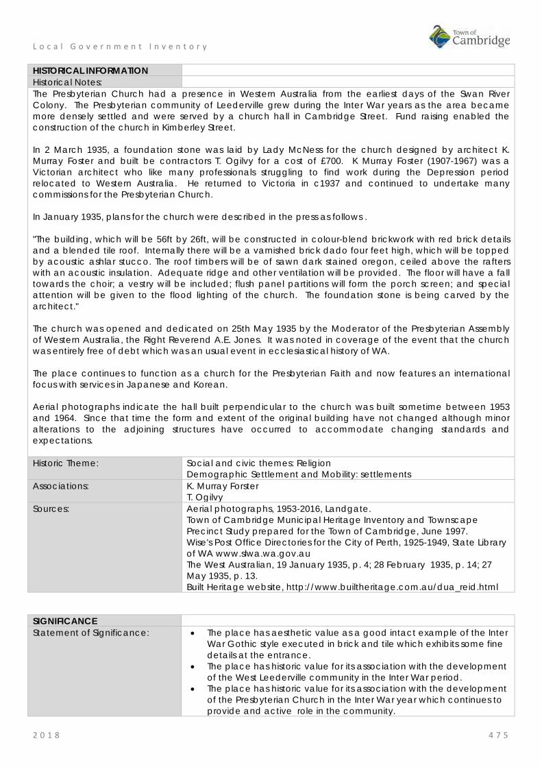
L o c a l G o v e r n m e n t I n v e n t o r y
2 0 1 8 4 7 5
HISTORICAL INFORMATION Historical Notes: The Presbyterian Church had a presence in Western Australia from the earliest days of the Swan River Colony. The Presbyterian community of Leederville grew during the Inter War years as the area became more densely settled and were served by a church hall in Cambridge Street. Fund raising enabled the construction of the church in Kimberley Street. In 2 March 1935, a foundation stone was laid by Lady McNess for the church designed by architect K. Murray Foster and built be contractors T. Ogilvy for a cost of £700. K Murray Foster (1907-1967) was a Victorian architect who like many professionals struggling to find work during the Depression period relocated to Western Australia. He returned to Victoria in c1937 and continued to undertake many commissions for the Presbyterian Church. In January 1935, plans for the church were described in the press as follows . "The building, which will be 56ft by 26ft, will be constructed in colour-blend brickwork with red brick details and a blended tile roof. Internally there will be a varnished brick dado four feet high, which will be topped by acoustic ashlar stucco. The roof timbers will be of sawn dark stained oregon, ceiled above the rafters with an acoustic insulation. Adequate ridge and other ventilation will be provided. The floor will have a fall towards the choir; a vestry will be included; flush panel partitions will form the porch screen; and special attention will be given to the flood lighting of the church. The foundation stone is being carved by the architect." The church was opened and dedicated on 25th May 1935 by the Moderator of the Presbyterian Assembly of Western Australia, the Right Reverend A.E. Jones. It was noted in coverage of the event that the church was entirely free of debt which was an usual event in ecclesiastical history of WA. The place continues to function as a church for the Presbyterian Faith and now features an international focus with services in Japanese and Korean. Aerial photographs indicate the hall built perpendicular to the church was built sometime between 1953 and 1964. Since that time the form and extent of the original building have not changed although minor alterations to the adjoining structures have occurred to accommodate changing standards and expectations. Historic Theme: Social and civic themes: Religion
Demographic Settlement and Mobility: settlements Associations: K. Murray Forster
T. Ogilvy Sources: Aerial photographs, 1953-2016, Landgate.
Town of Cambridge Municipal Heritage Inventory and Townscape Precinct Study prepared for the Town of Cambridge, June 1997. Wise's Post Office Directories for the City of Perth, 1925-1949, State Library of WA www.slwa.wa.gov.au The West Australian, 19 January 1935, p. 4; 28 February 1935, p. 14; 27 May 1935, p. 13. Built Heritage website, http://www.builtheritage.com.au/dua_reid.html
SIGNIFICANCE Statement of Significance: • The place has aesthetic value as a good intact example of the Inter
War Gothic style executed in brick and tile which exhibits some fine details at the entrance.
• The place has historic value for its association with the development of the West Leederville community in the Inter War period.
• The place has historic value for its association with the development of the Presbyterian Church in the Inter War year which continues to provide and active role in the community.
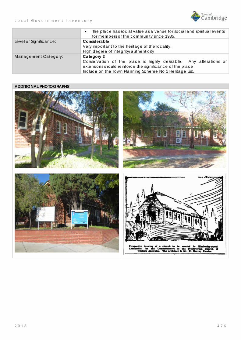
L o c a l G o v e r n m e n t I n v e n t o r y
2 0 1 8 4 7 6
• The place has social value as a venue for social and spiritual events for members of the community since 1935.
Level of Significance: Considerable Very important to the heritage of the locality. High degree of integrity/authenticity
Management Category: Category 2 Conservation of the place is highly desirable. Any alterations or extensions should reinforce the significance of the place Include on the Town Planning Scheme No 1 Heritage List.
ADDITIONAL PHOTOGRAPHS
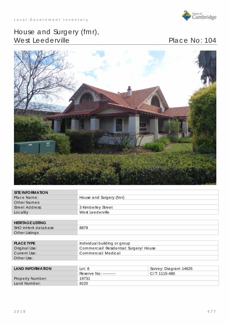
L o c a l G o v e r n m e n t I n v e n t o r y
2 0 1 8 4 7 7
House and Surgery (fmr), West Leederville Place No: 104
SITE INFORMATION Place Name: House and Surgery (fmr) Other Names: Street Address: 3 Kimberley Street Locality West Leederville HERITAGE LISTING SHO inHerit database 8879 Other Listings PLACE TYPE Individual building or group Original Use: Commercial/ Residential: Surgery/ House Current Use: Commercial: Medical Other Use: LAND INFORMATION Lot: 8 Survey: Diagram 14625 Reserve No: ---------- C/T: 1115-480 Property Number: 19731 Land Number: 8220

L o c a l G o v e r n m e n t I n v e n t o r y
2 0 1 8 4 7 8
CONSTRUCTION DETAILS Construction Date: 1927 Walls: Brick: common, rendered and face brick Roof: Tile: terracotta Architectural Style: Inter-war Californian Bungalow Physical Description: Single storey Californian Bungalow constructed as house and attached doctor’s surgery. The place is of predominantly single storey construction with additional storey concealed within the roofline. The house is of brick and rendered brick construction with terracotta tiled hipped and gabled roofs. The house benefits from a dual aspect to both Kimberley Street, the principal façade, and Railway Parade. The place is of asymmetric planform with a pair of projecting wings to the Kimberley Street elevation, one of which was the former surgery. The place presents with many key features of the Californian Bungalow architectural design including low slung roofs, wide masonry piers to the verandah, masonry verandah balustrade and broad gables to the main elevations. The windows are mainly timber framed double hung sash frames, some with leaded glazing. There is a bank of six sashes to the bay window to Kimberley Street and a feature corner window facing the intersection of Kimberley Street and Railway Parade consisting of two abutting sash windows and a further feature circular window to the Railway Parade elevation. The upper storey accommodation is contained within the roof voids and has brick balustrades and arched

L o c a l G o v e r n m e n t I n v e n t o r y
2 0 1 8 4 7 9
openings to the balconies and recessed window/door openings to the accommodation. The construction is face brick to the lower section of the elevation with roughcast render above, this pattern is replicated in the upper storey accommodation. The verandah balustrade is rendered with brick capping. Condition: Good Integrity: High Authenticity: Moderate HISTORICAL INFORMATION Historical Notes: This area of West Leederville was largely subdivided in the 1890s and settlement resulted from the proximity of the area to the railway. Early development was mainly small timber and iron cottages, with small businesses establishing in areas adjacent to the railway. The subdivision plan for this area of West Leederville was approved in 1904 however there is no indication that the site was developed until this combined residence and doctors surgery was constructed c1927. In 1925, Dr Frederick Carter (1883-1956) purchased two lots of land for houses at then 5 and 9 (now 3 and 5) Kimberley St. The lots were well suited for the location of a medical doctor’s home and consulting room as the site was close to the West Leederville Railway Station, and with bus and tram services only a block away on Cambridge Street. The site was also accessible to both St John of God hospital and Dr Carter's other consulting room at the western end of St George’s Terrace. Dr Carter was granted a building license in November 1926 and the main dwelling at then 5 Kimberley was completed in May 1927; later that year the garage and adjoining ’granny flat’ for Emily Jane Carter, Frederick Carter’s mother were also completed. The construction of the building at 3/5 Kimberley Street attracted considerable interest from nearby residents and passers by, and on completion a photograph of it appeared in the Sunday Times. Being a two-storey dwelling that contained a larger-than-typical family home plus a dispensary, consulting room, and waiting room, the house was large and the architectural style was distinctive, with a combination of influences from the British Arts and Crafts movement and the Californian style bungalow. The buildings were designed by the architect George Herbert Parry (1892-1951). George Herbert Parry was born in Perth and in 1904, having completed his secondary schooling, Parry went to England to undertake his architectural training. He was articled to Mervyn McCartney and also worked with Ernest Newton who, along with Norman Shaw, was regarded as a leader in British domestic architecture. In 1907, Herbert Parry returned to WA and joined the Public Works Department, but he soon moved into private practice. By 1911, Parry had established his own architectural business. Apart from a three-year partnership with Marshall Clifton, Parry practiced alone until partnered by his son, Mervyn, after the Second World War. Herbert Parry died in 1951. In addition to his domestic work, Parry was noted for his design of numerous churches including parts of St George's Cathedral; he was also in demand as a designer of public buildings and suburban and country hotels. The successful tenderer for the building of the Kimberley St dwellings was Charles Grayson of 307 Hay St Perth. Dr Frederick William Carter and his wife Mary Ann Giles Carter, nee Prowse (c1877-1962) married in 1910 and had one daughter. Frederick Carter was an energetic, friendly and compassionate medical doctor who engaged in general practice in the West Leederville area from 1919 until his retirement due to ill health in 1954; he was also a prominent member of the community and of the medical profession. In 1955, the property was sold to the Western Australian Federation of Junior Farmers (later Rural Youth). Within a month of settlement, in February 1955, the building was being put to use as a training camp for Junior Farmer leaders from throughout the state. The leaders - both female and male - resided at 3 Kimberley St for the duration of the training, and the building was to serve as a short-stay hostel for rural members for the next 20 years. Its other main functions were as headquarters for the organization, offices for administrators and field officers, and as a meeting place and training site for the Movement and its various committees and affiliated bodies.

L o c a l G o v e r n m e n t I n v e n t o r y
2 0 1 8 4 8 0
By the early 1980s the Rural Youth membership had declined dramatically and eventually the state government withdrew most of its financial support for the Movement. Thus in December 1984 3 Kimberley St was sold to the engineering firm of Pritchard-Francis and Associates. Pritchard-Francis were unable to purchase the whole of the property owned by the Rural Youth Movement, but they managed to persuade the vendors to sub-divide. Thus the smaller block to the north was sold separately; consequently, the house that had been occupied by Mrs Carter and later used as a residence for the caretakers and female members was demolished, making way for three units. Pritchard-Francis took possession of the larger property, 3 Kimberley Street, comprising the main house, the tennis court and the garage in early 1985. The new owners were keen to restore the original features of the building and undertook restoration works which were supported by information supplied in a series of photographs supplied by Betty Carter of the interior and exterior of the property in the 1920s. The former garage/shed was demolished during this period. In c2005, when the large addition was constructed adjoining the western elevation which required the removal of the tennis court and integration with the existing building. Historic Theme: Occupations: commercial services and industries
Demographic settlement and mobility: settlements Associations: Frederick and Mary Carter
George Herbert Parry Charles Grayson Pritchard Francis, Engineers
Sources: Aerial photographs, 1953-2016, Landgate. Town of Cambridge Municipal Heritage Inventory and Townscape Precinct Study prepared for the Town of Cambridge, June 1997. Wise's Post Office Directories for the City of Perth, 1925-1949, State Library of WA www.slwa.wa.gov.au House and Surgery (fmr), 3 Kimberley Street West Leederville Conservation Plan prepared for The Kimberley Street Syndicate August 2004 by Heritage and Conservation Professionals, August 2004.
SIGNIFICANCE Statement of Significance: The following statement is taken from the Conservation Plan for the
House and Surgery (fmr), 3 Kimberley Street West Leederville prepared by Heritage and Conservation Professionals in August 2004.
House and former surgery, 3 Kimberley Street, a two storey brick and tile building in the Federation Bungalow style, designed by architect George Herbert Parry, has cultural heritage significance for the following reasons: • the place is of aesthetic significance as a fine and well resolved
example of a building in the federation Bungalow style featuring a wide roofline and verandahs, fine brickwork, joinery detailing and leadlight doors and windows;
• the place is a prominent and well known landmark that contributes to the heritage character of West Leederville;
• the place is of historic significance as an example of a residential building with attached surgery built in the 1920s and representing a time when doctors practiced medicine from surgeries attached to their homes; and
• the place is a fine example of the work of architect George Herbert Parry.
Level of Significance: Some/moderate Contributes to the heritage of the locality. Has some altered or modified elements, not necessarily detracting from the overall significance of the
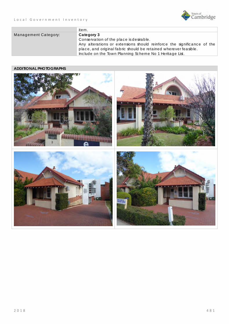
L o c a l G o v e r n m e n t I n v e n t o r y
2 0 1 8 4 8 1
item. Management Category: Category 3
Conservation of the place is desirable. Any alterations or extensions should reinforce the significance of the place, and original fabric should be retained wherever feasible. Include on the Town Planning Scheme No 1 Heritage List.
ADDITIONAL PHOTOGRAPHS

L o c a l G o v e r n m e n t I n v e n t o r y
2 0 1 8 4 8 2
Leederville Fire Station (fmr) No 2, West Leederville Place No: 105
SITE INFORMATION Place Name: Leederville Fire Station (fmr) No 2 Other Names: Street Address: 65 Kimberley Street Locality West Leederville HERITAGE LISTING SHO inHerit database 8876 Other Listings Fire and Rescue Service Heritage Inventory PLACE TYPE Individual building or group Original Use: Governmental: Fire Station Current Use: Residential: single storey residential Other Use: LAND INFORMATION Lot: 8 Survey: Diagram 1468 Reserve No: --------- C/T: 2094-806 Property Number: 19837 Land Number: 8327

L o c a l G o v e r n m e n t I n v e n t o r y
2 0 1 8 4 8 3
CONSTRUCTION DETAILS Construction Date: 1904; 1928; 1940 Walls: Timber: weatherboard Roof: Metal: zincalume Architectural Style: Federation: Free Style
Inter War: Californian bungalow Physical Description: Former fire station constructed in an elevated position along the western side of Kimberley Street, obscured from clear view from the road due to the boundary fence, wall and plantings. The former fire station has been converted to residential use which has had an impact on its original presentation and no longer reads as a former fire station. The place is of timber framed construction with weatherboard cladding to the main elevation and timber panelling with timbered detailing to the gable. The façade presents in an asymmetric manner which reads as a projecting wing to the main part of the elevation and a recessed northern section. A multi-paned bay window has been inserted into the façade. The entrance is recessed to the north of the projecting wing, with small timber framed and boarded verandah with skillion roof and simple timber post balustrade. The entrance door is set to the rear of the verandah with a traditional three section opening consisting of timber and glass panelled door and matching side lights. A timber framed and weatherboard addition has been constructed to the rear which does not impact on

L o c a l G o v e r n m e n t I n v e n t o r y
2 0 1 8 4 8 4
street views of the property. The roof to the main section of the former fire station is gabled with a mansarded gable to the façade. The side addition has a skillion roof, all clad with Colorbond. Internally, the place no longer resembles the fire station but some original features have been retained. Many of the rooms have pressed metal wall and ceiling linings. Floors are jarrah with matching timber panelling to mid-wall height in some rooms. The fireplace in kitchen remains extant. New features and finishes have been incorporated to facilitate the new use but the house still presents with a 1930s style aesthetic in keeping with the original construction of the building. Condition: Good Integrity: Low Authenticity: Moderate
HISTORICAL INFORMATION Historical Notes: This building was constructed in 1903 to serve as the fire station for the Leederville district. It was formally opened by the Henry Daglish MLA on June 5th 1903. The timber building included a tower on the northern side of the building which was removed prior to 1911 when a new tower was apparent to the rear of the building. In 1909, the District Fire Brigades Act was passed which enforced the registration of all existing and future brigades. This act enforced greater contributions by the state government and enabled the Fire Brigades Board to buy and sell property for fire brigades purposes. In 1910, the Leederville Municipal; brigade was taken over by the Fire Brigades Board and in 1914 the Leederville Council combined with the Perth City Council. In 1923, the agreement that only permanent and professional fire fighters should be employed in the Fire Brigade was enforced. The volunteer Brigade at Leederville Fire Station, disbanded leaving only the professional staff. During that year, fittings in fire stations were standardised to ensure that all stations were of a universal standard. In the same year, a decision was made by the Fire Brigade Board to amalgamate the Leederville and Subiaco Fire Brigades, and to construct a new Fire Station in McCourt Street Leederville, now known as Leederville Fire Station (fmr no 3). This decision to close the Leederville Fire Station No.2 was not welcomed by all members of the community. The imminent closure of Leederville Fire Station (fmr no 2) saw a number of local community groups petitioning the council for use of the building. These associations included the Boy Scouts, the Women’s RSL Auxiliary Ladies War Memorial Committee, the West Leederville Charity Bridge Club and the Leederville Presbyterian Boys Club. On 12 December 1927, the City of Perth Building Surveyor reported that Leederville Fire Station (fmr no 2) was in “a well preserved state and could be used as a lodge or meeting room, or the whole building could be converted into a residence”. On 15 of December 1927, the WA Fire Brigade vacated the Leederville Fire Station. Ownership of Leederville Fire Station (fmr no 2) was transferred to the Perth City Council. At the beginning of 1928, it was resolved that Leederville Fire Station (fmr no 2) be placed on sale by public auction, as the Management Committee were of the opinion that a charitable organisation would not be able to maintain the premises. The City Building Surveyor requested 100 pounds to convert Leederville Fire Station (fmr no 2) into a residence, and the property appeared in an advertisement in the Government Gazette, which stated that “the whole of Lot 8 of Perthshire Location AE, shown in deposited Diagram 1468, Certificate of Title Volume 252/175 comprising of 16 perches and fronting on Kimberley St West Leederville” was to be put up for public auction. On 26 April 1928, Leederville Fire Station (fmr no 2) was sold to a Mr John H. McKay, a foreman of a tin mine in Greenbushes Western Australia, for £518. £150 was paid as a cash deposit, with the terms of payment for the balance to be paid in equal consecutive quarterly payments over 3 years.

L o c a l G o v e r n m e n t I n v e n t o r y
2 0 1 8 4 8 5
In May 1930, John McKay wrote to Perth City Council requesting easier terms on account of the abnormal drop in the price of tin. Easier terms were granted. It would appear that John McKay remained in Greenbushes, renting out Leederville Fire Station (fmr no 2) to a tenant Maude Regina Schultz. On 29th April 1937, Leederville Fire Station (fmr no 2) was purchased by Mrs Schultz. In 1940, Maude Schultz submitted plans to the City of Perth for alterations to the place. These included altering the former double door entrance at the front of the place to a bay window and creating a front porch. A new bathroom was added to the rear of the premises. The building was used as a residence for the Schultz family until the early 1960s. The place was transferred to other owners before being purchased by the current owner in March 1997 Leederville Fire Station (fmr no 2) who renovated and extended the rear of the property. The former bathroom was demolished to make way for an extended kitchen and a new modern family room, dining room and decking area. Further alterations were made in 2014 to the rear of the property creating a new carport and gardens. Aerial photographs indicate the form of the original fire station is still evident in the structure. There have been minimal changes to the original building envelope although internal modifications are likely to have been made. Some additions to the rear of building present c1964 have been removed and the rear of the building extended. Historic Theme: Social and Civic activities: community services and utilities
Demographic settlement and mobility: settlements Associations: Schulze family Sources: Aerial photographs, 1953-2016, Landgate.
Town of Cambridge Municipal Heritage Inventory and Townscape Precinct Study prepared for the Town of Cambridge, June 1997. Wise's Post Office Directories for the City of Perth, 1925-1949, State Library of WA www.slwa.wa.gov.au Heritage Assessment prepared by Samantha Ehrenfeld, October 2007 as part of studies for UWA History course, provided by current owner.
SIGNIFICANCE Statement of Significance: • The place has aesthetic value for the remaining form and building
fabric of the 1903 fire station. • The interior of the place has aesthetic value for the diversity of
examples of pressed metal on the walls and ceilings following its conversion to a residence in 1940.
• The place has historic value for its association with the development of the West Leederville district in the early 20th century.
• The place has historic value for its demonstration of the scale of fire stations in small communities in the early 20th century.
• The place has social value as a demonstration of the adaption of a utilitarian building for a residence in the Inter War period.
Level of Significance: Some/moderate Contributes to the heritage of the locality. Has some altered or modified elements, not necessarily detracting from the overall significance of the item.
Management Category: Category 3 Conservation of the place is desirable. Any alterations or extensions should reinforce the significance of the place, and original fabric should be retained wherever feasible. Include on the Town Planning Scheme No 1 Heritage List.

L o c a l G o v e r n m e n t I n v e n t o r y
2 0 1 8 4 8 6
ADDITIONAL PHOTOGRAPHS
Western Mail 27 June 1903, p 26
1911 Western Mail 27 May 1911, p 30
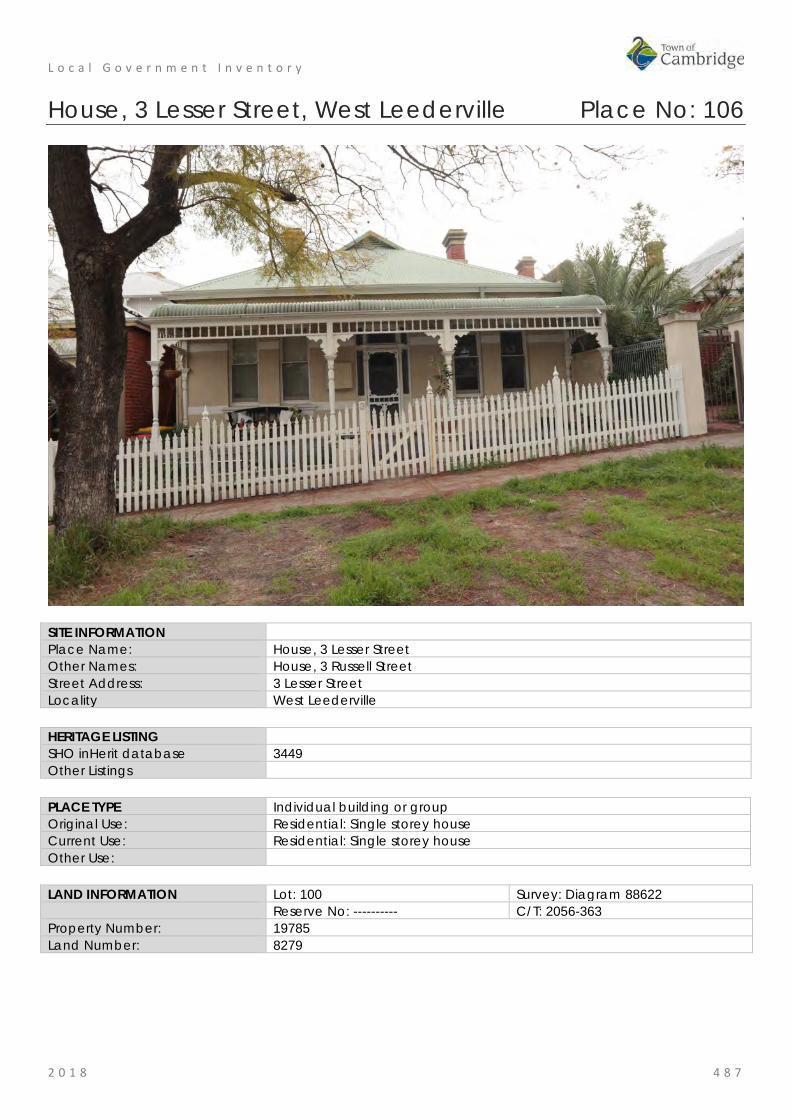
L o c a l G o v e r n m e n t I n v e n t o r y
2 0 1 8 4 8 7
House, 3 Lesser Street, West Leederville Place No: 106
SITE INFORMATION Place Name: House, 3 Lesser Street Other Names: House, 3 Russell Street Street Address: 3 Lesser Street Locality West Leederville HERITAGE LISTING SHO inHerit database 3449 Other Listings PLACE TYPE Individual building or group Original Use: Residential: Single storey house Current Use: Residential: Single storey house Other Use: LAND INFORMATION Lot: 100 Survey: Diagram 88622 Reserve No: ---------- C/T: 2056-363 Property Number: 19785 Land Number: 8279

L o c a l G o v e r n m e n t I n v e n t o r y
2 0 1 8 4 8 8
CONSTRUCTION DETAILS Construction Date: c1907 Walls: Brick: Painted Roof: Metal: Colorbond Architectural Style: Federation Bungalow Physical Description: Traditional Federation era brick and iron house that has undergone some alteration to its original finishes which has impacted on its level of authenticity. Originally a face brick house with a tuck-point finish the brickwork has been painted but traces of the tuck-point can still be seen under the paint. The rendered bands that traditionally created the 'blood and bandage' aesthetic have been painted a different colour to the brickwork and therefore remain a distinctive feature. The house is of symmetrical planform with a centrally placed entrance door flanked by pairs of 1-over-1 timber frame sash windows. The doors and windows are partially obscured by flyscreens but original detailing has been retained. The roof is hipped with a vented gablet and brick chimneys with rendered corbelling. The verandah canopy is separate to the main roof, positioned approximately three brick courses below the eaves. Both the main roof and canopy have been reclad. Condition: Fair Integrity: High Authenticity: Moderate

L o c a l G o v e r n m e n t I n v e n t o r y
2 0 1 8 4 8 9
HISTORICAL INFORMATION Historical Notes: This portion of West Leederville was subdivided for residential lots in 1896 and this street was designated as Russell Street (p.d. Lesser Street). From the readily available information this residence was built c1907 for Ernest Proud (1884-1950) and Annie Emma Proud, nee Stewart (1880-1925). Ernest Proud was a carpenter, born in South Australia who came to Western Australia in the early 1900s. The couple were married in 1906 with four children. He remarried in 1927 to Grace Davies and they continued to live at this residence. Ernest Proud died in 1950 and a funeral notice in the local press stated he was a long term employee of the Public Works Department. Grace Proud lived at the house until at least the mid 1950s. This property originally extended to Glen Street and the property had several small structures in the rear of the lot prior to subdivision in 1995 to created a new lot accessed from Glen Street. Aerial photographs indicate in 1995 the front portion of the place was clad with green corrugated iron and the rear in galvanised corrugated iron. The roof has subsequently been reclad in green colorbond and retained the roof form. Historic Theme: Demographic settlement and mobility: settlements
Occupations: domestic activities Associations: Ernest Proud Sources: Aerial photographs, 1953-2016, Landgate.
Town of Cambridge Municipal Heritage Inventory and Townscape Precinct Study prepared for the Town of Cambridge, June 1997, June 1997. Wise's Post Office Directories for the City of Perth, 1925-1949, State Library of WA www.slwa.wa.gov.au
SIGNIFICANCE Statement of Significance: • The place has aesthetic value as a good, largely intact example of
a brick Federation Bungalow style residence exhibiting original form and detail.
• The place has historic value for its association with the settlement of West Leederville in the early 20th century.
• The place has social value for its demonstration of the form and scale of housing built for skilled tradesmen and their families in the early 20th century.
Level of Significance: Some/moderate Contributes to the heritage of the locality. Has some altered or modified elements, not necessarily detracting from the overall significance of the item.
Management Category: Category 3 Conservation of the place is desirable. Any alterations or extensions should reinforce the significance of the place, and original fabric should be retained wherever feasible. Include on the Town Planning Scheme No 1 Heritage List.
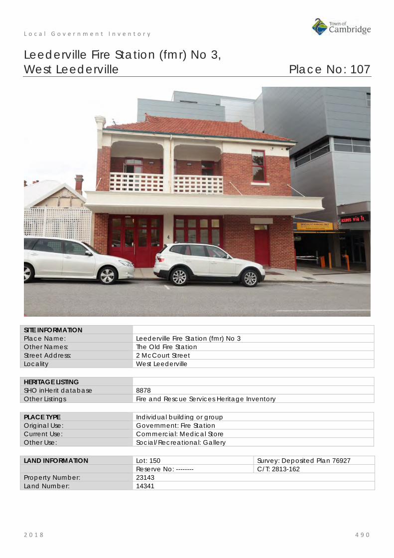
L o c a l G o v e r n m e n t I n v e n t o r y
2 0 1 8 4 9 0
Leederville Fire Station (fmr) No 3, West Leederville Place No: 107
SITE INFORMATION Place Name: Leederville Fire Station (fmr) No 3 Other Names: The Old Fire Station Street Address: 2 McCourt Street Locality West Leederville HERITAGE LISTING SHO inHerit database 8878 Other Listings Fire and Rescue Services Heritage Inventory PLACE TYPE Individual building or group Original Use: Government: Fire Station Current Use: Commercial: Medical Store Other Use: Social/Recreational: Gallery LAND INFORMATION Lot: 150 Survey: Deposited Plan 76927 Reserve No: -------- C/T: 2813-162 Property Number: 23143 Land Number: 14341

L o c a l G o v e r n m e n t I n v e n t o r y
2 0 1 8 4 9 1
CONSTRUCTION DETAILS Construction Date: 1926; 2013 Walls: Brick: Common Roof: Tile: Terracotta Architectural Style: Interwar: Arts and Crafts Physical Description: The former fire station is a two storey brick and tile building that has been adapted for commercial use whilst retaining the original fire station aesthetic. The bi-fold doors remain at ground level which originally provided access for the fire engines. The residence/fire officers accommodation was on the upper level which was recessed to allow for a balcony. Pedestrian access was via a single door in the main elevation.
The building is of simple design with rendered detailing breaking up the red brick. A deep verandah canopy projects out above all access points at ground level. The balustrade to the upper level balcony and upper courses of the elevation are also rendered. All windows are timber framed sashes and the doors leading to the upper verandah are French doors with glazed fanlights. The roof is hipped with gablets with decorative finials.
Condition: Good Integrity: Moderate Authenticity: Moderate HISTORICAL INFORMATION Historical Notes: The Leederville Fire Station was constructed in 1926 and opened in 1927. The building was designed by architect Jack Learmonth Ochiltree (1870-1954) and constructed by Frederick Edward Sedgley (c1877-1958). The building replaced fire stations in Kimberley Street and Rokeby Road which were subsequently closed.
The fire station demonstrated the arrangement of vehicle store on the ground floor and the staff accommodation in the level above.
Jack Ochiltree was formerly appointed as the architect for the WA Fire Brigades in 1913, a position he held for several decades. He was a prominent and successful architect in Western Australia in the first half of the 20th century.
This fire station was used until the Daglish Fire Station was opened in 1964 and was sold privately in 1965. During the 1970s, the Fire Station Art Gallery operated out of the premises and was a prestigious venue and meeting place for the Perth arts community.

L o c a l G o v e r n m e n t I n v e n t o r y
2 0 1 8 4 9 2
In 2013, the lot and the adjacent lot on the corner of Railway Parade were amalgamated as a strata property. The former Fire Station building retained its form and extent although a small building adjoining the rear of the building was removed and a new multi storey building is now [2018] located close to the rear and southern side of the building.
Historic Theme: Social and civic activities: Community services and utilities Social and civic activities: Cultural activities
Associations: West Australian Fire Brigade's Board Sources: Aerial photographs, 1953-2016, Landgate.
Town of Cambridge Municipal Heritage Inventory and Townscape Precinct Study prepared for the Town of Cambridge, June 1997, June 1997. Wise's Post Office Directories for the City of Perth, 1925-1949, State Library of WA www.slwa.wa.gov.au
SIGNIFICANCE Statement of Significance: • The place has aesthetic value as a good example of well designed
service building demonstrating the Inter War Arts and Crafts style. • The place has historic value for its association with the development
of the Leederville community in the 1920s and the recognition of this growth through the provision of fire brigade services.
• The place has historic value for its demonstration of the significance of fire stations to local communities and the government support provided for this service.
• The place has research value for its demonstration of the scale and form of fire stations in the Inter War period although the interior has been altered the exterior remains largely intact.
• The former Fire Station has historic and social value as an important gallery for the art community in Perth during the 1970s.
Level of Significance: Considerable Very important to the heritage of the locality. High degree of integrity/authenticity
Management Category: Category 2 Conservation of the place is highly desirable. Any alterations or extensions should reinforce the significance of the place Include on the Town Planning Scheme No 1 Heritage List.
ADDITIONAL PHOTOGRAPHS

L o c a l G o v e r n m e n t I n v e n t o r y
2 0 1 8 4 9 3
Residence, 101 Northwood Street, West Leederville Place No: 108
SITE INFORMATION Place Name: Residence, 101 Northwood Street Other Names: Myall Street Address: 101 Northwood Street Locality West Leederville HERITAGE LISTING SHO inHerit database 25296 Other Listings PLACE TYPE Individual building or group Original Use: Residential: Single storey house Current Use: Residential: Single storey house Other Use: LAND INFORMATION Lot: Strata Lot 3 Survey: Strata Plan 75725 Reserve No: ------- C/T: 2927-989 Property Number: 24558 Land Number: 15382

L o c a l G o v e r n m e n t I n v e n t o r y
2 0 1 8 4 9 4
CONSTRUCTION DETAILS Construction Date: 1915 Walls: Brick: tuckpointed Roof: Tile: Terracotta Architectural Style: Federation Arts and Crafts Physical Description: Substantial brick and tile house of traditional planform and detailing. The house is sited on a slope with the faceted bay being supported on a deep limestone plinth.
The house is located on a corner lot and has a relationship with both Northwood Street and Ruislip Street, the principal façade being to Northwood Street. The house is tuckpointed, to the top of the windows with render above.
The front elevation is of asymmetric planform with a faceted bay window tucked underneath a decorated gable. A verandah extends across the recessed section of the façade and wraps around the return frontage along Ruislip Street. The main roof is hipped with a gable to the projecting wings to both frontages. The bullnose verandah canopy is a separate structure, positioned below the eaves, and clad in red colorbond.
The faceted bay contains three windows, each with lead lights with floral stained glass patterns. The main window is a three section opening with highlight windows whilst each of the side panels contains a single window with highlight. The sills are moulded render. The chimneys are a combination of brick to the lower courses of the stack and rendered to the upper section and to the corbelling, each with a terracotta honeypot flue.
Condition: Good Integrity: High Authenticity: Moderate
HISTORICAL INFORMATION Historical Notes: The Municipalities of Leederville and North Perth were incorporated into the City of Perth in November 1914. As part of the amalgamation some of the road names were rationalised to avoid confusion. Northwood Street was formerly Monger Street, and Ruislip Street was formerly Ruby Street.
This area of West Leederville had been approved for subdivision as residential lots in 1894. There is no information to suggest the lots were occupied in any form until purchased by Alfred Colliver Trenoweth (1879-1949) in c1915. Alfred Trenoweth and his brothers were builders and traded under the name, Trenoweth Brothers. In 1915, an advertisement was placed in The West Australian for a Plasterer to work on the 'Trenoweth job' on the corner of Monger and Ruby Streets. Alfred Trenoweth and his wife, Ellen Elizabeth

L o c a l G o v e r n m e n t I n v e n t o r y
2 0 1 8 4 9 5
(Nellie) were living at the house in 1916, therefore it is concluded the house was built in 1915 by Trenoweth Brothers. If an architect was used for the design no details have been found in the current research. The Trenoweth Bros advertised many properties for sale during this period so it is likely this small scale property development was one of their business techniques.
Alfred and Nellie, nee Kneale (1889-1948) married in 1906 and had no children. They lived at this house until c1919 and relocated to Nedlands. From the available information it appears the Trenoweth family purchased a large parcel of land in c1914 for this house and for a short period of time the Trenoweth Bros operated their building operations from the adjacent lot (HN 107).
Subsequent occupants included the McLellan Family and the Fitzpatrick Family. For a brief period in the early 1920s the place was occupied by manager William McCorkhill and his wife Mary, they sold the house and advertised the house and its contents as follows:
Magnificent Brick Bungalow residence, tiled roof, containing 6 rooms, kitchen, and bathroom with porcelain bath, oak mantelpieces, cupboards built in … hall, vestibule, 3.6 passage, 12ft walls, 8ft verandah, wire doors. The whole in thorough repair. Sewered. A very comfortable home.
In addition to the exhaustive list of furniture and household goods on sale the household 4 year old Jersey cow was on sale.
Long term occupants from the late 1920s until the 1960s were traveller, Leslie Ernest Cary (c1900-1965) and his wife Hester Annie, nee Oldfield (c1901-1990). The couple married in 1928 so it is likely they moved to this residence and made it their family home until Leslie's death in 1965.
Aerial photographs indicate the form and extent of the residence have not changed significantly since the mid 20th century. The roof cladding of the verandahs to the front and rear of the place were originally corrugated iron and these have been changed to red colorbond. A small carport has been present to the north of the lot from the mid 1960s which was extended to its current form in the 1980s.
In 2016, a new residence was built to the rear of the lot, facing Ruislip Street which was in the former garden of the original residence.
Historic Theme: Demographic Settlement and mobility: settlements occupations: Domestic activities
Associations: Trenoweth Family Trenoweth Bros McClellan Family McCorkhill Family Kirkpatrick Family Cary Family
Sources: Aerial photographs, 1953-2016, Landgate. Town of Cambridge Municipal Heritage Inventory and Townscape Precinct Study prepared for the Town of Cambridge, June 1997. Wise's Post Office Directories for the City of Perth, 1925-1949, State Library of WA www.slwa.wa.gov.au Cambridge Notes, Town of Cambridge Local History Collection, item T34.
SIGNIFICANCE Statement of Significance: • The place has aesthetic value as a good intact example of a
Federation Arts and Crafts style residence built in brick and tile which retains much of the original detail and form although the setting has been diminished.
• The place has aesthetic value as a prominent landmark in the street since the early 20th century.
• The place has historic value for its association with the establishment and development of the West Leederville district in the 1910s.
• The place has social value for its demonstration of the type of housing for professional men and their families in the early 20th century.

L o c a l G o v e r n m e n t I n v e n t o r y
2 0 1 8 4 9 6
Level of Significance: Some/moderate Contributes to the heritage of the locality. Has some altered or modified elements, not necessarily detracting from the overall significance of the item.
Management Category: Category 3 Conservation of the place is desirable. Any alterations or extensions should reinforce the significance of the place, and original fabric should be retained wherever feasible. Include on the Town Planning Scheme No 1 Heritage List.
ADDITIONAL PHOTOGRAPHS

L o c a l G o v e r n m e n t I n v e n t o r y
2 0 1 8 4 9 7
Residence, 104 Northwood Street, West Leederville Place No: 109
SITE INFORMATION Place Name: Residence, 104 Northwood Street Other Names: Street Address: 104 Northwood Street Locality West Leederville HERITAGE LISTING SHO inHerit database Other Listings PLACE TYPE Individual building or group Original Use: Residential: Single storey residence Current Use: Residential: Single storey residence Other Use: LAND INFORMATION Lot: 3, 4 Survey: Diagram 794 Reserve No: --------- C/T: 1243-335 Property Number: 20265 Land Number: 8743; 8744
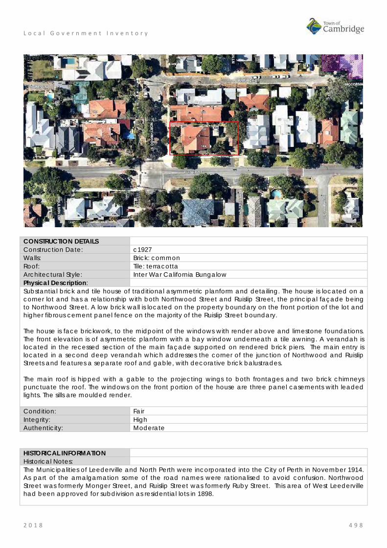
L o c a l G o v e r n m e n t I n v e n t o r y
2 0 1 8 4 9 8
CONSTRUCTION DETAILS Construction Date: c1927 Walls: Brick: common Roof: Tile: terracotta Architectural Style: Inter War California Bungalow Physical Description: Substantial brick and tile house of traditional asymmetric planform and detailing. The house is located on a corner lot and has a relationship with both Northwood Street and Ruislip Street, the principal façade being to Northwood Street. A low brick wall is located on the property boundary on the front portion of the lot and higher fibrous cement panel fence on the majority of the Ruislip Street boundary. The house is face brickwork, to the midpoint of the windows with render above and limestone foundations. The front elevation is of asymmetric planform with a bay window underneath a tile awning. A verandah is located in the recessed section of the main façade supported on rendered brick piers. The main entry is located in a second deep verandah which addresses the corner of the junction of Northwood and Ruislip Streets and features a separate roof and gable, with decorative brick balustrades. The main roof is hipped with a gable to the projecting wings to both frontages and two brick chimneys punctuate the roof. The windows on the front portion of the house are three panel casements with leaded lights. The sills are moulded render. Condition: Fair Integrity: High Authenticity: Moderate
HISTORICAL INFORMATION Historical Notes: The Municipalities of Leederville and North Perth were incorporated into the City of Perth in November 1914. As part of the amalgamation some of the road names were rationalised to avoid confusion. Northwood Street was formerly Monger Street, and Ruislip Street was formerly Ruby Street. This area of West Leederville had been approved for subdivision as residential lots in 1898.
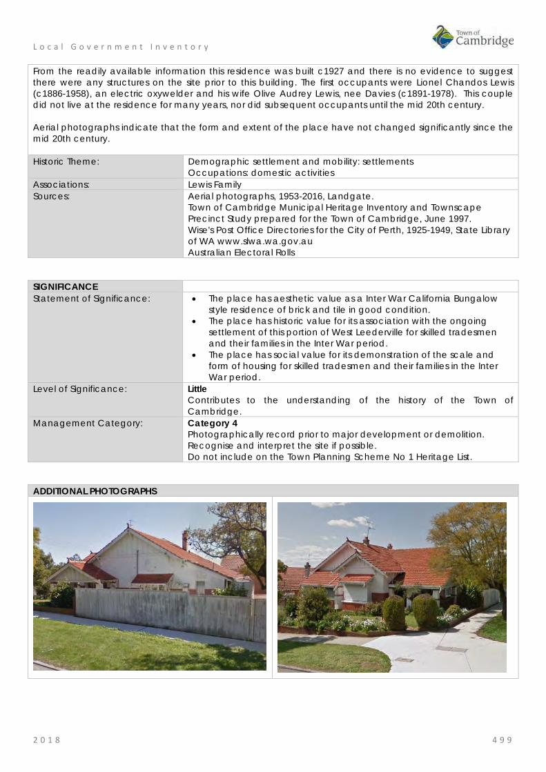
L o c a l G o v e r n m e n t I n v e n t o r y
2 0 1 8 4 9 9
From the readily available information this residence was built c1927 and there is no evidence to suggest there were any structures on the site prior to this building. The first occupants were Lionel Chandos Lewis (c1886-1958), an electric oxywelder and his wife Olive Audrey Lewis, nee Davies (c1891-1978). This couple did not live at the residence for many years, nor did subsequent occupants until the mid 20th century. Aerial photographs indicate that the form and extent of the place have not changed significantly since the mid 20th century. Historic Theme: Demographic settlement and mobility: settlements
Occupations: domestic activities Associations: Lewis Family Sources: Aerial photographs, 1953-2016, Landgate.
Town of Cambridge Municipal Heritage Inventory and Townscape Precinct Study prepared for the Town of Cambridge, June 1997. Wise's Post Office Directories for the City of Perth, 1925-1949, State Library of WA www.slwa.wa.gov.au Australian Electoral Rolls
SIGNIFICANCE Statement of Significance: • The place has aesthetic value as a Inter War California Bungalow
style residence of brick and tile in good condition. • The place has historic value for its association with the ongoing
settlement of this portion of West Leederville for skilled tradesmen and their families in the Inter War period.
• The place has social value for its demonstration of the scale and form of housing for skilled tradesmen and their families in the Inter War period.
Level of Significance: Little Contributes to the understanding of the history of the Town of Cambridge.
Management Category: Category 4 Photographically record prior to major development or demolition. Recognise and interpret the site if possible. Do not include on the Town Planning Scheme No 1 Heritage List.
ADDITIONAL PHOTOGRAPHS

L o c a l G o v e r n m e n t I n v e n t o r y
2 0 1 8 5 0 0
West Leederville Primary School, West Leederville Place No: 110
SITE INFORMATION Place Name: West Leederville Primary School Other Names: West Leederville School;
West Leederville State School Street Address: 58 Northwood Street Locality West Leederville HERITAGE LISTING SHO inHerit database 2208 Other Listings State Register of Heritage Places PLACE TYPE Individual building or group Original Use: Educational: Primary School Current Use: Educational: Primary School Other Use: LAND INFORMATION Lot: 302 Survey: Plan 48175 Reserve No: R35879 C/T: LR3136-403 Property Number: 19767 Land Number: 8258
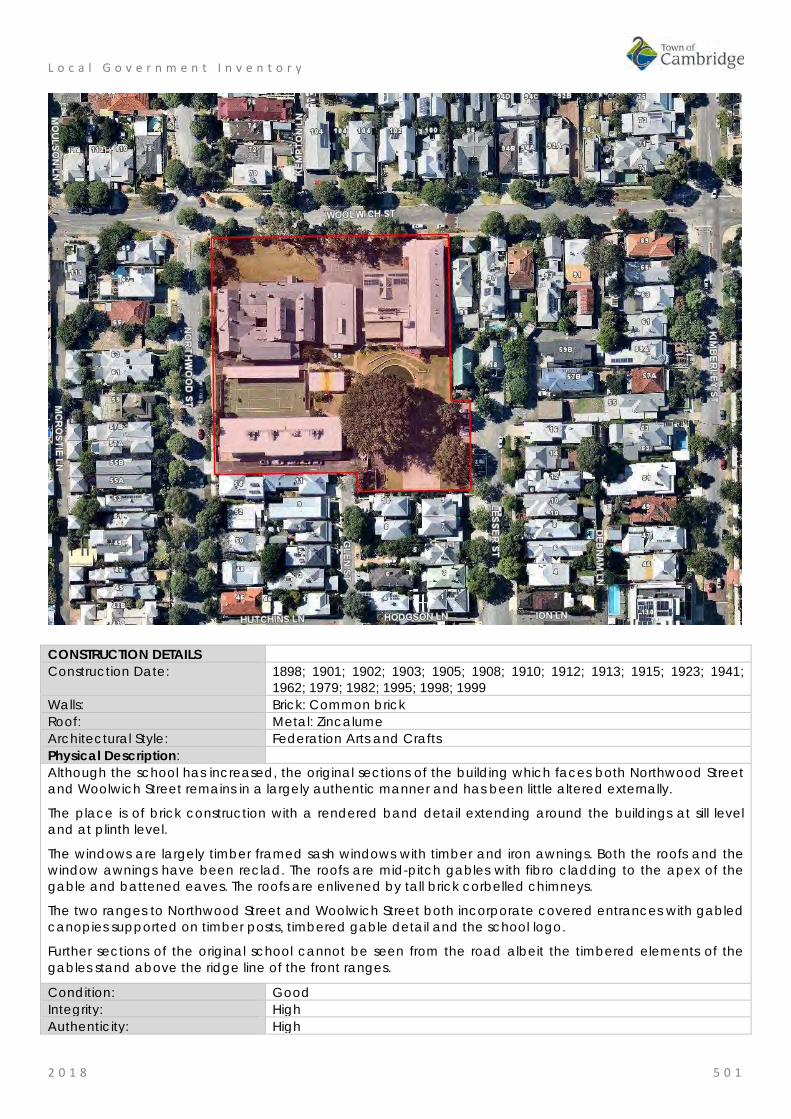
L o c a l G o v e r n m e n t I n v e n t o r y
2 0 1 8 5 0 1
CONSTRUCTION DETAILS Construction Date: 1898; 1901; 1902; 1903; 1905; 1908; 1910; 1912; 1913; 1915; 1923; 1941;
1962; 1979; 1982; 1995; 1998; 1999 Walls: Brick: Common brick Roof: Metal: Zincalume Architectural Style: Federation Arts and Crafts Physical Description: Although the school has increased, the original sections of the building which faces both Northwood Street and Woolwich Street remains in a largely authentic manner and has been little altered externally.
The place is of brick construction with a rendered band detail extending around the buildings at sill level and at plinth level.
The windows are largely timber framed sash windows with timber and iron awnings. Both the roofs and the window awnings have been reclad. The roofs are mid-pitch gables with fibro cladding to the apex of the gable and battened eaves. The roofs are enlivened by tall brick corbelled chimneys.
The two ranges to Northwood Street and Woolwich Street both incorporate covered entrances with gabled canopies supported on timber posts, timbered gable detail and the school logo.
Further sections of the original school cannot be seen from the road albeit the timbered elements of the gables stand above the ridge line of the front ranges.
Condition: Good Integrity: High Authenticity: High

L o c a l G o v e r n m e n t I n v e n t o r y
2 0 1 8 5 0 2
HISTORICAL INFORMATION Historical Notes: The Western Australian gold boom resulted in a great increase in population, and there was considerable expansion of residential and commercial building in the areas to the north, east, and west of the city. It was during this period of rapid growth that the suburbs of Subiaco and Leederville developed, the latter taking its name from William Leeder, one of the first European settlers in the area. In 1896, a temporary school was established in Subiaco. In the same year, the first school opened at Leederville. In August 1897, a number of residents from north of the railway line, representing about 90 children, submitted a petition requesting establishment of a school at West Leederville. On 28 August, O. P. Staples, Secretary for Education, advised the Minister for Education that as both Leederville and Subiaco schools were full, it was advisable to build a new school on a site which had been acquired recently, located between Subiaco and Leederville. Plans for the new school were prepared in 1897 and approved in early 1898. Tenders were called, and the contract was awarded to Carter & O’Daille at a cost of £1,352 18s 6d, with completion due on 14 October 1898. However, subsequently Lake & Gurr were contracted to build the place at a cost of £1292 13s 11d, with completion set for 7 November 1898. On Tuesday, 1 November 1898, the Minister for Education and Colonial Secretary, George Randell, MLC officially opened West Leederville School. It was reported in the local press that the position of the new school was well calculated to meet the demands of such a populous centre and the buildings were described as follows: "The main schoolroom is divided in the centre by shutters which when down enable one half to be used for the infants. In addition it is provided with classrooms, a lavatory and other conveniences, while both lighting and ventilation appear to be all that can be desired. The furnishing of the building is excellent and includes provision for carrying on kindergarten work amongst the infants. The building though complete in itself is designed for future expansion and as occasion justified it additional provision for 50 children at a time can be made." The first head teacher was James Sadler, ‘a gentleman of considerable experience in teaching’, who had previously taught at Albany. It was intended that a female teacher be appointed at once to assist in teaching at the school. Since the opening of the school the original facilities have been adapted and added to in response to the demands of the surrounding population and changes in teaching practices and community expectations. The following developments at the school represent the key government response to these changes. 1899 Acquisition of adjoining half acre lot for future infants school 1901 New classroom built by G. Fraser for £320/10/3 1902 New teachers room, verandah and hat room 1902 Teacher' Quarters built by W. Fairweather for £520/0/4 1903 Two new classrooms, extension of corridor and new corridor, and new boys hat room and lavatory built
by W.C. Rose for £667 /7/10 1905 New classroom built by W.T. Deeble for £295/6/10. 1907 School fenced with closed pickets 1907/8 Termite damaged timber replaced 1910 Hall built by N.F. Pedersen for £1,173/11/6 and opened on 5 October 1910 1912 New classroom opening from corridor, built by W. H. Pearman for £322/4/4 1913 New classroom opening from the hall, built by W. Fairweather for £486/4/6 1914-18 Drainage works undertaken 1915 Pavilion classroom erected 1922 New classroom opening from the hall built by W.H.Pearman for £418/19/4. 1939-45 School designated as an Air Raid Precaution (ARP) depot. Slit trenches dug in north eastern corner
of school grounds. Pavilion classroom erected at the school, relocated from Bayswater PS. 1945 Stage added to the hall 1953 Open air theatre established but termite damage led to its removal in 1978

L o c a l G o v e r n m e n t I n v e n t o r y
2 0 1 8 5 0 3
1957 Memorial Library instituted and centralised library established 1958 New brick shelter shed 1960 Relocation of the pavilion classroom from bitumen playground 1961/2 Brick toilet block constructed 1971 Migrant teacher appointed 1973-5 Carpet laid over timber floors and refurbished admin areas 1978 School Bell relocated to the school hall 1970s Acquisition of land adjacent to the school 1979 Conversion of Pavilion classroom to a Pre-Primary Centre 1981 New entry steps and door 1987 Construction of the oval and entrance pergola 1989 New toilet facilities added to the Pre-Primary Centre 1995 New gardener's shed built east of the toilet block to replace gardeners store destroyed by fire 1998 Construction of covered assembly area, canteen and store and removal of (1958) brick shelter 1999 Construction of a transportable building for use as a kindergarten 2004 Universal access bathrooms 2009 Multi purpose library, art and music building 2010 New Administration building and relocation of heritage building 2013 Two storey classroom 2016 Five classrooms, second storey addition to library, music and art building Historic Theme: Social and Civic Activities: Education and science
Social and Civic Activities: Institutions Social and Civic Activities: Community services and Utilities
Associations: George Temple Poole, Hilson Beasley, John H Grainger, Wilson Tuckey, Robert Hawke
Sources: Aerial photographs, 1953-2016, Landgate. Town of Cambridge Municipal Heritage Inventory and Townscape Precinct Study prepared for the Town of Cambridge, June 1997. State Register Entry and Assessment Documentation for Place 2208 West Leederville Primary School, prepared in 2004.
SIGNIFICANCE Statement of Significance: The following statement is taken from the State Register Entry for Place
2208 prepared in 2004 by the State Heritage Office.
West Leederville Primary School, a brick and iron primary school in the Federation Arts and Crafts style, together with a collection of buildings comprising shelter sheds, pavilion classroom, pre-primary, toilet block, covered area, transportable classroom, kindergarten, covered sand pit, and gardener's store, in an open bitumen paved and grassed setting, has cultural heritage significance for the following reasons: • the place is a fine example of a Federation Arts and Crafts style
school building, with a very fine school hall and well-crafted construction, in a pleasant and leafy landscaped setting;
• the place illustrates the use and flexibility of standard Public Works Department designs for schools as practised in Western Australia in the late nineteenth and early twentieth centuries, along with the subsequent adaptations to those designs through the twentieth century as educational practices evolved;
• the place makes a positive contribution to its suburban context of mostly Federation period houses and commercial buildings, which extends through a large area of West Leederville;
• the place reflects rapid growth in the gold boom period and early twentieth century, and, in the post World War Two period, the influx of migrants from a wide range of ethnic backgrounds;

L o c a l G o v e r n m e n t I n v e n t o r y
2 0 1 8 5 0 4
• the main building derives from a standard design, introduced under George Temple Poole as Assistant-Engineer-in Chief (1892-1896) of the Public Works Department when standard planning was developed as a means of managing rapid expansion and producing efficiency;
• the pavilion classroom (1915) is rare as an example of its type and for the fact that it is retained on its original site, with few later changes; and,
• the timber construction shelter sheds (1908) are the only surviving buildings on site that were constructed in the early 1900s.
The brick construction toilet block, bricks tore, and kindergarten, covered sandpit and gardener's store have little cultural heritage significance
Level of Significance: Exceptional Essential to the heritage of the locality. Rare or outstanding example. Recommended for inclusion on the State Register of Heritage Places.
Management Category: Category 1 The place should be retained and conserved unless there is no feasible and prudent alternative to doing otherwise. Any alterations or extensions should reinforce the significance of the place, and be in accordance with a Conservation Plan (if one exists for the place). Include on the Town Planning Scheme No 1 Heritage List.
ADDITIONAL PHOTOGRAPHS

L o c a l G o v e r n m e n t I n v e n t o r y
2 0 1 8 5 0 5
Cowden Park, West Leederville Place No: 111
SITE INFORMATION Place Name: Cowden Park Other Names: M657 Street Address: 82 Northwood Street Locality West Leederville HERITAGE LISTING SHO inHerit database Other Listings PLACE TYPE Urban Park Original Use: Park/Reserve Current Use: Park/Reserve Other Use: LAND INFORMATION Lot: 25; 26; 211; 212; 213; 214 Survey: P4413;
DP 31559 Reserve No: -------- C/T: 1075-395
1324/448 977/199
Property Number: 20323 Land Number: 8809, 8810, 8806, 8807, 8795, 8808

L o c a l G o v e r n m e n t I n v e n t o r y
2 0 1 8 5 0 6
CONSTRUCTION DETAILS Construction Date: c1910; c1917; 1927, 1980s Walls: N/A Roof: N/A Architectural Style: N/A Physical Description: Cowden Park is a small suburban park extending between Northwood Street and Kimberley Street with additional access from Bernard Street and Kempton Lane. The long narrow park is predominantly open grassland containing mature Moreton Bay Fig trees, picnic tables and children’s play area. The park has a gently sloping topography, dropping to a lower level along Kimberley Street, enabling long views through the space. Condition: N/A Integrity: High Authenticity: High HISTORICAL INFORMATION Historical Notes: Cowden Park was created by the Municipality of Leederville in the 1900s when the locality was being established. The park is comprised of residential lots set aside for the purpose of creating a park.
The park was named in recognition of Leederville councillor, Harry Cowden (c1882-1926), a shipping manager who moved to Leederville c1910 and was elected to the council in 1911. In 1914, with the incorporation of Leederville in the City of Perth, Harry Cowden stood for election as a councillor representing the new Leederville Ward. He was elected and held office for a number of years. It is understood the name had been applied to the park prior to the inclusion of Leederville within the City of Perth.
In 1916, the City of Perth parks and gardens department noted that because of lack of funds no work was undertaken at the park but because of the proximity to the West Leederville School it was proposed that planting the park with grass and trees in the future. Presumably there was little landscaping at the park prior to this time. The large fig trees on the Northwood Street boundary of the park are likely to have been planted not long after this decision although no documentary evidence has been found to support this conclusion.
In 1927, the West Leederville Ratepayers Association induced the City of Perth to resume two additional lots

L o c a l G o v e r n m e n t I n v e n t o r y
2 0 1 8 5 0 7
(each 66ft x 120ft) to increase the playground portion of the park. The Kimberley Street, or eastern end of the park was not resumed for the park until c1982. Since that time additional facilities have been added to the park and been subject to ongoing maintenance.
Historic Theme: Social and Civic Activities: Sport, recreation and entertainment Demographic settlement and mobility: Government policy People: local heroes and battlers
Associations: Harry Cowden Sources: Aerial photographs, 1953-2016, Landgate.
The West Australian, 7 January 1916, p. 8. The Daily News, 6 April 1926, 1; 7 November 1927, p. 2.
SIGNIFICANCE Statement of Significance: • The place has aesthetic value as a well maintained greened
landscape and playground in an urban setting. • The park has historic value for its association with the development
of community facilities in West Leederville in the 1900s when this portion of West Leederville was being developed.
• The place has historic value for its association with Harry Cowden a committed worker for his community in many fields.
• The park has social value for many members of the community as a place for informal sports, passive recreation and social events
Level of Significance: Some/moderate Contributes to the understanding of the history of the Town of Cambridge.
Management Category: Category 3 Conservation of the place is desirable. Any alterations or extensions should reinforce the significance of the place, and original fabric should be retained wherever feasible. Include on the Town Planning Scheme No 1 Heritage List.

L o c a l G o v e r n m e n t I n v e n t o r y
2 0 1 8 5 0 8
ADDITIONAL PHOTOGRAPHS

L o c a l G o v e r n m e n t I n v e n t o r y
2 0 1 8 5 0 9
Residence, 97 Northwood Street, West Leederville Place No: 112
SITE INFORMATION Place Name: Residence, 97 Northwood Street Other Names: Street Address: 97 Northwood Street Locality West Leederville HERITAGE LISTING SHO inHerit database Other Listings PLACE TYPE Individual building or group Original Use: Residential: Single storey residence Current Use: Residential: Single storey residence Other Use: LAND INFORMATION Lot: Strata Lot 1 Survey: Strata Plan 60202, Plan 133 Reserve No: ------- C/T: 2749-591 Property Number: 21574, 22331 Land Number: 11476, 8574

L o c a l G o v e r n m e n t I n v e n t o r y
2 0 1 8 5 1 0
CONSTRUCTION DETAILS Construction Date: c1901; 1980s Walls: Timber: weatherboard Roof: Metal: zincalume Architectural Style: Federation Bungalow Physical Description: 97 Northwood Street is a timber framed and weatherboard house with dual frontages to Northwood Street and Ruislip Street. The house has been added to along the Ruislip Street elevation but elements of the original design intent remain extant. The place is of asymmetric plan form to Northwood Street with a projecting bay and a series of stepped verandahs which wrap around both principal elevations. The entrance faces Ruislip Street. The roof is a complex hipped form with a separate skillion verandah canopy positioned below the eaves. Although the roof has been reclad with zincalume, the chimneys were retained. The Northwood Street section of the property consist of a projecting weatherboard bay containing two timber framed sash windows. The main entrance is located behind this section in a separate vestibule/foyer. The main body of the house is located west of the entrance and faces Ruislip Street. When the house is viewed from Ruislip Street, it presents with a series of projecting elements creating a high level of activation to the elevation. Windows to the Ruislip Street elevation are predominantly French doors. Condition: Good Integrity: High Authenticity: Low
HISTORICAL INFORMATION Historical Notes: The Municipalities of Leederville and North Perth were incorporated into the City of Perth in November 1914. As part of the amalgamation some of the road names were rationalised to avoid confusion. Northwood Street was formerly Monger Street, and Ruislip Street was formerly Ruby Street. This area of West Leederville had been approved for subdivision as residential lots in 1894. From the readily available information this residence was built c1901 and the first occupant was Walter Jones, an electrician, and his family. At the time of construction the residence was a simple timber cottage presenting to Northwood Street. No details of the architect or builder have been found in this research.
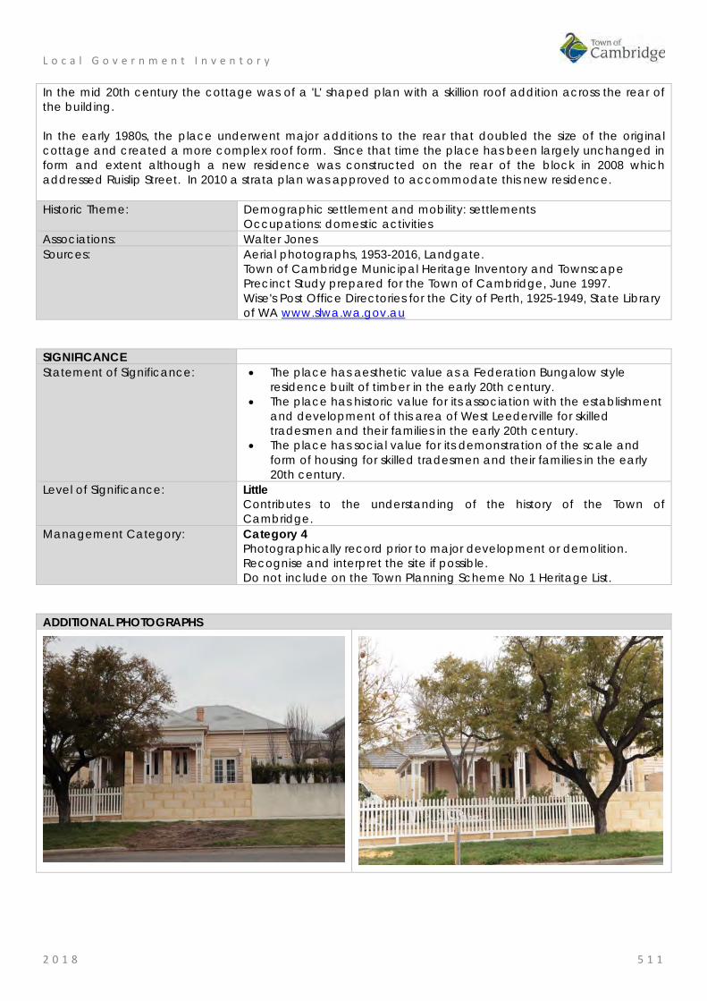
L o c a l G o v e r n m e n t I n v e n t o r y
2 0 1 8 5 1 1
In the mid 20th century the cottage was of a 'L' shaped plan with a skillion roof addition across the rear of the building. In the early 1980s, the place underwent major additions to the rear that doubled the size of the original cottage and created a more complex roof form. Since that time the place has been largely unchanged in form and extent although a new residence was constructed on the rear of the block in 2008 which addressed Ruislip Street. In 2010 a strata plan was approved to accommodate this new residence. Historic Theme: Demographic settlement and mobility: settlements
Occupations: domestic activities Associations: Walter Jones Sources: Aerial photographs, 1953-2016, Landgate.
Town of Cambridge Municipal Heritage Inventory and Townscape Precinct Study prepared for the Town of Cambridge, June 1997. Wise's Post Office Directories for the City of Perth, 1925-1949, State Library of WA www.slwa.wa.gov.au
SIGNIFICANCE Statement of Significance: • The place has aesthetic value as a Federation Bungalow style
residence built of timber in the early 20th century. • The place has historic value for its association with the establishment
and development of this area of West Leederville for skilled tradesmen and their families in the early 20th century.
• The place has social value for its demonstration of the scale and form of housing for skilled tradesmen and their families in the early 20th century.
Level of Significance: Little Contributes to the understanding of the history of the Town of Cambridge.
Management Category: Category 4 Photographically record prior to major development or demolition. Recognise and interpret the site if possible. Do not include on the Town Planning Scheme No 1 Heritage List.
ADDITIONAL PHOTOGRAPHS

L o c a l G o v e r n m e n t I n v e n t o r y
2 0 1 8 5 1 2
Commercial Premises, 256-276 Railway Parade, West Leederville Place No: 113
SITE INFORMATION Place Name: Commercial Premises, 256-276 Railway Parade Other Names: Street Address: 256-258, 260-262, 264-270 and 276 Railway Parade Locality West Leederville HERITAGE LISTING SHO inHerit database Other Listings PLACE TYPE Individual building or group Original Use: Commercial: shops Current Use: Commercial: shops Other Use: LAND INFORMATION Lot: 204; 203; 6; 7 Survey: Diagrams 56221; 52465; 5704 Reserve No: -------- C/T: 2075-686; 1475-527; 1524-899; 1535-98 Property Number: 19744; 19745; 19742; 19766 Land Number: 8234; 8235; 8232; 8257

L o c a l G o v e r n m e n t I n v e n t o r y
2 0 1 8 5 1 3
CONSTRUCTION DETAILS Construction Date: 1910-1920; 1950s; 1970s Walls: Brick: painted Roof: Metal: corrugated iron Architectural Style: Federation;
Post War International Physical Description: Strip of shops on the north side of Railway Parade between Rosslyn and Northwood Streets. The five premises demonstrate varying styles and levels of authenticity as they have been compromised by alterations. The properties at 256-258 (former Serendipity Books) and 264-270 retain original detailing to the parapets although the shop frontages have been altered. The shops at the east and west ends of the range 254 and 276 were constructed in the late 1970s/early 1980s, whilst the unit at 260-262 appears to date from the 1950s but has since been altered so that none of its original design intent remains visible. The shops are reflective of commercial strip development but they do not present with a coherent form. Condition: Fair Integrity: Moderate Authenticity: Low

L o c a l G o v e r n m e n t I n v e n t o r y
2 0 1 8 5 1 4
HISTORICAL INFORMATION Historical Notes: This portion of West Leederville expanded rapidly in the early 20th century as settlement spread along the railway line in the suburbs close to Perth. The location of these shops across the road from the Leederville train station was an logical site for small businesses. From the readily available information shops were built in the period between 1910 and 1920 when the area was developed. The types of businesses occupying these premises were typical of the period; tobacconist, fruiterer, newsagent, bootmaker, confectioner, hairdresser and chemist. This type of occupant continued until the 1940s and 1950s. At the corner of Northwood Street and Railway Parade for many years was a fuel, or timber yard. In the 1970s, the shops at 264-270 Railway Parade were reroofed and integrated into one structure. In c1980 the premises on the corner of Northwood Street and Railway Parade (276) was built and shortly after the premises at 260-262 Railway Parade. Since that time the form and extent of this group of shops have not changed significantly although internal fit outs have been modified in response to new occupants. Serendipity Books at 256 Railway Parade has been at this location since 1974 and is well known amongst many members of the community. The shop front of their premises above the parapet is largely consistent with the original construction period. Historic Theme: Occupations: Commercial services and industries Associations: Sources: Aerial photographs, 1953-2016, Landgate.
Town of Cambridge Municipal Heritage Inventory and Townscape Precinct Study prepared for the Town of Cambridge, June 1997. Wise's Post Office Directories for the City of Perth, 1925-1949, State Library of WA www.slwa.wa.gov.au
SIGNIFICANCE Statement of Significance: • This group of shops have some aesthetic value for the remaining
form and detail demonstrating the Federation style of the early 20th century.
• This group of shops have historic value for their association with the growth of Leederville in the early 20th century and for their demonstration of the type of shops common in most suburbs.
• The group of shops have landmark value for their continuity of form and contribution to the streetscape since the early 20th century
Level of Significance: Little Contributes to the understanding of the history of the Town of Cambridge.
Management Category: Category 4 Photographically record prior to major development or demolition. Recognise and interpret the site if possible. Do not include on the Town Planning Scheme No 1 Heritage List.

L o c a l G o v e r n m e n t I n v e n t o r y
2 0 1 8 5 1 5
ADDITIONAL PHOTOGRAPHS
256/258 Railway Parade
264 Railway Parade
260-264 Railway Parade

L o c a l G o v e r n m e n t I n v e n t o r y
2 0 1 8 5 1 6
Residence, 314 Railway Parade, West Leederville Place No: 114
SITE INFORMATION Place Name: Residence, 314 Railway Parade Other Names: Smart Residence Street Address: 314 Railway Parade Locality West Leederville HERITAGE LISTING SHO inHerit database Other Listings PLACE TYPE Individual building or group Original Use: Residential: Single storey residence Current Use: Residential: Single storey residence Other Use: LAND INFORMATION Lot: 467 Survey: Plan 133 Reserve No: ------- C/T: 322-16 Property Number: 19392 Land Number: 7893

L o c a l G o v e r n m e n t I n v e n t o r y
2 0 1 8 5 1 7
CONSTRUCTION DETAILS Construction Date: c1905 Walls: Stone: limestone Roof: Tile: terracotta Architectural Style: Federation Bungalow Physical Description: A single storey stone, brick and tile house with asymmetric planform, facing Railway Parade. The façade incorporates a projecting bay with timbered gable detail and two timber framed sash windows. The recessed section of the façade incorporates a further pair of timber framed sashes. The hipped roof to the main house was originally clad with Marseille tiles with prominent brick and rendered corbelled chimney but has recently been clad with corrugated zincalume. The verandah extends across the full with of the façade and returns around to the east elevation to the main entry. The deck is timber but the canopy was in the process of being replaced at the time of inspection. The rear section of the building has brick facing to the narrow section of south elevation and red brick beyond. Condition: Good Integrity: High Authenticity: Moderate
HISTORICAL INFORMATION Historical Notes: This portion of West Leederville expanded rapidly in the early 20th century as settlement spread along the railway line in the suburbs close to Perth. From the readily available information this residence was built c1905 for William Smart (c1856-1920) and his

L o c a l G o v e r n m e n t I n v e n t o r y
2 0 1 8 5 1 8
wife Ruth Mary Smart and their three sons. William Smart was born in Dundee, Scotland and he worked at the Midland Railway Workshops following his arrival in Western Australia in 1895. Prior to his death in 1920 he had achieved the position of Leading Foreman Moulder at the workshops. Ruth Smart (c1867-1942) stayed on in the house until the early 1930s. Aerial photographs indicate that the form and extent of the original cottage have not changed significantly since the mid 20th century although the roof has been reclad with zincalume. Historic Theme: Demographic settlement and mobility: land allocation and subdivision
Occupations: Domestic activities Associations: William Smart and family Sources: Aerial photographs, 1953-2016, Landgate.
Australian Electoral Roles, 1903-1983 The West Australian 15 April 1920, p.4. Wise's Post Office Directories for the City of Perth, 1925-1949, State Library of WA www.slwa.wa.gov.au
SIGNIFICANCE Statement of Significance: • The place has aesthetic value as a largely intact example of a
Federation Bungalow style residence built in stone and tile. • The place has historic value for its association with the establishment
and development of West Leederville in the early 20th century. • The place has social value as a demonstration of the type of
residence occupied by skilled tradesmen and their families in the early 20th century.
Level of Significance: Some/moderate Contributes to the heritage of the locality. Has some altered or modified elements, not necessarily detracting from the overall significance of the item.
Management Category: Category 3 Conservation of the place is desirable. Any alterations or extensions should reinforce the significance of the place, and original fabric should be retained wherever feasible. Include on the Town Planning Scheme No 1 Heritage List.
ADDITIONAL PHOTOGRAPHS

L o c a l G o v e r n m e n t I n v e n t o r y
2 0 1 8 5 1 9
Chapel of St Michael the Archangel, West Leederville Place No: 115
SITE INFORMATION Place Name: Chapel of St Michael the Archangel Other Names: Church of St Chapel for the Home of the Good Shepherd Street Address: 50 Ruislip Street Locality West Leederville HERITAGE LISTING SHO inHerit database 23899 Other Listings Catholic Church Inventory PLACE TYPE Individual building or group Original Use: Religious: Church Current Use: Religious: Church Other Use: LAND INFORMATION Lot: 162, 163 Survey: Plan 15834 Reserve No: ------ C/T: 1769-62
1769-63 Property Number: 19290; 10679 Land Number: 7807; 9888

L o c a l G o v e r n m e n t I n v e n t o r y
2 0 1 8 5 2 0
CONSTRUCTION DETAILS Construction Date: 1938 Walls: Stone: Limestone Roof: Tile: terracotta Architectural Style: Inter War Gothic Physical Description: The church is one of an impressive precinct of striking buildings set within a landscaped setting in the heart of residential West Leederville. The buildings are set atop a grassy bank, with views up a central driveway from McCourt Street towards the building. The church is located on the eastern side of the land parcel and is linked to the main building (former convent and now administration centre) by a colonnaded walkway. The church was constructed in the inter-war era and expresses gothic design influences including the tall lancet windows, the verticality of the building and the buttresses with pinnacles. The church is of similar stonework as the main building and laid in a distinctive bond. The lancet windows contain stained leaded glazing with the main windows positioned above the doorways to the south and west elevations. The east elevation takes on a different character than the principal façade and consists of three faceted towers, reminiscent of European castle architecture. The roof is shallow pitched to the main roof, clad with terracotta tiles. The north face of the church presents with ashlar stonework creating a contrasting smooth aesthetic to the other elevations. The details remain the same with a regular rhythm of buttresses and windows to both elevations. No internal inspection of the chapel was undertaken at the time of assessment. Condition: Good Integrity: High Authenticity: High

L o c a l G o v e r n m e n t I n v e n t o r y
2 0 1 8 5 2 1
HISTORICAL INFORMATION Historical Notes: The Chapel of St Michael the Archangel was designed by architects, Henderson and Gamble and built by contractors, C.W. Arnott for £20,400. The chapel was built to serve the community of Sisters and those living and working at the Home of the Good Shepherd which provided institutional care for women and girls as well as an Industrial School for girls which operated from the site. The partnership of Henderson and Gamble only existed for a short period. The most well-known of the pair, Edgar Le Blond Henderson (1890-1971) is best-known for his succession of Inter-War Gothic and Inter-War Romanesque style Catholic churches, hospitals, convents and schools. E Le B Henderson formed a partnership with Fremantle born architect-artist Allan Gamble (1907-2001) from 1937 to 1939. Gamble’s fine sketching abilities were a great asset to the Henderson & Gamble practice, and he was later to exhibit art works as far away as New York. The chapel was consecrated by Archbishop Prendiville on 30 September 1939, the Feast of St Michael the Archangel to whom it is dedicated. E Le B Henderson was then engaged to convert the old chapel into a classroom and concert hall for the inmates of the convent. The church has some fine decorative features and art works including stained glass windows installed in the chapel in 1951, and in April 1952, Greek artist George Krafilakis was commissioned to paint a crucifixion scene on the wall behind the high Altar. In March 1953, a Carillion of four bells with Westminster chimes was installed. The Industrial School for girls and the Home of the Good Shepherd closed in the 1970s. The church has changed little since its original construction although modified for current standards and community expectations. The chapel is now a popular venue for wedding ceremonies. Historic Theme: Social and Civic: Religion
Social and Civic Activities: Community services and utilities Associations: Edgar Le B Henderson
Allan Gamble C. W. Arnott
Sources: Landgate land information and aerial photographs. Town of Cambridge, Municipal Heritage Inventory, Heritage and Conservation Professionals, 1996. Architectural Features of the Catholic Education Centre and Chapel of St Michael the Archangel, Catholic Education Centre. Taylor, Dr John J., ‘Edgar Le Blond Henderson (1890-1971) ', Western Australian Architect Biographies, http://www.architecture.com.au/i-cms?page=13453, accessed October 2017. The West Australian, 4 June 1938, p. 4. Cambridge Notes, Town of Cambridge Local Studies Centre, Item T460.
SIGNIFICANCE Statement of Significance: • The chapel has aesthetic value as an intact and well detailed
example of the Inter War Gothic style executed in stone, brick and tile.
• The chapel has historic value for its association with the provision of services by the Sisters of the Good Shepherd from 1904 to 1979.
• The chapel has historic value for its association with the prominent ecclesiastical architect, Edgar le Blond Henderson and his partner Alan Gamble.
• The chapel has social value for the members of the community who attended the place from 1938 to 1979 when it was an adjunct to the Home of the Good Shepherd institutions for women and girls.

L o c a l G o v e r n m e n t I n v e n t o r y
2 0 1 8 5 2 2
• The chapel has social value for the immediate and widespread community for its use as a wedding venue in recent decades.
Level of Significance: Exceptional Essential to the heritage of the locality. Rare or outstanding example. Recommended for inclusion on the State Register of Heritage Places.
Management Category: Category 1 The place should be retained and conserved unless there is no feasible and prudent alternative to doing otherwise. Any alterations or extensions should reinforce the significance of the place, and be in accordance with a Conservation Plan (if one exists for the place). Include on the Town Planning Scheme No 1 Heritage List.
ADDITIONAL PHOTOGRAPHS

L o c a l G o v e r n m e n t I n v e n t o r y
2 0 1 8 5 2 3
Ruislip Street Catholic Precinct, West Leederville Place No: 116
SITE INFORMATION Place Name: Ruislip Street Catholic Precinct Other Names: Home of the Good Shepherd, Catholic Education Centre, Church of St
Michael the Archangel Hill of Tara
Street Address: 50 Ruislip Street Locality West Leederville HERITAGE LISTING SHO inHerit database 8880 Other Listings Catholic Church Inventory PLACE TYPE Individual building or group Original Use: Religious: Convent Current Use: Education: Administration Other Use: Residential: Institutional housing LAND INFORMATION Lot: 162, 163 Survey: Plan 15834 Reserve No: ------- C/T: 1769-62
1769-63 Property Number: 19290; 10679 Land Number: 7807; 9888

L o c a l G o v e r n m e n t I n v e n t o r y
2 0 1 8 5 2 4
CONSTRUCTION DETAILS Construction Date: 1903; 1904; 1938; 1980s Walls: Stone: Limestone Roof: Tile: terracotta Architectural Style: Federation Romanesque
Inter War Gothic Physical Description: Impressive precinct of striking buildings set within a landscaped setting in the heart of residential West Leederville. The buildings are set atop a grassy bank, with views up a central driveway from McCourt Street towards the building. The main building is a three storey Federation Romanesque limestone structure of symmetrical plan form with a central entrance, flanking wings, colonnaded verandah and balcony across the entire façade. The third storey accommodation is within the roof space with a regular rhythm of dormer windows across the roofscape. The roof is a combination of gables and hips clad in terracotta tiles and further enlivened by a series of tall chimneys with rendered bands, caps and flues. The colonnades to the verandah and balcony are identical, each section containing six arched openings. The verandah is open to the stone deck whilst the balcony has a stone balustrade. The flanking wings both contain faceted bays to the ground floor and a window ensemble contained within an arched opening to the upper level. The side and rear (north) elevations are of brick construction. The addition to the west of the main building was constructed in the 1960s and is not of significance. The church was constructed in the inter-war era and expresses gothic design influences including the tall lancet windows, the verticality of the building and the buttresses with pinnacles. The church is of similar stonework as the main building and laid in a distinctive bond. The lancet windows contain stained leaded glazing with the main windows positioned above the doorways to the south and west elevations. The east
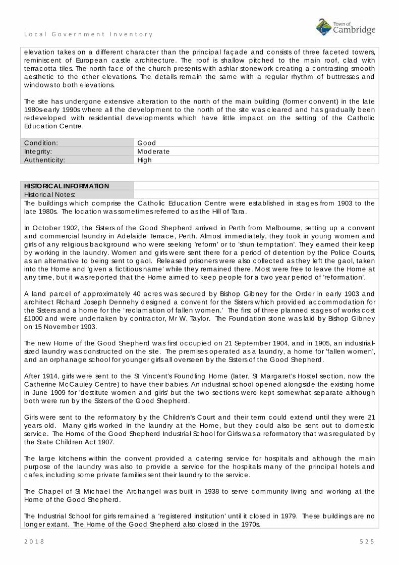
L o c a l G o v e r n m e n t I n v e n t o r y
2 0 1 8 5 2 5
elevation takes on a different character than the principal façade and consists of three faceted towers, reminiscent of European castle architecture. The roof is shallow pitched to the main roof, clad with terracotta tiles. The north face of the church presents with ashlar stonework creating a contrasting smooth aesthetic to the other elevations. The details remain the same with a regular rhythm of buttresses and windows to both elevations. The site has undergone extensive alteration to the north of the main building (former convent) in the late 1980s-early 1990s where all the development to the north of the site was cleared and has gradually been redeveloped with residential developments which have little impact on the setting of the Catholic Education Centre. Condition: Good Integrity: Moderate Authenticity: High
HISTORICAL INFORMATION Historical Notes: The buildings which comprise the Catholic Education Centre were established in stages from 1903 to the late 1980s. The location was sometimes referred to as the Hill of Tara. In October 1902, the Sisters of the Good Shepherd arrived in Perth from Melbourne, setting up a convent and commercial laundry in Adelaide Terrace, Perth. Almost immediately, they took in young women and girls of any religious background who were seeking 'reform' or to 'shun temptation'. They earned their keep by working in the laundry. Women and girls were sent there for a period of detention by the Police Courts, as an alternative to being sent to gaol. Released prisoners were also collected as they left the gaol, taken into the Home and 'given a fictitious name' while they remained there. Most were free to leave the Home at any time, but it was reported that the Home aimed to keep people for a two year period of 'reformation'. A land parcel of approximately 40 acres was secured by Bishop Gibney for the Order in early 1903 and architect Richard Joseph Dennehy designed a convent for the Sisters which provided accommodation for the Sisters and a home for the ‘reclamation of fallen women.’ The first of three planned stages of works cost £1000 and were undertaken by contractor, Mr W. Taylor. The Foundation stone was laid by Bishop Gibney on 15 November 1903. The new Home of the Good Shepherd was first occupied on 21 September 1904, and in 1905, an industrial-sized laundry was constructed on the site. The premises operated as a laundry, a home for 'fallen women', and an orphanage school for younger girls all overseen by the Sisters of the Good Shepherd. After 1914, girls were sent to the St Vincent's Foundling Home (later, St Margaret's Hostel section, now the Catherine McCauley Centre) to have their babies. An industrial school opened alongside the existing home in June 1909 for 'destitute women and girls' but the two sections were kept somewhat separate although both were run by the Sisters of the Good Shepherd. Girls were sent to the reformatory by the Children's Court and their term could extend until they were 21 years old. Many girls worked in the laundry at the Home, but they could also be sent out to domestic service. The Home of the Good Shepherd Industrial School for Girls was a reformatory that was regulated by the State Children Act 1907. The large kitchens within the convent provided a catering service for hospitals and although the main purpose of the laundry was also to provide a service for the hospitals many of the principal hotels and cafes, including some private families sent their laundry to the service. The Chapel of St Michael the Archangel was built in 1938 to serve community living and working at the Home of the Good Shepherd. The Industrial School for girls remained a 'registered institution' until it closed in 1979. These buildings are no longer extant. The Home of the Good Shepherd also closed in the 1970s.

L o c a l G o v e r n m e n t I n v e n t o r y
2 0 1 8 5 2 6
In 1985 the convent was purchased by the Archdiocese of Perth. Extensive structural work, restoration and refurbishment were undertaken during the following year. Since that time the buildings have been modified and added to as required and now function as the administration centre for the Catholic Education Centre of WA. The works were overseen by architect Marcus Collins. As part of these works the buildings to the north and west of the former convent were demolished and new additions have been integrated into the existing 1903 building in 2017. Historic Theme: Social and Civic Activities: Religion
Social and Civic Activities: law and order Associations: Richard Joseph Dennehy
E Le B Henderson C. W. Arnott Marcus Collins
Sources: Landgate land information and aerial photographs. Town of Cambridge, Municipal Heritage Inventory, Heritage and Conservation Professionals, 1996. Find and Connect website, History and Information about Australian orphanages, children’s Homes & other institutions. www.findandconnect.gov.au The Western Mail The West Australian Cambridge Notes. Cambridge Local Studies Centre, Item T443.
SIGNIFICANCE Statement of Significance: • The place has aesthetic value as a group of buildings in a well
maintained landscaped setting which exhibit the style and detail of the two earliest buildings on the site, the Chapel and the former convent and home for women.
• The precinct has aesthetic value as a dominant landmark in the district because of its location on a rise and the large scale of the buildings compared to the surrounding residential buildings.
• The precinct has historic value for its association with the Sisters of the Good Shepherd who provided institutional care for women and girls at this site from 1904 to 1979.
• The precinct has historic value as a demonstration of how institutional care by government and private organisations developed and changed throughout the 20th century.
• The precinct has social value for many members of the community who lived or worked there until 1979; and for the members of the community who had friends or family associated with the place.
Level of Significance: Exceptional Essential to the heritage of the locality. Rare or outstanding example. Recommended for inclusion on the State Register of Heritage Places.
Management Category: Category 1 The place should be retained and conserved unless there is no feasible and prudent alternative to doing otherwise. Any alterations or extensions should reinforce the significance of the place, and be in accordance with a Conservation Plan (if one exists for the place). Include on the Town Planning Scheme No 1 Heritage List.

L o c a l G o v e r n m e n t I n v e n t o r y
2 0 1 8 5 2 7
ADDITIONAL PHOTOGRAPHS
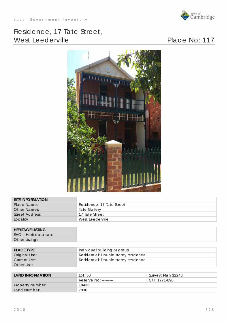
L o c a l G o v e r n m e n t I n v e n t o r y
2 0 1 8 5 2 8
Residence, 17 Tate Street, West Leederville Place No: 117
SITE INFORMATION Place Name: Residence, 17 Tate Street Other Names: Tate Gallery Street Address: 17 Tate Street Locality West Leederville HERITAGE LISTING SHO inHerit database Other Listings PLACE TYPE Individual building or group Original Use: Residential: Double storey residence Current Use: Residential: Double storey residence Other Use: LAND INFORMATION Lot: 50 Survey: Plan 32248 Reserve No: --------- C/T: 1771-896 Property Number: 19433 Land Number: 7930
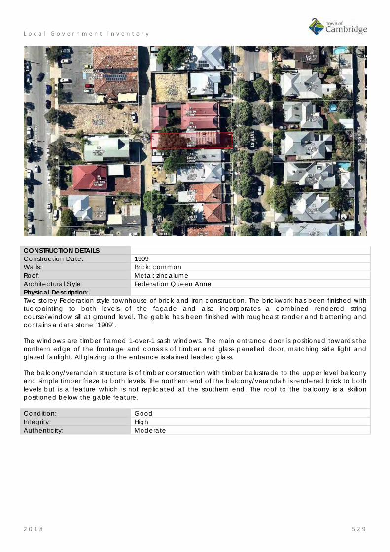
L o c a l G o v e r n m e n t I n v e n t o r y
2 0 1 8 5 2 9
CONSTRUCTION DETAILS Construction Date: 1909 Walls: Brick: common Roof: Metal: zincalume Architectural Style: Federation Queen Anne Physical Description: Two storey Federation style townhouse of brick and iron construction. The brickwork has been finished with tuckpointing to both levels of the façade and also incorporates a combined rendered string course/window sill at ground level. The gable has been finished with roughcast render and battening and contains a date stone ‘1909’. The windows are timber framed 1-over-1 sash windows. The main entrance door is positioned towards the northern edge of the frontage and consists of timber and glass panelled door, matching side light and glazed fanlight. All glazing to the entrance is stained leaded glass. The balcony/verandah structure is of timber construction with timber balustrade to the upper level balcony and simple timber frieze to both levels. The northern end of the balcony/verandah is rendered brick to both levels but is a feature which is not replicated at the southern end. The roof to the balcony is a skillion positioned below the gable feature. Condition: Good Integrity: High Authenticity: Moderate

L o c a l G o v e r n m e n t I n v e n t o r y
2 0 1 8 5 3 0
HISTORICAL INFORMATION Historical Notes: This portion of West Leederville underwent significant development in the early 1900s; it was a convenient location adjacent to the railway line for working families. The subdivision for these residential lots was approved by the Department of Lands and Surveys in 1901 and development followed swiftly afterwards. Lots in Tate Street Leederville were advertised for sale in 1905 for £65. From the available information this lot was not developed until the two-storey residence was constructed on the property. The notation ‘1909’ in the gable of the building seems to conclusively prove the date of construction. Post Office Directories and Electoral Rolls indicate the occupants in 1909 were bootmaker, William Hamilton Paterson and his mother Margaret. However, it seems there was a large family group in the house as in March 1909; a notice in The West Australian records the death of Daniel Osborne Reid (1871-1909) at his residence 17 Tate Street, Leederville. Daniel Osborne Reid and his wife Robina, their son and two daughters were living at the house with his mother-in-law Margaret Paterson and presumably William Paterson. When reviewing the Post Office Directories it seems that other members of the extended Paterson and Reid families were living in Tate Street during the early 1900s. Thomas and Ellen Paterson, the brother and sister-in-law of William Paterson were living in Tate Street until Thomas’s death in 1906, aged 35. James and George Reid who were believed to be brothers of Daniel Reid. The Post Office Directories indicate that the Reids were living at or near this property prior to 1909. Further research may resolve this query. William Paterson enlisted with the Australian Imperial Forece in 1916, and sadly died in early 1917, and at that time his mother, Margaret Paterson stated her address as 17 Tate Street, Leederville. Margaret Paterson died in the early 1920s and the place was subsequently occupied by a series of tenants, and often more than one occupant, which suggests it was divided into two premises. Aerial photographs indicate there have been additions to the rear of the place since the mid 20th century however the form and extent of the original structure are still readily apparent. The adjacent two storey residences constructed in the late 1990s seems to have used this place as the inspiration for the design. Historic Theme: Demographic settlement and mobility: Land allocation and subdivision
Occupations: domestic activities Associations: Paterson Family
Reid Family Sources: Aerial photographs, 1953-2016, Landgate.
Wise's Post Office Directories for the City of Perth, 1925-1949, State Library of WA www.slwa.wa.gov.au NAA; B2455, William Hamilton Paterson. The West Australian, 20 October 1905, p. 3; 31 Dec 1906, p. 1; 2 March 1917, p. 1.
SIGNIFICANCE Statement of Significance: • The place has aesthetic value as a rare and intact example of a
two storey brick and iron residence built in the early 20th century. • The place has aesthetic value as a landmark in the streetscape as it
is a rare two structure until the construction of the adjacent two storey residence in the late 1990s.
• The place has historic value for its association with the settlement and development of this portion of West Leederville in the early 20th century for working families.
• The place has historic value for its association with how extended families lived together during the early 20th century.
• The place has social value as a demonstration of the type of home built for large extended families which were later adapted as separate residences.

L o c a l G o v e r n m e n t I n v e n t o r y
2 0 1 8 5 3 1
Level of Significance: Considerable Very important to the heritage of the locality. High degree of integrity/authenticity
Management Category: Category 2 Conservation of the place is highly desirable. Any alterations or extensions should reinforce the significance of the place Include on the Town Planning Scheme No 1 Heritage List.
ADDITIONAL PHOTOGRAPHS

L o c a l G o v e r n m e n t I n v e n t o r y
2 0 1 8 5 3 2
St Barnabas Anglican Church, West Leederville Place No: 118
SITE INFORMATION Place Name: St Barnabas Anglican Church Other Names: Street Address: 104 Woolwich Street Locality West Leederville HERITAGE LISTING SHO inHerit database 11549 Other Listings Anglican Church Inventory PLACE TYPE Individual building or group Original Use: Religious: Church Current Use: Religious: Church Other Use: LAND INFORMATION Lot: 16, 17, 18 Survey: Plan 2278 Reserve No: --------- C/T: 1482-899 Property Number: 20317 Land Number: 8798, 8799, 8800
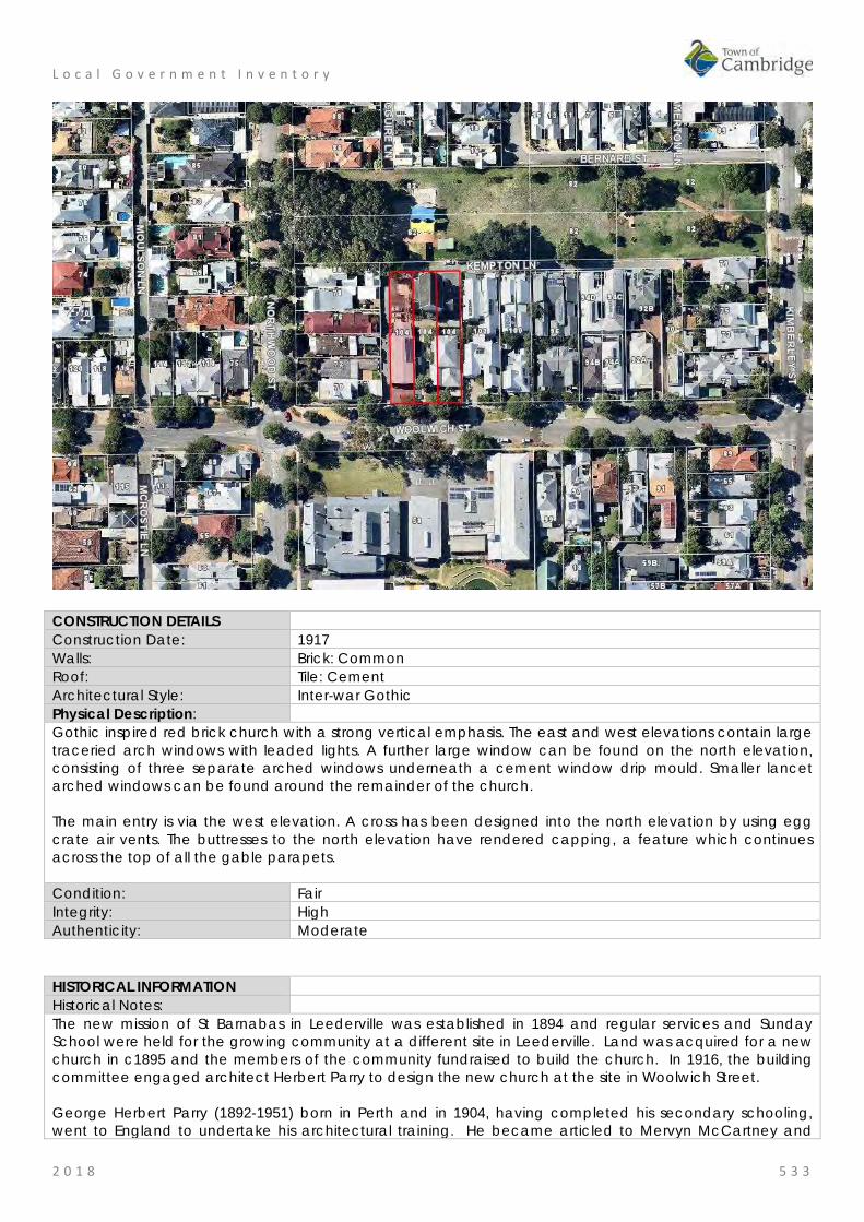
L o c a l G o v e r n m e n t I n v e n t o r y
2 0 1 8 5 3 3
CONSTRUCTION DETAILS Construction Date: 1917 Walls: Brick: Common Roof: Tile: Cement Architectural Style: Inter-war Gothic Physical Description: Gothic inspired red brick church with a strong vertical emphasis. The east and west elevations contain large traceried arch windows with leaded lights. A further large window can be found on the north elevation, consisting of three separate arched windows underneath a cement window drip mould. Smaller lancet arched windows can be found around the remainder of the church. The main entry is via the west elevation. A cross has been designed into the north elevation by using egg crate air vents. The buttresses to the north elevation have rendered capping, a feature which continues across the top of all the gable parapets. Condition: Fair Integrity: High Authenticity: Moderate
HISTORICAL INFORMATION Historical Notes: The new mission of St Barnabas in Leederville was established in 1894 and regular services and Sunday School were held for the growing community at a different site in Leederville. Land was acquired for a new church in c1895 and the members of the community fundraised to build the church. In 1916, the building committee engaged architect Herbert Parry to design the new church at the site in Woolwich Street. George Herbert Parry (1892-1951) born in Perth and in 1904, having completed his secondary schooling, went to England to undertake his architectural training. He became articled to Mervyn McCartney and

L o c a l G o v e r n m e n t I n v e n t o r y
2 0 1 8 5 3 4
also worked with Ernest Newton who, along with Norman Shaw, was regarded as a leader in British domestic architecture. In 1907, Herbert Parry returned to WA and joined the Public Works Department, but he soon moved into private practice. By 1911, Parry had established his own architectural business. Apart from a three-year partnership with Marshall Clifton, Parry practiced alone until partnered by his son, Mervyn, after the Second World War. Herbert Parry died in 1951. In addition to his domestic work, Parry was noted for his design of numerous churches including parts of St George’s Cathedral; he was also in demand as a designer of public buildings and suburban and country hotels. A foundation stone was laid on 24 February 1917 for this new church by Sir Edward Albert Stone KCMG, Australian lawyer, lieutenant governor, politician and the fourth Chief Justice of Western Australia. The ceremony was conducted by Archbishop Riley and attended by many dignitaries of the church and local government. In the coverage of the ceremony in the local press it was noted that 'the style of the church when completed will be Gothic, with a nave, western tower, side aisles, north and south transepts, choir and sanctuary. The accommodation of the finished church will be 500 or 600. For the present however only the transepts, choir and sanctuary are being built at a cost of £1600 and the accommodation will be 250'. The church was completed in June 1917 and consecrated by the Archbishop Riley on Sunday 17 June 1917. The funds for the church were raised through the efforts of the rector, vestry and parishioners of the Leederville parish. It does not appear that the full plans for the church were ever finalised. The church retains the timber façade to Woolwich Street with a brick elevation to Kempton Lane although there are side aisles and transepts. The location of the church to the rear of the lot suggests the plans were to build on to the elevation facing Woolwich Street Aerial photographs indicate that a hall was built on the western boundary of the lot in the 1960s and a residence on the eastern boundary in c1978. In 1999, the church was reroofed and a second storey was added to the residence. The hall and residence are not part of this assessment. Information for the Parish Council in 2018 states that there are some structural issues. Recently the ceiling was repaired and roof plumbing has been replaced where essential. Ongoing maintenance and repairs are being attended to by the Parish. Historic Theme: Social and civic activities: Religion
Demographic Settlement and Mobility: settlements Associations: Sir Edward Stone
Herbert Parry Sources: Aerial photographs, 1953-2016, Landgate.
Town of Cambridge Municipal Heritage Inventory and Townscape Precinct Study prepared for the Town of Cambridge, June 1997. Wise's Post Office Directories for the City of Perth, 1925-1949, State Library of WA www.slwa.wa.gov.au The Western Mail, 2 March 1917, p. 29. The Daily News, 16 June 1917, p. 3.
SIGNIFICANCE Statement of Significance: • The church has aesthetic value for its form and remaining detail of
the Federation Gothic Style executed in brick and timber. • The church has historic value for its association with the
establishment and development of the Leederville community in the early 20th century.
• The church has historic value for its association with the Anglican community which has been present at this site since 1917.
• The place has social value for the many members of the community who have attended religious or social events at this venue throughout the 20th and 21st century.
Level of Significance: Considerable

L o c a l G o v e r n m e n t I n v e n t o r y
2 0 1 8 5 3 5
Very important to the heritage of the locality. High degree of integrity/authenticity
Management Category: Category 2 Conservation of the place is highly desirable. Any alterations or extensions should reinforce the significance of the place Include on the Town Planning Scheme No 1 Heritage List.
ADDITIONAL PHOTOGRAPHS
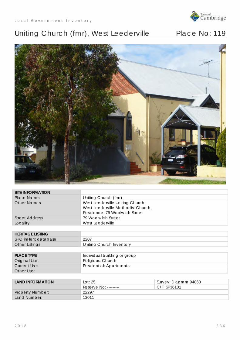
L o c a l G o v e r n m e n t I n v e n t o r y
2 0 1 8 5 3 6
Uniting Church (fmr), West Leederville Place No: 119
SITE INFORMATION Place Name: Uniting Church (fmr) Other Names: West Leederville Uniting Church,
West Leederville Methodist Church, Residence, 79 Woolwich Street
Street Address: 79 Woolwich Street Locality West Leederville HERITAGE LISTING SHO inHerit database 2207 Other Listings Uniting Church Inventory PLACE TYPE Individual building or group Original Use: Religious: Church Current Use: Residential: Apartments Other Use: LAND INFORMATION Lot: 25 Survey: Diagram 94868 Reserve No: --------- C/T: SP36131 Property Number: 22297 Land Number: 13011

L o c a l G o v e r n m e n t I n v e n t o r y
2 0 1 8 5 3 7
CONSTRUCTION DETAILS Construction Date: 1900; 1999 Walls: Wall: Rendered brick Roof: Metal: Zincalume Architectural Style: Federation Gothic Physical Description: A former church now converted into a residence. Although the place has been converted for residential use, the ecclesiastical character still prevails. The place is of brick construction, rendered to the main body of the building with face brick gables. The steeply pitched roof has been reclad in long sheet zincalume cladding. The arched openings around the house remain extant and now contain clear glazing. The porch entrance with arched timber board door also remains extant. Condition: Good Integrity: Low Authenticity: Moderate
HISTORICAL INFORMATION Historical Notes: Two foundation stones were laid for the former church on Thursday 13 December 1900. One by Mr W G Brookman Mayor of Perth and the other by Mrs Veryard the Mayoress of Leederville. At this ceremony Reverend Bird stated that it had been found necessary to build a church owing to the increase in membership of the denomination in Leederville. The trustees of the church had secured the excellent site overlooking the greater part of the suburb and were in the process of erecting the church of the dimensions 25ft x 35ft. The architect and builder of the church have not been determined in this research. The church was built in 1900 and opened on 24 January 1901 by the Rev Bird. The opening ceremony coincided with a memorial service for Queen Victoria on 22 January 1901. The Church provided the

L o c a l G o v e r n m e n t I n v e n t o r y
2 0 1 8 5 3 8
foundation of the former Methodist circuit that spread throughout the adjacent suburbs as far as Wembley Downs. Until the 1970's the church attracted large congregations and ran a Sunday School for up to 200 children. In 1977, three Australian churches came together, Presbyterian, Methodist and Congregational churches as the Uniting Church in Australia. In the following years there was rationalisation of the property held by the three separate organisations. In Leederville, it was resolved to dispose of this property due to the diminishing size of the congregation and the building was subsequently used for various community activities until the late 1990s. In c1997, a proposal to convert the church to an office and residence, and demolish the hall was considered by the Town of Cambridge and approved subject to conditions. In 1999, a strata plan was approved for the site and the property was developed for residential occupancy. The hall was demolished and two additional lots were created addressing Woolwich Street which have subsequently been developed with the addition of new two storey residences. The former church was divided into three separate premises with the most obvious external change the insertion of three gables on the western elevation and changing the roof cladding from asbestos to corrugated zincalume. Since the creation of the residences there has been minimal changes in the form of the former church. Historic Theme: Social and civic activities: Religion Associations: Loftus Walker Hewitt Architects Sources: Aerial photographs, 1953-2016, Landgate.
Town of Cambridge Municipal Heritage Inventory and Townscape Precinct Study prepared for the Town of Cambridge, June 1997. Wise's Post Office Directories for the City of Perth, 1925-1949, State Library of WA www.slwa.wa.gov.au The Inquirer and Commercial News, 14 December 1900, p. 9. Town of Cambridge, Council Minutes 27 May 1997, item DES97.103.
SIGNIFICANCE Statement of Significance: • Uniting Church (fmr) has aesthetic value for the remaining form and
detail of its original construction in 1901 in the Federation Gothic style.
• The place has aesthetic value as a landmark in the streetscape since 1901.
• The place has historic value for its association with the Methodist Church and later the Uniting Church in the developing residential areas of Perth throughout the 20th century.
• The place has social value for the members of the community who attended the place as the Methodist and Uniting Church throughout the 20th century for social or religious occasions.
Level of Significance: Little Contributes to the understanding of the history of the Town of Cambridge.
Management Category: Category 4 Photographically record prior to major development or demolition. Recognise and interpret the site if possible. Do not include on the Town Planning Scheme No 1 Heritage List.

L o c a l G o v e r n m e n t I n v e n t o r y
2 0 1 8 5 3 9
ADDITIONAL PHOTOGRAPHS

Heritage List – October 2018
1
Place Number Name Street
No Street name Locality Physical Description Statement of Significance Recommended Management Category
16 Holy Spirit Catholic Church
2 Keaney Place
City Beach The Holy Spirit Memorial Church is one element of the Holy Spirit complex which also includes the Administration Centre, Presbytery and Primary School. The Church is the major feature of the site and is a landmark in a range of views across City Beach.
The church is of buff brick construction with a prominent curved aesthetic. The church has a blank curved elevation to Keaney Place with an increasingly enlivened elevation as it curves around the driveway. The entrance is located to the southern aspect of the building with stepped entrance to double aluminium doors and a small canopy supported on broad circular brick column. The church continues to curve around with brick elevations and highlight aluminium framed openings until it reaches the blank brick elevation facing the street. The feature aspect of the building is the sloping visible roof form culminating in a fanned window, parapet wall and feature cross. This aspect of the church can be seen in long views across City Beach.
The church is a landmark feature, bearing a resemblance to a shell and is dedicated to those who have served in the various conflicts in which Australia has been involved.
The following statement is taken from the State Register Entry for the place. Holy Spirit Catholic Church, City Beach, comprising a Late Twentieth Century Organic style brick church (1973-74), including original fittings and furnishings of high design quality, grotto (1994-95), and ancillary structures has cultural heritage significance for the following reasons: • the place is a striking landmark constructed to a unique sculptural design,
with its dramatic external form, high quality interior spaces, and finelydesigned sanctuary fittings and furnishings;
• the place is a good example of a church designed to facilitate liturgicaland theological changes in the Catholic church following the SecondVatican Council, with its open interior layout, clear site lines, placement ofaltar and baptistery, and lack of barriers to the sanctuary area;
• the place is a very fine representative example of Late Twentieth CenturyOrganic style architecture, featuring sweeping curved brick walls and anoverall irregular curved floor plan;
• the place demonstrates technical proficiency in its use of steel reinforcedcurved brickwork, and the finished building receiving the 1975 Clay BrickAward; and
• the place was designed by the prominent 1950s-1980s Western Australianarchitectural firm Forbes & Fitzhardinge, who were leading exponents ofcontemporary late twentieth century architecture.
The Presbytery (1964) and Parish Centre (2006) are of little significance. The Grotto (1994-95) is of some significance.
Category 1
21 Quarry Amphitheatre
145 Oceanic Drive
City Beach Quarry Amphitheatre sits on northern slopes of Bold Park, accessed via Waldron Drive or Scenic Drive. The place consists of a former limestone quarry that has been adapted to form a theatre space, consisting of an Entrance, Auditorium, Stage, Backstage and rear area, set between two limestone faces.
The Auditorium consists of a number of grassed tiers orientated in a southerly direction looking back towards the stage. The tiers are edged with concrete pavers and are divided into two sections by a central paved aisle.
The Stage is a rectangular timber floor set on a steel frame with timber deck. The Backstage area is located below the stage
The following statement is taken from the State Register Entry for the place. Quarry Amphitheatre, City Beach comprising a 556 seat open air Amphitheatre located high upon Reabold Hill in City Beach with panoramic views of Bold Park towards the City, within a former limestone quarry, in a natural bushland setting, has cultural heritage significance for the following reasons: • the place is unique in Western Australia as a former limestone quarry that
has been adapted for re-use as an amphitheatre;
• the place is rare as an extant inner Perth metropolitan quarry associatedwith the development of the limestone quarrying industry in the latenineteenth century;
• the stone from the quarry was used in some of Perth's early buildingsincluding the foundations of Perth Town Hall;
• the place is significant for its associations with prominent settlers WalterPadbury and Henry Trigg, who were significant figures in the earlydevelopment of Western Australia;
• the place has aesthetic value for its bushland setting and unobstructedviews of the city;
• the place has social significance to the local and wider communityhaving been a venue for concerts, ballet and other cultural events since1986;
• and the place is associated with Diana Waldron, founder of Perth CityBallet, who with her husband architect, Ken Waldron, was responsible forthe inception, fundraising and construction of the Quarry.
The administration building, toilets, kiosk and storage sheds and access areas north of the stage are of little significance.
Category 1
46 Model Timber 12 The Floreat Model Timber Home located at 12 The Boulevard Floreat, comprises a single storey, The following statement is taken from the State Register Entry for the place. Category 1
DV18.170 - ATTACHMENT 2 OF 5 - HERITAGE LIST REVISED
Heritage List – October 2018
2
Place Number Name Street
No Street name Locality Physical Description Statement of Significance Recommended Management Category
Home Boulevard painted Jarrah weatherboard and tile residence. The front elevation of the house is set back from the front boundary and located towards the eastern side of the lot with a pathway down the western side of the house. The front and side boundaries are defined by a low non-original picket fence.
The front garden features many original plants including a tall poplar tree on the eastern side of the house, rose beds and borders of various flowering shrubs typical of gardens from the inter-war period. Fixed to the side of the house is the foundation stone laid by the Hon. J. J. Kenneally MLA, Minister for Employment and Industries, on 5 November 1933, on behalf of the Model Homes Committee.
The house comprises the original section constructed in 1933 and a modest addition at the rear constructed in 1977. External walls are of painted Jarrah weatherboard on brick footings.
The roof is moderately pitched and hipped with a feature gable over the front verandah. The roof is clad with terracotta tiles and the gable features vertically hung timber shingles which have been retained unpainted and stained, with a circular roof vent which is painted white. The eaves are wide and generally lined, apart from the eaves of the front gable which are battened. There are two chimneys, which are rendered and painted brick with a simple ridge detail to the tops with terracotta pots.
The front verandah ring beam is supported on a series of circular tapered columns designed to give a classical effect, with a timber balustrade featuring vertical balusters and a central feature panel with a criss-cross design.
Windows are timber framed double hung casements with timber framed fly screens fixed externally. The sashes are divided into small panes with leadlight and have obscure glass borders. Windows to the front elevation have ornamental shutters with diamond shaped cut-outs and window boxes.
The front door is timber with three vertical panels to the lower section and one glazed leadlight panel of obscure uncoloured glass. The door has matching side panels with sidelights. A steel mesh security screen is not original.
The gardens are in good condition with original features, trees and plants.
Model Timber Home, a single-storey Jarrah weatherboard and tile residence in the Inter-War Californian Bungalow style set in original landscaped gardens and built as a model home in 1934, has cultural heritage significance for the following reasons: • the place was one of two winning designs in the competition run by the
Model Homes Committee as part of the Building Revival Campaign, an initiative to promote and stimulate employment in the home building industry during the economic depression of the 1930s;
• the place is a significant example of the work of architect Reg Summerhayes who was a prominent member of the architectural profession in Western Australia during the inter-war period;
• the place is a rare example of a home which has remained substantially unchanged with original fittings, furnishings and garden layout since its construction in 1934;
• the place was one of the first two homes built in the Floreat Park No 1 Estate, which was planned as a Garden Suburb by the City of Perth under the influence of Town Clerk WE Bold who promoted the principles of the Garden City Movement in Western Australia in the 1920s and 30s; and,
• the place has associations with J J Kenneally, Minister for Employment, who laid the foundation stone and who subsequently opened the house.
48 Model Brick Home
6 The Boulevard
Floreat Model Brick Home located at 6 The Boulevard Floreat, comprises a single storey, rendered brick and tile residence which, together with the Model Timber Home located at 12 The Boulevard Floreat, was one of the first two homes constructed in Floreat Park No 1 Estate, a residential subdivision designed on the principles of a Garden Suburb.
Model Brick Home is located on The Boulevard, one of the major roads in Floreat. Adjacent homes are of similar age, proportions and style, and apart from Model Timber Home, are brick or rendered brick and tile. All houses are of approximately equal setback with landscaped front gardens and an avenue of mature street trees.
At the rear of the property, a gate from the back garden opens onto a laneway which accesses an area of public open space. This area, which has no street frontage, is landscaped with trees and shrubs and provides an additional recreational area for the houses which back onto it. Two grassed laneways access Selby Street.
Model Brick Home is sited on a rectangular residential lot. The front elevation of the house is set back approximately 7.5m from the front boundary and located towards the eastern side of the lot, with an
driveway down the western side of the house to the garage at the rear. There is a curved entrance driveway at the front of the house on the western side. The front garden area on the eastern side features a concrete slab retaining wall which separates the driveway from the garden.
The following statement is taken from the State Register Entry for the place. Model Brick Home, a single-storey brick and tile residence in a simplified version of the Inter-War Old English style set in landscaped gardens and built as a model home in 1934, has cultural heritage significance for the following reasons: • the place was one of two winning designs in the competition run by the
Model Homes Committee as part of the Building Revival Campaign, an initiative to promote and stimulate employment in the home building industry during the economic depression of the 1930s;
• designed by architect Howard Bonner, the place is a fine example of an architect designed home from the inter-war period, exhibiting the influence of a simplified form of the Inter-War Old English architectural style characterised by the dominant steeply pitched gabled roof and distinctive curved line of the front elevation; and
• the place was one of the first two homes built in the Floreat Park No. 1 Estate, which was planned as a Garden Suburb by the City of Perth under the influence of Town Clerk, W. E. Bold, who promoted the principles of the Garden City Movement in Western Australia in the 1920s and 30s.
Category 1

Heritage List – October 2018
3
Place Number Name Street
No Street name Locality Physical Description Statement of Significance Recommended Management Category
The house comprises the original section constructed in 1933 and additions constructed in 1995. The extension has been designed to complement the original in terms of roof pitch, materials and finish and is not visible from the street. External fabric of Model Brick Home features painted rendered masonry walls on limestone footings. The roof is steeply pitched (approximately 45º) and gabled with a prominent gabled wall to the front elevation with a rectangular timber vent at the apex. This wall extends in a prominent curve beyond the edge of the house to the eastern site boundary. There is a rendered banded detail to the top edge of the curved wall. An arched opening in the eastern side of the front elevation provides access to the side of the house through a timber garden gate. The roof is clad with terracotta tiles. Square profile gutters and downpipes are not original and the original chimney has been removed.
There is an open terrace with low walls at the front of the house accessed by five front steps. The terrace and steps are clad with slate which is not original. Two timber pergolas which have been constructed over the front verandah are not original. The original foundation stone is extant on the front wall of the house.
Original windows are timber framed six paned casements with timber mullions. The front door is timber with an elaborate diamond panel in the centre and original brass door handle. The French doors to the front terrace have aluminium frames and are not original.
The same roof line and wall details have been continued for the 1995 extension. There have been no significant alterations to the place since the 1995 additions.
54 Catherine McAuley Centre
18 Barrett Street
Wembley The Catherine McCauley Centre is an elevated site in Wembley containing aged care facilities, children’s welfare facilities and disability services. The site contains a mix of purpose built accommodation and facilities as well as the historic buildings that formed part of the early occupation of the site.
Together with the more contemporary developments on the site, the Catherine McCauley forms a precinct of structures and landscape elements developed by the Sisters of Mercy for religious and social welfare purposes. The main vehicular access to the services part of the site is from Barrett Street with additional access to the residential component from Ruislip Street. The site is a mix of buildings, hard landscaping/parking and soft landscaping with trees, other plantings and lawned areas.
The historic elements of the site comprise:
• Former Benedictine stables • Olive Trees • Remnants of Cemetery • Old School building • St Roch’s • Former Laundry building • St Vincent’s Foundling Home (fmr) • Kindergarten building • Nursery building St Gerard’s Hospital
The following statement is taken from the State Register Entry for the place. Catherine McAuley Centre, comprising Benedictine Stables (fmr) (c. 1858, 1890s, 1990s); Olive Trees (c.1858); Cemetery (1891-1913); Old School(1893); St Rochs (c.1900); former Laundry (c.1910); St Vincent’s Foundling Home (fmr) which includes the Foundling Home (1914, 1918, 1950s, 1994), Kindergarten (1925, 1971, 1994) and Nursery (1928, 1970, 1994); and, St Gerard’s Hospital (fmr) (1938), has cultural heritage significance for the following reasons: • The Benedictine Stables (fmr) has rarity value as it is one of few agrarian
buildings dating from the 1850s still in existence in the metropolitan area and is the only remaining structure from the early Benedictine occupation of the site;
• the various elements illustrate the evolution of the site from an agrarian beginning, with stables and olive groves, to a facility dealing with the needs of urban family life, and reflect the rapid development and changing social environment of Perth and Western Australia, since the 1850s;
• the place contributes to the aesthetic qualities of the landscape particularly through the Old School, which has landmark value when approached from the south entrance of the site and provides a focus for the historic group of buildings at the place. St Vincent’s Foundling Home (fmr) contains decorative timber work, terracotta finials and brick work with render banding;
• the various elements of the place contribute to the community’s sense of place;
• the Benedictine Stables (fmr) and Olive Trees are evidence of the Catholic Benedictine Order who occupied the site from 1852 to 1864, and also with Bishop Serra, under whose authority the site was developed. The Old School is a reminder of the ongoing religious associations of the site;
• St Vincent’s Foundling Home (fmr) and Old Chapel are evidence of the
Category 1
Heritage List – October 2018
4
Place Number Name Street
No Street name Locality Physical Description Statement of Significance Recommended Management Category
work of the Sisters of Mercy, and the services to children in need which they have provided on the site since 1876;
• the Benedictine Stables (fmr) and Olive Trees are a reminder of the olive oil industry conducted by the Sisters of Mercy, and which helped provide funds for the ongoing operation of the orphanage and foundling home. The olive oil manufactured at St Joseph’s Orphanage won first prize at several Royal Perth shows;
• the place is illustrative of the institutional approach to the care and training of children which prevailed in the late 19th century and into the first six decades of the 20th century; and,
• when opened in 1925, the Kindergarten was one of the first to use the Montessori teaching method and aspects of design in Western Australia. The nursery still displays the ventilated and mosquito proofed verandah, which was considered modern at the time of construction.
55 St Vincent's Foundling Home (fmr)
18 Barrett Street
Wembley The Foundling Home is a predominantly single- storey red brick building with a clay tiled roof. The complex roof over the U-shaped plan form comprises a mix of hipped and gabled forms and feature gablets. Terracotta finials, including a central cross, have been placed at some of the apices and face brick chimneys that widen at the top, punctuate the roof forms. The roof pitch is lower over the verandah around the outer edge of the building. The Foundling Home is representative of the Federation Queen Anne style displaying some complexity in the decorative elements of the roof and timberwork.
A verandah wraps around the south (front) elevation of the building but has been enclosed at the southeast corner and along the east elevation. The concrete verandah floor is approximately at ground level adjacent to the car park along the western edge but the fall in the site reveals a base of coursed, squared rubble limestone beneath floor level on the east side of the building.
The principal entrance to the place is located centrally in the south elevation and is defined by gables in the verandah roof and main roof form above. Both these gables exhibit a half-timber effect in the infill. In addition, a plaque reading ‘St Vincent’s Foundling Home’ is evident beneath the main gable. The verandah timberwork is moderately elaborate with curved brackets and carved panels fixed to the square timber posts supporting the roof. The close spacing of the exposed rafter ends, apparent beneath the ogee profile gutter, establishes a frieze which with the contrasting colours of the paintwork accentuates the decorative effect. A metal balustrade spanning between the posts has been introduced. The square panels of the valance, between the grouped posts at the corners, appear to have a carved timber ‘S’ imposed over a hollow ‘M’. This refers to SIHS (Greek meaning Jesus Christ Son of God & Saviour) and HIS (Latin meaning Jesus saviour of men).
Walls of the building have been constructed in red, colonial bond face brickwork with a contrasting cream mortar. Bands of cream render are evident at windowsill and head height and also in the outer gablets in the roof above. Vertical strips in the brickwork of these gablet infills allow ventilation to the roof space. The infill of the west gable is supported on a frieze of brick corbels. Other brickwork bonds are apparent around the building providing evidence of different periods of construction.
A Foundation Plaque laid on 10 September 1914 identifying the architect and contractor is located on the south face of the extruding west gable of the building.
Windows and doors are principally of timber construction. Many of the openings exhibit an unusual form of ‘Lifting Window’ with sliding glazed upper sashes and a three panelled timber sash below.
The following statement is taken from the State Register Entry for the place. Catherine McAuley Centre, comprising Benedictine Stables (fmr) (c. 1858, 1890s, 1990s); Olive Trees (c.1858); Cemetery (1891-1913); Old School(1893); St Rochs (c.1900); former Laundry (c.1910); St Vincent’s Foundling Home (fmr) which includes the Foundling Home (1914, 1918, 1950s, 1994), Kindergarten (1925, 1971, 1994) and Nursery (1928, 1970, 1994); and, St Gerard’s Hospital (fmr) (1938), has cultural heritage significance for the following reasons: • The Benedictine Stables (fmr) has rarity value as it is one of few agrarian
buildings dating from the 1850s still in existence in the metropolitan area and is the only remaining structure from the early Benedictine occupation of the site;
• the various elements illustrate the evolution of the site from an agrarian beginning, with stables and olive groves, to a facility dealing with the needs of urban family life, and reflect the rapid development and changing social environment of Perth and Western Australia, since the 1850s;
• the place contributes to the aesthetic qualities of the landscape particularly through the Old School, which has landmark value when approached from the south entrance of the site and provides a focus for the historic group of buildings at the place. St Vincent’s Foundling Home (fmr) contains decorative timber work, terracotta finials and brick work with render banding;
• the various elements of the place contribute to the community’s sense of place;
• the Benedictine Stables (fmr) and Olive Trees are evidence of the Catholic Benedictine Order who occupied the site from 1852 to 1864, and also with Bishop Serra, under whose authority the site was developed. The Old School is a reminder of the ongoing religious associations of the site;
• St Vincent’s Foundling Home (fmr) and Old Chapel are evidence of the work of the Sisters of Mercy, and the services to children in need which they have provided on the site since 1876;
• the Benedictine Stables (fmr) and Olive Trees are a reminder of the olive oil industry conducted by the Sisters of Mercy, and which helped provide funds for the ongoing operation of the orphanage and foundling home. The olive oil manufactured at St Joseph’s Orphanage won first prize at several Royal Perth shows;
Category 1

Heritage List – October 2018
5
Place Number Name Street
No Street name Locality Physical Description Statement of Significance Recommended Management Category
Large windows prominent in the south and west elevations are composed of narrow panes in timber frames between masonry mullions and exhibit rendered quoining.
Sliding aluminium windows are located in the area where the verandah has been enclosed.
• the place is illustrative of the institutional approach to the care and training of children which prevailed in the late 19th century and into the first six decades of the 20th century; and,
• when opened in 1925, the Kindergarten was one of the first to use the Montessori teaching method and aspects of design in Western Australia. The nursery still displays the ventilated and mosquito proofed verandah, which was considered modern at the time of construction.
56 Olive Trees, Barrett Street
18 Barrett Street
Wembley The mature olive trees on the site are in good condition and located near the entrance to the administration building and on the eastern side of the property.
The following statement is taken from the State Register Entry for the place. Catherine McAuley Centre, comprising Benedictine Stables (fmr) (c. 1858, 1890s, 1990s); Olive Trees (c.1858); Cemetery (1891-1913); Old School(1893); St Rochs (c.1900); former Laundry (c.1910); St Vincent’s Foundling Home (fmr) which includes the Foundling Home (1914, 1918, 1950s, 1994), Kindergarten (1925, 1971, 1994) and Nursery (1928, 1970, 1994); and, St Gerard’s Hospital (fmr) (1938), has cultural heritage significance for the following reasons: • The Benedictine Stables (fmr) has rarity value as it is one of few agrarian
buildings dating from the 1850s still in existence in the metropolitan area and is the only remaining structure from the early Benedictine occupation of the site;
• the various elements illustrate the evolution of the site from an agrarian beginning, with stables and olive groves, to a facility dealing with the needs of urban family life, and reflect the rapid development and changing social environment of Perth and Western Australia, since the 1850s;
• the place contributes to the aesthetic qualities of the landscape particularly through the Old School, which has landmark value when approached from the south entrance of the site and provides a focus for the historic group of buildings at the place. St Vincent’s Foundling Home (fmr) contains decorative timber work, terracotta finials and brick work with render banding;
• the various elements of the place contribute to the community’s sense of place;
• the Benedictine Stables (fmr) and Olive Trees are evidence of the Catholic Benedictine Order who occupied the site from 1852 to 1864, and also with Bishop Serra, under whose authority the site was developed. The Old School is a reminder of the ongoing religious associations of the site;
• St Vincent’s Foundling Home (fmr) and Old Chapel are evidence of the work of the Sisters of Mercy, and the services to children in need which they have provided on the site since 1876;
• the Benedictine Stables (fmr) and Olive Trees are a reminder of the olive oil industry conducted by the Sisters of Mercy, and which helped provide funds for the ongoing operation of the orphanage and foundling home. The olive oil manufactured at St Joseph’s Orphanage won first prize at several Royal Perth shows;
• the place is illustrative of the institutional approach to the care and training of children which prevailed in the late 19th century and into the first six decades of the 20th century; and,
• when opened in 1925, the Kindergarten was one of the first to use the Montessori teaching method and aspects of design in Western Australia. The nursery still displays the ventilated and mosquito proofed verandah, which was considered modern at the time of construction.
Category 1

Heritage List – October 2018
6
Place Number Name Street
No Street name Locality Physical Description Statement of Significance Recommended Management Category
57 Benedictine Stables (fmr)
18 Barrett Street
Wembley Single storey stone range with brick chimney and gabled roof clad in short sheet corrugated iron. The stonework has previously been lime washed which is now wearing off in places. The building has undergone previous works but is showing further signs of wear with a rusted roof.
The south elevation is mainly blank stone apart from two small timber framed openings positioned directly under the eaves. The brick and stone chimney is positioned at the eastern end of the range and stands proud of the east wall.
The north elevation is the most activated of the walls incorporating three doors (two single door and a central double door) and two timber framed windows. Bitumen has been laid to the north elevation whilst the south sits on a stone retaining wall.
The following statement is taken from the State Register Entry for the place. Catherine McAuley Centre, comprising Benedictine Stables (fmr) (c. 1858, 1890s, 1990s); Olive Trees (c.1858); Cemetery (1891-1913); Old School(1893); St Rochs (c.1900); former Laundry (c.1910); St Vincent’s Foundling Home (fmr) which includes the Foundling Home (1914, 1918, 1950s, 1994), Kindergarten (1925, 1971, 1994) and Nursery (1928, 1970, 1994); and, St Gerard’s Hospital (fmr) (1938), has cultural heritage significance for the following reasons: • The Benedictine Stables (fmr) has rarity value as it is one of few agrarian
buildings dating from the 1850s still in existence in the metropolitan area and is the only remaining structure from the early Benedictine occupation of the site;
• the various elements illustrate the evolution of the site from an agrarian beginning, with stables and olive groves, to a facility dealing with the needs of urban family life, and reflect the rapid development and changing social environment of Perth and Western Australia, since the 1850s;
• the place contributes to the aesthetic qualities of the landscape particularly through the Old School, which has landmark value when approached from the south entrance of the site and provides a focus for the historic group of buildings at the place. St Vincent’s Foundling Home (fmr) contains decorative timber work, terracotta finials and brick work with render banding;
• the various elements of the place contribute to the community’s sense of place;
• the Benedictine Stables (fmr) and Olive Trees are evidence of the Catholic Benedictine Order who occupied the site from 1852 to 1864, and also with Bishop Serra, under whose authority the site was developed. The Old School is a reminder of the ongoing religious associations of the site;
• St Vincent’s Foundling Home (fmr) and Old Chapel are evidence of the work of the Sisters of Mercy, and the services to children in need which they have provided on the site since 1876;
• the Benedictine Stables (fmr) and Olive Trees are a reminder of the olive oil industry conducted by the Sisters of Mercy, and which helped provide funds for the ongoing operation of the orphanage and foundling home. The olive oil manufactured at St Joseph’s Orphanage won first prize at several Royal Perth shows;
• the place is illustrative of the institutional approach to the care and training of children which prevailed in the late 19th century and into the first six decades of the 20th century; and,
• when opened in 1925, the Kindergarten was one of the first to use the Montessori teaching method and aspects of design in Western Australia. The nursery still displays the ventilated and mosquito proofed verandah, which was considered modern at the time of construction.
Category 1
82 Lake Monger
(including Lake Monger Recreation Club and Wembley Bowling Club)
Lake Monger Drive
Wembley Lake Monger is a large urban wetland located to the north of West Leederville and bordered by Lake Monger Drive to the south and the Mitchell Freeway to the north east side of the lake. The Reserve totals 70 hectares which is predominantly occupied by the lake. Additional facilities include a walk trail around the lake, sporting facilities, visitor facilities and children’s play area.
The lake is surrounded by flora and fauna, with a walk through the conservation area with boardwalks and lookouts across the lake. The south foreshore and the west side of the lake provide a grassy contrast to the lake and dense plantings along the north
• The place has aesthetic value as a large, well maintained landscape in the metropolitan area which is a landmark in the district.
• The place has historic and social value for the Whadjuk Noongar peoples who used the place for food, shelter and spiritual reasons.
• The place has historic value for its association with the early settlement of the district in the 1830s and particularly with the Monger family who leased this lake and its surrounds and provided the origin for the name.
Category 1

Heritage List – October 2018
7
Place Number Name Street
No Street name Locality Physical Description Statement of Significance Recommended Management Category
eastern side of the lake.
The buildings within the grounds are representative of the post war period and the continued use of the place for recreation purposes.
• The place has historic value for its association with market gardens which operated close to the city of Perth in the 19th and 20th century.
• The place has historic value for its association with sports and recreation on the lake from the 19th century.
• The place has ongoing social value for the members of the community who have enjoyed the lake and its surrounds for passive recreation for many decades.
94 Leederville War Memorial and Rose Garden
78-80 Cambridge Street
West Leederville
The War Memorial garden is located to the east of the town hall, creating a soft landscaped setting to the town hall buildings.
The garden consists of the War Memorial constructed of rock faced granite, concrete plinth and carved stone lions; the rose garden; pergola and other plantings. The Memorial is set back from the road but can be clearly seen in its open setting.
The following statement is taken from the State Register Entry for the place. Leederville Town Hall & Recreation Complex, a pair of single storey classically planned face brickwork, stucco walls and Colorbond custom orb roof buildings in the Federation Free Classical style, together with a roughhewn granite obelisk memorial with sculpted marble lions, memorial rose garden, bowling greens, and mature trees and setting, has cultural heritage significance for the following reasons: • the place is a fine example of two successive buildings designed in the
Federation Free Classical Style architecture;
• the bowling greens, established in 1906, are one of the oldest bowling greens in Western Australia still operating on their original site;
• the place was designed by A. E. Clarke, a prominent architect in Victoria and Western Australia, and built by well-known local builder, W. H. Roberts;
• the place has social value to the community of the immediate district of West Leederville, and the wider community, through its continuous use since 1904;
• the place is a civic landmark in the largely residential environment of West Leederville, and the palms flanking the monument are a distinctive element in the vicinity;
• the Leederville War Memorial was designed by Pietro Porcelli, the first local sculptor in Western Australia to be noted for public artwork; and,
• the place is representative of the development and rapid growth of Leederville in the pre-World War One period; and marks a phase in the establishment of municipal buildings in the suburb.
The bowling clubrooms, the 1955 addition to the rear of the bowling clubrooms, the 1955 addition to the rear of the hall, and the landscape treatments immediately around the west, north and east sides of the hall are of little significance. The hard landscaped area in front of the hall is intrusive.
Category 1
95 Leederville Town Hall & Recreation Complex
78, 80, 82, 84, 86
Cambridge Street
West Leederville
The Leederville Town Hall comprises two buildings, both of which are in the Federation Free Classical architectural style. The two buildings are of brick construction finished with tuckpointing to the facades and face brick to the side elevations. Both facades are enlivened by rendered elements, painted in bright white, including pilasters, fascias, pediments, window sills and decorative motifs. Both buildings are of similar design, each incorporating a central entrance flanked by windows. For the main hall, the entry consists of double timber doors with segmented arch fanlight, flanked by rendered pillars and has the word ‘HALL’ above the entry. The entry to the second hall, which is set back behind the main building, is of similar design albeit the actual entrance doors are to the rear of the covered entry which is secured by metal gates, this entrance is not as ornate as the main entrance but the similarity of design can be seen in the two. Windows are timber framed sashes to both buildings.
Brick additions have been added to both buildings but these cannot be seen in the
The following statement is taken from the State Register Entry for the place. Leederville Town Hall & Recreation Complex, a pair of single storey classically planned face brickwork, stucco walls and Colorbond custom orb roof buildings in the Federation Free Classical style, together with a roughhewn granite obelisk memorial with sculpted marble lions, memorial rose garden, bowling greens, and mature trees and setting, has cultural heritage significance for the following reasons: • the place is a fine example of two successive buildings designed in the
Federation Free Classical Style architecture;
• the bowling greens, established in 1906, are one of the oldest bowling greens in Western Australia still operating on their original site;
• the place was designed by A. E. Clarke, a prominent architect in Victoria and Western Australia, and built by well-known local builder, W. H.
Category 1

Heritage List – October 2018
8
Place Number Name Street
No Street name Locality Physical Description Statement of Significance Recommended Management Category
street view.
The roofs to the halls are both hipped with gablets to the street elevation, both obscured from clear view at street level due to the parapet walls across the facades. The roofs are clad in a green/grey Colorbond.
Leederville Town Hall is located within a park setting with Holyrood Park to the west, the Memorial Garden to the east and the bowling club to the north.
The bowling club is located to the rear of the War Memorial Gardens. The clubhouse is an unassuming single storey structure of pale brick construction with colorbond roof. The building footprint has not been enlarged since it was originally constructed in the early 1960s with the only visible alterations from the street frontage being the recladding of the roof and the addition of the ramped access.
The façade has two distinct characters: to the east of the main entrance, the windows are placed in a regular rhythm with five openings between the door and the end of the building. Each window consists of a large fixed pane window with three highlight windows above. To the west of the main entrance, the façade consists of an irregular placement of windows and doors of differing styles and dimensions. The characters reflect the different uses of the internal spaces. The name “LEEDERVILLE SPORTING CLUB” has been placed above the eastern windows of the façade.
The bowling greens are laid out to the side and rear of the building.
Roberts;
• the place has social value to the community of the immediate district of West Leederville, and the wider community, through its continuous use since 1904;
• the place is a civic landmark in the largely residential environment of West Leederville, and the palms flanking the monument are a distinctive element in the vicinity;
• the Leederville War Memorial was designed by Pietro Porcelli, the first local sculptor in Western Australia to be noted for public artwork; and,
• the place is representative of the development and rapid growth of Leederville in the pre-World War One period; and marks a phase in the establishment of municipal buildings in the suburb.
The bowling clubrooms, the 1955 addition to the rear of the bowling clubrooms, the 1955 addition to the rear of the hall, and the landscape treatments immediately around the west, north and east sides of the hall are of little significance. The hard landscaped area in front of the hall is intrusive.
110 West Leederville Primary School
58 Northwood Street
West Leederville
Although the school has increased, the original sections of the building which faces both Northwood Street and Woolwich Street remains in a largely authentic manner and has been little altered externally.
The place is of brick construction with a rendered band detail extending around the buildings at sill level and at plinth level.
The windows are largely timber framed sash windows with timber and iron awnings. Both the roofs and the window awnings have been reclad. The roofs are mid-pitch gables with fibro cladding to the apex of the gable and battened eaves. The roofs are enlivened by tall brick corbelled chimneys.
The two ranges to Northwood Street and Woolwich Street both incorporate covered entrances with gabled canopies supported on timber posts, timbered gable detail and the school logo.
Further sections of the original school cannot be seen from the road albeit the timbered elements of the gables stand above the ridge line of the front ranges.
The following statement is taken from the State Register Entry for the place. West Leederville Primary School, a brick and iron primary school in the Federation Arts and Crafts style, together with a collection of buildings comprising shelter sheds, pavilion classroom, pre-primary, toilet block, covered area, transportable classroom, kindergarten, covered sand pit, and gardener's store, in an open bitumen paved and grassed setting, has cultural heritage significance for the following reasons: • the place is a fine example of a Federation Arts and Crafts style school
building, with a very fine school hall and well-crafted construction, in a pleasant and leafy landscaped setting;
• the place illustrates the use and flexibility of standard Public Works Department designs for schools as practised in Western Australia in the late nineteenth and early twentieth centuries, along with the subsequent adaptations to those designs through the twentieth century as educational practices evolved;
• the place makes a positive contribution to its suburban context of mostly Federation period houses and commercial buildings, which extends through a large area of West Leederville;
• the place reflects rapid growth in the gold boom period and early twentieth century, and, in the post World War Two period, the influx of migrants from a wide range of ethnic backgrounds;
• the main building derives from a standard design, introduced under George Temple Poole as Assistant-Engineer-in Chief (1892-1896) of the Public Works Department when standard planning was developed as a means of managing rapid expansion and producing efficiency;
• the pavilion classroom (1915) is rare as an example of its type and for the fact that it is retained on its original site, with few later changes; and,
• the timber construction shelter sheds (1908) are the only surviving buildings on site that were constructed in the early 1900s.
The brick construction toilet block, bricks tore, and kindergarten, covered
Category 1

Heritage List – October 2018
9
Place Number Name Street
No Street name Locality Physical Description Statement of Significance Recommended Management Category
sandpit and gardener's store have little cultural heritage significance
115 Chapel of St Michael the Archangel
50 Ruislip Street West Leederville
The church is one of an impressive precinct of striking buildings set within a landscaped setting in the heart of residential West Leederville. The buildings are set atop a grassy bank, with views up a central driveway from McCourt Street towards the building. The church is located on the eastern side of the land parcel and is linked to the main building (former convent and now administration centre) by a colonnaded walkway.
The church was constructed in the inter-war era and expresses gothic design influences including the tall lancet windows, the verticality of the building and the buttresses with pinnacles. The church is of similar stonework as the main building and laid in a distinctive bond. The lancet windows contain stained leaded glazing with the main windows positioned above the doorways to the south and west elevations.
The east elevation takes on a different character than the principal façade and consists of three faceted towers, reminiscent of European castle architecture. The roof is shallow pitched to the main roof, clad with terracotta tiles. The north face of the church presents with ashlar stonework creating a contrasting smooth aesthetic to the other elevations. The details remain the same with a regular rhythm of buttresses and windows to both elevations.
No internal inspection of the chapel was undertaken at the time of assessment.
• The chapel has aesthetic value as an intact and well detailed example of the Inter War Gothic style executed in stone, brick and tile.
• The chapel has historic value for its association with the provision of services by the Sisters of the Good Shepherd from 1904 to 1979.
• The chapel has historic value for its association with the prominent ecclesiastical architect, Edgar le Blond Henderson and his partner Alan Gamble.
• The chapel has social value for the members of the community who attended the place from 1938 to 1979 when it was an adjunct to the Home of the Good Shepherd institutions for women and girls.
• The chapel has social value for the immediate and widespread community for its use as a wedding venue in recent decades.
Category 1
116 Ruislip Street Catholic Precinct
50 Ruislip Street West Leederville
Impressive precinct of striking buildings set within a landscaped setting in the heart of residential West Leederville. The buildings are set atop a grassy bank, with views up a central driveway from McCourt Street towards the building.
The main building is a three storey Federation Romanesque limestone structure of symmetrical plan form with a central entrance, flanking wings, colonnaded verandah and balcony across the entire façade. The third storey accommodation is within the roof space with a regular rhythm of dormer windows across the roofscape. The roof is a combination of gables and hips clad in terracotta tiles and further enlivened by a series of tall chimneys with rendered bands, caps and flues. The colonnades to the verandah and balcony are identical, each section containing six arched openings. The verandah is open to the stone deck whilst the balcony has a stone balustrade. The flanking wings both contain faceted bays to the ground floor and a window ensemble contained within an arched opening to the upper level. The side and rear (north) elevations are of brick construction. The addition to the west of the main building was constructed in the 1960s and is not of significance.
The church was constructed in the inter-war era and expresses gothic design influences including the tall lancet windows, the verticality of the building and the buttresses with pinnacles. The church is of similar stonework as the main building and laid in a distinctive bond. The lancet windows contain stained leaded glazing with the main windows positioned above the doorways to the south and west elevations. The east elevation takes on a different character than the principal façade and consists of three faceted towers, reminiscent of European castle architecture. The roof is shallow pitched to the main roof, clad with terracotta tiles. The north face of the church presents with ashlar stonework creating a contrasting smooth aesthetic to the other elevations. The details remain the same with a regular rhythm of buttresses and windows to both elevations.
The site has undergone extensive alteration to the north of the main building (former convent) in the late 1980s-early 1990s where all the development to the north of the site was cleared and has gradually been redeveloped with residential developments which have little impact on the setting of the Catholic Education Centre.
• The place has aesthetic value as a group of buildings in a well maintained landscaped setting which exhibit the style and detail of the two earliest buildings on the site, the Chapel and the former convent and home for women.
• The precinct has aesthetic value as a dominant landmark in the district because of its location on a rise and the large scale of the buildings compared to the surrounding residential buildings.
• The precinct has historic value for its association with the Sisters of the Good Shepherd who provided institutional care for women and girls at this site from 1904 to 1979.
• The precinct has historic value as a demonstration of how institutional care by government and private organisations developed and changed throughout the 20th century.
• The precinct has social value for many members of the community who lived or worked there until 1979; and for the members of the community who had friends or family associated with the place.
Category 1
1 Maxwell House 3 Asten Road City Beach A distinctive single storey house with gently sloping skillion roofline across the full width of the façade.
As with all Iwanoff Houses, Maxwell House presents with a unique and distinctive
• The place has aesthetic value as an intact example of the late 20th century International style.
• This residence and other examples of Iwanoff's work are a comprehensive
Category 2

Heritage List – October 2018
10
Place Number Name Street
No Street name Locality Physical Description Statement of Significance Recommended Management Category
frontage incorporating decorative concrete panels. In this instance, the panel is perforated concrete creating a projecting screen over the façade of the house. The entrance is located in a recessed position in the centre of the façade consisting of single panel door with large adjacent window.
As with many of the Iwanoff designs a unique letterbox was designed by Iwanoff to complement the residence.
and notable group of buildings which demonstrate a specific design style and period.
• The place has historic value for its association with prominent architect, Iwan Iwanoff who was influential in Western Australian practice for his non-traditional approach to design and materials drawn from European trends.
• The place has historic value for its association with the 1960s which was characterised as a period of affluence which was teamed with a willingness to experiment with new styles and materials.
• The place has social value as the house and others of Iwanoff's design are the source of study and interest amongst members of the community.
5 South City Beach Kiosk
Challenger Parade
City Beach The organic form of the two remaining kiosks forms a distinctive element of the beach and coastline in City Beach and Floreat. The South City Beach Kiosk sits below the road level and on the edge of the beach making it invisible in certain views from the car parking areas and dunes along Jubilee Crescent/Challenger Parade. As a beach kiosk, it has a prominent position within the beach setting.
The kiosk is of concrete formwork construction enabling the organic form to be clearly defined. The curve and irregularity of the shape together with the contrast of smooth concrete and the corrugated finish are the key elements of the design. The functional spaces of the kiosk and change rooms are completed by the flat roof that resembles the turned up brim of a sunhat.
The external form of the kiosk remains largely intact with only the colour scheme and small details changing. The concrete is beginning to show signs of damage in places with corrosion of the reinforcements becoming visible.
• The place has aesthetic value as a rare intact example of a concrete building exhibiting Late 20th century Brutalist influences in an organic style;
• Together with the remaining Floreat Kiosk, the pair has aesthetic value as landmarks on the beach front which exhibit unusual form and construction;
• The place has historic value for its association with a period of innovation and experimentation in building design in the 1960s;
• the place has historic value for its association with prominent architects in Western Australia during the 1960s and 1970s; Paul Ritter and Tony Brand;
• The place has social value for many members of the community from the Town of Cambridge and the wider Perth metropolitan area for its association with visits to the beach since 1970.
Category 2
7 Floreat Kiosk Challenger Parade
City Beach The organic form of the two remaining kiosks forms a distinctive element of the beach and coastline in City Beach and Floreat. The Floreat Kiosk has a visible presence from Challenger Parade as well as being visible from the beach.
The kiosk is of concrete formwork construction enabling the organic form to be clearly defined. The curve and irregularity of the shape together with the contrast of smooth concrete and the corrugated finish are they key elements of the design. The functional spaces of the kiosk and change rooms are completed by the flat roof that resembles the turned up brim of a sunhat.
The external form of the kiosk remains largely intact with only the colour scheme and small details changing. The awnings which surround the structure are removable as is the lightweight partitioning on the seaward side. The concrete is beginning to show signs of damage in places with corrosion of the reinforcements becoming visible.
• The place has aesthetic value as a rare intact example of a concrete building exhibiting Late 20th century Brutalist influences in an organic style;
• together with the remaining South City Beach Kiosk, the pair has aesthetic value as landmarks on the beach front which exhibit unusual form and construction;
• the place has historic value for its association with a period of innovation and experimentation in building design in the 1960s;
• the place has historic value for its association with prominent architects in Western Australia during the 1960s and 1970s, Paul Ritter and Tony Brand;
• the place has social value for many members of the community from the Town of Cambridge and the wider Perth metropolitan area for its association with visits to the beach since 1970.
Category 2
8 Wright House 24 Dilkara Way City Beach Single storey cubiform house with garage under the house. The façade is of asymmetric planform with projecting wing with recessed full height windows behind a verandah area, an off centre entrance separated from the remainder of the façade by concrete pillars. The remainder of the façade is predominantly full height glazing set behind a balcony with concrete balustrade.
A deep concrete fascia extends across the full extent of the façade which forms part of the canopy to the balcony area.
As with many of Iwanoff residential designs it features a unique letterbox in the style of the main building.
• The place has aesthetic value as an intact example of the late 20th century international style and as a landmark in the streetscape.
• This residence and other examples of Iwanoff's work are a comprehensive and notable group of buildings which demonstrate a specific design style and period.
• The place has historic value for its association with prominent architect, Iwan Iwanoff who was influential in Western Australian practice for his non traditional approach to design and materials drawn from European trends.
• The place has historic value for its association with the early 1970s which was characterised as a period of affluence which was teamed with a willingness to experiment with new styles and materials.
Category 2

Heritage List – October 2018
11
Place Number Name Street
No Street name Locality Physical Description Statement of Significance Recommended Management Category
• The place has social value as the house and others of Iwanoff's design are the source of study and interest amongst members of the community.
9 Tomich House 7 Dorking Road
City Beach The Tomich House is one of a number of Iwanoff houses constructed in the area in the 1960s/1970s. This example stands three stories high and has a distinctive and intricate façade of curves.
The house is of concrete block construction painted white. The windows are of varying dimensions and styles, all with aluminium frames. The entry feature consists of a full height curved element containing five full height narrow strip windows separated by concrete pilasters.
There are a lot of blank elements to the visible elevations of the house but due to their curved nature, the house presents as a dynamic form. Later additions to the place have continued the original style and detail of the residence although compromises to the original structure are evident.
As was common with many of Iwanoff designs it features an individually designed letterbox which is consistent with the overall design.
• The place has aesthetic value as an intact example of the late 20th century brutalist style and as a landmark in the streetscape.
• This residence and other examples of Iwanoff's work are a comprehensive and notable group of buildings which demonstrate a specific design style and period.
• The place has historic value for its association with prominent architect, Iwan Iwanoff who was influential in Western Australian practice for his non traditional approach to design and materials drawn from European trends.
• The place has historic value for its association with the early 1970s which was characterised as a period of affluence which was teamed with a willingness to experiment with new styles and materials.
• The place has social value as the house and others of Iwanoff's design are the source of study and interest amongst members of the community.
Category 2
14 Happy Tree Hovea Crescent
City Beach The Happy Tree is a large multi-trunked Tuart tree located on the verge outside no. 9 Hovea Crescent.
The natural nooks in the tree have been filled with toys, supplemented by platforms and steps with other creatures and fantasy figures attached all around the tree.
A commemorative plaque celebrating the Happy Tree has been erected alongside a plaque from its creator, Ralph Soderlund states “The Happy Tree stands tall and free, a gift from God for all to see, its happiness is there to share, take some to others to show you care”.
• The Happy tree has aesthetic value as a mature and well established tuart tree which has been adorned with carved characters.
• The Happy tree has aesthetic value as a landmark in the street and the community for its contribution and continuity in the streetscape since 1978.
• The Happy tree has historic value for its association with the development of the City Beach community in the 1970s when the first characters were added to the tree.
• The Happy tree has historic value for its association with Ralph and Ivy Soderlund who lived at this house from 1961 until the 2000s and for their contribution to the community in creating the tree carvings and the associated books and annual story telling event.
• The Happy tree has social value for the members of the City Beach community who have attended storytelling events at the tree since 1978 and for its contribution to the sense of place.
Category 2
23 Bold Park Perry Lakes Drive
City Beach Bold Park is an extensive area of natural environment, parklands and bush, bounded by Oceanic Drive, West Coast Highway, Perry Lakes Drive and Rochdale Road, totalling 437 hectares and is the largest remaining bushland within the urban area of the Swan Coastal Plain. The portion of land to the south of Rochdale Road bordered by West Coast Highway to the west can be considered part of the original landholding and its physical form, fauna and flora are consistent with Bold Park. A further section of Bold Park is found to the north of Oceanic Drive, extending along Bold Park Drive and bordered by The Boulevard to the north and Kalinda Drive (not including the International School site or the Town of Cambridge Administration Centre).
The park contains a number of features including Camel Lake, Pine Plantation, Reabold Hill and various heritage trails and nature walks and together with a number of lookouts providing long views across the City and out towards the Indian Ocean. The park also contains Perry House built in the early 1900s for the caretaker of the park (see separate entry).
The parcel of land south of Rochdale Road is more informal in nature with no facilities such as graded paths or signage.
• The place has aesthetic value as a large well maintained parkland within a suburban setting that is accessible to the community.
• The place has historic value as a remnant of the coastal bushland in the metropolitan area that has remained intact since the early 19th century.
• The place has historic value for its associations with prominent settlers Walter Padbury, Henry Trigg and Joseph Perry, who were significant figures in the early development of Western Australia;
• The place has historic value for its association with William Ernest Bold who was an influential leader in the City of Perth who shaped the development of this portion of the Town of Cambridge in the early 20th century;
• The place has research value as the largest remaining bushland remnant in the urban area of the Swan Coastal Plain. The tuart-banksia woodlands and limestone heaths support a number of habitats for wildlife.
• The place has social value for the members of the community who access the place for passive recreation and research.
Category 2

Heritage List – October 2018
12
Place Number Name Street
No Street name Locality Physical Description Statement of Significance Recommended Management Category
• The place has social value as demonstrated by the formation of the Friends of Bold Park Bushland Inc, a community group dedicated to the ongoing care and maintenance of the park.
28 Murphy House 14 Tranmore Way
City Beach A single storey Iwanoff house of concrete block construction, unpainted, with skillion roof and distinctive concrete block sculpture on the façade.
The façade is a contrasting image of blank concrete block and intricate sculpture with a recessed entry and twin garages at the far end. The house is set in the middle of the lot behind an open garden which emphasises the distinctive form of the house.
• The place has aesthetic value as an intact example of the late 20th century brutalist style and as a landmark in the streetscape.
• This residence and other examples of Iwanoff's work are a comprehensive and notable group of buildings which demonstrate a specific design style and period.
• The place has historic value for its association with prominent architect, Iwan Iwanoff who was influential in Western Australian practice for his non-traditional approach to design and materials drawn from European trends.
• The place has historic value for its association with the early 1970s which was characterised as a period of affluence which was teamed with a willingness to experiment with new styles and materials.
• The place has social value as the house and others of Iwanoff's design are the source of study and interest amongst members of the community.
Category 2
30 Roberts Residence
12 Yanagin Crescent
City Beach A two storey Iwanoff house of concrete block construction. The activated façade is characterised by the concrete blockwork arranged in an abstract manner which shield much of the façade from clear view but still allows light into the house.
Beyond the blockwork there is a high degree of glazing to the façade, a balcony to part of the upper level and a verandah to the lower level.
A single storey garage to the north east corner of the house provides a private garden area for the recessed section of the house.
The house is built on an elevated position which emphasises the angular nature of the design.
• The place has aesthetic value as an intact example of the late 20th century brutalist style and as a landmark in the streetscape.
• This residence and other examples of Iwanoff's work are a comprehensive and notable group of buildings which demonstrate a specific design style and period.
• The place has historic value for its association with prominent architect, Iwan Iwanoff who was influential in Western Australian practice for his non-traditional approach to design and materials drawn from European trends.
• The place has historic value for its association with the early 1970s which was characterised as a period of affluence which was teamed with a willingness to experiment with new styles and materials.
• The place has social value as the house and others of Iwanoff's design are the source of study and interest amongst members of the community.
Category 2
31 Schenberg House
4 Alyth Road Floreat Single storey house with undercroft parking. The façade of the house is of lineal design with a frontage divided into bays created by the shade structure supports, creating a regular rhythm to the frontage of the property. The windows behind the shade structure are all full height openings.
The shade structures and planting have obscured the front elevation and prevented full description of this property.
• The place has aesthetic value as an intact example of the late 20th century International style.
• This residence and other examples of Iwanoff's work are a comprehensive and notable group of buildings which demonstrate a specific design style and period.
• The place has historic value for its association with prominent architect, Iwan Iwanoff who was influential in Western Australian practice for his non-traditional approach to design and materials drawn from European trends.
• The place has historic value for its association with the early 1960s which was characterised as a period of affluence which was teamed with a willingness to experiment with new styles and materials.
• The place has social value as the house and others of Iwanoff's design are the source of study and interest amongst members of the community.
Category 2
32 St Nicholas' Anglican Church
45 Berkeley Crescent
Floreat The church was constructed in 1962 and is considered to form part of the Late Twentieth Century Ecclesiastical style, and is quite simple in its presentation. The structure benefits from a traditional vertical emphasis. The place is of brick construction
• The church has aesthetic value as a good intact example of the post war international style executed in brick and tile featuring stained glass and
Category 2

Heritage List – October 2018
13
Place Number Name Street
No Street name Locality Physical Description Statement of Significance Recommended Management Category
with a tiled roof. A free standing tower is located to the front of the north west corner of the church.
The stained glass windows are located around the building, many of which extend to the eaves, and are principally strip windows in a blank brick elevation. The north elevation to Berkeley Street consists of an asymmetric plan with one of the entries accommodated in the north wing and a second through the tower.
original internal features.
• The church has aesthetic value as a landmark in the street and district.
• The place has historic value for its association with the development of Floreat Park in the 1950s and 1960s and with the acceleration of settlement following the Empire/Commonwealth Games in 1962.
• The place has historic value for its identification with the sportsmen and women which reflected the enthusiasm for sports in the early 1960s when Perth held the Commonwealth Games.
• The place has social value for the members of the community who have attended the place for social and religious occasions since 1962.
35 Floreat Park Primary School
38 Chandler Avenue West
Floreat Floreat Park Primary School is located to the west of Howtree Place and south of The Boulevard, two of the main roads running through the suburb.
The school is of traditional design displaying many features of academic architecture of the 1950s including brick and render construction with terracotta tiled roofs. The school is mainly single storey though sections of the buildings do incorporate a lower level to take account of the changing land levels across the site.
The lower sections of the elevations are face brick with the upper sections rendered. Windows are multi-paned timber framed sash openings. The roofs are hipped with tall white painted brick chimneys, it is unknown whether the traditional fireplaces still remain extant inside the class rooms.
The school is arranged in a series of ranges around an enclosed court yard, new development has occurred to the north western corner of the site and the oval/sports field is located to the west of the main school buildings.
• The place has aesthetic value as a largely intact example of a Post-World War II complex of educational buildings that feature the style and detail of the period.
• The place has historic significance for its association with the settlement of Floreat and the provision of education to the community of Floreat Park.
• The place has social value for the members of the local community, particularly past students and staff who attended the school.
Category 2
36 Residence, 32 Donegal Road
32 Donegal Road
Floreat Single storey brick and stone house with flat, or very shallow pitched, roof. The front of the house is characterised by the full height windows positioned to either end of the elevation with the centre of the façade being dominated by a random stone wall which supports a flat roof verandah canopy.
• The place has aesthetic value as an intact example of the late 20th century International style and as a landmark in the streetscape.
• This residence and examples of architect Iwan Iwanoff's work are a comprehensive and notable group of buildings which demonstrate a specific design style and period.
• The place has historic value for its association with the early 1970s which was characterised as a period of affluence which was teamed with a willingness to experiment with new styles and materials.
• The place has social value as the house and others of Iwanoff's design are the source of study and interest amongst members of the community.
Category 2
38 Iwanoff House 16 Lifford Road Floreat 16 Lifford Road was architect Iwan Iwanoff’s own house and studio. The studio was located on the ground floor with the living accommodation on the upper level.
The house is of concrete block construction with a continuous band of windows across the upper section of façade with angled block sills and a smaller band of similar windows to the lower level. The stark nature of the concrete blockwork has been enlivened by decorative concrete panels between windows and the entrance door at ground level. The house is built below road level with much of the house obscured from view through dense planting.
• The place has aesthetic value as an intact example of the late 20th century international style and as a landmark in the streetscape.
• This residence and other examples of Iwanoff's work are a comprehensive and notable group of buildings which demonstrate a specific design style and period.
• The place has historic value for its association with prominent architect, Iwan Iwanoff who was influential in Western Australian practice for his non-traditional approach to design and materials drawn from European trends.
• The place has historic value for its association with the early 1970s which was characterised as a period of affluence which was teamed with a willingness to experiment with new styles and materials.
• The place has social value as the house and others of Iwanoff's design are the source of study and interest amongst members of the community.
Category 2

Heritage List – October 2018
14
Place Number Name Street
No Street name Locality Physical Description Statement of Significance Recommended Management Category
39 Schmidt-Lademann House
22 Lifford Road Floreat Part single storey part double storey house with distinctive skillion roofline extending across the full width of the house, terminating in an extensive balcony to the side elevation with tall concrete columns presenting in a stark angular form.
A further balcony extends across part of the façade with timber balustrade. The façade is dominated by full height glazed panels and characteristic rubble stone panel wall.
• The place has aesthetic value as an intact example of the late 20th century international style and as a landmark in the streetscape.
• This residence and other examples of Iwanoff's work are a comprehensive and notable group of buildings which demonstrate a specific design style and period.
• The place has historic value for its association with prominent architect, Iwan Iwanoff who was influential in Western Australian practice for his non traditional approach to design and materials drawn from European trends.
• The place has historic value for its association with the late 1950s to the 1970s which was characterised as a period of affluence which was teamed with a willingness to experiment with new styles and materials.
• The place has social value as the house and others of Iwanoff's design are the source of study and interest amongst members of the community.
Category 2
40 St Cecilia's Roman Catholic Church
47 Peebles Road
Floreat The early 1960s church is of concrete panel construction with a distinctive glazed façade incorporating large panels of coloured glass. The church comes under the late 20th century ecclesiastical architectural design where traditional church design gave way to a more flexible design approach that was reflective of changing liturgical practices.
St Cecilia’s is a five sided building with each face incorporating a shallow pitched gable roof creating a dynamic roofline resulting in a landmark building in the streetscape. The roof is clad in colorbond with skylights along the ridgeline of the western roof section.
The principal façade is positioned at a slight angle facing the intersection of Grantham Street and Kenmore Crescent. The façade consists of three main bays of intersection glass and concrete panels flanked by angled glazed and concrete walls. The remaining elevations are a mix of plain concrete panelled walls and glazed and concrete panels walls. There is an element of transparency through the building courtesy of the abundance of windows.
The church adjoins the Newman College site and is surrounded by both hard and soft landscaping.
• St Cecilia's church has aesthetic value as an intact example of the Late 20th Century Ecclesiastical style and as a landmark in the streetscape.
• The place has historic value for its association with prominent architect, Raymond Jones who was influential in Western Australian practice for his non-traditional approach to design and materials.
• The place has historic value for its association with the early 1960s which was characterised as a period of affluence which was teamed with a willingness to experiment with new styles and materials.
• The church complex has social value for the members of the Floreat and wider metropolitan community who have attended the venue for social, religious and musical events since 1961.
Category 2
41 Perry Lakes Reserve
Perry Lakes Drive
Floreat Perry Lakes adjoins Bold Park and is located on the east side of Perry Lakes Drive creating a large area of natural bushland and open lawn within an urban setting. The parkland provides a range of recreational facilities including ovals, walk trails and sporting facilities. The parkland is approximately 80 hectares in size and contains two lakes, East Lake and West Lake.
The Fire Pit is located within the parkland, close to the scout hut and other sporting facilities. The pit is circular and of brick construction with a recessed central section and timber benches around the perimeter.
A commemorative metal sculpture is located within the grounds that honours 75 years of Scouting which occurred in 1982. The sculpture also acknowledges the 1979 world wide jamboree which saw 12000 scouts camp at the site.
• The place has aesthetic value as a large well maintained parkland within a suburban setting that is accessible to the community.
• The place has historic value for its remnants of coastal bushland in the metropolitan area that has remained intact since the early 19th century.
• The place has historic value for its associations with prominent settlers Walter Padbury, Henry Trigg and Joseph Perry, who were significant figures in the early development of Western Australia;
• The place has historic value for its association with William Ernest Bold who was an influential leader in the City of Perth who shaped the development of this portion of the Town of Cambridge in the early 20th century;
• The place has social value for the members of the community who access the place for passive recreation and research.
• The fire pit within the reserve has social value for current and former scouts, guides and their leaders who have attended group activities at the site.
Category 2
42 Perry House 167 Perry Lakes Floreat Single storey brick and stone house with hipped terracotta tiled roof and surrounding • The place has aesthetic value as a good largely intact example of a Category 2

Heritage List – October 2018
15
Place Number Name Street
No Street name Locality Physical Description Statement of Significance Recommended Management Category
Drive verandah to three sides of the former house.
The house has a semi-elevated position with brick steps leading up to the verandah. The façade is of symmetrical presentation with a centrally placed entrance door with fanlight flanked by single timber framed sash windows. All openings and the corner edges of the elevations are enlivened by brick quoining.
The red brickwork has been finished with tuckpointing whilst the stone element of the construction has been skimmed with plaster and scored with tuck pointing to look like dressed stone. The side and rear elevations have been altered by way of brick additions within the verandah line and present with a lower level of authenticity than the façade.
Federation Bungalow residence built in stone, brick and iron.
• The place has historic value for its association with the commitment by the City of Perth to manage the large landholding, known as the Endowment Lands as future parklands.
• The place has historic value for its association with innovative and influential City of Perth Town Clerk, William Ernest Bold who developed the plan to retain these large parklands and oversee their management.
• The place has social value as an illustration of government housing for a skilled tradesman and his family in the early 20th century when this locality would have been a remote posting.
• The place has social value for the members of the Volunteer groups which now occupy the premises which provide a service to the wider community.
43 Perry Lakes Scoreboard
1 Stadium Drive
Floreat Perry Lakes Scoreboard is the last remaining element of the former sporting facilities erected for the commonwealth games in 1962. The scorecard sits in a prominent elevated position amidst contemporary townhouse developments which has resulted in a loss of context for the structure.
The scoreboard is a three storey structure of pale brick construction to the ground level and side elevations. The upper levels of the façade are glazed with a glazed parapet topped with four flagpoles.
The façade of the building has been altered with the double height glazing replacing the scoreboard, the removal of the balcony and the replacement of the small openings at ground level with full height window and door arrangements. Whilst the structure still makes a statement in the landscape, the integrity and authenticity of the structure has been degraded through the redevelopment of the site and adaptation of the scoreboard.
• The scoreboard has aesthetic value as an intact demonstration of the Post War International style executed in brick.
• The scoreboard has aesthetic value as a landmark in the streetscape as it is a unique element in a residential complex that is well known to many members of the community.
• The scoreboard has historic value for its association with the 1962 Empire and Commonwealth Games that were a significant event in the Perth community
Category 2
51 Henderson Park 99 Jersey Street Jolimont Large area of parkland in a corner position off Jersey Street and Salvado Road. The park has gently raised peripheral banks allowing for clear vistas across the sports oval. The park contains formal sports areas, training areas and clubroom facilities.
• The park has aesthetic value as a well maintained landscaped park in a largely built up environment which features a group of mature trees
• The place has historic value for its association with the early 20th century in which this area was used for agricultural purposes as demonstrated by the decision to allocate this land for grazing.
• The place has historic value for its association with the establishment and growth of the Wembley district in the Inter War period when this land was set aside for recreational purposes
• The place has social value for the many members of the community who have attended organised and informal events at the park, in addition to the many passive recreation users.
Category 2
61 Commercial Premises, 288 Cambridge Street
288 Cambridge Street
Wembley A single storey inter-war commercial building with elaborate parapet with distinctive pyramid ornamentation. The parapet is of rendered brickwork construction, left in a natural colour whilst the render of the shop has been painted. The boxed awning is cantilevered with awning ties above and a broad profile corrugated metal lined canopy. The roof cannot be seen from the street frontage.
The shops present as a symmetrical frontage. The treatments have changed over the years but the original design intent of the façade remains visible, the two units being separated by a broad masonry pilaster. The retail units each have a large plain glass window to the street and a smaller angled window leading to the recessed access doors. The doors are double timber framed glass doors with fanlight above. The fanlight in both instances has been boarded up. The highlights above the main shop windows have also been boarded up the separate panels remain visible.
• The place has aesthetic value as a good intact example of an Inter War combined shop and retail premises with original detail.
• The place has historic value for its association with the development of Wembley in the Inter War period and this section of Cambridge Street which was, and continues to be, a retail hub.
• The place has social value for its continuity of function as a commercial premises since the 1930s
Category 2

Heritage List – October 2018
16
Place Number Name Street
No Street name Locality Physical Description Statement of Significance Recommended Management Category
70 Wembley Hotel 344 Cambridge Street
Wembley Substantial rendered brick and tile building constructed in an ‘L’ shape with dual frontages to Cambridge Street and Alexander Street. A drive through bottle shop has been constructed at the western end of the building, presenting with the same detailing as the main hotel.
The façade is divided into a series of bays with feature gable sections to both elevations and a main corner entrance that has become obscured by trees. This entrance no longer has direct access from the street due to the construction of a boundary wall around the garden area.
The ground level bays to Cambridge Street provide service access for deliveries with flush shutter doors whilst the upper bays were once hotel accommodation with direct access to the balcony that wraps around the façade. The bays to the Alexander Street elevation presents in a more traditional manner with both the ground and upper level elevation being recessed behind the verandah and balcony. The ground floor level is part of the public bar/restaurant area.
Whereas the Cambridge Street elevation has been painted in muted tones with all traces of the face brickwork being obscured, the Alexander Street elevation has retained the brickwork providing a contrast with the rendered gables, fascias and upper level elevation. Other materials include timber balustrade to the balcony with square timber posts, open eaves, terracotta tiled roofs with corbelled brick chimneys, and timber framed windows.
The place has undergone alteration but still clearly reflects the design intent of the place.
• The place has aesthetic value as a good intact example of the Inter War Mediterranean style executed in brick and tile demonstrating many intact external and internal details.
• The place has landmark value in Wembley and the Cambridge Streetscape as a prominent feature since 1932.
• The place has historic value for its association with the development of Wembley in the 1930s.
• The place has historic value for its association with prominent local architect, Edgar Le B Henderson, builders Snook and Sons and owners, the Cranley family.
• The place has social value to the community as a place of gathering for many social and formal events since the 1930s.
Category 2
75 Our Lady of Victories Roman Catholic Church
364 Cambridge Street
Wembley Substantial brick and tile church demonstrating the post-war ecclesiastical architectural style. The building is principally of cruciform plan form with the main body of the church extending on a north-south axis and gabled wings to the east and west elevations. Additional flat roof single storey accommodation of a more utilitarian design extends around the church on the east and north sides and to the rear of the west wing, although the principal design features of the main body of the church have been followed in these single storey sections the windows are smaller and the plinth is rendered.
To the south of the west wing a double height area forms the main entrance into the church with large multi-paned window above the doorway. The bell tower is a tall narrow square tower with little adornment.
The church is predominantly of brick construction with polychromatic patterned brickwork to the south elevation overlooking Cambridge Street and a stone plinth laid as uncoursed rubble with stones of varying sizes laid in irregular positions. A full height window extends up the eastern corner of the façade with rendered mullions and a patterned blockwork base. Windows to the east and west elevations are narrow strip windows of varying heights but each divided into a series of panes.
• The place has aesthetic value as an intact and good example of the Post-War ecclesiastical style executed in brick and concrete and as a landmark in the streetscape.
• The place has research value as the first example of pre-stressed concrete arches used in Western Australia and may provide information relating to the evolution of this technique.
• The place has historic value for its association with the development of the Wembley community in the period following World War Two.
• The place has social value for the members of the Wembley and wider community who have attended social and religious occasions at this church since 1954.
• The place has social value for the members of the Wembley Catholic community who were active in organising the construction of the church following the formation of the parish in 1947.
Category 2
77 Wembley Police Station
379 Cambridge Street
Wembley Post war single storey domestic scale building utilised as a police station. The principal façade faces Marlow Street incorporating a traditional asymmetric planform.
The ‘cut-out’ corner to the north-west corner of the Cambridge Street elevation forms a covered porch/verandah area with the entrance door facing towards Marlow Street. Originally of ‘L’ shape plan form, the building has been extended towards the south with a substantial rectangular addition of similar design.
The building is of brick and tiled construction with timbered gable to Marlow Street and rendered wall beneath the main window to Cambridge Street. The porch/verandah area has a timber wall to the west elevation, solid to the lower four panels with 12 open panels above.
• The place has aesthetic value as a good intact example of a post war residential scaled police station executed in brick and tile which retains many original details.
• The place has historic value for its association with the development of Wembley in the post-World War II period and the government response to these demands for services.
• The place has social value for the members of the community as the police station has been an ongoing presence since the mid-1950s.
Category 2

Heritage List – October 2018
17
Place Number Name Street
No Street name Locality Physical Description Statement of Significance Recommended Management Category
79 Wembley Primary School
41 Grantham Street
Wembley Wembley Primary School is of traditional design with the early sections of the school dating from the 1930s. The original section of the school extended parallel to Grantham Street with entrances in the centre of the range and at either end. The original range was extended southwards in the 1960s and again in the 1980s. The additions to the original section of the school were of similar design, replicating the single storey nature of the original section. The west range was extended southwards again in the early 2000s together with a further range extending east-west creating a central green quad space. Additional buildings have been constructed since towards the south of the site with additional sporting facilities.
The early sections of the building is of brick construction with terracotta tiled roof. The walls are face brick between ground level and window sills and rendered brickwork from sills to eaves. The three entry features are fully rendered with parapet roof lines and brick plinth/steps. The main roof is shallow pitched hip with a number of tall rendered brick chimneys.
The windows are varied in design, all are multi-paned, some with sash openings and others with hopper style windows.
The Grantham Street elevation has a centrally placed entrance within a projecting entry feature. The edges of the entry statement and the original range are distinguished by the rustication of the render, adding emphasis to these sections of the façade. The render to the main ranges is smooth.
The central entrance also incorporates the school name, “WEMBLEY SCHOOL” carved into the render above a decorative panel
The school has a lawned setting to Grantham Street, interspersed with mature trees and shrub plantings. The gardens extend around to part of the east and west elevations creating a pleasant green setting to the school.
• The school buildings have aesthetic value as a cohesive group of brick educational buildings that demonstrate the form and detail of the Inter War period and subsequent periods.
• Wembley Primary School has historic significance for its association with the period in which the area was established and developed. The periods of development on the site are consistent with the growth of the community.
• The school has social significance for the local community and in particular the present and past students and staff of the school.
Category 2
81 Rutter Park 183 Jersey Street Wembley A suburban park extending between Alexander Street and Jersey Street and located to the south of the Wembley Community Centre. The park has a central open grassed area with peripheral tree plantings. BBQ facilities, public art and children’s play area also contribute to the social nature of the space.
• The place has aesthetic value as an area of mature, green landscape in this built up suburban area which is valued for passive and organised recreation.
• The place has historic value for its association with the establishment and development of Wembley in the 1930s.
• The place has historic value for its association with Angus Rutter who was an active campaigner to improve the facilities in the Wembley district.
• The place has social value for the community as the venue for formal and informal events since the 1930s.
Category 2
85 St Edmund's Anglican Church
54 Pangbourne Street
Wembley Large brick church located in a residential street and close to another church on the same road. The church makes a striking contribution to the streetscape through design, siting and scale. The place is of red brick construction with hipped roof to the main body of the church and faceted hip to the apse.
A square tower of brick construction with turrets is constructed to the south west corner of the façade. The tower is mainly a blank brick elevation with only three very narrow leaded windows and an 'arrow slit' above recessed door and louver breaking up the brickwork. The faceted apse is the main feature of the Pangbourne Street façade, creating an interesting feature in the streetscape.
The rose window is on the east elevation and can be seen from Crofts Lane, and demonstrates the traditional use of tracery in the design.
• The church has aesthetic value as a good intact example of the post war international style executed in brick and tile featuring stained glass and original internal features.
• The church has aesthetic value as a landmark in the street and district. The place has historic value for its association with the development of Wembley in the 1950s.
• The place has historic value for its association with the development of the Anglican community in Wembley since 1917.
• The place has social value for the members of the community who have attended the place for social and religious occasions since 1955.
Category 2
103 Henderson Memorial Presbyterian
101 Kimberley Street
West Leederville
A small red brick church with steeply pitched terracotta tiled roof. The church occupies a corner lot with its main entrance facing Kimberley Street. The entrance is in the centre of the east elevation consisting of traditional double timber doors with additional glazed doors inserted behind and herringbone brickwork to the arched
• The place has aesthetic value as a good intact example of the Inter War Gothic style executed in brick and tile which exhibits some fine details at the entrance.
Category 2
Heritage List – October 2018
18
Place Number Name Street
No Street name Locality Physical Description Statement of Significance Recommended Management Category
Church panel above. The door is flanked by simple timber framed arched openings with obscured glazing.
The north and south elevations are divided into a series of bays by brick pilasters creating a regular rhythm of brickwork and windows. Each of the four bays contains two timber framed windows, each window divided into three panes with yellow obscured glazing. A small rear porch follows similar design principles to the main body of the church.
The Church Hall has been constructed to the rear of the church, facing Ruislip Street and whilst the Hall has been constructed with a timber frame and fibro cladding, the design principles are similar to the church including the steep pitched roof and the small porch to the south elevation.
• The place has historic value for its association with the development of the West Leederville community in the Inter War period.
• The place has historic value for its association with the development of the Presbyterian Church in the Inter War year which continues to provide and active role in the community.
• The place has social value as a venue for social and spiritual events for members of the community since 1935.
107 Leederville Fire Station No. 3 (fmr)
2 McCourt Street
West Leederville
The former fire station is a two storey brick and tile building that has been adapted for commercial use whilst retaining the original fire station aesthetic. The bi-fold doors remain at ground level which originally provided access for the fire engines. The residence/fire officer’s accommodation was on the upper level which was recessed to allow for a balcony. Pedestrian access was via a single door in the man elevation.
The building is of simple design with rendered detailing breaking up the red brick. A deed verandah canopy projects out above all access points at ground level. The balustrade to the upper level balcony and upper courses of the elevation are also rendered. All windows are timber framed sashes and the doors leading to the upper verandah are French doors with glazed fanlights. The roof is hipped with gablets with decorative finials.
• The place has aesthetic value as a good example of well-designed service building demonstrating the Inter War Arts and Crafts style.
• The place has historic value for its association with the development of the Leederville community in the 1920s and the recognition of this growth through the provision of fire brigade services.
• The place has historic value for its demonstration of the significance of fire stations to local communities and the government support provided for this service.
• The place has research value for its demonstration of the scale and form of fire stations in the Inter War period although the interior has been altered the exterior remains largely intact.
• The former Fire Station has historic and social value as an important gallery for the art community in Perth during the 1970s.
Category 2
117 Residence, 17 Tate Street
17 Tate Street West Leederville
Two storey Federation style townhouse of brick and iron construction. The brickwork has been finished with tuckpointing to both levels of the façade and also incorporates a combined rendered string course/window sill at ground level. The gable has been finished with roughcast render and battening and contains a date stone ‘1909’.
The windows are timber framed 1-over-1 sash windows. The main entrance door is positioned towards the northern edge of the frontage and consists of timber and glass panelled door, matching side light and glazed fanlight. All glazing to the entrance is stained leaded glass.
The balcony/verandah structure is of timber construction with timber balustrade to the upper level balcony and simple timber frieze to both levels. The northern end of the balcony/verandah is rendered brick to both levels but is a feature which is not replicated at the southern end. The roof to the balcony is a skillion positioned below the gable feature.
• The place has aesthetic value as a rare and intact example of a two storey brick and iron residence built in the early 20th century.
• The place has aesthetic value as a landmark in the streetscape as it is a rare two structure until the construction of the adjacent two storey residence in the late 1990s.
• The place has historic value for its association with the settlement and development of this portion of West Leederville in the early 20th century for working families.
• The place has historic value for its association with how extended families lived together during the early 20th century.
• The place has social value as a demonstration of the type of home built for large extended families which were later adapted as separate residences.
Category 2
118 St Barnabas Anglican Church
104 Woolwich Street
West Leederville
Gothic inspired red brick church with a strong vertical emphasis. The east and west elevations contain large traceried arch windows with leaded lights. A further large window can be found on the north elevation, consisting of three separate arched windows underneath a cement window drip mould. Smaller lancet arched windows can be found around the remainder of the church.
The main entry is via the west elevation. A cross has been designed into the north elevation by using egg crate air vents. The buttresses to the north elevation have rendered capping, a feature which continues across the top of all the gable parapets.
• The church has aesthetic value for its form and remaining detail of the Federation Gothic Style executed in brick and timber.
• The church has historic value for its association with the establishment and development of the Leederville community in the early 20th century.
• The church has historic value for its association with the Anglican community which has been present at this site since 1917.
• The place has social value for the many members of the community who have attended religious or social events at this venue throughout the 20th and 21st century.
Category 2
3 St Paul's Church 57 Brompton City Beach St Paul’s is a late 20th century church of pale brick construction with clip lock skillion roofs. The place consists of church and parish centre separated by a central enclosed
• The church and hall have aesthetic value as good intact examples of the Category 3

Heritage List – October 2018
19
Place Number Name Street
No Street name Locality Physical Description Statement of Significance Recommended Management Category
and Hall Road hallway.
The church consists of predominantly blank walls, enlivened only by a small number of windows. The main feature of the church is an increased height brick and glass tower, further emphasised by a large timber cross located on the south east corner of the church. The ‘tower’ is glazed to the east elevation with three full height windows separated by brick columns. The south aspect of the ‘tower’ presents with plain brickwork with angled parapet wall with the name of the church and the cross as the only elements of decoration.
The attached church hall is of equally simple presentation with a blank elevation to Brompton Road and mainly glazed elevation facing northwards over the garden.
The main entrance to the church is via a pathway through the gardens from Brompton Road, leading to the central entrance. A further pathway is to the rear of the church providing access to the car park.
The church is located to the east of the Ocean Village shopping centre and to the south of the park, in a predominantly residential area.
Late 20th century Ecclesiastical style executed in brick.
• The church hall has historic value for its association with the establishment and development of this portion of City Beach.
• The church and hall have social value for the members of the community who have attended the venue for spiritual and social events since 1976.
4 Kapinara Primary School
2 Catesby Street
City Beach Kapinara Primary School is a single and double storey brick and Colorbond school positioned in the south western corner of a large site which includes two ovals and hard courts, surrounded by peripheral planting. The main entrance is along Catesby Street to the south, which is set at a slightly lower level than the road. There are two car parks on the site, the original on the eastern side.
The school is of brick construction, divided into a regular rhythm of bays, each with aluminium framed windows. The school has a traditional academic aesthetic with a simple utilitarian presentation. The school is arranged in ranges, each interconnecting with each other and forming a series of quads and semi-enclosed spaces.
• The place has aesthetic value as a largley intact example of a late 20th century complex of educational buildings that feature the style and detail of the period.
• The place has historic significance representing the history of settlement of the local area and also the provision of education to the new community in City Beach and Wembley Downs.
• The place has social value for the members of the local community, particularly past students and staff who attended the school.
Category 3
6 Floreat Beach and Groyne
Challenger Parade
City Beach Extensive area of beach with dunes, native vegetation and landscaping. The area of beach between Floreat and City Beach is connected not only by the beach but through purpose built boardwalks and coastal paths.
The dunes and natural vegetation aesthetic is interspersed with formal landscaping of lawned areas and plantings softening the hard landscaping of the carparks. Facilities include kiosks, surf clubrooms, restaurants, picnic and BBQ areas and children’s play areas.
• Floreat Beach has aesthetic value as a large stretch of beach and foreshore that is well maintained and in good condition.
• The place has historic value for its association with the establishment and development of the adjacent suburb of City Beach from a holiday destination in the 1920s to its development in the 1960s as part of the greater metropolitan area.
• The place has historic value for its demonstration of the evolution in the development of public facilities with the remaining kiosk the earliest structure on the site through to contemporary structures.
• The groyne has potential research value as they demonstrate methods of construction in the mid-20th century which may prove instructive to future projects,
• The place has social value for many members of the community from the Town of Cambridge and the wider Perth metropolitan area who have visited the beach for formal and informal recreation.
Category 3
12 Beecroft Park 32 Gayton Road
City Beach Beecroft Park is a mid sized urban park situated among residential development and formed part of the original Empire Village in 1962. The park is mainly open grass with dense tree planting around the periphery.
The topography is mainly flat with a slight incline towards Tilton Terrace. The park is laid out for football and also has a small children’s play area at the southern end of the space. Interpretation relating to the Empire Village is located at the southern boundary, opposite the shopping centre.
• The place has aesthetic value as a well maintained landscape and sports ground in an urban setting.
• The park has historic value for its association with the development of community facilities in City Beach in the 1960s when this portion of the suburb was being developed as a consequence of the decision to hold the 1962 British Empire and Commonwealth Games in Perth.
• The place has historic value for its association with Bertha Beecroft a committed worker for her community in many areas.
• The park has social value for many members of the community as a place
Category 3

Heritage List – October 2018
20
Place Number Name Street
No Street name Locality Physical Description Statement of Significance Recommended Management Category
for organised and informal sports, and passive recreation.
15 City Beach High School (fmr)
20 Kalinda Drive
City Beach The school was constructed in the mid-1960s in the natural bushland in City Beach. The low ranges of the school are mainly hidden from clear view of the street behind landscaped gardens along Kalinda Drive. The school buildings are predominantly arranged in a series of east-west ranges with a number of open spaces between each block.
The blocks are single and double storey brick construction with pebbledash render in placed and all incorporate shallow pitched colorbond roofs. Windows are timber framed sashes and highlight windows.
The reception block and access into other areas of the school is via a high brick wall with an integrated entrance, the brickwork being enlivened by the aboriginal mural across the full extent of the wall.
• The layout of the campus and the original buildings from the mid-1960s have aesthetic value as they demonstrate the form and style of the period and illustrate a greater sophistication in public buildings when designing for the climate and landscape in Western Australia.
• The place has historic value as it demonstrates the settlement and rapid growth of City Beach in the 1960s and the government's response to this new community.
• The place has social value for the members of the community from the 1966 to present day who attended the school as staff or students, or were associated with those who went there.
Category 3
18 City Beach Primary School
30 Marapana Road
City Beach The school is located on a corner plot, at a lower level than the surrounding roads. The school comprises a range of buildings of single storey construction which have been added to as demand for the school increased.
The school is of brick construction with a shallow pitch colorbond roof. A feature parapet wall of painted brick construction with “City Beach Primary School” emblazoned across it creates the entry statement of the school.
The school is of face brick and painted brick construction with timber framed windows, deep overhang of the roof providing some shade to the windows and additional shade structures positioned midway up some of the windows.
The school is located amidst an open green setting with trees and other planting, softening the utilitarian appearance of the school and helping it blend in with the residential character of the area. The three main ranges of the school are similar in their presentation and are arranged around the netball courts to the rear of the buildings.
• The place has aesthetic value for the remaining form and detail of a mid 20th century complex of educational buildings which continues to evolve and represent subsequent styles.
• The place has historic significance representing the history of settlement of City Beach in the period following World War II and the rapid population growth in the 1960s.
• The place has social value for the members of the local community, particularly past students and staff who attended the school.
Category 3
22 City Beach, Groyne and Lookout Tower
Challenger Parade
City Beach Extensive area of beach with dunes, native vegetation and landscaping. Boardwalks and coastal paths are located in the sand dunes connecting City Beach with the beaches to the north and south. The two groynes roughly define the boundaries of City Beach.
The dunes and natural vegetation aesthetic is interspersed with formal landscaping of lawned areas and plantings softening the hard landscaping of the carparks. Facilities include the Restaurants, Kiosk, City Beach Surf Lifesaving Club and volley ball courts, picnic and BBQ areas and children’s play areas.
Located on the City Beach Groyne, the Look Out Tower is a simple form comprising a slender steel column with ladder leading to an octagonal lookout shelter that provides 360° visual access.
• City Beach has aesthetic value as a large stretch of beach and foreshore that is well maintained and in good condition.
• The place has historic value for its association with the establishment and development of the suburb of City Beach from a holiday destination in the 1920s to being part of the wider Perth metropolitan area.
• The place has historic value for its demonstration of the evolution in the development of public facilities with the remaining kiosk the earliest structures on the site through to contemporary structures completed in 2016. The place has historic value for its association with prominent architects in Western Australia during the 1960s and 1970s; Paul Ritter and Tony Brand;
• The groyne has potential research value as they demonstrate methods of construction in the mid-20th century which may prove instructive to future projects;
• the place has social value for many members of the community from the Town of Cambridge and the wider Perth metropolitan area who have visited the beach for formal and informal recreation.
Category 3
24 Lisle House 9 Pindari Road
City Beach A two storey house situated in an elevated position on the west side of Pindari Road. The house is highly distinctive, constructed in an almost complete donut shape, with a central garden in the void. The house is of painted brick construction with a flat roof, the brick walls enlivened by an abundance of windows that advocated cross ventilation as a natural cooling process.
In contrast to the stark white of the main house, the garage is of rock faced stone
• The place has aesthetic value as an intact example of the late 20th century organic style and as a landmark in the streetscape.
• The place has historic value for its association with prominent architect, Raymond Jones who was influential in Western Australian practice for his non-traditional approach to design and materials.
• The place has historic value for its association with the early 1970s which
Category 3

Heritage List – October 2018
21
Place Number Name Street
No Street name Locality Physical Description Statement of Significance Recommended Management Category
construction which abuts the main house creating a completely private inner garden behind.
The windows are mainly large openings and are a major feature of the aesthetic qualities of the building. The main windows are three panes high and three to four panes wide, occupying great sections of the wall. Shade is provided by a small overhanging canopy.
The house is positioned on an elevated site with lawns to the front.
was characterised as a period of affluence which was teamed with a willingness to experiment with new styles and materials.
26 St Christopher's Anglican Church
25 Templetonia Crescent
City Beach St Christopher’s Anglican Church is set back from Templetonia Crescent, on top of a grassy embankment and partially obscured from clear view by a brick wall and trees. Due to the layout of the area, the church has an angled relationship with Templetonia Crescent.
The building is single storey to the principal façade and is of brick construction painted white. The entrance is set behind a small section of covered driveway. The presentation is simple, reflective of the era of development and contains sections of blank brick walls. The butterfly roof of the south west corner makes a feature element of the building.
The Tamala Road elevation is elevated, built on brick retaining with a dog leg staircase to the entrance doors. The main section of elevation is a rendered blank wall enlivened only the Church signage and flanked by recessed windows. The roof to the main section of the building is a shallow pitch gable roof, with skillion canopies to Templetonia Crescent elevation and to the rear.
The church is positioned to the rear of lawned gardens with flower beds, shrubbery and trees. Vehicular access to the front entrance is via an informal grassed driveway accessed from Yalgun Road with the main access from the car park to Tamala Road.
The rectory is not included in this assessment.
• The church has aesthetic value as a good intact example of the post war International style executed in brick that is set within its original landscaped setting.
• St Christopher's Anglican Church complex of buildings are a landmark in the streetscape for their continuity of presence in the community since the development of the suburb on this elevated site.
• The church has historic value for its association with the establishment and development of City Beach in the 1960s.
• The place has historic value for its association with the provision of services to the Anglican and wider community since 1967.
• The place has social value for the members of the City Beach and wider community who have attended the place for social and religious events since 1967.
Category 3
52 Matthews Netball Centre
199 Salvado Road
Jolimont The Matthews Netball Centre has been home to netball since 1961 however the original building no longer exists. This site is now the location of the State Netball Centre, managed by the State Government and the Matthews Netball Centre owned and managed by the Town of Cambridge. The two new facilities were constructed in 2013.
• The place has historic value for its association with the development of netball, formerly Women's basketball, in the 1950s and 1960s from an amateur sport to its current status as a well organised professional sports organisation.
• The place has historic value for its association with the development of Jolimont in the 1960s which was sparsely settled in the mid-20th century when land was set aside for the sports grounds.
• The place has historic value as the location of the second World Netball Championships in August 1967 which demonstrated the international recognition of Western Australia as a venue for sports at the highest level since the 1962 Empire Games.
• The place has historic value for its association with Maude Matthews who was President of the Women's Basketball Association when these courts were established in 1961. Her contribution is recognised in the naming of the courts in her honour.
• The place has social value for the many members of the community who have attended the place since 1961 as players, spectators or officials. The widespread popularity of the game has meant a significant portion of the Perth and wider Western Australian community have visited this place.
Category 3
58 Wembley Theatre and Gardens (fmr)
202 Cambridge Street
Wembley Art Deco corner building that has retained much of its original design aesthetic to the facade. The place has a characteristic art deco style parapet with stepped elements and bands that were key elements of the style. The angled section of the façade facing the intersection incorporates a long thin window as well as increased height parapet.
• The place has aesthetic value for its remnant elements of the Inter War Functionalist style on the Cambridge Street façade and portion of the Station Street façade.
• The place has historic value for its association with the development of the community in the Inter War period.
Category 3

Heritage List – October 2018
22
Place Number Name Street
No Street name Locality Physical Description Statement of Significance Recommended Management Category
As a former cinema, the upper levels of the elevations are mainly blank, with only small windows breaking up the rendered construction. The ground level benefits from a higher degree of activation with a number of shop units and the original entrance to the building. The shop frontages consist of a simple arrangement of large windows with frosted glazing and single glass and timber door. The original entrance has a large window divided into a series of panes in an art deco style arrangement, flanked by entrance doors. An awning extends around the façade.
Only the façade is from the original construction.
• The place has historic value for its association with the widespread popularity of cinemas in metropolitan Perth in the Inter War period.
• The place has social value for the members of the community who attended the place as a cinema from 1937 to 1962 and for its later function as a restaurant.
60 Commercial Premises, 286 Cambridge Street
286 Cambridge Street
Wembley A row of inter-war single storey commercial shops consisting of three units, tied together with a single verandah awning.
The three shops have undergone some decorative alteration but the original design intent remains clearly evident. Above the verandah canopy, the buildings present with a unified aesthetic consisting of a parapet. The central section of the parapet is the dominant section with the two flanking sections being slightly subservient in terms of scale and decoration.
The shop frontages present in a symmetrical manner. The two flanking shop units each have a single entrance door positioned on the outer edge of the façade, recessed behind the large shop window with a traditional angled arrangement. The central shop has a centrally placed entrance with double doors and windows to either side. The windows appear to be boarded over and evidence of the highlights extending across the top of the elevation remain evident.
• The place has aesthetic value as an example of an Inter War combined shop and retail premises with original detail.
• The place has historic value for its association with the development of Wembley in the Inter War period and this section of Cambridge Street which was, and continues to be, a retail hub.
• The place has social value for its continuity of function as commercial premises since the 1930s.
Category 3
62 Commercial Premises, 294 Cambridge Street
294 Cambridge Street
Wembley A single storey inter-war commercial building located on the corner of Cambridge Street and Nanson Street. The place consists of three separate units, each presenting in a similar manner tied together by the painted rendered finish and the face brickwork to the lower section of the shop frontages.
The roof cladding over the former residence is a product known as Decramastic (Decromastic) which was a galvanised steel metal roof cladding with a tile profile.
There is evidence of concrete corrosion and cracking in the parapet to all three shop premises. The verandah canopy is in poor condition due to regular collisions with vehicles. The rear of the property demonstrates poor structural integrity as evidenced by failing mortar and cracking.
• The place has aesthetic value as a good example of an Inter War combined shop and retail premises with original detail.
• The place has historic value for its association with the development of Wembley in the Inter War period and this section of Cambridge Street which was, and continues to be, a retail hub.
• The place has social value for its continuity of function as a commercial premise since the 1930s.
Category 3
64 Residence, 316 Cambridge Street
316 Cambridge Street
Wembley Inter-war weatherboard cottage of asymmetrical plan form. The projecting section of the façade contains a three sectioned bay window with timber framed sashes and weatherboard cladding above and below the window. The gable above has roughcast render with timber batten detailing and turned timber finial.
The recessed section of the house contains a further three section timber framed window with sashes and the main entrance which has fanlight and sidelights.
The high hipped and gabled roof together with the bullnose verandah canopy have been reclad with colorbond. The verandah also contains non-original decorative brackets and frieze. The balustrade is rendered masonry.
A tall brick chimney with elaborate corbelling is positioned on the west side of the roof behind the gable.
A site visit in 2018 demonstrated that the original room arrangments, timber floors and details were still in evidence.
• The place has aesthetic value as an example of an Inter War residence with original detail.
• The place has historic value for its association with the development of Wembley in the Inter War period.
• The place has social value for its demonstration of the form and scale of housing in the Inter War period.
Category 3
71 Commercial Premises, 347-349 Cambridge Street
347-349
Cambridge Street
Wembley Post war single storey retail unit with art deco inspired motif to the parapet. The building is of brick construction rendered to the façade and painted brickwork to the side. The parapet contains a central rendered fin and rendered capping, both painted in contrasting colour to add emphasis to the detail.
The shop has retained the recessed entrance and angled shop windows with highlights across the entire façade. Although alterations have occurred, the original design
• The place has aesthetic value as an example of a Post War combined shop and retail premises with original detail.
• The place has historic value for its association with the development of Wembley in the Post War period and this section of Cambridge Street which was, and continues to be, a retail hub.
• The place has social value for its continuity of function as a commercial
Category 3

Heritage List – October 2018
23
Place Number Name Street
No Street name Locality Physical Description Statement of Significance Recommended Management Category
intent of the buildings remains extant.
Adjoining 347 Cambridge Street is 347a which is a post war single storey brick commercial premises originally containing three retail units. The internal planning has been altered resulting in the amalgamation of two units to create Lawleys and the subdivision of the adjacent unit to create two small retail outlets.
Despite the alterations to the frontages, they have retained an air of the traditional retail unit with large shop windows and glazed doors. The highlight windows have been retained though boarded over to the central shop units.
The units are of brick construction which has not been painted. A verandah awning extends across the façade supported on tied rods and has pressed metal lining to the underside.
premise since the 1950s.
78 Horton House 24A Connolly Street
Wembley Single storey traditional brick and iron house. The house incorporates an asymmetric planform with shallow projecting bay with full height timber framed sash windows, extending from ground level to the verandah canopy. Two rendered bands extend around the façade creating the traditional blood and bandages character that was popular in this era. The main roof is a complex hip with a gable to the bay and gablets to the south side of the roof. Tall brick chimneys with rendered moulding are positioned around the roof. The entrance is located on the south side of the building, set back behind the main building frontage.
• The place has aesthetic value as a good and intact example of the Federation Queen Anne style.
• The place has historic value for its association with the early settlement of the Cambridge area in c1860s by the Roman Catholic Church who acquired several parcels of land in the area.
• The place has social value for its demonstration of the form and style of home built for a skilled tradesman and his family
Category 3
83 Wembley Church of Christ
61, 61A
Nanson Street
Wembley Simple brick church constructed during the early days of World War Two. The place is of simple construction with symmetrical façade incorporating a gabled central section with three arched stained glass windows flanked by entrance wings, each with arched door openings with stained glass windows and double timber doors and parapet walls. The larger body of the church sites to the rear of the entry section with a larger gabled element projecting above the front gable. The entrance section appears to have been constructed at a later date, circa late 1950s-early 1960s. The brick to the entrance is a paler brick than the main body of the church.
The main section of the church sits on a limestone plinth and is divided into bays by capped buttresses, each bay containing an arched window. The end bay on the north wall has an arched door opening with brick stepped access and skillion canopy.
The church hall extends from the rear of the church on a north west axis, located at the rear of the lot. The hall was constructed in the 1960s.
Hard standing for use as parking has been laid to the north of the church.
• The place has aesthetic value as a simple expression of the Inter War Gothic style expressed in brick and tile.
• The place is a landmark in the community and streetscape for its continuity of presence and function since the 1939.
• The place has historic value for its association with the establishment and development of the Wembley community in the Inter War years.
• The place has social value to the members of the Wembley Church of Christ and the wider community who have attended services and social events at the venue since 1939.
Category 3
84 Wembley Uniting Church
35 Pangbourne Street
Wembley A brick and tile church with distinctive frontage. The church is single storey with steep pitched roof and double height parapet wall to the Pangbourne Street elevation. The main feature of the wall is the arched window with herringbone brick detailing. The front porch section of the church is a later addition, it consists of a single storey section with parapet wall and flat roof. The central section contains a glass brick window, flanked by slightly recessed walls each with a small glazed window. The side elevations of the main body of the church are divided into bays by brick columns with each bay containing a stained glass casement window.
A brick addition has been constructed to the rear to provide hall facilities, presenting with a similar design aesthetic incorporating high brick parapet walls with concrete capping and few adornments.
• The place has aesthetic value for the remaining form and detail of its original construction in 1941 in the Inter War Gothic style.
• The place has aesthetic value as a landmark in the streetscape since 1941.
• The place has historic value for its association with the Methodist Church and later the Uniting Church in the developing residential areas of Wembley throughout the 20th century.
• The place has social value for the members of the community who attended the place as the Methodist and Uniting Church throughout the 20th century for social or religious occasions.
Category 3
87 Orr House 66 Reserve Street
Wembley Single storey brick house of traditional design and planform. The hipped roof has been reclad with colorbond, retaining the two red brick chimneys. The roof continues down with a slight break of pitch to form the verandah canopy. The verandah extends around the house, accessed via steps from the front and supported on a rendered masonry retaining wall. The deck is timber, with a simple timber balustrade and timber posts supporting the canopy. The house has a symmetrical façade, the centrally placed entrance consists of single door with side panels and lights and fanlight across
• The place has aesthetic value as a good intact example of the Inter War Arts and Crafts style executed in brick which has retained original details
• The place has historic value for its association with the establishment and development of this part of Wembley in the Inter War years.
• The place has social and historic value as an example of a home for a professional man and his family in the Inter War period.
Category 3
Heritage List – October 2018
24
Place Number Name Street
No Street name Locality Physical Description Statement of Significance Recommended Management Category
the entire in a traditional form. The entrance is flanked by three-section timber framed windows with integral highlight panes.
88 Olive Trees, St Columbas Avenue
St Columbas Avenue
Wembley There are several trees on this small triangular road reserve at the junction of St Columba’s Avenue and Gregory Street. The olive trees are large and appear to be in good condition. A plaque is located at the base of the largest tree on the apex of the triangle which denotes the origin of the trees.
A second interpretive sign provides some history for the development of the area under the name of the 'Church Lands Estate'.
• The trees have aesthetic value as large mature trees in good condition which contribute to the leafy character of the streetscape and are landmarks on this prominent corner;
• The trees have historic value for their association with the foundation of the monastery at 'New Subiaco' in the 1850s.
• The trees have historic value for their association with the olive oil industry conducted by the Sisters of Mercy, and which helped provide funds for the ongoing operation of the orphanage and foundling home located at what is now the Catherine McCauley Centre. The olive oil manufactured at St Joseph’s Orphanage won first prize at several Royal Perth shows.
• The trees have social value for their contribution to the streetscape and are valued by the community as demonstrated by their inclusion in the Local Government Inventory
Category 3
90 Hope Residence (fmr)
92 Blencowe Street
West Leederville
Substantial Federation Queen Anne house of brick and tile construction located on a corner lot. The design of the house takes full advantage of its location with three principal elevations to the street along Blencowe Street, Ruislip Street and the intersection of the two roads.
The house is of red brick construction with rendered detailing, terracotta tiled roofs and decorative redbrick and rendered chimneys. The roof is a complex form of hips and gablets with a later addition dormer. The gables are lined with battened fibro panelling. The verandah extends around the front of the house, positioned under the eaves.
The house has been extended to the rear which does not impact on the presentation of the house.
• The place has aesthetic value as a large and well maintained Federation Bungalow style residence built of brick and tile that features many original details.
• The place has historic value for its association with the establishment and development of this area of West Leederville for professional men and their families in the early 20th century.
• The place has historic value for its association with Percy George Samuel Hope, an influential figure in the development of town planning in Western Australia in the early 20th century.
• The place has social value for its demonstration of the scale and form of housing for professional men and their families in the early 20th century.
Category 3
97 Residence, 1 Glen Street
1 Glen Street West Leederville
A single storey timber framed and weatherboard cottage. The asymmetric plan incorporates a projecting wing with timbered gable feature and a simple timber 1-over-1 sash window below. The recessed section of the cottage incorporates a similar simple sash window and the entrance door. The main section of the roof is hipped with a separate verandah canopy. The verandah detail includes turned timber posts and a timber deck and the verandah is accessed by steps.
The extension to the rear of the original cottage has been undertaken in timber and clad with weatherboards to match the original. The front garden has been raised and retained with a rendered masonry wall, topped with a timber fence with regularly spaced brick piers.
• The place has aesthetic value as a good intact example of a simple timber workers cottage built in the early 20th century featuring its original form and detail.
• This place and the adjacent timber cottages (5, 7 and 9 Glen Street) are a cohesive group of timber cottages that make a positive contribution to the streetscape.
• The place has historic value for its association with the settlement and development of Leederville in the early 20th century for working families.
• The place has social value as a demonstration of the scale and form of housing for working families in the early 20th century
Category 3
98 Residence, 5 Glen Street
5 Glen Street West Leederville
Single storey timber frame and weatherboard cottage with hipped roof clad with Decromastic cladding, a metal cladding made to look like tiles. The bullnose verandah canopy has been reconstructed with corrugated cladding whilst the verandah detail includes turned timber posts and a timber deck.
The verandah deck has been truncated to accommodate on site parking. The windows are timber framed 1-over-1 sashes flanking a central entrance door with fanlight.
• The place has aesthetic value as a good intact example of a simple timber workers cottage built in the early 20th century featuring its original form and detail.
• This place and the adjacent timber cottages (1, 7 and 9 Glen Street) are a cohesive group of timber cottages that make a positive contribution to the streetscape.
• The place has historic value for its association with the settlement and development of Leederville in the early 20th century for working families.
• The place has social value as a demonstration of the scale and form of housing for working families in the early 20th century
Category 3
99 Residence, 7 Glen Street
7 Glen Street West Leederville
Single storey timber frame and weatherboard cottage with hipped roof clad with zincalume. The flat verandah canopy has been reconstructed with corrugated
• The place has aesthetic value as a good intact example of a simple timber workers cottage built in the early 20th century featuring its original
Category 3

Heritage List – October 2018
25
Place Number Name Street
No Street name Locality Physical Description Statement of Significance Recommended Management Category
cladding whilst the verandah detail includes turned timber posts and a timber deck accessed by a flight of centrally located steps.
The verandah deck has been truncated to accommodate on site parking. The windows are timber framed 1-over-1 sashes flanking a central entrance door with fanlight. The majority of the area in front of the cottage has been paved with concrete.
Additions were constructed on the rear of the original cottage in 2001 which featured a two storey portion that is visible from the street. The roof form and materials of the additions are consistent with the original cottage.
form and detail.
• This place and the adjacent timber cottages (1, 5 and 9 Glen Street) are a cohesive group of timber cottages that make a positive contribution to the streetscape.
• The place has historic value for its association with the settlement and development of Leederville in the early 20th century for working families.
• The place has social value as a demonstration of the scale and form of housing for working families in the early 20th century
100 Residence, 9 Glen Street
9 Glen Street West Leederville
Single storey timber frame and weatherboard cottage with gable roof clad with zincalume. The bullnose verandah canopy has been reconstructed with corrugated cladding whilst the verandah detail includes turned timber posts and a timber deck.
The verandah deck has been truncated to accommodate on site parking. The windows are timber framed 1-over-1 sashes flanking a central entrance door with fanlight. The verandah is accessed by simple timber steps/ The majority of the area in front of the property has been paved for parking.
• The place has aesthetic value as a good intact example of a simple timber workers cottage built in the early 20th century featuring its original form and detail.
• This place and the adjacent timber cottages (1, 5 and 7 Glen Street) are a cohesive group of timber cottages that make a positive contribution to the streetscape.
• The place has historic value for its association with the settlement and development of Leederville in the early 20th century for working families.
• The place has social value as a demonstration of the scale and form of housing for working families in the early 20th century
Category 3
104 House and Surgery (fmr)
3 Kimberley Street
West Leederville
Single storey Californian Bungalow constructed as house and attached doctor’s surgery. The place is of predominantly single storey construction with additional storey concealed within the roofline.
The house is of brick and rendered brick construction with terracotta tiled hipped and gabled roofs. The house benefits from a dual aspect to both Kimberley Street, the principal façade, and Railway Parade. The place is of asymmetric planform with a pair of projecting wings to the Kimberley Street elevation, one of which was the former surgery.
The place presents with many key features of the Californian Bungalow architectural design including low slung roofs, wide masonry piers to the verandah, masonry verandah balustrade and broad gables to the main elevations. The windows are mainly timber framed double hung sash frames, some with leaded glazing. There is a bank of six sashes to the bay window to Kimberley Street and a feature corner window facing the intersection of Kimberley Street and Railway Parade consisting of two abutting sash windows and a further feature circular window to the Railway Parade elevation.
The construction is face brick to the lower section of the elevation with roughcast render above, this pattern is replicated in the upper storey accommodation. The verandah balustrade is rendered with brick capping.
The following statement is taken from the Conservation Plan for the House and Surgery (fmr), 3 Kimberley Street West Leederville prepared by Heritage and Conservation Professionals in August 2004.
House and former surgery, 3 Kimberley Street, a two storey brick and tile building in the Federation Bungalow style, designed by architect George Herbert Parry, has cultural heritage significance for the following reasons:
• the place is of aesthetic significance as a fine and well resolved example of a building in the federation Bungalow style featuring a wide roofline and verandahs, fine brickwork, joinery detailing and leadlight doors and windows;
• the place is a prominent and well known landmark that contributes to the heritage character of West Leederville;
• the place is of historic significance as an example of a residential building with attached surgery built in the 1920s and representing a time when doctors practiced medicine from surgeries attached to their homes; and
• the place is a fine example of the work of architect George Herbert Parry.
Category 3
105 Leederville Fire Station (fmr) No 2
65 Kimberley Street
West Leederville
Former fire station constructed in an elevated position along the western side of Kimberley Street, obscured from clear view from the road due to the boundary fence, wall and plantings.
The former fire station has been converted to residential use which has had an impact on its original presentation and no longer reads as a former fire station. The place is of timber framed construction with weatherboard cladding to the main elevation and timber panelling with timbered detailing to the gable. The façade presents in an asymmetric manner which reads as a projecting wing to the main part of the elevation and a recessed northern section. A multi-paned bay window has been inserted into the façade. The entrance is recessed to the north of the projecting wing, with small timber framed and boarded verandah with skillion roof and simple timber post balustrade. The entrance door is set to the rear of the verandah with a traditional three
• The place has aesthetic value for the remaining form and building fabric of the 1903 fire station.
• The interior of the place has aesthetic value for the diversity of examples of pressed metal on the walls and ceilings following its conversion to a residence in 1940.
• The place has historic value for its association with the development of the West Leederville district in the early 20th century.
• The place has historic value for its demonstration of the scale of fire stations in small communities in the early 20th century.
• The place has social value as a demonstration of the adaption of a utilitarian building for a residence in the Inter War period.
Category 3
Heritage List – October 2018
26
Place Number Name Street
No Street name Locality Physical Description Statement of Significance Recommended Management Category
section opening consisting of timber and glass panelled door and matching side lights.
A timber framed and weatherboard addition has been constructed to the rear which does not impact on street views of the property.
The roof to the main section of the former fire station is gabled with a mansarded gable to the façade. The side addition has a skillion roof, all clad with Colorbond.
Internally, the place no longer resembles the fire station but some original features have been retained. Many of the rooms have pressed metal wall and ceiling linings. Floors are jarrah with matching timber panelling to mid-wall height in some rooms. The fireplace in kitchen remains extant. New features and finishes have been incorporated to facilitate the new use but the house still presents with a 1930s style aesthetic in keeping with the original construction of the building.
106 House, 3 Lesser Street
3 Lesser Street West Leederville
Traditional Federation era brick and iron house that has undergone some alteration to its original finishes which has impacted on its level of authenticity. Originally a face brick house with a tuckpoint finish the brickwork has been painted but traces of the tuckpoint can still be seen under the paint. The rendered bands that traditionally created the 'blood and bandage' aesthetic have been painted a different colour to the brickwork and therefore remain a distinctive feature.
The house is of symmetrical planform with a centrally placed entrance door flanked by pairs of 1-over-1 timber frame sash windows. The doors and windows are partially obscured by flyscreens but original detailing has been retained.
The roof is hipped with a vented gablet and brick chimneys with rendered corbelling. The verandah canopy is separate to the main roof, positioned approximately three brick courses below the eaves. Both the main roof and canopy have been reclad.
• The place has aesthetic value as a good, largely intact example of a brick Federation Bungalow style residence exhibiting original form and detail.
• The place has historic value for its association with the settlement of West Leederville in the early 20th century.
• The place has social value for its demonstration of the form and scale of housing built for skilled tradesmen and their families in the early 20th century.
Category 3
108 Residence, 101 Northwood Street
101 Northwood Street
West Leederville
Substantial brick and tile house of traditional planform and detailing. The house is sited on a slope with the faceted bay being supported on a deep limestone plinth.
The house is located on a corner lot and has a relationship with both Northwood Street and Ruislip Street, the principal façade being to Northwood Street. The house is tuckpointed, to the top of the windows with render above.
The front elevation is of asymmetric planform with a faceted bay window tucked underneath a decorated gable. A verandah extends across the recessed section of the façade and wraps around the return frontage along Ruislip Street. The main roof is hipped with a gable to the projecting wings to both frontages. The bullnose verandah canopy is a separate structure, positioned below the eaves, and clad in red colorbond.
The faceted bay contains three windows, each with lead lights with floral stained glass patterns. The main window is a three section opening with highlight windows whilst each of the side panels contains a single window with highlight. The sills are moulded render. The chimneys are a combination of brick to the lower courses of the stack and rendered to the upper section and to the corbelling, each with a terracotta honeypot flue.
• The place has aesthetic value as a good intact example of a Federation Arts and Crafts style residence built in brick and tile which retains much of the original detail and form although the setting has been diminished.
• The place has aesthetic value as a prominent landmark in the street since the early 20th century.
• The place has historic value for its association with the establishment and development of the West Leederville district in the 1910s.
• The place has social value for its demonstration of the type of housing for professional men and their families in the early 20th century.
Category 3
111 Cowden Park 82 Northwood Street
West Leederville
Cowden Park is a small suburban park extending between Northwood Street and Kimberley Street with additional access from Bernard Street and Kempton Lane.
The long narrow park is predominantly open grassland containing mature Moreton Bay Fig trees, picnic tables and children’s play area. The park has a gently sloping topography, dropping to a lower level along Kimberley Street, enabling long views through the space.
• The place has aesthetic value as a well maintained greened landscape and playground in an urban setting.
• The park has historic value for its association with the development of community facilities in West Leederville in the 1900s when this portion of West Leederville was being developed.
• The place has historic value for its association with Harry Cowden a committed worker for his community in many fields.
• The park has social value for many members of the community as a place for informal sports, passive recreation and social events
Category 3
Heritage List – October 2018
27
Place Number Name Street
No Street name Locality Physical Description Statement of Significance Recommended Management Category
114 Residence, 314 Railway Parade
314 Railway Parade
West Leederville
A single storey stone, brick and tile house with asymmetric planform, facing Railway Parade. The façade incorporates a projecting bay with timbered gable detail and two timber framed sash windows. The recessed section of the façade incorporates a further pair of timber framed sashes. The hipped roof to the main house was originally clad with Marseille tiles with prominent brick and rendered corbelled chimney but has recently been clad with corrugated zincalume. The verandah extends across the full with of the façade and returns around to the east elevation to the main entry. The deck is timber but the canopy was in the process of being replaced at the time of inspection. The rear section of the building has brick facing to the narrow section of south elevation and red brick beyond.
• The place has aesthetic value as a largely intact example of a Federation Bungalow style residence built in stone and tile.
• The place has historic value for its association with the establishment and development of West Leederville in the early 20th century.
• The place has social value as a demonstration of the type of residence occupied by skilled tradesmen and their families in the early 20th century.
Category 3
SUMMARY OF REVISIONS TO THE LOCAL GOVERNMENT INVENTORY
No. Name Address Locality Revised Category
HHS Comment and Recommendation
1 Maxwell House 3 Asten Road City Beach Category 2 No change in category - additional information included following submission from owner.
2 Residences, 4, 10 and 19 Branksome Gardens
4, 10, 19 Branksome Gardens
City Beach Category 4 No change
3 St Paul's Church and Hall 57 Brompton Road City Beach Category 3 Additional information included following submission from owner and response from Anglican Church archives.
4 Kapinara Primary School 2 Catesby Street City Beach Category 3 Additional information included following submission from school.
5 South City Beach Kiosk Challenger Parade City Beach Category 2 No change
6 Floreat Beach and Groyne Challenger Parade City Beach Category 3 No change
7 Floreat Kiosk Challenger Parade City Beach Category 2 No change
8 Wright House 24 Dilkara Way City Beach Category 2 No change
9 Tomich House 7 Dorking Road City Beach Category 2 Amended historical notes, associations and physical description to reflect additional information from owner and archived plans sourced by the Town. Additional of recent photographs.
10 British Empire and Commonwealth Games Village (fmr)
Bound By Dupont Ave, Oban Rd, Tilton Tce, Gifford Gardens, Pandora Dr & The Boulevard
City Beach Category 4 No change in category - modification of the statement of significance in response to comments in submission from owners of properties.
11 City Beach Ovals 20 Fred Burton Way City Beach Category 4 No change
12 Beecroft Park 32 Gayton Road City Beach Category 3 Category changed to reflect association with British Empire Games - Previous Category 4.
13 House, 17 Hovea Crescent 17 Hovea Crescent City Beach Category 4 Additional information provided by current owner and archive plans. Descriptions revised and Category changed from 4 to 3 as a result of review.
14 Happy Tree Hovea Crescent City Beach Category 2 No change
15 City Beach High School (fmr) 20 Kalinda Drive City Beach Category 3 No change
16 Holy Spirit Catholic Church 2 Keaney Place City Beach Category 1 No change to category - Clarified differences in the level of significance of the Church and the Parish Complex and School and additional site information.
17 Holy Spirit Parish Complex 2 Keaney Place City Beach Category 4 No change to category - Clarified differences in the level of significance of the Church and the Parish Complex and School and additional site information.
18 City Beach Primary School 30 Marapana Road City Beach Category 3 Minor additional information and photographs added to description.
19 Ryan Residence (fmr) 14 Marimba Crescent City Beach Category 4 Category changed as a result of additional information from current owner and original plans provided by previous owner - Previous Category 3.
20 Booth House 59 Oban Road City Beach Category 4 Category changed as a result of additional information from current owner and archive plans sourced by the Town - Previous Category 3.
21 Quarry Amphitheatre 145 Oceanic Drive City Beach Category 1 New photographs added to description.
22 City Beach, Groyne and Lookout Tower
Challenger Parade City Beach Category 3 New photographs added to description.
23 Bold Park Bound By The Boulevard, Bold Park Dr, Perry Lakes Dr, Stephenson Ave, West Coast Hwy, Challenger Pde, Oceanic Dr & Kalinda Dr
City Beach Category 2 No change
24 Lisle House 9 Pindari Road City Beach Category 3 No change
25 Templetonia Park Templetonia Crescent City Beach Category 4 No change
26 St Christopher's Anglican Church
25 Templetonia Crescent City Beach Category 3 Category changed following further review and comparison. The rectory was removed from the place record as it was built in 2003 and has no heritage value - Previous Category 2.
27 City Beach Civic Centre 33 Templetonia Crescent City Beach Category 4 No change
28 Murphy House 14 Tranmore Way City Beach Category 2 No change
29 Ocean Village Park Bound by Brompton Rd, Yaltara Rd, Hale Rd & Kilpa Ct
City Beach Category 4 No change
30 Roberts Residence 12 Yanagin Crescent City Beach Category 2 No change
31 Schenberg House 4 Alyth Road Floreat Category 2 No change
32 St Nicholas' Anglican Church 45 Berkeley Crescent Floreat Category 2 No change
33 All Saints Floreat Uniting 48 Berkeley Crescent Floreat Category 4 No change to category - Manse removed from entry as it was built 1995 and has no heritage value.
DV18.170 - ATTACHMENT 3 OF 5 - SUMMARY OF REVISED LOCAL GOVERNMENT INVENTORY

SUMMARY OF REVISIONS TO THE LOCAL GOVERNMENT INVENTORY
Church, Crawford Hall and Manse
34 Floreat Oval 39 Chandler Avenue West Floreat Category 4 No change
35 Floreat Park Primary School 38 Chandler Avenue West Floreat Category 2 No change
36 Residence, 32 Donegal Road 32 Donegal Road Floreat Category 2 Minor additional information and photographs added to description.
37 Floreat Forum Shopping Centre
5 Howtree Place Floreat Category 4 Minor additional information and photographs added to description.
38 Iwanoff House 16 Lifford Road Floreat Category 2 No change
39 Schmidt-Lademann House 22 Lifford Road Floreat Category 2 No change
40 St Cecilia's Roman Catholic Church
47 Peebles Road Floreat Category 2 Minor additional information and photographs added to description.
41 Perry Lakes Reserve Perry Lakes Drive Floreat Category 2 Additional information included relating to the Scouts Memorial Sculpture.
42 Perry House 167 Perry Lakes Drive Floreat Category 2 No change
43 Perry Lakes Scoreboard 1 Stadium Drive Floreat Category 2 Category changed following review - Previous Category 1.
44 Avenue of Trees, The Boulevard
The Boulevard (btwn Cambridge St & Chipping Rd)
Floreat / City Beach
Category 4 No change
45 McLean Park The Boulevard Floreat Category 4 No change
46 Model Timber Home 12 The Boulevard Floreat Category 1 No change
47 Paganin House (fmr) 165 The Boulevard Floreat Category 4 No change
48 Model Brick Home 6 The Boulevard Floreat Category 1 No change in category - additional information included following site visit and information from owner.
49 Dempster House 82 The Boulevard Floreat Category 4 Amended historical notes with additional information.
50 St Nicholas' Church Hall 84 The Boulevard Floreat Category 5 No change
51 Henderson Park 99 Jersey Street Jolimont Category 2 No change in category - additional information included submissions from community.
52 Matthews Netball Centre 199 Salvado Road Jolimont Category 3 Minor edits to description of place.
53 St John of God Hospital 12 Salvado Road Subiaco Category 5 No change
54 Catherine McAuley Centre 18 Barrett Street Wembley Category 1 No change
55 St Vincent's Foundling Home (fmr)
18 Barrett Street Wembley Category 1 No change
56 Olive Trees, Barrett Street 18 Barrett Street Wembley Category 1 No change
57 Benedictine Stables (fmr) 18 Barrett Street Wembley Category 1 No change
58 Wembley Theatre and Gardens (fmr)
202 Cambridge Street Wembley Category 3 No change
59 Commercial Premises, 284 Cambridge Street
284 Cambridge Street Wembley Category 4 No change
60 Commercial Premises, 286 Cambridge Street
286 Cambridge Street Wembley Category 3 Category changed following further review and comparison - Previous Category 2.
61 Commercial Premises, 288 Cambridge Street
288 Cambridge Street Wembley Category 2 No change
62 Commercial Premises, 294 Cambridge Street
294 Cambridge Street Wembley Category 3 No change - consideration of category undertaken following site visit and viewing original plans sourced by the Town of Cambridge. The potential structural condition has been noted in the physical evidence. Additional information and photographs added to description.
63 Commercial Premises, 296 Cambridge Street
296 Cambridge Street Wembley Category 4 Category changed as a result of site visit and additional information from owner - Previous Category 3. Additional information and photographs added to description.
64 Commercial Premises, 298 Cambridge Street
298 Cambridge Street Wembley Remove Place removed following further review and comparison.
64 Residence, 316 Cambridge Street
316 Cambridge Street Wembley Category 3 No change other than Place # (Former Place 64 298 Cambridge St removed) - previously Place 65
65 Commercial Premises, 318 Cambridge Street
318 Cambridge Street Wembley Category 4 Category changed following site visit and information from current owner - Previous Category 3. Place Number changed - previously Place 66.
66 Residence, 319 Cambridge Street
319A Cambridge Street Wembley Category 4 No change in category - Additional information included as provided by current owner. Place # changed - previously Place 67
67 Residence, 321 Cambridge 321 Cambridge Street Wembley Category 4 No change in category - Additional information included as provided by current owner.
SUMMARY OF REVISIONS TO THE LOCAL GOVERNMENT INVENTORY
Street Place # changed - previously Place 68
68 Commercial Premises, 332 Cambridge Street
332 Cambridge Street Wembley Category 4 Category changed following site visit and information from current owner - Previous Category 3. Place # changed - previously Place 69
69 Commercial Premises, 338-342 Cambridge Street
338-342 Cambridge Street Wembley Category 4 Category changed following further review and comparison - previous Category 3 Place # changed - previously Place 70
70 Wembley Hotel 344 Cambridge Street Wembley Category 2 No change other than Place # - previously Place 69
71 Commercial Premises, 347-349 Cambridge Street
347-349 Cambridge Street Wembley Category 3 Minor additional information to description. Place # changed - previously Place 72
72 Commercial Premises, 352 Cambridge Street
352 Cambridge Street Wembley Category 4 No change other than Place # - previously Place 73
73 Commercial Premises, 361 Cambridge Street
361 Cambridge Street Wembley Category 4 No change other than Place # - previously Place 74
74 Commercial Premises, 363 Cambridge Street
363 Cambridge Street Wembley Category 4 No change other than Place # - previously Place 75
75 Our Lady of Victories Roman Catholic Church
364 Cambridge Street Wembley Category 2 No change other than Place # - previously Place 76
76 Residence, 377A Cambridge Street
377A Cambridge Street Wembley Category 4 No change other than Place # - previously Place 77
77 Wembley Police Station 379 Cambridge Street Wembley Category 2 No change other than Place # - previously Place 78
78 Horton House 24A Connolly Street Wembley Category 3 No change other than Place # - previously Place 79
79 Wembley Primary School 41 Grantham Street Wembley Category 2 No change other than Place # - previously Place 80
80 Commercial Premises, Grantham, cnr Jersey and Nanson Streets
38-42 Grantham Street 46-56 Grantham Street 81 Nanson Street
Wembley Category 4 No change other than Place # - previously Place 81
81 Rutter Park 183 Jersey Street Wembley Category 2 No change other than Place # - previously Place 82
82 Lake Monger (including Lake Monger Recreation Club and Wembley Bowling Club)
Bound by Lake Monger Dr, Gregory St, Dodd St, & Mitchell Fwy
Wembley Category 1 No change other than Place # - previously Place 83
83 Wembley Church of Christ 61 & 61A Nanson Street Wembley Category 3 Category changed following site visit and information from current property manager - previous Category 2. Place # changed - previously Place 84
84 Wembley Uniting Church 35 Pangbourne Street Wembley Category 3 Category changed following further review and comparison - Previous Category 2. Place # changed, previously Place 85
85 St Edmund's Anglican Church 54 Pangbourne Street Wembley Category 2 No change other than Place # - previously Place 86
86 Meyer House 64 Reserve Street Wembley Category 4 Category changed following further review and comparison - previous Category 3. Place # changed - previously Place 87
87 Orr House 66 Reserve Street Wembley Category 3 No change other than Place # - previously Place 88
88 Olive Trees, St Columbas Avenue
St Columbas Avenue Wembley Category 3 Additional photograph to description. Place # changed - previously Place 89
89 Wembley Golf Course and Club Rooms
200 The Boulevard Wembley Category 4 Minor additional information to description. Place # changed - previously Place 90
90 Hope Residence (fmr) 92 Blencowe Street West Leederville Category 3 No change other than Place # - previously Place 91
91 Petrol Station (fmr) 144 Cambridge Street West Leederville Category 4 No change other than Place # - previously Place 92
92 Niola Private Hospital (fmr) 61 Cambridge Street West Leederville Category 4 No change in category - Additional historical information included following submission from the owner. Place # changed - previously Place 93
93 Baptist Church - site 77 Cambridge Street West Leederville Category 5 No change other than Place # - previously Place 94
94 Leederville War Memorial and Rose Garden
78-80 Cambridge Street West Leederville Category 1 No change other than Place # - previously Place 95
95 Leederville Town Hall & Recreation Complex
82-84 Cambridge Street West Leederville Category 1 No change other than Place # - previously Place 96
96 Strathmore Wine Saloon (fmr) 99 Cambridge Street West Leederville Category 4 No change in category - Additional information included following submission from owner. Place # changed - previously Place 97
97 Residence, 1 Glen Street 1 Glen Street West Leederville Category 3 No change in category - Additional information included following submission from owner.

SUMMARY OF REVISIONS TO THE LOCAL GOVERNMENT INVENTORY
Place # changed - previously Place 98
98 Residence, 5 Glen Street 5 Glen Street West Leederville Category 3 No change other than Place # - previously Place 99 - (Former Place 64, 298 Cambridge St removed)
99 Residence, 7 Glen Street 7 Glen Street West Leederville Category 3 No change in category - Additional information included following submission from owner. Place # changed - previously Place 100
100 Residence, 9 Glen Street 9 Glen Street West Leederville Category 3 No change other than Place # - previously Place 101
101 Holyrood Street Precinct Holyrood Street (btwn Cambridge St & Woolwich St)
West Leederville Precinct No change other than Place # - previously Place 102
102 Kimberley Street Precinct Kimberley Street (btwn Cambridge St & Woolwich St)
West Leederville Precinct No change other than Place # - previously Place 103
103 Henderson Memorial Presbyterian Church
101 Kimberley Street West Leederville Category 2 No change other than Place # - previously Place 104
104 House and Surgery (fmr) 3 Kimberley Street West Leederville Category 3 No change other than Place # - previously Place 105
105 Leederville Fire Station No. 2 (fmr)
65 Kimberley Street West Leederville Category 3 Category changed following site visit, additional information from owner and information regarding building submissions from the Town - Previous Category 4. Place # changed - previously Place 106
106 House, 3 Lesser Street 3 Lesser Street West Leederville Category 3 No change other than Place # - previously Place 107
107 Leederville Fire Station No. 3 (fmr)
2 McCourt Street West Leederville Category 2 No change other than Place # - previously Place 108
108 Residence, 101 Northwood Street
101 Northwood Street West Leederville Category 3 No change other than Place # - previously Place 109
109 Residence, 104 Northwood Street
104 Northwood Street West Leederville Category 4 No change other than Place # - previously Place 110
110 West Leederville Primary School
58 Northwood Street West Leederville Category 1 No change other than Place # - previously Place 111
111 Cowden Park 82 Northwood Street West Leederville Category 3 Category changed following additional information and review - Previous Category 4. Place # changed - previously Place 112
112 Residence, 97 Northwood Street
92 Northwood Street West Leederville Category 4 No change other than Place # - previously Place 113
113 Commercial Premises, 256 -276 Railway Parade
256-276 Railway Parade West Leederville Category 4 Minor additional information to description. Place # changed - previously Place 114
114 Residence, 314 Railway Parade
314 Railway Parade West Leederville Category 3 No change other than Place # - previously Place 115
115 Chapel of St Michael the Archangel
50 Ruislip Street West Leederville Category 1 No change other than Place # - previously Place 116
116 Ruislip Street Catholic Precinct
50 Ruislip Street West Leederville Category 1 No change other than Place # - previously Place 117
117 Residence, 17 Tate Street 17 Tate Street West Leederville Category 2 No change other than Place # - previously Place 118
118 St Barnabas Anglican Church 104 Woolwich Street West Leederville Category 2 No change other than Place # - previously Place 119
119 Uniting Church (fmr) 79 Woolwich Street West Leederville Category 4 No change other than Place # - previously Place 120
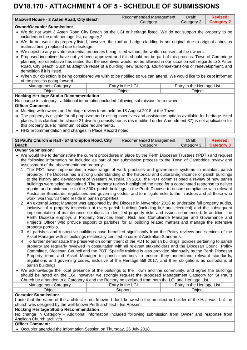
Maxwell House - 3 Asten Road, City Beach Recommended Management
Category Draft:
Category 2 Revised:
Category 2
Owner/Occupier Submission:
We do not want 3 Asten Road City Beach on the LGI or heritage listed. We do not support the property to beincluded on the draft heritage list, category 2.
We do not want this property listed, however, the roof and edge cladding is not original due to original asbestosmaterial being replaced due to leakage.
We object to any private residential properties being listed without the written consent of the owners.
Proposed incentives have not yet been approved and this should not be part of this process. Town of Cambridgeplanning representative has stated that the incentives would not be allowed in our situation with regards to 3 AstenRoad, City Beach. Such as adaptive reuse of a building, new building, additions/extensions or redevelopment, anddemolition if it is listed.
When our objection is being considered we wish to be notified so we can attend. We would like to be kept informedof the process going forward.
Management Category Entry in the LGI Entry in the Heritage List
Object Object Object
Hocking Heritage Studio Recommendation: No change in category - additional information included following submission from owner.
Officer Comment:
Meeting with owners and heritage review team held on 18 August 2018 at the Town.
The property is eligible for all proposed and existing incentives and assistance options available for heritage listedplaces. It is clarified the clause 21 dwelling density bonus (as modified under Amendment 37) is not application forthis property due to minimum lot size requirements.
HHS recommendation and changes in Place Record noted.
St Paul's Church & Hall - 57 Brompton Road, City Beach
Recommended Management Category
Draft: Category 3
Revised: Category 3
Owner Submission:
We would like to demonstrate the current procedures in place by the Perth Diocesan Trustees (‘PDT’) and requestthe following information be included as part of our submission process to the Town of Cambridge review andassessment of the abovementioned property:-1 The PDT have implemented a wide range of work practices and governance systems to maintain parish
property. The Diocese has a strong understanding of the historical and cultural significance of parish buildings to the history and development of Western Australia. In 2016, the PDT commissioned a review of how parish buildings were being maintained. The property review highlighted the need for a coordinated response to deliver repairs and maintenance to the 300+ parish buildings in the Perth Diocese to ensure compliance with relevant Australian Standards, regulations and governing codes, and to mitigate risks to the Trustees and all those who work, worship, visit and reside in parish properties.
2 An external Asset Manager was appointed by the Diocese in November 2016 to undertake full property audits, inclusive of a property inspection of every parish building (including fire and electrical) and the subsequent implementation of maintenance solutions to identified property risks and issues commenced. In addition, the Perth Diocese employs a Property Services team, Risk and Compliance Manager and Governance and Projects Officer who provide support to parishes for all building related matters and manage the extensive property portfolio.
3 All parishes and respective buildings have benefited significantly from the Policy reviews and services of the Asset Manager with all buildings electrically certified to current Australian Standards.
4 To further demonstrate the preservation commitment of the PDT to parish buildings, policies pertaining to parish property are regularly reviewed in consultation with all relevant stakeholders and the Diocesan Council Policy Committee, Diocesan Council and the PDT. Specific training is also provided biannually by the Perth Diocesan Property team and Asset Manager to parish members to ensure they understand relevant standards, regulations and governing codes, inclusive of the Heritage Bill 2017, and their obligations as custodians of parish buildings
We acknowledge the local presence of the buildings to the Town and the community, and agree the buildingsshould be noted on the LGI, however we strongly request the proposed Management Category for St Paul'sChurch be amended to a Category 4 and the Rectory be excluded from both the LGI and Heritage List.
Management Category Entry in the LGI Entry in the Heritage List
Object Support Object
Occupier Submission: I note that the name of the architect is not known. I don't know who the architect or builder of the Hall was, but the church was designed by the well-known Perth architect - Iris Rossen.
Hocking Heritage Studio Recommendation: No change in Category - Additional information included following submission from Owner and response from Anglican Church archives.
Officer Comment:
Occupier attended the Information Session on Thursday, 26 July 2018.
DV18.170 - ATTACHMENT 4 OF 5 - SCHEDULE OF SUBMISSIONS
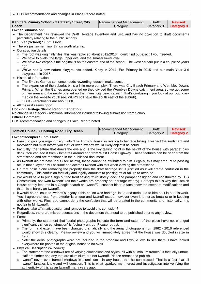
HHS recommendation and changes in Place Record noted.
Kapinara Primary School - 2 Catesby Street, City Beach
Recommended Management Category
Draft: Category 3
Revised: Category 3
Owner Submission:
The Department has reviewed the Draft Heritage Inventory and List, and has no objection to draft documents particularly relating to the public schools.
Occupier (School) Submission:
There’s just some minor things worth altering.
Construction details o The roof was originally tiles, this was replaced about 2012/2013. I could find out exact if you needed. o We have to ovals, the large upper oval and the smaller lower oval. o We have two carparks the original is on the eastern end of the school. The west carpark put in a couple of years
ago. o We’ve had 3 new nature playgrounds added. Kindy in 2014, Pre Primary in 2015 and our main Year 3-6
playground in 2016.
Historical Information o The Empire Games sentence needs rewording, doesn’t make sense. o The expansion of the suburbs bit is a little more complex. There was City Beach Primary and Wembley Downs
Primary. When the Games area opened up they divided the Wembley Downs catchment area, so we got some of their area and the newly opened northern/west city beach area (if that’s confusing if you look at our boundary map on the website you’ll see. WDPS still have the south east of the suburb).
o Our K-6 enrolments are about 380.
All the rest seems good.
Hocking Heritage Studio Recommendation: No change in category - additional information included following submission from School.
Officer Comment: HHS recommendation and changes in Place Record noted.
Tomich House - 7 Dorking Road, City Beach Recommended Management
Category Draft:
Category 2 Revised:
Category 2
Owner/Occupier Submission:
I need to give you urgent insight into ‘The Tomich House’ in relation to heritage listing. I respect the sentiment and motivation but must inform you that Mr Iwan Iwanoff would likely object if he could.
Factually, the feature that draws the eye and is the key talking point is the height of the house with parapet plus deck. You can see it from kilometres around and from West Coast Highway. These features can be seen from the streetscape and are mentioned in the published document.
As Iwanoff did not have input (see below), these cannot be attributed to him. Legally, this may amount to passing off, in that a layman will assume and accredit Iwanoff with this when viewing the streetscape.
On that basis alone removing the property from the draft heritage list is justified as it will create confusion in the community. This confusion factually and legally amounts to passing off or failure to attribute.
We would have to put a sign out the front saying “third storey, deck and parapet designed and constructed by TCS Construction, not Iwan Iwanoff” (as their works are probably not heritage worthy). Perhaps this is why the Tomich House barely features in a Google search on Iwanoff? I suspect his true fans know the extent of modifications and that this is barely an Iwanoff.
It would be an insult to Iwanoff’s legacy if this house was heritage listed and attributed to him as it is not his work. Yes, I agree the road front exterior is unique and Iwanoff-esque, however even it is not as brutalist or in keeping with other works. Plus, you cannot deny the confusion that will be created in the community and historically. It is not fair to Mr Iwanoff.
Perhaps take affirmative action and remove to avoid this confusion?
Regardless, there are misrepresentations in the document that need to be published prior to any review.
Form: o Primarily, the statement that “aerial photographs indicate the form and extent of the place have not changed
significantly since construction” is factually untrue. Please retract. o The form and extent have been changed dramatically and the aerial photographs from 1962 - 2016 referenced
would show this clearly. Please review and you will immediately agree that the house was doubled in size in 1986.
o Note: the aerial photographs were not included in the proposal and I would love to see them. I have looked everywhere for photos of the original house to no avail.
Physical Description (Windows): o The statement “the windows are of varying dimensions and styles, all with aluminium frames” is factually untrue.
Half are timber and any that are aluminium are not Iwanoff. Please retract and publish. o Iwanoff never ever framed windows in aluminium - in any house that he constructed. That is a fact that all
Iwanoff fanatics know and will question. This is what sparked my interest and investigation into verifying the authenticity of this as an Iwanoff many years ago.

o In this residence, everything Iwanoff is timber frames. From the front door to the two remaining original first floor bedroom windows (featuring timber breezeways). From that point westward the frames are aluminium. This part of the house is simply not Iwanoff.
Significance: o This entire section is now contentious. o It is not an intact example of Iwanoff work and does breach his specific design style of the period. The place has
less historic value because Iwanoff did not experiment with the materials used as referenced in the document.
For Further Insight: o The house was significantly altered in 1985-86 by a construction company called TCS(?) for the owner Naidoo.
Iwan Iwanoff passed away in 1986. There is clear evidence that this was not Iwanoff’s design in any way shape or form. Iwanoff passed in 1986; plans have a notes to “finish in style of original” or similar; and the aluminium frames (see below).
o Iwanoff did not design or construct third storey or deck that are visible from the streetscape and from kilometres away.
Further: o Based on my investigation it appears the front facing exterior windows were also significantly modified. o Also note there are 7 full height narrow strip windows. o Iwanoff designed and built a house ‘low set’ house with a lower, ground and first floor. o Significant alterations have been made to the interior & exterior of the original house with no input from Iwanoff. o Significant alterations have been added to the original house, including the feature ‘parapet’ and deck. o Unfortunately, many of Iwanoff’s features were removed. The signature flower boxes. The timber finishes (now
aluminium). His original balcony.
It was only recently that I really studied the plans and discovered many of the facts above. Until then even I didn’t have knowledge of the extent of the alterations to the interior and exterior.
However, we were always aware that the third floor and deck were not his work. Again, I highlight these are a part of the streetscape. If you took photographs from any other angle and location than those published you can see the third storey, parapet and deck.
I have been surprised at the common misconception that the Tomich House is an original Iwanoff. Even by his biggest ‘fans’. Just compare it to other ‘low set’ designs in the area (such as the Boulevard).
It is with regret that I inform you of this because his work is unique.
Ps. I believe the Tomich family were winemakers with a vinery in the south west. Mr Tomich died shortly after the build of cancer or similar. They never occupied the house. Hearsay- I have been told this.
Hocking Heritage Studio Recommendation: No change in category – Amended historical notes, associations and physical description to reflect additional information from the owner and archived plans sourced by the Town.
Officer Comment:
Meeting with owner and heritage review team held on 1 August 2018 at the property.
HHS recommendation and changes in Place Record noted.
British Empire and Commonwealth Games Village (fmr)
Recommended Management Category
Draft: Category 4
Revised: Category 4
Owner #1 Submission:
We believe Place No. 10 area, this precinct should be removed from the draft LGI.
We have reviewed and carefully read the two documents cited by the Heritage Council as guides to best practice for Local Government Inventories: Basic Principles…etc. and Criteria for the Assessment…etc
The following is a response and submission based on the second document 'Criteria for the Assessment of Local Heritage Places and Areas'.
P5 states the following: "A place or area will be significance to the locality if it meets one or more of the criteria in section 2 under the headings of Aesthetic, Historic, Research or Social value." We do not believe Place No. 10 meets any of the criteria listed in this document and that record of the Empire Games is will and fully documented in the Local Studies section of the local library, City of Perth Archives and the Town of Cambridge records from 2003 and 4. Further there are a number of plaques in the local area which record the association of the Empire Games with this precinct and the construction of what is known as the Empire Shopping Centre has wonderfully incorporated a number of engraved plates which illustrate and celebrate the Games.
"Heritage significance needs to be clearly distinguished from the broader concept of urban character, given that all areas or localities demonstrate some form of urban character. Heritage Areas are select areas with special qualities, and will generally be quite rare within a locality. There is generally no need to assign a level of significance to a heritage Area as a whole (in terms of exceptional, considerable, some/moderate significance)." Place No 10 no longer appears to be significantly different to any other parts of the suburb. When we moved here in 1981 we used to refer to it as the 'modest corner' of the suburb. This is longer the case.
Criterion 1 P6 - It is significance in exhibiting particular aesthetic characteristics. Guidelines for Exclusion under this criterion. A place or area is not normally included under this criterion if its distinguishing features have been lost, degraded or compromised. This point is clearly evident as state above - it no longer appears to be significantly different to any other part of the

suburb.
Criterion 2 P8 - It is significant to the evolution or pattern of the history of the local district. It is not clearly associated with the conduct of the Empire Games, and the latter did not play an important part in the locality's history. The houses constructed for the temporary use of participating athletes to be subsequently on sold to the general public. There was already a significant amount of housing in the central area of the suburb. o Guidelines for Exclusion - A place or area will generally be excluded if:
it has brief, incidental or distant association with historically important activities, processes, people or event.
it is associated with events of interest only to a small number of people
it retains no physical trace of the event or activity. These particular guidelines are met:- a very brief association with those Games, of minor interest in the sweep of local history and almost no physical trace of the Games remain.
Criterion 3A P10 - It has demonstrable potential to yield information that will contribute to an understanding of the natural or cultural history of the local district. o Guidelines for Exclusion - It is likely to yield information that could easily be obtained from documentary
sources. In fact, the information would be significantly more easily obtained from documentary sources.
Criterion 3B P10 - It is significant in demonstrating a high degree of technical innovation or achievement. o This criterion has no relevance to Place 10 - no technical innovation or achieve is evident.
Criterion 4 P12 - It is significant through association with a community or cultural group in the local district for social, cultural, educational or spiritual reasons. o As active and involved residents for 37 years in Place No 10 we have never noticed or been aware of any
significance of this precinct to any local group or indeed any particular association of any group to it. o This document acknowledges the difficulty of identification and substantiation under this criteria. o "Care should be taken not to confuse cultural heritage significance with amenity or utility. There must be
evidence that the building/place is valued over and above the activities that occurred there." o There is zero evidence of this value.
Criterion 5 P13 - It demonstrates rare, uncommon or endangered aspects of the cultural heritage of the local district. o Guidelines for Exclusion - A place or area will not normally be considered under this criterion if its distinguishing
features have been degraded or compromised. The intervening 50 plus years have resulted in a significant increase in Perth's population with subsequent general development of all suburban areas in close proximity to the CBD. This area has never exhibited any particular cultural heritage such that is would fall under this criterion. Housing deemed adequate and suitable to populations of the 1960s has been viewed quite differently since the 1990s with consequent significant alteration and enlargement or as in most cases, demolition and rebuild.
Criterion 6 P14 - This criterion appears to relate to single place rather than a whole area, so not applicable here. o Heritage Areas - an extra Criterion P16 - A Heritage Area will be of significance for the local district if:
a) it meets one or more of the criteria under section 2 under the headings of Aesthetic, Historic, Research or Social significance; and
b) it demonstrates a unified or cohesive physical form in the public realm with an identifiable aesthetic, historical or social theme associated with a particular period or periods of development.
This area may have been considered to fall within the ambit of (b) at the time it was constructed (1962). However it has long since exhibited any unified or cohesive physical form. Changes in Council building regulations have varied a number of planning guidelines e.g. height limitations, set back amounts and housing density which have been contributed to the many changes in housing stock in this area.
Reference P17 of the Heritage Council document Criteria for the Assessment…etc. o "This is arguably not a Heritage Area because the extent of loss of historic housing stock, limiting the degree to
which it demonstrates a 'unified or consistent physical form in the public realm". o This statement (P17) as to why the Wembley Precinct No.6 no longer qualifies as a Heritage Area applies
equally to the area under present consideration and for much the same reasons.
We believe the precinct referred to in the drat LGI and has long since lost its heritage integrity. We were unaware that the precinct had been placed on the draft in 1997 and were considerably surprised at this discovery.
We urge the Council to remove, this area Place No 10 from the draft Local Government Inventory List of Heritage Places. Neither the Council nor residents of this area benefit in any way from being places on the draft GI, even at Management Level 4.
We have chosen not to duplicate the documents appearing in the Submission to the Heritage Council of WA which was prepared by the Council and Ronald Bodycoat. This submission and its information is already available to the Council from their own records.
We urge the Council to again refer to the arguments made in this submission in January 2004 even though it was particularly concerned with individual houses in this precinct. The arguments are not only still relevant but even more so with the passage of another 13 years and the changes that have occurred during that time.
Owner #2 Submission: Games Village being category 4 and no impact on future demolition/development potential.
Owner #3 Submission: My neighbours are elderly and very concerned as they have been through this before. It would be better if the letter we received was even clearer about there being no heritage listing of the games village homes - they were ready to
demolish theirs 15 years ago when heritage listing was proposed and quite a few were knocked over Owner #4 Submission:
Thank you for your comprehensive letter which we received this morning confirming that our property is merely in an area being considered for a Category 4 municipal listing which will not preclude any major alterations or demolition subject to standard Council planning guidelines and subject to the three management recommendations outlined.
We have already received the written assurances of the Heritage Council in 2004 that homes in the Empire Games Village will not be heritage listed.
In 2003, we obtained over 1,600 signatures in opposition to the intended Heritage Listing of our homes and these were presented to State Government by our local Member of Parliament and former Minister, Doctor Elizabeth Constable, and copies of these 1,600 signatures were also forwarded to the Heritage Council of WA.
We hold these signatures and all correspondence with the Premier, our Member of Parliament and the Heritage Council itself.
After a long and bitter campaign, the Heritage Council of WA eventually confirmed that our own home would not be involved or affected by any registration process. "Your property is not among those identified. This mean your property will not be involved or affected by the registration process" (8 December 2003).
However the Heritage Council of WA initially retained first 17 then 3 unfortunate homeowners. The full community stood by these unfortunate 17 homeowners and eventually after much correspondence the employment of an Heritage Architect a formula was arrived at that fully satisfied all parties. "The Heritage Council of Western Australia decided at its meeting on 13 February 2004 that the British Empire and Commonwealth Games Village Precinct (fmr) not be recommended for inclusion in the State Register of Heritage Places. The Heritage Council believes however that the Games Village was an important aspect of the 1962 Empire Games and is worthy of recognition. To this end the Heritage Council resolved to actively pursue a range of interpretative initiatives with the Town of Cambridge to recognise the cultural heritage significance of the British Empire and Commonwealth Games Village Precinct (fmr)"
The formula agreed upon was the renaming of the shopping centre to become the Empire Shopping Centre with numerous photographic plaques, additional commemorative plaques on various walkways and a photographic booklet to record all the homes in the Games Village (Fading Events and Places) of which we hold a copy which you may like to see.
The battle to prevent the heritage listing of our family homes badly affected the physical and mental wellbeing of many older residents in the Games Village who saw the value of their homes, often their sole financial asset, plummet.
You can understand from the above why this is such a sensitive issue and your written assurance that this is not to be repeated is greatly appreciated
Submission provided correspondence from the 2004 Member for Churchlands the Heritage Council of Western Australia regarding the State Register assessment of the Empire Games Village.
Management Category Entry in the LGI Entry in the Heritage List
Support Support Object
Owner #5 Submission:
The listing of the "Games Village Precinct" is not appropriate.
There are factual errors in the statement of significance. I personally made a detailed study of the area described as the "Games Village Precinct" in 2004, when my property has been proposed for heritage listing. I document my findings in a submission to the Town of Cambridge at that time. On this basis I submit the following information: o The Statement of Significance is factually wrong in stating that "the remaining houses have aesthetic value as
they demonstrate the best in Western Australian architecture in the early 1960s". o They were designed in a competition on the basis of price/performance for a particular purpose and are based
on a limited number of basic designs, with variations in orientation and arrangement of modules. o It also states, "the remaining houses have historic value for their demonstration of the scale and the size of the
homes considered to be standards in the 1960s". o In 2004 there were relatively few remaining examples of the original housing. Now, fourteen years later, the
phrase 'relatively few' must be replaced with 'very few'. The great majority have been demolished and replaced, and most of the remainder have been greatly extended. Once can count with the fingers on one hand the number of houses that might possibly demonstrate anything about 1960s size and scale. Any value they might arguably have in providing such a demonstration is trivial in comparison with that offered by their readily accessible detailed site and construction plans, further supplemented by extensive photographic records and scholarly publications.
o I would also point out that the State Heritage Office document 'Criteria for the assessment of local heritage places and areas' states that "there is generally no need to assign a level of significance to heritage areas as a whole".
On these bases I submit that the area described as "Games Village Precinct" is adequately memorialised by its street layout, which according to the Heritage Information and Frequently Asked Questions, represents character rather than heritage. Accordingly, this area should not be categorised as having heritage significance.
Management Category Entry in the LGI Entry in the Heritage List
Object Object Object

Owner #6 Submission: No written response provided (only support for entry on LGI as noted below).
Management Category Entry in the LGI Entry in the Heritage List
Object Object Object
Owner #7 Submission:
There is nothing further to be gained by historians, property owners or the local council by the proposed listing of this extensive area. This has implications for approximately 160 house owners. See subsequent comments and attached letters.
By removing Place No: 10 “The former British Empire and Commonwealth Games Village area from the DRAFT LGI. There is absolutely no need to list this extensive area, (with around 160 homes affected), on the Local Government Inventory List of Heritage Places as 1. There may be future unanticipated consequences of such a listing and 2. There is no further heritage value to be obtained from listing the area.
As an example of an unintended consequence of listing this extensive area has it been considered that problems may arise with the Councils' current proposal in the LPS to build apartments on the land to the West of the Empire Village shopping centre? The fact that the Empire Games was held in Perth in 1962 is already well documented at the Empire Village shopping centre and elsewhere. The layout of the former games village is also well documented and will be well protected by any planning approvals issued by Cambridge Council.
Previously heritage proposal for this area was rejected in 2002. In 2004 in a survey of affected residents 90% of the residents responded and 74% felt the village was not worthy of heritage status. Ref: Geographies of Australian Heritages: A Book Edited by Roy Jones and Brian J Shaw. Chapter 10 Perth's Commonwealth Games Heritage. Whose value at what price?
No means no. The Town of Cambridge should remove this area from the Draft LGI.
Text of my recent email letters to Town of Cambridge Councillors on this subject follow. Email 1
The Cambridge Council and the property owners in this area and historians have nothing to gain from the proposed listing. I am a property owner in the affected area.
In the document that was circulated by the Council inviting comment about this proposed listing-under Level of Significance, it is acknowledged that this area “Contributes little to the understanding of the history of The Town of Cambridge and it has further proposed that it is only placed in Management Category 4 which suggests “Photographically record prior to major developments or demolition. Recognise and interpret the site if possible. Do not include on the Town Planning Scheme No 1 Heritage List.” These are appropriate comments.
In the paragraph re Statement of Significance the comment “The remaining houses have aesthetic value as they demonstrate the best in Western Australian residential architecture in the early 1960’s” is clearly incorrect. The houses were basic and purpose built for a price. The plan was always that the blocks would be sold, and the houses be demolished to make way for more appropriate residential housing. This is largely what has happened.
To say that “The remaining houses have historic value for their demonstration of the scale and the size of homes considered to be standards in the 1960’s” is also incorrect for the same reasons.
There is absolutely no need to list this extensive area on the Local Government Inventory List of Heritage Places
The fact that the Empire Games was held in Perth in 1962 is already well documented at the Empire Village shopping centre.
The layout of the former games village is also well documented and will be well protected by any planning approvals issued by Cambridge Council.
The State Heritage Office document Criteria for the Assessment of Local Heritage Places and Areas states “Heritage areas are select areas with special qualities and will generally be quite rare within a locality. There is generally no need to assign a level of significance to a Heritage Area as a whole.” Other reasons why listing this extensive area is inappropriate under these criteria are listed in Appendix 1.
Listing on the Local Government Inventory List of Heritage Places would just be an impost on the property owners involved, as well as needless bureaucracy for the Cambridge Council.
It would be foolish to involve the Heritage Council in any way with the listing of such a large area of real estate.
History has demonstrated many times that having another level of bureaucracy in the form of the Heritage Council having involvement in any decision making is unwelcome.
This is particularly true if any heritage value under discussion is already well documented and protected.
I hope that on further consideration you will agree that this proposed listing should be withdrawn from the Draft Local Government Inventory List of Heritage Places.
Appendix 1. o On reviewing The State Heritage Office document: “Criteria for the Assessment of Local Heritage Places and
Areas” it is very difficult to understand why it has been considered appropriate to recommend listing an extensive suburban area like this at all.
o On p.5 under Assessing Heritage Areas it states “Heritage significance needs to be clearly distinguished from the broader concept of urban character, given that all areas or localities demonstrate some form of urban character.”
o On p.6 under 2.1 Aesthetic Value Criterion 1: It is significant in exhibiting particular aesthetic characteristics under ‘Guidelines for Exclusion’ it states “a place or area is not normally included if it has only a loose association with creative or artistic excellence or achievement.”
o On p.8 under 2.2 Historic Value Criterion 2: It is significant in the evolution or pattern of the history of the local
district. under ‘Guidelines for Exclusion’ it states “a place or area will generally be excluded if it has a brief, incidental or distant association with historically important processes, people or events”
o On p.10 under 2.3 Research Value Criterion 3A It has demonstrated the potential to yield information that will contribute to an understanding of the natural or cultural history of the local district. Under Guidelines for Exclusion it states “A place will not normally be included if it is likely to yield information that could easily be obtained from documentary sources”
o On p.12 under 2.4 Social values Criterion 4: It is significant through association with a community or cultural group in the local district for social, cultural, educational or spiritual reasons. under Guidelines for Exclusion it states “Care should be taken not to confuse cultural heritage significance with amenity or utility. There must be evidence that the building/place is valued over and above the activities that occur there’
o No evidence of cultural heritage significance. o On p. 16 under 2.8 Heritage Areas it states “An entire local government area can be divided into ‘urban
character areas’ or planning precincts. However Heritage areas are select areas with special qualities and will generally be quite rare”
o On p 16 again “Heritage Areas typically exist on a much larger scale than individual places, contain a large number of built elements and property holdings, and their designation potentially has more far-reaching planning implications than the listing of a single place. Areas require a commensurate level of care in their assessment and documentation”.
o On Page 17 under Reasons for excluding Wembley Precinct No 6 it states “This is arguably not a Heritage Area because of the extent of loss of historic housing stock, limiting the degree to which it demonstrates a ‘unified or consistent physical form in the public realm”.
o On p.19 under Heritage Areas it states “Heritage areas are select areas with special qualities and will generally be quite rare within a locality. There is generally no need to assign a level of significance to a Heritage Area as a whole.”
Email 2
When you actually go around and look at the housing in the "Games Village" you will find that there is absolutely no consistency of architectural style in the area.
Most people who have purchased a block in this area have either extensively renovated, or they have demolished and rebuilt. I doubt you will be able to find anyone who purchased because they liked the architecture of the (original) house, or because of the areas remote association with the Commonwealth Games.
As outlined in my original email to the Council, there is no further heritage value to be obtained by listing this extensive area of Real Estate on the LGI. This is true for all concerned; the Council, the Residents and the Historians. The general layout and appearance of the area should be well protected by the current planning approvals process of the Cambridge Council.
Unfortunately it is far too easy to list something as having Heritage Value as there is no skin off the person who suggests the listing, and the Heritage Council seem keen to list anything that is suggested. I am not opposed to all Heritage Listing, but it does need to be done very carefully and selectively as it does impact on property owners’ rights.
In 2002, when the Heritage Council wanted to list some of the remnant houses in the area, it was established beyond doubt that if you can avoid having the bureaucrats at the Heritage Council involved in any decision making then that is a wise choice.
The owners of those very basic properties were those significantly disadvantaged by this proposal. The people who were affected were essentially those without the funds or opportunity to develop their property. In these cases there was no question that a successful listing would significantly devalue their properties and no recompense was offered.
Fortunately the inappropriateness and the unfair consequences of this attempted listing were widely recognised. It was eventually successfully fought off, but only with great difficulty, by the united efforts of a large number of residents in the area with the assistance of the Council at that time.
The whole exercise demonstrated that there can be significant unintended consequences for property owners if the Heritage Council bureaucracy gets involved with their property rights.
On the information that has been provided the impositions of the Category 4 listing do not appear to be onerous, but there are obvious concerns should there be any "bracket creep" in the category of listing by the Heritage Council in the future. If the area is not on the Local Government Inventory this is far less likely to eventuate and to cause any problems for owners or the Cambridge Council in the future. For example, has it been considered that unanticipated problems may arise with the Councils' current proposal in the LPS to build apartments on the land to the West of the Empire Village shopping centre?
The current revisiting of the LGI by the Council represents a golden opportunity for the Council to remove the area from the list; as any heritage value is well recognised, documented and protected already.
I am hopeful that wise heads will prevail, and that the Council will decide to delete this proposed area listing from the Cambridge Council LGI.
Management Category Entry in the LGI Entry in the Heritage List
Neutral Object Object
Owner #8 Submission:
Listing the precinct of the former British Empire and Commonwealth Games Village will unnecessarily impact on our ability as home owners to renovate, rebuild, redevelop or sell our home by introducing another level of bureaucracy into our quiet enjoyment of our property. This is an unfair impost on us when the great majority of

former games village homes have been demolished, the actual village shops have been extensively redeveloped beyond recognition of their original construction and the area is no more significant in planning than any other suburbs developed at that time or prior.
Further the Games Village houses were noted as being designed with the recognition that they would be sold and possibly demolished and/or redeveloped. It was not envisaged that they be preserved. As for them being characteristic of mid-twentieth century architecture would be debatable given the examples of such in the suburb and those in suburbs that were developed around that time. An example of this would be the suburb I grew up in which was Coolbinia. The houses in that suburb and in neighbouring Yokine and Dianella nearby are prime examples of mid-twentieth century design.
This is an example of the Cambridge Council yet again seeking to circumvent the original objection and subsequent assurances of the whole Games Village fiasco. It was rescinded once before after much objection from local residents and once again it has raised its head after being resurrected in a misguided interpretation of the significance of the area.
The question is ambiguous because although my property is not individually listed it is indirectly listed as a consequence of being located within the Games Village precinct.
I have the documents provided have only provided limited information and is obfuscatory about what is being proposed. There was no explanation about categories of heritage and some of the listings were trite and of inflated significance.
Management Category Entry in the LGI Entry in the Heritage List
Object Object Object
Hocking Heritage Studio Recommendation: No change in category - modification of the statement of significance in response to comments in submission from owners of properties.
Officer Comment:
The Town notified owners of properties within the British Empire and Commonwealth Games Village Area and invited comment on the draft heritage review. Eight submissions were received in response.
It is noted the Empire Games Village is an is an existing entry from the 1997 MHI and is recommended to be Category 4 on the LGI. Therefore properties are not subject to heritage requirements under the planning system.
It is noted the Heritage Council of Western Australia assessed the Empire Games Village for entry on the State Register however no entry has been declared to date.
Submissions and HHS recommendation and changes in Place Record noted.
House - 17 Hovea Crescent, City Beach Recommended Management
Category Draft:
Category 3 Revised:
Category 4
Owner/Occupier #1 Submission:
Do not include Cat 3 LGI places on the heritage list as they have not been assessed to be of the “highest heritage value” - this is consistent with the published position of the Town of Cambridge.
Town of Cambridge References: o ToCambridge, Municipal Heritage Inventory and townscape precinct study, P59, 3.1.2 Residential properties,
June 1997. o ToCambridge, Heritage interim Consultation report, page 40, Sept 2017. o ToCambridge, Draft Heritage Review Information session presentation, slide 13, July 2018
Include publicly owned and maintained places or areas on the heritage List. Include only Cat 1 and Cat 2 private residences on the Heritage list where the property owner has given their explicit consent.
Town of Cambridge must recognise that studies they have provided regarding the effects of heritage listing on properties are at least 10 years old/outdated and are inconclusive on the impact of value and cost of ownership by listing non-precinct private homes specifically in this area of Perth, WA. The Town should satisfy itself and its residents that the interests and assets of those residents are suitably protected by any heritage action placed upon them. If heritage is of value to the community both the benefits and the risks of heritage listing should be carried by the Town and not placed only on private home owners which could potentially bankrupt individuals, if not only ruin their retirement(s). The currently proposed compensation does not adequately address the risk being placed upon nominated private residence owners.
The formal statement of significance for a property should identify parts of the property that are to be protected and require additional development consideration. Remainder of property including those places not visible to the public (rear gardens etc.) should remain unaffected by heritage listing. Furthermore, changes to heritage protected parts of a property that are not permanent should be excluded from the proposal. i.e. changing colour of paint does not permanently alter the piece of heritage to be preserved by it does restrict a private property owner the freedom of choice. It is these types of restraints that deter potential buyers from purchasing heritage homes. This is also consistent with the data provided by the Town of Cambridge where value impact of heritage listing of a property is influenced by the degree of regulatory control placed upon it.
The initial draft heritage assessment was reviewed in a meeting on August 8, 2018 that included the following attendees: myself, my spouse, the Town’s Manager Planning Strategies and Strategic Planning Officer and Hocking Heritage Studio. Errors that myself and my spouse had identified with the heritage assessment were thoroughly discussed at that meeting.
Since that meeting, a revised heritage assessment has been issued by ToCambridge (on Thursday August 23,
2018) and me and my spouse received it that day. The following is a list of errors that are still in the heritage assessment, after it was reissued to us on Aug. 23, 2018: 1 The physical description identified tall windows and glass blocks. The tall windows are not an original feature of
the home and only two of the five glass block locations are original. 2 The “distinguished block decoration on single storey is also not an original feature of the building”
Note that no revised Statement of significance has been issued and the following comments relate to the initial statement of assessment.
3 Condition of property is classed as good but this is not consistent with State Heritage office criteria for the assessment of local heritage places and areas as it is an assessment of the current building’ condition and not “in relation to values for which that place has been assessed” Please correct to “fair” as per guidelines.
4 In reference to the Statement of Significance: second bullet states that this is rare, this is incorrect as interwar functionalist properties can be seen across the ToCambridge, in Nedlands and Dalkieth. Please review statement. Final bullet point stating that this is an example “of design and scale of housing” seems contradictory to second bullet, implying that this property is both rare and a good example? Please clarify.
5 Level of significance to be revised based on revised assessment. 6 Consider reducing management category from 3 to 4 or do not include on LGI based on the revised
assessments.
I shall be completing the feedback form shortly however I would once again like to state my objection to the proposal that cat 3 LGI properties also be placed on the Heritage list.
Review of the papers provided by Town of Cambridge on the value of heritage listing of properties. The heritage information and frequently asked questions booklet issued by the Town of Cambridge states that "Heritage Listing does not affect property prices". The Town of Cambridge kindly provided the supporting references behind this statement and the following text summarises the findings of those papers.
Overall that it can be seen that the effect on the value of a residence is specific to the property in question and its particular circumstances. It is important to note that all of the risk of heritage listing is carried by the property owner!
In short the findings of this review have established that: o A total of 9 references were provided by the Town. o All of the material provided was at least 10 years old (papers between 2001 - 2008) most of which reference
empirical data from the early to mid 90s. o The effect of heritage listing on property prices in established heritage areas/ precincts or in historic towns that
attract tourism has a positive effect. o No conclusive evidence was presented that determined the impact on stand alone residences within
established neighbourhood. o Non of these studies addressed the impact of the time on the market or additional sales costs carried by the
property owner. Some of the research speaks in general terms about the polarizing of the market by heritage listing and the corresponding reduction in potential buyers for the heritage listed property.
o None of the studies addressed the increased costs of heritage listing that must be carried by the property owner. i.e. specialist insurance, specialist tradespeople.
o One study, not provide by the Town shows that the effect on property value of private residences is 10-15% reduction in value and up to 60% in value where the property is not fulfilling its "highest and best use".
The state in the ToCambridge pamphlet stating that "heritage listing does not affect property prices" is unfounded based on the conclusions of its own reference material. Said reference material is of an age where its applicability should be questioned particularly where it has an impact on the value of private homes owned by rate payers within the ToCambridge, especially as the risk are borne by the rate payers who have little influence.
Proceeding with Heritage Listing private residences in non-heritage precincts places an unfair burden on the rate payers and voter who own these properties within the ToCambridge.
Reference 5 leans on references 8 and 9 of this document and suggests that there is a premium on heritage listed homes of 12% in the Ku-Ring-gai area of Sydney and other Heritage precincts.
Reference 6 counters the claim (D'Arcy) that the Metropolitan residences increase in value as it was not clear whether those homes were in the same area and that the area was acting independently from the remainder of the metropolitan market. Reference 6 supports an increase in value within precincts not stand alone communities. Recognises that all studies lack the statistical rigor to provide strong conclusions. Interestingly, the study (ref 6) recommends an evaluation of the impact on value of a residence proposed for listing to be conducted by local Government.
References 7 and 10 are of limited value in that they are summaries of the papers already reviewed within this document.
Reference 8 reviews Sydneys Kui-ring-gai area which shows a 12% increase in residence values by being heritage listed. The Kui-ring-gai area is a heritage area but not all houses are listed.
Reference 9 summarises a number of papers written in the 1990s. Reference 9 highlights the variability in the studies and the lack of conclusive evidence supporting any one hypothesis. There is reference to the study by the Urban Consulting group, Melbourne (The Effects of Heritage Listing, 1995) in which it state that where there is a fall in the value of a heritage listed property it is borne by the property owner. It also highlights that there is a trend for increased value for residences in tourist towns and heritage areas.
I understand that whilst the statement of significance will be completed by Hocking Heritage Studio, the decision on whether to heritage list or not is the decision of the council. I would therefore like to be appraised of any council
meetings that are to be held on the topic of heritage, especially those that may relate to my property or to the topic of the LGI and heritage listing so that I might attend and remain engaged on this most important of issues.
Finally, I would like to point you in the direction of the following reference S Keck, 1999, Heritage Controls and Property Values, A review at local government level, Herron Todd White. In this reference it states that approximately 50% of stand alone properties [in the study area] may see an adverse effect on value of 10-15%, the remainder, which do not fulfil their highest and best use would see an adverse effect on value of 10-60%!!!! Based on a recent valuation of my property, that amounts to $200,000 - $1,2000,000 of my post tax investment and retirement fund. i.e. if this study were to come to fruition, which is a possible outcome, there are no meaningful guarantees of compensation being offered and you would essentially commit me to working until I drop. Imagine if this were you and your home?
It is worth highlighting that the proposal to place stand-alone private residences onto the Heritage list is inconsistent with the previous position held by the ToCambridge in 1997 (ToCambridge Municipal Heritage inventory and townscape precinct study part 1 p59, June 1997). Imperative to note is that in 1997, the ToCambridge also recognised the potential negative consequences of heritage listing private residences. The data has not materially changed since that study was completed and since the 1997 heritage movement by ToCambridge. The current position and actions of ToCambridge are also inconsistent with its more recent publicised position where only private residences of the “highest heritage value” shall be placed onto the heritage list. (ToCambridge, Heritage interim Consultation report, page 40, Sept 2017 and ToCambridge, Draft Heritage Review Information session presentation, slide 13, July 2018).
The statement in the ToCambridge’ FAQ “The majority of research concludes that heritage listing does not affect property values” is not consistent with the data that the ToCambridge has provided in this current heritage listing campaign. The FAQ and by default ToCambridge, in this instance, therefore misleads those who are impacted by this current heritage effort. The ToCambridge’s Customer charter states that it commits “to providing accurate and consistent information”. However, ToCambridge breaches this claim and statement by providing supporting reports with irrelevant, outdated, historical data and then by claiming confidently in the FAQ that there is “no effect on property prices”. Private assets - and equally importantly the homes of some of the ToCambridge’s residents - are being essentially gambled-on. This gambling action is not the choice of individual owners, which makes it incredibly invasive on the part of the ToCambridge. It also violates personal property owner rights to make their own informed decisions in their lives relating to residence, financial investment, wealth portfolio and retirement.
I believe that the ToCambridge has a moral and ethical duty to not expose residents to or impose upon them risk or realised financial loss by its actions. Additionally, ToCambridge has a responsibility to ensure if there is a loss because of heritage listing that due and full compensation is provided to property owners by ToCambridge. In our case, this could be as high as $1million to $2million.
The preservation of heritage within in the community, for the benefit of the community should not be the burden of a handful of its residents. The benefits and risks of heritage preservation should be carried equally by the community.
Submission included references and articles relating to heritage and property value provided by the Town of Cambridge and Hocking Heritage Studio: 1. Report to Australian Property Institute concerning Residential sales analysis 1988 to 2006. (2008) Prepared by
Barton Consultancy Pty Ltd. 2. Value of Heritage to City of Ballarat - Case Study. Prepared by David Cotterill - Principal Economist Sinclair
Knight Merz 3. Valuing the Priceless: the Value of Historic Heritage in Australia - Research report 2. (2005) Prepared by the
Allen Consulting Group for the Heritage Chairs and Officials of Australia and New Zealand. 4. Impact of Heritage Listing on Residential Property Values 5. Managing Cultural Heritage: Heritage Listing and Property Value .(2005) Prepared by Dr L. Armitage - University
of Melbourne and J. Irons - Curtin University, for the European Real Estate Society Conference. 6. The impact of heritage listing on property value. (2005) Dr L. Armitage 7. Heritage Australia: a review of Australian material regarding the economic and social benefits of heritage
property. University of Western Sydney and NSW Heritage Office. 8. Does the housing market value heritage? Some empirical evidence. Vinita Deodhar 9. The Impact of heritage listing on property value in Western Australia. (2001) Heritage Council of Western
Australia 10. Heritage Listing and Property Valuations in Victoria (2001) Heritage Victoria
Management Category Entry in the LGI Entry in the Heritage List
Object Object Object
Owner/Occupier #2 Submission:
Do not include Cat 3 LGI places on the heritage list as they have not been assessed to be of the “highest heritage value” - this is consistent with the published position of the Town of Cambridge. Placing Cat 3 LGI places on the heritage list is not consistent with the published position.
Town of Cambridge References: o ToCambridge, Municipal Heritage Inventory and townscape precinct study, P59, 3.1.2 Residential properties,
June 1997. o ToCambridge, Heritage interim Consultation report, page 40, Sept 2017. o ToCambridge, Draft Heritage Review Information session presentation, slide 13, July 2018

Include publicly owned and maintained places or areas on the heritage List. Include only Cat 1 and Cat 2 private residences on the Heritage list where the property owner has given their explicit consent.
The Town should recognise/acknowledge that studies they have provided regarding the effects of heritage listing on properties are at least 10 years old/outdated and are inconclusive on the impact of value and cost of ownership by listing non-precinct private homes specifically in this area of Perth, WA. The Town should satisfy itself and its residents that the interests and assets of those residents are suitably protected by any heritage action placed upon them. If heritage is of value to the community both the benefits and the risks of heritage listing should be carried by the Town and not placed only on private home owners which could potentially bankrupt individuals, if not only ruin their retirement(s). The currently proposed compensation does not adequately address the risk being placed upon nominated private residence owners.
The formal statement of significance for a property should identify parts of the property that are to be protected and require additional development consideration. Remainder of property including those places not visible to the public (rear gardens etc.) should remain unaffected by heritage listing. Furthermore, changes to the heritage protected parts of a property that are not permanent should be excluded from the proposal. i.e. changing colour of paint does not permanently alter the piece of heritage to be preserved but it does restrict a private property owner the freedom of choice. It is these types of restraints that deter potential buyers from purchasing heritage homes. This is also consistent with the data provided by the Town of Cambridge where value impact of heritage listing of a property is influenced by the degree of regulatory control placed upon it.
The initial draft heritage assessment was reviewed in a meeting on August 8, 2018 that included the following attendees: myself, my spouse, Manager Planning Strategies and Strategic Planning Officer and Hocking Heritage Studio. Errors that myself and my spouse had identified with the heritage assessment were thoroughly discussed at that meeting.
Since that meeting, a revised heritage assessment has been issued by ToCambridge (on Thursday August 23, 2018) and me and my spouse received it that day. The following is a list of errors that are still in the heritage assessment, after it was reissued to us on Aug. 23, 2018: 1 The physical description identified tall windows and glass blocks. The tall windows are not an original feature of
the home and only two of the five glass block locations are original. 2 The “distinguished block decoration on single storey is also not an original feature of the building” 3 Condition of property is classed as good but this is not consistent with State Heritage office criteria for the
assessment of local heritage places and areas as it is an assessment of the current building’ condition and not “in relation to values for which that place has been assessed” Please correct to “fair” as per guidelines.
4 In reference to the Statement of Significance: second bullet states that this is rare, this is incorrect as interwar functionalist properties can be seen across the ToCambridge, in Nedlands and Dalkieth. Please review statement. Final bullet point stating that this is an example “of design and scale of housing” seems contradictory to second bullet, implying that this property is both rare and a good example? Please clarify.
5 Level of significance to be revised based on revised assessment. 6 Consider reducing management category from 3 to 4 or do not include on LGI based on the revised
assessments.
It is worth highlighting that the proposal to place stand-alone private residences onto the Heritage list is inconsistent with the previous position held by the ToCambridge in 1997 (ToCambridge Municipal Heritage inventory and townscape precinct study part 1 p59, June 1997). Imperative to note is that in 1997, the ToCambridge also recognised the potential negative consequences of heritage listing private residences. The data has not material changed since that study was completed and since the 1997 heritage movement by ToCambridge.
The current position and actions of ToCambridge are also inconsistent with its more recent publicised position where only private residences of the “highest heritage value” shall be placed onto the heritage list. (ToCambridge, Heritage interim Consultation report, page 40, Sept 2017 and ToCambridge, Draft Heritage Review Information session presentation, slide 13, July 2018).
The statement in the ToCambridge’ FAQ “The majority of research concludes that heritage listing does not affect property values” is not consistent with the data that the ToCambridge has provided in this current heritage listing campaign. The FAQ and by default ToCambridge, in this instance, therefore misleads those who are impacted by this current heritage effort. The ToCambridge’s Customer charter states that it commits “to providing accurate and consistent information”. However, ToCambridge breaches this claim and statement by providing supporting reports with irrelevant, outdated, historical data and then by claiming confidently in the FAQ that there is “no effect on property prices”. Private assets - and equally importantly the homes of some of the ToCambridge’s residents - are being essentially gambled-on. This gambling action is not the choice of individual owners, which makes it incredibly invasive on the part of the ToCambridge. It also violates personal property owner rights to make their own informed decisions in their lives relating to residence, financial investment, wealth portfolio and retirement. I know that I would not purchase a heritage listed property, so I do not think that a property that I knowingly purchased with no heritage designation or listing should have such imposed on it.
I believe that the ToCambridge has a moral and ethical duty to not expose residents to or impose upon them risk or realised financial loss by its actions. Additionally, ToCambridge has a responsibility to ensure if there is a loss because of heritage listing that due and full compensation is provided to property owners by ToCambridge. In our case, this could be as high as $1million to $2million.
The preservation of heritage within in the community should not be a financial burden that only a handful of residents assume and carry just so that the rest of the community can benefit.
Management Category Entry in the LGI Entry in the Heritage List
Object Object Object
Hocking Heritage Studio Recommendation: Category changed and description information revised as a result of review and the additional information provided by current owner and archive plans.
Officer Comment:
Meeting with owners, Manager Planning Strategies and Economic Development and the heritage review team held on 8 August 2018 at the Town. Following the meeting, updated ‘Historical Information’ and ‘Physical Description’ sections were referred to the place owners for further review and comment.
The inability to fulfil highest and best use would likely refer to where a small building is located on land that is zoned for larger mixed use development. The subject property is zoned Residential R12.5 and may be developed for single dwelling purpose; heritage listing doesn't prohibit extensions or demolition. It is noted the revised recommended Management Category for the property is Category 4 and therefore it is not proposed to be included in the Heritage List.
Property value and compensation/incentives for heritage listing addressed in the LGI and Heritage List report to Council.
Submissions and HHS recommendation and changes to Category and Place Record noted.
City Beach High School (fmr) - 20 Kalinda Drive, City Beach
Recommended Management Category
Draft: Category 3
Revised: Category 3
Owner Submission:
The Department has reviewed the Draft Heritage Inventory and List, and has no objection to draft documents particularly relating to the public schools.
Hocking Heritage Studio Recommendation: No change.
Officer Comment: Submissions and HHS recommendation noted.
City Beach Primary School - 30 Marapana Road, City Beach
Recommended Management Category
Draft: Category 3
Revised: Category 3
Owner Submission:
The Department has reviewed the draft Heritage Inventory and List, and has no objection to draft documents particularly relating to the public schools.
Hocking Heritage Studio Recommendation: No change in category - Minor additional information and photographs added to description.
Officer Comment: Submissions and HHS recommendation and changes in Place Record noted.
Ryan Residence (fmr) - 14 Marimba Crescent, City Beach
Recommended Management Category
Draft: Category 3
Revised: Category 4
Owner/Occupier Submission:
I want my property removed from the list. I will make the decision to list. My property which is Listed has no significance to the Town, City Beach & has been Listed due to emotional attachment by previous owner. I bought the property without the listing now previous owner wants listing what happens to my plans. This is wrong.
The Town should speak to owners of the property before any listing (draft). Owners should be only persons to List or nominate as they are the ones whom are at the whim of the Heritage legislation - Fines, penalties, imprisonment. Be aware of other persons making applications to have places listed. Other owners make application to stop others intended progress, stop others from blocking potential views etc.
This listing destroys my future plans, and will prevent future subdivision potential (previously 3 houses on the block). This listing will stop future sale of house, how many City Beach residents want to live in a 3 x 1 small home?
Further, I request my property be removed from the Draft Heritage Inventory List and comments made within the Local Government Inventory "the current owner is intent on retaining original design" be removed as at no time have the Town or it's heritage consultants approached me regarding this matter.
The Category Listing is incorrect. Whilst it needs to be dropped to a lower level "Little Significance", it should be removed completely.
Heritage Consultant was significantly influenced by previous owners emotional connection to the property. The house 'Sydney Regional Design' has no significance to Perth or City Beach.
Background - The property as seen in the Town’s Local Government Inventory Place No: 19 is a small 138m2 three bedroom, one bathroom home of red/brown brick on a land area 1108m2, of block value only, and has no heritage significance to the community or State. The person whom has requested the listing, and significantly influenced the heritage consultants’ views and decision on the Management Category, is the previous owner whom has an emotional attachment to her previous family home and at no time prior to sale to me mentioned her desire to heritage list the home. The previous owner should have listed it whilst being the owner, or at least made buyers aware prior to sale of such an intention, before benefiting from the sale of the property with no restrictions. Should I

have known of her intentions, I would not have purchased the property. Importantly, the Architectural Style of “Late Century Sydney Regional” has no significance to Perth nor specifically to City Beach.
Prior Changes - The house, since my ownership, has been made liveable following removal of a friable asbestos roof that leaked water onto the stramit ceiling (3” thick straw/hay), causing the hay to expand creating a significant fire risk. These changes, and various other changes, have altered the original character of the home. These repairs are temporary and the house needs significant other works to rectify mortar and brick cancer throughout, wood rot and termite damage to window frames and floor stumps.
Demolition - These necessary repair works and associated costs overcapitalise the house, and considered together with this nomination and potential heritage listing, have influenced my decision and/or forced me to intend to demolish the house, for which I have since received approval to do so from the Town. I had not planned to undertake the demolition, however, due to the nomination I now feel I have little option but to protect my investment and to allow me the freedom to develop my property how I wish. Further, penalties of the Heritage of Western Australia Act 1990 include fines of $1 000 000, imprisonment for 2 years and daily penalties of $50 000 all of which I could be subject to given this listing. Should a heritage listing be made on the property, I do not have the monetary funds to build immediately and I will now have to demolish the house within the demolition licence time period, and grub or clear the land leaving the land vacant with the exception of an aviary and old shed until I am in a position to build my new home in the next 8 - 10 years.
Financial Impairment - Please also note my following concerns of the significant financial implications of a heritage listing other than the fines and penalties mentioned prior on my property: o Recently, subdivisions were approved in City Beach which however have since been rescinded. At the time of
subdivision approval my property was able to have three homes on it, and the surrounding neighbouring properties four homes. A heritage listing on my house, as advised by the Town’s Strategic Planning Officer, and the Acting Director Planning and Development will only ever be able to have the existing single home on it, even with the heritage dispensations should subdivisions ever be allowed again, thus severely effecting any earning potential of my property.
o A heritage listing on my property would have a significant effect on the sale of my property and reduce the pool of buyers if I need to sell the property should my circumstances change.
o The Town’s proposed Grant Scheme to heritage home owners is a pittance compared to works necessary to maintain an old house and need to be increased substantially.
o Property purchasers in City Beach generally want to redevelop and build their own dream homes and not be constrained by heritage requirements. It should be the owners who list properties for heritage consideration as they are the ones financially disadvantaged.
o Heritage houses have value where they are pooled together in suburbs like that of Guildford, Shenton Park or Subiaco. In stark contrast, my existing house in future will be surrounded by large homes especially when neighbouring properties subdivide (if approved) with four homes on each.
o Heritage homes lack the energy efficiency of modern homes. o Please also note the Building Surveyors Report (to be submitted on completion).
Summary and Request - With respect, the Town has gone through its own process of demolishing the old to make way for the new. Consider the previous City of Perth Surf Life Saving Club building which had far more significance to the community and Perth city residents, which was demolished due to the costs of maintenance and as it had reached its use by date. Now a much more suitable building sits in its position. Similarly, I to wish to have the flexibility of making changes to my house to suit my and my family’s needs. Therefore, I again ask that you remove my house from the Draft Local Government Heritage List.
Management Category Entry in the LGI Entry in the Heritage List
Object Object Object
Private Citizen Submission:
The Ryan House in Marimba Crescent ticks all the boxes of the Sydney Style Nuts and Berries architecture of the 1960s.
A group of Sydney architects were influenced by Japanese architecture and the work of Frank Lloyd Wright in the early 21st Century in particular the Robie House in Chicago. Natural materials and textural qualities were used to reflect nature in their buildings.
The Ryan house reflected this philosophy by focusing on the qualities of the site with the materials being used to reflect the natural environment. These included the use of clinker bricks, unpainted timber joinery panels and extensive use of glass to bring the outside into the home.
The untouched rocky terrain of the Marimba Cres. Site, with its treed natural vegetation, gave the opportunity to design a house with split levels and covered roof places parallel to the slope of the land. This configuration helped to produce interior spaces of greater richness and complexity than the box like rooms of the earlier conventional homes.
Sydney architect Ken Woolley adopted this style of architecture when designing his own award winning home along the designing upmarket project homes for e.g. Pettit and Sevitt in the 1960s.
The Ryan house is one of the remaining examples of the Nuts and Berries style of Architecture in the area.
Comment from Heritage and Conservation Consultant - Heritage Intelligence (WA) included in submission: Based on documentary and verbal evidence, I make the following comment with regard to the architectural style: The subject property situated at 14 Marimba Crescent in City Beach designed by Architect Noel Ryan for his family, demonstrates influences of the Lake Twentieth Century Perth Regional architectural style (1) that also reflects the domestic architecture of the Sydney Regional style that developed post World War Two. Characteristics of the

architectural styles are the response to the site environment, the simply plan form, use of the rustic clinker bricks and the low pitched roof profile. (Reference: (1) - For consistency throughout Western Australia, the Heritage Council references architectural styles from Apperly, R., Reynolds, P. A Pictorial Guide to Identifying Australian Architecture Styles and terms from 1788 to the present. Angus & Robertson Publishers, Sydney. 2002. pp.240-247.)
Submission provided original plans and newspaper article (West Australian Saturday, 25 May 1968).
Hocking Heritage Studio Recommendation: Category changed and place record updated as a result of additional information from current owner and original plans provided by previous owner.
Officer Comment:
Previous owner submitted copy of the original house plans to be provided to the Town's heritage consultants.
Meeting between Manager Planning Strategies and Economic Development, Strategic Planning Officer, HHS and Owner held on 13 August 2018 at the Town.
Comments relating to the perceived implications of heritage listing are addressed in the Report to Council.
Demolition Permit issued by the Town on 10 August 2018 valid for two years (DP0023-2018). Town sought legal advice to clarify if the draft heritage listing inhibits the Town from issuing a demolition permit under the Building Regulations. Based on the advice received, the Town does not have grounds to withhold the granting of the demolition permit on the basis of the proposed heritage listing, and therefore the permit could be issued.
Submissions and HHS recommendation and changes to Category and Place Record noted.
Booth House - 59 Oban Road, City Beach Recommended Management
Category Draft:
Category 3 Revised:
Category 4
Owner/Occupier Submission:
We appreciate the opportunity to discuss and lodge our Objection to the allocated Management Category and subsequent inclusion of our property on the Draft Local Government Inventory (LGI) and Heritage List.
As acknowledged at our meeting the information used to assess our property was based on what was available in the public domain and that actual site information was limited and that the information we highlighted was not available to consider when making the initial assessment. In essence we believe: 1 The reference in the assessment form of 59 Oban Road which describes the property as “having some
alterations or modified elements not detracting from the overall significance of the item”. We believe this claim is incorrect as the place has had major alterations and modifications across 4 separate campaigns, and
2 The Statement of Significance refers to the place being an intact example of the late 20th century International style. We believe it is not an intact example. It is a heavily modified example therefore this claim is not accurate. Its aesthetic value appears to be considerably compromised.
We believe that this additional information should influence the inclusion of the property on the overall inventory
With respect to the nomination of 59 Oban Road, City Beach to the referred Draft Local Government Inventory, we lodge an objection to: o The recommended level of significance/management category o Inclusion of the Property in the Local Government Inventory o Inclusion of the Property in the Heritage List
Basis for nomination - We understand the architectural design drawings for 59 Oban Road, along with the furniture, were drafted by Iwan Iwanoff for the original owners of the property. The property has been nominated on the basis of its: 1 Historic Value - for its association with Iwan Iwanoff. 2 Social Value - as the house and others of Iwanoff's design are the source of study and interest amongst
members of the community. For the following reasons, we believe the property does not warrant inclusion on the Local Government Inventory and the Heritage List.
Property Specifics - The nomination cites the following for inclusion of the property: 1 Authenticity - is rates as moderate and cites "Since construction these has been little change to the form or
extent of the building although the front elevation appears to have been altered" This is not a true statement. Contrary to this: a) The home was originally built in 1973. Since then it has undergone renovations no less than 4 times with
substantial alterations to the interior and exterior of the original home. Every elevation of the original home has been altered significantly.
b) The home was designed in 1969 ("Appendix 1") - the original was an extremely small home. The layout was impractical to subsequent owners and has undergone a total reconfiguration over the 3 redevelopment that we can find evidence of:
i. 1973 -1986 -cannot find plans for this but a major extension was added which has doubled the size of the original home creating a substantial alteration. This is evidenced by the Appendix 2" which shows the existing residence design prior to the 1986 redevelopment.
ii. 1986 - the heart of the home around the kitchen, dining and living rooms where redesigned. Refer "Appendix 3".
iii. 1989 - the front elevation was significantly altered. Again, almost 50% of the front span has been changed. The original integrated car port has been enclosed and the original open front patio has also been enclosed and converted into a dining room resulting in a significant alteration to the front elevation
and visual appearance from the street. Refer "Appendix 4". iv. Post 1990 - the kitchen, dining and family areas where redesigned again. We do not have plans for this
but refer to the photos where the kitchen, family area has had walls removed and the three rooms have been reorientated. Refer "Appendix 5" where the photos demonstrate the changes in the design of the home.
Other significant alterations to the original home include outside of the above works include: c) Exterior Painted - originally the home was the natural colour of the blocks which is often a feature of Iwanoff
homes. The previous owners painted them in blue and yellow. Since then the colour scheme has been changed again.
d) Internally design - there has been a significant reconfiguration that makes the property unrecognisable from the original plan.
e) Kitchens and bathrooms - have all been refurbished in the 1980/ 90s and are now requiring replacement again.
Also, for noting the windows are cited as "full height" on the façade. This is not correct they actually commence 1.2m above the ground. As a consequence of the above, the distinguishing "Iwanoff" aesthetic features of the house have been significantly lost or compromised. All these structural changes were completed prior to our purchase of the property in 2013. In addition, the mature verge and front yard landscaping and vegetation largely obscures (pictures below) any remaining "original" components of the house from the street. Considering these aspects, we believe that the authenticity of the property is now non-existent rather than the "moderate" value as assessed.
2 Condition - rated as "good". The actual structural condition of the property is poor. This is supported by the attached Building Report ("Appendix 7") which confirms the following; a) None of the remaining original windows are operational. Most have been modified and all require
replacement in the short to medium term. The current original windows are a safety and security hazard as they:
i. Do not open and therefore inhibit the ability to provide ventilation internally within the house ii. Maintaining the original windows would involve replacement of the original primitive shutter system which
does not adequately ventilate rooms iii. The original windows pose a security and safety risk because they currently can be pushed in, leaving
the property easy to enter. The original windows do not take into account the unfortunate security necessity of the modern house, nor do they provide the sustainability and durability features of a house within 500m from the beach.
b) Ceiling- is sagging at numerous locations throughout the house and requires replacement in the short to medium term due to issues with the substructure.
c) Roofing - needs a complete replacement including sheeting and beams. d) Services - problems have been ongoing and will only increase due to the setup of the services to the home. The existence of these significant structural issues would actually render the current property condition as "Poor". Therefore we believe this has been incorrectly assessed. In addition the report confirms that: a) We would be unable to restore the few original features that remain due to both practical and safety reasons. b) Due to the considerable number of issues with the property the costs of actually carrying out these works
with any endeavour to retain the original fabric would not be economically viable. 3 Integrity- rated as "high". The house has substantially lost its design and technical integrity through subsequent
aesthetic changes to, or deterioration of, the significant elements which mean that the home does not appear as it was originally intended. The original design obviously presented numerous difficulties in regards to its practicality and security; hence the significant changes over time. This is also the case for the current and future owners who, out of necessity, need to make structural and functional changes to maintain security for our family. Therefore it is believed that the integrity of the property is "low".
Statement of significance - We have provided our responses to the statements which were lodged in support for inclusion of the property: 1 Statement 1- "The place has aesthetic value as an intact example of the late 20th century International style."
o The aesthetic value of this property is limited in comparison to Iwan Iwanoff's other works. It does not incorporate many of the elements for which his significant and unique works are known. Originally and now in its current form, 59 Oban Rd is not recognisable or easily identifiable as an Iwanoff design. The original features are not intact as a consequence of the significant changes to the façade, internal design modifications, and significant additions. It has been modified significantly.
2 Statement 2 - "This residence and other examples of /wan Iwanoff's work are a comprehensive and notable group of buildings which demonstrate a specific design style and period.
3 Statement 3 - "The place has historic value for its association with prominent architect, /wan Iwanoff who was influential in WA practice ..."
4 Statement 4 - "The place has historic value for its association with the early 1970s which was characterised as a period of affluence which was teamed with a willingness to experiment with new styles and materials" o The response to these three statements can be provided as one. Whilst Iwan Iwanoff is acknowledged as an
iconic Perth architect with a unique style, this property is certainly not a meaningful representation of his work. There are other examples of his work on the register that are.

o The property exhibits a very low degree of representativeness of Iwan Iwanoff's work. Whilst it does have the use of masonry blocks and large windows, these design elements are commonplace amongst many other homes and are both used extensively throughout Perth.
o With respect to the significant fabric of the place it has been so altered that there is now only limited evidence of a particular association with Iwanoff's architectural design.
5 Statement 5 - "The place has social value as the house and other of Iwanoff's design are the source of study and interest amongst the community" o This is not a statement of fact. We do not believe that this statement relates to 59 Oban Road particular
given the degree of alteration to the home. We do not believe that anyone has ever studied this property and it has never been cited as one of Iwanoff's significant works.
o As cited in the nomination, Iwanoff has a large body of work throughout Perth including homes, shop fronts, a civic administration centre and a public library. So his work is not rare and in fact it is noted that a number of his much more significant pieces have already been identified by this Draft which are significantly more representative of his work. Whilst we agree Iwanoff's work possesses significance for this purpose, we do not believe that this particular property possess the requisite level of significance. There are a number of other properties listed that will meet the needs of the community (and be preferred) with respect to these needs. The social value will not be reduced by excluding this property from being nominated.
Summary - This property has been recommended for listing based on a community survey conducted in June 2017 where 1 response provided that all Iwan Iwanoff homes should be preserved. 59 Oban Road was not specifically recommended, but was identified in this broad, all-encompassing statement from one responder. Other Iwanoff homes were individually listed by more than one respondent due to their alleged historical and architectural significance. Significance is defined by the Oxford Dictionary (on line) "as the quality of being worthy of attention: importance ... " By essential comparison to Iwan Iwanoff's other designs that exist for all to see, the existing structure on 59 Oban Road has very little to no historical resemblance to the original design nor aesthetic significance. This property is not worthy to be placed on any Heritage List and it would be contrary to the basic intention of the heritage process to do so.
Overall we believe the historical and heritage significance is little to none and that if it was to remain on the LGI the unforeseen financial implication would be significant. We further believe the listing does not warrant the limitation being imposed on any future redevelopment as required to rectify the structural integrity and ensure the ongoing safety of the inhabitants.
The original assessment appears to have been based on a very limited pool of information (understandably) that was available. We believe that with all the additional information provided herewith, that the property should be removed from the Local Government Inventory.
Submission included the following appendices: • Appendix 1 - 1969 plans • Appendix 2 - 1986 existing plans • Appendix 3 - 1986 proposed additions plans • Appendix 4 - 1989 alterations plans and comparison of original architectural design & current view from street. • Appendix 5 - comparison of Kitchen, Meals and Family Room plans and photos of the actual layout of these rooms • Appendix 6 - Property Condition Report from Edward Tomczak Consulting
Hocking Heritage Studio Recommendation: Category changed as a result of additional information from current owner and archive plans sourced by the Town.
Officer Comment:
Meeting with owner and heritage review team held on 10 August 2018 at the Town.
Submissions and HHS recommendation and changes to Category and Place Record noted.
Quarry Amphitheatre - 167 Oceanic Drive, City Beach
Recommended Management Category
Draft: Category 1
Revised: Category 1
Occupier Submission: We have provided a petition we started to place the Quarry Amphitheatre on the State Heritage List. This petition took place on Change.org and received 658 signatures in support. Along with this petition, we also provide the previous petition from 2014 and letters of support from members of the community.
Management Category Entry in the LGI Entry in the Heritage List
Support Support Support
Hocking Heritage Studio Recommendation: No change to Category – minor changes to Place Record information and new photographs following site visit with occupier.
Officer Comment:
Meeting with occupier, Manager Planning Strategies and Economic Development and heritage review team held on 30 July 2018 at the site.
Land and facility owned by Town of Cambridge.
The place is a under assessment by the Heritage Council of Western Australia (HCWA) for entry on the State Register under the Heritage Act.
In June 2017 Council considered a report seeking support for HCWA to include the Quarry Amphitheatre on the
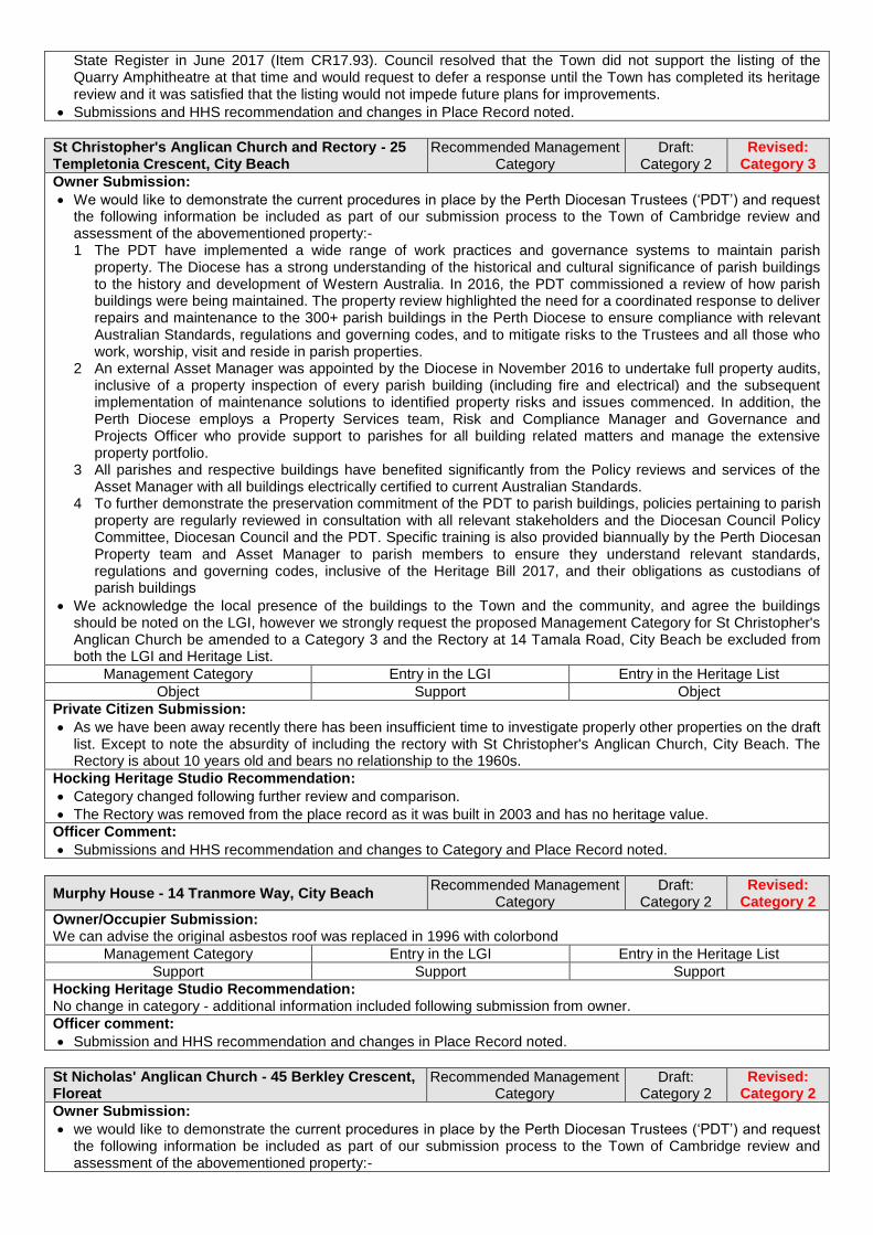
State Register in June 2017 (Item CR17.93). Council resolved that the Town did not support the listing of the Quarry Amphitheatre at that time and would request to defer a response until the Town has completed its heritage review and it was satisfied that the listing would not impede future plans for improvements.
Submissions and HHS recommendation and changes in Place Record noted.
St Christopher's Anglican Church and Rectory - 25 Templetonia Crescent, City Beach
Recommended Management Category
Draft: Category 2
Revised: Category 3
Owner Submission:
We would like to demonstrate the current procedures in place by the Perth Diocesan Trustees (‘PDT’) and request the following information be included as part of our submission process to the Town of Cambridge review and assessment of the abovementioned property:- 1 The PDT have implemented a wide range of work practices and governance systems to maintain parish
property. The Diocese has a strong understanding of the historical and cultural significance of parish buildings to the history and development of Western Australia. In 2016, the PDT commissioned a review of how parish buildings were being maintained. The property review highlighted the need for a coordinated response to deliver repairs and maintenance to the 300+ parish buildings in the Perth Diocese to ensure compliance with relevant Australian Standards, regulations and governing codes, and to mitigate risks to the Trustees and all those who work, worship, visit and reside in parish properties.
2 An external Asset Manager was appointed by the Diocese in November 2016 to undertake full property audits, inclusive of a property inspection of every parish building (including fire and electrical) and the subsequent implementation of maintenance solutions to identified property risks and issues commenced. In addition, the Perth Diocese employs a Property Services team, Risk and Compliance Manager and Governance and Projects Officer who provide support to parishes for all building related matters and manage the extensive property portfolio.
3 All parishes and respective buildings have benefited significantly from the Policy reviews and services of the Asset Manager with all buildings electrically certified to current Australian Standards.
4 To further demonstrate the preservation commitment of the PDT to parish buildings, policies pertaining to parish property are regularly reviewed in consultation with all relevant stakeholders and the Diocesan Council Policy Committee, Diocesan Council and the PDT. Specific training is also provided biannually by the Perth Diocesan Property team and Asset Manager to parish members to ensure they understand relevant standards, regulations and governing codes, inclusive of the Heritage Bill 2017, and their obligations as custodians of parish buildings
We acknowledge the local presence of the buildings to the Town and the community, and agree the buildings should be noted on the LGI, however we strongly request the proposed Management Category for St Christopher's Anglican Church be amended to a Category 3 and the Rectory at 14 Tamala Road, City Beach be excluded from both the LGI and Heritage List.
Management Category Entry in the LGI Entry in the Heritage List
Object Support Object
Private Citizen Submission:
As we have been away recently there has been insufficient time to investigate properly other properties on the draft list. Except to note the absurdity of including the rectory with St Christopher's Anglican Church, City Beach. The Rectory is about 10 years old and bears no relationship to the 1960s.
Hocking Heritage Studio Recommendation:
Category changed following further review and comparison.
The Rectory was removed from the place record as it was built in 2003 and has no heritage value.
Officer Comment:
Submissions and HHS recommendation and changes to Category and Place Record noted.
Murphy House - 14 Tranmore Way, City Beach Recommended Management
Category Draft:
Category 2 Revised:
Category 2
Owner/Occupier Submission: We can advise the original asbestos roof was replaced in 1996 with colorbond
Management Category Entry in the LGI Entry in the Heritage List
Support Support Support
Hocking Heritage Studio Recommendation: No change in category - additional information included following submission from owner.
Officer comment:
Submission and HHS recommendation and changes in Place Record noted.
St Nicholas' Anglican Church - 45 Berkley Crescent, Floreat
Recommended Management Category
Draft: Category 2
Revised: Category 2
Owner Submission:
we would like to demonstrate the current procedures in place by the Perth Diocesan Trustees (‘PDT’) and request the following information be included as part of our submission process to the Town of Cambridge review and assessment of the abovementioned property:-

1 The PDT have implemented a wide range of work practices and governance systems to maintain parish property. The Diocese has a strong understanding of the historical and cultural significance of parish buildings to the history and development of Western Australia. In 2016, the PDT commissioned a review of how parish buildings were being maintained. The property review highlighted the need for a coordinated response to deliver repairs and maintenance to the 300+ parish buildings in the Perth Diocese to ensure compliance with relevant Australian Standards, regulations and governing codes, and to mitigate risks to the Trustees and all those who work, worship, visit and reside in parish properties.
2 An external Asset Manager was appointed by the Diocese in November 2016 to undertake full property audits, inclusive of a property inspection of every parish building (including fire and electrical) and the subsequent implementation of maintenance solutions to identified property risks and issues commenced. In addition, the Perth Diocese employs a Property Services team, Risk and Compliance Manager and Governance and Projects Officer who provide support to parishes for all building related matters and manage the extensive property portfolio.
3 All parishes and respective buildings have benefited significantly from the Policy reviews and services of the Asset Manager with all buildings electrically certified to current Australian Standards.
4 To further demonstrate the preservation commitment of the PDT to parish buildings, policies pertaining to parish property are regularly reviewed in consultation with all relevant stakeholders and the Diocesan Council Policy Committee, Diocesan Council and the PDT. Specific training is also provided biannually by the Perth Diocesan Property team and Asset Manager to parish members to ensure they understand relevant standards, regulations and governing codes, inclusive of the Heritage Bill 2017, and their obligations as custodians of parish buildings
We acknowledge the local presence of the buildings to the Town and the community, and agree the buildings should be noted on the LGI, however we strongly request the proposed Management Category for St Nicholas' Anglican Church be amended to a Category 3 on both the LGI and Heritage List.
Recommended Management Category
Entry in the Local Government Inventory
Entry in the Heritage List
Object Support Support
Hocking Heritage Studio Recommendation: No change recommended following review of submission.
Officer Comment:
Submission and HHS recommendation and changes in Place Record noted.
All Saints Floreat Uniting Church - 48 Berkeley Crescent, Floreat
Recommended Management Category
Draft: Category 4
Revised: Category 4
Occupier (Organisation) Submission:
One amendment is needed in the section on Historical Notes. The last sentence needs to be replaced with the following: The original single storey manse located on the northern side of the site was demolished in 1995 and a new 2 storey manse built on the site. The house continues to be used for its original purpose as accommodation for the Minister
Hocking Heritage Studio Recommendation: No change to category - Manse removed from entry as it was built 1995 and has no heritage value.
Officer Comment: Submission and HHS recommendation and changes in Place Record noted.
Floreat Park Primary School - 38 Chandler Avenue West, Floreat
Recommended Management Category
Draft: Category 2
Revised: Category 2
Owner Submission:
The Department has reviewed the draft Heritage Inventory and List, and has no objection to draft documents particularly relating to the public schools.
Hocking Heritage Studio Recommendation: No change recommended.
Officer Comment: Submission and HHS recommendation noted.
Perry Lakes Reserve - Perry Lakes Drive, Floreat Recommended Management
Category Draft:
Category 2 Revised:
Category 2
Occupier Submission:
The Scout Memorial for the "World Jamboree 1979-1980" and the "Jamboree Of Far Horizon 1994-1995" situated on the West Bank of the east lake within the Perry Lakes Precinct was erected in 1982 to commemorate the 1979-80 Jamboree at the same time to celebrate the 75th Anniversary of Scouting in Western Australia and the 150th Anniversary of Western Australia.
The Memorial was designed by Mr T Cowley of the School of Industrial Design at the Western Australian Institute of Technology.
Perry Lakes was the site of two World Jamborees. The first Jamboree, known as Way Jam was held in 1979-80 being the 4thAsia-Pacific and the 12th Australian Jamboree where 12000 Scouts and Leaders camped on the

Perry Lakes precinct for 10 days, turning the area into a large Tent City with all amenities. There were 35 Countries represented from throughout the World who attended. The second Jamboree held at Perry Lakes Precincts was the 15th Asia-pacific 17th -Australian Jamboree of Far Horizon held in 1994-1995 where 13000 Scouts and Leaders. There were 23 countries represented from throughout the world who attended. They camped for 10 days making it the largest Tent City ever erected in WA.
Because the concrete surround around the memorial has now deteriorated, the Scout Association is endeavouring to clean and seal the weathered concrete and replace the damaged information plaques.
To this end a restoration fund has been established to carry out these repairs. As a add on to the Scouts Memorial History, the Scouts are endeavouring build a picnic shelter with Jamboree History fitted into the roof space. "Sketch plan provided"
Submission for the firepit situated behind the Cambridge Scout and Guide Hall - The Cambridge Scouts have used the Fire pit many times over the past 10 years. At present we cannot find any information on who constructed the Fire Pit or was it used for the two Jamborees held within the Perry Lakes Reserve.
Submission provided sketch of the Scout Memorial proposed works.
Management Category Entry in the LGI Entry in the Heritage List
Support Support Support
Hocking Heritage Studio Recommendation: No change in category - Additional information included relating to the Scouts Memorial Sculpture.
Officer comment:
Proposed works have been referred to the Town’s Infrastructure Services team for review.
Submission and HHS recommendation and changes in Place Record noted.
Perry Lakes Scoreboard - 1 Stadium Drive, Floreat Recommended Management
Category Draft:
Category 1 Revised:
Category 2
Owner/Occupier #1 Submission:
What will happen to the scoreboard if listed as Category 1. What will this cost to maintain?
The Town of Cambridge has the right balance between heritage and new - this process is far too long.
Management Category Entry in the LGI Entry in the Heritage List
Object Object Object
Owner/Occupier #2 Submission: It is a unique landmark, with great cultural and historic value for all Australians to enjoy. Both our kids performed athletics at the Stadium
Management Category Entry in the LGI Entry in the Heritage List
Support Support Support
Hocking Heritage Studio Recommendation: Category changed following review and further comparison.
Officer comment:
The scoreboard was retained as part of the Perry Lakes redevelopment and now is located on the same site as two apartment buildings (2 Burvill Drive and 1 Stadium Drive, Floreat). It is noted that letter packages were sent to owners and occupiers of these apartment buildings. Two responses were received as noted above.
Maintenance of the structure is managed through strata agreement, maintenance and restoration works would be eligible for funding support through the Town’s proposed grant program if Heritage Listed.
Submissions and HHS recommendation and changes to Category noted.
Model Brick Home - 6 The Boulevard, Floreat Recommended Management
Category Draft:
Category 1 Revised:
Category 1
Owner/Occupier Submission:
I have significant experience in owning a Heritage property and in performing renovation and remediation.
I see a number of problems with the new proposals by the Town that I have already discussed with the Town staff, and I suggest some improvements.
I should point out that some of the improvements – rate relief and fee relief - were not mentioned in the consultant report. Given that these are common in other councils I have to ask whether it was a signal omission by the consultants or the Town had instructed them to not provide these options.
The problems: o Heritage owners’ insurance bill will increase significantly. Many insurers refuse to insure Heritage properties
and the ones that do charge higher premiums and/or put serious exclusions on the benefits. o Heritage owners’ insurance benefits will often only pay the cost of rebuilding in modern materials - which you
can't use because of the Heritage requirements. The benefits will likely not pay for a Heritage architect in addition to their chosen builder, nor any Heritage related fees.
o When Heritage owners sell their home they will get less money because the buyer pool is much smaller, it will take a lot longer and cost more to sell, and the offers from the restricted buyer pool will be lower. If they have bridging finance the delay can be a serious issue.
o Heritage owners’ building costs will increase because the instant the word ‘Heritage’ is mentioned Builders’ and Trades’ eyes light up! E.g. painting can double in price depending on whether you mention it is Heritage or not.
o Heritage owners’ rates will stay the same because Heritage listing is not considered in the rate assessment process. So despite your property having lower realisable worth, the owner will still have to pay full rates.
o The Town Council supported by the administration has quite recently actively discriminated against Heritage Owners for political purposes but were stopped by the State. There is no evidence they won't try something like this again.
o The 'annual lottery' of up to $5000 grants actually has almost zero value to Heritage Owners. This money will mostly be taken up in mandatory documentation and compliance costs for your project.
o The cost to the Town of administering the grants scheme will be significantly larger than the amount of money actually disbursed, mainly in additional administration costs. This means it is a very inefficient way of helping Heritage owners.
The Town should institute practical assistance measures including measures used by Heritage aware councils. In particular measures that have little administration costs so the maximum money can go to the Heritage owners rather than the Town administration costs. These include: o Rate relief o Fee relief including on mandatory ratepayer contributions to capital projects o Insurance premium co-payments o Insurance 'gap cover' to cover the cost difference between modern materials repair and Heritage compliant
repair costs o Provision of free architect services to manage the Heritage component of projects o Grants of a size that are actually useful and not swallowed up in administration costs
In addition the Town should: o Make a binding resolution that no decision by council will adversely affect Heritage property owners, specifically
including decisions that discriminate against Heritage property owners compared to their neighbours in zoning changes.
o Include heritage properties in decisions relating to Town infrastructure projects – for example in the current underground power rollout, no consideration was made of heritage properties when fee relief was considered for different classes of properties affected by remnant power lines.
o Adopt a culture that when projects are being considered that Heritage properties are explicitly included in the planning process.
o Require Town staff be fully educated on heritage values, to learn how to comply with the Town obligations for heritage support for all planning, infrastructure, and maintenance activities.
I would like to explicitly comment on two recent instances of heritage property treatment, showing why I think the Town of Cambridge has very low heritage values.
The NBN project being run by Telstra sent contractors to my property for assessment of how to connect the NBN service. I told the workers the property was State Heritage Listed and they immediately called their manager to visit the property and discuss the options. We had a fruitful site meeting within half an hour of first contact. Their manager was fully aware of their obligations and documented the site with photographs and measurements and left to get approval of State Heritage Council for the different options. I considered this to be a very professional approach. I should point out that the manager and workers were already aware the property was on the State Heritage list, along with the model wood home.
I compare and contrast with the shambolic Town of Cambridge underground power installation. The Town has contractors Western Power and an electrical sub-contractor for the underground power connection to the house. When I learned they were about to install underground power I rang the electrical contractor and was told the Town hadn’t told them my property was State Heritage Listed. They were not aware of this. The Town had certainly not given them a State Heritage approved installation plan as required under the planning process. I received a visit the next day from the contractor management and told them the property was State Heritage Listed. The installation team arrived a day or so later and I told them the property was State Heritage listed. They were not aware of this. I then rang the Town to ask for someone from the Town to come down and ensure the installation was done in accordance with State Heritage requirements. No-one bothered to come down and the installation was done on the fascia of the property, breaching the waterproofing I had just put in, and leaving the paint damaged.
I again contacted the Town and was told to send a photo, with no further followup. I had to send a letter to the CEO to get any action. I then got Western Power and Town of Cambridge project managers roll up, upon which the TOC project manager immediately blamed the electrical sub-contractor for his own failure to manage the installation. This is clear evidence the Town has no culture whatsoever to support Heritage values. The Town through their Project Manager was responsible to get Heritage Council approval and to instruct their sub-contractors. It did not do so. This very poor performance indicates to me the town has almost no Heritage awareness, and so if they actually implement their new Heritage scheme, there is very little hope they will help owners whose houses become listed.
This explains in part why I recommended the Town implement staff training programs for Heritage awareness.
I should also point out that at time of writing this I still have an installation on my front facade with bright galvanised pipe running into an unpainted non-waterproof patch. I imagine it will stay that way as the Town certainly has no interest in doing the right thing.
Hocking Heritage Studio Recommendation: No change in category - additional information included following site visit and information from owner.
Officer comment:
Meeting with owner and heritage review team held on 16 August 2018 at the property.
It is noted the property is a permanent entry on the State Register under the Heritage Act.
While entry on the State Register may influence insurance costs, there is no evidence to support this assertion with respect to listing under a local planning scheme.
In response to feedback regarding additional support for owners of heritage Listed places, it is suggested Council investigate potential for rate concession option. Refer to associated report to Council.
The Town’s underground project officer has contacted the owner, sub-contractors and the Heritage Council of Western Australia to resolve the underground power installation.
Submission and HHS recommendation and changes in Place Record noted.
St Nicholas' Church Hall - 84 The Boulevard, Floreat Recommended Management
Category Draft:
Category 5 Revised:
Category 5
Owner Submission:
We would like to demonstrate the current procedures in place by the Perth Diocesan Trustees (‘PDT’) and request the following information be included as part of our submission process to the Town of Cambridge review and assessment of the abovementioned property:- 1 The PDT have implemented a wide range of work practices and governance systems to maintain parish
property. The Diocese has a strong understanding of the historical and cultural significance of parish buildings to the history and development of Western Australia. In 2016, the PDT commissioned a review of how parish buildings were being maintained. The property review highlighted the need for a coordinated response to deliver repairs and maintenance to the 300+ parish buildings in the Perth Diocese to ensure compliance with relevant Australian Standards, regulations and governing codes, and to mitigate risks to the Trustees and all those who work, worship, visit and reside in parish properties.
2 An external Asset Manager was appointed by the Diocese in November 2016 to undertake full property audits, inclusive of a property inspection of every parish building (including fire and electrical) and the subsequent implementation of maintenance solutions to identified property risks and issues commenced. In addition, the Perth Diocese employs a Property Services team, Risk and Compliance Manager and Governance and Projects Officer who provide support to parishes for all building related matters and manage the extensive property portfolio.
3 All parishes and respective buildings have benefited significantly from the Policy reviews and services of the Asset Manager with all buildings electrically certified to current Australian Standards.
4 To further demonstrate the preservation commitment of the PDT to parish buildings, policies pertaining to parish property are regularly reviewed in consultation with all relevant stakeholders and the Diocesan Council Policy Committee, Diocesan Council and the PDT. Specific training is also provided biannually by the Perth Diocesan Property team and Asset Manager to parish members to ensure they understand relevant standards, regulations and governing codes, inclusive of the Heritage Bill 2017, and their obligations as custodians of parish buildings
We acknowledge the local presence of the buildings to the Town and the community, and agree the buildings should be noted on the LGI, however we strongly request St Nicholas' Church Hall be excluded as a place of significance and removed from both the LGI and Heritage List.
Management Category Entry in the LGI Entry in the Heritage List
Object Object Object
Hocking Heritage Studio Recommendation: No change recommended following review of submission.
Officer Comment:
Submissions and HHS recommendation in Place Record noted.
Henderson Park - 99 Jersey Street, Jolimont Recommended Management
Category Draft:
Category 2 Revised:
Category 2
Occupier (Organisation) Submission:
The Wembley Athletic Club has had a long and proud history based almost entirely at Henderson Park.
Will preserve this reserve in perpetuity and acknowledge its long history.
Management Category Entry in the LGI Entry in the Heritage List
Support Support Support
Private Citizen Submission:
I support the nomination of Henderson Park under Category 2.
Henderson Park's naming dates back to the 20th May 1935 when it was approved by the then Perth City Council (PCC). It was 7 years earlier in 1928, 90 years ago that the original request was made to utilise the space as the future home of the Wembley Athletic Club.
This is an historic space that over the past 90 years has served the local community as a place for social, sporting and general recreational activities. Specifically as sporting infrastructure it has served football, baseball, cricket and basketball. Every family that has lived in Wembley, Jolimont, Floreat, and West Leederville have likely used Henderson Park as it will have contributed to the amenity of the town they have chosen to live in.
My interest related on 3 levels; as a resident who has used the park as open space, recreation etc.; as a former footballer and member of the Wembley Amateur Football Club in the 1980's and through my families direct connection being that it is named after my Great-Grandfather, Mr Hugh Murray Henderson. He served as a Perth

City Councillor in the 1930's which was a difficult tie for the community. During that time he sat on the City's Endowment Lands Committee from 1930 (Chair from 1934) and The Works Committee from 1931 (Chair in 1933) up to and including the time when the naming of the park was recommended by the Wembley Park Progress Association to the PCC and approved in May 1935.
Hugh Henderson was a local businessman and sports enthusiast. He owned Henderson Homes, a Master Builder whose workshops were located on Cambridge Street opposite where the Squash Court are today and were later relocated to 9 Bishop Street, Jolimont after the Second World War. Henderson Homes employed many local people, including many members of the Wembley Athletics Club and actively supported their training, apprenticeships, employment and therefore local families. His other sports interests and support included his leasing, co-founding and the original construction of the Wembley Golf Course where he and his 2 partners constructed the southern most original 18 golf holes and buildings including the caretakers cottage. He assisted in constructing the early club rooms for the City of Perth and Scarborough Surf Clubs. He was recognised by the former with Life Membership where his name appears on the wall in the new facility entrance area. During the 1950-60's he served on the committee and as Vice-President of West Perth Football Club.
It is therefore fair to say that as a current resident and ratepayer who has lived for over 50 years in the Town area and with a direct connection to Henderson Park I strongly support Henderson Park's inclusion on the Scheme Heritage List.
There is nearly 100 years of history and community connection. It is a magnificent open space surrounded by magnificent trees, it is an asset of the town and would be a tragedy should it ever be considered for another use. It would also be highly disrespectful to the person it was named after, their legacy given their significant contribution to the local community, it's people and the social amenity of the area.
At the same time I would also request on behalf of my extended family that there be greater resource allocated to the maintenance of signage, recognition and community usage of the Henderson Park area and facility.
Hocking Heritage Studio Recommendation: No change in category - additional information included following submissions from community.
Officer Comment:
Signage and community recognition projects directly related to the heritage of the place may be incorporated into a grant application under the proposed Heritage incentive program.
Submissions and HHS recommendation and changes in Place Record noted.
Commercial Premises - 294 Cambridge Street, Wembley
Recommended Management Category
Draft: Category 3
Revised: Category 3
Owner Submission:
It appears to be driven by a minority of residents in the vicinity of buildings that could be developed into multi storey mixed commercial and residential use. Buildings with "character" are being turned into heritage listings.
294 Cambridge Street has been included and it is a 1950 style building in extremely bad condition. Date of construction 1950 as per valuer report previously supplied to Council
Description of building presumes there has been no additions/changes to the structure since build and there have been major changes to the structure.
294 Cambridge has been substantially altered and is a structurally poor condition. 10 Years ago when the previous owner used the premises as junk storage all the neighbours wanted the building pulled down. After purchasing it in 2008, we spent a lot of money renovating the building. When we leased the premises the two tenants leased parts of the house and fitted out and renovated the premises to be a small bar and a hamburger outlet. Walls and doors were installed and the middle wall was almost entirely removed to combine the premises B & C into a large expanded bar. Parts of the house were included in the cafe and bar (office/ store and function room. The back of the houses was substantially rebuilt to provide a male and female toilet as well as a disabled toilet. A plan of the fitout was provided when we had the meeting with Council as well as photos showing the condition. o The main problem is the state of the front facade and awning. The facade is seriously cracked and is strapped
with metal braces. The awning is causing a slight lean on the facade which is contributing to the cracks o The awning is badly rusted and has been struck 3 times since we have owned it causing considerable damage. o The awning will have to be removed in the near future as is a possible safety hazard (see report) o The ceiling has been completely replaced and has no historical connection with the building (See report) o The roof on the commercial was totally replaced and flashing was installed over the parapet walls to prevent
rainwater entering the brickwork (see report) o The house roof is fully sheeting with a protective cover of flashing to stop water ingress. o All the brickwork shows signs of mortar deterioration, particularly the red brick walls around the house (see
report)
TOC is a modern group of suburbs and should not be encumbered with attempts to retain structurally unsound, poorly designed and insignificant buildings.
Further submission provided after advertising period regarding damage to awning - See photo. Not as much damage as previous incidents but shows the problem we have with the awning. The whole structure has been pushed over about 200mm and the impact would be contributing to the cracking of the building façade. Damage has been done by a vehicle striking the awning again. 4th time since we owned the building. Please include this in my submission.

Submission provided photographs, structural condition reports of the condition of the property.
Management Category Entry in the LGI Entry in the Heritage List
Object Object Object
Hocking Heritage Studio Recommendation:
Meeting with owners and heritage review team held on 2 August 2018 at the Town.
No change in Category - consideration of category undertaken following meeting with owners, site visit and viewing original plans sourced by the Town. The potential structural condition has been noted in the physical evidence. Additional information and photographs have been included in the Place Record.
Officer Comment:
Properties along Cambridge Street in Wembley were initial reviewed as part of the Wembley Activity Centre Plan. The Centre Plan. The properties between Nanson Street and Essex street were also nominated in the heritage review preliminary engagement period.
The existing planning framework provides discretion flexibility and concessions to enable heritage and development potential to be achieved. The Wembley Centre Plan also identifies that further work be undertaken regarding development controls to encourage retention of character and heritage facades.
Submission and HHS recommendation and changes in Place Record noted.
Commercial Premises - 296 Cambridge Street, Wembley
Recommended Management Category
Draft: Category 3
Revised: Category 4
Owner Submission:
If my property at 296 Cambridge Street is zoned on Heritage List, it will incur a loss of commercial value. Would the Cambridge Council and the Heritage Council give me compensation in cash for that loss.
I do not support the Heritage zoning of my property at 296 Cambridge Street, Wembley (under Category 3) as mentioned in the above. I would appreciate very much if my property is taken off from your Heritage zoning.
Actually, our property is situated outside your heritage listing area. Separated by Nanson Street which marks the western limit of your list.
Management Category Entry in the LGI Entry in the Heritage List
Object Object Object
Hocking Heritage Studio Recommendation:
Category changed as a result of site visit and additional information from owner. Additional information and photographs also included in the Place Record.
Officer Comment:
Meeting with owners and heritage review team held on 8 August 2018 at the Town. Owner was provided extracts and maps from the Wembley Activity Centre Plan as part of discussions on comparative development potential. It is noted the property is not identified on the Wembley Centre Plan maps as a ‘pre-war’ building but the Plan recommended the further development standards that encourage retention of notable facades be developed for ‘pre-war’ and heritage places in the Wembley Centre.
As per Officer Comment for 296 Cambridge Street, Wembley above, the property was initially identified as part of the Wembley Activity Centre Plan.
The revised recommended Management Category 4 is not proposed to be entered on the Heritage List and only identified in the LGI, meaning the property is subject to the same planning requirements as non-heritage places.
Submission and HHS recommendation and changes to Category and Place Record noted.
Commercial Premises - 318 Cambridge Street, Wembley
Recommended Management Category
Draft: Category 3
Revised: Category 4
Owner Submission:
It is my opinion that the above property has lost all original fabric of a heritage building, both external and internal, painting of external walls, replacing all windows and doors, enclosing veranda's, constructing carports, replacing rusty gutters and veranda's, removal of low wire fences on both the southern and western sides. It has been over 40 years since it has been used as a residence and a place of business. It is my opinion that it is only seen now as a place of business.
Management Category Entry in the LGI Entry in the Heritage List
Object Object Object
Occupier Submission:
It is my opinion that the above property should not be listed as a heritage building. It has lost most if not all of the original features that would make it a heritage building. These include the sub-division of the original block, significant changes to the façade, other changes and improvements both external an internal, such as painting of external walls, replacing all windows and doors in a more modern style, enclosing of verandas, constructing carports, replacing the original rusted gutters and verandas, installation of ramps to enable wheelchair access, the provision of visitor parking in the front of the building (as per council requirements) and the removal of low wire fences on both the southern and western sides.
It has been over 40 years since this property has been used as both a residence and a place of business which was indicated as the main reason it would be considered of heritage importance. Therefore, it has lost all its creditability to be seen as aesthetically important or part of the local heritage of the community. It is my opinion that it is only seen now as a place of business.

I am deeply concerned that any listing will adversely affect my ability to make improvements or alteration to the property, which in turn may impact the viability of the business. In addition, I have invested considerable capital into the purchase of the property, it would be deeply distressing that If in the future, this listing lowered the market value or ability to sell. I therefore respectfully request that the above property should be taken off the Local Government Inventory or at the very least should be downgraded to a Category 4.
Thank you in anticipation.
Hocking Heritage Studio Recommendation: Category changed following site visit and information from current owner.
Officer Comment:
Meeting with owner and heritage review team held on 31 July 2018 at the property.
Submissions and HHS recommendation and changes to Category noted.
Residence - 319A Cambridge Street, Wembley Recommended Management
Category Draft:
Category 4 Revised:
Category 4
Owner Submission:
The house has been modified. The original garage has gone, the verandah has gone. The window/doors replaced. A new addition on the back and more. Just because you think it resembles a heritage building does not mean it is. I can build a new house to look like this, would that be heritage listed because it is worthy of conservation.
The property stated has been modified to resemble characteristics of original but is not the original. As such, the property is not worthy of heritage.
We do not support 319A Cambridge Street being even considered for listing. Everyone ticks boxes when you send out survey but if it was their home it would be a different storey
To maintain a heritage building costs lots of money more than pensioners etc. can afford by waiving a fee is just pitiful.
Management Category Entry in the LGI Entry in the Heritage List
Object Object Object
Hocking Heritage Studio Recommendation: No change in category - additional information included following submission from owner.
Officer Comment:
The property is recommended to be included in the LGI as Category 4. The LGI does not have force or effect in the planning system, meaning development to this property is subject to the same requirements and controls as non-heritage places.
It is noted the heritage grant program is proposed to be available for places entered on the Heritage List.
Submission and HHS recommendation and changes in Place Record noted.
Residence - 321 Cambridge Street, Wembley Recommended Management
Category Draft:
Category 4 Revised:
Category 4
Owner Submission:
Owner provided the following information to Cambridge Library regarding the property: 321 Cambridge Street, Wembley: "Built by Mr? Glenn, a builder at 308 Cambridge Street, on land title to his wife Edith May Glenn.
Hocking Heritage Studio Recommendation: No change in category - additional information included following submission from owner.
Officer Comment: Submission and HHS recommendation and changes in Place Record noted.
Residence - 332 Cambridge Street, Wembley Recommended Management
Category Draft:
Category 3 Revised:
Category 4
Owner Submission:
Many alterations have been effected on my property in the past, and as such much of the original design has been lost.
The façade above the verandah of the shops has had the original design covered with metal sheeting to give a different aspect, making it more in keeping with modern features.
The window on the Cambridge Street side was completely destroyed when a water main burst under the footpath. The original rounded copper and wooden frames could not be copied and as a result the total window was replaced with glass and the frames with whit aluminium. This seriously altered the original design which had features at the top of the glass under the verandah. Because the Jersey Street window was not impacted, it had to be removed to match it with the new window in Cambridge Street. Again with glass and aluminium fames.
The wooden framed entrance door was also replaced by colorbond aluminium and glass.
The original front verandah of the residence cannot be seen as it is obscured by the addition of the high brick fence.
The carport is a new addition with a fibreglass roof.
The rest of the block is taken up with the additions of two modern premises of glass and brick, with metal roofing.
As the oversized building of seven storeys next door in Cambridge Street was allowed, it is completely out of character with the surrounding area and compromises my building.

The rest of my family are also members of the family trust and as such, have to be informed of any future changes to the property. Do to major health problems that affected my family over the past 18 months, I have transferred management of the property to a property management firm.
With all the reasons given I would prefer to leave 332 Cambridge Street as it is and not to have it entered on the Heritage List.
Hocking Heritage Studio Recommendation: Category changed following site visit and information provided by the owner.
Officer Comment:
Meeting with owners and heritage review team held on 2 August 2018 at the Town.
HHS recommendation, and the changes to Category and Place Record noted.
Wembley Primary School - 41 Grantham Street, Wembley
Recommended Management Category
Draft: Category 2
Revised: Category 2
Owner Submission:
The Department has reviewed the draft Heritage Inventory and List, and has no objection to draft documents particularly relating to the public schools.
Hocking Heritage Studio Recommendation: No change recommended.
Officer Comment: Submission and HHS recommendation noted.
St Edmunds Anglican Church - 54 Pangbourne Street, Wembley
Recommended Management Category
Draft: Category 2
Revised: Category 2
Owner Submission:
We would like to demonstrate the current procedures in place by the Perth Diocesan Trustees (‘PDT’) and request the following information be included as part of our submission process to the Town of Cambridge review and assessment of the abovementioned property:- 1 The PDT have implemented a wide range of work practices and governance systems to maintain parish
property. The Diocese has a strong understanding of the historical and cultural significance of parish buildings to the history and development of Western Australia. In 2016, the PDT commissioned a review of how parish buildings were being maintained. The property review highlighted the need for a coordinated response to deliver repairs and maintenance to the 300+ parish buildings in the Perth Diocese to ensure compliance with relevant Australian Standards, regulations and governing codes, and to mitigate risks to the Trustees and all those who work, worship, visit and reside in parish properties.
2 An external Asset Manager was appointed by the Diocese in November 2016 to undertake full property audits, inclusive of a property inspection of every parish building (including fire and electrical) and the subsequent implementation of maintenance solutions to identified property risks and issues commenced. In addition, the Perth Diocese employs a Property Services team, Risk and Compliance Manager and Governance and Projects Officer who provide support to parishes for all building related matters and manage the extensive property portfolio.
3 All parishes and respective buildings have benefited significantly from the Policy reviews and services of the Asset Manager with all buildings electrically certified to current Australian Standards.
4 To further demonstrate the preservation commitment of the PDT to parish buildings, policies pertaining to parish property are regularly reviewed in consultation with all relevant stakeholders and the Diocesan Council Policy Committee, Diocesan Council and the PDT. Specific training is also provided biannually by the Perth Diocesan Property team and Asset Manager to parish members to ensure they understand relevant standards, regulations and governing codes, inclusive of the Heritage Bill 2017, and their obligations as custodians of parish buildings
We acknowledge the local presence of the buildings to the Town and the community, and agree the buildings should be noted on the LGI, however we strongly request the proposed Management Category for St Edmunds Anglican Church be amended to a Category 3, and the Hall be separate from the Church as a place of interest on both the LGI and Heritage List.
Management Category Entry in the LGI Entry in the Heritage List
Object Support Support
Hocking Heritage Studio Recommendation: No change recommended following review of submission.
Officer Comment:
Submission and HHS recommendation and changes in Place Record noted.
Orr House - 66 Reserve Street, Wembley Recommended Management
Category Draft:
Category 3 Revised:
Category 3
Owner/Occupier Submission:
As the owner & occupier of the property, I object to being on the LGI as a Category 3! However, I would be happy to be on the LGI as a Category 4 only. I do not want my property on the draft Heritage List.
I have maintained and looked after the property for many years. You have no right to have any say in my property
whilst I bare all the expense & effort over the years and you nil effort & expense.
LGI Category 1, 2, & 3 should be limited to public & private community buildings E.g. Wembley Hotel. Private residential buildings on the LGI should be limited to Category 4 only.
All properties on the LGI should be exempt from paying Council rates.
Management Category Entry in the LGI Entry in the Heritage List
Object Support Object
Hocking Heritage Studio Recommendation: No change recommended.
Officer Comment:
All property owners have a level of responsibility to ensure a place is properly maintained and appropriate for contemporary use. Heritage listing itself does not create a legal obligation to maintain a property. However, Council may require repairs to be undertaken by issuing a Heritage Conservation Notice pursuant to clause 13 of the Deemed Provisions, if it is found that a heritage listed place is not properly maintained (there is actual or imminent deterioration of a significant element of the place, or the overall structural integrity of the place).
Comments relating to rate exemption addressed in associated report to Council.
Submission and HHS recommendation noted.
Niola Private Hospital (fmr) - 61-69 Cambridge Street, West Leederville
Recommended Management Category
Draft: Category 4
Revised: Category 4
Owner Submission:
Abbotsford Private Hospital is located at 61 Cambridge Street, West Leederville on the corner of Abbotsford Street. The Site, known within the LGI as Niola Private Hospital, has been recommended by the Town for inclusion in the LGI as a Management Category 4. It is acknowledged that there is currently a Development Application before the Town for the demolition of this item to enable the redevelopment of the hospital site.
Palassis Architects have reviewed the LGI. It is agreed that the Management Category 4 is the most appropriate management category and the place has little heritage significance. Palassis have recommended that Council substantiate, revise or delete the final dot point in the Statement of Significance relating to Social Values. We also request that the Town consider revising the assessment to clarify: o any associated with Miss Hazel Prowse. o use in the intervening the period between the late 1940s, when it ceased operations as a maternity hospital,
and mid-1970s when it commenced operations as a private psychiatric hospital. o when the place name changed to Abbotsford Private Hospital.
The Town within a request for additional information for the development application acknowledged that the development is subject to a public art contribution as outlined in the Town's Policy 5.6. It was suggested that the public art contribution be used to recognise and interpret the historical significant of the heritage building and the hospital use on the site. KDC and Healthe Care have taken on board the Town's comments and will endeavour to interpret the heritage significance of the site through public art.
This Heritage Advice Report (HAR) has been prepared by Palassis Architects for KDC Pty Ltd (KDC), on behalf of Healthe Care Australia (Healthe Care), in relation to Niola Private Hospital (fmr), 61 Cambridge Street, West Leederville.
Niola Private Hospital (fmr) is a c.1917 single storey Federation bungalow which forms part of a small private hospital acquired by Vital Healthcare Australia and operated by Healthe Care in February 2017, known as Abbotsford Private Hospital. Having conducted a review of its Local Government Inventory (LGI) in 2017, the Town of Cambridge has recently advised the owner that Niola Private Hospital (fmr) is recommended for inclusion in the draft LGI as Place No. 93. The owner has been invited to participate in the heritage assessment review process, which closes on Monday 27 August 2018. In order to support the owner in its submission to Council as part of this process, Palassis Architects has been commissioned to conduct an independent peer review of Council’s LGI heritage assessment of the place.
The HAR summarises the key findings of this peer review process. o Site Information - Council's heritage assessment records the place names as Niola Private Hospital (fmr) and
identifies its original name, St Gerard’s Private Hospital, and current name, Abbotsford Private Hospital, as other names applicable to the place. Our review confirms this nomenclature is appropriate. The street address and locality are correctly recorded as 61 Cambridge Street, West Leederville.
o Heritage Listing - Council’s heritage assessment records no heritage listings for the place. Our review of HCWA’s ‘inHerit’ database, conducted on 13 August 2018, has similarly revealed no heritage listings. Our search criteria included: street address, locality, place name (both current & historic), and key words and phrases (maternity, private hospital).
o Place Type - Council’s heritage assessment records the Place Type as an ‘individual building or group’; and the Original Use and Current Use as ‘Health: Hospital’. Our review confirms that this is a correct assessment of the place type and use. We note that ‘Residential: single storey residential’ is recorded under Other Use, however this would not appear to be substantiated in Council’s assessment. Maternity care during the first half of the twentieth century was a thriving cottage industry, which appears to have often been accommodated in former residences. However, our review of the available material has not uncovered any evidence that confirms non-hospital related residential uses for Niola Private Hospital (fmr). We note that this is a minor irregularity which would have little bearing on Council’s overall heritage significance assessment.

o Land Information - The Lot and Survey numbers indicated in Council’s heritage assessment (Lot 181 on Survey Diagram 84657) have been cross referenced with Landgate’s database and found to be correct. Details not appearing on Landgate’s database (Certificate of Title, Property Number and Land Number) were not able to be verified as part of our review.
o Construction Date - Council’s heritage assessment records construction dates of c.1917 and 2012. Our review of contemporary newspaper notices and Wise Post Office Directories confirms that a private maternity hospital was operating from this location from at least 1918, which supports Council’s original construction date estimate of c.1917. Based on our analysis of Landgate aerial photographs, additions were made to the hospital facility in the late 1970s, early 2000s and most recently during a major building campaign, which occurred between 2010 and 2013. Substantial alterations to the original c.1917 building do not appear to have occurred until 2012, when the rear half of the single storey building was demolished to construct a new two storey addition during this campaign. This aligns with Council’s later 2012 construction date assessment.
o Wall & roof Construction - Council’s heritage assessment records a painted brick and metal roofed building, which was confirmed by our external inspection.
o Architectural Style - Council’s heritage assessment records the style as Federation Bungalow, which was a style typically applied to free standing single storey brick buildings in residential suburbs between c.1890 and c.1915. We concur with this assessment of the architectural style.
o Physical Description - Our review of the physical description contained in Council’s heritage assessment, has found that it accurately records the existing situation. We note:
- that the feature gable, over the former main entrance on Cambridge Street, has a pebble dash render appearance, and that there is also a similar feature gable on the eastern side.
- that the verandah, with its simply profiled painted timber posts, balustrades and decking, retains a traditional appearance.
- that a remnant chimney, visible from Cambridge Street, retains an unpainted appearance which is most likely original.
- that views to the place, particularly from Abbotsford Street, are presently compromised by a transformer building, brick boundary fencing and mature plantings.
o Condition - The condition statement is a measure the current state of the place in relation to the values for which it has been assessed, generally graded on the scale of good, fair or poor. Council’s heritage assessment records the place as in good condition, which generally indicates minor deterioration only with superficial and tear and no major maintenance requirements. Our inspection has revealed no particularly noteworthy condition issues, however we note that paint finishes are in need of maintenance and that the garden appears unkempt.
o Integrity - Integrity describes the extent to which a building retains its original function, generally graded on a scale of high, medium or low. Although purpose-built as a private hospital, and still functioning for this purpose, the current focus is on mental health care rather than maternity care. Council’s heritage assessment records the place as of moderate integrity and we agree with this assessment.
o Authenticity - Authenticity describes the extent to which the fabric is in its original state, generally graded on a scale of high, medium or low. Council’s heritage assessment records the place as of moderate (medium) authenticity. Based on the available evidence, we agree with this assessment.
o Historical Information - Our research has revealed:
- that the place was operational as a maternity hospital from at least 1918, with a contemporary newspaper notice recording the birth of Younami Shand on 12 May 1918. (West Australian, Friday 31 May 1918, p.19)
- that the place offered surgical medical and midwifery services, under the care of Nurse Ryan, from c.1919 to c.1922.
- that the place was known as St Gerard’s (Private) Hospital from at c.1918 until c.1922, after which it became known as Niola (Private) Hospital.
- that the place continued to operate as a private maternity hospital from c.1922, offering “first class accommodation for ladies during accouchement”. (West Australian, Saturday 20 May 1922, p.16)
- that Nurse M. A Prowse was associated with the place from c.1923.
- that Miss Hazel Prowse (not mentioned in Council’s assessment) was associated with the place from c.1935 and officially assumed control in c.1936 (West Australian, Monday 16 November 1936, p.14.)
- that in the period 1939 to 1949, at least 19 private hospitals in the metropolitan area, including Niola Hospital, had closed, mainly due to staff shortages, rising cost or property re-purposing. However, it was still recorded as Niola Private Hospital in post office directories up until the last year of publication, which was 1949.
- that the place commenced operations as a “discrete psychiatric unit” from January 1, 1974, retaining the name Niola (Private) Hospital. (Advertising feature appearing in The Australian, 27 October 1999, p.21)
- that the place commenced trading under the name of Abbotsford Private Hospital on 26 October 2010 and continues to be known by this name. It was acquired by Healthe Care Australia (Healthe Care), Australia’s third largest corporate private hospital operator in February 2017.
- that in 2018, Abbotsford Private Hospital offers inpatient and day patient facilities and support services for adults with psychiatric and psychological conditions.
o Our findings are generally consistent with the historical notes presented in Council’s heritage assessment, although we recommend that the assessment is revised to consider:
- any association with Miss Hazel Prowse.
- use in the intervening the period between the late 1940s, when it ceased operations as a maternity hospital, and mid-1970s, when it commenced operations as a private psychiatric hospital.
- when the place name changed to Abbotsford Private Hospital. Note that any further or more detailed evaluation of the historical notes by our office would require input from a professional historian.
o Historic Theme - With reference to HCWA’s Historic Themes index (Appendix I) Council’s heritage assessment identifies Theme 107 (Demographic settlement & mobility: Settlements) and Theme 404 (Social and civic activities: Community services and utilities) as applicable to the place. We concur with this assessment.
o Statement of Significance - We have reviewed Council’s significance assessment in the context of HCWA’s standard assessment criteria (Appendix II).
o Council’s assessment contains 5 dot point statements that identify the place as having aesthetic, historic and social values attributable to:
- the remaining form and detail of the Federation Bungalow style hospital (dot point 1)
- provision of medical services to the local and wider community since 1917 (dot point 2)
- growth of the medical sector in the vicinity (dot point 3)
- members of the community who have worked, were patients or were otherwise associated with the premises in the 20th century (dot point 4)
- ability of the place to demonstrate type of health care available in the early to mid 20th century for maternity patients (dot point 5).
o Whilst we generally agree with the broad heritage values identified, we make the follow comments: o Aesthetic Value - The remaining form and detail is largely screened from streetscape view, particularly along
Abbotsford Street, where the main entrance into the hospital is now located. Views are compromised by new additions, boundary fencing and mature plantings, although it must be said that these mature plantings do contribute to the aesthetic values of the place. The corner location does not serve to enhance the landmark qualities. The direct view of the place from Cambridge Street is however well preserved.
o Historic Values - Historic value may also be attributed to the association with nurses Ryan and Prowse, who established themselves in business as the owners/managers of private hospitals in an era when nursing was one of the relatively few ‘respectable’ professions commonly available to women. We note that this is a value that could be easily interpreted without necessitating any fabric retention.
o Social Value - The place offered private maternity services for about 32 years and has been a private psychiatric facility for about 44 years. As a private hospital catering to a relatively small sector of the community, it is our opinion that the place has fairly limited social value, and that this would be mainly attributable to the families of those who were born at 61 Cambridge Street during its use as a private maternity hospital between c.1917 and c.1949. We note that this is a value that could be easily interpreted without necessitating any fabric retention.
o We draw to your attention Council’s claim that the place has social value “for those remaining elements which demonstrate the type of health care available in the early to mid-20th century for maternity patients” (dot point 5). This appears to place some emphasis on social values being attributable to some of the physical fabric of the place. This value is not well substantiated by the evidence presented in Council’s assessment. Based on our external streetscape inspection, there would appear to be little trace of early maternity events or activities that are directly attributable to the physical fabric of the place. As there is a small risk arising from this statement that Council may insist on some fabric retention in order to preserve the stated social values, we recommend that Council be requested to clarify, revise or delete this statement.
o Level of Significance - Council’s heritage assessment identifies the place as of little heritage significance, which indicates it does not generally fulfil the criteria for entry in the local heritage list. We agree with this level of significance assessment.
o Management Category - Council’s heritage assessment recommends Management Category 4 for this place, which is the lowest category applicable to extant places on the LGI. The management category is intended to reflect the desired outcome in terms of any heritage values identified. In this instance, Council’s assessment recommends:
- preparation of a photographic record prior to major development or demolition.
- recognition and interpretation of the significant values of the site if possible.
- not to include the place on the Town Planning Scheme No.1 Heritage List. Council has stated that demolition of Category 4 places will not require development approval and will be assessed through the usual building permit process. It is our opinion that, consistent with Council’s assessment, Management Category 4 is the most appropriate management category for this place.
o Comparative Analysis - Comparative analysis with similar heritage places is often a useful way of confirming the relative importance of a place. Niola Private Hospital (fmr) may be compared to:
- other single storey Federation Bungalow buildings constructed in the metropolitan area in the period 1910 to 1920.
- other early twentieth century private maternity hospitals. Our search of HCWA’s ‘inHerit’ database has revealed the following:
- Federation Bungalow Style - HCWA’s database lists 521 places constructed in the Federation Bungalow style, of which 43 are State Registered places. Approximately 72 of these were constructed in the year 1917-1918, with 24 of those State Registered. Many of these places are likely to share similar physical
characteristics to Niola Private Hospital (fmr), particularly those located in the nearby suburbs of Claremont, Subiaco, Shenton Park, West Perth, and Leederville.
- Private Maternity Hospitals - HCWA’s database lists 17 maternity hospitals located in the local government jurisdictions of: Bayswater (1), Beverley (1), Fremantle (1), Greater Geraldton (1), Irwin (1), Kalgoorlie-Boulder (1), Kwinana (1), Narrogin (1) Nedlands (1), Quairading, (1) Subiaco (3), Swan (1), Victoria Park (1), Vincent (1) and Wyalkatchem (1). Four (4) are State Registered Places: Kensington Private Maternity Hospital (fmr) (HCWA Place No. 9173) in Subiaco; Hillcrest (HCWA Place No. 1035) in North Fremantle; Geraldton Residency (HCWA Place No. 3715) in Geraldton; Edward Millen Home (fmr) (HCWA Place No. 2176) in East Victoria Park.
A further two (2) have been assessed as not warranting assessment for the State Register: House, 5 Burnside Street Bayswater (HCWA Place No. 11295) in July 2016; Swan Maternity Hospital (HCWA Place No. 17281) in May 2009. All except one are listed in Local Government Inventories. Swan Maternity Hospital (HCWA Place No. 17281) was removed from the City of Vincent LGI in February 2012. Originally assigned Management Category B, it was approved for demolition in 2011. It is noted that the other Category 4 place, O’Connor’s Maternity Hospital (fmr) (HCWA place No. 11837) in Port Denison, was destroyed by a flood in 1971 and is no longer extant.
o Findings & Summary Recommendations - Overall, our peer review of Council’s heritage assessment of Niola Private Hospital (fmr) has found that it generally presents a fair and accurate assessment of the place. We recommend that your submission to Council takes into account our recommendations under Section 2.6.1 and Section 7.2.1, specifically: 1. That Council be requested to substantiate, revise or delete the final dot point (dot point 5) in the Statement
of Significance relating to Social Values. 2. That Council be requested to consider revising the assessment to clarify:
- any association with Miss Hazel Prowse.
- use in the intervening the period between the late 1940s, when it ceased operations as a maternity hospital, and mid-1970s, when it commenced operations as a private psychiatric hospital.
- when the place name changed to Abbotsford Private Hospital.
Hocking Heritage Studio Recommendation: No change in category - Additional historical information included from the owner submission.
Officer Comment: Submission and HHS recommendation noted.
Leederville Town Hall & recreation Complex - 82-84 Cambridge Street, West Leederville
Recommended Management Category
Draft: Category 1
Revised: Category 1
Occupier (Organisation) Submission: Our Club supports the heritage listing of this complex and bowling greens.
Management Category Entry in the LGI Entry in the Heritage List
Support Support Support
Hocking Heritage Studio Recommendation: No change recommended.
Officer Comment:
The Leederville Town Hall is permanently entered on the State Register and owned by the Town of Cambridge.
Submission and HHS recommendation noted.
Strathmore Wine Saloon (fmr) - 95 Cambridge Street, West Leederville
Recommended Management Category
Draft: Category 4
Revised: Category 4
Owner Submission: I wish to oppose this nomination as I believe it to be ill founded. It is my understanding the old building were completely demolished and the new building which is now known as J.B.O’Reillys was built as Milk Jacksons, which then became The Hare and Hound, and subsequently ourselves. I would welcome the opportunity to talk this matter over with yourself at you convenience.
Hocking Heritage Studio Recommendation: No change in category - additional information included following submission from owner.
Officer Comment:
The property is recommended to be included in the LGI as Category 4. The LGI does not have force or effect in the planning system, meaning development to this property is subject to the same requirements and controls as non-heritage places.
Submission and HHS recommendation and changes in Place Record noted.
Residence - 1 Glen Street, West Leederville Recommended Management
Category Draft:
Category 3 Revised:
Category 3
Owner/Occupier Submission:
We respectfully submit that 1 Glen Street should be categorised in the category 4 management category, rather than category 3, for the reasons set out below: 1. No distinctive features or scarcity value: The Property, a weatherboard cottage with a late 1990's add on, is

similar to in style to an abundance of other properties in the West Leederville area. We have included a list of 39 weatherboard cottages with attaching photos (please see attached), occurring in enclaves, which exhibit greater or equal aesthetic value to the West Leederville streetscape than the Property. Due to the high proportion of similar cottages in the area, the Property does not have any scarcity value of unique aesthetic value - and therefore demonstrates little cultural significance.
2. No unity in design or materials : Aside from the add on to the rear of the Property, there are many features inconsistent with the original design of workers' cottages, such as: a) the front door with stained glass insert is consistent with the art - deco period 1930 - 1950 rather than that of
an original workers cottage; b) the windows frames are generic frames purchased from Osborne Park; c) the cornices are also generic cornices purchased from Bunnings; d) the Property has a visible antenna, security system and electric cables inconsistent with original workers
cottages; and e) the Zincalume roofing is a modern and not consistent in form with original workers' cottages. The gutters and
down pipes are colorbond (stylised with very modern graffiti) and are also inconsistent with the original styles. 3. Does not demonstrate scale and form of original housing - The inventory claims the Property "has a social value
as a demonstration of the scale and form of housing for working families in the early 20th century", however, as the add on to the Property faces the lane way, the Property does not provide an accurate demonstration of the scale and form of the original cottage. The add on constitutes around 50% of the Property's size, and undermines the scale and form of the original workers' cottages.
4. Property is not adjacent to 5, 7 and 9 Glen Street: The Property is not adjacent to 5, 7 and 9 Glen Street, as stated in the inventory. 3 Glen Street is a new brick build. Removing the Property from the inventory would not interfere with the protection afforded to the three adjacent cottages at 5, 7 and 9.
5. Lack of historical evidence: The inventory claims the place has "aesthetic value as a good intact example of a simple timber workers cottage", however, there is a no evidence that provided to suggest that the Property is in fact an original. There are no photographs cited which evidence the original form of the cottage prior to 1953, and the studies relied upon in the inventory merely demonstrate that the property lot has not been subdivided (not that the house in the original structure). The earliest photograph of the Property is an aerial photograph taken in 1953. The dwelling in the photograph is not consistent with the current boundaries of the Property and suggests that the house has been rebuilt since 1953.
6. No cultural or historical significance: The dwelling has no cultural or historical significance.
For the reasons set out above, we respectfully submit that the categorisation of our Property should be reconsidered to be a category 4.
Submission provided a screenshot of 1953 property aerial and a list of worker cottage style properties located in West Leederville.
Hocking Heritage Studio Recommendation: No change in category - additional information included following submission from owner.
Officer Comment:
Detailed character area or streetscape reviews were not part of the scope of this heritage project. This property was identified in the heritage review following site inspection of a nearby property identified on the Heritage Council’s inHerit database.
Submission and HHS recommendation and changes in Place Record noted.
Residence - 7 Glen Street, West Leederville Recommended Management
Category Draft:
Category 3 Revised:
Category 3
Owner/Occupier Submission:
The property is listed as a single level dwelling in fact it is 2 storey with the addition added sometime ago (not that visible if looking directly at front of property)
Generally the process should be handled a lot better. Owners of properties that are in the LGI Category 3 private dwellings should be invited and considered as opposed to be selected by non-residents.
I am totally opposed to our property being on any kind of Heritage List (whatever category), due to the fact that our property is barely older than 20 years. Whoever nominated our property (without even stepping on foot on it) is truly unaware of what 'heritage' means. Our house has neither finials, fret work, picket fence, stained glass or anything that warrants reference to 'heritage'. Only floorboards and outside cladding for a few rooms is original and the rest of the house has been entirely renovated or new addition.
We have pulled down our picket fence and even dug out our porch to enable extra parking. The garden has been 'modernised' along with the addition of a limestone wall to hold it in - none of this is 'heritage'. We are not interested in installing anything of worthy of what people call 'heritage features' and do not like that look at all.
To me heritage prestige should be awarded to actual 'old' buildings with many original features and truly worthy of such acknowledgement. The Council needs to realise that there are just some 'older' looking homes in the area and the fact that we have a frontage with a door in the middle and two windows either side is not a strong enough case to warrant it being on any kind of heritage list. In my opinion this stance of heritage listing the Council is taking, is about 25 years too late. Anyway, the fact that West Leederville is to become a high density living area simply contradicts any idea that people what to live in a 'heritage house' or 'heritage area' and yet have 'modern' apartments looking down over them. The area has already been ruined by this decision and now we need to succumb to other people's
whims about how our house should be categorised.
There are many other houses in West Leederville that far exceed the 'look' of heritage than ours, including many on Northwood Street. Why these are not on the heritage list I am astounded. You have truly picked the wrong house for heritage listing - no matter what category you consider use to be in. Once again I reiterate, we are not at all interested in 7 Glen Street being nominated as a heritage building and we are happy to take this further if so be it.
Management Category Entry in the LGI Entry in the Heritage List
Object Object Object
Hocking Heritage Studio Recommendation: No change in category - additional information included following submission from owner.
Officer Comment:
Meeting with owners and heritage review team held on Wednesday, 22 August 2018 at the property.
The abovementioned additions to the property received approval for variations to the planning controls, with the associated Council Report noting the property has been extended and maintained in a manner that is highly sympathetic to the original fabric of the place. The proposed heritage listing in part recognises these efforts in conserving the cultural heritage significance.
Submission and HHS recommendation and changes in Place Record noted.
Residence - 9 Glen Street, West Leederville Recommended Management
Category Draft:
Category 3 Revised:
Category 3
Owner/Occupier Submission: It is our expectation based on the information provided (especially the emphasis on streetscape) that all places in Glen St West Leederville will have the same LGI / heritage classification applied.
Management Category Entry in the LGI Entry in the Heritage List
Object Neutral Object
Hocking Heritage Studio Recommendation: No change recommended.
Officer Comment:
Submission and HHS recommendation and changes in Place Record noted.
It is noted that the Glen Street properties identified in the LGI are all recommended Management Category 3.
Holyrood Street Precinct - West Leederville Recommended Management
Category Draft:
Precinct Revised: Precinct
Owner #1 Submission: No written response provided (only support for entry on LGI as noted below).
Management Category Entry in the LGI Entry in the Heritage List
Support
Owner #2 Submission:
Include a sentence or two which acknowledges "historically significant" residences need to meet the environmental, living and social needs of the present if they are to remain relevant and useful and to not impose any procedural or financial hardships to the residents who occupy these homes (i.e. homes of Holyrood St).
Our house was built in 1905. Design and building material in 2018 have obviously changed since then. Our house haemorrhages heat in the winter and appears to have an 'open door' policy for heat to come in during the summer. The front doors and windows need replacing and resealing however to do this we would need to get approval from Council and spend many thousands of dollars to replace the weighted sash windows. it is not financially viable and these is a local of 'historically" skilled craftsmanship in Perth. We are residents of a 1905 house in 2018 climate conditions. How can Council help us to live in an insulated 1905 weatherboard house when we 'can't change the front'? We would also like to have more natural light in the front two rooms, however have been told by Council in the past we cannot have additional windows as this is 'not what they had in 1905'.
Management Category Entry in the LGI Entry in the Heritage List
Object Object Object
Owner #3 Submission: Think very carefully about how this will impact your rate payers
Management Category Entry in the LGI Entry in the Heritage List
Neutral Neutral Neutral
Hocking Heritage Studio Recommendation: No change recommended.
Officer Comment:
Holyrood Street between Cambridge Street and Woolwich Street, West Leederville was designated a Çonservation Area’ under the Town of Cambridge Town Planning Scheme No. 1 in 2002.
Owners of properties in the Holyrood Street Precinct were notified and invited to comment on the draft heritage review. Three submissions were received.
Submissions and HHS recommendation noted.
Kimberley Street Precinct - West Leederville Recommended Management
Category Draft:
Precinct Revised: Precinct
Owner #1 Submission:
I moved and bought this house in this area for 2 reasons: 1- It's access to the Lake/Freeway/City 2- It's beautiful maintained and mostly reworked and not redeveloped (urbanisation) of the character buildings that
exist.
I wholly support the Council's plan to acknowledge and highlight these areas.
Management Category Entry in the LGI Entry in the Heritage List
Support Support Support
Owner #2 Submission: The area identified on Kimberley Street is fairly intact with heritage significance.
Management Category Entry in the LGI Entry in the Heritage List
Support Support Neutral
Hocking Heritage Studio Recommendation: No change recommended.
Officer Comment:
Owners of properties located in the Kimberley Street Precinct were notified by the Town and invited to comment on the draft heritage review. Two submissions were received.
Submissions and HHS recommendation noted.
Leederville Fire Station No. 2 (fmr) - 65 Kimberley Street, West Leederville
Recommended Management Category
Draft: Category 4
Revised: Category 3
Owner/Occupier Submission: As mentioned the main reason for having you over was to showcase the different patterns of pressed tin so that they might be retained if there were any future development at this property. The patterns are all quite distinct and varied as discussed, and the use on walls as well as ceilings is quite unique for a residence. Submission provided a copy of a report on the heritage significance on the place undertaken by a University of Western Australia student for additional historic and social information.
Hocking Heritage Studio Recommendation: Category changed following site visit, additional information from owner and information regarding building submissions from the Town.
Officer Comment:
Meeting with owners and heritage review team held on 8 August 2018 at the property.
The Leederville Fire Station No. 2 (fmr) - 65 Kimberley Street, West Leederville is an existing entry from the 1997 MHI. The HHS and Town Officer met with the owner at the property during the consultation period. Further information was also provided by the Owner and sourced from the Town's archives. This new evidence suggested the place has higher significance that initially assessed and HHS have the place to have higher significance also suggests that the property has a.
Submission and HHS recommendation and changes to Category and Place Record noted.
Further consultation with the property owner and occupiers is required prior to Council considering to enter the place on the Heritage List.
House - 3 Lesser Street, West Leederville Recommended Management
Category Draft:
Category 3 Revised:
Category 3
Owner Submission: I believe that any restriction on a property devalues the pool of potential buyers. Therefore being placed on the Heritage List would devalue it and make future sales more difficult. I purchased the property as an investment due to the great location. I also saw potential for an extension (a possible second storey) and this would be more difficult and expensive if Heritage List.
Management Category Entry in the LGI Entry in the Heritage List
Neutral Neutral Object
Hocking Heritage Studio Recommendation: No change recommended.
Officer Comment:
Comments relating to implications on development potential and property value are addressed in the associated Report to Council.
Submission and HHS recommendation and changes in Place Record noted.
West Leederville Primary School - 58 Northwood Street, West Leederville
Recommended Management Category
Draft: Category 2
Revised: Category 2
Owner Submission:
The Department has reviewed the draft Heritage Inventory and List, and has no objection to draft documents particularly relating to the public schools.
Hocking Heritage Studio Recommendation: No change recommended.

Officer Comment:
Place is a permanent entry on the State Register under the Heritage Act.
Submission and HHS recommendation noted.
Commercial Premises - 256-276 Railway Parade, West Leederville
Recommended Management Category
Draft: Category 4
Revised: Category 4
Owner #1 Submission:
Specifically regarding my property, my concerns with the inherent and obvious lack of heritage features on my premises were somewhat addressed in communication my son had in person with the Towns Strategic Planning Officer on 7 August 2018. This communication re-confirmed that the Town of Cambridge has formally acknowledged that this property "...has since been altered so that none of its original design intent remains visible" - as was stated in their written correspondence to me on 13 July 2018.
According to the Place Record, it would appear that the address for my premises Lot 6 on Diagram 5704 and being the whole of the land in Certificate of Title Volume 1524 Folio 899 has been erroneously referred to as either 260 or 262 Railway Parade. The address is 260-262 Railway Parade.
Management Category Entry in the LGI Entry in the Heritage List
Neutral Neutral Neutral
Hocking Heritage Studio Recommendation: No change in category - Minor additional information include Place Record description.
Officer Comment:
It is noted that the Town notified owners of the four properties and invited their comment on the draft heritage review. One submission was received.
Submission and HHS recommendation and changes in Place Record noted.
St Barnabas Anglican Church - 104 Woolwich Street, West Leederville
Recommended Management Category
Draft: Category 2
Revised: Category 2
Owner Submission:
we would like to demonstrate the current procedures in place by the Perth Diocesan Trustees (‘PDT’) and request the following information be included as part of our submission process to the Town of Cambridge review and assessment of the abovementioned property:- 1 The PDT have implemented a wide range of work practices and governance systems to maintain parish
property. The Diocese has a strong understanding of the historical and cultural significance of parish buildings to the history and development of Western Australia. In 2016, the PDT commissioned a review of how parish buildings were being maintained. The property review highlighted the need for a coordinated response to deliver repairs and maintenance to the 300+ parish buildings in the Perth Diocese to ensure compliance with relevant Australian Standards, regulations and governing codes, and to mitigate risks to the Trustees and all those who work, worship, visit and reside in parish properties.
2 An external Asset Manager was appointed by the Diocese in November 2016 to undertake full property audits, inclusive of a property inspection of every parish building (including fire and electrical) and the subsequent implementation of maintenance solutions to identified property risks and issues commenced. In addition, the Perth Diocese employs a Property Services team, Risk and Compliance Manager and Governance and Projects Officer who provide support to parishes for all building related matters and manage the extensive property portfolio.
3 All parishes and respective buildings have benefited significantly from the Policy reviews and services of the Asset Manager with all buildings electrically certified to current Australian Standards.
4 To further demonstrate the preservation commitment of the PDT to parish buildings, policies pertaining to parish property are regularly reviewed in consultation with all relevant stakeholders and the Diocesan Council Policy Committee, Diocesan Council and the PDT. Specific training is also provided biannually by the Perth Diocesan Property team and Asset Manager to parish members to ensure they understand relevant standards, regulations and governing codes, inclusive of the Heritage Bill 2017, and their obligations as custodians of parish buildings
We acknowledge the local presence of the buildings to the Town and the community, and agree the buildings should be noted on the LGI, however we strongly request the proposed Management Category for St Barnabas Anglican Church be amended to a Category 3 on both the LGI and Heritage List.
Management Category Entry in the LGI Entry in the Heritage List
Object Object Object
Occupier Submission:
As a 'warden' responsible for buildings, safety, ongoing ministry work of the church: I am firstly concerned to ensure stability of a place of worship and Christian ministry. Secondly, I am concerned to ensure that future church leadership will not be limited in their development and maintenance of the site and buildings. Thirdly, I am keenly aware that the building is owned and provided by the Anglican Church of Australia, and it is important to respectfully consider their interests in the buildings as well.
I would not describe the condition as 'good'. I am a building materials and building inspection professional, and intimately involved in its maintenance. I would describe the building structure as 'reasonable' for its age. There are

some foundational movement cracks (inside), and stained glass windows that leak badly. Further to this, the South wall which was temporary in 1917 is surprisingly in a reasonable condition for being 100 years old. The portico/annex at its base leaks and will need restoration works. The roof tiles are also only in reasonable condition, recent works include complete ceiling repair and stabilisation since a panel fell in high winds, and roof plumbing replacements are ongoing.
These are all issues to be addressed, and I would not like to see extra layers of hindrance to any major repairs, since we already deal within the Anglican Church building rules and guidelines.
The Building in question is significant to the approximately 150 parish members as a place of worship.
Assuming this gives stability and without major concerns for future development, I would support Heritage Listing of the Church building.
Management Category Entry in the LGI Entry in the Heritage List
Support
Hocking Heritage Studio Recommendation: No change recommended following review of submission.
Officer Comment:
Submissions and HHS recommendation noted.
Uniting Church (for) – 79 Woolwich Street, West Leederville
Recommended Management Category
Draft: Category 4
Revised: Category 4
Owner #1 Submission:
I do not believe that 79 Woolwich Street should be included. The site was previously heritage listed and was removed from the list as it was deemed not of adequate cultural significance. I agree with this. As previously stated, the site was previously listed as Heritage and was subsequently removed from this list due to the low level of significance and remaining structure.
Management Category Entry in the LGI Entry in the Heritage List
Neutral Neutral Neutral
Hocking Heritage Studio Recommendation: No change recommended.
Officer Comment:
It is noted the former Uniting Church – 79 Woolwich Street, West Leederville is an existing entry from the 1997 MHI. A dwelling density bonus and approval of a non-conforming use were approved on the basis of heritage conservation in 1997/1998.
The Town notified the three dwelling owners and invited comment on the draft heritage review. One submission was received.
Submission and HHS recommendation noted.

Sch
edule
# Submitter # & Interest
Object/ Support/ Neither
Comment Officer Comment
42 (52) Owner Object As a long-time resident of the West Leederville and owner of three properties in this area (with the assistance of the Bank!), I have a vested interest in the suburb's future. I would like to voice my disagreement with the proposal, however, as it will not add to the overall feeling of the suburb (the new development have not detracted from it in any way), it will make further development unnecessarily difficult for certain home owners (myself included) and it will reduce house value in the suburb.
The Town has a requirement under the Heritage of Western Australia Act 1990 and the Planning and Development (Local Planning Schemes) Regulations 2015 - Schedule 2 to identify places of cultural heritage significance. Entry on a Heritage Listing does not prohibit development. Heritage conservation objectives are balanced with the need for places to change to meet contemporary needs and the overall expectations for development within the area. The existing planning framework is considered to provide sufficient flexibility for positive heritage outcomes and the development potential to be realised. The LGI and Heritage List along with the associated heritage documentation will be reviewed regularly to ensure heritage is managed effectively and statutory requirements are met.
43 (65) Gov. Agency
No objection
ATCO owns and operates gas mains of varying pressures and associated gas infrastructure in the surrounding road reserves, along with gas service supply lines from those gas mains to both commercial and domestic properties, within the Town of Cambridge. ATCO Gas has no objection to the proposed Amendment No. 37 and the Draft Heritage Review, based on the information provided and made available on the Town of Cambridge’s webpage. The most pertinent amendment for ATCO Gas is the inclusion of the sub clause 33(1)(i) to include meter boxes as exempt minor structures.
Comment noted. Comments relating to Amendment No. 37 and the exemption from the requirement for Development Approval for meter boxes are addressed in the associated Report to Council.
45 (67) Gov. Agency
No objection
The Department of Health has no objection to Amendment 37 or the draft Heritage Places review. Comment noted.
46 (68) Gov. Agency
The existence of Aboriginal Sites or Heritage Places does not affect the implementation of Local Planning Policies or Scheme Amendments. If proponents wish to conduct ground disturbing works within an Aboriginal Site or Heritage Place, they may then need to seek approval under that Aboriginal Heritage Act 1972 (AHA). DPLH recommends that proponents seek advice directly from the Department in regards to such proposals. The Other Heritage Places ID 3735 (Perry Lakes), ID 3756 (Trigg to Perth) and ID 19262 (Bold Park Scarred Tree) that you have included in your inventory have their status listed as 'Stored Data / Not a Site'. This means that they have been assessed by the Aboriginal Cultural Materials Committee as not being places to which the AHA applies and therefore do not need to be included. The Aboriginal sites ID 3788 (Lake Monger), ID 3318 (Lake Monger NW/W), ID 20178 (Bold Park) and ID 3734 (Stephenson Avenue) do intersect with the places listed in the heritage inventory as identified in the documents supplied to this Department.
Comment noted. The Aboriginal Sites reference ID numbers are listed in the 'other heritage listings' section of the relevant LGI Place Records as follows:
ID 3788 (Lake Monger) and ID 3318 (Lake Monger NW/W) is referenced in Lake Monger Place Record
ID 20178 (Bold Park) and ID 3734 (Stephenson Avenue) are referenced in Bold Park Place Record
As per submission, other Heritage Places ID 3735 (Perry Lakes), ID 3756 (Trigg to Perth) and ID 19262 (Bold Park Scarred Tree) are not referenced in the LGI or Heritage List.
(69) Gov. Agency
No objection
Please be advised that the Public Transport Authority has no objections for the removal of the footbridge from the inventory listing.
Comment noted. The West Leederville Railway Station Footbridge is not included in the Town's revised Inventory (the remaining aspects of the structure are not located within the Town's municipal boundary).
47 (70) Gov. Agency
No objection
The following comments are provided on Draft Local Government Inventory and Heritage List from a heritage perspective: 1. We would like to congratulate you on completing the first stage of your Local Government Inventory and Heritage List review,
and hope you are finding this to be a constructive process for the Town and local community. 2. We note that the draft LGI has generally been compiled in accordance with the Heritage Council publication, ‘Criteria for the
Assessment of Local Heritage Places and Areas’, and contains information to assist in the identification of heritage places within the local government area.
3. Part 3 of the LGI describes the management categories assigned to each heritage place and while it includes the use of similar Levels of Significance and Management Categories recommended by the Heritage Council, it introduces a ‘historic site’ management category. Use of a separate category to denote historic sites is not recommended. Instead, they should be assigned an appropriate level of significance (often ‘little significance’ but sometimes higher) and identified in the place record as place type ‘Historic Site’.
4. In relation to the inHerit reference number included in each place record, we would like to recommend of the following: • ‘SHO’ is no longer a valid term as we now form part of the Department of Planning, Lands and Heritage. We recommend
changing this to ‘inHerit Reference Number’, or something similar. • To avoid confusion about the implications of places being included in the database, it would be better to note the inHerit
reference number under ‘Site Information, or possibly ‘Land Information’. • The draft LGI has a number of places that are listed as P9108, which is ‘City Beach’. City Beach will in fact be the parent
place for a number of smaller places. If the Town would like to have a separate place record created for a new place that does not match an existing record, the Town is encouraged to flag it as a new place, rather than linking it to an existing place which broadly matches, or covers the whole precinct. This will make clear which places will need a new inHerit record created once the LGI is adopted. Please note that this may apply to other place records within the LGI as we have not checked each individual record.
• Further to the above, the Holy Spirit Catholic Church (P13020) and the larger precinct (P9106) are both mapped with the same area. While we support the use of references and mapping, we encourage the Town to make clear the actual boundaries of each individual place. This applies to each new place created by the Town.
5. The ‘Places Assessed by Management Category’ table starting on page 63 is useful for quick reference purposes. We recommend that the LGI page number and the inHerit database Place Number also be included in these tables for ease of reference.
6. The Deemed Provisions (Part 7 cl61) make reference to development approval being required for places included on the heritage list being identified as having a significant interior. If the Town would like development control over any interiors of
Comments are noted with the following: 3. It is acknowledged Category 5 - Historic Site is not included in the Heritage
Council's guidelines. The purpose of category 5 is to provide an understanding of the history of the place. It recognises the former value of a site, which may not necessarily warrant further protection or acknowledgement. The inclusion of Category 5 is recommended to be retained.
4. 5. & 7. The ‘Heritage Listings’ section of each LGI Place Record will be updated
to include whether or not a place is entered on the Town’s Heritage List subject to the Council's decision. Similarly, the inHerit database and other minor edits to the LGI such as clarifying parent place inHerit numbers, removing ‘SHO’ references and inserting page number references will be undertaken once the LGI and Heritage List are adopted. Further it is noted the Holy Spirit Church and Parish Complex LGI Place Records have been revised to clarify differences in the level of significance and additional site information.
6. The Town’s heritage review was predominantly based on the exterior
significance of a place. Significant interiors are identified where appropriate.
Sch
edule
# Submitter # & Interest
Object/ Support/ Neither
Comment Officer Comment
places included in the heritage list, these places will need to be noted as having a significant interior. 7. The Heritage Council has developed the inHerit online database to create a single, central point of reference for heritage
information. Each local government is able to act as a custodian for their own heritage data to ensure it is kept accurate and up to date. The system now provides data to Landgate’s Property Interest Report further demonstrating the benefits of a centralised system. Once the reviewed LGI and Heritage List is adopted by Council, the inHerit system should be updated to reflect any changes. Advice and training are available to support data entry by custodians. Please contact this office for further assistance.
8. Please note that this review does not include any assessment of individual place records and considers only the general format and documentation.
48 (71) Gov. Agency
Support We support the intent to enable better protection of the Town's heritage assets, and to encourage private landowners to understand the value of the historic elements of local streetscapes and places. It is important that the heritage significance of a place and the impact of any new proposed development in its vicinity is properly considered in the planning assessment of development proposals affecting these places. We anticipate that the Amendment and the drafting of Local Planning Policy 3.16 was undertaken in consultation with the Heritage Officers from the Department of Planning, Lands and Heritage, so as to ensure that the Inventory and Heritage List can provide suitably robust provisions around retention, protection and rejuvenation of significant built fabric. We support the Town seeking its own independent heritage advice as required, and can see value in offering a 'density bonus' to incentivise proper attention to the restoration / adaptive reuse of heritage sites as part of the redevelopment. However we would also recommend a requirement for expert design review (by the Town's Design Review Panel) to be undertaken on these types of projects, to ensure that new development achieves a suitable level of design quality, consistent with the significance of the heritage place. The Panel could provide holistic advice on integration and interface matters, to supplement the specific technical advice of the Town's appointed Heritage Expert. There are several precedents for local authorities integrating technical heritage expertise with design review panel functions, to the benefit of the proponent, Council and community. The City of Fremantle is one such example. You may be aware that the Draft SPP7 Design Principles include a provision under Principle 1 'Context and Character' for design review consideration of significant elements associated with development proposal.
The LGI and Heritage List were prepared by heritage specialists consistent with the format and content guidelines published by the Heritage Council of Western Australia. Modifications have been made to the draft LGI, Heritage List, draft Policy and Scheme Amendment in response to submissions and improve the accuracy and thoroughness of the information. The Draft Policy and Amendment have been prepared to supplement and support the existing planning framework requirements for heritage planning matters. Advice from the DPLH - Heritage Services on the LGI, Heritage List and the associated heritage documents is addressed in the respective Reports to Council. Comments relating to heritage advice, application of development incentives and DRP referral are addressed in the associated draft Policy and Amendment No. 37 reports to Council.
49 (72) Gov. Agency
No objection
The Department of Education has reviewed the Draft Local Heritage Inventory List and has no objection to draft documents particularly relating to the public schools.
Comment Noted. Comments relating to proposed heritage listing of public schools are addressed in the associated LGI and Heritage List Report to Council.
50 (73) Gov. Agency
No objection
Main Roads has now had the opportunity to review the information provided and raises no objection to the amendment and draft heritage items. The following comments are made in relation to the proposal: 1. Council is advised the MRS shall be amended and realigned in the future. This amendment shall impact upon a small portion
of the Lake Monger site. Please see attached Land Protection Plan 9921-68 for details. 2. Future plan requirements are proposed over Bold Park. In terms of the future development in this section of West Coast
Highway, Oceanic Drive and Stephenson Highway, its important that Council is aware of Land Protection Plans 1.2784, 1.2783.2, 1.1491/1 and 1.2785. This land shall be required for future road purposes.
3. The project for the further development of Stephenson Highway/Oceanic Drive and upgrading/widening of West Coast Highway is not in Main Roads current 4 year forward estimated construction program and all projects not listed are considered long term.
Please be aware that timing information is subject to change and that Main Roads assumes no liability for the information provided. Submission included the following plans: Plan ID 9921-68: Mitchell Freeway H16 - Land Protection Plan; Plan ID 1.2784: West Coast Highway/Oceanic Drive - Proposed Land Requirement; Plan ID 1.2785: Oceanic Drive/Stephenson Avenue - Proposed Land Requirement; and Plan ID 1.1491/1 & 1.2783/2: West Coast Highway - Proposed Land Requirement.
It is acknowledged that the future works outlined by Main Roads WA are public works under the Planning and Development Act 2005 and therefore not affected by the implementation of the LGI and Heritage List. Comments relating to the amendments proposed to the Metropolitan Region Scheme are addressed in the associated Scheme Amendment report.

R E P O R T
TOWN OF CAMBRIDGE AND HOCKING HERITAGE STUDIO
LOCAL GOVERNMENT INVENTORY AND HERITAGE LIST:
COMMUNITY ENGAGEMENT REPORT
OCTOBER 2018
DV18.170 - ATTACHMENT 5 OF 5 - CONSULTATION REPORT

Project Details
CLIENT Town of Cambridge
CONTACT DETAILS
Brett Cammell
Manager Planning Strategies & Economic Development
Kimberley Macphail
Strategic Planning Officer
ADDRESS 1 Bold Park Drive
Floreat WA 6014
PHONE (08) 9347 6006
EMAIL [email protected]
CLIENT Hocking Heritage Studio
CONTACT DETAILS
Prue Griffin
Director
Gemma Smith
Managing Director
ADDRESS 156 Onslow Rd
Shenton Park WA 6008
PHONE (08) 9388 2810
EMAIL [email protected]
PREPARED BY Creating Communities Pty Ltd
PROJECT TEAM Andrew Watt
Director
ADDRESS 100 Jersey Street Jolimont WA 6014
PHONE (08) 9284 0910
EMAIL [email protected]
DISCLAIMER The professional analysis and advice in this document has been prepared by Creating Communities for the exclusive use of the client in accordance with the terms of engagement. While we have tried to ensure the accuracy of the information of this publication, Creating Communities does not and shall not assume any responsibility or liability for any errors, omissions or resultant consequences including any loss or damage arising from reliance on the content of this document. As the document takes into account the particular instructions and requirements of our client, it is not intended for and should not be relied upon by any third party and no responsibility is undertaken to any third party. This document has been prepared by Creating Communities. © Creating Communities. All rights reserved. For information or permission to reprint, please contact Creating Communities at: Email [email protected] Phone +61 8 9284 0910 Fax +61 8 9284 0912 Mail 100 Jersey Street, Jolimont, WA 6014 Web www.creatingcommunities.com.au
Community Engagement Report PAGE 2
Project Details ............................................................................................. 2
1. INTRODUCTION ................................................................................... 3
2. METHODOLOGY .................................................................................. 4
2.1 Key Project Stages ......................................................................................... 4
2.2 Preliminary Community Engagement (2017) ............................................... 4
2.3 Formal Consultation Period - Information Sessions (July 2018) ................... 6
3. SUMMARY OF FINDINGS ..................................................................... 9
3.1 Key Findings of Preliminary Engagement (2017) .......................................... 9
3.2 Key Findings of the Formal Consulting 2018 ..............................................12
4. DETAILED FINDINGS .......................................................................... 14
4.1 Preliminary Engagement Period (2017) ......................................................14
4.2 Formal Advertising Period (2018) ...............................................................42
5. APPENDICES ...................................................................................... 73
5.1 Community Engagement Plan ....................................................................73
5.2 Heritage Information Sheet (2017) .............................................................77
5.3 Community Information Session Presentation (2017) ...............................81
5.4 Information and Frequently Asked Questions Booklet (2018) ...................94
5.5 Formal Submission Form (2018) ...............................................................102
5.6 Community Information Session Presentation (2018) .............................110
CONTENTS
Community Engagement Report PAGE 3
1. INTRODUCTION
Hocking Heritage Studio and Creating Communities were engaged to review the existing Local
Government Inventory (LGI) and prepare a Heritage List for the Town of Cambridge, informed by a
community engagement process.
The LGI is a local heritage survey that identifies local heritage assets in a systematic fashion, and provides
the base information needed for local heritage planning to achieve consistency, strategic direction, and
community support. They identify the places that are of cultural heritage significance for each local
government district.
Creating Communities facilitated the community engagement process to inform the preparation of the
LGI. The community engagement activities undertaken educated the community about heritage and
created greater awareness, understanding and support for the review process. The process also provided
the community with the opportunity to give input into the identification of heritage places, with their
feedback informing the LGI review.
Following this preliminary engagement process, the LGI and Heritage List were drafted. These drafts were
endorsed by the Town of Cambridge Council and were released for formal public consultation. A formal
public consultation period was undertaken for the overall heritage review project which includes:
Draft Local Government Inventory
Draft Heritage List
Proposed incentives and assistance
Draft Local Planning Policy 3.15: Development of Heritage Places
Scheme Amendment No. 37
This formal public consultation period included two Community Information Session delivered by Creating
Communities, Hocking Heritage Studios and staff from the Town of Cambridge. Along with a feedback
form, submission period and one on one meetings managed by the town.
This report includes findings of the engagement process as prepared by Creating Communities, including:
The Community Information Session and Survey delivered in May – June, 2017 to inform the draft
LGI and Heritage List
The second round of Community Information Sessions delivered in July 2018 as part of the formal
public consultation period
The sections of this report on the findings of the feedback form have been prepared by the Town.
Submissions relating to the draft Policy 3.15 and Amendment 37 are addressed separately.

Community Engagement Report PAGE 4
2. METHODOLOGY
2.1 Key Project Stages
The Town of Cambridge’s Heritage Review has been conducted by heritage specialists Hocking Heritage
Studios and supported by community engagement consultants Creating Communities. All work has been
directed by the staff from the Planning and Development Team at the Town of Cambridge. The below
outlines the key stages of the Review process. This report addresses the processes and outcomes of the
two community engagement phases undertaken as part of the heritage review project.
Town of Cambridge Heritage Review, Key Stages
May 2016 Council resolve to commence a review of the Local Government
Inventory (LGI) and prepare Heritage List
February 2017 Consultants Hocking Heritage Studio and Creating Communities
appointed to undertake the project
May – June 2017 Preliminary community engagement
1 information session and an online survey, ~200 responses
May 2018 Council endorse draft LGI, draft Heritage List, proposed incentives,
draft Policy, and Amendment 37 for public advertising
July - August 2018 Formal public consultation
2 information sessions(58 attendees), one-on-one owner meetings,
and feedback form (72 responses)
November - 2018 Revised LGI, Heritage List, proposed incentives, draft Policy, and
Amendment 37 to be presented to Council for determination
2.2 Preliminary Community Engagement (2017)
Creating Communities facilitated the community engagement process to educate the community about
heritage and to seek feedback and input regarding heritage places. The information gleaned from the
process was used by Hocking Heritage Studio to review the MHI and draft the updated LGI and Heritage
List.
Community Engagement Plan
Creating Communities developed a comprehensive Community Engagement Plan to guide
the process. Key content of the Plan included:
Aims and objectives

Community Engagement Report PAGE 5
Key messages
Target audiences
Schedule of activities
Roles and responsibilities
The Community Engagement Plan is provided in Appendix 5.1.
Town Planning Scheme Review Steering Committee (TPSRSC)
Creating Communities and Hocking Heritage Studio attended a TPSRSC meeting on Tuesday
2 May 2017 to brief elected members on the proposed Community Engagement Plan. This
included presentation of the aims and objectives, key messages, communication materials
and engagement schedule.
Following this briefing, there were amendments to the draft materials and messages.
Community Information Session
A Community Information Session was held on Saturday 27 May 2017 from 10:00am to 12:00pm at The
Boulevard Centre. The session included a presentation from Creating Communities and Hocking Heritage
Studio on the project, the heritage review process, different types of heritage listing, and the current
Inventory.
A total of 22 participants completed group discussion activities discussing the following questions in small
groups, and then shared with the whole group:
What is unique about heritage in the Town of Cambridge?
What can the Town of Cambridge do to celebrate and recognise its heritage?
What issues or other ideas do you have about heritage in the Town of Cambridge?
A map of the current places listed on the Inventory was also displayed at the session
Participants were able to use Question Cards to ask specific questions they may have about their own
property or situation, and provide their details to be contacted by the Town of Cambridge after the
workshops.
Community Survey
A survey was produced which was open for a period of four weeks from Friday 12 May to Friday 9 June
2017. The survey was available to complete online, with hardcopies able to be provided on request. The
survey was also available to complete at the Community Information Session on tablet devices.
The survey consisted of the following questions:
1. What is unique or what do you like most about the Town of Cambridge’s heritage?
2. Below are all the places or properties currently included on the Heritage Inventory. Choose those
places that you think should be removed from the list (if any). Please describe why this place
should be removed:
3. If there is an important place or property that has heritage value that is not currently on the
Heritage Inventory? If so, please nominate this place below and explain why you think it has
important heritage value:
4. Are there other comments you would like to make about heritage in the Town of Cambridge?
181 survey responses were received at the close of the advertising period.

Community Engagement Report PAGE 6
Communication Materials and Promotion
Creating Communities designed a DL Flyer to promote the survey and information session. The Town of
Cambridge printed and distributed this flyer via letter drop to all properties in the Town, mail out to
approximately 3,000 property owners with service address' outside the Town, and provided to local
schools, community facilities and shopping centres.
Creating Communities and Hocking Heritage Studio developed a Heritage Information and Frequently
Asked Questions Booklet, which was provided in hardcopy at the Information Session and available online
on the Town of Cambridge website.
A Public Notice was published in the Cambridge Post newspaper on Saturday 13 May 2017 to coincide
with the start of the online survey. A link to the online survey along with the Heritage Frequently Asked
Questions and Answers document, and the State Heritage Office guidelines were available on the Town's
website. The online survey and Community Information Session were also promoted on the Town's social
media pages and circulated to the Cambridge News email database.
The preliminary engagement and communication materials are provided in the Appendix 5.2 and 5.3.
2.3 Formal Consultation Period - Information Sessions (July 2018)
Following this 2017 engagement process, the LGI and Heritage List were drafted. In May 2018 the Town of
Cambridge Council endorsed the overall heritage review project as follows for the purpose of formal
public consultation:
Draft Local Government Inventory
Draft Heritage List
Proposed incentives and assistance
Draft Local Planning Policy 3.15: Development of Heritage Places
Scheme Amendment No. 37
The Formal advertising period was undertaken from Saturday 14th July and concluded Monday, 27th
August 2018
Consultation engagement activities included the provision of a feedback form and two Community
Information Sessions facilitated by Creating Communities. Owners of places recommended for inclusion in
the draft LGI were also provided the opportunity to meet one-on-one with the Town's staff and Hocking
Heritage Studio to discuss their particular circumstances.
Public Consultation Material Endorsement
In accordance with Council Policy 1.2.15 'Public Consultation Material', the consultation material was
provided to Elected Members for endorsement prior to advertising.
An outline of the public consultation schedule and the consultation material were provided to Elected
Members on Friday, 29 June 2018. This included the FAQ, feedback form, cover letters, webpage
information and newspaper features. The information session presentation was provided on Monday, 23
July 2018.
Minor amendments to the draft materials and messages were made in line with Elected Member
feedback.

Community Engagement Report PAGE 7
Community Information Sessions
Two Community Information Sessions were held to provide information and respond to questions
regarding the draft LGI and Heritage List. These sessions were held on Thursday 26 July 2018 (6:30pm -
8:30pm) and Saturday 28 July 2018 (10:00am - 12:00pm), at the Town of Cambridge Administration
Centre. A total of 58 participants attended the two sessions.
Creating Communities facilitated the Information Sessions, with presentations from Hocking Heritage
Studies on the Heritage Framework and Assessment Process and The Town of Cambridge on Implications
for Owners, Exemptions and Incentives.
After each presentation participants had the opportunity to ask questions and have these answered by
the representatives from Hocking Heritage Studio and the Town.
Participants were encouraged to arrange a one-on-one meeting with the Heritage Review Team if they
wished to discuss the specific circumstances of individual properties Copies of the draft LGI, draft Heritage
List, the FAQ and feedback forms were made available at the information sessions.
In addition to asking questions, participants were also given the opportunity to complete an individual
question slip, which would be followed up by the Town of Cambridge staff. Sticky note and question slip
feedback is presented in 4.2 of this Report.
Feedback Form
A feedback booklet was prepared to seek comment on the Heritage review project of the draft LGI and
draft Heritage List, as well as the proposed incentives, draft Policy and Amendment 37.
With respect to the draft LGI and draft Heritage List, the feedback form invited responders to answer the
following questions:
What do you support about the draft LGI and draft Heritage List?
Do you have any concerns with the draft LGI and draft Heritage List?
How can the draft LGI and draft Heritage List be improved?
The section on the proposed heritage assistance options invited responders to indicate if their level of
support, objection, or neither support nor object to the proposed incentives, indicate the types of works
that should be eligible for funding through a grant, and provide comment on other types of assistance the
Town should make available for heritage places.
An online version of the feedback form was available via the Town's website throughout the consultation
period. Hardcopy of the feedback form was provided to owners and occupiers of places as detailed below,
as well as available at the Community Information Sessions, the Cambridge Library and the Town's
Administration Centre.
The community were also encouraged to submit comment via email and in writing.
Property Owner Meetings
One-on-one meetings with the Hocking Heritage Studio and the Town's staff were available to owners of
places proposed to be heritage listed, to discuss their particular situation. Additionally, the Town's officers
met with community members where appointments were requested.
The meetings were scheduled to be held after the Information Sessions between Monday 31 July 2018
and Friday 10 August 2018 with the option to meet at either the Town's office or at the subject property.

Community Engagement Report PAGE 8
Owners were able to book an appointment via the heritage review webpage or by contacting the Town
with additional dates and times made available as required. Resulting in 20 meetings held between
Monday 30 July 2018 and Wednesday 22 August 2018.
Communication Materials and Promotion
Creating Communities and Hocking Heritage Studio updated the Heritage Information and Frequently
Asked Questions Booklet in line with Councils' decision on draft Heritage documents.
The FAQ, feedback form were provided in hardcopy at the Information Sessions and available online on
the Town of Cambridge website.
The Town of Cambridge sent consultation packages to property owners and occupiers of places identified
in the draft Heritage List and the owners of places on the draft LGI only.( i.e. Category 4, Category 5 and
the two Precincts). The heritage review notification packages included:
Cover letter notifying of the heritage review process, the consultation period, information session
and meetings;
Copy of the relevant draft Place Record from the LGI;
Frequently Asked Questions booklet; and
Feedback Form.
Overall 665 heritage review consultation packages were mailed.
The wider community and residents were advised of the sessions by advertising in the local newspaper
and the Town's website. Those who participated in the preliminary consultation period were updated on
the project and advised of the information sessions via email.
A Cambridge News feature was published in the Post Newspaper on Saturday 14 July 2018 to coincide
with the start of the advertising period. The advertising period and Community Information Sessions were
also promoted on the Town's social media pages.
A dedicated consultation webpage was available on the Town's website which included further
information on the draft heritage review along with links to the feedback form, the Heritage Frequently
Asked Questions and Answers document, Council minutes, The Heritage Council of Western Australia
assessment guidelines and the Town's 1997 MHI.
These documents were also available in hard copy at the Town's Administration Centre, and the
Cambridge Library during the advertising period.
The formal consultation period engagement and communication materials are provided in the Appendix
54 to 5.6.

Community Engagement Report PAGE 9
3. SUMMARY OF FINDINGS
This Section is a summary of the findings from the engagement activities from the preliminary
engagement (Information Session and Community Survey in 2017) and the formal consultation
(Information Sessions and feedback form in 2018). Detailed findings are provided in Section 4.
3.1 Key Findings of Preliminary Engagement (2017) The preliminary consultation period was held over a four week period from Friday 12 May to Friday 9 June
2017. Overall 181 participants completed the Community Survey, and the information session was
attended by 22 community members.
The below is an overview of the key themes and findings, based on combined feedback from the
Community Survey and Community Information Session for each of the Focus Areas. Further detail is
provided in Section 3 and Section 4.
PARTICIPANTS
181 Community Survey Participants 22 Community Information Session Participants
UNIQUE AND MOST VALUED ASPECTS OF HERITAGE
Parks, beaches, trees, greenery and open space
Older style homes and housing
The sense of space and character that the suburb has because of the parks, open space and ‘garden suburb’ design
WAYS TO RECOGNISE AND CELEBRATE HERITAGE
Community events and activities that celebrate heritage, such as information sessions and talks, exhibitions and displays and forming a historical society
Recognising and celebrating Aboriginal history and culture
Engage with the community to find out more about history
Include heritage protections and considerations in policies
HERITAGE ISSUES
Over-development and development being a threat to public open space
Heritage protections not being in place, i.e. in Town Planning Scheme
Implications for property owners, including resale value, market price and ability to modify/develop
Needs to be consideration of incentives, offsets and compensation to property owners
PLACE REMOVALS
Total Removal Nominations 209
Individual Places Nominated for Removal
40
Area with Most Nominations Floreat (68; 33%)
Area with Least Nominations West Leederville (41; 20%)
Overall most common removal nominations:
Floreat Forum Shopping Centre
City Beach High School
Model Brick Home
House and Surgery (West Leederville)
Kapinara Primary School
Overall most common reasons for removal:
Concern about listing limiting contemporary use or progress/development
Places being “ugly”, unattractive or run down
Places being private or commercial buildings and not “public places”
Places not being unique, important or significant
PLACE NOMINATIONS
Total Nominations 82
Individual Places Nominated for Consideration
50
Most Common Place Type Nominated
Landmarks & Reserves (32%)
Area with Most Nominations West Leederville (30%)
Top Nominations:
City Beach kiosk and change rooms
Overall, common themes/reasons for inclusion:
Importance of parks, public open spaces and reserves for recreation, liveability and character of the area

Community Engagement Report PAGE 10
Land/reserves along West Coast Highway, including Templetonia Park and “Endowment Land”
Garden Suburb
101 Northwood St, West Leederville
Olive tree in private home - 9 Abbotsford Street
House on Abbotsford Private Hospital
Former home of Iwan Iwanoff
The sense of space and character of the area because of the parks and greenery (“garden suburb”)
The unique older style homes and buildings, including areas as well as individual homes and homes designed and lived in by Iwan Iwanoff
Unique Aspects of Heritage
In both the Community Survey and the Community Information Session, participants were asked what is
unique or what they like the most about heritage in the Town of Cambridge.
Overall, across both formats, there were several aspects that came through as strong themes and highly
valued aspects of the Town’s heritage. Overall, the most common themes were parks, trees, greenery
and open space; older style home and housing; and, the sense of space that the suburb has because of
the parks and ‘garden suburb’ design.
MOST COMMON THEMES
Community Information Session (22 attendees) Community Survey (181 Responses)
Significant trees, including those on St Leonards Ave, Callington Ave, Moreton Bay Fig Trees, Beecroft Park Tuart Trees (4)
Parks, greenery and open spaces are important and an important part of the character of the area (4)
Older/historical houses, including 1930s and 1950s/60s houses (4)
Perry Lakes Reserve, including old score board and history of original Limekilns Estate (3)
City Beach, including old kiosk, history of the hitch back wagon roads and beach generally, and should be protected (3)
Parks and public open space (91)
Residential blocks are big, have large setbacks/verges and are generally low density/low scale (59)
Trees/significant trees (41)
Older style houses generally (37)
"Garden suburb" (33)
Recognise and Celebrate Heritage
At the Community Information Session, participants were asked to discuss their ideas for what the Town
of Cambridge can do to recognise and celebrate its heritage.
A wide range of suggestions were discussed, mostly relating to community events and activities. The
most common suggestions were:
Create a history of the Town of Cambridge, such as through a book or photo display (5)
Information sessions and talks (4)
Celebrate and recognise Aboriginal history, especially at the lakes (4)
Engage with home owners to get a history of individual houses and the community to find out
about heritage (3)
Form a historical society (3)
Incorporate heritage protections and policies into Town Planning Scheme (3)
Preserve trees, parks, lakes and unique natural landscape (3)
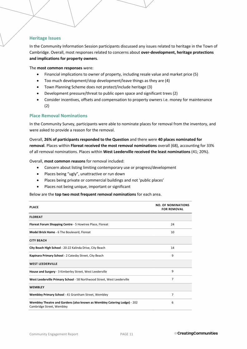
Community Engagement Report PAGE 11
Heritage Issues
In the Community Information Session participants discussed any issues related to heritage in the Town of
Cambridge. Overall, most responses related to concerns about over-development, heritage protections
and implications for property owners.
The most common responses were:
Financial implications to owner of property, including resale value and market price (5)
Too much development/stop development/leave things as they are (4)
Town Planning Scheme does not protect/include heritage (3)
Development pressure/threat to public open space and significant trees (2)
Consider incentives, offsets and compensation to property owners i.e. money for maintenance
(2)
Place Removal Nominations
In the Community Survey, participants were able to nominate places for removal from the inventory, and
were asked to provide a reason for the removal.
Overall, 26% of participants responded to the Question and there were 40 places nominated for
removal. Places within Floreat received the most removal nominations overall (68), accounting for 33%
of all removal nominations. Places within West Leederville received the least nominations (41; 20%).
Overall, most common reasons for removal included:
Concern about listing limiting contemporary use or progress/development
Places being “ugly”, unattractive or run down
Places being private or commercial buildings and not ‘public places’
Places not being unique, important or significant
Below are the top two most frequent removal nominations for each area.
PLACE NO. OF NOMINATIONS
FOR REMOVAL
FLOREAT
Floreat Forum Shopping Centre - 5 Howtree Place, Floreat 24
Model Brick Home - 6 The Boulevard, Floreat 10
CITY BEACH
City Beach High School - 20-22 Kalinda Drive, City Beach 14
Kapinara Primary School - 2 Catesby Street, City Beach 9
WEST LEEDERVILLE
House and Surgery - 3 Kimberley Street, West Leederville 9
West Leederville Primary School - 58 Northwood Street, West Leederville 7
WEMBLEY
Wembley Primary School - 41 Grantham Street, Wembley 7
Wembley Theatre and Gardens (also known as Wembley Catering Lodge) - 202 Cambridge Street, Wembley
6
Community Engagement Report PAGE 12
Place Nominations
Through the Community Survey, participants were able to nominate new places for inclusion on the
inventory, and asked to provide the place name, address and reason for inclusion.
Overall, 30% of participants nominated one or more places for inclusion, with a total of 50 places
nominated for inclusion in the LGI.
The most common place type nominated were landmarks and reserves (32%) and residential buildings
(28%). The suburbs with the most place nominations were West Leederville (30%) and City Beach (24%).
In general, common themes that emerged via the nominations were the importance of parks, public open
spaces and reserves; the sense of space and character of the area because of the parks and greenery
(“garden suburb”); and the older style homes and buildings, including areas as well as individual homes
and homes designed and lived in by Iwan Iwanoff.
Overall, the most common place nominations were:
City Beach kiosk and change rooms (7)
Land/reserves along West Coast Highway, including Templetonia Park and “Endowment Land” (5)
Garden Suburb (5)
101 Northwood St, West Leederville (4)
Olive tree in private home (3)
House on Abbotsford Private Hospital (3)
Former home of Iwan Iwanoff (3)
3.2 Key Findings of the Formal Consulting 2018
The formal consultation period ran for 43 days from Saturday, 14 July 2018 until Monday, 27 August 2018.
A total of 58 participants attended the two sessions and 64 received consisting of 47 feedback forms and
17 other written submissions. Eight submissions from public authorities were also received.
As noted comments relating to the draft policy and amendment 37 are addressed in separate reports.
Information Sessions - July 2018
The following were the most common themes of question raised in the Community Information Sessions
in July 2018, following the development of the draft LGI and draft Heritage List.
The number in brackets indicates how many specific questions relate to this theme. Some participants
listed multiple questions, while most participants chose not to provide a question.
Questions on the Heritage Framework and Assessment Process
Subjectivity in the criteria used to construct the LGI and Heritage List (8)
Specific locations of significance (4)
Participants perceiving that the Town of Cambridge have a lack of interest in / commitment to
heritage (3)
Questions related to heritage precincts (3)
The number and concentration of heritage places across the Town of Cambridge (3)
Potential for reversing the decisions to list specific places (3)
Questions related to historical research (3)
Community Engagement Report PAGE 13
Questions on Implications for Owners, Exemptions and Incentives
Financial implications and sales (9)
Changes to specific parts of the property / minor changes and whether these require approval (8)
Whether structurally damaged heritage properties can be repaired/replaced (2)
Draft Local Government Incentives and draft Heritage Lists
Feedback was overall sympathetic to the concept of recording and preserving local history for future
generations but there was a divisive response regarding the Town of Cambridge establishing any statutory
heritage list that could impose potential restrictions on property owners and development options.
The most comment themes raised were:
Place nomination and assessment criteria process (17)
Owner consent should be required to list a place and/or further owner consultation required (17)
Further consultation required and (14)
Comment on an individual place (13)
Support the concept of keeping record and acknowledging local history (12)
Concern places were incorrectly categorised or were not of significance (12)
Heritage List only including places with the highest significance (12)
Support for the Town only keeping record of place and no statutory listing (7)
Feedback relating to the individual places is addressed in the associated place submissions schedule.
Proposed Heritage Incentives
46 of the submissions received included comment about the proposed heritage incentives (45 Feedback
Forms and one other written submission).
Of the 45 feedback form submissions 26 indicated support, 10 were in opposition, 6 neither supported no
objected, and three did not provide response to this aspect of the incentives feedback form section.
Despite the general support for the development fee waiver and the grant program, responders largely
believed the amount of funding was inadequate and other incentive options such as rate concessions
were suggested.
Key themes on the incentives include:
Proposed incentives are minimal and inadequate (22)
Town should compensate owners for maintaining heritage for the wider community benefit (16)
Other types of assistance from the Town particularly rate concessions (12)
Grant should only be for heritage conservation works (9)
The feedback and submissions received are detailed in section 4 of this report
Community Engagement Report PAGE 14
4. DETAILED FINDINGS
4.1 Preliminary Engagement Period (2017)
4.1.1 Community Information Session
A Community Information Session was held on Saturday 27 May, 2017 from 10:00am to 12:00pm. There
was a total of 22 participants. Participants completed group discussion activities in small groups. The
detailed findings from each of these questions are provided below.
Q1. What’s unique about heritage in the Town of Cambridge?
Overall, most responses related to the trees, parks and greenery in the Town.
The most common responses were:
Significant trees, including those on St Leonards Ave, Callington Ave, Moreton Bay Fig Trees,
Beecroft Park Tuart Trees (4)
Parks, greenery and open spaces are important and an important part of the character of the
area (4)
Older/historical houses, including 1930s and 1950s/60s houses (4)
Responses are provided below according to theme, the number below refers to the frequency of the
response.
THEME RESPONSE
Trees. Parks and Greenery (17)
Significant trees, including those on St Leonards Ave, Callington Ave, Moreton Bay Fig Trees, Beecroft Park Tuart Trees (4)
Parks, greenery and open spaces are important and an important part of the character of the area (4)
Perry Lakes Reserve, including old score board and history of original Limekilns Estate (3)
City Beach, including old kiosk, history of the hitch back wagon roads and beach generally, and should be protected (3)
Lake Monger (2)
Alderbury Reserve (1)
Style/Architecture (8)
Older/historical houses, including 1930s and 1950s/60s houses (4)
West Leederville houses, including Woolwich St, weatherboard homes and brick and iron homes (2)
Art deco buildings, such as the Luna Theatre (1)
California Bungalows in Wembley (1)
Specific Buildings/Places (8)
Churches, including St Barnabas (2)
Old Plank Road/Oceanic Drive (1)
Floreat Forum Shopping Centre (1)
West Leederville Town Hall (1)
Plastone Building West Leederville (1)
Games Village (1)
WWII history: Submarine lookout and bomb shelter at 2 Hoven Crescent (1)
Aboriginal heritage (2) Lake Monger, Aboriginal hunting ground (1)
Early Aboriginal history of area (1)

Community Engagement Report PAGE 15
Q2. What can the Town of Cambridge do to recognise and celebrate its heritage?
Overall, most responses related to suggested events and activities, such as a photo history of the Town,
information sessions, home owner stories and a historical society.
The most common responses overall were:
Create a history of the Town of Cambridge, such as through a book or photo display (5)
Information sessions and talks (4)
Celebrate and recognise Aboriginal history, especially at the lakes (4)
Responses are provided below according to theme, the number below refers to the frequency of the
response.
THEME RESPONSE
Events and Activities (19)
Create a history of the Town of Cambridge, such as through a book or photo display (5)
Information sessions and talks (4)
Engage with home owners to get a history of individual houses and the community to find out about heritage (3)
Historical society (3)
Heritage tours and walks (2)
Heritage Open Days and events (1)
Aboriginal heritage events, such as bush tucker walks (1)
General (9)
Celebrate and recognise Aboriginal history, especially at the lakes (4)
Respect and celebrate the past in general (2)
Preserve heritage generally (1)
Involve/engage with young people on heritage (1)
Provide more 'plain text' information about heritage (1)
Planning and Policy (8)
Incorporate heritage protections and policies into Town Planning Scheme (3)
Restrict or limit demolition/provide guidelines on demolition (2)
Melbourne is a good example of mix of old and new buildings (1)
Develop a long term plan for heritage ("100 year plan") (1)
Engage with experts on heritage protections and best practice (1)
Built Form and Architecture (4)
Keep the façade of older buildings (1)
Celebrate modern architecture as well, such as City Beach (1)
Conduct architectural survey (1)
Maintain good mix of diverse housing and styles (1)
Parks and Streetscapes (4) Preserve trees, parks, lakes and unique natural landscape (3)
Preserve character of streetscapes (1)
Other (3) “Give the heritage council teeth” (2)
“New Empire Village is truly a celebration” (1)
Community Engagement Report PAGE 16
Q3. Are there any issues about heritage in the Town of Cambridge that you’d like to
discuss?
Overall, most responses related to concerns about over-development, heritage protections and
implications for owners.
The most common responses overall were:
Financial implications to owner of property, including resale value and market price (5)
Too much development/Stop development/leave things as they are (4)
Town Planning Scheme does not protect/include heritage (3)
Responses are provided below according to theme, the number below refers to the frequency of the
response.
THEME RESPONSE
Development and Protections (11)
Too much development/Stop development/leave things as they are (4)
Town Planning Scheme does not protect/include heritage (3)
Development pressure/threat to public open space and significant trees (2)
Protect beaches and natural areas (1)
Consider impact of increased density on heritage (1)
Owner Issues (8)
Financial implications to owner of property, including resale value and market price (5)
Owner should be involved in process and must agree to listing/not be forced (1)
Owners have right to protect their own interests (1)
Heritage listing restricts what owner can do to home/property (1)
Incentives (2) Consider incentives, offsets and compensation to property owners e.g. money for maintenance (2)
Communication (1) Public should see the draft Heritage List (1)

Community Engagement Report PAGE 17
4.1.2 Community Survey
Overall 181 participants completed the survey, which was open for a period of four weeks from Friday 12
May to Friday 9 June 2017. The survey was available to complete online. Hardcopy surveys were able to
be provided on request, however no hardcopy surveys were requested or submitted. The survey was also
available to complete at the Community Information Session on tablet devices.
The detailed findings from the survey are provided below according to question.
Q1. What is unique or what do you like most about the Town of Cambridge’s heritage?
92% of participants responded to Question One. Overall, most responses related to parks, trees and open
space and residential housing styles.
The most common specific responses were:
Parks and public open space (91)
Residential blocks are big, have large setbacks/verges and are generally low density/low scale
(59)
Trees/significant trees (41)
Older style houses generally (37)
"Garden suburb" (33)
Responses are provided below according to theme, the number below refers to the frequency of the
response.
THEME RESPONSE
Parks, Trees and Open Space (254)
Parks and public open space (91)
Trees/significant trees (41)
"Garden suburb" (33)
Perry Lakes, including old score board (21)
The beach/coastline, including City Beach and Floreat Beach (16)
Bold Park (15)
Lake Monger (12)
Preserved bushland (10)
Reabold Hill (7)
Sporting precincts and recreation areas (3)
Alderbury Reserve (2)
Wembley Golf Course (2)
Herdsman Lake (1)
Residential Housing (112)
Residential blocks are big, have large setbacks/verges and are generally low density/low scale (59)
Older style houses generally (37)
Federation style houses (5)
California Bungalows (4)
Pre-war houses (3)
Area is known for housing styles (2)
Houses of significant people/houses built by significant people (2)
Precincts and Streetscapes (48)
Sense of space in area, with wide and open streets (19)
Streetscapes are unique, especially tree lined streets (12)
West Leederville housing and streetscape (9)

Community Engagement Report PAGE 18
Precincts with whole streets with older houses intact (2)
Suburb layout and road network (2)
Ruislip St (2)
Holyrood St (1)
St Leonards Ave (1)
General Building Styles (15)
Mix of different styles of architecture, and both modern and older style alongside each other (9)
Art deco (3)
Edwardian architecture (2)
Post War (1)
Specific Buildings (6) Cambridge Town Hall, Leederville Town Hall or unspecified Town Hall (5)
Wembley Hotel (1)
History of Area (5) Aboriginal cultural heritage and history, and use of local environment (3)
Early settlement buildings in Town some of earliest in Perth / early expansion/history of Perth (2)
Other Comments (28) Other/Negative Comment (18)
Better infill design
Unfortunately, buildings have been allowed over heights that I feel have detracted from feel of these suburbs, particularly The Cube apartments on Cambridge St and I am not looking forward to the seeing the apartments on the old nursery site along Salvado Rd because of their height!!
The Parks and open spaces e.g. Perry Lakes, Monger Lake, Alderbury St Reserve bold Park etc. - so not spoil these places by developing them any further e.g. new sport facilities at Alderbury Reserve, cafe at Mongers Lake. Sort out the Water Levels at Perry Lakes
I find the soul of suburbs like Wembley are being destroyed when enormous 2 storey dwellings are built on small blocks many of which tower over the quant bungalows. I would like to see more restrictions on the demolition of these period homes. I would like to see the facades restored enabling owners to modernise the rear- incorporating old and new. There aren't too many of these homes left in Australia and I believe they need to be protected. Areas like Wembley will not hold the same appeal as more blocks are flooded with houses more suitable to city beach and the northern suburbs.
The ongoing homogenisation of new buildings is losing all this history.
The historical value of Floreat and City Beach is too often disregarded by the Town in preparation of policy and determination of development applications and a rediscovery of just what Gardens Suburbs means needs to occur and be reflected in all Policy and in the Town Planning Scheme. Whilst many of the original values have been compromised the overall integrity of this approach to suburban development in these locations remains even more relevant than ever as infill agendas are pursued and over development is often encouraged. The public realm and the private interface needs far more thought and effort in the Town of Cambridge.
My question is: What is the Town of Cambridge? Yes, older buildings etc. do play a part but what is the use of respecting and revering these if they can be bulldozed? The T of C also has many newer edifices that require acknowledgement as heritage examples. And so do its parks - e.g. Beecroft Park, Ocean Village Park to name 2 - we love them so please protect them as they are.
And indigenous heritage is also so important to our history - Botanic Gardens & Parks Authority has information about areas around Bold Park"
There are NO heritage private dwellings. Hands OFF!!!
Town of Cambridge doesn't seem to have any apart from the Leederville town hall and Holyrood Street
I value investment in archives, including aural histories, and celebration of history.
There are many beautiful Art deco homes and so many of them have been knocked down for cheap ugly McMansions.
The Town of Cambridge is varied in age and so historical locations and architecture varies through a long timeline. Unfortunately very little work has been done by council to research or preserve these sites. Particularly in West Leederville where density goals by planning has ignored heritage value and the architectural value of the area.
The variety of heritage in the town, from Art Deco to federation style property's each are an important time in WA's history and should be preserved, cause once knocked down it's gone forever
The sort of house which typified Floreat is being rapidly destroyed by the new McMansions which are being approved even though they frequently exceed guidelines.

Community Engagement Report PAGE 19
Pity about the loss of water and destruction of trees nearby [Perry Lakes].
Why change what works and is unique and beautiful. Our Natural environment is what works and makes us so special. Less scale of building and more emphasis on our natural setting. Other councils would love to have what we have.
The modernist houses in the area west of the Forum create a unique precinct under threat from tacky oversized McMansions. Again, west of the Forum the garden suburb is being ruined by absence of trees and gardens due to the building of oversized houses that require tree demolition.
Generally should respect and preserve heritage (6)
Quiet and peaceful (2)
ANZAC services (1)
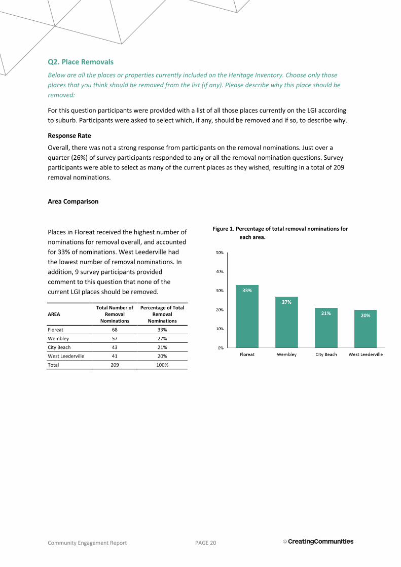
Community Engagement Report PAGE 20
Q2. Place Removals
Below are all the places or properties currently included on the Heritage Inventory. Choose only those
places that you think should be removed from the list (if any). Please describe why this place should be
removed:
For this question participants were provided with a list of all those places currently on the LGI according
to suburb. Participants were asked to select which, if any, should be removed and if so, to describe why.
Response Rate
Overall, there was not a strong response from participants on the removal nominations. Just over a
quarter (26%) of survey participants responded to any or all the removal nomination questions. Survey
participants were able to select as many of the current places as they wished, resulting in a total of 209
removal nominations.
Area Comparison
Places in Floreat received the highest number of
nominations for removal overall, and accounted
for 33% of nominations. West Leederville had
the lowest number of removal nominations. In
addition, 9 survey participants provided
comment to this question that none of the
current LGI places should be removed.
AREA Total Number of
Removal Nominations
Percentage of Total Removal
Nominations
Floreat 68 33%
Wembley 57 27%
City Beach 43 21%
West Leederville 41 20%
Total 209 100%
Figure 1. Percentage of total removal nominations for
each area.

Community Engagement Report PAGE 21
Figure 2. Removal nominations according to area.
WEST LEEDERVILLE WEMBLEY
FLOREAT CITY BEACH

Community Engagement Report PAGE 22
Figure 3. Frequency of place removal nominations.

Community Engagement Report PAGE 23
Removal Nominations
Detailed removal nominations are provided below, including the place, number of nominations received
and the reasons provided for removal.
Note that some participants did not provide a reason for removal, and some participants provided
multiple reasons. It should also be noted that some participants provided the same reason for each
removal nomination (i.e. response repeated verbatim for each nomination), these are marked in italics in
the below table.
Responses below have been provided in their raw form, and have not been summarised.
PLACE FREQUENCY REASON FOR REMOVAL
WEST LEEDERVILLE
House and Surgery - 3 Kimberley Street, West Leederville
9
I don't believe that is a particularly attractive building, and the site would be more suitable for a higher use than what is currently there. Any amenity that this building projects to the surrounding area would be outweighed by a functional higher use development on the same site.
No private house should be listed
These are not iconic buildings that should disrupt progress
Cannot see the reason
Not a public building
West Leederville Primary School - 58 Northwood Street, West Leederville
7
Primary schools have to grow and adapt to more student, change to provide an up to date learning environment, much of the original school has been modified already
Should have the option to be updated and have modern facilities for school children
The school should not be constrained by the implications of heritage if it needs to develop in line with student needs
Primary schools are for educating children not for looking at
Schools are supposed to be a place our young children are well educated and develop curious minds which explore possibilities, not a place where innovation and progress are stopped. Schools should be maintained and upgraded by the Education Department as the need arises. They should serve the community as it changes demographically so need to have the flexibility to grow and shrink over generations. The Council role should be to ensure there are enough schools of high quality to serve their community. If this means lobbying for upgrades please get active.
These are not iconic buildings that should disrupt progress
Cannot see the reason
Uniting Church and Hall - Corner Woolwich Street & Kimberley Street, West Leederville
5
Not a particularly attractive example of a church and hall
Ugly and not needed
These are not iconic buildings that should disrupt progress
Churches should fund and look after their own properties without imposing the expense on others in the community. They should also be able to choose when to replace them if they own them, so not our business what is done with them.
Henderson Memorial Presbyterian Church - 101 Kimberley Street, West Leederville
5
Not a particularly attractive example of a church
Ugly and not needed
These are not iconic buildings that should disrupt progress
Churches should fund and look after their own properties without imposing the expense on others in the community. They should also be able to choose when to replace them if they own
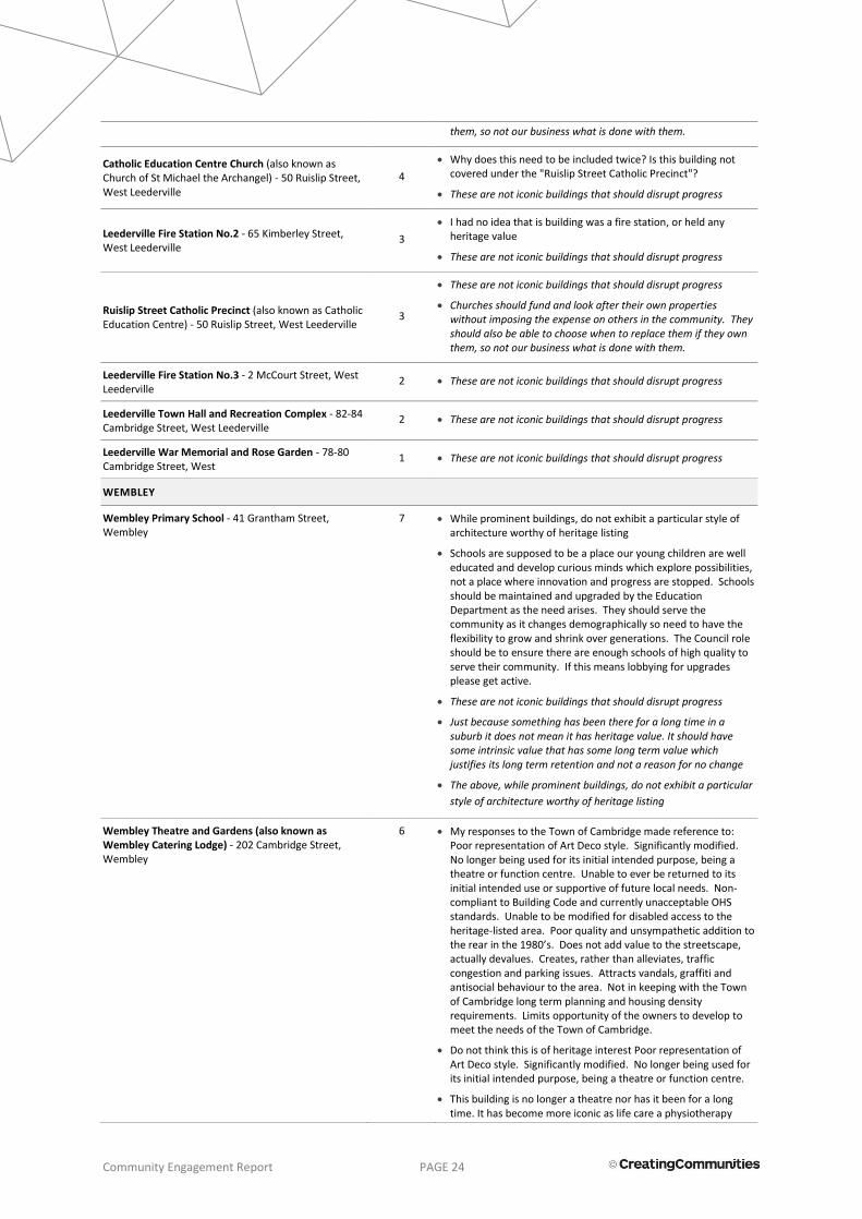
Community Engagement Report PAGE 24
them, so not our business what is done with them.
Catholic Education Centre Church (also known as Church of St Michael the Archangel) - 50 Ruislip Street, West Leederville
4
Why does this need to be included twice? Is this building not covered under the "Ruislip Street Catholic Precinct"?
These are not iconic buildings that should disrupt progress
Leederville Fire Station No.2 - 65 Kimberley Street, West Leederville
3
I had no idea that is building was a fire station, or held any heritage value
These are not iconic buildings that should disrupt progress
Ruislip Street Catholic Precinct (also known as Catholic Education Centre) - 50 Ruislip Street, West Leederville
3
These are not iconic buildings that should disrupt progress
Churches should fund and look after their own properties without imposing the expense on others in the community. They should also be able to choose when to replace them if they own them, so not our business what is done with them.
Leederville Fire Station No.3 - 2 McCourt Street, West Leederville
2 These are not iconic buildings that should disrupt progress
Leederville Town Hall and Recreation Complex - 82-84 Cambridge Street, West Leederville
2 These are not iconic buildings that should disrupt progress
Leederville War Memorial and Rose Garden - 78-80 Cambridge Street, West
1 These are not iconic buildings that should disrupt progress
WEMBLEY
Wembley Primary School - 41 Grantham Street, Wembley
7 While prominent buildings, do not exhibit a particular style of architecture worthy of heritage listing
Schools are supposed to be a place our young children are well educated and develop curious minds which explore possibilities, not a place where innovation and progress are stopped. Schools should be maintained and upgraded by the Education Department as the need arises. They should serve the community as it changes demographically so need to have the flexibility to grow and shrink over generations. The Council role should be to ensure there are enough schools of high quality to serve their community. If this means lobbying for upgrades please get active.
These are not iconic buildings that should disrupt progress
Just because something has been there for a long time in a suburb it does not mean it has heritage value. It should have some intrinsic value that has some long term value which justifies its long term retention and not a reason for no change
The above, while prominent buildings, do not exhibit a particular
style of architecture worthy of heritage listing
Wembley Theatre and Gardens (also known as Wembley Catering Lodge) - 202 Cambridge Street, Wembley
6 My responses to the Town of Cambridge made reference to: Poor representation of Art Deco style. Significantly modified. No longer being used for its initial intended purpose, being a theatre or function centre. Unable to ever be returned to its initial intended use or supportive of future local needs. Non-compliant to Building Code and currently unacceptable OHS standards. Unable to be modified for disabled access to the heritage-listed area. Poor quality and unsympathetic addition to the rear in the 1980’s. Does not add value to the streetscape, actually devalues. Creates, rather than alleviates, traffic congestion and parking issues. Attracts vandals, graffiti and antisocial behaviour to the area. Not in keeping with the Town of Cambridge long term planning and housing density requirements. Limits opportunity of the owners to develop to meet the needs of the Town of Cambridge.
Do not think this is of heritage interest Poor representation of Art Deco style. Significantly modified. No longer being used for its initial intended purpose, being a theatre or function centre.
This building is no longer a theatre nor has it been for a long time. It has become more iconic as life care a physiotherapy

Community Engagement Report PAGE 25
practice in the middle of a medical precinct
The building no longer is representative of its initial design. Substantially and unsympathetically added and modified. Doesn't suit the purpose of the area. Substantial modification would be required to restore to its initial addition to the heritage inventory. No longer consistent with the area or the intentions of Cambridge street planning development for the community. Staircase no longer meets current building codes and OHS requirements. Unable to be modified to meet these. Heritage listing prevents modification for disabled access. Attracts graffiti, vandalism and antisocial behaviour. Removal affords opportunity to develop the site in keeping with the Town's planning requirements.
These are not iconic buildings that should disrupt progress
Our Lady of Victories Roman Catholic Church - 364 Cambridge Street, Wembley
5 Churches should fund and look after their own properties without imposing the expense on others in the community. They should also be able to choose when to replace them if they own them, so not our business what is done with them.
These are not iconic buildings that should disrupt progress
The above, while prominent buildings, do not exhibit a particular style of architecture worthy of heritage listing
St Edmund's Anglican Church - 54 Pangbourne Street, Wembley
5 These are not iconic buildings that should disrupt progress
Churches should fund and look after their own properties without imposing the expense on others in the community. They should also be able to choose when to replace them if they own them, so not our business what is done with them.
Wembley Uniting Church - 35 Pangbourne Street, Wembley
5 Churches should fund and look after their own properties without imposing the expense on others in the community. They should also be able to choose when to replace them if they own them, so not our business what is done with them.
These are not iconic buildings that should disrupt progress
Just because something has been there for a long time in a suburb it does not mean it has heritage value. It should have some intrinsic value that has some long term value which justifies its long term retention and not a reason for no change
The above, while prominent buildings, do not exhibit a particular style of architecture worthy of heritage listing
Wembley Church of Christ - 61-63 Nanson Street, Wembley
5 I don't know why the Wembley Church of Christ - 61-63 Nanson Street, Wembley is of significant value
These are not iconic buildings that should disrupt progress
Churches should fund and look after their own properties without imposing the expense on others in the community. They should also be able to choose when to replace them if they own them, so not our business what is done with them.
Wembley Hotel - 344 Cambridge Street, Wembley 4 Not sure that has any great architectural merit & recent alterations were not sympathetic to its original form (i.e. the drive through bottle shop)
These are not iconic buildings that should disrupt progress
Just because something has been there for a long time in a suburb it does not mean it has heritage value. It should have some intrinsic value that has some long term value which justifies its long term retention and not a reason for no change
Henderson Park - Cnr Salvado Road & Jersey Street, Jolimont
3 These are not iconic buildings that should disrupt progress
The Meyer House - 64 Reserve Street, Wembley 3 These are not iconic buildings that should disrupt progress
The Orr House - 66 Reserve Street, Wembley 3 These are not iconic buildings that should disrupt progress

Community Engagement Report PAGE 26
Catherine McAuley Centre The Old Chapel - 18 Barrett Street, Wembley
3 These are not iconic buildings that should disrupt progress
Churches should fund and look after their own properties without imposing the expense on others in the community. They should also be able to choose when to replace them if they own them, so not our business what is done with them.
Rutter Park - Between Alexander Street & Jersey Street, Wembley
3 These are not iconic buildings that should disrupt progress
Catherine McAuley Centre St Vincent's Foundlings Home - 18 Barrett Street, Wembley
2 These are not iconic buildings that should disrupt progress
Catherine McAuley Centre Stables - 18 Barrett Street, Wembley
1 These are not iconic buildings that should disrupt progress
Catherine McAuley Centre Olive Trees - 18 Barrett Street, Wembley
1 These are not iconic buildings that should disrupt progress
1 St Columbas Avenue Olive Trees - 1 St Columbas Avenue, Wembley
1 These are not iconic buildings that should disrupt progress
Lake Monger - Lake Monger Drive, Wembley 0
FLOREAT
Floreat Forum Shopping Centre - 5 Howtree Place, Floreat
24 All the best bits have gone
I am not sure why this area should be o the heritage list to start with
Floreat Forum is ideally placed to become a major hub of ToC -the potential for providing for residential and many types of commercial and community amenities for the whole of ToC with excellent access potentials between North and South while giving Wembley and West Leederville a breathing space from the ill-thought developments to date -with the high probability of decreasing the traffic issues in ToC's Eastern suburbs. Not long ago FF had a major change -i.e. nothing there is of value either historically or visually; it stands in the way of sensible, inclusive progress. I see no heritage value in its recent form -certainly its value as a centre is hampered by the restrictions of its form
This is a commercial shopping mall
It's been substantially changed over the years and I'm happy for it to be updated or redeveloped if required
Not removed, but needs to be modernised whilst capturing heritage aspects through photographs.
The original Floreat Forum shopping centre was a magnificent example of 1960s architecture, the current renovated Forum looks nothing like the original and currently has little architectural or heritage value. It’s a shame the original building wasn't preserved, view the photos online, it was stunning
Floreat forum is a shit heap - there's absolutely nothing there of significance. I would have no problem (and would encourage) it to be rebuilt into a better shopping centre. It should, however, remain a shopping centre and not be sold off for crappy modern housing like Perry Lakes.... That was a terrible decision.
Don't know why a shopping centre is listed. Presumably this would limit future development.
There is nothing unique or worth specifically preserving at the forum.
It’s a shopping centre for god’s sake.
I would like the Floreat Forum Shopping Centre to be retained in its current function, but cannot see why it should not be updated from its current form to keep it viable.
Floreat Forum is unattractive and insignificant. I would rather a nicer shopping complex with more street appeal and facade.

Community Engagement Report PAGE 27
It’s been changed a lot
These buildings have no value to me or anyone I know
? reason Private property
These are not iconic buildings that should disrupt progress
Model Brick Home - 6 The Boulevard, Floreat 10 Ugly and not needed
? reason Private property
I don't know what they are, or why they would be historic.
These buildings have no value to me or anyone I know.
These are not iconic buildings that should disrupt progress
The retention of "niche" man-made constructions as "heritage" on the basis that they are interesting to a small minority, while being inaccessible to the majority, should be questioned. I have lived in the area for 12 years and never knew that 6 and 12 The Boulevard were heritage listed. I don't see their listing as "heritage" having any positive effect on the area. This is in stark contrast with the likes of Perry Lakes, Bold Park, etc. which have shaped, and continue to shape the nature, culture and appeal of the area. As regard the former Perry Lakes Sporting Complex, if this refers to the site of the former Empire Games Stadium, I would question what value Heritage Listing provides if the stadium was demolished and the site has now been turned into housing estate. I would be interested to know what difference there would have been if the site had not been Heritage Listed.
Not a public building
Model Timber Home - 12 The Boulevard, Floreat 8 Ugly and not needed
? reason Private property
I don't know what they are, or why they would be historic.
These buildings have no value to me or anyone I know.
These are not iconic buildings that should disrupt progress
The retention of "niche" man-made constructions as "heritage" on the basis that they are interesting to a small minority, while being inaccessible to the majority, should be questioned. I have lived in the area for 12 years and never knew that 6 and 12 The Boulevard were heritage listed. I don't see their listing as "heritage" having any positive effect on the area. This is in stark contrast with the likes of Perry Lakes, Bold Park, etc. which have shaped, and continue to shape the nature, culture and appeal of the area. As regard the former Perry Lakes Sporting Complex, if this refers to the site of the former Empire Games Stadium, I would question what value Heritage Listing provides if the stadium was demolished and the site has now been turned into housing estate. I would be interested to know what difference there would have been if the site had not been Heritage Listed.
Not a public building
Floreat Park Primary School - 38 Chandler Street West, Floreat
8 Retaining Floreat Park Primary School is reasonable but, like other buildings there is the emotional as well as heritage and even commercial reasons for considering whether to retain on the list -I'm somewhat ambivalent on that one.
Floreat Park Primary School is of non-descript architecture.
Floreat Park Primary School was built in the late 1960s and some areas are very difficult to utilise well with current teaching methods and tools. The under croft areas are too small for effective classrooms and very expensive to install wiring to. It is supposed to be a place our young children are well educated and develop curious minds which explore possibilities, not a place where innovation and progress are stopped. Schools should be maintained and upgraded by the Education Department as the need arises. They should serve the community as it changes demographically so need to have the flexibility to grow and shrink over generations. The Council role

Community Engagement Report PAGE 28
should be to ensure there are enough schools of high quality to serve their community. If this means lobbying for upgrades please get active.
These buildings have no value to me or anyone I know
These are not iconic buildings that should disrupt progress
Perry Lakes Sporting Complex (former) - Underwood Avenue, Floreat
8 The Perry Lakes sporting complex no longer exists - demolished
I see little heritage value in Perry Lakes Sporting Complex as far as the built scenario -the value is in the open spaces: I'm unfamiliar with the conditions of that area that specifically relate to being on the Heritage List
It doesn't exist anymore
These are not iconic buildings that should disrupt progress
St Cecilia's Roman Catholic Church - 47 Peebles Road, Floreat
7 Personally I think it is fine to preserve the older churches in the greater city area and for old but not the oldest church in small suburbs, that are small and I would assume a higher cost to maintain are not necessary. Churches should not primarily be about the building.
Why is the church at 47 Peebles Road, Floreat interesting?
Churches should fund and look after their own properties without imposing the expense on others in the community. They should also be able to choose when to replace them if they own them, so not our business what is done with them.
These are not iconic buildings that should disrupt progress
Perry House - 165-167 Oceanic Drive, Floreat 3 These buildings have no value to me or anyone I know
These are not iconic buildings that should disrupt progress
Bold Park & Adjacent Bushland - Oceanic Drive, Floreat 0
Perry Lakes - Perry Lakes Drive, Floreat 0
CITY BEACH
City Beach High School - 20-22 Kalinda Drive, City Beach
14 New and appropriate buildings for education use
CB High School -once again I don't know the conditions for inclusion on the heritage list: it is arguable in my mind as to why it was ever placed there.
This site should be developed to provide a new high school in the area
Should be able to update the old school so that it is an up to date high school, as we don't have many in the area
Most of these buildings have no value and limiting development to retain these items is regressive and does not consider development adds value through renewal and reinvigoration. Therefore assets and suburbs need to change
These are not iconic buildings that should disrupt progress
Kapinara Primary School - 2 Catesby Street, City Beach 9 New and appropriate buildings for education use
Most of these buildings have no value and limiting development to retain these items is regressive and does not consider development adds value through renewal and reinvigoration. Therefore assets and suburbs need to change
These are not iconic buildings that should disrupt progress
City Beach Primary School - 30 Marapana Road, City Beach
8 I'm indifferent
Most of these buildings have no value and limiting development to retain these items is regressive and does not consider development adds value through renewal and reinvigoration. Therefore assets and suburbs need to change
These are not iconic buildings that should disrupt progress

Community Engagement Report PAGE 29
Commonwealth Games Village Precinct (former) - Btwn The Boulevard, Tilton Terrace, Pandora Drive & Dupont Avenue, City Beach
6 The houses are all too old. They should be removed and allow bigger houses on them. Do not subdivide the blocks. Leave to block sizes as they are. !!!!!!!!!!!!!!
The Games Village -please don't remove the park from heritage listing. But the actual village, i.e. the homes that were built specifically for athletes, are 'discussable'. Many have been replaced with more modern places. The Empire Shopping Centre is poorly planned and should not be on the list - the NE entrance/exit is dangerous as are the roads surrounding that area, the pedestrian access is also not particularly safe, the parking is insufficient, the non-connection between north and south shops is not conducive for visual overview nor good for business etc. etc.; the whole complex needs consideration -certainly not with heritage listing conditions hanging over it.
These are not iconic buildings that should disrupt progress
Happy Tree Tuart - 9 Hovea Crescent, City Beach 3 Most of these buildings have no value and limiting development to retain these items is regressive and does not consider development adds value through renewal and reinvigoration. Therefore assets and suburbs need to change
These are not iconic buildings that should disrupt progress
Holy Spirit School & War Memorial Church - 2 Keaney Place, City Beach
2 These are not iconic buildings that should disrupt progress
City Beach Foreshore - Challenger Parade, City Beach 1 Most of these buildings have no value and limiting development to retain these items is regressive and does not consider development adds value through renewal and reinvigoration. Therefore assets and suburbs need to change
Quarry Amphitheatre - 145 Oceanic Drive, City Beach 0
OTHER COMMENTS
Other Comments
(where none of the above were selected for removal) 14 Again adding homes with great architecture to the list!
All should remain on the heritage list
Can’t comment - don't know many of these places as I live on the coastal part of Cambridge. However, I view the Town as having mainly 'natural' as opposed to 'built' heritage values.
I do not think any should be removed. In fact it would be
wonderful to find other homes that could be added to the list!
I view the Town as having mainly 'natural' as opposed to 'built' heritage values
Keep them all, please!
None of the above should be removed. There is too much imbalance of new buildings V's heritage & will lose the old charm
None of these places should be removed.
None of this should be touched
None, all should be preserved.
Please do not remove any!!!
There is not enough community knowledge about the historical value of any of these sites to make such a decision. There are very few houses like one of the first houses in the area - 101 Northwood. Council should have added this to their list.
Why would any of these need to be removed from the heritage list? They are all important in their own way
You need to take into account the owners of these properties - as them what they want

Community Engagement Report PAGE 30
Q3. Place Nominations
If there is an important place or property that has heritage value that is not currently on the Heritage Inventory, please nominate this place below and explain why
you think it has important heritage value:
Participants were able to nominate up to three places for inclusion on the Inventory. Overall, 30% of participants responded to this question and nominated one or
more places for inclusion, with a total of 82 nominations. Two additional nominations which were received during the survey period directly via the Town of
Cambridge are included in the findings. Of these 82 nominations, 9 were for places on or associated with places already listed on the current LGI and a number of
places were nominated multiple times, resulting in approximately 50 places nominated for heritage assessment.
Place Types
Overall, the most common place type nominated for inclusion was landmarks
and reserves, accounting for 32% of nominations. This is consistent with the
overall findings, with parks and reserves a strongly valued local amenity and
feature.
TYPE TOTAL NUMBER OF
NOMINATIONS PERCENTAGE OF TOTAL
NOMINATIONS
Landmarks and Reserves 26 32%
Residential 23 28%
Commercial 9 11%
Institutional and Community Facilities
13 16%
Areas 11 13%
Total 82 100%
Figure 4. Percentage of nominations for each place type.

Community Engagement Report PAGE 31
Place Locations
West Leederville and City Beach were the suburbs with the most place
nominations. Note the below table includes where place nominations were
located in more than one suburb. The percentage is provided as an indicative
measure, and calculated using the overall total number of nominations (50),
to show the proportion of nominations for each area.
AREA Number of Places
Nominated Percentage of Nominated
Places
West Leederville 15 30%
City Beach 12 24%
Floreat 11 22%
Wembley 7 14%
Not specific 5 10%
50 100%
Figure 5. Percentage of place nominations from each area.

Community Engagement Report PAGE 32
Figure 6. Nominations according to area.
WEST LEEDERVILLE WEMBLEY
FLOREAT CITY BEACH
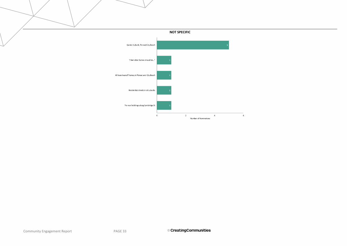
Community Engagement Report PAGE 33
NOT SPECIFIC
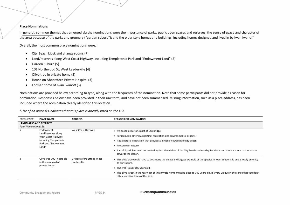
Community Engagement Report PAGE 34
Place Nominations
In general, common themes that emerged via the nominations were the importance of parks, public open spaces and reserves; the sense of space and character of
the area because of the parks and greenery (“garden suburb”); and the older style homes and buildings, including homes designed and lived in by Iwan Iwanoff.
Overall, the most common place nominations were:
City Beach kiosk and change rooms (7)
Land/reserves along West Coast Highway, including Templetonia Park and “Endowment Land” (5)
Garden Suburb (5)
101 Northwood St, West Leederville (4)
Olive tree in private home (3)
House on Abbotsford Private Hospital (3)
Former home of Iwan Iwanoff (3)
Nominations are provided below according to type, along with the frequency of the nomination. Note that some participants did not provide a reason for
nomination. Responses below have been provided in their raw form, and have not been summarised. Missing information, such as a place address, has been
included where the nomination clearly identified this location.
*Use of an asterisks indicates that this place is already listed on the LGI.
FREQUENCY PLACE NAME ADDRESS REASON FOR NOMINATION
LANDMARKS AND RESERVES Total Nominations: 26
5 Endowment Land/reserves along West Coast Highway, including Templetonia Park and “Endowment Land”
West Coast Highway It's an iconic historic part of Cambridge
For its public amenity, sporting, recreation and environmental aspects.
It is a natural vegetation that provides a unique viewpoint of city beach.
Preserve for nature
A useful park has been decimated against the wishes of the City Beach and nearby Residents and there is room to e increased towards the Ocean.
3 Olive tree 100+ years old in the rear yard of private home
9 Abbottsford Street, West Leederville
This olive tree would have to be among the oldest and largest example of the species in West Leederville and a lovely amenity to our suburb.
The tree is over 100 years old
The olive street in the rear year of this private home must be close to 100 years old. It’s very unique in the sense that you don’t often see olive trees of this size.

Community Engagement Report PAGE 35
2 * City Beach Groyne and Lookout tower, and Floreat groyne
Challenger Pde, City Beach An iconic image which represents many people's memories of visit the beach. The tower represents the importance of surf lifesavers and the services they provide to keep the community safe whilst swimming.
Obviously they define the two beaches, provide valuable recreation for protected swimming, good surfing sand banks, fishing, etc. More groynes would be welcome as would extensions to make the existing groynes longer
2 Ocean Village Park Brompton/Drabble Road, City Beach
This area includes both parkland and remnant bush land particularly a fenced area and on the north east side of the park. Scattered through the bush land which surrounds the grassed area there is a number of very old tuarts (eucalyptus gamphocephala). According to the Department of Conservation website: These trees provide important biological and ecological values and habitats for many animal and fungal species. Aboriginal people valued tuart woodlands for hunting and gathering and used bark from trees to make weapons and tools. And further: Tuart trees and their communities are under threat from urban development. As there is higher density residential building on the west and northern sides of this park and there will almost certainly be higher density residential development on the southern side which is at present the Ocean Village shopping center, it is felt that this area will come under increasing pressure and requires some status to protect the unique features of this smaller area of bush land within the Town. This area is habitat for a wide variety of bird species including honey eaters, wattle birds, owls, magpies and carnaby parrots. At one point on the south western side of the park there is a sign which reads: This Remnant Bush environment is protected and rehabilitate by Council and the local community for the benefit of current and future generations. The preservation of this site can assist in the following functions; - provide and area of habitat for native flora and fauna; provide the community with a glimpse of what naturally existed in the area prior to development; provide educational institutions the opportunity to study the area; provide a reserve of indigenous plant species for use by future generations.
Our parks are important and this one contains wonderful Tuarts - trees indigenous to the area
2 Floreat Oval, Floreat Park and McLean Park; Floreat primary school and McLean Park
All of the land between Oceanic Dve, The Boulevard, Ulster Rd and Howtree Plce
For its public amenity, sporting, recreation and environmental aspects.
I think McLean Park should be reserved for the school (they are losing a lot of their "green space"), social sport (not grade) _ and community activities (dog walking, runners etc.)
2 *Bold Park Bold Park It's an iconic historic part of Cambridge
Industrial and Indigenous heritage
2 *Perry Lakes Perry Lakes It's an iconic historic part of Cambridge
Perry Lakes, parks and bush areas are vital to our way of life in Cambridge
1 City Beach ovals West Coast Highway / Fred Burton Way
Sport throughout the years a + worth protecting such a useful sporting and dog walking and exercise place that has lovely beach and sunset views.
1 Beecroft Park Oban Road, City Beach Our parks are important and this one is loved by many
1 Cowden Park between Northwood and Kimberley Streets, West Leederville
It has been an open play space for generations of children in West Leederville. Its proximity to the Anglican Church and the heritage listed West Leederville Primary School. The presence of old Moreton Bay Fig Trees. Its location on the top of the hill may be relevant to the story of Aboriginal settlement in the area.
1 Park Area between The Boulevard and Bourneville Street, Floreat
This as park area, "formerly", in the time of the 2nd World War, was deemed an underground air shelter ground cordon; fittingly "a" bunker shelter.
1 *Quarry amphitheatre Bold Park Industrial and Indigenous heritage

Community Engagement Report PAGE 36
1 Fire pit at Perry Lakes near the Scout Hall
Perry Lakes reserve Commonwealth games significance
1 *Lake Monger South Foreshore
Lake Monger Drive, West Leederville
Specifically the lawns and the historic and intentional planting of the palms, willows and plane trees to create the unique landscape that is the dominant icon of the lake. Listing of this landscape continues the legacy of the design and maintains the experiences (black swan interaction, picnics, relaxing under the trees on the lawn) for the generations to come.
1 The big fir tree that is lit up with lights at Christmas - South side of Lake Monger
Lake Monger Drive, West Leederville
It is the Christmas Tree in this area
RESIDENTIAL BUILDINGS Total Nominations: 23
4 101 Northwood St 101 Northwood Street, West Leederville; 104 Northwood Street, West Leederville
One of the first grand homes built in its time - as a display home and also the long term residence of the head of the local fire bridges and the organization for over 40 years.
Each of the four houses reflects a different architectural styles, and from a slightly different period.
One of the grandest private homes in west Leederville
This is a beautiful home over 100 years old.
3 Former home of Iwan Iwanoff - Lifford Road Floreat
16 Lifford Road, Floreat Iwanoff is an important architect and this was his private home and studio. It tells stories of migration, discrimination, strength, uniqueness and design.
Renowned architect Ivan Iwanoff designed and built this house for himself and his own family and lived there for a number of years. It is a wonderful example of brutalist architecture.
2 Roberts House 12 Yanagin Crescent, City Beach An important example of the work of Iwanoff.
2 Paganin House 165 The Boulevard, Floreat An important example of the work of Iwanoff.
2 97 Northwood St, West Leederville
97 Northwood Street, West Leederville
A particularly fine example of an Edwardian timber cottage
Each of the four houses reflects a different architectural styles, and from a slightly different period.
1 Private homes 4, 10, 19 Branksome Gardens, City Beach
These 3 houses are examples of the original South City Beach homes which gave the area its character. Most of the old beach houses have been demolished to make way for modern developments so it's important to keep some examples of what was.
1 House 14 Marimba Crescent, City Beach Early modernist house. I am a previous owner of the house and am happy to be contacted for further information.
1 House 314 Railway Parade, West Leederville
The home is a beautiful example of Federation architecture, constructed from solid limestone blocks and featuring a wide wrap-around veranda.
1 Four houses on each corner of Northwood and Ruislip Streets
97, 98, 101, 104 Northwood Street, West Leederville
Each of the four houses reflects a different architectural styles, and from a slightly different period.
1 Cnr Blencowe Ruislip St - large heritage house
92 Blencowe Street, West Leederville
Architectural and period value
1 All Ivan Iwanoff homes in Floreat & City Beach
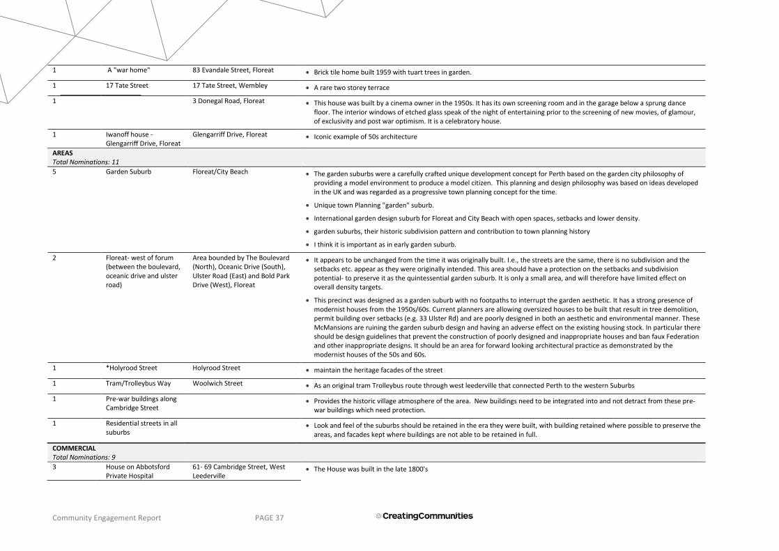
Community Engagement Report PAGE 37
1 A "war home" 83 Evandale Street, Floreat Brick tile home built 1959 with tuart trees in garden.
1 17 Tate Street 17 Tate Street, Wembley A rare two storey terrace
1 3 Donegal Road, Floreat This house was built by a cinema owner in the 1950s. It has its own screening room and in the garage below a sprung dance floor. The interior windows of etched glass speak of the night of entertaining prior to the screening of new movies, of glamour, of exclusivity and post war optimism. It is a celebratory house.
1 Iwanoff house - Glengarriff Drive, Floreat
Glengarriff Drive, Floreat Iconic example of 50s architecture
AREAS Total Nominations: 11
5 Garden Suburb Floreat/City Beach The garden suburbs were a carefully crafted unique development concept for Perth based on the garden city philosophy of providing a model environment to produce a model citizen. This planning and design philosophy was based on ideas developed in the UK and was regarded as a progressive town planning concept for the time.
Unique town Planning "garden" suburb.
International garden design suburb for Floreat and City Beach with open spaces, setbacks and lower density.
garden suburbs, their historic subdivision pattern and contribution to town planning history
I think it is important as in early garden suburb.
2 Floreat- west of forum (between the boulevard, oceanic drive and ulster road)
Area bounded by The Boulevard (North), Oceanic Drive (South), Ulster Road (East) and Bold Park Drive (West), Floreat
It appears to be unchanged from the time it was originally built. I.e., the streets are the same, there is no subdivision and the setbacks etc. appear as they were originally intended. This area should have a protection on the setbacks and subdivision potential- to preserve it as the quintessential garden suburb. It is only a small area, and will therefore have limited effect on overall density targets.
This precinct was designed as a garden suburb with no footpaths to interrupt the garden aesthetic. It has a strong presence of modernist houses from the 1950s/60s. Current planners are allowing oversized houses to be built that result in tree demolition, permit building over setbacks (e.g. 33 Ulster Rd) and are poorly designed in both an aesthetic and environmental manner. These McMansions are ruining the garden suburb design and having an adverse effect on the existing housing stock. In particular there should be design guidelines that prevent the construction of poorly designed and inappropriate houses and ban faux Federation and other inappropriate designs. It should be an area for forward looking architectural practice as demonstrated by the modernist houses of the 50s and 60s.
1 *Holyrood Street Holyrood Street maintain the heritage facades of the street
1 Tram/Trolleybus Way Woolwich Street As an original tram Trolleybus route through west leederville that connected Perth to the western Suburbs
1 Pre-war buildings along Cambridge Street
Provides the historic village atmosphere of the area. New buildings need to be integrated into and not detract from these pre-war buildings which need protection.
1 Residential streets in all suburbs
Look and feel of the suburbs should be retained in the era they were built, with building retained where possible to preserve the areas, and facades kept where buildings are not able to be retained in full.
COMMERCIAL Total Nominations: 9
3 House on Abbotsford Private Hospital
61- 69 Cambridge Street, West Leederville
The House was built in the late 1800's

Community Engagement Report PAGE 38
The old heritage character home located on the Abbotsford Private Hospital complex was constructed circa 1890 and is a beautiful example of classic heritage character homes in the West Leederville area. There are not many examples as fine as this old residence.
Part of the existing development from the early 1900's forms part of the current recently developed hospital. The older house was kept and forms and has a Cambridge Street frontage for all to see. It adds a historic aesthetic to the street in an area made up of modern buildings and soon to come new development on Cambridge Street
1 Commercial buildings - Along Cambridge St Wembley between Holland St and Essex St
284-304 Cambridge Street, Wembley
They have been there for many years and are significant in maintaining the heritage feel of Wembley
1 Commercial buildings - Along Cambridge St between Simper St and Jersey St (both sides of Cambridge St)
332-363 Cambridge Street, Wembley
They have been there for many years and are of heritage value; the Jade Flower Restaurant is a Wembley institution!!
1 Commercial buildings - Along Grantham St between Alexander St and Essex St
38-42, 46-56 Grantham Street. They have been there many years and are part of the heritage of Wembley as they maintain the older feel of the suburb
1 JB O’Reilly pub 99 Cambridge Street, West Leederville
It's been a West Leederville institution for generations of Western Suburbs folk.
1 Old Petrol Station - cnr Blencowe St and Cambridge St
144 Cambridge Street, West Leederville
The architecture is very period (art deco?) and has no equivalence in the wider area, speaking to a time of glamour and the introduction of the automobile.
1 Row of shops between Northwood Street and Rosslyn Street, directly over the road from the West Leederville Railway Station
254, 256, 262, 264, & 276 Railway Parade, West Leederville
They reflect the development of commerce along the railway line. And changing use of the buildings.
INSTITUTIONAL AND COMMUNITY FACILITIES Total Nominations: 13
7 City Beach kiosk and change rooms
South City Beach The destruction of the original City Beach Surf Club just a few years ago was an act of wanton vandalism by the Town and it should be ashamed of taking such a cavalier approach to heritage. The City Beach Kiosk is one of the few remaining structures from that period and must be saved
It is of significance as a minor work of prominent WA architect Tony Brand in the brutalist style. It is associated with the provision of extensive public infrastructure by the City of Perth Council into its primary beach following the success of the expansion of its suburbs extending to the coast.
A beautiful and rare piece of 1960s architecture with its curved walls and roof
original architectural form
It's iconic for early users of city beach. a funky building that if restored would be very popular
Iconic Building could be restored and put to good use
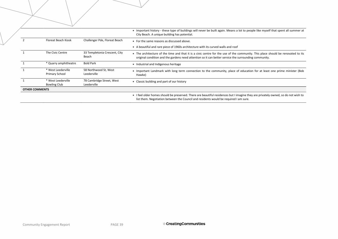
Community Engagement Report PAGE 39
Important history - these type of buildings will never be built again. Means a lot to people like myself that spent all summer at City Beach. A unique building has potential.
2 Floreat Beach Kiosk Challenger Pde, Floreat Beach For the same reasons as discussed above.
A beautiful and rare piece of 1960s architecture with its curved walls and roof
1 The Civic Centre 33 Templetonia Crescent, City Beach
The architecture of the time and that it is a civic centre for the use of the community. This place should be renovated to its original condition and the gardens need attention so it can better service the surrounding community.
1 * Quarry amphitheatre Bold Park Industrial and Indigenous heritage
1 * West Leederville Primary School
58 Northwood St, West Leederville
Important Landmark with long term connection to the community, place of education for at least one prime minister (Bob Hawke)
1 * West Leederville Bowling Club
78 Cambridge Street, West Leederville
Classic building and part of our history
OTHER COMMENTS
I feel older homes should be preserved. There are beautiful residences but I imagine they are privately owned, so do not wish to list them. Negotiation between the Council and residents would be required I am sure.
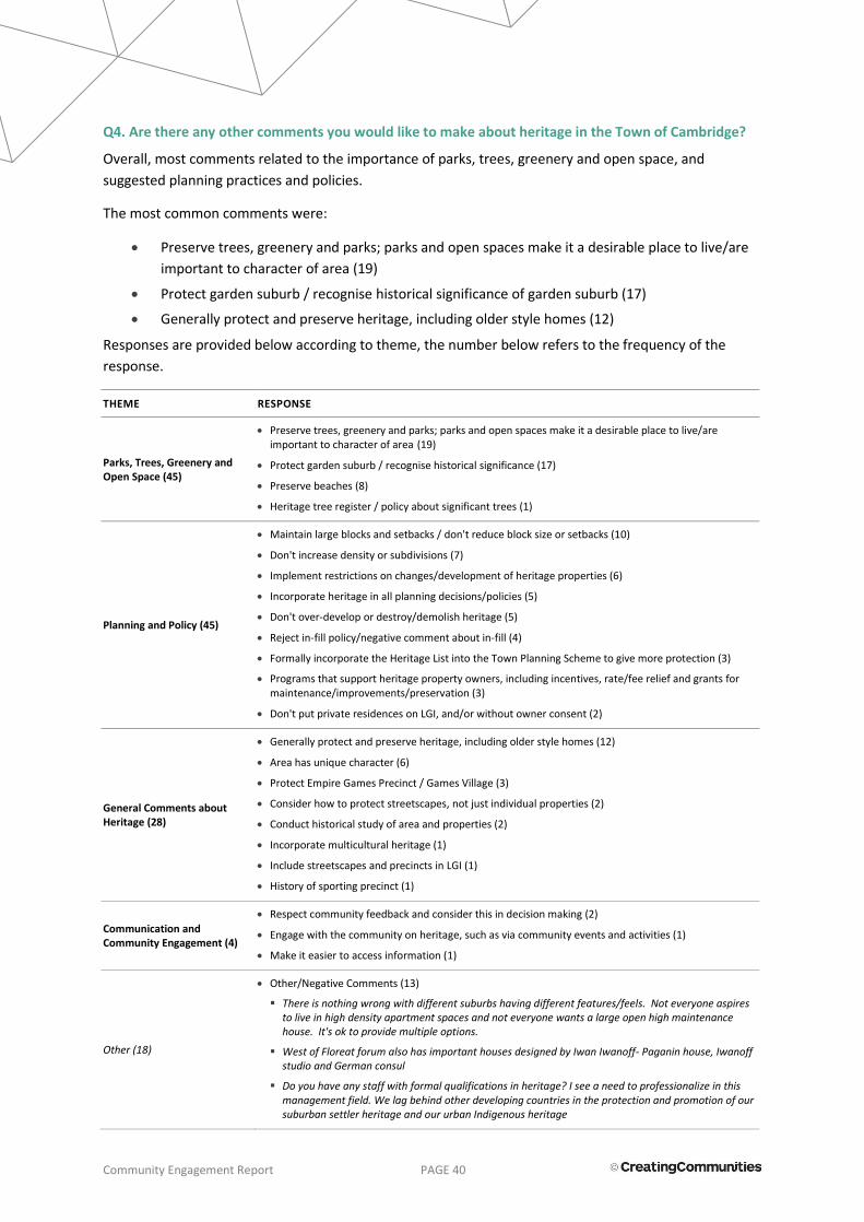
Community Engagement Report PAGE 40
Q4. Are there any other comments you would like to make about heritage in the Town of Cambridge?
Overall, most comments related to the importance of parks, trees, greenery and open space, and
suggested planning practices and policies.
The most common comments were:
Preserve trees, greenery and parks; parks and open spaces make it a desirable place to live/are
important to character of area (19)
Protect garden suburb / recognise historical significance of garden suburb (17)
Generally protect and preserve heritage, including older style homes (12)
Responses are provided below according to theme, the number below refers to the frequency of the
response.
THEME RESPONSE
Parks, Trees, Greenery and Open Space (45)
Preserve trees, greenery and parks; parks and open spaces make it a desirable place to live/are important to character of area (19)
Protect garden suburb / recognise historical significance (17)
Preserve beaches (8)
Heritage tree register / policy about significant trees (1)
Planning and Policy (45)
Maintain large blocks and setbacks / don't reduce block size or setbacks (10)
Don't increase density or subdivisions (7)
Implement restrictions on changes/development of heritage properties (6)
Incorporate heritage in all planning decisions/policies (5)
Don't over-develop or destroy/demolish heritage (5)
Reject in-fill policy/negative comment about in-fill (4)
Formally incorporate the Heritage List into the Town Planning Scheme to give more protection (3)
Programs that support heritage property owners, including incentives, rate/fee relief and grants for maintenance/improvements/preservation (3)
Don't put private residences on LGI, and/or without owner consent (2)
General Comments about Heritage (28)
Generally protect and preserve heritage, including older style homes (12)
Area has unique character (6)
Protect Empire Games Precinct / Games Village (3)
Consider how to protect streetscapes, not just individual properties (2)
Conduct historical study of area and properties (2)
Incorporate multicultural heritage (1)
Include streetscapes and precincts in LGI (1)
History of sporting precinct (1)
Communication and Community Engagement (4)
Respect community feedback and consider this in decision making (2)
Engage with the community on heritage, such as via community events and activities (1)
Make it easier to access information (1)
Other (18)
Other/Negative Comments (13)
There is nothing wrong with different suburbs having different features/feels. Not everyone aspires to live in high density apartment spaces and not everyone wants a large open high maintenance house. It's ok to provide multiple options.
West of Floreat forum also has important houses designed by Iwan Iwanoff- Paganin house, Iwanoff studio and German consul
Do you have any staff with formal qualifications in heritage? I see a need to professionalize in this management field. We lag behind other developing countries in the protection and promotion of our suburban settler heritage and our urban Indigenous heritage

Community Engagement Report PAGE 41
Why aren't the Endowment Lands included in the survey?
The appalling list of so called heritage buildings etc. some so recent its madness. Every so often the Town/City of Perth steps up and starts the exercise, not very successfully. Another waste of money - never get it right!!!!
I do not understand why the civic centre in City Beach is not already listed.
In general the early 20th century architecture is disappearing from our neighbourhood as McMansions invade, especially as the infill policies take hold.
Cambridge gives lip service only to heritage I have seen the demolition of many heritage homes worthy of listing in west Leederville. The council allowing a developer who has a reputation for bowling over west Leederville’s home to develop the home on the corner of Ruislip and Northwood St is a disgrace. I moved from west Leederville to Claremont 3 years ago because of this councils attitude to heritage homes
Yes this survey is poorly constructed. Poorly advertised to achieve a desired outcome. I.e. To justify limiting change. Council needs to get on with progressing a plan to allow for change and stop deferring it. Asked on excuses such as heritage plans. These are not mutually exclusive activities
Our heritage should not be decided on financial considerations
Believe the elected officials must adhere to the desires of their constituents and nothing else
Leave well alone!
A lot has already been lost, and it seems the ToC is intent on destroying more.
Positive comment about engagement process/heritage review (2)
Thank you for the invitation and opportunity to comment.
Although I have lived in the area for 3 years, I don't have much point of view. Coming from a European background, I am realising the differences of meaning of "heritage" in diverse cultures. I am pleased to receive the survey link from my mailbox.
Positive comment about current heritage approach/good developments (2)
The recent upgrades to Bold Park pool, City Beach surf club and Boulevard Shopping Centre are excellent, well done all responsible. The plans for Beecroft Park look promising. Keep up the good work
Pleased to hear this is happening
Town is a great place to live (1)
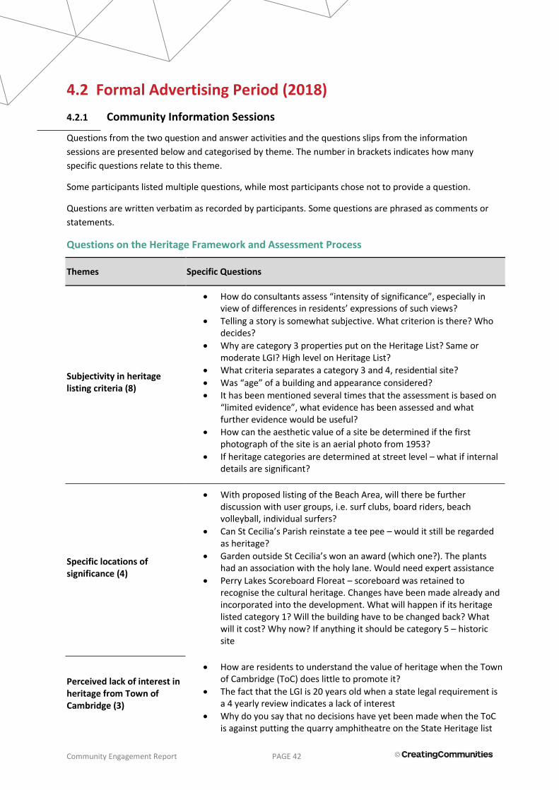
Community Engagement Report PAGE 42
4.2 Formal Advertising Period (2018)
4.2.1 Community Information Sessions
Questions from the two question and answer activities and the questions slips from the information
sessions are presented below and categorised by theme. The number in brackets indicates how many
specific questions relate to this theme.
Some participants listed multiple questions, while most participants chose not to provide a question.
Questions are written verbatim as recorded by participants. Some questions are phrased as comments or
statements.
Questions on the Heritage Framework and Assessment Process
Themes Specific Questions
Subjectivity in heritage listing criteria (8)
How do consultants assess “intensity of significance”, especially in view of differences in residents’ expressions of such views?
Telling a story is somewhat subjective. What criterion is there? Who decides?
Why are category 3 properties put on the Heritage List? Same or moderate LGI? High level on Heritage List?
What criteria separates a category 3 and 4, residential site?
Was “age” of a building and appearance considered?
It has been mentioned several times that the assessment is based on “limited evidence”, what evidence has been assessed and what further evidence would be useful?
How can the aesthetic value of a site be determined if the first photograph of the site is an aerial photo from 1953?
If heritage categories are determined at street level – what if internal details are significant?
Specific locations of significance (4)
With proposed listing of the Beach Area, will there be further discussion with user groups, i.e. surf clubs, board riders, beach volleyball, individual surfers?
Can St Cecilia’s Parish reinstate a tee pee – would it still be regarded as heritage?
Garden outside St Cecilia’s won an award (which one?). The plants had an association with the holy lane. Would need expert assistance
Perry Lakes Scoreboard Floreat – scoreboard was retained to recognise the cultural heritage. Changes have been made already and incorporated into the development. What will happen if its heritage listed category 1? Will the building have to be changed back? What will it cost? Why now? If anything it should be category 5 – historic site
Perceived lack of interest in heritage from Town of Cambridge (3)
How are residents to understand the value of heritage when the Town of Cambridge (ToC) does little to promote it?
The fact that the LGI is 20 years old when a state legal requirement is a 4 yearly review indicates a lack of interest
Why do you say that no decisions have yet been made when the ToC is against putting the quarry amphitheatre on the State Heritage list

Community Engagement Report PAGE 43
because it may limit seating expansion at the amphitheatre?
Precincts (3)
What category does a precinct come under?
Please reconsider putting the Empire Games Village area as a precinct of heritage value
Regarding Holyrood St – is this a precinct, or is each house listed individually?
Number and concentration of heritage places (3)
In terms of places/km2, places/number of residents (etc.), how does ToC’s inventory and list compare with other LG areas?
Has the State Government prescribed a target number (concentration ratio, etc.) for ToC Council to put on the inventory (and list)?
How does the Heritage List, with the State Government, plan to fit 30,000,000 people into Perth?
Potential for reversing the decision (3)
What is likelihood of reversing the decision?
What is the likelihood of reversing the decision? What is the process?
If a property is on the list how can we ensure it stays on the Heritage list?
What is the process to remove a property from LGI list?
Historical research (3)
Do you make enquiries in to the family history with proposed properties?
Was the historical info researched from the original Perth City Council?
Can residents get access to old photos?
Relationship with State Government heritage (2)
Can the Heritage Council override the Town decision to leave a place off the heritage list?
What is the practical effect of moving from the Local Government list to the State Heritage list?
Commercial properties (2) Why 20 commercial properties in Wembley and how and who
nominated these 20?
Removal of commercial property – how can this be achieved?
Properties with multiple buildings (1)
Some properties have different age buildings on them. Does the category apply to both buildings?
Heritage preventing accessibility (1)
Why was the old games village streetscape – listed? With more residents becoming elderly, this area has little or no footpaths for pedestrian motorised gophers. Will we get footpaths? Children, pedestrians of all ages are forced to walk on the road edge
Recommendations inconsistent with criteria (1)
The recommendation is inconsistent with the Criteria for the Assessment of Local Heritage Places and Areas document: Listing precincts as of heritage value should be done (p. 16). The housing stock has degraded (p.17). The housing was not representative of Perth’s best, it was a value for money camp. The association was brief. Recently the stadium was knocked over. The history of the area is well represented at the Heritage Shopping Centre etc. etc.
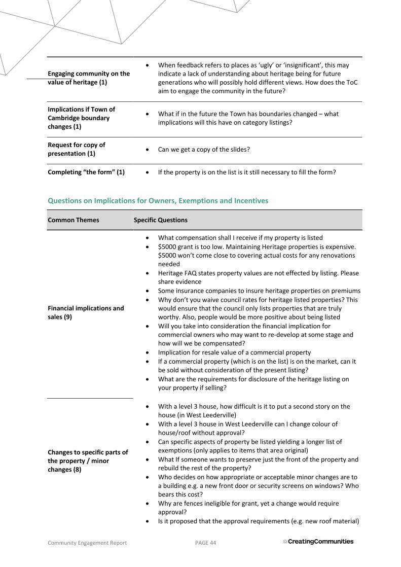
Community Engagement Report PAGE 44
Engaging community on the value of heritage (1)
When feedback refers to places as ‘ugly’ or ‘insignificant’, this may indicate a lack of understanding about heritage being for future generations who will possibly hold different views. How does the ToC aim to engage the community in the future?
Implications if Town of Cambridge boundary changes (1)
What if in the future the Town has boundaries changed – what implications will this have on category listings?
Request for copy of presentation (1)
Can we get a copy of the slides?
Completing “the form” (1) If the property is on the list is it still necessary to fill the form?
Questions on Implications for Owners, Exemptions and Incentives
Common Themes Specific Questions
Financial implications and sales (9)
What compensation shall I receive if my property is listed
$5000 grant is too low. Maintaining Heritage properties is expensive. $5000 won’t come close to covering actual costs for any renovations needed
Heritage FAQ states property values are not effected by listing. Please share evidence
Some insurance companies to insure heritage properties on premiums
Why don’t you waive council rates for heritage listed properties? This would ensure that the council only lists properties that are truly worthy. Also, people would be more positive about being listed
Will you take into consideration the financial implication for commercial owners who may want to re-develop at some stage and how will we be compensated?
Implication for resale value of a commercial property
If a commercial property (which is on the list) is on the market, can it be sold without consideration of the present listing?
What are the requirements for disclosure of the heritage listing on your property if selling?
Changes to specific parts of the property / minor changes (8)
With a level 3 house, how difficult is it to put a second story on the house (in West Leederville)
With a level 3 house in West Leederville can I change colour of house/roof without approval?
Can specific aspects of property be listed yielding a longer list of exemptions (only applies to items that area original)
What If someone wants to preserve just the front of the property and rebuild the rest of the property?
Who decides on how appropriate or acceptable minor changes are to a building e.g. a new front door or security screens on windows? Who bears this cost?
Why are fences ineligible for grant, yet a change would require approval?
Is it proposed that the approval requirements (e.g. new roof material)

Community Engagement Report PAGE 45
apply to all categories (1-4) on the heritage list?
If a place has heritage significance, do alterations to the non-heritage aspects of the place require approvals? I.e. changing a 1990’s fence to a 1990’s house?
Structurally damaged heritage properties (2)
Major structural issues which will cause long-term issues – are these considered in removal from listing?
Property was run-down and structurally unsounds when we bought it ten years ago and fixed it up
Distinction between building and property (1)
Is a LGI and Heritage Listing against the home/building or the property?
State Heritage Register (1) Is being on the heritage list the same as the State register?
Listing visible on title (1) Does heritage listing appear on property title?
Density bonus (1)
For residential lots – wouldn’t adding a density bonus (that encourages development) significantly alter initial reasons for the initial heritage listing? E.g. original 50’s/60’s fences with large backyards.
Demolition of a category 3 residential property (1)
How difficult would it be to set approval to demolish a category 3 residential property?
Adjacent properties on LGI (1)
If two adjacent properties are potentially on the LGI list, what are the implications for future development?
Holy Spirit Catholic Church (1)
Holy Spirit Catholic Church City Beach is heritage listed. In order to install stained glass windows of the images of Jesus, Saints and the Sacraments to enhance devotion and prayer, do I need approval to do that?
Meaning of “desirable features” (1)
Current usage by tenants is a desirable feature. Is this justification for listing?
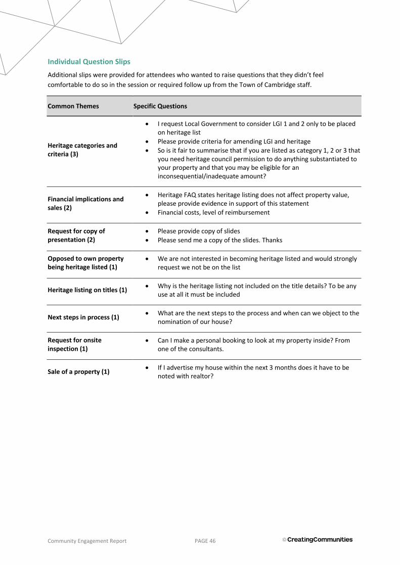
Community Engagement Report PAGE 46
Individual Question Slips
Additional slips were provided for attendees who wanted to raise questions that they didn’t feel
comfortable to do so in the session or required follow up from the Town of Cambridge staff.
Common Themes Specific Questions
Heritage categories and criteria (3)
I request Local Government to consider LGI 1 and 2 only to be placed on heritage list
Please provide criteria for amending LGI and heritage
So is it fair to summarise that if you are listed as category 1, 2 or 3 that you need heritage council permission to do anything substantiated to your property and that you may be eligible for an inconsequential/inadequate amount?
Financial implications and sales (2)
Heritage FAQ states heritage listing does not affect property value, please provide evidence in support of this statement
Financial costs, level of reimbursement
Request for copy of presentation (2)
Please provide copy of slides
Please send me a copy of the slides. Thanks
Opposed to own property being heritage listed (1)
We are not interested in becoming heritage listed and would strongly request we not be on the list
Heritage listing on titles (1) Why is the heritage listing not included on the title details? To be any
use at all it must be included
Next steps in process (1) What are the next steps to the process and when can we object to the
nomination of our house?
Request for onsite inspection (1)
Can I make a personal booking to look at my property inside? From one of the consultants.
Sale of a property (1) If I advertise my house within the next 3 months does it have to be
noted with realtor?

Community Engagement Report PAGE 47
Feedback on the draft Local Government Inventory
Submitter #
Q8 - What do you support about the draft Local Government Inventory?
1 It seeks to provide some security over buildings of historic value, without the full heritage listing process, as I understand it.
2 We support the Town's initiative to ensure places of significance are retained to protect buildings that are synonymous to the area for future generations.
3 We support the Town's initiative to ensure places of significance are retained to protect buildings that are synonymous to the area for future generations.
4 We support the Town's initiative to ensure places of significance are retained to protect buildings that are synonymous to the area for future generations.
5 We support the Town's initiative to ensure places of significance are retained to protect buildings that are synonymous to the area for future generations.
6 We support the Town's initiative to ensure places of significance are retained to protect buildings that are synonymous to the area for future generations.
7 We support the Town's initiative to ensure places of significance are retained to protect buildings that are synonymous to the area for future generations.
8 Nothing except truly historical sites with exceptional heritage value.
9 I support the nomination of Henderson Park under Category 2, #51.
10 The overall concept.
12 We do not support the proposed listing on the LGI of Heritage Places of the area referred to as Place No.10.
13 No listing only recorded information.
14 As owners we do not support the property to be included on the draft heritage list, category 2.
15 The complex getting listed.
17 I applaud the initiative to review and update the Local Government Inventory.
19 I support the inclusion of public places and areas that are owned and maintained by the ToCambridge or other public entity on the LGI. I support the inclusion of private homes/residences only where the owners have given their explicit consent to be placed onto the LGI.
20 I support the inclusion of public places and areas that are owned and maintained by the ToCambridge or other public entity on the LGI. I support the inclusion of private homes/residences only where the owners have given their explicit consent to be placed onto the LGI.
21 Good initiative to keep ta record of culturally and historically significant places.
22 I support identifying places with cultural heritage significance.

Community Engagement Report PAGE 48
23 It is necessary.
24 I support a record of Historic Places.
26 The area identified on Kimberley Street is fairly intact with heritage significance.
27 Will preserve this reserve in perpetuity and acknowledge its long history.
29 The listing of public & private community buildings i.e. Wembley Hotel.
31 Heritage character of the area needs some preservation.
32 Preserving heritage of the area including character
33 Preserving character and heritage of the area.
35 I do not support the listing of my property because it will significantly cause a loss of its market value.
36 Nothing
37 The drawing up of an LGI is required under the current Heritage Legislation so I understand why this has been done
38 I support Exceptional Significance buildings being on the local government inventory.
40 I support the Town of Cambridge's consultation with the public and the fact that proprietors are still able to use their properties as desired.
41 It is important to keep an up to date and maintain a database of LGI of the significance of buildings and places.
42 Games Village being category 4 and no impact on future demolition/development potential.
44 Fine - For those who own property to request but previous owners, devaluing or destroying new owners' dreams or financial investments is wrong. I only support it where the existing owner lists the property. Only support heritage in residential areas where the whole suburbs, streets are heritage not sporadic.
45 Nothing
46 I support the maintenance and acknowledgement of the significance of heritage areas/buildings/streets.
47 Nothing, this is an unnecessary impost on owners and ratepayers.
Submitter #
Q 9 - Do you have any concerns with the draft Local Government Inventory?
1 Yes, it may hold up or limit future maintenance or renovation items.
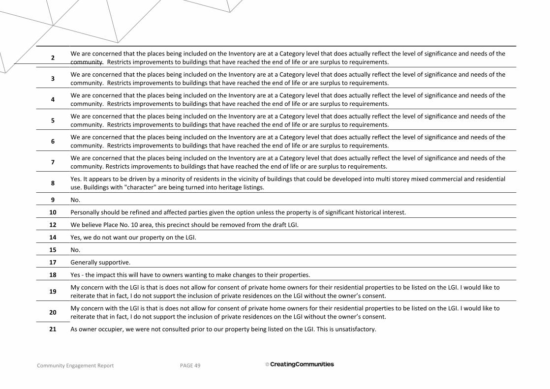
Community Engagement Report PAGE 49
2 We are concerned that the places being included on the Inventory are at a Category level that does actually reflect the level of significance and needs of the community. Restricts improvements to buildings that have reached the end of life or are surplus to requirements.
3 We are concerned that the places being included on the Inventory are at a Category level that does actually reflect the level of significance and needs of the community. Restricts improvements to buildings that have reached the end of life or are surplus to requirements.
4 We are concerned that the places being included on the Inventory are at a Category level that does actually reflect the level of significance and needs of the community. Restricts improvements to buildings that have reached the end of life or are surplus to requirements.
5 We are concerned that the places being included on the Inventory are at a Category level that does actually reflect the level of significance and needs of the community. Restricts improvements to buildings that have reached the end of life or are surplus to requirements.
6 We are concerned that the places being included on the Inventory are at a Category level that does actually reflect the level of significance and needs of the community. Restricts improvements to buildings that have reached the end of life or are surplus to requirements.
7 We are concerned that the places being included on the Inventory are at a Category level that does actually reflect the level of significance and needs of the community. Restricts improvements to buildings that have reached the end of life or are surplus to requirements.
8 Yes. It appears to be driven by a minority of residents in the vicinity of buildings that could be developed into multi storey mixed commercial and residential use. Buildings with "character" are being turned into heritage listings.
9 No.
10 Personally should be refined and affected parties given the option unless the property is of significant historical interest.
12 We believe Place No. 10 area, this precinct should be removed from the draft LGI.
14 Yes, we do not want our property on the LGI.
15 No.
17 Generally supportive.
18 Yes - the impact this will have to owners wanting to make changes to their properties.
19 My concern with the LGI is that is does not allow for consent of private home owners for their residential properties to be listed on the LGI. I would like to reiterate that in fact, I do not support the inclusion of private residences on the LGI without the owner’s consent.
20 My concern with the LGI is that is does not allow for consent of private home owners for their residential properties to be listed on the LGI. I would like to reiterate that in fact, I do not support the inclusion of private residences on the LGI without the owner’s consent.
21 As owner occupier, we were not consulted prior to our property being listed on the LGI. This is unsatisfactory.

Community Engagement Report PAGE 50
22 Yes.
23 The listing of the "Games Village Precinct" is not appropriate.
24
It is constricting for private homes to be on a government inventory even on a minor scale. When it comes time to sell and mention is made of a heritage inventory the buyer is always deterred and it severely affects the value of the property. Depending on the Shire and persons handling the inventory it can be very detrimental to the property, have found Shire become quite powerful in this area which is unfair as it is us who owns the property and feel the shire ends up having more power over your property and the owner. We have a historic homestead in Manjimup that is on the Shires Heritage inventory in the highest category unfortunately instead of being there to help we feel due to the listing on it from the Shire they make it harder for us, we own the property and are the ones that have invested huge funds to maintain and conserve it and is unfair that the Shire has a hold over us.
Similarly the Heritage council even though our property is only noted on the Heritage Council, they have a power over us and once again we own the property but are at a severe disadvantage due to Shire and Heritage inventories, especially when it comes to try and sell the property or to value add to the property. Work in the way of huge improvements so that it does not fall into a state of disrepair and money that has been spent on it means nothing to the Heritage Council or Shire.
There are no incentives for heritage properties you may obtain a grant but it has to be overseen by a heritage recommended architect which would take up most of the funding and in our experience we have found certain local qualified builders are more practical, less expensive and have a high knowledge of the local historic homes as we the owners do as well.
It is unfair to have a constriction on a private historic home in West Leederville when in the past so many gorgeous old homes have been demolished and replaced with modern mansions that will date in a short time. Sometimes I can see why so many heritage buildings in Perth have been demolished, if there have been so many demands to keep them original. I wonder how much older countries manage to maintain and keep so many old buildings.
I hope the Town of Cambridge will carefully consider the above when preparing the Heritage Inventory
26 No.
27 No.
29 Yes, Private residential buildings should be off limits as Categories 1, 2, & 3. They should be Category 4 only.
31 Don’t want prescriptive rules, guidelines and incentives.
32 I feel there are some properties missing which are unique to the area.
33 Significant properties missing.
35 I have no concerns over your draft Local Government Inventory. But it should not have singled out my property which is outside your Local Government Inventory listing.
36 There is little of value to include. Seems to be a waste of ratepayers money.

Community Engagement Report PAGE 51
37 Yes. There is nothing further to be gained by historians, property owners or the local council by the proposed listing of this extensive area. This has implications for approximately 160 house owners. See subsequent comments and attached letters.
38 I am deeply concerned that any listing will adversely affect any ability to make improvements or alteration to the property, which in turn may impact the viability of the business. In addition, I have invested considerable capital into the purchase of the property, it would be deeply distressing that if in the future, this listing lowered the market value or ability to sell.
40 As it stands, I have no general concerns with the Local Government Inventory.
41 No.
42 My neighbours are elderly and very concerned as they have been through this before. It would be better if the letter we received was even clearer about there being no heritage listing of the games village homes - they were ready to demolish theirs 15 years ago when heritage listing was proposed and quite a few were knocked over.
44 Yes - I bought the property without the listing now previous owner wants listing what happens to my plans. This is wrong. I wish my home to be removed from the list. As above, the only present owners should be allowed to list as they are the ones whom are at the whim of the Heritage legislation - Fines, penalties, imprisonment.
45 Yes - What will happen to the scoreboard if listed as Category 1. What will this cost to maintain?
46 No.
47 Placing an unnecessary burden on owners of listed properties or precincts.
Submitter #
Q 10 - How can the draft Local Government Inventory be improved?
1 I cannot comment on this.
2 Streamline the process by running the LGI independently and at a different time to the Heritage List. The submission process could be easily replaced by applicants lodging a letter of support or objection. The current process is lengthy and time consuming.
3 Streamline the process by running the LGI independently and at a different time to the Heritage List. The submission process could be easily replaced by applicants lodging a letter of support or objection. The current process is lengthy and time consuming.
4 Streamline the process by running the LGI independently and at a different time to the Heritage List. The submission process could be easily replaced by applicants lodging a letter of support or objection. The current process is lengthy and time consuming.
5 Streamline the process by running the LGI independently and at a different time to the Heritage List. The submission process could be easily replaced by

Community Engagement Report PAGE 52
applicants lodging a letter of support or objection. The current process is lengthy and time consuming.
6 Streamline the process by running the LGI independently and at a different time to the Heritage List. The submission process could be easily replaced by applicants lodging a letter of support or objection. The current process is lengthy and time consuming.
7 Streamline the process by running the LGI independently and at a different time to the Heritage List. The submission process could be easily replaced by applicants lodging a letter of support or objection. The current process is lengthy and time consuming.
8 Focus on truly historical places/buildings which have history.
10 A more thorough research based approach, not reliant on suggested properties.
11 Include a sentence or two which acknowledges "historically significant" residences need to meet the environmental, living and social needs of the present if they are to remain relevant and useful and to not impose any procedural or financial hardships to the residents who occupy these homes (i.e. homes of Holyrood St).
12 As we have been away recently there have been insufficient time to investigate properly other properties on the draft list. Except to note the absurdity of including the rectory with St Christopher's Anglican Church, City Beach. The Rectory is about 10 years old and bears no relationship to the 1960s.
14 We believe that privately owned residences should not be included on the draft heritage list without the owner's full approval as it will restrict and limit our options over the property we currently enjoy and this will seriously affect the property's valuation.
17
This comment applies to both the Local Government Inventory & Heritage Listing. While the listed statement and degree of protection that the Inventory and Heritage Listing brings to specific buildings is a positive thing, the issue of heritage runs much deeper. I am particularly concerned with the aspect of the Modernist and 'Garden Suburb' heritage of the areas of Floreat and City Beach. I do not believe that this very unique history is adequately reinforced to the community. I have carried out my own survey of buildings with such heritage value in these areas that are still remaining and I have found over 70 + such buildings. The question for me is; how can we move forward in these areas while respecting the wonderful unique history and built environment of these areas? I feel that there is a lot more to be done beyond the protection of individual buildings. While 'Design Guidelines' could give some overview for the future infill and replacement of existing buildings in these areas that encourages new buildings that respect the past, I feel that such guidelines can simply result in clichéd responses. I would like to see more promotion of the unique modernist history of these areas that will in turn bring an awareness and respect to what is unique about these suburbs. Through examples of new buildings such as the one that I designed in Floreat, the public can see how it is possible to create new buildings that reflect the past while still remain 'forward looking'. Other ways of recording and reflecting the past history beyond the specific recognition of individual buildings could be achieved in the 'Games Village' precinct in City beach. Here, for example the street side kerbs in front of each house could have permanent discs fixed to represent if the athletes that stayed in these houses achieved a Gold, Silver or Bronze medal at the 1962 Empire Games. What a wonderful record this would make for both the local residents and the wider community. Further such measures could include the street tree planting reflecting the nations that attended the Empire games. These are just a couple of ways that this unique history can be more accessible to the community.
18 By making sure that only places with genuine heritage aspects are listed.

Community Engagement Report PAGE 53
19
The draft LGI can be improved by seeking consent from property owners, especially those of stand-alone private residences prior to listing a property.
The data provided by ToCambridge to support listing properties and the effect this will have on their respective market values is not relevant to this current listing effort/draft LGI action that the ToCambridge is undertaking. Therefore, it is worth either 1) providing relevant data or 2) conceding that there is no relevant data and therefore the listing poses unforeseen, not well understood effects on the listed properties. Option #2 means that there is significant risk imposed upon the property owners in being listed on the LGI.
Even though the data provided by ToCambridge is irrelevant to this LGI undertaking, the majority of the property value assessment data supports no or some positive impact on value where properties are within an established Heritage precinct. For this reason, again, I cannot support the inclusion of stand-alone private residences on LGI unless consent is expressly given by the owner.
20
The draft LGI can be improved by seeking consent from property owners, especially those of stand-alone private residences prior to listing a property.
Also, data provided by ToCambridge to support listing properties and the effect this will have on their respective market values is not relevant to this current listing effort/draft LGI action that the ToCambridge is undertaking. Therefore, it is worth either 1) providing relevant data or 2) conceding that there is no relevant data and therefore the listing poses unforeseen, not well understood effects on the listed properties. Option #2 means that there is significant risk imposed upon the property owners in being listed on the LGI.
Even though the data provided by ToCambridge is irrelevant to this LGI undertaking, the majority of the property value assessment data supports no or some positive impact on value where properties are within an established Heritage precinct. For this reason, again, I cannot support the inclusion of stand-alone private residences on LGI unless consent is expressly given by the owner.
21 Consult owner-occupiers prior to listing on any LGI, even draft, prior to issue.
23 More rigorous review of proposed listings.
24 Could be made as just a record of places
26 Not sure.
29 See Question 9. = 'Yes, Private residential buildings should be off limits as Categories 1, 2, & 3. They should be Category 4 only.'
31 One on one consultation with property owners that are affected.
32 Upfront consultation with the locals.
33 More consultation with local residents.
35 Actually, our property is situated outside your heritage listing area. Separated by Nanson Street which marks the western limit of your list.
36 By not having one at all.
37 By removing Place No: 10 “The former British Empire and Commonwealth Games Village area from the DRAFT LGI.

Community Engagement Report PAGE 54
38 Only exceptional significance buildings to be preserved.
40 Continuing consultation with proprietors of properties contained in the LGI. Also, prior consultation with these proprietors regarding their concerns before final decisions are made.
41 Not sure (seems well organised).
42 Perhaps another letter to be very clear about the outcomes and any impact (i.e.. none) on the games village homes.
44 Firstly, by removing my property. Approaching owners only for nominations and only allow owners of properties to list - not others. Presentations that advise owners of cons not only pros of such listing.
45 To list something before any development takes place. Putting a building on the list after significant changes have been done.
47 Better consultation with owners prior to listing.
Feedback on the draft Heritage List
Submitter #
Q 11 - What do you support about the draft Heritage List?
1 As I understand it, there is nothing to support about this list: either a building is on the list or it is not. This would just hold up the renovations process.
2 We support the Town's initiative to ensure places of significance are retained to protect buildings that are synonymous to the area for future generations.
3 We support the Town's initiative to ensure places of significance are retained to protect buildings that are synonymous to the area for future generations.
4 We support the Town's initiative to ensure places of significance are retained to protect buildings that are synonymous to the area for future generations.
5 We support the Town's initiative to ensure places of significance are retained to protect buildings that are synonymous to the area for future generations.
6 We support the Town's initiative to ensure places of significance are retained to protect buildings that are synonymous to the area for future generations.
7 We support the Town's initiative to ensure places of significance are retained to protect buildings that are synonymous to the area for future generations.
8 Nothing.
9 I support the nomination of Henderson Park under Category 2, #51.
10 As per Question 8 = 'The overall concept.'
13 Only Category 4.

Community Engagement Report PAGE 55
14 We support local government public buildings, such as churches, libraries of architectural and historical significance being added to the list only.
15 Good idea to keep heritage areas.
17 I believe that it is important to have adequate record of each locations history. All new work in each precinct should pay some respect (without mimicking) the past.
19
I support the inclusion of public places and areas that are owned and maintained by the ToCambridge or other public entity to be placed on a heritage list. I support the inclusion of private homes on a heritage list only where respective owners have given explicit consent to be placed onto it and meaningful and substantial provisions have been put in place to protect the private owners from any financial loss(es) that are related to such a listing (e.g., realised overall home value decrease and coverage for additional time on market). The current proposal for financial compensation/provisions is not meaningful or substantial.
20
I support the inclusion of public places and areas that are owned and maintained by the ToCambridge or other public entity to be placed on a heritage list. I support the inclusion of private homes on a heritage list only where respective owners have given explicit consent to be placed onto it and meaningful and substantial provisions have been put in place to protect the private owners from any financial loss(es) that are related to such a listing (e.g., realised overall home value decrease and coverage for additional time on market). The current proposal for financial compensation/provisions is not meaningful or substantial.
21 Good initiative to respect and retain the street front of culturally and historically significant places.
23 It is necessary.
26 The protection of streetscape that has heritage significance.
27 Historical significance.
29 Should be limited to public & private community buildings.
31 Preserving character.
32 Preserving heritage of the area including character.
33 Preserving character and heritage of the area.
35 I do not support the draft Heritage Listing to include my property.
36 Nothing.
37 No comment.
38 Only exceptional significance buildings to be preserved.

Community Engagement Report PAGE 56
40 I support the Town of Cambridge's consultation with proprietors of properties on the proposed Heritage List.
41 It is a unique landmark, with great cultural and historic value for all Australians to enjoy. Both our kids performed athletics at the Stadium.
43 That true historic items are listed not renovated, modified or dilapidated buildings etc.
44 Fine for Government owned buildings.
45 Only concerned about the Scoreboard.
46 As above. = 'I support the maintenance and acknowledgement of the significance of heritage areas/buildings/streets.'
47 The concept of listing places of real significance to the identity of the town.
Submitter
# Q 12 - Do you have any concerns with the draft Heritage List?
1 See above. = 'As I understand it, there is nothing to support about this list: either a building is on the list or it is not. This would just hold up the renovations
process.'
2 We are concerned that the places being included on the Inventory are at a Category level that does actually reflect the level of significance and needs of the
community. Restricts improvements to buildings that have reached the end of life or are surplus to requirements.
3 We are concerned that the places being included on the Inventory are at a Category level that does actually reflect the level of significance and needs of the
community. Restricts improvements to buildings that have reached the end of life or are surplus to requirements.
4 We are concerned that the places being included on the Inventory are at a Category level that does actually reflect the level of significance and needs of the
community. Restricts improvements to buildings that have reached the end of life or are surplus to requirements.
5 We are concerned that the places being included on the Inventory are at a Category level that does actually reflect the level of significance and needs of the
community. Restricts improvements to buildings that have reached the end of life or are surplus to requirements.
6 We are concerned that the places being included on the Inventory are at a Category level that does actually reflect the level of significance and needs of the
community. Restricts improvements to buildings that have reached the end of life or are surplus to requirements.
7 We are concerned that the places being included on the Inventory are at a Category level that does actually reflect the level of significance and needs of the
community. Restricts improvements to buildings that have reached the end of life or are surplus to requirements.
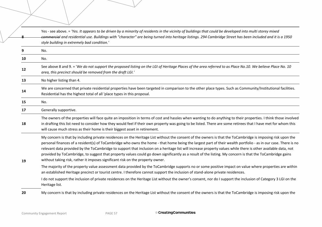
Community Engagement Report PAGE 57
8
Yes - see above. = 'Yes. It appears to be driven by a minority of residents in the vicinity of buildings that could be developed into multi storey mixed
commercial and residential use. Buildings with "character" are being turned into heritage listings. 294 Cambridge Street has been included and it is a 1950
style building in extremely bad condition.'
9 No.
10 No.
12 See above 8 and 9. = 'We do not support the proposed listing on the LGI of Heritage Places of the area referred to as Place No.10. We believe Place No. 10
area, this precinct should be removed from the draft LGI.'
13 No higher listing than 4.
14 We are concerned that private residential properties have been targeted in comparison to the other place types. Such as Community/Institutional facilities.
Residential has the highest total of all 'place types in this proposal.
15 No.
17 Generally supportive.
18
The owners of the properties will face quite an imposition in terms of cost and hassles when wanting to do anything to their properties. I think those involved
in drafting this list need to consider how they would feel if their own property was going to be listed. There are some retirees that I have met for whom this
will cause much stress as their home is their biggest asset in retirement.
19
My concern is that by including private residences on the Heritage List without the consent of the owners is that the ToCambridge is imposing risk upon the
personal finances of a resident(s) of ToCambridge who owns the home - that home being the largest part of their wealth portfolio - as in our case. There is no
relevant data provided by the ToCambridge to support that inclusion on a heritage list will increase property values while there is other available data, not
provided by ToCambridge, to suggest that property values could go down significantly as a result of the listing. My concern is that the ToCambridge gains
without taking risk, rather it imposes significant risk on the property owner.
The majority of the property value assessment data provided by the ToCambridge supports no or some positive impact on value where properties are within
an established Heritage precinct or tourist centre. I therefore cannot support the inclusion of stand-alone private residences.
I do not support the inclusion of private residences on the Heritage List without the owner’s consent, nor do I support the inclusion of Category 3 LGI on the
Heritage list.
20 My concern is that by including private residences on the Heritage List without the consent of the owners is that the ToCambridge is imposing risk upon the

Community Engagement Report PAGE 58
personal finances of a resident(s) of ToCambridge who owns the home - that home being the largest part of their wealth portfolio - as in our case. There is no
relevant data provided by the ToCambridge to support that inclusion on a heritage list will increase property values while there is other available data, not
provided by ToCambridge, to suggest that property values could go down significantly as a result of the listing. My concern is that the ToCambridge gains
without taking risk, rather it imposes significant risk on the property owner.
The majority of the property value assessment data provided by the ToCambridge supports no or some positive impact on value where properties are within
an established Heritage precinct or tourist centre. I therefore cannot support the inclusion of stand-alone private residences.
I do not support the inclusion of private residences on the Heritage List without the owner’s consent, nor do I support the inclusion of Category 3 LGI on the
Heritage list.
21 As owner occupier, we were not consulted prior to our property being listed on the draft heritage list. This is unsatisfactory. Future sale-ability is a concern
(the fact that there are arguments either way just adds to uncertainty).
22 Yes. I do not believe that my property should be included. The site was previously heritage listed and was removed from the list as it was deemed not of
adequate cultural significance. I agree with this.
23 The listing of the "Games Village Precinct" is not appropriate.
26 No.
27 No.
29 Yes, Residential buildings should be off limits.
31 property owners should have control of options.
32 I feel there are some properties missing which are unique to the area.
33 Significant properties missing.
34 My property has been nominated.
35 As mentioned above. = 'I do not support the listing of my property 296 Cambridge Street, Wembley because it will significantly cause a loss of its market
value. Actually, our property is situated outside your heritage listing area. Separated by Nanson Street which marks the western limit of your list.'
36 There is little of value to include. Seems to be a waste of ratepayers money.
37 No comment.

Community Engagement Report PAGE 59
38 Yes, some dwellings on the list are of no heritage value at all.
40
Specifically regarding my property, my concerns with the inherent and obvious lack of heritage features on my premises were somewhat addressed in
communication my son had in person with the Town's Strategic Planning Officer on 7 August 2018. This communication re-confirmed that the Town of
Cambridge has formally acknowledged that this property "...has since been altered so that none of its original design intent remains visible" - as was stated in
their written correspondence to me on 13 July 2018.
41 No.
43 Yes. The property stated has been modified to resemble characteristics of original but is not the original.
44 Yes - I want my property removed. I will make the decision to list. My property which is Listed has no significance to the Town, City Beach & has been Listed
due to emotional attachment by previous owner. Owners should be only persons to List or nominate.
46 No.
47 Some of the sites identified include trees that are not native to the area.
Submitter #
Q 13 - How can the draft Heritage List be improved?
1 I cannot comment on this.
2 The Heritage List could be improved by capping a minimum age of say 50+ years from construction before buildings are even considered to be included on the Heritage List as a place of heritage significance.
3 The Heritage List could be improved by capping a minimum age of say 50+ years from construction before buildings are even considered to be included on the Heritage List as a place of heritage significance.
4 The Heritage List could be improved by capping a minimum age of say 50+ years from construction before buildings are even considered to be included on the Heritage List as a place of heritage significance.
5 The Heritage List could be improved by capping a minimum age of say 50+ years from construction before buildings are even considered to be included on the Heritage List as a place of heritage significance.
6 The Heritage List could be improved by capping a minimum age of say 50+ years from construction before buildings are even considered to be included on the Heritage List as a place of heritage significance.
7 The Heritage List could be improved by capping a minimum age of say 50+ years from construction before buildings are even considered to be included on
Community Engagement Report PAGE 60
the Heritage List as a place of heritage significance.
8 A more objective assessment of what is truly historical. Stop trying to include buildings and places because the neighbours want to stop development. Look at the physical/structural condition. Separate character and heritage.
14 By seeking approval from the owners prior to the formulation of the draft List, not afterwards and by providing more notice for the process such as meetings and submissions.
17
As stated above under the same question for the Local Government Inventory. = 'This comment applies to both the Local Government Inventory & Heritage Listing. While the listed statement and degree of protection that the Inventory and Heritage Listing brings to specific buildings is a positive thing, the issue of heritage runs much deeper. I am particularly concerned with the aspect of the Modernist and 'Garden Suburb' heritage of the areas of Floreat and City Beach. I do not believe that this very unique history is adequately reinforced to the community. I have carried out my own survey of buildings with such heritage value in these areas that are still remaining and I have found over 70 + such buildings. The question for me is; how can we move forward in these areas while respecting the wonderful unique history and built environment of these areas? I feel that there is a lot more to be done beyond the protection of individual buildings. While 'Design Guidelines' could give some overview for the future infill and replacement of existing buildings in these areas that encourages new buildings that respect the past, I feel that such guidelines can simply result in clichéd responses. I would like to see more promotion of the unique modernist history of these areas that will in turn bring an awareness and respect to what is unique about these suburbs. Through examples of new buildings such as the one that I designed in Floreat, the public can see how it is possible to create new buildings that reflect the past while still remain 'forward looking'. Other ways of recording and reflecting the past history beyond the specific recognition of individual buildings could be achieved in the 'Games Village' precinct in City beach. Here, for example the street side kerbs in front of each house could have permanent discs fixed to represent if the athletes that stayed in these houses achieved a Gold, Silver or Bronze medal at the 1962 Empire Games. What a wonderful record this would make for both the local residents and the wider community. Further such measures could include the street tree planting reflecting the nations that attended the Empire games. These are just a couple of ways that this unique history can be more accessible to the community.'
18 Take off items that don’t hold any real heritage value.
19
The draft heritage list can be improved by removing Cat 3 LGI properties from it because including this category of property on the list is not consistent with the ToCambridge’ stated position of including only the places that are of the “highest heritage value”. This is consistent with the position published by the Town of Cambridge in its own references. - ToCambridge, Municipal Heritage Inventory and townscape precinct study, P59, 3.1.2 Residential properties, June 1997. - ToCambridge, Heritage interim Consultation report, page 40, Sept 2017. - ToCambridge, Draft Heritage Review Information session presentation, slide 13, July 2018
Include only Cat 1 and Cat 2 private residences on the Heritage list where the owner has given their consent to be included/listed. This is consistent with the published position of the ToCambridge (see above) and allows any proposed funding to be focused where it has the greatest impact.
20 The draft heritage list can be improved by removing Cat 3 LGI properties from it because including this category of property on the list is not consistent with the ToCambridge’ stated position of including only the places that are of the “highest heritage value”. This is consistent with the position published by the

Community Engagement Report PAGE 61
Town of Cambridge in its own references. - ToCambridge, Municipal Heritage Inventory and townscape precinct study, P59, 3.1.2 Residential properties, June 1997. - ToCambridge, Heritage interim Consultation report, page 40, Sept 2017. - ToCambridge, Draft Heritage Review Information session presentation, slide 13, July 2018
Include only Cat 1 and Cat 2 private residences on the Heritage list where the owner has given their consent to be included/listed. This is consistent with the published position of the ToCambridge (see above) and allows any proposed funding to be focused where it has the greatest impact.
21 Consult owner-occupiers prior to listing on any heritage list, even draft, prior to issue.
23 More rigorous review of proposed listings.
24 Would prefer to see it just as a record of places.
26 Not sure.
29 See Question 11. = 'Should be limited to public & private community buildings.'
31 Don’t want prescriptive rules, guidelines and incentives.
32 Upfront consultation with the locals.
33 More consultation with local residents.
34 No comment.
35 I do not have any idea about that.
36 By not having one at all.
37 No comment.
38 By only having those dwellings that are of any reasonable heritage value on the initial draft and remove those that are only of slight significance.
40 Continuing consultation with proprietors of properties contained in the Heritage List. Also, prior consultation with these proprietors regarding their concerns before final decisions are made.
43 By more research into history of property and if they are of true significance. A modified pre-war house cannot possibly have significance.
44 By removing my property from the list. Only allow owners to nominate. Provide owner funds to defend against Listing. Communicate with owners prior to Listing.
47 Being a little more selective about architectural significance and it being independently peer reviewed. It looks like a catch all at moment from one point of view. Second and third professional opinions should be sought so that council can make a decision with a more than one opinion.
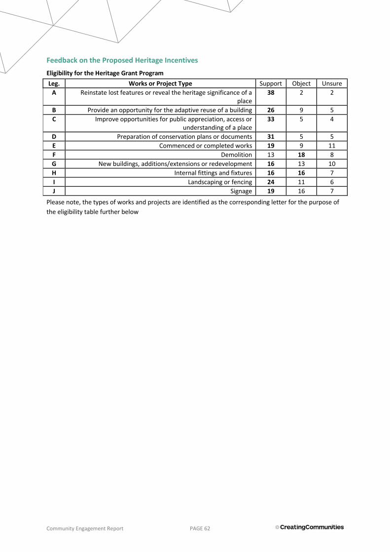
Community Engagement Report PAGE 62
Feedback on the Proposed Heritage Incentives
Eligibility for the Heritage Grant Program
Leg. Works or Project Type Support Object Unsure
A Reinstate lost features or reveal the heritage significance of a place
38 2 2
B Provide an opportunity for the adaptive reuse of a building 26 9 5
C Improve opportunities for public appreciation, access or understanding of a place
33 5 4
D Preparation of conservation plans or documents 31 5 5
E Commenced or completed works 19 9 11
F Demolition 13 18 8
G New buildings, additions/extensions or redevelopment 16 13 10
H Internal fittings and fixtures 16 16 7
I Landscaping or fencing 24 11 6
J Signage 19 16 7
Please note, the types of works and projects are identified as the corresponding letter for the purpose of
the eligibility table further below

Community Engagement Report PAGE 63
Submitter #
Q18 - Financial assistance for owners of Heritage Listed places is proposed in the form of development application fee waiver and a heritage grant program. Do you
agree or disagree with this approach, and why?
Q20 - Are there any other types of assistance the Town should make available to owners of heritage places?
1 I believe this is a question best answered by someone else.
I don't know enough to answer this question. I can only imagine that timely response to allow urgent maintenance, and personal support be given, especially when so many stakeholders exist for buildings like St Barnabas Church.
2 Support We agree with the Town's proposal to waive the development application fee and proposed heritage grant program.
Reduction of fees for change of permitted use and zoning.
3 Support We agree with the Town's proposal to waive the development application fee and proposed heritage grant program.
Reduction of fees for change of permitted use and zoning.
4 Support We agree with the Town's proposal to waive the development application fee and proposed heritage grant program.
Reduction of fees for change of permitted use and zoning.
5 Support We agree with the Town's proposal to waive the development application fee and proposed heritage grant program.
Reduction of fees for change of permitted use and zoning.
6 Support We agree with the Town's proposal to waive the development application fee and proposed heritage grant program.
Reduction of fees for change of permitted use and zoning.
7 Support We agree with the Town's proposal to waive the development application fee and proposed heritage grant program.
Reduction of fees for change of permitted use and zoning.
8 Object This is a token gesture and goes nowhere near truly compensating a property owner for the cost and inconvenience of a heritage listing.
Stop the listing process for non historical places of limited or zero historical value
9 Support I agree with both, fee waiver and heritage grants on the basis that assessment is relative and consistent.
N/A
10 Object The development fee waiver is not applicable to our property as is single dwelling the financial sums being talked of are minimal in reality.
The process for fund allocation should be an easy process as property owners are already being subjected to a more rigorous process.
11
We, as residents of Holyrood Street, should not be either advantaged or disadvantaged financially by living/owning a house on this street. Public/community heritage buildings/spaces should be provided financial assistance to be appreciated by the whole community.

Community Engagement Report PAGE 64
12
The proposed financial assistance from Council is entirely derisory. For Council to offer more a campaign for more community support is needed. Community support is unlikely when residents regard many heritage proposals as entirely lacking merit.
Note letter in the Post page 2 25/8/2018.
13 Support Agree to heritage listed houses, not the Empire Village area. Photographically record prior to demolition or any existing games village properties
14 Neither
Proposed incentives have not yet been approved and this should not be part of this process. Town of Cambridge planning representative has stated that the incentives would not be allowed in our situation with regards to my property. Such as adaptive reuse of a building, new building, additions/extensions or redevelopment, and demolition if it is listed.
Major building maintenance and total costs but not applicable as mentioned in (18) as Council staff has stated there will be no concessions. This building has been constructed with materials with a limited lifespan.
15 Support Agree Assist with maintenance costs. Advertise heritage listing.
16 Support We both support proposal to waive fees associated with development applications and the provision of a heritage grant program
17 Support I agree. If the council is looking to truly support its heritage then incentives need to be provided.
18 Support
People impacted by this heritage review should not be negatively impacted or made to jump through hoops to make changes to their property. There should be no additional fees resulting from LGI or heritage listing. If there are special planning requirements for changes to a property because of LGI or heritage listing - for example the use of heritage architects that would not otherwise be needed, the town of Cambridge should cover that cost and provide guidance to support property owners.
The town should take complete responsibility for the burden a heritage listing will cause for a property owner outside of the direct cost capital works - so that owners are not unfairly impacted by the requirements imposed on them due to the listing of their property. I think this will deter the listing of properties that hold little or no heritage significance.
19 Object
The proposed financial assistance is inadequate as it is currently proposed. Five grants of up to $5000 means that there is up to $25000 spread across 81 heritage listed properties, $308 p.a. per property. In today’s marketplace this sum is inconsequential for compensating regular tradespeople let alone premium maintenance costs that would be associated with heritage-skilled tradespeople. This proposed inadequate sum is incongruent with the statement about these heritage-listed properties being “importance of Heritage to the community”.
Furthermore, the proposed financial assistance does not come close to covering or
The ToCambridge should provide a guarantee to the owners of heritage listed properties to compensate them against any loss of value associated with heritage listing at least until the property is sold and the new owner accepts any conditions associated with a heritage property. The data supporting the impact of property value is not certain and under the current proposals property owners assume all of the risk on behalf of the community.
The ToCambridge should compensate all current property owners

Community Engagement Report PAGE 65
addressing potential losses that may be realised by property owners if trying to sell their property on. The FAQ sheet provided by ToCambridge incorrectly states that the majority of studies show house price is unaffected by heritage listing. The evidence provided by ToCambridge in support of this claim is at least 10 years old and is comprised primarily of studies of precincts or tourist areas. In most cases the data is inconclusive. One study (Keck, Heritage Controls and Property Values, 1999) states that a 10-15% reduction in value of the home could occur with Heritage listing. In ToCambridge this type of loss would amount to hundreds of thousands of dollars per property. Translating this type of loss to all properties on the heritage list, an approximately $100 million loss could occur - for which no protection against such a loss is offered by the ToCambridge. Finally, the studies provided do not address - at all - the increased running costs of heritage homes, nor does it address the costs that will result from a most likely increased time taken to sell a property, given its heritage status and attached special conditions and considerations. The ToCambridge is asking private home owners to carry an intolerable burden on behalf of the community and this is not fair or acceptable.
whose homes are to be heritage listed for increased sales costs associated with increased time listed on the market. It is the expert opinion of multiple real estate agents in this area that heritage listing polarises the market thus reducing the number of potential buyers and increasing the time to compete a sale. Invalidated yet probable figures referenced are that 60% of buyers will not be interested in heritage-listed property and time-to-sell would most likely increase by a factor of three. If true, this amounts to tens of thousands of dollars of additional sales costs that is the burden of the current owners.
20 Object
The proposed financial assistance is inadequate as it is currently proposed. Five grants of up to $5000 means that there is up to $25000 spread across 81 heritage listed properties, $308 p.a. per property. In today’s marketplace this sum is inconsequential for compensating regular tradespeople let alone premium maintenance costs that would be associated with heritage-skilled tradespeople. This proposed inadequate sum is incongruent with the statement about these heritage-listed properties being “importance of Heritage to the community”.
Furthermore, the proposed financial assistance does not come close to covering or addressing potential losses that may be realised by property owners if trying to sell their property on. The FAQ sheet provided by ToCambridge incorrectly states that the majority of studies show house price is unaffected by heritage listing. The evidence provided by ToCambridge in support of this claim is at least 10 years old and is comprised primarily of studies of precincts or tourist areas. In most cases the data is inconclusive. One study (Keck, Heritage Controls and Property Values, 1999) states that a 10-15% reduction in value of the home could occur with Heritage listing. In ToCambridge this type of loss would amount to hundreds of thousands of dollars per property. Translating this type of loss to all properties on the heritage list, an approximately $100 million loss could occur - for which no
The ToCambridge should provide a guarantee to the owners of heritage listed properties to compensate them against any loss of value associated with heritage listing at least until the property is sold and the new owner accepts any conditions associated with a heritage property. The data supporting the impact of property value is not certain and under the current proposals property owners assume all of the risk on behalf of the community. The ToCambridge should compensate all current property owners whose home are to be heritage listed for increased sales costs associated with increased time listed on the market. It is the expert opinion of multiple real estate agents in this area that heritage listing polarises the market thus reducing the number of potential buyers and increasing the time to compete a sale. Invalidated yet probable figures referenced are that 60% of buyers will not be interested in heritage-listed property and time-to-sell would most likely increase by a factor of three. If true, this amounts to tens of thousands of dollars of additional sales costs that is the burden of the current owners.

Community Engagement Report PAGE 66
protection against such a loss is offered by the ToCambridge. Finally, the studies provided do not address - at all - the increased running costs of heritage homes, nor does it address the costs that will result from a most likely increased time taken to sell a property, given its heritage status and attached special conditions and considerations. The ToCambridge is asking private home owners to carry an intolerable burden on behalf of the community and this is not fair or acceptable. It in fact, this movement infringes on the property owner’s rights in to make their own considerations and decisions and also to own and manage personal property.
21 Neither The Budgeted $25,000 per year would only cover 5 grants of the maximum allowance ($5,000) per year. This seems insufficient given the amount of places in Category 1 & 2 (let-alone category 3).
Not sure.
22 Object The site has been significantly changed since it was a Church both internally and externally. However for those sites that have retained the original structure I agree with assistance to maintain.
23 Support Heritage listing is a burden imposed on individuals by the community and should be compensated.
24 Neither
Fee waiver is good however the heritage grant program will depend if it is a grant or if money has to be provided towards it by the owner and also what constrictions there are on it such as if it requires a heritage architect to oversee it in our experience this would be uneconomical to the owners
Best help would be to not put constrictions on them like I have said is unfair certain owners have to maintain to original when others have been allowed to demolish or change drastically Would like to see more support from shires instead of power over owners just support in the way of information or by not showing power and making it constricting and costly for owners of heritage properties. Do feel even though the property has been bought and paid for the owner is at a disadvantage.
25 Support No comment provided.
26 Support Agree. If the street section is identified as being of significance then the incentives should be in place for owners to ensure this significance is upheld aesthetically.
27 Support No comment provided.
28 Support No comment provided.
29 Object I disagree with this approach because the owner of the property only gets a

Community Engagement Report PAGE 67
benefit if they decide to do some form of development on the property. Also they have to jump through hoops to get this assistance which is a very small amount anyway. If the Council & Heritage Group were serious, they should make all LGI &/or Heritage Listed properties exempt from paying Council rates. This may change people's attitude to LGI & Heritage List.
30 Support
Agree. Owners are fearful of financial imposts that they would not have with non-heritage buildings. If Cambridge is serious about embracing heritage it needs to do a lot more to assist owners, which then makes properties more attractive to buyers, which lifts the value, which improves the streetscape, which enhances the community
31 Object Fee waiver is agreed, but I object to the density bonus
32 Object I agree with the fee waiver and heritage grant. I strongly object to density bonus for residential lots.
33 Object I agree with fee waiver and heritage grant. I object to density bonus for residential lots.
34 Support No comment provided.
35 Object I have no opinion on this. But I do know heritage zoning will add a deleterious encumbrance that will significantly down value on my property
36 Object It's the owners responsibility to upkeep a place they own, nobody else's. If someone can't afford it, sell and let someone else do the up keeping.
37 Object The level of financial assistance offered to affected property owners is inadequate.
38 Support Financial assistance should be given to those dwellings/buildings on the heritage list if you are trying to preserve them for future generations as it takes quite a lot of money for the up keep of a heritage building.
40 Support
Generally speaking, I agree with these proposed incentives. If a property is found to have significant heritage value, it is important to compensate the owners for any modifications of their premises that enhance this value - especially given the practical and undeniable effects this heritage listing may have on discouraging potential buyers of the property at the time of sale. Furthermore, extensions to existing structures are typically at least twice as expensive per square metre as

Community Engagement Report PAGE 68
compared with building after demolition, particularly if the structure is to be renovated in a period style of architecture.
41 Support Agree, seems fair and encourages the upkeep and maintenance of the heritage buildings or place.
43 Object In respect to 319A, it has been modified to be listed. To maintain a heritage building costs lots of money more than pensioners etc. can afford by waiving a fee is just pitiful
44 Neither
Regardless of what assistances is provided it will not cover me for the financial implications this Listing will have and does not allow me to carry out my plans or dreams. People should only be able to list their own properties. The Town's proposed grant scheme is a pittance compared to works necessary to maintain an old home & need to be substantially increased.
45 Support If there is no cost involved to an owner of a heritage listed house then agree with that.
46 Neither
Agree, heritage buildings require much care and upkeep. This should be performed by experienced specialists and tradesmen with experience and knowledge of the methods/materials used in the past and how to upkeep/maintain them.
47 Neither No comment provided.
Other Written Submission
63
I have significant experience in owning a Heritage property and in performing renovation and remediation. I see a number of problems with the new proposals by the Town that I have already discussed with the Town staff, and I suggest some improvements. I should point out that some of the improvements – rate relief and fee relief - were not mentioned in the consultant report. Given that these are common in other councils I have to ask whether it was a signal omission by the consultants or the Town had instructed them to not provide these options. The problems: • Heritage owners’ insurance bill will increase significantly. Many insurers refuse to insure Heritage properties and the ones that do charge higher premiums
and/or put serious exclusions on the benefits. • Heritage owners’ insurance benefits will often only pay the cost of rebuilding in modern materials - which you can't use because of the Heritage requirements.
The benefits will likely not pay for a Heritage architect in addition to their chosen builder, nor any Heritage related fees. • When Heritage owners sell their home they will get less money because the buyer pool is much smaller, it will take a lot longer and cost more to sell, and the

Community Engagement Report PAGE 69
offers from the restricted buyer pool will be lower. If they have bridging finance the delay can be a serious issue. • Heritage owners’ building costs will increase because the instant the word ‘Heritage’ is mentioned Builders’ and Trades’ eyes light up! E.g. painting can double
in price depending on whether you mention it is Heritage or not. • Heritage owners’ rates will stay the same because Heritage listing is not considered in the rate assessment process. So despite your property having lower
realisable worth, the owner will still have to pay full rates. • The Town Council supported by the administration has quite recently actively discriminated against Heritage Owners for political purposes but were stopped
by the State. There is no evidence they won't try something like this again. • The 'annual lottery' of up to $5000 grants actually has almost zero value to Heritage Owners. This money will mostly be taken up in mandatory documentation
and compliance costs for your project. • The cost to the Town of administering the grants scheme will be significantly larger than the amount of money actually disbursed, mainly in additional
administration costs. This means it is a very inefficient way of helping Heritage owners. The Town should institute practical assistance measures including measures used by Heritage aware councils. In particular measures that have little administration costs so the maximum money can go to the Heritage owners rather than the Town administration costs. These include: • • Rate relief • • Fee relief including on mandatory ratepayer contributions to capital projects • • Insurance premium co-payments • • Insurance 'gap cover' to cover the cost difference between modern materials repair and Heritage compliant repair costs • • Provision of free architect services to manage the Heritage component of projects • • Grants of a size that are actually useful and not swallowed up in administration costs
In addition the Town should: • Make a binding resolution that no decision by council will adversely affect Heritage property owners, specifically including decisions that discriminate against
Heritage property owners compared to their neighbours in zoning changes. • Include heritage properties in decisions relating to Town infrastructure projects – for example in the current underground power rollout, no consideration was
made of heritage properties when fee relief was considered for different classes of properties affected by remnant power lines. • Adopt a culture that when projects are being considered that Heritage properties are explicitly included in the planning process. • Require Town staff be fully educated on heritage values, to learn how to comply with the Town obligations for heritage support for all planning,
infrastructure, and maintenance activities.

Community Engagement Report PAGE 70
S u b m i s s i o n #
r e i n s t a t e l o s t f e a t u r e s o r r e v e a l t h e h e r i t a g e s i g n i f i c a n c e o f a p l a c e
p r o v i d e a n o p p o r t u n i t y f o r t h e a d a p t i v e r e u s e o f a b u i l d i n g
i m p r o v e o p p o r t u n i t i e s f o r p u b l i c a p p r e c i a t i o n , a c c e s s o r u n d e r s t a n d i n g o f a p l a c e
p r e p a r a t i o n o f c o n s e r v a t i o n p l a n s o r d o c u m e n t s
C o m m e n c e d o r c o m p l e t e d w o r k s
D e m o l i t i o n
N e w b u i l d i n g s , a d d i t i o n s / e x t e n s i o n s o r r e d e v e l o p m e n t I n t e r n a l f i t t i n g s a n d f i x t u r e s
l a n d s c a p i n g o r f e n c i n g
s i g n a g e
Submit # A B C D E F G H I J
1 no response no response no response no response no response no response no response no response no response no response
2 Eligible Eligible Eligible Eligible Eligible Eligible Eligible Ineligible Eligible Ineligible
3 Eligible Eligible Eligible Eligible Eligible Eligible Eligible Ineligible Eligible Ineligible
4 Eligible Eligible Eligible Eligible Eligible Eligible Eligible Ineligible Eligible Ineligible
5 Eligible Eligible Eligible Eligible Eligible Eligible Eligible Ineligible Eligible Ineligible
6 Eligible Eligible Eligible Eligible Eligible Eligible Eligible Ineligible Eligible Ineligible
7 Eligible Eligible Eligible Eligible Eligible Eligible Eligible Ineligible Eligible Ineligible
8 Eligible Eligible Ineligible Ineligible Eligible Eligible Eligible Eligible Eligible Eligible
9 Eligible Eligible Eligible Eligible no response no response no response no response Eligible Eligible
10 Eligible Eligible Eligible Eligible Eligible Ineligible Ineligible Eligible Eligible Eligible
13 Ineligible Ineligible Ineligible Eligible Ineligible Eligible Eligible Ineligible Ineligible Ineligible
14 Eligible Eligible Eligible Eligible Eligible Eligible Eligible Eligible Eligible Eligible
15 Eligible Eligible Eligible Eligible Unsure Unsure Unsure Unsure Unsure Eligible
16 Eligible Eligible Eligible Eligible Ineligible Ineligible Unsure Eligible Eligible Unsure
17 Eligible Eligible Eligible Eligible Eligible Ineligible Eligible Ineligible Ineligible Ineligible
18 Eligible Ineligible Ineligible Ineligible Ineligible Ineligible Ineligible Ineligible Ineligible Ineligible
19 Eligible Ineligible Eligible Ineligible Ineligible Ineligible Ineligible Ineligible Ineligible Ineligible
20 Eligible Ineligible Ineligible Ineligible Ineligible Ineligible Ineligible Ineligible Eligible Eligible
21 Eligible Eligible Eligible Eligible Eligible Unsure Unsure Ineligible Unsure Unsure
22 Unsure Unsure Unsure Unsure Unsure Unsure Unsure Unsure Unsure Unsure
23 Eligible Eligible Eligible Eligible Unsure Unsure Unsure Unsure Unsure Unsure
24 no response no response no response no response no response no response no response no response no response no response
25 Eligible Ineligible Eligible Eligible Eligible Ineligible Unsure Eligible Eligible Eligible
26 Eligible Unsure Eligible Unsure Unsure Ineligible Ineligible Ineligible Eligible Eligible
27 Eligible no response Eligible no response no response no response no response no response no response Eligible
28 Eligible no response Eligible Eligible no response no response no response no response Eligible* Eligible
29 Eligible Unsure Unsure Eligible Unsure Ineligible Ineligible Unsure Ineligible Ineligible
30 Eligible Ineligible Eligible Eligible Eligible Ineligible Ineligible Ineligible Ineligible Eligible
31 Eligible Ineligible Eligible Eligible Ineligible Ineligible Ineligible Eligible Ineligible Ineligible
32 Eligible Unsure Eligible Eligible Ineligible Ineligible Ineligible Eligible Ineligible Ineligible
33 Eligible Ineligible Eligible Eligible Ineligible Ineligible Ineligible Eligible Ineligible Ineligible
34 Eligible Eligible Eligible Unsure Unsure Ineligible Ineligible Eligible Eligible Eligible
35 Eligible Eligible Eligible Eligible Eligible Eligible Eligible Eligible Eligible Eligible
36 Ineligible Ineligible Ineligible Ineligible Ineligible Ineligible Ineligible Ineligible Ineligible Ineligible
37 Eligible Eligible Eligible Eligible Unsure Unsure Unsure Eligible Eligible Eligible
38 Eligible Eligible Eligible Eligible Eligible Ineligible Eligible Eligible Eligible Eligible

Community Engagement Report PAGE 71
39 Eligible Eligible Unsure Unsure Unsure Unsure Unsure Unsure Unsure Unsure
40 Eligible Eligible Eligible Eligible Eligible Ineligible Eligible Eligible Eligible Eligible
41 Eligible Eligible Eligible Eligible Unsure Unsure Unsure Unsure Eligible Unsure
43 Eligible Eligible Eligible Eligible Eligible Eligible Eligible Eligible Eligible Eligible
44 Eligible Eligible Eligible Eligible Eligible Eligible Eligible Eligible Eligible Eligible
45 Unsure Unsure Unsure Unsure Unsure Unsure Unsure Unsure Unsure Unsure
46 Eligible Eligible Eligible Eligible Unsure Ineligible Ineligible Ineligible Ineligible Ineligible
47 Eligible Eligible Eligible Eligible Eligible Eligible Eligible Eligible Eligible Eligible S u b m i s s i o n #
r e i n s t a t e l o s t f e a t u r e s o r r e v e a l t h e h e r i t a g e s i g n i f i c a n c e o f a p l a c e
p r o v i d e a n o p p o r t u n i t y f o r t h e a d a p t i v e r e u s e o f a b u i l d i n g
i m p r o v e o p p o r t u n i t i e s f o r p u b l i c a p p r e c i a t i o n , a c c e s s o r u n d e r s t a n d i n g o f a p l a c e
p r e p a r a t i o n o f c o n s e r v a t i o n p l a n s o r d o c u m e n t s
C o m m e n c e d o r c o m p l e t e d w o r k s
D e m o l i t i o n
N e w b u i l d i n g s , a d d i t i o n s / e x t e n s i o n s o r r e d e v e l o p m e n t I n t e r n a l f i t t i n g s a n d f i x t u r e s
l a n d s c a p i n g o r f e n c i n g
s i g n a g e
Submitter # Please state if there are other works or projects that should be eligible or ineligible for funding through a heritage grant program.
21 Eligible - other alternation which do not materially affect the external appearance of the building.
28 Landscaping eligible (no fencing)
30 Eligible - The cost differentiation for insuring a heritage property compared with normal insurance. S u b m i s s i o n #
I f o t h e r p l e a s e s t a t e
Submitter # Why should the above be eligible or ineligible for funding through a heritage grant program?
1 Again this question should be answered by a heritage professional.
9 On economic grounds that some will be more worthy on a relative, objective assessment.
10 If being demolished not really appropriate to use scarce funds for this purpose. New buildings should come from a different funding model.
14 But we do not want the property listed so this is not applicable.
15 We are unsure of certain aspects as this doesn’t involve the building.
18 It should only really be used to reinstate features or reveal the heritage significance of a place.
19 Heritage controls should only be applied to specific aspects of any property or place which are identified in the LGI formal statement of significance. Also, heritage controls should not cover normal property maintenance or update activities that are associated with property ownership. Heritage controls should only relate to specific heritage items that are being preserved for the community.
20 Heritage controls should only be applied to specific aspects of any property or place which are identified in the LGI formal statement of significance. Also, heritage controls should not cover normal property maintenance or update activities that are associated with property ownership. Heritage controls should only relate to specific heritage items that are being preserved for the community.
21 Anything that requires development approval due to heritage should also be eligible for the grant.
23 I am unsure because some actions may or may not be warranted depending on circumstances.
24 Any of this would be extremely difficult to work out fairly for any owner of a heritage inventory property it would also depend on the demands by the Town and Heritage Council in our experience of wanting to obtain help from heritage council grants or similar they become powerful and the owners are at a disadvantage.
25 The Quarry Amphitheatre is one of Perth's most unique and spectacular outdoor performance venues. The Quarry has a lot of history and is a valuable part of the Town as seen by its regular usage. The support is needed due to the continual need to maintain the facility.
26 As per Question 18 answer. = 'If the street section is identified as being of significance then the incentives should be in place for owners to ensure this significance is upheld

Community Engagement Report PAGE 72
aesthetically.'
27 Public interest and historical significance.
28 Assistance for a history picnic shelter to be erected as per attached sketch (concept plans for shelter provided).
29 It should be limited to public use buildings only.
30 Heritage is about retaining for the future what is significant from the past; so retaining original features and assisting owners to do so. I do not believe adaptive reuse should be funded as it irreversibly alters the place and therefore is not presenting the authentic to future generations.
35 Because of the deleterious encumbrance put on the property concerned.
36 Ineligible. See point 18. = 'It's the owners responsibility to upkeep a place they own, nobody else's. If someone can't afford it, sell and let someone else do the up keeping.'
37
Ideally each case should be assessed on an individual basis and on its individual merits by an independent entity. The questions that must always be asked are "Who is this of value to?" and "At what cost?"
The people who consider something to be of heritage value should contribute significantly financially to any costs involved with loss of property value, restoration, upkeep or renovation. If there is widespread general community support for the property or site being heritage listed, then it is reasonable to expect an adequate contribution from Government to the cost.
38 If you are serious about keeping the integrity significance of these buildings then they need to be supported.
40
For the same reasons as those listed above. = 'Generally speaking, I agree with these proposed incentives. If a property is found to have significant heritage value, it is important to compensate the owners for any modifications of their premises that enhance this value - especially given the practical and undeniable effects this heritage listing may have on discouraging potential buyers of the property at the time of sale. Furthermore, extensions to existing structures are typically at least twice as expensive per square metre as compared with building after demolition, particularly if the structure is to be renovated in a period style of architecture.'
43 You shouldn't have control over other peoples' properties/livelihoods and if you force people to meet your requirements you should pay for it.
44 Old houses are not built to today's standards. My house has small rooms, 3 x 1, termite damage, concrete cancer, to keep an old house is financially ruining. Maintenance of old home with poor energy efficiency is expensive.
45 Too many questions!
46 I believe that grants should be used to restore/maintain buildings and its precinct. I do not think personal preference tasks or reuse/commercial zoning should be included.
47 It is unfair to place the burden on an individual owner if you are preserving for the wider population.

Community Engagement Report PAGE 73
5. APPENDICES
5.1 Community Engagement Plan
Purpose of the Plan
This document outlines the aims and objectives, key messages, target audience and schedule of activities
for community engagement as part of the review of the Town of Cambridge Local Government Inventory
and development of a Heritage List.
Aim and Key Objectives
To educate and inform the general Cambridge community about:
o what heritage means and local heritage in Cambridge
o the purpose, aims and processes of heritage in local government
o the difference between heritage and character
o the different aspects of heritage, including the Heritage List and the State Register
o the Local Government Inventory and Heritage List, including:
the process of review;
the previous Municipal Inventory;
identification of local heritage assets and the process of categorisation/ranking;
and,
implications of identification and inclusion in the Inventory for commercial or
residential owners.
To enable the community to provide input into the review of the Local Government Inventory
and Heritage List
To alleviate concerns about the potential impact of local places being identified as a heritage
asset and included on the Inventory
To provide an opportunity to nominate local places to be included or excluded from the
Inventory
To ensure internal alignment and buy-in from internal stakeholders, including elected members
Key messages
The below includes the key overarching messages that will be communicated in the engagement process.
Note. See also attached Heritage Frequently Asked Questions.
Heritage
Heritage places are those places which help to tell the story of the development of a town or
district.
Each town or district has its own story which contributes to the unique identity of a place.
Heritage and character are different, but complimentary qualities, of a street or townscape.
Local Government Inventory and Heritage List
The Heritage Inventory is simply a list of places that have been identified as having heritage
value.

Community Engagement Report PAGE 74
Assessment of places for possible inclusion on the heritage inventory or heritage list is largely
based on an external assessment and a brief history of each place.
The Heritage List includes places from the inventory that have the highest heritage value to the
Town of Cambridge. Places on the Heritage List receive some protections under the Town of
Cambridge Planning Scheme.
Owners will have the opportunity to contribute to the assessment process.
Development is still possible if a place is included on the Heritage List.
Community Engagement
The community can provide input into the Inventory and Heritage List by nominating local
heritage places for inclusion.
All nominations for inclusion will be considered by the Town of Cambridge and assessed against
standard criteria.
Target stakeholders
General community within the Town of Cambridge
Councillors and key internal stakeholders
Schedule of proposed activities, including timing and responsibilities
Engagement activities are specified below with individual tasks, deadlines and responsibilities indicated.
Note the below is subject to change, and can be adjusted based on the Town of Cambridge’s
requirements.
In order to ensure the best possible participation rate and opportunity for community input the below
schedule takes into account the Easter Public Holidays (14-17 April), ANZAC Day Public Holiday (25 April)
and the school holidays (8-23 April).
Key Dates
KEY ENGAGEMENT ACTIVITY DATES
TPSRSC* Tuesday 2 May
Community Dl Flyer Drop Monday 8 May
Online Community Survey Opens Monday 8 May
Community Information Session Saturday 27 May
Online Community Survey Closes Monday 29 May
The below schedule is based on all materials being drafted by the date of the Council Briefing, to allow for
these materials to be presented.
Engagement Schedule
ITEM DATE RESPONSIBLE
TPSRSC*
Draft Community Engagement Plan (this document) Completed CC/HHS
Project team final approval of CEP Completed TOC
Community Engagement Report PAGE 75
TPSRSC, including presentation of all drafted materials Tuesday 2 May TOC / CC/HHS
Council approval/any resulting amendments Friday 5 May TOC
Community DL Flyer Drop
Draft DL Flyer content Tuesday 4 April CC
Approval of content Monday 10 April TOC
Design DL Flyer Thursday 13 April CC
Final approval of Dl Flyer (by project team) Friday 28 April TOC
Council approval of DL Flyer Tuesday 2 May TOC
Print, and distribution via post and/or email Monday 8 May TOC
Online Community Survey
Design survey questionnaire Tuesday 4 April CC / HHS
Approval of survey questionnaire (by project team) Monday 10 April TOC
Approval of survey questionnaire by Council Friday 5 May TOC
Upload survey to Engagement HQ Monday 15 May TOC
Survey opens Monday 8 May TOC
Survey closes Monday 29 May TOC
Provide raw data from survey Tuesday 30 May TOC
Analyse survey data Wednesday 7 June CC
Heritage Fact Sheet*
Draft Fact Sheet content Thursday 13 April HHS/CC
Approval of Fact Sheet content Friday 21 April TOC
Design Fact Sheet Wednesday 26 April CC
Approval of Fact Sheet (by project team) Friday 28 April TOC
Approval of Fact Sheet by Council Tuesday 2 May TOC
Print Fact Sheet Friday 26 May TOC
Distribute Fact Sheet at Community information Session Saturday 27 May CC/HHS
Community Information Session
Confirm date, venue and all other logistical requirements Monday 10 April TOC
Draft PowerPoint Presentation/Agenda Friday 21 April HHS/CC
Final approval of PowerPoint Presentation/Agenda Friday 28 April TOC
Provide all equipment, infrastructure and/or catering for session Friday 26 May TOC
Set-up Community Information Session Saturday 27 May CC
Facilitate Community Information Session
Note. CC to facilitate, with support from HHS. It is suggested that TOC
staff attend.
Saturday 27 May CC/HHS
Meetings with affected owners
To include letter drop to affected owners
TBC – 1 week from date of release of the
Draft LGI
Consultation Report TBC – Following the conclusion of all
consultation activities
Formal advertisement period TBC
*Note this item is subject to a variation.
Engagement Tools and Activities
The below outlines each engagement tool or activity specified in the Engagement Schedule.
ACTIVITY DESCRIPTION RATIONALE
Community DL Flyer Drop Mail out to all residents of a DL Flyer to promote
the upcoming Community Information Session,
Survey and draw attention to the opportunity for
affected landowners to participate in one-on-one
meetings with a member of the project team.
Inform community of engagement process
Promote survey
Promote Community Information Session
Provide early communication that

Community Engagement Report PAGE 76
To be printed and distributed by Town of
Cambridge.
affected landowners will have an opportunity to have a one-on-one meeting
Community Information
Session
This information session will aim to explain and
educate interested community members about
the purpose and process of creating Inventory and
Heritage Lists.
Information will be presented on each of the key
areas outlines in the Key Messages of this
document.
The venue will be a local community facility as
recommended by the Town of Cambridge.
The online community survey will also be
promoted at this Community Information Session
and an electronic tablet will be available on the
day for participants to complete the survey
immediately.
Promote Community Information Session
Provide and promote survey
To educate and inform the general Cambridge community about heritage (see Aims for complete list)
To obtain community input into the review
To alleviate concerns about the potential impact of local places being identified as a heritage asset and included on the Inventory
To provide an opportunity to nominate local places to be included or excluded from the Inventory
Online Community Survey An online survey to obtain input into the review of
the LGI and general community perceptions of
heritage in the Town of Cambridge.
The survey would include up to four (4) questions
to obtain feedback on: the important heritage
places in Town of Cambridge; and, nominations
for heritage places not included in the current LGI.
The survey will be uploaded onto the Town of
Cambridge’s Engagement HQ platform.
To provide an opportunity to nominate local places to be included or excluded from the Inventory
To obtain community input into the review
To allow those unable to attend the CIS to provide feedback and input
To maximise community participation and response rate
Heritage Fact Sheet A Fact Sheet that provides answers to frequently asked questions about heritage in general, as well as in relation to planning and the Inventory. To be distributed at the Community Information Session and used ongoing as a communication tool.
To provide answers to frequently asked questions about heritage
To alleviate concerns about the potential impact of local places being identified as a heritage asset and included on the Inventory
To provide a communication tool for any future engagement with the community regarding heritage
Letter Drop Once affected owners are identified, a letter will be sent that provides information on the Inventory and implications of listing, and offers a one-on-one meeting to discuss their specific feedback, needs and concerns.
To alleviate concerns about the potential impact of their property or place being identified on the Inventory
Invite affected owners to attend a one-on-one meeting
One-on-one Meetings with
Affected Owners
Project team to meet with affected owners face-
to-face to discuss their specific feedback, needs
and concerns.
Meeting content will include providing
information on the Draft LGI, discussing the
expected impact on the owner and providing the
opportunity for the owner to provide feedback on
the Draft LGI.
To discuss specific concerns or issues for affected landowners
To manage and maintain good relationships with affected landowners
To alleviate concerns about the potential impact of local places being identified as a heritage asset and included on the Inventory
Consultation Summary Report Creating Communities to provide a Consultation
Summary Report that includes the key findings
from each of the consultation activities.
To inform the finalisation of the Heritage Inventory
To provide a record of consultation

Community Engagement Report PAGE 77
5.2 Heritage Information Sheet (2017)

Community Engagement Report PAGE 78
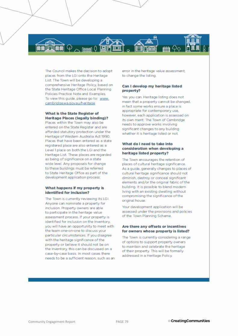
Community Engagement Report PAGE 79
Community Engagement Report PAGE 80

Community Engagement Report PAGE 81
5.3 Community Information Session Presentation (2017)
Community Engagement Report PAGE 82

Community Engagement Report PAGE 83

Community Engagement Report PAGE 84

Community Engagement Report PAGE 85
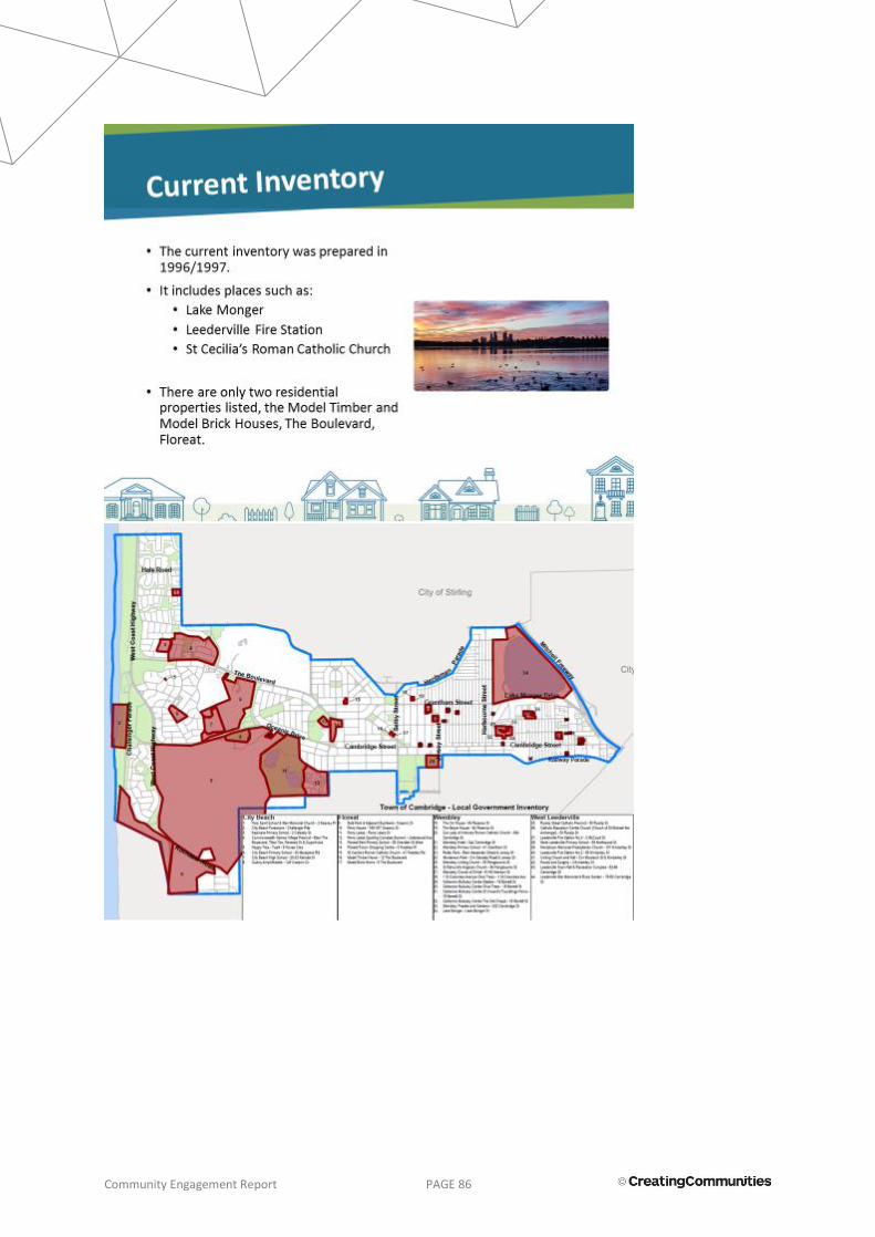
Community Engagement Report PAGE 86
Community Engagement Report PAGE 87

Community Engagement Report PAGE 88

Community Engagement Report PAGE 89
Community Engagement Report PAGE 90
Community Engagement Report PAGE 91
Community Engagement Report PAGE 92
Community Engagement Report PAGE 93
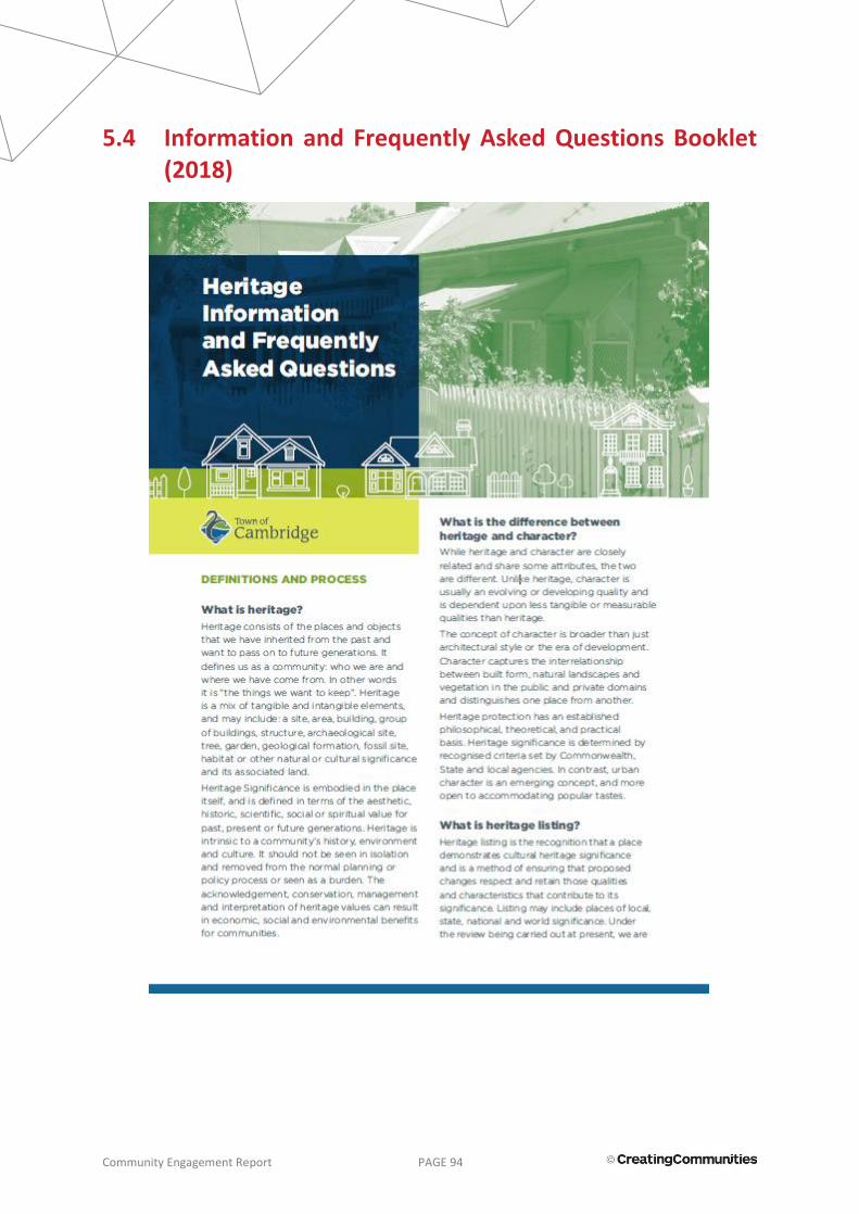
Community Engagement Report PAGE 94
5.4 Information and Frequently Asked Questions Booklet (2018)
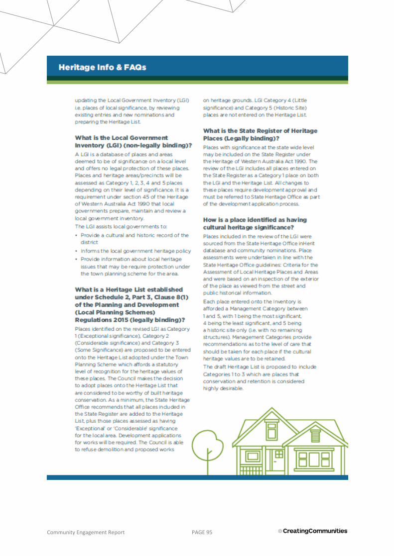
Community Engagement Report PAGE 95
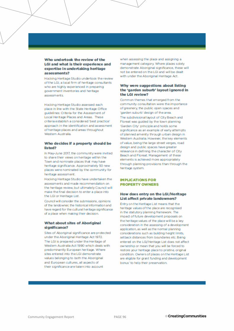
Community Engagement Report PAGE 96
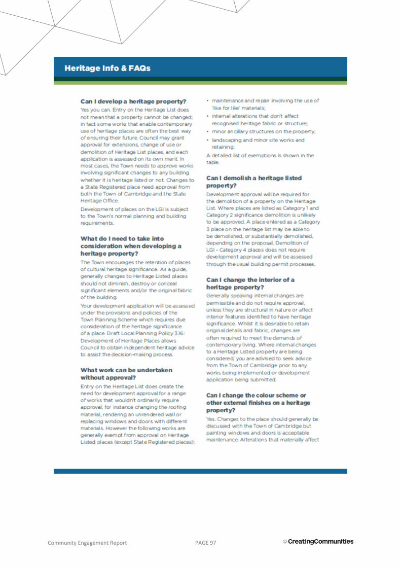
Community Engagement Report PAGE 97

Community Engagement Report PAGE 98

Community Engagement Report PAGE 99

Community Engagement Report PAGE 100
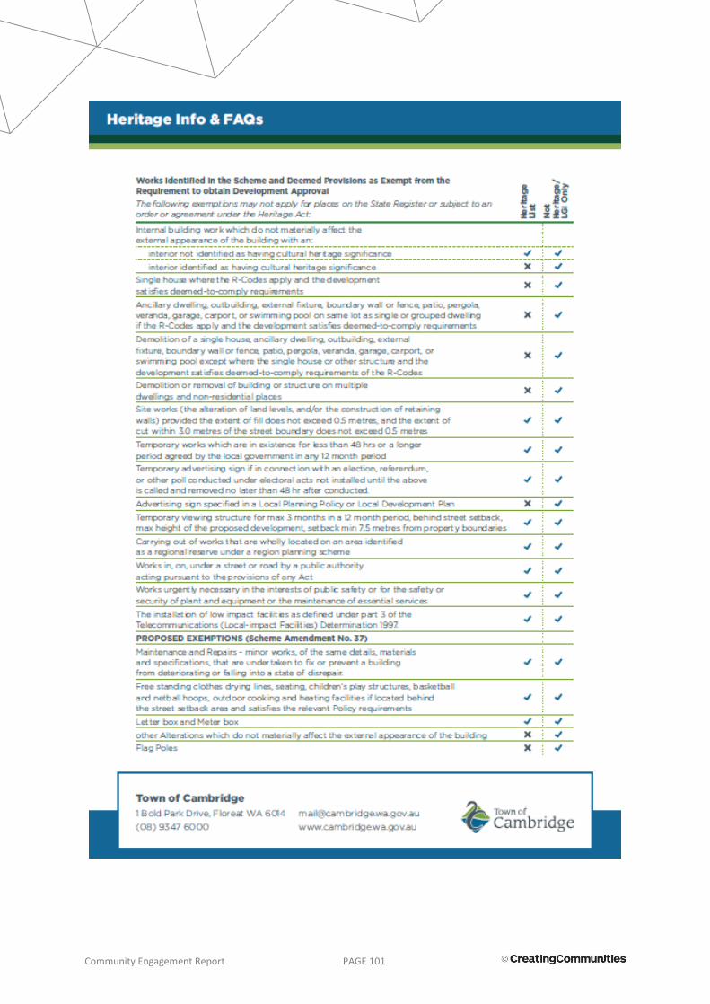
Community Engagement Report PAGE 101
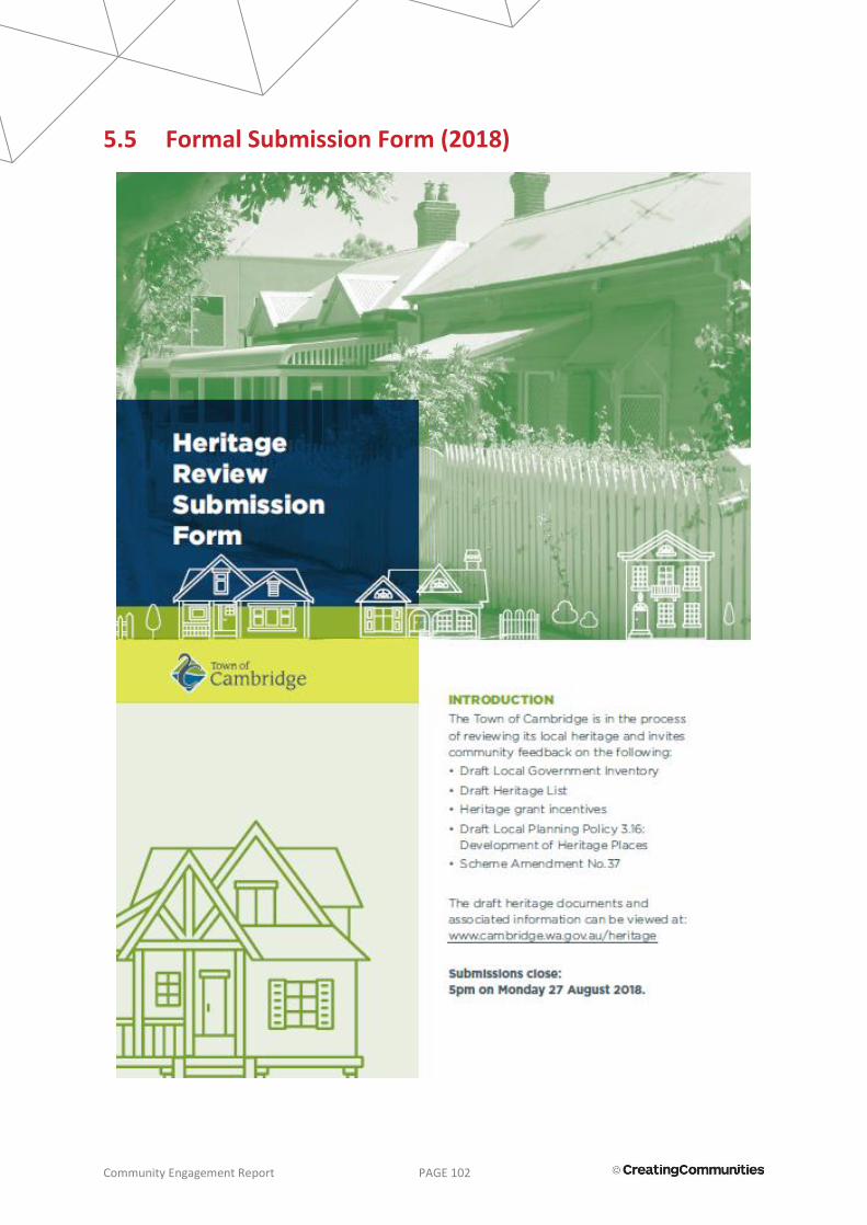
Community Engagement Report PAGE 102
5.5 Formal Submission Form (2018)
Community Engagement Report PAGE 103

Community Engagement Report PAGE 104

Community Engagement Report PAGE 105

Community Engagement Report PAGE 106
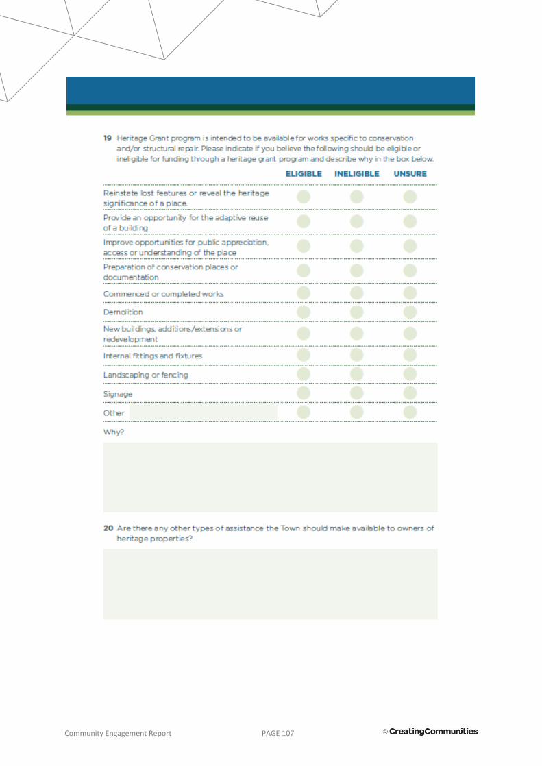
Community Engagement Report PAGE 107

Community Engagement Report PAGE 108

Community Engagement Report PAGE 109

Community Engagement Report PAGE 110
5.6 Community Information Session Presentation (2018)

Community Engagement Report PAGE 111

Community Engagement Report PAGE 112

Community Engagement Report PAGE 113

Community Engagement Report PAGE 114

Community Engagement Report PAGE 115

Community Engagement Report PAGE 116

Community Engagement Report PAGE 117

Community Engagement Report PAGE 118

Community Engagement Report PAGE 119

Community Engagement Report PAGE 120
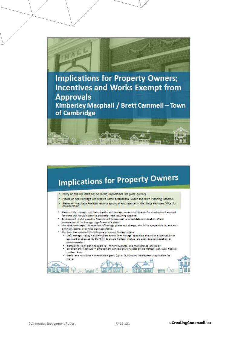
Community Engagement Report PAGE 121

Community Engagement Report PAGE 122

Community Engagement Report PAGE 123
Community Engagement Report PAGE 124
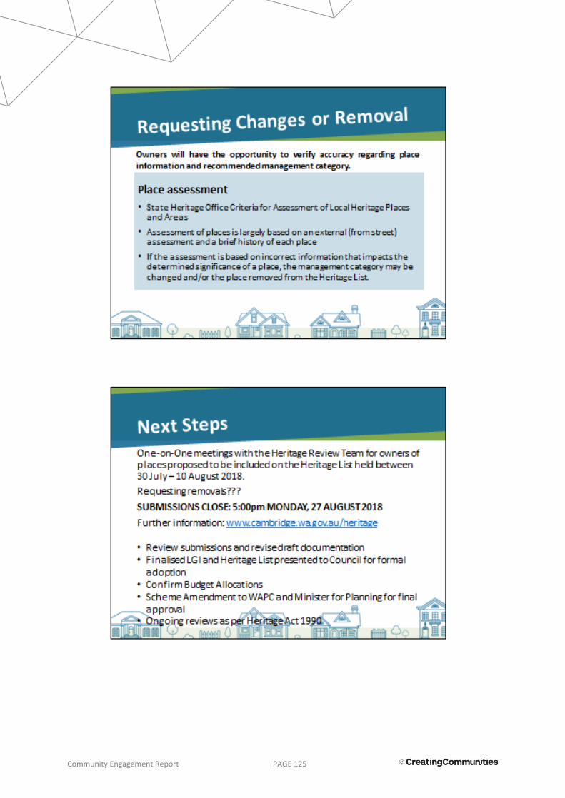
Community Engagement Report PAGE 125

Community Engagement Report PAGE 126

Community Engagement Report PAGE 127
100 Jersey St Jolimont 6014 PERTH | WESTERN AUSTRALIA
creatingcommunities.com.au +61 8 9284 0910