Inventory - City of Hollister
25
1-1 Chapter One Inventory The initial step in the preparation of the airport master plan for Hollister Municipal Airport is the collection of information pertaining to the airport and the area it serves. The information summarized in this chapter will be used in subsequent analyses in this study and includes: The information in this chapter was obtained from several sources, including on-site inspections, interviews with City staff and airport tenants, airport records, related studies, the Federal Aviation Administration (FAA), and a number of internet sites. • • • • Physical inventories and descriptions of the facilities and services currently provided at the airport, including the regional airspace, air traffic control, and aircraft operating procedures. Background information pertaining to the City of Hollister and regional area, including descriptions of the regional climate, surface transportation systems, the Hollister Municipal Airport's role in the regional, state, and aviation systems, and development that has taken place recently at the airport. Population and other significant socioeconomic data which can provide an indication of future trends that could influence aviation activity at the airport. A review of existing local and regional plans and studies to determine their potential influence on the development and implementation of the airport master plan.
-
Upload
khangminh22 -
Category
Documents
-
view
0 -
download
0
Transcript of Inventory - City of Hollister

1-1
Chapter One
InventoryThe initial step in the preparation of the airport master plan for Hollister Municipal Airport is the collection of information pertaining to the airport and the area it serves. The information summarized in this chapter will be used in subsequent analyses in this study and includes:
The information in this chapter was obtained from several sources, including on-site inspections, interviews with City staff andairport tenants, airport records, related studies, the FederalAviation Administration (FAA), and a number of internet sites.
•
•
•
•
Physical inventories and descriptions of the facilities and servicescurrently provided at the airport, including the regional airspace,air traffic control, and aircraft operating procedures.
Background information pertaining to the City of Hollister andregional area, including descriptions of the regional climate, surfacetransportation systems, the Hollister Municipal Airport's role in theregional, state, and aviation systems, and development that hastaken place recently at the airport.
Population and other significant socioeconomic data which can provide an indication of future trends that could influence aviationactivity at the airport.
A review of existing local and regional plans and studies to determine their potential influence on the development andimplementation of the airport master plan.

1-2
A complete listing of the data sources is provided at the end of this chapter. HISTORICAL PERSPECTIVE Hollister Municipal Airport began as a private grass airstrip in 1912 when it served as host to aviators Frank Bry-ant and Roy Francis, who performed an air show on May 18 and 19. The airstrip became known as Turner Field in the mid-20s after the property was acquired by Everett Turner, who ran the local crop dusting service. The year 1932 brought the first annual Hollister Air Race and the first para-chute jump, and in 1936 a special air-mail delivery service was introduced. In 1941, the Navy purchased the property and the airfield became Navy Air Auxiliary Station (N.A.A.S.) Hol-lister. At its peak operation, N.A.A.S. Hollister housed 200-300 Navy per-sonnel undergoing advanced weapons training and military opera-tions/attack procedures prior to enter-ing the war zone. N.A.A.S. Hollister operated as a military base until June 1946 when civilian activity was al-lowed. Eighteen months later, on De-cember 9, 1947, the facilities were turned over to the City of Hollister through a quitclaim deed.
RECENT DEVELOPMENT HISTORY In cooperation with the FAA and State, the City of Hollister has made continual improvements to Hollister Municipal Airport. Table 1A summa-rizes the major improvement projects at the Airport since 1989. Since 1989, almost 10 million dollars have been invested by the FAA at Hollister Mu-nicipal Airport through the Federal Airport Improvement Program (AIP). AIRPORT ADMINISTRATION Hollister Municipal Airport is owned by the City of Hollister. The airport is under the direction of the City Man-ager. The Airport Manager is respon-sible for the operation, maintenance, and management of the airport. A five-member Airport Advisory Commission provides recommenda-tions on the policies and long-range plans for the Hollister Municipal Air-port to the City Council. At least three members are required to be resi-dents of the City of Hollister and all members must be residents of San Benito County. The members are ap-pointed by the Mayor with the ap-proval of the City Council. Appoint-ments are for a two-year time period, with staggered terms of office to en-sure that no more than two-thirds of the terms expire in any one-year pe-riod.

1-3
TABLE 1A Recent Development History/Federal Grant History Grant Year Project Description Federal Grant
1989 Overlay Runway 24, Reconstruct Taxiways $472,200 1991 Overlay Runway 31, Seal Runway 24 $672,200 1996 Extend Runway 31, Purchase 22 Acres $6,062,800 2000 Taxiway Extension To Runway 31,
Reconstruct Taxiway To Runway 24
$1,220,000 2001 Purchase Aviation Easement and Install
AWOS, Airport Beacon, and Security Fence
$1,381,000 Source: City of Hollister AWOS – Automated Weather Observation System
AIRPORT FACILITIES Airport facilities can be functionally classified into two broad categories: airside and landside. The airside category includes those facilities di-rectly associated with aircraft opera-tions. The landside category includes those facilities necessary to provide a safe transition from surface to air transportation and support aircraft servicing, storage, maintenance, and operational safety. AIRSIDE FACILITIES Airside facilities include runways, taxiways, airfield lighting, and navi-gational aids. Airside facilities are identified on Exhibit 1A. Table 1B summarizes airside facility data.
Runways The existing runway configuration at Hollister Municipal Airport includes two intersecting runways (Runway 6-24 and Runway 13-31). Runway 13-31, the longest runway, is 6,350 feet long, 100 feet wide, and is oriented in a northwest-southeast manner. Run-way 6-24 is 3,150 feet long, 100 feet wide, and oriented in a northeast-southwest manner. A 750-foot lead-in taxiway is located behind the Runway 6 landing threshold. A 450-foot lead-in taxiway is located behind the Run-way 24. This pavement cannot be used for landings. Since it is not des-ignated as part of the runway, it should not be used for departure. The Runway 6 and Runway 24 thresholds have been located to provide sufficient landing clearance over obstacles within the approach surface. A hill is located west of the Runway 24 end, while San Felipe Road is an obstruc-tion to Runway 24 without the thresh-old in its existing location. A 1,170-foot lead-in taxiway is located behind the Runway 31 end.

1-4
TABLE 1B Airside Facility Data Hollister Municipal Airport Runway 6-24 Runway 13-31 Length (ft.) Width (ft.) Surface Material
3,150 100
Asphalt
6,350 100
Asphalt Load Bearing Strength Single Wheel Double Wheel
30,000 45,000
30,000 45,000
Instrument Approach Procedures None GPS (31) Approach Aids Global Positioning System (GPS) Visual Approach Slope Indicators (VASI) Precision Approach Path Indicators (PAPI) Runway End Identifier Lights (REILs)
Rwy 6 No No No No
Rwy 24 No Yes No Yes
Rwy 13 No No Yes Yes
Rwy 31 Yes No Yes Yes
Pavement Edge Lighting Medium Intensity Runway Lighting
Taxiway Retro-
Reflective Delineators
Medium Intensity Runway Lighting
Taxiway Retro-
Reflective Delineators
Pavement Markings Basic Nonprecision Elevation 230 feet Mean Sea Level (MSL) Fixed Wing Aircraft Traffic Pattern Helicopter Traffic Pattern
Left Right
Source: November 2002 Airport/Facility Directory GPS- Global Positioning System
Both runways are constructed of as-phalt. The load bearing strengths are the same for both runways: 30,000 SWL and 45,000 DWL. Single wheel loading (SWL) refers to the design of certain aircraft landing gear which has a single wheel on each main land-ing gear strut. Dual wheel loading (DWL) refers to the design of certain aircraft landing gears which have two wheels on each main landing gear strut.
Taxiways The taxiway system at Hollister Mu-nicipal Airport is identified on Ex-hibit 1A. Both runways are equipped with full-length parallel taxiways. Taxiway A is a full-length parallel taxiway providing access to both ends of Runway 13-31. Taxiway A is 50 feet wide and is located 300 feet from the Runway 13-31 centerline. Taxiways B, D, F, and H connect Taxiway A to Runway 13-31, and serve as runway entrance and exit points. Each taxi-way is 50 feet wide.

REILREIL
Exhibit 1AAIRSIDE FACILITIES
01M
P12
-1A
-12/
11/0
3
HH FF
RUNW
AY 6
-24
(3,1
50' x
100
')
RUNW
AY 6
-24
(3,1
50' x
100
')
F EEE CC BA
BA
RUNWAY 13-31 (6,350' x 100')RUNWAY 13-31 (6,350' x 100')RUNWAY 13-31 (6,350' x 100')
RUNW
AY 6
-24
(3,1
50' x
100
')
High
way
156
Bypa
ssHi
ghw
ay15
6By
pass
San Felipe Rd. (Hwy 156)
San Felipe Rd. (Hwy 156)
San Felipe Rd. (Hwy 156)
Bolsa Rd. (Hwy 25)Bolsa Rd. (Hwy 25)Bolsa Rd. (Hwy 25)
Holding ApronHolding ApronHolding Apron
300'300'300'
1,170'1,170'1,170'
Lead-in TaxiwayLead-in TaxiwayLead-in Taxiway
Soar HollisterSoar Hollister(Gliders)(Gliders)
Soar Hollister(Gliders)
Aerostar Way
Aerostar Way
Aerostar WayAirway Dr.
Airway Dr.
Airway Dr.
750'
750'
750'
450'
450'
450'
Lead-in TaxiwayLead-in TaxiwayLead-in Taxiway
Lead-in TaxiwayLead-in TaxiwayLead-in Taxiway
VASI-2VASI-2VASI-2
Lighted Wind ConeLighted Wind Cone& Segmented Circle& Segmented CircleLighted Wind Cone
& Segmented Circle
250'250'250'
50'50'50'
PAPI-2PAPI-2PAPI-2
LandingLandingThresholdThresholdLandingThreshold
LandingLandingThresholdThreshold
LandingThreshold
Landing ThresholdLanding ThresholdLanding Threshold
Proposed CDFProposed CDFAir Attack BaseAir Attack BaseProposed CDFAir Attack Base
50'50'50'
II
Segmented CircleSegmented Circle
West Executive HangarsWest Executive Hangars
Taxiway SignsTaxiway Signs
West T-HangarsWest T-Hangars
PAPI-2PAPI-2
REILREILREIL RE
ILRE
ILRE
IL
PAPI-2PAPI-2PAPI-2
REILREILREIL
CC
T-HangarsT-HangarsT-HangarsExecutive HangarsExecutive HangarsExecutive Hangars
Wash RackWash RackWash Rack
C & MC & MHelicopterHelicopterC & MHelicopter
CC
50'50'50' 50'50'50'50'50'50'AA
Rotating BeaconRotating BeaconRotating Beacon
TetrahedronTetrahedron
NORTH
NORTH
NORTH
0 800800 1,6001,600
SCALE IN FEETSCALE IN FEET
0 800 1,600
SCALE IN FEET
VASI-2VASI-2 Beacon/Electrical Vault
Beacon/Electrical Vault
HollisterMunicipalAirport
Existing Airport Property Line
Easements
Proposed Pavement
Proposed Buildings
LEGEND
PAPI - Precision Approach Path IndicatorREIL - Runway End Identifier LightsVASI - Visual Approach Slope Indicator
KEY
JJ
TetrahedronTetrahedronTetrahedron
Flynn
Rd.
Flynn
Rd.
Flynn
Rd.
50'50'50'

1-5
Taxiway C is a full length parallel taxiway extending between each end of Runway 6-24. Taxiway C is 50 feet wide and is located 250 feet from the Runway 6-24 centerline. Taxiway I and Taxiway J connect Taxiway C to Runway 6-24. Each taxiway is 50 feet wide. Airfield Lighting Airfield lighting systems extend an airport’s usefulness into periods of darkness and/or poor visibility. A va-riety of lighting systems are installed at the airport for this purpose. These lighting systems, categorized by func-tion, are summarized as follows. Identification Lighting: The loca-tion of an airport at night is univer-sally identified by a rotating beacon. A rotating beacon projects two beams of light, one white and one green, 180 degrees apart. The rotating beacon at Hollister Municipal Airport is located in the southeast portion of the airfield, adjacent to the main power vault as shown on Exhibit 1A. Pavement Edge Lighting: Pave-ment edge lighting utilizes light fix-tures placed near the edge of the pavement to define the lateral limits of the pavement. This lighting is es-sential for safe operations during night and/or times of low visibility in order to maintain safe and efficient access to and from the runway and aircraft parking areas. Both runways at Hollister Municipal Airport are equipped with medium intensity run-way lighting (MIRL). All taxiways are equipped with retro-reflector markers. Each runway end is equipped with
threshold lights, which identify the landing threshold. Runway threshold lights utilize specially designed lens which are red on one side and green on the other. The red portion is visible during departure while the green por-tion is visible during approach. Visual Approach Lighting: The ap-proach and landing phase of all flights at Hollister Municipal Airport is con-ducted visually by the pilot. A number of landing aids have been installed at the airport to assist pilots in determin-ing the correct descent path to the runway end during landing. A visual approach slope indicator (VASI) is available at the Runway 24 end. A precision approach path indicator (PAPI) is available at the Runway 13 and Runway 31 ends. While different in configuration, the VASI and PAPI are similar in use. Each system con-sists of a series of lights, located at various distances from the runway threshold, which when interpreted by the pilot, give him or her an indication of being above, below, or on the desig-nated descent path to the runway end. Runway End Identification Light-ing: Runway end identification lights (REILs) provide rapid and positive identification of the approach end of the runway. The REIL system con-sists of two synchronized flashing lights, located laterally on each side of the runway threshold, facing the ap-proaching aircraft. REILs are in-stalled on both ends of Runway 13-31 and to Runway 24. Airfield Signs: Airfield identification signs assist pilots in identifying their location on the airport and direct them to their desired location. Lighted air-

1-6
field signs are located at aircraft hold positions, at taxiway intersections, and at the intersection of the connect-ing taxiways and runways. Pilot-Controlled Lighting: Airfield lighting systems can be controlled through a pilot-controlled lighting sys-tem (PCL). A PCL allows pilots to turn on/or increase the intensity of the airfield lighting systems from the air-craft with the use of the aircraft’s ra-dio transmitter. The MIRL to each runway, REILs, PAPIs, and VASIs are connected to the PCL system at Hol-lister Municipal Airport. Pavement Markings Pavement markings aid in the move-ment of aircraft along airport surfaces and identify closed or hazardous areas on the airport. The non-precision markings on Runway 13-31 identify the runway centerline, threshold, des-ignation, pavement edge, and aircraft holding positions. The basic markings on Runway 6-24 identify the runway centerline, designation, and aircraft holding positions. Taxiway and apron taxilane centerline markings are provided to assist air-craft using these airport surfaces. Centerline markings assist pilots in maintaining proper clearance from pavement edges and objects near the taxilane/taxiway edges. Pavement markings also identify aircraft park-ing positions.
Weather Reporting Hollister Municipal Airport is not cur-rently equipped with automated weather reporting. However, the City has a federal grant to install an auto-mated weather observation system (AWOS). The AWOS will provide automated aviation weather observa-tions 24 hours a day. The system up-dates weather observations every minute, continuously reporting signifi-cant weather changes as they occur. The AWOS system reports cloud ceil-ing, visibility, temperature, dew point, wind direction, wind speed, altimeter setting (barometric pressure), and density altitude (airfield elevation cor-rected for temperature). Hollister Municipal Airport is equipped with a lighted wind cone, tetrahedron, and segmented circle. The wind cone provides wind direction and speed information to pilots. The tetrahedron is a device that is used as a landing direction indicator. The small end of the tetrahedron points in the direction of landing. The seg-mented circle provides aircraft traffic pattern information. The lighted wind cone and segmented circle are located northwest of the runway intersection, while the tetrahedron is located south-west of the runway intersection. Enroute Navigation And Airspace Navigational aids are electronic de-vices that transmit radio frequencies, which pilots of properly equipped air-

1-7
craft translate into point-by-point guidance and position information. For pilots flying to and from Hollister Municipal Airport, the global position-ing system (GPS), very high frequency omnidirectional range (VOR), and LORAN-C navigational aids are avail-able for use. The global positioning system (GPS) was initially developed by the United States Department of Defense for mili-tary navigation around the world. In-creasingly, GPS has been utilized more in civilian uses. GPS uses satel-lites placed in orbit around the globe to transmit electronic signals, which pilots of properly equipped aircraft use to determine altitude, speed, and navigational information. The FAA is proceeding with a program to make satellite navigation the primary navi-gation system across the country; however, most existing navigational aids will be retained for redundancy and security. The VOR, in general, provides azi-muth readings to pilots of properly equipped aircraft by transmitting a radio signal at every degree to provide 360 individual navigational courses. Frequently, distance measuring equipment (DME) is combined with a VOR facility to provide distance as well as direction information to the pilot. Military tactical air navigation aids (TACANs) are commonly com-bined to form a VORTAC. A VORTAC provides distance and direction infor-mation to civil and military pilots. The Salinas VORTAC, San Jose VOR/DME, Panoche VORTAC, and Priest VOR can be used by pilots when navigating to or from Hollister Mu-
nicipal Airport. These facilities are identified on Exhibit 1B. Loran-C is a ground-based enroute navigational aid which utilizes a sys-tem of transmitters located in various locations across the continental United States. Loran-C is similar to GPS as pilots are not required to navi-gate using a specific facility. With a properly equipped aircraft, pilots can navigate to any airport in the United States using Loran-C. Instrument Approach Procedures Instrument approach procedures are a series of predetermined maneuvers established by the FAA, using elec-tronic navigational aids, that assist pilots in locating and landing at an airport during low visibility and cloud ceiling conditions. There is currently one published instrument approach to Hollister Municipal Airport. The GPS approach to Runway 31 is a non-precision instrument approach that provides course guidance information to the pilot. The capability of an instrument ap-proach is defined by the visibility and cloud ceiling minimums associated with the approach. Visibility mini-mums define the horizontal distance that the pilot must be able to see in order to complete the approach. Cloud ceilings define the lowest level a cloud layer (defined in feet above the ground) can be situated for the pilot to complete the approach. If the ob-served visibility or cloud ceilings are below the minimums prescribed for the approach, the pilot cannot com-

1-8
plete the instrument approach. The minimum visibility and cloud ceiling requirements vary according to the approach speed of the aircraft. The Runway 31 GPS approach provides for straight-in landings when the visibil-ity is restricted to one mile and cloud ceilings are at least 600 feet above the ground for aircraft with approach speeds less than 120 knots. In aircraft with approach speeds between 121 and 140 knots, the cloud ceilings re-main the same, while the visibility minimums increase to one and one-half miles. When a local altimeter set-ting is not available, the cloud ceiling minimums increase to 700 feet for air-craft with approach speeds less than 120 knots. For aircraft with approach speeds between 121 and 140 knots, the cloud ceiling increases to 700 feet while the visibility minimums in-crease to two miles. The Runway 31 GPS approach also provides a circling option. The circling option allows pilots to land on any runway end at the airport after follow-ing the approach procedure. The cir-cling minimums are the same as the straight-in approach procedure if the local altimeter setting is available. When this is not available, the cloud ceilings increase to 800 feet for air-craft with approach speeds less than 121 knots. For aircraft with approach speeds between 121 and 140 knots, the cloud ceilings increase to 800 feet, while the visibility minimums in-crease to two miles. The installation of the AWOS should eliminate the disparity in approach minimums as it will provide local altimeter settings continuously.
Local Operating Procedures Hollister Municipal Airport is located at 230 feet mean sea level (MSL). A left-hand traffic pattern has been es-tablished for all runways. In this manner, aircraft approach the desired runway end, following a series of left-hand turns. The traffic pattern alti-tude (TPA) is 1,030 feet MSL (800 feet AGL) for fixed-wing aircraft. The heli-copter TPA is 750 feet MSL (500 feet AGL). Helicopters are requested to use a right traffic pattern. Vicinity Airspace The Federal Aviation Administration Act of 1958 established the FAA as the responsible agency for the control and use of navigable airspace within the United States. In response to this leg-islative directive, the FAA has estab-lished the National Airspace System (NAS) to protect persons and property on the ground and to provide for a safe and efficient airspace environment for civil, commercial, and military avia-tion. The NAS consists of U.S. air-space, air navigation facilities, air-ports and landing areas, aeronautical charts, regulations and procedures, technical information and services, personnel and material. The system also includes components shared jointly with the military. Airspace in the vicinity is depicted in Exhibit 1B. The U.S. airspace structure provides two basic categories of airspace, con-trolled and uncontrolled, and identi-fies them as Classes A, B, C, D, E, and

01M
P12
-1B
-12/
12/0
3
Exhibit 1BVICINITY AIRSPACE AND AIRPORTS
LEGEND
Airport with other than hard-surfacedrunways
Seaplane Base
Airport with hard-surfaced runways1,500' to 8,069' in length
Airports with hard-surfaced runwaysgreater than 8,069' or some multiplerunways less than 8,069'
Non-Directional Radiobeacon (NDB)
VORTAC
VHF Omni Range (VOR)
VOR-DME
Compass Rose
Class B Airspace
Class C Airspace
Class D Airspace
Class E Airspace
Class E Airspace with floor700 ft. above surface
Differentiates Floors ofClass E Airspace greaterthan 700 ft. above surface
Victor Airways
Military Training Routes
Mode C
MOA - Military OperationsArea
Prohibited, Restricted,Warning and Alert Areas
Wilderness Areas
VENTANAVENTANAWILDERNESS AREAWILDERNESS AREA
VENTANAWILDERNESS AREA
VENTANAVENTANAWILDERNESS AREAWILDERNESS AREA
VENTANAWILDERNESS AREA
Eagle (Pvt.)Eagle (Pvt.)Eagle (Pvt.)
Los BanosLos BanosLos Banos
Ahlem (Pvt.)Ahlem (Pvt.)Ahlem (Pvt.)
GustineGustineGustine
Patters(Pvt.)
Patters(Pvt.)
Patters(Pvt.)
Westley (Pvt.)Westley (Pvt.)Westley (Pvt.)
MontereyPeninsulaMontereyPeninsulaMontereyPeninsula
MarinaMarinaMarina SalinasSalinasSalinas
WatsonvilleWatsonvilleWatsonville
BonnyDoon(Pvt.)
BonnyDoon(Pvt.)
BonnyDoon(Pvt.)
SouthCountySouth
CountySouth
County
MinetaSan Jose Intl.
MinetaSan Jose Intl.
MinetaSan Jose Intl.
Palo AltonPalo AltonPalo Alton
San CarlosSan CarlosSan Carlos
WARNINGW-285-A&BWARNING
W-285-A&BWARNING
W-285-A&B
PINNACLESPINNACLESNATIONALNATIONAL
MONUMENTMONUMENT
PINNACLESNATIONAL
MONUMENT
LOS BANOS STATELOS BANOS STATEWILDLIFE AREAWILDLIFE AREA
LOS BANOS STATEWILDLIFE AREA
MERCED NATIONALMERCED NATIONALWILDLIFE REFUGEWILDLIFE REFUGEMERCED NATIONALWILDLIFE REFUGE
SAN LUIS NATIONALSAN LUIS NATIONALWILDLIFE REFUGEWILDLIFE REFUGE
SAN LUIS NATIONALWILDLIFE REFUGE
KESTERSON NATIONALKESTERSON NATIONALWILDLIFE REFUGEWILDLIFE REFUGE
KESTERSON NATIONALWILDLIFE REFUGE
ORESTIMBAORESTIMBAWILDERNESSWILDERNESS
AREAAREA
ORESTIMBAWILDERNESS
AREA
CALIFORNIACALIFORNIASEA OTTERSEA OTTER
GAME REFUGEGAME REFUGE
CALIFORNIASEA OTTER
GAME REFUGE
TurlockAirpark(Pvt.)
TurlockAirpark(Pvt.)
TurlockAirpark(Pvt.)
TurlockTurlockTurlock
CastleCastleCastle
Merced/MacreadyMerced/
MacreadyMerced/
Macready
VOLTAVOLTASTATESTATE
WILDLIFEWILDLIFEAREAAREA
VOLTASTATE
WILDLIFEAREA
MoffettFederalMoffettFederalMoffettFederal
PajarPajarNDBNDBPajarNDB
ChualarChualarNDBNDB
ChualarNDB
V 27
V 27
V 27
V 230V 230V 230
V 137V 137V 137
V 248
V 248
V 248
V 1
13
V 1
13
V 1
13
V 485V 485V 485
V 230V 230V 230
V 87V 87V 87
V 109-113-585
V 109-113-585
V 109-113-585
V 25-87
V 25-87
V 25-87
V 301
V 301
V 301
V 107
V 107
V 107
V 1
11V
111
V 1
11
V 25-87
V 25-87
V 25-87
IR207
IR207
IR207
IR203
IR203
IR203
IR203IR203IR203
PriestPriestVORVORPriestVOR
Christensen (Pvt.)Christensen (Pvt.)Christensen (Pvt.)
Clark(Pvt.)Clark(Pvt.)Clark(Pvt.)
Mesa Del ReyMesa Del ReyMesa Del Rey
VR1257VR1257VR1257
HUNTER LOW A& HIGH MOA
HUNTER LOW A& HIGH MOA
HUNTER LOW A& HIGH MOA
V 25V 25V 25
PanochePanocheVORTACVORTACPanocheVORTAC
Big SurBig SurVORTACVORTACBig Sur
VORTAC
SalinasSalinasVORTACVORTACSalinas
VORTAC
WoodsideWoodsideVORTACVORTACWoodsideVORTAC
MONTEREY BAYMONTEREY BAYNATIONAL MARINENATIONAL MARINE
SANCTUARYSANCTUARY
MONTEREY BAYNATIONAL MARINE
SANCTUARY
HOLLISTERAIRPORT
Reid HillviewReid HillviewReid HillviewSan JoseSan JoseVOR-DMEVOR-DMESan JoseVOR-DME
HollisterMunicipalAirport
Source: San Francisco Sectional Chart, US Department of Commerce, National Oceanic and Atmospheric Administration 9/5/02
San FransicoSan FransicoVOR-DMEVOR-DME
San FransicoVOR-DME
FrazierLake
FrazierLake
FrazierLake

1-9
G. Class A airspace is controlled air-space and includes all airspace from 18,000 feet mean sea level (MSL) to Flight Level 600 (approximately 60,000 feet MSL). Class B airspace is controlled airspace surrounding high capacity commercial service airports (e.g., San Francisco International Air-port). Class C airspace is controlled airspace surrounding lower activity commercial service (e.g., Monterey Peninsula Airport) and some military airports. Class D airspace is con-trolled airspace surrounding airports with an airport traffic control tower (e.g., Salinas Municipal Airport). All aircraft operating within Classes A, B, C, and D airspace must be in contact with the air traffic control facility re-sponsible for that particular airspace. Class E is controlled airspace that en-compasses all instrument approach procedures and low altitude federal airways. Only aircraft conducting in-strument flights are required to be in contact with air traffic control when operating in Class E airspace. Air-craft conducting visual flights in Class E airspace are not required to be in radio communications with air traffic control facilities; however, visual flight can only be conducted if minimum visibility and cloud ceilings exist. Class G airspace is uncontrolled air-space that does not require contact with an air traffic control facility. Hollister Municipal Airport is located in Class E airspace, with a floor 700 feet above surface. The Class E air-space around Hollister Municipal Air-port extends outward at a radius of approximately five nautical miles.
The Class E airspace extends an addi-tional seven nautical miles southeast of the airport to encompass the Run-way 31 GPS approach procedure. The Class E airspace also extends outward approximately two nautical miles to the northwest. For aircraft arriving or departing the regional area using VOR facilities, a system of Federal Airways, referred to as Victor Airways, has been estab-lished. Victor Airways are corridors of airspace eight miles wide that extend upward from 1,200 feet AGL to 18,000 feet MSL and extend between VOR navigational facilities. Victor Airways are shown with solid blue lines on Exhibit 1B. V485 crosses Hollister Municipal Airport, extending between the Priest VOR to the southeast and San Jose VOR/DME to the northwest. V111 extends north of the airport, and emanates from the Salinas VORTAC. Military training routes in the vicinity of Hollister Municipal Airport are identified on Exhibit 1B. Military jets travel these routes above 10,000 feet MSL at speeds in excess of 250 knots. While not considered part of the U.S. airspace structure, the boundaries of National Park Service areas and U.S. Forest and Primitive areas are noted on aeronautical charts. While aircraft operations are not specifically re-stricted over these areas, aircraft are requested to maintain a minimum al-titude of 2,000 feet above the surface. Exhibit 1B depicts the boundaries of these areas near Hollister Municipal Airport.

1-10
Air Traffic Control Hollister Municipal Airport does not have an airport traffic control tower (ATCT); therefore, no formal air traffic services are available. Aircraft operat-ing in the vicinity of the airport are not required to file any type of flight plan or contact any air traffic control facility unless they are entering air-space where contact is mandatory or have filed an instrument flight plan. Air traffic advisories and certain weather information can be obtained using the common traffic advisory fre-quency (CTAF) channel 123.0 MHz, also known as UNICOM. The Oakland Flight Service Station (FSS) provides pilots with weather in-formation and flight planning process-ing. NorCal Approach Control pro-vides enroute air traffic control func-tions and controls all aircraft using the Runway 31 GPS approach. LANDSIDE FACILITIES Landside facilities are the ground-based facilities that support the air-craft and pilot/passenger handling functions. These facilities typically include a terminal building, aircraft storage/maintenance hangars, aircraft parking aprons, and support facilities such as fuel storage, automobile park-ing, roadway access, and aircraft res-cue and firefighting. Landside facili-ties are identified on Exhibit 1C.
Apron The main apron area at Hollister Mu-nicipal Airport is located southeast of the Runway 13-31/Runway 6-24 inter-section. This main apron area encom-passes approximately 42,800 square yards including space for aircraft parking and taxilane access to hangar facilities. The main apron provides approximately 120 tiedown spaces. Aircraft Hangars There are 17 separate hangar build-ings at Hollister Municipal Airport, totaling approximately 153,100 square feet. Hangar facilities are located ad-jacent to the main hangar (east han-gar area) as well as near the Runway 6 end (west hangar area). Hangar space at Hollister Municipal Airport is comprised of conventional (clear span) hangars and T-hangars. Conventional hangars provide a large, open space free from roof support structures which typically have the capability to accommodate several aircraft simul-taneously. T-hangars provide for separate hangar facilities within a larger continuous facility. Conventional hangar space at Hollis-ter Municipal Airport totals approxi-mately 71,500 square feet within six facilities located along the eastern edge of the main apron area. This in-cludes hangar space devoted to the aviation college, aircraft maintenance,

Exhibit 1CLANDSIDE FACILITIES
01M
P12
-1C
-12/
11/0
3
6 7 8 941
11
Airp
ort D
r.
Airp
ort D
r.
Airp
ort D
r.
13
20
19
300'300'300'
Lead-in TaxiwayLead-in TaxiwayLead-in Taxiway
1,170'1,170'1,170'
BB
AA
CC
Fuel IslandFuel IslandFuel Island
San Felipe Rd. (Hwy 156)
San Felipe Rd. (Hwy 156)
San Felipe Rd. (Hwy 156)
RUNW
AY 6
-24
(3,1
50' x
100
')
RUNW
AY 6
-24
(3,1
50' x
100
')
RUNW
AY 6
-24
(3,1
50' x
100
')
Lead
-in T
axiw
ay
Lead
-in T
axiw
ay
Lead
-in T
axiw
ay
450'
450'
450'
LandingLandingThresholdThresholdLandingThreshold
Landing ThresholdLanding ThresholdLanding Threshold
RUNWAY 13-31 (6,350' x 100')RUNWAY 13-31 (6,350' x 100')RUNWAY 13-31 (6,350' x 100')
50'50'50'
3
5
12
1415
50'50'50'250'250'250'
JJ
Main ApronMain ApronMain Apron
AA
Airport Manager'sAirport Manager'sOfficeOfficeAirport Manager'sOffice
Airport MaintenanceAirport MaintenanceAirport Maintenance10
HollisterMunicipalAirport
2
18
16
17
NORTH
NORTH
NORTH00 300300300 600600600
SCALE IN FEETSCALE IN FEETSCALE IN FEET
Former National GuardFacility (Vacant)
Former National GuardFacility (Vacant)
20Hollister Elks LodgeHollister Elks Lodge19Storage BuildingsStorage Buildings15RestaurantRestaurant14Office/StorageOffice/Storage13California Dept. of ForestryCalifornia Dept. of Forestry11
Fuel Storage/DispencingFuel Storage/Dispensing Airport MaintenanceAirport Maintenance
Gavilan CollegeGavilan College2Gavilan CollegeGavilan College1
Gavilan CollegeGavilan College3 Gavilan CollegeGavilan College4
7
Aircraft StorageAircraft Storage9 T-Hangar FacilitiesT-Hangar Facilities10
Aircraft Storage/MaintenanceAircraft Storage/MaintenanceAircraft Storage/MaintenanceAircraft Storage/Maintenance 8
Aircraft MaintenanceAircraft Maintenance6
ElectricalVault andRotatingBeacon
ElectricalVault andRotatingBeacon
5
Aircraft MaintenanceAircraft Maintenance16
18
17
16
Office/StorageOffice/Storage17 18
Existing Airport Property Line
Easements
LEGEND
Astro Dr.Astro Dr.Astro Dr.
Skylane Dr.Skylane Dr.Skylane Dr.
Arm
ory
Dr.
Arm
ory
Dr.
Arm
ory
Dr.
Mar
s Dr
.M
ars
Dr.
Mar
s Dr
.
Mer
cury
Dr.
Mer
cury
Dr.
Mer
cury
Dr.

1-11
fixed base operator (FBO) services, and aircraft storage. There are nine separate T-hangar buildings on the airport, providing approximately 81,600 square feet of space and 75 separate hangar spaces. Three of these facilities are located southwest of the Runway 6 end. Other Buildings A number of original N.A.A.S. Hollis-ter buildings still remain at Hollister Municipal Airport. These include Buildings 15 (19,116 s.f.), 18 (2,500 s.f.), 19 (4,800 s.f.), 20 (3,243 s.f.), and 21 (4,606 s.f.). All buildings are one-story and wood-framed and are cur-rently used by various aviation-related and non-aviation related businesses. An architectural and structural as-sessment was completed in July 1999 for Buildings 15, 19, 20, and 21. This study found the buildings to be in gen-erally sound condition, with the excep-tion of non-conventional lateral load resisting systems and a reduced load carrying capacity. The buildings show significant deterioration to the exte-rior as well as some interior damage. These buildings are likely to contain lead and asbestos. The assessment also noted concerns relating to compli-ance with building codes and disabled person accessibility requirements. One of the original buildings, Building 25, was lost to fire in 2002. Building 18 is a former military building and is used for general storage by a private tenant. The Elks Lodge is located on the east side of the airport, near San Felipe Road. This is the former N.A.A.S. Hollister enlisted club. The building
is owned by the City and leased by the Elks Lodge. This building encom-passes approximately 15,500 square feet. In addition to its hangar facilities, Ga-vilan College has a 2,250 square-foot classroom facility and 2,250 square-foot aviation shop with attached noise suppression equipment for engine test-ing. The on-airport restaurant is lo-cated east of the main apron area in a 1,650 square-foot building. General Aviation Services Gavilan Aviation provides the tradi-tional FBO services at Hollister Mu-nicipal Air-port. Gavilan Aviation provides aircraft refueling, line ser-vices flight training, aircraft rentals, sightseeing tours/rides, aircraft main-tenance, aircraft parts, aviation acces-sories, aircraft sales/leasing/broker-age, pilot supplies, and courtesy transportation. Adventure Center Skydiving provides skydiving services. While Adventure Center Skydiving facilities are located on the airport, and aircraft takeoff and land at Hollister Municipal Airport, there is not a parachutist landing area on the airport. The parachutist land-ing area is located on private property near the town of Tres Pinos. Soar Hollister provides glider training, rentals, and sightseeing. Soar Hollis-ter is located off airport property north of Runway 6-24. Runway 24 is gener-ally used for glider operations, how-ever, any runway may be used de-pending on wind direction and when

1-12
practicing crosswind or downwind landings. OK Turbines provides aircraft turbine jet engine repair and parts. Air-Fab provides aircraft restoration services. C&M Helicopters provides aerial crop dusting services. Gavilan College pro-vides aviation maintenance training. Vintage Wings and Wheels provides aircraft maintenance, modifications, parts, and accessories. Other Airport Tenants The following businesses and organi-zations are located at Hollister Mu-nicipal Airport. • Hollister Elks Lodge • Airborne • Ding-A-Ling Café • Steve Eggleston • Hollister Elks Building • P.L. Enterprises • Ramstad Enterprises • Specialty Distributors • Tri Systems • Weath-Aero, Inc. California Department of Forestry (CDF) The California Department of Forestry (CDF) currently operates an Air At-tack Base from facilities located east of Runway 13-31. The CDF utilizes S-2 Trackers, a former Navy aircraft. The S-2 is a twin-engine, piston-powered aircraft. The CDF has ex-pressed interest in moving west of Runway 13-31, as depicted on Exhibit 1A. The proposed facility would be
accessible via Aerostar Way, through the adjacent industrial park. Aircraft Rescue and Firefighting (ARFF) There is no designated aircraft rescue and firefighting (ARFF) facility at Hol-lister Municipal Airport. The closest fire department to the Airport is lo-cated in downtown Hollister, approxi-mately four miles south of the Airport. Fuel Storage and Dispensing Fuel storage at Hollister Municipal Airport is located underground on the main apron as shown on Exhibit 1B. Fuel storage totals 20,000 gallons, evenly split between 100LL and Jet-A fuel. Fuel is dispensed through the fixed fuel island and mobile fuel trucks. Utilities Water, sanitary sewer, and electrical utilities are available at the airport. Natural gas and electric utilities are supplied by PG&E. Water and sani-tary sewer service is provided by the City of Hollister. The airport’s pri-mary electrical vault is located east of Runway 13-31 near the rotating bea-con. Fencing The airport perimeter and apron areas are equipped with a mix of barbed-wire and chain-link fencing. Neither
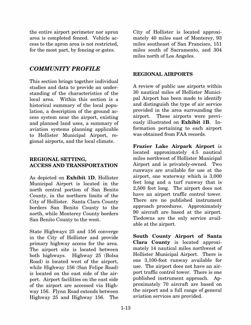
1-13
the entire airport perimeter nor apron area is completed fenced. Vehicle ac-cess to the apron area is not restricted, for the most part, by fencing or gates. COMMUNITY PROFILE This section brings together individual studies and data to provide an under-standing of the characteristics of the local area. Within this section is a historical summary of the local popu-lation, a description of the ground ac-cess system near the airport, existing and planned land uses, a summary of aviation systems planning applicable to Hollister Municipal Airport, re-gional airports, and the local climate. REGIONAL SETTING, ACCESS AND TRANSPORTATION As depicted on Exhibit 1D, Hollister Municipal Airport is located in the north central portion of San Benito County, in the northern limits of the City of Hollister. Santa Clara County borders San Benito County to the north, while Monterey County borders San Benito County to the west. State Highways 25 and 156 converge in the City of Hollister and provide primary highway access for the area. The airport site is located between both highways. Highway 25 (Bolsa Road) is located west of the airport, while Highway 156 (San Felipe Road) is located on the east side of the air-port. Airport facilities on the east side of the airport are accessed via High-way 156. Flynn Road extends between Highway 25 and Highway 156. The
City of Hollister is located approxi-mately 40 miles east of Monterey, 93 miles southeast of San Francisco, 151 miles south of Sacramento, and 304 miles north of Los Angeles. REGIONAL AIRPORTS A review of public use airports within 30 nautical miles of Hollister Munici-pal Airport has been made to identify and distinguish the type of air service provided in the area surrounding the airport. These airports were previ-ously illustrated on Exhibit 1B. In-formation pertaining to each airport was obtained from FAA records. Frazier Lake Airpark Airport is located approximately 4.5 nautical miles northwest of Hollister Municipal Airport and is privately-owned. Two runways are available for use at the airport, one waterway which is 3,000 feet long and a turf runway that is 2,500 feet long. The airport does not have an airport traffic control tower. There are no published instrument approach procedures. Approximately 90 aircraft are based at the airport. Tiedowns are the only service avail-able at the airport. South County Airport of Santa Clara County is located approxi-mately 14 nautical miles northwest of Hollister Municipal Airport. There is one 3,100-foot runway available for use. The airport does not have an air-port traffic control tower. There is one published instrument approach. Ap-proximately 70 aircraft are based on the airport and a full range of general aviation services are provided.

1-14
Salinas Municipal Airport is lo-cated approximately 17 nautical miles southwest of Hollister Municipal Air-port. Three runways are available for use at the airport, the longest being 6,000 feet long. There is an operating airport traffic control tower. There are five published instrument ap-proaches. Approximately 224 aircraft are based at the airport and a full range of general aviation services are available. Watsonville Municipal Airport is located approximately 18 nautical miles northwest of Hollister Municipal Airport. There are two runways available for use at the airport, the longest being 4,501 feet long. There is no airport traffic control tower. There are three published instrument ap-proaches. Approximately 331 aircraft are based at the airport and a full range of general aviation services are available. Marina Municipal Airport is lo-cated approximately 21 nautical miles southwest of Hollister Municipal Air-port. There is one 3,000-foot runway available for use at the airport. There is no airport traffic control tower. There are four published instrument approaches available at the airport. Approximately 65 aircraft are based at the airport. Services available include fuel, flight instruction, skydiving, and major airframe and power plant ser-vices. Monterey Peninsula Airport is lo-cated approximately 28 nautical miles southwest of Hollister Municipal Air-port. There are two runways available for use at this airport, the longest be-
ing 7,598 feet long. There is no airport traffic control tower. There are seven published instrument approaches available at the airport. Approxi-mately 169 aircraft are based at the airport and a full range of general aviation services are available. Los Banos Municipal Airport is lo-cated approximately 28 nautical miles northeast of Hollister Municipal Air-port. There is one 3,005-foot runway available for use. There is no airport traffic control tower. There are two published instrument approaches. Approximately 24 aircraft are based at the airport. Services include fuel and aircraft maintenance, minor airframe service, and major power plant ser-vice. THE AIRPORT’S SYSTEM ROLE Airport planning exists on many lev-els: local, regional, and national. Each level has a different emphasis and purpose. An airport master plan is the primary local airport planning document. The previous master plan for Hollister Municipal Airport was completed in 1985. Principal recom-mendations of the master plan in-cluded land acquisition, extension of Runway13-31 to the northwest, con-struction of new terminal areas in-cluding access roads, utilities, and T-hangars. At the national level, Hollister Mu-nicipal Airport is designated within the FAA’s National Plan of Integrated Airport Systems (NPIAS). Inclusion within the NPIAS allows the airport to

Salinas
Salinas
Salinas
17
9
1
152
156
156129
156
25
198
165
33
140
152
59 99
M E R C E DM E R C E DM E R C E D
S T A N I S L A U SS T A N I S L A U SS T A N I S L A U S
S A N T AS A N T AC L A R AC L A R AS A N T AC L A R A
S A N T AS A N T AC R U ZC R U Z
S A N T AC R U Z
S A NS A NB E N I T OB E N I T O
S A NB E N I T O
M O N T E R E YM O N T E R E YM O N T E R E Y
F R E S N OF R E S N OF R E S N O
33
33
1
S A NS A NM A T E OM A T E O
S A NM A T E O
84
85
146
G14
G17
G16
PINNACLESPINNACLESNATIONALNATIONAL
MONUMENTMONUMENT
PINNACLESNATIONAL
MONUMENT
NORTH
NOT TO SCALE
G13
01M
P12
-1D
-3/4
/03
Exhibit 1D LOCATION MAP
236
25
G20
183
68
LOS PADRESLOS PADRESNATIONAL FORESTNATIONAL FOREST
LOS PADRESNATIONAL FOREST
CoalingaCoalingaCoalinga
MendotaMendotaMendota
Los BanosLos BanosLos Banos
LosLosGatosGatosLosGatos
SaratogaSaratogaSaratoga Camp-Camp-bellbellCamp-bell
MarinaMarinaMarinaSalinasSalinasSalinas
SeasideSeasideSeasideMontereyMontereyMonterey
ASBESTOSASBESTOSHAZARDHAZARD
AREAAREA
ASBESTOSHAZARD
AREA
VENTANAVENTANAWILDERNESSWILDERNESS
VENTANAWILDERNESS
SAN LUISSAN LUISN.W.RN.W.RSAN LUISN.W.R
SoledadSoledadSoledad
GreenfieldGreenfieldGreenfield
King CityKing CityKing City
Santa CruzSanta CruzSanta Cruz WatsonvilleWatsonvilleWatsonville
HUNTERHUNTERLIGGETTLIGGETTA.R.C.A.R.C.
HUNTERLIGGETTA.R.C.
CaliforniaA
queduct
CaliforniaA
queduct
Delta Mendota Canal
Delta Mendota Canal
M A D E R AM A D E R AM A D E R A5
101
101
GilroyGilroyGilroy
HOLLISTERHOLLISTERHOLLISTERHOLLISTERHOLLISTER
San Benito
San Benito
San Benito
DIA
BLO
RA
NG
E
DIA
BLO
RA
NG
E
DIA
BLO
RA
NG
E
SIERRADE
SALINAS
SIERRADE
SALINAS
PACIFICPACIFICOCEANOCEANPACIFICOCEAN
AndersonAnderson Res. Res.Anderson Res.
CoyoteCoyoteRes.Res.CoyoteRes.
SanSanLuisLuisRes.Res.
SanLuisRes.
Tres PinosTres PinosTres Pinos
PaicinesPaicinesPaicines
San JuanSan JuanBautistaBautistaSan JuanBautista
MercedMercedMerced
M O N T E R E YM O N T E R E YM O N T E R E Y
FALLON RD. SHELTON DR.
PARKCENTER DR.
APPOLLO WAY
APPOLLO WAY
APPOLLO WAY
FLYNN RD.
AIRWAY
DR.
AERO
STAR
WAY
156
25
25
156156
BRIG
GS
R
D.
Southern Pacific Railroad
WRIGHT RD.WRIGHT RD.WRIGHT RD. McCLOSKEY RD.
CHAPPELL RD.CHAPPELL RD.CHAPPELL RD.
SAN
FELI
PE
RD.
BERT DR.
LA
N A LN.
Santa A
na Creek
HollisterMunicipalAirport
HOLLISTERAIRPORT

1-15
be eligible for Federal Airport Im-provement Program (AIP) funding. Hollister Municipal Airport is classi-fied as a general aviation airport in the NPIAS. A total of 3,489 airports across the country are included in the NPIAS. This includes 2,558 existing general aviation airports and 111 pro-posed general aviation airports. Hol-lister Municipal Airport is one of 175 general aviation airports in the State of California that are included in the NPIAS. At the state level, Hollister Municipal Airport is included as a general avia-tion airport in the California State Aviation System Plan (SASP). The purpose of the SASP is to ensure that the state has an adequate and efficient system of airports to serve its aviation needs well into the future. The SASP defines the specific role of each airport in the state’s aviation system and es-tablishes funding needs. AREA LAND USE As evident from the aerial photograph on Exhibit 1A, the land uses sur-rounding the airport are varied and include open space, agricultural uses, and industrial/commercial develop-ment. The areas north of Runway 6-24 (on the north, east, and west sides of the airport) are currently in agricul-tural or open space uses. Light indus-trial uses are located east of San Felipe Road. The Air Park Business Center is a 100-acre master-planned industrial park that is developing southwest of the airport in the area between the airport boundary and Flynn Road.
As detailed in the 1995 Hollister Gen-eral Plan, the land uses for the area adjoining the Airport are planned for industrial and public/industrial uses and is shown on Exhibit 1E. Agricul-tural uses are planned within the broader approach paths for Runway 6 and Runway 13. The area northeast of the runway intersection is planned for commercial, industrial, and public airport uses. A portion of the land northwest of the runway intersection is planned for industrial uses along the airport boundary and agricultural uses to Bolsa Road. A combination of industrial, public, and agricultural uses are designated for the area north of Flynn Road to the Airport bound-ary. Proposed land uses within the Northeast Hollister Area Plan include: general commercial, administra-tive/professional office, low density residential, open space/parks, and public/institutional uses. The City of Hollister completed the annexation of 208 acres of land along the northeastern airport boundary for the development of the Hollister Air-port Terminal Business Park. The Hollister Airport Terminal Business Park could include as much as 1,215,324 square feet of building space for light industrial northeast of the New Airport Parkway, 784,080 square feet of additional corporate aircraft hangars, a museum, hotel, fixed base operator (FBO), and other airport ser-vice buildings, and the expansion of airport tiedowns and aprons. Similar to the Air Park Business Center, the Hollister Airport Terminal Business Park is planned to have direct airport access for businesses that would re-quire access to the runways and taxi-
1-16
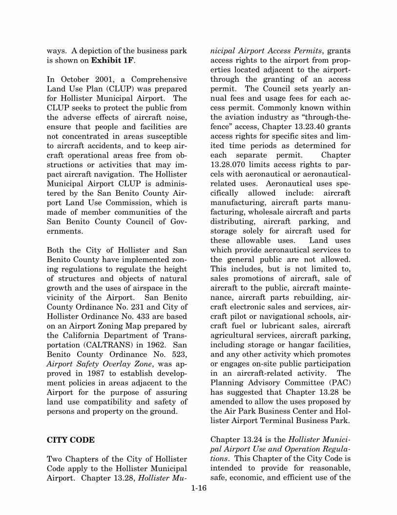
ways. A depiction of the business park is shown on Exhibit 1F. In October 2001, a Comprehensive Land Use Plan (CLUP) was prepared for Hollister Municipal Airport. The CLUP seeks to protect the public from the adverse effects of aircraft noise, ensure that people and facilities are not concentrated in areas susceptible to aircraft accidents, and to keep air-craft operational areas free from ob-structions or activities that may im-pact aircraft navigation. The Hollister Municipal Airport CLUP is adminis-tered by the San Benito County Air-port Land Use Commission, which is made of member communities of the San Benito County Council of Gov-ernments. Both the City of Hollister and San Benito County have implemented zon-ing regulations to regulate the height of structures and objects of natural growth and the uses of airspace in the vicinity of the Airport. San Benito County Ordinance No. 231 and City of Hollister Ordinance No. 433 are based on an Airport Zoning Map prepared by the California Department of Trans-portation (CALTRANS) in 1962. San Benito County Ordinance No. 523, Airport Safety Overlay Zone, was ap-proved in 1987 to establish develop-ment policies in areas adjacent to the Airport for the purpose of assuring land use compatibility and safety of persons and property on the ground. CITY CODE Two Chapters of the City of Hollister Code apply to the Hollister Municipal Airport. Chapter 13.28, Hollister Mu-
nicipal Airport Access Permits, grants access rights to the airport from prop-erties located adjacent to the airport-through the granting of an access permit. The Council sets yearly an-nual fees and usage fees for each ac-cess permit. Commonly known within the aviation industry as “through-the-fence” access, Chapter 13.23.40 grants access rights for specific sites and lim-ited time periods as determined for each separate permit. Chapter 13.28.070 limits access rights to par-cels with aeronautical or aeronautical-related uses. Aeronautical uses spe-cifically allowed include: aircraft manufacturing, aircraft parts manu-facturing, wholesale aircraft and parts distributing, aircraft parking, and storage solely for aircraft used for these allowable uses. Land uses which provide aeronautical services to the general public are not allowed. This includes, but is not limited to, sales promotions of aircraft, sale of aircraft to the public, aircraft mainte-nance, aircraft parts rebuilding, air-craft electronic sales and services, air-craft pilot or navigational schools, air-craft fuel or lubricant sales, aircraft agricultural services, aircraft parking, including storage or hangar facilities, and any other activity which promotes or engages on-site public participation in an aircraft-related activity. The Planning Advisory Committee (PAC) has suggested that Chapter 13.28 be amended to allow the uses proposed by the Air Park Business Center and Hol-lister Airport Terminal Business Park. Chapter 13.24 is the Hollister Munici-pal Airport Use and Operation Regula-tions. This Chapter of the City Code is intended to provide for reasonable, safe, economic, and efficient use of the

SOUTH PACIF
IC R
AILROAD
SOUTH PACIF
IC R
AILROAD
SOUTH PACIF
IC R
AILROAD
WR
IGH
T R
OA
DW
RIG
HT
RO
AD
WR
IGH
T R
OA
D
HIGHWAY 25
HIGHWAY 25
HIGHWAY 25
HIG
HW
AY
156
HIG
HW
AY
156
HIG
HW
AY
156
SAN FELIPE ROADSAN FELIPE ROADSAN FELIPE ROAD
DDDAA
DAA
DDAAAAAAAA
OAAAA
OOA
OOOR
ORR
OR
OR
ORR RR
NNNNNNNNNNNO
NNO
NO
NO
NO
NOOLLOLOLO
LLLLLLLA
LA
LAAAAA
LLAAAAAAAAAAFAAFAFF
FL
YN
N R
OA
DF
LY
NN
RO
AD
FL
YN
N R
OA
D
BU
EN
A V
IST
A R
OA
DB
UE
NA
VIS
TA
RO
AD
BU
EN
A V
IST
A R
OA
D
SA
NT
A A
NN
A R
OA
DS
AN
TA
AN
NA
RO
AD
SA
NT
A A
NN
A R
OA
D
WR
IGH
T
RO
AD
WR
IGH
T
RO
AD
WR
IGH
T
RO
AD
FAIRVIEW ROADFAIRVIEW ROADFAIRVIEW ROAD
McC
LO
SK
EY
RO
AD
McC
LO
SK
EY
RO
AD
McC
LO
SK
EY
RO
AD
BOLSA ROAD
BOLSA ROAD
BOLSA ROAD
SANTA ANNA CREEK
SANTA ANNA CREEK
SANTA ANNA CREEK
01M
P12
-1E
-4/1
7/03
NORTH
0 4,000 8,000
SCALE IN FEET
Exhibit 1EGENERAL PLAN
HollisterMunicipalAirport
Public
Industrial
Industrial Business Park
Public & Industrial
Commercial
High Residential
Medium Residential
Low Residential
Agriculture
Rural Residential
Open Spaces/Parks
Administrative/Professional Offices
SOURCE: Hollister General Plan Program 1995-2010 November 6, 1995
LEGEND

1-17
airport as a public transportation fa-cility and as a base for aviation and aviation-related operations, and to protect the municipal environment from unwanted and inappropriate aviation uses. DEVELOPMENT MORATORIUM The City of Hollister, through Ordi-nance No. 974, and the California Re-gional Water Quality Control Board, through Cease and Desist Order No. R3-2002-0105, have imposed a mora-torium on new development in the City. The moratorium suspends the issuance of new building permits for construction in the City including: construction of new commercial, resi-dential, or industrial buildings which require connection to the City sewer system, construction of new dwelling units, or building additions that in-clude installation of a new plumbing fixture unit. This moratorium is in ef-fect until the City of Hollister can make improvements to the wastewa-ter treatment and disposal facilities. CLIMATE Weather conditions are important to the planning and development of an airport. Temperature is an important factor in determining runway length requirements, while wind direction and speed are used to determine opti-mum runway orientation. The need for navigational aids and lighting is determined by the percentage of time that visibility is impaired due to cloud coverage or other conditions.
Climate in the Hollister area is typi-cally warm and sunny. July through September is the warmest period with the maximum temperature reaching 81 to 83 degrees Fahrenheit. Decem-ber and January is the coolest period with lows in the mid–30s. The region averages 13.52 inches of precipitation a year, with relatively rain free sum-mer months. The majority of the rain-fall occurs in December and January. Table 1C summarizes climatic data for Hollister, California. POPULATION Population is an important demo-graphic element to consider when planning for future needs of the air-port. Historical population data for the City of Hollister and San Benito County is presented in Table 1D. As shown in the table, the City of Hollis-ter has grown 5.9 percent since 1990, growing from 19,318 in 1990 to 34,413 in 2000. San Benito County has grown at a lesser rate of 3.8 percent since 1990, adding 16,900 residents. SUMMARY The information which has been pro-vided on the preceding pages provides a foundation upon which the remain-ing elements of the planning process will be constructed. Information on current facilities and activities will provide (with additional data collec-tion and analysis) for the development of aviation demand forecasts, de-mand/capacity analyses, and facility needs assessments. This information will, in turn, provide guidance for the

1-18
assessment of potential changes to aviation facilities or procedures neces-
sary to meet goals for long-term facil-ity improvements.
TABLE 1C Climatological Summary
Monthly Averages Precipitation Month Maximum (F) Minimum (F) Mean (inches)
January February March April May June July August September October November December
60.5 64.1 67.0 71.0 74.2 78.9 81.9 82.1 83.2 77.7 68.4 61.5
36.2 39.6 40.6 43.1 46.3 49.6 51.3 51.1 50.4 46.0 40.1 37.0
2.67 2.40 2.01 1.23 0.27 0.07 0.03 0.03 0.16 0.54 1.56 2.56
Annual 72.6 44.3 13.52 Source: Western Regional Climate Center
TABLE 1D Historical Population
Year City of Hollister San Benito County 1990 1991 1992 1993 1994 1995 1996 1997 1998 1999 2000 2001 2002
19,318 20,150 21,300 22,700 24,000 25,650 27,400 29,300 31,200 32,850 34,413 35,094 36,338
36,900 37,900 39,850 41,050 42,300 44,350 46,050 48,450 50,200 52,200 53,234 54,430 55,921
Average Annual Growth 1990-2002
5.4%
3.6%
Source: California Department of Finance Demographic Research Unit

01M
P12
-1F
-3/4
/03
Exhibit 1FHOLLISTER AIRPORT
TERMINAL BUSINESS PARK
SOURCE: Draft Environmental Impact Report Hollister Airport Terminal Business Park City of Hollister, September 1999
AIR
PO
RT
PR
OP
ER
TY
LIN
EA
IRP
OR
T P
RO
PE
RT
Y L
INE
AIRPORT PROPERTY LINEAIRPORT PROPERTY LINEAIRPORT PROPERTY LINE
AIR
PO
RT
PR
OP
ER
TY L
INE
AIR
PO
RT
PR
OP
ER
TY L
INE
AIR
PO
RT
PR
OP
ER
TY L
INE
HollisterMunicipalAirport
Airport Property LineProject Site Boundary

1-19
DOCUMENT SOURCES A variety of sources were used in the inventory of existing facilities. The following listing presents a partial list of reference documents. The list does not reflect some information collected by airport staff or through interviews with airport personnel. Hollister Municipal Airport Master Plan, January 1986, Waddell Engi-neering Corporation. From Grass Strip to Airport: A History of the Hollister Municipal Airport, September 2001, Harriet Brin. Hollister Airport Terminal Business Park: Draft Environmental Impact Report, September 1999, prepared for the City of Hollister by David J. Pow-ers & Associates, Inc. Hollister Municipal Airport Building Assessment, July 1999, Heming-way/Stock Architects. Hollister General Plan 1995-2010, No-vember 1995, Duncan & Jones. Hollister Municipal Airport Compre-hensive Land Use Plan, October 2001, Aries Consultants LTD.
Sectional Aeronautical Charts, U.S. Department of Commerce, National Oceanic and Atmospheric Administra-tion, current edition. U.S. Terminal Procedures, Southwest U.S., U.S. Department of Transporta-tion, Federal Aviation Administration, National Aeronautical Charting Of-fice, current edition. Airport Facility Directory, Southwest U.S., U.S. Department of Transporta-tion, Federal Aviation Administration, National Aeronautical Charting Of-fice, current edition. The following Internet web pages were also visited for information during the preparation of this chapter: www.airnav.com www.faa.org www.ambag.org www.census.gov www.dof.ca.gov www.wrcc.edu