On-site digital heritage inventory development at Bat, Oman
8
ON-SITE DIGITAL HERITAGE INVENTORY DEVELOPMENT AT BAT, OMAN Y. Kondo a, * , T. Miki b , T. Kuronuma c , T. Oguchi d a Center for Research Promotion, Research Institute for Humanity and Nature, Kyoto, 603-8047 Japan - [email protected] b Dept. of Archaeology, The University of Tokyo, Bunkyo-ku, Tokyo 113-0033 Japan - [email protected] c Dept. of Archaeology, Tokyo Metropolitan University, Hachioji-shi, Tokyo 192-0397 Japan - [email protected] d Center for Spatial Information Science, The University of Tokyo, Kashiwa-shi, Chiba 277-8568 Japan - [email protected] KEY WORDS: Digital heritage inventory, on-site cultural resource management, transdisciplinary research, usability, Oman. ABSTRACT: This paper reports on the on-site development of a local-scale digital heritage inventory (DHI) of the Bronze Age site at Bat in the interior of Oman. The goal of this inventory project was to share geospatial and archaeological information of tombs and other built structures with researchers and government agents to conduct cultural heritage management, scientific research, outreach, and educa- tion. To this end, the Bat Digital Heritage Inventory (BatDHI) was compiled at the local office by incorporating previous survey records, which were concurrently crosschecked and updated by ground-truth surveys. The current version of the BatDHI was implemented us- ing a combination of a network-access-ready database application, open source geographical information system, and web-based map engine. This system assisted both fieldwork and management works including decision making and planning. This inventory project exemplified a transdisciplinary research, in which researchers and societal stakeholders collaborated for co-design of research agendas, co-production of knowledge, and co-dissemination of outcomes. 1. INTRODUCTION Bat (pronounced “baat”) is a protohistoric settlement site, lo- cated at the geographic front between the Rub al-Khali Desert and Hajar Mountains in the interior of Oman. In terms of archae- ology, Bat is known as one of the best-preserved oasis towns of the Bronze Age (ca. 3200–1300 BC) in Southeast Arabia. The site was discovered in 1966, and since the middle of the 1970s, the Danish and British expeditions have surveyed and excavated settlements and tombs dated to the Hafit (ca. 3200–2750 BC), Umm an-Nar (ca. 2750–2000 BC), and Wadi Suq periods (ca. 2000–1300 BC), as well as circular built structures (“towers”) of the Umm an-Nar period (De Cardi et al., 1976, Frifelt, 1976, Frifelt, 1985, Brunswig, 1989, Gentelle and Frifelt, 1989, Frifelt, 2002). In 1988, Bat was inscribed to the UNESCO World Her- itage List with the neighboring sites of Al-Khutm and Al-Ayn, based on the criteria of (iii) uniqueness and (v) environmental vulnerability (UNESCO, 1988). The UNESCO-designated pro- tection areas, covering the main portions of the site, were reported in 2000 (Cotto, 2000). Succeeding these missions, German and American teams have been working at the site until now (B¨ ohme and Al-Sabri, 2011, Thornton et al., 2013). On request of the Omani Ministry of Heritage and Culture (MHC), the authors’ team started developing an inventory of archaeologi- cal features inside the UNESCO area of Bat in 2013. The goal of this inventory project was to share geospatial and archaeo- logical information of tombs and other built structures with re- searchers and MHC officials to conduct cultural resource man- agement (CRM), scientific research, outreach, and education. For this purpose, the inventory was to be shared with (1) the research team seasonally coming to the site from Japan, (2) MHC staff members working at the local office, (3) MHC officials at the headquarters in Muscat, and (4) other researchers and local stake- holders. Since these actors normally work in remote places, a network-based data sharing system was necessary for this enter- prise. * Corresponding author. In order to build such a data sharing system for the heritage man- agement at Bat, we applied a digital heritage inventory (DHI) or geospatial database system specialized in CRM. DHI systems are already applied to national level CRM projects in the Middle East and the Gulf regions, exemplified by the MEGA-Jordan (Myers and Dalgity, 2012) and the Qatar National Historic Environment Record (Breadmore et al., 2010). Open source DHI applications, such as Arches (http://archesproject.org) developed by a joint project of the Getty Conservation Institute and World Monu- ments Fund (Myers et al., 2012, Myers et al., 2014), have boosted their availability for and applicability to CRM projects at different places and regions in different spatial scales, with following the international standard CIDOC-CRM (ISO, 2006): They are also applicable to local-scale CRM projects. Based on this thought, the authors have been developing the Bat Digital Heritage Inven- tory (BatDHI) to manage and share archaeological information on site. This paper presents concepts, data flow, metadata struc- ture, preliminary results, and assessments of the BatDHI project. 2. CONCEPTS Key concepts of the BatDHI are summarized by three words— simplicity, sustainability, and security: 2.1 Simplicity The BatDHI system was designed to be as simple as possible to guarantee easy access and wide use. Internet-based applications were selected for the system so that people in remote places can share information. It should be used as easily as Facebook and Google Maps, regardless of user’s different levels of computing skills. Regarding the accessibility, it is noted that wireless Internet ac- cess has dramatically been improved in the Bat region in last few years, and a broadband Internet connection was established in the local office. Smartphones and tablet PCs, with which we can browse maps in the field with wireless Internet connection, have ISPRS Annals of the Photogrammetry, Remote Sensing and Spatial Information Sciences, Volume II-5/W3, 2015 25th International CIPA Symposium 2015, 31 August – 04 September 2015, Taipei, Taiwan
Transcript of On-site digital heritage inventory development at Bat, Oman

ON-SITE DIGITAL HERITAGE INVENTORY DEVELOPMENT AT BAT, OMAN
Y. Kondoa,∗, T. Mikib, T. Kuronumac, T. Oguchid
a Center for Research Promotion, Research Institute for Humanity and Nature, Kyoto, 603-8047 Japan - [email protected] Dept. of Archaeology, The University of Tokyo, Bunkyo-ku, Tokyo 113-0033 Japan - [email protected]
c Dept. of Archaeology, Tokyo Metropolitan University, Hachioji-shi, Tokyo 192-0397 Japan - [email protected] Center for Spatial Information Science, The University of Tokyo, Kashiwa-shi, Chiba 277-8568 Japan - [email protected]
KEY WORDS: Digital heritage inventory, on-site cultural resource management, transdisciplinary research, usability, Oman.
ABSTRACT:
This paper reports on the on-site development of a local-scale digital heritage inventory (DHI) of the Bronze Age site at Bat in theinterior of Oman. The goal of this inventory project was to share geospatial and archaeological information of tombs and other builtstructures with researchers and government agents to conduct cultural heritage management, scientific research, outreach, and educa-tion. To this end, the Bat Digital Heritage Inventory (BatDHI) was compiled at the local office by incorporating previous survey records,which were concurrently crosschecked and updated by ground-truth surveys. The current version of the BatDHI was implemented us-ing a combination of a network-access-ready database application, open source geographical information system, and web-based mapengine. This system assisted both fieldwork and management works including decision making and planning. This inventory projectexemplified a transdisciplinary research, in which researchers and societal stakeholders collaborated for co-design of research agendas,co-production of knowledge, and co-dissemination of outcomes.
1. INTRODUCTION
Bat (pronounced “baat”) is a protohistoric settlement site, lo-cated at the geographic front between the Rub al-Khali Desertand Hajar Mountains in the interior of Oman. In terms of archae-ology, Bat is known as one of the best-preserved oasis towns ofthe Bronze Age (ca. 3200–1300 BC) in Southeast Arabia. Thesite was discovered in 1966, and since the middle of the 1970s,the Danish and British expeditions have surveyed and excavatedsettlements and tombs dated to the Hafit (ca. 3200–2750 BC),Umm an-Nar (ca. 2750–2000 BC), and Wadi Suq periods (ca.2000–1300 BC), as well as circular built structures (“towers”)of the Umm an-Nar period (De Cardi et al., 1976, Frifelt, 1976,Frifelt, 1985, Brunswig, 1989, Gentelle and Frifelt, 1989, Frifelt,2002). In 1988, Bat was inscribed to the UNESCO World Her-itage List with the neighboring sites of Al-Khutm and Al-Ayn,based on the criteria of (iii) uniqueness and (v) environmentalvulnerability (UNESCO, 1988). The UNESCO-designated pro-tection areas, covering the main portions of the site, were reportedin 2000 (Cotto, 2000). Succeeding these missions, German andAmerican teams have been working at the site until now (Bohmeand Al-Sabri, 2011, Thornton et al., 2013).
On request of the Omani Ministry of Heritage and Culture (MHC),the authors’ team started developing an inventory of archaeologi-cal features inside the UNESCO area of Bat in 2013. The goalof this inventory project was to share geospatial and archaeo-logical information of tombs and other built structures with re-searchers and MHC officials to conduct cultural resource man-agement (CRM), scientific research, outreach, and education. Forthis purpose, the inventory was to be shared with (1) the researchteam seasonally coming to the site from Japan, (2) MHC staffmembers working at the local office, (3) MHC officials at theheadquarters in Muscat, and (4) other researchers and local stake-holders. Since these actors normally work in remote places, anetwork-based data sharing system was necessary for this enter-prise.
∗Corresponding author.
In order to build such a data sharing system for the heritage man-agement at Bat, we applied a digital heritage inventory (DHI) orgeospatial database system specialized in CRM. DHI systems arealready applied to national level CRM projects in the Middle Eastand the Gulf regions, exemplified by the MEGA-Jordan (Myersand Dalgity, 2012) and the Qatar National Historic EnvironmentRecord (Breadmore et al., 2010). Open source DHI applications,such as Arches (http://archesproject.org) developed by ajoint project of the Getty Conservation Institute and World Monu-ments Fund (Myers et al., 2012, Myers et al., 2014), have boostedtheir availability for and applicability to CRM projects at differentplaces and regions in different spatial scales, with following theinternational standard CIDOC-CRM (ISO, 2006): They are alsoapplicable to local-scale CRM projects. Based on this thought,the authors have been developing the Bat Digital Heritage Inven-tory (BatDHI) to manage and share archaeological informationon site. This paper presents concepts, data flow, metadata struc-ture, preliminary results, and assessments of the BatDHI project.
2. CONCEPTS
Key concepts of the BatDHI are summarized by three words—simplicity, sustainability, and security:
2.1 Simplicity
The BatDHI system was designed to be as simple as possible toguarantee easy access and wide use. Internet-based applicationswere selected for the system so that people in remote places canshare information. It should be used as easily as Facebook andGoogle Maps, regardless of user’s different levels of computingskills.
Regarding the accessibility, it is noted that wireless Internet ac-cess has dramatically been improved in the Bat region in last fewyears, and a broadband Internet connection was established inthe local office. Smartphones and tablet PCs, with which we canbrowse maps in the field with wireless Internet connection, have
ISPRS Annals of the Photogrammetry, Remote Sensing and Spatial Information Sciences, Volume II-5/W3, 201525th International CIPA Symposium 2015, 31 August – 04 September 2015, Taipei, Taiwan
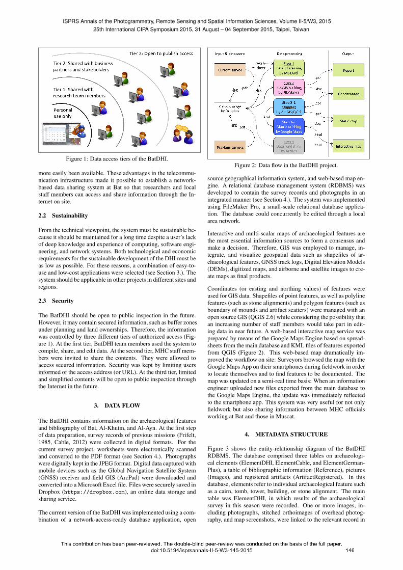
Figure 1: Data access tiers of the BatDHI.
more easily been available. These advantages in the telecommu-nication infrastructure made it possible to establish a network-based data sharing system at Bat so that researchers and localstaff members can access and share information through the In-ternet on site.
2.2 Sustainability
From the technical viewpoint, the system must be sustainable be-cause it should be maintained for a long time despite a user’s lackof deep knowledge and experience of computing, software engi-neering, and network systems. Both technological and economicrequirements for the sustainable development of the DHI must beas low as possible. For these reasons, a combination of easy-to-use and low-cost applications were selected (see Section 3.). Thesystem should be applicable in other projects in different sites andregions.
2.3 Security
The BatDHI should be open to public inspection in the future.However, it may contain secured information, such as buffer zonesunder planning and land ownerships. Therefore, the informationwas controlled by three different tiers of authorized access (Fig-ure 1). At the first tier, BatDHI team members used the system tocompile, share, and edit data. At the second tier, MHC staff mem-bers were invited to share the contents. They were allowed toaccess secured information. Security was kept by limiting usersinformed of the access address (or URL). At the third tier, limitedand simplified contents will be open to public inspection throughthe Internet in the future.
3. DATA FLOW
The BatDHI contains information on the archaeological featuresand bibliography of Bat, Al-Khutm, and Al-Ayn. At the first stepof data preparation, survey records of previous missions (Frifelt,1985, Cable, 2012) were collected in digital formats. For thecurrent survey project, worksheets were electronically scannedand converted to the PDF format (see Section 4.). Photographswere digitally kept in the JPEG format. Digital data captured withmobile devices such as the Global Navigation Satellite System(GNSS) receiver and field GIS (ArcPad) were downloaded andconverted into a Microsoft Excel file. Files were securely saved inDropbox (https://dropbox.com), an online data storage andsharing service.
The current version of the BatDHI was implemented using a com-bination of a network-access-ready database application, open
Figure 2: Data flow in the BatDHI project.
source geographical information system, and web-based map en-gine. A relational database management system (RDBMS) wasdeveloped to contain the survey records and photographs in anintegrated manner (see Section 4.). The system was implementedusing FileMaker Pro, a small-scale relational database applica-tion. The database could concurrently be edited through a localarea network.
Interactive and multi-scalar maps of archaeological features arethe most essential information sources to form a consensus andmake a decision. Therefore, GIS was employed to manage, in-tegrate, and visualize geospatial data such as shapefiles of ar-chaeological features, GNSS track logs, Digital Elevation Models(DEMs), digitized maps, and airborne and satellite images to cre-ate maps as final products.
Coordinates (or easting and northing values) of features wereused for GIS data. Shapefiles of point features, as well as polylinefeatures (such as stone alignments) and polygon features (such asboundary of mounds and artifact scatters) were managed with anopen source GIS (QGIS 2.6) while considering the possibility thatan increasing number of staff members would take part in edit-ing data in near future. A web-based interactive map service wasprepared by means of the Google Maps Engine based on spread-sheets from the main database and KML files of features exportedfrom QGIS (Figure 2). This web-based map dramatically im-proved the workflow on site: Surveyors browsed the map with theGoogle Maps App on their smartphones during fieldwork in orderto locate themselves and to find features to be documented. Themap was updated on a semi-real time basis: When an informationengineer uploaded new files exported from the main database tothe Google Maps Engine, the update was immediately reflectedto the smartphone app. This system was very useful for not onlyfieldwork but also sharing information between MHC officialsworking at Bat and those in Muscat.
4. METADATA STRUCTURE
Figure 3 shows the entity-relationship diagram of the BatDHIRDBMS. The database comprised three tables on archaeologi-cal elements (ElementDHI, ElementCable, and ElementGerman-Plus), a table of bibliographic information (Reference), pictures(Images), and registered artifacts (ArtifactRegistered). In thisdatabase, elements refer to individual archaeological feature suchas a cairn, tomb, tower, building, or stone alignment. The maintable was ElementDHI, in which results of the archaeologicalsurvey in this season were recorded. One or more images, in-cluding photographs, stitched orthoimages of overhead photog-raphy, and map screenshots, were linked to the relevant record in
ISPRS Annals of the Photogrammetry, Remote Sensing and Spatial Information Sciences, Volume II-5/W3, 201525th International CIPA Symposium 2015, 31 August – 04 September 2015, Taipei, Taiwan

a many-to-one cardinal relationship. ElementCable and Element-GermanPlus contained records of the previous surveys (Cable,2012, Bohme and Al-Sabri, 2011). Data fields are described inthe following subsections.
4.1 Elements
Data fields and specifications of the ElementDHI table are as fol-lows (Figures 4 to 8):
4.1.1 General
• SiteName (Site): The site name is contained in the “Site-Name” field (Figure 3) and shown in the “Site” window onthe interface (Figure 4). The vocabulary of attribute value isstrictly controlled: One value is selected from the list (Bat,Al-Khutm, or Al-Ayn). This would not allow any exceptionsby default. The data type is always text.
• UID (Worksheet UID): A unique identifier for distinguish-ing individual records (or worksheets). UID is put to everydata element regardless of the type of data entity (i.e., work-sheets, GPS log files, images, references, etc.). It is com-posed of ten digits, representing the last two digits of theyear, followed by two digits of month, day, hour, and timeof the data entry. For example, UID 1401091023 means thatthe entry was created at 10:23 am, January 9, 2014. The datatype is long integer.
• DHI Number (DHI No.): Serial identifier for individual el-ements, assigned by the project team. Short integer.
• DanishID, GermanID: Serial identifier for individual ele-ments, assigned by Danish expedition (Frifelt, 1976, Frifelt,1985) and German one (Bohme and Al-Sabri, 2011). Text.
• CMC ID: Serial identifier for individual elements, assignedby Cable’s survey (Cable, 2012). It is composed of six digitsbeginning with the last two digits of the year. This identifieris used as the primary key to related tables.
• UTM Easting/Northing (UTM Easting/Northing): Geoco-ordinates based on the Universal Transverse Mercator spa-tial projection system zone 40N. The data type is double-precision floating point (hereafter called “double”). The val-ues were calculated from the WGS84-based coordinates byusing the geometry calculation of ArcGIS.
• Latitude, Longitude: WGS84-based latitude and longitudein decimal (dd.dddd). Double.
• FeatType (Element Type): Category of element. The vo-cabulary is loosely controlled. One value is selected fromcairn, tomb, tower, mound, or stone alignment. Other val-ues are also allowed if necessary. Text.
• GroundTruth (Ground truth validated by the Japanese team?):Yes/no flag to indicate whether or not the relevant monu-ment was checked in the field. The data type is binary.
• WorksheetIRI (Worksheet IRI): International Resource Iden-tifier (also called Uniform Resource Identifier, or URI) ofthe original worksheet PDF uploaded to the Dropbox cloudstorage. This helps users to browse the worksheet. The datatype is text.
4.1.2 Location (Figure 4)
• GNSS type (“GNSS type” on the GNSS tab): Type of GNSSdevice used for measuring coordinates. The vocabulary isstrictly controlled. One value is selected from Garmin GPS,Hemisphere DGPS (differential GPS), and Trimble GNSS.
• DGPS OmanTMfrom/to (GNSS time): Local time of thebeginning and end of a DGPS session. Five or six digitsin the format of hhmmss (102141 means 10:21:41 for in-stance). Long integer.
Figure 4: Interface of the ElementDHI table (GNSS tab).
Figure 5: Interface of the ElementDHI table (Topo tab).
• DGPS TotalPts (points): Total number of GPS points takenin the track mode. Short integer.
• DGPS PDOP filter (PDOP filter): Filtering value (or thresh-old) of PDOP (position dilution of precision) score, whichindicate an index of data quality. Double.
• DGPS PDOP avg (PDOP average): The average of PDOPvalues after omitting bad quality (or high value in PDOP)points. Double.
• DGPS filteredPts (points): Total number of points reservedfor the average calculation. Short integer.
• GISDataType (Primary GIS data type): Type of GIS shape-file (point, polyline, or polygon) for the monument. The vo-cabulary is strictly controlled. Text.
• FeatID (Feature ID): Temporal identifier of features in theshapefile. Long integer.
4.1.3 Topography (Figure 5)
• FeatTopography (“Topography” on the Topo tab): Topog-raphy of the feature locus. One value is selected from thelist (alluvial fan, floodplain, valley bottom, ridge, bedrockslope, talus slope, fluvial terrace, wadi channel, salt marsh,or sand dune). Other values are allowed if necessary. Text.
4.1.4 Archaeology (Figure 6)
• FeatPeriod (“Period” on the Archaeology tab): Time pe-riod(s) to which the element belonged. The vocabulary is
ISPRS Annals of the Photogrammetry, Remote Sensing and Spatial Information Sciences, Volume II-5/W3, 201525th International CIPA Symposium 2015, 31 August – 04 September 2015, Taipei, Taiwan

Figure 3: Entity-relationship diagram of BatDHI. See Cable 2012 for the description of fields in the ElementCable table.
Figure 6: Interface of the ElementDHI table (Archaeology tab). Figure 7: Interface of the ElementDHI table (Architecture tab).
ISPRS Annals of the Photogrammetry, Remote Sensing and Spatial Information Sciences, Volume II-5/W3, 201525th International CIPA Symposium 2015, 31 August – 04 September 2015, Taipei, Taiwan

Figure 8: Interface of the ElementDHI table (Comments tab).
strictly controlled. One or more values are selected from thelist (Paleolithic, Holocene Pre-Hafit, Hafit, Umm an-Nar,Wadi Suq, Iron Age, and Islamic). Text.
• Artifacts: Type of artifacts collected. One or more valuesare selected from the list (ceramics, lithics, worked stones,stone vessels, beads, and metal objects). Other values arealso allowed if necessary. Text.
4.1.5 Architecture (Figure 7)
• FeatBotLength, FeatBotWidth, FeatHeight (relevant to“Bottom length (or diameter)”, “width”, and “height” on theArchitecture tab): Length, width, and height of the elementin meters. These values were copied from those measuredby previous surveys if any. Double.
• ExteriorFeatures (Exterior features): Presence of specificfeatures on the exterior of the element. The vocabulary iscontrolled (multiple selections from corbelling, entrance, outerwall, double skin, sealed, white stone, relief, pecked exte-rior, and others, if present). Binary.
• OuterWallThickness (Outer wall thickness): Thickness ofouter wall in centimeters in case of Umm an-Nar tombs.Measured when it is preserved. Double.
• EntBaseWidth/Height (Entrance base width/height): Widthand height of the entrance base in centimeters in the case ofcairns and tombs. Measured when preserved. Double.
• EntBaseHeightFromGround (Ground height): Height ofthe entrance from the ground (in case of cairn and tomb), ifpreserved. Double, in centimetres.
• EntOrientation (Orientation of entrance/inner wall): Az-imuth of the entrance (in the case of cairns and tombs), set-ting magnetic north as 0 (360) degrees. Measured when pre-served. Double.
• Course (Number of courses reserved): Maximum numberof reserved stone courses. Short integer.
• BuiltStoneType (Stone type): Type of built stones. Onevalue is selected from the list (cobble, slate, or ashlar). Othervalues are allowed if necessary. Text.
4.1.6 Comments (Figure 8)
• Remarks (The window on the top of the Comments tab):Descriptions of the monument. The comments of previoussurveys (Cable, 2012) were copied from the original datafiles and added to this field.
4.2 References
References were described in a standard format, compatible tothe BibTeX (http://www.bibtex.org).
4.3 Images
The data fields and specifications of the Image table are as fol-lows:
• UID, DHI number: See Section 4.1.• ImageIRI: IRI of the relevant image saved in Dropbox (if
any).• Image: Image file embedded. The data type is object.• ImageFileName• PhotoDirection: Direction of Photography. One value is
selected from N, NE, E, SE, E, SW, W, or NW. Other values(NNW for example) are also allowed.
5. GROUND TRUTH SURVEY
Previous survey records (Frifelt, 1985, Bohme and Al-Sabri, 2011,Cable, 2012) were crosschecked through fieldwork. Geocoordi-nates of each feature (or element) were measured with a GNSSreceiver with sub-meter accuracy. Mounds and stone alignmentswere mapped by means of a field GIS (ESRI ArcPad). The surveywas assisted by an interactive DHI map powered by the GoogleMaps Engine (Figures 9 and 10). Thanks to this map on a smart-phone, surveyors easily managed to identify features to be checkedon site. Reports of individual elements exported from the File-Maker database (Figure 11) were also helpful in the survey andpost-survey data processing.
As a result, 634 elements were reconfirmed present in and aroundthe UNESCO World Heritage areas (red boundary in Figure 9).Those included 289 Hafit-type cairns, 59 Umm an-Nar tombs, 7third millennium towers, 30 Wadi Suq tombs, 80 Iron Age tombs,and 76 traces of stone alignments, which were typically made ofbifacial stone foundation.
As pointed out by the previous studies (Bohme, 2011, Cable,2012), Hafit-type cairn tombs were mainly aligned on the ridge.However, cairn tombs in the UNESCO World Heritage area werecharacterized by a well-preserved cluster (DH 112 to 132, 147to 155 in Figure 9 for example) on the terrace at the foot of thehills. Those were probably built in the transitional phase leadingup to the subsequent Umm an-Nar period. A cluster of Umm an-Nar-type circular tombs was built on the terrace to the southwestof the transitional cluster (Bohme, 2011). The third millenniumtowers were located in the floodplain. The subsequent Wadi Suq-type oval tombs were also located on the terrace (DH 266 to 273).A cluster of subterranean graves of the Iron Age was also discov-ered on the opposite bank of the main cemetery. More than 40subterranean graves (DH 190 to 239) were clustered in a diame-ter of 100 meters there.
There were also a number of rectilinear stone alignments in thefloodplain. They evidenced the presence of residential structuresand water management systems such as dams and bunds. Mostof the tombs were built to the north of the semicircular long wall(Frifelt, 1985). It seems that the main settlement might have beenlocated in the central floodplain in the western periphery of theWorld Heritage area. Another complex of Umm an-Nar tombsand platforms was identified on the hill to the east of the so-calledSettlement Slope (Frifelt, 1985, Brunswig, 1989). A possible set-tlement area, evidenced by bifacial stone wall foundations, wasalso identified on the terrace to the south of the Settlement Slope.
ISPRS Annals of the Photogrammetry, Remote Sensing and Spatial Information Sciences, Volume II-5/W3, 201525th International CIPA Symposium 2015, 31 August – 04 September 2015, Taipei, Taiwan

Figure 9: A Google Maps Engine interactive map of the BatDHI, showing the spatial distribution of archaeological features in andaround the UNESCO area (red).
Figure 10: An example of the retrieval of a feature by attributes on Google Maps Engine.
ISPRS Annals of the Photogrammetry, Remote Sensing and Spatial Information Sciences, Volume II-5/W3, 201525th International CIPA Symposium 2015, 31 August – 04 September 2015, Taipei, Taiwan

Figure 11: An example of the report of a feature exported from the BatDHI FileMaker database.
6. ASSESSMENTS AND CONCLUSIONS
The authors developed the first version of the DHI for the UN-ESCO World Heritage sites of Bat, Al-Khutm, and Al-Ayn. Theinventory (BatDHI) integrated the information of the previoussurveys by Danish, German, and American expeditions in orderto draw a complete figure of the geography of monuments in theWorld Heritage areas and buffer zones. The records were vali-dated by the ground-truth survey. The coordinates of monuments
were updated with a high-resolution GNSS device. The systemwas simple enough and therefore suitable for the on-site CRM,with which non-researchers at different levels of PC skills wereinvolved.
It is also noted that this inventory project provided a new researchdevelopment in heritage management with a transdisciplinary ap-proach, in which researchers, governmental agents (MHC offi-cials and local staff members in this case), and other societal
ISPRS Annals of the Photogrammetry, Remote Sensing and Spatial Information Sciences, Volume II-5/W3, 201525th International CIPA Symposium 2015, 31 August – 04 September 2015, Taipei, Taiwan

stakeholders collaborated for co-design of research agendas, co-production of knowledge, and co-dissemination of outcomes (Leavy,2012, Mauser et al., 2013).
In near future, other geospatial data will be integrated and man-aged in the BatDHI. Among them, vector data may include (1)point clouds of benchmarks, topography, and centroids of builtfeatures, (2) polyline features of roads and drainages, (3) poly-gon features of cadastral areas and site coverage. On the otherhand, raster data may include satellite images such as LAND-SAT, ASTER, ALOS, and GeoEye-1 for base maps, orthoimagesderived from airborne or overhead photography, Digital ElevationModels (DEMs), and results of spatial analyses and modeling. Acombination of these spatial data and information on archaeolog-ical elements will facilitate further research and CRM in a moreeffective manner.
The authors are also planning to install the upcoming release (ver-sion 3.0) of Arches open source DHI for the next version of Bat-DHI, which will become a pilot system for larger-scale heritageinventories in the region.
ACKNOWLEDGEMENTS
This research was conducted under the auspices of the Ministryof Heritage and Culture, the Sultanate of Oman. We would like tothank Mr. Sultan bin Saif Al-Bakri, Director of Excavations andArchaeological Studies and all staff members of the Departmentfor their wonderful supports for our mission. We are also gratefulto local staff members working at Bat, particularly to the repre-sentatives of the Ministry of Heritage and Culture Mr. SulaimanAl-Jabri and Mr. Ismail Al-Matrafi for their tireless support infieldwork and logistics.This research was financially supported by the JSPS KAKENHI11J00130, Kurita Water & Environment Foundation Grant 13C005,and the RIHN Discretionary Budget for Early Career Researchersto YK and JSPS KAKENHI 22101005 to TO. We would like tothank Tara Beuzen-Waller, Charlotte M. Cable, Stephane Desru-elles, Eric Fouache, Atsushi Noguchi and Christopher P. Thorn-ton for their comments on our research. The earlier version of thispaper was presented at the 41st Annual Conference of ComputerApplications and Quantitative Methods in Archaeology (CAA)held in Paris in April 2014.
REFERENCES
Bohme, M., 2011. The Bat-type: A Hafit period tomb con-struction in Oman. Arabian Archaeology and Epigraphy 22(1),pp. 23–31.
Bohme, M. and Al-Sabri, B., 2011. Umm an-Nar burial 401at Bat, Oman: architecture and find. Arabian Archaeology andEpigraphy 22(2), pp. 113–154.
Breadmore, R., Cuttler, R., Al-Naimi, F., Ramsey, E., Fitch, S.and Kallweit, H., 2010. The Qatar National Historic EnvironmentRecord: A bespoke cultural resource management tool and thewider implications for heritage management within the region.Proceedings of the Seminar for Arabian Studies 40, pp. 5–16.
Brunswig, R. H., 1989. Cultural history, environment and econ-omy as seen from an Umm an-Nar settlement: evidence from testexcavations at Bat, Oman, 1977/78. The Journal of Oman Studies10, pp. 9–50.
Cable, C. M., 2012. A multitude of monuments: Finding and de-fending access to resources in third millennium BC Oman. PhDthesis, Michigan State University.
Cotto, K.-Y., 2000. Investigations on Bat: Preliminary report.http://whc.unesco.org/archive/periodicreporting/ARB/cycle01/section2/434.pdf (15 Feb. 2015).
De Cardi, B., Collier, S. and Doe, D., 1976. Excavations and sur-vey in Oman, 1974–75. The Journal of Oman Studies 2, pp. 101–188.
Frifelt, K., 1976. Evidence of a third millennium B.C. town inOman. The Journal of Oman Studies 2, pp. 57–73.
Frifelt, K., 1985. Further evidence of the third millennium BCtown at Bat in Oman. The Journal of Oman Studies 7, pp. 89–104.
Frifelt, K., 2002. Bat, a centre in third millennium Oman. In:S. Cleuziou, M. Tosi and J. Zarins (eds), Essays on the Late Pre-history of the Arabian Peninsula, Serie Orientale Roma, InstitutoItaliano per l’Africa e l’Orientale, pp. 101–110.
Gentelle, P. and Frifelt, K., 1989. About the distribution of thirdmillennium graves and settlements in the Ibri area of Oman. In:P. M. Costa and M. Tosi (eds), Oman Studies: Papers on the Ar-chaeology and History of Oman, Serie Orientale Roma, InstitutoItaliano per il Medio ed Estremo Oriente, pp. 119–126.
ISO, 2006. International Standard ISO 21127: Information anddocumentation–A reference ontology for the interchange of cul-tural heritage information.
Leavy, P., 2012. Essentials of transdisciplinary research: Us-ing problem-centered methodologies. Qualitative Essentials, LeftCoast Press.
Mauser, W., Klepper, G., Rice, M., Schmalzbauer, B. S., Hack-mann, H., Leemans, R. and Moore, H., 2013. Transdisciplinaryglobal change research: the co-creation of knowledge for sus-tainability. Current Opinion in Environmental Sustainability 5,pp. 420–431.
Myers, D. and Dalgity, A., 2012. The Middle East-ern Geodatabase for Antiquities (MEGA): An opensource GIS-based heritage site inventory and manage-ment system. Change Over Time 2(1), pp. 32–57.http://www.getty.edu/conservation/our_projects/field_projects/jordan/jordan_publications.html (15Feb. 2015).
Myers, D., Avramides, I. and Dalgity, A., 2014. Changing theheritage inventory paradigm: The Arches open source system.Conservation Perspectives: The GCI Newsletter 28(2), pp. 4–9.
Myers, D., Dalgity, A., Avramides, I. and Wuthrich, D., 2012.Arches: an open source GIS for the inventory and management ofimmovable cultural heritage. Lecture Notes in Computer Science7617, pp. 817–824.
Thornton, C. P., Cable, C. M. and Possehl, G. L., 2013. Three sea-sons at Kasr al-Khafaji (Tower 1146) at Bat, Oman. In: D. Frenezand M. Tosi (eds), Proceedings of the 19th Meeting of the Euro-pean Association of South Asian Archaeology (Ravenna, Italy,2-6 July 2007). Volume I, BAR International Series 2454, Ar-chaeopress, pp. 255–268.
UNESCO, 1988. Archaeological sites of Bat, Al-Khutm and Al-Ayn. http://whc.unesco.org/en/list/434 (15 Feb. 2015).
ISPRS Annals of the Photogrammetry, Remote Sensing and Spatial Information Sciences, Volume II-5/W3, 201525th International CIPA Symposium 2015, 31 August – 04 September 2015, Taipei, Taiwan