ISRAEL, JORDAN, MOROCCO, OMAN, U.A.E - African Wildlife Safaris
Upload
ronininstituteCategory
view
4download
0
CCED Block 4 Heritage Protection Program Report on Fieldwork Activities
October 4th-‐6th, 2012
Dr. Jeffrey Rose National Geographic
Summary In July 2012, a series of archaeological sites were discovered within the planned Block 4 seismic survey area (see previous report). In further preparation for the survey, a return trip was carried out between Oct 4th and 6th 2012 with Mr. Yan XianJi and Mr. Amir Melik, who will be leading the BGP survey. Sites determined to be at risk within the survey area were staked off for protection. The following is a report of actions taken at each site. Detailed locations and coordinates are provided in the attached excel file, which summarizes all of the archaeological sites discovered to date within Block 4.
Map of known sites within the planned Block 4 seismic survey area
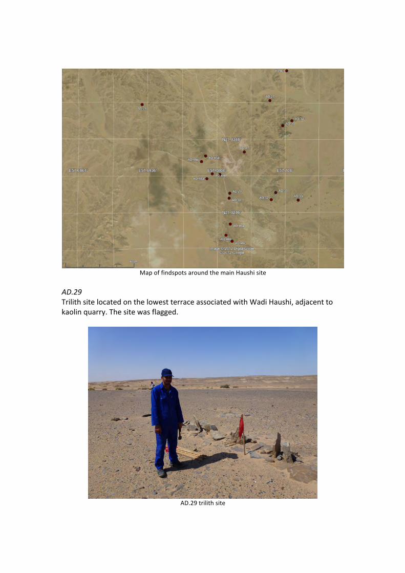
Map of findspots around the main Haushi site
AD.29 Trilith site located on the lowest terrace associated with Wadi Haushi, adjacent to kaolin quarry. The site was flagged.
AD.29 trilith site

AD.37a-‐b AD.37a is a small lithic scatter of less than 20 specimens at the top of a high jebel. Since the seismic equipment cannot be brought onto this hill, no action was required. On the way to AD.37a, a much larger and more significant site – AD.37b – was identified in the low hills around the jebel. The site is associated with a fossil wood exposure, in which prehistoric inhabitants have exploited the silicified wood for the manufacture of stone tools. This is a unique find in Oman and considered to be of great scientific importance. The site was flagged.
View from above of AD.37b fossilized wood chipping scatter
Mr. Melik and Mr. XianJi examine artifacts from AD.37b

Artifacts from AD.37b
AD.38 Isolated Muslim grave at the edge of the Tertiary escarpment overlooking the Saiwan sabkha. The grave was flagged.
AD.38 Muslim grave
AD.39 An isolated findspot of three stone tools that is not associated with any local raw material outcrop. No action required. AD.40 Same as previous. No action required.

AD.41 AD.41 is a large lithic scatter that forms the northern extent of the main Haushi prehistoric site. We placed survey flags around the full extent of the scatter. In the process of demarcating AD.41, we also placed flags around the adjoining lithic scatters at AD.27, AD.34, and AD.35.
Mr. XianJi examines a dense scatter of stone tools at AD.41
AD.44 Isolated Muslim grave at the base of the linear dune field at the western edge of Block 4. The grave was flagged.
AD.44 Muslim grave

AD.45a-‐b AD.45a is a large, high density lithic scatter associated with the high quality Shuaiba chert outcropping throughout the hills around Wadi Haushi (the main Haushi site). We placed survey flags around the full extent of the scatter. AD.45b is a small stone structure at the base of the chert hill, which was also flagged for protection.
Survey flags being placed around AD.45b (foreground) and AD.45a (background)
AD.46a-‐c As previous, AD.46a-‐c is an expansive lithic scatter associated with the Shuaiba chert outcrop throughout the hills around Haushi. We placed survey flags around the full extent of the scatter.
Survey flags being placed around AD.46 lithic scatter

Mr. XianJi examines a spear point discovered at AD.46
AD.47 As previous, AD.47 is an expansive lithic scatter associated with the Shuaiba chert outcrop throughout the hills around Haushi. It is noteworthy that there is a Ministry of Heritage & Culture sign markingthe site, yet the kaolin quarry has removed much of the artifact-‐bearing surface. Flags were placed around the parts of the site that still remain intact.
Dense lithic scatter at AD.47

Broken spear point from AD.47
Ministry of Heritage & Culture archaeological site sign at AD.47

Destroyed surface at AD.47 by kaolin quarrying activities
AD.48a-‐c AD.48 consists of three small stone structures spaced about 50m apart. They are all situated on the edge of the same terrace that houses the AD.29 trilith and are probably contemporary with that structure. Each stone structure was flagged separately.
AD.48 stone structure being flagged for protection
Additional findspots In addition to these archaeological sites, two additional findspots of geological interested were mapped at 21.10213N 57.81532E and 21.10533N 57.77117 E. Both

are fossil wood exposures, with some specimens preserved up to 50cm in maximum dimension. The sites were flagged.
Fossilized wood findspot 1
Close up of wood fossil 1

Fossilized wood findspot 2
Close up of wood fossil 2
Copyright © 2022 FDOKUMEN