insights from a structural field study in Jabal Akhdar (Oman ...
20
GeoArabia, Vol. 9, No. 2, 2004 Gulf PetroLink, Bahrain Eoalpine (Cretaceous) evolution of the Oman Tethyan continental margin: insights from a structural field study in Jabal Akhdar (Oman Mountains) Jean-Paul Breton, François Béchennec, Joël Le Métour, Laure Moen-Maurel and Philippe Razin ABSTRACT A structural study in Jabal Akhdar (an autochthonous window in the Oman Mountains) shows that the thrusts and imbrications, mapped in the Permian- Cretaceous formations of the Arabian Platform, have a vergence top to the north- northeast and are associated with a regional cleavage resulting from a ductile shear deformation of the same vergence. This deformation affects the entire autochthonous unit, from the southwestern edge of Jabal Akhdar to the northeastern edge of Saih Hatat, with an increasing strain intensity towards the northeast. The same domain is also affected by a HP/LT metamorphism with a northeastward increase from chlorite facies to blueschist and eclogite facies, i.e. characteristic of a northeast-dipping subduction. However, the retrograde character of the metamorphic parageneses associated with the ductile shear, as well as its north-northeast vergence, indicate that this deformation is linked to the exhumation of the autochthon during the Campanian. These observations have been synthesised in a new lithospheric-scale interpretation of the geodynamic development of the North Oman continental margins during the middle to late Cretaceous. The sequential evolution along a transect passing from southwest of Jabal Akhdar to northeast of Muscat can be summarised as follows: An intra-continental subduction zone affected the autochthon of the Arabian Platform with a basal rupture lying in the proximal part of the continental margin, to the south of the northern edge of the carbonate platform. A North Muscat microplate was created between the intra-continental subduction zone and the intra-oceanic subduction that gave rise to the Samail Ophiolite; this microplate includes the outer part of the Arabian Platform, the continental slope and the entire Hawasina Basin. From Early Turonian to Late Santonian the obduction and the intra-continental subduction were coeval and parallel. The northeast edge of the North Muscat microplate plunged below the Samail Nappe whilst the emergent southwest part overthrust the innermost parts of the Arabian Platform. The leading edge of the Samail and Hawasina Nappes advanced across the southwestern border of the North Muscat microplate just before obduction and intra-continental subduction ceased at the Santonian–Campanian boundary. Towards the end of the intra-continental subduction, the lower part of the crust of the subducted autochthon delaminated the upper part, marking the first stage of the metamorphic rocks exhumation. From Early Campanian to Early Maastrichtian, the North Muscat microplate moved to the northeast, its northeastern edge sinking by gravity into the asthenosphere. The subducted autochthon rose up, and came into contact with the base of the obducted units. The resulting uplift of the ophiolite nappes produced its emergence and partial erosion. Local crustal thickening, related to the lithospheric delamination, caused doming at Saih Hatat and subsequent erosion that locally extended to the pre-Permian sedimentary basement during the Early Maastrichtian. The present day domal shape of Jabal Akhdar is however related to Tertiary tectonic events. 41 Downloaded from http://pubs.geoscienceworld.org/geoarabia/article-pdf/9/2/41/5441505/breton.pdf by guest on 17 July 2022
-
Upload
khangminh22 -
Category
Documents
-
view
4 -
download
0
Transcript of insights from a structural field study in Jabal Akhdar (Oman ...
GeoArabia, Vol. 9, No. 2, 2004Gulf PetroLink, Bahrain
Eoalpine (Cretaceous) evolution of the Oman Tethyan continentalmargin: insights from a structural field study in Jabal Akhdar
(Oman Mountains)
Jean-Paul Breton, François Béchennec, Joël Le Métour,Laure Moen-Maurel and Philippe Razin
ABSTRACT
A structural study in Jabal Akhdar (an autochthonous window in the OmanMountains) shows that the thrusts and imbrications, mapped in the Permian-Cretaceous formations of the Arabian Platform, have a vergence top to the north-northeast and are associated with a regional cleavage resulting from a ductile sheardeformation of the same vergence. This deformation affects the entire autochthonousunit, from the southwestern edge of Jabal Akhdar to the northeastern edge of SaihHatat, with an increasing strain intensity towards the northeast. The same domain isalso affected by a HP/LT metamorphism with a northeastward increase from chloritefacies to blueschist and eclogite facies, i.e. characteristic of a northeast-dippingsubduction. However, the retrograde character of the metamorphic paragenesesassociated with the ductile shear, as well as its north-northeast vergence, indicatethat this deformation is linked to the exhumation of the autochthon during theCampanian.
These observations have been synthesised in a new lithospheric-scale interpretationof the geodynamic development of the North Oman continental margins during themiddle to late Cretaceous. The sequential evolution along a transect passing fromsouthwest of Jabal Akhdar to northeast of Muscat can be summarised as follows:
An intra-continental subduction zone affected the autochthon of the Arabian Platformwith a basal rupture lying in the proximal part of the continental margin, to thesouth of the northern edge of the carbonate platform. A North Muscat microplatewas created between the intra-continental subduction zone and the intra-oceanicsubduction that gave rise to the Samail Ophiolite; this microplate includes the outerpart of the Arabian Platform, the continental slope and the entire Hawasina Basin.
From Early Turonian to Late Santonian the obduction and the intra-continentalsubduction were coeval and parallel. The northeast edge of the North Muscatmicroplate plunged below the Samail Nappe whilst the emergent southwest partoverthrust the innermost parts of the Arabian Platform. The leading edge of the Samailand Hawasina Nappes advanced across the southwestern border of the North Muscatmicroplate just before obduction and intra-continental subduction ceased at theSantonian–Campanian boundary. Towards the end of the intra-continentalsubduction, the lower part of the crust of the subducted autochthon delaminated theupper part, marking the first stage of the metamorphic rocks exhumation.
From Early Campanian to Early Maastrichtian, the North Muscat microplate movedto the northeast, its northeastern edge sinking by gravity into the asthenosphere.The subducted autochthon rose up, and came into contact with the base of theobducted units. The resulting uplift of the ophiolite nappes produced its emergenceand partial erosion. Local crustal thickening, related to the lithospheric delamination,caused doming at Saih Hatat and subsequent erosion that locally extended to thepre-Permian sedimentary basement during the Early Maastrichtian. The present daydomal shape of Jabal Akhdar is however related to Tertiary tectonic events.
41
Downloaded from http://pubs.geoscienceworld.org/geoarabia/article-pdf/9/2/41/5441505/breton.pdfby gueston 17 July 2022
42
Breton et al.
INTRODUCTION
Location and Geological Setting
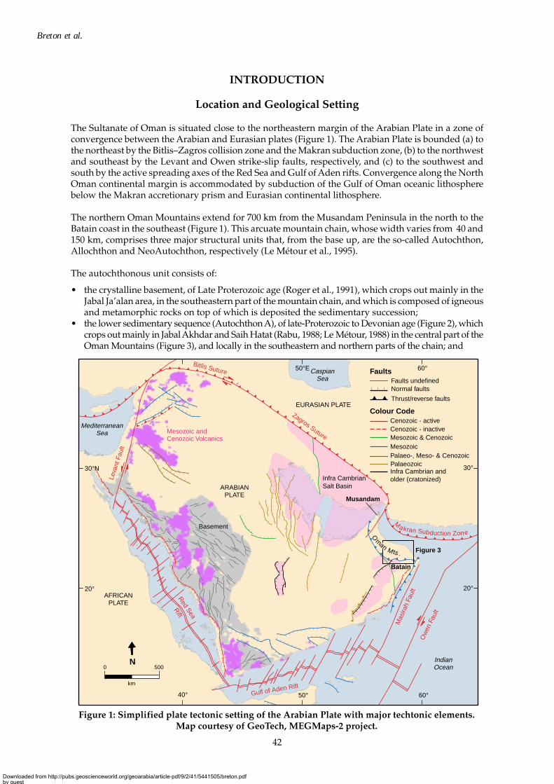
The Sultanate of Oman is situated close to the northeastern margin of the Arabian Plate in a zone ofconvergence between the Arabian and Eurasian plates (Figure 1). The Arabian Plate is bounded (a) tothe northeast by the Bitlis–Zagros collision zone and the Makran subduction zone, (b) to the northwestand southeast by the Levant and Owen strike-slip faults, respectively, and (c) to the southwest andsouth by the active spreading axes of the Red Sea and Gulf of Aden rifts. Convergence along the NorthOman continental margin is accommodated by subduction of the Gulf of Oman oceanic lithospherebelow the Makran accretionary prism and Eurasian continental lithosphere.
The northern Oman Mountains extend for 700 km from the Musandam Peninsula in the north to theBatain coast in the southeast (Figure 1). This arcuate mountain chain, whose width varies from 40 and150 km, comprises three major structural units that, from the base up, are the so-called Autochthon,Allochthon and NeoAutochthon, respectively (Le Métour et al., 1995).
The autochthonous unit consists of:
• the crystalline basement, of Late Proterozoic age (Roger et al., 1991), which crops out mainly in theJabal Ja’alan area, in the southeastern part of the mountain chain, and which is composed of igneousand metamorphic rocks on top of which is deposited the sedimentary succession;
• the lower sedimentary sequence (Autochthon A), of late-Proterozoic to Devonian age (Figure 2), whichcrops out mainly in Jabal Akhdar and Saih Hatat (Rabu, 1988; Le Métour, 1988) in the central part of theOman Mountains (Figure 3), and locally in the southeastern and northern parts of the chain; and
Figure 1: Simplified plate tectonic setting of the Arabian Plate with major techtonic elements.Map courtesy of GeoTech, MEGMaps-2 project.
Ma kran Subduction Zon eO
man Mts . Figure 3
40° 50°
50°E
60°
60°
20°
30°N
20°
30°
N0 500
km
Colour CodeCenozoic - active
Mesozoic & Cenozoic
Infra Cambrian and older (cratonized)
Thrust/reverse faults
Normal faultsFaults undefined
Cenozoic - inactive
Palaeo-, Meso- & CenozoicMesozoic
Faults
Mesozoic and Cenozoic Volcanics
Infra Cambrian Salt Basin
Basement
Palaeozoic
Batain
Zagros Suture
Ow
en F
ault
Mas
irah
Faul
t
Leva
nt F
ault
Bitlis Suture
Musandam
IndianOcean
MediterraneanSea
CaspianSea
Red Sea
Rift
AFRICANPLATE
ARABIANPLATE
EURASIAN PLATE
Gulf of Aden Rift
Downloaded from http://pubs.geoscienceworld.org/geoarabia/article-pdf/9/2/41/5441505/breton.pdfby gueston 17 July 2022
43
Structural field study in Jabal Akhdar, Oman
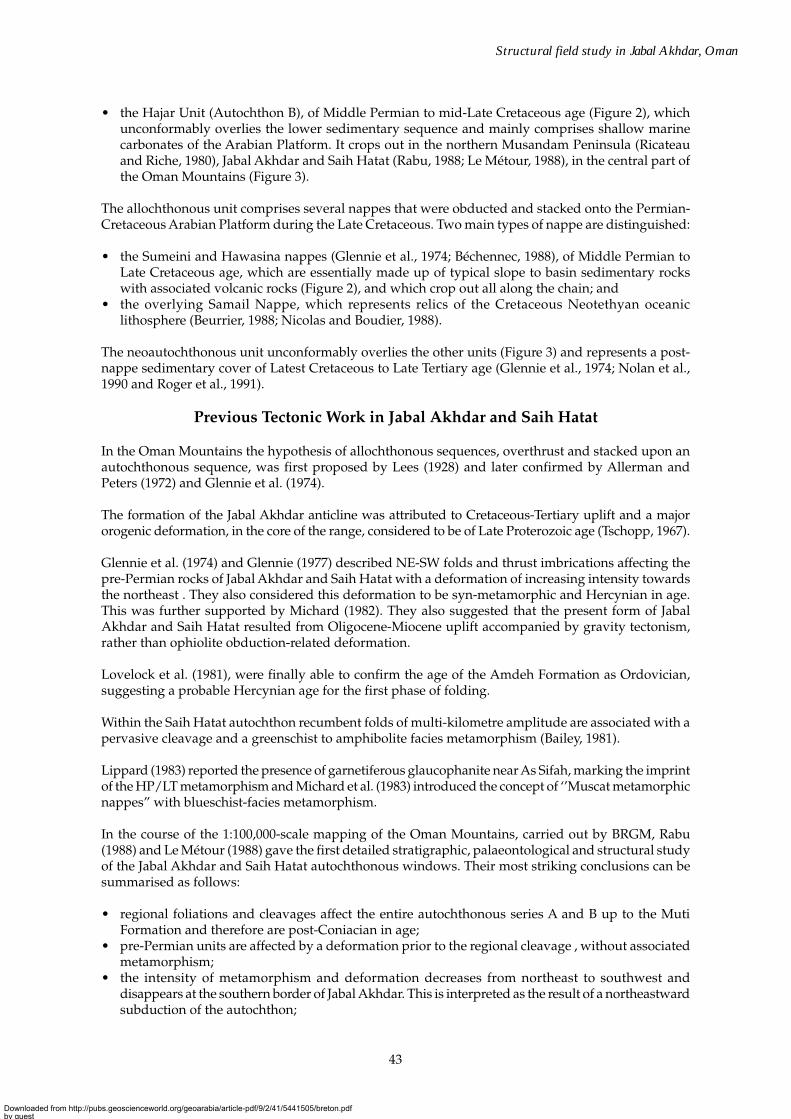
• the Hajar Unit (Autochthon B), of Middle Permian to mid-Late Cretaceous age (Figure 2), whichunconformably overlies the lower sedimentary sequence and mainly comprises shallow marinecarbonates of the Arabian Platform. It crops out in the northern Musandam Peninsula (Ricateauand Riche, 1980), Jabal Akhdar and Saih Hatat (Rabu, 1988; Le Métour, 1988), in the central part ofthe Oman Mountains (Figure 3).
The allochthonous unit comprises several nappes that were obducted and stacked onto the Permian-Cretaceous Arabian Platform during the Late Cretaceous. Two main types of nappe are distinguished:
• the Sumeini and Hawasina nappes (Glennie et al., 1974; Béchennec, 1988), of Middle Permian toLate Cretaceous age, which are essentially made up of typical slope to basin sedimentary rockswith associated volcanic rocks (Figure 2), and which crop out all along the chain; and
• the overlying Samail Nappe, which represents relics of the Cretaceous Neotethyan oceaniclithosphere (Beurrier, 1988; Nicolas and Boudier, 1988).
The neoautochthonous unit unconformably overlies the other units (Figure 3) and represents a post-nappe sedimentary cover of Latest Cretaceous to Late Tertiary age (Glennie et al., 1974; Nolan et al.,1990 and Roger et al., 1991).
Previous Tectonic Work in Jabal Akhdar and Saih Hatat
In the Oman Mountains the hypothesis of allochthonous sequences, overthrust and stacked upon anautochthonous sequence, was first proposed by Lees (1928) and later confirmed by Allerman andPeters (1972) and Glennie et al. (1974).
The formation of the Jabal Akhdar anticline was attributed to Cretaceous-Tertiary uplift and a majororogenic deformation, in the core of the range, considered to be of Late Proterozoic age (Tschopp, 1967).
Glennie et al. (1974) and Glennie (1977) described NE-SW folds and thrust imbrications affecting thepre-Permian rocks of Jabal Akhdar and Saih Hatat with a deformation of increasing intensity towardsthe northeast . They also considered this deformation to be syn-metamorphic and Hercynian in age.This was further supported by Michard (1982). They also suggested that the present form of JabalAkhdar and Saih Hatat resulted from Oligocene-Miocene uplift accompanied by gravity tectonism,rather than ophiolite obduction-related deformation.
Lovelock et al. (1981), were finally able to confirm the age of the Amdeh Formation as Ordovician,suggesting a probable Hercynian age for the first phase of folding.
Within the Saih Hatat autochthon recumbent folds of multi-kilometre amplitude are associated with apervasive cleavage and a greenschist to amphibolite facies metamorphism (Bailey, 1981).
Lippard (1983) reported the presence of garnetiferous glaucophanite near As Sifah, marking the imprintof the HP/LT metamorphism and Michard et al. (1983) introduced the concept of ‘’Muscat metamorphicnappes” with blueschist-facies metamorphism.
In the course of the 1:100,000-scale mapping of the Oman Mountains, carried out by BRGM, Rabu(1988) and Le Métour (1988) gave the first detailed stratigraphic, palaeontological and structural studyof the Jabal Akhdar and Saih Hatat autochthonous windows. Their most striking conclusions can besummarised as follows:
• regional foliations and cleavages affect the entire autochthonous series A and B up to the MutiFormation and therefore are post-Coniacian in age;
• pre-Permian units are affected by a deformation prior to the regional cleavage , without associatedmetamorphism;
• the intensity of metamorphism and deformation decreases from northeast to southwest anddisappears at the southern border of Jabal Akhdar. This is interpreted as the result of a northeastwardsubduction of the autochthon;
Downloaded from http://pubs.geoscienceworld.org/geoarabia/article-pdf/9/2/41/5441505/breton.pdfby gueston 17 July 2022
44
Breton et al.
? ? ? ?
Lithology
Sand, clay, conglomerateChalky conglomerateLimestone, marl, sandstoneConglomerate, sandstone
Umber, radiolarite / basalt to andesite
Dolerite and basalt dykes
Isotropic gabbro
and late intrusive wehrlite,
uralitic gabbro & trondhjemite
Layered gabbro
and late intrusive
wehrlite, dunite,
melagabbro and granite
Harzburgite, dunite
and late intrusive granite
Amphibolite andmetasedimentary rocks
Radiolarian chert, limestoneMegabreccia, calciruditeBasalt, andesiteCalcirudite, clayey limestoneMaiolica micritic limestone
Shallow-marine limestone
Sandstone, shale, limestone
Quartz sandstone, limestone
Grey-white bedded dolomite
Black bedded limestone and dolomiteMetavolcanitesMetatuffite
Saih Hatat
Quartzitic sandstone,
sandstone
Shale, siltstoneand sandstone
Quartzitic and shaly
Quartzitic sandstoneQuartz sandstone
Tuffite, ignimbrite,
Foetid limestone
Greywacke,
siltstone,
Shelf
Shelf
Shelf
Shelf
NatihMuti Bathyal to abyssal
Shelf to bathyal
Base of slope to bathyal
Base of slope to bathyal
Shelf to bathyal
Abyssal
Abyssal
Lithosphericupper mantle
Oceanic crust
Metamorphic Sole
Kawr
Al Aridh
HamratDuru
Aruma
Wasia
Kahmah
Sahtan
Akhdar
Umar
Tectonized harzburgite
Cumulatelayered gabbro
High levelgabbro
Sheeted dyke complex
Barzaman
Abyssal
Aeolian, alluvial coastal
Alluvial
AlluvialProximal shallow shelf
FormationGroupStratigraphy
Maastrichtian
Cenomanian-CampanianAlbian-Cenomanian
Albian
Mio-PlioceneEocene
Aptian ?
Aptian
Carnian
Tithonian
Coniacian ?
Santonian ?
CenomanianAlbian
Late Wordian
Hauterivian
CapitanianLate Wordian
Wuchiapingian
ValanginianTithonianCallovian-
Pliensbachain
Barremian
ConiacianTuronian
Norian-Rhetian
Turonian
FarsHadramaut
Aruma Qahlah
Palaeogeo-graphic setting
Lower extrusivesSuhaylah / Upper extru.
Seeb / Rusayl / Jafnayn
NayidSidr
GuwaysaMatbatAl Jil
MusallahBuwaydah
Sayfam
SafilNadan
Sinni
Aqil
Misfah
Baid
Shams
Nahr Umr Shu'aibaKharaibLekhwairHabshan
BathyalOuter shelf to slope
Awabi RaydaBirkat Salil
Shelf
ErosionSubaerial
Submarineintracon-tinental riftzone
Hatat
Saih Hatat
Saiq
Mahil
Amdeh
J. Akhdar Saih Hatat
Shelf to rift
Shallow shelf,Supratidal
J. Akhdar
Erosion ornon
deposition ?
Haima
HuqfNeoproterozoic
Early Cambrian
Ordovician
Jurassic
Cretaceous
Cretaceousto Permian
Cretaceous-Jurassic
HA
WA
SIN
A N
AP
PE
S
SA
MA
IL N
AP
PE
- O
PH
IOLI
TE
(ALL
OC
HT
HO
N)
(ALL
OC
HT
HO
N)
HA
JAR
UN
IT(A
UT
OC
HT
HO
N B
)P
RE
-LA
TE
PE
RM
IAN
SE
QU
EN
CE
(AU
TO
CH
TH
ON
A)
Cretaceous-Jurassic
Cretaceousto
Cretaceousto
CretaceousTriassic
Cretaceous
Cretaceous
Tertiary
QuaternaryPOST-NAPPECOVER
Triassic
Triassic
Triassic
Permian
Mistal
Hajir Hiyam
Mu'aydin
Fara
Kharus
tawny dolomiteBasalt to andesite
Limestone and dolomite
Siltsone andshale with carbonate beds
conglomerate
Limestone and dolomite
Banded schist,
metagreywacke,
tawny dolomite.Metabasalt and metarhyoliteSchist and metagreywacke
siltstone and shale
J. Akhdar
Thick-bedded limestone
Thick-bedded limestone
Radiolarite, sandstone,calcarenite, megabrecciaThick-bedded limestone
Clayey limestone, limestone
Clayey limestone, limestoneMaiolica, limestone
Limestone, shale, breccia
Basalt and trachyandesite
Basaltic pillow-lava, andesite
Basaltic pillow-lava, andesite
Radiolarian chert, calciruditeTurbiditic calcarenite
Turbiditic calcarenite
Turbiditic calcarenite
Radiolarian chert, limestone, breccia
Radiolarian chert, mixritic limestone
Petrographic Moho
Metamorphic Sole
Permian
Triassic
Basaltic pillow-lava
Diamictite, silt-stone, greywacke
7 km
500
0
m
DisconformityUnconformityThrust fault
U
Downloaded from http://pubs.geoscienceworld.org/geoarabia/article-pdf/9/2/41/5441505/breton.pdfby gueston 17 July 2022
45
Structural field study in Jabal Akhdar, Oman
Saih Hatat window
Jabal Akhdar window
Jabal Shams
3,009 m
Rustaq Nakhl
Nizwa
Bahla
Samail
Fanjah
BarkaMuscat
Gulf of OmanBatinah coastal plain
As SuwaiqHawasina windowYanqul
Ibri
Natih AnticlineFahud Anticline
Maradi Fault
Hamrat Duru range
Salakh Arch
Adam
Jabal Madar
Quriyat
As Sifah
TRANSECT
(Fig
ure 8)
Figure 4
Figures 5a and b
Ibra
57°E 58°
57° 58°
23°
24°N 24°
23°
59°
59°
500
km
N
Surficial deposits (Quaternary alluvial, eolian and shore deposits)
Molasse (Mio-Pliocene Barzaman Formation)
Postnappe cover (Campanian to Miocene sediments)
Samail Nappe (Cretaceous oceanic crust and upper mantle)
Hawasina Nappes (Permian-Cretaceous slope and basin sediments, volcanic basement)
Autochthon B (Late Permian toCenomanian shelf and Turonian-santonian basin sediments)
Autochthon A (Neoproterozoic to Ordovician sediments and volcanites)
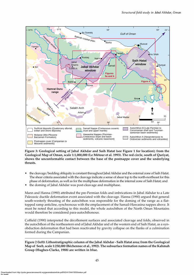
Figure 3: Geological setting of Jabal Akhdar and Saih Hatat (see Figure 1 for location); from theGeological Map of Oman, scale 1:1,000,000 (Le Métour et al. 1993). The red circle, south of Quriyat,shows the unconformable contact between the base of the postnappe cover and the underlyingthrusts.
• the cleavage/bedding obliquity is constant throughout Jabal Akhdar and the external zone of Saih Hatat.The shear criteria associated with the cleavage indicate a sense of shear top to the north-northeast for thisphase of deformation, as well as for the multiphase deformation in the internal zone of Saih Hatat; and
• the doming of Jabal Akhdar was post-cleavage and multiphase.
Mann and Hanna (1990) attributed the pre-Permian folds and imbrications in Jabal Akhdar to a LatePaleozoic ductile deformation event associated with the cleavage. Hanna (1990) argued that generalsouth-westerly thrusting of the autochthon was responsible for the doming of the range as a flat-topped ramp anticline, synchronous with the emplacement of the Samail-Hawasina nappes above. Itmust be noted that according to this model, the whole autochthon of the North Oman Mountainswould therefore be considered para-autochthonous.
Coffield (1990) interpreted the décollement surfaces and associated cleavage and folds, observed inthe autochthon of the northeastern end of Jabal Akhdar and of the western end of Saih Hatat, as a syn-obduction deformation that had been reactivated by gravity collapse on the flanks of a culminationformed during the Campanian.
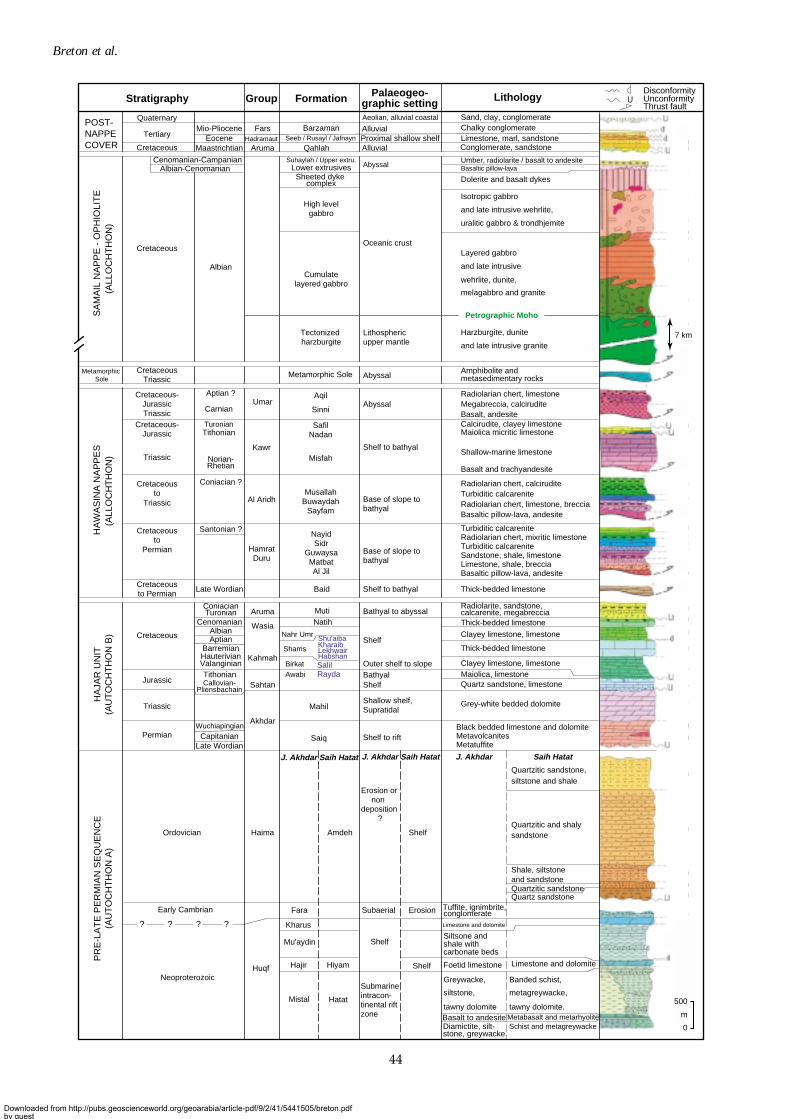
Figure 2 (left): Lithostratigraphic column of the Jabal Akhdar - Saih Hatat area; from the GeologicalMap of Seeb, scale 1:250,000 (Béchennec et al., 1992). The subsurface formation names of the KahmahGroup (Hughes-Clarke, 1988) are written in blue.
Downloaded from http://pubs.geoscienceworld.org/geoarabia/article-pdf/9/2/41/5441505/breton.pdfby gueston 17 July 2022
46
Breton et al.
On the basis of laboratory scale experiments, Chemenda et al. (1996) interpreted the structure of the SaihHatat dome as a result of: (a) the detachment of the continental subducted crust from its mantle counterpart,and (b) its buoyancy driven uplift into the interplate zone under a compressional regime of low intensity.
Mount et al. (1998) suggested that the doming of Jabal Akhdar and Saih Hatat represented frontal tipfolds related to blind reverse basement faults. They argued that these dipped steeply towards thenorth-northeast along the southern dome flanks, rooting into a deep décollement to the north. Usingapatite fission tracks data, they dated compression and the resulting fast uplift as Oligocene.
In the internal zone of Saih Hatat, Miller (1998), Miller et al. (1998, 1999, 2002) presented evidence fora regional ductile thrust zone with a top to the north-northeast sense of shear. This shear zone separatestwo main units the so-called upper and lower slab. They attributed the syn-schistose deformation,associated to retrograde metamorphism, to the exhumation of the subducted autochthon.
Finally a SSW-NNE seismically-constrained crustal transect by Al-Lazki et al. (2002) crossing the JabalAkhdar range from Fahud to the coastal plain provided a more precise view of the different crustalunits. This demonstrated that there was no major repetition within the autochthon, but did suggestthe presence of a crustal root beneath Jabal Akhdar.
STRUCTURAL FEATURES
Structural and Metamorphic Zoning of the Autochthon
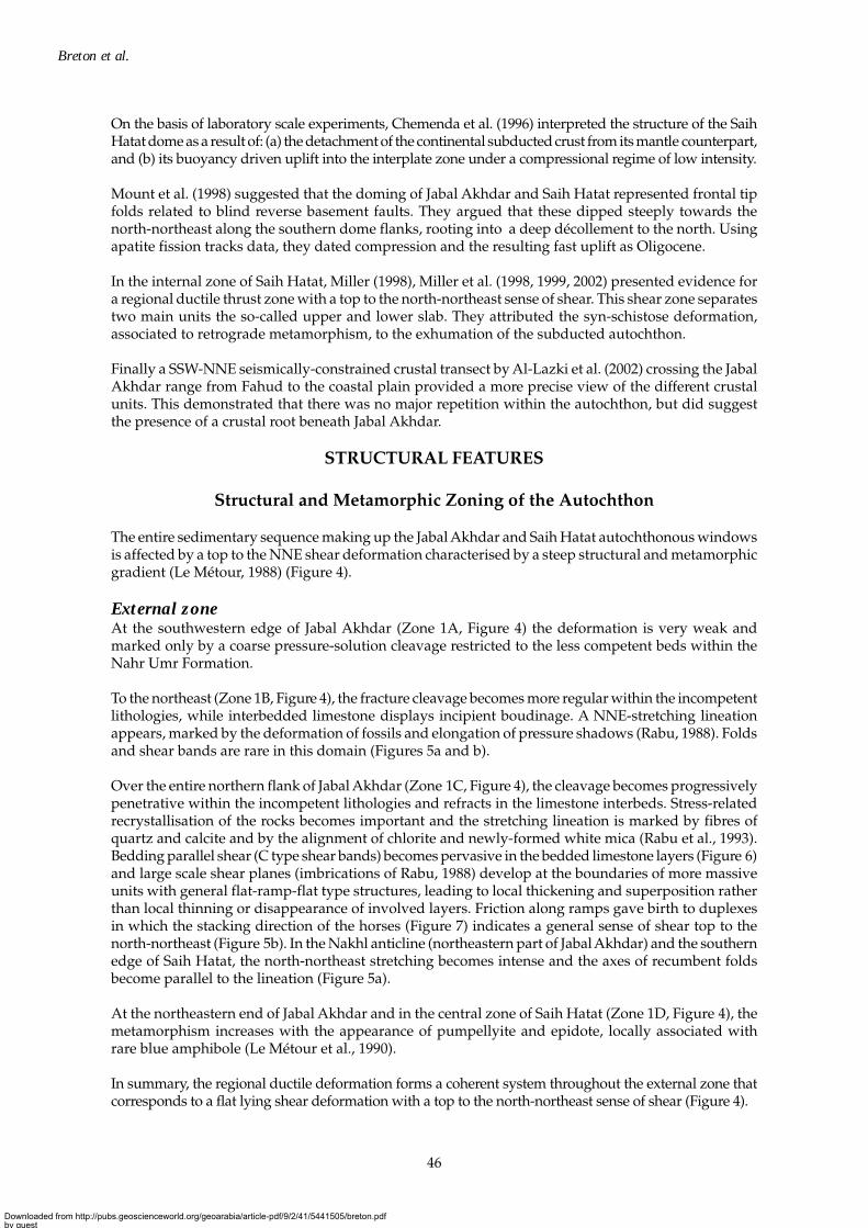
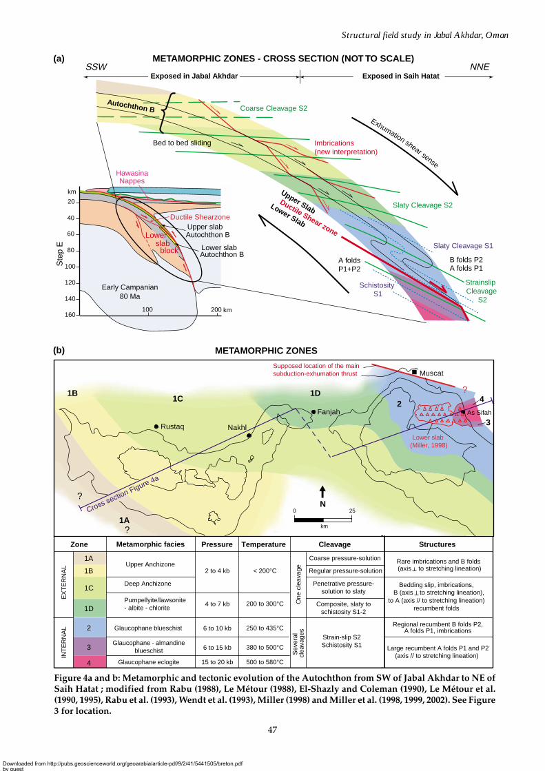
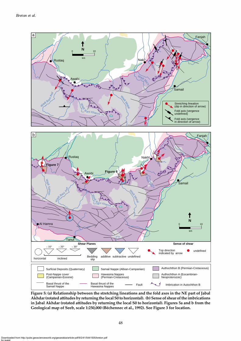
The entire sedimentary sequence making up the Jabal Akhdar and Saih Hatat autochthonous windowsis affected by a top to the NNE shear deformation characterised by a steep structural and metamorphicgradient (Le Métour, 1988) (Figure 4).
External zoneAt the southwestern edge of Jabal Akhdar (Zone 1A, Figure 4) the deformation is very weak andmarked only by a coarse pressure-solution cleavage restricted to the less competent beds within theNahr Umr Formation.
To the northeast (Zone 1B, Figure 4), the fracture cleavage becomes more regular within the incompetentlithologies, while interbedded limestone displays incipient boudinage. A NNE-stretching lineationappears, marked by the deformation of fossils and elongation of pressure shadows (Rabu, 1988). Foldsand shear bands are rare in this domain (Figures 5a and b).
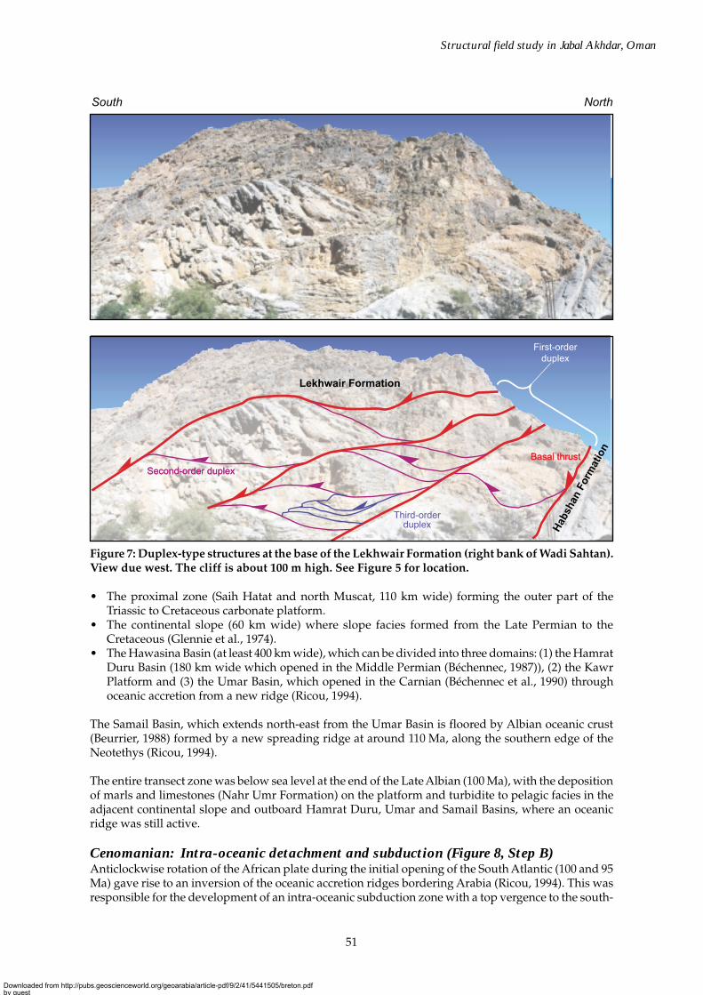
Over the entire northern flank of Jabal Akhdar (Zone 1C, Figure 4), the cleavage becomes progressivelypenetrative within the incompetent lithologies and refracts in the limestone interbeds. Stress-relatedrecrystallisation of the rocks becomes important and the stretching lineation is marked by fibres ofquartz and calcite and by the alignment of chlorite and newly-formed white mica (Rabu et al., 1993).Bedding parallel shear (C type shear bands) becomes pervasive in the bedded limestone layers (Figure 6)and large scale shear planes (imbrications of Rabu, 1988) develop at the boundaries of more massiveunits with general flat-ramp-flat type structures, leading to local thickening and superposition ratherthan local thinning or disappearance of involved layers. Friction along ramps gave birth to duplexesin which the stacking direction of the horses (Figure 7) indicates a general sense of shear top to thenorth-northeast (Figure 5b). In the Nakhl anticline (northeastern part of Jabal Akhdar) and the southernedge of Saih Hatat, the north-northeast stretching becomes intense and the axes of recumbent foldsbecome parallel to the lineation (Figure 5a).
At the northeastern end of Jabal Akhdar and in the central zone of Saih Hatat (Zone 1D, Figure 4), themetamorphism increases with the appearance of pumpellyite and epidote, locally associated withrare blue amphibole (Le Métour et al., 1990).
In summary, the regional ductile deformation forms a coherent system throughout the external zone thatcorresponds to a flat lying shear deformation with a top to the north-northeast sense of shear (Figure 4).
Downloaded from http://pubs.geoscienceworld.org/geoarabia/article-pdf/9/2/41/5441505/breton.pdfby gueston 17 July 2022
47
Structural field study in Jabal Akhdar, Oman
Figure 4a and b: Metamorphic and tectonic evolution of the Autochthon from SW of Jabal Akhdar to NE ofSaih Hatat ; modified from Rabu (1988), Le Métour (1988), El-Shazly and Coleman (1990), Le Métour et al.(1990, 1995), Rabu et al. (1993), Wendt et al. (1993), Miller (1998) and Miller et al. (1998, 1999, 2002). See Figure3 for location.
Pressure Temperature Structures
1A
1B
Deep Anchizone
One
cle
avag
e
EX
TE
RN
AL
INT
ER
NA
L
Sev
eral
cle
avag
es
Pumpellyite/lawsonite- albite - chlorite1D
2 Glaucophane blueschist
3Glaucophane - almandine
blueschist
Glaucophane eclogite4
CleavageZone
1C
Metamorphic facies
Upper AnchizoneCoarse pressure-solution Rare imbrications and B folds
Bedding slip, imbrications,
to A (axis // to stretching lineation)recumbent folds
Regional recumbent B folds P2,A folds P1, imbrications
Large recumbent A folds P1 and P2
(axis Regular pressure-solution
Penetrative pressure-solution to slaty
Composite, slaty toschistosity S1-2
Strain-slip S2Schistosity S1
2 to 4 kb < 200°C
200 to 300°C
250 to 435°C
380 to 500°C
500 to 580°C
4 to 7 kb
6 to 10 kb
6 to 15 kb
15 to 20 kb
to stretching lineation)
B (axis to stretching lineation),
(axis // to stretching lineation)
METAMORPHIC ZONES
METAMORPHIC ZONES - CROSS SECTION (NOT TO SCALE)
(b)
(a)
Nakhl
Fanjah As Sifah
Muscat
Rustaq
Cross section Figure 4a
1C1D1B
1A
?
2
3
4
?
?
Lower slab (Miller, 1998)
Supposed location of the main subduction-exhumation thrust
250
km
N
Exhumation shear sense
SSW NNE
Autochthon B Coarse Cleavage S2
Slaty Cleavage S2
Strainslip Cleavage
S2
Slaty Cleavage S1
Schistosity S1
B folds P2A folds P1
A folds P1+P2
Ductile Shear zone
Upper SlabLower Slab
Bed to bed sliding Imbrications (new interpretation)
Hawasina Nappes
Lower slab block
160
60
80
100
120
140
40
km
20
km
100 200
Ductile Shearzone
Autochthon B
Upper slab Autochthon B
Lower slab
Exposed in Jabal Akhdar Exposed in Saih Hatat
Ste
p E
80 MaEarly Campanian
Downloaded from http://pubs.geoscienceworld.org/geoarabia/article-pdf/9/2/41/5441505/breton.pdfby gueston 17 July 2022
48
Breton et al.
Figure 5: (a) Relationship between the stretching lineations and the fold axes in the NE part of JabalAkhdar (rotated attitudes by returning the local S0 to horizontal). (b) Sense of shear of the imbricationsin Jabal Akhdar (rotated attitudes by returning the local S0 to horizontal). Figures 5a and b from theGeological map of Seeb, scale 1:250,000 (Béchennec et al., 1992). See Figure 3 for location.
Rustaq
Awabi
Nakl
Samail
Fanjah
Wadi B
a ni Kharus
Wadi M
istal
Wadi Mis'n
W
adi Bani
Aw
f
Stretching lineation (dip in direction of arrow)
Fold axis (vergence in direction of arrow)
Fold axis (vergence undefined)
a
100
km
N
100
km
N
Wadi B
a ni Kharus
Rustaq
Al Hamra
Tanuf
Awabi
Nakhl
Samail
Fanjah
Top direction indicated by arrow
undefined
Shear Planes
Fault
horizontal inclinedBedding
slipadditive subtractive undefined
Imbrication in Autochthon BBasal thrust of the Samail Nappe
Basal thrust of the Hawasina Nappes
Authochthon B (Permian-Cretaceous)
Authochthon A (Eocambrian-Neoproterozoic)
Hawasina Nappes (Permian-Cretaceous)
Post-Nappe cover (Campanian-Eocene)
Surficial Deposits (Quaternary) Samail Nappe (Albian-Campanian)
~ 10° ~ 20° ~ 30°
Wadi M
istal
Wadi M
is'n
Wadi S
ahtan
Wad
i Bani A
wf
Sense of shear
Figure 7
Figure 6
b
Downloaded from http://pubs.geoscienceworld.org/geoarabia/article-pdf/9/2/41/5441505/breton.pdfby gueston 17 July 2022
49
Structural field study in Jabal Akhdar, Oman
Internal zoneThe internal zone encompassing the north-eastern part of the Saih Hatat area, is marked by a verysignificant increase in both metamorphic facies and intensity of tectonic deformation (Le Métour, 1988).Crossite blueschist facies is observed in the outerpart (Zone 2, Figure 4), passing to almandine blueschistfacies towards As Sifah on the coast (Zone 3, Figure 4), and finally glaucophane eclogite facies (Zone 4,Figure 4) in the immediate vicinity of As Sifah. The structure of the internal zone results from two majorphases of ductile deformation, each with similar sense of shear to the north-northeast and strong associatedstretching in the same direction (Le Métour, 1988; Miller, 1998). A regional ductile shear zone with a topvergence to the north-northeast, duplicating the Saiq Formation (Miller et al., 1998) separates an upperslab from a lower slab (Figure 4). The first cleavage S1 (slaty cleavage in the southwestern part of theinternal zone becoming a foliation in the northeastern part), is parallel to the axial plane of large scalesimilar recumbent folds (with axes parallel to the stretching lineation), observed in the lower slab and atthe base of the upper slab close to the shear zone. The second cleavage S2, that is of strain-slip type, isparallel to the axial plane of large multi-kilometre scale recumbent cylindrical folds (Figure 4), the axesof which are oblique to perpendicular to the stretching lineation. These folds, observed in the upper slabevolve to similar recumbent folds, with axes parallel to the stretching lineation, in the vicinity of theshear zone and in the lower slab where they refold the P1 folds.
Tectonic Interpretation
Subduction and exhumation of the autochthonIncreasing intensity of metamorphism and orientation of the HP/LT facies zones (Figure 4) appears toreflect the increasing burial of the autochthon towards the northeast in a manner characteristic of asubduction zone (Le Métour et al. 1990). The As Sifah metabasic rocks are interpreted to have beeneclogised at depths ranging between 40 and 70 km by various authors (Le Métour, 1988; El-Shazly andColeman, 1990; Wendt et al., 1993). The ductile deformation, whose sense of shear is consistently topto the north-northeast and parallel to the stretching lineation, decreases in intensity towards the south-west as does the metamorphism. However this regional scale vergence is opposite to the sense ofshear that would result from the descending movement of a subducted unit. The observed kinematicsare compatible with an exhumation of the autochthon. This finds support in the retrograde metamorphiccharacter of the syn-cleavage paragenesis. The only evidence of the subduction phase itself appears tobe south-southwest top verging microfolds, whose axial plane foliation is associated with a progradeparagenesis in the eclogite (Miller, 1998). According to Miller (1998), the foliation fabrics of zones 3and 4, outside the eclogite, show a paragenesis with a post-eclogite character (garnet ghosts). WithinZone 2, the mineral parageneses defining the S1 foliation, in the axial plane of the folds, with relics ofsodic amphibole in the epidote crystals, provides further evidence of retrograde metamorphism (Milleret al., 1999). Moreover, the mineral paragenesis defining the S2 strain slip cleavage, in the axial planeof the regional recumbent folds, characterises a further stage of retrograde metamorphism in thegreenschist facies with sodic amphibole relics within the albite crystals (Le Métour, 1988).
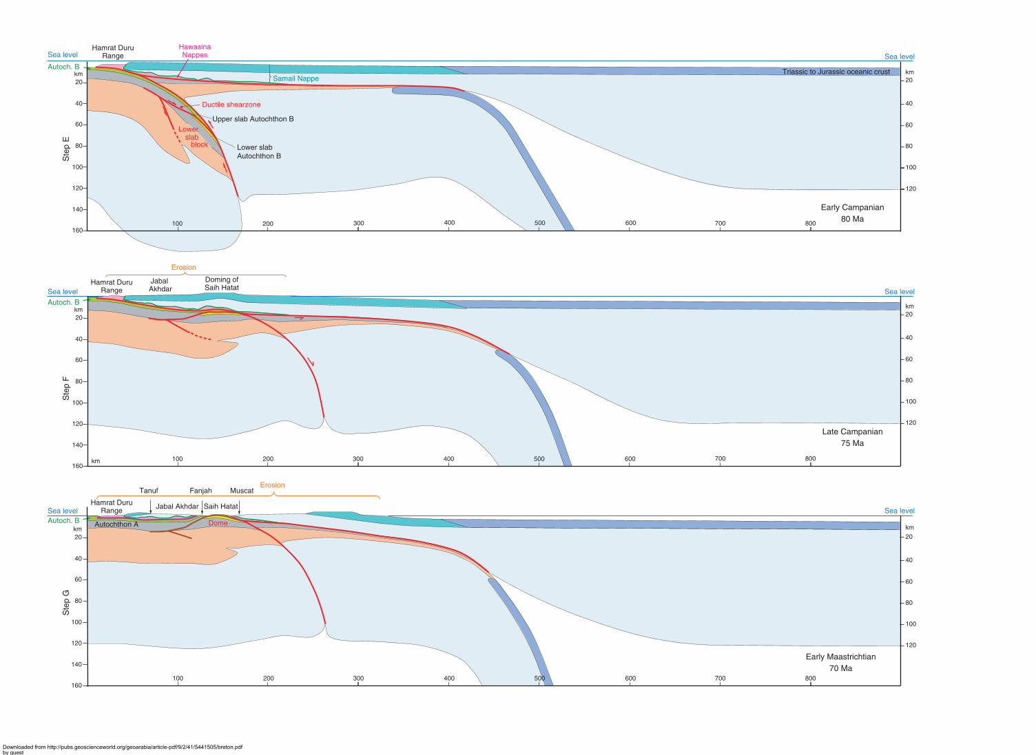
The two-phase character of the deformation in the internal zone reflects two stages of exhumation.The first stage, during which syn-S1 foliation developed, reflects the movement of the lower slab(Miller et al., 1998) and only affected the internal zone. It corresponds to the onset of exhumation ofthe deepest part of the subducted autochthon along the ductile shear zone separating the upper andlower slabs (Figure 8, Step E). The second stage corresponds to the total exhumation of the autochthon,with deformation affecting both internal and external zones (Figure 8, Steps F and G). In this newinterpretation (adapted from Miller et al., 2002) incorporating Jabal Akhdar and Saih Hatat, we suggestthat the single regional cleavage of the external zone (S1 of Le Métour, 1988 and Rabu, 1988) wouldcorrespond to the S2 strain-slip cleavage of the internal zone.
EOALPINE GEODYNAMIC EVOLUTION OF THE OMANI TETHYANCONTINENTAL MARGIN
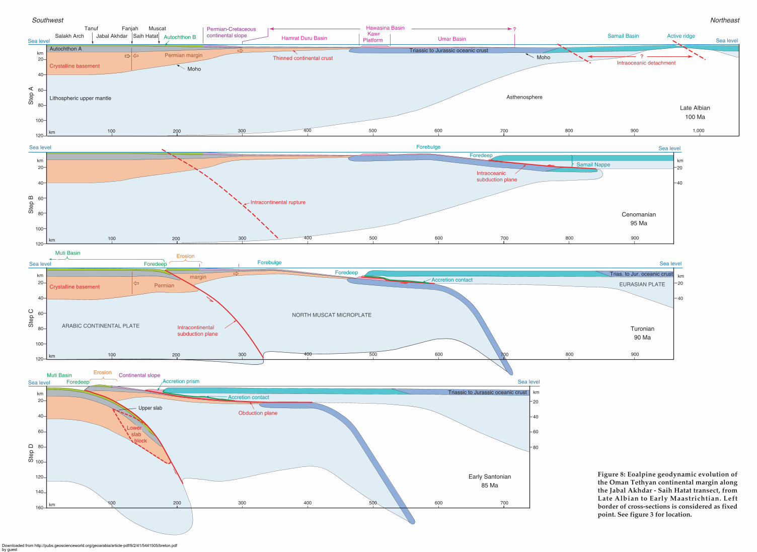
Our revised interpretation of the late Cretaceous evolution of the Oman continental margin is illustratedby a sequence of seven sections at lithospheric scale along a same transect (Figure 8) drawn for 5 Ma timeintervals from the Late Albian (100 Ma) to the Early Maastrichtian (70 Ma). The transect (Figure 3) is oriented
Downloaded from http://pubs.geoscienceworld.org/geoarabia/article-pdf/9/2/41/5441505/breton.pdfby gueston 17 July 2022
50
Breton et al.
SW to NE from south of the Hamrat Duru Range, across the eastern part of Jabal Akhdar to Fanjah. Thereit is offset by 50 km to the SE and continues from the southern edge of Saih Hatat north-eastward into theGulf of Oman.
Premises and Onset of the Subductions
The passive margin in Albian times (Figure 8, Step A)The Salakh Arch – Jabal Akhdar domain forms the north-eastern part of the Arabian Platform (AfricanPlate) with, from the top down, 2,500 m of Permian-Cretaceous Autochthon B (Hajar Unit), 8,000 m ofNeoproterozoic Autochthon A and 30 km of crystalline basement (Al Lazki et al., 2002). The 300 kmcontinental margin represents a NeoTethyan boundary initiated by intra-Gondwanian rifting in theMiddle Permian and evolving into an open seaway separating the Iran - Mega Lhasa block from theGondwana supercontinent (Ricou, 1994). This margin is marked by progressive crustal thinning towardsthe north-east with three main zones:
South North
Bedding S0
Bedding slip and ramp, T2
Marker Bed
Stratigraphic contact
Natih FormationNahr Umr Formation
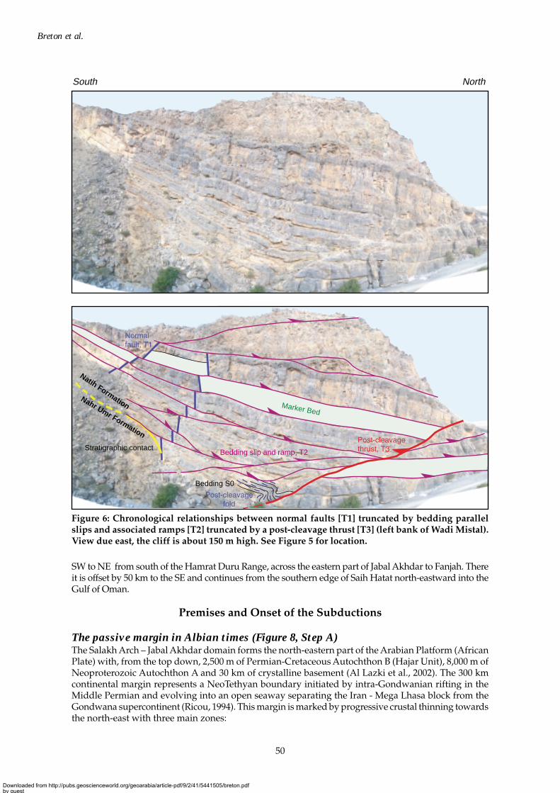
Figure 6: Chronological relationships between normal faults [T1] truncated by bedding parallelslips and associated ramps [T2] truncated by a post-cleavage thrust [T3] (left bank of Wadi Mistal).View due east, the cliff is about 150 m high. See Figure 5 for location.
Downloaded from http://pubs.geoscienceworld.org/geoarabia/article-pdf/9/2/41/5441505/breton.pdfby gueston 17 July 2022
51
Structural field study in Jabal Akhdar, Oman
• The proximal zone (Saih Hatat and north Muscat, 110 km wide) forming the outer part of theTriassic to Cretaceous carbonate platform.
• The continental slope (60 km wide) where slope facies formed from the Late Permian to theCretaceous (Glennie et al., 1974).
• The Hawasina Basin (at least 400 km wide), which can be divided into three domains: (1) the HamratDuru Basin (180 km wide which opened in the Middle Permian (Béchennec, 1987)), (2) the KawrPlatform and (3) the Umar Basin, which opened in the Carnian (Béchennec et al., 1990) throughoceanic accretion from a new ridge (Ricou, 1994).
The Samail Basin, which extends north-east from the Umar Basin is floored by Albian oceanic crust(Beurrier, 1988) formed by a new spreading ridge at around 110 Ma, along the southern edge of theNeotethys (Ricou, 1994).
The entire transect zone was below sea level at the end of the Late Albian (100 Ma), with the depositionof marls and limestones (Nahr Umr Formation) on the platform and turbidite to pelagic facies in theadjacent continental slope and outboard Hamrat Duru, Umar and Samail Basins, where an oceanicridge was still active.
Cenomanian: Intra-oceanic detachment and subduction (Figure 8, Step B)Anticlockwise rotation of the African plate during the initial opening of the South Atlantic (100 and 95Ma) gave rise to an inversion of the oceanic accretion ridges bordering Arabia (Ricou, 1994). This wasresponsible for the development of an intra-oceanic subduction zone with a top vergence to the south-
Second-order duplexSecond-order duplex
Basal thrustBasal thrust
Hab
shan
For
mat
ion
South North
Lekhwair Formation
Figure 7: Duplex-type structures at the base of the Lekhwair Formation (right bank of Wadi Sahtan).View due west. The cliff is about 100 m high. See Figure 5 for location.
Downloaded from http://pubs.geoscienceworld.org/geoarabia/article-pdf/9/2/41/5441505/breton.pdfby gueston 17 July 2022
52
Breton et al.
west, within the Samail Basin, outboard of the North Oman continental margin. The initial location ofthe detachment is under debate (Figure 8, Step A). According to different authors, the detachment islocated either along the earlier oceanic ridge where the mechanical strength of the crust might beexpected to be relatively weak (Boudier et al., 1985), or at the transition zone between the older (Triassicto Jurassic) crust and the Samail Basin (Beurrier et al., 1989). Partial melting of subducted oceaniclithosphere gave rise to a second phase of intrusive and extrusive igneous activity within the upperplate (Samail Nappe), from Cenomanian to Late Turonian (96 to 88 Ma) as indicated by the age ofoverlying pelagic sediments (Beurrier, 1988). Thrusting of a hot lithosphere induced a syn-tectonicamphibolite to granulite-facies contact metamorphism (865°C, 2 kb) at its base (Boudier et al., 1985),with an inverse gradient of metamorphism, that affected the volcanites of the old subducted andaccreted oceanic crust (Rabu, 1988). The average radiometric age of the metamorphism peak is 97 Ma(Boudier et al., 1985; Montigny et al., 1988). The sediments of the distal part of the Umar Basin were inturn subducted (Figure 8, Step B) and affected by a greenschist-facies metamorphism (400°C, 5 kb).Ortho-amphibolite and accreted metasediments formed the metamorphic sole; its outliers mark thebase of the Samail Nappe.
Intra-continental detachment and onset of subduction: earliest to MiddleTuronian (Figure 8, Step C)The major intra-continental detachment that would give rise to subduction of the Jabal Akhdar – SaihHatat autochthon occurred to the north of Muscat, in the outer part of the carbonate platform(Figure 8, Step B). Its appearance is reflected by a radical change in the platform palaeogeographyduring the early Turonian. The whole of the platform became exposed and was affected by erosionincreasing towards the north-east from the southern border of Jabal Akhdar and cutting down to thelower part of the Sahtan Group near Muscat (Rabu, 1988; Le Métour, 1988). This erosion indicates avery broad doming (Béchennec et al., 1995) which could reflect the response of the thick continentalcrust (forebulge) to the onset of intra-continental subduction.
Before the middle Turonian, the entire platform that covers the northern part of Oman deepened(Béchennec et al., 1995; Le Métour et al., 1995) to form a basin in which the Muti Formation pelagicsediments were deposited unconformably (Glennie et al., 1974). The progression of the subduction tothe north of Saih Hatat (north of Muscat) drove back the large forebulge over 300 km to the southwest,leaving space for the foredeep and the associated Muti Basin (Figure 8, Step C).
Formation of the North Muscat Microplate
Obduction and subduction: Middle Turonian to latest Santonian (Figure 8, Step D)During the Early Turonian, a North Muscat microplate was formed between the intra-continental subductionzone of Saih Hatat and the intra-oceanic subduction zone of the Samail Nappe (Figure 8, Step C). Fromsouth-west to north-east this microplate included: (1) the outer part of the carbonate platform, (2) thecontinental slope, and (3) the whole of the Hawasina Basin. From the Early Turonian to the end of theSantonian, the two subductions were coeval (Figure 8, Step C, D and E). The intra-oceanic subductionbecame an obduction (as defined by Coleman, 1971) during the Middle Turonian when the Samail Ophiolitenappe (oceanic lithosphere) overthrust the continental crust of the margin (Hamrat Duru Basin).
The progression of the Samail Ophiolite Nappe is dated by the age of the tectonic truncation of the underlyingHawasina units (Béchennec, 1988): i.e. Middle Turonian for the Kawr platform, Santonian for the HamratDuru Basin. The final structure of the Hawasina Nappes results from an underthrusting-accretion processcomparable to that observed in present-day subductions (Lallemand, 1999). Part of the Hamrat Durusediments formed a frontal accretionary prism, represented in the transect by the Hamrat Duru Range.
The evolution of the intra-continental subduction is recorded by the Muti Formation facies. Over thewhole of the Jabal Akhdar and Saih Hatat area, the upper part of the Muti Formation containsmegabreccias and olistoliths whose components originate from the outer part of the carbonate platformlocated to the north-east (Muscat - Musandam horst of Le Métour, 1988; Rabu, 1988). This slope-toedebris shows signs of karstification and their ages range from Late Permian to Early Cretaceous. Thepelagic matrix of the megabreccia has been dated in a few places only from Middle-Late Turonian in
Downloaded from http://pubs.geoscienceworld.org/geoarabia/article-pdf/9/2/41/5441505/breton.pdfby gueston 17 July 2022
53
Structural field study in Jabal Akhdar, Oman
the south of Saih Hatat and north of Jabal Akhdar to Coniacian-Santonian on the south-western edgeof Jabal Akhdar (Le Métour, 1988; Rabu, 1988). The overthrusted south-western edge of the NorthMuscat microplate had thus been exposed and deeply eroded since the Early Turonian (Figure 8, StepD). The debris, which were deposited from Middle Turonian to Santonian in the foredeep at the toe ofthe thrust front, were progressively underthrusted, from north of Muscat to the southwestern edge ofJabal Akhdar. The Muti Formation can thus be considered as a typical wildflysch.
The autochthon’s descent along the intra-continental subduction zone has not been satisfactorilyconstrained by radiometric dating of the HP/LT facies minerals. For the deepest facies (Zones 3 and 4,Figure 4), the ages range from 130 to 83 Ma (Montigny et al., 1988; El-Shazly and Lanphere 1992;Searle et al., 1994; Miller et al., 1999). Only the ages younger than 90 Ma are compatible with thestratigraphic data (age of the Muti Formation involved in the subduction). These last ages indicatethat the As Sifah area (southeast of Muscat, Figures 3 and 4) reached a depth in the region of 40 to 70km at the end of the Santonian (Figure 4 and Figure 8, Step D).
End of obduction and subduction: Early Campanian (Figure 8, Step E)The end of the obduction is characterised by the arrival of the Hamrat Duru allochthonous units in thenorth of the foreland basin (north of Natih, Figure 3) during the Early Campanian (Boote et al., 1990,Warburton et al., 1990). By late Santonian, the Samail Nappe and accreted Hawasina units had crossedthe North Muscat microplate and advanced 20-40 km beyond its southern margin, before finally comingto a halt in the foreland basin south-west of Jabal Akhdar (north-eastern border of the African Platesensu stricto) at the beginning of the Campanian (Figure 8, Step E). The Early Campanian age of theyoungest pelagic sediments covering the Samail Nappe (Beurrier, 1988) indicates that it remainedsubmerged up until the end of obduction. Meanwhile, the North Muscat microplate, formed of oceaniccrust in the northeast and of highly thinned continental crust in the south-west, gradually sunkisostatically beneath the ophiolitic nappe (Figure 8, Steps B to D and E).
The HP/LT peak is dated from the Ruwi lawsonite schist (Muscat) at 80 Ma (El-Shazly and Lanphere,1992), whilst the post-eclogite fabrics marking the first syn-S1 deformation of the internal zone aredated at 82 to 79 Ma (Miller et al., 1999). This indicates that the end of the intra-continental subductionwas synchronous with the end of the obduction and that the deformation giving the S1cleavage in theinternal zone began slightly before the end of subduction. In the internal zone, the formation of thelower slab and the north-northeasterly top vergence of the ductile shear zone separating it from theupper slab (Miller et al., 1998) are interpreted as the impingement of a lower block into the overlyingcrust (Figure 8, Step D and E). This wedging movement took place along two conjugate shear zoneramps, the lower one in the crystalline basement and the upper one in the sedimentary cover(autochthons A and B). The buoyant uplift, proposed by Chemenda et al. (1996) is interpreted hereinto be responsible only for the delamination of the Arabian continental plate by the impingement ofthis block made of light continental crust. As obduction and intra-continental subduction ended in theEarly Campanian, the convergence zone between the Eurasia and African plates jumped to the Makransubduction zone of southeastern Iran (Glennie et al., 1990).
Post-obduction Exhumation and Uplift
Exhumation of the autochthon: Campanian to Early Maastrichtian (Figure 8, Step F)The earliest post-nappe sediments, resting unconformably on the thrust stack, are represented by theQahlah Formation (Glennie et al., 1974) exposed near Al Khawd and Fanjah. These thick fluviatilesediments include conglomerates whose pebbles, according to Nolan et al., (1990), comprise Hawasinachert, Hajar Unit limestone and Amdeh Formation quartzite (Figure 2). This continental formation,dated as Late Campanian to Early Maastrichtian (Nolan et al., 1990), indicates that erosion during thisperiod reached the Autochthon A of Saih Hatat, which was exhumed and exposed. The exhumationimplies a northeastward displacement of the North Muscat microplate by 100 km (Figure 8, Step Eto F), and resulted from the sinking into the asthenosphere of its northeastern part, composed of heavyold oceanic crust. Hence the movement became reversed (normal shear) along the intra-continentalsubduction plane, and the uplift of the autochthon induced NNE-top-verging shear deformation inthe ductile cover. This deformation is responsible for S2 cleavage in the internal zone of Saih Hatat andthe regional cleavage in the external zone up to the southwestern edge of Jabal Akhdar. The retrograde
Downloaded from http://pubs.geoscienceworld.org/geoarabia/article-pdf/9/2/41/5441505/breton.pdfby gueston 17 July 2022
54
Breton et al.
metamorphic parageneses associated with the deformation fabrics in the lower and upper slabs of theinternal zone are dated at 76 to 70 Ma (El-Shazly and Lanphere, 1992; Miller et al., 1999). However,these ages appear slightly too young to fit the stratigraphic data (age of the Qahlah Formation).
The straightening of the continental crust combined with the northeastward movement of the NorthMuscat microplate brought the top of the Autochthon B (top of the Muti Formation) in contact withthe base of the Allochthon (Figure 8, Step F). At the contact, mylonitisation (Le Métour, 1988; Rabu,1988) reflects a relative movement whose vergence and amplitude remain to be determined. The regionaltectonic contact between Allochthon and Autochthon (Figure 3), classically considered to be theobduction contact, is here interpreted as due to the exhumation of HP metamorphic rocks.
General uplift: Middle Campanian to Maastrichtian (Figure 8, Step G)This episode was accompanied by a general uplift of the margin, giving rise to the emergence of theSamail Ophiolite and the beginning of its erosion in the Late Campanian. The erosion was accompaniedby isostatic uplift until equilibrium was reached in the Middle Maastrichtian. Local crustal thickeningresulting from the impingement of the lower block of the autochthon into the delaminated Arabiccontinental Plate, resulted in the doming of Saih Hatat range and exposure of the autochthon witherosion down to the pre-Permian rocks. During the same time, the Autochthon of Jabal Akhdar remainedflat and covered by the Hawasina nappes and a non-eroded part of the ophiolite (Figure 8, Step F). Itsdoming and uplift are related to the later Tertiary tectonic events.
CONCLUSION – DISCUSSION
Interpretation keypointsThree remarkable geodynamic characteristics of the North Oman margin in the Upper Cretaceoushave been highlighted in this analysis:
1) The development of a northeast verging intra-continental subduction zone along the old NeoTethyancontinental margin, which ruptured the overlying Mesozoic carbonate platform and formed aforedeep fed by detritus from the uplifted outboard part of the shelf.
2) The subducted margin reveals no collision-type deformation along the studied transect, to thepoint that no accretion structure (fold-and-thrust-belt) could be identified (no pre-S1 imbricationwith a southwest vergence involving the crystalline basement and duplication of the Saih Hatatand Jabal Akhdar sequence). On the contrary, the only deformation which is coeval with thecontinental subduction consists of normal faults affecting the Natih Formation from the forelandup to Saih Hatat (Boote et al., 1990; Rabu, 1988; Le Métour, 1988). These NW-SE trending normalfaults die out in the Muti Formation or are sealed at its base. They could be linked to the pullingdown of the continental lithosphere. Moreover, this extensional event is confirmed by theintercalations of pillow basalts observed in the Muti Formation (Rabu, 1988; Le Métour, 1988).
3) Based upon the ratio between the length of the subducted continental plate and the depth reachedby its extremity (about 100 km for the crystalline basement), the subduction zone appears to havebeen very steeply dipping. This is quite surprisingly considering its thickness (30 km) and the lowdensity of the subducted continental crust (Figure 8, Step D).
Origin of the Intra-continental subductionFrom a mechanical point of view, the horizontal movement of the Samail Nappe, which suggests lowbasal friction, is difficult to reconcile with the steep angle of the intra-continental subduction zone.The driving force of such an intra-continental subduction likely results from an initially complex 3-Dgeometry of the continental margin and kinematics of surrounding oceanic domains.
The structure of the Saih Hatat half-window indicates that the subduction died out to the west-northwest: on the one hand, the deepest metamorphic facies lie to the east, along the coast line of AsSifah (Figure 4), and on the other hand the periclinal termination of the dome to the west seems toindicate that the crustal thickening dies out rapidly to the west. According to Ricou (personalcommunication) an intra-oceanic subduction with a top-to-the-south-west vergence could haveoriginated at about 100 Ma, from a transform fault located to the east of the North Oman margin and
Downloaded from http://pubs.geoscienceworld.org/geoarabia/article-pdf/9/2/41/5441505/breton.pdfby gueston 17 July 2022
55
Structural field study in Jabal Akhdar, Oman
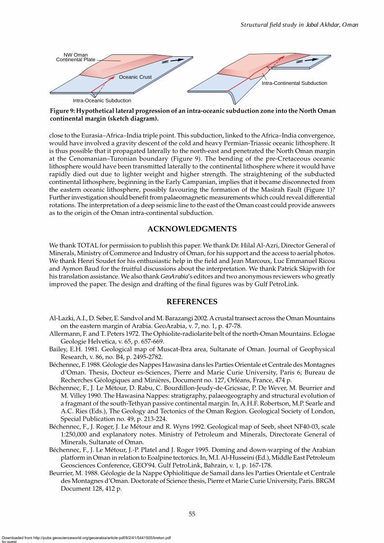
close to the Eurasia–Africa–India triple point. This subduction, linked to the Africa–India convergence,would have involved a gravity descent of the cold and heavy Permian-Triassic oceanic lithosphere. Itis thus possible that it propagated laterally to the north-east and penetrated the North Oman marginat the Cenomanian–Turonian boundary (Figure 9). The bending of the pre-Cretaceous oceaniclithosphere would have been transmitted laterally to the continental lithosphere where it would haverapidly died out due to lighter weight and higher strength. The straightening of the subductedcontinental lithosphere, beginning in the Early Campanian, implies that it became disconnected fromthe eastern oceanic lithosphere, possibly favouring the formation of the Masirah Fault (Figure 1)?Further investigation should benefit from palaeomagnetic measurements which could reveal differentialrotations. The interpretation of a deep seismic line to the east of the Oman coast could provide answersas to the origin of the Oman intra-continental subduction.
ACKNOWLEDGMENTS
We thank TOTAL for permission to publish this paper. We thank Dr. Hilal Al-Azri, Director General ofMinerals, Ministry of Commerce and Industry of Oman, for his support and the access to aerial photos.We thank Henri Soudet for his enthusiastic help in the field and Jean Marcoux, Luc Emmanuel Ricouand Aymon Baud for the fruitful discussions about the interpretation. We thank Patrick Skipwith forhis translation assistance. We also thank GeoArabia’s editors and two anonymous reviewers who greatlyimproved the paper. The design and drafting of the final figures was by Gulf PetroLink.
REFERENCES
Al-Lazki, A.I., D. Seber, E. Sandvol and M. Barazangi 2002. A crustal transect across the Oman Mountainson the eastern margin of Arabia. GeoArabia, v. 7, no. 1, p. 47-78.
Allermann, F. and T. Peters 1972. The Ophiolite-radiolarite belt of the north-Oman Mountains. EclogaeGeologie Helvetica, v. 65, p. 657-669.
Bailey, E.H. 1981. Geological map of Muscat-Ibra area, Sultanate of Oman. Journal of GeophysicalResearch, v. 86, no. B4, p. 2495-2782.
Béchennec, F. 1988. Géologie des Nappes Hawasina dans les Parties Orientale et Centrale des Montagnesd’Oman. Thesis, Docteur es-Sciences, Pierre and Marie Curie University, Paris 6; Bureau deRecherches Géologiques and Minières, Document no. 127, Orléans, France, 474 p.
Béchennec, F., J. Le Métour, D. Rabu, C. Bourdillon-Jeudy-de-Gricssac, P. De Wever, M. Beurrier andM. Villey 1990. The Hawasina Nappes: stratigraphy, palaeogeography and structural evolution ofa fragmant of the south-Tethyan passive continental margin. In, A.H.F. Robertson, M.P. Searle andA.C. Ries (Eds.), The Geology and Tectonics of the Oman Region. Geological Society of London,Special Publication no. 49, p. 213-224.
Béchennec, F., J. Roger, J. Le Métour and R. Wyns 1992. Geological map of Seeb, sheet NF40-03, scale1:250,000 and explanatory notes. Ministry of Petroleum and Minerals, Directorate General ofMinerals, Sultanate of Oman.
Béchennec, F., J. Le Métour, J.-P. Platel and J. Roger 1995. Doming and down-warping of the Arabianplatform in Oman in relation to Eoalpine tectonics. In, M.I. Al-Husseini (Ed.), Middle East PetroleumGeosciences Conference, GEO’94. Gulf PetroLink, Bahrain, v. 1, p. 167-178.
Beurrier, M. 1988. Géologie de la Nappe Ophiolitique de Samail dans les Parties Orientale et Centraledes Montagnes d’Oman. Doctorate of Science thesis, Pierre et Marie Curie University, Paris. BRGMDocument 128, 412 p.
NW OmanContinental Plate
Oceanic Crust
Intra-Oceanic Subduction
Intra-Continental Subduction
Figure 9: Hypothetical lateral progression of an intra-oceanic subduction zone into the North Omancontinental margin (sketch diagram).
Downloaded from http://pubs.geoscienceworld.org/geoarabia/article-pdf/9/2/41/5441505/breton.pdfby gueston 17 July 2022
56
Breton et al.
Beurrier, M., M. Ohnenstetter, B. Cabanis, J.L. Lescuyer, M. Tegyey and J. Le Métour 1989. Géochimiedes filons doléritiques et des roches volcaniques ophiolitiques de la nappe no. 2, p. 205-219
Boote, D.R.D., D. Mou and R.I. Waite 1990. Structural evolution of the Suneinah Foreland, centralOman Mountains. In, A.H.F. Robertson, M.P. Searle and A.C. Ries (Eds.), The Geology and Tectonicsof the Oman Region. Geological Society of London, Special Publication no. 49, p. 397-418.
Boudier, F., J.L. Bouchez, A. Nicolas, M. Cannat, G. Ceuleneer, M. Misseri and R. Montigny 1985.Kinematic of oceanic thrusting in the Oman Ophiolite: model for plate convergence. Earth andPlanetary Sciences Letters, v. 75, p. 215-222.
Chemenda, A.I., M. Mattauer and A.N. Bokum 1996. Continental subduction and a mechanism forexhumation of high-pressure metamorphic rocks: new modelling and field data from Oman. EarthPlanetary Science Letters, no. 143, p. 173-182.
Coffield, D.Q. 1990. Structures associated with nappe emplacement and culmination collapse in theCentral Oman Mountains. In, A.H.F. Robertson, M.P. Searle and A.C. Ries (Eds.), The Geology andTectonics of the Oman Region. Geological Society of London, Special Publication no. 49, p. 447-458.
Coleman, R.G. 1971. Plate tectonic emplacement of upper mantle peridotites along continental edges.Journal of Geophysical Research, no. 76, p. 1212-1222.
El-Shazly, A.K. and R.G. Coleman 1990. Metamorphism in the Oman Mountains in relation to the SemailOphiolite emplacement. In, A.H.F. Robertson, M.P. Searle and A.C. Ries (Eds.), The Geology andTectonics of the Oman Region. Geological Society of London, Special Publication no. 49, p. 473-493.
El-Shazly, A.K. and M.A. Lanphere 1992. Two high pressure metamorphism events in NE Oman:evidence from 40Ar/39 dating and petrological data. Journal of Geology, no. 100, p. 731-751.
Glennie, K.W. 1977. Outline of the Geology of Oman. Memoire h. ser. Société Géologique France, v. 8,p. 25-31.
Glennie, K.W., M.G.A. Bœuf, M.W. Hugues-Clarke, M. Moody-Stuart, W. Pilaar and B.M. Reinhardt1974. Geology of the Oman Mountains. Koninklijk Nederlands Geol. en Mijnbouw.Genootschap,Transactions, no. 31.
Glennie, K.W., M.G.A. Bœuf, M.W. Hugues-Clarke, M. Moody-Stuart, W. Pilaar and B.M. Reinhardt1990. Interrelationship of the Makran-Oman Mountains belts of convergence. In, A.H.F. Robertson,M.P. Searle and A.C. Ries (Eds.), The Geology and Tectonics of the Oman Region. Geological Societyof London, Special Publication no. 49, p. 773-786.
Hanna, S.S. 1990. The Alpine deformation of the central Oman Mountains. In, A.H.F. Robertson, M.P.Searle and A.C. Ries (Eds.), The Geology and Tectonics of the Oman Region. Geological Society ofLondon, Special Publication no. 49, p. 341-359.
Hughes-Clarke, M.W. 1988. Stratigraphy and rock unit nomenclature in the oil-producing area of interiorOman. Journal of Petroleum Geology, v. 11, no. 1, p. 5-60.
Le Métour, J. 1988. Géologie del’Autochtone des Montagnes d’Oman: la Fenêtre du Saih Hatat. Thesis,Docteur es-Sciences, Pierre and Marie Curie University, Paris 6; Bureau de Recherches Géologiqueset Minières, Document no. 129, 420 p.
Le Métour, J., D. Rabu, M. Tegyey, F. Béchennec, M. Beurrier and M. Villey M. 1990. Subduction andobduction: two stages in the Eo-Alpine tectonometamorphic evolution of the Oman Mountains.In, A.H.F. Robertson, M.P. Searle and A.C. Ries (Eds.), The Geology and Tectonics of the OmanRegion. Geological Society of London, Special Publication no. 49, p. 327-339.
Le Métour, J., J.-P. Platel, F. Béchennec, A. Berthiaux, S. Chevrel, J. Dubreuilh, J. Roger and R. Wyns1993. Geological map of Oman, scale: 1:1,000,000. Directorate General of Minerals, Oman Ministryof Petroleum and Minerals.
Le Métour, J., J.C. Michel, F. Béchennec, J.-P. Platel and J. Roger 1995. Geology and mineral wealth of theSultanate of Oman. Ministry of Petroleum and Minerals, Directorate General of Minerals, Oman, 285 p.
Lallemand, S. 1999. La subduction océanique. Gordon and Breach Science Publishers, Netherland, p. 1-194.Lees, G.M. 1928. The geology and tectonics of Oman and parts of south eastern Arabia. Quarterly
Journal of the Geologic Society of London, v. 84, p. 585-670.Lippard, S.J. 1983. Cretaceous high pressure metamorphism in NE Oman and its relation to subduction
and ophiolite nappe emplacement. Journal of the Geological Society of London, v. 140, p. 97-104.Lovelock, P.E.R., T.L. Potter, E.B. Walsworth-Bell and W.M. Wiemer 1981. Ordovician rocks in the
Oman Mountains: the Amdeh Formation. Geol. Mijnbouw, p. 487-495.Mann, A. and S.S. Hanna 1990. The tectonic evolution of pre-Permian rocks, central and southeastern
Oman Mountains. In, A.H.F. Robertson, M.P. Searle and A.C. Ries (Eds.), The Geology and Tectonicsof the Oman Region. Geological Society of London, Special Publication no. 49, p. 307-325.
Downloaded from http://pubs.geoscienceworld.org/geoarabia/article-pdf/9/2/41/5441505/breton.pdfby gueston 17 July 2022
57
Structural field study in Jabal Akhdar, Oman
Michard, A. 1982. Contribution à la connaissance de la marge nord du Gondwana, une chaîne plisséePaléozoïque, vraisemblablement hercynienne en Oman. C.R. Acad. Sci. Paris, 22 p.
Michard, A., B. Goffé and M. Ouazzani 1983. Obduction related high pressure-low temperaturemetamorphism in upper crustal materials, Oman. 2nd European Union Geoscience Meeting,Strasbourg. Terra Cognita, 3, p. 187 (Abstract).
Miller, J.McL. 1998. The structure, metamorphism and 40Ar/39Ar geochronology of northeast SaihHatat, Oman: implications for the formation and preservation of high pressure rocks. UnpublishedPhD thesis, Monash University, Clayton, Melbourne, Australia.
Miller J.McL., D.R. Gray and R.T. Gregory 1998. Exhumation of high-pressure rocks, north-easternOman. Geology, no. 26, p. 235-238.
Miller, J.McL., R.T. Gregory, D.R. Gray and D.A. Foster 1999. Geological and geochronologicalconstraints on the exhumation of a high-pressure metamorphic terrane, Oman. In, U. Ring, M.T.Brandon, G.S. Lister and S.D. Xillet (Eds.), Exhumation Processes: Normal Faulting, Ductile Flowand Erosion. Geological Society of London, Special Publication no. 154, p. 241-260.
Miller, J.McL, D.R. Gray and R.T. Gregory 2002. Geometry and significance of internal windows andregional isoclinal folds in northeast Saih Hatat, Sultanate of Oman. Journal of Structural Geology,no. 24, p. 359-386.
Montigny, R., O. Le Mer and H. Whitechurch 1988. K-Ar and 40Ar/39 study of metamorphic rocksassociated with the Oman ophiolite: tectonic implications. Tectonophysics, v. 151, p. 345-362.
Mount, V.S., R.I.S. Crawford and S.C. Bergman 1998. Regional structural style of the central and southernOman Mountains: Jebel Akhdar, Saih Hatat, and the northern Ghaba basin. GeoArabia, v. 3, no. 4,p. 475-490.
Nicolas, A. and F. Boudier (Eds.) 1988. The Ophiolites of Oman. Tectonophysics, Special issue, v. 151,401 p.
Nolan, S.C., P.W. Skelton, B.P. Clissold and J.D. Smewing 1990. Maastrichtian to early Tertiarystratigraphy and palaeogeography of the Central and Northern Oman Mountains. In, A.H.F.Robertson, M.P. Searle and A.C. Ries (Eds.), The Geology and Tectonics of the Oman Region.Geological Society of London, Special Publication no. 49, p. 495-519.
Rabu, D. 1988. Géologie de l’autochtone des montagnes d’Oman la fenêtre du Jabal Adkar. La semellemétamorphique de la Nappe ophiolitique de Semail dans les parties orientale et centrale desMontagnes d’Oman: une revue. Document BRGM Orléans, no. 130, p. 1-582.
Rabu, D., P. Nehlig, J. Roger, F. Béchennec, M. Beurrier, J. Le Métour, C. Bourdillon-de-Grissac, M.Tegyey, J.J. Chauvel, C. Cavelier, H. Al Hazri, T. Juteau, D. Janjou, B. Lemière, M. Villey and R.Wyns (Eds.) 1993. Stratigraphy and structure of the Oman Mountains. Document BRGM Orléans,no. 262.
Ricou, L.E. 1994. Tethys reconstructed: plates, continental fragments and their boundaries since 260Ma from central America to south-eastern Asia. Geodynamica Acta (Paris) 1994, 7 (4), p. 169-218.
Ricateau, R. and P.H. Riche 1980. Geology of the Musandam Peninsula (Sultanate of Oman) and itssurroundings. Journal of Petroleum Geology, v. 3, p. 139-152.
Roger, J., F. Béchennec, D. Janjou, J. Le Métour, R. Wyns and M. Beurrier 1991. Geological map of theJa’Alan Quadrangle, Sultanate of Oman. Geoscience map, scale 1:100,000, sheet NF 40-8E andexplanatory notes. Ministry of Petroleum and Minerals, Directorate General of Minerals, Sultanateof Oman. 90 p.
Searle, M.P., D.J. Waters, H.N. Martin and D.X. Rex 1994. Structure and metamorphism ofblueschisteclogite facies rocks from the NE Oman Mountains. Journal of the Geological Society ofLondon, no. 151, p. 555-576.Sharland, P.R., R. Archer, D.M. Casey, R.B. Davies, S.A. Hall, A.P. Heward, A.D. Horbury and M.D.
Simmons 2001. Arabian Plate Sequence Stratigraphy. Geoarabia Special Publication 2, GulfPetroLink, Bahrain, 371 p.
Tschopp, R.H. 1967. The general geology of Oman. Proceedings of the 7th World Petroleum Congress,Mexico, v. 2, p. 213-242.
Warburton, J., T.J. Burnhill, R.H. Graham and K.P. Isaac 1990. The evolution of the Oman MountainsForeland Basin. In, A.H.F. Robertson, M.P. Searle and A.C. Ries (Eds.), The Geology and Tectonicsof the Oman Region. Geological Society of London, Special Publication no. 49, p. 419-427.
Wendt, A.S., P. D’Arco, B. Goffé and R. Oberhänsli 1993. Radial cracks around a-quartz inclusions inalmandine: constrains on the metamorphic history of the Oman mountains. Earth Planetary ScienceLetters, no. 114, p. 449-461.
Downloaded from http://pubs.geoscienceworld.org/geoarabia/article-pdf/9/2/41/5441505/breton.pdfby gueston 17 July 2022
58
Breton et al.
ABOUT THE AUTHORS
Jean-Paul Breton is a Structural Geologist with the French Bureau deRecherches Géologiques et Minières (BRGM). He holds a PhD in structuralgeology from the University of Paris (1972). He joined BRGM in 1972,working on structural studies applied to geological mapping, mineralexploration, underground storage and geotechnics in France, Europe, Africaand, from 1981 to 1992, in Saudi Arabia. Jean-Paul made a significantcontribution to the conception and implementation of the Tectonic Map ofFrance at 1:1,000,000 scale (1st ed., 1981). Since 1993, he has been the localrepresentative of BRGM in Oman and, since 2002, is in charge of a scientificresearch program related to the geodynamics of the southern edge of the Arabianplate. [email protected]
François Béchennec is a Geological Expert with the Bureau de RecherchesGéologiques et Minières (BRGM). He received his Doctoral of science degreefrom the University Pierre et Marie Curie (Paris 6) in 1987. Since joiningBRGM in 1978, François was mainly in charge of geological mappingprojects, especially in Oman, but also in France and Africa. He is affiliatedwith the Geological Society of France (SGF) and is interested in the geologyof the Middle East Region.
Joël Le Métour has 17 years of experience in the geology of Oman. Hereceived his Doctorate of Sciences from the University of Paris in 1987. Hejoined the Bureau de Recherches Géologiques et Minières in 1978 and wasemployed as a Mapping Geologist up to 1987. Between 1988 and 1994 Joëlacted as Chief Geologist for geological mapping projects of the Ministry ofPetroleum and Minerals of the Sultanate of Oman. He is member of theFrench Geological Society. Presently, Joël is leading the Geological Serviceof BRGM. [email protected]
Laure Moen-Maurel has been leading reservoir modelling projects for theTOTAL Geosciences Division since 2000. Previously, Laure acquired over12 years of experience in petroleum exploration, working for the GeologicalSurvey of Canada (Institute of Sedimentary and Petroleum Geology), Petro-Canada, Elf, or as a consultant, dealing with basin analysis and structurallycomplex plays (Foothills, fractured reservoirs, deep delta fold-and-thrustbelts, inversion tectonics). She graduated from the University of Paris andholds a PhD in Structural Geology from the University of Calgary (1987).
Philippe Razin is Professor of Geology at the University of Bordeaux,France. He received his Doctoral of science degree from the University ofBordeaux in 1989 and joined the Bureau de Recherches Géologiques etMinières as an expert in sedimentology and basin synthesis. Philippe wasinvolved in various projects (mapping, water and mineral exploration,geotechnics, 3-D modelling). He moved to the University of Bordeaux in1997, where he teaches sedimentary and structural geology, geodynamicsand field mapping. His research activities concern relations between tectonicand sedimentation, in collaboration with BRGM, IFP, IFREMER and oilcompanies. [email protected]
For more information about the authors see, Geoscientist Directory at www.gulfpetrolink.com
Manuscript Received September 15, 2003Revised November 10, 2003
Accepted November 18, 2003Press Version Proofread by Authors January 15, 2004
Downloaded from http://pubs.geoscienceworld.org/geoarabia/article-pdf/9/2/41/5441505/breton.pdfby gueston 17 July 2022
Crystalline basement
Lithospheric upper mantle
Autochthon A
Autochthon B Hamrat Duru Basin
Hawasina Basin Kawr
Platform
Permian-Cretaceouscontinental slope
Umar Basin
?Samail Basin Active ridge
Intraoceanic detachment
100 Ma
Late Albian
95 MaCenomanian
85 MaEarly Santonian
90 MaTuronian
Asthenosphere
TanufJabal Akhdar
Fanjah MuscatSaih HatatSalakh Arch
Moho
Moho
Sea level
Permian margin Thinned continental crust ?
Intraoceanicsubduction plane
Foredeep
Forebulge
Triassic to Jurassic oceanic crust
Intracontinental rupture
Samail Nappe
Sea level
Sea level
Sea level
Crystalline basement
ARABIC CONTINENTAL PLATE
Foredeep
Permian
margin
Erosion
Intracontinentalsubduction plane
Foredeep
Forebulge
Accretion contact Trias. to Jur. oceanic crust
EURASIAN PLATE
Sea level
Sea level
NORTH MUSCAT MICROPLATE
Muti Basin
Sea level
Sea level Continental slope
Accretion prismMuti Basin Erosion
Foredeep
Lower slab block
Obduction plane
Accretion contact Triassic to Jurassic oceanic crust
Southwest Northeast
Upper slab
100 200 300 400 500 600 700 800 900 1,000
100 200 300 400 500 600 700 800 900
100 200 300 400 500 600 700 800 900
100 200 300 400 500 600 700
20
40
60
80
100
120
Ste
p A
Ste
p B
Ste
p D
Ste
p C
120
20
40
60
80
100
km
km
km
km
km
km
120
20
40
60
80
100
km
120
140
160
20
40
60
80
100
km
20
40
km
20
40
20
40
60
80
km
km
Figure 8: Eoalpine geodynamic evolution of the Oman Tethyan continental margin along the Jabal Akhdar - Saih Hatat transect, from Late Albian to Early Maastrichtian. Left border of cross-sections is considered as fixed point. See figure 3 for location.
Downloaded from http://pubs.geoscienceworld.org/geoarabia/article-pdf/9/2/41/5441505/breton.pdfby gueston 17 July 2022
Saih HatatJabal Akhdar
Autochthon A DomeAutoch. BSea level
MuscatFanjahTanufErosion
70 MaEarly Maastrichtian
75 Ma
Late Campanian
80 MaEarly Campanian
Sea level
Triassic to Jurassic oceanic crust
Sea level
Sea level
Sea levelHamrat Duru
Range
Hamrat Duru Range
Hamrat Duru Range
Jabal Akhdar
Doming of Saih Hatat
Erosion
Autoch. B
Sea level
Autoch. B
Hawasina Nappes
Samail Nappe
Ductile shearzone
Lower slab block Lower slab
Autochthon B
Upper slab Autochthon B
100 200 300 400 500 600 700 800
700 800
700 800
100 200 300 400 500 600
100 200 300 400 500 600
Ste
p E
20km
40
60
80
100
120
160
60
80
100
120
140
40
km20
Ste
p G
Ste
p F
20
40
60
80
100
120
20km
40
60
80
100
120
km
160
60
80
100
120
140
40
km
km
20
160
60
80
100
120
140
40
km20
Downloaded from http://pubs.geoscienceworld.org/geoarabia/article-pdf/9/2/41/5441505/breton.pdfby gueston 17 July 2022