Historical perspective on seismic hazard to Hispaniola and the northeast Caribbean region
Upload
khangminh22Category
view
1download
0
Project on “Seismic Hazard & Vulnerability Assessment in Dhaka Chittagong & Sylhet cityAssessment in Dhaka, Chittagong & Sylhet city
areas, Bangladesh”
By
Mohammad Ashraful Kamal (Geologist)( g )

Tectonic & Seismic zoning map of BangladeshTectonic & Seismic zoning map of Bangladesh

Geological map of Bangladesh

Dhaka City

Quick view of QB image: Chittagong & Sylhet City
Chittagong SylhetChittagong Sylhet

Major historical EQs in and around BangladeshDate Name Epicenter Magnitude Comment11th October
1737Kolkata 22.60N,
88.40E,X (in MM)
>7 MIndia's deadliest earthquake.
J 10 1869 K h J i ti Hill 7 5 S lh t T f 650 000January10, 1869 Kachar Jaintia Hills25.00 N , 93.00 E
7.5 Depth 50 km.
Sylhet Town. area of 650,000 square miles.
July 14, 1885
The BengalEarthquake
Bogra Fault 24.00 N,90 00 E
7.0 damage within a 100 km radius of the epicenter. an area of 6,00,000 square kilometers90.00 E kilometers.
June 12, 1897 The GreatIndianEarthquake
Shillong Plateau 26.00N, 91.00E
8.7 Dhaka-Kolkata.
July 8, 1918
Mymensingh 24.50 N, 91.00 E 7.412 -14 km
damage in a 100-kilometer radius of the epicenter
July 3, 1934 Dhubri 24.50 N, 91.00 E 7.1 Rangpur experienced severe tremor
January15, 1934 Bihar-Nepal Darbhanga26.50N, 86.50E
8.3 the Ganges Basin;
August 15, 1950
Assam Arunachal Pradesh 8.5 Felt throughout Bangladesh
23rd October 1943
Dergaon Assam
26.80 N , 94.00 E 7.05 Felt throughout Bangladesh

Recent EQs in and around Bangladesh (NEIC, USGS)
Date Name Epicenter Magnitude CommentMay 8,1997
Indo-Bangla border Lat 24.89Long 92.25
6 Mb Felt from Chittagong to Rangpur, also in Sylhet and Meghalaya, India.g
34 km depthy g y
November 21, 1997
Chittagong Indo-Bangladesh
Border
Lat 22.21Long 92.8357 km depth
6 Mb felt throughout Bangladesh
J l 22 1999 M h hkh li L t 21 47 5 2 MbJuly 22, 1999 MoheshkhaliIsland
Lat 21.47Long 91.90; depth10 km
5.2 Mb
31st December 1999
Indo-Bangladesh Border Region
21.43N, 91.76ENear Sonadia
Mb - 4.3 triggered a tidal surge that reached heights of 4 feet.
4th January 2000
Bungtlang (Tripura), India
Epicenter: 22.13N, 92.77E
Mb - 4.6 Southern Bangladesh epicenters about 150 km from
Chittagong.
19th December 2001
Kaliakoir, Dhaka 23.70 N 90.40 E (IMD)
M 4.2 IMD Strong tremors (MM V-VI) in Dhaka City2001 (IMD) City,
20th June 2002 Rajshahi 25.80N 88.86E (NEIC)
ML 4.6 Shook buildings for 39 seconds in Bogra and Syedpur.
25th March 2003 Bhutan 27.260N 89.240E (NEIC)
M 5.1 Though the epicenter was in Bhutan ( )
27th July 2003 Barkal-Rangamati 22.85 N92.31 E Depth–10 km
M 5.6

ADPC project Components under Comprehensive Disaster ManagementCo p e e s e sas e a age e
Program (CDMP) of Bangladesh
• Seismic Hazard & Vulnerability Assessment of Dhaka, Chittagong and Sylhet City Corporation Areasg g y y p
• Contingency Planning for earthquake hazard
• Training, Advocacy and Awareness with regards to earthquake and tsunami hazardsq
• Support for a Disaster Management Information Network (DMIN)Network (DMIN)

Project Implementation Partners of ADPC
OYO International Corporation, JapanAsian Institute of Technology (AIT), ThailandNational Society for Earthquake Technology (NSET), N lNepalDhaka University Chittagong University of Engineering TechnologyChittagong University of Engineering Technology (CUET)Shahjalal University of Science and Technology Sylhet

Component: Seismic Hazard & Vulnerability AssessmentAssessment
Seismic Hazard Assessment:• Report on Scenario Earthquake p q• Setting of fault model • EQ vulnerability map for each city• Study on sub surface soil properties • Engineering geological maps and reports
Vulnerability & Risk Assessment:Development of GIS inventory of Building footprints and Lifelines• Development of GIS inventory of Building footprints and Lifelines
• Assessment of Physical Vulnerability of Buildings and Lifeline Infrastructure
• Production of vulnerability maps & reportsoduct o o u e ab ty aps & epo ts• Loss Estimation study report for the city corporation area

Geological & Geophysical investigations
• Boring for Geological & Geo-technical data collection• H/V (single) micro-tremor measurementsH/V (single) micro tremor measurements• Multi channel analysis of surface wave (MASW)• Shear wave velocity data by
- PS logging- Shallow seismic survey - Small Scale Array Micro-tremor measurements (SSMM)
• Liquefaction analysisActi e fa lt st d• Active fault study
• EQ catalog etc.

Vulnerability & Risk Assessment
• 3 stage building survey (sampling from different classes))
• Structural analysis of buildings (class dependent)• Occupation type analysisp yp y• Day/night inhabitant data• Life line (gas, water, electricity, telephone etc.) dataLife line (gas, water, electricity, telephone etc.) data• Building footprint, road network data etc.

Vulnerability Assessment : Building footprints, road network etc.Building footprints, road network etc.

Component: Contingency Planning
A good contingency plan ensures better preparednessA good contingency plan ensures better preparedness for any emergency that may occur, even one that is very different from the scenario in the plan
- It is a process rather than just the production of a document.
i b ildi- is a consensus-building process

WHY CONTINGENCY PLAN?
facilitate rapid emergency response by allowing planners, inadvance to:advance to:
• Consider the likely consequences of an emergency before itoccurs• Identify the key resources, both human and physical, which maybe available for emergency• Identify the critical areas for immediate action• Build and train the emergency response team in advance• Define general policies and approach to the emergency inadvance• Include actions designed to prevent an emergency as well asInclude actions designed to prevent an emergency as well as limit its consequences

Main responses in a CONTINGENCY PLANMain responses in a CONTINGENCY PLAN
• Search and Rescue• Health and Medical Service • Request for External assistance for search and rescue • Law Enforcement & Security • Emergency Shelter & Mass Care
f /• Fire-fighting/Rescue • Communications • Damage Assessment etc• Damage Assessment etc.
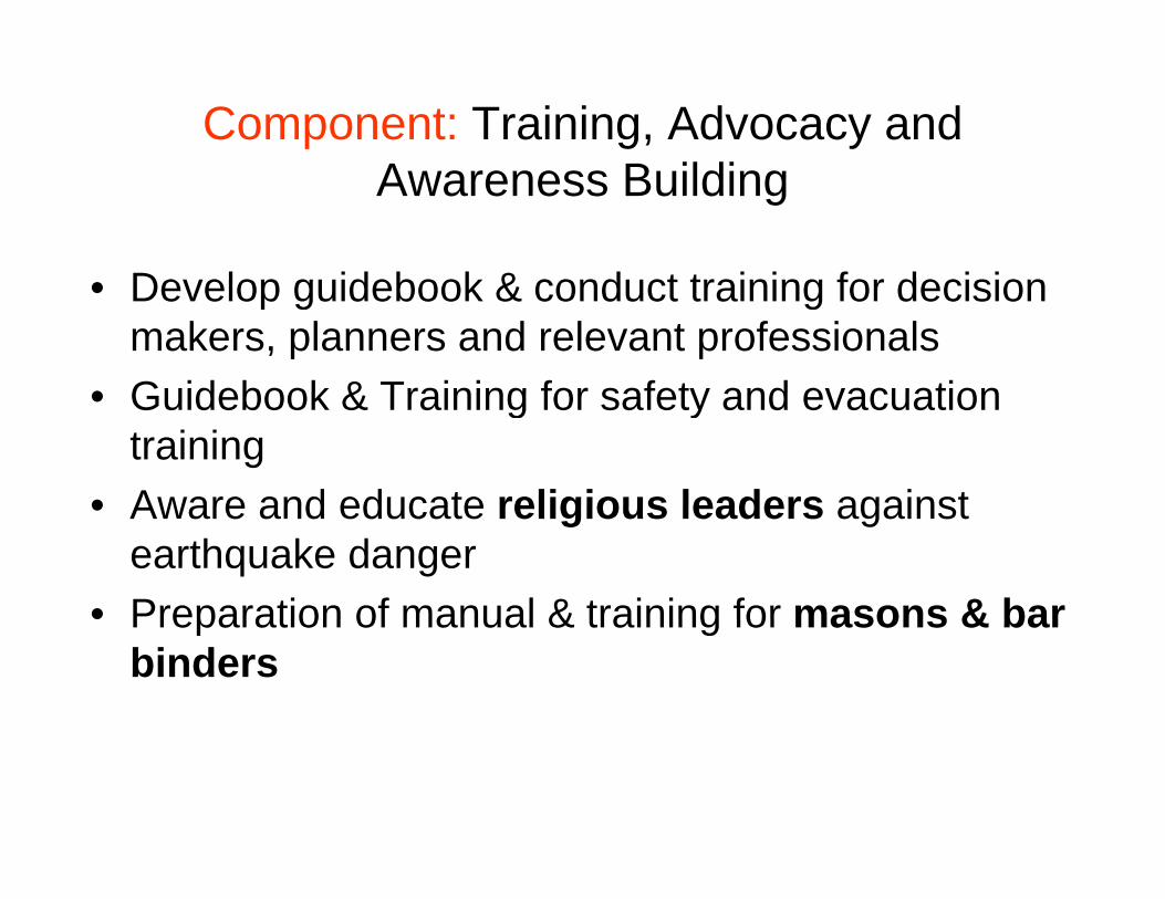
Component: Training, Advocacy and A B ildiAwareness Building
De elop g idebook & cond ct training for decision• Develop guidebook & conduct training for decision makers, planners and relevant professionals
• Guidebook & Training for safety and evacuation• Guidebook & Training for safety and evacuation training
• Aware and educate religious leaders against• Aware and educate religious leaders against earthquake danger
• Preparation of manual & training for masons & barPreparation of manual & training for masons & bar binders

Training & Advocacy
• Documentary to develop awareness of earthquake hazard & vulnerability
• Production & dissemination of poster and leaflet on earthquake vulnerability reduction measures

Soil sample collection for geo-technical investigationg

Shallow seismic data collection

Micro-tremor data collection

Field work for active fault study

Active fault studyy

PS logging (down hole test) for shear wave velocityy

Geophysical survey for Surface wave

Component: Support for a Disaster M t I f ti N t k (DMIN)Management Information Network (DMIN)
• Status of existing links for informationStatus of existing links for information dissemination between source and community level
• Review options for strengthening existing links and p g g gfilling gaps where appropriate
• Carry out “mock drills” for rapid onset “emergency” h dhazards
• Undertake post-event audits to assess information flow between warning sourceflow between warning source
• Design and test appropriate information network(s) to priority hazard typesto priority hazard types
Copyright © 2022 FDOKUMEN