Proceedings - Repositório da Universidade de Lisboa
19
22 nd Annual International Sustainable Development Research Society Conference Lisbon, Portugal, 13-15 July 2016 Edited by: João Joanaz de Melo, Antje Disterheft, Sandra Caeiro, Rui F. Santos and Tomás B. Ramos Universidade Nova de Lisboa Campus de Campolide Proceedings Volume 1 of 3
-
Upload
khangminh22 -
Category
Documents
-
view
1 -
download
0
Transcript of Proceedings - Repositório da Universidade de Lisboa
22nd Annual International Sustainable Development
Research Society Conference
Lisbon, Portugal, 13-15 July 2016
Edited by: João Joanaz de Melo, Antje Disterheft,
Sandra Caeiro, Rui F. Santos and Tomás B. Ramos
Universidade Nova de Lisboa Campus de Campolide
Proceedings Volume 1 of 3

Proceedings of the 22nd International Sustainable Development
Research Society Conference
ISDRS 2016 Rethinking Sustainability Models and
Practices: Challenges for the New and Old World Contexts
Volume 1 of 3
Edited by: João Joanaz de Melo, Antje Disterheft,
Sandra Caeiro, Rui F. Santos and Tomás B. Ramos
July 2016
ISRDR 2016 was organized and hosted on behalf of ISDRS by the Center for Environmental and Sustainability Research,
School of Science and Technology, Universidade Nova de Lisboa

22nd International Sustainable Development Research Society Conference (ISDRS 2016), Vol. 1 School of Science and Technology, Universidade Nova de Lisboa, Lisbon, Portugal, 13-15 July 2016
2
Copyright © International Sustainable Development Research Society (ISDRS) and Faculdade de Ciências e Tecnologia, Universidade Nova de Lisboa (FCT NOVA)
Note: the Proceedings as a whole are subject to copyright by ISDRS and FCT NOVA. Individual authors have the right to self-archive and disseminate their own papers, and are also free to seek their publication in scientific journals.
Edited by: João Joanaz de Melo, Antje Disterheft, Sandra Caeiro, Rui F. Santos and Tomás B. Ramos
Title: Proceedings of the 22nd Annual International Sustainable Development Research Society Conference
Subtitle: Rethinking Sustainability Models and Practices: Challenges for the New and Old World Contexts
Volume 1 of 3
Published by the International Sustainable Development Research Society and the Center for Environmental and Sustainability Research, School of Science and Technology, Universidade Nova de Lisboa
Digital edition only
Lisbon, July 2016
ISBN: 978-972-674-791-8
Cover design: Nuno Videira
CENSE - Center for Environmental and Sustainability Research Faculdade de Ciências e Tecnologia, Universidade Nova de Lisboa 2829-516 Caparica Portugal Phone: +351-212948397 Fax: +351-212948554 Email: [email protected], [email protected] www.cense.fct.unl.pt www.fct.unl.pt International Sustainable Development Research Society http://isdrs.org

22nd International Sustainable Development Research Society Conference (ISDRS 2016), Vol. 1 School of Science and Technology, Universidade Nova de Lisboa, Lisbon, Portugal, 13-15 July 2016
153
Coastal ecosystem valuation as a tool for sustainable planning in Maputo Ana Beja da Costa1 1 Landscape Architecture, Biodiversity and Conservation Group, Linking Landscape, Environment, Agriculture and Food, (LEAF)/ Instituto Superior de Agronomia / ULisboa, [email protected]
Abstract Many of the large urban areas of Africa are located along the coast, as is the case of Accra, Lagos, Luanda, Cape Town and Maputo, placing them both by their colonial origin and by its geographical context in a category of large cities that have a particular and strong relationship with their landscape setting, similar to places such as Mumbai, Rio de Janeiro and Hong Kong. Nature and urbanity are in extremely close proximity, with both spectacular and problematic results (Beja da Costa et al., 2009). In these cities, urban sprawl often occupies structuring and risk prone places of their ecological structures, namely proximity to flood plains and to vulnerable coastlines. Additionally, climate change and sea level rise introduce another dimension to the risk, (Tucci, 2009) that must be considered while planning these cities’ coastal areas. Focusing on Maputo, Mozambique, this paper will analyse an African capital that faces many development pressures, and where most development projects are targeting its coastline. This one is formed by both valuable and vulnerable landscapes in terms of visual quality and in terms of the quality of the natural resources and ecosystems value, given the variety of environments such as swamps, dunes and alluvium deposits, (Oliveira et al., 1996) that allow for the existence of a variety of biotopes. In turn, these play important roles for both the territory and the local population, given the value of the environmental setting as a direct food source, as a flood and hazard control mechanism and as a biodiversity asset to the city (which presents further economic gains for the city). This paper firstly presents an overall review regarding Maputo’s current urban planning processes; secondly it describes the specific ecological values of Maputo within its broader ecoregion context. The study proposes to analyse the valuation of ecosystem services of Maputo’s coastal landscapes, centred on the belief that there are greater benefits in retaining natural habitats than converting them into plantations, shrimp farms, etc. (de Groot, 2005) or into urban areas. It questions if the incorporation of ecosystem services may become a strategy towards the improvement of sustainable planning of the city’s coastal areas. The themes of ecosystem values and sustainability are to be addressed regarding a shift in Maputo’s urban development paradigm, aiming at safeguarding its natural systems while contributing to maintaining the city’s well-known image of quality.
Keywords: Maputo, Coastal Ecosystem services, sustainable urban development
1. Introduction The world is experiencing the fastest urbanization process in history with a projected 4.9 billion people to live in cities by 2030, corresponding to almost 60% of the world’s population (IFOU, 2009). Megacities, defined by the United Nations as a metropolitan area with a total population of more than 10 million people, were firstly found in North America (New York) in the 1950’s, secondly in South America (Mexico City) and in Eastern Asia (Tokyo) during the 1970’s; from 2000 onwards and with an increasing rate of growth, new megacities rose throughout the world (UN, 2006). The trend continues and more recently these megacities have begun to emerge in Africa - though few urban regions can be considered megacities (Lagos, Cairo) - in what promises to be one of the more remarkable forthcoming developments in the overall pattern of urbanization (UN-Habitat, 2012).

22nd International Sustainable Development Research Society Conference (ISDRS 2016), Vol. 1 School of Science and Technology, Universidade Nova de Lisboa, Lisbon, Portugal, 13-15 July 2016
154
Many of the large urban areas on the African continent are located along the coast, as is the case of Maputo, where urban sprawl often occupies structuring and risk prone areas. Additionally, the near future will bring new challenges for such areas in Maputo, namely infrastructural changes that include the Katembe bridge construction or the new ring road (Maputo, 2008) that will have an impact both on the urban form and the natural ecosystems of the city’s coastal area. The estuaries’ ecological systems throughout Maputo’s coastline are not being taken into account in ongoing and (near) future large-scale urban development projects and the exuberant wealth of Maputo’s coastal ecological systems is being consumed both by the fast influx of people into the city and by the large development investments being made in urban projects.
This paper firstly presents an overall review of Maputo’s urban planning processes and secondly the specific ecological values of Maputo within its broader ecoregion context are described. A qualitative analysis of the current urban plans for Maputo’s coastal area and an analysis of the current state of its ecosystems, through literature review and study of satellite photography, allow for an evaluation of ecosystem values and sustainability regarding a shift in Maputo’s urban development paradigm. The analysis equally allows for an evaluation of the current state of ecosystems and investigation of its potential value for the sustainable planning of the study area. This paper is based on the initial fieldwork findings and in the organization process of the secondary data collection for the ongoing PhD research in Landscape Architecture and Urban Ecology entitled “Merging ecological systems and urban infrastructures at Maputo’s coastline”.
2. Methods 2.1 Specifics of recent urban expansion processes in Maputo Municipality coastline Maputo is Mozambique’s largest and economically most important city, accounting for about 30% of the country’s gross domestic product. The surrounding “semi-rural” areas are undergoing a fast process of densification. Maputo and its surrounding metropolitan area, including the administratively separate city of Matola, has a population of over two million. (Promaputo, 2012). Large investments are being made by the city’s administration that through an extensive project sponsored by the World Bank - the Maputo Municipal Development Plan (Promaputo) aimed at leading institutional reform and municipal governance (estimated budget 10.8 million US$), to monitor municipal finance (estimated budget 5.3 million US$), and to improve planning and service delivery (estimated budget 25 million US$). This includes immediate spatial impacts, aiming to improve solid waste collection and management and to improve and increase road infrastructure (Promaputo, 2012).
The 2008 “Plano de Estrutura Urbana do Município de Maputo” (PEUMM) (Maputo Municipality Urban Structure Plan), makes a thorough analysis of the city’s current situation, with an overview of past and current development and structural plans for the city. This document refers to the city’s ecological structure, enumerating five categories for the structure: humid low land areas (mangroves), flood prone areas, green forested protection areas, urban green areas (gardens and parks) and beaches. The PEUMM refers the importance of these categories, solely in a descriptive manner, and the need to regulate construction indexes and protection mechanisms, though it does not refer the tools required for this (Maputo, 2008). It seems that these categories can be a useful starting point to study Maputo’s ecological structure, but the articulation between the information within the PEUMM and the reality of Maputo’s natural systems seems far from being complete.
Whereas urban development in Maputo was, up to the 1970s, contained on the plateau on the North margin of the Maputo Bay and in the Baixa area, nowadays the city’s expansion is moving towards the last vacant stretches of land: the low plane along the Costa do Sol, Marginal and Katembe, in the South margin of the Maputo Bay. These areas are advertised by promotors as the
most desirable areas for middle and high income class housing, and as tourism facilities due
22nd International Sustainable Development Research Society Conference (ISDRS 2016), Vol. 1 School of Science and Technology, Universidade Nova de Lisboa, Lisbon, Portugal, 13-15 July 2016
155
to its proximity to the sea and beaches, privileged views and a comfortable distance and accessibility to the city centre.
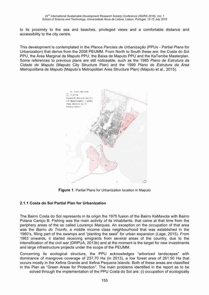
This development is contemplated in the Planos Parciais de Urbanização (PPUs - Partial Plans for Urbanization) that derive from the 2008 PEUMM. From North to South these are: the Costa do Sol PPU, the Área Marginal de Maputo PPU, the Baixa de Maputo PPU and the KaTembe Masterplan. Some references to previous plans are still noticeable, such as the 1985 Plano de Estrutura da Cidade de Maputo (Maputo City Structure Plan) and the 1999 Plano de Estrutura da Área Metropolitana de Maputo (Maputo’s Metropolitan Area Structure Plan) (Maputo et al., 2015).
Figure 1. Partial Plans for Urbanization location in Maputo
2.1.1 Costa do Sol Partial Plan for Urbanization The Bairro Costa do Sol represents in its origin the 1975 fusion of the Bairro KaMavota with Bairro Polana Caniço B. Fishing was the main activity of its inhabitants, that came at that time from the periphery areas of the so called Lourenço Marques. An exception on the occupation of that area was the Bairro do Triunfo, a middle income class neighbourhood that was established in the 1960’s, filling part of the swamps and “planting the seed” for urban expansion (Lage, 2015). From 1983 onwards, it started receiving emigrants from several areas of the country, due to the intensification of the civil war (DRPUA, 2013b) and at the moment is the target for new investments and large infrastructure projects under the scope of the PEUMM.
Concerning its ecological structure, the PPU acknowledges “arborized landscapes” with dominance of mangrove coverage of 237,70 Ha (in 2013), a low forest area of 261.50 Ha that occurs mostly in the Xefina Grande and Xefina Pequena Islands. Both of these areas are classified in the Plan as “Green Areas for Protection”. The main problems identified in the report as to be
solved through the implementation of the PPU Costa do Sol are: (i) occupation of ecologically

22nd International Sustainable Development Research Society Conference (ISDRS 2016), Vol. 1 School of Science and Technology, Universidade Nova de Lisboa, Lisbon, Portugal, 13-15 July 2016
156
sensitive areas; (ii) spontaneous occupation; (iii) floods and sea intrusion; (iv) occupation of protection areas (mangroves), previously classified as “Areas belonging to the Ecological Structure” and as “Green Area for Protection”; (v) coastal erosion; (vi) lack of accessibility and mobility (DRPUA, 2013b). It is important to note that despite the fact that the ecological structure is quite simplified in the PPU report, most of identified problems are related with this same structure.
Overall, the Costa do Sol urbanization major problems are related to the hydrological system: draining rainwater through the means of drainage open pipes, draining water from the underground water table, reducing erosion, waste water and sanitation. It considers that the “establishment of naturalized or formal water surfaces, especially when adjacent to the roads, is particularly suitable” (DRPUA, 2013a). Again, the acknowledged Mangrove Protection Area, well referenced and established in the plan report, does not show any relation or potential quality, nor a functional relation with the surrounding areas.
2.1.2 Area Marginal de Maputo Partial Plan for Urbanization The Area Marginal de Maputo Partial Plan for Urbanization considers the coastline to be a spontaneous area within the city morphology, and acknowledges the quick and often contradictory transformation pressures that it is subject to and that will change the “social and urban order that exists nowadays”. Along with urban high income and low density areas, urban void areas, such as the mangrove, the Golf or the former car race tracks, and middle and low income areas coexist. In the midst of this all, the “original layout of the Aldeia dos Pescadores maintains its characteristics and vitality”. (Maputo et al., 2015) This PPU geographically overlaps the PPU Costa do Sol.
The Area Marginal de Maputo PPU makes relevant statements in relation to the mangrove area. It considers its need for protection and in addition the need for a connection to the Bay, in order to guarantee the survival and sustainability of this relevant feature of Maputo’s coast. (Maputo et al., 2015) The PPU Report also addresses the sea level rise problematic, acknowledging that there is a need for a disaster prevention and occupation strategies, in order to minimize the loss and waste of means and resources. In this sense, and taking in account that this report is from 2015, this is already an improvement when comparing it with the neighbouring plan reports. The PPU states that tourism and residential are the main vocations of the Marginal of Maputo area due to its unique location and setting, but always giving a strong emphasis on the environmental protection aspect. It recognizes the value of the Avenida Marginal waterfront as a landmark for producing an image of the modern city, and it considers real-estate speculation and informal housing occupation the main and contradictory pressures for this area. The Avenida Marginal PPU reinforces as major guidelines: “Conservation of the environmental factors, enumerated as sand beaches, dunes, riverside vegetation, agriculture areas and mangroves; Housing development: high standards and private sector investment area; Tourism and leisure; Waterfront, as a resource for transformation and improvement of the city” (Maputo et al., 2015).
Concerning the areas directly implied in the crossing of the Avenida Marginal and Circular de Maputo ring road – that is transversal to several Partial Plans for Urbanization and that represents one of the major ongoing investments in the area – the PPU considers that these should be valued through the future adequate urban development. It criticizes its proximity to the coastline since it blocks access to the beaches and diminishes the quality of its fruition. The PPU also criticizes the blockage to the mangrove and rainwater drainage that is occurring due to the road construction, whereas one of the priorities of this PPU is to open up water channels and retention basins so that the connection between water systems is improved and the mangrove sustained.
The PPU report reinforces the need for a holistic environmental vision. It states that a harmonization of the environmental aspects should not only be identified in this plan, but also in the adjacent PPU’s (Costa do Sol, Polana Caniço, Baixa,…) and the ones on the West side of the area. The main environmental problems to be considered are soil erosion, rainwater drainage and climatic resilience.

22nd International Sustainable Development Research Society Conference (ISDRS 2016), Vol. 1 School of Science and Technology, Universidade Nova de Lisboa, Lisbon, Portugal, 13-15 July 2016
157
2.1.3 Baixa de Maputo Partial Plan for Urbanization The Baixa area is the origin of the Maputo settlement as we know it. It is the historical neighbourhood of Maputo and it still has, as in its origin, a major commercial and administrative vocation. It sits on reclaimed marshlands and alluvial deposits that link the area to a stretch of elevated “interior degraded fixed dunes and sand layers” (Oliveira et al., 1996) where the city mainly developed during the 19th and 20th century. This relevant geology has “important enterprises in the city at the Ponta Vermelha. A great many of the geological accidents in the city, such as landslides, erosion and tilted buildings have occurred here.”(Maputo, 2008) The Baixa is frequently subject of flood events, namely along the 25 de Setembro Avenue (Conselho Municipal de Maputo, 2014).
Almost fully a formal and consolidated area, corresponding to the “Cimento” (concrete) city, it houses commercial and industrial functions and few residential areas. It corresponds to Maputo’s CBD where major projects are foreseen. In the introductory stages of the Baixa PPU, the main existing problems referred to, are: traffic and parking congestion, low public transport coverage; lack of infrastructure to support informal commerce; water supply; drainage and sanitation; energy supply; and solid waste collection, treatment and disposal; The absence of maintenance or improvement of these infrastructures – being most of them previous to 1975 - is a concern when considering high density developments, due to stress increase on the existing infrastructure, that can limit (even more) the performance of urban services (Conselho Municipal de Maputo, 2014)
The Baixa PPU is divided into three sectors: Baixa Central, Baixa Este (East) and Baixa Oeste (West).
The “Waterfront Promenade” is the brand of the Baixa PPU. It has about 2.5 km extension, from the Baixa-Central section to the Baixa-Este section. It envisions a downgrade of motor traffic circulation to a one-way system (West-East) in order to give space for pedestrians and cyclists, to increase the row of planted palm trees for shading area and local commerce and restoration areas. Within the Chapter “Public Space of Private ownership (5.2.2.5)” there is reference to a “waterfront linear square” that aims to increase structural resistance to extreme climate events and sea level rise. It consists on a 10m wide green strip from the built line (towards the sea), where 80% of the surfaces should be permeable. Here, guidelines and bonuses for investors shall be negotiated case by case (Conselho Municipal de Maputo, 2014). It is highly questionable whether a 2.5x0.01km semi-permeable strip can mitigate sea-level rise, when the guidelines for it are negotiated plot by plot.
2.1.4 Katembe Masterplan The Katembe District General Masterplan was presented in 2012 by the consortium Promontório Planning – Betar, ordered by the Empresa de Desenvolvimento de Maputo Sul E.P. This public enterprise was created by the Government of Mozambique “to promote the building and management of the Katembe Bridge, roads from Maputo to Ponta do Ouro (including the Circular de Maputo) (…), as well as connected activities” (Promontório, 2012).
The first phase consists in the construction of a bridge that will improve the accessibility towards Ponta do Ouro; the second phase is the construction of a new city extension dependent on foreign investment, and where a future middleclass will settle. “Maputo South, the new part of the city should host 400.000 inhabitants by 2040. The master plan has already been approved and incorporates housing, commerce, industry, services, tourism and leisure”(Van Orshoven and Ysenbaardt, 2014). It defined 13 operational units, of which 3 have an approved Plano de Pormenor (Detailed Plan), and would have different functions according to location, potentialities
and accessibility to the projected highway. An approximate area of 3,000 ha is preserved and

22nd International Sustainable Development Research Society Conference (ISDRS 2016), Vol. 1 School of Science and Technology, Universidade Nova de Lisboa, Lisbon, Portugal, 13-15 July 2016
158
remains as an agriculture and ecological reserve (Promontório, 2012) according to the initial masterplan, that intends to address the three main environmental problems of the area: flooding, coastal erosion and deforestation. This city extension could represent part of the solution to address the city’s main problems, such as traffic and parking congestion, housing supply, electricity and water supply overload, etc. (Bettencourt, 2016)
2.1.5 Transversal to all coastal Partial Plans for Urbanization The reviewed PPUs are structured according to the traditional comprehensive planning structure tools, inherited from the 20th century colonial and socialist planning influences (Mendes, 1980), and they do not contemplate the current problematics that Maputo, as a coastal city, faces such as the sea level rise and the incorporation of natural systems in the city’s green structure in an integrated manner. Its neo-liberalism development results on the one hand in large migration influxes and extensive informally urbanized areas and on the other hand in large investments being made at a city scale, and in private developments sprouting at a plot scale. Biophysical characterization is often incoherent and lacking linkage between morphology, natural processes and landscape valuation. The current planning tools lack updated intellectual backgrounds and are based in a mind-set where coastal wetland areas are not acknowledged dynamic landscape features.
In legal terms, it is important to refer that in Mozambique land is owed by the state, as it is considered “a universal means of creation of wealth and social well-being and its use is a right of the people”. Thus, the legal instrument giving rights over the land is the Right to Use and Benefit from the Land (DUAT: Direito de Uso e Aproveitamento da Terra), conceded upon request from public or private entities or individuals and it recognizes the rights acquired by inheritance or occupation (when not attributed legally to a third party). It cannot be attributed in Public Domain, nor in total and partial protected areas. Nevertheless special licenses can be issued and the Council of Ministers can “create, modify or extinguish partial and total protection zones” (Moçambique, 2015), thus jeopardizing the integrity of ecological systems.
There is an operative gap between the planning instruments - PPUs (2013-15), the Katembe Masterplan (2010)-, environmental impact studies - the “Circular de Maputo ring road environmental impact studies” (2012), the “Costa de Sol Swamp and Mangrove Zoning and Protection Study (2010), amongst others (see Figure 2) and the actual projects being implemented. The DUATs add another layer of complexity since they are transversal to all the studies and plans and are subject to political will. A deep change in mind-set is needed to address “adaptation deficits” (Roberts et al., 2011), and to coordinate basic infrastructure works, as upgrade and extension of sewage, rain water drainage and road networks that can work as an integrated system that prioritizes and accommodates water level fluctuations needed for the well-functioning of coastal ecosystems. In turn, these should start being acknowledged as “soft engineering” (Kithiia and Lyth, 2011) assets that can decrease infrastructure costs and increase its resilience.

22nd International Sustainable Development Research Society Conference (ISDRS 2016), Vol. 1 School of Science and Technology, Universidade Nova de Lisboa, Lisbon, Portugal, 13-15 July 2016
159
Figure 2. Urban planning legislation and recent urban investments timeline
For example, the main infrastructure artery that is now under construction – the Circular de Maputo ring road – considers a 10 to 20 meter buffer area (in the Costa do Sol PPU) with multifunctional services. Parking and accessibility to the beaches are not contemplated in the report, neither the implantation choices for the road trajectory. The ring road cuts through the plan area as it cuts through water circulation outlets, mangroves and through the Aldeia dos Pescadores. As stated in the Avenida Marginal PPU, “there is a constant and strong human pressure” in the abovementioned areas, and that “none of the ongoing projects under construction are guided by any Partial Plan or Detailed Urban Plan. The only guiding instrument is the PEUMM” (Maputo et al., 2015). Meanwhile, private investors develop in a “plot-by-plot” process throughout the Av. Marginal, supported by the DUATs. It is possible that the actual building process, mainly coordinated and executed by internationally outsourced firms, influences the planning processes through the disregard of the established plans and a lack of capacity (or interest) to enforce these. Additionally, these international firms also bring their own interests, namely financial ones.
2.2 Specific ecological value of Maputo Municipality coastline Mozambique’s ecoregion is contemplated in the Millennium Ecosystem Assessment Sub-global component of Southern Africa, including Botswana, South Africa, Zambia and Zimbabwe (UNEP, 2005). It is inserted in the Southern / Eastern African sub region. In terms of Mozambique’s ecoregions characterization, Mozambique comprises several, and Maputo’s region is comprised within the “Maputoland Coastal Forest Mosaic”. This consists of 30 303 km² of ‘Tropical and Subtropical moist broadleaf forests’, described by the World Wild Fund Organization as:
“Flanking the Indian Ocean, the Maputoland Coastal Forest Mosaic includes a wide variety of habitat types, such as dry forest, swamp forest, grassland, wetland and estuarine systems. As a result, floral and faunal diversity and endemism are high. Nearly 10 percent of vascular plant species found in the ecoregion are endemic, including 3 endemic plant genera. Charismatic species such as the African elephant (Loxodonta africana) are also found here, offering a high potential for ecotourism. Almost 14 percent of this ecoregion is contained in protected areas. However,

22nd International Sustainable Development Research Society Conference (ISDRS 2016), Vol. 1 School of Science and Technology, Universidade Nova de Lisboa, Lisbon, Portugal, 13-15 July 2016
160
invasive exotic plants and expanding populations are starting to place considerable pressure on the natural environment in South Africa. Although Mozambique is still relatively depopulated south of Maputo, there are threats from large-scale deforestation and other forms of development, even in formally designated reserves.” (Kirkwood)
The coastline of Maputo flanks the Maputo Bay. It is the confluence of six rivers: the Incomati, at the North edge of Maputo region; the Infulene, that is the Western physical limit of Maputo’s municipality; the Matola River, that confines and gives the name to Matola city, the Umbeluzi, the Tembe and finally the Maputo River, at the Southeast tip of the bay confining the Katembe district on the East side; (Beja da Costa, 2014) forming a “large body of water of 1280 Km2 with an average depth of 10m (…). It is strongly influenced by the tide and receives the discharges of three large rivers (Incomati, Umbeluzi, Maputo) and can thus be considered as the lower part of a compound mega-estuary. The inner morphological limits are the mouths of the several single estuaries that discharge into it (Bandeira and Paula, 2014). The study area that this paper reports to, is situated within the administrative border of Maputo Municipality which comprises only part of the Maputo Bay and where the ecosystems played a dominant role in shaping the city’s morphology. It is important to mention that we will exclude the ecosystems of Inhaca Island, as these are not included in the aim of the urban-nature interface that this research is focused on.
Figure 3. Maputo Bay estuary and its ecosystems
Coastal wetlands, as the ones in Maputo Bay, are among the most productive yet highly threatened systems in the world, framed and protected by the Convention on Wetlands (Ramsar, Iran, 1971), of which Mozambique is a party since 2004. As such, wetlands are the only group of ecosystems to have their own international convention (Turner et al., 1999) and have since been
generally defined as “areas of marsh, fen, peatland or water, whether natural or artificial,

22nd International Sustainable Development Research Society Conference (ISDRS 2016), Vol. 1 School of Science and Technology, Universidade Nova de Lisboa, Lisbon, Portugal, 13-15 July 2016
161
permanent or temporary, with water that is static or flowing, fresh, brackish or salt, including areas of marine water the depth of which at low tide does not exceed six meters.” In this document, Recommendation 10 is specific on “African Wetlands”, enhancing the value of the African wetlands as habitats for migratory waterfowl with wintering season in Africa and recommends the enhancement of “research on productivity of wetlands and, possibly with the help of UNESCO, establish an African List of wetlands of international importance (...)” (IUCN, 1971). Described by Odum (1971) as “high diversity tropical coastal ecosystems”, that due to low temperature and salinity changes, can divert their energy to elevated symbiosis degrees, complex life cycles and organisms adaptations, as the mangrove swamps root adaptation to salt water, as organism that due to adaptation to intense luminosity present high levels of organic nutrients, seagrasses meadows and coral reefs, and through this produce disproportionately more services relating to human well-being than most other systems” (MA, 2005). Maputo’s coast currently suffers from direct drivers of degradation as: “population growth and increasing economic development, which include infrastructure development, land conversion, water withdrawal, pollution, overharvesting and overexploitation, and the introduction of invasive alien species” (MA, 2005) in such scale that surpasses the ecosystems tolerance limits (Odum, 1971).
2.2.1 Mangroves
In the Municipality of Maputo several relevant wetland ecosystems are identified: starting from the Northern border of the Municipality, in the low lying plane between the Ponta Vermelha ridge and the sea, the flood plain of the Incomati River’s mouth present a considerable area of mangrove forests, that is being progressively fragmented by urban development; mangroves reoccur in the Southern margin of Maputo’s Municipality, on the right margin of the Tembe river (see Figure 3). These considerable mangrove areas play an important role on the functioning of the coastal and marine ecosystems in the Bay. They are a nutrient-rich environment and sheltered nursery ground for marine fauna, they regulate sedimentation, prevent coastal erosion and protect the coastline from storms and high tide events (Bandeira and Paula, 2014), both by diminishing water runoff speed and by sustaining the soil. The mangrove forests along the Maputo city coast also have a relevant role as regulators of water quality and wastewater filtration. Mangroves provide important ecosystem services that go beyond mere water security and water for food security. Other ecosystem services provided by wetlands include nutrient cycling, climate change (mitigation and adaptation), food security (provision of crops and nurseries for fisheries), job security (maintenance of fisheries, soil quality for agriculture) and a range of cultural benefits, including knowledge (scientific and traditional), recreation and tourism, and formation of cultural values, including identity and spiritual values.” (ten Brink et al., 2013)
Figure 4. New urban fringes colonization of the mangrove at Costa do Sol (2015)
It is stated by de Boer that the mangroves in the Maputo Municipality have decreased -90% in the Maputo city area, -49% in the Katembe area, -85% in the Costa do Sol and -22% in the Bairro dos Pescadores, between 1958 and 1991 (de Boer, 2002), showing a clear negative evolution in the
Western margin of the bay, caused on the one hand by direct use, exploitation urban and

22nd International Sustainable Development Research Society Conference (ISDRS 2016), Vol. 1 School of Science and Technology, Universidade Nova de Lisboa, Lisbon, Portugal, 13-15 July 2016
162
infrastructure development. This trend is likely to have continued in a faster pace until the current date.
2.2.2 Sand dunes
Throughout almost all the coastline there are coastal dunes formations. In the North margin, from the Bairro dos Pescadores and through the full extension of the Costa do Sol area until the Polana Caniço B area. In the South margin, a sand beach is continuous since the Katembe tip until the mouth of the Maputo River (see Figure 3). These comprise what is classified as dune vegetation mosaics of two types: pioneer dune plant communities, composed mainly by succulent and creepers that stabilize sandy soils, reducing the intensity of erosion from the shoreline up to the consolidated dunes; And by young dune scrub plant communities, in areas of soft topography previously stabilized by pioneer communities (Bandeira et al., 2014b); These occur mostly between the Desportivo Sports Club and the Bairro dos Pescadores, in the North coastline and between Katembe and the Maputo River Mouth, in the Southern coastline of the Maputo Municipality.
2.2.3 Seagrass Areas of submerged aquatic vegetation, which consists of seagrass vegetation (Ferreira and Bandeira, 2014), are described as critical habitats with multiple essential roles in the shallow-water environment, formed by higher plants that have adapted to live in a marine environment dominated by changing water levels, temperature and salinity (den Hartog and Kuo, 2006 in Bandeira et al., 2014a). They grow in proximity to the mangrove ecosystems, distributed between the Bairro dos Pescadores tip and the Xefina Island, and along the Costa do Sol (see Figure 3). They function as a nursery for fish and crustaceans and contribute to the consolidation of sediments (Paula, 2016), mitigating erosion.
2.2.4 Compromised ecosystems Many coastal wetlands will change as a consequence of projected sea level rise. The lowest areas of Maputo, which include the harbour and railway infrastructures, can and are likely to flood if no adaptation measures are taken. Other increased potential impacts of climate change are referred to in the Baixa PPU report, such as increased intensity of floods, droughts and cyclones; coastal erosion; contaminated and decreased water resources; increased health problems related to water resources and heat stress (Conselho Municipal de Maputo, 2014).
The Incomati flood plain is under pressure from the ring road construction, as previously described in section 2.1.5 of this paper. It crosses straight through what was already considered “sensitive landscape” in the Regional Masterplan for Maputo’s city planning of 1969, in an extension of about 20 km. An embankment prevents the road from flooding. (Van Orshoven and Ysenbaardt, 2014) The consequent division of the landscape will block tidal movements into the plain, compromising the fragile ecosystems that lie within. Mangrove swamps are decreasing. The large areas of small horticultural and agricultural plots will not have natural access to water; and the fishermen living in the Bairro dos Pescadores will lose direct proximity to their income source, the sea. On the other hand, once the road has formed a barrier between the coastline and the city and diminished water influence on the low plane, the trend of this area to become Maputo’s next (dangerously) urbanized territory will be drastically enhanced.

22nd International Sustainable Development Research Society Conference (ISDRS 2016), Vol. 1 School of Science and Technology, Universidade Nova de Lisboa, Lisbon, Portugal, 13-15 July 2016
163
Figure 5. Ring road construction and progressive landfill and occupation of
the Incomati floodplane at Bairro dos Pescadores (years 2000 and 2016 comparison)
The same is happening in Katembe, where the bridge pillars and highway axis are sitting on wetlands. We can expect a similar process to happen, cutting water circulation, constraining Katembe people’s access to natural water courses and agricultural and grazing areas. The bridge construction project and the Katembe Masterplan foresees an immense population increase on this relatively slow moving, low density area. Also, the relocation from the (informal) Bairro de Malanga, in Maputo to Katembe can bring pressures: its population, if relocated, will lose easy access to Maputo centre, as the bridge does not contemplate pedestrian circulation (Forjaz, 2015). As such, it is possible that these people will not be able to maintain their original income sources and it is likely that they will put additional pressure on Katembe’s surrounding ecosystems.
Figure 6. Bridge construction yard at Katembe in proximity with mangroves and floodplain
(years 2001 and 2016 comparison)
Finally, the sand dunes on this coastline are now very reduced on the Northern shore of the study area, as they are being built upon from the Ponta Vermelha until the Bairro dos Pescadores. In Katembe they are still present along the beach.
3. Results and Discussion: Ecosystem services valuation as tool (or strategy) towards
sustainable planning for Maputo’s coastline

22nd International Sustainable Development Research Society Conference (ISDRS 2016), Vol. 1 School of Science and Technology, Universidade Nova de Lisboa, Lisbon, Portugal, 13-15 July 2016
164
There is an awareness that Maputo is currently facing a key moment of its urban development, “one that will shape the city for generations to come” (Conselho Municipal de Maputo, 2014). The exhaustive Partial Plans for Urbanization mention the will of the Concelho Municipal de Maputo to engage the city’s inhabitants, stakeholders and public and private entities in processes needed to improve Maputo’s living conditions, and to keep up with the tradition and ambition of being a model city within the African geographical context. What is questionable at this point is the operability, articulation and coherence between plans, planning tools and implementation processes, and the lack of integration of the city as a whole in relation to the natural processes that it interferes with. Furthermore, the management of investments are one of the key factors in the implementation of priority interventions at the local scale, that need to be articulated within the city’s regional scale, taking into account the natural and environmental factors that work beyond the city’s boundaries.
A leap forward towards a sustainable Maputo is to consider the ecosystem services concept as a basis for the ongoing complex planning processes, integrating the plans’ spatial analysis, stakeholders and decision making entities. “The most important contribution of the recognition of ecosystem services is that it reframes the relationship between humans and the rest of nature” (Constanza et al., 2014), putting natural resources in perspective of economic valuation, not only production wise but also through its “enhanced value”, related to the position in the landscape (in-land, riparian, coastal wetland..), corresponding functions (sediment retention, waterfowl, storm buffer…) (Mitsch and Gosselink, 2000) and possible trade-offs.
The valuation of ecosystems is a useful tool to measure the intrinsic value of ecosystems and its translation into economic terms, which can be applied in the case of Maputo’s ecological systems. Ecosystem services – namely food, freshwater, energy, fibre; diseases control; global climate; protection from natural disasters; non material benefits to people (UNEP, 2005) - were acknowledged at the Eight Conference of the Parties to the CBD (2006), as “overwhelming contributors to human life and well-being” (UNCBD, 2006). These services are provided by multi-functional landscapes, often referred to as “natural capital”. The notion that wetland ecosystems can become an essential asset to the planning processes of the new urbanized areas of Maputo, can become evident by acknowledging that:
Mangroves can be used as indicators of sea-level rise (de Boer, 2002), but also as storm and tidal surges mitigating element, and consequent changes in river flow regimes and sediment transport (MA, 2005) and for erosion protection. That these can act as resilient storm buffers that mitigate and adapt to climate change and as such, decrease costs of infrastructural works, as the protection wall built at Costa do Sol, shifting the construction trend from “hard engineering works” to “soft engineering solutions” (Kithiia and Lyth, 2011).
Figure 7. Mangrove destruction for the ring road construction;
flood retention wall at Bairro dos Pescadores (2015)

22nd International Sustainable Development Research Society Conference (ISDRS 2016), Vol. 1 School of Science and Technology, Universidade Nova de Lisboa, Lisbon, Portugal, 13-15 July 2016
165
Urban coastal ecosystems in Maputo should be regarded as service providers of goods for consumption, as food sources and in providing fuel and material for boat and housing construction, as it still happens in the original settlements of the coastline, as Bairro dos Pescadores and Katembe, meeting people’s basic needs and improving their quality of life (Roberts et al., 2011); and as service providers, for example as waste treatment by recycling waste components (Cilliers et al., 2013), among others.
Also the cultural and religious meaning of mangroves and wetlands to local population should be considered as these areas are often used by the local population for religious ceremonies. At the Costa do Sol beach and at the mangroves near Bairro dos Pescadores, groups gather for prayer on the mangroves on a weekly basis. They also gather on the beach, for resting and socializing at the end of the working day. This should be preserved and enhanced as ‘cultural ecosystems services’, commonly defined as the “non-material benefits people obtain from ecosystems through spiritual enrichment, cognitive development, recreation, and aesthetic experience” (Plieninger et al., 2015) are relevant in changing perspectives in the way planning processes should be carried out, as “the individuals who benefit most from the conservation of wetlands are often residents, including many who are likely to have been disenfranchised from decision making processes. Decisions concerning the fate of wetlands, however, are often made through processes that are unsympathetic to local needs”(MA, 2005,p.7). In this sense, fieldwork done (and to be continued) in the scope of the PhD research has major relevance, in identifying the relation of local communities with the surrounding landscape, in understanding local management of ecosystems, in defining what are the current trade-offs for these communities and identifying factors of degradation.
Finally, the middle and high income class urban areas, where basic needs of the population are taken care of, wetlands and coastal dunes have potential for becoming the new public spaces, for their aesthetic and for more functional attributes (Mitsch and Gosselink, 2000), incorporating short-term recreation functions, providing human health and psychological well-being for its users (Plieninger et al., 2015). Mangroves, beaches and (few) sand dunes at Costa do Sol and Katembe represent an incomparable landscape and visual asset, associated with the sea view in the city, altogether increasing real estate value and tourism potential, and consequently increasing their own ecosystem value.
Economic valuation of the services provided by the abovementioned ecosystems, many of which are already being engulfed by urbanization, can bring to light the implicit value of the existing ecosystems, assessing “critical thresholds” for their functionality (Mitsch and Gosselink, 2000) and eventually enhancing the need for its conservation and integration in the planning processes at multiple scales, considering it an urban multi-functional landscape. It is relevant to remember that “many services delivered by wetlands (such as flood mitigation, climate regulation, groundwater recharge, and prevention of erosion) are not marketed and accrue to society at large at local and global scales and that (…) individuals often do not have incentives to maintain the services for the benefits of wider society. (…) In some cases, the benefits of conversion exceed those of maintaining the wetland, such as in prime agricultural areas or in the borders of growing urban areas. However, as more and more wetlands are lost, the relative value of the conservation of the remaining wetlands increases (…).”(MA, 2005), reinforcing the ‘economic law of scarcity’ – the rarer the more valuable.
4. Conclusions As far as current urban planning in Maputo is concerned, legal and operational tools that are put into practice nowadays, at city and neighbourhood scales, describe the importance of preserving ecological features as elements rather than as systems. The PPU´s do not inhibit numerous real estate developments and infrastructure works to sprout wildly. In combination with increased demographics and consequent urban sprawl, the urban planning practice still jeopardizes the integrity and conservation of Maputo’s coastal ecosystems.
Ecosystem services valuation is an operational tool that presents a possibility for a shift in the urban planning paradigm in Maputo, from a neo-liberalism development perspective towards
22nd International Sustainable Development Research Society Conference (ISDRS 2016), Vol. 1 School of Science and Technology, Universidade Nova de Lisboa, Lisbon, Portugal, 13-15 July 2016
166
a sustainability perspective. Through applying ecosystem valuation methods as a starting point for urban planning; by researching in concrete terms the functions and figures associated with the existing ecosystems and their specific trade-offs, the planning proposals can become more informed on how to integrate ecosystems in their outputs and through that, they can add value to urban development and quality of life in the city. Acknowledging that “wetland value appears to be maximum when distributed spatially across a landscape that is not dominated either by cities or agriculture, but one that balances nature and human enterprises” (Mitsch and Gosselink, 2000). Further research is needed on how this can be realized in a context where formal planning processes are mostly guided towards resisting nature, rather than to live with.
In practical terms, local communities are the ones that have most knowledge about the value of the coastal ecosystems with which they coexist. As such, an important step towards the shift in Maputo’s planning strategy is to raise awareness amongst local communities so that they can be empowered to stand up and preserve the natural capital of their city, instead of losing ground to real estate development (which is not going to necessarily improve their own housing conditions). A conjugation of a precise economic valuation of the coastal ecosystems, together with the bottom up change of attitudes towards planning decisions should be tested, to improve usage and integration of these landscapes in the African urban reality.
References Bandeira, S., Gullstrom, M., Balidy, H., Samussone, D. & Cossa, D. 2014a. Seagrass Meadows in
Maputo Bay. In: Bandeira, S. & Paula, J. (eds.) The Maputo Bay Ecossystem. WIOMSA, Zanzibar Town.
Bandeira, S. & Paula, J. (eds.) 2014. The Maputo Bay Ecosystem. WIOMSA, Zanzibar.
Bandeira, S., Senkoro, A., Barbosa, F., Mualassace, D. & Figueiredo, E. 2014b. The Terrestrial Environment Adjacent to Maputo Bay. In: Bandeira, S. & Paula, J. (eds.) The Maputo Bay Ecossystem. WIOMSA, Zanzibar Town.
Beja Da Costa, A. 2014. Estuarine landscape dynamics in urban Maputo in: Silva, I. M., Marques, T. P. & Andrade, G. (eds.) ECLAS Conference Landscape: A place of cultivation Book of Proceedings. School of Sciences, Universidade do Porto, Porto.
Beja Da Costa, A., Favaro, S. & Campos, L. 2009. Shifting Ecologies. In: Shannon, K. & Gosseye, J. (eds.) Reclaiming (the Urbanism of) Mumbai. 1 ed. Sun Academia, Amsterdam.
Bettencourt, P. 2016. Reunião com o Dr. Pedro Bettencourt, in: Beja Da Costa, A. (ed.).
Cilliers, S., Cilliers, J., Lubbe, R. & Siebert, S. 2013. Ecosystem services of urban green spaces in African countries - perspectives and challenges, Urban Ecosystens. Springer Science+Business Media.
Conselho Municipal De Maputo, C., Dcu 2014. Relatório do Plano Parcial de Urbanização da Baixa de Maputo. Conselho Municipal de Maputo, Maputo.
Constanza, R., De Groot, R., Suttom, P., Van Der Ploeg, S., Anderson, S., Kubiszewski, I., Farber, S. & Turner, R. K. 2014. Changes in the global value of ecosystem services, Global Environment Change. Elsevier.
De Boer, W. F. 2002. The rise and fall of the mangrove forest in Maputo Bay, Mozambique, Wetlands Ecology and Management. Kluwer Academic Publishers, the Netherlands.
De Groot, R. 2005. Function-analysis and valuation as a toom to assess land use conflicts in planning for sustainable, multi-functional landscapes. Landscape and Urban Planning, 175-186.
Drpua, D. R. D. P. U. E. A. 2013a. Relatório de Fundamentação das Opções Tomadas. Conselho Municipal de Maputo, Maputo.
Drpua, D. R. D. P. U. E. A. 2013b. Relatório do Diagnóstico do PPU do Bairro Costa do Sol.

22nd International Sustainable Development Research Society Conference (ISDRS 2016), Vol. 1 School of Science and Technology, Universidade Nova de Lisboa, Lisbon, Portugal, 13-15 July 2016
167
Conselho Municipal de Maputo, Maputo.
Ferreira, M. A. & Bandeira, S. 2014. Maputo Bay's coastal habitats. In: Bandeira, S. & Paula, J. (eds.) The Maputo Bay Ecosystem. WIOMSA, Zanzibar Town.
Forjaz, J. 2015. Reunião com Arq. José Forjaz, in: Beja Da Costa, A. (ed.).
Ifou 2009. The New Urban Question: Urbanism Beyond Neo-Liberalism. Papiroz Publishing House, Rijswijk.
Iucn. 1972. Final Act of the International Conference on the Conservation of Wetlands and Waterfowl. In: Carp, E., ed. International Conference on the Conservation of Wetlands and Waterfowl, 1971 Ramsar, Iran. International Wildfowl Research Bureau, Ramsar, Iran.
Kirkwood, D. Tropical and Subtropical moist broadleaf forests: Southeastern Africa: Mozambique, Swaziland and South Africa. Available from: http://www.worldwildlife.org/ecoregions/at0119 (Accessed 18th June 2014).
Kithiia, J. & Lyth, A. 2011. Urban Wildscapes and green spaces in Mombasa and their potential contribution to climate change adaptation and mitigation, Environment & Urbanization. Sage Publications.
Lage, L. 2015. Reunião com Prof. Luis Lage, in: Beja Da Costa, A. (ed.).
Ma, M. E. A. 2005. Ecosystems and Human Well-being: Wetlands and Water Synthesis. World Resources Institute, Washington DC.
Maputo, C. M. D. 2008. Plano de Estrutura Urbana do Municipio de Maputo (PEUMM) - Structure Plan for the Municipality of Maputo, in: Conselho Municipal De Maputo in Collaboration with Universidade Eduardo Mondlane (Centro De Estudos Do Habitat Da Faculdade De Arquitectura E Planéamento Fisico), T. (ed.). Conselho Municipal de Maputo, Maputo, Moçambique.
Maputo, C. M. D., Srl, E., Srl, S., Architects, M. & Lda, G. 2015. PPU da Área Marginal de Maputo, in: Maputo, C. M. D. (ed.). Conselho Municipal de Maputo, Maputo.
Mendes, M. C. 1980. Maputo Antes da Independência. Geografia de uma Cidade Colonial. Universidade de Lisboa, Lisbon, Portugal.
Mitsch, W. J. & Gosselink, J. G. 2000. The value of wetlands: importance of scale and landscape setting, Ecological Economics Elsevier Science B.V.
Moçambique, P. D. G. D. 2015. Direito do Uso e Aproveitamento da Terra [Online]. http://www.portaldogoverno.gov.mz/por/Cidadao/Informacao/Direito-do-Uso-e-Aproveitamento-de-Terra (Accessed 16th March 2016).
Odum, E. P. 1971. Fundamentos de Ecologia. Fundação Calouste Gulbenkian Lisboa.
Oliveira, J. T., Momade, F. J. & Ferrara, M. 1996. Notícia Explicativa da Carta Geológica 2532 D3 Maputo (escala 1:50000). Ministério dos Recursos Minerais e Energia, Direcção Nacional de Geologia, Maputo.
Paula, J. 2016. Reunião com o Prof. José Paula, in: Beja Da Costa, A. (ed.).
Plieninger, T., C., B., Fagerholm, N., Byg, A., Hartel, T., Hurley, P., Lopez-Santiago, C., Nagabhatla, N., Oteros-Rozas, E., Raymond, C., Van Der Horst, D. & Huntsinger, L. 2015. The role of cultural ecosystem services in landscape management and planning, Current Opinion in Environmental Sustainability. Elsevier.
Promaputo 2012. Implementation Completion and Results Report on a credit in the amount of SDR 20.00 MILLION to the Republic of Mozambique for the Promaputo: the maputo municipal development program. Urban and Water Unit, Country Department AFCS2, Africa Region, Maputo, Moçambique.
Promontório. 2012. Maputo-Sul City Plan [Online].

22nd International Sustainable Development Research Society Conference (ISDRS 2016), Vol. 1 School of Science and Technology, Universidade Nova de Lisboa, Lisbon, Portugal, 13-15 July 2016
168
http://www.promontorio.net/userfiles/projects_more/pdf/maputo-sul_city_plan.pdf (Accessed 22 March 2015).
Roberts, D., Boon, R., Diederichs, N., Douwes, E., Govender, N., Mcinnes, A., Mclean, C., O'donoghue, S. & Spires, M. 2011. Exploring ecosystem-based adaptation in Durban, South Africa: "learning-by-doing" at the local government coal face. Environment & Urbanization, 167-195.
Ten Brink, P., Russi, D., Farmer, A., Badura, T., Coates, D., Forster, J., Kumar, R. & Davidson, N. 2013. The Economics of Ecossystems and Biodiversity for Water and Wetlands. Executive Summary. Institute for European Environmental Policy (IEEP) & Ramsar Secretariat.
Tucci, C. 2009. Mitigating of water related natural disasters in developing countries. In: Feyen, J., Shannon, K. & Neville, M. (eds.) Water and Urban Development Paradigms. 1st ed. Taylor & Francis Group, London.
Turner, R. K., Van Den Bergh, J. C. J. M., Sonderqvist, T., Barendregt, A., Van Der Straaten, J., Maltby, E. & Van Ierland, E. C. 1999. Ecological-Economic analysis of wetlands: Scientific integration for management and policy, Ecological Economics. 2000 ed. Elsevier Science B.V, .
Un-Habitat 2012. State of the World's Cities Report 2012/2013: Prosperity of Cities, World Urban Forum. United Nations Human Settlements Programme (UN-Habitat), Nairobi.
Un 2006. World Urbanization Prospects: the 2005 Revision. UN, Department of Economic and Social Affairs, Population Division.
Uncbd 2006. Summary of the Second Global Biodiversity Outlook. United Nations Convention on Biological Diversity, Curitiba, Brazil.
Unep 2005. Ecossystems and Human Well-being, A Framework for Assessment; Introduction and Conceptual Framework, in: Assessment, M. E. (ed.). United Nations.
Van Orshoven, N. & Ysenbaardt, L. 2014. Water and Forest Urbanism in Maputo: A Geographical introduction. Master of Architecture, KU Leuven.