Print Pat00001.TIF (62 pages)
62
U.S. oepartmen;j. of Transportation United States Coast Guard Commandant United States Coast Guard 2100 Second Street, S.w. Washington, DC 20593-0001 Staff Symbol: G-MSO-1 Phone: (202)267-0229 FAX: (202)267-4570 COMDTPUB P16700.4 NVIC 8 2 28 AUG 2002 NAVIGATION AND VESSEL INSPECTION CIRCULAR No.8? Subj: GUIDELINES FOR ASSESSING MERCHANT MARINERS THROUGH DEMONSTRATIONS OF PROFICIENCY AS OFFICERS IN CHARGE OF A NAVIGATIONAL WATCH ON SHIPS OF 500 GROSS TONNAGE OR MORE AS MEASURED UNDER THE INTERNATIONAL TONNAGE CONVENTION (ITC) Ref: (a) International Convention on Standards of Training, Certification and Watchkeeping for Seafarers, 1978, as amended (STCW), Regulation 1111 and Section A-II11 of STCW Code, incorporated into regulations at 46 CFR 10.1 02(b) (b) Federal Register dated August 22, 2000, Docket No. USCG-2000-7693, Guidelines for Assessing Merchant Mariners Through Demonstrations of Proficiency as Officers in Charge of Navigational Watches on Ships of 500 Gross Tonnage or More as Measured Under the International Tonnage Convention (ITC) (c) Guidelines for Assessing Merchant Mariners Through Demonstrations of Proficiency as Officers in Charge of Navigational Watches on Ships of500 Gross Tonnage or More as Measured Under the International Tonnage Convention (ITC), Docket No. USCG-2000-7693, Available at: http://dms.dot.gov 1. PURPOSE. This Circular provides the national guidelines for the assessment of a seafarer's practical proficiency through demonstrations of skills of an applicant for an STCW certificate as an Officer in Charge of a Navigational Watch on Ships of 500 Gross Tonnage or More as Under the International TOr'dlage Convention (ITC). These gllidelines are for use in training programs approved or accepted by the U. S. Coast Guard as meeting reference (a) and by designated examiners (DEs) when carrying out their assessment activities. 2. ACTION. Officers in Charge, Marine Inspection (OCMIs), should use this Circular when establishing that a candidate is entitled to hold an STCW-95 certificate as an Officer in A B C o E F G H DISTRIBUTION SOL No 139 - a b c d e f g h i j * 2 2 3 NON-STANDARD DISTRIBUTION: See Page 3 k m n 0 p q r 5 t u v w x y 3 3 * 1 2 z 1
-
Upload
khangminh22 -
Category
Documents
-
view
2 -
download
0
Transcript of Print Pat00001.TIF (62 pages)

U.S. oepartmen;j. of Transportation
United States Coast Guard
Commandant United States Coast Guard
2100 Second Street, S.w. Washington, DC 20593-0001 Staff Symbol: G-MSO-1 Phone: (202)267-0229 FAX: (202)267-4570
COMDTPUB P16700.4
NVIC 8 2 28 AUG 2002
NA VIGATION AND VESSEL INSPECTION CIRCULAR No.8?
Subj: GUIDELINES FOR ASSESSING MERCHANT MARINERS THROUGH DEMONSTRATIONS OF PROFICIENCY AS OFFICERS IN CHARGE OF A NAVIGATIONAL WATCH ON SHIPS OF 500 GROSS TONNAGE OR MORE AS MEASURED UNDER THE INTERNATIONAL TONNAGE CONVENTION (ITC)
Ref: (a) International Convention on Standards of Training, Certification and Watchkeeping for Seafarers, 1978, as amended (STCW), Regulation 1111 and Section A-II11 of STCW Code, incorporated into regulations at 46 CFR 10.1 02(b)
(b) Federal Register dated August 22, 2000, Docket No. USCG-2000-7693, Guidelines for Assessing Merchant Mariners Through Demonstrations of Proficiency as Officers in Charge of Navigational Watches on Ships of 500 Gross Tonnage or More as Measured Under the International Tonnage Convention (ITC)
(c) Guidelines for Assessing Merchant Mariners Through Demonstrations of Proficiency as Officers in Charge of Navigational Watches on Ships of500 Gross Tonnage or More as Measured Under the International Tonnage Convention (ITC), Docket No. USCG-2000-7693, Available at: http://dms.dot.gov
1. PURPOSE. This Circular provides the national guidelines for the assessment of a seafarer's practical proficiency through demonstrations of skills of an applicant for an STCW certificate as an Officer in Charge of a Navigational Watch on Ships of 500 Gross Tonnage or More as ~v1easured Under the International TOr'dlage Convention (ITC). These gllidelines are for use in training programs approved or accepted by the U. S. Coast Guard as meeting reference (a) and by designated examiners (DEs) when carrying out their assessment activities.
2. ACTION. Officers in Charge, Marine Inspection (OCMIs), should use this Circular when establishing that a candidate is entitled to hold an STCW -95 certificate as an Officer in
A
B
C
o E
F
G
H
DISTRIBUTION SOL No 139 -a b c d e f g h i j
* 2 2 3
NON-STANDARD DISTRIBUTION: See Page 3
k m n 0 p q r 5 t u v w x y
3 3
* 1 2
z
1

NAVIGATION AND VESSEL INSPECTION CIRCULAR NO. 8
Charge of a Navigational Watch on Ships of 500 Gross Tonnage or More as Measured Under the lTC. OCMIs should also bring this Circular to the attention ofthe appropriate people in the maritime industry within their zones. This Circular is available on the World Wide Web at http://www.uscg.mil/hg/g-mlnvic/. Within the Coast Guard, it will be distributed by electronic means only.
3. DIRECTIVES AFFECTED. None.
a. The guidance from the International Maritime Organization (IMO) on shipboard assessments of proficiency, MSC/Circular 853, suggests that administrations should develop standards and measures of perfonnance for practical tests as part of a program of training and assessment of mariners. These standards and measures ensure the unifonn assessment of mariners without regard to individuality of the DEs and will result in standardization, fairness, and consistency. Enclosure (1) provides an overview of the Coast Guard's policy on assessments of mariners as required by the STCW.
b. The Coast Guard tasked the Merchant Marine Personnel Advisory Committee (MERPAC) to recommend national criteria for a mariner's certification as an Officer in Charge of a Navigational Watch on Ships of 500 Gross Tonnage or More as Measured Under the ITC. The National Maritime Center (NMC) then used MERP AC's criteria to develop proposed national guidelines, which we published for public comment in references (b) and (c). Comments from the public maybe found in attachments (3), (4), and (5) of reference (c). After consideration ofthe public's comments, the NMC developed the final version of the national assessments, which appear in enclosure (2). MERPAC's criteria included "knowledge" competencies that did not appear in the national guidelines. These focus solely on the practical demonstrations of a mariner's competency. Persons or organizations who submitted comments to the docket and who ,"1:,,..... .... 1...:1 l~l.ro -hu-fhO'l" ,;nf'",.....·~ .. t·"'·H~+~n'" r'\'*" +ho ..... ~C""I"'Ilrt.'"CI'O +r'\ +h.cr.~¥ ",..... ................ 01"'l+CI' ~h"...,lA 'I:'I'~+~ +_ +1..._ VVVUIU 1..I..1\..'" 1U..l\.J..l'-'.l J..U.l.VJ..l.lJ.U\..1V.1J. VII UJ.\".f J.""~pV.lJ.t::)"" t..V Ul""l.1 ,""Vl111.11,",1U.13 13J.J.VU.lU VV.1.1L~ l.V Ul'"
National Maritime Center at 4200 Wilson Boulevard, Suite 630, Arlington, VA 22203.
5. DISCUSSION.
a. Any mariner who commences training or sea service required by the STCW on or after August 1, 1998, or any mariner applying for STCW certification as an Officer in Charge of a Navigational Watch on Ships of 500 Gross Tonnage or More as Measured Under the lTC on or after February 1, 2002, is required by 46 CFR 1O.901(c) to present documentation demonstrating competence in those skills specified in the table of enclosure (2). The practical demonstrations of skills are required by 1 0.205(p) to be completed in the presence of, and certified by, a DE. Unless a mariner demonstrates proficiency in the skills required of an Officer in Charge of a Navigational Watch on Ships of 500 Gross Tonnage or More as Measured Under the ITC in enclosure (2), the OCMI will not issue the STCW certificate.
b. A person assessing a mariner under STCW for practical proficiency as an Officer in Charge of aN avigational Watch on Ships of 500 Gross Tonnage or More as Measured
2

NAVIGATION AND VESSEL INSPECTION CIRCULAR NO. 8 2
Under the ITC should use either the guidelines in enclosure (2) or an alternative as discussed in paragraph 5.c.
c. Those who assess the practical proficiency of mariners may refine these published guidelines and develop innovative alternatives; however, before they use them, they must submit them to the NMC for approval by the Coast Guard. A training institution submitting a course that leads to certification as an Officer in Charge of a Navigational Watch on Ships of 500 Gross Tonnage or More as Measured Under the ITC should either state that the guidelines in enclosure (2) will apply or otherwise identify the guidelines to be used.
d. Merchant mariners required to demonstrate proficiency through demonstrations of skills for an Officer in Charge of a Navigational V{atch on Ships of 500 Gross Tonnage or More as Measured Under ITC are encouraged to use these guidelines for self-study and self-assessment.
Encl: (1) Assessments of Mariners
:AU . LUTA Rear Admira. U.S. Coast Guard
Assistant Commandant for Marine Safety, Security and Environmental Protection
(2) Assessment Guidelines for Table A-lIll, Proficiency as Officer in Charge ofa Navigational Watch on Ships of500 gross tonnage or more
Non-Standard Distribution:
B:a G-M(I); G-MS(1); G-MSO (4)
D:I CG Liaison Officer MILSEALIFTCOMD (Code N-7CG) (1); CG Liaison Officer MARAD (MAR-720.2) (1).
3

Enclosure (l) to Navigation and Vessel Inspection Circular 8
ASSESSMENTS OF MARINERS
1. ASSESSMENT OF SKILLS.
a. Any mariner who commences training or sea service required by the International Convention on Standards of Training, Certification and Watchkeeping for Seafarers, 1978 (STCW), on or after August 1, 1998, or any mariner who applies for STCW certification as an officer in charge of a navigational watch on ships of 500 gross tonnage or more as measured under the International Tonnage Convention on or after February 1,2002, must demonstrate to a designated examiner (DE) minimum competency in certain knowledge, understandings, and proficiencies. Without evidence to this effect; no endorsement will be issued.
b. Traditionally, in the United States, the Coast Guard has measured mariners' competency through assessments of knowledge. Knowledgebased components of this competency usually involve the recalling of facts or concepts, and written examinations are normally valid and reliable instruments for assessing such components. Historically, the Coast Guard has issued licenses and documents based predominantly on written essay and multiple-choice examinations. Currently, the Coast Guard employs a bank of over 25,000 multiple-choice questions to examine mariners.
c. Assessment of understanding is more complex than assessment of knowledge. Understanding involves specific principles and information processes necessary to analyie alternatives, make conclusions, make choices and decisions, or affect outcomes. Because it is a covert characteristic, understanding must be ascertained through assessment of an overt behavior that demonstrates understanding. Ascertainment can employ a variety of mechanisms, ranging from written problems involving calculations or analysis of facts to practical demonstrations requiring diagnostic or analytical reasoning. Many of the Coast Guard's 25,000 written questions for multiple-choice examinations involve problems that assess an understanding; but, in many instances, complete understanding is best measured through actuai assessment of a mariner's performance.
d. Guidance provided by the IMO on certain assessments of proficiency requires development of standards and measures of performance for practical tests as part of seafarers' training programs. This is a new requirement for many flag-state administrations and their maritime industries. Performance assessment is part of a larger, well-established body of knowledge called instructional system design (ISD). Within this body, assessment methodologies range from the simple and straightforward to the complex and difficult. For the purposes ofSTCW, the Coast Guard believes the simplest and most straightforward approach works best and has decided to develop a set of national guidelines. In these, a performance standard has three components: the condition, the

Enclosure (1) to Navigation and Vessel Inspection Circular 8
behavior, and the criteria. The first establishes the conditions under which the candidate must demonstrate the knowledge, understanding, or proficiency. The second specifies the precise set of knowledge, understandings, or skills (the 'behaviors') that must be recalled, demonstrated, or performed. The third is the particular acts against which we measure an applicant's behavior to determine whether the performance can be considered minimally competent.
e. The third component is normally expressed in terms of "measures" or combinations of "measures," such as a time limit or requirement, a specific sequence, a number or a percentage, a tolerance, or a degree of conformance or accuracy required. For highly critical skills, the criteria may require precise ans\vers, require exact sequences of actions, or have very small tolerances of errors or degrees of conformance. For instance, missing just one step of a sequence may constitute failure because that step was critical to achieving the final outcome. In less-critical skills, wider tolerances or degrees of conformance may pass; however, in every case the applicant must demonstrate at least the minimal level of competence set forth in the criteria.
2. DEVELOPMENT OF STANDARDS.
a. While the STCW Code gives broad guidance on the standards of performance and methods of assessment, the responsibility for the development of specific performance standards for each competency lies with the training provider. Development of valid and reliable performance standards is a resource-intensive effort. To minimize cost to the industry, promote uniformity, expedite the development process, and provide valid examples of these new performance standards, the Coast Guard asked that MERPAC develop recommendations for a set of these standards.
b. MERPAC developed the core elements ofa set of these standards and forwarded them to the Coast Guard. We reviewed the initial recommendations and compared them to the requirements of the STCW. We incorporated the final products into the proposed national assessment guidelines and published them in the Federal Register for public comments. After considering the comments, we have made them the standards for identifying minimum levels of competence during demonstrations of a mariner's proficiency.
c. We encourage companies and maritime training institutions to use the national guidelines for assessment of STCW proficiencies in training programs submitted for our approval or for acceptance by a recognized quality-standards system. They should use them during STCW proficiency assessments conducted by their DEs. They may develop alternative assessment standards; however, they may not use these in
2
Enclosure (1) to Navigation and Vessel Inspection Circular 8
accepted or approved training programs until we have reviewed and approved them.
3. WRITTEN EXAMINATIONS.
a. Written examinations used in training programs under the STCW deserve particular emphasis. Companies and maritime training institutions should review their written instruments for assessing each knowledge-based and understanding-based competency from the STCW to ensure they include at least one question for each competency in the appropriate table from Part A of the STCW Code.
b. Companies and maritime training institutions should also have mUltiple questions for addressing each knowledge-based and understanding-based competency from the STCW to afford candidates a fair opportunity to demonstrate minimum ability. If only one question assessed a required knowledge or understanding, an incorrect answer would constitute a failure to have demonstrated the knowledge or understanding and would leave the candidate ineligible to have that competency certified by the DE, unless the DE used an alternative method. Accordingly, it would be preferable for the assessment to contain several questions. For example, in a written multiple-choice examination, if four questions concerned the same critical knowledge, three correct answers and one incorrect answer would meet the requirements for minimum competency if the performance standard was a 70% score. In this case the mariner would qualify as competent for that knowledge.
3

Enclosure (2) to Navigation and Inspection Circular 8 02
Assessment Guidelines for TABLE A-II/I Specification for minimum standard of competency
Proficiency as Officer in Charge of a Navigational Watch on Shi]~s of 5001 gross tonnage or more
Candidates for a certificate as an offi,cer in charge of a navigational watch on ships of 500 gross tonnage or more must meet the standards of competence st:t out in STCW Code Table A-IIIl. In order to accomplish this, candidates must:
• Complete approved education and training and meet all the competencies listed in the table;
• Pass a written examination for th(~ knowledge and understanding portion of those competencies; and
• Successfully accomplish a practical demonstration of skill for selected competencies.
Written Assessments
Assessments by written examination are required for: Rules of the Road; Celestial Navigation; Terrestrial Navigation; Electronic Navigation and Position System; Echo Sounders; Magnetic and Gyro-compasses; Steering Control Systems; Meteorology; Watchkeeping, including Bridge Resource Management and Voyage Planning; Radar Navigation; ARPA; Emergency Procedures; Search and Rescue; Visual Signaling;, Ship Handling; Cargo Handling and Stowage; Pollution Prevention; Ship Stability; Fire Fighting and Fire Prevention; Life Saving; Medical First Aid; and IMO Conventions concerning Safety of Life at Sea. The candidate must achieve at least a grade of 70% in each area of knowledge or understanding within the competency, except for Rules of the Road, which he or she must complete with a passing grade of 90%.
Training and Assessment in Radar and ARPA must include successful completion of approved simulator courses and in-service experience. Training and assessment in Medical First Aid, Fire Prevention and Fire Fighting, Advanced Fire Fighting, and Crowd Management and Passenger Safety for passenger ships may be satisfied by attending independent courses that are approved or accepted by the Coast Guard as meeting the requirements of the STCW. These guide1inc~s contain assessment criteria for some of these subjects. The Coast Guard will grant approval for these courses only if they use the relevant national assessment criteria or their

Enclosure (2) to Navigation and Insp1ection Circular 8 0 2
equivalents in their courses to assess practical demonstrations of skill. The candidate must achieve a minimum-passing grade of 70% in each area of knowledge or underst~mding within the competency.
The knowledge- or understanding-based portion of the following competencies may be assessed through a written multiple-choice examination. The candidate must achieve a minimum-passing grade of 70% in each area of knowledge or understanding within the competency.
1. Plan and conduct a pass.age and determine position; 2. Maintain a safe navigational watch; 3. Use radar and ARPA to maintain safety of navigation; 4. Respond to emergencies; 5. Respond to a distress signal at sea; 6. Use the standard marin(~ navigation vocabulary as replaced by the IMO standard marine communication phrases and use English in
written and oral form; 7. Transmit and receive information by visual signaling; 8. Maneuver the ship; 9. Monitor the loading, stowage, securing, and unloading of cargoes and their care during the voyage; 10. Ensure compliance with pollution-prevention requirements; 11. Maintain seaworthiness of the ship; 12. Prevent, control, and fight fires on board; 13. Operate life-saving appliances; 14. Apply medical first-aid on ship, and 15. Monitor compliance with legislative requirements.
Practical Demonstrations of Skill
The assessment criteria that follow id€mtify those skills in Table A-II1I that must be demonstrated: Plan and conduct a passage and determine position; Maintain a safe navigational watch; Use radar and ARPA to maintain safety of navigation; and Maneuver the ship. These assessment guidelines establish the conditions under which the assessment will occur, the performance or behavior the candidate is to accomplish, and the standards against which the performance is measured. The examiner is encouraged to use a checklist in conducting assessments of practical demonstrations of skill. Checklists allow a training institution or designated examiner
2

Enclosure (2) to Navigation and Inspection Circular 8 02
to ensure that critical tasks are not overlooked when evaluating a candidate's practical demonstration. Training institutions and designated examiners should develop their own checklists for use in conducting the assessments in a complete and structured manner.
3

Enclosure (2) to Navigation and Inspection Circular 8
Plan and conduct a Cel,estial Given a standard the candidate will 1. The candidate removes the errors passage and Nav,igation. It marine sextant with a remove the adjustable in the following order: determine position. perpendicularity error, sextant errors. a. Perpendicularity;
Ability to use side error, parallelism b. Side error; celestial bodies to error, and collimation c. Parallelism; and determine the error, totaling no more
d. Collimation error. ship ''s position * than 2' and a clear or
Adjust a sextant. sharply defined cloudy 2. The candidate's remaining index
horizon, error is less than 0.5 minutes of arc
Note: 1 as determined by the assessor.
Ability to use Aboard a ship or on the candidate will The candidate's:
celestial bodies to shore, given a standard measure the altitude of 1. altitude is within ±0.5 minutes of
determine the marine sextant, a clear the lower limb of the arc, after correction for index
ship ~s position '" horizon, a visible sun, sun and accurately error, compared with the assessor's
Measure the and an accurate time, record the time of the
solution; and observation.
altitude of the sun. 2. time is within ± 2 seconds of the
Note 1 assessor's solution.
4

Ability to use celestial bodies to determine the ship's position * Measure the altitude of at l(~ast 3 stars
Note: 1
Ability to use celestial bodies to determine the ship's position * Measure the altitude of the sun at m4~ridian passage (local apparent noon).
Note 1
Ability to use celestial bodies to determine the ship's position *
Aboard a ship or on shore, given a standard marine sextant, a clear horizon, a clear or partly cloudy sky, and an accurate time, during a single twilight,
Aboard a ship or on shore, given a standard marine sextant, a clear horizon, and a clear or partly cloudy sky,
Aboard a ship at sea, or in a navigation laboratory, when given assumed positions,
5
Enclosure (2) to Navigation and Inspection Circular 8
the candidate will TIle candidate's:
measure the altitude of 1. altitude is within ±O.5 minutes of three stars and arc, after correction for index accurately record the times ofthe observation of each star.
the candidate will measure the altitude of the sun as it transits the meridian on which the vessel is locatl~d.
the candidate will advance all three lines of position to a
error, compared with the assessor's solution; and
2. time is ± 2 seconds ofUTC of the assessor's solution.
The candidate's altitude is within ±O.5 minutes of arc, after correction for index error, of the assessor's solution me:asured at meridian passage.
Thle candidate's position ofthe running fix is within 1 nm ofthe assessor's solution.

Enclosure (2) to Navigation and Inspection Circular 8
(cont'd) Celestial running fix
Note 1
Ability to use celestial bodies to determine the
ship's position * Star fix
Note 1
'l'errestrilJil and coasta~l navigationt*
Ability to determine the ship's position by use of:
(cont'd) intercepts, azimuths, times of three observations of the sun, and a standard plotting sheet appropriate for the dead reckoning position,
Aboard a ship at sea, or in a navigation laboratory, when given the assumed positions, intercepts, azimuths, and times of three star observations, and on a standard plotting sheet appropriate for the dead reckoning position,
On a ship underway, or on a full-mission ship simulator, with land and aids to navigation in sight, using a standard bearing circle, alidade, or other device for taking bearings, and , .
6
(cont'd) common time.
the candidate will plot the three lines of position and advance them to a common time.
the candidate wi11 determine the bearings of at least two charted objects and plot them.
The candidate's position of the star fix is within 1 nm of the assessor's solution.
The candidate's:
1. position is within ±O.l nm of the assessor's solution;
2. crossing angles of bearings are not less than 300 nor more than 1600
between bearings;
3. bearings of objects abeam or close

(cont'd) .1 landmarks.
.2 aids to nav~gation,
including lighthouses, beacons and navigational structures. * AbilUy to determine the ship's position by use (if Marine Radar *
Ability to determine the ship's position by use * of Marine Radar
(cont'd) given a chart with a scale of no more than 1: 150,000,
On an operational marine radar or a radar simulator that meets applicable national and international performance standards, with land and navigational aids displayed, and given a chart with a scale of no more than 1 :150,000,
On an operational marine radar or a radar simulator that meets applicable national and international performance standards,
7
Enclosure (2) to Navigation and Inspection Circular 8
(cont'd) to the beam are observed first; and
4. chart in use is the largest scale suitable for the waters being transited.
the candidate will I The candidate's position is within ± determine two or more 0.1 nm of the assessor's solution. ranges measured from identified charted objects or points of land and plot them.
the candidate will I Thc~ candidate's position is within ± determine two or more 0.1 nm of the assessor's solution. tangents measured from identified-charted objects or points ofland and plot

Enclosure (2) to Navigation and Inspection Circular 8
Ability to determine the ship ~s position by use * of Dt~ad Reckoning
Ability to determine the ship's position by use * of Set and Drift
(cont'd) with land and I (cont'd) them. navigational aids displayed, and given a chart with a scale of no more than 1: 150,000,
On a ship underway or a full-mission ship simulator and using a standard plotting sheet or chart, and given the vessel's speed made good and course made good for the past four hours,
On a ship underway, or on a full-mission ship simulator, with the ship's speed of at least 10 knots, and using a plotting sheet or chart, when encountering wind and current which set the vessel,
8
the candidate will plot the ship's DR position for every hour (or more frequently if required) for the duration of the watch.
the candidate will plot the vessel's position on at least two successive occasions not less than 30 minutes apart, calculate set and drift by vector analysis and determine the course to steer to make the intended course.
The candidate's position is within ± 1 nrn of the assessor's solution.
Thle candidate's course to steer is within ± 5° of the assessor's solution.
Enclosure (2) to Navigation and Inspection Circular
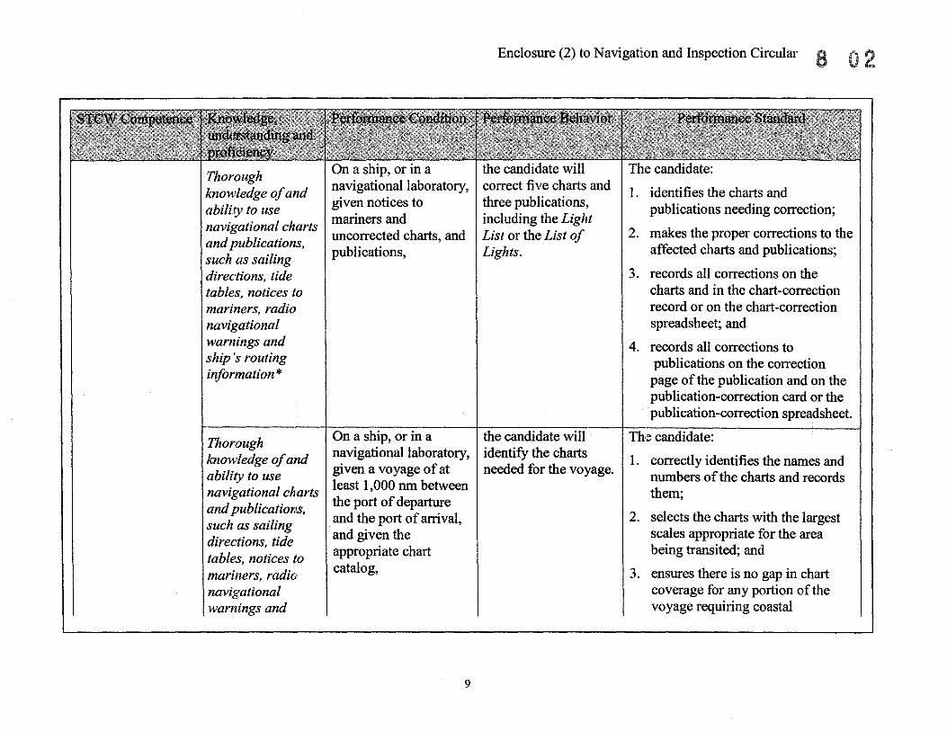
Thorough On a ship, or in a the candidate will The candidate:
knowledge of and navigational laboratory, correct five charts and 1. identifies the charts and
ability to use given notices to three publications, publications needing correction; navigational charts mariners and including the Light
and publications, uncorrected charts, and List or the List of 2. makes the proper corrections to the
such as sailing publications, Lights. affected charts and publications;
directions, tide 3. records all corrections on the tables, notices to charts and in the chart-correction mariners, radio record or on the chart-correction navigational spreadsheet; and warnings and 4. records all corrections to ship ':S routing publications on the correction information * page of the publication and on the
publication-correction card or the publication-correction spreadsheet.
Thorough On a ship, or in a the candidate will Thle candidate:
knowledge of and navigational laboratory, identify the charts 1. correctly identifies the names and
ability to use given a voyage of at needed for the voyage. numbers of the charts and records
navigational charts least 1,000 nm between them;
and publications, the port of departure
such as sailing and the port of arrival, 2. selects the charts with the largest
directions, tide and given the scales appropriate for the area
tables, notices to appropriate chart being transited; and
mariners, radio catalog, 3. ensures there is no gap in chart navigational coverage for any portion of the warnings and voyage requiring coastal
9

Enclosure (2) to Navigation and Inspection Circular
(cont'd) ship's routing information *
On a ship, a full- I the candidate willl:
Electronic' systems of position fixing anar navigation: It
Ability to determine the ship's position by use of electronic navigational alds*
GPS orDGPS
mission ship simulator, or in a navigation laboratory, when given three way-points consisting of a position of departure, a position of arrival, and one other way-point, with total distance of more than 1,000 nm,
On a ship underway, or on a full-mission ship simulator, or in a navigation laboratory, using a GPS or DGPS receiver which meets IMO perfonnance standards,
10
1. detennine the appropriate courses and distances between way-points; and
2. plot the intended courses on tht~ charts selected.
the candidate will initialize a GPS or DGPS receiver, determine the ship's position and evaluate the accuracy of that position.
(cont'd) navigation between departure and arrival at any port.
TIle candidate:
1. correctly calculates courses and distances between way-points;
2. ensures the route is the most direct; and
3. plots the courses on the appropriately scaled charts noting the ETA at each way-point, including the final way-point.
The candidate:
1. initializes the system; and
2. determines the accuracy of the position.

Ability to determine the ship ''s position by use o.f electronic navigational aids * LORAN
Bcbe., Sow:lders*
Ability to operate the equipment and
On a ship underway, or on a full-mission ship simulator, or in a navigation laboratory, using a GPS or OGPS receiver which meets IMO performance standards, when hearing "Man Overboard,"
On a ship underway, or on a full-mission ship simulator, or in a navigation laboratory, using a LORAN receiver which meets both national and international performance standards,
On a ship underway, using an echo sounder which meets IMO performance standards or a part-task trainer
11
Enclosure (2) to Navigation and Inspection Circular 8 0
the candidate will activate the man overboard/emerg<mcy position save fundi on.
the candidate will initialize a LORAN receiver, determine the ship's position, and evaluate the accuracy of that position.
the candidate will tum on, test and operate the echo sounder.
The candidate saves or records the ship's position within one minute of hearing "Man Overboard."
The candidate: 1. turns on the receiver; 2. selects the appropriate station pair; 3. reads and correctly plots the
lat/long or TOs within 0.1 nm of the assessor's solution on a chart with a scale of no more than 1 :150,000; and
4. evaluates the accuracy of the fix using the system and receiver limitations and TO crossing
The candidate:
1. turns the system on;
2. tests the echo sounder in accordance with manufacturer's

Enclosure (2) to Navigation and Inspection Circular
(cont'd) apply the information correctly *
C01l'l,pass -Mag.netic and Gyr,o*
Abillty to determine errors of the magnetic and gyro-compasses, using terrestrial means, and to allow for such errors *
(cont'd) that realistically simulates all the functions and controls of an echo sounder which meets IMO performance standards,
On a ship underway or on a full-mission ship simulator, using navigational or natural terrestrial ranges,
On a ship underway or
12
the candidate will take a visual bearing 0 f the range and determine gyro-compass error.
I the candidate will
I
(cont'd) recommendations;
3. notes the correct UTC on the echo sounder paper (if fitted);
4. ensures the scale selected is the lowest appropriate for the vessel's draft and the depth of water of the area of transit; and
5. adjusts the sensitivity to obtain proper depth reading on the display and correct trace on the paper (if fitted).
The candidate:
1. compares the visual bearing to the charted bearing;
2. determines the compass error and properly labels it; and
3. determines the gyro-compass error ±O.5° of the assessor's solution.
The candidate: 11. compares the magnetic heading to

Enclosure (2) to Navigation and Inspection Circular
(cont'd) on a full- (cont'd) detennine the (cont'd) the corrected gyro heading mission ship simulator, magnetic compass (corrected for a known gyro error); with both a magnetic error. and and gyro-compass, 2. detennines the magnetic compass
error and properly labels it; 3. detennines the magnetic compass
error ±O.5° of the assessor's solution; and
4. correctly records it in the compass record book and the
On a ship underway or the candidate will note The candidate: on a full-mission ship the vessel's magnc~tic- 1. compares the magnetic heading to simulator, using compass heading the charted range bearing; navigational or natural while aligned on the 2. detennines the magnetic compass terrestrial ranges, using range and detennine error and properly labels it; only a magnetic magnetic compass 3. detennines variation from the compass, and a chart deviation. chart; with variation, 4. detennines magnetic compass
deviation ±O.5° of the assessor's solution; and
5. correctly records it in the compass record book and the ship's log.
On a ship underway or the candidate will The candidate correctly applies on a full-mission ship correctly apply thc~ compass error to the magnetic course simulator, and given a compass error to the and his or her solution is ± 1 ° of the deviation table, course by magnetiic assessor's solution.
13

Enclosure (2) to Navigation and Inspection Circular 8
On a ship underway or on a full-mission ship simulator, or in a navigational laboratory, and given a deviation table, on a chart with a scale of no more than 1:150,000,
Ability to On a ship underway, determine errors of an~ using a standard the magnetic and azImuth circle, gyro-compasses, using celestial means, and to allow for such errors * Azimuth of the sun
Note 1
14
(cont'd) compass to make good the intended true course.
the candidate willI correctly apply the compass error to the bearings by magnetic compass of at least two charted objects and plot them on the chart in use.
The candidate:
1" correctly applies compass error to the magnetic bearings; and
2.. determines the objects' position ±0.5 nm of the assessor's solution.
the candidate will read I The candidate: the gyro-compass bearing of the SUln and determine gyrocompass error.
1. reads the azimuth of the sun when the repeater is level;
2. notes the time of the reading;
3. determines the true azimuth of the sun for the time of the reading;
4. compares the gyro-compass azimuth to the true azimuth and determines the gyro error; and
5. determines gyro-compass error ±0.5° of the assessor's solution.

Enclosure (2) to Navigation and Inspection Circular 8
steering On a ship underway or the candidate will The candidate: control on a full-mission ship conduct the pre- 1. turns on the steering control systems * simulator, departure test of the system; Adjustment of vessel's steering gear.
controls for 2. aligns the steering gyro-repeater
optimum Note 2 with the master gyro-compass;
performance * 3. tests the controls for switching pumps and motors between the port and starboard steering systems after the required warm-up period; and
4. tests both the port and starboard steering systems as follows:
a. when the control is switched to hand steering, the rudder is tested throughout its full range of motion; and
b. when the control is switched to non follow-up, the rudder is tested throughout its full range of motion.
On a ship underway or the candidate will set I The candidate sets :
15

Enclosure (2) to Navigation and Inspection Circular 8
Met490rolog¥,*
Ability to use and interpret information obtained from on-boa~d
meteorological instruments. *
(cont'd) on a fullmission ship simulator, while in auto-pilot,
On a ship underway or in a laboratory,
On a ship underway or in a laboratory, while
16
(cont'd) the ruddt::r and weather controls that are most suitable for the weather and sea conditions.
the candidate will determine the barometric pressure in millibars, or in inches or millimeters of mercury.
the candidate will determine true wind
(cont'd)
1. the weather control in accordance with the manufacturer's recommendations for the prevailing sea conditions;
2. the rudder control in accordance with the manufacturer's recommendations for the prevailing sea conditions for the area transited or simulated; and
3. the rate of tum control (if fitted) in accordance with the standing orders.
The candidate:
1. reads the barometer read and applies the appropriate corrections; and
2. determines the barometric pressure within 0.5 millibar, .02 inch or 0.4 millimeter of the assessor's corrected reading.
Th~e candidate converts the apparent wind speed and direction to true wind

Maintain a safe navigational watch.
Wa tchkeepi;llg*
Thorough knowledge of the content, application and intent of the International Regulations for Preventing Collisions at Sea *
(cont'd) using an anemometer,
On a ship underway or in a laboratory, while using the surface, upper air and sea state analysis weather maps,
At night, on a ship underway, on a fullmission ship simulator, or using approved laboratory equipment,
In daylight, on a ship underway, on a fullmission ship simulator, or using approved
17
Enclosure (2) to Navigatilon and Inspection Circular a
(cont'd) speed and direction.
the candidate will determine the weather to be encountered during the next 24-hour period.
the candidate will identify vessels through observation of their light configurations.
the candidate will identify vessels through observation of
(cont'd) speed and direction within one point for direction and five knots for speed of the assessor's solution.
The candidate determines expected wind, sea, and weather conditions (types and amount of cloud cover, rain, and fog) based on standard me:teorological principles and they agree with the assessor's determinations, based on the movement of the systems and fronts.
Thle candidate correctly identifies the situation or occupation of 18 of 20 vessels that have different light configurations.
Th~l candidate correctly identifies the situation or occupation of 18 of 20 vessels that are displaying different required shapes.

Enclosure (2) to Navigation and Inspection Circular 8
( cont' d) laboratory equipment,
In restricted visibility, on a ship underway, on a full-mission ship simulator, or using approved laboratory equipment,
On a ship underway, on a full-mission ship simulator, or using approved laboratory equipment, while using a gyro-compass repeater and an azimuth circle, bearing circle, alidade, or other device for taking bearings, and a marine radar or ARPA (which meet IMO performance standards) set on the 12-mile scale and the targets more than 8 nm
18
( cont' d) their required shapes.
the candidate will identify vessels by hearing their required sound signals.
the candidate will determine if risk of collision exists with approaching meeting, crossing and overtaking vessels.
The candidate correctly identifies the situation or occupation of 9 of 10 vessels sounding different required sOlmd signals.
The candidate: 1. takes two visual bearings of an
approaching vessel using an azimuth circle, bearing circle, or alidade to determine if the bearing to the approaching vessels is appreciably changing, and each observation is within ± 2° of the assessor's solution; and
2. takes two electronic bearings of an approaching vessel on a radar or an ARPA to determine if the bearing to the approaching vessels is appreciably changing and each observation is within ± 2° of the assessor's solution.

(cont'd) away,
On a ship underway, on a full-mission ship simulator, or using approved laboratory equipment, when risk of collision with an approaching meeting vessel exists in good visibility in the open ocean,
On a ship underway, on a full-mission ship simulator, or using approved laboratory equipment, when risk of collision with an approaching crossing vessel (from the candidate's starboard side at a relative
of between 30
19
Enclosure (2) to Navigation and Inspection Circular 8 2
the candidate will apply the rules of the road correctly and maneuver the vessel to avoid the collision, if required.
the candidate will apply the rules of the road correctly and maneuver the vessel to avoid the collision, if required.
The candidate:
1. determines the aspect of the approaching vessel;
2. identifies the situation as a meeting situation;
3. takes positive action in ample time in accordance with the steering and sailing rules to achieve a CPA of at least 3 nm; and
4. makes speed or course changes large enough to be readily apparent to another vessel observing visually or by radar.
Thl~ candidate:
1. determines the aspect of the approaching vessel;
2. identifies the situation as a crossing situation;
3. takes positive action in ample time in accordance with the steering and sailing rules to achieve a CPA of at least 3 nm; and

Enclosure (2) to Navigation and Inspection Circular
(cont'd) degrees and 112.5 degrees) exists in good visibility in the open ocean,
On a ship underway, on a full-mission ship simulator, or using approved laboratory equipment, when risk of collision with an approaching overtaking vessel exists in good visibility in the open ocean,
20
the candidate will apply the rules of the road correctly and maneuver the vessel to avoid the collision, if required.
(cont'd)
4. makes speed or course changes large enough to be readily apparent to another vessel observing visually or by radar.
The candidate:
1. determines the aspect of the approaching vessel;
2. identifies the situation as an overtaking situation;
3. attempts to call the overtaking vessel on the VHF;
4. sounds the danger signal, if required by the rules;
5. takes positive action in ample time in accordance with Rule 17 of the steering and sailing rules to achieve a CPA of at least 1 nm; and
6. makes speed or course changes large enough to be readily apparent to another vessel observing visually or by radar.

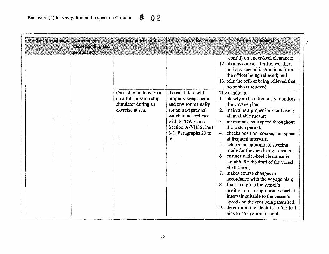
Thorough knowledge of the principles to be observed in keeping a safe watch *
On a ship undelWay or on a full-mission ship simulator during an exercise at sea,
21
Enclosure (2) to Navigation and Inspection Circular
the candidate will properly relieve the watch in accordance with STCW Code Section A-VnV2, Part 3-1, Paragraphs 21 and 22.
The candidate: 1. reads the standing orders and night
orders; 2. reads the vessel's position, course,
and speed from the GPS or DGPS receiver and compares them to the DR position and track;
3. compares the position of the next charted way-point to the GPS or DGPS way-point and the route print out;
4. verifies the identity of critical aids to navigation in sight;
5. detennines tides and currents as necessary;
6. detennines visibility and weather; 7. checks and properly tunes the
radar and/or ARPA; 8. checks all targets displayed on the
radar and/or ARPA; 9. checks heading by magnetic and
gyro-compass; 10. detennines the navigational
hazards likely to be encountered during the watch;
11. detennines the possible effects of list, trim, water density, and squat
Enclosure (2) to Navigation and Inspection Circular 8
On a ship underway or on a full-mission ship simulator during an exercise at sea,
22
the candidate will properly keep a safe and environmentally sound navigational watch in accordance with STCW Codc;~ Section A-VIIII2, Part 3-1, Paragraphs 23 to 50.
(cont'd) on under-keel clearance; 12. obtains courses, traffic, weather,
and any special instructions from the officer being relieved; and
13. tells the officer being relieved that he or she is relieved.
The candidate: 1. closely and continuously monitors
the voyage plan; 2. maintains a proper look-out using
all available means; 3. maintains a safe speed throughout
the watch period; 4. checks position, course, and speed
at frequent intervals; 5. selects the appropriate steering
mode for the area being transited; 6. ensures under-keel clearance is
suitable for the draft: of the vessel at all times;
7. makes course changes in accordance with the voyage plan;
8. fixes and plots the vessel's position on an appropriate chart at intervals suitable to the vessel's speed and the area being transited;
9. determines the identities of critical aids to navigation in sight;
)"

23
Enclosure (2) to Navigation and Inspection Circular 8
(cont'd) 10. uses more than one method,
including electronic and other navigational equipment, external fixed aids, geographic reference points, and hydrographic contours, to fix the vessel's position and to check the accuracy of fixes;
11 .. checks radio equipment frequently to verify it is functioning properly;
12 .. determines the risk or danger of collision with each approaching vessel and takes early and substantial action in accordance with the COLREGS to avoid collisions;
13. executes rudder and engine orders as ordered;
14. verifies the validity of the gyro input to all navigation equipment;
15. determines gyrocompass error by any available means and properly logs it;
16. correctly applies magnetic variation and compass deviation to courses and bearings;
17. determines that the person steering the vessel is competent to do so;

Enclosure (2) to Navigation and Inspection Circular
On a ship underway or on a full-mission ship simulator during an exercise at sea,
24
the candidate will notify the master as instructed, and when in doubt of other vessels' intentions, or in any circumstances that affect the routine navigation of the vessel in accordance
(cont'd) 18. determines tide and current
conditions for the watch period in coastal or tidal waters;
19. properly determines set and drift and applies them to allow for set and drift;
20. correctly and timely records and reports the weather conditions near the ship as required;
21. checks running lights throughout the watch period;
22. notifies the master as directed by all master's or standing orders;
23. makes all required log entries; and 24. uses all relevant navigation
information to identify protected marine habitats, areas, and sanctuaries.
The candidate notifies the master immediately when any of the following occur: 1. the vessel encounters or expects to
encounter restricted visibility; 2. concern is raised by vessel traffic
density or the movements of other ships;
3. maintaining course is difficult;

On a ship at anchor or on a full-mission ship
25
Enclosure (2) to Navigation and Inspection Circular
(cont'd) with STeW Code Section AVIII12, Part 3-1, Paragraph 40.
the candidate will properly keep a safe
(cont'd) 4. there is a failure to sight land or a
navigational mark, or to obtain soundings when expected;
5. aids to navigation are not in position or are displaying incorrect characteristics;
6. land or a navigational mark is unexpectedly sighted, or soundings obtained change unexpectedly;
7. failure of the engines or control systems, steering, or any essential navigational equipment, or sounding of alarms or indicators for these systems;
8. failure of any radio equipment; 9. concerns arise in heavy weather
about damage to the vessel or its cargo;
10. notice of any hazard to navigation that poses a threat to the vessel;
Ill. any doubt about the ship's safety or other emergency arises; or
12. any changes are made to the voyage plan.
The candidate: 1. determines and plots the ship's

Enclosure (2) to Navigation and Inspection Circular
(cont'd) simulator (cont'd) anchor watch (cont'd) position; during an exercise at in accordance with 2. frequently checks the ship's anchor with wind and STCW Code Section position by visual and radar seas building, A-VIIII2, Part 3-1, bearings and radar ranges from the
Paragraph 51. same charted objects; 3. establishes the GPS or DGPS
anchor alann; 4. maintains a proper lookout; 5. ensures periodic inspections are
made; 6. posts a rating at the anchor to carry
out orders with respect to the anchor;
7. monitors weather, tides, and sea state;
8. notifies the master immediately when the weather changes, visibility becomes restricted, or the anchor starts to drag;
9. places engines on standby and ensures they are ready for immediate use where appropriate; and
10. properly displays all required lights and shapes and sounds
sound' ~ .. On a ship at sea or on a the candidate will The candidate:
full-mission ship recognize the 1. determines that there is restricted
26

Enclosure (2) to Navigation and Inspection Circular 8 0
(cont'd) simulator (cont'd) restricted (cont'd) visibility; during an exercise at visibility and tak(~ the 2. notifies the master; sea, when visibility appropriate action to 3. switches the steering to hand becomes restricted navigate in restri(~ted steering; while underway, visibility in 4. posts a proper lookout and turns
accordance with 1he the running lights on; COLREGS and in 5. adjusts the vessel's speed to reflect accordance with the change of circumstances in Section STCW Code accordance with Rule 6; A-VIIII2, Part 3-1, 6. commences the sounding of Paragraph 45. required signals;
7. sets the radar and/or ARPA on the appropriate scale to scan at long range for the presence of other vessels; and
8. plots approaching targets on the radar and/or ARPA, if fitted, and uses fixes to obtain early warning of risk of collision and to determine the speed and direction of relative motion.
On a ship at sea or on a the candidate will tum I The candidate: full-mission ship the watch over. 1. plots a DR position on the chart in simulator during an use for the end of the watch; exercise at sea, 2. determines the ship's position and
plots it by all means appropriate to the area being transited;
3. reads the required weather data
27

Enclosure (2) to Navigation and Inspection Circular
28
(cont'd) and records it in the deck log;
4. compares and records the heading of the gyro and magnetic;
5. checks the movement of all vessel traffic by both visual and electronic means immediately before being relieved;
6. relays the vessel's course and speed, posting of special lookouts, steering mode in use, and weather and visibility to the relieving officer;
7. relays any special instructions regarding occurrences during the past watch or which are expected during the next watch;
8. reports all relevant information concerning vessels in sight or on the radar and/or ARPA to the relieving officer;
9. notifies the master if there is any doubt that the relieving officer is competent to perform his or her duties;
10. does not relinquish the watch during a maneuver or other action being taken to avoid a hazard to

Thorough knowledge of effective bridge teamwork procedures *
On a ship, a fullmission ship simulator, or in a navigation laboratory, when given a port of departure and a port of arrival more than 1,000 nm apart,
29
Enclosure (2) to Navigation and Inspection Circular 8 0
the candidate will plan a safe and environmentally sound voyage and review the voyage plan with the master and deck officers.
(cont'd) navigation; and 11. does not relinquish the watch or
leave the bridge until he/she has been informed by the relieving officer that he or she is ready to take the watch.
Appraisal (The candidate's plan takes into account paragraph 2 of the annex to IMO Assembly Resolution A.893(21»: 1. the condition of the vessel, and its
stability, equipment, operational limitations, draft, and maneuvering characteristics;
2. any special characteristics of the cargo and its stowage;
3. crew members' competency and rest status;
4. the status of all ship's certificates and documents;
5. up-to-date charts of proper scale, and the latest notices to mariners and radio navigational warnings;
6. up-to-date coast pilots, sailing directions, and other information sources appropriate for the voyage;
7. relevant routing guides; 8. up-to-date tide and current tables

Enclosure (2) to Navigation and Inspection Circular
30
(cont'd) and atlases; 9. weatherinfonnation; 10. weather routing services; 11. ship-reporting systems, VTS and
environmental protection measures;
12. vessel traffic density for the route; 13. pilotage requirements and
infonnation exchange; and 14. port infonnation, including
emergency response capability.
Planning (The candidate's plan contains the following in accordance with paragraph 3 of the annex to IMO Assembly Resolution A.893(21»:
15 .. courses plotted on the appropriately scaled charts noting the ETA at each way-point, including the final way-point;
16 .. courses and distances between way-points are correctly calculated and indicated on the charts;
17. the most direct route that avoids all hazards to navigation by the margin of safety of 3 nm;
18. the areas of all required speed

On a ship, or on a fullmission ship simulator, when given a voyage plan,
31
Enclosure (2) to Navigation and Inspection Circular 8
the candidate will execute the voyagt~ plan.
(cont'd) changes; 19. the minimum under-keel
clearances in critical areas; 20. positions requiring a change of
machinery status; 21" way-point of all course changes; 22 .. the methods and frequency of
position fixing, including areas requiring the highest accuracy;
23. the positions and radio hailing frequencies or channels where port authorities, pilots and VTS services must be notified are noted on the relevant chart;
24. the state of the tide and currents at the port of departure for the times of departure and transit;
25. contingency plan for alternative actions in cases of emergency;
26. the review of the voyage plan with the Master and deck officers; and
27. all relevant navigation information is used to identify protected marine
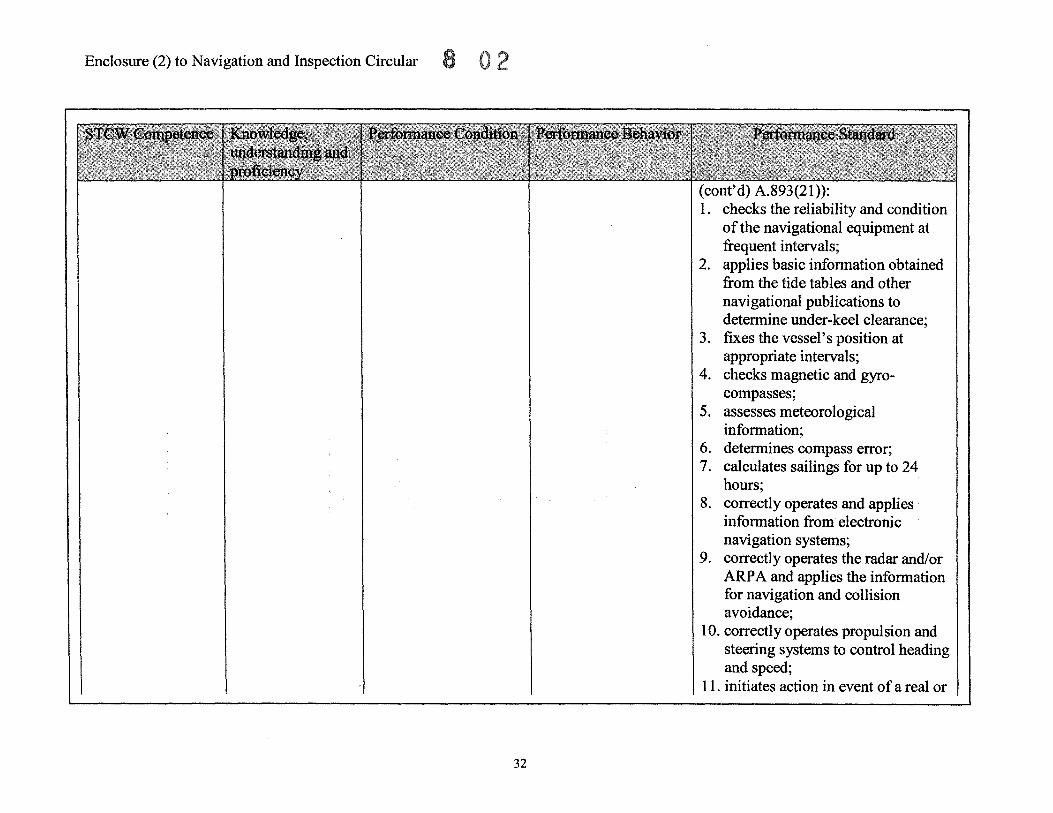
areas and sanctuaries. Ex,~cute a voyage plan (The candidate, in accordance with paragraphs 4 and 5 of the annex to IMO Assembly Resolution
Enclosure (2) to Navigation and Inspection Circular
32
(cont'd) A.893(2I»: 1. checks the reliability and condition
of the navigational equipment at frequent intervals;
2. applies basic information obtained from the tide tables and other navigational publications to determine under-keel clearance;
3. fixes the vessel's position at appropriate intervals;
4. checks magnetic and gyrocompasses;
5. assesses meteorological information;
6. determines compass error; 7. calculates sailings for up to 24
hours; 8. correctly operates and applies
information from electronic navigation systems;
9. correctly operates the radar and/or ARPA and applies the information for navigation and collision avoidance;
10. correctly operates propulsion and steering systems to control heading and speed;
11. initiates action in event of a real or

Thorough knowledge of effective bridge teamwork procedures * Watch Augmentation
Thorough knowledge of effective bridge teamwork procedures *
BRM Recognition of watch condition
On a ship at sea or on a full-mission ship simulator during an exercise at sea, when help is needed because of restricted visibility, vessel traffic or safety of navigation,
BRM Condition III: the ship is navigating near land, shoals or with increased traffic density and/or
33
Enclosure (2) to Navigation and Inspection Circular
the candidate will recognize the need for additional personnel on the bridge and notify the master.
The candidate will identify all vessels (targets) posing a risk or danger of collision, and provide appropriate
(cont'd) simulated equipment malfunction or failure of major items of equipment;
12. correctly conducts radiocommunications;
13. monitors and correctly operates safety and alarm systems; and
14. closely and continuously monitors the
Th(~ candidate notifies the master immediately if: 1. the vessel encounters or expects to
encounter restricted visibility; 2. there is cause for concern because
of vessel traffic density or the movements of other ship;
3. the vessel will transit restricted waters with vessel traffic; or
4. he or she is fatigued to the point that decision making is affected.
The candidate: 1. determines the risk and danger of
loollision of all approaching vessels within 6 minutes;
2. ilmmediately notifies the conning officer of the relative position of

Enclosure (2) to Navigation and Inspection Circular
(cont'd) restricted ( cont' d) infonnation (cont'd) the threatening vessel, its visibility. This and recommendations CPA and TCPA; condition requires on vessel traffic and 3. recommends course changes in concentrated navigation any other situation or accordance with the COLREGS to and observation of condition that may remove the risk of collision and traffic for collision affect the safe prevent close-quarters situations avoidance (entering or navigation of the from developing; leaving port). vessel to the conning 4. ensures all recommended course or
officer. speed changes result in increasing On a ship at sea or on a the CPA of approaching vessels full-mission simulator identified as posing a risk or during an exercise at danger of collision; sea, and with a bridge 5. ensures all recommended course team in place for changes provide sufficient sea navigating in congested room and bottom clearance for the near-coastal waters area being transited; with or without reduced 6. ensures communications are clear, visibility, and assigned immediate, reliable, and relevant; to monitor vessel's and traffic, using a radar or 7. ensures non-essential activities are ARPA which meets all avoided. national and international perfonnance re uirements, BRM the candidate will Th(l candidate: Condition III detennine and plot the 1. uses visual and electronic means to
vessel's position by detennine the ship's position,
34

Enclosure (2) to Navigation and Inspection Circular 8 0
( cont' d) On a ship at (cont'd) electronic and (cont'd) including GPS or DGPS, sea or on a full-mission visual means, LORAN, radar, ARPA, ECDIS (if ship simulator during communicate as fitted), and Echo Sounder; an exercise at sea, and required on the VHF, 2.. plots the vessel's position in with a bridge team in and carry out all accordance with tolerances stated place for navigating in engine commands, previously at regular intervals congested near-coastal ensure that all rudder appropriate to the vessel's speed waters with or without commands are and the area being transited; reduced visibility, and properly carried out, 3" determines the correct courses to assigned to monitor and make all steer to maintain the ship on the vessel's position, appropriate log book intended track and recommends communicate on the entries. them to the conning officer; VHF, and all other 4. answers all VHF calls to own ship bridge duties, using an and makes calls to other ships in IMO compliant ARPA, the area and port authorities as aGPSorDGPS required; receiver and all the 5. monitors the helmsman to ensure bridge equipment all rudder commands are carried identified in the out; standard, 6. ensures communication is clear,
immediate, reliable, and relevant; 7. ensures non-essential activities are
avoided; and 8. makes all required entries in the
vessel's
Thorough IBRM the candidate will I The ~~d;date: knowledge of monitor his or her
Condition II or III vessel' s movem~ent, 11. detects the misinformation or
35

Enclosure (2) to Navigation and Inspection Circular
(cont'd) effective bridge teamwork procedures * Error trapping
(cont'd) Condition II: The ship is underway offshore in restricted visibility, with increased traffic, land or shoals affecting navigation (coastwise navigation).
On a ship at sea or on a full-mission ship simulator during an exercise at sea, and with a bridge team in place for navigating in congested near-coastal waters with or without reduced visibility, and assigned duties as an officer in a bridge team, when one ofthe following occur: 1. an incorrect rudder
order is given; 2. a rudder or engine
command is not given at the proper time to maintain the
36
( cont' d) recognize erroneously-stated information about the vessel's position or a target vessel's movement, and notifY the conning offic~er of specific questions regarding the vessel's situation.
( cont' d) command error; and
2. notifies the officer within 30 seconds of the occurrence of the error (for helm orders, the candidate detects the error and issues a corrective order within 5 seconds).

Thorough knowledge of effective bridge, teamwork procedures * Prioritization
(cont'd) intended track;
3. a navigational aid is misidentified;
4. the vessel's position is improperly fixed; or
5. a target vessel's movements are
BRM Condition II or III
On a full-mission ship simulator during an exercise at sea, and with a bridge team in place, while navigating in congested nearcoastal waters in good visibility, and assigned duties as an officer in a bridge team, and given the following: 1. a vessel on own
ship's starboard bow changes course
37
Enclosure (2) to Navigation and Inspection Circular 8
the candidate will determine the appropriate action to take.
Thje candidate: 1. assesses the situation; 2. determines in which priority action
must be taken for the safety of the vessel;
3. recommends that the engines be slowed or stopped in sufficient time to avoid the collision with the vessel on the starboard bow; and
4. after the danger of collision is over, acknowledges the distress call.
Enclosure (2) to Navigation and Inspection CircularS
( cont' d) and creates a risk of collision;
2. there is insufficient water depth for own ship to turn to starboard;
3. the diesel engines are using heavy fuel;
4. a vessel ahead is on a reciprocal course 1.5 run away with a CPA of 0.5 run on the port side; and
5. theGMDSS distress alarnn
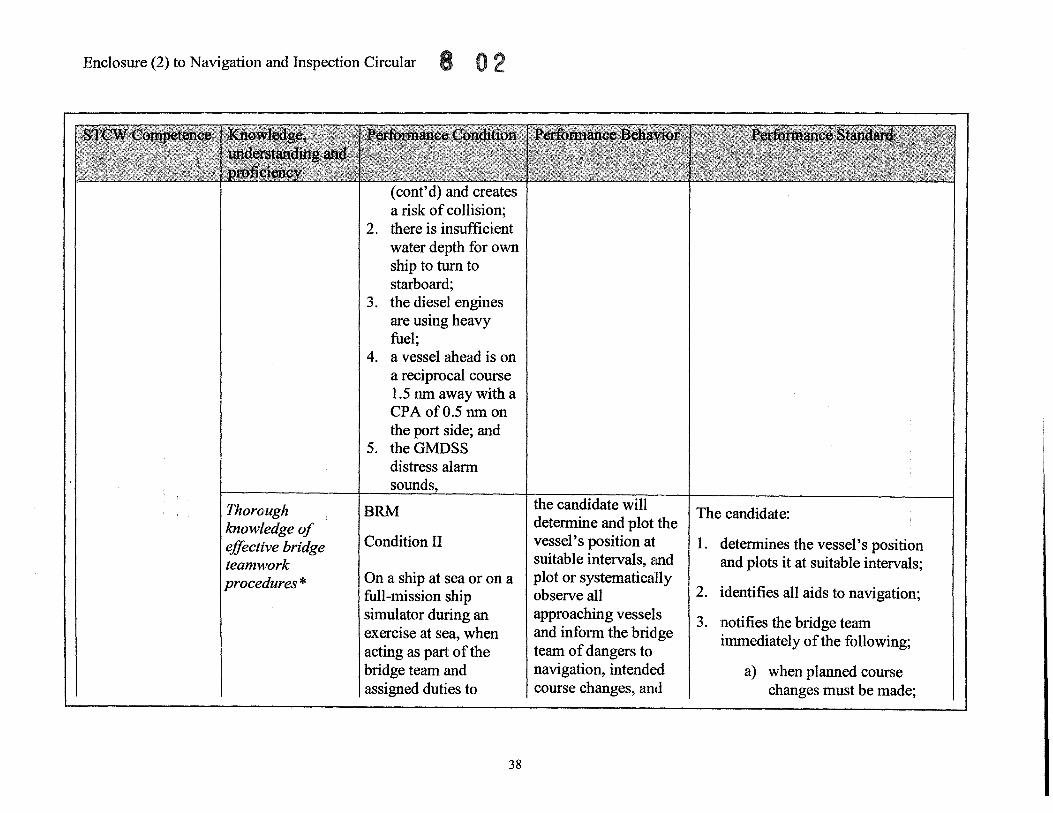
Thorough BRM the candidate will I The candidate: knowledge of deternnine and plot the
effective bridge Condition II vessel's position at 1. deternnines the vessel's position teamwork suitable intervals, and and plots it at suitable intervals; procedures * On a ship at sea or on a plot or systematically
2. identifies all aids to navigation; full-mission ship observe all simulator during an approaching vessels 3. notifies the bridge team exercise at sea, when and infornn the bridge
immediately of the following; acting as part of the team of dangers to bridge team and navigation, intended a) when planned course assigned duties to course changes, and changes must be made;
38

(cont'd) monitor the vessel's navigation and determine the risk or danger of collision with all vessels underway in open sea, using an ARPA meeting all national and international performance requirements, a GPS or DGPS receiver and all the bridge equipment identified in the standard,
39
Enclosure (2) to Navigation and Inspection Circular 8
(cont'd) vessels which pose a risk or danger of collision.
(cont'd)
b) effects of tides or currents are setting the vessel off its intended course; or
c) there is any doubt about the vessel's position.
4" determines by visual and radar/ ARPA bearings that risk and danger of collision exists with approaching vessels in the vicinity; and
5. notifies the bridge team of the following:
a) danger or risk of collision exists with any approaching vessel;
b) recommended course change to avoid the risk or danger of collision; and
c) recommended speed change to avoid the risk or danger of collision if the engines are available for
Enclosure (2) to Navigation and Inspection Circular
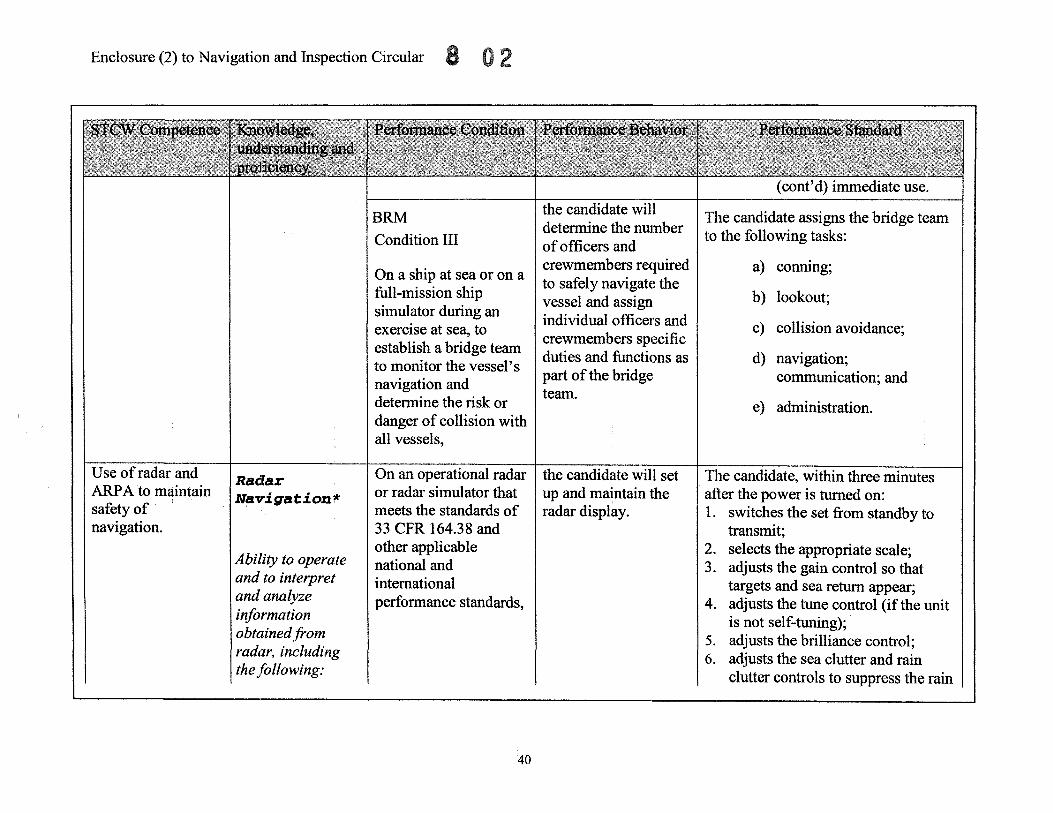
Use of radar and ARPA to maintain safety of navigation.
Radar NalrigatioJl '"
Ability to operate and to interpret and analyze information obtained from radar, including the following:
BRM
Condition III
On a ship at sea or on a full-mission ship simulator during an exercise at sea, to establish a bridge team to monitor the vessel's navigation and determine the risk or danger of collision with all vessels,
On an operational radar or radar simulator that meets the standards of 33 CFR 164.38 and other applicable national and international performance standards,
40
the candidate will determine the number of officers and crewmembers required to safely navigat(~ the vessel and assign individual officers and crewmembers sp1ecific duties and functions as part of the bridge: team.
the candidate will set up and maintain 1the radar display.
The candidate assigns the bridge team to the following tasks:
a) conning;
b) lookout;
c) collision avoidance;
d) navigation; communication; and
e) administration.
The candidate, within three minutes after the power is turned on: 1. switches the set from standby to
transmit; 2. selects the appropriate scale; 3. adjusts the gain control so that
targets and sea return appear; 4. adjusts the tune control (if the unit
is not self-tuning); 5. adjusts the brilliance control; 6. adjusts the sea clutter and rain
clutter controls to suppress the rain

(cont'd) Performance, including,
.2 setting up and maintaining displays *
Radar. Navigacioni ,..
Ability to operate and to interpret and analyze information obtained from radar, including
On an operational radar or radar simulator that meets the standards of 33 CFR 164.38 and other applicable national and international performance standards,
On an operational radar or radar simulator that meets the standards of 33 CFR 164.38 and other applicable national and international performance standards,
41
Enclosure (2) to Navigation and Inspection Circular 8
the candidate will switch the display from north-up stabilized relative: motion to true motion to head-up, and state how to recognize the mode displayed.
the candidate will identify false echoes, sea return, a racon and SART.
(cont'd) and sea clutter without losing targets; and
7. selects the north-up stabilized relative motion .
Within 15 seconds, the candidate: 1. switches the display from north-up
stabilized relative motion to true motion;
2. switches the display from true motion to head-up; and
3. points to the location on the display of the information that indicates the mode
The candidate recognizes and correctly id€mtifies: 1. the false echoes:
a. indirect or false echoes; b. side-lobe effects; c. multiple echoes; d. second-trace echoes; e. electronic interference; and f. spoking;
2. sea return; 3. racons; and

Enclosure (2) to Navigation and Inspection Circular
Pe~formance, including,
.3 detection of misrepresentation of information,
echoes, sea return, etc., racons and SARTs*
Radar Na'vigation ,..
Use, including:
.1 range and bearing, course, and speed ofother ships; time and distance of crossing, meeting, and overtaking h· * s zps.
On an operational radar or radar simulator that meets the standards of 33 CFR 164.38 and other applicable national and international performance standards, with land and aids to navigation in range,
42
the candidate will determine the range and bearing to an object.
(cont'd) 4" SARTS.
1. The candidate determines the range and bearing to an object selected by the assessor within 30 seconds.
2. The candidate's: a. range is within ± 0.1 nm of the assessor's solution or ± 1 % of the range scale in use; and
b. bearing is within ± 10 of the assessor's solution.

Radc!l.r Nav;igation ""
2 identification of critical echoes. *
Rad~lr
Nav:£gation'~
.2 identificatim,'l of critical echoes; detecting cours~~ and speed chanJ?es of other ships; effectlve changes of own ship's course and speed*
On an operational radar or radar simulator that meets the standards of 33 CFR 164.38 and other applicable national and international performance standards, set on the 12-mile scale, with at least 5 vessels on the display,
On an operational radar or radar simulator that meets the standards of 33 CFR 164.38 and other applicable national and international performance standards, set on the 12-mile scale,
43
Enclosure (2) to Navigation and Inspection Circular 8
the candidate will determine if risk of collision or danger of collision exists with all approaching vessels.
the candidate will determine: 1. the range and
bearing to 3 other ships (meeting, crossing, and overtaking);
2. the DRM and SRM of all other ships; and
3. the CPA and TCPAofall vessels.
The candidate identifies: 1. all approaching vessels whose
bearings do not change appreciably; and
2. all vessels that have a CPA ofless than 3 nm.
The candidate makes all determinations within 8 minutes of determining the initial range and bearing of each vessel.
Th(~ candidate completes: 1. the range and bearing solution
within 30 seconds and they are within the previously stated tolerances;
2. the DRM solution within 6 minutes and it is ± 5° of the assessor's solution;
3. the SRM solution within 7 minutes of initial range and bearing and it is ± 2 knot of the assessor's solution;
4. the CPA solution within 7 minutes and it is ± 0.5 nm of the assessor's solution; and
5. the TCP A solution within 8

Enclosure (2) to Navigation and Inspection Circular
Radar Na'vigation*
.2 .identification of critical echoes; detecting course and speed changes of other ships; effective changes of own ship's
On an operational radar or radar simulator that meets the standards of 33 CFR 164.38 and other applicable national and international performance standards, set on the 12-mile scale, in the stabilized relative motion northup mode, and with meeting or crossing targets,
On an operational radar or radar simulator that meets the standards of 33 CFR 164.38 and other applicable national and international performance standards, on the 12-mile scale in north-up stabilized
44
the candidate willl detect speed and course changes of other ships which result in a chang1e in the direction or s:peed of relative motion.
the candidate will control the target vessel's DRM by changing own ship's course in accordance with the COLREGS.
(cont'd) minutes and it is ± 3 minutes of the assessor's solution.
The candidate detects other ships' speed changes of at least 5 knots and/or course changes of at least 10° within 10 rotations of the sweep (30 seconds) from the time he or she hegins the systematic observation of the display.
1he candidate: 1. determines the new course to steer
to achieve a 2 nm CPA; 2. executes a tum to starboard; and 3. achieves a CPA of not less than 1.8
nm or more than 2.2 nm.

(cont'd) course (cont'd) relative motion and speed mode, with a ship on
the starboard bow with .3 application of a CPA of 0.5 nm, International Regulations for Preventing Collisions at Sea *
On an operational radar or radar simulator that meets the standards of 33 CFR 164.38 and other applicable national and international perfonnance standards, set on the 12-mile scale, in the north-up stabilized relative motion mode, with a vessel on the beam with a CPA ofless than 0.5 nm ahead,
Rad.ar I On an operational radar
Nav'i gat iOIL* or radar simulator that meets the standards of
• 4 plotting I 33 CFR 164.38 and
45
Enclosure (2) to Navigation and Inspection Circular 8 0
the candidate will control the target vessel's DRM by changing own ship's speed in accordance with the COLREGS.
the candidate will detennine the true course and speed of three target vessels .
The candidate: 1. determines the new speed to
achieve a 2 nm CPA; 2. executes a speed reduction; and 3. achieves a CPA of not less than 1.8
nm or more than 2.2 nm.
The candidate: 1. constructs a relative motion
triangle on either a reflection plotter, a maneuvering board or a

Enclosure (2) to Navigation and Inspection Circular
(cont'd) techniques and relative and true motion concepts *
(cont'd) other applicable national and international perfonnance standards, set on the 12-mile scale, in the relative motion north-up mode, using any graphically correct method,
On an operational radar or radar simulator that meets the standards of 33 CFR 164.38 and other applicable national and international performance standards, set on the 12.:.mile scale, in the true motion mode, using any graphically correct method,
46
the candidate will detennine the DRM, SRM, CPA and TCP A of three target vessels.
(cont'd) transfer plotting sheet; and 2. solves for the target vessel's true
course and speed within 8 minutes.
The candidate's true course solution is ± 5° and the true speed solution is within ± 5 knots of the assessor's solution.
The candidate: 1. constructs a relative motion
triangle on either a reflection plotter, a maneuvering board or a transfer plotting sheet;
2. obtains a DRM solution within 8 minutes and within± 5° of the assessor's solution;
3. obtains a SRM solution within 8 minutes of initial range and within ± 2 knots of the assessor's solution;
4. obtains a CPA solution within 7 minutes and within ± 0.5 nm of the assessor's solution; and
5. obtains a TCPA solution within 8 minutes and within ± 3 minutes of the assessor's solution.

Enclosure (2) to Navigation and Inspection Circular 8
Radar I On an operational radar the candidate willI use The candidate: or radar simulator that a parallel index line to 1" constructs a parallel index line
Na,rigatiolrl It I meets the standards of monitor and maintain through the edge of the known 33 CFR 164.38 and the vessel on tra(~k. hazard to navigation or land mass; other applicable and
.5 parallel I national and 2 .. monitors the vessel's movement by indexing * international referring to the relative position of
performance standards, the PI in relation to the land mass set on the 12-mile or other fixed radar conspicuous scale, in relative target. motion north-up mode, with aids to navigation The vessel must not drift more than and a coastline 10 % of the set distance toward the displayed on the known hazard or land mass. display,
Principle types of On an operational the candidate will set I VVithin three minutes, the candidate:
ARPA, their ARP A that meets the up and maintain the
display standards of 33 CFR ARP A display. 1. turns the power on;
characteristics, 164.38 (or an ARPA 2. initializes performance monitor;
pe~formance simulator that meets 3. notes error messages;
standards and the applicable national and 4. switches from standby to on;
dangers of over- international 5. selects the appropriate scale;
reliance on ARPA. performance standards 6. adjusts the gain control so that for ARPA), targets and sea return appear;
Ability to operate 7. adjusts the tune control (if the unit and to interpret is not self-tuning); and analyze 8. adjusts the brilliance control;
47

Enclosure (2) to Navigation and Inspection Circular 2
(cont'd) information obtained from ARPA, including:
.1 system pe~formance and accuracy, tracking capabilities and limitations, and processing delays
.2 use of operational warnings and system tests * No1te3
.3 methods of target acquisltion and their limitations *
Note 3
On an operational ARPA that meets the standards of 33 CFR 164.38 (or an ARPA simulator that meets applicable national and international performance standards
48
the candidate will acquire ten targets manually.
(cont'd) 9" adjusts the sea clutter and rain
clutter controls to suppress the rain and sea clutter without losing targets;
10. selects display north-up stabilized relative motion;
11. selects proper gyro course and speed input; and
12. selects sea-stabilized mode.
The candidate manually acquires 10 t:rrgets within 2 minutes.

.4 true and relative, vectors, graphic representation of target information and danger areas *
Note: 3
(cont'd) for ARPA), with at least 10 targets on the selected range,
On an operational ARPA that meets the standards of33 CFR 164.38 (or an ARPA simulator that meets applicable national and international performance standards for ARPA), with the ARPA on the 12-mile scale, and in automatic acquisition,
On an operational ARPA that meets the standards of33 CFR 164.38 (or an ARPA simulator that meets applicable national and international performance standards for ARPA), with the ARP A on the 12-mile
49
Enclosure (2) to Navigation and Inspection Circular
the candidate willi establish an exclusion area that suppresses the automatic acquisition of targets in that area.
the candidate will switch between true and relative vectors and change the length of the vectors from 6 minutes to 30 minutes.
The candidate establishes an exclusion arc~a within 2 minutes on the port or starboard side of the vessel that is either: 1. described by an arc of 90° on the
appropriate side of the vessel; or 2. described by a line parallel to the
vessel's track four nm from the vessel.
The candidate switches between true and relative vectors and changes the length of the vectors within 10 seconds.

Enclosure (2) to Navigation and Inspection Circular
(cont'd) scale,
On an operational ARPA that meets the standards of33 CFR 164.38 (or an ARPA simulator that meets applicable national and international performance standards for ARPA), with the ARPA on the 12-mile scale,
On an operational ARPA that meets the standards of33 CFR 164.38 (or an ARPA simulator that meets applicable national and international performance standards for ARPA),
On an operational ARPA that meets the standards of33 CFR 164.38 (or an ARPA
50
the candidate willl designate two acquired targets.
the candidate will cancel a single target.
the candidate wil1 demonstrate the ability to display a target's (cont'd) history.
The candidate designates: 1. two of the acquired targets for an
alphanumeric display of the target information; and
2. the designation is completed within 10 seconds for each target.
The candidate cancels a sing1e target within 5 seconds.
The candidate correctly: 1. operates the controls that display a
target's history; and 2. displays the target's history within

Enclosure (2) to Navigation and Inspection Circular
(cont'd) simulator that I (cont'd) history. meets applicable national and international performance standards for ARPA), on the 12-mile scale,
On an operational ARPA that meets the standards of33 CFR 164.38 (or an ARPA simulator that meets applicable national and international performance standards for ARPA), with the ARPA on the 12-mile scale,
On an operational ARPA that meets the standards of33 CFR 164.38 (or an ARPA simulator that meets applicable national and international performance standards
51
the candidate will establish the CPA and TCP A for dangerous targets.
the candidate will establish an alarm area with outer and inner guard rings.
(cont'd) 10 seconds.
TIle candidate determines the parameters for dangerous targets by: 1. entering a minimum CPA; and 2. entering a minimum TCP A.
TIle candidate completes data entry within 1 minute.
TIle candidate establishes an alarm area with an outer guard ring of 8 nm and an inner guard ring of 4nm within 2 minutes.

Enclosure (2) to Navigation and Inspection Circular
.5 deriving and analyzing information, critical echoes, exclusion areas and trial maneuvers *
Note 3
( cont' d) for ARP A), with the ARPA on the 12-mile scale,
On an operational ARPA that meets the standards of33 CFR 164.38 (or an ARPA simulator that meets applicable national and international performance standards for ARPA), with. the ARPA on the 12-mile scale, with at least ten targets within 12 nm of own ship,
On an operational ARPA that meets the standards of33 CFR 164.38 (or an ARPA simulator that meets applicable national and international performance standards for ARPA), with the
52
the candidate will demonstrate the trial maneuver function.
the candidate will switch the display from a north-up relative motion slea stabilized display to a true motion ground stabilized display.
The candidate: 1. accesses the trial maneuver mode; 2. enters course changes; 3. determines the course to steer to
avoid all targets by at least 2 nm, within 30 seconds;
4. enters speed changes; 5. determines the speed necessary to
avoid all targets by at least 2 nm, within 30 seconds; and
6. returns the display to real time.
The candidate completes the change within 10 seconds.

(cont'd) ARPA on the 12-mile scale,
On an operational ARPA that meets the standards of 33 CFR 164.38 (or an ARPA simulator that meets applicable national and international performance standards for ARPA), with the ARPA on the 12-mile scale,
On an operational ARPA that meets the standards of33 CFR 164.38 (or an ARPA simulator that meets applicable national and international performance standards for ARPA), with the
53
Enclosure (2) to Navigation and Inspection Circular
the candidate will! determine the range and bearing to an object.
the candidate will establish a nav line to monitor and maintain the vessel on track.
The candidate:
1. determines the range and bearing to an object selected by the assessor within 30 seconds by positioning the VRM on the edge of the object which is closest to the vessel and positioning the EBL through the object;
2. obtains a range within ± 0.1 nm of the assessor's solution or ± 1 % of the range scale in use; and
3. obtains a bearing within ± 10 of the assessor's solution.
TIle candidate: 1. constructs a nav line between the 2
nav marks and through the seaward edge of the known hazard to navigation or land mass;
2. positions the VRM at a distance named by the assessor from the edge of the nav line;
3. monitors the vessel's movement to

Enclosure (2) to Navigation and Inspection Circular
Maneuver the ship. Sb.ip ma,lleuvering and ba;lldling*
Maneuvering and procedures for the rescue O'f persO'n O'verbO'ard*
(cont'd) ARPA on the 12-mile scale, using 2 nav marks and one nav line,
On an operational ARPA that meets the standards of33 CFR 164.38 (or an ARPA simulator that meets applicable national and international performance standards for ARPA), on the 12-mile scale,
On a ship at sea or in a full-mission simulator, upon receiving notification of a ManOverboard (MOB),
54
the candidate will determine the set and drift of the vessel.
the candidate willi immediately initIate either a Williamson Tum or Anderson Tum (as appropriate for conditions), return the vessel to the MOB, and give the command to launch the rescue boat.
(cont'd) determine if the edge of the VRM moves inside the nav line; and
4. ensures that the VRM does not drift more than 10 % of the VRM distance inside the nav line.
Tne candidate: 1. ensures the display is sea
stabilized; 2. identifies, acquires, and designates
a stationary target; and 3.. reads the target's course and speed
as the set and drift within 3' minutes.
Tne candidate: 1. orders full rudder to the side of
MOB and places the engines on stand by (does not reduce RPMs);
2. simulates releasing the lighted buoy;
3., sounds MOB signal if other vessels are in sight;
4.. marks (if equipped) the ship's position on ARP AlGPS or DGPS;

Shj[p • I
malleUVer~J!lg I ancl
ha:lldling*
Basic Maneuvering
On a ship at sea or in a full-mission simulator,
On a ship at sea, or in a full-mission simulator, proceeding at a speed
55
Enclosure (2) to Navigation and Inspection Circular;. 0 2
the candidate will order turning the vessel left or right more than 45° from the original heading.
the candidate will execute an emergency stop.
(cont'd) 5. simulates a "Mayday" call on the
VHF notifying any vessels in vicinity of the MOB;
6. completes the recovery tum; 7. states that the rescue boat would be
prepared for launch, or scrambling nets rigged on correct side of the vessel; and
8. states that when on the reciprocal of the original course, the vessel will be slowed and stopped within .1 nm of the MOB to begin the recovery/search.
The candidate: 1. orders the tum left or right more
than 45° from the original heading by applying a minimum of 10° and a maximum of 20° of rudder;
2. reduces rudder as the ship approaches the new course; and
3. steadies on the new course without over-shooting the course by more than 10°.
The candidate, within the safe operating limits of the vessel's propulsion system, stops the vessel

Enclosure (2) to Navigation and Inspection Circular
(cont'd) of at least half ahead,
* Italics denote STeW proficiency from Table A-II1I of the STeW
Note 1 - For oceans route only Note 2 - Required for officer in charge of a navigation watch of vessels greater than 3,000 GT Note 3 - Not required for mariners serving exclusively on vessels not fitted with ARPA
56
(cont'd) using maximum astern thrust and rudder cycling without deviating from the original course by more than 20°.