Phase I Environmental Site Assessment Corridor Study Route ...
605
Phase I Environmental Site Assessment Corridor Study Route 1 Widening Project Dumfries, Prince William County, Virginia Region: NOVA District Task Number: E-FR022 VDOT Project Number: 0001-212-249 VDOT UPC: 90339 Prepared for Mr. Brutus Cooper Regional VDOT HAZMAT Manager Virginia Department of Transportation NOVA District Office 4975 Alliance Drive Fairfax, VA 22030 Prepared by EEE Consulting, Inc. 201 Church Street Blacksburg, Virginia 24060 August 2018 Prepared by: Joshua Hepler, PG, Environmental Scientist Reviewed by: Chris Lalli, Vice President
-
Upload
khangminh22 -
Category
Documents
-
view
0 -
download
0
Transcript of Phase I Environmental Site Assessment Corridor Study Route ...

Phase I Environmental Site AssessmentCorridor Study
Route 1 Widening ProjectDumfries, Prince William County, Virginia
Region: NOVA District Task Number: E-FR022VDOT Project Number: 0001-212-249VDOT UPC: 90339
Prepared forMr. Brutus CooperRegional VDOT HAZMAT ManagerVirginia Department of TransportationNOVA District Office4975 Alliance DriveFairfax, VA 22030
Prepared by EEE Consulting, Inc.201 Church StreetBlacksburg, Virginia 24060
August 2018
Prepared by: Joshua Hepler, PG, Environmental Scientist
Reviewed by: Chris Lalli, Vice President

3e
Table of Contents
Tables
Figures

3e
Appendices

3e
Acronyms
3e

3e
Executive Summary
recognized environmental conditionsFigures 1 & 2
Table 1

3e
Table 1. Summary of Recognized Environmental Conditions (REC).Site Address VDOT
Roll Sheet No.
Government Databases
FOIA Information Site Reconnaissance Environmental
REC – Context of Proposed R/W &
Improvements
Topographic Elevation Relative
to Study Area Limits
Right-of-Way (R/W) Acquisition(Yes or No)
Proposed Disturbance(s)
REC - Property is potential full take;
Drainage Structures 3-2, 3-3,
& 3-4 Figure 3
REC - Partial take; Drainage
Structures 9-4 &9-8
Figure 4
REC - Partial take; Adjacent Storm
Water Basin(BMP#4); Drainage Structures 10-10 &
10-16
Figure 5
REC – Partial take; Drainage Structure
12-4
Figure 6
REC - Property is potential full take;Storm Water Basin
(BMP#8);Structures 13-24
&13-25
-Roadway Cut:
Figure 6

3e
Site Address VDOT Roll
Sheet No.
Government Databases
FOIA Information Site Reconnaissance Environmental
Context of REC to Proposed R/W &
Improvements
Topographic Elevation Relative
to Study Area Limits
Right-of-Way (R/W) Acquisition (Yes or No)
Proposed Disturbance(s)
REC – Property is Potential Full Take;Drainage Pipe that connects 13A-2 to
13A-5
Figure 6
REC – Property is Potential Full Take; Storm Water Basin(BMP#5); Drainage Structures 13-6 &
13-5
Figure 6REC – Property is
Potential Full Take; Portion of BMP #
7; Drainage Structures 15-1, 15-2, 15-3, 15-13, 15-
14, 15-15, 15-16, 15-17, &15-19
Figure 7
REC - Partial Take; Drainage
Structures 15-7 & 15-7
Figure 7REC - Partial
Take; Drainage Structures 17-1 &
17-2
Figure 8

3e
Site Address VDOT Roll
Sheet No.
Government Databases
FOIA Information Site Reconnaissance Environmental
Context of REC to Proposed R/W &
Improvements
Topographic Elevation Relative
to Study Area Limits
Right-of-Way (R/W) Acquisition (Yes or No)
Proposed Disturbance(s)
REC - Partial Take; Drainage
Structures 16-9 &17-10
Figure 8
REC - Partial Take; Drainage Structure 17-5
Figure 8

3e
Sections 4.1, 4.2, 4.3Tables 2, 3, 4, 5
Figures 3-8
Section 5.0Table 5.

3e
1.0 INTRODUCTION
Figure 1
Standard Practice for Environmental Site Assessments
2.0 PURPOSE
Standard Practice for Environmental Site Assessments

3e
Recognized Environmental Conditions (REC) means the presence or likely presence of any hazardous substance or petroleum products in, on, or at a property: (1) due to release to the environment; (2) under conditions indicative of a release to the environment; or (3) under conditions that pose a material threat of a future release to the environment. De minimis conditions are not recognized environmental conditions.
3.0 EXISTING CONDITIONS
3.1. Land Use
Figures 3-8
3.2 Topography
Figure 2
Figure 2
3e
3.3 Geology
4.0 METHODOLOGY
4.1. Regulatory Agency Database Research
Appendix A)

3e
Appendix A.
Table 2
3e
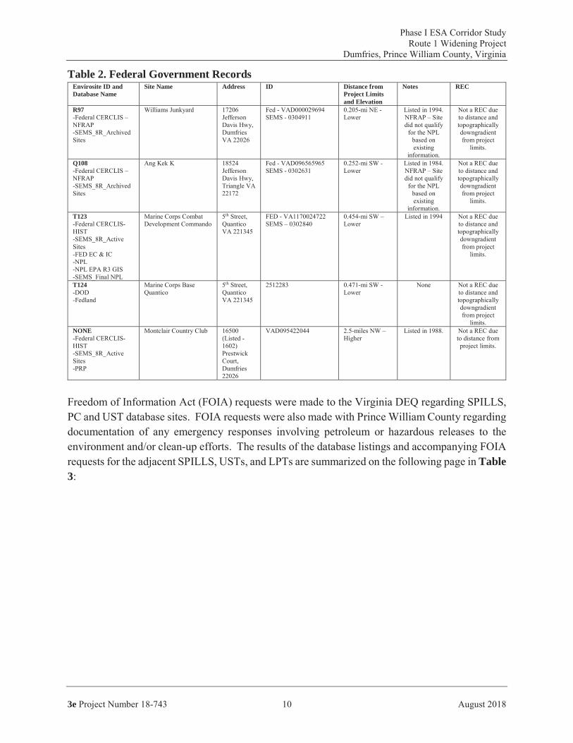
Table 2. Federal Government RecordsEnvirosite ID and Database Name
Site Name Address ID Distance from Project Limits and Elevation
Notes REC
R97
Q108
T123
T124
NONE
Table 3

3e
Table 3. Virginia Government Records and FOIA SummaryDatabase Map ID & Listing
Site Name Address ID FOIA REC (Yes or No)
REC due to property being
likely a full take.Drainage Pipe that connects 13A-2 to
13A-5
REC – proximate to storm water basin(BMP#4) and drainage structures10-10 & 10-16. (Figure 5)

3e
Database Map ID & Listing
Site Name Address ID FOIA REC (Yes or No)
REC due to sitecurrently cleared and no indication of tank locations or information available to document UST closures. Partial Take; Drainage Structure 17-5
REC to proposedutility improvement and partial R/W acquisition.Drainage Structures 16-9 & 17-10 (Figure 8)
REC, proximate to project limits.Drainage Structures 17-1 & 17-2 (Figure 8)REC because property will likely be acquired as R/WDrainage Structures 3-2, 3-3, & 3-4. (Figure 3)

3e
Database Map ID & Listing
Site Name Address ID FOIA REC (Yes or No)
REC due to dissolved phase petroleum impact approximate to SWB and proposed Structures. Adjacent Storm Water Basin; Drainage Structures 10-10 & 10-16 (Figure 5)
REC due to documented
petroleum impacts to GW and site isapproximate to project limits.
Drainage Structures 9-4 &
9-8 (Figure 4)

3e
Database Map ID & Listing
Site Name Address ID FOIA REC (Yes or No)
REC due to no records available for review and likely full take for BMP #7, 15-1, 15-2, 15-3, 15-13, 15-14, 15-15, 15-16, 15-17, and 15-19 and associated connection pipe. (Figure 7)
REC due to reported petroleum (DRO) impact proximate to the project limits. Drainage Structures 17-1 & 17-2 (Figure 8)
4.1.1. Other Mapped Sites/Database Listings
not considered
4.1.2. Unmappable Sites/Database Listings
3e3e
not considered

3e
4.2. Field Reconnaissance
Appendix B
Table 4

3e
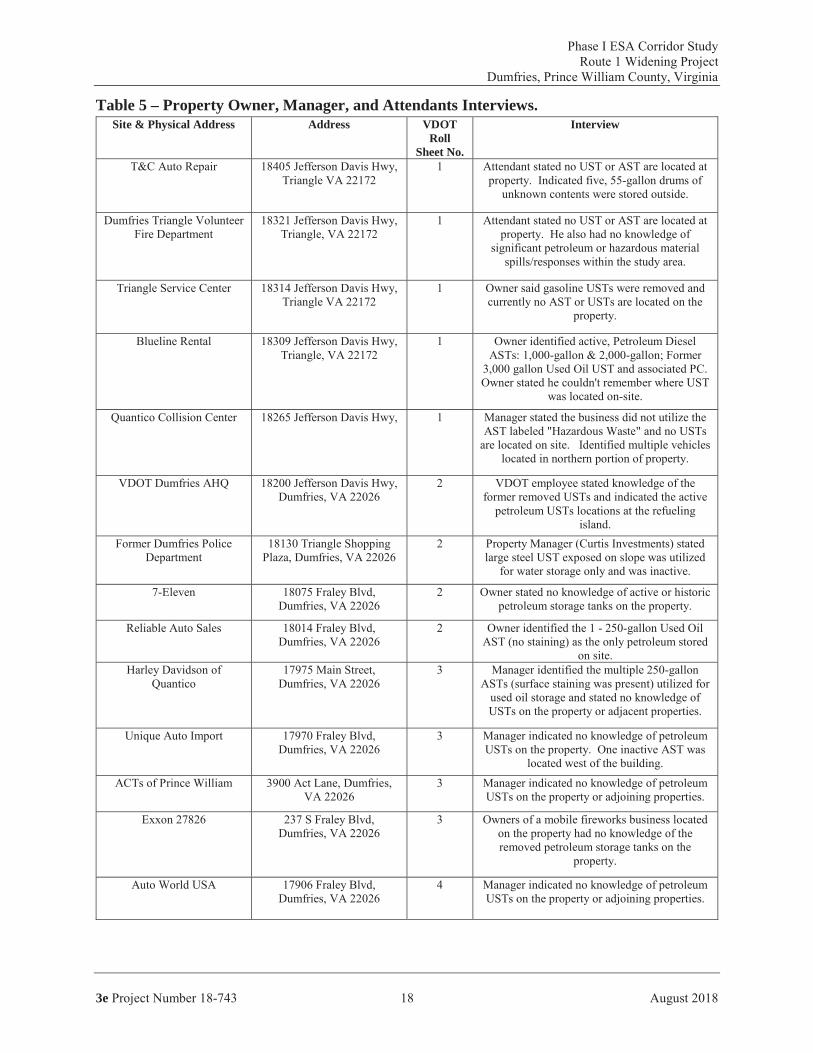
Table 4 – Field Reconnaissance Summary. Site & Physical Address Address VDOT Roll
Sheet No. Environmental Finding(s) Identified
by Site ReconnaissanceREC (Yes or No)
REC - Property is potential full take;
Potential cuts associated with
Drainage Structures 3-2, 3-3, & 3-4
(Figure 3)
REC - Partial take; Potential cuts
associated with Drainage Structures 9-4 & 9-8 (Figure 4)REC - Partial take;
Potential cuts associated with
Stormwater Basin &Drainage Structures
10-10 & 10-16 (Figure 5)
REC – Property is potential full take;
Potential cuts associated with
Drainage Structures 12-4 and associated
pipe (Figure 6)REC – Property is potential full take;
Potential cuts associated with
Stormwater Basin &Drainage Structures
13-24 & 13-25 (Figure 6)
REC - Property is potential full take;
Potential cut association with
section of drainage pipe. (Figure 6)
REC – Property is potential full take;
Potential cuts associated with
Stormwater Basin &Drainage Structures 13-6 & 13-5. (Figure
6)

3e
Site & Physical Address Address VDOT Roll Sheet No.
Environmental Finding(s) Identified by Site Reconnaissance
REC (Yes or No)
REC – Property is potential full take;
Potential cuts associated with
drainage structures 15-1, 15-2, 15-3, 15-13, 15-14, 15-15, 15-
16, 15-17, &15-19 (Figure 7)
REC - Partial Take; Potential cuts
associated with drainage structures
15-10 & 15-7 (Figure 7)
REC - Partial Take; Potential cuts
associated with drainage structures 17-1 & 17-2 (Figure
8)REC - Partial Take;
Potential cuts associated with
drainage structures 16-9 & 17-10 (Figure
8)
4.3. Environmental Liens/Activity and Use Limitations
4.4. Interviews
4.4.1. Prince William County
3e
4.4.2. Property Owners, Managers, and Attendants
Table 5
3e
Table 5 – Property Owner, Manager, and Attendants Interviews.Site & Physical Address Address VDOT
Roll Sheet No.
Interview

3e
de minimis

3e
4.5. Historical Use Information on the Study Area
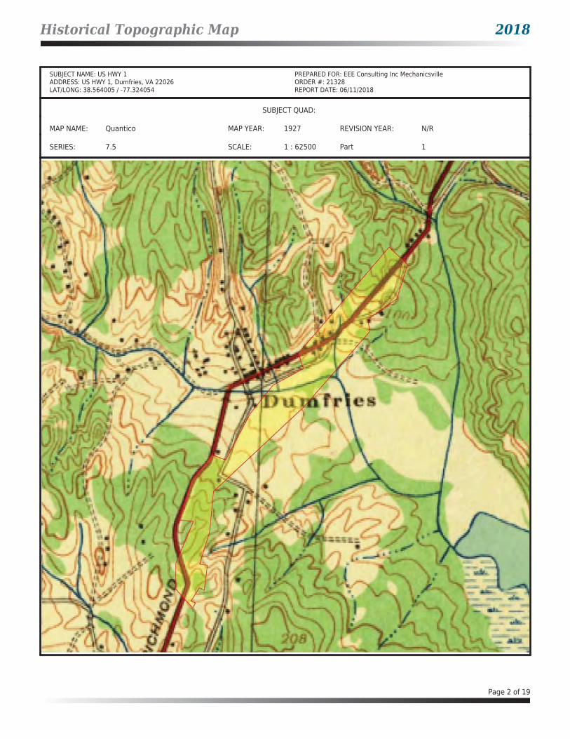
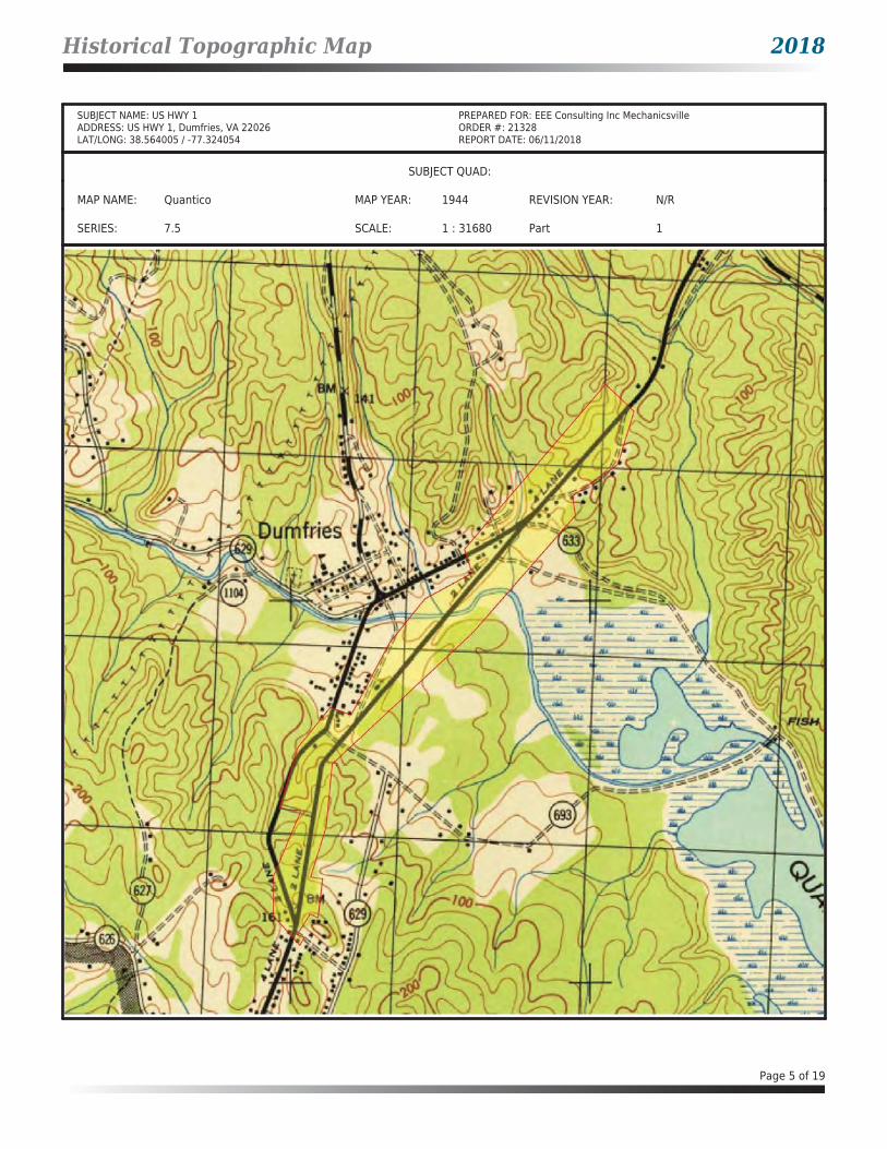
4.5.1. Historical Topographic Maps
Appendix C
4.5.2. Historical Aerial Photographs
Appendix D

3e
5.0 CONCLUSIONS & RECOMMENDATIONS
Table 6
Table 6 – REC Conclusion and Recommendations.Site & Physical Address Address Government
Database FOIA Information Site Reconnaissance
Environmental REC – Context of Proposed R/W &
ImprovementsREC - Property is potential full take; Potential cuts for
drainage structures 3-2, 3-3, & 3-4
(Figure 3)
REC - Partial take; Potential cuts for
drainage structures9-4 & 9-8 (Figure 4)
REC - Partial take; Potential cuts for
Storm Water Basin& drainage
structures 10-10 & 10-16 (Figure 5)
REC – Partial take; Potential cut for
drainage structure 12-4 (Figure 6)

3e
Site & Physical Address Address Government Database
FOIA Information Site Reconnaissance Environmental
REC – Context of Proposed R/W &
ImprovementsREC – Property is potential full take; Potential cuts for
Storm Water Basin& drainage
structures 13-24 &13-25. (Figure 6)
REC – Property is potential full take;Potential cuts for
drainage pipe. (Figure 6)
REC – Property is potential full take;Potential cuts for
Storm Water Basin& drainage
structures 13-6 &13-5. (Figure 6)
REC – Property is potential full take; Potential cuts for
drainage structures 15-1, 15-2, 15-3, 15-13, 15-14, 15-15, 15-16, 15-17, and 15-19.
(Figure 7)
REC - Partial Take; Potential cuts for
drainage structure 15-10 & 15-7.
(Figure 7)
REC - Partial Take; Potential cuts for
drainage structures 17-1 & 17-2. (Figure
8)
REC – Partial Take; Potential cuts for 16-
8, 16-9, 17-10. (Figure 8)
REC -Likely Partial Take
-Roadway Cut and Fill: 354+45.00 50-ft to 150-ft R of Rt. 1
CL-Potential Cuts –
Drainage Structures (Figure 8)
3e
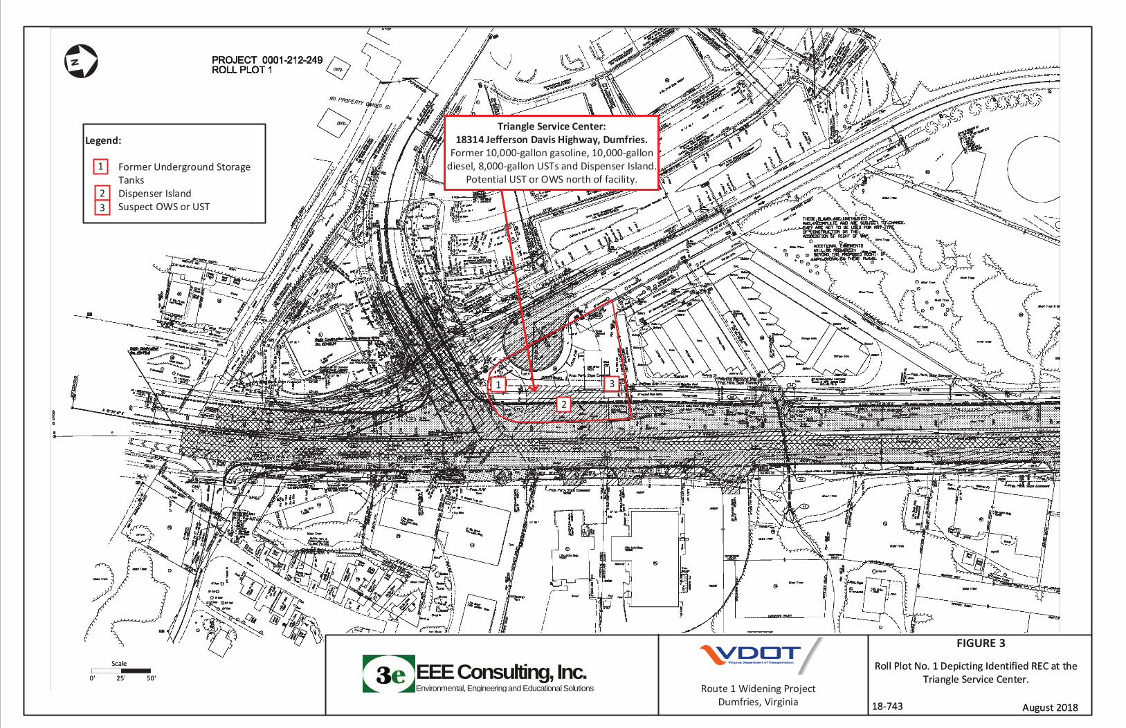
Triangle Service Center
Figure 3Exxon 27826-
Figure 4
Caliber Collision/Marine Structural Applications/Chesapeake Materials -
Figure 5
Daniels Auto Care -
Figure 6
A&M Mechanic and Tire/Edgardo Ayala -
Figure 6
Cropper Auto Care -

3e
Figure 6
Mr. K’s Carwash -
Figure 6
C&J Automotive/The Car Store, Inc -
Figure 7
1 Performance Auto Care -
Figure 7
Dumfries BP -
Figure 8
W Express -
Figure 8
Pullen Moving Company -
Figure 8
3e
6.0 REFERENCES
Appendix C DStandard Practice for Environmental Site Assessments: Phase I
Environmental Site Assessment Process
9VAC 25-580
7.0 SIGNATURES OF ENVIRONMENTAL PROFESSIONALS

3e
8.0 QUALIFICATIONS OF ENVIRONMENTAL PROFESSIONALS
Joshua P. Hepler, PG
Areas of Expertise
Christopher John Lalli
Areas of Expertise

Figures

Project Area
0 0.5 1
Miles
±Prepared by Leah Potts, 08/02/2018Sources:ESRI BasemapProjection: WGS 1984 Web Mercator Auxiliary Sphere
FIGURE 1AERIAL MAP
ROUTE 1 WIDENING
Dumfries, VA
Service Layer Credits: Esri, HERE, Garmin, © OpenStreetMap contributors, and the GIS user communitySource: Esri, DigitalGlobe, GeoEye, Earthstar Geographics, CNES/Airbus DS, USDA, USGS, AeroGRID, IGN, andthe GIS User Community

Project Area
0 0.5 1
Miles
±Prepared by Leah Potts, 08/02/2018Sources:ESRI BasemapProjection: WGS 1984 Web Mercator Auxiliary Sphere
FIGURE 2TOPOGRAPHIC MAP
ROUTE 1 WIDENING
Dumfries, VA
Service Layer Credits: Copyright:© 2013 National Geographic Society, i-cubed
1:24,000
EEEConsulting,Inc.Environmental, Engineering and Educational Solutions
18-743 August 2018
Roll Plot No. 1 Depicting Identified REC at the Triangle Service Center.
EEEConsulting,Inc.Environmental, Engineering and Educational Solutions
18-743 August 2018
Roll Plot No. 1 Depicting Identified REC at the Triangle Service Center.
FIGURE 3
Triangle Service Center:18314 Jefferson Davis Highway, Dumfries.
Former 10,000-gallon gasoline, 10,000-gallon diesel, 8,000-gallon USTs and Dispenser Island.
Potential UST or OWS north of facility.
Route 1 Widening ProjectDumfries, Virginia
Scale
0' 25' 50'
Scale
0' 25' 50'
Legend:
Former Underground Storage TanksDispenser IslandSuspect OWS or UST
1
2
3
1
23

EEEConsulting,Inc.Environmental, Engineering and Educational Solutions
18-743 August 2018
Roll Plot No. 3 Depicting Identified REC at Exxon #27826.
EEEConsulting,Inc.Environmental, Engineering and Educational Solutions
18-743 August 2018
Roll Plot No. 3 Depicting Identified REC at Exxon #27826.
FIGURE 4
Route 1 Widening ProjectDumfries, Virginia
Scale
0' 25' 50'
Scale
0' 25' 50'
Exxon #27826237 South Fraley Blvd, Dumfries
PC1996-3206; Former 8,000-gallon gasoline, 6,000-gallon gasoline, 4,000-gallon gasoline USTs
and Dispenser Island.
Legend:
Former Underground Storage TanksDispenser Island
1
2
1
2

EEEConsulting,Inc.Environmental, Engineering and Educational Solutions
18-743 August 2018
Roll Sheet No. 4 Depicting Identified REC at Caliber Collision/Marine Structural
Applications/Chesapeake Materials. EEEConsulting,Inc.Environmental, Engineering and Educational Solutions
18-743 August 2018
Roll Sheet No. 4 Depicting Identified REC at Caliber Collision/Marine Structural
Applications/Chesapeake Materials.
FIGURE 5
Route 1 Widening ProjectDumfries, Virginia
Scale
0' 25' 50'
Scale
0' 25' 50'
Caliber Collision/Marine Structural Applications/Chesapeake Materials
17884 Fraley Blvd, Dumfries: PC1998-3531; Former 10,000-gallon diesel UST.
Legend:
Former Underground Storage Tank
1
1

EEEConsulting,Inc.Environmental, Engineering and Educational Solutions
18-743 August 2018
Roll Sheet No. 5 Depicting Identified REC at Daniels Auto Care, A&M Mechanic and Tire, a
Carwash, Cropper Auto Care and a Residential Property.
EEEConsulting,Inc.Environmental, Engineering and Educational Solutions
18-743 August 2018
Roll Sheet No. 5 Depicting Identified REC at Daniels Auto Care, A&M Mechanic and Tire, a
Carwash, Cropper Auto Care and a Residential Property.
FIGURE 6
Route 1 Widening ProjectDumfries, Virginia
Scale
0' 25' 50'
Scale
0' 25' 50'
Daniels Auto Care17711 Fraley Blvd, Dumfries:
Oil Water Separator
A&M Mechanic and Tire/Edgardo Ayala17691 Fraley Blvd, Dumfries:
1-1,000-gallon used oil AST & multiple 55-gallon drums with surface staining.
Mr. K’s Carwash17651 Main Street, Dumfries:
Oil Water Separator and 55-gallon drum of Used Oil with surface
staining.
Cropper Auto Care17662 Main Street, Dumfries: Multiple 250-gallon ASTs with
surface staining.
Legend:
Multiple ASTsSuspect OWS and 55-gallon Drum with Staining1,000-gallon AST and 55-gallon DrumsSuspect OWS Location
1
2
3
1
2
34
4

EEEConsulting,Inc.Environmental, Engineering and Educational Solutions
18-743 August 2018
Roll Sheet No. 6 Depicting Identified REC at 1 Performance Auto Care and C&J Automotive.
EEEConsulting,Inc.Environmental, Engineering and Educational Solutions
18-743 August 2018
Roll Sheet No. 6 Depicting Identified REC at 1 Performance Auto Care and C&J Automotive.
FIGURE 7
Route 1 Widening ProjectDumfries, Virginia
Scale
0' 25' 50'
Scale
0' 25' 50'
C&J Automotive/The Car Store17539 Jefferson Davis Hwy, Dumfires:
PC 2003-3054 No Records via FOIA
1 Performance Auto Care 17484 Jefferson Davis Hwy,
Dumfries: Potential OWS
Legend:
Suspect OWS LocationPollution Complaint – Affected Area(s) Unknown
1
2
1
2

EEEConsulting,Inc.Environmental, Engineering and Educational Solutions
18-743 August 2018
Roll Sheet No. 7 Depicting Identified RECs at BP , Pullen Moving Co. and W Express.
EEEConsulting,Inc.Environmental, Engineering and Educational Solutions
18-743 August 2018
Roll Sheet No. 7 Depicting Identified RECs at BP , Pullen Moving Co. and W Express.
FIGURE 8
Route 1 Widening ProjectDumfries, Virginia
Scale
0' 25' 50'
Scale
0' 25' 50'
BP17400 Jefferson Davis Hwy,
Dumfries: 3-10,000 gallon gasoline, 1-10,000-gallon diesel USTs; PC 2007-3232
W Express 17499 Jefferson Davis Hwy, Dumfries VA:
1-12K gasoline, 1-8K gasoline USTs.
Legend:
Active UST LocationDocumented TPH-DRO ImpactActive UST Location
12
1
2
3
3
Pullen Moving Co. 122 Old Stage Coach Rd, Dumfries VA: 4K gasoline and 4K diesel USTs.

Appendix A: Regulatory Database Report

Government Records Report | 2018
Order Number: 21328Report Generated: 06/11/2018
Project Name: Project Number:
US HWY 1US HWY 1
Dumfries, VA 22026
2 Corporate DriveSuite 450
Shelton, CT 06484Toll Free: 866-211-2028www.envirositecorp.com

Table of Contents 2018
Section Page
Executive Summary 1
Executive Summary by Distance 2
Executive Summary by Database 6
Property Proximity Map 27
Area Map 28
Map Findings Summary 29
Map Findings 34
Unmappable Summary 374
Environmental Records Searched 375
Geological Landscape Section 390
Geological Landscape Section Soil Map 393
Geological Landscape Section Summary 394
Geological Findings Map 521
Geological Landscape Section Map Findings 522
Geological Landscape Section Map Findings Radon 537
Geological Landscape Records Searched 538
Disclaimer - Copyright and Trademark Notice
All information contained in this report are based on data available from various public, government and other sources and are based upon the best data available from those sources. The information available in this report may be available from other sources and is not exclusive or the exclusive property of Envirosite Corporation.
NO WARRANTY EXPRESSED OR IMPLIED, IS MADE IN CONNECTION WITH THIS REPORT, INCLUDING WITHOUT LIMITATION, MERCHANTABILITY OR FITNESS FOR A PARTICULAR PURPOSE. ALL RISK IS ASSUMED BY USER AND Envirosite assumes no liability for faulty or inaccurate information. The Reports may utilize a variety of public and other sources reasonably available to Envirosite. Envirosite cannot, and does not assure, warrant, guarantee or assume any liability for the correctness, comprehensiveness, timeliness or completeness of any of such information, nor is the information in any Report to be construed as legal advice with respect to environmental risks associated with any property. Envirosite shall not be liable to anyone for any claims, causes of action, suits, damages, losses, costs and expenses (including, without limitation, attorneys’ fees and costs) arising out of or caused by this report regardless of the acts, errors or omissions, or negligence of Envirosite. Any damages shall be limited to the purchase price of the report.
Purchaser of the report accepts the report “As Is”. The report is intended only to provide information only and should not be considered as providing any legal advice, prediction, forecast, or fact as to the environmental risk for any specific property. Reports are proprietary to Envirosite, and contain copyrighted material and trademarks of Envirosite. All other trademarks used herein are the property of their respective owners. All rights of Envirosite as to the Reports are reserved.

Executive Summary 2018
Envirosite Corporation has conducted a search of all reasonably ascertainable records in accordance with EPA’s AAI (40 CFR Part 312) requirements and the ASTM E-1527-13 Environmental Site Assessments standard.
SUBJECT PROPERTY INFORMATION:
ADDRESS:US HWY 1US HWY 1Dumfries, VA 22026
COORDINATES:Latitude (North): 38.564005 - 38°33'50.4"Longitude (West): -77.324054 - -77°19'26.6"Universal Transverse Mercator: Zone 18NUTM X (Meters): 297514.37UTM Y (Meters): 4270956.35
ELEVATION:Elevation: 33.720 ft. above sea level
USGS TOPOGRAPHIC MAP ASSOCIATED WITH SUBJECT PROPERTY:
Subject Property Map: 38077e3 QUANTICO, VAMost Recent Revision: 2016
Page 1 of 540

Executive Summary by Distance 2018
MAP ID SITE NAME ADDRESS DATABASE(S) RELATIVE ELEVATION
DIRECTION / DISTANCE
A1 DUMFRIES PHARMACY 245 S FRALEY BLVD ECHO, FRS, RCRA_NONGEN SPA2 N/R 17882 FRALEY BLVD ERNS SPA3 TRIPLE A TIRES FUEL SPILL 17882 FRALEY BLVD SPILLS - VA SPA4 POHANKA COLLISION CENTER OF DUM... 17884 FRALEY BLVD AFS, ECHO, FRS SPA5 MARINE STRUCTURAL APPLICATIONS 17884 S FRALEY BLVD UST - VA SPA6 CHESAPEAKE MATERIALS 17884 S FRALEY BLVD LPT - VA SPA7 CALIBER COLLISION CENTERS - DUMFRIES 17884 FRALEY BOULEVARD RCRA_CESQG SP8 BUDS TRIANGLE BODY SHOP 142 N FRALEY BLVD ECHO, FRS, RCRA_CESQG SPB9 COLONIAL CONCRETE TARMAC, INC 3440 CANAL RD ECHO, FRS, ICIS SPB10 DUMFRIES LIFT STATION FORCE MAIN 3450 CANAL ROAD, SPILLS - VA SPB11 PHILLIP C. CLARKE ELECTRICAL CONT... 3510 CANAL ST AST - VA SP12 EXXON CO USA #27826 237 S FRALEY RD-TANKS ECHO, FRS, RCRA_CESQG SPB13 PWSCA PUMP STATION L-018 221 CANAL ST UST - VA SPB14 PWCSA - PUMP STATION L018 221 CANAL ST LPT - VA SPB15 PRINCE WILLIAM COUNTY SA L-18 221 CANAL RD Archived SPILLS - VA SPB16 VIRGINIA CONCRETE COMPANY INC- ... 217 CANAL RD AFS SPB17 DUMFRIES PLANT 217 CANAL RD UST - VA SPB18 VIRGINIA CONCRETE DUMFRIES PLANT 217 CANAL RD FRS, LPT - VA, TRIS SPB19 CARDINAL CONRETE DUMFRIES PLT. 217 CANAL RD. ICIS SPB20 VIRGINIA CONCRETE COMPANY INCO... 217 CANAL RD ECHO SPB21 M D NESTER 215 A CANAL RD ECHO, FRS, RCRA_NONGEN SPC22 GAS ODOR - TWO GUYS ANTIQUES 17682 MAIN ST. SPILLS - VA SPB23 WHITEHURST PAVING COMPANY INC... 207 CANAL ST LPT - VA SPB24 WHITEHURST TRANSPORT INCORPORATED 207 CANAL ST AST - VA, UST - VA SPC25 CROPPERS TOWING 17662 MAIN ST SPILLS - VA SPD26 N/R 17983 DUMFRIES SHOPPING ... SPILLS - VA SPD27 FU SHENG REST 18011 DUMFRIES SHOPPING ... Archived SPILLS - VA SPD28 EXXON 27826 237 S FRALEY RD LPT - VA SPD29 PADRINOS II 18035 DUMFRIES SHOPPING ... Archived SPILLS - VA SPD30 RITE AID # 1064 18039 DUMFRIES SHOPPING ... BRS, ECHO, FRS, RCRA_CESQG SPD31 BANK OF AMERICA 4001 GRAHAM PARK RD Archived SPILLS - VA SP32 BROWNS AUTO MACHINE INC 924 N MAIN ST ECHO, FRS, RCRA_NONGEN SPE33 THE ANTIQUE STATION 17650 POSSUM POINT ROAD Archived SPILLS - VA SPF34 QUICK SHOP 18020 MAIN ST UST - VA SPF35 GASOLINE RELEASE @CARROLL FUEL 18020 MAIN ST. SPILLS - VA SPF36 QUIK SHOP CITGO 18020 MAIN ST LPT - VA SPF37 QUICK STOP CITGO 18020 MAIN ST LPT - VA SPE38 ATLANTIC REFINING & MKTG CORP-CO... RT 783 POSSUM POINT RD ECHO, FRS, RCRA_NONGEN SP
Page 2 of 540

Executive Summary by Distance 2018
MAP ID SITE NAME ADDRESS DATABASE(S) RELATIVE ELEVATION
DIRECTION / DISTANCE
39 WHITE STAR CLNRS 18101 TRIANGLE SHOPPING PLZ ECHO, FRS, RCRA_NONGEN SPG40 AMG MOTORS 17575 OLD STAGE COACH ROAD SPILLS - VA SPG41 N/R 17575 OLD STAGE COACH ROAD ERNS SPH42 PULLEN MOVING CO 122 OLD STAGE COACH RD UST - VA SPH43 C AND J AUTOMOTIVE 17539 JEFFERSON DAVIS HWY LPT - VA SPI44 VDOT - Dumfries Area Headquarters 18200 Jefferson Davis Hwy LPT - VA, UST - VA SPI45 VA DEPARTMENT OF TRANSPORTATIO... 18200 JEFFERSON DAVIS HWY ECHO, FRS, RCRA_CESQG SPI46 VDOT - DUMFRIES AREA HEADQUARTERS 18200 JEFFERSON DAVIS HI... ECHO, FRS, RCRA_CESQG SPJ47 PRINCE WILLIAM CONCRETE RECYCLE... 17491 JEFFERSON DAVIS HWY AFS, ECHO, FRS SPJ48 PRINCE WILLIAM CONCRETE RECYCLE... 17491 JEFFERSON DAVIS HI... ENF - VA SP49 TRIANGLE FRONT END AND FRAME S... 18265 JEFFERSON DAVIS HWY AFS, ECHO, FRS SPJ50 W EXPRESS 17449 JEFFERSON DAVIS HWY UST - VA SPJ51 MAACO COLLISION REPAIR AND AUTO... 17432 JEFFERSON DAVIS HWY AFS, ECHO, FRS SPJ52 DUMFRIES BP 17400 JEFFERSON DAVIS HWY UST - VA SPJ53 BP GAS STATION 02049 17400 JEFFERSON DAVIS HWY LPT - VA SPJ54 AMOCO 2049 17400 JEFFERSON DAVIS HWY LPT - VA SPK55 PROGRESSIVE PRINTING 18309 JEFFERSON DAVIS HWY ECHO, FRS, RCRA_CESQG SPK56 TRIANGLE SERVICE CENTER 18314 JEFFERSON DAVIS HWY UST - VA SPK57 QUALITY AUTO REPAIR 18313 JEFFERSON DAVIS HWY ECHO, FRS, RCRA_CESQG SPK58 QUALITY MOTORS INCORPORATED 18309 AND 18313 JEFFERSO... UST - VA SPK59 AUSLEY WILBUR H PROPERTY 18309 AND 18313 JEFFERSO... LPT - VA SPL60 PUMPS FOODMART 17315 JEFFERSON DAVIS HWY UST - VA SPL61 AMOCO SERVICE STATION 2049 17300 JEFFERSON DAVIS HWY RCRA_LQG SPL62 AMOCO #2049-TANKS 17300 JEFFERSON DAVIS HWY ECHO, FRS SPM63 SEWAGE SPILL US ROUTE 1 AND ROUTE 234 SPILLS - VA SPM64 DUMFRIES AUTO BODY & FRAME INC 17368 JEFF DAVIS HWY ECHO, FRS, RCRA_CESQG Higher NE / 0.003 mi.B65 AGGREGATE INDUSTRIES - DUMFRIES... 3540 CANAL ROAD ECHO, FRS, RCRA_NONGEN Lower NE / 0.008 mi.B66 DUMFRIES READY-MIX CONCRETE 3540 CANAL RD AST - VA Lower NE / 0.008 mi.B67 ENNSTONE CONCRETE PLANT 3540 CANAL ROAD Archived SPILLS - VA Lower NE / 0.008 mi.B68 DUMFRIES READY-MIX CONCRETE PLANT 3454 CANAL RD AST - VA Lower NE / 0.011 mi.B69 A-ANNANDALE INC. 3456 CANAL ROAD ECHO, FRS, RCRA_SQG Lower NE / 0.011 mi.B70 TITAN AND COLONIAL CONCRETE 124 POSSUM PT RD & 3454 C... Archived SPILLS - VA Lower NE / 0.011 mi.71 SKIPS AUTO PARTS INC 160 OLD STAGECOACH RD ECHO, FRS, RCRA_CESQG Higher NE / 0.012 mi.N72 18420 JEFFERSON DAVIS HIGHWAY 18420 JEFFERSON DAVIS HI... Archived SPILLS - VA Higher SW / 0.030 mi.M73 N/R 17279-17299 JEFFERSON DAV... SPILLS - VA Higher NE / 0.043 mi.O74 FORMER GAS STATION 258 N MAIN ST UST - VA Lower N / 0.052 mi.O75 NANLU ENTERPRISES 258 N MAIN ST LPT - VA Lower N / 0.052 mi.N76 FORMER TURLINGTON PROPERTY 18433 TO 18427 JEFFERSON ... UST - VA Higher SW / 0.062 mi.
Page 3 of 540

Executive Summary by Distance 2018
MAP ID SITE NAME ADDRESS DATABASE(S) RELATIVE ELEVATION
DIRECTION / DISTANCE
N77 TURLINGTON JUDY AND GARRISON LI... 18433 TO 18427 JEFFERSON ... LPT - VA Higher SW / 0.062 mi.78 17880 LOUNSBERY TENANTS 17880 LOUNSBERY DR Archived SPILLS - VA Lower ENE / 0.103 mi.P79 CHARON SHELL 18434 JEFFERSON DAVIS HWY UST - VA Higher SW / 0.106 mi.P80 CHARON SHELL FORMER 18434 JEFFERSON DAVIS HWY LPT - VA Higher SW / 0.106 mi.P81 BLACK WOLF INC TA QUANTICO SVC STA 18434 JEFF DAVIS HWY ECHO, FRS, RCRA_CESQG Higher SW / 0.107 mi.82 SEITZ RESIDENCE 17398 TRIPOLI BLVD Archived SPILLS - VA Higher NNE / 0.119 mi.83 LYONS AUTOMOTIVE CENTER 17276 DUMFRIES ROAD ECHO, FRS, RCRA_CESQG Higher NNE / 0.128 mi.P84 FORMER PEARSON PROPERTY/TRIANG... 18501 TO 18507 JEFFERSON ... UST - VA Higher SW / 0.147 mi.P85 PEARSON SHIRLEY L AND GLORIA A P... 18501 TO 18507 JEFFERSON ... LPT - VA Higher SW / 0.147 mi.86 GETTY 71212 3901 GRAHAM PARK RD UST - VA Higher SW / 0.147 mi.87 D & K AUTO BODY INC 304 MINE RD ECHO, FRS, RAATS, RCRA_NONGEN Lower WNW / 0.149 mi.Q88 Kims ASAP Auto Repair 18516 Jefferson Davis Hwy LPT - VA, UST - VA Higher SW / 0.155 mi.Q89 TEXACO/AL'S TRIANGLE 18516 JEFFERSON DAVIS HWY LPT - VA Higher SW / 0.155 mi.90 BACUS TIMOTHY A AND JOAN M RESI... 17633 ROSE HILL CIR LPT - VA Higher ENE / 0.156 mi.91 TOWER 38 33 58.57N, 077 19 05.08W DIGITAL OBSTACLE Lower ENE / 0.160 mi.Q92 EXXON S/S #2-3877 18510 JEFFERSON DAVIS HWY UST - VA Higher SW / 0.170 mi.Q93 TRIANGLE AMOCO 18515 JEFFERSON DAVIS HWY ECHO, FRS, RCRA_NONGEN Higher SW / 0.188 mi.Q94 BP AMOCO STATION #1974 18515 JEFFERSON DAVIS HWY UST - VA Higher SW / 0.188 mi.Q95 AMOCO #1974-TANKS 18515 JEFFERSON DAIVS HWY ECHO, FRS, RCRA_SQG Higher SW / 0.188 mi.Q96 AMOCO 1974 18515 JEFFERSON DAVIS HWY LPT - VA Higher SW / 0.188 mi.R97 WILLIAMS JUNKYARD 17206 JEFFERSON DAVIS HI... CERCLIS NFRAP, SEMS_8R_ARCHIVED SITES Higher NE / 0.205 mi.R98 HUMSTON DOUGLAS PROPERTY 17206 JEFFERSON DAVIS HWY LPT - VA Higher NE / 0.205 mi.Q99 YUEN CORP 18517 JEFFERSON DAVIS HWY UST - VA Higher SW / 0.215 mi.S100 STAR ENTERPRISE 2210 DUMFRIES RD ECHO, FRS, RCRA_NONGEN Higher NNE / 0.221 mi.Q101 TOWN OF TRIANGLE SANITARY SEWER LINES LPT - VA Higher SW / 0.224 mi.Q102 TOWN OF TRIANGLE (XREF 81-0529) SANITARY SEWER LINES LPT - VA Higher SW / 0.224 mi.R103 PRINCETON WOODS EXXON 17164 JEFFERSON DAVIS HWY UST - VA Higher NE / 0.233 mi.S104 PMG NVA SHELL 9012 17250 DUMFRIES RD UST - VA Higher NNE / 0.239 mi.Q105 FURNITURE OUTLET 18525 JEFFERSON DAVIS HWY LPT - VA Higher SW / 0.246 mi.106 DUMFRIES ELEMENTARY SCHOOL 300 CAMERON ST AFS, LPT - VA Higher WNW / 0.248 mi.S107 TEXACO 230681333 - MONTCLAIR 17250 DUMFRIES RD LPT - VA Higher NNE / 0.250 mi.Q108 ANG KEK K 18524 JEFFERSON DAVIS HWY CERCLIS NFRAP, SEMS_8R_ARCHIVED SITES Higher SW / 0.252 mi.Q109 KLEIN PROPERTY FORMERLY HOWARD... 18524 JEFFERSON DAVIS HWY LPT - VA Higher SW / 0.252 mi.Q110 UNION 76 - SIMMONS 18527 JEFFERSON DAVIS HWY LPT - VA Higher SW / 0.257 mi.R111 EXXONMOBIL STATION 20389 17164 JEFFERSON DAVIS HWY LPT - VA Higher NE / 0.260 mi.S112 POTOMAC CDD LANDFILL 3730 GREENTREE LN SWF/LF - VA Higher NNE / 0.284 mi.113 WALKER STEVEN RESIDENCE 3227 GRAHAM PARK RD LPT - VA Higher SSW / 0.306 mi.114 EL RANCHO RESTAURANT 18607 JEFFERSON DAVIS HWY LPT - VA Higher SW / 0.331 mi.
Page 4 of 540

Executive Summary by Distance 2018
MAP ID SITE NAME ADDRESS DATABASE(S) RELATIVE ELEVATION
DIRECTION / DISTANCE
T115 HARVEYS TOWING 18609 JEFFERSON DAVIS HWY LPT - VA Higher SW / 0.336 mi.T116 EXXON 23901 18625 JEFFERSON DAVIS HWY LPT - VA Higher SW / 0.355 mi.117 PRINCE WILLIAM FOREST PARK 38.6285099535, -77.4278004968 FEDLAND WSW / 0.361 mi.T118 VIRGINIA PAWN AND CHILI HUT 18617 JEFFERSON DAVIS HWY LPT - VA Higher SW / 0.375 mi.T119 SHELL - TRIANGLE SERVICE CENTER 18630 JEFFERSON DAVIS HWY LPT - VA Higher SW / 0.409 mi.120 FOUR MILE CREEK SEEP 551 N WASHINGTON ST LPT - VA Higher NW / 0.412 mi.T121 U S INNS 4202 INN ST LPT - VA Higher SW / 0.427 mi.122 QUIKEES TIRE AND GAS 18704 OLD TRIANGLE RD LPT - VA Higher SSW / 0.441 mi.T123 MARINE CORPS COMBAT DEVELOPME... 5TH STREET CERCLIS-HIST, CONSENT (DECREES), FED E C,... SW / 0.454 mi.T124 MARINE CORPS BASE QUANTICO 38.5222258164239, -77.286... DOD SW / 0.471 mi.T125 MARINE CORPS BASE QUANTICO 38.5222258159, -77.2869392845 FEDLAND SW / 0.471 mi.126 7 Eleven 10757 18750 Fuller Heights Rd LPT - VA, UST - VA Higher SSW / 0.477 mi.U127 TOWER 38 34 04.40N, 077 20 17.30W DIGITAL OBSTACLE Lower WNW / 0.556 mi.U128 TOWER 38 34 06.70N, 077 20 16.80W DIGITAL OBSTACLE Lower WNW / 0.583 mi.U129 TOWER 38 34 05.60N, 077 20 18.90W DIGITAL OBSTACLE Lower WNW / 0.589 mi.U130 TOWER 38 34 06.80N, 077 20 20.30W DIGITAL OBSTACLE Lower WNW / 0.621 mi.131 TOWER 38 35 11.49N, 077 19 04.61W DIGITAL OBSTACLE Higher NNE / 0.723 mi.132 BLDG 38 32 37.00N, 077 20 36.00W DIGITAL OBSTACLE Higher SW / 0.810 mi.
Page 5 of 540

Executive Summary by Database 2018
SUBJECT PROPERTY SEARCH RESULTS:The subject property was identified in the following records. For more information on this property, see Map Findings section on page 34.
SITE DATABASE(S) EPA ID
DUMFRIES PHARMACY245 S FRALEY BLVDDUMFRIES, VA 22026
ECHO, FRS, RCRA_NONGEN N/R
RCRA_NONGEN- ID: VAD988212882 Status: No Violation/Inspections Date: N/A
N/R17882 FRALEY BLVDDUMFRIES, VA
ERNS N/R
TRIPLE A TIRES FUEL SPILL17882 FRALEY BLVDDUMFRIES, VA 22026
SPILLS - VA N/R
SPILLS - VA- ID: 2018-N-0644 Status: Closed Date: 09/08/2017
POHANKA COLLISION CENTER OF DUMFRIES17884 FRALEY BLVDDUMFRIES, VA 22026
AFS, ECHO, FRS N/R
MARINE STRUCTURAL APPLICATIONS17884 S FRALEY BLVDDUMFRIES, VA 22026
UST - VA N/R
UST - VA- ID: Facility ID 3007633 Status: N/A Date: N/A- ID: Tank ID 1 Status: CLS IN GRD Date: Date Closed 05/01/1985- ID: Tank ID 2 Status: REM FROM GRD Date: Date Closed 08/01/1997
CHESAPEAKE MATERIALS17884 S FRALEY BLVDDUMFRIES, VA 22026
LPT - VA N/R
LPT - VA- ID: Facility ID 200000076684 Status: N/A Date: N/A- ID: PC Number 19983531 Status: Closed Date: 11/06/1998
CALIBER COLLISION CENTERS - DUMFRIES17884 FRALEY BOULEVARDDUMFRIES, VA 22026
RCRA_CESQG VAR000515841
RCRA_CESQG- ID: VAR000515841 Status: No Violation/Inspections Date: N/A
BUDS TRIANGLE BODY SHOP142 N FRALEY BLVDDUMFRIES, VA 22026
ECHO, FRS, RCRA_CESQG VAD988170452
RCRA_CESQG- ID: VAD988170452 Status: No Violation/Inspections Date: N/A
COLONIAL CONCRETE TARMAC, INC3440 CANAL RDDUMFRIES, VA 22026
ECHO, FRS, ICIS N/R
Page 6 of 540

Executive Summary by Database 2018
SITE DATABASE(S) EPA ID
DUMFRIES LIFT STATION FORCE MAIN3450 CANAL ROAD,DUMFRIES, VA
SPILLS - VA N/R
SPILLS - VA- ID: 2012-N-2637 Status: Closed Date: 05/21/2012
PHILLIP C. CLARKE ELECTRICAL CONTRACTORS3510 CANAL STDUMFRIES, VA 22026
AST - VA N/R
AST - VA- ID: Facility ID 3042394 Status: N/A Date: N/A- ID: Tank Number 1 Status: CURR IN USE Date: Date Closed N/R- ID: Tank Number 2 Status: CURR IN USE Date: Date Closed N/R
EXXON CO USA #27826237 S FRALEY RD-TANKSDUMFRIES, VA 22026
ECHO, FRS, RCRA_CESQG N/R
RCRA_CESQG- ID: VAD988194585 Status: No Violation/Inspections Date: N/A
PWSCA PUMP STATION L-018221 CANAL STDUMFRIES, VA 22026
UST - VA N/R
UST - VA- ID: Facility ID 3018248 Status: N/A Date: N/A- ID: Tank ID R1 Status: REM FROM GRD Date: Date Closed 04/28/1998
PWCSA - PUMP STATION L018221 CANAL STDUMFRIES, VA 22026
LPT - VA N/R
LPT - VA- ID: Facility ID 200000075439 Status: N/A Date: N/A- ID: PC Number 19983753 Status: Closed Date: 12/11/1998
PRINCE WILLIAM COUNTY SA L-18221 CANAL RDDUMFRIES, VA
Archived SPILLS - VA N/R
ARCHIVED SPILLS - VA- ID: 2005-N-0713 Status: Closed Date: 03/22/2005
VIRGINIA CONCRETE COMPANY INC- DUMFRIES217 CANAL RDDUMFRIES, VA 22026
AFS N/R
DUMFRIES PLANT217 CANAL RDDUMFRIES, VA 22026
UST - VA N/R
UST - VA- ID: Facility ID 3019486 Status: N/A Date: N/A- ID: Tank ID 1 Status: REM FROM GRD Date: Date Closed 04/29/1996
Page 7 of 540
Executive Summary by Database 2018
SITE DATABASE(S) EPA ID
VIRGINIA CONCRETE DUMFRIES PLANT217 CANAL RDDUMFRIES, VA 22026
FRS, LPT - VA, TRIS N/R
LPT - VA- ID: Facility ID 200000088151 Status: N/A Date: N/A- ID: PC Number 19963169 Status: Closed Date: 01/29/1997
CARDINAL CONRETE DUMFRIES PLT.217 CANAL RD.DUMFRIES, VA 22026
ICIS N/R
VIRGINIA CONCRETE COMPANY INCORPORATED DUMPHRIES217 CANAL RDDUMFRIES, VA 22026
ECHO N/R
M D NESTER215 A CANAL RDDUMFRIES, VA 22026
ECHO, FRS, RCRA_NONGEN VAR000000745
RCRA_NONGEN- ID: VAR000000745 Status: No Violation/Inspections Date: N/A
GAS ODOR - TWO GUYS ANTIQUES17682 MAIN ST.DUMFRIES, VA 22026
SPILLS - VA N/R
SPILLS - VA- ID: 2012-N-1492 Status: Closed Date: 12/13/2011
WHITEHURST PAVING COMPANY INCORPORATED207 CANAL STDUMFRIES, VA 22026
LPT - VA N/R
LPT - VA- ID: Facility ID 200000201698 Status: N/A Date: N/A- ID: PC Number 19940470 Status: Closed Date: 09/14/1994
WHITEHURST TRANSPORT INCORPORATED207 CANAL STDUMFRIES, VA 22026
AST - VA, UST - VA N/R
AST - VA- ID: Facility ID 3002179 Status: N/A Date: N/A- ID: Tank Number D1 Status: CURR IN USE Date: Date Closed N/R
UST - VA- ID: Facility ID 3002179 Status: N/A Date: N/A- ID: Tank ID R1 Status: REM FROM GRD Date: Date Closed 09/08/1993
CROPPERS TOWING17662 MAIN STDUMFRIES, VA
SPILLS - VA N/R
SPILLS - VA- ID: 2012-N-2164 Status: Closed Date: 03/14/2012
Page 8 of 540

Executive Summary by Database 2018
SITE DATABASE(S) EPA ID
N/R17983 DUMFRIES SHOPPING PLAZADUMFRIES, VA
SPILLS - VA N/R
SPILLS - VA- ID: 2016-N-0512 Status: Closed Date: 08/14/2015
FU SHENG REST18011 DUMFRIES SHOPPING CENTERDUMFRIES, VA
Archived SPILLS - VA N/R
ARCHIVED SPILLS - VA- ID: 2005-N-0787 Status: Closed Date: 06/10/2005
EXXON 27826237 S FRALEY RDDUMFRIES, VA 22026
LPT - VA N/R
LPT - VA- ID: Facility ID 200000078498 Status: N/A Date: N/A- ID: PC Number 19963206 Status: Closed Date: 08/13/1997
PADRINOS II18035 DUMFRIES SHOPPING CENTERDUMFRIES, VA
Archived SPILLS - VA N/R
ARCHIVED SPILLS - VA- ID: 2005-N-1026 Status: Closed Date: 06/07/2005
RITE AID # 106418039 DUMFRIES SHOPPING CENTERDUMFRIES, VA 22026
BRS, ECHO, FRS, RCRA_CESQG VAR000525659
RCRA_CESQG- ID: VAR000525659 Status: No Violation/Inspections Date: N/A
BANK OF AMERICA4001 GRAHAM PARK RDDUMFRIES, VA
Archived SPILLS - VA N/R
ARCHIVED SPILLS - VA- ID: 2005-N-0889 Status: Closed Date: 06/07/2005
BROWNS AUTO MACHINE INC924 N MAIN STDUMFRIES, VA 22026
ECHO, FRS, RCRA_NONGEN VAD988187746
RCRA_NONGEN- ID: VAD988187746 Status: No Violation/Inspections Date: N/A
THE ANTIQUE STATION17650 POSSUM POINT ROADDUMFRIES, VA
Archived SPILLS - VA N/R
ARCHIVED SPILLS - VA- ID: 2004-N-0203 Status: Closed Date: 09/15/2003
QUICK SHOP18020 MAIN STDUMFRIES, VA 22026
UST - VA N/R
UST - VA- ID: Facility ID 3020035 Status: N/A Date: N/A
Page 9 of 540

Executive Summary by Database 2018
SITE DATABASE(S) EPA ID
- ID: Tank ID 1 Status: CURR IN USE Date: Date Closed N/R- ID: Tank ID 2MA Status: CURR IN USE Date: Date Closed N/R- ID: Tank ID 3MA Status: CURR IN USE Date: Date Closed N/R- ID: Tank ID 4MB Status: CURR IN USE Date: Date Closed N/R
There is an additional 1 status record, see site details.
GASOLINE RELEASE @CARROLL FUEL18020 MAIN ST.DUMFRIES, VA 22026
SPILLS - VA N/R
SPILLS - VA- ID: 2014-N-3237 Status: Closed Date: 06/02/2014
QUIK SHOP CITGO18020 MAIN STDUMFRIES, VA 22026
LPT - VA N/R
LPT - VA- ID: Facility ID 200000075312 Status: N/A Date: N/A- ID: PC Number 20003382 Status: Closed Date: 07/12/2000
QUICK STOP CITGO18020 MAIN STDUMFRIES, VA 22026
LPT - VA N/R
LPT - VA- ID: Facility ID 200000075312 Status: N/A Date: N/A- ID: PC Number 20063201 Status: Closed Date: 03/26/2007
ATLANTIC REFINING & MKTG CORP-COCKPIT PTRT 783 POSSUM POINT RDDUMFRIES, VA 22026
ECHO, FRS, RCRA_NONGEN N/R
RCRA_NONGEN- ID: VAD070351606 Status: No Violation/Inspections Date: N/A
WHITE STAR CLNRS18101 TRIANGLE SHOPPING PLZDUMFRIES, VA 22026
ECHO, FRS, RCRA_NONGEN VAD981102957
RCRA_NONGEN- ID: VAD981102957 Status: No Violation/Inspections Date: N/A
AMG MOTORS17575 OLD STAGE COACH ROADDUMFRIES, VA
SPILLS - VA N/R
SPILLS - VA- ID: 2010-N-1263 Status: Closed Date: 11/10/2009
N/R17575 OLD STAGE COACH ROADDUMFRIES, VA 22026
ERNS N/R
PULLEN MOVING CO122 OLD STAGE COACH RDDUMFRIES, VA 22026
UST - VA N/R
UST - VA- ID: Facility ID 3011887 Status: N/A Date: N/A- ID: Tank ID 1 Status: CLS IN GRD Date: Date Closed 04/29/1986- ID: Tank ID 2 Status: CLS IN GRD Date: Date Closed 04/15/1985
Page 10 of 540

Executive Summary by Database 2018
SITE DATABASE(S) EPA ID
C AND J AUTOMOTIVE17539 JEFFERSON DAVIS HWYDUMFRIES, VA 22026
LPT - VA N/R
LPT - VA- ID: Facility ID 200000207873 Status: N/A Date: N/A- ID: PC Number 20033054 Status: Closed Date: 09/27/2002
VDOT - Dumfries Area Headquarters18200 Jefferson Davis HwyDumfries, VA 22026
LPT - VA, UST - VA N/R
UST - VA- ID: Facility ID 3019533 Status: N/A Date: N/A- ID: Tank ID 1 Status: CURR IN USE Date: Date Closed N/R- ID: Tank ID 2 Status: CURR IN USE Date: Date Closed N/R- ID: Tank ID R1 Status: REM FROM GRD Date: Date Closed 09/15/1998- ID: Tank ID R2 Status: REM FROM GRD Date: Date Closed 09/15/1998
There are an additional 2 status records, see site details.
LPT - VA- ID: Facility ID 200000078813 Status: N/A Date: N/A- ID: PC Number 19993097 Status: Closed Date: 04/05/1999
VA DEPARTMENT OF TRANSPORTATION DUMFRIES AREA HEADQUARTERS18200 JEFFERSON DAVIS HWYDUMFRIES, VA 22026
ECHO, FRS, RCRA_CESQG VAR000518571
RCRA_CESQG- ID: VAR000518571 Status: No Violation/Inspections Date: N/A
VDOT - DUMFRIES AREA HEADQUARTERS18200 JEFFERSON DAVIS HIGHWAYDUMFRIES, VA 22026
ECHO, FRS, RCRA_CESQG VAR000520288
RCRA_CESQG- ID: VAR000520288 Status: No Violation/Inspections Date: N/A
PRINCE WILLIAM CONCRETE RECYCLERS INCORPORATED17491 JEFFERSON DAVIS HWYDUMFRIES, VA 22026
AFS, ECHO, FRS N/R
PRINCE WILLIAM CONCRETE RECYCLERS, INC.17491 JEFFERSON DAVIS HIGHWAYDUMFRIES, VA
ENF - VA N/R
TRIANGLE FRONT END AND FRAME SERVICE INCORPORATED18265 JEFFERSON DAVIS HWYDUMFRIES, VA 22026
AFS, ECHO, FRS N/R
W EXPRESS17449 JEFFERSON DAVIS HWYDUMFRIES, VA 22026
UST - VA N/R
UST - VA- ID: Facility ID 3037304 Status: N/A Date: N/A- ID: Tank ID 1 Status: CURR IN USE Date: Date Closed N/R- ID: Tank ID 2 Status: CURR IN USE Date: Date Closed N/R
Page 11 of 540

Executive Summary by Database 2018
SITE DATABASE(S) EPA ID
MAACO COLLISION REPAIR AND AUTO PAINTING17432 JEFFERSON DAVIS HWYDUMFRIES, VA 22026
AFS, ECHO, FRS N/R
DUMFRIES BP17400 JEFFERSON DAVIS HWYDUMFRIES, VA 22026
UST - VA N/R
UST - VA- ID: Facility ID 3020554 Status: N/A Date: N/A- ID: Tank ID 1 Status: CURR IN USE Date: Date Closed N/R- ID: Tank ID 2 Status: CURR IN USE Date: Date Closed N/R- ID: Tank ID 3 Status: CURR IN USE Date: Date Closed N/R- ID: Tank ID 4 Status: CURR IN USE Date: Date Closed N/R
BP GAS STATION 0204917400 JEFFERSON DAVIS HWYDUMFRIES, VA 22026
LPT - VA N/R
LPT - VA- ID: Facility ID 200000193886 Status: N/A Date: N/A- ID: PC Number 20073232 Status: Closed Date: 08/06/2007
AMOCO 204917400 JEFFERSON DAVIS HWYDUMFRIES, VA 22026
LPT - VA N/R
LPT - VA- ID: Facility ID 200000193886 Status: N/A Date: N/A- ID: PC Number 19940678 Status: Closed Date: 12/20/1994
PROGRESSIVE PRINTING18309 JEFFERSON DAVIS HWYTRIANGLE, VA 22172
ECHO, FRS, RCRA_CESQG VAD988213690
RCRA_CESQG- ID: VAD988213690 Status: No Violation/Inspections Date: N/A
TRIANGLE SERVICE CENTER18314 JEFFERSON DAVIS HWYTRIANGLE, VA 22172
UST - VA N/R
UST - VA- ID: Facility ID 3005725 Status: N/A Date: N/A- ID: Tank ID 1 Status: REM FROM GRD Date: Date Closed 09/13/1991- ID: Tank ID 2 Status: REM FROM GRD Date: Date Closed 09/13/1991- ID: Tank ID 3 Status: REM FROM GRD Date: Date Closed 09/13/1991
QUALITY AUTO REPAIR18313 JEFFERSON DAVIS HWYTRIANGLE, VA 22172
ECHO, FRS, RCRA_CESQG VAD988170825
RCRA_CESQG- ID: VAD988170825 Status: No Violation/Inspections Date: N/A
QUALITY MOTORS INCORPORATED18309 AND 18313 JEFFERSON DAVIS HWYTRIANGLE, VA 22172
UST - VA N/R
UST - VA- ID: Facility ID 3018262 Status: N/A Date: N/A- ID: Tank ID 2 Status: PERM OUT OF USE Date: Date Closed N/R
Page 12 of 540

Executive Summary by Database 2018
SITE DATABASE(S) EPA ID
- ID: Tank ID R1 Status: REM FROM GRD Date: Date Closed 08/19/2003
AUSLEY WILBUR H PROPERTY18309 AND 18313 JEFFERSON DAVIS HWYTRIANGLE, VA 22172
LPT - VA N/R
LPT - VA- ID: Facility ID 200000075380 Status: N/A Date: N/A- ID: PC Number 20043158 Status: Closed Date: 07/08/2004
PUMPS FOODMART17315 JEFFERSON DAVIS HWYDUMFRIES, VA 22026
UST - VA N/R
UST - VA- ID: Facility ID 3037409 Status: N/A Date: N/A- ID: Tank ID 1 Status: CURR IN USE Date: Date Closed N/R- ID: Tank ID 2 Status: CURR IN USE Date: Date Closed N/R
AMOCO SERVICE STATION 204917300 JEFFERSON DAVIS HWYDUMFRIES, VA 22026
RCRA_LQG VAD988199071
RCRA_LQG- ID: VAD988199071 Status: No Violation/Inspections Date: N/A
AMOCO #2049-TANKS17300 JEFFERSON DAVIS HWYDUMFRIES, VA 22026
ECHO, FRS N/R
SEWAGE SPILLUS ROUTE 1 AND ROUTE 234DUMFRIES, VA
SPILLS - VA N/R
SPILLS - VA- ID: 2011-N-1641 Status: Closed Date: 06/21/2011
SEARCH RESULTS:
FEDERAL CERCLIS LIST
CERCLIS NFRAP: The CERCLIS sites with No Further Remedial Action Planned from the CERCLIS program database. The Environmental Protection Agency decommissioned the CERCLIS data in 2014. The last update was November 12, 2013. 2 SITES FOUND WITHIN .5 MILE
EQUAL/HIGHER ELEVATION
MAP ID SITE NAME SITE ADDRESS DIRECTION/DISTANCE PAGER97 WILLIAMS JUNKYARD 17206 JEFFERSON DAVIS
HIGHWAYNE / 0.205 mi. 251
- ID: VAD000029694 Status: NFRAP-Site does not qualify for the NPL based on existing information
Date: 12/06/1994
Q108 ANG KEK K 18524 JEFFERSON DAVIS HWY SW / 0.252 mi. 270
- ID: VAD096565965 Status: NFRAP-Site does not qualify for the NPL based on existing information
Date: 09/01/1984
Page 13 of 540

Executive Summary by Database 2018
FEDERAL CERCLIS LIST (cont.)
CERCLIS-HIST: The CERCLIS program database contains information on the assessment and remediation of federal hazardous waste sites. The Environmental Protection Agency decommissioned the CERCLIS data in 2014. The last update was November 12, 2013. 1 SITE FOUND WITHIN .5 MILE
EQUAL/HIGHER ELEVATION
MAP ID SITE NAME SITE ADDRESS DIRECTION/DISTANCE PAGET123 MARINE CORPS COMBAT
DEVELOPMENT COMMAND5TH STREET SW / 0.454 mi. 284
FEDERAL FACILITY: Sites where Federal Facilities Restoration and Reuse Office (FFRRO) arranged cleanup for Base Closure and Property Transfer at Federal Facilities 1 SITE FOUND WITHIN 1 MILE
EQUAL/HIGHER ELEVATION
MAP ID SITE NAME SITE ADDRESS DIRECTION/DISTANCE PAGET123 MARINE CORPS COMBAT
DEVELOPMENT COMMAND5TH STREET SW / 0.454 mi. 284
- ID: VA1170024722 Status: N/R Date: N/A
SEMS_8R_ACTIVE SITES: The Active Site Inventory Report displays site and location information at active SEMS sites. An active site is one at which site assessment, removal, remedial, enforcement, cost recovery, or oversight activities are being planned or conducted. NPL sites include latitude and longitude information. For non-NPL sites, a brief site status is provided. 1 SITE FOUND WITHIN .5 MILE
EQUAL/HIGHER ELEVATION
MAP ID SITE NAME SITE ADDRESS DIRECTION/DISTANCE PAGET123 MARINE CORPS COMBAT
DEVELOPMENT COMMAND5TH STREET SW / 0.454 mi. 284
- ID: 0302840 Status: N/R Date: N/A
SEMS_8R_ARCHIVED SITES: The Archived Site Inventory displays site and location information at sites archived from SEMS. An archived site is one at which EPA has determined that assessment has been completed and no further remedial action is planned under the Superfund program at this time. 2 SITES FOUND WITHIN .5 MILE
EQUAL/HIGHER ELEVATION
MAP ID SITE NAME SITE ADDRESS DIRECTION/DISTANCE PAGER97 WILLIAMS JUNKYARD 17206 JEFFERSON DAVIS
HIGHWAYNE / 0.205 mi. 251
- ID: 0304911 Status: NFRAP-Site does not qualify for the NPL based on existing information
Date: N/A
Q108 ANG KEK K 18524 JEFFERSON DAVIS HWY SW / 0.252 mi. 270
- ID: 0302631 Status: NFRAP-Site does not qualify for the NPL based on existing information
Date: N/A
FEDERAL INSTITUTIONAL CONTROLS / ENGINEERING CONTROLS REGISTRIES
FED E C: Federal listing of remediation sites with engineering controls 1 SITE FOUND WITHIN .5 MILE
EQUAL/HIGHER ELEVATION
MAP ID SITE NAME SITE ADDRESS DIRECTION/DISTANCE PAGET123 MARINE CORPS COMBAT
DEVELOPMENT COMMAND5TH STREET SW / 0.454 mi. 284
- ID: VA1170024722 Status: RECORD OF DECISION Date: 09/30/2011- ID: VA1170024722 Status: RECORD OF DECISION Date: 09/29/2011- ID: VA1170024722 Status: RECORD OF DECISION Date: 09/30/2008- ID: VA1170024722 Status: RECORD OF DECISION Date: 09/02/2008
Page 14 of 540

Executive Summary by Database 2018
FEDERAL INSTITUTIONAL CONTROLS / ENGINEERING CONTROLS REGISTRIES (cont.)
FED E C: Federal listing of remediation sites with engineering controls 1 SITE FOUND WITHIN .5 MILE
EQUAL/HIGHER ELEVATION (cont.)
MAP ID SITE NAME SITE ADDRESS DIRECTION/DISTANCE PAGE- ID: VA1170024722 Status: RECORD OF DECISION Date: 12/20/2007
There are an additional 6 status records, see site details.
FED I C: Federal listing of remediation sites with institutional controls 1 SITE FOUND WITHIN .5 MILE
EQUAL/HIGHER ELEVATION
MAP ID SITE NAME SITE ADDRESS DIRECTION/DISTANCE PAGET123 MARINE CORPS COMBAT
DEVELOPMENT COMMAND5TH STREET SW / 0.454 mi. 284
- ID: VA1170024722 Status: RECORD OF DECISION Date: 09/30/2011- ID: VA1170024722 Status: RECORD OF DECISION Date: 09/29/2011- ID: VA1170024722 Status: RECORD OF DECISION Date: 09/30/2008- ID: VA1170024722 Status: RECORD OF DECISION Date: 12/20/2007- ID: VA1170024722 Status: RECORD OF DECISION Date: 09/30/1997
FEDERAL NPL SITE LIST
NPL: List of priority contaminated sites among identified releases or threatened releases of hazardous substances pollutants or contaminants nationally 1 SITE FOUND WITHIN 1 MILE
EQUAL/HIGHER ELEVATION
MAP ID SITE NAME SITE ADDRESS DIRECTION/DISTANCE PAGET123 MARINE CORPS COMBAT
DEVELOPMENT COMMAND5TH STREET SW / 0.454 mi. 284
- ID: VA1170024722 Status: Final Date: Listing Date 05/31/1994
NPL EPA R3 GIS: Geospatial data for the Environmental Protection Agency Region 3 National Priority List subject to environmental regulation 1 SITE FOUND WITHIN 1 MILE
EQUAL/HIGHER ELEVATION
MAP ID SITE NAME SITE ADDRESS DIRECTION/DISTANCE PAGET123 MARINE CORPS COMBAT
DEVELOPMENT COMMAND5TH STREET SW / 0.454 mi. 284
SEMS_FINAL NPL: All Included National Priority List Sites 1 SITE FOUND WITHIN 1 MILE
EQUAL/HIGHER ELEVATION
MAP ID SITE NAME SITE ADDRESS DIRECTION/DISTANCE PAGET123 MARINE CORPS COMBAT
DEVELOPMENT COMMAND5TH STREET SW / 0.454 mi. 284
- ID: 0302840 Status: N/A Date: Final Date 05/31/1994
Page 15 of 540

Executive Summary by Database 2018
FEDERAL RCRA GENERATORS LIST
RCRA_CESQG: Resource Conservation and Recovery Act listing of licensed conditionally exempt small quantity generators 12 SITES FOUND WITHIN .25 MILE
EQUAL/HIGHER ELEVATION
MAP ID SITE NAME SITE ADDRESS DIRECTION/DISTANCE PAGEM64 DUMFRIES AUTO BODY &
FRAME INC17368 JEFF DAVIS HWY NE / 0.003 mi. 173
- ID: VA0000104786 Status: No Violation/Inspections Date: N/A
71 SKIPS AUTO PARTS INC 160 OLD STAGECOACH RD NE / 0.012 mi. 193
- ID: VAD988205019 Status: No Violation/Inspections Date: N/A
P81 BLACK WOLF INC TA QUANTICO SVC STA
18434 JEFF DAVIS HWY SW / 0.107 mi. 208
- ID: VAR000007674 Status: No Violation/Inspections Date: N/A
83 LYONS AUTOMOTIVE CENTER 17276 DUMFRIES ROAD NNE / 0.128 mi. 214
- ID: VAR000511865 Status: No Violation/Inspections Date: N/A
RCRA_NONGEN: Resource Conservation and Recovery Act listing of licensed non-generators 9 SITES FOUND WITHIN .25 MILE
EQUAL/HIGHER ELEVATION
MAP ID SITE NAME SITE ADDRESS DIRECTION/DISTANCE PAGEQ93 TRIANGLE AMOCO 18515 JEFFERSON DAVIS HWY SW / 0.188 mi. 237
- ID: VAD988210902 Status: No Violation/Inspections Date: N/A
S100 STAR ENTERPRISE 2210 DUMFRIES RD NNE / 0.221 mi. 256
- ID: VAD988172474 Status: No Violation/Inspections Date: N/A
LOWER ELEVATION
MAP ID SITE NAME SITE ADDRESS DIRECTION/DISTANCE PAGEB65 AGGREGATE INDUSTRIES -
DUMFRIES READY-MIX CONCRETE FACILITY
3540 CANAL ROAD NE / 0.008 mi. 176
- ID: VAP404201206 Status: No Violation/Inspections Date: N/A
87 D & K AUTO BODY INC 304 MINE RD WNW / 0.149 mi. 225
- ID: VAD982565897 Status: Generators - General Date: Violation 07/31/1990 - Achieved Compliance 09/26/1990
- ID: VAD982565897 Status: LDR - General Date: Violation 07/31/1990 - Achieved Compliance 09/26/1990
RCRA_SQG: Resource Conservation and Recovery Act listing of licensed small quantity generators 2 SITES FOUND WITHIN .25 MILE
EQUAL/HIGHER ELEVATION
MAP ID SITE NAME SITE ADDRESS DIRECTION/DISTANCE PAGEQ95 AMOCO #1974-TANKS 18515 JEFFERSON DAIVS HWY SW / 0.188 mi. 246
- ID: VAD988199220 Status: No Violation/Inspections Date: N/A
Page 16 of 540

Executive Summary by Database 2018
FEDERAL RCRA GENERATORS LIST (cont.)
RCRA_SQG: Resource Conservation and Recovery Act listing of licensed small quantity generators 2 SITES FOUND WITHIN .25 MILE
LOWER ELEVATION
MAP ID SITE NAME SITE ADDRESS DIRECTION/DISTANCE PAGEB69 A-ANNANDALE INC. 3456 CANAL ROAD NE / 0.011 mi. 187
- ID: VAR000508184 Status: Used Oil - Generators Date: Violation 03/29/2006 - Achieved Compliance 03/29/2006
- ID: VAR000508184 Status: Generators - General Date: Violation 12/16/2004 - Achieved Compliance 03/29/2006
STATE AND TRIBAL REGISTERED STORAGE TANK LISTS
AST - VA: Registered Aboveground Storage Tanks in Virginia 4 SITES FOUND WITHIN .25 MILE
LOWER ELEVATION
MAP ID SITE NAME SITE ADDRESS DIRECTION/DISTANCE PAGEB66 DUMFRIES READY-MIX
CONCRETE3540 CANAL RD NE / 0.008 mi. 180
- ID: Facility ID 3042271 Status: N/A Date: N/A- ID: Tank Number 1 Status: CURR IN USE Date: Date Closed N/R
B68 DUMFRIES READY-MIX CONCRETE PLANT
3454 CANAL RD NE / 0.011 mi. 182
- ID: Facility ID 3030847 Status: N/A Date: N/A- ID: Tank Number 2port Status: CURR IN USE Date: Date Closed N/R- ID: Tank Number 3port Status: CURR IN USE Date: Date Closed N/R- ID: Tank Number 1 Status: CURR IN USE Date: Date Closed N/R- ID: Tank Number 2 Status: CURR IN USE Date: Date Closed N/R
UST - VA: Registered Underground Storage Tanks in Virginia 23 SITES FOUND WITHIN .25 MILE
EQUAL/HIGHER ELEVATION
MAP ID SITE NAME SITE ADDRESS DIRECTION/DISTANCE PAGEN76 FORMER TURLINGTON
PROPERTY18433 TO 18427 JEFFERSON DAVIS HWY
SW / 0.062 mi. 201
- ID: Facility ID 3041635 Status: N/A Date: N/A- ID: Tank ID 001 Status: REM FROM GRD Date: Date Closed
09/23/2009- ID: Tank ID 002 Status: REM FROM GRD Date: Date Closed
09/23/2009
P79 CHARON SHELL 18434 JEFFERSON DAVIS HWY SW / 0.106 mi. 205
- ID: Facility ID 3014080 Status: N/A Date: N/A- ID: Tank ID 1 Status: REM FROM GRD Date: Date Closed
09/01/1992- ID: Tank ID 2 Status: CLS IN GRD Date: Date Closed
09/01/1992- ID: Tank ID 3 Status: REM FROM GRD Date: Date Closed
09/01/1992- ID: Tank ID 4 Status: REM FROM GRD Date: Date Closed
09/01/1992
P84 FORMER PEARSONPROPERTY/TRIANGLE FOREIGN CAR
18501 TO 18507 JEFFERSON DAVIS HWY
SW / 0.147 mi. 217
- ID: Facility ID 3041355 Status: N/A Date: N/A- ID: Tank ID R1 Status: REM FROM GRD Date: Date Closed
06/04/2009
Page 17 of 540

Executive Summary by Database 2018
STATE AND TRIBAL REGISTERED STORAGE TANK LISTS (cont.)
UST - VA: Registered Underground Storage Tanks in Virginia 23 SITES FOUND WITHIN .25 MILE
EQUAL/HIGHER ELEVATION (cont.)
MAP ID SITE NAME SITE ADDRESS DIRECTION/DISTANCE PAGE- ID: Tank ID R2 Status: REM FROM GRD Date: Date Closed
06/04/2009- ID: Tank ID R3 Status: REM FROM GRD Date: Date Closed
06/04/2009- ID: Tank ID R4 Status: REM FROM GRD Date: Date Closed
06/04/2009
86 GETTY 71212 3901 GRAHAM PARK RD SW / 0.147 mi. 221
- ID: Facility ID 3002278 Status: N/A Date: N/A- ID: Tank ID R1 Status: REM FROM GRD Date: Date Closed
10/09/2008- ID: Tank ID R2 Status: REM FROM GRD Date: Date Closed
10/09/2008- ID: Tank ID R3 Status: REM FROM GRD Date: Date Closed
10/09/2008- ID: Tank ID R4 Status: REM FROM GRD Date: Date Closed N/R
There are an additional 2 status records, see site details.
Q88 Kims ASAP Auto Repair 18516 Jefferson Davis Hwy SW / 0.155 mi. 230
- ID: Facility ID 3025937 Status: N/A Date: N/A- ID: Tank ID R1 Status: REM FROM GRD Date: Date Closed
01/01/1985- ID: Tank ID R2 Status: REM FROM GRD Date: Date Closed
01/01/1985
Q92 EXXON S/S #2-3877 18510 JEFFERSON DAVIS HWY SW / 0.170 mi. 235
- ID: Facility ID 3009904 Status: N/A Date: N/A- ID: Tank ID R1 Status: REM FROM GRD Date: Date Closed
10/01/1986- ID: Tank ID R2 Status: REM FROM GRD Date: Date Closed
10/01/1986- ID: Tank ID R3 Status: REM FROM GRD Date: Date Closed
10/01/1986- ID: Tank ID R4 Status: REM FROM GRD Date: Date Closed
10/01/1986
Q94 BP AMOCO STATION #1974 18515 JEFFERSON DAVIS HWY SW / 0.188 mi. 240
- ID: Facility ID 3024218 Status: N/A Date: N/A- ID: Tank ID R1 Status: REM FROM GRD Date: Date Closed
11/09/1990- ID: Tank ID R2 Status: REM FROM GRD Date: Date Closed
11/09/1990- ID: Tank ID R3 Status: REM FROM GRD Date: Date Closed
11/09/1990- ID: Tank ID R4 Status: REM FROM GRD Date: Date Closed
11/09/1990There are an additional 5 status records, see site details.
Q99 YUEN CORP 18517 JEFFERSON DAVIS HWY SW / 0.215 mi. 255
- ID: Facility ID 3021284 Status: N/A Date: N/A- ID: Tank ID 1 Status: CLS IN GRD Date: Date Closed
05/08/1986- ID: Tank ID 2 Status: CLS IN GRD Date: Date Closed
05/08/1986
R103 PRINCETON WOODS EXXON 17164 JEFFERSON DAVIS HWY NE / 0.233 mi. 261
- ID: Facility ID 3037462 Status: N/A Date: N/A- ID: Tank ID 1 Status: CURR IN USE Date: Date Closed N/R- ID: Tank ID 2 Status: CURR IN USE Date: Date Closed N/R
Page 18 of 540

Executive Summary by Database 2018
STATE AND TRIBAL REGISTERED STORAGE TANK LISTS (cont.)
UST - VA: Registered Underground Storage Tanks in Virginia 23 SITES FOUND WITHIN .25 MILE
EQUAL/HIGHER ELEVATION (cont.)
MAP ID SITE NAME SITE ADDRESS DIRECTION/DISTANCE PAGE- ID: Tank ID 3 Status: CURR IN USE Date: Date Closed N/R
S104 PMG NVA SHELL 9012 17250 DUMFRIES RD NNE / 0.239 mi. 263
- ID: Facility ID 3019089 Status: N/A Date: N/A- ID: Tank ID 1 Status: CURR IN USE Date: Date Closed N/R- ID: Tank ID 2 Status: CURR IN USE Date: Date Closed N/R- ID: Tank ID 3 Status: CURR IN USE Date: Date Closed N/R- ID: Tank ID 4 Status: CURR IN USE Date: Date Closed N/R
There is an additional 1 status record, see site details.
LOWER ELEVATION
MAP ID SITE NAME SITE ADDRESS DIRECTION/DISTANCE PAGEO74 FORMER GAS STATION 258 N MAIN ST N / 0.052 mi. 199
- ID: Facility ID 3010303 Status: N/A Date: N/A- ID: Tank ID R1 Status: REM FROM GRD Date: Date Closed
10/31/1995- ID: Tank ID R2 Status: REM FROM GRD Date: Date Closed
10/31/1995
STATE AND TRIBAL LEAKING STORAGE TANK LISTS
LPT - VA: Petroleum Storage tanks with known releases 39 SITES FOUND WITHIN .5 MILE
EQUAL/HIGHER ELEVATION
MAP ID SITE NAME SITE ADDRESS DIRECTION/DISTANCE PAGEN77 TURLINGTON JUDY AND
GARRISON LINDA PROPERTY18433 TO 18427 JEFFERSON DAVIS HWY
SW / 0.062 mi. 203
- ID: Facility ID 200000848397 Status: N/A Date: N/A- ID: PC Number 20083172 Status: Closed Date: 10/26/2012
P80 CHARON SHELL FORMER 18434 JEFFERSON DAVIS HWY SW / 0.106 mi. 207
- ID: Facility ID 200000074742 Status: N/A Date: N/A- ID: PC Number 20083175 Status: Closed Date: 03/20/2013
P85 PEARSON SHIRLEY L AND GLORIA A PROPERTY
18501 TO 18507 JEFFERSON DAVIS HWY
SW / 0.147 mi. 220
- ID: Facility ID 200000848396 Status: N/A Date: N/A- ID: PC Number 20083178 Status: Closed Date: 10/26/2012
Q88 Kims ASAP Auto Repair 18516 Jefferson Davis Hwy SW / 0.155 mi. 230
- ID: Facility ID 200000077152 Status: N/A Date: N/A- ID: PC Number 19911030 Status: Closed Date: 08/23/1994
Q89 TEXACO/AL'S TRIANGLE 18516 JEFFERSON DAVIS HWY SW / 0.155 mi. 232
- ID: Facility ID 200000077152 Status: N/A Date: N/A- ID: PC Number 19800882 Status: Closed Date: 06/23/1995
90 BACUS TIMOTHY A AND JOAN M RESIDENCE
17633 ROSE HILL CIR ENE / 0.156 mi. 233
- ID: Facility ID 200000852859 Status: N/A Date: N/A- ID: PC Number 20103213 Status: Closed Date: 12/09/2010
Q96 AMOCO 1974 18515 JEFFERSON DAVIS HWY SW / 0.188 mi. 250
- ID: Facility ID 200000193813 Status: N/A Date: N/A- ID: PC Number 20023187 Status: Closed Date: 03/15/2002- ID: PC Number 19910034 Status: Closed Date: 06/12/1995
Page 19 of 540

Executive Summary by Database 2018
STATE AND TRIBAL LEAKING STORAGE TANK LISTS (cont.)
LPT - VA: Petroleum Storage tanks with known releases 39 SITES FOUND WITHIN .5 MILE
EQUAL/HIGHER ELEVATION (cont.)
MAP ID SITE NAME SITE ADDRESS DIRECTION/DISTANCE PAGER98 HUMSTON DOUGLAS
PROPERTY17206 JEFFERSON DAVIS HWY NE / 0.205 mi. 254
- ID: Facility ID 200000223846 Status: N/A Date: N/A- ID: PC Number 20063231 Status: Closed Date: 05/02/2006
Q101 TOWN OF TRIANGLE SANITARY SEWER LINES SW / 0.224 mi. 260
- ID: Facility ID 200000186051 Status: N/A Date: N/A- ID: PC Number 19810529 Status: Closed Date: 08/05/1994
Q102 TOWN OF TRIANGLE (XREF 81-0529)
SANITARY SEWER LINES SW / 0.224 mi. 260
- ID: Facility ID 200000186051 Status: N/A Date: N/A- ID: PC Number 19810665 Status: Closed Date: 08/05/1994
Q105 FURNITURE OUTLET 18525 JEFFERSON DAVIS HWY SW / 0.246 mi. 267
- ID: Facility ID 200000186185 Status: N/A Date: N/A- ID: PC Number 19973160 Status: Closed Date: 11/21/1997
106 DUMFRIES ELEMENTARY SCHOOL
300 CAMERON ST WNW / 0.248 mi. 268
- ID: Facility ID 200000078812 Status: N/A Date: N/A- ID: PC Number 19910125 Status: Closed Date: 03/09/1992
S107 TEXACO 230681333 - MONTCLAIR
17250 DUMFRIES RD NNE / 0.250 mi. 269
- ID: Facility ID 200000074013 Status: N/A Date: N/A- ID: PC Number 19901427 Status: Closed Date: 02/03/1995
Q109 KLEIN PROPERTY FORMERLY HOWARDS CITGO
18524 JEFFERSON DAVIS HWY SW / 0.252 mi. 273
- ID: Facility ID 200000079442 Status: N/A Date: N/A- ID: PC Number 19973042 Status: Closed Date: 05/07/2009
Q110 UNION 76 - SIMMONS 18527 JEFFERSON DAVIS HWY SW / 0.257 mi. 274
- ID: Facility ID 200000096323 Status: N/A Date: N/A- ID: PC Number 19910097 Status: Closed Date: 02/18/1992
R111 EXXONMOBIL STATION 20389 17164 JEFFERSON DAVIS HWY NE / 0.260 mi. 274
- ID: Facility ID 200000195074 Status: N/A Date: N/A- ID: PC Number 20103117 Status: Closed Date: 04/20/2010
113 WALKER STEVEN RESIDENCE 3227 GRAHAM PARK RD SSW / 0.306 mi. 276
- ID: Facility ID 200000224498 Status: N/A Date: N/A- ID: PC Number 20053240 Status: Closed Date: 03/13/2009
114 EL RANCHO RESTAURANT 18607 JEFFERSON DAVIS HWY SW / 0.331 mi. 277
- ID: Facility ID 200000185392 Status: N/A Date: N/A- ID: PC Number 19930568 Status: Closed Date: 06/21/1993
T115 HARVEYS TOWING 18609 JEFFERSON DAVIS HWY SW / 0.336 mi. 277
- ID: Facility ID 200000077696 Status: N/A Date: N/A- ID: PC Number 19930567 Status: Closed Date: 10/05/1994
T116 EXXON 23901 18625 JEFFERSON DAVIS HWY SW / 0.355 mi. 278
- ID: Facility ID 200000078608 Status: N/A Date: N/A- ID: PC Number 20063240 Status: Closed Date: 01/03/2012- ID: PC Number 19983789 Status: Closed Date: 07/17/1998- ID: PC Number 19954197 Status: Closed Date: 02/23/1995
Page 20 of 540

Executive Summary by Database 2018
STATE AND TRIBAL LEAKING STORAGE TANK LISTS (cont.)
LPT - VA: Petroleum Storage tanks with known releases 39 SITES FOUND WITHIN .5 MILE
EQUAL/HIGHER ELEVATION (cont.)
MAP ID SITE NAME SITE ADDRESS DIRECTION/DISTANCE PAGET118 VIRGINIA PAWN AND CHILI
HUT18617 JEFFERSON DAVIS HWY SW / 0.375 mi. 281
- ID: Facility ID 200000186226 Status: N/A Date: N/A- ID: PC Number 19930566 Status: Closed Date: 10/05/1994
T119 SHELL - TRIANGLE SERVICE CENTER
18630 JEFFERSON DAVIS HWY SW / 0.409 mi. 281
- ID: Facility ID 200000074576 Status: N/A Date: N/A- ID: PC Number 19983780 Status: Closed Date: 07/22/1998
120 FOUR MILE CREEK SEEP 551 N WASHINGTON ST NW / 0.412 mi. 282
- ID: Facility ID 200000198782 Status: N/A Date: N/A- ID: PC Number 20013110 Status: Closed Date: 06/28/2002
T121 U S INNS 4202 INN ST SW / 0.427 mi. 283
- ID: Facility ID 200000185565 Status: N/A Date: N/A- ID: PC Number 19993333 Status: Closed Date: 12/28/2001
122 QUIKEES TIRE AND GAS 18704 OLD TRIANGLE RD SSW / 0.441 mi. 284
- ID: Facility ID 200000193887 Status: N/A Date: N/A- ID: PC Number 19983783 Status: Closed Date: 01/11/2000
126 7 Eleven 10757 18750 Fuller Heights Rd SSW / 0.477 mi. 364
- ID: Facility ID 200000095517 Status: N/A Date: N/A- ID: PC Number 19941016 Status: Closed Date: 05/15/2001- ID: PC Number 19890882 Status: Closed Date: 09/07/1993
LOWER ELEVATION
MAP ID SITE NAME SITE ADDRESS DIRECTION/DISTANCE PAGEO75 NANLU ENTERPRISES 258 N MAIN ST N / 0.052 mi. 200
- ID: Facility ID 200000087246 Status: N/A Date: N/A- ID: PC Number 19963074 Status: Closed Date: 01/16/1996
STATE AND TRIBAL LANDFILL AND/OR SOLID WASTE DISPOSAL SITE LISTS
SWF/LF - VA: State Landfill locations 1 SITE FOUND WITHIN .5 MILE
EQUAL/HIGHER ELEVATION
MAP ID SITE NAME SITE ADDRESS DIRECTION/DISTANCE PAGES112 POTOMAC CDD LANDFILL 3730 GREENTREE LN NNE / 0.284 mi. 275
- ID: SWP441 Status: Active Date: 08/06/1984
RECORDS OF EMERGENCY RELEASE REPORTS
ARCHIVED SPILLS - VA: The VA Department of Environment Qualitys Pollution Response Program responses to air, water, and waste pollution incidents prior to October 2009. 10 SITES FOUND WITHIN .125 MILE
EQUAL/HIGHER ELEVATION
MAP ID SITE NAME SITE ADDRESS DIRECTION/DISTANCE PAGEN72 18420 JEFFERSON DAVIS
HIGHWAY18420 JEFFERSON DAVIS HIGHWAY
SW / 0.030 mi. 196
- ID: 2002-N-0273 Status: Closed Date: 10/10/2001
Page 21 of 540

Executive Summary by Database 2018
RECORDS OF EMERGENCY RELEASE REPORTS (cont.)
ARCHIVED SPILLS - VA: The VA Department of Environment Qualitys Pollution Response Program responses to air, water, and waste pollution incidents prior to October 2009. 10 SITES FOUND WITHIN .125 MILE
EQUAL/HIGHER ELEVATION (cont.)
MAP ID SITE NAME SITE ADDRESS DIRECTION/DISTANCE PAGE82 SEITZ RESIDENCE 17398 TRIPOLI BLVD NNE / 0.119 mi. 212
- ID: 2005-N-0995 Status: Closed Date: 06/19/2006
LOWER ELEVATION
MAP ID SITE NAME SITE ADDRESS DIRECTION/DISTANCE PAGEB67 ENNSTONE CONCRETE PLANT 3540 CANAL ROAD NE / 0.008 mi. 181
- ID: 2006-N-0385 Status: Closed Date: 11/15/2005
B70 TITAN AND COLONIAL CONCRETE
124 POSSUM PT RD & 3454 CANAL RD
NE / 0.011 mi. 192
- ID: 2008-N-0043 Status: Closed Date: 10/10/2007
78 17880 LOUNSBERY TENANTS 17880 LOUNSBERY DR ENE / 0.103 mi. 203
- ID: 2003-N-0804 Status: Closed Date: 05/12/2003
SPILLS - VA: Oil and hazardous material spills report sites 9 SITES FOUND WITHIN .125 MILE
EQUAL/HIGHER ELEVATION
MAP ID SITE NAME SITE ADDRESS DIRECTION/DISTANCE PAGEM73 N/R 17279-17299 JEFFERSON
DAVIS HWYNE / 0.043 mi. 197
- ID: 2012-N-3025 Status: Closed Date: 05/22/2012
OTHER ASCERTAINABLE RECORDS
CONSENT (DECREES): Legal decisions regarding responsibility for Superfund locations 1 SITE FOUND WITHIN 1 MILE
EQUAL/HIGHER ELEVATION
MAP ID SITE NAME SITE ADDRESS DIRECTION/DISTANCE PAGET123 MARINE CORPS COMBAT
DEVELOPMENT COMMAND5TH STREET SW / 0.454 mi. 284
DIGITAL OBSTACLE: The Digital Obstacle File describes all known obstacles of interest to aviation users in the U.S. with limited coverage of the Pacific the Caribbean Canada and Mexico. The obstacles are assigned unique numerical identifiers; accuracy codes and listed in order of ascending latitude within each state or area by FAA Region. 7 SITES FOUND WITHIN 1 MILE
EQUAL/HIGHER ELEVATION
MAP ID SITE NAME SITE ADDRESS DIRECTION/DISTANCE PAGE131 TOWER 38 35 11.49N, 077 19 04.61W NNE / 0.723 mi. 372132 BLDG 38 32 37.00N, 077 20 36.00W SW / 0.810 mi. 373
LOWER ELEVATION
MAP ID SITE NAME SITE ADDRESS DIRECTION/DISTANCE PAGE91 TOWER 38 33 58.57N, 077 19 05.08W ENE / 0.160 mi. 234U127 TOWER 38 34 04.40N, 077 20 17.30W WNW / 0.556 mi. 370U128 TOWER 38 34 06.70N, 077 20 16.80W WNW / 0.583 mi. 370U129 TOWER 38 34 05.60N, 077 20 18.90W WNW / 0.589 mi. 371U130 TOWER 38 34 06.80N, 077 20 20.30W WNW / 0.621 mi. 372
Page 22 of 540
Executive Summary by Database 2018
OTHER ASCERTAINABLE RECORDS (cont.)
DOD: Department of Defense sites 1 SITE FOUND WITHIN 1 MILE
EQUAL/HIGHER ELEVATION
MAP ID SITE NAME SITE ADDRESS DIRECTION/DISTANCE PAGET124 MARINE CORPS BASE
QUANTICO38.5222258164239, -77.2869392843096
SW / 0.471 mi. 363
FEDLAND: Federal land locations 2 SITES FOUND WITHIN 1 MILE
EQUAL/HIGHER ELEVATION
MAP ID SITE NAME SITE ADDRESS DIRECTION/DISTANCE PAGE117 PRINCE WILLIAM FOREST PARK 38.6285099535,
-77.4278004968WSW / 0.361 mi. 280
T125 MARINE CORPS BASE QUANTICO
38.5222258159, -77.2869392845
SW / 0.471 mi. 363
ROD: Permanent remedy at an NPL site 1 SITE FOUND WITHIN 1 MILE
EQUAL/HIGHER ELEVATION
MAP ID SITE NAME SITE ADDRESS DIRECTION/DISTANCE PAGET123 MARINE CORPS COMBAT
DEVELOPMENT COMMAND5TH STREET SW / 0.454 mi. 284
Following sites were unable to be mapped.
SITE NAME: ADDRESS, CITY, ZIP: DATABASE(S):
1681 HIDEAWAY DR & PROPERTY NEXT DOOR 1681 HIDEAWAY DR, DUMFRIES 22026 Archived SPILLS - VAAT&T VA2200 RTE 234, DUMFRIES 22026 AST - VA, UST - VABKEP MATERIALS LLC - DUMFRIES VA 1301 CHERRY HILL RD, DUMFRIES 22026 AST - VACOCKPIT POINT PROPERTY 1285 CHERRY HIL..., PRINCE WILLI... 22026 VRP - VACOCKPIT POINT PROPERTY-FORMER CHER... 1285 CHERRY HILL RD, DUMFRIES 22026 SWF/LF - VADOMINION-UNKNOWN SHEEN ON POTOMA... NEAR DOMINION POWER PO..., DUMFRIES... SPILLS - VAEXXON S/S #2-7826 237 S FRALEY RD, DUMFRIES 22026 UST - VAFOREST PARK TOWNHOMES VAN BUREN ROAD, DUMFRIES 22026 Archived SPILLS - VAL-10 MELROSE PUMPING STATION 3320 MELROSE AVE, DUMFRIES 22026 UST - VAMONTCLAIR COUNTRY CLUB 1602 PRESTWICK COURT, DUMFRIES 22026 CERCLIS-HIST, SEMS_8R_ARCHIVED SITESPOHANKA BODY SHOP 212 S FRALEY BLVD, DUMFRIES 22026 ECHO, FRS, RCRA_CESQGPOSSUM POINT POWER STATION ASH POND E, DUMFRIES 22026 Archived SPILLS - VAPOTOMAC CDD LANDFILL ODOR AND SED... GREENTREE LANE, DUMFRIES 22026 SPILLS - VAPRINCE WILLIAM SCHOOLS E BUS OPERAT... 14800 FOUR YEAR TRL, DUMFRIES 22026 AST - VASAFETY KLEEN/AMTRACK ACCIDENT, OIL ... CHERRY HILL CSX RR CRO..., DUMFRIES 22026 SPILLS - VAST SERVICES 1800 COCKPIT POINT ROA..., DUMFRIES 22026 Archived SPILLS - VATANYA'S RESTAURANT 18013 DUMFRIES RD, DUMFRIES 22026 Archived SPILLS - VAWAS-I IYY 203 GRAHAM ST, DUMFRIES 22026 UST - VA
DATABASE(S) WITH NO MAPPED SITES:
STATE BROWNFIELD LISTBROWNFIELDS - VA Brownfield
FEDERAL RCRA NON-CORRACTS TSD FACILITIES LISTARCHIVED RCRA TSDF Archived Resource Conservation and Recovery Act: Treatment Storage
and Disposal FacilitiesRCRA_TSDF Resource Conservation and Recovery Act: Treatment Storage and
Disposal Facilities
Page 23 of 540

Executive Summary by Database 2018
FEDERAL RCRA CORRACTS FACILITIES LISTCORRACTS Hazardous Waste Corrective Action
FEDERAL DELISTED NPL SITE LISTDELISTED NPL Delisted National Priority ListDELISTED PROPOSED NPL Delisted proposed National Priority ListSEMS_DELETED NPL Sites Deleted from National Priorities List
FEDERAL INSTITUTIONAL CONTROLS / ENGINEERING CONTROLS REGISTRIESRCRA IC_EC RCRA sites with Institutional and Engineering Controls
FEDERAL NPL SITE LISTNPL EPA R1 GIS GIS for EPA Region 1 NPLNPL EPA R6 GIS GIS for EPA Region 6 NPLNPL EPA R8 GIS GIS for EPA Region 8 NPLNPL EPA R9 GIS GIS for EPA Region 9 NPLPART NPL Part National Priority ListPROPOSED NPL Proposed National Priority ListSEMS_PROPOSED NPL Sites Proposed to be Added to the National Priorities List
FEDERAL RCRA GENERATORS LISTRCRA_FULL_DETAIL Resource Conservation and Recovery Act_Full detail
STATE AND TRIBAL REGISTERED STORAGE TANK LISTSFEMA UST FEMA Underground Storage TanksINDIAN UST R1 Underground Storage Tanks on Indian Land in EPA Region 1INDIAN UST R10 Underground Storage Tanks on Indian Land in EPA Region 10INDIAN UST R2 Underground Storage Tanks on Indian Land in EPA Region 2INDIAN UST R4 Underground Storage Tanks on Indian Land in EPA Region 4INDIAN UST R5 Underground Storage Tanks on Indian Land in EPA Region 5INDIAN UST R6 Underground Storage Tanks on Indian Land in EPA Region 6INDIAN UST R7 Underground Storage Tanks on Indian Land in EPA Region 7INDIAN UST R8 Underground Storage Tanks on Indian Land in EPA Region 8INDIAN UST R9 Underground Storage Tanks on Indian Land in EPA Region 9
STATE AND TRIBAL LEAKING STORAGE TANK LISTSINDIAN LUST R1 Leaking Underground Storage Tanks on Indian Land in EPA Region 1INDIAN LUST R10 Leaking Underground Storage Tanks on Indian Land in EPA Region 10INDIAN LUST R2 Leaking Underground Storage Tanks on Indian Land in EPA Region 2INDIAN LUST R4 Leaking Underground Storage Tanks on Indian Land in EPA Region 4INDIAN LUST R5 Leaking Underground Storage Tanks on Indian Land in EPA Region 5INDIAN LUST R6 Leaking Underground Storage Tanks on Indian Land in EPA Region 6INDIAN LUST R7 Leaking Underground Storage Tanks on Indian Land in EPA Region 7INDIAN LUST R8 Leaking Underground Storage Tanks on Indian Land in EPA Region 8INDIAN LUST R9 Leaking Underground Storage Tanks on Indian Land in EPA Region 9PRO LUST - VA Leaking Underground Storage TanksSWRO LPT - VA Leaking Petroleum Storage TanksTRO LUST - VA Leaking Underground Storage TanksVRO LUST - VA Leaking Underground Storage Tanks
STATE BROWNFIELD LISTTRIBAL BROWNFIELDS Tribal Brownfields
STATE AND TRIBAL VOLUNTARY CLEANUP SITESARCHIVED VRP - VA Archived Voluntary Remediation ProgramVRP - VA Voluntary Remediation Program
STATE INSTITUTIONAL CONTROLS / ENGINEERING CONTROLS REGISTRIESI C - VA Institutional Controls
Page 24 of 540

Executive Summary by Database 2018
LOCAL LISTS OF LANDFILL / SOLID WASTE DISPOSAL SITESDEBRIS REGION 9 Torres Martinez Reservation Illegal Dump SitesINDIAN ODI R8 Open Dump InventoryODI Open Dump InventoryTRIBAL ODI Indian Open Dump Inventory Sites
LOCAL LISTS OF HAZARDOUS WASTE / CONTAMINATED SITESFED CDL DOJ Clandestine Drug LabsUS HIST CDL Historical Clandestine Drug Labs
LOCAL BROWNFIELD LISTSFED BROWNFIELDS Federal Brownfields
RECORDS OF EMERGENCY RELEASE REPORTSHMIRS (DOT) Hazardous Materials Information Reporting Systems
LOCAL LAND RECORDSLIENS 2 CERCLA Lien Information
OTHER ASCERTAINABLE RECORDSCDC HAZDAT Hazardous Substance Release and Health Effects InformationCOAL ASH DOE Coal Ash: Department of EnergyCOAL ASH EPA Coal Ash: Environmental Protection AgencyCOAL GAS Coal Gas PlantsCORRECTIVE ACTIONS_2020 Wastes - Hazardous Waste - Corrective ActionDOT OPS Department of Transportation Office of Pipeline SafetyENOI Electronic Notice of IntentEPA FUELS EPA Fuels Registration, Reporting, and Compliance ListEPA OSC EPA On-Site CoordinatorEPA WATCH EPA Watch ListFA HWF Financial Assurance for Hazardous Waste FacilitiesFTTS FIFRA/TSCA Tracking SystemFTTS INSP FIFRA/TSCA Tracking System: InspectionsFUDS Formerly Used Defense SitesHIST AFS Historical Air Facility SystemsHWC DOCKET Hazardous Waste Compliance DocketINDIAN RESERVATION Indian ReservationsLEAD_SMELTER Lead Smelter SitesLUCIS Land Use Control Information SystemsLUCIS 2 Land Use Control Information Systems 2MINES MinesMLTS Material Licensing Tracking SystemsNPL AOC Areas related to NPL remediation sitesNPL LIENS National Priority List LiensOSHA Occupational Safety & Health AdministrationPADS PCB Activity Database SystemsPCB TRANSFORMER Polychlorinated Biphenyls TransformersRAATS RCRA Administrative Action Tracking SystemsRADINFO Radiation Information SystemsRMP Risk Management PlansSCRD DRYCLEANERS SCRD DrycleanersSEMS_SMELTER Sites on SEMS Potential Smelter ActivitySSTS Section 7 Tracking SystemsTOSCA-CHEMICAL Toxic Substance Control Act: ChemicalsTOSCA-PLANT Toxic Substance Control Act: PlantsUMTRA Uranium Mill Tailing SitesAIRS - VA Air PermitsCEDS - VA Comprehensive Environmental Data SystemDAYCARE - VA Child CareDRYCLEANERS - VA Drycleaners
Page 25 of 540

Executive Summary by Database 2018
OTHER ASCERTAINABLE RECORDS (cont.)HIST DRYCLEANERS - VA Historical Drycleaners
Page 26 of 540
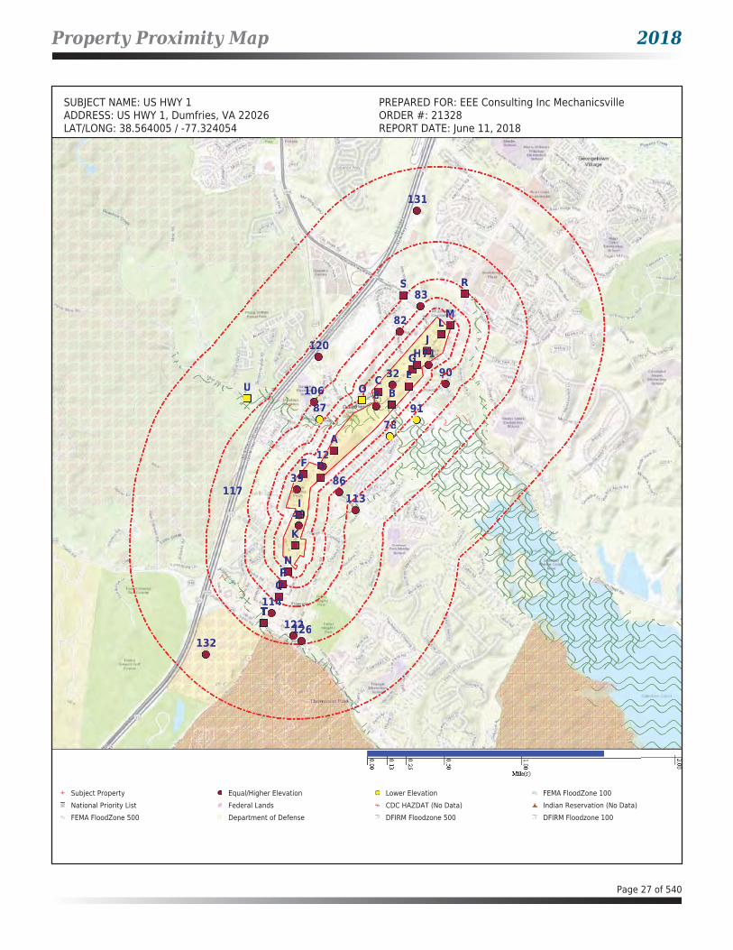
Property Proximity Map 2018
SUBJECT NAME: US HWY 1 PREPARED FOR: EEE Consulting Inc MechanicsvilleADDRESS: US HWY 1, Dumfries, VA 22026 ORDER #: 21328LAT/LONG: 38.564005 / -77.324054 REPORT DATE: June 11, 2018
8
12
32
39
49
NP
Q
T
71
82
83
86
90
RS
106
113
114
120
122126
131
132
A
BC
DF
G
I
J
K
LM
E
H
T
OU
7887 91
TT
117
8888888888
12221
3323
39393999
44944949
NNNPPPP
QQQ
717171
822
83
8668
9090
RS
1066
113113
1141444
1201
122126112222
131
132
AAA
BBCCC
DDDDDFFF
GGG
I
J
K
LLLMM
EEE
HGG
OOU
788788888887788788 9191
TTTTTTTTTTTTTT
117
Subject Property Equal/Higher Elevation Lower Elevation FEMA FloodZone 100 National Priority List Federal Lands CDC HAZDAT (No Data) Indian Reservation (No Data)FEMA FloodZone 500 Department of Defense DFIRM Floodzone 500 DFIRM Floodzone 100
Page 27 of 540

Area Map 2018
SUBJECT NAME: US HWY 1 PREPARED FOR: EEE Consulting Inc MechanicsvilleADDRESS: US HWY 1, Dumfries, VA 22026 ORDER #: 21328LAT/LONG: 38.564005 / -77.324054 REPORT DATE: June 11, 2018
8
12
32
39
49
NP
Q
T
71
82
83
86
90
RS
106
113
114
120
A
B
C
DF
G
I
J
K
LM
E
H
T
OU
78
87 91
TT
117
88888
121212
32
3393
494949
NNNP
Q
1711
822
83
8686
909
RRS
1066
3113131
114
120
AAA
B
CCC
DDDFFF
G
I
J
K
LMM
E
H
OOUU
787
87 9191
TTTTTTTTTTTTTTTT
117
Subject Property Equal/Higher Elevation Lower Elevation FEMA FloodZone 100 National Priority List Federal Lands CDC HAZDAT (No Data) Indian Reservation (No Data)FEMA FloodZone 500 Department of Defense DFIRM Floodzone 500 DFIRM Floodzone 100
Page 28 of 540

Map Findings Summary 2018
DATABASESUBJECT
PROPERTY
SEARCH DISTANCE(MILES) <1/8 1/8 - 1/4 1/4 - 1/2 1/2 - 1 >1
TOTAL MAPPED
STATE BROWNFIELD LIST
BROWNFIELDS - VA 0.500 0 0 0 -- -- 0
FEDERAL RCRA NON-CORRACTS TSD FACILITIES LIST
ARCHIVED RCRA TSDF 0.500 0 0 0 -- -- 0
RCRA_TSDF 0.500 0 0 0 -- -- 0
FEDERAL CERCLIS LIST
CERCLIS NFRAP 0.500 0 1 1 -- -- 2
CERCLIS-HIST 0.500 0 0 1 -- -- 1
FEDERAL FACILITY 1.000 0 0 1 0 -- 1
SEMS_8R_ACTIVE SITES 0.500 0 0 1 -- -- 1
SEMS_8R_ARCHIVED SITES 0.500 0 1 1 -- -- 2
FEDERAL RCRA CORRACTS FACILITIES LIST
CORRACTS 1.000 0 0 0 0 -- 0
FEDERAL DELISTED NPL SITE LIST
DELISTED NPL 1.000 0 0 0 0 -- 0
DELISTED PROPOSED NPL 1.000 0 0 0 0 -- 0
SEMS_DELETED NPL 1.000 0 0 0 0 -- 0
FEDERAL ERNS LIST
ERNS X SP -- -- -- -- -- 2
FEDERAL INSTITUTIONAL CONTROLS / ENGINEERING CONTROLS REGISTRIES
FED E C 0.500 0 0 1 -- -- 1
FED I C 0.500 0 0 1 -- -- 1
RCRA IC_EC 0.250 0 0 -- -- -- 0
FEDERAL NPL SITE LIST
NPL 1.000 0 0 1 0 -- 1
NPL EPA R1 GIS 1.000 0 0 0 0 -- 0
NPL EPA R3 GIS 1.000 0 0 1 0 -- 1
NPL EPA R6 GIS 1.000 0 0 0 0 -- 0
NPL EPA R8 GIS 1.000 0 0 0 0 -- 0
NPL EPA R9 GIS 1.000 0 0 0 0 -- 0
PART NPL 1.000 0 0 0 0 -- 0
PROPOSED NPL 1.000 0 0 0 0 -- 0
SEMS_FINAL NPL 1.000 0 0 1 0 -- 1
SEMS_PROPOSED NPL 1.000 0 0 0 0 -- 0
Page 29 of 540
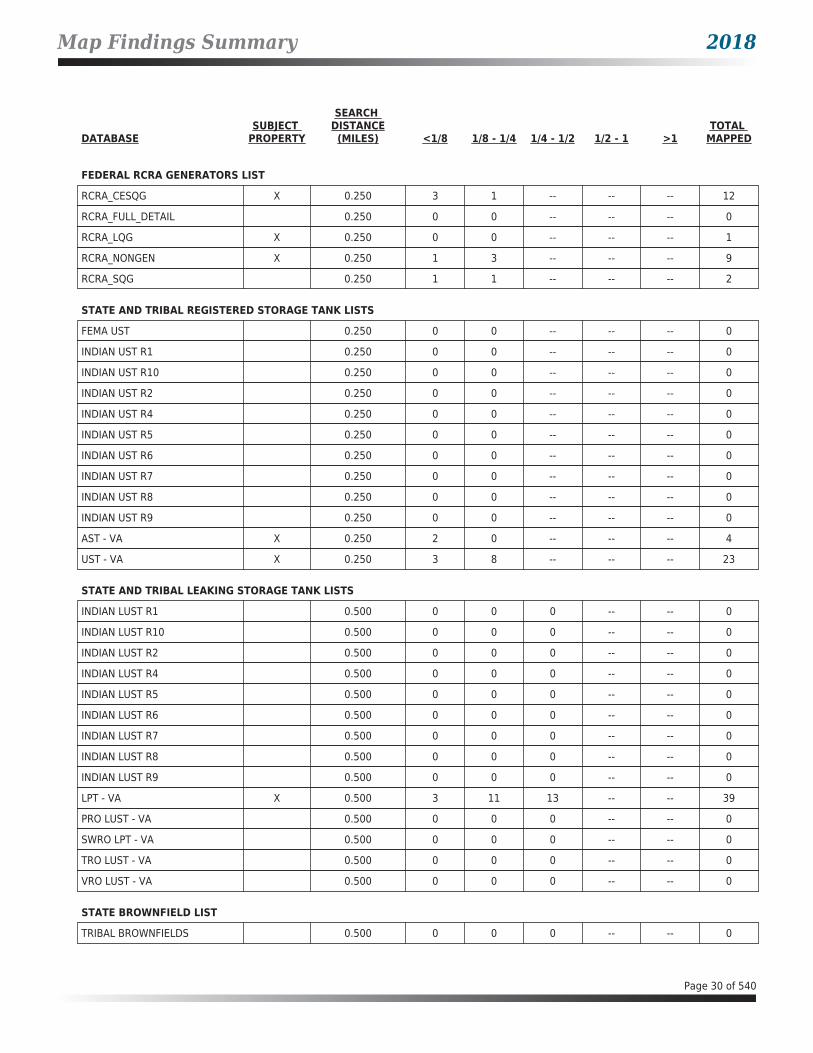
Map Findings Summary 2018
DATABASESUBJECT
PROPERTY
SEARCH DISTANCE(MILES) <1/8 1/8 - 1/4 1/4 - 1/2 1/2 - 1 >1
TOTAL MAPPED
FEDERAL RCRA GENERATORS LIST
RCRA_CESQG X 0.250 3 1 -- -- -- 12
RCRA_FULL_DETAIL 0.250 0 0 -- -- -- 0
RCRA_LQG X 0.250 0 0 -- -- -- 1
RCRA_NONGEN X 0.250 1 3 -- -- -- 9
RCRA_SQG 0.250 1 1 -- -- -- 2
STATE AND TRIBAL REGISTERED STORAGE TANK LISTS
FEMA UST 0.250 0 0 -- -- -- 0
INDIAN UST R1 0.250 0 0 -- -- -- 0
INDIAN UST R10 0.250 0 0 -- -- -- 0
INDIAN UST R2 0.250 0 0 -- -- -- 0
INDIAN UST R4 0.250 0 0 -- -- -- 0
INDIAN UST R5 0.250 0 0 -- -- -- 0
INDIAN UST R6 0.250 0 0 -- -- -- 0
INDIAN UST R7 0.250 0 0 -- -- -- 0
INDIAN UST R8 0.250 0 0 -- -- -- 0
INDIAN UST R9 0.250 0 0 -- -- -- 0
AST - VA X 0.250 2 0 -- -- -- 4
UST - VA X 0.250 3 8 -- -- -- 23
STATE AND TRIBAL LEAKING STORAGE TANK LISTS
INDIAN LUST R1 0.500 0 0 0 -- -- 0
INDIAN LUST R10 0.500 0 0 0 -- -- 0
INDIAN LUST R2 0.500 0 0 0 -- -- 0
INDIAN LUST R4 0.500 0 0 0 -- -- 0
INDIAN LUST R5 0.500 0 0 0 -- -- 0
INDIAN LUST R6 0.500 0 0 0 -- -- 0
INDIAN LUST R7 0.500 0 0 0 -- -- 0
INDIAN LUST R8 0.500 0 0 0 -- -- 0
INDIAN LUST R9 0.500 0 0 0 -- -- 0
LPT - VA X 0.500 3 11 13 -- -- 39
PRO LUST - VA 0.500 0 0 0 -- -- 0
SWRO LPT - VA 0.500 0 0 0 -- -- 0
TRO LUST - VA 0.500 0 0 0 -- -- 0
VRO LUST - VA 0.500 0 0 0 -- -- 0
STATE BROWNFIELD LIST
TRIBAL BROWNFIELDS 0.500 0 0 0 -- -- 0
Page 30 of 540

Map Findings Summary 2018
DATABASESUBJECT
PROPERTY
SEARCH DISTANCE(MILES) <1/8 1/8 - 1/4 1/4 - 1/2 1/2 - 1 >1
TOTAL MAPPED
STATE AND TRIBAL VOLUNTARY CLEANUP SITES
ARCHIVED VRP - VA 0.500 0 0 0 -- -- 0
VRP - VA 0.500 0 0 0 -- -- 0
STATE INSTITUTIONAL CONTROLS / ENGINEERING CONTROLS REGISTRIES
I C - VA 0.500 0 0 0 -- -- 0
STATE AND TRIBAL LANDFILL AND/OR SOLID WASTE DISPOSAL SITE LISTS
SWF/LF - VA 0.500 0 0 1 -- -- 1
LOCAL LISTS OF LANDFILL / SOLID WASTE DISPOSAL SITES
DEBRIS REGION 9 0.500 0 0 0 -- -- 0
INDIAN ODI R8 0.500 0 0 0 -- -- 0
ODI 0.500 0 0 0 -- -- 0
TRIBAL ODI 0.500 0 0 0 -- -- 0
LOCAL LISTS OF HAZARDOUS WASTE / CONTAMINATED SITES
FED CDL SP -- -- -- -- -- 0
US HIST CDL SP -- -- -- -- -- 0
LOCAL BROWNFIELD LISTS
FED BROWNFIELDS 0.500 0 0 0 -- -- 0
RECORDS OF EMERGENCY RELEASE REPORTS
HMIRS (DOT) SP -- -- -- -- -- 0
ARCHIVED SPILLS - VA X 0.125 5 -- -- -- -- 10
SPILLS - VA X 0.125 1 -- -- -- -- 9
LOCAL LAND RECORDS
LIENS 2 SP -- -- -- -- -- 0
OTHER ASCERTAINABLE RECORDS
AFS X SP -- -- -- -- -- 5
BRS X SP -- -- -- -- -- 1
CDC HAZDAT 1.000 0 0 0 0 -- 0
COAL ASH DOE 0.500 0 0 0 -- -- 0
COAL ASH EPA 0.500 0 0 0 -- -- 0
COAL GAS 1.000 0 0 0 0 -- 0
CONSENT (DECREES) 1.000 0 0 1 0 -- 1
CORRECTIVE ACTIONS_2020 0.500 0 0 0 -- -- 0
DIGITAL OBSTACLE 1.000 0 1 0 6 -- 7
Page 31 of 540

Map Findings Summary 2018
DATABASESUBJECT
PROPERTY
SEARCH DISTANCE(MILES) <1/8 1/8 - 1/4 1/4 - 1/2 1/2 - 1 >1
TOTAL MAPPED
OTHER ASCERTAINABLE RECORDS (cont.)
DOD 1.000 0 0 1 0 -- 1
DOT OPS SP -- -- -- -- -- 0
ECHO X SP -- -- -- -- -- 19
ENOI SP -- -- -- -- -- 0
EPA FUELS SP -- -- -- -- -- 0
EPA OSC 0.125 0 -- -- -- -- 0
EPA WATCH SP -- -- -- -- -- 0
FA HWF SP -- -- -- -- -- 0
FEDLAND 1.000 0 0 2 0 -- 2
FRS X SP -- -- -- -- -- 19
FTTS SP -- -- -- -- -- 0
FTTS INSP SP -- -- -- -- -- 0
FUDS 1.000 0 0 0 0 -- 0
HIST AFS SP -- -- -- -- -- 0
HWC DOCKET SP -- -- -- -- -- 0
ICIS X SP -- -- -- -- -- 2
INDIAN RESERVATION 1.000 0 0 0 0 -- 0
LEAD_SMELTER SP -- -- -- -- -- 0
LUCIS 0.500 0 0 0 -- -- 0
LUCIS 2 0.500 0 0 0 -- -- 0
MINES 0.250 0 0 -- -- -- 0
MLTS SP -- -- -- -- -- 0
NPL AOC 1.000 0 0 0 0 -- 0
NPL LIENS SP -- -- -- -- -- 0
OSHA SP -- -- -- -- -- 0
PADS SP -- -- -- -- -- 0
PCB TRANSFORMER SP -- -- -- -- -- 0
RAATS SP -- -- -- -- -- 0
RADINFO SP -- -- -- -- -- 0
RMP 0.500 0 0 0 -- -- 0
ROD 1.000 0 0 1 0 -- 1
SCRD DRYCLEANERS 0.250 0 0 -- -- -- 0
SEMS_SMELTER SP -- -- -- -- -- 0
SSTS SP -- -- -- -- -- 0
TOSCA-CHEMICAL SP -- -- -- -- -- 0
TOSCA-PLANT SP -- -- -- -- -- 0
Page 32 of 540

Map Findings Summary 2018
DATABASESUBJECT
PROPERTY
SEARCH DISTANCE(MILES) <1/8 1/8 - 1/4 1/4 - 1/2 1/2 - 1 >1
TOTAL MAPPED
OTHER ASCERTAINABLE RECORDS (cont.)
TRIS X SP -- -- -- -- -- 1
UMTRA 0.500 0 0 0 -- -- 0
AIRS - VA SP -- -- -- -- -- 0
CEDS - VA SP -- -- -- -- -- 0
DAYCARE - VA SP -- -- -- -- -- 0
DRYCLEANERS - VA 0.250 0 0 -- -- -- 0
ENF - VA X SP -- -- -- -- -- 1
HIST DRYCLEANERS - VA 0.250 0 0 -- -- -- 0
Page 33 of 540

Map Findings 2018
Map Id: A1Direction: Distance: Actual: Not AvailableElevation: Relative:
Envirosite ID: 26857027EPA ID: N/RSite Name : DUMFRIES PHARMACY
245 S FRALEY BLVDDUMFRIES, VA 22026
Database(s) : [ECHO, FRS, RCRA_NONGEN]
ECHO
Facility Name : DUMFRIES PHARMACYFacility Address : 245 S FRALEY BLVD, DUMFRIES, VA 22026County : PRINCE WILLIAM
Last Inspection Date : 08/21/1998Registry ID : 110005250771FIPS Code : 51153EPA Region : 03Inspection Count : 0Last Inspection Days : 7142Informal Count : 0Last Informal Action Date : N/RFormal Action Count : 0Last Formal Action Date : N/RTotal Penalties : 0Penalty Count : N/RLast Penalty Date : N/RLast Penalty Amount : N/RQTRS IN NC : 0Programs IN SNC : 0Current Compliance Status : No ViolationThree-Year Compliance Status : ____________Collection Method : ADDRESS MATCHING-HOUSE NUMBERReference Point : PLANT ENTRANCE (GENERAL)Accuracy Meters : 150Derived Tribes : N/RDerived HUC : 02070011Derived WBD : 020700110104Derived STCTY FIPS : 51153Derived Zip : 22026Derived CD113 : 11Derived CB2010 : 511539010012003MYRTK Universe : NNNNPDES IDs : N/RCWA Permit Types : N/RCWA Compliance Tracking : N/RCWA NAICS : N/RCWA SICS : N/RCWA Inspection Count : N/RCWA Last Inspection Days : N/RCWA Informal Count : N/RCWA Formal Action Count : N/RCWA Last Formal Action Date : N/RCWA Penalties : N/RCWA Last Penalty Date : N/RCWA Last Penalty Amount : N/RCWA Quarters IN NC : N/RCWA Current Compliance Status : N/RCWA Current SNC Flag : NCWA 13 Quarters Compliance Status : N/RCWA 13 Quarters Effluent Exceedances: N/RCWA Three-Year QNCR Codes : N/RDFR URL : Click here for hyperlink provided by the agency.Facility SIC Codes : N/RFacility NAICS Codes : 44611Facility Last Inspection EPA Date : N/R
Page 34 of 540

Map Findings 2018
Map Id: A1Direction: Distance: Actual: Not AvailableElevation: Relative:
Envirosite ID: 26857027EPA ID: N/RSite Name : DUMFRIES PHARMACY
245 S FRALEY BLVDDUMFRIES, VA 22026
Database(s) : [ECHO, FRS, RCRA_NONGEN] (cont.)
ECHO (cont.)
Facility Last Inspection State Date : 08/21/1998Facility Last Formal Act EPA Date : N/RFacility Last Formal Act State Date : N/RFacility Last Informal Act EPA Date : N/RFacility Last Informal Act State Date: N/RFacility Federal Agency : N/RTRI Reporter : N/RFacility Imp Water Flag : N/RCurrent SNC Flag : NIndian County Flag : NFederal Flag : N/RUS Mexico Border Flag : N/RChesapeak Bay Flag : YAIR Flag : NNPDES Flag : NSDWIS Flag : NRCRA Flag : YTRI Flag : NGHG Flag : NMajor Flag : N/RActive Flag : N/RNAA Flag : YLatitude : 38.563561Longitude : -77.327982
FRS
Facility Name : DUMFRIES PHARMACYFacility Address : 245 S FRALEY BLVD, DUMFRIES, VA 22026County : PRINCE WILLIAM
Registry ID : 110005250771FRS Facility URL : Click here for hyperlink provided by the agency.
Source Description :
RCRAInfo is EPA’s comprehensive information system that supports the Resource Conservation and Recovery Act (RCRA) of 1976 and the Hazardous and Solid Waste Amendments (HSWA) of 1984 through the tracking of events and activities related to facilities that generate, transport, and treat, store, or dispose of hazardous waste. RCRAInfo allows RCRA program staff to track the notification, permit, compliance, and corrective action activities required under RCRA. RCRAInfo also supports generation of the National Hazardous Waste Biennial Report. All generators and treatment, storage, and disposal facilities who handle hazardous waste are required to report to the EPA Administrator at least once every two years to support creation of the Biennial Report.
FRS Environmental InterestSource and System ID : RCRAINFO - VAD988212882
RCRA_NONGEN
Date form received by agency : 08/21/1998Facility name : DUMFRIES PHARMACYFacility address : 245 S FRALEY BLVD, DUMFRIES VA 22026
Page 35 of 540

Map Findings 2018
Map Id: A1Direction: Distance: Actual: Not AvailableElevation: Relative:
Envirosite ID: 26857027EPA ID: N/RSite Name : DUMFRIES PHARMACY
245 S FRALEY BLVDDUMFRIES, VA 22026
Database(s) : [ECHO, FRS, RCRA_NONGEN] (cont.)
RCRA_NONGEN (cont.)
EPA ID : VAD988212882Mailing address : 245 S FRALEY BLVD, DUMFRIES VA 22026Contact : N/RContact address : N/RContact country : USContact telephone : N/RContact email : N/REPA Region : 03Land type : N/RSource type : ImplementerClassification : Not a generator, verifiedDescription : Not a generator, verified
Handler Activities Summary :U.S. importer of hazardous waste : NoMixed waste (haz. and radioactive) : NoRecycler of hazardous waste : NoTransporter of hazardous waste : NoTreater storer or disposer of HW : NoUnderground injection activity : NoOn-site burner exemption : NoFurnace exemption : NoUsed oil fuel burner : NoUsed oil processor : NoUsed oil refiner : NoUsed oil fuel marketer to burner : NoUsed oil Specification marketer : NoUsed oil transfer facility : NoUsed oil transporter : No
Historical Generators :Date form received by agency : 03/02/1992Facility name : DUMFRIES PHARMACYClassification : Conditionally Exempt Small Quantity Generator
Facility has No violations / inspections reported.
Evaluation Action Summary :Evaluation date : 08/21/1998Evaluation : COMPLIANCE EVALUATION INSPECTION ON-SITEArea of violation : N/RDate achieved compliance : N/REvaluation lead agency : State
Page 36 of 540

Map Findings 2018
Map Id: A2Direction: Distance: Actual: Not AvailableElevation: Relative:
Envirosite ID: 351687447EPA ID: N/RSite Name : N/R
17882 FRALEY BLVDDUMFRIES, VA
Database(s) : [ERNS]
ERNS
Facility Address : 17882 FRALEY BLVD, DUMFRIES, VACounty : PRINCE WILLIAM
Incident InformationIncident Date Time : 09/07/2017 10:00 AMType of Incident : FIXEDIncident Cause : OPERATOR ERRORIncident DTG : DISCOVEREDIncident Location : N/RSequence Number : 1189644Potential Flag : N
Description of Incident : CALLER REPORTS A DISCHARGE OF VARIOUS OILS INCLUDING DIESEL, GASOLINE, AND MOTOR OILS, ONTO THE GROUND WITH AN UNKNOWN AMOUNT IN A DRAINAGE DITCH AT A PRIVATE BUSINESS FACILITY.
Incident Response SummaryDate Time Received : 09/07/2017 12:30 PMDate Time Completed : 09/07/2017 12:55 PMCall Type : IncidentSource : TELEPHONEResponsible Company : TRIPLE A TIRESResponsible Org Type : UNKNOWNResponsible City : DUMFRIESResponsible State : VAResponsible Zip : N/R
Incident Details Summary
Remedial Action : CALLER REPORTS THE BUSINESS PERSONNEL ARE CLEANING UP THE DISCHARGE BUT DOING A VERY POOR JOB. CONTINUOS SPILLING WHILE ATTEMPTING TO CLEAN WITH SNOW SHOVEL INTO AN UNSEALED DRUM.
Medium : DRAINAGE DITCHMedium Description : WATERBody of Water : DRAINAGE DITCHWeather Conditions : SUNNYWater Temperature : N/RWater Supply Contaminated : UWaterway Closed : NWaterway Description : N/R
Additional Incident Details SummaryActual Amount : N/RActual Amount Units : N/RCapacity of Tank : N/RCapacity of Tank Units : N/RContinuous Release Begin Date : N/RContinuous Release End Date : N/R
Page 37 of 540

Map Findings 2018
Map Id: A2Direction: Distance: Actual: Not AvailableElevation: Relative:
Envirosite ID: 351687447EPA ID: N/RSite Name : N/R
17882 FRALEY BLVDDUMFRIES, VA
Database(s) : [ERNS] (cont.)
ERNS (cont.)
Continuous Release Change Date : N/RContinuous Release Permit : N/RContinuous Release Type : N/RDescription of Tank : N/RDevice Operational : UDOT Crossing Number : N/RDOT Regulated : UNPDES : N/RNPDES Compliance : UPipeline Aboveground : ABOVEPipeline Covered : UPipeline Type : N/RTank ID : N/RTank Regulated : UTank Regulated by : N/R
Materials Involved SummaryName of Material : GASOLINE: AUTOMOTIVE (UNLEADED)CAS Number : 000000-00-0Amount of Material : 0Unit of Measure : UNKNOWN AMOUNTUN Number : N/RCHRIS Code : GASReached Water : YESAmount in Water : 0Unit of Measure (Reach Water) : UNKNOWN AMOUNT
Name of Material : OIL, FUEL: NO. 1-DCAS Number : 000000-00-0Amount of Material : 0Unit of Measure : UNKNOWN AMOUNTUN Number : N/RCHRIS Code : OODReached Water : YESAmount in Water : 0Unit of Measure (Reach Water) : UNKNOWN AMOUNT
Name of Material : OTHER OILCAS Number : 000000-00-0Amount of Material : 0Unit of Measure : UNKNOWN AMOUNTUN Number : N/RCHRIS Code : OTHReached Water : YESAmount in Water : 0Unit of Measure (Reach Water) : UNKNOWN AMOUNT
Additional Materials Involved SummaryName of Material : N/RCAS Number : N/RCHRIS Code : N/R
Page 38 of 540

Map Findings 2018
Map Id: A2Direction: Distance: Actual: Not AvailableElevation: Relative:
Envirosite ID: 351687447EPA ID: N/RSite Name : N/R
17882 FRALEY BLVDDUMFRIES, VA
Database(s) : [ERNS] (cont.)
ERNS (cont.)
Upper Bounds : N/RUpper Bounds Unit : N/RUpper Bounds Rate : N/R
Trains DetailsTrain Name Number : N/RTrain Type : N/RTrain Speed : N/RTrain Direction : N/RNumber Locomotives : N/RNumber Cars : N/RNumber Derailed : N/RTrack Speed : N/RRailroad Name : N/RNon Compliance with Hazmat : N/R
Derailed Units SummaryTrain Name Number : N/RCar Number : N/RCar Content : N/RPosition in Train : N/RDerailed Type : N/R
Vessels DetailsVessel Name : N/RVessel Type : N/RVessel Length : N/RHull Construction : N/RFuel Capacity : N/RFuel on Board : N/RCargo Capacity : N/RCargo on Board : N/RIs Vessel Aground : N/RFlag : N/RBreadth : N/RDraught : N/RFuel Capacity Units : N/RFuel on Board Units : N/RCargo Capacity Units : N/RCargo on Board Units : N/R
Mobile DetailsVehicle Own Fuel Capacity : N/RCargo Capacity : N/RAmount of Cargo on Board : N/RHazmat Carrier : N/RCarrier Licensed : N/RNoncompliance with Hazmat : N/RMobile Type : N/R
Page 39 of 540

Map Findings 2018
Map Id: A2Direction: Distance: Actual: Not AvailableElevation: Relative:
Envirosite ID: 351687447EPA ID: N/RSite Name : N/R
17882 FRALEY BLVDDUMFRIES, VA
Database(s) : [ERNS] (cont.)
ERNS (cont.)
Cargo Capacity Units : N/RAmount of Cargo on Board Units : N/RVehicle Year : N/RVehicle Make : N/RVehicle Model : N/RVehicle Number : N/RTrailer Number : N/R
Map Id: A3Direction: Distance: Actual: Not AvailableElevation: Relative:
Envirosite ID: 360926987EPA ID: N/RSite Name : TRIPLE A TIRES FUEL SPILL
17882 FRALEY BLVDDUMFRIES, VA 22026
Database(s) : [SPILLS - VA]
SPILLS - VA
Facility Name : Triple A Tires Fuel SpillFacility Address : 17882 Fraley Blvd, Dumfries, VA 22026County : Prince William County
Incident Date : 09/07/2017Call Received Date : 09/08/2017Closure Date : 09/08/2017IR Number : 2018-N-0644Associated IR : N/RReference ID : 109827Status : ClosedFacility Name : N/RRegion : NorthernIncident Type : PetroleumIncident Subtype : Petroleum * Surface SpillThreat to : N/RTerrorism (Y/N) : NCharacterize Incident : UnknownMaterials : Fuel (0-0 Unknown) * Oil (0-0 Unknown)Effect to Receptor : N/RWater Body : N/RLow Quantity to Water : N/RHigh Quantity to Water : N/RQuantity Units : N/ROther Receptors : N/RRP Company : N/RRP Name : N/RProperty Owner : N/RProperty Company : N/RDuration of Event (Hours) : 0Impacts : N/ROther Impacts : N/RSteps Taken : N/RSteps Taken Description : N/R
Page 40 of 540

Map Findings 2018
Map Id: A3Direction: Distance: Actual: Not AvailableElevation: Relative:
Envirosite ID: 360926987EPA ID: N/RSite Name : TRIPLE A TIRES FUEL SPILL
17882 FRALEY BLVDDUMFRIES, VA 22026
Database(s) : [SPILLS - VA] (cont.)
SPILLS - VA (cont.)
System Components : N/ROther System Components : N/RCause of Event : N/RCorrective Action Taken : N/RWeather Status : N/APrecipitation (Wet) : 0Discharge Type : N/ADischarge Volume : 0Unknown Discharge (Y/N) : N
Original Call Incident Description :
PER NRC# 1189644...CALLER REPORTS A DISCHARGE OF VARIOUS OILS INCLUDING DIESEL, GASOLINE, AND MOTOR OILS, ONTO THE GROUND WITH AN UNKNOWN AMOUNT IN A DRAINAGE DITCH AT A PRIVATE BUSINESS FACILITY...CALLER REPORTS THE BUSINESS PERSONNEL ARE CLEANING UP THE DISCHARGE BUT DOING A VERY POOR JOB. CONTINUOS SPILLING WHILE ATTEMPTING TO CLEAN WITH SNOW SHOVEL INTO AN UNSEALED DRUM....NO VDEM RESOURCES REQUESTED...
Original Call Material Description : fuel spillOriginal Call Location Description : 17882 Fraley Blvd in Dumfries, VAIncident Ongoing at Time of Call : NAgencies Notified (Y/N) : Y
Other Agencies : Prince William Fire and Rescue (by DEQ); VDEM (HMVA-26992 RHMO-Iverson); NRC (#1189644)
Permitted (Y/N) : NCall Reported by Name : N/RCall Reported by Company Name : Caliber CollisionCall RP Company Name : Triple A TiresCall RP Name : N/RCall Property Owner Company Name : N/RCall Property Owner Name : N/R
Closure Comments : Case ClosedPrince William County Fire and Rescue completed site investigation - unfounded complaint
Site Summary : N/R
Map Id: A4Direction: Distance: Actual: Not AvailableElevation: Relative:
Envirosite ID: 7075701EPA ID: N/RSite Name : POHANKA COLLISION CENTER OF
DUMFRIES17884 FRALEY BLVDDUMFRIES, VA 22026
Database(s) : [AFS, ECHO, FRS]
AFS
Facility Name : POHANKA COLLISION CENTER OF DUMFRIESFacility Address : 17884 FRALEY BLVD, DUMFRIES, VA 22026County : Prince William
Page 41 of 540

Map Findings 2018
Map Id: A4Direction: Distance: Actual: Not AvailableElevation: Relative:
Envirosite ID: 7075701EPA ID: N/RSite Name : POHANKA COLLISION CENTER OF
DUMFRIES17884 FRALEY BLVDDUMFRIES, VA 22026
Database(s) : [AFS, ECHO, FRS] (cont.)
AFS (cont.)
Facility SummaryProgram System ID : VA0000005115300857Facility Registry ID : 110033181722EPA Region : EPA Region 3 - DE, DC, MD, PA, VA, WVSIC Codes : N/RNAICS Code : 811121NAICS Code Description : Automotive Body, Paint, and Interior Repair and MaintenanceFacility Type : Non-GovernmentAir Pollutant Class Code : MINAir Pollutant Class Description : Minor EmissionsAir Operating Status Code : OPRAir Operating Status Description : OperatingCurrent High Priority Violation (HPV) Code: No ViolCurrent High Priority Violation (HPV) Description: No ViolLocal Control Region Code : N/RLocal Control Region Name : N/R
Air Pollutant DetailsProgram System ID : VA0000005115300857Pollutant Code : 300000228Pollutant Description : Nickel compoundsSRS ID : 650036Chemical Abstract Service Number : N/RAir Pollutant Class Code : MINAir Pollutant Class Description : Minor Emissions
Program System ID : VA0000005115300857Pollutant Code : 300000243Pollutant Description : VOLATILE ORGANIC COMPOUNDS (VOCS)SRS ID : 761346Chemical Abstract Service Number : N/RAir Pollutant Class Code : MINAir Pollutant Class Description : Minor Emissions
Air Violation History DetailsHPV Day Zero Date : N/RHPV Resolved Date : N/RProgram System ID : N/RActivity ID : N/RAgency Type : N/RState Code : N/RAir LCON Code : N/RComp Determination UID : N/RENF Response Policy Codes : N/RENF Response Policy Description : N/RProgram Codes : N/RProgram Description : N/RPollutant Codes : N/RPollutant Description : N/R
Page 42 of 540

Map Findings 2018
Map Id: A4Direction: Distance: Actual: Not AvailableElevation: Relative:
Envirosite ID: 7075701EPA ID: N/RSite Name : POHANKA COLLISION CENTER OF
DUMFRIES17884 FRALEY BLVDDUMFRIES, VA 22026
Database(s) : [AFS, ECHO, FRS] (cont.)
AFS (cont.)
Earliest FRV Determ Date : N/R
ECHO
Facility Name : POHANKA COLLISION CENTER OF DUMFRIESFacility Address : 17884 FRALEY BLVD, DUMFRIES, VA 22026County : PRINCE WILLIAM
Last Inspection Date : N/RRegistry ID : 110033181722FIPS Code : 51153EPA Region : 03Inspection Count : 0Last Inspection Days : N/RInformal Count : 0Last Informal Action Date : N/RFormal Action Count : 0Last Formal Action Date : N/RTotal Penalties : 0Penalty Count : N/RLast Penalty Date : N/RLast Penalty Amount : N/RQTRS IN NC : 0Programs IN SNC : 0Current Compliance Status : No ViolationThree-Year Compliance Status : ____________Collection Method : ADDRESS MATCHING-HOUSE NUMBERReference Point : ENTRANCE POINT OF A FACILITY OR STATIONAccuracy Meters : 50Derived Tribes : N/RDerived HUC : 02070011Derived WBD : 020700110104Derived STCTY FIPS : 51153Derived Zip : 22026Derived CD113 : 11Derived CB2010 : 511539009011008MYRTK Universe : NNNNPDES IDs : N/RCWA Permit Types : N/RCWA Compliance Tracking : N/RCWA NAICS : N/RCWA SICS : N/RCWA Inspection Count : N/RCWA Last Inspection Days : N/RCWA Informal Count : N/RCWA Formal Action Count : N/RCWA Last Formal Action Date : N/RCWA Penalties : N/RCWA Last Penalty Date : N/RCWA Last Penalty Amount : N/RCWA Quarters IN NC : N/RCWA Current Compliance Status : N/RCWA Current SNC Flag : NCWA 13 Quarters Compliance Status : N/RCWA 13 Quarters Effluent Exceedances: N/R
Page 43 of 540

Map Findings 2018
Map Id: A4Direction: Distance: Actual: Not AvailableElevation: Relative:
Envirosite ID: 7075701EPA ID: N/RSite Name : POHANKA COLLISION CENTER OF
DUMFRIES17884 FRALEY BLVDDUMFRIES, VA 22026
Database(s) : [AFS, ECHO, FRS] (cont.)
ECHO (cont.)
CWA Three-Year QNCR Codes : N/RDFR URL : Click here for hyperlink provided by the agency.Facility SIC Codes : N/RFacility NAICS Codes : 811121Facility Last Inspection EPA Date : N/RFacility Last Inspection State Date : N/RFacility Last Formal Act EPA Date : N/RFacility Last Formal Act State Date : N/RFacility Last Informal Act EPA Date : N/RFacility Last Informal Act State Date: N/RFacility Federal Agency : N/RTRI Reporter : N/RFacility Imp Water Flag : N/RCurrent SNC Flag : NIndian County Flag : NFederal Flag : N/RUS Mexico Border Flag : N/RChesapeak Bay Flag : YAIR Flag : YNPDES Flag : NSDWIS Flag : NRCRA Flag : YTRI Flag : NGHG Flag : NMajor Flag : N/RActive Flag : YNAA Flag : YLatitude : 38.562833Longitude : -77.3281
FRS
Facility Name : POHANKA COLLISION CENTER OF DUMFRIESFacility Address : 17884 FRALEY BLVD, DUMFRIES, VA 220260000County : PRINCE WILLIAM
Registry ID : 110033181722FRS Facility URL : Click here for hyperlink provided by the agency.
Source Description :
AFS contains compliance and permit data for stationary sources of air pollution regulated by the EPA, State, and Local air pollution agencies.
Source Description :
AIR contains compliance and permit data for stationary sources of air pollution regulated by the EPA, State, and Local air pollution agencies.
Page 44 of 540

Map Findings 2018
Map Id: A4Direction: Distance: Actual: Not AvailableElevation: Relative:
Envirosite ID: 7075701EPA ID: N/RSite Name : POHANKA COLLISION CENTER OF
DUMFRIES17884 FRALEY BLVDDUMFRIES, VA 22026
Database(s) : [AFS, ECHO, FRS] (cont.)
FRS (cont.)
Source Description :
RCRAInfo is EPA’s comprehensive information system that supports the Resource Conservation and Recovery Act (RCRA) of 1976 and the Hazardous and Solid Waste Amendments (HSWA) of 1984 through the tracking of events and activities related to facilities that generate, transport, and treat, store, or dispose of hazardous waste. RCRAInfo allows RCRA program staff to track the notification, permit, compliance, and corrective action activities required under RCRA. RCRAInfo also supports generation of the National Hazardous Waste Biennial Report. All generators and treatment, storage, and disposal facilities who handle hazardous waste are required to report to the EPA Administrator at least once every two years to support creation of the Biennial Report.
FRS Environmental InterestSource and System ID : AIRS/AFS - 5115300857
ICIS - VA0000005115300857RCRAINFO - VAR000515841
Map Id: A5Direction: Distance: Actual: Not AvailableElevation: Relative:
Envirosite ID: 14441275EPA ID: N/RSite Name : MARINE STRUCTURAL APPLICATIONS
17884 S FRALEY BLVDDUMFRIES, VA 22026
Database(s) : [UST - VA]
UST - VA
Facility Name : Marine Structural ApplicationsFacility Address : 17884 S Fraley Blvd, Dumfries, VA 22026County : Prince William County
Facility ID : 3007633Facility Type : COMMERCIALCEDS Facility ID : 200000076684Region Code : NVRO
Tank InformationInstall Date : 04/26/1984Date Closed : 08/01/1997Tank Number : 2Tank Status : REM FROM GRDTank Owner ID : 36459Tank Type : USTCapacity : 10000Federally Regulated Tank : YContents : DIESELOther Contents : N/R
Page 45 of 540

Map Findings 2018
Map Id: A5Direction: Distance: Actual: Not AvailableElevation: Relative:
Envirosite ID: 14441275EPA ID: N/RSite Name : MARINE STRUCTURAL APPLICATIONS
17884 S FRALEY BLVDDUMFRIES, VA 22026
Database(s) : [UST - VA] (cont.)
UST - VA (cont.)
Tank Material InformationTank Number : 2Tank Owner ID : 36459Tank Material Asphalt/Bare Steel : YTank Material CCP/STI-P3 : NTank Material Composite : NTank Material Fiberglass : NTank Material Concrete : NTank Material Impressed Current : NTank Material Double Walled : NTank Material Lined Interior : YTank Material Excavation Liner : NTank Material Polyethylene Tank Jacket: NTank Material Secondary Containment : NTank Material Repaired : NTank Material Unknown : NTank Material Other : NTank Material Other Notes : N/R
Tank InformationInstall Date : 04/26/1976Date Closed : 05/01/1985Tank Number : 1Tank Status : CLS IN GRDTank Owner ID : 36459Tank Type : USTCapacity : 1000Federally Regulated Tank : YContents : GASOLINEOther Contents : N/R
Tank Material InformationTank Number : 1Tank Owner ID : 36459Tank Material Asphalt/Bare Steel : YTank Material CCP/STI-P3 : NTank Material Composite : NTank Material Fiberglass : NTank Material Concrete : NTank Material Impressed Current : NTank Material Double Walled : NTank Material Lined Interior : NTank Material Excavation Liner : NTank Material Polyethylene Tank Jacket: NTank Material Secondary Containment : NTank Material Repaired : NTank Material Unknown : NTank Material Other : NTank Material Other Notes : N/R
Page 46 of 540

Map Findings 2018
Map Id: A6Direction: Distance: Actual: Not AvailableElevation: Relative:
Envirosite ID: 24846975EPA ID: N/RSite Name : CHESAPEAKE MATERIALS
17884 S FRALEY BLVDDUMFRIES, VA 22026
Database(s) : [LPT - VA]
LPT - VA
Facility Name : Chesapeake MaterialsFacility Address : 17884 S Fraley Blvd, Dumfries, VA 22026County : Prince William County
Release Reported : 08/12/1997PC Number : 19983531CEDS Facility ID : 200000076684Case Status : ClosedCase Closed Date : 11/06/1998Region : NVROProgram : RP LeadHeating Oil Category : N/RFederally Regulated UST : YRegulated Petroleum UST (1) : YExcluded UST (1) : NDeferred UST (1) : NPartially Deferred UST (1) : NExempt 1 UST (2) : NExempt 2 Heating Oil UST (2) : NSmall Heating Oil AST (2) : NRegulated AST (3) : NUnregulated AST (3) : NOther (Y/N) : NOther Description : N/RUnknown (Y/N) : NPriority : 2Suspect Confirm Indicator : ConfirmedLatitude : 38.5627401158Longitude : -77.3278124231Last Date in Agency List : 02/09/2018
Map Id: A7Direction: Distance: Actual: Not AvailableElevation: Relative:
Envirosite ID: 29580315EPA ID: VAR000515841Site Name : CALIBER COLLISION CENTERS - DUMFRIES
17884 FRALEY BOULEVARDDUMFRIES, VA 22026
Database(s) : [RCRA_CESQG]
RCRA_CESQG
Date form received by agency : 06/15/2015Facility name : CALIBER COLLISION CENTERS - DUMFRIESFacility address : 17884 FRALEY BOULEVARD, DUMFRIES VA 22026EPA ID : VAR000515841Mailing address : 401 E CORPORATE DR, STE 150, LEWISVILLE TX 75057Contact : SHARON LAWRENCEContact address : 401 E CORPORATE DR, STE 150, LEWISVILLE TX 75057Contact country : USContact telephone : 469-948-9630Contact email : [email protected] Region : 03
Page 47 of 540

Map Findings 2018
Map Id: A7Direction: Distance: Actual: Not AvailableElevation: Relative:
Envirosite ID: 29580315EPA ID: VAR000515841Site Name : CALIBER COLLISION CENTERS - DUMFRIES
17884 FRALEY BOULEVARDDUMFRIES, VA 22026
Database(s) : [RCRA_CESQG] (cont.)
RCRA_CESQG (cont.)
Land type : PrivateSource type : NotificationClassification : Conditionally Exempt Small Quantity Generator
Description :
Handlers that generate 100 kilograms or less of hazardous waste per calendar month, and accumulate 1000 kg or less of hazardous waste at any time; or generate one kilogram or less of acutely hazardous waste per calendar month, and accumulate at any time: 1 kg or less of acutely hazardous waste; or 100 kg or less of any residue or contaminated soil, waste or other debris resulting from the cleanup of a spill, into or on any land or water, of acutely hazardous waste;or generate 100 kg or less of any residue or contaminated soil, waste or other debris resulting from the cleanup of a spill, into or on any land or water, of acutely hazardous waste during any calendar month, and accumulate at any time: 1 kg or less of acutely hazardous waste; or 100 kg or less of any residue or contaminated soil, waste or other debris resulting from the cleanup of a spill, into or on any land or water, of acutely hazardous waste.
Owner/Operator Summary :Owner Operator name : POHANKA COLLISION CENTERS INCOwner Operator address : N/ROwner Operator country : N/ROwner Operator telephone : N/ROwner Operator Email : N/ROwner Operator Fax : N/RLegal status : PrivateOwner Operator Type : OperatorOwner/Op start date : 11/01/1997Owner/Op end date : N/R
Owner Operator name : CHESAPEAKE STAFFORD ASSOC. LLCOwner Operator address : 2951 JEFFERSON DAVIS HWY, STAFFORD VA 22554Owner Operator country : USOwner Operator telephone : N/ROwner Operator Email : N/ROwner Operator Fax : N/RLegal status : PrivateOwner Operator Type : OwnerOwner/Op start date : 01/01/2000Owner/Op end date : N/R
Owner Operator name : CALIBER COLLISION CENTERSOwner Operator address : 401 E CORPORATE DR, STE 150, LEWISVILLE TX 75057Owner Operator country : USOwner Operator telephone : 469-948-9630Owner Operator Email : N/ROwner Operator Fax : N/RLegal status : PrivateOwner Operator Type : OwnerOwner/Op start date : 01/01/2015Owner/Op end date : N/R
Owner Operator name : MARK ROGERSOwner Operator address : N/ROwner Operator country : USOwner Operator telephone : N/R
Page 48 of 540

Map Findings 2018
Map Id: A7Direction: Distance: Actual: Not AvailableElevation: Relative:
Envirosite ID: 29580315EPA ID: VAR000515841Site Name : CALIBER COLLISION CENTERS - DUMFRIES
17884 FRALEY BOULEVARDDUMFRIES, VA 22026
Database(s) : [RCRA_CESQG] (cont.)
RCRA_CESQG (cont.)
Owner Operator Email : N/ROwner Operator Fax : N/RLegal status : PrivateOwner Operator Type : OperatorOwner/Op start date : 01/01/2015Owner/Op end date : N/R
Handler Activities Summary :U.S. importer of hazardous waste : NoMixed waste (haz. and radioactive) : NoRecycler of hazardous waste : NoTransporter of hazardous waste : NoTreater storer or disposer of HW : NoUnderground injection activity : NoOn-site burner exemption : NoFurnace exemption : NoUsed oil fuel burner : NoUsed oil processor : NoUsed oil refiner : NoUsed oil fuel marketer to burner : NoUsed oil Specification marketer : NoUsed oil transfer facility : NoUsed oil transporter : No
Historical Generators :Date form received by agency : 03/07/2008Facility name : POHANKA COLLISION CENTER - DUMFRIESClassification : Conditionally Exempt Small Quantity Generator
Hazardous Waste Summary :Waste code : F003
Waste name :
THE FOLLOWING SPENT NONHALOGENATED SOLVENTS: XYLENE, ACETONE, ETHYL ACETATE, ETHYL BENZENE, ETHYL ETHER, METHYL ISOBUTYL KETONE, N-BUTYL ALCOHOL, CYCLOHEXANONE, AND METHANOL; ALL SPENT SOLVENT MIXTURES/BLENDS CONTAINING, BEFORE USE, ONLY THE ABOVE SPENT NONHALOGENATED SOLVENTS; AND ALL SPENT SOLVENT MIXTURES/BLENDS CONTAINING, BEFORE USE, ONE OR MORE OF THE ABOVE NONHALOGENATED SOLVENTS, AND A TOTAL OF TEN PERCENT OR MORE (BY VOLUME) OF ONE OR MORE OF THOSE SOLVENTS LISTED IN F001, F002, F004, AND F005; AND STILL BOTTOMS FROM THE RECOVERY OF THESE SPENT SOLVENTS AND SPENT SOLVENT MIXTURES.
Waste code : F005
Waste name :
THE FOLLOWING SPENT NONHALOGENATED SOLVENTS: TOLUENE, METHYL ETHYL KETONE, CARBON DISULFIDE, ISOBUTANOL, PYRIDINE, BENZENE, 2-ETHOXYETHANOL, AND 2-NITROPROPANE; ALL SPENT SOLVENT MIXTURES/BLENDS CONTAINING, BEFORE USE, A TOTAL OF TEN PERCENT OR MORE (BY VOLUME) OF ONE OR MORE OF THE ABOVE NONHALOGENATED SOLVENTS OR THOSE SOLVENTS LISTED IN F001, F002, OR F004; AND STILL BOTTOMS FROM THE RECOVERY OF THESE SPENT SOLVENTS AND SPENT SOLVENT MIXTURES.
Facility has No violations / inspections reported.
Page 49 of 540

Map Findings 2018
Map Id: 8Direction: Distance: Actual: Not AvailableElevation: Relative:
Envirosite ID: 13355826EPA ID: VAD988170452Site Name : BUDS TRIANGLE BODY SHOP
142 N FRALEY BLVDDUMFRIES, VA 22026
Database(s) : [ECHO, FRS, RCRA_CESQG]
ECHO
Facility Name : BUDS TRIANGLE BODY SHOPFacility Address : 142 N FRALEY BLVD, DUMFRIES, VA 22026County : PRINCE WILLIAM
Last Inspection Date : N/RRegistry ID : 110005236128FIPS Code : 51153EPA Region : 03Inspection Count : 0Last Inspection Days : N/RInformal Count : 0Last Informal Action Date : N/RFormal Action Count : 0Last Formal Action Date : N/RTotal Penalties : 0Penalty Count : N/RLast Penalty Date : N/RLast Penalty Amount : N/RQTRS IN NC : 0Programs IN SNC : 0Current Compliance Status : No ViolationThree-Year Compliance Status : ____________Collection Method : ADDRESS MATCHING-HOUSE NUMBERReference Point : ENTRANCE POINT OF A FACILITY OR STATIONAccuracy Meters : 50Derived Tribes : N/RDerived HUC : 02070011Derived WBD : 020700110104Derived STCTY FIPS : 51153Derived Zip : 22026Derived CD113 : 11Derived CB2010 : 511539009012011MYRTK Universe : NNNNPDES IDs : N/RCWA Permit Types : N/RCWA Compliance Tracking : N/RCWA NAICS : N/RCWA SICS : N/RCWA Inspection Count : N/RCWA Last Inspection Days : N/RCWA Informal Count : N/RCWA Formal Action Count : N/RCWA Last Formal Action Date : N/RCWA Penalties : N/RCWA Last Penalty Date : N/RCWA Last Penalty Amount : N/RCWA Quarters IN NC : N/RCWA Current Compliance Status : N/RCWA Current SNC Flag : NCWA 13 Quarters Compliance Status : N/RCWA 13 Quarters Effluent Exceedances: N/RCWA Three-Year QNCR Codes : N/RDFR URL : Click here for hyperlink provided by the agency.Facility SIC Codes : N/RFacility NAICS Codes : N/RFacility Last Inspection EPA Date : N/R
Page 50 of 540

Map Findings 2018
Map Id: 8Direction: Distance: Actual: Not AvailableElevation: Relative:
Envirosite ID: 13355826EPA ID: VAD988170452Site Name : BUDS TRIANGLE BODY SHOP
142 N FRALEY BLVDDUMFRIES, VA 22026
Database(s) : [ECHO, FRS, RCRA_CESQG] (cont.)
ECHO (cont.)
Facility Last Inspection State Date : N/RFacility Last Formal Act EPA Date : N/RFacility Last Formal Act State Date : N/RFacility Last Informal Act EPA Date : N/RFacility Last Informal Act State Date: N/RFacility Federal Agency : N/RTRI Reporter : N/RFacility Imp Water Flag : N/RCurrent SNC Flag : NIndian County Flag : NFederal Flag : N/RUS Mexico Border Flag : N/RChesapeak Bay Flag : YAIR Flag : NNPDES Flag : NSDWIS Flag : NRCRA Flag : YTRI Flag : NGHG Flag : NMajor Flag : N/RActive Flag : YNAA Flag : YLatitude : 38.567524Longitude : -77.32286
FRS
Facility Name : BUDS TRIANGLE BODY SHOPFacility Address : 142 N FRALEY BLVD, DUMFRIES, VA 22026County : PRINCE WILLIAM
Registry ID : 110005236128FRS Facility URL : Click here for hyperlink provided by the agency.
Source Description :
RCRAInfo is EPA’s comprehensive information system that supports the Resource Conservation and Recovery Act (RCRA) of 1976 and the Hazardous and Solid Waste Amendments (HSWA) of 1984 through the tracking of events and activities related to facilities that generate, transport, and treat, store, or dispose of hazardous waste. RCRAInfo allows RCRA program staff to track the notification, permit, compliance, and corrective action activities required under RCRA. RCRAInfo also supports generation of the National Hazardous Waste Biennial Report. All generators and treatment, storage, and disposal facilities who handle hazardous waste are required to report to the EPA Administrator at least once every two years to support creation of the Biennial Report.
FRS Environmental InterestSource and System ID : RCRAINFO - VAD988170452
RCRA_CESQG
Date form received by agency : 11/28/1989Facility name : BUDS TRIANGLE BODY SHOPFacility address : 142 N FRALEY BLVD, DUMFRIES VA 22026
Page 51 of 540
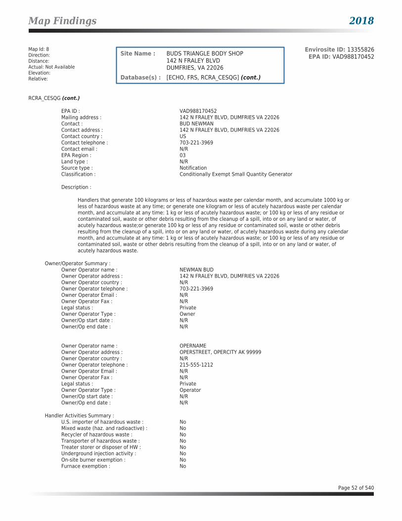
Map Findings 2018
Map Id: 8Direction: Distance: Actual: Not AvailableElevation: Relative:
Envirosite ID: 13355826EPA ID: VAD988170452Site Name : BUDS TRIANGLE BODY SHOP
142 N FRALEY BLVDDUMFRIES, VA 22026
Database(s) : [ECHO, FRS, RCRA_CESQG] (cont.)
RCRA_CESQG (cont.)
EPA ID : VAD988170452Mailing address : 142 N FRALEY BLVD, DUMFRIES VA 22026Contact : BUD NEWMANContact address : 142 N FRALEY BLVD, DUMFRIES VA 22026Contact country : USContact telephone : 703-221-3969Contact email : N/REPA Region : 03Land type : N/RSource type : NotificationClassification : Conditionally Exempt Small Quantity Generator
Description :
Handlers that generate 100 kilograms or less of hazardous waste per calendar month, and accumulate 1000 kg or less of hazardous waste at any time; or generate one kilogram or less of acutely hazardous waste per calendar month, and accumulate at any time: 1 kg or less of acutely hazardous waste; or 100 kg or less of any residue or contaminated soil, waste or other debris resulting from the cleanup of a spill, into or on any land or water, of acutely hazardous waste;or generate 100 kg or less of any residue or contaminated soil, waste or other debris resulting from the cleanup of a spill, into or on any land or water, of acutely hazardous waste during any calendar month, and accumulate at any time: 1 kg or less of acutely hazardous waste; or 100 kg or less of any residue or contaminated soil, waste or other debris resulting from the cleanup of a spill, into or on any land or water, of acutely hazardous waste.
Owner/Operator Summary :Owner Operator name : NEWMAN BUDOwner Operator address : 142 N FRALEY BLVD, DUMFRIES VA 22026Owner Operator country : N/ROwner Operator telephone : 703-221-3969Owner Operator Email : N/ROwner Operator Fax : N/RLegal status : PrivateOwner Operator Type : OwnerOwner/Op start date : N/ROwner/Op end date : N/R
Owner Operator name : OPERNAMEOwner Operator address : OPERSTREET, OPERCITY AK 99999Owner Operator country : N/ROwner Operator telephone : 215-555-1212Owner Operator Email : N/ROwner Operator Fax : N/RLegal status : PrivateOwner Operator Type : OperatorOwner/Op start date : N/ROwner/Op end date : N/R
Handler Activities Summary :U.S. importer of hazardous waste : NoMixed waste (haz. and radioactive) : NoRecycler of hazardous waste : NoTransporter of hazardous waste : NoTreater storer or disposer of HW : NoUnderground injection activity : NoOn-site burner exemption : NoFurnace exemption : No
Page 52 of 540

Map Findings 2018
Map Id: 8Direction: Distance: Actual: Not AvailableElevation: Relative:
Envirosite ID: 13355826EPA ID: VAD988170452Site Name : BUDS TRIANGLE BODY SHOP
142 N FRALEY BLVDDUMFRIES, VA 22026
Database(s) : [ECHO, FRS, RCRA_CESQG] (cont.)
RCRA_CESQG (cont.)
Used oil fuel burner : NoUsed oil processor : NoUsed oil refiner : NoUsed oil fuel marketer to burner : NoUsed oil Specification marketer : NoUsed oil transfer facility : NoUsed oil transporter : No
Hazardous Waste Summary :Waste code : D001Waste name : IGNITABLE WASTE
Waste code : F002
Waste name :
THE FOLLOWING SPENT HALOGENATED SOLVENTS: TETRACHLOROETHYLENE, METHYLENE CHLORIDE, TRICHLOROETHYLENE, 1,1,1-TRICHLOROETHANE, CHLOROBENZENE, 1,1,2-TRICHLORO-1,2,2-TRIFLUOROETHANE, ORTHO-DICHLOROBENZENE, TRICHLOROFLUOROMETHANE, AND 1,1,2, TRICHLOROETHANE; ALL SPENT SOLVENT MIXTURES/BLENDS CONTAINING, BEFORE USE, A TOTAL OF TEN PERCENT OR MORE (BY VOLUME) OF ONE OR MORE OF THE ABOVE HALOGENATED SOLVENTS OR THOSE SOLVENTS LISTED IN F001, F004, AND F005; AND STILL BOTTOMS FROM THE RECOVERY OF THESE SPENT SOLVENTS AND SPENT SOLVENT MIXTURES.
Waste code : F003
Waste name :
THE FOLLOWING SPENT NONHALOGENATED SOLVENTS: XYLENE, ACETONE, ETHYL ACETATE, ETHYL BENZENE, ETHYL ETHER, METHYL ISOBUTYL KETONE, N-BUTYL ALCOHOL, CYCLOHEXANONE, AND METHANOL; ALL SPENT SOLVENT MIXTURES/BLENDS CONTAINING, BEFORE USE, ONLY THE ABOVE SPENT NONHALOGENATED SOLVENTS; AND ALL SPENT SOLVENT MIXTURES/BLENDS CONTAINING, BEFORE USE, ONE OR MORE OF THE ABOVE NONHALOGENATED SOLVENTS, AND A TOTAL OF TEN PERCENT OR MORE (BY VOLUME) OF ONE OR MORE OF THOSE SOLVENTS LISTED IN F001, F002, F004, AND F005; AND STILL BOTTOMS FROM THE RECOVERY OF THESE SPENT SOLVENTS AND SPENT SOLVENT MIXTURES.
Waste code : F005
Waste name :
THE FOLLOWING SPENT NONHALOGENATED SOLVENTS: TOLUENE, METHYL ETHYL KETONE, CARBON DISULFIDE, ISOBUTANOL, PYRIDINE, BENZENE, 2-ETHOXYETHANOL, AND 2-NITROPROPANE; ALL SPENT SOLVENT MIXTURES/BLENDS CONTAINING, BEFORE USE, A TOTAL OF TEN PERCENT OR MORE (BY VOLUME) OF ONE OR MORE OF THE ABOVE NONHALOGENATED SOLVENTS OR THOSE SOLVENTS LISTED IN F001, F002, OR F004; AND STILL BOTTOMS FROM THE RECOVERY OF THESE SPENT SOLVENTS AND SPENT SOLVENT MIXTURES.
Facility has No violations / inspections reported.
Page 53 of 540

Map Findings 2018
Map Id: B9Direction: Distance: Actual: Not AvailableElevation: Relative:
Envirosite ID: 26965659EPA ID: N/RSite Name : COLONIAL CONCRETE TARMAC, INC
3440 CANAL RDDUMFRIES, VA 22026
Database(s) : [ECHO, FRS, ICIS]
ECHO
Facility Name : COLONIAL CONCRETE TARMAC, INCFacility Address : 3440 CANAL RD, DUMFRIES, VA 22026County : PRINCE WILLIAM
Last Inspection Date : 12/17/2002Registry ID : 110015715724FIPS Code : 51153EPA Region : 03Inspection Count : 0Last Inspection Days : 5563Informal Count : 0Last Informal Action Date : N/RFormal Action Count : 0Last Formal Action Date : N/RTotal Penalties : 0Penalty Count : N/RLast Penalty Date : N/RLast Penalty Amount : N/RQTRS IN NC : 0Programs IN SNC : 0Current Compliance Status : No ViolationThree-Year Compliance Status : ____________Collection Method : ADDRESS MATCHING-HOUSE NUMBERReference Point : ENTRANCE POINT OF A FACILITY OR STATIONAccuracy Meters : 50Derived Tribes : N/RDerived HUC : 02070011Derived WBD : 020700110104Derived STCTY FIPS : 51153Derived Zip : 22026Derived CD113 : 11Derived CB2010 : 511539009012010MYRTK Universe : NNNNPDES IDs : VAG116024CWA Permit Types : MinorCWA Compliance Tracking : OnCWA NAICS : N/RCWA SICS : 3273CWA Inspection Count : N/RCWA Last Inspection Days : 5563CWA Informal Count : N/RCWA Formal Action Count : N/RCWA Last Formal Action Date : N/RCWA Penalties : N/RCWA Last Penalty Date : N/RCWA Last Penalty Amount : N/RCWA Quarters IN NC : 0CWA Current Compliance Status : No ViolationCWA Current SNC Flag : NCWA 13 Quarters Compliance Status : _____________CWA 13 Quarters Effluent Exceedances: N/RCWA Three-Year QNCR Codes : N/RDFR URL : Click here for hyperlink provided by the agency.Facility SIC Codes : 3273Facility NAICS Codes : N/RFacility Last Inspection EPA Date : 12/17/2002
Page 54 of 540

Map Findings 2018
Map Id: B9Direction: Distance: Actual: Not AvailableElevation: Relative:
Envirosite ID: 26965659EPA ID: N/RSite Name : COLONIAL CONCRETE TARMAC, INC
3440 CANAL RDDUMFRIES, VA 22026
Database(s) : [ECHO, FRS, ICIS] (cont.)
ECHO (cont.)
Facility Last Inspection State Date : N/RFacility Last Formal Act EPA Date : N/RFacility Last Formal Act State Date : N/RFacility Last Informal Act EPA Date : N/RFacility Last Informal Act State Date: N/RFacility Federal Agency : N/RTRI Reporter : N/RFacility Imp Water Flag : N/RCurrent SNC Flag : NIndian County Flag : NFederal Flag : N/RUS Mexico Border Flag : N/RChesapeak Bay Flag : YAIR Flag : NNPDES Flag : YSDWIS Flag : NRCRA Flag : NTRI Flag : NGHG Flag : NMajor Flag : N/RActive Flag : YNAA Flag : YLatitude : 38.567517Longitude : -77.320868
FRS
Facility Name : COLONIAL CONCRETE TARMAC, INCFacility Address : 3440 CANAL RD, DUMFRIES, VA 22026County : PRINCE WILLIAM
Registry ID : 110015715724FRS Facility URL : Click here for hyperlink provided by the agency.
Source Description :
The NPDES module of the Compliance Information System (ICIS) tracks surface water permits issued under the Clean Water Act. Under NPDES, all facilities that discharge pollutants from any point source into waters of the United States are required to obtain a permit. The permit will likely contain limits on what can be discharged, impose monitoring and reporting requirements, and include other provisions to ensure that the discharge does not adversely affect water quality.
FRS Environmental InterestSource and System ID : ICIS - VAG116024
ICIS
Facility Name : COLONIAL CONCRETE TARMAC, INCFacility Address : 3440 CANAL RD, DUMFRIES, VA 22026
Page 55 of 540

Map Findings 2018
Map Id: B9Direction: Distance: Actual: Not AvailableElevation: Relative:
Envirosite ID: 26965659EPA ID: N/RSite Name : COLONIAL CONCRETE TARMAC, INC
3440 CANAL RDDUMFRIES, VA 22026
Database(s) : [ECHO, FRS, ICIS] (cont.)
ICIS (cont.)
NPDES ID : VAG116024ICIS Facility Interest ID : 3200019955Facility UIN : 110015715724Facility Type Code : Privately Owned FacilityImpaired Waters : N/RLatitude : 38.567517Longitude : -77.320868
Facility NAICSNAICS Code : N/RNAICS Description : N/R
Facility SICSIC Code : 3273SIC Description : Ready-Mixed Concrete
Map Id: B10Direction: Distance: Actual: Not AvailableElevation: Relative:
Envirosite ID: 354195742EPA ID: N/RSite Name : DUMFRIES LIFT STATION FORCE MAIN
3450 CANAL ROAD,DUMFRIES, VA
Database(s) : [SPILLS - VA]
SPILLS - VA
Facility Name : Dumfries Lift Station Force MainFacility Address : 3450 Canal Road, Dumfries, VACounty : Prince William County
Incident Date : 04/03/2012Call Received Date : 04/11/2012Closure Date : 05/21/2012IR Number : 2012-N-2637Associated IR : N/RReference ID : 14082Status : ClosedFacility Name : HL Mooney WRFRegion : NorthernIncident Type : WaterIncident Subtype : SSO * WaterThreat to : N/RTerrorism (Y/N) : NCharacterize Incident : AccidentalMaterials : Sewage (1-999 Gallons)Effect to Receptor : UnknownWater Body : Quantico Creek/Potomac River BasinLow Quantity to Water : 1
Page 56 of 540

Map Findings 2018
Map Id: B10Direction: Distance: Actual: Not AvailableElevation: Relative:
Envirosite ID: 354195742EPA ID: N/RSite Name : DUMFRIES LIFT STATION FORCE MAIN
3450 CANAL ROAD,DUMFRIES, VA
Database(s) : [SPILLS - VA] (cont.)
SPILLS - VA (cont.)
High Quantity to Water : 999Quantity Units : GallonsOther Receptors : N/RRP Company : N/RRP Name : N/RProperty Owner : N/RProperty Company : N/RDuration of Event (Hours) : 0Impacts : SSO Reached Receiving WatersOther Impacts : N/RSteps Taken : Repaired PipeSteps Taken Description : N/RSystem Components : Pipe FailureOther System Components : N/RCause of Event : N/RCorrective Action Taken : N/RWeather Status : DryPrecipitation (Wet) : 0Discharge Type : UntreatedDischarge Volume : 999Unknown Discharge (Y/N) : NOriginal Call Incident Description : Force Main leakOriginal Call Material Description : Raw SewageOriginal Call Location Description : 3450 Canal Road, Dumfries Lift Station Force MainIncident Ongoing at Time of Call : NAgencies Notified (Y/N) : NOther Agencies : N/RPermitted (Y/N) : YCall Reported by Name : ANONYMOUS ANONYMOUSCall Reported by Company Name : Town of Dumfries staffCall RP Company Name : PWCSACall RP Name : Don PannellCall Property Owner Company Name : N/RCall Property Owner Name : N/RClosure Comments : NFASite Summary : N/R
Map Id: B11Direction: Distance: Actual: Not AvailableElevation: Relative:
Envirosite ID: 13223205EPA ID: N/RSite Name : PHILLIP C. CLARKE ELECTRICAL
CONTRACTORS3510 CANAL STDUMFRIES, VA 22026
Database(s) : [AST - VA]
AST - VA
Facility Name : Phillip C. Clarke Electrical ContractorsFacility Address : 3510 Canal St, Dumfries, VA 22026County : Prince William County
Page 57 of 540
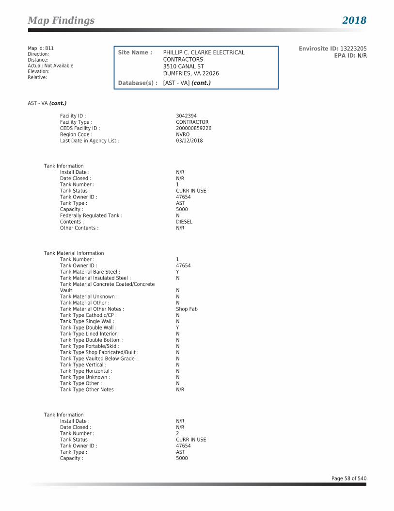
Map Findings 2018
Map Id: B11Direction: Distance: Actual: Not AvailableElevation: Relative:
Envirosite ID: 13223205EPA ID: N/RSite Name : PHILLIP C. CLARKE ELECTRICAL
CONTRACTORS3510 CANAL STDUMFRIES, VA 22026
Database(s) : [AST - VA] (cont.)
AST - VA (cont.)
Facility ID : 3042394Facility Type : CONTRACTORCEDS Facility ID : 200000859226Region Code : NVROLast Date in Agency List : 03/12/2018
Tank InformationInstall Date : N/RDate Closed : N/RTank Number : 1Tank Status : CURR IN USETank Owner ID : 47654Tank Type : ASTCapacity : 5000Federally Regulated Tank : NContents : DIESELOther Contents : N/R
Tank Material InformationTank Number : 1Tank Owner ID : 47654Tank Material Bare Steel : YTank Material Insulated Steel : NTank Material Concrete Coated/Concrete Vault: NTank Material Unknown : NTank Material Other : NTank Material Other Notes : Shop FabTank Type Cathodic/CP : NTank Type Single Wall : NTank Type Double Wall : YTank Type Lined Interior : NTank Type Double Bottom : NTank Type Portable/Skid : NTank Type Shop Fabricated/Built : NTank Type Vaulted Below Grade : NTank Type Vertical : NTank Type Horizontal : NTank Type Unknown : NTank Type Other : NTank Type Other Notes : N/R
Tank InformationInstall Date : N/RDate Closed : N/RTank Number : 2Tank Status : CURR IN USETank Owner ID : 47654Tank Type : ASTCapacity : 5000
Page 58 of 540

Map Findings 2018
Map Id: B11Direction: Distance: Actual: Not AvailableElevation: Relative:
Envirosite ID: 13223205EPA ID: N/RSite Name : PHILLIP C. CLARKE ELECTRICAL
CONTRACTORS3510 CANAL STDUMFRIES, VA 22026
Database(s) : [AST - VA] (cont.)
AST - VA (cont.)
Federally Regulated Tank : NContents : DIESELOther Contents : N/R
Tank Material InformationTank Number : 2Tank Owner ID : 47654Tank Material Bare Steel : YTank Material Insulated Steel : NTank Material Concrete Coated/Concrete Vault: NTank Material Unknown : NTank Material Other : NTank Material Other Notes : Shop FabTank Type Cathodic/CP : NTank Type Single Wall : NTank Type Double Wall : YTank Type Lined Interior : NTank Type Double Bottom : NTank Type Portable/Skid : NTank Type Shop Fabricated/Built : NTank Type Vaulted Below Grade : NTank Type Vertical : NTank Type Horizontal : NTank Type Unknown : NTank Type Other : NTank Type Other Notes : N/R
Map Id: 12Direction: Distance: Actual: Not AvailableElevation: Relative:
Envirosite ID: 26856254EPA ID: N/RSite Name : EXXON CO USA #27826
237 S FRALEY RD-TANKSDUMFRIES, VA 22026
Database(s) : [ECHO, FRS, RCRA_CESQG]
ECHO
Facility Name : EXXON CO USA #27826Facility Address : 237 S FRALEY RD-TANKS, DUMFRIES, VA 22026County : PRINCE WILLIAM
Last Inspection Date : N/RRegistry ID : 110005242282FIPS Code : 51153EPA Region : 03Inspection Count : 0Last Inspection Days : N/RInformal Count : 0
Page 59 of 540
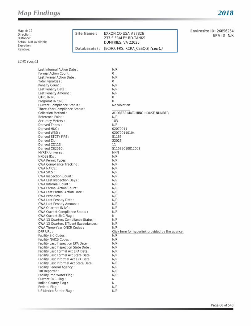
Map Findings 2018
Map Id: 12Direction: Distance: Actual: Not AvailableElevation: Relative:
Envirosite ID: 26856254EPA ID: N/RSite Name : EXXON CO USA #27826
237 S FRALEY RD-TANKSDUMFRIES, VA 22026
Database(s) : [ECHO, FRS, RCRA_CESQG] (cont.)
ECHO (cont.)
Last Informal Action Date : N/RFormal Action Count : 0Last Formal Action Date : N/RTotal Penalties : 0Penalty Count : N/RLast Penalty Date : N/RLast Penalty Amount : N/RQTRS IN NC : 0Programs IN SNC : 0Current Compliance Status : No ViolationThree-Year Compliance Status : ____________Collection Method : ADDRESS MATCHING-HOUSE NUMBERReference Point : N/RAccuracy Meters : 183Derived Tribes : N/RDerived HUC : 02070011Derived WBD : 020700110104Derived STCTY FIPS : 51153Derived Zip : 22026Derived CD113 : 11Derived CB2010 : 511539010012003MYRTK Universe : NNNNPDES IDs : N/RCWA Permit Types : N/RCWA Compliance Tracking : N/RCWA NAICS : N/RCWA SICS : N/RCWA Inspection Count : N/RCWA Last Inspection Days : N/RCWA Informal Count : N/RCWA Formal Action Count : N/RCWA Last Formal Action Date : N/RCWA Penalties : N/RCWA Last Penalty Date : N/RCWA Last Penalty Amount : N/RCWA Quarters IN NC : N/RCWA Current Compliance Status : N/RCWA Current SNC Flag : NCWA 13 Quarters Compliance Status : N/RCWA 13 Quarters Effluent Exceedances: N/RCWA Three-Year QNCR Codes : N/RDFR URL : Click here for hyperlink provided by the agency.Facility SIC Codes : N/RFacility NAICS Codes : N/RFacility Last Inspection EPA Date : N/RFacility Last Inspection State Date : N/RFacility Last Formal Act EPA Date : N/RFacility Last Formal Act State Date : N/RFacility Last Informal Act EPA Date : N/RFacility Last Informal Act State Date: N/RFacility Federal Agency : N/RTRI Reporter : N/RFacility Imp Water Flag : N/RCurrent SNC Flag : NIndian County Flag : NFederal Flag : N/RUS Mexico Border Flag : N/R
Page 60 of 540
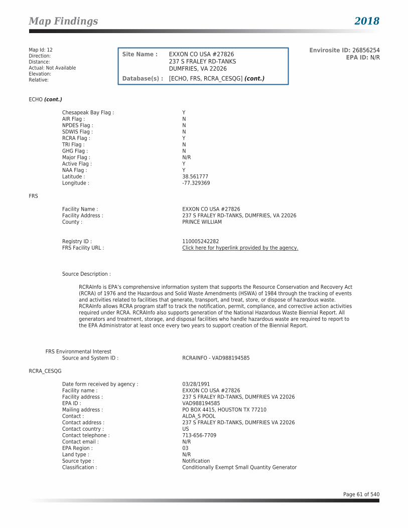
Map Findings 2018
Map Id: 12Direction: Distance: Actual: Not AvailableElevation: Relative:
Envirosite ID: 26856254EPA ID: N/RSite Name : EXXON CO USA #27826
237 S FRALEY RD-TANKSDUMFRIES, VA 22026
Database(s) : [ECHO, FRS, RCRA_CESQG] (cont.)
ECHO (cont.)
Chesapeak Bay Flag : YAIR Flag : NNPDES Flag : NSDWIS Flag : NRCRA Flag : YTRI Flag : NGHG Flag : NMajor Flag : N/RActive Flag : YNAA Flag : YLatitude : 38.561777Longitude : -77.329369
FRS
Facility Name : EXXON CO USA #27826Facility Address : 237 S FRALEY RD-TANKS, DUMFRIES, VA 22026County : PRINCE WILLIAM
Registry ID : 110005242282FRS Facility URL : Click here for hyperlink provided by the agency.
Source Description :
RCRAInfo is EPA’s comprehensive information system that supports the Resource Conservation and Recovery Act (RCRA) of 1976 and the Hazardous and Solid Waste Amendments (HSWA) of 1984 through the tracking of events and activities related to facilities that generate, transport, and treat, store, or dispose of hazardous waste. RCRAInfo allows RCRA program staff to track the notification, permit, compliance, and corrective action activities required under RCRA. RCRAInfo also supports generation of the National Hazardous Waste Biennial Report. All generators and treatment, storage, and disposal facilities who handle hazardous waste are required to report to the EPA Administrator at least once every two years to support creation of the Biennial Report.
FRS Environmental InterestSource and System ID : RCRAINFO - VAD988194585
RCRA_CESQG
Date form received by agency : 03/28/1991Facility name : EXXON CO USA #27826Facility address : 237 S FRALEY RD-TANKS, DUMFRIES VA 22026EPA ID : VAD988194585Mailing address : PO BOX 4415, HOUSTON TX 77210Contact : ALDA_S POOLContact address : 237 S FRALEY RD-TANKS, DUMFRIES VA 22026Contact country : USContact telephone : 713-656-7709Contact email : N/REPA Region : 03Land type : N/RSource type : NotificationClassification : Conditionally Exempt Small Quantity Generator
Page 61 of 540

Map Findings 2018
Map Id: 12Direction: Distance: Actual: Not AvailableElevation: Relative:
Envirosite ID: 26856254EPA ID: N/RSite Name : EXXON CO USA #27826
237 S FRALEY RD-TANKSDUMFRIES, VA 22026
Database(s) : [ECHO, FRS, RCRA_CESQG] (cont.)
RCRA_CESQG (cont.)
Description :
Handlers that generate 100 kilograms or less of hazardous waste per calendar month, and accumulate 1000 kg or less of hazardous waste at any time; or generate one kilogram or less of acutely hazardous waste per calendar month, and accumulate at any time: 1 kg or less of acutely hazardous waste; or 100 kg or less of any residue or contaminated soil, waste or other debris resulting from the cleanup of a spill, into or on any land or water, of acutely hazardous waste;or generate 100 kg or less of any residue or contaminated soil, waste or other debris resulting from the cleanup of a spill, into or on any land or water, of acutely hazardous waste during any calendar month, and accumulate at any time: 1 kg or less of acutely hazardous waste; or 100 kg or less of any residue or contaminated soil, waste or other debris resulting from the cleanup of a spill, into or on any land or water, of acutely hazardous waste.
Owner/Operator Summary :Owner Operator name : FERLAZZO STEPHEN LOwner Operator address : 237 S FRALEY RD, DUMFRIES VA 22026Owner Operator country : N/ROwner Operator telephone : 215-555-1212Owner Operator Email : N/ROwner Operator Fax : N/RLegal status : PrivateOwner Operator Type : OwnerOwner/Op start date : N/ROwner/Op end date : N/R
Owner Operator name : OPERNAMEOwner Operator address : OPERSTREET, OPERCITY AK 99999Owner Operator country : N/ROwner Operator telephone : 215-555-1212Owner Operator Email : N/ROwner Operator Fax : N/RLegal status : PrivateOwner Operator Type : OperatorOwner/Op start date : N/ROwner/Op end date : N/R
Handler Activities Summary :U.S. importer of hazardous waste : NoMixed waste (haz. and radioactive) : NoRecycler of hazardous waste : NoTransporter of hazardous waste : NoTreater storer or disposer of HW : NoUnderground injection activity : NoOn-site burner exemption : NoFurnace exemption : NoUsed oil fuel burner : NoUsed oil processor : NoUsed oil refiner : NoUsed oil fuel marketer to burner : NoUsed oil Specification marketer : NoUsed oil transfer facility : NoUsed oil transporter : No
Hazardous Waste Summary :Waste code : D000Waste name : Not Defined
Page 62 of 540

Map Findings 2018
Map Id: 12Direction: Distance: Actual: Not AvailableElevation: Relative:
Envirosite ID: 26856254EPA ID: N/RSite Name : EXXON CO USA #27826
237 S FRALEY RD-TANKSDUMFRIES, VA 22026
Database(s) : [ECHO, FRS, RCRA_CESQG] (cont.)
RCRA_CESQG (cont.)
Waste code : D018Waste name : BENZENE
Facility has No violations / inspections reported.
Map Id: B13Direction: Distance: Actual: Not AvailableElevation: Relative:
Envirosite ID: 14442730EPA ID: N/RSite Name : PWSCA PUMP STATION L-018
221 CANAL STDUMFRIES, VA 22026
Database(s) : [UST - VA]
UST - VA
Facility Name : PWSCA PUMP STATION L-018Facility Address : 221 Canal St, Dumfries, VA 22026County : Prince William County
Facility ID : 3018248Facility Type : LOCALCEDS Facility ID : 200000075439Region Code : NVRO
Tank InformationInstall Date : 05/06/1980Date Closed : 04/28/1998Tank Number : R1Tank Status : REM FROM GRDTank Owner ID : 37382Tank Type : USTCapacity : 5000Federally Regulated Tank : YContents : DIESELOther Contents : N/R
Tank Material InformationTank Number : R1Tank Owner ID : 37382Tank Material Asphalt/Bare Steel : YTank Material CCP/STI-P3 : NTank Material Composite : NTank Material Fiberglass : NTank Material Concrete : NTank Material Impressed Current : NTank Material Double Walled : NTank Material Lined Interior : NTank Material Excavation Liner : N
Page 63 of 540

Map Findings 2018
Map Id: B13Direction: Distance: Actual: Not AvailableElevation: Relative:
Envirosite ID: 14442730EPA ID: N/RSite Name : PWSCA PUMP STATION L-018
221 CANAL STDUMFRIES, VA 22026
Database(s) : [UST - VA] (cont.)
UST - VA (cont.)
Tank Material Polyethylene Tank Jacket: NTank Material Secondary Containment : NTank Material Repaired : NTank Material Unknown : NTank Material Other : NTank Material Other Notes : N/R
Map Id: B14Direction: Distance: Actual: Not AvailableElevation: Relative:
Envirosite ID: 24846793EPA ID: N/RSite Name : PWCSA - PUMP STATION L018
221 CANAL STDUMFRIES, VA 22026
Database(s) : [LPT - VA]
LPT - VA
Facility Name : PWCSA - Pump Station L018Facility Address : 221 Canal St, Dumfries, VA 22026County : Prince William County
Release Reported : 05/12/1998PC Number : 19983753CEDS Facility ID : 200000075439Case Status : ClosedCase Closed Date : 12/11/1998Region : NVROProgram : RP LeadHeating Oil Category : N/RFederally Regulated UST : YRegulated Petroleum UST (1) : YExcluded UST (1) : NDeferred UST (1) : NPartially Deferred UST (1) : NExempt 1 UST (2) : NExempt 2 Heating Oil UST (2) : NSmall Heating Oil AST (2) : NRegulated AST (3) : NUnregulated AST (3) : NOther (Y/N) : NOther Description : N/RUnknown (Y/N) : NPriority : N/RSuspect Confirm Indicator : ConfirmedLatitude : 38.5678785842Longitude : -77.3192415521Last Date in Agency List : 02/09/2018
Page 64 of 540

Map Findings 2018
Map Id: B15Direction: Distance: Actual: Not AvailableElevation: Relative:
Envirosite ID: 330024721EPA ID: N/RSite Name : PRINCE WILLIAM COUNTY SA L-18
221 CANAL RDDUMFRIES, VA
Database(s) : [ARCHIVED SPILLS - VA]
Archived SPILLS - VA
Facility Name : Prince William County SA L-18Facility Address : 221 Canal Rd, Dumfries, VACounty : Prince William County
Closure Date : 03/22/2005Incident Date : 03/20/2005Call Received Date : 03/20/2005IR Number : 2005-N-0713Associated IR : N/RReference ID : N/RIncident Type : WaterIncident Subtype : SSORegion : NorthernThreat to : N/RTerrorism (Y/N) : NOCharacterize Incident : N/RMaterials : Sewage(642000 - 642000 Gallons)Effect to Receptor : N/RWater Body : Quantico CreekLow Quantity to Water : 642000High Quantity to Water : 642000Quantity Units : GallonsOther Receptors : N/RRP Company : Prince William County Service AuthorityRP Name : N/RProperty Owner : N/RProperty Company : N/RDuration of Event (Hours) : N/RImpacts : N/ROther Impacts : N/RSteps Taken : N/RSteps Taken Description : N/RSystem Components : N/ROther System Components : N/RCause of Event : N/RCorrective Action Taken : N/RWeather Status : N/RPrecipitation (Wet) : N/RDischarge Type : N/RDischarge Volume : N/RUnknown Discharge (Y/N) : NO
Original Call Incident Description : Caller from PWCSA report. Overflow from a manhole at the above address caused by a burned out sewage pump. The pump has been repaired and the area of the overflow has been cleaned up and limed. Some of the product flowed into the creek. No assist has been requested.
Original Call Material Description : sewage (Qty=642000)
Original Call Location Description : Prince William County SA L-18-221 Canal Rd-Dumfries-VA--Prince William County
Incident Ongoing at Time of Call : N/RAgencies Notified (Y/N) : NOOther Agencies : N/RPermitted (Y/N) : NO
Page 65 of 540
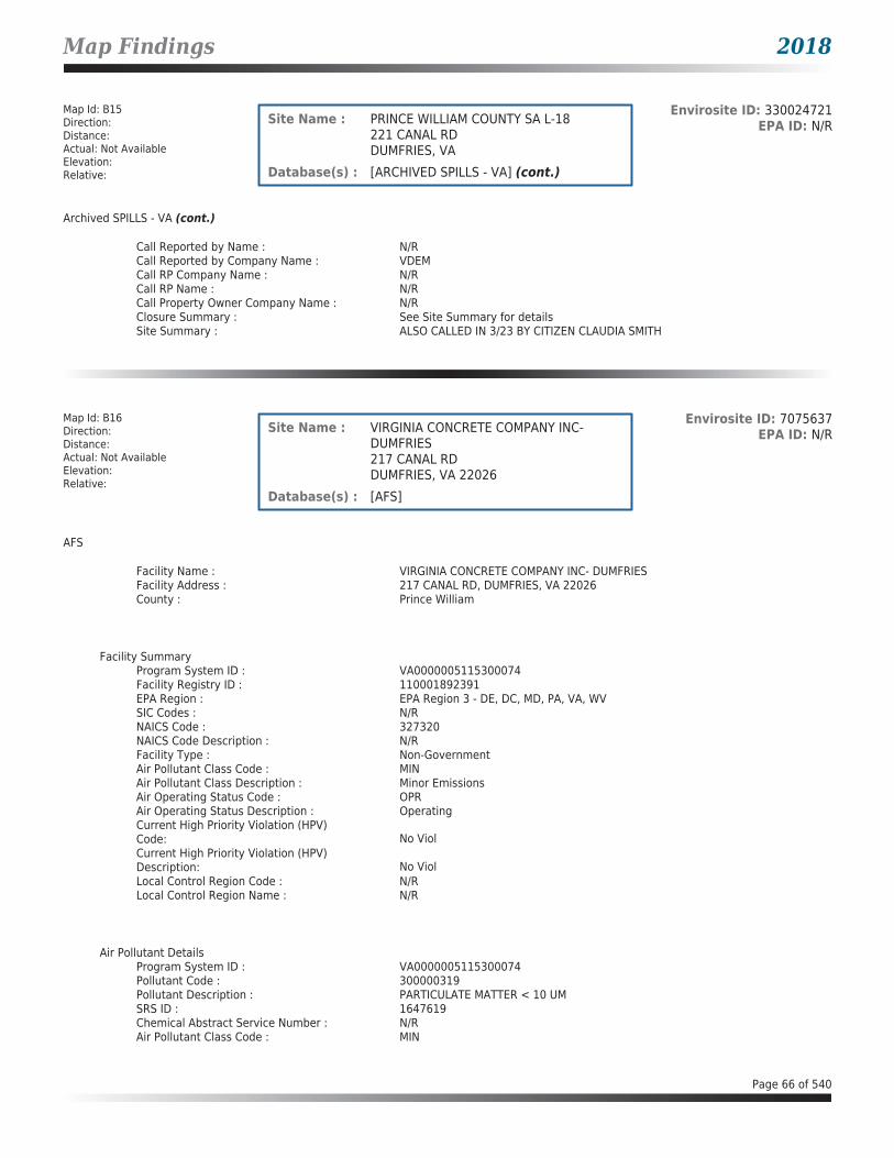
Map Findings 2018
Map Id: B15Direction: Distance: Actual: Not AvailableElevation: Relative:
Envirosite ID: 330024721EPA ID: N/RSite Name : PRINCE WILLIAM COUNTY SA L-18
221 CANAL RDDUMFRIES, VA
Database(s) : [ARCHIVED SPILLS - VA] (cont.)
Archived SPILLS - VA (cont.)
Call Reported by Name : N/RCall Reported by Company Name : VDEMCall RP Company Name : N/RCall RP Name : N/RCall Property Owner Company Name : N/RClosure Summary : See Site Summary for detailsSite Summary : ALSO CALLED IN 3/23 BY CITIZEN CLAUDIA SMITH
Map Id: B16Direction: Distance: Actual: Not AvailableElevation: Relative:
Envirosite ID: 7075637EPA ID: N/RSite Name : VIRGINIA CONCRETE COMPANY INC-
DUMFRIES217 CANAL RDDUMFRIES, VA 22026
Database(s) : [AFS]
AFS
Facility Name : VIRGINIA CONCRETE COMPANY INC- DUMFRIESFacility Address : 217 CANAL RD, DUMFRIES, VA 22026County : Prince William
Facility SummaryProgram System ID : VA0000005115300074Facility Registry ID : 110001892391EPA Region : EPA Region 3 - DE, DC, MD, PA, VA, WVSIC Codes : N/RNAICS Code : 327320NAICS Code Description : N/RFacility Type : Non-GovernmentAir Pollutant Class Code : MINAir Pollutant Class Description : Minor EmissionsAir Operating Status Code : OPRAir Operating Status Description : OperatingCurrent High Priority Violation (HPV) Code: No ViolCurrent High Priority Violation (HPV) Description: No ViolLocal Control Region Code : N/RLocal Control Region Name : N/R
Air Pollutant DetailsProgram System ID : VA0000005115300074Pollutant Code : 300000319Pollutant Description : PARTICULATE MATTER < 10 UMSRS ID : 1647619Chemical Abstract Service Number : N/RAir Pollutant Class Code : MIN
Page 66 of 540
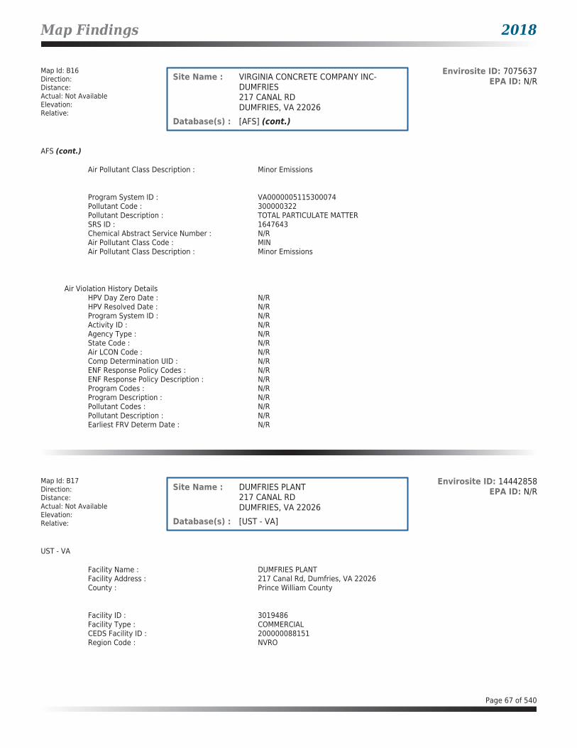
Map Findings 2018
Map Id: B16Direction: Distance: Actual: Not AvailableElevation: Relative:
Envirosite ID: 7075637EPA ID: N/RSite Name : VIRGINIA CONCRETE COMPANY INC-
DUMFRIES217 CANAL RDDUMFRIES, VA 22026
Database(s) : [AFS] (cont.)
AFS (cont.)
Air Pollutant Class Description : Minor Emissions
Program System ID : VA0000005115300074Pollutant Code : 300000322Pollutant Description : TOTAL PARTICULATE MATTERSRS ID : 1647643Chemical Abstract Service Number : N/RAir Pollutant Class Code : MINAir Pollutant Class Description : Minor Emissions
Air Violation History DetailsHPV Day Zero Date : N/RHPV Resolved Date : N/RProgram System ID : N/RActivity ID : N/RAgency Type : N/RState Code : N/RAir LCON Code : N/RComp Determination UID : N/RENF Response Policy Codes : N/RENF Response Policy Description : N/RProgram Codes : N/RProgram Description : N/RPollutant Codes : N/RPollutant Description : N/REarliest FRV Determ Date : N/R
Map Id: B17Direction: Distance: Actual: Not AvailableElevation: Relative:
Envirosite ID: 14442858EPA ID: N/RSite Name : DUMFRIES PLANT
217 CANAL RDDUMFRIES, VA 22026
Database(s) : [UST - VA]
UST - VA
Facility Name : DUMFRIES PLANTFacility Address : 217 Canal Rd, Dumfries, VA 22026County : Prince William County
Facility ID : 3019486Facility Type : COMMERCIALCEDS Facility ID : 200000088151Region Code : NVRO
Page 67 of 540

Map Findings 2018
Map Id: B17Direction: Distance: Actual: Not AvailableElevation: Relative:
Envirosite ID: 14442858EPA ID: N/RSite Name : DUMFRIES PLANT
217 CANAL RDDUMFRIES, VA 22026
Database(s) : [UST - VA] (cont.)
UST - VA (cont.)
Tank InformationInstall Date : 05/07/1976Date Closed : 04/29/1996Tank Number : 1Tank Status : REM FROM GRDTank Owner ID : 30725Tank Type : USTCapacity : 10000Federally Regulated Tank : YContents : DIESELOther Contents : N/R
Tank Material InformationTank Number : 1Tank Owner ID : 30725Tank Material Asphalt/Bare Steel : YTank Material CCP/STI-P3 : NTank Material Composite : NTank Material Fiberglass : NTank Material Concrete : NTank Material Impressed Current : NTank Material Double Walled : NTank Material Lined Interior : NTank Material Excavation Liner : NTank Material Polyethylene Tank Jacket: NTank Material Secondary Containment : NTank Material Repaired : NTank Material Unknown : NTank Material Other : NTank Material Other Notes : N/R
Map Id: B18Direction: Distance: Actual: Not AvailableElevation: Relative:
Envirosite ID: 18128195EPA ID: N/RSite Name : VIRGINIA CONCRETE DUMFRIES PLANT
217 CANAL RDDUMFRIES, VA 22026
Database(s) : [FRS, LPT - VA, TRIS]
FRS
Facility Name : VIRGINIA CONCRETE DUMFRIES PLANTFacility Address : 217 CANAL RD, DUMFRIES, VA 22026County : PRINCE WILLIAM COUNTY
Registry ID : 110001892391FRS Facility URL : Click here for hyperlink provided by the agency.
Page 68 of 540

Map Findings 2018
Map Id: B18Direction: Distance: Actual: Not AvailableElevation: Relative:
Envirosite ID: 18128195EPA ID: N/RSite Name : VIRGINIA CONCRETE DUMFRIES PLANT
217 CANAL RDDUMFRIES, VA 22026
Database(s) : [FRS, LPT - VA, TRIS] (cont.)
FRS (cont.)
Source Description :
AFS contains compliance and permit data for stationary sources of air pollution regulated by the EPA, State, and Local air pollution agencies.
Source Description :
AIR contains compliance and permit data for stationary sources of air pollution regulated by the EPA, State, and Local air pollution agencies.
Source Description :
ICIS provides a database that, when complete, will contain enforcement and compliance information across most of EPA's programs. The vision for ICIS is to replace EPA's independent databases that contain enforcement data with a single repository for that information. Currently, ICIS contains all Federal Administrative and Judicial enforcement actions and a subset of the Permit Compliance System (PCS), which supports the National Pollutant Discharge Elimination System (NPDES). This information is maintained in ICIS by EPA in the Regional offices and at Headquarters. A future release of ICIS will completely replace PCS and will integrate that information with Federal actions already in the system. ICIS also has the capability to track other activities that support compliance and enforcement programs, including incident tracking, compliance assistance, and compliance monitoring.
Source Description :
The CEDS is the Virginia Department of Environmental Quality's (DEQ) electronic data system for maintaining data on sources of pollutants in all media.
Source Description :
The NPDES module of the Compliance Information System (ICIS) tracks surface water permits issued under the Clean Water Act. Under NPDES, all facilities that discharge pollutants from any point source into waters of the United States are required to obtain a permit. The permit will likely contain limits on what can be discharged, impose monitoring and reporting requirements, and include other provisions to ensure that the discharge does not adversely affect water quality.
Source Description :
TRIS is a publicly available EPA database reported annually by certain covered industry groups, as well as federal facilities. It contains information about more than 650 toxic chemicals that are being used, manufactured, treated, transported, or released into the environment, and includes information about waste management and pollution prevention activities.
FRS Environmental InterestSource and System ID : AIRS/AFS - 5115300074
CEDS - 200000088151
Page 69 of 540

Map Findings 2018
Map Id: B18Direction: Distance: Actual: Not AvailableElevation: Relative:
Envirosite ID: 18128195EPA ID: N/RSite Name : VIRGINIA CONCRETE DUMFRIES PLANT
217 CANAL RDDUMFRIES, VA 22026
Database(s) : [FRS, LPT - VA, TRIS] (cont.)
FRS (cont.)
ICIS - 7425819ICIS - VA0000005115300074ICIS - VAG110092TRIS - 2202WVRGNC217CA
LPT - VA
Facility Name : Virginia Concrete Dumfries PlantFacility Address : 217 Canal Rd, Dumfries, VA 22026County : Prince William County
Release Reported : 04/29/1996PC Number : 19963169CEDS Facility ID : 200000088151Case Status : ClosedCase Closed Date : 01/29/1997Region : NVROProgram : RP LeadHeating Oil Category : N/RFederally Regulated UST : YRegulated Petroleum UST (1) : YExcluded UST (1) : NDeferred UST (1) : NPartially Deferred UST (1) : NExempt 1 UST (2) : NExempt 2 Heating Oil UST (2) : NSmall Heating Oil AST (2) : NRegulated AST (3) : NUnregulated AST (3) : NOther (Y/N) : NOther Description : N/RUnknown (Y/N) : NPriority : 3Suspect Confirm Indicator : ConfirmedLatitude : 38.5668668162Longitude : -77.3198879789Last Date in Agency List : 02/09/2018
TRIS
Facility Name : VIRGINIA CONCRETE DUMFRIES PLANTFacility Address : 217 CANAL RD, DUMFRIES, VA 22026County : PRINCE WILLIAM
Reported Chemical InformationReporting Year : 2016Document Control Number : 1316215098207CAS Number : 007439921Chemical Name : LEADUnit of Measure : PoundsOn-Site Use : NOMaximum Amount Onsite : 01
Page 70 of 540

Map Findings 2018
Map Id: B18Direction: Distance: Actual: Not AvailableElevation: Relative:
Envirosite ID: 18128195EPA ID: N/RSite Name : VIRGINIA CONCRETE DUMFRIES PLANT
217 CANAL RDDUMFRIES, VA 22026
Database(s) : [FRS, LPT - VA, TRIS] (cont.)
TRIS (cont.)
Onsite Release SummaryTotal Fugitive Air Emissions : .02168Total Stack Air Emissions : .00211Total Air Emissions : .02379Total Number of Receiving Streams : 0Total Surface Water Discharge : 0Total Underground Injection Onsite to Class I Wells - Pounds: 0Total Underground Injection Onsite to Class II-V Wells - Pounds: 0Total Underground Injection : 0Total RCRA Subtitle C Landfills : 0Total Other On-Site Land Releases : 0Total Land Treatment : 0Total Surface Impoundments : 0Total Other Disposal : 0Total On-Site Land Releases : 0
Offsite Release SummaryTotal Transferred Off-Site to Disposal: 0Total Transferred Off-Site for Further Waste Management: 0Total RCRA C Surface Impoundments : 0Total Other Surface Impoundments : 0
Reported Chemical InformationReporting Year : 2015Document Control Number : 1315213878667CAS Number : 007439921Chemical Name : LEADUnit of Measure : PoundsOn-Site Use : NOMaximum Amount Onsite : 01
Onsite Release SummaryTotal Fugitive Air Emissions : .0227Total Stack Air Emissions : .00241Total Air Emissions : .02511Total Number of Receiving Streams : 0Total Surface Water Discharge : 0Total Underground Injection Onsite to Class I Wells - Pounds: 0Total Underground Injection Onsite to Class II-V Wells - Pounds: 0Total Underground Injection : 0Total RCRA Subtitle C Landfills : 0Total Other On-Site Land Releases : 0Total Land Treatment : 0Total Surface Impoundments : 0Total Other Disposal : 0Total On-Site Land Releases : 0
Page 71 of 540

Map Findings 2018
Map Id: B18Direction: Distance: Actual: Not AvailableElevation: Relative:
Envirosite ID: 18128195EPA ID: N/RSite Name : VIRGINIA CONCRETE DUMFRIES PLANT
217 CANAL RDDUMFRIES, VA 22026
Database(s) : [FRS, LPT - VA, TRIS] (cont.)
TRIS (cont.)
Offsite Release SummaryTotal Transferred Off-Site to Disposal: 0Total Transferred Off-Site for Further Waste Management: 0Total RCRA C Surface Impoundments : 0Total Other Surface Impoundments : 0
Reported Chemical InformationReporting Year : 2014Document Control Number : 1314212730485CAS Number : 007439921Chemical Name : LEADUnit of Measure : PoundsOn-Site Use : NOMaximum Amount Onsite : 01
Onsite Release SummaryTotal Fugitive Air Emissions : .0254Total Stack Air Emissions : .003Total Air Emissions : .0284Total Number of Receiving Streams : 0Total Surface Water Discharge : 0Total Underground Injection Onsite to Class I Wells - Pounds: 0Total Underground Injection Onsite to Class II-V Wells - Pounds: 0Total Underground Injection : 0Total RCRA Subtitle C Landfills : 0Total Other On-Site Land Releases : 0Total Land Treatment : 0Total Surface Impoundments : 0Total Other Disposal : 0Total On-Site Land Releases : 0
Offsite Release SummaryTotal Transferred Off-Site to Disposal: 0Total Transferred Off-Site for Further Waste Management: 0Total RCRA C Surface Impoundments : 0Total Other Surface Impoundments : 0
Reported Chemical InformationReporting Year : 2013Document Control Number : 1313211750310CAS Number : 007439921Chemical Name : LEADUnit of Measure : PoundsOn-Site Use : NOMaximum Amount Onsite : 01
Page 72 of 540
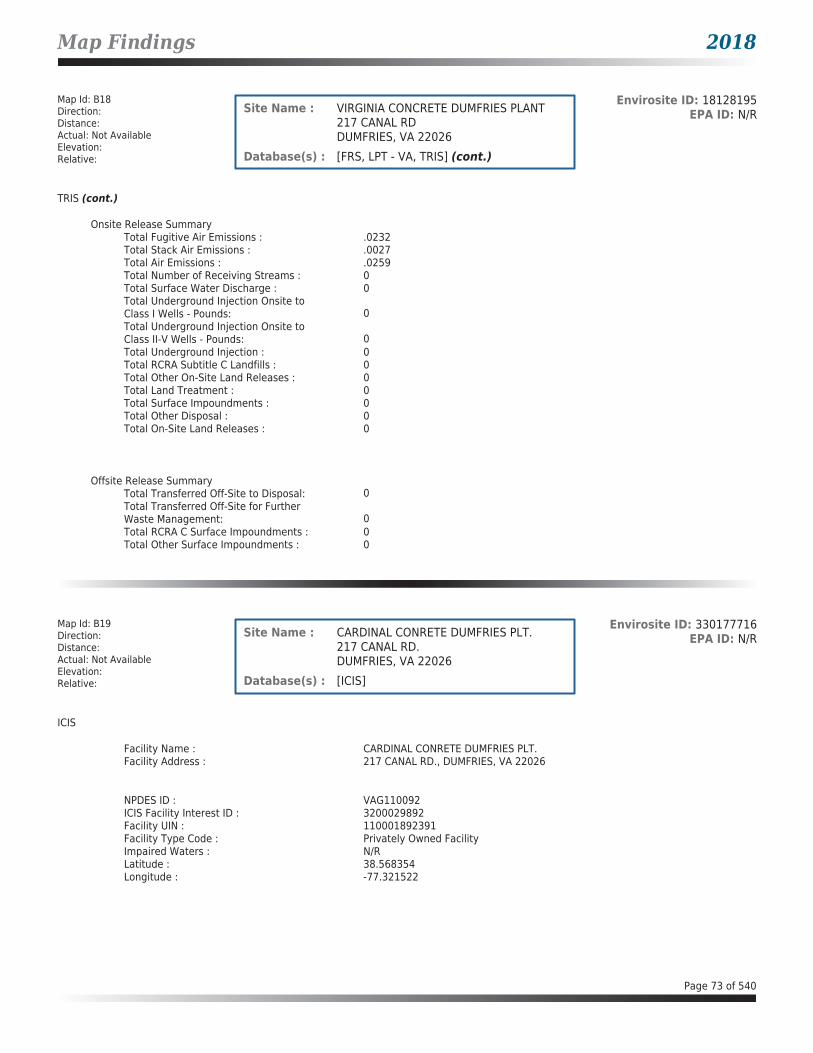
Map Findings 2018
Map Id: B18Direction: Distance: Actual: Not AvailableElevation: Relative:
Envirosite ID: 18128195EPA ID: N/RSite Name : VIRGINIA CONCRETE DUMFRIES PLANT
217 CANAL RDDUMFRIES, VA 22026
Database(s) : [FRS, LPT - VA, TRIS] (cont.)
TRIS (cont.)
Onsite Release SummaryTotal Fugitive Air Emissions : .0232Total Stack Air Emissions : .0027Total Air Emissions : .0259Total Number of Receiving Streams : 0Total Surface Water Discharge : 0Total Underground Injection Onsite to Class I Wells - Pounds: 0Total Underground Injection Onsite to Class II-V Wells - Pounds: 0Total Underground Injection : 0Total RCRA Subtitle C Landfills : 0Total Other On-Site Land Releases : 0Total Land Treatment : 0Total Surface Impoundments : 0Total Other Disposal : 0Total On-Site Land Releases : 0
Offsite Release SummaryTotal Transferred Off-Site to Disposal: 0Total Transferred Off-Site for Further Waste Management: 0Total RCRA C Surface Impoundments : 0Total Other Surface Impoundments : 0
Map Id: B19Direction: Distance: Actual: Not AvailableElevation: Relative:
Envirosite ID: 330177716EPA ID: N/RSite Name : CARDINAL CONRETE DUMFRIES PLT.
217 CANAL RD.DUMFRIES, VA 22026
Database(s) : [ICIS]
ICIS
Facility Name : CARDINAL CONRETE DUMFRIES PLT.Facility Address : 217 CANAL RD., DUMFRIES, VA 22026
NPDES ID : VAG110092ICIS Facility Interest ID : 3200029892Facility UIN : 110001892391Facility Type Code : Privately Owned FacilityImpaired Waters : N/RLatitude : 38.568354Longitude : -77.321522
Page 73 of 540

Map Findings 2018
Map Id: B19Direction: Distance: Actual: Not AvailableElevation: Relative:
Envirosite ID: 330177716EPA ID: N/RSite Name : CARDINAL CONRETE DUMFRIES PLT.
217 CANAL RD.DUMFRIES, VA 22026
Database(s) : [ICIS] (cont.)
ICIS (cont.)
Facility NAICSNAICS Code : N/RNAICS Description : N/R
Facility SICSIC Code : 3273SIC Description : Ready-Mixed Concrete
Map Id: B20Direction: Distance: Actual: Not AvailableElevation: Relative:
Envirosite ID: 396036919EPA ID: N/RSite Name : VIRGINIA CONCRETE COMPANY
INCORPORATED DUMPHRIES217 CANAL RDDUMFRIES, VA 22026
Database(s) : [ECHO]
ECHO
Facility Name : VIRGINIA CONCRETE COMPANY INCORPORATED DUMPHRIESFacility Address : 217 CANAL RD, DUMFRIES, VA 22026County : PRINCE WILLIAM
Last Inspection Date : 08/01/2007Registry ID : 110001892391FIPS Code : 51153EPA Region : 03Inspection Count : 0Last Inspection Days : 3875Informal Count : 0Last Informal Action Date : N/RFormal Action Count : 0Last Formal Action Date : N/RTotal Penalties : 0Penalty Count : N/RLast Penalty Date : N/RLast Penalty Amount : N/RQTRS IN NC : 0Programs IN SNC : 0Current Compliance Status : No ViolationThree-Year Compliance Status : ____________Collection Method : ADDRESS MATCHING-HOUSE NUMBERReference Point : ENTRANCE POINT OF A FACILITY OR STATIONAccuracy Meters : 99999999Derived Tribes : N/RDerived HUC : 02070011Derived WBD : 020700110104Derived STCTY FIPS : 51153Derived Zip : 22026Derived CD113 : 11
Page 74 of 540

Map Findings 2018
Map Id: B20Direction: Distance: Actual: Not AvailableElevation: Relative:
Envirosite ID: 396036919EPA ID: N/RSite Name : VIRGINIA CONCRETE COMPANY
INCORPORATED DUMPHRIES217 CANAL RDDUMFRIES, VA 22026
Database(s) : [ECHO] (cont.)
ECHO (cont.)
Derived CB2010 : 511539009012010MYRTK Universe : NNNNPDES IDs : VAG110092CWA Permit Types : MinorCWA Compliance Tracking : OnCWA NAICS : N/RCWA SICS : 3273CWA Inspection Count : N/RCWA Last Inspection Days : 4694CWA Informal Count : N/RCWA Formal Action Count : N/RCWA Last Formal Action Date : N/RCWA Penalties : N/RCWA Last Penalty Date : N/RCWA Last Penalty Amount : N/RCWA Quarters IN NC : 0CWA Current Compliance Status : No ViolationCWA Current SNC Flag : NCWA 13 Quarters Compliance Status : _____________CWA 13 Quarters Effluent Exceedances: N/RCWA Three-Year QNCR Codes : N/RDFR URL : Click here for hyperlink provided by the agency.Facility SIC Codes : 3273Facility NAICS Codes : 327320Facility Last Inspection EPA Date : 05/04/2005Facility Last Inspection State Date : 08/01/2007Facility Last Formal Act EPA Date : N/RFacility Last Formal Act State Date : N/RFacility Last Informal Act EPA Date : N/RFacility Last Informal Act State Date: N/RFacility Federal Agency : N/RTRI Reporter : YFacility Imp Water Flag : N/RCurrent SNC Flag : NIndian County Flag : NFederal Flag : N/RUS Mexico Border Flag : N/RChesapeak Bay Flag : YAIR Flag : YNPDES Flag : YSDWIS Flag : NRCRA Flag : NTRI Flag : YGHG Flag : NMajor Flag : N/RActive Flag : YNAA Flag : YLatitude : 38.568354Longitude : -77.321522
Page 75 of 540

Map Findings 2018
Map Id: B21Direction: Distance: Actual: Not AvailableElevation: Relative:
Envirosite ID: 14572787EPA ID: VAR000000745Site Name : M D NESTER
215 A CANAL RDDUMFRIES, VA 22026
Database(s) : [ECHO, FRS, RCRA_NONGEN]
ECHO
Facility Name : M D NESTERFacility Address : 215 A CANAL RD, DUMFRIES, VA 22026County : PRINCE WILLIAM
Last Inspection Date : 12/08/1997Registry ID : 110005256739FIPS Code : 51153EPA Region : 03Inspection Count : 0Last Inspection Days : 7398Informal Count : 0Last Informal Action Date : N/RFormal Action Count : 0Last Formal Action Date : N/RTotal Penalties : 0Penalty Count : N/RLast Penalty Date : N/RLast Penalty Amount : N/RQTRS IN NC : 0Programs IN SNC : 0Current Compliance Status : No ViolationThree-Year Compliance Status : ____________Collection Method : Zip Code CentroidReference Point : N/RAccuracy Meters : 10000Derived Tribes : N/RDerived HUC : N/RDerived WBD : N/RDerived STCTY FIPS : N/RDerived Zip : N/RDerived CD113 : N/RDerived CB2010 : N/RMYRTK Universe : NNNNPDES IDs : N/RCWA Permit Types : N/RCWA Compliance Tracking : N/RCWA NAICS : N/RCWA SICS : N/RCWA Inspection Count : N/RCWA Last Inspection Days : N/RCWA Informal Count : N/RCWA Formal Action Count : N/RCWA Last Formal Action Date : N/RCWA Penalties : N/RCWA Last Penalty Date : N/RCWA Last Penalty Amount : N/RCWA Quarters IN NC : N/RCWA Current Compliance Status : N/RCWA Current SNC Flag : NCWA 13 Quarters Compliance Status : N/RCWA 13 Quarters Effluent Exceedances: N/RCWA Three-Year QNCR Codes : N/RDFR URL : Click here for hyperlink provided by the agency.Facility SIC Codes : N/RFacility NAICS Codes : N/RFacility Last Inspection EPA Date : N/R
Page 76 of 540

Map Findings 2018
Map Id: B21Direction: Distance: Actual: Not AvailableElevation: Relative:
Envirosite ID: 14572787EPA ID: VAR000000745Site Name : M D NESTER
215 A CANAL RDDUMFRIES, VA 22026
Database(s) : [ECHO, FRS, RCRA_NONGEN] (cont.)
ECHO (cont.)
Facility Last Inspection State Date : 12/08/1997Facility Last Formal Act EPA Date : N/RFacility Last Formal Act State Date : N/RFacility Last Informal Act EPA Date : N/RFacility Last Informal Act State Date: N/RFacility Federal Agency : N/RTRI Reporter : N/RFacility Imp Water Flag : N/RCurrent SNC Flag : NIndian County Flag : NFederal Flag : N/RUS Mexico Border Flag : N/RChesapeak Bay Flag : YAIR Flag : NNPDES Flag : NSDWIS Flag : NRCRA Flag : YTRI Flag : NGHG Flag : NMajor Flag : N/RActive Flag : N/RNAA Flag : N/RLatitude : 38.566025Longitude : -77.298908
FRS
Facility Name : M D NESTERFacility Address : 215 A CANAL RD, DUMFRIES, VA 22026County : PRINCE WILLIAM
Registry ID : 110005256739FRS Facility URL : Click here for hyperlink provided by the agency.
Source Description :
RCRAInfo is EPA’s comprehensive information system that supports the Resource Conservation and Recovery Act (RCRA) of 1976 and the Hazardous and Solid Waste Amendments (HSWA) of 1984 through the tracking of events and activities related to facilities that generate, transport, and treat, store, or dispose of hazardous waste. RCRAInfo allows RCRA program staff to track the notification, permit, compliance, and corrective action activities required under RCRA. RCRAInfo also supports generation of the National Hazardous Waste Biennial Report. All generators and treatment, storage, and disposal facilities who handle hazardous waste are required to report to the EPA Administrator at least once every two years to support creation of the Biennial Report.
FRS Environmental InterestSource and System ID : RCRAINFO - VAR000000745
RCRA_NONGEN
Date form received by agency : 12/08/1997Facility name : M D NESTERFacility address : 215 A CANAL RD, DUMFRIES VA 22026
Page 77 of 540

Map Findings 2018
Map Id: B21Direction: Distance: Actual: Not AvailableElevation: Relative:
Envirosite ID: 14572787EPA ID: VAR000000745Site Name : M D NESTER
215 A CANAL RDDUMFRIES, VA 22026
Database(s) : [ECHO, FRS, RCRA_NONGEN] (cont.)
RCRA_NONGEN (cont.)
EPA ID : VAR000000745Mailing address : 215 A CANAL RD, DUMFRIES VA 22026Contact : N/RContact address : N/RContact country : USContact telephone : N/RContact email : N/REPA Region : 03Land type : PrivateSource type : ImplementerClassification : Not a generator, verifiedDescription : Not a generator, verified
Handler Activities Summary :U.S. importer of hazardous waste : NoMixed waste (haz. and radioactive) : NoRecycler of hazardous waste : NoTransporter of hazardous waste : NoTreater storer or disposer of HW : NoUnderground injection activity : NoOn-site burner exemption : NoFurnace exemption : NoUsed oil fuel burner : NoUsed oil processor : NoUsed oil refiner : NoUsed oil fuel marketer to burner : NoUsed oil Specification marketer : NoUsed oil transfer facility : NoUsed oil transporter : No
Historical Generators :Date form received by agency : 04/03/1995Facility name : M D NESTERClassification : Large Quantity Generator
Facility has No violations / inspections reported.
Evaluation Action Summary :Evaluation date : 12/08/1997Evaluation : COMPLIANCE EVALUATION INSPECTION ON-SITEArea of violation : N/RDate achieved compliance : N/REvaluation lead agency : State
Page 78 of 540

Map Findings 2018
Map Id: C22Direction: Distance: Actual: Not AvailableElevation: Relative:
Envirosite ID: 21812885EPA ID: N/RSite Name : GAS ODOR - TWO GUYS ANTIQUES
17682 MAIN ST.DUMFRIES, VA 22026
Database(s) : [SPILLS - VA]
SPILLS - VA
Facility Name : Gas Odor - Two Guys AntiquesFacility Address : 17682 Main St., Dumfries, VA 22026County : Prince William County
Incident Date : 12/08/2011Call Received Date : 12/08/2011Closure Date : 12/13/2011IR Number : 2012-N-1492Associated IR : N/RReference ID : 12395Status : ClosedFacility Name : N/RRegion : NorthernIncident Type : AirIncident Subtype : Air * OdorThreat to : N/RTerrorism (Y/N) : NCharacterize Incident : UnknownMaterials : N/REffect to Receptor : N/RWater Body : N/RLow Quantity to Water : N/RHigh Quantity to Water : N/RQuantity Units : N/ROther Receptors : N/RRP Company : N/RRP Name : N/RProperty Owner : N/RProperty Company : N/RDuration of Event (Hours) : 0Impacts : N/ROther Impacts : N/RSteps Taken : N/RSteps Taken Description : N/RSystem Components : N/ROther System Components : N/RCause of Event : N/RCorrective Action Taken : N/RWeather Status : N/APrecipitation (Wet) : 0Discharge Type : N/ADischarge Volume : 0Unknown Discharge (Y/N) : NOriginal Call Incident Description : Smell of gasOriginal Call Material Description : gasOriginal Call Location Description : Two Guys Antiques, 17682 Main St., Dumfries 22026Incident Ongoing at Time of Call : YAgencies Notified (Y/N) : YOther Agencies : Columbia Gas (800-543-8911)Permitted (Y/N) : NCall Reported by Name : Patty DegrawCall Reported by Company Name : Town of DumfriesCall RP Company Name : N/RCall RP Name : N/RCall Property Owner Company Name : N/RCall Property Owner Name : N/R
Page 79 of 540

Map Findings 2018
Map Id: C22Direction: Distance: Actual: Not AvailableElevation: Relative:
Envirosite ID: 21812885EPA ID: N/RSite Name : GAS ODOR - TWO GUYS ANTIQUES
17682 MAIN ST.DUMFRIES, VA 22026
Database(s) : [SPILLS - VA] (cont.)
SPILLS - VA (cont.)
Closure Comments : NFASite Summary : Columbia Gas was called to check out the situation.
Map Id: B23Direction: Distance: Actual: Not AvailableElevation: Relative:
Envirosite ID: 24849659EPA ID: N/RSite Name : WHITEHURST PAVING COMPANY
INCORPORATED207 CANAL STDUMFRIES, VA 22026
Database(s) : [LPT - VA]
LPT - VA
Facility Name : Whitehurst Paving Company IncorporatedFacility Address : 207 Canal St, Dumfries, VA 22026County : Prince William County
Release Reported : 09/15/1993PC Number : 19940470CEDS Facility ID : 200000201698Case Status : ClosedCase Closed Date : 09/14/1994Region : NVROProgram : RP LeadHeating Oil Category : N/RFederally Regulated UST : YRegulated Petroleum UST (1) : YExcluded UST (1) : NDeferred UST (1) : NPartially Deferred UST (1) : NExempt 1 UST (2) : NExempt 2 Heating Oil UST (2) : NSmall Heating Oil AST (2) : NRegulated AST (3) : NUnregulated AST (3) : NOther (Y/N) : NOther Description : N/RUnknown (Y/N) : NPriority : N/RSuspect Confirm Indicator : ConfirmedLatitude : 38.5684578349Longitude : -77.3214961357Last Date in Agency List : 02/09/2018
Page 80 of 540

Map Findings 2018
Map Id: B24Direction: Distance: Actual: Not AvailableElevation: Relative:
Envirosite ID: 25026412EPA ID: N/RSite Name : WHITEHURST TRANSPORT
INCORPORATED207 CANAL STDUMFRIES, VA 22026
Database(s) : [AST - VA, UST - VA]
AST - VA
Facility Name : Whitehurst Transport IncorporatedFacility Address : 207 Canal St, Dumfries, VA 22026County : Prince William County
Facility ID : 3002179Facility Type : INDUSTRIALCEDS Facility ID : 200000201698Region Code : NVROLast Date in Agency List : 03/12/2018
Tank InformationInstall Date : 05/19/1996Date Closed : N/RTank Number : D1Tank Status : CURR IN USETank Owner ID : 46528Tank Type : ASTCapacity : 6000Federally Regulated Tank : NContents : DIESELOther Contents : N/R
Tank Material InformationTank Number : D1Tank Owner ID : 46528Tank Material Bare Steel : YTank Material Insulated Steel : NTank Material Concrete Coated/Concrete Vault: NTank Material Unknown : NTank Material Other : NTank Material Other Notes : N/RTank Type Cathodic/CP : NTank Type Single Wall : NTank Type Double Wall : NTank Type Lined Interior : NTank Type Double Bottom : NTank Type Portable/Skid : NTank Type Shop Fabricated/Built : NTank Type Vaulted Below Grade : NTank Type Vertical : NTank Type Horizontal : NTank Type Unknown : NTank Type Other : NTank Type Other Notes : N/R
UST - VA
Facility Name : Whitehurst Transport IncorporatedFacility Address : 207 Canal St, Dumfries, VA 22026County : Prince William County
Page 81 of 540

Map Findings 2018
Map Id: B24Direction: Distance: Actual: Not AvailableElevation: Relative:
Envirosite ID: 25026412EPA ID: N/RSite Name : WHITEHURST TRANSPORT
INCORPORATED207 CANAL STDUMFRIES, VA 22026
Database(s) : [AST - VA, UST - VA] (cont.)
UST - VA (cont.)
Facility ID : 3002179Facility Type : INDUSTRIALCEDS Facility ID : 200000201698Region Code : NVRO
Tank InformationInstall Date : 11/01/1970Date Closed : 09/08/1993Tank Number : R1Tank Status : REM FROM GRDTank Owner ID : 34773Tank Type : USTCapacity : 10000Federally Regulated Tank : YContents : DIESELOther Contents : N/R
Tank Material InformationTank Number : R1Tank Owner ID : 34773Tank Material Asphalt/Bare Steel : YTank Material CCP/STI-P3 : NTank Material Composite : NTank Material Fiberglass : NTank Material Concrete : NTank Material Impressed Current : NTank Material Double Walled : NTank Material Lined Interior : NTank Material Excavation Liner : NTank Material Polyethylene Tank Jacket: NTank Material Secondary Containment : NTank Material Repaired : NTank Material Unknown : NTank Material Other : NTank Material Other Notes : N/R
Map Id: C25Direction: Distance: Actual: Not AvailableElevation: Relative:
Envirosite ID: 21812868EPA ID: N/RSite Name : CROPPERS TOWING
17662 MAIN STDUMFRIES, VA
Database(s) : [SPILLS - VA]
SPILLS - VA
Facility Name : Croppers TowingFacility Address : 17662 Main St, Dumfries, VA
Page 82 of 540

Map Findings 2018
Map Id: C25Direction: Distance: Actual: Not AvailableElevation: Relative:
Envirosite ID: 21812868EPA ID: N/RSite Name : CROPPERS TOWING
17662 MAIN STDUMFRIES, VA
Database(s) : [SPILLS - VA] (cont.)
SPILLS - VA (cont.)
County : Prince William County
Incident Date : N/RCall Received Date : 02/17/2012Closure Date : 03/14/2012IR Number : 2012-N-2164Associated IR : N/RReference ID : 13409Status : ClosedFacility Name : N/RRegion : NorthernIncident Type : PetroleumIncident Subtype : Petroleum * Surface SpillThreat to : N/RTerrorism (Y/N) : NCharacterize Incident : IntentionalMaterials : Vehicle fluids (0-0 Unknown)Effect to Receptor : N/RWater Body : N/RLow Quantity to Water : N/RHigh Quantity to Water : N/RQuantity Units : N/ROther Receptors : N/RRP Company : N/RRP Name : N/RProperty Owner : N/RProperty Company : N/RDuration of Event (Hours) : 0Impacts : N/ROther Impacts : N/RSteps Taken : N/RSteps Taken Description : N/RSystem Components : N/ROther System Components : N/RCause of Event : N/RCorrective Action Taken : N/RWeather Status : N/APrecipitation (Wet) : 0Discharge Type : N/ADischarge Volume : 0Unknown Discharge (Y/N) : N
Original Call Incident Description :
Tip or Complaint: the company in qeustion is dumping automotive fluids on the ground when they are scraping cars for salvage. they are letting antifreeze and gasoleen drain on the ground as well as letting ac refrigerent escape into the air. there shop is is located in between. two residents homes. ive seen them let the fluids run down the sewer drains.they are not properly disposing of them. they have been doing this for the past three years. dont take my word for it sit back and watch them test the ground by the house thats right next to the aout shop. i believe something should be done about this.
Original Call Material Description : autmotive fluids, antifreeze, gasolineOriginal Call Location Description : Croppers Towing tire auto care, 17662 Main St., DumfriesIncident Ongoing at Time of Call : YAgencies Notified (Y/N) : YOther Agencies : EPA TIPS
Page 83 of 540

Map Findings 2018
Map Id: C25Direction: Distance: Actual: Not AvailableElevation: Relative:
Envirosite ID: 21812868EPA ID: N/RSite Name : CROPPERS TOWING
17662 MAIN STDUMFRIES, VA
Database(s) : [SPILLS - VA] (cont.)
SPILLS - VA (cont.)
Permitted (Y/N) : NCall Reported by Name : ANONYMOUS ANONYMOUSCall Reported by Company Name : N/RCall RP Company Name : N/RCall RP Name : N/RCall Property Owner Company Name : N/RCall Property Owner Name : N/RClosure Comments : NFA. None of the activites as described in the complaint were observed.Site Summary : N/R
Map Id: D26Direction: Distance: Actual: Not AvailableElevation: Relative:
Envirosite ID: 317766672EPA ID: N/RSite Name : N/R
17983 DUMFRIES SHOPPING PLAZADUMFRIES, VA
Database(s) : [SPILLS - VA]
SPILLS - VA
Facility Name : N/RFacility Address : 17983 DUMFRIES SHOPPING PLAZA, Dumfries, VACounty : Prince William County
Incident Date : 08/10/2015Call Received Date : 08/14/2015Closure Date : 08/14/2015IR Number : 2016-N-0512Associated IR : N/RReference ID : 42848Status : ClosedFacility Name : N/RRegion : NorthernIncident Type : WaterIncident Subtype : Point Source * WaterThreat to : N/RTerrorism (Y/N) : NCharacterize Incident : IntentionalMaterials : Sodium hypochlorite (1-1 Gallons)Effect to Receptor : N/RWater Body : N/RLow Quantity to Water : N/RHigh Quantity to Water : N/RQuantity Units : N/ROther Receptors : N/RRP Company : N/RRP Name : N/RProperty Owner : N/RProperty Company : N/RDuration of Event (Hours) : 0Impacts : N/ROther Impacts : N/R
Page 84 of 540

Map Findings 2018
Map Id: D26Direction: Distance: Actual: Not AvailableElevation: Relative:
Envirosite ID: 317766672EPA ID: N/RSite Name : N/R
17983 DUMFRIES SHOPPING PLAZADUMFRIES, VA
Database(s) : [SPILLS - VA] (cont.)
SPILLS - VA (cont.)
Steps Taken : N/RSteps Taken Description : N/RSystem Components : N/ROther System Components : N/RCause of Event : N/RCorrective Action Taken : N/RWeather Status : N/APrecipitation (Wet) : 0Discharge Type : N/ADischarge Volume : 0Unknown Discharge (Y/N) : N
Original Call Incident Description : CITIZEN REPORTED WORKERS DUMPING APPROX 1 GAL OF BLEACH INTO DUMPSTER TO TRY AND NEUTRALIZE SMELL. RELEASE IS CONTAINED TO DUMPSTER. NO WATERWAYS AFFECTED AND NO REQUEST FOR ASSISTANCE.
Original Call Material Description : sodium hypochloriteOriginal Call Location Description : 17983 DUMFRIES SHOPPING PLAZA, DUMFRIES, VAIncident Ongoing at Time of Call : NAgencies Notified (Y/N) : NOther Agencies : N/RPermitted (Y/N) : NCall Reported by Name : N/RCall Reported by Company Name : PRINCE WILLIAM Fire DeptCall RP Company Name : N/RCall RP Name : N/RCall Property Owner Company Name : N/RCall Property Owner Name : N/RClosure Comments : NFASite Summary : N/R
Map Id: D27Direction: Distance: Actual: Not AvailableElevation: Relative:
Envirosite ID: 330016593EPA ID: N/RSite Name : FU SHENG REST
18011 DUMFRIES SHOPPING CENTERDUMFRIES, VA
Database(s) : [ARCHIVED SPILLS - VA]
Archived SPILLS - VA
Facility Name : Fu Sheng RestFacility Address : 18011 Dumfries Shopping Center, Dumfries, VACounty : Prince William County
Closure Date : 06/10/2005Incident Date : N/RCall Received Date : 04/04/2005IR Number : 2005-N-0787Associated IR : N/RReference ID : N/R
Page 85 of 540

Map Findings 2018
Map Id: D27Direction: Distance: Actual: Not AvailableElevation: Relative:
Envirosite ID: 330016593EPA ID: N/RSite Name : FU SHENG REST
18011 DUMFRIES SHOPPING CENTERDUMFRIES, VA
Database(s) : [ARCHIVED SPILLS - VA] (cont.)
Archived SPILLS - VA (cont.)
Incident Type : WasteIncident Subtype : Solid WasteRegion : NorthernThreat to : N/RTerrorism (Y/N) : NOCharacterize Incident : N/RMaterials : Oil (Vegetable)(-1 - -1 Unknown)Effect to Receptor : N/RWater Body : N/RLow Quantity to Water : N/RHigh Quantity to Water : N/RQuantity Units : N/ROther Receptors : Pavement, LandRP Company : N/RRP Name : N/RProperty Owner : N/RProperty Company : N/RDuration of Event (Hours) : N/RImpacts : N/ROther Impacts : N/RSteps Taken : N/RSteps Taken Description : N/RSystem Components : N/ROther System Components : N/RCause of Event : N/RCorrective Action Taken : N/RWeather Status : N/RPrecipitation (Wet) : N/RDischarge Type : N/RDischarge Volume : N/RUnknown Discharge (Y/N) : NO
Original Call Incident Description : have 2 valley protein containers, still dumping grease at front door, in dumpsters, spillage onto parking area, possibly into drains, going on for 2 yrs. Have other tenants in property complaining of slipping on grease.
Original Call Material Description : cooking grease
Original Call Location Description : Fu Sheng Rest-18011 Dumfries Shopping Center-Dumfries-VA--Prince William County
Incident Ongoing at Time of Call : N/RAgencies Notified (Y/N) : NOOther Agencies : N/RPermitted (Y/N) : NOCall Reported by Name : N/RCall Reported by Company Name : Mary FrezzoCall RP Company Name : N/RCall RP Name : N/RCall Property Owner Company Name : N/RClosure Summary : See Site Summary for details
Site Summary : 4/5/05 - Lv. Messge for Restaurant Group.6/7/05 inspect shopping center with HD restaurant inspections.
Page 86 of 540

Map Findings 2018
Map Id: D28Direction: Distance: Actual: Not AvailableElevation: Relative:
Envirosite ID: 24848101EPA ID: N/RSite Name : EXXON 27826
237 S FRALEY RDDUMFRIES, VA 22026
Database(s) : [LPT - VA]
LPT - VA
Facility Name : Exxon 27826Facility Address : 237 S Fraley Rd, Dumfries, VA 22026County : Prince William County
Release Reported : 06/18/1996PC Number : 19963206CEDS Facility ID : 200000078498Case Status : ClosedCase Closed Date : 08/13/1997Region : NVROProgram : RP LeadHeating Oil Category : N/RFederally Regulated UST : YRegulated Petroleum UST (1) : YExcluded UST (1) : NDeferred UST (1) : NPartially Deferred UST (1) : NExempt 1 UST (2) : NExempt 2 Heating Oil UST (2) : NSmall Heating Oil AST (2) : NRegulated AST (3) : NUnregulated AST (3) : NOther (Y/N) : NOther Description : N/RUnknown (Y/N) : NPriority : 3Suspect Confirm Indicator : ConfirmedLatitude : 38.5608580958Longitude : -77.3297252553Last Date in Agency List : 02/09/2018
Map Id: D29Direction: Distance: Actual: Not AvailableElevation: Relative:
Envirosite ID: 330023992EPA ID: N/RSite Name : PADRINOS II
18035 DUMFRIES SHOPPING CENTERDUMFRIES, VA
Database(s) : [ARCHIVED SPILLS - VA]
Archived SPILLS - VA
Facility Name : PADRINOS IIFacility Address : 18035 Dumfries Shopping Center, Dumfries, VACounty : Prince William County
Closure Date : 06/07/2005Incident Date : N/RCall Received Date : 06/07/2005IR Number : 2005-N-1026Associated IR : N/RReference ID : N/R
Page 87 of 540

Map Findings 2018
Map Id: D29Direction: Distance: Actual: Not AvailableElevation: Relative:
Envirosite ID: 330023992EPA ID: N/RSite Name : PADRINOS II
18035 DUMFRIES SHOPPING CENTERDUMFRIES, VA
Database(s) : [ARCHIVED SPILLS - VA] (cont.)
Archived SPILLS - VA (cont.)
Incident Type : WasteIncident Subtype : Solid WasteRegion : NorthernThreat to : N/RTerrorism (Y/N) : NOCharacterize Incident : N/RMaterials : N/REffect to Receptor : N/RWater Body : N/RLow Quantity to Water : N/RHigh Quantity to Water : N/RQuantity Units : N/ROther Receptors : N/RRP Company : N/RRP Name : N/RProperty Owner : N/RProperty Company : N/RDuration of Event (Hours) : N/RImpacts : N/ROther Impacts : N/RSteps Taken : N/RSteps Taken Description : N/RSystem Components : N/ROther System Components : N/RCause of Event : N/RCorrective Action Taken : N/RWeather Status : N/RPrecipitation (Wet) : N/RDischarge Type : N/RDischarge Volume : N/RUnknown Discharge (Y/N) : NOOriginal Call Incident Description : GREASE DUMPING COMPLAINT - THREE RESTAURANTS SHARE AREAOriginal Call Material Description : N/R
Original Call Location Description : PADRINOS II-18035 Dumfries Shopping Center-Dumfries-VA--Prince William County
Incident Ongoing at Time of Call : N/RAgencies Notified (Y/N) : NOOther Agencies : N/RPermitted (Y/N) : NOCall Reported by Name : N/RCall Reported by Company Name : Lynn FassCall RP Company Name : N/RCall RP Name : N/RCall Property Owner Company Name : N/RClosure Summary : See Site Summary for detailsSite Summary : NO WASTE MGMT ISSUES ATTRIBUTED TO THIS SOURCE
Page 88 of 540

Map Findings 2018
Map Id: D30Direction: Distance: Actual: Not AvailableElevation: Relative:
Envirosite ID: 337149256EPA ID: VAR000525659Site Name : RITE AID # 1064
18039 DUMFRIES SHOPPING CENTERDUMFRIES, VA 22026
Database(s) : [BRS, ECHO, FRS, RCRA_CESQG]
BRS
Date form received by agency : 02/19/2016Facility name : RITE AID # 1064Facility address : 18039 DUMFRIES SHOPPING CENTER, DUMFRIES VA 22026EPA ID : VAR000525659Mailing address : 30 HUNTER LANE, CAMP HILL PA 17011Contact : DAVID W CROZIERContact address : 30 HUNTER LANE, CAMP HILL PA 17011Contact country : USContact telephone : 717-975-8643Contact email : [email protected] Region : 03Land type : PrivateSource type : Annual/Biennial Report updated with NotificationClassification : Conditionally Exempt Small Quantity Generator
Description :
Handlers that generate 100 kilograms or less of hazardous waste per calendar month, and accumulate 1000 kg or less of hazardous waste at any time; or generate one kilogram or less of acutely hazardous waste per calendar month, and accumulate at any time: 1 kg or less of acutely hazardous waste; or 100 kg or less of any residue or contaminated soil, waste or other debris resulting from the cleanup of a spill, into or on any land or water, of acutely hazardous waste;or generate 100 kg or less of any residue or contaminated soil, waste or other debris resulting from the cleanup of a spill, into or on any land or water, of acutely hazardous waste during any calendar month, and accumulate at any time: 1 kg or less of acutely hazardous waste; or 100 kg or less of any residue or contaminated soil, waste or other debris resulting from the cleanup of a spill, into or on any land or water, of acutely hazardous waste.
Owner/Operator Summary :Owner Operator name : RITE AID OF VIRGINIA, INC.Owner Operator address : N/ROwner Operator country : N/ROwner Operator telephone : N/ROwner Operator Email : N/ROwner Operator Fax : N/RLegal status : PrivateOwner Operator Type : OperatorOwner/Op start date : 12/09/1995Owner/Op end date : N/R
Owner Operator name : DUMFRIES SHOPPING CENTER, INC.Owner Operator address : P.O. BOX 1135, DUMFRIES VA 22026Owner Operator country : USOwner Operator telephone : 703-946-2944Owner Operator Email : N/ROwner Operator Fax : N/RLegal status : PrivateOwner Operator Type : OwnerOwner/Op start date : 12/09/1995Owner/Op end date : N/R
Waste Activity MonitoringReport Cycle : 2015Hazardous Waste Page Number : 1Hazardous Waste Sub-Page Number : 1BR Form : GMWaste Description : AEROSOLS
Page 89 of 540

Map Findings 2018
Map Id: D30Direction: Distance: Actual: Not AvailableElevation: Relative:
Envirosite ID: 337149256EPA ID: VAR000525659Site Name : RITE AID # 1064
18039 DUMFRIES SHOPPING CENTERDUMFRIES, VA 22026
Database(s) : [BRS, ECHO, FRS, RCRA_CESQG] (cont.)
BRS (cont.)
Primary NAICS : 44611Source Code : G11
Source Code Description : Discarding off-specification, out-of-date, and/or unused chemicals or products
Form Code : W801Form Code Description : Compressed gases of any typeManagement Method : H141
Management Method Description : The site receiving this waste stored/bulked and transferred the waste with no treatment or recovery (H010-H129), fuel blending (H061), or disposal (H131-H135) at that receiving site.
Generation Tons : .0041Managed Tons : 0Shipped Tons : .0041Received Tons : 0Receiver ID : PAD010154045Receiver State : PAShipper ID : VAR000525659Shipper State : VAWaste Minimization Code : XWaste Minimization Code Description : No waste minimization efforts were implemented for this wasteWaste Code List : D001, D035Waste Code Group : TCORICRWaste Code Group Description : Description not provided in the BRS systemWaste Generation Type : N/R
Report Cycle : 2015Hazardous Waste Page Number : 2Hazardous Waste Sub-Page Number : 1BR Form : GMWaste Description : BLEACH - LIQUID AND SOLIDPrimary NAICS : 44611Source Code : G11
Source Code Description : Discarding off-specification, out-of-date, and/or unused chemicals or products
Form Code : W110Form Code Description : Caustic aqueous waste without cyanides (pH >12.5)Management Method : H110Management Method Description : Description not provided in the BRS systemGeneration Tons : .00255Managed Tons : 0Shipped Tons : .00255Received Tons : 0Receiver ID : PAD010154045Receiver State : PAShipper ID : VAR000525659Shipper State : VAWaste Minimization Code : XWaste Minimization Code Description : No waste minimization efforts were implemented for this wasteWaste Code List : D002Waste Code Group : D002
Page 90 of 540

Map Findings 2018
Map Id: D30Direction: Distance: Actual: Not AvailableElevation: Relative:
Envirosite ID: 337149256EPA ID: VAR000525659Site Name : RITE AID # 1064
18039 DUMFRIES SHOPPING CENTERDUMFRIES, VA 22026
Database(s) : [BRS, ECHO, FRS, RCRA_CESQG] (cont.)
BRS (cont.)
Waste Code Group Description : CORROSIVE WASTEWaste Generation Type : SLUDGE TRTMNT / STAB / ENCAP
Report Cycle : 2015Hazardous Waste Page Number : 3Hazardous Waste Sub-Page Number : 1BR Form : GMWaste Description : BUTANE LIGHTERSPrimary NAICS : 44611Source Code : G11
Source Code Description : Discarding off-specification, out-of-date, and/or unused chemicals or products
Form Code : W203Form Code Description : Concentrated non-halogenated (e.g., non-chlorinated) solventManagement Method : H141
Management Method Description : The site receiving this waste stored/bulked and transferred the waste with no treatment or recovery (H010-H129), fuel blending (H061), or disposal (H131-H135) at that receiving site.
Generation Tons : .0002Managed Tons : 0Shipped Tons : .0002Received Tons : 0Receiver ID : PAD010154045Receiver State : PAShipper ID : VAR000525659Shipper State : VAWaste Minimization Code : XWaste Minimization Code Description : No waste minimization efforts were implemented for this wasteWaste Code List : D001Waste Code Group : D001Waste Code Group Description : IGNITABLE WASTEWaste Generation Type : N/R
Report Cycle : 2015Hazardous Waste Page Number : 4Hazardous Waste Sub-Page Number : 1BR Form : GMWaste Description : CORROSIVE ACID LIQUIDS AND SOLIDSPrimary NAICS : 44611Source Code : G11
Source Code Description : Discarding off-specification, out-of-date, and/or unused chemicals or products
Form Code : W103Form Code Description : Spent concentrated acid (5% or more)Management Method : H110Management Method Description : Description not provided in the BRS systemGeneration Tons : .001Managed Tons : 0Shipped Tons : .001
Page 91 of 540

Map Findings 2018
Map Id: D30Direction: Distance: Actual: Not AvailableElevation: Relative:
Envirosite ID: 337149256EPA ID: VAR000525659Site Name : RITE AID # 1064
18039 DUMFRIES SHOPPING CENTERDUMFRIES, VA 22026
Database(s) : [BRS, ECHO, FRS, RCRA_CESQG] (cont.)
BRS (cont.)
Received Tons : 0Receiver ID : PAD010154045Receiver State : PAShipper ID : VAR000525659Shipper State : VAWaste Minimization Code : XWaste Minimization Code Description : No waste minimization efforts were implemented for this wasteWaste Code List : D002Waste Code Group : D002Waste Code Group Description : CORROSIVE WASTEWaste Generation Type : SLUDGE TRTMNT / STAB / ENCAP
Report Cycle : 2015Hazardous Waste Page Number : 5Hazardous Waste Sub-Page Number : 1BR Form : GMWaste Description : EMPTY P-LISTED PHARMACEUTICAL CONTAINERSPrimary NAICS : 44611Source Code : G11
Source Code Description : Discarding off-specification, out-of-date, and/or unused chemicals or products
Form Code : W005Form Code Description : Waste pharmaceuticals managed as hazardous wasteManagement Method : H141
Management Method Description : The site receiving this waste stored/bulked and transferred the waste with no treatment or recovery (H010-H129), fuel blending (H061), or disposal (H131-H135) at that receiving site.
Generation Tons : .000655Managed Tons : 0Shipped Tons : .000655Received Tons : 0Receiver ID : PAD010154045Receiver State : PAShipper ID : VAR000525659Shipper State : VAWaste Minimization Code : XWaste Minimization Code Description : No waste minimization efforts were implemented for this wasteWaste Code List : P001Waste Code Group : P001
Waste Code Group Description : 2H-1-BENZOPYRAN-2-ONE, 4-HYDROXY-3-(3-OXO-1-PHENYLBUTYL)-, & SALTS, WHEN PRESENT AT CONCENTRATIONS GREATER THAN 0.3% (OR) WARFARIN, & SALTS, WHEN PRES
Waste Generation Type : N/R
Report Cycle : 2015Hazardous Waste Page Number : 6Hazardous Waste Sub-Page Number : 1BR Form : GMWaste Description : FLAMMABLE NON-DEA CONTROLLED PHARMACEUTICALS
Page 92 of 540
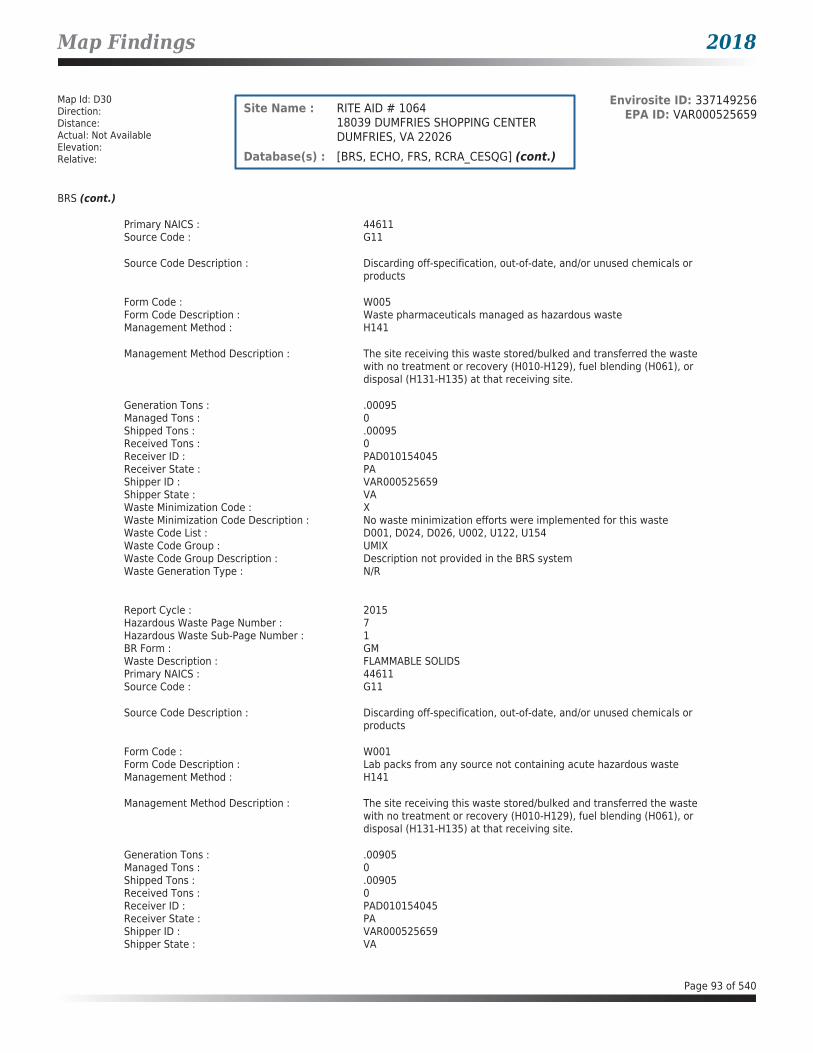
Map Findings 2018
Map Id: D30Direction: Distance: Actual: Not AvailableElevation: Relative:
Envirosite ID: 337149256EPA ID: VAR000525659Site Name : RITE AID # 1064
18039 DUMFRIES SHOPPING CENTERDUMFRIES, VA 22026
Database(s) : [BRS, ECHO, FRS, RCRA_CESQG] (cont.)
BRS (cont.)
Primary NAICS : 44611Source Code : G11
Source Code Description : Discarding off-specification, out-of-date, and/or unused chemicals or products
Form Code : W005Form Code Description : Waste pharmaceuticals managed as hazardous wasteManagement Method : H141
Management Method Description : The site receiving this waste stored/bulked and transferred the waste with no treatment or recovery (H010-H129), fuel blending (H061), or disposal (H131-H135) at that receiving site.
Generation Tons : .00095Managed Tons : 0Shipped Tons : .00095Received Tons : 0Receiver ID : PAD010154045Receiver State : PAShipper ID : VAR000525659Shipper State : VAWaste Minimization Code : XWaste Minimization Code Description : No waste minimization efforts were implemented for this wasteWaste Code List : D001, D024, D026, U002, U122, U154Waste Code Group : UMIXWaste Code Group Description : Description not provided in the BRS systemWaste Generation Type : N/R
Report Cycle : 2015Hazardous Waste Page Number : 7Hazardous Waste Sub-Page Number : 1BR Form : GMWaste Description : FLAMMABLE SOLIDSPrimary NAICS : 44611Source Code : G11
Source Code Description : Discarding off-specification, out-of-date, and/or unused chemicals or products
Form Code : W001Form Code Description : Lab packs from any source not containing acute hazardous wasteManagement Method : H141
Management Method Description : The site receiving this waste stored/bulked and transferred the waste with no treatment or recovery (H010-H129), fuel blending (H061), or disposal (H131-H135) at that receiving site.
Generation Tons : .00905Managed Tons : 0Shipped Tons : .00905Received Tons : 0Receiver ID : PAD010154045Receiver State : PAShipper ID : VAR000525659Shipper State : VA
Page 93 of 540

Map Findings 2018
Map Id: D30Direction: Distance: Actual: Not AvailableElevation: Relative:
Envirosite ID: 337149256EPA ID: VAR000525659Site Name : RITE AID # 1064
18039 DUMFRIES SHOPPING CENTERDUMFRIES, VA 22026
Database(s) : [BRS, ECHO, FRS, RCRA_CESQG] (cont.)
BRS (cont.)
Waste Minimization Code : XWaste Minimization Code Description : No waste minimization efforts were implemented for this wasteWaste Code List : D001, D018, D035, U002Waste Code Group : U002Waste Code Group Description : 2-PROPANONE (I) (OR) ACETONE (I)Waste Generation Type : N/R
Report Cycle : 2015Hazardous Waste Page Number : 8Hazardous Waste Sub-Page Number : 1BR Form : GMWaste Description : NICOTINEPrimary NAICS : 44611Source Code : G11
Source Code Description : Discarding off-specification, out-of-date, and/or unused chemicals or products
Form Code : W004Form Code Description : Lab packs from any source containing acute hazardous wasteManagement Method : H141
Management Method Description : The site receiving this waste stored/bulked and transferred the waste with no treatment or recovery (H010-H129), fuel blending (H061), or disposal (H131-H135) at that receiving site.
Generation Tons : .0027Managed Tons : 0Shipped Tons : .0027Received Tons : 0Receiver ID : PAD010154045Receiver State : PAShipper ID : VAR000525659Shipper State : VAWaste Minimization Code : XWaste Minimization Code Description : No waste minimization efforts were implemented for this wasteWaste Code List : P075Waste Code Group : P075Waste Code Group Description : NICOTINE, & SALTS (OR) PYRIDINE, 3-(1-METHYL-2-PYRROLIDINYL)-,(S)-,
& SALTSWaste Generation Type : N/R
Report Cycle : 2015Hazardous Waste Page Number : 9Hazardous Waste Sub-Page Number : 1BR Form : GMWaste Description : OVER THE COUNTER PHARMACEUTICALSPrimary NAICS : 44611Source Code : G11
Source Code Description : Discarding off-specification, out-of-date, and/or unused chemicals or products
Form Code : W005Form Code Description : Waste pharmaceuticals managed as hazardous waste
Page 94 of 540

Map Findings 2018
Map Id: D30Direction: Distance: Actual: Not AvailableElevation: Relative:
Envirosite ID: 337149256EPA ID: VAR000525659Site Name : RITE AID # 1064
18039 DUMFRIES SHOPPING CENTERDUMFRIES, VA 22026
Database(s) : [BRS, ECHO, FRS, RCRA_CESQG] (cont.)
BRS (cont.)
Management Method : H141
Management Method Description : The site receiving this waste stored/bulked and transferred the waste with no treatment or recovery (H010-H129), fuel blending (H061), or disposal (H131-H135) at that receiving site.
Generation Tons : .0086Managed Tons : 0Shipped Tons : .0086Received Tons : 0Receiver ID : PAD010154045Receiver State : PAShipper ID : VAR000525659Shipper State : VAWaste Minimization Code : XWaste Minimization Code Description : No waste minimization efforts were implemented for this wasteWaste Code List : D007, D010, D011, D026, U129, U205Waste Code Group : UMIXWaste Code Group Description : Description not provided in the BRS systemWaste Generation Type : N/R
Report Cycle : 2015Hazardous Waste Page Number : 10Hazardous Waste Sub-Page Number : 1BR Form : GMWaste Description : OXIDIZER LIQUIDSPrimary NAICS : 44611Source Code : G11
Source Code Description : Discarding off-specification, out-of-date, and/or unused chemicals or products
Form Code : W316Form Code Description : Metal salts or chemicals not containing cyanidesManagement Method : H070Management Method Description : Description not provided in the BRS systemGeneration Tons : .00385Managed Tons : 0Shipped Tons : .00385Received Tons : 0Receiver ID : PAD010154045Receiver State : PAShipper ID : VAR000525659Shipper State : VAWaste Minimization Code : XWaste Minimization Code Description : No waste minimization efforts were implemented for this wasteWaste Code List : D001Waste Code Group : D001Waste Code Group Description : IGNITABLE WASTEWaste Generation Type : WASTEWATER TREATMENT
Report Cycle : 2015Hazardous Waste Page Number : 11Hazardous Waste Sub-Page Number : 1BR Form : GM
Page 95 of 540

Map Findings 2018
Map Id: D30Direction: Distance: Actual: Not AvailableElevation: Relative:
Envirosite ID: 337149256EPA ID: VAR000525659Site Name : RITE AID # 1064
18039 DUMFRIES SHOPPING CENTERDUMFRIES, VA 22026
Database(s) : [BRS, ECHO, FRS, RCRA_CESQG] (cont.)
BRS (cont.)
Waste Description : SILVER OXIDE BATTERIESPrimary NAICS : 44611Source Code : G11
Source Code Description : Discarding off-specification, out-of-date, and/or unused chemicals or products
Form Code : W309Form Code Description : Batteries, battery parts, cores, casings (lead-acid or other types)Management Method : H141
Management Method Description : The site receiving this waste stored/bulked and transferred the waste with no treatment or recovery (H010-H129), fuel blending (H061), or disposal (H131-H135) at that receiving site.
Generation Tons : .00015Managed Tons : 0Shipped Tons : .00015Received Tons : 0Receiver ID : PAD010154045Receiver State : PAShipper ID : VAR000525659Shipper State : VAWaste Minimization Code : XWaste Minimization Code Description : No waste minimization efforts were implemented for this wasteWaste Code List : D011Waste Code Group : D011Waste Code Group Description : SILVERWaste Generation Type : N/R
ECHO
Facility Name : RITE AID # 1064Facility Address : 18039 DUMFRIES SHOPPING CENTER, DUMFRIES, VA 22026County : PRINCE WILLIAM
Last Inspection Date : N/RRegistry ID : 110055476140FIPS Code : 51153EPA Region : 03Inspection Count : 0Last Inspection Days : N/RInformal Count : 0Last Informal Action Date : N/RFormal Action Count : 0Last Formal Action Date : N/RTotal Penalties : 0Penalty Count : N/RLast Penalty Date : N/RLast Penalty Amount : N/RQTRS IN NC : 0Programs IN SNC : 0Current Compliance Status : No ViolationThree-Year Compliance Status : ____________Collection Method : ADDRESS MATCHING-HOUSE NUMBERReference Point : ENTRANCE POINT OF A FACILITY OR STATION
Page 96 of 540

Map Findings 2018
Map Id: D30Direction: Distance: Actual: Not AvailableElevation: Relative:
Envirosite ID: 337149256EPA ID: VAR000525659Site Name : RITE AID # 1064
18039 DUMFRIES SHOPPING CENTERDUMFRIES, VA 22026
Database(s) : [BRS, ECHO, FRS, RCRA_CESQG] (cont.)
ECHO (cont.)
Accuracy Meters : 50Derived Tribes : N/RDerived HUC : 02070011Derived WBD : 020700110104Derived STCTY FIPS : 51153Derived Zip : 22026Derived CD113 : 11Derived CB2010 : 511539009011011MYRTK Universe : NNNNPDES IDs : N/RCWA Permit Types : N/RCWA Compliance Tracking : N/RCWA NAICS : N/RCWA SICS : N/RCWA Inspection Count : N/RCWA Last Inspection Days : N/RCWA Informal Count : N/RCWA Formal Action Count : N/RCWA Last Formal Action Date : N/RCWA Penalties : N/RCWA Last Penalty Date : N/RCWA Last Penalty Amount : N/RCWA Quarters IN NC : N/RCWA Current Compliance Status : N/RCWA Current SNC Flag : NCWA 13 Quarters Compliance Status : N/RCWA 13 Quarters Effluent Exceedances: N/RCWA Three-Year QNCR Codes : N/RDFR URL : Click here for hyperlink provided by the agency.Facility SIC Codes : N/RFacility NAICS Codes : 44611Facility Last Inspection EPA Date : N/RFacility Last Inspection State Date : N/RFacility Last Formal Act EPA Date : N/RFacility Last Formal Act State Date : N/RFacility Last Informal Act EPA Date : N/RFacility Last Informal Act State Date: N/RFacility Federal Agency : N/RTRI Reporter : N/RFacility Imp Water Flag : N/RCurrent SNC Flag : NIndian County Flag : NFederal Flag : N/RUS Mexico Border Flag : N/RChesapeak Bay Flag : YAIR Flag : NNPDES Flag : NSDWIS Flag : NRCRA Flag : YTRI Flag : NGHG Flag : NMajor Flag : N/RActive Flag : YNAA Flag : YLatitude : 38.560653Longitude : -77.329749
Page 97 of 540

Map Findings 2018
Map Id: D30Direction: Distance: Actual: Not AvailableElevation: Relative:
Envirosite ID: 337149256EPA ID: VAR000525659Site Name : RITE AID # 1064
18039 DUMFRIES SHOPPING CENTERDUMFRIES, VA 22026
Database(s) : [BRS, ECHO, FRS, RCRA_CESQG] (cont.)
FRS
Facility Name : RITE AID # 1064Facility Address : 18039 DUMFRIES SHOPPING CENTER, DUMFRIES, VA 22026County : PRINCE WILLIAM
Registry ID : 110055476140FRS Facility URL : Click here for hyperlink provided by the agency.
Source Description :
RCRAInfo is EPA’s comprehensive information system that supports the Resource Conservation and Recovery Act (RCRA) of 1976 and the Hazardous and Solid Waste Amendments (HSWA) of 1984 through the tracking of events and activities related to facilities that generate, transport, and treat, store, or dispose of hazardous waste. RCRAInfo allows RCRA program staff to track the notification, permit, compliance, and corrective action activities required under RCRA. RCRAInfo also supports generation of the National Hazardous Waste Biennial Report. All generators and treatment, storage, and disposal facilities who handle hazardous waste are required to report to the EPA Administrator at least once every two years to support creation of the Biennial Report.
FRS Environmental InterestSource and System ID : RCRAINFO - VAR000525659
RCRA_CESQG
Date form received by agency : 02/19/2016Facility name : RITE AID # 1064Facility address : 18039 DUMFRIES SHOPPING CENTER, DUMFRIES VA 22026EPA ID : VAR000525659Mailing address : 30 HUNTER LANE, CAMP HILL PA 17011Contact : DAVID W CROZIERContact address : 30 HUNTER LANE, CAMP HILL PA 17011Contact country : USContact telephone : 717-975-8643Contact email : [email protected] Region : 03Land type : PrivateSource type : Annual/Biennial Report updated with NotificationClassification : Conditionally Exempt Small Quantity Generator
Description :
Handlers that generate 100 kilograms or less of hazardous waste per calendar month, and accumulate 1000 kg or less of hazardous waste at any time; or generate one kilogram or less of acutely hazardous waste per calendar month, and accumulate at any time: 1 kg or less of acutely hazardous waste; or 100 kg or less of any residue or contaminated soil, waste or other debris resulting from the cleanup of a spill, into or on any land or water, of acutely hazardous waste;or generate 100 kg or less of any residue or contaminated soil, waste or other debris resulting from the cleanup of a spill, into or on any land or water, of acutely hazardous waste during any calendar month, and accumulate at any time: 1 kg or less of acutely hazardous waste; or 100 kg or less of any residue or contaminated soil, waste or other debris resulting from the cleanup of a spill, into or on any land or water, of acutely hazardous waste.
Owner/Operator Summary :Owner Operator name : RITE AID OF VIRGINIA, INC.Owner Operator address : N/R
Page 98 of 540
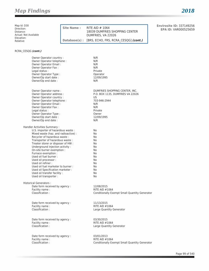
Map Findings 2018
Map Id: D30Direction: Distance: Actual: Not AvailableElevation: Relative:
Envirosite ID: 337149256EPA ID: VAR000525659Site Name : RITE AID # 1064
18039 DUMFRIES SHOPPING CENTERDUMFRIES, VA 22026
Database(s) : [BRS, ECHO, FRS, RCRA_CESQG] (cont.)
RCRA_CESQG (cont.)
Owner Operator country : N/ROwner Operator telephone : N/ROwner Operator Email : N/ROwner Operator Fax : N/RLegal status : PrivateOwner Operator Type : OperatorOwner/Op start date : 12/09/1995Owner/Op end date : N/R
Owner Operator name : DUMFRIES SHOPPING CENTER, INC.Owner Operator address : P.O. BOX 1135, DUMFRIES VA 22026Owner Operator country : USOwner Operator telephone : 703-946-2944Owner Operator Email : N/ROwner Operator Fax : N/RLegal status : PrivateOwner Operator Type : OwnerOwner/Op start date : 12/09/1995Owner/Op end date : N/R
Handler Activities Summary :U.S. importer of hazardous waste : NoMixed waste (haz. and radioactive) : NoRecycler of hazardous waste : NoTransporter of hazardous waste : NoTreater storer or disposer of HW : NoUnderground injection activity : NoOn-site burner exemption : NoFurnace exemption : NoUsed oil fuel burner : NoUsed oil processor : NoUsed oil refiner : NoUsed oil fuel marketer to burner : NoUsed oil Specification marketer : NoUsed oil transfer facility : NoUsed oil transporter : No
Historical Generators :Date form received by agency : 12/08/2015Facility name : RITE AID #1064Classification : Conditionally Exempt Small Quantity Generator
Date form received by agency : 11/13/2015Facility name : RITE AID #1064Classification : Large Quantity Generator
Date form received by agency : 03/30/2015Facility name : RITE AID #1064Classification : Large Quantity Generator
Date form received by agency : 03/01/2013Facility name : RITE AID #1064Classification : Conditionally Exempt Small Quantity Generator
Page 99 of 540

Map Findings 2018
Map Id: D30Direction: Distance: Actual: Not AvailableElevation: Relative:
Envirosite ID: 337149256EPA ID: VAR000525659Site Name : RITE AID # 1064
18039 DUMFRIES SHOPPING CENTERDUMFRIES, VA 22026
Database(s) : [BRS, ECHO, FRS, RCRA_CESQG] (cont.)
RCRA_CESQG (cont.)
Hazardous Waste Summary :Waste code : D001Waste name : IGNITABLE WASTE
Waste code : D002Waste name : CORROSIVE WASTE
Waste code : D007Waste name : CHROMIUM
Waste code : D010Waste name : SELENIUM
Waste code : D011Waste name : SILVER
Waste code : D018Waste name : BENZENE
Waste code : D024Waste name : M-CRESOL
Waste code : D026Waste name : CRESOL
Waste code : D035Waste name : METHYL ETHYL KETONE
Waste code : P001
Waste name : 2H-1-BENZOPYRAN-2-ONE, 4-HYDROXY-3-(3-OXO-1-PHENYLBUTYL)-, & SALTS, WHEN PRESENT AT CONCENTRATIONS GREATER THAN 0.3% (OR) WARFARIN, & SALTS, WHEN PRESENT AT CONCENTRATIONS GREATER THAN 0.3%
Waste code : P075Waste name : NICOTINE, & SALTS (OR) PYRIDINE, 3-(1-METHYL-2-PYRROLIDINYL)-,(S)-,
& SALTS
Waste code : U002Waste name : 2-PROPANONE (I) (OR) ACETONE (I)
Waste code : U122Waste name : FORMALDEHYDE
Page 100 of 540

Map Findings 2018
Map Id: D30Direction: Distance: Actual: Not AvailableElevation: Relative:
Envirosite ID: 337149256EPA ID: VAR000525659Site Name : RITE AID # 1064
18039 DUMFRIES SHOPPING CENTERDUMFRIES, VA 22026
Database(s) : [BRS, ECHO, FRS, RCRA_CESQG] (cont.)
RCRA_CESQG (cont.)
Waste code : U129
Waste name : CYCLOHEXANE, 1,2,3,4,5,6-HEXACHLORO-, (1ALPHA, 2ALPHA, 3BETA, 4ALPHA, 5ALPHA, 6BETA)- (OR) LINDANE
Waste code : U154Waste name : METHANOL (I) (OR) METHYL ALCOHOL (I)
Waste code : U205Waste name : SELENIUM SULFIDE (OR) SELENIUM SULFIDE SES2 (R,T)
Facility has No violations / inspections reported.
Map Id: D31Direction: Distance: Actual: Not AvailableElevation: Relative:
Envirosite ID: 330011487EPA ID: N/RSite Name : BANK OF AMERICA
4001 GRAHAM PARK RDDUMFRIES, VA
Database(s) : [ARCHIVED SPILLS - VA]
Archived SPILLS - VA
Facility Name : Bank of AmericaFacility Address : 4001 Graham Park Rd, Dumfries, VACounty : Prince William County
Closure Date : 06/07/2005Incident Date : N/RCall Received Date : 05/17/2005IR Number : 2005-N-0889Associated IR : N/RReference ID : N/RIncident Type : WaterIncident Subtype : SSORegion : NorthernThreat to : N/RTerrorism (Y/N) : NOCharacterize Incident : N/RMaterials : N/REffect to Receptor : N/RWater Body : N/RLow Quantity to Water : N/RHigh Quantity to Water : N/RQuantity Units : N/ROther Receptors : N/RRP Company : N/RRP Name : N/RProperty Owner : N/RProperty Company : N/R
Page 101 of 540

Map Findings 2018
Map Id: D31Direction: Distance: Actual: Not AvailableElevation: Relative:
Envirosite ID: 330011487EPA ID: N/RSite Name : BANK OF AMERICA
4001 GRAHAM PARK RDDUMFRIES, VA
Database(s) : [ARCHIVED SPILLS - VA] (cont.)
Archived SPILLS - VA (cont.)
Duration of Event (Hours) : N/RImpacts : N/ROther Impacts : N/RSteps Taken : N/RSteps Taken Description : N/RSystem Components : N/ROther System Components : N/RCause of Event : N/RCorrective Action Taken : N/RWeather Status : N/RPrecipitation (Wet) : N/RDischarge Type : N/RDischarge Volume : N/RUnknown Discharge (Y/N) : NO
Original Call Incident Description : While walking on Graham Park Road she observed sewage type H20 in parking lot of Bank of America
Original Call Material Description : N/ROriginal Call Location Description : Bank of America-4001 Graham Park Rd-Dumfries-VA--Prince William
CountyIncident Ongoing at Time of Call : N/RAgencies Notified (Y/N) : NOOther Agencies : N/RPermitted (Y/N) : NOCall Reported by Name : N/RCall Reported by Company Name : Jene BurkeCall RP Company Name : N/RCall RP Name : N/RCall Property Owner Company Name : N/RClosure Summary : See Site Summary for detailsSite Summary : IN AREA 6/7/05 DID NOT NOTICE ANYTHING UNUSUAL
Map Id: 32Direction: Distance: Actual: Not AvailableElevation: Relative:
Envirosite ID: 15284403EPA ID: VAD988187746Site Name : BROWNS AUTO MACHINE INC
924 N MAIN STDUMFRIES, VA 22026
Database(s) : [ECHO, FRS, RCRA_NONGEN]
ECHO
Facility Name : BROWNS AUTO MACHINE INCFacility Address : 924 N MAIN ST, DUMFRIES, VA 22026County : PRINCE WILLIAM
Last Inspection Date : 03/02/2017Registry ID : 110005239447FIPS Code : 51153EPA Region : 03Inspection Count : 1
Page 102 of 540

Map Findings 2018
Map Id: 32Direction: Distance: Actual: Not AvailableElevation: Relative:
Envirosite ID: 15284403EPA ID: VAD988187746Site Name : BROWNS AUTO MACHINE INC
924 N MAIN STDUMFRIES, VA 22026
Database(s) : [ECHO, FRS, RCRA_NONGEN] (cont.)
ECHO (cont.)
Last Inspection Days : 374Informal Count : 0Last Informal Action Date : N/RFormal Action Count : 0Last Formal Action Date : N/RTotal Penalties : 0Penalty Count : N/RLast Penalty Date : N/RLast Penalty Amount : N/RQTRS IN NC : 0Programs IN SNC : 0Current Compliance Status : No ViolationThree-Year Compliance Status : ____________Collection Method : ADDRESS MATCHING-HOUSE NUMBERReference Point : ENTRANCE POINT OF A FACILITY OR STATIONAccuracy Meters : 50Derived Tribes : N/RDerived HUC : 02070011Derived WBD : 020700110104Derived STCTY FIPS : 51153Derived Zip : 22026Derived CD113 : 11Derived CB2010 : 511539010011006MYRTK Universe : NNNNPDES IDs : N/RCWA Permit Types : N/RCWA Compliance Tracking : N/RCWA NAICS : N/RCWA SICS : N/RCWA Inspection Count : N/RCWA Last Inspection Days : N/RCWA Informal Count : N/RCWA Formal Action Count : N/RCWA Last Formal Action Date : N/RCWA Penalties : N/RCWA Last Penalty Date : N/RCWA Last Penalty Amount : N/RCWA Quarters IN NC : N/RCWA Current Compliance Status : N/RCWA Current SNC Flag : NCWA 13 Quarters Compliance Status : N/RCWA 13 Quarters Effluent Exceedances: N/RCWA Three-Year QNCR Codes : N/RDFR URL : Click here for hyperlink provided by the agency.Facility SIC Codes : N/RFacility NAICS Codes : N/RFacility Last Inspection EPA Date : N/RFacility Last Inspection State Date : 03/02/2017Facility Last Formal Act EPA Date : N/RFacility Last Formal Act State Date : N/RFacility Last Informal Act EPA Date : N/RFacility Last Informal Act State Date: N/RFacility Federal Agency : N/RTRI Reporter : N/RFacility Imp Water Flag : N/RCurrent SNC Flag : NIndian County Flag : N
Page 103 of 540

Map Findings 2018
Map Id: 32Direction: Distance: Actual: Not AvailableElevation: Relative:
Envirosite ID: 15284403EPA ID: VAD988187746Site Name : BROWNS AUTO MACHINE INC
924 N MAIN STDUMFRIES, VA 22026
Database(s) : [ECHO, FRS, RCRA_NONGEN] (cont.)
ECHO (cont.)
Federal Flag : N/RUS Mexico Border Flag : N/RChesapeak Bay Flag : YAIR Flag : NNPDES Flag : NSDWIS Flag : NRCRA Flag : YTRI Flag : NGHG Flag : NMajor Flag : N/RActive Flag : N/RNAA Flag : YLatitude : 38.569712Longitude : -77.320867
FRS
Facility Name : BROWNS AUTO MACHINE INCFacility Address : 924 N MAIN ST, DUMFRIES, VA 22026County : PRINCE WILLIAM
Registry ID : 110005239447FRS Facility URL : Click here for hyperlink provided by the agency.
Source Description :
RCRAInfo is EPA’s comprehensive information system that supports the Resource Conservation and Recovery Act (RCRA) of 1976 and the Hazardous and Solid Waste Amendments (HSWA) of 1984 through the tracking of events and activities related to facilities that generate, transport, and treat, store, or dispose of hazardous waste. RCRAInfo allows RCRA program staff to track the notification, permit, compliance, and corrective action activities required under RCRA. RCRAInfo also supports generation of the National Hazardous Waste Biennial Report. All generators and treatment, storage, and disposal facilities who handle hazardous waste are required to report to the EPA Administrator at least once every two years to support creation of the Biennial Report.
FRS Environmental InterestSource and System ID : RCRAINFO - VAD988187746
RCRA_NONGEN
Date form received by agency : 03/15/2017Facility name : BROWNS AUTO MACHINE INCFacility address : 924 N MAIN ST, DUMFRIES VA 22026EPA ID : VAD988187746Mailing address : 924 N MAIN ST, DUMFRIES VA 22026Contact : BROWN WILLIAMContact address : 924 N MAIN ST, DUMFRIES VA 22026Contact country : USContact telephone : 703-221-2792Contact email : N/REPA Region : 03Land type : N/RSource type : Implementer
Page 104 of 540

Map Findings 2018
Map Id: 32Direction: Distance: Actual: Not AvailableElevation: Relative:
Envirosite ID: 15284403EPA ID: VAD988187746Site Name : BROWNS AUTO MACHINE INC
924 N MAIN STDUMFRIES, VA 22026
Database(s) : [ECHO, FRS, RCRA_NONGEN] (cont.)
RCRA_NONGEN (cont.)
Classification : Not a generator, verifiedDescription : Not a generator, verified
Owner/Operator Summary :Owner Operator name : BROWN,JR WILLIAM_JOwner Operator address : OWNERSTREET, OWNERCITY AK 99999Owner Operator country : USOwner Operator telephone : 215-555-1212Owner Operator Email : N/ROwner Operator Fax : N/RLegal status : PrivateOwner Operator Type : OwnerOwner/Op start date : N/ROwner/Op end date : N/R
Owner Operator name : OPERNAMEOwner Operator address : OPERSTREET, OPERCITY AK 99999Owner Operator country : USOwner Operator telephone : 215-555-1212Owner Operator Email : N/ROwner Operator Fax : N/RLegal status : PrivateOwner Operator Type : OperatorOwner/Op start date : N/ROwner/Op end date : N/R
Handler Activities Summary :U.S. importer of hazardous waste : NoMixed waste (haz. and radioactive) : NoRecycler of hazardous waste : NoTransporter of hazardous waste : NoTreater storer or disposer of HW : NoUnderground injection activity : NoOn-site burner exemption : NoFurnace exemption : NoUsed oil fuel burner : NoUsed oil processor : NoUsed oil refiner : NoUsed oil fuel marketer to burner : NoUsed oil Specification marketer : NoUsed oil transfer facility : NoUsed oil transporter : No
Historical Generators :Date form received by agency : 10/13/1990Facility name : BROWNS AUTO MACHINE INCClassification : Small Quantity Generator
Facility has No violations / inspections reported.
Evaluation Action Summary :Evaluation date : 03/02/2017Evaluation : FOCUSED COMPLIANCE INSPECTIONArea of violation : N/RDate achieved compliance : N/REvaluation lead agency : State
Page 105 of 540

Map Findings 2018
Map Id: E33Direction: Distance: Actual: Not AvailableElevation: Relative:
Envirosite ID: 330028473EPA ID: N/RSite Name : THE ANTIQUE STATION
17650 POSSUM POINT ROADDUMFRIES, VA
Database(s) : [ARCHIVED SPILLS - VA]
Archived SPILLS - VA
Facility Name : The Antique StationFacility Address : 17650 Possum Point Road, Dumfries, VACounty : Prince William County
Closure Date : 09/15/2003Incident Date : N/RCall Received Date : 09/03/2003IR Number : 2004-N-0203Associated IR : N/RReference ID : N/RIncident Type : PetroleumIncident Subtype : PetroleumRegion : NorthernThreat to : N/RTerrorism (Y/N) : NOCharacterize Incident : N/RMaterials : Oil (Unknown)(-1 - -1 Unknown)Effect to Receptor : N/RWater Body : N/RLow Quantity to Water : N/RHigh Quantity to Water : N/RQuantity Units : N/ROther Receptors : N/RRP Company : N/RRP Name : N/RProperty Owner : N/RProperty Company : N/RDuration of Event (Hours) : N/RImpacts : N/ROther Impacts : N/RSteps Taken : N/RSteps Taken Description : N/RSystem Components : N/ROther System Components : N/RCause of Event : N/RCorrective Action Taken : N/RWeather Status : N/RPrecipitation (Wet) : N/RDischarge Type : N/RDischarge Volume : N/RUnknown Discharge (Y/N) : NO
Original Call Incident Description : 5 gallon buckets w/partial lids full of oil material several square feet of area grass dead
Original Call Material Description : used oil (Qty=0)
Original Call Location Description : The Antique Station-17650 Possum Point Road-Dumfries-VA--Prince William County
Incident Ongoing at Time of Call : N/RAgencies Notified (Y/N) : NOOther Agencies : N/RPermitted (Y/N) : NOCall Reported by Name : N/RCall Reported by Company Name : Richard Giampa
Page 106 of 540

Map Findings 2018
Map Id: E33Direction: Distance: Actual: Not AvailableElevation: Relative:
Envirosite ID: 330028473EPA ID: N/RSite Name : THE ANTIQUE STATION
17650 POSSUM POINT ROADDUMFRIES, VA
Database(s) : [ARCHIVED SPILLS - VA] (cont.)
Archived SPILLS - VA (cont.)
Call RP Company Name : N/RCall RP Name : N/RCall Property Owner Company Name : N/RClosure Summary : See Site Summary for details
Site Summary : two containers of used oil abandoned at antique shop. Shop will remove material
Map Id: F34Direction: Distance: Actual: Not AvailableElevation: Relative:
Envirosite ID: 14442911EPA ID: N/RSite Name : QUICK SHOP
18020 MAIN STDUMFRIES, VA 22026
Database(s) : [UST - VA]
UST - VA
Facility Name : Quick ShopFacility Address : 18020 Main St, Dumfries, VA 22026County : Prince William County
Facility ID : 3020035Facility Type : GAS STATIONCEDS Facility ID : 200000075312Region Code : NVRO
Tank InformationInstall Date : 05/03/1985Date Closed : N/RTank Number : 1Tank Status : CURR IN USETank Owner ID : 45489Tank Type : USTCapacity : 12000Federally Regulated Tank : YContents : GASOLINEOther Contents : N/R
Tank Material InformationTank Number : 1Tank Owner ID : 45489Tank Material Asphalt/Bare Steel : NTank Material CCP/STI-P3 : NTank Material Composite : NTank Material Fiberglass : YTank Material Concrete : N
Page 107 of 540

Map Findings 2018
Map Id: F34Direction: Distance: Actual: Not AvailableElevation: Relative:
Envirosite ID: 14442911EPA ID: N/RSite Name : QUICK SHOP
18020 MAIN STDUMFRIES, VA 22026
Database(s) : [UST - VA] (cont.)
UST - VA (cont.)
Tank Material Impressed Current : NTank Material Double Walled : NTank Material Lined Interior : NTank Material Excavation Liner : NTank Material Polyethylene Tank Jacket: NTank Material Secondary Containment : NTank Material Repaired : NTank Material Unknown : NTank Material Other : NTank Material Other Notes : N/R
Tank InformationInstall Date : 05/03/1985Date Closed : N/RTank Number : 2MATank Status : CURR IN USETank Owner ID : 45489Tank Type : USTCapacity : 12000Federally Regulated Tank : YContents : GASOLINEOther Contents : N/R
Tank Material InformationTank Number : 2MATank Owner ID : 45489Tank Material Asphalt/Bare Steel : NTank Material CCP/STI-P3 : NTank Material Composite : NTank Material Fiberglass : YTank Material Concrete : NTank Material Impressed Current : NTank Material Double Walled : NTank Material Lined Interior : NTank Material Excavation Liner : NTank Material Polyethylene Tank Jacket: NTank Material Secondary Containment : NTank Material Repaired : NTank Material Unknown : NTank Material Other : NTank Material Other Notes : N/R
Tank InformationInstall Date : 05/03/1985Date Closed : N/RTank Number : 3MATank Status : CURR IN USETank Owner ID : 45489Tank Type : USTCapacity : 10000Federally Regulated Tank : Y
Page 108 of 540
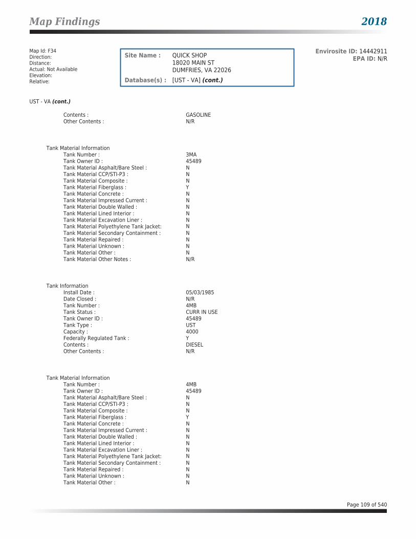
Map Findings 2018
Map Id: F34Direction: Distance: Actual: Not AvailableElevation: Relative:
Envirosite ID: 14442911EPA ID: N/RSite Name : QUICK SHOP
18020 MAIN STDUMFRIES, VA 22026
Database(s) : [UST - VA] (cont.)
UST - VA (cont.)
Contents : GASOLINEOther Contents : N/R
Tank Material InformationTank Number : 3MATank Owner ID : 45489Tank Material Asphalt/Bare Steel : NTank Material CCP/STI-P3 : NTank Material Composite : NTank Material Fiberglass : YTank Material Concrete : NTank Material Impressed Current : NTank Material Double Walled : NTank Material Lined Interior : NTank Material Excavation Liner : NTank Material Polyethylene Tank Jacket: NTank Material Secondary Containment : NTank Material Repaired : NTank Material Unknown : NTank Material Other : NTank Material Other Notes : N/R
Tank InformationInstall Date : 05/03/1985Date Closed : N/RTank Number : 4MBTank Status : CURR IN USETank Owner ID : 45489Tank Type : USTCapacity : 4000Federally Regulated Tank : YContents : DIESELOther Contents : N/R
Tank Material InformationTank Number : 4MBTank Owner ID : 45489Tank Material Asphalt/Bare Steel : NTank Material CCP/STI-P3 : NTank Material Composite : NTank Material Fiberglass : YTank Material Concrete : NTank Material Impressed Current : NTank Material Double Walled : NTank Material Lined Interior : NTank Material Excavation Liner : NTank Material Polyethylene Tank Jacket: NTank Material Secondary Containment : NTank Material Repaired : NTank Material Unknown : NTank Material Other : N
Page 109 of 540

Map Findings 2018
Map Id: F34Direction: Distance: Actual: Not AvailableElevation: Relative:
Envirosite ID: 14442911EPA ID: N/RSite Name : QUICK SHOP
18020 MAIN STDUMFRIES, VA 22026
Database(s) : [UST - VA] (cont.)
UST - VA (cont.)
Tank Material Other Notes : N/R
Tank InformationInstall Date : 05/03/1985Date Closed : N/RTank Number : 5MBTank Status : CURR IN USETank Owner ID : 45489Tank Type : USTCapacity : 4000Federally Regulated Tank : YContents : DIESELOther Contents : N/R
Tank Material InformationTank Number : 5MBTank Owner ID : 45489Tank Material Asphalt/Bare Steel : NTank Material CCP/STI-P3 : NTank Material Composite : NTank Material Fiberglass : YTank Material Concrete : NTank Material Impressed Current : NTank Material Double Walled : NTank Material Lined Interior : NTank Material Excavation Liner : NTank Material Polyethylene Tank Jacket: NTank Material Secondary Containment : NTank Material Repaired : NTank Material Unknown : NTank Material Other : NTank Material Other Notes : N/R
Map Id: F35Direction: Distance: Actual: Not AvailableElevation: Relative:
Envirosite ID: 21812646EPA ID: N/RSite Name : GASOLINE RELEASE @CARROLL FUEL
18020 MAIN ST.DUMFRIES, VA 22026
Database(s) : [SPILLS - VA]
SPILLS - VA
Facility Name : Gasoline Release @Carroll FuelFacility Address : 18020 Main St., Dumfries, VA 22026County : Prince William County
Page 110 of 540

Map Findings 2018
Map Id: F35Direction: Distance: Actual: Not AvailableElevation: Relative:
Envirosite ID: 21812646EPA ID: N/RSite Name : GASOLINE RELEASE @CARROLL FUEL
18020 MAIN ST.DUMFRIES, VA 22026
Database(s) : [SPILLS - VA] (cont.)
SPILLS - VA (cont.)
Incident Date : 05/24/2014Call Received Date : 06/02/2014Closure Date : 06/02/2014IR Number : 2014-N-3237Associated IR : N/RReference ID : 26996Status : ClosedFacility Name : N/RRegion : NorthernIncident Type : PetroleumIncident Subtype : Petroleum * Surface SpillThreat to : N/RTerrorism (Y/N) : NCharacterize Incident : UnknownMaterials : Gasoline (5-5 Gallons)Effect to Receptor : N/RWater Body : N/RLow Quantity to Water : N/RHigh Quantity to Water : N/RQuantity Units : N/ROther Receptors : N/RRP Company : N/RRP Name : N/RProperty Owner : N/RProperty Company : N/RDuration of Event (Hours) : 0Impacts : N/ROther Impacts : N/RSteps Taken : N/RSteps Taken Description : N/RSystem Components : N/ROther System Components : N/RCause of Event : N/RCorrective Action Taken : N/RWeather Status : N/RPrecipitation (Wet) : 0Discharge Type : N/RDischarge Volume : 0Unknown Discharge (Y/N) : N
Original Call Incident Description : While making a delivery a motorist ran over the hose releasing 5 gallons of gasoline onto the ground. The driver used a spill kit to remove the released product.
Original Call Material Description : GasolineOriginal Call Location Description : Carroll Fuel, 18020 Main St., Dumfries, VA 22026Incident Ongoing at Time of Call : N/RAgencies Notified (Y/N) : N/ROther Agencies : RHMO Iverson (HMVA-6566)Permitted (Y/N) : NCall Reported by Name : Eric BrumgratCall Reported by Company Name : N/RCall RP Company Name : N/RCall RP Name : N/RCall Property Owner Company Name : N/RCall Property Owner Name : N/RClosure Comments : Notification only
Page 111 of 540

Map Findings 2018
Map Id: F35Direction: Distance: Actual: Not AvailableElevation: Relative:
Envirosite ID: 21812646EPA ID: N/RSite Name : GASOLINE RELEASE @CARROLL FUEL
18020 MAIN ST.DUMFRIES, VA 22026
Database(s) : [SPILLS - VA] (cont.)
SPILLS - VA (cont.)
Site Summary : Driver used spill kit to remove the released product.
Map Id: F36Direction: Distance: Actual: Not AvailableElevation: Relative:
Envirosite ID: 24845008EPA ID: N/RSite Name : QUIK SHOP CITGO
18020 MAIN STDUMFRIES, VA 22026
Database(s) : [LPT - VA]
LPT - VA
Facility Name : Quik Shop CitgoFacility Address : 18020 Main St, Dumfries, VA 22026County : Prince William County
Release Reported : 06/23/2000PC Number : 20003382CEDS Facility ID : 200000075312Case Status : ClosedCase Closed Date : 07/12/2000Region : NVROProgram : RP LeadHeating Oil Category : N/RFederally Regulated UST : YRegulated Petroleum UST (1) : YExcluded UST (1) : NDeferred UST (1) : NPartially Deferred UST (1) : NExempt 1 UST (2) : NExempt 2 Heating Oil UST (2) : NSmall Heating Oil AST (2) : NRegulated AST (3) : NUnregulated AST (3) : NOther (Y/N) : NOther Description : N/RUnknown (Y/N) : NPriority : 3Suspect Confirm Indicator : ConfirmedLatitude : 38.5613303718Longitude : -77.3319026242Last Date in Agency List : 02/09/2018
Page 112 of 540

Map Findings 2018
Map Id: F37Direction: Distance: Actual: Not AvailableElevation: Relative:
Envirosite ID: 342395655EPA ID: N/RSite Name : QUICK STOP CITGO
18020 MAIN STDUMFRIES, VA 22026
Database(s) : [LPT - VA]
LPT - VA
Facility Name : Quick Stop CitgoFacility Address : 18020 Main St, Dumfries, VA 22026County : Prince William County
Release Reported : 03/27/2006PC Number : 20063201CEDS Facility ID : 200000075312Case Status : ClosedCase Closed Date : 03/26/2007Region : NVROProgram : RP LeadHeating Oil Category : N/RFederally Regulated UST : YRegulated Petroleum UST (1) : N/RExcluded UST (1) : N/RDeferred UST (1) : N/RPartially Deferred UST (1) : N/RExempt 1 UST (2) : N/RExempt 2 Heating Oil UST (2) : N/RSmall Heating Oil AST (2) : N/RRegulated AST (3) : N/RUnregulated AST (3) : N/ROther (Y/N) : N/ROther Description : N/RUnknown (Y/N) : N/RPriority : 3Suspect Confirm Indicator : SuspectedLatitude : 38.5613448342Longitude : -77.331832181Last Date in Agency List : 02/09/2018
Map Id: E38Direction: Distance: Actual: Not AvailableElevation: Relative:
Envirosite ID: 26960347EPA ID: N/RSite Name : ATLANTIC REFINING & MKTG CORP-
COCKPIT PTRT 783 POSSUM POINT RDDUMFRIES, VA 22026
Database(s) : [ECHO, FRS, RCRA_NONGEN]
ECHO
Facility Name : ATLANTIC REFINING & MKTG CORP-COCKPIT PTFacility Address : RT 783 POSSUM POINT RD, DUMFRIES, VA 22026County : PRINCE WILLIAM
Last Inspection Date : N/RRegistry ID : 110008184302FIPS Code : 51153EPA Region : 03Inspection Count : 0
Page 113 of 540

Map Findings 2018
Map Id: E38Direction: Distance: Actual: Not AvailableElevation: Relative:
Envirosite ID: 26960347EPA ID: N/RSite Name : ATLANTIC REFINING & MKTG CORP-
COCKPIT PTRT 783 POSSUM POINT RDDUMFRIES, VA 22026
Database(s) : [ECHO, FRS, RCRA_NONGEN] (cont.)
ECHO (cont.)
Last Inspection Days : N/RInformal Count : 0Last Informal Action Date : N/RFormal Action Count : 0Last Formal Action Date : N/RTotal Penalties : 0Penalty Count : N/RLast Penalty Date : N/RLast Penalty Amount : N/RQTRS IN NC : 0Programs IN SNC : 0Current Compliance Status : No ViolationThree-Year Compliance Status : ____________Collection Method : ADDRESS MATCHING-HOUSE NUMBERReference Point : N/RAccuracy Meters : 183Derived Tribes : N/RDerived HUC : 02070011Derived WBD : 020700110104Derived STCTY FIPS : 51153Derived Zip : 22026Derived CD113 : 11Derived CB2010 : 511539009012001MYRTK Universe : NNNNPDES IDs : N/RCWA Permit Types : N/RCWA Compliance Tracking : N/RCWA NAICS : N/RCWA SICS : N/RCWA Inspection Count : N/RCWA Last Inspection Days : N/RCWA Informal Count : N/RCWA Formal Action Count : N/RCWA Last Formal Action Date : N/RCWA Penalties : N/RCWA Last Penalty Date : N/RCWA Last Penalty Amount : N/RCWA Quarters IN NC : N/RCWA Current Compliance Status : N/RCWA Current SNC Flag : NCWA 13 Quarters Compliance Status : N/RCWA 13 Quarters Effluent Exceedances: N/RCWA Three-Year QNCR Codes : N/RDFR URL : Click here for hyperlink provided by the agency.Facility SIC Codes : N/RFacility NAICS Codes : 33312Facility Last Inspection EPA Date : N/RFacility Last Inspection State Date : N/RFacility Last Formal Act EPA Date : N/RFacility Last Formal Act State Date : N/RFacility Last Informal Act EPA Date : N/RFacility Last Informal Act State Date: N/RFacility Federal Agency : N/RTRI Reporter : N/RFacility Imp Water Flag : N/RCurrent SNC Flag : N
Page 114 of 540

Map Findings 2018
Map Id: E38Direction: Distance: Actual: Not AvailableElevation: Relative:
Envirosite ID: 26960347EPA ID: N/RSite Name : ATLANTIC REFINING & MKTG CORP-
COCKPIT PTRT 783 POSSUM POINT RDDUMFRIES, VA 22026
Database(s) : [ECHO, FRS, RCRA_NONGEN] (cont.)
ECHO (cont.)
Indian County Flag : NFederal Flag : N/RUS Mexico Border Flag : N/RChesapeak Bay Flag : YAIR Flag : NNPDES Flag : NSDWIS Flag : NRCRA Flag : YTRI Flag : NGHG Flag : NMajor Flag : N/RActive Flag : N/RNAA Flag : YLatitude : 38.569653Longitude : -77.31882
FRS
Facility Name : ATLANTIC REFINING & MKTG CORP-COCKPIT PTFacility Address : RT 783 POSSUM POINT RD, DUMFRIES, VA 22026County : PRINCE WILLIAM
Registry ID : 110008184302FRS Facility URL : Click here for hyperlink provided by the agency.
Source Description :
RCRAInfo is EPA’s comprehensive information system that supports the Resource Conservation and Recovery Act (RCRA) of 1976 and the Hazardous and Solid Waste Amendments (HSWA) of 1984 through the tracking of events and activities related to facilities that generate, transport, and treat, store, or dispose of hazardous waste. RCRAInfo allows RCRA program staff to track the notification, permit, compliance, and corrective action activities required under RCRA. RCRAInfo also supports generation of the National Hazardous Waste Biennial Report. All generators and treatment, storage, and disposal facilities who handle hazardous waste are required to report to the EPA Administrator at least once every two years to support creation of the Biennial Report.
FRS Environmental InterestSource and System ID : RCRAINFO - VAD070351606
RCRA_NONGEN
Date form received by agency : 05/05/1993Facility name : ATLANTIC REFINING & MKTG CORP-COCKPIT PTFacility address : RT 783 POSSUM POINT RD, DUMFRIES VA 22026EPA ID : VAD070351606Mailing address : 3144 PASSYUNK AVE, PHILADELPHIA PA 19145Contact : N/RContact address : N/RContact country : USContact telephone : N/RContact email : N/REPA Region : 03
Page 115 of 540

Map Findings 2018
Map Id: E38Direction: Distance: Actual: Not AvailableElevation: Relative:
Envirosite ID: 26960347EPA ID: N/RSite Name : ATLANTIC REFINING & MKTG CORP-
COCKPIT PTRT 783 POSSUM POINT RDDUMFRIES, VA 22026
Database(s) : [ECHO, FRS, RCRA_NONGEN] (cont.)
RCRA_NONGEN (cont.)
Land type : N/RSource type : ImplementerClassification : Not a generator, verifiedDescription : Not a generator, verified
Owner/Operator Summary :Owner Operator name : OPERNAMEOwner Operator address : OPERSTREET, OPERCITY AK 99999Owner Operator country : N/ROwner Operator telephone : 215-555-1212Owner Operator Email : N/ROwner Operator Fax : N/RLegal status : PrivateOwner Operator Type : OperatorOwner/Op start date : N/ROwner/Op end date : N/R
Handler Activities Summary :U.S. importer of hazardous waste : NoMixed waste (haz. and radioactive) : NoRecycler of hazardous waste : NoTransporter of hazardous waste : NoTreater storer or disposer of HW : NoUnderground injection activity : NoOn-site burner exemption : NoFurnace exemption : NoUsed oil fuel burner : NoUsed oil processor : NoUsed oil refiner : NoUsed oil fuel marketer to burner : NoUsed oil Specification marketer : NoUsed oil transfer facility : NoUsed oil transporter : No
Historical Generators :Date form received by agency : 08/18/1980Facility name : ATLANTIC REFINING & MKTG CORP-COCKPIT PTClassification : Large Quantity Generator
Facility has No violations / inspections reported.
Map Id: 39Direction: Distance: Actual: Not AvailableElevation: Relative:
Envirosite ID: 14571023EPA ID: VAD981102957Site Name : WHITE STAR CLNRS
18101 TRIANGLE SHOPPING PLZDUMFRIES, VA 22026
Database(s) : [ECHO, FRS, RCRA_NONGEN]
ECHO
Facility Name : WHITE STAR CLNRS
Page 116 of 540

Map Findings 2018
Map Id: 39Direction: Distance: Actual: Not AvailableElevation: Relative:
Envirosite ID: 14571023EPA ID: VAD981102957Site Name : WHITE STAR CLNRS
18101 TRIANGLE SHOPPING PLZDUMFRIES, VA 22026
Database(s) : [ECHO, FRS, RCRA_NONGEN] (cont.)
ECHO (cont.)
Facility Address : 18101 TRIANGLE SHOPPING PLZ, DUMFRIES, VA 22026County : PRINCE WILLIAM
Last Inspection Date : 08/21/1998Registry ID : 110005230197FIPS Code : 51153EPA Region : 03Inspection Count : 0Last Inspection Days : 7142Informal Count : 0Last Informal Action Date : N/RFormal Action Count : 0Last Formal Action Date : N/RTotal Penalties : 0Penalty Count : N/RLast Penalty Date : N/RLast Penalty Amount : N/RQTRS IN NC : 0Programs IN SNC : 0Current Compliance Status : No ViolationThree-Year Compliance Status : ____________Collection Method : ADDRESS MATCHING-HOUSE NUMBERReference Point : ENTRANCE POINT OF A FACILITY OR STATIONAccuracy Meters : 50Derived Tribes : N/RDerived HUC : 02070011Derived WBD : 020700110104Derived STCTY FIPS : 51153Derived Zip : 22026Derived CD113 : 11Derived CB2010 : 511539010012023MYRTK Universe : NNNNPDES IDs : N/RCWA Permit Types : N/RCWA Compliance Tracking : N/RCWA NAICS : N/RCWA SICS : N/RCWA Inspection Count : N/RCWA Last Inspection Days : N/RCWA Informal Count : N/RCWA Formal Action Count : N/RCWA Last Formal Action Date : N/RCWA Penalties : N/RCWA Last Penalty Date : N/RCWA Last Penalty Amount : N/RCWA Quarters IN NC : N/RCWA Current Compliance Status : N/RCWA Current SNC Flag : NCWA 13 Quarters Compliance Status : N/RCWA 13 Quarters Effluent Exceedances: N/RCWA Three-Year QNCR Codes : N/RDFR URL : Click here for hyperlink provided by the agency.Facility SIC Codes : N/RFacility NAICS Codes : 81232Facility Last Inspection EPA Date : N/RFacility Last Inspection State Date : 08/21/1998
Page 117 of 540

Map Findings 2018
Map Id: 39Direction: Distance: Actual: Not AvailableElevation: Relative:
Envirosite ID: 14571023EPA ID: VAD981102957Site Name : WHITE STAR CLNRS
18101 TRIANGLE SHOPPING PLZDUMFRIES, VA 22026
Database(s) : [ECHO, FRS, RCRA_NONGEN] (cont.)
ECHO (cont.)
Facility Last Formal Act EPA Date : N/RFacility Last Formal Act State Date : N/RFacility Last Informal Act EPA Date : N/RFacility Last Informal Act State Date: N/RFacility Federal Agency : N/RTRI Reporter : N/RFacility Imp Water Flag : N/RCurrent SNC Flag : NIndian County Flag : NFederal Flag : N/RUS Mexico Border Flag : N/RChesapeak Bay Flag : YAIR Flag : NNPDES Flag : NSDWIS Flag : NRCRA Flag : YTRI Flag : NGHG Flag : NMajor Flag : N/RActive Flag : N/RNAA Flag : YLatitude : 38.559524Longitude : -77.332397
FRS
Facility Name : WHITE STAR CLNRSFacility Address : 18101 TRIANGLE SHOPPING PLZ, DUMFRIES, VA 22026County : PRINCE WILLIAM
Registry ID : 110005230197FRS Facility URL : Click here for hyperlink provided by the agency.
Source Description :
RCRAInfo is EPA’s comprehensive information system that supports the Resource Conservation and Recovery Act (RCRA) of 1976 and the Hazardous and Solid Waste Amendments (HSWA) of 1984 through the tracking of events and activities related to facilities that generate, transport, and treat, store, or dispose of hazardous waste. RCRAInfo allows RCRA program staff to track the notification, permit, compliance, and corrective action activities required under RCRA. RCRAInfo also supports generation of the National Hazardous Waste Biennial Report. All generators and treatment, storage, and disposal facilities who handle hazardous waste are required to report to the EPA Administrator at least once every two years to support creation of the Biennial Report.
FRS Environmental InterestSource and System ID : RCRAINFO - VAD981102957
RCRA_NONGEN
Date form received by agency : 08/21/1998Facility name : WHITE STAR CLNRSFacility address : 18101 TRIANGLE SHOPPING PLZ, DUMFRIES VA 22026EPA ID : VAD981102957
Page 118 of 540

Map Findings 2018
Map Id: 39Direction: Distance: Actual: Not AvailableElevation: Relative:
Envirosite ID: 14571023EPA ID: VAD981102957Site Name : WHITE STAR CLNRS
18101 TRIANGLE SHOPPING PLZDUMFRIES, VA 22026
Database(s) : [ECHO, FRS, RCRA_NONGEN] (cont.)
RCRA_NONGEN (cont.)
Mailing address : 18101 TRIANGLE SHOPPING PLZ, DUMFRIES VA 22026Contact : N/RContact address : N/RContact country : USContact telephone : N/RContact email : N/REPA Region : 03Land type : PrivateSource type : ImplementerClassification : Not a generator, verifiedDescription : Not a generator, verified
Owner/Operator Summary :Owner Operator name : OPERNAMEOwner Operator address : OPERSTREET, OPERCITY AK 99999Owner Operator country : N/ROwner Operator telephone : 215-555-1212Owner Operator Email : N/ROwner Operator Fax : N/RLegal status : PrivateOwner Operator Type : OperatorOwner/Op start date : N/ROwner/Op end date : N/R
Handler Activities Summary :U.S. importer of hazardous waste : NoMixed waste (haz. and radioactive) : NoRecycler of hazardous waste : NoTransporter of hazardous waste : NoTreater storer or disposer of HW : NoUnderground injection activity : NoOn-site burner exemption : NoFurnace exemption : NoUsed oil fuel burner : NoUsed oil processor : NoUsed oil refiner : NoUsed oil fuel marketer to burner : NoUsed oil Specification marketer : NoUsed oil transfer facility : NoUsed oil transporter : No
Historical Generators :Date form received by agency : 11/05/1985Facility name : WHITE STAR CLNRSClassification : Small Quantity Generator
Facility has No violations / inspections reported.
Evaluation Action Summary :Evaluation date : 08/21/1998Evaluation : COMPLIANCE EVALUATION INSPECTION ON-SITEArea of violation : N/RDate achieved compliance : N/REvaluation lead agency : State
Page 119 of 540

Map Findings 2018
Map Id: G40Direction: Distance: Actual: Not AvailableElevation: Relative:
Envirosite ID: 21813112EPA ID: N/RSite Name : AMG MOTORS
17575 OLD STAGE COACH ROADDUMFRIES, VA
Database(s) : [SPILLS - VA]
SPILLS - VA
Facility Name : AMG MotorsFacility Address : 17575 OLD STAGE COACH ROAD, Dumfries, VACounty : Prince William County
Incident Date : 10/28/2009Call Received Date : 11/10/2009Closure Date : 11/10/2009IR Number : 2010-N-1263Associated IR : N/RReference ID : 845Status : ClosedFacility Name : N/RRegion : NorthernIncident Type : PetroleumIncident Subtype : Petroleum * Surface SpillThreat to : N/RTerrorism (Y/N) : NCharacterize Incident : UnknownMaterials : Oil (0-0 Unknown)Effect to Receptor : N/RWater Body : N/RLow Quantity to Water : N/RHigh Quantity to Water : N/RQuantity Units : N/ROther Receptors : N/RRP Company : N/RRP Name : N/RProperty Owner : N/RProperty Company : N/RDuration of Event (Hours) : 0Impacts : N/ROther Impacts : N/RSteps Taken : N/RSteps Taken Description : N/RSystem Components : N/ROther System Components : N/RCause of Event : N/RCorrective Action Taken : N/RWeather Status : N/APrecipitation (Wet) : 0Discharge Type : N/ADischarge Volume : 0Unknown Discharge (Y/N) : N
Original Call Incident Description : WHAT APPEARS TO BE A LARGE OIL OR CHEMICAL SPILL WAS DISCOVERED WHILE LOOKING AT A USED CAR. THE EMPLOYEES WERE WASHING A CAR OVER A PORTION OF THE AREA AND THE WASTE WATER RUN OFF WAS GOING INTO THEWOODS BEHIND THEIR REPAIR SHOP.
Original Call Material Description : unknown oil
Original Call Location Description : AMG MOTORS INC. 17575 OLD STAGE COACH ROAD, Dumfries (reported to NRC/EOC 11/09/09).
Incident Ongoing at Time of Call : N
Page 120 of 540

Map Findings 2018
Map Id: G40Direction: Distance: Actual: Not AvailableElevation: Relative:
Envirosite ID: 21813112EPA ID: N/RSite Name : AMG MOTORS
17575 OLD STAGE COACH ROADDUMFRIES, VA
Database(s) : [SPILLS - VA] (cont.)
SPILLS - VA (cont.)
Agencies Notified (Y/N) : NOther Agencies : N/RPermitted (Y/N) : NCall Reported by Name : ANONYMOUS ANONYMOUSCall Reported by Company Name : N/RCall RP Company Name : N/RCall RP Name : N/RCall Property Owner Company Name : N/RCall Property Owner Name : N/R
Closure Comments : Based on site visit. No issues observed. No significant oil stained areas observed.
Site Summary : WHAT APPEARS TO BE A LARGE OIL OR CHEMICAL SPILL WAS DISCOVERED WHILE LOOKING AT A USED CAR. THE EMPLOYEES WERE WASHING A CAR OVER A PORTION OF THE AREA AND THE WASTE WATER RUN OFF WAS GOING INTO THEWOODS BEHIND THEIR REPAIR SHOP.
Map Id: G41Direction: Distance: Actual: Not AvailableElevation: Relative:
Envirosite ID: 316131093EPA ID: N/RSite Name : N/R
17575 OLD STAGE COACH ROADDUMFRIES, VA 22026
Database(s) : [ERNS]
ERNS
Facility Address : 17575 OLD STAGE COACH ROAD, DUMFRIES, VA 22026County : PRINCE WILLIAM
Incident InformationIncident Date Time : 10/28/2009 10:08 AMType of Incident : FIXEDIncident Cause : DUMPINGIncident DTG : DISCOVEREDIncident Location : N/RSequence Number : 922961Potential Flag : N
Description of Incident : ///WEB REPORT/// WHAT APPEARS TO BE A LARGE OIL OR CHEMICAL SPILL WAS DISCOVERED WHILE LOOKING AT A USED CAR. THE EMPLOYEES WERE WASHING A CAR OVER A PORTION OF THE AREA AND THE WASTE WATER RUN OFF WAS GOING INTO THE WOODS BEHIND THEIR REPAIR SHOP.
Page 121 of 540

Map Findings 2018
Map Id: G41Direction: Distance: Actual: Not AvailableElevation: Relative:
Envirosite ID: 316131093EPA ID: N/RSite Name : N/R
17575 OLD STAGE COACH ROADDUMFRIES, VA 22026
Database(s) : [ERNS] (cont.)
ERNS (cont.)
Incident Response SummaryDate Time Received : 11/09/2009 09:18 AMDate Time Completed : 11/09/2009 09:35 AMCall Type : IncidentSource : WEB REPORTResponsible Company : AMG MOTORS INC.Responsible Org Type : PRIVATE ENTERPRISEResponsible City : DUMFRIESResponsible State : VAResponsible Zip : 22026
Incident Details SummaryRemedial Action : N/AMedium : WOODS BEHIND THE SHOPMedium Description : LANDBody of Water : N/RWeather Conditions : UNKNOWNWater Temperature : N/RWater Supply Contaminated : UWaterway Closed : NWaterway Description : N/R
Additional Incident Details SummaryActual Amount : N/RActual Amount Units : N/RCapacity of Tank : N/RCapacity of Tank Units : N/RContinuous Release Begin Date : N/RContinuous Release End Date : N/RContinuous Release Change Date : N/RContinuous Release Permit : N/RContinuous Release Type : N/RDescription of Tank : N/RDevice Operational : UDOT Crossing Number : N/RDOT Regulated : UNPDES : N/RNPDES Compliance : UPipeline Aboveground : ABOVEPipeline Covered : NPipeline Type : N/RTank ID : N/RTank Regulated : UTank Regulated by : N/R
Materials Involved SummaryName of Material : UNKNOWN OILCAS Number : 000000-00-0Amount of Material : 0Unit of Measure : UNKNOWN AMOUNTUN Number : N/R
Page 122 of 540

Map Findings 2018
Map Id: G41Direction: Distance: Actual: Not AvailableElevation: Relative:
Envirosite ID: 316131093EPA ID: N/RSite Name : N/R
17575 OLD STAGE COACH ROADDUMFRIES, VA 22026
Database(s) : [ERNS] (cont.)
ERNS (cont.)
CHRIS Code : OUNReached Water : UNKNOWNAmount in Water : N/RUnit of Measure (Reach Water) : N/R
Additional Materials Involved SummaryName of Material : N/RCAS Number : N/RCHRIS Code : N/RUpper Bounds : N/RUpper Bounds Unit : N/RUpper Bounds Rate : N/R
Trains DetailsTrain Name Number : N/RTrain Type : N/RTrain Speed : N/RTrain Direction : N/RNumber Locomotives : N/RNumber Cars : N/RNumber Derailed : N/RTrack Speed : N/RRailroad Name : N/RNon Compliance with Hazmat : N/R
Derailed Units SummaryTrain Name Number : N/RCar Number : N/RCar Content : N/RPosition in Train : N/RDerailed Type : N/R
Vessels DetailsVessel Name : N/RVessel Type : N/RVessel Length : N/RHull Construction : N/RFuel Capacity : N/RFuel on Board : N/RCargo Capacity : N/RCargo on Board : N/RIs Vessel Aground : N/RFlag : N/RBreadth : N/RDraught : N/RFuel Capacity Units : N/RFuel on Board Units : N/RCargo Capacity Units : N/RCargo on Board Units : N/R
Page 123 of 540

Map Findings 2018
Map Id: G41Direction: Distance: Actual: Not AvailableElevation: Relative:
Envirosite ID: 316131093EPA ID: N/RSite Name : N/R
17575 OLD STAGE COACH ROADDUMFRIES, VA 22026
Database(s) : [ERNS] (cont.)
ERNS (cont.)
Mobile DetailsVehicle Own Fuel Capacity : N/RCargo Capacity : N/RAmount of Cargo on Board : N/RHazmat Carrier : N/RCarrier Licensed : N/RNoncompliance with Hazmat : N/RMobile Type : N/RCargo Capacity Units : N/RAmount of Cargo on Board Units : N/RVehicle Year : N/RVehicle Make : N/RVehicle Model : N/RVehicle Number : N/RTrailer Number : N/R
Map Id: H42Direction: Distance: Actual: Not AvailableElevation: Relative:
Envirosite ID: 14441977EPA ID: N/RSite Name : PULLEN MOVING CO
122 OLD STAGE COACH RDDUMFRIES, VA 22026
Database(s) : [UST - VA]
UST - VA
Facility Name : PULLEN MOVING COFacility Address : 122 Old Stage Coach Rd, Dumfries, VA 22026County : Prince William County
Facility ID : 3011887Facility Type : TRUCKING/TRANSPORTCEDS Facility ID : 200000075460Region Code : NVRO
Tank InformationInstall Date : 04/29/1980Date Closed : 04/15/1985Tank Number : 2Tank Status : CLS IN GRDTank Owner ID : 32501Tank Type : USTCapacity : 4000Federally Regulated Tank : YContents : GASOLINEOther Contents : N/R
Page 124 of 540

Map Findings 2018
Map Id: H42Direction: Distance: Actual: Not AvailableElevation: Relative:
Envirosite ID: 14441977EPA ID: N/RSite Name : PULLEN MOVING CO
122 OLD STAGE COACH RDDUMFRIES, VA 22026
Database(s) : [UST - VA] (cont.)
UST - VA (cont.)
Tank Material InformationTank Number : 2Tank Owner ID : 32501Tank Material Asphalt/Bare Steel : YTank Material CCP/STI-P3 : NTank Material Composite : NTank Material Fiberglass : NTank Material Concrete : NTank Material Impressed Current : NTank Material Double Walled : NTank Material Lined Interior : NTank Material Excavation Liner : NTank Material Polyethylene Tank Jacket: NTank Material Secondary Containment : NTank Material Repaired : NTank Material Unknown : NTank Material Other : NTank Material Other Notes : N/R
Tank InformationInstall Date : 04/29/1980Date Closed : 04/29/1986Tank Number : 1Tank Status : CLS IN GRDTank Owner ID : 32501Tank Type : USTCapacity : 4000Federally Regulated Tank : YContents : DIESELOther Contents : N/R
Tank Material InformationTank Number : 1Tank Owner ID : 32501Tank Material Asphalt/Bare Steel : YTank Material CCP/STI-P3 : NTank Material Composite : NTank Material Fiberglass : NTank Material Concrete : NTank Material Impressed Current : NTank Material Double Walled : NTank Material Lined Interior : NTank Material Excavation Liner : NTank Material Polyethylene Tank Jacket: NTank Material Secondary Containment : NTank Material Repaired : NTank Material Unknown : NTank Material Other : NTank Material Other Notes : N/R
Page 125 of 540

Map Findings 2018
Map Id: H43Direction: Distance: Actual: Not AvailableElevation: Relative:
Envirosite ID: 24842530EPA ID: N/RSite Name : C AND J AUTOMOTIVE
17539 JEFFERSON DAVIS HWYDUMFRIES, VA 22026
Database(s) : [LPT - VA]
LPT - VA
Facility Name : C and J AutomotiveFacility Address : 17539 Jefferson Davis Hwy, Dumfries, VA 22026County : Prince William County
Release Reported : 09/20/2002PC Number : 20033054CEDS Facility ID : 200000207873Case Status : ClosedCase Closed Date : 09/27/2002Region : NVROProgram : RP LeadHeating Oil Category : N/RFederally Regulated UST : NRegulated Petroleum UST (1) : NExcluded UST (1) : NDeferred UST (1) : NPartially Deferred UST (1) : NExempt 1 UST (2) : NExempt 2 Heating Oil UST (2) : NSmall Heating Oil AST (2) : NRegulated AST (3) : NUnregulated AST (3) : NOther (Y/N) : NOther Description : N/RUnknown (Y/N) : YPriority : 3Suspect Confirm Indicator : ConfirmedLatitude : 38.5716489629Longitude : -77.3177808663Last Date in Agency List : 02/09/2018
Map Id: I44Direction: Distance: Actual: Not AvailableElevation: Relative:
Envirosite ID: 7361077EPA ID: N/RSite Name : VDOT - Dumfries Area Headquarters
18200 Jefferson Davis HwyDumfries, VA 22026
Database(s) : [LPT - VA, UST - VA]
LPT - VA
Facility Name : VDOT - Dumfries Area HeadquartersFacility Address : 18200 Jefferson Davis Hwy, Dumfries, VA 22026County : Prince William County
Release Reported : 09/28/1998PC Number : 19993097CEDS Facility ID : 200000078813Case Status : ClosedCase Closed Date : 04/05/1999Region : NVRO
Page 126 of 540
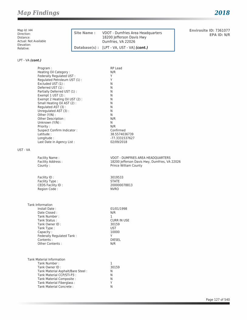
Map Findings 2018
Map Id: I44Direction: Distance: Actual: Not AvailableElevation: Relative:
Envirosite ID: 7361077EPA ID: N/RSite Name : VDOT - Dumfries Area Headquarters
18200 Jefferson Davis HwyDumfries, VA 22026
Database(s) : [LPT - VA, UST - VA] (cont.)
LPT - VA (cont.)
Program : RP LeadHeating Oil Category : N/RFederally Regulated UST : YRegulated Petroleum UST (1) : YExcluded UST (1) : NDeferred UST (1) : NPartially Deferred UST (1) : NExempt 1 UST (2) : NExempt 2 Heating Oil UST (2) : NSmall Heating Oil AST (2) : NRegulated AST (3) : NUnregulated AST (3) : NOther (Y/N) : NOther Description : N/RUnknown (Y/N) : NPriority : N/RSuspect Confirm Indicator : ConfirmedLatitude : 38.5574036739Longitude : -77.3331537627Last Date in Agency List : 02/09/2018
UST - VA
Facility Name : VDOT - DUMFRIES AREA HEADQUARTERSFacility Address : 18200 Jefferson Davis Hwy, Dumfries, VA 22026County : Prince William County
Facility ID : 3019533Facility Type : STATECEDS Facility ID : 200000078813Region Code : NVRO
Tank InformationInstall Date : 01/01/1998Date Closed : N/RTank Number : 1Tank Status : CURR IN USETank Owner ID : 30159Tank Type : USTCapacity : 10000Federally Regulated Tank : YContents : DIESELOther Contents : N/R
Tank Material InformationTank Number : 1Tank Owner ID : 30159Tank Material Asphalt/Bare Steel : NTank Material CCP/STI-P3 : NTank Material Composite : NTank Material Fiberglass : YTank Material Concrete : N
Page 127 of 540

Map Findings 2018
Map Id: I44Direction: Distance: Actual: Not AvailableElevation: Relative:
Envirosite ID: 7361077EPA ID: N/RSite Name : VDOT - Dumfries Area Headquarters
18200 Jefferson Davis HwyDumfries, VA 22026
Database(s) : [LPT - VA, UST - VA] (cont.)
UST - VA (cont.)
Tank Material Impressed Current : NTank Material Double Walled : YTank Material Lined Interior : NTank Material Excavation Liner : NTank Material Polyethylene Tank Jacket: NTank Material Secondary Containment : NTank Material Repaired : NTank Material Unknown : NTank Material Other : NTank Material Other Notes : N/R
Tank InformationInstall Date : 01/01/1998Date Closed : N/RTank Number : 2Tank Status : CURR IN USETank Owner ID : 30159Tank Type : USTCapacity : 6000Federally Regulated Tank : YContents : GASOLINEOther Contents : N/R
Tank Material InformationTank Number : 2Tank Owner ID : 30159Tank Material Asphalt/Bare Steel : NTank Material CCP/STI-P3 : NTank Material Composite : NTank Material Fiberglass : YTank Material Concrete : NTank Material Impressed Current : NTank Material Double Walled : YTank Material Lined Interior : NTank Material Excavation Liner : NTank Material Polyethylene Tank Jacket: NTank Material Secondary Containment : NTank Material Repaired : NTank Material Unknown : NTank Material Other : NTank Material Other Notes : N/R
Tank InformationInstall Date : 05/06/1976Date Closed : 09/15/1998Tank Number : R1Tank Status : REM FROM GRDTank Owner ID : 30159Tank Type : USTCapacity : 2000Federally Regulated Tank : Y
Page 128 of 540

Map Findings 2018
Map Id: I44Direction: Distance: Actual: Not AvailableElevation: Relative:
Envirosite ID: 7361077EPA ID: N/RSite Name : VDOT - Dumfries Area Headquarters
18200 Jefferson Davis HwyDumfries, VA 22026
Database(s) : [LPT - VA, UST - VA] (cont.)
UST - VA (cont.)
Contents : GASOLINEOther Contents : N/R
Tank Material InformationTank Number : R1Tank Owner ID : 30159Tank Material Asphalt/Bare Steel : YTank Material CCP/STI-P3 : NTank Material Composite : NTank Material Fiberglass : NTank Material Concrete : NTank Material Impressed Current : NTank Material Double Walled : NTank Material Lined Interior : NTank Material Excavation Liner : NTank Material Polyethylene Tank Jacket: NTank Material Secondary Containment : NTank Material Repaired : NTank Material Unknown : NTank Material Other : NTank Material Other Notes : N/R
Tank InformationInstall Date : 05/06/1956Date Closed : 09/15/1998Tank Number : R2Tank Status : REM FROM GRDTank Owner ID : 30159Tank Type : USTCapacity : 1000Federally Regulated Tank : YContents : DIESELOther Contents : N/R
Tank Material InformationTank Number : R2Tank Owner ID : 30159Tank Material Asphalt/Bare Steel : YTank Material CCP/STI-P3 : NTank Material Composite : NTank Material Fiberglass : NTank Material Concrete : NTank Material Impressed Current : NTank Material Double Walled : NTank Material Lined Interior : NTank Material Excavation Liner : NTank Material Polyethylene Tank Jacket: NTank Material Secondary Containment : NTank Material Repaired : NTank Material Unknown : NTank Material Other : N
Page 129 of 540

Map Findings 2018
Map Id: I44Direction: Distance: Actual: Not AvailableElevation: Relative:
Envirosite ID: 7361077EPA ID: N/RSite Name : VDOT - Dumfries Area Headquarters
18200 Jefferson Davis HwyDumfries, VA 22026
Database(s) : [LPT - VA, UST - VA] (cont.)
UST - VA (cont.)
Tank Material Other Notes : N/R
Tank InformationInstall Date : 05/06/1956Date Closed : 09/15/1998Tank Number : R3Tank Status : REM FROM GRDTank Owner ID : 30159Tank Type : USTCapacity : 1000Federally Regulated Tank : YContents : DIESELOther Contents : N/R
Tank Material InformationTank Number : R3Tank Owner ID : 30159Tank Material Asphalt/Bare Steel : YTank Material CCP/STI-P3 : NTank Material Composite : NTank Material Fiberglass : NTank Material Concrete : NTank Material Impressed Current : NTank Material Double Walled : NTank Material Lined Interior : NTank Material Excavation Liner : NTank Material Polyethylene Tank Jacket: NTank Material Secondary Containment : NTank Material Repaired : NTank Material Unknown : NTank Material Other : NTank Material Other Notes : N/R
Tank InformationInstall Date : 05/06/1956Date Closed : 09/15/1998Tank Number : R4Tank Status : REM FROM GRDTank Owner ID : 30159Tank Type : USTCapacity : 1000Federally Regulated Tank : YContents : DIESELOther Contents : N/R
Tank Material InformationTank Number : R4Tank Owner ID : 30159Tank Material Asphalt/Bare Steel : Y
Page 130 of 540

Map Findings 2018
Map Id: I44Direction: Distance: Actual: Not AvailableElevation: Relative:
Envirosite ID: 7361077EPA ID: N/RSite Name : VDOT - Dumfries Area Headquarters
18200 Jefferson Davis HwyDumfries, VA 22026
Database(s) : [LPT - VA, UST - VA] (cont.)
UST - VA (cont.)
Tank Material CCP/STI-P3 : NTank Material Composite : NTank Material Fiberglass : NTank Material Concrete : NTank Material Impressed Current : NTank Material Double Walled : NTank Material Lined Interior : NTank Material Excavation Liner : NTank Material Polyethylene Tank Jacket: NTank Material Secondary Containment : NTank Material Repaired : NTank Material Unknown : NTank Material Other : NTank Material Other Notes : N/R
Map Id: I45Direction: Distance: Actual: Not AvailableElevation: Relative:
Envirosite ID: 13360026EPA ID: VAR000518571Site Name : VA DEPARTMENT OF TRANSPORTATION
DUMFRIES AREA HEADQUARTERS18200 JEFFERSON DAVIS HWYDUMFRIES, VA 22026
Database(s) : [ECHO, FRS, RCRA_CESQG]
ECHO
Facility Name : VA DEPARTMENT OF TRANSPORTATION DUMFRIES AREA HEADQUARTERSFacility Address : 18200 JEFFERSON DAVIS HWY, DUMFRIES, VA 22026County : PRINCE WILLIAM
Last Inspection Date : N/RRegistry ID : 110040525287FIPS Code : 51153EPA Region : 03Inspection Count : 0Last Inspection Days : N/RInformal Count : 0Last Informal Action Date : N/RFormal Action Count : 0Last Formal Action Date : N/RTotal Penalties : 0Penalty Count : N/RLast Penalty Date : N/RLast Penalty Amount : N/RQTRS IN NC : 0Programs IN SNC : 0Current Compliance Status : No ViolationThree-Year Compliance Status : ____________Collection Method : ADDRESS MATCHING-HOUSE NUMBERReference Point : ENTRANCE POINT OF A FACILITY OR STATIONAccuracy Meters : 50Derived Tribes : N/R
Page 131 of 540
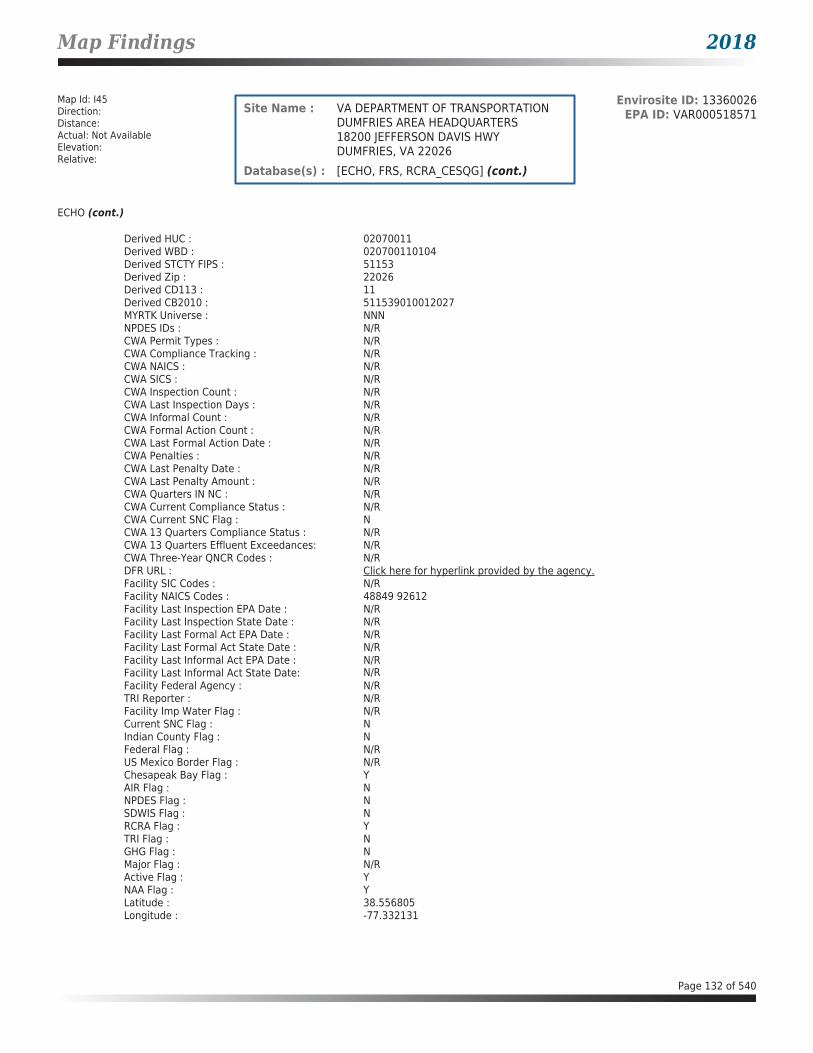
Map Findings 2018
Map Id: I45Direction: Distance: Actual: Not AvailableElevation: Relative:
Envirosite ID: 13360026EPA ID: VAR000518571Site Name : VA DEPARTMENT OF TRANSPORTATION
DUMFRIES AREA HEADQUARTERS18200 JEFFERSON DAVIS HWYDUMFRIES, VA 22026
Database(s) : [ECHO, FRS, RCRA_CESQG] (cont.)
ECHO (cont.)
Derived HUC : 02070011Derived WBD : 020700110104Derived STCTY FIPS : 51153Derived Zip : 22026Derived CD113 : 11Derived CB2010 : 511539010012027MYRTK Universe : NNNNPDES IDs : N/RCWA Permit Types : N/RCWA Compliance Tracking : N/RCWA NAICS : N/RCWA SICS : N/RCWA Inspection Count : N/RCWA Last Inspection Days : N/RCWA Informal Count : N/RCWA Formal Action Count : N/RCWA Last Formal Action Date : N/RCWA Penalties : N/RCWA Last Penalty Date : N/RCWA Last Penalty Amount : N/RCWA Quarters IN NC : N/RCWA Current Compliance Status : N/RCWA Current SNC Flag : NCWA 13 Quarters Compliance Status : N/RCWA 13 Quarters Effluent Exceedances: N/RCWA Three-Year QNCR Codes : N/RDFR URL : Click here for hyperlink provided by the agency.Facility SIC Codes : N/RFacility NAICS Codes : 48849 92612Facility Last Inspection EPA Date : N/RFacility Last Inspection State Date : N/RFacility Last Formal Act EPA Date : N/RFacility Last Formal Act State Date : N/RFacility Last Informal Act EPA Date : N/RFacility Last Informal Act State Date: N/RFacility Federal Agency : N/RTRI Reporter : N/RFacility Imp Water Flag : N/RCurrent SNC Flag : NIndian County Flag : NFederal Flag : N/RUS Mexico Border Flag : N/RChesapeak Bay Flag : YAIR Flag : NNPDES Flag : NSDWIS Flag : NRCRA Flag : YTRI Flag : NGHG Flag : NMajor Flag : N/RActive Flag : YNAA Flag : YLatitude : 38.556805Longitude : -77.332131
Page 132 of 540

Map Findings 2018
Map Id: I45Direction: Distance: Actual: Not AvailableElevation: Relative:
Envirosite ID: 13360026EPA ID: VAR000518571Site Name : VA DEPARTMENT OF TRANSPORTATION
DUMFRIES AREA HEADQUARTERS18200 JEFFERSON DAVIS HWYDUMFRIES, VA 22026
Database(s) : [ECHO, FRS, RCRA_CESQG] (cont.)
FRS
Facility Name : VA DEPARTMENT OF TRANSPORTATION DUMFRIES AREA HEADQUARTERSFacility Address : 18200 JEFFERSON DAVIS HWY, DUMFRIES, VA 22026County : PRINCE WILLIAM
Registry ID : 110040525287FRS Facility URL : Click here for hyperlink provided by the agency.
Source Description :
RCRAInfo is EPA’s comprehensive information system that supports the Resource Conservation and Recovery Act (RCRA) of 1976 and the Hazardous and Solid Waste Amendments (HSWA) of 1984 through the tracking of events and activities related to facilities that generate, transport, and treat, store, or dispose of hazardous waste. RCRAInfo allows RCRA program staff to track the notification, permit, compliance, and corrective action activities required under RCRA. RCRAInfo also supports generation of the National Hazardous Waste Biennial Report. All generators and treatment, storage, and disposal facilities who handle hazardous waste are required to report to the EPA Administrator at least once every two years to support creation of the Biennial Report.
FRS Environmental InterestSource and System ID : RCRAINFO - VAR000518571
RCRA_CESQG
Date form received by agency : 01/26/2010Facility name : VA DEPARTMENT OF TRANSPORTATION DUMFRIES AREA HEADQUARTERSFacility address : 18200 JEFFERSON DAVIS HWY, DUMFRIES VA 22026EPA ID : VAR000518571Mailing address : 18200 JEFFERSON DAVIS HWY, DUMFRIES VA 22026Contact : MARK TOIGOContact address : 18200 JEFFERSON DAVIS HWY, DUMFRIES VA 22026Contact country : USContact telephone : 703-221-5020Contact email : [email protected] Region : 03Land type : StateSource type : NotificationClassification : Conditionally Exempt Small Quantity Generator
Description :
Handlers that generate 100 kilograms or less of hazardous waste per calendar month, and accumulate 1000 kg or less of hazardous waste at any time; or generate one kilogram or less of acutely hazardous waste per calendar month, and accumulate at any time: 1 kg or less of acutely hazardous waste; or 100 kg or less of any residue or contaminated soil, waste or other debris resulting from the cleanup of a spill, into or on any land or water, of acutely hazardous waste;or generate 100 kg or less of any residue or contaminated soil, waste or other debris resulting from the cleanup of a spill, into or on any land or water, of acutely hazardous waste during any calendar month, and accumulate at any time: 1 kg or less of acutely hazardous waste; or 100 kg or less of any residue or contaminated soil, waste or other debris resulting from the cleanup of a spill, into or on any land or water, of acutely hazardous waste.
Owner/Operator Summary :Owner Operator name : COMMONWEALTH OF VA - VDOT
Page 133 of 540

Map Findings 2018
Map Id: I45Direction: Distance: Actual: Not AvailableElevation: Relative:
Envirosite ID: 13360026EPA ID: VAR000518571Site Name : VA DEPARTMENT OF TRANSPORTATION
DUMFRIES AREA HEADQUARTERS18200 JEFFERSON DAVIS HWYDUMFRIES, VA 22026
Database(s) : [ECHO, FRS, RCRA_CESQG] (cont.)
RCRA_CESQG (cont.)
Owner Operator address : 1201 E. BROAD ST., RICHMOND VA 23219Owner Operator country : USOwner Operator telephone : 703-383-2369Owner Operator Email : N/ROwner Operator Fax : N/RLegal status : StateOwner Operator Type : OwnerOwner/Op start date : 01/23/1952Owner/Op end date : N/R
Owner Operator name : VA DEPT OF TRANSPORTATIONOwner Operator address : N/ROwner Operator country : N/ROwner Operator telephone : N/ROwner Operator Email : N/ROwner Operator Fax : N/RLegal status : StateOwner Operator Type : OperatorOwner/Op start date : 01/23/1952Owner/Op end date : N/R
Handler Activities Summary :U.S. importer of hazardous waste : NoMixed waste (haz. and radioactive) : NoRecycler of hazardous waste : NoTransporter of hazardous waste : NoTreater storer or disposer of HW : NoUnderground injection activity : NoOn-site burner exemption : NoFurnace exemption : NoUsed oil fuel burner : NoUsed oil processor : NoUsed oil refiner : NoUsed oil fuel marketer to burner : NoUsed oil Specification marketer : NoUsed oil transfer facility : NoUsed oil transporter : No
Hazardous Waste Summary :Waste code : D001Waste name : IGNITABLE WASTE
Facility has No violations / inspections reported.
Page 134 of 540

Map Findings 2018
Map Id: I46Direction: Distance: Actual: Not AvailableElevation: Relative:
Envirosite ID: 13360107EPA ID: VAR000520288Site Name : VDOT - DUMFRIES AREA HEADQUARTERS
18200 JEFFERSON DAVIS HIGHWAYDUMFRIES, VA 22026
Database(s) : [ECHO, FRS, RCRA_CESQG]
ECHO
Facility Name : VDOT - DUMFRIES AREA HEADQUARTERSFacility Address : 18200 JEFFERSON DAVIS HIGHWAY, DUMFRIES, VA 22026County : PRINCE WILLIAM
Last Inspection Date : N/RRegistry ID : 110043863469FIPS Code : 51153EPA Region : 03Inspection Count : 0Last Inspection Days : N/RInformal Count : 0Last Informal Action Date : N/RFormal Action Count : 0Last Formal Action Date : N/RTotal Penalties : 0Penalty Count : N/RLast Penalty Date : N/RLast Penalty Amount : N/RQTRS IN NC : 0Programs IN SNC : 0Current Compliance Status : No ViolationThree-Year Compliance Status : ____________Collection Method : ADDRESS MATCHING-HOUSE NUMBERReference Point : ENTRANCE POINT OF A FACILITY OR STATIONAccuracy Meters : 50Derived Tribes : N/RDerived HUC : 02070011Derived WBD : 020700110104Derived STCTY FIPS : 51153Derived Zip : 22026Derived CD113 : 11Derived CB2010 : 511539010012027MYRTK Universe : NNNNPDES IDs : N/RCWA Permit Types : N/RCWA Compliance Tracking : N/RCWA NAICS : N/RCWA SICS : N/RCWA Inspection Count : N/RCWA Last Inspection Days : N/RCWA Informal Count : N/RCWA Formal Action Count : N/RCWA Last Formal Action Date : N/RCWA Penalties : N/RCWA Last Penalty Date : N/RCWA Last Penalty Amount : N/RCWA Quarters IN NC : N/RCWA Current Compliance Status : N/RCWA Current SNC Flag : NCWA 13 Quarters Compliance Status : N/RCWA 13 Quarters Effluent Exceedances: N/RCWA Three-Year QNCR Codes : N/RDFR URL : Click here for hyperlink provided by the agency.Facility SIC Codes : N/RFacility NAICS Codes : 48849 92612Facility Last Inspection EPA Date : N/R
Page 135 of 540

Map Findings 2018
Map Id: I46Direction: Distance: Actual: Not AvailableElevation: Relative:
Envirosite ID: 13360107EPA ID: VAR000520288Site Name : VDOT - DUMFRIES AREA HEADQUARTERS
18200 JEFFERSON DAVIS HIGHWAYDUMFRIES, VA 22026
Database(s) : [ECHO, FRS, RCRA_CESQG] (cont.)
ECHO (cont.)
Facility Last Inspection State Date : N/RFacility Last Formal Act EPA Date : N/RFacility Last Formal Act State Date : N/RFacility Last Informal Act EPA Date : N/RFacility Last Informal Act State Date: N/RFacility Federal Agency : N/RTRI Reporter : N/RFacility Imp Water Flag : N/RCurrent SNC Flag : NIndian County Flag : NFederal Flag : N/RUS Mexico Border Flag : N/RChesapeak Bay Flag : YAIR Flag : NNPDES Flag : NSDWIS Flag : NRCRA Flag : YTRI Flag : NGHG Flag : NMajor Flag : N/RActive Flag : YNAA Flag : YLatitude : 38.556805Longitude : -77.332131
FRS
Facility Name : VDOT - DUMFRIES AREA HEADQUARTERSFacility Address : 18200 JEFFERSON DAVIS HIGHWAY, DUMFRIES, VA 22026County : PRINCE WILLIAM
Registry ID : 110043863469FRS Facility URL : Click here for hyperlink provided by the agency.
Source Description :
RCRAInfo is EPA’s comprehensive information system that supports the Resource Conservation and Recovery Act (RCRA) of 1976 and the Hazardous and Solid Waste Amendments (HSWA) of 1984 through the tracking of events and activities related to facilities that generate, transport, and treat, store, or dispose of hazardous waste. RCRAInfo allows RCRA program staff to track the notification, permit, compliance, and corrective action activities required under RCRA. RCRAInfo also supports generation of the National Hazardous Waste Biennial Report. All generators and treatment, storage, and disposal facilities who handle hazardous waste are required to report to the EPA Administrator at least once every two years to support creation of the Biennial Report.
FRS Environmental InterestSource and System ID : RCRAINFO - VAR000520288
RCRA_CESQG
Date form received by agency : 08/18/2011Facility name : VDOT - DUMFRIES AREA HEADQUARTERSFacility address : 18200 JEFFERSON DAVIS HIGHWAY, DUMFRIES VA 22026
Page 136 of 540

Map Findings 2018
Map Id: I46Direction: Distance: Actual: Not AvailableElevation: Relative:
Envirosite ID: 13360107EPA ID: VAR000520288Site Name : VDOT - DUMFRIES AREA HEADQUARTERS
18200 JEFFERSON DAVIS HIGHWAYDUMFRIES, VA 22026
Database(s) : [ECHO, FRS, RCRA_CESQG] (cont.)
RCRA_CESQG (cont.)
EPA ID : VAR000520288Mailing address : 18200 JEFFERSON DAVIS HIGHWAY, DUMFRIES VA 22026Contact : STEVE SATTERWHITEContact address : 18200 JEFFERSON DAVIS HIGHWAY, DUMFRIES VA 22026Contact country : USContact telephone : 703-221-5020Contact email : [email protected] Region : 03Land type : StateSource type : NotificationClassification : Conditionally Exempt Small Quantity Generator
Description :
Handlers that generate 100 kilograms or less of hazardous waste per calendar month, and accumulate 1000 kg or less of hazardous waste at any time; or generate one kilogram or less of acutely hazardous waste per calendar month, and accumulate at any time: 1 kg or less of acutely hazardous waste; or 100 kg or less of any residue or contaminated soil, waste or other debris resulting from the cleanup of a spill, into or on any land or water, of acutely hazardous waste;or generate 100 kg or less of any residue or contaminated soil, waste or other debris resulting from the cleanup of a spill, into or on any land or water, of acutely hazardous waste during any calendar month, and accumulate at any time: 1 kg or less of acutely hazardous waste; or 100 kg or less of any residue or contaminated soil, waste or other debris resulting from the cleanup of a spill, into or on any land or water, of acutely hazardous waste.
Owner/Operator Summary :Owner Operator name : COMMONWEALTH OF VIRGINIA - VDOTOwner Operator address : 1201 EAST BROAD STREET, RICHMOND VA 23219Owner Operator country : USOwner Operator telephone : 703-259-1961Owner Operator Email : N/ROwner Operator Fax : N/RLegal status : StateOwner Operator Type : OwnerOwner/Op start date : 01/23/1952Owner/Op end date : N/R
Owner Operator name : DAVID M. SALISBURYOwner Operator address : N/ROwner Operator country : USOwner Operator telephone : N/ROwner Operator Email : N/ROwner Operator Fax : N/RLegal status : StateOwner Operator Type : OperatorOwner/Op start date : 01/01/2000Owner/Op end date : N/R
Handler Activities Summary :U.S. importer of hazardous waste : NoMixed waste (haz. and radioactive) : NoRecycler of hazardous waste : NoTransporter of hazardous waste : NoTreater storer or disposer of HW : NoUnderground injection activity : NoOn-site burner exemption : NoFurnace exemption : No
Page 137 of 540

Map Findings 2018
Map Id: I46Direction: Distance: Actual: Not AvailableElevation: Relative:
Envirosite ID: 13360107EPA ID: VAR000520288Site Name : VDOT - DUMFRIES AREA HEADQUARTERS
18200 JEFFERSON DAVIS HIGHWAYDUMFRIES, VA 22026
Database(s) : [ECHO, FRS, RCRA_CESQG] (cont.)
RCRA_CESQG (cont.)
Used oil fuel burner : NoUsed oil processor : NoUsed oil refiner : NoUsed oil fuel marketer to burner : NoUsed oil Specification marketer : NoUsed oil transfer facility : NoUsed oil transporter : No
Hazardous Waste Summary :Waste code : D001Waste name : IGNITABLE WASTE
Facility has No violations / inspections reported.
Map Id: J47Direction: Distance: Actual: Not AvailableElevation: Relative:
Envirosite ID: 29462135EPA ID: N/RSite Name : PRINCE WILLIAM CONCRETE RECYCLERS
INCORPORATED17491 JEFFERSON DAVIS HWYDUMFRIES, VA 22026
Database(s) : [AFS, ECHO, FRS]
AFS
Facility Name : PRINCE WILLIAM CONCRETE RECYCLERS INCORPORATEDFacility Address : 17491 JEFFERSON DAVIS HWY, DUMFRIES, VA 22026County : Prince William
Facility SummaryProgram System ID : VA0000005115373722Facility Registry ID : 110037604740EPA Region : EPA Region 3 - DE, DC, MD, PA, VA, WVSIC Codes : N/RNAICS Code : 423930NAICS Code Description : N/RFacility Type : Non-GovernmentAir Pollutant Class Code : MINAir Pollutant Class Description : Minor EmissionsAir Operating Status Code : TMPAir Operating Status Description : Temporarily ClosedCurrent High Priority Violation (HPV) Code: No ViolCurrent High Priority Violation (HPV) Description: No ViolLocal Control Region Code : N/RLocal Control Region Name : N/R
Page 138 of 540
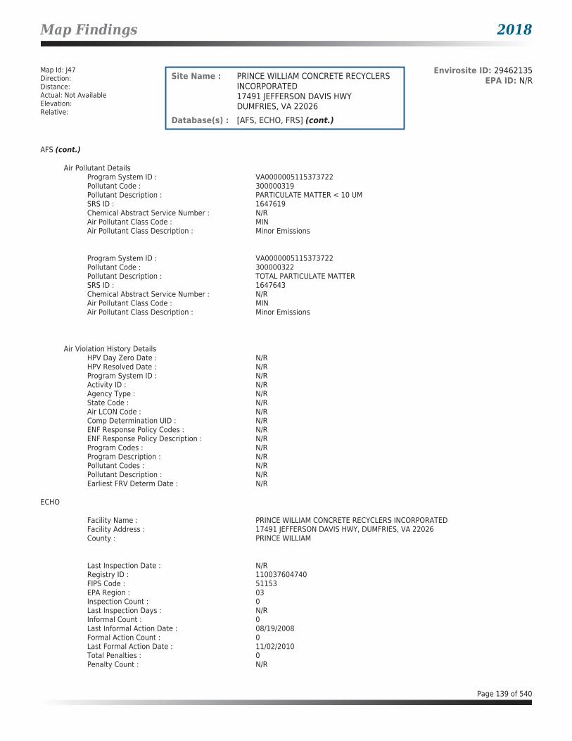
Map Findings 2018
Map Id: J47Direction: Distance: Actual: Not AvailableElevation: Relative:
Envirosite ID: 29462135EPA ID: N/RSite Name : PRINCE WILLIAM CONCRETE RECYCLERS
INCORPORATED17491 JEFFERSON DAVIS HWYDUMFRIES, VA 22026
Database(s) : [AFS, ECHO, FRS] (cont.)
AFS (cont.)
Air Pollutant DetailsProgram System ID : VA0000005115373722Pollutant Code : 300000319Pollutant Description : PARTICULATE MATTER < 10 UMSRS ID : 1647619Chemical Abstract Service Number : N/RAir Pollutant Class Code : MINAir Pollutant Class Description : Minor Emissions
Program System ID : VA0000005115373722Pollutant Code : 300000322Pollutant Description : TOTAL PARTICULATE MATTERSRS ID : 1647643Chemical Abstract Service Number : N/RAir Pollutant Class Code : MINAir Pollutant Class Description : Minor Emissions
Air Violation History DetailsHPV Day Zero Date : N/RHPV Resolved Date : N/RProgram System ID : N/RActivity ID : N/RAgency Type : N/RState Code : N/RAir LCON Code : N/RComp Determination UID : N/RENF Response Policy Codes : N/RENF Response Policy Description : N/RProgram Codes : N/RProgram Description : N/RPollutant Codes : N/RPollutant Description : N/REarliest FRV Determ Date : N/R
ECHO
Facility Name : PRINCE WILLIAM CONCRETE RECYCLERS INCORPORATEDFacility Address : 17491 JEFFERSON DAVIS HWY, DUMFRIES, VA 22026County : PRINCE WILLIAM
Last Inspection Date : N/RRegistry ID : 110037604740FIPS Code : 51153EPA Region : 03Inspection Count : 0Last Inspection Days : N/RInformal Count : 0Last Informal Action Date : 08/19/2008Formal Action Count : 0Last Formal Action Date : 11/02/2010Total Penalties : 0Penalty Count : N/R
Page 139 of 540

Map Findings 2018
Map Id: J47Direction: Distance: Actual: Not AvailableElevation: Relative:
Envirosite ID: 29462135EPA ID: N/RSite Name : PRINCE WILLIAM CONCRETE RECYCLERS
INCORPORATED17491 JEFFERSON DAVIS HWYDUMFRIES, VA 22026
Database(s) : [AFS, ECHO, FRS] (cont.)
ECHO (cont.)
Last Penalty Date : 11/02/2010Last Penalty Amount : 3500QTRS IN NC : 0Programs IN SNC : 0Current Compliance Status : Not AvailableThree-Year Compliance Status : ____________Collection Method : ADDRESS MATCHING-HOUSE NUMBERReference Point : ENTRANCE POINT OF A FACILITY OR STATIONAccuracy Meters : 50Derived Tribes : N/RDerived HUC : 02070011Derived WBD : 020700110104Derived STCTY FIPS : 51153Derived Zip : 22026Derived CD113 : 11Derived CB2010 : 511539010011043MYRTK Universe : NNNNPDES IDs : N/RCWA Permit Types : N/RCWA Compliance Tracking : N/RCWA NAICS : N/RCWA SICS : N/RCWA Inspection Count : N/RCWA Last Inspection Days : N/RCWA Informal Count : N/RCWA Formal Action Count : N/RCWA Last Formal Action Date : N/RCWA Penalties : N/RCWA Last Penalty Date : N/RCWA Last Penalty Amount : N/RCWA Quarters IN NC : N/RCWA Current Compliance Status : N/RCWA Current SNC Flag : NCWA 13 Quarters Compliance Status : N/RCWA 13 Quarters Effluent Exceedances: N/RCWA Three-Year QNCR Codes : N/RDFR URL : Click here for hyperlink provided by the agency.Facility SIC Codes : N/RFacility NAICS Codes : 423930Facility Last Inspection EPA Date : N/RFacility Last Inspection State Date : N/RFacility Last Formal Act EPA Date : N/RFacility Last Formal Act State Date : 11/02/2010Facility Last Informal Act EPA Date : N/RFacility Last Informal Act State Date: 08/19/2008Facility Federal Agency : N/RTRI Reporter : N/RFacility Imp Water Flag : N/RCurrent SNC Flag : NIndian County Flag : NFederal Flag : N/RUS Mexico Border Flag : N/RChesapeak Bay Flag : YAIR Flag : YNPDES Flag : NSDWIS Flag : N
Page 140 of 540
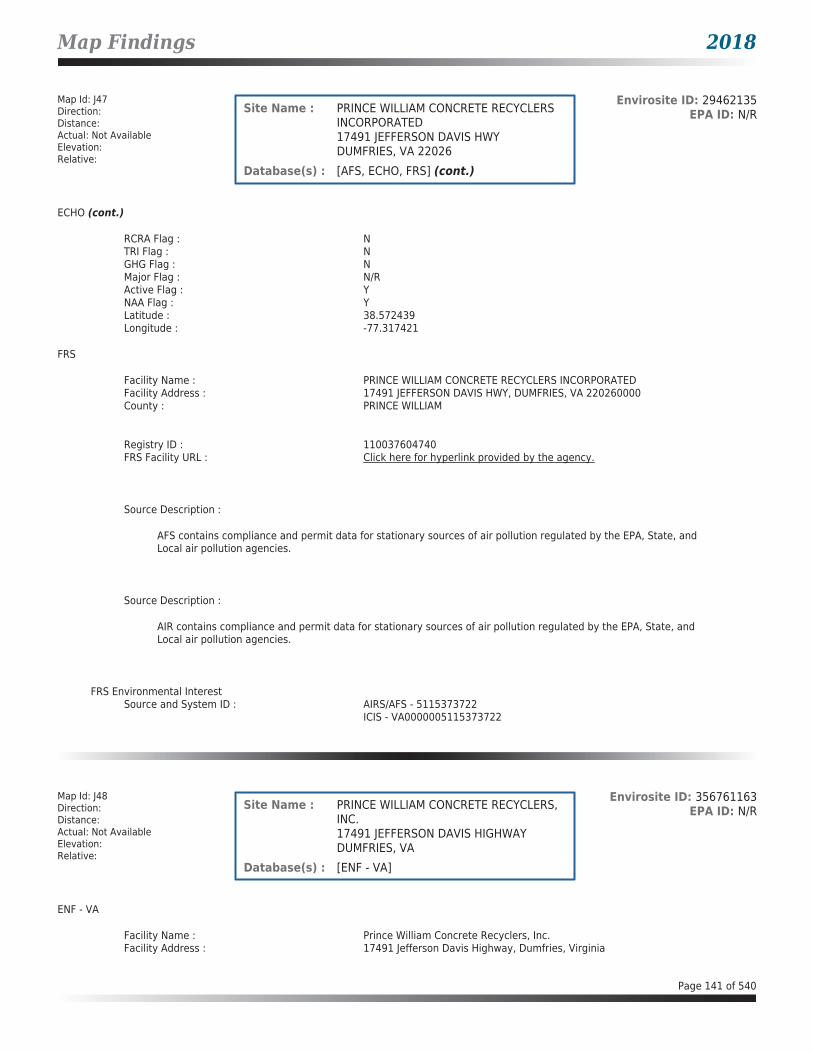
Map Findings 2018
Map Id: J47Direction: Distance: Actual: Not AvailableElevation: Relative:
Envirosite ID: 29462135EPA ID: N/RSite Name : PRINCE WILLIAM CONCRETE RECYCLERS
INCORPORATED17491 JEFFERSON DAVIS HWYDUMFRIES, VA 22026
Database(s) : [AFS, ECHO, FRS] (cont.)
ECHO (cont.)
RCRA Flag : NTRI Flag : NGHG Flag : NMajor Flag : N/RActive Flag : YNAA Flag : YLatitude : 38.572439Longitude : -77.317421
FRS
Facility Name : PRINCE WILLIAM CONCRETE RECYCLERS INCORPORATEDFacility Address : 17491 JEFFERSON DAVIS HWY, DUMFRIES, VA 220260000County : PRINCE WILLIAM
Registry ID : 110037604740FRS Facility URL : Click here for hyperlink provided by the agency.
Source Description :
AFS contains compliance and permit data for stationary sources of air pollution regulated by the EPA, State, and Local air pollution agencies.
Source Description :
AIR contains compliance and permit data for stationary sources of air pollution regulated by the EPA, State, and Local air pollution agencies.
FRS Environmental InterestSource and System ID : AIRS/AFS - 5115373722
ICIS - VA0000005115373722
Map Id: J48Direction: Distance: Actual: Not AvailableElevation: Relative:
Envirosite ID: 356761163EPA ID: N/RSite Name : PRINCE WILLIAM CONCRETE RECYCLERS,
INC.17491 JEFFERSON DAVIS HIGHWAYDUMFRIES, VA
Database(s) : [ENF - VA]
ENF - VA
Facility Name : Prince William Concrete Recyclers, Inc.Facility Address : 17491 Jefferson Davis Highway, Dumfries, Virginia
Page 141 of 540

Map Findings 2018
Map Id: J48Direction: Distance: Actual: Not AvailableElevation: Relative:
Envirosite ID: 356761163EPA ID: N/RSite Name : PRINCE WILLIAM CONCRETE RECYCLERS,
INC.17491 JEFFERSON DAVIS HIGHWAYDUMFRIES, VA
Database(s) : [ENF - VA] (cont.)
ENF - VA (cont.)
County : Prince William County
Effective Date : 11/02/2010Entered Date : N/RTerminated Date : 03/12/2011Superseded Date : N/RAmendment Effective Date : N/RIssued Date : N/RFinal Orders : Final Orders - Northern RegionName : Prince William Concrete Recyclers, Inc.EPA ID : N/RRegistration Number : 73722Permit Number : N/RFacility ID : N/RIssued to : Prince William Concrete Recyclers, Inc.For : N/RAIR Registration Number : N/RIncident Report Number : N/RPDF Link : Click here for hyperlink provided by the agency.
Map Id: 49Direction: Distance: Actual: Not AvailableElevation: Relative:
Envirosite ID: 26961030EPA ID: N/RSite Name : TRIANGLE FRONT END AND FRAME
SERVICE INCORPORATED18265 JEFFERSON DAVIS HWYDUMFRIES, VA 22026
Database(s) : [AFS, ECHO, FRS]
AFS
Facility Name : TRIANGLE FRONT END AND FRAME SERVICE INCORPORATEDFacility Address : 18265 JEFFERSON DAVIS HWY, DUMFRIES, VA 22026County : Prince William
Facility SummaryProgram System ID : VA0000005115300852Facility Registry ID : 110008192561EPA Region : EPA Region 3 - DE, DC, MD, PA, VA, WVSIC Codes : N/RNAICS Code : 811121NAICS Code Description : Automotive Body, Paint, and Interior Repair and MaintenanceFacility Type : Non-GovernmentAir Pollutant Class Code : MINAir Pollutant Class Description : Minor EmissionsAir Operating Status Code : OPRAir Operating Status Description : OperatingCurrent High Priority Violation (HPV) Code: No Viol
Page 142 of 540

Map Findings 2018
Map Id: 49Direction: Distance: Actual: Not AvailableElevation: Relative:
Envirosite ID: 26961030EPA ID: N/RSite Name : TRIANGLE FRONT END AND FRAME
SERVICE INCORPORATED18265 JEFFERSON DAVIS HWYDUMFRIES, VA 22026
Database(s) : [AFS, ECHO, FRS] (cont.)
AFS (cont.)
Current High Priority Violation (HPV) Description:
No Viol
Local Control Region Code : N/RLocal Control Region Name : N/R
Air Pollutant DetailsProgram System ID : VA0000005115300852Pollutant Code : 300000228Pollutant Description : Nickel compoundsSRS ID : 650036Chemical Abstract Service Number : N/RAir Pollutant Class Code : MINAir Pollutant Class Description : Minor Emissions
Program System ID : VA0000005115300852Pollutant Code : 300000243Pollutant Description : VOLATILE ORGANIC COMPOUNDS (VOCS)SRS ID : 761346Chemical Abstract Service Number : N/RAir Pollutant Class Code : MINAir Pollutant Class Description : Minor Emissions
Air Violation History DetailsHPV Day Zero Date : N/RHPV Resolved Date : N/RProgram System ID : N/RActivity ID : N/RAgency Type : N/RState Code : N/RAir LCON Code : N/RComp Determination UID : N/RENF Response Policy Codes : N/RENF Response Policy Description : N/RProgram Codes : N/RProgram Description : N/RPollutant Codes : N/RPollutant Description : N/REarliest FRV Determ Date : N/R
ECHO
Facility Name : TRIANGLE FRONT END AND FRAME SERVICE INCORPORATEDFacility Address : 18265 JEFFERSON DAVIS HWY, DUMFRIES, VA 22026County : PRINCE WILLIAM
Last Inspection Date : N/RRegistry ID : 110008192561FIPS Code : 51153EPA Region : 03Inspection Count : 0
Page 143 of 540

Map Findings 2018
Map Id: 49Direction: Distance: Actual: Not AvailableElevation: Relative:
Envirosite ID: 26961030EPA ID: N/RSite Name : TRIANGLE FRONT END AND FRAME
SERVICE INCORPORATED18265 JEFFERSON DAVIS HWYDUMFRIES, VA 22026
Database(s) : [AFS, ECHO, FRS] (cont.)
ECHO (cont.)
Last Inspection Days : N/RInformal Count : 0Last Informal Action Date : N/RFormal Action Count : 0Last Formal Action Date : N/RTotal Penalties : 0Penalty Count : N/RLast Penalty Date : N/RLast Penalty Amount : N/RQTRS IN NC : 0Programs IN SNC : 0Current Compliance Status : No ViolationThree-Year Compliance Status : ____________Collection Method : ADDRESS MATCHING-HOUSE NUMBERReference Point : CENTER OF A FACILITY OR STATIONAccuracy Meters : 30Derived Tribes : N/RDerived HUC : 02070011Derived WBD : 020700110104Derived STCTY FIPS : 51153Derived Zip : 22026Derived CD113 : 11Derived CB2010 : 511539010012027MYRTK Universe : NNNNPDES IDs : N/RCWA Permit Types : N/RCWA Compliance Tracking : N/RCWA NAICS : N/RCWA SICS : N/RCWA Inspection Count : N/RCWA Last Inspection Days : N/RCWA Informal Count : N/RCWA Formal Action Count : N/RCWA Last Formal Action Date : N/RCWA Penalties : N/RCWA Last Penalty Date : N/RCWA Last Penalty Amount : N/RCWA Quarters IN NC : N/RCWA Current Compliance Status : N/RCWA Current SNC Flag : NCWA 13 Quarters Compliance Status : N/RCWA 13 Quarters Effluent Exceedances: N/RCWA Three-Year QNCR Codes : N/RDFR URL : Click here for hyperlink provided by the agency.Facility SIC Codes : N/RFacility NAICS Codes : 811121Facility Last Inspection EPA Date : N/RFacility Last Inspection State Date : N/RFacility Last Formal Act EPA Date : N/RFacility Last Formal Act State Date : N/RFacility Last Informal Act EPA Date : N/RFacility Last Informal Act State Date: N/RFacility Federal Agency : N/RTRI Reporter : N/RFacility Imp Water Flag : N/RCurrent SNC Flag : N
Page 144 of 540

Map Findings 2018
Map Id: 49Direction: Distance: Actual: Not AvailableElevation: Relative:
Envirosite ID: 26961030EPA ID: N/RSite Name : TRIANGLE FRONT END AND FRAME
SERVICE INCORPORATED18265 JEFFERSON DAVIS HWYDUMFRIES, VA 22026
Database(s) : [AFS, ECHO, FRS] (cont.)
ECHO (cont.)
Indian County Flag : NFederal Flag : N/RUS Mexico Border Flag : N/RChesapeak Bay Flag : YAIR Flag : YNPDES Flag : NSDWIS Flag : NRCRA Flag : YTRI Flag : NGHG Flag : NMajor Flag : N/RActive Flag : YNAA Flag : YLatitude : 38.55599Longitude : -77.3323
FRS
Facility Name : TRIANGLE FRONT END AND FRAME SERVICE INCORPORATEDFacility Address : 18265 JEFFERSON DAVIS HWY, DUMFRIES, VA 220260000County : PRINCE WILLIAM
Registry ID : 110008192561FRS Facility URL : Click here for hyperlink provided by the agency.
Source Description :
AFS contains compliance and permit data for stationary sources of air pollution regulated by the EPA, State, and Local air pollution agencies.
Source Description :
AIR contains compliance and permit data for stationary sources of air pollution regulated by the EPA, State, and Local air pollution agencies.
Source Description :
RCRAInfo is EPA’s comprehensive information system that supports the Resource Conservation and Recovery Act (RCRA) of 1976 and the Hazardous and Solid Waste Amendments (HSWA) of 1984 through the tracking of events and activities related to facilities that generate, transport, and treat, store, or dispose of hazardous waste. RCRAInfo allows RCRA program staff to track the notification, permit, compliance, and corrective action activities required under RCRA. RCRAInfo also supports generation of the National Hazardous Waste Biennial Report. All generators and treatment, storage, and disposal facilities who handle hazardous waste are required to report to the EPA Administrator at least once every two years to support creation of the Biennial Report.
Page 145 of 540
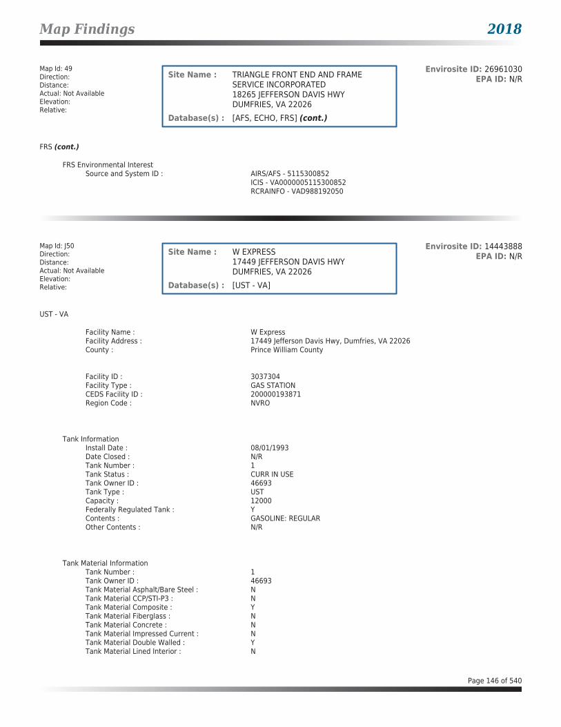
Map Findings 2018
Map Id: 49Direction: Distance: Actual: Not AvailableElevation: Relative:
Envirosite ID: 26961030EPA ID: N/RSite Name : TRIANGLE FRONT END AND FRAME
SERVICE INCORPORATED18265 JEFFERSON DAVIS HWYDUMFRIES, VA 22026
Database(s) : [AFS, ECHO, FRS] (cont.)
FRS (cont.)
FRS Environmental InterestSource and System ID : AIRS/AFS - 5115300852
ICIS - VA0000005115300852RCRAINFO - VAD988192050
Map Id: J50Direction: Distance: Actual: Not AvailableElevation: Relative:
Envirosite ID: 14443888EPA ID: N/RSite Name : W EXPRESS
17449 JEFFERSON DAVIS HWYDUMFRIES, VA 22026
Database(s) : [UST - VA]
UST - VA
Facility Name : W ExpressFacility Address : 17449 Jefferson Davis Hwy, Dumfries, VA 22026County : Prince William County
Facility ID : 3037304Facility Type : GAS STATIONCEDS Facility ID : 200000193871Region Code : NVRO
Tank InformationInstall Date : 08/01/1993Date Closed : N/RTank Number : 1Tank Status : CURR IN USETank Owner ID : 46693Tank Type : USTCapacity : 12000Federally Regulated Tank : YContents : GASOLINE: REGULAROther Contents : N/R
Tank Material InformationTank Number : 1Tank Owner ID : 46693Tank Material Asphalt/Bare Steel : NTank Material CCP/STI-P3 : NTank Material Composite : YTank Material Fiberglass : NTank Material Concrete : NTank Material Impressed Current : NTank Material Double Walled : YTank Material Lined Interior : N
Page 146 of 540

Map Findings 2018
Map Id: J50Direction: Distance: Actual: Not AvailableElevation: Relative:
Envirosite ID: 14443888EPA ID: N/RSite Name : W EXPRESS
17449 JEFFERSON DAVIS HWYDUMFRIES, VA 22026
Database(s) : [UST - VA] (cont.)
UST - VA (cont.)
Tank Material Excavation Liner : NTank Material Polyethylene Tank Jacket: NTank Material Secondary Containment : NTank Material Repaired : NTank Material Unknown : NTank Material Other : YTank Material Other Notes : Act100 Epoxy Coated Steel
Tank InformationInstall Date : 08/01/1993Date Closed : N/RTank Number : 2Tank Status : CURR IN USETank Owner ID : 46693Tank Type : USTCapacity : 8000Federally Regulated Tank : YContents : GASOLINE: PREMIUMOther Contents : N/R
Tank Material InformationTank Number : 2Tank Owner ID : 46693Tank Material Asphalt/Bare Steel : NTank Material CCP/STI-P3 : NTank Material Composite : YTank Material Fiberglass : NTank Material Concrete : NTank Material Impressed Current : NTank Material Double Walled : YTank Material Lined Interior : NTank Material Excavation Liner : NTank Material Polyethylene Tank Jacket: NTank Material Secondary Containment : NTank Material Repaired : NTank Material Unknown : NTank Material Other : YTank Material Other Notes : Act100 Epoxy Coated Steel
Page 147 of 540

Map Findings 2018
Map Id: J51Direction: Distance: Actual: Not AvailableElevation: Relative:
Envirosite ID: 7075694EPA ID: N/RSite Name : MAACO COLLISION REPAIR AND AUTO
PAINTING17432 JEFFERSON DAVIS HWYDUMFRIES, VA 22026
Database(s) : [AFS, ECHO, FRS]
AFS
Facility Name : MAACO COLLISION REPAIR AND AUTO PAINTINGFacility Address : 17432 JEFFERSON DAVIS HWY, DUMFRIES, VA 22026County : Prince William
Facility SummaryProgram System ID : VA0000005115300850Facility Registry ID : 110027235524EPA Region : EPA Region 3 - DE, DC, MD, PA, VA, WVSIC Codes : N/RNAICS Code : 811121NAICS Code Description : Automotive Body, Paint, and Interior Repair and MaintenanceFacility Type : Non-GovernmentAir Pollutant Class Code : MINAir Pollutant Class Description : Minor EmissionsAir Operating Status Code : OPRAir Operating Status Description : OperatingCurrent High Priority Violation (HPV) Code: No ViolCurrent High Priority Violation (HPV) Description: No ViolLocal Control Region Code : N/RLocal Control Region Name : N/R
Air Pollutant DetailsProgram System ID : VA0000005115300850Pollutant Code : 300000228Pollutant Description : Nickel compoundsSRS ID : 650036Chemical Abstract Service Number : N/RAir Pollutant Class Code : MINAir Pollutant Class Description : Minor Emissions
Program System ID : VA0000005115300850Pollutant Code : 300000243Pollutant Description : VOLATILE ORGANIC COMPOUNDS (VOCS)SRS ID : 761346Chemical Abstract Service Number : N/RAir Pollutant Class Code : MINAir Pollutant Class Description : Minor Emissions
Air Violation History DetailsHPV Day Zero Date : N/RHPV Resolved Date : N/RProgram System ID : N/RActivity ID : N/RAgency Type : N/RState Code : N/RAir LCON Code : N/RComp Determination UID : N/R
Page 148 of 540

Map Findings 2018
Map Id: J51Direction: Distance: Actual: Not AvailableElevation: Relative:
Envirosite ID: 7075694EPA ID: N/RSite Name : MAACO COLLISION REPAIR AND AUTO
PAINTING17432 JEFFERSON DAVIS HWYDUMFRIES, VA 22026
Database(s) : [AFS, ECHO, FRS] (cont.)
AFS (cont.)
ENF Response Policy Codes : N/RENF Response Policy Description : N/RProgram Codes : N/RProgram Description : N/RPollutant Codes : N/RPollutant Description : N/REarliest FRV Determ Date : N/R
ECHO
Facility Name : MAACO COLLISION REPAIR AND AUTO PAINTINGFacility Address : 17432 JEFFERSON DAVIS HWY, DUMFRIES, VA 22026County : PRINCE WILLIAM
Last Inspection Date : N/RRegistry ID : 110027235524FIPS Code : 51153EPA Region : 03Inspection Count : 0Last Inspection Days : N/RInformal Count : 0Last Informal Action Date : N/RFormal Action Count : 0Last Formal Action Date : N/RTotal Penalties : 0Penalty Count : N/RLast Penalty Date : N/RLast Penalty Amount : N/RQTRS IN NC : 0Programs IN SNC : 0Current Compliance Status : Not AvailableThree-Year Compliance Status : ____________Collection Method : ADDRESS MATCHING-HOUSE NUMBERReference Point : ENTRANCE POINT OF A FACILITY OR STATIONAccuracy Meters : 50Derived Tribes : N/RDerived HUC : 02070011Derived WBD : 020700110104Derived STCTY FIPS : 51153Derived Zip : 22026Derived CD113 : 11Derived CB2010 : 511539010011024MYRTK Universe : NNNNPDES IDs : N/RCWA Permit Types : N/RCWA Compliance Tracking : N/RCWA NAICS : N/RCWA SICS : N/RCWA Inspection Count : N/RCWA Last Inspection Days : N/RCWA Informal Count : N/RCWA Formal Action Count : N/RCWA Last Formal Action Date : N/RCWA Penalties : N/RCWA Last Penalty Date : N/R
Page 149 of 540

Map Findings 2018
Map Id: J51Direction: Distance: Actual: Not AvailableElevation: Relative:
Envirosite ID: 7075694EPA ID: N/RSite Name : MAACO COLLISION REPAIR AND AUTO
PAINTING17432 JEFFERSON DAVIS HWYDUMFRIES, VA 22026
Database(s) : [AFS, ECHO, FRS] (cont.)
ECHO (cont.)
CWA Last Penalty Amount : N/RCWA Quarters IN NC : N/RCWA Current Compliance Status : N/RCWA Current SNC Flag : NCWA 13 Quarters Compliance Status : N/RCWA 13 Quarters Effluent Exceedances: N/RCWA Three-Year QNCR Codes : N/RDFR URL : Click here for hyperlink provided by the agency.Facility SIC Codes : N/RFacility NAICS Codes : 811121Facility Last Inspection EPA Date : N/RFacility Last Inspection State Date : N/RFacility Last Formal Act EPA Date : N/RFacility Last Formal Act State Date : N/RFacility Last Informal Act EPA Date : N/RFacility Last Informal Act State Date: N/RFacility Federal Agency : N/RTRI Reporter : N/RFacility Imp Water Flag : N/RCurrent SNC Flag : NIndian County Flag : NFederal Flag : N/RUS Mexico Border Flag : N/RChesapeak Bay Flag : YAIR Flag : YNPDES Flag : NSDWIS Flag : NRCRA Flag : NTRI Flag : NGHG Flag : NMajor Flag : N/RActive Flag : YNAA Flag : YLatitude : 38.573101Longitude : -77.31665
FRS
Facility Name : MAACO COLLISION REPAIR AND AUTO PAINTINGFacility Address : 17432 JEFFERSON DAVIS HWY, DUMFRIES, VA 220260000County : PRINCE WILLIAM
Registry ID : 110027235524FRS Facility URL : Click here for hyperlink provided by the agency.
Source Description :
AFS contains compliance and permit data for stationary sources of air pollution regulated by the EPA, State, and Local air pollution agencies.
Page 150 of 540

Map Findings 2018
Map Id: J51Direction: Distance: Actual: Not AvailableElevation: Relative:
Envirosite ID: 7075694EPA ID: N/RSite Name : MAACO COLLISION REPAIR AND AUTO
PAINTING17432 JEFFERSON DAVIS HWYDUMFRIES, VA 22026
Database(s) : [AFS, ECHO, FRS] (cont.)
FRS (cont.)
Source Description :
AIR contains compliance and permit data for stationary sources of air pollution regulated by the EPA, State, and Local air pollution agencies.
FRS Environmental InterestSource and System ID : AIRS/AFS - 5115300850
ICIS - VA0000005115300850
Map Id: J52Direction: Distance: Actual: Not AvailableElevation: Relative:
Envirosite ID: 14442963EPA ID: N/RSite Name : DUMFRIES BP
17400 JEFFERSON DAVIS HWYDUMFRIES, VA 22026
Database(s) : [UST - VA]
UST - VA
Facility Name : Dumfries BPFacility Address : 17400 Jefferson Davis Hwy, Dumfries, VA 22026County : Prince William County
Facility ID : 3020554Facility Type : GAS STATIONCEDS Facility ID : 200000193886Region Code : NVRO
Tank InformationInstall Date : 09/02/1987Date Closed : N/RTank Number : 1Tank Status : CURR IN USETank Owner ID : 41804Tank Type : USTCapacity : 10000Federally Regulated Tank : YContents : GASOLINEOther Contents : N/R
Tank Material InformationTank Number : 1Tank Owner ID : 41804Tank Material Asphalt/Bare Steel : NTank Material CCP/STI-P3 : Y
Page 151 of 540

Map Findings 2018
Map Id: J52Direction: Distance: Actual: Not AvailableElevation: Relative:
Envirosite ID: 14442963EPA ID: N/RSite Name : DUMFRIES BP
17400 JEFFERSON DAVIS HWYDUMFRIES, VA 22026
Database(s) : [UST - VA] (cont.)
UST - VA (cont.)
Tank Material Composite : NTank Material Fiberglass : NTank Material Concrete : NTank Material Impressed Current : NTank Material Double Walled : NTank Material Lined Interior : NTank Material Excavation Liner : NTank Material Polyethylene Tank Jacket: NTank Material Secondary Containment : NTank Material Repaired : NTank Material Unknown : NTank Material Other : NTank Material Other Notes : STi-P3
Tank InformationInstall Date : 09/02/1987Date Closed : N/RTank Number : 2Tank Status : CURR IN USETank Owner ID : 41804Tank Type : USTCapacity : 10000Federally Regulated Tank : YContents : GASOLINEOther Contents : N/R
Tank Material InformationTank Number : 2Tank Owner ID : 41804Tank Material Asphalt/Bare Steel : NTank Material CCP/STI-P3 : YTank Material Composite : NTank Material Fiberglass : NTank Material Concrete : NTank Material Impressed Current : NTank Material Double Walled : NTank Material Lined Interior : NTank Material Excavation Liner : NTank Material Polyethylene Tank Jacket: NTank Material Secondary Containment : NTank Material Repaired : NTank Material Unknown : NTank Material Other : NTank Material Other Notes : STiP-3
Tank InformationInstall Date : 09/02/1987Date Closed : N/RTank Number : 3Tank Status : CURR IN USETank Owner ID : 41804
Page 152 of 540

Map Findings 2018
Map Id: J52Direction: Distance: Actual: Not AvailableElevation: Relative:
Envirosite ID: 14442963EPA ID: N/RSite Name : DUMFRIES BP
17400 JEFFERSON DAVIS HWYDUMFRIES, VA 22026
Database(s) : [UST - VA] (cont.)
UST - VA (cont.)
Tank Type : USTCapacity : 10000Federally Regulated Tank : YContents : GASOLINEOther Contents : N/R
Tank Material InformationTank Number : 3Tank Owner ID : 41804Tank Material Asphalt/Bare Steel : NTank Material CCP/STI-P3 : YTank Material Composite : NTank Material Fiberglass : NTank Material Concrete : NTank Material Impressed Current : NTank Material Double Walled : NTank Material Lined Interior : NTank Material Excavation Liner : NTank Material Polyethylene Tank Jacket: NTank Material Secondary Containment : NTank Material Repaired : NTank Material Unknown : NTank Material Other : NTank Material Other Notes : STiP-3
Tank InformationInstall Date : 09/02/1987Date Closed : N/RTank Number : 4Tank Status : CURR IN USETank Owner ID : 41804Tank Type : USTCapacity : 10000Federally Regulated Tank : YContents : DIESELOther Contents : N/R
Tank Material InformationTank Number : 4Tank Owner ID : 41804Tank Material Asphalt/Bare Steel : NTank Material CCP/STI-P3 : YTank Material Composite : NTank Material Fiberglass : NTank Material Concrete : NTank Material Impressed Current : NTank Material Double Walled : NTank Material Lined Interior : NTank Material Excavation Liner : NTank Material Polyethylene Tank Jacket: NTank Material Secondary Containment : N
Page 153 of 540

Map Findings 2018
Map Id: J52Direction: Distance: Actual: Not AvailableElevation: Relative:
Envirosite ID: 14442963EPA ID: N/RSite Name : DUMFRIES BP
17400 JEFFERSON DAVIS HWYDUMFRIES, VA 22026
Database(s) : [UST - VA] (cont.)
UST - VA (cont.)
Tank Material Repaired : NTank Material Unknown : NTank Material Other : NTank Material Other Notes : STiP-3
Map Id: J53Direction: Distance: Actual: Not AvailableElevation: Relative:
Envirosite ID: 24838642EPA ID: N/RSite Name : BP GAS STATION 02049
17400 JEFFERSON DAVIS HWYDUMFRIES, VA 22026
Database(s) : [LPT - VA]
LPT - VA
Facility Name : BP Gas Station 02049Facility Address : 17400 Jefferson Davis Hwy, Dumfries, VA 22026County : Prince William County
Release Reported : 05/21/2007PC Number : 20073232CEDS Facility ID : 200000193886Case Status : ClosedCase Closed Date : 08/06/2007Region : NVROProgram : RP LeadHeating Oil Category : N/RFederally Regulated UST : YRegulated Petroleum UST (1) : YExcluded UST (1) : NDeferred UST (1) : NPartially Deferred UST (1) : NExempt 1 UST (2) : NExempt 2 Heating Oil UST (2) : NSmall Heating Oil AST (2) : NRegulated AST (3) : NUnregulated AST (3) : NOther (Y/N) : NOther Description : N/RUnknown (Y/N) : NPriority : 3Suspect Confirm Indicator : ConfirmedLatitude : 38.5749983847Longitude : -77.3154070358Last Date in Agency List : 02/09/2018
Page 154 of 540
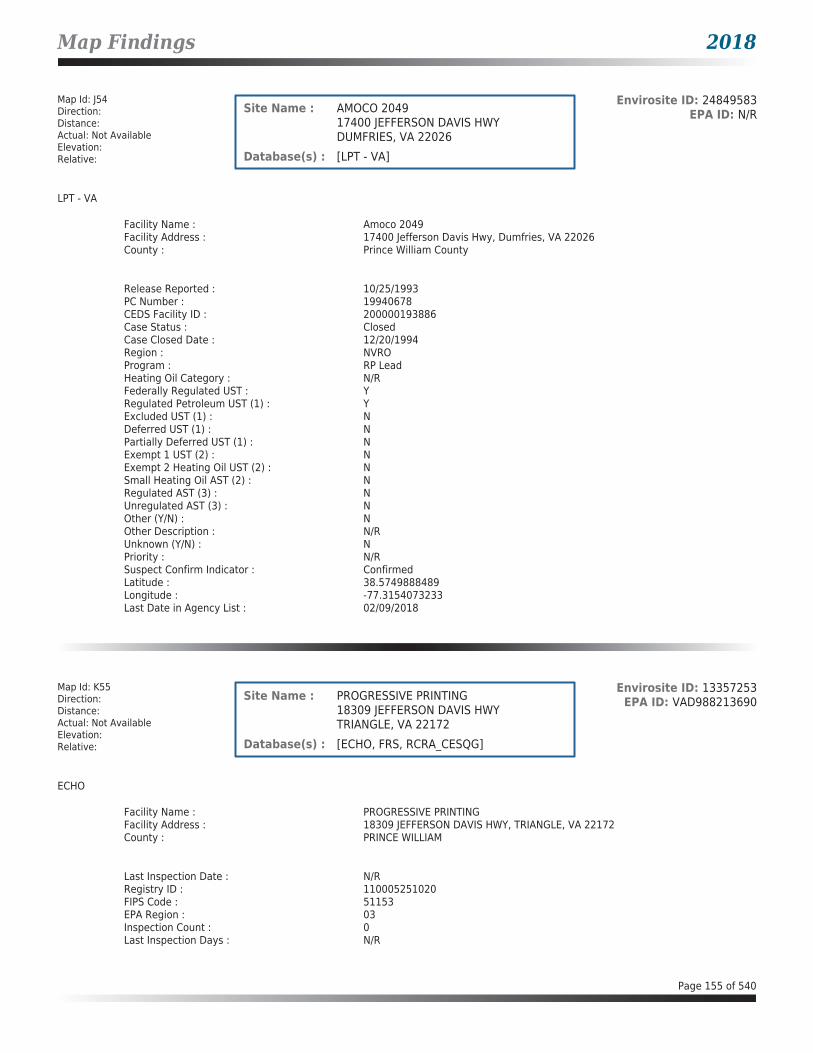
Map Findings 2018
Map Id: J54Direction: Distance: Actual: Not AvailableElevation: Relative:
Envirosite ID: 24849583EPA ID: N/RSite Name : AMOCO 2049
17400 JEFFERSON DAVIS HWYDUMFRIES, VA 22026
Database(s) : [LPT - VA]
LPT - VA
Facility Name : Amoco 2049Facility Address : 17400 Jefferson Davis Hwy, Dumfries, VA 22026County : Prince William County
Release Reported : 10/25/1993PC Number : 19940678CEDS Facility ID : 200000193886Case Status : ClosedCase Closed Date : 12/20/1994Region : NVROProgram : RP LeadHeating Oil Category : N/RFederally Regulated UST : YRegulated Petroleum UST (1) : YExcluded UST (1) : NDeferred UST (1) : NPartially Deferred UST (1) : NExempt 1 UST (2) : NExempt 2 Heating Oil UST (2) : NSmall Heating Oil AST (2) : NRegulated AST (3) : NUnregulated AST (3) : NOther (Y/N) : NOther Description : N/RUnknown (Y/N) : NPriority : N/RSuspect Confirm Indicator : ConfirmedLatitude : 38.5749888489Longitude : -77.3154073233Last Date in Agency List : 02/09/2018
Map Id: K55Direction: Distance: Actual: Not AvailableElevation: Relative:
Envirosite ID: 13357253EPA ID: VAD988213690Site Name : PROGRESSIVE PRINTING
18309 JEFFERSON DAVIS HWYTRIANGLE, VA 22172
Database(s) : [ECHO, FRS, RCRA_CESQG]
ECHO
Facility Name : PROGRESSIVE PRINTINGFacility Address : 18309 JEFFERSON DAVIS HWY, TRIANGLE, VA 22172County : PRINCE WILLIAM
Last Inspection Date : N/RRegistry ID : 110005251020FIPS Code : 51153EPA Region : 03Inspection Count : 0Last Inspection Days : N/R
Page 155 of 540

Map Findings 2018
Map Id: K55Direction: Distance: Actual: Not AvailableElevation: Relative:
Envirosite ID: 13357253EPA ID: VAD988213690Site Name : PROGRESSIVE PRINTING
18309 JEFFERSON DAVIS HWYTRIANGLE, VA 22172
Database(s) : [ECHO, FRS, RCRA_CESQG] (cont.)
ECHO (cont.)
Informal Count : 0Last Informal Action Date : N/RFormal Action Count : 0Last Formal Action Date : N/RTotal Penalties : 0Penalty Count : N/RLast Penalty Date : N/RLast Penalty Amount : N/RQTRS IN NC : 0Programs IN SNC : 0Current Compliance Status : No ViolationThree-Year Compliance Status : ____________Collection Method : ADDRESS MATCHING-HOUSE NUMBERReference Point : CENTER OF A FACILITY OR STATIONAccuracy Meters : 30Derived Tribes : N/RDerived HUC : 02070011Derived WBD : 020700110104Derived STCTY FIPS : 51153Derived Zip : 22172Derived CD113 : 11Derived CB2010 : 511539009014004MYRTK Universe : NNNNPDES IDs : N/RCWA Permit Types : N/RCWA Compliance Tracking : N/RCWA NAICS : N/RCWA SICS : N/RCWA Inspection Count : N/RCWA Last Inspection Days : N/RCWA Informal Count : N/RCWA Formal Action Count : N/RCWA Last Formal Action Date : N/RCWA Penalties : N/RCWA Last Penalty Date : N/RCWA Last Penalty Amount : N/RCWA Quarters IN NC : N/RCWA Current Compliance Status : N/RCWA Current SNC Flag : NCWA 13 Quarters Compliance Status : N/RCWA 13 Quarters Effluent Exceedances: N/RCWA Three-Year QNCR Codes : N/RDFR URL : Click here for hyperlink provided by the agency.Facility SIC Codes : N/RFacility NAICS Codes : N/RFacility Last Inspection EPA Date : N/RFacility Last Inspection State Date : N/RFacility Last Formal Act EPA Date : N/RFacility Last Formal Act State Date : N/RFacility Last Informal Act EPA Date : N/RFacility Last Informal Act State Date: N/RFacility Federal Agency : N/RTRI Reporter : N/RFacility Imp Water Flag : N/RCurrent SNC Flag : NIndian County Flag : NFederal Flag : N/R
Page 156 of 540

Map Findings 2018
Map Id: K55Direction: Distance: Actual: Not AvailableElevation: Relative:
Envirosite ID: 13357253EPA ID: VAD988213690Site Name : PROGRESSIVE PRINTING
18309 JEFFERSON DAVIS HWYTRIANGLE, VA 22172
Database(s) : [ECHO, FRS, RCRA_CESQG] (cont.)
ECHO (cont.)
US Mexico Border Flag : N/RChesapeak Bay Flag : YAIR Flag : NNPDES Flag : NSDWIS Flag : NRCRA Flag : YTRI Flag : NGHG Flag : NMajor Flag : N/RActive Flag : YNAA Flag : YLatitude : 38.55436Longitude : -77.33264
FRS
Facility Name : PROGRESSIVE PRINTINGFacility Address : 18309 JEFFERSON DAVIS HWY, TRIANGLE, VA 22172County : PRINCE WILLIAM
Registry ID : 110005251020FRS Facility URL : Click here for hyperlink provided by the agency.
Source Description :
RCRAInfo is EPA’s comprehensive information system that supports the Resource Conservation and Recovery Act (RCRA) of 1976 and the Hazardous and Solid Waste Amendments (HSWA) of 1984 through the tracking of events and activities related to facilities that generate, transport, and treat, store, or dispose of hazardous waste. RCRAInfo allows RCRA program staff to track the notification, permit, compliance, and corrective action activities required under RCRA. RCRAInfo also supports generation of the National Hazardous Waste Biennial Report. All generators and treatment, storage, and disposal facilities who handle hazardous waste are required to report to the EPA Administrator at least once every two years to support creation of the Biennial Report.
FRS Environmental InterestSource and System ID : RCRAINFO - VAD988213690
RCRA_CESQG
Date form received by agency : 03/23/1992Facility name : PROGRESSIVE PRINTINGFacility address : 18309 JEFFERSON DAVIS HWY, TRIANGLE VA 22172EPA ID : VAD988213690Mailing address : 18309 JEFFERSON DAVIS HWY, TRIANGLE VA 22172Contact : TERRY GRAYContact address : 18309 JEFFERSON DAVIS HWY, TRIANGLE VA 22172Contact country : USContact telephone : 703-221-8475Contact email : N/REPA Region : 03Land type : N/RSource type : NotificationClassification : Conditionally Exempt Small Quantity Generator
Page 157 of 540

Map Findings 2018
Map Id: K55Direction: Distance: Actual: Not AvailableElevation: Relative:
Envirosite ID: 13357253EPA ID: VAD988213690Site Name : PROGRESSIVE PRINTING
18309 JEFFERSON DAVIS HWYTRIANGLE, VA 22172
Database(s) : [ECHO, FRS, RCRA_CESQG] (cont.)
RCRA_CESQG (cont.)
Description :
Handlers that generate 100 kilograms or less of hazardous waste per calendar month, and accumulate 1000 kg or less of hazardous waste at any time; or generate one kilogram or less of acutely hazardous waste per calendar month, and accumulate at any time: 1 kg or less of acutely hazardous waste; or 100 kg or less of any residue or contaminated soil, waste or other debris resulting from the cleanup of a spill, into or on any land or water, of acutely hazardous waste;or generate 100 kg or less of any residue or contaminated soil, waste or other debris resulting from the cleanup of a spill, into or on any land or water, of acutely hazardous waste during any calendar month, and accumulate at any time: 1 kg or less of acutely hazardous waste; or 100 kg or less of any residue or contaminated soil, waste or other debris resulting from the cleanup of a spill, into or on any land or water, of acutely hazardous waste.
Owner/Operator Summary :Owner Operator name : WILBUR H AUSLEYOwner Operator address : 3204 SHOREVIEW ROAD, TRIANGLE VA 22172Owner Operator country : N/ROwner Operator telephone : 703-490-3305Owner Operator Email : N/ROwner Operator Fax : N/RLegal status : PrivateOwner Operator Type : OwnerOwner/Op start date : N/ROwner/Op end date : N/R
Handler Activities Summary :U.S. importer of hazardous waste : NoMixed waste (haz. and radioactive) : NoRecycler of hazardous waste : NoTransporter of hazardous waste : NoTreater storer or disposer of HW : NoUnderground injection activity : NoOn-site burner exemption : NoFurnace exemption : NoUsed oil fuel burner : NoUsed oil processor : NoUsed oil refiner : NoUsed oil fuel marketer to burner : NoUsed oil Specification marketer : NoUsed oil transfer facility : NoUsed oil transporter : No
Hazardous Waste Summary :Waste code : D001Waste name : IGNITABLE WASTE
Facility has No violations / inspections reported.
Page 158 of 540

Map Findings 2018
Map Id: K56Direction: Distance: Actual: Not AvailableElevation: Relative:
Envirosite ID: 14441029EPA ID: N/RSite Name : TRIANGLE SERVICE CENTER
18314 JEFFERSON DAVIS HWYTRIANGLE, VA 22172
Database(s) : [UST - VA]
UST - VA
Facility Name : TRIANGLE SERVICE CENTERFacility Address : 18314 Jefferson Davis Hwy, Triangle, VA 22172County : Prince William County
Facility ID : 3005725Facility Type : GAS STATIONCEDS Facility ID : 200000096229Region Code : NVRO
Tank InformationInstall Date : 04/05/1981Date Closed : 09/13/1991Tank Number : 1Tank Status : REM FROM GRDTank Owner ID : 27064Tank Type : USTCapacity : 8000Federally Regulated Tank : YContents : KEROSENEOther Contents : N/R
Tank Material InformationTank Number : 1Tank Owner ID : 27064Tank Material Asphalt/Bare Steel : NTank Material CCP/STI-P3 : YTank Material Composite : NTank Material Fiberglass : NTank Material Concrete : NTank Material Impressed Current : NTank Material Double Walled : NTank Material Lined Interior : NTank Material Excavation Liner : NTank Material Polyethylene Tank Jacket: NTank Material Secondary Containment : NTank Material Repaired : NTank Material Unknown : NTank Material Other : NTank Material Other Notes : N/R
Tank InformationInstall Date : 04/05/1981Date Closed : 09/13/1991Tank Number : 2Tank Status : REM FROM GRDTank Owner ID : 27064Tank Type : USTCapacity : 10000Federally Regulated Tank : YContents : GASOLINE
Page 159 of 540

Map Findings 2018
Map Id: K56Direction: Distance: Actual: Not AvailableElevation: Relative:
Envirosite ID: 14441029EPA ID: N/RSite Name : TRIANGLE SERVICE CENTER
18314 JEFFERSON DAVIS HWYTRIANGLE, VA 22172
Database(s) : [UST - VA] (cont.)
UST - VA (cont.)
Other Contents : N/R
Tank Material InformationTank Number : 2Tank Owner ID : 27064Tank Material Asphalt/Bare Steel : NTank Material CCP/STI-P3 : YTank Material Composite : NTank Material Fiberglass : NTank Material Concrete : NTank Material Impressed Current : NTank Material Double Walled : NTank Material Lined Interior : NTank Material Excavation Liner : NTank Material Polyethylene Tank Jacket: NTank Material Secondary Containment : NTank Material Repaired : NTank Material Unknown : NTank Material Other : NTank Material Other Notes : N/R
Tank InformationInstall Date : 04/05/1981Date Closed : 09/13/1991Tank Number : 3Tank Status : REM FROM GRDTank Owner ID : 27064Tank Type : USTCapacity : 10000Federally Regulated Tank : YContents : GASOLINEOther Contents : N/R
Tank Material InformationTank Number : 3Tank Owner ID : 27064Tank Material Asphalt/Bare Steel : NTank Material CCP/STI-P3 : YTank Material Composite : NTank Material Fiberglass : NTank Material Concrete : NTank Material Impressed Current : NTank Material Double Walled : NTank Material Lined Interior : NTank Material Excavation Liner : NTank Material Polyethylene Tank Jacket: NTank Material Secondary Containment : NTank Material Repaired : NTank Material Unknown : NTank Material Other : NTank Material Other Notes : N/R
Page 160 of 540

Map Findings 2018
Map Id: K57Direction: Distance: Actual: Not AvailableElevation: Relative:
Envirosite ID: 13355840EPA ID: VAD988170825Site Name : QUALITY AUTO REPAIR
18313 JEFFERSON DAVIS HWYTRIANGLE, VA 22172
Database(s) : [ECHO, FRS, RCRA_CESQG]
ECHO
Facility Name : QUALITY AUTO REPAIRFacility Address : 18313 JEFFERSON DAVIS HWY, TRIANGLE, VA 22172County : PRINCE WILLIAM
Last Inspection Date : 02/12/1998Registry ID : 110005236191FIPS Code : 51153EPA Region : 03Inspection Count : 0Last Inspection Days : 7332Informal Count : 0Last Informal Action Date : N/RFormal Action Count : 0Last Formal Action Date : N/RTotal Penalties : 0Penalty Count : N/RLast Penalty Date : N/RLast Penalty Amount : N/RQTRS IN NC : 0Programs IN SNC : 0Current Compliance Status : No ViolationThree-Year Compliance Status : ____________Collection Method : ADDRESS MATCHING-HOUSE NUMBERReference Point : CENTER OF A FACILITY OR STATIONAccuracy Meters : 30Derived Tribes : N/RDerived HUC : 02070011Derived WBD : 020700110104Derived STCTY FIPS : 51153Derived Zip : 22172Derived CD113 : 11Derived CB2010 : 511539009014004MYRTK Universe : NNNNPDES IDs : N/RCWA Permit Types : N/RCWA Compliance Tracking : N/RCWA NAICS : N/RCWA SICS : N/RCWA Inspection Count : N/RCWA Last Inspection Days : N/RCWA Informal Count : N/RCWA Formal Action Count : N/RCWA Last Formal Action Date : N/RCWA Penalties : N/RCWA Last Penalty Date : N/RCWA Last Penalty Amount : N/RCWA Quarters IN NC : N/RCWA Current Compliance Status : N/RCWA Current SNC Flag : NCWA 13 Quarters Compliance Status : N/RCWA 13 Quarters Effluent Exceedances: N/RCWA Three-Year QNCR Codes : N/RDFR URL : Click here for hyperlink provided by the agency.Facility SIC Codes : N/RFacility NAICS Codes : 811111Facility Last Inspection EPA Date : N/R
Page 161 of 540

Map Findings 2018
Map Id: K57Direction: Distance: Actual: Not AvailableElevation: Relative:
Envirosite ID: 13355840EPA ID: VAD988170825Site Name : QUALITY AUTO REPAIR
18313 JEFFERSON DAVIS HWYTRIANGLE, VA 22172
Database(s) : [ECHO, FRS, RCRA_CESQG] (cont.)
ECHO (cont.)
Facility Last Inspection State Date : 02/12/1998Facility Last Formal Act EPA Date : N/RFacility Last Formal Act State Date : N/RFacility Last Informal Act EPA Date : N/RFacility Last Informal Act State Date: N/RFacility Federal Agency : N/RTRI Reporter : N/RFacility Imp Water Flag : N/RCurrent SNC Flag : NIndian County Flag : NFederal Flag : N/RUS Mexico Border Flag : N/RChesapeak Bay Flag : YAIR Flag : NNPDES Flag : NSDWIS Flag : NRCRA Flag : YTRI Flag : NGHG Flag : NMajor Flag : N/RActive Flag : YNAA Flag : YLatitude : 38.55387Longitude : -77.33274
FRS
Facility Name : QUALITY AUTO REPAIRFacility Address : 18313 JEFFERSON DAVIS HWY, TRIANGLE, VA 22172County : PRINCE WILLIAM
Registry ID : 110005236191FRS Facility URL : Click here for hyperlink provided by the agency.
Source Description :
RCRAInfo is EPA’s comprehensive information system that supports the Resource Conservation and Recovery Act (RCRA) of 1976 and the Hazardous and Solid Waste Amendments (HSWA) of 1984 through the tracking of events and activities related to facilities that generate, transport, and treat, store, or dispose of hazardous waste. RCRAInfo allows RCRA program staff to track the notification, permit, compliance, and corrective action activities required under RCRA. RCRAInfo also supports generation of the National Hazardous Waste Biennial Report. All generators and treatment, storage, and disposal facilities who handle hazardous waste are required to report to the EPA Administrator at least once every two years to support creation of the Biennial Report.
FRS Environmental InterestSource and System ID : RCRAINFO - VAD988170825
RCRA_CESQG
Date form received by agency : 02/12/1998Facility name : QUALITY AUTO REPAIRFacility address : 18313 JEFFERSON DAVIS HWY, TRIANGLE VA 22172
Page 162 of 540
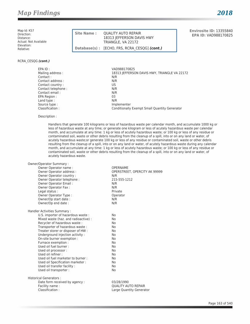
Map Findings 2018
Map Id: K57Direction: Distance: Actual: Not AvailableElevation: Relative:
Envirosite ID: 13355840EPA ID: VAD988170825Site Name : QUALITY AUTO REPAIR
18313 JEFFERSON DAVIS HWYTRIANGLE, VA 22172
Database(s) : [ECHO, FRS, RCRA_CESQG] (cont.)
RCRA_CESQG (cont.)
EPA ID : VAD988170825Mailing address : 18313 JEFFERSON DAVIS HWY, TRIANGLE VA 22172Contact : N/RContact address : N/RContact country : USContact telephone : N/RContact email : N/REPA Region : 03Land type : N/RSource type : ImplementerClassification : Conditionally Exempt Small Quantity Generator
Description :
Handlers that generate 100 kilograms or less of hazardous waste per calendar month, and accumulate 1000 kg or less of hazardous waste at any time; or generate one kilogram or less of acutely hazardous waste per calendar month, and accumulate at any time: 1 kg or less of acutely hazardous waste; or 100 kg or less of any residue or contaminated soil, waste or other debris resulting from the cleanup of a spill, into or on any land or water, of acutely hazardous waste;or generate 100 kg or less of any residue or contaminated soil, waste or other debris resulting from the cleanup of a spill, into or on any land or water, of acutely hazardous waste during any calendar month, and accumulate at any time: 1 kg or less of acutely hazardous waste; or 100 kg or less of any residue or contaminated soil, waste or other debris resulting from the cleanup of a spill, into or on any land or water, of acutely hazardous waste.
Owner/Operator Summary :Owner Operator name : OPERNAMEOwner Operator address : OPERSTREET, OPERCITY AK 99999Owner Operator country : N/ROwner Operator telephone : 215-555-1212Owner Operator Email : N/ROwner Operator Fax : N/RLegal status : PrivateOwner Operator Type : OperatorOwner/Op start date : N/ROwner/Op end date : N/R
Handler Activities Summary :U.S. importer of hazardous waste : NoMixed waste (haz. and radioactive) : NoRecycler of hazardous waste : NoTransporter of hazardous waste : NoTreater storer or disposer of HW : NoUnderground injection activity : NoOn-site burner exemption : NoFurnace exemption : NoUsed oil fuel burner : NoUsed oil processor : NoUsed oil refiner : NoUsed oil fuel marketer to burner : NoUsed oil Specification marketer : NoUsed oil transfer facility : NoUsed oil transporter : No
Historical Generators :Date form received by agency : 03/28/1990Facility name : QUALITY AUTO REPAIRClassification : Large Quantity Generator
Page 163 of 540
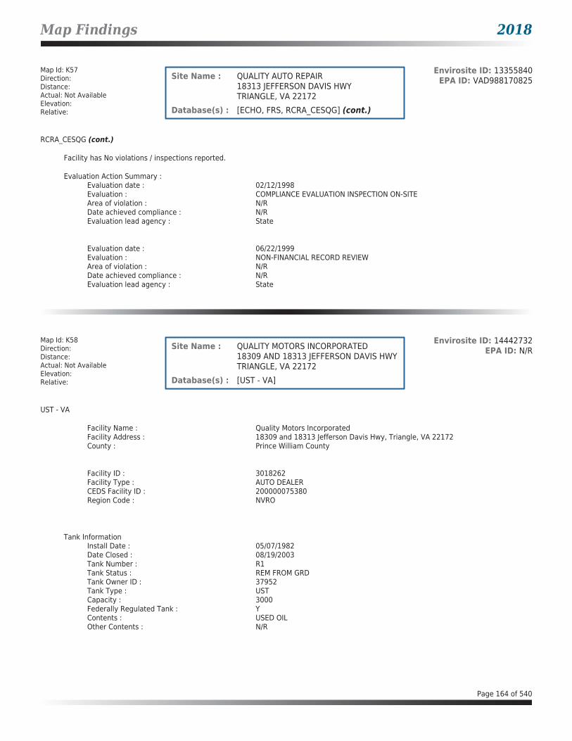
Map Findings 2018
Map Id: K57Direction: Distance: Actual: Not AvailableElevation: Relative:
Envirosite ID: 13355840EPA ID: VAD988170825Site Name : QUALITY AUTO REPAIR
18313 JEFFERSON DAVIS HWYTRIANGLE, VA 22172
Database(s) : [ECHO, FRS, RCRA_CESQG] (cont.)
RCRA_CESQG (cont.)
Facility has No violations / inspections reported.
Evaluation Action Summary :Evaluation date : 02/12/1998Evaluation : COMPLIANCE EVALUATION INSPECTION ON-SITEArea of violation : N/RDate achieved compliance : N/REvaluation lead agency : State
Evaluation date : 06/22/1999Evaluation : NON-FINANCIAL RECORD REVIEWArea of violation : N/RDate achieved compliance : N/REvaluation lead agency : State
Map Id: K58Direction: Distance: Actual: Not AvailableElevation: Relative:
Envirosite ID: 14442732EPA ID: N/RSite Name : QUALITY MOTORS INCORPORATED
18309 AND 18313 JEFFERSON DAVIS HWYTRIANGLE, VA 22172
Database(s) : [UST - VA]
UST - VA
Facility Name : Quality Motors IncorporatedFacility Address : 18309 and 18313 Jefferson Davis Hwy, Triangle, VA 22172County : Prince William County
Facility ID : 3018262Facility Type : AUTO DEALERCEDS Facility ID : 200000075380Region Code : NVRO
Tank InformationInstall Date : 05/07/1982Date Closed : 08/19/2003Tank Number : R1Tank Status : REM FROM GRDTank Owner ID : 37952Tank Type : USTCapacity : 3000Federally Regulated Tank : YContents : USED OILOther Contents : N/R
Page 164 of 540

Map Findings 2018
Map Id: K58Direction: Distance: Actual: Not AvailableElevation: Relative:
Envirosite ID: 14442732EPA ID: N/RSite Name : QUALITY MOTORS INCORPORATED
18309 AND 18313 JEFFERSON DAVIS HWYTRIANGLE, VA 22172
Database(s) : [UST - VA] (cont.)
UST - VA (cont.)
Tank Material InformationTank Number : R1Tank Owner ID : 37952Tank Material Asphalt/Bare Steel : YTank Material CCP/STI-P3 : NTank Material Composite : NTank Material Fiberglass : NTank Material Concrete : NTank Material Impressed Current : NTank Material Double Walled : NTank Material Lined Interior : NTank Material Excavation Liner : NTank Material Polyethylene Tank Jacket: NTank Material Secondary Containment : NTank Material Repaired : NTank Material Unknown : NTank Material Other : NTank Material Other Notes : N/R
Tank InformationInstall Date : 05/08/1971Date Closed : N/RTank Number : 2Tank Status : PERM OUT OF USETank Owner ID : 37952Tank Type : USTCapacity : 500Federally Regulated Tank : YContents : USED OILOther Contents : N/R
Tank Material InformationTank Number : 2Tank Owner ID : 37952Tank Material Asphalt/Bare Steel : YTank Material CCP/STI-P3 : NTank Material Composite : NTank Material Fiberglass : NTank Material Concrete : NTank Material Impressed Current : NTank Material Double Walled : NTank Material Lined Interior : NTank Material Excavation Liner : NTank Material Polyethylene Tank Jacket: NTank Material Secondary Containment : NTank Material Repaired : NTank Material Unknown : NTank Material Other : NTank Material Other Notes : N/R
Page 165 of 540

Map Findings 2018
Map Id: K59Direction: Distance: Actual: Not AvailableElevation: Relative:
Envirosite ID: 24841552EPA ID: N/RSite Name : AUSLEY WILBUR H PROPERTY
18309 AND 18313 JEFFERSON DAVIS HWYTRIANGLE, VA 22172
Database(s) : [LPT - VA]
LPT - VA
Facility Name : Ausley Wilbur H PropertyFacility Address : 18309 and 18313 Jefferson Davis Hwy, Triangle, VA 22172County : Prince William County
Release Reported : 12/19/2003PC Number : 20043158CEDS Facility ID : 200000075380Case Status : ClosedCase Closed Date : 07/08/2004Region : NVROProgram : RP LeadHeating Oil Category : N/RFederally Regulated UST : YRegulated Petroleum UST (1) : YExcluded UST (1) : NDeferred UST (1) : NPartially Deferred UST (1) : NExempt 1 UST (2) : NExempt 2 Heating Oil UST (2) : NSmall Heating Oil AST (2) : NRegulated AST (3) : NUnregulated AST (3) : NOther (Y/N) : NOther Description : N/RUnknown (Y/N) : NPriority : 3Suspect Confirm Indicator : ConfirmedLatitude : 38.5539726528Longitude : -77.3322318352Last Date in Agency List : 02/09/2018
Map Id: L60Direction: Distance: Actual: Not AvailableElevation: Relative:
Envirosite ID: 14443910EPA ID: N/RSite Name : PUMPS FOODMART
17315 JEFFERSON DAVIS HWYDUMFRIES, VA 22026
Database(s) : [UST - VA]
UST - VA
Facility Name : PUMPS FOODMARTFacility Address : 17315 Jefferson Davis Hwy, Dumfries, VA 22026County : Prince William County
Facility ID : 3037409Facility Type : GAS STATIONCEDS Facility ID : 200000195065Region Code : NVRO
Page 166 of 540
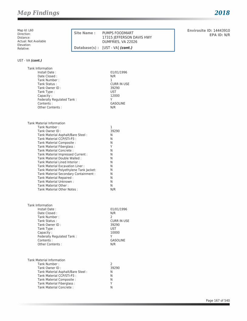
Map Findings 2018
Map Id: L60Direction: Distance: Actual: Not AvailableElevation: Relative:
Envirosite ID: 14443910EPA ID: N/RSite Name : PUMPS FOODMART
17315 JEFFERSON DAVIS HWYDUMFRIES, VA 22026
Database(s) : [UST - VA] (cont.)
UST - VA (cont.)
Tank InformationInstall Date : 01/01/1996Date Closed : N/RTank Number : 1Tank Status : CURR IN USETank Owner ID : 39290Tank Type : USTCapacity : 12000Federally Regulated Tank : YContents : GASOLINEOther Contents : N/R
Tank Material InformationTank Number : 1Tank Owner ID : 39290Tank Material Asphalt/Bare Steel : NTank Material CCP/STI-P3 : NTank Material Composite : NTank Material Fiberglass : YTank Material Concrete : NTank Material Impressed Current : NTank Material Double Walled : NTank Material Lined Interior : NTank Material Excavation Liner : NTank Material Polyethylene Tank Jacket: NTank Material Secondary Containment : NTank Material Repaired : NTank Material Unknown : NTank Material Other : NTank Material Other Notes : N/R
Tank InformationInstall Date : 01/01/1996Date Closed : N/RTank Number : 2Tank Status : CURR IN USETank Owner ID : 39290Tank Type : USTCapacity : 10000Federally Regulated Tank : YContents : GASOLINEOther Contents : N/R
Tank Material InformationTank Number : 2Tank Owner ID : 39290Tank Material Asphalt/Bare Steel : NTank Material CCP/STI-P3 : NTank Material Composite : NTank Material Fiberglass : YTank Material Concrete : N
Page 167 of 540
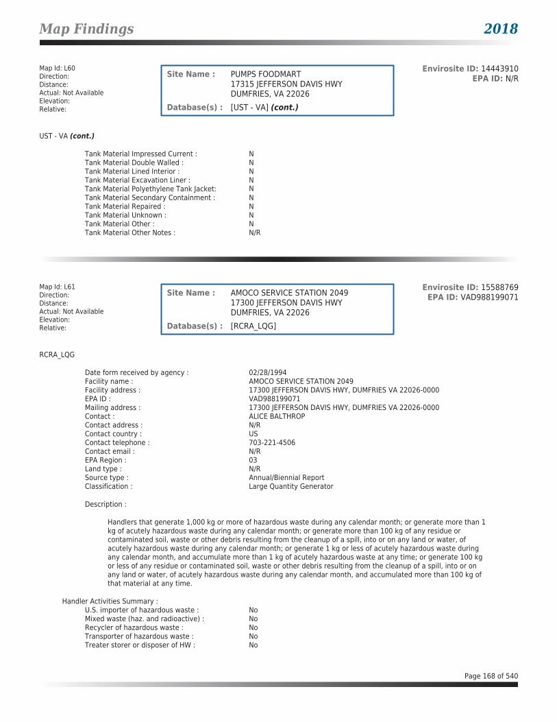
Map Findings 2018
Map Id: L60Direction: Distance: Actual: Not AvailableElevation: Relative:
Envirosite ID: 14443910EPA ID: N/RSite Name : PUMPS FOODMART
17315 JEFFERSON DAVIS HWYDUMFRIES, VA 22026
Database(s) : [UST - VA] (cont.)
UST - VA (cont.)
Tank Material Impressed Current : NTank Material Double Walled : NTank Material Lined Interior : NTank Material Excavation Liner : NTank Material Polyethylene Tank Jacket: NTank Material Secondary Containment : NTank Material Repaired : NTank Material Unknown : NTank Material Other : NTank Material Other Notes : N/R
Map Id: L61Direction: Distance: Actual: Not AvailableElevation: Relative:
Envirosite ID: 15588769EPA ID: VAD988199071Site Name : AMOCO SERVICE STATION 2049
17300 JEFFERSON DAVIS HWYDUMFRIES, VA 22026
Database(s) : [RCRA_LQG]
RCRA_LQG
Date form received by agency : 02/28/1994Facility name : AMOCO SERVICE STATION 2049Facility address : 17300 JEFFERSON DAVIS HWY, DUMFRIES VA 22026-0000EPA ID : VAD988199071Mailing address : 17300 JEFFERSON DAVIS HWY, DUMFRIES VA 22026-0000Contact : ALICE BALTHROPContact address : N/RContact country : USContact telephone : 703-221-4506Contact email : N/REPA Region : 03Land type : N/RSource type : Annual/Biennial ReportClassification : Large Quantity Generator
Description :
Handlers that generate 1,000 kg or more of hazardous waste during any calendar month; or generate more than 1 kg of acutely hazardous waste during any calendar month; or generate more than 100 kg of any residue or contaminated soil, waste or other debris resulting from the cleanup of a spill, into or on any land or water, of acutely hazardous waste during any calendar month; or generate 1 kg or less of acutely hazardous waste during any calendar month, and accumulate more than 1 kg of acutely hazardous waste at any time; or generate 100 kg or less of any residue or contaminated soil, waste or other debris resulting from the cleanup of a spill, into or on any land or water, of acutely hazardous waste during any calendar month, and accumulated more than 100 kg of that material at any time.
Handler Activities Summary :U.S. importer of hazardous waste : NoMixed waste (haz. and radioactive) : NoRecycler of hazardous waste : NoTransporter of hazardous waste : NoTreater storer or disposer of HW : No
Page 168 of 540

Map Findings 2018
Map Id: L61Direction: Distance: Actual: Not AvailableElevation: Relative:
Envirosite ID: 15588769EPA ID: VAD988199071Site Name : AMOCO SERVICE STATION 2049
17300 JEFFERSON DAVIS HWYDUMFRIES, VA 22026
Database(s) : [RCRA_LQG] (cont.)
RCRA_LQG (cont.)
Underground injection activity : NoOn-site burner exemption : NoFurnace exemption : NoUsed oil fuel burner : NoUsed oil processor : NoUsed oil refiner : NoUsed oil fuel marketer to burner : NoUsed oil Specification marketer : NoUsed oil transfer facility : NoUsed oil transporter : No
Historical Generators :Date form received by agency : 04/24/1991Facility name : AMOCO #2049-TANKSClassification : Small Quantity Generator
Facility has No violations / inspections reported.
Map Id: L62Direction: Distance: Actual: Not AvailableElevation: Relative:
Envirosite ID: 26856487EPA ID: N/RSite Name : AMOCO #2049-TANKS
17300 JEFFERSON DAVIS HWYDUMFRIES, VA 22026
Database(s) : [ECHO, FRS]
ECHO
Facility Name : AMOCO #2049-TANKSFacility Address : 17300 JEFFERSON DAVIS HWY, DUMFRIES, VA 22026County : PRINCE WILLIAM
Last Inspection Date : N/RRegistry ID : 110005244805FIPS Code : 51153EPA Region : 03Inspection Count : 0Last Inspection Days : N/RInformal Count : 0Last Informal Action Date : N/RFormal Action Count : 0Last Formal Action Date : N/RTotal Penalties : 0Penalty Count : N/RLast Penalty Date : N/RLast Penalty Amount : N/RQTRS IN NC : 0Programs IN SNC : 0Current Compliance Status : No ViolationThree-Year Compliance Status : ____________Collection Method : ADDRESS MATCHING-HOUSE NUMBERReference Point : ENTRANCE POINT OF A FACILITY OR STATION
Page 169 of 540
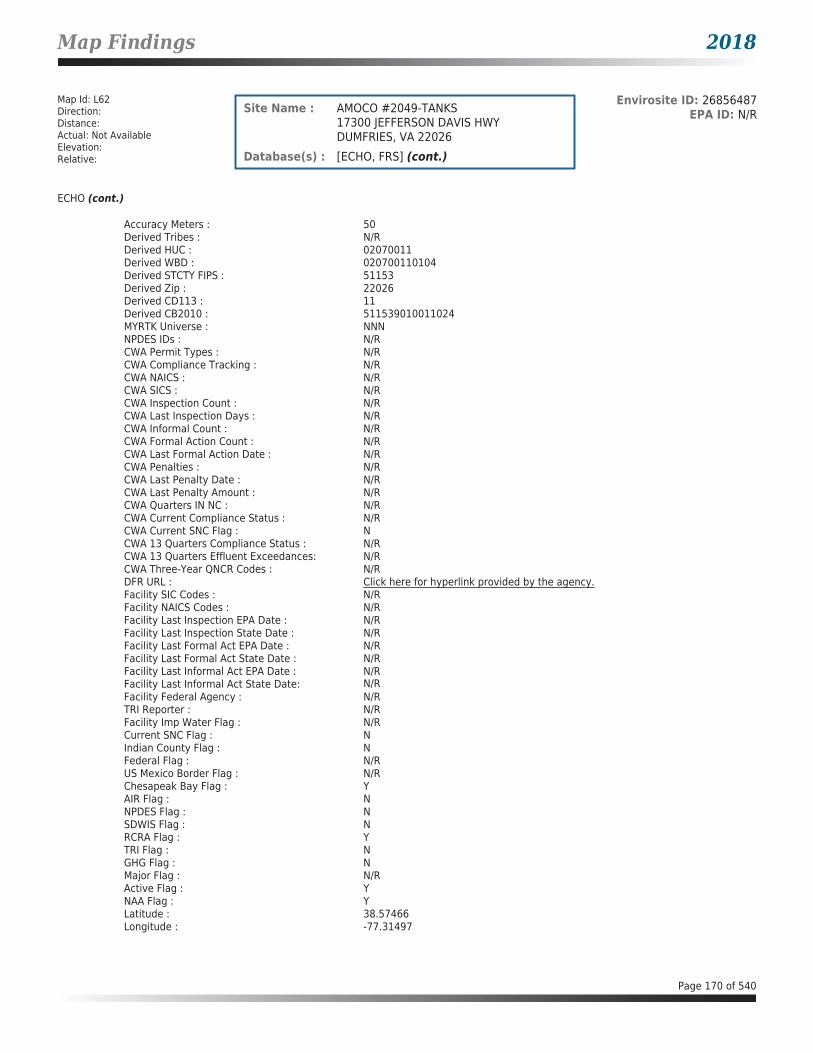
Map Findings 2018
Map Id: L62Direction: Distance: Actual: Not AvailableElevation: Relative:
Envirosite ID: 26856487EPA ID: N/RSite Name : AMOCO #2049-TANKS
17300 JEFFERSON DAVIS HWYDUMFRIES, VA 22026
Database(s) : [ECHO, FRS] (cont.)
ECHO (cont.)
Accuracy Meters : 50Derived Tribes : N/RDerived HUC : 02070011Derived WBD : 020700110104Derived STCTY FIPS : 51153Derived Zip : 22026Derived CD113 : 11Derived CB2010 : 511539010011024MYRTK Universe : NNNNPDES IDs : N/RCWA Permit Types : N/RCWA Compliance Tracking : N/RCWA NAICS : N/RCWA SICS : N/RCWA Inspection Count : N/RCWA Last Inspection Days : N/RCWA Informal Count : N/RCWA Formal Action Count : N/RCWA Last Formal Action Date : N/RCWA Penalties : N/RCWA Last Penalty Date : N/RCWA Last Penalty Amount : N/RCWA Quarters IN NC : N/RCWA Current Compliance Status : N/RCWA Current SNC Flag : NCWA 13 Quarters Compliance Status : N/RCWA 13 Quarters Effluent Exceedances: N/RCWA Three-Year QNCR Codes : N/RDFR URL : Click here for hyperlink provided by the agency.Facility SIC Codes : N/RFacility NAICS Codes : N/RFacility Last Inspection EPA Date : N/RFacility Last Inspection State Date : N/RFacility Last Formal Act EPA Date : N/RFacility Last Formal Act State Date : N/RFacility Last Informal Act EPA Date : N/RFacility Last Informal Act State Date: N/RFacility Federal Agency : N/RTRI Reporter : N/RFacility Imp Water Flag : N/RCurrent SNC Flag : NIndian County Flag : NFederal Flag : N/RUS Mexico Border Flag : N/RChesapeak Bay Flag : YAIR Flag : NNPDES Flag : NSDWIS Flag : NRCRA Flag : YTRI Flag : NGHG Flag : NMajor Flag : N/RActive Flag : YNAA Flag : YLatitude : 38.57466Longitude : -77.31497
Page 170 of 540

Map Findings 2018
Map Id: L62Direction: Distance: Actual: Not AvailableElevation: Relative:
Envirosite ID: 26856487EPA ID: N/RSite Name : AMOCO #2049-TANKS
17300 JEFFERSON DAVIS HWYDUMFRIES, VA 22026
Database(s) : [ECHO, FRS] (cont.)
FRS
Facility Name : AMOCO #2049-TANKSFacility Address : 17300 JEFFERSON DAVIS HWY, DUMFRIES, VA 22026County : PRINCE WILLIAM
Registry ID : 110005244805FRS Facility URL : Click here for hyperlink provided by the agency.
Source Description :
RCRAInfo is EPA’s comprehensive information system that supports the Resource Conservation and Recovery Act (RCRA) of 1976 and the Hazardous and Solid Waste Amendments (HSWA) of 1984 through the tracking of events and activities related to facilities that generate, transport, and treat, store, or dispose of hazardous waste. RCRAInfo allows RCRA program staff to track the notification, permit, compliance, and corrective action activities required under RCRA. RCRAInfo also supports generation of the National Hazardous Waste Biennial Report. All generators and treatment, storage, and disposal facilities who handle hazardous waste are required to report to the EPA Administrator at least once every two years to support creation of the Biennial Report.
FRS Environmental InterestSource and System ID : RCRAINFO - VAD988199071
Map Id: M63Direction: Distance: Actual: Not AvailableElevation: Relative:
Envirosite ID: 21812994EPA ID: N/RSite Name : SEWAGE SPILL
US ROUTE 1 AND ROUTE 234DUMFRIES, VA
Database(s) : [SPILLS - VA]
SPILLS - VA
Facility Name : Sewage SpillFacility Address : US Route 1 and Route 234, Dumfries, VACounty : Prince William County
Incident Date : 12/07/2010Call Received Date : 12/08/2010Closure Date : 06/21/2011IR Number : 2011-N-1641Associated IR : N/RReference ID : 6983Status : ClosedFacility Name : N/RRegion : NorthernIncident Type : WaterIncident Subtype : Point Source * WaterThreat to : N/RTerrorism (Y/N) : N
Page 171 of 540

Map Findings 2018
Map Id: M63Direction: Distance: Actual: Not AvailableElevation: Relative:
Envirosite ID: 21812994EPA ID: N/RSite Name : SEWAGE SPILL
US ROUTE 1 AND ROUTE 234DUMFRIES, VA
Database(s) : [SPILLS - VA] (cont.)
SPILLS - VA (cont.)
Characterize Incident : UnknownMaterials : Sewage (1--1 Gallons)Effect to Receptor : N/RWater Body : N/RLow Quantity to Water : N/RHigh Quantity to Water : N/RQuantity Units : N/ROther Receptors : N/RRP Company : N/RRP Name : N/RProperty Owner : N/RProperty Company : N/RDuration of Event (Hours) : 0Impacts : N/ROther Impacts : N/RSteps Taken : N/RSteps Taken Description : N/RSystem Components : N/ROther System Components : N/RCause of Event : N/RCorrective Action Taken : N/RWeather Status : N/APrecipitation (Wet) : 0Discharge Type : N/ADischarge Volume : 0Unknown Discharge (Y/N) : NOriginal Call Incident Description : Unknown truck spilled raw sewage onto active roadway and then drove
away.Original Call Material Description : Raw SewageOriginal Call Location Description : Intersection of Route 1 and Route 234 DumfriesIncident Ongoing at Time of Call : YAgencies Notified (Y/N) : YOther Agencies : Prince William County Fire and Rescue, VDOTPermitted (Y/N) : NCall Reported by Name : Amy AllisonCall Reported by Company Name : PWCo Fire and RescueCall RP Company Name : N/RCall RP Name : N/RCall Property Owner Company Name : N/RCall Property Owner Name : N/RClosure Comments : NFA. Spill was remediated.
Site Summary : Ed Stuart spoke with Duke Snyder regarding cleanup. VDOT wanted to know what to do, I advised that VDOT should notify a cleanup contractor to respond to scene and cleanup roadway. I explained that since this involved an active roadway that VDOT had the authority to activate cleanup contractor and that VA DEQ is not a first responder agency.
Page 172 of 540

Map Findings 2018
Map Id: M64Direction: NEDistance: 0.003 mi.Actual: 16.349 ft.Elevation: 0.019 mi. / 102.766 ft.Relative: Higher
Envirosite ID: 13353993EPA ID: VA0000104786Site Name : DUMFRIES AUTO BODY & FRAME INC
17368 JEFF DAVIS HWYDUMFRIES, VA 22026
Database(s) : [ECHO, FRS, RCRA_CESQG]
ECHO
Facility Name : DUMFRIES AUTO BODY & FRAME INCFacility Address : 17368 JEFF DAVIS HWY, DUMFRIES, VA 22026County : PRINCE WILLIAM
Last Inspection Date : N/RRegistry ID : 110005213410FIPS Code : 51153EPA Region : 03Inspection Count : 0Last Inspection Days : N/RInformal Count : 0Last Informal Action Date : N/RFormal Action Count : 0Last Formal Action Date : N/RTotal Penalties : 0Penalty Count : N/RLast Penalty Date : N/RLast Penalty Amount : N/RQTRS IN NC : 0Programs IN SNC : 0Current Compliance Status : No ViolationThree-Year Compliance Status : ____________Collection Method : Zip Code CentroidReference Point : N/RAccuracy Meters : 10000Derived Tribes : N/RDerived HUC : N/RDerived WBD : N/RDerived STCTY FIPS : N/RDerived Zip : N/RDerived CD113 : N/RDerived CB2010 : N/RMYRTK Universe : NNNNPDES IDs : N/RCWA Permit Types : N/RCWA Compliance Tracking : N/RCWA NAICS : N/RCWA SICS : N/RCWA Inspection Count : N/RCWA Last Inspection Days : N/RCWA Informal Count : N/RCWA Formal Action Count : N/RCWA Last Formal Action Date : N/RCWA Penalties : N/RCWA Last Penalty Date : N/RCWA Last Penalty Amount : N/RCWA Quarters IN NC : N/RCWA Current Compliance Status : N/RCWA Current SNC Flag : NCWA 13 Quarters Compliance Status : N/RCWA 13 Quarters Effluent Exceedances: N/RCWA Three-Year QNCR Codes : N/RDFR URL : Click here for hyperlink provided by the agency.Facility SIC Codes : N/RFacility NAICS Codes : N/RFacility Last Inspection EPA Date : N/R
Page 173 of 540

Map Findings 2018
Map Id: M64Direction: NEDistance: 0.003 mi.Actual: 16.349 ft.Elevation: 0.019 mi. / 102.766 ft.Relative: Higher
Envirosite ID: 13353993EPA ID: VA0000104786Site Name : DUMFRIES AUTO BODY & FRAME INC
17368 JEFF DAVIS HWYDUMFRIES, VA 22026
Database(s) : [ECHO, FRS, RCRA_CESQG] (cont.)
ECHO (cont.)
Facility Last Inspection State Date : N/RFacility Last Formal Act EPA Date : N/RFacility Last Formal Act State Date : N/RFacility Last Informal Act EPA Date : N/RFacility Last Informal Act State Date: N/RFacility Federal Agency : N/RTRI Reporter : N/RFacility Imp Water Flag : N/RCurrent SNC Flag : NIndian County Flag : NFederal Flag : N/RUS Mexico Border Flag : N/RChesapeak Bay Flag : YAIR Flag : NNPDES Flag : NSDWIS Flag : NRCRA Flag : YTRI Flag : NGHG Flag : NMajor Flag : N/RActive Flag : YNAA Flag : N/RLatitude : 38.566025Longitude : -77.298908
FRS
Facility Name : DUMFRIES AUTO BODY & FRAME INCFacility Address : 17368 JEFF DAVIS HWY, DUMFRIES, VA 22026County : PRINCE WILLIAM
Registry ID : 110005213410FRS Facility URL : Click here for hyperlink provided by the agency.
Source Description :
RCRAInfo is EPA’s comprehensive information system that supports the Resource Conservation and Recovery Act (RCRA) of 1976 and the Hazardous and Solid Waste Amendments (HSWA) of 1984 through the tracking of events and activities related to facilities that generate, transport, and treat, store, or dispose of hazardous waste. RCRAInfo allows RCRA program staff to track the notification, permit, compliance, and corrective action activities required under RCRA. RCRAInfo also supports generation of the National Hazardous Waste Biennial Report. All generators and treatment, storage, and disposal facilities who handle hazardous waste are required to report to the EPA Administrator at least once every two years to support creation of the Biennial Report.
FRS Environmental InterestSource and System ID : RCRAINFO - VA0000104786
RCRA_CESQG
Date form received by agency : 01/14/1994Facility name : DUMFRIES AUTO BODY & FRAME INCFacility address : 17368 JEFF DAVIS HWY, DUMFRIES VA 22026
Page 174 of 540

Map Findings 2018
Map Id: M64Direction: NEDistance: 0.003 mi.Actual: 16.349 ft.Elevation: 0.019 mi. / 102.766 ft.Relative: Higher
Envirosite ID: 13353993EPA ID: VA0000104786Site Name : DUMFRIES AUTO BODY & FRAME INC
17368 JEFF DAVIS HWYDUMFRIES, VA 22026
Database(s) : [ECHO, FRS, RCRA_CESQG] (cont.)
RCRA_CESQG (cont.)
EPA ID : VA0000104786Mailing address : PO BOX 1028, DUMFRIES VA 22026-1028Contact : LINDA DEMOTTContact address : PO BOX 1028, DUMFRIES VA 22026-1028Contact country : USContact telephone : 703-221-3033Contact email : N/REPA Region : 03Land type : PrivateSource type : NotificationClassification : Conditionally Exempt Small Quantity Generator
Description :
Handlers that generate 100 kilograms or less of hazardous waste per calendar month, and accumulate 1000 kg or less of hazardous waste at any time; or generate one kilogram or less of acutely hazardous waste per calendar month, and accumulate at any time: 1 kg or less of acutely hazardous waste; or 100 kg or less of any residue or contaminated soil, waste or other debris resulting from the cleanup of a spill, into or on any land or water, of acutely hazardous waste;or generate 100 kg or less of any residue or contaminated soil, waste or other debris resulting from the cleanup of a spill, into or on any land or water, of acutely hazardous waste during any calendar month, and accumulate at any time: 1 kg or less of acutely hazardous waste; or 100 kg or less of any residue or contaminated soil, waste or other debris resulting from the cleanup of a spill, into or on any land or water, of acutely hazardous waste.
Owner/Operator Summary :Owner Operator name : DUMFRIES AUTO BODY & FRAME INCOwner Operator address : 17368 JEFF DAVIS HWY, DUMFRIES VA 22026Owner Operator country : N/ROwner Operator telephone : 703-221-3033Owner Operator Email : N/ROwner Operator Fax : N/RLegal status : PrivateOwner Operator Type : OwnerOwner/Op start date : N/ROwner/Op end date : N/R
Handler Activities Summary :U.S. importer of hazardous waste : NoMixed waste (haz. and radioactive) : NoRecycler of hazardous waste : NoTransporter of hazardous waste : NoTreater storer or disposer of HW : NoUnderground injection activity : NoOn-site burner exemption : NoFurnace exemption : NoUsed oil fuel burner : NoUsed oil processor : NoUsed oil refiner : NoUsed oil fuel marketer to burner : NoUsed oil Specification marketer : NoUsed oil transfer facility : NoUsed oil transporter : No
Hazardous Waste Summary :Waste code : D001Waste name : IGNITABLE WASTE
Page 175 of 540
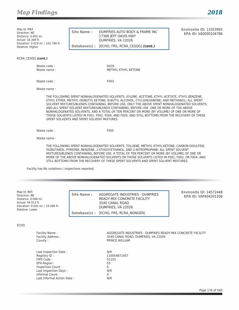
Map Findings 2018
Map Id: M64Direction: NEDistance: 0.003 mi.Actual: 16.349 ft.Elevation: 0.019 mi. / 102.766 ft.Relative: Higher
Envirosite ID: 13353993EPA ID: VA0000104786Site Name : DUMFRIES AUTO BODY & FRAME INC
17368 JEFF DAVIS HWYDUMFRIES, VA 22026
Database(s) : [ECHO, FRS, RCRA_CESQG] (cont.)
RCRA_CESQG (cont.)
Waste code : D035Waste name : METHYL ETHYL KETONE
Waste code : F003
Waste name :
THE FOLLOWING SPENT NONHALOGENATED SOLVENTS: XYLENE, ACETONE, ETHYL ACETATE, ETHYL BENZENE, ETHYL ETHER, METHYL ISOBUTYL KETONE, N-BUTYL ALCOHOL, CYCLOHEXANONE, AND METHANOL; ALL SPENT SOLVENT MIXTURES/BLENDS CONTAINING, BEFORE USE, ONLY THE ABOVE SPENT NONHALOGENATED SOLVENTS; AND ALL SPENT SOLVENT MIXTURES/BLENDS CONTAINING, BEFORE USE, ONE OR MORE OF THE ABOVE NONHALOGENATED SOLVENTS, AND A TOTAL OF TEN PERCENT OR MORE (BY VOLUME) OF ONE OR MORE OF THOSE SOLVENTS LISTED IN F001, F002, F004, AND F005; AND STILL BOTTOMS FROM THE RECOVERY OF THESE SPENT SOLVENTS AND SPENT SOLVENT MIXTURES.
Waste code : F005
Waste name :
THE FOLLOWING SPENT NONHALOGENATED SOLVENTS: TOLUENE, METHYL ETHYL KETONE, CARBON DISULFIDE, ISOBUTANOL, PYRIDINE, BENZENE, 2-ETHOXYETHANOL, AND 2-NITROPROPANE; ALL SPENT SOLVENT MIXTURES/BLENDS CONTAINING, BEFORE USE, A TOTAL OF TEN PERCENT OR MORE (BY VOLUME) OF ONE OR MORE OF THE ABOVE NONHALOGENATED SOLVENTS OR THOSE SOLVENTS LISTED IN F001, F002, OR F004; AND STILL BOTTOMS FROM THE RECOVERY OF THESE SPENT SOLVENTS AND SPENT SOLVENT MIXTURES.
Facility has No violations / inspections reported.
Map Id: B65Direction: NEDistance: 0.008 mi.Actual: 44.513 ft.Elevation: 0.002 mi. / 10.266 ft.Relative: Lower
Envirosite ID: 14572448EPA ID: VAP404201206Site Name : AGGREGATE INDUSTRIES - DUMFRIES
READY-MIX CONCRETE FACILITY3540 CANAL ROADDUMFRIES, VA 22026
Database(s) : [ECHO, FRS, RCRA_NONGEN]
ECHO
Facility Name : AGGREGATE INDUSTRIES - DUMFRIES READY-MIX CONCRETE FACILITYFacility Address : 3540 CANAL ROAD, DUMFRIES, VA 22026County : PRINCE WILLIAM
Last Inspection Date : N/RRegistry ID : 110054871457FIPS Code : 51153EPA Region : 03Inspection Count : 0Last Inspection Days : N/RInformal Count : 0Last Informal Action Date : N/R
Page 176 of 540

Map Findings 2018
Map Id: B65Direction: NEDistance: 0.008 mi.Actual: 44.513 ft.Elevation: 0.002 mi. / 10.266 ft.Relative: Lower
Envirosite ID: 14572448EPA ID: VAP404201206Site Name : AGGREGATE INDUSTRIES - DUMFRIES
READY-MIX CONCRETE FACILITY3540 CANAL ROADDUMFRIES, VA 22026
Database(s) : [ECHO, FRS, RCRA_NONGEN] (cont.)
ECHO (cont.)
Formal Action Count : 0Last Formal Action Date : N/RTotal Penalties : 0Penalty Count : N/RLast Penalty Date : N/RLast Penalty Amount : N/RQTRS IN NC : 0Programs IN SNC : 0Current Compliance Status : No ViolationThree-Year Compliance Status : ____________Collection Method : ADDRESS MATCHING-HOUSE NUMBERReference Point : CENTER OF A FACILITY OR STATIONAccuracy Meters : 30Derived Tribes : N/RDerived HUC : 02070011Derived WBD : 020700110104Derived STCTY FIPS : 51153Derived Zip : 22026Derived CD113 : 11Derived CB2010 : 511539009012012MYRTK Universe : NNNNPDES IDs : N/RCWA Permit Types : N/RCWA Compliance Tracking : N/RCWA NAICS : N/RCWA SICS : N/RCWA Inspection Count : N/RCWA Last Inspection Days : N/RCWA Informal Count : N/RCWA Formal Action Count : N/RCWA Last Formal Action Date : N/RCWA Penalties : N/RCWA Last Penalty Date : N/RCWA Last Penalty Amount : N/RCWA Quarters IN NC : N/RCWA Current Compliance Status : N/RCWA Current SNC Flag : NCWA 13 Quarters Compliance Status : N/RCWA 13 Quarters Effluent Exceedances: N/RCWA Three-Year QNCR Codes : N/RDFR URL : Click here for hyperlink provided by the agency.Facility SIC Codes : N/RFacility NAICS Codes : N/RFacility Last Inspection EPA Date : N/RFacility Last Inspection State Date : N/RFacility Last Formal Act EPA Date : N/RFacility Last Formal Act State Date : N/RFacility Last Informal Act EPA Date : N/RFacility Last Informal Act State Date: N/RFacility Federal Agency : N/RTRI Reporter : N/RFacility Imp Water Flag : N/RCurrent SNC Flag : NIndian County Flag : NFederal Flag : N/RUS Mexico Border Flag : N/R
Page 177 of 540

Map Findings 2018
Map Id: B65Direction: NEDistance: 0.008 mi.Actual: 44.513 ft.Elevation: 0.002 mi. / 10.266 ft.Relative: Lower
Envirosite ID: 14572448EPA ID: VAP404201206Site Name : AGGREGATE INDUSTRIES - DUMFRIES
READY-MIX CONCRETE FACILITY3540 CANAL ROADDUMFRIES, VA 22026
Database(s) : [ECHO, FRS, RCRA_NONGEN] (cont.)
ECHO (cont.)
Chesapeak Bay Flag : YAIR Flag : NNPDES Flag : NSDWIS Flag : NRCRA Flag : YTRI Flag : NGHG Flag : NMajor Flag : N/RActive Flag : N/RNAA Flag : YLatitude : 38.56728Longitude : -77.32068
FRS
Facility Name : AGGREGATE INDUSTRIES - DUMFRIES READY-MIX CONCRETE FACILITYFacility Address : 3540 CANAL ROAD, DUMFRIES, VA 22026County : PRINCE WILLIAM
Registry ID : 110054871457FRS Facility URL : Click here for hyperlink provided by the agency.
Source Description :
RCRAInfo is EPA’s comprehensive information system that supports the Resource Conservation and Recovery Act (RCRA) of 1976 and the Hazardous and Solid Waste Amendments (HSWA) of 1984 through the tracking of events and activities related to facilities that generate, transport, and treat, store, or dispose of hazardous waste. RCRAInfo allows RCRA program staff to track the notification, permit, compliance, and corrective action activities required under RCRA. RCRAInfo also supports generation of the National Hazardous Waste Biennial Report. All generators and treatment, storage, and disposal facilities who handle hazardous waste are required to report to the EPA Administrator at least once every two years to support creation of the Biennial Report.
FRS Environmental InterestSource and System ID : RCRAINFO - VAP404201206
RCRA_NONGEN
Date form received by agency : 11/15/2012Facility name : AGGREGATE INDUSTRIES - DUMFRIES READY-MIX CONCRETE FACILITYFacility address : 3540 CANAL ROAD, DUMFRIES VA 22026EPA ID : VAP404201206Mailing address : 6401 GOLDEN TRIANGLE DRIVE, GREENBELT MD 20770Contact : WENDY TAYLORContact address : 3540 CANAL ROAD, DUMFRIES VA 22026Contact country : USContact telephone : 703-445-0454Contact email : [email protected] Region : 03Land type : PrivateSource type : ImplementerClassification : Not a generator, verified
Page 178 of 540

Map Findings 2018
Map Id: B65Direction: NEDistance: 0.008 mi.Actual: 44.513 ft.Elevation: 0.002 mi. / 10.266 ft.Relative: Lower
Envirosite ID: 14572448EPA ID: VAP404201206Site Name : AGGREGATE INDUSTRIES - DUMFRIES
READY-MIX CONCRETE FACILITY3540 CANAL ROADDUMFRIES, VA 22026
Database(s) : [ECHO, FRS, RCRA_NONGEN] (cont.)
RCRA_NONGEN (cont.)
Description : Not a generator, verified
Owner/Operator Summary :Owner Operator name : BARDON, INCOwner Operator address : 6401 GOLDEN TRIANGLE DRIVE, GREENBELT MD 20770Owner Operator country : USOwner Operator telephone : 301-982-1400Owner Operator Email : N/ROwner Operator Fax : N/RLegal status : PrivateOwner Operator Type : OwnerOwner/Op start date : 11/01/2011Owner/Op end date : N/R
Owner Operator name : WENDY TAYLOROwner Operator address : N/ROwner Operator country : USOwner Operator telephone : N/ROwner Operator Email : N/ROwner Operator Fax : N/RLegal status : PrivateOwner Operator Type : OperatorOwner/Op start date : 11/01/2011Owner/Op end date : N/R
Handler Activities Summary :U.S. importer of hazardous waste : NoMixed waste (haz. and radioactive) : NoRecycler of hazardous waste : NoTransporter of hazardous waste : NoTreater storer or disposer of HW : NoUnderground injection activity : NoOn-site burner exemption : NoFurnace exemption : NoUsed oil fuel burner : NoUsed oil processor : NoUsed oil refiner : NoUsed oil fuel marketer to burner : NoUsed oil Specification marketer : NoUsed oil transfer facility : NoUsed oil transporter : No
Historical Generators :Date form received by agency : 04/25/2012Facility name : AGGREGATE INDUSTRIES - DUMFRIES READY-MIX CONCRETE FACILITYClassification : Small Quantity Generator
Facility has No violations / inspections reported.
Page 179 of 540

Map Findings 2018
Map Id: B66Direction: NEDistance: 0.008 mi.Actual: 44.513 ft.Elevation: 0.002 mi. / 10.266 ft.Relative: Lower
Envirosite ID: 327021350EPA ID: N/RSite Name : DUMFRIES READY-MIX CONCRETE
3540 CANAL RDDUMFRIES, VA 22026
Database(s) : [AST - VA]
AST - VA
Facility Name : Dumfries Ready-Mix ConcreteFacility Address : 3540 Canal Rd, Dumfries, VA 22026County : Prince William County
Facility ID : 3042271Facility Type : INDUSTRIALCEDS Facility ID : 200000201463Region Code : NVROLast Date in Agency List : 03/12/2018
Tank InformationInstall Date : 01/01/2000Date Closed : N/RTank Number : 1Tank Status : CURR IN USETank Owner ID : 47422Tank Type : ASTCapacity : 1000Federally Regulated Tank : NContents : DIESELOther Contents : N/R
Tank Material InformationTank Number : 1Tank Owner ID : 47422Tank Material Bare Steel : YTank Material Insulated Steel : NTank Material Concrete Coated/Concrete Vault: NTank Material Unknown : NTank Material Other : NTank Material Other Notes : N/RTank Type Cathodic/CP : NTank Type Single Wall : NTank Type Double Wall : YTank Type Lined Interior : NTank Type Double Bottom : NTank Type Portable/Skid : NTank Type Shop Fabricated/Built : NTank Type Vaulted Below Grade : NTank Type Vertical : NTank Type Horizontal : NTank Type Unknown : NTank Type Other : NTank Type Other Notes : N/R
Page 180 of 540

Map Findings 2018
Map Id: B67Direction: NEDistance: 0.008 mi.Actual: 44.513 ft.Elevation: 0.002 mi. / 10.266 ft.Relative: Lower
Envirosite ID: 330015567EPA ID: N/RSite Name : ENNSTONE CONCRETE PLANT
3540 CANAL ROADDUMFRIES, VA
Database(s) : [ARCHIVED SPILLS - VA]
Archived SPILLS - VA
Facility Name : Ennstone Concrete PlantFacility Address : 3540 Canal Road, Dumfries, VACounty : Prince William County
Closure Date : 11/15/2005Incident Date : N/RCall Received Date : 11/07/2005IR Number : 2006-N-0385Associated IR : N/RReference ID : N/RIncident Type : WaterIncident Subtype : WaterRegion : NorthernThreat to : N/RTerrorism (Y/N) : NOCharacterize Incident : N/RMaterials : Water (Wash)(-1 - -1 Unknown)Effect to Receptor : N/RWater Body : Quantico CreekLow Quantity to Water : -1High Quantity to Water : -1Quantity Units : UnknownOther Receptors : N/RRP Company : N/RRP Name : N/RProperty Owner : N/RProperty Company : N/RDuration of Event (Hours) : N/RImpacts : N/ROther Impacts : N/RSteps Taken : N/RSteps Taken Description : N/RSystem Components : N/ROther System Components : N/RCause of Event : N/RCorrective Action Taken : N/RWeather Status : N/RPrecipitation (Wet) : N/RDischarge Type : N/RDischarge Volume : N/RUnknown Discharge (Y/N) : NO
Original Call Incident Description : Town Mgr. reports observing washwater from concrete truck washing going into settling basins and then being discharged onto the grounds which then flows into a ditch and then into a pipe which then flows directly into the Quantico Creek. Wants someone to check and see if they have a permit and if they are complying
Original Call Material Description : concrete wash waterOriginal Call Location Description : Ennstone Concrete Plant-3540 Canal Road-Dumfries-VA--Prince William
CountyIncident Ongoing at Time of Call : N/RAgencies Notified (Y/N) : NOOther Agencies : N/RPermitted (Y/N) : YESCall Reported by Name : N/R
Page 181 of 540
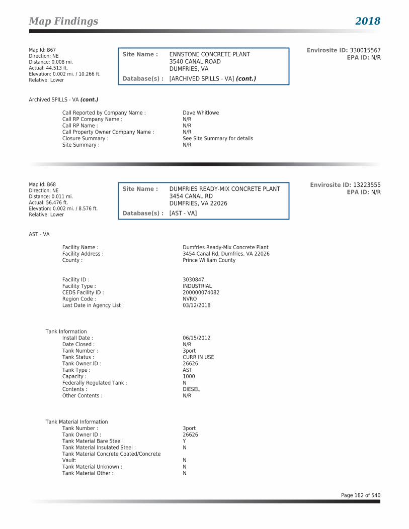
Map Findings 2018
Map Id: B67Direction: NEDistance: 0.008 mi.Actual: 44.513 ft.Elevation: 0.002 mi. / 10.266 ft.Relative: Lower
Envirosite ID: 330015567EPA ID: N/RSite Name : ENNSTONE CONCRETE PLANT
3540 CANAL ROADDUMFRIES, VA
Database(s) : [ARCHIVED SPILLS - VA] (cont.)
Archived SPILLS - VA (cont.)
Call Reported by Company Name : Dave WhitloweCall RP Company Name : N/RCall RP Name : N/RCall Property Owner Company Name : N/RClosure Summary : See Site Summary for detailsSite Summary : N/R
Map Id: B68Direction: NEDistance: 0.011 mi.Actual: 56.476 ft.Elevation: 0.002 mi. / 8.576 ft.Relative: Lower
Envirosite ID: 13223555EPA ID: N/RSite Name : DUMFRIES READY-MIX CONCRETE PLANT
3454 CANAL RDDUMFRIES, VA 22026
Database(s) : [AST - VA]
AST - VA
Facility Name : Dumfries Ready-Mix Concrete PlantFacility Address : 3454 Canal Rd, Dumfries, VA 22026County : Prince William County
Facility ID : 3030847Facility Type : INDUSTRIALCEDS Facility ID : 200000074082Region Code : NVROLast Date in Agency List : 03/12/2018
Tank InformationInstall Date : 06/15/2012Date Closed : N/RTank Number : 3portTank Status : CURR IN USETank Owner ID : 26626Tank Type : ASTCapacity : 1000Federally Regulated Tank : NContents : DIESELOther Contents : N/R
Tank Material InformationTank Number : 3portTank Owner ID : 26626Tank Material Bare Steel : YTank Material Insulated Steel : NTank Material Concrete Coated/Concrete Vault: NTank Material Unknown : NTank Material Other : N
Page 182 of 540

Map Findings 2018
Map Id: B68Direction: NEDistance: 0.011 mi.Actual: 56.476 ft.Elevation: 0.002 mi. / 8.576 ft.Relative: Lower
Envirosite ID: 13223555EPA ID: N/RSite Name : DUMFRIES READY-MIX CONCRETE PLANT
3454 CANAL RDDUMFRIES, VA 22026
Database(s) : [AST - VA] (cont.)
AST - VA (cont.)
Tank Material Other Notes : N/RTank Type Cathodic/CP : NTank Type Single Wall : NTank Type Double Wall : YTank Type Lined Interior : NTank Type Double Bottom : NTank Type Portable/Skid : NTank Type Shop Fabricated/Built : NTank Type Vaulted Below Grade : NTank Type Vertical : NTank Type Horizontal : NTank Type Unknown : NTank Type Other : NTank Type Other Notes : N/R
Tank InformationInstall Date : 10/15/2006Date Closed : N/RTank Number : 2portTank Status : CURR IN USETank Owner ID : 26626Tank Type : ASTCapacity : 1000Federally Regulated Tank : NContents : DIESELOther Contents : N/R
Tank Material InformationTank Number : 2portTank Owner ID : 26626Tank Material Bare Steel : YTank Material Insulated Steel : NTank Material Concrete Coated/Concrete Vault: NTank Material Unknown : NTank Material Other : NTank Material Other Notes : N/RTank Type Cathodic/CP : NTank Type Single Wall : NTank Type Double Wall : YTank Type Lined Interior : NTank Type Double Bottom : NTank Type Portable/Skid : NTank Type Shop Fabricated/Built : NTank Type Vaulted Below Grade : NTank Type Vertical : NTank Type Horizontal : NTank Type Unknown : NTank Type Other : NTank Type Other Notes : N/R
Page 183 of 540

Map Findings 2018
Map Id: B68Direction: NEDistance: 0.011 mi.Actual: 56.476 ft.Elevation: 0.002 mi. / 8.576 ft.Relative: Lower
Envirosite ID: 13223555EPA ID: N/RSite Name : DUMFRIES READY-MIX CONCRETE PLANT
3454 CANAL RDDUMFRIES, VA 22026
Database(s) : [AST - VA] (cont.)
AST - VA (cont.)
Tank InformationInstall Date : 01/01/1994Date Closed : N/RTank Number : 1Tank Status : CURR IN USETank Owner ID : 26626Tank Type : ASTCapacity : 5000Federally Regulated Tank : NContents : DIESELOther Contents : N/R
Tank Material InformationTank Number : 1Tank Owner ID : 26626Tank Material Bare Steel : YTank Material Insulated Steel : NTank Material Concrete Coated/Concrete Vault: NTank Material Unknown : NTank Material Other : NTank Material Other Notes : N/RTank Type Cathodic/CP : NTank Type Single Wall : NTank Type Double Wall : NTank Type Lined Interior : NTank Type Double Bottom : NTank Type Portable/Skid : NTank Type Shop Fabricated/Built : NTank Type Vaulted Below Grade : NTank Type Vertical : NTank Type Horizontal : NTank Type Unknown : NTank Type Other : NTank Type Other Notes : N/R
Tank Number : 1Tank Owner ID : 34612Tank Material Bare Steel : YTank Material Insulated Steel : NTank Material Concrete Coated/Concrete Vault: NTank Material Unknown : NTank Material Other : NTank Material Other Notes : N/RTank Type Cathodic/CP : NTank Type Single Wall : NTank Type Double Wall : NTank Type Lined Interior : NTank Type Double Bottom : NTank Type Portable/Skid : NTank Type Shop Fabricated/Built : NTank Type Vaulted Below Grade : NTank Type Vertical : N
Page 184 of 540

Map Findings 2018
Map Id: B68Direction: NEDistance: 0.011 mi.Actual: 56.476 ft.Elevation: 0.002 mi. / 8.576 ft.Relative: Lower
Envirosite ID: 13223555EPA ID: N/RSite Name : DUMFRIES READY-MIX CONCRETE PLANT
3454 CANAL RDDUMFRIES, VA 22026
Database(s) : [AST - VA] (cont.)
AST - VA (cont.)
Tank Type Horizontal : NTank Type Unknown : NTank Type Other : NTank Type Other Notes : N/R
Tank InformationInstall Date : 06/01/1982Date Closed : N/RTank Number : 1Tank Status : CURR IN USETank Owner ID : 34612Tank Type : ASTCapacity : 2000Federally Regulated Tank : NContents : DIESELOther Contents : N/R
Tank Material InformationTank Number : 1Tank Owner ID : 26626Tank Material Bare Steel : YTank Material Insulated Steel : NTank Material Concrete Coated/Concrete Vault: NTank Material Unknown : NTank Material Other : NTank Material Other Notes : N/RTank Type Cathodic/CP : NTank Type Single Wall : NTank Type Double Wall : NTank Type Lined Interior : NTank Type Double Bottom : NTank Type Portable/Skid : NTank Type Shop Fabricated/Built : NTank Type Vaulted Below Grade : NTank Type Vertical : NTank Type Horizontal : NTank Type Unknown : NTank Type Other : NTank Type Other Notes : N/R
Tank Number : 1Tank Owner ID : 34612Tank Material Bare Steel : YTank Material Insulated Steel : NTank Material Concrete Coated/Concrete Vault: NTank Material Unknown : NTank Material Other : NTank Material Other Notes : N/RTank Type Cathodic/CP : NTank Type Single Wall : N
Page 185 of 540

Map Findings 2018
Map Id: B68Direction: NEDistance: 0.011 mi.Actual: 56.476 ft.Elevation: 0.002 mi. / 8.576 ft.Relative: Lower
Envirosite ID: 13223555EPA ID: N/RSite Name : DUMFRIES READY-MIX CONCRETE PLANT
3454 CANAL RDDUMFRIES, VA 22026
Database(s) : [AST - VA] (cont.)
AST - VA (cont.)
Tank Type Double Wall : NTank Type Lined Interior : NTank Type Double Bottom : NTank Type Portable/Skid : NTank Type Shop Fabricated/Built : NTank Type Vaulted Below Grade : NTank Type Vertical : NTank Type Horizontal : NTank Type Unknown : NTank Type Other : NTank Type Other Notes : N/R
Tank InformationInstall Date : 06/01/1982Date Closed : N/RTank Number : 2Tank Status : CURR IN USETank Owner ID : 34612Tank Type : ASTCapacity : 1000Federally Regulated Tank : NContents : DIESELOther Contents : N/R
Tank Material InformationTank Number : 2Tank Owner ID : 34612Tank Material Bare Steel : YTank Material Insulated Steel : NTank Material Concrete Coated/Concrete Vault: NTank Material Unknown : NTank Material Other : NTank Material Other Notes : N/RTank Type Cathodic/CP : NTank Type Single Wall : NTank Type Double Wall : NTank Type Lined Interior : NTank Type Double Bottom : NTank Type Portable/Skid : NTank Type Shop Fabricated/Built : NTank Type Vaulted Below Grade : NTank Type Vertical : NTank Type Horizontal : NTank Type Unknown : NTank Type Other : NTank Type Other Notes : N/R
Page 186 of 540

Map Findings 2018
Map Id: B69Direction: NEDistance: 0.011 mi.Actual: 56.476 ft.Elevation: 0.002 mi. / 8.576 ft.Relative: Lower
Envirosite ID: 15287510EPA ID: VAR000508184Site Name : A-ANNANDALE INC.
3456 CANAL ROADDUMFRIES, VA 22026
Database(s) : [ECHO, FRS, RCRA_SQG]
ECHO
Facility Name : A-ANNANDALE INC.Facility Address : 3456 CANAL ROAD, DUMFRIES, VA 22026County : PRINCE WILLIAM
Last Inspection Date : 03/29/2006Registry ID : 110020479329FIPS Code : 51153EPA Region : 03Inspection Count : 0Last Inspection Days : 4365Informal Count : 0Last Informal Action Date : N/RFormal Action Count : 0Last Formal Action Date : N/RTotal Penalties : 0Penalty Count : N/RLast Penalty Date : N/RLast Penalty Amount : N/RQTRS IN NC : 0Programs IN SNC : 0Current Compliance Status : No ViolationThree-Year Compliance Status : ____________Collection Method : ADDRESS MATCHING-HOUSE NUMBERReference Point : CENTER OF A FACILITY OR STATIONAccuracy Meters : 30Derived Tribes : N/RDerived HUC : 02070011Derived WBD : 020700110104Derived STCTY FIPS : 51153Derived Zip : 22026Derived CD113 : 11Derived CB2010 : 511539009012012MYRTK Universe : NNNNPDES IDs : N/RCWA Permit Types : N/RCWA Compliance Tracking : N/RCWA NAICS : N/RCWA SICS : N/RCWA Inspection Count : N/RCWA Last Inspection Days : N/RCWA Informal Count : N/RCWA Formal Action Count : N/RCWA Last Formal Action Date : N/RCWA Penalties : N/RCWA Last Penalty Date : N/RCWA Last Penalty Amount : N/RCWA Quarters IN NC : N/RCWA Current Compliance Status : N/RCWA Current SNC Flag : NCWA 13 Quarters Compliance Status : N/RCWA 13 Quarters Effluent Exceedances: N/RCWA Three-Year QNCR Codes : N/RDFR URL : Click here for hyperlink provided by the agency.Facility SIC Codes : N/RFacility NAICS Codes : 23731 23521 23899Facility Last Inspection EPA Date : N/R
Page 187 of 540

Map Findings 2018
Map Id: B69Direction: NEDistance: 0.011 mi.Actual: 56.476 ft.Elevation: 0.002 mi. / 8.576 ft.Relative: Lower
Envirosite ID: 15287510EPA ID: VAR000508184Site Name : A-ANNANDALE INC.
3456 CANAL ROADDUMFRIES, VA 22026
Database(s) : [ECHO, FRS, RCRA_SQG] (cont.)
ECHO (cont.)
Facility Last Inspection State Date : 03/29/2006Facility Last Formal Act EPA Date : N/RFacility Last Formal Act State Date : N/RFacility Last Informal Act EPA Date : N/RFacility Last Informal Act State Date: N/RFacility Federal Agency : N/RTRI Reporter : N/RFacility Imp Water Flag : N/RCurrent SNC Flag : NIndian County Flag : NFederal Flag : N/RUS Mexico Border Flag : N/RChesapeak Bay Flag : YAIR Flag : NNPDES Flag : NSDWIS Flag : NRCRA Flag : YTRI Flag : NGHG Flag : NMajor Flag : N/RActive Flag : YNAA Flag : YLatitude : 38.56725Longitude : -77.32066
FRS
Facility Name : A-ANNANDALE INC.Facility Address : 3456 CANAL ROAD, DUMFRIES, VA 22026County : PRINCE WILLIAM
Registry ID : 110020479329FRS Facility URL : Click here for hyperlink provided by the agency.
Source Description :
RCRAInfo is EPA’s comprehensive information system that supports the Resource Conservation and Recovery Act (RCRA) of 1976 and the Hazardous and Solid Waste Amendments (HSWA) of 1984 through the tracking of events and activities related to facilities that generate, transport, and treat, store, or dispose of hazardous waste. RCRAInfo allows RCRA program staff to track the notification, permit, compliance, and corrective action activities required under RCRA. RCRAInfo also supports generation of the National Hazardous Waste Biennial Report. All generators and treatment, storage, and disposal facilities who handle hazardous waste are required to report to the EPA Administrator at least once every two years to support creation of the Biennial Report.
FRS Environmental InterestSource and System ID : RCRAINFO - VAR000508184
RCRA_SQG
Date form received by agency : 12/02/2004Facility name : A-ANNANDALE INC.Facility address : 3456 CANAL ROAD, DUMFRIES VA 22026
Page 188 of 540
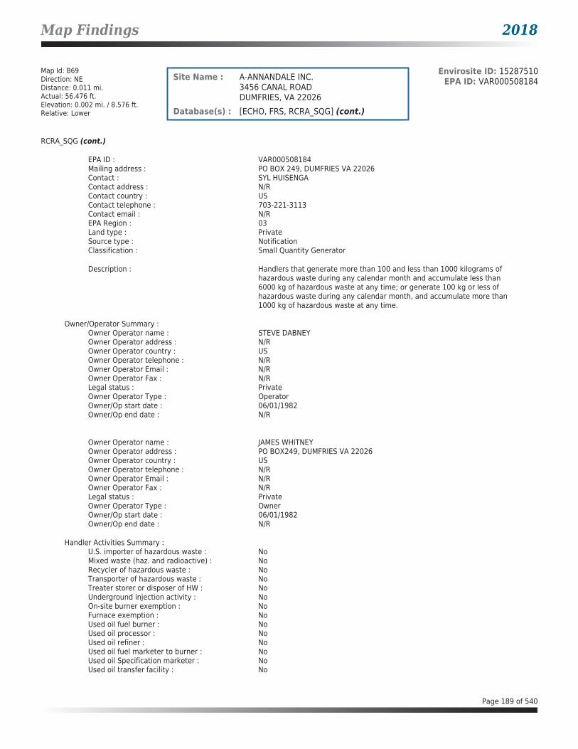
Map Findings 2018
Map Id: B69Direction: NEDistance: 0.011 mi.Actual: 56.476 ft.Elevation: 0.002 mi. / 8.576 ft.Relative: Lower
Envirosite ID: 15287510EPA ID: VAR000508184Site Name : A-ANNANDALE INC.
3456 CANAL ROADDUMFRIES, VA 22026
Database(s) : [ECHO, FRS, RCRA_SQG] (cont.)
RCRA_SQG (cont.)
EPA ID : VAR000508184Mailing address : PO BOX 249, DUMFRIES VA 22026Contact : SYL HUISENGAContact address : N/RContact country : USContact telephone : 703-221-3113Contact email : N/REPA Region : 03Land type : PrivateSource type : NotificationClassification : Small Quantity Generator
Description : Handlers that generate more than 100 and less than 1000 kilograms of hazardous waste during any calendar month and accumulate less than 6000 kg of hazardous waste at any time; or generate 100 kg or less of hazardous waste during any calendar month, and accumulate more than 1000 kg of hazardous waste at any time.
Owner/Operator Summary :Owner Operator name : STEVE DABNEYOwner Operator address : N/ROwner Operator country : USOwner Operator telephone : N/ROwner Operator Email : N/ROwner Operator Fax : N/RLegal status : PrivateOwner Operator Type : OperatorOwner/Op start date : 06/01/1982Owner/Op end date : N/R
Owner Operator name : JAMES WHITNEYOwner Operator address : PO BOX249, DUMFRIES VA 22026Owner Operator country : USOwner Operator telephone : N/ROwner Operator Email : N/ROwner Operator Fax : N/RLegal status : PrivateOwner Operator Type : OwnerOwner/Op start date : 06/01/1982Owner/Op end date : N/R
Handler Activities Summary :U.S. importer of hazardous waste : NoMixed waste (haz. and radioactive) : NoRecycler of hazardous waste : NoTransporter of hazardous waste : NoTreater storer or disposer of HW : NoUnderground injection activity : NoOn-site burner exemption : NoFurnace exemption : NoUsed oil fuel burner : NoUsed oil processor : NoUsed oil refiner : NoUsed oil fuel marketer to burner : NoUsed oil Specification marketer : NoUsed oil transfer facility : No
Page 189 of 540
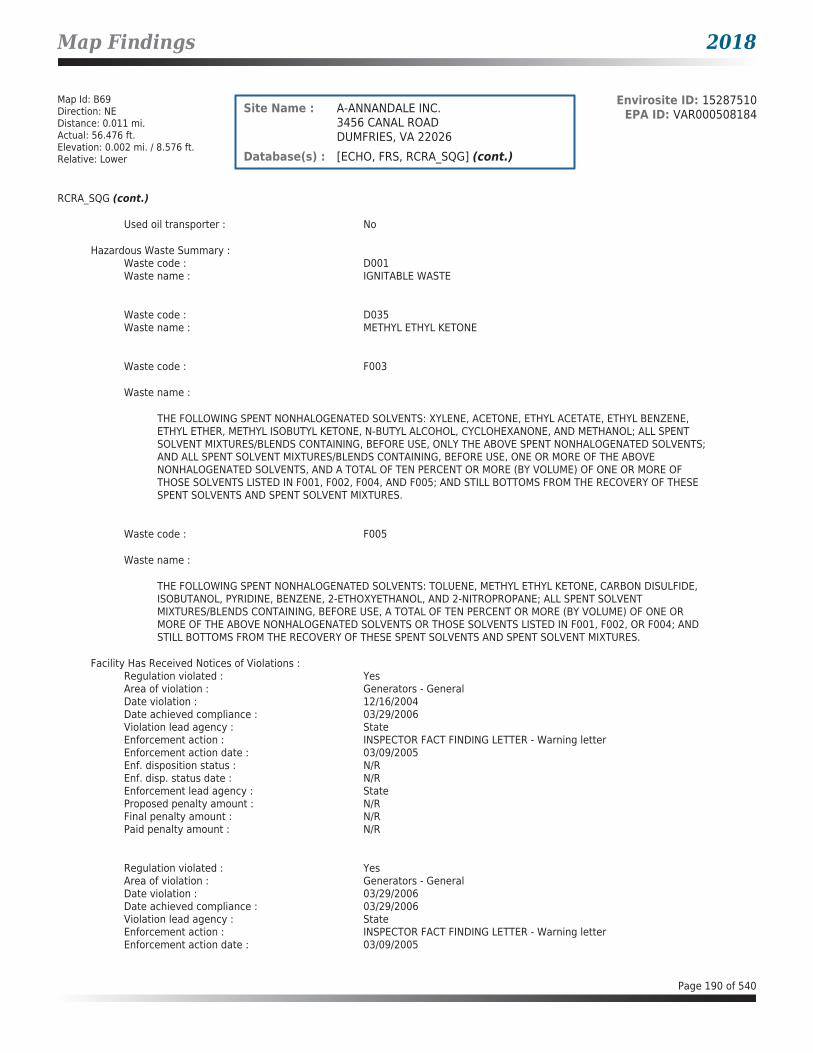
Map Findings 2018
Map Id: B69Direction: NEDistance: 0.011 mi.Actual: 56.476 ft.Elevation: 0.002 mi. / 8.576 ft.Relative: Lower
Envirosite ID: 15287510EPA ID: VAR000508184Site Name : A-ANNANDALE INC.
3456 CANAL ROADDUMFRIES, VA 22026
Database(s) : [ECHO, FRS, RCRA_SQG] (cont.)
RCRA_SQG (cont.)
Used oil transporter : No
Hazardous Waste Summary :Waste code : D001Waste name : IGNITABLE WASTE
Waste code : D035Waste name : METHYL ETHYL KETONE
Waste code : F003
Waste name :
THE FOLLOWING SPENT NONHALOGENATED SOLVENTS: XYLENE, ACETONE, ETHYL ACETATE, ETHYL BENZENE, ETHYL ETHER, METHYL ISOBUTYL KETONE, N-BUTYL ALCOHOL, CYCLOHEXANONE, AND METHANOL; ALL SPENT SOLVENT MIXTURES/BLENDS CONTAINING, BEFORE USE, ONLY THE ABOVE SPENT NONHALOGENATED SOLVENTS; AND ALL SPENT SOLVENT MIXTURES/BLENDS CONTAINING, BEFORE USE, ONE OR MORE OF THE ABOVE NONHALOGENATED SOLVENTS, AND A TOTAL OF TEN PERCENT OR MORE (BY VOLUME) OF ONE OR MORE OF THOSE SOLVENTS LISTED IN F001, F002, F004, AND F005; AND STILL BOTTOMS FROM THE RECOVERY OF THESE SPENT SOLVENTS AND SPENT SOLVENT MIXTURES.
Waste code : F005
Waste name :
THE FOLLOWING SPENT NONHALOGENATED SOLVENTS: TOLUENE, METHYL ETHYL KETONE, CARBON DISULFIDE, ISOBUTANOL, PYRIDINE, BENZENE, 2-ETHOXYETHANOL, AND 2-NITROPROPANE; ALL SPENT SOLVENT MIXTURES/BLENDS CONTAINING, BEFORE USE, A TOTAL OF TEN PERCENT OR MORE (BY VOLUME) OF ONE OR MORE OF THE ABOVE NONHALOGENATED SOLVENTS OR THOSE SOLVENTS LISTED IN F001, F002, OR F004; AND STILL BOTTOMS FROM THE RECOVERY OF THESE SPENT SOLVENTS AND SPENT SOLVENT MIXTURES.
Facility Has Received Notices of Violations :Regulation violated : YesArea of violation : Generators - GeneralDate violation : 12/16/2004Date achieved compliance : 03/29/2006Violation lead agency : StateEnforcement action : INSPECTOR FACT FINDING LETTER - Warning letterEnforcement action date : 03/09/2005Enf. disposition status : N/REnf. disp. status date : N/REnforcement lead agency : StateProposed penalty amount : N/RFinal penalty amount : N/RPaid penalty amount : N/R
Regulation violated : YesArea of violation : Generators - GeneralDate violation : 03/29/2006Date achieved compliance : 03/29/2006Violation lead agency : StateEnforcement action : INSPECTOR FACT FINDING LETTER - Warning letterEnforcement action date : 03/09/2005
Page 190 of 540

Map Findings 2018
Map Id: B69Direction: NEDistance: 0.011 mi.Actual: 56.476 ft.Elevation: 0.002 mi. / 8.576 ft.Relative: Lower
Envirosite ID: 15287510EPA ID: VAR000508184Site Name : A-ANNANDALE INC.
3456 CANAL ROADDUMFRIES, VA 22026
Database(s) : [ECHO, FRS, RCRA_SQG] (cont.)
RCRA_SQG (cont.)
Enf. disposition status : N/REnf. disp. status date : N/REnforcement lead agency : StateProposed penalty amount : N/RFinal penalty amount : N/RPaid penalty amount : N/R
Regulation violated : YesArea of violation : Used Oil - GeneratorsDate violation : 03/29/2006Date achieved compliance : 03/29/2006Violation lead agency : StateEnforcement action : N/REnforcement action date : N/REnf. disposition status : N/REnf. disp. status date : N/REnforcement lead agency : N/RProposed penalty amount : N/RFinal penalty amount : N/RPaid penalty amount : N/R
Evaluation Action Summary :Evaluation date : 12/16/2004Evaluation : COMPLIANCE EVALUATION INSPECTION ON-SITEArea of violation : Generators - GeneralDate achieved compliance : 03/29/2006Evaluation lead agency : State
Evaluation date : 03/29/2006Evaluation : FOLLOW-UP INSPECTIONArea of violation : Generators - GeneralDate achieved compliance : 03/29/2006Evaluation lead agency : State
Evaluation date : 03/29/2006Evaluation : FOLLOW-UP INSPECTIONArea of violation : Used Oil - GeneratorsDate achieved compliance : 03/29/2006Evaluation lead agency : State
Page 191 of 540

Map Findings 2018
Map Id: B70Direction: NEDistance: 0.011 mi.Actual: 56.476 ft.Elevation: 0.002 mi. / 8.576 ft.Relative: Lower
Envirosite ID: 330028649EPA ID: N/RSite Name : TITAN AND COLONIAL CONCRETE
124 POSSUM PT RD & 3454 CANAL RDDUMFRIES, VA
Database(s) : [ARCHIVED SPILLS - VA]
Archived SPILLS - VA
Facility Name : Titan and Colonial ConcreteFacility Address : 124 Possum Pt Rd & 3454 Canal Rd, Dumfries, VACounty : Prince William County
Closure Date : 10/10/2007Incident Date : 07/18/2007Call Received Date : 07/18/2007IR Number : 2008-N-0043Associated IR : N/RReference ID : N/RIncident Type : AirIncident Subtype : AirRegion : NorthernThreat to : N/RTerrorism (Y/N) : NOCharacterize Incident : N/RMaterials : Concrete Dust(-1 - -1 Unknown)Effect to Receptor : N/RWater Body : N/RLow Quantity to Water : N/RHigh Quantity to Water : N/RQuantity Units : N/ROther Receptors : N/RRP Company : N/RRP Name : N/RProperty Owner : N/RProperty Company : N/RDuration of Event (Hours) : N/RImpacts : N/ROther Impacts : N/RSteps Taken : N/RSteps Taken Description : N/RSystem Components : N/ROther System Components : N/RCause of Event : N/RCorrective Action Taken : N/RWeather Status : N/RPrecipitation (Wet) : N/RDischarge Type : N/RDischarge Volume : N/RUnknown Discharge (Y/N) : NO
Original Call Incident Description : Mr. Scott indicated that Titan & Colonial Concrete are not appropriately managing their dust. Mr. Scott said he has tried to work with Titan & Colonial to minimize the dust but they are not cooperating.
Original Call Material Description : concrete dust (Qty=unknown - on-going)
Original Call Location Description : Titan and Colonial Concrete-124 Possum Pt Rd & 3454 Canal Rd-Dumfries-VA--Prince William County
Incident Ongoing at Time of Call : N/RAgencies Notified (Y/N) : NOOther Agencies : N/RPermitted (Y/N) : YESCall Reported by Name : N/R
Page 192 of 540

Map Findings 2018
Map Id: B70Direction: NEDistance: 0.011 mi.Actual: 56.476 ft.Elevation: 0.002 mi. / 8.576 ft.Relative: Lower
Envirosite ID: 330028649EPA ID: N/RSite Name : TITAN AND COLONIAL CONCRETE
124 POSSUM PT RD & 3454 CANAL RDDUMFRIES, VA
Database(s) : [ARCHIVED SPILLS - VA] (cont.)
Archived SPILLS - VA (cont.)
Call Reported by Company Name : Joe ScottCall RP Company Name : N/RCall RP Name : N/RCall Property Owner Company Name : N/RClosure Summary : See Site Summary for detailsSite Summary : Gumbita sent letter to J. Scott 9/7/07.
Map Id: 71Direction: NEDistance: 0.012 mi.Actual: 65.649 ft.Elevation: 0.017 mi. / 91.742 ft.Relative: Higher
Envirosite ID: 13356864EPA ID: VAD988205019Site Name : SKIPS AUTO PARTS INC
160 OLD STAGECOACH RDDUMFRIES, VA 22026
Database(s) : [ECHO, FRS, RCRA_CESQG]
ECHO
Facility Name : SKIPS AUTO PARTS INCFacility Address : 160 OLD STAGECOACH RD, DUMFRIES, VA 22026County : PRINCE WILLIAM
Last Inspection Date : 08/12/1998Registry ID : 110005247937FIPS Code : 51153EPA Region : 03Inspection Count : 0Last Inspection Days : 7151Informal Count : 0Last Informal Action Date : N/RFormal Action Count : 0Last Formal Action Date : N/RTotal Penalties : 0Penalty Count : N/RLast Penalty Date : N/RLast Penalty Amount : N/RQTRS IN NC : 0Programs IN SNC : 0Current Compliance Status : No ViolationThree-Year Compliance Status : ____________Collection Method : ADDRESS MATCHING-HOUSE NUMBERReference Point : ENTRANCE POINT OF A FACILITY OR STATIONAccuracy Meters : 50Derived Tribes : N/RDerived HUC : 02070011Derived WBD : 020700110104Derived STCTY FIPS : 51153Derived Zip : 22026Derived CD113 : 11Derived CB2010 : 511539009012001MYRTK Universe : NNNNPDES IDs : N/RCWA Permit Types : N/R
Page 193 of 540

Map Findings 2018
Map Id: 71Direction: NEDistance: 0.012 mi.Actual: 65.649 ft.Elevation: 0.017 mi. / 91.742 ft.Relative: Higher
Envirosite ID: 13356864EPA ID: VAD988205019Site Name : SKIPS AUTO PARTS INC
160 OLD STAGECOACH RDDUMFRIES, VA 22026
Database(s) : [ECHO, FRS, RCRA_CESQG] (cont.)
ECHO (cont.)
CWA Compliance Tracking : N/RCWA NAICS : N/RCWA SICS : N/RCWA Inspection Count : N/RCWA Last Inspection Days : N/RCWA Informal Count : N/RCWA Formal Action Count : N/RCWA Last Formal Action Date : N/RCWA Penalties : N/RCWA Last Penalty Date : N/RCWA Last Penalty Amount : N/RCWA Quarters IN NC : N/RCWA Current Compliance Status : N/RCWA Current SNC Flag : NCWA 13 Quarters Compliance Status : N/RCWA 13 Quarters Effluent Exceedances: N/RCWA Three-Year QNCR Codes : N/RDFR URL : Click here for hyperlink provided by the agency.Facility SIC Codes : N/RFacility NAICS Codes : 45331 44131Facility Last Inspection EPA Date : N/RFacility Last Inspection State Date : 08/12/1998Facility Last Formal Act EPA Date : N/RFacility Last Formal Act State Date : N/RFacility Last Informal Act EPA Date : N/RFacility Last Informal Act State Date: N/RFacility Federal Agency : N/RTRI Reporter : N/RFacility Imp Water Flag : N/RCurrent SNC Flag : NIndian County Flag : NFederal Flag : N/RUS Mexico Border Flag : N/RChesapeak Bay Flag : YAIR Flag : NNPDES Flag : NSDWIS Flag : NRCRA Flag : YTRI Flag : NGHG Flag : NMajor Flag : N/RActive Flag : YNAA Flag : YLatitude : 38.571471Longitude : -77.316904
FRS
Facility Name : SKIPS AUTO PARTS INCFacility Address : 160 OLD STAGECOACH RD, DUMFRIES, VA 22026County : PRINCE WILLIAM
Registry ID : 110005247937FRS Facility URL : Click here for hyperlink provided by the agency.
Page 194 of 540

Map Findings 2018
Map Id: 71Direction: NEDistance: 0.012 mi.Actual: 65.649 ft.Elevation: 0.017 mi. / 91.742 ft.Relative: Higher
Envirosite ID: 13356864EPA ID: VAD988205019Site Name : SKIPS AUTO PARTS INC
160 OLD STAGECOACH RDDUMFRIES, VA 22026
Database(s) : [ECHO, FRS, RCRA_CESQG] (cont.)
FRS (cont.)
Source Description :
RCRAInfo is EPA’s comprehensive information system that supports the Resource Conservation and Recovery Act (RCRA) of 1976 and the Hazardous and Solid Waste Amendments (HSWA) of 1984 through the tracking of events and activities related to facilities that generate, transport, and treat, store, or dispose of hazardous waste. RCRAInfo allows RCRA program staff to track the notification, permit, compliance, and corrective action activities required under RCRA. RCRAInfo also supports generation of the National Hazardous Waste Biennial Report. All generators and treatment, storage, and disposal facilities who handle hazardous waste are required to report to the EPA Administrator at least once every two years to support creation of the Biennial Report.
FRS Environmental InterestSource and System ID : RCRAINFO - VAD988205019
RCRA_CESQG
Date form received by agency : 08/12/1998Facility name : SKIPS AUTO PARTS INCFacility address : 160 OLD STAGECOACH RD, DUMFRIES VA 22026EPA ID : VAD988205019Mailing address : 160 OLD STAGECOACH RD, DUMFRIES VA 22026Contact : N/RContact address : N/RContact country : USContact telephone : N/RContact email : N/REPA Region : 03Land type : PrivateSource type : ImplementerClassification : Conditionally Exempt Small Quantity Generator
Description :
Handlers that generate 100 kilograms or less of hazardous waste per calendar month, and accumulate 1000 kg or less of hazardous waste at any time; or generate one kilogram or less of acutely hazardous waste per calendar month, and accumulate at any time: 1 kg or less of acutely hazardous waste; or 100 kg or less of any residue or contaminated soil, waste or other debris resulting from the cleanup of a spill, into or on any land or water, of acutely hazardous waste;or generate 100 kg or less of any residue or contaminated soil, waste or other debris resulting from the cleanup of a spill, into or on any land or water, of acutely hazardous waste during any calendar month, and accumulate at any time: 1 kg or less of acutely hazardous waste; or 100 kg or less of any residue or contaminated soil, waste or other debris resulting from the cleanup of a spill, into or on any land or water, of acutely hazardous waste.
Handler Activities Summary :U.S. importer of hazardous waste : NoMixed waste (haz. and radioactive) : NoRecycler of hazardous waste : NoTransporter of hazardous waste : NoTreater storer or disposer of HW : NoUnderground injection activity : NoOn-site burner exemption : NoFurnace exemption : NoUsed oil fuel burner : NoUsed oil processor : NoUsed oil refiner : NoUsed oil fuel marketer to burner : No
Page 195 of 540

Map Findings 2018
Map Id: 71Direction: NEDistance: 0.012 mi.Actual: 65.649 ft.Elevation: 0.017 mi. / 91.742 ft.Relative: Higher
Envirosite ID: 13356864EPA ID: VAD988205019Site Name : SKIPS AUTO PARTS INC
160 OLD STAGECOACH RDDUMFRIES, VA 22026
Database(s) : [ECHO, FRS, RCRA_CESQG] (cont.)
RCRA_CESQG (cont.)
Used oil Specification marketer : NoUsed oil transfer facility : NoUsed oil transporter : No
Historical Generators :Date form received by agency : 09/13/1991Facility name : SKIPS AUTO PARTS INCClassification : Small Quantity Generator
Facility has No violations / inspections reported.
Evaluation Action Summary :Evaluation date : 08/12/1998Evaluation : COMPLIANCE EVALUATION INSPECTION ON-SITEArea of violation : N/RDate achieved compliance : N/REvaluation lead agency : State
Map Id: N72Direction: SWDistance: 0.030 mi.Actual: 156.072 ft.Elevation: 0.029 mi. / 155.102 ft.Relative: Higher
Envirosite ID: 330009453EPA ID: N/RSite Name : 18420 JEFFERSON DAVIS HIGHWAY
18420 JEFFERSON DAVIS HIGHWAYTRIANGLE, VA
Database(s) : [ARCHIVED SPILLS - VA]
Archived SPILLS - VA
Facility Name : 18420 Jefferson Davis HighwayFacility Address : 18420 Jefferson Davis Highway, Triangle, VACounty : Prince William County
Closure Date : 10/10/2001Incident Date : 10/04/2001Call Received Date : 10/10/2001IR Number : 2002-N-0273Associated IR : N/RReference ID : N/RIncident Type : PetroleumIncident Subtype : PetroleumRegion : NorthernThreat to : N/RTerrorism (Y/N) : NOCharacterize Incident : N/RMaterials : Oil (Unknown)(-1 - -1 Unknown)Effect to Receptor : N/RWater Body : N/RLow Quantity to Water : N/RHigh Quantity to Water : N/RQuantity Units : N/ROther Receptors : N/RRP Company : N/R
Page 196 of 540

Map Findings 2018
Map Id: N72Direction: SWDistance: 0.030 mi.Actual: 156.072 ft.Elevation: 0.029 mi. / 155.102 ft.Relative: Higher
Envirosite ID: 330009453EPA ID: N/RSite Name : 18420 JEFFERSON DAVIS HIGHWAY
18420 JEFFERSON DAVIS HIGHWAYTRIANGLE, VA
Database(s) : [ARCHIVED SPILLS - VA] (cont.)
Archived SPILLS - VA (cont.)
RP Name : N/RProperty Owner : N/RProperty Company : N/RDuration of Event (Hours) : N/RImpacts : N/ROther Impacts : N/RSteps Taken : N/RSteps Taken Description : N/RSystem Components : N/ROther System Components : N/RCause of Event : N/RCorrective Action Taken : N/RWeather Status : N/RPrecipitation (Wet) : N/RDischarge Type : N/RDischarge Volume : N/RUnknown Discharge (Y/N) : NO
Original Call Incident Description : Last week received citizen complaint of oil on the south side of the building. Place is auto repair/body shop, he will conduct his inspection, and if its more than a housekeeping complaint he will get back to me
Original Call Material Description : oil, unspecified (Qty=0)
Original Call Location Description : 18420 Jefferson Davis Highway-18420 Jefferson Davis Highway-Triangle-VA--Prince William County
Incident Ongoing at Time of Call : N/RAgencies Notified (Y/N) : NOOther Agencies : N/RPermitted (Y/N) : NOCall Reported by Name : N/RCall Reported by Company Name : JohnCall RP Company Name : N/RCall RP Name : N/RCall Property Owner Company Name : N/RClosure Summary : See Site Summary for detailsSite Summary : N/R
Map Id: M73Direction: NEDistance: 0.043 mi.Actual: 225.468 ft.Elevation: 0.018 mi. / 96.207 ft.Relative: Higher
Envirosite ID: 21812842EPA ID: N/RSite Name : N/R
17279-17299 JEFFERSON DAVIS HWYDUMFRIES, VA
Database(s) : [SPILLS - VA]
SPILLS - VA
Facility Name : N/RFacility Address : 17279-17299 Jefferson Davis Hwy, Dumfries, VACounty : Prince William County
Page 197 of 540

Map Findings 2018
Map Id: M73Direction: NEDistance: 0.043 mi.Actual: 225.468 ft.Elevation: 0.018 mi. / 96.207 ft.Relative: Higher
Envirosite ID: 21812842EPA ID: N/RSite Name : N/R
17279-17299 JEFFERSON DAVIS HWYDUMFRIES, VA
Database(s) : [SPILLS - VA] (cont.)
SPILLS - VA (cont.)
Incident Date : N/RCall Received Date : 05/21/2012Closure Date : 05/22/2012IR Number : 2012-N-3025Associated IR : N/RReference ID : 14548Status : ClosedFacility Name : N/RRegion : NorthernIncident Type : PetroleumIncident Subtype : Petroleum * Surface SpillThreat to : N/RTerrorism (Y/N) : NCharacterize Incident : UnknownMaterials : Motor oil (0-0 Unknown)Effect to Receptor : N/RWater Body : N/RLow Quantity to Water : N/RHigh Quantity to Water : N/RQuantity Units : N/ROther Receptors : N/RRP Company : N/RRP Name : N/RProperty Owner : N/RProperty Company : N/RDuration of Event (Hours) : 0Impacts : N/ROther Impacts : N/RSteps Taken : N/RSteps Taken Description : N/RSystem Components : N/ROther System Components : N/RCause of Event : N/RCorrective Action Taken : N/RWeather Status : N/APrecipitation (Wet) : 0Discharge Type : N/ADischarge Volume : 0Unknown Discharge (Y/N) : NOriginal Call Incident Description : Oil runoff from property into nearby creek.Original Call Material Description : oil runoffOriginal Call Location Description : Mopiecar Motocar, 17279-17299 Jefferson Davis Hwy, DumfriesIncident Ongoing at Time of Call : YAgencies Notified (Y/N) : NOther Agencies : N/RPermitted (Y/N) : NCall Reported by Name : N/RCall Reported by Company Name : N/RCall RP Company Name : N/RCall RP Name : N/RCall Property Owner Company Name : N/RCall Property Owner Name : N/RClosure Comments : NFA. No issues or indication of oil spill observed.Site Summary : N/R
Page 198 of 540
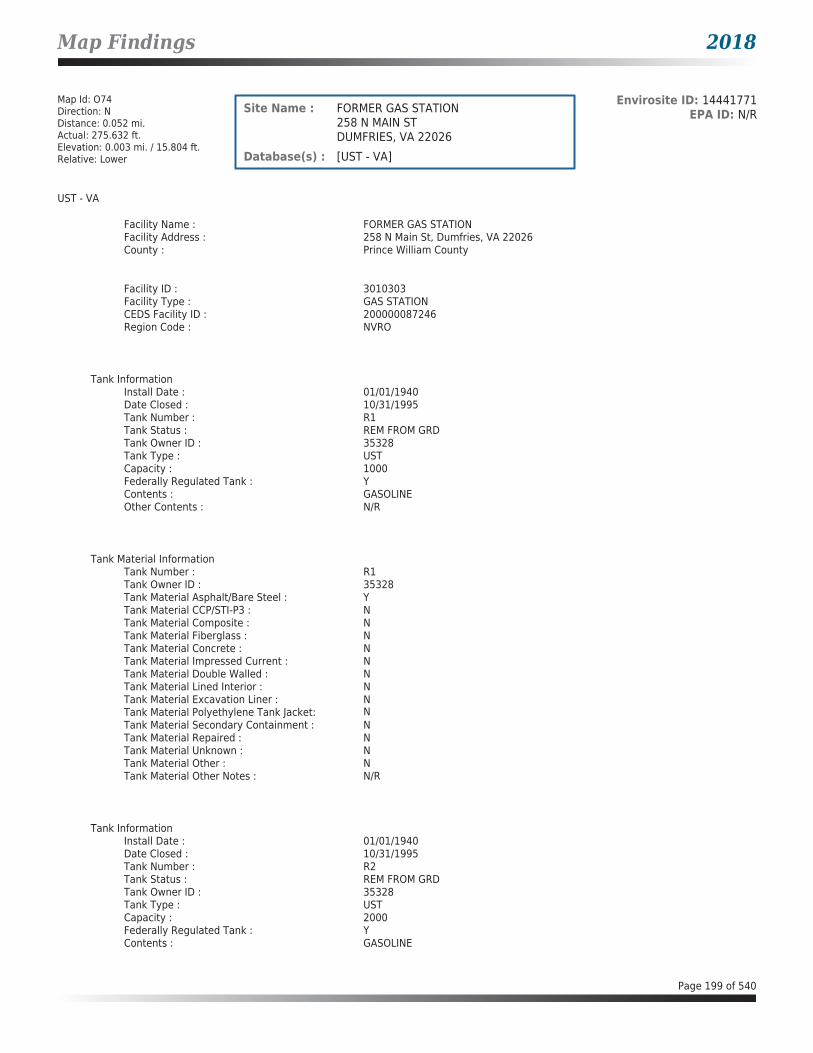
Map Findings 2018
Map Id: O74Direction: NDistance: 0.052 mi.Actual: 275.632 ft.Elevation: 0.003 mi. / 15.804 ft.Relative: Lower
Envirosite ID: 14441771EPA ID: N/RSite Name : FORMER GAS STATION
258 N MAIN STDUMFRIES, VA 22026
Database(s) : [UST - VA]
UST - VA
Facility Name : FORMER GAS STATIONFacility Address : 258 N Main St, Dumfries, VA 22026County : Prince William County
Facility ID : 3010303Facility Type : GAS STATIONCEDS Facility ID : 200000087246Region Code : NVRO
Tank InformationInstall Date : 01/01/1940Date Closed : 10/31/1995Tank Number : R1Tank Status : REM FROM GRDTank Owner ID : 35328Tank Type : USTCapacity : 1000Federally Regulated Tank : YContents : GASOLINEOther Contents : N/R
Tank Material InformationTank Number : R1Tank Owner ID : 35328Tank Material Asphalt/Bare Steel : YTank Material CCP/STI-P3 : NTank Material Composite : NTank Material Fiberglass : NTank Material Concrete : NTank Material Impressed Current : NTank Material Double Walled : NTank Material Lined Interior : NTank Material Excavation Liner : NTank Material Polyethylene Tank Jacket: NTank Material Secondary Containment : NTank Material Repaired : NTank Material Unknown : NTank Material Other : NTank Material Other Notes : N/R
Tank InformationInstall Date : 01/01/1940Date Closed : 10/31/1995Tank Number : R2Tank Status : REM FROM GRDTank Owner ID : 35328Tank Type : USTCapacity : 2000Federally Regulated Tank : YContents : GASOLINE
Page 199 of 540

Map Findings 2018
Map Id: O74Direction: NDistance: 0.052 mi.Actual: 275.632 ft.Elevation: 0.003 mi. / 15.804 ft.Relative: Lower
Envirosite ID: 14441771EPA ID: N/RSite Name : FORMER GAS STATION
258 N MAIN STDUMFRIES, VA 22026
Database(s) : [UST - VA] (cont.)
UST - VA (cont.)
Other Contents : N/R
Tank Material InformationTank Number : R2Tank Owner ID : 35328Tank Material Asphalt/Bare Steel : YTank Material CCP/STI-P3 : NTank Material Composite : NTank Material Fiberglass : NTank Material Concrete : NTank Material Impressed Current : NTank Material Double Walled : NTank Material Lined Interior : NTank Material Excavation Liner : NTank Material Polyethylene Tank Jacket: NTank Material Secondary Containment : NTank Material Repaired : NTank Material Unknown : NTank Material Other : NTank Material Other Notes : N/R
Map Id: O75Direction: NDistance: 0.052 mi.Actual: 275.632 ft.Elevation: 0.003 mi. / 15.804 ft.Relative: Lower
Envirosite ID: 24848208EPA ID: N/RSite Name : NANLU ENTERPRISES
258 N MAIN STDUMFRIES, VA 22026
Database(s) : [LPT - VA]
LPT - VA
Facility Name : Nanlu EnterprisesFacility Address : 258 N Main St, Dumfries, VA 22026County : Prince William County
Release Reported : 11/15/1995PC Number : 19963074CEDS Facility ID : 200000087246Case Status : ClosedCase Closed Date : 01/16/1996Region : NVROProgram : RP LeadHeating Oil Category : N/RFederally Regulated UST : YRegulated Petroleum UST (1) : YExcluded UST (1) : NDeferred UST (1) : NPartially Deferred UST (1) : NExempt 1 UST (2) : NExempt 2 Heating Oil UST (2) : N
Page 200 of 540

Map Findings 2018
Map Id: O75Direction: NDistance: 0.052 mi.Actual: 275.632 ft.Elevation: 0.003 mi. / 15.804 ft.Relative: Lower
Envirosite ID: 24848208EPA ID: N/RSite Name : NANLU ENTERPRISES
258 N MAIN STDUMFRIES, VA 22026
Database(s) : [LPT - VA] (cont.)
LPT - VA (cont.)
Small Heating Oil AST (2) : NRegulated AST (3) : NUnregulated AST (3) : NOther (Y/N) : NOther Description : N/RUnknown (Y/N) : NPriority : 3Suspect Confirm Indicator : ConfirmedLatitude : 38.5630728123Longitude : -77.3305317897Last Date in Agency List : 02/09/2018
Map Id: N76Direction: SWDistance: 0.062 mi.Actual: 328.767 ft.Elevation: 0.029 mi. / 152.077 ft.Relative: Higher
Envirosite ID: 14444197EPA ID: N/RSite Name : FORMER TURLINGTON PROPERTY
18433 TO 18427 JEFFERSON DAVIS HWYTRIANGLE, VA 22172
Database(s) : [UST - VA]
UST - VA
Facility Name : Former Turlington PropertyFacility Address : 18433 to 18427 Jefferson Davis Hwy, Triangle, VA 22172County : Prince William County
Facility ID : 3041635Facility Type : N/RCEDS Facility ID : 200000848397Region Code : NVRO
Tank InformationInstall Date : N/RDate Closed : 09/23/2009Tank Number : 001Tank Status : REM FROM GRDTank Owner ID : 45288Tank Type : USTCapacity : 500Federally Regulated Tank : YContents : DIESELOther Contents : N/R
Tank Material InformationTank Number : 001Tank Owner ID : 45288Tank Material Asphalt/Bare Steel : YTank Material CCP/STI-P3 : N
Page 201 of 540

Map Findings 2018
Map Id: N76Direction: SWDistance: 0.062 mi.Actual: 328.767 ft.Elevation: 0.029 mi. / 152.077 ft.Relative: Higher
Envirosite ID: 14444197EPA ID: N/RSite Name : FORMER TURLINGTON PROPERTY
18433 TO 18427 JEFFERSON DAVIS HWYTRIANGLE, VA 22172
Database(s) : [UST - VA] (cont.)
UST - VA (cont.)
Tank Material Composite : NTank Material Fiberglass : NTank Material Concrete : NTank Material Impressed Current : NTank Material Double Walled : NTank Material Lined Interior : NTank Material Excavation Liner : NTank Material Polyethylene Tank Jacket: NTank Material Secondary Containment : NTank Material Repaired : NTank Material Unknown : NTank Material Other : NTank Material Other Notes : N/R
Tank InformationInstall Date : N/RDate Closed : 09/23/2009Tank Number : 002Tank Status : REM FROM GRDTank Owner ID : 45288Tank Type : USTCapacity : 1000Federally Regulated Tank : YContents : DIESELOther Contents : N/R
Tank Material InformationTank Number : 002Tank Owner ID : 45288Tank Material Asphalt/Bare Steel : YTank Material CCP/STI-P3 : NTank Material Composite : NTank Material Fiberglass : NTank Material Concrete : NTank Material Impressed Current : NTank Material Double Walled : NTank Material Lined Interior : NTank Material Excavation Liner : NTank Material Polyethylene Tank Jacket: NTank Material Secondary Containment : NTank Material Repaired : NTank Material Unknown : NTank Material Other : NTank Material Other Notes : N/R
Page 202 of 540

Map Findings 2018
Map Id: N77Direction: SWDistance: 0.062 mi.Actual: 328.767 ft.Elevation: 0.029 mi. / 152.077 ft.Relative: Higher
Envirosite ID: 24837848EPA ID: N/RSite Name : TURLINGTON JUDY AND GARRISON LINDA
PROPERTY18433 TO 18427 JEFFERSON DAVIS HWYTRIANGLE, VA 22172
Database(s) : [LPT - VA]
LPT - VA
Facility Name : Turlington Judy and Garrison Linda PropertyFacility Address : 18433 to 18427 Jefferson Davis Hwy, Triangle, VA 22172County : Prince William County
Release Reported : 12/14/2007PC Number : 20083172CEDS Facility ID : 200000848397Case Status : ClosedCase Closed Date : 10/26/2012Region : NVROProgram : RP LeadHeating Oil Category : N/RFederally Regulated UST : YRegulated Petroleum UST (1) : YExcluded UST (1) : NDeferred UST (1) : NPartially Deferred UST (1) : NExempt 1 UST (2) : NExempt 2 Heating Oil UST (2) : NSmall Heating Oil AST (2) : NRegulated AST (3) : NUnregulated AST (3) : NOther (Y/N) : NOther Description : N/RUnknown (Y/N) : NPriority : 3Suspect Confirm Indicator : ConfirmedLatitude : 38.5508762259Longitude : -77.3335672904Last Date in Agency List : 02/09/2018
Map Id: 78Direction: ENEDistance: 0.103 mi.Actual: 544.558 ft.Elevation: 0.003 mi. / 15.748 ft.Relative: Lower
Envirosite ID: 330009430EPA ID: N/RSite Name : 17880 LOUNSBERY TENANTS
17880 LOUNSBERY DRDUMFRIES, VA
Database(s) : [ARCHIVED SPILLS - VA]
Archived SPILLS - VA
Facility Name : 17880 Lounsbery TenantsFacility Address : 17880 Lounsbery Dr, Dumfries, VACounty : Prince William County
Closure Date : 05/12/2003Incident Date : N/RCall Received Date : 04/30/2003IR Number : 2003-N-0804Associated IR : N/R
Page 203 of 540

Map Findings 2018
Map Id: 78Direction: ENEDistance: 0.103 mi.Actual: 544.558 ft.Elevation: 0.003 mi. / 15.748 ft.Relative: Lower
Envirosite ID: 330009430EPA ID: N/RSite Name : 17880 LOUNSBERY TENANTS
17880 LOUNSBERY DRDUMFRIES, VA
Database(s) : [ARCHIVED SPILLS - VA] (cont.)
Archived SPILLS - VA (cont.)
Reference ID : N/RIncident Type : PetroleumIncident Subtype : PetroleumRegion : NorthernThreat to : N/RTerrorism (Y/N) : NOCharacterize Incident : N/RMaterials : Oil (Unknown)(2 - 2 Quart)Effect to Receptor : N/RWater Body : N/RLow Quantity to Water : N/RHigh Quantity to Water : N/RQuantity Units : N/ROther Receptors : N/RRP Company : Tenant with green GMC JimmyRP Name : N/RProperty Owner : N/RProperty Company : Margaret CowlesDuration of Event (Hours) : N/RImpacts : N/ROther Impacts : N/RSteps Taken : N/RSteps Taken Description : N/RSystem Components : N/ROther System Components : N/RCause of Event : N/RCorrective Action Taken : N/RWeather Status : N/RPrecipitation (Wet) : N/RDischarge Type : N/RDischarge Volume : N/RUnknown Discharge (Y/N) : NOOriginal Call Incident Description : witness them pull GMC on curb drain oil on road. Backt=yard tooOriginal Call Material Description : used oil (Qty=2)
Original Call Location Description : 17880 Lounsbery Tenants-17880 Lounsbery Dr-Dumfries-VA--Prince William County
Incident Ongoing at Time of Call : N/RAgencies Notified (Y/N) : NOOther Agencies : N/RPermitted (Y/N) : NOCall Reported by Name : N/RCall Reported by Company Name : Bob LangCall RP Company Name : N/RCall RP Name : N/RCall Property Owner Company Name : N/RClosure Summary : See Site Summary for detailsSite Summary : send letter, cc TH owner
Page 204 of 540

Map Findings 2018
Map Id: P79Direction: SWDistance: 0.106 mi.Actual: 558.677 ft.Elevation: 0.028 mi. / 146.391 ft.Relative: Higher
Envirosite ID: 14442247EPA ID: N/RSite Name : CHARON SHELL
18434 JEFFERSON DAVIS HWYTRIANGLE, VA 22172
Database(s) : [UST - VA]
UST - VA
Facility Name : CHARON SHELLFacility Address : 18434 Jefferson Davis Hwy, Triangle, VA 22172County : Prince William County
Facility ID : 3014080Facility Type : GAS STATIONCEDS Facility ID : 200000074742Region Code : NVRO
Tank InformationInstall Date : 04/17/1979Date Closed : 09/01/1992Tank Number : 1Tank Status : REM FROM GRDTank Owner ID : 38058Tank Type : USTCapacity : 8000Federally Regulated Tank : YContents : GASOLINEOther Contents : N/R
Tank Material InformationTank Number : 1Tank Owner ID : 38058Tank Material Asphalt/Bare Steel : YTank Material CCP/STI-P3 : NTank Material Composite : NTank Material Fiberglass : NTank Material Concrete : NTank Material Impressed Current : NTank Material Double Walled : NTank Material Lined Interior : NTank Material Excavation Liner : NTank Material Polyethylene Tank Jacket: NTank Material Secondary Containment : NTank Material Repaired : NTank Material Unknown : NTank Material Other : NTank Material Other Notes : N/R
Tank InformationInstall Date : 04/17/1979Date Closed : 09/01/1992Tank Number : 2Tank Status : CLS IN GRDTank Owner ID : 38058Tank Type : USTCapacity : 4000Federally Regulated Tank : YContents : GASOLINE
Page 205 of 540

Map Findings 2018
Map Id: P79Direction: SWDistance: 0.106 mi.Actual: 558.677 ft.Elevation: 0.028 mi. / 146.391 ft.Relative: Higher
Envirosite ID: 14442247EPA ID: N/RSite Name : CHARON SHELL
18434 JEFFERSON DAVIS HWYTRIANGLE, VA 22172
Database(s) : [UST - VA] (cont.)
UST - VA (cont.)
Other Contents : N/R
Tank Material InformationTank Number : 2Tank Owner ID : 38058Tank Material Asphalt/Bare Steel : YTank Material CCP/STI-P3 : NTank Material Composite : NTank Material Fiberglass : NTank Material Concrete : NTank Material Impressed Current : NTank Material Double Walled : NTank Material Lined Interior : NTank Material Excavation Liner : NTank Material Polyethylene Tank Jacket: NTank Material Secondary Containment : NTank Material Repaired : NTank Material Unknown : NTank Material Other : NTank Material Other Notes : N/R
Tank InformationInstall Date : 04/17/1979Date Closed : 09/01/1992Tank Number : 3Tank Status : REM FROM GRDTank Owner ID : 38058Tank Type : USTCapacity : 4000Federally Regulated Tank : YContents : GASOLINEOther Contents : N/R
Tank Material InformationTank Number : 3Tank Owner ID : 38058Tank Material Asphalt/Bare Steel : YTank Material CCP/STI-P3 : NTank Material Composite : NTank Material Fiberglass : NTank Material Concrete : NTank Material Impressed Current : NTank Material Double Walled : NTank Material Lined Interior : NTank Material Excavation Liner : NTank Material Polyethylene Tank Jacket: NTank Material Secondary Containment : NTank Material Repaired : NTank Material Unknown : NTank Material Other : NTank Material Other Notes : N/R
Page 206 of 540

Map Findings 2018
Map Id: P79Direction: SWDistance: 0.106 mi.Actual: 558.677 ft.Elevation: 0.028 mi. / 146.391 ft.Relative: Higher
Envirosite ID: 14442247EPA ID: N/RSite Name : CHARON SHELL
18434 JEFFERSON DAVIS HWYTRIANGLE, VA 22172
Database(s) : [UST - VA] (cont.)
UST - VA (cont.)
Tank InformationInstall Date : 04/17/1979Date Closed : 09/01/1992Tank Number : 4Tank Status : REM FROM GRDTank Owner ID : 38058Tank Type : USTCapacity : 1000Federally Regulated Tank : YContents : DIESELOther Contents : N/R
Tank Material InformationTank Number : 4Tank Owner ID : 38058Tank Material Asphalt/Bare Steel : YTank Material CCP/STI-P3 : NTank Material Composite : NTank Material Fiberglass : NTank Material Concrete : NTank Material Impressed Current : NTank Material Double Walled : NTank Material Lined Interior : NTank Material Excavation Liner : NTank Material Polyethylene Tank Jacket: NTank Material Secondary Containment : NTank Material Repaired : NTank Material Unknown : NTank Material Other : NTank Material Other Notes : N/R
Map Id: P80Direction: SWDistance: 0.106 mi.Actual: 558.677 ft.Elevation: 0.028 mi. / 146.391 ft.Relative: Higher
Envirosite ID: 24837845EPA ID: N/RSite Name : CHARON SHELL FORMER
18434 JEFFERSON DAVIS HWYTRIANGLE, VA 22172
Database(s) : [LPT - VA]
LPT - VA
Facility Name : Charon Shell formerFacility Address : 18434 Jefferson Davis Hwy, Triangle, VA 22172County : Prince William County
Release Reported : 12/14/2007PC Number : 20083175CEDS Facility ID : 200000074742Case Status : ClosedCase Closed Date : 03/20/2013
Page 207 of 540
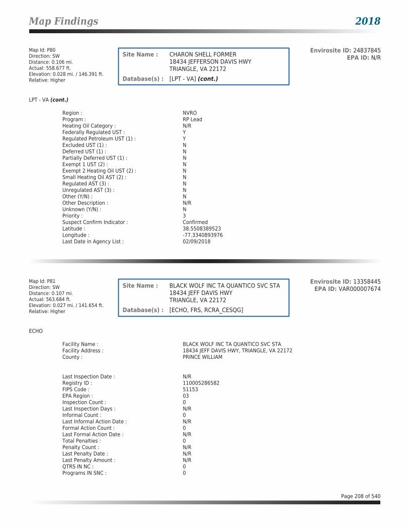
Map Findings 2018
Map Id: P80Direction: SWDistance: 0.106 mi.Actual: 558.677 ft.Elevation: 0.028 mi. / 146.391 ft.Relative: Higher
Envirosite ID: 24837845EPA ID: N/RSite Name : CHARON SHELL FORMER
18434 JEFFERSON DAVIS HWYTRIANGLE, VA 22172
Database(s) : [LPT - VA] (cont.)
LPT - VA (cont.)
Region : NVROProgram : RP LeadHeating Oil Category : N/RFederally Regulated UST : YRegulated Petroleum UST (1) : YExcluded UST (1) : NDeferred UST (1) : NPartially Deferred UST (1) : NExempt 1 UST (2) : NExempt 2 Heating Oil UST (2) : NSmall Heating Oil AST (2) : NRegulated AST (3) : NUnregulated AST (3) : NOther (Y/N) : NOther Description : N/RUnknown (Y/N) : NPriority : 3Suspect Confirm Indicator : ConfirmedLatitude : 38.5508389523Longitude : -77.3340893976Last Date in Agency List : 02/09/2018
Map Id: P81Direction: SWDistance: 0.107 mi.Actual: 563.684 ft.Elevation: 0.027 mi. / 141.654 ft.Relative: Higher
Envirosite ID: 13358445EPA ID: VAR000007674Site Name : BLACK WOLF INC TA QUANTICO SVC STA
18434 JEFF DAVIS HWYTRIANGLE, VA 22172
Database(s) : [ECHO, FRS, RCRA_CESQG]
ECHO
Facility Name : BLACK WOLF INC TA QUANTICO SVC STAFacility Address : 18434 JEFF DAVIS HWY, TRIANGLE, VA 22172County : PRINCE WILLIAM
Last Inspection Date : N/RRegistry ID : 110005286582FIPS Code : 51153EPA Region : 03Inspection Count : 0Last Inspection Days : N/RInformal Count : 0Last Informal Action Date : N/RFormal Action Count : 0Last Formal Action Date : N/RTotal Penalties : 0Penalty Count : N/RLast Penalty Date : N/RLast Penalty Amount : N/RQTRS IN NC : 0Programs IN SNC : 0
Page 208 of 540

Map Findings 2018
Map Id: P81Direction: SWDistance: 0.107 mi.Actual: 563.684 ft.Elevation: 0.027 mi. / 141.654 ft.Relative: Higher
Envirosite ID: 13358445EPA ID: VAR000007674Site Name : BLACK WOLF INC TA QUANTICO SVC STA
18434 JEFF DAVIS HWYTRIANGLE, VA 22172
Database(s) : [ECHO, FRS, RCRA_CESQG] (cont.)
ECHO (cont.)
Current Compliance Status : No ViolationThree-Year Compliance Status : ____________Collection Method : ADDRESS MATCHING-HOUSE NUMBERReference Point : N/RAccuracy Meters : 183Derived Tribes : N/RDerived HUC : 02070011Derived WBD : 020700110104Derived STCTY FIPS : 51153Derived Zip : 22172Derived CD113 : 11Derived CB2010 : 511539010012029MYRTK Universe : NNNNPDES IDs : N/RCWA Permit Types : N/RCWA Compliance Tracking : N/RCWA NAICS : N/RCWA SICS : N/RCWA Inspection Count : N/RCWA Last Inspection Days : N/RCWA Informal Count : N/RCWA Formal Action Count : N/RCWA Last Formal Action Date : N/RCWA Penalties : N/RCWA Last Penalty Date : N/RCWA Last Penalty Amount : N/RCWA Quarters IN NC : N/RCWA Current Compliance Status : N/RCWA Current SNC Flag : NCWA 13 Quarters Compliance Status : N/RCWA 13 Quarters Effluent Exceedances: N/RCWA Three-Year QNCR Codes : N/RDFR URL : Click here for hyperlink provided by the agency.Facility SIC Codes : N/RFacility NAICS Codes : N/RFacility Last Inspection EPA Date : N/RFacility Last Inspection State Date : N/RFacility Last Formal Act EPA Date : N/RFacility Last Formal Act State Date : N/RFacility Last Informal Act EPA Date : N/RFacility Last Informal Act State Date: N/RFacility Federal Agency : N/RTRI Reporter : N/RFacility Imp Water Flag : N/RCurrent SNC Flag : NIndian County Flag : NFederal Flag : N/RUS Mexico Border Flag : N/RChesapeak Bay Flag : YAIR Flag : NNPDES Flag : NSDWIS Flag : NRCRA Flag : YTRI Flag : NGHG Flag : NMajor Flag : N/RActive Flag : Y
Page 209 of 540

Map Findings 2018
Map Id: P81Direction: SWDistance: 0.107 mi.Actual: 563.684 ft.Elevation: 0.027 mi. / 141.654 ft.Relative: Higher
Envirosite ID: 13358445EPA ID: VAR000007674Site Name : BLACK WOLF INC TA QUANTICO SVC STA
18434 JEFF DAVIS HWYTRIANGLE, VA 22172
Database(s) : [ECHO, FRS, RCRA_CESQG] (cont.)
ECHO (cont.)
NAA Flag : YLatitude : 38.551689Longitude : -77.33365
FRS
Facility Name : BLACK WOLF INC TA QUANTICO SVC STAFacility Address : 18434 JEFF DAVIS HWY, TRIANGLE, VA 22172County : PRINCE WILLIAM
Registry ID : 110005286582FRS Facility URL : Click here for hyperlink provided by the agency.
Source Description :
RCRAInfo is EPA’s comprehensive information system that supports the Resource Conservation and Recovery Act (RCRA) of 1976 and the Hazardous and Solid Waste Amendments (HSWA) of 1984 through the tracking of events and activities related to facilities that generate, transport, and treat, store, or dispose of hazardous waste. RCRAInfo allows RCRA program staff to track the notification, permit, compliance, and corrective action activities required under RCRA. RCRAInfo also supports generation of the National Hazardous Waste Biennial Report. All generators and treatment, storage, and disposal facilities who handle hazardous waste are required to report to the EPA Administrator at least once every two years to support creation of the Biennial Report.
FRS Environmental InterestSource and System ID : RCRAINFO - VAR000007674
RCRA_CESQG
Date form received by agency : 05/21/1997Facility name : BLACK WOLF INC TA QUANTICO SVC STAFacility address : 18434 JEFF DAVIS HWY, TRIANGLE VA 22172EPA ID : VAR000007674Mailing address : 18434 JEFF DAVIS HWY, TRIANGLE VA 22172Contact : CHRIS BERRYContact address : 18434 JEFF DAVIS HWY, TRIANGLE VA 22172Contact country : USContact telephone : 703-221-4600Contact email : N/REPA Region : 03Land type : PrivateSource type : NotificationClassification : Conditionally Exempt Small Quantity Generator
Page 210 of 540

Map Findings 2018
Map Id: P81Direction: SWDistance: 0.107 mi.Actual: 563.684 ft.Elevation: 0.027 mi. / 141.654 ft.Relative: Higher
Envirosite ID: 13358445EPA ID: VAR000007674Site Name : BLACK WOLF INC TA QUANTICO SVC STA
18434 JEFF DAVIS HWYTRIANGLE, VA 22172
Database(s) : [ECHO, FRS, RCRA_CESQG] (cont.)
RCRA_CESQG (cont.)
Description :
Handlers that generate 100 kilograms or less of hazardous waste per calendar month, and accumulate 1000 kg or less of hazardous waste at any time; or generate one kilogram or less of acutely hazardous waste per calendar month, and accumulate at any time: 1 kg or less of acutely hazardous waste; or 100 kg or less of any residue or contaminated soil, waste or other debris resulting from the cleanup of a spill, into or on any land or water, of acutely hazardous waste;or generate 100 kg or less of any residue or contaminated soil, waste or other debris resulting from the cleanup of a spill, into or on any land or water, of acutely hazardous waste during any calendar month, and accumulate at any time: 1 kg or less of acutely hazardous waste; or 100 kg or less of any residue or contaminated soil, waste or other debris resulting from the cleanup of a spill, into or on any land or water, of acutely hazardous waste.
Owner/Operator Summary :Owner Operator name : BERRY CHRISOwner Operator address : 18434 JEFF DAVIS HWY, TRIANGLE VA 22172Owner Operator country : N/ROwner Operator telephone : 703-221-4600Owner Operator Email : N/ROwner Operator Fax : N/RLegal status : PrivateOwner Operator Type : OwnerOwner/Op start date : N/ROwner/Op end date : N/R
Owner Operator name : WATSON HARVEYOwner Operator address : OWNER STREET, OWNER CITY AK 99999Owner Operator country : N/ROwner Operator telephone : 215-555-1212Owner Operator Email : N/ROwner Operator Fax : N/RLegal status : PrivateOwner Operator Type : OwnerOwner/Op start date : N/ROwner/Op end date : N/R
Handler Activities Summary :U.S. importer of hazardous waste : NoMixed waste (haz. and radioactive) : NoRecycler of hazardous waste : NoTransporter of hazardous waste : NoTreater storer or disposer of HW : NoUnderground injection activity : NoOn-site burner exemption : NoFurnace exemption : NoUsed oil fuel burner : NoUsed oil processor : NoUsed oil refiner : NoUsed oil fuel marketer to burner : NoUsed oil Specification marketer : NoUsed oil transfer facility : NoUsed oil transporter : No
Hazardous Waste Summary :Waste code : D001Waste name : IGNITABLE WASTE
Page 211 of 540

Map Findings 2018
Map Id: P81Direction: SWDistance: 0.107 mi.Actual: 563.684 ft.Elevation: 0.027 mi. / 141.654 ft.Relative: Higher
Envirosite ID: 13358445EPA ID: VAR000007674Site Name : BLACK WOLF INC TA QUANTICO SVC STA
18434 JEFF DAVIS HWYTRIANGLE, VA 22172
Database(s) : [ECHO, FRS, RCRA_CESQG] (cont.)
RCRA_CESQG (cont.)
Waste code : D006Waste name : CADMIUM
Waste code : D008Waste name : LEAD
Waste code : D018Waste name : BENZENE
Waste code : D027Waste name : 1,4-DICHLOROBENZENE
Waste code : D039Waste name : TETRACHLOROETHYLENE
Waste code : D040Waste name : TRICHLORETHYLENE
Facility has No violations / inspections reported.
Map Id: 82Direction: NNEDistance: 0.119 mi.Actual: 630.913 ft.Elevation: 0.017 mi. / 88.432 ft.Relative: Higher
Envirosite ID: 330026799EPA ID: N/RSite Name : SEITZ RESIDENCE
17398 TRIPOLI BLVDDUMFRIES, VA
Database(s) : [ARCHIVED SPILLS - VA]
Archived SPILLS - VA
Facility Name : Seitz ResidenceFacility Address : 17398 Tripoli Blvd, Dumfries, VACounty : Prince William County
Closure Date : 06/19/2006Incident Date : 06/18/2005Call Received Date : 06/18/2005IR Number : 2005-N-0995Associated IR : N/RReference ID : N/RIncident Type : PetroleumIncident Subtype : PetroleumRegion : NorthernThreat to : N/RTerrorism (Y/N) : NOCharacterize Incident : N/RMaterials : Oil (Fuel-Diesel)(-1 - -1 Unknown)
Page 212 of 540
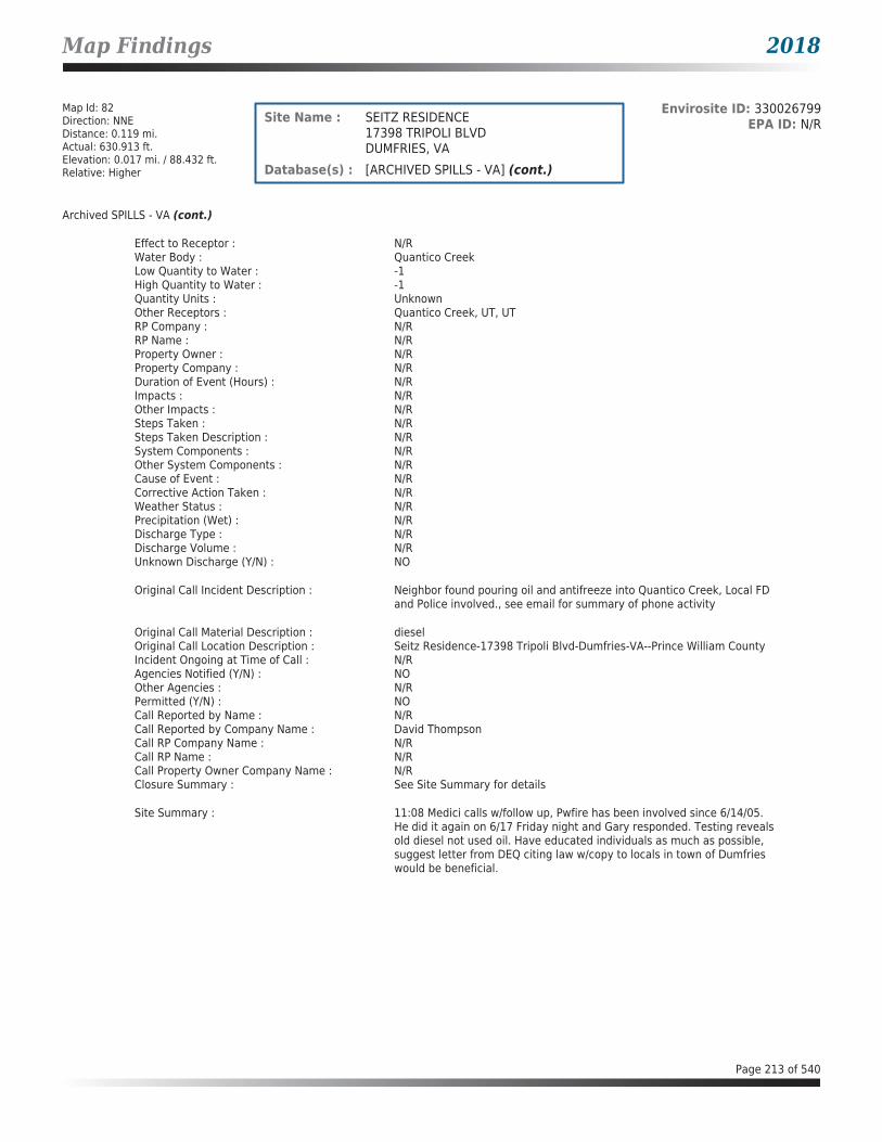
Map Findings 2018
Map Id: 82Direction: NNEDistance: 0.119 mi.Actual: 630.913 ft.Elevation: 0.017 mi. / 88.432 ft.Relative: Higher
Envirosite ID: 330026799EPA ID: N/RSite Name : SEITZ RESIDENCE
17398 TRIPOLI BLVDDUMFRIES, VA
Database(s) : [ARCHIVED SPILLS - VA] (cont.)
Archived SPILLS - VA (cont.)
Effect to Receptor : N/RWater Body : Quantico CreekLow Quantity to Water : -1High Quantity to Water : -1Quantity Units : UnknownOther Receptors : Quantico Creek, UT, UTRP Company : N/RRP Name : N/RProperty Owner : N/RProperty Company : N/RDuration of Event (Hours) : N/RImpacts : N/ROther Impacts : N/RSteps Taken : N/RSteps Taken Description : N/RSystem Components : N/ROther System Components : N/RCause of Event : N/RCorrective Action Taken : N/RWeather Status : N/RPrecipitation (Wet) : N/RDischarge Type : N/RDischarge Volume : N/RUnknown Discharge (Y/N) : NO
Original Call Incident Description : Neighbor found pouring oil and antifreeze into Quantico Creek, Local FD and Police involved., see email for summary of phone activity
Original Call Material Description : dieselOriginal Call Location Description : Seitz Residence-17398 Tripoli Blvd-Dumfries-VA--Prince William CountyIncident Ongoing at Time of Call : N/RAgencies Notified (Y/N) : NOOther Agencies : N/RPermitted (Y/N) : NOCall Reported by Name : N/RCall Reported by Company Name : David ThompsonCall RP Company Name : N/RCall RP Name : N/RCall Property Owner Company Name : N/RClosure Summary : See Site Summary for details
Site Summary : 11:08 Medici calls w/follow up, Pwfire has been involved since 6/14/05. He did it again on 6/17 Friday night and Gary responded. Testing reveals old diesel not used oil. Have educated individuals as much as possible, suggest letter from DEQ citing law w/copy to locals in town of Dumfries would be beneficial.
Page 213 of 540

Map Findings 2018
Map Id: 83Direction: NNEDistance: 0.128 mi.Actual: 673.950 ft.Elevation: 0.025 mi. / 130.299 ft.Relative: Higher
Envirosite ID: 13359630EPA ID: VAR000511865Site Name : LYONS AUTOMOTIVE CENTER
17276 DUMFRIES ROADDUMFRIES, VA 22026
Database(s) : [ECHO, FRS, RCRA_CESQG]
ECHO
Facility Name : LYONS AUTOMOTIVE CENTERFacility Address : 17276 DUMFRIES ROAD, DUMFRIES, VA 22026County : PRINCE WILLIAM
Last Inspection Date : N/RRegistry ID : 110024552456FIPS Code : 51153EPA Region : 03Inspection Count : 0Last Inspection Days : N/RInformal Count : 0Last Informal Action Date : N/RFormal Action Count : 0Last Formal Action Date : N/RTotal Penalties : 0Penalty Count : N/RLast Penalty Date : N/RLast Penalty Amount : N/RQTRS IN NC : 0Programs IN SNC : 0Current Compliance Status : No ViolationThree-Year Compliance Status : ____________Collection Method : ADDRESS MATCHING-HOUSE NUMBERReference Point : ENTRANCE POINT OF A FACILITY OR STATIONAccuracy Meters : 50Derived Tribes : N/RDerived HUC : 02070011Derived WBD : 020700110104Derived STCTY FIPS : 51153Derived Zip : 22026Derived CD113 : 11Derived CB2010 : 511539010011024MYRTK Universe : NNNNPDES IDs : N/RCWA Permit Types : N/RCWA Compliance Tracking : N/RCWA NAICS : N/RCWA SICS : N/RCWA Inspection Count : N/RCWA Last Inspection Days : N/RCWA Informal Count : N/RCWA Formal Action Count : N/RCWA Last Formal Action Date : N/RCWA Penalties : N/RCWA Last Penalty Date : N/RCWA Last Penalty Amount : N/RCWA Quarters IN NC : N/RCWA Current Compliance Status : N/RCWA Current SNC Flag : NCWA 13 Quarters Compliance Status : N/RCWA 13 Quarters Effluent Exceedances: N/RCWA Three-Year QNCR Codes : N/RDFR URL : Click here for hyperlink provided by the agency.Facility SIC Codes : N/RFacility NAICS Codes : 811111Facility Last Inspection EPA Date : N/R
Page 214 of 540

Map Findings 2018
Map Id: 83Direction: NNEDistance: 0.128 mi.Actual: 673.950 ft.Elevation: 0.025 mi. / 130.299 ft.Relative: Higher
Envirosite ID: 13359630EPA ID: VAR000511865Site Name : LYONS AUTOMOTIVE CENTER
17276 DUMFRIES ROADDUMFRIES, VA 22026
Database(s) : [ECHO, FRS, RCRA_CESQG] (cont.)
ECHO (cont.)
Facility Last Inspection State Date : N/RFacility Last Formal Act EPA Date : N/RFacility Last Formal Act State Date : N/RFacility Last Informal Act EPA Date : N/RFacility Last Informal Act State Date: N/RFacility Federal Agency : N/RTRI Reporter : N/RFacility Imp Water Flag : N/RCurrent SNC Flag : NIndian County Flag : NFederal Flag : N/RUS Mexico Border Flag : N/RChesapeak Bay Flag : YAIR Flag : NNPDES Flag : NSDWIS Flag : NRCRA Flag : YTRI Flag : NGHG Flag : NMajor Flag : N/RActive Flag : YNAA Flag : YLatitude : 38.57738Longitude : -77.31758
FRS
Facility Name : LYONS AUTOMOTIVE CENTERFacility Address : 17276 DUMFRIES ROAD, DUMFRIES, VA 22026County : PRINCE WILLIAM
Registry ID : 110024552456FRS Facility URL : Click here for hyperlink provided by the agency.
Source Description :
RCRAInfo is EPA’s comprehensive information system that supports the Resource Conservation and Recovery Act (RCRA) of 1976 and the Hazardous and Solid Waste Amendments (HSWA) of 1984 through the tracking of events and activities related to facilities that generate, transport, and treat, store, or dispose of hazardous waste. RCRAInfo allows RCRA program staff to track the notification, permit, compliance, and corrective action activities required under RCRA. RCRAInfo also supports generation of the National Hazardous Waste Biennial Report. All generators and treatment, storage, and disposal facilities who handle hazardous waste are required to report to the EPA Administrator at least once every two years to support creation of the Biennial Report.
FRS Environmental InterestSource and System ID : RCRAINFO - VAR000511865
RCRA_CESQG
Date form received by agency : 01/30/2006Facility name : LYONS AUTOMOTIVE CENTERFacility address : 17276 DUMFRIES ROAD, DUMFRIES VA 22026
Page 215 of 540

Map Findings 2018
Map Id: 83Direction: NNEDistance: 0.128 mi.Actual: 673.950 ft.Elevation: 0.025 mi. / 130.299 ft.Relative: Higher
Envirosite ID: 13359630EPA ID: VAR000511865Site Name : LYONS AUTOMOTIVE CENTER
17276 DUMFRIES ROADDUMFRIES, VA 22026
Database(s) : [ECHO, FRS, RCRA_CESQG] (cont.)
RCRA_CESQG (cont.)
EPA ID : VAR000511865Mailing address : 17276 DUMFRIES ROAD, DUMFRIES VA 22026Contact : TED C LYONSContact address : N/RContact country : USContact telephone : 703-221-7774Contact email : N/REPA Region : 03Land type : PrivateSource type : NotificationClassification : Conditionally Exempt Small Quantity Generator
Description :
Handlers that generate 100 kilograms or less of hazardous waste per calendar month, and accumulate 1000 kg or less of hazardous waste at any time; or generate one kilogram or less of acutely hazardous waste per calendar month, and accumulate at any time: 1 kg or less of acutely hazardous waste; or 100 kg or less of any residue or contaminated soil, waste or other debris resulting from the cleanup of a spill, into or on any land or water, of acutely hazardous waste;or generate 100 kg or less of any residue or contaminated soil, waste or other debris resulting from the cleanup of a spill, into or on any land or water, of acutely hazardous waste during any calendar month, and accumulate at any time: 1 kg or less of acutely hazardous waste; or 100 kg or less of any residue or contaminated soil, waste or other debris resulting from the cleanup of a spill, into or on any land or water, of acutely hazardous waste.
Owner/Operator Summary :Owner Operator name : TEDDY LYONSOwner Operator address : N/ROwner Operator country : USOwner Operator telephone : N/ROwner Operator Email : N/ROwner Operator Fax : N/RLegal status : PrivateOwner Operator Type : OwnerOwner/Op start date : 09/03/1958Owner/Op end date : N/R
Owner Operator name : TEDDY LYONSOwner Operator address : 15071 GREENMET DRIVE, WOODBRIDGE VA 22193Owner Operator country : USOwner Operator telephone : N/ROwner Operator Email : N/ROwner Operator Fax : N/RLegal status : PrivateOwner Operator Type : OperatorOwner/Op start date : 09/03/1958Owner/Op end date : N/R
Handler Activities Summary :U.S. importer of hazardous waste : NoMixed waste (haz. and radioactive) : NoRecycler of hazardous waste : NoTransporter of hazardous waste : NoTreater storer or disposer of HW : NoUnderground injection activity : NoOn-site burner exemption : NoFurnace exemption : No
Page 216 of 540

Map Findings 2018
Map Id: 83Direction: NNEDistance: 0.128 mi.Actual: 673.950 ft.Elevation: 0.025 mi. / 130.299 ft.Relative: Higher
Envirosite ID: 13359630EPA ID: VAR000511865Site Name : LYONS AUTOMOTIVE CENTER
17276 DUMFRIES ROADDUMFRIES, VA 22026
Database(s) : [ECHO, FRS, RCRA_CESQG] (cont.)
RCRA_CESQG (cont.)
Used oil fuel burner : NoUsed oil processor : NoUsed oil refiner : NoUsed oil fuel marketer to burner : NoUsed oil Specification marketer : NoUsed oil transfer facility : NoUsed oil transporter : No
Hazardous Waste Summary :Waste code : D001Waste name : IGNITABLE WASTE
Facility has No violations / inspections reported.
Map Id: P84Direction: SWDistance: 0.147 mi.Actual: 773.802 ft.Elevation: 0.026 mi. / 138.294 ft.Relative: Higher
Envirosite ID: 340286224EPA ID: N/RSite Name : FORMER PEARSON PROPERTY/TRIANGLE
FOREIGN CAR18501 TO 18507 JEFFERSON DAVIS HWYTRIANGLE, VA 22172
Database(s) : [UST - VA]
UST - VA
Facility Name : Former Pearson Property/Triangle Foreign CarFacility Address : 18501 to 18507 Jefferson Davis Hwy, Triangle, VA 22172County : Prince William County
Facility ID : 3041355Facility Type : LOCALCEDS Facility ID : 200000848396Region Code : NVRO
Tank InformationInstall Date : N/RDate Closed : 06/04/2009Tank Number : R1Tank Status : REM FROM GRDTank Owner ID : 45288Tank Type : USTCapacity : 1000Federally Regulated Tank : YContents : USED OILOther Contents : N/R
Page 217 of 540

Map Findings 2018
Map Id: P84Direction: SWDistance: 0.147 mi.Actual: 773.802 ft.Elevation: 0.026 mi. / 138.294 ft.Relative: Higher
Envirosite ID: 340286224EPA ID: N/RSite Name : FORMER PEARSON PROPERTY/TRIANGLE
FOREIGN CAR18501 TO 18507 JEFFERSON DAVIS HWYTRIANGLE, VA 22172
Database(s) : [UST - VA] (cont.)
UST - VA (cont.)
Tank Material InformationTank Number : R1Tank Owner ID : 45288Tank Material Asphalt/Bare Steel : YTank Material CCP/STI-P3 : NTank Material Composite : NTank Material Fiberglass : NTank Material Concrete : NTank Material Impressed Current : NTank Material Double Walled : NTank Material Lined Interior : NTank Material Excavation Liner : NTank Material Polyethylene Tank Jacket: NTank Material Secondary Containment : NTank Material Repaired : NTank Material Unknown : NTank Material Other : NTank Material Other Notes : N/R
Tank InformationInstall Date : N/RDate Closed : 06/04/2009Tank Number : R2Tank Status : REM FROM GRDTank Owner ID : 45288Tank Type : USTCapacity : 4000Federally Regulated Tank : YContents : GASOLINEOther Contents : N/R
Tank Material InformationTank Number : R2Tank Owner ID : 45288Tank Material Asphalt/Bare Steel : YTank Material CCP/STI-P3 : NTank Material Composite : NTank Material Fiberglass : NTank Material Concrete : NTank Material Impressed Current : NTank Material Double Walled : NTank Material Lined Interior : NTank Material Excavation Liner : NTank Material Polyethylene Tank Jacket: NTank Material Secondary Containment : NTank Material Repaired : NTank Material Unknown : NTank Material Other : NTank Material Other Notes : N/R
Page 218 of 540

Map Findings 2018
Map Id: P84Direction: SWDistance: 0.147 mi.Actual: 773.802 ft.Elevation: 0.026 mi. / 138.294 ft.Relative: Higher
Envirosite ID: 340286224EPA ID: N/RSite Name : FORMER PEARSON PROPERTY/TRIANGLE
FOREIGN CAR18501 TO 18507 JEFFERSON DAVIS HWYTRIANGLE, VA 22172
Database(s) : [UST - VA] (cont.)
UST - VA (cont.)
Tank InformationInstall Date : N/RDate Closed : 06/04/2009Tank Number : R3Tank Status : REM FROM GRDTank Owner ID : 45288Tank Type : USTCapacity : 4000Federally Regulated Tank : YContents : GASOLINEOther Contents : N/R
Tank Material InformationTank Number : R3Tank Owner ID : 45288Tank Material Asphalt/Bare Steel : YTank Material CCP/STI-P3 : NTank Material Composite : NTank Material Fiberglass : NTank Material Concrete : NTank Material Impressed Current : NTank Material Double Walled : NTank Material Lined Interior : NTank Material Excavation Liner : NTank Material Polyethylene Tank Jacket: NTank Material Secondary Containment : NTank Material Repaired : NTank Material Unknown : NTank Material Other : NTank Material Other Notes : N/R
Tank InformationInstall Date : N/RDate Closed : 06/04/2009Tank Number : R4Tank Status : REM FROM GRDTank Owner ID : 45288Tank Type : USTCapacity : 4000Federally Regulated Tank : YContents : GASOLINEOther Contents : N/R
Tank Material InformationTank Number : R4Tank Owner ID : 45288Tank Material Asphalt/Bare Steel : YTank Material CCP/STI-P3 : NTank Material Composite : NTank Material Fiberglass : N
Page 219 of 540

Map Findings 2018
Map Id: P84Direction: SWDistance: 0.147 mi.Actual: 773.802 ft.Elevation: 0.026 mi. / 138.294 ft.Relative: Higher
Envirosite ID: 340286224EPA ID: N/RSite Name : FORMER PEARSON PROPERTY/TRIANGLE
FOREIGN CAR18501 TO 18507 JEFFERSON DAVIS HWYTRIANGLE, VA 22172
Database(s) : [UST - VA] (cont.)
UST - VA (cont.)
Tank Material Concrete : NTank Material Impressed Current : NTank Material Double Walled : NTank Material Lined Interior : NTank Material Excavation Liner : NTank Material Polyethylene Tank Jacket: NTank Material Secondary Containment : NTank Material Repaired : NTank Material Unknown : NTank Material Other : NTank Material Other Notes : N/R
Map Id: P85Direction: SWDistance: 0.147 mi.Actual: 773.802 ft.Elevation: 0.026 mi. / 138.294 ft.Relative: Higher
Envirosite ID: 342395450EPA ID: N/RSite Name : PEARSON SHIRLEY L AND GLORIA A
PROPERTY18501 TO 18507 JEFFERSON DAVIS HWYTRIANGLE, VA 22172
Database(s) : [LPT - VA]
LPT - VA
Facility Name : Pearson Shirley L and Gloria A PropertyFacility Address : 18501 to 18507 Jefferson Davis Hwy, Triangle, VA 22172County : Prince William County
Release Reported : 12/14/2007PC Number : 20083178CEDS Facility ID : 200000848396Case Status : ClosedCase Closed Date : 10/26/2012Region : NVROProgram : RP LeadHeating Oil Category : N/RFederally Regulated UST : YRegulated Petroleum UST (1) : YExcluded UST (1) : NDeferred UST (1) : NPartially Deferred UST (1) : NExempt 1 UST (2) : NExempt 2 Heating Oil UST (2) : NSmall Heating Oil AST (2) : NRegulated AST (3) : NUnregulated AST (3) : NOther (Y/N) : NOther Description : N/RUnknown (Y/N) : NPriority : 3Suspect Confirm Indicator : ConfirmedLatitude : 38.550318362
Page 220 of 540

Map Findings 2018
Map Id: P85Direction: SWDistance: 0.147 mi.Actual: 773.802 ft.Elevation: 0.026 mi. / 138.294 ft.Relative: Higher
Envirosite ID: 342395450EPA ID: N/RSite Name : PEARSON SHIRLEY L AND GLORIA A
PROPERTY18501 TO 18507 JEFFERSON DAVIS HWYTRIANGLE, VA 22172
Database(s) : [LPT - VA] (cont.)
LPT - VA (cont.)
Longitude : -77.3338157716Last Date in Agency List : 02/09/2018
Map Id: 86Direction: SWDistance: 0.147 mi.Actual: 775.505 ft.Elevation: 0.011 mi. / 57.372 ft.Relative: Higher
Envirosite ID: 14440441EPA ID: N/RSite Name : GETTY 71212
3901 GRAHAM PARK RDTRIANGLE, VA 22172
Database(s) : [UST - VA]
UST - VA
Facility Name : Getty 71212Facility Address : 3901 Graham Park Rd, Triangle, VA 22172County : Prince William County
Facility ID : 3002278Facility Type : GAS STATIONCEDS Facility ID : 200000193868Region Code : NVRO
Tank InformationInstall Date : 04/09/1984Date Closed : N/RTank Number : R4Tank Status : REM FROM GRDTank Owner ID : 27127Tank Type : USTCapacity : 8000Federally Regulated Tank : YContents : GASOLINEOther Contents : N/R
Tank Material InformationTank Number : R4Tank Owner ID : 27127Tank Material Asphalt/Bare Steel : NTank Material CCP/STI-P3 : NTank Material Composite : NTank Material Fiberglass : YTank Material Concrete : NTank Material Impressed Current : NTank Material Double Walled : NTank Material Lined Interior : NTank Material Excavation Liner : NTank Material Polyethylene Tank Jacket: N
Page 221 of 540

Map Findings 2018
Map Id: 86Direction: SWDistance: 0.147 mi.Actual: 775.505 ft.Elevation: 0.011 mi. / 57.372 ft.Relative: Higher
Envirosite ID: 14440441EPA ID: N/RSite Name : GETTY 71212
3901 GRAHAM PARK RDTRIANGLE, VA 22172
Database(s) : [UST - VA] (cont.)
UST - VA (cont.)
Tank Material Secondary Containment : NTank Material Repaired : NTank Material Unknown : NTank Material Other : NTank Material Other Notes : N/R
Tank InformationInstall Date : 04/09/1984Date Closed : N/RTank Number : R5Tank Status : REM FROM GRDTank Owner ID : 27127Tank Type : USTCapacity : 8000Federally Regulated Tank : YContents : GASOLINEOther Contents : N/R
Tank Material InformationTank Number : R5Tank Owner ID : 27127Tank Material Asphalt/Bare Steel : NTank Material CCP/STI-P3 : NTank Material Composite : NTank Material Fiberglass : YTank Material Concrete : NTank Material Impressed Current : NTank Material Double Walled : NTank Material Lined Interior : NTank Material Excavation Liner : NTank Material Polyethylene Tank Jacket: NTank Material Secondary Containment : NTank Material Repaired : NTank Material Unknown : NTank Material Other : NTank Material Other Notes : N/R
Tank InformationInstall Date : 04/09/1984Date Closed : N/RTank Number : R6Tank Status : REM FROM GRDTank Owner ID : 27127Tank Type : USTCapacity : 8000Federally Regulated Tank : YContents : GASOLINEOther Contents : N/R
Page 222 of 540

Map Findings 2018
Map Id: 86Direction: SWDistance: 0.147 mi.Actual: 775.505 ft.Elevation: 0.011 mi. / 57.372 ft.Relative: Higher
Envirosite ID: 14440441EPA ID: N/RSite Name : GETTY 71212
3901 GRAHAM PARK RDTRIANGLE, VA 22172
Database(s) : [UST - VA] (cont.)
UST - VA (cont.)
Tank Material InformationTank Number : R6Tank Owner ID : 27127Tank Material Asphalt/Bare Steel : NTank Material CCP/STI-P3 : NTank Material Composite : NTank Material Fiberglass : YTank Material Concrete : NTank Material Impressed Current : NTank Material Double Walled : NTank Material Lined Interior : NTank Material Excavation Liner : NTank Material Polyethylene Tank Jacket: NTank Material Secondary Containment : NTank Material Repaired : NTank Material Unknown : NTank Material Other : NTank Material Other Notes : N/R
Tank InformationInstall Date : 01/01/1984Date Closed : 10/09/2008Tank Number : R1Tank Status : REM FROM GRDTank Owner ID : 27127Tank Type : USTCapacity : 8000Federally Regulated Tank : YContents : GASOLINEOther Contents : N/R
Tank Material InformationTank Number : R1Tank Owner ID : 27127Tank Material Asphalt/Bare Steel : NTank Material CCP/STI-P3 : NTank Material Composite : NTank Material Fiberglass : YTank Material Concrete : NTank Material Impressed Current : NTank Material Double Walled : NTank Material Lined Interior : NTank Material Excavation Liner : NTank Material Polyethylene Tank Jacket: NTank Material Secondary Containment : NTank Material Repaired : NTank Material Unknown : NTank Material Other : NTank Material Other Notes : N/R
Page 223 of 540

Map Findings 2018
Map Id: 86Direction: SWDistance: 0.147 mi.Actual: 775.505 ft.Elevation: 0.011 mi. / 57.372 ft.Relative: Higher
Envirosite ID: 14440441EPA ID: N/RSite Name : GETTY 71212
3901 GRAHAM PARK RDTRIANGLE, VA 22172
Database(s) : [UST - VA] (cont.)
UST - VA (cont.)
Tank InformationInstall Date : 01/01/1984Date Closed : 10/09/2008Tank Number : R2Tank Status : REM FROM GRDTank Owner ID : 27127Tank Type : USTCapacity : 8000Federally Regulated Tank : YContents : GASOLINEOther Contents : N/R
Tank Material InformationTank Number : R2Tank Owner ID : 27127Tank Material Asphalt/Bare Steel : NTank Material CCP/STI-P3 : NTank Material Composite : NTank Material Fiberglass : YTank Material Concrete : NTank Material Impressed Current : NTank Material Double Walled : NTank Material Lined Interior : NTank Material Excavation Liner : NTank Material Polyethylene Tank Jacket: NTank Material Secondary Containment : NTank Material Repaired : NTank Material Unknown : NTank Material Other : NTank Material Other Notes : N/R
Tank InformationInstall Date : 01/01/1984Date Closed : 10/09/2008Tank Number : R3Tank Status : REM FROM GRDTank Owner ID : 27127Tank Type : USTCapacity : 8000Federally Regulated Tank : YContents : GASOLINEOther Contents : N/R
Tank Material InformationTank Number : R3Tank Owner ID : 27127Tank Material Asphalt/Bare Steel : NTank Material CCP/STI-P3 : NTank Material Composite : NTank Material Fiberglass : YTank Material Concrete : N
Page 224 of 540

Map Findings 2018
Map Id: 86Direction: SWDistance: 0.147 mi.Actual: 775.505 ft.Elevation: 0.011 mi. / 57.372 ft.Relative: Higher
Envirosite ID: 14440441EPA ID: N/RSite Name : GETTY 71212
3901 GRAHAM PARK RDTRIANGLE, VA 22172
Database(s) : [UST - VA] (cont.)
UST - VA (cont.)
Tank Material Impressed Current : NTank Material Double Walled : NTank Material Lined Interior : NTank Material Excavation Liner : NTank Material Polyethylene Tank Jacket: NTank Material Secondary Containment : NTank Material Repaired : NTank Material Unknown : NTank Material Other : NTank Material Other Notes : N/R
Map Id: 87Direction: WNWDistance: 0.149 mi.Actual: 787.895 ft.Elevation: 0.003 mi. / 15.541 ft.Relative: Lower
Envirosite ID: 14571249EPA ID: VAD982565897Site Name : D & K AUTO BODY INC
304 MINE RDDUMFRIES, VA 22026
Database(s) : [ECHO, FRS, RAATS, RCRA_NONGEN]
ECHO
Facility Name : D & K AUTO BODY INCFacility Address : 304 MINE RD, DUMFRIES, VA 22026County : PRINCE WILLIAM
Last Inspection Date : 07/31/1990Registry ID : 110005233103FIPS Code : 51153EPA Region : 03Inspection Count : 0Last Inspection Days : 10085Informal Count : 0Last Informal Action Date : 08/23/1990Formal Action Count : 0Last Formal Action Date : N/RTotal Penalties : 0Penalty Count : N/RLast Penalty Date : N/RLast Penalty Amount : N/RQTRS IN NC : 0Programs IN SNC : 0Current Compliance Status : No ViolationThree-Year Compliance Status : ____________Collection Method : ADDRESS MATCHING-HOUSE NUMBERReference Point : ENTRANCE POINT OF A FACILITY OR STATIONAccuracy Meters : 50Derived Tribes : N/RDerived HUC : 02070011Derived WBD : 020700110104Derived STCTY FIPS : 51153Derived Zip : 22026
Page 225 of 540

Map Findings 2018
Map Id: 87Direction: WNWDistance: 0.149 mi.Actual: 787.895 ft.Elevation: 0.003 mi. / 15.541 ft.Relative: Lower
Envirosite ID: 14571249EPA ID: VAD982565897Site Name : D & K AUTO BODY INC
304 MINE RDDUMFRIES, VA 22026
Database(s) : [ECHO, FRS, RAATS, RCRA_NONGEN] (cont.)
ECHO (cont.)
Derived CD113 : 11Derived CB2010 : 511539010011045MYRTK Universe : NNNNPDES IDs : N/RCWA Permit Types : N/RCWA Compliance Tracking : N/RCWA NAICS : N/RCWA SICS : N/RCWA Inspection Count : N/RCWA Last Inspection Days : N/RCWA Informal Count : N/RCWA Formal Action Count : N/RCWA Last Formal Action Date : N/RCWA Penalties : N/RCWA Last Penalty Date : N/RCWA Last Penalty Amount : N/RCWA Quarters IN NC : N/RCWA Current Compliance Status : N/RCWA Current SNC Flag : NCWA 13 Quarters Compliance Status : N/RCWA 13 Quarters Effluent Exceedances: N/RCWA Three-Year QNCR Codes : N/RDFR URL : Click here for hyperlink provided by the agency.Facility SIC Codes : N/RFacility NAICS Codes : N/RFacility Last Inspection EPA Date : N/RFacility Last Inspection State Date : 07/31/1990Facility Last Formal Act EPA Date : N/RFacility Last Formal Act State Date : N/RFacility Last Informal Act EPA Date : N/RFacility Last Informal Act State Date: 08/23/1990Facility Federal Agency : N/RTRI Reporter : N/RFacility Imp Water Flag : N/RCurrent SNC Flag : NIndian County Flag : NFederal Flag : N/RUS Mexico Border Flag : N/RChesapeak Bay Flag : YAIR Flag : NNPDES Flag : NSDWIS Flag : NRCRA Flag : YTRI Flag : NGHG Flag : NMajor Flag : N/RActive Flag : N/RNAA Flag : YLatitude : 38.56632Longitude : -77.329706
FRS
Facility Name : D & K AUTO BODY INCFacility Address : 304 MINE RD, DUMFRIES, VA 22026County : PRINCE WILLIAM
Page 226 of 540

Map Findings 2018
Map Id: 87Direction: WNWDistance: 0.149 mi.Actual: 787.895 ft.Elevation: 0.003 mi. / 15.541 ft.Relative: Lower
Envirosite ID: 14571249EPA ID: VAD982565897Site Name : D & K AUTO BODY INC
304 MINE RDDUMFRIES, VA 22026
Database(s) : [ECHO, FRS, RAATS, RCRA_NONGEN] (cont.)
FRS (cont.)
Registry ID : 110005233103FRS Facility URL : Click here for hyperlink provided by the agency.
Source Description :
RCRAInfo is EPA’s comprehensive information system that supports the Resource Conservation and Recovery Act (RCRA) of 1976 and the Hazardous and Solid Waste Amendments (HSWA) of 1984 through the tracking of events and activities related to facilities that generate, transport, and treat, store, or dispose of hazardous waste. RCRAInfo allows RCRA program staff to track the notification, permit, compliance, and corrective action activities required under RCRA. RCRAInfo also supports generation of the National Hazardous Waste Biennial Report. All generators and treatment, storage, and disposal facilities who handle hazardous waste are required to report to the EPA Administrator at least once every two years to support creation of the Biennial Report.
FRS Environmental InterestSource and System ID : RCRAINFO - VAD982565897
RAATS
Facility Has Received Notices of Violations :Regulation violated : YesArea of violation : Generators - GeneralDate violation : 07/31/1990Date achieved compliance : 09/26/1990Violation lead agency : StateEnforcement action : WRITTEN INFORMALEnforcement action date : 08/23/1990Enf. disposition status : N/REnf. disp. status date : N/REnforcement lead agency : StateProposed penalty amount : N/RFinal penalty amount : N/RPaid penalty amount : N/R
Regulation violated : YesArea of violation : LDR - GeneralDate violation : 07/31/1990Date achieved compliance : 09/26/1990Violation lead agency : StateEnforcement action : WRITTEN INFORMALEnforcement action date : 08/23/1990Enf. disposition status : N/REnf. disp. status date : N/REnforcement lead agency : StateProposed penalty amount : N/RFinal penalty amount : N/RPaid penalty amount : N/R
RCRA_NONGEN
Date form received by agency : 01/15/1988Facility name : D & K AUTO BODY INC
Page 227 of 540

Map Findings 2018
Map Id: 87Direction: WNWDistance: 0.149 mi.Actual: 787.895 ft.Elevation: 0.003 mi. / 15.541 ft.Relative: Lower
Envirosite ID: 14571249EPA ID: VAD982565897Site Name : D & K AUTO BODY INC
304 MINE RDDUMFRIES, VA 22026
Database(s) : [ECHO, FRS, RAATS, RCRA_NONGEN] (cont.)
RCRA_NONGEN (cont.)
Facility address : 304 MINE RD, DUMFRIES VA 22026EPA ID : VAD982565897Mailing address : 304 MINE RD, DUMFRIES VA 22026Contact : DARREL STURGELLContact address : 304 MINE RD, DUMFRIES VA 22026Contact country : USContact telephone : 703-221-3033Contact email : N/REPA Region : 03Land type : N/RSource type : NotificationClassification : Not a generator, verifiedDescription : Not a generator, verified
Owner/Operator Summary :Owner Operator name : OPERNAMEOwner Operator address : OPERSTREET, OPERCITY AK 99999Owner Operator country : N/ROwner Operator telephone : 215-555-1212Owner Operator Email : N/ROwner Operator Fax : N/RLegal status : PrivateOwner Operator Type : OperatorOwner/Op start date : N/ROwner/Op end date : N/R
Owner Operator name : DARRELL STURGELLOwner Operator address : 304 MAINE RD, DUMBRIES VA 22026Owner Operator country : N/ROwner Operator telephone : 703-221-3033Owner Operator Email : N/ROwner Operator Fax : N/RLegal status : PrivateOwner Operator Type : OwnerOwner/Op start date : N/ROwner/Op end date : N/R
Handler Activities Summary :U.S. importer of hazardous waste : NoMixed waste (haz. and radioactive) : NoRecycler of hazardous waste : NoTransporter of hazardous waste : NoTreater storer or disposer of HW : NoUnderground injection activity : NoOn-site burner exemption : NoFurnace exemption : NoUsed oil fuel burner : NoUsed oil processor : NoUsed oil refiner : NoUsed oil fuel marketer to burner : NoUsed oil Specification marketer : NoUsed oil transfer facility : NoUsed oil transporter : No
Page 228 of 540

Map Findings 2018
Map Id: 87Direction: WNWDistance: 0.149 mi.Actual: 787.895 ft.Elevation: 0.003 mi. / 15.541 ft.Relative: Lower
Envirosite ID: 14571249EPA ID: VAD982565897Site Name : D & K AUTO BODY INC
304 MINE RDDUMFRIES, VA 22026
Database(s) : [ECHO, FRS, RAATS, RCRA_NONGEN] (cont.)
RCRA_NONGEN (cont.)
Hazardous Waste Summary :Waste code : D001Waste name : IGNITABLE WASTE
Waste code : F003
Waste name :
THE FOLLOWING SPENT NONHALOGENATED SOLVENTS: XYLENE, ACETONE, ETHYL ACETATE, ETHYL BENZENE, ETHYL ETHER, METHYL ISOBUTYL KETONE, N-BUTYL ALCOHOL, CYCLOHEXANONE, AND METHANOL; ALL SPENT SOLVENT MIXTURES/BLENDS CONTAINING, BEFORE USE, ONLY THE ABOVE SPENT NONHALOGENATED SOLVENTS; AND ALL SPENT SOLVENT MIXTURES/BLENDS CONTAINING, BEFORE USE, ONE OR MORE OF THE ABOVE NONHALOGENATED SOLVENTS, AND A TOTAL OF TEN PERCENT OR MORE (BY VOLUME) OF ONE OR MORE OF THOSE SOLVENTS LISTED IN F001, F002, F004, AND F005; AND STILL BOTTOMS FROM THE RECOVERY OF THESE SPENT SOLVENTS AND SPENT SOLVENT MIXTURES.
Waste code : F005
Waste name :
THE FOLLOWING SPENT NONHALOGENATED SOLVENTS: TOLUENE, METHYL ETHYL KETONE, CARBON DISULFIDE, ISOBUTANOL, PYRIDINE, BENZENE, 2-ETHOXYETHANOL, AND 2-NITROPROPANE; ALL SPENT SOLVENT MIXTURES/BLENDS CONTAINING, BEFORE USE, A TOTAL OF TEN PERCENT OR MORE (BY VOLUME) OF ONE OR MORE OF THE ABOVE NONHALOGENATED SOLVENTS OR THOSE SOLVENTS LISTED IN F001, F002, OR F004; AND STILL BOTTOMS FROM THE RECOVERY OF THESE SPENT SOLVENTS AND SPENT SOLVENT MIXTURES.
Facility Has Received Notices of Violations :Regulation violated : YesArea of violation : LDR - GeneralDate violation : 07/31/1990Date achieved compliance : 09/26/1990Violation lead agency : StateEnforcement action : WRITTEN INFORMALEnforcement action date : 08/23/1990Enf. disposition status : N/REnf. disp. status date : N/REnforcement lead agency : StateProposed penalty amount : N/RFinal penalty amount : N/RPaid penalty amount : N/R
Regulation violated : YesArea of violation : Generators - GeneralDate violation : 07/31/1990Date achieved compliance : 09/26/1990Violation lead agency : StateEnforcement action : WRITTEN INFORMALEnforcement action date : 08/23/1990Enf. disposition status : N/REnf. disp. status date : N/REnforcement lead agency : StateProposed penalty amount : N/RFinal penalty amount : N/R
Page 229 of 540

Map Findings 2018
Map Id: 87Direction: WNWDistance: 0.149 mi.Actual: 787.895 ft.Elevation: 0.003 mi. / 15.541 ft.Relative: Lower
Envirosite ID: 14571249EPA ID: VAD982565897Site Name : D & K AUTO BODY INC
304 MINE RDDUMFRIES, VA 22026
Database(s) : [ECHO, FRS, RAATS, RCRA_NONGEN] (cont.)
RCRA_NONGEN (cont.)
Paid penalty amount : N/R
Evaluation Action Summary :Evaluation date : 07/31/1990Evaluation : COMPLIANCE EVALUATION INSPECTION ON-SITEArea of violation : LDR - GeneralDate achieved compliance : 09/26/1990Evaluation lead agency : State
Evaluation date : 07/31/1990Evaluation : COMPLIANCE EVALUATION INSPECTION ON-SITEArea of violation : Generators - GeneralDate achieved compliance : 09/26/1990Evaluation lead agency : State
Map Id: Q88Direction: SWDistance: 0.155 mi.Actual: 816.241 ft.Elevation: 0.026 mi. / 135.869 ft.Relative: Higher
Envirosite ID: 7365124EPA ID: N/RSite Name : Kims ASAP Auto Repair
18516 Jefferson Davis HwyTriangle, VA 22172
Database(s) : [LPT - VA, UST - VA]
LPT - VA
Facility Name : Kims ASAP Auto RepairFacility Address : 18516 Jefferson Davis Hwy, Triangle, VA 22172County : Prince William County
Release Reported : 01/16/1991PC Number : 19911030CEDS Facility ID : 200000077152Case Status : ClosedCase Closed Date : 08/23/1994Region : NVROProgram : RP LeadHeating Oil Category : N/RFederally Regulated UST : YRegulated Petroleum UST (1) : YExcluded UST (1) : NDeferred UST (1) : NPartially Deferred UST (1) : NExempt 1 UST (2) : NExempt 2 Heating Oil UST (2) : NSmall Heating Oil AST (2) : NRegulated AST (3) : NUnregulated AST (3) : NOther (Y/N) : NOther Description : N/RUnknown (Y/N) : N
Page 230 of 540

Map Findings 2018
Map Id: Q88Direction: SWDistance: 0.155 mi.Actual: 816.241 ft.Elevation: 0.026 mi. / 135.869 ft.Relative: Higher
Envirosite ID: 7365124EPA ID: N/RSite Name : Kims ASAP Auto Repair
18516 Jefferson Davis HwyTriangle, VA 22172
Database(s) : [LPT - VA, UST - VA] (cont.)
LPT - VA (cont.)
Priority : N/RSuspect Confirm Indicator : ConfirmedLatitude : 38.5493909567Longitude : -77.334839039Last Date in Agency List : 02/09/2018
UST - VA
Facility Name : KIMS ASAP AUTO REPAIRFacility Address : 18516 Jefferson Davis Hwy, Triangle, VA 22172County : Prince William County
Facility ID : 3025937Facility Type : COMMERCIALCEDS Facility ID : 200000077152Region Code : NVRO
Tank InformationInstall Date : 12/01/1984Date Closed : 01/01/1985Tank Number : R1Tank Status : REM FROM GRDTank Owner ID : 27910Tank Type : USTCapacity : 8000Federally Regulated Tank : YContents : GASOLINEOther Contents : N/R
Tank Material InformationTank Number : R1Tank Owner ID : 27910Tank Material Asphalt/Bare Steel : NTank Material CCP/STI-P3 : NTank Material Composite : NTank Material Fiberglass : YTank Material Concrete : NTank Material Impressed Current : NTank Material Double Walled : NTank Material Lined Interior : NTank Material Excavation Liner : NTank Material Polyethylene Tank Jacket: NTank Material Secondary Containment : NTank Material Repaired : NTank Material Unknown : NTank Material Other : NTank Material Other Notes : N/R
Page 231 of 540

Map Findings 2018
Map Id: Q88Direction: SWDistance: 0.155 mi.Actual: 816.241 ft.Elevation: 0.026 mi. / 135.869 ft.Relative: Higher
Envirosite ID: 7365124EPA ID: N/RSite Name : Kims ASAP Auto Repair
18516 Jefferson Davis HwyTriangle, VA 22172
Database(s) : [LPT - VA, UST - VA] (cont.)
UST - VA (cont.)
Tank InformationInstall Date : 12/01/1984Date Closed : 01/01/1985Tank Number : R2Tank Status : REM FROM GRDTank Owner ID : 27910Tank Type : USTCapacity : 8000Federally Regulated Tank : YContents : GASOLINEOther Contents : N/R
Tank Material InformationTank Number : R2Tank Owner ID : 27910Tank Material Asphalt/Bare Steel : NTank Material CCP/STI-P3 : NTank Material Composite : NTank Material Fiberglass : YTank Material Concrete : NTank Material Impressed Current : NTank Material Double Walled : NTank Material Lined Interior : NTank Material Excavation Liner : NTank Material Polyethylene Tank Jacket: NTank Material Secondary Containment : NTank Material Repaired : NTank Material Unknown : NTank Material Other : NTank Material Other Notes : N/R
Map Id: Q89Direction: SWDistance: 0.155 mi.Actual: 816.241 ft.Elevation: 0.026 mi. / 135.869 ft.Relative: Higher
Envirosite ID: 24853757EPA ID: N/RSite Name : TEXACO/AL'S TRIANGLE
18516 JEFFERSON DAVIS HWYTRIANGLE, VA 22172
Database(s) : [LPT - VA]
LPT - VA
Facility Name : Texaco/Al's TriangleFacility Address : 18516 Jefferson Davis Hwy, Triangle, VA 22172County : Prince William County
Release Reported : 06/26/1980PC Number : 19800882CEDS Facility ID : 200000077152Case Status : ClosedCase Closed Date : 06/23/1995
Page 232 of 540

Map Findings 2018
Map Id: Q89Direction: SWDistance: 0.155 mi.Actual: 816.241 ft.Elevation: 0.026 mi. / 135.869 ft.Relative: Higher
Envirosite ID: 24853757EPA ID: N/RSite Name : TEXACO/AL'S TRIANGLE
18516 JEFFERSON DAVIS HWYTRIANGLE, VA 22172
Database(s) : [LPT - VA] (cont.)
LPT - VA (cont.)
Region : NVROProgram : RP LeadHeating Oil Category : N/RFederally Regulated UST : NRegulated Petroleum UST (1) : NExcluded UST (1) : NDeferred UST (1) : NPartially Deferred UST (1) : NExempt 1 UST (2) : NExempt 2 Heating Oil UST (2) : NSmall Heating Oil AST (2) : NRegulated AST (3) : NUnregulated AST (3) : NOther (Y/N) : NOther Description : N/RUnknown (Y/N) : YPriority : 3Suspect Confirm Indicator : ConfirmedLatitude : 38.5494093592Longitude : -77.3348020464Last Date in Agency List : 02/09/2018
Map Id: 90Direction: ENEDistance: 0.156 mi.Actual: 824.636 ft.Elevation: 0.021 mi. / 109.413 ft.Relative: Higher
Envirosite ID: 342392662EPA ID: N/RSite Name : BACUS TIMOTHY A AND JOAN M
RESIDENCE17633 ROSE HILL CIRDUMFRIES, VA 22026
Database(s) : [LPT - VA]
LPT - VA
Facility Name : Bacus Timothy A and Joan M ResidenceFacility Address : 17633 Rose Hill Cir, Dumfries, VA 22026County : Prince William County
Release Reported : 02/03/2010PC Number : 20103213CEDS Facility ID : 200000852859Case Status : ClosedCase Closed Date : 12/09/2010Region : NVROProgram : RP LeadHeating Oil Category : Category 2Federally Regulated UST : NRegulated Petroleum UST (1) : NExcluded UST (1) : NDeferred UST (1) : NPartially Deferred UST (1) : NExempt 1 UST (2) : NExempt 2 Heating Oil UST (2) : N
Page 233 of 540

Map Findings 2018
Map Id: 90Direction: ENEDistance: 0.156 mi.Actual: 824.636 ft.Elevation: 0.021 mi. / 109.413 ft.Relative: Higher
Envirosite ID: 342392662EPA ID: N/RSite Name : BACUS TIMOTHY A AND JOAN M
RESIDENCE17633 ROSE HILL CIRDUMFRIES, VA 22026
Database(s) : [LPT - VA] (cont.)
LPT - VA (cont.)
Small Heating Oil AST (2) : YRegulated AST (3) : NUnregulated AST (3) : NOther (Y/N) : NOther Description : N/RUnknown (Y/N) : NPriority : 3Suspect Confirm Indicator : ConfirmedLatitude : 38.5696095447Longitude : -77.314306083Last Date in Agency List : 02/09/2018
Map Id: 91Direction: ENEDistance: 0.160 mi.Actual: 846.502 ft.Elevation: 0.002 mi. / 9.56 ft.Relative: Lower
Envirosite ID: 350789091EPA ID: N/RSite Name : TOWER
38 33 58.57N, 077 19 05.08WTRIANGLE, VA
Database(s) : [DIGITAL OBSTACLE]
DIGITAL OBSTACLE
Facility Name : TOWERFacility Address : TRIANGLE, VA
Date of Action : 07/25/2004Action : ChangeFAA Study Number : 2002AEA00146OEOBS Number : 51-001228Obstacle Type : TOWERCountry Identifier : USType of Lighting : Medium Intensity White Strobe & RedVerification Status : VerifiedQuantity : 1Mark Indicator : NoneAbove Ground Level Height (Feet) : 00318Above Mean Sea Level Height (Feet) : 00329Horizontal Accuracy : +-20'Vertical Accuracy : +-3'Latitude : 38 33 58.57NLongitude : 077 19 05.08W
Page 234 of 540

Map Findings 2018
Map Id: Q92Direction: SWDistance: 0.170 mi.Actual: 898.776 ft.Elevation: 0.025 mi. / 133.048 ft.Relative: Higher
Envirosite ID: 14441685EPA ID: N/RSite Name : EXXON S/S #2-3877
18510 JEFFERSON DAVIS HWYTRIANGLE, VA 22171
Database(s) : [UST - VA]
UST - VA
Facility Name : EXXON S/S #2-3877Facility Address : 18510 Jefferson Davis Hwy, Triangle, VA 22171County : Prince William County
Facility ID : 3009904Facility Type : GAS STATIONCEDS Facility ID : 200000078611Region Code : NVRO
Tank InformationInstall Date : 05/01/1981Date Closed : 10/01/1986Tank Number : R1Tank Status : REM FROM GRDTank Owner ID : 36553Tank Type : USTCapacity : 6000Federally Regulated Tank : YContents : GASOLINEOther Contents : N/R
Tank Material InformationTank Number : R1Tank Owner ID : 36553Tank Material Asphalt/Bare Steel : NTank Material CCP/STI-P3 : NTank Material Composite : NTank Material Fiberglass : YTank Material Concrete : NTank Material Impressed Current : NTank Material Double Walled : NTank Material Lined Interior : NTank Material Excavation Liner : NTank Material Polyethylene Tank Jacket: NTank Material Secondary Containment : NTank Material Repaired : NTank Material Unknown : NTank Material Other : NTank Material Other Notes : N/R
Tank InformationInstall Date : 05/01/1981Date Closed : 10/01/1986Tank Number : R2Tank Status : REM FROM GRDTank Owner ID : 36553Tank Type : USTCapacity : 8000Federally Regulated Tank : YContents : GASOLINE
Page 235 of 540

Map Findings 2018
Map Id: Q92Direction: SWDistance: 0.170 mi.Actual: 898.776 ft.Elevation: 0.025 mi. / 133.048 ft.Relative: Higher
Envirosite ID: 14441685EPA ID: N/RSite Name : EXXON S/S #2-3877
18510 JEFFERSON DAVIS HWYTRIANGLE, VA 22171
Database(s) : [UST - VA] (cont.)
UST - VA (cont.)
Other Contents : N/R
Tank Material InformationTank Number : R2Tank Owner ID : 36553Tank Material Asphalt/Bare Steel : NTank Material CCP/STI-P3 : NTank Material Composite : NTank Material Fiberglass : YTank Material Concrete : NTank Material Impressed Current : NTank Material Double Walled : NTank Material Lined Interior : NTank Material Excavation Liner : NTank Material Polyethylene Tank Jacket: NTank Material Secondary Containment : NTank Material Repaired : NTank Material Unknown : NTank Material Other : NTank Material Other Notes : N/R
Tank InformationInstall Date : 05/01/1981Date Closed : 10/01/1986Tank Number : R3Tank Status : REM FROM GRDTank Owner ID : 36553Tank Type : USTCapacity : 6000Federally Regulated Tank : YContents : GASOLINEOther Contents : N/R
Tank Material InformationTank Number : R3Tank Owner ID : 36553Tank Material Asphalt/Bare Steel : NTank Material CCP/STI-P3 : NTank Material Composite : NTank Material Fiberglass : YTank Material Concrete : NTank Material Impressed Current : NTank Material Double Walled : NTank Material Lined Interior : NTank Material Excavation Liner : NTank Material Polyethylene Tank Jacket: NTank Material Secondary Containment : NTank Material Repaired : NTank Material Unknown : NTank Material Other : NTank Material Other Notes : N/R
Page 236 of 540

Map Findings 2018
Map Id: Q92Direction: SWDistance: 0.170 mi.Actual: 898.776 ft.Elevation: 0.025 mi. / 133.048 ft.Relative: Higher
Envirosite ID: 14441685EPA ID: N/RSite Name : EXXON S/S #2-3877
18510 JEFFERSON DAVIS HWYTRIANGLE, VA 22171
Database(s) : [UST - VA] (cont.)
UST - VA (cont.)
Tank InformationInstall Date : 05/01/1981Date Closed : 10/01/1986Tank Number : R4Tank Status : REM FROM GRDTank Owner ID : 36553Tank Type : USTCapacity : 1000Federally Regulated Tank : YContents : USED OILOther Contents : N/R
Tank Material InformationTank Number : R4Tank Owner ID : 36553Tank Material Asphalt/Bare Steel : NTank Material CCP/STI-P3 : NTank Material Composite : NTank Material Fiberglass : YTank Material Concrete : NTank Material Impressed Current : NTank Material Double Walled : NTank Material Lined Interior : NTank Material Excavation Liner : NTank Material Polyethylene Tank Jacket: NTank Material Secondary Containment : NTank Material Repaired : NTank Material Unknown : NTank Material Other : NTank Material Other Notes : N/R
Map Id: Q93Direction: SWDistance: 0.188 mi.Actual: 992.887 ft.Elevation: 0.025 mi. / 129.669 ft.Relative: Higher
Envirosite ID: 13357090EPA ID: VAD988210902Site Name : TRIANGLE AMOCO
18515 JEFFERSON DAVIS HWYTRIANGLE, VA 22172
Database(s) : [ECHO, FRS, RCRA_NONGEN]
ECHO
Facility Name : TRIANGLE AMOCOFacility Address : 18515 JEFFERSON DAVIS HWY, TRIANGLE, VA 22172County : PRINCE WILLIAM
Last Inspection Date : N/RRegistry ID : 110005249800FIPS Code : 51153EPA Region : 03Inspection Count : 0
Page 237 of 540
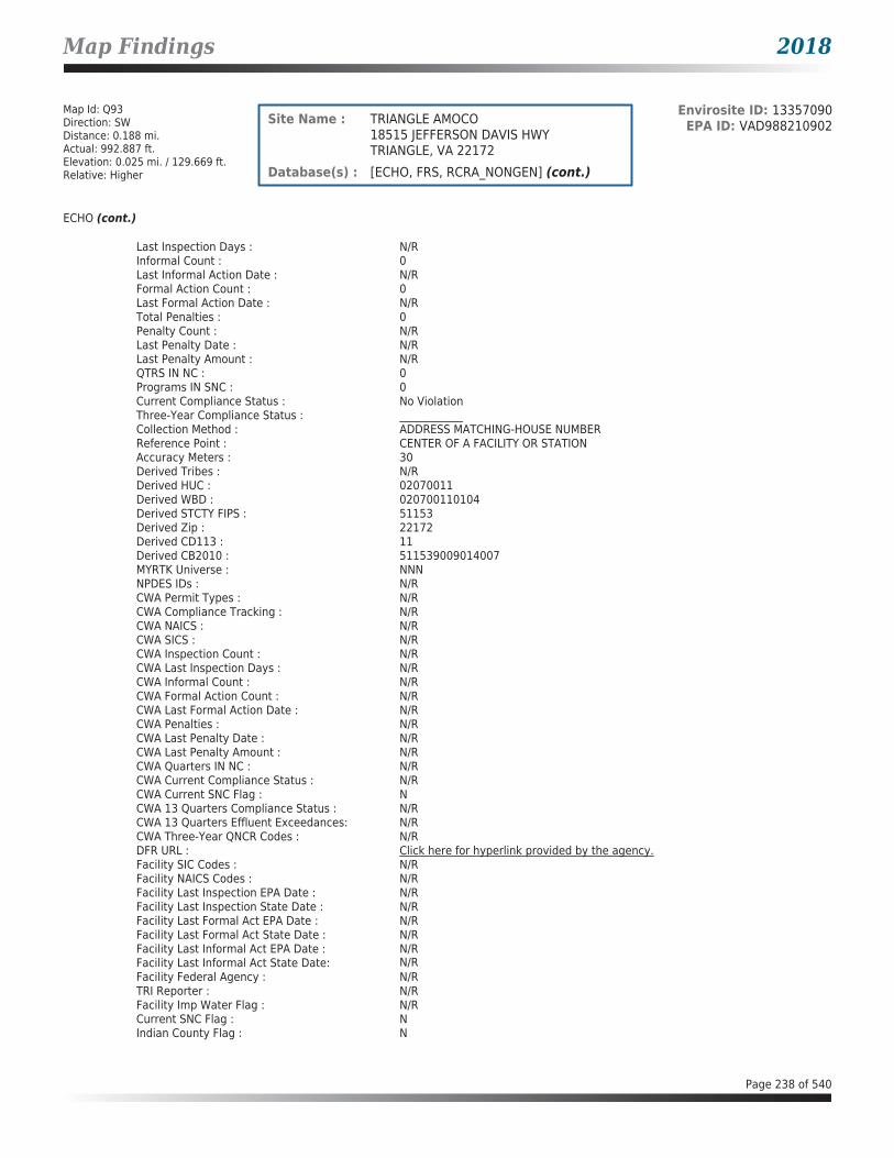
Map Findings 2018
Map Id: Q93Direction: SWDistance: 0.188 mi.Actual: 992.887 ft.Elevation: 0.025 mi. / 129.669 ft.Relative: Higher
Envirosite ID: 13357090EPA ID: VAD988210902Site Name : TRIANGLE AMOCO
18515 JEFFERSON DAVIS HWYTRIANGLE, VA 22172
Database(s) : [ECHO, FRS, RCRA_NONGEN] (cont.)
ECHO (cont.)
Last Inspection Days : N/RInformal Count : 0Last Informal Action Date : N/RFormal Action Count : 0Last Formal Action Date : N/RTotal Penalties : 0Penalty Count : N/RLast Penalty Date : N/RLast Penalty Amount : N/RQTRS IN NC : 0Programs IN SNC : 0Current Compliance Status : No ViolationThree-Year Compliance Status : ____________Collection Method : ADDRESS MATCHING-HOUSE NUMBERReference Point : CENTER OF A FACILITY OR STATIONAccuracy Meters : 30Derived Tribes : N/RDerived HUC : 02070011Derived WBD : 020700110104Derived STCTY FIPS : 51153Derived Zip : 22172Derived CD113 : 11Derived CB2010 : 511539009014007MYRTK Universe : NNNNPDES IDs : N/RCWA Permit Types : N/RCWA Compliance Tracking : N/RCWA NAICS : N/RCWA SICS : N/RCWA Inspection Count : N/RCWA Last Inspection Days : N/RCWA Informal Count : N/RCWA Formal Action Count : N/RCWA Last Formal Action Date : N/RCWA Penalties : N/RCWA Last Penalty Date : N/RCWA Last Penalty Amount : N/RCWA Quarters IN NC : N/RCWA Current Compliance Status : N/RCWA Current SNC Flag : NCWA 13 Quarters Compliance Status : N/RCWA 13 Quarters Effluent Exceedances: N/RCWA Three-Year QNCR Codes : N/RDFR URL : Click here for hyperlink provided by the agency.Facility SIC Codes : N/RFacility NAICS Codes : N/RFacility Last Inspection EPA Date : N/RFacility Last Inspection State Date : N/RFacility Last Formal Act EPA Date : N/RFacility Last Formal Act State Date : N/RFacility Last Informal Act EPA Date : N/RFacility Last Informal Act State Date: N/RFacility Federal Agency : N/RTRI Reporter : N/RFacility Imp Water Flag : N/RCurrent SNC Flag : NIndian County Flag : N
Page 238 of 540

Map Findings 2018
Map Id: Q93Direction: SWDistance: 0.188 mi.Actual: 992.887 ft.Elevation: 0.025 mi. / 129.669 ft.Relative: Higher
Envirosite ID: 13357090EPA ID: VAD988210902Site Name : TRIANGLE AMOCO
18515 JEFFERSON DAVIS HWYTRIANGLE, VA 22172
Database(s) : [ECHO, FRS, RCRA_NONGEN] (cont.)
ECHO (cont.)
Federal Flag : N/RUS Mexico Border Flag : N/RChesapeak Bay Flag : YAIR Flag : NNPDES Flag : NSDWIS Flag : NRCRA Flag : YTRI Flag : NGHG Flag : NMajor Flag : N/RActive Flag : N/RNAA Flag : YLatitude : 38.54949Longitude : -77.33446
FRS
Facility Name : TRIANGLE AMOCOFacility Address : 18515 JEFFERSON DAVIS HWY, TRIANGLE, VA 22172County : PRINCE WILLIAM
Registry ID : 110005249800FRS Facility URL : Click here for hyperlink provided by the agency.
Source Description :
RCRAInfo is EPA’s comprehensive information system that supports the Resource Conservation and Recovery Act (RCRA) of 1976 and the Hazardous and Solid Waste Amendments (HSWA) of 1984 through the tracking of events and activities related to facilities that generate, transport, and treat, store, or dispose of hazardous waste. RCRAInfo allows RCRA program staff to track the notification, permit, compliance, and corrective action activities required under RCRA. RCRAInfo also supports generation of the National Hazardous Waste Biennial Report. All generators and treatment, storage, and disposal facilities who handle hazardous waste are required to report to the EPA Administrator at least once every two years to support creation of the Biennial Report.
FRS Environmental InterestSource and System ID : RCRAINFO - VAD988210902
RCRA_NONGEN
Date form received by agency : 11/19/1998Facility name : TRIANGLE AMOCOFacility address : 18515 JEFFERSON DAVIS HWY, TRIANGLE VA 22172EPA ID : VAD988210902Mailing address : 1 W PENNSYLVANIA AVE STE 900, TOWSON MD 20204-5027Contact : N/RContact address : N/RContact country : USContact telephone : N/RContact email : N/REPA Region : 03Land type : PrivateSource type : Implementer
Page 239 of 540

Map Findings 2018
Map Id: Q93Direction: SWDistance: 0.188 mi.Actual: 992.887 ft.Elevation: 0.025 mi. / 129.669 ft.Relative: Higher
Envirosite ID: 13357090EPA ID: VAD988210902Site Name : TRIANGLE AMOCO
18515 JEFFERSON DAVIS HWYTRIANGLE, VA 22172
Database(s) : [ECHO, FRS, RCRA_NONGEN] (cont.)
RCRA_NONGEN (cont.)
Classification : Not a generator, verifiedDescription : Not a generator, verified
Handler Activities Summary :U.S. importer of hazardous waste : NoMixed waste (haz. and radioactive) : NoRecycler of hazardous waste : NoTransporter of hazardous waste : NoTreater storer or disposer of HW : NoUnderground injection activity : NoOn-site burner exemption : NoFurnace exemption : NoUsed oil fuel burner : NoUsed oil processor : NoUsed oil refiner : NoUsed oil fuel marketer to burner : NoUsed oil Specification marketer : NoUsed oil transfer facility : NoUsed oil transporter : No
Historical Generators :Date form received by agency : 01/21/1992Facility name : TRIANGLE AMOCOClassification : Conditionally Exempt Small Quantity Generator
Facility has No violations / inspections reported.
Map Id: Q94Direction: SWDistance: 0.188 mi.Actual: 992.887 ft.Elevation: 0.025 mi. / 129.669 ft.Relative: Higher
Envirosite ID: 14443491EPA ID: N/RSite Name : BP AMOCO STATION #1974
18515 JEFFERSON DAVIS HWYTRIANGLE, VA 22172
Database(s) : [UST - VA]
UST - VA
Facility Name : BP Amoco Station #1974Facility Address : 18515 Jefferson Davis Hwy, Triangle, VA 22172County : Prince William County
Facility ID : 3024218Facility Type : GAS STATIONCEDS Facility ID : 200000193813Region Code : NVRO
Tank InformationInstall Date : 09/01/1990Date Closed : 12/06/2001Tank Number : RA1
Page 240 of 540

Map Findings 2018
Map Id: Q94Direction: SWDistance: 0.188 mi.Actual: 992.887 ft.Elevation: 0.025 mi. / 129.669 ft.Relative: Higher
Envirosite ID: 14443491EPA ID: N/RSite Name : BP AMOCO STATION #1974
18515 JEFFERSON DAVIS HWYTRIANGLE, VA 22172
Database(s) : [UST - VA] (cont.)
UST - VA (cont.)
Tank Status : REM FROM GRDTank Owner ID : 33990Tank Type : USTCapacity : 10000Federally Regulated Tank : YContents : GASOLINEOther Contents : N/R
Tank Material InformationTank Number : RA1Tank Owner ID : 33990Tank Material Asphalt/Bare Steel : NTank Material CCP/STI-P3 : YTank Material Composite : NTank Material Fiberglass : NTank Material Concrete : NTank Material Impressed Current : NTank Material Double Walled : YTank Material Lined Interior : NTank Material Excavation Liner : NTank Material Polyethylene Tank Jacket: NTank Material Secondary Containment : NTank Material Repaired : NTank Material Unknown : NTank Material Other : NTank Material Other Notes : N/R
Tank InformationInstall Date : 09/01/1990Date Closed : 12/06/2001Tank Number : RA2Tank Status : REM FROM GRDTank Owner ID : 40055Tank Type : USTCapacity : 10000Federally Regulated Tank : YContents : GASOLINEOther Contents : N/R
Tank Material InformationTank Number : RA2Tank Owner ID : 40055Tank Material Asphalt/Bare Steel : NTank Material CCP/STI-P3 : YTank Material Composite : NTank Material Fiberglass : NTank Material Concrete : NTank Material Impressed Current : NTank Material Double Walled : YTank Material Lined Interior : NTank Material Excavation Liner : N
Page 241 of 540

Map Findings 2018
Map Id: Q94Direction: SWDistance: 0.188 mi.Actual: 992.887 ft.Elevation: 0.025 mi. / 129.669 ft.Relative: Higher
Envirosite ID: 14443491EPA ID: N/RSite Name : BP AMOCO STATION #1974
18515 JEFFERSON DAVIS HWYTRIANGLE, VA 22172
Database(s) : [UST - VA] (cont.)
UST - VA (cont.)
Tank Material Polyethylene Tank Jacket: NTank Material Secondary Containment : NTank Material Repaired : NTank Material Unknown : NTank Material Other : NTank Material Other Notes : N/R
Tank InformationInstall Date : 09/01/1990Date Closed : 12/06/2001Tank Number : RA3Tank Status : REM FROM GRDTank Owner ID : 40055Tank Type : USTCapacity : 10000Federally Regulated Tank : YContents : GASOLINEOther Contents : N/R
Tank Material InformationTank Number : RA3Tank Owner ID : 40055Tank Material Asphalt/Bare Steel : NTank Material CCP/STI-P3 : YTank Material Composite : NTank Material Fiberglass : NTank Material Concrete : NTank Material Impressed Current : NTank Material Double Walled : YTank Material Lined Interior : NTank Material Excavation Liner : NTank Material Polyethylene Tank Jacket: NTank Material Secondary Containment : NTank Material Repaired : NTank Material Unknown : NTank Material Other : NTank Material Other Notes : N/R
Tank InformationInstall Date : 09/01/1990Date Closed : 12/06/2001Tank Number : RA4Tank Status : REM FROM GRDTank Owner ID : 40055Tank Type : USTCapacity : 10000Federally Regulated Tank : YContents : GASOLINEOther Contents : N/R
Page 242 of 540

Map Findings 2018
Map Id: Q94Direction: SWDistance: 0.188 mi.Actual: 992.887 ft.Elevation: 0.025 mi. / 129.669 ft.Relative: Higher
Envirosite ID: 14443491EPA ID: N/RSite Name : BP AMOCO STATION #1974
18515 JEFFERSON DAVIS HWYTRIANGLE, VA 22172
Database(s) : [UST - VA] (cont.)
UST - VA (cont.)
Tank Material InformationTank Number : RA4Tank Owner ID : 40055Tank Material Asphalt/Bare Steel : NTank Material CCP/STI-P3 : YTank Material Composite : NTank Material Fiberglass : NTank Material Concrete : NTank Material Impressed Current : NTank Material Double Walled : YTank Material Lined Interior : NTank Material Excavation Liner : NTank Material Polyethylene Tank Jacket: NTank Material Secondary Containment : NTank Material Repaired : NTank Material Unknown : NTank Material Other : NTank Material Other Notes : N/R
Tank InformationInstall Date : 09/01/1990Date Closed : 12/06/2010Tank Number : RA5Tank Status : REM FROM GRDTank Owner ID : 40055Tank Type : USTCapacity : 550Federally Regulated Tank : YContents : USED OILOther Contents : N/R
Tank Material InformationTank Number : RA5Tank Owner ID : 40055Tank Material Asphalt/Bare Steel : NTank Material CCP/STI-P3 : YTank Material Composite : NTank Material Fiberglass : NTank Material Concrete : NTank Material Impressed Current : NTank Material Double Walled : YTank Material Lined Interior : NTank Material Excavation Liner : NTank Material Polyethylene Tank Jacket: NTank Material Secondary Containment : NTank Material Repaired : NTank Material Unknown : NTank Material Other : NTank Material Other Notes : N/R
Page 243 of 540

Map Findings 2018
Map Id: Q94Direction: SWDistance: 0.188 mi.Actual: 992.887 ft.Elevation: 0.025 mi. / 129.669 ft.Relative: Higher
Envirosite ID: 14443491EPA ID: N/RSite Name : BP AMOCO STATION #1974
18515 JEFFERSON DAVIS HWYTRIANGLE, VA 22172
Database(s) : [UST - VA] (cont.)
UST - VA (cont.)
Tank InformationInstall Date : 01/01/1975Date Closed : 11/09/1990Tank Number : R1Tank Status : REM FROM GRDTank Owner ID : 33990Tank Type : USTCapacity : 8000Federally Regulated Tank : YContents : GASOLINEOther Contents : N/R
Tank Material InformationTank Number : R1Tank Owner ID : 33990Tank Material Asphalt/Bare Steel : YTank Material CCP/STI-P3 : NTank Material Composite : NTank Material Fiberglass : NTank Material Concrete : NTank Material Impressed Current : NTank Material Double Walled : NTank Material Lined Interior : NTank Material Excavation Liner : NTank Material Polyethylene Tank Jacket: NTank Material Secondary Containment : NTank Material Repaired : NTank Material Unknown : NTank Material Other : NTank Material Other Notes : N/R
Tank InformationInstall Date : 01/01/1975Date Closed : 11/09/1990Tank Number : R2Tank Status : REM FROM GRDTank Owner ID : 33990Tank Type : USTCapacity : 8000Federally Regulated Tank : YContents : GASOLINEOther Contents : N/R
Tank Material InformationTank Number : R2Tank Owner ID : 33990Tank Material Asphalt/Bare Steel : YTank Material CCP/STI-P3 : NTank Material Composite : NTank Material Fiberglass : NTank Material Concrete : N
Page 244 of 540

Map Findings 2018
Map Id: Q94Direction: SWDistance: 0.188 mi.Actual: 992.887 ft.Elevation: 0.025 mi. / 129.669 ft.Relative: Higher
Envirosite ID: 14443491EPA ID: N/RSite Name : BP AMOCO STATION #1974
18515 JEFFERSON DAVIS HWYTRIANGLE, VA 22172
Database(s) : [UST - VA] (cont.)
UST - VA (cont.)
Tank Material Impressed Current : NTank Material Double Walled : NTank Material Lined Interior : NTank Material Excavation Liner : NTank Material Polyethylene Tank Jacket: NTank Material Secondary Containment : NTank Material Repaired : NTank Material Unknown : NTank Material Other : NTank Material Other Notes : N/R
Tank InformationInstall Date : 01/01/1975Date Closed : 11/09/1990Tank Number : R3Tank Status : REM FROM GRDTank Owner ID : 33990Tank Type : USTCapacity : 8000Federally Regulated Tank : YContents : GASOLINEOther Contents : N/R
Tank Material InformationTank Number : R3Tank Owner ID : 33990Tank Material Asphalt/Bare Steel : YTank Material CCP/STI-P3 : NTank Material Composite : NTank Material Fiberglass : NTank Material Concrete : NTank Material Impressed Current : NTank Material Double Walled : NTank Material Lined Interior : NTank Material Excavation Liner : NTank Material Polyethylene Tank Jacket: NTank Material Secondary Containment : NTank Material Repaired : NTank Material Unknown : NTank Material Other : NTank Material Other Notes : N/R
Tank InformationInstall Date : 01/01/1975Date Closed : 11/09/1990Tank Number : R4Tank Status : REM FROM GRDTank Owner ID : 33990Tank Type : USTCapacity : 3000Federally Regulated Tank : Y
Page 245 of 540
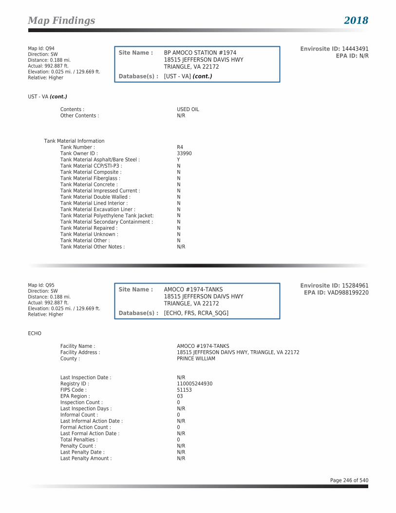
Map Findings 2018
Map Id: Q94Direction: SWDistance: 0.188 mi.Actual: 992.887 ft.Elevation: 0.025 mi. / 129.669 ft.Relative: Higher
Envirosite ID: 14443491EPA ID: N/RSite Name : BP AMOCO STATION #1974
18515 JEFFERSON DAVIS HWYTRIANGLE, VA 22172
Database(s) : [UST - VA] (cont.)
UST - VA (cont.)
Contents : USED OILOther Contents : N/R
Tank Material InformationTank Number : R4Tank Owner ID : 33990Tank Material Asphalt/Bare Steel : YTank Material CCP/STI-P3 : NTank Material Composite : NTank Material Fiberglass : NTank Material Concrete : NTank Material Impressed Current : NTank Material Double Walled : NTank Material Lined Interior : NTank Material Excavation Liner : NTank Material Polyethylene Tank Jacket: NTank Material Secondary Containment : NTank Material Repaired : NTank Material Unknown : NTank Material Other : NTank Material Other Notes : N/R
Map Id: Q95Direction: SWDistance: 0.188 mi.Actual: 992.887 ft.Elevation: 0.025 mi. / 129.669 ft.Relative: Higher
Envirosite ID: 15284961EPA ID: VAD988199220Site Name : AMOCO #1974-TANKS
18515 JEFFERSON DAIVS HWYTRIANGLE, VA 22172
Database(s) : [ECHO, FRS, RCRA_SQG]
ECHO
Facility Name : AMOCO #1974-TANKSFacility Address : 18515 JEFFERSON DAIVS HWY, TRIANGLE, VA 22172County : PRINCE WILLIAM
Last Inspection Date : N/RRegistry ID : 110005244930FIPS Code : 51153EPA Region : 03Inspection Count : 0Last Inspection Days : N/RInformal Count : 0Last Informal Action Date : N/RFormal Action Count : 0Last Formal Action Date : N/RTotal Penalties : 0Penalty Count : N/RLast Penalty Date : N/RLast Penalty Amount : N/R
Page 246 of 540
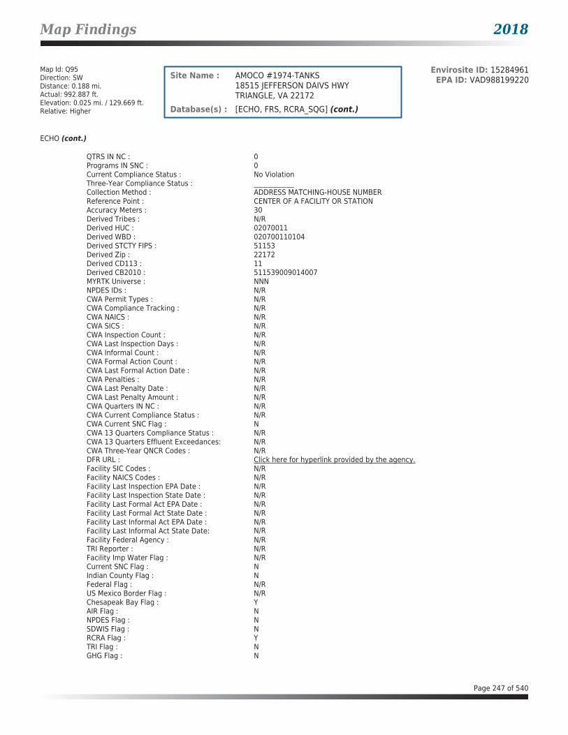
Map Findings 2018
Map Id: Q95Direction: SWDistance: 0.188 mi.Actual: 992.887 ft.Elevation: 0.025 mi. / 129.669 ft.Relative: Higher
Envirosite ID: 15284961EPA ID: VAD988199220Site Name : AMOCO #1974-TANKS
18515 JEFFERSON DAIVS HWYTRIANGLE, VA 22172
Database(s) : [ECHO, FRS, RCRA_SQG] (cont.)
ECHO (cont.)
QTRS IN NC : 0Programs IN SNC : 0Current Compliance Status : No ViolationThree-Year Compliance Status : ____________Collection Method : ADDRESS MATCHING-HOUSE NUMBERReference Point : CENTER OF A FACILITY OR STATIONAccuracy Meters : 30Derived Tribes : N/RDerived HUC : 02070011Derived WBD : 020700110104Derived STCTY FIPS : 51153Derived Zip : 22172Derived CD113 : 11Derived CB2010 : 511539009014007MYRTK Universe : NNNNPDES IDs : N/RCWA Permit Types : N/RCWA Compliance Tracking : N/RCWA NAICS : N/RCWA SICS : N/RCWA Inspection Count : N/RCWA Last Inspection Days : N/RCWA Informal Count : N/RCWA Formal Action Count : N/RCWA Last Formal Action Date : N/RCWA Penalties : N/RCWA Last Penalty Date : N/RCWA Last Penalty Amount : N/RCWA Quarters IN NC : N/RCWA Current Compliance Status : N/RCWA Current SNC Flag : NCWA 13 Quarters Compliance Status : N/RCWA 13 Quarters Effluent Exceedances: N/RCWA Three-Year QNCR Codes : N/RDFR URL : Click here for hyperlink provided by the agency.Facility SIC Codes : N/RFacility NAICS Codes : N/RFacility Last Inspection EPA Date : N/RFacility Last Inspection State Date : N/RFacility Last Formal Act EPA Date : N/RFacility Last Formal Act State Date : N/RFacility Last Informal Act EPA Date : N/RFacility Last Informal Act State Date: N/RFacility Federal Agency : N/RTRI Reporter : N/RFacility Imp Water Flag : N/RCurrent SNC Flag : NIndian County Flag : NFederal Flag : N/RUS Mexico Border Flag : N/RChesapeak Bay Flag : YAIR Flag : NNPDES Flag : NSDWIS Flag : NRCRA Flag : YTRI Flag : NGHG Flag : N
Page 247 of 540

Map Findings 2018
Map Id: Q95Direction: SWDistance: 0.188 mi.Actual: 992.887 ft.Elevation: 0.025 mi. / 129.669 ft.Relative: Higher
Envirosite ID: 15284961EPA ID: VAD988199220Site Name : AMOCO #1974-TANKS
18515 JEFFERSON DAIVS HWYTRIANGLE, VA 22172
Database(s) : [ECHO, FRS, RCRA_SQG] (cont.)
ECHO (cont.)
Major Flag : N/RActive Flag : YNAA Flag : YLatitude : 38.54949Longitude : -77.33446
FRS
Facility Name : AMOCO #1974-TANKSFacility Address : 18515 JEFFERSON DAIVS HWY, TRIANGLE, VA 22172County : PRINCE WILLIAM
Registry ID : 110005244930FRS Facility URL : Click here for hyperlink provided by the agency.
Source Description :
RCRAInfo is EPA’s comprehensive information system that supports the Resource Conservation and Recovery Act (RCRA) of 1976 and the Hazardous and Solid Waste Amendments (HSWA) of 1984 through the tracking of events and activities related to facilities that generate, transport, and treat, store, or dispose of hazardous waste. RCRAInfo allows RCRA program staff to track the notification, permit, compliance, and corrective action activities required under RCRA. RCRAInfo also supports generation of the National Hazardous Waste Biennial Report. All generators and treatment, storage, and disposal facilities who handle hazardous waste are required to report to the EPA Administrator at least once every two years to support creation of the Biennial Report.
FRS Environmental InterestSource and System ID : RCRAINFO - VAD988199220
RCRA_SQG
Date form received by agency : 04/24/1991Facility name : AMOCO #1974-TANKSFacility address : 18515 JEFFERSON DAIVS HWY, TRIANGLE VA 22172EPA ID : VAD988199220Mailing address : STE 1500 ONE N CHARLES ST, BALTIMORE MD 21201Contact : TONI DOUGHERTYContact address : 18515 JEFFERSON DAIVS HWY, TRIANGLE VA 22172Contact country : USContact telephone : 301-625-7858Contact email : N/REPA Region : 03Land type : N/RSource type : NotificationClassification : Small Quantity Generator
Description : Handlers that generate more than 100 and less than 1000 kilograms of hazardous waste during any calendar month and accumulate less than 6000 kg of hazardous waste at any time; or generate 100 kg or less of hazardous waste during any calendar month, and accumulate more than 1000 kg of hazardous waste at any time.
Page 248 of 540

Map Findings 2018
Map Id: Q95Direction: SWDistance: 0.188 mi.Actual: 992.887 ft.Elevation: 0.025 mi. / 129.669 ft.Relative: Higher
Envirosite ID: 15284961EPA ID: VAD988199220Site Name : AMOCO #1974-TANKS
18515 JEFFERSON DAIVS HWYTRIANGLE, VA 22172
Database(s) : [ECHO, FRS, RCRA_SQG] (cont.)
RCRA_SQG (cont.)
Owner/Operator Summary :Owner Operator name : AMOCO OIL COMPANYOwner Operator address : STE 1500 ONE N CHARLES ST, BALTIMORE MD 21201Owner Operator country : N/ROwner Operator telephone : 301-625-7856Owner Operator Email : N/ROwner Operator Fax : N/RLegal status : PrivateOwner Operator Type : OwnerOwner/Op start date : N/ROwner/Op end date : N/R
Owner Operator name : OPERNAMEOwner Operator address : OPERSTREET, OPERCITY AK 99999Owner Operator country : N/ROwner Operator telephone : 215-555-1212Owner Operator Email : N/ROwner Operator Fax : N/RLegal status : PrivateOwner Operator Type : OperatorOwner/Op start date : N/ROwner/Op end date : N/R
Handler Activities Summary :U.S. importer of hazardous waste : NoMixed waste (haz. and radioactive) : NoRecycler of hazardous waste : NoTransporter of hazardous waste : NoTreater storer or disposer of HW : NoUnderground injection activity : NoOn-site burner exemption : NoFurnace exemption : NoUsed oil fuel burner : NoUsed oil processor : NoUsed oil refiner : NoUsed oil fuel marketer to burner : NoUsed oil Specification marketer : NoUsed oil transfer facility : NoUsed oil transporter : No
Hazardous Waste Summary :Waste code : D001Waste name : IGNITABLE WASTE
Waste code : D018Waste name : BENZENE
Facility has No violations / inspections reported.
Page 249 of 540

Map Findings 2018
Map Id: Q96Direction: SWDistance: 0.188 mi.Actual: 992.887 ft.Elevation: 0.025 mi. / 129.669 ft.Relative: Higher
Envirosite ID: 24843101EPA ID: N/RSite Name : AMOCO 1974
18515 JEFFERSON DAVIS HWYTRIANGLE, VA 22172
Database(s) : [LPT - VA]
LPT - VA
Facility Name : Amoco 1974Facility Address : 18515 Jefferson Davis Hwy, Triangle, VA 22172County : Prince William County
Release Reported : 01/02/2002PC Number : 20023187CEDS Facility ID : 200000193813Case Status : ClosedCase Closed Date : 03/15/2002Region : NVROProgram : RP LeadHeating Oil Category : N/RFederally Regulated UST : YRegulated Petroleum UST (1) : YExcluded UST (1) : NDeferred UST (1) : NPartially Deferred UST (1) : NExempt 1 UST (2) : NExempt 2 Heating Oil UST (2) : NSmall Heating Oil AST (2) : NRegulated AST (3) : NUnregulated AST (3) : NOther (Y/N) : NOther Description : N/RUnknown (Y/N) : NPriority : 3Suspect Confirm Indicator : ConfirmedLatitude : 38.5492479539Longitude : -77.3341915217Last Date in Agency List : 02/09/2018
Release Reported : 07/09/1990PC Number : 19910034CEDS Facility ID : 200000193813Case Status : ClosedCase Closed Date : 06/12/1995Region : NVROProgram : RP LeadHeating Oil Category : N/RFederally Regulated UST : YRegulated Petroleum UST (1) : YExcluded UST (1) : NDeferred UST (1) : NPartially Deferred UST (1) : NExempt 1 UST (2) : NExempt 2 Heating Oil UST (2) : NSmall Heating Oil AST (2) : NRegulated AST (3) : NUnregulated AST (3) : NOther (Y/N) : NOther Description : N/RUnknown (Y/N) : NPriority : 3Suspect Confirm Indicator : ConfirmedLatitude : 38.5493887661
Page 250 of 540
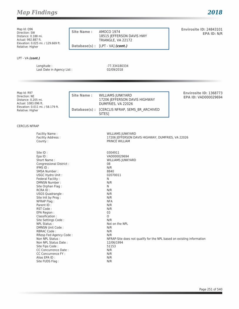
Map Findings 2018
Map Id: Q96Direction: SWDistance: 0.188 mi.Actual: 992.887 ft.Elevation: 0.025 mi. / 129.669 ft.Relative: Higher
Envirosite ID: 24843101EPA ID: N/RSite Name : AMOCO 1974
18515 JEFFERSON DAVIS HWYTRIANGLE, VA 22172
Database(s) : [LPT - VA] (cont.)
LPT - VA (cont.)
Longitude : -77.334180334Last Date in Agency List : 02/09/2018
Map Id: R97Direction: NEDistance: 0.205 mi.Actual: 1083.096 ft.Elevation: 0.011 mi. / 58.179 ft.Relative: Higher
Envirosite ID: 1368773EPA ID: VAD000029694Site Name : WILLIAMS JUNKYARD
17206 JEFFERSON DAVIS HIGHWAYDUMFRIES, VA 22026
Database(s) : [CERCLIS NFRAP, SEMS_8R_ARCHIVED SITES]
CERCLIS NFRAP
Facility Name : WILLIAMS JUNKYARDFacility Address : 17206 JEFFERSON DAVIS HIGHWAY, DUMFRIES, VA 22026County : PRINCE WILLIAM
Site ID : 0304911Epa ID : VAD000029694Short Name : WILLIAMS JUNKYARDCongressional District : 08IFMS ID : N/RSMSA Number : 8840USGC Hydro Unit : 02070011Federal Facility : NDMNSN Number : N/RSite Orphan Flag : NRCRA ID : N/RUSGS Quadrangle : N/RSite Init by Prog : N/RNFRAP Flag : NFAParent ID : N/RRST Code : N/REPA Region : 03Classification : OSite Settings Code : N/RNPL Status : Not on the NPLDMNSN Unit Code : N/RRBRAC Code : N/RRResp Fed Agency Code : N/RNon NPL Status : NFRAP-Site does not qualify for the NPL based on existing informationNon NPL Status Date : 12/06/1994Site Fips Code : 51153CC Concurrence Date : N/RCC Concurrence FY : N/RAlias EPA ID : N/RSite FUDS Flag : N/R
Page 251 of 540

Map Findings 2018
Map Id: R97Direction: NEDistance: 0.205 mi.Actual: 1083.096 ft.Elevation: 0.011 mi. / 58.179 ft.Relative: Higher
Envirosite ID: 1368773EPA ID: VAD000029694Site Name : WILLIAMS JUNKYARD
17206 JEFFERSON DAVIS HIGHWAYDUMFRIES, VA 22026
Database(s) : [CERCLIS NFRAP, SEMS_8R_ARCHIVED SITES] (cont.)
CERCLIS NFRAP (cont.)
CERCLIS Site Contact Name(s)Contact ID : 3000189Contact Title : On-Scene Coordinator (OSC)
Alias Comments : CHARLES/WILLIAMSite Description : N/R
CERCLIS Assessment HistoryAction Code : 001Action : ARCHIVE SITEDate Started : N/RDate Completed : 12/06/1994Priority Level : 1Operational Unit : 00Primary Responsibility : EPA In-HousePlanning Status : N/RUrgency Indicator : N/RAction Anomaly : N/R
Action Code : 001Action : DISCOVERYDate Started : N/RDate Completed : 05/27/1993Priority Level : 1Operational Unit : 00Primary Responsibility : State, Fund FinancedPlanning Status : N/RUrgency Indicator : N/RAction Anomaly : N/R
Action Code : 001Action : PRELIMINARY ASSESSMENTDate Started : 02/01/1994Date Completed : 12/06/1994Priority Level : 1Operational Unit : 00Primary Responsibility : State, Fund FinancedPlanning Status : N/RUrgency Indicator : N/RAction Anomaly : N/R
Action Code : 001Action : REMOVAL ASSESSMENTDate Started : 06/27/1994Date Completed : 06/27/1994Priority Level : 1Operational Unit : 00Primary Responsibility : EPA Fund-FinancedPlanning Status : PrimaryUrgency Indicator : N/R
Page 252 of 540

Map Findings 2018
Map Id: R97Direction: NEDistance: 0.205 mi.Actual: 1083.096 ft.Elevation: 0.011 mi. / 58.179 ft.Relative: Higher
Envirosite ID: 1368773EPA ID: VAD000029694Site Name : WILLIAMS JUNKYARD
17206 JEFFERSON DAVIS HIGHWAYDUMFRIES, VA 22026
Database(s) : [CERCLIS NFRAP, SEMS_8R_ARCHIVED SITES] (cont.)
CERCLIS NFRAP (cont.)
Action Anomaly : N/R
SEMS_8R_ARCHIVED SITES
Facility Name : WILLIAMS JUNKYARDFacility Address : 17206 JEFFERSON DAVIS HIGHWAY, DUMFRIES, VA 22026County : PRINCE WILLIAM
Site DetailsSite ID : 0304911EPA ID : VAD000029694Region : 03Congressional District : 08Federal Facility : NNPL Status : Not on the NPLNon NPL Status : NFRAP-Site does not qualify for the NPL based on existing informationFIPS Code : 51153Last Date in Agency List : 01/02/2018
Additional InformationStart Date : 06/27/1994Finish Date : 06/27/1994OU : 00Action Code : RSAction Name : RV ASSESSSequence : 1Quality : N/RCurrent Action Lead : EPA Perf
Start Date : 02/01/1994Finish Date : 12/06/1994OU : 00Action Code : PAAction Name : PASequence : 1Quality : NCurrent Action Lead : St Perf
Start Date : 05/27/1993Finish Date : 05/27/1993OU : 00Action Code : DSAction Name : DISCVRYSequence : 1Quality : N/RCurrent Action Lead : St Perf
Start Date : N/RFinish Date : 12/06/1994
Page 253 of 540

Map Findings 2018
Map Id: R97Direction: NEDistance: 0.205 mi.Actual: 1083.096 ft.Elevation: 0.011 mi. / 58.179 ft.Relative: Higher
Envirosite ID: 1368773EPA ID: VAD000029694Site Name : WILLIAMS JUNKYARD
17206 JEFFERSON DAVIS HIGHWAYDUMFRIES, VA 22026
Database(s) : [CERCLIS NFRAP, SEMS_8R_ARCHIVED SITES] (cont.)
SEMS_8R_ARCHIVED SITES (cont.)
OU : 00Action Code : VSAction Name : ARCH SITESequence : 1Quality : N/RCurrent Action Lead : EPA Perf In-Hse
Map Id: R98Direction: NEDistance: 0.205 mi.Actual: 1083.096 ft.Elevation: 0.011 mi. / 58.179 ft.Relative: Higher
Envirosite ID: 24839527EPA ID: N/RSite Name : HUMSTON DOUGLAS PROPERTY
17206 JEFFERSON DAVIS HWYDUMFRIES, VA 22026
Database(s) : [LPT - VA]
LPT - VA
Facility Name : Humston Douglas PropertyFacility Address : 17206 Jefferson Davis Hwy, Dumfries, VA 22026County : Prince William County
Release Reported : 04/17/2006PC Number : 20063231CEDS Facility ID : 200000223846Case Status : ClosedCase Closed Date : 05/02/2006Region : NVROProgram : RP LeadHeating Oil Category : N/RFederally Regulated UST : NRegulated Petroleum UST (1) : NExcluded UST (1) : NDeferred UST (1) : NPartially Deferred UST (1) : NExempt 1 UST (2) : NExempt 2 Heating Oil UST (2) : NSmall Heating Oil AST (2) : NRegulated AST (3) : NUnregulated AST (3) : NOther (Y/N) : YOther Description : junkyardUnknown (Y/N) : NPriority : 3Suspect Confirm Indicator : ConfirmedLatitude : 38.5774692943Longitude : -77.312873192Last Date in Agency List : 02/09/2018
Page 254 of 540
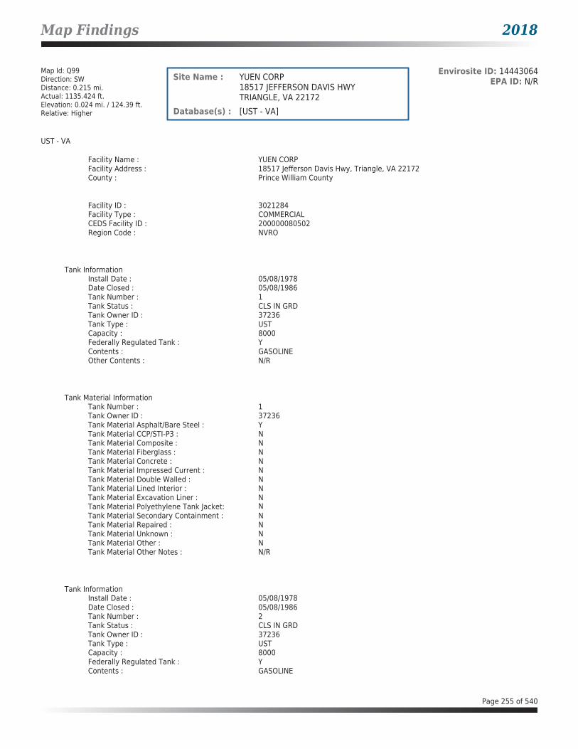
Map Findings 2018
Map Id: Q99Direction: SWDistance: 0.215 mi.Actual: 1135.424 ft.Elevation: 0.024 mi. / 124.39 ft.Relative: Higher
Envirosite ID: 14443064EPA ID: N/RSite Name : YUEN CORP
18517 JEFFERSON DAVIS HWYTRIANGLE, VA 22172
Database(s) : [UST - VA]
UST - VA
Facility Name : YUEN CORPFacility Address : 18517 Jefferson Davis Hwy, Triangle, VA 22172County : Prince William County
Facility ID : 3021284Facility Type : COMMERCIALCEDS Facility ID : 200000080502Region Code : NVRO
Tank InformationInstall Date : 05/08/1978Date Closed : 05/08/1986Tank Number : 1Tank Status : CLS IN GRDTank Owner ID : 37236Tank Type : USTCapacity : 8000Federally Regulated Tank : YContents : GASOLINEOther Contents : N/R
Tank Material InformationTank Number : 1Tank Owner ID : 37236Tank Material Asphalt/Bare Steel : YTank Material CCP/STI-P3 : NTank Material Composite : NTank Material Fiberglass : NTank Material Concrete : NTank Material Impressed Current : NTank Material Double Walled : NTank Material Lined Interior : NTank Material Excavation Liner : NTank Material Polyethylene Tank Jacket: NTank Material Secondary Containment : NTank Material Repaired : NTank Material Unknown : NTank Material Other : NTank Material Other Notes : N/R
Tank InformationInstall Date : 05/08/1978Date Closed : 05/08/1986Tank Number : 2Tank Status : CLS IN GRDTank Owner ID : 37236Tank Type : USTCapacity : 8000Federally Regulated Tank : YContents : GASOLINE
Page 255 of 540
Map Findings 2018
Map Id: Q99Direction: SWDistance: 0.215 mi.Actual: 1135.424 ft.Elevation: 0.024 mi. / 124.39 ft.Relative: Higher
Envirosite ID: 14443064EPA ID: N/RSite Name : YUEN CORP
18517 JEFFERSON DAVIS HWYTRIANGLE, VA 22172
Database(s) : [UST - VA] (cont.)
UST - VA (cont.)
Other Contents : N/R
Tank Material InformationTank Number : 2Tank Owner ID : 37236Tank Material Asphalt/Bare Steel : YTank Material CCP/STI-P3 : NTank Material Composite : NTank Material Fiberglass : NTank Material Concrete : NTank Material Impressed Current : NTank Material Double Walled : NTank Material Lined Interior : NTank Material Excavation Liner : NTank Material Polyethylene Tank Jacket: NTank Material Secondary Containment : NTank Material Repaired : NTank Material Unknown : NTank Material Other : NTank Material Other Notes : N/R
Map Id: S100Direction: NNEDistance: 0.221 mi.Actual: 1165.742 ft.Elevation: 0.028 mi. / 146.732 ft.Relative: Higher
Envirosite ID: 14571498EPA ID: VAD988172474Site Name : STAR ENTERPRISE
2210 DUMFRIES RDDUMFRIES, VA 22026
Database(s) : [ECHO, FRS, RCRA_NONGEN]
ECHO
Facility Name : STAR ENTERPRISEFacility Address : 2210 DUMFRIES RD, DUMFRIES, VA 22026County : PRINCE WILLIAM
Last Inspection Date : N/RRegistry ID : 110005237001FIPS Code : 51153EPA Region : 03Inspection Count : 0Last Inspection Days : N/RInformal Count : 0Last Informal Action Date : N/RFormal Action Count : 0Last Formal Action Date : N/RTotal Penalties : 0Penalty Count : N/RLast Penalty Date : N/RLast Penalty Amount : N/RQTRS IN NC : 0
Page 256 of 540
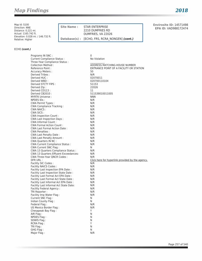
Map Findings 2018
Map Id: S100Direction: NNEDistance: 0.221 mi.Actual: 1165.742 ft.Elevation: 0.028 mi. / 146.732 ft.Relative: Higher
Envirosite ID: 14571498EPA ID: VAD988172474Site Name : STAR ENTERPRISE
2210 DUMFRIES RDDUMFRIES, VA 22026
Database(s) : [ECHO, FRS, RCRA_NONGEN] (cont.)
ECHO (cont.)
Programs IN SNC : 0Current Compliance Status : No ViolationThree-Year Compliance Status : ____________Collection Method : ADDRESS MATCHING-HOUSE NUMBERReference Point : ENTRANCE POINT OF A FACILITY OR STATIONAccuracy Meters : 50Derived Tribes : N/RDerived HUC : 02070011Derived WBD : 020700110104Derived STCTY FIPS : 51153Derived Zip : 22026Derived CD113 : 11Derived CB2010 : 511539010011005MYRTK Universe : NNNNPDES IDs : N/RCWA Permit Types : N/RCWA Compliance Tracking : N/RCWA NAICS : N/RCWA SICS : N/RCWA Inspection Count : N/RCWA Last Inspection Days : N/RCWA Informal Count : N/RCWA Formal Action Count : N/RCWA Last Formal Action Date : N/RCWA Penalties : N/RCWA Last Penalty Date : N/RCWA Last Penalty Amount : N/RCWA Quarters IN NC : N/RCWA Current Compliance Status : N/RCWA Current SNC Flag : NCWA 13 Quarters Compliance Status : N/RCWA 13 Quarters Effluent Exceedances: N/RCWA Three-Year QNCR Codes : N/RDFR URL : Click here for hyperlink provided by the agency.Facility SIC Codes : N/RFacility NAICS Codes : N/RFacility Last Inspection EPA Date : N/RFacility Last Inspection State Date : N/RFacility Last Formal Act EPA Date : N/RFacility Last Formal Act State Date : N/RFacility Last Informal Act EPA Date : N/RFacility Last Informal Act State Date: N/RFacility Federal Agency : N/RTRI Reporter : N/RFacility Imp Water Flag : N/RCurrent SNC Flag : NIndian County Flag : NFederal Flag : N/RUS Mexico Border Flag : N/RChesapeak Bay Flag : YAIR Flag : NNPDES Flag : NSDWIS Flag : NRCRA Flag : YTRI Flag : NGHG Flag : NMajor Flag : N/R
Page 257 of 540

Map Findings 2018
Map Id: S100Direction: NNEDistance: 0.221 mi.Actual: 1165.742 ft.Elevation: 0.028 mi. / 146.732 ft.Relative: Higher
Envirosite ID: 14571498EPA ID: VAD988172474Site Name : STAR ENTERPRISE
2210 DUMFRIES RDDUMFRIES, VA 22026
Database(s) : [ECHO, FRS, RCRA_NONGEN] (cont.)
ECHO (cont.)
Active Flag : N/RNAA Flag : YLatitude : 38.57813Longitude : -77.319001
FRS
Facility Name : STAR ENTERPRISEFacility Address : 2210 DUMFRIES RD, DUMFRIES, VA 22026County : PRINCE WILLIAM
Registry ID : 110005237001FRS Facility URL : Click here for hyperlink provided by the agency.
Source Description :
RCRAInfo is EPA’s comprehensive information system that supports the Resource Conservation and Recovery Act (RCRA) of 1976 and the Hazardous and Solid Waste Amendments (HSWA) of 1984 through the tracking of events and activities related to facilities that generate, transport, and treat, store, or dispose of hazardous waste. RCRAInfo allows RCRA program staff to track the notification, permit, compliance, and corrective action activities required under RCRA. RCRAInfo also supports generation of the National Hazardous Waste Biennial Report. All generators and treatment, storage, and disposal facilities who handle hazardous waste are required to report to the EPA Administrator at least once every two years to support creation of the Biennial Report.
FRS Environmental InterestSource and System ID : RCRAINFO - VAD988172474
RCRA_NONGEN
Date form received by agency : 12/30/2010Facility name : STAR ENTERPRISEFacility address : 2210 DUMFRIES RD, DUMFRIES VA 22026EPA ID : VAD988172474Mailing address : PO BOX 2099, HOUSTON TX 77252-2099Contact : SONDRA BIENVENUContact address : PO BOX 2099, HOUSTON TX 77252-2099Contact country : USContact telephone : 713-241-2258Contact email : N/REPA Region : 03Land type : PrivateSource type : ImplementerClassification : Not a generator, verifiedDescription : Not a generator, verified
Owner/Operator Summary :Owner Operator name : OPERNAMEOwner Operator address : OPERSTREET, OPERCITY AK 99999Owner Operator country : N/ROwner Operator telephone : 215-555-1212Owner Operator Email : N/ROwner Operator Fax : N/R
Page 258 of 540

Map Findings 2018
Map Id: S100Direction: NNEDistance: 0.221 mi.Actual: 1165.742 ft.Elevation: 0.028 mi. / 146.732 ft.Relative: Higher
Envirosite ID: 14571498EPA ID: VAD988172474Site Name : STAR ENTERPRISE
2210 DUMFRIES RDDUMFRIES, VA 22026
Database(s) : [ECHO, FRS, RCRA_NONGEN] (cont.)
RCRA_NONGEN (cont.)
Legal status : PrivateOwner Operator Type : OperatorOwner/Op start date : N/ROwner/Op end date : N/R
Owner Operator name : MOTIVA ENTERPRISES LLCOwner Operator address : PO BOX 4540, HOUSTON TX 77210-4540Owner Operator country : N/ROwner Operator telephone : 713-241-2258Owner Operator Email : N/ROwner Operator Fax : N/RLegal status : PrivateOwner Operator Type : OwnerOwner/Op start date : N/ROwner/Op end date : N/R
Handler Activities Summary :U.S. importer of hazardous waste : NoMixed waste (haz. and radioactive) : NoRecycler of hazardous waste : NoTransporter of hazardous waste : NoTreater storer or disposer of HW : NoUnderground injection activity : NoOn-site burner exemption : NoFurnace exemption : NoUsed oil fuel burner : NoUsed oil processor : NoUsed oil refiner : NoUsed oil fuel marketer to burner : NoUsed oil Specification marketer : NoUsed oil transfer facility : NoUsed oil transporter : No
Historical Generators :Date form received by agency : 07/25/2002Facility name : STAR ENTERPRISEClassification : Not a generator, verified
Date form received by agency : 07/05/1990Facility name : STAR ENTERPRISEClassification : Small Quantity Generator
Facility has No violations / inspections reported.
Page 259 of 540

Map Findings 2018
Map Id: Q101Direction: SWDistance: 0.224 mi.Actual: 1181.663 ft.Elevation: 0.023 mi. / 122.178 ft.Relative: Higher
Envirosite ID: 345734639EPA ID: N/RSite Name : TOWN OF TRIANGLE
SANITARY SEWER LINESTRIANGLE, VA 22172
Database(s) : [LPT - VA]
LPT - VA
Facility Name : Town of TriangleFacility Address : Sanitary sewer lines, Triangle, VA 22172County : Prince William County
Release Reported : 05/21/1981PC Number : 19810529CEDS Facility ID : 200000186051Case Status : ClosedCase Closed Date : 08/05/1994Region : NVROProgram : RP LeadHeating Oil Category : N/RFederally Regulated UST : NRegulated Petroleum UST (1) : NExcluded UST (1) : NDeferred UST (1) : NPartially Deferred UST (1) : NExempt 1 UST (2) : NExempt 2 Heating Oil UST (2) : NSmall Heating Oil AST (2) : NRegulated AST (3) : NUnregulated AST (3) : NOther (Y/N) : NOther Description : N/RUnknown (Y/N) : NPriority : N/RSuspect Confirm Indicator : ConfirmedLatitude : 38.548915877Longitude : -77.3345119606Last Date in Agency List : 02/09/2018
Map Id: Q102Direction: SWDistance: 0.224 mi.Actual: 1181.772 ft.Elevation: 0.023 mi. / 123.274 ft.Relative: Higher
Envirosite ID: 345734640EPA ID: N/RSite Name : TOWN OF TRIANGLE (XREF 81-0529)
SANITARY SEWER LINESTRIANGLE, VA 22172
Database(s) : [LPT - VA]
LPT - VA
Facility Name : Town of Triangle (XREF 81-0529)Facility Address : Sanitary sewer lines, Triangle, VA 22172County : Prince William County
Release Reported : 05/21/1981PC Number : 19810665CEDS Facility ID : 200000186051Case Status : ClosedCase Closed Date : 08/05/1994Region : NVRO
Page 260 of 540

Map Findings 2018
Map Id: Q102Direction: SWDistance: 0.224 mi.Actual: 1181.772 ft.Elevation: 0.023 mi. / 123.274 ft.Relative: Higher
Envirosite ID: 345734640EPA ID: N/RSite Name : TOWN OF TRIANGLE (XREF 81-0529)
SANITARY SEWER LINESTRIANGLE, VA 22172
Database(s) : [LPT - VA] (cont.)
LPT - VA (cont.)
Program : RP LeadHeating Oil Category : N/RFederally Regulated UST : NRegulated Petroleum UST (1) : NExcluded UST (1) : NDeferred UST (1) : NPartially Deferred UST (1) : NExempt 1 UST (2) : NExempt 2 Heating Oil UST (2) : NSmall Heating Oil AST (2) : NRegulated AST (3) : NUnregulated AST (3) : NOther (Y/N) : NOther Description : N/RUnknown (Y/N) : YPriority : N/RSuspect Confirm Indicator : ConfirmedLatitude : 38.548950602Longitude : -77.3345954509Last Date in Agency List : 02/09/2018
Map Id: R103Direction: NEDistance: 0.233 mi.Actual: 1227.681 ft.Elevation: 0.012 mi. / 61.44 ft.Relative: Higher
Envirosite ID: 14443918EPA ID: N/RSite Name : PRINCETON WOODS EXXON
17164 JEFFERSON DAVIS HWYDUMFRIES, VA 22026
Database(s) : [UST - VA]
UST - VA
Facility Name : Princeton Woods ExxonFacility Address : 17164 Jefferson Davis Hwy, Dumfries, VA 22026County : Prince William County
Facility ID : 3037462Facility Type : GAS STATIONCEDS Facility ID : 200000195074Region Code : NVRO
Tank InformationInstall Date : 05/25/1999Date Closed : N/RTank Number : 1Tank Status : CURR IN USETank Owner ID : 34558Tank Type : USTCapacity : 15000Federally Regulated Tank : YContents : GASOLINE
Page 261 of 540

Map Findings 2018
Map Id: R103Direction: NEDistance: 0.233 mi.Actual: 1227.681 ft.Elevation: 0.012 mi. / 61.44 ft.Relative: Higher
Envirosite ID: 14443918EPA ID: N/RSite Name : PRINCETON WOODS EXXON
17164 JEFFERSON DAVIS HWYDUMFRIES, VA 22026
Database(s) : [UST - VA] (cont.)
UST - VA (cont.)
Other Contents : N/R
Tank Material InformationTank Number : 1Tank Owner ID : 34558Tank Material Asphalt/Bare Steel : NTank Material CCP/STI-P3 : NTank Material Composite : NTank Material Fiberglass : YTank Material Concrete : NTank Material Impressed Current : NTank Material Double Walled : YTank Material Lined Interior : NTank Material Excavation Liner : NTank Material Polyethylene Tank Jacket: NTank Material Secondary Containment : NTank Material Repaired : NTank Material Unknown : NTank Material Other : NTank Material Other Notes : N/R
Tank InformationInstall Date : 05/25/1999Date Closed : N/RTank Number : 2Tank Status : CURR IN USETank Owner ID : 34558Tank Type : USTCapacity : 15000Federally Regulated Tank : YContents : GASOLINEOther Contents : N/R
Tank Material InformationTank Number : 2Tank Owner ID : 34558Tank Material Asphalt/Bare Steel : NTank Material CCP/STI-P3 : NTank Material Composite : NTank Material Fiberglass : YTank Material Concrete : NTank Material Impressed Current : NTank Material Double Walled : YTank Material Lined Interior : NTank Material Excavation Liner : NTank Material Polyethylene Tank Jacket: NTank Material Secondary Containment : NTank Material Repaired : NTank Material Unknown : NTank Material Other : NTank Material Other Notes : N/R
Page 262 of 540
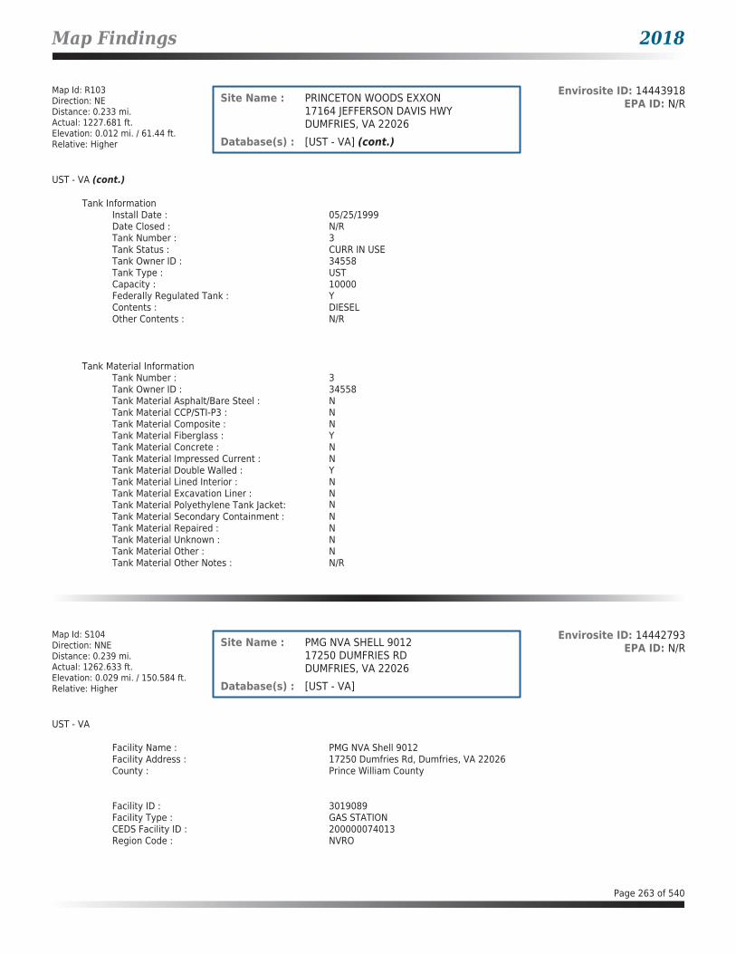
Map Findings 2018
Map Id: R103Direction: NEDistance: 0.233 mi.Actual: 1227.681 ft.Elevation: 0.012 mi. / 61.44 ft.Relative: Higher
Envirosite ID: 14443918EPA ID: N/RSite Name : PRINCETON WOODS EXXON
17164 JEFFERSON DAVIS HWYDUMFRIES, VA 22026
Database(s) : [UST - VA] (cont.)
UST - VA (cont.)
Tank InformationInstall Date : 05/25/1999Date Closed : N/RTank Number : 3Tank Status : CURR IN USETank Owner ID : 34558Tank Type : USTCapacity : 10000Federally Regulated Tank : YContents : DIESELOther Contents : N/R
Tank Material InformationTank Number : 3Tank Owner ID : 34558Tank Material Asphalt/Bare Steel : NTank Material CCP/STI-P3 : NTank Material Composite : NTank Material Fiberglass : YTank Material Concrete : NTank Material Impressed Current : NTank Material Double Walled : YTank Material Lined Interior : NTank Material Excavation Liner : NTank Material Polyethylene Tank Jacket: NTank Material Secondary Containment : NTank Material Repaired : NTank Material Unknown : NTank Material Other : NTank Material Other Notes : N/R
Map Id: S104Direction: NNEDistance: 0.239 mi.Actual: 1262.633 ft.Elevation: 0.029 mi. / 150.584 ft.Relative: Higher
Envirosite ID: 14442793EPA ID: N/RSite Name : PMG NVA SHELL 9012
17250 DUMFRIES RDDUMFRIES, VA 22026
Database(s) : [UST - VA]
UST - VA
Facility Name : PMG NVA Shell 9012Facility Address : 17250 Dumfries Rd, Dumfries, VA 22026County : Prince William County
Facility ID : 3019089Facility Type : GAS STATIONCEDS Facility ID : 200000074013Region Code : NVRO
Page 263 of 540

Map Findings 2018
Map Id: S104Direction: NNEDistance: 0.239 mi.Actual: 1262.633 ft.Elevation: 0.029 mi. / 150.584 ft.Relative: Higher
Envirosite ID: 14442793EPA ID: N/RSite Name : PMG NVA SHELL 9012
17250 DUMFRIES RDDUMFRIES, VA 22026
Database(s) : [UST - VA] (cont.)
UST - VA (cont.)
Tank InformationInstall Date : 04/17/1984Date Closed : 12/16/1997Tank Number : R5Tank Status : REM FROM GRDTank Owner ID : 36032Tank Type : USTCapacity : 550Federally Regulated Tank : YContents : USED OILOther Contents : N/R
Tank Material InformationTank Number : R5Tank Owner ID : 36032Tank Material Asphalt/Bare Steel : NTank Material CCP/STI-P3 : NTank Material Composite : NTank Material Fiberglass : YTank Material Concrete : NTank Material Impressed Current : NTank Material Double Walled : NTank Material Lined Interior : NTank Material Excavation Liner : NTank Material Polyethylene Tank Jacket: NTank Material Secondary Containment : NTank Material Repaired : NTank Material Unknown : NTank Material Other : NTank Material Other Notes : N/R
Tank InformationInstall Date : 04/17/1984Date Closed : N/RTank Number : 1Tank Status : CURR IN USETank Owner ID : 45860Tank Type : USTCapacity : 12000Federally Regulated Tank : YContents : GASOLINEOther Contents : N/R
Tank Material InformationTank Number : 1Tank Owner ID : 45860Tank Material Asphalt/Bare Steel : NTank Material CCP/STI-P3 : NTank Material Composite : NTank Material Fiberglass : YTank Material Concrete : N
Page 264 of 540

Map Findings 2018
Map Id: S104Direction: NNEDistance: 0.239 mi.Actual: 1262.633 ft.Elevation: 0.029 mi. / 150.584 ft.Relative: Higher
Envirosite ID: 14442793EPA ID: N/RSite Name : PMG NVA SHELL 9012
17250 DUMFRIES RDDUMFRIES, VA 22026
Database(s) : [UST - VA] (cont.)
UST - VA (cont.)
Tank Material Impressed Current : NTank Material Double Walled : NTank Material Lined Interior : NTank Material Excavation Liner : NTank Material Polyethylene Tank Jacket: NTank Material Secondary Containment : NTank Material Repaired : NTank Material Unknown : NTank Material Other : NTank Material Other Notes : N/R
Tank InformationInstall Date : 04/17/1984Date Closed : N/RTank Number : 2Tank Status : CURR IN USETank Owner ID : 45860Tank Type : USTCapacity : 10000Federally Regulated Tank : YContents : DIESELOther Contents : N/R
Tank Material InformationTank Number : 2Tank Owner ID : 45860Tank Material Asphalt/Bare Steel : NTank Material CCP/STI-P3 : NTank Material Composite : NTank Material Fiberglass : YTank Material Concrete : NTank Material Impressed Current : NTank Material Double Walled : NTank Material Lined Interior : NTank Material Excavation Liner : NTank Material Polyethylene Tank Jacket: NTank Material Secondary Containment : NTank Material Repaired : NTank Material Unknown : NTank Material Other : NTank Material Other Notes : N/R
Tank InformationInstall Date : 04/17/1984Date Closed : N/RTank Number : 3Tank Status : CURR IN USETank Owner ID : 45860Tank Type : USTCapacity : 10000Federally Regulated Tank : Y
Page 265 of 540

Map Findings 2018
Map Id: S104Direction: NNEDistance: 0.239 mi.Actual: 1262.633 ft.Elevation: 0.029 mi. / 150.584 ft.Relative: Higher
Envirosite ID: 14442793EPA ID: N/RSite Name : PMG NVA SHELL 9012
17250 DUMFRIES RDDUMFRIES, VA 22026
Database(s) : [UST - VA] (cont.)
UST - VA (cont.)
Contents : GASOLINEOther Contents : N/R
Tank Material InformationTank Number : 3Tank Owner ID : 45860Tank Material Asphalt/Bare Steel : NTank Material CCP/STI-P3 : NTank Material Composite : NTank Material Fiberglass : YTank Material Concrete : NTank Material Impressed Current : NTank Material Double Walled : NTank Material Lined Interior : NTank Material Excavation Liner : NTank Material Polyethylene Tank Jacket: NTank Material Secondary Containment : NTank Material Repaired : NTank Material Unknown : NTank Material Other : NTank Material Other Notes : N/R
Tank InformationInstall Date : 04/17/1984Date Closed : N/RTank Number : 4Tank Status : CURR IN USETank Owner ID : 45860Tank Type : USTCapacity : 8000Federally Regulated Tank : YContents : DIESELOther Contents : N/R
Tank Material InformationTank Number : 4Tank Owner ID : 45860Tank Material Asphalt/Bare Steel : NTank Material CCP/STI-P3 : NTank Material Composite : NTank Material Fiberglass : YTank Material Concrete : NTank Material Impressed Current : NTank Material Double Walled : NTank Material Lined Interior : NTank Material Excavation Liner : NTank Material Polyethylene Tank Jacket: NTank Material Secondary Containment : NTank Material Repaired : NTank Material Unknown : NTank Material Other : N
Page 266 of 540

Map Findings 2018
Map Id: S104Direction: NNEDistance: 0.239 mi.Actual: 1262.633 ft.Elevation: 0.029 mi. / 150.584 ft.Relative: Higher
Envirosite ID: 14442793EPA ID: N/RSite Name : PMG NVA SHELL 9012
17250 DUMFRIES RDDUMFRIES, VA 22026
Database(s) : [UST - VA] (cont.)
UST - VA (cont.)
Tank Material Other Notes : N/R
Map Id: Q105Direction: SWDistance: 0.246 mi.Actual: 1300.971 ft.Elevation: 0.023 mi. / 121.371 ft.Relative: Higher
Envirosite ID: 24847565EPA ID: N/RSite Name : FURNITURE OUTLET
18525 JEFFERSON DAVIS HWYTRIANGLE, VA 22172
Database(s) : [LPT - VA]
LPT - VA
Facility Name : Furniture OutletFacility Address : 18525 Jefferson Davis Hwy, Triangle, VA 22172County : Prince William County
Release Reported : 03/31/1997PC Number : 19973160CEDS Facility ID : 200000186185Case Status : ClosedCase Closed Date : 11/21/1997Region : NVROProgram : RP LeadHeating Oil Category : N/RFederally Regulated UST : YRegulated Petroleum UST (1) : YExcluded UST (1) : NDeferred UST (1) : NPartially Deferred UST (1) : NExempt 1 UST (2) : NExempt 2 Heating Oil UST (2) : NSmall Heating Oil AST (2) : NRegulated AST (3) : NUnregulated AST (3) : NOther (Y/N) : NOther Description : N/RUnknown (Y/N) : NPriority : 3Suspect Confirm Indicator : ConfirmedLatitude : 38.5486771679Longitude : -77.3345016201Last Date in Agency List : 02/09/2018
Page 267 of 540

Map Findings 2018
Map Id: 106Direction: WNWDistance: 0.248 mi.Actual: 1306.948 ft.Elevation: 0.01 mi. / 52.195 ft.Relative: Higher
Envirosite ID: 24852323EPA ID: N/RSite Name : DUMFRIES ELEMENTARY SCHOOL
300 CAMERON STDUMFRIES, VA 22026
Database(s) : [AFS, LPT - VA]
AFS
Facility Name : DUMFRIES ELEMENTARY SCHOOLFacility Address : 300 CAMERON ST, DUMFRIES, VA 220260000County : Prince William
Facility SummaryProgram System ID : VA0000005115300030Facility Registry ID : 110001898135EPA Region : EPA Region 3 - DE, DC, MD, PA, VA, WVSIC Codes : 8211NAICS Code : 611110NAICS Code Description : N/RFacility Type : County GovernmentAir Pollutant Class Code : MINAir Pollutant Class Description : Minor EmissionsAir Operating Status Code : OPRAir Operating Status Description : OperatingCurrent High Priority Violation (HPV) Code: No ViolCurrent High Priority Violation (HPV) Description: No ViolLocal Control Region Code : N/RLocal Control Region Name : N/R
Air Pollutant DetailsProgram System ID : VA0000005115300030Pollutant Code : 300000005Pollutant Description : NITROGEN OXIDES NO2SRS ID : 167924Chemical Abstract Service Number : 10102440Air Pollutant Class Code : MINAir Pollutant Class Description : Minor Emissions
Air Violation History DetailsHPV Day Zero Date : N/RHPV Resolved Date : N/RProgram System ID : N/RActivity ID : N/RAgency Type : N/RState Code : N/RAir LCON Code : N/RComp Determination UID : N/RENF Response Policy Codes : N/RENF Response Policy Description : N/RProgram Codes : N/RProgram Description : N/RPollutant Codes : N/RPollutant Description : N/REarliest FRV Determ Date : N/R
Page 268 of 540

Map Findings 2018
Map Id: 106Direction: WNWDistance: 0.248 mi.Actual: 1306.948 ft.Elevation: 0.01 mi. / 52.195 ft.Relative: Higher
Envirosite ID: 24852323EPA ID: N/RSite Name : DUMFRIES ELEMENTARY SCHOOL
300 CAMERON STDUMFRIES, VA 22026
Database(s) : [AFS, LPT - VA] (cont.)
LPT - VA
Facility Name : Dumfries Elementary SchoolFacility Address : 300 Cameron St, Dumfries, VA 22026County : Prince William County
Release Reported : 07/25/1990PC Number : 19910125CEDS Facility ID : 200000078812Case Status : ClosedCase Closed Date : 03/09/1992Region : NVROProgram : RP LeadHeating Oil Category : N/RFederally Regulated UST : YRegulated Petroleum UST (1) : YExcluded UST (1) : NDeferred UST (1) : NPartially Deferred UST (1) : NExempt 1 UST (2) : NExempt 2 Heating Oil UST (2) : NSmall Heating Oil AST (2) : NRegulated AST (3) : NUnregulated AST (3) : NOther (Y/N) : NOther Description : N/RUnknown (Y/N) : NPriority : N/RSuspect Confirm Indicator : ConfirmedLatitude : 38.5681162138Longitude : -77.3305193148Last Date in Agency List : 02/09/2018
Map Id: S107Direction: NNEDistance: 0.250 mi.Actual: 1321.223 ft.Elevation: 0.029 mi. / 153.671 ft.Relative: Higher
Envirosite ID: 24852550EPA ID: N/RSite Name : TEXACO 230681333 - MONTCLAIR
17250 DUMFRIES RDDUMFRIES, VA 22026
Database(s) : [LPT - VA]
LPT - VA
Facility Name : Texaco 230681333 - MontclairFacility Address : 17250 Dumfries Rd, Dumfries, VA 22026County : Prince William County
Release Reported : 04/23/1990PC Number : 19901427CEDS Facility ID : 200000074013Case Status : ClosedCase Closed Date : 02/03/1995Region : NVRO
Page 269 of 540

Map Findings 2018
Map Id: S107Direction: NNEDistance: 0.250 mi.Actual: 1321.223 ft.Elevation: 0.029 mi. / 153.671 ft.Relative: Higher
Envirosite ID: 24852550EPA ID: N/RSite Name : TEXACO 230681333 - MONTCLAIR
17250 DUMFRIES RDDUMFRIES, VA 22026
Database(s) : [LPT - VA] (cont.)
LPT - VA (cont.)
Program : RP LeadHeating Oil Category : N/RFederally Regulated UST : YRegulated Petroleum UST (1) : YExcluded UST (1) : NDeferred UST (1) : NPartially Deferred UST (1) : NExempt 1 UST (2) : NExempt 2 Heating Oil UST (2) : NSmall Heating Oil AST (2) : NRegulated AST (3) : NUnregulated AST (3) : NOther (Y/N) : NOther Description : N/RUnknown (Y/N) : NPriority : 2Suspect Confirm Indicator : ConfirmedLatitude : 38.5780512522Longitude : -77.3194555083Last Date in Agency List : 02/09/2018
Map Id: Q108Direction: SWDistance: 0.252 mi.Actual: 1330.765 ft.Elevation: 0.023 mi. / 121.07 ft.Relative: Higher
Envirosite ID: 1366951EPA ID: VAD096565965Site Name : ANG KEK K
18524 JEFFERSON DAVIS HWYTRIANGLE, VA 22172
Database(s) : [CERCLIS NFRAP, SEMS_8R_ARCHIVED SITES]
CERCLIS NFRAP
Facility Name : ANG KEK KFacility Address : 18524 JEFFERSON DAVIS HWY, TRIANGLE, VA 22172County : PRINCE WILLIAM
Site ID : 0302631Epa ID : VAD096565965Short Name : ANG KEK KCongressional District : 07IFMS ID : N/RSMSA Number : 8840USGC Hydro Unit : 02070011Federal Facility : NDMNSN Number : N/RSite Orphan Flag : NRCRA ID : N/RUSGS Quadrangle : N/RSite Init by Prog : N/RNFRAP Flag : NFAParent ID : N/RRST Code : N/R
Page 270 of 540
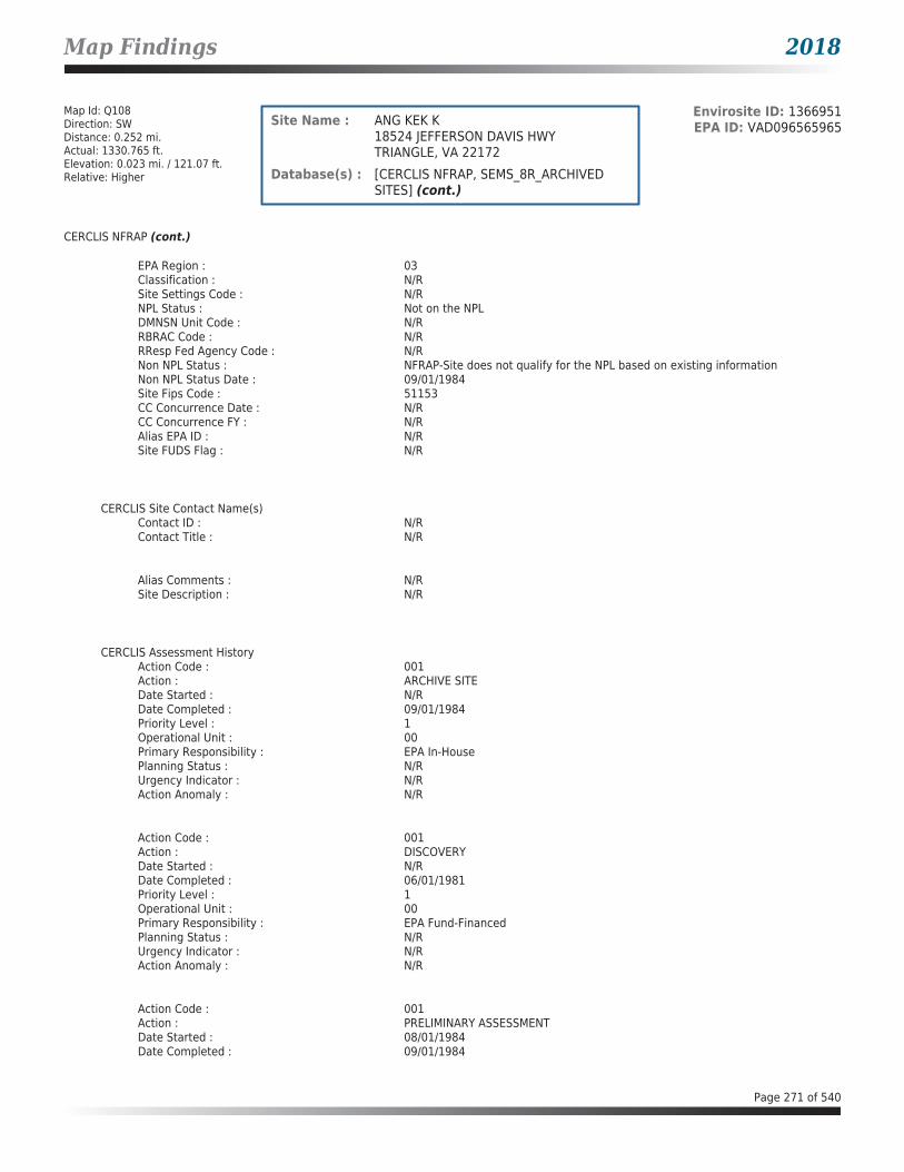
Map Findings 2018
Map Id: Q108Direction: SWDistance: 0.252 mi.Actual: 1330.765 ft.Elevation: 0.023 mi. / 121.07 ft.Relative: Higher
Envirosite ID: 1366951EPA ID: VAD096565965Site Name : ANG KEK K
18524 JEFFERSON DAVIS HWYTRIANGLE, VA 22172
Database(s) : [CERCLIS NFRAP, SEMS_8R_ARCHIVED SITES] (cont.)
CERCLIS NFRAP (cont.)
EPA Region : 03Classification : N/RSite Settings Code : N/RNPL Status : Not on the NPLDMNSN Unit Code : N/RRBRAC Code : N/RRResp Fed Agency Code : N/RNon NPL Status : NFRAP-Site does not qualify for the NPL based on existing informationNon NPL Status Date : 09/01/1984Site Fips Code : 51153CC Concurrence Date : N/RCC Concurrence FY : N/RAlias EPA ID : N/RSite FUDS Flag : N/R
CERCLIS Site Contact Name(s)Contact ID : N/RContact Title : N/R
Alias Comments : N/RSite Description : N/R
CERCLIS Assessment HistoryAction Code : 001Action : ARCHIVE SITEDate Started : N/RDate Completed : 09/01/1984Priority Level : 1Operational Unit : 00Primary Responsibility : EPA In-HousePlanning Status : N/RUrgency Indicator : N/RAction Anomaly : N/R
Action Code : 001Action : DISCOVERYDate Started : N/RDate Completed : 06/01/1981Priority Level : 1Operational Unit : 00Primary Responsibility : EPA Fund-FinancedPlanning Status : N/RUrgency Indicator : N/RAction Anomaly : N/R
Action Code : 001Action : PRELIMINARY ASSESSMENTDate Started : 08/01/1984Date Completed : 09/01/1984
Page 271 of 540

Map Findings 2018
Map Id: Q108Direction: SWDistance: 0.252 mi.Actual: 1330.765 ft.Elevation: 0.023 mi. / 121.07 ft.Relative: Higher
Envirosite ID: 1366951EPA ID: VAD096565965Site Name : ANG KEK K
18524 JEFFERSON DAVIS HWYTRIANGLE, VA 22172
Database(s) : [CERCLIS NFRAP, SEMS_8R_ARCHIVED SITES] (cont.)
CERCLIS NFRAP (cont.)
Priority Level : 1Operational Unit : 00Primary Responsibility : State, Fund FinancedPlanning Status : N/RUrgency Indicator : N/RAction Anomaly : N/R
SEMS_8R_ARCHIVED SITES
Facility Name : ANG KEK KFacility Address : 18524 JEFFERSON DAVIS HWY, TRIANGLE, VA 22172County : PRINCE WILLIAM
Site DetailsSite ID : 0302631EPA ID : VAD096565965Region : 03Congressional District : 07Federal Facility : NNPL Status : Not on the NPLNon NPL Status : NFRAP-Site does not qualify for the NPL based on existing informationFIPS Code : 51153Last Date in Agency List : 01/02/2018
Additional InformationStart Date : 08/01/1984Finish Date : 09/01/1984OU : 00Action Code : PAAction Name : PASequence : 1Quality : NCurrent Action Lead : St Perf
Start Date : 06/01/1981Finish Date : 06/01/1981OU : 00Action Code : DSAction Name : DISCVRYSequence : 1Quality : N/RCurrent Action Lead : EPA Perf
Start Date : N/RFinish Date : 09/01/1984OU : 00Action Code : VSAction Name : ARCH SITESequence : 1Quality : N/R
Page 272 of 540
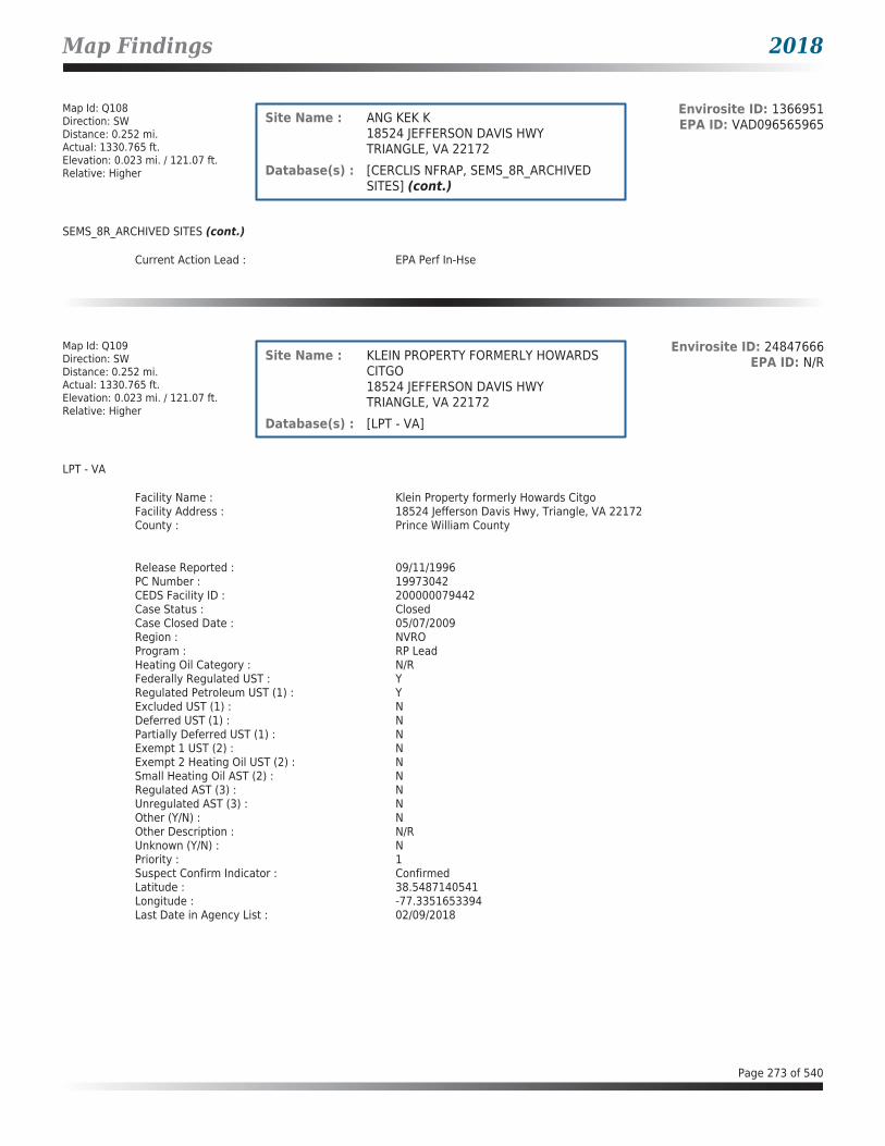
Map Findings 2018
Map Id: Q108Direction: SWDistance: 0.252 mi.Actual: 1330.765 ft.Elevation: 0.023 mi. / 121.07 ft.Relative: Higher
Envirosite ID: 1366951EPA ID: VAD096565965Site Name : ANG KEK K
18524 JEFFERSON DAVIS HWYTRIANGLE, VA 22172
Database(s) : [CERCLIS NFRAP, SEMS_8R_ARCHIVED SITES] (cont.)
SEMS_8R_ARCHIVED SITES (cont.)
Current Action Lead : EPA Perf In-Hse
Map Id: Q109Direction: SWDistance: 0.252 mi.Actual: 1330.765 ft.Elevation: 0.023 mi. / 121.07 ft.Relative: Higher
Envirosite ID: 24847666EPA ID: N/RSite Name : KLEIN PROPERTY FORMERLY HOWARDS
CITGO18524 JEFFERSON DAVIS HWYTRIANGLE, VA 22172
Database(s) : [LPT - VA]
LPT - VA
Facility Name : Klein Property formerly Howards CitgoFacility Address : 18524 Jefferson Davis Hwy, Triangle, VA 22172County : Prince William County
Release Reported : 09/11/1996PC Number : 19973042CEDS Facility ID : 200000079442Case Status : ClosedCase Closed Date : 05/07/2009Region : NVROProgram : RP LeadHeating Oil Category : N/RFederally Regulated UST : YRegulated Petroleum UST (1) : YExcluded UST (1) : NDeferred UST (1) : NPartially Deferred UST (1) : NExempt 1 UST (2) : NExempt 2 Heating Oil UST (2) : NSmall Heating Oil AST (2) : NRegulated AST (3) : NUnregulated AST (3) : NOther (Y/N) : NOther Description : N/RUnknown (Y/N) : NPriority : 1Suspect Confirm Indicator : ConfirmedLatitude : 38.5487140541Longitude : -77.3351653394Last Date in Agency List : 02/09/2018
Page 273 of 540

Map Findings 2018
Map Id: Q110Direction: SWDistance: 0.257 mi.Actual: 1357.249 ft.Elevation: 0.023 mi. / 120.951 ft.Relative: Higher
Envirosite ID: 24852333EPA ID: N/RSite Name : UNION 76 - SIMMONS
18527 JEFFERSON DAVIS HWYTRIANGLE, VA 22172
Database(s) : [LPT - VA]
LPT - VA
Facility Name : Union 76 - SimmonsFacility Address : 18527 Jefferson Davis Hwy, Triangle, VA 22172County : Prince William County
Release Reported : 07/19/1990PC Number : 19910097CEDS Facility ID : 200000096323Case Status : ClosedCase Closed Date : 02/18/1992Region : NVROProgram : State LeadHeating Oil Category : N/RFederally Regulated UST : YRegulated Petroleum UST (1) : YExcluded UST (1) : NDeferred UST (1) : NPartially Deferred UST (1) : NExempt 1 UST (2) : NExempt 2 Heating Oil UST (2) : NSmall Heating Oil AST (2) : NRegulated AST (3) : NUnregulated AST (3) : NOther (Y/N) : NOther Description : N/RUnknown (Y/N) : NPriority : N/RSuspect Confirm Indicator : ConfirmedLatitude : 38.5485337773Longitude : -77.3346176393Last Date in Agency List : 02/09/2018
Map Id: R111Direction: NEDistance: 0.260 mi.Actual: 1374.520 ft.Elevation: 0.013 mi. / 66.611 ft.Relative: Higher
Envirosite ID: 24836044EPA ID: N/RSite Name : EXXONMOBIL STATION 20389
17164 JEFFERSON DAVIS HWYDUMFRIES, VA 22026
Database(s) : [LPT - VA]
LPT - VA
Facility Name : ExxonMobil Station 20389Facility Address : 17164 Jefferson Davis Hwy, Dumfries, VA 22026County : Prince William County
Release Reported : 10/29/2009PC Number : 20103117CEDS Facility ID : 200000195074Case Status : ClosedCase Closed Date : 04/20/2010Region : NVRO
Page 274 of 540

Map Findings 2018
Map Id: R111Direction: NEDistance: 0.260 mi.Actual: 1374.520 ft.Elevation: 0.013 mi. / 66.611 ft.Relative: Higher
Envirosite ID: 24836044EPA ID: N/RSite Name : EXXONMOBIL STATION 20389
17164 JEFFERSON DAVIS HWYDUMFRIES, VA 22026
Database(s) : [LPT - VA] (cont.)
LPT - VA (cont.)
Program : RP LeadHeating Oil Category : N/RFederally Regulated UST : YRegulated Petroleum UST (1) : YExcluded UST (1) : NDeferred UST (1) : NPartially Deferred UST (1) : NExempt 1 UST (2) : NExempt 2 Heating Oil UST (2) : NSmall Heating Oil AST (2) : NRegulated AST (3) : NUnregulated AST (3) : NOther (Y/N) : NOther Description : N/RUnknown (Y/N) : NPriority : 3Suspect Confirm Indicator : ConfirmedLatitude : 38.578967532Longitude : -77.3126516603Last Date in Agency List : 02/09/2018
Map Id: S112Direction: NNEDistance: 0.284 mi.Actual: 1501.159 ft.Elevation: 0.03 mi. / 156.634 ft.Relative: Higher
Envirosite ID: 325577520EPA ID: N/RSite Name : POTOMAC CDD LANDFILL
3730 GREENTREE LNDUMFRIES, VA 22026
Database(s) : [SWF/LF - VA]
SWF/LF - VA
Facility Name : Potomac CDD LandfillFacility Address : 3730 Greentree Ln, Dumfries, VA 22026County : Prince William County
Facility Operation Effective Date : 08/06/1984Facility Operation Status : ActiveLandfill Type : CONSTRUCTION / DEMOLITION / DEBRIS (CDD) LANDFILUnit Effective Date : 08/06/1984Unit Name : Potomac LandfillUnit Status : ActivePermit Number : SWP441Regional Office : Northern Regional OfficeContact Name : N/RTelephone : N/R
Facility Operation Effective Date : 08/06/1984Facility Operation Status : ActiveLandfill Type : LANDFILL MINING [SW]Unit Effective Date : 02/04/2002Unit Name : Potomac Landfill Mining Operation
Page 275 of 540

Map Findings 2018
Map Id: S112Direction: NNEDistance: 0.284 mi.Actual: 1501.159 ft.Elevation: 0.03 mi. / 156.634 ft.Relative: Higher
Envirosite ID: 325577520EPA ID: N/RSite Name : POTOMAC CDD LANDFILL
3730 GREENTREE LNDUMFRIES, VA 22026
Database(s) : [SWF/LF - VA] (cont.)
SWF/LF - VA (cont.)
Unit Status : ActivePermit Number : SWP441Regional Office : Northern Regional OfficeContact Name : N/RTelephone : N/R
Map Id: 113Direction: SSWDistance: 0.306 mi.Actual: 1614.827 ft.Elevation: 0.009 mi. / 48.691 ft.Relative: Higher
Envirosite ID: 24840503EPA ID: N/RSite Name : WALKER STEVEN RESIDENCE
3227 GRAHAM PARK RDDUMFRIES, VA 22026
Database(s) : [LPT - VA]
LPT - VA
Facility Name : Walker Steven ResidenceFacility Address : 3227 Graham Park Rd, Dumfries, VA 22026County : Prince William County
Release Reported : 03/30/2005PC Number : 20053240CEDS Facility ID : 200000224498Case Status : ClosedCase Closed Date : 03/13/2009Region : NVROProgram : RP LeadHeating Oil Category : NFAFederally Regulated UST : NRegulated Petroleum UST (1) : NExcluded UST (1) : NDeferred UST (1) : NPartially Deferred UST (1) : NExempt 1 UST (2) : NExempt 2 Heating Oil UST (2) : NSmall Heating Oil AST (2) : YRegulated AST (3) : NUnregulated AST (3) : NOther (Y/N) : NOther Description : N/RUnknown (Y/N) : NPriority : 3Suspect Confirm Indicator : ConfirmedLatitude : 38.5575711877Longitude : -77.3254026034Last Date in Agency List : 02/09/2018
Page 276 of 540

Map Findings 2018
Map Id: 114Direction: SWDistance: 0.331 mi.Actual: 1747.175 ft.Elevation: 0.022 mi. / 113.783 ft.Relative: Higher
Envirosite ID: 24850521EPA ID: N/RSite Name : EL RANCHO RESTAURANT
18607 JEFFERSON DAVIS HWYTRIANGLE, VA 22172
Database(s) : [LPT - VA]
LPT - VA
Facility Name : El Rancho RestaurantFacility Address : 18607 Jefferson Davis Hwy, Triangle, VA 22172County : Prince William County
Release Reported : 09/17/1992PC Number : 19930568CEDS Facility ID : 200000185392Case Status : ClosedCase Closed Date : 06/21/1993Region : NVROProgram : RP LeadHeating Oil Category : N/RFederally Regulated UST : NRegulated Petroleum UST (1) : NExcluded UST (1) : NDeferred UST (1) : NPartially Deferred UST (1) : NExempt 1 UST (2) : NExempt 2 Heating Oil UST (2) : NSmall Heating Oil AST (2) : NRegulated AST (3) : NUnregulated AST (3) : NOther (Y/N) : NOther Description : N/RUnknown (Y/N) : YPriority : 3Suspect Confirm Indicator : ConfirmedLatitude : 38.5472274988Longitude : -77.3353187834Last Date in Agency List : 02/09/2018
Map Id: T115Direction: SWDistance: 0.336 mi.Actual: 1775.053 ft.Elevation: 0.022 mi. / 113.783 ft.Relative: Higher
Envirosite ID: 24850522EPA ID: N/RSite Name : HARVEYS TOWING
18609 JEFFERSON DAVIS HWYTRIANGLE, VA 22172
Database(s) : [LPT - VA]
LPT - VA
Facility Name : Harveys TowingFacility Address : 18609 Jefferson Davis Hwy, Triangle, VA 22172County : Prince William County
Release Reported : 09/17/1992PC Number : 19930567CEDS Facility ID : 200000077696Case Status : ClosedCase Closed Date : 10/05/1994Region : NVRO
Page 277 of 540

Map Findings 2018
Map Id: T115Direction: SWDistance: 0.336 mi.Actual: 1775.053 ft.Elevation: 0.022 mi. / 113.783 ft.Relative: Higher
Envirosite ID: 24850522EPA ID: N/RSite Name : HARVEYS TOWING
18609 JEFFERSON DAVIS HWYTRIANGLE, VA 22172
Database(s) : [LPT - VA] (cont.)
LPT - VA (cont.)
Program : RP LeadHeating Oil Category : N/RFederally Regulated UST : YRegulated Petroleum UST (1) : YExcluded UST (1) : NDeferred UST (1) : NPartially Deferred UST (1) : NExempt 1 UST (2) : NExempt 2 Heating Oil UST (2) : NSmall Heating Oil AST (2) : NRegulated AST (3) : NUnregulated AST (3) : NOther (Y/N) : NOther Description : N/RUnknown (Y/N) : NPriority : N/RSuspect Confirm Indicator : ConfirmedLatitude : 38.5473338183Longitude : -77.3352435746Last Date in Agency List : 02/09/2018
Map Id: T116Direction: SWDistance: 0.355 mi.Actual: 1872.369 ft.Elevation: 0.021 mi. / 108.921 ft.Relative: Higher
Envirosite ID: 24839518EPA ID: N/RSite Name : EXXON 23901
18625 JEFFERSON DAVIS HWYTRIANGLE, VA 22172
Database(s) : [LPT - VA]
LPT - VA
Facility Name : Exxon 23901Facility Address : 18625 Jefferson Davis Hwy, Triangle, VA 22172County : Prince William County
Release Reported : 03/16/2006PC Number : 20063240CEDS Facility ID : 200000078608Case Status : ClosedCase Closed Date : 01/03/2012Region : NVROProgram : RP LeadHeating Oil Category : N/RFederally Regulated UST : YRegulated Petroleum UST (1) : YExcluded UST (1) : NDeferred UST (1) : NPartially Deferred UST (1) : NExempt 1 UST (2) : NExempt 2 Heating Oil UST (2) : NSmall Heating Oil AST (2) : NRegulated AST (3) : N
Page 278 of 540

Map Findings 2018
Map Id: T116Direction: SWDistance: 0.355 mi.Actual: 1872.369 ft.Elevation: 0.021 mi. / 108.921 ft.Relative: Higher
Envirosite ID: 24839518EPA ID: N/RSite Name : EXXON 23901
18625 JEFFERSON DAVIS HWYTRIANGLE, VA 22172
Database(s) : [LPT - VA] (cont.)
LPT - VA (cont.)
Unregulated AST (3) : NOther (Y/N) : NOther Description : N/RUnknown (Y/N) : NPriority : 2Suspect Confirm Indicator : ConfirmedLatitude : 38.5462000073Longitude : -77.3357190556Last Date in Agency List : 02/09/2018
Release Reported : 06/26/1998PC Number : 19983789CEDS Facility ID : 200000078608Case Status : ClosedCase Closed Date : 07/17/1998Region : NVROProgram : RP LeadHeating Oil Category : N/RFederally Regulated UST : YRegulated Petroleum UST (1) : N/RExcluded UST (1) : N/RDeferred UST (1) : N/RPartially Deferred UST (1) : N/RExempt 1 UST (2) : N/RExempt 2 Heating Oil UST (2) : N/RSmall Heating Oil AST (2) : N/RRegulated AST (3) : N/RUnregulated AST (3) : N/ROther (Y/N) : N/ROther Description : N/RUnknown (Y/N) : N/RPriority : N/RSuspect Confirm Indicator : SuspectedLatitude : 38.546344703Longitude : -77.33593673Last Date in Agency List : 02/09/2018
Release Reported : 02/21/1995PC Number : 19954197CEDS Facility ID : 200000078608Case Status : ClosedCase Closed Date : 02/23/1995Region : NVROProgram : RP LeadHeating Oil Category : N/RFederally Regulated UST : YRegulated Petroleum UST (1) : YExcluded UST (1) : NDeferred UST (1) : NPartially Deferred UST (1) : NExempt 1 UST (2) : NExempt 2 Heating Oil UST (2) : NSmall Heating Oil AST (2) : NRegulated AST (3) : NUnregulated AST (3) : N
Page 279 of 540
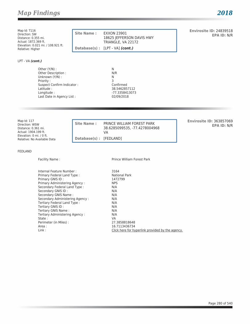
Map Findings 2018
Map Id: T116Direction: SWDistance: 0.355 mi.Actual: 1872.369 ft.Elevation: 0.021 mi. / 108.921 ft.Relative: Higher
Envirosite ID: 24839518EPA ID: N/RSite Name : EXXON 23901
18625 JEFFERSON DAVIS HWYTRIANGLE, VA 22172
Database(s) : [LPT - VA] (cont.)
LPT - VA (cont.)
Other (Y/N) : NOther Description : N/RUnknown (Y/N) : NPriority : 3Suspect Confirm Indicator : ConfirmedLatitude : 38.5462857112Longitude : -77.3358413073Last Date in Agency List : 02/09/2018
Map Id: 117Direction: WSWDistance: 0.361 mi.Actual: 1904.199 ft.Elevation: 0 mi. / 0 ft.Relative: No Available Data
Envirosite ID: 363857069EPA ID: N/RSite Name : PRINCE WILLIAM FOREST PARK
38.6285099535, -77.4278004968VA
Database(s) : [FEDLAND]
FEDLAND
Facility Name : Prince William Forest Park
Internal Feature Number : 3164Primary Federal Land Type : National ParkPrimary GNIS ID : 1472799Primary Administering Agency : NPSSecondary Federal Land Type : N/ASecondary GNIS ID : N/ASecondary GNIS Name : N/ASecondary Administering Agency : N/ATertiary Federal Land Type : N/ATertiary GNIS ID : N/ATertiary GNIS Name : N/ATertiary Administering Agency : N/AState : VAPerimeter (in Miles) : 27.3858818648Area : 16.7113436734Link : Click here for hyperlink provided by the agency.
Page 280 of 540
Map Findings 2018
Map Id: T118Direction: SWDistance: 0.375 mi.Actual: 1982.024 ft.Elevation: 0.02 mi. / 106.135 ft.Relative: Higher
Envirosite ID: 24850523EPA ID: N/RSite Name : VIRGINIA PAWN AND CHILI HUT
18617 JEFFERSON DAVIS HWYTRIANGLE, VA 22172
Database(s) : [LPT - VA]
LPT - VA
Facility Name : Virginia Pawn and Chili HutFacility Address : 18617 Jefferson Davis Hwy, Triangle, VA 22172County : Prince William County
Release Reported : 09/17/1992PC Number : 19930566CEDS Facility ID : 200000186226Case Status : ClosedCase Closed Date : 10/05/1994Region : NVROProgram : RP LeadHeating Oil Category : N/RFederally Regulated UST : NRegulated Petroleum UST (1) : NExcluded UST (1) : NDeferred UST (1) : NPartially Deferred UST (1) : NExempt 1 UST (2) : NExempt 2 Heating Oil UST (2) : NSmall Heating Oil AST (2) : NRegulated AST (3) : NUnregulated AST (3) : NOther (Y/N) : NOther Description : N/RUnknown (Y/N) : YPriority : N/RSuspect Confirm Indicator : ConfirmedLatitude : 38.5468298647Longitude : -77.3355953046Last Date in Agency List : 02/09/2018
Map Id: T119Direction: SWDistance: 0.409 mi.Actual: 2157.581 ft.Elevation: 0.019 mi. / 101.407 ft.Relative: Higher
Envirosite ID: 342395936EPA ID: N/RSite Name : SHELL - TRIANGLE SERVICE CENTER
18630 JEFFERSON DAVIS HWYTRIANGLE, VA 22172
Database(s) : [LPT - VA]
LPT - VA
Facility Name : Shell - Triangle Service CenterFacility Address : 18630 Jefferson Davis Hwy, Triangle, VA 22172County : Prince William County
Release Reported : 06/04/1998PC Number : 19983780CEDS Facility ID : 200000074576Case Status : ClosedCase Closed Date : 07/22/1998Region : NVRO
Page 281 of 540

Map Findings 2018
Map Id: T119Direction: SWDistance: 0.409 mi.Actual: 2157.581 ft.Elevation: 0.019 mi. / 101.407 ft.Relative: Higher
Envirosite ID: 342395936EPA ID: N/RSite Name : SHELL - TRIANGLE SERVICE CENTER
18630 JEFFERSON DAVIS HWYTRIANGLE, VA 22172
Database(s) : [LPT - VA] (cont.)
LPT - VA (cont.)
Program : RP LeadHeating Oil Category : N/RFederally Regulated UST : YRegulated Petroleum UST (1) : N/RExcluded UST (1) : N/RDeferred UST (1) : N/RPartially Deferred UST (1) : N/RExempt 1 UST (2) : N/RExempt 2 Heating Oil UST (2) : N/RSmall Heating Oil AST (2) : N/RRegulated AST (3) : N/RUnregulated AST (3) : N/ROther (Y/N) : N/ROther Description : N/RUnknown (Y/N) : N/RPriority : 3Suspect Confirm Indicator : SuspectedLatitude : 38.5469705391Longitude : -77.3362063997Last Date in Agency List : 02/09/2018
Map Id: 120Direction: NWDistance: 0.412 mi.Actual: 2177.887 ft.Elevation: 0.024 mi. / 127.68 ft.Relative: Higher
Envirosite ID: 30476574EPA ID: N/RSite Name : FOUR MILE CREEK SEEP
551 N WASHINGTON STFALLS CHURCH, VA 22026
Database(s) : [LPT - VA]
LPT - VA
Facility Name : Four Mile Creek SeepFacility Address : 551 N Washington St, Falls Church, VA 22026County : Falls Church City
Release Reported : 11/28/2000PC Number : 20013110CEDS Facility ID : 200000198782Case Status : ClosedCase Closed Date : 06/28/2002Region : NVROProgram : State LeadHeating Oil Category : N/RFederally Regulated UST : NRegulated Petroleum UST (1) : NExcluded UST (1) : NDeferred UST (1) : NPartially Deferred UST (1) : NExempt 1 UST (2) : NExempt 2 Heating Oil UST (2) : NSmall Heating Oil AST (2) : NRegulated AST (3) : N
Page 282 of 540
Map Findings 2018
Map Id: 120Direction: NWDistance: 0.412 mi.Actual: 2177.887 ft.Elevation: 0.024 mi. / 127.68 ft.Relative: Higher
Envirosite ID: 30476574EPA ID: N/RSite Name : FOUR MILE CREEK SEEP
551 N WASHINGTON STFALLS CHURCH, VA 22026
Database(s) : [LPT - VA] (cont.)
LPT - VA (cont.)
Unregulated AST (3) : NOther (Y/N) : NOther Description : N/RUnknown (Y/N) : YPriority : 2Suspect Confirm Indicator : ConfirmedLatitude : 38.886386823Longitude : -77.1642843673Last Date in Agency List : 02/09/2018
Map Id: T121Direction: SWDistance: 0.427 mi.Actual: 2255.039 ft.Elevation: 0.02 mi. / 103.432 ft.Relative: Higher
Envirosite ID: 24845869EPA ID: N/RSite Name : U S INNS
4202 INN STTRIANGLE, VA 22172
Database(s) : [LPT - VA]
LPT - VA
Facility Name : U S InnsFacility Address : 4202 Inn St, Triangle, VA 22172County : Prince William County
Release Reported : 04/21/1999PC Number : 19993333CEDS Facility ID : 200000185565Case Status : ClosedCase Closed Date : 12/28/2001Region : NVROProgram : RP LeadHeating Oil Category : N/RFederally Regulated UST : NRegulated Petroleum UST (1) : NExcluded UST (1) : NDeferred UST (1) : NPartially Deferred UST (1) : NExempt 1 UST (2) : NExempt 2 Heating Oil UST (2) : YSmall Heating Oil AST (2) : NRegulated AST (3) : NUnregulated AST (3) : NOther (Y/N) : NOther Description : N/RUnknown (Y/N) : NPriority : 3Suspect Confirm Indicator : ConfirmedLatitude : 38.5466463079Longitude : -77.3368927324Last Date in Agency List : 02/09/2018
Page 283 of 540

Map Findings 2018
Map Id: 122Direction: SSWDistance: 0.441 mi.Actual: 2330.007 ft.Elevation: 0.018 mi. / 94.216 ft.Relative: Higher
Envirosite ID: 24846769EPA ID: N/RSite Name : QUIKEES TIRE AND GAS
18704 OLD TRIANGLE RDTRIANGLE, VA 22172
Database(s) : [LPT - VA]
LPT - VA
Facility Name : Quikees Tire and GasFacility Address : 18704 Old Triangle Rd, Triangle, VA 22172County : Prince William County
Release Reported : 06/25/1998PC Number : 19983783CEDS Facility ID : 200000193887Case Status : ClosedCase Closed Date : 01/11/2000Region : NVROProgram : RP LeadHeating Oil Category : N/RFederally Regulated UST : YRegulated Petroleum UST (1) : YExcluded UST (1) : NDeferred UST (1) : NPartially Deferred UST (1) : NExempt 1 UST (2) : NExempt 2 Heating Oil UST (2) : NSmall Heating Oil AST (2) : NRegulated AST (3) : NUnregulated AST (3) : NOther (Y/N) : NOther Description : N/RUnknown (Y/N) : NPriority : N/RSuspect Confirm Indicator : ConfirmedLatitude : 38.5453192772Longitude : -77.3329295836Last Date in Agency List : 02/09/2018
Map Id: T123Direction: SWDistance: 0.454 mi.Actual: 2399.757 ft.Elevation: 0 mi. / 0 ft.Relative: No Available Data
Envirosite ID: 461019EPA ID: VA1170024722Site Name : MARINE CORPS COMBAT DEVELOPMENT
COMMAND5TH STREETQUANTICO, VA 22134
Database(s) : [CERCLIS-HIST, CONSENT (DECREES), FED E C, FED I C, FEDERAL FACILITY, NPL, NPL EPA R3 GIS, ROD, SEMS_8R_ACTIVE SITES, SEMS_FINAL NPL]
CERCLIS-HIST
Facility Name : MARINE CORPS COMBAT DEVELOPMENT COMMANDFacility Address : 5TH STREET, QUANTICO, VA 22134County : PRINCE WILLIAM
Site ID : 0302840Epa ID : VA1170024722
Page 284 of 540

Map Findings 2018
Map Id: T123Direction: SWDistance: 0.454 mi.Actual: 2399.757 ft.Elevation: 0 mi. / 0 ft.Relative: No Available Data
Envirosite ID: 461019EPA ID: VA1170024722Site Name : MARINE CORPS COMBAT DEVELOPMENT
COMMAND5TH STREETQUANTICO, VA 22134
Database(s) : [CERCLIS-HIST, CONSENT (DECREES), FED E C, FED I C, FEDERAL FACILITY, NPL, NPL EPA R3 GIS, ROD, SEMS_8R_ACTIVE SITES, SEMS_FINAL NPL] (cont.)
CERCLIS-HIST (cont.)
Short Name : MARINE CORPS COMBAT DEVELCongressional District : 01IFMS ID : 03AHSMSA Number : 8840USGC Hydro Unit : 02070011Federal Facility : YDMNSN Number : 56000Site Orphan Flag : NRCRA ID : N/RUSGS Quadrangle : N/RSite Init by Prog : N/RNFRAP Flag : N/RParent ID : N/RRST Code : N/REPA Region : 03Classification : FSite Settings Code : SUNPL Status : Currently on the Final NPLDMNSN Unit Code : ACRERBRAC Code : N/RRResp Fed Agency Code : USNVNon NPL Status : N/RNon NPL Status Date : N/RSite Fips Code : 51153CC Concurrence Date : N/RCC Concurrence FY : N/RAlias EPA ID : N/RSite FUDS Flag : N/R
CERCLIS Site Contact Name(s)Contact ID : 13001052Contact Name : LISA BRADFORD CUNNINGHAMContact Tel. : 2158143363Contact Title : Remedial Project Manager (RPM)Contact Email : N/R
Contact ID : 13004963Contact Name : LARRY A. BROWNContact Tel. : 2158145527Contact Title : Community Involvement CoordinatorContact Email : N/R
Alias Comments : MARINE CORPS COMBAT DEVELOPMENT COMMANDSite Description : N/R
Alias Comments : MARINE CORPS COMBAT DEVELOPMENT COMMAND QUANTICOSite Description : Federal Facility Docket
Page 285 of 540
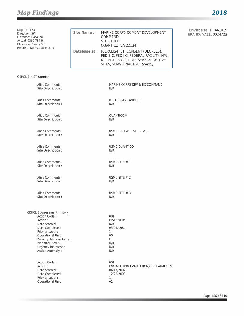
Map Findings 2018
Map Id: T123Direction: SWDistance: 0.454 mi.Actual: 2399.757 ft.Elevation: 0 mi. / 0 ft.Relative: No Available Data
Envirosite ID: 461019EPA ID: VA1170024722Site Name : MARINE CORPS COMBAT DEVELOPMENT
COMMAND5TH STREETQUANTICO, VA 22134
Database(s) : [CERCLIS-HIST, CONSENT (DECREES), FED E C, FED I C, FEDERAL FACILITY, NPL, NPL EPA R3 GIS, ROD, SEMS_8R_ACTIVE SITES, SEMS_FINAL NPL] (cont.)
CERCLIS-HIST (cont.)
Alias Comments : MARINE CORPS DEV & ED COMMANDSite Description : N/R
Alias Comments : MCDEC SAN LANDFILLSite Description : N/R
Alias Comments : QUANTICO *Site Description : N/R
Alias Comments : USMC HZD WST STRG FACSite Description : N/R
Alias Comments : USMC QUANTICOSite Description : N/R
Alias Comments : USMC SITE # 1Site Description : N/R
Alias Comments : USMC SITE # 2Site Description : N/R
Alias Comments : USMC SITE # 3Site Description : N/R
CERCLIS Assessment HistoryAction Code : 001Action : DISCOVERYDate Started : N/RDate Completed : 05/01/1981Priority Level : 1Operational Unit : 00Primary Responsibility : FPlanning Status : N/RUrgency Indicator : N/RAction Anomaly : N/R
Action Code : 001Action : ENGINEERING EVALUATION/COST ANALYSISDate Started : 04/17/2002Date Completed : 12/22/2003Priority Level : 1Operational Unit : 02
Page 286 of 540

Map Findings 2018
Map Id: T123Direction: SWDistance: 0.454 mi.Actual: 2399.757 ft.Elevation: 0 mi. / 0 ft.Relative: No Available Data
Envirosite ID: 461019EPA ID: VA1170024722Site Name : MARINE CORPS COMBAT DEVELOPMENT
COMMAND5TH STREETQUANTICO, VA 22134
Database(s) : [CERCLIS-HIST, CONSENT (DECREES), FED E C, FED I C, FEDERAL FACILITY, NPL, NPL EPA R3 GIS, ROD, SEMS_8R_ACTIVE SITES, SEMS_FINAL NPL] (cont.)
CERCLIS-HIST (cont.)
Primary Responsibility : FFPlanning Status : N/RUrgency Indicator : N/RAction Anomaly : N/R
Action Code : 001Action : Explanation Of Significant DifferencesDate Started : N/RDate Completed : 02/03/2006Priority Level : 2Operational Unit : 05Primary Responsibility : FFPlanning Status : N/RUrgency Indicator : N/RAction Anomaly : N/R
Action Code : 001Action : FEDERAL FACILITY FEASIBILITY STUDYDate Started : 12/18/2006Date Completed : N/RPriority Level : 1Operational Unit : 23Primary Responsibility : FFPlanning Status : N/RUrgency Indicator : N/RAction Anomaly : N/R
Action Code : 001Action : FEDERAL FACILITY FIVE YEAR REVIEWDate Started : N/RDate Completed : 03/31/2003Priority Level : 1Operational Unit : 04Primary Responsibility : FFPlanning Status : N/RUrgency Indicator : N/RAction Anomaly : N/R
Action Code : 001Action : FEDERAL FACILITY REMEDIAL ACTIONDate Started : 05/01/1996Date Completed : 09/30/1997Priority Level : 1Operational Unit : 04Primary Responsibility : FFPlanning Status : N/RUrgency Indicator : WAction Anomaly : N/R
Page 287 of 540

Map Findings 2018
Map Id: T123Direction: SWDistance: 0.454 mi.Actual: 2399.757 ft.Elevation: 0 mi. / 0 ft.Relative: No Available Data
Envirosite ID: 461019EPA ID: VA1170024722Site Name : MARINE CORPS COMBAT DEVELOPMENT
COMMAND5TH STREETQUANTICO, VA 22134
Database(s) : [CERCLIS-HIST, CONSENT (DECREES), FED E C, FED I C, FEDERAL FACILITY, NPL, NPL EPA R3 GIS, ROD, SEMS_8R_ACTIVE SITES, SEMS_FINAL NPL] (cont.)
CERCLIS-HIST (cont.)
Action Code : 001Action : FEDERAL FACILITY REMEDIAL INVESTIGATIONDate Started : 06/14/2002Date Completed : N/RPriority Level : 1Operational Unit : 23Primary Responsibility : FFPlanning Status : N/RUrgency Indicator : N/RAction Anomaly : N/R
Action Code : 001Action : FEDERAL FACILITY REMEDIAL INVESTIGATION/FEASIBILITY STUDYDate Started : 12/31/1996Date Completed : 09/30/1997Priority Level : 1Operational Unit : 04Primary Responsibility : FFPlanning Status : PUrgency Indicator : N/RAction Anomaly : N/R
Action Code : 001Action : FEDERAL FACILITY REMOVALDate Started : 07/14/2004Date Completed : 04/04/2005Priority Level : 1Operational Unit : 02Primary Responsibility : FFPlanning Status : N/RUrgency Indicator : 3Action Anomaly : N/R
Action Code : 001Action : FEDERAL INTERAGENCY AGREEMENTDate Started : 10/12/1994Date Completed : 02/05/1999Priority Level : 1Operational Unit : 00Primary Responsibility : FEPlanning Status : PUrgency Indicator : N/RAction Anomaly : N/R
Action Code : 001Action : FINAL LISTING ON NATIONAL PRIORITIES LISTDate Started : N/RDate Completed : 05/31/1994Priority Level : 1
Page 288 of 540

Map Findings 2018
Map Id: T123Direction: SWDistance: 0.454 mi.Actual: 2399.757 ft.Elevation: 0 mi. / 0 ft.Relative: No Available Data
Envirosite ID: 461019EPA ID: VA1170024722Site Name : MARINE CORPS COMBAT DEVELOPMENT
COMMAND5TH STREETQUANTICO, VA 22134
Database(s) : [CERCLIS-HIST, CONSENT (DECREES), FED E C, FED I C, FEDERAL FACILITY, NPL, NPL EPA R3 GIS, ROD, SEMS_8R_ACTIVE SITES, SEMS_FINAL NPL] (cont.)
CERCLIS-HIST (cont.)
Operational Unit : 00Primary Responsibility : FPlanning Status : PUrgency Indicator : N/RAction Anomaly : N/R
Action Code : 001Action : INTERAGENCY AGREEMENT NEGOTIATIONSDate Started : 10/12/1994Date Completed : 02/05/1999Priority Level : 1Operational Unit : 00Primary Responsibility : FEPlanning Status : PUrgency Indicator : N/RAction Anomaly : N/R
Action Code : 001Action : PRELIMINARY ASSESSMENTDate Started : N/RDate Completed : 09/10/1985Priority Level : 1Operational Unit : 00Primary Responsibility : FFPlanning Status : N/RUrgency Indicator : N/RAction Anomaly : N/R
Action Code : 001Action : PROPOSAL TO NATIONAL PRIORITIES LISTDate Started : N/RDate Completed : 05/10/1993Priority Level : 1Operational Unit : 00Primary Responsibility : FPlanning Status : PUrgency Indicator : N/RAction Anomaly : N/R
Action Code : 001Action : RECORD OF DECISIONDate Started : N/RDate Completed : 09/30/1997Priority Level : 1Operational Unit : 04Primary Responsibility : FFPlanning Status : N/RUrgency Indicator : N/RAction Anomaly : N/R
Page 289 of 540
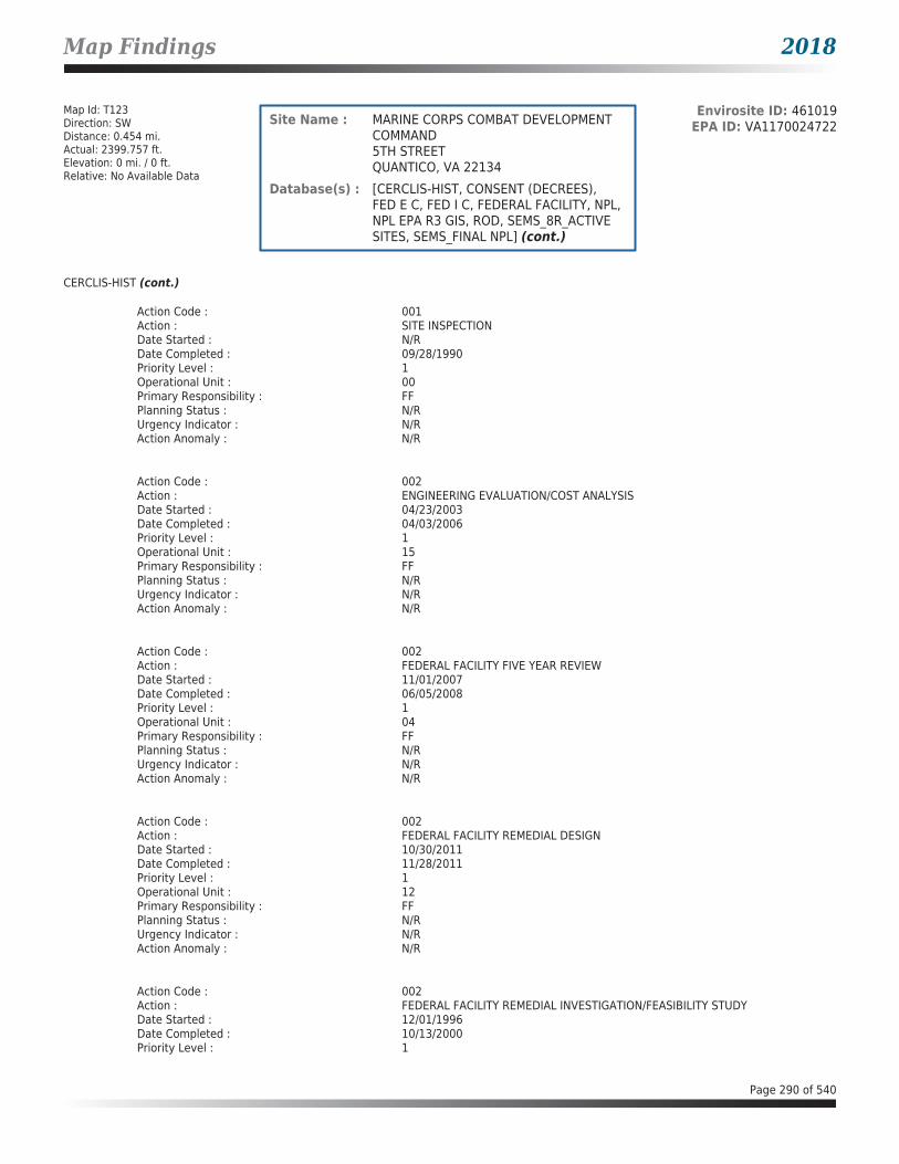
Map Findings 2018
Map Id: T123Direction: SWDistance: 0.454 mi.Actual: 2399.757 ft.Elevation: 0 mi. / 0 ft.Relative: No Available Data
Envirosite ID: 461019EPA ID: VA1170024722Site Name : MARINE CORPS COMBAT DEVELOPMENT
COMMAND5TH STREETQUANTICO, VA 22134
Database(s) : [CERCLIS-HIST, CONSENT (DECREES), FED E C, FED I C, FEDERAL FACILITY, NPL, NPL EPA R3 GIS, ROD, SEMS_8R_ACTIVE SITES, SEMS_FINAL NPL] (cont.)
CERCLIS-HIST (cont.)
Action Code : 001Action : SITE INSPECTIONDate Started : N/RDate Completed : 09/28/1990Priority Level : 1Operational Unit : 00Primary Responsibility : FFPlanning Status : N/RUrgency Indicator : N/RAction Anomaly : N/R
Action Code : 002Action : ENGINEERING EVALUATION/COST ANALYSISDate Started : 04/23/2003Date Completed : 04/03/2006Priority Level : 1Operational Unit : 15Primary Responsibility : FFPlanning Status : N/RUrgency Indicator : N/RAction Anomaly : N/R
Action Code : 002Action : FEDERAL FACILITY FIVE YEAR REVIEWDate Started : 11/01/2007Date Completed : 06/05/2008Priority Level : 1Operational Unit : 04Primary Responsibility : FFPlanning Status : N/RUrgency Indicator : N/RAction Anomaly : N/R
Action Code : 002Action : FEDERAL FACILITY REMEDIAL DESIGNDate Started : 10/30/2011Date Completed : 11/28/2011Priority Level : 1Operational Unit : 12Primary Responsibility : FFPlanning Status : N/RUrgency Indicator : N/RAction Anomaly : N/R
Action Code : 002Action : FEDERAL FACILITY REMEDIAL INVESTIGATION/FEASIBILITY STUDYDate Started : 12/01/1996Date Completed : 10/13/2000Priority Level : 1
Page 290 of 540

Map Findings 2018
Map Id: T123Direction: SWDistance: 0.454 mi.Actual: 2399.757 ft.Elevation: 0 mi. / 0 ft.Relative: No Available Data
Envirosite ID: 461019EPA ID: VA1170024722Site Name : MARINE CORPS COMBAT DEVELOPMENT
COMMAND5TH STREETQUANTICO, VA 22134
Database(s) : [CERCLIS-HIST, CONSENT (DECREES), FED E C, FED I C, FEDERAL FACILITY, NPL, NPL EPA R3 GIS, ROD, SEMS_8R_ACTIVE SITES, SEMS_FINAL NPL] (cont.)
CERCLIS-HIST (cont.)
Operational Unit : 01Primary Responsibility : FFPlanning Status : PUrgency Indicator : N/RAction Anomaly : N/R
Action Code : 002Action : FEDERAL FACILITY REMOVALDate Started : 03/08/2004Date Completed : 04/19/2005Priority Level : 1Operational Unit : 18Primary Responsibility : FFPlanning Status : PUrgency Indicator : 3Action Anomaly : N/R
Action Code : 002Action : RECORD OF DECISIONDate Started : N/RDate Completed : 10/13/2000Priority Level : 1Operational Unit : 01Primary Responsibility : FFPlanning Status : N/RUrgency Indicator : N/RAction Anomaly : N/R
Action Code : 003Action : FEDERAL FACILITY FIVE YEAR REVIEWDate Started : 01/19/2012Date Completed : 06/05/2013Priority Level : 1Operational Unit : 04Primary Responsibility : FFPlanning Status : N/RUrgency Indicator : N/RAction Anomaly : N/R
Action Code : 003Action : FEDERAL FACILITY REMEDIAL ACTIONDate Started : 05/31/2013Date Completed : N/RPriority Level : 1Operational Unit : 12Primary Responsibility : FFPlanning Status : N/RUrgency Indicator : N/RAction Anomaly : N/R
Page 291 of 540
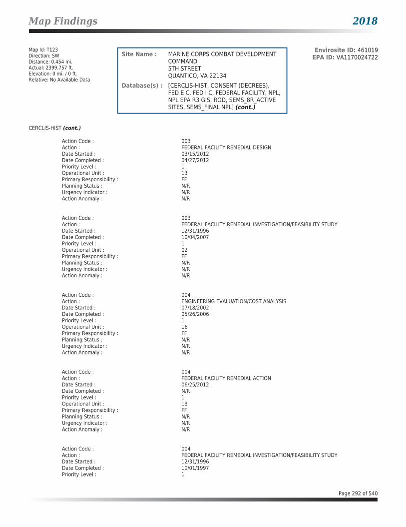
Map Findings 2018
Map Id: T123Direction: SWDistance: 0.454 mi.Actual: 2399.757 ft.Elevation: 0 mi. / 0 ft.Relative: No Available Data
Envirosite ID: 461019EPA ID: VA1170024722Site Name : MARINE CORPS COMBAT DEVELOPMENT
COMMAND5TH STREETQUANTICO, VA 22134
Database(s) : [CERCLIS-HIST, CONSENT (DECREES), FED E C, FED I C, FEDERAL FACILITY, NPL, NPL EPA R3 GIS, ROD, SEMS_8R_ACTIVE SITES, SEMS_FINAL NPL] (cont.)
CERCLIS-HIST (cont.)
Action Code : 003Action : FEDERAL FACILITY REMEDIAL DESIGNDate Started : 03/15/2012Date Completed : 04/27/2012Priority Level : 1Operational Unit : 13Primary Responsibility : FFPlanning Status : N/RUrgency Indicator : N/RAction Anomaly : N/R
Action Code : 003Action : FEDERAL FACILITY REMEDIAL INVESTIGATION/FEASIBILITY STUDYDate Started : 12/31/1996Date Completed : 10/04/2007Priority Level : 1Operational Unit : 02Primary Responsibility : FFPlanning Status : N/RUrgency Indicator : N/RAction Anomaly : N/R
Action Code : 004Action : ENGINEERING EVALUATION/COST ANALYSISDate Started : 07/18/2002Date Completed : 05/26/2006Priority Level : 1Operational Unit : 16Primary Responsibility : FFPlanning Status : N/RUrgency Indicator : N/RAction Anomaly : N/R
Action Code : 004Action : FEDERAL FACILITY REMEDIAL ACTIONDate Started : 06/25/2012Date Completed : N/RPriority Level : 1Operational Unit : 13Primary Responsibility : FFPlanning Status : N/RUrgency Indicator : N/RAction Anomaly : N/R
Action Code : 004Action : FEDERAL FACILITY REMEDIAL INVESTIGATION/FEASIBILITY STUDYDate Started : 12/31/1996Date Completed : 10/01/1997Priority Level : 1
Page 292 of 540

Map Findings 2018
Map Id: T123Direction: SWDistance: 0.454 mi.Actual: 2399.757 ft.Elevation: 0 mi. / 0 ft.Relative: No Available Data
Envirosite ID: 461019EPA ID: VA1170024722Site Name : MARINE CORPS COMBAT DEVELOPMENT
COMMAND5TH STREETQUANTICO, VA 22134
Database(s) : [CERCLIS-HIST, CONSENT (DECREES), FED E C, FED I C, FEDERAL FACILITY, NPL, NPL EPA R3 GIS, ROD, SEMS_8R_ACTIVE SITES, SEMS_FINAL NPL] (cont.)
CERCLIS-HIST (cont.)
Operational Unit : 03Primary Responsibility : FFPlanning Status : SUrgency Indicator : N/RAction Anomaly : TO
Action Code : 004Action : FEDERAL FACILITY REMOVALDate Started : 12/22/2003Date Completed : 07/31/2004Priority Level : 1Operational Unit : 02Primary Responsibility : FFPlanning Status : PUrgency Indicator : 3Action Anomaly : N/R
Action Code : 005Action : ENGINEERING EVALUATION/COST ANALYSISDate Started : 07/18/2002Date Completed : 02/04/2004Priority Level : 1Operational Unit : 17Primary Responsibility : FFPlanning Status : N/RUrgency Indicator : N/RAction Anomaly : N/R
Action Code : 005Action : FEDERAL FACILITY REMEDIAL INVESTIGATION/FEASIBILITY STUDYDate Started : 12/31/1996Date Completed : 10/13/2000Priority Level : 1Operational Unit : 05Primary Responsibility : FFPlanning Status : PUrgency Indicator : N/RAction Anomaly : N/R
Action Code : 005Action : FEDERAL FACILITY REMOVALDate Started : 04/01/2005Date Completed : 05/11/2005Priority Level : 1Operational Unit : 05Primary Responsibility : FFPlanning Status : N/RUrgency Indicator : 3Action Anomaly : N/R
Page 293 of 540
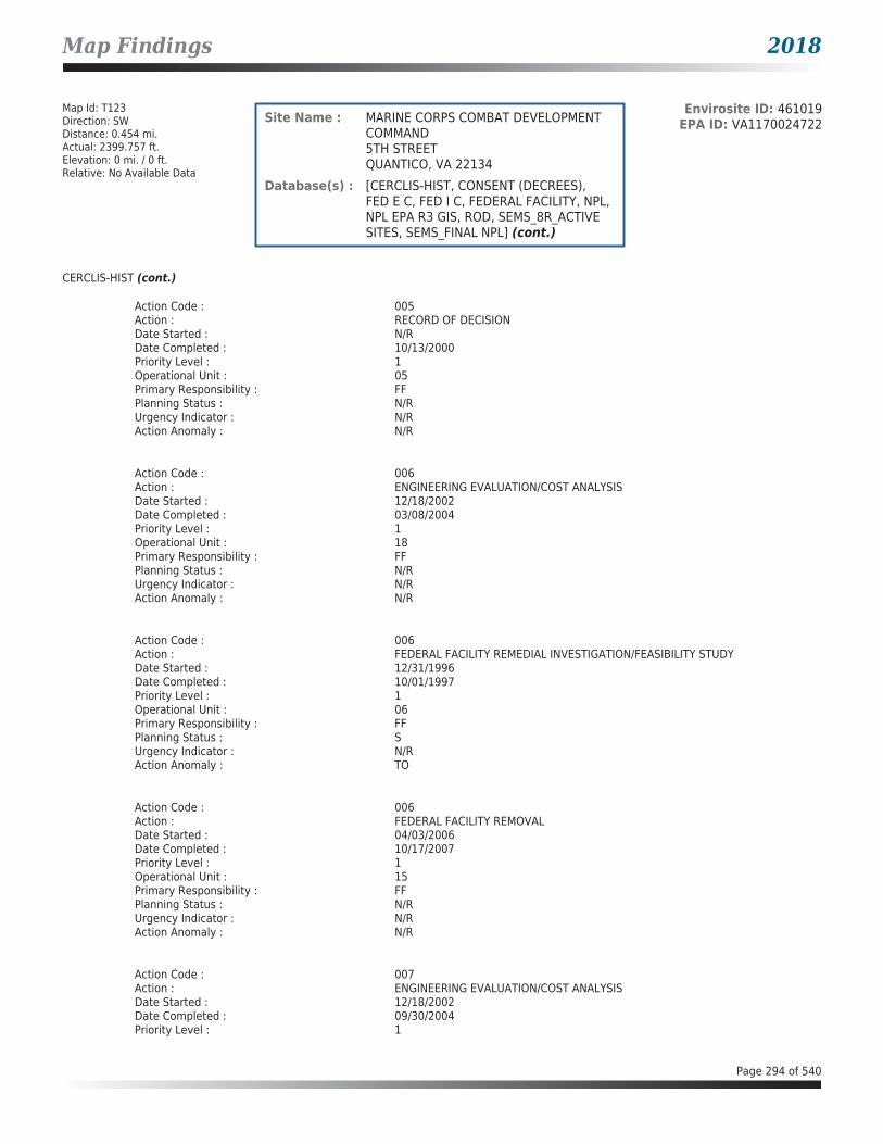
Map Findings 2018
Map Id: T123Direction: SWDistance: 0.454 mi.Actual: 2399.757 ft.Elevation: 0 mi. / 0 ft.Relative: No Available Data
Envirosite ID: 461019EPA ID: VA1170024722Site Name : MARINE CORPS COMBAT DEVELOPMENT
COMMAND5TH STREETQUANTICO, VA 22134
Database(s) : [CERCLIS-HIST, CONSENT (DECREES), FED E C, FED I C, FEDERAL FACILITY, NPL, NPL EPA R3 GIS, ROD, SEMS_8R_ACTIVE SITES, SEMS_FINAL NPL] (cont.)
CERCLIS-HIST (cont.)
Action Code : 005Action : RECORD OF DECISIONDate Started : N/RDate Completed : 10/13/2000Priority Level : 1Operational Unit : 05Primary Responsibility : FFPlanning Status : N/RUrgency Indicator : N/RAction Anomaly : N/R
Action Code : 006Action : ENGINEERING EVALUATION/COST ANALYSISDate Started : 12/18/2002Date Completed : 03/08/2004Priority Level : 1Operational Unit : 18Primary Responsibility : FFPlanning Status : N/RUrgency Indicator : N/RAction Anomaly : N/R
Action Code : 006Action : FEDERAL FACILITY REMEDIAL INVESTIGATION/FEASIBILITY STUDYDate Started : 12/31/1996Date Completed : 10/01/1997Priority Level : 1Operational Unit : 06Primary Responsibility : FFPlanning Status : SUrgency Indicator : N/RAction Anomaly : TO
Action Code : 006Action : FEDERAL FACILITY REMOVALDate Started : 04/03/2006Date Completed : 10/17/2007Priority Level : 1Operational Unit : 15Primary Responsibility : FFPlanning Status : N/RUrgency Indicator : N/RAction Anomaly : N/R
Action Code : 007Action : ENGINEERING EVALUATION/COST ANALYSISDate Started : 12/18/2002Date Completed : 09/30/2004Priority Level : 1
Page 294 of 540

Map Findings 2018
Map Id: T123Direction: SWDistance: 0.454 mi.Actual: 2399.757 ft.Elevation: 0 mi. / 0 ft.Relative: No Available Data
Envirosite ID: 461019EPA ID: VA1170024722Site Name : MARINE CORPS COMBAT DEVELOPMENT
COMMAND5TH STREETQUANTICO, VA 22134
Database(s) : [CERCLIS-HIST, CONSENT (DECREES), FED E C, FED I C, FEDERAL FACILITY, NPL, NPL EPA R3 GIS, ROD, SEMS_8R_ACTIVE SITES, SEMS_FINAL NPL] (cont.)
CERCLIS-HIST (cont.)
Operational Unit : 19Primary Responsibility : FFPlanning Status : N/RUrgency Indicator : N/RAction Anomaly : OC
Action Code : 007Action : FEDERAL FACILITY REMEDIAL ACTIONDate Started : 03/03/2012Date Completed : N/RPriority Level : 1Operational Unit : 10Primary Responsibility : FFPlanning Status : N/RUrgency Indicator : N/RAction Anomaly : N/R
Action Code : 007Action : FEDERAL FACILITY REMEDIAL INVESTIGATION/FEASIBILITY STUDYDate Started : 12/31/1996Date Completed : 06/21/2001Priority Level : 1Operational Unit : 07Primary Responsibility : FFPlanning Status : PUrgency Indicator : N/RAction Anomaly : N/R
Action Code : 007Action : FEDERAL FACILITY REMOVALDate Started : 10/16/2006Date Completed : 03/05/2007Priority Level : 1Operational Unit : 16Primary Responsibility : FFPlanning Status : N/RUrgency Indicator : N/RAction Anomaly : N/R
Action Code : 007Action : RECORD OF DECISIONDate Started : N/RDate Completed : 06/21/2001Priority Level : 1Operational Unit : 07Primary Responsibility : FFPlanning Status : N/RUrgency Indicator : N/RAction Anomaly : N/R
Page 295 of 540

Map Findings 2018
Map Id: T123Direction: SWDistance: 0.454 mi.Actual: 2399.757 ft.Elevation: 0 mi. / 0 ft.Relative: No Available Data
Envirosite ID: 461019EPA ID: VA1170024722Site Name : MARINE CORPS COMBAT DEVELOPMENT
COMMAND5TH STREETQUANTICO, VA 22134
Database(s) : [CERCLIS-HIST, CONSENT (DECREES), FED E C, FED I C, FEDERAL FACILITY, NPL, NPL EPA R3 GIS, ROD, SEMS_8R_ACTIVE SITES, SEMS_FINAL NPL] (cont.)
CERCLIS-HIST (cont.)
Action Code : 008Action : ENGINEERING EVALUATION/COST ANALYSISDate Started : 07/25/2002Date Completed : 03/04/2005Priority Level : 1Operational Unit : 20Primary Responsibility : FFPlanning Status : N/RUrgency Indicator : N/RAction Anomaly : N/R
Action Code : 009Action : ENGINEERING EVALUATION/COST ANALYSISDate Started : 12/18/2002Date Completed : 03/04/2005Priority Level : 1Operational Unit : 21Primary Responsibility : FFPlanning Status : N/RUrgency Indicator : N/RAction Anomaly : N/R
Action Code : 009Action : FEDERAL FACILITY REMOVALDate Started : 05/12/2005Date Completed : 06/21/2005Priority Level : 1Operational Unit : 20Primary Responsibility : FFPlanning Status : N/RUrgency Indicator : N/RAction Anomaly : N/R
Action Code : 010Action : ENGINEERING EVALUATION/COST ANALYSISDate Started : 03/06/2002Date Completed : 05/17/2004Priority Level : 1Operational Unit : 05Primary Responsibility : FFPlanning Status : N/RUrgency Indicator : N/RAction Anomaly : N/R
Action Code : 010Action : FEDERAL FACILITY REMEDIAL INVESTIGATION/FEASIBILITY STUDYDate Started : 06/01/2001Date Completed : 03/01/2007Priority Level : 1
Page 296 of 540
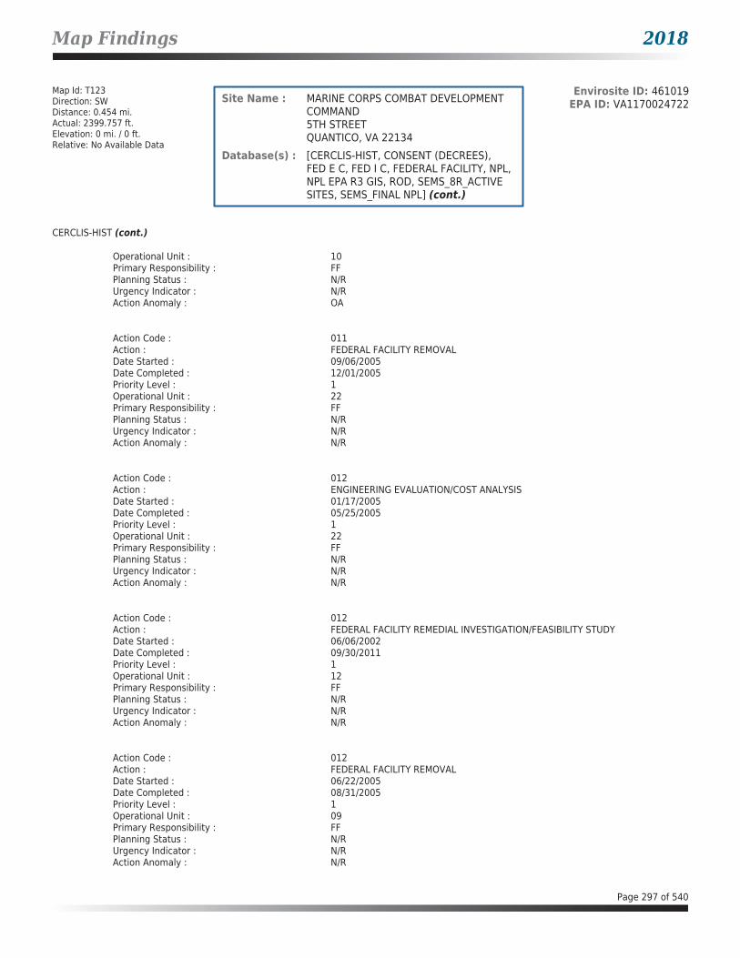
Map Findings 2018
Map Id: T123Direction: SWDistance: 0.454 mi.Actual: 2399.757 ft.Elevation: 0 mi. / 0 ft.Relative: No Available Data
Envirosite ID: 461019EPA ID: VA1170024722Site Name : MARINE CORPS COMBAT DEVELOPMENT
COMMAND5TH STREETQUANTICO, VA 22134
Database(s) : [CERCLIS-HIST, CONSENT (DECREES), FED E C, FED I C, FEDERAL FACILITY, NPL, NPL EPA R3 GIS, ROD, SEMS_8R_ACTIVE SITES, SEMS_FINAL NPL] (cont.)
CERCLIS-HIST (cont.)
Operational Unit : 10Primary Responsibility : FFPlanning Status : N/RUrgency Indicator : N/RAction Anomaly : OA
Action Code : 011Action : FEDERAL FACILITY REMOVALDate Started : 09/06/2005Date Completed : 12/01/2005Priority Level : 1Operational Unit : 22Primary Responsibility : FFPlanning Status : N/RUrgency Indicator : N/RAction Anomaly : N/R
Action Code : 012Action : ENGINEERING EVALUATION/COST ANALYSISDate Started : 01/17/2005Date Completed : 05/25/2005Priority Level : 1Operational Unit : 22Primary Responsibility : FFPlanning Status : N/RUrgency Indicator : N/RAction Anomaly : N/R
Action Code : 012Action : FEDERAL FACILITY REMEDIAL INVESTIGATION/FEASIBILITY STUDYDate Started : 06/06/2002Date Completed : 09/30/2011Priority Level : 1Operational Unit : 12Primary Responsibility : FFPlanning Status : N/RUrgency Indicator : N/RAction Anomaly : N/R
Action Code : 012Action : FEDERAL FACILITY REMOVALDate Started : 06/22/2005Date Completed : 08/31/2005Priority Level : 1Operational Unit : 09Primary Responsibility : FFPlanning Status : N/RUrgency Indicator : N/RAction Anomaly : N/R
Page 297 of 540

Map Findings 2018
Map Id: T123Direction: SWDistance: 0.454 mi.Actual: 2399.757 ft.Elevation: 0 mi. / 0 ft.Relative: No Available Data
Envirosite ID: 461019EPA ID: VA1170024722Site Name : MARINE CORPS COMBAT DEVELOPMENT
COMMAND5TH STREETQUANTICO, VA 22134
Database(s) : [CERCLIS-HIST, CONSENT (DECREES), FED E C, FED I C, FEDERAL FACILITY, NPL, NPL EPA R3 GIS, ROD, SEMS_8R_ACTIVE SITES, SEMS_FINAL NPL] (cont.)
CERCLIS-HIST (cont.)
Action Code : 012Action : RECORD OF DECISIONDate Started : N/RDate Completed : 09/30/2011Priority Level : 1Operational Unit : 12Primary Responsibility : FFPlanning Status : N/RUrgency Indicator : N/RAction Anomaly : N/R
Action Code : 013Action : ENGINEERING EVALUATION/COST ANALYSISDate Started : 01/06/2005Date Completed : 05/25/2005Priority Level : 1Operational Unit : 09Primary Responsibility : FFPlanning Status : N/RUrgency Indicator : N/RAction Anomaly : N/R
Action Code : 013Action : FEDERAL FACILITY REMEDIAL INVESTIGATION/FEASIBILITY STUDYDate Started : 06/14/2002Date Completed : 09/29/2011Priority Level : 1Operational Unit : 13Primary Responsibility : FFPlanning Status : N/RUrgency Indicator : N/RAction Anomaly : N/R
Action Code : 013Action : FEDERAL FACILITY REMOVALDate Started : 01/09/2006Date Completed : 03/02/2006Priority Level : 1Operational Unit : 11Primary Responsibility : FFPlanning Status : N/RUrgency Indicator : N/RAction Anomaly : N/R
Action Code : 013Action : RECORD OF DECISIONDate Started : N/RDate Completed : 09/29/2011Priority Level : 1
Page 298 of 540

Map Findings 2018
Map Id: T123Direction: SWDistance: 0.454 mi.Actual: 2399.757 ft.Elevation: 0 mi. / 0 ft.Relative: No Available Data
Envirosite ID: 461019EPA ID: VA1170024722Site Name : MARINE CORPS COMBAT DEVELOPMENT
COMMAND5TH STREETQUANTICO, VA 22134
Database(s) : [CERCLIS-HIST, CONSENT (DECREES), FED E C, FED I C, FEDERAL FACILITY, NPL, NPL EPA R3 GIS, ROD, SEMS_8R_ACTIVE SITES, SEMS_FINAL NPL] (cont.)
CERCLIS-HIST (cont.)
Operational Unit : 13Primary Responsibility : FFPlanning Status : N/RUrgency Indicator : N/RAction Anomaly : N/R
Action Code : 014Action : ENGINEERING EVALUATION/COST ANALYSISDate Started : 01/17/2005Date Completed : 05/25/2005Priority Level : 1Operational Unit : 11Primary Responsibility : FFPlanning Status : N/RUrgency Indicator : N/RAction Anomaly : N/R
Action Code : 014Action : FEDERAL FACILITY REMOVALDate Started : 03/13/2006Date Completed : 03/31/2006Priority Level : 1Operational Unit : 17Primary Responsibility : FFPlanning Status : N/RUrgency Indicator : N/RAction Anomaly : N/R
Action Code : 015Action : FEDERAL FACILITY REMEDIAL INVESTIGATION/FEASIBILITY STUDYDate Started : 12/31/1998Date Completed : 12/20/2007Priority Level : 1Operational Unit : 04Primary Responsibility : FFPlanning Status : N/RUrgency Indicator : N/RAction Anomaly : N/R
Action Code : 015Action : FEDERAL FACILITY REMOVALDate Started : 03/15/2011Date Completed : 04/06/2011Priority Level : 1Operational Unit : 25Primary Responsibility : FFPlanning Status : N/RUrgency Indicator : N/RAction Anomaly : N/R
Page 299 of 540
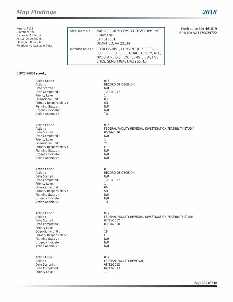
Map Findings 2018
Map Id: T123Direction: SWDistance: 0.454 mi.Actual: 2399.757 ft.Elevation: 0 mi. / 0 ft.Relative: No Available Data
Envirosite ID: 461019EPA ID: VA1170024722Site Name : MARINE CORPS COMBAT DEVELOPMENT
COMMAND5TH STREETQUANTICO, VA 22134
Database(s) : [CERCLIS-HIST, CONSENT (DECREES), FED E C, FED I C, FEDERAL FACILITY, NPL, NPL EPA R3 GIS, ROD, SEMS_8R_ACTIVE SITES, SEMS_FINAL NPL] (cont.)
CERCLIS-HIST (cont.)
Action Code : 015Action : RECORD OF DECISIONDate Started : N/RDate Completed : 10/01/1997Priority Level : 1Operational Unit : 03Primary Responsibility : SNPlanning Status : N/RUrgency Indicator : N/RAction Anomaly : TO
Action Code : 016Action : FEDERAL FACILITY REMEDIAL INVESTIGATION/FEASIBILITY STUDYDate Started : 06/14/2010Date Completed : N/RPriority Level : 1Operational Unit : 21Primary Responsibility : FFPlanning Status : N/RUrgency Indicator : N/RAction Anomaly : N/R
Action Code : 016Action : RECORD OF DECISIONDate Started : N/RDate Completed : 10/01/1997Priority Level : 1Operational Unit : 06Primary Responsibility : SNPlanning Status : N/RUrgency Indicator : N/RAction Anomaly : TO
Action Code : 017Action : FEDERAL FACILITY REMEDIAL INVESTIGATION/FEASIBILITY STUDYDate Started : 07/31/2007Date Completed : 09/30/2008Priority Level : 1Operational Unit : 19Primary Responsibility : FFPlanning Status : N/RUrgency Indicator : N/RAction Anomaly : N/R
Action Code : 017Action : FEDERAL FACILITY REMOVALDate Started : 08/22/2012Date Completed : 04/17/2013Priority Level : 1
Page 300 of 540

Map Findings 2018
Map Id: T123Direction: SWDistance: 0.454 mi.Actual: 2399.757 ft.Elevation: 0 mi. / 0 ft.Relative: No Available Data
Envirosite ID: 461019EPA ID: VA1170024722Site Name : MARINE CORPS COMBAT DEVELOPMENT
COMMAND5TH STREETQUANTICO, VA 22134
Database(s) : [CERCLIS-HIST, CONSENT (DECREES), FED E C, FED I C, FEDERAL FACILITY, NPL, NPL EPA R3 GIS, ROD, SEMS_8R_ACTIVE SITES, SEMS_FINAL NPL] (cont.)
CERCLIS-HIST (cont.)
Operational Unit : 19Primary Responsibility : FFPlanning Status : N/RUrgency Indicator : N/RAction Anomaly : N/R
Action Code : 017Action : RECORD OF DECISIONDate Started : N/RDate Completed : 12/20/2007Priority Level : 1Operational Unit : 04Primary Responsibility : FFPlanning Status : N/RUrgency Indicator : N/RAction Anomaly : N/R
Action Code : 018Action : FEDERAL FACILITY REMOVALDate Started : 04/10/2012Date Completed : 05/14/2012Priority Level : 1Operational Unit : 27Primary Responsibility : FFPlanning Status : N/RUrgency Indicator : N/RAction Anomaly : N/R
Action Code : 018Action : RECORD OF DECISIONDate Started : N/RDate Completed : 10/04/2007Priority Level : 1Operational Unit : 02Primary Responsibility : FFPlanning Status : N/RUrgency Indicator : N/RAction Anomaly : N/R
Action Code : 019Action : FEDERAL FACILITY REMOVALDate Started : 08/20/2012Date Completed : N/RPriority Level : 1Operational Unit : 28Primary Responsibility : FFPlanning Status : N/RUrgency Indicator : N/RAction Anomaly : N/R
Page 301 of 540

Map Findings 2018
Map Id: T123Direction: SWDistance: 0.454 mi.Actual: 2399.757 ft.Elevation: 0 mi. / 0 ft.Relative: No Available Data
Envirosite ID: 461019EPA ID: VA1170024722Site Name : MARINE CORPS COMBAT DEVELOPMENT
COMMAND5TH STREETQUANTICO, VA 22134
Database(s) : [CERCLIS-HIST, CONSENT (DECREES), FED E C, FED I C, FEDERAL FACILITY, NPL, NPL EPA R3 GIS, ROD, SEMS_8R_ACTIVE SITES, SEMS_FINAL NPL] (cont.)
CERCLIS-HIST (cont.)
Action Code : 021Action : FEDERAL FACILITY REMOVALDate Started : 02/14/2013Date Completed : N/RPriority Level : 1Operational Unit : 12Primary Responsibility : FFPlanning Status : N/RUrgency Indicator : N/RAction Anomaly : N/R
Action Code : 021Action : RECORD OF DECISIONDate Started : N/RDate Completed : 07/03/2007Priority Level : 1Operational Unit : 05Primary Responsibility : FFPlanning Status : N/RUrgency Indicator : N/RAction Anomaly : N/R
Action Code : 022Action : RECORD OF DECISIONDate Started : N/RDate Completed : 09/02/2008Priority Level : 1Operational Unit : 20Primary Responsibility : FFPlanning Status : N/RUrgency Indicator : N/RAction Anomaly : N/R
Action Code : 024Action : RECORD OF DECISIONDate Started : N/RDate Completed : 09/30/2008Priority Level : 1Operational Unit : 19Primary Responsibility : FFPlanning Status : N/RUrgency Indicator : N/RAction Anomaly : N/R
CONSENT (DECREES)
Facility Name : MARINE CORPS COMBAT DEVELOPMENT COMMANDFacility Address : 5TH STREET, QUANTICO, VA 22134County : PRINCE WILLIAM
Page 302 of 540
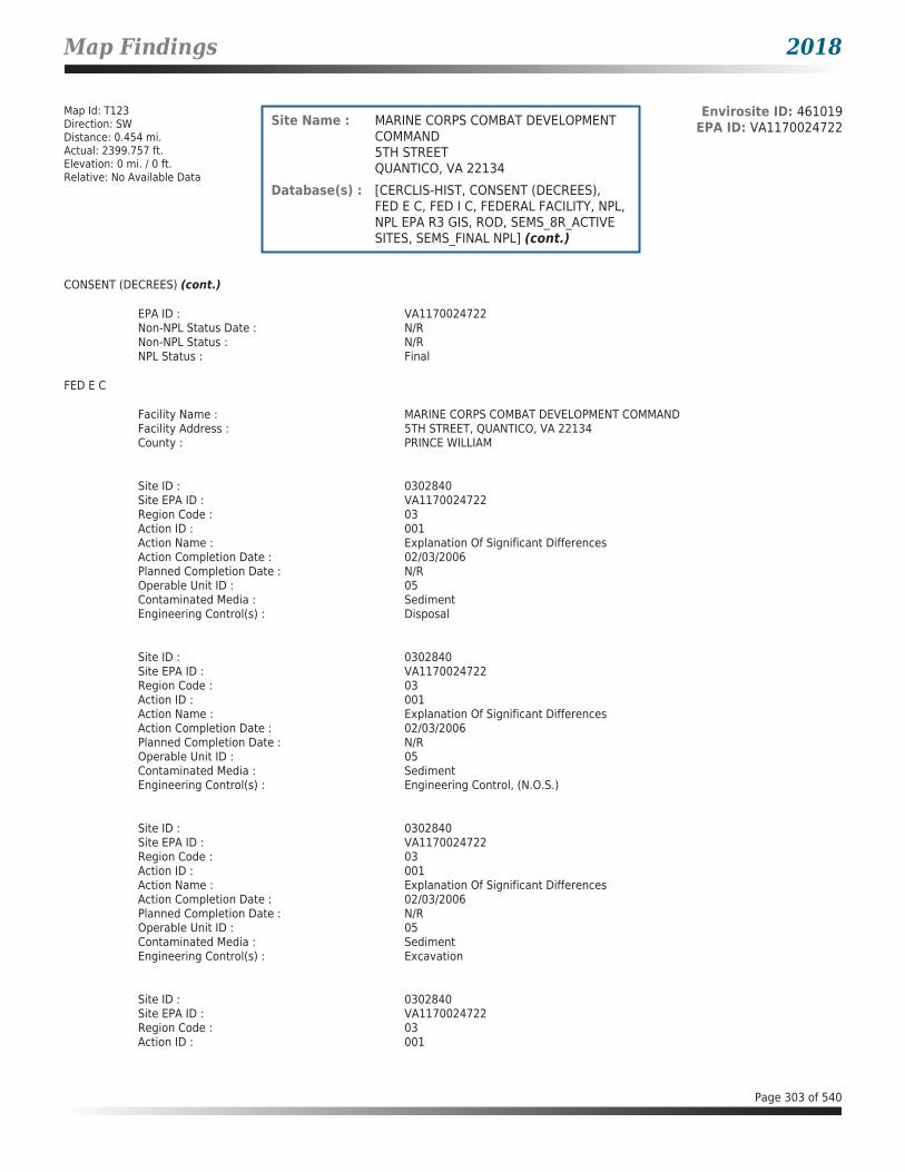
Map Findings 2018
Map Id: T123Direction: SWDistance: 0.454 mi.Actual: 2399.757 ft.Elevation: 0 mi. / 0 ft.Relative: No Available Data
Envirosite ID: 461019EPA ID: VA1170024722Site Name : MARINE CORPS COMBAT DEVELOPMENT
COMMAND5TH STREETQUANTICO, VA 22134
Database(s) : [CERCLIS-HIST, CONSENT (DECREES), FED E C, FED I C, FEDERAL FACILITY, NPL, NPL EPA R3 GIS, ROD, SEMS_8R_ACTIVE SITES, SEMS_FINAL NPL] (cont.)
CONSENT (DECREES) (cont.)
EPA ID : VA1170024722Non-NPL Status Date : N/RNon-NPL Status : N/RNPL Status : Final
FED E C
Facility Name : MARINE CORPS COMBAT DEVELOPMENT COMMANDFacility Address : 5TH STREET, QUANTICO, VA 22134County : PRINCE WILLIAM
Site ID : 0302840Site EPA ID : VA1170024722Region Code : 03Action ID : 001Action Name : Explanation Of Significant DifferencesAction Completion Date : 02/03/2006Planned Completion Date : N/ROperable Unit ID : 05Contaminated Media : SedimentEngineering Control(s) : Disposal
Site ID : 0302840Site EPA ID : VA1170024722Region Code : 03Action ID : 001Action Name : Explanation Of Significant DifferencesAction Completion Date : 02/03/2006Planned Completion Date : N/ROperable Unit ID : 05Contaminated Media : SedimentEngineering Control(s) : Engineering Control, (N.O.S.)
Site ID : 0302840Site EPA ID : VA1170024722Region Code : 03Action ID : 001Action Name : Explanation Of Significant DifferencesAction Completion Date : 02/03/2006Planned Completion Date : N/ROperable Unit ID : 05Contaminated Media : SedimentEngineering Control(s) : Excavation
Site ID : 0302840Site EPA ID : VA1170024722Region Code : 03Action ID : 001
Page 303 of 540

Map Findings 2018
Map Id: T123Direction: SWDistance: 0.454 mi.Actual: 2399.757 ft.Elevation: 0 mi. / 0 ft.Relative: No Available Data
Envirosite ID: 461019EPA ID: VA1170024722Site Name : MARINE CORPS COMBAT DEVELOPMENT
COMMAND5TH STREETQUANTICO, VA 22134
Database(s) : [CERCLIS-HIST, CONSENT (DECREES), FED E C, FED I C, FEDERAL FACILITY, NPL, NPL EPA R3 GIS, ROD, SEMS_8R_ACTIVE SITES, SEMS_FINAL NPL] (cont.)
FED E C (cont.)
Action Name : Explanation Of Significant DifferencesAction Completion Date : 02/03/2006Planned Completion Date : N/ROperable Unit ID : 05Contaminated Media : SedimentEngineering Control(s) : Other, (N.O.S.)
Site ID : 0302840Site EPA ID : VA1170024722Region Code : 03Action ID : 001Action Name : RECORD OF DECISIONAction Completion Date : 09/30/1997Planned Completion Date : 06/30/2000Operable Unit ID : 04Contaminated Media : OtherEngineering Control(s) : Consolidate
Site ID : 0302840Site EPA ID : VA1170024722Region Code : 03Action ID : 001Action Name : RECORD OF DECISIONAction Completion Date : 09/30/1997Planned Completion Date : 06/30/2000Operable Unit ID : 04Contaminated Media : OtherEngineering Control(s) : Disposal
Site ID : 0302840Site EPA ID : VA1170024722Region Code : 03Action ID : 001Action Name : RECORD OF DECISIONAction Completion Date : 09/30/1997Planned Completion Date : 06/30/2000Operable Unit ID : 04Contaminated Media : ResidualsEngineering Control(s) : Flocculation
Site ID : 0302840Site EPA ID : VA1170024722Region Code : 03Action ID : 001Action Name : RECORD OF DECISIONAction Completion Date : 09/30/1997Planned Completion Date : 06/30/2000Operable Unit ID : 04Contaminated Media : Residuals
Page 304 of 540

Map Findings 2018
Map Id: T123Direction: SWDistance: 0.454 mi.Actual: 2399.757 ft.Elevation: 0 mi. / 0 ft.Relative: No Available Data
Envirosite ID: 461019EPA ID: VA1170024722Site Name : MARINE CORPS COMBAT DEVELOPMENT
COMMAND5TH STREETQUANTICO, VA 22134
Database(s) : [CERCLIS-HIST, CONSENT (DECREES), FED E C, FED I C, FEDERAL FACILITY, NPL, NPL EPA R3 GIS, ROD, SEMS_8R_ACTIVE SITES, SEMS_FINAL NPL] (cont.)
FED E C (cont.)
Engineering Control(s) : Operations & Maintenance (O&M)
Site ID : 0302840Site EPA ID : VA1170024722Region Code : 03Action ID : 001Action Name : RECORD OF DECISIONAction Completion Date : 09/30/1997Planned Completion Date : 06/30/2000Operable Unit ID : 04Contaminated Media : SoilEngineering Control(s) : Disposal
Site ID : 0302840Site EPA ID : VA1170024722Region Code : 03Action ID : 001Action Name : RECORD OF DECISIONAction Completion Date : 09/30/1997Planned Completion Date : 06/30/2000Operable Unit ID : 04Contaminated Media : SoilEngineering Control(s) : Excavation
Site ID : 0302840Site EPA ID : VA1170024722Region Code : 03Action ID : 001Action Name : RECORD OF DECISIONAction Completion Date : 09/30/1997Planned Completion Date : 06/30/2000Operable Unit ID : 04Contaminated Media : SoilEngineering Control(s) : Other, (N.O.S.)
Site ID : 0302840Site EPA ID : VA1170024722Region Code : 03Action ID : 001Action Name : RECORD OF DECISIONAction Completion Date : 09/30/1997Planned Completion Date : 06/30/2000Operable Unit ID : 04Contaminated Media : SoilEngineering Control(s) : Revegetation
Page 305 of 540
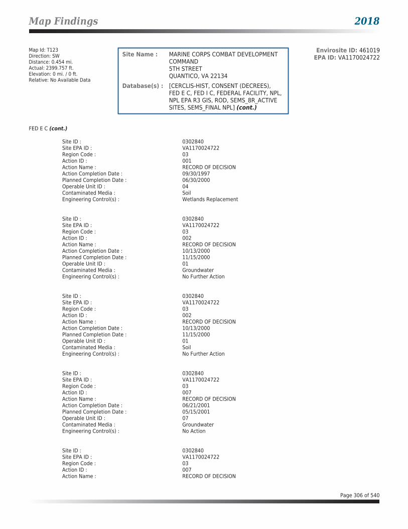
Map Findings 2018
Map Id: T123Direction: SWDistance: 0.454 mi.Actual: 2399.757 ft.Elevation: 0 mi. / 0 ft.Relative: No Available Data
Envirosite ID: 461019EPA ID: VA1170024722Site Name : MARINE CORPS COMBAT DEVELOPMENT
COMMAND5TH STREETQUANTICO, VA 22134
Database(s) : [CERCLIS-HIST, CONSENT (DECREES), FED E C, FED I C, FEDERAL FACILITY, NPL, NPL EPA R3 GIS, ROD, SEMS_8R_ACTIVE SITES, SEMS_FINAL NPL] (cont.)
FED E C (cont.)
Site ID : 0302840Site EPA ID : VA1170024722Region Code : 03Action ID : 001Action Name : RECORD OF DECISIONAction Completion Date : 09/30/1997Planned Completion Date : 06/30/2000Operable Unit ID : 04Contaminated Media : SoilEngineering Control(s) : Wetlands Replacement
Site ID : 0302840Site EPA ID : VA1170024722Region Code : 03Action ID : 002Action Name : RECORD OF DECISIONAction Completion Date : 10/13/2000Planned Completion Date : 11/15/2000Operable Unit ID : 01Contaminated Media : GroundwaterEngineering Control(s) : No Further Action
Site ID : 0302840Site EPA ID : VA1170024722Region Code : 03Action ID : 002Action Name : RECORD OF DECISIONAction Completion Date : 10/13/2000Planned Completion Date : 11/15/2000Operable Unit ID : 01Contaminated Media : SoilEngineering Control(s) : No Further Action
Site ID : 0302840Site EPA ID : VA1170024722Region Code : 03Action ID : 007Action Name : RECORD OF DECISIONAction Completion Date : 06/21/2001Planned Completion Date : 05/15/2001Operable Unit ID : 07Contaminated Media : GroundwaterEngineering Control(s) : No Action
Site ID : 0302840Site EPA ID : VA1170024722Region Code : 03Action ID : 007Action Name : RECORD OF DECISION
Page 306 of 540

Map Findings 2018
Map Id: T123Direction: SWDistance: 0.454 mi.Actual: 2399.757 ft.Elevation: 0 mi. / 0 ft.Relative: No Available Data
Envirosite ID: 461019EPA ID: VA1170024722Site Name : MARINE CORPS COMBAT DEVELOPMENT
COMMAND5TH STREETQUANTICO, VA 22134
Database(s) : [CERCLIS-HIST, CONSENT (DECREES), FED E C, FED I C, FEDERAL FACILITY, NPL, NPL EPA R3 GIS, ROD, SEMS_8R_ACTIVE SITES, SEMS_FINAL NPL] (cont.)
FED E C (cont.)
Action Completion Date : 06/21/2001Planned Completion Date : 05/15/2001Operable Unit ID : 07Contaminated Media : SoilEngineering Control(s) : No Action
Site ID : 0302840Site EPA ID : VA1170024722Region Code : 03Action ID : 007Action Name : RECORD OF DECISIONAction Completion Date : 06/21/2001Planned Completion Date : 05/15/2001Operable Unit ID : 07Contaminated Media : SoilEngineering Control(s) : No Further Action
Site ID : 0302840Site EPA ID : VA1170024722Region Code : 03Action ID : 012Action Name : RECORD OF DECISIONAction Completion Date : 09/30/2011Planned Completion Date : 09/30/2011Operable Unit ID : 12Contaminated Media : SedimentEngineering Control(s) : Disposal
Site ID : 0302840Site EPA ID : VA1170024722Region Code : 03Action ID : 012Action Name : RECORD OF DECISIONAction Completion Date : 09/30/2011Planned Completion Date : 09/30/2011Operable Unit ID : 12Contaminated Media : SedimentEngineering Control(s) : Dredging
Site ID : 0302840Site EPA ID : VA1170024722Region Code : 03Action ID : 012Action Name : RECORD OF DECISIONAction Completion Date : 09/30/2011Planned Completion Date : 09/30/2011Operable Unit ID : 12Contaminated Media : SedimentEngineering Control(s) : Monitored Natural Recovery
Page 307 of 540

Map Findings 2018
Map Id: T123Direction: SWDistance: 0.454 mi.Actual: 2399.757 ft.Elevation: 0 mi. / 0 ft.Relative: No Available Data
Envirosite ID: 461019EPA ID: VA1170024722Site Name : MARINE CORPS COMBAT DEVELOPMENT
COMMAND5TH STREETQUANTICO, VA 22134
Database(s) : [CERCLIS-HIST, CONSENT (DECREES), FED E C, FED I C, FEDERAL FACILITY, NPL, NPL EPA R3 GIS, ROD, SEMS_8R_ACTIVE SITES, SEMS_FINAL NPL] (cont.)
FED E C (cont.)
Site ID : 0302840Site EPA ID : VA1170024722Region Code : 03Action ID : 012Action Name : RECORD OF DECISIONAction Completion Date : 09/30/2011Planned Completion Date : 09/30/2011Operable Unit ID : 12Contaminated Media : SedimentEngineering Control(s) : Monitoring
Site ID : 0302840Site EPA ID : VA1170024722Region Code : 03Action ID : 012Action Name : RECORD OF DECISIONAction Completion Date : 09/30/2011Planned Completion Date : 09/30/2011Operable Unit ID : 12Contaminated Media : SedimentEngineering Control(s) : Sampling
Site ID : 0302840Site EPA ID : VA1170024722Region Code : 03Action ID : 012Action Name : RECORD OF DECISIONAction Completion Date : 09/30/2011Planned Completion Date : 09/30/2011Operable Unit ID : 12Contaminated Media : SedimentEngineering Control(s) : Shoreline Stabilization
Site ID : 0302840Site EPA ID : VA1170024722Region Code : 03Action ID : 012Action Name : RECORD OF DECISIONAction Completion Date : 09/30/2011Planned Completion Date : 09/30/2011Operable Unit ID : 12Contaminated Media : SedimentEngineering Control(s) : Subaqueous Sediment Cap
Site ID : 0302840Site EPA ID : VA1170024722Region Code : 03Action ID : 013Action Name : RECORD OF DECISION
Page 308 of 540

Map Findings 2018
Map Id: T123Direction: SWDistance: 0.454 mi.Actual: 2399.757 ft.Elevation: 0 mi. / 0 ft.Relative: No Available Data
Envirosite ID: 461019EPA ID: VA1170024722Site Name : MARINE CORPS COMBAT DEVELOPMENT
COMMAND5TH STREETQUANTICO, VA 22134
Database(s) : [CERCLIS-HIST, CONSENT (DECREES), FED E C, FED I C, FEDERAL FACILITY, NPL, NPL EPA R3 GIS, ROD, SEMS_8R_ACTIVE SITES, SEMS_FINAL NPL] (cont.)
FED E C (cont.)
Action Completion Date : 09/29/2011Planned Completion Date : 09/30/2011Operable Unit ID : 13Contaminated Media : SedimentEngineering Control(s) : Monitored Natural Recovery
Site ID : 0302840Site EPA ID : VA1170024722Region Code : 03Action ID : 013Action Name : RECORD OF DECISIONAction Completion Date : 09/29/2011Planned Completion Date : 09/30/2011Operable Unit ID : 13Contaminated Media : SedimentEngineering Control(s) : No Further Action
Site ID : 0302840Site EPA ID : VA1170024722Region Code : 03Action ID : 017Action Name : RECORD OF DECISIONAction Completion Date : 12/20/2007Planned Completion Date : 12/30/2007Operable Unit ID : 04Contaminated Media : GroundwaterEngineering Control(s) : Monitoring
Site ID : 0302840Site EPA ID : VA1170024722Region Code : 03Action ID : 017Action Name : RECORD OF DECISIONAction Completion Date : 12/20/2007Planned Completion Date : 12/30/2007Operable Unit ID : 04Contaminated Media : Solid WasteEngineering Control(s) : Operations & Maintenance (O&M)
Site ID : 0302840Site EPA ID : VA1170024722Region Code : 03Action ID : 018Action Name : RECORD OF DECISIONAction Completion Date : 10/04/2007Planned Completion Date : 12/29/2007Operable Unit ID : 02Contaminated Media : GroundwaterEngineering Control(s) : No Action
Page 309 of 540

Map Findings 2018
Map Id: T123Direction: SWDistance: 0.454 mi.Actual: 2399.757 ft.Elevation: 0 mi. / 0 ft.Relative: No Available Data
Envirosite ID: 461019EPA ID: VA1170024722Site Name : MARINE CORPS COMBAT DEVELOPMENT
COMMAND5TH STREETQUANTICO, VA 22134
Database(s) : [CERCLIS-HIST, CONSENT (DECREES), FED E C, FED I C, FEDERAL FACILITY, NPL, NPL EPA R3 GIS, ROD, SEMS_8R_ACTIVE SITES, SEMS_FINAL NPL] (cont.)
FED E C (cont.)
Site ID : 0302840Site EPA ID : VA1170024722Region Code : 03Action ID : 018Action Name : RECORD OF DECISIONAction Completion Date : 10/04/2007Planned Completion Date : 12/29/2007Operable Unit ID : 02Contaminated Media : SedimentEngineering Control(s) : No Action
Site ID : 0302840Site EPA ID : VA1170024722Region Code : 03Action ID : 018Action Name : RECORD OF DECISIONAction Completion Date : 10/04/2007Planned Completion Date : 12/29/2007Operable Unit ID : 02Contaminated Media : SoilEngineering Control(s) : No Further Action
Site ID : 0302840Site EPA ID : VA1170024722Region Code : 03Action ID : 018Action Name : RECORD OF DECISIONAction Completion Date : 10/04/2007Planned Completion Date : 12/29/2007Operable Unit ID : 02Contaminated Media : Surface WaterEngineering Control(s) : No Action
Site ID : 0302840Site EPA ID : VA1170024722Region Code : 03Action ID : 021Action Name : RECORD OF DECISIONAction Completion Date : 07/03/2007Planned Completion Date : 07/02/2007Operable Unit ID : 05Contaminated Media : Solid WasteEngineering Control(s) : No Action
Site ID : 0302840Site EPA ID : VA1170024722Region Code : 03Action ID : 022Action Name : RECORD OF DECISION
Page 310 of 540
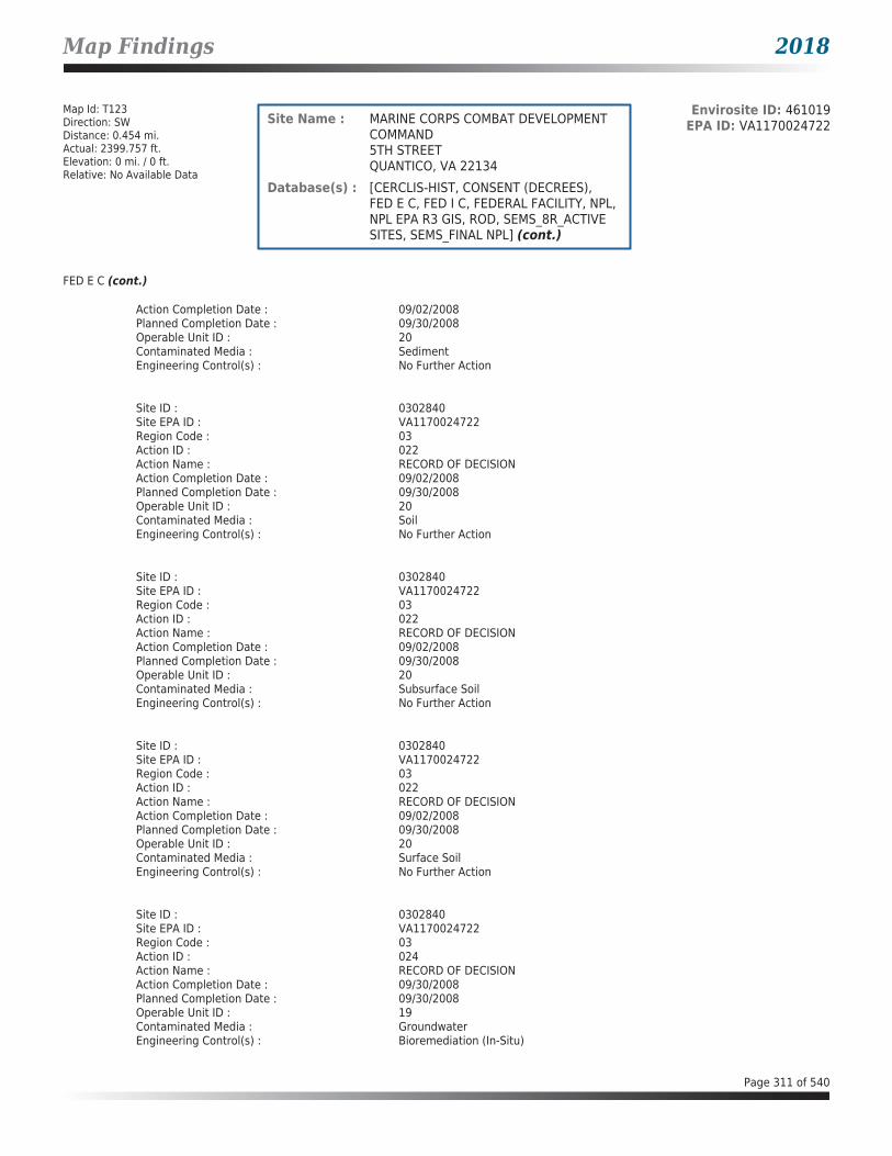
Map Findings 2018
Map Id: T123Direction: SWDistance: 0.454 mi.Actual: 2399.757 ft.Elevation: 0 mi. / 0 ft.Relative: No Available Data
Envirosite ID: 461019EPA ID: VA1170024722Site Name : MARINE CORPS COMBAT DEVELOPMENT
COMMAND5TH STREETQUANTICO, VA 22134
Database(s) : [CERCLIS-HIST, CONSENT (DECREES), FED E C, FED I C, FEDERAL FACILITY, NPL, NPL EPA R3 GIS, ROD, SEMS_8R_ACTIVE SITES, SEMS_FINAL NPL] (cont.)
FED E C (cont.)
Action Completion Date : 09/02/2008Planned Completion Date : 09/30/2008Operable Unit ID : 20Contaminated Media : SedimentEngineering Control(s) : No Further Action
Site ID : 0302840Site EPA ID : VA1170024722Region Code : 03Action ID : 022Action Name : RECORD OF DECISIONAction Completion Date : 09/02/2008Planned Completion Date : 09/30/2008Operable Unit ID : 20Contaminated Media : SoilEngineering Control(s) : No Further Action
Site ID : 0302840Site EPA ID : VA1170024722Region Code : 03Action ID : 022Action Name : RECORD OF DECISIONAction Completion Date : 09/02/2008Planned Completion Date : 09/30/2008Operable Unit ID : 20Contaminated Media : Subsurface SoilEngineering Control(s) : No Further Action
Site ID : 0302840Site EPA ID : VA1170024722Region Code : 03Action ID : 022Action Name : RECORD OF DECISIONAction Completion Date : 09/02/2008Planned Completion Date : 09/30/2008Operable Unit ID : 20Contaminated Media : Surface SoilEngineering Control(s) : No Further Action
Site ID : 0302840Site EPA ID : VA1170024722Region Code : 03Action ID : 024Action Name : RECORD OF DECISIONAction Completion Date : 09/30/2008Planned Completion Date : 09/30/2008Operable Unit ID : 19Contaminated Media : GroundwaterEngineering Control(s) : Bioremediation (In-Situ)
Page 311 of 540

Map Findings 2018
Map Id: T123Direction: SWDistance: 0.454 mi.Actual: 2399.757 ft.Elevation: 0 mi. / 0 ft.Relative: No Available Data
Envirosite ID: 461019EPA ID: VA1170024722Site Name : MARINE CORPS COMBAT DEVELOPMENT
COMMAND5TH STREETQUANTICO, VA 22134
Database(s) : [CERCLIS-HIST, CONSENT (DECREES), FED E C, FED I C, FEDERAL FACILITY, NPL, NPL EPA R3 GIS, ROD, SEMS_8R_ACTIVE SITES, SEMS_FINAL NPL] (cont.)
FED E C (cont.)
Site ID : 0302840Site EPA ID : VA1170024722Region Code : 03Action ID : 024Action Name : RECORD OF DECISIONAction Completion Date : 09/30/2008Planned Completion Date : 09/30/2008Operable Unit ID : 19Contaminated Media : GroundwaterEngineering Control(s) : Monitoring
FED I C
Facility Name : MARINE CORPS COMBAT DEVELOPMENT COMMANDFacility Address : 5TH STREET, QUANTICO, VA 22134County : PRINCE WILLIAM
Site DetailsSite ID : 0302840Site EPA ID : VA1170024722Region Code : 03Action ID : 001Action Name : RECORD OF DECISIONAction Completion Date : 09/30/1997Planned Completion Date : 06/30/2000Operable Unit ID : 04Contaminated Media : ResidualsEngineering Control(s) : Access Restriction, Fencing
Site ID : 0302840Site EPA ID : VA1170024722Region Code : 03Action ID : 001Action Name : RECORD OF DECISIONAction Completion Date : 09/30/1997Planned Completion Date : 06/30/2000Operable Unit ID : 04Contaminated Media : SoilEngineering Control(s) : Access Restriction, Fencing
Site ID : 0302840Site EPA ID : VA1170024722Region Code : 03Action ID : 012Action Name : RECORD OF DECISIONAction Completion Date : 09/30/2011Planned Completion Date : 09/30/2011Operable Unit ID : 12
Page 312 of 540

Map Findings 2018
Map Id: T123Direction: SWDistance: 0.454 mi.Actual: 2399.757 ft.Elevation: 0 mi. / 0 ft.Relative: No Available Data
Envirosite ID: 461019EPA ID: VA1170024722Site Name : MARINE CORPS COMBAT DEVELOPMENT
COMMAND5TH STREETQUANTICO, VA 22134
Database(s) : [CERCLIS-HIST, CONSENT (DECREES), FED E C, FED I C, FEDERAL FACILITY, NPL, NPL EPA R3 GIS, ROD, SEMS_8R_ACTIVE SITES, SEMS_FINAL NPL] (cont.)
FED I C (cont.)
Contaminated Media : SedimentEngineering Control(s) : Institutional Controls, (N.O.S.)
Site ID : 0302840Site EPA ID : VA1170024722Region Code : 03Action ID : 013Action Name : RECORD OF DECISIONAction Completion Date : 09/29/2011Planned Completion Date : 09/30/2011Operable Unit ID : 13Contaminated Media : SedimentEngineering Control(s) : Building, demolition, or excavation regulation
Site ID : 0302840Site EPA ID : VA1170024722Region Code : 03Action ID : 013Action Name : RECORD OF DECISIONAction Completion Date : 09/29/2011Planned Completion Date : 09/30/2011Operable Unit ID : 13Contaminated Media : SedimentEngineering Control(s) : Deed Restriction
Site ID : 0302840Site EPA ID : VA1170024722Region Code : 03Action ID : 013Action Name : RECORD OF DECISIONAction Completion Date : 09/29/2011Planned Completion Date : 09/30/2011Operable Unit ID : 13Contaminated Media : SedimentEngineering Control(s) : Recreational Restriction
Site ID : 0302840Site EPA ID : VA1170024722Region Code : 03Action ID : 017Action Name : RECORD OF DECISIONAction Completion Date : 12/20/2007Planned Completion Date : 12/30/2007Operable Unit ID : 04Contaminated Media : GroundwaterEngineering Control(s) : Groundwater use/well drilling regulation
Page 313 of 540

Map Findings 2018
Map Id: T123Direction: SWDistance: 0.454 mi.Actual: 2399.757 ft.Elevation: 0 mi. / 0 ft.Relative: No Available Data
Envirosite ID: 461019EPA ID: VA1170024722Site Name : MARINE CORPS COMBAT DEVELOPMENT
COMMAND5TH STREETQUANTICO, VA 22134
Database(s) : [CERCLIS-HIST, CONSENT (DECREES), FED E C, FED I C, FEDERAL FACILITY, NPL, NPL EPA R3 GIS, ROD, SEMS_8R_ACTIVE SITES, SEMS_FINAL NPL] (cont.)
FED I C (cont.)
Site ID : 0302840Site EPA ID : VA1170024722Region Code : 03Action ID : 017Action Name : RECORD OF DECISIONAction Completion Date : 12/20/2007Planned Completion Date : 12/30/2007Operable Unit ID : 04Contaminated Media : SoilEngineering Control(s) : Building, demolition, or excavation regulation
Site ID : 0302840Site EPA ID : VA1170024722Region Code : 03Action ID : 017Action Name : RECORD OF DECISIONAction Completion Date : 12/20/2007Planned Completion Date : 12/30/2007Operable Unit ID : 04Contaminated Media : SoilEngineering Control(s) : Zoning regulation
Site ID : 0302840Site EPA ID : VA1170024722Region Code : 03Action ID : 017Action Name : RECORD OF DECISIONAction Completion Date : 12/20/2007Planned Completion Date : 12/30/2007Operable Unit ID : 04Contaminated Media : Solid WasteEngineering Control(s) : Building, demolition, or excavation regulation
Site ID : 0302840Site EPA ID : VA1170024722Region Code : 03Action ID : 017Action Name : RECORD OF DECISIONAction Completion Date : 12/20/2007Planned Completion Date : 12/30/2007Operable Unit ID : 04Contaminated Media : Solid WasteEngineering Control(s) : Zoning regulation
Site ID : 0302840Site EPA ID : VA1170024722Region Code : 03Action ID : 024Action Name : RECORD OF DECISION
Page 314 of 540

Map Findings 2018
Map Id: T123Direction: SWDistance: 0.454 mi.Actual: 2399.757 ft.Elevation: 0 mi. / 0 ft.Relative: No Available Data
Envirosite ID: 461019EPA ID: VA1170024722Site Name : MARINE CORPS COMBAT DEVELOPMENT
COMMAND5TH STREETQUANTICO, VA 22134
Database(s) : [CERCLIS-HIST, CONSENT (DECREES), FED E C, FED I C, FEDERAL FACILITY, NPL, NPL EPA R3 GIS, ROD, SEMS_8R_ACTIVE SITES, SEMS_FINAL NPL] (cont.)
FED I C (cont.)
Action Completion Date : 09/30/2008Planned Completion Date : 09/30/2008Operable Unit ID : 19Contaminated Media : GroundwaterEngineering Control(s) : Building, Demolition, or Excavation Regulation
Site ID : 0302840Site EPA ID : VA1170024722Region Code : 03Action ID : 024Action Name : RECORD OF DECISIONAction Completion Date : 09/30/2008Planned Completion Date : 09/30/2008Operable Unit ID : 19Contaminated Media : GroundwaterEngineering Control(s) : Groundwater use/well drilling regulation
FEDERAL FACILITY
Facility Name : MARINE CORPS COMBAT DEVELOPMENT COMMANDFacility Address : 5TH STREET, QUANTICO, VA 22134County : PRINCE WILLIAM
Site ID : 0302840EPA ID : VA1170024722Region : 03Congressional District : 01Federal Facility : YNPL Status : Currently on the Final NPLNon NPL Status : N/RFIPS Code : 51153Latitude : 38.521667Longitude : -77.29Last Date in Agency List : 01/02/2018
Additional InformationStart Date : 07/23/2016Finish Date : 09/02/2016OU : 24Action Code : LVAction Name : FF RVSequence : 29Quality : N/RCurrent Action Lead : Fed Fac
Start Date : 04/26/2016Finish Date : 10/22/2016
Page 315 of 540

Map Findings 2018
Map Id: T123Direction: SWDistance: 0.454 mi.Actual: 2399.757 ft.Elevation: 0 mi. / 0 ft.Relative: No Available Data
Envirosite ID: 461019EPA ID: VA1170024722Site Name : MARINE CORPS COMBAT DEVELOPMENT
COMMAND5TH STREETQUANTICO, VA 22134
Database(s) : [CERCLIS-HIST, CONSENT (DECREES), FED E C, FED I C, FEDERAL FACILITY, NPL, NPL EPA R3 GIS, ROD, SEMS_8R_ACTIVE SITES, SEMS_FINAL NPL] (cont.)
FEDERAL FACILITY (cont.)
OU : 32Action Code : LVAction Name : FF RVSequence : 27Quality : N/RCurrent Action Lead : Fed Fac
Start Date : 02/15/2016Finish Date : N/ROU : 36Action Code : NHAction Name : FF RISequence : 3Quality : N/RCurrent Action Lead : Fed Fac
Start Date : 10/05/2015Finish Date : 12/19/2016OU : 27Action Code : LVAction Name : FF RVSequence : 25Quality : N/RCurrent Action Lead : Fed Fac
Start Date : 12/02/2014Finish Date : 06/15/2015OU : 27Action Code : EEAction Name : EE/CASequence : 15Quality : N/RCurrent Action Lead : Fed Fac
Start Date : 10/09/2014Finish Date : N/ROU : 24Action Code : LWAction Name : FF RI/FSSequence : 18Quality : N/RCurrent Action Lead : Fed Fac
Start Date : 10/09/2014Finish Date : N/ROU : 27Action Code : LWAction Name : FF RI/FS
Page 316 of 540

Map Findings 2018
Map Id: T123Direction: SWDistance: 0.454 mi.Actual: 2399.757 ft.Elevation: 0 mi. / 0 ft.Relative: No Available Data
Envirosite ID: 461019EPA ID: VA1170024722Site Name : MARINE CORPS COMBAT DEVELOPMENT
COMMAND5TH STREETQUANTICO, VA 22134
Database(s) : [CERCLIS-HIST, CONSENT (DECREES), FED E C, FED I C, FEDERAL FACILITY, NPL, NPL EPA R3 GIS, ROD, SEMS_8R_ACTIVE SITES, SEMS_FINAL NPL] (cont.)
FEDERAL FACILITY (cont.)
Sequence : 21Quality : N/RCurrent Action Lead : Fed Fac
Start Date : 10/09/2014Finish Date : N/ROU : 30Action Code : LWAction Name : FF RI/FSSequence : 22Quality : N/RCurrent Action Lead : Fed Fac
Start Date : 10/09/2014Finish Date : N/ROU : 31Action Code : LWAction Name : FF RI/FSSequence : 23Quality : N/RCurrent Action Lead : Fed Fac
Start Date : 10/09/2014Finish Date : N/ROU : 32Action Code : LWAction Name : FF RI/FSSequence : 24Quality : N/RCurrent Action Lead : Fed Fac
Start Date : 10/09/2014Finish Date : N/ROU : 33Action Code : LWAction Name : FF RI/FSSequence : 25Quality : N/RCurrent Action Lead : Fed Fac
Start Date : 10/09/2014Finish Date : N/ROU : 35Action Code : NHAction Name : FF RISequence : 2Quality : N/RCurrent Action Lead : Fed Fac
Page 317 of 540
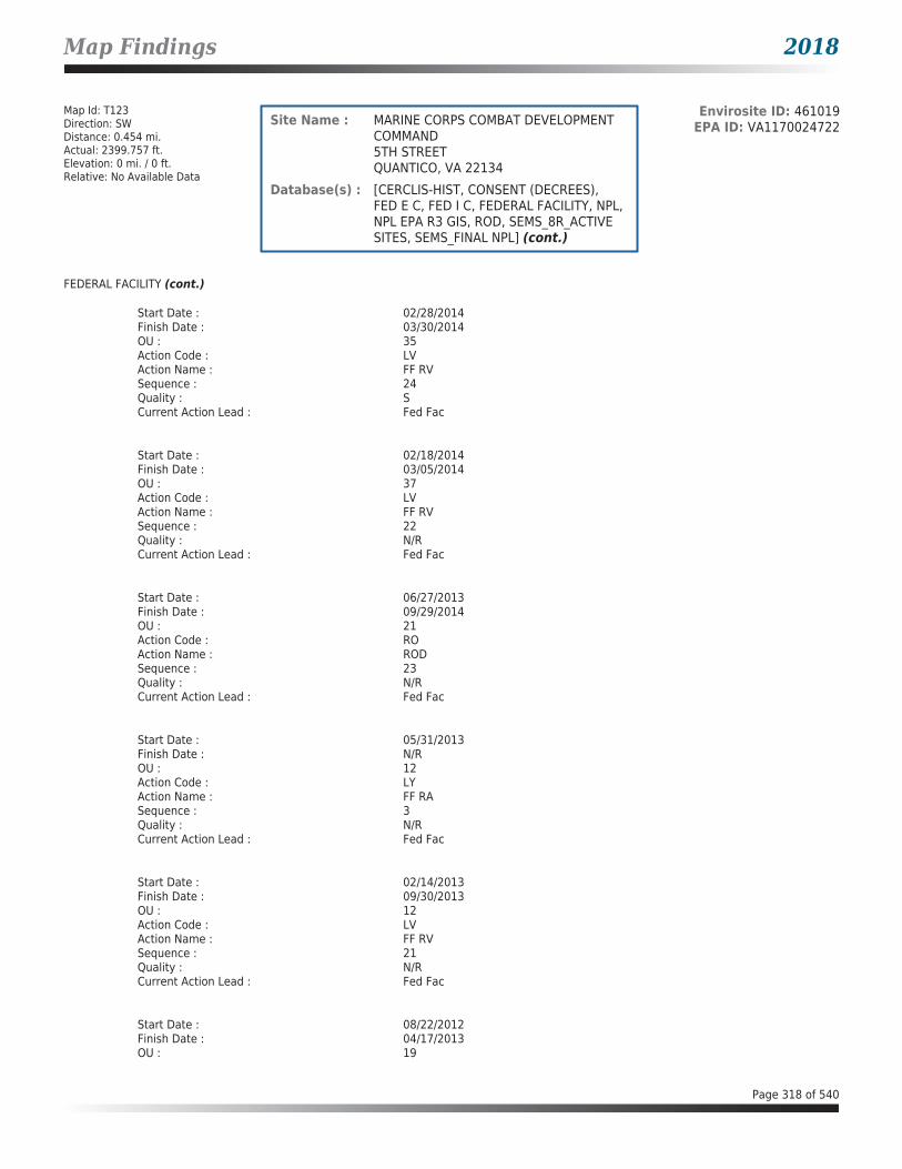
Map Findings 2018
Map Id: T123Direction: SWDistance: 0.454 mi.Actual: 2399.757 ft.Elevation: 0 mi. / 0 ft.Relative: No Available Data
Envirosite ID: 461019EPA ID: VA1170024722Site Name : MARINE CORPS COMBAT DEVELOPMENT
COMMAND5TH STREETQUANTICO, VA 22134
Database(s) : [CERCLIS-HIST, CONSENT (DECREES), FED E C, FED I C, FEDERAL FACILITY, NPL, NPL EPA R3 GIS, ROD, SEMS_8R_ACTIVE SITES, SEMS_FINAL NPL] (cont.)
FEDERAL FACILITY (cont.)
Start Date : 02/28/2014Finish Date : 03/30/2014OU : 35Action Code : LVAction Name : FF RVSequence : 24Quality : SCurrent Action Lead : Fed Fac
Start Date : 02/18/2014Finish Date : 03/05/2014OU : 37Action Code : LVAction Name : FF RVSequence : 22Quality : N/RCurrent Action Lead : Fed Fac
Start Date : 06/27/2013Finish Date : 09/29/2014OU : 21Action Code : ROAction Name : RODSequence : 23Quality : N/RCurrent Action Lead : Fed Fac
Start Date : 05/31/2013Finish Date : N/ROU : 12Action Code : LYAction Name : FF RASequence : 3Quality : N/RCurrent Action Lead : Fed Fac
Start Date : 02/14/2013Finish Date : 09/30/2013OU : 12Action Code : LVAction Name : FF RVSequence : 21Quality : N/RCurrent Action Lead : Fed Fac
Start Date : 08/22/2012Finish Date : 04/17/2013OU : 19
Page 318 of 540

Map Findings 2018
Map Id: T123Direction: SWDistance: 0.454 mi.Actual: 2399.757 ft.Elevation: 0 mi. / 0 ft.Relative: No Available Data
Envirosite ID: 461019EPA ID: VA1170024722Site Name : MARINE CORPS COMBAT DEVELOPMENT
COMMAND5TH STREETQUANTICO, VA 22134
Database(s) : [CERCLIS-HIST, CONSENT (DECREES), FED E C, FED I C, FEDERAL FACILITY, NPL, NPL EPA R3 GIS, ROD, SEMS_8R_ACTIVE SITES, SEMS_FINAL NPL] (cont.)
FEDERAL FACILITY (cont.)
Action Code : LVAction Name : FF RVSequence : 17Quality : N/RCurrent Action Lead : Fed Fac
Start Date : 08/20/2012Finish Date : 06/30/2013OU : 28Action Code : LVAction Name : FF RVSequence : 19Quality : N/RCurrent Action Lead : Fed Fac
Start Date : 06/25/2012Finish Date : N/ROU : 13Action Code : LYAction Name : FF RASequence : 4Quality : N/RCurrent Action Lead : Fed Fac
Start Date : 04/10/2012Finish Date : 05/14/2012OU : 27Action Code : LVAction Name : FF RVSequence : 18Quality : N/RCurrent Action Lead : Fed Fac
Start Date : 03/15/2012Finish Date : 04/27/2012OU : 13Action Code : LXAction Name : FF RDSequence : 3Quality : N/RCurrent Action Lead : Fed Fac
Start Date : 03/03/2012Finish Date : 09/29/2014OU : 10Action Code : LYAction Name : FF RASequence : 7
Page 319 of 540

Map Findings 2018
Map Id: T123Direction: SWDistance: 0.454 mi.Actual: 2399.757 ft.Elevation: 0 mi. / 0 ft.Relative: No Available Data
Envirosite ID: 461019EPA ID: VA1170024722Site Name : MARINE CORPS COMBAT DEVELOPMENT
COMMAND5TH STREETQUANTICO, VA 22134
Database(s) : [CERCLIS-HIST, CONSENT (DECREES), FED E C, FED I C, FEDERAL FACILITY, NPL, NPL EPA R3 GIS, ROD, SEMS_8R_ACTIVE SITES, SEMS_FINAL NPL] (cont.)
FEDERAL FACILITY (cont.)
Quality : N/RCurrent Action Lead : Fed Fac
Start Date : 10/30/2011Finish Date : 11/28/2011OU : 12Action Code : LXAction Name : FF RDSequence : 2Quality : N/RCurrent Action Lead : Fed Fac
Start Date : 09/30/2011Finish Date : 09/30/2011OU : 12Action Code : ROAction Name : RODSequence : 12Quality : N/RCurrent Action Lead : Fed Fac
Start Date : 09/29/2011Finish Date : 09/29/2011OU : 13Action Code : ROAction Name : RODSequence : 13Quality : N/RCurrent Action Lead : Fed Fac
Start Date : 07/31/2011Finish Date : N/ROU : 38Action Code : NHAction Name : FF RISequence : 4Quality : N/RCurrent Action Lead : Fed Fac
Start Date : 03/15/2011Finish Date : 04/06/2011OU : 25Action Code : LVAction Name : FF RVSequence : 15Quality : N/RCurrent Action Lead : Fed Fac
Page 320 of 540

Map Findings 2018
Map Id: T123Direction: SWDistance: 0.454 mi.Actual: 2399.757 ft.Elevation: 0 mi. / 0 ft.Relative: No Available Data
Envirosite ID: 461019EPA ID: VA1170024722Site Name : MARINE CORPS COMBAT DEVELOPMENT
COMMAND5TH STREETQUANTICO, VA 22134
Database(s) : [CERCLIS-HIST, CONSENT (DECREES), FED E C, FED I C, FEDERAL FACILITY, NPL, NPL EPA R3 GIS, ROD, SEMS_8R_ACTIVE SITES, SEMS_FINAL NPL] (cont.)
FEDERAL FACILITY (cont.)
Start Date : 06/14/2010Finish Date : 09/29/2014OU : 21Action Code : LWAction Name : FF RI/FSSequence : 16Quality : N/RCurrent Action Lead : Fed Fac
Start Date : 09/30/2008Finish Date : 09/30/2008OU : 19Action Code : ROAction Name : RODSequence : 24Quality : N/RCurrent Action Lead : Fed Fac
Start Date : 09/02/2008Finish Date : 09/02/2008OU : 20Action Code : ROAction Name : RODSequence : 22Quality : N/RCurrent Action Lead : Fed Fac
Start Date : 12/20/2007Finish Date : 12/20/2007OU : 04Action Code : ROAction Name : RODSequence : 17Quality : N/RCurrent Action Lead : Fed Fac
Start Date : 10/04/2007Finish Date : 10/04/2007OU : 02Action Code : ROAction Name : RODSequence : 18Quality : N/RCurrent Action Lead : Fed Fac
Start Date : 07/31/2007Finish Date : 09/30/2008OU : 19
Page 321 of 540

Map Findings 2018
Map Id: T123Direction: SWDistance: 0.454 mi.Actual: 2399.757 ft.Elevation: 0 mi. / 0 ft.Relative: No Available Data
Envirosite ID: 461019EPA ID: VA1170024722Site Name : MARINE CORPS COMBAT DEVELOPMENT
COMMAND5TH STREETQUANTICO, VA 22134
Database(s) : [CERCLIS-HIST, CONSENT (DECREES), FED E C, FED I C, FEDERAL FACILITY, NPL, NPL EPA R3 GIS, ROD, SEMS_8R_ACTIVE SITES, SEMS_FINAL NPL] (cont.)
FEDERAL FACILITY (cont.)
Action Code : LWAction Name : FF RI/FSSequence : 17Quality : N/RCurrent Action Lead : Fed Fac
Start Date : 07/03/2007Finish Date : 07/03/2007OU : 05Action Code : ROAction Name : RODSequence : 21Quality : N/RCurrent Action Lead : Fed Fac
Start Date : 12/18/2006Finish Date : N/ROU : 23Action Code : NIAction Name : FF FSSequence : 1Quality : N/RCurrent Action Lead : Fed Fac
Start Date : 10/16/2006Finish Date : 03/05/2007OU : 16Action Code : LVAction Name : FF RVSequence : 7Quality : N/RCurrent Action Lead : Fed Fac
Start Date : 04/03/2006Finish Date : 10/17/2007OU : 15Action Code : LVAction Name : FF RVSequence : 6Quality : CCurrent Action Lead : Fed Fac
Start Date : 03/13/2006Finish Date : 03/31/2006OU : 17Action Code : LVAction Name : FF RVSequence : 14
Page 322 of 540

Map Findings 2018
Map Id: T123Direction: SWDistance: 0.454 mi.Actual: 2399.757 ft.Elevation: 0 mi. / 0 ft.Relative: No Available Data
Envirosite ID: 461019EPA ID: VA1170024722Site Name : MARINE CORPS COMBAT DEVELOPMENT
COMMAND5TH STREETQUANTICO, VA 22134
Database(s) : [CERCLIS-HIST, CONSENT (DECREES), FED E C, FED I C, FEDERAL FACILITY, NPL, NPL EPA R3 GIS, ROD, SEMS_8R_ACTIVE SITES, SEMS_FINAL NPL] (cont.)
FEDERAL FACILITY (cont.)
Quality : N/RCurrent Action Lead : Fed Fac
Start Date : 01/09/2006Finish Date : 03/02/2006OU : 11Action Code : LVAction Name : FF RVSequence : 13Quality : N/RCurrent Action Lead : Fed Fac
Start Date : 09/06/2005Finish Date : 12/01/2005OU : 22Action Code : LVAction Name : FF RVSequence : 11Quality : N/RCurrent Action Lead : Fed Fac
Start Date : 06/22/2005Finish Date : 08/31/2005OU : 09Action Code : LVAction Name : FF RVSequence : 12Quality : N/RCurrent Action Lead : Fed Fac
Start Date : 05/12/2005Finish Date : 06/21/2005OU : 20Action Code : LVAction Name : FF RVSequence : 9Quality : N/RCurrent Action Lead : Fed Fac
Start Date : 04/01/2005Finish Date : 05/11/2005OU : 05Action Code : LVAction Name : FF RVSequence : 5Quality : N/RCurrent Action Lead : Fed Fac
Page 323 of 540

Map Findings 2018
Map Id: T123Direction: SWDistance: 0.454 mi.Actual: 2399.757 ft.Elevation: 0 mi. / 0 ft.Relative: No Available Data
Envirosite ID: 461019EPA ID: VA1170024722Site Name : MARINE CORPS COMBAT DEVELOPMENT
COMMAND5TH STREETQUANTICO, VA 22134
Database(s) : [CERCLIS-HIST, CONSENT (DECREES), FED E C, FED I C, FEDERAL FACILITY, NPL, NPL EPA R3 GIS, ROD, SEMS_8R_ACTIVE SITES, SEMS_FINAL NPL] (cont.)
FEDERAL FACILITY (cont.)
Start Date : 01/17/2005Finish Date : 05/25/2005OU : 11Action Code : EEAction Name : EE/CASequence : 14Quality : N/RCurrent Action Lead : Fed Fac
Start Date : 01/17/2005Finish Date : 05/25/2005OU : 22Action Code : EEAction Name : EE/CASequence : 12Quality : N/RCurrent Action Lead : Fed Fac
Start Date : 01/06/2005Finish Date : 05/25/2005OU : 09Action Code : EEAction Name : EE/CASequence : 13Quality : N/RCurrent Action Lead : Fed Fac
Start Date : 07/14/2004Finish Date : 04/04/2005OU : 02Action Code : LVAction Name : FF RVSequence : 1Quality : N/RCurrent Action Lead : Fed Fac
Start Date : 03/08/2004Finish Date : 04/19/2005OU : 18Action Code : LVAction Name : FF RVSequence : 2Quality : N/RCurrent Action Lead : Fed Fac
Start Date : 12/22/2003Finish Date : 07/31/2004OU : 02
Page 324 of 540

Map Findings 2018
Map Id: T123Direction: SWDistance: 0.454 mi.Actual: 2399.757 ft.Elevation: 0 mi. / 0 ft.Relative: No Available Data
Envirosite ID: 461019EPA ID: VA1170024722Site Name : MARINE CORPS COMBAT DEVELOPMENT
COMMAND5TH STREETQUANTICO, VA 22134
Database(s) : [CERCLIS-HIST, CONSENT (DECREES), FED E C, FED I C, FEDERAL FACILITY, NPL, NPL EPA R3 GIS, ROD, SEMS_8R_ACTIVE SITES, SEMS_FINAL NPL] (cont.)
FEDERAL FACILITY (cont.)
Action Code : LVAction Name : FF RVSequence : 4Quality : N/RCurrent Action Lead : Fed Fac
Start Date : 04/23/2003Finish Date : 04/03/2006OU : 15Action Code : EEAction Name : EE/CASequence : 2Quality : N/RCurrent Action Lead : Fed Fac
Start Date : 12/18/2002Finish Date : 03/04/2005OU : 21Action Code : EEAction Name : EE/CASequence : 9Quality : N/RCurrent Action Lead : Fed Fac
Start Date : 12/18/2002Finish Date : 03/08/2004OU : 18Action Code : EEAction Name : EE/CASequence : 6Quality : N/RCurrent Action Lead : Fed Fac
Start Date : 07/25/2002Finish Date : 03/04/2005OU : 20Action Code : EEAction Name : EE/CASequence : 8Quality : N/RCurrent Action Lead : Fed Fac
Start Date : 07/18/2002Finish Date : 02/04/2004OU : 17Action Code : EEAction Name : EE/CASequence : 5
Page 325 of 540

Map Findings 2018
Map Id: T123Direction: SWDistance: 0.454 mi.Actual: 2399.757 ft.Elevation: 0 mi. / 0 ft.Relative: No Available Data
Envirosite ID: 461019EPA ID: VA1170024722Site Name : MARINE CORPS COMBAT DEVELOPMENT
COMMAND5TH STREETQUANTICO, VA 22134
Database(s) : [CERCLIS-HIST, CONSENT (DECREES), FED E C, FED I C, FEDERAL FACILITY, NPL, NPL EPA R3 GIS, ROD, SEMS_8R_ACTIVE SITES, SEMS_FINAL NPL] (cont.)
FEDERAL FACILITY (cont.)
Quality : N/RCurrent Action Lead : Fed Fac
Start Date : 07/18/2002Finish Date : 05/26/2006OU : 16Action Code : EEAction Name : EE/CASequence : 4Quality : N/RCurrent Action Lead : Fed Fac
Start Date : 06/14/2002Finish Date : 09/29/2011OU : 13Action Code : LWAction Name : FF RI/FSSequence : 13Quality : N/RCurrent Action Lead : Fed Fac
Start Date : 06/14/2002Finish Date : N/ROU : 23Action Code : NHAction Name : FF RISequence : 1Quality : N/RCurrent Action Lead : Fed Fac
Start Date : 06/06/2002Finish Date : 09/30/2011OU : 12Action Code : LWAction Name : FF RI/FSSequence : 12Quality : N/RCurrent Action Lead : Fed Fac
Start Date : 04/17/2002Finish Date : 12/22/2003OU : 02Action Code : EEAction Name : EE/CASequence : 1Quality : N/RCurrent Action Lead : Fed Fac
Page 326 of 540

Map Findings 2018
Map Id: T123Direction: SWDistance: 0.454 mi.Actual: 2399.757 ft.Elevation: 0 mi. / 0 ft.Relative: No Available Data
Envirosite ID: 461019EPA ID: VA1170024722Site Name : MARINE CORPS COMBAT DEVELOPMENT
COMMAND5TH STREETQUANTICO, VA 22134
Database(s) : [CERCLIS-HIST, CONSENT (DECREES), FED E C, FED I C, FEDERAL FACILITY, NPL, NPL EPA R3 GIS, ROD, SEMS_8R_ACTIVE SITES, SEMS_FINAL NPL] (cont.)
FEDERAL FACILITY (cont.)
Start Date : 03/06/2002Finish Date : 05/17/2004OU : 05Action Code : EEAction Name : EE/CASequence : 10Quality : N/RCurrent Action Lead : Fed Fac
Start Date : 06/21/2001Finish Date : 06/21/2001OU : 07Action Code : ROAction Name : RODSequence : 7Quality : N/RCurrent Action Lead : Fed Fac
Start Date : 10/13/2000Finish Date : 10/13/2000OU : 01Action Code : ROAction Name : RODSequence : 2Quality : N/RCurrent Action Lead : Fed Fac
Start Date : 10/13/2000Finish Date : 10/13/2000OU : 05Action Code : ROAction Name : RODSequence : 5Quality : N/RCurrent Action Lead : Fed Fac
Start Date : 12/31/1998Finish Date : 12/20/2007OU : 04Action Code : LWAction Name : FF RI/FSSequence : 15Quality : N/RCurrent Action Lead : Fed Fac
Start Date : 10/01/1997Finish Date : 10/01/1997OU : 03
Page 327 of 540

Map Findings 2018
Map Id: T123Direction: SWDistance: 0.454 mi.Actual: 2399.757 ft.Elevation: 0 mi. / 0 ft.Relative: No Available Data
Envirosite ID: 461019EPA ID: VA1170024722Site Name : MARINE CORPS COMBAT DEVELOPMENT
COMMAND5TH STREETQUANTICO, VA 22134
Database(s) : [CERCLIS-HIST, CONSENT (DECREES), FED E C, FED I C, FEDERAL FACILITY, NPL, NPL EPA R3 GIS, ROD, SEMS_8R_ACTIVE SITES, SEMS_FINAL NPL] (cont.)
FEDERAL FACILITY (cont.)
Action Code : ROAction Name : RODSequence : 15Quality : N/RCurrent Action Lead : St Perf
Start Date : 10/01/1997Finish Date : 10/01/1997OU : 06Action Code : ROAction Name : RODSequence : 16Quality : N/RCurrent Action Lead : St Perf
Start Date : 09/30/1997Finish Date : 09/30/1997OU : 04Action Code : ROAction Name : RODSequence : 1Quality : N/RCurrent Action Lead : Fed Fac
Start Date : 12/31/1996Finish Date : 06/21/2001OU : 07Action Code : LWAction Name : FF RI/FSSequence : 7Quality : N/RCurrent Action Lead : Fed Fac
Start Date : 12/31/1996Finish Date : 09/30/1997OU : 04Action Code : LWAction Name : FF RI/FSSequence : 1Quality : N/RCurrent Action Lead : Fed Fac
Start Date : 12/31/1996Finish Date : 10/01/1997OU : 03Action Code : LWAction Name : FF RI/FSSequence : 4
Page 328 of 540

Map Findings 2018
Map Id: T123Direction: SWDistance: 0.454 mi.Actual: 2399.757 ft.Elevation: 0 mi. / 0 ft.Relative: No Available Data
Envirosite ID: 461019EPA ID: VA1170024722Site Name : MARINE CORPS COMBAT DEVELOPMENT
COMMAND5TH STREETQUANTICO, VA 22134
Database(s) : [CERCLIS-HIST, CONSENT (DECREES), FED E C, FED I C, FEDERAL FACILITY, NPL, NPL EPA R3 GIS, ROD, SEMS_8R_ACTIVE SITES, SEMS_FINAL NPL] (cont.)
FEDERAL FACILITY (cont.)
Quality : N/RCurrent Action Lead : Fed Fac
Start Date : 12/31/1996Finish Date : 10/01/1997OU : 06Action Code : LWAction Name : FF RI/FSSequence : 6Quality : N/RCurrent Action Lead : Fed Fac
Start Date : 12/31/1996Finish Date : 10/04/2007OU : 02Action Code : LWAction Name : FF RI/FSSequence : 3Quality : N/RCurrent Action Lead : Fed Fac
Start Date : 12/31/1996Finish Date : 10/13/2000OU : 05Action Code : LWAction Name : FF RI/FSSequence : 5Quality : N/RCurrent Action Lead : Fed Fac
Start Date : 12/01/1996Finish Date : 10/13/2000OU : 01Action Code : LWAction Name : FF RI/FSSequence : 2Quality : N/RCurrent Action Lead : Fed Fac
Start Date : 05/01/1996Finish Date : 09/30/1997OU : 04Action Code : LYAction Name : FF RASequence : 1Quality : N/RCurrent Action Lead : Fed Fac
Page 329 of 540

Map Findings 2018
Map Id: T123Direction: SWDistance: 0.454 mi.Actual: 2399.757 ft.Elevation: 0 mi. / 0 ft.Relative: No Available Data
Envirosite ID: 461019EPA ID: VA1170024722Site Name : MARINE CORPS COMBAT DEVELOPMENT
COMMAND5TH STREETQUANTICO, VA 22134
Database(s) : [CERCLIS-HIST, CONSENT (DECREES), FED E C, FED I C, FEDERAL FACILITY, NPL, NPL EPA R3 GIS, ROD, SEMS_8R_ACTIVE SITES, SEMS_FINAL NPL] (cont.)
FEDERAL FACILITY (cont.)
Start Date : 05/31/1994Finish Date : 05/31/1994OU : 00Action Code : NFAction Name : NPL FINLSequence : 1Quality : N/RCurrent Action Lead : EPA Perf
Start Date : 05/10/1993Finish Date : 05/10/1993OU : 00Action Code : NPAction Name : PROPOSEDSequence : 1Quality : N/RCurrent Action Lead : EPA Perf
Start Date : 09/28/1990Finish Date : 09/28/1990OU : 00Action Code : SIAction Name : SISequence : 1Quality : HCurrent Action Lead : Fed Fac
Start Date : 01/15/1990Finish Date : N/ROU : 00Action Code : LZAction Name : FF CRSequence : 1Quality : N/RCurrent Action Lead : Fed Fac
Start Date : 09/10/1985Finish Date : 09/10/1985OU : 00Action Code : PAAction Name : PASequence : 1Quality : LCurrent Action Lead : Fed Fac
Start Date : 05/01/1981Finish Date : 05/01/1981OU : 00
Page 330 of 540

Map Findings 2018
Map Id: T123Direction: SWDistance: 0.454 mi.Actual: 2399.757 ft.Elevation: 0 mi. / 0 ft.Relative: No Available Data
Envirosite ID: 461019EPA ID: VA1170024722Site Name : MARINE CORPS COMBAT DEVELOPMENT
COMMAND5TH STREETQUANTICO, VA 22134
Database(s) : [CERCLIS-HIST, CONSENT (DECREES), FED E C, FED I C, FEDERAL FACILITY, NPL, NPL EPA R3 GIS, ROD, SEMS_8R_ACTIVE SITES, SEMS_FINAL NPL] (cont.)
FEDERAL FACILITY (cont.)
Action Code : DSAction Name : DISCVRYSequence : 1Quality : N/RCurrent Action Lead : Fed Fac
NPL
Facility Name : Marine Corps Combat Development CommandFacility Address : 5TH STREET, QUANTICO, VA 22134
Listing Date : 05/31/1994Site Score : 50.00Site EPA ID : VA1170024722Federal Facility Indicator : YesNational Priorities List Status : FinalCongressional District : 01
Other Site Name : MARINE CORPS DEV & ED COMMAND; MCDEC SAN LANDFILL; QUANTICO *; USMC HZD WST STRG FAC; USMC QUANTICO; USMC SITE # 1; USMC SITE # 2; USMC SITE # 3
County : PRINCE WILLIAMSite Listing Narrative Link : Click here for hyperlink provided by the agency.Federal Register Notice Link : Click here for hyperlink provided by the agency.
Site DetailsSuperfund Site : MARINE CORPS COMBAT DEVELOPMENT COMMAND QUANTICO, VA
Site Background :
The Marine Corps Combat Development Command site (MCCDC) is a 56,000-acre military training facility that overlaps areas in Prince William, Northern Stafford, and Eastern Fauquier counties. The base is located in Quantico, Virginia, about 35 miles south of Washington, D.C. on the Potomac River. MCCDC is bordered by Prince William Forest Park to the north and the Potomac River to the east. The western and southern portions of the base include residential areas. Operations began at MCCDC in 1917, when the Department of Defense established a new Marine training camp. A large expansion in the size of the facility occurred in 1943. The MCCDC prepares Marine Corps officers for general combat by providing them with an understanding of technical operations and by performing research and development on military equipment. Park to the north and the Potomac River to the east. The western and southern portions of the base include residential areas. Operations began at MCCDC in 1917, when the Department of Defense established a new Marine training camp. A large expansion in the size of the facility occurred in 1943. The MCCDC prepares Marine Corps officers for general combat by providing them with an understanding of technical operations and by performing research and development on military equipment.
Page 331 of 540

Map Findings 2018
Map Id: T123Direction: SWDistance: 0.454 mi.Actual: 2399.757 ft.Elevation: 0 mi. / 0 ft.Relative: No Available Data
Envirosite ID: 461019EPA ID: VA1170024722Site Name : MARINE CORPS COMBAT DEVELOPMENT
COMMAND5TH STREETQUANTICO, VA 22134
Database(s) : [CERCLIS-HIST, CONSENT (DECREES), FED E C, FED I C, FEDERAL FACILITY, NPL, NPL EPA R3 GIS, ROD, SEMS_8R_ACTIVE SITES, SEMS_FINAL NPL] (cont.)
NPL (cont.)
Site Status :
The EPA and the Navy entered into a Federal Facility Agreement (FFA) to conduct studies and to examine ways to conduct clean up at the Marine Corps Combat and Development Command. As a result, a total of 213 potential sites were identified for further consideration and 15 sites have been identified since the FFA was signed giving a total of 228 sites requiring studies. As of January 2012, 219 sites have been investigated and closed with either consensus agreements or Record of Decisions. Ongoing site work includes:Lunga Recreational Area - The Navy has completed 99% of the TEMTADS field work having scanned 14,162 of the 14,336 anomalies. The work plan for the RI (OU35) is currently being reviewed by EPA. Action Memo has been signed for the Time Critical Removal Action for the drum removal at (OU27). The removal action work plan is currently being reviewed by EPA. The TCRA for the drum removal is planned to begin this winter. Old Landfill - A Interim Record of Decision (ROD) was signed in September 1997 and a Final ROD was signed in November 2007. This decision includes: Land Use Controls, Groundwater Use Restrictions, and Groundwater monitoring to confirm that contaminants are not moving off-site at unacceptable levels. The final Long-Term Monitoring Plan for this site was finalized February 2008. The Draft 3rd LTM is currently being reviewed by EPA.Building 2101 Paint Boot Sump - An Action ROD was signed September 30, 2008 for ORC Treatment, Institutional Control and Long-Term Monitoring. A Time Critical Removal Action was conducted in FY12 to remove munitions and explosives of concern to a depth of 2 feet. Land use control measures are currently being developed for this site. Quantico Embayment and Southern Wetlands - The Record of Decision was signed in September 2011. The selected remedies include: a Habitat Enhancement Cap; Institutional Controls; Dredging and Off-Site Disposal; Monitored Natural Recovery and statutory 5-Year Reviews. The remedial action was completed for the Southern Wetlands and the Remedial Action Completing Report was signed in September 2014.Chopawamsic Creek - The Record of Decision was signed in September 2011. The selected remedy includes: Monitored Natural Recovery, Land Use Controls and statutory 5-Year Reviews. Abrahams Creek - EPA has review the Draft Treatability Study, Cap Materials Report and expect the final document in January 2015.B-2113 UG Tank Loading/Unloading Area (SWMU M-13) - The Record of Decision was signed in September 2014 for bioremediation. Removal Actions have been completed for the following sites, followed by No action or NFA RODs.Camp Barrett Disposal Area Camp Goettge Disposal Area Camp Upshur Disposal Area Smith Lake Road Cleared Area Pesticide Control Building TBS Northwest Training Area Building 4 Accumulation Area Golf Course Maintenance Area Old Batch Plant Former Rifle Range
Contact InformationContact Name : Larry BrownContact Title : Community Involvement CoordinatorPhone : (215) 814-5527Email : [email protected]
Additional Site Contacts : Navy Remedial Project Manager:, Frederick Evans, (202) 685-3303, [email protected]; MCCDC Remedial Project Manager:, Maria Hoidal, (703) 432-0521, [email protected]
Contact Name : Lisa CunninghamContact Title : Remedial Project ManagerPhone : (215) 814-3363Email : [email protected]
Additional Site Contacts : Navy Remedial Project Manager:, Frederick Evans, (202) 685-3303, [email protected]; MCCDC Remedial Project Manager:, Maria Hoidal, (703) 432-0521, [email protected]
Page 332 of 540

Map Findings 2018
Map Id: T123Direction: SWDistance: 0.454 mi.Actual: 2399.757 ft.Elevation: 0 mi. / 0 ft.Relative: No Available Data
Envirosite ID: 461019EPA ID: VA1170024722Site Name : MARINE CORPS COMBAT DEVELOPMENT
COMMAND5TH STREETQUANTICO, VA 22134
Database(s) : [CERCLIS-HIST, CONSENT (DECREES), FED E C, FED I C, FEDERAL FACILITY, NPL, NPL EPA R3 GIS, ROD, SEMS_8R_ACTIVE SITES, SEMS_FINAL NPL] (cont.)
NPL (cont.)
Contaminant InformationCAS Number : 106-46-7Contaminant Name : 1,4-DICHLOROBENZENEContaminated Media : Ground WaterArea of Site Found (Operable Unit) : B-2113 UG TANK LOAD/UNLOAD (21)
CAS Number : 11096-82-5Contaminant Name : AROCLOR 1260Contaminated Media : SedimentArea of Site Found (Operable Unit) : OLD BATCH PLANT (05)
CAS Number : 11096-82-5Contaminant Name : AROCLOR 1260Contaminated Media : SoilArea of Site Found (Operable Unit) : OLD LANDFILL (04)
CAS Number : 120-82-1Contaminant Name : 1,2,4-TRICHLOROBENZENEContaminated Media : Ground WaterArea of Site Found (Operable Unit) : B-2113 UG TANK LOAD/UNLOAD (21)
CAS Number : 127-18-4Contaminant Name : TETRACHLOROETHENEContaminated Media : Ground WaterArea of Site Found (Operable Unit) : B-2113 UG TANK LOAD/UNLOAD (21)
CAS Number : 130498-29-2Contaminant Name : PAHContaminated Media : SoilArea of Site Found (Operable Unit) : FORMER RIFLE RANGE (02)
CAS Number : 156-59-2Contaminant Name : cis-1,2-DICHLOROETHENEContaminated Media : Ground WaterArea of Site Found (Operable Unit) : B-2101 PAINT BOOTH SUMP (19)
CAS Number : 156-59-2Contaminant Name : cis-1,2-DICHLOROETHENEContaminated Media : Ground WaterArea of Site Found (Operable Unit) : B-2113 UG TANK LOAD/UNLOAD (21)
CAS Number : 191-24-2Contaminant Name : BENZO(GHI)PERYLENEContaminated Media : Soil
Page 333 of 540

Map Findings 2018
Map Id: T123Direction: SWDistance: 0.454 mi.Actual: 2399.757 ft.Elevation: 0 mi. / 0 ft.Relative: No Available Data
Envirosite ID: 461019EPA ID: VA1170024722Site Name : MARINE CORPS COMBAT DEVELOPMENT
COMMAND5TH STREETQUANTICO, VA 22134
Database(s) : [CERCLIS-HIST, CONSENT (DECREES), FED E C, FED I C, FEDERAL FACILITY, NPL, NPL EPA R3 GIS, ROD, SEMS_8R_ACTIVE SITES, SEMS_FINAL NPL] (cont.)
NPL (cont.)
Area of Site Found (Operable Unit) : OLD LANDFILL (04)
CAS Number : 193-39-5Contaminant Name : INDENO(1,2,3-CD)PYRENEContaminated Media : SoilArea of Site Found (Operable Unit) : OLD LANDFILL (04)
CAS Number : 205-99-2Contaminant Name : BENZO(B)FLUORANTHENEContaminated Media : SoilArea of Site Found (Operable Unit) : OLD LANDFILL (04)
CAS Number : 50-29-3Contaminant Name : 4,4-DDTContaminated Media : SoilArea of Site Found (Operable Unit) : GULF COURSE MAINTENANCE AREA (20)
CAS Number : 50-29-3Contaminant Name : 4,4-DDTContaminated Media : SoilArea of Site Found (Operable Unit) : OLD LANDFILL (04)
CAS Number : 50-32-8Contaminant Name : BENZO[A]PYRENEContaminated Media : SoilArea of Site Found (Operable Unit) : OLD LANDFILL (04)
CAS Number : 53-70-3Contaminant Name : DIBENZO(A,H)ANTHRACENEContaminated Media : SoilArea of Site Found (Operable Unit) : OLD LANDFILL (04)
CAS Number : 541-73-1Contaminant Name : 1,3-DICHLOROBENZENEContaminated Media : Ground WaterArea of Site Found (Operable Unit) : B-2113 UG TANK LOAD/UNLOAD (21)
CAS Number : 56-55-3Contaminant Name : BENZO[A]ANTHRACENEContaminated Media : SoilArea of Site Found (Operable Unit) : OLD LANDFILL (04)
Page 334 of 540

Map Findings 2018
Map Id: T123Direction: SWDistance: 0.454 mi.Actual: 2399.757 ft.Elevation: 0 mi. / 0 ft.Relative: No Available Data
Envirosite ID: 461019EPA ID: VA1170024722Site Name : MARINE CORPS COMBAT DEVELOPMENT
COMMAND5TH STREETQUANTICO, VA 22134
Database(s) : [CERCLIS-HIST, CONSENT (DECREES), FED E C, FED I C, FEDERAL FACILITY, NPL, NPL EPA R3 GIS, ROD, SEMS_8R_ACTIVE SITES, SEMS_FINAL NPL] (cont.)
NPL (cont.)
CAS Number : 60-57-1Contaminant Name : DIELDRINContaminated Media : SoilArea of Site Found (Operable Unit) : GULF COURSE MAINTENANCE AREA (20)
CAS Number : 60-57-1Contaminant Name : DIELDRINContaminated Media : SoilArea of Site Found (Operable Unit) : OLD LANDFILL (04)
CAS Number : 67-66-3Contaminant Name : CHLOROFORMContaminated Media : Ground WaterArea of Site Found (Operable Unit) : B-2113 UG TANK LOAD/UNLOAD (21)
CAS Number : 72-54-8Contaminant Name : 4,4-DDDContaminated Media : SedimentArea of Site Found (Operable Unit) : OLD BATCH PLANT (05)
CAS Number : 72-54-8Contaminant Name : 4,4-DDDContaminated Media : SoilArea of Site Found (Operable Unit) : GULF COURSE MAINTENANCE AREA (20)
CAS Number : 72-54-8Contaminant Name : 4,4-DDDContaminated Media : SoilArea of Site Found (Operable Unit) : OLD LANDFILL (04)
CAS Number : 72-55-9Contaminant Name : 4,4-DDEContaminated Media : SoilArea of Site Found (Operable Unit) : GULF COURSE MAINTENANCE AREA (20)
CAS Number : 7429-90-5Contaminant Name : ALUMINUMContaminated Media : Ground WaterArea of Site Found (Operable Unit) : OLD LANDFILL (04)
CAS Number : 7429-90-5Contaminant Name : ALUMINUM (FUME OR DUST)Contaminated Media : SoilArea of Site Found (Operable Unit) : OLD LANDFILL (04)
Page 335 of 540

Map Findings 2018
Map Id: T123Direction: SWDistance: 0.454 mi.Actual: 2399.757 ft.Elevation: 0 mi. / 0 ft.Relative: No Available Data
Envirosite ID: 461019EPA ID: VA1170024722Site Name : MARINE CORPS COMBAT DEVELOPMENT
COMMAND5TH STREETQUANTICO, VA 22134
Database(s) : [CERCLIS-HIST, CONSENT (DECREES), FED E C, FED I C, FEDERAL FACILITY, NPL, NPL EPA R3 GIS, ROD, SEMS_8R_ACTIVE SITES, SEMS_FINAL NPL] (cont.)
NPL (cont.)
CAS Number : 7439-89-6Contaminant Name : IRONContaminated Media : Ground WaterArea of Site Found (Operable Unit) : OLD LANDFILL (04)
CAS Number : 7439-92-1Contaminant Name : LEADContaminated Media : SoilArea of Site Found (Operable Unit) : B-4 ACCUMULATION AREA (18)
CAS Number : 7439-92-1Contaminant Name : LEADContaminated Media : SoilArea of Site Found (Operable Unit) : FORMER RIFLE RANGE (02)
CAS Number : 7439-92-1Contaminant Name : LEADContaminated Media : SoilArea of Site Found (Operable Unit) : OLD LANDFILL (04)
CAS Number : 7439-96-5Contaminant Name : MANGANESEContaminated Media : Ground WaterArea of Site Found (Operable Unit) : OLD LANDFILL (04)
CAS Number : 7439-96-5Contaminant Name : MANGANESEContaminated Media : SoilArea of Site Found (Operable Unit) : OLD LANDFILL (04)
CAS Number : 7439-97-6Contaminant Name : MERCURYContaminated Media : SoilArea of Site Found (Operable Unit) : GULF COURSE MAINTENANCE AREA (20)
CAS Number : 7440-28-0Contaminant Name : THALLIUMContaminated Media : SoilArea of Site Found (Operable Unit) : OLD LANDFILL (04)
CAS Number : 7440-38-2Contaminant Name : ARSENICContaminated Media : Ground WaterArea of Site Found (Operable Unit) : OLD LANDFILL (04)
Page 336 of 540
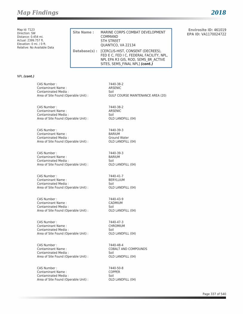
Map Findings 2018
Map Id: T123Direction: SWDistance: 0.454 mi.Actual: 2399.757 ft.Elevation: 0 mi. / 0 ft.Relative: No Available Data
Envirosite ID: 461019EPA ID: VA1170024722Site Name : MARINE CORPS COMBAT DEVELOPMENT
COMMAND5TH STREETQUANTICO, VA 22134
Database(s) : [CERCLIS-HIST, CONSENT (DECREES), FED E C, FED I C, FEDERAL FACILITY, NPL, NPL EPA R3 GIS, ROD, SEMS_8R_ACTIVE SITES, SEMS_FINAL NPL] (cont.)
NPL (cont.)
CAS Number : 7440-38-2Contaminant Name : ARSENICContaminated Media : SoilArea of Site Found (Operable Unit) : GULF COURSE MAINTENANCE AREA (20)
CAS Number : 7440-38-2Contaminant Name : ARSENICContaminated Media : SoilArea of Site Found (Operable Unit) : OLD LANDFILL (04)
CAS Number : 7440-39-3Contaminant Name : BARIUMContaminated Media : Ground WaterArea of Site Found (Operable Unit) : OLD LANDFILL (04)
CAS Number : 7440-39-3Contaminant Name : BARIUMContaminated Media : SoilArea of Site Found (Operable Unit) : OLD LANDFILL (04)
CAS Number : 7440-41-7Contaminant Name : BERYLLIUMContaminated Media : SoilArea of Site Found (Operable Unit) : OLD LANDFILL (04)
CAS Number : 7440-43-9Contaminant Name : CADMIUMContaminated Media : SoilArea of Site Found (Operable Unit) : OLD LANDFILL (04)
CAS Number : 7440-47-3Contaminant Name : CHROMIUMContaminated Media : SoilArea of Site Found (Operable Unit) : OLD LANDFILL (04)
CAS Number : 7440-48-4Contaminant Name : COBALT AND COMPOUNDSContaminated Media : SoilArea of Site Found (Operable Unit) : OLD LANDFILL (04)
CAS Number : 7440-50-8Contaminant Name : COPPERContaminated Media : SoilArea of Site Found (Operable Unit) : OLD LANDFILL (04)
Page 337 of 540

Map Findings 2018
Map Id: T123Direction: SWDistance: 0.454 mi.Actual: 2399.757 ft.Elevation: 0 mi. / 0 ft.Relative: No Available Data
Envirosite ID: 461019EPA ID: VA1170024722Site Name : MARINE CORPS COMBAT DEVELOPMENT
COMMAND5TH STREETQUANTICO, VA 22134
Database(s) : [CERCLIS-HIST, CONSENT (DECREES), FED E C, FED I C, FEDERAL FACILITY, NPL, NPL EPA R3 GIS, ROD, SEMS_8R_ACTIVE SITES, SEMS_FINAL NPL] (cont.)
NPL (cont.)
CAS Number : 7440-62-2Contaminant Name : VANADIUM (FUME OR DUST)Contaminated Media : SoilArea of Site Found (Operable Unit) : OLD LANDFILL (04)
CAS Number : 75-01-4Contaminant Name : CHLOROETHENE (VINYL CHLORIDE)Contaminated Media : Ground WaterArea of Site Found (Operable Unit) : B-2101 PAINT BOOTH SUMP (19)
CAS Number : 75-01-4Contaminant Name : CHLOROETHENE (VINYL CHLORIDE)Contaminated Media : Ground WaterArea of Site Found (Operable Unit) : B-2113 UG TANK LOAD/UNLOAD (21)
CAS Number : 79-00-5Contaminant Name : 1,1,2-TRICHLOROETHANEContaminated Media : Ground WaterArea of Site Found (Operable Unit) : B-2113 UG TANK LOAD/UNLOAD (21)
CAS Number : 79-01-6Contaminant Name : TRICHLOROETHENEContaminated Media : Ground WaterArea of Site Found (Operable Unit) : B-2113 UG TANK LOAD/UNLOAD (21)
CAS Number : 79-34-5Contaminant Name : TETRACHLOROETHANEContaminated Media : Ground WaterArea of Site Found (Operable Unit) : B-2113 UG TANK LOAD/UNLOAD (21)
CAS Number : 87-61-6Contaminant Name : 1,2,3-TRICHLOROBENZENEContaminated Media : Ground WaterArea of Site Found (Operable Unit) : B-2113 UG TANK LOAD/UNLOAD (21)
Operable Units InformationOU ID : 00Name : SITEWIDETypes of Contaminants Present at ROD Completion: N/RCleanup Technologies Selected in the Decision Document: N/R
Page 338 of 540

Map Findings 2018
Map Id: T123Direction: SWDistance: 0.454 mi.Actual: 2399.757 ft.Elevation: 0 mi. / 0 ft.Relative: No Available Data
Envirosite ID: 461019EPA ID: VA1170024722Site Name : MARINE CORPS COMBAT DEVELOPMENT
COMMAND5TH STREETQUANTICO, VA 22134
Database(s) : [CERCLIS-HIST, CONSENT (DECREES), FED E C, FED I C, FEDERAL FACILITY, NPL, NPL EPA R3 GIS, ROD, SEMS_8R_ACTIVE SITES, SEMS_FINAL NPL] (cont.)
NPL (cont.)
OU ID : 01Name : PESTICIDE BURIAL AREATypes of Contaminants Present at ROD Completion: N/RCleanup Technologies Selected in the Decision Document: N/R
OU ID : 02Name : FORMER RIFLE RANGETypes of Contaminants Present at ROD Completion: N/RCleanup Technologies Selected in the Decision Document: N/R
OU ID : 03Name : FIRE TRAINING AREATypes of Contaminants Present at ROD Completion: N/RCleanup Technologies Selected in the Decision Document: N/R
OU ID : 04Name : OLD LANDFILLTypes of Contaminants Present at ROD Completion: ALUMINUM; ARSENIC; BARIUM; IRON; MANGANESECleanup Technologies Selected in the Decision Document: Institutional Controls; Monitoring; Operations & Maintenance (O&M)
OU ID : 05Name : OLD BATCH PLANTTypes of Contaminants Present at ROD Completion: 4,4-DDD; AROCLOR 1260
Cleanup Technologies Selected in the Decision Document: Disposal (offsite); ESD/Amd - Remedy Element Addition/Modification;
Excavation; Habitat Restoration
OU ID : 06Name : AERO CLUBTypes of Contaminants Present at ROD Completion: N/RCleanup Technologies Selected in the Decision Document: N/R
OU ID : 07Name : ARSENIC BURIAL AREA
Page 339 of 540

Map Findings 2018
Map Id: T123Direction: SWDistance: 0.454 mi.Actual: 2399.757 ft.Elevation: 0 mi. / 0 ft.Relative: No Available Data
Envirosite ID: 461019EPA ID: VA1170024722Site Name : MARINE CORPS COMBAT DEVELOPMENT
COMMAND5TH STREETQUANTICO, VA 22134
Database(s) : [CERCLIS-HIST, CONSENT (DECREES), FED E C, FED I C, FEDERAL FACILITY, NPL, NPL EPA R3 GIS, ROD, SEMS_8R_ACTIVE SITES, SEMS_FINAL NPL] (cont.)
NPL (cont.)
Types of Contaminants Present at ROD Completion:
N/R
Cleanup Technologies Selected in the Decision Document: N/R
OU ID : 09Name : PESTICIDE CONTROL BUILDINGTypes of Contaminants Present at ROD Completion: N/RCleanup Technologies Selected in the Decision Document: N/R
OU ID : 10Name : OLF SOUTHERN WETLANDSTypes of Contaminants Present at ROD Completion: N/RCleanup Technologies Selected in the Decision Document: N/R
OU ID : 11Name : TBS NORTHWEST TRAINING AREATypes of Contaminants Present at ROD Completion: N/RCleanup Technologies Selected in the Decision Document: N/R
OU ID : 12Name : QWS EMBAYMENTTypes of Contaminants Present at ROD Completion: N/RCleanup Technologies Selected in the Decision Document: N/R
OU ID : 13Name : QWS CHOPAWAMSIC CREEKTypes of Contaminants Present at ROD Completion: N/RCleanup Technologies Selected in the Decision Document: N/R
OU ID : 15Name : CAMP BARRETT DISPOSAL AREATypes of Contaminants Present at ROD Completion: N/RCleanup Technologies Selected in the Decision Document: N/R
Page 340 of 540

Map Findings 2018
Map Id: T123Direction: SWDistance: 0.454 mi.Actual: 2399.757 ft.Elevation: 0 mi. / 0 ft.Relative: No Available Data
Envirosite ID: 461019EPA ID: VA1170024722Site Name : MARINE CORPS COMBAT DEVELOPMENT
COMMAND5TH STREETQUANTICO, VA 22134
Database(s) : [CERCLIS-HIST, CONSENT (DECREES), FED E C, FED I C, FEDERAL FACILITY, NPL, NPL EPA R3 GIS, ROD, SEMS_8R_ACTIVE SITES, SEMS_FINAL NPL] (cont.)
NPL (cont.)
OU ID : 16Name : CAMP GOETTGE DISPOSAL AREATypes of Contaminants Present at ROD Completion: N/RCleanup Technologies Selected in the Decision Document: N/R
OU ID : 17Name : SMITH LAKE ROAD CLEARED AREATypes of Contaminants Present at ROD Completion: N/RCleanup Technologies Selected in the Decision Document: N/R
OU ID : 18Name : B-4 ACCUMULATION AREATypes of Contaminants Present at ROD Completion: N/RCleanup Technologies Selected in the Decision Document: N/R
OU ID : 19Name : B-2101 PAINT BOOTH SUMPTypes of Contaminants Present at ROD Completion: CHLOROETHENE (VINYL CHLORIDE); cis-1,2-DICHLOROETHENECleanup Technologies Selected in the Decision Document: Bioremediation (other, NOS, insitu); Institutional Controls; Monitoring
OU ID : 20Name : GULF COURSE MAINTENANCE AREATypes of Contaminants Present at ROD Completion: 4,4-DDD; 4,4-DDE; 4,4-DDT; ARSENIC; DIELDRIN; MERCURYCleanup Technologies Selected in the Decision Document: No Further Action
OU ID : 21Name : B-2113 UG TANK LOAD/UNLOAD
Types of Contaminants Present at ROD Completion: 1,1,2-TRICHLOROETHANE; 1,2,3-TRICHLOROBENZENE; 1,2,4-
TRICHLOROBENZENE; 1,3-DICHLOROBENZENE; 1,4-DICHLOROBENZENE; CHLOROETHENE (VINYL CHLORIDE); CHLOROFORM; TETRACHLOROETHANE; TETRACHLOROETHENE; TRICHLOROETHENE; cis-1,2-DICHLOROETHENE
Page 341 of 540

Map Findings 2018
Map Id: T123Direction: SWDistance: 0.454 mi.Actual: 2399.757 ft.Elevation: 0 mi. / 0 ft.Relative: No Available Data
Envirosite ID: 461019EPA ID: VA1170024722Site Name : MARINE CORPS COMBAT DEVELOPMENT
COMMAND5TH STREETQUANTICO, VA 22134
Database(s) : [CERCLIS-HIST, CONSENT (DECREES), FED E C, FED I C, FEDERAL FACILITY, NPL, NPL EPA R3 GIS, ROD, SEMS_8R_ACTIVE SITES, SEMS_FINAL NPL] (cont.)
NPL (cont.)
Cleanup Technologies Selected in the Decision Document:
Bioremediation (bioaugmentation, insitu); Bioremediation (other, NOS, insitu); Institutional Controls; Monitored Natural Attenuation; Monitoring (groundwater)
OU ID : 22Name : CAMP UPSHURTypes of Contaminants Present at ROD Completion: N/RCleanup Technologies Selected in the Decision Document: N/R
OU ID : 23Name : ABRAHAMS CREEKTypes of Contaminants Present at ROD Completion: N/RCleanup Technologies Selected in the Decision Document: N/R
OU ID : 24Name : UXO 13A 81MM MORTOR RGE IMPACTTypes of Contaminants Present at ROD Completion: N/RCleanup Technologies Selected in the Decision Document: N/R
OU ID : 25Name : UXO 021 COMBAT AREA C FFRTypes of Contaminants Present at ROD Completion: N/RCleanup Technologies Selected in the Decision Document: N/R
OU ID : 27Name : UXO-034 LUNGA RECREATION AREA SOUTHTypes of Contaminants Present at ROD Completion: N/RCleanup Technologies Selected in the Decision Document: N/R
OU ID : 28Name : UXO 031 CAMP BARRETT TRAININGTypes of Contaminants Present at ROD Completion: N/RCleanup Technologies Selected in the Decision Document: N/R
Page 342 of 540
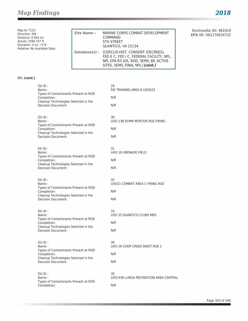
Map Findings 2018
Map Id: T123Direction: SWDistance: 0.454 mi.Actual: 2399.757 ft.Elevation: 0 mi. / 0 ft.Relative: No Available Data
Envirosite ID: 461019EPA ID: VA1170024722Site Name : MARINE CORPS COMBAT DEVELOPMENT
COMMAND5TH STREETQUANTICO, VA 22134
Database(s) : [CERCLIS-HIST, CONSENT (DECREES), FED E C, FED I C, FEDERAL FACILITY, NPL, NPL EPA R3 GIS, ROD, SEMS_8R_ACTIVE SITES, SEMS_FINAL NPL] (cont.)
NPL (cont.)
OU ID : 29Name : FBI TRAINING AREA 8 UXO033Types of Contaminants Present at ROD Completion: N/RCleanup Technologies Selected in the Decision Document: N/R
OU ID : 30Name : UXO 13B 81MM MORTOR RGE FIRINGTypes of Contaminants Present at ROD Completion: N/RCleanup Technologies Selected in the Decision Document: N/R
OU ID : 31Name : UXO 19 GRENADE FIELDTypes of Contaminants Present at ROD Completion: N/RCleanup Technologies Selected in the Decision Document: N/R
OU ID : 32Name : UXO21 COMBAT AREA C FIRING RGETypes of Contaminants Present at ROD Completion: N/RCleanup Technologies Selected in the Decision Document: N/R
OU ID : 33Name : UXO 25 QUANTICO CLUBS MRSTypes of Contaminants Present at ROD Completion: N/RCleanup Technologies Selected in the Decision Document: N/R
OU ID : 34Name : UXO 26 CHOP CREEK SKEET RGE 1Types of Contaminants Present at ROD Completion: N/RCleanup Technologies Selected in the Decision Document: N/R
OU ID : 35Name : UXO-038 LUNGA RECREATION AREA CENTRALTypes of Contaminants Present at ROD Completion: N/R
Page 343 of 540

Map Findings 2018
Map Id: T123Direction: SWDistance: 0.454 mi.Actual: 2399.757 ft.Elevation: 0 mi. / 0 ft.Relative: No Available Data
Envirosite ID: 461019EPA ID: VA1170024722Site Name : MARINE CORPS COMBAT DEVELOPMENT
COMMAND5TH STREETQUANTICO, VA 22134
Database(s) : [CERCLIS-HIST, CONSENT (DECREES), FED E C, FED I C, FEDERAL FACILITY, NPL, NPL EPA R3 GIS, ROD, SEMS_8R_ACTIVE SITES, SEMS_FINAL NPL] (cont.)
NPL (cont.)
Cleanup Technologies Selected in the Decision Document:
N/R
OU ID : 36Name : UXO-034 LUNGA RECREATION AREA NORTHTypes of Contaminants Present at ROD Completion: N/RCleanup Technologies Selected in the Decision Document: N/R
OU ID : 37Name : UXO-018 FLYING FIELD BOMBING TARGET #5Types of Contaminants Present at ROD Completion: N/RCleanup Technologies Selected in the Decision Document: N/R
OU ID : 38Name : SITE 99 SOIL AREAS B AND CTypes of Contaminants Present at ROD Completion: N/RCleanup Technologies Selected in the Decision Document: N/R
OU ID : 39Name : UXO-035 LUNGA RESERVOIRTypes of Contaminants Present at ROD Completion: N/RCleanup Technologies Selected in the Decision Document: N/R
OU ID : 40Name : GRENADE PIT UXO 036Types of Contaminants Present at ROD Completion: N/RCleanup Technologies Selected in the Decision Document: N/R
OU ID : 41Name : CHOPAWAMSIC CREEK RANGE FANSTypes of Contaminants Present at ROD Completion: N/RCleanup Technologies Selected in the Decision Document: N/R
Page 344 of 540

Map Findings 2018
Map Id: T123Direction: SWDistance: 0.454 mi.Actual: 2399.757 ft.Elevation: 0 mi. / 0 ft.Relative: No Available Data
Envirosite ID: 461019EPA ID: VA1170024722Site Name : MARINE CORPS COMBAT DEVELOPMENT
COMMAND5TH STREETQUANTICO, VA 22134
Database(s) : [CERCLIS-HIST, CONSENT (DECREES), FED E C, FED I C, FEDERAL FACILITY, NPL, NPL EPA R3 GIS, ROD, SEMS_8R_ACTIVE SITES, SEMS_FINAL NPL] (cont.)
NPL (cont.)
Performance Measures InformationHuman Exposure Under Control : YesGroundwater Migration Under Control : YesConstruction Complete : NoSitewide Ready for Anticipated Use : No
NPL EPA R3 GIS
Description : GIS for EPA Region 3 NPL
ROD
Facility Name : MARINE CORPS COMBAT DEVELOPMENT COMMANDFacility Address : 5TH STREET, QUANTICO, VA 22134County : PRINCE WILLIAM
Date : 09/29/2014EPA ID : VA1170024722Region : 03Title : OU 21 FINAL RECORD OF DECISION (ROD) - SWMU M-13Title (Link) : Click here for hyperlink provided by the agency.
Date : 09/30/2011EPA ID : VA1170024722Region : 03Title : RECORD OF DECISION (ROD) - SITE 99 & SITE 96Title (Link) : Click here for hyperlink provided by the agency.
Date : 09/29/2011EPA ID : VA1170024722Region : 03Title : RECORD OF DECISION (ROD) - SITE 100 - CHOPAWAMSIC CREEKTitle (Link) : Click here for hyperlink provided by the agency.
Date : 09/30/2008EPA ID : VA1170024722Region : 03Title : RECORD OF DECISION (ROD) - SITE 95Title (Link) : Click here for hyperlink provided by the agency.
Date : 09/03/2008EPA ID : VA1170024722Region : 03Title : RECORD OF DECISION (ROD) - SITE 8, 9, 10, 21, 32, 33, 34, 98Title (Link) : Click here for hyperlink provided by the agency.
Page 345 of 540

Map Findings 2018
Map Id: T123Direction: SWDistance: 0.454 mi.Actual: 2399.757 ft.Elevation: 0 mi. / 0 ft.Relative: No Available Data
Envirosite ID: 461019EPA ID: VA1170024722Site Name : MARINE CORPS COMBAT DEVELOPMENT
COMMAND5TH STREETQUANTICO, VA 22134
Database(s) : [CERCLIS-HIST, CONSENT (DECREES), FED E C, FED I C, FEDERAL FACILITY, NPL, NPL EPA R3 GIS, ROD, SEMS_8R_ACTIVE SITES, SEMS_FINAL NPL] (cont.)
ROD (cont.)
Date : 12/20/2007EPA ID : VA1170024722Region : 03Title : RECORD OF DECISION (ROD) - SITE 4 - OLD LANDFILLTitle (Link) : Click here for hyperlink provided by the agency.
Date : 10/04/2007EPA ID : VA1170024722Region : 03Title : RECORD OF DECISION (ROD) - SITE 20 (L-37) - FORMER RIFLE RANGETitle (Link) : Click here for hyperlink provided by the agency.
Date : 06/21/2001EPA ID : VA1170024722Region : 03Title : RECORD OF DECISION (ROD) - SITE 17 - ARSENIC BURIAL AREATitle (Link) : Click here for hyperlink provided by the agency.
Date : 10/13/2000EPA ID : VA1170024722Region : 03Title : RECORD OF DECISION (ROD) - SITE 1 - PESTICIDE BURIAL AREATitle (Link) : Click here for hyperlink provided by the agency.
Date : 10/13/2000EPA ID : VA1170024722Region : 03Title : RECORD OF DECISION (ROD) - SITE 1 - PESTICIDE BURIAL AREATitle (Link) : Click here for hyperlink provided by the agency.
Date : 10/13/2000EPA ID : VA1170024722Region : 03Title : RECORD OF DECISION (ROD) - SITE 5 - OLD BATCH PLANTTitle (Link) : Click here for hyperlink provided by the agency.
Date : 09/30/1997EPA ID : VA1170024722Region : 03Title : RECORD OF DECISION (ROD)Title (Link) : Click here for hyperlink provided by the agency.
SEMS_8R_ACTIVE SITES
Facility Name : MARINE CORPS COMBAT DEVELOPMENT COMMANDFacility Address : 5TH STREET, QUANTICO, VA 22134
Page 346 of 540

Map Findings 2018
Map Id: T123Direction: SWDistance: 0.454 mi.Actual: 2399.757 ft.Elevation: 0 mi. / 0 ft.Relative: No Available Data
Envirosite ID: 461019EPA ID: VA1170024722Site Name : MARINE CORPS COMBAT DEVELOPMENT
COMMAND5TH STREETQUANTICO, VA 22134
Database(s) : [CERCLIS-HIST, CONSENT (DECREES), FED E C, FED I C, FEDERAL FACILITY, NPL, NPL EPA R3 GIS, ROD, SEMS_8R_ACTIVE SITES, SEMS_FINAL NPL] (cont.)
SEMS_8R_ACTIVE SITES (cont.)
County : PRINCE WILLIAM
Site DetailsSite ID : 0302840EPA ID : VA1170024722Region : 03Congressional District : 01Federal Facility : YNPL Status : Currently on the Final NPLNon NPL Status : N/RFIPS Code : 51153Latitude : 38.521667Longitude : -77.29Last Date in Agency List : 01/02/2018
Additional InformationStart Date : 07/23/2016Finish Date : 09/02/2016OU : 24Action Code : LVAction Name : FF RVSequence : 29Quality : N/RCurrent Action Lead : Fed Fac
Start Date : 04/26/2016Finish Date : 10/22/2016OU : 32Action Code : LVAction Name : FF RVSequence : 27Quality : N/RCurrent Action Lead : Fed Fac
Start Date : 02/15/2016Finish Date : N/ROU : 36Action Code : NHAction Name : FF RISequence : 3Quality : N/RCurrent Action Lead : Fed Fac
Start Date : 10/05/2015Finish Date : 12/19/2016
Page 347 of 540

Map Findings 2018
Map Id: T123Direction: SWDistance: 0.454 mi.Actual: 2399.757 ft.Elevation: 0 mi. / 0 ft.Relative: No Available Data
Envirosite ID: 461019EPA ID: VA1170024722Site Name : MARINE CORPS COMBAT DEVELOPMENT
COMMAND5TH STREETQUANTICO, VA 22134
Database(s) : [CERCLIS-HIST, CONSENT (DECREES), FED E C, FED I C, FEDERAL FACILITY, NPL, NPL EPA R3 GIS, ROD, SEMS_8R_ACTIVE SITES, SEMS_FINAL NPL] (cont.)
SEMS_8R_ACTIVE SITES (cont.)
OU : 27Action Code : LVAction Name : FF RVSequence : 25Quality : N/RCurrent Action Lead : Fed Fac
Start Date : 12/02/2014Finish Date : 06/15/2015OU : 27Action Code : EEAction Name : EE/CASequence : 15Quality : N/RCurrent Action Lead : Fed Fac
Start Date : 10/09/2014Finish Date : N/ROU : 24Action Code : LWAction Name : FF RI/FSSequence : 18Quality : N/RCurrent Action Lead : Fed Fac
Start Date : 10/09/2014Finish Date : N/ROU : 27Action Code : LWAction Name : FF RI/FSSequence : 21Quality : N/RCurrent Action Lead : Fed Fac
Start Date : 10/09/2014Finish Date : N/ROU : 30Action Code : LWAction Name : FF RI/FSSequence : 22Quality : N/RCurrent Action Lead : Fed Fac
Start Date : 10/09/2014Finish Date : N/ROU : 31Action Code : LWAction Name : FF RI/FS
Page 348 of 540

Map Findings 2018
Map Id: T123Direction: SWDistance: 0.454 mi.Actual: 2399.757 ft.Elevation: 0 mi. / 0 ft.Relative: No Available Data
Envirosite ID: 461019EPA ID: VA1170024722Site Name : MARINE CORPS COMBAT DEVELOPMENT
COMMAND5TH STREETQUANTICO, VA 22134
Database(s) : [CERCLIS-HIST, CONSENT (DECREES), FED E C, FED I C, FEDERAL FACILITY, NPL, NPL EPA R3 GIS, ROD, SEMS_8R_ACTIVE SITES, SEMS_FINAL NPL] (cont.)
SEMS_8R_ACTIVE SITES (cont.)
Sequence : 23Quality : N/RCurrent Action Lead : Fed Fac
Start Date : 10/09/2014Finish Date : N/ROU : 32Action Code : LWAction Name : FF RI/FSSequence : 24Quality : N/RCurrent Action Lead : Fed Fac
Start Date : 10/09/2014Finish Date : N/ROU : 33Action Code : LWAction Name : FF RI/FSSequence : 25Quality : N/RCurrent Action Lead : Fed Fac
Start Date : 10/09/2014Finish Date : N/ROU : 35Action Code : NHAction Name : FF RISequence : 2Quality : N/RCurrent Action Lead : Fed Fac
Start Date : 02/28/2014Finish Date : 03/30/2014OU : 35Action Code : LVAction Name : FF RVSequence : 24Quality : SCurrent Action Lead : Fed Fac
Start Date : 02/18/2014Finish Date : 03/05/2014OU : 37Action Code : LVAction Name : FF RVSequence : 22Quality : N/RCurrent Action Lead : Fed Fac
Page 349 of 540

Map Findings 2018
Map Id: T123Direction: SWDistance: 0.454 mi.Actual: 2399.757 ft.Elevation: 0 mi. / 0 ft.Relative: No Available Data
Envirosite ID: 461019EPA ID: VA1170024722Site Name : MARINE CORPS COMBAT DEVELOPMENT
COMMAND5TH STREETQUANTICO, VA 22134
Database(s) : [CERCLIS-HIST, CONSENT (DECREES), FED E C, FED I C, FEDERAL FACILITY, NPL, NPL EPA R3 GIS, ROD, SEMS_8R_ACTIVE SITES, SEMS_FINAL NPL] (cont.)
SEMS_8R_ACTIVE SITES (cont.)
Start Date : 06/27/2013Finish Date : 09/29/2014OU : 21Action Code : ROAction Name : RODSequence : 23Quality : N/RCurrent Action Lead : Fed Fac
Start Date : 05/31/2013Finish Date : N/ROU : 12Action Code : LYAction Name : FF RASequence : 3Quality : N/RCurrent Action Lead : Fed Fac
Start Date : 02/14/2013Finish Date : 09/30/2013OU : 12Action Code : LVAction Name : FF RVSequence : 21Quality : N/RCurrent Action Lead : Fed Fac
Start Date : 08/22/2012Finish Date : 04/17/2013OU : 19Action Code : LVAction Name : FF RVSequence : 17Quality : N/RCurrent Action Lead : Fed Fac
Start Date : 08/20/2012Finish Date : 06/30/2013OU : 28Action Code : LVAction Name : FF RVSequence : 19Quality : N/RCurrent Action Lead : Fed Fac
Start Date : 06/25/2012Finish Date : N/ROU : 13
Page 350 of 540

Map Findings 2018
Map Id: T123Direction: SWDistance: 0.454 mi.Actual: 2399.757 ft.Elevation: 0 mi. / 0 ft.Relative: No Available Data
Envirosite ID: 461019EPA ID: VA1170024722Site Name : MARINE CORPS COMBAT DEVELOPMENT
COMMAND5TH STREETQUANTICO, VA 22134
Database(s) : [CERCLIS-HIST, CONSENT (DECREES), FED E C, FED I C, FEDERAL FACILITY, NPL, NPL EPA R3 GIS, ROD, SEMS_8R_ACTIVE SITES, SEMS_FINAL NPL] (cont.)
SEMS_8R_ACTIVE SITES (cont.)
Action Code : LYAction Name : FF RASequence : 4Quality : N/RCurrent Action Lead : Fed Fac
Start Date : 04/10/2012Finish Date : 05/14/2012OU : 27Action Code : LVAction Name : FF RVSequence : 18Quality : N/RCurrent Action Lead : Fed Fac
Start Date : 03/15/2012Finish Date : 04/27/2012OU : 13Action Code : LXAction Name : FF RDSequence : 3Quality : N/RCurrent Action Lead : Fed Fac
Start Date : 03/03/2012Finish Date : 09/29/2014OU : 10Action Code : LYAction Name : FF RASequence : 7Quality : N/RCurrent Action Lead : Fed Fac
Start Date : 10/30/2011Finish Date : 11/28/2011OU : 12Action Code : LXAction Name : FF RDSequence : 2Quality : N/RCurrent Action Lead : Fed Fac
Start Date : 09/30/2011Finish Date : 09/30/2011OU : 12Action Code : ROAction Name : RODSequence : 12
Page 351 of 540

Map Findings 2018
Map Id: T123Direction: SWDistance: 0.454 mi.Actual: 2399.757 ft.Elevation: 0 mi. / 0 ft.Relative: No Available Data
Envirosite ID: 461019EPA ID: VA1170024722Site Name : MARINE CORPS COMBAT DEVELOPMENT
COMMAND5TH STREETQUANTICO, VA 22134
Database(s) : [CERCLIS-HIST, CONSENT (DECREES), FED E C, FED I C, FEDERAL FACILITY, NPL, NPL EPA R3 GIS, ROD, SEMS_8R_ACTIVE SITES, SEMS_FINAL NPL] (cont.)
SEMS_8R_ACTIVE SITES (cont.)
Quality : N/RCurrent Action Lead : Fed Fac
Start Date : 09/29/2011Finish Date : 09/29/2011OU : 13Action Code : ROAction Name : RODSequence : 13Quality : N/RCurrent Action Lead : Fed Fac
Start Date : 07/31/2011Finish Date : N/ROU : 38Action Code : NHAction Name : FF RISequence : 4Quality : N/RCurrent Action Lead : Fed Fac
Start Date : 03/15/2011Finish Date : 04/06/2011OU : 25Action Code : LVAction Name : FF RVSequence : 15Quality : N/RCurrent Action Lead : Fed Fac
Start Date : 06/14/2010Finish Date : 09/29/2014OU : 21Action Code : LWAction Name : FF RI/FSSequence : 16Quality : N/RCurrent Action Lead : Fed Fac
Start Date : 09/30/2008Finish Date : 09/30/2008OU : 19Action Code : ROAction Name : RODSequence : 24Quality : N/RCurrent Action Lead : Fed Fac
Page 352 of 540

Map Findings 2018
Map Id: T123Direction: SWDistance: 0.454 mi.Actual: 2399.757 ft.Elevation: 0 mi. / 0 ft.Relative: No Available Data
Envirosite ID: 461019EPA ID: VA1170024722Site Name : MARINE CORPS COMBAT DEVELOPMENT
COMMAND5TH STREETQUANTICO, VA 22134
Database(s) : [CERCLIS-HIST, CONSENT (DECREES), FED E C, FED I C, FEDERAL FACILITY, NPL, NPL EPA R3 GIS, ROD, SEMS_8R_ACTIVE SITES, SEMS_FINAL NPL] (cont.)
SEMS_8R_ACTIVE SITES (cont.)
Start Date : 09/02/2008Finish Date : 09/02/2008OU : 20Action Code : ROAction Name : RODSequence : 22Quality : N/RCurrent Action Lead : Fed Fac
Start Date : 12/20/2007Finish Date : 12/20/2007OU : 04Action Code : ROAction Name : RODSequence : 17Quality : N/RCurrent Action Lead : Fed Fac
Start Date : 10/04/2007Finish Date : 10/04/2007OU : 02Action Code : ROAction Name : RODSequence : 18Quality : N/RCurrent Action Lead : Fed Fac
Start Date : 07/31/2007Finish Date : 09/30/2008OU : 19Action Code : LWAction Name : FF RI/FSSequence : 17Quality : N/RCurrent Action Lead : Fed Fac
Start Date : 07/03/2007Finish Date : 07/03/2007OU : 05Action Code : ROAction Name : RODSequence : 21Quality : N/RCurrent Action Lead : Fed Fac
Start Date : 12/18/2006Finish Date : N/ROU : 23
Page 353 of 540

Map Findings 2018
Map Id: T123Direction: SWDistance: 0.454 mi.Actual: 2399.757 ft.Elevation: 0 mi. / 0 ft.Relative: No Available Data
Envirosite ID: 461019EPA ID: VA1170024722Site Name : MARINE CORPS COMBAT DEVELOPMENT
COMMAND5TH STREETQUANTICO, VA 22134
Database(s) : [CERCLIS-HIST, CONSENT (DECREES), FED E C, FED I C, FEDERAL FACILITY, NPL, NPL EPA R3 GIS, ROD, SEMS_8R_ACTIVE SITES, SEMS_FINAL NPL] (cont.)
SEMS_8R_ACTIVE SITES (cont.)
Action Code : NIAction Name : FF FSSequence : 1Quality : N/RCurrent Action Lead : Fed Fac
Start Date : 10/16/2006Finish Date : 03/05/2007OU : 16Action Code : LVAction Name : FF RVSequence : 7Quality : N/RCurrent Action Lead : Fed Fac
Start Date : 04/03/2006Finish Date : 10/17/2007OU : 15Action Code : LVAction Name : FF RVSequence : 6Quality : CCurrent Action Lead : Fed Fac
Start Date : 03/13/2006Finish Date : 03/31/2006OU : 17Action Code : LVAction Name : FF RVSequence : 14Quality : N/RCurrent Action Lead : Fed Fac
Start Date : 01/09/2006Finish Date : 03/02/2006OU : 11Action Code : LVAction Name : FF RVSequence : 13Quality : N/RCurrent Action Lead : Fed Fac
Start Date : 09/06/2005Finish Date : 12/01/2005OU : 22Action Code : LVAction Name : FF RVSequence : 11
Page 354 of 540

Map Findings 2018
Map Id: T123Direction: SWDistance: 0.454 mi.Actual: 2399.757 ft.Elevation: 0 mi. / 0 ft.Relative: No Available Data
Envirosite ID: 461019EPA ID: VA1170024722Site Name : MARINE CORPS COMBAT DEVELOPMENT
COMMAND5TH STREETQUANTICO, VA 22134
Database(s) : [CERCLIS-HIST, CONSENT (DECREES), FED E C, FED I C, FEDERAL FACILITY, NPL, NPL EPA R3 GIS, ROD, SEMS_8R_ACTIVE SITES, SEMS_FINAL NPL] (cont.)
SEMS_8R_ACTIVE SITES (cont.)
Quality : N/RCurrent Action Lead : Fed Fac
Start Date : 06/22/2005Finish Date : 08/31/2005OU : 09Action Code : LVAction Name : FF RVSequence : 12Quality : N/RCurrent Action Lead : Fed Fac
Start Date : 05/12/2005Finish Date : 06/21/2005OU : 20Action Code : LVAction Name : FF RVSequence : 9Quality : N/RCurrent Action Lead : Fed Fac
Start Date : 04/01/2005Finish Date : 05/11/2005OU : 05Action Code : LVAction Name : FF RVSequence : 5Quality : N/RCurrent Action Lead : Fed Fac
Start Date : 01/17/2005Finish Date : 05/25/2005OU : 11Action Code : EEAction Name : EE/CASequence : 14Quality : N/RCurrent Action Lead : Fed Fac
Start Date : 01/17/2005Finish Date : 05/25/2005OU : 22Action Code : EEAction Name : EE/CASequence : 12Quality : N/RCurrent Action Lead : Fed Fac
Page 355 of 540
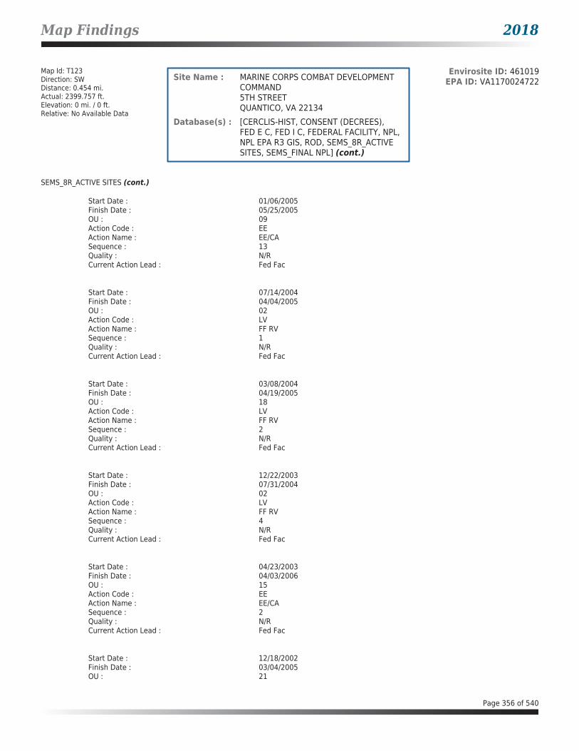
Map Findings 2018
Map Id: T123Direction: SWDistance: 0.454 mi.Actual: 2399.757 ft.Elevation: 0 mi. / 0 ft.Relative: No Available Data
Envirosite ID: 461019EPA ID: VA1170024722Site Name : MARINE CORPS COMBAT DEVELOPMENT
COMMAND5TH STREETQUANTICO, VA 22134
Database(s) : [CERCLIS-HIST, CONSENT (DECREES), FED E C, FED I C, FEDERAL FACILITY, NPL, NPL EPA R3 GIS, ROD, SEMS_8R_ACTIVE SITES, SEMS_FINAL NPL] (cont.)
SEMS_8R_ACTIVE SITES (cont.)
Start Date : 01/06/2005Finish Date : 05/25/2005OU : 09Action Code : EEAction Name : EE/CASequence : 13Quality : N/RCurrent Action Lead : Fed Fac
Start Date : 07/14/2004Finish Date : 04/04/2005OU : 02Action Code : LVAction Name : FF RVSequence : 1Quality : N/RCurrent Action Lead : Fed Fac
Start Date : 03/08/2004Finish Date : 04/19/2005OU : 18Action Code : LVAction Name : FF RVSequence : 2Quality : N/RCurrent Action Lead : Fed Fac
Start Date : 12/22/2003Finish Date : 07/31/2004OU : 02Action Code : LVAction Name : FF RVSequence : 4Quality : N/RCurrent Action Lead : Fed Fac
Start Date : 04/23/2003Finish Date : 04/03/2006OU : 15Action Code : EEAction Name : EE/CASequence : 2Quality : N/RCurrent Action Lead : Fed Fac
Start Date : 12/18/2002Finish Date : 03/04/2005OU : 21
Page 356 of 540
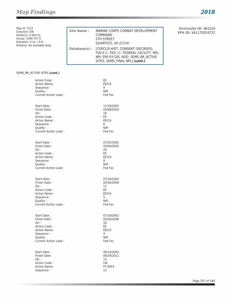
Map Findings 2018
Map Id: T123Direction: SWDistance: 0.454 mi.Actual: 2399.757 ft.Elevation: 0 mi. / 0 ft.Relative: No Available Data
Envirosite ID: 461019EPA ID: VA1170024722Site Name : MARINE CORPS COMBAT DEVELOPMENT
COMMAND5TH STREETQUANTICO, VA 22134
Database(s) : [CERCLIS-HIST, CONSENT (DECREES), FED E C, FED I C, FEDERAL FACILITY, NPL, NPL EPA R3 GIS, ROD, SEMS_8R_ACTIVE SITES, SEMS_FINAL NPL] (cont.)
SEMS_8R_ACTIVE SITES (cont.)
Action Code : EEAction Name : EE/CASequence : 9Quality : N/RCurrent Action Lead : Fed Fac
Start Date : 12/18/2002Finish Date : 03/08/2004OU : 18Action Code : EEAction Name : EE/CASequence : 6Quality : N/RCurrent Action Lead : Fed Fac
Start Date : 07/25/2002Finish Date : 03/04/2005OU : 20Action Code : EEAction Name : EE/CASequence : 8Quality : N/RCurrent Action Lead : Fed Fac
Start Date : 07/18/2002Finish Date : 02/04/2004OU : 17Action Code : EEAction Name : EE/CASequence : 5Quality : N/RCurrent Action Lead : Fed Fac
Start Date : 07/18/2002Finish Date : 05/26/2006OU : 16Action Code : EEAction Name : EE/CASequence : 4Quality : N/RCurrent Action Lead : Fed Fac
Start Date : 06/14/2002Finish Date : 09/29/2011OU : 13Action Code : LWAction Name : FF RI/FSSequence : 13
Page 357 of 540

Map Findings 2018
Map Id: T123Direction: SWDistance: 0.454 mi.Actual: 2399.757 ft.Elevation: 0 mi. / 0 ft.Relative: No Available Data
Envirosite ID: 461019EPA ID: VA1170024722Site Name : MARINE CORPS COMBAT DEVELOPMENT
COMMAND5TH STREETQUANTICO, VA 22134
Database(s) : [CERCLIS-HIST, CONSENT (DECREES), FED E C, FED I C, FEDERAL FACILITY, NPL, NPL EPA R3 GIS, ROD, SEMS_8R_ACTIVE SITES, SEMS_FINAL NPL] (cont.)
SEMS_8R_ACTIVE SITES (cont.)
Quality : N/RCurrent Action Lead : Fed Fac
Start Date : 06/14/2002Finish Date : N/ROU : 23Action Code : NHAction Name : FF RISequence : 1Quality : N/RCurrent Action Lead : Fed Fac
Start Date : 06/06/2002Finish Date : 09/30/2011OU : 12Action Code : LWAction Name : FF RI/FSSequence : 12Quality : N/RCurrent Action Lead : Fed Fac
Start Date : 04/17/2002Finish Date : 12/22/2003OU : 02Action Code : EEAction Name : EE/CASequence : 1Quality : N/RCurrent Action Lead : Fed Fac
Start Date : 03/06/2002Finish Date : 05/17/2004OU : 05Action Code : EEAction Name : EE/CASequence : 10Quality : N/RCurrent Action Lead : Fed Fac
Start Date : 06/21/2001Finish Date : 06/21/2001OU : 07Action Code : ROAction Name : RODSequence : 7Quality : N/RCurrent Action Lead : Fed Fac
Page 358 of 540

Map Findings 2018
Map Id: T123Direction: SWDistance: 0.454 mi.Actual: 2399.757 ft.Elevation: 0 mi. / 0 ft.Relative: No Available Data
Envirosite ID: 461019EPA ID: VA1170024722Site Name : MARINE CORPS COMBAT DEVELOPMENT
COMMAND5TH STREETQUANTICO, VA 22134
Database(s) : [CERCLIS-HIST, CONSENT (DECREES), FED E C, FED I C, FEDERAL FACILITY, NPL, NPL EPA R3 GIS, ROD, SEMS_8R_ACTIVE SITES, SEMS_FINAL NPL] (cont.)
SEMS_8R_ACTIVE SITES (cont.)
Start Date : 10/13/2000Finish Date : 10/13/2000OU : 01Action Code : ROAction Name : RODSequence : 2Quality : N/RCurrent Action Lead : Fed Fac
Start Date : 10/13/2000Finish Date : 10/13/2000OU : 05Action Code : ROAction Name : RODSequence : 5Quality : N/RCurrent Action Lead : Fed Fac
Start Date : 12/31/1998Finish Date : 12/20/2007OU : 04Action Code : LWAction Name : FF RI/FSSequence : 15Quality : N/RCurrent Action Lead : Fed Fac
Start Date : 10/01/1997Finish Date : 10/01/1997OU : 03Action Code : ROAction Name : RODSequence : 15Quality : N/RCurrent Action Lead : St Perf
Start Date : 10/01/1997Finish Date : 10/01/1997OU : 06Action Code : ROAction Name : RODSequence : 16Quality : N/RCurrent Action Lead : St Perf
Start Date : 09/30/1997Finish Date : 09/30/1997OU : 04
Page 359 of 540

Map Findings 2018
Map Id: T123Direction: SWDistance: 0.454 mi.Actual: 2399.757 ft.Elevation: 0 mi. / 0 ft.Relative: No Available Data
Envirosite ID: 461019EPA ID: VA1170024722Site Name : MARINE CORPS COMBAT DEVELOPMENT
COMMAND5TH STREETQUANTICO, VA 22134
Database(s) : [CERCLIS-HIST, CONSENT (DECREES), FED E C, FED I C, FEDERAL FACILITY, NPL, NPL EPA R3 GIS, ROD, SEMS_8R_ACTIVE SITES, SEMS_FINAL NPL] (cont.)
SEMS_8R_ACTIVE SITES (cont.)
Action Code : ROAction Name : RODSequence : 1Quality : N/RCurrent Action Lead : Fed Fac
Start Date : 12/31/1996Finish Date : 06/21/2001OU : 07Action Code : LWAction Name : FF RI/FSSequence : 7Quality : N/RCurrent Action Lead : Fed Fac
Start Date : 12/31/1996Finish Date : 09/30/1997OU : 04Action Code : LWAction Name : FF RI/FSSequence : 1Quality : N/RCurrent Action Lead : Fed Fac
Start Date : 12/31/1996Finish Date : 10/01/1997OU : 03Action Code : LWAction Name : FF RI/FSSequence : 4Quality : N/RCurrent Action Lead : Fed Fac
Start Date : 12/31/1996Finish Date : 10/01/1997OU : 06Action Code : LWAction Name : FF RI/FSSequence : 6Quality : N/RCurrent Action Lead : Fed Fac
Start Date : 12/31/1996Finish Date : 10/04/2007OU : 02Action Code : LWAction Name : FF RI/FSSequence : 3
Page 360 of 540

Map Findings 2018
Map Id: T123Direction: SWDistance: 0.454 mi.Actual: 2399.757 ft.Elevation: 0 mi. / 0 ft.Relative: No Available Data
Envirosite ID: 461019EPA ID: VA1170024722Site Name : MARINE CORPS COMBAT DEVELOPMENT
COMMAND5TH STREETQUANTICO, VA 22134
Database(s) : [CERCLIS-HIST, CONSENT (DECREES), FED E C, FED I C, FEDERAL FACILITY, NPL, NPL EPA R3 GIS, ROD, SEMS_8R_ACTIVE SITES, SEMS_FINAL NPL] (cont.)
SEMS_8R_ACTIVE SITES (cont.)
Quality : N/RCurrent Action Lead : Fed Fac
Start Date : 12/31/1996Finish Date : 10/13/2000OU : 05Action Code : LWAction Name : FF RI/FSSequence : 5Quality : N/RCurrent Action Lead : Fed Fac
Start Date : 12/01/1996Finish Date : 10/13/2000OU : 01Action Code : LWAction Name : FF RI/FSSequence : 2Quality : N/RCurrent Action Lead : Fed Fac
Start Date : 05/01/1996Finish Date : 09/30/1997OU : 04Action Code : LYAction Name : FF RASequence : 1Quality : N/RCurrent Action Lead : Fed Fac
Start Date : 05/31/1994Finish Date : 05/31/1994OU : 00Action Code : NFAction Name : NPL FINLSequence : 1Quality : N/RCurrent Action Lead : EPA Perf
Start Date : 05/10/1993Finish Date : 05/10/1993OU : 00Action Code : NPAction Name : PROPOSEDSequence : 1Quality : N/RCurrent Action Lead : EPA Perf
Page 361 of 540

Map Findings 2018
Map Id: T123Direction: SWDistance: 0.454 mi.Actual: 2399.757 ft.Elevation: 0 mi. / 0 ft.Relative: No Available Data
Envirosite ID: 461019EPA ID: VA1170024722Site Name : MARINE CORPS COMBAT DEVELOPMENT
COMMAND5TH STREETQUANTICO, VA 22134
Database(s) : [CERCLIS-HIST, CONSENT (DECREES), FED E C, FED I C, FEDERAL FACILITY, NPL, NPL EPA R3 GIS, ROD, SEMS_8R_ACTIVE SITES, SEMS_FINAL NPL] (cont.)
SEMS_8R_ACTIVE SITES (cont.)
Start Date : 09/28/1990Finish Date : 09/28/1990OU : 00Action Code : SIAction Name : SISequence : 1Quality : HCurrent Action Lead : Fed Fac
Start Date : 01/15/1990Finish Date : N/ROU : 00Action Code : LZAction Name : FF CRSequence : 1Quality : N/RCurrent Action Lead : Fed Fac
Start Date : 09/10/1985Finish Date : 09/10/1985OU : 00Action Code : PAAction Name : PASequence : 1Quality : LCurrent Action Lead : Fed Fac
Start Date : 05/01/1981Finish Date : 05/01/1981OU : 00Action Code : DSAction Name : DISCVRYSequence : 1Quality : N/RCurrent Action Lead : Fed Fac
SEMS_FINAL NPL
Facility Name : MARINE CORPS COMBAT DEVELOPMENT COMMANDFacility Address : 5TH STREET, QUANTICO, VA 22134County : PRINCE WILLIAM
Final Date : 05/31/1994Site ID : 0302840Epa ID : VA1170024722Region : 03Federal Facility : YLatitude : 38.521667
Page 362 of 540

Map Findings 2018
Map Id: T123Direction: SWDistance: 0.454 mi.Actual: 2399.757 ft.Elevation: 0 mi. / 0 ft.Relative: No Available Data
Envirosite ID: 461019EPA ID: VA1170024722Site Name : MARINE CORPS COMBAT DEVELOPMENT
COMMAND5TH STREETQUANTICO, VA 22134
Database(s) : [CERCLIS-HIST, CONSENT (DECREES), FED E C, FED I C, FEDERAL FACILITY, NPL, NPL EPA R3 GIS, ROD, SEMS_8R_ACTIVE SITES, SEMS_FINAL NPL] (cont.)
SEMS_FINAL NPL (cont.)
Longitude : -77.290000
Map Id: T124Direction: SWDistance: 0.471 mi.Actual: 2487.536 ft.Elevation: 0 mi. / 0 ft.Relative: No Available Data
Envirosite ID: 363841249EPA ID: N/RSite Name : MARINE CORPS BASE QUANTICO
38.5222258164239, -77.2869392843096VA
Database(s) : [DOD]
DOD
Facility Name : Marine Corps Base QuanticoFacility Address : VA
Internal Feature Number : 2520Primary Federal Land Type : Marine CorpsPrimary GNIS ID : 2512283Primary Administering Agency : DODSecondary Federal Land Type : N/ASecondary GNIS ID : N/ASecondary GNIS Name : N/ASecondary Administering Agency : N/ATertiary Federal Land Type : N/ATertiary GNIS ID : N/ATertiary GNIS Name : N/ATertiary Administering Agency : N/AState FIPS Code : 51GIS Acreage : 8111.87358369Perimeter (in Miles) : 17.207532284Area : 12.6748024745Link : Click here for hyperlink provided by the agency.
Map Id: T125Direction: SWDistance: 0.471 mi.Actual: 2487.536 ft.Elevation: 0 mi. / 0 ft.Relative: No Available Data
Envirosite ID: 363854389EPA ID: N/RSite Name : MARINE CORPS BASE QUANTICO
38.5222258159, -77.2869392845VA
Database(s) : [FEDLAND]
FEDLAND
Facility Name : Marine Corps Base Quantico
Page 363 of 540

Map Findings 2018
Map Id: T125Direction: SWDistance: 0.471 mi.Actual: 2487.536 ft.Elevation: 0 mi. / 0 ft.Relative: No Available Data
Envirosite ID: 363854389EPA ID: N/RSite Name : MARINE CORPS BASE QUANTICO
38.5222258159, -77.2869392845VA
Database(s) : [FEDLAND] (cont.)
FEDLAND (cont.)
Internal Feature Number : 2520Primary Federal Land Type : Marine CorpsPrimary GNIS ID : 2512283Primary Administering Agency : DODSecondary Federal Land Type : N/ASecondary GNIS ID : N/ASecondary GNIS Name : N/ASecondary Administering Agency : N/ATertiary Federal Land Type : N/ATertiary GNIS ID : N/ATertiary GNIS Name : N/ATertiary Administering Agency : N/AState : VAPerimeter (in Miles) : 17.207532284Area : 12.6748024745Link : Click here for hyperlink provided by the agency.
Map Id: 126Direction: SSWDistance: 0.477 mi.Actual: 2516.771 ft.Elevation: 0.018 mi. / 95.587 ft.Relative: Higher
Envirosite ID: 7363411EPA ID: N/RSite Name : 7 Eleven 10757
18750 Fuller Heights RdTriangle, VA 22172
Database(s) : [LPT - VA, UST - VA]
LPT - VA
Facility Name : 7 Eleven 10757Facility Address : 18750 Fuller Heights Rd, Triangle, VA 22172County : Prince William County
Release Reported : 12/09/1993PC Number : 19941016CEDS Facility ID : 200000095517Case Status : ClosedCase Closed Date : 05/15/2001Region : NVROProgram : RP LeadHeating Oil Category : N/RFederally Regulated UST : YRegulated Petroleum UST (1) : YExcluded UST (1) : NDeferred UST (1) : NPartially Deferred UST (1) : NExempt 1 UST (2) : NExempt 2 Heating Oil UST (2) : NSmall Heating Oil AST (2) : NRegulated AST (3) : NUnregulated AST (3) : NOther (Y/N) : NOther Description : N/RUnknown (Y/N) : N
Page 364 of 540

Map Findings 2018
Map Id: 126Direction: SSWDistance: 0.477 mi.Actual: 2516.771 ft.Elevation: 0.018 mi. / 95.587 ft.Relative: Higher
Envirosite ID: 7363411EPA ID: N/RSite Name : 7 Eleven 10757
18750 Fuller Heights RdTriangle, VA 22172
Database(s) : [LPT - VA, UST - VA] (cont.)
LPT - VA (cont.)
Priority : 2Suspect Confirm Indicator : ConfirmedLatitude : 38.5445400351Longitude : -77.331864788Last Date in Agency List : 02/09/2018
Release Reported : 02/02/1989PC Number : 19890882CEDS Facility ID : 200000095517Case Status : ClosedCase Closed Date : 09/07/1993Region : NVROProgram : RP LeadHeating Oil Category : N/RFederally Regulated UST : YRegulated Petroleum UST (1) : YExcluded UST (1) : NDeferred UST (1) : NPartially Deferred UST (1) : NExempt 1 UST (2) : NExempt 2 Heating Oil UST (2) : NSmall Heating Oil AST (2) : NRegulated AST (3) : NUnregulated AST (3) : NOther (Y/N) : NOther Description : N/RUnknown (Y/N) : NPriority : 1Suspect Confirm Indicator : ConfirmedLatitude : 38.5446251803Longitude : -77.3318258093Last Date in Agency List : 02/09/2018
UST - VA
Facility Name : 7 Eleven 10757Facility Address : 18750 Fuller Heights Rd, Triangle, VA 22172County : Prince William County
Facility ID : 3004339Facility Type : GAS STATIONCEDS Facility ID : 200000095517Region Code : NVRO
Tank InformationInstall Date : 10/23/2015Date Closed : N/RTank Number : 005Tank Status : CURR IN USETank Owner ID : 47914Tank Type : USTCapacity : 20000Federally Regulated Tank : Y
Page 365 of 540
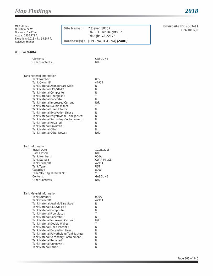
Map Findings 2018
Map Id: 126Direction: SSWDistance: 0.477 mi.Actual: 2516.771 ft.Elevation: 0.018 mi. / 95.587 ft.Relative: Higher
Envirosite ID: 7363411EPA ID: N/RSite Name : 7 Eleven 10757
18750 Fuller Heights RdTriangle, VA 22172
Database(s) : [LPT - VA, UST - VA] (cont.)
UST - VA (cont.)
Contents : GASOLINEOther Contents : N/R
Tank Material InformationTank Number : 005Tank Owner ID : 47914Tank Material Asphalt/Bare Steel : NTank Material CCP/STI-P3 : NTank Material Composite : NTank Material Fiberglass : YTank Material Concrete : NTank Material Impressed Current : N/RTank Material Double Walled : YTank Material Lined Interior : NTank Material Excavation Liner : NTank Material Polyethylene Tank Jacket: NTank Material Secondary Containment : NTank Material Repaired : NTank Material Unknown : NTank Material Other : NTank Material Other Notes : N/R
Tank InformationInstall Date : 10/23/2015Date Closed : N/RTank Number : 006ATank Status : CURR IN USETank Owner ID : 47914Tank Type : USTCapacity : 8000Federally Regulated Tank : YContents : GASOLINEOther Contents : N/R
Tank Material InformationTank Number : 006ATank Owner ID : 47914Tank Material Asphalt/Bare Steel : NTank Material CCP/STI-P3 : NTank Material Composite : NTank Material Fiberglass : YTank Material Concrete : NTank Material Impressed Current : N/RTank Material Double Walled : YTank Material Lined Interior : NTank Material Excavation Liner : NTank Material Polyethylene Tank Jacket: NTank Material Secondary Containment : NTank Material Repaired : NTank Material Unknown : NTank Material Other : N
Page 366 of 540

Map Findings 2018
Map Id: 126Direction: SSWDistance: 0.477 mi.Actual: 2516.771 ft.Elevation: 0.018 mi. / 95.587 ft.Relative: Higher
Envirosite ID: 7363411EPA ID: N/RSite Name : 7 Eleven 10757
18750 Fuller Heights RdTriangle, VA 22172
Database(s) : [LPT - VA, UST - VA] (cont.)
UST - VA (cont.)
Tank Material Other Notes : N/R
Tank InformationInstall Date : 10/23/2015Date Closed : N/RTank Number : 006BTank Status : CURR IN USETank Owner ID : 47914Tank Type : USTCapacity : 12000Federally Regulated Tank : YContents : DIESELOther Contents : N/R
Tank Material InformationTank Number : 006BTank Owner ID : 47914Tank Material Asphalt/Bare Steel : NTank Material CCP/STI-P3 : NTank Material Composite : NTank Material Fiberglass : YTank Material Concrete : NTank Material Impressed Current : N/RTank Material Double Walled : YTank Material Lined Interior : NTank Material Excavation Liner : NTank Material Polyethylene Tank Jacket: NTank Material Secondary Containment : NTank Material Repaired : NTank Material Unknown : NTank Material Other : NTank Material Other Notes : N/R
Tank InformationInstall Date : 08/01/1983Date Closed : 10/14/2015Tank Number : R1Tank Status : REM FROM GRDTank Owner ID : 47914Tank Type : USTCapacity : 10000Federally Regulated Tank : YContents : GASOLINEOther Contents : N/R
Tank Material InformationTank Number : R1Tank Owner ID : 47914Tank Material Asphalt/Bare Steel : N
Page 367 of 540

Map Findings 2018
Map Id: 126Direction: SSWDistance: 0.477 mi.Actual: 2516.771 ft.Elevation: 0.018 mi. / 95.587 ft.Relative: Higher
Envirosite ID: 7363411EPA ID: N/RSite Name : 7 Eleven 10757
18750 Fuller Heights RdTriangle, VA 22172
Database(s) : [LPT - VA, UST - VA] (cont.)
UST - VA (cont.)
Tank Material CCP/STI-P3 : NTank Material Composite : NTank Material Fiberglass : YTank Material Concrete : NTank Material Impressed Current : NTank Material Double Walled : NTank Material Lined Interior : NTank Material Excavation Liner : NTank Material Polyethylene Tank Jacket: NTank Material Secondary Containment : NTank Material Repaired : NTank Material Unknown : NTank Material Other : NTank Material Other Notes : N/R
Tank InformationInstall Date : 08/01/1983Date Closed : 10/14/2015Tank Number : R2Tank Status : REM FROM GRDTank Owner ID : 47914Tank Type : USTCapacity : 10000Federally Regulated Tank : YContents : GASOLINEOther Contents : N/R
Tank Material InformationTank Number : R2Tank Owner ID : 47914Tank Material Asphalt/Bare Steel : NTank Material CCP/STI-P3 : NTank Material Composite : NTank Material Fiberglass : YTank Material Concrete : NTank Material Impressed Current : NTank Material Double Walled : NTank Material Lined Interior : NTank Material Excavation Liner : NTank Material Polyethylene Tank Jacket: NTank Material Secondary Containment : NTank Material Repaired : NTank Material Unknown : NTank Material Other : NTank Material Other Notes : N/R
Tank InformationInstall Date : 08/01/1983Date Closed : 10/14/2015Tank Number : R3Tank Status : REM FROM GRD
Page 368 of 540

Map Findings 2018
Map Id: 126Direction: SSWDistance: 0.477 mi.Actual: 2516.771 ft.Elevation: 0.018 mi. / 95.587 ft.Relative: Higher
Envirosite ID: 7363411EPA ID: N/RSite Name : 7 Eleven 10757
18750 Fuller Heights RdTriangle, VA 22172
Database(s) : [LPT - VA, UST - VA] (cont.)
UST - VA (cont.)
Tank Owner ID : 47914Tank Type : USTCapacity : 6000Federally Regulated Tank : YContents : GASOLINEOther Contents : N/R
Tank Material InformationTank Number : R3Tank Owner ID : 47914Tank Material Asphalt/Bare Steel : NTank Material CCP/STI-P3 : NTank Material Composite : NTank Material Fiberglass : YTank Material Concrete : NTank Material Impressed Current : NTank Material Double Walled : NTank Material Lined Interior : NTank Material Excavation Liner : NTank Material Polyethylene Tank Jacket: NTank Material Secondary Containment : NTank Material Repaired : NTank Material Unknown : NTank Material Other : NTank Material Other Notes : N/R
Tank InformationInstall Date : 08/01/1983Date Closed : 10/14/2015Tank Number : R4Tank Status : REM FROM GRDTank Owner ID : 47914Tank Type : USTCapacity : 10000Federally Regulated Tank : YContents : KEROSENEOther Contents : N/R
Tank Material InformationTank Number : R4Tank Owner ID : 47914Tank Material Asphalt/Bare Steel : NTank Material CCP/STI-P3 : NTank Material Composite : NTank Material Fiberglass : YTank Material Concrete : NTank Material Impressed Current : NTank Material Double Walled : NTank Material Lined Interior : NTank Material Excavation Liner : NTank Material Polyethylene Tank Jacket: N
Page 369 of 540

Map Findings 2018
Map Id: 126Direction: SSWDistance: 0.477 mi.Actual: 2516.771 ft.Elevation: 0.018 mi. / 95.587 ft.Relative: Higher
Envirosite ID: 7363411EPA ID: N/RSite Name : 7 Eleven 10757
18750 Fuller Heights RdTriangle, VA 22172
Database(s) : [LPT - VA, UST - VA] (cont.)
UST - VA (cont.)
Tank Material Secondary Containment : NTank Material Repaired : NTank Material Unknown : NTank Material Other : NTank Material Other Notes : N/R
Map Id: U127Direction: WNWDistance: 0.556 mi.Actual: 2936.343 ft.Elevation: 0.003 mi. / 17.096 ft.Relative: Lower
Envirosite ID: 350982145EPA ID: N/RSite Name : TOWER
38 34 04.40N, 077 20 17.30WDUMFRIES, VA
Database(s) : [DIGITAL OBSTACLE]
DIGITAL OBSTACLE
Facility Name : TOWERFacility Address : DUMFRIES, VA
Date of Action : 05/04/2014Action : ChangeFAA Study Number : 2006AEA02421OEOBS Number : 51-002197Obstacle Type : TOWERCountry Identifier : USType of Lighting : RedVerification Status : UnverifiedQuantity : 1Mark Indicator : MarkedAbove Ground Level Height (Feet) : 00299Above Mean Sea Level Height (Feet) : 00339Horizontal Accuracy : +-250'Vertical Accuracy : +-50'Latitude : 38 34 04.40NLongitude : 077 20 17.30W
Map Id: U128Direction: WNWDistance: 0.583 mi.Actual: 3079.904 ft.Elevation: 0.004 mi. / 19.829 ft.Relative: Lower
Envirosite ID: 350920069EPA ID: N/RSite Name : TOWER
38 34 06.70N, 077 20 16.80WDUMFRIES, VA
Database(s) : [DIGITAL OBSTACLE]
DIGITAL OBSTACLE
Facility Name : TOWERFacility Address : DUMFRIES, VA
Page 370 of 540
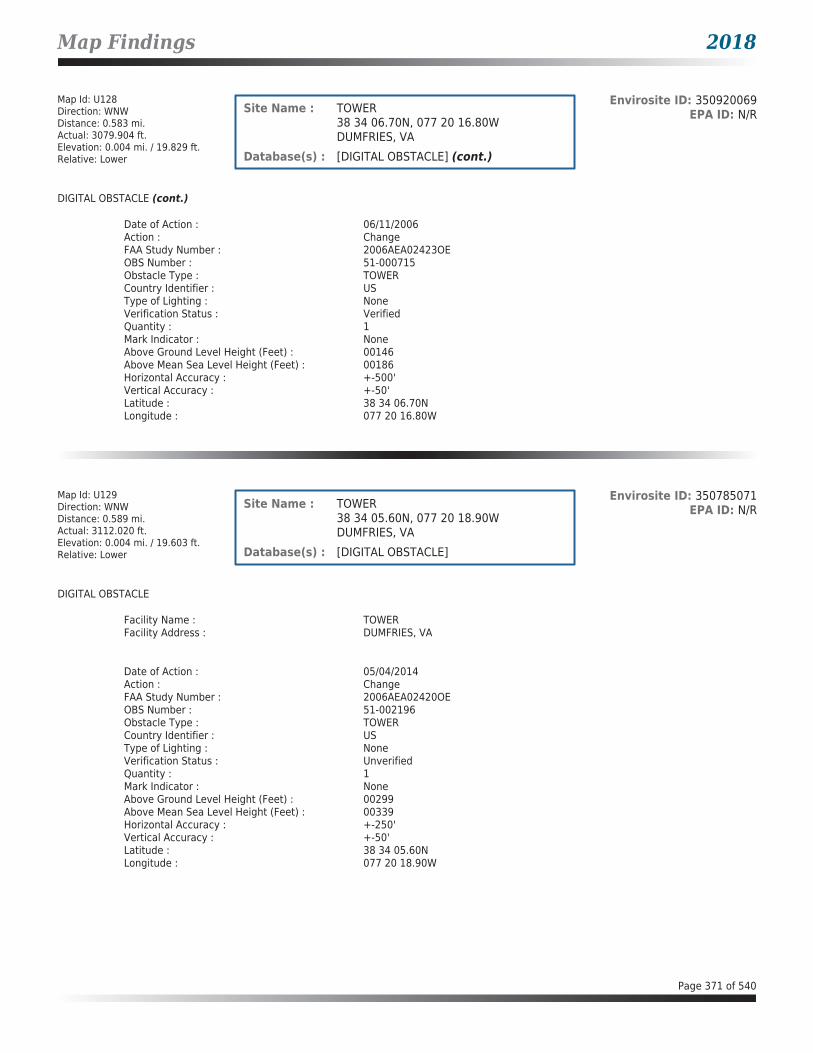
Map Findings 2018
Map Id: U128Direction: WNWDistance: 0.583 mi.Actual: 3079.904 ft.Elevation: 0.004 mi. / 19.829 ft.Relative: Lower
Envirosite ID: 350920069EPA ID: N/RSite Name : TOWER
38 34 06.70N, 077 20 16.80WDUMFRIES, VA
Database(s) : [DIGITAL OBSTACLE] (cont.)
DIGITAL OBSTACLE (cont.)
Date of Action : 06/11/2006Action : ChangeFAA Study Number : 2006AEA02423OEOBS Number : 51-000715Obstacle Type : TOWERCountry Identifier : USType of Lighting : NoneVerification Status : VerifiedQuantity : 1Mark Indicator : NoneAbove Ground Level Height (Feet) : 00146Above Mean Sea Level Height (Feet) : 00186Horizontal Accuracy : +-500'Vertical Accuracy : +-50'Latitude : 38 34 06.70NLongitude : 077 20 16.80W
Map Id: U129Direction: WNWDistance: 0.589 mi.Actual: 3112.020 ft.Elevation: 0.004 mi. / 19.603 ft.Relative: Lower
Envirosite ID: 350785071EPA ID: N/RSite Name : TOWER
38 34 05.60N, 077 20 18.90WDUMFRIES, VA
Database(s) : [DIGITAL OBSTACLE]
DIGITAL OBSTACLE
Facility Name : TOWERFacility Address : DUMFRIES, VA
Date of Action : 05/04/2014Action : ChangeFAA Study Number : 2006AEA02420OEOBS Number : 51-002196Obstacle Type : TOWERCountry Identifier : USType of Lighting : NoneVerification Status : UnverifiedQuantity : 1Mark Indicator : NoneAbove Ground Level Height (Feet) : 00299Above Mean Sea Level Height (Feet) : 00339Horizontal Accuracy : +-250'Vertical Accuracy : +-50'Latitude : 38 34 05.60NLongitude : 077 20 18.90W
Page 371 of 540

Map Findings 2018
Map Id: U130Direction: WNWDistance: 0.621 mi.Actual: 3276.524 ft.Elevation: 0.004 mi. / 21.86 ft.Relative: Lower
Envirosite ID: 350787169EPA ID: N/RSite Name : TOWER
38 34 06.80N, 077 20 20.30WDUMFRIES, VA
Database(s) : [DIGITAL OBSTACLE]
DIGITAL OBSTACLE
Facility Name : TOWERFacility Address : DUMFRIES, VA
Date of Action : 05/04/2014Action : ChangeFAA Study Number : 2006AEA02422OEOBS Number : 51-002198Obstacle Type : TOWERCountry Identifier : USType of Lighting : RedVerification Status : UnverifiedQuantity : 1Mark Indicator : MarkedAbove Ground Level Height (Feet) : 00299Above Mean Sea Level Height (Feet) : 00339Horizontal Accuracy : +-250'Vertical Accuracy : +-50'Latitude : 38 34 06.80NLongitude : 077 20 20.30W
Map Id: 131Direction: NNEDistance: 0.723 mi.Actual: 3815.063 ft.Elevation: 0.034 mi. / 179.491 ft.Relative: Higher
Envirosite ID: 350785354EPA ID: N/RSite Name : TOWER
38 35 11.49N, 077 19 04.61WDUMFRIES, VA
Database(s) : [DIGITAL OBSTACLE]
DIGITAL OBSTACLE
Facility Name : TOWERFacility Address : DUMFRIES, VA
Date of Action : 11/21/2004Action : ChangeFAA Study Number : 2002AEA03990OEOBS Number : 51-002001Obstacle Type : TOWERCountry Identifier : USType of Lighting : NoneVerification Status : VerifiedQuantity : 1Mark Indicator : NoneAbove Ground Level Height (Feet) : 00199Above Mean Sea Level Height (Feet) : 00378Horizontal Accuracy : +-20'Vertical Accuracy : +-3'Latitude : 38 35 11.49NLongitude : 077 19 04.61W
Page 372 of 540

Map Findings 2018
Map Id: 132Direction: SWDistance: 0.810 mi.Actual: 4277.467 ft.Elevation: 0.039 mi. / 205.236 ft.Relative: Higher
Envirosite ID: 350633795EPA ID: N/RSite Name : BLDG
38 32 37.00N, 077 20 36.00WQUANTICO, VA
Database(s) : [DIGITAL OBSTACLE]
DIGITAL OBSTACLE
Facility Name : BLDGFacility Address : QUANTICO, VA
Date of Action : 03/27/2005Action : ChangeFAA Study Number : 2005AEA00603OEOBS Number : 51-002031Obstacle Type : BLDGCountry Identifier : USType of Lighting : Medium Intensity White StrobeVerification Status : VerifiedQuantity : 1Mark Indicator : NoneAbove Ground Level Height (Feet) : 00205Above Mean Sea Level Height (Feet) : 00380Horizontal Accuracy : +-500'Vertical Accuracy : +-50'Latitude : 38 32 37.00NLongitude : 077 20 36.00W
Page 373 of 540

Unmappable Summary 2018
ENVIROSITE ID NAME ADDRESS CITY ZIP DATABASE(S)330009405 1681 HIDEAWAY DR & PROPERT... 1681 HIDEAWAY DR DUMFRIES 22026 Archived SPILLS - VA350418624 AT&T VA2200 RTE 234 DUMFRIES 22026 AST - VA, UST - VA350418627 BKEP MATERIALS LLC - DUMFRIE... 1301 CHERRY HILL RD DUMFRIES 22026 AST - VA331423124 COCKPIT POINT PROPERTY 1285 CHERRY HILL ROAD PRINCE WILLIAM COUNTY 22026 VRP - VA325577540 COCKPIT POINT PROPERTY-FORM... 1285 CHERRY HILL RD DUMFRIES 22026 SWF/LF - VA21812709 DOMINION-UNKNOWN SHEEN ON... NEAR DOMINION POWER POSSU... DUMFRIES 22026 SPILLS - VA14441733 EXXON S/S #2-7826 237 S FRALEY RD DUMFRIES 22026 UST - VA330016280 FOREST PARK TOWNHOMES VAN BUREN ROAD DUMFRIES 22026 Archived SPILLS - VA14442728 L-10 MELROSE PUMPING STATION 3320 MELROSE AVE DUMFRIES 22026 UST - VA1326961 MONTCLAIR COUNTRY CLUB 1602 PRESTWICK COURT DUMFRIES 22026 CERCLIS-HIST, SEMS_8...13358779 POHANKA BODY SHOP 212 S FRALEY BLVD DUMFRIES 22026 ECHO, FRS, RCRA_CESQG330024563 POSSUM POINT POWER STATION ASH POND E DUMFRIES 22026 Archived SPILLS - VA340134446 POTOMAC CDD LANDFILL ODOR ... GREENTREE LANE DUMFRIES 22026 SPILLS - VA13223393 PRINCE WILLIAM SCHOOLS E BU... 14800 FOUR YEAR TRL DUMFRIES 22026 AST - VA344028129 SAFETY KLEEN/AMTRACK ACCIDE... CHERRY HILL CSX RR CROSSING DUMFRIES 22026 SPILLS - VA330027716 ST SERVICES 1800 COCKPIT POINT ROAD DUMFRIES 22026 Archived SPILLS - VA330028336 TANYA'S RESTAURANT 18013 DUMFRIES RD DUMFRIES 22026 Archived SPILLS - VA14443032 WAS-I IYY 203 GRAHAM ST DUMFRIES 22026 UST - VA
Page 374 of 540

Environmental Records Searched 2018
STATE BROWNFIELD LIST
BROWNFIELDS - VA: List of brownfield sites
Agency Version Date: 04/20/2018Agency Update Frequency: VariesPlanned Next Contact: 07/17/2018
Agency: Department of Environmental QualityAgency Contact: (804) 698-4179Most Recent Contact: 04/20/2018
FEDERAL RCRA NON-CORRACTS TSD FACILITIES LIST
ARCHIVED RCRA TSDF: Resource Conservation and Recovery Act hazardous waste transportation storage disposal and treatment facilities
Agency Version Date: 03/16/2018Agency Update Frequency: VariesPlanned Next Contact: 08/03/2018
Agency: U.S. Environmental Protection AgencyAgency Contact: 215-814-2469Most Recent Contact: 05/25/2018
RCRA_TSDF: Resource Conservation and Recovery Act hazardous waste transportation storage disposal and treatment facilities
Agency Version Date: 03/16/2018Agency Update Frequency: QuarterlyPlanned Next Contact: 08/03/2018
Agency: U.S. Environmental Protection AgencyAgency Contact: 215-814-2469Most Recent Contact: 05/25/2018
FEDERAL CERCLIS LIST
CERCLIS NFRAP: The CERCLIS sites with No Further Remedial Action Planned from the CERCLIS program database. The Environmental Protection Agency decommissioned the CERCLIS data in 2014. The last update was November 12, 2013.
Agency Version Date: 10/25/2013Agency Update Frequency: QuarterlyPlanned Next Contact: 06/25/2018
Agency: U.S. Environmental Protection AgencyAgency Contact: 800-424-9346Most Recent Contact: 04/15/2018
CERCLIS-HIST: The CERCLIS program database contains information on the assessment and remediation of federal hazardous waste sites. The Environmental Protection Agency decommissioned the CERCLIS data in 2014. The last update was November 12, 2013.
Agency Version Date: 11/05/2016Agency Update Frequency: QuarterlyPlanned Next Contact: 06/25/2018
Agency: U.S. Environmental Protection AgencyAgency Contact: 800-424-9346Most Recent Contact: 04/15/2018
FEDERAL FACILITY: Sites where Federal Facilities Restoration and Reuse Office (FFRRO) arranged cleanup for Base Closure and Property Transfer at Federal Facilities
Agency Version Date: 01/02/2018Agency Update Frequency: VariesPlanned Next Contact: 06/25/2018
Agency: U.S. Environmental Protection AgencyAgency Contact: 703-603-8712Most Recent Contact: 04/15/2018
SEMS_8R_ACTIVE SITES: The Active Site Inventory Report displays site and location information at active SEMS sites. An active site is one at which site assessment, removal, remedial, enforcement, cost recovery, or oversight activities are being planned or conducted. NPL sites include latitude and longitude information. For non-NPL sites, a brief site status is provided.
Agency Version Date: 12/11/2017Agency Update Frequency: QuarterlyPlanned Next Contact: 06/25/2018
Agency: U.S. Environmental Protection AgencyAgency Contact: 703-603-8867Most Recent Contact: 04/15/2018
SEMS_8R_ARCHIVED SITES: The Archived Site Inventory displays site and location information at sites archived from SEMS. An archived site is one at which EPA has determined that assessment has been completed and no further remedial action is planned under the Superfund program at this time.
Agency Version Date: 12/11/2017Agency Update Frequency: QuarterlyPlanned Next Contact: 06/25/2018
Agency: U.S. Environmental Protection AgencyAgency Contact: 703-603-8867Most Recent Contact: 04/15/2018
Page 375 of 540

Environmental Records Searched 2018
FEDERAL RCRA CORRACTS FACILITIES LIST
CORRACTS: List of facilities where Resource Conservation and Recovery Act Corrective Action Program used to investigate and remediate hazardous releases
Agency Version Date: 03/16/2018Agency Update Frequency: QuarterlyPlanned Next Contact: 08/03/2018
Agency: U.S. Environmental Protection AgencyAgency Contact: 202-566-1667Most Recent Contact: 05/25/2018
FEDERAL DELISTED NPL SITE LIST
DELISTED NPL: National Priority List of sites that were delisted and no longer require action
Agency Version Date: 01/02/2018Agency Update Frequency: QuarterlyPlanned Next Contact: 06/25/2018
Agency: U.S. Environmental Protection AgencyAgency Contact: 703-603-8867Most Recent Contact: 04/15/2018
DELISTED PROPOSED NPL: Sites that have been delisted from the proposed National Priority List
Agency Version Date: 01/02/2018Agency Update Frequency: QuarterlyPlanned Next Contact: 06/25/2018
Agency: U.S. Environmental Protection AgencyAgency Contact: 703-603-8867Most Recent Contact: 04/15/2018
SEMS_DELETED NPL: All Deleted National Priority List Sties
Agency Version Date: 12/11/2017Agency Update Frequency: QuarterlyPlanned Next Contact: 06/25/2018
Agency: U.S. Environmental Protection AgencyAgency Contact: 703-603-8867Most Recent Contact: 04/15/2018
FEDERAL ERNS LIST
ERNS: Emergency Response Notification System records of reported spills
Agency Version Date: 02/07/2018Agency Update Frequency: AnnuallyPlanned Next Contact: 06/27/2018
Agency: National Response Center United States Coast GuardAgency Contact: N/RMost Recent Contact: 04/18/2018
FEDERAL INSTITUTIONAL CONTROLS / ENGINEERING CONTROLS REGISTRIES
Fed E C: Federal listing of remediation sites with engineering controls
Agency Version Date: 02/21/2018Agency Update Frequency: VariesPlanned Next Contact: 07/11/2018
Agency: U.S. Environmental Protection AgencyAgency Contact: 800-424-9346Most Recent Contact: 05/02/2018
Fed I C: Federal listing of remediation sites with institutional controls
Agency Version Date: 02/21/2018Agency Update Frequency: VariesPlanned Next Contact: 07/11/2018
Agency: U.S. Environmental Protection AgencyAgency Contact: 800-424-9346Most Recent Contact: 05/02/2018
RCRA IC_EC: Sites with institutional or engineering controls related to Resource Conservation and Recovery Act
Agency Version Date: 03/16/2018Agency Update Frequency: VariesPlanned Next Contact: 08/03/2018
Agency: U.S. Environmental Protection AgencyAgency Contact: 215-814-2469Most Recent Contact: 05/25/2018
Page 376 of 540

Environmental Records Searched 2018
FEDERAL NPL SITE LIST
NPL: List of priority contaminated sites among identified releases or threatened releases of hazardous substances pollutants or contaminants nationally
Agency Version Date: 01/02/2018Agency Update Frequency: QuarterlyPlanned Next Contact: 06/25/2018
Agency: U.S. Environmental Protection AgencyAgency Contact: 703-603-8867Most Recent Contact: 04/15/2018
NPL EPA R1 GIS: Geospatial data for the Environmental Protection Agency Region 1 National Priority List subject to environmental regulation
Agency Version Date: 01/02/2018Agency Update Frequency: QuarterlyPlanned Next Contact: 06/25/2018
Agency: U.S. Environmental Protection AgencyAgency Contact: 202-566-2132Most Recent Contact: 04/15/2018
NPL EPA R3 GIS: Geospatial data for the Environmental Protection Agency Region 3 National Priority List subject to environmental regulation
Agency Version Date: 04/09/2018Agency Update Frequency: QuarterlyPlanned Next Contact: 08/14/2018
Agency: U.S. Environmental Protection AgencyAgency Contact: 202-566-2132Most Recent Contact: 06/05/2018
NPL EPA R6 GIS: Geospatial data for the Environmental Protection Agency Region 6 National Priority List subject to environmental regulation
Agency Version Date: 01/18/2018Agency Update Frequency: QuarterlyPlanned Next Contact: 06/25/2018
Agency: U.S. Environmental Protection AgencyAgency Contact: 202-566-2132Most Recent Contact: 04/15/2018
NPL EPA R8 GIS: Geospatial data for the Environmental Protection Agency Region 8 National Priority List subject to environmental regulation
Agency Version Date: 01/02/2018Agency Update Frequency: QuarterlyPlanned Next Contact: 06/25/2018
Agency: U.S. Environmental Protection AgencyAgency Contact: 202-566-2132Most Recent Contact: 04/15/2018
NPL EPA R9 GIS: Geospatial data for the Environmental Protection Agency Region 9 National Priority List subject to environmental regulation
Agency Version Date: 01/02/2018Agency Update Frequency: QuarterlyPlanned Next Contact: 06/25/2018
Agency: U.S. Environmental Protection AgencyAgency Contact: 202-566-2132Most Recent Contact: 04/15/2018
PART NPL: Sites that are a part of an National Priority List site referred to as the parent site
Agency Version Date: 01/02/2018Agency Update Frequency: QuarterlyPlanned Next Contact: 06/25/2018
Agency: U.S. Environmental Protection AgencyAgency Contact: 703-603-8867Most Recent Contact: 04/15/2018
PROPOSED NPL: Sites that have been proposed for the National Priority List
Agency Version Date: 01/02/2018Agency Update Frequency: QuarterlyPlanned Next Contact: 06/25/2018
Agency: U.S. Environmental Protection AgencyAgency Contact: 703-603-8867Most Recent Contact: 04/15/2018
SEMS_FINAL NPL: All Included National Priority List Sites
Agency Version Date: 10/10/2017Agency Update Frequency: QuarterlyPlanned Next Contact: 06/25/2018
Agency: U.S. Environmental Protection AgencyAgency Contact: 703-603-8867Most Recent Contact: 04/15/2018
Page 377 of 540

Environmental Records Searched 2018
FEDERAL NPL SITE LIST (cont.)
SEMS_PROPOSED NPL: All Proposed National Priority List Sites
Agency Version Date: 12/11/2017Agency Update Frequency: QuarterlyPlanned Next Contact: 06/25/2018
Agency: U.S. Environmental Protection AgencyAgency Contact: 703-603-8867Most Recent Contact: 04/15/2018
FEDERAL RCRA GENERATORS LIST
RCRA_CESQG: Resource Conservation and Recovery Act listing of licensed conditionally exempt small quantity generators
Agency Version Date: 03/16/2018Agency Update Frequency: VariesPlanned Next Contact: 08/03/2018
Agency: U.S. Environmental Protection AgencyAgency Contact: 215-814-2469Most Recent Contact: 05/25/2018
RCRA_FULL_DETAIL: Full detail of related sites to the Resource Conservation and Recovery Act
Agency Version Date: 03/16/2018Agency Update Frequency: VariesPlanned Next Contact: 08/03/2018
Agency: U.S. Environmental Protection AgencyAgency Contact: 215-814-2469Most Recent Contact: 05/25/2018
RCRA_LQG: Resource Conservation and Recovery Act listing of licensed large quantity generators
Agency Version Date: 03/16/2018Agency Update Frequency: QuarterlyPlanned Next Contact: 08/03/2018
Agency: U.S. Environmental Protection AgencyAgency Contact: 215-814-2469Most Recent Contact: 05/25/2018
RCRA_NONGEN: Resource Conservation and Recovery Act listing of licensed non-generators
Agency Version Date: 03/16/2018Agency Update Frequency: VariesPlanned Next Contact: 08/03/2018
Agency: U.S. Environmental Protection AgencyAgency Contact: 215-814-2469Most Recent Contact: 05/25/2018
RCRA_SQG: Resource Conservation and Recovery Act listing of licensed small quantity generators
Agency Version Date: 03/16/2018Agency Update Frequency: QuarterlyPlanned Next Contact: 08/03/2018
Agency: U.S. Environmental Protection AgencyAgency Contact: 215-814-2469Most Recent Contact: 05/25/2018
STATE AND TRIBAL REGISTERED STORAGE TANK LISTS
FEMA UST: FEMA underground storage tank listing
Agency Version Date: 12/14/2017Agency Update Frequency: VariesPlanned Next Contact: 07/24/2018
Agency: FEMAAgency Contact: 202-212-5283Most Recent Contact: 04/27/2018
INDIAN UST R1: Underground Storage Tanks on Indian Land in EPA Region 1
Agency Version Date: 10/14/2017Agency Update Frequency: QuarterlyPlanned Next Contact: 06/12/2018
Agency: U.S. Environmental Protection Agency Region 1Agency Contact: 855-246-3642Most Recent Contact: 04/03/2018
INDIAN UST R10: Underground Storage Tanks on Indian Land in EPA Region 10
Agency Version Date: 10/24/2017Agency Update Frequency: QuarterlyPlanned Next Contact: 07/09/2018
Agency: U.S. Environmental Protection Agency Region 10Agency Contact: 855-246-3642Most Recent Contact: 04/30/2018
Page 378 of 540

Environmental Records Searched 2018
STATE AND TRIBAL REGISTERED STORAGE TANK LISTS (cont.)
INDIAN UST R2: Underground Storage Tanks on Indian Land in EPA Region 2
Agency Version Date: 12/07/2016Agency Update Frequency: QuarterlyPlanned Next Contact: 06/18/2018
Agency: U.S. Environmental Protection Agency Region 2Agency Contact: 855-246-3642Most Recent Contact: 04/09/2018
INDIAN UST R4: Underground Storage Tanks on Indian Land in EPA Region 4
Agency Version Date: 10/14/2017Agency Update Frequency: Semi AnnuallyPlanned Next Contact: 07/09/2018
Agency: U.S. Environmental Protection Agency Region 4Agency Contact: 855-246-3642Most Recent Contact: 04/30/2018
INDIAN UST R5: Underground Storage Tanks on Indian Land in EPA Region 5
Agency Version Date: 10/16/2017Agency Update Frequency: VariesPlanned Next Contact: 06/28/2018
Agency: U.S. Environmental Protection Agency Region 5Agency Contact: 855-246-3642Most Recent Contact: 04/19/2018
INDIAN UST R6: Underground Storage Tanks on Indian Land in EPA Region 6
Agency Version Date: 10/06/2017Agency Update Frequency: Semi AnnuallyPlanned Next Contact: 07/12/2018
Agency: U.S. Environmental Protection Agency Region 6Agency Contact: 855-246-3642Most Recent Contact: 05/03/2018
INDIAN UST R7: Underground Storage Tanks on Indian Land in EPA Region 7
Agency Version Date: 10/12/2017Agency Update Frequency: VariesPlanned Next Contact: 06/28/2018
Agency: U.S. Environmental Protection Agency Region 7Agency Contact: 855-246-3642Most Recent Contact: 04/19/2018
INDIAN UST R8: Underground Storage Tanks on Indian Land in EPA Region 8
Agency Version Date: 04/02/2018Agency Update Frequency: QuarterlyPlanned Next Contact: 08/20/2018
Agency: U.S. Environmental Protection Agency Region 8Agency Contact: 855-246-3642Most Recent Contact: 06/11/2018
INDIAN UST R9: Underground Storage Tanks on Indian Land in EPA Region 9
Agency Version Date: 01/22/2018Agency Update Frequency: QuarterlyPlanned Next Contact: 08/20/2018
Agency: U.S. Environmental Protection Agency Region 9Agency Contact: 855-246-3642Most Recent Contact: 06/11/2018
AST - VA: Registered Aboveground Storage Tanks in Virginia
Agency Version Date: 03/12/2018Agency Update Frequency: VariesPlanned Next Contact: 07/30/2018
Agency: Department of Environmental QualityAgency Contact: (804) 698-4000Most Recent Contact: 05/21/2018
UST - VA: Registered Underground Storage Tanks in Virginia
Agency Version Date: 03/12/2018Agency Update Frequency: VariesPlanned Next Contact: 07/30/2018
Agency: Department of Environmental QualityAgency Contact: (804) 698-4000Most Recent Contact: 05/21/2018
Page 379 of 540

Environmental Records Searched 2018
STATE AND TRIBAL LEAKING STORAGE TANK LISTS
INDIAN LUST R1: Leaking Underground Storage Tanks on Indian Land in EPA Region 1
Agency Version Date: 10/14/2017Agency Update Frequency: QuarterlyPlanned Next Contact: 06/12/2018
Agency: U.S. Environmental Protection Agency Region 1Agency Contact: 855-246-3642Most Recent Contact: 04/03/2018
INDIAN LUST R10: Leaking Underground Storage Tanks on Indian Land in EPA Region 10
Agency Version Date: 10/24/2017Agency Update Frequency: QuarterlyPlanned Next Contact: 07/09/2018
Agency: U.S. Environmental Protection Agency Region 10Agency Contact: 855-246-3642Most Recent Contact: 04/30/2018
INDIAN LUST R2: Leaking Underground Storage Tanks on Indian Land in EPA Region 2
Agency Version Date: 11/19/2012Agency Update Frequency: QuarterlyPlanned Next Contact: 06/18/2018
Agency: U.S. Environmental Protection Agency Region 2Agency Contact: 855-246-3642Most Recent Contact: 04/09/2018
INDIAN LUST R4: Leaking Underground Storage Tanks on Indian Land in EPA Region 4
Agency Version Date: 10/14/2017Agency Update Frequency: Semi AnnuallyPlanned Next Contact: 07/09/2018
Agency: U.S. Environmental Protection Agency Region 4Agency Contact: 855-246-3642Most Recent Contact: 04/30/2018
INDIAN LUST R5: Leaking Underground Storage Tanks on Indian Land in EPA Region 5
Agency Version Date: 10/16/2017Agency Update Frequency: VariesPlanned Next Contact: 06/28/2018
Agency: U.S. Environmental Protection Agency Region 5Agency Contact: 855-246-3642Most Recent Contact: 04/19/2018
INDIAN LUST R6: Leaking Underground Storage Tanks on Indian Land in EPA Region 6
Agency Version Date: 10/06/2017Agency Update Frequency: QuarterlyPlanned Next Contact: 07/02/2018
Agency: U.S. Environmental Protection Agency Region 6Agency Contact: 855-246-3642Most Recent Contact: 04/23/2018
INDIAN LUST R7: Leaking Underground Storage Tanks on Indian Land in EPA Region 7
Agency Version Date: 09/21/2017Agency Update Frequency: VariesPlanned Next Contact: 06/28/2018
Agency: U.S. Environmental Protection Agency Region 7Agency Contact: 855-246-3642Most Recent Contact: 04/19/2018
INDIAN LUST R8: Leaking Underground Storage Tanks on Indian Land in EPA Region 8
Agency Version Date: 10/12/2017Agency Update Frequency: QuarterlyPlanned Next Contact: 06/29/2018
Agency: U.S. Environmental Protection Agency Region 8Agency Contact: 855-246-3642Most Recent Contact: 04/20/2018
INDIAN LUST R9: Leaking Underground Storage Tanks on Indian Land in EPA Region 9
Agency Version Date: 04/02/2018Agency Update Frequency: QuarterlyPlanned Next Contact: 08/20/2018
Agency: U.S. Environmental Protection Agency Region 9Agency Contact: 855-246-3642Most Recent Contact: 06/11/2018
LPT - VA: Petroleum Storage tanks with known releases
Agency Version Date: 02/09/2018Agency Update Frequency: QuarterlyPlanned Next Contact: 06/29/2018
Agency: Department of Environmental QualityAgency Contact: (804) 698-4000Most Recent Contact: 04/20/2018
Page 380 of 540

Environmental Records Searched 2018
STATE AND TRIBAL LEAKING STORAGE TANK LISTS (cont.)
PRO LUST - VA: Piedmont Regional Office: Leaking Underground Storage Tanks
Agency Version Date: 02/09/2018Agency Update Frequency: QuarterlyPlanned Next Contact: 06/29/2018
Agency: Department of Environmental QualityAgency Contact: (804) 698-4000Most Recent Contact: 04/20/2018
SWRO LPT - VA: South Western Region : Leaking Petroleum Storage Tanks
Agency Version Date: 02/09/2018Agency Update Frequency: QuarterlyPlanned Next Contact: 06/29/2018
Agency: Department of Environmental QualityAgency Contact: (804) 698-4000Most Recent Contact: 04/20/2018
TRO LUST - VA: Tidewater Regional Office: Leaking Underground Storage Tanks
Agency Version Date: 02/09/2018Agency Update Frequency: QuarterlyPlanned Next Contact: 06/29/2018
Agency: Department of Environmental QualityAgency Contact: (804) 698-4000Most Recent Contact: 04/20/2018
VRO LUST - VA: Valley Regional Office: Leaking Underground Storage Tanks
Agency Version Date: 02/09/2018Agency Update Frequency: QuarterlyPlanned Next Contact: 06/29/2018
Agency: Department of Environmental QualityAgency Contact: (804) 698-4000Most Recent Contact: 04/20/2018
STATE BROWNFIELD LIST
TRIBAL BROWNFIELDS: Tribal brownfield remediation site listing
Agency Version Date: 02/10/2014Agency Update Frequency: QuarterlyPlanned Next Contact: 07/02/2018
Agency: U.S. Environmental Protection AgencyAgency Contact: 855-246-3642Most Recent Contact: 04/04/2018
STATE AND TRIBAL VOLUNTARY CLEANUP SITES
ARCHIVED VRP - VA: Archived Voluntary Remediation Program Sites
Agency Version Date: 01/13/2016Agency Update Frequency: QuarterlyPlanned Next Contact: 06/26/2018
Agency: Department of Environmental QualityAgency Contact: (804) 698-4190Most Recent Contact: 04/17/2018
VRP - VA: VRP Completed and Planned sites within Virginia
Agency Version Date: 02/06/2018Agency Update Frequency: QuarterlyPlanned Next Contact: 07/18/2018
Agency: Department of Environmental QualityAgency Contact: (804) 698-4000Most Recent Contact: 04/20/2018
STATE INSTITUTIONAL CONTROLS / ENGINEERING CONTROLS REGISTRIES
I C - VA: Sites with institutional controls
Agency Version Date: 02/06/2018Agency Update Frequency: QuarterlyPlanned Next Contact: 07/18/2018
Agency: Department of Environmental QualityAgency Contact: (804) 698-4000Most Recent Contact: 04/20/2018
Page 381 of 540
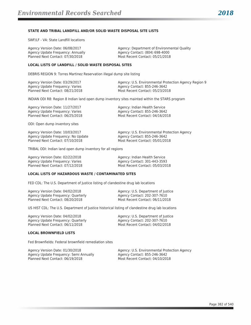
Environmental Records Searched 2018
STATE AND TRIBAL LANDFILL AND/OR SOLID WASTE DISPOSAL SITE LISTS
SWF/LF - VA: State Landfill locations
Agency Version Date: 06/08/2017Agency Update Frequency: AnnuallyPlanned Next Contact: 07/30/2018
Agency: Department of Environmental QualityAgency Contact: (804) 698-4000Most Recent Contact: 05/21/2018
LOCAL LISTS OF LANDFILL / SOLID WASTE DISPOSAL SITES
DEBRIS REGION 9: Torres Martinez Reservation illegal dump site listing
Agency Version Date: 03/29/2017Agency Update Frequency: VariesPlanned Next Contact: 08/21/2018
Agency: U.S. Environmental Protection Agency Region 9Agency Contact: 855-246-3642Most Recent Contact: 05/23/2018
INDIAN ODI R8: Region 8 Indian land open dump inventory sites mainted within the STARS program
Agency Version Date: 11/27/2017Agency Update Frequency: VariesPlanned Next Contact: 06/25/2018
Agency: Indian Health ServiceAgency Contact: 855-246-3642Most Recent Contact: 04/16/2018
ODI: Open dump inventory sites
Agency Version Date: 10/03/2017Agency Update Frequency: No UpdatePlanned Next Contact: 07/10/2018
Agency: U.S. Environmental Protection AgencyAgency Contact: 855-246-3642Most Recent Contact: 05/01/2018
TRIBAL ODI: Indian land open dump inventory for all regions
Agency Version Date: 02/22/2018Agency Update Frequency: VariesPlanned Next Contact: 07/12/2018
Agency: Indian Health ServiceAgency Contact: 301-443-3593Most Recent Contact: 05/03/2018
LOCAL LISTS OF HAZARDOUS WASTE / CONTAMINATED SITES
FED CDL: The U.S. Department of Justice listing of clandestine drug lab locations
Agency Version Date: 04/02/2018Agency Update Frequency: QuarterlyPlanned Next Contact: 08/20/2018
Agency: U.S. Department of JusticeAgency Contact: 202-307-7610Most Recent Contact: 06/11/2018
US HIST CDL: The U.S. Department of Justice historical listing of clandestine drug lab locations
Agency Version Date: 04/02/2018Agency Update Frequency: QuarterlyPlanned Next Contact: 06/11/2018
Agency: U.S. Department of JusticeAgency Contact: 202-307-7610Most Recent Contact: 04/02/2018
LOCAL BROWNFIELD LISTS
Fed Brownfields: Federal brownfield remediation sites
Agency Version Date: 01/30/2018Agency Update Frequency: Semi AnnuallyPlanned Next Contact: 06/19/2018
Agency: U.S. Environmental Protection AgencyAgency Contact: 855-246-3642Most Recent Contact: 04/10/2018
Page 382 of 540

Environmental Records Searched 2018
RECORDS OF EMERGENCY RELEASE REPORTS
HMIRS (DOT): Hazardous Material spills reported by the Department of Transportation
Agency Version Date: 03/07/2018Agency Update Frequency: VariesPlanned Next Contact: 07/25/2018
Agency: U.S. Department of TransportationAgency Contact: (202) 366-4996Most Recent Contact: 05/16/2018
ARCHIVED SPILLS - VA: The VA Department of Environment Qualitys Pollution Response Program responses to air, water, and waste pollution incidents prior to October 2009.
Agency Version Date: 03/13/2018Agency Update Frequency: QuarterlyPlanned Next Contact: 07/31/2018
Agency: Department of Environmental QualityAgency Contact: 804-698-4000Most Recent Contact: 05/22/2018
SPILLS - VA: Oil and hazardous material spills report sites
Agency Version Date: 03/13/2018Agency Update Frequency: QuarterlyPlanned Next Contact: 07/31/2018
Agency: Department of Environmental QualityAgency Contact: 804-698-4000Most Recent Contact: 05/22/2018
LOCAL LAND RECORDS
LIENS 2: Comprehensive Environmental Response Compensation and Liability Act sites with liens
Agency Version Date: 05/11/2017Agency Update Frequency: No Longer MaintainedPlanned Next Contact: 09/10/2018
Agency: U.S. Environmental Protection AgencyAgency Contact: 800-424-9346Most Recent Contact: 03/12/2018
OTHER ASCERTAINABLE RECORDS
AFS: Air Facility Systems Quarterly Extract
Agency Version Date: 02/09/2018Agency Update Frequency: QuarterlyPlanned Next Contact: 06/29/2018
Agency: Environmental Protection AgencyAgency Contact: (202) 566-1667Most Recent Contact: 04/20/2018
BRS: Reporting of hazardous waste generation and management from large quantity generators
Agency Version Date: 03/16/2018Agency Update Frequency: BiennialPlanned Next Contact: 08/03/2018
Agency: Environmental Protection AgencyAgency Contact: (202) 566-1667Most Recent Contact: 05/25/2018
CDC HAZDAT: The Agency for Toxic Substances and Disease Registry's Hazardous Substance Release/Health Effects Database.
Agency Version Date: 06/28/2014Agency Update Frequency: VariesPlanned Next Contact: 06/25/2018
Agency: Agency for Toxic Substances and Disease RegistryAgency Contact: 770-488-6399Most Recent Contact: 04/15/2018
COAL ASH DOE: List of existing and planned generators with 1 megawatt or greater of combined capacity that are utilizing coal ash impoundments.
Agency Version Date: 03/08/2018Agency Update Frequency: VariesPlanned Next Contact: 07/26/2018
Agency: Department of EnergyAgency Contact: (202) 586-8800Most Recent Contact: 05/17/2018
COAL ASH EPA: Coal Combustion Residues Surface Impoundments List
Agency Version Date: 07/31/2014Agency Update Frequency: VariesPlanned Next Contact: 07/02/2018
Agency: Environmental Protection AgencyAgency Contact: (202) 566-1667Most Recent Contact: 04/23/2018
Page 383 of 540

Environmental Records Searched 2018
OTHER ASCERTAINABLE RECORDS (cont.)
COAL GAS: Manufactured Gas Plant locations
Agency Version Date: 05/11/2017Agency Update Frequency: QuarterlyPlanned Next Contact: 07/13/2018
Agency: U.S. Environmental Protection AgencyAgency Contact: 855-246-3642Most Recent Contact: 04/16/2018
CONSENT (DECREES): Legal decisions regarding responsibility for Superfund locations
Agency Version Date: 01/02/2018Agency Update Frequency: VariesPlanned Next Contact: 06/25/2018
Agency: Environmental Protection AgencyAgency Contact: (800) 424-9346Most Recent Contact: 04/15/2018
Corrective Actions_2020: The RCRA cleanup baseline includes facilities expected to need corrective action.
Agency Version Date: 04/22/2013Agency Update Frequency: QuarterlyPlanned Next Contact: 08/03/2018
Agency: U.S. Environmental Protection AgencyAgency Contact: N/RMost Recent Contact: 05/25/2018
DIGITAL OBSTACLE: The Digital Obstacle File describes all known obstacles of interest to aviation users in the U.S. with limited coverage of the Pacific the Caribbean Canada and Mexico. The obstacles are assigned unique numerical identifiers; accuracy codes and listed in order of ascending latitude within each state or area by FAA Region.
Agency Version Date: 02/01/2018Agency Update Frequency: VariesPlanned Next Contact: 06/21/2018
Agency: Federal Aviation AdministrationAgency Contact: 855-379-6518Most Recent Contact: 04/12/2018
DOD: Department of Defense sites
Agency Version Date: 03/13/2018Agency Update Frequency: VariesPlanned Next Contact: 06/25/2018
Agency: Environmental Protection AgencyAgency Contact: (800) 424-9346Most Recent Contact: 04/15/2018
DOT OPS: Incident Data Report
Agency Version Date: 02/19/2018Agency Update Frequency: VariesPlanned Next Contact: 07/09/2018
Agency: U.S. Department of TransportationAgency Contact: (202) 366-4996Most Recent Contact: 04/30/2018
ECHO: ECHO is EPA Enforcement and Compliance History Online website to search for facilities in your community to assess their compliance with environmental regulations related to CAA, CWA, RCRA, & SDWA.
Agency Version Date: 03/12/2018Agency Update Frequency: QuarterlyPlanned Next Contact: 07/30/2018
Agency: U.S. Environmental Protection AgencyAgency Contact: 202-566-1667Most Recent Contact: 05/21/2018
ENOI: The Electronic Notice of Intent (eNOI) database contains construction sites and industrial facilities that submit permit requests to EPA for Construction General Permits (CGP) and Multi-Sector General Permits (MSGP).
Agency Version Date: 02/23/2018Agency Update Frequency: QuarterlyPlanned Next Contact: 07/13/2018
Agency: Environmental Protection AgencyAgency Contact: (202) 566-1667Most Recent Contact: 05/04/2018
EPA FUELS: List of companies and facilities registered to participate in EPA Fuel Programs under Title 40 CFR Part 80.
Agency Version Date: 02/09/2018Agency Update Frequency: QuarterlyPlanned Next Contact: 06/29/2018
Agency: U.S. Environmental Protection AgencyAgency Contact: (202) 564-2307Most Recent Contact: 04/20/2018
Page 384 of 540

Environmental Records Searched 2018
OTHER ASCERTAINABLE RECORDS (cont.)
EPA OSC: Listing of oil spills and hazardous substance release sites requiring EPA On-Site Coordinators.
Agency Version Date: 12/27/2017Agency Update Frequency: QuarterlyPlanned Next Contact: 07/25/2018
Agency: U.S. Environmental Protection AgencyAgency Contact: N/RMost Recent Contact: 05/16/2018
EPA WATCH: The EPA Watch List was used to facilitate dialogue between EPA, state and local environmental agencies on enforcement matters relating to facilities with alleged violations identified as either significant or high priority. EPA maintained the lists from 2011 - 2013.
Agency Version Date: 02/09/2018Agency Update Frequency: QuarterlyPlanned Next Contact: 06/29/2018
Agency: U.S. Environmental Protection AgencyAgency Contact: (202) 564-2307Most Recent Contact: 04/20/2018
FA HWF: Hazardous Waste Facilities with Financial Assurance
Agency Version Date: 03/27/2018Agency Update Frequency: VariesPlanned Next Contact: 08/14/2018
Agency: Environmental Protection AgencyAgency Contact: (800) 424-9346Most Recent Contact: 06/04/2018
FEDLAND: Federal land locations
Agency Version Date: 03/12/2018Agency Update Frequency: VariesPlanned Next Contact: 07/30/2018
Agency: Environmental Protection AgencyAgency Contact: (800) 424-9346Most Recent Contact: 05/21/2018
FRS: Facility Registry Systems
Agency Version Date: 02/15/2018Agency Update Frequency: VariesPlanned Next Contact: 07/05/2018
Agency: Environmental Protection AgencyAgency Contact: (202) 566-1667Most Recent Contact: 04/26/2018
FTTS: Tracking of administrative and enforcement activities related to FIFRA/TSCA
Agency Version Date: 04/16/2013Agency Update Frequency: VariesPlanned Next Contact: 07/09/2018
Agency: Environmental Protection AgencyAgency Contact: (202) 564-2280Most Recent Contact: 04/11/2018
FTTS INSP: Tracking of inspections related to FIFRA/TSCA
Agency Version Date: 05/08/2017Agency Update Frequency: VariesPlanned Next Contact: 07/12/2018
Agency: Environmental Protection AgencyAgency Contact: (202) 564-2280Most Recent Contact: 04/16/2018
FUDS: Defense sites that require cleanup
Agency Version Date: 09/30/2015Agency Update Frequency: VariesPlanned Next Contact: 07/02/2018
Agency: US Army Corps of EngineeringAgency Contact: (202) 761-0011Most Recent Contact: 04/23/2018
HIST AFS: List of Air Facility Systems Quarterly Extract that are no longer in current agency list.
Agency Version Date: 02/09/2018Agency Update Frequency: QuarterlyPlanned Next Contact: 06/29/2018
Agency: Environmental Protection AgencyAgency Contact: (202) 566-1667Most Recent Contact: 04/20/2018
Page 385 of 540

Environmental Records Searched 2018
OTHER ASCERTAINABLE RECORDS (cont.)
HWC DOCKET: Listing of Federal facilities which are managing or have managed hazardous waste; or have had a release of hazardous waste.
Agency Version Date: 02/09/2018Agency Update Frequency: QuarterlyPlanned Next Contact: 06/29/2018
Agency: U.S. Environmental Protection AgencyAgency Contact: (202) 564-2307Most Recent Contact: 04/20/2018
ICIS: Comprised of all Federal Administrative and Judicial enforcement information [intended to replace PCS] by tracking enforcement and compliance information (also contains what used to be known as FFTS)
Agency Version Date: 03/13/2018Agency Update Frequency: VariesPlanned Next Contact: 07/31/2018
Agency: Environmental Protection AgencyAgency Contact: (202) 566-1667Most Recent Contact: 05/22/2018
INDIAN RESERVATION: Indian Reservation sites
Agency Version Date: 04/25/2018Agency Update Frequency: VariesPlanned Next Contact: 07/04/2018
Agency: Environmental Protection AgencyAgency Contact: (800) 424-9346Most Recent Contact: 04/25/2018
LEAD_SMELTER: Listing of former Lead Smelter Sites
Agency Version Date: 01/09/2018Agency Update Frequency: VariesPlanned Next Contact: 07/10/2018
Agency: Environmental Protection AgencyAgency Contact: (202) 566-1667Most Recent Contact: 05/01/2018
LUCIS: Land Use Control Information Systems
Agency Version Date: 06/28/2014Agency Update Frequency: No Longer MaintainedPlanned Next Contact: 07/13/2018
Agency: Department of the Navy: BRAC PMOAgency Contact: (619) 532-0900Most Recent Contact: 05/04/2018
LUCIS 2: Land Use Control Information Systems
Agency Version Date: 01/17/2018Agency Update Frequency: QuarterlyPlanned Next Contact: 07/13/2018
Agency: Department of the Navy: BRAC PMOAgency Contact: (619) 532-0900Most Recent Contact: 04/16/2018
MINES: Mines Master Index Files
Agency Version Date: 03/14/2018Agency Update Frequency: VariesPlanned Next Contact: 08/01/2018
Agency: Department of LaborAgency Contact: (202) 693-9400Most Recent Contact: 05/23/2018
MLTS: Sites in possession/use of radioactive materials regulated by NRC
Agency Version Date: 01/02/2018Agency Update Frequency: VariesPlanned Next Contact: 06/18/2018
Agency: Nuclear Regulatory CommissionAgency Contact: (800) 397-4209Most Recent Contact: 03/20/2018
NPL AOC: Areas of Concern related to NPL remediation sites
Agency Version Date: 01/02/2018Agency Update Frequency: QuarterlyPlanned Next Contact: 06/25/2018
Agency: Environmental Protection AgencyAgency Contact: N/RMost Recent Contact: 04/15/2018
Page 386 of 540

Environmental Records Searched 2018
OTHER ASCERTAINABLE RECORDS (cont.)
NPL LIENS: National Priority List of sites with Liens
Agency Version Date: 02/19/2018Agency Update Frequency: VariesPlanned Next Contact: 06/25/2018
Agency: U.S. Environmental Protection AgencyAgency Contact: 703-603-8867Most Recent Contact: 04/30/2018
OSHA: OSHA's listing of inspections violations and fatality information
Agency Version Date: 01/02/2018Agency Update Frequency: VariesPlanned Next Contact: 07/31/2018
Agency: Occupational Safety & Health AdministrationAgency Contact: 800-321-6742Most Recent Contact: 05/22/2018
PADS: Listing of generators transporters commercial store/ brokers and disposers of PCB
Agency Version Date: 01/18/2018Agency Update Frequency: VariesPlanned Next Contact: 06/22/2018
Agency: Environmental Protection AgencyAgency Contact: (703) 308-8404Most Recent Contact: 04/13/2018
PCB TRANSFORMER: Registry of PCB's
Agency Version Date: 01/18/2018Agency Update Frequency: No UpdatePlanned Next Contact: 08/16/2018
Agency: Environmental Protection AgencyAgency Contact: (703) 308-8404Most Recent Contact: 06/07/2018
RAATS: Listing of major violators with enforcement actions issued under RCRA. Includes administrative and civil actions filed by the EPA. This dataset is no longer maintained.
Agency Version Date: 03/16/2018Agency Update Frequency: VariesPlanned Next Contact: 08/03/2018
Agency: Environmental Protection AgencyAgency Contact: (202) 566-1667Most Recent Contact: 05/25/2018
RADINFO: EPA regulated facilities with radiation and radioactive materials
Agency Version Date: 01/18/2018Agency Update Frequency: VariesPlanned Next Contact: 08/16/2018
Agency: Environmental Protection AgencyAgency Contact: (202) 566-1667Most Recent Contact: 06/07/2018
RMP: Facilities producing/handling/ process/ distribute/ store specific chemicals report plans required by the Clean Air Act
Agency Version Date: 02/28/2018Agency Update Frequency: MonthlyPlanned Next Contact: 07/10/2018
Agency: Environmental Protection AgencyAgency Contact: (202) 564-2534Most Recent Contact: 04/12/2018
ROD: Permanent remedy at an NPL site
Agency Version Date: 03/13/2018Agency Update Frequency: VariesPlanned Next Contact: 06/25/2018
Agency: Environmental Protection AgencyAgency Contact: (800) 424-9346Most Recent Contact: 04/15/2018
SCRD DRYCLEANERS: State Coalition for Remediation of Drycleaners
Agency Version Date: 02/22/2018Agency Update Frequency: No UpdatePlanned Next Contact: 07/12/2018
Agency: Environmental Protection AgencyAgency Contact: (202) 566-1667Most Recent Contact: 05/03/2018
Page 387 of 540

Environmental Records Searched 2018
OTHER ASCERTAINABLE RECORDS (cont.)
SEMS_SMELTER: This report includes sites that have smelting-related, or potentially smelting-related, indicators in the SEMS database. The report includes information on the site location as well as contaminants of concern.
Agency Version Date: 12/11/2017Agency Update Frequency: QuarterlyPlanned Next Contact: 06/25/2018
Agency: U.S. Environmental Protection AgencyAgency Contact: 703-603-8867Most Recent Contact: 04/15/2018
SSTS: Tracking of facilities who produce pesticides and their quantity
Agency Version Date: 02/28/2018Agency Update Frequency: AnnuallyPlanned Next Contact: 07/18/2018
Agency: Environmental Protection AgencyAgency Contact: (202) 566-1667Most Recent Contact: 05/09/2018
TOSCA-CHEMICAL: Chemicals controlled by the Toxic Substance Control Act
Agency Version Date: 06/28/2014Agency Update Frequency: VariesPlanned Next Contact: 07/03/2018
Agency: Environmental Protection AgencyAgency Contact: (202) 566-1667Most Recent Contact: 04/24/2018
TOSCA-PLANT: Plants controlled by the Toxic Substance Control Act
Agency Version Date: 02/28/2018Agency Update Frequency: VariesPlanned Next Contact: 07/18/2018
Agency: Environmental Protection AgencyAgency Contact: (202) 566-1667Most Recent Contact: 05/09/2018
TRIS: Information regarding toxic chemicals that are being used/manufactured/ treated/ transported/released into the environment
Agency Version Date: 03/12/2018Agency Update Frequency: VariesPlanned Next Contact: 07/30/2018
Agency: Environmental Protection AgencyAgency Contact: (202) 566-1667Most Recent Contact: 05/21/2018
UMTRA: Uranium Recovery Sites
Agency Version Date: 01/04/2018Agency Update Frequency: VariesPlanned Next Contact: 08/02/2018
Agency: United States Nuclear Regulatory CommissionAgency Contact: (301) 415-8200Most Recent Contact: 05/24/2018
AIRS - VA: AIRS Title V facilities
Agency Version Date: 02/16/2018Agency Update Frequency: VariesPlanned Next Contact: 07/26/2018
Agency: Department of Environmental QualityAgency Contact: (804) 698-4000Most Recent Contact: 04/30/2018
CEDS - VA: Comprehensive Environmental Data System- Wastewater Permit Disposal System
Agency Version Date: 03/08/2018Agency Update Frequency: VariesPlanned Next Contact: 07/26/2018
Agency: Department of Environmental QualityAgency Contact: (804) 698-4000Most Recent Contact: 05/17/2018
DAYCARE - VA: List of child care facilities
Agency Version Date: 02/01/2018Agency Update Frequency: VariesPlanned Next Contact: 06/21/2018
Agency: Department of Social ServicesAgency Contact: (804) 726-7000Most Recent Contact: 04/12/2018
Page 388 of 540
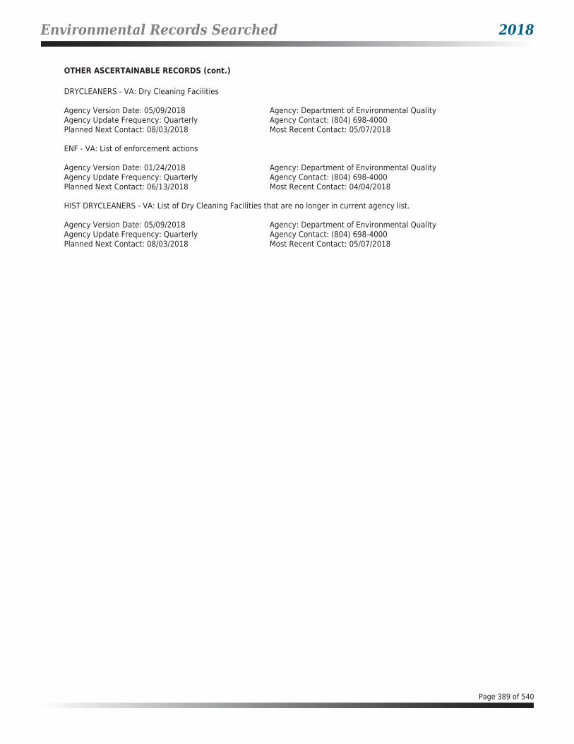
Environmental Records Searched 2018
OTHER ASCERTAINABLE RECORDS (cont.)
DRYCLEANERS - VA: Dry Cleaning Facilities
Agency Version Date: 05/09/2018Agency Update Frequency: QuarterlyPlanned Next Contact: 08/03/2018
Agency: Department of Environmental QualityAgency Contact: (804) 698-4000Most Recent Contact: 05/07/2018
ENF - VA: List of enforcement actions
Agency Version Date: 01/24/2018Agency Update Frequency: QuarterlyPlanned Next Contact: 06/13/2018
Agency: Department of Environmental QualityAgency Contact: (804) 698-4000Most Recent Contact: 04/04/2018
HIST DRYCLEANERS - VA: List of Dry Cleaning Facilities that are no longer in current agency list.
Agency Version Date: 05/09/2018Agency Update Frequency: QuarterlyPlanned Next Contact: 08/03/2018
Agency: Department of Environmental QualityAgency Contact: (804) 698-4000Most Recent Contact: 05/07/2018
Page 389 of 540

Geological Landscape Section 2018
SUBJECT PROPERTY ADDRESS:US HWY 1US HWY 1Dumfries, VA 22026
SUBJECT PROPERTY COORDINATES:
Latitude(North): 38.564005 - 38°33'50.4"Longitude(West): -77.324054 - -77°19'26.6"Universal Transverse Mercator: Zone 18NUTM X (Meters): 297514.37UTM Y (Meters): 4270956.35
ELEVATION:Elevation: 33.720 ft. above sea level
USGS TOPOGRAPHIC MAP:
Subject Property Map:Most Recent Revision:
38077e3 QUANTICO, VA2016
GEOHYDROLOGY DATA:
SUBJECT PROPERTY TOPOGRAPHY:
Topographic Gradient: East
DFIRM FLOOD ZONE:
DFIRM Flood
Subject Property County: Electronic Data:
PRINCE WILLIAM Yes - refer to the PROPERTY PROXIMITY MAP and AREA MAP
Flood Plain Panel at Subject Property: 51153C
Additional Panels in search area: No available data
FEMA FLOOD ZONE:
FEMA Flood
Subject Property County: Electronic Data:
PRINCE WILLIAM Yes - refer to the PROPERTY PROXIMITY MAP and AREA MAP
Flood Plain Panel at Subject Property: 51153C0304D51153C0312D
Additional Panels in search area: 51153C0310D51153C0303D51153C0316D51153C0311D
Page 390 of 540

Geological Landscape Section 2018
NATIONAL WETLAND INVENTORY:
NWI Electronic
NWI Quad at Subject Property: Data Coverage:
QUANTICO Yes - refer to the Geological Findings Map
LITHOSTRATIGRAPHIC INFORMATION:
ROCK STRATIGRAPHIC UNIT: GEOLOGIC AGE IDENTIFICATION
Era: Mesozoic Category: 50 lK Lower CretaceousSystem: CretaceousSeries: Lower CretaceousCode: lK
Page 391 of 540

Geological Landscape Section 2018
SURROUNDING ELEVATION PROFILES:
Page 392 of 540
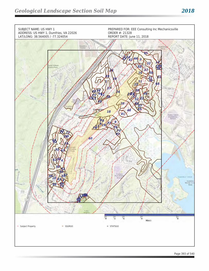
Geological Landscape Section Soil Map 2018
SUBJECT NAME: US HWY 1 PREPARED FOR: EEE Consulting Inc MechanicsvilleADDRESS: US HWY 1, Dumfries, VA 22026 ORDER #: 21328LAT/LONG: 38.564005 / -77.324054 REPORT DATE: June 11, 2018
A
81
92
85
77
72
70
59
56
53
42
39 36
34
27
21
11
5
84
74
65
64
95
75
66
61
57
55
52
51
46
44
31
2924
23
94
93
91
68
54
47
37
35
7
129
87
18
86
82
79 76
58
49
48
30
19
17
15
8
6
88
4540
28
16
10
2
8380
78
38
3314
89
50
20
63
43
1
90
67
4126
13
7371
69
62
25
4
3
60
32
22
Subject Property SSURGO STATSGO
Page 393 of 540

Geological Landscape Section Summary 2018
SOIL COMPOSITION IN GENERAL AREA OF SUBJECT PROPERTY:Agency source: Soil Conservation Service, US Department of Agriculture
SOIL MAP ID 1USDA Soil Name Quantico,SeriesUSDA Soil Texture LoamHydrologic Soil Group BSoil Drainage Class Well drainedHydric Classification 0Corrosion Potential - Uncoated Steel High
Layer Depth (inches)
Soil Texture AASHTO Group Unified Soil Description
SaturatedHydraulic
Conductivity micro m/sec
Soil Reaction pH
1 0-33 Loam Silt-Clay materials (more than 35% passing NO. 200), silty soils. Reference: This is a classification of soil material for highway and airfield construction (Procedure M 145-73 in Am. Assoc. of State Highway and Transportation Officials, 1984.
Reference: This is a classification of soil material designed for general construction purposes. It is dependent on the particle size distribution of the <75 mm, the liquid limit, and the plasticity index and on whether the soil material is high in organic matter (ASTM test D 2487, in ASTM, 1984).
14-42 4.5-5.5
2 33-46 Clay loam Silt-Clay materials (more than 35% passing No. 200) clayey soils. Reference: This is a classification of soil material for highway and airfield construction (Procedure M 145-73 in Am. Assoc. of State Highway and Transportation Officials, 1984.
FINE-GRAINED SOILS, Silts and clays (liquid limit is less than 50%), Lean Clay. Reference: This is a classification of soil material designed for general construction purposes. It is dependent on the particle size distribution of the <75 mm, the liquid limit, and the plasticity index and on whether the soil material is high in organic matter (ASTM test D 2487, in ASTM, 1984).
4-14 4.5-5.5
3 46-119 Clay Reference: This is a classification of soil material for highway and airfield construction (Procedure M 145-73 in Am. Assoc. of State Highway and Transportation Officials, 1984.
FINE-GRAINED SOILS, Silts and clays (liquid limit is 50% or more), Fat Clay. Reference: This is a classification of soil material designed for general construction purposes. It is dependent on the particle size distribution of the <75 mm, the liquid limit, and the plasticity index and on whether the soil material is high in
4-14 4.5-5.5
Page 394 of 540
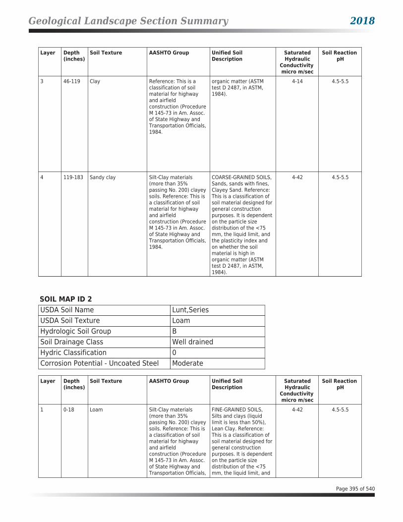
Geological Landscape Section Summary 2018
Layer Depth (inches)
Soil Texture AASHTO Group Unified Soil Description
SaturatedHydraulic
Conductivity micro m/sec
Soil Reaction pH
3 46-119 Clay Reference: This is a classification of soil material for highway and airfield construction (Procedure M 145-73 in Am. Assoc. of State Highway and Transportation Officials, 1984.
organic matter (ASTM test D 2487, in ASTM, 1984).
4-14 4.5-5.5
4 119-183 Sandy clay Silt-Clay materials (more than 35% passing No. 200) clayey soils. Reference: This is a classification of soil material for highway and airfield construction (Procedure M 145-73 in Am. Assoc. of State Highway and Transportation Officials, 1984.
COARSE-GRAINED SOILS, Sands, sands with fines, Clayey Sand. Reference: This is a classification of soil material designed for general construction purposes. It is dependent on the particle size distribution of the <75 mm, the liquid limit, and the plasticity index and on whether the soil material is high in organic matter (ASTM test D 2487, in ASTM, 1984).
4-42 4.5-5.5
SOIL MAP ID 2USDA Soil Name Lunt,SeriesUSDA Soil Texture LoamHydrologic Soil Group BSoil Drainage Class Well drainedHydric Classification 0Corrosion Potential - Uncoated Steel Moderate
Layer Depth (inches)
Soil Texture AASHTO Group Unified Soil Description
SaturatedHydraulic
Conductivity micro m/sec
Soil Reaction pH
1 0-18 Loam Silt-Clay materials (more than 35% passing No. 200) clayey soils. Reference: This is a classification of soil material for highway and airfield construction (Procedure M 145-73 in Am. Assoc. of State Highway and Transportation Officials,
FINE-GRAINED SOILS, Silts and clays (liquid limit is less than 50%), Lean Clay. Reference: This is a classification of soil material designed for general construction purposes. It is dependent on the particle size distribution of the <75 mm, the liquid limit, and
4-42 4.5-5.5
Page 395 of 540

Geological Landscape Section Summary 2018
Layer Depth (inches)
Soil Texture AASHTO Group Unified Soil Description
SaturatedHydraulic
Conductivity micro m/sec
Soil Reaction pH
1 0-18 Loam 1984. the plasticity index and on whether the soil material is high in organic matter (ASTM test D 2487, in ASTM, 1984).
4-42 4.5-5.5
2 18-99 Clay Reference: This is a classification of soil material for highway and airfield construction (Procedure M 145-73 in Am. Assoc. of State Highway and Transportation Officials, 1984.
FINE-GRAINED SOILS, Silts and clays (liquid limit is 50% or more), Fat Clay. Reference: This is a classification of soil material designed for general construction purposes. It is dependent on the particle size distribution of the <75 mm, the liquid limit, and the plasticity index and on whether the soil material is high in organic matter (ASTM test D 2487, in ASTM, 1984).
4-14 4.5-5.5
3 99-183 Sandy loam Reference: This is a classification of soil material for highway and airfield construction (Procedure M 145-73 in Am. Assoc. of State Highway and Transportation Officials, 1984.
COARSE-GRAINED SOILS, Sands, sands with fines, Clayey Sand. Reference: This is a classification of soil material designed for general construction purposes. It is dependent on the particle size distribution of the <75 mm, the liquid limit, and the plasticity index and on whether the soil material is high in organic matter (ASTM test D 2487, in ASTM, 1984).
14-141 4.5-5.5
SOIL MAP ID 3USDA Soil Name Quantico,SeriesUSDA Soil Texture LoamHydrologic Soil Group BSoil Drainage Class Well drainedHydric Classification 0Corrosion Potential - Uncoated Steel High
Page 396 of 540

Geological Landscape Section Summary 2018
Layer Depth (inches)
Soil Texture AASHTO Group Unified Soil Description
SaturatedHydraulic
Conductivity micro m/sec
Soil Reaction pH
1 0-33 Loam Silt-Clay materials (more than 35% passing NO. 200), silty soils. Reference: This is a classification of soil material for highway and airfield construction (Procedure M 145-73 in Am. Assoc. of State Highway and Transportation Officials, 1984.
Reference: This is a classification of soil material designed for general construction purposes. It is dependent on the particle size distribution of the <75 mm, the liquid limit, and the plasticity index and on whether the soil material is high in organic matter (ASTM test D 2487, in ASTM, 1984).
14-42 4.5-5.5
2 33-46 Clay loam Silt-Clay materials (more than 35% passing No. 200) clayey soils. Reference: This is a classification of soil material for highway and airfield construction (Procedure M 145-73 in Am. Assoc. of State Highway and Transportation Officials, 1984.
FINE-GRAINED SOILS, Silts and clays (liquid limit is less than 50%), Lean Clay. Reference: This is a classification of soil material designed for general construction purposes. It is dependent on the particle size distribution of the <75 mm, the liquid limit, and the plasticity index and on whether the soil material is high in organic matter (ASTM test D 2487, in ASTM, 1984).
4-14 4.5-5.5
3 46-119 Clay Reference: This is a classification of soil material for highway and airfield construction (Procedure M 145-73 in Am. Assoc. of State Highway and Transportation Officials, 1984.
FINE-GRAINED SOILS, Silts and clays (liquid limit is 50% or more), Fat Clay. Reference: This is a classification of soil material designed for general construction purposes. It is dependent on the particle size distribution of the <75 mm, the liquid limit, and the plasticity index and on whether the soil material is high in organic matter (ASTM test D 2487, in ASTM, 1984).
4-14 4.5-5.5
4 119-183 Sandy clay Silt-Clay materials (more than 35% passing No. 200) clayey soils. Reference: This is a classification of soil material for highway and airfield construction (Procedure M 145-73 in Am. Assoc. of State Highway and Transportation Officials, 1984.
COARSE-GRAINED SOILS, Sands, sands with fines, Clayey Sand. Reference: This is a classification of soil material designed for general construction purposes. It is dependent on the particle size distribution of the <75 mm, the liquid limit, and the plasticity index and on whether the soil material is high in
4-42 4.5-5.5
Page 397 of 540

Geological Landscape Section Summary 2018
Layer Depth (inches)
Soil Texture AASHTO Group Unified Soil Description
SaturatedHydraulic
Conductivity micro m/sec
Soil Reaction pH
4 119-183 Sandy clay Silt-Clay materials (more than 35% passing No. 200) clayey soils. Reference: This is a classification of soil material for highway and airfield construction (Procedure M 145-73 in Am. Assoc. of State Highway and Transportation Officials, 1984.
organic matter (ASTM test D 2487, in ASTM, 1984).
4-42 4.5-5.5
SOIL MAP ID 4USDA Soil Name Quantico,SeriesUSDA Soil Texture LoamHydrologic Soil Group BSoil Drainage Class Well drainedHydric Classification 0Corrosion Potential - Uncoated Steel High
Layer Depth (inches)
Soil Texture AASHTO Group Unified Soil Description
SaturatedHydraulic
Conductivity micro m/sec
Soil Reaction pH
1 0-33 Loam Silt-Clay materials (more than 35% passing NO. 200), silty soils. Reference: This is a classification of soil material for highway and airfield construction (Procedure M 145-73 in Am. Assoc. of State Highway and Transportation Officials, 1984.
Reference: This is a classification of soil material designed for general construction purposes. It is dependent on the particle size distribution of the <75 mm, the liquid limit, and the plasticity index and on whether the soil material is high in organic matter (ASTM test D 2487, in ASTM, 1984).
14-42 4.5-5.5
2 33-46 Clay loam Silt-Clay materials (more than 35% passing No. 200) clayey soils. Reference: This is a classification of soil material for highway and airfield construction (Procedure M 145-73 in Am. Assoc. of State Highway and Transportation Officials, 1984.
FINE-GRAINED SOILS, Silts and clays (liquid limit is less than 50%), Lean Clay. Reference: This is a classification of soil material designed for general construction purposes. It is dependent on the particle size distribution of the <75 mm, the liquid limit, and the plasticity index and on whether the soil material is high in
4-14 4.5-5.5
Page 398 of 540

Geological Landscape Section Summary 2018
Layer Depth (inches)
Soil Texture AASHTO Group Unified Soil Description
SaturatedHydraulic
Conductivity micro m/sec
Soil Reaction pH
2 33-46 Clay loam Silt-Clay materials (more than 35% passing No. 200) clayey soils. Reference: This is a classification of soil material for highway and airfield construction (Procedure M 145-73 in Am. Assoc. of State Highway and Transportation Officials, 1984.
organic matter (ASTM test D 2487, in ASTM, 1984).
4-14 4.5-5.5
3 46-119 Clay Reference: This is a classification of soil material for highway and airfield construction (Procedure M 145-73 in Am. Assoc. of State Highway and Transportation Officials, 1984.
FINE-GRAINED SOILS, Silts and clays (liquid limit is 50% or more), Fat Clay. Reference: This is a classification of soil material designed for general construction purposes. It is dependent on the particle size distribution of the <75 mm, the liquid limit, and the plasticity index and on whether the soil material is high in organic matter (ASTM test D 2487, in ASTM, 1984).
4-14 4.5-5.5
4 119-183 Sandy clay Silt-Clay materials (more than 35% passing No. 200) clayey soils. Reference: This is a classification of soil material for highway and airfield construction (Procedure M 145-73 in Am. Assoc. of State Highway and Transportation Officials, 1984.
COARSE-GRAINED SOILS, Sands, sands with fines, Clayey Sand. Reference: This is a classification of soil material designed for general construction purposes. It is dependent on the particle size distribution of the <75 mm, the liquid limit, and the plasticity index and on whether the soil material is high in organic matter (ASTM test D 2487, in ASTM, 1984).
4-42 4.5-5.5
Page 399 of 540
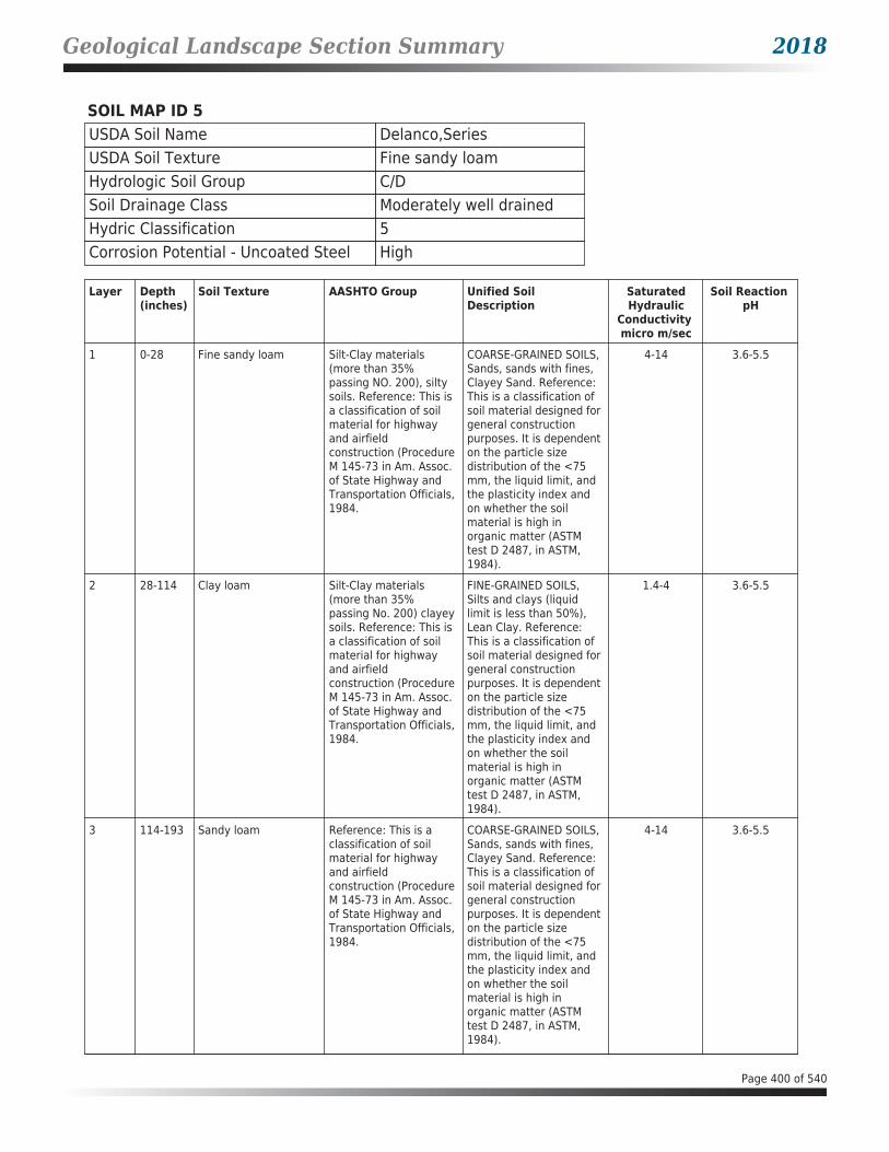
Geological Landscape Section Summary 2018
SOIL MAP ID 5USDA Soil Name Delanco,SeriesUSDA Soil Texture Fine sandy loamHydrologic Soil Group C/DSoil Drainage Class Moderately well drainedHydric Classification 5Corrosion Potential - Uncoated Steel High
Layer Depth (inches)
Soil Texture AASHTO Group Unified Soil Description
SaturatedHydraulic
Conductivity micro m/sec
Soil Reaction pH
1 0-28 Fine sandy loam Silt-Clay materials (more than 35% passing NO. 200), silty soils. Reference: This is a classification of soil material for highway and airfield construction (Procedure M 145-73 in Am. Assoc. of State Highway and Transportation Officials, 1984.
COARSE-GRAINED SOILS, Sands, sands with fines, Clayey Sand. Reference: This is a classification of soil material designed for general construction purposes. It is dependent on the particle size distribution of the <75 mm, the liquid limit, and the plasticity index and on whether the soil material is high in organic matter (ASTM test D 2487, in ASTM, 1984).
4-14 3.6-5.5
2 28-114 Clay loam Silt-Clay materials (more than 35% passing No. 200) clayey soils. Reference: This is a classification of soil material for highway and airfield construction (Procedure M 145-73 in Am. Assoc. of State Highway and Transportation Officials, 1984.
FINE-GRAINED SOILS, Silts and clays (liquid limit is less than 50%), Lean Clay. Reference: This is a classification of soil material designed for general construction purposes. It is dependent on the particle size distribution of the <75 mm, the liquid limit, and the plasticity index and on whether the soil material is high in organic matter (ASTM test D 2487, in ASTM, 1984).
1.4-4 3.6-5.5
3 114-193 Sandy loam Reference: This is a classification of soil material for highway and airfield construction (Procedure M 145-73 in Am. Assoc. of State Highway and Transportation Officials, 1984.
COARSE-GRAINED SOILS, Sands, sands with fines, Clayey Sand. Reference: This is a classification of soil material designed for general construction purposes. It is dependent on the particle size distribution of the <75 mm, the liquid limit, and the plasticity index and on whether the soil material is high in organic matter (ASTM test D 2487, in ASTM, 1984).
4-14 3.6-5.5
Page 400 of 540

Geological Landscape Section Summary 2018
SOIL MAP ID 6USDA Soil Name Lunt,SeriesUSDA Soil Texture LoamHydrologic Soil Group BSoil Drainage Class Well drainedHydric Classification 0Corrosion Potential - Uncoated Steel Moderate
Layer Depth (inches)
Soil Texture AASHTO Group Unified Soil Description
SaturatedHydraulic
Conductivity micro m/sec
Soil Reaction pH
1 0-18 Loam Silt-Clay materials (more than 35% passing No. 200) clayey soils. Reference: This is a classification of soil material for highway and airfield construction (Procedure M 145-73 in Am. Assoc. of State Highway and Transportation Officials, 1984.
FINE-GRAINED SOILS, Silts and clays (liquid limit is less than 50%), Lean Clay. Reference: This is a classification of soil material designed for general construction purposes. It is dependent on the particle size distribution of the <75 mm, the liquid limit, and the plasticity index and on whether the soil material is high in organic matter (ASTM test D 2487, in ASTM, 1984).
4-42 4.5-5.5
2 18-99 Clay Reference: This is a classification of soil material for highway and airfield construction (Procedure M 145-73 in Am. Assoc. of State Highway and Transportation Officials, 1984.
FINE-GRAINED SOILS, Silts and clays (liquid limit is 50% or more), Fat Clay. Reference: This is a classification of soil material designed for general construction purposes. It is dependent on the particle size distribution of the <75 mm, the liquid limit, and the plasticity index and on whether the soil material is high in organic matter (ASTM test D 2487, in ASTM, 1984).
4-14 4.5-5.5
3 99-183 Sandy loam Reference: This is a classification of soil material for highway and airfield construction (Procedure M 145-73 in Am. Assoc. of State Highway and Transportation Officials, 1984.
COARSE-GRAINED SOILS, Sands, sands with fines, Clayey Sand. Reference: This is a classification of soil material designed for general construction purposes. It is dependent on the particle size distribution of the <75 mm, the liquid limit, and the plasticity index and on whether the soil material is high in organic matter (ASTM test D 2487, in ASTM,
14-141 4.5-5.5
Page 401 of 540

Geological Landscape Section Summary 2018
Layer Depth (inches)
Soil Texture AASHTO Group Unified Soil Description
SaturatedHydraulic
Conductivity micro m/sec
Soil Reaction pH
3 99-183 Sandy loam Reference: This is a classification of soil material for highway and airfield construction (Procedure M 145-73 in Am. Assoc. of State Highway and Transportation Officials, 1984.
1984). 14-141 4.5-5.5
SOIL MAP ID 7USDA Soil Name Dumfries,SeriesUSDA Soil Texture Sandy loamHydrologic Soil Group ASoil Drainage Class Well drainedHydric Classification 0Corrosion Potential - Uncoated Steel Low
Layer Depth (inches)
Soil Texture AASHTO Group Unified Soil Description
SaturatedHydraulic
Conductivity micro m/sec
Soil Reaction pH
1 0-25 Sandy loam Silt-Clay materials (more than 35% passing NO. 200), silty soils. Reference: This is a classification of soil material for highway and airfield construction (Procedure M 145-73 in Am. Assoc. of State Highway and Transportation Officials, 1984.
COARSE-GRAINED SOILS, Sands, sands with fines, Clayey Sand. Reference: This is a classification of soil material designed for general construction purposes. It is dependent on the particle size distribution of the <75 mm, the liquid limit, and the plasticity index and on whether the soil material is high in organic matter (ASTM test D 2487, in ASTM, 1984).
14-42 4.5-5.5
2 25-74 Sandy clay loam Silt-Clay materials (more than 35% passing No. 200) clayey soils. Reference: This is a classification of soil material for highway and airfield construction (Procedure M 145-73 in Am. Assoc. of State Highway and
COARSE-GRAINED SOILS, Sands, sands with fines, Clayey Sand. Reference: This is a classification of soil material designed for general construction purposes. It is dependent on the particle size distribution of the <75 mm, the liquid limit, and
14-42 4.5-5.5
Page 402 of 540

Geological Landscape Section Summary 2018
Layer Depth (inches)
Soil Texture AASHTO Group Unified Soil Description
SaturatedHydraulic
Conductivity micro m/sec
Soil Reaction pH
2 25-74 Sandy clay loam Transportation Officials, 1984.
the plasticity index and on whether the soil material is high in organic matter (ASTM test D 2487, in ASTM, 1984).
14-42 4.5-5.5
3 74-89 Sandy loam Reference: This is a classification of soil material for highway and airfield construction (Procedure M 145-73 in Am. Assoc. of State Highway and Transportation Officials, 1984.
COARSE-GRAINED SOILS, Sands, sands with fines, Clayey Sand. Reference: This is a classification of soil material designed for general construction purposes. It is dependent on the particle size distribution of the <75 mm, the liquid limit, and the plasticity index and on whether the soil material is high in organic matter (ASTM test D 2487, in ASTM, 1984).
14-42 4.5-5.5
4 89-183 Sandy loam Reference: This is a classification of soil material for highway and airfield construction (Procedure M 145-73 in Am. Assoc. of State Highway and Transportation Officials, 1984.
COARSE-GRAINED SOILS, Sands, sands with fines, Clayey Sand. Reference: This is a classification of soil material designed for general construction purposes. It is dependent on the particle size distribution of the <75 mm, the liquid limit, and the plasticity index and on whether the soil material is high in organic matter (ASTM test D 2487, in ASTM, 1984).
14-42 4.5-5.5
SOIL MAP ID 8USDA Soil Name Lunt,SeriesUSDA Soil Texture LoamHydrologic Soil Group BSoil Drainage Class Well drainedHydric Classification 0Corrosion Potential - Uncoated Steel Moderate
Page 403 of 540

Geological Landscape Section Summary 2018
Layer Depth (inches)
Soil Texture AASHTO Group Unified Soil Description
SaturatedHydraulic
Conductivity micro m/sec
Soil Reaction pH
1 0-18 Loam Silt-Clay materials (more than 35% passing No. 200) clayey soils. Reference: This is a classification of soil material for highway and airfield construction (Procedure M 145-73 in Am. Assoc. of State Highway and Transportation Officials, 1984.
FINE-GRAINED SOILS, Silts and clays (liquid limit is less than 50%), Lean Clay. Reference: This is a classification of soil material designed for general construction purposes. It is dependent on the particle size distribution of the <75 mm, the liquid limit, and the plasticity index and on whether the soil material is high in organic matter (ASTM test D 2487, in ASTM, 1984).
4-42 4.5-5.5
2 18-99 Clay Reference: This is a classification of soil material for highway and airfield construction (Procedure M 145-73 in Am. Assoc. of State Highway and Transportation Officials, 1984.
FINE-GRAINED SOILS, Silts and clays (liquid limit is 50% or more), Fat Clay. Reference: This is a classification of soil material designed for general construction purposes. It is dependent on the particle size distribution of the <75 mm, the liquid limit, and the plasticity index and on whether the soil material is high in organic matter (ASTM test D 2487, in ASTM, 1984).
4-14 4.5-5.5
3 99-183 Sandy loam Reference: This is a classification of soil material for highway and airfield construction (Procedure M 145-73 in Am. Assoc. of State Highway and Transportation Officials, 1984.
COARSE-GRAINED SOILS, Sands, sands with fines, Clayey Sand. Reference: This is a classification of soil material designed for general construction purposes. It is dependent on the particle size distribution of the <75 mm, the liquid limit, and the plasticity index and on whether the soil material is high in organic matter (ASTM test D 2487, in ASTM, 1984).
14-141 4.5-5.5
Page 404 of 540

Geological Landscape Section Summary 2018
SOIL MAP ID 9USDA Soil Name Elsinboro,SeriesUSDA Soil Texture Sandy loamHydrologic Soil Group BSoil Drainage Class Well drainedHydric Classification 5Corrosion Potential - Uncoated Steel Moderate
Layer Depth (inches)
Soil Texture AASHTO Group Unified Soil Description
SaturatedHydraulic
Conductivity micro m/sec
Soil Reaction pH
1 0-23 Sandy loam Reference: This is a classification of soil material for highway and airfield construction (Procedure M 145-73 in Am. Assoc. of State Highway and Transportation Officials, 1984.
COARSE-GRAINED SOILS, Sands, sands with fines, Clayey Sand. Reference: This is a classification of soil material designed for general construction purposes. It is dependent on the particle size distribution of the <75 mm, the liquid limit, and the plasticity index and on whether the soil material is high in organic matter (ASTM test D 2487, in ASTM, 1984).
4-14 4.5-5.5
2 23-112 Sandy clay loam Silt-Clay materials (more than 35% passing No. 200) clayey soils. Reference: This is a classification of soil material for highway and airfield construction (Procedure M 145-73 in Am. Assoc. of State Highway and Transportation Officials, 1984.
Reference: This is a classification of soil material designed for general construction purposes. It is dependent on the particle size distribution of the <75 mm, the liquid limit, and the plasticity index and on whether the soil material is high in organic matter (ASTM test D 2487, in ASTM, 1984).
4-14 4.5-5.5
3 112-165 Sandy loam Reference: This is a classification of soil material for highway and airfield construction (Procedure M 145-73 in Am. Assoc. of State Highway and Transportation Officials, 1984.
COARSE-GRAINED SOILS, Sands, sands with fines, Clayey Sand. Reference: This is a classification of soil material designed for general construction purposes. It is dependent on the particle size distribution of the <75 mm, the liquid limit, and the plasticity index and on whether the soil material is high in organic matter (ASTM test D 2487, in ASTM, 1984).
4-42 4.5-5.5
Page 405 of 540

Geological Landscape Section Summary 2018
SOIL MAP ID 10USDA Soil Name Lunt,SeriesUSDA Soil Texture LoamHydrologic Soil Group BSoil Drainage Class Well drainedHydric Classification 0Corrosion Potential - Uncoated Steel Moderate
Layer Depth (inches)
Soil Texture AASHTO Group Unified Soil Description
SaturatedHydraulic
Conductivity micro m/sec
Soil Reaction pH
1 0-18 Loam Silt-Clay materials (more than 35% passing No. 200) clayey soils. Reference: This is a classification of soil material for highway and airfield construction (Procedure M 145-73 in Am. Assoc. of State Highway and Transportation Officials, 1984.
FINE-GRAINED SOILS, Silts and clays (liquid limit is less than 50%), Lean Clay. Reference: This is a classification of soil material designed for general construction purposes. It is dependent on the particle size distribution of the <75 mm, the liquid limit, and the plasticity index and on whether the soil material is high in organic matter (ASTM test D 2487, in ASTM, 1984).
4-42 4.5-5.5
2 18-99 Clay Reference: This is a classification of soil material for highway and airfield construction (Procedure M 145-73 in Am. Assoc. of State Highway and Transportation Officials, 1984.
FINE-GRAINED SOILS, Silts and clays (liquid limit is 50% or more), Fat Clay. Reference: This is a classification of soil material designed for general construction purposes. It is dependent on the particle size distribution of the <75 mm, the liquid limit, and the plasticity index and on whether the soil material is high in organic matter (ASTM test D 2487, in ASTM, 1984).
4-14 4.5-5.5
3 99-183 Sandy loam Reference: This is a classification of soil material for highway and airfield construction (Procedure M 145-73 in Am. Assoc. of State Highway and Transportation Officials, 1984.
COARSE-GRAINED SOILS, Sands, sands with fines, Clayey Sand. Reference: This is a classification of soil material designed for general construction purposes. It is dependent on the particle size distribution of the <75 mm, the liquid limit, and the plasticity index and on whether the soil material is high in organic matter (ASTM test D 2487, in ASTM,
14-141 4.5-5.5
Page 406 of 540
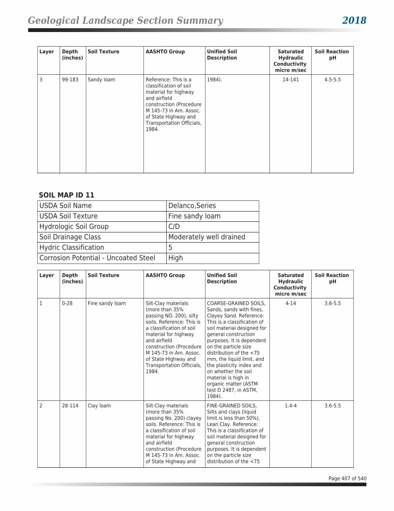
Geological Landscape Section Summary 2018
Layer Depth (inches)
Soil Texture AASHTO Group Unified Soil Description
SaturatedHydraulic
Conductivity micro m/sec
Soil Reaction pH
3 99-183 Sandy loam Reference: This is a classification of soil material for highway and airfield construction (Procedure M 145-73 in Am. Assoc. of State Highway and Transportation Officials, 1984.
1984). 14-141 4.5-5.5
SOIL MAP ID 11USDA Soil Name Delanco,SeriesUSDA Soil Texture Fine sandy loamHydrologic Soil Group C/DSoil Drainage Class Moderately well drainedHydric Classification 5Corrosion Potential - Uncoated Steel High
Layer Depth (inches)
Soil Texture AASHTO Group Unified Soil Description
SaturatedHydraulic
Conductivity micro m/sec
Soil Reaction pH
1 0-28 Fine sandy loam Silt-Clay materials (more than 35% passing NO. 200), silty soils. Reference: This is a classification of soil material for highway and airfield construction (Procedure M 145-73 in Am. Assoc. of State Highway and Transportation Officials, 1984.
COARSE-GRAINED SOILS, Sands, sands with fines, Clayey Sand. Reference: This is a classification of soil material designed for general construction purposes. It is dependent on the particle size distribution of the <75 mm, the liquid limit, and the plasticity index and on whether the soil material is high in organic matter (ASTM test D 2487, in ASTM, 1984).
4-14 3.6-5.5
2 28-114 Clay loam Silt-Clay materials (more than 35% passing No. 200) clayey soils. Reference: This is a classification of soil material for highway and airfield construction (Procedure M 145-73 in Am. Assoc. of State Highway and
FINE-GRAINED SOILS, Silts and clays (liquid limit is less than 50%), Lean Clay. Reference: This is a classification of soil material designed for general construction purposes. It is dependent on the particle size distribution of the <75
1.4-4 3.6-5.5
Page 407 of 540
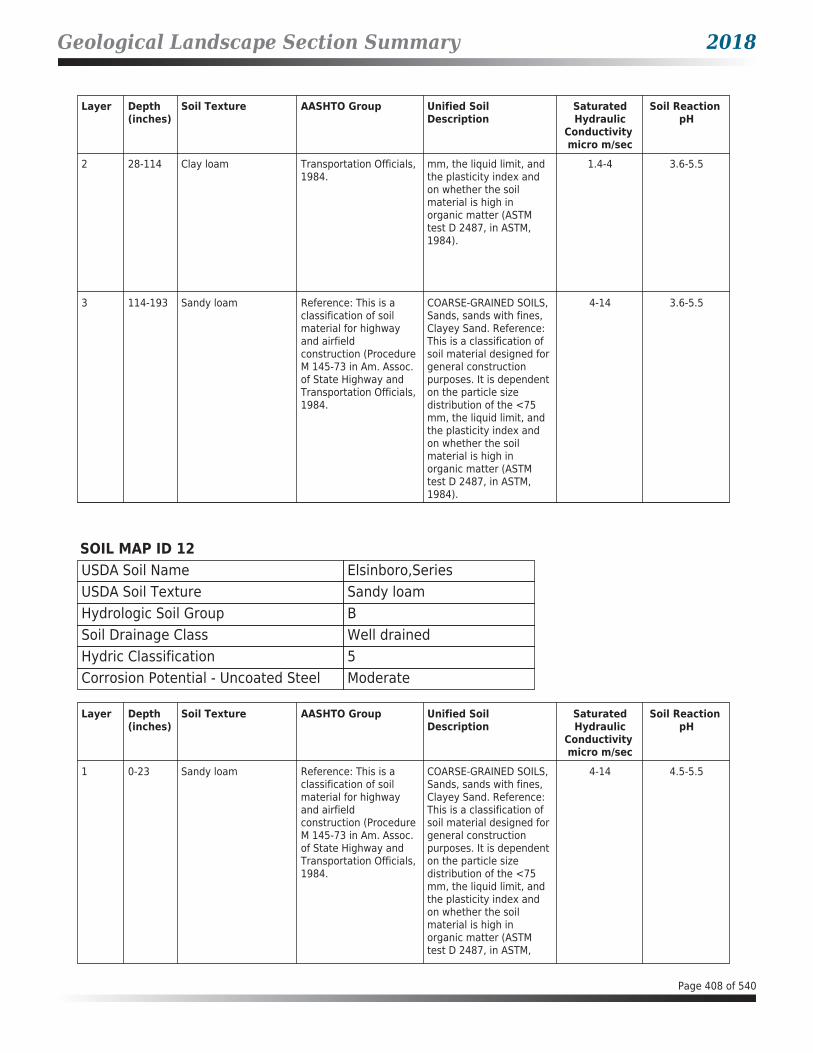
Geological Landscape Section Summary 2018
Layer Depth (inches)
Soil Texture AASHTO Group Unified Soil Description
SaturatedHydraulic
Conductivity micro m/sec
Soil Reaction pH
2 28-114 Clay loam Transportation Officials, 1984.
mm, the liquid limit, and the plasticity index and on whether the soil material is high in organic matter (ASTM test D 2487, in ASTM, 1984).
1.4-4 3.6-5.5
3 114-193 Sandy loam Reference: This is a classification of soil material for highway and airfield construction (Procedure M 145-73 in Am. Assoc. of State Highway and Transportation Officials, 1984.
COARSE-GRAINED SOILS, Sands, sands with fines, Clayey Sand. Reference: This is a classification of soil material designed for general construction purposes. It is dependent on the particle size distribution of the <75 mm, the liquid limit, and the plasticity index and on whether the soil material is high in organic matter (ASTM test D 2487, in ASTM, 1984).
4-14 3.6-5.5
SOIL MAP ID 12USDA Soil Name Elsinboro,SeriesUSDA Soil Texture Sandy loamHydrologic Soil Group BSoil Drainage Class Well drainedHydric Classification 5Corrosion Potential - Uncoated Steel Moderate
Layer Depth (inches)
Soil Texture AASHTO Group Unified Soil Description
SaturatedHydraulic
Conductivity micro m/sec
Soil Reaction pH
1 0-23 Sandy loam Reference: This is a classification of soil material for highway and airfield construction (Procedure M 145-73 in Am. Assoc. of State Highway and Transportation Officials, 1984.
COARSE-GRAINED SOILS, Sands, sands with fines, Clayey Sand. Reference: This is a classification of soil material designed for general construction purposes. It is dependent on the particle size distribution of the <75 mm, the liquid limit, and the plasticity index and on whether the soil material is high in organic matter (ASTM test D 2487, in ASTM,
4-14 4.5-5.5
Page 408 of 540

Geological Landscape Section Summary 2018
Layer Depth (inches)
Soil Texture AASHTO Group Unified Soil Description
SaturatedHydraulic
Conductivity micro m/sec
Soil Reaction pH
1 0-23 Sandy loam Reference: This is a classification of soil material for highway and airfield construction (Procedure M 145-73 in Am. Assoc. of State Highway and Transportation Officials, 1984.
1984). 4-14 4.5-5.5
2 23-112 Sandy clay loam Silt-Clay materials (more than 35% passing No. 200) clayey soils. Reference: This is a classification of soil material for highway and airfield construction (Procedure M 145-73 in Am. Assoc. of State Highway and Transportation Officials, 1984.
Reference: This is a classification of soil material designed for general construction purposes. It is dependent on the particle size distribution of the <75 mm, the liquid limit, and the plasticity index and on whether the soil material is high in organic matter (ASTM test D 2487, in ASTM, 1984).
4-14 4.5-5.5
3 112-165 Sandy loam Reference: This is a classification of soil material for highway and airfield construction (Procedure M 145-73 in Am. Assoc. of State Highway and Transportation Officials, 1984.
COARSE-GRAINED SOILS, Sands, sands with fines, Clayey Sand. Reference: This is a classification of soil material designed for general construction purposes. It is dependent on the particle size distribution of the <75 mm, the liquid limit, and the plasticity index and on whether the soil material is high in organic matter (ASTM test D 2487, in ASTM, 1984).
4-42 4.5-5.5
SOIL MAP ID 13USDA Soil Name Quantico,SeriesUSDA Soil Texture LoamHydrologic Soil Group BSoil Drainage Class Well drainedHydric Classification 0Corrosion Potential - Uncoated Steel High
Page 409 of 540

Geological Landscape Section Summary 2018
Layer Depth (inches)
Soil Texture AASHTO Group Unified Soil Description
SaturatedHydraulic
Conductivity micro m/sec
Soil Reaction pH
1 0-33 Loam Silt-Clay materials (more than 35% passing NO. 200), silty soils. Reference: This is a classification of soil material for highway and airfield construction (Procedure M 145-73 in Am. Assoc. of State Highway and Transportation Officials, 1984.
Reference: This is a classification of soil material designed for general construction purposes. It is dependent on the particle size distribution of the <75 mm, the liquid limit, and the plasticity index and on whether the soil material is high in organic matter (ASTM test D 2487, in ASTM, 1984).
14-42 4.5-5.5
2 33-46 Clay loam Silt-Clay materials (more than 35% passing No. 200) clayey soils. Reference: This is a classification of soil material for highway and airfield construction (Procedure M 145-73 in Am. Assoc. of State Highway and Transportation Officials, 1984.
FINE-GRAINED SOILS, Silts and clays (liquid limit is less than 50%), Lean Clay. Reference: This is a classification of soil material designed for general construction purposes. It is dependent on the particle size distribution of the <75 mm, the liquid limit, and the plasticity index and on whether the soil material is high in organic matter (ASTM test D 2487, in ASTM, 1984).
4-14 4.5-5.5
3 46-119 Clay Reference: This is a classification of soil material for highway and airfield construction (Procedure M 145-73 in Am. Assoc. of State Highway and Transportation Officials, 1984.
FINE-GRAINED SOILS, Silts and clays (liquid limit is 50% or more), Fat Clay. Reference: This is a classification of soil material designed for general construction purposes. It is dependent on the particle size distribution of the <75 mm, the liquid limit, and the plasticity index and on whether the soil material is high in organic matter (ASTM test D 2487, in ASTM, 1984).
4-14 4.5-5.5
4 119-183 Sandy clay Silt-Clay materials (more than 35% passing No. 200) clayey soils. Reference: This is a classification of soil material for highway and airfield construction (Procedure M 145-73 in Am. Assoc. of State Highway and Transportation Officials, 1984.
COARSE-GRAINED SOILS, Sands, sands with fines, Clayey Sand. Reference: This is a classification of soil material designed for general construction purposes. It is dependent on the particle size distribution of the <75 mm, the liquid limit, and the plasticity index and on whether the soil material is high in
4-42 4.5-5.5
Page 410 of 540

Geological Landscape Section Summary 2018
Layer Depth (inches)
Soil Texture AASHTO Group Unified Soil Description
SaturatedHydraulic
Conductivity micro m/sec
Soil Reaction pH
4 119-183 Sandy clay Silt-Clay materials (more than 35% passing No. 200) clayey soils. Reference: This is a classification of soil material for highway and airfield construction (Procedure M 145-73 in Am. Assoc. of State Highway and Transportation Officials, 1984.
organic matter (ASTM test D 2487, in ASTM, 1984).
4-42 4.5-5.5
SOIL MAP ID 14USDA Soil Name Lunt,SeriesUSDA Soil Texture LoamHydrologic Soil Group BSoil Drainage Class Well drainedHydric Classification 0Corrosion Potential - Uncoated Steel Moderate
Layer Depth (inches)
Soil Texture AASHTO Group Unified Soil Description
SaturatedHydraulic
Conductivity micro m/sec
Soil Reaction pH
1 0-18 Loam Silt-Clay materials (more than 35% passing No. 200) clayey soils. Reference: This is a classification of soil material for highway and airfield construction (Procedure M 145-73 in Am. Assoc. of State Highway and Transportation Officials, 1984.
FINE-GRAINED SOILS, Silts and clays (liquid limit is less than 50%), Lean Clay. Reference: This is a classification of soil material designed for general construction purposes. It is dependent on the particle size distribution of the <75 mm, the liquid limit, and the plasticity index and on whether the soil material is high in organic matter (ASTM test D 2487, in ASTM, 1984).
4-42 4.5-5.5
2 18-99 Clay Reference: This is a classification of soil material for highway and airfield construction (Procedure M 145-73 in Am. Assoc. of State Highway and Transportation Officials, 1984.
FINE-GRAINED SOILS, Silts and clays (liquid limit is 50% or more), Fat Clay. Reference: This is a classification of soil material designed for general construction purposes. It is dependent on the particle size distribution of the <75 mm, the liquid limit, and
4-14 4.5-5.5
Page 411 of 540

Geological Landscape Section Summary 2018
Layer Depth (inches)
Soil Texture AASHTO Group Unified Soil Description
SaturatedHydraulic
Conductivity micro m/sec
Soil Reaction pH
2 18-99 Clay Reference: This is a classification of soil material for highway and airfield construction (Procedure M 145-73 in Am. Assoc. of State Highway and Transportation Officials, 1984.
the plasticity index and on whether the soil material is high in organic matter (ASTM test D 2487, in ASTM, 1984).
4-14 4.5-5.5
3 99-183 Sandy loam Reference: This is a classification of soil material for highway and airfield construction (Procedure M 145-73 in Am. Assoc. of State Highway and Transportation Officials, 1984.
COARSE-GRAINED SOILS, Sands, sands with fines, Clayey Sand. Reference: This is a classification of soil material designed for general construction purposes. It is dependent on the particle size distribution of the <75 mm, the liquid limit, and the plasticity index and on whether the soil material is high in organic matter (ASTM test D 2487, in ASTM, 1984).
14-141 4.5-5.5
SOIL MAP ID 15USDA Soil Name Lunt,SeriesUSDA Soil Texture LoamHydrologic Soil Group BSoil Drainage Class Well drainedHydric Classification 0Corrosion Potential - Uncoated Steel Moderate
Layer Depth (inches)
Soil Texture AASHTO Group Unified Soil Description
SaturatedHydraulic
Conductivity micro m/sec
Soil Reaction pH
1 0-18 Loam Silt-Clay materials (more than 35% passing No. 200) clayey soils. Reference: This is a classification of soil material for highway and airfield construction (Procedure M 145-73 in Am. Assoc. of State Highway and Transportation Officials, 1984.
FINE-GRAINED SOILS, Silts and clays (liquid limit is less than 50%), Lean Clay. Reference: This is a classification of soil material designed for general construction purposes. It is dependent on the particle size distribution of the <75 mm, the liquid limit, and the plasticity index and on whether the soil material is high in
4-42 4.5-5.5
Page 412 of 540

Geological Landscape Section Summary 2018
Layer Depth (inches)
Soil Texture AASHTO Group Unified Soil Description
SaturatedHydraulic
Conductivity micro m/sec
Soil Reaction pH
1 0-18 Loam Silt-Clay materials (more than 35% passing No. 200) clayey soils. Reference: This is a classification of soil material for highway and airfield construction (Procedure M 145-73 in Am. Assoc. of State Highway and Transportation Officials, 1984.
organic matter (ASTM test D 2487, in ASTM, 1984).
4-42 4.5-5.5
2 18-99 Clay Reference: This is a classification of soil material for highway and airfield construction (Procedure M 145-73 in Am. Assoc. of State Highway and Transportation Officials, 1984.
FINE-GRAINED SOILS, Silts and clays (liquid limit is 50% or more), Fat Clay. Reference: This is a classification of soil material designed for general construction purposes. It is dependent on the particle size distribution of the <75 mm, the liquid limit, and the plasticity index and on whether the soil material is high in organic matter (ASTM test D 2487, in ASTM, 1984).
4-14 4.5-5.5
3 99-183 Sandy loam Reference: This is a classification of soil material for highway and airfield construction (Procedure M 145-73 in Am. Assoc. of State Highway and Transportation Officials, 1984.
COARSE-GRAINED SOILS, Sands, sands with fines, Clayey Sand. Reference: This is a classification of soil material designed for general construction purposes. It is dependent on the particle size distribution of the <75 mm, the liquid limit, and the plasticity index and on whether the soil material is high in organic matter (ASTM test D 2487, in ASTM, 1984).
14-141 4.5-5.5
Page 413 of 540
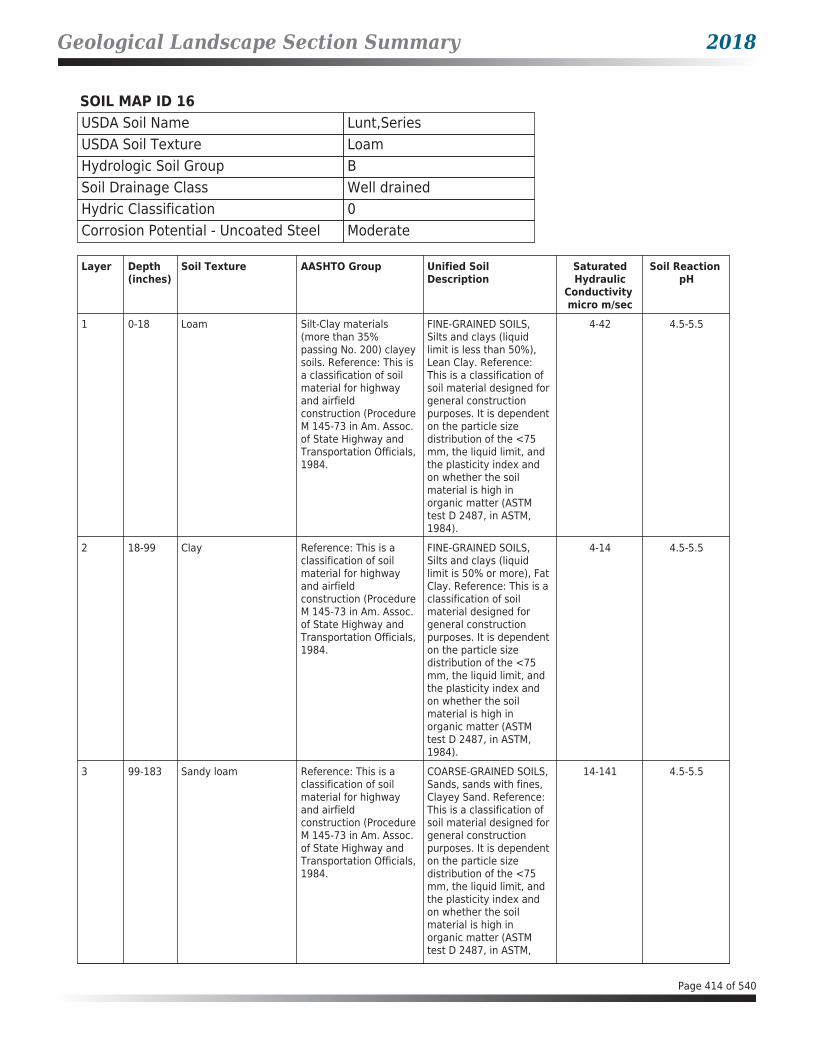
Geological Landscape Section Summary 2018
SOIL MAP ID 16USDA Soil Name Lunt,SeriesUSDA Soil Texture LoamHydrologic Soil Group BSoil Drainage Class Well drainedHydric Classification 0Corrosion Potential - Uncoated Steel Moderate
Layer Depth (inches)
Soil Texture AASHTO Group Unified Soil Description
SaturatedHydraulic
Conductivity micro m/sec
Soil Reaction pH
1 0-18 Loam Silt-Clay materials (more than 35% passing No. 200) clayey soils. Reference: This is a classification of soil material for highway and airfield construction (Procedure M 145-73 in Am. Assoc. of State Highway and Transportation Officials, 1984.
FINE-GRAINED SOILS, Silts and clays (liquid limit is less than 50%), Lean Clay. Reference: This is a classification of soil material designed for general construction purposes. It is dependent on the particle size distribution of the <75 mm, the liquid limit, and the plasticity index and on whether the soil material is high in organic matter (ASTM test D 2487, in ASTM, 1984).
4-42 4.5-5.5
2 18-99 Clay Reference: This is a classification of soil material for highway and airfield construction (Procedure M 145-73 in Am. Assoc. of State Highway and Transportation Officials, 1984.
FINE-GRAINED SOILS, Silts and clays (liquid limit is 50% or more), Fat Clay. Reference: This is a classification of soil material designed for general construction purposes. It is dependent on the particle size distribution of the <75 mm, the liquid limit, and the plasticity index and on whether the soil material is high in organic matter (ASTM test D 2487, in ASTM, 1984).
4-14 4.5-5.5
3 99-183 Sandy loam Reference: This is a classification of soil material for highway and airfield construction (Procedure M 145-73 in Am. Assoc. of State Highway and Transportation Officials, 1984.
COARSE-GRAINED SOILS, Sands, sands with fines, Clayey Sand. Reference: This is a classification of soil material designed for general construction purposes. It is dependent on the particle size distribution of the <75 mm, the liquid limit, and the plasticity index and on whether the soil material is high in organic matter (ASTM test D 2487, in ASTM,
14-141 4.5-5.5
Page 414 of 540

Geological Landscape Section Summary 2018
Layer Depth (inches)
Soil Texture AASHTO Group Unified Soil Description
SaturatedHydraulic
Conductivity micro m/sec
Soil Reaction pH
3 99-183 Sandy loam Reference: This is a classification of soil material for highway and airfield construction (Procedure M 145-73 in Am. Assoc. of State Highway and Transportation Officials, 1984.
1984). 14-141 4.5-5.5
SOIL MAP ID 17USDA Soil Name Lunt,SeriesUSDA Soil Texture LoamHydrologic Soil Group BSoil Drainage Class Well drainedHydric Classification 0Corrosion Potential - Uncoated Steel Moderate
Layer Depth (inches)
Soil Texture AASHTO Group Unified Soil Description
SaturatedHydraulic
Conductivity micro m/sec
Soil Reaction pH
1 0-18 Loam Silt-Clay materials (more than 35% passing No. 200) clayey soils. Reference: This is a classification of soil material for highway and airfield construction (Procedure M 145-73 in Am. Assoc. of State Highway and Transportation Officials, 1984.
FINE-GRAINED SOILS, Silts and clays (liquid limit is less than 50%), Lean Clay. Reference: This is a classification of soil material designed for general construction purposes. It is dependent on the particle size distribution of the <75 mm, the liquid limit, and the plasticity index and on whether the soil material is high in organic matter (ASTM test D 2487, in ASTM, 1984).
4-42 4.5-5.5
2 18-99 Clay Reference: This is a classification of soil material for highway and airfield construction (Procedure M 145-73 in Am. Assoc. of State Highway and Transportation Officials, 1984.
FINE-GRAINED SOILS, Silts and clays (liquid limit is 50% or more), Fat Clay. Reference: This is a classification of soil material designed for general construction purposes. It is dependent on the particle size
4-14 4.5-5.5
Page 415 of 540

Geological Landscape Section Summary 2018
Layer Depth (inches)
Soil Texture AASHTO Group Unified Soil Description
SaturatedHydraulic
Conductivity micro m/sec
Soil Reaction pH
2 18-99 Clay Reference: This is a classification of soil material for highway and airfield construction (Procedure M 145-73 in Am. Assoc. of State Highway and Transportation Officials, 1984.
distribution of the <75 mm, the liquid limit, and the plasticity index and on whether the soil material is high in organic matter (ASTM test D 2487, in ASTM, 1984).
4-14 4.5-5.5
3 99-183 Sandy loam Reference: This is a classification of soil material for highway and airfield construction (Procedure M 145-73 in Am. Assoc. of State Highway and Transportation Officials, 1984.
COARSE-GRAINED SOILS, Sands, sands with fines, Clayey Sand. Reference: This is a classification of soil material designed for general construction purposes. It is dependent on the particle size distribution of the <75 mm, the liquid limit, and the plasticity index and on whether the soil material is high in organic matter (ASTM test D 2487, in ASTM, 1984).
14-141 4.5-5.5
SOIL MAP ID 18USDA Soil Name Hatboro,SeriesUSDA Soil Texture Silt loamHydrologic Soil Group B/DSoil Drainage Class Poorly drainedHydric Classification 45Corrosion Potential - Uncoated Steel High
Layer Depth (inches)
Soil Texture AASHTO Group Unified Soil Description
SaturatedHydraulic
Conductivity micro m/sec
Soil Reaction pH
1 0-36 Silt loam Silt-Clay materials (more than 35% passing NO. 200), silty soils. Reference: This is a classification of soil material for highway and airfield construction (Procedure M 145-73 in Am. Assoc. of State Highway and Transportation Officials, 1984.
FINE-GRAINED SOILS, Silts and clays (liquid limit is less than 50%), Lean Clay. Reference: This is a classification of soil material designed for general construction purposes. It is dependent on the particle size distribution of the <75 mm, the liquid limit, and the plasticity index and on whether the soil material is high in organic matter (ASTM test D 2487, in ASTM,
4-14 4.5-7.3
Page 416 of 540

Geological Landscape Section Summary 2018
Layer Depth (inches)
Soil Texture AASHTO Group Unified Soil Description
SaturatedHydraulic
Conductivity micro m/sec
Soil Reaction pH
1 0-36 Silt loam Silt-Clay materials (more than 35% passing NO. 200), silty soils. Reference: This is a classification of soil material for highway and airfield construction (Procedure M 145-73 in Am. Assoc. of State Highway and Transportation Officials, 1984.
1984). 4-14 4.5-7.3
2 36-61 Silty clay loam Silt-Clay materials (more than 35% passing No. 200) clayey soils. Reference: This is a classification of soil material for highway and airfield construction (Procedure M 145-73 in Am. Assoc. of State Highway and Transportation Officials, 1984.
FINE-GRAINED SOILS, Silts and clays (liquid limit is less than 50%), Lean Clay. Reference: This is a classification of soil material designed for general construction purposes. It is dependent on the particle size distribution of the <75 mm, the liquid limit, and the plasticity index and on whether the soil material is high in organic matter (ASTM test D 2487, in ASTM, 1984).
4-14 4.5-7.3
3 61-122 Sandy clay loam Silt-Clay materials (more than 35% passing No. 200) clayey soils. Reference: This is a classification of soil material for highway and airfield construction (Procedure M 145-73 in Am. Assoc. of State Highway and Transportation Officials, 1984.
FINE-GRAINED SOILS, Silts and clays (liquid limit is less than 50%), Lean Clay. Reference: This is a classification of soil material designed for general construction purposes. It is dependent on the particle size distribution of the <75 mm, the liquid limit, and the plasticity index and on whether the soil material is high in organic matter (ASTM test D 2487, in ASTM, 1984).
4-14 5.6-6.5
4 122-152 Loamy sand Reference: This is a classification of soil material for highway and airfield construction (Procedure M 145-73 in Am. Assoc. of State Highway and Transportation Officials, 1984.
COARSE-GRAINED SOILS, Sands, sands with fines, Clayey Sand. Reference: This is a classification of soil material designed for general construction purposes. It is dependent on the particle size distribution of the <75 mm, the liquid limit, and the plasticity index and
14-42 5.6-6.5
Page 417 of 540

Geological Landscape Section Summary 2018
Layer Depth (inches)
Soil Texture AASHTO Group Unified Soil Description
SaturatedHydraulic
Conductivity micro m/sec
Soil Reaction pH
4 122-152 Loamy sand Reference: This is a classification of soil material for highway and airfield construction (Procedure M 145-73 in Am. Assoc. of State Highway and Transportation Officials, 1984.
on whether the soil material is high in organic matter (ASTM test D 2487, in ASTM, 1984).
14-42 5.6-6.5
SOIL MAP ID 19USDA Soil Name Lunt,SeriesUSDA Soil Texture LoamHydrologic Soil Group BSoil Drainage Class Well drainedHydric Classification 0Corrosion Potential - Uncoated Steel Moderate
Layer Depth (inches)
Soil Texture AASHTO Group Unified Soil Description
SaturatedHydraulic
Conductivity micro m/sec
Soil Reaction pH
1 0-18 Loam Silt-Clay materials (more than 35% passing No. 200) clayey soils. Reference: This is a classification of soil material for highway and airfield construction (Procedure M 145-73 in Am. Assoc. of State Highway and Transportation Officials, 1984.
FINE-GRAINED SOILS, Silts and clays (liquid limit is less than 50%), Lean Clay. Reference: This is a classification of soil material designed for general construction purposes. It is dependent on the particle size distribution of the <75 mm, the liquid limit, and the plasticity index and on whether the soil material is high in organic matter (ASTM test D 2487, in ASTM, 1984).
4-42 4.5-5.5
2 18-99 Clay Reference: This is a classification of soil material for highway and airfield construction (Procedure M 145-73 in Am. Assoc. of State Highway and Transportation Officials, 1984.
FINE-GRAINED SOILS, Silts and clays (liquid limit is 50% or more), Fat Clay. Reference: This is a classification of soil material designed for general construction purposes. It is dependent on the particle size distribution of the <75 mm, the liquid limit, and the plasticity index and on whether the soil
4-14 4.5-5.5
Page 418 of 540

Geological Landscape Section Summary 2018
Layer Depth (inches)
Soil Texture AASHTO Group Unified Soil Description
SaturatedHydraulic
Conductivity micro m/sec
Soil Reaction pH
2 18-99 Clay Reference: This is a classification of soil material for highway and airfield construction (Procedure M 145-73 in Am. Assoc. of State Highway and Transportation Officials, 1984.
material is high in organic matter (ASTM test D 2487, in ASTM, 1984).
4-14 4.5-5.5
3 99-183 Sandy loam Reference: This is a classification of soil material for highway and airfield construction (Procedure M 145-73 in Am. Assoc. of State Highway and Transportation Officials, 1984.
COARSE-GRAINED SOILS, Sands, sands with fines, Clayey Sand. Reference: This is a classification of soil material designed for general construction purposes. It is dependent on the particle size distribution of the <75 mm, the liquid limit, and the plasticity index and on whether the soil material is high in organic matter (ASTM test D 2487, in ASTM, 1984).
14-141 4.5-5.5
SOIL MAP ID 20USDA Soil Name Marumsco,SeriesUSDA Soil Texture LoamHydrologic Soil Group C/DSoil Drainage Class Moderately well drainedHydric Classification 0Corrosion Potential - Uncoated Steel High
Layer Depth (inches)
Soil Texture AASHTO Group Unified Soil Description
SaturatedHydraulic
Conductivity micro m/sec
Soil Reaction pH
1 0-18 Loam Silt-Clay materials (more than 35% passing No. 200) clayey soils. Reference: This is a classification of soil material for highway and airfield construction (Procedure M 145-73 in Am. Assoc. of State Highway and Transportation Officials, 1984.
FINE-GRAINED SOILS, Silts and clays (liquid limit is less than 50%), Lean Clay. Reference: This is a classification of soil material designed for general construction purposes. It is dependent on the particle size distribution of the <75 mm, the liquid limit, and the plasticity index and
4-14 3.6-5
Page 419 of 540

Geological Landscape Section Summary 2018
Layer Depth (inches)
Soil Texture AASHTO Group Unified Soil Description
SaturatedHydraulic
Conductivity micro m/sec
Soil Reaction pH
1 0-18 Loam Silt-Clay materials (more than 35% passing No. 200) clayey soils. Reference: This is a classification of soil material for highway and airfield construction (Procedure M 145-73 in Am. Assoc. of State Highway and Transportation Officials, 1984.
on whether the soil material is high in organic matter (ASTM test D 2487, in ASTM, 1984).
4-14 3.6-5
2 18-74 Clay Reference: This is a classification of soil material for highway and airfield construction (Procedure M 145-73 in Am. Assoc. of State Highway and Transportation Officials, 1984.
FINE-GRAINED SOILS, Silts and clays (liquid limit is 50% or more), Fat Clay. Reference: This is a classification of soil material designed for general construction purposes. It is dependent on the particle size distribution of the <75 mm, the liquid limit, and the plasticity index and on whether the soil material is high in organic matter (ASTM test D 2487, in ASTM, 1984).
0.42-1.4 3.6-5
3 74-119 Sandy clay loam Reference: This is a classification of soil material for highway and airfield construction (Procedure M 145-73 in Am. Assoc. of State Highway and Transportation Officials, 1984.
COARSE-GRAINED SOILS, Sands, sands with fines, Clayey Sand. Reference: This is a classification of soil material designed for general construction purposes. It is dependent on the particle size distribution of the <75 mm, the liquid limit, and the plasticity index and on whether the soil material is high in organic matter (ASTM test D 2487, in ASTM, 1984).
1.4-4 3.6-5
4 119-190 Sandy clay loam Reference: This is a classification of soil material for highway and airfield construction (Procedure M 145-73 in Am. Assoc. of State Highway and Transportation Officials, 1984.
COARSE-GRAINED SOILS, Sands, sands with fines, Clayey Sand. Reference: This is a classification of soil material designed for general construction purposes. It is dependent on the particle size distribution of the <75 mm, the liquid limit, and the plasticity index and on whether the soil material is high in organic matter (ASTM test D 2487, in ASTM, 1984).
0.42-141 3.6-5
Page 420 of 540

Geological Landscape Section Summary 2018
SOIL MAP ID 21USDA Soil Name Delanco,SeriesUSDA Soil Texture Fine sandy loamHydrologic Soil Group C/DSoil Drainage Class Moderately well drainedHydric Classification 5Corrosion Potential - Uncoated Steel High
Layer Depth (inches)
Soil Texture AASHTO Group Unified Soil Description
SaturatedHydraulic
Conductivity micro m/sec
Soil Reaction pH
1 0-28 Fine sandy loam Silt-Clay materials (more than 35% passing NO. 200), silty soils. Reference: This is a classification of soil material for highway and airfield construction (Procedure M 145-73 in Am. Assoc. of State Highway and Transportation Officials, 1984.
COARSE-GRAINED SOILS, Sands, sands with fines, Clayey Sand. Reference: This is a classification of soil material designed for general construction purposes. It is dependent on the particle size distribution of the <75 mm, the liquid limit, and the plasticity index and on whether the soil material is high in organic matter (ASTM test D 2487, in ASTM, 1984).
4-14 3.6-5.5
2 28-114 Clay loam Silt-Clay materials (more than 35% passing No. 200) clayey soils. Reference: This is a classification of soil material for highway and airfield construction (Procedure M 145-73 in Am. Assoc. of State Highway and Transportation Officials, 1984.
FINE-GRAINED SOILS, Silts and clays (liquid limit is less than 50%), Lean Clay. Reference: This is a classification of soil material designed for general construction purposes. It is dependent on the particle size distribution of the <75 mm, the liquid limit, and the plasticity index and on whether the soil material is high in organic matter (ASTM test D 2487, in ASTM, 1984).
1.4-4 3.6-5.5
3 114-193 Sandy loam Reference: This is a classification of soil material for highway and airfield construction (Procedure M 145-73 in Am. Assoc. of State Highway and Transportation Officials, 1984.
COARSE-GRAINED SOILS, Sands, sands with fines, Clayey Sand. Reference: This is a classification of soil material designed for general construction purposes. It is dependent on the particle size distribution of the <75 mm, the liquid limit, and the plasticity index and on whether the soil material is high in organic matter (ASTM test D 2487, in ASTM, 1984).
4-14 3.6-5.5
Page 421 of 540

Geological Landscape Section Summary 2018
SOIL MAP ID 22USDA Soil Name Urban land,Miscellaneous
areaUSDA Soil Texture Not ReportedHydrologic Soil Group Not ReportedSoil Drainage Class Not ReportedHydric Classification 0Corrosion Potential - Uncoated Steel Not Reported
SOIL MAP ID 23USDA Soil Name Dumfries,SeriesUSDA Soil Texture Sandy loamHydrologic Soil Group ASoil Drainage Class Well drainedHydric Classification 0Corrosion Potential - Uncoated Steel Low
Layer Depth (inches)
Soil Texture AASHTO Group Unified Soil Description
SaturatedHydraulic
Conductivity micro m/sec
Soil Reaction pH
1 0-25 Sandy loam Silt-Clay materials (more than 35% passing NO. 200), silty soils. Reference: This is a classification of soil material for highway and airfield construction (Procedure M 145-73 in Am. Assoc. of State Highway and Transportation Officials, 1984.
COARSE-GRAINED SOILS, Sands, sands with fines, Clayey Sand. Reference: This is a classification of soil material designed for general construction purposes. It is dependent on the particle size distribution of the <75 mm, the liquid limit, and the plasticity index and on whether the soil material is high in organic matter (ASTM test D 2487, in ASTM, 1984).
14-42 4.5-5.5
2 25-74 Sandy clay loam Silt-Clay materials (more than 35% passing No. 200) clayey soils. Reference: This is a classification of soil material for highway and airfield construction (Procedure M 145-73 in Am. Assoc. of State Highway and Transportation Officials, 1984.
COARSE-GRAINED SOILS, Sands, sands with fines, Clayey Sand. Reference: This is a classification of soil material designed for general construction purposes. It is dependent on the particle size distribution of the <75 mm, the liquid limit, and the plasticity index and on whether the soil material is high in organic matter (ASTM test D 2487, in ASTM, 1984).
14-42 4.5-5.5
3 74-89 Sandy loam Reference: This is a classification of soil material for highway
COARSE-GRAINED SOILS, Sands, sands with fines, Clayey Sand. Reference:
14-42 4.5-5.5
Page 422 of 540

Geological Landscape Section Summary 2018
Layer Depth (inches)
Soil Texture AASHTO Group Unified Soil Description
SaturatedHydraulic
Conductivity micro m/sec
Soil Reaction pH
3 74-89 Sandy loam and airfield construction (Procedure M 145-73 in Am. Assoc. of State Highway and Transportation Officials, 1984.
This is a classification of soil material designed for general construction purposes. It is dependent on the particle size distribution of the <75 mm, the liquid limit, and the plasticity index and on whether the soil material is high in organic matter (ASTM test D 2487, in ASTM, 1984).
14-42 4.5-5.5
4 89-183 Sandy loam Reference: This is a classification of soil material for highway and airfield construction (Procedure M 145-73 in Am. Assoc. of State Highway and Transportation Officials, 1984.
COARSE-GRAINED SOILS, Sands, sands with fines, Clayey Sand. Reference: This is a classification of soil material designed for general construction purposes. It is dependent on the particle size distribution of the <75 mm, the liquid limit, and the plasticity index and on whether the soil material is high in organic matter (ASTM test D 2487, in ASTM, 1984).
14-42 4.5-5.5
SOIL MAP ID 24USDA Soil Name Dumfries,SeriesUSDA Soil Texture Sandy loamHydrologic Soil Group ASoil Drainage Class Well drainedHydric Classification 0Corrosion Potential - Uncoated Steel Low
Layer Depth (inches)
Soil Texture AASHTO Group Unified Soil Description
SaturatedHydraulic
Conductivity micro m/sec
Soil Reaction pH
1 0-25 Sandy loam Silt-Clay materials (more than 35% passing NO. 200), silty soils. Reference: This is a classification of soil material for highway and airfield construction (Procedure M 145-73 in Am. Assoc. of State Highway and Transportation Officials, 1984.
COARSE-GRAINED SOILS, Sands, sands with fines, Clayey Sand. Reference: This is a classification of soil material designed for general construction purposes. It is dependent on the particle size distribution of the <75 mm, the liquid limit, and the plasticity index and on whether the soil
14-42 4.5-5.5
Page 423 of 540
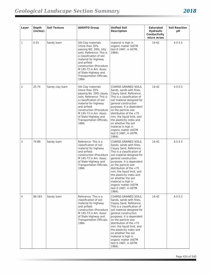
Geological Landscape Section Summary 2018
Layer Depth (inches)
Soil Texture AASHTO Group Unified Soil Description
SaturatedHydraulic
Conductivity micro m/sec
Soil Reaction pH
1 0-25 Sandy loam Silt-Clay materials (more than 35% passing NO. 200), silty soils. Reference: This is a classification of soil material for highway and airfield construction (Procedure M 145-73 in Am. Assoc. of State Highway and Transportation Officials, 1984.
material is high in organic matter (ASTM test D 2487, in ASTM, 1984).
14-42 4.5-5.5
2 25-74 Sandy clay loam Silt-Clay materials (more than 35% passing No. 200) clayey soils. Reference: This is a classification of soil material for highway and airfield construction (Procedure M 145-73 in Am. Assoc. of State Highway and Transportation Officials, 1984.
COARSE-GRAINED SOILS, Sands, sands with fines, Clayey Sand. Reference: This is a classification of soil material designed for general construction purposes. It is dependent on the particle size distribution of the <75 mm, the liquid limit, and the plasticity index and on whether the soil material is high in organic matter (ASTM test D 2487, in ASTM, 1984).
14-42 4.5-5.5
3 74-89 Sandy loam Reference: This is a classification of soil material for highway and airfield construction (Procedure M 145-73 in Am. Assoc. of State Highway and Transportation Officials, 1984.
COARSE-GRAINED SOILS, Sands, sands with fines, Clayey Sand. Reference: This is a classification of soil material designed for general construction purposes. It is dependent on the particle size distribution of the <75 mm, the liquid limit, and the plasticity index and on whether the soil material is high in organic matter (ASTM test D 2487, in ASTM, 1984).
14-42 4.5-5.5
4 89-183 Sandy loam Reference: This is a classification of soil material for highway and airfield construction (Procedure M 145-73 in Am. Assoc. of State Highway and Transportation Officials, 1984.
COARSE-GRAINED SOILS, Sands, sands with fines, Clayey Sand. Reference: This is a classification of soil material designed for general construction purposes. It is dependent on the particle size distribution of the <75 mm, the liquid limit, and the plasticity index and on whether the soil material is high in organic matter (ASTM test D 2487, in ASTM, 1984).
14-42 4.5-5.5
Page 424 of 540
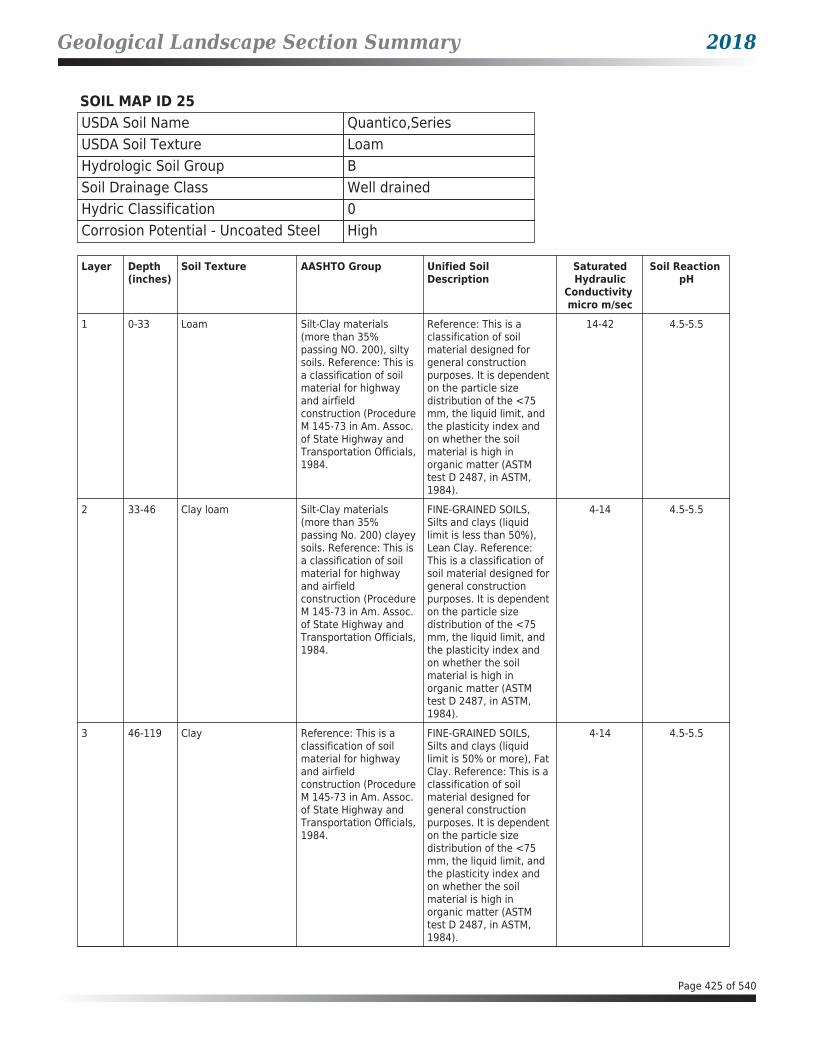
Geological Landscape Section Summary 2018
SOIL MAP ID 25USDA Soil Name Quantico,SeriesUSDA Soil Texture LoamHydrologic Soil Group BSoil Drainage Class Well drainedHydric Classification 0Corrosion Potential - Uncoated Steel High
Layer Depth (inches)
Soil Texture AASHTO Group Unified Soil Description
SaturatedHydraulic
Conductivity micro m/sec
Soil Reaction pH
1 0-33 Loam Silt-Clay materials (more than 35% passing NO. 200), silty soils. Reference: This is a classification of soil material for highway and airfield construction (Procedure M 145-73 in Am. Assoc. of State Highway and Transportation Officials, 1984.
Reference: This is a classification of soil material designed for general construction purposes. It is dependent on the particle size distribution of the <75 mm, the liquid limit, and the plasticity index and on whether the soil material is high in organic matter (ASTM test D 2487, in ASTM, 1984).
14-42 4.5-5.5
2 33-46 Clay loam Silt-Clay materials (more than 35% passing No. 200) clayey soils. Reference: This is a classification of soil material for highway and airfield construction (Procedure M 145-73 in Am. Assoc. of State Highway and Transportation Officials, 1984.
FINE-GRAINED SOILS, Silts and clays (liquid limit is less than 50%), Lean Clay. Reference: This is a classification of soil material designed for general construction purposes. It is dependent on the particle size distribution of the <75 mm, the liquid limit, and the plasticity index and on whether the soil material is high in organic matter (ASTM test D 2487, in ASTM, 1984).
4-14 4.5-5.5
3 46-119 Clay Reference: This is a classification of soil material for highway and airfield construction (Procedure M 145-73 in Am. Assoc. of State Highway and Transportation Officials, 1984.
FINE-GRAINED SOILS, Silts and clays (liquid limit is 50% or more), Fat Clay. Reference: This is a classification of soil material designed for general construction purposes. It is dependent on the particle size distribution of the <75 mm, the liquid limit, and the plasticity index and on whether the soil material is high in organic matter (ASTM test D 2487, in ASTM, 1984).
4-14 4.5-5.5
Page 425 of 540

Geological Landscape Section Summary 2018
Layer Depth (inches)
Soil Texture AASHTO Group Unified Soil Description
SaturatedHydraulic
Conductivity micro m/sec
Soil Reaction pH
4 119-183 Sandy clay Silt-Clay materials (more than 35% passing No. 200) clayey soils. Reference: This is a classification of soil material for highway and airfield construction (Procedure M 145-73 in Am. Assoc. of State Highway and Transportation Officials, 1984.
COARSE-GRAINED SOILS, Sands, sands with fines, Clayey Sand. Reference: This is a classification of soil material designed for general construction purposes. It is dependent on the particle size distribution of the <75 mm, the liquid limit, and the plasticity index and on whether the soil material is high in organic matter (ASTM test D 2487, in ASTM, 1984).
4-42 4.5-5.5
SOIL MAP ID 26USDA Soil Name Quantico,SeriesUSDA Soil Texture LoamHydrologic Soil Group BSoil Drainage Class Well drainedHydric Classification 0Corrosion Potential - Uncoated Steel High
Layer Depth (inches)
Soil Texture AASHTO Group Unified Soil Description
SaturatedHydraulic
Conductivity micro m/sec
Soil Reaction pH
1 0-33 Loam Silt-Clay materials (more than 35% passing NO. 200), silty soils. Reference: This is a classification of soil material for highway and airfield construction (Procedure M 145-73 in Am. Assoc. of State Highway and Transportation Officials, 1984.
Reference: This is a classification of soil material designed for general construction purposes. It is dependent on the particle size distribution of the <75 mm, the liquid limit, and the plasticity index and on whether the soil material is high in organic matter (ASTM test D 2487, in ASTM, 1984).
14-42 4.5-5.5
2 33-46 Clay loam Silt-Clay materials (more than 35% passing No. 200) clayey soils. Reference: This is a classification of soil material for highway and airfield construction (Procedure M 145-73 in Am. Assoc. of State Highway and Transportation Officials,
FINE-GRAINED SOILS, Silts and clays (liquid limit is less than 50%), Lean Clay. Reference: This is a classification of soil material designed for general construction purposes. It is dependent on the particle size distribution of the <75 mm, the liquid limit, and
4-14 4.5-5.5
Page 426 of 540
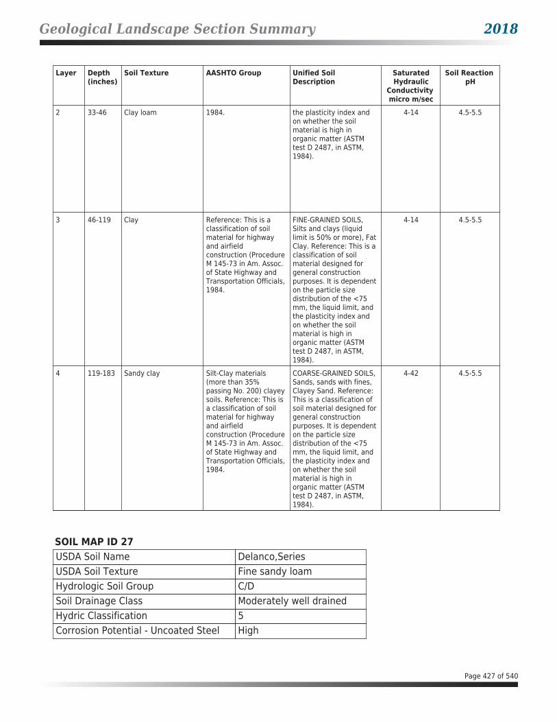
Geological Landscape Section Summary 2018
Layer Depth (inches)
Soil Texture AASHTO Group Unified Soil Description
SaturatedHydraulic
Conductivity micro m/sec
Soil Reaction pH
2 33-46 Clay loam 1984. the plasticity index and on whether the soil material is high in organic matter (ASTM test D 2487, in ASTM, 1984).
4-14 4.5-5.5
3 46-119 Clay Reference: This is a classification of soil material for highway and airfield construction (Procedure M 145-73 in Am. Assoc. of State Highway and Transportation Officials, 1984.
FINE-GRAINED SOILS, Silts and clays (liquid limit is 50% or more), Fat Clay. Reference: This is a classification of soil material designed for general construction purposes. It is dependent on the particle size distribution of the <75 mm, the liquid limit, and the plasticity index and on whether the soil material is high in organic matter (ASTM test D 2487, in ASTM, 1984).
4-14 4.5-5.5
4 119-183 Sandy clay Silt-Clay materials (more than 35% passing No. 200) clayey soils. Reference: This is a classification of soil material for highway and airfield construction (Procedure M 145-73 in Am. Assoc. of State Highway and Transportation Officials, 1984.
COARSE-GRAINED SOILS, Sands, sands with fines, Clayey Sand. Reference: This is a classification of soil material designed for general construction purposes. It is dependent on the particle size distribution of the <75 mm, the liquid limit, and the plasticity index and on whether the soil material is high in organic matter (ASTM test D 2487, in ASTM, 1984).
4-42 4.5-5.5
SOIL MAP ID 27USDA Soil Name Delanco,SeriesUSDA Soil Texture Fine sandy loamHydrologic Soil Group C/DSoil Drainage Class Moderately well drainedHydric Classification 5Corrosion Potential - Uncoated Steel High
Page 427 of 540

Geological Landscape Section Summary 2018
Layer Depth (inches)
Soil Texture AASHTO Group Unified Soil Description
SaturatedHydraulic
Conductivity micro m/sec
Soil Reaction pH
1 0-28 Fine sandy loam Silt-Clay materials (more than 35% passing NO. 200), silty soils. Reference: This is a classification of soil material for highway and airfield construction (Procedure M 145-73 in Am. Assoc. of State Highway and Transportation Officials, 1984.
COARSE-GRAINED SOILS, Sands, sands with fines, Clayey Sand. Reference: This is a classification of soil material designed for general construction purposes. It is dependent on the particle size distribution of the <75 mm, the liquid limit, and the plasticity index and on whether the soil material is high in organic matter (ASTM test D 2487, in ASTM, 1984).
4-14 3.6-5.5
2 28-114 Clay loam Silt-Clay materials (more than 35% passing No. 200) clayey soils. Reference: This is a classification of soil material for highway and airfield construction (Procedure M 145-73 in Am. Assoc. of State Highway and Transportation Officials, 1984.
FINE-GRAINED SOILS, Silts and clays (liquid limit is less than 50%), Lean Clay. Reference: This is a classification of soil material designed for general construction purposes. It is dependent on the particle size distribution of the <75 mm, the liquid limit, and the plasticity index and on whether the soil material is high in organic matter (ASTM test D 2487, in ASTM, 1984).
1.4-4 3.6-5.5
3 114-193 Sandy loam Reference: This is a classification of soil material for highway and airfield construction (Procedure M 145-73 in Am. Assoc. of State Highway and Transportation Officials, 1984.
COARSE-GRAINED SOILS, Sands, sands with fines, Clayey Sand. Reference: This is a classification of soil material designed for general construction purposes. It is dependent on the particle size distribution of the <75 mm, the liquid limit, and the plasticity index and on whether the soil material is high in organic matter (ASTM test D 2487, in ASTM, 1984).
4-14 3.6-5.5
Page 428 of 540

Geological Landscape Section Summary 2018
SOIL MAP ID 28USDA Soil Name Lunt,SeriesUSDA Soil Texture LoamHydrologic Soil Group BSoil Drainage Class Well drainedHydric Classification 0Corrosion Potential - Uncoated Steel Moderate
Layer Depth (inches)
Soil Texture AASHTO Group Unified Soil Description
SaturatedHydraulic
Conductivity micro m/sec
Soil Reaction pH
1 0-18 Loam Silt-Clay materials (more than 35% passing No. 200) clayey soils. Reference: This is a classification of soil material for highway and airfield construction (Procedure M 145-73 in Am. Assoc. of State Highway and Transportation Officials, 1984.
FINE-GRAINED SOILS, Silts and clays (liquid limit is less than 50%), Lean Clay. Reference: This is a classification of soil material designed for general construction purposes. It is dependent on the particle size distribution of the <75 mm, the liquid limit, and the plasticity index and on whether the soil material is high in organic matter (ASTM test D 2487, in ASTM, 1984).
4-42 4.5-5.5
2 18-99 Clay Reference: This is a classification of soil material for highway and airfield construction (Procedure M 145-73 in Am. Assoc. of State Highway and Transportation Officials, 1984.
FINE-GRAINED SOILS, Silts and clays (liquid limit is 50% or more), Fat Clay. Reference: This is a classification of soil material designed for general construction purposes. It is dependent on the particle size distribution of the <75 mm, the liquid limit, and the plasticity index and on whether the soil material is high in organic matter (ASTM test D 2487, in ASTM, 1984).
4-14 4.5-5.5
3 99-183 Sandy loam Reference: This is a classification of soil material for highway and airfield construction (Procedure M 145-73 in Am. Assoc. of State Highway and Transportation Officials, 1984.
COARSE-GRAINED SOILS, Sands, sands with fines, Clayey Sand. Reference: This is a classification of soil material designed for general construction purposes. It is dependent on the particle size distribution of the <75 mm, the liquid limit, and the plasticity index and on whether the soil material is high in organic matter (ASTM test D 2487, in ASTM,
14-141 4.5-5.5
Page 429 of 540

Geological Landscape Section Summary 2018
Layer Depth (inches)
Soil Texture AASHTO Group Unified Soil Description
SaturatedHydraulic
Conductivity micro m/sec
Soil Reaction pH
3 99-183 Sandy loam Reference: This is a classification of soil material for highway and airfield construction (Procedure M 145-73 in Am. Assoc. of State Highway and Transportation Officials, 1984.
1984). 14-141 4.5-5.5
SOIL MAP ID 29USDA Soil Name Dumfries,SeriesUSDA Soil Texture Sandy loamHydrologic Soil Group ASoil Drainage Class Well drainedHydric Classification 0Corrosion Potential - Uncoated Steel Low
Layer Depth (inches)
Soil Texture AASHTO Group Unified Soil Description
SaturatedHydraulic
Conductivity micro m/sec
Soil Reaction pH
1 0-25 Sandy loam Silt-Clay materials (more than 35% passing NO. 200), silty soils. Reference: This is a classification of soil material for highway and airfield construction (Procedure M 145-73 in Am. Assoc. of State Highway and Transportation Officials, 1984.
COARSE-GRAINED SOILS, Sands, sands with fines, Clayey Sand. Reference: This is a classification of soil material designed for general construction purposes. It is dependent on the particle size distribution of the <75 mm, the liquid limit, and the plasticity index and on whether the soil material is high in organic matter (ASTM test D 2487, in ASTM, 1984).
14-42 4.5-5.5
2 25-74 Sandy clay loam Silt-Clay materials (more than 35% passing No. 200) clayey soils. Reference: This is a classification of soil material for highway and airfield construction (Procedure M 145-73 in Am. Assoc. of State Highway and
COARSE-GRAINED SOILS, Sands, sands with fines, Clayey Sand. Reference: This is a classification of soil material designed for general construction purposes. It is dependent on the particle size distribution of the <75 mm, the liquid limit, and
14-42 4.5-5.5
Page 430 of 540

Geological Landscape Section Summary 2018
Layer Depth (inches)
Soil Texture AASHTO Group Unified Soil Description
SaturatedHydraulic
Conductivity micro m/sec
Soil Reaction pH
2 25-74 Sandy clay loam Transportation Officials, 1984.
the plasticity index and on whether the soil material is high in organic matter (ASTM test D 2487, in ASTM, 1984).
14-42 4.5-5.5
3 74-89 Sandy loam Reference: This is a classification of soil material for highway and airfield construction (Procedure M 145-73 in Am. Assoc. of State Highway and Transportation Officials, 1984.
COARSE-GRAINED SOILS, Sands, sands with fines, Clayey Sand. Reference: This is a classification of soil material designed for general construction purposes. It is dependent on the particle size distribution of the <75 mm, the liquid limit, and the plasticity index and on whether the soil material is high in organic matter (ASTM test D 2487, in ASTM, 1984).
14-42 4.5-5.5
4 89-183 Sandy loam Reference: This is a classification of soil material for highway and airfield construction (Procedure M 145-73 in Am. Assoc. of State Highway and Transportation Officials, 1984.
COARSE-GRAINED SOILS, Sands, sands with fines, Clayey Sand. Reference: This is a classification of soil material designed for general construction purposes. It is dependent on the particle size distribution of the <75 mm, the liquid limit, and the plasticity index and on whether the soil material is high in organic matter (ASTM test D 2487, in ASTM, 1984).
14-42 4.5-5.5
SOIL MAP ID 30USDA Soil Name Lunt,SeriesUSDA Soil Texture LoamHydrologic Soil Group BSoil Drainage Class Well drainedHydric Classification 0Corrosion Potential - Uncoated Steel Moderate
Page 431 of 540

Geological Landscape Section Summary 2018
Layer Depth (inches)
Soil Texture AASHTO Group Unified Soil Description
SaturatedHydraulic
Conductivity micro m/sec
Soil Reaction pH
1 0-18 Loam Silt-Clay materials (more than 35% passing No. 200) clayey soils. Reference: This is a classification of soil material for highway and airfield construction (Procedure M 145-73 in Am. Assoc. of State Highway and Transportation Officials, 1984.
FINE-GRAINED SOILS, Silts and clays (liquid limit is less than 50%), Lean Clay. Reference: This is a classification of soil material designed for general construction purposes. It is dependent on the particle size distribution of the <75 mm, the liquid limit, and the plasticity index and on whether the soil material is high in organic matter (ASTM test D 2487, in ASTM, 1984).
4-42 4.5-5.5
2 18-99 Clay Reference: This is a classification of soil material for highway and airfield construction (Procedure M 145-73 in Am. Assoc. of State Highway and Transportation Officials, 1984.
FINE-GRAINED SOILS, Silts and clays (liquid limit is 50% or more), Fat Clay. Reference: This is a classification of soil material designed for general construction purposes. It is dependent on the particle size distribution of the <75 mm, the liquid limit, and the plasticity index and on whether the soil material is high in organic matter (ASTM test D 2487, in ASTM, 1984).
4-14 4.5-5.5
3 99-183 Sandy loam Reference: This is a classification of soil material for highway and airfield construction (Procedure M 145-73 in Am. Assoc. of State Highway and Transportation Officials, 1984.
COARSE-GRAINED SOILS, Sands, sands with fines, Clayey Sand. Reference: This is a classification of soil material designed for general construction purposes. It is dependent on the particle size distribution of the <75 mm, the liquid limit, and the plasticity index and on whether the soil material is high in organic matter (ASTM test D 2487, in ASTM, 1984).
14-141 4.5-5.5
Page 432 of 540

Geological Landscape Section Summary 2018
SOIL MAP ID 31USDA Soil Name Dumfries,SeriesUSDA Soil Texture Sandy loamHydrologic Soil Group ASoil Drainage Class Well drainedHydric Classification 0Corrosion Potential - Uncoated Steel Low
Layer Depth (inches)
Soil Texture AASHTO Group Unified Soil Description
SaturatedHydraulic
Conductivity micro m/sec
Soil Reaction pH
1 0-25 Sandy loam Silt-Clay materials (more than 35% passing NO. 200), silty soils. Reference: This is a classification of soil material for highway and airfield construction (Procedure M 145-73 in Am. Assoc. of State Highway and Transportation Officials, 1984.
COARSE-GRAINED SOILS, Sands, sands with fines, Clayey Sand. Reference: This is a classification of soil material designed for general construction purposes. It is dependent on the particle size distribution of the <75 mm, the liquid limit, and the plasticity index and on whether the soil material is high in organic matter (ASTM test D 2487, in ASTM, 1984).
14-42 4.5-5.5
2 25-74 Sandy clay loam Silt-Clay materials (more than 35% passing No. 200) clayey soils. Reference: This is a classification of soil material for highway and airfield construction (Procedure M 145-73 in Am. Assoc. of State Highway and Transportation Officials, 1984.
COARSE-GRAINED SOILS, Sands, sands with fines, Clayey Sand. Reference: This is a classification of soil material designed for general construction purposes. It is dependent on the particle size distribution of the <75 mm, the liquid limit, and the plasticity index and on whether the soil material is high in organic matter (ASTM test D 2487, in ASTM, 1984).
14-42 4.5-5.5
3 74-89 Sandy loam Reference: This is a classification of soil material for highway and airfield construction (Procedure M 145-73 in Am. Assoc. of State Highway and Transportation Officials, 1984.
COARSE-GRAINED SOILS, Sands, sands with fines, Clayey Sand. Reference: This is a classification of soil material designed for general construction purposes. It is dependent on the particle size distribution of the <75 mm, the liquid limit, and the plasticity index and on whether the soil material is high in organic matter (ASTM test D 2487, in ASTM, 1984).
14-42 4.5-5.5
Page 433 of 540

Geological Landscape Section Summary 2018
Layer Depth (inches)
Soil Texture AASHTO Group Unified Soil Description
SaturatedHydraulic
Conductivity micro m/sec
Soil Reaction pH
4 89-183 Sandy loam Reference: This is a classification of soil material for highway and airfield construction (Procedure M 145-73 in Am. Assoc. of State Highway and Transportation Officials, 1984.
COARSE-GRAINED SOILS, Sands, sands with fines, Clayey Sand. Reference: This is a classification of soil material designed for general construction purposes. It is dependent on the particle size distribution of the <75 mm, the liquid limit, and the plasticity index and on whether the soil material is high in organic matter (ASTM test D 2487, in ASTM, 1984).
14-42 4.5-5.5
SOIL MAP ID 32USDA Soil Name Urban land,Miscellaneous
areaUSDA Soil Texture Not ReportedHydrologic Soil Group Not ReportedSoil Drainage Class Not ReportedHydric Classification 0Corrosion Potential - Uncoated Steel Not Reported
SOIL MAP ID 33USDA Soil Name Lunt,SeriesUSDA Soil Texture LoamHydrologic Soil Group BSoil Drainage Class Well drainedHydric Classification 0Corrosion Potential - Uncoated Steel Moderate
Layer Depth (inches)
Soil Texture AASHTO Group Unified Soil Description
SaturatedHydraulic
Conductivity micro m/sec
Soil Reaction pH
1 0-18 Loam Silt-Clay materials (more than 35% passing No. 200) clayey soils. Reference: This is a classification of soil material for highway and airfield construction (Procedure M 145-73 in Am. Assoc. of State Highway and Transportation Officials, 1984.
FINE-GRAINED SOILS, Silts and clays (liquid limit is less than 50%), Lean Clay. Reference: This is a classification of soil material designed for general construction purposes. It is dependent on the particle size distribution of the <75 mm, the liquid limit, and the plasticity index and
4-42 4.5-5.5
Page 434 of 540

Geological Landscape Section Summary 2018
Layer Depth (inches)
Soil Texture AASHTO Group Unified Soil Description
SaturatedHydraulic
Conductivity micro m/sec
Soil Reaction pH
1 0-18 Loam Silt-Clay materials (more than 35% passing No. 200) clayey soils. Reference: This is a classification of soil material for highway and airfield construction (Procedure M 145-73 in Am. Assoc. of State Highway and Transportation Officials, 1984.
on whether the soil material is high in organic matter (ASTM test D 2487, in ASTM, 1984).
4-42 4.5-5.5
2 18-99 Clay Reference: This is a classification of soil material for highway and airfield construction (Procedure M 145-73 in Am. Assoc. of State Highway and Transportation Officials, 1984.
FINE-GRAINED SOILS, Silts and clays (liquid limit is 50% or more), Fat Clay. Reference: This is a classification of soil material designed for general construction purposes. It is dependent on the particle size distribution of the <75 mm, the liquid limit, and the plasticity index and on whether the soil material is high in organic matter (ASTM test D 2487, in ASTM, 1984).
4-14 4.5-5.5
3 99-183 Sandy loam Reference: This is a classification of soil material for highway and airfield construction (Procedure M 145-73 in Am. Assoc. of State Highway and Transportation Officials, 1984.
COARSE-GRAINED SOILS, Sands, sands with fines, Clayey Sand. Reference: This is a classification of soil material designed for general construction purposes. It is dependent on the particle size distribution of the <75 mm, the liquid limit, and the plasticity index and on whether the soil material is high in organic matter (ASTM test D 2487, in ASTM, 1984).
14-141 4.5-5.5
SOIL MAP ID 34USDA Soil Name Delanco,SeriesUSDA Soil Texture Fine sandy loamHydrologic Soil Group C/DSoil Drainage Class Moderately well drainedHydric Classification 5Corrosion Potential - Uncoated Steel High
Page 435 of 540

Geological Landscape Section Summary 2018
Layer Depth (inches)
Soil Texture AASHTO Group Unified Soil Description
SaturatedHydraulic
Conductivity micro m/sec
Soil Reaction pH
1 0-28 Fine sandy loam Silt-Clay materials (more than 35% passing NO. 200), silty soils. Reference: This is a classification of soil material for highway and airfield construction (Procedure M 145-73 in Am. Assoc. of State Highway and Transportation Officials, 1984.
COARSE-GRAINED SOILS, Sands, sands with fines, Clayey Sand. Reference: This is a classification of soil material designed for general construction purposes. It is dependent on the particle size distribution of the <75 mm, the liquid limit, and the plasticity index and on whether the soil material is high in organic matter (ASTM test D 2487, in ASTM, 1984).
4-14 3.6-5.5
2 28-114 Clay loam Silt-Clay materials (more than 35% passing No. 200) clayey soils. Reference: This is a classification of soil material for highway and airfield construction (Procedure M 145-73 in Am. Assoc. of State Highway and Transportation Officials, 1984.
FINE-GRAINED SOILS, Silts and clays (liquid limit is less than 50%), Lean Clay. Reference: This is a classification of soil material designed for general construction purposes. It is dependent on the particle size distribution of the <75 mm, the liquid limit, and the plasticity index and on whether the soil material is high in organic matter (ASTM test D 2487, in ASTM, 1984).
1.4-4 3.6-5.5
3 114-193 Sandy loam Reference: This is a classification of soil material for highway and airfield construction (Procedure M 145-73 in Am. Assoc. of State Highway and Transportation Officials, 1984.
COARSE-GRAINED SOILS, Sands, sands with fines, Clayey Sand. Reference: This is a classification of soil material designed for general construction purposes. It is dependent on the particle size distribution of the <75 mm, the liquid limit, and the plasticity index and on whether the soil material is high in organic matter (ASTM test D 2487, in ASTM, 1984).
4-14 3.6-5.5
Page 436 of 540

Geological Landscape Section Summary 2018
SOIL MAP ID 35USDA Soil Name Dumfries,SeriesUSDA Soil Texture Sandy loamHydrologic Soil Group ASoil Drainage Class Well drainedHydric Classification 0Corrosion Potential - Uncoated Steel Low
Layer Depth (inches)
Soil Texture AASHTO Group Unified Soil Description
SaturatedHydraulic
Conductivity micro m/sec
Soil Reaction pH
1 0-25 Sandy loam Silt-Clay materials (more than 35% passing NO. 200), silty soils. Reference: This is a classification of soil material for highway and airfield construction (Procedure M 145-73 in Am. Assoc. of State Highway and Transportation Officials, 1984.
COARSE-GRAINED SOILS, Sands, sands with fines, Clayey Sand. Reference: This is a classification of soil material designed for general construction purposes. It is dependent on the particle size distribution of the <75 mm, the liquid limit, and the plasticity index and on whether the soil material is high in organic matter (ASTM test D 2487, in ASTM, 1984).
14-42 4.5-5.5
2 25-74 Sandy clay loam Silt-Clay materials (more than 35% passing No. 200) clayey soils. Reference: This is a classification of soil material for highway and airfield construction (Procedure M 145-73 in Am. Assoc. of State Highway and Transportation Officials, 1984.
COARSE-GRAINED SOILS, Sands, sands with fines, Clayey Sand. Reference: This is a classification of soil material designed for general construction purposes. It is dependent on the particle size distribution of the <75 mm, the liquid limit, and the plasticity index and on whether the soil material is high in organic matter (ASTM test D 2487, in ASTM, 1984).
14-42 4.5-5.5
3 74-89 Sandy loam Reference: This is a classification of soil material for highway and airfield construction (Procedure M 145-73 in Am. Assoc. of State Highway and Transportation Officials, 1984.
COARSE-GRAINED SOILS, Sands, sands with fines, Clayey Sand. Reference: This is a classification of soil material designed for general construction purposes. It is dependent on the particle size distribution of the <75 mm, the liquid limit, and the plasticity index and on whether the soil material is high in organic matter (ASTM test D 2487, in ASTM, 1984).
14-42 4.5-5.5
Page 437 of 540

Geological Landscape Section Summary 2018
Layer Depth (inches)
Soil Texture AASHTO Group Unified Soil Description
SaturatedHydraulic
Conductivity micro m/sec
Soil Reaction pH
4 89-183 Sandy loam Reference: This is a classification of soil material for highway and airfield construction (Procedure M 145-73 in Am. Assoc. of State Highway and Transportation Officials, 1984.
COARSE-GRAINED SOILS, Sands, sands with fines, Clayey Sand. Reference: This is a classification of soil material designed for general construction purposes. It is dependent on the particle size distribution of the <75 mm, the liquid limit, and the plasticity index and on whether the soil material is high in organic matter (ASTM test D 2487, in ASTM, 1984).
14-42 4.5-5.5
SOIL MAP ID 36USDA Soil Name Delanco,SeriesUSDA Soil Texture Fine sandy loamHydrologic Soil Group C/DSoil Drainage Class Moderately well drainedHydric Classification 5Corrosion Potential - Uncoated Steel High
Layer Depth (inches)
Soil Texture AASHTO Group Unified Soil Description
SaturatedHydraulic
Conductivity micro m/sec
Soil Reaction pH
1 0-28 Fine sandy loam Silt-Clay materials (more than 35% passing NO. 200), silty soils. Reference: This is a classification of soil material for highway and airfield construction (Procedure M 145-73 in Am. Assoc. of State Highway and Transportation Officials, 1984.
COARSE-GRAINED SOILS, Sands, sands with fines, Clayey Sand. Reference: This is a classification of soil material designed for general construction purposes. It is dependent on the particle size distribution of the <75 mm, the liquid limit, and the plasticity index and on whether the soil material is high in organic matter (ASTM test D 2487, in ASTM, 1984).
4-14 3.6-5.5
2 28-114 Clay loam Silt-Clay materials (more than 35% passing No. 200) clayey soils. Reference: This is a classification of soil material for highway and airfield construction (Procedure M 145-73 in Am. Assoc.
FINE-GRAINED SOILS, Silts and clays (liquid limit is less than 50%), Lean Clay. Reference: This is a classification of soil material designed for general construction purposes. It is dependent on the particle size
1.4-4 3.6-5.5
Page 438 of 540

Geological Landscape Section Summary 2018
Layer Depth (inches)
Soil Texture AASHTO Group Unified Soil Description
SaturatedHydraulic
Conductivity micro m/sec
Soil Reaction pH
2 28-114 Clay loam of State Highway and Transportation Officials, 1984.
distribution of the <75 mm, the liquid limit, and the plasticity index and on whether the soil material is high in organic matter (ASTM test D 2487, in ASTM, 1984).
1.4-4 3.6-5.5
3 114-193 Sandy loam Reference: This is a classification of soil material for highway and airfield construction (Procedure M 145-73 in Am. Assoc. of State Highway and Transportation Officials, 1984.
COARSE-GRAINED SOILS, Sands, sands with fines, Clayey Sand. Reference: This is a classification of soil material designed for general construction purposes. It is dependent on the particle size distribution of the <75 mm, the liquid limit, and the plasticity index and on whether the soil material is high in organic matter (ASTM test D 2487, in ASTM, 1984).
4-14 3.6-5.5
SOIL MAP ID 37USDA Soil Name Dumfries,SeriesUSDA Soil Texture Sandy loamHydrologic Soil Group ASoil Drainage Class Well drainedHydric Classification 0Corrosion Potential - Uncoated Steel Low
Layer Depth (inches)
Soil Texture AASHTO Group Unified Soil Description
SaturatedHydraulic
Conductivity micro m/sec
Soil Reaction pH
1 0-25 Sandy loam Silt-Clay materials (more than 35% passing NO. 200), silty soils. Reference: This is a classification of soil material for highway and airfield construction (Procedure M 145-73 in Am. Assoc. of State Highway and Transportation Officials, 1984.
COARSE-GRAINED SOILS, Sands, sands with fines, Clayey Sand. Reference: This is a classification of soil material designed for general construction purposes. It is dependent on the particle size distribution of the <75 mm, the liquid limit, and the plasticity index and on whether the soil material is high in organic matter (ASTM test D 2487, in ASTM,
14-42 4.5-5.5
Page 439 of 540

Geological Landscape Section Summary 2018
Layer Depth (inches)
Soil Texture AASHTO Group Unified Soil Description
SaturatedHydraulic
Conductivity micro m/sec
Soil Reaction pH
1 0-25 Sandy loam Silt-Clay materials (more than 35% passing NO. 200), silty soils. Reference: This is a classification of soil material for highway and airfield construction (Procedure M 145-73 in Am. Assoc. of State Highway and Transportation Officials, 1984.
1984). 14-42 4.5-5.5
2 25-74 Sandy clay loam Silt-Clay materials (more than 35% passing No. 200) clayey soils. Reference: This is a classification of soil material for highway and airfield construction (Procedure M 145-73 in Am. Assoc. of State Highway and Transportation Officials, 1984.
COARSE-GRAINED SOILS, Sands, sands with fines, Clayey Sand. Reference: This is a classification of soil material designed for general construction purposes. It is dependent on the particle size distribution of the <75 mm, the liquid limit, and the plasticity index and on whether the soil material is high in organic matter (ASTM test D 2487, in ASTM, 1984).
14-42 4.5-5.5
3 74-89 Sandy loam Reference: This is a classification of soil material for highway and airfield construction (Procedure M 145-73 in Am. Assoc. of State Highway and Transportation Officials, 1984.
COARSE-GRAINED SOILS, Sands, sands with fines, Clayey Sand. Reference: This is a classification of soil material designed for general construction purposes. It is dependent on the particle size distribution of the <75 mm, the liquid limit, and the plasticity index and on whether the soil material is high in organic matter (ASTM test D 2487, in ASTM, 1984).
14-42 4.5-5.5
4 89-183 Sandy loam Reference: This is a classification of soil material for highway and airfield construction (Procedure M 145-73 in Am. Assoc. of State Highway and Transportation Officials, 1984.
COARSE-GRAINED SOILS, Sands, sands with fines, Clayey Sand. Reference: This is a classification of soil material designed for general construction purposes. It is dependent on the particle size distribution of the <75 mm, the liquid limit, and the plasticity index and on whether the soil material is high in
14-42 4.5-5.5
Page 440 of 540

Geological Landscape Section Summary 2018
Layer Depth (inches)
Soil Texture AASHTO Group Unified Soil Description
SaturatedHydraulic
Conductivity micro m/sec
Soil Reaction pH
4 89-183 Sandy loam Reference: This is a classification of soil material for highway and airfield construction (Procedure M 145-73 in Am. Assoc. of State Highway and Transportation Officials, 1984.
organic matter (ASTM test D 2487, in ASTM, 1984).
14-42 4.5-5.5
SOIL MAP ID 38USDA Soil Name Lunt,SeriesUSDA Soil Texture LoamHydrologic Soil Group BSoil Drainage Class Well drainedHydric Classification 0Corrosion Potential - Uncoated Steel Moderate
Layer Depth (inches)
Soil Texture AASHTO Group Unified Soil Description
SaturatedHydraulic
Conductivity micro m/sec
Soil Reaction pH
1 0-18 Loam Silt-Clay materials (more than 35% passing No. 200) clayey soils. Reference: This is a classification of soil material for highway and airfield construction (Procedure M 145-73 in Am. Assoc. of State Highway and Transportation Officials, 1984.
FINE-GRAINED SOILS, Silts and clays (liquid limit is less than 50%), Lean Clay. Reference: This is a classification of soil material designed for general construction purposes. It is dependent on the particle size distribution of the <75 mm, the liquid limit, and the plasticity index and on whether the soil material is high in organic matter (ASTM test D 2487, in ASTM, 1984).
4-42 4.5-5.5
2 18-99 Clay Reference: This is a classification of soil material for highway and airfield construction (Procedure M 145-73 in Am. Assoc. of State Highway and Transportation Officials, 1984.
FINE-GRAINED SOILS, Silts and clays (liquid limit is 50% or more), Fat Clay. Reference: This is a classification of soil material designed for general construction purposes. It is dependent on the particle size distribution of the <75 mm, the liquid limit, and
4-14 4.5-5.5
Page 441 of 540
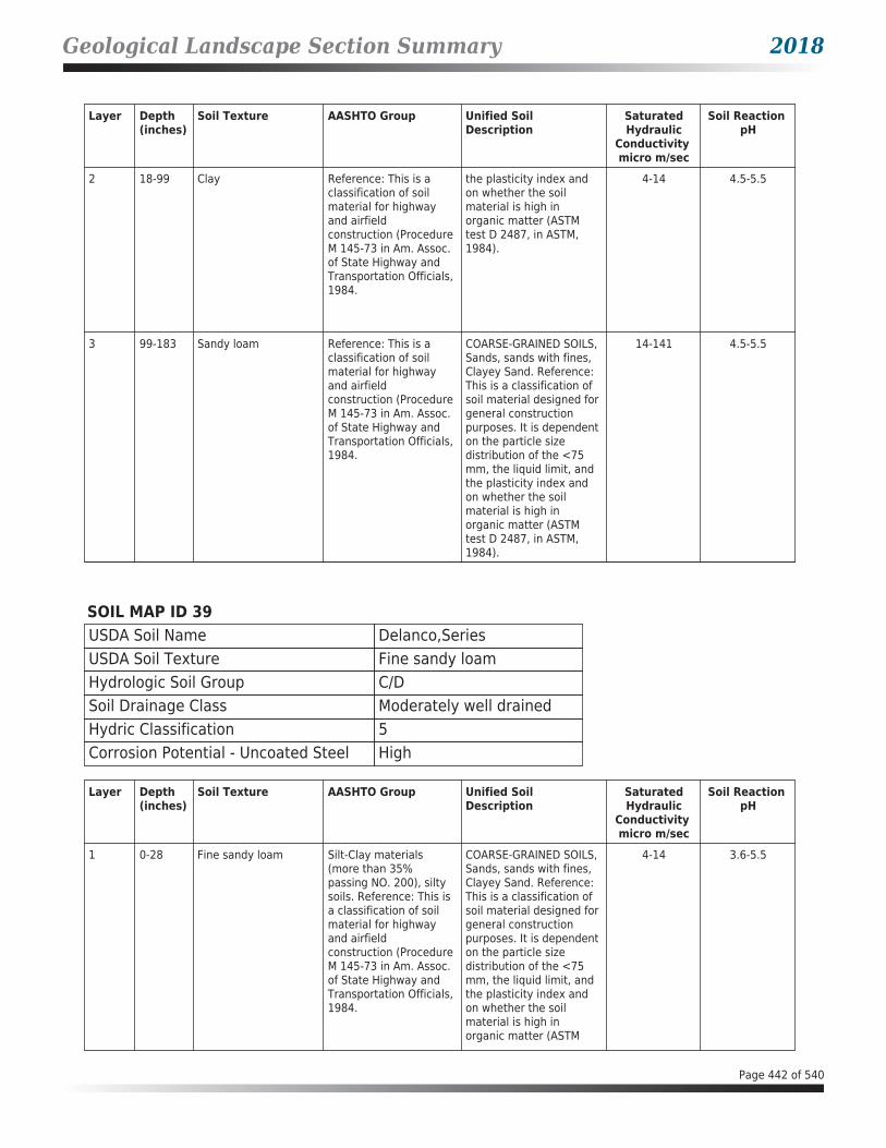
Geological Landscape Section Summary 2018
Layer Depth (inches)
Soil Texture AASHTO Group Unified Soil Description
SaturatedHydraulic
Conductivity micro m/sec
Soil Reaction pH
2 18-99 Clay Reference: This is a classification of soil material for highway and airfield construction (Procedure M 145-73 in Am. Assoc. of State Highway and Transportation Officials, 1984.
the plasticity index and on whether the soil material is high in organic matter (ASTM test D 2487, in ASTM, 1984).
4-14 4.5-5.5
3 99-183 Sandy loam Reference: This is a classification of soil material for highway and airfield construction (Procedure M 145-73 in Am. Assoc. of State Highway and Transportation Officials, 1984.
COARSE-GRAINED SOILS, Sands, sands with fines, Clayey Sand. Reference: This is a classification of soil material designed for general construction purposes. It is dependent on the particle size distribution of the <75 mm, the liquid limit, and the plasticity index and on whether the soil material is high in organic matter (ASTM test D 2487, in ASTM, 1984).
14-141 4.5-5.5
SOIL MAP ID 39USDA Soil Name Delanco,SeriesUSDA Soil Texture Fine sandy loamHydrologic Soil Group C/DSoil Drainage Class Moderately well drainedHydric Classification 5Corrosion Potential - Uncoated Steel High
Layer Depth (inches)
Soil Texture AASHTO Group Unified Soil Description
SaturatedHydraulic
Conductivity micro m/sec
Soil Reaction pH
1 0-28 Fine sandy loam Silt-Clay materials (more than 35% passing NO. 200), silty soils. Reference: This is a classification of soil material for highway and airfield construction (Procedure M 145-73 in Am. Assoc. of State Highway and Transportation Officials, 1984.
COARSE-GRAINED SOILS, Sands, sands with fines, Clayey Sand. Reference: This is a classification of soil material designed for general construction purposes. It is dependent on the particle size distribution of the <75 mm, the liquid limit, and the plasticity index and on whether the soil material is high in organic matter (ASTM
4-14 3.6-5.5
Page 442 of 540

Geological Landscape Section Summary 2018
Layer Depth (inches)
Soil Texture AASHTO Group Unified Soil Description
SaturatedHydraulic
Conductivity micro m/sec
Soil Reaction pH
1 0-28 Fine sandy loam Silt-Clay materials (more than 35% passing NO. 200), silty soils. Reference: This is a classification of soil material for highway and airfield construction (Procedure M 145-73 in Am. Assoc. of State Highway and Transportation Officials, 1984.
test D 2487, in ASTM, 1984).
4-14 3.6-5.5
2 28-114 Clay loam Silt-Clay materials (more than 35% passing No. 200) clayey soils. Reference: This is a classification of soil material for highway and airfield construction (Procedure M 145-73 in Am. Assoc. of State Highway and Transportation Officials, 1984.
FINE-GRAINED SOILS, Silts and clays (liquid limit is less than 50%), Lean Clay. Reference: This is a classification of soil material designed for general construction purposes. It is dependent on the particle size distribution of the <75 mm, the liquid limit, and the plasticity index and on whether the soil material is high in organic matter (ASTM test D 2487, in ASTM, 1984).
1.4-4 3.6-5.5
3 114-193 Sandy loam Reference: This is a classification of soil material for highway and airfield construction (Procedure M 145-73 in Am. Assoc. of State Highway and Transportation Officials, 1984.
COARSE-GRAINED SOILS, Sands, sands with fines, Clayey Sand. Reference: This is a classification of soil material designed for general construction purposes. It is dependent on the particle size distribution of the <75 mm, the liquid limit, and the plasticity index and on whether the soil material is high in organic matter (ASTM test D 2487, in ASTM, 1984).
4-14 3.6-5.5
Page 443 of 540

Geological Landscape Section Summary 2018
SOIL MAP ID 40USDA Soil Name Lunt,SeriesUSDA Soil Texture LoamHydrologic Soil Group BSoil Drainage Class Well drainedHydric Classification 0Corrosion Potential - Uncoated Steel Moderate
Layer Depth (inches)
Soil Texture AASHTO Group Unified Soil Description
SaturatedHydraulic
Conductivity micro m/sec
Soil Reaction pH
1 0-18 Loam Silt-Clay materials (more than 35% passing No. 200) clayey soils. Reference: This is a classification of soil material for highway and airfield construction (Procedure M 145-73 in Am. Assoc. of State Highway and Transportation Officials, 1984.
FINE-GRAINED SOILS, Silts and clays (liquid limit is less than 50%), Lean Clay. Reference: This is a classification of soil material designed for general construction purposes. It is dependent on the particle size distribution of the <75 mm, the liquid limit, and the plasticity index and on whether the soil material is high in organic matter (ASTM test D 2487, in ASTM, 1984).
4-42 4.5-5.5
2 18-99 Clay Reference: This is a classification of soil material for highway and airfield construction (Procedure M 145-73 in Am. Assoc. of State Highway and Transportation Officials, 1984.
FINE-GRAINED SOILS, Silts and clays (liquid limit is 50% or more), Fat Clay. Reference: This is a classification of soil material designed for general construction purposes. It is dependent on the particle size distribution of the <75 mm, the liquid limit, and the plasticity index and on whether the soil material is high in organic matter (ASTM test D 2487, in ASTM, 1984).
4-14 4.5-5.5
3 99-183 Sandy loam Reference: This is a classification of soil material for highway and airfield construction (Procedure M 145-73 in Am. Assoc. of State Highway and Transportation Officials, 1984.
COARSE-GRAINED SOILS, Sands, sands with fines, Clayey Sand. Reference: This is a classification of soil material designed for general construction purposes. It is dependent on the particle size distribution of the <75 mm, the liquid limit, and the plasticity index and on whether the soil material is high in organic matter (ASTM test D 2487, in ASTM,
14-141 4.5-5.5
Page 444 of 540

Geological Landscape Section Summary 2018
Layer Depth (inches)
Soil Texture AASHTO Group Unified Soil Description
SaturatedHydraulic
Conductivity micro m/sec
Soil Reaction pH
3 99-183 Sandy loam Reference: This is a classification of soil material for highway and airfield construction (Procedure M 145-73 in Am. Assoc. of State Highway and Transportation Officials, 1984.
1984). 14-141 4.5-5.5
SOIL MAP ID 41USDA Soil Name Quantico,SeriesUSDA Soil Texture LoamHydrologic Soil Group BSoil Drainage Class Well drainedHydric Classification 0Corrosion Potential - Uncoated Steel High
Layer Depth (inches)
Soil Texture AASHTO Group Unified Soil Description
SaturatedHydraulic
Conductivity micro m/sec
Soil Reaction pH
1 0-33 Loam Silt-Clay materials (more than 35% passing NO. 200), silty soils. Reference: This is a classification of soil material for highway and airfield construction (Procedure M 145-73 in Am. Assoc. of State Highway and Transportation Officials, 1984.
Reference: This is a classification of soil material designed for general construction purposes. It is dependent on the particle size distribution of the <75 mm, the liquid limit, and the plasticity index and on whether the soil material is high in organic matter (ASTM test D 2487, in ASTM, 1984).
14-42 4.5-5.5
2 33-46 Clay loam Silt-Clay materials (more than 35% passing No. 200) clayey soils. Reference: This is a classification of soil material for highway and airfield construction (Procedure M 145-73 in Am. Assoc. of State Highway and Transportation Officials, 1984.
FINE-GRAINED SOILS, Silts and clays (liquid limit is less than 50%), Lean Clay. Reference: This is a classification of soil material designed for general construction purposes. It is dependent on the particle size distribution of the <75 mm, the liquid limit, and the plasticity index and
4-14 4.5-5.5
Page 445 of 540

Geological Landscape Section Summary 2018
Layer Depth (inches)
Soil Texture AASHTO Group Unified Soil Description
SaturatedHydraulic
Conductivity micro m/sec
Soil Reaction pH
2 33-46 Clay loam Silt-Clay materials (more than 35% passing No. 200) clayey soils. Reference: This is a classification of soil material for highway and airfield construction (Procedure M 145-73 in Am. Assoc. of State Highway and Transportation Officials, 1984.
on whether the soil material is high in organic matter (ASTM test D 2487, in ASTM, 1984).
4-14 4.5-5.5
3 46-119 Clay Reference: This is a classification of soil material for highway and airfield construction (Procedure M 145-73 in Am. Assoc. of State Highway and Transportation Officials, 1984.
FINE-GRAINED SOILS, Silts and clays (liquid limit is 50% or more), Fat Clay. Reference: This is a classification of soil material designed for general construction purposes. It is dependent on the particle size distribution of the <75 mm, the liquid limit, and the plasticity index and on whether the soil material is high in organic matter (ASTM test D 2487, in ASTM, 1984).
4-14 4.5-5.5
4 119-183 Sandy clay Silt-Clay materials (more than 35% passing No. 200) clayey soils. Reference: This is a classification of soil material for highway and airfield construction (Procedure M 145-73 in Am. Assoc. of State Highway and Transportation Officials, 1984.
COARSE-GRAINED SOILS, Sands, sands with fines, Clayey Sand. Reference: This is a classification of soil material designed for general construction purposes. It is dependent on the particle size distribution of the <75 mm, the liquid limit, and the plasticity index and on whether the soil material is high in organic matter (ASTM test D 2487, in ASTM, 1984).
4-42 4.5-5.5
SOIL MAP ID 42USDA Soil Name Delanco,SeriesUSDA Soil Texture Fine sandy loamHydrologic Soil Group C/DSoil Drainage Class Moderately well drainedHydric Classification 5Corrosion Potential - Uncoated Steel High
Page 446 of 540

Geological Landscape Section Summary 2018
Layer Depth (inches)
Soil Texture AASHTO Group Unified Soil Description
SaturatedHydraulic
Conductivity micro m/sec
Soil Reaction pH
1 0-28 Fine sandy loam Silt-Clay materials (more than 35% passing NO. 200), silty soils. Reference: This is a classification of soil material for highway and airfield construction (Procedure M 145-73 in Am. Assoc. of State Highway and Transportation Officials, 1984.
COARSE-GRAINED SOILS, Sands, sands with fines, Clayey Sand. Reference: This is a classification of soil material designed for general construction purposes. It is dependent on the particle size distribution of the <75 mm, the liquid limit, and the plasticity index and on whether the soil material is high in organic matter (ASTM test D 2487, in ASTM, 1984).
4-14 3.6-5.5
2 28-114 Clay loam Silt-Clay materials (more than 35% passing No. 200) clayey soils. Reference: This is a classification of soil material for highway and airfield construction (Procedure M 145-73 in Am. Assoc. of State Highway and Transportation Officials, 1984.
FINE-GRAINED SOILS, Silts and clays (liquid limit is less than 50%), Lean Clay. Reference: This is a classification of soil material designed for general construction purposes. It is dependent on the particle size distribution of the <75 mm, the liquid limit, and the plasticity index and on whether the soil material is high in organic matter (ASTM test D 2487, in ASTM, 1984).
1.4-4 3.6-5.5
3 114-193 Sandy loam Reference: This is a classification of soil material for highway and airfield construction (Procedure M 145-73 in Am. Assoc. of State Highway and Transportation Officials, 1984.
COARSE-GRAINED SOILS, Sands, sands with fines, Clayey Sand. Reference: This is a classification of soil material designed for general construction purposes. It is dependent on the particle size distribution of the <75 mm, the liquid limit, and the plasticity index and on whether the soil material is high in organic matter (ASTM test D 2487, in ASTM, 1984).
4-14 3.6-5.5
Page 447 of 540

Geological Landscape Section Summary 2018
SOIL MAP ID 43USDA Soil Name Quantico,SeriesUSDA Soil Texture LoamHydrologic Soil Group BSoil Drainage Class Well drainedHydric Classification 0Corrosion Potential - Uncoated Steel High
Layer Depth (inches)
Soil Texture AASHTO Group Unified Soil Description
SaturatedHydraulic
Conductivity micro m/sec
Soil Reaction pH
1 0-33 Loam Silt-Clay materials (more than 35% passing NO. 200), silty soils. Reference: This is a classification of soil material for highway and airfield construction (Procedure M 145-73 in Am. Assoc. of State Highway and Transportation Officials, 1984.
Reference: This is a classification of soil material designed for general construction purposes. It is dependent on the particle size distribution of the <75 mm, the liquid limit, and the plasticity index and on whether the soil material is high in organic matter (ASTM test D 2487, in ASTM, 1984).
14-42 4.5-5.5
2 33-46 Clay loam Silt-Clay materials (more than 35% passing No. 200) clayey soils. Reference: This is a classification of soil material for highway and airfield construction (Procedure M 145-73 in Am. Assoc. of State Highway and Transportation Officials, 1984.
FINE-GRAINED SOILS, Silts and clays (liquid limit is less than 50%), Lean Clay. Reference: This is a classification of soil material designed for general construction purposes. It is dependent on the particle size distribution of the <75 mm, the liquid limit, and the plasticity index and on whether the soil material is high in organic matter (ASTM test D 2487, in ASTM, 1984).
4-14 4.5-5.5
3 46-119 Clay Reference: This is a classification of soil material for highway and airfield construction (Procedure M 145-73 in Am. Assoc. of State Highway and Transportation Officials, 1984.
FINE-GRAINED SOILS, Silts and clays (liquid limit is 50% or more), Fat Clay. Reference: This is a classification of soil material designed for general construction purposes. It is dependent on the particle size distribution of the <75 mm, the liquid limit, and the plasticity index and on whether the soil material is high in organic matter (ASTM test D 2487, in ASTM, 1984).
4-14 4.5-5.5
Page 448 of 540

Geological Landscape Section Summary 2018
Layer Depth (inches)
Soil Texture AASHTO Group Unified Soil Description
SaturatedHydraulic
Conductivity micro m/sec
Soil Reaction pH
4 119-183 Sandy clay Silt-Clay materials (more than 35% passing No. 200) clayey soils. Reference: This is a classification of soil material for highway and airfield construction (Procedure M 145-73 in Am. Assoc. of State Highway and Transportation Officials, 1984.
COARSE-GRAINED SOILS, Sands, sands with fines, Clayey Sand. Reference: This is a classification of soil material designed for general construction purposes. It is dependent on the particle size distribution of the <75 mm, the liquid limit, and the plasticity index and on whether the soil material is high in organic matter (ASTM test D 2487, in ASTM, 1984).
4-42 4.5-5.5
SOIL MAP ID 44USDA Soil Name Dumfries,SeriesUSDA Soil Texture Sandy loamHydrologic Soil Group ASoil Drainage Class Well drainedHydric Classification 0Corrosion Potential - Uncoated Steel Low
Layer Depth (inches)
Soil Texture AASHTO Group Unified Soil Description
SaturatedHydraulic
Conductivity micro m/sec
Soil Reaction pH
1 0-25 Sandy loam Silt-Clay materials (more than 35% passing NO. 200), silty soils. Reference: This is a classification of soil material for highway and airfield construction (Procedure M 145-73 in Am. Assoc. of State Highway and Transportation Officials, 1984.
COARSE-GRAINED SOILS, Sands, sands with fines, Clayey Sand. Reference: This is a classification of soil material designed for general construction purposes. It is dependent on the particle size distribution of the <75 mm, the liquid limit, and the plasticity index and on whether the soil material is high in organic matter (ASTM test D 2487, in ASTM, 1984).
14-42 4.5-5.5
2 25-74 Sandy clay loam Silt-Clay materials (more than 35% passing No. 200) clayey soils. Reference: This is a classification of soil material for highway and airfield construction (Procedure M 145-73 in Am. Assoc.
COARSE-GRAINED SOILS, Sands, sands with fines, Clayey Sand. Reference: This is a classification of soil material designed for general construction purposes. It is dependent on the particle size distribution of the <75
14-42 4.5-5.5
Page 449 of 540

Geological Landscape Section Summary 2018
Layer Depth (inches)
Soil Texture AASHTO Group Unified Soil Description
SaturatedHydraulic
Conductivity micro m/sec
Soil Reaction pH
2 25-74 Sandy clay loam of State Highway and Transportation Officials, 1984.
mm, the liquid limit, and the plasticity index and on whether the soil material is high in organic matter (ASTM test D 2487, in ASTM, 1984).
14-42 4.5-5.5
3 74-89 Sandy loam Reference: This is a classification of soil material for highway and airfield construction (Procedure M 145-73 in Am. Assoc. of State Highway and Transportation Officials, 1984.
COARSE-GRAINED SOILS, Sands, sands with fines, Clayey Sand. Reference: This is a classification of soil material designed for general construction purposes. It is dependent on the particle size distribution of the <75 mm, the liquid limit, and the plasticity index and on whether the soil material is high in organic matter (ASTM test D 2487, in ASTM, 1984).
14-42 4.5-5.5
4 89-183 Sandy loam Reference: This is a classification of soil material for highway and airfield construction (Procedure M 145-73 in Am. Assoc. of State Highway and Transportation Officials, 1984.
COARSE-GRAINED SOILS, Sands, sands with fines, Clayey Sand. Reference: This is a classification of soil material designed for general construction purposes. It is dependent on the particle size distribution of the <75 mm, the liquid limit, and the plasticity index and on whether the soil material is high in organic matter (ASTM test D 2487, in ASTM, 1984).
14-42 4.5-5.5
SOIL MAP ID 45USDA Soil Name Lunt,SeriesUSDA Soil Texture LoamHydrologic Soil Group BSoil Drainage Class Well drainedHydric Classification 0Corrosion Potential - Uncoated Steel Moderate
Page 450 of 540

Geological Landscape Section Summary 2018
Layer Depth (inches)
Soil Texture AASHTO Group Unified Soil Description
SaturatedHydraulic
Conductivity micro m/sec
Soil Reaction pH
1 0-18 Loam Silt-Clay materials (more than 35% passing No. 200) clayey soils. Reference: This is a classification of soil material for highway and airfield construction (Procedure M 145-73 in Am. Assoc. of State Highway and Transportation Officials, 1984.
FINE-GRAINED SOILS, Silts and clays (liquid limit is less than 50%), Lean Clay. Reference: This is a classification of soil material designed for general construction purposes. It is dependent on the particle size distribution of the <75 mm, the liquid limit, and the plasticity index and on whether the soil material is high in organic matter (ASTM test D 2487, in ASTM, 1984).
4-42 4.5-5.5
2 18-99 Clay Reference: This is a classification of soil material for highway and airfield construction (Procedure M 145-73 in Am. Assoc. of State Highway and Transportation Officials, 1984.
FINE-GRAINED SOILS, Silts and clays (liquid limit is 50% or more), Fat Clay. Reference: This is a classification of soil material designed for general construction purposes. It is dependent on the particle size distribution of the <75 mm, the liquid limit, and the plasticity index and on whether the soil material is high in organic matter (ASTM test D 2487, in ASTM, 1984).
4-14 4.5-5.5
3 99-183 Sandy loam Reference: This is a classification of soil material for highway and airfield construction (Procedure M 145-73 in Am. Assoc. of State Highway and Transportation Officials, 1984.
COARSE-GRAINED SOILS, Sands, sands with fines, Clayey Sand. Reference: This is a classification of soil material designed for general construction purposes. It is dependent on the particle size distribution of the <75 mm, the liquid limit, and the plasticity index and on whether the soil material is high in organic matter (ASTM test D 2487, in ASTM, 1984).
14-141 4.5-5.5
Page 451 of 540

Geological Landscape Section Summary 2018
SOIL MAP ID 46USDA Soil Name Dumfries,SeriesUSDA Soil Texture Sandy loamHydrologic Soil Group ASoil Drainage Class Well drainedHydric Classification 0Corrosion Potential - Uncoated Steel Low
Layer Depth (inches)
Soil Texture AASHTO Group Unified Soil Description
SaturatedHydraulic
Conductivity micro m/sec
Soil Reaction pH
1 0-25 Sandy loam Silt-Clay materials (more than 35% passing NO. 200), silty soils. Reference: This is a classification of soil material for highway and airfield construction (Procedure M 145-73 in Am. Assoc. of State Highway and Transportation Officials, 1984.
COARSE-GRAINED SOILS, Sands, sands with fines, Clayey Sand. Reference: This is a classification of soil material designed for general construction purposes. It is dependent on the particle size distribution of the <75 mm, the liquid limit, and the plasticity index and on whether the soil material is high in organic matter (ASTM test D 2487, in ASTM, 1984).
14-42 4.5-5.5
2 25-74 Sandy clay loam Silt-Clay materials (more than 35% passing No. 200) clayey soils. Reference: This is a classification of soil material for highway and airfield construction (Procedure M 145-73 in Am. Assoc. of State Highway and Transportation Officials, 1984.
COARSE-GRAINED SOILS, Sands, sands with fines, Clayey Sand. Reference: This is a classification of soil material designed for general construction purposes. It is dependent on the particle size distribution of the <75 mm, the liquid limit, and the plasticity index and on whether the soil material is high in organic matter (ASTM test D 2487, in ASTM, 1984).
14-42 4.5-5.5
3 74-89 Sandy loam Reference: This is a classification of soil material for highway and airfield construction (Procedure M 145-73 in Am. Assoc. of State Highway and Transportation Officials, 1984.
COARSE-GRAINED SOILS, Sands, sands with fines, Clayey Sand. Reference: This is a classification of soil material designed for general construction purposes. It is dependent on the particle size distribution of the <75 mm, the liquid limit, and the plasticity index and on whether the soil material is high in organic matter (ASTM test D 2487, in ASTM, 1984).
14-42 4.5-5.5
Page 452 of 540

Geological Landscape Section Summary 2018
Layer Depth (inches)
Soil Texture AASHTO Group Unified Soil Description
SaturatedHydraulic
Conductivity micro m/sec
Soil Reaction pH
4 89-183 Sandy loam Reference: This is a classification of soil material for highway and airfield construction (Procedure M 145-73 in Am. Assoc. of State Highway and Transportation Officials, 1984.
COARSE-GRAINED SOILS, Sands, sands with fines, Clayey Sand. Reference: This is a classification of soil material designed for general construction purposes. It is dependent on the particle size distribution of the <75 mm, the liquid limit, and the plasticity index and on whether the soil material is high in organic matter (ASTM test D 2487, in ASTM, 1984).
14-42 4.5-5.5
SOIL MAP ID 47USDA Soil Name Dumfries,SeriesUSDA Soil Texture Sandy loamHydrologic Soil Group ASoil Drainage Class Well drainedHydric Classification 0Corrosion Potential - Uncoated Steel Low
Layer Depth (inches)
Soil Texture AASHTO Group Unified Soil Description
SaturatedHydraulic
Conductivity micro m/sec
Soil Reaction pH
1 0-25 Sandy loam Silt-Clay materials (more than 35% passing NO. 200), silty soils. Reference: This is a classification of soil material for highway and airfield construction (Procedure M 145-73 in Am. Assoc. of State Highway and Transportation Officials, 1984.
COARSE-GRAINED SOILS, Sands, sands with fines, Clayey Sand. Reference: This is a classification of soil material designed for general construction purposes. It is dependent on the particle size distribution of the <75 mm, the liquid limit, and the plasticity index and on whether the soil material is high in organic matter (ASTM test D 2487, in ASTM, 1984).
14-42 4.5-5.5
2 25-74 Sandy clay loam Silt-Clay materials (more than 35% passing No. 200) clayey soils. Reference: This is a classification of soil material for highway and airfield construction (Procedure M 145-73 in Am. Assoc.
COARSE-GRAINED SOILS, Sands, sands with fines, Clayey Sand. Reference: This is a classification of soil material designed for general construction purposes. It is dependent on the particle size distribution of the <75
14-42 4.5-5.5
Page 453 of 540

Geological Landscape Section Summary 2018
Layer Depth (inches)
Soil Texture AASHTO Group Unified Soil Description
SaturatedHydraulic
Conductivity micro m/sec
Soil Reaction pH
2 25-74 Sandy clay loam of State Highway and Transportation Officials, 1984.
mm, the liquid limit, and the plasticity index and on whether the soil material is high in organic matter (ASTM test D 2487, in ASTM, 1984).
14-42 4.5-5.5
3 74-89 Sandy loam Reference: This is a classification of soil material for highway and airfield construction (Procedure M 145-73 in Am. Assoc. of State Highway and Transportation Officials, 1984.
COARSE-GRAINED SOILS, Sands, sands with fines, Clayey Sand. Reference: This is a classification of soil material designed for general construction purposes. It is dependent on the particle size distribution of the <75 mm, the liquid limit, and the plasticity index and on whether the soil material is high in organic matter (ASTM test D 2487, in ASTM, 1984).
14-42 4.5-5.5
4 89-183 Sandy loam Reference: This is a classification of soil material for highway and airfield construction (Procedure M 145-73 in Am. Assoc. of State Highway and Transportation Officials, 1984.
COARSE-GRAINED SOILS, Sands, sands with fines, Clayey Sand. Reference: This is a classification of soil material designed for general construction purposes. It is dependent on the particle size distribution of the <75 mm, the liquid limit, and the plasticity index and on whether the soil material is high in organic matter (ASTM test D 2487, in ASTM, 1984).
14-42 4.5-5.5
SOIL MAP ID 48USDA Soil Name Lunt,SeriesUSDA Soil Texture LoamHydrologic Soil Group BSoil Drainage Class Well drainedHydric Classification 0Corrosion Potential - Uncoated Steel Moderate
Page 454 of 540

Geological Landscape Section Summary 2018
Layer Depth (inches)
Soil Texture AASHTO Group Unified Soil Description
SaturatedHydraulic
Conductivity micro m/sec
Soil Reaction pH
1 0-18 Loam Silt-Clay materials (more than 35% passing No. 200) clayey soils. Reference: This is a classification of soil material for highway and airfield construction (Procedure M 145-73 in Am. Assoc. of State Highway and Transportation Officials, 1984.
FINE-GRAINED SOILS, Silts and clays (liquid limit is less than 50%), Lean Clay. Reference: This is a classification of soil material designed for general construction purposes. It is dependent on the particle size distribution of the <75 mm, the liquid limit, and the plasticity index and on whether the soil material is high in organic matter (ASTM test D 2487, in ASTM, 1984).
4-42 4.5-5.5
2 18-99 Clay Reference: This is a classification of soil material for highway and airfield construction (Procedure M 145-73 in Am. Assoc. of State Highway and Transportation Officials, 1984.
FINE-GRAINED SOILS, Silts and clays (liquid limit is 50% or more), Fat Clay. Reference: This is a classification of soil material designed for general construction purposes. It is dependent on the particle size distribution of the <75 mm, the liquid limit, and the plasticity index and on whether the soil material is high in organic matter (ASTM test D 2487, in ASTM, 1984).
4-14 4.5-5.5
3 99-183 Sandy loam Reference: This is a classification of soil material for highway and airfield construction (Procedure M 145-73 in Am. Assoc. of State Highway and Transportation Officials, 1984.
COARSE-GRAINED SOILS, Sands, sands with fines, Clayey Sand. Reference: This is a classification of soil material designed for general construction purposes. It is dependent on the particle size distribution of the <75 mm, the liquid limit, and the plasticity index and on whether the soil material is high in organic matter (ASTM test D 2487, in ASTM, 1984).
14-141 4.5-5.5
Page 455 of 540

Geological Landscape Section Summary 2018
SOIL MAP ID 49USDA Soil Name Lunt,SeriesUSDA Soil Texture LoamHydrologic Soil Group BSoil Drainage Class Well drainedHydric Classification 0Corrosion Potential - Uncoated Steel Moderate
Layer Depth (inches)
Soil Texture AASHTO Group Unified Soil Description
SaturatedHydraulic
Conductivity micro m/sec
Soil Reaction pH
1 0-18 Loam Silt-Clay materials (more than 35% passing No. 200) clayey soils. Reference: This is a classification of soil material for highway and airfield construction (Procedure M 145-73 in Am. Assoc. of State Highway and Transportation Officials, 1984.
FINE-GRAINED SOILS, Silts and clays (liquid limit is less than 50%), Lean Clay. Reference: This is a classification of soil material designed for general construction purposes. It is dependent on the particle size distribution of the <75 mm, the liquid limit, and the plasticity index and on whether the soil material is high in organic matter (ASTM test D 2487, in ASTM, 1984).
4-42 4.5-5.5
2 18-99 Clay Reference: This is a classification of soil material for highway and airfield construction (Procedure M 145-73 in Am. Assoc. of State Highway and Transportation Officials, 1984.
FINE-GRAINED SOILS, Silts and clays (liquid limit is 50% or more), Fat Clay. Reference: This is a classification of soil material designed for general construction purposes. It is dependent on the particle size distribution of the <75 mm, the liquid limit, and the plasticity index and on whether the soil material is high in organic matter (ASTM test D 2487, in ASTM, 1984).
4-14 4.5-5.5
3 99-183 Sandy loam Reference: This is a classification of soil material for highway and airfield construction (Procedure M 145-73 in Am. Assoc. of State Highway and Transportation Officials, 1984.
COARSE-GRAINED SOILS, Sands, sands with fines, Clayey Sand. Reference: This is a classification of soil material designed for general construction purposes. It is dependent on the particle size distribution of the <75 mm, the liquid limit, and the plasticity index and on whether the soil material is high in organic matter (ASTM test D 2487, in ASTM,
14-141 4.5-5.5
Page 456 of 540

Geological Landscape Section Summary 2018
Layer Depth (inches)
Soil Texture AASHTO Group Unified Soil Description
SaturatedHydraulic
Conductivity micro m/sec
Soil Reaction pH
3 99-183 Sandy loam Reference: This is a classification of soil material for highway and airfield construction (Procedure M 145-73 in Am. Assoc. of State Highway and Transportation Officials, 1984.
1984). 14-141 4.5-5.5
SOIL MAP ID 50USDA Soil Name Marr,SeriesUSDA Soil Texture Very fine sandy loamHydrologic Soil Group BSoil Drainage Class Well drainedHydric Classification 0Corrosion Potential - Uncoated Steel Moderate
Layer Depth (inches)
Soil Texture AASHTO Group Unified Soil Description
SaturatedHydraulic
Conductivity micro m/sec
Soil Reaction pH
1 0-33 Very fine sandy loam Silt-Clay materials (more than 35% passing NO. 200), silty soils. Reference: This is a classification of soil material for highway and airfield construction (Procedure M 145-73 in Am. Assoc. of State Highway and Transportation Officials, 1984.
FINE-GRAINED SOILS, Silts and clays (liquid limit is less than 50%), Lean Clay. Reference: This is a classification of soil material designed for general construction purposes. It is dependent on the particle size distribution of the <75 mm, the liquid limit, and the plasticity index and on whether the soil material is high in organic matter (ASTM test D 2487, in ASTM, 1984).
14-42 5.1-5.5
2 33-135 Sandy clay loam Silt-Clay materials (more than 35% passing No. 200) clayey soils. Reference: This is a classification of soil material for highway and airfield construction (Procedure M 145-73 in Am. Assoc.
FINE-GRAINED SOILS, Silts and clays (liquid limit is less than 50%), Lean Clay. Reference: This is a classification of soil material designed for general construction purposes. It is dependent on the particle size
4-14 4.5-5.5
Page 457 of 540

Geological Landscape Section Summary 2018
Layer Depth (inches)
Soil Texture AASHTO Group Unified Soil Description
SaturatedHydraulic
Conductivity micro m/sec
Soil Reaction pH
2 33-135 Sandy clay loam of State Highway and Transportation Officials, 1984.
distribution of the <75 mm, the liquid limit, and the plasticity index and on whether the soil material is high in organic matter (ASTM test D 2487, in ASTM, 1984).
4-14 4.5-5.5
3 135-183 Sandy loam Reference: This is a classification of soil material for highway and airfield construction (Procedure M 145-73 in Am. Assoc. of State Highway and Transportation Officials, 1984.
COARSE-GRAINED SOILS, Sands, Sands with fines, Silty Sand. Reference: This is a classification of soil material designed for general construction purposes. It is dependent on the particle size distribution of the <75 mm, the liquid limit, and the plasticity index and on whether the soil material is high in organic matter (ASTM test D 2487, in ASTM, 1984).
14-42 4.5-5.5
SOIL MAP ID 51USDA Soil Name Dumfries,SeriesUSDA Soil Texture Sandy loamHydrologic Soil Group ASoil Drainage Class Well drainedHydric Classification 0Corrosion Potential - Uncoated Steel Low
Layer Depth (inches)
Soil Texture AASHTO Group Unified Soil Description
SaturatedHydraulic
Conductivity micro m/sec
Soil Reaction pH
1 0-25 Sandy loam Silt-Clay materials (more than 35% passing NO. 200), silty soils. Reference: This is a classification of soil material for highway and airfield construction (Procedure M 145-73 in Am. Assoc. of State Highway and Transportation Officials, 1984.
COARSE-GRAINED SOILS, Sands, sands with fines, Clayey Sand. Reference: This is a classification of soil material designed for general construction purposes. It is dependent on the particle size distribution of the <75 mm, the liquid limit, and the plasticity index and on whether the soil material is high in organic matter (ASTM test D 2487, in ASTM, 1984).
14-42 4.5-5.5
Page 458 of 540

Geological Landscape Section Summary 2018
Layer Depth (inches)
Soil Texture AASHTO Group Unified Soil Description
SaturatedHydraulic
Conductivity micro m/sec
Soil Reaction pH
2 25-74 Sandy clay loam Silt-Clay materials (more than 35% passing No. 200) clayey soils. Reference: This is a classification of soil material for highway and airfield construction (Procedure M 145-73 in Am. Assoc. of State Highway and Transportation Officials, 1984.
COARSE-GRAINED SOILS, Sands, sands with fines, Clayey Sand. Reference: This is a classification of soil material designed for general construction purposes. It is dependent on the particle size distribution of the <75 mm, the liquid limit, and the plasticity index and on whether the soil material is high in organic matter (ASTM test D 2487, in ASTM, 1984).
14-42 4.5-5.5
3 74-89 Sandy loam Reference: This is a classification of soil material for highway and airfield construction (Procedure M 145-73 in Am. Assoc. of State Highway and Transportation Officials, 1984.
COARSE-GRAINED SOILS, Sands, sands with fines, Clayey Sand. Reference: This is a classification of soil material designed for general construction purposes. It is dependent on the particle size distribution of the <75 mm, the liquid limit, and the plasticity index and on whether the soil material is high in organic matter (ASTM test D 2487, in ASTM, 1984).
14-42 4.5-5.5
4 89-183 Sandy loam Reference: This is a classification of soil material for highway and airfield construction (Procedure M 145-73 in Am. Assoc. of State Highway and Transportation Officials, 1984.
COARSE-GRAINED SOILS, Sands, sands with fines, Clayey Sand. Reference: This is a classification of soil material designed for general construction purposes. It is dependent on the particle size distribution of the <75 mm, the liquid limit, and the plasticity index and on whether the soil material is high in organic matter (ASTM test D 2487, in ASTM, 1984).
14-42 4.5-5.5
Page 459 of 540

Geological Landscape Section Summary 2018
SOIL MAP ID 52USDA Soil Name Dumfries,SeriesUSDA Soil Texture Sandy loamHydrologic Soil Group ASoil Drainage Class Well drainedHydric Classification 0Corrosion Potential - Uncoated Steel Low
Layer Depth (inches)
Soil Texture AASHTO Group Unified Soil Description
SaturatedHydraulic
Conductivity micro m/sec
Soil Reaction pH
1 0-25 Sandy loam Silt-Clay materials (more than 35% passing NO. 200), silty soils. Reference: This is a classification of soil material for highway and airfield construction (Procedure M 145-73 in Am. Assoc. of State Highway and Transportation Officials, 1984.
COARSE-GRAINED SOILS, Sands, sands with fines, Clayey Sand. Reference: This is a classification of soil material designed for general construction purposes. It is dependent on the particle size distribution of the <75 mm, the liquid limit, and the plasticity index and on whether the soil material is high in organic matter (ASTM test D 2487, in ASTM, 1984).
14-42 4.5-5.5
2 25-74 Sandy clay loam Silt-Clay materials (more than 35% passing No. 200) clayey soils. Reference: This is a classification of soil material for highway and airfield construction (Procedure M 145-73 in Am. Assoc. of State Highway and Transportation Officials, 1984.
COARSE-GRAINED SOILS, Sands, sands with fines, Clayey Sand. Reference: This is a classification of soil material designed for general construction purposes. It is dependent on the particle size distribution of the <75 mm, the liquid limit, and the plasticity index and on whether the soil material is high in organic matter (ASTM test D 2487, in ASTM, 1984).
14-42 4.5-5.5
3 74-89 Sandy loam Reference: This is a classification of soil material for highway and airfield construction (Procedure M 145-73 in Am. Assoc. of State Highway and Transportation Officials, 1984.
COARSE-GRAINED SOILS, Sands, sands with fines, Clayey Sand. Reference: This is a classification of soil material designed for general construction purposes. It is dependent on the particle size distribution of the <75 mm, the liquid limit, and the plasticity index and on whether the soil material is high in organic matter (ASTM test D 2487, in ASTM, 1984).
14-42 4.5-5.5
Page 460 of 540

Geological Landscape Section Summary 2018
Layer Depth (inches)
Soil Texture AASHTO Group Unified Soil Description
SaturatedHydraulic
Conductivity micro m/sec
Soil Reaction pH
4 89-183 Sandy loam Reference: This is a classification of soil material for highway and airfield construction (Procedure M 145-73 in Am. Assoc. of State Highway and Transportation Officials, 1984.
COARSE-GRAINED SOILS, Sands, sands with fines, Clayey Sand. Reference: This is a classification of soil material designed for general construction purposes. It is dependent on the particle size distribution of the <75 mm, the liquid limit, and the plasticity index and on whether the soil material is high in organic matter (ASTM test D 2487, in ASTM, 1984).
14-42 4.5-5.5
SOIL MAP ID 53USDA Soil Name Delanco,SeriesUSDA Soil Texture Fine sandy loamHydrologic Soil Group C/DSoil Drainage Class Moderately well drainedHydric Classification 5Corrosion Potential - Uncoated Steel High
Layer Depth (inches)
Soil Texture AASHTO Group Unified Soil Description
SaturatedHydraulic
Conductivity micro m/sec
Soil Reaction pH
1 0-28 Fine sandy loam Silt-Clay materials (more than 35% passing NO. 200), silty soils. Reference: This is a classification of soil material for highway and airfield construction (Procedure M 145-73 in Am. Assoc. of State Highway and Transportation Officials, 1984.
COARSE-GRAINED SOILS, Sands, sands with fines, Clayey Sand. Reference: This is a classification of soil material designed for general construction purposes. It is dependent on the particle size distribution of the <75 mm, the liquid limit, and the plasticity index and on whether the soil material is high in organic matter (ASTM test D 2487, in ASTM, 1984).
4-14 3.6-5.5
2 28-114 Clay loam Silt-Clay materials (more than 35% passing No. 200) clayey soils. Reference: This is a classification of soil material for highway and airfield construction (Procedure M 145-73 in Am. Assoc.
FINE-GRAINED SOILS, Silts and clays (liquid limit is less than 50%), Lean Clay. Reference: This is a classification of soil material designed for general construction purposes. It is dependent on the particle size
1.4-4 3.6-5.5
Page 461 of 540

Geological Landscape Section Summary 2018
Layer Depth (inches)
Soil Texture AASHTO Group Unified Soil Description
SaturatedHydraulic
Conductivity micro m/sec
Soil Reaction pH
2 28-114 Clay loam of State Highway and Transportation Officials, 1984.
distribution of the <75 mm, the liquid limit, and the plasticity index and on whether the soil material is high in organic matter (ASTM test D 2487, in ASTM, 1984).
1.4-4 3.6-5.5
3 114-193 Sandy loam Reference: This is a classification of soil material for highway and airfield construction (Procedure M 145-73 in Am. Assoc. of State Highway and Transportation Officials, 1984.
COARSE-GRAINED SOILS, Sands, sands with fines, Clayey Sand. Reference: This is a classification of soil material designed for general construction purposes. It is dependent on the particle size distribution of the <75 mm, the liquid limit, and the plasticity index and on whether the soil material is high in organic matter (ASTM test D 2487, in ASTM, 1984).
4-14 3.6-5.5
SOIL MAP ID 54USDA Soil Name Dumfries,SeriesUSDA Soil Texture Sandy loamHydrologic Soil Group ASoil Drainage Class Well drainedHydric Classification 0Corrosion Potential - Uncoated Steel Low
Layer Depth (inches)
Soil Texture AASHTO Group Unified Soil Description
SaturatedHydraulic
Conductivity micro m/sec
Soil Reaction pH
1 0-25 Sandy loam Silt-Clay materials (more than 35% passing NO. 200), silty soils. Reference: This is a classification of soil material for highway and airfield construction (Procedure M 145-73 in Am. Assoc. of State Highway and Transportation Officials, 1984.
COARSE-GRAINED SOILS, Sands, sands with fines, Clayey Sand. Reference: This is a classification of soil material designed for general construction purposes. It is dependent on the particle size distribution of the <75 mm, the liquid limit, and the plasticity index and on whether the soil material is high in organic matter (ASTM test D 2487, in ASTM,
14-42 4.5-5.5
Page 462 of 540
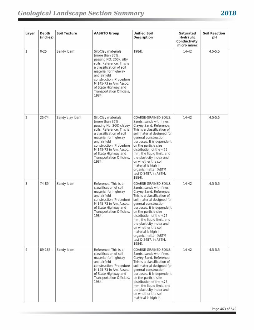
Geological Landscape Section Summary 2018
Layer Depth (inches)
Soil Texture AASHTO Group Unified Soil Description
SaturatedHydraulic
Conductivity micro m/sec
Soil Reaction pH
1 0-25 Sandy loam Silt-Clay materials (more than 35% passing NO. 200), silty soils. Reference: This is a classification of soil material for highway and airfield construction (Procedure M 145-73 in Am. Assoc. of State Highway and Transportation Officials, 1984.
1984). 14-42 4.5-5.5
2 25-74 Sandy clay loam Silt-Clay materials (more than 35% passing No. 200) clayey soils. Reference: This is a classification of soil material for highway and airfield construction (Procedure M 145-73 in Am. Assoc. of State Highway and Transportation Officials, 1984.
COARSE-GRAINED SOILS, Sands, sands with fines, Clayey Sand. Reference: This is a classification of soil material designed for general construction purposes. It is dependent on the particle size distribution of the <75 mm, the liquid limit, and the plasticity index and on whether the soil material is high in organic matter (ASTM test D 2487, in ASTM, 1984).
14-42 4.5-5.5
3 74-89 Sandy loam Reference: This is a classification of soil material for highway and airfield construction (Procedure M 145-73 in Am. Assoc. of State Highway and Transportation Officials, 1984.
COARSE-GRAINED SOILS, Sands, sands with fines, Clayey Sand. Reference: This is a classification of soil material designed for general construction purposes. It is dependent on the particle size distribution of the <75 mm, the liquid limit, and the plasticity index and on whether the soil material is high in organic matter (ASTM test D 2487, in ASTM, 1984).
14-42 4.5-5.5
4 89-183 Sandy loam Reference: This is a classification of soil material for highway and airfield construction (Procedure M 145-73 in Am. Assoc. of State Highway and Transportation Officials, 1984.
COARSE-GRAINED SOILS, Sands, sands with fines, Clayey Sand. Reference: This is a classification of soil material designed for general construction purposes. It is dependent on the particle size distribution of the <75 mm, the liquid limit, and the plasticity index and on whether the soil material is high in
14-42 4.5-5.5
Page 463 of 540

Geological Landscape Section Summary 2018
Layer Depth (inches)
Soil Texture AASHTO Group Unified Soil Description
SaturatedHydraulic
Conductivity micro m/sec
Soil Reaction pH
4 89-183 Sandy loam Reference: This is a classification of soil material for highway and airfield construction (Procedure M 145-73 in Am. Assoc. of State Highway and Transportation Officials, 1984.
organic matter (ASTM test D 2487, in ASTM, 1984).
14-42 4.5-5.5
SOIL MAP ID 55USDA Soil Name Dumfries,SeriesUSDA Soil Texture Sandy loamHydrologic Soil Group ASoil Drainage Class Well drainedHydric Classification 0Corrosion Potential - Uncoated Steel Low
Layer Depth (inches)
Soil Texture AASHTO Group Unified Soil Description
SaturatedHydraulic
Conductivity micro m/sec
Soil Reaction pH
1 0-25 Sandy loam Silt-Clay materials (more than 35% passing NO. 200), silty soils. Reference: This is a classification of soil material for highway and airfield construction (Procedure M 145-73 in Am. Assoc. of State Highway and Transportation Officials, 1984.
COARSE-GRAINED SOILS, Sands, sands with fines, Clayey Sand. Reference: This is a classification of soil material designed for general construction purposes. It is dependent on the particle size distribution of the <75 mm, the liquid limit, and the plasticity index and on whether the soil material is high in organic matter (ASTM test D 2487, in ASTM, 1984).
14-42 4.5-5.5
2 25-74 Sandy clay loam Silt-Clay materials (more than 35% passing No. 200) clayey soils. Reference: This is a classification of soil material for highway and airfield construction (Procedure M 145-73 in Am. Assoc. of State Highway and Transportation Officials, 1984.
COARSE-GRAINED SOILS, Sands, sands with fines, Clayey Sand. Reference: This is a classification of soil material designed for general construction purposes. It is dependent on the particle size distribution of the <75 mm, the liquid limit, and the plasticity index and on whether the soil
14-42 4.5-5.5
Page 464 of 540
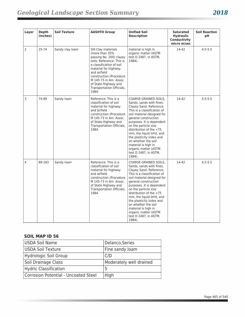
Geological Landscape Section Summary 2018
Layer Depth (inches)
Soil Texture AASHTO Group Unified Soil Description
SaturatedHydraulic
Conductivity micro m/sec
Soil Reaction pH
2 25-74 Sandy clay loam Silt-Clay materials (more than 35% passing No. 200) clayey soils. Reference: This is a classification of soil material for highway and airfield construction (Procedure M 145-73 in Am. Assoc. of State Highway and Transportation Officials, 1984.
material is high in organic matter (ASTM test D 2487, in ASTM, 1984).
14-42 4.5-5.5
3 74-89 Sandy loam Reference: This is a classification of soil material for highway and airfield construction (Procedure M 145-73 in Am. Assoc. of State Highway and Transportation Officials, 1984.
COARSE-GRAINED SOILS, Sands, sands with fines, Clayey Sand. Reference: This is a classification of soil material designed for general construction purposes. It is dependent on the particle size distribution of the <75 mm, the liquid limit, and the plasticity index and on whether the soil material is high in organic matter (ASTM test D 2487, in ASTM, 1984).
14-42 4.5-5.5
4 89-183 Sandy loam Reference: This is a classification of soil material for highway and airfield construction (Procedure M 145-73 in Am. Assoc. of State Highway and Transportation Officials, 1984.
COARSE-GRAINED SOILS, Sands, sands with fines, Clayey Sand. Reference: This is a classification of soil material designed for general construction purposes. It is dependent on the particle size distribution of the <75 mm, the liquid limit, and the plasticity index and on whether the soil material is high in organic matter (ASTM test D 2487, in ASTM, 1984).
14-42 4.5-5.5
SOIL MAP ID 56USDA Soil Name Delanco,SeriesUSDA Soil Texture Fine sandy loamHydrologic Soil Group C/DSoil Drainage Class Moderately well drainedHydric Classification 5Corrosion Potential - Uncoated Steel High
Page 465 of 540

Geological Landscape Section Summary 2018
Layer Depth (inches)
Soil Texture AASHTO Group Unified Soil Description
SaturatedHydraulic
Conductivity micro m/sec
Soil Reaction pH
1 0-28 Fine sandy loam Silt-Clay materials (more than 35% passing NO. 200), silty soils. Reference: This is a classification of soil material for highway and airfield construction (Procedure M 145-73 in Am. Assoc. of State Highway and Transportation Officials, 1984.
COARSE-GRAINED SOILS, Sands, sands with fines, Clayey Sand. Reference: This is a classification of soil material designed for general construction purposes. It is dependent on the particle size distribution of the <75 mm, the liquid limit, and the plasticity index and on whether the soil material is high in organic matter (ASTM test D 2487, in ASTM, 1984).
4-14 3.6-5.5
2 28-114 Clay loam Silt-Clay materials (more than 35% passing No. 200) clayey soils. Reference: This is a classification of soil material for highway and airfield construction (Procedure M 145-73 in Am. Assoc. of State Highway and Transportation Officials, 1984.
FINE-GRAINED SOILS, Silts and clays (liquid limit is less than 50%), Lean Clay. Reference: This is a classification of soil material designed for general construction purposes. It is dependent on the particle size distribution of the <75 mm, the liquid limit, and the plasticity index and on whether the soil material is high in organic matter (ASTM test D 2487, in ASTM, 1984).
1.4-4 3.6-5.5
3 114-193 Sandy loam Reference: This is a classification of soil material for highway and airfield construction (Procedure M 145-73 in Am. Assoc. of State Highway and Transportation Officials, 1984.
COARSE-GRAINED SOILS, Sands, sands with fines, Clayey Sand. Reference: This is a classification of soil material designed for general construction purposes. It is dependent on the particle size distribution of the <75 mm, the liquid limit, and the plasticity index and on whether the soil material is high in organic matter (ASTM test D 2487, in ASTM, 1984).
4-14 3.6-5.5
Page 466 of 540


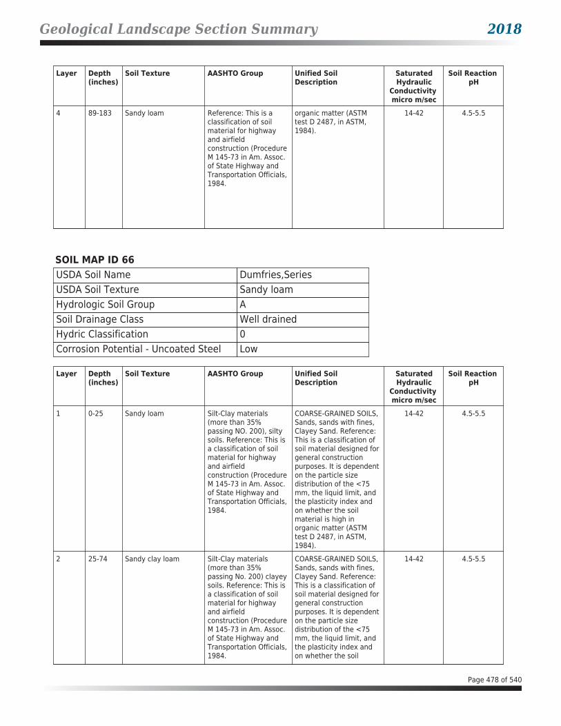


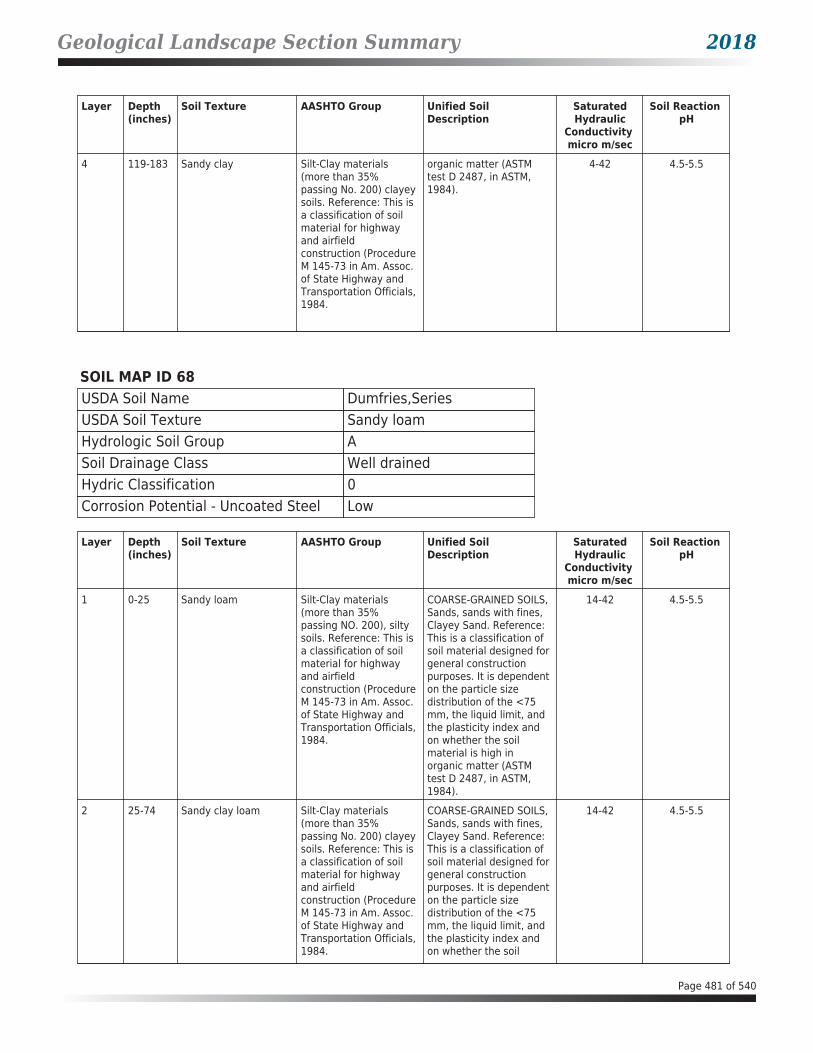


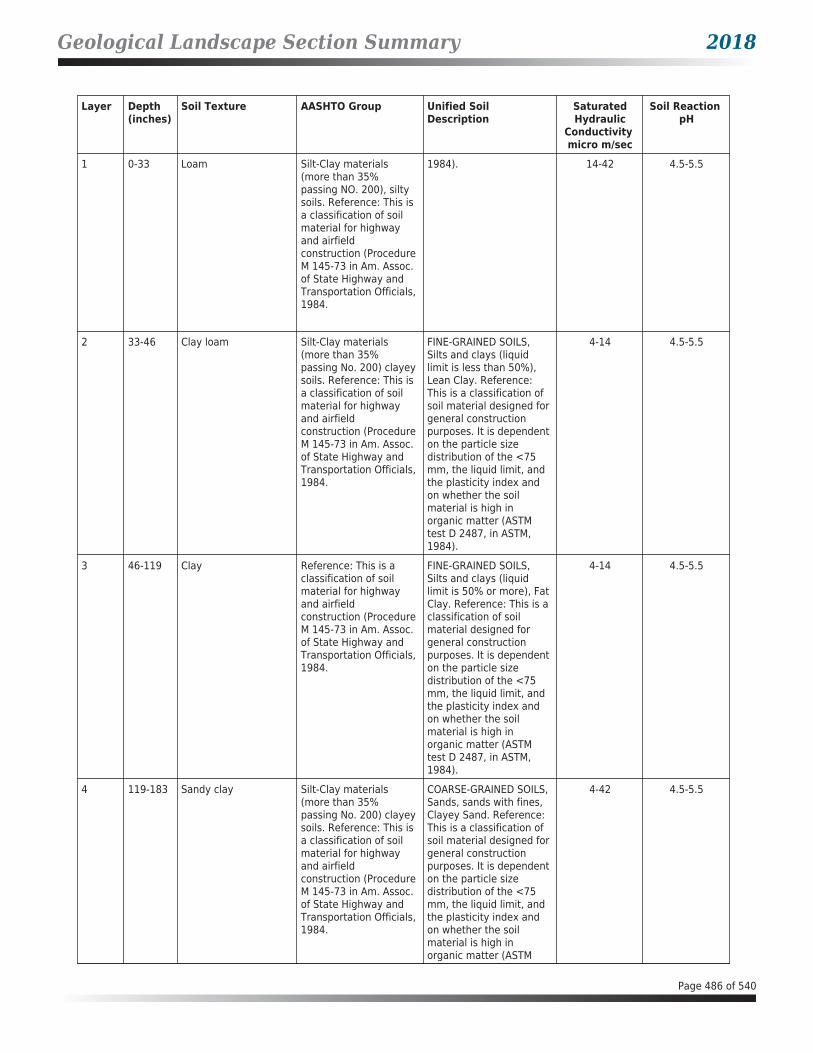


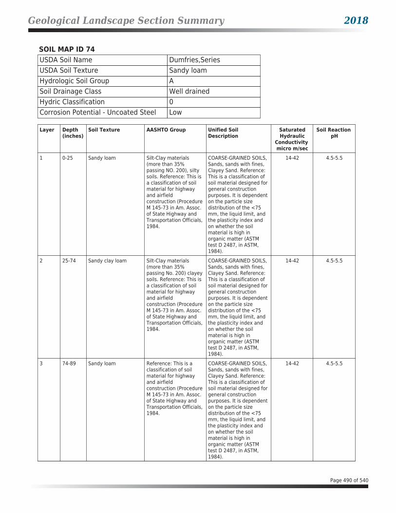
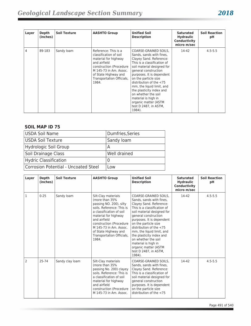

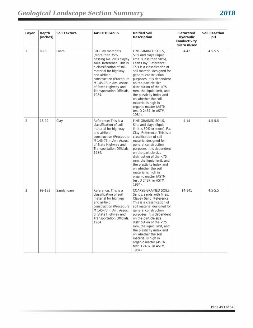


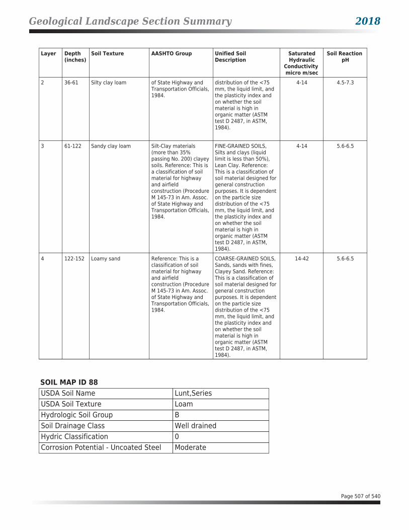


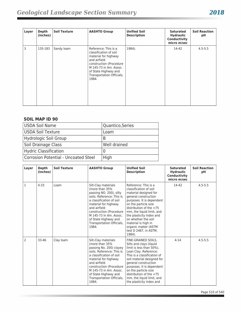


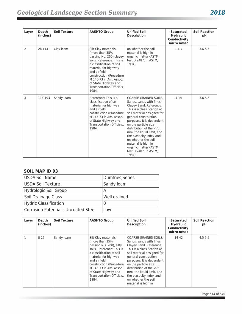


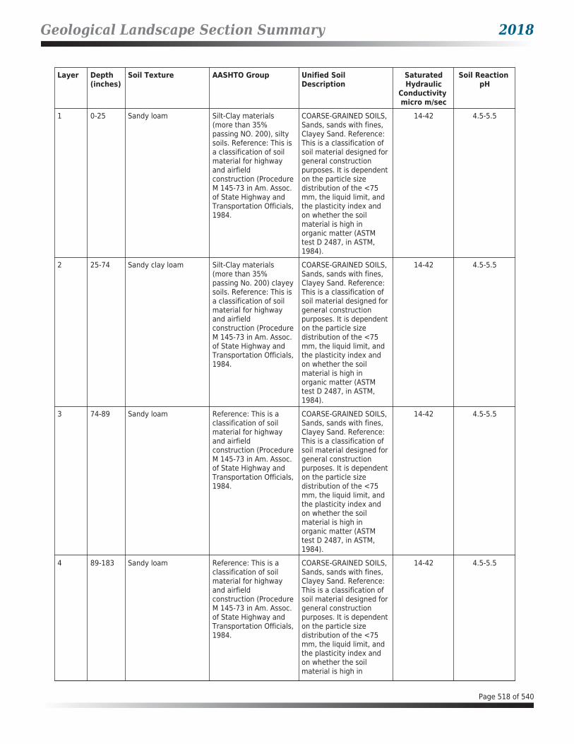


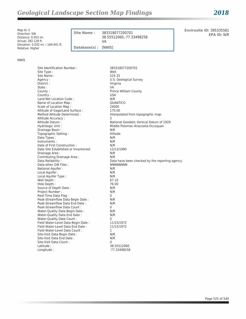


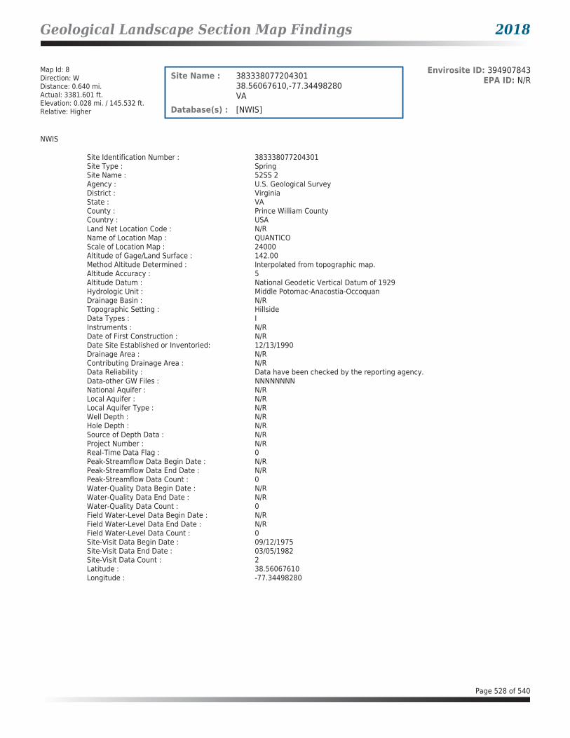
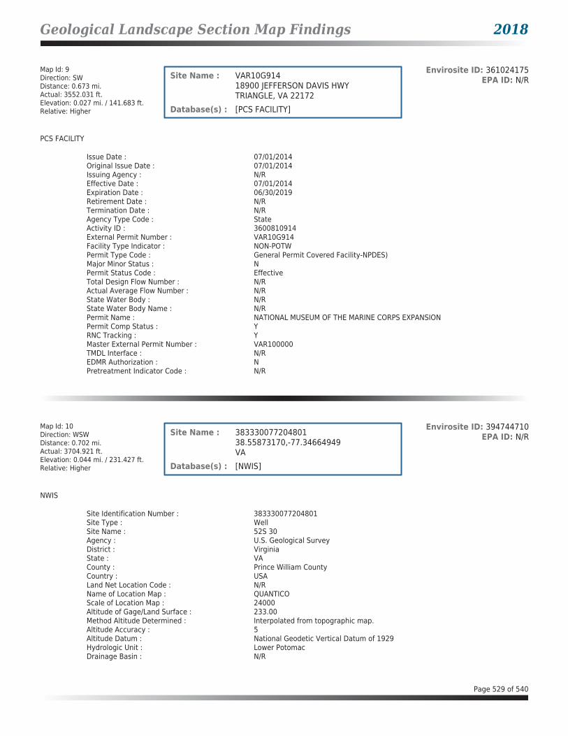


HIG Research SummarySite LocationUS HWY 1US HWY 1Dumfries, VA
Requested byEnvirosite Corporation2 Corporate Drive Suite 450Shelton, CT
This Research Summary identifies the products and services provided by Historical Information Gatherers, Inc. (HIG)for the above referenced site location. All products are provided as PDFs unless otherwise noted.
FIM+ MapsThe HIG Historical Map Collection and the United States Library of Congress Map Collection were searched for fireinsurance maps (FIMs), real estate atlases and similar maps for the site location and adjoining properties. No FIMs orsimilar maps were identified for the site location and/or adjoining properties.
Disclaimer & Limitation of LiabilityThis Research Summary and the related documents and images provided by Historical Information Gatherers (hereafter referred to as the “Site Specific HIG Data”)contain information obtained from a variety of public and private sources. Additional information for the site and surrounding properties may exist. Accordingly, there canbe no guaranty or warranty that the information provided is complete for its particular intended purpose. No warranty expressed or implied, is made whatsoever inconnection with the Site Specific HIG Data. Historical Information Gatherers specifically disclaims the making of any such warranties, including without limitation,merchantability or fitness for a particular purpose. Historical Information Gatherers, its officers, employees and independent contractors cannot be held liable to anyone forany loss or damage, whether arising out of errors or omissions, negligence, accident or any other cause, resulting directly or indirectly from any information provided orany information not provided in the Site Specific HIG Data. Any liability on the part of Historical Information Gatherers is strictly limited to a refund equal to the amount paidfor the Site Specific HIG Data.
HIG Copyright NoticeThis Research Summary and the selection, arrangement and compilation of Site Specific HIG Data are the property of Historical Information Gatherers. © Copyright 2018by Historical Information Gatherers, Inc. All rights reserved. The person or entity that ordered and paid for the Site Specific HIG Data is granted a personal,non-assignable, limited license to reproduce the Site Specific HIG Data solely for purposes of providing supporting documentation for reports produced for the site locationwhich is noted on page one of this Research Summary. Any other reproduction or other use of the Site Specific HIG Data in any media or format, in whole or in part, isexpressly prohibited without prior written permission from Historical Information Gatherers, and the person or entity that ordered and paid for the Site Specific HIG Dataassumes all liability for the making of any such reproductions.
Licensing AgreementThe licensing agreement between Historical Information Gatherers and infoGroup provides that Historical Information Gatherers may create photocopies or reproductionsof portions of Polk City Directories, Hill-Donnelley Criss-Cross Directories and other directories under infoGroup copyright. The licensing agreement also permits theperson or entity that ordered and paid for the Site Specific HIG Data to include photocopies or reproductions of portions of Polk City Directories, Hill-Donnelley Criss-CrossDirectories and other directories under infoGroup copyright as supporting documents for reports produced for the site which is the subject of the Site Specific HIG Data.
HIG Project #2016843Client Project #21328Date Created06/13/2018
Historical Information Gatherers • www.historicalinfo.com • 952-253-2004 • Page 1 of 1

Fire Insurance Maps No Coverage StatementSite LocationUS HWY 1US HWY 1Dumfries, VA
Requested byEnvirosite Corporation2 Corporate Drive Suite 450Shelton, CT
The HIG Historical Map Collection and the United States Library of Congress Map Collection were searched for fireinsurance maps (FIM), real estate atlases and similar maps for the site location and adjoining properties. No FIMs orsimilar maps were identified for the site location and/or adjacent properties.
FIM+ MapsThe HIG Historical Map Collection and the United States Library of Congress Map Collection were searched for fireinsurance maps (FIMs), real estate atlases and similar maps for the site location and adjoining properties. No FIMs orsimilar maps were identified for the site location and/or adjoining properties.
HIG Project #2016843Client Project #21328Date Created06/13/2018
Historical Information Gatherers • www.historicalinfo.com • 952-253-2004 • Page 1 of 1

Appendix B: Field Reconnaissance Photographs
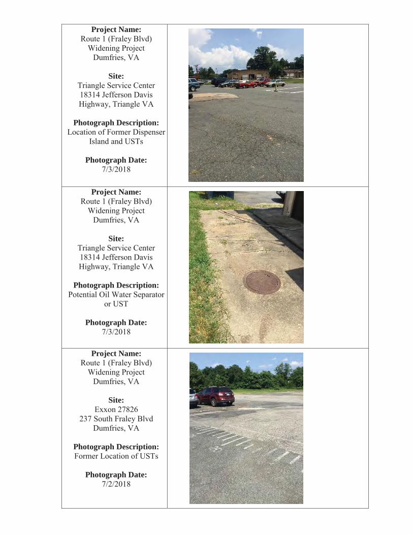
Project Name:
Site:
Photograph Description:
Photograph Date:
Project Name:
Site:
Photograph Description:
Photograph Date:
Project Name:
Site:
Photograph Description:
Photograph Date:

Project Name:
Site:
Photograph Description:
Photograph Date:
Project Name:
Site:
Photograph Description:
Photograph Date:
Project Name:
Site:
Photograph Description:
Photograph Date:

Project Name:
Site:
Photograph Description:
Photograph Date:
Project Name:
Site:
Photograph Description:
Photograph Date:

Project Name:
Site:
Photograph Description:
Photograph Date:
Project Name:
Site:
Photograph Description:
Photograph Date:
Project Name:
Site:
Photograph Description:
Photograph Date:

Project Name:
Site:
Photograph Description:
Photograph Date:
Project Name:
Site:
Photograph Description:
Photograph Date:
Project Name:
Site:
Photograph Description:
Photograph Date:

Project Name:
Site:
Photograph Description:
Photograph Date:
Project Name:
Site:
Photograph Description:
Photograph Date:

Appendix C: Historical Topographic Maps