
MMG Resources Inc. IZOK CORRIDOR PROJECT
50
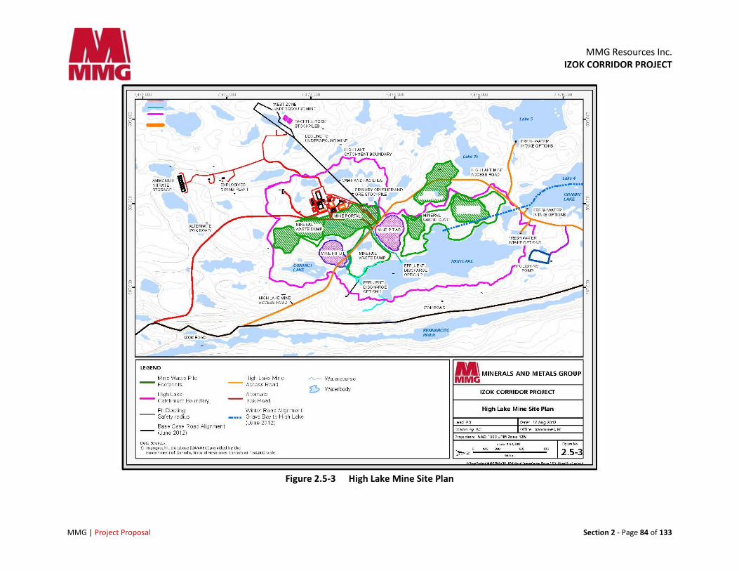
MMG Resources Inc. IZOK CORRIDOR PROJECT MMG | Project Proposal Section 2 - Page 84 of 133 Figure 2.5-3 High Lake Mine Site Plan
-
Upload
khangminh22 -
Category
Documents
-
view
2 -
download
0
Transcript of MMG Resources Inc. IZOK CORRIDOR PROJECT
MMG Resources Inc.
IZOK CORRIDOR PROJECT
MMG | Project Proposal Section 2 - Page 84 of 133
Figure 2.5-3 High Lake Mine Site Plan
MMG Resources Inc. IZOK CORRIDOR PROJECT
MMG | Project Proposal Section 2 - Page 85 of 133
2.5.8.2 Roads
Mine site roads connect all parts of the mine, and will be constructed of waste rock and surfaced with screened gravel.
2.5.8.3 Electric Power Generation
Electric power for the mine will be provided by diesel electrical generating units located in a power house at the mine complex. Power generation capability will be approximately 5 MW, including standby units with generation capability of 1 MW, which will be located adjacent to the camp complex for use in the event of a failure of the main system. Engine and exhaust heat will be recovered from the diesel generators for heating buildings.
2.5.8.4 Electric Power Distribution
Power distribution will be similar to the system described for the Izok Mine site (refer to section 2.4.10.6).
2.5.8.5 Mine Services
Services within the mine complex will be run within utilidors.
2.5.8.6 Fuel Systems
Approximately 7 ML of low sulphur diesel will be required annually for operations at the High Lake Mine. Diesel will be transported by truck to the mine site from the bulk fuel storage at Grays Bay port, and used for power generation and mobile equipment operation.
Diesel will be supplied from diesel storage tanks located near the service building and the diesel generators. The fuel system will comprise two diesel storage tanks plus required containers of gasoline and lubricants, which will all be located within a bermed area. Facilities will be provided for metering at the mine site tank farm.
Facilities will be provided for metered delivery to vehicles through a dispensing station with a 50,000 litre day tank in accordance with requirements of National Fire Code of Canada. Re-fuelling of vehicles will be conducted within a bermed area to contain any potential spills.
Diesel will be piped from the tank farm to a day tank at the diesel power generation equipment, which will be located in a power house within the mine complex area.
Other fuel types will include aviation fuel for helicopters. Helicopter fuel will be stored in 45 gallon steel barrels and annual consumption is estimated at 50,000 litres. It will be stored in a lined bermed area at the tank farm and moved on pallets as needed to a lined bermed area at the helicopter pad.
All fuel handling equipment, installations, and procedures will comply with Environment Canada’s fuel storage system regulations (Storage Tank System for Petroleum and Allied Petroleum Products).
MMG Resources Inc. IZOK CORRIDOR PROJECT
MMG | Project Proposal Section 2 - Page 86 of 133
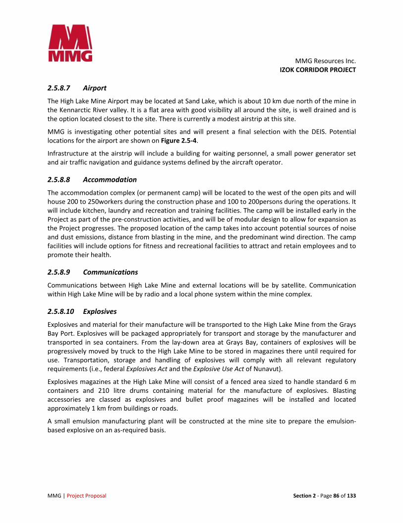
2.5.8.7 Airport
The High Lake Mine Airport may be located at Sand Lake, which is about 10 km due north of the mine in the Kennarctic River valley. It is a flat area with good visibility all around the site, is well drained and is the option located closest to the site. There is currently a modest airstrip at this site.
MMG is investigating other potential sites and will present a final selection with the DEIS. Potential locations for the airport are shown on Figure 2.5-4.
Infrastructure at the airstrip will include a building for waiting personnel, a small power generator set and air traffic navigation and guidance systems defined by the aircraft operator.
2.5.8.8 Accommodation
The accommodation complex (or permanent camp) will be located to the west of the open pits and will house 200 to 250workers during the construction phase and 100 to 200persons during the operations. It will include kitchen, laundry and recreation and training facilities. The camp will be installed early in the Project as part of the pre-construction activities, and will be of modular design to allow for expansion as the Project progresses. The proposed location of the camp takes into account potential sources of noise and dust emissions, distance from blasting in the mine, and the predominant wind direction. The camp facilities will include options for fitness and recreational facilities to attract and retain employees and to promote their health.
2.5.8.9 Communications
Communications between High Lake Mine and external locations will be by satellite. Communication within High Lake Mine will be by radio and a local phone system within the mine complex.
2.5.8.10 Explosives
Explosives and material for their manufacture will be transported to the High Lake Mine from the Grays Bay Port. Explosives will be packaged appropriately for transport and storage by the manufacturer and transported in sea containers. From the lay-down area at Grays Bay, containers of explosives will be progressively moved by truck to the High Lake Mine to be stored in magazines there until required for use. Transportation, storage and handling of explosives will comply with all relevant regulatory requirements (i.e., federal Explosives Act and the Explosive Use Act of Nunavut).
Explosives magazines at the High Lake Mine will consist of a fenced area sized to handle standard 6 m containers and 210 litre drums containing material for the manufacture of explosives. Blasting accessories are classed as explosives and bullet proof magazines will be installed and located approximately 1 km from buildings or roads.
A small emulsion manufacturing plant will be constructed at the mine site to prepare the emulsion-based explosive on an as-required basis.
MMG Resources Inc. IZOK CORRIDOR PROJECT
MMG | Project Proposal Section 2 - Page 87 of 133
Figure 2.5-4 Potential High Lake Mine Airstrips
Emulsion consists of ammonium nitrate (AN) prills, water and emulsifiers. Ammonium nitrate will be handled in specially constructed containers of 20-tonne capacity. Emulsifiers will be shipped in steel drums. These products are not classified as explosives, but are classified as oxidizers and will be shipped and handled in compliance with regulations for such products and will be stored in a fenced outdoor area.
2.5.8.11 Hazardous Materials
The High Lake Mine and infrastructure will use a variety of chemicals and reagents classified as hazardous materials. Hazardous materials will be packaged in drums or bulk bags and shipped to mine in sea containers via barge or ocean bulk-carrier ships to Grays Bay port, or by air either to Izok Mine or High Lake Mine airstrip.
All hazardous material will be stored within original packaging and typically within the original shipping container and will be placed adjacent to the point of use, allowing for safe storage and ready access. A
MMG Resources Inc. IZOK CORRIDOR PROJECT
MMG | Project Proposal Section 2 - Page 88 of 133
full description of types, quantities, method of storage and containment, secondary containment measures, method of chemical transfer, and description of spill control measures for hazardous materials will be developed as part of the feasibility study.
2.5.8.12 Mine Infrastructure Alternatives
No alternatives to the currently planned mine infrastructure have been identified.
2.5.8.13 Mine Infrastructure - Mitigation by Design
By constructing only one processing plant at the Izok Mine site to process ore from both the Izok and High Lake mine sites, overall surface disturbance from the plant and associated tailings deposition will be minimized. Further, this will also reduce discharge from treated effluent from the High lake Mine and potential water quality issues.
With the exception of the Sand Lake airstrip, most of the infrastructure elements will be located within the High Lake catchment to avoid downstream environmental effects in the event of an accidental release of contact water or spilled material.
The general arrangement and juxtaposition of infrastructure elements in the Project design, minimizes the disturbed area.
2.5.8.14 Mine Infrastructure Closure Plan
At closure, all infrastructure at the High Lake Mine will be decommissioned, dismantled and removed.
2.6 Road Transportation Road transportation for the Project will include a ~350 km all season access road linking Izok and High Lake mines with the port at Grays Bay (‘Izok Road’), two temporary winter roads for construction of the mines (Izok to Contwoyto and High Lake to Grays Bay) and several lesser access roads between Project facilities.
Please note that MMG is undertaking additional studies in 2012 to refine and improve the all-season road route, including consideration of alternative alignments for some segments, and that changes might result from this additional work.
2.6.1 Winter Roads
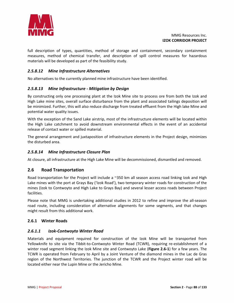
2.6.1.1 Izok-Contwoyto Winter Road
Materials and equipment required for construction of the Izok Mine will be transported from Yellowknife to site via the Tibbit-to-Contwoyto Winter Road (TCWR), requiring re-establishment of a winter road segment linking the Izok Mine site and Contwoyto Lake (Figure 2.6-1) for a few years. The TCWR is operated from February to April by a Joint Venture of the diamond mines in the Lac de Gras region of the Northwest Territories. The junction of the TCWR and the Project winter road will be located either near the Lupin Mine or the Jericho Mine.
MMG Resources Inc.
IZOK CORRIDOR PROJECT
MMG | Project Proposal Section 2 - Page 89 of 133
Figure 2.6-1 Izok to Jericho/Lupin Winter Road
MMG Resources Inc. IZOK CORRIDOR PROJECT
MMG | Project Proposal Section 2 - Page 90 of 133
Note that a winter road linking Lupin Mine and Izok Lake was constructed and used in previous years (it has been used previously to support MMG exploration programs). The winter road into the Izok Mine will be operated each winter for several years prior to completion of Izok Road. Winter road construction and management of road operations and traffic patterns will be consistent with best management practices in place for the TCWR.
The alignment of the Izok-Contwoyto Winter Road will be selected by personnel experienced in winter-road construction and operation. The route will follow frozen lakes and watercourses to the extent practical to minimize the length of on-land segments. Where these waterbodies are fish-bearing, road construction and management will be undertaken in accordance with DFO guidelines to avoid disturbance of fish habitat.
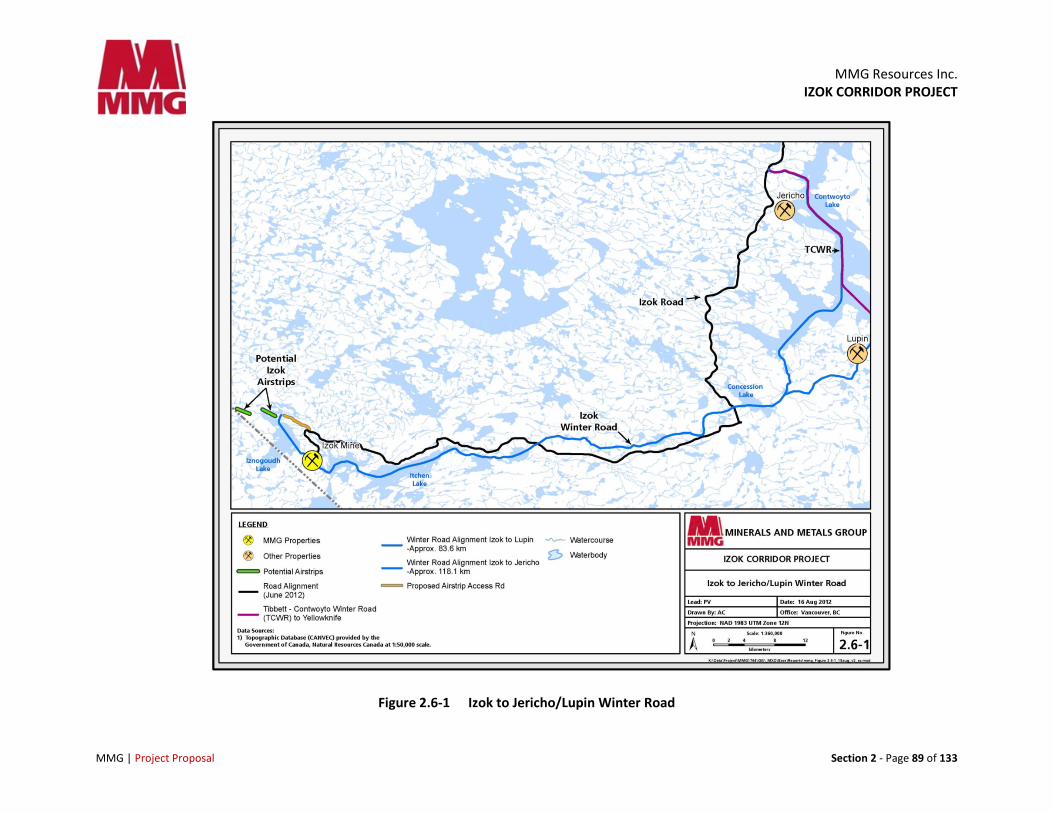
2.6.1.2 Grays Bay to High Lake Winter Road
A winter road from Grays Bay to High Lake Mine will be developed and operated annually during the construction phase of the Project to transport equipment and materials required for constructing the High Lake Mine, and to facilitate construction of Izok Road (Figure 2.6-2)
2.6.1.3 Water Management and Use
During winter road operation, it may be necessary to add water to the roadway to maintain or increase the thickness of the snow/ice embankment. Water will be drawn from previously selected waterbodies situated along the proposed road alignment following best management practices and within allowable water withdrawal limits. Where these lakes are fish-bearing, water withdrawal will be consistent with DFO guidelines. Water will be spread on the road using best practices and low ground pressure equipment.
Winter road alignments will not follow creek channels but will cross them occasionally. Where streams are crossed, particular attention will be given to ensuring that natural flow patterns during spring freshet are not hindered.
2.6.2 Izok Road (All-Season Road)
2.6.2.1 Overview
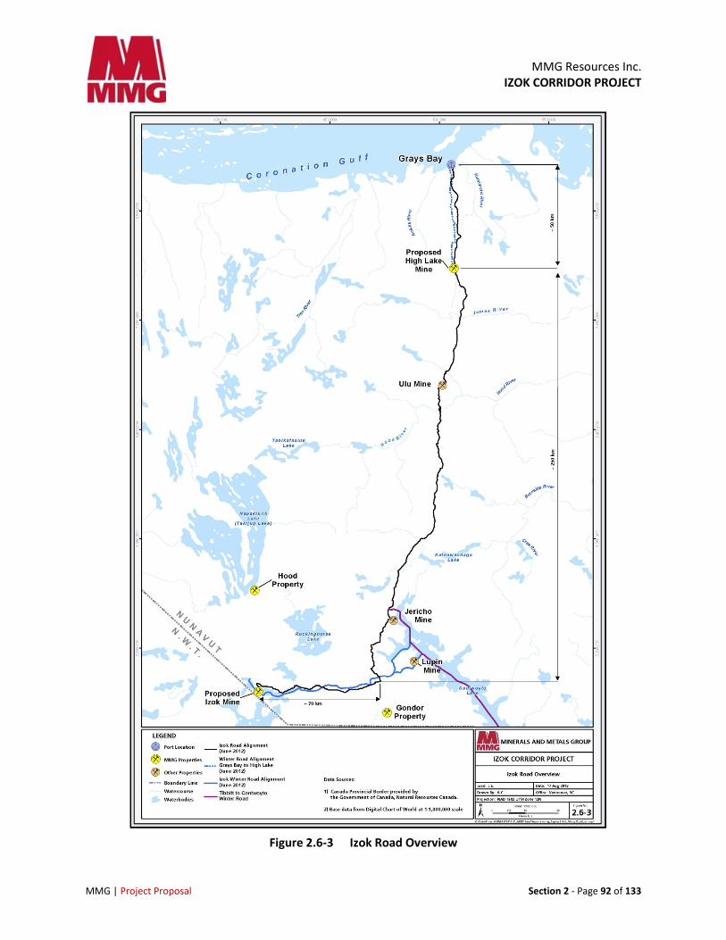
A ~350 km all-season access road (‘Izok Road’) will be constructed between the Izok Mine and Grays Bay Port to transport concentrate from the processing plant at the Izok Mine to the port and to backhaul ore from the High Lake Mine to the processing plant (Figure 2.6-3). Izok Road will also be used to transport personnel, fuel, cement, explosives and other mine supplies from the port to the mines. Although the majority of resupply materials to the Izok Mine will be via the port and Izok Road, there may be occasions when some re-supply is required from the south via the TCWR during winter. More information will be provided in the DEIS.
The exact length of the road may change slightly as studies are ongoing in 2012 to optimize the route. MMG is using 350km as an approximate length of the road but efforts to reduce this are ongoing.
MMG Resources Inc.
IZOK CORRIDOR PROJECT
MMG | Project Proposal Section 2 - Page 91 of 133
Figure 2.6-2 Grays Bay to High Lake Winter Road
MMG Resources Inc.
IZOK CORRIDOR PROJECT
MMG | Project Proposal Section 2 - Page 92 of 133
Figure 2.6-3 Izok Road Overview
MMG Resources Inc. IZOK CORRIDOR PROJECT
MMG | Project Proposal Section 2 - Page 93 of 133
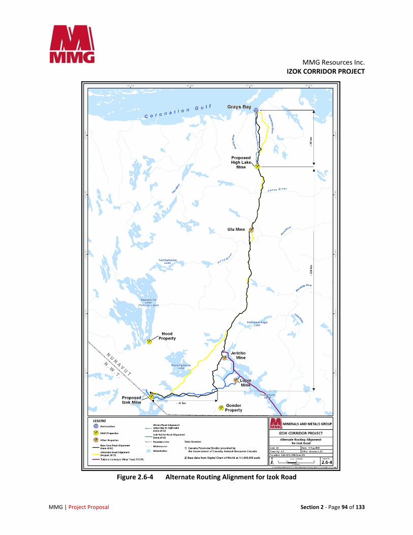
2.6.2.2 Route Selection
The proposed route of Izok Road is based on available topographic information and preliminary route reconnaissance completed in 2007, 2008 and 2012. Environmental and archaeological studies have also been undertaken, as well as preliminary identification of potential sources of granular fill and rock quarries.
The ongoing feasibility study will include more detailed road design work and changes to the current alignment will be made to optimize the route. Key road design considerations will include minimizing the length and number of stream crossings, optimizing the use of road building material sources and avoiding disturbance of ground ice and permafrost.
As noted earlier, MMG is considering alternate route alignments for two segments of Izok Road based on information gathered during the feasibility study. The alternate segments are as follows.
• South Rockinghorse Segment: Izok Mine – south of Rockinghorse Lake – connecting to the base case route north of the Jericho Mine (77 km)
• Grays Bay Access Segment: High Lake – Grays Bay running east of the base case road alignment (36 km)
These alternative route alignments (Figure 2.6-4) are being considered due to MMG’s interest in reducing haul distances, minimizing the number and lengths of streams crossings, avoiding challenging terrain features, reducing the potential for wildlife interactions, and increasing road user safety.
Conceptual design work and environmental baseline investigations are planned for the summer of 2012. These alternative route alignments will be further considered during the feasibility planning process and may be carried forward into the DEIS. However, MMG‘s objective is to have a final route selected by Q1 2013 and presented in the DEIS.
2.6.2.3 Izok Road Design Basis The design basis for Izok Road includes a variety of engineering and environmental considerations and a particular focus on addressing the challenges of constructing, operating and decommissioning an all-season road in the arctic. Wind, snow, ice, drainage, fog, permafrost, light conditions and of course safety are all considerations when designing a road in the north.
Key Design Considerations
The following are key design considerations for Izok Road.
• Health and safety
• Minimize disturbance of ice lenses and permafrost
• Identify the optimum route for constructability and operation, including snow and ice management
• Design water crossings to minimize stream crossings and their effect on fish passage and habitat
MMG Resources Inc. IZOK CORRIDOR PROJECT
MMG | Project Proposal Section 2 - Page 94 of 133
Figure 2.6-4 Alternate Routing Alignment for Izok Road
MMG Resources Inc. IZOK CORRIDOR PROJECT
MMG | Project Proposal Section 2 - Page 95 of 133
• Site borrow areas and quarries to minimize adverse effects on environmental and cultural values
• Identify suitable locations for wildlife crossing structures (e.g., caribou and other ungulates movement)
• Design road embankment heights to prevent visual obstructions and ease of caribou crossing
• Use of adequate materials on road surface and slopes to create a good travel surface for caribou crossing
Road Alignment
Ground conditions along Izok Road alignment are typically moraine (tills) with a bouldery surface and exposed frost-shattered bedrock. Some glaciofluvial outwash and esker complexes are also present. Marine and glacio-marine sediments are crossed as the route approaches the coast. Permafrost is continuous along the entire route with ground ice contents varying depending on terrain. Taliks of different sizes are expected under the numerous water bodies.
Between the Izok Mine and approximately 70 km to the east, the alignment generally follows smooth ground moraine, with gentler slopes. From there, the north-south section of the road alignment is quite rugged, with rock outcrops, substantial microtopography, and many stream crossings. The alignment has been adjusted to avoid difficult terrain and topography wherever possible.
The road alignment crosses many minor diffuse drainage paths that are dry for much of the year. Where it can be demonstrated that fish will not be affected, crossings of these diffuse drainages will be constructed with open-graded rock fill that is porous and will not interrupt overland flows. Crossings of other watercourses will be constructed using current best practices and in accordance with DFO’s operational policy guidance for crossing structures for fish bearing watercourses. River crossings will be single or multiple-span bridges.
2.6.2.4 Key Geometric Parameters The following is a summary of the preliminary geometric parameters for Izok Road.
• Road width of either 7 m (single lane) or 9 m (dual lane)
• Minimum horizontal curve radius of 170 m (super elevation of 4%)
• Desirable maximum vertical grades of 8%
• Single-lane bridges, approximately 5 m to 6 m wide and possibly 9 m wide in difficult conditions
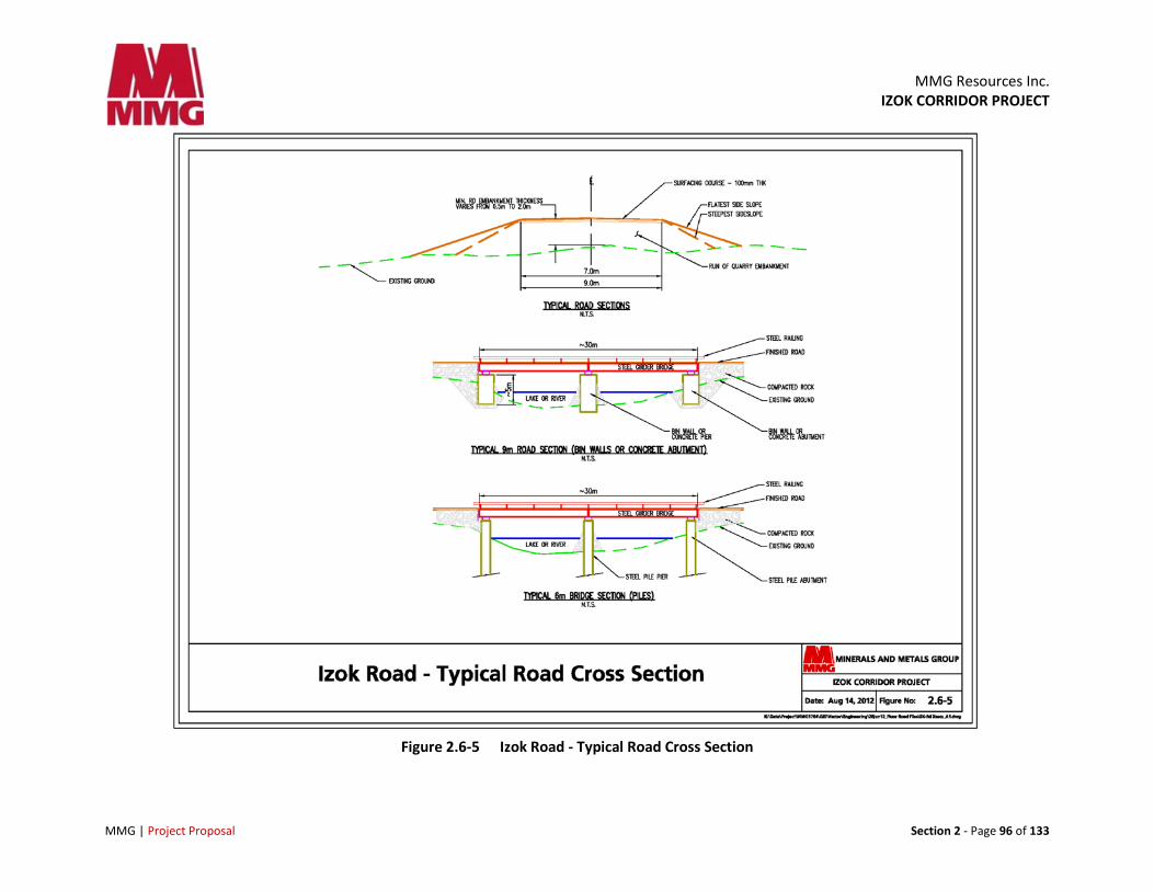
2.6.2.5 Embankment Height and Side Slopes
Surficial soil, permafrost conditions and topography are controlling factors in determining the embankment height for design purposes. Terrain conditions along the road corridor are generally considered to be rugged with a high degree of variability. Surficial soil conditions will be interpreted based on field observations, mapping and photographs and used to determine appropriate design for embankment height.
Side slopes will be designed based on ground ice and surface water conditions. Modifications will be made at segments selected for caribou crossings. Figure 2.6-5shows a typical road cross section.
MMG Resources Inc.
IZOK CORRIDOR PROJECT
MMG | Project Proposal Section 2 - Page 96 of 133
Figure 2.6-5 Izok Road - Typical Road Cross Section
MMG Resources Inc. IZOK CORRIDOR PROJECT
MMG | Project Proposal Section 2 - Page 97 of 133
2.6.2.6 Caribou Crossing Considerations
The Bathurst Caribou Herd moves through the Project area in concentrated groups each spring en route to calving grounds north of Contwoyto Lake, resulting in large numbers of caribou crossing the proposed alignment of Izok Road (refer to section 5.3.7.2 for additional details). Caribou crossing structures will be incorporated in the road design in areas of preferred habitat and at known crossing locations in order to facilitate continued caribou movement. The portion of Izok Road from the Jericho Mine to the Ulu Mine has historically been the area that has experienced the largest caribou movements in the past, and is expected to require multiple crossing. The need for crossings may be minimized at locations where topography and road design allow for relatively minimal grade on side slopes.
Road design considerations to facilitate continued caribou movement include:
• Embankments designed within minimal side slopes wherever possible
• Slope surface should be a relatively smooth and compacted
• Road width should be similar to that elsewhere on the road system
• The length of crossings may be variable; longer or more frequently situated crossings will be required in high-movement areas
2.6.2.7 Stream Crossings
For fish-bearing streams, crossings will be clear span structures consistent with DFO’s operational policy guidance (i.e., bridges constructed entirely outside the upper water level or a culvert with footings situated outside the high water level of the channel). For non-fish bearing watercourses, wet lowlands and seasonally moist areas, a rock fill approach (placement of large rock material directly on the existing ground at the base of a road and embankment) may be used which will allow free drainage and maintain hydraulic function.
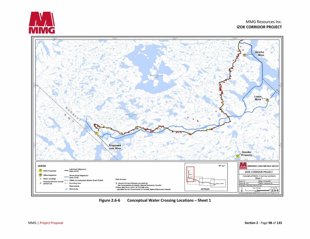
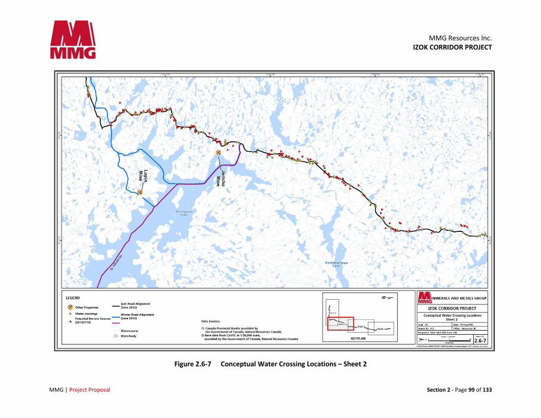
Current plans for Izok Road specify approximately 60 single-span bridges ranging from 10 m to 40 m in length, 10 multi-span bridge structures, and 80 major culvert and rock fill locations. Several additional culverts and rock fills will be installed along the road to ensure proper drainage through the embankment during freshet and other high flow events. Further information will be provided in the DEIS.
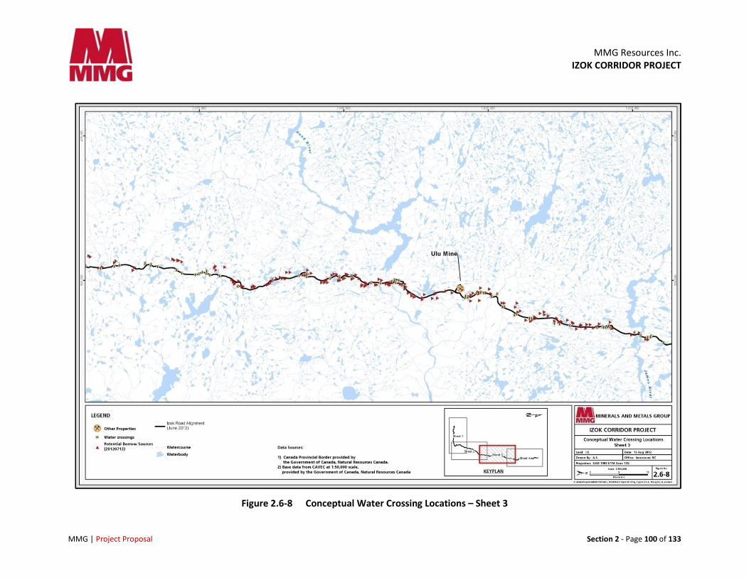
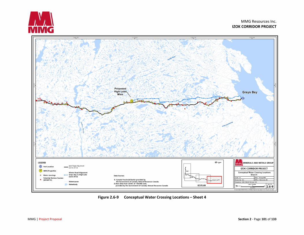
Figure 2.6-6 through Figure 2.6-9 are conceptual illustrations of water crossings along the proposed Izok Road alignment. Crossing specifications and locations will be confirmed as road design continues during the feasibility study.
Appropriate erosion and sediment control measures (silt fences, flow checks in ditches, erosion control blankets and or seeding and mulch on exposed earth slopes) will be utilized to prevent adverse effects on watercourses and aquatic life during construction and operation of the roadway. All in-stream works will be conducted during acceptable time windows to avoid or reduce potential effects on fish (and raptors and other biological activities as relevant or related to road construction).
MMG Resources Inc.
IZOK CORRIDOR PROJECT
MMG | Project Proposal Section 2 - Page 98 of 133
Figure 2.6-6 Conceptual Water Crossing Locations – Sheet 1
MMG Resources Inc.
IZOK CORRIDOR PROJECT
MMG | Project Proposal Section 2 - Page 99 of 133
Figure 2.6-7 Conceptual Water Crossing Locations – Sheet 2
MMG Resources Inc.
IZOK CORRIDOR PROJECT
MMG | Project Proposal Section 2 - Page 100 of 133
Figure 2.6-8 Conceptual Water Crossing Locations – Sheet 3
MMG Resources Inc.
IZOK CORRIDOR PROJECT
MMG | Project Proposal Section 2 - Page 101 of 133
Figure 2.6-9 Conceptual Water Crossing Locations – Sheet 4
MMG Resources Inc. IZOK CORRIDOR PROJECT
MMG | Project Proposal Section 2 - Page 102 of 133
2.6.3 Road Construction
Construction of Izok Road will likely require two to three years depending on the level of effort and the construction staging plan to be developed as the engineering program proceeds. This schedule will also be affected by the issuance of permits for pre-construction activity and MMG’s ability to mobilize material and equipment in 2014 and 2015.
At this time, MMG plans to initiate the construction concurrently from three to four strategically located starting points (or headings) along the length of the proposed road alignment. These headings will be areas that can be used to stage equipment and supplies in advance of construction. Existing facilities such as the Ulu project, Lupin or Jericho mines, or nearby sites, that can be supplied via winter road are good potential candidates, as is the proposed port location at Grays Bay that could be supplied via sealift during the summer open water season. MMG will discuss such arrangements with the owners of those sites, or find alternate sites, as planning progresses. Some of these facilities have adjacent airstrips that can also be used as necessary.
Construction activities will continue year round, with the possible exception of December and January when there is extreme weather and limited daylight or if concentrations of caribou are passing through one of the construction areas. There may also be changes to work contemplated near caribou crossings and calving activity, or any other sensitive biological activity. Wildlife and traffic management plans will be prepared for the construction phase of the Project.
Wherever possible, construction activities, quarries and borrow sources will be confined to the proposed road alignment to limit the area of disturbance and related effects on wildlife and habitat. Quarry and borrow sources will typically be located at 5 to 10 km intervals along the alignment and the locations of these sites and characteristics of materials will be confirmed during the road design process. Rock fill and granular material will be used for embankment construction. Cuts through ice rich soils will be avoided to maintain ground stability.
Rock and aggregate material will be sourced from quarries and approved sand or gravel deposits. During summer months, access trails to these material sources will be constructed with embankment material to minimize effects on the tundra. This technique will also be used to build pioneer roads within the final road alignment to access the bridge sites.
Culverts and bridge structures will be prefabricated and shipped to the nearest mobilization point and then transported along the newly constructed road or pioneer road to the crossing location. Bin wall (or similar type) abutments for bridge structures will be assembled on site. Small span bridges can be transported and launched as a complete unit (decking may be added on site). Larger or multi-span bridges will be transported in segments, assembled on site and launched. Major bridge structures may require more substantial abutment foundations (piles) or in the case of a multi-span structure, in-stream pier construction.
2.6.3.1 Construction Materials
The majority of Izok Road will be constructed with blast rock sub-base topped with aggregate granular base. Sources of road construction materials will be obtained from widening road cuts, glaciofluvial deposits, selected esker sands and gravels (wildlife habitat and archaeological issues will be considered),
MMG Resources Inc. IZOK CORRIDOR PROJECT
MMG | Project Proposal Section 2 - Page 103 of 133
and quarried rock. Sources of granular fill will be pre-screened through site investigations to avoid the use of potentially acid generating (PAG) materials in the road base. Dust suppression measures will be applied during construction and during placement and compaction of granular materials.
Borrow sources and quarries will be located as close as possible to where the material is required and portable rock crushers will be utilized during construction to minimize haul distances for gravel and rock. Figures 2.5-6 to 2.6-9 show the potential locations of quarry and borrow sources.
During rock and aggregate production, site operations will adhere to legislation and best practices applicable to migratory birds, protected wildlife, endangered species and species at risk.
A rehabilitation plan will be prepared and approved prior to operations at each pit or quarry.
2.6.4 Road Operation
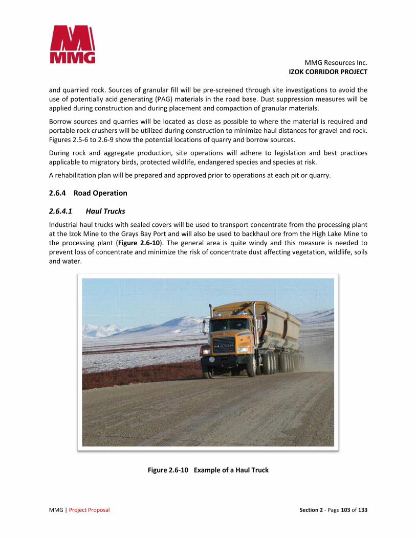
2.6.4.1 Haul Trucks
Industrial haul trucks with sealed covers will be used to transport concentrate from the processing plant at the Izok Mine to the Grays Bay Port and will also be used to backhaul ore from the High Lake Mine to the processing plant (Figure 2.6-10). The general area is quite windy and this measure is needed to prevent loss of concentrate and minimize the risk of concentrate dust affecting vegetation, wildlife, soils and water.
Figure 2.6-10 Example of a Haul Truck
MMG Resources Inc. IZOK CORRIDOR PROJECT
MMG | Project Proposal Section 2 - Page 104 of 133
Speed limits and traffic management procedures will be established to allow for efficient movement of concentrate, ore, fuel and supplies while ensuring safe operations for all weather and road conditions and minimizing the potential for collisions with wildlife, particularly caribou. A Traffic Management Plan and a Wildlife Management Plan will be prepared in consultation with HTOs and other stakeholders to ensure that mitigation and management measures appropriate for the local conditions are identified and implemented.
2.6.4.2 Vehicle Usage and Traffic Volumes
It is anticipated that Izok Road will operate 330 days per year, providing an allowance for up to five weeks of road closure or traffic limitations due to inclement weather, road repairs or to avoid/mitigate potential effects on wildlife, particularly calving related movement of the Bathurst Herd across Izok Road and Dolphin and Union Herd movements near the Grays Bay Port.
A total of approximately 6 million “wet” tonnes of concentrate will be hauled from the Izok Mine site to the port, or an average of 500,000 tonnes per annum (tpa) over the 12-year production phase. “Wet” tonnes refer to concentrate with the appropriate moisture content, not a saturated product.
Approximately 570,000 tpa of ore will be back hauled from the High Lake Mine to the processing plant at the Izok Mine site. This ore backhaul process will require an average of 15 round trips per operating day by haul trucks moving concentrate north from the Izok Mine site to the Port and then returning empty to the High Lake Mine site, taking on a load of ore and returning to the Izok Mine. At a speed of 80 km per hour, it would take one truck 6 hours to travel from Izok to Grays Bay. Obviously, this may change based on weather, visibility, road surface conditions and other speed consideration related to safe operation or wildlife and traffic management plans.
As well, road traffic of any kind will be affected by road closure: if for example, if the road is closed for a period of two to three weeks, traffic will need to be increased at other times to make up for the lost concentrate transportation. MMG will be preparing more accurate and more detailed traffic plans in conjunction with maintenance schedule, Wildlife Management Plan and in consultation with other operators in arctic conditions to establish thresholds for safe road use (fog, wind and temperature for example).
The Project’s fuel and non-fuel cargo will be hauled to the Izok Mine and the High Lake Mine from the Grays Bay Port in road tankers and on container trucks. In addition, a small number of passenger and service/maintenance vehicles will use Izok Road. The total traffic volume on Izok Road is expected to be approximately 25 round trips per operating day.
2.6.4.3 Road Maintenance
Periodic maintenance of roadway surfaces and embankments will be required to repair defects and maintain the road surface. These maintenance activities will be conducted using conventional construction equipment, including graders, bulldozers, haul trucks and loaders. It is anticipated that road maintenance facilities will be established at the Izok Mine and at the Port. Road maintenance camps may also be established at High Lake and/or another intermediate location.
MMG Resources Inc. IZOK CORRIDOR PROJECT
MMG | Project Proposal Section 2 - Page 105 of 133
Culverts and bridges will be regularly inspected, particularly preceding and during spring thaw and freshet. Road dust will be managed using water from nearby sources, but suppressants such as calcium chloride may be considered during operation of the roadway when required.
2.6.4.4 Road Access
Road access, including potential use of the road by the public or other industrial users will be addressed in a Traffic Management Plan to be developed for the Project (see section 12).
At this time, MMG is planning to build, operate and maintain the all-season access road using its own resources and solely for Project use. Accordingly, MMG will assume full responsibility for construction, operation, maintenance and eventual closure and reclamation of this road. In the future, MMG may consider entering into agreements with other parties regarding shared use of the road, assuming that road-related safety risks can be managed effectively and any business risks related to road capacity and schedule can be addressed in manner that does not hinder the economic viability of the Project.
2.6.4.5 Emergency Management
Safety and preparedness for potential vehicle collisions and spills will be paramount and addressed in MMG’s Spill Prevention and Emergency Response Plan. Implementation will occur prior to the start of construction, including training of staff and contractors and deployment of spill response equipment and supplies. In the event of a spill, a Spill Response Team will attend the site with appropriate containment and collection facilities. Any contaminated soil will be collected and disposed of in an appropriate manner.
Procedures will also be established for monitoring vehicles in transit and controlling traffic during inclement weather or when wildlife migrations necessitate vehicle movement restrictions. These and other traffic management measures will be detailed in MMG’s Traffic Management Plan.
2.6.4.6 Road Safety
Izok Road and the mine access roads will be cleared of snow as required to maintain trafficable conditions. Road clearing operations will be carried out in manner that avoids obstruction of major watercourses and maintains identified caribou crossings. Major consideration for road safety will include:
• Snow clearing/stockpiling
• Freshet and hydrological conditions at crossings
• Pullouts for snow storms, vehicle breakdowns and bridges
• Monitoring vehicles for bad weather and wildlife movements
• Radio communications, signage, speed limits
• Additional procedures will be developed in 2012 and 2013 after consulting with operators in arctic environment
MMG Resources Inc. IZOK CORRIDOR PROJECT
MMG | Project Proposal Section 2 - Page 106 of 133
2.6.5 Alternatives Considered
Previous studies have considered several options for developing the Izok and High Lake deposits and transporting concentrate to processing facilities in Europe, Asia or North America. The only option that was financially viable was to develop the two deposits concurrently, process ore at a single facility and link them by road to a port on the Coronation Gulf.
Other options, including a road from the Izok deposit to a port site east of Kugluktuk and a road linking the Izok deposit to a proposed port at Bathurst Inlet were ruled out because they do not allow for efficient development and transportation of the mineral resources at High Lake.
In addition, the Bathurst Inlet Port and Road (BIPR) is a longer overall hauling distance and requires a crossing of Contwoyto Lake, by ice road in the winter and barge in the summer and would require concentrate haulage to cease during spring thaw and winter freeze up.
Other transportation options considered included truck hauling on winter road to railhead in the Northwest Territories and a slurry pipeline to a port at Grays Bay. These were also eliminated due to the costs of such options.
2.6.6 Road Reclamation
Upon closure, Izok Road between Grays Bay and the Izok Mine will be decommissioned and reclaimed in accordance with Nunavut guidelines. All bridges and culverts will be removed. Appropriate erosion and sediment control measures will be utilized during the removal of these structures. The road will be restored to stable conditions and pre-existing natural drainage patterns will be restored.
2.7 Grays Bay Port
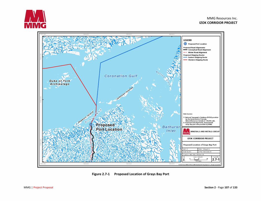
2.7.1 Port Infrastructure
The port and related infrastructure will be located in Grays Bay (Figure 2.7-1) in the Coronation Gulf, approximately 330km northeast from the Izok Mine site, and 50 km north of the High Lake Satellite Mine site. It is located 179 km east of Kugluktuk and about 2.5 km west of the mouth of the Kennarctic River.
The port will consist of two main components:
1. Land-based infrastructure such as the concentrate storage building, fuel storage and laydown area, camp and administration office
2. The dock itself, which will have a footprint in the marine environment
While land-based activities at the port such as transport of fuel, concentrate and supplies will be year round, marine activities will be limited to the ice-free months in Coronation Gulf (roughly from mid July to mid October) when fuel and supplies for the Project will be delivered and the concentrate will be loaded and transported by bulk-carrier ships. This may also involve barge traffic.
At this time, MMG does not plan to break continuous land fast ice. Ice floes will be moved or broken by an ice breaker as needed during the months of July to October (refer to section 2.7.3 for more information).
MMG Resources Inc.
IZOK CORRIDOR PROJECT
MMG | Project Proposal Section 2 - Page 107 of 133
Figure 2.7-1 Proposed Location of Grays Bay Port
MMG Resources Inc. IZOK CORRIDOR PROJECT
MMG | Project Proposal Section 2 - Page 108 of 133
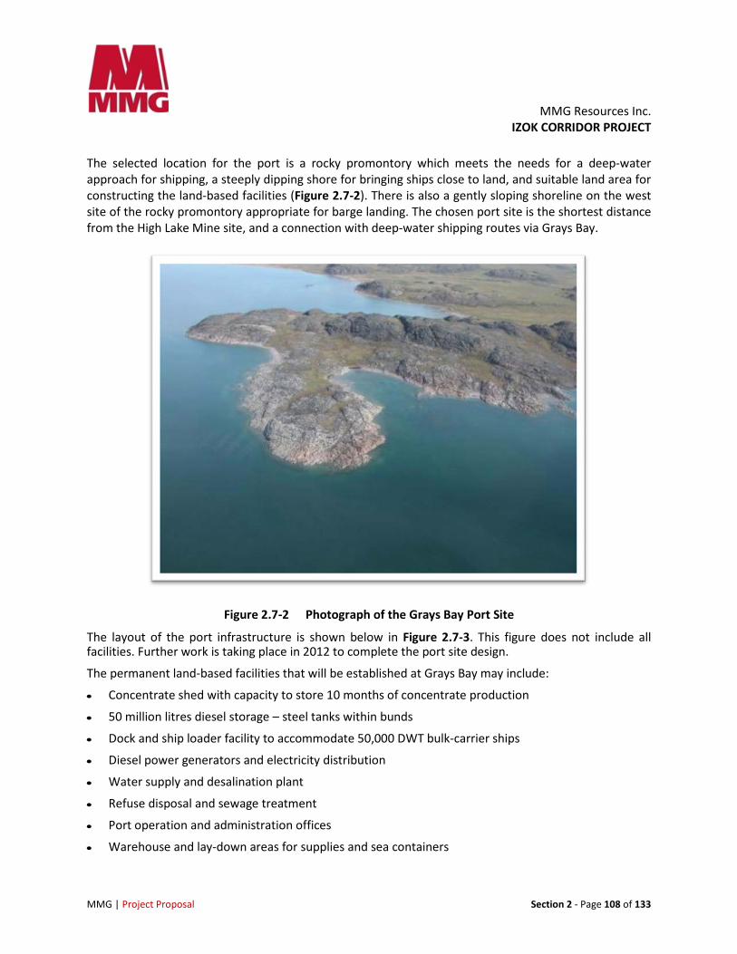
The selected location for the port is a rocky promontory which meets the needs for a deep-water approach for shipping, a steeply dipping shore for bringing ships close to land, and suitable land area for constructing the land-based facilities (Figure 2.7-2). There is also a gently sloping shoreline on the west site of the rocky promontory appropriate for barge landing. The chosen port site is the shortest distance from the High Lake Mine site, and a connection with deep-water shipping routes via Grays Bay.
Figure 2.7-2 Photograph of the Grays Bay Port Site
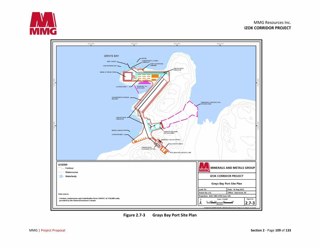
The layout of the port infrastructure is shown below in Figure 2.7-3. This figure does not include all facilities. Further work is taking place in 2012 to complete the port site design.
The permanent land-based facilities that will be established at Grays Bay may include:
• Concentrate shed with capacity to store 10 months of concentrate production
• 50 million litres diesel storage – steel tanks within bunds
• Dock and ship loader facility to accommodate 50,000 DWT bulk-carrier ships
• Diesel power generators and electricity distribution
• Water supply and desalination plant
• Refuse disposal and sewage treatment
• Port operation and administration offices
• Warehouse and lay-down areas for supplies and sea containers
MMG Resources Inc.
IZOK CORRIDOR PROJECT
MMG | Project Proposal Section 2 - Page 109 of 133
Figure 2.7-3 Grays Bay Port Site Plan
MMG Resources Inc. IZOK CORRIDOR PROJECT
MMG | Project Proposal Section 2 - Page 110 of 133
• Permanent camp
• Communication system
• Security
• Barge landing site
• Roads linking these facilities
2.7.2 Port Construction
2.7.2.1 Construction of Land-based Infrastructure
The land-based infrastructure will be built on level ground. Surface drainage ditches will be built around the site to collect any contaminated water and treated before release. Roadways and access areas around buildings will be designed to the same criteria as Izok Road.
Ground conditions are characterized by surface bedrock with minor quantities of till and thin glacio- marine sediments found in depressions. The site will first be graded to provide a stable and level surface for construction of the site facilities and roadways. Permafrost is present at the site but will not affect the stability of structures sitting on bedrock as building foundations will be built on competent bedrock.
Infilling of a small bay on the west side of the rocky promontory may be required for development of infrastructure. This will be determined based on further feasibility studies (refer to section 2.5-3).
In unheated structures such as the concentrate storage building, a floor space will be built. Any unconsolidated material will be excavated to a maximum depth of 2 m and will be replaced with well-graded, free-draining structural fill. The fill will be capped with crushed granular surfacing or with a concrete slab as building requirements dictate. Heated buildings and structures including the permanent camp will either be constructed with foundations elevated above the existing ground to preserve the permafrost or will sit directly on structural fill and which will act as a thermal barrier.
A permanent diesel storage facility will be built with berms. Fuel tanks will be constructed per the guidelines and permit terms and conditions.
Roads, power lines, communication lines, and piping will be constructed throughout the dock area as required.
2.7.2.2 Dock Description and Construction
A dock to accommodate 50,000 DWT ships will be built on the deep-water side of the rock peninsula (north facing shoreline). The ships will require a minimum of 12 m draft.
The berth will be a steel sheet pile structure backfilled with rock fill. This type of structure was selected because it offers good ice resistance, and has a high deck-load capacity. This has proven to be reliable dock structure for northern mining projects and other docking facilities across the Arctic.
The berth face will be at least 100 m. Floating mooring buoys or pile dolphins at each end of the wharf will secure the ship and be used to move it along the dock. Mooring buoys will be anchored by chain to concrete blocks on the seabed; the buoys will be removed at the end of each shipping season.
MMG Resources Inc. IZOK CORRIDOR PROJECT
MMG | Project Proposal Section 2 - Page 111 of 133
Details on dock construction will be provided as the feasibility study progresses. However, it is anticipated that dredging of marine sediments and blasted rock will likely be required. MMG will work with the Department of Fisheries and Oceans and other groups to plan construction, schedule, mitigations of impacts as well as a plan for No Net Loss of fish habitat within the dock footprint (refer to section 12).
2.7.3 Port Operation
The land-based, year round activity at the port will consist of trucks delivering the concentrate to the concentrate storage building, trucks picking up diesel, sea-containers and supplies to bring to the mine sites. The diesel station, power generation and camp will operate year–round. A robust Traffic Management Plan will be developed to minimize stress to the Dolphin and Union Caribou Herd when the area is used by caribou to cross to Victoria Island. Refer to section 7 for more details.
Shipping activities and ship loading activities will take place during ice-free months. The port will be open to receive ships and barges from mid July to October as recommended in the Draft West Kitikmeot Land Use Plan (NPC 2005), but most likely from August to October. Ice conditions studies are ongoing to provide more clarity on the most likely shipping window during those months
No shore-based ship’s power, water, or services will be provided. Crews from foreign flagged vessels will not be allowed on shore.
2.7.3.1 Ships, Ship Loading and Unloading
Concentrate will be shipped offshore in 50,000 DWT ice-strengthened bulk-carriers, one of which will be specially designed to carry either diesel fuel or concentrates. This ship, called an Oil Bulk Ore Carrier (OBO) will deliver fuel to the port on the first trip it makes every year. Each ship will have five hatches into which the concentrate will be transferred using a ship-loader.
The preliminary ship specifications are summarized below:
• Type 50,000 DWT bulk-carrier
• Length 195 m
• Beam 32.5 m
• Draft 12.0 m
• Required water depth 13.5 m
Five ships will likely be required in the peak production years and will likely be constructed specifically for this Project. Economics and Fednav’s Arctic experience suggest Polar Class 6 or equivalent ships with ice breaker support.MMG is assessing how and when ships will be commissioned, completed and operated.
Vessels will berth without tug assistance. Onshore accommodation will not be provided for ships’ crews. Ships will likely be at the dock for 4 to 5 days.
MMG Resources Inc. IZOK CORRIDOR PROJECT
MMG | Project Proposal Section 2 - Page 112 of 133
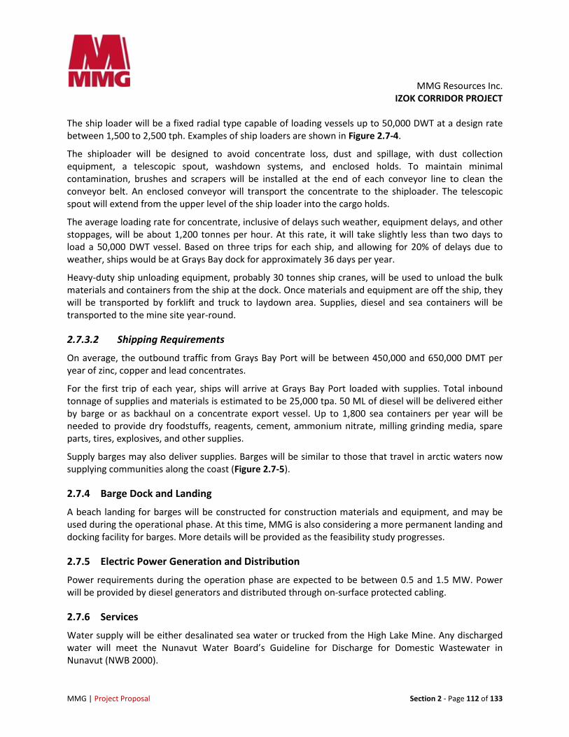
The ship loader will be a fixed radial type capable of loading vessels up to 50,000 DWT at a design rate between 1,500 to 2,500 tph. Examples of ship loaders are shown in Figure 2.7-4.
The shiploader will be designed to avoid concentrate loss, dust and spillage, with dust collection equipment, a telescopic spout, washdown systems, and enclosed holds. To maintain minimal contamination, brushes and scrapers will be installed at the end of each conveyor line to clean the conveyor belt. An enclosed conveyor will transport the concentrate to the shiploader. The telescopic spout will extend from the upper level of the ship loader into the cargo holds.
The average loading rate for concentrate, inclusive of delays such weather, equipment delays, and other stoppages, will be about 1,200 tonnes per hour. At this rate, it will take slightly less than two days to load a 50,000 DWT vessel. Based on three trips for each ship, and allowing for 20% of delays due to weather, ships would be at Grays Bay dock for approximately 36 days per year.
Heavy-duty ship unloading equipment, probably 30 tonnes ship cranes, will be used to unload the bulk materials and containers from the ship at the dock. Once materials and equipment are off the ship, they will be transported by forklift and truck to laydown area. Supplies, diesel and sea containers will be transported to the mine site year-round.
2.7.3.2 Shipping Requirements
On average, the outbound traffic from Grays Bay Port will be between 450,000 and 650,000 DMT per year of zinc, copper and lead concentrates.
For the first trip of each year, ships will arrive at Grays Bay Port loaded with supplies. Total inbound tonnage of supplies and materials is estimated to be 25,000 tpa. 50 ML of diesel will be delivered either by barge or as backhaul on a concentrate export vessel. Up to 1,800 sea containers per year will be needed to provide dry foodstuffs, reagents, cement, ammonium nitrate, milling grinding media, spare parts, tires, explosives, and other supplies.
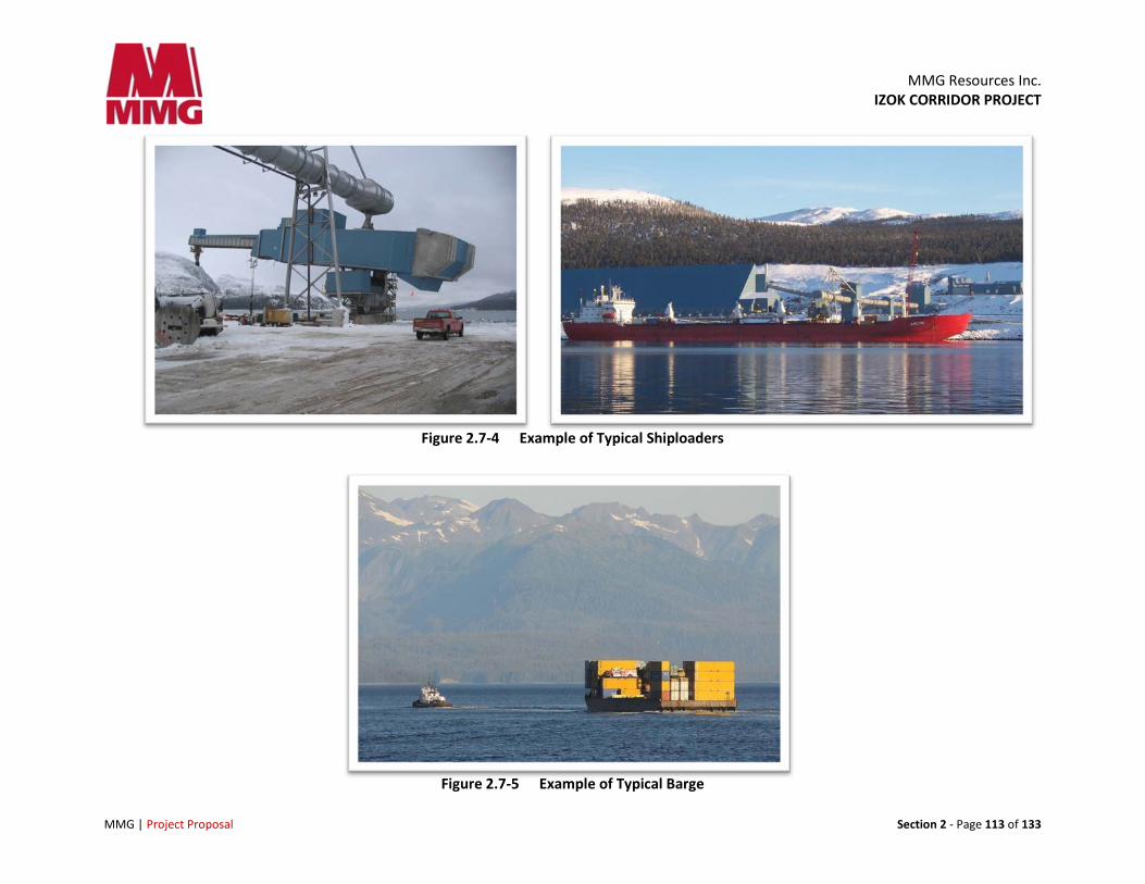
Supply barges may also deliver supplies. Barges will be similar to those that travel in arctic waters now supplying communities along the coast (Figure 2.7-5).
2.7.4 Barge Dock and Landing
A beach landing for barges will be constructed for construction materials and equipment, and may be used during the operational phase. At this time, MMG is also considering a more permanent landing and docking facility for barges. More details will be provided as the feasibility study progresses.
2.7.5 Electric Power Generation and Distribution
Power requirements during the operation phase are expected to be between 0.5 and 1.5 MW. Power will be provided by diesel generators and distributed through on-surface protected cabling.
2.7.6 Services
Water supply will be either desalinated sea water or trucked from the High Lake Mine. Any discharged water will meet the Nunavut Water Board’s Guideline for Discharge for Domestic Wastewater in Nunavut (NWB 2000).
MMG Resources Inc.
IZOK CORRIDOR PROJECT
MMG | Project Proposal Section 2 - Page 113 of 133
Figure 2.7-4 Example of Typical Shiploaders
Figure 2.7-5 Example of Typical Barge
MMG Resources Inc. IZOK CORRIDOR PROJECT
MMG | Project Proposal Section 2 - Page 114 of 133
Waste and surface water will be managed at the port site during the summer. This includes rainfall, snowmelt, and wash down water. Drainage paths will be developed for surface water runoff to flow into collection ditches. Collection ditches will direct water to a settling pond where solids will settle out and oil or diesel fuel will be retained by an invert weir trap. The solids will be disposed of as per a Waste Management Plan.
The port site will be capable of handling waste through proper processes and waste disposal management practices. An incineration plant and sewer system will be constructed on site simultaneously with the camp. Combustible garbage and construction waste materials will be transported to the incineration plant for disposal.
All water and sewage lines will be on surface and will be enclosed, heat-traced, insulated, and protected from traffic and winter conditions.
2.7.7 Fuel Systems
During the construction phase, temporary portable diesel tanks may be used prior to the construction of the tank farm.
After the grading of the site has been completed, a permanent fuel storage facility will be built for servicing the Izok project. This facility will consist of a bermed tank farm with two to four diesel storage tanks. The tanks will be filled from a ship with marine hoses, using the ship’s pumps, connected to the permanent delivery piping network.
An impermeable membrane (arctic liner) will be embedded in the floor and dike walls. Tank foundations will be on structural fill over bedrock to avoid any permafrost and settlement issues.
Jet fuel for helicopters and aircraft as well as gasoline for small equipment will be shipped in drums or ISO tank containers. Propane and other industrial gases will be brought in bottles, and lubricants will be brought in plastic cubes.
2.7.8 Air Transportation
An airstrip may be constructed near the Grays Bay Port to meet access needs during construction. This airstrip will likely not be used during the operational phase given that an airstrip 40 km south at Sand Lake will be available. Personnel will likely travel to the Sand Lake Airport and then be transported by truck to the Grays Bay Port site. Final selection of the airstrip location will be based on further feasibility studies.
2.7.9 Accommodation
A temporary construction camp will be located at the port site, capable of housing between 100 and 250 people.
MMG Resources Inc. IZOK CORRIDOR PROJECT
MMG | Project Proposal Section 2 - Page 115 of 133
A camp for25 to 40 people will be built to meet the operational needs of the port. This number may change once traffic plans have been finalized as it is very likely that drivers will need to overnight at the camp, and shift schedule may affect the number of rooms required.
The facility will include a kitchen, first aid room, common dining room, mud rooms, and a recreation room. The operations office will be located at the same complex.
2.7.10 Communications
External communication will be either by satellite or microwave. MMG is still researching and costing the best way to provide reliable communication for all sites.
2.7.11 Explosives Handling
Ammonium nitrate will be shipped in specially constructed containers with a payload of 20 tonnes. Emulsifiers will be transported and stored in steel drums inside a 20 ft sea container. As these products are not classified as explosives, they do not require heated buildings and can be stored in an open fenced area.
Blasting accessories are classified as explosives, and specialized, bullet-proof magazines will be constructed in a separate area located at an appropriate distance from buildings and roads as per the Explosives Act requirements.
2.7.12 Hazardous Materials
There will be limited quantities of hazardous materials (e.g., chemical reagents required for the mineral processing plant) that will move through Grays Bay Port in containers destined for High Lake Mine and Izok Mine. Containers will remain un-opened at the Grays Bay Port, and hazardous materials will not be removed from their packaging. They will be stored in bermed and lined areas.
Hazardous wastes will be canned and shipped off site. A management plan will be prepared for hazardous waste disposal.
2.7.12.1 Air Emissions and Dust
The major sources of air emissions will be gases from combustion of diesel fuel and dust emissions. Low sulphur grade diesel will be used for power generation and mobile vehicle operation. Concentrate will be contained within covered buildings and conveyor galleries from unloading of concentrate trucks to unloading to the ships hold.
MMG Resources Inc. IZOK CORRIDOR PROJECT
MMG | Project Proposal Section 2 - Page 116 of 133
Operating equipment, vehicles, and the power plant have the potential to affect air quality. Examples of mitigation measures include:
• Efficient operation of all equipment (vehicles and power plant)
• Speed limits to reduce dust
• Application of dust suppressants to open ground where dust can originate
• Regular application of water to reduce dust emissions during the summer
• Installation of dust collectors at concentrate transfer points
• Enclosed handling of concentrate from delivery to the storage shed to the ship hatches.
The Project is fossil fuel intensive as alternative energy sources do not exist in the area. The combustion of fossil fuels (e.g., diesel) produces greenhouse gases (GHG) such as carbon dioxide (CO2), methane (CH4) and nitrous oxide (N2O). Emission factors will be used to calculate GHG emissions from the quantity of fuel consumed for a given fuel type and combustion source.
2.7.12.2 Noise Emissions
The major sources of noise will be from diesel-powered vehicles and, diesel-powered generation equipment. The highest continuous noise levels at Grays Bay port will be generated by the concentrate trucks. Other sources of noise will be from the operation of pumps, compressors, generators, front end loaders and service vehicles.
Mitigation measures to reduce noise pollution will include:
• Conducting regular maintenance of construction and operations vehicles and equipment
• Installing air inlet silencers and exhaust silencers on all combustion engines
• Constructing noise baffles or enclosures for particularly noisy equipment
• Developing a noise monitoring and reduction program as part of the company’s Health and Safety Policy
2.7.13 Security
Security and customs control for international shipping will be managed by MMG and will comply with Canadian law. Ship’s personnel will remain on ship while at Grays Bay Port.
2.7.14 Port Alternatives Considered
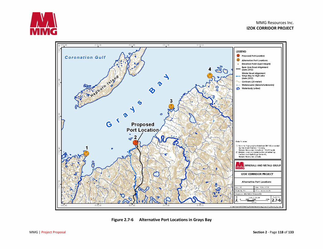
2.7.14.1 Alternative Port Locations
Several alternative locations have been considered for the location of the port (Figure 2.7-6). Several engineering reports, bathymetric studies, archaeological studies, the economics of the Project and the distance to High Lake provided good background information to guide the final selection of the port. MMG’s long-term plan for its presence in Nunavut has also influenced site selection.
MMG Resources Inc. IZOK CORRIDOR PROJECT
MMG | Project Proposal Section 2 - Page 117 of 133
Three adjacent sites were considered and rejected as being less accessible by either ships or by road. Further afield, a potential port location east of Kugluktuk, some 100 km west of the selected site, was assessed and rejected as being too far from High Lake Mine and being an option only if Izok was the only proposed mine.
A potential port location in Bathurst Inlet was assessed and rejected as providing access to Izok Mine but not to High Lake Mine. In addition, the Bathurst Inlet Road would require the crossing of a 69 km lake (on ice road in winter and/or by barge during ice-free months) with consequent loss of transportation for several months during the shoulder season. It would still not connect the High Lake Mine to the Izok Mine.
Both options were deemed uneconomic, as revenues from both Izok and High Lake concentrate must be part of the business plan to make the Project economically viable.
2.7.14.2 Alternative Dock Types
Various types of docks have been considered and rejected in favour of a gravity-based sheet pile structure. Risk involved with a sheet pile structure is considered low for this application as there are numerous successful examples of these structures in the north.
A prefabricated caisson structure that would be shipped to the dock location and sunk onto a prepared foundation was considered and rejected as having no perceivable advantage and having a higher cost than a sheet pile structure.
A floating dock and a pipe pile dock were both considered but rejected as being too vulnerable to forces imposed by ice.
2.7.14.3 Alternative Concentrate Storage Building Construction Material
A lighter steel frame building with fabric cladding was considered and rejected as having no clear advantage.
2.7.15 Mitigation by Design
The environmental effects of Grays Bay Port have been mitigated through minimizing the disturbed area. The location selected for Grays Bay Port allows all necessary infrastructure components to be constructed within a small footprint.
MMG Resources Inc.
IZOK CORRIDOR PROJECT
MMG | Project Proposal Section 2 - Page 118 of 133
Figure 2.7-6 Alternative Port Locations in Grays Bay
MMG Resources Inc. IZOK CORRIDOR PROJECT
MMG | Project Proposal Section 2 - Page 119 of 133
2.7.16 Closure Plan
All infrastructures at Grays Bay Port will be decommissioned, dismantled, and removed at closure.
2.7.17 Port Surface Water Management
Best practices for the control of sedimentation in run-off water will be implemented during construction and operation, including silt traps, silt fences, settling ponds and sumps, grease traps, and monitoring and pumping systems.
To the extent practical, non-contact runoff water from undisturbed areas will be segregated and, if found to satisfy discharge water quality standards, discharged to the receiving environment without treatment.
Contact water will be collected and diverted to a water holding pond, which will have sufficient storage capacity to accommodate seasonal variations in surface water.
All contact water will be tested for contaminants prior to treatment and/or release. Where necessary, diversion ditches will be used to route contact water to collection ponds or sumps for transfer to a water holding pond.
Management plans for disposal of sludge from the water holding pond will be developed.
No alternatives to the proposed Surface Water Management Plan have been identified as it conforms to the highest industry standard best practices and regulations for managing surface water.
The Surface Water Management Plan (see section 12) will mitigate the risk of uncontrolled release of contact water to the environment by intercepting, collecting, and treating such water by means of well-designed water control and containment structures.
All water retaining structures for managing contact water will be designed to handle the volumes of water resulting from exceptional weather events to ensure there is no possibility of uncontrolled release of contact water.
Water flow amounts used in design of water management systems are based on conservative assessments of global warming trends.
The volume of contact water generated will be minimized by intercepting and diverting around disturbed areas the greatest amount of non-contact surface water as the topography permits.
Where ground conditions indicate it necessary, liners will be installed in water retaining structures to eliminate seepage of contact water into groundwater regimes.
2.7.18 Port Water Treatment
Sewage generated at Grays Bay will be treated in a rotating biological contactor sewage treatment system or similar. Effluent will meet discharge criteria prior to release to the marine environment.
Sludge from sewage treatment will be discharged to a land farm or incinerated.
MMG Resources Inc. IZOK CORRIDOR PROJECT
MMG | Project Proposal Section 2 - Page 120 of 133
Grey water will be directed either to a water treatment plant where it will be treated for re-use, treated to meet discharge criteria and discharged in the sea, or directed to a land farm.
No alternatives have been identified for water treatment and discharge at Grays Bay.
At closure, all water treatment and discharge infrastructure not required for the first post-closure phase treatment of water in Grays Bay will be decommissioned and removed.
2.8 Marine Transportation Between 450,000 and 650,000 DMT of mineral concentrates will be shipped from Grays Bay through Coronation Gulf to ports in Europe and Asia en route to smelters and refineries. An estimated 50 ML diesel oil and 25,000 t resupply cargo will be transported into Grays Bayevery year to re-supply port and mine site operations.
Coronation Gulf is ice free for three to four months each year. Shipping access through the Coronation Gulf must, however, pass through parts of the Arctic Ocean that have narrower ice-free periods. While the length of the shipping season will depend on vessel design (ice classification) and ice conditions, the maximum length of the shipping season will in many cases be limited to 100 to 120 days to be consistent with the draft Kitikmeot Regional Land Use Plan (NPC 2005).
Vessel speeds will average 14 knots in open water and will reduce to an average of 6 knots in areas of the Northwest Passage such as between Resolute and Grays Bay. In accordance with the North Baffin Region Land Use Plan (NPC 2000), all ships will remain at least 10 km from coastlines in the Northwest Passage and 20 to 25 km from the coast of Lancaster Sound, unless approaching or leaving port, to avoid direct contact with concentrations of marine wildlife, whenever safe and practical to do so.
MMG will consult with several boards and agencies to prepare marine transportation plans to mitigate marine transport effects on marine mammals and birds.
MMG is in the process of completing transportation, logistics and scheduling for marine transport. Details will be provided as this work progresses. MMG will also be looking into lessons learned from other projects currently in the NIRB review process for guidance and recommendations.
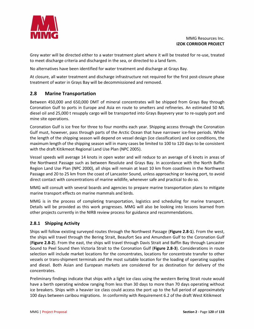
2.8.1 Shipping Activity
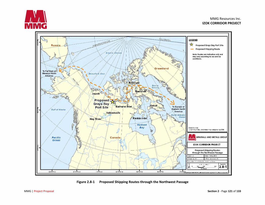
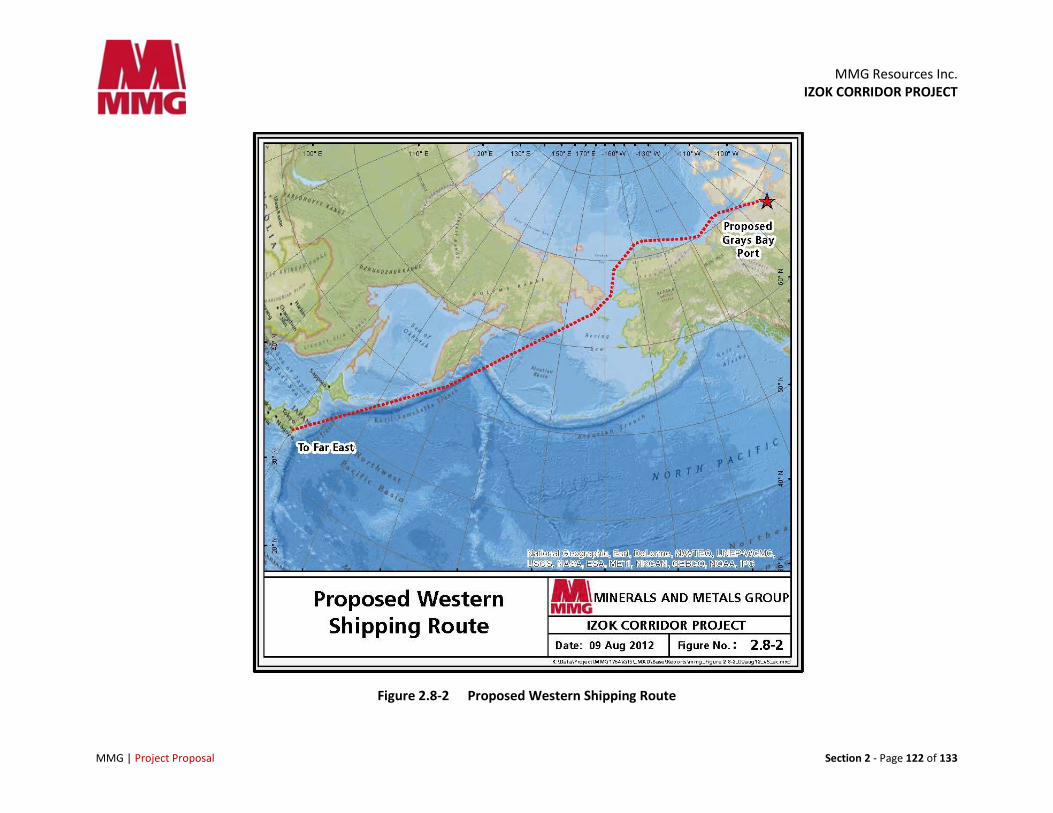
Ships will follow existing surveyed routes through the Northwest Passage (Figure 2.8-1). From the west, the ships will travel through the Bering Strait, Beaufort Sea and Amundsen Gulf to the Coronation Gulf (Figure 2.8-2). From the east, the ships will travel through Davis Strait and Baffin Bay through Lancaster Sound to Peel Sound then Victoria Strait to the Coronation Gulf (Figure 2.8-3). Considerations in route selection will include market locations for the concentrates, locations for concentrate transfer to other vessels or trans-shipment terminals and the most suitable location for the loading of operating supplies and diesel. Both Asian and European markets are considered for as destination for delivery of the concentrates.
Preliminary findings indicate that ships with a light ice class using the western Bering Strait route would have a berth operating window ranging from less than 30 days to more than 70 days operating without ice breakers. Ships with a heavier ice class could access the port up to the full period of approximately 100 days between caribou migrations. In conformity with Requirement 6.2 of the draft West Kitikmeot
MMG Resources Inc.
IZOK CORRIDOR PROJECT
MMG | Project Proposal Section 2 - Page 121 of 133
Figure 2.8-1 Proposed Shipping Routes through the Northwest Passage
MMG Resources Inc.
IZOK CORRIDOR PROJECT
MMG | Project Proposal Section 2 - Page 122 of 133
Figure 2.8-2 Proposed Western Shipping Route
MMG Resources Inc.
IZOK CORRIDOR PROJECT
MMG | Project Proposal Section 2 - Page 123 of 133
Figure 2.8-3 Proposed Eastern Shipping Route
MMG Resources Inc. IZOK CORRIDOR PROJECT
MMG | Project Proposal Section 2 - Page 124 of 133
Regional Land Use Plan (NPC 2005), shipping and ice breaking shall not take place during caribou migration periods outside the normal open water season between 01 July and 15 October, or between 15 October and 30 October if there is no ice breaking.
The eastern Davis Strait route is expected to have a shorter ice-free shipping period than the western route, and is closer to eastern markets for the Izok Corridor Project concentrates. Shipping related to the Project will take into account sensitive coastal and offshore areas, wildlife migration timing and shipping considerations outlined in the North Baffin Regional Land Use Plan (NPC 2000).
At this time, 16 round trips will be needed during the peak year of production. Only one ship at a time will be alongside the dock for loading or discharging. Ships may have to anchor in the vicinity to wait for space at the dock.
Ships will travel south from the surveyed Northwest Passage shipping route through the Coronation Gulf to reach Grays Bay. On leaving the dock, the ships will follow a route northeast from the dock across Grays Bay to the channel to the immediate east of Hepburn Island, then north across Coronation Gulf and onwards to Europe or the Far East to join the surveyed east/west route.A bathymetric survey of the north/south route through the Coronation Gulf was conducted in 2004 and the route was determined to be navigable. The Grays Bay dock location was selected based in part on a bathymetric survey of Grays Bay.
2.8.2 Waste and Water Management
Section 12 provides a list of Waste and Water Management plans. Ballast water, bilge water, waste oil, solid waste, deck drainage, Grey and Black Water Management plans will be developed for the Project.
2.8.3 Mitigation by Design
Ocean bulk-carriers built for the Project will incorporate updated environmental protection systems, including:
• Self-contained hold wash water tanks
• Bilge water cleaned and released per Canadian regulation
• Oil carrier will be double-hulled
• Fuel burned by ships will be low sulphur arctic fuel per regulation
• Avoidance of breaking land fast ice
• Limiting shipping activity to open-water season to avoid disturbance to caribou crossings and Inuit harvesting activities
In the DEIS, MMG will provide a description of waste produced or carried onboard, including quantities, storage, treatment, handling and disposal methods for ballast water, bilge water, waste oil, solid waste, deck drainage, grey and blackwater and hazardous or toxic waste.
MMG will provide a list of all applicable regulations concerning management of waste and discharges into the marine environment.
MMG Resources Inc. IZOK CORRIDOR PROJECT
MMG | Project Proposal Section 2 - Page 125 of 133
2.8.4 Alternatives Considered
Consideration has been given to the following alternatives to ocean carriage of concentrates and re-supply.
• Road transport via winter or all-weather road constructed southwards to Yellowknife was considered, studied and modelled but rejected due to high capital and operating cost. Once in Yellowknife, the concentrate would still need to be transported to either to a smelter in Trail, BC, or to a port in BC (Stewart or Vancouver). This is not a feasible option. Neither road, railroad or slurry pipeline are economic options for a southern land based route option. A recent study completed by MMG in 2010 and 2011 confirmed that shipping is the most viable option for the shipping of concentrate.
• Re-supply on barges out of Hay River, NWT which navigate the Mackenzie River is being considered for the Project. This option will be further evaluated as an alternative to shipping re-supply containers and break-bulk on the hatches of the bulk-carriers. It is likely that this would be an alternative for only part of the Project needs.
2.9 Employment and Procurement
2.9.1 Project Management and Administration
MMG already operates several mines in Australia, Asia and Africa. MMG will bring this experience and knowledge to the Canadian Project and make adjustments and changes as required by the Canadian and Nunavut context.
The main administration for Canadian operations will be in Vancouver, BC. MMG will also maintain a Project office in Kugluktuk. MMG will consider the possibility of another northern office.
There will also be an on-site management mine manager to oversee daily operations, with support from MMG’s Vancouver office.
2.9.2 Human Resource Management
MMG has extensive Human Resource policies governing its global operations. Some of the key policies include:
• Equal Opportunity, Promoting Diversity & Fair Treatment
• Education Assistance
• Flexible Workplace Arrangements
• Group Personal Accident
• New Employee Guideline
• Parental Leave Policy
• Performance Improvement Policy
MMG Resources Inc. IZOK CORRIDOR PROJECT
MMG | Project Proposal Section 2 - Page 126 of 133
• Recognition, Spot Bonus, Merit Adjustment & Higher Duties Allowances
• Medical and other Insurances
2.9.3 Construction Workforce
There are no existing permanent communities in the vicinity of the Project construction sites with facilities that could accommodate construction workers. The construction crews will likely originate from western and northern Canada and possibly other locations, and camp accommodations will be required as early as 2015.
The three base camps at High Lake Mine, Izok Mine, and Grays Bay Port and the three mobile road construction camps will be used during the construction of the roads, the port and the mine site facilities. Other sites may be considered and will be discussed later as the feasibility study progresses. It is anticipated that the construction base camps at the Grays Bay Port, and High Lake and Izok Mine sites will eventually be used by operations personnel as permanent camps. Before construction of the Izok Mine camp and associated water and sewage treatment facilities are completed, it is anticipated that workers will be flown in from the Izok or other camps daily.
The average on-site work force is expected to be approximately 670. The total workforce will be approximately double that at 1140 workers based on a fly-in fly-out (FIFO) rotation. These numbers are preliminary and may change as the feasibility study progresses.
2.9.4 Operations Workforce
During the operational phase of the Project, the total work force will be approximately 710 people, with 400 people on the mine site at any particular time due to shift cycles and rotation of personnel. This includes a total of approximately 45 people at the Port site during summer shipping operations, and 20 during the non-shipping months. These numbers are preliminary and may change as the feasibility study progresses.
2.9.5 Closure and Reclamation Workforce
Progressive reclamation will occur throughout the life of the Project, and some closure work will begin in the last year of the operating phase. Final site reclamation is estimated to take two to three years, starting in 2029, followed by a post-closure monitoring phase of approximately seven years. The workforce required during reclamation and post-closure monitoring has yet to be determined.
2.9.6 Mobilization
The Izok Corridor Project will be a FIFO operation.MMG has well established mine management and administration systems for FIFO operations. These systems will be adapted and applied to its operations in Nunavut.
MMG is considering mobilization options from the Kitikmeot communities, as well as other points in Canada. These studies are part of the feasibility evaluation currently taking place.
MMG Resources Inc. IZOK CORRIDOR PROJECT
MMG | Project Proposal Section 2 - Page 127 of 133
2.9.7 On-site Services and Facilities for Workers
MMG will offer on-site services and facilities for its workers consistent with other northern operations. Employees may expect fitness, cultural and spiritual facilities, healthy meals including country foods and the ability for staff to store their own country foods, educational labs and opportunities/facilities for training.
2.9.8 Contracting and Procurement
MMG will contract and procure from firms in Nunavut as possible. Terms, conditions, criteria and requirements will be clearly identified in a timely manner. As part of the feasibility evaluation, MMG will be examining other opportunities for local contracting and procurement.
2.9.9 Inuit Impact and Benefit Agreement
MMG will negotiate a draft Inuit Impact and Benefit Agreement (IIBA) prior to the submission of the Final Environmental Impact Statement. MMG has already initiated early discussions with the KIA.
2.9.10 Inuit Contracting and Business Support
The extent to which Inuit firms will meet MMG’s business support needs awaits the results of the ongoing planning and assessment, and will be informed through negotiations between MMG and the KIA. The percentage of the workforce that will be Inuit is one of the factors that are being examined as part of the labour force evaluation, and also will be part of future discussions between MMG and the KIA.
2.9.11 Community Outreach
Currently, community outreach has included sponsorship of a variety of community-based initiatives. MMG is providing active support to community-based “stay in school” initiatives and opportunities. A training program is planned, which will facilitate apprenticeships in skills that will mesh with Project employment opportunities. As the Project proceeds through the regulatory process, MMG will be expanding its community outreach program.
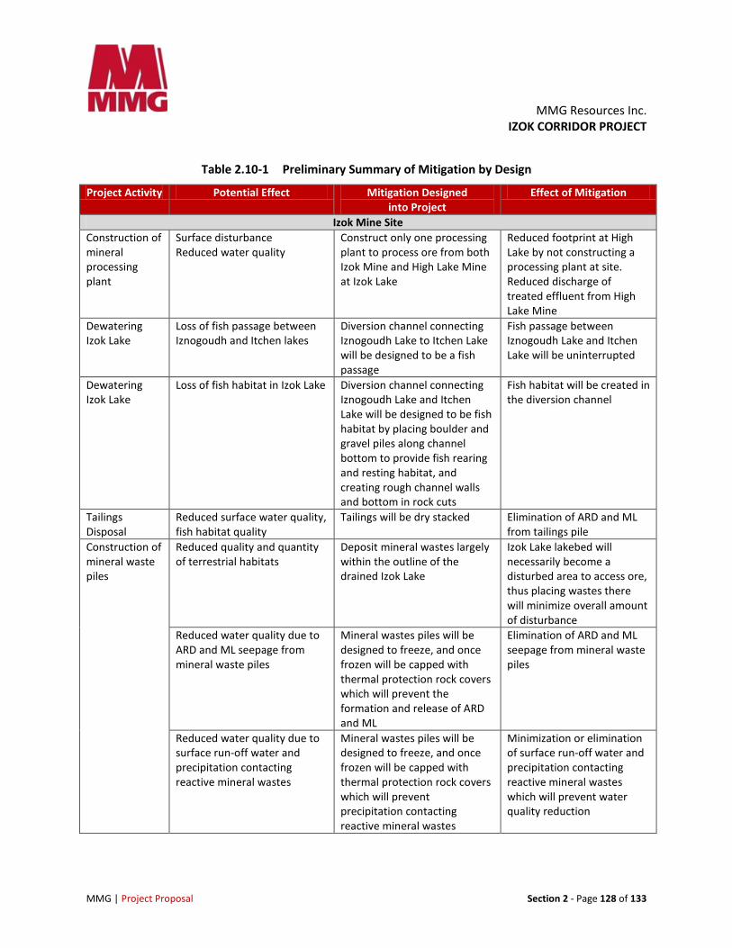
2.10 Summary of Mitigation by Project Design Various mitigation measures have been incorporated into the design of the Project to eliminate or reduce potential environmental effects. These preliminary measures are summarized below in Table 2.10-1. Additional measures will be adopted in the next years, based on consultation with stakeholders.
MMG Resources Inc. IZOK CORRIDOR PROJECT
MMG | Project Proposal Section 2 - Page 128 of 133
Table 2.10-1 Preliminary Summary of Mitigation by Design
Project Activity Potential Effect Mitigation Designed into Project
Effect of Mitigation
Izok Mine Site Construction of mineral processing plant
Surface disturbance Reduced water quality
Construct only one processing plant to process ore from both Izok Mine and High Lake Mine at Izok Lake
Reduced footprint at High Lake by not constructing a processing plant at site. Reduced discharge of treated effluent from High Lake Mine
Dewatering Izok Lake
Loss of fish passage between Iznogoudh and Itchen lakes
Diversion channel connecting Iznogoudh Lake to Itchen Lake will be designed to be a fish passage
Fish passage between Iznogoudh Lake and Itchen Lake will be uninterrupted
Dewatering Izok Lake
Loss of fish habitat in Izok Lake Diversion channel connecting Iznogoudh Lake and Itchen Lake will be designed to be fish habitat by placing boulder and gravel piles along channel bottom to provide fish rearing and resting habitat, and creating rough channel walls and bottom in rock cuts
Fish habitat will be created in the diversion channel
Tailings Disposal
Reduced surface water quality, fish habitat quality
Tailings will be dry stacked Elimination of ARD and ML from tailings pile
Construction of mineral waste piles
Reduced quality and quantity of terrestrial habitats
Deposit mineral wastes largely within the outline of the drained Izok Lake
Izok Lake lakebed will necessarily become a disturbed area to access ore, thus placing wastes there will minimize overall amount of disturbance
Reduced water quality due to ARD and ML seepage from mineral waste piles
Mineral wastes piles will be designed to freeze, and once frozen will be capped with thermal protection rock covers which will prevent the formation and release of ARD and ML
Elimination of ARD and ML seepage from mineral waste piles
Reduced water quality due to surface run-off water and precipitation contacting reactive mineral wastes
Mineral wastes piles will be designed to freeze, and once frozen will be capped with thermal protection rock covers which will prevent precipitation contacting reactive mineral wastes
Minimization or elimination of surface run-off water and precipitation contacting reactive mineral wastes which will prevent water quality reduction
MMG Resources Inc. IZOK CORRIDOR PROJECT
MMG | Project Proposal Section 2 - Page 129 of 133
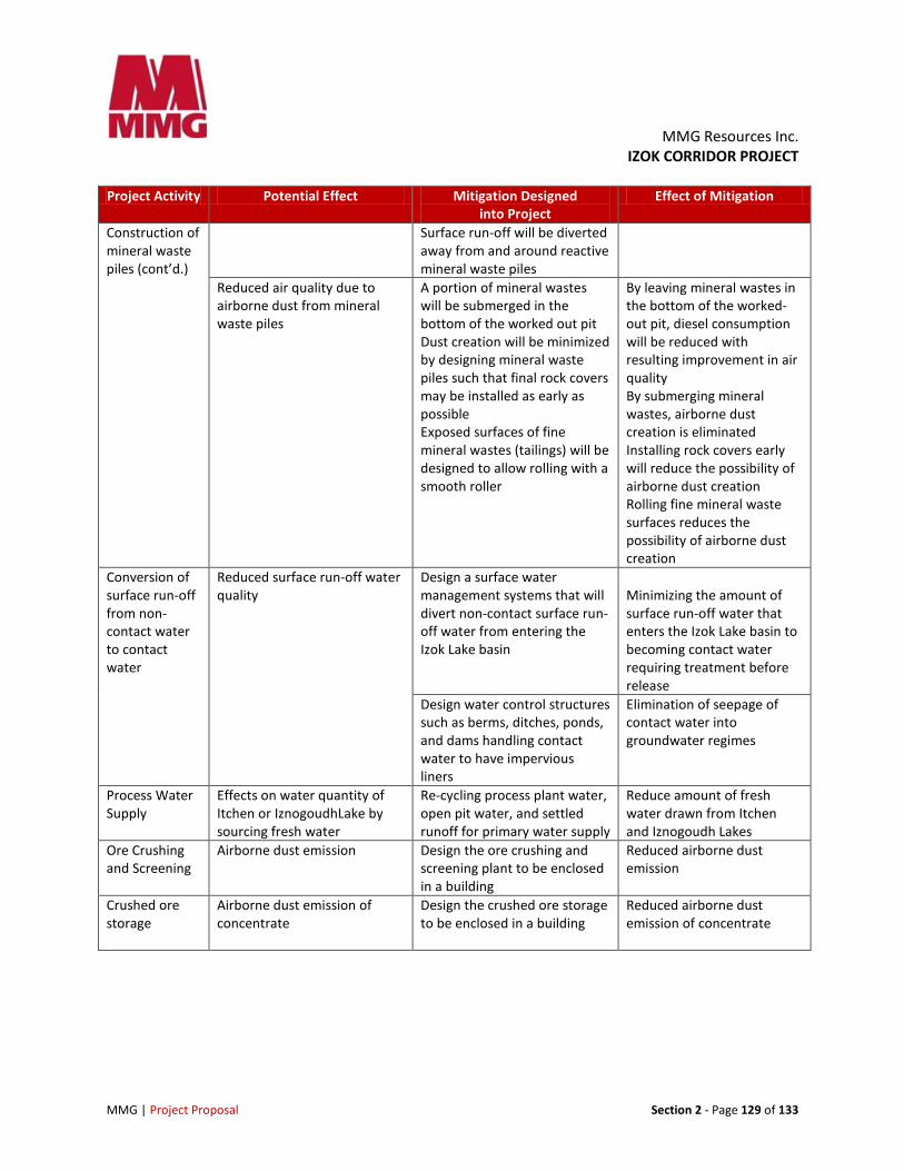
Project Activity Potential Effect Mitigation Designed into Project
Effect of Mitigation
Construction of mineral waste piles (cont’d.)
Surface run-off will be diverted away from and around reactive mineral waste piles
Reduced air quality due to airborne dust from mineral waste piles
A portion of mineral wastes will be submerged in the bottom of the worked out pit Dust creation will be minimized by designing mineral waste piles such that final rock covers may be installed as early as possible Exposed surfaces of fine mineral wastes (tailings) will be designed to allow rolling with a smooth roller
By leaving mineral wastes in the bottom of the worked-out pit, diesel consumption will be reduced with resulting improvement in air quality By submerging mineral wastes, airborne dust creation is eliminated Installing rock covers early will reduce the possibility of airborne dust creation Rolling fine mineral waste surfaces reduces the possibility of airborne dust creation
Conversion of surface run-off from non-contact water to contact water
Reduced surface run-off water quality
Design a surface water management systems that will divert non-contact surface run-off water from entering the Izok Lake basin
Minimizing the amount of surface run-off water that enters the Izok Lake basin to becoming contact water requiring treatment before release
Design water control structures such as berms, ditches, ponds, and dams handling contact water to have impervious liners
Elimination of seepage of contact water into groundwater regimes
Process Water Supply
Effects on water quantity of Itchen or IznogoudhLake by sourcing fresh water
Re-cycling process plant water, open pit water, and settled runoff for primary water supply
Reduce amount of fresh water drawn from Itchen and Iznogoudh Lakes
Ore Crushing and Screening
Airborne dust emission Design the ore crushing and screening plant to be enclosed in a building
Reduced airborne dust emission
Crushed ore storage
Airborne dust emission of concentrate
Design the crushed ore storage to be enclosed in a building
Reduced airborne dust emission of concentrate
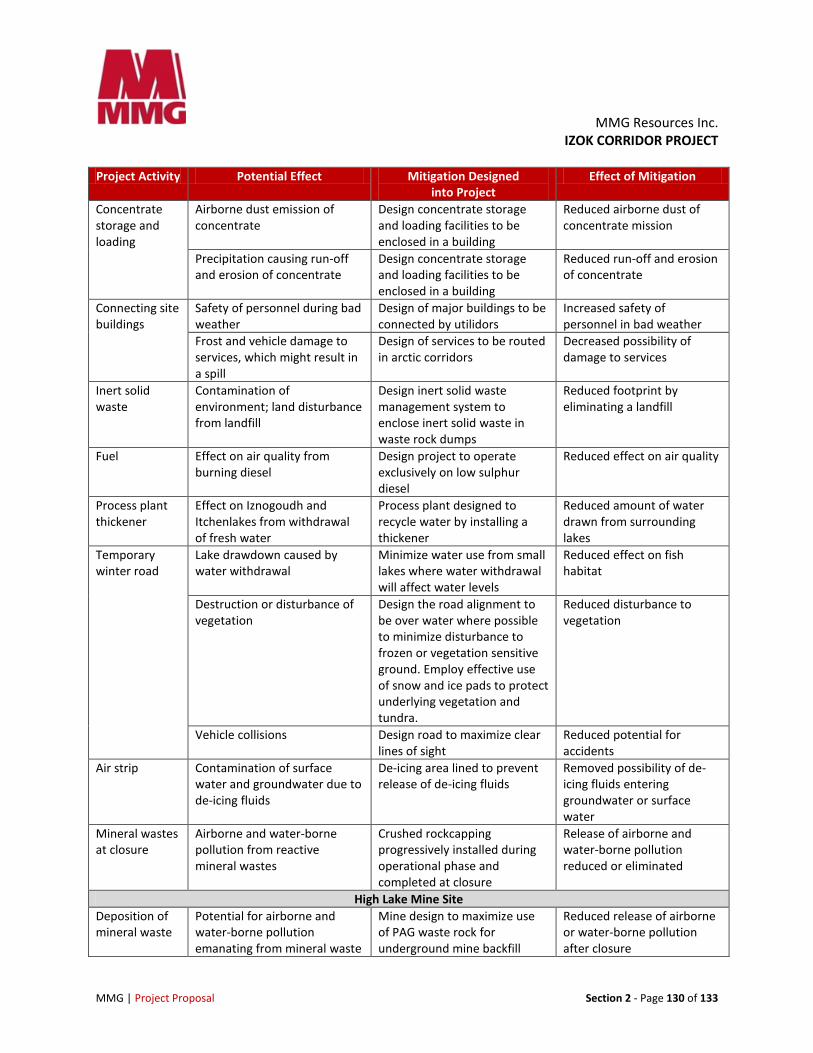
MMG Resources Inc. IZOK CORRIDOR PROJECT
MMG | Project Proposal Section 2 - Page 130 of 133
Project Activity Potential Effect Mitigation Designed into Project
Effect of Mitigation
Concentrate storage and loading
Airborne dust emission of concentrate
Design concentrate storage and loading facilities to be enclosed in a building
Reduced airborne dust of concentrate mission
Precipitation causing run-off and erosion of concentrate
Design concentrate storage and loading facilities to be enclosed in a building
Reduced run-off and erosion of concentrate
Connecting site buildings
Safety of personnel during bad weather
Design of major buildings to be connected by utilidors
Increased safety of personnel in bad weather
Frost and vehicle damage to services, which might result in a spill
Design of services to be routed in arctic corridors
Decreased possibility of damage to services
Inert solid waste
Contamination of environment; land disturbance from landfill
Design inert solid waste management system to enclose inert solid waste in waste rock dumps
Reduced footprint by eliminating a landfill
Fuel Effect on air quality from burning diesel
Design project to operate exclusively on low sulphur diesel
Reduced effect on air quality
Process plant thickener
Effect on Iznogoudh and Itchenlakes from withdrawal of fresh water
Process plant designed to recycle water by installing a thickener
Reduced amount of water drawn from surrounding lakes
Temporary winter road
Lake drawdown caused by water withdrawal
Minimize water use from small lakes where water withdrawal will affect water levels
Reduced effect on fish habitat
Destruction or disturbance of vegetation
Design the road alignment to be over water where possible to minimize disturbance to frozen or vegetation sensitive ground. Employ effective use of snow and ice pads to protect underlying vegetation and tundra.
Reduced disturbance to vegetation
Vehicle collisions Design road to maximize clear lines of sight
Reduced potential for accidents
Air strip Contamination of surface water and groundwater due to de-icing fluids
De-icing area lined to prevent release of de-icing fluids
Removed possibility of de-icing fluids entering groundwater or surface water
Mineral wastes at closure
Airborne and water-borne pollution from reactive mineral wastes
Crushed rockcapping progressively installed during operational phase and completed at closure
Release of airborne and water-borne pollution reduced or eliminated
High Lake Mine Site Deposition of mineral waste
Potential for airborne and water-borne pollution emanating from mineral waste
Mine design to maximize use of PAG waste rock for underground mine backfill
Reduced release of airborne or water-borne pollution after closure
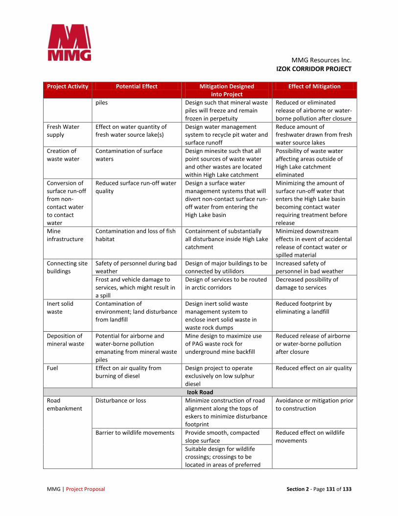
MMG Resources Inc. IZOK CORRIDOR PROJECT
MMG | Project Proposal Section 2 - Page 131 of 133
Project Activity Potential Effect Mitigation Designed into Project
Effect of Mitigation
piles Design such that mineral waste piles will freeze and remain frozen in perpetuity
Reduced or eliminated release of airborne or water-borne pollution after closure
Fresh Water supply
Effect on water quantity of fresh water source lake(s)
Design water management system to recycle pit water and surface runoff
Reduce amount of freshwater drawn from fresh water source lakes
Creation of waste water
Contamination of surface waters
Design minesite such that all point sources of waste water and other wastes are located within High Lake catchment
Possibility of waste water affecting areas outside of High Lake catchment eliminated
Conversion of surface run-off from non-contact water to contact water
Reduced surface run-off water quality
Design a surface water management systems that will divert non-contact surface run-off water from entering the High Lake basin
Minimizing the amount of surface run-off water that enters the High Lake basin becoming contact water requiring treatment before release
Mine infrastructure
Contamination and loss of fish habitat
Containment of substantially all disturbance inside High Lake catchment
Minimized downstream effects in event of accidental release of contact water or spilled material
Connecting site buildings
Safety of personnel during bad weather
Design of major buildings to be connected by utilidors
Increased safety of personnel in bad weather
Frost and vehicle damage to services, which might result in a spill
Design of services to be routed in arctic corridors
Decreased possibility of damage to services
Inert solid waste
Contamination of environment; land disturbance from landfill
Design inert solid waste management system to enclose inert solid waste in waste rock dumps
Reduced footprint by eliminating a landfill
Deposition of mineral waste
Potential for airborne and water-borne pollution emanating from mineral waste piles
Mine design to maximize use of PAG waste rock for underground mine backfill
Reduced release of airborne or water-borne pollution after closure
Fuel Effect on air quality from burning of diesel
Design project to operate exclusively on low sulphur diesel
Reduced effect on air quality
Izok Road Road embankment
Disturbance or loss Minimize construction of road alignment along the tops of eskers to minimize disturbance footprint
Avoidance or mitigation prior to construction
Barrier to wildlife movements Provide smooth, compacted slope surface
Reduced effect on wildlife movements
Suitable design for wildlife crossings; crossings to be located in areas of preferred
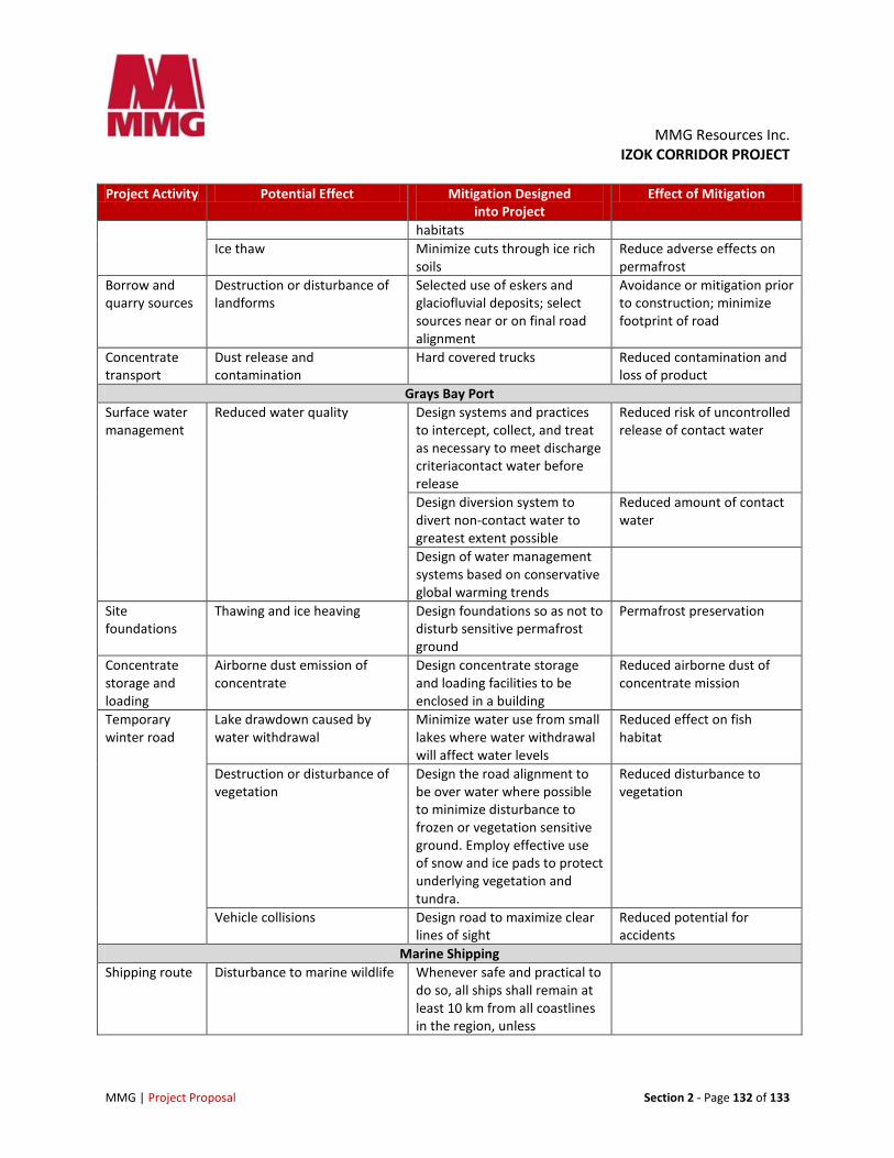
MMG Resources Inc. IZOK CORRIDOR PROJECT
MMG | Project Proposal Section 2 - Page 132 of 133
Project Activity Potential Effect Mitigation Designed into Project
Effect of Mitigation
habitats Ice thaw Minimize cuts through ice rich
soils Reduce adverse effects on permafrost
Borrow and quarry sources
Destruction or disturbance of landforms
Selected use of eskers and glaciofluvial deposits; select sources near or on final road alignment
Avoidance or mitigation prior to construction; minimize footprint of road
Concentrate transport
Dust release and contamination
Hard covered trucks Reduced contamination and loss of product
Grays Bay Port Surface water management
Reduced water quality Design systems and practices to intercept, collect, and treat as necessary to meet discharge criteriacontact water before release
Reduced risk of uncontrolled release of contact water
Design diversion system to divert non-contact water to greatest extent possible
Reduced amount of contact water
Design of water management systems based on conservative global warming trends
Site foundations
Thawing and ice heaving Design foundations so as not to disturb sensitive permafrost ground
Permafrost preservation
Concentrate storage and loading
Airborne dust emission of concentrate
Design concentrate storage and loading facilities to be enclosed in a building
Reduced airborne dust of concentrate mission
Temporary winter road
Lake drawdown caused by water withdrawal
Minimize water use from small lakes where water withdrawal will affect water levels
Reduced effect on fish habitat
Destruction or disturbance of vegetation
Design the road alignment to be over water where possible to minimize disturbance to frozen or vegetation sensitive ground. Employ effective use of snow and ice pads to protect underlying vegetation and tundra.
Reduced disturbance to vegetation
Vehicle collisions Design road to maximize clear lines of sight
Reduced potential for accidents
Marine Shipping Shipping route Disturbance to marine wildlife Whenever safe and practical to
do so, all ships shall remain at least 10 km from all coastlines in the region, unless
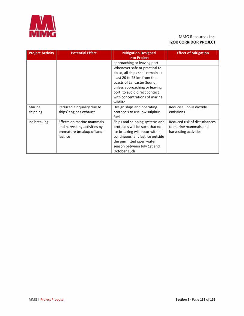
MMG Resources Inc. IZOK CORRIDOR PROJECT
MMG | Project Proposal Section 2 - Page 133 of 133
Project Activity Potential Effect Mitigation Designed into Project
Effect of Mitigation
approaching or leaving port Whenever safe or practical to do so, all ships shall remain at least 20 to 25 km from the coasts of Lancaster Sound, unless approaching or leaving port, to avoid direct contact with concentrations of marine wildlife
Marine shipping
Reduced air quality due to ships’ engines exhaust
Design ships and operating protocols to use low sulphur fuel
Reduce sulphur dioxide emissions
Ice breaking Effects on marine mammals and harvesting activities by premature breakup of land-fast ice
Ships and shipping systems and protocols will be such that no ice breaking will occur within continuous landfast ice outside the permitted open water season between July 1st and October 15th
Reduced risk of disturbances to marine mammals and harvesting activities