Palenque's Settlement Pattern and Social Organization Models
30
1 Palenque’s Settlement Pattern and Social Organization Models Edwin L. Barnhart November 2005 For the first half of the 20 th century the prevailing opinion was that Classic Maya ruins were isolated ceremonial centers where only elite and priestly classes resided. The majority of the population was thought to be farmers living in the hinterlands, entering the centers only for religious events. Starting in the 1960’s, intensive surveys around the ceremonial centers began to paint a different picture, one suggesting that they were surrounded by large, socio- economically diverse populations. These discoveries compelled archaeologists to reevaluate the social mechanisms that allowed these large, densely settled populations to remain cohesive over multiple generations. Many social organization models have been forwarded, some more productive than others. Using an extensive survey completed in 2000, this paper evaluates which of the current models best fits the Palenque settlement pattern. The Palenque Mapping Project (PMP) was completed in August of 2000. In total, 1481 structures and over sixteen linear kilometers of terracing were recorded (Map 1). The site’s previous map (Robertson 1983), covering essential the same area, contained only 329 structures. During the course of 18 months in the forests surrounding Palenque an area of 220 hectares was 100% surveyed and determined to be over four times more extensively settled than previously understood. The new map was created from over 24,500 individual data points taken at every building corner, river’s edge and topography change. The over 1100 newly recorded structures range from small, half meter tall platforms to the largest structure ever found in Palenque, the Escondido Temple. In addition to the variety of structure types, they are arranged in recognizable zones of the city. The zones suspected of being residential are further arranged in a repeated pattern of smaller structures arranged around notably larger compounds. This paper is going to first describe the observable settlement pattern data for Palenque and then use it to evaluate which of a number of social organization models proposed for the Classic period Maya best fit the pattern found at Palenque. In its conclusion, this paper will argue that a Cargo System model, comprised of elite council members from within the community under the authority of the Ahau, best fits Palenque’s settlement pattern.
-
Upload
mayaexploration -
Category
Documents
-
view
6 -
download
0
Transcript of Palenque's Settlement Pattern and Social Organization Models
1
Palenque’s Settlement Pattern and Social Organization Models Edwin L. Barnhart
November 2005
For the first half of the 20th century the prevailing opinion was that Classic Maya ruins were isolated ceremonial centers where only elite and priestly classes resided. The majority of the population was thought to be farmers living in the hinterlands, entering the centers only for religious events. Starting in the 1960’s, intensive surveys around the ceremonial centers began to paint a different picture, one suggesting that they were surrounded by large, socio-economically diverse populations. These discoveries compelled archaeologists to reevaluate the social mechanisms that allowed these large, densely settled populations to remain cohesive over multiple generations. Many social organization models have been forwarded, some more productive than others. Using an extensive survey completed in 2000, this paper evaluates which of the current models best fits the Palenque settlement pattern.
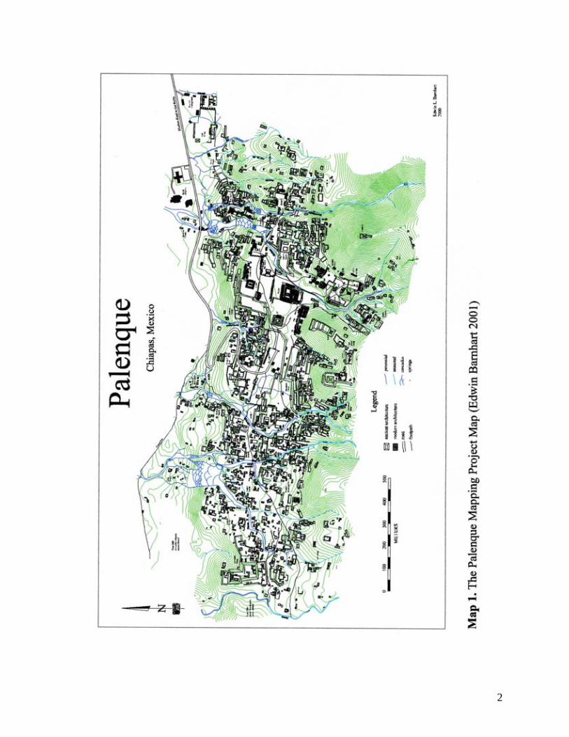
The Palenque Mapping Project (PMP) was completed in August of 2000. In total, 1481
structures and over sixteen linear kilometers of terracing were recorded (Map 1). The site’s
previous map (Robertson 1983), covering essential the same area, contained only 329 structures.
During the course of 18 months in the forests surrounding Palenque an area of 220 hectares was
100% surveyed and determined to be over four times more extensively settled than previously
understood. The new map was created from over 24,500 individual data points taken at every
building corner, river’s edge and topography change. The over 1100 newly recorded structures
range from small, half meter tall platforms to the largest structure ever found in Palenque, the
Escondido Temple. In addition to the variety of structure types, they are arranged in recognizable
zones of the city. The zones suspected of being residential are further arranged in a repeated
pattern of smaller structures arranged around notably larger compounds. This paper is going to
first describe the observable settlement pattern data for Palenque and then use it to evaluate
which of a number of social organization models proposed for the Classic period Maya best fit
the pattern found at Palenque. In its conclusion, this paper will argue that a Cargo System
model, comprised of elite council members from within the community under the authority of
the Ahau, best fits Palenque’s settlement pattern.
2
3
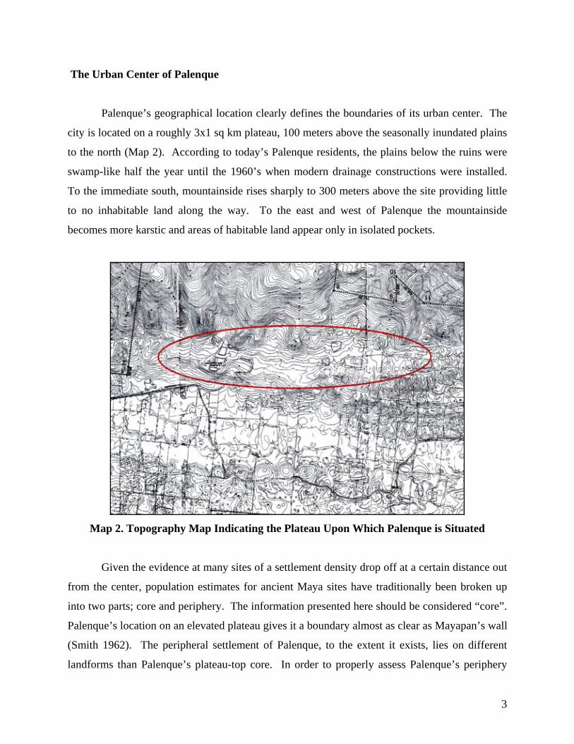
The Urban Center of Palenque
Palenque’s geographical location clearly defines the boundaries of its urban center. The
city is located on a roughly 3x1 sq km plateau, 100 meters above the seasonally inundated plains
to the north (Map 2). According to today’s Palenque residents, the plains below the ruins were
swamp-like half the year until the 1960’s when modern drainage constructions were installed.
To the immediate south, mountainside rises sharply to 300 meters above the site providing little
to no inhabitable land along the way. To the east and west of Palenque the mountainside
becomes more karstic and areas of habitable land appear only in isolated pockets.
Map 2. Topography Map Indicating the Plateau Upon Which Palenque is Situated
Given the evidence at many sites of a settlement density drop off at a certain distance out
from the center, population estimates for ancient Maya sites have traditionally been broken up
into two parts; core and periphery. The information presented here should be considered “core”.
Palenque’s location on an elevated plateau gives it a boundary almost as clear as Mayapan’s wall
(Smith 1962). The peripheral settlement of Palenque, to the extent it exists, lies on different
landforms than Palenque’s plateau-top core. In order to properly assess Palenque’s periphery
4
one would need separate surveys of the mountains above and the plains below. The plains were
sampled in the 1990’s and found to have extremely little settlement evidence. Agricultural
evidence, however, was abundant (Liendo 1999). Surveys of the mountainsides around the
plateau have yet to be conducted. From the viewpoint of current evidence and informal
reconnaissance, a very low settlement density for the mountainsides can also be predicted. It is
not until 10-20 km outside of Palenque that small satellite sites like Nunutun, Xupa, El Retiro
and Santa Isabel begin appearing. While Palenque’s apparent isolation seems contradictory
when compared to other Classic centers, one should bear in mind that the same plateau location
that made Palenque naturally defensible may have made it difficult to militarily defend and/or
subjugate the immediate peripheral area.
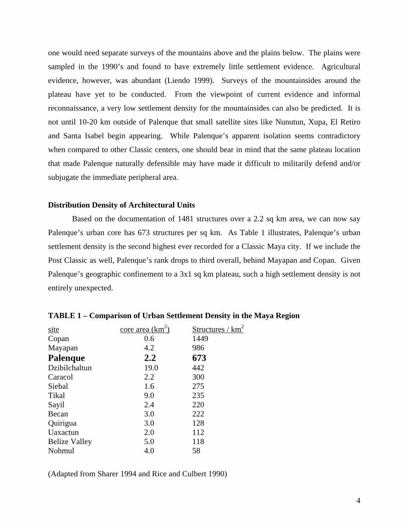
Distribution Density of Architectural Units
Based on the documentation of 1481 structures over a 2.2 sq km area, we can now say
Palenque’s urban core has 673 structures per sq km. As Table 1 illustrates, Palenque’s urban
settlement density is the second highest ever recorded for a Classic Maya city. If we include the
Post Classic as well, Palenque’s rank drops to third overall, behind Mayapan and Copan. Given
Palenque’s geographic confinement to a 3x1 sq km plateau, such a high settlement density is not
entirely unexpected.
TABLE 1 – Comparison of Urban Settlement Density in the Maya Region
site core area (km2) Structures / km2 Copan 0.6 1449 Mayapan 4.2 986 Palenque 2.2 673 Dzibilchaltun 19.0 442 Caracol 2.2 300 Siebal 1.6 275 Tikal 9.0 235 Sayil 2.4 220 Becan 3.0 222 Quirigua 3.0 128 Uaxactun 2.0 112 Belize Valley 5.0 118 Nohmul 4.0 58
(Adapted from Sharer 1994 and Rice and Culbert 1990)
5
What is not included in Table 1 is the sixteen linear kilometers of terracing discovered at
Palenque, some of which may be concealing hillside residential units like Group I/II. This
terracing will be further discussed in the “public works” section of this paper.
Population Estimates
Current evidence of settlement at Palenque supports no more than 7500 people at its
peak. Though continued survey may increase that number, it will never rise to the levels known
to have lived within sites like Tikal, Caracol, and Copan. There is simply a lack of habitable
land around Palenque’s center. Blom and La Farge (1926-27) estimated Palenque’s settlement to
extend sixteen square kilometers around its center. While it is true that ancient structures are
found that far outside the center, they are so infrequent that it would be misleading to call them
peripheral settlement. Base on his informal reconnaissance of the surrounding mountainside,
your author would predict a maximum of 10-20 structures per square kilometer. A recent survey
of the plains directly below the city and the immediate surrounding foothills reported only ten
residential groups over an area greater than five square kilometers (Liendo 1999). Compared to
673/km sq on the plateau, the immediate outlying population appears negligible. Thus, in terms
of population size, Palenque’s population is extremely small when compared to other major
Classic Maya cities.
One of the key factors in estimating Palenque’s population is how many people we
believe occupied the average residential structure. Traditionally, researchers have relied on
ethnographic studies of modern Maya communities from which to draw their comparisons.
Though Thompson (1954), among others, suggested numbers as high as 10 family members per
household based on contact period information, most researchers agree on a number between 4
and 6 for the Classic period. An average of 5 persons per structure was used for many sites
including Tikal (Haviland 1965, 1969, 1970), Siebal (Tourtellot 1976), Mayapan (Smith 1962)
and Copan (Willey and Leventhal 1979). Following the standard, 4-6 persons per structure is
used here to present the range of estimates for Palenque.
In almost every population estimate put forth for an ancient Maya city the researcher has
altered the results by a percentage from the simplistic 5 per structure count. Some would have
the raw numbers reduced based on the accepted fact that not all peripheral mounds could be
6
residential. Haviland’s studies at Tikal lead him to suggest 16.5% were non-residential (1965).
For Copan, Webster and Freter suggested a 20-30% reduction (1990). Others would suggest
further reductions to account for abandoned structures. Certainly the Classic Maya tradition of
residential burial and its processes of converting home to tomb would produce a percentage of
non-inhabited, but culturally functional, residential structures (Barnhart 2002).
On the flip side, there are those who would have the raw numbers increased based on the
undetectable presence of perishable structures. For the sites of Santa Rita (D. Chase 1990) and
Tayasal (A. Chase 1990) the population estimates accounted for invisible and hidden structures,
raising the surveyed structure count by 37-50%. Studies at Nohmul also factored in for hidden
structures (Pyburn 1990). As carefully as these adjustments are determined, we must
acknowledge they are essentially arbitrary. They are based on current evidence and in that
regard validated. In the case of Palenque, with its extremely high building density, it is hard to
imagine adding much more for perishable structures. Palenque’s lack of small mound
excavation data further begs conservative estimates. Percentage reductions also have to be
factored in for gaps in our chronological data. Given these limitations, Palenque’s estimate
presented here follows the consensus compiled by Rice and Culbert (1990); a flat 30% reduction
from the raw structure count.
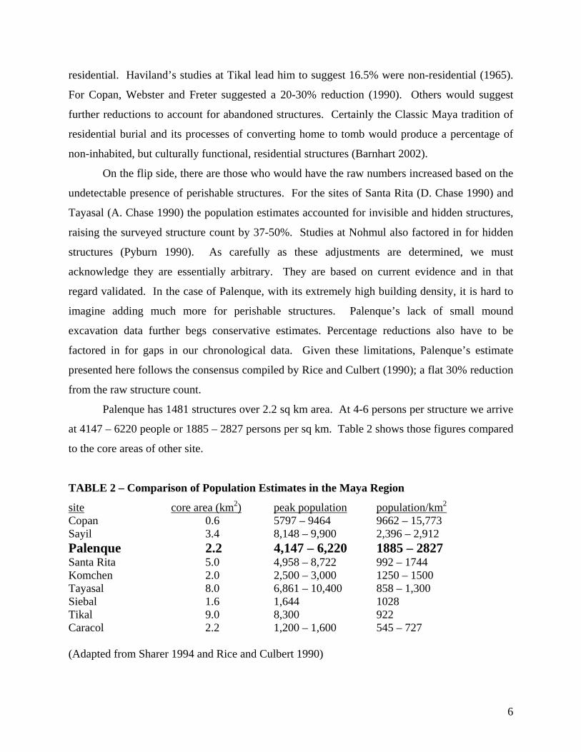
Palenque has 1481 structures over 2.2 sq km area. At 4-6 persons per structure we arrive
at 4147 – 6220 people or 1885 – 2827 persons per sq km. Table 2 shows those figures compared
to the core areas of other site.
TABLE 2 – Comparison of Population Estimates in the Maya Region
site core area (km2) peak population population/km2 Copan 0.6 5797 – 9464 9662 – 15,773 Sayil 3.4 8,148 – 9,900 2,396 – 2,912 Palenque 2.2 4,147 – 6,220 1885 – 2827 Santa Rita 5.0 4,958 – 8,722 992 – 1744 Komchen 2.0 2,500 – 3,000 1250 – 1500 Tayasal 8.0 6,861 – 10,400 858 – 1,300 Siebal 1.6 1,644 1028 Tikal 9.0 8,300 922 Caracol 2.2 1,200 – 1,600 545 – 727 (Adapted from Sharer 1994 and Rice and Culbert 1990)
7
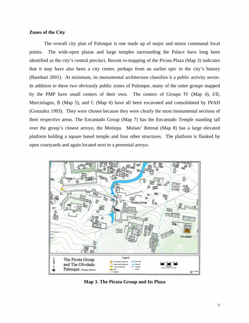
Zones of the City The overall city plan of Palenque is one made up of major and minor communal focal
points. The wide-open plazas and large temples surrounding the Palace have long been
identified as the city’s central precinct. Recent re-mapping of the Picota Plaza (Map 3) indicates
that it may have also been a city center, perhaps from an earlier epic in the city’s history
(Barnhart 2001). At minimum, its monumental architecture classifies it a public activity sector.
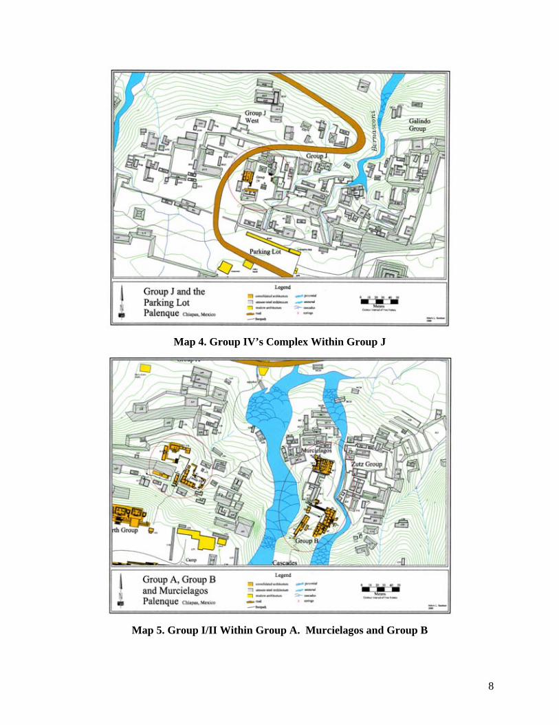
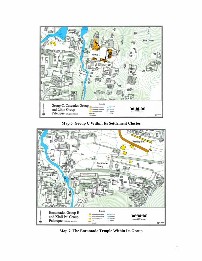
In addition to these two obviously public zones of Palenque, many of the outer groups mapped
by the PMP have small centers of their own. The centers of Groups IV (Map 4), I/II,
Murcielagos, B (Map 5), and C (Map 6) have all been excavated and consolidated by INAH
(Gonzalez 1993). They were chosen because they were clearly the most monumental sections of
their respective areas. The Encantado Group (Map 7) has the Encantado Temple standing tall
over the group’s closest arroyo, the Motiepa. Moises’ Retreat (Map 8) has a large elevated
platform holding a square based temple and four other structures. The platform is flanked by
open courtyards and again located next to a perennial arroyo.
Map 3. The Picota Group and Its Plaza
8
Map 4. Group IV’s Complex Within Group J
Map 5. Group I/II Within Group A. Murcielagos and Group B
9
Map 6. Group C Within Its Settlement Cluster
Map 7. The Encantado Temple Within Its Group

10
Map 8. The Complex Within the Moises’ Retreat Group
Map 9. The Ach’ Group and Connected Terracing
11
Located a half kilometer northeast of and over seventy meters below Palenque’s center,
lies a public plaza group, the Ach’ Group (Map 9). The plaza is 80x150m and a structure named
the Maya L bounds its south side, standing five meters tall and measuring sixty-seven meters
across its front side. A wide staircase with two tiers climbs up to the structure’s top where the
stubs of fifty columns testify to the Maya L’s open colonnade architecture (Figure 1). The Ach’
Group is one of the strongest examples that Palenque, in addition to its ceremonial center, had a
multiple public gathering areas.
Structure density was found to be greatest in Palenque’s western region, specifically in
between the Arroyos Picota and Motiepa. Structure density is also quite high in between the
Arroyos Otulum and Balunte. Examples of water management architecture and landscape
alteration found throughout those densely settled zones seem to be primarily focused on freeing
habitable lands from seasonal inundation (French 2001).
Agriculture and the Ach’ Group
Palenque’s agricultural methods are still in need of investigation. The lack of milpa lands
within Tikal’s densely settled immediate periphery baffled investigators until the discovery of
raised fields in the bajos (Haviland 1970). Caracol was found to have constructed hundreds of
hillside agricultural terraces throughout its immediate periphery (Chase and Chase 1996). The
shear size of the population estimates for each of those cities demanded massive and reliable
food sources. At Palenque, while the population estimate is much smaller, the need for
subsistence resources was still of first-order importance.
Rodrigo Liendo has identified what he believes to be irrigation canals in the plains
directly below the city’s plateau (1999). While he identified many fields around the Michol
River, they alone would not have been capable of feeding a population of the size now believed
to have lived within Palenque’s core settlement. Liendo also identified limited areas of
agricultural terracing. Some of those terraces, the ones within and to the east of Mayabell
Campground, were mapped in during the PMP survey. They are wide, gently sloped and do not
have structures built upon them. Those terraces connect to the Ach’ Group’s plaza, the only off-
plateau public plaza in Palenque (Map 9). The “Maya L”, the dominant structure of that 80x150
meter plaza, was distinctly public in architectural form (Figure 1). Its 30-meter wide staircase
leads six meters up to a 50-meter long, L-shaped superstructure. Its roof was perishable, as
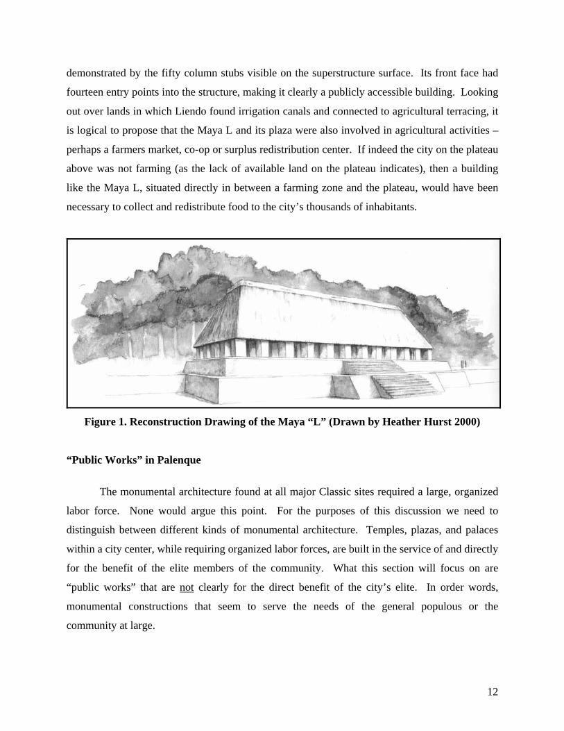
12
demonstrated by the fifty column stubs visible on the superstructure surface. Its front face had
fourteen entry points into the structure, making it clearly a publicly accessible building. Looking
out over lands in which Liendo found irrigation canals and connected to agricultural terracing, it
is logical to propose that the Maya L and its plaza were also involved in agricultural activities –
perhaps a farmers market, co-op or surplus redistribution center. If indeed the city on the plateau
above was not farming (as the lack of available land on the plateau indicates), then a building
like the Maya L, situated directly in between a farming zone and the plateau, would have been
necessary to collect and redistribute food to the city’s thousands of inhabitants.
Figure 1. Reconstruction Drawing of the Maya “L” (Drawn by Heather Hurst 2000)
“Public Works” in Palenque
The monumental architecture found at all major Classic sites required a large, organized
labor force. None would argue this point. For the purposes of this discussion we need to
distinguish between different kinds of monumental architecture. Temples, plazas, and palaces
within a city center, while requiring organized labor forces, are built in the service of and directly
for the benefit of the elite members of the community. What this section will focus on are
“public works” that are not clearly for the direct benefit of the city’s elite. In order words,
monumental constructions that seem to serve the needs of the general populous or the
community at large.
13
At Tikal there are the earthworks bounding the north and south ends of the city’s outer
boundary. They are massive and no doubt required a large labor force to construct. These
earthworks, in conjunction with bajos to the east and west, enclosed not just the homes of the
elite but all the residences within a 16 sq km area. These are prime examples of public works.
The site of the Caracol contains probably the strongest examples of public works yet documented
in the Maya area. Wide areas of agricultural terracing were found along the causeways leading
out from the center to outlying zones. The size, scale and peripheral locations of these terraces
led the Chases to conclusively argue that they held crops designated for public surplus.
Caracol’s causeways also appear to have been public transportation routes rather then ceremonial
processional routes (Chase et al. 1990).
Even from just the surface examination preformed on Palenque’s exterior it is clear that
public works pervade the site’s settlement pattern. One of Palenque’s largest settlement
obstacles must have been erosion. Placed half way up a mountainside with nine perennial
arroyos and over fifty natural springs, flooding was a constant possibility, especially during the
rainy season. Without proper control features in place, rain run-off coming down the
mountainsides could have easily wash construction out and consistently overflowed the arroyos.
For Palenque, the solution appears to have been terracing and arroyo canalization. The Otulum
Aqueduct and the great terraces holding the city’s main plazas in place are features that protect
the elite controlled central precinct from erosion processes and flooding. The PMP (Barnhart
2001) discovered that those same kinds of features were built all across the plateau and were in
fact concentrated in the residential zones. The vast and complex system of drains, canals, and
aqueducts constructed in all parts of the city are well documented in Kirk French’s University of
Cinncinati Thesis (2001). The over sixteen linear kilometers of residential terracing on the city’s
hillsides are described in more detail below.
Terracing encountered outside of Maya city centers is typically determined to be
agricultural. At Palenque, terracing appears instead to have been employed to stabilize hillside
residential sectors. Groups both east and west of Palenque’s center contain residential terracing,
most at least two meters in height. Most group’s contain multiple terraces running over 100
meters in length. In total, over sixteen linear kilometers of terraces have now been documented
at Palenque. The Xinil Pa’ Group alone, shown in Map 10, contains over a kilometer of
interconnected terracing. The scale of these terraces clearly required organized labor of a size
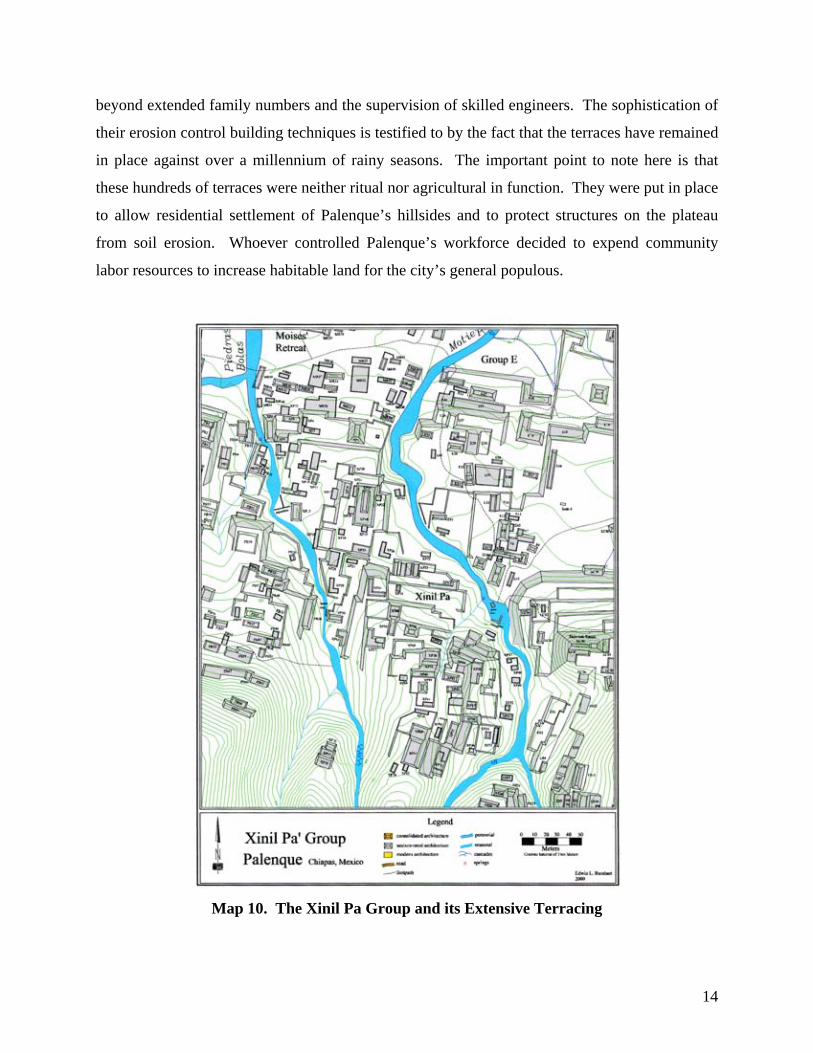
14
beyond extended family numbers and the supervision of skilled engineers. The sophistication of
their erosion control building techniques is testified to by the fact that the terraces have remained
in place against over a millennium of rainy seasons. The important point to note here is that
these hundreds of terraces were neither ritual nor agricultural in function. They were put in place
to allow residential settlement of Palenque’s hillsides and to protect structures on the plateau
from soil erosion. Whoever controlled Palenque’s workforce decided to expend community
labor resources to increase habitable land for the city’s general populous.
Map 10. The Xinil Pa Group and its Extensive Terracing
15
Palenque and Maya Settlement Pattern Models
Palenque, like every other ruins extensively mapped ruins in the Maya area since the
1960’s, does not fit the “vacant ceremonial center” model. In fact, Palenque’s 673 structures per
sq km make it one of the most densely settled centers of the Classic Period. Evidence indicates a
population of thousands living close together in an urban center. Architectural diversity strongly
suggests there were multiple levels of socio-economic status interspersed throughout the plateau
upon which the city was built. Though more study of Palenque’s subsistence strategies is
needed, it seems clear that the land demands of swidden agriculture would not have been
practical for a community of Palenque’s now confirmed size. Studies conducted in the late
1990’s suggest the plains below Palenque were farmed using small, numerous irrigation canals
(Liendo 1999). Extensive water management systems and residential terracing, referred to here
as “public works” indicate that an organized labor force was commissioned to create wide areas
of habitable space for city residents. Multiple locations of public gathering space indicate that
community interaction was an important component of the city’s social organization. Clearly,
Palenque was not an isolated religious center. The question this paper now turns to is – what
social organization model best fits the pattern Palenque chose to follow when settling the
plateau?
The Feudal Model (Adams and Smith 1981), though it seems to have many connections
with the ancient Maya social hierarchy and the inter-relationship between major centers, is not to
be a good model to use for explaining intra-site settlement patterns. For Palenque and the
evaluation of its land use strategies, the Feudal Model is a poor fit. Specifically, the “vassals” of
Palenque’s rulers seem to live within the city, in the significantly larger complexes located in
each of the residential zones. Group IV, identified as the residence of Chak Suutz, war captain
of Late Classic Palenque Ruler Kinich Ahkal Mo’ III (Martin and Gribe 2000), is a prime piece
of evidence to support the notion that important noble are living within the city.. In a European
style feudal society, vassals would be living on the vast land holdings that were their reward for
loyalty to the regional overlord. If Palenque were a feudal kingdom, the variation, size, and
quality of architectural units would be much more separated into distinct socio-economic zones
of the city, denoting the type of social segregation that epitomizes feudal society. Even if feudal
16
“vassal lords” were living within the city, they would not be living amongst the “serfs” as
Palenque’s pattern seems to indicate.
Sanders and Webster (1989, 2001) have suggested that Fox’s Regal-Ritual Center Model
(1977) best explains the settlement patterns of Classic Maya centers. In this form of social
organization, the entire community is envisioned as an extension of the ruling family’s residence,
with all the “city’s” inhabitants living to support the needs of the royalty. Essentially, they are
suggesting the elite and priestly classes lived in the central precinct, and the surrounding
population were their servants. Citing the lack of archaeological evidence for markets in most
Maya centers, they conclude that they did not reach the “Administrative” or “Mercantile” forms
of social organization that emerged in Central Mexican cities. In a paper your written by your
author (Barnhart 2005), Palenque’s identification as a “Regal-Ritual Center” was discounted for
a number of reasons. Among the most compelling reasons were; 1) the presence of multiple
public gathering centers outside of the Palace area plaza, including the Picota Plaza (Map 3) and
the Ach’ Group (Map 9), and 2) the “public works” that extend across the entire city. Major city
resources being expended to develop, improve, and maintain habitation areas well outside of the
central elite precinct does not fit a settlement pattern focused solely on the service of a single
royal dynasty. Clearly other members of community were reaping the benefits of Palenque
residency.
The Galactic Polities Model (Demarast 1987), which suggests city expansion was based
on the charisma of its rulers, is difficult to evaluate against Palenque’s settlement pattern.
Though it does seem to fit the city’s rapid expansion under the reigns of Pakal and Kan Balam,
how would one test for the influence of personality through excavation? A model for settlement
evolution based primarily on hieroglyphic texts and art can only go so far.
David Freidel’s Pilgrimage-Fair Model (1980) is another interesting social interaction
model to be considered. Freidel’s model suggests that cities gained status and population
increases by hosting religiously sanctioned festivals open to traveling traders and pilgrims.
While Palenque’s many open plazas could have accommodated such festivals, the Pilgrimage-
Fair Model is difficult to support through archaeological investigation. As has been made clear
by Sanders and Webster (1989, 2001), archaeologists have yet to securely connect Maya central
plazas with market activities. Though a modern Maya tradition of craftsman traveling out from
their homes to sell their wares during other community’s “market days”, without artifactual or
17
architecture evidence to support the existence of ancient markets, this model is not a fruitful
avenue through which to understand Palenque’s settlement.
The model that seems to fit the best, and one that could be further investigated through
excavation, is the Cargo Model (Vogt 1983). First forwarded by Evon Vogt (1983), the Cargo
Model draws comparisons between modern and ancient Maya settlement patterns. The Cargo
System, still in practice in the Highlands of Guatemala and Chiapas, involves headmen of
extended families trading off the responsibility of administration and hosting ceremonial events
in their community centers. Affluent members of the community volunteer and are chosen to be
the “cargo holders” and to pay for all the expenses incurred during the event. In return they gain
status and prestige. The system fosters a focus on the community center and the extended family
compounds of both cargo holders. The less wealthy event participants tend to live clustered
tightly around the homes of potential cargo holders. This kind of tight settlement pattern with
interspersed socio-economic levels fits nicely with the land use pattern we now have for
Palenque. It could also be applied to the settlements of most other Classic Maya cities.
Willey first stated that the “patio group” is the primary building block of ancient Maya
settlement (Willey 1980). He named 2-6 structures as the average patio group size and noted
that they are generally found in clusters of 5 to 15. He went on to note that each cluster typically
has a patio group larger than the rest; groups Willey suggested were loci for small group
authority compatible with lineage organization. According to Vogt (1983), the exact same
settlement pattern exists at Zinacantan and other modern Maya communities of the Highlands.
In Zinacantan, the community has a center surrounded by Snas, patrilocally organized groups
living clustered together. The Snas typically include 12-15 patio groups and one larger patio
group where the patrilocal leader resides. It is those patrilocal leaders who trade off the burden
of cargo holder. Permanent religious posts are also present in Maya cargo systems. Priests live
in the center and maintain the grounds upon which cargo events occur. Vogt suggests that these
priests correlate to the priestly class long believed to have lived in small numbers in Classic
Maya city centers. The map of Paste’ illustrates the settlement pattern of snas and the center they
formed around (Map 11). In terms of land use and settlement patterns, Vogt’s Cargo Model fits
the archaeological evidence well. Vogt also demonstrated that the spacing between structures of
an average patio group in Zinacantan (12-13 meters) was also the standard in the ruins of Tikal,
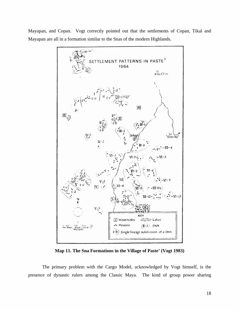
18
Mayapan, and Copan. Vogt correctly pointed out that the settlements of Copan, Tikal and
Mayapan are all in a formation similar to the Snas of the modern Highlands.
Map 11. The Sna Formations in the Village of Paste’ (Vogt 1983)
The primary problem with the Cargo Model, acknowledged by Vogt himself, is the
presence of dynastic rulers among the Classic Maya. The kind of group power sharing
19
necessitated by the Cargo System is incompatible with despotic rule. However, a cargo system
that incorporated homage to the ahau and the public praise of the cargo holder by the ahau and
priests could produce much the same settlement pattern. The kind of council system that a
Cargo System creates was the predominant political formation among the Post Classic Maya and
the autonomous Maya communities of the contact period. In the Chilam Balam de Chumayel
(Roys 1967), the Post Classic Yucatan capital city of Mayapan was said to be the seat of regional
government, where a council of lords representing different communities ruled jointly with a
single primary ruler. Landa (1941) described the same kind of political system, said by Maya
informants of the 1500’s to have exited at both Mayapan and Chichen Itza. Schele and Friedel
(1990) have presented epigraphic evidence supporting the notion that a council ruled Chichen
Itza. Jones (1998) outlines detailed evidence that the autonomous kingdom of Itza living in the
area of Lake Peten were ruled by a single ruler, Kan Ek, but that he in turn shared power and
political administration duties with a council of lords, both from within the island of Noj Peten
(now known as Flores) and around the shores of Lake Peten. This system was in place when
Cortez passed through in the mid-1500’s and persisted right up until the Itza were conquered in
1697.
Landa (1941) also describes annual Weyeb’ rituals, marking the end of each solar
calendar year, in which idols were circulated within the quarters of a community, accompanied
by ritual dancing and animal sacrifice. The Wayeb’ rituals were also a time in which important
men on the council shifted certain responsibilities and privileges to others for the coming year.
The moving of the idols into different zones of the community was part of the shift in council
member responsibilities. In this regard, we can see that a certain element of Cargo System, or
the codified sharing of socio-political responsibility through a rotation system, was apparently
functioning during the contact period.
In each of these documented cases of council system social organization, council
members are elite individuals who represented their communities and inherited their positions
through heredity. In many cases, intermarriage within important families solidified relationships
between council members, as well as between the primary ruler and the council members. That
kind of alliance and dissention along familial lines was clearly happening among the Itza council
members when they making their last stand against the Spanish in 1697 (Jones 1998).
20
Of course, to document that council systems were in place during the Post Classic and
Contact Periods is not enough to confirm they existed in the Classic Period. Clearly, the practice
of intermarriage to solidify alliances, both within and between Maya political spheres, has been
well documented in the Classic Period epigraphic record (Martin and Grube 2000). Further, the
Late Classic period carved monuments begin to indicate the presence of councils. Beginning in
the 700’s AD, and almost invariably with very late rulers of their respective dynasties, we see
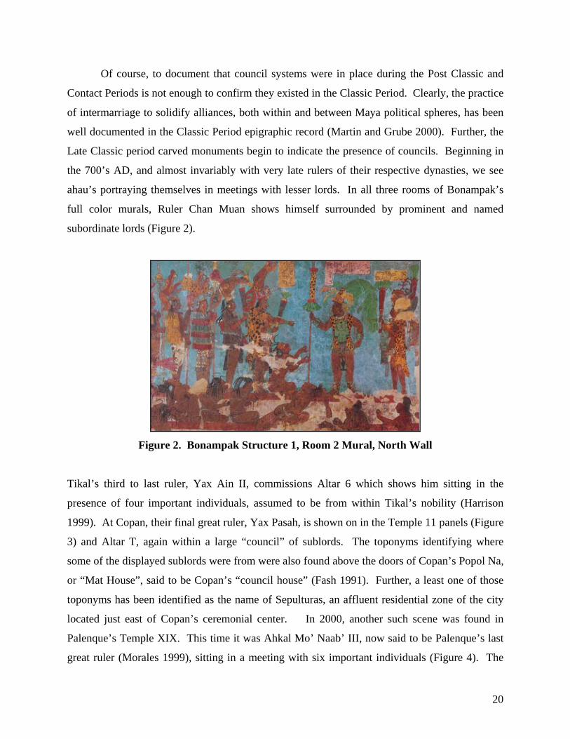
ahau’s portraying themselves in meetings with lesser lords. In all three rooms of Bonampak’s
full color murals, Ruler Chan Muan shows himself surrounded by prominent and named
subordinate lords (Figure 2).
Figure 2. Bonampak Structure 1, Room 2 Mural, North Wall
Tikal’s third to last ruler, Yax Ain II, commissions Altar 6 which shows him sitting in the
presence of four important individuals, assumed to be from within Tikal’s nobility (Harrison
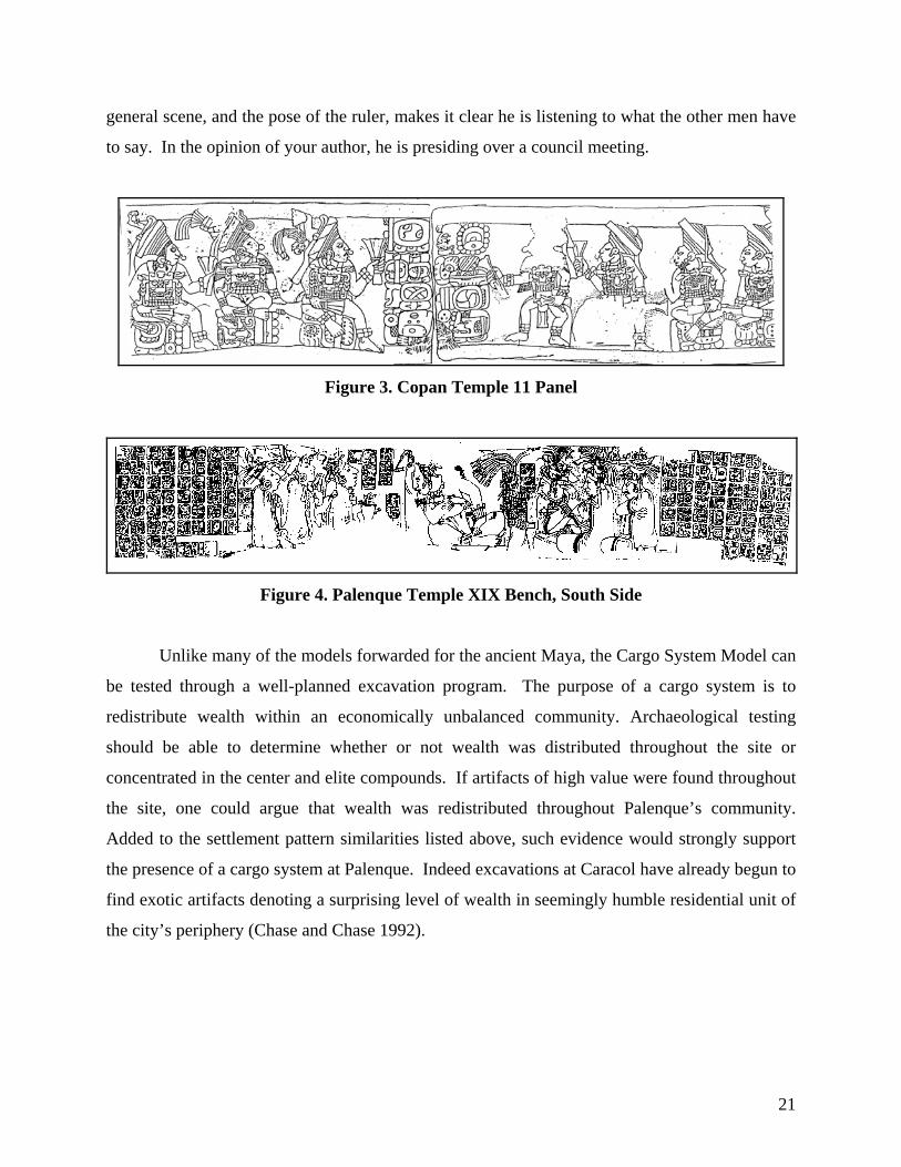
1999). At Copan, their final great ruler, Yax Pasah, is shown on in the Temple 11 panels (Figure
3) and Altar T, again within a large “council” of sublords. The toponyms identifying where
some of the displayed sublords were from were also found above the doors of Copan’s Popol Na,
or “Mat House”, said to be Copan’s “council house” (Fash 1991). Further, a least one of those
toponyms has been identified as the name of Sepulturas, an affluent residential zone of the city
located just east of Copan’s ceremonial center. In 2000, another such scene was found in
Palenque’s Temple XIX. This time it was Ahkal Mo’ Naab’ III, now said to be Palenque’s last
great ruler (Morales 1999), sitting in a meeting with six important individuals (Figure 4). The
21
general scene, and the pose of the ruler, makes it clear he is listening to what the other men have
to say. In the opinion of your author, he is presiding over a council meeting.
Figure 3. Copan Temple 11 Panel
Figure 4. Palenque Temple XIX Bench, South Side
Unlike many of the models forwarded for the ancient Maya, the Cargo System Model can
be tested through a well-planned excavation program. The purpose of a cargo system is to
redistribute wealth within an economically unbalanced community. Archaeological testing
should be able to determine whether or not wealth was distributed throughout the site or
concentrated in the center and elite compounds. If artifacts of high value were found throughout
the site, one could argue that wealth was redistributed throughout Palenque’s community.
Added to the settlement pattern similarities listed above, such evidence would strongly support
the presence of a cargo system at Palenque. Indeed excavations at Caracol have already begun to
find exotic artifacts denoting a surprising level of wealth in seemingly humble residential unit of
the city’s periphery (Chase and Chase 1992).
22
Summary
In considering a variety of social organization models against Palenque’s recently
revealed settlement pattern, this paper concludes that a council political system, perhaps with an
associated Cargo System, fits the evidence best. The Feudal Model (Adams and Smith 1981) is
not a good fit because of Palenque’s apparent socio-economic integration, as indicated by the
heterogeneity of size, shape, and quality of architecture dispersed all across the city. Feudalism
should show a marked boundary between the wealthy of the community and the less fortunate
who support them. The Regal-Ritual Center Model (Sanders and Webster 1989) is also not a
good fit because the Palenque settlement pattern does not fit what we would expect from an
“extended palatial residence.” Zones of the city like the Picota Plaza and the Ach’ Group Plaza
indicate that the plaza surrounding the palace was not the only public gathering area, thus
clouding a straight forward focus on the royal family. Further, the public works of Palenque in
the form of sixteen linear kilometers of residential terracing and extensive water management
features demonstrate that significant city resources were spent to improve the living standards of
the wider community, not solely on aggrandizing the ruler. The Galactic Polity Model
(Demarast 1987) and the Pilgrimage-Fair Model (Freidel 1980), while potentially factors
influencing Palenque’s social organization, are not productive avenues of analysis because of the
difficulty of developing an excavation strategy to support their existence.
The basis of this study is the settlement pattern of Palenque. The pattern shows that
residential zones of the city are arrangements of small buildings and patio groups clustering
around notably larger residential complexes. While excavations have yet to clearly prove these
zones are residential, if future excavations determine instead that they are administrative,
mercantile, or even religious zones, that would only strengthen the hypothesis of a council
political formation. In reviewing the published theories of Classic Maya social organization,
Vogt’s comparison to modern day Zinacantan stood out as very applicable to Palenque’s
settlement pattern. Each Zinacantan Sna has one of more affluent members who agree to take
Cargo positions and serve terms as part of the council that coordinates community events and
helps adminstrate community policy. Though the people in the council positions change every
year, the system itself endures and the cargo holder/council member residences are the focal
23
points of intra-sna social activities. Zinacantan’s settlement pattern of clusters around cargo
holder compounds is perpetuated by the way they choose to social organize.
Of course, Zinacantan today is 1300 years after Palenque and does not have a primary
“ruler”. Can we backward project this council system pattern into ancient Maya history?
Looking back to the colonial period, the answer is clearly yes. The Itza of Lake Peten had a
council system of government, functioning under the leadership of a single individual ruler, right
up until their 1967 conquest (Jones 1998). Both their island capital of Noj Peten, and the larger
Itza territory were broken up into quadrants. Council representatives were elite family members
from within each quadrant, and in most cases positions were handed down from father to son.
Chamula, a village neighboring Zinacantan, is also broken up into quadrants, and cargo position
obligations are handed down through patrilocal lines (Karasik, pc). Landa (1941) reported a
similar pattern in 16th century Yucatan, in which council members from community quadrants
helped a single supreme ruler govern the region. Further, Landa noted a kind of Cargo System,
in which council members rotated communal responsibilities and privileges on an annual basis.
The Post-classic Maya histories as related in the Chilam Balam de Chumayel (Roys 1967) takes
the council system of government back yet further, describing the council at Mayapan who
represented the various communities of the region, and even implying that Chichen Itza’s
government functioned in the same way. Schele and Freidel (1990) found hieroglyphic evidence
at Chichen Itza further supporting the presence of a ruling council. Even stepping back into the
Late Classic period, carved panels and murals at Copan, Tikal, Bonampak, and even Palenque
itself show late rulers participating in meetings with other elite individuals, events your author
interprets as council meetings.
In conclusion, this paper forwards the theory that Palenque’s social organization, at least
by Late Classic times, was based on a council system who supported the Ahau in city
administration, and who lived in the larger complexes of the urban residential zones. While it is
difficult to say just how early in Palenque’s history this council system began, it seems to have
come to the forefront of governance by the reign of Ahkal Mo’ Naab’ III. Since it is common
sense that new forms of socio-political organization do not occur overnight, it is logical to
assume the council system of Palenque was developing for generations before Ahkal Mo’ Naab’
III portrayed it on his Temple XIX throne.
24
As for Vogt’s Cargo System Model, only the council aspect of his theory can currently be
applied to Palenque’s settlement pattern. We cannot yet say that a cargo system existed at
Palenque. We can, however, say that its settlement formation would have accommodated one. An excavation project, focused on artifact assembles found in a variety of residential units,
would be a productive way to further investigate the presence or absence of a cargo system..
A final point - the end of the city of Palenque shows no signs of unrest or violence. A
peaceable and unified decision seems to have been made to abandon the city. That kind of
decision is not made by a disorganized, disgruntled populous, but rather by the kind of consensus
that only a council can reach.
25
BIBLIOGRAPHY
Adams, Richard E.W. 1980 “Swamps, Canals, and the Locations of Ancient Maya Cities”, Antiquity 54:206-14. Adams, Richard E.W. 1981 “Settlement Patterns of the Central Yucatan and Southern Campeche Regions”,
in Lowland Maya Settlement Patterns, edited by W. Ashmore, pp.211-258. University of New Mexico Press, Albuquerque.
Adams, Richard E.W. and R.C. Jones 1981 “Spatial Patterns and Regional Growth Among Classic Maya Cities”,
American Antiquity 46:301-32. Adams, Richard E.W. and W.D. Smith 1981 “Feudal Models for Classic Maya Civilization”, In Lowland Maya Settlement
Patterns, edited by W. Ashmore, pp. 335-349. University of New Mexico Press, Albuquerque.
Andrews, George 1975 Maya Cities: Placemaking and Urbanization, University of Oklahoma Press, Norman. Ashmore, Wendy 1980 “The Classic Maya Settlement at Quirigua”. Expedition 23(1):20-27. Barnhart, Edwin 2001 The Palenque Mapping Project: Settlement and Urbanism at an Ancient Maya City, a dissertation presented to the University of Texas at Austin. Barnhart, Edwin 2002 “Residential Burials and Ancestor Worship: A Reexamination of Classic Maya
Settlement Patterns”, La Organizacion Social Entre Los Mayas Prehispanicos, Coloniales y Modernas, Memoria de La Tercera Mesa Redonda dePalenque, Volume II, pg. 141-158 Instituto Nacional de Antropologia e Historia, Universidad Autonoma de Yucatan.
Barnhart, Edwin 2005 “Palenque, Urban City of the Ancient Maya”, El Urbanismo En Mesoamerica/ Urbanism in Mesoamerica, edited by Willam Sanders and Robert Cobean. Proyecto Urbanismo en Mesoamerica / Urbanism in Mesoamerica Project, Volume 2. Pennsylvania State Univeristy and Instituto Nacional de Antropologia e Historia, University Park and Mexico City. (in press) Blanton, Richard 1978 Monte Alban: Settlement Patterns at the Ancient Zapotec Capital, Academic Press, New York.
26
Blom, Franz and O. La Farge 1926-27 Tribes and Temples. MARI Publications 1 and 2. Chase, Arlen 1990 “Maya Archaeology and Population Estimates in the Tayasal – Paxcaman Zone,
Peten, Guatemala”, In Precolumbian Population History in the Maya Lowlands, edited by T. P. Culbert and D.S. Rice. University of New Mexico Press, Albuquerque.
Chase, Arlen and Diane Chase 1992 Mesoamerican Elites: An Archaeological Assessment, University of Oklahoma Press. Chase, Arlen and Diane Chase 1996 “A Mighty Maya Nation; How Caracol Built An Empire By Cultivating Its “Middle-Class””, Archaeology, 49 (5):66-72. Chase, Diane 1990 “The Invisible Maya: Population History and Archaeology at Santa Rita Corozal”,
In Precolumbian Population History in the Maya Lowlands, edited by T. P. Culbert and D.S. Rice, University of New Mexico Press, Albuquerque.
Chase, Diane, Arlen Chase and William Haviland 1990 “The Classic Maya City: Reconsidering “The Mesoamerican Urban Tradition”,
American Anthropologist 92:499-506. Demarest, Arthur 1987 “Ideology in Ancient Maya Cultural Evolution: The Dynamics of Galactic
Polities”, Paper prepared for the SAR Advanced Seminar, “Ideology and Cultural Evolution in the New World”, Santa Fe.
Fash, William 1991 Scribes, Warriors and Kings: The City of Copan and The Ancient Maya, Thames and Hudson, New York. Freidel, David 1980 “The Political Economics of residential Dispersion Among the Lowland Maya”,
Maya Lowland Settlement Patterns, edited by W. Ashmore, University of New Mexico Press, Albuquerque.
Fox, Richard 1977 Urban Anthropology. Prentice Hall, Englewood Cliffs, N.J. French, Kirk 2002 Creating Space Through Water Management at the Classic Maya Site of
Palenque, Chiapas, Mexico, a thesis submitted to the University of Cincinnati. Gonzalez Cruz, Arnoldo 1993 Trabajos Arqueologicos En Palenque, Chiapas. Informe de Campo,VI
Temporada, Volumen VIII Serie Informes de Campo 6, Consejo Nacional Para La Cultura y Las Artes, Instituto Nacional de Antropologia e Historia, Mexico.
27
Haviland, William 1965 “Prehistoric Settlement at Tikal, Guatemala”. Expedition 7(3):14-23. Haviland, William 1969 “A New Population Estimate for Tikal, Guatemala”. American Antiquity
34:424-433. Haviland, William 1970 “Tikal, Guatemala and Mesoamerican Urbanism”. World Archaeology 2:186-198. Hester, Tom and Harry Shafer 1984 “Exploitation of Chert Resources by the Ancient Maya of Northern Belize”,
World Archaeology 16(2): 157-173. Jones, Grant 1998 The Conquest of the Last Maya Kingdom, Stanford University Press. Landa, Diego de 1941 Landa’s Relacion de Las Cosas de Yucatan, edited and translated by Alfred Tozzer, Peabody Museum of American Archaeology and Ethnology, Harvard University. Larios Villalta, Rudy 2002 “Palenque’s Temple XX: A Very Special Puzzle”, in Mesoweb Feature, www.mesoweb.com/palenque/features/larios/TXX.html Liendo Stuardo, Rodrigo 1999 The Organization of AgricuturalProduction at a Maya Center,Settlement Patterns
in the Palenque Region, Chiapas, Mexico, a dissertation submitted to the University of Pittsburgh.
Lucero, Lisa 1999 “Water control and Maya politics in the southern Maya lowlands,” in Complex polities in the ancient tropical world. edited by E. A. Bacus and L. J. Lucero, pp. 34-49. Archeological Papers of the American Anthropological Association Number 9. Arlington, VA: American Anthropological Association. Marcus, Joyce 1983 “On the Nature of the Mesoamerican City”, in Prehistoric Settlement Patterns,
edited by E.Vogt and R. Leventhal, University of New Mexico Press and Peabody Museum of Archaeology and Ethnology, Harvard University, Cambridge.
Martin, Simon and Nikolai Grube 1995 “Maya Superstates”, Archaeology 48 (6):41-43. Martin, Simon and Nikolai Grube 2000 Chronicle of The Maya Kings and Queens, Thames & Hudson, London.
28
Marquez Morfin, Lourdes, Patricia Olga Hernamadez Espinoza and Almudena Gomez Ortiz 2002 “La Poblacion Urbana de Palenque en El Clasico Tardio”, La Organizacion
Social Entre Los Mayas Prehispanicos, Coloniales y Modernas, Memoria de La Tercera Mesa Redonda de Palenque, Volume II, pg.13-34, Instituto Nacional de Antropologia e Historia, Universidad Autonoma de Yucatan.
Millon, Rene 1974 “The Study of Urbanism at Teotihuacan, Mexico”, Vol. 1, University of Texas Press, Austin. Morales, Alfonso 1999 “Just Who Was This Amazing King? Palenque Cross Group Project Report”, PARI Newsletter, Number 30, Winter 1999, San Francisco. Morely, Sylvanus 1946 The Ancient Maya, Stanford University Press, Stanford. Pyburn, Anne 1990 “Settlement Patterns at Nohmul: Preliminary Results of Four Excavation
Seasons”, In Precolumbian Population History in the Maya Lowlands, edited by T. P. Culbert and D.S. Rice, University of New Mexico Press, Albuquerque.
Rands, Robert 1974 “The Ceramic Sequence at Palenque, Chiapas”, Mesoamerican Archaeology,
New Approaches, Edited by Norman Hammond, University of Texas Press, Austin.
Rands, Robert and Ronald Bishop 2003 “The Dish-Plate Tradition in Palenque”, Patterns and Process: A Festschrift in Honor of Edward V. Sayre, Smithsonian Center for Materials Research and Education, Washington D.C. Rice, Don and T.Patrick Culbert 1990 “Historical Contexts for Population Reconstruction in the Maya Lowlands”,
In Precolumbian Population History in the Maya Lowlands, edited by T. P. Culbert and D.S. Rice. University of New Mexico Press, Albuquerque.
Ringle, William and E.W. Andrews V 1990 “The Demogrpahy of Komchen, An Early Maya Town in Northern Yucatan”,
In Precolumbian Population History in the Maya Lowlands, edited by T. P. Culbert and D.S. Rice. University of New Mexico Press, Albuquerque.
Robertson, Merle Greene 1983 Temple of the Inscriptions, Volume 1 of The Sculpture of Palenque.
Princeton: Princeton University Press. Roys, Ralph 1967 The Book of Chilam Balam of Chumayel, University of Oklahoma Press.
29
Sanders, William and David Webster 1989 “The Mesoamerican Urban Tradition”, American Antiquity 90:521-546. Schele, Linda and David Freidel 1990 A Forest of Kings. William Morrow and Co., New York Sharer, Robert 1994 The Ancient Maya, Fifth Edition. Stanford University Press. Shook, Edwin 1952 The Great Wall of Mayapan, Carnegie Institution of Washington, Department of Archaeology, Current Reports, No. 2, Washington, D.C.. Smith, A. Ledyard 1962 “Residential and Associated Structures at Mayapan”, in Mayapan, Yucatan,
Mexico, Carnegie Institution of Washington, Publication 619, pp. 165-320, Washington D.C..
Smyth, Michael and Christopher Dore 1994 “Maya Urbanism”, National Geograohic Research & Exploration, 10(1):38-55. Thompson, J. Eric 1954 The Rise and Fall of Maya Civilization. University of Oklahoma Press, Norman. Tourtellot, Gair, III 1976 “Patterns of Domestic Architecture at a Maya Garden City: Siebal”. A paper
presented at the 41st Annual Meeting of the SAA, St. Louis, Missouri. Tourtellot, Gair III 1990 “Population Estimates for Preclassic and Classic Seibal, Peten”, In Precolumbian
Population History in the Maya Lowlands, edited by T. P. Culbert and D.S. Rice, University of New Mexico Press, Albuquerque.
Tourtellot, Gair, III, J.A. Sabloff, M.P. Smyth, L.V. Whitley, S.L. Walling, T. Gallereta N., C. Perez A., G.F. Andrews, and N.P. Dunning 1988 “Mapping Community Patterns at Sayil, Yucatan, Mexico: The 1985 Season”,
Journal of New World Archaeology 8:1-24. Turner, B.L., II and P.D. Harrison (Editors) 1983 Pulltrouser Swamp: Ancient Maya Habitat, Agriculture, and Settlement in
Northern Belize. University of Texas Press, Austin. Vogt, Evon 1983 “Ancient and Contemporary Maya Settlement Patterns: A New Look from the
Chiapas Highlands”, in Prehistoric Settlement Patterns: Essays in Honor of Gordon R. Willey, edited by E. Vogt and R. Leventhal, pp. 89-114. University of New Mexico Press, Albuquerque.
30
Webster, David and A. Freter 1990 “The Demography of Late Classic Copan”, In Precolumbian Population History
in the Maya Lowlands, edited by T. P. Culbert and D.S. Rice. University of New Mexico Press, Albuquerque.
Webster, David and William Sanders 2001 “La Antigua Ciudad Mesoamericana: Teoria y Concepto”, in Reconstruyendo
la Cuidad Maya: El Urbanismo en Las Sociedades Antiguas, edited by Andreas Cuidad Ruiz, M. Josefa Iglesias Ponce De Leon and M. Carmen Martinez Martinez. Sociedad Espanola De Estudios Mayas, Pub. 6, pp. 34-64.
Willey, Gordon 1980 “Towards a Holistic View of Ancient Maya Civilization”, Man 15: 249-66. Willey, Gordon and Richard Leventhal 1979 “Prehistoric Settlement at Copan”, In Maya Archaeology and Ethnohistory,
edited by N. Hammond, pp. 75-102. University of Texas Press, Austin.