pakistan geographical - Punjab University
88
PAKISTAN GEOGRAPHICAL REVIE~ . .~ T}l. .P-d "'.r.~_. --.~ .,~--.. Geograph~ 6379 II1I1I ·6374 PU-Lahor Volume 24 ••• Number 1 January 19 6 9
-
Upload
khangminh22 -
Category
Documents
-
view
1 -
download
0
Transcript of pakistan geographical - Punjab University

PAKISTANGEOGRAPHICALREVIE~ .
.~ T}l. .P-d "'.r.~_.--.~ .,~--..Geograph~
6379 II1I1I·6374
PU-Lahor
Volume 24 ••• Number 1
January 1969

EDITORIAL BOARD
K. U. KURESHY, EditorIQTIDAR H. ZAIDI, Associate Editor
Advisory Board
KAZI S. AHMAD, University of the Punjab
NAFIS AHMAD, University of Dacca- .,."
M. ASHRAF KHAN DURRANT, University of Peshawar
Corresponding Editors
R. O. BUCHANAN, London, United Kingdom
SIRRI ERINC,· University of Istanbul, TurkeyPRESTON E. JAMES, Syracuse University, U.S.A.
CARL TROLL, University of Bonn, West Germany
CHAUNCY. D. HARRIS, University of Chicago, U.S.A
OSKAR H. K. SPATE. Australian National University, Australia.
~ -Pakistan 'Geographical Review
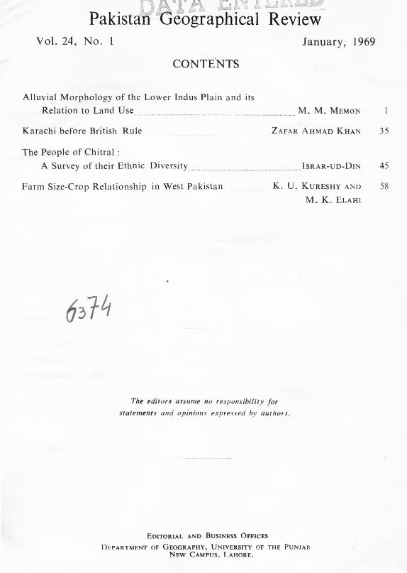
Vol. 24, No. 1 January, 1969
Alluvial Morphology of the Lower Indus Plain and its
Relation to Land Use. . . M. M. MEMON
Karachi before British Rule ZAFAR AHMAD KHAN 35
The People of Chitral :
A Survey of their Ethnic Diversity . ISRAR-UD-DIN 45
Farm Size-Crop Relationship in West Pakistan K. U. KURESHY AND
M. K. ELAHI
58
The editors assume no responsibility forstatements and opinions expressed by authors.
EDITORIAL AND BUSINESS OFFICES
DEPARTMENT OF GEOGRAPHY, UNIVERSITY OF THE PUNJABNEW CAMPUS, LAHORE.

NEWS AND NOTES
International Union for QuaternaryResearch ANIS A. ABBASI
Twenty First International Geographical
Congrees, November-December, 1968 .
Shamsus Zoha, 1924-1969.
... IQTIDAR H. ZAIDI
IQTIDAR H. ZAIDI
Second All Pakistan Geographical
Conference, Lahore... . ..H.. ... H.......H..... M. K. ELAHI 79
BOOK REVIEWS
74
75
77
Jan O.M. Broek, Geography: Its scope and spirit. BILAL AHMAD 82
David Ditcher, The North West Frontier of WestPakistan MISS FAREEHA RAHMAN 83

Pakistan Geographical ReviewVolume 24 January, 1969 Number 1
ALLUVIAL MORPHOLOGY OF THE LOWER INDUS PLAINAND ITS RELATION TO LAND USE
M. M. MEMON
THE ORIGIN OF THE PLAIN
FOR an elaborate study of the morphological features of the Lower Indus Plain it isnecessary to know about the nature of its origin and the processes involved in
its development. In the sub-continent of Pakistan and India, a vast geosyncline ortrough lies between the mighty Himalayas in the north and the plateau of PeninsularIndia in the south. The origin of this depression is intimately connected with thatof the bordering ranges. Eduard Suess believes that it is a "fore-deep" in front of thehigh crust-waves of the Himalayas as they were checked in their southward advanceby the Archean land-mass of Peninsular India. Based on this view the depressionis synclinal in nature. According to Sir. S. Burrard it occupies a deep "rift valley",a portion of the earth's surface sunk in a huge crack or fissure in the sub-crust,between parallel dislocations or faults on its two sides. The formation of the greatcrack 15,000 miles long and several thousand feet deep was according to his viewassociated with the rise of the Himalayas.
D. N. Wadia! and other geologists picture the conversion of the depressionto almost level plains by a simple process of alluviation in which the deposition keptpace with subsidence. According to Wadia underlying the Pleistocene and sub-Recentalluvial deposits of the mighty rivers of the Indo-Gangetic system are unconsolidatedSiwalik and older Tertiary sediments of the Himalayan piedmont and below theseare more consolidated older formations, such as the Gondwanas and Cretaceous, thepresence of which is indicated by good reflections of the seismic wave as well as byborings l . Gravity, magnetic and seismic explorations, that have been made so farreveal that the depth of alluvium is variable, from less than 1,000 to over 2,000
metres".
lD.N. Wadia : Geology of India (London: 1909), p. 284.2lbid. p. 389.
#< MR. MEMON is Professor and Head of the Department of Geography, University
of Sind, Hyderabad.

2 PAKISTAN GEOGRAPHICAL REVIEW JANUARY
It will not be out of place to mention here the views of Al-Beruni the "MasterAliboron" of the medieval west, which he expressed with regard to the origin of theplain as early as 1030 A. D. He states, "But if you have seen the soil of India withyour own eyes and meditate on its nature, if you consider the rounded stones found
in the earth however deeply you dig, stones that are huge near the mountains andwhere the rivers have a violent current, stones that are of smaller size at greatdistance from the mountains, and where the streams flow more slowly, stones thatare pulverised in the shape of sand and where the streams begin to stagnate theirmouths and near the sea-if you consider a\l this, you could scarcely help thinkingthat India has once been a sea which by degrees has been fi\led up by the alluviumof the streams 3."
The western section of this extensive plain is called the Indus Plain, and hasfor its base the old peninsular pre-cambrian mass which extends across it intoKashmir. On it lie the great thickness of sediments, deposited by the rivers. Under-neath these alluvium deposits a sub-terranean ridge. known as Delhi Shahpurridge is traceable from Delhi northwestwards to the Salt Range which divides the plaininto two sub-terranean basins. The existence of this ridge has been supported bygeodetic evidence or gravity anamolies.
The trough of the Indus Plain is regarded to be of a fairly .great depth. Itsarchean floor is covered by about 15,000 feet of sub-Recent alluvium overlying ashelving bank of older fluviatile sediments of the Siwalik and Murree epoch (Mio-pliocene). On the basis of geodetic data, Oldham in 1917, postulated the maximumthickness of the alluvium from 15,000 to 20,000 feet+. However, gravity surveysconducted recently have led E.A. Glennie to suggest a much lesser depth aggregatingonly 6,:'00 feets. The whole thickness of the alluvial depths constitutes one continuousconformable series whose accumulation is still in progress.
The geophysical work carried out very recently in the Lahore Basin by theBurmah Oil Company gives a depth to the basement of about 22,000 feet in the regionof about 29° .3'N, 70° .8'E, while the torsion balance survey in the Indus Basinreveals depths exceeding 2.000 feet close to the Delhi-Shahpur ridge. The alluviumis regarded as thin in the Sind area, except for the basin lying west of Jacobabad28° .3'N, 68° .4'E6.
3E.C. Sachau : Al-Beruni's India (Lahore: 1914) Popular Edition, Vol. I, p. 198.4R. D. Oldham: Memoirs of Geological Survey of India, Vol. 92, p. 119.5E.A. Glennie: Gravity anamolies of the structure of the earth, Survey of India Professional
paper No. 27. (1932).6E. A. Glennie, "Gravity Data and Crust al Warping in North West Pakistan and adjacentparts of India," (1955).

1969 ALLUVIAL MORPHOLOGY OF THE LOWER INDUS PLAIN 3
Whatever the nature of the depression, it was subjected to rigorous sedimen-tation during the greater part of the Tertiary era and is believed to have proceededparri-passu with the slow sinking of the basin. Outcrops of marine Kirthar limestonesnear Sukkur and Hyderabad as well as the presence of Siwalik like fluviatile sedimentsat a depth of only about 535 feet near LyaJlpur, suggest the possibility that in thisregion the earlier sediments deposited on the pre-Cambrian basement were marine.With the gradual withdrawal of the sea during the later part of the Tertiary era.shallow-water and possibly deltaic deposits were laid down, finally culminating in therestoration of terrestrial conditions and deposition of fluviatile material with theadvent of the Siwalik period. Since then, it has remained a vast floodplain on whichthe sediments of numerous streams have accumulated in enormous thickness.
The whole of the Indus Plain from the Himalayas to the Salt range in thenorth to the Arabian Sea in the south, is one of the most homogeneous physiographicregions of the earth, with only the Kirana hills in the upper part and the limestoneridges at Sukkur and Hyderabad in the southern part to interrupt the flow of itsrivers. The plain has a very fertile soil and abundant water supply, making itone of the most prosperous agricultural regions of the sub-continent. The southernsection of this plain is termed the Lower Indus Plain (Fig.-l). Here all the alluvialdeposits are the work of one river, the Indus which carries the combined watersof all its tributaries. The deposits consist of old and recent alluvium, cut by riverchannels, some of which are leveed. The gradient from Kashrnor to the Arabian Seaon the average is less than one foot a mile.
THE LOWER I DUS, ITS ALIGNMENT AND GENERAL TRENDS
A study of the contour map of the region (Fig.-2) reveals that the river IndusIS aligned along a ridge throughout its entire course from the Gudu Barrage to thesea. This feature is very well marked in the north where contours on the rightbank from Kashrnor to below Larkana run from south to north, until they meeta distinct hollow or trough that extends from near J acobabad to Manchar Lake.The hills have forced the river to follow a south westerly course in a narrow beltbetween Shikarpur and Larkana in the west and the desert in the east. The riverhas well developed natural levees. When the river overflows them at the time offloods, the water finds its way through a net work of distributaries which slopeaway from the main water course. The general slope of the land away from the riveralso helps the right bank flood water to be drained into the Manchar Lake. Duringthe floods the lake swells into 100 sq. miles. When it recedes after the floods itleaves behind vast alluvial deposits.

4 PAKIST AN GEOGRAPHICAL REVIEW
->»;~/ "~ -
h/ ...~~----/1,"-
~~~#
)/
\r'. -~----I
I.\)
I'\~r.
I
L~_
••• NCHAItLAI<[
LOWER INDUS PLAINBARRAGES AND CANALS
'0I
'0 20I
MILES
l~/
~ ,j;~ )1!) /,1c oc s ncc N6P(' 'C,r: ---
Ar~~AHIS '.11
>6,-.. :/J
FIGURE 1
JANUARY

1969 ALLUVIAL MORPHOLOGy OF THE LOWER INDUS PLAIN 5
CONTOUR INTERVAL 10FEET
LOWER IN DU 5 PLAIN
SURFACE CONTOURS
DESERT AL TlTUDE S NOT SHOWN
'm".0 \ 8 •• 20 '0 40....-=--=-:.-.~--.~--
AL TITUOE5 FEEi, \I I
( III
,,~C
I
THARDESERT
FIGURE 2
6 PAKISTAN GEOGRAPHICAL REVIEW JANUARY
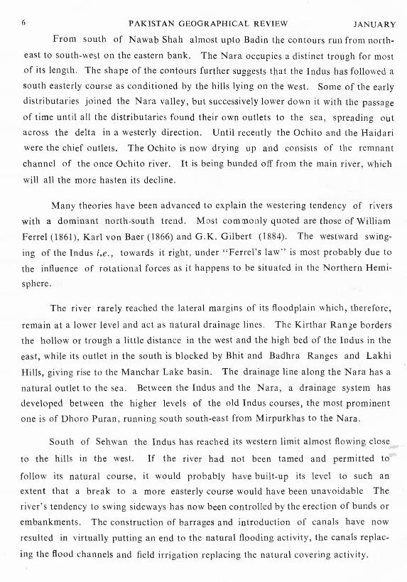
From south of Nawab Shah almost upto Badin the contours run from north-
east to south-west on the eastern bank. The Nara occupies a distinct trough for most
of its length, The shape of the contours further suggests that the Indus has followed a
south easterly course as conditioned by the hills lying on the west. Some of the early
distributaries joined the Nara valley, but successively lower down it with the passage
of time until all the distributaries found their own outlets to the sea, spreading out
across the delta in a westerly direction, Until recently the Ochito and the Haidari
were the chief outlets. The Ochito is now drying up and consists of the remnant
channel of the once Ochito river. It is being bunded off from the main river, which
will all the more hasten its decline.
Many theories have been advanced to explain the westering tendency of rivers
with a dominant north-south trend. Most commonly quoted are those of William
Ferrel (1861), Karl vcn Baer (1866) and G,K. Gilbert (1884). The westward swing-
mg of the Indus i,e. towards it right, under "Ferrel's law" is most probably due to
the influence of rotational forces as it happens to be situated in the Northern Hemi-
sphere.
The river rarely reached the lateral margins of its floodplain which, therefore,
remain at a lower level and act as natural drainage lines, The Kirthar Range borders
the hollow or trough a little distance in the west and the high bed of the Indus in the
east, while its outlet in the south is blocked by Bhit and Badhra Ranges and Lakhi
Hills, giving rise to the Ma nchar Lake basin. The drainage line along the Nara has a
natural outlet to the sea. Between the Indus and the Nara, a drainage system has
developed between the higher levels of the old Indus courses, the most prominent
one is of Dhoro Puran, running south south-east from Mirpurkhas to the Nara.
South of Sehwan the Indus has reached its western limit almost flowing close
to the hills in the west. If the river had not been tamed and permitted to
follow its natural course, it would probably have built-up its level to such an
extent that a break to a more easterly course would have been unavoidable The
river's tendency to swing sideways has now been controlled by the erection of bunds or
embankments. The construction of barrages and introduction of canals have now
resulted in virtually putting an end to the natural flooding activity, the canals replac-
ing the flood channels and field irrigation replacing the natural covering activity.

1969 ALLUVIAL MORPHOLOGY OF THE LOWER INDUS PLAIN
THE CHA GING COURSES OF THE INDUS
For a correct appraisal of the alluvial morphology of the Lower Indus Plain,
it is necessary to have a precise knowledge of the different courses of the Indus
7
during recorded history. Such an information is of vital significance in interprett-
ing the geomorphology and in understanding the distribution of soil texture in the
region. Apart from the abundance of information available in different languages
regarding the river and its wanderings, remnants of abandoned river channels amply
testify to the oscillations of the river in the floodplain formed by the deposition of its
own sediments. It is, unfortunate, that historical evidences in this regard are, however
confusing and most unsystematic. They are thus practically of no help in arriving
at a correct and detailed reconstruction of the sequence of events.
However, the dawn of aerial photography has opened up the scope of inter-
pretting the earlier courses with accuracy. The aerial photographs now available
for the Lower Indus Region have made the task of correlating the traced courses with
the historical records comparatively easier.
It is hard to visualise the fury and uncontrolled force of the mighty river prior
to the construction of flood protective bunds, and barrages taming it, by confining it
to its present channel. Only a few parts of the floodplain situated at a higher level
escaped being submerged when the river was swollen in flood. Occasionally the river
breached its raised course formed by the aggradation of its own sediments and gradu-
ally adopted an entirely new course. Consequently human habitations and standing
crops alike were swept away by the surging waters bringing misery and destructionin trail.
Not much is known about the course followed by the Indus in pre-historic
times. The earliest evidence of settlements and agriculture in the floodplain is
provided by the un-earthed ruins of the ancient city of Moen-jo Daro and a number
of contemporary village sites. The civilization named after this town persisted
over a remarkable length of time, suggesting that the river was then comparativelystable. It may be assumed that the river at that time lay not far to the east of this
city and its decline may be attributed to the shifting of the river course eastwards.
When Alexander the Great sailed down the Indus in 326-325 B.C. the riverused to flow northwest of Sukkur close to Gauspur, north of Shikarpur and downsouth to Ruk. It then crossed the present river course and running parallel to itfor some distance in the east reached Patala , a city somewhere in the area of Brah-

8 PAKISTAN GEOGRAPHICAL REVIEW
\,I
//
Shohdadkot
\ /'
v(/ -ie
~\/~\) ()~
1/I CHANGING COURSES
IJ OF THE INDUS
105 eI , I
SCALE
1,0 210 lp 4p MILE 5
J
I
Old rlv~r Cou rse
Pr~s~nt riv~r Course
• Cont~mporary s~ttl.m~ nt
Mod~rn s~ttl~m.nt
Command boundrye
/.I\.
Upland
JANUARY
fiGURE ~
1969 ALLUVIAL MORPHOLOGY OF THE LOWER INDUS PLAIN 9
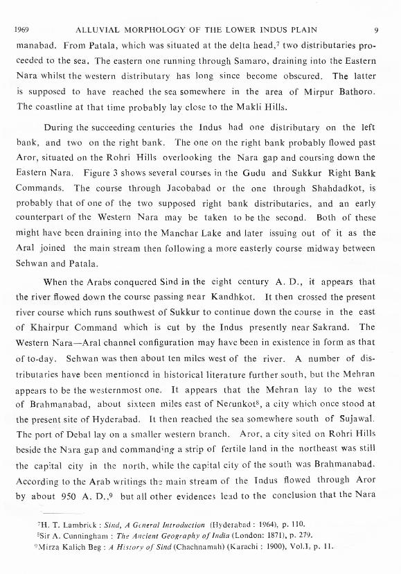
manabad. From Patala, which was situated at the delta head,? two distributaries pro-
ceeded to the sea. The eastern one running through Samaro, draining into the Eastern
Nara whilst the western distributary has long since become obscured. The latter
is supposed to have reached the sea somewhere in the area of Mirpur Bathoro.
The coastline at that time probably lay close to the Makli Hills.
During the succeeding centuries the Indus had one distributary on the left
bank, and two on the right bank. The one on the right bank probably flowed past
Aror, situated on the Rohri Hills overlooking the Nara gap and coursing down the
Eastern Nara. Figure 3 shows several courses in the Gudu and Sukkur Right Bank
Commands. The course through Jacobabad or the one through Shahdadkot, is
probably that of one of the two supposed right bank distributaries, and an early
counterpart of the Western Nara may be taken to be the second. Both of these
might have been draining into the Manchar Lake and later issuing out of it as the
Aral joined the main stream then following a more easterly course midway between
Sehwan and Patala.
When the Arabs conquered Sind in the eight century A. D., it appears that
the river flowed down the course passing near Kandhkot. It then crossed the present
river course which runs southwest of Sukkur to continue down the course in the east
of Khairpur Command which is cut by the Indus presently near Sakrand. The
Western Nara-Aral channel configuration may have been in existence in form as that
of to-day. Sehwan was then about ten miles west of the river. A number of dis-
tributaries have been mentioned in historical literature further south, but the Mehran
appears to be the westernmost one, It appears that the Mehran lay to the west
of Brahman abad, about sixteen miles east of Nerunkot", a city which once stood at
the present site of Hyderabad. It then reached the sea somewhere south of Suja wal.
The port of Deba l lay on a smaller western branch. Aror, a city sited on Rohri Hills
beside the Nara gap and commanding a strip of fertile land in the northeast was still
the capital city in the north, while the capital city of the south was Brahmanabad.
According to the Arab writings the main stream of the Indus flowed through Aror
by about 950 A. D.,9 but all other evidences lead to the conclusion that the Nara
7H, T. La mbr ic k : Sind, A General Introduction (Hyderabad : 1964), p. 110.sSir A. Cunningham : The Ancient Geography of India (London: 1871), p. 279.
9,Vlirza Kalich Beg: A Hist ory of Si!1d(Chachnamah) (Karachi: 1900), VoU, p. 11.

10 PAKISTAN GEOGRAPHICAL REVIEW JANUARY
gap carried a branch of the river and certainly not the full volume of the watersof the Indus.
It was probably between the 10th and thirteenth centuries and certainly not laterthan 1333 A. D.lO that the river broke through the Sukkur gap, perhaps due mainlyto an increase in volume, on account of the joining of the two major branches-theone through Warah, and the other through Kandhkot and east of Khairpur Com-mand. This incident inevitably resulted in the desertion of the Kandhkot and EastKhairpur courses. Consequently the settlement of Aror declined and the fertilecountry to the northeast was laid waste. In the south, the flourishing southeasterncorner of Sind also shared a similar fate on account of the drying up of a majordistributary passing near Shahdadpur and Talhar as shown in the map. As thisregion declined, the Gungro course region extending from Tando Muhammad Khan
out to the sea via Sir Creek rose to prominence.
After making a passage through the Sukkur gap the river started cutting its
former floodplain in G udu Left Bank and Khairpur Commands, later to shift gra-
dually northwestwards to its present position. Further south it flowed a little west of
its present course north of Sehwan, where the two courses can be traced as shown
in the map. This resulted in the increased fertility and prosperity of the Lark ana-
Dadu area. From Sehwan the river flowed southeast becoming traceable again from
south of Hala, east of Hyderabad , to Tando Muhammad Khan where it turned
southwest. This course must have been contemporaneous with the Gungro, but soon
superseded it, since the Kalri and Baghar distributaries existed by 1340 A. D. The
Kalri which served a major outlet to the sea in 1519, declined some time in the
middle of the eighteenth century, whilst the Baghar continuing to be the main outlet
of the river silted up soon after 1817.
Some time during 1758-79 another major hydrographic change occurred which
caused the Indus to adopt approximately its present course in the north leaving the
Dadu area. In the south the present course west of Hyderabad was formed which
passes through another gap in the limestone outlier.'! In the south the new course
rejoined the former channel, and Baghar served as its main outlet.12 In 1819 the
Indus began to follow a new course, at first along the Sattah but later turning south-
west flowing through the Ochito, then named "Hajamro". During the middle of the
10Lambrick: Op, cit , footnote 8, p 182 and 183.11M. R. Haig ; The Indus Delta Country (London: 1894), p. 118.12Lambrick : Op. cit , footnote 8, p. 193.

1969 ALLUVIAL MORPHOLOGY OF THE LOWER INDUS PLAIN 11
'<- LOWER INDUS PLAINLANDFORMS
SCALE25 0 25 50~I~~--~======~~~==~~~IMiles
ACTIVE FLOODPLAIN
MEANDER FLOODPLAIN
enCOVER FLOODPLAIN
DELTAIC FLOODPLAIN
TIDAL DELTA
PIEDMONT PLAIN
DESERT FRINGE
SAND PLAIN
OKARACHI
: .: ',,: ., -...... ~ ~ --" ~ "- - - - --"'-----------------
00 0 000 00o 0
~r:-:-:t~
IlIIIID~r:-:-l~••~
FIGURE 4
12 PAK1STAN GEOGRAPHtCAL REV1EW
(/)
Il::(/) <[ en
10 ....J U _I
ILl (/) (/) ILlZ a. z
v Z Il:: (/) 0 ;z(/) <[ ILl l- ll:: <[
:r:r<) ILl :r 0 en (.) u$I ....J (.) Z 0 l-
ll::<[ a. :::> ~> C\J ::E ILl 0/ / ILl ::E ILl 3> > 0 en
ILl....J
/,y a: I-- I-- ILl ....J
U a: z a::0 I--Z <[ (/) 0 en(.) m I--
;z I-- ;z en 0a:: I-- en :r 3 ILl 0
/ (/) 0 ~ 0 ::E 0~ z ~ ....Jo, -o :r I-- ....J u,
0:: / ~'\:..::":.,t<! 0I
,,Y:
JANUARY
'-o
last century it breached the Ochito and followed a more easterly outlet, the Haidari.Finally in the last decade, bunds were extended southwards to cut off the Ochito,while the main river had itself found yet another principal outlet to the east ofHaidari.

1969 ALLUVIAL MORPItOLOGY OF 'TItE LOWER INDUS PLAIN 13
It is only in the north, near Ghotki and west of Khairpur that the river shiftedslowly and steadily westward during the past one thousand years. The delta of theIndus has also grown and is advancing south-westward due to constant deposition ofyounger sediments. The courses running across Rohri and Nara Commands werenarrow deltaic distributaries nearly two thousand years ago, so also was thecourse passing near Shahdadpur about a thousand years back. Man's control overthe river developed very gradually and suffered many a set-back. It was not untilthe construction of bunds that the floods could be controlled, and settlements couldbecome more permanent. The construction of barrages and the assured watersupply that resulted was the final logical step in man's control over the river.
It may be concluded that broadly speaking the Indus may be said to haveshifted its course steadily westward, although individual courses may have remainedfairly stable for quite a few centuries until sudden breaks resulted in the formation of
new courses.
LANDFORMSThe Lower Indus Plain which apparently looks to be perfectly flat to the
untrained eye, is not so in reality. The contours and aerial photographs reveal minorvariations in relief and pattern of alluvial deposits, suggesting that the different partsof the plain were deposited at different periods and in different ways. This featuredivides the plain into units called landforms which differ from one another both intheir origin and morphology.
The landforms encountered in the region mark different phases in alluvialsedimentation. A feature of the alluvial sediments is that they have well sortedtextures and reveal an intricate stratification, with rapid lateral and vertical changes.The most recent sediments are fine sandy loam to silty clays, while those deposited alittle earlier than these are much coarser and at places almost sandy. The varioustypes of landforms found in the region can easily be distinguished in that they differfrom one another in their geomorphic associations-elevation, topography and soilstructure. Fig. 4 shows landforms which are of considerable areal extent whilethose of smaller order of size, on account of limitations of scale have been shownin Fig. 5.
Meander floodplains
These are the abandoned river courses which may lie either adjacent to thepresent active floodplain or may follow entirely different courses. When in the pastthese courses were active, coarser sediments were deposited during floods until thelevel of the meander belt was raised to an extent which forced the river to adopt a
new course. In the old course the sediments became stabilized, and as the new

14 PAKISTAN GEOGRAPHICAL REVIEW JANUARY
r: .........••.,I, ,\2 ., : __.•. :.. :>.::"__.::""\:'~" .: ; ..': <": : ..1.\:':.;'.: .• '" . :. 'r .>:
))' ...\ \?AR'U~\ ..........Mi"?~J\\-, ../.......:: .•..~yb~%i&\'i \~l," <:
\..-:.:.:::.:. .:>. \
\<':"~:..::':::':::) .' '" .;':.:......: \ ...... , .
r, :
... .....I .' . '..' .' .",. '. '\"... . /: . /' ~- -........ '.. /.
I ~ ./ - """,·::: ..~.;rH ·DO:/-·.:.i V~ '- .: .-'. . . .U .i . ,' . c..,
/i,'<ii1
>: Qtv
'- - .. ' . ./ '\I'..... i-: .o,,.. .: ~.
( ..•.... ./ A...
.j.. ':.'1 s 0 5 10\ Ul,~.~,~.!~~!~~!
(.:... MILES: .. : II·' '...: . /",j
- - COMMA~D BOUNOrlY(ROHRI _ NARA)
1::.:.::'.:1 COVER FLOOD PLAINS
~ - ABANDONED RIVER COURSES
FIGURE 6-Showing cover floodplain in the Southern Section of Rohri and Nara Commands(I) Nasurpur course; (2) Shahdadpur course; (3) Dhoro Puran and (4) Samaro course.
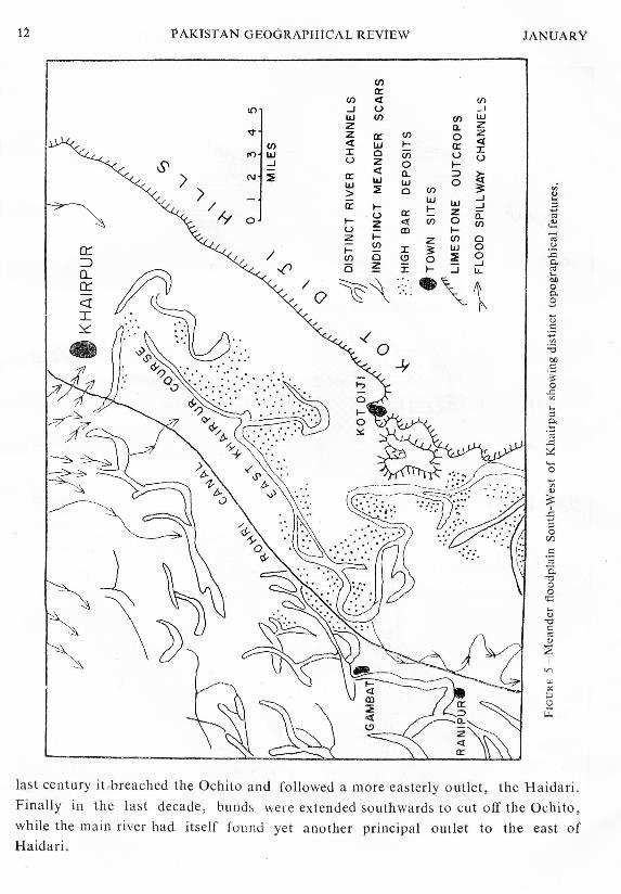
course built up a still higher level, they got covered up. The intervening low lyingareas between the river courses, the cover floodplains, received a veneer of fine sedi-ments every time the flood water escaped from the river courses. The meanderfloodplains are much wider in the north but gradually get narrower (the interveningcover floodplains wider) as they enter the delta until the "bank-topping" floods aredominant in the deltaic distributaries giving rise to extensive cover floodplains. Anexample of the distncti tobographical features of the meander floodplains is to befound south-west of Khairpur (Fig. 5).
Bar deposits
These are of two types depending on their relative height and relief. This
distinction is perhaps due to the amount and proportion of coarse material carried .

1969 ALLUVIAL MORPHOLOGY OF THE LOWER INDUS PLAIN 15
by the river. Of the two types, low-bar deposits are more common. Their relief iscomparatively more even, soil texture is mostly coarse-medium with coarse horizonsand of fine medium with thin horizons especially at the surface. High bar deposits(Fig. 5) have a comparatively higher relief and are normally out of command;their topography is rough and soil texture is predominantly coarse i.e., sandy.
Channel Deposits.
These are very important landforms of common occurrence in the region.Sometimes they subdue other types of meander floodplain deposition by their coarsetextured material which may at times be of fairly good thickness. Three types oflevees have been distinguished (a) bank levee, it is most common in the delta region,
(b) spillway levee, it is of very wide occurrence. Spillway levees vary in size andextent, they are smaller than the bank levees because they have been formed byspillways and (c) sheet levee, it occurs when the river suddenly overflows its banksover a wide front, inundating large areas, and depositing layers of coarser sedimentsusually of shallow depth.
Cover floodplains.
This is the most extensive landform in the region. The intervening areasbetween the river courses, which are at a lower level are periodically inundated at thetime of floods. By the time the slow moving flood water reaches there it has
already dropped its load of coarser material and only the finer material is depositedhere vertically covering former topographic features, leading to the formation of coverfloodplains (Fig 6). The cover floodplains fall into three types, depending in somemeasure on their relative age a) shallow cover-plain, it is slightly depressed land withsmooth topography, textures fine-medium to varying depth overlying coarse-mediumor coarse, b) deep cover-plain, it is also slightly depressed land with very smooth topo-graphy, textures are mostly fine-medium and c) very fine cover plain, slightly depressedland with very smooth topography, textures fine and fine-medium to varying depth.
Active floodplain.
The present day active river channel is the active floodplain. It is an artificial
landform since it is bunded over most of its length. The bunds create artificial coverfloodplain conditions and so the sediments deposited away from the active channelsmay be quite thick. The bunds also restrain the river so that it may not materiallychange its course. Under such conditions natural deposition of sediments over theflood plain is now no longer possible.
Delta zoneThe distributaries of the river Indus, near Tatta begin to spread out across the
delta on their way to the Arabian sea. The two landforms, deltaic floodplain and

16 PAKISTAN GEOGRAPHICAL REVIEW JANUARY
tidal delta, cover the greater part of the Indus delta. The deltaic floodplain coversabout 25 per cent of the region. It lies above the high tide and is that part of thedelta most recently abandoned by the sea. The tidal delta comprises almost 60per cent of the region. The soil profiles of the deltaic floodplain are very changeablefrom place to place and most of them show thin stratification. The soil texturesrange from moderately coarse to moderately fine and are generally finer than thosefound in most other plains of river laid alluvium. Coarser materials are found onthe active floodplains and along the banks of some of the distributaries.
The extreme western portion of the Indus delta which faces the Arabian seaand the extreme southern portion which faces the Rann of Kutch consist of tidalmudflats and constitute the tidal delta or tidal cover-plain. All the lands under thetidal delta are inundated at the time of high tides and lie exposed at iow tides. Thewidth of the tidal delta varies between five and twenty-five miles. There are only afew small parts that are high enough not to be overrun by the tides. This divisioncorresponds to the cover floodplains found inland but with the difference that its sedi-ments are comparatively finer and of no immediate agricultural value.
Desert fr inge
The name is given to the floodplains and desert border north of Sanghar district.Here isolated sand-dunes are encountered rising over the aliuvial plain. The textureof the intervening alluvium is similar to that of the type of associated floodplain. Atplaces the surface has become sandy on account of man's intervention by levelling
the sand-dune margins.
Piedmont zone
The main Piedmont plain is the Kachhi Plain, which extends from Kashmor toJhatpat, north to Sibi, and south to Manchar Lake. The Piedmont material in thisarea is mostly of a fine texture, and alluvial in origin as it has been brought down bystreams descending from the adjacent hills. It is also as well sorted as the Indusalluvium. Elsewhere, adjacent to the Lower Indus plain, Piedmont zones occur alongthe foot of the Rohri Hills and along the Ko h istan area and its outliers in GhulamMuhammed Barrage Command. They mostly consist of coarse fan material, butlimited Piedmont cover floodplains occur west of Tatta.
Soils.
Pedologists in an attempt to describe and classify soils on a world-wide basis,have set up as their primary units the three soil orders, zonal, intrazonal and azonal.The second level of classification divides the zonal order into great soil groups, eachof which has a distinctive horizon development and has evolved under a distinctiveclimatic regime. In the world map showing the principal zonal soil groups, soils of

1969 ALLUVIAL MORPHOLOGY OF THE LOWER INDUS PLAIN 17
the Lower Indus Plain together with those of the Thar desert have been included inthe category of desert soils or Sierozernst '. The zonal soils are not the cnly soils inthe zones or regions, but each region has also its intrazonal and azonal soils whichexist in association with each of the classes made. Azonal soils are generally foundin areas of extremely youthful and undeveloped regolith, such as newly depositedalluvium. They do not show any distinctive physical characteristics, such as horizons,because they are immature on account of not getting enough time to develop. Thesoils of the Lower Indus Plain mostly consist of river laid alluvium which is of recentorigin; they either show very little or no profile development and so no horizons.The layering that they exhibit is related to the deposition of alluvium and thecharacteristics inherited from the parent material. It is, therefore, advisible toinclude these soils in the category of Regosols belonging to the azonal soil order.
Texture is the only reasonably stable characteristic of the soils and is alsoreadily recognisable; the other morphological features viz., colour, consistence andstructure, are not well developed and so they cannot be adopted as a criterion to
differentiate between soils. For purposes of soil mapping on detailed scales, texturecan be employed as a basis but on regional scales the stratification becomes toocomplex. Soil textures are very closely related to depositional conditions, and eachlandform has a defined range of textural profiles together with characteristics ofelevation and topography. It is, therefore, that modes of deposition have beenfound to be the most suitable basis of soil classification in the region and themapping units finally adopted are geomorphic units or landforms.
It is on account of arid climate that virgin soils show [\ high content of thesalts of sodium, potassium, magnesium and calcium. A zone of accumulation ofthese salts is usually found at a depth corresponding to the penetration of rain orflood water. It is affected by drainage in different areas and only shows where thewater-table is deep, so that no salts from the ground water reach the surface of thesoil. Calcium carbonate present in these soils works as a cementing material andits proportion is about ten per cent of the soil by weight. Its concretions, however,are not widespread. Most of this salt was depos.ted here as sediments which theriver brought with it from the Himalayas, but certainly some of it has precipitatedfrom the irrigation water as well. An analysis of soils indicate that they are low inorganic matter and available nitrogen and phosphate, but are very productive whenirrig ated!+. The deficiency of organic matter in soils is due to high temperaturesexperienced in the region which rapidly oxidize the organic matter and do not let itaccumulate in soils. The organic matter is the chief source of food and energy for
13A. N. Strahler: The Earth Sciences, New York, 1963. p. 621.HF. O. Young: Report (0 the Government of Pakistan on Soils and Agriculture (Rome: 1953).
p.l0.
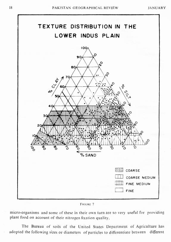
18 PAKISTAN GEOGRAPHICAL REVIEW
TEXTURE DISTRIBUTION IN THE
LOWER INDUS PLAIN
JANUARY
micro-organisms and some of these in their own turn are so very useful for providingplant food on account of their nitrogen fixation quality.
.. .-
The Bureau of soils of the United States Department of Agriculture hasadopted the following sizes or diameters of particles to differentiate between different
o 6'0 0 '6<:
%SAND
~~OJ]mrrno
COARSE
COARSE MEDIUM
FINE MEDIUM
FINE
FIGURE 7

1969 ALLUVIAL MORPHOLOGY OF THE LOWER INDUS PLAIN 19
types of soil as to their physical composition: coarse sand is taken as 1.00-0.50 milli-meter, medium sand 0.50-0.25 millimeter, fine sand 0.25-0.10 millimeter, very fine sand0.10-0.05 millimeter, silt 0.05-0.002 millimeter and clay below 0.002 millimeter indiameter.re Various textures are produced by combinations of sand, silt and clayin certain proportions. The scale employed in this connection is also the same asadopted by the Bureau of Soils of the United States Department of Agriculture:sand-eighty per cent or more of sand and twenty per cent or less of silt or clay, sandyloam-twenty to fifty per cent of silt and clay and the remainder sand, loam - twenty
per cent or less of clay and thirty to fifty per cent of sand (if silt predominatesthen it is silty loam, if clay then clay ioam), clay-thirty per cent of clay and lessthan seventy per cent of larger sizcs!e.
The United States Department of Agriculture texture triangle'? has beenadopted to convert mechanical analysis into textural classes. The mechanicalanalyses have been done by Hunting Technical Services" on samples overthe range of textures encountered in the Lower Indus Plain and their distributionis shown in Fig. 7.18 This figure suggests that the majority of textures belong tosilty loam and silty clay loam classes. True clays and medium or coarse sandsare rare particularly in the upper alluvial layers. Soil textures having eighty-fiveper cent of sand are not widespread but are limited to high-bar deposits and certainparts of the meander floodplains.
The meander floodplains have comparatively rough topography and generallycoarse soils, while the cover floodplains have smooth topography and fine soils.The levees have coarse-medium or coarse soils, overlying fine-medium or fine soils.In the north-west of the region, there is a strip of alluvium, the piedmont, thathas been deposited by streams from the adjacent hills. It is generally of a finetexture and possesses different physical properties from the Indus alluvium.
RISING WATER-TABLE AND ASSOCIATED PROBLEMS
A study of the water-table and its fluctua tions is of vital significance to any kindof agricultural development in the region. Such a study can very greatly helpin determining the types of crop which can be grown successfully, methods ofcultivation and irrigation to be employed, and other agricultural practices to befollowed.
15C. E. Miller and L. M. Turk: "Fundamentals 0/ Soil Science." (New York: 1956), p. 45.16Strahler. op clt , footnote 14, p. 612.17M iller and Turk, op. cit , footnote 16, p. 52.18Lower Indus Report. Physical Resources, West Pakistan WAPDA, Vol. 2, p. 161.=Authcrs of the "Lower Indus Repor t+-Pbysical Resources." 1965.

20 PAKISTAN GEOGRAPHICAL REVIEW
;-/'
»:---.... ---{(
\
BARRAGE
//
II NORTH - WESTERN, CANAL L-~--""
\.~)
/I
I
,\/
( :;:,I 0
\6~,<;
\
CANAL COMMANDBOUNDARIES
,,,,'+'0'
'""" \
I;01-I< /"'/::01
)
I/
/
/
//
/'10 0 10 20 30 40 50I, ,I I "
MILES
FIGURE 8
JANUARY

1969 ALLuviAL MORPHOLOGY OF THE LOWER INDUS PLAIN 21 k.
APRIL 1964
\
1>..•..DEPT~ t-~
FEET 1> -,III 0-4
\Z
G 0
5-8c!J)
DI
9 -12 I
~I
> 12 \/
j
WATER -TABLE
FIGURE 9

PAKtStAN GEOGRAPHiCAL REVIEW JANUARY
In the last century the water-table was very close to the stabilized natural water-table established by natural forces, but the construction of barrages with a net-work of canals in the present cenlury(Fig. 1) have considerably disturbed the balancethat existed previously between the natural recharge of the aquifer through riverand rain and the discharge of its water to the sea. In consequence, surface infil-tration of water by rainfall, floods, field irrigation, seepage from river, canals, spills,hill torrents, and sub-soil flow of water towards the valley from adjacent higherareas now exceeds the down-valley outflow of water, loss of water due to evaporationfrom shallow water-table, transpiration by plants and removal of water by drainsresulting in the rising of the water-table, which fluctuates from season to season.
Figures 8 and 9 show the canal command boundaries and depth to water-tablerespectively and Tables 1 and 2 show percentage of the area in each water-tabledepth class by canal commands for the months of April and October 1964 respec-tively. These tables indicate that the areas of low water-table are: Gudu BarrageCommand Right and Left Banks, Rohri Canal Command and Tando Bago PerennialArea (eastern side only). All the rest of the commands have a high water-table.The commands that have the greatest percentage of their area under water-tableof four feet and less both in April and October are: Ghulam MuhammadBarrage Right Bank and Left Bank (non-perennial), Rice Canal, Gudu Right Bankand Nara Canal.
These tables further indicate that throughout the irrigated area the water-tableis generally high. In many areas it is either still rising or has risen to the extent asto reach a state of balance under the present intensities of cultivation. Table 3
TABLE I-PERCENTAGE OF AREA IN EACHWATER-TABLEDEPTH CLASSBYCANALCOMMANDS,APRIL, 1964.
Command 0-4 ft. 4-S ft. S-12 ft. 12-16 ft. Below 16 ft.
Gudu Left Bank Nil O.S 0.5 6.4 92.3Gudu Right Bank 2.2 56.7 39.2 0.7 1.2
Pat Feeder Area Nil 3.1 3.7 12.2 81.0N.W. Canal 9.5 68.0 21.5 0.7 0.3Rice Canal 0.8 61.3 31.1 0.8 NilDadu Canal Nil 56.0 28.8 14.4 0.8Khairpur 1\.8 46.4 10.5 5.5 25.8Rohri Canal 1.2 7.3 24.5 29.0 38.0Nara Canal 7.0 42.2 36.4 7.8 6.6Tando Bago 2.2 22.7 49.5 18.2 7.4
G.M. Left Bank (N.P.) 5.3 23.9 49.0 19.1 2.7Gaja Nil 97.0 3.0 Nil NilG.M. Right Bank (P) Nil 27.4 31.6 20.2 20.8G.M. Right Bank (N.P.) 5.1 42.1 50.0 2.8 Nil
SOllRCE: "LOWER INDUS REPORT, PHYSICALRESOURCES,"WAPDA, 1965, Vol. 2, P.456.

1969 ALLUVIAL MORPHOLOGY OF THE LOWER INDUS PLAIN 23
TABLE 2-PERCENTAGE OF AREA IN EACH WATER-TABLE DEPTH CLASS BY CANAL COMMANDS,OCTOBER, 1964.
Command 0-4 ft. 4-8 ft. 8-12 ft. 12-16fl. Below 16 ft.
Gudu Left Bank N'I 0.9 13.1 16.5 69.5I.
Glldll Right Bank 64.5 34.9 0.6 Nil Nil
Pat Feeder Area Nil 7.7 2.5 10.2 79.6
N.W. Canal 46.0 35.0 11.3 5.8 1.9
Ri(;e Canal 84.5 15.5 Nil Nil Nil
Dadu Canal 13.1 37.9 40.8 8.2 NilKhairpur 14.9 48.2 9.9 3.4 23.6
Rohri Canal 1.4 12.3 21.6 33.1 31.6
Nara Canal 60·3 21.9 13.1 1.6 3.1
Tando Bago 5.2 37.8 41.4 12.3 3.3
G.M. Left Bank (N.P.) 68.1 30.4 0.8 0.7 Nil
Gaja 40.0 55.0 5.0 Nil Nil
G.M. Right Bank (P) 42.1 10.1 24.5 22.4 0.9
G.M. Right Bank (N.P.) 73.2 22.5 4.3 Nil Nil
SOURCE: "LOWER INDUS REPORT, PHYSICAL RESOURCES," WAPDA, 1965, VOL. 2, P. 457.
shows the percentage of cultivable commanded area in each water-table depth class for
the region as a whole. It reveals that over sixty per cent of the commanded area
has water-table of twelve feet and less from the surface in the month of April, while
sixty per cent of the area has eight feet and less in the month of October.
TABLE 3-PERCENTAGE OF CULTIVABLE COMMANDED AREA IN EACH WATER-TABLE DEPTH CLASS.
Area 0-4 ft. 4-8 ft. 8-12 ft. 12-16 ft. Below 16 ft.
April 1964 Perennial 2.8 20.3 16.8 9.2 10.9
April 1964 Seasonal 1.0 12.8 13.0 3.5 9.7
April 1964 Total 3.8 33.1 29.8 12.7 20.6
October 1964 Perennial 16.9 14.5 11.6 8.8 8.2
October 1964 Seasonal 20.5 9.0 I.l 1.6 7.8------~ --------
October 1964 Total 37.4 23.5 12.7 10.4 16.0
SOURCE; "LOWER INDUS REPORT, PHYSICAL RESOURCES," WAPDA, 1965, VOL. 2, P. 499.
24 PAKISTAN GEOGRAPHICAL REVIEW JANUARY
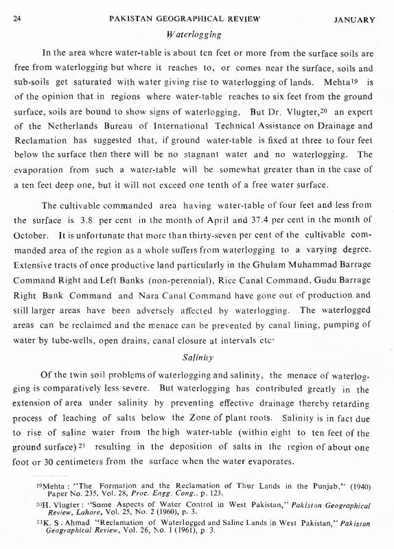
Waterlogging
In the area where water-table is about ten feet or more from the surface soils are
free from waterlogging but where it reaches to, or comes near the surface, soils and
sub-soils get saturated with water giving rise to waterlogging of lands. Mehta+s is
of the opinion that in regions where water-table reaches to six feet from the ground
surface, soils are bound to show signs of waterlogging. But Dr. Vlugter,20 an expert
of the Netherlands Bureau of International Technical Assistance on Drainage and
Reclamation has suggested that, if ground water-table is fixed at three to four feet
below the surface then there will be no stagnant water and no waterlogging. The
evaporation from such a water-table will be somewhat greater than in the case of
a ten feet deep one, but it will not exceed one tenth of a free water surface.
The cultivable commanded area having water-table of four feet and less from
the surface is 3.8 per cent in the month of April and 37.4 per cent in the month of
October. It is unfortunate that more than thirty-seven per cent of the cultivable com-
manded area of the region as a whole suffers from waterlogging to a varying degree.
Extensive tracts of once productive land particularly in the Ghulam Muhammad Barrage
Command Right and Left Banks (non-perennial), Rice Canal Command, Gudu Barrage
Right Bank Command and Nara Canal Command have gone out of production and
stil1 larger areas have been adversely affected by waterlogging. The waterlogged
areas can be reclaimed and the menace can be prevented by canal lining, pumping of
water by tube-wells, open drains, canal closure at intervals etc-
Salinity
Of the twin soil problems of waterlogging and salinity, the menace of wa terlog-ging is comparatively less severe. But waterlogging has contributed greatly in the
extension of area under salinity by preventing effective drainage thereby retarding
process of leaching of salts below the Zone of plant roots. Salinity is in fact due
to rise of saline water from the high water-table (within eight to ten feet of the
ground surface) 21 resulting in the deposition of salts in the region of about one
foot or 30 centimeters from the surface when the water evaporates.
19Mehta : "The Formation and the Reclamation of Thur Lands in the Punjab." (1940)Paper No. 235. Vel. 28, Proc. Ellgg. Cong., p. 123.
2oH. Vlugter: "Some Aspects of Water Control in West Pakistan," Pakistan GeographicalReview, Lahore, Vol. 25, No.2 (1960), p, 3.
21K. S . Ahmad "Reclamation of Waterlogged and Saline Lands in West Pakistan," PakistanGeographical Review, Vol. 26, 1\0. 1 (1961), P 3.

1967 ALLUVIAL MORPHOLOGY OF THE LOWER lNDUS PLAIN 25
o•
UPPER SOILSALINITY
NON TO MODERATELYSALINE
SEVERELY SALINE
2? , , ,9 2;> 5fMILES
FIGURE 10
26 PAKISTAN GEOGRAPHICAL REVIEW JANUARY
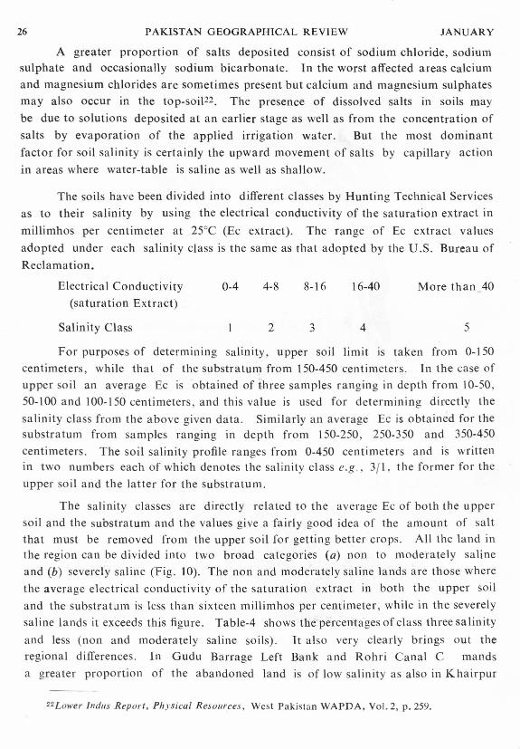
A greater proportion of salts deposited consist of sodium chloride, sodiumsulphate and occasionally sodium bicarbonate. In the worst affected areas calciumand magnesium chlorides are sometimes present but calcium and magnesium sulphatesmay also occur in the top-soil--", The presence of dissolved salts in soils maybe due to solutions deposited at an earlier stage as well as from the concentration ofsalts by evaporation of the applied irrigation water. But the most dominantfactor for soil salinity is certainly the upward movement of salts by capillary actionin areas where water-table is saline as well as shallow.
The soils have been divided into different classes by Hunting Technical Servicesas to their salinity by using the electrical conductivity of the saturation extract inmillimhos per centimeter at 25°C (Ec extract). The range of Ec extract valuesadopted under each salinity class is the same as that adopted by the U.S. Bureau ofReclamation.
Electrical Conductivity(saturation Extract)
Salinity Class
0-4 4-8 8-16 16-40 More than 40
2 3 4 5
For purposes of determining salinity, upper soil limit IS taken from 0-150centimeters, while that of the substratum from 150-450 centimeters. In the case ofupper soil an average Ec is obtained of three samples ranging in depth from 10-50,50-100 and 100-150 centimeters, and this value is used for determining directly thesalinity class from the above given data. Similarly an average Ec is obtained for thesubstratum from samples ranging in depth from 150-250, 250-350 and 350-450centimeters. The soil salinity profile ranges from 0-450 centimeters and is writtenin two numbers each of which denotes the salinity class e.g ., 3/1, the former for theupper soil and the latter for the substratum.
The salinity classes are directly related to the average Ec of both the uppersoil and the substratum and the values give a fairly good idea of the amount of saltthat must be removed from the upper soil for getting better crops. All the land inthe region can be divided into two broad categories (a) non to moderately salineand (b) severely saline (Fig. 10). The non and moderately saline lands are those wherethe average electrical conductivity of the saturation extract in both the upper soiland the substratum is less than sixteen millimhos per centimeter, while in the severelysaline lands it exceeds this figure. Table-4 shows the percentages of class three salinityand less (non and moderately saline soils). It also very clearly brings out theregional differences. In Gudu Barrage Left Bank and Rohri Canal C mandsa greater proportion of the abandoned land is of low salinity as also in Khairpur
22Lower Indus Report, Physical Resources, West Pakistan WAPDA. Vol. 2, p. 259.

1969 ALLUVIAL MORPHOLOGY OF THE LOWER INDUS PLAIN 27
SCALE
10 0 10 20I I MILES
LAND USE
D PREDOMINANTLY CULTIVATED
f;; tl PREDOMINANTLY ABANDONED
I===l CULTIVATED 8. ABANDONEDt::::::j MIXE D
[II] NEVER CULTIVATED
- - - -O-F - --K--U-T-c- H-
FIGURE 11

28 PAKISTAN GEOGRAPHICAL REVIEW JANUARY
Command. One can logically arrive at this conclusion as far as Gudu Barrage LeftBank and Rohri Canal Commands are concerned because water-tables are fairly deepbut for Khairpur Command where water-table is shallower, this reasoning does nothold good. In Nara Conal and Gaja Commands about half the abandoned land isseverely saline, and in both water-table is shallow. In Ghularn Muhammad Barrage,Sukkur Barrage Right Bank and Gudu Barrage Right Bank Commands only twenty-fiveper cent of the bores drilled for the purpose showed low salinity.
TABLE 4-DISTRTBUTJON OF MODERATELY SALINE LANDS IN EACH COMMAND BY PERCENTAGE UNDER
DIFFERENT LAND USE HEADS.
Command Cultivated Abandoned
Gudu R.B. 8l 24
Gudu L.B. 96 90
Sukkur R.B. iO 24
Khairpur 91 84
Rohri 94 74
Nara 81 42
Ghularn Muhammad R.B. 66 26
Ghulam Muhammad R.B. 68 21
Never cultivated
54
47
7378
30
10
19
SOURCE: "LOWER INDUS REPORT, PHYSICAL RESOURCES". WAPDA, 1965, VOL. 2, P. 336.
In Rohri Canal and Khairpur Commands never cultivated lands are mostlyof low salinity. In these commands abandoned and never cultivated lands areuncultivated for reasons other than salinity. In Gudu Barrage Command Right andLeft Banks about fifty per cent of the never cultivated land is of low salinity _ Most ofthe area of these commands being situated at a level a little higher than the surrounding
country cannot be irrigated by canals.
To show the distribution of soil salinity, salinity class 3/3 has been adopted asthe dividing line between moderately and severely saline soils. Table 5 shows thepercentages of areas under these soils in the different commands. The Gudu BarrageLeft Bank, Rohri Canal and Khairpur Commands have a low percentage of severelysaline soils, whereas Gudu Barrage Right Bank and Nara Canal Commands have onethird of their area under this salinity class. The Sukkur Barrage Command RightBank has almost half, while Ghulam Muhammad Barrage Command Right and LeftBanks taken together have two thirds of their area as severely saline.

1969 ALLUVIAL MORPHOLOGY OF THE LOWER INDUS PLA[N 29TABLE 5-DISTRIBUTION OF SALINITY IN THE REGION (PERCENTAGES OF AREAS UNDER COMMANDS).
Command Moderately Saline Severely Saline
Rohri
Khairpur
Gudu L.B.
908681
63
63
52
34
33
1014
19
37
374856
67
Nara
Gudu R.B.
Sukkur R.B.Ghularn Muhammad L.B.
Ghulam Muhammad R.B.
SOURCE: "LOWER INDUS REPORT,·,pHYS1CAL RESOURCES", WAPDA, 1965, VOL. 2, P.361.
Since all classes of upper soil salinity are found associated with all depthsof water-table, therefore, no definite relationship can be established between water-table depth and upper soil salinity. Relationship between geomorphic featuresand salinity is also not very distinct, since in almost all the landforms, there areequal number of sites of class four and five salinity. The levees are in fact themost saline of all the geomorphic units. Salinity in them varies considerably andit is very difficult to find out whether it is due to landform or land use, becausethe saline part of the cover floodplain in proximity with the levee deposit is nevercultivated.
LAND USE
A study of land use map of the Lower Indus Plain (Fig. 11) reveals thefollowing three outstanding features: a) almost contiguous tracts of abandonedland in the right bank commands, b) extensive tracts of cultivated land situatedon the left bank in the Rohri Canal Command and c) patches of abandoned andnever cultivated land in the Gudu Barrage and Ghulam Muhammad Barrage Com-mands. The abandoned land constitutes approximately sixteen per cent of theregions cultivable commanded area 23. This can be explained to be mainly dueto : a) failure of development efforts in never cultivated saline lands, b) deficiencyof water or its absence particularly in lands in proximity to canal extremities dueto maldistribution of water and improper canal maintenance and c) harmful effects.of waterlogging and salinity. The two soil evils of waterlogging and salinity arerampant in areas where there has been appreciable rise in water-table due to seepagefrom canals running in close proximity. The process of salinisation of soil com-mences no sooner irrigating of land ceases.
23. Ibid, Vol. 7, p, 42.
30 PAKISTAN GEOGRAPHICAL REVIEW JANUARY
Table 6 indicates that the three major commands viz, Gudu, Sukkur andGhulam Mohammad have a gross area of approximately fifteen million acres of which1.7 million acres are uncultivable. The balance of more than thirteen million acresis either at present used for irrigated agriculture or is potentially irrigable. Apart
from the above mentioned fifteen million acres, the area between the river bundsexcluding the main channel consists of 1.6 million acres of which 418,000 acres arecultivated and 387,000 acres are under forest (Table 7). The remaining 834.000acres consist of non-cultivable and unproductive land.
TABLE 6-LAND USE SUMMARY (1,000 ACRES).
I Cultivable land TotalBarrage Command I Non-culti- Gross
Productive I Unproductive c. c. A vated land area
Gudu 1.436 1.366 2.802 298 3,100
Sukkur 5.691 1,779 7.470 1,031 8.501
Ghularn 1,279 1.645 2,924 392 3.316Muhammad
Total :- 8,406 4,790 13,196 1,721 14,917
SOURCE: "LOWER INDUS REPORT, PHYSICAL RESOURCES". WAPDA, 1965, VOL. 7, P. 41.
TABLE 7-LAND USE IN RIVERAIN AREA (1,000 ACRES).
River tractNon-cultivable GrossCultivated Forest and unproduc-
tive land area
188 94 213 495*
119 107 358 584*
58 111 114 283*
53 75 149 277*---------------_._------
Total :- 418 387 834 1,639
Gudu to Sukkur
Suk kur to SehwanI
Sehwan to G. M. B.
G. M. B. to Sea
"Excludes main channel.
SOURCE: "LOWER INDUS REPORT, PHYSICAL RESOURCES", WAPDA, 1965, VOL. 7, P.42.
The unproductive land comprises thirty-six per cent of the total cultivablecommanded area of the three major commands. In individual commands the per-centage of unproductive land to its cultivable commanded area is the highest, fifty-six

1969 ALLUVIAL MORPHOLOGY OF THE LOWER INDUS PLAIN 31
per cent in the still developing Ghulam Mohammad Barrage Command, forty-nineper cent in the Gudu .Barrage Command and the lowest twenty-four per cent in theSukkur Barrage Command. The non-cultivable land in these commands accountsfor 11.5 per cent of their gross area. The non-cultivated land within these com-mands is such which can be developed by canal irrigation provided etf~rts are made.In the rest of the commands the never cultivated land represents the transition be-tween sand-hills and sand dunes on the one side and the already cultivated area onthe other.
Lakes, permanent and seasonal swamps occupy 584,000 acres. Of this figureeight per cent is in the Rice Canal Command, seventy four per cent within the GhulamMohammad Barrage Command, and the remaining eighteen per cent is largelyaccounted for by the broad reaches of the Nara Canal which have been includedwithin this category of land use. In the Rice Canal Command, lakes and perma-nent swamps occupy 19,000 acres and seasonal swamps 29,000 acres. They are mostlyconcentrated in the south-west corner of the command. This concentration accounts.for fifty and thirty three per cent of the area under lakes and permanent swamps andseasonal swamps of the command respectively. In the Ghularn Mohammad BarrageCommand lakes and permanent swamps occupy 185,000 acres, representing forty-seven per cent of the uncultivable area. The seasonal swamps account for 246,000acres, or eight per cent of the cultivable commanded area. These two categoriestotalling 431,000 acres or about 13 per cent of the gross area of the command, reduceto a very considerable degree the area of land available for development.
LANDFORMS AND LAND USE.
A comparative study of landform and land use maps Figs. 4 and 10 not onlygives a clear understanding of the physical environment and human reactions toit but also reveals both adjustments and maladjustments in land use.
On the basis of field studies. interpretation of aerial photographs and largescale maps, it appears that the cover flood plains consist of mixed cultivated and aban-doned lands. In the middle section of the Lower Indus Plain particularly in RohriCanal Command cultivated area is generally devoid of abandoned land as it is almostfree from natural shortcomings. However, in the northern section of the plain in allthe right bank Commands and in the southern section on the left bank of the riversouth of Hyderabad-- Tando Muhammad Khan, patches of predominantly abandonedand never cultivated land are widespread. The meander floodplains are predominantlycultivated excluding the bar and levee deposits which are mostly saline and out of
command. The deltaic floodplains in the delta zone mostly consist of mixed cul-tivated and abandoned lands due to the twin menace of waterlogging and salinity.

32 PAKISTAN GEOGRAPHICAL REVIEW JANUARY
The tidal delta is not cultivated, since it is rendered unfit for agriculture on accountof constant onrush of sea water at the time of high tide.
The active floodplain is bounded by embankments along most of its length.
Riverain forests are found in the area between the river bunds excluding the mainchannel. On either side of the main channel of the lower Indus from Hyderabadto Goth Mira (about eight miles south of Sehwan) in the north and Chuh ar Jarnaliin the south, the forests generally run in a continuous stretch. There are no foreststo be found in a 10 miles strip south of Hyderabad due to the narrowness of the riverchannel. Northward of Goth Mira almost upto Kashmor forests wherever encounteredare generally in patches or in strips of various sizes. Of the total area between theriver bunds, exculding the main channel less than twenty-five per cent is forested,about twenty-five' per cent is cultivated and more than fifty per cent is non-cultivableand unproductive land.
CONCLUSION
All the alluvial deposits of the Lower Indus Plain are obviously the work ofone river, the Indus, which have completely buried the original land surface of theplain together with its earlier marine deposits to a depth of some thousand feet.
The plain may be regarded as a fairly homogeneous aquifer likened to a huge sponge,capable of absorbing runoff from abjacent foothills as well as rainfall and seepagefrom the river and canals that traverse it, and of transmitting this subterranean flowdownslope to the Arabian Sea.
Human control by erecting bunds has virtually confined tbe river to its ownchannel. It can now no longer swing sideways, but the natural tendency of a breakthrough to a more easterly course still persists on account of its building up of itschannel. Under such conditions the natural deposition of alluvium over the flood-plains is now restricted. It, therefore, becomes necessary that the fertility of soilsshould be maintained by adding such soil constituents of which they are depleted
on account of their supporting crops through the ages.
The soils of the region are of recent origin and pedologically immature,There is very little or no profile development and so no horizons. The landformsfound here mark different phases in alluvial sedimentation. A redeeming feature,however, of these sediments is that they exhibit well sorted textures and reveal intricatestratification with rapid lateral and vertical changes. The most recent sedimentsare fine sandy loam to silty clay, while those deposited a little earlier are muchcoa rser and '~at places a Il110st sandy. Soil textures having eighty-five per cent ofsand are limited to high bar deposits and certain parts of the meander floodplains.The soils arc deficient in organic matter, available nitrogen and phosphate but are

1969 ALLUVIAL MORPHOLOGY OF THE LOWER INDUS PLAIN 33
very productive when irrigated. It is hoped that the present situation of loworganic content in soils will certainly improve with an increase in cropping inten-sities, thereby improving the physical characteristics of soils, provided the drainageis good.
Abandoned land in the region constitutes approximately sixteen per cent ofthe cultivable commanded area, which is mainly due to a failure of developmentefforts in saline lands in proximity with canal extremities, maldistribution of waterand damage done by waterlogging and salinity. Within the three major commands(Gudu, Sukkur and Ghulam Mohammad) non-cultivated lands are those which canbe developed by canal irrigation. In the remaining commands the never cultivatedland represents the transition between sand-hills and sand-dunes on the one sideand the already cultivated area on the other.
About sixty per cent of the region has a high water-table which manifestsitself in the form of waterlogging of lands. Under the existing conditions water-table is expected to rise in all the perennial commands. The seasonal rice growingareas evince a typical seasonal rythm which can be expected to persist withoutmuch change even where development provides greater water supplies. In perennialareas where it is envisaged to introduce tube-wells for utilizing ground water, pum-
ping will indirectly control the water-table, but in areas where increased surfacesupplies are inevitable water-table is bound to rise resulting in waterlogging of lands.Thus provision of a drainage system in such areas is inevitable for bringing downthe water-table. It will not be out of place to mention here that the governmentis alive to the need of providing a drainage system. Many schemes having beenformulated for the purpose and are under various stages of execution.
Salinity has now assumed alarming proportion in the region. About thirty-eight per cent of the land is severely salt affected and the remaining sixty-twoper cent is moderately saline This soil defect together with waterlogging is limitingto a very considerable degree the productivity of the cultivated land in the region.There is no dennite relationship between water-table depth and upper soil salinity,since a II classes of upper soil salini ty are found associated with all depths of wa ter-table.Abrupt changes in salinity over short distances are very common. In such placessalinity is associated with water-table depth, ground water salinity and land use.These three factors are so closely interrelated that no one factor can be considered inde-pendently of the other two. Relationship between landforms and salinity is also notvery clear. Since in almost all the landforms there are equal number of sites ofclass four and five salinity. The levees are certainly the worst affected in this regardand the extent of salinity in them is also variable. It is difficult to make out whetherit is due to landform or land use, because the saline part of the cover floodplainalong side the levee deposits is never cultivated.
34 PAKISTAN GEOGRAPHICAL REVIEW JANUARY
It is, indeed, very fortunate that modern science and technology has enabledman to evolve effective methods to eradicate the harmful effects of the twin soildiseases. It is now left to us to employ these methods to our advantage expedi-tiously and intelligently. Efforts at first should be directed to check their spreadingand then to redeem partially damaged lands as also those permanently lost to agri-culture on account of it. Methods employed must correspond to local geologicaland hydrological conditions as also to requirements of agriculture, for differenttypes of crops are raised in different areas.
In the end it is hoped that, this study may prove to be of some advantagein appreciating the relationship that exists between the geomorphic features, soilsand present land use and in indicating the direction in which more detailed studies
may be undertaken for a planned and intelligent use of the land.

KARACHI BEFORE BRITISH RULE
ZAFAR AHMAD KHAN
NOTHING d~:fi.nite is. kn~wn about the early ~istory of Karachi befo.re it becamepart of British India In 1843. Some wnters consider that It IS the same
'Alexander's Haven' from which earchus sailed with his fleet to explore the coastof Mekran and Persia". Others believe that it is the ancient seaport of Debal whichwas destroyed by the Arab General Muhammad Bin Kasim in his invasion of theSind in A.D. 7112. But Hughes holds that a town never existed on the site ofKarachi or anywhere near it until the first quarter of the 18th Century>. Baillie.!Aitkin> and Smythv also have the same opinion. Their assertion is based on thefact that this part of the coast of Sind lacked all the natural advantages that areconducive to the growth of towns. 'However, they all agree that before 1725 theredid exist on the present site of Karachi a small village which consisted of abouttwenty-five fishermen's huts and was known as Dirbo.
In 1.729. a number of settlers arrived at Dirbo from a nearby port calledKhar ak Bundar. Kharak Bundar was situated at the mouth of the River Hubb andhad a lucrative trade with the countries on the Arabian Sea coast? But around1725 the harbour became silted up and the merchants were forced to migrate toanother place which would afford them better mercantile advantages.
Dirbo was situated at the head of Karachi Bay which was spacious and quitesafe for vessels. It was only the sheltered bay on the Sind coast where protectioncould be obtained from winds and weathers. The River Indus was sufficiently near
lB. Pot t inger: Travels in Beloochistan and Sind (London: 1816). p. 385. C. Masson:"Lahore via Multan , Ulh, Khairpur. Hyder abad and Tatta to Karachi and Ocean" Proceedings0/ the Geog. Soc .• Bombay, Sept. Nov., 1840: Bombay 1941, p. 116. E.B. Eastwick: Personal Obser-vations ill Sind (London: 1831), p. 120.
2A. Burnt'S : Travels ill Bok hara, being {III account 0/ a journey [rom India to Kabool Tar.tary and Persia (London: 1831), p.20. Suleman Nadvi: "Early Relations between Arabia andIndia": Islamic Culture, Vol. II (Hyderabad Deccan: 1937), p. 18.
3A. W. Hughes: A Gazetteer of the province 0/ Sind (Bombay: 1876), p. 414.4A.F. Baillie: Kurrach ee : Pqst , Present and Future (Lond: 1890), p. I.5E.F. Aitkin: Gazet t ee r of I1lt Province of Sind, Vol. 2 (Bombay: 1909), p. 57.6J. W. Smyth: Gazet t eer of the Province 0/ Sind, Vol. 1, Karachi District (Bombay: 1927),
p.43.iH.E.A. James: A forgotten Chapter of Indian history as described in the Memoirs of
Seth Nao Mal Botchand, Exeter (1915), p. 36.8Masson: Op . cit., footnote I, p, 1I4.
"'DR. KHAN is Professor of Geography, Post-Graduate Section, GovernmentCollege, Rawalpindi.
36 PAKISTAN GEOGRAPHICAL REVIEW JANUARY
to be utilized for commerce with the interior. Plenty of flat land was available allaround for expansion. An added attraction was the availability of fresh water.
The water was obtained from a well called 'Kalachi's Kun'-Kun means welland Kalachi was the name of a fisherman. The village of Dirbo thus became knownas Kalachi-jo-got (the village of Kalachi) in later years. Karachi seems to be acorrupt version of Kalachi.
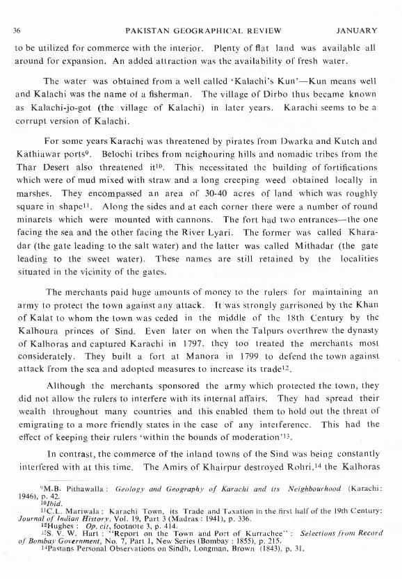
For some years Karachi was threatened by pirates from Dwarka and Kutch andKathiawar ports". Belochi tribes from neighouring hills and nomadic tribes from theThar Desert also threatened itlO. This necessitated the building of fortificationswhich were of mud mixed with straw and a long creeping weed obtained locally inmarshes. They encompassed an area of 30-40 acres of land which was roughlysquare in shapett. Along the sides and at each corner there were a number of roundminarets which were mounted with cannons. The fort had two entrances-the onefacing the sea and the other facing the River Lyari. The former was called Khara-dar (the gate leading to the salt water) and the latter was called Mithadar (the gateleading to the sweet water). These names are still retained by the localitiessituated in the vicinity of the gates.
The merchants paid huge amounts of money to the rulers for maintaining anarmy to protect the town against any attack. It was strongly garrisoned by the Khanof Kalat to whom the town was ceded in the middle of the l Sth Century by theKalhoura princes of Sind. Even later on when the Talpurs overthrew the dynastyof Kalhoras and captured Karachi in 1797, they too treated the merchants mostconsiderately. They built a fort at Manora in 1799 to defend the town againstattack from the sea and adopted measures to increase its tta de+-.
Although the merchants sponsored the army which protected the town, theydid not allow the rulers to interfere with its internal affairs. They had spread theirwealth throughout many countries and this enabled them to hold out the threat ofemigrating to a more friendly states in the case of any interference. This had theeffect of keeping their rulers 'within the bounds of moderation'l3.
In contrast, the commerce of the inland towns of the Sind was being constantlyinterfered with at this time. The Amirs of Khairpur destroyed Rohri.i-t the Kalhoras
9M.B. Pithawalla: Geology and Geography 0/ Karachi and its Neighbourhood (Karachi:1946), p. 42.
IO/hid.IlC.L. Mariwala : Karachi Town, its Trade and Taxation in the first half of the 19th Century:
Journal 0/ Indian History, Vol. 19, Part 3 (Madras: 1941), p. 336.12Hughes: Op. cit , footnote 3, p. 414.13S. V. W. Hart: "Report on the Town and Port of Kurrachee": Selections from Record
of Bombay Government, No.7, Part J, New Series (Bombay: 1855). p. 215.J4Pastans Personal Observations on Sindh, Longman, Brown (1843). p. 31.

HYDERABAo •'0
'"'0
INDUS DELTA1817
INDUS DELTA1837
KARACHI ~:>":>o:r:•...•IIIm'"11o
"m="::i-en..•.•-"ct"'!.'!1
ARABIAN
5 E AA R A
5 E A
FIG\)R~ Iw--I

38 PAKISTAN GEOGRAPHICAL REVIEW JA UARY
Sehwan ;'> and the Talpurs Bukkar and Sukkar!e. Although there IS no evidenceto prove it, there is a strong probability that as the trade of the inland townsdeclined, that of Karachi grew stronger and became more firmly established at itsexpense.
Some impetus to the growth of trade also came from the decline of severalimportant port-towns of the Sind. Their decline was brought about by changes inthe courses of the branches of the River Indus after the earthquake of 1819. Figure 4(A) shows the condition of the Indus delta in 1817. Shah Bundar is situatedon the Mul branch, Lohari Bundar on the Buggar and Vikkar Bundar of the Hujamribranch. Figure 4 (B) represents the condition of the delta twenty years later in 1837.All the branches except for the Mograh-Sita have been forsaken. Buggar and Mullare disconnected from the Indus and are drying up. Shah Bundar became ruinedaround 182017, Lohari Bundar in 182818, and Vikkar Bunder in 183919. Theseports had had considerable business as export depots. Vikkar Bundar in particularwas a depot for the greater part of the foreign and internal commerce of Indus delta20,
and handled nearly two-thirds of the grain export of the Sind21. A great part of thetrade of the above ports was probably transferred to Karachi. It is certain at leastin the case of Shah Bundar that when the harbour was blocked up, many of themerchants moved to Karachi22.
During the eighteenth Century Karachi remained confined within its walls.There were no significant developments except for the filling in of open spaces withhouses and shops. However, at the beginning of the nineteenth Century, there hadoccurred a few breaches in the walls which provided easy contact with outside andgave rise to the development of some straggling suburbs around the fort21.
In 1839, Karachi was captured by the British army. But with an agreementwith the rulers of the Sind the army did not interfere with the affairs of Karachi.It encamped about a mile and a half east of the town where a few permanentbarracks were built. This was the birth of Karachi Cantonment.
l5llurnes: Op. cit., footnote 2, p. 251.l6S.P. Chablani : Economic Conditions in Sind 1592-i843 (Calcuta, 1951), p. 59.17Smyth: Op, cit , footnote 6.l8/hid, p. 69.19E. Thornton: A Gazetteer of the countries adjacent to india Oil the north-west, including
Sinde , Afghanistan, Beloochist an, the Punjab and the neighbouring states, Vol. 2 (London: (844),p. 419.
2oT. G. Carless : Memoirs on the Delta of Indus : Selections from the Records of the BombayGovernment , No. 17. Part. 2 (Bombay: 1855), p. 429.
211. F. Heddle : Memoirs 011 the River indus, Selections from Records of the Bombay Govern-ment, No. 18. Part. 2 (Bombay: 1855), p.429. .
22Hughes: Op. cit., footnote 3, p. 414-5.2~Thornton: Op. cit., footnote 19, p. 419.

1969 KARACHI BEFORE BRI rrsn RULE 39
The fortifications as found by the British army were too dilapidated to be fit fordefence. Most of the towers were mere heaps of earth and there were many breachesin the wall so large that the inhabitants used them as convenient places of 'ingressand egress.v '
Like most of the Indian towns the settlement was very congested and excessivelyd ir ty-> (Fig. 5). The streets were crooked and so narrow that two horses could barelypass each other in the principal tboroughfaresse. The narrow alleys through whichnothing bulkier than a jackass could pass with ease, boasted no common sewer:drainage was managed by evaporation. Every inhabitant threw away in front ofhis dwellings what he did not want within; while the birds and the dogs were theonly scavangers-".
Almost every street was a bazaar. The bazaars contained tne shops of whole-salers, retailers, carpenters, goldsmiths, potters, dyers and the offices and stores ofimporters and exporters-", They were covered with ma tt ing overhead which preven-ted the free circulation of air, there prevailed 'a faint dead smell of drugs and spicesas one might suppose to proceed from a newly made mummy 'zv. It was oftenincreased by the aroma of carrion in such a state that even the kites pronounced itrather too high to be pleasants".
The houses were built of mud mixed with a large quantity of chopped grass-which was plastered over a framework of wood. Some were two or three storeyshigh but the majority did not exceed one storey. They were all flat roofed and fittedwith badgirs or wind-catchersu.
As to the public buildings, there were none possessing any remarkablefearures v. Temples numbered thirty-one and the mosques twenty-one. In addition,there were a few schools. All of them were built of mud and were scattered
haphazardly in the town.
The suburbs had become quite extensive. They occupied two areas, one onthe west and the other on the east. The former was near the sea and was inhabitedby fishermen and mariners. The latter was along the River Lyari and was inhabitedby coolies and water-carriers»: Both contained huts and hovels which were built
2-'J. W. Winchester: "Some notes on Sinde", Transactions of the Ball/bay GeographicalSociety (September to May, 1844), p. 207.
25J_ M. B. Neill: Recollections of jour years of Service ill East with 'he 40th Regiment(London: 1845), p. 28.
26T. G. Carless: "Memoirs on the Bay, Harbour .and Trade of Kurrachee Selections fronrRecords of Bombay Government, No. 17, New Series, Part 1 (Bombay: 1855), p. 196.
27R.F. Burton: Sinde: or the Unhappy Valley (London: 1851), p. 207.2sHart: Op. cit, footnote 13.29Burton: Op, cit , footnote 27, p. 30.30lbid.31Hart: Op, cit , footnote 13, p. 211.32Baillie: Op . cit, footnote 4, p. 34_»tu« p. 212.
of
~~m
~\"~:,,<';">;"" rlll'l ~ .,.:::...;:)/,:,(.::"
, .....
":l»7'-tr:-l»
."o
A.
SCo
~
KHARA DAnWAZA
.....»Zc:»;0>-(
s:UroL.
",:x::
oenooi'l»"0:r:•.....o»ri'len<l-<rn:E
•. ,: .:',.
;" ,-. ;.',',,'
"
Probable LayoutKARACHI TOWN (1839)
MITH,A.DAW,A.ZA
NAWA8'S HOUSE
NAwA B'S COURT
RESrDENT~L
FIGURE 2

~UhOfOl" it .3 z.. I 0 Y4 Yl :YJ.t I ••••.•, .
:" .(Esbplis~ in)
1839
""Q\
""/··f:/ c: \'"
./ /.
D'J-<'Jt I.
o~
"'~fl!' •••
Serai
.. ;.:;'<.''',~.:
S: SuburbL.G: Landing Ground
~:>~>o::r:-~' •.,
!!..:..~f~~:,";:~,;'.j;;ii\{:;,;;;::"".,;,;,,, ,'" ). e-.
"J ··0.::.C -?~/ II"~,<~ '?;-..~..,~~-~,{,,;;.~. ~/\f "~. ' =,~..c; - -~-... •• "I ~\""f.,",ft lB' Y . '.. .,"A'~~ '/4, C H ,.., " , . .....:-., ""'\'~
.....,
;:-;'.,
,'"
!:Xitr1'T1o~tT1
!:Xi:;z:I
~•...•r/l::r:~CrtT1
KARACHIHARBOUR, TOWN a. ENVIRONS
1838 \::{:i;)~·~~.i...
oo
CJIslands
'" ~..'
'.~.::~.I
';'~:"~~;'.-'.. ~
FIGURE 3

42 PAK1STAN GEOGRAPHICAL REVIEW JANUARY
I,J>~-:::0
/ (;::;I MORA
rI\,OOlUTPV.
\
"\\,,
.••..
\\
\
KARACHITrade Routes
1838
o 5 10• 20 ~
r
FIGURE 4

1969 KARACHI BEFORE BRITIsH RULE 43
of mud and locally available t armish and thuar bushes. Of the towns the totalpopulation of 14,000 nearly half lived in the suburbs.
To the south of the town where today stands the Sind Madrasah Buildingwas situated a Kafila Serai or camping ground for caravans which used to come viathe land routes from Sind, Rajputaria and Afghanistan. The Kafila Serai covered
a large open space in the centre of which stood a ramshackle inn. The location ofthe Kafila Serai outside the town was advantageous in two ways. It served as aprotection against turbulent Afghans and facilitated the levying of duties on themerchandise wh ich en tered or left the town.>
There was a Muslim cemetry by the southern wall and a mud pier in frontof the western gate or Kharadar. On the pier stood the Chabutra or customs house,a building one storey high and raised upon five arches.
The harbour in front was little more than a safe anchorage for native craft.Boats drawing more than 10 or 12 feet of water could not enter it. There weremangrove swamps and mud flats all around (Fig. 6). There was no broad and deepchannel to provide direct and easy approach to the pier. The boats were anchoredfirst at the Kearnar i Point. Then at high tides the passengers and goods were broughton small doongis (boats) through a narrow channel to within three or fourhundred yards of the landing place. From there the goods were carried throughthe mud to the dry land on the heads of coolies; and passengers either walked ashoreor were carried pick-a-back, according to their means and social position.s>
Inland transport was also undeveloped. There was "not a single mile ofbridge or metalled road, not a masonry bridge of any kind, in fact not five milesof any cleared road."36 The Kuclia (unmetalled road) tracks used by caravanspassed through rocky hil1s and waterless plains (Fig. 7). They crossed over the seaso-nal streams and could only be used during the dry season. The wheeled carriagewas practically unknown 37 and camels were used for long distance transport.s"
The same was true about inland water transport. The nearest branch of theIndus was several miles away from Karachi. Merchandise was first carried from theharbour by boats via Ghara Creek as far as Gharo from where it was carried on
34Footnote 4.350p. cit. M. P. Webb: The Karachi Handbook and Directory for 1927-8 (Karachi: 1927), p 28.36Aitkin: Op cit., footnote 5, p.38.:713. P. Delhoste: Renort on the country between Kurrachee, Thatt a , and. Schwan, Selections
from the Records o] the Bombay Government, No.7, Part I (Bomt ay . 1855), p.265.JSW. P Andrew: The Indus and its Provinces : Their political and commercial importance
(London: 1857), p. 4.

44 PAKISTA GEOGRAPHICAL REVIEW JANUARY
camels to Jerruk on the Indus. There it was again loaded onto boats for variousdestinations.s? The river currents were so strong that the passage of boats up-streamwas incredibly slow and in places navigation was very difficult and dangerous. Asa result the natives did not make much use of the Gha ra Creek.w
The undeveloped state of the transport systems severely limited the commercialactivity of Karachi. The reports on the trade in 1838 furnished by Ca rless and Martare interesting;" The value of the total trade was Rs. 21,46,625. Impo rts amoun-ted to Rs. 15,99,625 (74.8%) and exports to Rs.5,47,OOO (25.2%). Bombay, Malabar,Bengal, Muscat and the Persian Gulf were the main areas from which the goodswere imported. From Bombay were imported china, silk cloth, cotton piece goods,cotton yarns, pepper, copper and ivory. The main items imported from Malabarand Bengal was sugar. From the Persian Gulf and Muscat were imported dates, pearlsand slaves. The imported goods were mostly despatched to the Sind, Punjab, Kalat,Khorasan, and Afghanistan by land routes. As regards the exports, the main itemswere glue, wool. saltpetre, hides, indigo, tobacco, opium and lungi, all broughtfrom up-country and sent to Bombay, Muscat and Behrein.
The analysis of merchandise both incoming and cutgoing shows: (1) Thatmost of the merchandise passed through the port in transit to and from the interiorarea. (2) The merchandise consisted mostly of goods of high value and small bulk.(3) There was not a single item which originated in the port. (4) No goods were des-tined for processing or manufacturing within the town. Thus Karachi had neitherany commerce of its own, nor any income producing activity. It only served as adepot for the exchange of merchandise. The town's economy could thereforeafford very limited opportunities for development and expansion.
The same conditions prevailed until 1843. when the Sind was incorporated
in British India and Karachi became the administrative headquarters of the province.
;9Baillie: Op cit., footnote 4, p.384oE. P. Delhoste: "Report on the routes leading from Kurr achee to Jerruk," Selections from
the Records of the Bombay Government; No.17. Part I, New Series (Bombay 1855). p.255.4lF. G. Carle ss ; The Bay, Harbour, Trade of Karachi, OJ) cit , footnote 20, p.196. Hart: op cit,
footnote 13.

THE PEOPLE OF CHITRAL : A SURVEY OF THEIR ETHNIC DIVERSITY*ISRAR-UD-DIN
ONE of the interesting features of Ch itral State is its ethnic variety. There area number of ethnic groups, varying in their population size. Each of the ethnic
groups has its own specific culture and way of life. They possess different history,speak different languages and practise different customs. It is, therefore, useful toattempt to describe the behavioural pattern of the various people living in ChitralState. Thus the purpose of this paper is to present a coherent description of themain cultural aspects of the people of Chitral.
KHOW: THE PREDOMINANT GROUP
The majority of the people of Chitral are called the Khow, who make a popu-lation of 96,118, including 48,641 Males and 47,477 Females.! In their customs,culture, language and other ways of life, the Khow are different from their Pathanneighbours on the south. They are, however, more related to the people inhabitingthe valleys of Gilgit Agency, Azad Kashmir, because of their long historical contactswith them.
The Khow, to-day, extend as far as Gupis in Gilgit Agency. According toBiddulph, they used to spread over much larger areas than they occupy now. Thishe has presumed from the appearance of their name in the ancient 'Kophen' (KabulRiver), the Choaspes (Kunar River), the Choas (the combined Swat and PanjkoraRiver) etc.s
The language of the Khow is called' Khowar' which is spoken nowhere elseexcept in Chitral and by the Khow settlers in Gilgit Agency and certain parts ofPakistan. According to Professor Morgenstierne, "Khowar is an Indo-Aryanlanguage of archaic type But it contains, apart from more recent borrowingsfrom Persian, Aryan and Hindi, also loan words from the Pamir dialects, as well asa number of words of Middle Iranian origin. Some words are borrowed from, orshared with Burushaski and Shina , and several of the common words are of unknownorigin." 3
As far as the origin of the Khow is concerned, they can be divided into twogroups;
1) The Original Khow, and2) The Later Immigrants who mixed with the Original Khow.
"The paper is a chapter from my M. Sc. Thesis: A Social Geography of Chitral Stale (LondonUniversity of London, 1965). I am thankful to Professor Ernrys Jones, who supervised my thesis.
ICensus of Pakistan. 1961, Census Report of Tribal Areas. Part II, pp.2John Biddulph ; Tribes of the Hin Ju Kush; Calcutta 1880, pp. 160·161.3G. Morgenstierne; Nam is, Languages and Tribes of Cnitral, The Encyclopaedia of Islam
(New Edition); Vol. 2, Fasciculus 23 (London: 1963), p. 31.= Mr. Israr-ud-Din is Senior Lecturer in Geography, University of Peshawar,Peshawar.

46 PAKISTAN GEOGRAPHICAL REVIEW
The Original ]{how
JANUARY
The Original Khow are of Aryan stock. In the ancient times the regionbetween the Hindu Kush and the Himalayas, was inhabited by a people called
'Pisacha'4. They were later exterminated or driven out or absorbed by the invadingAryans who came about three thousand years ago from the northern passes of theHindu Kush and occupied most of their territory between Nuristan (FormerKafirstan) in Afghanistan and Gilgit and Astor in Azad Kashmir. This area wasthus occupied by a homogeneous race. But subsequently, as Biddulph suggests, thearea was split into two parts "by a wedge of Khow invasion, representing membersof a different, but related tribes coming from the north. "5 Grierson agrees to theabove suggestion and further adds that Khowar represents "the language of a laterbody of Dardic? invaders, akin to the earlier ones'".> We are thus led to theconclusion that the Khow though came and settled in these valleys later than the
first wave of Aryans, belonged to the same race. Whatever differences had occurredin them and in their language were because of their long contacts wi th the Ghalchaspeaking people of the north, before crossing over into Chitral.
These people to-day, form the Original Khow of Chitral and consist of smallfamilies scattered in various parts of the state. The interesting thing about themis that their population, instead of increasing, is, to a certain extent, static. In noneof the villages can more than four houses of the same family be found. The reasonfor this would be the circumstances in which they were put. They were subduedand subjugated by the different waves of immigrants and invaders, who not only
treated them as their slaves but also seized their belongings, leaving them the bareminimum for sustenance. In such a condition, when a family grew in size, other
members had to leave in search of a more reasonable livelihood in some otherplace, abandoning their properties to the ones remaining behind.
+Sir George A. Grierson: Linguistic Survey of India, Vol. VIII, Part II; Calcutta 1919, p. 1.5John Biddulph: Dialects of the Hindu Kush, Journal of R,A,S, London, Vol. XVII,
1885, pp. 133·1334.
6/bid, Tribes of the Hindu Kush, pp. 157·61; and G.A. Grierson; op, clt , pp, 7·11.
7In ancient Sanskrit, Greek and Roman literatures the word 'Dard' has been used for thepeople inhabiting the whole mountain tract between the Hindu Kush and the frontiers of India.Accordingly, the tract is called 'Dardistan' and the languages spoken in the area are generallygrouped under 'Dard Group' of Indo-Aryan languages. The present people are also, sometimes,referred to as 'Dard'. (J. Biddulph; 1 ribes of the Hindu Kush, p. 1:>5; and G.A. Grierson;op. cit, pp. 1·2).

1969 THE PEOPLE OF CHITRAL 47
The Immigrants
These include those who came to Chitral in different decades as refugeesfrom the surrounding countries of Badakhshan, Wakhan, Russian and ChineseTurkistan, Gilgit Agency, Dir and Swat states of Pakistan and parts of Afghanistan.Many also came as invaders or as followers or scions of the ruling class, who wereat first" adventitious and sporadic squatters but they made themselves at homesubduing, dispossessing and oppressing the existing primitive stock"8.
These clans and families who came later in spite of their different orrgins andbackgrounds, absorbed themselves into the Original Khow by living in the samevillages, intermarriages, adapting Khowar language, Khow customs and other waysof life. The hostile surrounding conditions helped towards this development a greatdeal by creating a common purpose of defence for these different elements. In lateryears Islam, which they all had embraced, played an important role as a unifyingfactor. Thus these people, having ethnologically and historicaIly different backgroundsand consisting of about two hundred different clans and families are one peopletoday and all called the Khow.
Characterist lcs
The Khow are described as dolicho-cephalic to meso-cephalic, of middle height,fair complexion and well builtv. The family organization is based on a patrilocaland patrilineal basis. An average family is made up of seven members which includefa ther, mother, SOilS, their wives and children. In the case of upper class families,the household members reach thirty or more which include father, mother, (ormothers) sons, their wives and children and servants and their families.
The father is the head of the family and the mother plays a role of 'homeminister' and is in charge of all the domestic affairs. The division of labour accordingto sex and age is as follows.
Men are responsible for all agricultural work (except weeding, which is done by
women), storing fuel wood, fodder, looking after goats and sheep, marketing, yarning
and weaving and other manual work. The women do domestic work such as looking
after children, preparing meals, cleaning the house, etc. They also look after the cows
and prepare dairy products and help their men in certain agricultural work e.g. water-
ing, weeding, harvesting and threshing. They sew and embroider, which count as
important qualifications for a woman. They also help in weeding.
SR. C. F. Schomberg: Kafirs Glaciers or Travels in Chitral (London; Martin, Hopkinson,1938). DD. 209·210.
9G. Morgenstierne : Op ci I .• footnote, p. 31.

48 PAKISTAN GEOGRAPHICAL REVIEW JANUARY
The children in this and all other small tribes, to be mentioned later, workafter the age of seven by helping their parents in the fields by taking meals to them orgrazing kids or cattle, scaring away birds, and watering the fields.
The most notable characteristic of the Khow is their cheerfulness, fondness ofrejoicing and merry-making. They are also good polo players, and keen sportsmen.
Though certain writers have described them as "prone to cold-blooded cruelty, .traitors" ,10 and" lazy " ,II but the conditions prevailing now do not supportthese accusations. They are, on the other hand, very hard working and peaceful mindedpeople. The Khow women are experts in certain handicrafts such as embroidery worksand weaving woollen materials. Unfortunately, due to lack of patronage, thesefabrics are not yet presented to the world outside Pakistan and so the Khow womenhave so far failed to get their due credit.
There are other tribes, though small in number as well.
Considering the population, the number of small tribes in Chitral is very high.They are ten in number and rnake a population of 16,726, including 8,840 Males and7,580 Females. These tribes have immigrated from different surrounding countries ofChitral and have settled in various parts of the country. They speak their ownlanguages and, to a certain extent, observe their own customs. Though all of them,except the Kalash, are Muslims and there is a great deal of mixing and intercoursebetween them and the Khow, still they have preserved their identity. Thesetribes are:
1. The Kalash, 2. The Bashga li , 3. The Gowari, 4. The Darnali, 5. TheDangarike, 6. The Pathans, 7. The_ Gojar, 8. The Wokhi, 9. The Badakhshi orMadaklashti, and 10. The Mundiji.
THE KALASH
This tribe which comprises of about 2,500 souls, inhabits the three sidevalleys of south western Chitral, which are called Rumboor, Bumburat and Birir. The
Kalash are pagans (in their beliefs), primitive in their ways of life and unique in theircustoms and traditions. They have, strangely enough, succeeded in maintaining theirold beliefs and culture in the face of increasing influence of Islam and centuries ofdomination by alien races. Not only that, they have also been successful inpreserving"... the original characteristics of their race"J2 in pure form.
hlSir G. Robertson: Story oj a Minor Siege (London: 1896), pp. 9-10.11Schomberg: Op, cit, p. 220.128. S. Guha: "Racial Affinities of the people of India", Census oj India, 1931, Vol. I,
part 3, p. xxi.

1969 THE PEOPLE OF CHITRAL 49
Origin
It has now been confirmed through traditions that the Ka lash are immigrantsbut the actual place of their emigration is in obscurity. They themselves claim tohave come from a place called Tsiyam, but it is not certain whether by this theymean the country of Thailand which used to be called by that name, or Syria whichis also named Sham. However, in the light of certain Kalash festival songs, whichdescribe places of battles between them and the then inhabitants of Chitral, Siigerhas been able to trace their route along the River Chitral down to a place calledWaigal which is situated in Afghanistan. But in Prof. Morgenstierne's opinion;Tsiyam is situated still further south, but, he also points out that" Kalash onlystayed for a few generations in Waigal.. .... "13 Beyond this no information couldbe obtained. Thus so far we are only able to conclude that the habitation of the
Kalash was round about the area between the Lower Bashgal valley and Cha gan Sarai(in Afghanistan) before their arrival in Chitral.
Emigration
During the eleventh century of the present era, Sabugtagin and his son Mahmedof Gazni, the Kings of Kabul, were waging wars against the infidel tribes in the regionof Jalalabad and Lughman+'. Those tribes who are now inhabitants of Nuristan(which was formerly called Kafirstan and the people Red Kafirs) in Afghanistan,could not stand these attacks and so had to retreat, pushing back the tribes inhabitingthe upper valleys between Lughman and Lower Bashgal. The Kalash who livedin this area could not face the invading tribes and so in their turn invaded the lowerparts of Chitral which they occupied as far as the villages of Baranis or Roshun(about thirty miles above Chitral Town). They remained rulers of this part of Chitralfor about three hundred years, when in 1320 A.D. they were defeated and subjugatedby the Khow who had by then accepted Islam->.
With the passage of time, the Kalash who remained in the main valley with theMuslim Khow, were greatly influenced by them and so accepted their religion andadopted their customs and language. On the other hand, the Kalash who lived inthese valleys and those who later retreated to these areas, were, to a certain extentdue to their seclus.on and mainly because of the tolerant character of theirneighbours, able to continue their old practices. They enjoyed every freedom underthe Muslim rulers and remained totally unmolested in their corners. In their turn,they only paid certain special taxes or performed corvee as those in the other tribes
who belonged to the lower classes, till the reforms in 1953.
13Siiger, H: Ethnological Research ill Cliit ral, Sikkim and Assam: 1956, p. 34.14Downes, E: Kafirst an, Lahore, 1873, p. 6.15Murtazl, Mirza Ghularn : Op . cit , p. 29.

50 PAKISTAN GEOGRAPHlCAL REViEW JANUARY
Charac t er is I ics
The Kalash are described as Proto Nordic typetv : "The inter-relationshipbetween the Khow and Kalash race is", according to Guha, "very remote". Incomplexion they are fair but generally darker than the Khow and the Bashgali tribes!"
The religion of the Kalash is a mixture of idolatory and ancestor worship.They have numerous gods and goddesses who are worshipped by singing hymns,sacrificing goats according to fixed rituals and by spectacular dances in which bothmen and women take part. Fairies, demons and ghosts of ancestors are alsoconciliated in similar manner. They also believe in paradise and hell, and considercharity the best way to happiness.
An average Kalash family is the same as in the case of the Khow. Division oflabour according to sex is, however, different from the other tribes. In this case menare responsible for looking after animals, preparing dairy products, farming andother outdoor work such as marketing or manual work. Women's duties are bringingin fire-wood, grinding grain, weaving woollen cloth, certain agricultural work,i.e., weeding and watering, looking after children and other domestic work done byKhow women.
The position of women is definitely low as is obvious in many ways. They arenot allowed to visit most of the shrines and sanctuaries. They are also forbidden togo to the goat-houses and cannot milk goats and sheep. Women are not evenallowed to put their feet between the hearth and the back wall where domestic utensilsare kept. They must wash their hands in running water and then stretch to get whatt hey need. If ever by mistake a woman puts her foot in the enclosure then all thearticles must be destroyed. Pure and sacred quality is, according to them, ascribedto these places and to guard them from pollution such precautions are taken.
Moreover, women are segregated during their monthly periods and duringchild-birth. They retire to a house called 'Bashalani' or women's house during thesedays and confine themselves for seven days in the first case and for forty days in thelatter. They are strictly forbidden to do any work during these days or to come outof these houses. No man can pass by these houses which with their surroundings arethought to be impure, and if someone by mistake passes by, he has to offer a sacrifice
to make himself pure.
These women are very industrious. They always seem to be doing some jobor other. The Kalash men are thought to be good masons, though unfortunatelythey do not take much advantage of this, and skilful channel builders. They are also,
16B. S. Guha : Races of Northern India.17Guha: Racial affinities of the people of India, Census of India, 1931, part Ill, p. xxi,
1969 THE PEOPLE OF CHITRAL 51though uneducated and totally illiterate, a very intelligent folk. They are also wellknown for their cheerfulness, wit and generosity. They are found of dancing andmerry making and love their old religion and customs very much. As a suppressedpeople they are humble in their demeanour, but also friendly.
Their dress is also different from the other tribes. Men wear grey woollentrousers and a black-brown poncho called 'bore' with a small woollen cap. The womenwear black gowns called' sangach', with a belt at the waist. The most interestingpart of the dress is the head-gear, hanging down the back to the waist, decorated withhundreds of shells and petty trinklets and is called 'kopes'. The language spoken bythe Kalash is called 'Kalasha' or Kalashwar.
THE BASHGALl
The Bashgalis or Shiekhan asdifferent parts of Chitral such as:Bumborate in North-Western, andnumber is approximately 2,000.
they areGabor in
Langur-bat
called by the other Chitrali, live inthe Northern part, Rumboor andin Southern Chitral. Their total
The Bashgalis are the descendants of those immigrants who were formerlypagans in their beliefs and lived in the Nuristan valleys of Afghanistan. They havebeen called Red Kafirs by the foreign writers to distinguish them from the Kalashwho are also termed Black Kafirs, and the area was named Kafiristan. Theirimmigration took place in the last decade of the nineteenth century when the forcefulconversion of this community was going on under the Amir of Afghanistan. Inconsequence most of them were converted to Islam but these people took refuge inChitral and settled in the areas mentioned. They had been practising their oldreligion until the 19265 after that all of them voluntarily embraced Islam.
The Bashgalis are different from other Chitralis not only in their language,which is called Bashgaliwar, but also in many other respects. An average family ismade up of fifteen members which includes father, mother (usually more than one),sons, their wives, children and grand-children. The different generations continue tolive together, whereas, in the other tribes the families split up after the death of thefather or after the third generation,
Division of labour is quite unique. For example, the duties of women includenot only the domestic work but also all the agricultural work. They are practicallyhousehold slaves and their life is one of incessant labour and trouble. They also do allcarrying except such very heaviest which are left for men. Men only plough, in whichalso a woman's help is needed to steer the ox in ploughing. Men's job is threshingcorn, looking after livestock and preparing dairy products.

52 PAKISTAN GEOGRAPHICAL REVIEW JANUARY
As is obvious from the above, the women are industrious and work incessantly.That is why the whole economy of the Bashgalis depends on them and those whohave much land marry more than one wife. Every wife's share of work and house isseparate and the husband stays with them in turn and enjoys their 'hospitality'. Thewomen are wonderfully helpful and kind among themselves and love their husbandsdevotedly. The men are lazy parasites and pass most of the time chatting. Once theywere thought to be the best bowmen in these regions and now that is no more. Theirfavourite pastime in winter is snow hockey which they play with great zeal and
enthusiasm.
THE Gow ARI OR ARANDUI
These people, who make a population of about 800, inhabit the southern-most vilage of Chitral called Arandu which is situated, on the border of Afghanis-tan. They are further divided into three groups according to their place of origin:
J) The Suniardari,
2) The Sultana, and
3) The Afghani or Swati.
The first group, Suniardari, immigrated from the Asm ar area of Afghanistanand claims to have settled here more than five hundred years ago. The second groupalso came to settle here from Jalal Abad in Afghanistan about seven generationsback. The third one, according to tradition, emigrated from Dir-Swat area in Pakis-tan twenty generations ago. Later they split into two branches and one of them
went further north to settle in the Darrul valley.
According to Prof. Morgenstierne's informant, the third group had" .immigrated from Gabar in Bajaur (Dir) in the time of Sultan Azdar Ali, sixteengenerations ago. His four sons were expelled by the Pathans, and one of them con-querred Arandu from the Cafirs and settled there " Further, Prof. Morgens-tierne suggests that.. ... a Sultan Haider Ali is mentioned by Babur and if we allowthirty years for each generation sixteen generations would carry us back to A.C.1450,about the time of this prince and of the Pathan conquest of Swat and Bajaur (Dir). Thetradition does, therefore, contain a nucleous of truth, and it is quite possible thatanother brother went further north to Damil. ..... 18
All these three groups are now intermingled and speak the same language
ealled <Gowar-bati' or' Arandui-war':
18Morgenstierne. G.: Gowaribati Oslo 1950, pp.5-6.

1969 THE PEOPLE OF CHITRAL 53
The ways of living of the Gowari are very backward compared with the Khow.Human beings and cattle live under the same roof. They are also unfriendly to eachother and the most troublesome people in the whole state. Killing each other and steal-ing each other's property is their day to day practice, so everyone lives in insecurity.That is why every precaution is made to safeguard the houses by building high boun-dary walls around. The houses also have no windows or ventilators except onesmall hole of six inches diameter in the roof which serves the purpose of letting inlight and letting out smoke.
The causes of all this could be traced as follows:
First of all, the settlements of other tribes such as the Gujars and the Pathanswho are recent settlers in this area cannot get along with each other. Also new fugi-tives from Afghanistan who come frequently, make the situation worse as they have todepend mainly on stealing. Old feuds and enmities continue for the generations andthe methods of vengeance used are killing or stealing.
The international border line which separates not only the same village, butalso the same families and old enemies, plays an important role in this regard. Forexample, nothing is easier than to kill one's enemy and slip across the border where hewould have no fear of law to condemn him.
An average family includes five members, which is composed of father, mo-ther and children. In division of labour they do the same as the Khow, but theonly difference is that they have 'gobana' system to look after the stock. For exam-ple, a man is employed by the whole village for this purpose for only two months ina year when other villagers are busy with other agricultural work. In the case ofthe Khow one member of the family is assigned the duty of looking after the stock.
THE DAM ALl
These people make a population of approximately 1,500 and inhabit thevalley called Damal which is situated about twenty miles north of Arandu on theleft bank of the Chitral river. According to their origin, these people are groupedinto:
a) The Shintari, and b) Swatis or Afghanis.
The two groups have by adopting the same language and customs and byintermarriages, become mixed and call themselves Damalis after the valley in whichthey live.
The Shintari claim to be the original or rather the earlier inhabitants of thisarea. Though not much anthropological research has so far been done on thesepeople, the linguistic investigations by Prof. Morgenstierne give much food forthought. This shows that "the lexological accordances of Damia (language of the

54 PAKISTAN GEOGRAPHICAL REVIEW JANUARY
Damalis) with Khowar (language of the Khow) and Gowar-bati (language of Gow-aris) are relatively few, while these connecting it with Kalasha, and other Kafirlanguages are more numerous. "He further points out the importances of Kafirlanguages sub-, super-, and adstratum in this language and suggests that" ... at leastto some extent it (Darnia) seems to belong to a form of Kafir" language differentfrom those which exist now. He also puts forward the hypothesis that "this unknownlanguage is the one once spoken by Jashis. At any rate, the morphologicalstructure of Damia shows that it must have existed as a separate language for aconsiderable period." 19
The Jashis lived 111 the upper reaches of the Bashgal and in other valleys be-fore the arrival of the present inhabitants of those areas. After the present inhabi-tants invaded those valleys, as mentioned earlier, in the lith century A.D., theysubdued and enslaved the Jashis. It is tempting to suggest that this group could befugitives from those people and retired to this secluded valley. The fact thatfriendly relations between this group and the Kalash, who were also fugitives andoccupied most of the part in Southern Chitral, gives support to this idea.
The second group, i.e., the Swatis or Afghanis, are a branch of Gowaris, asmentioned earlier, and had settled in this valley. They have now mixed with theprevious group.
These people live in scattered houses and only in summer which they spend inupper pastures with their livestock they live in groups. Thus the opportunities ofgetting together are very few and only on the occasions such as marriages, births anddeaths, or during religious festivals. But their relations with one another are, com-pared with the Gowaris, very friendly and co-operative. They are very backward ineducation and take no interest in it. Instead of sending their children to the schoolthey rather prefer them to look after the animals. A family generally consists offour members.
THE DANGARIK
It was about six generations ago that these people came and settled in theAshrat valley. Later they spread to the surrounding valleys of Beori and today theyare a population of about 2,500.
The place from which they emigrated is thought to be Chilas in Azad Kashmir.They still speak same old language, Phalura or Dangarik-war , which is the languagein Chilas, though it has now a number of innovations "due to the influence of thesesurrounding languages. "20
19Morgenstierne: Notes on Damali (Oslo 1940), pp.146-8.20Morgemtiernc : Phalura (Oslo 1941), p.8.
1969 THE PEOPLE OF CHITRAL
THE PATHAN
The Pathans have immigrated from Dir, Swat (in Pakistan) and other partsof Afghanistan during the last hundred years. They came here as fugitives due tofamily troubles, or as traders or as state servants, and then settled. Now they inhabitdifferent parts of the country but their main concentration is in Drosh, Chitraland Mustuj. Besides, they are found in Rashun, Petch Ute (Lut Kuh), Arandu andDamal.
55
They make population of about 3,000 and all speak Pashtu. More than85 per cent of them are engaged in trade and control eighty per cent of the state'swhole trade.
They are very co-operative and helpful towards each other and try best todominate the rest of the population commercially. Though they live in the samevillage as the Khow they mainly keep to themselves. They also practise marriagesamong themselves and mainly avoid having close relations especial1y with thecommon Khow.
Their family structure IS based on conjugal bases, except those whosemainstay is agriculture and who are consanguine, patrilocal type as other Khow.
Thus their family includes four members on average, which consists of father, motherand children.
THE GOJAR
The Gojar are originally from Dir, Swat and Hazara Kohistan in Pakistan andhave spread in the different parts of Southern Chitral during the last fifty years.Their main concentration is in the Shishi Kuh valley and they are also found inDamal and Arandu valleys. Main occupation of the Gojar is stock rasing. As theydo not have their own lands and pastures, so they have to take lands and pasturesbelonging to others, on lease. Except those who are settled in this way, the rest movewith animals in search of pastures from place to place according to the seasonsof the year. Due to this nomadic and scattered way of life they have no socialorganization. Their total population, according to the 1961 census report, is 2,910.
Two WOKHI
These people live in the neighbourhood of glaciers on the north-eastern mostpart of Chitral, cal1ed Baroghil. They make a population of about 450.
The Wokhi are immigrants from Wokhan in Afghanistan but there are also twofamilies who have immigrated from Russian and Chinese Turkistan and called Kirgizand Sirquli, respectively. These two, though, have their own languages, which areTurkish and Tajik but the common language of all is Wokhi (language of the
Wokhis).

56 PAKISTAN GEOGRAPHICAL REVIEW JANUARY
Baraghil was used as summer pasture before', but during the last fifty yearsthese people have been able to bring so many acres of land under the plough withtheir hard work and so have started living permanently. Their main occupation isstock raising.
They live in scattered houses and only in the four months of summer they getthe opportunity of getting together in the summer quarters. A family is composed ofeight members in average, which include father, mother, brother, sister-in-law andchildren. The elder brother is head of the family. The Wokhis are pleasant andfriendly folk and fond of dancing and singing. According to Schomberg, "Theyseldom speak the truth, because under the conditions of their lives it does not pay todo so. 'Don't quote me' is as much a Wokhi proverb as a Whitehall one. The Wokhilive in one country and have relations in others, so they have to be circumspect.As they cannot learn to hold their tongues, they protect themselves by tellinglies. "21
BADAKHSHIS OR MADAKLASHTI
These people live in Madaklasht village of Shishi Koh valley. Originally they
belonged to Badakhshan in Afghanistan and came to Chitral about two hundred years
ago. It is said that they were iron mongers and were invited by the then ruler
of Chitral to make guns for his army. Their total population is now about 1,400.
There is not much difference between them and the Khow, but their lanuage, which is
old Persian. Their favourite sport in winter is skiing.
YADGHA
They inhabit the village called Parabeck in the Lot-Kuh Valley. They areimmigrants from Badakhshan in Afghanistan. There is nothing much to say as theYadgha people have adopted all the ways of life of the Khow. The only thing theyhave so far preserved is their language. There are about five hundred of them.
RELIGIOUS GROUPS
The above tribes form three religious groups: Sunni Muslims, IsmailiaMuslims and 'Kafir' or Pagan. The Kalash are as has been mentioned, a Pagantribe. The small tribes, except the Madaklashti or Badakhshi, and more than twothirds of the Khow belong to the Sunni sect of Islam, while the remainder areIsmaili. The Ismaili inhabit mainly the valleys of the north-east and north-west,while the Sunni Muslims dominate the north-central valleys and the valleys of thelower parts of Chitral, The Kalash inhabit some of the western valleys.
21Schomberg: Op . cit.; pp, 257-8.

1969 THE PEOPLE OF CHITRAL 57
Islam was first introduced into Chitral through the northern passes of Baroghiland Dorah, by the invaders and other immigrants coming from Badakhshan andTurkistan and other parts. Most of these areas professed, and still profess, theIsmailia sect of Islam. Islam did not, however, enter the Kalash occupied regionof the south until the thirteenth century conquest. Thereafter the southern valleyswere not only open to settlers from the north but also to immigrants mainly SunniMuslims, from the south. Later the establishment of the present Sunni rulingfamily also helped the religion to spread northwards. The Sunni concentration inMulikhow and Torikhow tehsils is also ascribed to the missionary activities of afamous Afghan divine, Mulla-i-Roorn, in the sixteen century.
Those of the Kalash who lived in the main valleys of the south have beeninfluenced by their Muslim neighbours and have slowly accepted their religion(Sunnism). On the other hand those who lived in the secluded valleys have been ableto continue their old practices without being molested or influenced by the others.

FARM SIZE-CROP RELATIONSHIP IN WEST PAKISTANK.U. KURESHY AND M.K. ELAHI
IN this paper an attempt has been made to relate the cropping pattern] in WestPakistan with the various farm-size classes.? The data processed for the purpose
have been taken entirely from the Agricultural Census of Pakistan, 1960, Vols I-III.
The general farming pattern has been recorded in Fig. 1. For this purposethe cultivated area in each district has been represented in squares, the area of thesquare being equal to the total cultivated area in each district, adjusted to thescale of the map. The proportion of area in each of the various size classes of
farms has been shown in different columns. Auxiliary information relating to theratio of fragmented, manured and double cropped area in each size class has beenshown respectively in Figures 1,2 and 3.
Distribution of four major crops, wheat, rice, sugarcane and cotton, has beenstudied for the purpose of establishing farm size-crop relationship. The proportionof area of a crop in different size class farms to the total acreage of that crop in eachtehsil has been calculated. For,each crop a distributional map showing these ratioshas been prepared. In areas where sixty-six per cent- or more of any crop acreageis shared by a given size class farms, it is designated, according to the class, as pre-dominantly small, or predominantly medium or predominantly large. In areas wherethe crop ratio on anyone size class farm is between thirty-three to sixty-six per cent ofthe total acreage of that crop in the unit area and a lower proportion of acreage on the
IThe cropping pattern in West Pakistan, worked out in a separate paper by the presentwriters has been reckoned on the triple criteria of :
(i) The percentage of acreage under a crop to total cropped area by tehsils(ii) The ratio of acreage under a crop in a t ehsil to total acreage of that crop in West
Pakistan(Ui) Yield per acre.
The values obtained on the basis of each criterion for each crop by t ehsils have been rankedand the ranking coefficient calculated by dividing the total value of ranks by the number of criteria,viz, 3. For individual crops these values 'have been grouped in quintiles. For showing relationshipof farm size with the cropping pattern dominant areas under that crop have been shown in the insetof the farm size map.
2Farm is the aggregate ar ea of land operated by one person alone or with the assistance ofothers, without regard to location, size or title and used wholly or partly for agricultural production.
The Agricultural Census recognises the following farm size classes:Small 1 acre and under-under 5 acresMedium ......•.. 5 acres-under 25 acresLarge 25 acres-ISO acres and over.3The selection of sixty-six per cent and thirty-three per cent and less than thirty-three per
cent as the basis for three major divisions is made in view of the three major categories of farm sizesmall, medium and large as adopted by the 1960 Agricultural Census.
*DR. KURESHY is Professor and Head of the Department of Geography, Uni-versity of the Punjab, and DR. MISS ELAHI is Reader in the same Department.

1969 FARM SIZE-CROP RELATIONSHIP IN WEST PAKlSTAN 59
next less important size class farm, are shown as mixed categories. The index of eachmap thus carries nine categories (Figs 4-7). On these farm size-crop relationshipmaps dominant areas+ of each crop have also been marked in the inset maps. Areasfor which tehsit wise figures are not available are left unrepresented.
GENERAL PATTERN OF FARMS
The cultivated area in West Pakistan is distributed over some 4.8 millionfarms of various sizes, varying from under 1 acre to over 150 acres. Since thenumber of the small size farms is about fifty per cent and the area only eleven percent, it bears upon the average size of the cultivated farms so as to reduce it only to7.7 acres. Majority of the farms, upto sixtyper cent, are fragmented- into four or fiveparts often widely dispersed over the village land. The total fragmented farm areais as high as eighty per cent of the cultivated land. The ratio of fragmented areainvariably increases with the increasing size of the farms.
The overaIl distribution of cultivated area into the three size classes of farmsshows that the largest proportion of the cultivated area, about fifty-four per cent, isoccupied by the medium size farms and of this the largest ratio of about twenty-nineper cent is in farms of 12.5 to under 25 acres. The large farms of above 25 acresoccupy thirty-five per cent of the cultivated area while the least area, eleven per cent,is shared by the small size farms. The farms of under I acre account for onlyone per cent of the total cultivated area.
Ratio of net sown area to the total is generally higher in the canal irrigatedareas of upper Indus Plain and the sub-montane districts in the north and theDerajat>. It is lower in the canal irrigated areas of lower Indus Plain and lowestin western hill areas and the Baluchistan plateau.
Fragmentation of farms is extensive all over the area of study. It is indirect proportion to the size-class of farms.
Manuring is highly limited.
Double cropping is limited.
It is in indirect proportion to the size-class.
It is also in indirect proportion to the size-class.
Small Size Farms
Generally speaking the proportion of area in small size farms decreases fromnorth and north east to south west (Figs. 1, 2, 3). The distribution by districts showsthat nowhere the area in small farms exceeds thirty-eight per cent. In the mountainousand sub-montane areas in Hazara, Peshawar and Mardan, Potwar districts of Rawal-
+According to the 1960-Agricultural Census "Fragment is a piece of land forming part ofa farm. Where a farm is split into pieces not linked with one another in any rr anner, each piecewould constitute a fragment."
5The area between the Sulaiman Range and Indus in the districts of Dera Ismail Khan andDera Ghazi Khan.
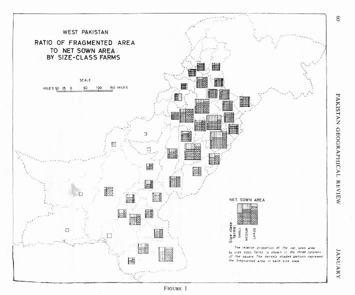
-.o~_, : 0 '__-_,I ~\\:----~" :,,~ ,,~ _ iiI'-' --- -' ~ I ',a:m , ;r,c-''----'l.-----'-'---~ I ~"-, 'f~ ,_
'~ l1I-~ ----- .. '
~I,{>/-
....
L
WEST PAKISTAN
RATIO OF FRAGMENTED AREATO NET SOWN AREA,
BY SIZE-CLASS FARMS
",.:....
'..';
'~:
::'.' .. ~,~..~~-,
SC ALE
MILE 5 SO Z5 a 50 100 150 MILES-,
/". "
/---' fi.~..~.;'.. m9 .--- ,-<,.'"....,~, ?..•...: ..
.)
o
m-
i,"\' II ,."
o e -li-:---"- 'II' !- ' ,, '......... , '
':II,>11-:
:-w~" ~.~
NET_ SOWN AREA
»< UIUI--
~E:j ~ ~•.• 4 ~ o
tlra:I: (5 IX,.,_ If) UJ <{Vi ~...J
rh~ r~/iJtlve proportion of tilt> net sown ar,.
by Sire class farms 1$ shown In Ifte tn,,' columnsof tht square rf'/, d('nsely shadt>d portions repr('s('ntttlp frogmented .f('. In (';Jell s;z(' class
FIGURE 1
s
"Q>~....tIl...,>ZotTloo;;tl
>-e::r:....o>r-;;tlrn<....trl~
'-<>ZC>;;tl><

'~~:.
... - ... - .•.
WEST PAKISTAN~".;'
,.':,'
"
............
RATIO OF MANURED AREATO NET SOWN AREA
BY SIZE-CLASS FARMS
i.•\
'>' .~.';..
MILES 50 25 0~ •••"om i"\~~~~~D0'-
_, ~.IIS.·;)• E -.•. : 00 /-II~II'):-
~('II111";~>I1<\.',ml,;>'
,,~'<:~J/\'/'-....._,.,:,.lIt
~\O'D""""·'·'!~'~';"\
~\ ....11\- \ ' "
~ :' ...: , I
. ,...-- .;...:.... --' •.•.... -' .,'
SCALE
50 100
'("',i\
o,
'T'";
NET SOWN AREA
.11....cUlI'!..J .:s: UJ
uE;i B ~~~~ ~ ~
Vi
'.,-.-' ,,".
':)::.r','
:.,'
,( o ~~~:,:.
.'.~~..;...- -'.." ..,
'.!!•.!
,;~~.... "" ."
'.,:":."x ,,
..-' \, ...j"./":
Th, r,f.tin proportion of th, ntf sown .ruby JiZf tt.ss f.rms IJ shown in th~ thrn cofllmn:Jof th, Jqu.r. Th. d.nSffy JhAd~d arUJ ,..p,..untth~ manu,..d .,. •• /fI •• ch SIZ. cl.us
FIGURE 2
\00'<\0
./
.">;>:ls:en-Nrpo;>:lo"0
;>:lrnr>-l-oZen:r:"'tI
-<Z
~tT1(/J-l"0
>AEil-l>Z
c-

1- ..._-.-- --'.~:-;.--
';VESi PAKISTAN•.!
r .:
:.•..~,,'•..------,RATIO OF DOUBLE CROPPED AREA
TO NET SOWN AREABY SIZE-CLASS FARMS
, .r.. .L,,-----~;\
!SCALE
, ;::3;;jJVIf''..:".:.:,-~~~"~~~
...·,·.,f··~":·J;:f~~-~',,~'··:<'·'···.,/\,r-,....,o =; i , illl~·.:;:·;~ir.
,/' 9 ;0; iii;:.'~',)W\' (C;.",
~'.'/U i IIIIl F~~2~g~/\L ;':~_ iI····:
\,j~'~')~ !WllIlf} • '
MILES 50 25 0 50 100 150 MILES
'~~:"-'"';
(..•..•,, -_.--,".-.-,),
)1-: .'o -'
'..,.1 ••• /-.,., •• - "
NET SOWN AREA.-VI·'ruln..J :& LLI
u~:d 6 ~~~ ~ ~ :3
i.1
__.,>' ...l '-~
ro -;,'.
"
rnt rt/~rl"t proportion of II';, n,t .s~wn Art.
1.)1 ~irp clA3~ ';ums is shown In '''t thrt~ columns
of r.',p SqU.fC Tlit dtnst(y sh,ri.d petrio"s ffprtS#
tht doub!t cropptd .ft'i 1('1 e.ch SIZ" csoss
- ..'-.,--.'-
FIGURE 3
~>..,
Rl
'"I:i:J>~t:i.i-l:J>Zamoa;;tI:J>'"Q
::r::n:J>l';;tIm-e.....m~
~:J>Zc::::J>;;tI
-<

1969 FARM SIZE·CROP RELATIONSHIP IN WEST PAKISTAN 63pindi and Jhelum, submontane districts of Gujrat and Sialkot, the area in small farmsis higher than in other parts of the country, mostly remaining above twenty per centthe highest being thirty-eight per cent in Hazara and thirty-one per cent III
Murree. Further details reveal that the tehsils of Abbottabad, Murree andKahuta have fifty-three, fifty two and forty per cent of the farm area in smallsize farms respectively. Rough terrain, in spite of higher rainfall, limits theavailability of large tracts of level land in general. Most of the northern highlandsare covered with forests and grasses with cultivated areas generally along thevalley flats and lower slopes. Over the Potwar the ravine cut land offers patchycultivation except in few sizeable plains. The sub montane districts of Gujrat andSialkot have their eastern portions in the foot-hill zone of Siwaliks, badly erodedand strewn with nallas. In these old settled areas the high fertility of land andpastoral activities as a supplementary source of income help to support a largepopulation over small farms. The hilliest and roughest parts in this humid andsubhumid zone have larger proportion of small size farms.
In the upper Indus Plain the proportion of land in small farms varies fromfour per cent in Bahawalnagar to seventeen per cent in Muzaffargarh, Only fewareas like tehsil Kasur of Lahore, Alipur of Muzaffargarh, D.G. Khan and Ahmad-pur East of Bahawalpur show higher proportions. This region is irrigated by canalwater and the greater part of it is formed of the newly settled canal colonies, wheremost of the irrigated farms have not yet been reduced to very small sizes.
In the lower Indus Plain in the newly irrigated lands the proportion of areain small size farms is in general even smaller, under ten per cent. Relatively higherpercentage is found in parts of Sukkur, Jaccobabad and Larkana, the earlier irrigatedand settled parts of the lower Indus Plains.
Over the western dry in the hilly area and the Baluchistan Plateau, conditionsare entirely different over the northern humid and subhumid hilly areas. The pro-portion of area in small size farms remains generally below 5 acres but varies fromI acre in Kharan to 10 acres in Quetta. Dearth of level land, lack of surfacedrainage and the low rainfall (10" over most parts) account for the least ratio of landin smaller farms as compared to other parts of West Pakistan. The small farms,with no substantial supplementary source of income, cannot adequately support eventhe thin population of the area.
Medium Size Farms
Over most of West Pakistan the medium size farms occupy more than halfthe total area except in the western hilly and submontane areas and the Baluchistanplateau. In the Indus Plains this ratio is below forty per cent.
64 PAKISTAN GEOGRAPHICAL REVIEW JANUARY
Data by tehsils depict that the variations over the Indus Plain generally showno definite pattern and mostly remain between 50-70 per cent. In the westernhilly and submontane areas and Baluchistan plateau, the low productivity due to roughterrain, aridity and lack of irrigation water account for this overall low proportion ofarea in medium size farms, which mostly remain between twenty-five to forty per cent.
The Large Size Farms
Farms above 25 acres are only eight per cent in number but occupythirty-five per cent of the area. The proportion of area occupied by these largefarms varies widely from eleven per cent to above eighty per cent in differentparts. For obvious reasons this ratio increases from the north and northeasthumid hilly and submontane areas to south and west, with arid but newlyirrigated lands in the lower Indus plains and arid and hilly lands in BaluchistanPlateau. The least percentage of area in large farms is in Sialkot district whereit falls to only eight per cent. Hazara and Rawalpindi follow closely witheleven per cent each. Campbellpur offers an exception among the northern hillyareas where the proportion of area in small farms is exceptionally low and inlarge farms exceptionally high as compared to its contiguous areas in the Potwar.Perhaps, the sizeable Chach plain and the Sil-Soan valley flats make it much lessdissected than other parts of the Potwar and hence a larger share in large size farms.
In the upper and lower Indus Plain large farms generally occupy twenty-fiveto forty per cent of the area, the larger share being in Mianwali fifty-two per centand Tharparkar sixty per cent. Both these areas are arid and sandy with limitedirrigation water. Moreover these are newly settled areas and have low populationdensities.
Over the Baluchistan plateau and in the western submontane areas like Bannuand D.l. Khan large size farms invariably occupy more than half the area. Thisis, as explained above, partly the result of physical factors of hilly terrain, aridityand lack of irrigation water and partiy a heritage of the tribal feudalism. Herein some cases the entire village area is owned by one land lord. This is reflectedeven in the detailed statistics of the large farms which reveal that in some partsupto forty per cent of the area is in farms of over 150acresv,
FARM SIze-CROP PATTERN RELATIONSHIP
WheatThere is hardly any area in West Pakistan that does not grow wheat but the
dominant wheat areas are the Potwar plateau and the canal irrigated parts of theupper Indus Plains. In the lower Indus Plains only a few tehsils of Hyderabad,Sanghar and Tharparkar districts are important wheat producers.
6Agricuitural Land Use Survey carried out in the villages of Ahmad Khan, Zai and Kuchlag inthe Quetta district has substantiated this view.

1969 FARM SIZE-CROP RELATIOl"SHIP IN WEST PAKISTAN 65
The farm size and crop pattern of wheat depicts that remarkably extensiveareas come under the category of mixed medium-large size farms (with 33-66 per centof wheat acreage JI1 the unit area on medium farms and a lower ratioon large farms) less extensive but sizable areas come under medium-small(33-66 per cent of wheat acreage on medium farms and the next lower ratio onsmall farms) and predominantly medium (66 per cent or more wheat acreage onmedium farms) size classes. The latter category (predominantly medium) is markedlymore conspicuous on the map in the lower Indus plain as compared to the upperIndus plain. It is noteworthy that the area under predominantly small (66 per cent ormore of wheat acreage on small farms) and the predominantly large (66 per centor more of wheat acreage on large farms) size class farms is extremely limited orpractically non-existent. No marked difference is notable in the farm size croppattern over the general area of wheat cultivation and the do m.nant wheat belt (areaof concentration of wheat.)
Over the greater part of the Potwar and the submontane districts of Hazara,Mardan and parts of Peshawar, wheat falls over small and medium size farms.Murree and Abbottabad tehsils are the only areas where wheat IS mostly grownover the mixed category of small-medium farms. Both these t ehsils however,are outside the important wheat areas. The rest of this region grows wheat mostlyover the mixed category of medium-small farms, the percentage over the mediumfarms varying from over 40 to 62 and over small farms varying from 20 to 40. Thetendency in the medium category is generally in favour of farms of above 7.5 tounder 25 acres and in small farm category in favour of farms of about 2.5 to under5 acres.
Over the greater part of the main wheat belt in the canal colonies of the upperIndus plains wheat is grown over the mixed category of medium-large farms.Jaranwala tehsil of Lyallpur, Sahiwal and Okara tehsils of Sahiwal and Khanewaltehsil of Multan district are exceptions where it is generally grown over medium size
farms. In these t ehsils the medium size farms form more than sixty-six per cent ofthe total farm area. The medium-large category shows that the greater acreage ofwheat is distributed over farms of 7.5 acres to under 50 acres which generally havemore than half the total acreage of wheat, the greater share among these occurringover farms of 25 to under 50 acres.
In the lower Indus plains distribution of wheat over the various farm sizesdoes not depict a well defined pattern. However, in the dominant wheat producingareas, it is mostly grown over medium-large and dominantly medium size farms.
Over the Baluchistan plateau and western submontane areas of Bannu andKohat wheat is predominantly a crop of large size farms of over 25 acres. Only

WEST PAKISTAN
,".~/<."-\
"
v •,.;.FARM SIZE AND CROP PATTERN
WHEAT
SCALE
,0MILES 50 25 0'== 100 150 MILES
• ,.," _c,' L, "\ -,
j'J~i~!it)• ;~, .~~ <, , - "'J" -; ::
.~~~<.
.r
r:
~.;i.._-
,'-
;,~-- _ ... '''" - ....•~" "':'\ .," :'i«';-,
..:-.';.•,- - -,- .'
,;))
FIGURE 4
..- -.;:-:- .
.',i
"L '. ,'-t . .,.:
,I
I'-~,
I",'.
"
,:~
·'·"\:::S:f.J:)/~; •. ; / '-~Domlnant, .... ~." """ ~ Wheal area...~~.'~,:....>J'.)'"it".,·, :;'.::.:,::;';':;;......\~,.j.-. \:? ,~':'::;;.p'
RATIO OF WHEAT ON SIZE-CLASS FARM
mmmn PREDOMINANTLV SMALL (65-/. or more of wheat .,en-ageWlilll..ll.I . on small (arms)
§- MEDIUM (66-/. or, more of wheat ilcreag,on medium farms)
LARGE (66-/. or more of wno er acreageon large farms)
E3 MIXED SMALL-MEDIUM 0],66-1. of wheat acreiJg~ on s~(f(~rms and thtJ next lower ratio
~
on medium>" MEDIUM-SMALL (33-66-1. of wheat acreage on mpd(um
';um:; and tile n(>xt lower ratioon small)
ffHE3llE II MEDIUM-LARGE (33·66 -I. of wheat acreage on mediumtttE:!ma farms and the nert (ower rarfo
D--- on large)-_-_-_-_ 1/ LARGE-MEDIUM 133-66-'. of WhCilt acr •• ge on farge- - - - farms and :he nett lower ratio
on medium)I~:::::::~IIf LARGE-SMALL (33-66-1. of whf.>iJtacreiJge on IJ~ge........ 'arms IInd th~ nelt (OWf.'r ratio
on sm.111)ffilli)" . II/ 1/ / ~ ~ 1/ SMALL _ LARGE (33-661'. of whpat IIcrcagp on sm"!/ / / / , 'arms and the nill' /ow(>r retro
on la.r9~)
'.,
0\0\
"
lft>Mfl
'">~..•tr.l.-l>Zo[T1oo~>-e:I:n>r~[T1
;S[T1
=e
•....>Zc>~><:

1969 FAR.M SIZE-CROP RELATIONSHIP IN WEST PAKISTAN 67
in few areas like parts of Kohat it shows close relationship with medium-largefarms.
The foregoing discussion on the distribution of wheat leads to the conclusionthat wheat in its general pattern of distribution over the various size farms keepsclose to the general ratio of area in each size class farms with a tendency to occurover the larger size farms of the category. Even on the small size farms it occursleast on farms of under 2.5 acres whereas in the medium category it is mostly distri-buted over the larger size farms of the class.
This relationship, leads to the conclusion that wheat forms a part of theextensive cultivation pattern. This becomes further clear when the degree offragmentation, manuring and intensity of cultivation is examined in each size classfarms. The application of manure (only 12 per cent of the cropped area of allfarms in West Pakistan is manured) decreases invariably with the increasing size ofthe farms. The manured area fluctuates from above forty per cent in farms under 1acre to a usually low percentage of under 5, in farms of above 150 acres. Similarlythe intensity of cultivation also decreases on larger farms, indicating that wheatmostly grows over areas with medium cropping intensities.
R i c e
Rice is a specialised crop in West Pakistan. Its cultivation is highly localizedon gently sloping or almost flat areas with adequate supply of water. Over West Pakis-tan about sixty per cent of rice acreage is shared by the medium size farms, in which
category farms from 12.5 to under 25 acres share the largest proportion of rice area.
Rice cultivation is areally extensive in 3 out of the 9 categories shown on themap. These 3 categories are 1. Dominantly medium (66 per cent or more ofrice acreage on medium farms). Land under this category is more extensive in thelower Indus plain than in the upper Indus plain. 2. Mixed medium-large (33-66 percent of rice acreage on medium farms and a lower ratio on large size farms)and 3. Medium-small (33-66 per cent of rice acreage on medium farms and the nextratio on small farms).
In the upper Indus plain, in the most important rice growing areas cornprrsmgof Gujrat, Sialkot , Lahore and a few tehsils of Lyallpur and Sahiwal districts it occursmostly over dominantly medium farms and medium-small mixed category. Theother important relationship is with medium-large farms in Gujranwal a and Sheikhu-pura. In these areas from among the medium farms category rice occurs mostly onfarms from 12.5 to under 25 acres, lesser on 7.5 to under 12.5 acre farms and least on2.5 to under 5 acre farms. Only in Sialkot relatively larger proportion of rice iscultivated over farms of 7.5 to under 12.5 acres. In Gujrat and parts of Sia lkot itoccurs mostly on medium-small farms with a considerable proportion of area in farmsof under 5 acres.

WEST PAKISTAN
,.~.~-...~~:~~:~.~:,~....•. -,." ,/
../~ :-,.,< ~'\. .. ....•}~~.•.~-~~
c-\:tM~jFARM SIZE AND CROP, PATTERNRICE
SCALE
MILES 50 0 50 100 150 MILE 5
". '\ ~~~'.• .,'
rii
~'''' •• ~ ,. J'
~-"'.'~~/c ,
.':~~- . '. ,,;.. -'. -, •. ' . "'?i
/.. ",-:~." j.'-\ --;i";' ...
,,"
~- - - .. ..,.- "", - " .:/,'
'. '''-,~y'.1. _._._
,~~'..•. ~'';~\'-~-"., '
q
.>.?~IIIDDffiill}/
,,//.' /'
;'''' /~-;..
t-'-
'.' ,J"~
,.,v.;•..;..,'....!
.•.••" l"'- _._..•.•.•
i.'"{I.i
ii
i
.~.•....../-" ..•. ;'..~.
''-'-'' ~
"
i.",' ..."./
;:JfJ!ff.!' )".~ "/ [~~."C ~ gfc~'na~~~...: ':. ".~.,':'"-'1':~"~ ~'~ '. :,ord:~~,,~~;U'ldlon
~ v '":;',::,:,:;,:';~,._.~.L._ •.. -.- .•.•. J
RATIO OF RICE ON SIZE-CLASS FARMS
(56-1. or more of nee acreageon small farms)
" MEDIUM (66-/. or ,more of nee acreageon mearum (arms)
LARGE (66-/. or more of rice acreageon farge (arms)
EEEEE MIXED SMALL MEDIUM
["or.
!; ,- - --'~,,-S(;.~ .,.,.,.,
i
FIGURE 5
MEDIUM - SMAll
(33-660/. ot rice acreage on smailfarms and the next (OWEY retro
on medIUm)(33-66"/. of nee acreage on mediumlfarms and the next lower r eno
on small)(33-66 "I. of nee acreage on rnedrutnfarms and the next lower r etr o
on larg'.)(33-66 "I. of r.ce au €'aQt! on largefarms and the next /awor ratio
on medium)(33·66"/. o(rlce",'eage on largefarms and the nelff lower ret ro
on small)(33-66 ~/. of r -ce acreagE' r n smillffarms and ttve net; (ower ratio
on large)
MEDIUM-LARGE
l ARGE-\<1EOIUM
l,ARGf: -SMALL
SMAll-L ARGE
," ,-j/•.
'-<>-Zc::>-~>-<:
C\CO
'"tt>-~-r./J:>-l>-ZotT1oo~>-'"C::t:.-o>-r-~tT1<-tT1~.
1969 FARM SIZE-CROP RELATIONSHIP IN WESr PAKISTAN 69In Gujranwala and Sheikhupura medium-large farms have the largest share of
rice acreage. Here a greater portion of rice falls on 12.5 to under 25 acre farms witha substantial portion grown over large size farms of 25 to under 50 acres. Whereasthis farm size and crop pattern relationship is very common in case of wheat, it occursonly in a few parts in the case of rice.
D. G. Khan and Muzaffargarh districts also show the same pattern. In theupper part of the lower Indus plains in the three main rice producing districts ofSukkur, Jaccobabad and Larkana medium size farms share the largest proportion ofover sixty-six per cent of the rice acreage. In the southern parts in Hyderabad,Thatta and Tharparkar, the dominant pattern remains the same. Only two tehsils ofHyderabad and one tehsil of Thatta have a substantial acreage over large farmsof 25 under 50 acres.
As compared to wheat the distributional pattern of rice in the main rice regionshows less variations over the various size class farms. Whereas in case of wheatthe dominant pattern is formed of medium-large category, in rice it is of dominantlymedium with only a few exceptions. The distribution of these two cereals is, therefore,generally complementary as in very few areas both these cereals are of equalimportance.
Sugarcane
Sugarcane with great demand of water supply is also a specialised crop. Itshows concentration in three major zones-Kabul valley, parts of canal colonies ofupper Indus plain and Bahawalpur plain and in the lower Indus plain in parts ofKhairpur, Nawabshah, Tharparkar and Hyderabad districts.
An important feature of the areal distribution of sugarcane cultivation is that,while considering West Pakistan as a whole the mixed medium large categorypredominates, it is the predominantly medium category which covers a larger expansein the dominant sugarcane belt, particularly in the upper Indus plain. Thisdistributional pattern is different from that of wheat and rice in the following respects:
a) The high percentage category of predominantly medium is somewhatlarger than that of rice and much more so than that of wheat;
b) The difference in the farm size-crop relationship between the generalarea of sugarcane cultivation and the dominant sugarcane belt is morepronounced than in case of wheat and rice.
In the Kabul valley it is mostly grown on medium-small and dominantly mediumfarms. This commercial crop, is treated as an annual crop and is highly fertilisedand intensively irrigated. The largest share of sugarcane acreage in Mardan isover the larger size farms of the medium group of 12.5 to under 25 acres, whereas
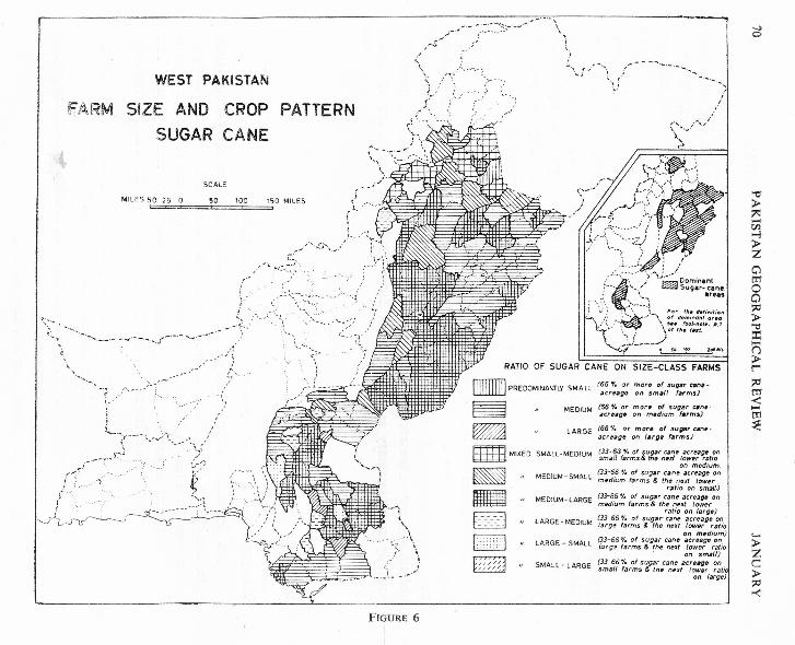
I /<:::~>-------\ -- ..----;/'':; :/ ~; ,--, I
WEST PAKISTAN'-:': /<~.'~"-'--~'~ "\;-"\ ,-- '---, ,
/9'," ..L,--.~:) :~_" \.i ~;.iFARM SIZE AND CROP PATTERN ;,\,,~ ,i,. ,.,,: ,-'
SUGAR CANE ,""<-~ ~-, ,"v'-'/
SCALE
50 150 MILES ~iMILES 50 25 0== 100.i..
..-~..:;;..,\
)-_.
",<}r~' '-'.r: ":~"-:';~~.. - '-"'i
\. '\ ."~:..-. ..', ~-:;':':\'~~'-'
-,
"",,- .,\,-,
c:.
RATIO OF SUGAR CANE ON SIZE-CLASS FARMS
........ - - -.-.~.-..•..••.;,-.--- .•......
;-~</ ..
~.,.•. ,....... /'\.- ,'.---. '(;;,-:--\-""~~
~'V"~_r'~t'-~-- --D
EIID~~
," ~~-~
'"
~~
-.,,'~:~ :
~
,/. ~i~:'~~r:::":~';-,~-f~t,~~'.
-,~/-'\-."'-':::~)"
- -' 'J' , ,-, . . ,.1.._ L i /
,:.':-.,--~- } ...d.·· ...· Dominant
:--~ '<, { ~ Sugar-ICra.~~
-.:,~" ).--~~':,'" ~ '. i For tit. (/."'''';I)n': ••] r- L~-"-'\ :;.dO,::;.~::.~r:~''.. ~ \Cfth.t.llt.
~~,-L_.__._:i. f.• ,011 aClO*' •
(65 if. or mOrt' o( sugar an~-ilcrffagf1 on smalt t.rms)
MEDIUM (56 'Y. or more o~ sugl!r cene-acr"g~ on m,dfum (arms)
lARGE (66·',. or mortl of $ugM cm.·Dcrug~ on t.rg. farms)
r..-:,l(
EmIl MIXED SMAll·MEOIUM
MEDIUM - SMAll
r;~;~Gf:;::'~i~~:rnc:.~f!,~;':::~rfonon medium_
(33':'66 0/. of sugllr cane .cr~.,~ onmedium f3rms & th~ next low.r
retio on sm.,U.j(.3.3-65 "I. of sUgJir cane acreage onmedium farms & the neJlt (ower
ratio on I••rgt!)(33 65'"1. of sugar'cant! acreage 011
f3rf)~ farms & the next (ower ratioon mt!dium)
(3.1-56 ·1. of sugar cant! ilcreagc onliJr~~ farms & the next lower ratio
, on smllU)(33 66"1. of sugar cane iJcreag~ onsmall farms & th" nut {ower retic
on (Nge)
.l
0-.J~~' ,\" ,
(~:~.-;\- !,,-
FIGURE 6
MEDIUM -LARGE
lARGE· MEDIUM
LARGE - SMALL
SMAll· lARGE
-.)0-
"tt:>'"-tIl>of:>ZotItoo:e>--e:r;-o:>r::0en<-m~
'-:>zc:>::0><
1969 FARM SIZE·CROP RELATIONSHIP IN WEST PAKISTAN 71
the largest share in Peshawar is of farms ranging from 7.5 to under 12.5 acres. Inboth these districts of Kabul valley a substantial portion is grown over small farmsof 2.5 to under 5 acres. The fairly high density of population and high productivityof land has resulted in this pattern.
In the canal colonies of upper Indus plains in parts of Sargodha, Lyallpur,Lahore, Multan, SahiwaJ, Sialkot, GujrawaJa and Gujrat, it is mostly grown overdominately medium size farms and in some t ehsils it IS grown over the mixed categoryof medium-large farms with minor variations. In areas where sugarcane is mostlygrown over the medium farms the greater share is of 12.5 to under 25 acre farms.In SiaJkot a considerable acreage is shared by farms of7.5 to under 12.5 acres.
In areas of medium-large farms the substantial share is that of 25 to under 50acre farms e.g. in Sargodha and Jhang. Over the Bahawalpur plain too, this mixedcategory of medium-large farms dominates the pattern with substantial share of 25to under 50 acre farms.
In the lower Indus plain, in areas of sugarcane concentration only one rela-tionship that of mixed medium-large farms dominate. These are the newly settledand thinly populated areas of less intensive farming parctices.
Cotton
Cotton is also a specialised non-cereal crop like sugarcane in West Pakistanand is usually treated as an annual crop. However, its distributional pattern inrelation to farm sizes is different from that of sugarcane, especially in areaswhere both these cash crops are of equal importance, like parts of canal coloniesof upper Indus plain. There are two areas of cotton concentration --one in the
upper Indus plain and the other in the lower Indus plain on the whole this cropdepicts dominant pattern of mixed medium-large farms with only a few exceptions.
In the upper Indus plain a comparison of the two maps of cotton and sugar-cane reveals that in areas where the two crops show equal concentration, as in partsof Lyallpur, Sahiwal and Multan, cotton falls on the medium-large whereas sugar-cane, as discussed earlier, falls mostly on dominantly medium size farms. Cottonin these areas is largely grown over 12.5 to under 25 acre farms from among the med-ium size group and over 25 to under 50 acre farms from among the large size group,with considerable acreage over farms of 50 to under 150 acres. The share of 50 tounder 150 acre farms increases in the Bahawalpur plains and in lower Indus plains 111
Sanghar, Hyderabad and Tharparkar districts.
From the detailed study of acreage over different farm sizes it is evident thatin comparison with sugarcane it grows over relatively larger farms. Sugarcane is amore paying crop than cotton and its cultivation over medium size farms in the upper

.- .-.,~:~:-:.:~..:.~~-.-."..:
.....•N
W EST PAKISTAN
,.'r- ..:...'.'
0:'< I;,~/?:,;>.:;FARM SIZE AND CROP
COTTONPATTERN
SCALE
50MILES 50 25 0'=='==± 100 150 MILES
, .•.-S"', ,/
•....~....... -._ ...'--'-'
,' ..J
-!-~;';::-~-
''; r~~_/'< ~ ".,
".,J<: . !-.r-;!"·-·"r·
-'.~/r,--/ ", (
,I:?""'"
I" §
~
"'~,\
....-.-.-.-.~.-.•.. - ..•..~'.".:. .••.•.
RAT.IO OF COTTON ON SIZE-CLASS FARMS-.'""( ,/'.••..•''-";i
iY-- - -·~""""v-..,,<~__..
\.•....;_ ..-._.
~••DD~~
rTITIj M!XED SMALL MEDIUM (33-66-t. of corton ~crugr onbbllJd smeu f~rm5 ~nd thp npxt lowerratio on mpdlum)
MEDIUM - SMALL ~~d~~:·f::~:t~~':t ~t,::":e~tO~owerretio on sm.lI)
MEDIUM-LARGE ~;~;; fo;r~~(~Onnd~~~P::x~ z:ratio on farg(')
LARGE - MEDIUM ~!~~~6~r::s~~~o~e ~~~:t~;w:;r erio on m('dlum)
LARGE _ SMALL (33-66-;-. of cotton acreage onlarge ternvs srvd 'fI.e next lower
ratio on srnett lSMALl- LARGE (33'66-/. of colton acreagp on
smiJll (arms and the next lowerr etro on largp)
"'-:.>
'~:/.> (.-.'~\';"
(~ ~(
)~~'~ ..'.~
"" ...,..
,
...,,,i, .-."- _.- ..•..-i ...-:..·•.
i
'Lt ,iii/c / ..
.••.•..~;.
'">'"...•Vl...;>ZotT1oo~>'"::cn>r~tT1<:...•tT1
~
'-<>Zc::>;:::>-<
;' ~' 'r77:l Oom,nan'r"" --.(' ~ Colton area
.'.\ -;, '.'';-..,:': . -- .. ~. Foe ,,_ ._""iI,,",A,/\,,: ,",,}~. ~~~;~:::.~';~
......•.::-4._. ~ s~'~ 2~o.••
FIGURE 7
(66 -;-. or mor e of cotton acrPiJgpon small f.rms)
MEDIUM (66-;-. or ovorv of cotton iJcr~a~on mpdlum farms)"
LARGE (66°/. or mor. of cotton iJcrug~on Ilugp f~rms)

1969 FARM SIZE-CROP RELATIONSHIP IN WEST PAKISTAN 73Indus plain, is more convenient. Sugarcane demands much more water and manur-ing and large size farms are less suited for the purpose with the present day prac-tices of manuring and water frequencies and very little use of machinery.
The overall farm size-crop relationship can be summed as follows:1) In general a high measure of selectivity for any given farm size is not trace-
able. Mixed medium-large category with 33-66 per cent of the total acreage of a givencrop on medium farms and the next lower ratio 011 large farms predominates. Thispre-dominance is more marked in case of wheat and cotton and less so in case of riceand sugarcane. The reasons for this non-specialised areal distribution of crops bysize classes of farming seem to result from the fact that the aqvantages of large-sizefarms are mitigated by a high measure of fragmentation, non-mechanisation of farm-ing, least application of manure, low intensity of cropping (small proportion ofdouble cropping) and the lack of interest evinced by absentee land lords in the mana-gement of the land. The small size farms cover a mentionable proportion of thecultivated land in old settled districts of the upper Indus plains and areas of roughterrain in the north away from the main agricultural core comprising of the canalirrigated plains. Secondly, these small size farms are not given as much attentionby the farmer as these are generally expected to attract in intensively cultivated areasof the world. Both manuring and double cropping on the small farms, thoughproportionately larger on this size class than on others, are in themselves not verypronounced.
2) The general non-selectivity mentioned above does not obliterate the regi-onal variations in farm size crop relationship, with crops mostly grown over smalland medium-small farms in the northern hilly and submontane areas, and mediumlarge and predominantly medium farms in the Indus plain, the latter being slightlymore extensive in the upper than in the lower Indus plain.
Areal expanse of predominantly medium category, with a high percentage of66% and over acreage of a given crop in the unit area on medium farms, is moremarked in upper Indus plain for sugarcane and cotton and in lower Indus plain forwheat and rice.
3) The difference in the farm size crop relationship in the general area ofcultivation on the one hand and the dominant belt of a given crop on the other isnot well marked in case of cereal crops, but is quite well marked in case of cashcrops, with predominantly medium category being more extensive in the respectivedominant belts than outside. It denotes that the cash crops in their respectiveareas of concentration tend to avoid both larger and small farms. Of the twocash crops, sugarcane and cotton, the former tends to occupy comparativelysmall farms than the latter. This is in keeping with the greater demands of sugar-cane in irrigation water and manuring which can be met more conveniently onsmaller fa rrns.

NEWS AND
TERNATIONAL UNION FORQUATERNARY RESEARCH
INQUA is an interdisciplinary Union grouping
geologists, geographers, soil scientists, anthro-
pologists, archaeologists, palentol cgists, bOUI-nists, ecologists, palynologists, climatologists,glaciologists, oceanographers and specialists ofother disciplines working for a better knowledgeof environment and its history during the Quaternary period.
The International Union for Quaternary Re-search has following objectives:
1) To encourage the interdisciplinary study
of all problems dealing with the quater-nary period as defined in geologicstratigraphy;
2) To facilitate and to co-ordinate inter-
national co-operation for this studythrough the organization of international
congresses and through Commissions,created for the study of specific problems.
Under the presidentship of Gerald M. Richmondof U. S. Geological Survey, Denvor (FederalCenter, Denvor, Co!orada, USA, 80225,) INQUAhad made the following progress since 1965 :
1) INQUA has become affiliated with the
International Union of GeologicalSciences as a member organization.
2) INQUA has become affiliated with theInternational Union of BiologicalScience (IUBS) and has organized aliaison committee on Quaternary Biology
within the Biological Division of that
Union. Professor William Mullendarsof Belgium is Chairman.
3) INQUA has become affiliated with thc
International Union of Prehistoric and
OTES
Protohistoric Sciences (lUPPS) and hasorganized a liaison committee with thatunion. Professor L. Balont of Franceis Chairman lUPPS is not an lCSU
Union.
4) INQUA is in process of becomingaffiliated with the International Geogra-phical Union and this affiliation is
scheduled to be approved at the congressof that Union in India this year.
The VITI congress of the J QUA will takeplace in Paris, August 30 to September 5, 1969.The meeting will include nine Commissions
(quaternary shorelines, nomenclature and corre-lation of the quaternary, neotectonics, originand lithology of quaternary deposits, Absolute
age of quaternary deposits, the quaternary mapof Europe, quaternary regional maps, tephr ochro-mology, and pa lespedology, twelve sections orcategories of talk and lectures (geomorphology,submarine geology and morphology of plant,paleontology and paleopedology, animal paleon-
tology, paleoclimatology, stratigraphy, sedimen-tology, neotectonics, cartography, absolute agesand p aleornagnn tisrn, human palentology andprehistory; and symposia to be announced byINQUA Committees. Seventeen pre and post-meetings field trips are planned, and a one day
excursion in the Paris area will be held during themeetings.
For additional information contact Mr. H.
Elahi (Secretary General of the VIJl INQUACongress, 19 rue Saint Jacques, Paris 5e France)who will supply a circular and preliminary prefe-
rence questionnaire. Those who wish toparticipate should note that the deadline forreturn of questionnaire to Mr. Elahi is June5, 1968.
AN[S A. ABBAS[University 0/ t lie Punjab,
74

NEWS AND NOTES
TWENTY-FIRST INTERNATIONAL GEOGRAPHICAL CONGRESS,
NOVEMBER-DECEMBER ]968
1969
The Twenty-first International Geographical
Congress met in New Delhi from December I
through 8. This time Professor S. B. Chatt erjee
of India was the president of I.G. U. Elaborate
arrangements regarding accommodation and
transportation, keeping in line with the traditional
Indian hospitality, were made for the delegates
who had gathered in the historic city from all
over the world. Besides, a large number of
geographers from various parts of India had also
come to attend the conference. There were
more than a thousand foreign delegates, among
whom those from the United States of America
predominated in number which was followed by
Canada.
From Pakistan there were six delegates who
attended the Conference including Professor
Kazi S. Ahmed of the Univers ity of the Punjab
as leader. The other members were Professors
Nafis Ahmed and Faz al-ul-Haq of the University
of Dacca, Sha msul Islam Siddiqi of the University
of Karachi, Hameeduddin Ahmad of the Univer-
sity of Peshawar and Iqtidar H. Zaidi of the
University of the Punjab, Professor Kazi
S. Ahmad also contributed a genera l article on
Pakistan to the souvenir publication on develop-
ing countries presented by I. G .. U, Another
was a research paper by Dr. I. H. Zaidi on " Land
Tenure System: A Problem in Political Geogra-
phy".
The sectional meetings of the Congress
remained being very well attended throughout
the period. The rooms allotted to some of the
sections were used to be full to the capacity.
Over one thousand papers were PI esented to
various sections. Geomorphology attracted thelargest number of papers which was followedby Regional Geography and planning and
urban geogranhy respectively (Table I).
75
TABLE I-NUMBER OF PAPERS CONTRIBUTED TO
VARIOUS FIELDS
GeomorphologyCI ima tologv , Hydrology, Oceanogra-phy & SoilsBiography
Complex Physical GeographyGeneral Economic GeographyAgricultural GeographyLand Use and Land Use mappingIndustry and Power
Trade and TransportUrban Geography
Population GeographyRural Settlement
Historical Geography
Political GeographyRegional Geography & RegionalPlanning (including Applied
Geography)Cartography and Photogra phyTechnique, Methodology andDocumentation
144
9274273255
415134
1046232
2829
131101
29Total :- 1066
Source: Abstracts of Papers, 21st I. G. U.Congress, India, 1968.
It is interesting to note that dispite thewidespread tendency to downgrade regional
geography in recent years as a genre of thesubject (which is unfortunate indeed) it continuesto form an important forum of attracting a goodnumber of scholars. Those working in the fieldof cultural geography seem to be more particu-larly interested in this approach and find the
forum of regional geography more rewarding for
the presentation of their papers. Although therewere relatively small number of papers presentedto t he section on quantitive methods, but as a
glance through the abstracts would show, this
method has been used profusely by the scholarspresenting their papers in other sections likegeomorphology, economic geography, urbangeography and others. This indicates the
76 PAKlSTAN GEOGRAPHICAL REVIEW JANUARY
increasing importance of statistical technique inthe analysis of geographical data.
In addition several pre-congress and post-congress symposia were organized at variousplals in India. Hence, besides attending themaln~ congress at New Delhi, some of thedelegates from Pakistan also participated in apre-congress symposia on land use organized byAligarh Muslim University. Apart from thesesymposia field study meetings pertaining tocertain regions were also arranged, viz, Jammuand Kashmir, East Rajistan, Darjeeling andSikkirn Himalaya, Meghalaya and Assam Valley,Sunderbans, Kaval Towns of Uttar Pradesh,Dehradun and Mussoorie, Growth of Delhithrough centuries and Calcutta conurbation.
These purely academic meetings were dove-tailed by a number of excursions by air, rail androad arranged before and after the Congress. Aneight-day International Geographical Tour toNepal was also arranged which attracted quite
:. ~."
a good number of foreign delegates. ThePakistani geographers, with the exception ofDr. Fazlul Haq (who stayed in India to participatein some of these programmes) could not partici-pate in any of these programmes and also in thepost-congress symposia, because they had to
rush home to attend the Second All PakistanGeography Conference which was to be held inthe las t week of December.
Two new associations under the I.G.U. werealso organized, namely: Association of AsianGeographers and Common Wealth Associationof Geographers. Dr. Sha msul Islam Siddiqiwas elected a member of the Executive Com-mittee of the latter.
The concluding session of the Congress electedProfessor Stanislaw Leszczycki (Poland) as thePresident and Professor Chancy D. Harris(Chicago) as Secretary of the I.G. U.
It was noted that the next InternationalGeographical Congress scheduled for J972 wouldbe held in Montreal, Canada. The other sug-gestion for the venue was the U.S.S.R.
On the whole, the Congress was well organizedand the delegates were provided all facilities. TheMain Congress was held in the modern newbuilding Vigyan Bhawan in New Delhi, whichis equipped with all modern facilities needed forsuch purposes.
]QTlDAR H. ZAIDI
University of the Punjab

SHAMSUS ZOHA, 1924-1969
For any field of learning there cannot beanything more unfortunate than the passing
away of a promising schola r who possesses talentand potential to do creative work. In the lateSharnsuz Zoha (may he rest in peace) we, thePakistani geographers, have lost one such col-league. H:: combined in himself the qualities
of a scientific geographer as well as that of agifted poet. His sad and untimely death occurredon January 13, I 969.
Mr. Zoha hailed from one of the distinguishedSyed families of' Bihar (India) known for theirreligious piety and literary tradition. He wasborn in one of the suburbs of Patna and received
his early education in Muzaffarpur where hisfather practised law. After passing his High
School Examination in 1940 Zoha joined PatnaCollege from where he obtained his B.A.degree in 1944. The literary taste that hepossessed as a part of his family backgroundwas further refined and stimulated by his closeassociation with some of the establishedscholars of Urdu literature working at Patna
College. He grew into a gifted poet and his
first poem was published during his college days.
However. his interest in geography seems tohave prevailed supreme, for after his B.A.he decided to pursue higher studies in geographywhich was one of hi-s main subjects of study atcollege level. Hence in the pursuit of learninghe came to Aligarh Muslim University, the
then Eldorado for geagraphica l studies in the
subcontinent. Here he got a chance to workwith Professors Kazi S. Ahmad, Tahir Rizviand late S. Muzaffar Ali. He completed his M.A.from this University in 1946 and after staying
for a few months in Bihar, Zoha came to
Karachi. Here, after the establishment ofPakistan, for a very brief period, he did some
journalistic work as a columnist for 'Dawn'a leading newspaper of the country. In 1948
he went to Quetta and joined Government
College as a lecturer in Geography. There he
managed the college classe s from first year tofourth single hanJed and through his devotion
and interesting lectures, he made geography one
of the most popular subjects among students.Here again inspired by the calm and serene
atmosphere of Quetta and natural beauty of itssurroundings he wrote several poems, especiallysonnents, which earned him a place among the
high ranking modern poets. Such literary
interests, however, did no, come in the way
of his scientific endeavours. Intrigued by thephysical landscape of Baluchistan Zoha wrotearticles entitled, "Physiographic Personality ofBaluchistan" which appeared (in two instal-ments) of Pakistan Geographical Review, Vol,VII, Numbers I and 2.
In the meantime he came in contact with
Baba-i-Urdu Maulvi Abdul Haq who was
concentrating his efforts on securing a res-pectable place for Urdu in national life. Baba
and his associates were convinced that Urdu
as the medium of inst ruction for highereducation cannot only replace English but it
77

78 PAKISTAN GEOGRAPHICAL REVIEW JANUARY
could also play an important role in developingnational consciousness and solidarity. Theyhad established Urdu College for testing suchideas. Impressed with Mr. Zoha's background,fine literary taste (particularly with his writingsin Urdu), scientific bent of mind, and crea-tive works, Babai Urdu and NIr. AftabHasan (the then Principal) offered him a postin Urdu College as Lecturer in Geography.
Thus from Quetta , sacrificing the benefitsof Government Service, he came back to Karachiand joined Urdu College in 1954. It is herewhere I came in closer contact with him andbecame intimate friends. During his stay inthe co !lege he made positive contribution topromoting the cause of Urdu as an effectivemedium of instruction and also to the cause ofgeography, by making it more interestingthrough his lectures with literary flavour.
In 1957 Professor I. R. Khan, the then Headof the Department of Geography of the Univer-sity of Karachi, secured his services for theDepartment. His literary taste coupled withclarity of thought and the depth of knowledgesoon earned him fame as a great teacher. Hismain interest was in Historical Geography andAsia.
Again, Mr. Aftab Hasan, who had now be-come Director of a newly established Bureau ofPublication of the University of Karachi,persuaded him to join the Bureau as its Assis-tant Director. He joined, although reluctantly,the Bureau and served it till he breathed his last.Here. he was in charge of translation, editingand production of the Text-books as well asbooks of scholarly standards. His versatility,devotion to duty and hardwork and charmingmanners made him extremely popular among hisuniversity colleagues. The Vice-Chancellor ofthe University, Dr. Ishtia q Husain Qura ishi, in
his own books, published by the Bureau, hasacknowledged Mr. Zoha's able performance. Hisservices to this Bureau must be written in redletters. He was a principal member of thecommittee on translation of geographical termsinstituted by the Bureau. He was editing the Urduversion of Anglo-America by White and Foscuewhich he leaves unfinished. He also worked forseveral years as Associate Editor of Jadid Sciencea leading scientific journal in Urdu publishedby the scientific society of Pakistan.
Despite his association with the Bureau ofPublica! ion he remained faithful to Geography.Even for his poems he would select topics ofgeographical interest. His poem, "Kana r-i-Bahr-e-Arab " (The Shore of the Arabian Sea)is his master piece in this respect. Duringhis stay in Quetta his interest in the historicalgeography of Baluchistan was <Housed andafter joining the University of Karachi hestarted working more activelv on this project.In order to use place names as a tool in thisstudy he took a special training in linguistics.This training combined with his knowledge ofArabic, Persian and Turkish languages helpedhim a great deal in carrying out his proposedstudy. He had begun writing and the first draftsof two chapters were ready when he fell ill andwas unable to recover again. On the basis ofwhat he discussed with me, I am sure the studywould have made significant contribution to theknowledge as well as the philosophy of thesubject. Let us hope that some one completesthis unfulfilled mission of the departed soul.
Mr. Zoha is survived by his wife, two sons andtwo daughters. Everyone who has met him willalways cherish his memory.
IQTlDAR H. ZAIDI
Universit y of the Punjab

1949 NEWS AND NOTES 79
SECOND ALL PAKISTAN GEOGRAPHICAL CONFERENCE. LAHORE
The Second All Pakistan Geographical Con-ference was held in Lahore. from 26th December1968 to 1st of January 1969. The Conferencewas inaugurated by Professor Hamid AhmadKhan. S. Pk .• Vice-Chancellor. University ofthe Punjab. on the morning of 26th Decemberin the Punjab University Auditorium at theNew Campus.
The function started with the recitation fromthe Holy Quran after which the President of theFirst All Pakistan Geographical ConferenceDr. Kazi S. Ahmad, S. I.•Professor Emeritus,University of the Punjab, Lahore, requestedthe President of the Second All Pakistan Geogra-phical Conference, Professor Nafis Ahmad,S. 1., Head of the Department of Geography.University of Dacca, to take the chair. Welcomeaddress was given by the General SecretaryProfessor Col. K. U. Kureshy, Head of theDepartment of Geography. While speaking onthe discipline of geography, Professor Kureshysaid that geography "has now grown from adescriptive field to a highly sophisticated scienceand it no more adheres to the deterministicapproach. We live in a period of social andtechnological revolution in which man's abilityto manipulate the process of nature is increasingat a rate which is difficult to follow",
The inaugural address was read out by Prof.Hamid Ahmad Khan in which he pointed outthat "Geography promotes the concept of oneworld" it is not only our hop .s forthe future but also the planning of our present,to which geographers can make a worthy con-tribution The task before our geographers,therefore, is continually to assess the strengthof the physical basis of Pakistan to seek tocoordinate it with our cultural needs".
Tne Presidential Address titled "Some Aspectsof Economic Development of Pakistan withSpecial Reference to Industr ialisation , 1947-68"was presented by Prof. Nafis Ahmad. In hisaddress the history of industrial gr ow th and itsrelationship with the development of power,transport, and agriculture was discussed. Prof.Nafis Ahmad while discussing the present stage
of industrialisation in Pakistan said, "Develop-ing countries like Pakistan do not need a longgestation period of a past development patternbefore they can reach the take off stage .Internal peace and quiet and sense of securityare essential to ventures in the field of industrialinvestment whether public or private Pak-istan has to continue to forge policies of econo-mic growth to combat poverty and ignorance."
After the Presidential Address the AssociateSecretary, Dr. Miss M. K. Elahi, Reader,Department of Geography read out the Good-will Messages,
The Sectional meetings were held from 27thDecember to 30th [:ecember 1968. There weresix Sections in all:-
Section
Section II
Section III
Section IV
Section V
Section VI
Geomorphology.phy, Climatologygra phy
Economic Geography
Hydroge ogra -and Oceano-
Population, Settlement and Socia IGeography
Political and Historical Geogra-phy.
Regional Geography and RegionalPlanning.Applied Geography and Carto-graphy.
Section J was presided over by Dr. A. I.H. Rizvi, Reader, Department of Geography,University of Dacca, Dacca. In his presidentialaddress on Pakistani Geomorphology he stressedthe need of recognizing geomorphology as a fullgrown science. He said "A whole science ofgeomorphology must pursue its own goal ofstudying landforms in their entirety and for theirown sake." Dr. A.I.H. Rizvi while discussingthe importance of training geographers for con-ducting research in quantitative and applied geo-morphology further added, .•Appl ied Geornor-phology can make effective contribution to theunderstanding of basic aspects of such pheno-mena of national importance as floods, aridityand salinity, naviga bl ity of streams, and effectsof terrain on military operations,"

~o GEOGRAPHICAL REVIEW JANUARY
The presidential address of Section 11 titled"Economic Geography in the Twentieth Cen-tury" was delivered by Professor Shamsul IslamSiddiqi. Head of the Department of Geography,University of Karachi. Professor Siddiqi dis-cussed the development and changes in conceptsand approaches of econorn ic geography in variouscountries of the world.
Section III was presided over by Mr. QaiserAli Khan, C.S.P .. Director General, Social Wel-fare, Government of Pakistan. In his address on"The Crisis of Identities," Mr. Qaiser Ali Khanackonwledged the full appreciation by geogra-phers of social dynamics of change for a betterunderstanding of social geography.
Dr. Miss K. Yusuf, Principal. GovernmentCollege for Women, Rawalpindi presided overthe section of Political and Historical Geography.Her presidential address "Great Powers andAsia" was a clear analysis of the politicaldevelopments in Asia and their relationship withthe international politics. It concluded with aprediction note of China being accepted as agreat power which may change the entire poli-tical trends in Asia.
Professor M. M. Mernon, President of Section V,read his address on the "Soil and Water Resour-ces of the Lower Indus Region". He discussedthe importance of adequate water supply andcuring the areas stricken with the high salinityfor the agricultural development of the region.
Section VI was presided over by Dr. Hamid-ud-Din Ahmad, Head of the Department of Geo-graphy, University of Peshawar, Pesharwar. Inhis presidential address "Applied Cartography",he brough t out the importance of cartographyas a major tool of geographers and said "asman continues to struggle and improve hisenvironment, so will the cartograr her, and hewill consider his latest product as the foundationst onc for newer and better maps in future".
General lectures were delivered on "The Prob-lems of Developing Countries" by Mr. Fazal-ur-Rehman Khan, S.Pk., C.S.P., Director, PakistanSteel Mills Corporation, Karachi and "Traffic
Problems in Lahore" by Mr. Sharnsul Haq,Deputy Director, Town Planning Department,Government of West Pakistan. Lahore.
A Symposium was held on 'Geography andNational Planning' in which Professor K.W.Thomson from New Zealand and Dr.R.S.Math-ieson from Australia were the main speakers.
A two-day excursion tour to Mangla Dam-Texila-Rawalpindi-Islarnabad was arranged forthe delegates. It was an excursion cum study tourin which the salient geomorphological aspectsof various areas and the cultural landscapewere studied under the supervision of Mr. AnisA. Abbasi. Lecturer, Department of Geography,Punjab University.
There were about 150 delegates, including 13foreign delegates from both the hemispheres whoattended the conference. The foreign delegateswho attended the Conference were:
1. Professor Chauncy D. Harris, Departmentof Geography, University of Chicago,Chicago, lllinois, USA
2. Mrs. Chauncy D. Harris. Chicago, Illinois,USA
3. Dr Marie A. Sosce, 126 West 86 Street,New York, USA
4. Mr. Albert P. McCarthY, Saint Louis Uni-versity, USA
S. Prof. Dra. Paulina Quarleri, BuenosAires, Argentina
6. Miss Maria Renee Cura, Buenos Aires,Argentina
7. Mrs. Fryda Schultz de Mantovani, BuenosAires, Argentina
8. Dr. P. Gentelle, Paris, France
9. Prof. Kardono Darmojuwono, Jogjakar-ta, Indonesia
10. Prof. Cerna l Arif Alagoz, Turkey11. Prof. K. W. Thomson, University of Mas-
sey, New Zealand
12. Dr.R.S. Mathieson, University of Sydney. '~New South Wales, Australia
13. Miss Siegrun Freyss, West Germany.

1969 NEWS AND NOTES 81
Pakistan delegates consisted of geographers
from all the Universities of Pakistan and a num-
ber of Degree Colleges. Apart from Professional
geographers, a number of geographers working
in various capacities in the Government and
semi Government organizations and other walksof life, participated in the deliberations of the
Conference.
All efforts were made by the Organizing Com-mitte to make the delegates feel at home. Fol-
lowing were the members of the OrganizingCommittee :-
r. Dr. Kazi S. Ahmad, S. I., Professor
Emeritus, University of the Punjab,
Lahore (President)
2. Prof. Col (Retd.) K.U. Kureshy. Head ofthe Department of Geography, University
of the Punjab, Lahore (General Secretary)
3. Dr. Miss M.K.Elahi, Reader, Department
of Geography, University of the Punjab.
Lahore (Associate Secretary),
Members
4. Mr. AnisGeography.Lahore
5. Mr. MasaudGeography.Lahore
6. Mr. Muhammad Jamil Bhatty, Departmentof Geography, University of the Punjab,Lahore
A. Abbasi, Department ofUniversity of the Punjab,
A. Mian, Department ofUniversity of the Punjab,
On the whole the conference was a great suc-cess. This could not have been possible withoutthe cooperation of the staff of the Department,and the University authorities and help offeredby tbe Government and Semi GovernmentOrganizations, Banks and Private Businessconcerns. The chief donors were the CentralGovernment; Pakistan Geographical Association,Habib Bank Ltd., United Bank Ltd., PakistanCycle Industrial Co-operative Society Ltd.,Industrial Development Bank of Pakistan,Premier Insurance Company of Pakistan Ltd,Muslim Insurance Company Ltd. and LahoreHardware Stores.
M. K. ELAHI
University 0/ the Punjab.
BOOK REVIEWSGeography: Its Scope and spirit. Jan
O. M. Broek, with a concluding chapter sugges-ting methods for elementary and secondaryteachers by Raymond H. Muessig and VincentR. Rogers. xii and 116 pp., maps, diagr.,bibiogr., table, index. Charles E. Merrill Books,Inc., Columbus, Ohio, 1965. 9i x 6 inches. 1.75(pa per back ).
"Whatever view we may hold concerning thenature and scope of geography. no doubt allwould agree that its purpose-is to add to man'sknowledge of reality. Methodology adds nothingto that knowledge, but only to our understandingof such knowledge." Richard Hartshorne. Per-spective on the Nature of Geography, 1959(pp. 6-7).
This small, but pleasantly written, volume isone of the many published under the "SocialScience Seminar Series." This series, accordingto its editors, "presents scholarly viewpoints onand information about history, geography. poli-tical science, economics, sociology, and anthro-pology. This social science material is comple-mented by creative and practical methods, tail-ored to each of the individual fields, for elemen-tary and secondary teachers."
Geography: Its Scope and Spirit is a commend-able volume. It will be welcomed not only bythe teachers but also students and generalreaders. In so short a volume it is naturallydifficult to do more than indicate the main linesof geographic thought and methodology. Profes-sor Jan O.M. Broek wrote the first six chapters,which deal with geography per se. These chap-ters cover a wide range of topics -·"GeographicThought and Practices," "Development of Geo-graphic Thought;' "Modern Viewpoints in Geo-graphy," "Some Research Themes," "TheMethods of Geography," and "the Essence ofGeography." The final chapter (Chapter 7),which suggests; methods for classroom teachers,is composed by the editors of the "Series"--Professors Raymond H. Muessig and VincentR. Rogers.
To this reviewer the finest chapters are thosedealing with modern viewpoints in geography. theessence of geography, and suggested methods forteachers. Chapter 3 deals with the modern
viewpoints in geography--the humanistic view-point, the social-cultural approach, the historicaldimension. and facets of location. This excellentreview comprehends some of the more importantfinding of scholars like von Thunen and Marsh.The author masterfully concludes by saying thatthe concern of geographers is with "spatial rela-tions between real places, not mere abstractmodels a la von Thunen " [my italics]. Studentsof methodology will be especially interested in anumber of fundamental interlocking conceptspresented in Chapter 6, which deals with theessence of geography. "The comparison of theseviewpoints, "Broek asserts, " ... actually clears theway for a better comprehension of the natureof geography." Chapter 7 deals with sug-gested methods for teachers. The authors sug-gest five salient geographical ideas, hoping thatthese "will encourage teachers to enlarge theirown vistas and those of their students."
Geographers in general must find the bookinteresting and valuable. The readers are ex-posed to important concepts, to a considerablerange of geographic techniques, and to a largebody of geographic knowledge. The strength ofthe book lies in the choice of subject matter, inlucid and effective presentation of geographicalideas. and in some excellent maps. For thosewho desire to enlarge their knowledge of the fielda well chosen, but highly selective, bibliographyis added to the first chapter.
In spite of its strengths, geographers wouldprobably confess to some disappointments. Thereare some serious omissions and editorial weak-nesses. One cannot refrain from wondering whyin Chapter 5, which deals with me thods in geo-graphy, no mention is made of field techniques.H is believed that the volume, in this omission,fails to reflect a true picture of American geo-graphy. In Chapter 2, on the otherhand, thework of Varenius is being discussed under "M iddleAges and Renaissance." "The reviewer feelsthat this should have been discussed under theheading "Beginnings of Modern Geography."
Nevertheless, Dr. Broek has succeeded in pro-viding a lucid, thoughtful, and stimulating intro-duction to the scope and spirit of geography.
lllLAL AHMADUniversit y of Karachi
82

1969 BOOK REVIEW 83The North West Frontier 0/ West Pakistan: A
Study in Regional Geography. David Ditcher.Oxford University Press, London (1967), XII and231 pp; maps, halftones, index, bibliography: 635($ 10.00).
The North West Frontier 0/ West Pakistan isthe first regional geography to be produced onthis area. In his introduction David Ditcher haslaid severe emphasis on the sharp interactionsbetween the people and the environment, andin fact, takes the physical environment as thebasis of the regional subdivisions ignoring thehuman aspects to a large extent. However, he issomewhat uncertain as to why the region shouldbe treated as an entity, w hether this basis shouldbe physiographic or demographic; or because sta-tistics are available for the region as a whole.
This uncertainty becomes evident, in the follow-ing seven chapters which deal with the physio-graphic divisions of the area. In each case, thepolitical and administrative divisions are also re-cognised in his consideration of the tribal statesand agencies as separate units, with a furtherbreakdown into insufficient portions on the phy-siographic, climatic, historical, economic and de-mographic aspects of each.
Sample studies of villages, local tribes, as wellas isolated individual cases illustrate an attempton the part of the author to compensate for hisneglect of the human aspect. These studies, how-ever, do lend a realistic and live expression to anotherwise dry dissection.
The economic and social problems faced by thepeople are synthesized in the final chapter. Themain problem is recognised as the necessity ofadjustment by the people to a land they formerly"lived off". This involves primarily issues ofland utilisation, the inherent culture, and the ad-ministrative and governmental attitudes. Theseattitudes on the local as well as the national levelhave, through nepotism and sheer lack of in-terest, been fundamentally responsible for thelow development of the region. This section alsoincludes the study of a few selected industries to-gether with the type and direction of trade. Thebook is rounded up with a number of append-ices mainly giving agricultural and industrial
statistics followed by a substantial bibliographyand index.
Maps and figures, in fair number, are scatteredthroughout the book, but reflect the neglect tosurvey on the part of the authorities and hesi-tence on the part of the tribesmen to let them doso. An adequate collection of illustration ispresented at the end, showing pictorially some ofthe physical and cultural scenes.
In short the North West Frontier 0/ Pakistancan be called a fairly adequate regional geo-graphy. It is, essentially a book tasting, verystrongly, of the out of date concept of environ-mentalism as illustrated by the generalisation."Because of the cropping wilderness of theirmountains, the Pathans have been able to remainfree of the troublesome external authority ofsocial institutions in a way that is almost unpre-cedented on the history of either the eastern orwestern world". Repeated accusations against go-·vernmental attitude and administration are alsonot justified. Furthermore the appendices andstatistical information do not in any way com-pensate for the immature and inadequate styleof the book. As a first regional geography of theNorth West Frontier, however, the informativevalue of the book cannot be denied.
MISS FAREEHA RAHMAN.
University of the Punjab.

PAKISTAN GEOGRAPHICAL REVIEW was instituted in 1949 replacingPunjab Geographical Review which was started in 1942. The object of this publicationis to further dissemination and exchange of scholarly knowledge. Its volumes containresearch articles on various topical and regional themes of Geography with particularreference to Pakistan. The Review is published half-yearly in January and July.
Submit all manuscripts and publications for Review to the Editor, PakistanGeographical Review, Department of Geography, University of the Punjab, Lahore.
Address all communications regarding subscriptions and purchase of the backnumbers to the Manager, Pakistan Geographical Review, Department of Geography,University of the Punjab, Lahore.
SUBSCRIPTION
Annual Rs. 10.00 I S 3.90 £ 1.Single Copy Rs. 5.00 I s 1.5010s.
BACK NUMBERS
Volumes 1 and 3 Not availableVolumes 2 to 13 Rs. 5.00/ S 2.00 or 5s each volumeVolumes 14 to 19 Rs. 8.00/ $ 2.00 or 5s each volume
Volume 11, Number 2, ]956 contains index from volumes 1 to 10.Volume 17, Number 2, 1962 contains index from volumes 1 to 18.Volume 22, Number 2, 1967 contains index from volumes 8 to 22.
Published by K. U. Kureshy, Editor, Pakistan Geographical ReviewPrinted at the Pakistan International Printers, l lb. G. T. Road, Lahore.