OTTAWA REGIONAL PLANNING COMMISSION
10
1 OTTAWA REGIONAL PLANNING COMMISSION 315 Madison Street, Room 107 Port Clinton, Ohio 43452 *2020 MEMBERSHIP ROSTER* OTTAWA COUNTY MEMBERS: County Commissioners: Mark Coppeler Mark Stahl Donald Douglas County Health Department: Jerry Bingham County Sanitary Engineer: James K. Frey County Engineer: Ronald Lajti County Agricultural Extension Agent: County Schools: Paul Lockwood CITIZEN MEMBERS: Bruce Card Andy Benko Jan James Mike Schenk Carl Koebel Betsy Slotnick Jim Moore Tomi Johnson MUNICIPALITIES: DELEGATE: ALTERNATE: Clay Center: Melvin Sprauer John Weber Elmore: Ben Drill Genoa: April Huston Jacob Diebert Marblehead: Robert Hruska Richard Zembala Oak Harbor: Peter Segaard Port Clinton: Jeff Morgan Mike Snider Put-In-Bay: TOWNSHIPS: Allen: Scott Everhardt Craig Blausey Bay: Denton Glovinsky Benny Petersen Benton: Adam Schumaker Jan James Carroll: James Meek Catawba: Matt Montowski Diane Belden Clay: Mike Diekman Joseph Badger Danbury: John Paul Dress Kathy Dale Erie: Anthony Wells Harris: Jerry Haar Portage: Sam Conte Molly Sass Put-In-Bay: Dave Frederick Salem: Todd Winke Matt Chasteen ADVISORY MEMBER: Soil Conservation Service District Soil Conservationist: Mike Libben
-
Upload
khangminh22 -
Category
Documents
-
view
2 -
download
0
Transcript of OTTAWA REGIONAL PLANNING COMMISSION

1
OTTAWA REGIONAL PLANNING COMMISSION
315 Madison Street, Room 107
Port Clinton, Ohio 43452
*2020 MEMBERSHIP ROSTER*
OTTAWA COUNTY MEMBERS: County Commissioners: Mark Coppeler Mark Stahl Donald Douglas County Health Department: Jerry Bingham County Sanitary Engineer: James K. Frey County Engineer: Ronald Lajti County Agricultural Extension Agent: County Schools: Paul Lockwood
CITIZEN MEMBERS: Bruce Card Andy Benko Jan James Mike Schenk Carl Koebel Betsy Slotnick Jim Moore Tomi Johnson
MUNICIPALITIES: DELEGATE: ALTERNATE: Clay Center: Melvin Sprauer John Weber Elmore: Ben Drill Genoa: April Huston Jacob Diebert Marblehead: Robert Hruska Richard Zembala Oak Harbor: Peter Segaard Port Clinton: Jeff Morgan Mike Snider Put-In-Bay:
TOWNSHIPS: Allen: Scott Everhardt Craig Blausey Bay: Denton Glovinsky Benny Petersen Benton: Adam Schumaker Jan James Carroll: James Meek Catawba: Matt Montowski Diane Belden Clay: Mike Diekman Joseph Badger Danbury: John Paul Dress Kathy Dale Erie: Anthony Wells Harris: Jerry Haar Portage: Sam Conte Molly Sass Put-In-Bay: Dave Frederick Salem: Todd Winke Matt Chasteen
ADVISORY MEMBER: Soil Conservation Service District Soil Conservationist: Mike Libben
2
ORGANIZATION The Ottawa Regional Planning Commission, “the Commission,” was created and is maintained through agreements with the board of county commissioners, participating boards of township trustees, and participating municipal councils. The Commission receives financial support from the county commissioners, per capita based fees from participating townships and municipalities, and outside grants and fees make up the remainder. In 2020 the Commission received $96,207.00 from the county commissioners, $25,111.21 from participating townships and villages, and $20,891.76 from grants, fees and refunds. Commission membership is as follows. Each participating township appoints one voting member to the Commission, which is usually a township trustee. Each participating municipality appoints one voting member for every five thousand residents. The county commissioners appoint nine citizen members who are selected to represent a wide cross-section of the county’s population. Other voting members of the Commission are the county engineer, county commissioners, county health commissioner, county sanitary engineer, county superintendent of schools, and the county agricultural extension agent. The district soil conservationist serves as an advisory member. Each January an executive committee is appointed to assist the director of the Commission. In 2020 the executive committee included the following members:
Bob Hruska President, Village of Marblehead Peter Segaard 1st Vice President, Village of Oak Harbor Adam Schumaker 2
nd Vice President, Benton Township
Bruce Card Past President, Citizen Member Mark Stahl County Commissioner
Ernie Cottrell Other Member, Allen Township Mark Messa Secretary As of December 2020, all twelve townships and seven of the eight municipalities in Ottawa County participated in the Commission. The Commission staff thanks the county commissioners, as well as the elected officials from townships and municipalities comprising the Commission, for their continued support. We invite you all to call upon us whenever we can be of assistance.

3
FUNCTIONS As permitted in Ohio Revised Code, “R.C.,” Section 713.23, the following are the responsibility of the Commission: formulate and review plans for land usage, mapping, transportation, parks, recreational facilities, water supply, sewage and sewage treatment, garbage disposal, civic center, and other public improvements. The Commission also reviews all proposed zoning text and map changes in the zoned townships of the County, and may advise any municipality on zoning issues. The county commissioners delegated to the Commission the power to review, recommend, and approve or disapprove all subdivisions proposed within the unincorporated areas of Ottawa County. To this end, the Commission prepared and adopted the Ottawa County Subdivision Regulations. The Commission last revised these regulations in 2008. These revisions primarily focused on stop sign requirements, improvement plan requirements and monumentation requirements.
The Commission also aids in periodically updating the Ottawa County Comprehensive Plan, “the Plan,” since its inception in 1970. To this end, the Commission has prepared the following studies: open space and recreation plan, developmental policies statement, flood hazard areas study, subdivision regulations revision, various township zoning revisions, and the Ohio capabilities analysis program. Since 1995 the Commission and townships have been updating the plan, and all townships have adopted these revisions. The Commission administers grants throughout the county. With less federal money available, this function is more important than it has been in the past. The Commission staff will assist governments within Ottawa County in this regard as requested. The Commission is involved in the periodic update of the All-Natural Hazard Mitigation Plan, which the Federal Emergency Management Agency, “FEMA,” required be prepared for Ottawa County. This plan analyzes the natural hazards likely to impact Ottawa County and provides estimates of damages that could result from each of the hazards.
The Commission has also revised the Ottawa County Flood Damage Reduction Resolution to conform to changes FEMA made. The Division of Water, Ohio Department of Natural Resources, “ODNR,” assisted with these revisions.

4
COMMUNITY ASSISTANCE A large portion of the 2020 work program involved direct assistance to the various governments of Ottawa County. The staff also provided information concerning various subject matters as requested by the general public. The Commission's work agenda included the following items:
The staff administered Ottawa County's Community Development Block Grant program and assisted with the CHIP/HOME Programs, Economic Development Program and the Revolving Loan Fund.
The director continued to monitor the Community Rating System Program, “the CRS.” The purpose of the CRS is to enable local communities to become more involved with the flood insurance program. Such involvement may result in lower flood insurance rates for policy owners in Ottawa County. The five year monitoring cycle was completed in August of 2020 and the annual recertification will be completed again in January of 2021
On May 18, 2015 the new FEMA Floodplain maps were adopted and took effect. The Commission Staff continue to respond to questions from the public regarding these revisions. FEMA has begun the process of creating coastal zones and wave action zones for the Great Lakes. Draft maps have been supplied to the county and are in the Regional Planning Office for review. It is anticipated that the revised maps with new wave action zones will be implemented in the next 12-18 months.
The director continues to serve as the prevailing wage coordinator for all county building projects, including the road and bridge projects initiated through the County Engineer’s Office as well as the renovations at the Riverview Health Care Campus that were completed in 2020.
The director, as the Ottawa County Enterprise Zone Manager, monitored all existing tax abatement agreements in effect throughout Ottawa County which include Enterprise Zone Agreements and Community Reinvestment Area or CRA agreements, and monitored the economic development revolving loan fund.
The Commission staff assisted several communities in zoning revisions and text amendments.
The director held a fair housing workshop for area realtors and a landlord/tenant workshop for area landlords. In addition, the director runs the fair housing program necessary for CDBG grant funding. Among many activities, this responsibility includes assisting the public with fair housing complaints.
The Commission staff also reviewed the digital address maps and completed the Border and Annexation Survey (BAS) for townships and municipalities in the county and worked in coordination with the US Census Bureau in gathering information during for 2020 Census.
5
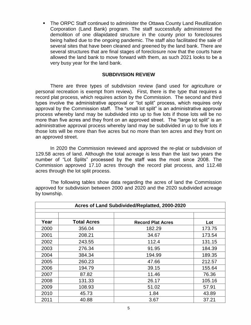
The ORPC Staff continued to administer the Ottawa County Land Reutilization
Corporation (Land Bank) program. The staff successfully administered the demolition of one dilapidated structure in the county prior to foreclosures being halted due to the ongoing pandemic. The staff also facilitated the sale of several sites that have been cleaned and greened by the land bank. There are several structures that are final stages of foreclosure now that the courts have allowed the land bank to move forward with them, as such 2021 looks to be a very busy year for the land bank.
SUBDIVISION REVIEW There are three types of subdivision review (land used for agriculture or personal recreation is exempt from review). First, there is the type that requires a record plat process, which requires action by the Commission. The second and third types involve the administrative approval or “lot split” process, which requires only approval by the Commission staff. The “small lot split” is an administrative approval process whereby land may be subdivided into up to five lots if those lots will be no more than five acres and they front on an approved street. The “large lot split” is an administrative approval process whereby land may be subdivided in up to five lots if those lots will be more than five acres but no more than ten acres and they front on an approved street.
In 2020 the Commission reviewed and approved the re-plat or subdivision of
129.58 acres of land. Although the total acreage is less than the last two years the number of “Lot Splits” processed by the staff was the most since 2008. The Commission approved 17.10 acres through the record plat process, and 112.48 acres through the lot split process.
The following tables show data regarding the acres of land the Commission
approved for subdivision between 2000 and 2020 and the 2020 subdivided acreage by township.
Acres of Land Subdivided/Replatted, 2000-2020
Year Total Acres Record Plat Acres Lot
2000 356.04 182.29 173.75
2001 208.21 34.67 173.54
2002 243.55 112.4 131.15
2003 276.34 91.95 184.39
2004 384.34 194.99 189.35
2005 260.23 47.66 212.57
2006 194.79 39.15 155.64
2007 87.82 11.46 76.36
2008 131.33 26.17 105.16
2009 108.93 51.02 57.91
2010 45.73 1.84 43.89
2011 40.88 3.67 37.21
6
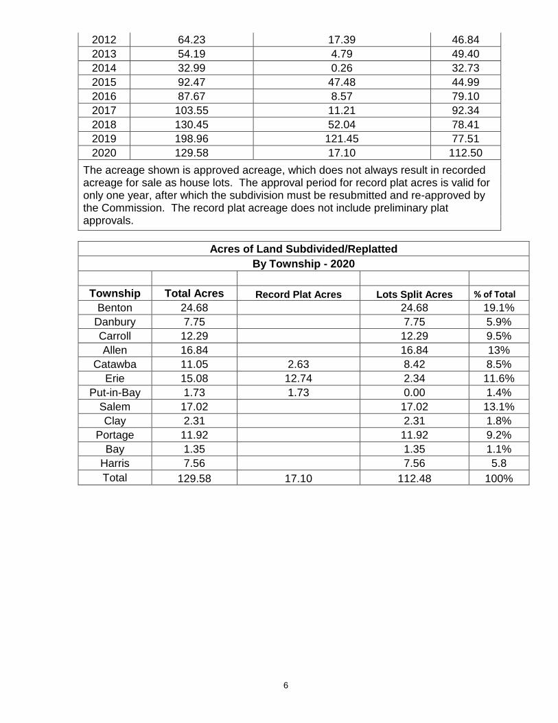
2012 64.23 17.39 46.84
2013 54.19 4.79 49.40
2014 32.99 0.26 32.73
2015 92.47 47.48 44.99
2016 87.67 8.57 79.10
2017 103.55 11.21 92.34
2018 130.45 52.04 78.41
2019 198.96 121.45 77.51
2020 129.58 17.10 112.50
The acreage shown is approved acreage, which does not always result in recorded acreage for sale as house lots. The approval period for record plat acres is valid for only one year, after which the subdivision must be resubmitted and re-approved by the Commission. The record plat acreage does not include preliminary plat approvals.
Acres of Land Subdivided/Replatted
By Township - 2020
Township Total Acres Record Plat Acres Lots Split Acres % of Total
Benton 24.68 24.68 19.1%
Danbury 7.75
7.75 5.9%
Carroll 12.29
12.29 9.5%
Allen 16.84 16.84 13%
Catawba 11.05 2.63 8.42 8.5%
Erie 15.08 12.74 2.34 11.6%
Put-in-Bay 1.73 1.73 0.00 1.4%
Salem 17.02 17.02 13.1%
Clay 2.31 2.31 1.8%
Portage 11.92 11.92 9.2%
Bay 1.35
1.35 1.1%
Harris 7.56 7.56 5.8
Total 129.58 17.10 112.48 100%

7
ZONING REVIEWS
The Commission reviews township zoning resolution text and map amendments, and makes recommendations to the townships on rezoning requests. In 2020, the Commission reviewed one (2) text amendments and nine (9) rezoning requests, which are outlined in the table below.
2020 Zoning Reviews
Applicant Township Request Township's Final Action
Danbury Trustees
Danbury Text Amendment
Approval
Herbert Beidel Danbury “R-2” to “R-C” Disapproved
Portage Trustees
Portage “A” to “C-2” Approval
Larry Durivage Allen “M-1” to “M-3” Rescinded by applicant
Ray Brooks Portage “R-3” to “C-2” Approval
Jane Market Put-In-Bay “C-2” to “R-1” Approval
John Dodge Put-In-Bay “A” to “R-1” Approval
Dean & Ann Rider
Danbury ”R-3” to “R-C” Disapproved
Dan Jadwisiak & Nancy Baily
Danbury “A” to- “C-2” Approval
Danbury Trustees
Danbury Text Amendment
Approval
James Biro
Portage “R-1” to “A” Approval
8
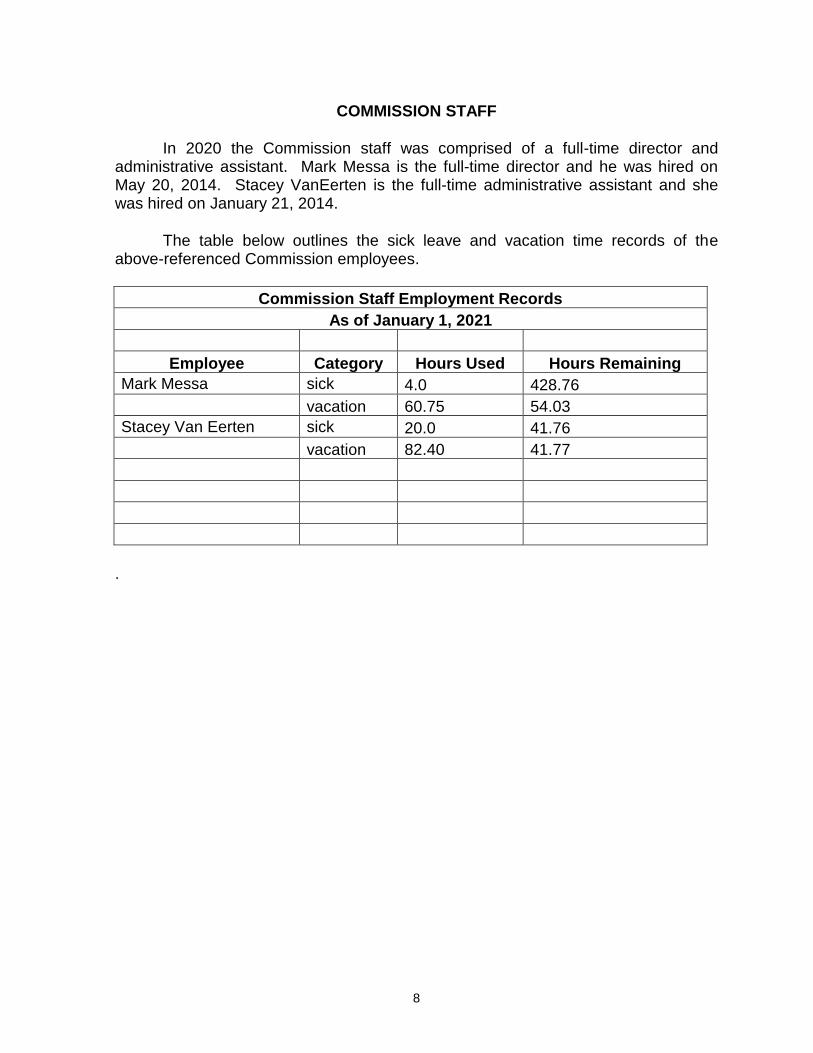
COMMISSION STAFF
In 2020 the Commission staff was comprised of a full-time director and administrative assistant. Mark Messa is the full-time director and he was hired on May 20, 2014. Stacey VanEerten is the full-time administrative assistant and she was hired on January 21, 2014.
The table below outlines the sick leave and vacation time records of the above-referenced Commission employees.
Commission Staff Employment Records
As of January 1, 2021
Employee Category Hours Used Hours Remaining
Mark Messa sick 4.0 428.76
vacation 60.75 54.03
Stacey Van Eerten sick 20.0 41.76
vacation 82.40 41.77
.

9
FINANCIAL STATEMENT
REGIONAL PLANNING COMMISSION
In 2020 the Commission’s receipts exceeded expenditures, resulting in an ending balance of $23,958.23, as reflected in the financial statement below.
Ottawa Regional Planning Commission
2020 Financial Statement
Beg. Balance (January 1, 2020) $ 4,554.14
Receipts
Ottawa County Commissioners $ 96,207.00
Local Membership Assessments $ 25,111.21
Fees/Grants/Refunds/ $ 16,081.76
Contract Services $ 5,250.00
Workers Compensation/refund $ 2,946.40
Total Receipts $ 145,596.37
Expenditures
Salaries $ 81,578.52
Office Supplies $ 493.83
Travel & Expenses $ 26.45
Public Employees Retirement $ 11,496.84
Workers Compensation $ 633.66
Other Expenses $ 2,355.69
Health & Life Insurance $ 27,674.40
Medicare $ 1,182.89
HSA Contribution $ 750.00
Total Expenditures $ 126,192.28
Ending Balance (January 1,
2021)
$ 23,958.23

10