Huglo, Michel. 4 vols. of Variorum Reprints: Index by Suzanne Hilton
Upload
khangminh22Category
view
2download
0
THESE TERMS GOVERN YOUR USE OF THIS DOCUMENT
Your use of this Ontario Geological Survey document (the “Content”) is governed by the terms set out on this page (“Terms of Use”). By downloading this Content, you (the
“User”) have accepted, and have agreed to be bound by, the Terms of Use.
Content: This Content is offered by the Province of Ontario’s Ministry of Northern Development and Mines (MNDM) as a public service, on an “as-is” basis. Recommendations and statements of opinion expressed in the Content are those of the author or authors and are not to be construed as statement of government policy. You are solely responsible for your use of the Content. You should not rely on the Content for legal advice nor as authoritative in your particular circumstances. Users should verify the accuracy and applicability of any Content before acting on it. MNDM does not guarantee, or make any warranty express or implied, that the Content is current, accurate, complete or reliable. MNDM is not responsible for any damage however caused, which results, directly or indirectly, from your use of the Content. MNDM assumes no legal liability or responsibility for the Content whatsoever. Links to Other Web Sites: This Content may contain links, to Web sites that are not operated by MNDM. Linked Web sites may not be available in French. MNDM neither endorses nor assumes any responsibility for the safety, accuracy or availability of linked Web sites or the information contained on them. The linked Web sites, their operation and content are the responsibility of the person or entity for which they were created or maintained (the “Owner”). Both your use of a linked Web site, and your right to use or reproduce information or materials from a linked Web site, are subject to the terms of use governing that particular Web site. Any comments or inquiries regarding a linked Web site must be directed to its Owner. Copyright: Canadian and international intellectual property laws protect the Content. Unless otherwise indicated, copyright is held by the Queen’s Printer for Ontario. It is recommended that reference to the Content be made in the following form: <Author’s last name>, <Initials> <year of publication>. <Content title>; Ontario Geological Survey, <Content publication series and number>, <total number of pages>p. Use and Reproduction of Content: The Content may be used and reproduced only in accordance with applicable intellectual property laws. Non-commercial use of unsubstantial excerpts of the Content is permitted provided that appropriate credit is given and Crown copyright is acknowledged. Any substantial reproduction of the Content or any commercial use of all or part of the Content is prohibited without the prior written permission of MNDM. Substantial reproduction includes the reproduction of any illustration or figure, such as, but not limited to graphs, charts and maps. Commercial use includes commercial distribution of the Content, the reproduction of multiple copies of the Content for any purpose whether or not commercial, use of the Content in commercial publications, and the creation of value-added products using the Content. Contact:
FOR FURTHER INFORMATION ON PLEASE CONTACT: BY TELEPHONE: BY E-MAIL:
The Reproduction of Content
MNDM Publication Services
Local: (705) 670-5691 Toll Free: 1-888-415-9845, ext.
5691 (inside Canada, United States)
The Purchase of MNDM Publications
MNDM Publication Sales
Local: (705) 670-5691 Toll Free: 1-888-415-9845, ext.
5691 (inside Canada, United States)
Crown Copyright Queen’s Printer Local: (416) 326-2678 Toll Free: 1-800-668-9938
(inside Canada, United States)
LES CONDITIONS CI-DESSOUS RÉGISSENT L'UTILISATION DU PRÉSENT DOCUMENT.
Votre utilisation de ce document de la Commission géologique de l'Ontario (le « contenu ») est régie par les conditions décrites sur cette page (« conditions d'utilisation »). En
téléchargeant ce contenu, vous (l'« utilisateur ») signifiez que vous avez accepté d'être lié par les présentes conditions d'utilisation.
Contenu : Ce contenu est offert en l'état comme service public par le ministère du Développement du Nord et des Mines (MDNM) de la province de l'Ontario. Les recommandations et les opinions exprimées dans le contenu sont celles de l'auteur ou des auteurs et ne doivent pas être interprétées comme des énoncés officiels de politique gouvernementale. Vous êtes entièrement responsable de l'utilisation que vous en faites. Le contenu ne constitue pas une source fiable de conseils juridiques et ne peut en aucun cas faire autorité dans votre situation particulière. Les utilisateurs sont tenus de vérifier l'exactitude et l'applicabilité de tout contenu avant de l'utiliser. Le MDNM n'offre aucune garantie expresse ou implicite relativement à la mise à jour, à l'exactitude, à l'intégralité ou à la fiabilité du contenu. Le MDNM ne peut être tenu responsable de tout dommage, quelle qu'en soit la cause, résultant directement ou indirectement de l'utilisation du contenu. Le MDNM n'assume aucune responsabilité légale de quelque nature que ce soit en ce qui a trait au contenu. Liens vers d'autres sites Web : Ce contenu peut comporter des liens vers des sites Web qui ne sont pas exploités par le MDNM. Certains de ces sites pourraient ne pas être offerts en français. Le MDNM se dégage de toute responsabilité quant à la sûreté, à l'exactitude ou à la disponibilité des sites Web ainsi reliés ou à l'information qu'ils contiennent. La responsabilité des sites Web ainsi reliés, de leur exploitation et de leur contenu incombe à la personne ou à l'entité pour lesquelles ils ont été créés ou sont entretenus (le « propriétaire »). Votre utilisation de ces sites Web ainsi que votre droit d'utiliser ou de reproduire leur contenu sont assujettis aux conditions d'utilisation propres à chacun de ces sites. Tout commentaire ou toute question concernant l'un de ces sites doivent être adressés au propriétaire du site. Droits d'auteur : Le contenu est protégé par les lois canadiennes et internationales sur la propriété intellectuelle. Sauf indication contraire, les droits d'auteurs appartiennent à l'Imprimeur de la Reine pour l'Ontario. Nous recommandons de faire paraître ainsi toute référence au contenu : nom de famille de l'auteur, initiales, année de publication, titre du document, Commission géologique de l'Ontario, série et numéro de publication, nombre de pages. Utilisation et reproduction du contenu : Le contenu ne peut être utilisé et reproduit qu'en conformité avec les lois sur la propriété intellectuelle applicables. L'utilisation de courts extraits du contenu à des fins non commerciales est autorisé, à condition de faire une mention de source appropriée reconnaissant les droits d'auteurs de la Couronne. Toute reproduction importante du contenu ou toute utilisation, en tout ou en partie, du contenu à des fins commerciales est interdite sans l'autorisation écrite préalable du MDNM. Une reproduction jugée importante comprend la reproduction de toute illustration ou figure comme les graphiques, les diagrammes, les cartes, etc. L'utilisation commerciale comprend la distribution du contenu à des fins commerciales, la reproduction de copies multiples du contenu à des fins commerciales ou non, l'utilisation du contenu dans des publications commerciales et la création de produits à valeur ajoutée à l'aide du contenu. Renseignements :
POUR PLUS DE RENSEIGNEMENTS SUR VEUILLEZ VOUS
ADRESSER À : PAR TÉLÉPHONE : PAR COURRIEL :
la reproduction du contenu
Services de publication du MDNM
Local : (705) 670-5691 Numéro sans frais : 1 888 415-9845,
poste 5691 (au Canada et aux États-Unis)
l'achat des publications du MDNM
Vente de publications du MDNM
Local : (705) 670-5691 Numéro sans frais : 1 888 415-9845,
poste 5691 (au Canada et aux États-Unis)
les droits d'auteurs de la Couronne
Imprimeur de la Reine
Local : 416 326-2678 Numéro sans frais : 1 800 668-9938
(au Canada et aux États-Unis)
Ontario
Ministry ofNaturalResources
Hon Alan W. Pope
John R. Sloan Deputy Minister
ONTARIO GEOLOGICAL SURVEY
Open File Report 5491
Peat and Peatland Evaluation of the Ottawa-Brockville Area Volume I
by
Bird and Hale Ltd.
1984
Ontario
Ministry ofNaturalResources
Hon Alan W. Pope Minister
John R. Stoan Deputy Minister
ONTARIO GEOLOGICAL SURVEY
Open File Report 5491
Peat and Peatland Evaluation of the Ottawa-Brockville Area Volume I
by
Bird and Hale Ltd.
1984
Ontario
Ministry ofNaturalResources
Hon. Alan W. Pope
John R. Sloan Deputy Minister
ONTARIO GEOLOGICAL SURVEY
Open File Report 5491
Peat and Peatland Evaluation of the Ottawa-Brockville Area Volume I
by
Bird and Hale Ltd.
1984

O OMNR-OGS 1984
Ontario
Ministry of Hon- Alan w., . . MinisterNatural
John R. Sloan Resources Deputy Minister
ONTARIO GEOLOGICAL SURVEY
Open File Report 5491
Peat and Peatland Evaluation of the
Ottawa-Brockville Area
Volume I
by
Bird and Hale Ltd.
1984
THIS PROJECT IS PART OF THE HYDROCARBON ENERGY RESOURCES PROGRAM (HERP), AND WAS FUNDED BY THE ONTARIO MINISTRY OF TREASURY AND ECONOMICS UNDER THE BOARD OF INDUSTRIAL LEADERSHIP AND DEVELOPMENT (BILD) PROGRAM.
Parts of this publication may be quoted if credit is given. It is recommended that reference to this report be made in the following form:
Bird and Hale Ltd.
1984: Peat and Peatland Evaluation of the Ottawa- Brockville Area, Volumes 1-5, Ontario Geological Survey Open File Report 5491, 217p., numerous tables and maps.

Ontario Geological Survey
OPEN FILE REPORT
Open file reports are made available to the public subject to the following conditions:
This report is unedited. Discrepancies may occur for which the Ontario Geological Survey does not assume liability. Recommendations and statements of opinion expressed are those of the author or authors and are not to be construed as statements of government policy.
Open file copies may be read at the following locations:
Mine* LibraryOntario Ministry of Natural Resources8th Floor, 77 Grenville Street, Toronto
The office of the Regional or Resident Geologist in whose district the area covered by this report is located.
Handwritten notes and sketches may be made from this report. Check with the Library or Region al or Resident Geologist's office as to whether there is a copy of this report that may be borrowed. The Library or Regional or Resident Geologist's office wffl also give you information on copying ar rangements. A copy of this report is available for Inter-Library Loan.
This report is on file in the Regional or Resident Geologists* office(s) located at:
255 Metcalf Street Concession Road Box 70 Kemptville, Ontario Tweed, Ontario KOG 1JO KOK 3JO
The right to reproduce this report is reserved by the Ontario Ministry of Natural Resources. Permission for other reproductions must be obtained in writing from the Director, Ontario Geological Survey.
V/G. Milne, Director Ontario Geological Survey
lil

FOREWORD
The Peatland Inventory Project is a component of the Hydrocarbon Energy Resources Program (HERP) funded by the Ontario Ministry of Treasury and Economics under the Board of Industrial Leadership and Development (BILD) Program. The inventory of the peat and peatland resources of Ontario is intended to provide information on possible fuel peat deposits as a means of encouraging increased energy self- sufficiency in Ontario. The Inventory will also provide information on the resources of horticultural peat in the province. As well/ data on the distribution, frequency and types of peatlands in the study areas will assist the Ministry and other agencies in land use planning and disposition.
This report is one of a series of peat and -peatland resource reports planned for study areas across Ontario. In 1983-84, seven areas were designated as study areas and contracted for investigation; Rainy River (30,000 ha of peatland), Ignace (24,000 ha), Foleyet (7,600 ha), New Liskeard (11,000 ha), Parry Sound (4,000 ha), Ottawa- Brockville (18,000 ha), and Kingston-Belleville (14,000 ha). Within these areas, 64 of the largest and most accessible peatlands were investigated at a relativ-ely detailed level. In these deposits, contractors were directed to conduct core sampling on grids of about 100 x 500 m, in order to produce detailed stratigraphic profiles of peat humification (decomposition) and peat materials, site mapping of deposit contours and elevations, and data on peat volumes, drainage and resource potential. Another 100 deposits were studied at a reconnaissance level. Field methods and data analysis were standardised through a common set of fieldwork and mapping guidelines prepared by the Ontario Geological Survey, and regional overview of peatland distribution was obtained by corroborative reconnaissances and satellite image interpetation by the Ontario Centre for Remote Sensing.
About 55 peat cores from sites studied in detail were submitted to O.G.S. for laboratory analysis. These cores were subsampled on the basis of humification levels and peat type, and are being analysed for various parameters which include developmental and peat chemistry measures, such as moisture content, bulk density, absorptive value, acidity, fibre content, ash content and calorific value. Elemental
v

analyses include carbon, nitrogen and oxygen, calcium, potassium, phosphorus, aluminum, copper, zinc and others. In addition, elements which might be potential by-products of gasification and other potential pollutants are analysed, such as sulphur, lead, arsenic and mercury. These analyses will be released in subsequent Open File Reports.
Although these inventory reports have been accepted by the Ontario Geological Survey with confidence that they represent a competent and unbiased appraisal of peatland in the study areas, the responsibility for the data and figures rests with the consulting firm. The results of their study are presented here as received from the consultant.
V.G. Milne, Director Ontario Geological Survey
vii

TABLE OF CONTENTS
VOLUME I ' page
Abstract i
1. INTRODUCTION l
1.1 Study Area Location l1.2 Objectives l1.3 Geology and Geomorphology of Study Area 41.4 Climate of the Study Area . 91.5 Current Utilization of Peatlands in the Study
Area 12
2. METHODOLOGY, FIELD INVESTIGATION " 14
2.1 General 142.2 Deposit Classification and Sample Site Location 152.3 Detailed Vegetation Analysis 16
3. METHODOLOGY, DATA ANALYSIS AND PRESENTATION .18
3.1 General 183.2 References and Contacts 19
4. RESULTS AND CONCLUSIONS 24
4.1 Study Area 244.2 Detailed Study Deposits 284.3 Reconnaissance Study Deposits 354.4 Peat Resource Potential 41
5. DETAILED DEPOSIT EVALUATIONS - 60
5.1 Peatland 31G-24, Moose Creek Bog, Tayside Bog 615.2 Peatland 31G-30, Richmond Fen, Phragmites Fen 725.3 Peatland 31G-58, Marlborough Agreement Forest 87
TABLES
Table l - Climatic Summary 11 Table 2 - Data Summary Table 43 Table 3 - Vascular Flora of Ottawa-Brockville
Study Area 53 Table 4 - Significant Vascular Plants 58
FIGURES
Figure l - Key Map of Ontario 2Figure 2 - Geographic Locations Map 3Figure 3 - Index Map following p. 59Figure 4 - Physiography 5Figure 5 - Bedrock Features and Physiographic Regions 6
ix

Table of Contents cont'd
page
VOLUME II
5 . DETAILED DEPOSIT EVALUATIONS 98
5.4 Peatland 31B-4, Rideau Bog, Merrickville Bog 985.5 Peatland 31B-8, Merrickville Bog, Bishop
Mills Bog,, Hanlans Marsh 110
VOLUME III
5. DETAILED DEPOSIT EVALUATIONS
5.6 Peatland 31B-18, Atkins Bog ~ 1255.7 Peatland 31B-28 1345.8 Peatland 31B-38B, Jellyby Swamp, North
Augusta Bog, Bellamy Bog 147
VOLUME IV
6. RECONNAISSANCE DEPOSIT EVALUATIONS 157
6.1 Peatland 31G-21 1586.2 Peatland 31G-32, Osgoode Bog 1616.3 Peatland 31G-35, Dalmany Bog, West Osgoode Bog 1656.4 Peatland 31G-38 1706.5 Peatland 31G-50 1746.6 Peatland 31G-54 1786.7 Peatland 31G-69/70 1826.8 Peatland 31B-10 187
VOLUME V
6. RECONNAISSANCE DEPOSIT EVALUATIONS 191
6.9 Peatland 31B-12 , Toyes Hill Bog 191"6.10 Peatland 31B-13, Glen Becker Bog 1956.11 Peatland 31B-30 1986.12 Peatland 31B-35, Loyada Lake Bog 2016.13 Peatland 31B-38A, Bellamy Bog 2056.14 Peatland 31B-39/40, Brockville Long Swamp,
Augusta Bog, Perrins Corners Swamp 2096.15 Peatland 31B-45, Centre Lake Bog, Lees Pond 214
XI

TABLE OF CONTENTS
VOLUME l
Page
Abstracp XV
1. INTRODUCTION - l
1.1 Study Area Location l1.2 Objectives l1.3 Geology and Geomorphology of Study Area - 41.4 Climate of the Study Area 91.5 Current Utilization of Peatlands in the Study Area 12
2. METHODOLOGY, FIELD INVESTIGATION 14
2.1 General .142.2 Deposit Classification and Sample Site Location 152.3 Detailed Vegetation Analysis 16
3. METHODOLOGY, DATA ANALYSIS AND PRESENTATION 18
3.1 General 183.2 References and Contacts 19
4. RESULTS AND CONCLUSIONS 24
4.1 Study Area 244.2 Detailed Study Deposits 284.3 Reconnaissance Study Deposists 354.4 Peat Resource Potential 41
5. DETAILED DEPOSIT EVALUATIONS 60
5..1 Peatland 31G-24, Moose Creek Bog, Tayside Bog 615.2 Peatland 31G-30, Richmond Fen, Phragmites Fen 725.3 Peatland 31G-58, Marlborough Agreement Forest 87
Xlll

ABSTRACT
Twenty-three peatlands within the approximately 7200 square kilo metres of Eastern Ontario that has been designated as the Ottawa- Brockville Study Area by the Ontario Geological Survey were studied in detail and fifteen were studies at a reconnaissance level, over the period August l to October 15, 1983.
Over 60* of the area of the peatlands can be classified as Basin Swamp geomorphological type sites, with another 14% being classified as Peat Margin type sites. No other geomorphological type site accounts for more than 10% of the peatland area, although there are minor occurrences of numerous fen- bog- and marsh-related type sites. These deposits are bowl-shaped and have developed either on flat- bedded bedrock overlain by flat-bedded lacustrine deposits, or in topographic anomalies of till or bedrock. Most deposits do not have any established drainage system, and many have no formal inlets or outlets. They are,situated in a region that has inefficient, poorly developed drainage, because of the impermeable soils and the lack of gradient.
The dominant cover type on all the peatlands is mixed-to-thicket swamp which accounts for close to two-thirds of the area. Purely deciduous or coniferous swamps are less common but still cover almost a quarter of the peatland areas. All deposits are at least 50% covered by swamp; most are over 75% swamp; and some are 100% swamp. No other cover type occurs on all deposits although fens occur on all detailed and one-third of the reconnaissance deposits. Bog communities are well represented only on four of the deposits; and, they are relatively well-defined central areas that account for 5%-10% of the deposit. Marsh communities are common but minor occurrences along the drainage channels and contained water bodies. Because of the long settlement history of the area, and the rural, agricultural emphasis of the local economies, past and current man- induced modifications to the vegetation cover are common: cutting, clearing, flooding and draining histories are evident on most de posits. The current vegetation communities are dominated by east ern white cedar, black ash, tamarack, white elm, silver maple and paper birch, with local occurrences of red ash, red maple, swamp birch and trembling aspen.
xv

ABSTRACT cont'd
All of the deposits are relatively shallow; rarely is the average overall depth greater than 2 m. The volumes, therefore, reflect the areal extent 'of the deposit. In almost all deposits, the peat is strongly sedge-dominated. On the very shallow deposits, especially those ones exhibiting a significant hardwood component, woody peat becomes important. As the depth of the deposits increase, especially where the basin configuration contains pockets in the basal material, so too does the potential for encountering an ooze layer underlying the peat. The majority of the peat in all deposits is humified (H4+), even in the shallow, peripheral areas. This is probably a consequence of the southerly climate,and the subse quent seasonal drying.
The accompanying table summarizes the characteristics and develop ment capabilities of the eight deposits which were studied in de tail. The development potential of most of the deposits is relat ively the same. Good access is available to all of them via county roads. Climatic conditions are relatively uniform throughout the region and sufficiently dry in the summer to permit extraction operations. However, none have very large reserves of peat, and as the basin depth increases so too does the potential for encount ering ooze, which is not suitable for either fuel or horticultural uses, and which decreases the trafficability of the deposit. All have a relatively dense tree cover. Drainage improvement for fuel or horticultural development is also a common constraint, since the grade across all deposits is minimal, rarely are there efficient receiving streams present, and, bedrock may complicate ditching.
Fuel peat development would appear to be a viable option only if it was to be developed for a specific energy-self-sufficient oper ation. Continuous strata of unhumified peat are not that common, and unhumified sphagnum peat evan less so. Those few areas with this characteristic have the best potential for utilization because, although these reserves are not extensive, there are suitable local markets. In-situ agricultural use may be feasible in large portions of the deposits, if site drainage could be improved.
xvi i


II
wSa
""•H
U
^
l
toe*
b]QQb)HHgb]Q
|2
5
l
fs (v w\ o ** ft"1 VO Ot OS O) N.
1V) "i k. *j -1 CO.C 4j C* O u O
, T,^M 3^ "*t ^ b
4 *
5 2f^ **
tt
28-i -* O22"
~i rvrC v•n "N
ri fx ie *n

Peat and Peatland Evaluation of the
Ottawa-Brockville Area
prepared for
MINISTRY OF NATURAL RESOURCES
ONTARIO GEOLOGICAL SURVEY
prepared by
BIRD AND HALE LIMITED
VOLUME l
l 1263 Bay St., Tor. Ont. M5R 2C1
Manuscript approved for publication by Owen L. White, Section Chief, Engineering and Terrain Geology Section, Aug.ust 24, 1984.This report is published by permission of V.G. Milne, Director, Ontario Geological Survey.
xxi

1. INTRODUCTION
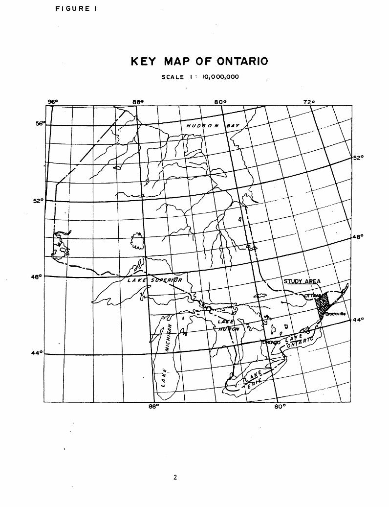
1.1 S tudy Area Location
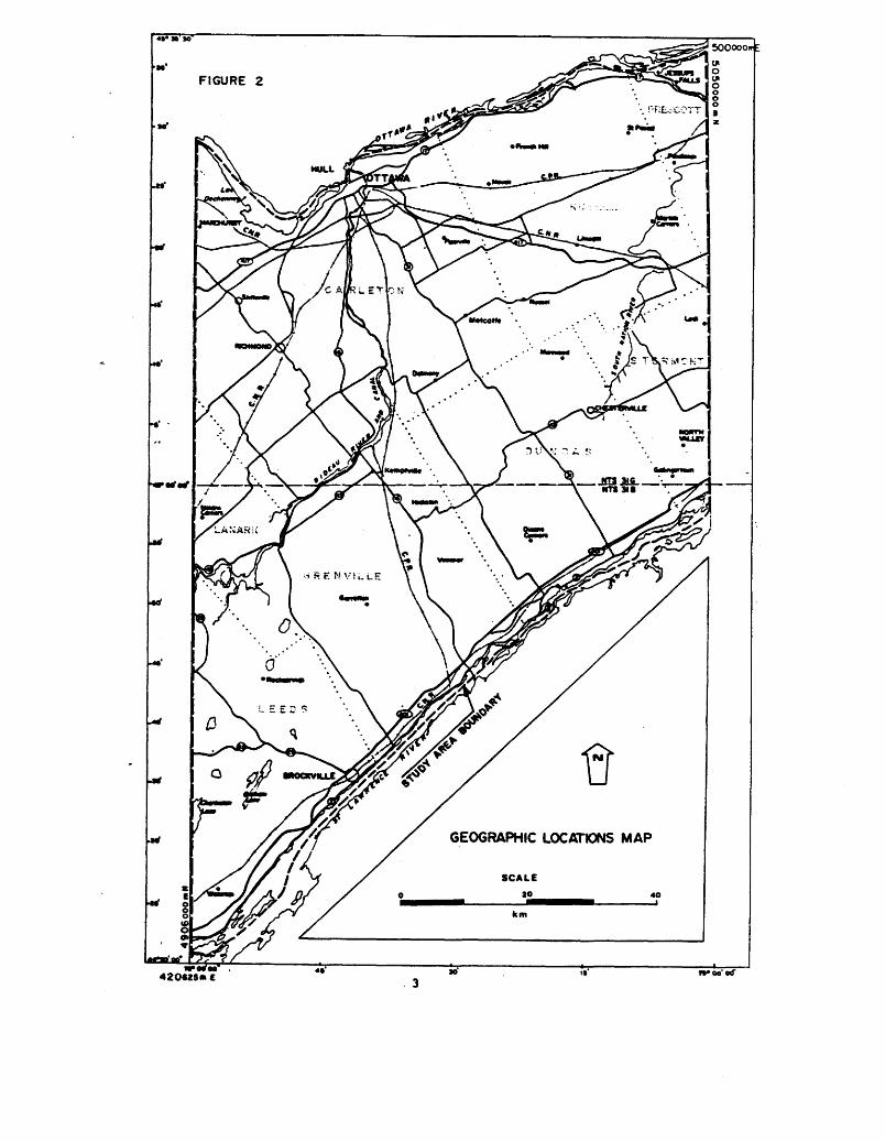
The O ttawa-BrockviIle study area is outlined on the ac companying Key Map (Figure 1). It is bounded by 75 deg rees and 76 degrees west longitude, and by the Ottawa River in the north and the St. Lawrence River in the south. The latitude, longitude, and U.T.M. Eastings and Northings of the study area are presented on Figure 2, Geographic Locations Map.
Major centres include Ottawa, Kemptville and Brockville.These and other identifiable locations and fe-atures areshown on the Geographic Locations Map.
The study area is contained on parts of 1:250,000 NTS map sheets 3IB-Brockville, and 31G-Ottawa, and comprises approximately 7200 square kilometres. The NTS map sheets serve as the Index Map of the peatlands in the study area (Figure 3 - included in Envelope 1). Of the 132 peat lands, eight have been investigated in detail and fifteen have been investigated at a reconnaissance level. These twenty-three deposits are located on the Index Map.
Objectives
The specific objectives of the study are given in the "Specifications for Peatland inventory Project, 1983" (Ontario Geological Survey, 1983). They are:
" ii) To carry out detailed field investigations of a de signated number of peatlands, to evaluate the peat type and peat humification stratigraphy, peat vol umes, elevations, drainage and surficial vegetation.
"iii) To subdivide and map all designated peatlands on the basis of airphoto interpretation and fieldwork into major types; i.e. bog, fen, swamp, marsh and open water, and to further subdivide these units into physiognomic groups."
The methods by which these objectives were to be met are outlined in that publication (pp. 5-13, Ontario Geolog- .ical Survey, 1983). These procedures are highlighted and expanded upon in Sections 2 and 3 of this report.
FI GURE l
KEY MAP OF ONTARIOSCALE l : IO,OOO,OOO
960 88*
44
80*
GEOGRAPHIC LOCATIONS MAP
420*25* C woo'orf
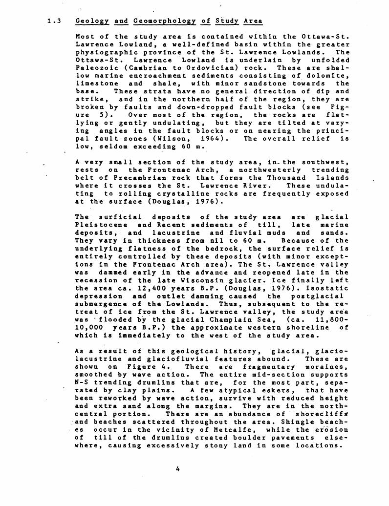
1.3 Geo logy and Geomorphology of Study Area
Most of the study area is contained within the Ottawa-St. Lawrence Lowland, a well-defined basin within the greater physiographic province of the St. Lawrence Lowlands. The Ottawa-St. Lawrence Lowland is underlain by unfolded Paleozoic (Cambrian to Ordovician) rock. These are shal low marine encroachment sediments consisting of dolomite, limestone and shale, with minor sandstone towards the base. These strata have no general direction of dip and strike, and in the northern half of the region, they are broken by faults and down-dropped fault blocks (see Fig ure 5). Over most of the region, the rocks are flat- lying or gently undulating, but they are tilted at vary ing angles in the fault blocks or on nearing the princi pal fault zones (Wilson, 1964). The overall relief is low, seldom exceeding 60 m.
A very small section of the study area, in-the southwest, rests on the Frontenac Arch, a northwesterly trending belt of Precambrian rock that forms the Thousand Islands where it crosses the St. Lawrence River. These undula ting to rolling crystalline rocks are frequently exposed at the surface (Douglas, 1976).
The surficial deposits of the study area are glacial Pleistocene and Recent sediments of till, late marine deposits, and lacustrine and fluvial muds and sands. They vary in thickness from nil to 60 m. Because of the underlying flatness of the bedrock, the surface relief is entirely controlled by these deposits (with minor except ions in the Frontenac Arch area). The St. Lawrence valley was dammed early in the advance and reopened late in the recession of the late Wisconsin glacier. Ice finally left the area ea. 12,400 years B.P. (Douglas, 1976). Isostatic depression and outlet damming caused the postglacial submergence of the Lowlands. Thus, subsequent to the re treat of ice from the St. Lawrence valley, the study area was 'flooded by the glacial Champlain Sea, (ea. 11,800- 10,000 years B.P.) the approximate western shoreline of which is immediately to the west of the study area.
As a result of this geological history, glacial, glacio lacustrine and glaciofluvial features abound. These are shown on Figure 4. There are fragmentary moraines, smoothed by wave action. The entire mid-section supports N-S trending drumlins that are, for the most part, sepa rated by clay plains. A few atypical eskers, that have been reworked by wave action, survive with reduced height and extra sand along the margins. They are in the north- central portion. There are an abundance of shorecliffs1 and beaches scattered throughout the area. Shingle beach es occur in the vicinity of Metcalfe, while the erosion of till of the drumlins created boulder pavements else where, causing excessively stony land in some locations.
FIGURE 4
PHYSIOGRAPHYSCALE
* CHAWIMI S PUTMAN.W73 l
OTTAWA VALLEY CLAY PLAINS
PRESCOTT AND RUSSEL SAND
OTTAWA VALLEY
CLAYRJUNS
NORTH GOWER DRUMLIN FIELD
SMITHS FALLS LIMESTONE PLAIN
WINCHESTER
CLAY PLAIN
GLENGARRY
TXL PLAIN
SMITHS FALLS
LIMESTONE PLAIN
BEDROCK FEATURESAND
PHYSIOGRAPHIC R83IONS
BROCKVILLE
LEEDS KNOBSAND
FLATS
BOUNDARY OF FRONTENAC ARCH
FAULTS
PHYSIOGRAPHIC REGIONS
(CHAPMAN * PUTNAM, HT31
TS'OO*
There are at least three classes.of marine clays: grey calcareous clays common in Grenville, Dundas and Stormont Counties (see Figure 2); other grey clays, with much less lime in Leeds and Lanark; and, east of Ottawa, pink and grey clays still lower in lime. Extensive areas of glac iofluvial sands are concentrated in the southeast and north-central areas (Chapman and Putnam, 1973).
With rebound, the area was raised, drained and was tilted toward the northeast. The following radiocarbon dates have been obtained for shallow-water marine fossils of the Champlain Sea episode (Terasmae, 1965):
10,630 jf 330 years B.P., Hull, Quebec 10,850 330 years B.P., Ottawa, Ontario 10,550 jf 200 years B.P., Ottawa, Ontario * 10,600 HK 200 years B.P., Cornwall, Ontario 10,200 200 years B.P., Ottawa, Ontario
These indicate that portions of the area were still drowned..as recently as 10,200 years B.P.
Eight physiographic regions are represented in the study area (see Figure 5), pertinent characteristics of which are discussed as follows, (information is extracted from Chapman and Putnam, 1973).
Leeds Knobs and Flats - The channels between Precambrian knobs of granite are filled with clay left by the Champ lain Sea. These rock knobs of the Frontenac Arch are relatively bare because the shallow drift was removed by wave action of the Sea. Thus, . the heights of land feed excess runoff to the poorly drained clay clay areas.
Smiths Falls Limestone Plain - This is the largest and most continuous tract of shallow soil over limestone in southern Ontario. The overall gradient is very gradual (approximately 1:1000) and many depressions are left undrained. The shallow soils vary greatly in texture from clay to light loams, sands and gravels (marine beaches). The only area of relatively deep deposits are the clays along the Rideau River.
Edwardsburg Sand Plain - In this region, the bedrock and most of the boulder clay are covered by sand beds, of glaciofluvial origin. The emergence of land formed beach ridges, notably east of Kemptville. The overall relief is small and the water table generally stands near the surface.
North Gower Drumlin Field - The region supports numerous scattered, often incompletely formed, drumlins. Lacust rine clay and silt deposits infill between the drumlins. Also present are various gravel ridges and small areas of bare limestone plain. Although the Rideau and its tribu taries traverse the area, the drainage is not well devel oped .
Glengarry Tl11 Plain - This region of low relief contains the drainage divide between the St. Lawrence and Ottawa Rivers. The headwaters of most of the systems in the region, both to the north and south, flow sluggishly for long distances between ridges before finding outlets to main streams.- The area consists of long drumlinoid ridges, a few well formed drumlins, and intervening clay flats. The till is loamy and contains limestone and Precambrian rock. The outstanding characteristic of the area is its stoniness, although wave active produced some sand and gravel bars.
Winches ter Clay P lain - The poorly drained tight clays of this region have locations where the underlying till protrudes. There are also some drumlins, areas of shal low soil over bedrock and, in the south, occasional bars, beaches and boulder pavements. . There is very little relief: the South Nation River descends on-ly 15 m in 48 km through the region, making drainage improvement diffi cult.
Ottawa Valley Clay Plains - This broad clay plain is interrupted by ridges of rock and sand. The soils are more acidic than the calcareous clays further south. Drainage through much of the clay plain is extremely inefficient. Except for the Ottawa River, all channels are inefficient, frequently overflowing their banks.
Russel l and Presco tt Sand Plains - These level surface sand plains are fragmented by-the Ottawa Valley Clay Plains, which frequently lie 60 m lower than the sand plains. The boundaries are usually abrupt bluffs. These sands are deltaic (into Champlain Sea) with some coarser glaciofluvial sand and gravel deposits immediately south of Ottawa. The drainage tends to be poor back from the escarpments. Along these bluffs, springs often occur. Drainage improvement is possible if deep drains are con structed into the subsoil.
From the preceding discussion, the reasons for the devel opment of peatlands in the study area become evident:' either flat bedded bedrock overlain by flat bedded lacus trine deposits; or, topographic anomalies of either till (drumlins) or bedrock (Precambrian) draining to lacus trine deposits. Thus, the deposits have formed in the low lying areas that experience both poor site and soil drainage because of lack of gradient and low permeability
These deposits could not begin forming until after the retreat of the Champlain Sea (ea. 10,200 years B.P.). Terasmae (1965) has determined a minimum age for early post-Champlain Sea sediments, for a site near Cornwall, Ontario (immediately to the east of the study area), of
9,430 ih 140 years B.P. However, palynological studies in the Ottawa area (Mott and Camfield, 1969; Mer Bleue Bog and five buried peat deposits) have dated basal organic material at from between approximately 8,830 ^ 190 to 7,650 ± 210 years B.P. These researchers noted that (a) topographically higher areas would be colonized earlier (because of retreat of ice and water) and (b) basal organic material in close proximity to limestone bedrock may be dated "too old" because of contamination of the organic material by older carbon from the carbonates of the limestone. Regardless, it seems evident that organic material did not start accumulating in the study area until as recently as about 9,000 years B.P.
After the reinvasion of vegetation to the study area, the presence of wetlands would have been further 'reinforced by continuing rebound that further isolated (and isol ates) the depressions from an efficient drainage system. Since the direction of rebound has caused .the drainage divide between the St. Lawrence and Ottawa Rivers to be within a few kilometres of the St. Lawrence, the primary drainage systems must flow through quite an extensive area of low gradient, low permeability soils. The streams are inadequate, and are prevented from reaching maturity by lack of gradient. (Drainage and flood control are major on-going problems; recurring floods are not uncommon.)
Therefore, the peat in the study area has had no more than approximately 9000 years of uninterrupted time to accumulate. Using a peat depth, of 2.9 m as the maximum average for the deposits investigated in this study, the average rate of peat accumulation in this area is about 3 years per millimetre (or about 75 years per inch). The maximum rate of peat accumulation in this area, based on a maximum encountered depth of 4.8 m (deposit 31B-35) is about 2 years per millimetre (or about 50 years per inch). These values are below the average that has been estimated for the Great Lakes area: it has been estimated that a mean rate of peat accumulation of -20 to 30 years per inch has occurred during the past several thousand years in the Great Lakes area (Bell, 1968, after Sears aird Janson, 1933). Although peat accumulates at different rates under different types of climate and vegetation, it is doubtful that this rate discrepancy can be attributed solely to these factors. More likely, the size of the depressions available for peat accumulation has limited, to a large extent, the amount of accumulation.
1.4 Climate of the Study Area
The study area is located in the Eastern Counties clim atic region of Southern Ontario (Brown e t a I., 1980). A climatic summary of averages and extremes for the region,
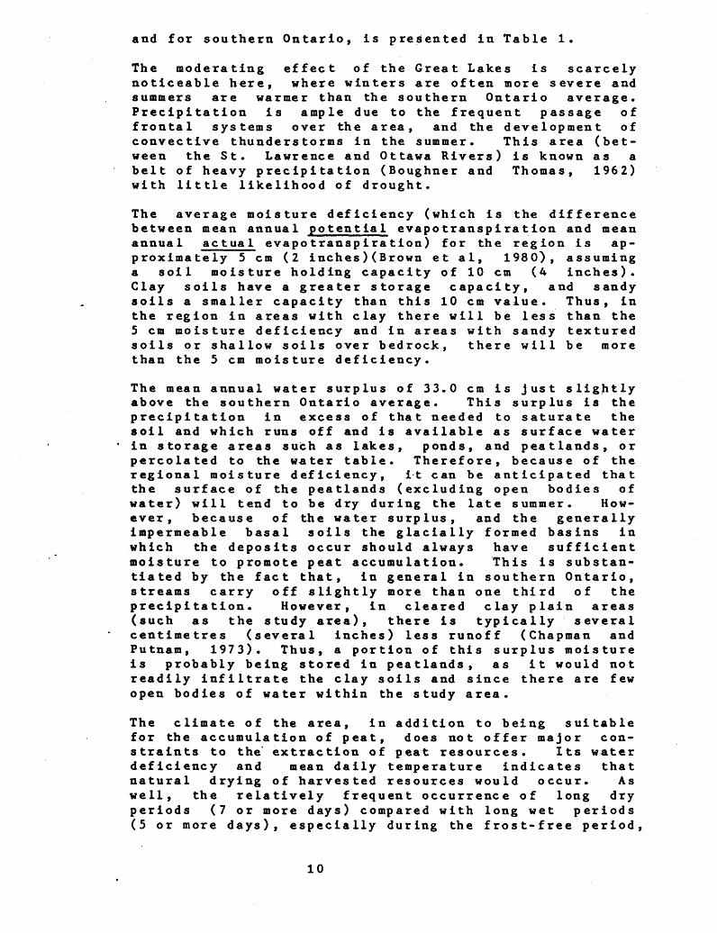
and for southern Ontario, is presented in Table 1.
The moderating effect of the Great Lakes is scarcely noticeable here, where winters are often more severe and summers are warmer than the southern Ontario average. Precipitation is ample due to the frequent passage of frontal systems over the area, and the development of convective thunderstorms in the summer. This area (bet ween the St. Lawrence and Ottawa Rivers) is known as a belt of heavy precipitation (Boughner and Thomas, 1962) with little likelihood of drought.
The average moisture deficiency (which is the difference between mean annual potential evapotranspiration and mean annual actual evapotranspiration) for the region is ap proximately 5 cm (2 inches)(Brown et al, 1980), assuming a soil moisture holding capacity of 10 cm (4 inches). Clay soils have a greater storage capacity, and sandy soils a smaller capacity than this 10 cm value. Thus, in the region in areas with clay there will be less than the 5 cm moisture deficiency and in areas with sandy textured soils or shallow soils over bedrock, there will be more than the 5 cm moisture deficiency.
The mean annual water surplus of 33.0 cm is just slightly above the southern Ontario average. This surplus is the precipitation in excess of that needed to saturate the soil and which runs off and is available as surface water in storage areas such as lakes, ponds, and peatlands, or percolated to the water table. Therefore, because of the regional moisture deficiency, it can be anticipated that the surface of the peatlands (excluding open bodies of water) will tend to be dry during the late summer. How ever, because of the water surplus, and the generally impermeable basal soils the glacially formed basins in which the deposits occur should always have sufficient moisture to promote peat accumulation. This is substan tiated by the fact that, in general in southern Ontario, streams carry off slightly more than one third of the precipitation. However, in cleared clay plain areas (such as the study area), there is typically several centimetres (several inches) less runoff (Chapman and Putnam, 1973). Thus, a portion of this surplus moisture is probably being stored in peatlands, as it would not readily infiltrate the clay soils and since there are few open bodies of water within the study area.
The climate of the area, in addition to being suitable for the accumulation of peat, does not offer major con straints to the' extraction of peat resources. Its water deficiency and mean daily temperature indicates that natural drying of harvested resources would occur. As well, the relatively frequent occurrence of long dry periods (7 or more days) compared with long wet periods (5 or more days), especially during the frost-free period,
10
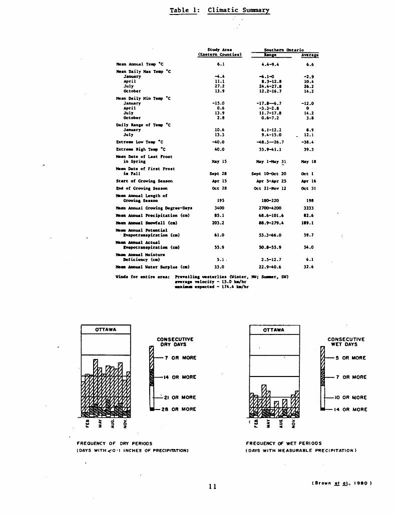
Table 1: Climatic Summary
Hean Date of Last Frostin Spring Hay IS
Hean Date of First Frostin Fall Sept 28
Start of Crowing Season Apr IS
End of Crowing Season Oct 28
Mean Annual Length ofCrowing Season 195
Mean Annual Crowing Degree-Days 3400
Mean Annual Precipitation (ea) 85.1
Mean Annual Snowfall (ea) 203.2
Hean Annual Potential ' Evapotranspiration (ea) 61.0
Mean Annual ActualEvapotranspiration (ea) 55.9
Mean Annual MoistureDeficiency (ea) 5.1 .
Mean Annual Water Surplus (ea) 33.0
Winds for entire area: Prevailing westerlies (Winter. average velocity - 15.0 ka/hr aaxiaua expected - 174.4 ka/hr
CONSECUTIVE DRY DAYS
7 OR MORE
•14 OR MORE
•21 OR MORE
28 OR MORE
Southern OntarioRange Average
4.
-6.8.
24.12.
-17.-3.11.0.
6.9.
-48.
33.
May
4-9.4 6.6
1-0 -2.93-12.8 10.44-27.8 26.22-16.7 14.2
8—6.7 -12.03-2.8 07-17.8 14.26-7.2 3.8
1-12.2 8.94-15.0 . 12.13—26.7 -38.49-41.1 39.3
1-Hay 31 Hay 18
Sept 10-Oct 20 Oct 1Apr 5-Apr 25 Apr 16
Oct 21-Nov 12 Oct 31
180-220 1982700-4200 333368.88.
53.
50.
2.22.
NW; Su
6-101.6 82.69-279.4 189.1
3-66.0 59.7
8-55.9 54.0
5-12.7 6.19-40.6 32.6
aaer. SW)
OTTAWA
tJa&'i"71 IT•yj -Jy
\ ft ffi wWmmmm
"
CONSECUTIVE WET DAYS
t —— 5 OR MORE X
9 —— 7 OR MOREs—— 10 OR MORE
l — 14 OR MORE
' ? I 1 I
FREQUENCY OF DRY PERIODS(DAYS WITH.^O-1 INCHES OF PRECIPITATION)
11(Brown .tt o±. t 1980
improves the ease of extraction. In fact, Monenco (1981) categorized southern Ontario as having the most favourable climatic conditions, within Ontario, for traditional peat harvesting methods.
l .5 Current Utilization of Peatlands in the Study Area
Intensive agricultural use has resulted in modification . and/or development of most peatlands in the study area, particularly around their periphery. Lynch-Steward (1983, after Snell, 1982) has estimated that 61-801 of the wetlands in this area have been converted to other uses and that there is concern about the remaining wetlands because of federal-provincial economic development pro grams, including a multi-million-dollar program for the subsidization of field drainage. Most modifications re sult from one or a combination of pasturing of livestock; cutting (primarily for fuelwood or cedar posts); dis charge of drainage from agricultural land; and, improve ment of drainage and clearing for agricultural cult ivation.
Deposits that were investigated that currently are being utilized are as follows:
Deposit 31G-24 (Moose Creek Bog; Tayside Bog) -This deposit has been drained extensively, and a large portion is currently under agricultural use. In the past, market gardens were operated by the Inter River Corporation.
Deposit 31G-35 (Dalmany Bog, Vest Osgoode Bog) -The southern portion of the deposit has been drained extensively and cleared of natural vegetative cover (some portions are regenerating). North of the road that traverses the southern portion of the deposit, the Continental Mushroom Farm has been removing the top 10 to 20 cm of woody peat for use as a planting medium for mushrooms. South of this same road, sod is being harvested.
Deposit 31G-69/70 (Winchester Boy, Vernon Bog) -This deposit has been drained extensively, presumably in an effort to render it suitable for agricultural use. It is now being managed by MNR as the Mountain Provincial Wildlife Area. As part of the management program, ponds are being excavated to provide water fowl habitat. The humified peat that is being removed is being used for plant bedding at the MNR tree nursery in Kemptville.
Deposit 31B-8 (Merrickville Bog, Bishop Mills Bog,Hanlans Marsh) -
Sphagnum peat is being removed from the east side of the northwest arm of this deposit for use in the MNR
12
tree nursery in Kemptville* This is a small scale operation and there have been no major modifications to the peatland.
Deposit 31B-39/40 (Brockville Long Swamp, Augusta Bog,Perrins Corners Swamp) -
The extreme west end of this deposit is being used for sewage disposal. This does not appear, to have resulted in any modification to the peatland.
13

2. METHODOLOGY, FIELD INVESTIGATION
2.1 General
This study was conducted in accordance with "Terms of Reference for the Ontario Peatland Inventory Project, 1983-84", specifically pages 5-13, and 49-78, (Ontario Geological Survey, 1983).
Initially, the designated peatlands (both reconnaissance and detailed) were interpreted on the airphotos for their basic peatland formations (fen, bog, swamp, marsh); then, transect layout and sample site locations were reviewed with Mr. J. Riley of O.G.S. (see section 2.2 for more information regarding grid and sample site selection).
The field investigations occurred over the period of August 8, 1983 and October 7, 1983. There~ were three - two member field crews whose task it was to log the peat and determine the general vegetation classification of the deposits. In addition there was a botanist who under took the more detailed vegetation investigation.
Relatively easy access was afforded close to all sites "by county roads, trails (skidoo, forestry), and unopened concessions. Private lands are adjacent to most sites and it was usually necessary to traverse this on foot. in only one instance was permission to cross private lands not given. The east side of deposit 31B-8 is privately owned, and the owner did not allow the field crews to investigate this portion of the deposit. The transects and sample points that had been determined were located in the field using the airphotos, a compass, and by chaining. The lines were flagged and, at sample sites, the flagging was marked with the site designation.
The peat cores were acquired using mini-McCauley samplers that had 5 cm by 100 cm sample chambers. The cores were logged and the data sheets were annotated as required by the terms of reference. Uhen physical samples of the peat were obtained, they were double-bagged in the field, and then placed in a freezer at the end of the day, for storage until shipment to OGS. Surface and subsurface water pH's were determined using ColorpHast Indicator Sticks. The vegetation plot size for the general veget ation classification was a 5 metre radius circle. Spec ifics of the detailed vegetation analysis are given in section 2.3.
Elevation contouring of five of the detailed deposits (31B-4, 31B-8, 31B-18, 31B-38B, 31B-28) was obtained by photogrammetry. Barometric surveying was conducted around these five deposits to provide the photogrammetri st s with the necessary vertical control for their model (see sec-
14
tion 3 for information concerning the photogrammetrie mapping).
The surface contours of the other three detailed deposits (31G-24, 31G-30, 31G-58) using an "Electronic Level". The study team became aware of this equipment part-way through the field investigation portion of the study. After discussions with OGS, it was decided to use this method on the three remaining deposits. This level com prises an elevation-sensitive 50-metre calibrated cable and a readout meter that gave the elevation difference between the two ends of the cable.
While in the field the District Managers for each Minis try of Natural Resources district were contacted for information (these are presented in section 3.2, Refer ences and Contacts). In addition, Mr. Drew Young, MNR, Brockville visited some of the deposits with the field crews.
2.2 Deposi t Classification and Sample Si te Location
When this study was initiated, OGS listed ten deposits for detailed investigation and fifteen deposits for reconnaissance investigation. After the initial airphoto interpretation of these deposits, it was determined that two of the reconnaissance deposits (31B-47b and 31B-48; see Figure 3, Index Map) had only a very shallow covering of organics (clay frequently evident at the surface) and could only dubiously be described as "peatlands". Thus, after consultation with OGS, these deposits were elimin ated from the investigation. On the remaining deposits (10 detailed; 13 reconnaissance), transect lines were placed so that all major vegetation types and any bays or topographic anomalies would be traversed. These lines, and the location of physical sample points, were reviewed with OGS, and modifications were made, prior to the field work .
After initiation of the field work, the categorization of some of the deposits changed (i.e., detailed or recon naissance) :- Because of the areal extent of 31G-69/70 consideration was given to making it a detailed rather than a recon naissance deposit. However, after a preliminary investi gation, it was determined that much of the deposit has peat depths less than one metre. Furthermore, the MNR District Manager (Mr. Richard Morin, Cornwall District) suggested that it may be more appropriate to investigate this deposit at a reconnaissance level. Thus, this de posit was left as a reconnaissance rather than a detailed 'deposit.- Deposits 31G-38 and 31G-50, which had been classed fordetailed investigation, became reconnaissance sites.
. From preliminary investigations it was determined that
15
both of these deposits had shallow overall peat depths. Moreover, as the field work progressed, it became evident that to investigate all the deposits it would be neces sary to either reduce some of the deposits to a recon naissance level of investigation, or reduce overall the amount of field investigation conducted on all detailed deposits. The former course of action was chosen.
The final categorization resulted in eight deposits being studied in detail, and fifteen being studied at a recon naissance level. Most of these fifteen reconnaissance deposits proved to be quite shallow. From the preliminary evalution, none appeared to offer more development poten tial than those sites that were to be investigated in de tail. As discussed in section 4.3 and volumes IV and V of this report the potential for further study and development remains low for all reconnaissance deposits.
On many of the detailed deposits, the spacing of the sample points was expanded from 100 metre intervals to 200 metre intervals, because of the consistency of the peat depth, the peat type, and the surface vegetation. On the reconnaissance deposits, the sample density reflected the complexity of vegetation communities and surface con figuration anomalies. On these deposits, the number-of sample points varied from three to fourteen. The only exception to this was 31G-21 for which there is only one sample point. This deposit proved to be a series of small interconnected wetlands only one of which (with an area of 45 ha) had any peat (average depth 0.2 m).
2.3 ' Detailed Vegetation Analysis
A preliminary vegetation cover type mapping was completed on the airphotos prior to the initiation of on-site investigations. On these photos were delineated the tentative boundaries of apparent major extensive and minor distinctive physiognomic cover types, and each area was briefly characterized as to its potential species composition, canopy density and areal extent. A proposed transect line grid was devised so that all the major cover types were crossed, and physical sample points and full vegetation sample points were designated within each type - at least three within those major types covering over 15Z of the deposit's surface area, and at least one in those distinctive minor types covering less than 15Z.
On-site field investigations of the vegetation were car ried out for the eight detailed deposits. These in vestigations followed the transect lines previously laid down by the peat sampling crews. Detailed vegetation analysis occurred at profile core and physical sample points wherever possible, thus securing a direct correl ation between cover type and peatland substrate profile. Only where distinctive cover types were not crossed by
16
the transect lines, or where the core/sample point was located in a pronouncedly unrepresentative cover were full vegetation samples located otherwise. Additionally, as a supplement to the full vegetation samples, a series of "continuity vegetation samples" (i.e., notes concern ing the dominant species, vegetation structural charact- erisics, and density) were taken, to act as a control on the cover type observations of the peat crews and estab lish the actual degree of representation, range of vari ation, or critical environmental situation of the various cover types within the deposit.
The detailed vegetation analyses were sampled from within a 78 square metre plot, the boundaries of which were est ablished by running a 5 metre line along several radii from a central point to the edge and loosely flagging the
Three two-square-metre detail plots were this area, with dimensions of 0.4 m x 5 m radius line to sample homogeneous types), 2 m (often within select representative vegetation type), depending upon their
suitability to the cover type.
Within each of these subplots, the species present and the percentage cover value (based on light exclusion and canopy density) were noted. Additional species occurring within the plots were listed. An overall summary of the general cover density values for each species and each Of the tree (over 135 cm), tall shrubs (over 135 cm), low shrub (under 135 cm), graminoid/herb, moss/lichen/aIgae and other strata was recorded.
A brief descriptive characterization of the cover type and these strata was written and pertinent observations on the condition, habitat, etcetera, were noted. A 0.5 m Otis split core soil sampler was used to ream out a hole in the substrate in order to reveal the water table depth from the hollows and to permit determination of water pH at the water table level or at ea. 40 cm. The physio gnomic cover type, Radforth cover type, average tree canopy height and dominant species in the strata were recorded.
Continuous species observations along the transects was carred out periodically to gain perspective on the rela tionship of the detailed vegetation sample information to the rest of the deposit. For these observations a form list was filled out on which were recorded the major analytical data from the site data record form: site location, wetland classification, Radforth cover type, tree height, stratal densities, major component species, and comments. These forms are included with the site data record sheets for each deposit.
17
3. METHODOLOGY, DATA ANALYSIS AND PRESENTATION
3.1 General
The analysis and presentation of the data were undertaken in accordance with the "Terms of Reference for the Ont ario Peatland Inventory Project, 1983-84", specifically pages 13, and 17-39 (Ontario Geological Survey, 1983). A major factor in the analysis is that the study team mem bers who were involved in the data acquisition undertook the analysis: i.e., individuals involved with vegetation determination in the field, completed the vegetation mapping; individuals involved in peat coring prepared the profiles, etc.
The key maps (1:10,000,000 and 1:500,000) and the index map (1:250,000) were prepared. A Field Investigation base map of each deposit was prepared, using the appropriate OEM map (1:10,000). The deposit boundary, transect and sample point locations, and such features as roads and railways lines are shown on this map. For the detailed deposits, three mylar copies of this Map are used for the presentation of (1) the peatland classification mapping; (2) elevation information; and (3) isopach information. Thus, each detailed deposit has four maps. For the reconnaissance deposits there is only two maps, the Field Investigation Map, and one copy that contains the peat land classification mapping.
Using the site data sheets and field sketches in con junction with the airphotos, the unit boundaries and physiognomic classification of the detailed and recon naissance deposits were refined. The final airphoto interpretation mapping was then transferred to a mylar copy of the appropriate OBM base map (both the airphotos and the base maps are at a scale of 1:10,000). From these maps, the area of each deposit and each vegetation unit (including enclosed open water) was determined using an electronic planimeter.
Elevation information on and around five of the detailed deposits (31B-4, 31B-8, 31B-18, 31B-28, 31B-38B) was determined by photogrammetry* J.D. Barnes Limited under took this work. The vertical ground control required for each site was provided by the field crews. Horizontal control was provided by OBM 1:10,000 maps. The elevations were tied into elevations A.S.L. using 1:50,000 NTS maps. One metre interval contours were provided on and around each deposit and this information was superimposed on an appropriate copy of the Field Investigation Map, which forms the Elevation Map for the deposit. From this Information, the elevation of individual sample points was interpolated and recorded on the data sheet for that sample point.
18
The elevation * information for the remaining three de tailed deposits (31G-24, 31G-30, 31G-58) was determined in the field (see Section 2.1) and the elevation of each sample point was recorded on the data sheet at that time. This information was transferred to the appropriate copy of the Field Investigation Map, which forms the Elevation Hap for 'the deposit, and elevation contour lines were interpolated.
Elevation maps were not prepared for the reconnaissance depos its.
This elevation information, along with the peat type, humification and depth information on the data sheets was used to prepare humification and peat type profiles of each transect line on each deposit.
Calculations of the average humification of surficial (unhumified, Hl-3) and humified (H4+) peat," and the cor responding depths were completed for each deposit, as described on pages 36, 37 of the Terms of Reference, (O.G.S., 1983). This information was transferred to an appropriate copy of the Field Investigation map for the detailed deposits (forming the Isopach Map for that de posit) and on to Field Investigation Maps for the recon naissance deposits. For the detailed deposits, this information was then used to interpolated peat depth contours.
Using the peat depth contours on the Isopach Maps, the volumes of peat (total; in area less than one metre; hum ified) in each detailed deposit were calculated, using the method and format described on pages 28, 29 and 30 of the Terms of Reference (O.G.S., 1983). Subsequently, where possible, extrapolation of general volume inform ation was made to the reconnaissance deposits.
preparation, text and overall con
clusions
3.2 References and Contacts
References
Bell, J.N.B., 1968. "The use of pollen analysis to deter mine post glacial vegetational and environmental Ont ario history." Jji Ontario History 50(2): 49-59.
Boughner, C.C. and M.K. Thomas, 1962. The Climate of Canada. The Meteorological Branch, Air Services, Department of Transport. 74 p.
19
Brodo, I., 1981. Lichens of the Ottawa District. Museum of Natural History, National ada, Ottawa.
_____ National Museums of Can-
Brown, D.M., G.A. McKay and L.J. Chapman, 1980. The Climate of Southern Ontario * Climatological Studies Number 5, Atmospheric Environment Services, Environ ment Canada, Toronto, xi 4- 67 p.
Chapman, L.J. and D.F. Putnam, 1973. The Physiography of Sou them Ontario , second edition. Ontario Research Foundation, University of Toronto Press. 386 p.
Cody, W.J., 1978. "The (Lythraceae) in Canada." 94:74-75.
s ta tus of in Canadian
Lythrum ala turn Field Naturalist
Conant, H.S. and P.L. Redfearn the Mosses and Liverworts. Publishers, Dubuque. 302 p
Jr., 1982. 2nd ed. Wm.
How to Know C. Brown Co.
Douglas, R.J.W. (scientific editor), 1976. Geology and Economic Minerals of Canada. Economic Geology Report No. l, Geological Survey of Canada. 3 vol. 838 p.
Dugal, A., A. Reddoch, J. Reddoch, D. White, C. Billing- ton and S. Hamill, 1978. "Response to the Conserva tion of Lands Report of the Regional Municipality of Ottawa-Carleton, Part 10." The Ottawa Field-Natural ists Club, Memo.
Fernald, M. L., 1950. Gray's Manual of Botany. 8th ed., Van Nostrand Reinhold Co., New York, xiv -l- 1632 p
Gauthier,of the Natural 23 p,
t* ^ O U \1 IX ^ ^ u li vs JL VI N* W . , HCW l W 1. CV * JV 4. V l ± \J ^ t, C *
Robert Edouard, 1971. Study of Five Peat-Bogs Lower Saint Lawrence. Quebec Department of
Resources, Mines Branch, Special Paper 10.
Gillett, J.M. and D.J. White, 1978. Checklist of Vascular Plants of the Ottawa-Hull Region, Canada. National Museum of Natural Sciences, Ottawa.
Gleason, H.A. and A. Cronquist, 1963. _____ ___ Plants of Northeas tern Uni tied Sta tes and Canada. D. Van Nostrand Co., New York. 810 p
Manual of VascularAdj acent
Graham, R. Bruce, 1979. in Selec ted Areas,Algoma, ^ Survey MDC
Some Peat Moss and Peat Districts of Nipissing
Thunder Bay, and Kenora. Ontario 132 p.
Deposits Sudbury,
Geological19
R. Bruce and T.E. Tibbetts, 1961. Evaluation ofMoss as Applied to Some Bogs in Southern Ont-Department of Mines and Technical Surveys,
20
Mines Branch Technical Bulletin 22. 100 p.
Hills, G.A., 1959. J± Ready Reference to Site Productivity in Ontario. Ontario Department of Lands and Forests.
Ireland, R.W., 1981. Checklist of the Mosses of Ontario. Publications in Botany 5, National Museums of Canada, Ottawa.
Ireland, R.W., 1982. Mosses of the Maritimes. National Museum of Natural Sciences, National Museums of Can ada , Ottawa.
LaDouceur, V.B. and B.M. DiLabio, 1982. "Recent Bird Sightings". Trail and Landscape 16(5):230-231.
Lynch-Stewart, Pauline, 1983. Land Use Change on Wetlands in Southern Canada; Review and Bibliography. Lands Directorate, Environment Canada, Working Paper 26. 115 p.
Monenco Ontario Limited, 1981. Evaluation of the Poten- tial of Peat in Ontario. Ontario Ministry of Natural Resources, Mineral Resources Branch, Occasional Paper No. 7. 193p.
Mott, R.J. and M. Canfield, 1969. Palynological Studies in the Ottawa Area. Geological Survey of Canada, Paper 69-38.
Ontario Geological Survey, 1983. Peatland Inventory Project Specifications. Ontario Ministry of Natural Resources. 100 p.
Ontario Institute of Pedology, n.d. Organic Soil Maps, map sheets: Brockville, 31B/12 (1:50,000); Kemptville 31G/4 (1:50,000); Merickville 31B/13 (1:50,000); Mor risburg 31B/14C and 31B/14W (1:50,000); Ogdensburg 31B (1:250,000); Ottawa 31G (1:250,000); Russell 31G/ 6e and 31G/6W (1:50,000); Winchester 31GX3e and 31G/ 3w (1:50,000).
Ontario Ministry of Natural Resources, Brockville Dis trict, n.d. "Public Land in Leeds and Grenville." Pamphlet.
Ontario Ministry of Natural Resources, Carleton Place District, n.d. "Carleton Place Administrative Dis trict". Pamphlet.
Ontario Ministry of Natural Resources, Cornwall District, n.d. Land tenure pamphlet.
Ontario Ministry of Natural Resource, Cornwall District, 1983. Land Use Guidelines. 52 p.
21

Penney, Randall Alexander, 1979. A^ Pollen Record from Pike Lake , Wellington County, Ontario. M.Se. Thesis, Geography, University of Toronto.
Reddoch, J., 1981. "Richmond Wetland Complex." Ontario Nature Reserves Program-Life Science Inventory Check Sheet.
Reddoch, J. 1981. (Correspondence re the Richmond Fen).
Reddoch, J. 1979. "Calcareous Fens in the Ottawa Dis trict." in Trail and Landscape 13(l):16-27.
Rowe, J.S., 1972. Fores t Regions of Canada. Canadian Forestry Service, Environment Canada, Publication No. 1300. 172 p.
Scoggan, H.J., 1979/78. The Flora of Canada. (4 vol.). National Museums of Canda, Ottawa, Publications in Botany No. 7. xiii * 1711 p.
Soper, J.H. and M.L. Heimburger, 1982. Shrubs of Ontario. Publications in Botany, Royal Ontario Museum, Toronto
Terasmae, J., 1965. Surficial Geology of the Cornwall and St. Lawrence Seaway Proj ect Areas, Ontario. Geolog ical Survey of Canada, Bulletin 121. 54 p.
Voss, E.G., 1972. Michigan Flora, Part l. Gymnosperms and Monocots. Cranbrook Institute of Science, Bulletin 55. 488 p.
White, D.J., 1977. (Correspondence re the Richmond Fen).
Wilson, Alice E., 1964. Geology of the Ottawa-St. Law rence Lowland, Ontario and Quebec. Geological Survey of Canada, Memoir 241. 66 p.
Contacts
Bailey, James R., 1983. Ministry of Natural Resources, Carlton Place District (District Manager).
Catling, P.M., 1984. Plant Research Institute, Central Experimental Farms, Department of Agriculture, Ottawa
Cuddy, D.G., 1983. Ministry of Natural Resources, East ern Region Parks.
Ekersley, Michael, 1983. Ministry of Natural Resources, Cornwall District (Biologist).
Hardy, William V., 1983. Ministry of Natural Resources,
22
Brockville District (District Manager).
Morin, J. Richard, 1983. Ministry of Natural Resources, Cornwall District (District Manager).
Riley, John, 1983/84. Ontario Geological Survery, Minis try of Natural Resources, Toronto (Peat Specialist).
Young, Drew, 1983. Ministry of Natural Resources, Brock ville District (District Pits and Quarries inspector)
23
4. RESULTS AMD CONCLUSIONS
A.I Study Area
The Brockville-0ttawa study area lies almost exclusively within the St. Lawrence Lowlands physiographic region. The overall relief is small, and generally the water table is close to the surface. The soils tend to be fine grained (clays, fine sands) and, where coarser material is present, it occurs in hard packed till or as boulder pavement. Most of the area has been cleared of natural vegetation for agriculture. The installation of open ditches and tile drains provides good farmland in the areas with fine-grained soils. Those areas that support natural vegetation and extensive stands of trees are often in areas where the poor drainage conditions cannot be improved easily, because of lack of gradient and/or suitable receiving drainage systems. The drainage system throughout much of the area is poorly organized and under-developed. The generally low permeability soils impede infiltration and retain moisture, and, since this area is known as one of heavy precipitation, there is usually an abundance of water available. In addition, the area is less moderated by the Great Lakes than other portions of southern Ontario.
As a result of the low-permeability soils, excess avail able moisture and inefficient drainage systems, peat has been able to accumulate. The overall flatness of the region, coupled with the presence of only relatively shallow bowl-shaped depressions, has resulted in areally extensive but shallow deposits. These deposits are not equally distributed throughout the study area. Of the eight physiographic regions that occur in the study area, the Smiths Falls Limestone Plain has by far the largest percentage of peatlands, as shown by the following table.
PhysiographicRegion
(see Fig 5J,Percent of S tudy Area
Depos i ts Investiga ted
Leeds Knobs * Flats
Smiths Falls Limes tone Plain
2731G-30D, 31G-58D
49 31B-4D, 31B-8D31B-18D, 31B-38bD 31G-50R, 31G-54R 31B-35R, 31B-38aR 31B-39/40R, 31B-45R
24
Edwardsburg Sand Plain
North Gower Drumlin Fid.
Glengarry Till Plain
Winches ter Clay Plain
Ottawa Valley Clay Plains
Russell and Prescott Sand Plain
12
11
15
16
10
31B-28D, 31B-10R 13 31B-30R,
W-half 31G-69/70R
5 31G-32R, 31G-35R
31B-13R
31G-24D, 31G-38R31B-12R,E-half 31G-69/70R
31G-21R
This distribution of peatlands probably is not solely the result of the Smiths Falls Limestone Plain being more geomorphologically suited to the development of peat- lands, but also because of (1) the fertility of the soils in other areas when the drainage is improved; and (2) the ease of drainage improvement* Basal rock was encountered in eleven of the twenty-three deposits that were investi gated in this study; however, only two of these eleven were located off the Limestone Plain (31B-28D and 31G- 24D). Thus, it appears that the "reclamation" of wet lands for agriculture and settlement has been more exten sive off the Limestone Plain.
The study area occurs within the Upper St. Lawrence Sec tion of the Great Lakes-St. Lawrence Forest Region. This Section essentially coincides with the St. Lawrence Low land physiographic region, and is dominated by deciduous forest. As reported by Rowe (1972) "the dominant cover type is composed of sugar maple and beech, with red maple, yellow birch, basswood, white ash, largetooth aspen, and red and bur oaks, with local occurrences of white oak, red ash, grey birch, rock elm, blue-beech and bitternut hickory. Poorly drained depressions frequently carry a hardwood swamp type in which black ash is prom inent." The findings of this study are in agreement with the latter statement of Rowe. The hardwood swamp type, especially if the mixed and thicket swamp types are included, is the predominant cover on the "poorly drained depressions" investigated in this study. Moreover, black .ash frequently represents a major portion of the canopy. In addition, coniferous swamp, open and treed fens, open and treed bogs, and marshes are present, as shown in Table 2.
25
Listed below is a summary, prepared from Table 2 (Data Summary Table), that shows the total area, and a percent age of the total area that contains peat (excludes lands utilized for agriculture or forestry and open water), for each of the major cover types* that occur on the eight detailed and fifteen reconnaissance deposits. The table also includes a list, for each cover type, of the most common tree species.
TOTAL AREA OF ALL DEPOSITS INVESTIGATED - 18,390 ha
Swamp 14,925 ha (851)
Conifer Swamp - 2,206 ha (131);
Hardwood Swamp - 1,753 ha (101)
Thicket Swamp - 5,183 ha (291)
Mixed Swamp - 5,789 ha (331)
Eastern W-hite Tamarack
Cedar
Spruce and minor Elm and Paper Birch) Speckled Alder, Winterberry, Alder- leaved Buckthorn Black Ash, Silver Maple, Red Ash, Elm, (Red Maple, Paper Birch, Trembling Aspen and minor Tamarack and Cedar) Speckled Alder, Vinterberry, Willows Cedar, Black Ash, Paper Birch, Trembling Aspen, Tamarack (Red Maple, Elm, Red Ash) Speckled Alder, Willows, Winterberry Black Ash, Cedar, Elm, Paper Birch, (Tamarack, Red Maple, Silver Maple, Balsam Fir) Speckled Alder, Red Osier Dogwood, Winterberry, Willows
.lowing conventions: imp - hSx, htS;i ** i ** * ^
^Summarized from Table 2 using the following conventions: Conifer Swamp - cSx, ctS; Hardwood Swamp - hSx, htS; Thicket Swamp - tSx, thSx, tcSx; Mixed Swamp - chSx, hcSx; Treed Fen - all TxxFx; Open Fen - all OxxFx; Treed Bog - a TxxBx; Open Bog - all OxxBx; Marsh - all xMx.
all
26
Fen - 1,753 ha (101)
Treed Fen
Open Fen
974 ha (67.): Tamarack, Cedar, Swamp: Birch, Paper Birch
779 ha (41): (Black Ash, Black Spruce,Red Ash)Willows, Vinterberry,Speckled Alder, RedOsier Dogwood
Bog - 513 ha (31)
Treed Bog
Open Bog
386 ha (21): Tamarack, Black Spruce,: Swamp Birch
127 ha (11): Velvet Leaf Blueberry,Leatherleaf, Labrador Tea
Marsh - 436 ha (21)
Utilized - 693 ha
Vater 70 ha
Speckled Alder, Willows,
used for agriculture or forestry
completely contained within the peatland
Therefore the dominant cover type on peatlands in the Ottawa-BrockviIle study area is mixed-to-thicket swamp, which accounts for close to two-thirds of the area. Purely deciduous or coniferous swamps are less common but still cover in total almost a quarter of the peatland areas. The predominance of mixed and thicket swamp cover types probably reflects the history of the area where cutting, clearing and fires have been recurring events. These swamp cover types are dominated by eastern white cedar, black ash, tamarack, elm, silver maple and paper birch, with local occurrences of red ash, red maple, swamp birch and trembling aspen. The most common shrubs are speckled alder, winterberry, willows, and red osier dogwood. Velvet leaf blueberry, labrador tea and leath- erleaf consistently are present on the few bog cover type areas encountered.
In addition to the cover types and plant species composi tion, there are other notable similarities and trends evident on the deposits that were investigated, both in detail and at a reconnaissance level:
- All deposits are relatively shallow; rarely is the average overall depth greater than 2 m. The volumes, therefore, reflect the areal extent of the deposit: as 'the size increases so too does the volume.
- In all deposits, the peat is strongly sedge-dominated.
27
In the relatively deeper deposits, ooze is present in the basal layer. The peat usually becomes more wood dominated near the surface and around the periphery, reflecting the current cover type. Only rarely is there a significant amount of moss-dominated peat.
- The majority of the peat in all deposits is humified (H4+). Moreover, the peat in the areas around the edges of the deposits, where the peat depth is less that one metre, is also usually humified. This is contrary to the assumption in the Terms of Reference, where it states that one is to assume that this peat is unhumified. The southerly climate (in terms of peatla'nds) and subsequent seasonal drying of the periphery and surface of the deposits largely accounts for this. These gradual-sloped, bowl-shaped depressions are relatively better drained and more aerated than more northerly peatlands, allowing for more complete decomposition.
A summary of the area, volume, depth and- physiognomic cover types of each of the deposits, and for all of the deposits is presented in Table 2, Data Summary Table. Table 3 presents the vascular flora of the eight detailed deposits, as derived from the field observations of lan D. Macdonald (study team botanist), and the records of John L. Riley, D.G. Cuddy and J. Reddoch. These tables follow this Section 4.
It is assumed that these tendencies also would be present on the other peatlands across the study area that were not investigated.
4.2 Detailed Study Deposits
Of the eight deposits studied in detail, only two of them are located off the Limestone Plain: 31B-28 on the Edwardsburg Sand Plain, and 31G-24 (Moose Creek Bog, Tayside Bog) on the Winchester Clay Plain. These have the second and third largest areas, respectively, and the second and first largest volumes, respectively, of all of the detailed deposits (see Table 2). Moreover, 31G-24 has the deepest overall average depth. In general, how ever, the volumes for all deposits more closely correlate to the areas than the overall mean depth, as shown below. The range of overall mean depth is only l m to 2.1 m, and only the deepest and shallowest are not within 0.3 m of the average overall depth of 1.5 m. Thus it is not surprising that areal extent dictates the volume, and in the absence of other information, this fact may be trans lated to other deposits within the Ottawa-BrockviIle study area. Consequently, if the conditions of a deposit tesult in it being a candidate for development, with other factors being equal, the larger the surface area of a deposit, the greater its development potential.
28
Rank Order For
Deposit
31G-2431B-2831G-3031B-831B-431G-5831B-38B31B-18
Volume Area Overall Mean Depth
As discussed previously and as detailed in Table 2, the vegetative cover of all deposits is dominated by various swamp communities. A summary of the information contained in Table 2 is presented below, using the same conventions for summarizing that are used in Section 4-1.
Cover Type
SWAMP
Conifer Hardwood Thicket Mixed
FEN
Treed Open
BOG
Treed Open
7,545 ha (761)
Average Depth, m (no . of sample p ts
751 ha (81)643 ha (71)
2,550 ha (261)3,601 ha (351)
1,594 ha (171)
748 ha 846 ha
(81) (91)
433 ha (41)
CONTAINED WATER BODIES
306 ha 127 ha
307 ha
583 ha
28 ha
(31) (11)
(31)
1.6 (758)
1.8 (79)0.9 (47)1.7 (215)1.7 (417)
1.8 (150)
1.7 1.9
2.1
2.0 2.3
0.7
1.0
(63) (87)
(63)
(37) (26)
(9)
(10)
The distribution of these various cover types is consist ent across the detailed deposits. On all deposits, swamps account for a minimum of two-thirds of the area, with the exception of 31G-24. On that deposit, slightly more than 501 is covered by swamp; however, fully one third of the area is under cultivation and a substantial
29
portion of the remainder has been drained. In fact, this deposit accounts for 991 of the area classified as "util ized" in the above table. For all but this deposit and 31B-38B, a mixed swamp is the dominant cover type. On 31G-24, thicket swamp dominates and accounts for over a third of the area of this cover type indicated in the above table. On 31B-38B, a hardwood swamp that occupies 251 of the area listed above, dominates. In addition, 31G-30 supports a substantial area of hardwood swamp ^307. of above-listed area); however, it is distributed around the periphery. 31G-30 also supports the largest area of coniferous swamp ^601 of above-listed area). Since 31G-30 has the largest areal extent of any detailed deposit, it is not surprising that it accounts for sub stantial portions of the area of various cover types.
Fens are the next most common cover type, occurring on all deposits, but rarely accounting for more than 101 of the deposit (exceptions are 31G-24 - 161; 31G-30 - 331; 31B-38B - 301). These fens tend to support primarily shrubs or trees rather than graminoids. Open graminoid fens were recorded only for 11 of the area of the detail ed deposits (see Table 2) and open low shrub fens only for 41 of the area.
Only on two deposits are bog communities found: 31B-8 and 31B-28. These are both dominated by shrubs rather than graminoids or herbs. Thus, even where there is substantial representation by fens or bogs, extensive clearing operations would have to occur to facilitate development.
In addition to the distinctive vegetation, the presence of fens rather than bogs was substantiated by the pH readings that were obtained from the near-surface ground- water. Bog areas typically had pH readings less than 5.0 while fen areas were typically over 5.5. It is not sur prising that there are fens rather than bogs. In these rather shallow depressions, contact with the relatively soluble sedimentary, calcareous substrate would provide some nutrients and tend to elevate the groundwater pH.
Marsh communities occur locally along drainage channels in all but 31G-24, and this deposit, with its high level of utilization, has been extensively drained. Only two deposits, 31B-4 and 31G-58 support significant cohesive areas of marsh.
All the deposits appear to have experienced modification to their cover types, at least around their periphery. The main cause of this has been clearing and draining for agriculture. Also having occurred, though, are fire; cutting for forestry; construction of roads, rail lines, and hydro lines; and, beaver activity (most deposits show signs of flooding).
30
The above summary table of the detailed deposits highlights the relation between vegetation cover type and peat depth. Very generally, the correlation in the table indicates classical peat accumulation patterns. The shallowest peats are recorded in the marsh (0.7 m) and hardwood swamp (0.9 m) types. In marshes, this is the result of their typically early successional role, and because they have high nutrient levels, exhibit flowing water, and are well-aerated, thus promoting more complete decomposition. The hardwood swamps are typically peri pheral to the main body of deposits, are better drained, seasonally dry, and are better aerated than most swamps, thus also promoting decomposition.
The thicket and mixed swamps are twice as deep (both average 1.7 m). These vegetation patterns -are, to a large extent, the result of the past disturbances to the various deposits. It can be postulated that these areas were more strongly coniferous dominated, - prior to the draining and burning stresses that they have experienced. This is supported by the fact that the conifer swamps are of similar depth (1.8 m).
The conifer swamp is a more northerly cover type, occur ring in the south on cooler-than-normal and wetter-than- normal sites, and in areas that are less subject to the fluctuations of spring flood/summer drought. These conditions promote slower decomposition and the accumul ation of peat.
The treed bogs and fens usually have positions on the "inside" of large peatlands, where they are nutrient stressed because of their isolation from basal sediment and groundwater flow. They average more than twice as deep as the marsh and hardwood swamp cover types (1.8 m). The open fens , of considerably greater scale earlier in the history of all these sites (see discussion below), now occur in the interior of peatlands (often in wetter sub-basins underlain by ooze) or along the edges of interior peatland ponds, and have slightly deeper peats (1.9 m). The rare open bogs, occupying slightly raised or isolated interior sites, and having probably entered into more typical bog-peat accumulation phases with sphagnum growth independent of groundwater regimes, are the deepest type of peatlands (2.3 m).
For all deposits, the majority of the peat is humified (H4-4-) and sedge dominated. Typically, the wood comple ment increases near the surface and around the periphery. Basal ooze is often evident in the deeper bays of the de posits. Only on two deposits, 31B-8 and 31B-28, is there a substantial layer of unhumified peat present. In both .cases, it is moss-dominated peat and since these are the two deposits that contain bogs, this is not surprising.
31

By correlating the preceding facts concerning peat depth, peat type, and vegetation cover type, it is possible to hypothesize the probable successional history of 1 the deposits: Early successional marsh communities initiated the deposition of peat, which is now recognized as either ooze or sedge-dominated. In some areas, this community was succeeded by hardwood and thicket swamp cover types. These swamps tend to develop directly on the marshes in better drained, aerated areas and are currently evident along the periphery of deposits or in shallow bays or are recognized by the wood-dominated, or wood-sedge dominated peat layers that overlay the marsh-laid ooze/sedge stra ta. In other areas, the marshes appear to have been suc ceeded by graminoid fens. With maturity came the change to shrub rich fen conditions, and gradually, as the surface became drier, to coniferous swamps, with wood and sedge dominated peats, that small, varying amounts of moss. In locallized central areas of a very few depo sits, the conditions are now becoming favourable for the development of bogs and the subsequent deposition of sphagnum-dominated peat.
The salient facts of each of the detailed deposits are summarized below:
31G-24 (Moose Creek Bog, Tayside Bog) -
This is the largest, deepest deposit, with an average overall depth of 2.2 m. One third of the deposit is currently being utilized for agriculture. Post-distur bance thicket and hardwood swamp accounts for over 751. of the remaining area and a substantial portion of it has been drained. The potential for further drainage improve ment for in-situ agricultural usage, or peat extraction appears to be good. Moreover, approximately 95X of the peat contained in this deposit is within the area with depths in excess of l m. This peat is humified and strongly sedge-dominated, with more wood peat near the surface. In addition, there is a high stump content near the surface which would reduce its extraction development potential. MNR, in its Sensitive Areas and Features
far developed for future concern or protection".
31G-30 (Richmond Fen, Phragmites Fen) -
This is the second largest deposit in surface area, but it has the shallowest overall depth of any detailed deposit (1.0 m). A substantial portion of the peat, though, is contained in the area where the depth is greater than l m. However, in this area there is a basal layer of ooze. Approximately 757. of the peat is sedge-
32
dominated, the majority of which is humified (H4+). Over 451 of the peat, however, is unhumified (Hl-3). The surface configuration of the deposit is very irregular, with many fingers and bay. In addition, there is a contained rock upland. These conditions may preclude development. Moreover, this deposit encompasses one of the most extensive fen complexes in eastern Ontario and consequently has been designated an Area of Natural and Scientific Interest (ANSI) and a Nature Reserve Candi date by MNR.
31G-58 (Marlborough Agreement Forest) -
This relatively small, shallow deposit (overall average depth of 1.2 m) has numerous bays and fingers, and con tains rock uplands. The deepest area (1.9 m, with an open tall shrub fen surface cover) contains a basal layer of ooze that adds an additional 1.5 million cubic metres to the deposit (not included in the total volume of 9.9 million cubic metres). Approximately 7071 of the peat is humified, and the majority of it is sedge-dominated. Near the surface, there is a relatively high stump content. Drainage improvement appears feasible; however, the pre ceding facts may preclude development. The deposit has been classed as an ANSI; it is managed by MNR for forest ry, wildlife (there is also a deer yard), and recreation.
31B-4 (Rideau Bog, Merrickville Bog)
This is a relatively small deposit; however, it is one of the two deepest deposits, having an overall average depth of 1.9 m. Most of the volume .of peat is in the deep central area. There is an additional volume of 1.4 mil lion cubic metres of ooze which adversely affects the development potential of the deposit. About 657, of the resources of the deposit are humified (H4+) sedge-domin ated peat. The deposit has a regular shape although there is an interior rock upland. In addition, it has a relatively low stump content and the MNR has no specific concerns regarding this deposit, thus improving the dev elopment potential.
31B-8 (Merrickville Bog, Bishop Mills Bog, Hanlacs Marsh)
This deposit, with its relatively open bog areas, con tains an unhumified moss peat layer (average thickness of 0.35 m) that is currently being extracted by MNR for use in its tree nursery. In the main body of the deposit where there is an approximately 2 m thick layer of humi fied, sedge-dominated peat, there is an underlying layer of ooze. The ooze and ooze-dominated layers occur prim arily in depressions in the substrate. They vary in thickness up to a maximum depth of l m, and represent a volume of 0.8 million cubic metres in excess of the volume of the deposit (23.5 million cubic metres). Thus,
33
the volume of ooze would not, by itself, eliminate the potential for development of this deposit. Elsewhere in the deposit, the complex configuration of the deposit (the main body and four embayments) may complicate ex traction. In addition, the overall average depth of the deposit, 1.5 m, is less than the approximately 2 m recor ded for the central portion of the deposit. The domed bog in the northwestern portion of this deposit is an ANSI.
31B-18 (Atkins Bog) -
This is the smallest deposit, both in volume and surface area. Its overall average depth is 1.5 m, and it is composed primarily of humified, woody (shrub-dominated) peat. There are localized, minor occurrences of moss peat. Almost the entire deposit is tree covered; less than two percent is either marsh or has been cleared for cultivation. It has rock islands and a relatively high stump content. The MNR has no specific cancerns regard ing this deposit.
31B-28 -
This relatively large deposit (second largest in both area and volume) supports a domed bog. In this area, .not only does the surface rise but also the base contour drops, resulting in a maximum peat depth of 4.9 m. The overall average peat depth for the deposit, however, is only 1.3 m. Host of the peat is H3-4 and is sedge- dominated. This is overlain by a relatively thin layer of woody peat. There is a shallow, discontinuous surface stratum of moss peat over most of the deposit. Thus, the extraction of horticulture peat may be possible. Elsewhere, the irregular configuration (contains numerous bays and peripheral channels), the included uplands, and the high stump content in areas where peat depths are greater than one metre, make the extraction of fuel peat less attractive. The deposit has been recognized as having district significance as a swamp and bog wetland by the Federation of Ontario Naturalists and the Ministry of Natural Resources.
31B-38B (Jellyby Swamp, North Augusta Bog, Bellamy Bog) -
This is the second smallest deposit. It has a uniform, relatively deep section (average depth of 2.3 m and maximum depth of 4.5 m) of humified sedge peat in the area with the lowest density of forest cover. However, this area is underlain by a layer of up to one metre of ooze and has an extremely high stump content. These factors adversely affect the development potential. The area is noted by MNR as providing good cover for migrat ing waterfowl.
34
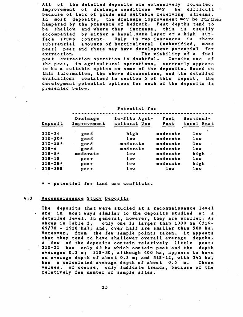
All of the detailed deposits are extensively forested. Improvement of drainage conditions may be difficult because of lack of grade and suitable receiving streams. In most deposits, the drainage Improvement may be further hampered by the presence of bedrock. Peat depths tend to
and where they Increase, this Is usually by either a basal ooze layer or a high sur- content. Only in two Instances Is there amounts of horticultural (unhumlfled, moss
and these may have development potential forThe viability of a fuel
peat extraction operation is doubtful. In-situ use of the peat, in agricultural operations, currently appears to be a suitable option on some of the deposits. Based on this information, the above discussions, and the detailed evaluations contained in section 5 of this report, the development potential options for each of the deposits is presented below.
be shallow accompanied face stump substantial peat) peat extraction.
Potential For
Depos i t
31G-2A31G-30*31G-58*31B-431B-8*31B-1831B-28*31B-38B
Drainage Improvement
In-Situ Agri- cultural Use
highlow
moderate moderate
lowlow .lowlow
Horticul tural Peat
moderate moderate moderate moderate moderate moderate moderate
low
* . potential for land use conflicts
4.3 Reconnaissance Study Deposits
The deposits that were studied at a reconnaissance level are in most ways similar to the deposits studied at a detailed level. In general, however, they are smaller. As shown in Table 2, only one is larger than 1000 ha (31G- 69/70 - 1910 ha); and, over half are smaller than 500 ha. Moreover, from the few sample points taken, it appears that they tend to have shallower overall average depths. A few of the deposits contain relatively little peat: 31G-21 has only 45 ha which contain peat and the depth averages 0.2 m; 31B-30, although 400 ha, appears to have an average depth of about 0.3 m; and 31B-12, with 345 ha, has a calculated average depth of about 0.5 m. These yalues, of course, only indicate trends, because of the relatively few number of sample sites.
35
As with the detailed deposits, .the largest reconnaissance deposit, both in area and estimated volume (interpolated from similar detailed deposits) is located on the Winchester Clay Plain: 31G-69/70 (a portion is situated on the Edwardsburg Sand Plain, which contains the second largest detailed deposit). Also similar to the detailed deposits is the dominant vegetation cover. On all depos its "swamp" accounts for the major portion of the cover type. A summary of the vegetation cover type information contained in Table 2 is presented below, using the same conventions for summarizing that are used in Sections 4.1 and 4.2.
Cover Type Area
SWAMP - 7,380 ha (951)
Coniferous Hardwood Thicket Mixed
FEN - 159 ha (21)
Treed - 31 haOpen - 128 ha (27.)
BOG - 80 ha (11)
Treed - 80 ha (11)
MARSH - 129 ha (21)
UTILIZED - 110 ha
CONTAINEDWATER BODIES - 42 ha
On only one deposit does swamp account for less than about three-quarters of the deposit: on 31B-45, only 691 is swamp; and, on seven deposits, virtually 1001 of the cover is swamp. No other cover type is consistently present on all deposits.
Fen is represented on one-third of the deposits and on 31B-45 (311), 31B-38A (61), and 31B-35 (61) they are classified as "open fens". Thus, 31B-45 has a substan tial portion of its area not densely forested. Unfortun ately, the deposit is rather small (225 ha).
Treed bog communities occur on two deposits, 31G-35 and31G-38. Both are localized and cover only small portionsof the deposits (33 ha, 67.; and 47 ha, 97. respectively.
36
Once again, marsh occurs locally along drainage channels. Seven deposits support marsh cover types which range in size from l ha to 44 ha and account for between <\^. to 101 of the surface area of the deposit.
Deposit 31G-35 is the only one that has an extensive area that is currently being utilized (161, 92 ha; Continental Mushroom Farm). Deposit 31B-12 has 18 ha (51) that has been classified as utilized; however, currently it is abandoned, cleared land.
Some of the other deposits have experienced modification around their periphery and as the result of road and rail construction but the level of modification is much less than on the detailed deposits. This is probably, to a large extent, a function of the typically smaller size of the reconnaissance deposits. However, flooding, as a result of beaver activity is still apparent.
There appears to be more variation in the peat type in the reconnaissance deposits, compared with the detailed deposits. Sedge peat dominates in all the detailed depo sits; however in six of the reconnaissance deposits the peat type is dominated by wood (31G-35, 31G-54, 31G- 69/70, 31B-30, 31B-38A, 31B-45). Even so, sedge peat is still well represented. Humified peat still prevails: in only 31G-38 is unhumified peat important and here it accounts for 1001 of the peat.
The salient facts of each of the reconnaissance deposits are summarized below.
31G-21 -
This deposit is in fact a series of connected shallow ponds, only one of which contains peat. MNR has indicated that some of these ponds are abandoned borrow pits that have flooded. The area is classed as upland deciduous forest by MNR. The one unit that does contain peat is only 45 ha, and exhibits 0.2 m deep sedge peat (251 HI and 751 H4).
31G-32 (Osgoode Bog) -
A large portion of this deposit extends beyond the desig nated study area. Within the designated study area, the deposit has a regular shape. The overall average peat depth is assumed to be about 0.8 m, which is only mar ginal for consideration in development. It contains humified, sedge dominated peat. There is a deer yard and a portion is own by the Rideau Valley Conservation Authori ty.
37
31G-35 (Dalmany Bog, West Osgoode Bog) -
Sixteen percent of this deposit is currently being util ized, primarily by Continental Mushroom Farm which is using unhumified wood peat as a bedding medium for the mushrooms. The majority of the reserves of the deposit is humified wood dominated peat located in a relatively deep (overall average depth of 1.7 m and maximum total depth of 3.1 m), regular shape central area. This deposit has the highest potential for further study of all recon naissance deposits.
31G-38 -
A large portion of this deposit extends beyond the desig nated study area. Within the designated study area, the deposit has a regular shape; however, the calculated overall average depth of 0.8 m may preclude it from serious consideration for development potential. It con tains unhumified, sedge peat. The area a "l s o supports a deer yard.
31G-50 -
This is a very shallow deposit that averages 0.4 m in depth, with the exception of the southwest arm that has an average depth of 1.6 m. The deposit exhibits numerous bays and peripheral channels and contains rock islands. It contains sedge-dominated, humified peat. MNR does not have any specific concerns regarding this deposit.
31G-54 - (Marlborough Agreement Forest)
The configuration of this deposit is two connected bowl- shaped depressions that could be treated separately in terms of draining and harvesting. The east basin appears relatively deep, appearing to be greater than 2 m; how ever, it contains a 0.5 m deep ooze-dominated basal layer. The west basin is assumed to have an average peat depth of less than one metre and does not contain the ooze layer. The entire deposit is dominated by humified wood/sedge peat. It is known to contain regionally sig nificant plant species, and the Richmond Deer Yard, and the southern poriton of the deposit is within the Marl borough Agreement Forest.
31G-69/70 (Winchester Bog, Vernon Bog, Mountain Provincial Wildlife Preserve) -
This regular shaped deposit is by far the largest recon naissance deposit. It contains primarily humified, wood dominated peat. However, unhumified (HI,2) sedge and brown moss dominated peat does occur. The southwest portion of the deposit appears to be the deepest, with a maximum recorded depth of 2.3 m. The overall average
38
depth appears to be about 1*4 m, and large portions of the peripery are assumed to have less than l m of peat. Currently, MNR is removing humified peat for use as plant bedding at the Kemptville Tree Nursery. The area is designated as a wildlife area (Mountain Provincial Wild life Area) and is currently being managed by MNR for waterfowl habitat improvement. It is also a deer yard.
31B-10 -
This very small deposit (260 ha) exhibits overburden up lands. It contains humified sedge peat, and the overall average peat depth is assumed to be approximately 1.1 m. The central portion has a regular shape; however, it is relatively shallow here. MNR has no specific concerns relating to this deposit.
31B-12 (Toyes Hill Bog) -
swamp, has been cleared, but currently is not be util ized. MNR has no specific concerns relating to this deposit.
31B-13 (Glen Becker Bog) -
This small, regular shape, shallow (approximately 1.0 m), hardwood-dominated swamp deposit contains humified sedge peat. MNR has no specific concerns relating to this deposit.
31B-30 -
This is a very irregular shape deposit that consists of a main body and numerous bays and peripheral channels. It is small, very shallow (approximately 0.3 m), and con tains woody, H6 peat. MNR has no specific concerns relating to this deposit.
31B-35 (Loyada Lake Bog) -
This deposit has a regular shape, has a deep overall average basin depth of 2.9 m and has a very deep (4. S m) section where the tree cover is somewhat less dense. However, a thick, 1.25 m, ooze basal layer significantly reduces the depth of peat to an average of 1.85 m. Thus, this ooze layer reduces the volume of ex trac tab le , humi fied, sedge-dominated peat and adversely influences the trafficability of the deposit. MNR has no specific con cerns relating to this deposit.
39
31B-38A (Bellamy Bog) -
A large portion of this deposit extends beyond the desig nated study area. Within the study area (350 ha), it has a regular shape and a moderate depth (1.2 m); however, from the five sample sites it appears to have a relative ly high stump content. The majority of the deposit appears to contain humified, woody peat. MNR has no specific concerns relating to this deposit.
31B-39/40 (Brockville Long Swamp, Augusta Bog, Perins Corners Swamp) -
This is a long, narrow deposit that exhibits numerous bays and peripheral channels. The basin is quite deep, especially in the southwest where a maximum total com bined peat and ooze depth of 6 m was encountered. The average total peat only depth for the deposit is 1.7 m. The deposit contains humified, sedge dominated peat. The deep peat appears to occur within a regular shaped cen tral area, improving its development potential. The deposit supports regionally rare plant species and is designated as a ANSI of high priority by MNR.
31B-45 (Centre Lake Bog, Lees Pond) -
This small deposit (225 ha) contains numerous uplands, and the shoreline of Lees Pond further complicates its configuration. The humified wood peat is underlain by ooze-dominated sedge peat that further reduces its devel opment potential. The average total peat depth is about 1.2 m. MNR has no specific concerns relating to this deposit.
As with the detailed deposits, all of the reconnaissance deposits are extensively forested and improvement of drainage conditions will be hampered by lack of gradient and receiving streams. The overall depths appear to be shallow (and shallower than those of the detailed depo sits) and ooze frequently occurs as a basal layer in the deeper locations.
Few of the reconnaissance deposits have any potential for future study or development. These that may merit fur ther study include: 31G-35, which is currently being utilized by Continental Mushroom Farm and has the great est potential for further study and development; 31B- 39/40 which may have development potential but supports environmentally sensitive areas; 31G-54, 31G-69/70, and 31B-35, all of which exhibit some development potential but the first two are constrained by environmental con siderations, and the latter has a substantial ooze layer. In addition, the portion 31G-32 that is outside the designated study area and was not investigated in this
40
s tudy ment.
may have potential for further study and develop-
4.4 Peat Resource Potential
None of the deposits within the Ottawa-Brockville study area appear to have high overall development potential, whether for fuel, horticultural or in-situ agricultural use. They all have good access which enhances their development potential. However, all have very dense tree cover which would increase the cost of devel opment .
The gradient across the entire study area, and the indiv idual deposits, is quite small. Drainage improvement may prove to be a major constraint because of this lack of gradient, coupled with a lack of suitable (efficient) receiving streams. In fact, the drainage and moisture conditions of the deposits, may be worse than they appeared during the field investigation. A-s shown below, the precipitation in the summer of 1983 was below the 30 year norm for the area.
Study Area Precipitation, Summer 1983
Month (1983)
June July
Augus t September October
Total
Recorded Rainfall
37.6 mm 74.0 mm 54.9 mm 53.2 mm 95.4 mm
315.1 mm
30 Year Norm
74.6 mm70.4 mm91.8 mm85.4 mm74.3 mm rain1.2 mm (1.2 cm
snow) 397.7 mm
None of the deposits are exceptionally deep and thus, the volumes are consistently related to the area of the deposit. These depths and volumes may be further re duced, with drainage and traffic (Graham, 19790.
The peat is relatively the same across the entire area: either sedge-dominated or wood-dominated humified peat forms the primary component. Moreover, typically, as depth increases so too does the probability of encount ering an ooze-dominated layer that not only reduces the extractable volume of peat but also reduces the traffic ability of the deposit. Continuous strata of unhumified
41
peat are not that common, and unhumified sphagnum peat even less so. Those few areas with this characteristic have the best potential for utilization because, although these reserves are not extensive, there are suitable local markets, reducing the operating costs. These peat types occur on 31B-8D, 31B-28D, and 31G-35R.
Agricultural use is feasible on some of the deposits; however drainage improvement problems are common.
Unless a specific, energy-self-sufficient operation was to establish itself in the area, the potential for a viable fuel peat operation appears limited at this time. This is because of the low volume of readily-extractable reserves of humified peat, and the rural nature of set tlement along with a well established energy grid system. Because of their extent, and relatively low level of constraints (keeping in mind that there is dense tree cover and difficult-to-improve drainage conditions every where) 31G-24D, 31B-8D and 31B-28D may have some poten tial in this regard, and 31G-35R and 31G-69/70R may warrant further study.
Further complicating the development potential of most of these deposits are various environmental constraints: 31G-24D contains a deer yard; 31G-69/70R is Mountain Provincial Wildlife Preserve; and, 31B-8 is an ANSI. In addition, regionally significant vascular plant species occur on various deposits. These are listed in Table 4.
42
TABLE 2: DATA SUMMARY TABLE
P9109TTOO S9ldatBS
fVOTSfilfd JO 'ON
pJTOaa&r
&9A irnj IPWIsi* ardbws 'w
azoo srapnfoujo fsw jo -O/Y;
73 or '3*arf jo•B tf?daa afiRza/nr
•M •-i1!} pt/PT^parf^ r*3oj jo t•o ——————————c q Mtj r*v; vow fi
ad/tj pttf?r3f?aoT
adfa lv3T6o-[oydj[Otao9O
( t*,OI x) *fr# 3traaT amn 7-0/1
'^•t0r *;^amro/i
3*acT r*3ojc
fs^oasup-jj; 'OAT; •*0*f ardtaws -w
(•v; a^ajjo m t t&TM
99JTV pUVll99d
(Wtf) 99JTY
pUVT399d T*30J
(*tf) Pajrv fipnis pa^pufirsaa
jo ranr TKJOI
parpngs pajy
(O HM M
| DETAILED DEPC
i i i t-i i ^ i i i i i
f-" l i cs m oi d i i t-i i
/•x x^ ^**
•-i p^*-iesr^**m-*t-it-i•-"•ocMncMtn^-r-^ooocM*-itnmeM cMmrommf-i
r^f-ir^r^os r*m\omt-in v o* en
tn *-fcMO"-"a*OvocMco f-i *-4 m 1-4 i— i m
^^ *^ © f^ o Q C u^-" ^-'COCOPuPtiptiS'-'
w en en to .c .c M co coE-HH O O O S3
M -*J g Q i-l *0 -Srtx^ w a e o. rj.
M C P- -H f C B.S oe - 60 3 -H e oo to G n * * wOv.fi 01 ij to 10 fr O O fc Z M CO
f— (
o *n
•-4
r^ n
x-\-*vO vO
0 r^ *nf-4
Or^ r*.f-4
OCMOCM
**CM
Ot— i m
1 1 II It-11 | CM f-4 1
vOr-4CMI l-*C^CMOmf-l
' ^"^ ^^ /^k ^^ S~l ^\
Cn*rtf-4 CM CM i— 1 CM f-( f- "
•-••ncncMvocMcnO'tfmcn
ooo-^-f-icMf-i^cMincnf-"CM t-* V CM fi fi
r-*ocMfimoc*isrmvocM sr CM en m en en
(bs.* COCOMOTCOM(k*feBb*MZuf4Jj:ujccocoin eoE
H O 0
S-siff 5-g|^!S'*'*.fi* aa z i- crxcm cox-v-o co •^ e c *-" *j x o a-H ewajtoCBJCcMOgto.^i cd^faiv^cMfiStOE ea w o b* cu ecv-' h w to *~*
fi
mt-4
r*. *
**CM
X"\r*.V*' NOCMf-4
OOf-4fi
o o\ mCM
O fi **st
Oenofien
1 1 1 fi 1 fi 1 1 1 1 1
CM l 1 oo 1 CM fi ficMen 1
^*- s**.
en en fi fi fi en f"co m \o r** r** oo r*- o\uw*
O O O fi O O O fiOOO
tf\ o\ fi -* CM en *n en-*cMCM •* f* fi
** 00 fi en CM CM ^ enCMCMCM ST fi fi
U. tu,N^ V.X
CAMMMCO'c/JCbtfci 3nC3EX4jjcj:usu4B(o h E*aHO
r 4J O. ' OL -5 n e C B M S E *B . 1 1- ^ -sfsfss s•asfgs*!^ffl^fiS juc W3
en<J•
oON
X~s
mv—'
vO*n
•n ON en
O f** o\
ini— i00 CM
00mofien
TABLE 2: DATA SUMMARY TABLE
P91391XOOjo 'ON 1 1 f-4 (-1 CS 1 1 1 1 1 1 1 04 f-l 1 1 .-1 t-l
69APJT099X
'ON
azoo sapnfouj(Sld JO 'ON)
jo
jo
(J f AJ t-l (QH O
4J O JS 4J O "-l "-* (0H HO
oUUAJf O CO.C 0 X 4J
H
-
c^sAcM^a w g^ ** *aS ^ c i; sO fir O IB 3 O 5
0. C C
Qdi
00
aom 7-0/1
f?33asup.7,z 'on) "ON
jo m j
(Vtf) V9JTY
00
TABLE 2: DATA SUMMARY TABLE
JO '1 f-l 1 1 r-t 1 CM
l so *n CM m to *-t i t-i CM 1 ^ t-l
9fd09S
l len CM
9zoo \O
JO 'ON) a 'j f 94 jo
CM /-s x-v OO X-N -*CM o* m "-* en *n r^^en ;S*-*cMCM '^•ill'-'ooS—' V0^ Nw' 4C * *— ' VB' ^— ' ^-^ 4C N—' ^3 S-X N-^
oooHinincM-^enoaocMin oo r^ en
JO *-l V V en CM CM v VVVr-l V V CMV
(9H)mmcMuiocnoocM
•O CO t-l CM•ncMt-* \O
OOCM OvO r- 1 vO
U JB 4J r-4 (0 H H
y 9 atJ5 4J 4J
H 0
O O O O (b O b-
MMCOOTcnCOCOCOMMMCOCACOoj:j:jc*j*JiJiJXj:jsj:js oJC 4J 4J *J O O rC
9dRj,S-w i1 fil (o J is
OS 0) 05 irt
. O 'Hi**
en en
( ta9 OT x)mst
(S139SUVX& 'Off)
9Tdat9S 'ON
(9tf)jo at f
99JTY
(9tf)0en o
ON
99JTY
jo 99XY
TABLE 2: DATA SUMMARY TABLE
P9:1
S4J
S*i Classif
Peatlarn
r*
(
l
Rpt
lO9f[OO S9ldut9S
{90TSfitJJ JO 'ON
pioovx
sid 9i dimes 'ON
9zoo sapnfot/j(Sld JO 'ON)
m '3eaoT jo(f3CTd(7 969JC9AY
X93O& JO \
(Vq) 99JW
^n.^2
( ta9 OT x) + W
( f "'a OT x)SOOT r OA
S139SUVJ,l 'ON)
sid 9-fdatvs -ON
jo a i tJlTM99XY ptl9T399d
9U9f^99d T910&
(9tf) 99JCV
135. p9ivu6jS9O
JO 99JY 1*30,1
parpn^s 99jry
CM r-l r-l
^2gSr^ScM^c7r^r7Hr7
^•nr^^roo*nooo*n*no*n^CMr^r^cnCMCM^OOOr-lO
V V V V
2s5 ss IS ff S s5 s s
x-x x—* r-l O fa *r4
4J *J r-l O 60 r-l i— 4 (0 0) H O O OHO
" ' Z Z Z
z z z
r}
1 1 CM
O
m -* CM 0\
CM CM r-l
co fa S o
IIea en
z
z
l-l
z
enM COo oOH O(d OO r-4
U
RECONNAISSANC
31G-21
z z z z z z
z z z z z z
r-l (-4 r-l
i in i i er* **r-4 r-l Q
^ in in oo CM \or-l ** CM
in ^r o CM m r-ir-4 r-l
en en en en co co j: *j u jz ji u
4J O JS
.stco to (0 5ea co
z
z
m
z
inr-l
Oo
CMm Or-len
zzzzzz zzz
z z z z z z zzzz
r-rf CO r-l r*r-l
00 1 r-l Ut 1 1 It r-lrl
CM rH O cnCM
oo in in ^D f*^ ^^ r*4 ^^ o^r-l r-l r-l r-l
o CM oo m m CT* in cocrvr- i
G cj G o ^ o -^cocoeocococococopaz
4J 4J r^
B O.*-* C MS•r* E K -* ^to (0 x? CA 60
CO CO "-" (O CO
z
••cz
r*.
z
ovO u-i
o o \o
m enOr-lm
TABLE 2: DATA SUMMARY TABLE
pa;l
ication
f Classif
Peatlant
r*
C
fip
^arroo sard***'K?jrsfilfcf /O -CW
PJC099V
6*A rrnJ V3wi
CSW /O 'ON)at '3994 jo
7P3QX JO \
9dfij. pin?r3W
ad/vi
'•3S i/iS
atanfo/i
s^aastreu *ojv;S W 9fdlO9S 'ON
- jo a T t&TM
(9l{) 99 JY
nis paqpufirsaaJTO P3JY r?3QiZ
p9TpniS V9JT\f
zzzzzzzzz
zzzzzzzzz
CM CM CM v^ i i ^, l v^ i i** 00 i-* en fi 0 O C3
CM CM fi
in in ^* t-* en ^ **fi fi
cncacocncncGcneQcQo x w H
H
tO Q. SP Sjx-,**
4J Q. -HI r*. *i x 2 f S rn J ox as in A ^*^ pQ ^^
4
Z
Z
-
Z
en
OoCMfi
CO
oen
z z z z z z
z z z z z z
fi sO enf^ ci d
CO CM vO \O 00 fien fi CM fi v
en *O CM in en fi in -a- CM o r^fi fi
Q bu
t/J CO CO 1/3 W Z
•S i" tt td
CQ W
z
z
-
4
Z
o0
m0 sOfi
O
1ofi en
z z z z z z z
z z z z z z z
x-\ x-s x-\m "— i t— tV-'N-' 1 1 1 ^ 1r-* so r* do fi
G\ *^ ^X ^J *^ C^ 9^4en fi en
m o o o o so -* so en en en o CMCM fi CM
S S S en w to co w co to
0 0
•Si-n (d *o 5pa co
"C
z
z
~
z
00 sO
o en enfi
st
O fi en
zzzzzzzzzz
zzzzzzzzzz
x-s x-x x-sr- 1 t— l ^3"
en •a- mCM O fi
CM - fi en
** fi en so fi
G ft* tuft
O 4J O O W
.si- . . ,.CQ CO•d 203 to
-cz
z
sO
z
ofifi
osO
CM
0 r*
sO
ofi en
47
TABLE 2: DATA SUMMARY TABLE
pa:1
i ea t ion
i Classif
c •o"H 4J
I
r*
(
i
Kpt
139TTOO sardines[•eoTsficfcf jo -OAT
pjooajf
azoo sapnrouj (Sld JO *QAT^
m '?eaqT jo tf3da(7 ajfip.ra.rtY
rP3Qil jo t
ad/ta puvf^vBd
o r 60 1 o tf drooroa*)
'•32 HIS
,XT™s^oasupjj; *OAT;
jo or r (f??/!
EHrer3"cT r^'oj;
T 55 pa3pu6rsa(7 jo eajv rp5Oii
psrpnis eaoY
zzzzzzzz
zzzzzzzz
CM t-" f-"
r** in enO f^ t-I
-"SS-S--
t-" t^ -* -* t^ CMt-l
O4J4J O .C .C O tt W 4J O fC
•Si"w cdl 3
CO CO
z
z
*
z
osO CM
o oso
01— 1
eaen
z z z z
z z z z
fi .-l .-1 r^ ^ in o o o
CM oo in m\O ** i-i
t-" so m t-iCM
GG^X^X^ 4J
CO CO CO 9jc 4.1 .e
•HIea co
Z
z
en
Z
inen
o oOs
CM
ea en
ZS&ZZZZZZZZ
zzzzzzzzzz
X"S X-N x— \fi f-4 t-t1 1 ^"^ 1 1 ^ 1 1 1m r* r^d -^ o
tn f-i t-i t— i
i— i i-^ CM os cM*nosf-ienCM
3 G Gcocococococococococr
f 4J ±J o j:
C g.•^ Qto a to 5
z
•^ z
en
Z
inso
Oo03
en1-4
ea*""' f
z z z z z z
Z Z Z Z Z Z '
*-" enl | | ^v-/ l
CM en O O
f-H CM CO OS 00 CMen st
en en m sor-4 f-l
g CO CO CO CO CO COx *j 4J 4J jc ajs y f.
c a.•H gto co •0 t*aa en
Z
Z
-a-
••C
z
o ost
OoOS
o enCOf— i en
TABLE 2: DATA SUMMARY TABLE
pa:1
co•M
s-*4
i CJassif
Pea t J am
r*
(
Kp
IO9HOO S9jdat*srpors/iifcf jo -o/f
pjrooatf
S3cj sidmvs 'ON
9zoo sapnfouj(sw 70 -OAT;
or '3eaoT jo
7*1730.1 JO k
W ~r
^^s(tu90l x) +PH
i?SsS309SUF.7.I -OAT;
fRf; 3w jo a j ipr/j
P^S'rSZ
n?s paqeufirsstf jo P9jy rp3Oi
zzzzzzzzzzzz
zzzzzzzzzzzz
X-N X1— N. X— \ X"N X1^f-l 1— 1 f-l fi 1— 1
l l ir^i lcoomiooiO CO CM fi -^
^H CO
f-l ,-| (M f-i o") -tfCOCMCMfl
fei fei fei fei
O 4J O fi W 0)o
o* ** "*1 Sc x-s 01 JS /-x C -3
*m fi O fi CM CO fci m OO X Q f4 (O (d
PQ ^^ tn S v^ eQ 5C
•^
Z
*
Z
in
•^
Z
oCO
oNO 1
•^
nCO
zzzzzzzzzzz
zzzzzzzzzzz
fi CM fi f*
i i i m in i ON i NO l lCM O O f"
fi fi ^
sa-saaasssafei fei fei
4J .C .C 4-1 4-1 4J .C CO P 0)^5 O JC O f-4 CO
O
4X0) Xoo fei NOCO v-"
C ^ 0) CX•H O, fi X-N *r4 CO 01 GO X CO f. (O 3 -C NO *J (Q (fi t/l c/i ^-x1 ea tf
Z
Z
m
••C
Z
o inCO
o0
oo
COf-4CO
zzzzzzzzzz
zzzzzzzzzz
X— S X-N X~N X— V X— S X^ X-NCM CO CM fi CO CM fi
fi NO r* m i*, fi CM l l lf" f" O O CO CM CO
rv. i—r-\O CO f" -* CM CO CM r-4 CM CM CO
NOCOsOCONOflNOCOfl O •noOCMCMNOCOflCMCM fi
fi CM CM
ffc
OxuMXncOfJt; coO AJ fi 01
H O
00 K fi X-NC ^ m o) KH O. C ^-* C NO W E -ft X C ^ (0 3 W CO to Cpa co m ^j js o)
•^z
z
-a-
z
m in00
oNOf-4
O
CO1eaf-4
CO
A9
TABLE 2: DATA SUMMARY TABLE
safdoresJO 'OH z z z z
^^^^^^^^.'^i'*.'*.'*.'*:*':'*:'*:'*:'*:'*.''':'*.'*'*'*'*'*'***ZZZZZZZZZZZZZZZZZZZZZZZZZZZZ
^H'^HHHHHHHHHHH^^H'^^'^^'*'*'*^'***^ZZZZZZZZZZZZZZZZZZZZZZZZZZZZ
\O X'X ^"^ X"N **V X*\ X"S X*\ X"S X"N ^^N ^^ X~S ^™N CM ^—s ^~s X^ X^v•-li—l xO-^-l CMr*.00*nt-^i—It^CMt-lr-lt—( OO CMCM t—"
CM\OI l i.-fini'-ioocM.-icMo*n\om*nr^.i icoit-ir^icMi•-•o "-"O eMO'-i'-'OcMt-iooO'-i cs cM"-^ en
irti-lf~lf-li-ICMr-4f-ICMf-IO^'-ICMi-ICMCM*-IOO^''-4oOi-l*-4'-lt-4i-lf-l l-* r-IVVCMr-(V V f-"ji-" V V V V
l—l 1—4
'oQ'3 Gfth Gfc^Cu fr^ Gfa^ G^ G 6^
o o u u*Jj:xjs.u4J4J4J4J o ojc.e.c.c.c.c^u'u ea w w w soO X *J4J4J4J4JUOUfX4JU4Jr-4O
H O O O
PJT0092Tnj V5JM
9idm9S 'ONz z z z
9ZOO(Sld JO -ON)
a ' joif q d aa 96 v 39 AY
O\ O *-" O Ut r-l CM i— 1
jo
(Vtf)m en NOCO CM -* CM
(bC/J CO 6u (b O J3 W CO
0 0
odfij,
( t i*9 0l x)
C t"9 0r x)
- ON)'ON m
00
jo a••c z
JO
o o
50
TABLE 2: DATA SUMMARY TABLE
ps;1
o•H4J
S2•H 0) (Q•0
3•M
Pea t lane
r*
(
- -
fip
109TT03 ffwfcnsrvOTSfiqd JO 'ON
pjrooaeT6*A rf.* V3T/*
*W 9ldU9S "ON
9xoo sapnrouj^s*f jro -OAT;
m 'I99d JOtf^daa 96*39 A Y
pw?1399d
T9JOJ, JO \
(9lf) 99 JY
9dRj. pU9T399d
'9j6oiotidjcotao99
(ta9 0l x) +PH
,^
SJ39SU91J, 'OH)
Sld 9fdat9S 'OH
JO tt l tf^T/f
p^r^sniS P939U6TS9Q
zzzzzzzzzzz
zzzzzzzzzzz
r-l CO r-* t-l
i-l 1 1 *-4 \0 (N 1 1 1 1 ^
CO ST t-l O CN
S3-SS-2SSS2
X— V X-S 1-1U CM **4
t-i co H (0 to -H H
f
ZZZZZZZZZZZZZZZZZZZZZZ
i-* i-i i-i m CM m CM '•-•Illli-l IIICSI Illlll l
X— k X~S *tf X~N x-^
o\ r- 1 tnsr (Mi-iaor-4irtcMi-ii— ir-i en i— i r^ *-ir^-soi l lomi ••-^•ncMcni-iotNO'nr^'intrvmt—* C^ C^ CO CM rH tJ en ^^ r^ CO CM rH r1^ x^ ^| x^
srmm*no*ntM r-i^tr-i*ncMf-i mmsrcM r*"i-*mC^ ^"^ Ut rM ^2 00 9~* en r1^ f^* *^ r^ i^ i-l CM
tJBuS GSfcT GS&uCJb. "fc ^ Q" 6u
- -
Z
z
r** O•-i
Z
0
en .......* aoi-i
0 I-l st
•t ut
W
oH
O
51
TABLE 2: DATA SUMMARY TABLE
pa:]
8•H •U
8•H
tJc•0
1
r*
r*
j
fipi
109TTOO s9Tdat*Sl*9TSfiHd JO 'ON
4r.S^S•zoo S9pnjouj
(SJd JO 'ON)a '3P0cf jo
tfjd9d 96ei9AY
IVIQJ, jo n
(Vtl) V91Y
9dfij, pU*TlV9d
^^Si( ta9 OT X) +W
(ta90l x) 9tan f OA
S139SWS1J, 'ON)
sw 9-fdafS "ON
jo m f qiTM
(Vq) V9XY
C Pt/; pajv13S" p91VU6jS9(I
JO V9JTY TV3O&
ZZZZZZZZZZZZZZZZZZZZZZZZ
to ON en oo O to r^ O to CM en to *~* CN ^a-llf-ilcM It-i f-iiii 1 1 l
^^
en 'ZZ 25 S^J^e^C: So^e7 ^ ^^!ooir^eniroenlr^^oo^l lenvo^mltoito^i^, o^, ^o, ^^cncM^ 04^-0 0 0-
-a- fi
/-S X-N /-N X^ O *-^ '"^ •™lU (b. CJ (b Q U (b *r4N^/ \^f \*f S.X ^^ Si^ toX 4J
U O OffUU4Jt-lOO'-lr-l COHi-l M 0)HOOO HHH 0
-
————————————————————————————————————————————————————————————————————————————— jC4JG. O)•o
TJ 4) 4J
••-1
(O 0)
1
*
52
Table 3: Vascular Flora of Ottawa-Brockville Study Area
This list is derived from field observations and collections of lan D. Macdonald (study team botanist) and records of J.L. Riley, D.G. Cuddy and J. Reddoch within the eight detailed deposits.
X-presence observed; ^-tentative determination; 0-voucher specimen collected (I.D.Macdonald - on file at University of Toronto, Canadiana Building)
LYCOrOOlACEAE Lycopodiua c lava to* L. flabclliforae L. lucidulua L. obacunia L. annotinua
EQOISETACEAE Equisetua arvenae E. fluviatile C. hyeaale E. scirpoides E. variefacua
OPMIOCLOSSACEAE Botrychiua aultifidua B. virginii
OSMURDACEAE
O. claytoniana O', regal ic
POLYPODIACEAE Adiantua pedatua Athyriua anguatatua Athyriua thelypteroides Cyatopceria bvlbifera Dryopteris clintoniana O. criatata O. interaedia D. Marginalia O. apinuloaa Cyanocarpiua dryopteris Hatteuccia atruthiopteris Onoclaa sensibilis Polypodiua vulgar*Polystichua aerostichoidesPteridiua aquilinuaThelyptcris noveboracensisT. paluatriaT. phegopteria
TAXACEAETaxua canadensis
PIKACEAE Abies balsaaea Larix laricina Picea glauca P. aariana Pinna banksiana, P. resinosa P. aerobus P. sylvestris Tauga canadensis
CVPKESSACEAE Juniperus coaanmis J. virginiana Thuja occidental!*
TTPHACEAE Typha angustifolia T. latifolia
SPARCANIACEAE Sparganiua aaericanua S. chlorocarpum S. aurycarpua S. fluviatile S. ainiaua S. (species)
KAJADACEAE Najaa flexilis Potaaogeton natans P. puaillus Potaaogeton species
1 OD
Jo
XX
x
xx x0
x
0
x
xx
x
0 0xxxxx
xx
x
x
xxxx
x
x
x
x
0)
5Jo
xxxx
0
ox
xx
x
xxxxx
xx
x
x
x0xxxxxxx
x
x
OJ
OD
JO
x
x
x
x
xx
xxx
xxx
x
x
xxx
xx
xxx
0}dODIO
xxxx
x
xx
xxxx
x
xxxx
xxxx
x
xxxxxxxxx
x
x
OD CO IO
CDR
xx
x
x
0
0
xxxx
xx
x
x
xx
xxx
xxx
M
oJo
x
x
x
xx
x
.x
xxxx
x
x
0 10
0
Jo
x
x
xx
xx
xxxxx
x
x0
x
xxxx
x
x
x
00n
0
Jo
x
x
0x
x
x
x
xxxx
xx
x
x
x x
o
x
x x
XXX
o
o x' x o
x
x x
JUNCACINACEAEScheuchzeria palustrisTriglochin aaritiaa
ALISMATACEAEAliaaa trivialeSagittaria (species)S. latifolia
HYDROCHARITACEAEHydrocharis aorsua-ranae
CRAMINEAE Agropyroti repenaAgroatia alba Brachyelytrua erectuaBroaua ciliatua B. ineraisB. kalaiCalaaagroatia canadensiaC. neglectaCinna arundinaceaCima latifoliaDactylia gloaerataDanthonia apicataDigitaria(apecies)Echinochloa crusgalliElyaus hystrixE. virginicusEragroatis f rank i iE. poaeoidesFeetuca elatiorGlyceria boreal isG. canadenaiaG. grand i sG. striataHordeua jubatuaLeeraia orytoides Muhlenbergia gloaerataM. acxicanaOryzopsis aaperifolia0. raceaosaPanicua capillareP. flexileP. lanuginoaua
var. iaplicatua P. pbiladelphiuaP. (species)Phalaria arundinaceaPhleua pratense Phragmites auatralisPoa annuaP. coopressaP. palustrisP. pratensisSchizachne purpurascensSetaria glaucaSporobolus cryptandrusS. neglectua
CYPERACEAECarex aquatilisC. arctataC. aureaC. bebbiiC. canescensC. crinita var. gynandraC. cristatellaC. deweyanaC. diandraC. dicperaaC. eburneaC. echinataC. f lavaC. gracilliaaC. granular i sC. gynocratesC. hyatericina
VOP
w
X
x
x
xx xxx
x
xxxxxxx
x
x
x xxxxxx
x0oxx xxxxxxx
0
x
x
x
xxx1x
ei1ms
xxx
0
x-X
0
x
xx
xxx0
x
xx
xxx0xx
0
x
xxxxxxx
0
xx
xxxxx
xxx
5mio
x
x
x
xx
x
x
xxx
x
x
xxxxxx
x
x
xx
xx
xxx0
0M
mJo
x-x
xx
x
0xxxxxxx
x00xx
xxx
x
xxx
xxxxxxx0x
x
x
x
x
xx
x
ODe)IO
aJo
x
x
0
x
0x
xxxxx
x
xxx
0x
x
x
xxxxxxx
o
0
x0x
xx
x
*(M
oIO
x
x
x
xt1xx
x
x
x
xx
x
x
x
xx
x
x
1
oIO
oIO
xx
x
x
xx
x
xxxxx
x
x
xxx
xxxxxx
x
x
xx
xx
x
x
x
xxx
xx
x
a}m
oIO
x
x
x
x
0x
x' X
xxx
xx
xxx
x
xxxx
xx
x
x
xx
x
x
xx
53
Table J cone'a
f a
(D CD
IO IO
? " * O ea 10
O o 10 to
C. interiorC. intuaescensC. lacustri*C. lasiocarpa var. aaericanaC. laxiflora(sensu* lato)C. lcptaleaC. liaosaC. lividaC. lupulinaC. luridaC. aichauxianaC. nigroaarginataC. oligosperaaC. oval**C. pallescensC. pauciflora'C. paupercula 'C. pedunculataC. pensylvanicaC. plantfgineaC. pseudo-cyperusC. retrorsaC. roseaC. stipataC. atrictaC. triaperaaC. tuckeraaniC. veaicariaC. viridulaC. vulpinoideaCladiua aariacoidasCyperus atrigosuaDulichiua arundinaceuaEleocharia acicular!*C. elliptical. arythropodaE. obtusaE. saalliiElaocharis apecieaEriophorum spissuaE. virginicuaE. viridi-carinatua hynchoapora albaScirpus acutusS. atrovirenaS. cyperinusS. tmdaoniaausS. pendulaS. validus
ABACEAE Acorua calaaus Arisaeaa triphyllua Calla paluatria
LEHHACEAE Leana ainor Spirodela polyrhiza Wolffia coluabiana
JinKACEAE Juncus alpinua J. bufonius J. canadensis , J. dudleyi J. effuaua J. nodosus J. tenuis J. torreyi Juncus specie*
LILIACEAE Alliua tricoccua Asparagus officinalis Clintonia borealia Erychroniua aaericamin Heaerocallis fulva Haiantheaua canadense
var. interior
Madeola virginiana Polygonatua pubescens Sailacina raceaosa
xxxxxx
oxx
xx
x
xxx
xxxxxx
x
x0xxx0
0
x xxxx
x xxxx
xxx
x
0
xxx0xxxxxx
0
x
x
x
x
x0
xx
xx
xx
x
i
x
xxfxxxxx
0xx
xxx
fx
x0x
0000
0
x
xx
xx
x
xxxxxx
x
xxx
x
x
xxx
xxxxxx
xxx
x
x
x
xxx
xxx
xxxx1x
t
xxx
xx
xx
f
x
xx
x
o
x
x
x
xfx
0x
x
xxx
0xxx0
x
x
x
xx -
xx
x0
xxx
xox
x
xx
x
xx
x
x
x
x
x
x
fx
x
x
x
x
xxxx
xx
xx0
x
xxx
x
xx
x
xxx
xx
x
txxx
x
xx
xx
xxx
xx
xxx
xxx
x
t
xx
x
x
x
00
xx
xx
x
S. atallata S. trifolia Saiilax hcrbacea Streptopu* roaeua Trillion grandiflorum Uvularia grandiflora U. acssilifolia
IRIOACEAE Iris vcrsicolor Siayrinchium aontamun
ORCHIDACEAECalopogon tuberosu*Cypripediu* acauleC. arietinusjC. calccolu*C. reginac
'Epipactia helleborincLiparis loeacliiPlatanthera clavellataP. dilatataP. hypcrboreaP. lewcophaeaP. paycodeaPogonia ophioglosaoidesSpiraathea ccrnuaS. roawazoffiana
SALICACEAE Populus balaaaufera
albaalba x grandidentatagrandidentatatrceuloideax jackii(unidentified hybrids)
Salix bebbiaoa S. Candida S. diacolor S. eriocarpa S. fragilis S. glaucophylloides S. lucida S. padicellaris S. petiolaris S. pyrifolia S. sarissuna
HTUCACEAE Myrica gal*
JUCUNDACEAE Carya cordiforais C. ovata
BETULACEAE Alnua incana Betula lutca B. papyrifera B. populifolia B. ptiaila var.glandulifera B. x aandbergi Carpinus carol iniana Coryluc cornuta Ostrya virginiana
FACACEAEFagua grandifolia Quercus alba Q. bicolor Q. borealia Q. BMcrocarpa
UIMACEAE Ulana asMricana U. rubraURTICACEAE Boehswria cylindrica Laportea canadensis Pilea pusula Urtica dioica
*ffim
XX
Xx
xx
x0x
o
x
xx
x
x
xx
x
x
x
xxx
x
xx
xx
xx
x
x0xx
O)
CD
xx
x
x
xx
x
x
x
x
x
x
xxx
xx
x0x
x
xx
xx
ox
xxx
x
xx
x
xxxx
CD
ffi
xx
x
xx
0
x
x
x
xxx
xx
x
x
xx
ox
x
x
x
x
1x0
x
x
xx
CO (M
CD
xx
x
0
xx
xx
x
0
o
xxx
xx
x
x
xx
x
x
x
oxx
x
x
xx
HI
CDttCO
0xxxx
x
0
0
x
x
xxox
xx
x
0
x
xx
xx
0xxxx
x
xx
x0
x
xx
*M
o
xx
xx
x
x
x
x
x
x
x
x
x
x
x
x
x
xx
o lo
o
xx
xx
x
x
x
x
xxx
x x
xxx
x
x
x
x
x
x0
xx
x
xx
x
x
xx
COm
o
xx
xx
1x
xt
x
o x
x
xx
ox
x
x0
xx
x
x
x
x
Table 3 cont'd
AUSTOLOCHIACEAEAaaraua canadense
SAHTALACEAECeocaulon lividun
POLYGONACEAEPolygonuB achoreuB
. aviculare
. convolvulus
. persicaria
. punctatuB
. scandensPolygonuB species
uaex acetosella. crispus. Bexicanus. orb icu latus. verticil latus
CHENOPODJACEAEChenopddiua albumC. glaucuBC. hybriduaSalsola kali
AMARANTHACEAEAaaranthus retroflexus
CAJETOPHTLLACEAECerastiua arvenseC. fontinalis Oianthus araeriaLychnis albaSaponaria officinal isSilene cucullataStellaria ea lye an t haS. graainea
CERATOPHTLLACEAECeratophyllua deaersua
MTMPHAEACEAE•uphar variegatuaNyaphaea odorata
RAWmCULACEAEActaea albaA. rubraAneaone canadensisA. cylindricaA. virginianaAquilegia canadensisCaltha palustrisCleswtis verticillateC. virginianaCop t is trifolia Hepatica aaericanaRanunculus abortivusR. acrisR. f labeller itR. pensylvanicus
. R. sceleratus ,ThalictniB daaycarpuaT. dioicuaT. polygaaua
Berberis vulgarisCaulophylluB thalictroides
*a10
X
xxxx
x
f
x
x
x
x0x
x
xxxxx
•xxx xx0x
x
x
B ?
m B10 10
x
xx xxxx
xx x
x x
xx xx
x
xxx0x x
x
xx xx xxx xx xx x
x xx xx xx xxxx x
0x
B BM mO BIO IO
xx
0
x
x xx
xx
x
xx
x x. x
x x
x
xx
xxxxxxx
xxx
xx0
x x
4- O B01 IO O
0 0 055 lo w
x
x xx
0
xx
f X X
x x
x
xx x
0 0x x
x
xxx x
xx x
XXXXXX
XXXx x
XXX
Podophyllu* peltatusiPAPAVERACEAE Sanguinaria canadensis
CRUCIFERAE Arabia glabra Barbarea vulgaris Brassice (species) ' Capsella bursa-pastoris Cardaaine pensylvanica C. pratensis
x x
x x x x
x
x
x
x
x x
xx x x
x
ErysiauB chicranthoidesReaper is BatronalisLepidiua caapestreLepidiuB speciesNasturtium officinaleRorippa islandicaThlaspi arvense
ARRACENTACEAESarracenia purpurea
ROSERACEAEDroscra interaedia0. rotundifolia
RASSULACEAEPen t ho run sedoidesSeduB acre
AXIFRACACEAEChrysospleniua aaericanuaMi tell* diphylla M. nudaRibes aBericanua
. cynosbati
. glandulosua
. hirtcllua
. lacustre
. tristeSaxifraga virginiensisTiarella cordifolia
OSACEAEAgriaonia gryposepalaAaelanchier arboreaA. sanguine*A. spicataAronia BelanocarpaCrategus (species )Pragaria vescaf. virginiana CeuB allepicunC. canadenseG. rivaleItiysocarpus opulifoliustotentilla anserina. argent ia. arguta. fruticosa. norvegica. palustris. rectarunu* pensylvanica. se rot in*. virginiana
Pyrus BalusRosa acicularis
. blanda
. palustrisubus allegheniensis. pubescens . strigosus.(species)
Sorbus aaericanaSpiraea albaS. toaentosaUaldsteini* fragarioides
ABACEAEABphicarpa bracteataApios aster ican*
.athyrus paluatrisAtus corniculatusedicago lupulina. sativalelilotus albarifoliua hybridua. pratense. repensicia cracca
4.
mM
0x
x
x
x
xxx00x0x
x
*xxx
x
xx
x
xxxxxx x
xxxx x
x
xxxxxxxxx
OD
B
x
xxxx
x
x
ox
xf
x
xx
fx
xx
0
xxxxx
xx
xx0x
xxx
xxxxx
xxxxx
40 B 01
0 OD
x
-
x
x
xx
xx xx x
x x
x
f
xx
xx
x x
xx x
0x
xx x
x
x
x
xx x
x
x x
x xx
x x
xx x
xx x
xx
x
Btoo
xxxx
x
x
xx
x
xx
xx
xx
xx
0
xxxx
x
xxx
x
xxxx
xxx
xx
xxx
fOl
0
x
x
x
xxx
xx
xx
x
xx
x
x
0
x0
xxx
x
x
wIO
o
x
x
xx
x
x
x
tx
x
x
x
xxxx
x
xxx
x
xxx
xx
x
xx
xxx
Bm
0
x
xxxx
' Xx
f
xx
xx
x
xx
x
x
x
x
xx
x
55
Table 3 cont'd
CDCD 40 ^ O tt
CM 10 10
ta CD o)Jo lo w
B CD
S W
CERAICIACEAEGeranium robertianum X C. bickiMllii X
OXALIDACEAE Qkalis stricta(sensu* lato) X X
MITACEAE XaachoxyluB americanum X X
POLTGALACEAE Polygala paucifolia
EUPHORBIACEAE Acalypha rhomboid** Euphorbia glystospersa
AKACARDIACEAE Rhue radicans R. cyphina
AQUIFOLIACEAE Ilex vcrticillaca Meanpanchus mucronate
CEUSTRACEAE Celastru* scandent
ACtRACEAE Ac*r negundo A. nigrua A. fubrusj A. saceharinuB A. aacchaniB
RALSAMINACEAE lapatiens biflora
RHAHNACEAE RhasBus alnifolius K. cat hart ica K. frangvla
VITACEAEParthenocissus vitacca Vitis riparia
TILIACEAE Tilia amricana
MALVACEAE Hal va (species)
HTPEUCACEAE Rypericua perforatua Trladenws virginicum
TXOLACEAE Viola affinis V. conspersa V. cttcullata V. incognita V. awcloskcyi V. renifoliavar. brainerdi V. roatrata - Viola species
THTMELAEACEAE Oirca palustris
LTTRRACEAEDacodon verticillate Lythruai aalicaria
OHACRACEAE Circaca alpina C. quadrisulcata Epilobium angustifoliusi E. coloratum E. glandulosum E. leptophyllum Ludvigia palustris Oenochera bicnnia .
RALORACACEAE 'MyriophylluB exalbescensM. (species)Proserpinaca palustris
X X
x x
x
XXX
x
xx
xx
xxx
x
xxx
xx
x
x
xx
x0
x
xxx
x
xx0
xx
x
xx
x
x
xxx
x
xx
xx
x
xx
xx
x
xxx
x
xxx
xx
x
x1
xx
x
x
0xxx
x
x0
xx
x
xx
xx
x
xx
x
xxx
xx
xx
xx
x
x
xxx
x
xxx
x
x
xx
x
xxx
x
xxx
xx
x
xx
xxxxx
xx
xxxxx0
•xx
xxx
xx
xxxx
x-x
xxxx
xx
xxxx
xx
10xxxx
xx
xxxx
x x x
xx x x x x x
x x x
x x x
l t
o x x x x x
x xXXX
xf X lx tXXX
xXXX
ARALIACEAE Aralia hispida A. nudicaulis A. racemosa Panax quinquefolia
UHBELL1FERAE Cicuta bulbifera Daucus carota HeracleuB siaxinua Hydrocotyle aaericana Osnorrhiza claytoni Pastinaca sativa Sanicula aurilandiea Siuat sauve
CORMACEAE Cornus canadensis C. raccBosa C. stolonifera
ERICACEAEAndromeda glaucophylla Arctostaphylos uva-ursi Chaoaedaphne calyculata Gaultheria hispidula C. procunbcns Cayluasacia baccata Kalaia angustifolia K. polifolia Lcduai groenlandicuB Honeses uniflora Honotropa uniflora Pyrola asarifolia P. clliptica P. rotundifolia P. secundaVacciniuai angustifoliua V. coryabosum V. acrocarpon V. sqrrtilloides V. oxycoccos
PRIMULACEAE Lysinachia ciliata L. terrestris L. thrysiflora Triantalis borealis
OLEAKCEAE Praxinus aa*ricana F. nigra F. pennsylvanica
var. subintegerrina Syringa vulgaris
CENTIAMACEAE Centiana andrewsii Centianopsis crinita asp.c. Menyanthcs trifoliata
APOCYMACEAE Apocynua) aadrosaeaifoliuaiA fmiuhifu^B
A. sibiricua
ASCLEPIADACEAE Asclepias incarnata A. syriaca
CONVOLVULACEAE Convolvulus septum Cuscuta gronovii
BORACIHACEAE Echiusi vulgar e Hackelia virginiana Myosotis laxa
VERBENACEAE Verbena hascata V.
*m10
X0
xx
xxxx
xxx
x
xxx
xxx
xx
xxx
x
xxx
xxx
x
0
x
t
xx
x
x
aa
x
xx
x
xx
00x
x
xx
xxxxxx
xxxxxx0x
0x
xxx0x
00
x
f
xx
x
x1x
x
0
CD
x
x
xx-
xx
x
x
xx
x
x
xxx
xxxx
x
xf
xx
x
x
x
0(M
CO
xx
x
xxxx
xxx
x
xxxxxxxxxtxx
x
xx
xx
xxx
x
0x
x
xx
x
x
x0
CO (O
CD
xx
x
xxx
xx
xxx
0
x
x
x
x
x
x
x0
xxxx
x
x
xx
x
x
x
*M
o
x
x
xx
xxx
x
x
x
x
x
xx
x
xx
xx
x
xx
x
x
oIO
o
x
x
x
x
xxxx
xxx
x
xxx
xx "xx
x
x
x
x
xx
xxx
x
x
xx
x
x
COfi
o
x
x
x
xxx
x
xxxt
4
x
xx
xxx
0
x
xx
x
x
x
56
Table 3 cont'd
LABIATAECaleopsis tetrahie GlecoM hederacea Isanthus brachlatus Leonurus cardiac* Lycopus asjericanus L. uniflorus Mentha arvensis Konarda fistulosa Hep*ea cacaria Origami* vulgare Prunella vulgaris Satureja vulgaris Scuteliaria galericulata S. lateriflora
SOLANACEAEPhytal i* grand i f lora P. heterophylla Solanya dulcamara S. nigrusi
SOtOPHTLARlACEAE die lone glabra Euphrasia aaericana Gerardia purpurea Linaria vulgaris Hisulus ringens Penstcoon digitaria Verbascusi thapsus Veronica efficinalis V. serpyllifolia
OWnANCHACEAE Epifagus virginiana
LERTIBULARIACEAE Utricularia cornuta 0. intermedia D. minor 0. vulgaris Otricularia species
PHMMACEAE Phryaa leptostachya
PLAKTACINACEAE Plaatago lanceolata P. major P. rugelii
RDB1ACEAECepbalanthua occidentalisCaliusi aaprelluaiC. circaecansC. laneeolatuBC. trifidusjC. triflorumHi ten* l la repent
CAPUFOLIACEAEDiervilla loniceraLinnaea borealisLonicera canadensisL. dioicaL. oblongifoliaL. villosaSambuous canadensisS. pwbensSymmhoricarpos albusTriosteum perfoliatumViburnun acerifoliumV. cassinoidesV. lentagoV. opulu* var. americanumV. recognituB
*min
0
xxx
xxxxx
x
x00x
x
x
0am
xpxxxx
xxxxx
xxxx
x0xxxtxxf
01
0w
xo
xxxxx
xxxx
xxx
x
x
x
0 M
B)m
xx
x0xxxx
xx
xxx
. xx
030 wort
x
xxxx
xxxx
xx
x
xxoxx
*M
om
x
xx
x
x
x
x
xx
x
o mt9
m
xxxxx
xx
xx
xxxx
x
0 m055
x
xx
x
xxxxx
x
00
x
x
x
x
x
xxx
x
x
xxxxxxx
x
xx
x x
xXXX
x
xx
x
X X 0XXX
x x
x x x
x
x
XXXXXX
xx x x
xx o
o
x x x
ox x x 6
o
xx x x x x x o o x
x x x
o x
xx x x x x o
x x
x x x x
x
x x
x x x
x x x
COCUUITACEAE Echinocystis lobata
CAMPAROLACEAE Campanula aparinoides
LOBELIACEAE Lobelia inflata L. kalnii
COHPOSITAEAchillea BilleioliunAabrosia arteaisiifoliaAnaphalis margaritaceaAntennarla neglectaA. plantaginifoliaArctiua minusArtesusia biennisA. vulgarisAater ciliolatusA. cordifoliusA. ericoidesA. juncifomisA. lanceolatusA. lateriflorusA. McrophyllusA. novae-angliaeA. ontarionis
- A. ptanicoidesA. puniceusA. uMbellatusBidens cernuaB. frondos*Centaurea jaceaChrysantheauB leacanthesusCichoriua) intybusCirsiuai arvenseC. vulgareConyea canadensisErechtites hieracifoliaErigeron philadelphicusE. strigosuaEupatoriu* aculatuaE. perfoliatueiE. rugocuBEuthaaia graainifoliaCnaphaliua obtusifoliumC. uliginosuBHieraciuB aurantiacuaH. florentinuBH. pratenseMieraciusi speciesInula heleniusiLactuca canadensisMatricaria atricarioidesPetasites palawtusPrenanthes altissiaa
Rudbeckia hirta Senecio pauperculus Solidago caesia S. canadensis S. bispida S. juncea S. MBoralis S. rugosa S. uliginosa Sonchua arvensis S. aaperTaraxacua officinale Tussilago farfara
*aw
X
x
x
xxxx
x
10x xx xx
x xxx
xx xxxxxxx xx xxxx
x
x
xxxxx0xxx1x
00CI
x
0
xxxx0x
~x
0
x
x
t
x
x
x
x
xx xx
xxxtx
xxxxxxxxxx
xx
0ort
x
x
xx
x
x
0
x
x
x
xx
x
x
xx
x
x
xxx
xxxx
x
0N
om
x
x
xxxx
x00xx
0
xx0
x
x
xx
x
x
xx
x
xx
x
xxxx
xxxx
xx
aasaart
x
x
xxxx
x
f
0
xx
x
x
x
xx
x
xx
xxtx xx
xx
x0
xxxox
xx
N
om
x
xxxx
x
t
x
xx
x
xx
x
x
xxx
x
x
xxx
xx
omom
x
xx
x
xx
x
x
x
xx0
x.
x
x
x
x
xxx
x
xx.x
xxxxx
x
010
ort
x
x
xx
x
x
tx
xx
0x
x
x
x
xx
xxx
x
xxtxxxxxx
57
Table A: Significant Vascular Plants
The presence of significant species within a deposit presents constraints to its active development, particularly where the critical habitat of rare, threatened or endangered species is concerned. The wetland sites support a number of locally and regionally significant species. These are listed be low, indicating their rare/sparse occurrence within the Ottawa and adjacent regions (Gillett and White, 1978) and those detailed deposits in which they occur, and the presence of verified collections (underlined).
(Note: Asterisks (*) preceding name indicates non-native species. Also,the deposits are indicated as, for instance, B-4 for 31B-4 and G-24 for 31G-24.)
Orycpteris clintonian*
Thelypteris noveboracensis(L.) Nieuvlo
Spar gan ion Minis*!*) (Hartn.)Fries
Scheuchteria palmer!* L.
Triglochia maritime L.
Hydrocharia erua-ranae L.
Broaua kalall Cray
Calaaagroatis neglect*
Cinna aruadinacea L.
Cinna latifolia (Trev.) Griseb.
Elysaia hystrix
Eragrostia f rank i i C.A. M*y.
Eragreati* poaeoides R.4S.
Muhleubergia t lorne ra t ia (Uilld7)Triir
Prytopsis racemose (Sm)Rickec
Panicum flexile (Catt.)Scribn.
Panicuai philadelphicua Bernh.
Phragmites australis
Sporobolus cryptandrus(Torr.)Cray
Carex aquatilii Wahl.
Carex caneacena L.
Carex echinate Murray
Carex gynocrates Wonask
Carex limosa L.
Carex ichauxiana Boeck.
aparaeB-18 B-38B C-30aparaeB-28sparseB-8 B-28 C-30rareC-30rareC-30sparse escapeB-4 B-B B-38BsparseG-SJBsparseC-24sparseB-28 B-38BsparseB-28 B-38B C-240=35 C-58sparseB-4 B-8 B-18 B-28B-38BrareB 4 B o
sparseC-58sparseB-4 B-8 B-18 B-28C-24 C-30 C-58sparseB-4 B-6 C-30sparseB-4 B-8 C-30 C-58sparseB-4 B-8 B-28sparseB-4 B-8 B-28 B-38BC-24 C-30 C-58rareB-28sparseB-38BsparseC-58sparseB-4rareB-18rareG-30rareB-4(J.L.Riley)
Carex oligospenaa Hichx.
Carex paucif lore
Carex paupercula Hichx.
Cladiuai aariscoides (Huh l . )Torr
Dulichiua arundinaceuiB(L.)
Eleocharia elliptic* Kunth
Eriophorus) spiasua Fern
Eriophoruai vlrginicum L.
Eriophorum viridi-carinatuo(Engelsi.)Fern
Rhynchospora alba (L.)Vahl
Scirpus acutus Muhl .
Scirpus hudson i anus
Juncus alpinua Vill.
Juncus canadensia J . Cay
Juncua torreyi Cov.
CypridpediuM arietinua R-Br .
Platanthera clavellata(Michx)Luer
Platanthera dilatata
Platanthera leucophaea(Hutt.) Lindl.
Spiranthes rosanroff iana Chan.
Salix Candida Flugge
Salix pedicellaria Pursh
Salix pyrifolia Anderss.
Betula puaila var. glandulifera fiege l ) Butler
Betula populifolia Marsh.
rareB-8rareC-30sparse (?)B-4 B-8 B-18 B-28B-38B C-24 C-30 C-58sparseC-30sparseB-8 B-28 B-38B C-30C-58rareB-8 C-30 C-58sparseB-8 B-28sparseB-4 B-8 B-28
sparseB-4 C-30(J.L.Riley)sparseB-8 C-30sparseB-28rareB-8 C-30(J.L.Riley)sparseB-8 B-28 B-38B C-24C-30sparaeB-8 B-38B C-30rareB-8 G-58sparseB-18sparseC-58rareG-30rareC-30(J.L.Riley)sparseB-28 C-30sparseB-8 B-18 B-28B-38B G-30rareC-58sparseB-8rare(?)B-4 B-8 B-18 B-28B-38B C-24 C-30 C-58sparse(?)B-8
58
Table 4 cont'd
la tula x sandbergi
Quercus bicolor
C*ocaulon lividum
Polygooum punctatum Ell.
Itamex maxicanus Meisn.
Stellaria calycantha(Ledeb.)Bong.
Ranunculus flabellaris Raf .
Thalictrum dasycarpum
Pro s* ra intermedia Hayn*
trist* Pall.
Potentjlla arguta Purth
ROM. palustris Marsh.
Sorbus american* Marsh.
Apios •ricana Marsh.
Euphorbia glyptospei(EngelmT}
Ac*r nignim Michx.f.
Viol* affinis
Vtela incognita Brainerdi
Viola renifolia var. brainerdiCray
Viola rostrata Pursh
gpilobiua coloratua Biehler
Epilobium leptophyllun R*f.
Pros*rpinaca palustris L.
yyrola rotundifolia
spars* (?) -38B C-30 C-58 rar. (TT" ~~"
B-18 B-28 TiT." (7) C-30 (J.L.Riley) pars*B-8 B-38BsparseB-28 B-38B G-S8spars*B-4 B-8 C-24 C-30spars*B-* B-8 B-18 B-28C-30 C-58rare (?)B-38BrareC-30 (J.L.Riley)spars*B-*spars*B-8 B-28rar*"TTTB-4 B-8 B-18 B-28B-38B C-30 C-58sparseB-38BsparseB-8 B-38B G-30sparse (?)B-8 B-38B parseB-38Brare (?)C-30spars* O)B-8 B-18 B-28 B-38BC-24 C-30 C-58 par**B-4 B-8rareB-8sparseB-28 C-24 C-30 C-58sparseB-4 B-8 B-18 B-28B-38B C-24 C-30 G-58sparseB-8 B-18 B-28r*re(?)B-* B-8 B-28 C-30C-58
Pyrola sectinda L.
ApocTnuai cannabinua L.
Apocynum sibiricun Jacq.
Hackelia vitginiana(L.) Johnst.
Myosotis laxa Lehm.
V*rb*na simplex Lehm.
Isanthus brachiatus (L.)BSP.
Monarda fistuloia L.
Utricularia minor
Utricularia eornuta
Linnaea borealis L.
Lonicera oblongifolia (Goldie)Hook.
Lonic*ra villosa (Michx.)RAS
Symphoricarpo* albus (L.)Blake
Triosteua perfoliatum L.
Viburnua cassinoides L.
Viburnum recognitum
Aster ericoides L.
Aster otitarionis
Aster ptarmicoides rSees) T&G.
*Centaurea jacea L.
Onaphalium obtmifoliua L.
*Tussilago farfara L.
sparse B-4 B-8sparse B-28sparseB-4 B-8sparseB-8sparseB-8 B-38BrareB-28sparseB-* B-8 B-18 C-58sparseB-4 B-8 B-18 B-38BC-58rareG-30rareC-30sparse (?)B-4 B-8 B-18 B-28B-38B C-24 C-30 C-S8sparseB-4 B-8 B-18 B-28B-38B G-24 C-50~C-58rareB-8 B-28 G-30sparseB-4 C-58sparseB-18 B-38BsparseB-8 B-28 C-24 C-30C-58rare (?)B-8 B-28 B-38B C-24rareB-4rare (?)B-28 C-30sparseC-58sparseB-8sparseB-4 B-8 B-18 B-28B-38B C-30 G-S8spars*B-8 B-28 B-38B C-24
59

5.0 DETAILED DEPOSIT EVALUATIONS
The data that were acquired for each detailed deposit, and the evaluation of these data, are presented in the subsequent subsections of this report. For each deposit, the location, access, physical site characteristics, vegetation characteristics, peat characteristics and potential for development are discussed. Copies of the Peatland Classification Hap,the Elevation Map, the Isopach Map, and the- peat type and humification profiles are contained in dockets which follow the text for that deposit.
60

5.1 PEATLAND 31G-24, MOOSE CREEK BOG, TAYSIDE BOG
Location
This deposit is located in Cambridge Township, the United Counties of Prescott and Russell (Lots 1-5, Cone. 8; Lots 1-6, Cone. 9; Lots 1-7, Cone. 10), and Roxborough Town ship, Storraont County (Lots 22-30, Cone. 8; Lots 19-20, Cone. 9). It is 3.5 km SE of Casselman.
It is located in UTM Zone 18, Easting 498 000, Northing 5014 000, with a latitude of 45 degrees 17 minutes north and a longitude of 75 degrees l minute east. The desig nated study area is covered by the following 1978, 1:10000 airphotos: 4518-146 #221-231; 4519- 151 #139-150; 4520-146 #100-110; 4521-151 #173-182; 4522-123 #184-194. The peatland is covered by: 4519-151 #142-148; 4520-146 #103-110; 4521-151 #178-182; 4522-123 #188-192.
Access
The west edge -of the deposit, at the baseline, may be accessed via the Mayerville sideroad, 0.75 km east of Mayerville. The CNR rail line from Ottawa to Montreal bisects the deposit, from the northwest to the southeast.
Dates of Field Study
The field investigations for peat determination and gen eral physiognomic characteristics were conducted on Oct-
- ober 5-7, 1983 during which time it was raining, and October 23-24, 1983 under dry but frost conditions. Full vegetation sampling occurred on October 7 and 14, 1983.
Although it was wet during the field investigations, for the three months prior to this there was only 807. of the 30 year norm for precipitation.
Topography and Drainage
This deposit has developed in a broad shallow basin in the lacustrine plain. With the exception of a localized occurrence of bedrock (in the southwest, L400E 200N and L400E 400N) , the entire deposit is underlain by lacust rine clays. Slopes of the substrate and the surrounding uplands are gently undulating (0-101 grade). The surface of the peatland is domed, with an increase in elevation from the periphery to the centre (B1400E) of approxi mately 2 m; thus, the topographic configuration of the peatland surface does not reflect the topography of the substrate. These topographic conditions should not pose any constraints to development.
'The natural drainage conditions have been significantly altered by the construction of an extensive ditch
61
drainage system within the deposit and on the adjacent uplands; Large portions of the peatland that have been drained are currently being cultivated.
Within the deposit, there are three primary drainage systems. (1) In the southern portion of the deposit, currently under agriculture, a series of parallel (N-S oriented) drainage ditches flow into a major drainage ditch which flows out of the deposit in and NU direction.(2) In the western portion of the deposit, which has been partially cleared for agricultural use, two series of parallel (N-S oriented) drainage ditches flow north into two major ditches that flow out of the west side of the deposit. These three major drainage ditches flow into Butternut Creek, which flows into the South Nation River.(3) A large drainage ditch flows in a SE to NW direction in the eastern portion of the deposit. This ditch is an extension of Moose Creek, which flows north into the South Nation River. Other than for the drainage ditch that is an extension of Moose Creek, f low-into the depo sit appears to consist entirely of runoff from the adja cent uplands.
The potential for improvement of drainage conditions, through extension of the existing drainage system, appears to be good.
Area and Shape
The total area of the deposit is approximately 1770 ha, of which approximately 1370 ha has peat depths in excess of l m. The deposit has a relatively regular oval shape with no bays or peripheral channels. Moreover, the bound ary of the area with peat depths in excess of l m paral lels the peatland boundary. Consequently, this area also has a regular oval shape with no channels or bays. This, along with the lack of uplands, would simplify harvest ing. Thus the development potential is dependent on peat depths and types which are discussed in subsequent sec tions of this report.
Peatland Vegeta tion
Fourteen full vegetation analyses of major and distinct ive minor physiognomic cover types occurred at the fol lowing locations:
L1400E 1900NL1AOOE 500SL1500E 700S
L250E 100N LAOOE 200S LAOOE 600S LAOOE 700N
LAOOE 900N L1AOOE 1100N L1AOOE 1500N L1AOOE 1850N
B1700EL1900E 1000S L1900E 1500S
These were supplemented by along the transects, where and species were recorded.
observations the dominant
at 76 loca tions vegetation types
62
The predominant geomorphological type in the study area is a Dome Bog which has a distinct dome of several metres. This encompasses over 807. of the deposit. Assoc iated with this type is a poorly developed Channel Fen type site that encompasses about 10Z of the deposit's northern portion. Around the periphery is a minor Peat Margin Swamp type site and locally within its interior are small Basin Swamp type sites, totaling 107. of the deposi t.
The severity of the past and current disturbances to this deposit, including extensive draining, cutting, cultiv ation, fire and transportion corridor development, has greatly affected the development of its physiognomic cover types. As a result, it is difficult to make a clear differentiation betwen bog, fen and swamp wetland formations and associated cover types. What clearly are bog formations according to their peatland character istics, have adopted many swamp-like characteristics due to the disturbances, with only remnants of-the bog affin ities. These cover types, therefore, are distinguished on the basis of their present vegetation characteristics. The predominant physiognomic cover type is a Thicket Swamp with an associated Deciduous Swamp complex that together occupy over A57. of the deposit. Persisting from the former natural condition of the peatland are Open, Low Shrub, Tall Shrub, Treed Tall Shrub, and Poor Fen communities which display varying degrees of degrad ation. Together, these encompass approximately 20V of thedeposit.
The Deciduous Swamp cover type 'occupies 27. (37 ha) of the deposit on a variety of Basin and Peat Margin Swamp and Dome Bog geomorphological type sites, and has acidic groundwater conditions (pH 5.6 1)* Two distinct phases of community patterns are readily distinguished here: a naturally occurring red maple swamp forest and a succes sional poplar grove. The former cover type does not appear to have suffered as intensive an impact from cutting and draining as has much of the deposit's feat ures. It occurs in several locations along the margin and in the central portions of the study area. There is evidence of seasonal standing water which down-drains by mid-summer. The tree canopy is closed (857.) and is strongly dominated by 10 m high Red Maple (Acer rubrum) accompanied by Paper Birch (Be tula papyrifera), Red Ash (Fraxinus pennsylvanica) or Tamarack (Larix laricina). There is a semi-open (20Z) tall shrub cover of Winter- berry (Ilex ver ticillata), Speckled Alder (Alnus incana), Northern Wild Raisin (Viburnum cas s inoides) and a open (2-57.) low shrub cover dominated by Red Osier Dogwood (Cornus s tolonifera) with lesser Swamp Fly Honeysuckle (Lonicera oblong if o l la) . There is a semi-closed (35-507.) tall herb cover of Royal Fern (Osmunda regalis)wi th lower Dwarf Raspberry (Rubus pubescens) ," Sensitive Fern
63
(Onoclea s ensibilis) Northern Bugleweed (Lycopus uniflorus), Sedge (Carex leptalea) and other wetland forest species. The moss cover is open (157.) with brown mosses. The second deciduous swamp phase is a succes sional, rather irregular cover type that has developed extensively upon the cut and drained peats of the depo sit's central and marginal portions. This type has a semi-closed (40-607.) tree cover of Trembling Aspen (Populus tremuloides) as a strong dominant, with irreg ular presences of Balsam Popular (Populus balsamifera), Paper Birch or Red Ash. The tall shrub cover is open to semi-closed (18-457.) with a variable complement of Tall Pussywillow (Salix discolor) , Slender Willow (S. petiol- aris) , Speckled Alder, Winterberry and Red-Panicled Dog wood (Cornus rac emosa). The low shrub cover is semi-open to semi-closed (35-757.) and is dominated by Red Raspberry (Rubus strigostis) , Red Osier Dogwood and Narrow-Leaved Meadowsweet (Spiraea alba). The herb cover is semi-open to semi-closed (30-50l"5a~nd includes a variety of remnant wetland and successional tolerant upland -species; pre dominant among these are Royal Fern, Canada Goldenrod (Solidago canadensis), New England Aster (As ter novae- angliae;, Dwarf Raspberry, Flat-topped White Aster (As ter umbella tus), Canada Blue Joint (Calamagrostis cana densis ),Meadow Strawberry (Fragaria virginiana) and Spotted Touch-me-not (Impat iens b iflora). Brown moss species form a 'semi-closed (55-857.) moss cover.
The Thicket Swamp cover type occurs throughout the depo sit in a variety of Dome Bog, Channel Fen, Basin and Peat Margin Swamp geomorphological type sites having an acidic groundwater (pH 5.4) and a shallow (25 cm) water table, and a variously flat to poorly developed hummock terrain. In all cases examined, the community patterns were deci dedly successional, following either cutting of a former forest cover or draining of a former heath cover. Two phases are evident, together totaling 147. (242 ha) of the deposit. The more widespread phase is a closed (707.) tall shrub cover decidedly dominated by Speckled Alder with a lesser series of associated wetland species inclu ding Winterberry and Red Elderberry (Sambucus pubens) and a semi-open to closed (10-857.) low shrub cover of Red Osier Dogwood, Narrow-Leaved Meadowsweet, Red Raspberry and others. There is a semi-open (101) tree cover of Red Maple, Tamarack, Trembling Aspen and Paper Birch. The herb cover is open to semi-closed (10-501) and supports a variety of wetland species, including Dwarf Raspberry, Spotted Touch-me-not, Northern Bugleweed, Stinging Nettle (Urtica d io ica) , Royal Fern, Sensitive Fern, Marsh Fern (Thelypteris palustris) and others. The moss cover is semi-closed (6 5-851) with a predominance of brown moss species and sparse sphagnum mosses. The second phase is a more diverse willow dominated successional scrub in which the tall (1.6 m) shrub cover is semi-closed (55-707.) with Slender Willow and Tall Pussywillow and a semi-open (307.)
64
low shrub cover of Red Osier Dogwood, Narrow-Leaved Mea dowsweet, Red Raspberry, Scrub Birch (Be tula glandulosa) and others. The tree canopy is open (201) of Red Maple and Tamarack. The herb cover is semi-closed (507.) of Royal Fern, Dwarf Raspberry, Canada Goldenrod, Sensitive Fern, Marsh Fern and others.
A portion of the Thicket Swamp (37.; 45 ha) has succeeded over former open low shrub bog communities, and is sev erely disturbed. This type occupies the Dome Bog and Basin Swamp geomorphological type sites with an acid (pH 5.5 4^2) groundwater in a very much lowered water table, due to the intensive draining. The tall shrub cover is semi-closed (40-551) with a dominance of Slender Willow, Tall Pussywillow, Autumn Willow (Salix s eriss ima), Red Panicled Dogwood and others, and a very sparse (27.) tree cover of 3 to 6 m high Trembling Aspen. The -low shrub is semi-closed with Narrow-Leaved Meadowsweet, Alder Leaf Buckthorn (Rhamnus alnifolius), Red Raspberry, Black Chokeberry (Aronia melanocarpa) and others. The herb layer is semi-closed (6 07.) with a variety of old field successional species dominating over the few, sparse remnant bog species; these include Flat Top White Aster, New England Aster, Spotted Joe Pye Weed (Eupa torium macu la turn) , Canada Goldenrod, Meadow Strawberry, Carex leptalea, Dwarf Raspberry, Marsh Fern, Flat-topped Gold enrod (Euthamia graminifolia) and others. The moss cover is semi-open to closed (40-857.) and supports a variety of remnant bog species such as the brown mosses Polytrichum communis and Aulocomnium cf. palus tre.
In addition to the pure stands, of Deciduous and Thicket Swamps, a complex of these types are the dominant commun ity, occupying 361 (625 ha) of the deposit.
Assoicated with the above tall shrub cover type is an Open Low Shrub Fen cover type which also occupies the Dome Bog and Basin Swamp geomorphological type sites in 31 (64 ha) of the deposit, often as a mosaic with the taller shrubs and graminoids. These have an irregular poorly developed low hummock terrain with a severely drained water table of acidic (pH 5.5) groundwater. The low shrub cover is predominant as a semi-closed cover (551) of Red Raspberry, Narrow-Leaved Meadowsweet, Red Osier Dogwood, Black Chokeberry, Wild Gooseberry (Ribes hirtelIum) and others, with only very local Leatherleaf (Chamaedaphne calyculata) or Labrador Tea (Ledum g roen- landicum). There are scattered (0-101) tall shrubs of Choke Cherry (Prunus virginiana), Slender Willow and Mountain Holly (Nemopanthus mucrona tus) and a very open tree cover of low(3 m)Trembling Aspen. The herb cover is semi-open (351) of tall species such as Canada Golden rod, New England Aster, Flat Top White Aster and Calico Aster (As ter lateriflora) and low herbs such as Meadow Strawberry, Dwarf Raspberry, Crested Woodfern (Dryopteris
65
oris ta ta) and others. The moss cover is semi-open (357.) with remnant bog brown moss species.
Also occurring locally throughout the Low and Tall Shrub Fens and the Thicket Swamps, in areas too small too map, is the Open Graminoid Fen cover type (17.; 21 ha) which has a moderately to poorly developed hummock terrain on the Dome Bog geomorpholog i ea l type sites. It also has acidic (pH 5.7) groundwater, with a severely drained water table. The closed (657.) herb cover includes a variety of successional species such as Canada Blue Joint, Flat-topped Goldenrod, Spotted Joe Pye Weed, Stiff Goldenrod (So lidago rugosa) and others, with a few rem nant bog species such as Ga rex tri sperma and Bog False Solomon's Seal (Smilacina trifolia). The moss cover is semi-closed (857f)with a variety of brown and sphagnum mosses. The existing shrub cover is low (60 'cm) and very open (107.) with stunted Slender Willow, Black Chokeberry and Red Osier Dogwood.
In the northern half of the deposit is a somewhat less disturbed fen system which includes the Open Tall Shrub Poor Fen cover type that in total occupies 67. (105 ha). It has developed upon the Channel Fen geomorphological type sites with an acid (pH 5.6) groundwater that pre sents seasonally standing water. The terrain is flat to having low hummocks. There is a semi-open to open (5- 207.) tree cover of 9 m tall Tamarack with frequent Red Maple. The tall shrub cover is semi-closed (45-657.) and is dominated by Slender Willow, Scrub Birch, Tall Pussy willow and Narrow-leaved Meadowsweet, while the low shrub cover is semi-closed to locally closed (50-757.) and includes Leatherleaf and Red Osier Dogwood as the dom inant, accompanied by Red Raspberry, Black Chokeberry or other fen or swamp shrubs. The herb cover is semi-open (257.) and is dominated by Dwarf Raspberry, Marsh Fern, Royal Fern and Canada Goldenrod. The moss cover is closed (957.) and is variously dominated by sphagnum or brown mos ses.
Occurring in association with the fens are Treed Tall Shrub cover type stands which show relationships to a treed coniferous swamp pattern. These appear to be rem nants from past disturbances which now occupy 57. (95 ha) of the deposit. They occupy the Channel Fen and Domed Bog geomorphological type sites with a flat to moderately hummocked terrain, and an acid (pH 5.4) groundwater with a 25 cm water table. The tree cover is closed (75TO and is dominated by 11 m tall Tamarack, with frequent Red Maple. The semi-open (307.) tall shrub cover is dominated by Winterberry. The low shrub cover is open (10-157.) and includes Narrow-leaved Meadowsweet, Leatherleaf and Red Osier Dogwood. The herb cover is semi-closed (357.) with tall Royal Fern and low Dwarf Raspberry, Bunchberry (Cornus canadensis), Marsh Fern, Tufted Loosestrife
66
(Lycopus uniflorus), Northern Bugleweed, Carex trisperma and others. The moss cover is closed (957.1 and supports almost equal portions of brown and sphagnum mosses.
The overall severity of disturbances within this area greatly reduce the quality of its natural features. What once were bog heath communities are now scarcely differ ent from old field successional meadows and scrubs. Other than a deer yard which occurs in the area (OMNR, Carleton Place District, Sensitive Areas Report), no significant natural features are reported.
Since the deposit is situated in a broad basin in a clay lacustrine plain, it probably never experienced good drainage. It is possible that it began as a graminoid marsh-fen complex which was gradually invaded by more and more woody species, becoming a shrub rich fen, then a treed fen. Along the periphery, where there is some gradient to the basal topography more swamp-like condi tions appear to have developed over the shrub rich fen. This progression accounts for the sedge-dominated basal peat which gives way to sedge with wood, and along the periphery, wood with sedge peat.
Peat Depth
Peat depth information for the deposit is summarized follows :
as
Average Peat Depths Entire Deposit
Surficial Layer - 0.3 m Humified Layer - 1.8 m Total Peat Depth - 2.1 m
Average Peat Depths Area With Peat > 1m
Surficial Layer - 0.4Humified Layer - 2.2Total Peat Depth - 2.6
The average total peat depth in the area with O. m of peat is 0.5 m. The deposit has formed in a gently sloping bowl shaped depression; thus, peat depths increase consistently from the periphery of the deposit toward the centre, where a maximum depth of 4.2 m is recorded (B1400E). Not surprisingly, therefore, the greatest accumulation of peat is in the centre of the deposit. Drainage potential appears to be similar across the deposit and the areas of lower density forest cover are scattered and of such irregular shape that they would provide limited advantage during harvesting. Therefore, based on peat concentration, the central portion of the deposit appears to have the greatest potential for development. The only factor which may pose a major constraint to development of this central area is the location of the Canadian National Railway line.
The following table contains a summary of the peat depths that occur within the various physiognomic types.
67
AVERAGE TOTAL PEAT DEPTHS OF PHYSIOGNOMIC TYPES
Variation In Total Peat Depth
Physiognomic Average Total Within Physiognomic Types Peat Depths (m) Types (m)
hs 2.1 1.5 - 3.4thS 2.2 O - 4.2tS 3.2 <l - 3.9
TtsF 3.4 2.5 - 3.8OtsF 3.1 2.2 - 3.901 sF 3.0 2.4-3.3
U (cultivated) 1.0 <l - 2.5
The peat depth under the various cover types .are highly variable. The only correlation that can be drawn is the consistent occurrence of the fens in areas with >l m of peat. Extensive clearing of the periphery, and draining, cutting, fire and railway construction have affected development of the physiognomic cover types on the deposit. Therefore, the average depths indicated in the above table may not be representative of the peat depths upon which these cover types would occur under natural cond i tions.
Peat Type
The majority (in excess of 807.) of the peat contained In the deposit is sedge-dominated, with varying minor pro portions of wood. Across most of the deposit the basal peat stratum varies from 701 to 1007. sedge, the remainder being composed of wood. In most locations, this stratum is overlain by other sedge-dominated strata containing varying proportions of wood up to 407.. In small isolated areas, particularly in the southwest and the periphery, the sedge-dominated strata are overlain by a layer, aver aging approximately 0.5 m in thickness, dominated by wood, with only minor amounts of sedge. A surficial layer of sphagnum peat that contains some sedge and wood (approximately 0.2 m thick) occurs over a small area in the west portion of the deposit. Thus, the surface is a mosaic of sphagnum, wood, and sedge dominated peat. In addition, it should be noted that there were locations in the deposit where the peat was burning during the field investigation phase.
The complex vegetative cover, effects of draining, cut ting, cultivation, fire and railway construction, as well as the strong dominance of sedge peat prevent the identi fication of relationships between peat and current veget ative cover types. The only occurrence that appears to be consistent is that of woody peat occurring in areas cur rently supporting thicket or deciduous swamp cover types.
68
Pea t Humification
The peat contained in the area with peat depths in excess of l m is approximately 151 surficial (unhumified) peat and 851 humified (H4+) peat. The average thickness of surficial peat in the area with M m of peat is 0.4 m; and, there was no surficial peat recorded in the area with <l m of peat. The occurrence of surficial peat is restricted to two locations. One small area is in the NW (vicinity L400E 800N to 1000N). Here, the surficial peat depth averages 1.2 m and consists of an H3 subsurface stratum of sedge peat. The other, more extensive area, is in the south central portion of the deposit, between L400E and L2400E and south from the B line to L1400E 1200S. In this area, the surficial peat depth averages approximately l m and consists of an H3 sedge .stratum, a localized thin (average thickness 0.25 m) layer of H2 woody peat containing some sedge, and a thin (approxi mately 0.2 m) localized layer of HI,2 sphagnum peat containing some sedge.
The remaining 851 of the peat contained in the deposit is humified (H4+), the maximum concentration of which is localized in the north central portion of the deposit. The average depth of humified peat in the area with >1 m of peat is 2.2 m. In some locations the basal stratum' of sedge peat has a humification of 7, which was the highest degree of humification encountered. Only a small amount of the sedge peat has a humification of 3, while the remainder is divided in almost equal proportions of H4, 5 and 6. The woody peat has humifications ranging between 4 and 6.
Generally, amorphous material in this deposit is restricted to woody peat with humification in excess of 4, sedge peat containing greater than 201 wood with humification in excess of 4, and sedge peat containing less than 201 wood with humification in excess of 6.
Pea t Volumes
As tabulated below, most of the peat (approximately 951) contained in this deposit is in the area having peat depths in excess of l m. Only a minor portion of the deposit, restricted to the periphery, has peat depths of less than l m.
A concentrated area in the cenral portion of the deposit, with depths in excess of 3 m, contains approximately 23.2 x 10⁻⁶ m-3 of peat, which represents approximately 657. of the peat contained in the area with peat depth in excess of l m. Approximately 30.1 x 10⁻⁶ m-3 (851) of the total peat reserves of the deposit consist of humified (H4+) peat.
69
Volume PeatTotal In Area With Total Peat Total Humified
Peatland Peatland ^m Peat Volume Peat Volumes No. Area(ha) (x!06m3) (x!06m3) (H4-10)(x!06m3
31G-24 1770 35.1 37.1 30.1
Po tential For Fuel or Horticultural Peat Development
The deposit is located approximately 5 km east of the village of Casselman and approximately 50 km east of Ottawa via Hwy 417. Access to the deposit is available via numerous loose surfaced roads on the west and south sides of the deposit. Access to the deposit and to a potential market in Ottawa may improve the -development potential.
The relatively high stump content of Z.7% is consistent across the deposit, and the majority of stumps were encountered in the top metre of peat. The high stump content may hamper ditching and peat harvesting, thus reducing the development potential of the deposit. In general, however, the potential for improvement of drain age conditions through extension of the existing ditch drainage system appears to be good. This would increase the development potential. With the exception of some localized and complex shaped open areas, tree and shrub cover are moderately dense across the deposit, thus nec essitating expensive clearing prior to utilization of the deposit. This reduces the development potential. As well, the location of the Canadian National Railway, through the area with the greatest accumulation of peat, has the effect of reducing the area that can be harvested as a unit, once again reducing the development potential.
The limited area and shallow depth of surficial (unhumif- ied) sphagnum peat will likely preclude extraction of horticultural peat. The majority of the peat contained in the deposit is sedge dominated, containing some wood, and has a humification of 3 or higher. This material may be suitable for energy uses.
The south half of Lots 2, 3 and 4, Concession VIII, Cam bridge Township, which are located in the north central portion of the deposit, are crown land. The rest of the deposit is located on Patent Land (private ownership).
Comments
The Organic Soil Map (1:50,000, Russell 31G/l6e)(Ontario Institute of Pedology) indicates that the east central part (about half of the deposit) as Glendale soil series, Typic Humisol subgroup, greater than 1.8 m deep. The
70
northeast and southeast parts are Avondale soil series, Terric Humisol subgroup, 0.9 m to 1.3 m deep. The central part is Carry soil series, Typic Humisol subgroup, great er than 1.8 m deep. The southwest part is Summerstown soil series, Terric Humisol subgroup, 0.4 m to 0.9 m deep. The northwest part is Glenroy soil series, Terric Humic Mesisol subgroup, 0.9 m to 1.3 m deep. Generally, the soil depths indicated on the Organic Soil Map are in agreement with those encountered during this study.
The OMNR has prepared a Sensitive Areas and Features report for this deposit. The deposit was described as follows:
"The Moose Creek Bog is a large, swampy area currently being extensively drained and developed. The principal vegetation types include Tamarack-Swamp Forest, Spruce- Swamp Forest, Willow-Sedge Meadow, and large areas of Timothy-Meadow border the area. No rare or unique plant species were noted. A large proliferation of common amphibians (especially Rana species) were noted. The soil appears to be largely 'muck'."
The findings of the MNR study are in agreement with this study. The recommendations of the Sensitive Areas report are :
"This site deserves little more than (possibly) a more thorough .botanical survey to determine if any unique species can be found. Otherwise, it can be considered as too far developed for future concern or protection."
During this study, no unique floral species were identi fied. There is, however, a deer yard present. As well, portions of the peat were burning at the time of the field investigation.
Portions of the deposit have been previously used for market gardening by Inter River Corporation.
(The following dockets contain the Peatland Classification Map, EJevation Map, Isopach Map, and Peat Profiles for this site.)
71

5.2 PEATLAND 31G-30, RICHMOND FEN, PHRAGMITES FEN
Location
The northern portion of this deposit (vicinity L3000N) is referred to as the Richmond Fen, while the central por tion and the southwest arm is called Phragmites Fen.
The deposit is situated in the Regional Municipality of Ottawa-Carl ton, in Goulbourn (Lots 12-23, Cone. 1; Lots 14-22, Cone. 2; Lots 16-19, Cone. 3) and Marlborough (Lots 10-13, Cone. 7; Lots 7-15, Cone. 8; Lots 5-14, Cone. 9; Lots 5-15, Cone. 10) Townships. It is located 5.25 km east of Dwyer Hill, 3 km west of Moores Corners, and 2.5 km south of the main intersection of Richmond.
It is located in UTM Zone 18, Easting 433 000, Northing 4998 000, with latitude 45 degrees 8 minutes, and longi tude 75 degrees 50 minutes. The designated study area is covered by the following 1978, 1:10000 airrphotos: 4507- 111 #129-140; 4508-111 #182-197; 4509-113 #20-32; 4510-79#138-150; 4511-172 #39-50; 4512-172 #194-207; 4513-94#63-76. The peatland is covered by 4507-111 #134-138; 4508-111 #186-192; 4509-113 #23-31; 4510-79 #141-148; 4511-172 #42-47; 4512-172 #201-203.
Access
The mideast boundary of the deposit can be reached by . driving 2.5 km southwest on the sideroad from Mills Corners, to its end. A snowmobile trail extends across the property from the end of'this road. The CNR rail line from Ottawa, south, crosses the northwest portion of the deposit.
1 Pates of Field Study
The field investigations for peat determination and gen eral physiognomic characteristics were conducted from September 25 to October 3, 1983. Full vegetation sampling occurred from October 9 to October 12, 1983.
During the peat sampling period, the surface of the peat land was dry and the water table was low, since the rainfall for the 3 months prior to the field investiga tion was only 807. of the 30 year norm. There was no precipitation or unusual weather conditions during the field investigation period.
Topography and Drainage
The deposit has developed in a gently sloping (0-107. grade 1) basin which is shallowest in the northern portion. The substrate of this basin protrudes through the surface and occurs as uplands in numerous locations, particularly
72
in the south portion of the deposit. The surrounding up lands also have gently undulating slopes (0-107. grade). Sand and clay, in equal proportions, constitute approxi mately 757. of the substrate, the bedrock comprising the rest. Generally, the clay, and minor amounts of silt, are contained in the deeper portions of the deposit. The bedrock occurs in some of the embayments, adjacent to the uplands and at higher substrate elevations. The sand occurs primarily in association with the bedrock.
The surface topography of the peatland is a subtle reflection of the topography of the substrate. Thus, the surface configuration is also that of a gently sloping basin that slopes down from the south to the north. The elevation decreases by approximately 6 m from the south (vicinity H300N and FOON) to the northwest ,(L2000N and L3000N). In the northern portion of the deposit, in an east-west direction, the surface has the configuration of a gently sloping bowl with the highest elevations around the periphery. There is an overall decrease of approxi mately 3 m from the west to the east. In the south, the deposit is relatively level, east-west.
With the exception of the occurrence of uplands within the deposit, the topography should .not pose any con straints to development.
The deposit is drained by four drainage systems. The Jock River which flows northeast into the Rideau River forms the northwest boundary and provides a major drainage out let. Nichols Creek flows through the west portion of the deposit, in a northerly direc'tion, and joins the Jock River. An extensive drainage ditch system has been con structed in the southeast arm. This system flows out of the southeast portion of the deposit and into Steven Creek which flows into the Rideau River. A small, poorly developed drainage channel flows in a southerly direction out of the Phragmites Fen in the southwest arm of the deposit.
Inflow to the deposit is via Nichols Creek, minor chan nels which flow into the drainage ditch system in the southeast arm, and runoff from the adjacent uplands.
There is evidence of beaver activity, in the northeast portion of the -deposit, that appears to result in exten sive flooding under normal precipitation conditions.
The potential for drainage improvement appears to be good across the entire deposit. The only potential constraint is the occurrence of bedrock substrate that may interfere with ditch construction. This will necessitate careful planning and design of a drainage system.
73
Area and Shape
The total area of the deposit is 2390 ha, of which approximately 1100 ha has peat depths in excess of one metre. The deposit has an irregular shape with numerous bays around the periphery and numerous uplands. Peat depths are generally less than one metre around the periphery and in the majority of the bays.
The area with greater than one metre of peat is contained in three separate areas. The largest area, containing the Richmond Fen, is in the north portion of the deposit. It has a central block of approximately 630 ha that has depths consistently greater than l m. This area also contains the the maximum peat depth encountered (3 m). The area has several bays, particularly to . the south, that contain greater than l m of peat. There is, however, an upland in the large southern bay. The second area (of peat depths >l m) consists of portions of the Phragmites Fen, located in the southwest arm and is" composed of three small isolated areas. The third area, located in the southeast arm, is approximately 60 ha, and is a very long narrow shape. From the standpoint of ease of har vesting, the northern area has the greatest potential; however, it should be noted that a Canadian National Railway line crosses this area and the area contains 'the Richmond Fen.
Peatland Vegetation
Thirty-nine full vegetation tinctive minor physiognomic
analyses of major and dis cover types occurred at the
following locations:B450NL800N 650EL850N 650EL1000N 200EL1000N 800UL1000N 1400VL1100N 1100EL1200N 1300EL1800N 1600EL2000N 600E
L2000NL2000NL2000NL2000NL2000NL2100NL3000NL3000NL3000NL3000N
1050E1600E400V1600V2200V1600E500E800E200V500V
L3000NL3000NL3000NB3600NL4000NL4000NB4100NF600NF1200NF1600N
1000V1600V1750V
1200V1400V
G1800NG1800NF2200NH200NH500NH1200NI1800NH2100NI2700N
50E120E
100V
150E
The predominant geomorphological types in the study area include an extensive Channel Fen which encompasses 347. (805 ha) of the deposit's central portions and southwards extensions, a Basin Swamp in large portions of its central basin and extensions, covering 437. (1035 ha) and a Peat Margin Swamp covering 227. (525 ha) and which extends around its periphery. As well, minor types include a Floodplain Swamp along its northern periphery and a series of small Basin Marshes around its edges.
74
The predominant physiognomic cover types of this deposit are Mixed Swamp, Open Tall Shrub Fen, Treed Tall Shrub Fen and Open Low Shrub Fen which together encompass over 707. of the study area. As well, there are several cover types of lesser extent but which are characteristic of much of this fen environment: Deciduous Swamp, Coniferous Swamp, Thicket Swamp, and Meadow Marsh, each of these cover less than 57. of the deposit.
Direct disturbance to these cover types have been limited to the periphery of the deposit. Cutting of the forest cover in deciduous, coniferous and mixed communities has occurred over the past century and is locally still continuing. A railway line right-of-way has been con structed across the area's northern quarter. Drainage ditching is restricted to the southeastern extension, where it has been successful in lowering the water table, and parallel to the railway line. There appears to have been some subtle change in the water table of the extens ive Richmond Fen system in the area's northern half, possibly from a blocking of its natural water flow- pat tern .
The Mixed Swamp cover type occurs on 237. (562 ha) of the deposit's central and peripheral areas. Its geomorphol- ogical type sites include Channel Fen, Basin Swamp and Peat Margin Swamp. These sites have a variously shallow to deep (1-3 m) peat substrate with a shallow to standing water table of only slightly acidic (pH 6.0-6.4) ground- water. The topography is of a flat to moderate develop ment of hummocks and hollows (0-30 cm) of stump and fallen log origins. The three full vegetation samples of this cover type and associated continuity observations indicate the occurrence of two distinct phases. The most widespread community pattern is a low, 8 m tall, semi- closed (35-657.) tree canopy of Eastern White Cedar (Thuj a occidentalis25) , Black Ash (Fraxinus nigra20) , Tamarack (Larix lariTinalO) and Paper Birch (Betula papyri feralO), with frequent but sparse trees of White Elm (Ulmus americana), White Spruce (Picea g lauca) and Eastern White Pine (Pinus a trobus) . The tall shrub cover here is semi- open (5-25^1of Speckled Alder (AInus incana), Winterberry (I lex verticillata) and, occasionally, Glossy Buckthorn (Rhamnus frangula). The low shrub is very open (S-10%) of Red Osier Dogwood (Cornus s tolonifera), Alder Leaf Buckthorn (Rhamnus alnifolial and SvTamp Fly Honeysuckle (Lonicera oblongifolia). The herb layer is semi-open (30-45Z) o"f a tall component of Royal Fern (Osmunda regalis) and a low stratum of Dwarf Raspberry (Rubus pub e se ens )", Sensitive Fern (Onoc lea s ens ibi lis ) , Sedge (Carex interior), Marsh Fern (Thelypteris palustris T, Northern Bugleweed (Lycopus uni flora) and 'Tufted Loosestrife (Lysimachia thrysiflora).The moss cover is closed (95^), predominantly of brown mosses with occasional sphagnum mosses. The second phase occurs as
75
an extensive stand in the deposit's north central portion. Here, the tree cover is dominated by a 12 m tall semi-closed (40-607.) of Tamarack35, Red Maple (Acer rubrumlO), Eastern White CedarS and White Elm5. The tall shrub cover is semi-open (20-357.) of Glossy Buckthorn, Winterberry and Speckled Alder. The low shrub cover is open (5-157.) of Red Osier Dogwood, Swamp Fly Honeysuckle and Alder Leaf Buckthorn. The herb cover is semi-open (30-407.) with frequent tall Royal Fern and low Carex interior, Dwarf Raspberry, Marsh Fern, Northern Bugleweed, Spotted Joe Pye Weed (Eupa torium macula turn) and others. Brown mosses dominate the closed (9 57.) moss cover, although sphagnum moss is occasionally dominant.
The Open Low Shrub Fen cover type occurs extensively throughout 157. (351 ha) of the study area on the Channel Fen, Basin Swamp and Feat Margin Swamp geomo~rpho log ica l type sites. It has a moderate to poor (10-50 cm) hummock- /hollow topography development of stump, rotten log and, locally, moss polster origins. The groujxdwater has a slightly acid reaction (pH 6.0-6.4) with a shallow (0-30 cm) water table. While this cover type is generally natural in its occurrence, several instances of its being a post-cutting artifact were recorded in the deposit's southern end. The tree canopy is a semi-open to very open (1-101) of Tamarack? and Eastern White Cedar3 which generally averages 6 m in height. The taller shrub cover is semi-closed (35-557.) and is consistently dominated by Swamp Birch (Be tula pumila var. glandulifera25), Slender Willow (Salix petlolaris!5) , accompanied by Speckled Alder, Tall Pussywillow (Salix discolor) Autumn Willow (S. seris s ima), Winterberry and Sandberg's Hybrid Birch (Be tu la ac sandbergii) . The lower cover is semi-open to semi-closed (15-507.) of Red Osier Dogwood, Alder Leaf Buckthorn, Narrow-Leaved Meadowsweet (Spiraea aIba), Swamp Fly Honeysuckle, Sweet Gale (Myrica gale) and shor ter Swamp Birch. The herb cover is closed to semi-closed (30-557.) of tall tussocks of Royal Fern, Carex lacustris, Canada Blue Joint (Calamagrostis canadensis) and Broad Leaf Cattail (Typha lati f o lia)~ a~nd a low herb cover of Carex interior, Dwarf Raspberry, Marsh Fern, Northern Bugleweed, River Horsetail (Equisetum fluviatile), Tufted Loosestrife and others. The moss cover is semi-open to closed (30-957.) of brown and sphagnum mosses.
This Open Low Shrub Fen cover type occurs as an extensive feature in the northern portion of the deposit where it has a flat to moderate (0-20 cm) hummock development. The water table is shallow (2-15 cm) in late summer but probably endures seasonal inundation. There is a slightly acidic (pH 5.8-6.0) reaction in the groundwater. The tree and tall covers here do not exceed a 2 m height as a very open cover density (3-131) of low Eastern White Cedar and Tamarack, with Swamp Birch, Autumn Willow and Slender Willow. The low shrub cover is semi-open (15-
76
357.) as a 35 cm high stratum of Sweet Gale and Swamp Birch with sparse Red Osier Dogwood, Sage-Leaved Willow (Salix Candida) and Bog Rosemary (Andromeda g lauco- phylla) . The herb cover is semi-open (20-357.) with Carex lasiocarpa, River Horsetail, Panicled Aster (As ter lan- ceolatus) and Broad Leaf Cattail. The moss cover is semi-open to semi-closed (25-757.) of brown mosses and algae.
The Open Low Shrub Fen cover type is also recorded from the eastern and southern portions of the deposit where it occurs as very local, small features. There is poor hummock development with a shallow to standing water table having slightly acidic (pH 6.2) water. This has a very open (57.) low tree/ tall shrub cover of Eastern White Cedar, Tamarack, Slender Willow, Swamp Birch., and Autumn Willow. The low shrub cover is semi-closed (25-357.) with low Swamp Birch, Sweet Gale and Red Osier Dogwood as the dominants, accompanied by Slender Willow, Alder Leaf Buckthorn and others. The herb cover is semi-open (25- 401) wi th Carex lasiocarpa, Common Reedgrass (Phragmi tes aus tralis), Marsh Fern, Dwarf Raspberry and Carex interior as the dominants. The moss cover is semi-closed (601)with brown mosses.
Often occurring in association with the above is 'the Treed Tall Shrub Fen cover type. It occupies 141 (334 ha) of the deposit in Channel Fen, Basin and Peat Margin Swamp geomorphological type sites, having a moderate (i5- 40 cm) hummock topography of mixed log, stump and polster origins. The groundwater is slightly acid (pH 5.8-6.1) with a shallow water of 5-15 cm. As in the open fen, this type has natural and past disturbance origins. The tree canopy is generally only semi-open (25-351) of 7 m tall Eastern White Cedarl5, TamaracklO and Black Ash5. The tall shrub cover is semi-closed (30-451) with Swamp Birch, Tall Pussywillow, Autumn Willow, Slender Willow and Winterberry. The low shrub cover is semi-open (10- 351) of Red Osier Dogwood, short Swamp Birch and Narrow- Leaved Meadowsweet, with frequent Alder Leaf Buckthorn, Swamp Fly Honeysuckle and Wild Gooseberry (Ribes hirtellum). The herb cover is semi-open to semi-closed (20-451) of tall Royal Fern, River Horsetail, Carex lacus tris, C. pseudo-cyperus and low Dwarf Raspberry, Marsh Fern, Carex interior, Tufted Loosestrife, Northern Bugleweed, Bog False Solomon's Seal (Smilacina trifolia) and others. The moss cover is semi-closed (80-951) of even portions of brown and sphagnum mosses.
The Treed Low Shrub Fen cover type occurs very locally along the edges of the open fens on the Channel Fen geomorphological type sites. These have a shallow (3-10 cm) water table with acid reaction (pH 5.9) and a low (10-30 cm) hummock topography. The tree canopy is semi- open (25-301) of Eastern White Cedar and Tamarack. The
77
tall shrub cover is open (157.) of Swamp Birch. The low shrub cover is semi-open (30-357.) of Sweet Galel5, Red Osier Dogwoodl2, Swamp Birch9, Alder Leaf BuckthornA and others. The herb cover is semi-open (301) with Carex interior, Dwarf Raspberry, Carex lasiocarpa, Marsh Fern and Carex s tricta. The moss cover is semi-closed (851) of brown mosses.
The Deciduous Swamp cover type generally occurs around the periphery of the deposit in Peat Margin and Flood- plain Swamp geomorphological type sites. It occupies 200 ha (87.). These have a relatively flat topography and shallow peat substrates with slightly acidic groundwater (pH 5.8-6.3) and a shallow late summer water table (10 cm) probably with considerable seasonal flooding. Two distinctive phases are recognized within the s.tudy area. The most widespread area is around its periphery. It is a somewhat discon-tinuous, semi-closed (50-651) swamp forest cover of 8 to 12 m tall Black AshSO, Red MaplelO and White Elm5 with local to frequent groves of Eastern White CedarlO. The tall shrub cover is semi-open (5-407.) of Winterberry and Speckled Alder. The low shrub cover is quite open (5-151) with Red Osier Dogwood and Alder Leaf Buckthorn as the dominants. The herb cover is semi- open to semi-closed (30-707.) of Royal Fern, Sensitive Fern * Carex interior, Dwarf Raspberry, Marsh Fern, Spot ted Joe Pye Weed, Northern Bugleweed, White Snakeroot (Eupatorium rugosum) and others. The moss cover is semi- closed (40-701) with brown mosses. The second phase is associated with the floodplain of the Jock River along the deposit's northern periphery. These have a tall (10- 15 m), semi-closed (70-801) tree canopy strongly dom inated by Silver Maple (Acer saccharinum65) and accom panied by Red Ash (Fraxinus pennsyIvanicalO), Black Ash5, White Elm and Crack Willow (Salix fragilis). The tall shrub cover is. open (0-207.) of Speckled Alder, Winter berry and Red Elderberry (Sambucus pubens). The low shrub cover is semi-open (5-201)oT Red Osier Dogwood. The herb cover is locally quite open to semi-closed (5- 701) of False Nettle (Boehmeria cylindrica), Royal Fern, Rice Cut Grass (Leerzia oryzoides), Fowl Meadow Grass (Glyceria striataT"i Deadly Nightshade (Solatium dulcam ara) ,Canary Grass (Phalaris arundinaceTland others. The moss cover is open to semi-closed (5-557.) of brown mosses.
The Coniferous Swamp cover type occupies 207. (475 ha) of the deposit, occurring, for the most part,- in its southern half. It is situated on the Basin and Peat Margin Swamp and Channel Fen geomorphological type sites with various peat substrate thicknesses, having a moderate (20-40 cm) hummock topography. The groundwater is slightly acidic (pH 6.0) and has a shallow water table (6 cm). This cover type may display affinities to the Treed Tall Shrub Fen in the central portions of the
78
deposit, but generally may be distinguished by its more vigorous tree canopy development of 10 m tall trees and a semi-closed (35-657.) cover of Eastern White Cedar35, Tamarack25, Black Spruce (Picea marianaS), Black Ash5, White Elm3 and others. The tall shrub cover is semi-open (10-307.) with Winterberry, Speckled Alder, Swamp Birch and Tall Pussywillow. The low shrub cover is also semi- open (5-307.) with tall tussocks of Royal Fern and a short ground cover of Dwarf Raspberry, Marsh Fern, Carex lepta lea and Sensitive Fern. The moss cover is closed (9 57.) o~f brown mosses and, occasionally, of sphagnum mosses .
The Open Graminoid Fen cover type appears as a diagnostic community in the two open fens of the northern portion (Richmond Fen) and southwestern extension .(Phragmites Fen) of the deposit (37.; 62 ha). These Channel Fen geomorphological type sites present a flat to moderate (2-40 cm) hummock/hollow topography with a perenially standing water table to a 40 cm depth of slightly acidic (pH 6.2) water. This cover type has virtually no tree or tall shrub cover, except for very scattered species such as Eastern White Cedar and Tamarack, and Swamp Birch, Narrow Leaved Meadowsweet or Slender Willow. The low shrub cover is open (5-257.) with Sweet Gale, Bog Rose mary, Bog Willow (Salix pedicellaris), Black Chokeberry (Aronia melanocarpa)and other distinctive species. The herb cover is semi-open (10-25^) and includes a rich complement of calciphilous species, including several that are of regional significance; dominant are Carex lasiocarpalO , Twig Rush (Cladium mariscoides5), Bog Gold- enrod (Solidago uliginosa2),(foramen Reedgrass5, Marsh Fern3 and Carex limosa. The moss cover is semi-open to semi-closed (30-807.) of brown mosses. Reddock (1981) has -identified numerous vascular plant species of regional and even provincial significance from this community; notable among these are Prairie White Fringed Orchid (Platanthera leucophaea), Lesser Bladderwort (Utricularia minor), White Bog Orchid (Platanthera dilatata) and Lead Coloured Sedge (Carex livida) . As well, a possible nest ing habitat occurs here for the regionally significant Yellow Rail (Ladauceur and DiLabio, 1982).
The Thicket Swamp cover type occupies 325 ha (147.) and occurs around the margin of the deposit and its inlaid uplands on Peat Margin Swamp geomorphological type sites having shallow peats (0.1-1.2 m) with slightly acid (pH 6.2), shallow to standing groundwater. Often, this type appears as a successional feature following cutting or flooding. It has an open (0-207.) tree cover of Eastern White Cedar, Tamarack or Trembling Aspen (Popu lus tremu- loides) . The tall shrub cover is semi-closed (35-707.) of Slender Willow, Tall Pussywillow, Swamp Birch, Winter berry or Speckled Alder. The low shrub cover is semi- open (207.) with Red Osier Dogwood, Narrow-Leaved Meadow-
79
sweet or Sweet Gale. The herb cover is semi-open (30- 40^) with a tall component of Carex lacus tris, Royal Fern, Carex pseudo-cyperus and Canada Blue Joint with a low component of Marsh Fern, Dwarf Raspberry, Northern Bugleweed, Carex interior, Tufted Loosestrife and Sensi tive Fern. The moss cover is open to closed (10-907.) with brown mosses and some sphagnum mosses.
The Meadow Marsh cover type which covers 26 ha (17.) is very local along the deposit's margins in Peat Margin Swamp or Basin Marsh geomorphological type sites. Flood ing appears to be a major cause of this feature. The dominant stratum is the herb cover; however, successional phases may have a scrub phase. The tall and low shrub covers are absent to semi-open (Q-24%) of Slender Willow or Red Osier Dogwood. The predominant herb cover is semi-closed (50-657.) with Canada Blue Joint, Carex lacus- tris, Broad Leaved Cattail and associated wetland species. The moss cover is semi-closed (40-657.).
This deposit is widely recognized as having many signifi cant and sensitive natural features. It has been identi fied as a high priority ANSI (Area of Natural and Scien tific Interest) by the Ontario Ministry of Natural Resources (Cuddy, 1983), as a significant wetland by the Federation of Ontario Naturalists (Reddoch, 1981), and as an "Environmental Area Class l" in the Regional Official Plan. The area encompasses one of the most extensive fen complexes in eastern Ontario, displaying a wide variety of representative and significant natural features. Over 30 species of regionally and provincially significant plants are recorded (Reddoch, 1981), most notable among which are the nationally rare Prairie White Fringed Orchid (Platanthera leucophaea), and the regionally rare Lesser Bladderwort (Utricularia minor), White Bog Orchid (Platanthera d ilatata), Carex limosa, Scheuchzeria (Scheuchzeria palustris) and Bog Willow (Salix pedicel- laris), and on adjacent uplands, Ginsing (Panax quinque- folium) and Golden Alexanders (Zizea aurea). There is a rich moss flora including regionally rare Cinclicium s tygium. The area is reported to support several region ally rare insects and is a breeding ground for the regionally rare Yellow Rail, Willow Flycatcher and Short- billed Marsh Wren.
The peat in this shallow, basin shaped deposit is strongly sedge-dominated at all strata, except in isol ated pockets along the periphery where wood dominated peat occurs, either alone or on top of a sedge stratum. There is a reasonable amount of drainage through the deposit and it may be assumed that this has been the case in the past. Therefore, it appears that this deposit was Initiated as a graminoid fen associated with graminoid- /meadow marshes along the drainages. With maturity came the change to shrub rich fen conditions in some areas;
80
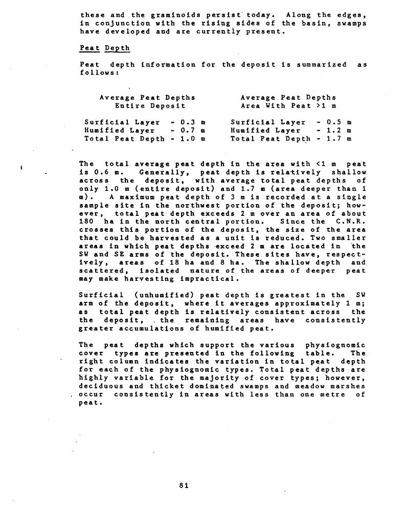
these and the graminoids persist' today. Along the edges, in conjunction with the rising sides of the basin, swamps have developed and are currently present.
Peat Depth
Peat depth information for the deposit is summarized as follows:
Average Peat Depths Average Peat DepthsEntire Deposit Area With Peat >l m
Surficial Layer - 0.3 m Surficial Layer - 0.5 mHumified Layer - 0.7 m Humified Layer - 1.2 mTotal Peat Depth - 1.0 m Total Peat Depth - 1.7 m
The total average peat depth in the area with <l m peat is 0.6 m. Generally, peat depth is relatively shallow across the deposit, with average total peat depths of only 1.0 m (entire deposit) and 1.7 m (area deeper than l m). A maximum peat depth of 3 m is recorded at a single sample site in the northwest portion of the deposit; how ever, total peat depth exceeds 2 m over an area of about 180 ha in the north central portion. Since the C.N.R. crosses this portion of the deposit, the size of the area that could be harvested as a unit is reduced. Two smaller areas in which peat depths exceed 2 m are located in the SV and SE arms of the deposit. These sites have, respect ively, areas of 18 ha and 8 ha. The shallow depth and scattered, isolated nature of the areas of deeper peat may make harvesting impractical.
Surficial (unhumified) peat depth is greatest in the SV arm of the deposit, where it averages approximately l m; as total peat depth is relatively consistent across the the deposit, . the remaining areas have consistently greater accumulations of humified peat.
The peat depths which support the various physiognomic cover types are presented in the following table. The right column indicates the variation in total peat depth for each of the physiognomic types. Total peat depths are highly variable for the majority of cover types; however, deciduous and thicket dominated swamps and meadow marshes occur consistently in areas with less than one metre of peat.
81
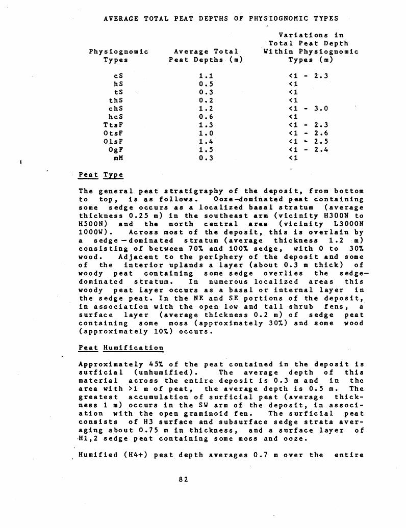
AVERAGE TOTAL PEAT DEPTHS OF PHYSIOGNOMIC TYPES
Variations in Total Peat Depth
Physiognomic Average Total Within Physiognomic Types Peat Depths (m) Types (m)
cS 1.1 <l - 2.3hS 0.5 <ltS 0.3 -CI
thS 0.2 <lchS 1.2 <l - 3.0hcS 0.6 <l
TtsF 1.3 <l - 2.3OtsF 1.0 *C1 - 2.6O Is F 1.4 ^ -- 2.5OgF 1.5 *C1 - 2.4mM 0.3 <l
Peat Type
The general peat stratigraphy of the deposit, from bottom to top, is as follows. Ooze dominated peat containing some sedge occurs as a localized basal stratum (average thickness 0.25 m) in the southeast arm (vicinity H300N to H500N) and the north central area (vicinity L3000N 1000W) . Across most of the deposit, this is overlain by a sedge dominated stratum (average thickness 1.2 m) consisting of between 707. and 1001 sedge, with O to 307. wood. Adjacent to the periphery of the deposit and some of the interior uplands a layer (about 0.3 m thick) of woody peat containing some sedge overlies the sedge- dominated stratum. In numerous localized areas this woody peat layer occurs as a basal or internal layer in the sedge peat. In the NE and SE portions of the deposit, in association with the open low and tall shrub fens, a surface layer (average thickness 0.2 m) of sedge peat containing some moss (approximately 307.) and some wood (approximately 107.) occurs.
Peat Humification
Approximately 457. of the peat contained in the deposit is surficial (unhumifled). The average depth of this material across the entire deposit is 0.3 m and in the area with >l. m of peat, the average depth is 0.5 m. The greatest accumulation of surficial peat (average thick ness l m) occurs in the SV arm of the deposit, in associ ation with the open graminoid fen. The surficial peat consists of H3 surface and subsurface sedge strata aver aging about 0.75 m in thickness, and a surface layer of 'HI,2 sedge peat containing some moss and ooze.
Humified (H4+) peat depth averages 0.7 m over the entire
82
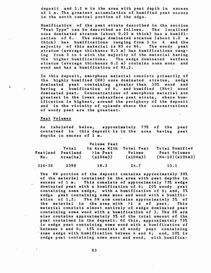
deposit and 1.2 m in the area with peat depth in excess of l m. The greatest accumulation of humified peat occurs in the north central portion of the edge.
Humification of the peat strata described in the section "Peat Type" can be described as follows. The localized ooze dominated stratum (about 0.25 m thick) has a humifi cation of 8. The sedge dominated stratum (about 1.2 m thick) has humifications ranging from 3 to 6 and the majority of this material is H5 or H6. The woody peat stratum (average thickness 0.3 m) has humificat ions rang ing from 3 to 6 with the majority of the material having the higher humifications. The sedge dominated surface stratum (average thickness 0.2 m) contains some moss and wood and has a humification of HI,2.
In this deposit, amorphous material consists primarily of the highly humified (H8) ooze dominated stratum, sedge dominated peat containing greater than 307. wood and having a humification of 6, and humified (H4+) wood dominated peat. Concentrations of amorphous material are greatest in the lower subsurface peat strata, where hum ification is highest, around the periphery of the deposit and in the vicinity of uplands where the concentrations of woody peat are the greatest.
Peat Volumes
As tabulated below, approximately 757. of the contained in this deposit is in the area having depths in excess of l m.
Peatland No.
31G-30
Total Peatland Area(ha)
239Q 18.3
Total PeatVolume (x!06m3)
24.7
Total HumifiedPeat Volumes (H4-10)(xl06m3)
13.1
The NW portion of the deposit contains approximately 307. of the material contained in the area with peat depths in excess of l m. This consists of approximately 757. sedge dominated peat with a humification of 6; 207. woody peat containing some sedge, with a humification of 6; and, 57. sedge peat containing some moss and wood with a humific ation of 1,2. The SW arm contains approximately 57. of the material in the area with >l. m of peat. This material consists almost entirely of sedge dominated peat containing some wood with a humification of 3. The SE arm also contains approximately 57. of the total amount of the peat contained in the deposit. Of this, approximately 757. is sedge peat containing some wood with a humification of between 4 and 6; 157. consists of woody peat containing some sedge with humification betwee 4 and 6; and, 107. is sedge peat containing some moss and wood, with huraifica-
83
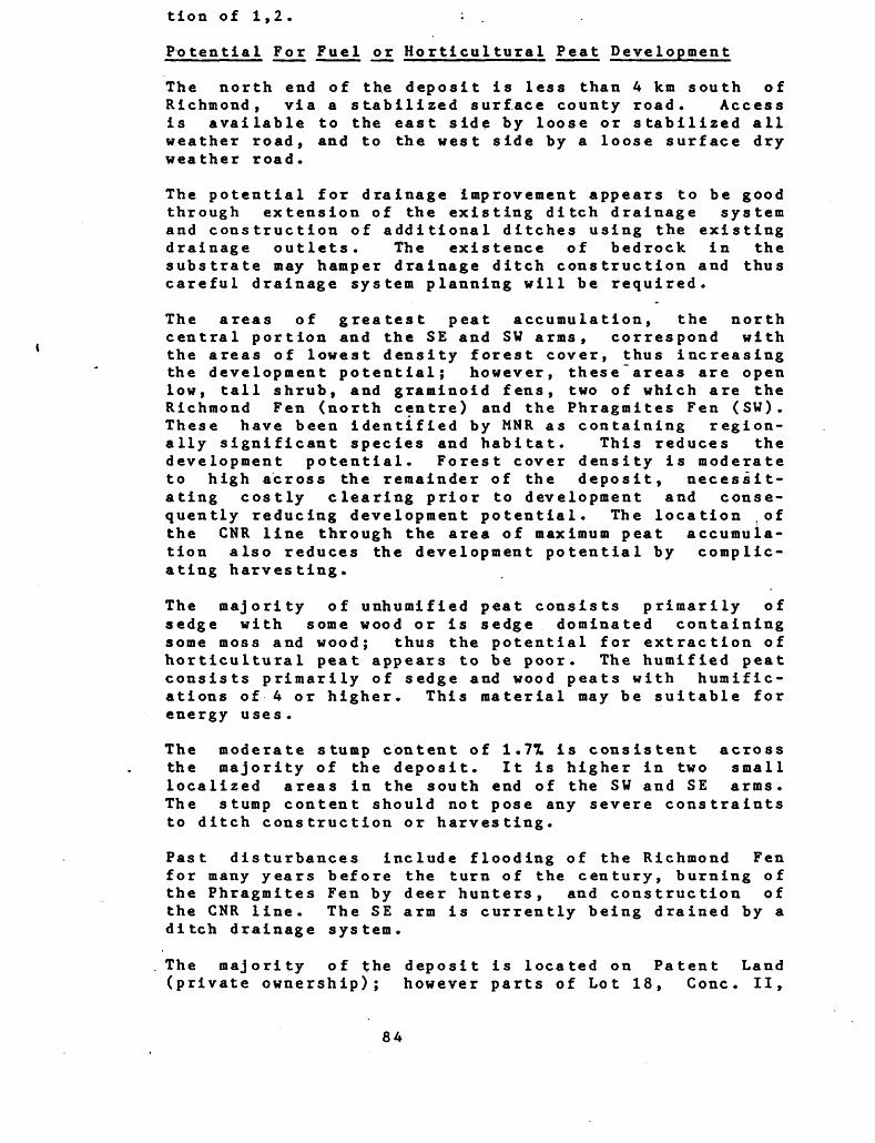
tion of 1,2. : .
Po tential For Fuel or Horticultural Peat Development
The north end of the deposit is less than 4 km south of Richmond, via a stabilized surface county road. Access is available to the east side by loose or stabilized all weather road, and to the west side by a loose surface dry weather road.
The potential for drainage improvement appears to be good through extension of the existing ditch drainage system and construction of additional ditches using the existing drainage outlets. The existence of bedrock in the substrate may hamper drainage ditch construction and thus careful drainage system planning will be required.
The areas of greatest peat accumulation, the north central portion and the SE and SV arms, correspond with the areas of lowest density forest cover, thus increasing the development potential; however, these areas are open low, tall shrub, and graminoid fens, two of which are the Richmond Fen (north centre) and the Phragmites Fen (SV). These have been identified by MNR as containing region ally significant species and habitat. This reduces the development potential. Forest cover density is moderate to high across the remainder of the deposit, necessit ating costly clearing prior to development and conse quently reducing development potential. The location .of the CNR line through the area of maximum peat accumula tion also reduces the development potential by complic ating harvesting.
The majority of unhumified peat consists primarily of sedge with some wood or is sedge dominated containing some moss and wood; thus the potential for extraction of horticultural peat appears to be poor. The humified peat consists primarily of sedge and wood peats with humific- ations of 4 or higher. This material may be suitable for energy uses .
The moderate stump content of 1.7H is consistent across the majority of the deposit. It is higher in two small localized areas in the south end of the SW and SE arms. The stump content should not pose any severe constraints to ditch construction or harvesting.
Past disturbances include flooding of the Richmond Fen for many years before the turn of the century, burning of the Phragmites Fen by deer hunters, and construction of the CNR line. The SE arm is currently being drained by a ditch drainage system.
The majority of the deposit is located on Patent Land (private ownership); however parts of Lot 18, Cone. II,
84
Lots 14, 17, 18, 19, 20, Cone. I, Goulbourn Twp; part of Lots 8, 11, 13, 14, 15, 16 Con IX, and Lot 13 Cone. VII, Rideau Twp are Agreement Forest, and parts of Lots 17 and 19, Cone I, Goulbourn Twp and part of Lot 14, Cone IX, Rideau Twp are Crown Land.
The overall shallow depth (average total depth in area with >l m of peat is 1.7 m) and the complex shape of the deposit, in conjunction with the above stated conditions may make development impractical.
Comments
The Organic Soil Map (1:250,000, Ottawa 31G)(Institute of Pedology) indicates that the north and central west part as Finch soil series, Terric Humisol subgroup, 0.4 m to 0.9 m deep. The central part is Munroe soil series, Terric Humisol subgroup, 0.9 m to 1.3 m deep. The south- west part is Strathmore soil series, Terric Humisol sub group, 0.9 to 1.3 m deep. The southeast part is Richmond Hill soil series, Terric Humic Mesisol subgroup, 0.4 m to 0.9 m deep. With the exceptions that the soil is indic ated as being deeper in the N, SV and SE portions of the deposit, the soil map agrees with the findings of this s tudy.
The deposit has been studied extensively by MNR as part of the Nature Reserves Program. This study revealed "extensive wetlands complex consisting of two calcereous sedge fens surrounded by treed fen and deciduous- coniferous swamps
- at least 30 species of regionally rare and uncommon vascular plants, including two colonies of Prairie White- fringed Orchid (rare in Ontario, rare in Canada, threat ened in the U.S.)
- rich moss flora including Cinclidium s tygium (one of two records in southern Ontario)
- nationally rare insect fauna
- significant breeding bird habitat for Yellow Rail and several song birds
- contains a deer yard
- organic soils over 2 m deep".
In summary, the report states that the deposit is "An excellent example of an extensive, highly diversified wetlands complex containing significant flora and fauna. The wetlands complex serves as a valuable water recharge area for the Jock River", and the recommendation is that it be a "High priority area for protection; the entire
85
wetlands complex should be acquired and given protection as a Nature Reserve".
The deposit is a Nature Reserve Candidate; is an Environ mental Area Class l in the Regional Official Plan; and has been designated by MNR as an Area of Natural and Scientific Interest of high priority with provincial significance.
(The following dockets contain the Peatland Classification Map, Elevation Map, Isopach Map, and Peat Profiles for this site.)
86

5.3 PEATLAND 31G-58, MARLBOROUGH AGREEMENT FOREST
Location
This deposit is situated in the Regional Municipality of Ottawa-Carl ton, in Marlborough Township (Lots 16-18, Cone. 1; Lots 13-21, Cone. 2; Lots 11-22, Cone. 3; Lots 9-19, Cone. 4; Lots 10-17, Cone. 5; Lots 14-15, Cone. 6). It is 4.5 km due north of Burritt Rapids.
It is located in UTM Zone 18, Easting 438 000, Northing 4989 000, latitude 45 degrees 3 minutes north, longitude 75 de- grees 47 minutes east. The designated'study area is covered by the following 1978, 1:10000 airphotos: 4502-76 #71-80; 4503-85 #4-8; 4504-116 #150-160; 4505-107 #130-140; 4506-109 #66-78; 4507-111 #134-146. The peat- land is covered by: 4502-74 #74-78; 4503-85 #4-8; 4504- 116 1153-157; 4505-107 #132-136; 4506-109 #68-73.
Access
The mideast boundary of the deposit is at the end of the sideroad that runs west from Pierces Corners, a distance of approximately 4.5 km. The northwest corner of the site is 3.75 km west, on Concession Road 4, from the in- tersectio'n of this Road and the Malakoff Road.
Dates of Field S tudy
Field investigations for peat determination and general physiognomic characteristics were undertaken during the period September 20 to September 25, 1983. Full veget ation sampling occurred on September 29, and October 5-7, 1983.
Heavy rainfall occurred throughout the peat sampling period. However, dry conditions were encountered since the rainfall for the three months prior to the field was only 70^ of the 30 year norm.
Topography and Drainage
This deposit has developed in a long, narrow, N-S oriented basin that has gently undulating (0-107. grade) slopes that decrease in elevation from the south to the north. The slopes on the adjacent and included uplands are also gently undulating. Other than for these randomly located bedrock inclusions, the majority of the substrate 'is sand and gravel with localized occurrences of clay.
The surface topography of the peatland is a subtle re flection of the topography of the substrate. The surface elevation of the deposit decreases by approximately 5 m from the south to the north. The southern two arms are elevated approximately 1.5 m above the south end of the
87

main body of the deposit. This elevation difference is the result of beaver dams between the southern arms and the main body. The main body has a gradual elevation decrease of approximately 3.5 m with the lowest elevation in the vicinity of the drainage outlet at Steven Creek. In a NE to S W direction across the deposit, the surface configuration is that of a gently sloping bowl with an elevation differential of approximately 2 m, the highest elevation being at the periphery and the lowest in the central portion or the vicinity of Steven Creek.
The major drainage feature and only primary drainage outlet from the deposit is Stevens Creek, which flows into the Rideau River. The Creek flows out of the north end of the deposit; is well developed; and, has a con siderable flow. It would likely serve as a satisfactory outlet for improving the drainage of the deposit. Another smaller and less well developed channel flows out of the extreme NE arm of the deposit and into Steven Creek.
Flow into the deposit is provided by an extension of Steven Creek that flows into the west central portion.of the deposit, and from runoff from the adjacent uplands.
Beaver activity in the SE, SW and NE arms and adjacent to the upland in the NE (vicinity L1800N 600E) has resulted in extensive flooding in these areas. The elevation and existing drainage network appear, to be sufficient to per mit considerable improvement of drainage in these areas through removal of the beaver dams.
The potential appears to be good for improvement of drainage conditions across the deposit through the con struction of a ditch drainage system. The localized occurrence of bedrock in the substrate may hamper con struction of ditches, particularly in the N portion of the main body where the bedrock is located only 2 m below the peatland surface.
Area and Shape
The total area is 970 ha, of which approximately 395 ha has peat depths >l m. The deposit has a very irregular shape consisting of a main central body with numerous bays and peripheral channels and some uplands. With the exception of small areas in the southern arms, peat in the bays is <l m deep. The main concentration of peat is in the central body which has approximately 520 ha with peat depth in ex-cess of l m; a maximum peat depth of 3.5 m; and, a relatively regular elongated oval shape. From the standpoint of ease of harvesting, this area has the highest development potential.
88
Peat land Vegetation
Eighteen full vegetation analyses of major and distinct ive minor physiognomic cover types occurred at the following locations:B900N B1200N L2900N 300W F1450S L900N 500E B1800N B3030N F1500S L1100N 600E B2600N F600S F1900S L1100N 900W B2900N 300E F1300S F2800S L1100N 950W L2900N 300WThese were supplemented by observations at 50 locations along the transects, where the dominant vegetation type and species were recorded.
The predominant geomorphological types in the study area are Basin Swamp, which occupies 597. of the deposit's central portions, and with peat depths that exceed 3 m, Peat Margin Swamp, which includes the fringe zones and extensions (15X) with a much shallower peat substrate, and Channel Fen in the eastern central portrion and which occupies 87. of the deposit. A Floodplain Swamp type parallels the creek basin in the area's northern half. Small areas of Stream Marsh also occur.
The predominant physiognomic cover type of this deposit is the Mixed Swamp which encompasses over 607. of 'its surface area. Other major types are the Deciduous Swamp and the Open and Treed Tall Shrub Fen which cover an additional 137. of the deposit. Minor types include Thicket Swamp, Meadows, Shrub Rich and Deep Marsh cover types, and Open Water.
Disturbance to the cover type here include past cutting that has affected all of the forest communities, at least lightly, throughout the study area and most noticeably around its periphery. Flooding is also noticeable along the course of Steven Creek's middle to lover reaches, and in the S and NE extensions. Beaver dam construction is responsible for this impact. Cut line and road clearance damage has been restricted to several northeastwards crossings. This has resulted in local erosion and an enhancement of the water table flow and increased access into the deposit.
The Mixed Swamp cover type encompasses 607. (590 ha) of the study area, extending from its southern limits north wards into the main body of the deposit. It occupies the Basin and Peat Margin Swamp and, to a lesser extent, Channel Fen geomorphological type sites. These have a moderate (10-50 cm) hummock/hollow topography, with an acidic (pH 5.7-6.4) groundwater reaction and a moderate (20-40 cm) water table depth. The peat substrate displays k moderate variation, from less than a metre to over 2.3 m. The tree cover is semi-open to semi-closed (35-707*) with 9 to 12 m tall Eastern White Cedar30 (Thuja
89
occidentalis) , Black Ash20 (Fraxinus nigra) and Paper BirchlS (Be tula papyrifera; being the dominants, consistently accompanied by White Elm8 (Ulmus americanus), TamarackS (Larix laricina), Red Maple3 (Acer rubru^nland others. The coniferous element tends to be dominant in the northern two-thirds of the deposit, with the deciduous element being dominant in the southwestern arm. The tall shrub cover is semi-open (10-35^) and is dominated by Winterberry15 (Ilex verticillata) and Speckled AlderlO (Ainus ineanalaccompanied by Tall Pussywillow (Salix d i s c o l o rT~t S~wamp Birch (Betula pumila var. glandulifera) or, very locally, Sandberg's Hybrid Birch (B. ac sandbergii) . The low shrub cover is semi- open (10-22ll w i tii Alder Leaf Buckthornl2 (Rhamnus alnifolius) and Red Osier DogwoodS (Cornus stoloniferaT as dominants, with lesser cover densities of Marsh Fly Honeysuckle (Lonicera oblong i folia and Wild. Gooseberry (Ribes hir tellum) . The herb cover is semi-closed (30-
of tall tussocks of Royal Fern30 (Osmunda regalis) a shorter stratum of Dwarf Raspberry (Rubus
(Carex interior), Northern Bugleweed______ ________ Tufted Loosestrife (Lysimachia thrysifloraland Marsh Fern (Thelypteris palustris). The moss cover is semi-closed (85-957.) and is dominated by a rich variety of brown mosses as well as occasional sphagnum moss.
The Deciduous .Swamp cover type appears to be mainly restricted to the Peat Margin Swamp geomorphological type sites around the deposit's periphery and in the southern extension, and to the Floodplain Swamp Type locally along the Creek, totaling 57. (45 ha) of the study area. Here, the peat substrate tends to be relatively shallow with seasonal standing water and a slightly acid groundwater reaction (pH 6.0). The topography is flat to poorly developed (10-20 cm). The tree cover is consistently dominated by 7 to 12 m high Black Ash30, accompanied by Silver MaplelO (Acer saccharinum) Balsam PoplarlO (Populus balsamiferal o"r" Paper BirchS. The shrub cover is variably open to semi-closed (5-A57.) with Speckled Alder and Winterberry. The low shrub cover is semi- closed (10-151) with Alder Leaf Buckthorn and Red Osier Dogwood. The herb cover is semi-closed (30-607.) with Dwarf Raspberry, White Snakeroot (Eupa tor iurn rugosum), Royal Fern, Marsh Fern, Poison Ivy (Rhus radicans), Speckled Touch-me-not (Impatiens b i flo ral and others. The moss cover is semi-closed (80-957.) with brown mosses.
The Open Tall Shrub Fen cover type appears to be restricted to the east central portion of the deposit where it occupies ZT. (32) of the deposit. It has developed on the Channel Fen geomorphic log i ea l type site with a moderate (30-50 cm) hummock topography and a 30 cm deep water table of slightly acidic (pH 6.2) groundwater. Its tree canopy is open (107.) with scattered, low (5 m)
90

Tamarack and Eastern Vhite Cedar.. The tall shrub cover is semi-open (357.) with Slender Villowl? (Salix petiolaris) and Swamp BirchlS as the dominants, accompanied by Tall Pussywillow and Vinterberry. The low shrub cover is semi-open (247.) with Red Osier DogwoodlS, Alder Leaf Buckthorn and Swamp Fly Honeysuckle. The herb cover is semi-closed (457.) and is dominated by Carex interiorl5, Marsh FernS, Dwarf RaspberryS and Royal FernS with River Horsetail (Equisetum fluviatile), Canada Blue Joint (Calamagrostis canadensisland o thers. The moss cover is semi-closed of brown mosses.
The Treed the abovedeposit's eastern central portion where it occupies 57. (48 ha) of the total surface area. It has developed on a Channel Fen geomorphological type site with a moderate (10-25 cm) topography, and a 22 cm deep water table with somewhat acid (pH 6.2) groundwater reaction. Its tree canopy is semi-open (357.) with 7 to 10 m ~ high Eastern Vhite Cedar35 as the decidedly dominant species, accomp anied by sparse Paper Birch, Tamarack, and Red Ash (Fraxinus pennsyIvanica). The tall shrub cover is semi- closed (487.) with Swamp Birch25 and W i nt erb er ry 18 as the dominants. The low shrub cover is rather open (237.) with a sparse complement that includes Alder Leaf Buckthorn, Red Osier Dogwood, Swamp Fly Honeysuckle and others. The semi-closed (327.) herb cover has scattered tussocks of Royal Fern and a low herb cover of Harsh Fern, Dwarf Raspberry, Tufted Loosestrife, Carex leptalea and others. The moss cover is closed (957.) with brown mosses domin ating over occasionally sphagnurt mosses.
The Thicket Swamp cover type occurs locally around the margins of the deposit and as local features among the mixed swamp cover type within the deposit, totallying 97. (85 ha) of its surface area. It has developed on Basin and Peat Margin Swamp geomorphological type sites having shallow to deep peat substrates with acidic groundwater (pH 5.8) and a variable water table depth (2-30 cm). The topography is moderate (12-35 cm) with stump and fallen log origins. There are two phases of community patterns here. Most commonly is an open tree canopy phase of the mixed swamp cover type. The tree canopy is semi-open(10- 201) with Eastern Vhite Cedar, Black Ash, Paper Birch and others. The predominant tall shrub cover is semi-closed (35-557.) with Vinterberry30, Speckled Alder25, Tall Pussywillow and Eastern Vhite Cedar samplings. The low shrub cover is open (5-107.) of Red Osier Dogwood and Alder Leaf Buckthorn. The herb cover is semi-closed (50- 701) of Royal Fern, Northern Bugleweed, Marsh Fern, Spotted Joe Pye Veed (Eupatorium maculatum) , Carex pseudo-cyperus and others. The moss cover is closed (907.) of brown mosses. The second phase is associated with the successional margins of the deposit. The tree
91
canopy is open (2-157.) with Red Ash, White Elm and Paper Birch. The tall shrub cover is closed (50-757.) and is dominated by Slender WillowSO, accompanied by Tall Pussywillow and Speckled Alder. The low shrub cover is open (5-157.) with Red Osier Dogwood. The herb cover is semi-open (25-407.) with Canada Blue JointZO, Carex pseudo-cyperus!5, Nodding Beggar Ticks (Bid ens cernua) t Harsh Fowl Meadow Grass (Poa palus tris), Northern Bugleweed and others. The moss cover is closed (957.) with brown moss.
The Meadow Marsh cover type occurs in two portions of the deposit; very locally in association with the flooded shoreline plains of Steven Creek in its northern half; and, around the flooded ponds in the southern arms. It occupies 27. (22 ha) of the deposit and has developed on Peat Margin Swamp and Basin and Stream Marsh geomorphol- ogical type sites having up to l m of perennial to seasonal standing water that is slightly acidic (pH 6.1). The hummock topography is flat to moderate (0-50 cm) of tussock and stump or log origins. The tree cover is typically of drowned Eastern Vhite Cedar, Black Ash and Red Ash. Tall and low shrub cover is quite open (1-57.) of Slender Willow, Red Osier Dogwood and, occasionally, Scrub Birch (Betula pumila var. glandulifera). The herb cover is closTd (707.;with a dominant tall grass cover of Canada Blue Joint65, Broad Leaf Cattail (Typha lati- folia), Carex pseudo-cyperus and others.
Associated with the above is a Shrub-Rich Marsh cover type (147.; 128 ha) that occupies the same geomorpho log ical type sites but occurs as a fringe community, has a less acid (pH 6.4) groundwater reaction, shallow standing water to a 20 cm deep water table by late summer and a flat to moderate (5-55 cm) topography. These have an open tre canopy (0-57.) of often live Eastern White Cedar, White Elm and Black Ash. The tall shrub cover is semi- open (10-157.) with Slender WillowlO, Speckled Alder5 and WinterberryS. The low shrub cover is open (5-107.) with Red Osier Dogwood, Tall Meadowsweet (Spiraea a Iba) and Red Raspberry (Rubus strigosus). The herb cover is quite variable, sharing species of both meadow marsh and the adjacent forested swamp. Its semi-closed (35-607.) cover includes Canada Blue Jointl5, Royal FernlO, Carex s trieta5, Marsh FernS, Carex pseudo-cyperus and many others. The moss cover is semi-open to semi-closed (30- 707.) of brown moss.
Occurring as minor physiognomic cover types are the Deep Marsh and Open Water features (27., 20 ha). These are associated with the flowing and standing waterbodies of Steven Creek and the several small ponds. They have ^developed upon the Basin and Stream Marsh geomorpholog ical type sites, having over 0.5 m of perennially standing water. The deep marsh cover type presents
92
scattered tall and low shrubs (2-101) of Slender Willow, Tall Pussywillow and Red Osier Dogwood, and an open to semi-open (10-357.) herb cover of emergent and aquatic species, including Branched Chara (Chara spp.), Frog's Bit (Hydrocharis morus-ranae) , Canada Blue Joint, Carex s tricta, Broad Leaf Cattail, Grey Bulrush (Scirpus validus), Floating Burreed (Sparganium fluviatile?and others. Brown mosses are generally quite sparse (0-157*).
This deposit presents many community patterns and assoc iated species which are representative of the site in the region. It has been recognized as an Area of Natural and Scientific Interest (ANSI) by the Ontario Ministry of Natural Resources (Cuddy, 1983); however, this designa tion has been not well defined. The deposit supports local concentrations of disrict significant species, including Sandberg's Hybrid Birch (Betula x. "sandbergii, IDM 15662) and Bog Willow (Salix pedicellaria) . Moreover, the adjacent upland limestone plains support a variety of district to regionally significant species, such as Kalm's Brome Grass (Bromus kalmii, IDM 15655), Torrey's Rush (Juncus torreyi, IDM 15666) and Upland White Aster (Aster ptarmicoides, IDM 15654).
The long narrow basin shape and the sand and gravel base suggest that the' deposit area may once have been a dra.in- age course. The good flow conditions would promote the establishment of a marsh community that gave way to a graminoid fen as the drainage conditions deteriorated. The sedge-dominated nature of the peat does not contradict this possibility. The graminoid fen complex gradually matured into a shrub.and tree dominated fen. Along the periphery, along the edges of the uplands and thus where site drainage is somewhat better, swamps are now developing.
Peat Depth
Peat depth information for the deposit is summarized as follows:
Average Peat Depths Average Peat Depth Entire Deposit Area With Peat ^m
Surficial Layer - 0.3 m Surficial Layer - 0.7 mHumified Layer - 0.7 m Humified Layer - 'l.l mTotal Peat Depth - 1.0 m Total Peat Depth - 1.8 m
The total average peat depth in the area with <l m of peat is 0.4 m. The total peat depth is highly variable across the deposit, with the maximum recorded depth of 3.5 m occurring in the central portion of the main body of the deposit (B2200N).
93
The basin depth exceeds l m in three areas. The main central body of the deposit, which is 520 ha, is in excess of l m; however, at some locations in the north portion of this section 0.75 m is basal ooze and not peat. Two other very small areas occur in the SW and SE arms and contain approximately 12 ha and 3 ha, respect ively, with peat depth in excess of l m. The small size and isolated nature of these areas will likely make harvesting impractical. The tree and tall shrub cover density is fairly consistent across the entire central body of the deposit, which contains peat depths in excess of l m.
The right column in the following table indicates the variation in total peat depth in the various physiognomic types. Total peat depth is highly variable in most of the cover types. The depth appears to be Consistently less than l m in areas supporting deciduous swamps, thicket deciduous swamps, and meadow and deep marshes.
AVERAGE TOTAL PEAT DEPTHS OF PHYSIOGNOMIC TYPES
Variation In Total Peat Depth
Physiognomic Average Total Within Physiognomic Types Peat Depths (m) Types (m)
hS 0.8 <ltS 0.5 <l - 2.25
thS 0.6 <lchS 1.7 <l - 3.5hcS 0.8 . '-CI - 1.4
TtsF 0.7 <l - 2.25OtsF 1.9 <l - 3.0srM 0.5 ^ - 2.8mM 0.3 <ldM 0.4 <l
Peat Type
The majority of the peat in the deposit is sedge-domin ated and contains varying percentages of wood. The bays and peripheral channels contain primarily shallow woody peat with varying amounts of sedge. In the northern three-quarters of the central body of the deposit, the basal peat stratum (average thickness of 0.75 m) consists of ooze containing some sedge. This stratum is not pres ent in other portions of the deposit. A sedge dominated stratum (approximately 1.25 m thick) containing some wood overlies the ooze stratum and elsewhere constitutes the basal stratum. A layer of woody peat containing some sedge (average thickness approximately 0.5 m) overlies the sedge stratum in most portions of the main body and .constitutes the basal peat around the periphery and in isolated other locations. In the central portion of the
94
main body of the deposit, the surface layer (about 0.15 m) consists of moss and sedge in almost equal propor tions .
The peripheral portions of the deposit, containing prim arily woody peat, are dominated by deciduous and thicket swamp cover types. The central body of the deposit, con taining the sequence of ooze, sedge, wood and combined moss-sedge dominated peat strata, from substrate to sur face, is dominated by a mixed (coniferous dominated) swamp cover type.
The existence of the 0.75 m stratum of ooze reduces the maximum total depth of peat available for harvest. This, and in consideration of the material that will be removed during stripping of the moderately dense forest cover, may make development impractical.
Peat Humification
The peat contained in the area in which total depth exceeds l m is approximately 307. surficial (unhumified) peat and 707. humified (H4+) peat.
The average surficial peat depth is 0.7 m in the area with peat depth in excess of l m. This material is con centrated in the north central and southwest portions of the main body of the deposit (vicinity F200 600S, L900N and L2800N). In the southwest, this material consists almost entirely of sedge dominated H3 peat containing some wood, and a minor percentage of moss dominated HI,2 peat containing some wood. In. the north central portion of the deposit, the unhumified material consists entirely of sedge dominated H3 peat containing some wood.
The average depth of humified (H4+) peat in the area with peat depth in excess of l m is 1.5 m. The greatest accum ulation of this material is in the central body of the deposit and consists of approximately 307. ooze dominated peat containing some sedge; 507. sedge peat containing some wood; and, 207. woody peat containing some sedge.
The humification of the previously described peat strata are summarized as follows:- ooze layer of H8-H9, with the majority being H9- sedge layer of H3-H7, with the majority being H4-H6- woody layer of H3-H7, with the majority being H4-H6- moss and sedge layer of HI,2
In this deposit, amorphous material consists primarily of woody peat with humification in exces of 4; sedge peat containing greater than 207. wood with humification of 3 or higher; sedge peat with a humification of 6 or higher; and ooze-dominated or ooze bearing strata. Amorphous material is concentrated in the main body of the deposit.
95

Pea t Volumes
As tabulated below, the majority (approximately 757.) of the peat contained in the deposit is within the area having peat depths in excess of l m. Of this, greater than 95Z is contained in the central body of the deposit.
Volume PeatTotal In Area With Total Peat Total Humified
Peatland Peatland ^m Peat Volume Peat Volumes No. Area(ha) (x!06m3) (xl06m3) (H4-10)(xl06m3
31G-58 970 7.0 9.9 4.3
Po tential For Fuel or Horticultural Peat Development
The deposit is' located 26 km from Smiths Falls and 40 km from Ottawa and access is available via numerous hard and loose surface all weather roads. The proximity and accessibility to these potential markets should enhance the development potential of the deposit.
The portion of the deposit that has peat depths in excess of l m also has moderate to heavy cover of trees and tall shrubs. This will necessitate costly clearing prior to development, thus reducing the development potential.
The potential appears to be good for drainge improvement through the construction of a ditch drainge system. The only potential constraint is the interference of sub strate bedrock with ditch construction.
The deposit has a relatively high stump content of 2.67.. The stump content is approximately twice as high in the central (vicinity L1800N) and southern (vicinity L900N) portions of the main body than in other portions of the deposit. The majority of stumps are contained in the first metre of peat below surface. The relatively high stump content will complicate drainage ditch construction and harvesting of peat and reduce development potential.
Because of the shallow depth and limited volume of mo-ss peat available, the potential for extraction of horti cultural is considered to be poor.
The deposit contains a maximum depth of 2.0 m of humified sedge and wood dominated peats that may be suitable for fuel use; however, the existence of an ooze stratum below this material may complicate extraction. As a result of the preceding discussion, this area may be said to have a moderate potential for the extraction of fuel peat.
96
The majority of the deposit is contained within the Marl borough Agreement Forest that is managed by MNR for the Regional Municipality of O ttawa-Carleton. The following lots are part of the Agreement Forest: Part of Lots 15, 17, Cone. II; Lots 14-17 and 19-21, Cone. Ill; Lots 14-17 and 19-21, Cone. IV; and, part Lot 16 Cone. V, Township of Rideau (Marlborough Ward). The remainder of the land is on Patent Land (private ownership).
Comments
The Organic Soil Map (1:250,000, Ottawa, 31G)(Ontario Institute of Pedology) indicates the entire deposit as Famne soil serie, Lithic Humisol subgroup, 0.9 to 1.3 m deep. The soil depth information contained on the soil map is not in agreement with the data obtained during this study, as soil depth was found to rang'e from O to 3.5 m.
The deposit has been designated as an Area.of Natural and Scientific Interest (ANSI); however, its significance is not well defined. It is managed by MNR for forestry, wildlife and recreation. The area also has a deer yard.
(The following dockets contain the Peatland Classification Map, Elevation Map Isopach Map, and Peat Profiles for this site.)
97

\ ^. 7^ki Ali\ ..i/. y
OGS Oppn Fil
n W Pope
Natural Resources
nib'f"
John R Sloan
Ontario
The Peatland Inventory Project is a component of the Hydrocarbon Energy Resources Program (HERP). funded by the Ontario Ministry of Treasury and Economics under the Board of Industrial Leadership and Development (81LD) Program.
PEATLAND 31 G -30
BASE MAP LEGEND
ELEVATION MAP
SCALE l : 10,000
LEGEND
STUDY AREA BOUNDARY
PEATLAND BOUNDARY
DRAfNAGE CHANNEL AND/OR FLOW DIRECTION
LAKES OR PONDINGS
SURVEY POINTS
PHYSICAL SAMPLE LOCATIONS
PERENNIAL INTERMITTENT
TRAVERSE SITE LOCATIONS
SECONDARY ACCESS ROADS OR TRAILS
COUNTY ROADS OR HIGHWAYS
L IOOON -i- I6OON
T-2
ELEVATION MAP LEGEND
ELEVATION (morOSm) 45
ELEVATION CONTOURS ( l m interval) ——-~
ELEVATION MAP SITE 31G-3Q
ONTARIO GEOLOGICAL SURVE vi
OTTAWA - BROCKVILLE STUDY
DATE O* PHOTOG*4PMY : l 9 7 8
bird and

435000 *" l 135QOO HI
^0\ ^A^^L W** TO**"
^T ^**k. , \ .lA*\ ^ \CL ^^i iJO/3.4 \ J '^ ^ \ ^
L-^r k
, ^ w.w.^.w ^^.—————gr^
l 2.ft^ n3^-8
MiniStrVOf J**1 AlanWPope* Mini'ifr
Natural L n ,,John R Sloan
ResourcesOntario
[ The Peatland Inventory Project is a component of the Hydrocarbon Energy Resources ", Program (HERP), funded by the Ontario Ministry of Treasury and Economics under the
Board of Industrial Leadership and Development (BILD) Program.
PEATLAND 31 G -30
BASE MAP LEGEND
ISOPACH MAP
SCALE l : 10,000
LEGEND
STUDY AREA BOUNDARY
PEATLAND BOUNDARY
DRAINAGE CHANNELAND/OR FLOW DIRECTION
LAKES OR PONDINGS
SURVEY POINTS
PHYSICAL SAMPLE LOCATIONS
SURVEY LINE DESIGNATION AND LENGTH
TRAVERSE SITE LOCATIONS
SECONDARY ACCESS ROADS OR TRAILS
COUNTY ROADS OR HIGHWAYS
PROFILE ALIGNMENT
PERENNIAL INTERMITTENT
L IOOON -f- I60ON
T-2
X———o RI
lSOPACH MAP LEGEND
Total peat depth (m)- — — —
Depth bf surficial layer (m)— —
Avg. H of surficial layer — — -
Avg. H of total peat depth— —
Depth contours (m)
t0.9/2.6 "; "——•"•'
O-*-— — — — Survey point • 2.e/ 4.4
PEATLAND
31 G-3O
TOTAL
SURFACE AREA
(ha.)
2390
AREA OVER 1 M DEEP
SURFACE AREA (ha)
1 1 0 0
TOTAL VOLUME (million m3)
18.3
VOLUME H' -K, (miM 1 ^^ r*-'
1.3. 1
ISOPACH MA
ONTARIO GEOLOGICAL SURVEY
PEATLANO INVENTORYOTTAWA - BPOCKVI'.LE
SCALE : l : 10,000
DAT" *V ^CT*-CS^w* . rf *

,-, GOODSTQWN
PEATLAND 31 G -30
BASE MAP LEGEND
PEATLAND CLASSIFICATION MAP
SCALE l : 10,000
LEGEND
STUDY AREA BOUNDARY
PEATLAND BOUNDARY
DRAINAGE CHANNELAND/OR FLOW DIRECTION
PERENNIAL INTERMITTENT
LAKES OR PONDINGS
SURVEY POINTS
PHYSICAL SAMPLE LOCATIONS
SURVEY LINE DESIGNATION AND LENGTH L IOOON -i- I60ON
TRAVERSE SITE LOCATIONS
SECONDARY ACCESS ROADS OR TRAILS
COUNTY ROADS OR HIGHWAYS
DETAILED VEGETATION SITE
PEATLAND CLASSIFICATION MAP LEGEND
SUBFORMATIONS
PHYSIOGNOMIC
GROUP
STUDY AREA BOUNDARY
en'Fife' Report 54f T
PEATLAND 3IG-24
BASE MAP LEGEND
ELEVATION MAP
SCALE l : 10,000
LEGEND
STUDY AREA BOUNDARY
PEATLAND BOUNDARY
DRAINAGE CHANNELAND/OR FLOW DIRECTION
LAKES OR PONDINGS
SURVEY POINTS
PHYSICAL SAMPLE LOCATIONS
SURVEY LINE DESIGNATION AND LENGTH
TRAVERSE SITE LOCATIONS
SECONDARY ACCESS ROADS OR TRAILS
COUNTY ROADS OR HIGHWAYS
PERENNIAL INTERMITTENT
L IOOON -l- I6OON
T-2
ELEVATION MAP LEGEND
ELEVATION (morO-Sm) 45
ELEVATION CONTOURS ( l m Intervol) —— —
ELEVATION MA SITE 31G-24
ONTARIO GEOLOGICAL SURVEY
PEATLAND INVENTORY PROJECTOTTAWA - BROCKVILLE STUDY AREA
SCALE l s l O,OOO
INTERPRETATION : Q. W ft N. D
CHECKED : B. M.
DATE OF PHOTOGRAPHY : l 9 7 8
DATE : OCTOBER , I983
DRAWN : A B 8 F C
CHECKED- B. M
PEATLAND : 3I 6 - 24
bird and* Airphoto interpretation ttudiee
Bay Strwthale ltd. |* Engineering and environmental coordination
Ministry of Natural
Hon Alan W Pope Minister
John R Stoan. deputy Minister
Ontario
Th p--*!--.d Invent Pro; rt is a comoonent of the Hydrocarbon Energy Resources Program (HERP), funded by the Ontario Ministry of Treasury and Economics under the Boa/d of Industrial Leadership and Development (BILD) Program.

AREABOUNDARY
RJEATLAND 3IG-24
BASE MAP LEGEND
PEATLAND CLASSIFICATION MAP
SCALE 1 : IO,OOO
LEGEND
STUDY AREA BOUNDARY
PEATLAND BOUNDARY
DRAINAGE CHANNEL AND/OR FLOW DIRECTION
LAKES OR PONDINGS
SURVEY POINTS .
PHYSICAL SAMPLE LOCATION!
SURVEY LINE DESIGNATION Ai
TRAVERSE SITE LOCATIONS
SECONDARY ACCESS ROADS C
COUNTY f^OADS OR HIGHWAY
DETAILED VEGETATION SIT
PEATLAND CLAS
x
INTERMITTENT — —— - ' —— *—
O
5 ^
ND LENGTH L IOOON -i- I6OON
T- 2 O
)R TRAILS ——— ———————
^S ———————————
E A
SIFIC-ATION MAP LEGEND—— ~ —— PHYSIOGNOMIC GROUP BOUNDARY
FORMATIONS SWAMP S
S INFORMATIONS
PKYSIOGNOM'C Deciduous h GROUP Conifer c
Thicket t
k
BOG ^ B MARSH M OPEW FEN F WftTEJ? W
Open O Treed T
Shrub- rich s r Meadow m Deep d Tall shrub ts Lcwthrut Is Shallow 9
Lowshrub Is S hat le M s Grominoid g Don d Sohognurr sp Shrub- r.'ch sr
Drained ; - ( D ) OTHER MODIFIERS : Flooded (F)
Cutover /recent secondary succession ( C ) Grazed ' { G ;Utilized , (U) Upland (Up)
Abbreviations are in order of Subformation X Physiognomic Group X Formation X of her modifier. Superscripts refer to cover percentages of !he particular Subformation 8 Physiognomic Group. Subscripts refer to percentage makeup of completed Formations (ex. mM 4 o tS 3o dS 3O )
PEATLAND CLASSIFIC
^ IM ^
ATfOTTMAP SITE 31G-24
ONTARIO GEOLOGICAL SURVEY
PEATLAND INVENTORY PROJECTOTTAWA - BROCKVILLE STUDY AREA
v t
SCALE : l : IO,OOO
INTERPRETATION: G. W S N. D
CHECKED : B. M. ,
DATE OF PHOTOGRAPHY : 1978
bird andm Airphoto interpretation studies
DATE : OCTOBER , l 983
DRAWN - A . B 8 F. Ci ^
CHECKED BM
PEATLAND 316-24
l^ — l-. I*r4 l I2M lay Sir^t 1 riCilV IK VI. m . TerwtM - Of**** I
* Engineering and environmental coordination l
Ministry ofNatural Resources
John R Sloan
Ontario
The h-H-^'rind lrv o nt"-y r -' , ^ L t it of the Hydrocarbon Energy Resources Program (HERP), funded by the Ontario IV" - stry of Treasury and Economics under the Jk Board of Industrial Leadership and Development (BILD) Program.
1 10000
AREA BOUNDARY
IKS Openpit*4 fcpoT
PEATLAND 3IG-24
BASE MAP LEGEND
ISOPACH MAP
SCALE ' 10,000
LEGEND
STUDY AREA BOUNDARY
PEATLAND BOUNDARY
DRAINAGE CHANNEL AND /OR FLOW DIRECTION
LAKES OR PONDINGS
SURVEY POINTS
PHYSICAL SAMPLE LOCATIONS
SURVEY LINE DESIGNATION AND LEIN
TRAVERSE SITE LOCATIONS
SECONDARY ACCESS ROADS OR TRA
COUNTY ROADS OR HIGHWAYS * * .
ISOPACH M/
JTotol peot depth {m)- — — — —
0epth of surficiof loyer (m) — — -*
Avg. H of surficial layer — — ——
Avg. H of total peat depth — — — -
Depth contours (m)
Profile alignment — -
TOTAL
PEATLM* SURFACE AREA SURWCE Af
""•* (ho)
3IG-Z4 I77O 1370
1*
ISOPACH MAP
INTERMITTENT —— — - —— —
O
VQ
IGTH L IOOON -t- I600N
T- 2 O
LS — — — — — —
VP LEGEND
r
k
V w '••O. 9 X 2. C
O-*.— — — — — Survey po4^ ••2.6/4.4
4-. ___ 1
~"" PI
AREA OVER 1 M DEEP
IEA TOTAL VOLUME VOLUME H4-IO vtmillion m3) (million m3 i
|35. 1 30- 1
j
SITE 31G-24
ONTARIO GEOLOGICAL SURVEY
PEATLAND INVENTORY PROJECTOTTAWA - BROCKVILLE STUDY AREA
SCALE l : IO,OOO
INTERPRETATION : Q. W B N. D
CHECKED : B. M.
DATE OF PHOTOGRAPHY : 1978
bird and ha* Airphoto interpretation ettidte* i
* ~ - — t*--,^ ---mi
DATE : OCTOBER , I983
DRAWN : A B ft F. C
CHECKED : B. M
PEATLAND SI 6 - 24
,!A l^^l l* 1H3 ^ *"^t JO ltd. f To^. - Om^M
i Enfineeriof and environ mental coordination
MiniStr\'Of Hon AlanWPope Minister
Natural— John R SloanResources Deputy M*,**
i *um . Prograr- - Board of In
K t of the Hydrocarbon Energy Resourcestl!r , HL H h - C-.-z -stry of Treasury and Economics under the
paHpr?hip and Dpvp'npment (BILD) Program.
|X3S Open File Report 54St
Ministry of H00 .Alan w P*' Mtnts'pr
NaturalJohn R Sloan
Resources Deputy Mm,^
The Peatip^H inventory Project is a comoonent of the Hydrocarbon Energy Resources Program (HE^P), funded by the Ontp'io Ministry of Treasury and Economics under the Board of Industrial Leadership and Dp-'flopment (BILD) Program.
PEATLAND 3IG-58
ISOPACH MAP
SCALE l : 10,000
LEGEND
STUDY AREA BOUNDARY
PEATLAND BOUNDARY
DRAINAGE CHANNELAND/OR FLOW DIRECTION
PERENNIAL INTERMITTENT
LAKES OR PONDINGS
SURVEY POINTS
PHYSICAL SAMPLE LOCATIONS
SURVEY LINE DESIGNATION AND LENGTH L 1000 N -t- 1600 N
TRAVERSE SITE LOCATIONS
SECONDARY ACCESS ROADS OR TRAILS
COUNTY ROADS OR HIGHWAYS
ISOPACH MAP LEGENH
Total peat deoth (m)-
Deoth of surficial lover
Avg. H of *urfiri a i layer
Avc H o* total peat
\ X-^-^ -
AREA BOUNDARY
TT - ;
STUDY AREA BOUNDARY
PG5 Open F ile "Report 54OT
Ministry Of "^ AlanWPope' Minister
NaturalJohn R SloanResources oepur. M.™,Pr
Ontario
- " i-vp'^r.r, proper js a component of the Hydrocarbon Energy Resources Prograrr (HERP), funded by the Ontario Ministry of Treasury and Economics under the Board of Industrial Leadership and Development (BILD) Program.
PEATLAND 3IG-58
BASE MAP LEGEND
ELEVATION MAP
SCALE l : 10,000
LEGEND
STUDY AREA BOUNDARY
PEATLAND BOUNDARY
DRAINAGE CHANNELAND/OR FLOW DIRECTION
LAKES OR PONDINGS
SURVEY POINTS
PHYSICAL SAMPLE LOCATIONS
SURVEY LINE DESIGNATION AND LENGTH
TRAVERSE SITE LOCATIONS
SECONDARY ACCESS ROADS OR TRAILS
COUNTY ROADS OR HIGHWAYS
PERENNIAL INTERMITTENT
LIOOON -9- I600N
T-2
ELEVATION MAP LEGEND
ELEVATION (m or 0-5 m) 4-5
ELEVATION CONTOURS ( l m Intervol) -—— —
ELEVATION SITE 31O.-5*
ONTARIO GEOLOGICAL SU?cVTY
PHATLAND iHVEfi
SP41F | : IC.^^
j|j--o-*o--*-rG ^ ^ X
f ^i^^N*.#* . l c-
^ r- -* ~ r
B M
D *ft JT'^Mt p*4i^^- j^^^ftMk. ^^^K^^Mk^.'•fmf**-*.- ^P^W*,CT'i.^-'jga^
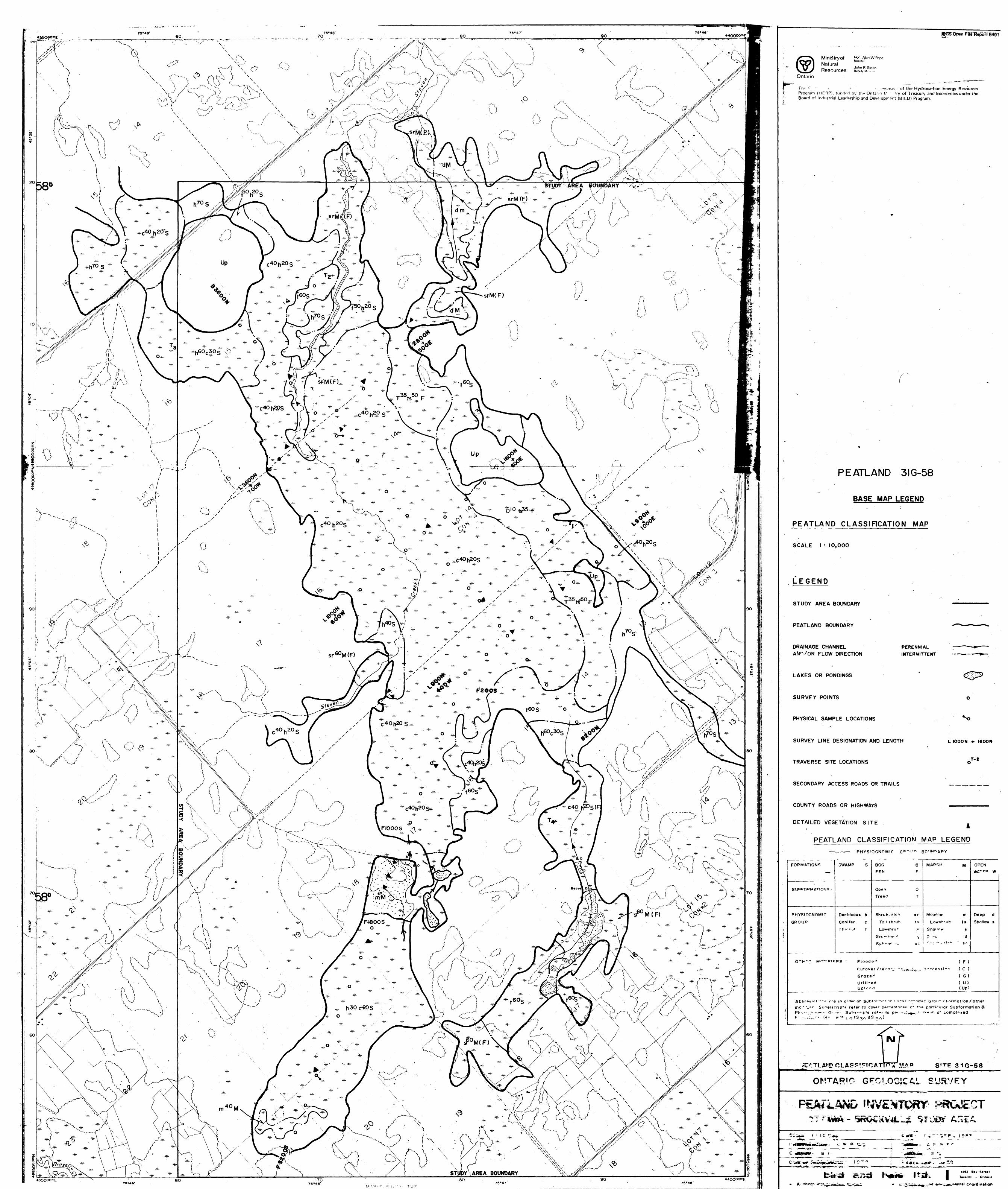
-. 40'.'X. '' mrM-Jv
STUDY AREA BOUNDARY
Ministry of Natural—Kesources
^ AianwpopeMinister
John R Sloan
Ontario
Tnf F F *-*wTnn - of the Hydrocarbon Energy Resources Program (HERP), funrit-d by the Ontario r/ try of Treasury and Economics under the Board of Industrial Leadership and Development (BILD) Program.
PEATLAND 3IG-58
BASE MAP LEGEND
PEATLAND CLASSIFICATION MAP
SCALE l -- IO,OOO
LEGEND
STUDY AREA BOUNDARY
PERENNIAL INTERMITTENT
DRAINAGE CHANNEL ANn/OR FLOW DIRECTION
LAKES OR PONDINGS
SURVEY POINTS
PHYSICAL SAMPLE LOCATIONS
SURVEY LINE DESIGNATION AND LENGTH
TRAVERSE SITE LOCATIONS
SECONDARY ACCESS ROADS OR TRAILS
COUNTY ROADS OR HIGHWAYS
DETAILED VEGETATION SITE
PEATLAND CLASSIFICATION MAP LEGEND
PHYSIOGNOMIC
L loooN -*- leoor*
T-2
FORMATIONS
— *
SUPPOPMAT.OM*.
PHYSIOGNOMir
GROUP
3WAMP S
Deciduous h
Conifer c
T h i- 1- --t t
BOG B
FEN F
Open O
Tree r* T
Shrub-ricb s r
To" shrub r*
Lowshru*- -,*
G re "* i npi H g
MARSH M
M^d,*
Lowsb'ub Is
Shallow s
C-^L: d•""-•: - 1- - r ^^ ' sr
OPEN
VyA ^ " W
Deep d
Shallow s
OTH~7 M 0"" plp RS - Flooded ( F )
Cutower /re 0 ~4 "^^.f^n^, . f -"crp^si^n ( C )
Grazed ( G )
Utilised ( U) Up' en d (Up*
Abbrpv'"t : "^- r-e IP o '•HP' of Subfrv-— ---i— - ' 0 ^v-"- : ~~--'rp'c Grou- x Formation X other
mo- 4 V^ r Superscripts refer to covpr pp^e^^^o^ c* t^o particular Subformation S Ph v^,"""^"1 "' G r ""^ Subscripts re'pr to ppr -^ J ,*i,^fc: '-"Wpi^r o f cornploxed
31G-58
i ciicjvFYl*k- *—— *^-*V -r' ^^ l
Jj 1C C**,
l ~ j^BWtwtf Mw****r.- i-
-? ^gy^" B r
, I9P'
A E P:
l 9 "* 9
. A coordination
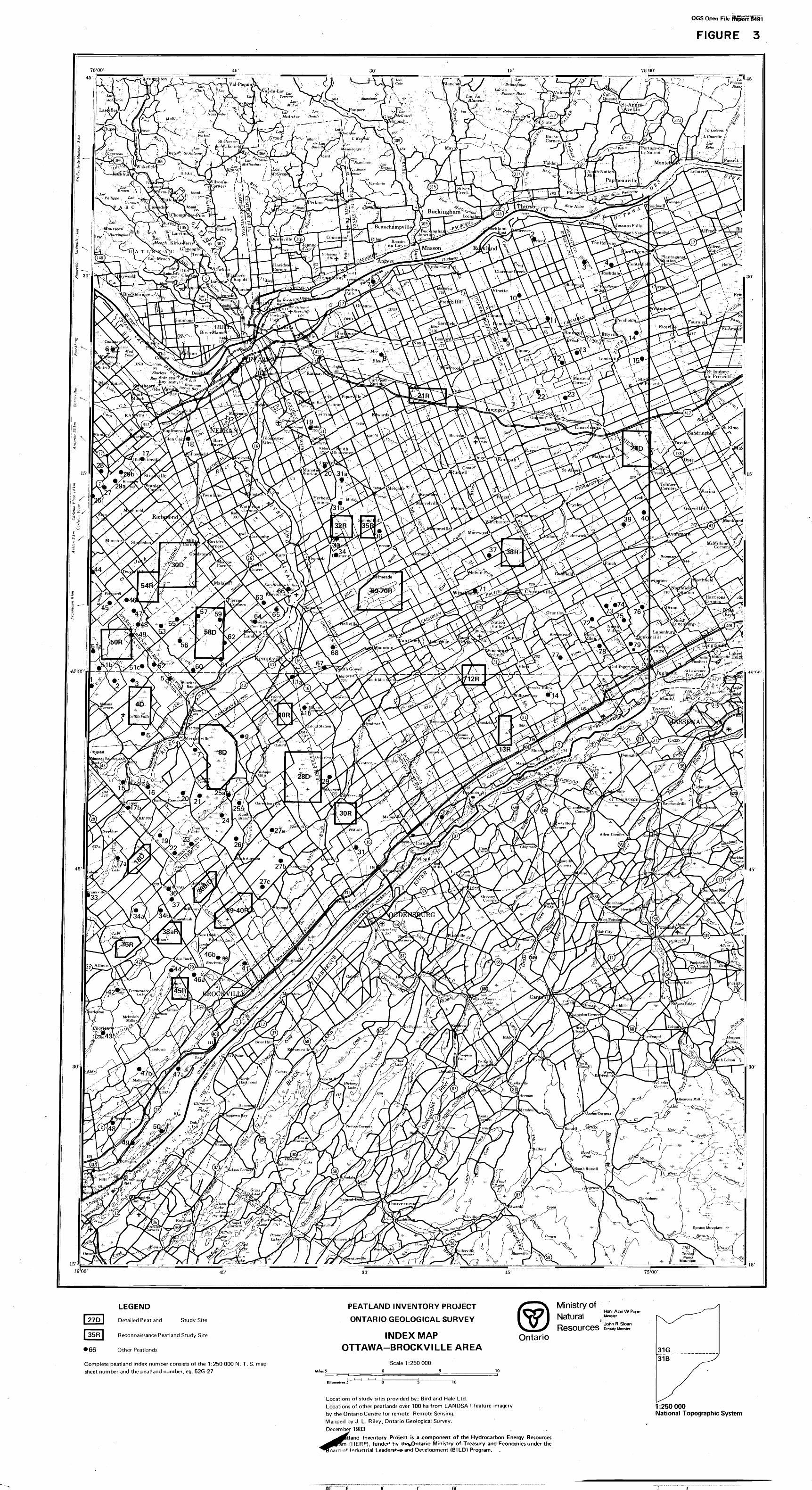
OGS Open ttle
FIGURE 3
LEGEND
| 27D | Detailed Peatland Study Site
j 35R | Reconnaissance Peatland Study Site
• 66 Other Peatlands
Complete peatland index number consists of the 1:250 000 N. T. S. map sheet number and the peatland number; eg. 52G-27 Miles 5
PEATLAND INVENTORY PROJECT
ONTARIO GEOLOGICAL SURVEY
INDEX MAP OTTAWA-BROCKVILLE AREA
Scale 1:250000 o s
Ministry ofHon Alan W Pope Mmtstef
John R Sloan
Ontario
10
Kilometres 5 10
Locations of study sites provided by; Bird and Hale Ltd.Locations of other peatlands over 100 ha from LANDSAT feature imageryby the Ontario Centre for remote Remote Sensing.Mapped by J. L. Riley, Ontario Geological Survey.December 1983 .
rt l and Inventory Project is a component of the Hydrocarbon Energy Resources im (HERP), funded hv th^Ontario Ministry of Treasury and Economics under the
fbard n* Industrial Leader***^ and Development (BILD) Program.
1:250000National Topographic System
)M ffi

PEATLAND 3IQ-30 TRANSECT L4000N PROFIUPEAT TYPE
C.N.R I600W
ELEVATION(m)94.0
PEATLAND 3IG-30 TRANSECT L4000N PROFILE^PEAT HUMIFICATION
96.0
CONT'D BELOW
500 1000 1500 2000 2500 2800DISTANCE(m)
SAMPLING POINT
IOOOE
ELEVATION(m)94.0
CONT'D BELOW
500 1000 1500 2000 2500 2800DISTANCE (m)
PEATLAND 3IG-30TRANSECT L4000N CONT'D . *
PROFILE PEAT TYPE SAMpUN6 p()|NT 7 S|TETYPE7SUBSTRATE TYPEI200E I400E
ROAD t96.0
ELEVATION(m)94.0
92.0H2800
PEATLAND 3IG-30 TRANSECT L4000N CONT'D PROFILE : PEAT HUMIFICATION
DISTANCE (m)
96.0
95:5
95.0-
94.5-
ELEVATION(m)94.0-
93.5
93.0-
92.5-
92XH 2800
3300
ROADt
I400E
3300
SCALE HORIZONTAL
VERTICAL
I40O N i
l
4OOO
5 O
SUBSTRATE SURFACE
ROADS, RAILROADS
PEAT TYPE PROFILESURVEY POINT LOCATION (Physical somple) (S) MOONto)
PEAT TYPE BOUNDARY —————
PEAT COMPOSITION
S - MOSS, WHERE DISTINCTIONS ARE POSSIBLESs - SPHAGNUM MOSS
Sb - BROWN MOSS
C - SEDGES, GRASSES, REEDS, HERBES, ttc.
L - WOODY MATERIAL, WHERE DISTINCTIONS ARE POSSIBLE
hs
Ln - SHRUB PEAT
LL - TREE PEAT
PEATLAND CLASSIFICATION (Sit* Type)
PEAT COMPOSITION 8 PERCENTAGE
SUBSCRPTS (0*K)O0Xo,l*l00Xo,Wank^roc*) Ln6 C 4
SUBSTRATE TYPES
RO - ROCK GR - GRAVEL
SA - SAND
SI - SILT C L - CLAY
OZ - OOZE
MA- MARL
PEATLAND CLASSIFICATION(SITE TYPE)
FORMATIONS
SUBFORMATIONS
PHYSIOGNOMIC
GROUP
SWAMP S
Deciduous h C cm i fer c Thicket t
BOG B FEN FOpen O Treed TShrub -rich sr Tall shrub ts Lowshrub Is Gr ami ooid g Sphagnum sp
MARSH M
Meadow m Lowshrub Is Shallow t
D**P d Shrub- rich sr
OPEN WATER W
Deep d Shallow 9
OTHER MODIFIERS: Flooded (F) Cutover /recent secondary succession (C) Graztd (G ) Utilized ( U )
HUMIFICATION PROFILEHUMIFICATION ( Von Post scale of decomposition)
HUMIFICATION BOUNDARY - BOUNDARIES OF H3 ft H4
- ALL OTHER BOUNDARIES
H 3
SURVEY POINT NUMBER - 70OW f TOP OF PROFILE)
SURVEY POINT LOCATION ON TRANSECT LINE - IOOO (BOTTOM OF PROFILE)
bird and hole ltd
Ministry of'NaturalResources
Hon Alan W Pope
John R Stoan Deputy Minister
Ontario
The Peatland Inventory Project is a component qf the Hydrocarbon Energy Resources Program (HERP), funded by the Ontario Ministry of Treasury and Economics under the Board of Industrial Leadership and Development (BILD) Program.
DISTANCE (m)
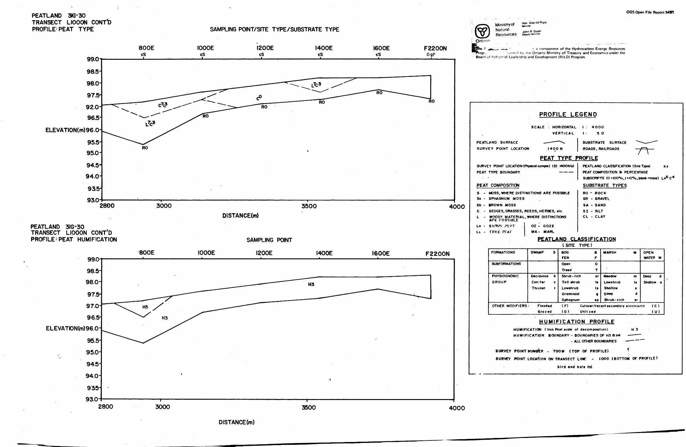
PEATLAND 3KJ-30 TRANSECT LIOOON CONT'D PROFILE'PEAT TYPE
OGS Open File Report 54ft
99.0
98.5-
98.0-
97.5-
92.0-
96.5
ELEVATION(m)96.0
95.5-
95.0
94.5
94.0-
935-
93.02800
PEATLAND 3IG-30 TRANSECT LIOOON CONT'D PROFILE'PEAT HUMIFICATION
99.098.5-
98.0-
97.5-
97.0-
96.5-
ELEVATK)N(m)96.0
95.5-
95.0-
94.5-
94.0-
935-
93.0
SAMPLING POINT/SITE TYPE/SUBSTRATE TYPE
800E cs
IOOOE cS
I200EcS
I400EcS
I600EcS
F2200NOgF
3000 3500 4000DISTANCE(m)
800E IOOOE
SAMPLING POINT
I200E I400E I600E F2200N
Ministry of Natural
Hon AlanWPope
ReSOUrceS Deputy MIO.IK*
c a component of the Hydrocarbon Energy Resourcesrogr.. rundM by the Ontario Ministry of Treasury and Economics under the
Board of Industrial Leadership and Development (BILD) Program.
PROFILE LEGEND
SCALE : HORIZONTAL
VERTICAL
PEATLAND SURFACE — — - —— \
SURVEY POINT LOCATION I40ON i
PEAT TYPE FSURVEY POINT LOCATION (Physical sample) (S) MOONto)
PEAT TYPE BOUNDARY —————
PEAT COMPOSITION
S - MOSS, WHERE DISTINCTIONS ARE POSSIBLE Ss - SPHAGNUM MOSS
Sb - BROWN MOSS
C - SEDGES, GRASSES, REEDS, HERBES, etc.L - WOODY MATERIAL, WHERE DISTINCTIONS
APE POSSIBLE
Ln - SS^JS ?rfj OZ - OOZE
LL - TRF.E PTAT MA- MARL
PEATLAND CL
FORMATIONS SWAMP S
SUBFORMATIONS
PHYSIOGNOMIC Deciduous h
GROUP Conifer c
Thicket t
OTHER MODIFIERS - Flooded Grazed
(SITEBOG FEN
Open
Treed
1 : 4OO
1 : 5
SUBSTRA
ROADS, F
PROFILEPEATLANC
PEAT COM
SUBSCRF1
SUBSTR
O
0
TE SURFACE ""*^ —— — """""
AILROADS — ~f~~\
) CLASSIFICATION (Site Type) h s
POSITION 8 PERCENTAGE
FS (0*K)O*yo,l*l00Xof blank *trace) Ln6 C 4
ATE TYPES
RO - ROCK GR - GRAVEL
SA - SAND
SI - SILT C L - CLAY
ASSIFICATIONTYPE)
B F
0
T
Shrub -rich sr
Tall shrub ts
Lowshrub Is Graminoid q
Sphagnum sp
(F) (G)
MARSH M OPEN WATER W
Meadow m Deep d
Lowshrub Is Shallow s Shallow 9
Deep d
Shrub- rich sr
Cut over /recent secondary s*jcc?3tion ( C )
Utilized (U)
HUMIFICATION PROFILEHUMIFICATION ( Von Post scale of decomposition) H 3
HUMIFICATION BOUNDARY - BOUNDARIES OF H3 8 H4 — — —
- ALL OTHER BOUNDARIES -*— ~~
SURVEY POINT NUMBER - 7OOW C TOP OF PROFILE) *
SURVEY POINT LOCATION ON TRANSECT LINE - IOOO (BOTTOM OF PROFILE)
bird and holt ltd.
2800 3000 3500 4000
DISTANCE (m)
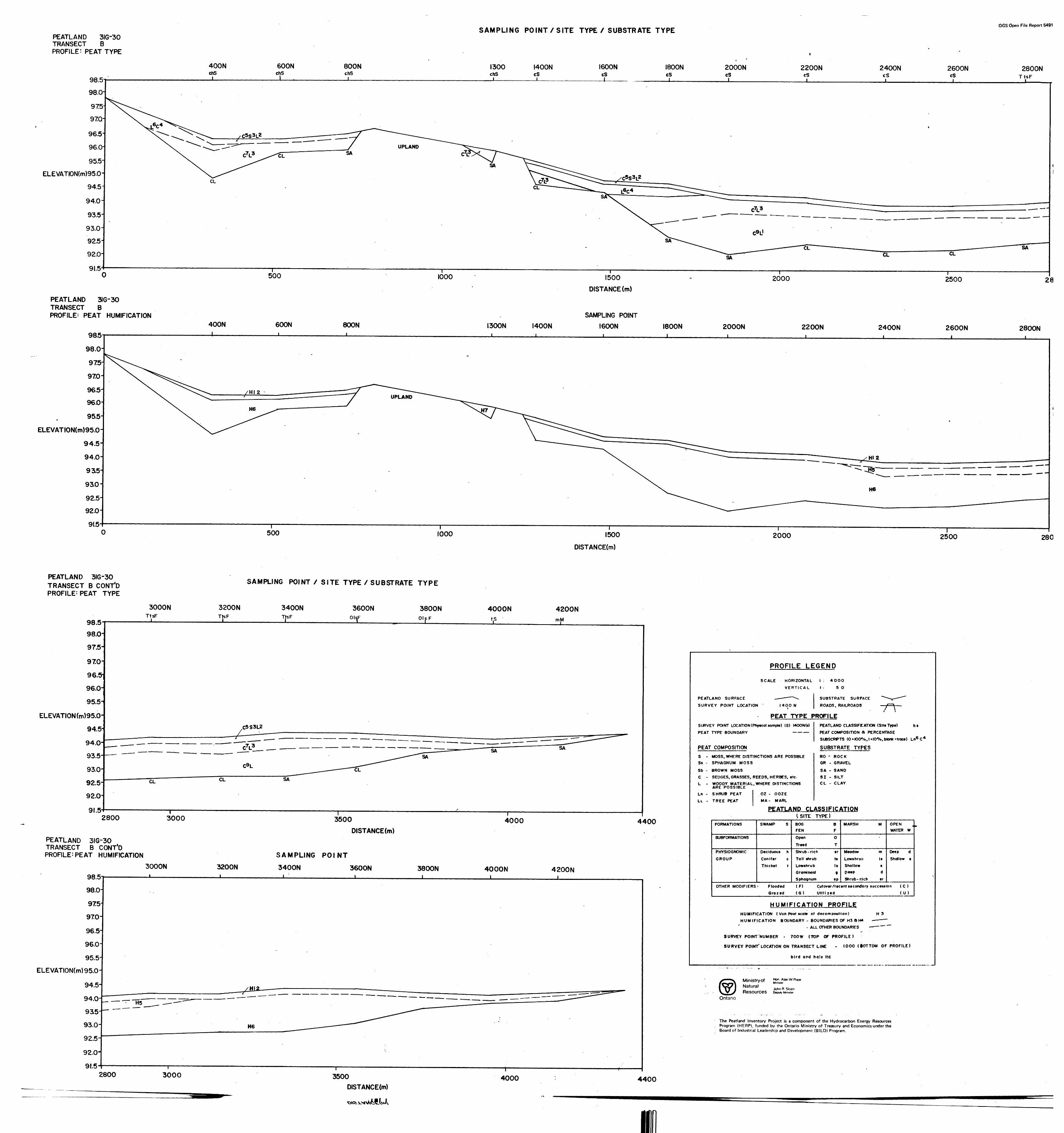
PEATLAND 3IG-30 TRANSECT BPROFILE^ PEAT TYPE
98.5
98.0
975
970
96.51
96.0
95.5-
ELEVATK)N(m)95.0-
94.5
94.0-
93.5-
93.0-925-
92.0-
91.5
SAMPLING POINT l SITE TYPE X SUBSTRATE TYPEOGS Open File Report 5491
800NchS
1300 I400N cs
I600N I800N cs
2000N cS
2200NcSJ.
2400N cS
2600N cS
2800NTtsF
CONT'D BELOW
500 1000
PEATLAND 3IG-30TRANSECT BPROFILE^ PEAT HUMIFICATION
985
GOON SOON I300N I400N
1500
DISTANCE (m)
SAMPLING POINT
I600N
2000 2500 2800
I800Nl
2000N 2200N 2400N 2800N
ELEVATION(m)95.0-
500 1000 1500
DISTANCE(m)
CONT' BELO
2000 2500 2800
PEATLAND 3IG-30 TRANSECT B CONT'D PROFILE-PEAT TYPE
98.598.0-
97.5
97.0-
96.0-
95.5^
ELEVATION (m)95.0-
94.5-
94.0-
93.5
93.0-
92.5-
92.O-
91.5-
SAMPLING POINT X SITE TYPE X SUBSTRATE TYPE
3000N 3200N 3400NTtsF
i TtsF TtsF3600N
OlsF3800NOisF
4000N 4200NmM
C5S3L2
SA
CL
SA
2800
PEATLAND 3IG-30 TRANSECT B CONT'D PROFILE^ PEAT HUMIFICATION
3000 3500"T——— 4000 4400
DISTANCE(m)
3000N 3200N98.5
98.0
975970-
96.5-
96.0-
95.5-
ELEVATION(m)95.0-
SAMPLING POINT
3400N 3600N——L-————————————————l————
3800Ni
4000N 4200N
2800 3000 3500 4000 4400DISTANCE(m)
PROFILE LEGEND
SCALE HORIZONTAL
VERTICAL
PEATLAND SURFACE — — — ——
SURVEY POINT LOCATION ' I400Ni
1 : 40OO1 : 5
SUBSTRA'
ROADS, R
O
FE SURFACE **'*^r— -^
i \
PEAT TYPE PROFILESURVEY POINT LOCATION (Physical sample) (S) !4OON(s)
PEAT TYPE BOUNDARY —————
PEAT
s -Ss -Sb -
C -L -
Ln -LL -
COMPOSITION
PEATLAND CLASSIFICATION (Site Type) h s
PEAT COMPOSITION ft PERCENTAGE
SUBSCRPTS (O*K)O*yo,l*IO*Xo,blank*troce) Ln6 C 4
SUBSTRATE TYPES
MOSS, WHERE DISTINCTIONS ARE POSSIBLESPHAGNUM MOSS
BROWN MOSS
SEDGES, GRASSES, REEDS, HERBES, etc-
WOODY MATERIAL, WHERE DISTINCTIONS ARE POSSIBLE
SHRUB PEAT
TREE PEAT
OZ - OOZE
MA- MARL
RO - ROCKGR - GRAVEL
SA - SANDSI - SILTCL - CLAY
PEATLAND CLASSIFICATION
- '
FORMATIONS
SUBFORMAT1ONS
PHYSIOGNOMIC
GROUP
OTHER MODIFIERS
SWAMP S
Deciduous hConifer cThicket t
' FloodedGrazed
(SITEBOGFENOpen
Treed
TYPE)
BFOT
Shrub -ri c h srTall shrub tsLowshrub IsGrominoid gSphagnum sp
(F)(G)
MARSH M OPENWATER W
.
Meadow m Deep dLows hr us Is Shallow sShallow t
Deep dShrub -ri c h sr
Cutover /recent secondary succession (C )Utilized (U)
HUMIFICATION PROFILEHUMIFICATION ( Von Post scale of decomposition) H 3HUMIFICATION BOUNDARY - BOUNDARIES OF H3 ft H4 —— ———
i- ALL OTHER BOUNDARIES —— — — ~~
SURVEY POINT'NUMBER - 7OOW (TOP Of PROFILE)
SURVEY POINT' LOCATION ON TRANSECT LINE 1000 (iOTTOM OF PROFILE)
bird and ha!* ltd.
Ministry ofNaturalResources
Hon Alan W PopeMinister
John R. Sloan Deputy Minister
Ontario
The Peatland Inventory Project is a component of the Hydrocarbon Energy Resources Program (HERP), funded by the Ontario Ministry of Treasury and Economics under the Board of Industrial Leadership and Development (BILO) Program.
l
OGS Open File Report 5491
PEATLAND 3IG-30 TRANSECT P3 PROFILE:PEAT TYPE
Ministry ofNaturalResources
Hon Alan W Pope
John R Sloan Deputy Minute*
SAMPLING POINT/SITE TYPE/SUBSTRATE TYPEOntario
The Ptat'anri Inventory Project is a component of the Hydrocarbon Energy Resources Program (HERP), funded by the Ontario Ministry of Treasury and Economics under the Board of Industrial Leadership and Development (81LD) Program.
IOQ5
100.0
99.5
ELEVATION(m)990
98.59ao-975
TilOtsF
l
HI700NOtsF
TI2OtsF
CL
500 800
PEATLAND 3IG- 30TRANSECT P3PROFILE-PEAT HUMIFICATION
Til
DISTANCE (m)
SAMPLING POINT
HI700N100.!
TI2
IOOJD-
99.5
ELEVATION(m)990
98.5
98.0H
975500
DISTANCE(m)f800
PEATLAND 3IG-30 TRANSECT P4 PROFILE: PEAT TYPE
100.5
PROFILE LEGEND
SCALE : HORIZONTAL
VERTICAL
PEATLAND SURFACE — —— ——
SURVEY POINT LOCATION I4OO i
"^
N
1 . 4OOO
1 5
SUBSTRA
ROADS, R
0
FE SURFACE "^-^-— -~"
AILROADS ' — -f — ——
PEAT TYPE PROFILESURVEY POINT LOCATION (Physicol sompte) (S) I4OONU)
PEAT TYPE BOUNDARY —————
PEAT
S -Ss -
Sb .
C -L -
Ln -LL -
COMPOSITION
-
PEATLAND CLASSIFICATION (Site Type) h s
PEAT COMPOSITION 8 PERCENTAGESUBSCRFTS (0 = 100^/0 J slOVo.btankMroce) Ln6 C 4
SUBSTRATE TYPES
MOSS, WHERE DISTINCTIONS ARE POSSIBLESPHAGNUM MOSS
BROWN MOSS
SEDGES, GRASSES, REEDS, HERBES, etc.WOODY MATERIAL, ARE POSSIBLESHRUB PEAT
TREE PEAT
WHERE DISTINCTIONS
OZ - OOZEMA- MARL
RO - ROCKGR - GRAVEL
SA - SAND
SI - SILTC L - CLAY
4
PEATLAND CLASSIFICATION
FORMATIONS
SUBFORMATIONS
PHYSIOGNOMIC
GROUP
OTHER MODIFIERS
SWAMP S
Deciduous hConifer .cThicket t
- Flooded•razed
(SITEBOGFEN
Open
Treed
TYPE)
BF
O
TShrub -rich sr
Tall shrub ts
Lowshrub IsGraminoid g
Sphagnum sp
(F)
(G)
MARSH M OPENWATER W
Meadow m Deep d
Lowshrub Is Shallow s
Shallow sDeep dShrub- rich sr
Cutover /recent secondary succession (C)
Utilized (U )
HUMIFICATION PROFILEHUMIFICATION ( Von Post scale of decomposition) H 3
HUMIFICATION BOUNDARY - BOUNDARIES OF H3 8 H4 —— - —- ALL OTHER BOUNDARIES ——— —
SURVEY POINT NUMBER - TOO W (TOP
SURVEY POINT
OF PROFILE)
LOCATION ON TRANSECT LINE - IOOO (BOTTOM OF PROFILE)
bird and hale ltd.
SAMPLING POINT/SITE TYPE/SUBSTRATE TYPET5chSj
HIOONTtsF
T6TtsF
ELEVATK)N(m)
IOOO
PEATLAND 3IG-30TRANSECT P4PROFILE^ PEAT HUMIFICATION
DISTANCE(m)
SAMPLING POINT
I4OO
100.5
100.0-
995- ELEVATION(m)
99.0-
T5 i
HIOON i
T6i
500 IOOODISTANCE (m)
1400
OCS Open FHe ftcport 54f V
PEATLAND 3IG-30 TRANSECT 1 PIPROFILE : PEAT TYPE
TI5chS
SAMPLING POINT/SITE TYPE/SUBSTRATE TYPEF200N T13cS cS
TI4cS
100.0
99.5J
99.0-
98.5-
9EO-
ELEVATON(m)97.5-
97.0-
96.5-
96.0-95.5-
-95.0
CL
'500 1000 1400DISTANCE(m)
PEATLAND 3IG-30TRANSECT PIPROFILE: PEAT HUMIFICATION
100.0 99.5-
99.0-
98.5-
98.0-
ELEVATION(m)97.5
970
965
96.0-
955-
95.0
TI5
SAMPLING POINT
TI4 F200N T13i
500 1000 1400
DtSTANCE(m)
PEATLAND 3IG-30 TRANSECT P2 PROFILE: PEAT TYPE
100.0-
99.5H
99.0-
98.5
98.0-
ELEVATION(m)975-
97.0-
96.5
96.0
PEATLAND 3IG-30TRANSECT P2PROFILE' PEAT HUMIFICATION
SAMPLING POINT/SITE TYPE/SUBSTRATE TYPE
T9cS
FI600NOgF(S)
T10cS
1000
SAMPLING POINT
T9 FI600N T10100.0-
99.5-
99.0-
98.5 98.0-
ELEVATK)N(m)97.5.
97.0-
96.5-
96.0500
DISTANCE (m)1000
PROFILE LEGEND
SCALE : HORIZONTALVERTICAL
PEATLANC SURFACE ~- — " — SURVEY POINT LOCATION MOON i
PEAT TYPE FSURVEY POINT LOCATION (Pflyefcot sample) (S)PEAT
PEAT
S -Ss -Sb -
C -L -
Ln -Le -
TYPE BOUNDARY
COMPOSITION
MOON (s)—————
1 : 40001 : 5 O
SUBSTRATE SURFACE ^*—— — "~"
ROADS , RAILROADS — crV—
^ROFILEPEATLAND CLASSIFICATION (Site Type) h sPEAT COMPOSITION 8 PERCENTAGESUBSCRPTS (OsK)O*Xo,l*l00Xo,btankMroce) Ln6 C 4
SUBSTRATE TYPES
MOSS, WHERE DISTINCTIONS ARE POSSIBLESPHAGNUM MOSS
BROWN MOSSSEDGES, GRASSES, REEDS. HERBES, etc.WOODY MATERIAL, ARE POSSIBLESHRUB PEAT
TREE PEAT
WHERE DISTINCTIONS
OZ - OOZEMA- MARL
RO - ROCKGR - GRAVEL
SA - SANDSI - SILTCL - CLAY
. '
PEATLAND CLASSIFICATION
FORMATIONS
SUBFORMAT1ONS
PHYSIOGNOMICGROUP
OTHER MODIFIERS
SWAMP S
Deciduous hConifer cThtcket t
: FloodedGrazed
(SITEBOGFENOpenTreed
TYPE)
iF0T-
Shrub -rich trToll shrub tsLowshrub ItGrominoid gSphagnum tp
(F)(G)
-
MARSH M OPEN WATER W
Meadow m Deep dLowshrub Is Shallow *Shallow s *-D*ep dShrub- rich - tr
Cutover /recent secondary euccessior. (C)Utilized (O)
HUMIFICATION PROFILEHUMIFICATION ( Von Post scale of decomposition) H 3HUMIFICATION BOUNDARY - BOUNDARIES OF H3 SH4 — - ——
- ALL OTHER BOUNDARIES - — — " ""
SURVEY POINT NUMBER - rf-OOW (TOP OF PROFILE) l
SURVEY POINT LOCATION ON TRANSECT LINEw i — ^ — — ^ ^. — i. *A~J
IOOO (BOTTOM OF PROFILE)
RF — jc 1- - Dec -
Orr
5^ The Peatlanrl Inventory Project is a component of the Hydrocarbon Energy Resources r Program (HERP\ funHpd by the Ontario W : nistry of Treasury and Economics under the . Board of Industrial Leadprship and Development (BILD) Proqram
OGS Open File Report 5491
PEATLAND 3IG-30 TRANSECT HPROFILE' PEAT TYPE
SAMPLING POINT/SITE TYPE/SUBSTRATE TYPE
ELEVATION (m) 98.0-
500 IOOO I500DISTANCE(m)
2000 2500 2800
PEATLAND 3IG-30TRANSECT HPROFILE^ PEAT HUMIFICATION
ROADc
I00.5
IOO.O-
99.5-
99.0
98.5-
ELEVATION(m)98.0- 97.5-
970-
96.5-
96.0-
95.5
IOON
l
300N 500N 700N 900N
SAMPLING POINT
MOON I300N
-i____________J
I500N
J———
I700N
J———
I900N
J———
2IOON 2300N 2500N
500 IOOO 1500 2000 2500 2800DISTANCE(m) Ministry of
NaturalResources
Hon Alan W Pope Mmster t
Ontario
PEATLAND 3IG~30 TRANSECT F PROFILE'- PEAT TYPE
-The Peatland Inventory Project is a component of the Hydrocarbon Energy Resources Program (HERP), funded by the Ontario Ministry of Treasury and Economics under the Board of Industrial Leadership and Development (BILD) Program.
SAMPLING POINT/SITE TYPE/SUBSTRATE TYPE
99.599.0-
98.5-
ELEVATON(m)9aO- 975-
970-
96.5^
96-O-
955'
OONchS
200N cS
400NOgF
600N 800NOgF
IOOONOgF
I200NOmM
-J————
I400N OmM-J———
I600NOmM(S)
I800NOgF
2000NOgF
2200NOgF
500 IOOO 1500"T———
2000DISTANCE (m)
2400
PEATLAND 3IG-30TRANSECT FPROFILE: PEAT HUMIFICATION
OON 200N 400N 600N 800N99.5
99.0
98.5-
ELEVAf K)N(m) 98.0'975"
970-
96.5-
96.0-
95.5-
IOOONj
SAMPLING POINT
I200N I400N I600N I800N 2000N 2200N
500 IOOO 1500
PROFILE LEGEND
SCALE : HORIZONTAL
VERTICAL
PEATLAND SURFACE — - — -"•""'
SURVEY POINT LOCATION I4OO i
i
SURVEY POINT LOCATION (R
^
N
1 : 400O
1 : 5 O
SUBSTRA1
ROADS , Ri
T SURFACE ^^ — -~*^
MLROAl/S — f^ ——
PEAT TYPE PROFILElystcol sompte) (S) !4OON(s)
PEAT TYPE BOUNDARY —————
PEAT COMPOSITION
PEATLAND CLASSIFICATION (Site Type) h s
PEAT COMPOSITION ft PERCENTAGE
SUBSCRFTS (O*K)O07o,|*IOeXo,blonk*traee) Ln6 C 4
SUBSTRATE TYPES
S - MOSS, WHERE DISTINCTIONS ARE POSSIBLE Ss - SPHAGNUM MOSS
Sb - BROWN MOSS
C - SEDGES, GRASSES, REEDS, HERBES, etc.
L - WOODY MATERIAL, WHERE DISTINCTIONS ARE POSSIBLE
Ln -
Lt -
SHRUB PEAT
TREE PEAT
OZ - OOZE
MA- MARL
RO - ROCK GR - GRAVEL
SA - SAND
SI - SILT CL - CLAY
PEATLAND CLASSIFICATION
FORMATIONS
SUBFORMATIONS
PHYSIOGNOMIC
GROUP
SWAMP S
Deciduous h
Conifer cThicket t
OTHER MODIFIERS : Flooded
G ra z ed
(SITE
BOGFEN
Open
Tr-eed
TYPE)
B
F
O
T
Shrub -rich srTaM shrub tsLowshrub IsG r ami no id gSphagnum sp
(F)(G)
MARSH M OPEN WATER W
Meadow m Deep d
Lows hr lib Is Shallow s
Shallow s
Deep d
Shrub- rich si
Cutover /recent secondary tuccess.or { c )
Utilized ™-. ... . ,. . . ...-.. . , * , --J
HUMIFICATION PROFILEHUMIFICATION { Von POST scole of decomposition) M 3
HUMIFICATJON BOUNDARY - BOUNDARIES OF Mb 5k H4 — ———
- ALL OTHER BOUNDARIES — — " ""
SURVEY POINT NUMBER -/7OOW (TOP OF f*ROFILE)
SURVEY POINT LOCATION ON TRANSECT LINE -
fclrd end i.*. :fd.
1000 (BOTTOM OF PROFILE)
"
2000 2400DISTANCE (m)
PEATLAND 3IG-30 TRANSECT L2000N CONT'D PROFILE 1 PEAT TYPE
OGS Open (Fife Report 5491
SAMPLING POINT/SITE TYPE/SUBSTRATE TYPE
600E cs
99.0
800EcSl
tOOOEcS i
I200EcS
I400ETtsF
I600ETrsF
i____
98.51
98.0 97.5-
97.0
96.5-
96.0-
955-
ELEVATION(m) 95.0- 94.5-
94.0-
935-
93.0 92.5-
92.0-
91.5-
91.0
I800ETteF—l———
2000EcS
2200EcS
l
2400EcS
26OOEtsi
H2IOONOtsF
SA
2800
PEATLAND 3IG-30 TRANSECT L2000N CONT'D PROFILE'PEAT HUMIFICATION
3000 3500 4000 4500 5000 5200DISTANCE (m)
99.0
98.5^
98.0-
97.5-
970-
96.5-
96.0-
95.5-
ELEVATION(m)95.0-
94.5-
94.0-
93.5-
93.0-
92.5-
920-
91.5-
91.0
600E i
800E IOOOE I200E I400E I600E
SAMPLING POINT
I800E 2000E 2200E_l
2400E * 2600E H2IOON
Ministry ofNaturalResources
Hon Alan W PopeMinister
John R Sloan Deputy Mintster
*Qntario
The Peatland Inventory Project is a component of the Hydrocarbon Energy Resources Program (HERP), funded by the Ontario Ministry of Treasury and Economics under the Board of Industrial Leadership and Development (BILD) Program.
PROFILE LEGEND
SCALE : HORIZONTAL
VERTICAL
PEATLAND SURFACE — —— — "
SURVEY POINT1 LOCATION 1400 i
^v.
N
1 : 4OOO
1 :* 5
SUBSTRA'
ROADS, R
O
FE SURFACE *"^^— ^"
AILROADS f — K ——
PEAT TYPE PROFILESURVEY POINT LOCATION (Ptiytical sample) (S) MOON (s)
PEAT TYPE BOUNDARY —————
PEAT
S -Ss -
Sb -
C -
L -
Ln -
LL -
COMPOSITION
t
PEATLAND CLASSIFICATION (Site Type) h s
PEAT COMPOSITION B PERCENTAGE
SUBSCRPTS (Os|OO0Xo,l*l00Xo,blonkMroce) Ln6 C 4
SUBSTRATE TYPES
MOSS, WHERE DISTINCTIONS ARE POSSIBLE
SPHAGNUM MOSS
BROWN MOSS
SEDGES, GRASSES, REEDS, HERBES, etc.
WOODY MATERIAL, ARE POSSIBLE
SHRUB PEAT
TREE PEAT
WHERE DISTINCTIONS
OZ - OOZE
MA- MARL
RO - ROCKGR - GRAVEL
SA - SAND
SI - SILTCL - CLAY
PEATLAND CLASSIFICATION
FORMATIONS
SUBFORMATIONS
PHYSIOGNOMIC
GROUP
OTHER MODIFIERS
SWAMP S
Deciduous h
Conifer c
Thicket t
- Flooded
Grazed
(SITEBOGFEN
Open
Treed
TYPE)
B'F
0
T
Shrub -rich sr
Tall shrub ts
Lowshrub Is
Graminoid q
L Sphagnum sp
(F)
(G)
MARSH M OPENWATER W
Meadow m Deep d
Lowshrub Is Shallow s
Shallow sDeep d
Shrub -ri eh sr
Cut over /recent secondary succession ( C )
Utilized (U)
HUMIFICATION PROFILE4
HUMIFICATION ( Von Post scale of decomposition) H 3
HUMIFICATION BOUNDARY - BOUNDARIES OF H3 ft H4 —— ——- ALL OTHER BOUNDARIES — — "~
SURVEY POINT NUMBER - 700 W ( TOP OF PHOT ILE )
SURVEY POINT LOCATION ON" TRANSECT LINE - IOOO ( BOTTOM OF PROFILE )
bird and hole ltd
2800 3000 3500 4000 4500 5000 5200
DISTANCE(m)
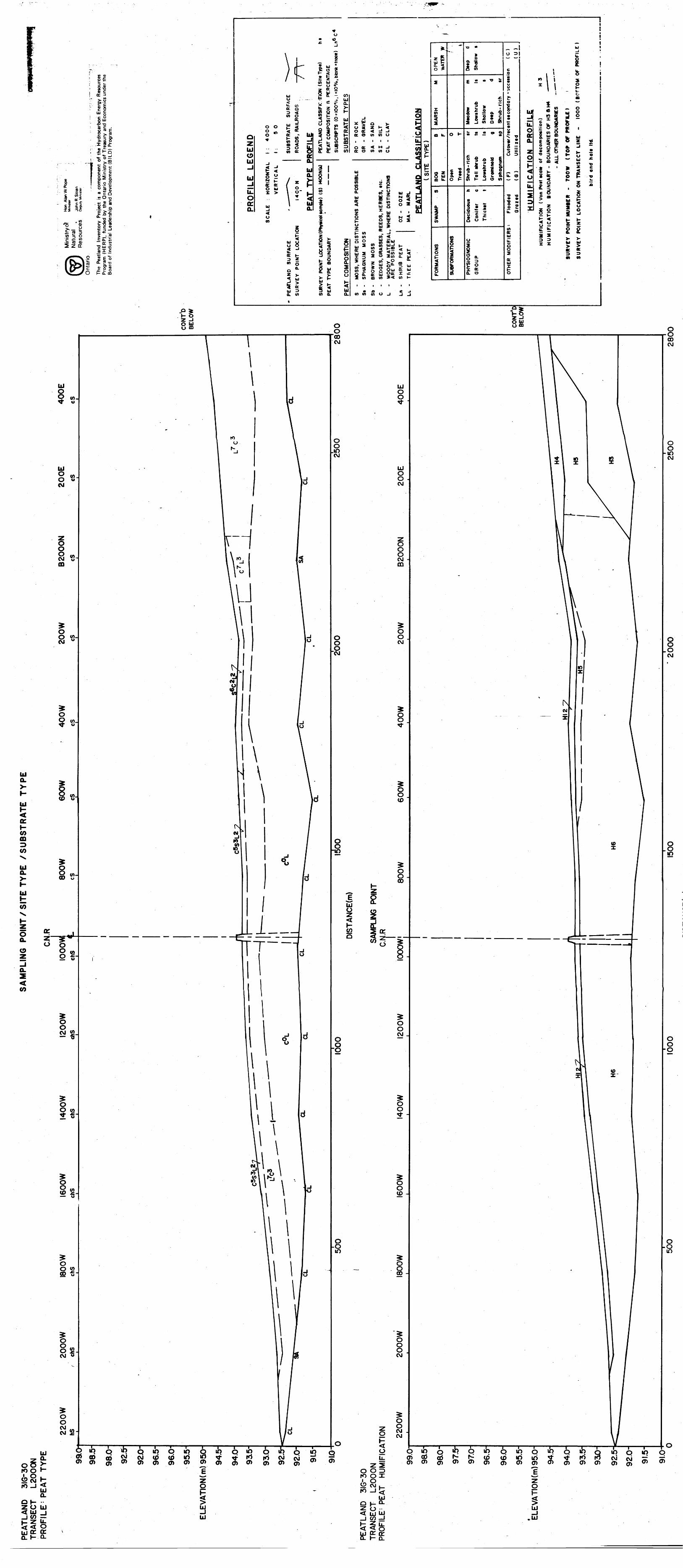
-.
*
J-
•-
-- •-
fi
...,., ^-|
]f ifl
C ^ !
S SI ;5 21 <* **Si fi15 3o
t.'lp CB "^1 W T Oc ^ w
•— (0 (U2 z ir
© i0
*n a)W ^0 "fc
rt VS-o0) C
OC 3
^53S* pu sc n•Sgc 0|UJ•e -oa c .X " EtpI 8 n- -^ aj o.w i± -1-•S 1" 0^^~0 ^-S•t-i t-^ *^ 4-"m .** Cc c w1st6 o5O -:- (C0 2 2w c Q .2 O -oc^ sS ^ Q.1^o. *-
-Q 9^-S"8 o c 5I-2 -2^-5esr t
or ^is!Si*o- 2-0OJ g" W.c E oK Q- CD
E LEGEND
-ju.o o: o.
\
/iUJo
~~"
^. . — - -
1 : 4OOO 1 : 50
SUBSTRATE SURFA ROADS, RAILROADS
^ROFILE
0 ^f^ ^Z X^M *" x 2
O UJ 1 C
J *
O CO
u.
Q.C ^
J" .I slilQ.
1- t-^UJ tjo o
CC 1- 3 Z V* O
0 ^
i ~
•5 i *E 3
CL en
1
* - " - io to i.j~.
is ir- < a5 z *en uj ^ z tt og tf - (0^ o" Ul
PEATLAND CLASSIFIC PEAT COMPOSITION B SUBSCRPTS (OnOO0/ SUBSTRATE TYPI 1* 2 o v h-0 5 Z Ir < <o ac < d -* 7* a: O in in u . vf
0 tt < M -l S So: o en en o afl X
31 MPz l u I —
^L 1 ^^ ^ ^^ a^^J
0 * P 3*2 2 of | ju J J
1 S . !| gs gs . 2 * w . . S3 1 g - 8| g Sl " uj if ? tt . —-—. *- - i- w , -J ————Z , en en en 4Y POINT LOCATIO
TYPE BOUNDARY COMPOSITION
UJ k.> K 55 2 Sma. Q.
50 co Suj
s * 1 1 g- s KUJ 3E 2 {5 5w w <
E 1 f g" S? J J S 5 g g ou. s uQ Q. tt UJ ^tt X tH2 en a) en >< en i-
*-
5^o ^
Z
MARSH
CD U.
2 F,O Um u-
M
SWAMP
FORMATIONS
- —
0 1-
li0 1-
m
SUBFORMATIONI
TJ "
0 1 O. ^
(5 w
. ^ ., s
^A —
S 75 * 2 2 j en o tS
Shrub -rich tr Toll thrub tt
Lowthrub It
Grominoid g Sphagnum tp
.C 0 *-
wIII• ~ o ~o o H
PHYSIOGNOMIC
GROUP
i w iTo ^— —
c o
1uk.
(F) Cutovtir /recent tt condo
(G) Utm ltd
Floodtd Grot td
(AttUJ
OTHER MODIFI
i iQ. J 1 u
i * 0 1--l iM l . g
i C-tt
CATION PROFILE
^^^
li.iI
t tcolt of dtcompotitjon)
lARY - BOUNDARIES OF H3 ftH4 - ALL OTHER BOUNOARES
TOO W ( TOP Of PROFILE I 1 TRANSECT LINE - 1000 (
rd and holt ltd
WO * —
S. * , 0co 3E0 OD X. 2> w b
i! f4(1 ~~ -mO — S —tt 2222
3 3 M M
i
i i i i i i i•t A C Jen en en u j j j
o yo ffi
UJ0 (ft O oCM
O O
8CD
O
8
OO w. o
UJ Q.
H Ul
a:l- coCD
(O
UJ O.^
UJ
35
I-5o.o
o.z <CO
~STi?
iO CM
OO (ft
o
o o wfi -g
o8s.CM
ro
UJ
g a. t roo i"&SH10 -"2Q.
OH --
< oir o:H Q-
o 10 - o '^ Qipoio OIQ o® coSi! cjii)a)io *f?^ ^o a) en en o o* o 0) o* en
/E
oiQ ib^tS10 CM CMen o en
UJo o
LJ o oCM
o o oCMm
o oCM
gO
^^*
UJo
H (Oo
o oCM
O O
lO (O
o oCD
O OO J CM
OoCM CM
oU.
O O Dro ox^ s.10-15
UJo l- Q- < UJ LU-J CO J
O O 00 CM
O O 10 CM
O O O CM
cal
O O IO
oo in
Q io Q ip o locri cd 06 ^*" ^~ toen en (j^ en en enQ *Q QCD IO ioen o en
o
SUJ-JUJ
i L i^ r i iQ tf? Q *O O iQ^- to ro CM CM ^o a* o o en ^
oQen
r- Q.
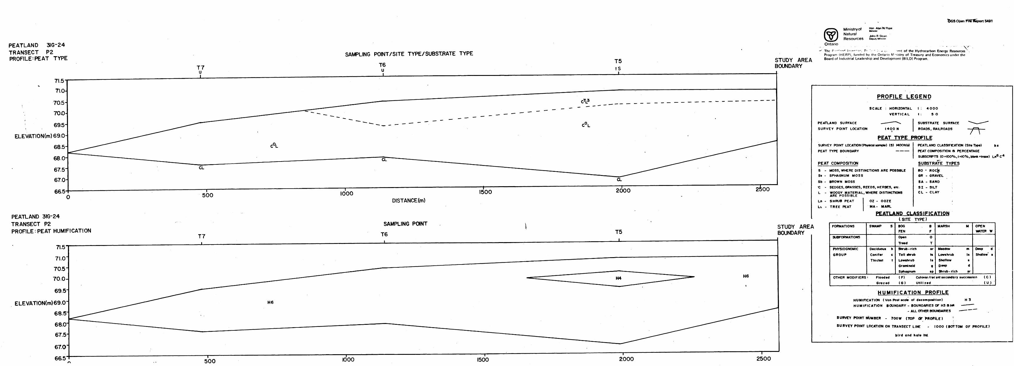
bGS Open FffiTlleport 5491
PEATLAND 3IG-24TRANSECT P2 PROFILE-PEAT TYPE
71.5
Ministryof Natural ,. D c .John K Stoan
Deputy Master
Ontario
SAMPLING POINT/SITE TYPE X SUBSTRATE TYPE
T7 u i
T6u i
T5tS
STUDY AREA BOUNDARY
The F-•-* 1 -""*- In-.""-*-,- pr - , d c , ent of the Hydrocarbon Energy Resources Program (HERP), funded by the Ontario Ministry of Treasury and Economics under the Board of Industrial Leadership and Development (BILD) Program.
70.5-
700
69.5-
ELEVATION(m) 69.0
68.5
68.067.5'
67.0
665
CL
500 1000 1500 2000 2^00
PEATLAND 3IG-24TRANSECT P2PROFILE: PEAT HUMIFICATION
DISTANCE (m)
SAMPLING POINT
T6
PROFILE LEGEND
SCALE
PEATLAND SURFACE
SURVEY POINT LOCATION
HORIZONTAL
VERTICAL
I4OO N i
4OOO
50
PEAT TYPE PROFILESURVEY POINT LOCATlONfPhyaico) sompte) (S) MOON (s)
PEAT TYPE BOUNDARY —————
PEAT COMPOSITION
htPEATLAND CLASSIFICATION (Sitt Type)PEAT COMPOSITION B PERCENTAGESUBSCRPTS (O*IOOeXo,l*IO0Xo,bkink*trac*) Ln6 C 4
SUBSTRATE TYPES
s -Ss -
Sb - •C -L -
Ln -
LL -
MOSS, WHERE DISTINCTIONS ARE POSSIBLE SPHAGNUM MOSS
BROWN MOSSSEDGES. GRASSES, REEDS, HERBES, etc.WOODY MATERIAL, WHERE DISTINCTIONS ARE POSSIBLESHRUB PEAT
TREE PEAT
OZ - MA-
RO -
OR - GRAVEL
SA - SAND SI - SILT C L - CLAY
PEATLAND CLASSIFICATION(SITE TYPE)
T5
ELEVATION(m)69.0
STUDY AREA BOUNDARY
A FORMATIONS
SUBFORMATIONS
PHYSIOGNOMIC
GROUP
SWAMP S
Deciduous h Conifer c Thicket t
BOG B FEN F
Open O
Treed TShrub -rich sr Toll shrub ts Lowshrub Is Grominoid q Sphagnum sp
MARSH M
Meadow ut Lowshrub Is Shallow s D**P d Shrub- rich sr
OPEN WATER W
Deep d Shallow' 9
OTHER MODIFIERS : Flooded (F) Cutovtr/rtctnt** condor y succession (C)
Grazed (G) Utilized (U )
HUMIFICATION PROFILEHUMIFICATION ( Von Post scote of decomposition) H 3
HUMIFICATION BOUNDARY - BOUNDARIES OF H3 3H4 — ——— - ALL OTHO? BOUNDARIES —— —— ~~
SURVEY POINT NUMBER - 7OOW (TOP dF WfOFfLE ) \
SURVEY POINT LOCATION ON TRANSECT LINE - IOOO (BOTTOM OF PROFILE)
bird and hoi* ltd
500 IOOO 1500 2000 2500
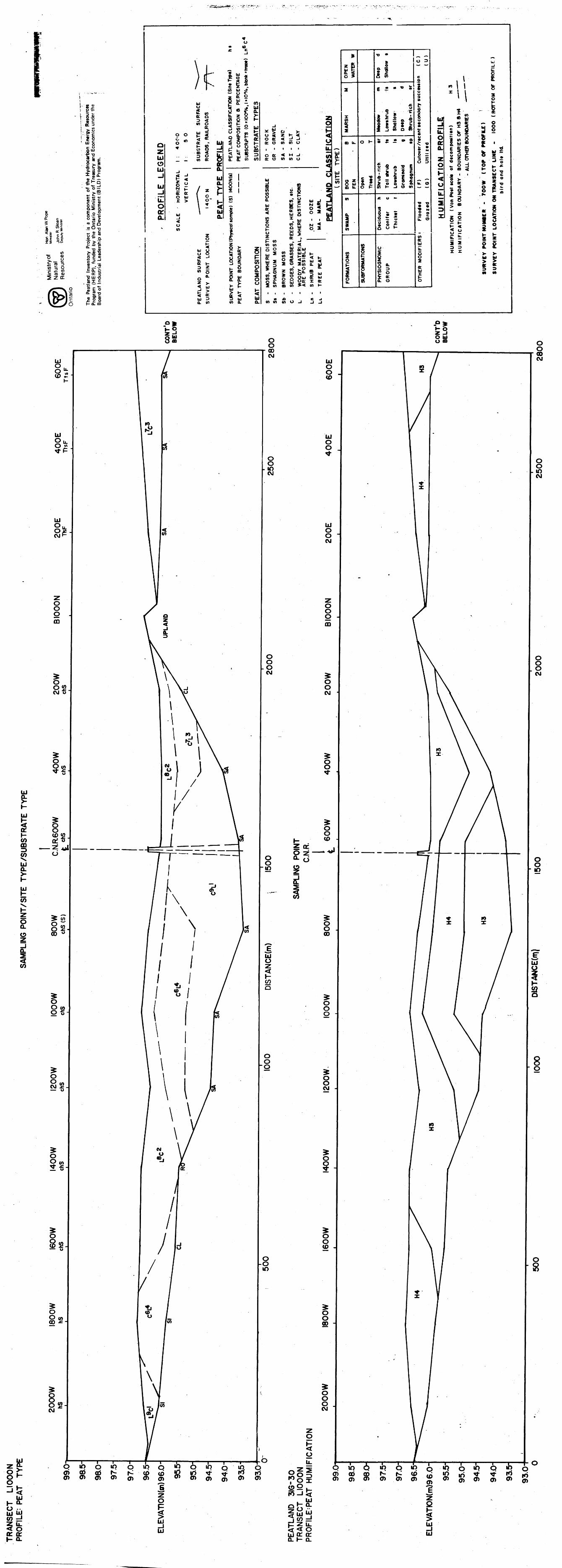
r g -l- g ^8-0
O) Ct ac 3
rllUJ gC 0 |UJ•e -o
.* i^ *~ 6*" Q*^ H- J•*- O — O oo** c"c ** *- ® .2 cc c *is tLil0 2 lw c D ^ O -Q
ts|SO) ^ Q.
JCL. •D O) > OJ "D C-n (oiJli--
^o7i; cc
S E o6-2-0
.s?8l- Q. ffi
.\
) r^ *^^
uto2 wor o3 < CO 0or
oo F 5C ^ *J n-
QO or - Ul ~ i- co ,Z ^ W O -^ m ^ ?""* m S o U.W . - .W) K OO ftUJ , ———— 0.
^J
-1 g i wUJ 5 ^ , 5;J E t X - f*— o w l oU. r S l o- h 0 - \ * 5 CE w l Ul Q. ^ Q.
o l OT
! 1S - '
bJ 0u 5or i-OT oo fcZ )-^ Ul
u 5Q. CO
Om to
^
g
lg*p- ^ J* C -A
CO Ul ^*^ o ® 2 or 2X 111 HX a - ea
PEATLAND CLASSIFICAT PEAT COMPOSITION ft SUBSCRIPTS (0*100^, SUBSTRATE TYPE1
^ S o ^ h-0 ^ Z 1- < <o or < d J /Ior o co co o ^, i i i i IJJL.o or < M -J ID or o co co o X*
iS I Uz i ui| 1 5 . w 0
i -S ^ S o 5 Si1 < ui 5 0 z lil
i 1 i 1 si
S
en
\ w gj ^•^ ' C tn —1 "
Y POINT LOCATION FYPE BOUNDARY COMPOSITION
Ul L.> h- S5 2 SCO Q. Q.
CO CO CO ^ O O W QiUI...Z J2 co uiJ i- o: X < t;5 < H S Z 2 K 5w 5 5T 5 Z C3 SOT Q. Ul
f- g l S g2 5 *1 1 1 s is i sZ co m co >< co *-
*z K0. ^O 9-
Z
MARSH
m u.
8 z Ul
CD 1*.
SWAMP S
FORMATIONS
0 *-
- -c
II
SUBFORMATIONS
TJ **
fte2 f.
c * w "^ w
f
I'jjll
k. w 3 O f
4 * 1 1 1CO H 3 O CO
^ u *-
if!J{ o .-c oo^
PHYSIOGNOMIC
GROUP
0 3— . — '
c0
lo uw^
Cutovtr/rtctnt stcorxtan
Utlli ltd
Flootftd ( F) Groztd ( G )
COor
OTHER MODIFIE
~.ju.
- 1 l s*M l
UJ-1tL Oo:Q.
z ot- < u
m
U.
i3 X
S -ir co ^.CO Ulin or ~ O — r < ui o
c? u. S 3 2 ~ 5 5 5kiisi 1 .ill * ** sil f li^ 3 j ' tb - -J o*. o d o K f.o 0 < l- 5.1 l ** W C
1 ^ 5 o8 5 J 5 *- ^ o S *- 8 g O P Z
! 8 1 5 " '8•^ ac S
Z UJ K
g s 1 5 52 ISC t - z z
11 i *w w
liW M
M A C -JCO CO CO O J J J
o:ty) mCO UJo.K UJ
(7)\
O Q.O
Q.
(O
ro
10
\KA.
O ip Q ipoi oo ab t(T) (T) (D (T)
Ul H a.LU UJCO d^ U-< Oa: orl- Q.
O
o u.
Ill. UJ
.j co prz u. 5< o LU o: o: o. l- a.
QlpQ IQ Q ip Q - IQ Q !Q QlOC)o6o5 ^^^td^iri^J" 5f- i*Jo a) ai - en .o) o) - ;r ^ mo en ^
2
lUJ UJ
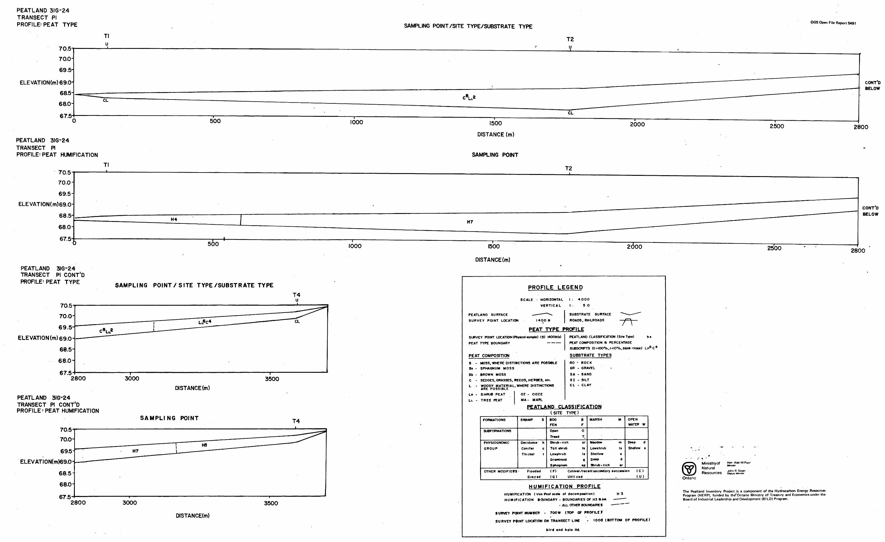
PEATLAND 3IG-24 TRANSECT PI PROFILE PEAT TYPE
70.570.0-
69.5-
ELEVATION(m)69.0- 68.5-
68.0-
67.5
PEATLAND 3IG-24TRANSECT PIPROFILE^ PEAT HUMIFICATION
SAMPLING POINT/SITE TYPE/SUBSTRATE TYPEOGS Open File Report 5491
T2
CONT'D BELOW
IOOO
Tl70.570.0-
69.5-ELEVATION(m)69.0-
68.5-
68.0-
67.5-500 IOOO
PEATLAND 3IG-24 TRANSECT PI CONT'D PROFILE'PEAT TYPE SAMPLING POINT/SITE TYPE/SUBSTRATE TYPE
T4 u
70.5 70.0-
69.5-
ELEVATION(m)69.0-
68.5-
68.0-
67.5
CL
2800
PEATLAND 3IG-24 TRANSECT PI CONT'D PROFILE' PEAT HUMIFICATION
3000 3500DISTANCE (m)
SAMPLING POINT T470.5
70.0-
695
ELEVATION(m)69.0-
68.5
68.0
67.52800 3000 3500
DISTANCE(m)
I500
DISTANCE (m)
SAMPLING POINT
2000 2500 2800
T2
CONT'D BELOW
I500
DISTANCE(m)
2000 2500 2800
PROFILE LEGEND
SCALE : HORIZONTAL
VERTICAL
PEATLAND SURFACE . — — — ""
SURVEY POINT LOCATION I4OO i
^
N
1 : 4OOO
1 : 5
SUBSTRA1
ROADS, R
0
FE SURFACE ^-^— — *"
AILROADS — f — \ ——
PEAT TYPE PROFILESURVEY POINT LOCATION (Riysicol so mote) (S) MOON (s)
PEAT TYPE BOUNDARY —————
PEAT COMPOSITION
PEATLAND CLASSIFICATION (Site Type) h s
PEAT COMPOSITION B PERCENTAGESUBSCRPTS (0*IOO*Xo,l*l00Xo,bloi**troce) Ln6 C 4
SUBSTRATE TYPES
S - MOSS, WHERE DISTINCTIONS ARE POSSIBLESi - SPHAGNUM MOSS
Sb - BROWN MOSS
C -
L -
Ln -
LL -
SEDGES, GRASSES, REEDS, HERBES, etc.WOODY MATERIAL, WHERE DISTINCTIONS ARE POSSIBLESHRUB PEAT
TREE PEAT
OZ - OOZEMA- MARL
RO - ROCKGR - GRAVEL
SA - SAND
SI - SILTC L - CLAY
PEATLAND CLASSIFICATION
FORMATIONS
SUBFORMATIONS
PHYSIOGNOMIC
GROUP
OTHER MODIFIERS
SWAMP S
Deciduous h
Conifer c
Thicket t
Flooded
Grazed
(SITE
BOGFEN
Open
Treed
TYPE)BF
O
T,
Shrub -rich sr
Toll shrub tsLowshrub IsGrominoid gSphagnum sp
(F)
(G)
MARSH M OPENWATER W
Meadow m Deep dLowshrub Is Shallow sShallow 9Deep dShrub- rich sr
Cut over /recent secondary succession ( C )Utilized (U)
HUMIFICATION PROFILEHUMIFICATION ( Von Post scole of decomposition) H 3
HUMIFICATION BOUNDARY - BOUNDARIES OF H3 ftH4 - — - —- ALL OTHER BOUNDARIES — — —
SURVEY POINT NUMBER - 700 W (TOP OF PROFILE^
SURVEY PdlNT LOCATION ON TRANSECT LINE
bird ond hole ltd.
. lOOd (BOTTOM OF PROFILE)
Ministry ofNaturalResources
Hon AtenWPopp Minister
John R Stoan Deputy Minister
Ontario
The Peatland Inventory Project is a component of the Hydrocarbon Energy Resources Program (HERP), funded by th/Ontario Ministry of Treasury and Economics under the Board of Industrial Leadership and Development (BILD) Program.
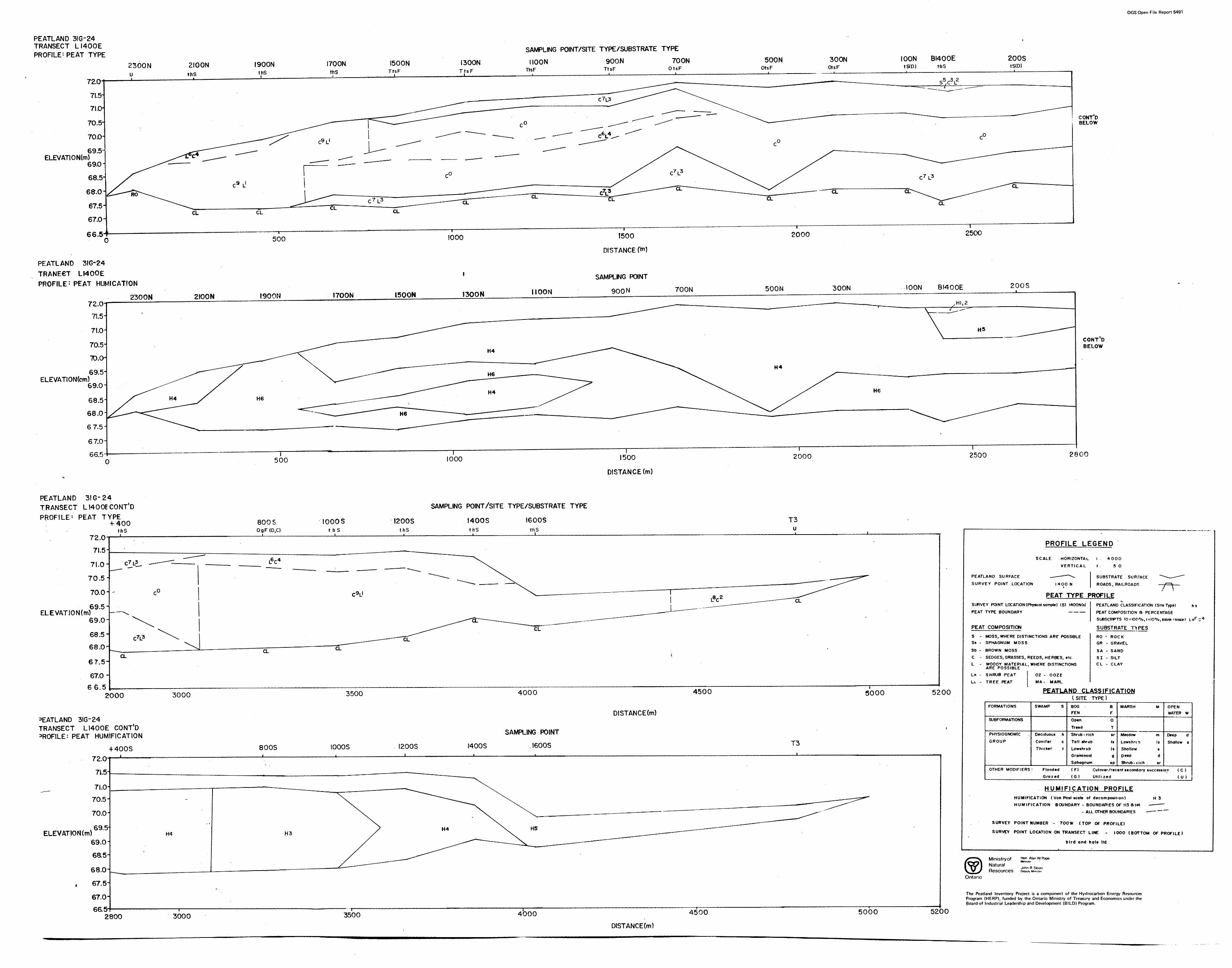
OGS Open File Report 5491
PEATLAND 3IG-24 TRANSECT LI400EPROFILE^ PEAT TYPE SAMPLING POINT/SITE TYPE/SUBSTRATE TYPE
2300N u
I900N I700NthS
I500N I300NTtsF
MOONTtsF
900.NTtsF
TOONOtsF
SOONOtsF
300NOtsF
IOONtS(D)
BI400EthS
200StS(D)
69.51 ELEVATION(m)
69.0-1
CONT'D BELOW
66.5
PEATLAND 3IG-24 TRANECT LI400E PROFILE : PEAT HUMICATION
2300N
500 1000
2IOON I900N I700N 1500N I300N MOON
F500
DISTANCE
SAMPLING POINT
900 N
2000 2500
700N SOON 300N IOON BI400E 200S
ELEVATIONfcm)
500 1000 1500
DISTANCE (m)
2000
CONT D BELOW
2500 2800
PEATLAND 31 G-24 TRANSECT LI400E CONT'D PROFILE 1 PEAT TYPE; -f-400
thS 72.0
SAMPLING POINT/SITE TYPE/SUBSTRATE TYPE
800 S OgF(D,C)
IOOOS t h S
I200SthS
I400SthS
I600S T3
ELEVATJON(m)
20OO
3EATLAND 3IG-24 TRANSECT LI40OE CONT'D
: PEAT HUMIFICATION
3000 3500 4000 4500 5000 5200
DISTANCE(m)
-MOOS 800S IOOOS I200S
SAMPLING POINT
I400S . I600S T3
ELEVATION(m)
72.0
7J.5-
7LO-
70.5-
70.0 J
69.5-
69.0-
68.5-
68.0^
67.5-
67.0-
66.5-2800 3000 3500 4000 4500 5000 5200
PROFILE LEGEND
SCALE HORIZONTAL
VERTICAL
PEATLAND SURFACE — — — ~\
SURVEY POINT LOCATION I4OON i
i . 4OOO
1 : 5
SUBSTRA
ROADS, F
0
TE SURFACE ~~^*~~^*~^
fAILROADS — /^^ ——
PEAT TYPE PROFILESURVEY POINT LOCATION (Phyacal sample) (S)
PEAT TYPE BOUNDARY
PEAT COMPOSITION
!4OON(s)— — —
PEATLAND CLASSIFICATION (Site Type) h s
PEAT COMPOSITION 8 PERCENTAGE
SUBSCRPTS (O ^OC'%, 1 slO0Xo, blank Mroce) Lnp C 4
SUBSTRATE TYPESS - MOSS, WHERE DISTINCTIONS ARr POSSIBLESs - SPHAGNUM MOSS.
Sb - BROWN MOSS
C - SEDGES, GRASSES, REEDS, HERBES, etc.L - WOODY MATERIAL,
ARE POSSIBLE
Ln - SHRUB PEAT
LL - TREE PEAT
WHERE DISTINCTIONS
OZ - OOZEMA- MARL
RO - ROCKGR - GRAVEL
SA - SAND
SI - SILTC L - CLAY
-
PEATLAND CLASSIFICATION
FORMATIONS
SUBFORMATIONS
PHYSIOGNOMIC
GROUP
OTHER MODIFIERS
SWAMP S
Deciduous h
Conifer c
Thicket t
: FloodedGrazed
(SITEBOGFEN
Open
Treed
TYPE)
BF
0
T
Shrub -ri eh sr
Tall shrub ts
Lowshrub IsGraminoid gSphagnum sp
(F)
(G)
MARSH M OPENWATER W
Meadow m Deep d
Lows hr i o Is Shallow t
Shallow sDeep dShrub -H eh sr
Cutover /recent secondary succession ( C )Utilized ( U )
HUMIFICATION PROFILEHUMIFICATION ( Von Post scale of decomposition) H 3
HUMIFICATION BOUNDARY - BOUNDARIES OF H3 8 W - —— —
- ALL OTHER BOUNDARIES — — — ~~
SURVEY POINT NUMBER - 70OW (TOP Of PROFILE)
SURVEY POINT LOCATION ON TRANSECT LINE - 1 OOO (BOTTOM OF PROFILE)
bird and hale ltd.
Ministry ofNaturalResources
Hon Alan W Pope Minister
John R Sloan Deputy Minister
Ontario
The Peatland Inventory Project is a component of the Hydrocarbon Energy Resources Program (HERP), funded by the Ontario Ministry of Treasury and Economics under the Board of Industrial Leadership and Development (BILD) Program.
DISTANCE(m)
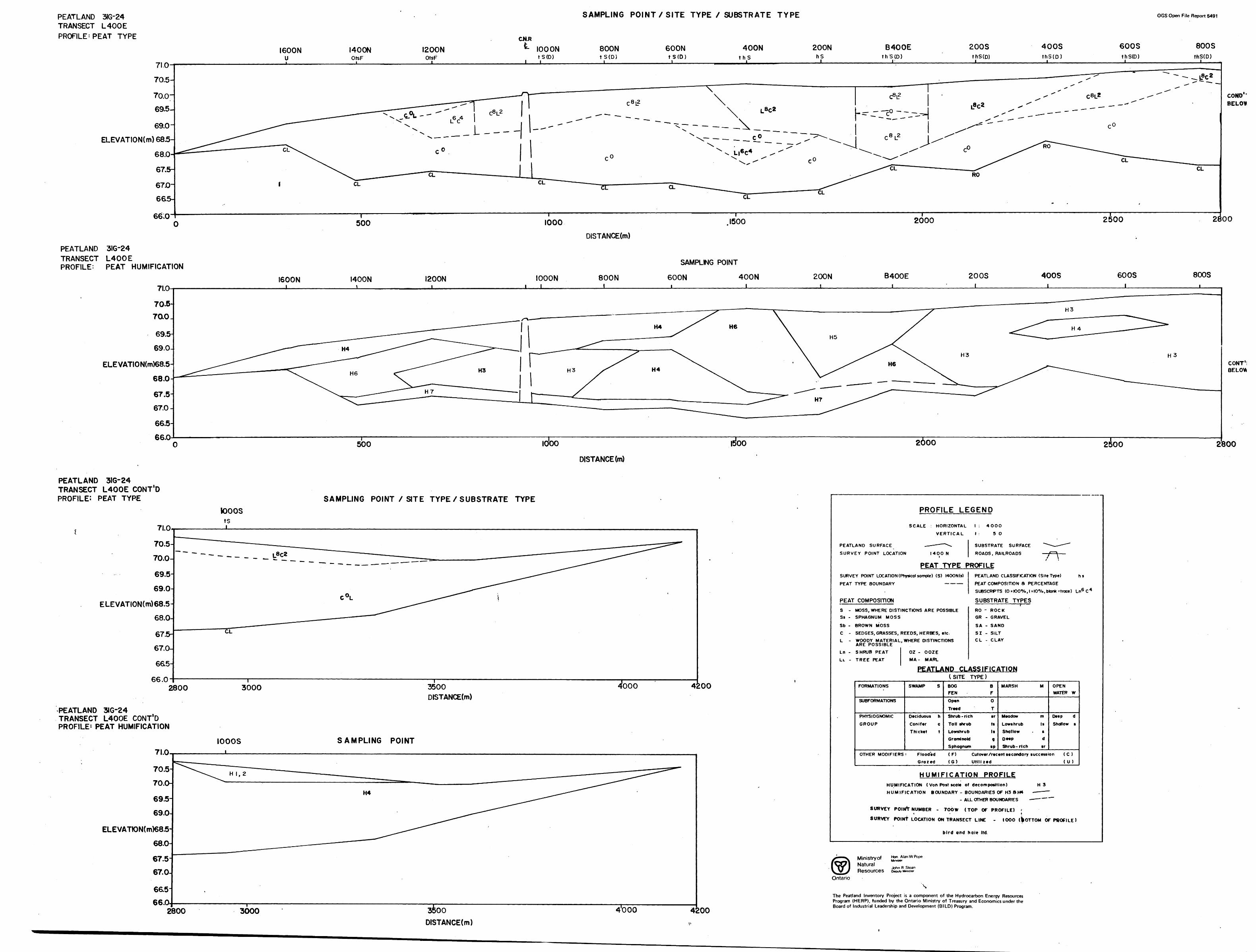
PEATLAND 316*24 TRANSECT L400E PROFILE-PEAT TYPE
SAMPLING POINT X SITE TYPE X SUBSTRATE TYPE
I600N I400N I20ONOtsF
C.N.RL IOOON
t S (D)800NtS(D)J
600Nt S (D)l
400NthS
J.
200NhS
JL
B400EthS(D)
JL
200SthS(D)J.
400SthS(D)
600SthS(D)
OGS Open File Report 5491
800 SthS(D)
ELEVATION(m)685-
COND'T BELOW
66.0
PEATLAND 3IG-24TRANSECT L400EPROFILE: PEAT HUMIFICATION
500 IOOO 2800
DISTANCE(m)
1600N7I.O
70.5-
70.0-
69.5-
69.0-
ELEVATION(m)68.5-
68.0-
67.5-
67.0-66.5-
66.0
I400N \__
I200N IOOON i i
SOON i
200Ni
B400E 200S i
400S 600Si
800S
CONT'D BELOW
500 IOOO ;oo 2600 2500 2800
DISTANCE (m)
PEATLAND 3IG-24 TRANSECT L400E CONT'D PROFILE: PEAT TYPE
7I.O
70.5
70.0-
69.5
69.0
ELEVATION(m)68.5
68.0-
67.5-
67.0-66.5-
66.0
SAMPLING POINT X SITE TYPE X SUBSTRATE TYPEtooosts
2800 3000 3500 DISTANCE(m)
4000 4200
PEATLAND 3IG-24 TRANSECT L400E CONT'D PROFILE- PEAT HUMIFICATION
IOOOS SAMPLING POINT7I.O
70.5
70.0-
69.5
69.0
ELEVATK)N(m)68.5
68.0
67.567.0
66.5H66.0.
2800 3000 sfeooDISTANCE(m)
4'000
PROFILE LEGEND
SCALE : HORIZONTAL
VERTICAL
PEATLANO SURFACE — — — —
SURVEY POINT LOCATION I4OONi
1 : 4OOO
1 5
SUBSTRA'
ROADS , R
O
FE SURFACE ^^- -^-^*
AILROADS — f^ ——
PEAT TYPE PROFILESURVEY POINT LOCATION (Physical sample) (S) !4OON(s)
PEAT TYPE BOUNDARY —————
PEAT
S -Ss -
Sb -
C -L -
Ln -LL -
COMPOSITION
PEATLAND CLASSIFICATION (Site Type) h s
PEAT COMPOSITION 8 PERCENTAGE
SUBSCRPTS (O'K)O0Xo,|zl00Xo,btankMrace) Ln6 C 4
SUBSTRATE TYPES
MOSS, WHERE DISTINCTIONS ARE POSSIBLESPHAGNUM MOSS
BROWN MOSS
SEDGES, GRASSES, REEDS, HERBES, tlc.
WOODY MATERIAL, ARE POSSIBLE
SHRUB PEAT
TREE PEAT
WHERE DISTINCTIONS
OZ - OOZE
MA- MARL
tRO - ROCKGR - GRAVEL
SA - SAND
SI - SILTC L - CLAY
PEATLAND CLASSIFICATION
FORMATIONS
SUBFORMATIONS
PHYSIOGNOMIC
GROUP
OTHER MODIFIERS
SWAMP S
Deciduous hConifer cThicket t
: FloodedG ra z ed
C SITE
BOGFENOpenTreed
TYPE)
BF0T
Shrub -rich srTall shrub tsLowshrub IsGraminoid 9Sphagnum sp
(F)(G)
MARSH M OPENWATER W
Meadow m Deep dLowshrub Is Shallow sShallow ' sDeep dShrub -ri eh sr
Cutover /recent secondary succession ( C )Utilized (U)
HUMIFICATION PROFILEHUMIFICATION ( Von Post scale of decomposition) H 3HUMIFICATION BOUNDARY - BOUNDARIES OF H3 8 H4 — — —
- ALL OTHER BOUNDARIES ——— —~
SURVEY POINT NUMBER -t 700W (TOP OF PROFILE) ?t
SURVEY POINT LOCATION ON TRANSECT LINE - looo BOTTOM OFPDOFILE)
bird and hale ltd.
Ministry ofNaturalResources
Hon Alan W PopeMinster
Ontario
4200
The Peatland Inventory Project is a component of the Hydrocarbon Energy Resources Program (HERP), funded by the Ontario Ministry of Treasury and Economics under the Board of Industrial Leadership and Development (BILD) Program.
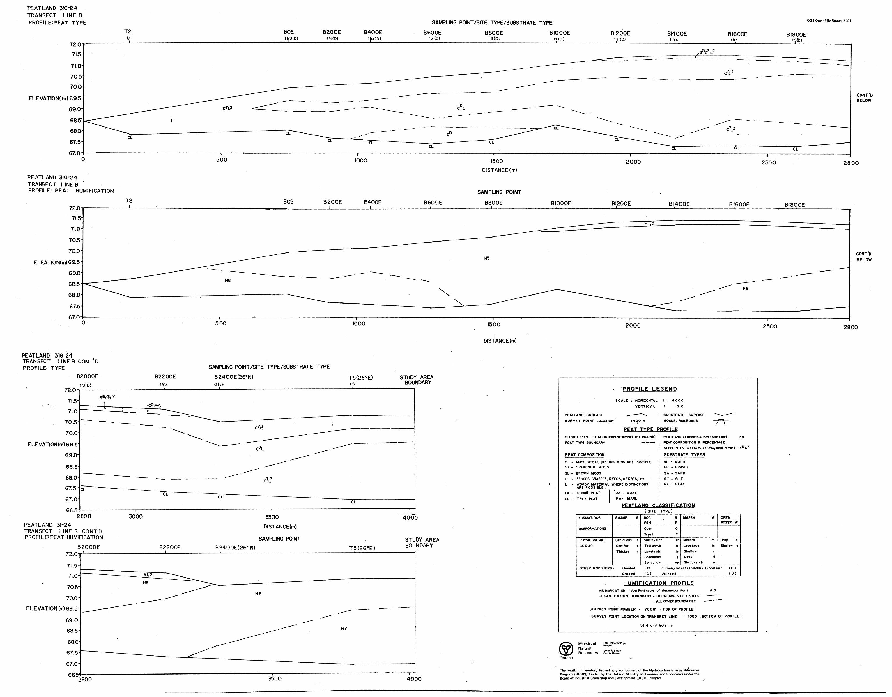
PEATLAND 3IG-24 TRANSECT LINE B PROFILE: PEAT TYPE SAMPLING POINT/SITE TYPE/SUBSTRATE TYPE OGS Open File Report 5491
T2 u
BOEthS(D)
B200Eths(D)
B400Eths(p)
B600Et S (D)
i
B800EtS(D)
BIOOOEts(D)
BI20OEts (D)
BI400Eths
BI600Eths
BI8OOEtstb)
72.0 71.5-71.0-
70.5
TOO
ELEVATION m) 69.5
69.0-
eao67.5-
67.0
CLCL
CL
CONT'DBELOW
500 1000
PEATLAND 3IG-24 TRANSECT LINE B PROFILE 1 PEAT HUMIFICATION
BOE B200EI.
B400E B600E
1500
DISTANCE (m)
SAMPLING POINT
B80OE
"T———
2000 2500 2800
BIOOOE BI200E BI400E BI600E BI800E
ELEATION(m)69.5-
CONTD BELOW
500 1000 1500
DISTANCE (m)
2OOO 2500 2800
PEATLAND 31G-24 TRANSECT LINES CONT'DPROFILE: TYPE
B2000E B2200ESAMPLING POINT/SITE TYPE/SUBSTRATE TYPE
B2400E(260 N) T5(26 0E)
72.0tS(D)
ELEVATION (m) 69.5-
STUDY AREA BOUNDARY
66.52800
PEATLAND 31-24 TRANSECT LINE B CONT'D PROFILE:PEAT HUMIFICATION
B2OOOE 72,0-r1
70.5-
70.0-
ELEVATION(m)69.5-
3000 3500
DISTANCED)
SAMPLING POINTB2200E B24OOE(26 0 N) T5(260E)
4000
STUDY AREA BOUNDARY
* PROFILE LEGEND
SCALE : HORIZONTAL
VERTICAL
PEATLAND SURFACE — — -— "^**
SURVEY POINT LOCATION I4OONi
1 : 4000
1 : 5
SUBSTRA'
ROADS, R
O
FE SURFACE "^^-^-^"
AILROADS — fZZf —— i t
PEAT TYPE PROFILESURVEY POINT LOCATION (Physical sample) (S) MOON(s)
PEAT TYPE BOUNDARY —————
PEAT
S -Ss -
Sb -
C -
L -
Ln -
LL -
COMPOSITION
PEATLAND CLASSIFICATION (Site Type) h t
PEAT COMPOSITION 8 PERCENTAGE
SUBSCRPTS (OrlOO0Xo f |s|00Xo,btankMroce) Ln6 C 4
SUBSTRATE TYPES
MOSS, WHERE DISTINCTIONS ARE POSSIBLE
SPHAGNUM MOSS
BROWN MOSS
SEDGES, GRASSES, REEDS, HERBES, tlc.
WOODY MATERIAL, WHERE DISTINCTIONS ARE POSSIBLE.
SHRUB PEAT
TREE PEAT
*OZ - OOZE
MA- MARL
RO ~ ROCK
GR - GRAVEL
SA - SAND
SI - SILTC L - CLAY
PEATLAND CLASSIFICATION
FORMATIONS
SUBFORMAT10NS
PHYSIOGNOMIC
GROUP
OTHER MODIFIERS
SWAMP S
Deciduous h
Conifer c
Thicket t
: Flooded
Grazed
(SITE
BOGFEN
Open
Treed
TYPE)
BF
0
T
Shrub -ri eh sr
Tall shrub ts
Lowshrub Is
Graminoid q
Sphagnum sp
(F)
(G)
MARSH M OPENWATER W
Meadow m Deep d
Lowshrub Is ShaMcw s
Shallow s
Deep d
Shrub- rich sr
Cutover/recent secondary succession ( C )
Utili zed (U )
HUM'IFICATION PROFILEHUMIFICATION ( Von Pott scale of decomposition) H 3
HUMIFICATION BOUNDARY - BOUNDARIES OF H3 8 H4 — — —
- ALL OTHER BOUNDARIE S - — - ~*~ ~~~
.SURVEY POttT NUMBER -
SURVEY POINT LOCATION
700W ( TOP OF PROFILE )
ON TRANSECT LINE
bird and hole ltd
- 1000 ( BOTTOM OF PROFILE )
Ministry ofNaturalResources
Hon Alan W Pope
John R Sloan Deputy (Minister
Ontario
665^2800 3500 4000
The Peatland Irtventory Project is a component of the Hydrocarbon Energy Resources Program (HERP), funded by the Ontario Ministry of Treasury and Economics under the Board of Industrial Leadership and Development (BILD) Program.
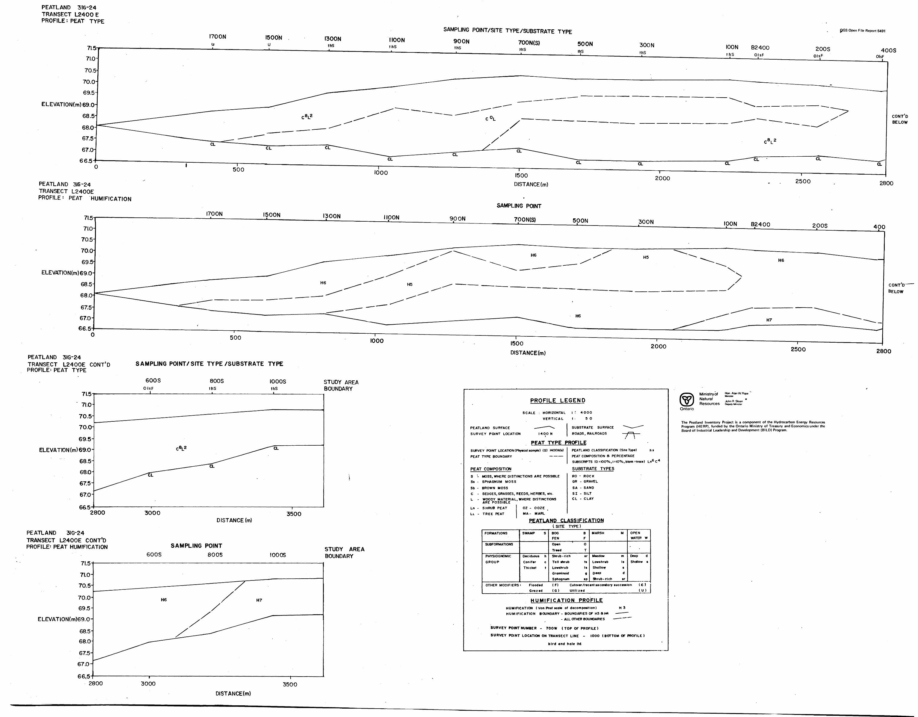
PEATLAND 31G-24 TRANSECT L2400 E PROFILE: PEAT TYPE
I700N u
I500Nu
I300NthS
MOONthS
SAMPUNG POINT/SITE TYPE /SUBSTRATE TYPE
700N(S) SOON
pGS Open File Report 5491
900NthS
ELEVAT!ON(m)69.0
CONT'D BELOW
O
PEATLAND 316*24TRANSECT L2400EPROFILE^ PEAT HUMIFICATION
500 1000
66.5
PEATLAND 3IQ-24TRANSECT L2400E CONT'D PROFILE: PEAT TYPE
6652800
PEATLAND 3IG-24 TRANSECT L2400E CONT'D PROFILE1 PEAT HUMIFICATION
71.5
71.0-
70.5
70.0
69.5
ELEVATlON(m)69.0-
68.5
68.0
67.5-
67.0-
66,52800
I700N I500N I300N MOON 90 ON
t500 DISTANCE (m)
t SAMPLING POINT
700N(S)
2000 2500 2800
500N 300N IOON B2400 2 O OS 400
ELEVATION(m)69.0-
CONT'D BELOW
500 1000 1500 DISTANCE(m)
2000 2500 2800
SAMPUNG POINT/SITE TYPE/SUBSTRATE TYPE
800S IOOOS
ELEVATION (m) 69.0
STUDY AREA BOUNDARY
3000 3500DISTANCE (m)
SAMPLING POINT600S 800S 10005
STUDY AREABOUNDARY
PROFILE LEGEND
SCALE : HORIZONTAL
VERTICAL
PEATLAND SURFACE - — - — "
SURVEY POINT LOCATION I40O i
•\
N
1 f 4OOO1 : 5
SUBSTRA'
ROADS, R
O
FE SURFACE "^^~-^~
i \
PEAT TYPE PROFILESURVEY POINT LOCATION (Physical sompte) (S)
PEAT TYPE BOUNDARY
PEAT COMPOSITION
!4OON(s)— — —
PEATLAND CLASSIFICATION (Site Type) h s
PEAT COMPOSITION ft PERCENTAGE
SUBSCRPTS (0 2 K)OeXo, 1 s|O*Vo, blank Mroce) Ln6 C 4
SUBSTRATE TYPES
S - MOSS, WHERE DISTINCTIONS ARE POSSIBLE
Ss - SPHAGNUM MOSS
Sb - BROWN MOSS
C - SEDGES, GRASSES, REEDS, HERBES, etc.
L - WOODY MATERIAL, WHERE DISTINCTIONS ARE POSSIBLE
Ln - SHRUB PEAT
LL - TREE PEAT
OZ - OOZE
MA- MARL
RO - ROCKGR - GRAVEL
SA - SAND
SI - SILTCL - CLAY
-
PEATLAND CLASSIFICATION
FORMATIONS
SUBFORMATIONS
PHYSIOGNOMIC
GROUP
OTHER MODIFIERS
SWAMP S
Deciduous h
Conifer c
Thicket t
5 FloodedGrazed
(SITEBOGFEN
OpenTreed
TYPE)
BF
0
T
Shrub -rich srToll shrub tsLowshrub IsGraminoid gSphagnum sp
(F)(G)
MARSH M OPENWATER W
*
Meadow m Deep dLows hr Mb Is Shallow sShallow sDeep d
Shrub- rich srCutover /recent secondary succession ( C f
Utilized (U)
HUMIFICATION PROFILEHUMIFICATION ( Von Post scale of decomposition) H 3HUMIFICATION BOUNDARY - BOUNDARIES OF H3 a H4 —— —— "
- ALL OTHER BOUNDARIES — — — —
SURVEY POINT NUMBER - 700W ( TOP OF PROFILE )
SURVEY POINT LOCATION ON TRANSECT LINE - IOOO ( BOTTOM OF PROFILE )
bird ond hole ltd.
Ministry ofNaturalResources
Hon Alan W Pope
John R Sloan Deputy Minister
Ontario
The Peatland Inventory Project is a component of the Hydrocarbon Energy Resources Program {HERP), funded by the Ontario Ministry of Treasury and Economics under the Board of Industrial Leadership and Development (BILD) Program.
3000 350ODISTANCE(m)
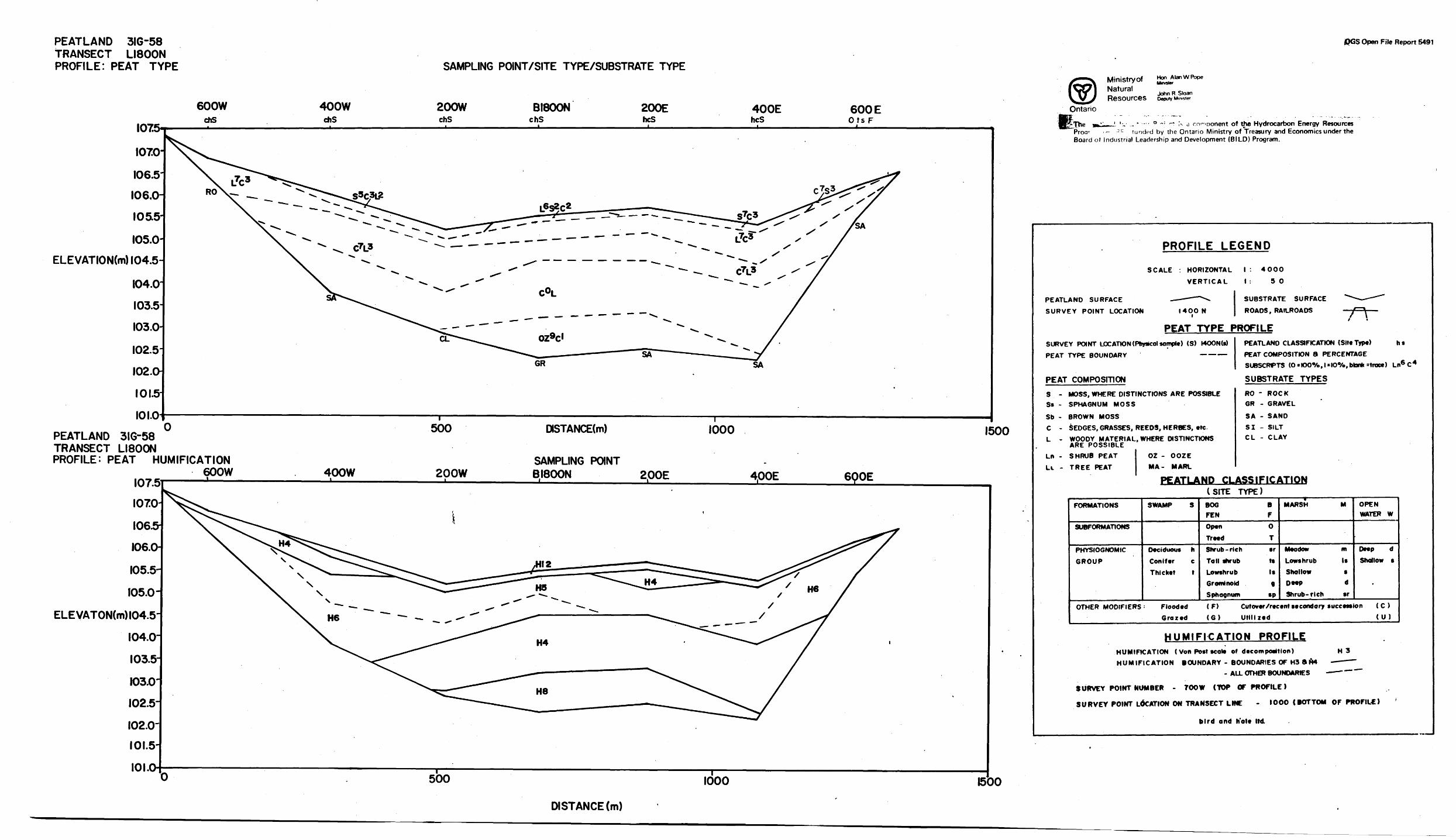
PEATLAND 316-58 TRANSECT LI800N PROFILE: PEAT TYPE
DCS Open File Report 6491
I075
400WehS
200WchS
BI800NchS
200EhcS
400EhcS
600 EOts F
I070-
I06.5-
I06.0-
I05.5
I05.0
ELEVATION(m)l04.5-
I04.0-
I03.5
I03.0-
I02.5-
I02.O
IOI.&
101.0
R0\-..
CL
PEATLAND 3IG-58 TRANSECT LI800N PROFILE: PEAT HUMIFICATION
107.51070
1065106.0-
105.5-
105.0-
ELEVATON(m)l04.5- 104.0-
103.5-
103.0-
102.5-102.0-
101.5-
101.0
400W
500
200W
OSTANCE(m)
SAMPLING POINT BI800N
1000 1500
2.00E 400E 6QOE
500 1000
Ministry ofNaturalResources
Hon Alan W Pope Minister
John R Sloan Deputy Minister
w-. —-- 0 ~ : -~~ Is d cnmoonent of the Hydrocarbon Energy Resources "Proar - 3C funded by the Ontario Ministry of Treasury and Economics under the Board of Industrial Leadership and Development (BILD) Program.
PROFILE LEGEND
SCALE : HORIZONTAL
VERTICAL
PEATLANO SURFACE - — —— ~"
SURVEY POINT LOCATION I4OO i
•^
N
1 : 4000
1 : 50
SUBSTRA1
ROADS, R
FE SURFACE *^* —— ~~~*
AILROADS — 'f~~\ ——i \
PEAT TYPE PROFILESURVEY POINT LOCATION (Physical sample) (S) r4OON(s)
PEAT TYPE BOUNDARY —————
PEAT COMPOSITION
PEATLAND CLASSIFICATION (Site Type) h t
PEAT COMPOSITION 8 PERCENTAGESUBSCRPTS (O*KX)0Xo,l*IO0Xo,blonkstroce) Ln6 C 4
SUBSTRATE TYPES
S - MOSS, WHERE DISTINCTIONS ARE POSSIBLESs - SPHAGNUM MOSS
Sb - BROWN MOSS
C -
L -
LB -
Le -
SEDGES, GRASSES, REEDS, HERBES, *tcWOODY MATERIAL, WHERE DISTINCTIONS ARE POSSIBLESHRUB PEAT
TREE PEAT
OZ - OOZEMA- MARL
RO - ROCKGR - GRAVEL
SA - SAND
SI - SILTC L - CLAY
PEATLAND CLASSIFICATION
FORMATIONS
SUBFORMATIONS
PHYSIOGNOMIC
GROUP
SWAMP S
Deciduous hConifer cThicket t
OTHER MODIFIERS' FloodedGrazed
(SITEBOGFEN
Open
Treed
TYPE)
BF
0
T
Shrub -rich srTall shrub tsLowshrub IsGrominoid 9Sphagnum sp
(F)(G)
MARSH M OPENWATER W
Meadow m Deep dLowshrub Is Shallow sShallow 9Deep d
Shrub- rich srCutover /recent secondary succession ( C )Utilized (U)
HUMIFICATION PROFILEHUMIFICATION ( Von Post seal* of decomposition) H 3
HUMIFICATION BOUNDARY - BOUNDARIES OF H3 ft H4 —— ——- ALL OTHER BOUNDARIES - —— '""" ""
SURVEY POINT NUMBER - TOO W (TOP OF PROFILE)
SURVEY POINT LOCATION ON TRANSECT LINE - IOOO CtOTTOM OF PROFILE)
bird and hole ltd
1500
DISTANCE (m)
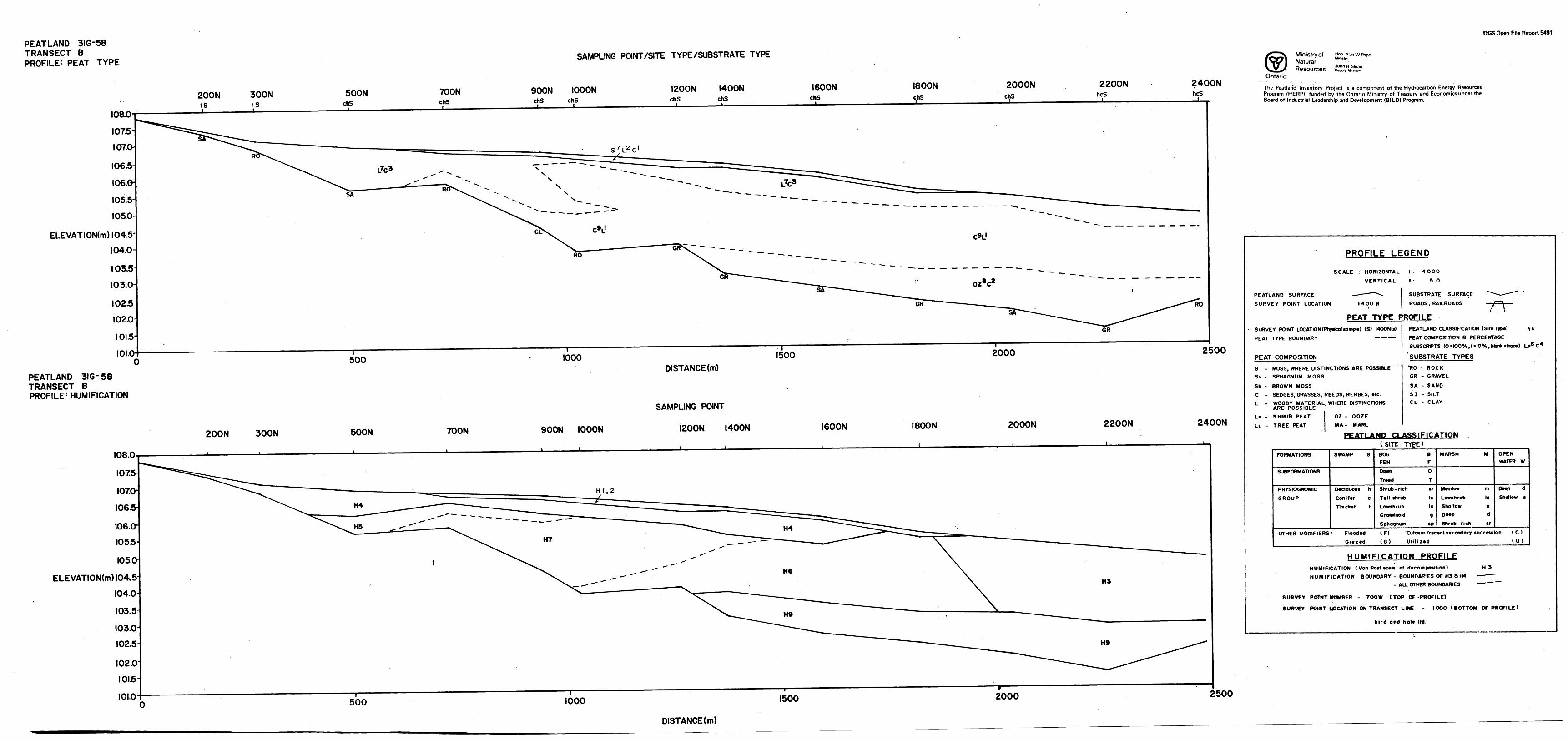
OGS Open File Report 5491
PEATLAND 3IG-58 TRANSECT B PROFILE: PEAT TYPE
I08.0
I07.5-
I07.O
I06.5-
I06.O I05.5-
I05i0-
ELEVATION(m)l04.5-
I04.0-
I03.5
I03.0H
1 02.5
I02.0
IOI.5
PEATLAND 3IG-58 TRANSECT B PROFILE 1 HUMIFICATION
SAMPLING POINT/SITE TYPE/SUBSTRATE TYPE
200Nts
300Nts
SOONchS
TOONchS
900NchS
IOOONchS
I200NchS
I400NchS
I600NchS
I800N 2000N 2200NhcS
2400NhcS
i
500 1000 1500 2000 2500
DISTANCE (m)
200N 300N SOON TOON SOON IOOON
SAMPLING POINT
I200N I400N I600N I800N 2000N 2200N 2400N
ELEVATION(m) 104.5
2500
Ministry ofNaturalResources
Hon Alan W PopeMinister
John R Stoan Deputy Minister
Ontario
The Peatland Inventory Project is a component of the Hydrocarbon Energy Resources Program (HERP), funded by the Ontario Ministry of Treasury and Economics under the Board of Industrial Leadership and Development (BILD) Program.
PROFILE LEGEND
SCALE : HORIZONTAL
VERTICAL
PEATLAND SURFACE — -*""^-
SURVEY POINT LOCATION I40ON i
PEAT TYPE PSURVEY POINT LOCATION (Physicol sample) (S)
PEAT TYPE BOUNDARY
PEAT COMPOSITION
S - MOSS, WHERE DI STIN Ss - SPHAGNUM MOSS
Sb - BROWN MOSS
C - SEDGES, GRASSES, RL - WOODY MATERIAL,
ARE POSSIBLE
Ln - SHRUB PEAT
Lt - TREE PEAT
FORMATIONS
SUBFORMATIONS
PHYSIOGNOMIC
GROUP
!4OON(s)
ICTIONS ARE POSSIBLE
EEDS, HERBES, etc.
WHERE DISTINCTIONS
OZ - OOZE MA- MARL
PEATLAND CL
SWAMP S
Deciduous h Conifer c Thicket t
OTHER MODIFIERS - Flood td
Grazed
(SITE
BOG FEN
Open
Treed
1 : 400
1 . 5~
SUBSTRA1
ROADS, R
^ROFILE
0
0
FE SURFACE ^^—— ~
AILROADS — fZ^t ——i \
PEATLAND CLASSIFICATION (Site Type) h s
PEAT COMPOSITION 8 PERCENTAGE SUBSCRPTS (O*IOO0Xo.|slO0Xo,btar*Mroce) Ln6 C 4
"SUBSTRATE TYPES*RO - ROCK GR - GRAVEL
SA - SAND
SI - SILT C L - CLAY
ASSIFICATIONTYfE)
B F
O
T
Shrub -ri eh sr
Tall shrub ts
Lowshrub Is Graminokt g
Sphagnum sp
(F)
(G)
MARSH M OPEN WATER W
Meadow m Deep d Lowshrub Is Shallow t Shallow s Deep d Shrub- r i eh sr
'Cufover /recent secondary succession (C)
Utilized (U)
HUMIFICATION PROFILEHUMIFICATION ( Von Post scale of decomposition) H 3 HUMIFICATION BOUNDARY - BOUNDARIES OF H3 S H4 - —— ——
- ALL OTHER BOUNDARIES — —— "~
SURVEY POTNT ttOMBER - 7OOW (TOP OF 'PROFILE)
SURVEY POINT LOCATION ON TRANSECT LINE - lOOO (BOTTOM OF PROFILE)
bird and hole ltd
500
DISTANCE (m)
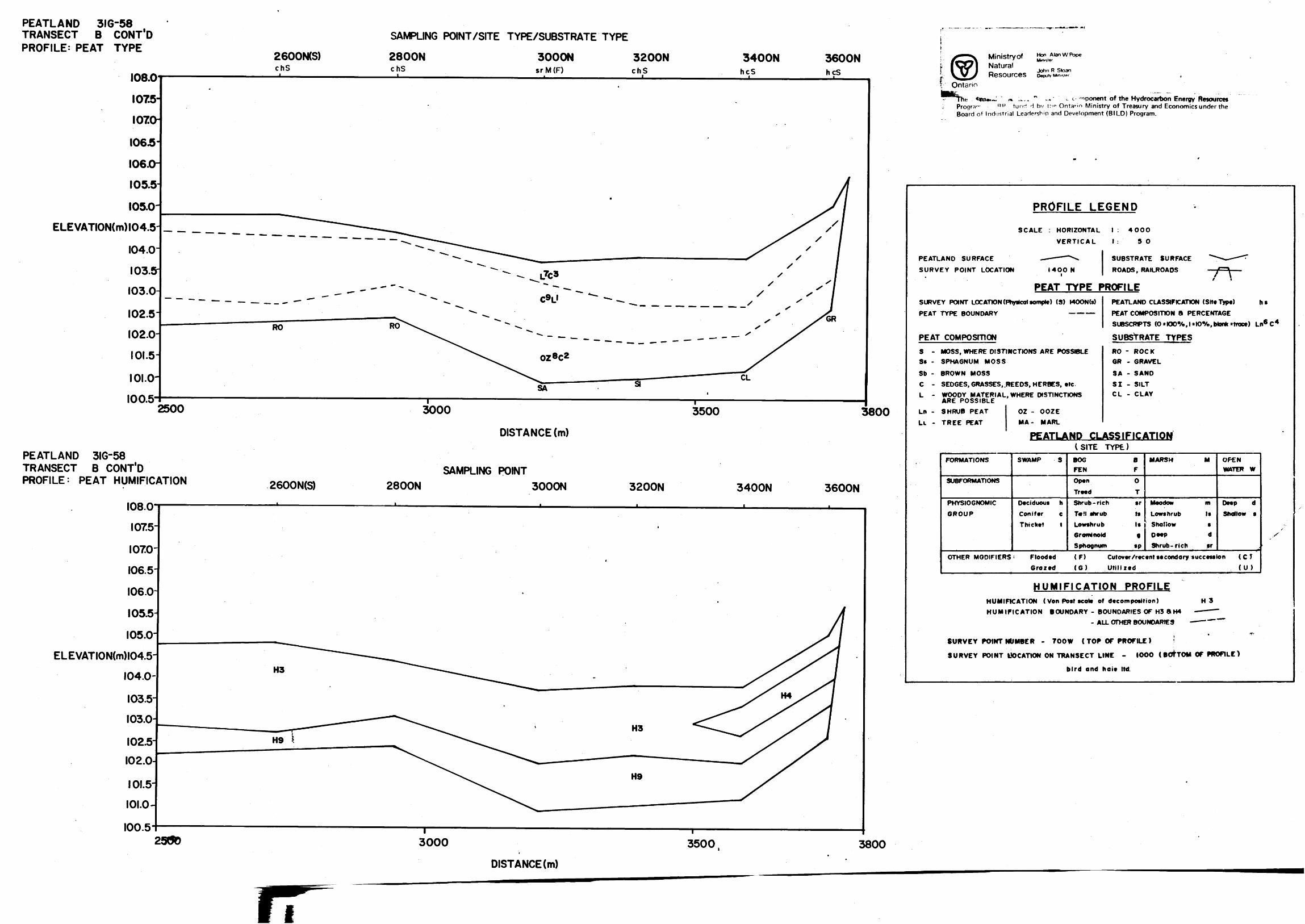
PEATLAND 3IG-58 TRANSECT B CONT'DPROFILE: PEAT TYPE
SAMPLING POINT/SITE TYPE/SUBSTRATE TYPE
2600MS) 2800N 3000Nsr M (F)
3200NchS
J.
3400NhcS
3600NhcS
ELEVATION(m)l04.5
2500
PEATLAND 3IG-58 TRANSECT B CONT'D PROFILE: PEAT HUMIFICATION
108.0
1075
250D
3000 3500 3800
DISTANCE (m)
2600N(S)SAMPLING POINT
2800N 3000N 3200N 3400N 3600N
ELEVATION(m)l04.5
3000 3500 3800DISTANCE (m)
Ministry ofNaturalResources
Hon Alan W PopeMmtster
John R Sloan Deputy Minis'*^
**n*.~ . .^,, " -* ' c. opponent of the Hydrocarbon Energy Resourcesfund d bv tn*1 Ontario Ministry of Treasury and Economics under the
Board of Industrial Leadership and Development (BILD) Program.
PROFILE LEGEND
SCALE : HORIZONTAL
VERTICAL
PEATLAND SURFACE — — —— '
SURVEY POINT LOCATION I4OO
\
N
1 : 400O
1 : 5
SUBSTRA
ROADS, R
O
fE SURFACE ^^-^^^ AILROADS f~-\ ——
/ tPEAT TYPE PROFILE
SURVEY POINT LOCATION (Physfcol somple) (S) MOON (s)
PEAT TYPE BOUNDARY —————
PEAT COMPOSITION
PEATLAND CLASSIFICATION (Site Type) h s
PEAT COMPOSITION ft PERCENTAGE
SUBSCRIPTS (O '(00%,1'KWo, Monk 'trace) Ln6 C 4
SUBSTRATE TYPES
S - MOSS, WHERE DISTINCTIONS ARE POSSIBLES* - SPHAGNUM MOSS
Sb - BROWN MOSS
C -
L -
Ln -
LL -
SEDGES, GRASSES, .REEDS, HERBES, etcWOODY MATERIAL, WHERE DISTINCTIONS ARE POSSIBLE
SHRUB PEAT
TREE PEAT
OZ - OOZEMA- MARL
RO - ROCKGR - GRAVEL
SA - SAND
SI - SILTCL - CLAY
PEATLAND CLASSIFICATION
FORMATIONS
SUBFORMATIONS
PHYSIOGNOMIC
GROUP
OTHER MODIFIERS
SWAMP S
Deciduous h
Conifer c
Thicket t
; FloodedGrazed
C SITE
BOGFEN
Open
Treed
TYPE)
BFOT
Shrub -rich srT* H shrub tsLowshrub IsGrominofd gSphagnum sp
(F)(G)
MARSH M OPENWATER W
Meodow m Deep dLowshrub Is Shallow s
i Shallow sD**P d" XShrub- ri eh sr
Cut over /recent secondary succession ( C TUtilized (U)
HUMIFICATION PROFILEHUMIFICATION ( Von Post scole of decomposition) H 3
HUMIFICATION BOUNDARY - BOUNDARIES OF H3 SH4 —— ——- ALL OTHER BOUNDARIES — —— —
SURVEY POINT NUMBER - 700 W (TOP OF PROFILE ) 1
SURVEY POINT LOCATION ON TRANSECT LINE - IOOO (BOTTOM OF PROFILE)
bird and haie ltd.
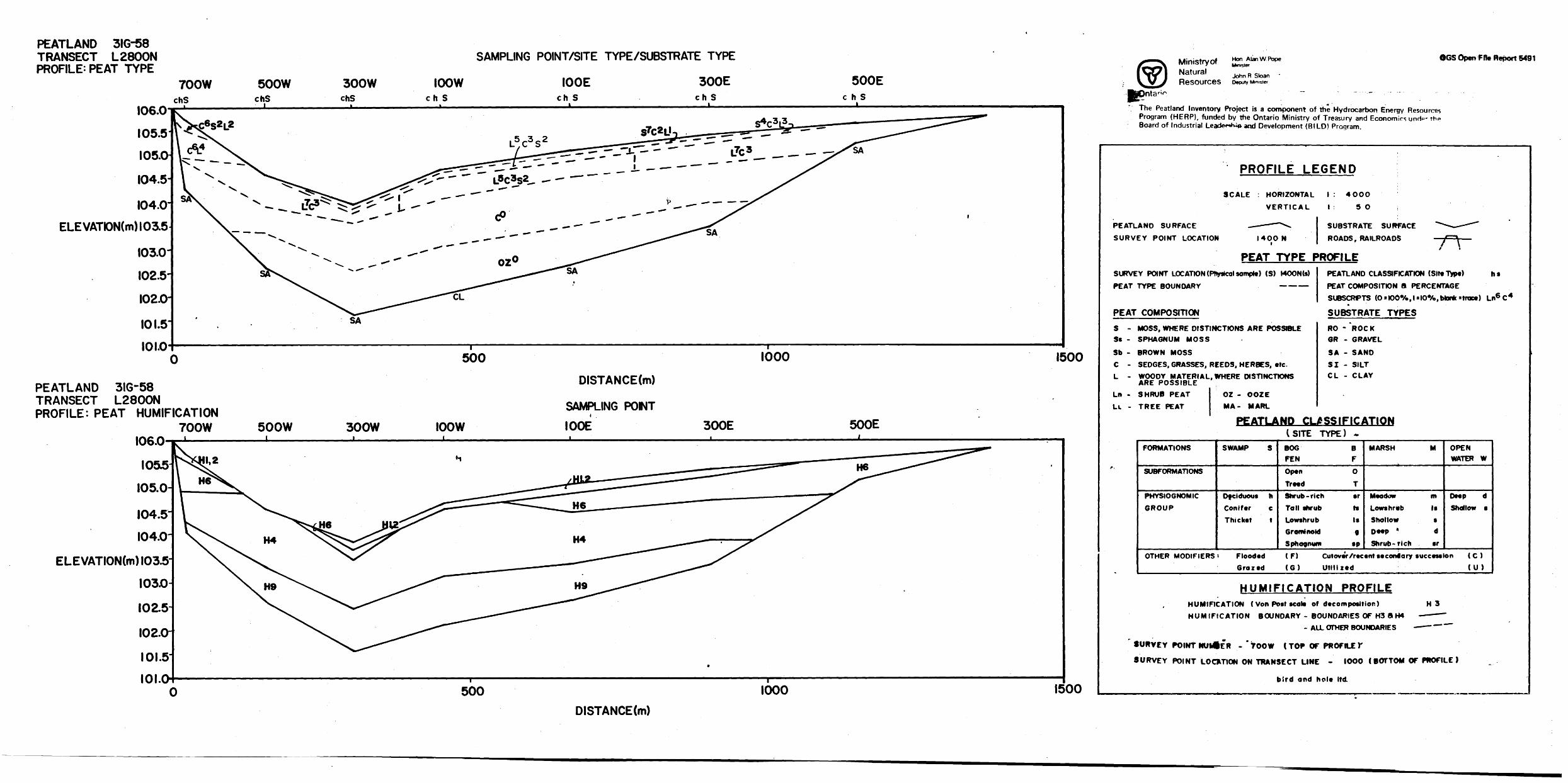
PEATLAND 31G-58 TRANSECT L2800N PROFILE: PEAT TYPE
106.0
105.5 I05.a
104.5-104.0-
ELEVATK)N(m) 103.5103.0-
102.5-
102.0-
101.5101.0
PEATLAND 3IG-58 TRANSECT L2800N PROFILE: PEAT HUMIFICATION
700W 106.0
SAMPLING POINT/SITE TYPE/SUBSTRATE TYPE
500 1000 1500
500W 300W IOOW
DISTANCE(m)
SAMPLING PONT l GOE 300E 500E
ELEVATION(m) 103.5-
500 1000 1500
Ministry ofNaturalResources
Hon Alan W Pope Minister
John R Stoan Deputy Minister
OGS Open File Report 5491
The Peatland Inventory Project is a component of the Hydrocarbon Energy Resources Program (HERP), funded by the Ontario Ministry of Treasury and Economics unrip- the Board of Industrial Leadei-tH^ aod Development (BILD) Program.
PROFILE LEGEND
SCALE HORIZONTAL
VERTICAL
PEATLAND SURFACE —— - —— "\
SURVEY POINT LOCATION I4OON i
\ : 40OO
1 : 5
SUBSTRA
ROADS, R
0
fE SURFACE *^^ ^
AILROADS — '/~~^\ —— i t
PEAT TYPE PROFILESURVEY POINT LOCATION (Phyitcol semple) (S) r4OON(s)
PEAT TYPE BOUNDARY —————
PEAT
S -St -
Sb -
C -L -
Ln -
Lc -
COMPOSITION
PEATLAND CLASSIFICATION (Site Type) h 9PEAT COMPOSITION 8 PERCENTAGE
SUBSCRFTS (0*K)00AJ*l00A,btank*trace) Ln6 C 4
SUBSTRATE TYPES
MOSS, WHERE DISTINCTIONS ARE POSSIBLESPHAGNUM MOSS
BROWN MOSS
SEDGES, GRASSES, REEDS, HERBES, etc.
WOODY MATERIAL, WHERE DISTINCTIONS ARE POSSIBLESHRUB PEAT
TREE PEAT
OZ - OOZEMA- MARL
RO - *ROCKGR - GRAVEL
SA - SAND
SI - SILTC L - CLAY
PEATLAND CLASSIFICATION
f.
FORMATIONS
SUBFORMATIONS
PHYSIOGNOMIC
GROUP
OTHER MODIFIERS
SWAMP S
Deciduous hConifer cThicket t
i FloodedGrazed
C SITEBOGFEN
OpenTreed
TYPE) -
BF
O
TShrub -ri eh erTall shrub fsLowshrub IsGrominoid 9Sphagnum sp(F)(G)
MARSH M OPENWATER W
Meadow m Deep d
Lowshrvb Is Shallow 9Shallow sDeep * d
Shrub- rich srCut over /recent secondary succession ( C )
Utilized (U)
HUMIFICATION PROFILEHUMIFICATION ( Von Post scale of decomposition) H 3
HUMIFICATION BOUNDARY - BOUNDARIES OF H3 8k H4 — - ———- ALL OTHER BOUNDARIES — — —
SURVEY POINT NUMlER - *700W t TOP OF PROFILE Y
SURVEY POINT LOCUTION ON TRANSECT LINE - IOOO ( BOTTOM OF PROFILE )
bird and hole ltd.
DISTANCE(m)
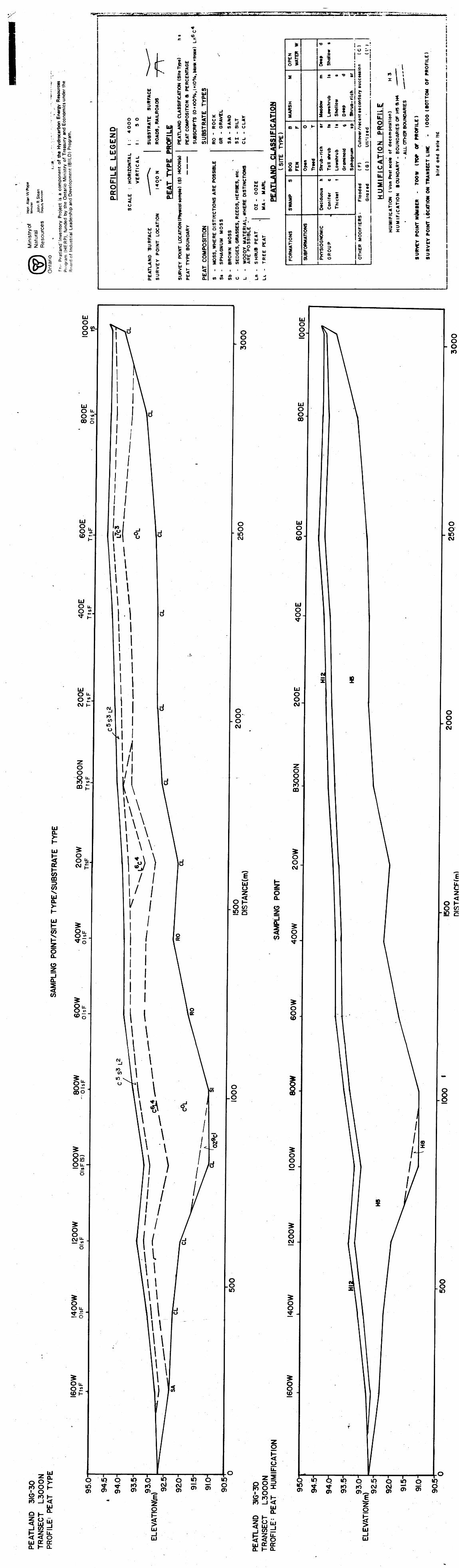
" z t—X ES xZ
i\
)(1 *
~~~
*",.
IUoisD < CO O
ac.
O-z.UJoUJ
PROFILE LI
o o je so .rt 5 a 0 " -T M* fc 8 -J
S S CL. . to o: Oa:- o.
SCALE : HORIZONTAL VERTICAL
ON I400N i
PEAT TYPE
SUl 0
2-tt KD Z *0 Qo IL
5 r,-i "l- : ^
41 ItUJ ^o. to
Om (0
~*^^g6 \
111* Z^ A
CO UJ ^
i o^j UJ M
^ m ^ y u 0 i a.^ r o ^ to g 2 |-co S: * ^ S S uo 2 12 !5 88fc Pd 0 S S p 1- w ffi< < flg ^ }f tf V) (O
1* S o > 1- o 5 z t- < ^O o: < rf -i 7i o: o co co u *J| 1 1 1 1 IL "-o
o or < M j jjj }^ o: o co co o Z*! 5zai-
3 1 , M"81 2 s J 55 i 1 | s 1 3""3 ^ " -rf J w- J J
1 s -85 g 1 Sf j 5 s 0 ' ujj
l i li ^— P co . -J. —— ——Z CO CO CO <
Y POINT LOCATIO TYPE BOUNDARY COMPOSITION
UJ |.> i- 552 SCO Q. O-
— ,— it! i—O O K QrUJ
u Z w Jo UJJ i-
1 i I i Is s S*- i 5 8' g2 * * S S |g 8S 1 SO Q. tt Ul 51"^ * a- 2 CO OD W *< IO 1-
^*
z pUJ P (L ^ 0 *
Z
Z COsz -
CD U.
O UJ CD U.
SWAMP S
FORMATIONS
o i-
UO P
CM
SUBFORMATION!
•o " J ^ -**g -. O —io I ~ -*
f 'a co i cc
e * * "O * t — " * .u i
i *
•1 * ^ A. 3
Z J CO O 6
* S — * M
r ? 3 o 5, fe w SE c * "5 i? c?2 s k o * 2 o o k- o.
Cft K -J 0 CO
Dtciduous h Coniftr e Thicktt t
f"
PHYSIOGNOMIC
GROUP
ttcondary
utovtr/rtcctnt
ti'lztd
o 3
FS - Floodtd ( F) Groztd (G)
KUJ
f OTHER MODIFI
N PRO FI
ol-
o iZ2
X
i i i i i t i
W A C -fCO CO CO O J J .J
i1 iiil
^ 1^^ *
l ' 1n \ \ 52 l l U.
i
J iCfl S Oc j i - 'o
t to i ^2 w CD k|5| f . sSil* iZ 3 d * * 20 CD rf —
FICATION ( Von Post scolt IFiCATlON BOUNDARY -
•- i
MllMBER - 700 W (TOP LOCATION ON TRANSECT L
bird and
^^ fc Cz ? 50
i i3 3 M M
1
i
LU O8"
LUO u. O r 00 o
o o o10
LU O O O
LU O O CO
o o- O
10
LU
8O)
o o- 10CM
LU O O
LU Oo
LUO u-o rCM i-
o oro "* mf
LU Q.
H
LUi smCO
OO L. utCM r
LU
CO
O Q.
O
Q.
l
O w
Ou.O w-
cool
O-OJOOu. — *t
o
o
oOLL 25
Ou. O J2 CPI-
OO . inCM
LU O O CM
O O O CM
o O O ro ffi
o oCM
UJ O
S^O co
h- 6Q.
o
lCO
o o oCM
OoCD
E
O I-O COin Q
o o o
O Oo
o-8
O O CM
OO ID
O O
O O
O.O
10
q ip oto St ^O) . o en
H Z U.< < ouj o: a:Q. K Q.
in o "Q Q *P o S S.8 Si 55 55
jOIUJ
UJ
oIpo o O
O fOH F5 -K
UJ Q.
01-.. 2 O uj < UJ "j Ij CO d p- Z U. 5 < Oo: o:
l- Q.
en o
n___,-Q
5K O
J o
tuUJ
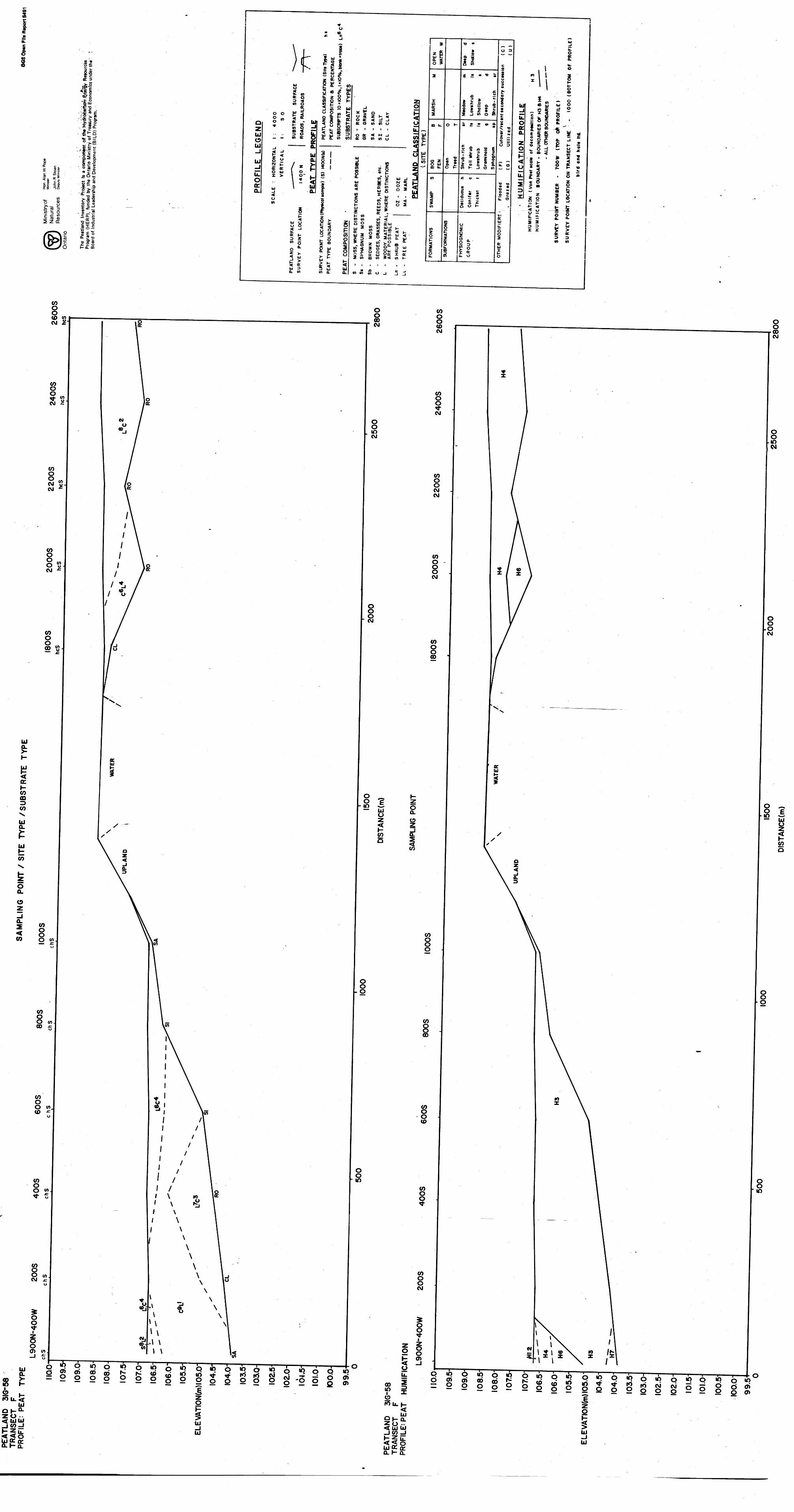
)iu0
* *
~~~
X
tCt Q 3 <en o
ac
0
UJ 0 UJ-JUJ-Ju. o a: o.
o o p 50 * S 2 o m ac - UJ* K CO "* ^ (O O -J
CD < r-. D 0 U.
— — co ac Q___ o:
.iS -1z <A* f ft
O o•S ^ l z ac ac f zo ui l o1 * \ !
ui i-i < uCO
i5
UI O 0 02 -1ac h-D Z OT 00 a-
is5 o:ui 3CL co
Mb
IdQ.
"SIda.
0•COc. c
1l ui i *s i- s fe *CO UI ^-— o *^ 2 ac 0g K " co4 0 li]
dM V* **" * S fr it z g *.8 g ? K3 5 2 ui
PEATLAND CI PEAT COMPO:
SUBSCRPTSSUBSTRAT
2d 3
^ S Q )- Po ^ z K 5 5o ac 4 -" -i ** ac o co co o v.i ' i i i U
O flC 4 M j ""ac o co co o vj
*i
1 1 ui U
2 1 l * i i-* o * C ^rw 2-0 ^*- "- CO z UI J .j
S 2 Hi P g S b t 5 ES o 2 JS W ^ A* z M ui i i GL8 2 S 5 ^ 5
Stg"
1 fe SI cJF ^.2 ui 95 - tt ,^ 1- CO . -1 ———————
O ^ 7
55 5 S s pSi c?) K o p z m Q.? w 2a. a O^ t 0UI .
| 6 SD UJ UJCO OL Q.
CO CO CO <o 0 en Suj Uj 2 co ft [ uj -J h tt *5 < *-03 55s i g ;^ 2 t5X O . * O SCO Q. UJ
5, g z fi ^ m *CO tf ^ S 9 3 w CO X O Q 2^ "^ ^5 a. ^ ui Oo: x o:2 CO 03 CO >< CO t-
*z fiffi0 ^
Z
xCO
5z
ea u.
O uiCD U.
CO
a.
iCO
lATIONS
2ac2
1
..c ^li
__ —
ORMATJONS
u.D
^
•o *
o ft s 2 5 2 co
E - - ^ i
•g
li I.I8 * o * 2
o f- c* jc Z j co o 55
s r - * ?
-c*f 3 ^ 2 i*- k. 3 0 2i -C ^ C C A W f -z C9
8=21^ i o 5 2 SCO K J CD CO
.CO*-
i -s•5-0 g g zQ 0 1-
o
iIS"isCL O
0 3
c
tuccettii
f0
1u*
Cufovvr/rectntt
Utiliied
tZ o
Flooded G ra z td
*
V)
R MODIFIER
UIx o
UI-JI. u.l o
1 1 ** 1 i 1 11 O
OP
U^•B
^^
li.
Oa:Q.
0P< OiZi ^ x
S . - oC {j UI Omgd 0
2 x ^ fe " 5 fei S .i ^1 ^ -5 lil 03 ^
i S 1 * iw 9 C- OL -15 1 2 e i-^ s ^ ** ao oa ,* w
•* ' i * Zo v Q *s| If• O zf z , oCO Zo m ac o > ™ w c — aa 5
z Jo? o 5 o 2 C ± -1
' ^2 -t -4t - o o!r — 0*0. s s > >33 UJ wxx 5 >
ac ac3 3 W) (0
1 1 1 1 1 li-
CO CO CO 0 J 5 ^
o. l-o.
Ou.
oo l in ^2 rou. j-
< ^ wSH o.Z o *-<UJ UI-JO) -ll-5i! << oUJ^Q:o. l- a.
q in q in oo oj os oo cd .- 2 2 g S 2 2o52g6ooSSg22 xo o en
2 o en
UJ-jUJ
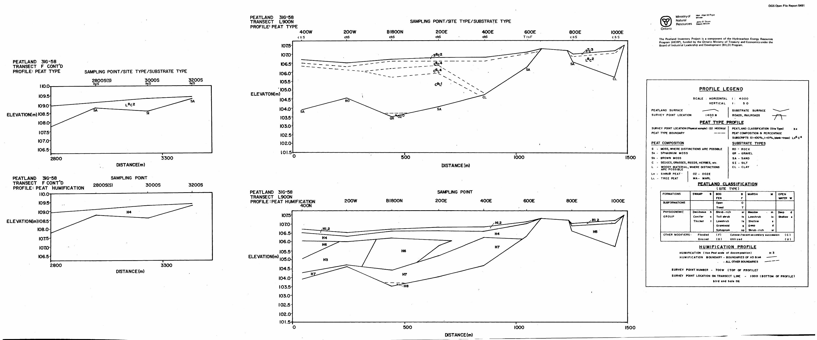
OGS Open File Report 5491
PEATLAND 316-58 TRANSECT L900N PROFILE' PEAT TYPE
SAMPLING POINT/SITE TYPE/SUBSTRATE TYPE
400WcfcS
200WchS
BI800NchS
200EchS
400E chS
600ETtsF
800EchS
IOOOEchS
PEATLAND 3IG-58 TRANSECT F CONT'D PROFILE: PEAT TYPE SAMPLING POINT/SITE TYPE/SUBSTRATE TYPE
IIO.O
I09.5-
I09.0-ELEVATION(mll08.5-
I08.O-107.5-
I07.0-
I06.5-
2800S(S)hfS____
3000ShcS
3200ShcS
SI
I075-
I070
1065
I06.0
I055-' I05.0-
ELEVATON(m)I04.5
I04.0
I03.5
I03.0-
I02.5 I02.0-
l O l.5
CL
2800
PEATLAND 3IG-58 TRANSECT F CONT'D PROFILE: PEAT HUMIFICATION
3300 500 IOOO I500DISTANCE(m)
SAMPLING POINT 2800S(S) 3000S
DISTANCE (m)
3200S
IIO.O I09.5-
\09JOr
ELEVATION(m)l08.5
I08.0-
I075-
I070
I06.5H
PEATLAND 3IG-58 TRANSECT L900N PROFILE;PEAT HUMIFICATION
400N200W B l SOON
SAMPLING POINT
200E 400E 600E 800E IOOOE
ELEVATIONtm)
2800 3300DISTANCE (m)
I075-
I070-
I06.5-
I06.0-I05.5-
I05.0-
I04.5-I04.0-
103.5-
I03.0-
I02.5
102.0 IOI.5
500 IOOO I500
Ministry ofNaturalResources
John R Sloan
Ontario
The Peatland Inventory Project is a component of the Hydrocarbon Energy Resources Program (HERP), funded by the Ontario Ministry of Treasury and Economics under the Board of Industrial Leadership and Development (BILD) Program.
PROFILE LEGEND
SCALE : HORIZONTAL
VERTICAL
PEATLAND SURFACE - — — ——
SURVEY POINT LOCATION MOON
PEAT TYPE FSURVEY POINT LOCATION (Physical sample) (S)
PEAT
PEAT
S -Ss -
Sb -
C -
L -
Ln -
LL -
TYPE BOUNDARY
COMPOSITION
!4OON(s)—————
1 : 40OO
1 : 5
SUBSTRA
ROADS, R
^ROFILE
O
TE SURFACE "^^— - -^
AILROADS — f^ ——t \
PEATLAND CLASSIFICATION (Site Type) h 9
PEAT COMPOSITION B PERCENTAGE
SUBSCRPTS (O'KX)*Xo.l*K)0Xo,blonk*trace) Ln6 C4
SUBSTRATE TYPESMOSS, WHERE DISTINCTIONS ARE POSSIBLESPHAGNUM MOSS
BROWN MOSS
SEDGES, GRASSES, REEDS, HERBES, etc.
WOODY MATERIAL, WHERE DISTINCTIONS ARE POSSIBLE
SHRUB PEAT '
TREE PEAT
OZ - OOZE
MA- MARL
RO - ROCK
GR - GRAVEL
SA - SAND
SI - SILTCL - CLAY
PEATLAND CLASSIFICATION
FORMATIONS
SUBFORMATIONS
PHYSIOGNOMIC
GROUP
OTHER MODIFIERS
SWAMP S
Deciduous h
Conifer c
Thicket t
: Flooded
G ra z ed
(SITEBOGFEN
Open
Treed
TYPE)
BF
0
T
Shrub -ri eh srTad shrub tsLowshrub IsGrominoid 9Sphagnum sp
(F)(G)
MARSH M OPENWATER W
Meadow - m Deep dLowshrub Is Shallow sShallow 9Deep dShrub- rich sr
Co t over /recent secondary succession ( C )
Utilized (U)
HUMIFICATION PROFILEHUMIFICATION ( Von Post scale of decomposition) H 3HUMIFICATION BOUNDARY - BOUNDARIES OF H3 8 H4 - ——— —
- ALL OTHER BOUNDARIES —— "—
SURVEY POINT NUMBER - 7OOW (TOP OF PROFILE)'
SURVEY POINT LOCATION ON TRANSECT LINE - IOOO (BOTTOM OF PROFILE)
bird and hale ltd
DISTANCE(m)

Ontario
Ministry ofNaturalResources
Hon. Alan W. Pope
John R. Stoan Deputy Minister
ONTARIO GEOLOGICAL SURVEY
Open File Report 5491
Peat and Peatland Evaluation of the Ottawa-Brockville Area Volume II
by
Bird and Hale Ltd.
1984
Ontario
Ministry ofNaturalResources
Hon Alan W. Pope Minister
John R. Stoan Deputy Minister
ONTARIO GEOLOGICAL SURVEY
Open File Report 5491
Peat and Peatland Evaluation of the Ottawa-Brockville Area Volume II
by
Bird and Hale Ltd.
1984
Ontario
Ministry ofNaturalResources
Hon. Alan W. Pope
John R. Sloan Deputy Minister
ONTARIO GEOLOGICAL SURVEY
Open File Report 5491
Peat and Peatland Evaluation of the Ottawa-Brockville Area Volume II
by
Bird and Hale Ltd.
1984

O OMNR-OGS 1984
Ministry of Hon Alan w-, . . MinisterNatural
John R. Sloan Resources Deputy Minister
Ontario
ONTARIO GEOLOGICAL SURVEY
Open File Report 5491
Peat and Peatland Evaluation of the
Ottawa-Brockville Area
Volume II
by
Bird and Hale Ltd.
1984
THIS PROJECT IS PART OF THE HYDROCARBON ENERGY RESOURCES PROGRAM (HERP), AND WAS FUNDED BY THE ONTARIO MINISTRY OF TREASURY AND ECONOMICS UNDER THE BOARD OF INDUSTRIAL LEADERSHIP AND DEVELOPMENT (BILD) PROGRAM.
Parts of this publication may be quoted if credit is given. It is recommended that reference to this report be made in the following form:
Bird and Hale Ltd.
1984: Peat and Peatland Evaluation ofthe Ottawa- Brockville Area, Volumes 1-5, Ontario Geological Survey Open File Report 5491, 217p., numerous tables and maps.

Ontario Geological Survey
OPEN FILE REPORT
Open file report* are made available to the public subject to the following condition*:
This report is unedited. Discrepancies may occur for which the Ontario Geological Surrey does not assume liability. Recommendations and statements of opinion f Tp rinsed are those of the author or authors and are not to be construed as statements of government policy.
Open file copies may be read at the following locations:
Mines LibraryOntario Ministry of Natural Resources8th Floor, 77 Grenville Street, Toronto
The office of the Regional or Resident Geologist in whose district the area covered by this report is located.
Handwritten notes and sketches may be made from this report. Check with the Library or Region* al or Resident Geologist's office as to whether there is a copy of this report that may be borrowed. The Library or Regional or Resident Geologist's office wffl also give you information on copying ar rangements. A copy of this report is available for Inter-Library Loan.
255 Metcalf Street Concession Road Box 70 Kemptville, Ontario Tweed, Ontario KOG 1JO KOK 3JO
The right to reproduce this report is reserved by the Ontario Ministry of Natural Resources. Permission for other reproductions must be obtained in writing from the Director, Ontario Geological Survey.
V.'G. Milne, Director Ontario Geological Survey
111

PEAT AND PEATLAND EVALUATION OF THE
OTTAWA - BROCKVILLE -AREA
TABLE OF CONTENTS
OF OPEN FILE REPORT 5491
Volume I
AbstractIntroductionMethodologyResults and ConclusionsDetailed Deposit Evaluations
31G-2431G-3031G-58
Volume IIDetailed Deposit Evaluations
31B-4 3 IB-8
Volume III
Detailed Deposit Evaluations 31B-18 31B-28 31B-38B
Volume IV
Reconnaissance Deposit Evaluations31G- 21, 32 f 35, 38, 50, 54, 69/70, 100
Volume VReconnaissance Deposit Evaluations
31B- 12, 13, 30, 35, 38A, 39/40, 45
* Indicates this report
v

VOLUME 2 page
DETAILED DEPOSIT EVALUATIONS 60
5.4 Peatland 31B-4, Rideau Bog, Merrickville Bog 985.5 Peatland 31B-8, Merrickville Bog, Bishop Mills Bog,
Hanlans Marsh 110
Vll

Peat and Peatland Evaluation of the Ottawa-Brockville Area
prepared for
MINISTRY OF NATURAL RESOURCES
ONTARIO GEOLOGICAL SURVEY
prepared by
BIRD AND HALE LIMITED
VOLUME 2
l 1263 Bay Street, Tor. Ont. M5R 2C1
Manuscript approved for publication by Owen L. White, Section Chief, Engineering and Terrain Geology Section, August 24, 1984.This report is published by permission of V.G. Milne, Director, Ontario Geological Survey.
ix

5.4 PEATLAND 31B-4, RIDEAU BOG, MERRICKVILLE BOG
Location
The deposit is located in Montague Township, Lanark County, (Lots 9-15, Cone. 2; Lots 7-15, Cone. 3; Lots 6- 14, Cone. 4, Lots 8-11, Cone. 5). It is 5.25 km due northwest of Merrickville, and Montague Airfield is less
west of the southwest portion of the de-
It is located in UTM Zone 18, Easting 428 000, Northing 4978 000, with latitude 44 degrees 58 minutes north, and longitude 75 degrees 54 minutes east. The designated study area is covered by the following 1978, 1:10000 airphotos: 4465-80 #140-148; 4466-81 #111-120; 4467-81 #194-204; 4468-110 #6-15. The peatland is covered by: 4465-80 #142-144; 4466-81 #114-117; 4467-81 #195-201; 4468-110 #10-12.
Access
The southeast corner of the deposit may be reached by following Hwy. 43 west from Merrickville to the first sideroad north, and following this road north to its end, approximately 3 km. The southwest corner of the deposit is reached by driving 1.3 km north of Rosedale, to the first sideroad and travelling east to the end of the road, approximately 3 km. By travelling east on the first concession road south of Nolans Corners, past Mon- taque Airfield, for approximately 4 km, the, northwest portion of the deposit is reached.
Dates of Field Study
The field investigations for peat determination and gen eral physiognomic characteristics were conducted from September 8 to 11, 1983. Full vegetation sampling occur red on September 13, 22-24, and October 10, 1983.
Dry conditions were encountered; in fact, the rainfall for the three months prior to the field investigation was only 707. of the 30 year norm.
Topography and Drainage
This deposit has developed in an oval-shaped, gently sloping basin, the long axis of which is oriented NNE to SSU. Along this long axis, the surface relief varies by a maximum of 2 m, with the highest elevation occurring in the south-central area. Perpendicular to this axis, the relief varies by approximately l m, with the highest areas occurring adjacent to the edges of the deposit. Consequently, the surface configuration is that of a gently sloping bowl that rises slightly from the south,
98
for a distance of approximately 1500 m, and then gently drops down toward the drainage outlet in the northeast. In general, and in areas of woody peat in particular, subtle variations in the topography of the substrate are reflected in the topography of the peatland surface, indicating that the peat accumulated continuously over these features. The more abrupt variations in the topo graphy of the substrate, however, are not normally re flected in the surface topography. In these instances, peat deposition took place in isolated pockets, with the accumulation eventually spreading over these substrate Is lands.
In the southern quarter of the deposit, this substrate consists primarily of sand. Clay is the dominant sub strate for the remainder of the deposit, with bedrock oc curring in random locations, particularly in the south- east where surface outcrops occur.
The deposit drains to the east, out of th~e northeast corner, by the northern tributary of Rideau Creek. This appears to be the only existing drainage outlet. Water flow into the deposit is primarily runoff from the sur rounding uplands. In addition, two extensions of the outlet creek flow into the north and northwest portions of the deposit. Beaver activity is evident in the north', and the southeast, where the presence of dams has caused flooding.
There is good potential for improving the drainage by cleaning, realigning and extending the existing drainage network. There is only the one drainage outlet; else where, the deposit is surrounded by gently undulating ^107. slope) to rolling (107.-207. slopes in localized areas) uplands. Thus, the construction of additional drainage outlets would require considerable ditching through mineral soil.
Area and Shape
The total area of this deposit is 880 ha, of which ap proximately 535 ha has peat depths in excess of one metre. The deposit has a relatively regular oval shape, with very few peripheral channels or bays. Moreover, these extensions consistently contain less than one metre of peat.
With the exception of approximately 50 ha in the north east, the entire deposit is forested, with the density of cover being fairly constant. Because of this, and be cause the potential for drainage improvement is the same for the entire deposit, the potential for resource devel opment is dependent on the quantity and quality of the peat at various locations. Since the south-central portion of the deposit has the greatest accumulation of
99
peat (maximum total depth of 5 greatest development potential.
m recorded), it has the
Peatland Vegetation
Twenty-one full vegetation tinctive minor physiognomic following locations:
analyses of cover types
maj or and dis - occurred at the
L1000N 200E L1000N 550W L1100N 500E L1100N 500W B1600N L1600N 1150E
L1600N 700E L1720N 400W B2100N L2100N 1000E L3000N 100E
L3000N 300E L3000N 350E L3000N 500E L3000N 200W L3300N 200W
L3500N 1200E L3600N 900E L3600N 800W L4100N 600E L4800N 200W
tions type
The predominant geomorphological types are Basin Swamp, which occupies 607* of this deposit with a p~ea t depth that exceeds 2 m; Channel Fen, which is restricted to the southern end, has over l m of peat depth, and covers 67.; and, Peat Margin Swamp which occurs around the deposit margin with a somewhat shallow-er peat depth and covers 301 of the deposit. Additional types occur as minor features: Basin Harsh, in the northeastern corner (has experienced severe flooding), and, Stream Marsh, along the drainage outlet, each of which covers approximately 27. of the deposit.
The predominant physiognomic cover type is Treed Mixed Swamp which encompasses over 601 of the deposit's surfacearea (528 ha). Other major types 125 ha), Coniferous Swamp (81; Swamp (47.; 37 ha). Minor types Fen (11; 9 ha), Treed Tall Shrub Rich Marsh (71; 57 ha), and, Deep
are Thicket Swamp (141; 69 ha), and Deciduous include Open Low Shrub Fen (31; 28 ha), Shrub- Marsh (31; 25 ha).
Disturbance to the cover types include past and local recent cutting within the forest canopies, particularly evident around the peripheral 200 m, and in the northern, east-central and southern sections of the deposit. Due to intensive beaver activity, severe flooding has occur red, creating an extensive Deep Meadow and Shrub-Rich Marsh complex which extends into the central portion of the deposit.
The Treed Mixed Swamp the deposit, in centra occupies the Basin and tent the Channel Fen, hibits a low to modera 55 cm) of stump and fa is mildly acidic (pH being 12 - 35 cm below
extends over the entire length of l as well as marginal locations. ItPeat Margin Swamp, and to some ex-
geomorphological type sites. It ex- te hummock/hollow topography (10 lien stem origins. The groundwater 6.1 - 6.7), the water table depthsurface. The peat displays a broad
100
range of variation in thickness, from 0.1 to 4.5 m. There are two general phases for this cover type. The most widespread is a mixed tree (8 to 14 m tall) canopy (457. to 707. average canopy density) dominated by Eastern White Cedar (Thuja occidentalis25) and Black Ash (Frax- inus nigraZO), accompanied by Paper Birch (Betula papyri- feralO),White Elm (Ulmus americana5), Tamarack (Larix laricinaS), Red Ash (Fraxinus pennsylvanica3) and Balsam Fir (Abies balsamea). The tall shrub cover is commonly quite open (O - 207.) with a predominance of saplings of the over-storey trees, notably Black Ash, Eastern White Cedar and Balsam Fir, and occasionally Winterberry (Ilex ver tici lla ta ) . The low shrub cover is semi-open (57. 207.) with a consistent presence of Red Osier Dogwood (Cornus stoloniferaS), Alder Leaf Buckthorn (Rhamnus alnifolius8)andSwamp Fly Honeysuckle (Lonicera oblong- if olia) . The herb cover is semi-open to semi-closed (307.- 707.), with an even low complement which includes Dwarf Raspberry (Rubus pubescensS), Marsh Fern (Thelypteris palustrisS), Northern Bugleweed (Lycopus" unifIora5), Sensitive Fern (Onodea sensibilis5), Sedge (Carex lep- taleaS), Tufted Looses trife (Lysimachia thrys ifloraS), Spotted Joe Pye Weed (Eupa torium macula tum5) , White Snakeroot (E. rugosumS), Poison Ivy (Rhus rad icans5), and others with a lesser cover density. The moss cover is semi-closed (507. - 85Z) with a predominance of brown mosses, infrequently accompanied by sphagnum moss. The second phase of this cover type tends to occur more locally around the deposit's margins, as a successional feature. It has a semi-open (307. - 407.) tree canopy of fast growing saplings of Black Ash, Red Ash, Silver Maple (Acer saccharinum), Balsam Poplar (Populus balsamifera), overtopping an understorey of low Eastern White Cedar. The shrub cover is semi-open to closed (157. - 807.) with a predominance of Winterberry and Speckled Alder (Ainu s incana) . The low shrub cover is quite open (O - 107.) with a predominance of Red Osier Dogwood. The herb cover is semi-closed (407. - 657.) and dominated by Dwarf Rasp berry, Spotted Touch-me-not (Impa tiens biflora), Sensi tive Fern, White Snakeroot, Spotted Joe Pye Weed, and Sedge (C. pseudo-cyperus) . There is a semi-closed (407. - 707.) brown moss cover.
The Thicket Swamp occupies Peat Margin, Basin and Stream Swamp and Basin Marsh geomorphological type sites, with flat to moderate (5 - 35 cm) hummock topography of stump and stem origins. The water table is shallow to moderate (15 - 35 cm) with seasonal, and in certain sites peren nial, standing water. Three distinct phases are evident within the deposit, each differing in having affinities to the swamp and marsh formations. The swamp-allied phase occurs frequently throughout the deposit. It has a semi- open (107. - 207.) tree cover of Eastern White CederlO, Black AshlO, Paper BirchS and White Elm3. The tall shrub cover is semi-closed (357. - 657.) and includes Speckled
101
AlderlO, Slender Willow (Salix petiolarislO), Tall Pussy Willow (Salix Disco Ior8) and WinterberryS with a comple ment of low tree species saplings. The low shrub cover is semi-open (107. ~ 207.) with Red Osier Dogwood and Alder Leaf Buckthorn. The herb cover is semi-closed (507. 701) many of the mixed swamp species, predominant of which are Dwarf Raspberry, Northern Bugleweed, Tufted Loosestrife and Spotted Joe Pye Weed. Brown mosses pre dominate in the semi-closed (657. - 901) moss cover. A second phase, presenting affinities with fen sites and cover types, occurs in the southern half and central portions of the deposit. These sites tend to have deeper peat and a variety of poor fen species. The tree cover is open (57. - 207.) with Eastern White CedarlO, Tara- aracklO, Black Spruce3 and White Elm3. The tall shrub cover is semi-closed (351 - 601) with a swamp species complement of Speckled Alder, Tall Pussy Willow, Slender Willow, Winterberry with the occasional fen indicator species, Swamp Birch (Be tula pumila var. glandulifera) . Similarily in the semi-open (101 - 251) low" shrub cover, among the predominant Red Osier Dogwood and Alder Leaf Buckthorn, Labrador Tea (Ledum groenlandicum) occas ionally occurs. The herb cover is semi-open to semi- closed (301 - 701) with the above listed swamp-allied species dominating over the sparse fen-allied species, such as Sedge ( C . trisperma) , Naked Mitre Wort ( M i t e I'l a s Nuda) , Bog False So lomon ' s S~eal ( Smilacina trif olia) , and Rush Leaf Aster (As ter j unciformis). The third phase is more readily identified as being successional with sev eral marsh-like affinities. It occurs locally around the deposit's periphery on thinner peat substrates with lon ger duration seasonal standing water. The tree cover is open to drown-kilied (01 - 101) with scattered Black Ash5, White Elm5, or Eastern White Cedar5. The tall shrub cover is semi-closed (407. - 657.) with Slender Wil low, Tall Pussywillow, Autumn Willow (S. seriss ima) or Speckled Alder predominating. A low shrub complement of Red Osier Dogwood and Tall Meadowsweet (Spiraea a Iba) form a semi-open (101 - 351) cover. The herb cover is semi-closed (351 - 707.) with a mixture of tall gram- inoids, such as Canada Blue Joint (Calamagrostis canad- ensisSO), Sedge (C. pseudo-cyperuslO)and Reed Canary Grass (Phalaris arundinaceaS) and low herbs, such as Large Leaf Beggar Ticks (Bidens frondosa), Northern Bugleweed, Marsh Fern, Dwarf Raspberry and Wild Calla (Calla palustris). The moss cover is semi-open to semi- closed (351 - 607.) brown mosses.
The Treed Conifer Swamp occurs locally throughout the deposit with more extensive concentrations in its south ern half. It has developed on Basin, Peat Margin and Stream Swamp and Channel Fen geomorphological type sites, with a moderate (10 - 35 cm) hummock topography of stump, fallen log and moss development origins. Here, the peat is shallow to relatively deep (0.1 m - 4.5 m) with an
102
acidic (pH 5.4 - 6.1) reactivity and a moderate (25 - 40 cm) water table depth. Two distinctly different phases of this cover type are recorded. The most widespread is associated with swamp sites, having a semi-closed (357. - 707.), 5 to 12 m tall coniferous tree canopy dominated by Eastern Vhite Cedar35, accompanied by Tamarack5, Black SprucelO, Paper BirchlO, and White Elm5. The tall shrub cover is open ( 57. - 2071) with Tall PussywillowlO, Spec kled Alder5, Swamp BirchS, and Winterberry10. The low shrub cover is semi-open (57. - 257.) with Red Osier Dog- wood!5, Alder Leaf BuckthornS and others. The herb layer is semi-closed (307. - 457.) with a tall layer of Royal Fern (Osmunda regalis20), Sedge (C. s trietal5) or Canada Blue Jointl5, and a low layer of Dwarf RaspberryS, Nor thern Bugleweed5, Sedge (C. lep taleaS), Tufted Loose- strifeS, Twinflower (Linnaea borealis), Naked,Mitrewort, Crested Shield Fern (Dryopteris cris tata) and others. The moss layer is closed(90Z)with a mixture of brown55 and sphagnum35 mosses. The second phase is associated with the fen sites in the deposit's southern third. Here, the tree canopy is semi-closed (657. - 707.) with 10 to 13 m tall Tamarack60 accompanied by sparce Black Ash, White Elm and Red Maple (Acer rubrum). The tall shrub cover is semi-open (10^1wTth Winterberry and Swamp Birch. The low shrub is open (57.) with Black Chokecherry (Aronia melanocarpa), Red Osier Dogwood and Labrador Tea. The herb cover is semi-open (307. - 357.) and is dominated by Royal Fern20 and Sedge (C. leptaleaS), with sparse Dwarf Raspbery, Northern Bugleweed and Tufted Loose strife. The moss cover here is closed (90Z) and is decidedly dominated by sphagnum moss85.
The Treed Deciduous Swamp is restricted to the margins of the deposit. It occupies the Peat Margin Swamp geomorph- ological type site with a flat to low (O - 20 cm) topo graphy, a thin layer of peat (10 - 25 cm), an often long- duration standing water table, and a slightly acidic (pH 6.2) groundwater reaction. The tree cover is semi-closed (557. - 657.) and tall (10 - 14 m) Black Ash45 , Silver Maple40, Red Ash20 and White Elml5. The tall shrub cover is dominated by a semi-open (207. - 357.) cover of saplings of the dominant tree species, with a sparse incidence of Winterberry5 or Speckled AlderS. The low shrub cover is open (57. - 107.) with Red Osier DogwoodS and Alder Leaf BuckthornS. The herb cover is semi-closed (357. - 557.) with Sensitive FernlO, Spotted Jewel Weed (Impatiens bif loralO), Marsh FernS, White SnakerootS, Spotted Joe Pye Weed5, Sedge (C. pseudo-cyperus5), False Nettle (Boe- hmeria cylindricaS), Northern Bugleweed5, Deadly Night shade (Solanum dulcamara3) and others. The moss cover is semi-open to semi-closed (15^ - 657.) brown mosses.
The Open Low Shrub Fen is restricted to the southwestern {quarter of the deposit where it occurs as a series of wet openings in the tree cover. These have developed on the
103
Channel Fen geomorphological type sites with 2.3 to 3.2 m deep peat and acidic (pH 5) groundwater with a moderate water table depth (30 - 40 cm). There are frequent mod erate hummocks (10 - 30 cm) of tussock and moss polster origins. The tree cover is quite open (O - 57.) of low (3 m) Tamarack, Black Spruce and Eastern White Cedar. The tall shrub cover is semi-open (107. - 207.) with a predom inance of Swamp Birch accompanied by Slender Willow and others. The semi-closed (457. - 601) low shrub cover is dominated by Labrador Tea, accompanied by a diverse rich fen complement of Bog Rosemary (Andromeda glaucophylla) , Black Chokecherry, Leatherleaf (Chamaedophne ealycula ta), Sheep Laurel (Kalmia angus tifolia), Bog Laureal (K. poli- folia) and Bog Willow (Salix pedicellaris) . The herb cover is a semi-open (1571 - 25V) with Dwarf Raspberry, Smooth Blueberry (Vaccinium angustifolium), Royal Fern, Sedge (C. lasiocarpa)"7 Bog Goldenrod (Solidago uliginosa), Virginia Cottongrass (Eriophorum virglnicum), Rush Leaf Aster and Bog False Solomon's Seal. The moss cover is closed (907. - 957.) and is dominated by sphagnum mosses.
The Treed Tall Shrub Fen occurs in association with the low shrub fen and extends somewhat further into the interior of the deposit's southern third. It has devel oped upon the Channel Fen geomorphological type site with a moderate hummock topography (20 - 40 cm) of stump, fal len stem and moss development origins. The groundwater is acidic (pH 5.8 - 6.2) with a shallow (20 - 55 era) water table . The tree cover is semi-open (257. - 401) Eastern White Cedarl5, Tamarackl5, Black Spruce5 and Paper Birch5 having a mean height of 7 to 9 m. The tall shrub cover is semi-open (151 - 451) with Slender Wil- Iow25, Swamp Birch25, Tall Pussywillowl5 and Mountain Holly (Nemopanthus mucronatus). The low shrub cover is semi-open to semi-closed(201 - 451) with Red Osier Dog- woodlO, low Swamp BirchlO, Leatherleaf5, Labrador TealO and Swamp Fly Honeysuckle. The herb cover is semi-open (101 - 351) with tall hummocks of Royal Fernl5 and Cin namon Fern (Osmunda cinnamomealO), and a low herbage of Sedge (C. interiors and C. losiocarpalO), Naked Mitre- wort5, Goldthread (Coptis trifolia5), Bog False Solomon's SealS, and Dwarf Raspberry5. A closed (907.) moss cover of both brown and sphagnum mosses makes up a hummocky carpet.
The Shrub-Rich Marsh occurs in the northeastern quarter of the deposit in association with the drainage channel and its flooded margins. It has developed upon the Stream and Peat Margin Swamp geomorphological type sites with an often shallow peat depth, a low (5 - 25 cm) topography and a long term standing water with a slightly acidic reaction (pH 6.5). This cover type displays its recent origins from flooding and wetland succession. Its tree cover is open (57.) drown-killed Eastern White Cedar
104
or Black Ash. The shrub is semi-open to semi-closed (257.- 507.) with Slender Willow30, Swamp Birch25, Tall Pussy- willow20, and others. The low shrub may be open to closed (57. - 707.) with Red Osier Dogwood25, Narrow-leaved Meadowsweet (Spiraea aIbal5), and Sweet Gale (Myrica galelO) . The herb cover is semi-closed (657.-7S7.) with a predominant tall graminoid cover of Canada Blue JointSO, Sedge (C . pseudo-cyperuslS and C. s trie talO) and Purple Loosestrifes, and a low herb cover of Beggar's TickslO, Spotted Jewel Veed5, Marsh Fern5, Frog's Bit (Hydrocharis morusnanae5) semi-closed (557, - 807.) brown mosses.
The Deep Marsh is restricted to the flooded northeastern corner of the deposit. This type has developed upon the Peat Margin Swamp or Stream Marsh geomorphological type sites, with a thin muck layer overlying clay with up to one metre of perennially standing water. A fibric muck mat of about 10 cm thickness blankets the area, often being submerged under 40 cm of water. The water has a slightly acidic reactivity (pH 6.5). This type lacks trees, shrub and moss strata, but has a semi-closed (657.- 757.) herb cover of submergent and floating emergent mats with Canada Blue Joint30, Sedge (C. stricta30), Frog's BitlO, and Common Bladderwort (Utricularia vulgarisS).
Small scattered occurrences of Tall Shrub Marsh cover type are present throughout the deposit, particularly about its periphery and along the extensively flooded stream basin of the northeastern corner. Its geomorphol- ogical types include Peat Margin Swamp and Stream and Basin Marsh. These sites are perennially flooded with a subneutral (pH 6.5) water reaction. There is a moderate to low (5 - 30 cm) hummock topography of tussock and stump origins. The tree cover is typically very sparse due to drown-kill ing of the Red Ash and Eastern White Cedar. The tall shrub cover is virtually absent, and the low shrub cover is very open (5^) with Red Osier Dogwood and Sweet Gale. The herb cover is semi-closed (657. 807.) with tall tussocks of Canada Blue Joint30, Broad Leaf Cattail (Typha latifolialO) and Sedge (C. pseudo- cyperuslO), and a lower herb carpet of Large Leaf Beggar TicksS, Marsh FernlO, Rice Cutgrass (Leerzia oryzoides2) , Deadly Nightshade2, Northern Bugleweed and others. The moss cover is semi-closed (80^) brown mosses.
Open Water also occurs in small localized areas of the deposit's northeastern quarter, in association with the drainage outlet and flooded basin. The over-one-metre deep water here may be open (QT. - 57.) cover density with only scattered emergent plants, or may be semi-closed (407. - 751.) with submergent meadows of Frog's Bit, Common Bladderwort, or other species.
105
This deposit presents many community patterns and associ ated species that are representative of the site in the Region. Of note are the relatively extensive mixed swamp and smaller, rich open low shrub fen complex of its southern half. No formal recognition of significance or sensitivity has been previously accorded to the area. Several locally significant plant species are recorded from the area, including wetland, fen, alvar and forest species; notable here are Salix pedicellaris (Bog Willow, I.D.M., 15609), Viola renifolia (Kidney Leaf Violet, I.D.M.), Isanthus brachiatus (False Pennyroyal, I.D.M. 1560A) and Eriophorum viridi-carinatum (Green Cottongrass, I.D.M. 15440).
Using the preceding discussion and correlating this with the peat types found, the successional history of the deposit may be hypothesized. In the southern three- quarters of the deposit, it is underlain by a layer of peat, of approximately 4 m in the south to 0.75 m in the central area, that is almost entirely sedg-e, with minor amounts of shrub. This indicates that it may have been a marsh. This layer is overlain by approximately 0.4 m of peat that consists primarly of tree and shrub peat, with some sedge, indicating the former presence of a treed swamp. In the northern portion of the deposit, the peat consists of approximately 0.5 m of shrub peat, with s~ome sedge, indicating either thicket swamp or shrub fen origins.
Peat Depth
Peat depth information for the'deposit is summarized as follows :
Average Peat Depths Average Peat Depths Entire Deposit Area With Peat > l ra
Surficial Layer - 0.6 m Surficial Layer - 0.8 mHumified Layer - 1.0 m Humified Layer - 1.5 mTotal Peat Depth - 1.6 m Total Peat Depth - 2.3 m
The total average peat depth in the area with less than one metre peat is 0.4 m. The total peat depth is highly variable throughout the deposit, with the maximum recorded depth of 5.0 m occurring in the south central part of the deposit (B1200N). The total peat depth grad ually decreases toward the north, and in the north central area, the total peat depth averages approximately 0.7 m. Thus, the south-central area has the greatest potential for resource development; however, the majority of the material consists of unhumified sedge peat.
The right column in the following table indicates the variation in total peat depth in the various physiognomic types. Total peat depths are highly variable. In
106
general, the tall shrub marshes are consistently located in areas with less than two metres of peat; and, the tall and low shrub fens are consistently located in areas with peat depths in excess of 1.5 m.
AVERAGE TOTAL PEAT DEPTHS OF PHYSIOGNOMIC TYPES
Variation In Total Peat Depth
Physiognomic Average Total Within Physiognomic Types Peat Depths (m) Types (m)
cS 2.4 O - 4.5hS 0.7 <l - 1.5tS 2.3 CI - 5.0
chS 2.2 -CI -- 4.5hcS 1.0 <l - 2.6
TtsF 3.7 3 - 4.3OlsF 3.0 1.5 - 3.2srM 1.2 <l - 2.0dM 0.5 *:i
Peat Type
In the southern three-quarters of the deposit, the basal sediment is overlain by a discontinuous stratum of highly humified (H8 and 9) material consisting primarily of ooze with some sedge, and with an average thickness of 0.5.m. A stratum of sedge peat, approximately 1.5 m thick, occurs between approximately 0.75 m and 2.25 m below grade. It has a maximum recorded thickness of 4.2 m in the south-central portion of the deposit (B1200N) and gradually decreases in thickness toward the north, and is non-existent in the northern quarter of the deposit. A stratum of woody peat, consisting primarily of shrubs and sedge, occurs throughout the majority of the deposit and has an average thickness of 0.5 m, and ranges from sur face to up to 0.7 m below grade. With the exception of the central portion of the deposit, this stratum occurs at the surface. In the central portion, the surface stratum is approximately 0.2 m of moss peat containing sphagnum, brown moss and sedges. These stratigraphic trends are generally consistent in an east-west direction across the deposit.
In the southern portion of the deposit, which is dom inated by a conifer mixed swamp, the deposit contains a thick stratum of unhumified sedge peat. In the north, under a deciduous-dominated mixed swamp, the sedge layer does not occur and the peat is primarily woody.
'Peat Humification
The average thickness of "surficial peat", in the area with peat in excess of l m in depth, is 0.8 m. Its
107
average thickness where the peat is less than l m deep is 0.1 m. The accumulation of unhumified peat is greatest in the south-central portion of the deposit and is prim arily the result of an unhumified (H3) subsurface stratum, which is mainly sedge. It averages approxi mately 1.5 m in thickness, is thickest in the vicinity of B1200N, and, with the exception of a thin (approximately 0.2 m) surface stratum of HI,2, is located between 0.75 m and 2.25 m below grade.
The average thickness of "humified peat", in the area with greater than l m depth of peat, is 1.8 m. Its average thickness where the peat is less than l m deep is 0.3 m. The northern and peripheral portions of the deposit contain primarily humified peat, accumulations of which do not generally exceed 1.25 m. In addition, in the south (vicinity of L1100N) and central areas (vicin ity of L3000N), average depths of approximately 3 m and 2.25 m, respectively, of H4 to H6 peat are "recorded.
In this deposit, amorphous material is mainly woody peat containing shrub and tree wood and humified sedge peat, often containing some ooz greatest concentrations of amorphous material o the northern and peripheral portions of the however, in the south-central area, amorphousoccurs in the bottom stratum whichm thick, and from surface
Peat Volumes
in a woody peat stratum to 0.7 m below grade.
is approxima that occurs
humified highly
e. The ccur in deposlt; material tely 0.5 locally,
Peatland No.
31B-4
Total Peatland Area(ha)
880
Volume Peat In Area With ^m Peat (x!06m3)
12.5
Total PeatVolume (x!06m3)
14.3
Total HumifiedPeat Volumes (H4-10)(xl06m3)
8.1
The southern third of the deposit contains approximately half of the available peat. Of this, approximately three quarters is sedge peat with a humification of 3, and the majority of the remainder is woody peat with humification ranging from 4 to 6.
Potential For Fuel or Horticultural Peat Development
The potential for development of this deposit is enhanced by good access: to the north end via County Road 18 whichis hard surfaced and extends to Smiths Falls and by
108
numerous loose or stabilized surface all-weather roads.
The stump content is a relatively low 0.757., and is con sistent across the deposit. However, the forest cover on the vast majority of the deposit is heavy, with the exceptions of some localized pockets and an area in the northeast that has less than l m of peat. Consequently, the deposit would require expensive clearing before it could be utilized. To its advantage, though, is the fact that the potential appears to be good for ditch drainage through upgrading and extension of the existing drainage system.
Approximately 657. of the peat in this deposit consists of humified woody peat (composed of shrub and t r e. e wood with some sedge). This may be suitable as an energy source. The remainder of the peat consists mainly of unhumified sedge peat.
The deposit is located entirely on Patent Land (private ownership).
Comments
The Organic Soil Map (1:50,000, Merrickville, 31B/13) (Ontario Institute of Pedology) indicates that the entire deposit is Montague soil series, Terric Humisol subgroup, 0.9 m to 1.3 m in depth. The peat depths, particularly in the central portions of the deposit, are much greater than indicated on the Soil Map.
MNR did not express any particular concerns regarding this peatland.
(The following dockets contain the Peatland Classification Map, Elevation Map, Isopach Map, and Peat Profiles for this site.)
109
5.5 PEATLAND 31B-8, MERRICKVILLE BOG, BISHOP MILLS BOG,HANLANS MARSH
Location
The deposit is located in Wolford (Lots 1-2, Cone. A; Lots 1-3, Cone. 1; Lots 1-5, Cone. 2; Lots 1-7, Cone. 3; Lots 1-10, Cone. 4; Lots 1-11, Cone. 5) and Oxford (Lots 1-3, Cone. 4; Lots 1-4, Cone. 5; Lots 1-4, Cone. 6; Lots 1-2, Cone. 7; Lot l, Cone. 8) Townships, County of Leeds- Grenville. It is approximately 3.5 km due east of Mer rickville, and immediately south of the CPR rail line that runs east.
It is located in UTM Zone 18, Easting 439 000, Northing 4972 000, with latitude 44 degrees 54 minutes "north, and long- itude 75 degrees 46 minutes east. The designated study area is covered by the following 1978, 1:10000 airphotos: 4459-195 #110-121; 4460-193 #198-209; 4461- 186 #30-41; 4462-77 #149-160; 4463-78 #149-160; 4464-78 #207-216; 4465-80 #150-160. The peatland is covered by: 4460-193 #201-205; 4461-186 #35-39; 4462-77 #153-157; 4463-78 #152-155; 4464-78 #209-214; 4465-80 #154-156.
Access
This is a very large deposit, with numerous points of ac cess. There are many forest access roads that extend south and west on the sideroads that run south and west from Newmanville. All give access to the east side of the deposit. East along the sideroad from Carleys Corners to its end, approximately 3.5 km, gives access to the midwest portion of the deposit. The southern part of the deposit may be reached by driving north from the sideroad west of Snowdons Corners, to the first intersection.
Dates of Field Study
Field investigations for the determination of peat char acteristics and general vegetation information were con ducted from August 24 to September 7, 1983. Full veget ation sampling took place on August 28-30 and September 7, 8, 11, 12, 1983. During this field investigation, there were a number of days during which rain fell, although for the three months prior to this investigation only 707. of the 30 year norm for precipitation for that period fell.
Topography and Drainage
In general, this deposit is level, with an elevation increase of only approximately 4 m over its entire length, from south to north. However, the peatland sur face is domed in four locations: in the vicinity of B1500N, the surface is raised approximately 0.6 m above
110
the surrounding peatland surface; between Lisson's Lake and the upland, in the vicinity of L3500N and LAGOON, the surface is raised approximately 0.75 m; in the vicinity of G1000N and G1500N there is a dome having an elevation rise of approximately 1.5 m; and, in the vicinity of G3000N and G3500N, there is a surface dome approximately 0.75 m high. The slopes of the adjacent uplands generally average less than 107..
Currently, there are no major outlets and drainage is limited to five minor drainage channels, four of which, including the Bigford Drain, flow out the southeast into Kemptville Creek, which eventually empties into the Rideau River. Three of these channels appear to be improved drainage ditches. The last drainage outlet is Dales Creek, which flows out the north end of^the deposit into the Rideau River. Flow into the deposit appears to consist entirely of runoff from the adjacent uplands. Beavers are active throughout, particularly around the periphery, in the southeast, east-central,' and northeast sections of the main body of the deposit, and in the northwest and east sections of the northwest embayment. This beaver activity has resulted in numerous localized areas of flooding. The only open waterbody is Lisson's Lake, a dystrophic lake with an area of 12 ha.
It appears that the drainage of the deposit could be im proved through upgrading of the existing drainage chan nels. Possible constraints include interference by the bedrock that underlies portions of the deposit, and the lack of sufficient grade. Unfortunately, the primary location where bedrock occurs'is in the northwest arm, the area that appears to have the greatest potential for development. In addition, the elevation of the adjacent uplands would probably prevent the construction of addi tional outlets. One exception may be a location in the extreme southeast portion of the deposit.
The majority of the deposit is underlain by sand and gravel; however, rock is recorded as basal sediment at numerous sample sites, particularly in the northwest arm. Since bedrock is visible at surface in numerous locations on adjacent uplands, it is assumed that bedrock rather than boulders was encountered below the deposit. The highly variable depth at which bedrock was encountered indicates very irregular bedrock topography. In general, variations and irregularities in the topography of the substrate are not reflected by similar variations in the peatland surface. This, along with the bedrock, may interfere with ditching or peat extraction.
Area and Shape
The total area of the deposit is 1665 ha, of which appro ximately 1040 ha has peat depths greater than l m. The
111
shape of the deposit is complex containing five major areas: the main body, and southeast, southwest, northeast and northwest embayments. In addition, there are numer ous uplands. The main body, between L2000N and L3500N, has a rectangular shape, and has a moderate depth aver aging between 2-3 m, with a maximum of 4 m. This area does not contain any embayments or uplands to complicate peat extraction. The southeast embayment has a regular shape; however, peat depth is shallow, not exceeding 2 m. The southwest embayment has an irregular shape, and a maximum depth of approximately 2 m. The south portion of the northeast embayment (LAGOON to L5800N) has a regular shape with no uplands or embayments to complicate extrac tion. Peat depth average approximately 3 m. The north portion of this embayment (north of L5800N) is shallow, less than l m and contains a large upland. . The south portion of the northwest embayment (G500N to G1500N) is regular in shape and peat depth averages approximately 2m. The north portion contains some uplands which may complicate extraction; however, peat depths average be tween 2-3 m.
The two areas that exhibit the greatest potential, based on ease of harvesting and volumes of peat available, are: (1) a portion of the main body, east of B line and north of L2000N, in conjunction with the southern portion' of the northeast embayment adjacent to the B line and south of L5800N; and (2) the northern portion of the northwest embayment, north of G2500N. This latter area has the lowest density of forest cover of the entire deposit. Development of the deposit will require careful planning and development of a detailed extraction plan.
Peatland Vegetation
Forty-two full vegetation samples of major and distinct ive minor physiognomic cover types were taken at locations listed in the following table.
L5300NL5800NB6300NF SOONG500NG500N 'F900NG1500NF1900NG2000N
B200NBACONB1000NL1500N 200EL1500N 900EL2000N 300EL2000N 1100EB2500NL2500N 300EL3000N 400EL3000N 600EThis sampling
L3000N 850EL3000N SOWL3000N 400VL3500N 300EL3500N 800EB4000NL4200N 200EL4200N 1600L4200N 300VL4800N 450EL4800N SSOEwas supple
400E 300V
00V 00V
100V
G2000N 600N G2000N 1000V G2500N 300E G2500N 450E G2500N 550V G3000N 300E G3500N 200E I500N 500VI1000N 100V I1000N 500V
400 locations vegetation type
ited by observations at over along the transects, where the dominant and species were recorded.
The predominant geomorphologiea l types in the study area are: Basin Swamp, which occupies most of the deposit's
112
southern and northeastern arms, totalling about 507. of the surface area; Peat Margin Swamp, along some portions of the deposit's periphery (307.); and, Domed Bog, occupy ing most of the northwestern arm (127.). Minor types include the following: Mound Bog, occurring east of Lis- son's Lake (37.); Shore Bog, on the northeast shore of Lisson's Lake (27.); Channel Fen, on the east site, north west arm, and locally in the southern main body (17,); Shore Fen, very locally in the northern arm (<17•)i and Basin Marsh, locally along the area's margins (^17.).
Within this extensive deposit 11 physiognomic cover types are recognized. Predominant major types are Treed Mixed Swamp and Coniferous Swamp, which occupy most of the southern arm and total 507. of the deposit's surface area; Thicket Swamp which occupies much of the northeastern and parts of the northwestern arms (257.); and, Treed Low Shrub Bog and Open Low Shrub Bog which occupy most of the northwestern arm and occur locally elsewhere (15^). Minor types also recorded here but covering'only about 27. of the surface area each are: Deciduous Swamp, Treed Tall Shrub Fen, Open Graminoid Fen, Tall Shrub Marsh, and Deep Water.
The predominant disturbance to the cover types within this deposit is general past and local recent cutting of the forested covers. This is most evident locally around the periphery for up to several hundred metres into the deposit. Flooding has occurred very locally around the deposit margins, due to beaver activities. Very local drainage and ditching has occurred on the eastern side. A small peat harvest and pothole blasting operation occurs locally in the northwestern arm. Several access routes have been cut into the deposit.
The Treed Mixed Swamp cover type encompasses 407. (600 ha) of the study area, extending over most of the southern arm and over much of the marginal portions of the north ern arms. It occupies Basin and Peat Margin Swamp geom- orphological type sites with moderate (10-50cm) hummock/ hollow topography development of stump and fallen log origins. The groundwater has an acidic reactivity (pH 5.7 - 6.3) and the water table is between 30-50 cm down. Two phases of community patterns are evident in this type. In the most widespread case, the tree canopy is semi-closed (60^-807.) with 7 to 12 m high Eastern White Cedar (Thuja occidentalls25), Paper Birch (Be tula papy- riferalS), Tamarack (Larix laricinaO-20), White Elm (UlmuT americanalO), Black Ash (Fraxinus nigralO) , and White Spruce (Picea glauca2). The tall shrub cover is open to semi-open (2-407.) with Speckled Alder (Alnus Incanal5) and Winterberry (Ilex verticilla talO) being .dominants. The low shrub cover is semi-open (5-307.) with Red Osier Dogwood (Cornus s toloniferalO), Alder Leaf Buckthorn (Rhamnus aInifoliaS),SwampFly Honeysuckle
113
(Lonicera oblongifolia3) and Wild Gooseberry (Ribes hirtelluml). The herb cover is semi-open to semi-closed (20-707.) with a tall layer of Royal Fern (Osmunda regalis20) or Cinnamon Fern (O. cinnamomea20) and a lower layer of Dwarf Raspberry (Rubus pubescenslO). Carex interiors, Marsh Fern (Thelypteris palus trisS), Northern Bugleweed (Lycopus uniflorus5)~Sensitive Fern (Onodea sensibilis5) , Canada Wild Lily of the Valley (Ma ian thetnum canadense3), Wild Sarsaparilla (Aralia nudicaulis3) , Flat Top White Aster (As ter umbellatus3), Small Bedstraw (Galium trifidum2) and other lowland forest species. The moss cover is semi-closed (60-857.) with a predominance of woodland brown mossesSO and sparse sphagnum moss 5. The second phase is less widespread, being restricted to the central southern arm. The tree cover here is shorter (6- 8 m) and semi-open (55-657.) with Eastern White Cedar25, TamaracklS, Paper Birchl2 and White Elm5. The tall shrub cover is semi-open (13-357. with Speckled AlderlO, Slender Willow (Salix petiolaris5), Swamp Birch (Be tula pumila var. glandulifera5) and others. The low shrub cover is semi-open (10-251) with Red Osier Dogwood and Alder Leaf Buckthorn. The herb cover here is semi-closed (50-807.) with a predominant tall layer of Royal Fern20, Cinnamon FernlS and Carex lacustri s20, and a lower layer of Dwarf Raspberry, Carex interior, Northern Buglewood, Marsh Fern- and others. The moss cover here is semi-closed (60-807*) with a mixture of brown mossesAO and sphagnum mosses30.
The Coniferous Swamp cover type occurs in several exten sive stands in the main body of the deposit, and totals 57. (100 ha) of the area. It has developed upon the Basin and Peat Margin Swamp and Channel Fen geomorphological type sites with a moderate (30-70 cm) hummock topography of stump, fallen log and moss polster origins. The groundwater is acidic (pH 5.7-6.1) and the water table is down 20 to over 50 cm. Two phases are recorded on the deposit. In the typical sites, the tree canopy is semi- open to semi-closed (25-757.) with 8 to 13 m tall Eastern White Cedar25, Tamarack25, Paper Birch5, White Elm5 and Red Maple (Acer rubrum3). The tall shrub cover is open to semi-closed (5-701) with Winterberry70, Speckled AlderS and Swamp Birch5. The low shrub cover is open (2- 401) with Alder Leaf BuckthornS, Red Osier Dogwoodd, Labrador Tea (Ledum groenlandicumS) and Swamp Fly Honey- suckle3. The herb cover is semi-closed (50-801) with a tall layer of Royal FernJ^, and a lower layer of Dwarf RaspberryS, Northern Bugleweed5, Marsh Fern5, Tufted Loosestrife (Lysimachia thrysifIora3), Naked Mitrewort (Mitella nuda2), Carex l"eptalea2 and other lowland forest herbs. The moss cover is semi-closed (60-857.) with brown mosses60 being predominant over sphagnum moss25. The second phase occurs in association with the bog forma tions in the southern arm and locally elsewhere. The tree canopy is semi-closed (55-707.) with a 10-12 m tall complement of Tamarack25, Black Spruce (Picea marianalS)
114
and Eastern White Cedar20. The tall shrub cover is semi- open to closed (20-851) with a marked presence of Moun tain Holly (Nemopanthus muconata) and Winterberry. The low shrub has a semi-closed (307.) prominence of Labrador Tea2 and Leatherleaf (Chamaedap.hne ea lyculata5) and Bog Rosemary (Andromeda glaucophylIa2), with Red Osier Dog- wood!5 and Alder Leaf BuckthornlO. The herb cover is semi-open (50-601) with Royal FernlS, Cinnamon Fernl2, Carex trisperma4, Sensitive FernS, Bog False Solomon's Seal (Smilacina trifoliata4), Dwarf Raspberry3, Naked Mitrewort, Starflower (Trientalis boreal is) and other boreal plants. The moss cover is semi-closed (907.) with a mixture of sphagnum mosses50 and brown feather moss es40.
The Thicket Swamp cover type occurs over large areas in the southern and northeastern portions of the deposit, particularly where there has been past flooding, cutting or other disturbance, and it totals 307. (520 ha) of the area. It has developed upon the Peat Margin and Basin Swamp, Channel Fen and Basin Marsh geomorphological type sites. These often have prolonged seasonal flooding, with a high water table (15-40 cm) and acidic groundwater (pH 5.4-6.7). Hummock topography development is moderate to poor (5-45 cm) with stump, fallen log and coppice base origins. Two general forms of this cover type are recog nized within this deposit. Most commonly associated with, and sharing many features of, the mixed swamps of the interior sites is a thicket swamp which has a semi- open (21-241) tree canopy of 4 to 8 m tall Eastern White CedarS, Black Ash5, Paper BirchS, Tamarack3 and others. The tall shrub cover is semi-closed 40-751) with Winter- berry25, Slender Willow20, Speckled AlderlO, Tall Pussy- willowS and Smooth Arrowroot (Viburnum recogni tum5). The low shrub cover is semi-open (15-257.) with Red Osier Dogwoodl5, Alder Leaf BuckthornS, Leatherleaf3 and others. The herb cover is semi-open (25-507.) with a tall layer of Royal Fern, Spotted Joe Pye Weed (Eupa torium macula turn3) and Flat Top White Aster (As ter umbellatus2), and a low layer of Dwarf RaspberryS, Carex interiors, Tufted Loosestrife3, Marsh Fern3, Northern Bugleweed2 and others. The moss layer is semi-open to semi-closed (30- 807.) with brown mosses 50 and sparse sphagnum mossesS. The second phase is associated more immediately with flooding or other disturbances around the deposit's peri phery. The tree canopy is generally absent (0-57.) except for sparse and often drown-killed trees of White Elml, Red Ash (Fraxinus pennsyIvanical) or Balsam Poplar (Pop- u lus balsamiferal) . The tall shrub cover is semi-open to semi-closed (25-751) with Slender Willow30, Swamp Birch20, Tall Pussywillows, Speckled AlderS, Autumn Willow (Salix s erissima50) and others. The low shrub cover is semi-open (5-307.) with Red Osier DogwoodlS, Narrow-Leaved Meadowsweet (Spiraea aIba5), Black Choke- berry (Aronia meIanocarpa3) and Leatherleaf3. The herb
115
cover is somewhat more marsh-like with a prominent, semi- closed (50-707.) presence of Bur Marigold (Bid ens cernus20), Purple Loosestrife (Lythrum salicaria20), Rice Cut Grass (Leerzia oryzoideslS),Canada Blue Joint (Calamagros tis canadensis20),Carex pseudo-cyperusS, C. diandraS, Harsh Fern5, Northern BugleweedS and others. The moss cover is open to semi-closed (5-857.) with brown mosses55.
The Treed Low Shrub Bog occurs in the northwestern arm of the deposit, and to the north of Lisson's Lake. It has developed upon the Dome and Hound Bog geomorphological type sites that have a thick (max. 3.8 m) peat substrate with a well developed (30-90 cm) hummock/hollow topo graphy of moss polster, shrub hummock and stump origins. The groundwater is strongly acidic (pH 4.2-4^.6), with a deep (over 50 cm) water table. The tree cover is semi- open (25-507.) with low (5-8 m) trees of Tamarack25, Grey Birch (Be tula populifolia20) and Black SprucelO. The tall shrub cover isopenfT-20^) with Mountain Holly and saplings of the trees species. The low shrub cover is generally semi-closed (20-80Z) with Velvet Leaf Blueberry (Vaccinium myrtilloides30) , Labrador Tea25, Leather- Ieaf20, Sheep Laurel (Kalmia angustifolialO), Black huckleberry (Gaylussacia baccataS) and Black ChokeberryS. The herb cover is open fl-25%) with Carex tri s perma5, flog False Solomon's Seal (Smilacina trifoliaSTTDense Cot- tongrass (Eriophorum spissum3) , Virginia Cottongrass (E. virginicum2),Cinnamon FernS, Small Cranberry (Vaccinium oxycoccosZ), Pitcher Plant (Sarraceia purpureal)and others. The moss cover is closed (90-957*) with sphagnum75 and brown mosses20.
The Open Low Shrub Bog cover type encompases 87. (130 ha) of the deposit, occurring in the northwestern arm and eastward of Lisson's Lake. It has developed upon the Domed and Hound Bog geomorphological type sites with a well developed (30-80 cm) hummock topography over a thick (2.3 m) peat substrate. The groundwater is acidic (pH 4.0-5.1) and has a water table that varies from 20 to over 50 cm in depth. Generally, the species complement of this type is limited to barely a dozen species. The tree and tall shrub covers are open (0-57.) with only sparse clusters of Tamarack, Black Spruce or Grey Birch and Hountain Holly, Paper Birch or Black Chokeberry. The low shrub cover is semi-open to semi-closed (25-857.) with Leatherleaf40-80, Velvet Leaf BlueberrylO, Sheep LaurelS, Bog Laurel (Kalmia polifolia2), and stunted examples of the tall shrub species. The herb cover is open (Q-15%) with Carex trisperma5, Virginia Cottongrass2, Small Cran- berry2, Pitcher Plant, Carex paupercula and Round Leaf Sundew (Drosera rotundifolia). The moss cover is dom inated by sphagnum mosses85, accompanied by the brown mosses Polytri chum commune, Aulacomnium palus tre and others, forming a closed (80-957.) cover of hummocks.
116
Where severe drainage has occurred, as along the north western margin of the deposit, the tall shrub and herb cover show a marked enrichment. The tall shrub cover becomes semi-open (20-307.) with the addition and dominance of Winterberry, Speckled Alder and Northern Wild Raisin (Viburnum cassinoides). The herb cover re mains open but supports a great many more species, inclu ding Carex interior, Canada Blue Joint, Sensitive Fern, Marsh Fern and others.
The Treed Deciduous Swamp cover type is recorded locally, totalling 17. (25 ha) of the deposit. It has developed on the Basin and Peat Margin Swamp geomorphological type sites with a poor (0-30 cm) hummock topography, moderate (20-70 cm) water table depth, and acidic groundwater. The tree canopy is semi-closed (40-607.) with 6 t a 12 m tall Black Ash25, White Elm25, Paper BirchlS and Red Ash5. The tall shrub cover is semi-open (5-157.) with Speckled AlderS, Tall Pussywillows, and WinterberryS. The low shrub cover is semi-open (10-207.) with Red "Osier Dogwood and Alder Leaf Buckthorn. The herb cover is semi-closed (30-601) with Royal Fern, Cinnamon Fern, Sensitive Fern, Carex interior, C. pseudo-cyperus, False Nettle (Boehmeria cylindrica), White Snakeroot (Eupa torium rugosum), Dwarf Raspberry and others. The moss cover is semi-closed (45-60X) with brown mosses.
The Treed Low Shrub Bog cover type occurs in the central portion and northwestern arm of the deposit, and totals 67. (95 ha) of the area. This has developed on the Dome and Mound Bog geomorphological type sites with deep (max. 3.8 m) peat and a well developed (30-60 cm) topography with a deep (over 50 cm), acidic (pH 5.2) water table. The tree covr is semi-closed (457.) with Black Spruce40, Tamarack5 and Grey BirchS. The tall shrub cover is semi- closed (457.) with Mountain Holly. The low shrub cover is very open (2-87.) with Labrador Tea4, Black Huckleberry and Sheep Laurel. The herb cover is extremely open (17.) with sparse Carex trisperma and Goldthread (Cop t is tri- f o lia) . The moss cover is closed (957.) with sphagnum mosses95 dominating.
The Treed Tall Shrub Fen cover type encompasses 37. (55 ha) of the deposit. It has developed on the Domed Bog and Channel Fen geomorphological type sites, has a 30-40 cm deep water table, and acidic groundwater (pH 6.1). There is moderate to poor topographic development of fallen log, coppice growth and moss polster origins. The tree cover is semi-open (25-351) with 5 to 7 m tall Eastern White Cedar20, TamarackS, Black Ash2, White Elm and Paper Birch. The tall shrub cover is semi-closed (50-757.) with Swamp Birch35, Slender Willow30, Winterberry30, Narrow-Leaved MeadowsweetlO and Speckled Alder. The low shrub cover is semi-closed (35-407.) with Red Osier DogwoodlO, Leatherleaf10, Black ChokeberryS,
117

Labrador Tea and others. The herb cover is semi-closed (35-55^) with Royal Fern, River Horsetail (Equisetum fluviatile), Carex interior, C. diandra,, Bog Goldenrod (Solidago uliginosa), Tufted Loosestrife and others. The moss cover is semi-closed (70^) with sphagnum and brown mosses.
The Open Graminoid Fen cover type occurs in the northwes tern arm of the deposit as a local feature covering 17. (9 ha) of the area. It has developed upon the Channel and Shore Fen geomorpholog!ea l type sites with poor hummock topography and a shallow perennial or long-duration stan ding water level. There is a very open tree and tall shrub cover of Tamarack, Swamp Birch, and Speckled Alder. The low shrub cover is semi-open (207.) with Leatherleaf, Red Osier Dogwood and low Swamp Birch. The herb cover is semi-closed (40-507.) with Harsh Fern30, Carex lasio- carpaS, Carex trisperma3, Pitcher Plant, Three Fruited Sedge (Dulichium arundinaceum), Water Willow (Decodon verticillata) and others. The moss cover is closed (957.) with sphagnum mosses.
The Shrub-Rich Marsh cover type occurs in less than 17. (4 ha) of the area in association with beaver flooded or drained sites of Basin and Shore Harsh geomorphological types. These have a moderate (20-40 cm) topography with slightly acidic groundwater (pH 6.5). The tree and tall shrub covers are very open with Red Ash, Red Maple, Slender Willow, Tall Pussywillow and Speckled Alder. The low shrub cover is semi-closed (15-207.) with Narrow- leaved MeadowsweetlO and Red Osier DogwoodS. The herb cover is closed (80-957.) with a -tall layer of Canada Blue Joint22, Purple LoosestrifelO, Carex diandra, C. pseudo- cyperus5 and Joe Pye Weedl, and a low layer of Marsh FernlS, Bur HarigoldS, Nodding Beggar Ticks (Bidens frondosaS), Sensitive Fern2 and others. The moss cover is open (10X) of brown moss.
The Deep Water cover type occurs locally in the deposit whee there is ponding or a small lake. It is situated on the Peat Hargin Swamp and Basin Bog geomorphological type sites with water depths of l to over 3 m. There often is a open (101) drown-killed tall shrub cover of Willow species and a live, floating low shrub cover of Water Willow5 and Leather leaf 2. The herb cover is open (47.) and floating, submergent or emergent, often upon a quaking muck mat, with Fragrant White Water Lily (Nymphara odorata), Needle Spike Rush (Eleocharis ocicularis),Bur Harigold, Marsh Purslane (Ludwigia palustris) and o~thers. There is no apparent moss cover.
This deposit presents many community patterns and assoc iated species which are representative of the site in the region. Additionally, the development, extent and spe cies richness of the several bog, fen and swamp form-
118
ations has allowed at least the domed bog of the north western arm of the deposit to be recognized as an Area of Natural and Scientific Interest (ANSI), by the Ontario Ministry of Natural Resources (Cuddy, 1983). Several plant species of local, regional and even provincial sig nificance occur here. These include several from both the wetland and adjacent upland sites. Of particular note are Small Bur Reed (Sparganium minimum, IDM 15331); Frank's Love Grass (Eragrostis frankii, IDM 15465); Nod ding Mountain Rice (Oryzopsis racemosa , IDM 15467); Sedge, (Carex oligosperma, IDM 15363) ; Torrey's Rush (Juncus torreyi, IDM 15481); Grey Birch (Be tula p op uli- folia, IDM 15362); Tall Cinquefoil (Potentilla arguta, IDM 15329); False Pennyroyal (Isan thus brachiatus, IDM 15359); Northern Honeysuckle(Lonicera vijlosa, IDM 15462, 15477); Smooth Arrowroot (Viburnum recogni turn, IDM 15346); and, Balsam Willow (Salix pyrifolia, IDM 15367).
Using the preceding discussion and correlating this with the peat types found, the successional history of the deposit may be hypothesized. The entire deposit is sup ported by a well-humified layer of sedge or sedge/ooze. This overtopped by a layer in which wood the wood compo nent gradually becomes more important, until the wood component dominates. This suggests that the deposit was initially either a graminoid fen or a marsh over which the existing swamp community is developing. Presently the through-drainage network of the deposit is very poor and it is controlled to a large extent by bedrock. This indicates that the drainage may never have been signifi cantly better, thus giving creditability to the existence of a historical graminoid fen.
Peat depth information for the deposit is summarized as follows:
Average Peat Depths Average Peat Depths Entire Deposit Area With Peat > 1m
Surficial Layer - 0.2 m Surficial Layer - 0.3 mHumified Layer - 1.2 m Humified Layer - 1.6 mTotal Peat Layer - 1.4 m Total Peat Layer - 1.9 m
The total average peat depth in the area with less than one metre peat is 0.4 m. The total peat depth is highly variable throughout the deposit, although the majority of the deposit has total peat depths in excess of l m* The accumulation is greatest in the vicinity of Lisson's Lake, where a maximum depth of 4.6 m was recorded. In the
of the northeastern arm, in the vicinity maximum total depth recorded was 3.9 m. portion of the northwestern arm, in the intersection of the "F" and "H" lines,
119
3.8 m was recorded. Because of the depth, these areas have the greatest potential for development. Around Lisson's Lake, and in the south end of the northeastern arm (vicinity L5300N), are also the areas that have the greatest accumulations of humified peat (H4+). The approximate average depths of the humified material are 2.8 and 2.5 m respectively. In the north portion of the northwestern arm, the peat depth is similar to the areas mentioned above; however, the thickness of the unhumified sedge and unhumified surficial moss strata are greater (approximately 1.5 m). Thus, there is less humified peat.
The right column in the following table indicates the variation in total peat depth in the various physiognomic types. As indicated, peat depths vary considerably in the majority of physiognomic types and those for which the depth is constant are few and shallow.
AVERAGE TOTAL PEAT DEPTHS OF PHYSIOGNOMIC TYPES
Variation In Total Peat Depth
Physiognomic Average Total Within Physiognomic Types Peat Depths (m) Types (m)
cS 2.5 <l - 4.2hS 0.7 <ltS 1.1 <l - 3.2
thS 0.6 <l - 1.1chS 1.8 <l - 4.6hcS 1.6 -CI - 3.5
TtsF 1.3 <l - 2.4OgF 0.5 *:i
TlsB 1.9 1.3 - 3.0OlsB 2.3 1.3 - 3.4srM 1.0 *C1 - 1.5
Peat Type
With the exception of the northwest arm, the entire deposit contains discontinuous strata of ooze, and sedge with varying amounts of ooze. These strata occur primar ily in depressions in the substate. These strata vary in thickness up to about l m, with the thickest ones occur ring in the central portion of the deposit (vicinity L3500N to L5800N). Very little ooze was encountered in the north portion of the northwestern arm, and that which was present was localized and restricted to the base of depressions in the substrate. In this arm north of F100N there is a consistent sedge layer. Above that, there is a discontinuous layer of woody peat that contains some sedge, it is concentrated around the periphery and is relatively thin (average 0.5 m). Overlying this is a continuous surface layer of moss peat that averages approximately 0.35 m in thickness. The southwest arm has
120
As indicated above, only a minor portion of this deposit has peat depths of less than l m. Primarily these occur around the periphery and in the extreme north and south.
Approximately 607. of the peat in the area greater than l m in depth is contained in three areas: in the centre, between L2500N and L4800N, and between Lisson's Lake and the upland; in the south end of the northeast arm, between L4800N and L5800N; and, in the north-central portion of the northwest arm, north of G2000N. These areas respectively contain 207., 57. and 357. of the peat in the area greater than one metre. Moreover, they contain, respectively, 207., 57. and 30^ of the H4+ peat in the area greater than one metre.
Po tential For Fuel or Ho rticultural Peat Development
The potential for development of this deposit, which is located approximately 5 km east of Merrickville, is enhanced by relatively good existing access. Access to almost all sections of the deposit is available via numerous loose or stabilized surface all weather roads. The best access to the northwest arm is via the loose or stabilized surface road that continues west of Newmanville to a forest access road that, in turn, continues onto the deposit.
The stump content is reasonably consistent throughout the deposit, at 1.267.. Two localized anomolies do occur, though. One is located in the central portion of the deposit, in the area defined by the peatland boundary in the west, Lisson's Lake, L3000N and F800N. In this area, stump counts of between 6 and 9 (out of 10 attempts) are recorded, which is 1.5 to 2 times the number of stumps encountered elsewhere. The other area, which is the record area of high stump content, is very localized and is restricted to the vicinity of F2400N to F2600N. Here, stump counts of 8 (out of 10 attempts) are recorded. This is approximately 2 times the average for the remainder of the deposit.
The potential for improved ditch drainage is moderate, being constrained by bedrock and lack of sufficient grade, as previously described. Further investigation would be required to verify these conditions.
The majority of the deposit is heavily forested, with the following exceptions: a small irregular shaped open low shrub bog west of Lisson's Lake; an open graminoid fen, and an open tall shrub fen on the east side of the north west arm in the vicinity of G1000N and G1500N; a large open low shrub bog , and a sparcely treed low shrub bog constituting approximately two-thirds of the northern portion of the northwest arm. As well numerous small
122
localized open formations occur throughout the deposit. The small size and irregular shape of the open low shrub bog east of Lisson's Lake may render this area unattract ive for development; however, the large size and regular shape of the open and sparsely treed low shrub bog areas in the northwest arm make these formations particularly attractive for development. These characteristics of this area, in conjunction with the continuous surface stratum of primarily sphagnum peat, suitable for horti cultural purposes, results in this portion of the deposit having the highest development of any area of the deposit. Sphagnum peat is currently being removed from the east side of the arm for use in a MNR tree nursery. Underlying this moss peat, there is a 1.5 m layer of H4- H6 sedge peat which may enhance the development potential of this area. Two other areas may have potential for the extraction of peat for energy purposes: in the vicinity of Lisson's Lake; and, the southern portion of the north east arm (L5300N to L5800N).
Comments
The northwestern portion of this deposit is recognized as an ANSI (Area of Natural and Scientific Interest) by MNR, as it is a good example of a domed bog.
Most of the northern portion (north of Lisson's Lake) is on Crown Land, or within the Leeds and Grenville County Forest (Limerick Foest) . A small portion in the south west section of the northwest arm may be on Patent Land, while the majority of the area south of Lisson's Lake is on Patent Land.
This deposit has been investigated previously and the results are contained in a Department of Mines and Tech nical Surveys report (Graham and Tibbetts, 1961): "Evalu ation of Peat Moss as Applied to some Bogs in Southern Ontario". During this study, the northwest arm of the deposit was investigated. In line with our observations, it was noted that considerable ditching would be required to adequately drain the deposit. Vegetation and peat type and humification descriptions are vague, but are generally similar to those determined during the current study. For the area investigated, the depths recorded in the previous study are similar to those encountered dur ing this study. The previous study was not conducted in the deepest portion of the deposit.
The following laboratory results were obtained during the previous study. Their Sample Location l is located in the vicinity of G2000N 3000V, in Open Low Shrub Bog, and Sample Location 3 is located in the vicinity of G2500N 200W, in Treed low shrub Bog. The depths are similar. At Location l, the pH determined in this study was more acidic (pH 4-5.1), while for Location 3, the pH was in
123
the same range (pH 5.2). Comparison of the other results must await completion of the laboratory analysis of this study.
Depth (ft)Absorptive Value at 257.
Moisture (x own wgt) Ash (7. dry) Nitrogen P H
Samp le l
0.5 to 4
8.6 4.4 1.9 5-6
Location 3
4.5 to 6.5
12.7 9.3 1.9 5-6
The final comments of the previous study are: "Fire andgradual drainage have peat in this portion the small lake at the possible that this results."
destroyed the fibrous nature of the of the bog. The area surrounding south end was not examined. It is area would yield more encouraging
The Organic Soil Map (1:50,000) (Merrickville, 31B/13, Ontario Institute of Pedology) map the central body and the southeast arm as Carry Soil Series, Typic Humisol sub-group, depth 1.3 m to 1.8 m; the southwest arm as Avandale Soil Series, Terric Humisol sub-group, depth O.9 m to 1.3 m; and, the central and northern periphery as Strathmore Soil Series, Terric Humisol sub-group, depth 0.9 m to 1.3 m. It was determined during this study that the central portions of the deposit are deeper than indi cated on this soils map, although, overall, average soil depths are similar (see Peat Depth discussion).
(The following dockets contain the Peatland Classification Map, Elevation Map, Isopach Map, and Peat Profiles for this site.)
124
discontinuous stratumwood that is overlain
of sedge peat, by a continuous
containing stratum of
some woody
peat that has is l m. In deposit, the sedge (wood) thick. This wood (sedge) layer of moss
some sedge, the average thickness of whichthe main body and the northeast arm of theooze-bearing stratum is overlain by thelayer and here it is approximately 2 mis then overlain by a 0.75 m layer of the
layer. There is a discontinuous surfacepeat that is approximately 0.1 m thick.
Charcoal and charred sticks were encountered locally throughout the deposit, at depths ranging from 0.5 m to 1.5 m .
Peat Humification
In general for the deposit, there is a discontinuous surficial layer of HI,2 (moss peat) underlain by a stra tum of H4-H6 (woody peat). This, in turn, is underlain sedge peat that has a humification that ranges from H3 to H7. The basal peat stratum has a humification of H8 and H9 (ooze, or sedge containing ooze).
The average thickness of the surficial peat in the area with peat greater than l m is 0.3 m. The accumulation of this unhumlfied peat is greatest in the northwest arm of the deposit and is primarily the result of a subsurface stratum of H3 sedge peat and a surface stratum of HI,2 moss peat.
The greatest accumulations of humified peat (H4+) occur in the central portion of the deposit, in the vicinity of Lisson's Lake and in the southern portion of the northeastern arm, in the vicinity of L5300N.. The approximate average humified peat depths in these areas are 2.8 and 2.5 m respectively. The average humified peat depth in the north portion of the northwestern arm is approximately 1.5 m.
Amorphous material occurs mainly in humified woody peat, sedge peat with humification in excess of H6, and ooze or sedge/ooze peat. The amount of amorphous material is con sistent throughout the deposit, with the exception of in the northern portion of the northwest arm. Here, the re duced amounts of ooze, sedge/ooze peat and H4+ woody peat have resulted in less amorphous material.
Peat Volumes
Peatland No.
1 31B-8
Total Peatland Area(ha)
1665
Volume Peat In Area With Mm Peat (xlO-6m3)
20.3
Total PeatVolume (xlO-6m3)
23.5
Total HumifiedPeat Volumes
(H4-10)(xlO-6m3)
16.9
121

Ontario
Ministry ofNaturalResources
Hon. Alan W. Pope
John R. SJoan Deputy Minister
ONTARIO GEOLOGICAL SURVEY
Open File Report 5491
Peat and Peatland Evaluation of the Ottawa-Brockville Area Volume III
by
Bird and Hale Ltd.
1984
Ontario
Ministry ofNaturalResources
Hon Alan W. Pope Minister
John R. Sloan Deputy Minister
ONTARIO GEOLOGICAL SURVEY
Open File Report 5491
Peat and Peatland Evaluation of the Ottawa-Brockville Area Volume III
by
Bird and Hale Ltd.
1984
Ontario
Ministry ofNaturalResources
Hon. Alan W. Pope Minister
John R. Sloan Deputy Minister
ONTARIO GEOLOGICAL SURVEY
Open File Report 5491
Peat and Peatland Evaluation of the Ottawa-Brockville ARea Volume III
by
Bird and Hale Ltd.
1984


O OMNR-OGS 1984
Ontario
Ministry of Hon Alan w-., . , MinisterNatural
John R. Sloan Resources Deputy Minister
ONTARIO GEOLOGICAL SURVEY
Open File Report 5491
Peat and Peatland Evaluation of the
Ottawa-BrockviIle Area
Volume III
by
Bird and Hale Ltd.
1984
THIS PROJECT IS PART OF THE HYDROCARBON ENERGY RESOURCES PROGRAM (HERP), AND WAS FUNDED BY THE ONTARIO MINISTRY OF TREASURY AND ECONOMICS UNDER THE BOARD OF INDUSTRIAL LEADERSHIP AND DEVELOPMENT (BILD) PROGRAM.
Parts of this publication may be quoted if credit is given. It is recommended that reference to this report be made in the following forrn^
Bird and Hale Ltd.
1984: Peat and Peatland Evaluation of the Ottawa- Brockville Area, Volumes 1-5, Ontario Geological Survey Open File Report 5491, 217p., numerous tables and maps.

Ontario Geological Survey
OPEN FILE REPORT
Open file report* axe made available to the public subject to the following conditions:
This report is unedited. Discrepancies may occur for which the Ontario Geological Survey does not assume liability. Recommendations and statements of opinion expressed axe those of the author or authors and are not to be construed as statements of government policy.
Open file copies may be read at the following locations:
Mines LibraryOntario Ministry of Natural Resources8th Floor, 77 Grenville Street, Toronto
The office of the Regional or Resident Geologist in whose district the area covered by this report is located.
Handwritten notes and sketches may be made from this report. Check with the Library or Region al or Resident Geologist's office as to whether there is a copy of this report that may be borrowed. The Library or Regional or Resident Geologist's office wfll also give yon information on copying ar rangements. A copy of this report is available for Inter*Library Loan.
This report is on file in the Regional or Resident Geologists' office(s) located at:
255 Metcalf Street Concession Road Box 70 Kemptville, Ontario Tweed, Ontario KOG 1JO KOK 3JO
The right to reproduce this report is reserved by the Ontario Ministry of Natural Resources. Permission for other reproductions must be obtained in writing from the Director, Ontario Geological Survey.
V.'G. Milne. Director Ontario Geological Survey
111

PEAT AND PEATLAND EVALUATION OF THE
OTTAWA - BROCKVILLE AREA
TABLE OF CONTENTS
DF OPEN FILE REPORT 5491
Volume I
AbstractIntroductionMethodologyResults and ConclusionsDetailed Deposit Evaluations
31G-2431G-3031G-58
Volume II
Detailed Deposit Evaluations 31B-4 31B-8
* Volume III
Detailed Deposit Evaluations 31B-18 31B-28 31B-38B
Volume IV
Reconnaissance Deposit Evaluations31G- 21, 32, 35, 38, 50, 54, 69/70, 100
Volume V
Reconnaissance Deposit Evaluations31B- 12, 13, 30, 35, 38A, 39/40, 45
Indicates this report
v

TABLE OF CONTENTS
VOLUME 3 page
5. DETAILED DEPOSIT EVALUATIONS - 60
5.6 Peatland 3IB-18, Atkins Bog 1255.7 Peatland 31B-28 . 1345.8 Peatland 31B-38B, Jellyby Swamp, North Augusta Bog,
Bellamy Bog 147
Vll

Peat and Peatland Evaluation of the Ottawa-Brockville Area
prepared for
MINISTRY OF NATURAL RESOURCES
ONTARIO GEOLOGICAL SURVEY
prepared by
BIRD AND HALE LIMITED1
VOLUME 3
l 1263 Bay St., Tor., Ont. M5R 2C1
Manuscript approved for publication by Owen L. White, Section Chief, Engineering and Terrain Geology Section, August 24, -1984.This report is published by permission of V.G. Milne, Director, Ontario Geological Survey.
IX


5.6 PEATLAND 31B-18, ATKINS BOG
Location
The deposit is located in Kitley Township, County of Leeds and Grenville (Lots 5-13, Cone. 8; Lots 9-13, Cone. 9). It is 6 km northeast of the main intersection in Toledo and 1.5 km due south of Crystal. It is situated midway between Irish Lake to the west (approximately 3.5 km) and Atkins Lake to the east (approximately 3.5 km).
It is located in UTM Zone 18, Easting 428 000, Northing 4957 000, with latitude 44 degrees 46 minutes north, and longitude 75 degrees 54 minutes east. The designated study area is covered by the following 1978, 1:10,000 airphotos: 4451-143 #182-191; #4452-157 #149-156; 4453- 162 #208-217; 4454-164 #10-19; 4455-164 #230-238. The peatland is covered by 4453-162 #210-214; 4454-164 #13- 16.
Access
The north end of the deposit is 700 m south of the first intersection south of Crystal. The second sideroad south of Crystal (approximately 3 km south of Crystal) runs just south of the southeast boundary of the deposit and access is readily available anywhere along this 1.9 km distance.
Dates of Field Study
The field investigations for the determination of peat characteristics and general vegetation characteristics were conducted from September 16 to 18, 1983. Full vegetation sampling took place from August 24 to 26, 1983, inclusive.
Topography and Drainage
This deposit is level, exhibiting over, its entire length a decrease of only 2 m in elevation, from the southwest to the northeast. The adjacent uplands generally have slopes of less than 107.; however, localized slopes of be tween 107. and 207. do occur.
The deposit does not have any organized inlets: the flow onto it appears entirely to consist of runoff from the adjacent uplands. During the field investigation, the surface was dry; however, extensive areas showed evidence of previous ponding of surface water. It must be noted that, for the three months prior to the field work, rainfall was only 707. of normal. Consequently, under normal rainfall conditions, the water table likely would be closer to the surface, causing the surface ponding.
125
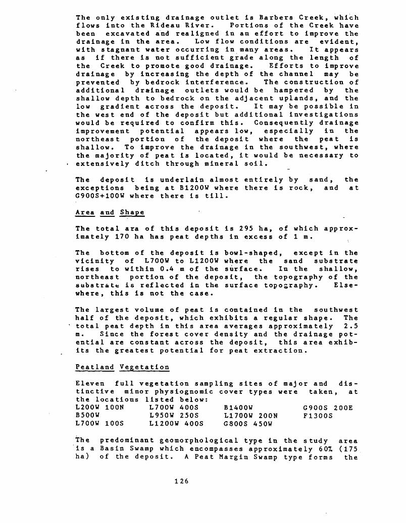
The only existing drainage outlet is Barbers Creek, which flows into the Rideau River. Portions of the Creek have been excavated and realigned in an effort to improve the drainage in the area. Low flow conditions are evident, with stagnant water occurring in many areas. It appears as if there is not sufficient grade along the length of the Creek to promote good drainage. Efforts to improve drainage by increasing the depth of the channel may be prevented by bedrock interference. The construction of additional drainage outlets would be hampered by the shallow depth to bedrock on the adjacent uplands, and the low gradient across the deposit. It may be possible in the west end of the deposit but additional investigations would be required to confirm this. Consequently drainage improvement potential appears low, especially in the northeast portion of the deposit where the peat is shallow. To improve the drainage in the southwest, where the majority of peat is located, it would be necessary to extensively ditch through mineral soil.
The deposit is underlain almost entirely by sand, the exceptions being at B1200U where there is rock, and at G900S+100W where there is till.
Area and Shape
The total ara of this deposit is 295 ha, of which approx imately 170 ha has peat depths in excess of l m.
The bottom of the deposit is bowl-shaped, except in the vicinity of L700W to L1200W where the sand substrate rises to within 0.4 m of the surface. In the shallow, northeast portion of the deposit, the topography of the aubstratfc is reflected in the surface topography. Else where, this is not the case.
The largest volume of peat is contained in the southwest half of the deposit, which exhibits a regular shape. The total peat depth in this area averages approximately 2.5 m. Since the forest cover density and the drainage pot ential are constant across the deposit, this area exhib its the greatest potential for peat extraction.
Peat land Vegetation
Eleven full vegetation sampling sites of major and dis tinctive minor physiognomic cover types were taken, at the locations listed below:L200W 100N L700W 400S B1400W G900S 200E B500W L950W 250S L1700W 200N F1300S L700W 100S L1200W 400S G800S 450W
The predominant geomorphological type in the study areais a Basin Swamp which encompasses approximately 607. (175ha) of the deposit. A Peat Margin Swamp type forms the
126
deposit's periphery, occupying approximately 357. (105 ha) of its surface area. Two small Channel Fen types account for approximately 57. (15 ha) of the deposit.
The predominant physiognomic cover types of this deposit are Mixed, Deciduous, Coniferous and Thicket Swamps, which together cover 951 (280 ha) of the surface area. As well, there are two small Treed Tall Shrub Fens, encom passing approximately 57. (15 ha) of its area, and one very small Open Meadow Marsh.
Disturbances to the cover types occur through most of the deposit. Cutting up to the recent past is most evident around the northeastern periphery of the area, resulting in Thicket Swamp communities. Former agricultural clear ing has impacted upon its northern portion.
The Treed Mixed Swamp cover type complex occupies approx imately 401 (115 ha) of the deposit, in Basin and Peat Margin Swamp geomorphological type sites. It exhibits mildly acidic (pH 6.0) groundwater conditions. This cover type has a varied range of origins, from being a natur ally occurring cover to being a successional feature following past to relatively recent disturbances of cut ting and windthrow. Several phases of this cover type are evident here. Generally, the tree cover has a semi- closed density of 601 (351-651) and is dominated by Black Ash (Fraxinus nigra), Eastern Vhite Cedar (Thuj a occiden- talis) and others. Successional, disturbed areas have a high incidence of Paper Birch (Betula papyrifera) in the canopy. The -tall shrub cover is generally quite open (51-101), except where the tree canopy is open or where there has bee recent disturbance; here, Speckled Alder (Alnus incana), Winterberry (Ilex verticillata) and others are typical. The low shrub cover is semi-open (251) with a consistent presence of Red Osier Dogwood (Cornus s tolonifera) and Alder Leaf Buckthorn (Rhamnus aInifolia). The herb cover includes a varied complement of lowland forest species with a predominance of tall swamp forest and marshland species in the more deciduous phases of the canopy, and more boreal species in the decidedly coniferous phases. Typically occurring in an open to semi-closed cover density (351-751) are Dwarf Raspberry (Rubus pubescens), Sedge (Carex lacus tri s and C. interior),Poison Ivy (Rhus radicans), Joe Pye Weed (Eupatorium macula turn), Marsh Fern (Thelypteri s palus- tris),Northern Bugleweed (Lycopus uniflorus)and Fringed Loosestrife (Lys imachia thrys iflora). The moss cover typically is semi-closed (557.-S57.) and is dominated by brown mos s es.
The Treed Deciduous Swamp cover type occurs along the margin of the deposit, often as a discontinuous, narrow fringe, but along the central northwestern portion as a 100 to 300 m wide band, altogether occupying 157. (50 ha)
127
of the deposit's area. These Peat Margin and Basin Swamp geomorphological type sites have a shallow to deep peat thickness and a mildly to slightly acidic (pH 5.7-6.4) groundwater. There is considerable seasonal standing water that down-drains over the growing season. Where there is relatively little or distant disturbance, the tree canopy is semi-closed (607.) and well over 10 m tall, with Black Ash, Silver Maple (Acer saccharinum) and White Elm (Ulmus americana). Where cutting or flooding distur bance is more recent, as in the northeastern and south western ends of the deposit, Black Ash and Paper Birch dominate as a lower (7 m), more open (407*) canopy. The tall shrub cover is quite open (57.) and includes Winter- berry, Speckled Alder, Slender Willow (Salix petiolaris). The l,ow shrub cover is semi-open (157.) and is dominated by Red Osier Dogwood with lesser cover densities of Alder Leaf Buckthorn and Swamp Honeysuckle (Lonicera oblongi- f olia) . The herb cover is generally semi-closet(657.) and is characterized by the predominance of Spotted Jewelweed (Impatiens biflora), False Nettle (Boehmeria cylindrica), Poison Ivy and Deadly Nightshade (Solanum dulcamara), accompanied by Sedge (Carex lacus trisT,Sen- sitive- Fern (Onpclea sensibilis), Fowl Meadow Grass (Glyceria s tria ta ) , W~hite Snakeroot ( Eupa torium rugosum) , Joe Pye Weed and others. The semi-open (87.-407.) moss cover is dominated by brown mosses.
Coniferous Swamp cover type occurs as two Peat Margin and Basin Swamp geomorphological
having deep to very shallow peat and a slight- groundwater (pH 5.9). An extensive closed tree cover occurs as a cohesive unit on the
central southeastern portion of the deposit, encompassing 2QT. (60 ha) of the deposit, where there has been relat ively little disturbance from cutting in the past 30 years. As well, this cover type occurs as a minor compo nent within the Mixed Swamp, often as a relict of more recent cutting. Its general tree canopy is quite closed (457.-957.) and is strongly dominated by Eastern White Cedar, accompanied by Tamarack (Larix laricina), Balsam Fir (Abies balsamea) or White Spruce ^Picea glauca) . The tall shrub cover is virtually absent, except in thicket- associated phases where Winterberry may be present. The low shrub cover is also open (57.-207.) and includes Alder Leaf Buckthorn, Swamp Honeysuckle, Labrador Tea (Ledum groenlandicum) or Red Osier Dogwood. The herb cover is semi-open (10^-307.) with several boreal associated species, including Sedge (Carex trisperma and C. leptalea), Dwarf Raspberry, Goldthread (Cop tis trifolia) and Northern Bugleweed. The moss cover is very closed (807.-957.) and includes generally equal portions of brown and sphagnum mosses.
The Thicket Swamp cover type occurs locally throughout the deposit and occupies approximately 177. (50 ha) of it
128
on Basin and Peat Margin Swamp geomorphological type sites, particularly about the periphery of the study area, where it is commonly associated with cutting, in the relatively recent past. Two phases are present: an early successional deciduous willow scrubland that has developed over recent clearcuts and abandoned croplands; and, a more diverse swamp scrub that occurs as openings among the treed swamp cover types. The tree canopy is very open (07.-57.) and includes Red Ash (Fraxinus pennsy1- vanica), Black Ash, Trembling Aspen (Populus tremu- loides) , or other wetland trees. The predominant tall shrub cover has a semi-open to semi-closed cover density (25Z-757.) with a variety of species such as Slender Willow, Tall Pussywillow (Salix discolor), Speckled Alder, Winterberry and others. The low shrub cover is semi-open (207.-607.) and is dominated by Red Osier Dogwood with Alder Leaf Buckthorn and Sweet Gale (Myrica gale). The herb cover is semi-open (207.-507.) and is dominated by Sedge (Carex pseudo-cyperus), Dwarf Raspberry and Marsh Fern, with Joe Pye Weed, Northern Bugleweed, Poison Ivy, and others. The moss cover is generally closed (95^) with mostly brown mosses, and frequent sphagnum mosses.
There are two Tall Shrub Fen cover types on the deposit, both situated on the Channel Fen geomorphological types sites in the interior portion of the deposit. These fens are treed with a semi-closed low tree (5 m) canopy. Here, the peat is over l m in thickness, has slightly acidic groundwater (pH 6.0-6.5), and a seasonally down- draining water table. These fens may be a successional artifact resulting from the cutting of the coniferous swamp, especially since they -exhibit at least l m peat. Both fen areas have similar component species which in clude several typical fen indicators, such as Swamp Birch (Betula purni la var. glandulifera) and Tamarack. To gether, these fens occupy 5Z (15 ha) of he deposit. In general, the tree canopy is semi-open (157.-307.) and dom inated by Tamarack, Eastern White Cedar, with frequent Black Spruce (Picea mariana) and White Elm. The tall shrub cover is semi-open (15^-407.) and is consistently dominated by Swamp Birch, Slender Willow and Autumn Willow (Salix seriss ima). The low shrub cover is semi- closed (40^-70X"5and is dominated by Swamp Birch and Red Osier Dogwood, with Labrador Tea, Swamp Honeysuckle and Alder Leaf Buckthorn. The herb cover is semi-closed (35Z-607.) and includes a variety of swamp and fen species such as Dwarf Raspberry, Sedge (Carex lasiocarpa, C. trisperma and C. interior), Bog False Solomon's Seal (Smilacina trifolia), Bog Goldenrod (Solidago u liginosa) , Marsh Fern and Bog Buckbean (Menyanthes trifoliata) . The moss cover is semi-closed (65^-95^), of a mixture of brown and sphagnum mosses.
The Open Meadow Marsh cover type occurs only as a very minor feature (< IT. ; l ha) on the Basin Marsh geomorpho-
129
logical type site, on the western margin of the deposit. It experiences seasonal flooding and down-draining due to beaver activity. It generally has a wet, closed gram- inoid . marsh with only very scattered, successional wet land shrubs of Slender Willow and Shining Willow (Salix lucida). It has a closed (80^) herb cover of Water Smartweed (Polygonum natans), Nodding Beggar Ticks (Bidens cernua), Sedge (Carex s tricta) and others. Its moss cover is very open ( 5T*) t with scattered brown mosses.
The flora of this deposit presents a moderate level of species diversity with several lowland plants being of local to regional interest for their representation of fen and lowland habitats and for their rarity: Ram's Head Lady Slipper (Cypripedium arietinum)(provincially rare), Sedge (Carex gynocratesTy Swamp White Oak (-Quercus b i- color), Clinton's Wood Fern (Dryopteris c lintoniana), Sweet Flag (Acorus calamus), Showy Lady Slipper(Cypri- pedium reginae).
The dominance of sedge peat in the central basin portion of the deposit tends to indicate fen origins for the deposit. As the deposit built up, filling the basin, swamp conditions began, and continue to, dominate the deposi t.
Peat Depth
Peat depth information is summarized as follows:
Average Peat Depths . Average Peat Depths Entire Deposit Area With Peat > 1m
Surficial Layer - 0.1 m Surficial Layer - 0.2 mHumified Layer - 1.2 m Humified Layer - 1.8 mTotal Peat Depth - 1.3 m Total Peat Depth - 2.0 m
Approximately 407. of this deposit of peat less than l m deep. The total average peat depth in this area is 0.5. The majority of the northeastern third of the deposit has less than l m of peat. Peat depth gradually increases toward the southwest, with the maximum accumulation in the south central area, in the vicinity of G400S and G900S where the maximum recorded depth is 3.7 m.
With the exception of a discontinuous stratum of HI,2 sphagnum peat (approximately 0.2 m thick) and a localized subsurface stratum of H3 sedge peat (approximately 0.5 m thick) in the vicinity of L1200W, the peat contained in the deposit is humified. The average depth of humified peat in the southwest (vicinity G400S and G900S), with greater than l m of peat, is 2.6 m. This area contains approximately 2.6 x 10⁶ m3, or about 807. of the humified peat within the portion of the deposit with more than one
130
metre of peat.
Since the forest cover and the drainage conditions are consistent across the deposit, the southwest portion appears to have the greatest potential for extraction of peat. This material may be suitable for energy uses.
The right column in the following table indicates varia tions in the total peat depth in different occurrences of the respective physiognomic types. The total peat depths are highly variable underlying the majority of the physi ognomic types. It may be noted, however, that the hard wood dominated formations appear to be located consist ently in areas with less than 2 m of peat, and the fens in areas with more than l m of peat.
AVERAGE TOTAL PEAT DEPTHS OF PHYSIOGNOMIC TYPES
Variation In TotaL Peat Depth
Physiognomic Average Total Within Physiognomic Types Peat Depths (ra) Types (m)
cS 2.0 <l - 3.7hS 0.9 <l - 1.9tS 1.1 <l - 3.0
htS 0.2 <lchS 1.9 <l - 3.5hcS 0.8 <l - 1.4
TtsF 1.9 l - 2.2mM 0.3 <l
Peat Type
In the northeast portion of the deposit, east of B600V, the peat consists of a single stratum of shrub-dominated woody peat. Throughout the majority of the remainder of the deposit, the basal peat stratum is sedge peat con taining some wood; however, around the periphery of the deposit, for a average width of 225 m, the peat is prim arily woody, with some sedge. This stratum has an aver age thickness of approximately 1.4 m. In the central portions, the woody stratum overlies the previously des cribed sedge stratum. Except for the portion of the deposit northeast of B900V, there is a discontinuous surface stratum of moss peat (sphagnum and brown) con taining some wood and sedge, and average 0.15 m in thick ness .
Peat Humification
The level of humification is reasonably constant through out the deposit. Approximately 757. of the total peat volume is humified (H4+). [It should be noted that during volume calculations it was assumed that all peat in the
131
area less the O.G.S . the vast humified .
than l m deep was umhumified (as directed in"Specifications").. However, in this deposit
majority of peat in the area with < 1m isIf this was taken into account, the percentage
of humified peat in the significantly.] According southwest portion of the
total volume would increase to the volume estimates, the deposit, in the vicinity of approximately 807. of the total
volume of humified peat available. The unhumified peat is restricted to a localized occurrence of subsurface H3 sedge peat (average thickness 0.5 m), in the vicinity of
G400S and G900S contains
L1200W, and a thin (average stratum of HI,2 moss peat.
0.15 m) discontinuous surface
Amorphous material primarily occurs in areas of woody peat with humifications in excess of 4, which constitutes approximately 807. of the total peat volume. The majority of the remaining woody peat has a fibre content of 2, and the sedge and moss peat both have fibre contents of 2 and 3.
Peat Volumes
Peatland No.
31B-18
Total Peatland Area(ha)
295
Volume Peat In Area With > l m Peat (x!06m3)
3.4
Total PeatVolume (xl06m3)
4.0
Total HumifiedPeat Volumes
(H4-10)(xl06m3)
3.1
The southwest portion of the deposit (southwest of L1700W) contains approximately 75Z of the total volume of peat available and approximately 807. of the total volume of humified peat.
Potential For Fuel or Peat Development
The access to this deposit is reasonably good. It possible to get close to the deposit, on all sides, loose, or stabilized surface, all weather roads.
is by
The average stump content is 2.57.; however, it appears to be slightly higher in the southwest. The high stump con tent throughout would likely complicate peat harvesting. Moreover, the lack of sufficient grade and bedrock inter ference may prevent, or increase the cost of, the devel opment of an adequate ditch drainage system. The consis tently heavy forest cover across the deposit will neces sitate major stripping operations and would contribute considerably to the cost of development. Thus, the extraction of the previously described 2.6 x 10⁶ m3 of humified peat, which may be suitable for energy use, will be constrained by these factors.
The discontinuous nature and shallow thickness of
132
surficial (unhumified) peat results in this deposit hav ing very limited horticultural peat potential.
The entire deposit is located on patent land.
Comments
The Organic Soil Map (1:50,000, Merrickville 31B/13) (Ontario Institute of Pedology) indicates the entire deposit as Cornwall soil series, Terric Humisol subgroup, 0.4 m to 0.9 m deep. The peat depth indicated on the Soil Map is considerably less than the depths encountered during this study.
MNR did not express any specific concerns regarding this peatland.
(The following dockets contain the Peatland Classification Map, Elevation Map, Isopach Map, and Peat Profiles for this site.)
133
5.7 PEATLAND 31B-28
. Location
The deposit is located in Augusta (Lots 1-6, Cone. 8; Lots 1-6, Cone. 9; Lots 1-2, Cone. 10), Edwardsburgh (Lots 31-37, Cone. 7; Lots 28-37, Cone. 8; Lots 26-37, Cone. 9; Lots 24-37, Cone. 10), and Oxford (Lots 15-17, Cone. 9; Lots 11-21, Cone. 10) Townships, County of Leeds Grenville. It is 4 km northwest of Spencerville, 3.5 km north of Roebuck and 0.5 km east of McRoberts. McRey- nolds is at its west boundary and The Island is 250 m outside its east boundary.
It is located in Zone 18, Easting 451 000, Northing 4968 000, with latitude 44 degrees 52 minutes -north, and longitude 75 degrees 37 minutes east. The designated study area is covered by the following 1978, 1:10,000 airphotos: 4458-189 #260-270; 4459-195 #123-134; 4460-193 #210-220; 4461-186 #43-55; 4462-287 #52-65; 4463-78 #160- 172. The peatland is covered by: 4458-189 #262-266; 4459-195 #125-131; 4460-193 #213-218; 4461-186 #46-52; 4462-287 #58-62; 4463-78 #164-169.
Access
The mideast boundary is 3 km southwest of Groveton, at the end of a sideroad from that town. The northern portion of the site can be reached (approximately 2 km south) and traversed by the CNR rail line that runs south from Oxford Station. The southern boundary can be reach ed by travelling 2 km northwest from Roebuck, along a
- sideroad to its end. From there a forest access road runs due north to the southern edge (approximatey 2 km), and then into the deposit.
Dates of Field Study
The field investigations for peat determination and general physiognomic characteristics were conducted from September 11 to 28, 1983. Full vegetation sampling occurred from September 25 to 28, 1983 inclusive.
No rain fell during the field investigation; and, for the three months prior to this, the rainfall was only 707. of the 30 year norm.
Topography and Drainage
In general, the deposit is level and the elevation is similar around the entire perimeter. This subdued topo graphy is a reflection of the topography of the sub strate. The only major exception is a domed area in the north central portion of the deposit (between L3700N and L4700N) where the surface is elevated approximately 2 m
134
above the surface of the surrounding area. Here, as the peatland surface rises slightly, the elevation of the substrate decreases. This results in this area having the maximum accumulation of peat (4.9 m) for the deposit.
Slopes on adjacent uplands are generally less than 107. grade; however, numerous localized areas of moderately rolling (107. to 207. grade) slopes occur.
There are no drainage channels flowing through the deposit. Drainage into the deposit appears to consist entirely of precipitation onto the deposit, and runoff from the adjacent uplands. Presently, there are only two drainage outlets, both of which are poorly developed and provide very limited drainge. Both flow out of the north end of the deposit and into the North Branch -of the South Nation River.
Since the central portion of the deposit is domed, surficial drainage is poorer around the periphery of the deposit and numerous localized areas of seasonal, and some areas of permanent, ponding of surface water occur. In addition, beaver activity in the northern and south- central portions of the deposit has resulted in extensive flooding.
The low topographic gradient across the deposit is not conducive to the formation of a well developed natural drainage system. This, and the presence of the adjacent uplands may prevent the construction of a properly functioning ditch drainage system within the deposit. However, it may be possible to construct an additional drainage outlet from the southwest portion of the deposit to Kemptville Creek (1.5 km). In the past, efforts were made to drain the northern portion of the deposit. A drainage ditch was constructed; however, it appears as if insufficient grade and the lack of a suitable outlet rendered these efforts unsuccessful.
With the exception of the domed area, and those areas flooded by beaver activity, the existing drainage conditions and potential for ditch drainage appear to be consistent across the deposit.
Most of the deposit is underlain by sand; however, rock is recorded as basal sediment at approximately 2QT. of the sample sites, scattered randomly across the deposit. This bedrock may interfere with the construction of drainage ditches in some portions of the deposit. Till was record ed at one location in the central portion, and clay at two sites in the northern portion.
Area and Shape
The total area of this deposit is 1990 ha, of which
135
approximately only 960 has peat depths in excess of l m. There are five areas in which peat depths do exceed l m. Four of these are in the southwest and one is in the northeast portions of the deposit. The deposit has a very irregular shape containing numerous embayments and peripheral channels, the peat depth in the majority of which is less than l m.
Many uplands occur within the deposit. The topography of the substrate is very irregular, and in numerous locations, these irregularities, some of which are not visible at the surface, are at very shallow depths. The complex shapes, small size, isolated nature, and shallow depths (max. 2.3 m) may make harvesting impractical. The area in the central portion is large, concentrated and has a relatively regular shape. Consequently, this area likely has the greatest potential for development.
Peat land Vegetation
Thirty-three full vegetation analyses odistinctive minor physiognomic cover typethe following locations:L100N 850EL700N 300EL700N 500WL1700N 200EL1700NL1700NL1700NL1700NL1700NTheselocationsvegetation
maj or occurred
and at
B2700N L2700N L2700N L2700N L2700N L3700N L3700N L3700N
100E 600E 1300E 1900E 700E 1000E 1200E
L3700N L3700N L3750N L3800N L3900N B4700N L4700N L4700N
300W 1600W 1300W 100E 400E
400E 200W
L4700N 700W L4700N 800W L5700N 8t)OW L6500N 1250E L7100N 1000E L7700N 1000E G700W 400S G1100W 200S
900EllOOE1700E300W300Wwere supplemented by observations
along the transects, where type and species were recorded.
at the
over 70 dominant
The predominant geomorphologiea l types in the study area are Basin Swamp, Channel Fen, Domed Bog and Peat Margin Swamp which together encompass over 807. of the deposit. Also occurring are minor occurrences of Flat Bog and Basin Marsh type sites.
Nine physiognomic cover types are identified within the study area of which three are predominant: Mixed Swamp, Treed Low Shrub Bog, and Thicket Swamp. Together, these occupy over 707. of the deposit. Of the remaining six minor distinctive cover types, Deciduous Swamp, Treed Tall Shrub Fen and Coniferous Swamp occupy over 207., while Tall Shrub Graminoid Fen, Shrub-Rich Marsh, Meadow Marsh and Deep Water each occupy less than 57..
Disturbances that affect the cover types within the depo sit include past and recent cutting, which is particular ly evident around its periphery; flooding which appears to be associated with the county road, the railroad bed,
136
and a hydroelectric power line corridor development which passes directly across the dome bog feature; and, ditch ing which is restricted to the northern end.
The Treed Mixed Swamp cover type occurs over 47X (94 ha) of the deposit in Basin and Peat Margin Swamp, Channel Fen, Domed and Flat Bog geomorphological type sites ha ving an acidic (pH 5.7) groundwater with a water table at about 35 cm (+2Q) . The topography presents only poor hummock development (20 cm) of log and stump origins. The peat thickness is variable, depending upon the loca tion within the deposit, ranging from shallow (0.1 m) at the margins to over 3 m in the central area. This cover type is most extensive in the deposit's southern half, but also occurs widely elsewhere. The detailed vegeta tion samples and supplemental observations . indicate a moderate range of variation here, with three general community patterns being evident. Most widespread in the central deposit is a 7 to 13 m high semi-closed (35-70X) tree cover of Eastern White Cedar (Thuj a oxcidental is 25) , Black Ash (Fraxinus nigra20), Paper Birch (Be tula papyri- feral5), accompanied by White Elm (Ulmus americana),Red Maple (Acer rubrum), Balsam Fir (Abies balsamea) and, surprisingly, frequent tall White Pine (Pinus s trobus). The tall shrub cover is semi-closed (25-45X)of Speckled Alder (Ainus incana), Winterberry (Ilex ver ticillata) , and Glossy Buckthorn (Rhamnus frangula). The low shrub cover is quite open (1-5X)wTth Red Osier Dogwood (Cornus stolonifera) and Alder Leaf Buckthorn (Rhamnus alni- folia).The herb cover is semi-open to semi-closed (15- 6OX) and has a variety of wetland species, the predom inant of which are Royal Fern (Osmunda regalis), Dwarf Raspberry (Rubus pubescens), Sensitive Fern (Onodea sen- sibilis), Spotted Joe Pye Weed (EupatorJum masulatum), Sedge (Carex interior), Flat Top White Aster (As ter umbella tus) and others. The moss cover is semi-closed (SO-95%)of brown mosses with frequent sphagnum mosses. In shallow peat sites, along the deposit margins, is a second distinct cover which has a semi-closed (657.), tall (10-14 m) tree canopy of Red Maple30-Eastern White Cedar20-Paper Birchl5 which has an understorey that includes many of the above species and stratum closures. A third distinct phase occurs on the deepest peats in association with the Bog geomorphological type sites. Here, the tree cover is semi-closed (70X), with a mixture of swamp and bog species, notably Eastern White Cedar20, Paper Birchl2, Tamarack (Larix laricinalO), Red MaplelO, and Black Spruce (Picea marianao*!"* The u~nderstorey strata reflect this bog affinity with the consistent, if minor, presence of Mountain Holly (Nemopanthus mucrona ta), Lab rador Tea (Ledum groenlandicum) , Carex"""tr i sperm a , Pitcher Plant (Sarraceniapurpureaj a~nd a pedominance of sphagnum moss .
The Treed Low Shrub Bog cover type occurs as an extensive
137
feature in the east central part of the deposit, where it is associated with the deep (max. approximately 4.5 m) peats of the Domed Bog geomorphological type site, and also as a very local feature in the deposit's southwest ern arm; together these occupy 107. (210 ha) of the study area. The topography here has moderately to strongly .developed (0.3 - 1.1 m) moss and shrub polster hummocks with a deep water table of strongly acidic groundwater (pH 4.1). The single detailed vegetation sample (L3700N 700E) and supplemental observations characterize the tree canopy as being semi-open (15-407.) with 4-7 m tall trees of Grey Birch (Be tula popu11 folia30), TamaracklO and Black SpruceS. The tall shrub cover is very open to semi-closed (1-407.) of Mountain Holly or Swamp Birch (Be tula pumila var. glandulifera). The low shrub cover is semi-closed (60-807.) of Velvet Leaf Blueberry ( Vac- cinium myrtilloides) Labrador Tea, Leatherleaf (Chamae- daphne calyculata), Sheep Laurel (Kalmia angus tifolia) and Black Chokeberry (Aronia melanocarpa). The herb cover is quite sparse to semi-open (2-35^) of Dense Cottongrass (Eriophorum spissum), Virginia Cottongrass (E. vi rginicum) t Carex trisperma, or Bog False Solomon's Seal (Smilacina trif olia) . Th~e moss cover is closed (957.) with a strong predominance of sphagnum moss accom panied by characteristic bog brown mosses such as Aula- comnium palus tre and Poly trichum commune.
The Thicket Swamp cover type occurs widely throughout the deposit, particularly in the northern and southwestern portion, on a wide variety of geomorphological types, including Peat Margin and Basin Swamp and Channel Fen type sites, in total covering 267. (475 ha) of the deposit. The substrate varies from thin mucks in peripheral sites to 2.8 m deep peats in central areas. The groundwater is moderately acidic (pH 5.6-6.1) and the water table varies from 0.35 to l m, with probable seasonal flooding. The topography presents a quite flat to moderately hummocky substrate (0-25 cm) of stump and fallen log origins. The detailed vegetation samples and supplemental observations indicate two distinct phases representing this cover type. Commonly associated with the mixed swamp is a relatively stable, late successional community pattern where there is an open (10 -237.) low (5-8 m) tree canopy of Eastern White Cedarl5, Paper BirchlO, Black AshlO, Red Maple5 among a predominant semi-closed (45-657.) tall shrub cover of Speckled Alder, Winterbery, Slender Willow (Salix petiolaris) and Tall Pussywillow (S. disco lor) . The low shrub cover is semi- open (15-307.) and is dominated by Red Osier Dogwood. The herb cover is semi-open to semi-closed (25-457.) and is dominated by Carex pseudo-cyperus, Marsh Fern (Thelyp- teris palustris) , Northern Bugleweed (Lycopus uniflorus)7 Dwarf Raspberry, Royal Fern, Joe Pye Weed and others. The moss cover is semi-open to semi-closed (30-657.) of brown moss and, occasionally sphagnum moss. The second
138
phase differs in being of an earlier successional stage, generally occurring on shallower or better eluviated peat with often prolonged seasonal or periodic flooding and effectively lacking a tree canopy or relationship to the mixed swamps. The dominating stratum is the tall shrub cover which is semi-closed (35-5511) typically having Slender Willow, Tall Pussywillow and Speckled Alder as dominants with a variety of species in lesser numbers, such as Winterbery, Swamp Birch and Nannyberry (Viburnum lentago) . The low shrub is generally open (5-207T5with Red Osier Dogwood, Narrow-Leaved Meadowsweet (Spiraea alba) and, locally, Leatherleaf. The herb cover is semi- closed OS-70%) of tall, wetland species such s Carex pseudo-cyperus, Joe Pye Weed, Tall Meadow Rue (Thalictrum polygamum)and Royal Fern and lower species such as Carex interior Nodding Beggar Ticks (Bidens frondpsa) , Dwarf Raspberry, Sensitive Fern and others. The moss cover is semi-closed (45-857.) of brown mosses.
The Deciduous Swamp cover type occurs around the periphery of the deposit and near the included uplands, and covers 47. (77 ha) of the surface. These Peat Margin Swamp geomorphological type sites have a generally flat topography with acid (pH 5.6-6.2) groundwater that has seasonal flooding. The peat substrate is often relatively thin. The tree canopy is semi-closed (807.) with dominating species being Red Maple55, Silver Maple (Acer saccharinumAO) and Black Ash, often having heights of 12-15 m. The tall shrub cover is semi-open (ID-40%) of Uinterberry and Speckled Alder. The low shrub cover is very open (3Z) of Red Osier Dogwood. The herb cover is semi-open (45Z) of Royal Fern, Sensitive Fern, Marsh Fern, Lesser Duckweed (Lemna minor) and others. The moss cover is often open (S-30%)of brown and sphagnum mosses.
The Treed Tall Shrub Fen cover type occupies 87. (13 ha) of the deposit with more continuous features in the Channel Fen geomorphological type sites in its southern and north-central portions. The topography has poor to moderate (5-30 cm) hummock/hollow development with a thick peat substrate that has a slightly acid (pH 5.9) groundwater and a water table which exceeds 0.5 m in depth by midsummer. The detailed vegetation samples indicate that there is a low (4-6 m), open (2-307.) tree canopy of Eastern White Cedar, Tamarack, Paper Birch and Red Maple. The predominantly tall shrub cover is semi- closed (35-607.) of Slender Willow, Swamp Birch, Tall Pussywillow, Winterberry and Speckled Alder. The low shrub cover is semi-open (5-357.) of Red Osier Dogwood, Leatherleaf or Labrador Tea. The herb cover is semi-open to semi-closed (35-707.) with a mixture of tall and short wetland and fen species including Carex lacus tris , Royal Fern, Carex pseudo-cyperus , C. interior, Dwarf Raspberry, Marsh Fern, River Horsetail (Equise turn fluviat i le) , Bog Goldenrod (Solidago uliginosa) and others.
139
The Treed Coniferous Swamp cover type occurs frequently throughout the deposit, covering 27. (AO ha) of its surface and is in association with the mixed swamp. It is situated on the Basin and Peat Margin Swamp and Flat Bog geomorphological type site with a moderate to poor (10-35 cm) hummock development, an acid (pH 4.7-5.8) groundwater and a water table up to 40 cm deep. The tree cover is semi-closed (33-70^) with up to 10 m high Eas tern White Cedar25, Tamarackl5, Balsam Fir5 accompanied by scattered Paper Birch or Red Maple. The tall shrub cover is semi-open (357.) of Speckled Alder and Winter- berry, while the low shrub cover is open (5-157.) of Red Osier Dogwood with Alder Leaf Buckthorn and others. The herb cover is open to semi-closed (10-60Z) dominated by Royal Fern with Sensitive Fern, Carex lep talea, Cinnamon Fern (Osmunda cinnamomae) and others. The moss cover is closed (70-95^*5 with both sphagnum and brown mosses. A second phase, associated only with the deep peats of the Dome Bog geomorphological type site presents a closed (70^), tall (10 m) tree canopy of Black Spruce and Tam arack with open understory strata dominated by Mountain Holly (107.), Labrador Tea (37.) and Carex trisperma (5^), with a closed (907.) brown and sphagnum moss cover.
Occurring only very locally in the study area are - the following cover types, often as extreme phases of the more major patterns. In the deep peat portions of the Channel Fen type site locally throughout the deposit is a Tall Shrub Graminoid Fen of Swamp BirchlO, Slender WillowS, Carex pseudo-cyperusZO, Royal FernlS, and sphagnum45 and brown mosses30. Very locally along the margins of the deposit on thin peats are two marsh cover types which are derived from beaver flooding. The Shrub- Rich Marsh has Slender Willow25, Swamp Birch20, Carex virescensl5, C. lasiocarpalO, Marsh Fern5, and brown mosses 20 developing on a quaking mat, or a more successional meadow of Slender WillowS, Rice Cut Grass (Leerzia oryzoidesll), Nodding Beggar Ticks (Bidens cernualO), Purple Loosestrife (Lythrum salicariall) Canada Blue Joint (Calamagrostis canadensis8) on the bottom of a down-drained beaver pond. In one location, a flooding from beaver activity has created a Meadow Marsh cover type with an overstorey of Black Ash25 and a closed (927.), rich herb cover of Spotted Jewelweed, Lesser Duck weed, Water Meal (Wolffia columbianal5), Rice Cut GrassS, and Large Leaf Beggar Ticks (Bidens" f rondosaS) . Local Open Water, inundated portions of the deposit, present an extremely open cover (57.) of pondweeds and aquatics.
This deposit has been recognized as being of local to district significance as a swamp and bog wetland by the inventory efforts of the Federation of Ontario Natural ists (Reddoch, 1982) and the Ontario Ministry of Natural Resources (Luciuk, 1976). It presents an extensive wet-
140
land swamp, fen and bog complex which has a variety of representative natural features. Several vascular plant species of local to regional significance include both the rare to sparse wetland plants: Stout Voodreed (Cinna arundinacea, IDM 15634), Grey Birch (Betula populifolia) Northern Fly Honeysuckle (Lonicera villosa, and Marsh Arrowwood (Viburnum alvar species on the adjacent (Potentilla arguta, IDM (Verbena simplex, IDM 15643)
____ ______ IDM 15651) recogni tumT, and sparse
uplands: Tall Cinquefoil 15640) and Narrow Leaf virvain
The subsurface topography of this deposit is very irreg ular, with numerous bedrock islands. All of the deepest sections contain predominantly sedge peat, sometimes in conjunction with ooze. These unconnected pockets may have supported graminoid fens. As these areas built up, connects among the pockets may have developed. With more flow, meadow marsh conditions may have become prevalent; the sedge peat extends above the pockets and throughout the deposit. The terrestrialization of the deposit then lead to the development of more wooded, swamp communities (and the deposition of woody peat), except along the areas where drainage still occurs, and where small marsh communities prevail.
Peat Depth
Peat depth information for follows:
the deposit is summarized as
Average Peat Depths Entire Deposit
Surficial Layer - 0.4 mHumified Layer - 0.9 mTotal Peat Depth -1.3 m
Average Peat Depths Area With Peat >l m
Surficial Layer - 0.7 mHumified Layer - 1.4 mTotal Peat Depth - 2.1 m
The total average peat depth in the area with less than one metre is 0.5 m, and in the area with greater than one metre of peat, it is 2.6 m. The total peat depth is highly variable throughout the deposit. Generally, peat is deeper in the central and northern portions than in the southern and southwestern section. The greatest accumulation is in the central portion (vicinity L3700N) where the maximum recorded depth is 4.9 m (B4000N). In this central area, approximately 150 ha has in excess of 3 m of peat. This area also contains the greatest depth of H4+ peat. The large size, regular shape and consistent depth greater than one metre give this area the highest development potential; however, the inclusion of some areas with less than 2 m of peat may complicate harvesting. Other areas in which peat depth exceeds l m are in the south and southeast where maximum depths of 2 and 2.3 m are recorded, and in the northeast where there is a maximum recorded depth of 1.3 m. The limited size
141
and shallow peat depths in these areas may make harvest- Ing impractical.
The right column in the following table indicates the variation in total peat depth in different occurrences of the various physiognomic types. The only correlation that is evident from the data is that the Shrub-Rich Marshes are consistently underlain by peat <l. m deep.
AVERAGE TOTAL PEAT DEPTHS OF PHYSIOGNOMIC TYPES
Variation In Total Peat Depth
Physiognomic Average Total Within Physiognomic Types Peat Depth (m) Types (m)
cS 2.2 <l -- 4hS 0.6 <l - 2.25tS 1.1 <l - 2.8
chS 1.4 ^1-3.8hcS 0.7 -CI - 2.5
TtsF 0.9 <l - 2.4TlsB 2.5 <i - 4.9.srM 0.5 -CI
Peat Type
In the extreme south and southwest portions of the deposit, the peat consists of approximately 0.5 m of woody peat overlaying approximately 0.5 m of sedge peat. In the south-central portion of the deposit, in association with the Treed Tall Shrub Fen, the peat con sists of a surficial layer of about 0.25 m of moss peat overlaying 0.25 m of woody peat, which overlays approximately 1.5 m of sedge peat.
In the central portion of the deposit, in association with the Treed Low Shrub Bog, peat consists of about 3.5 m of sedge peat containing some wood. In the central area from L1700N to B5000N, the peat consists of a surface layer of moss peat ranging in thickness from 0.1 m to 1.3 m. This stratum is underlain by a discontinuous layer of woody peat averageing 0.75 m. The basal peat strata, averaging 2.25 m in thickness, consists primarily of sedge peat that contains some wood.
In the northern portion of the deposit, peat consists primarily of sedge with a discontinuous surface stratum of woody peat.
Ooze only occurs as a sub-dominant (between 20-407.) component in two small areas, in the vicinity of L700N 00 and L700N 1000U. In both locations, the ooze occurs in assocation with sedge peat, in shallow strata, averaging 0.3 m, in depressions in the basal sediment.
142
Generally, the peat consists of a shallow discontinuous surface stratum of moss peat, overlaying a moderately thick layer of woody peat above a basal peat stratum of sedge peat. The following correlations between surface vegetation and peat type appear: in areas of Thicket Swamp, the surface layer of moss peat has not developed and peat consists of sedge or sedge overlain by a discon tinuous surface stratum of woody peat; the Low Shrub Bog is located in an area of primarily sedge peat and in some locations, a surface stratum of moss peat, and without a woody stratum; and, accumulations of moss peat, primarily sphagnum, appears to be greatest in the sites occupied by fens and mixed deciduous cover types.
Peat Humification
The proportions of humified to unhumified peat, through out the areas of the deposit with in excess of l m of peat, are consistent and averages approximately 2.5:1.
The size and total depth of the area, with in excess of l m of peat, located in the central portion of the deposit, is much larger than the other areas with in excess of l m of peat. Thus,- the concentrations of both humified (H4+) and unhumified peat are greatest in this area. 'The average total peat thickness in this central area is 2.5 m. Of this, 0.7 m is surficial (unhumified) peat and 1.8 is humified (H4+) peat. This results in a volume of approximately 3.7 x 10⁻⁶ m-3 of surficial peat and 9.5 x 10⁻⁶ m-3 of humified peat contained in the area with ^m of peat in this central portion. This represents approx imately 60TL and 7QT, respectively of the total volumes of surficial and humified peat contained in all areas of the deposit with greater than l m of peat. The surficial peat in this area consists primarily of HI,2 moss peat and H3 sedge peat and the humified peat consists of woody peat and humified sedge peat toward the bottom of the deposit and containing some wood.
Stratigraphically, the peat humification consists of the surface stratum of moss peat, which has a humification of HI,2. Across the majority of the deposit this is under lain by a woody peat stratum with humification ranging from 4 to 7 with the majority of this material being Hfc. The basal peat stratum consists of sedge peat having humifications ranging from 3 to 7, the higher humifica- tions occurring in peats close to the bottom of the deposit. The majority of the sedge peat has a humifica tion of 3 or 4, the limited ooze bearing stratum has a humification of 8.
Amorphous material appears to be concentrated primarilyin the woody peat, with humification in excess of 5; insedge peat with humification in excess of 6 and H4+ sedge
143
peat containing a high percentge of wood; and, in the ooze bearing sedge stratum with a humification of 8. This represents approximately 657. of the total peat re serves of the deposit. The majority of the sedge peat has humifications of 3 and A, and fibre content of 3. All of the moss peat has a fibre content of 3.
Peat Volumes
Peatland No.
31B-28
Total Peatland Area (ha)
1990
Volume Peat In Area With
^ra Peat (x!06m3)
20.0
Total PeatVolume (x!06m3)
25.1
Total HumifiedPeat Volumes
(H4-10)(xl06m3)
13.7
The greatest accumulation of peat, in the area with greater than l m of peat is in the central portion of the deposit. This area contains approximately 13.2 x 10⁻⁶ m-3 of peat, about 507. of the total reserves of the deposit, and 9.5 x 10⁻⁶ m-3 of humified (H4+) which represents approximately 707, of the humified peat contained in all of the areas with greater than l m of peat.
Po tential for Fuel or Horticultural Peat Development
It appears as if past efforts to improve drainge in the north end of the deposit were unsuccessful. The potential for ditch drainage appears to be poor, thus increasing the cost of, or preventing, development of portions of the deposit.
The average stump content is 1.251, and it appears to be consistent across the majority of the deposit. The excep tions are in the areas with greater than l m of peat, in the southwest and in the central portions of the deposit. The stump contents in these areas are lower than in the remainder of the deposit. The generally high stump content may hamper ditching and harvesting operations. The majority of stumps are contained in the first metre of peat. Thus, these may be removed during vegetation s tripp ing .
With the exceptions of the sparsely treed Low Shrub Bog in the east central and southwestern portions of the deposit, and the sparsely treed Tall Shrub Fens in the southwest and north central portions of the deposit, forest cover is consistently dense. The sparsely treed areas correspond with two of the areas of peat concentra tion. This is beneficial to the development capabilities of these areas.
The central portion of the deposit is located approxi mately 25 km from Prescott and approximately 20 km from Kemptville via Highway 16. Ottawa is located approxi-
144
mately 65 km north of the deposit. Access to most por- ions of the deposit is available via loose or stabilized surface roads.
The significant accumulation (approximately 1m) of unhum- ified (HI,2) sphagnum peat in the east central portion of the deposit (L3700N 1000E) may make extraction of horti cultural peat practical. The shallow depth (about 20 cm) of moss peat in other portions of the deposit will likely preclude economical extraction. The occurrence of large volumes of humified woody peat and sedge peat with humif ication of 3 and higher may render extraction of fuel peat practical from the north central portion of the deposit. The shallow (<2.3 m) total peat depth in con junction with poor drainage potential, dense forest cover and high stump content will likely render development of the remaining portions of the deposit impractical.
A large hydroelectric power line traverses the central portion, the portion of the deposit that exhibits the highest potential for development.
The entire deposit is located on Patent Land (private ownership).
Comments
This deposit was previously investigated and the results are contained in Graham and Tibbets, 1961. During that study, the north central portion of the deposit contain ing the sparsely treed Low Shrub Bog was investigated. As observed during this study, the east central portion of the deposit was relatively dry and fine and the sparsely treed area is slightly raised in the centre. The total peat depths encountered in both studies are similar as is the occurrence of the surficial stratum of unhumified moss peat; however, the previous study indic ates subsurface material as humified moss peat, while the sampling during this study revealed sedge peat with humi fication ranging from 4 to 7 .
The following laboratory results were obtained.
Sample Location l to 3 3 3
Depth (ft) 4-8 3-8 6-11 1-2 2-6 Absorptive Value at 257.
Moisture (x own wgt) 14.8 12.4 8.9 Ash (T. dry) 6.1 6.0 3.9 Nitrogen (7.) 2.8 --- 2.8 pH 5-6 --- 5-6
This Department of Mines report concluded that this deposit represents a potential source of peat moss that
145
could be used locally; however, it is doubtful that the quality could compete favourably with currently operating bogs .
The Organic Soil Map (1:50,000) (Merrickville, Slb/13, Ontario Institute of Pedology) indicates that the main body and the northeast arm of the deposit as Carry Soil Series, typic humisol subgroup, depth 1.3 m to 1.8 m. The southern and central periphery areas are Strathmore Soil Series, terric humisol subgroup, depth 0.9 m to 1.3 m, and the northwest periphery is Finch Soil Series, terric humisol subgroup, depth 0.4 m to 0.9 m.
The deposit has been recognized as having District significance by the Federation of Ontario Naturalists and the Ministry of Natural Resources. Rare and sparse plant species have been recorded on this deposit.
(The following dockets contain the Peatland Classification Map, Elevation Map, Isopach Map, and Peat Profiles for this site.)
146
5.8 PEATLAND 31B-38B, JELLYBY SWAMP, NORTH AUGUSTA BOGBELLAMY BOG
Location
The deposit is located in Elizabethtown Township, County of Leeds Grenville (Lots 6-14, Cone. 8; Lots 4-15, Cone. 9). It is 1.5 km due east of Jellyby and 1.8 km due north of Bellamy.
It is located in UTM Zone 18, Easting 437 000, Northing 4953 000, with latitude 44 degrees 44 minutes north, and longitude 75 degrees 47 minutes east. The designated
. study area is covered by the following 1978, 1:10000 airphotos: 4449-129 #123-133; 4450-131 #123-133; 4451- 143 #193-202; 4452-157 #157-168. The peatland is covered by 4450-131 #127-130; 4451-143 #196-200; 4452-157 #162- 166.
Access
The northern portion of the deposit is traversed, north west to southeast, by Fly Creek Road, which is 2.8 km east from Jellyby, along Concession Road 6. The southern portion of the deposit is traversed, northwest to south- east, by the CPR rail line. The deposit starts approxi mately 1.5 km south of Jellyby, along this rail line.
Dates of Field Study
The field investigations for peat determination and gen eral physiognomic characteris'tics were conducted from August 11 to August 15, 1983. Full vegetation sampling occurred on August 16-18 and 23, 1983.
It rained heavily during the field investigation; however for the three months prior to the field investigation, the area experienced only 7QT. of the 30 year norm for rainfall.
Topography and Drainage
Parallel to the direction of flow of Mud Creek, from the southwest to the northeast, the surface elevation grad ually decreases, by approximately l m. Perpendicular to the flow of Mud Creek, along the southeast-northwest axis, the surface topography is a gently sloping bowl, with the highest elevations at the periphery of the deposit and the lowest adjacent to Mud Creek. The maximum elevation difference from the edges to the central por tion of the deposit is approximately 2 m. The surface topography subtly reflects the peatland 1 s basal topo graphy, that of a gently sloping bowl. The only excep-
. tion to this is an upland, in the vicinity of B600S. The topography of the surrounding uplands is an extension of
147
the peatland basin, and consists primarily undulating slopes (G-10% grade).
of gently
Mud Creek, plus a small creek that flows into the deposit from the southeast, and two small intermittent channels that flow in from the north, provide inflow to the de posit. In addition, the deposit receives runoff from the adjacent uplands. Hud Creek represents the only existing and potential drainage outlet from the deposit. It flows through the deposit in a SU to NE direction and empties
(which empties into the Rideau limited topographic gradient, the sluggish. Two small dystrophic and SV portions of the deposit,
and 0.3 ha respectively.
into Kemptville Creek River). As a result of flow in this Creek is lakes occur in the NW having areas of 1.4 ha
The drainage conditions and potential for improvement are similar across the deposit, and can be rated as only moderate. This is because the lack of sufficient grade may hamper the construction of the properjly functioning ditch drainage system.
Area and Shape
The total area of the deposit is 530 ha, of which approximately 340 ha has peat depths in excess of l m. The peat depth around the periphery of the deposit and the few embayments present is consistently less than l m.
The deeper, central area has a regular shape and contains only one upland (vicinity B600S). The area with the highest development potential is concentrated in the west half of the deposit. The maximum recorded depth is 4.5 m.
Peatland Vegetation
Eighteen full vegetation analyses of major andive minor physiognomic cover types occurred atlowing locations:LOGON 100W L500S 320WB200N L1000S 700EB500N L1000S 270WL500S 400E L1000S 600WL500S 1010E B1500S
distinct- the fol-
L1500S 300E L1500S 500W L2000S 200W L2000S 400W
L2000S 650W L2000S 800W L2500S 300E L2500S 250W
There are nine geomorphological types in the study area, predominant among which are Basin Swamp (307.), Peat Margin Swamp (257.) and Channel Fen (257.), with lesser occurrences of Floodplain Swamp, Stream Swamp, Stream Fen, Stream Marsh, Open Water and Upland inclusions.
There are three predominant physiognomic peatland typesin this deposit: Decidupus Swamp, Mixed Swamp and OpenTall Shrub Fen, together occupying over 857. of its sur face area As well. there are five additional minor
148
cover types present: Thicket Swamp, Coniferous Swamp, Treed Tall Shrub Fen, Meadow Marsh and Open Water.
Disturbances within the deposit that have modified the cover types include local past cutting of the forest cover, localized severe clearance associated with road bed, railway and hydroelectric transmission line corridor, and possible alteration of the water flow patterns at the road and rail crossings.
The Treed Deciduous Swamp cover type encompasses 317. (165 ha) of the deposit, most common on the Peat Margin Swamp geomorphologlcal type site and extending 200 to 500 m into the deposit as several extensive, if discontinuous, features. There is seasonal standing water, with a slightly acid (pH 6.2-6.8) groundwater. Two distinctive community patterns are evident here, associated with the peat depth and disturbance history. The more striking cover type is an over 12 m tall, submature to intermediate aged forest, strongly dominated by a closed (801) canopy of Silver Maple (Acer saccharinum) with a low, but consistent incidence of Red Ash (Fraxinus pennsylvanica), White Elm (Ulmus americana), Black Ash (Fraxinus nigra) and Eastern White Cedar (Thuja occidentalislin younger stages. This phase has a very open (0-51)tall and low shrub cover of Winterberry CIlex verticillata), Speckled Alder (Alnus incana) and Red Osier Dogwood (Cornus s tolonifera), with a variously open to closed herb cover of False Nettle (Boehmeria cylindrica), Sensitive Fern (Onoclea sens ibilis) , Sedge (Carex" pseudo-cyperus) , Marsh Fern (Thelypteri s palus- tris) and Northern Bugleweed (Lyeopus uniflorus j and an irregular semi-open brown moss cover. The second phase is younger in age class with a shorter (7-9 m) semi- closed (601) tree canopy dominated by Black Ash assoc iated with* White Elm, Red Ash, Eastern White Cedar and others. The tall shrub cover is open to semi-closed and supports Speckled Alder, Winterberry and Tall Pussywillow (Salix disco lor) . The low shrub cover is open to semi- closed (5-501) and includes Red Osier Dogwood and Alder Leaf Buckthorn (Rhamnus alnifolius). The herb cover is generally closed with a variety of wetland species such as Carex s tricta, C. pseudo-cyperus, Sensitive Fern, Dwarf Raspbery (Rubus pubescens), Northern Bugleweed, Marsh Fern, White Snakeroot (Eupa toriurn rugo sum) , Poison Ivy (Rhus radicans) and others. The moss cover is semi- open with brown moss species being dominant. The latter of these phases displays an affinity to the mixed swamp cover type.
The Treed Mixed Swamp cover type occupies over 297. (155 ha) of the deposit in Peat Margin and Basin Swamp geomorphological type sites having a moderately deep to shallow peat substrate of slightly acid (pH 6.5) ground- water conditions and a shallow water table (35 cm). The
149
origins of this mixed canopy is commonly from succession following past cutting. This is particularly evident along the deposit margins where stumps and fallen logs are frequent. Further into the deposit's interior, how ever, the cover may be a more natural association of deciduous and coniferous species. In general, the tree canopy has a semi-closed to semi-open (657.) cover density and is dominated by 9 to 12 m tall Black Ash and Eastern White Cedar with a lesser presence of White Elm and Balsam Fir (Abies baIsamea). The tall shrub cover is very open to semi-open (0-357.) with an inconsistent com plement that includes Highbush cranberry (Viburnum opulus) , and Nannyberry (V. lentago). The low shrub cover is open (4-161) with Alder Leaf Buckthorn, Swamp Fly-Honeysuckle (Lonicera oblongifo lia) and occasional Canada Yew (Taxus canadensisT"* The herb layer is semi- open to semi-closed (35-857.) with a variety-of lowland species, notably Sensitive Fern, Dwarf Raspberry, North ern Bugleweed, Harsh Fern, Wild Sarsaparilla (Aralia nudicaulis) and others. The moss cover is very open to very closed (5-951) of brown mosses.
The Op.en Tall Shrub Fen cover type occurs along the deeper peats of the central portion of the deposit, in the Channel Fen geomorphological type sites where there is a shallow water table (2-20 cm) having a neutral to slightly acidic (pH 6.3-7.0) groundwater. Two phases* of this type appear to predominate, together occupying 287. (148 ha) of the deposit. Associated with the channel of the meandering Hud Creek is a semi-closed, tall shrub cover which displays some affinities with the thicket swamp type. The upper, tall shrub cover is semi-closed (50-701) and includes Slender Willow (Salix petiolaris), Tall Pussywillow, Autumn Willow (S. serissima) , Swamp Birch (Betula pumila var. glandulifera). Tall Arrowwood (Viburnum recogni turn) and Hoary Willow (Salix Candida). The lower shrub cover is semi-closed and includes Swamp Birch, Shrubby cinquefoil (Potentilla fruticosa) , Red Osier Dogwood, Alder Leaf Buckthorn, Bog Rosemary (Andromeda glaucophylla), Sweet Gale (Myrica gale), and Swamp Fly-Honeysuckle. The herb cover is semi-open (30- 757.) of Dwarf Raspbery, Marsh Fern, Royal Fern, Canada Blue Joint (Calamagrostis canadensis), Carex interior, Bog GoldenroTl (Solidago uliginosa),Northern Bugleweed and Spotted Joe Pye Weed (Eupa tor iurn maculatum) . The moss cover is open to semi-closed (20-801) with brown mosses. A second phase is associated with the broader Channel Fen sites. This presents a more even, semi- closed (557.), tall shrub cover of Swamp Birch and Slender Willow with a semi-closed (457.) low shrub cover of Shrubby Cinquefoil, Red Osier Dogwood, Alder Leaf Buck thorn and Swamp Fly-Honeysuckle; a semi-open to semi- closed herb cover of Ga rex interior, Marsh Fern, River Horsetail (Equi s eturn fluviatila), Canada Blue Joint, Bog Goldenrod and other fen species; and, a semi-closed brown
150
moss cover. In both phases, there are local areas where Tamarack (Larix laricina), Eastern White Cedar or Black Ash are present as very open tree cover.
The Thicket Swamp cover type encompasses 81 (42 ha) of the deposit, occurring as several discontinuous features on a variety of geomorphological types, notably Peat Margin, Basin and Floodplain Swamp sites. This cover type has both natural origins as deciduous to mixed shrub/low tree communities and successional origins following the disturbances of past cutting. Several cover patterns are present, including an extensive cover of semi-closed to closed (40-657.) Speckled Alder, Red Osier Dogwood, Winterberry and Slender Willow in the central portion of the deposit, a flooded semi-closed (701) deciduous scrub of Slender Willow locally around its margins, and a rich, diverse mixed cover of Speckled Alder, Slender Willow, Swamp Birch and Winterberry in association with the floodplain channel. As well, frequently throughout the deeper peats of the central deposit i^s a gradation towards the tall shrub fen cover type. In general, the predominant cover is semi-closed (65-757.) tall shrub stratum of Speckled Alder, Slender Willow, Red Osier Dog wood and Winterberry, with a very scattered low tree com ponent of Black Ash or Eastern White Cedar. The low shrub cover is semi-open (30-401) with Red Osier Dogwood, Swamp Birch and Sweet Gale. The herb cover is semi- closed (50-801) of Carex stricta, Canada Blue Joint, Northern Bugleweed, Harsh Fern, Spotted Joe Pye Weed, Small Bedstraw (Galium trifidum), Deadly Nightshade (Solanum dulcamara!"* Rifce Cut Grass (Leerzia oryzoides) and others. The moss cover is open to closed (15-857.) with brown moss species. On the alluvial deposits of the meandering stream course and its floodplain, the herb complement is strikingly rich and diverse. Where there is a transition towards marshland or where there has been considerable flooding or downdraining, Slender Willow or Speckled Alder tend to be dominant with a poor herb layer of Large-leaved Beggar Ticks (Bidens frondosa) , or algae (Chara spp.), and no mosses.
The Treed Coniferous Swamp cover type appears to occur as a cohesive unit only very locally on the central south eastern margin of the deposit, encompassing 11 (5 ha); however, elements of its patterns are evident in association with the mixed swamp elsewhere throughout the deposit. Typically, there is a closed to semi-closed (50-751) coniferous tree canopy, strongly dominated by Eastern White Cedar and associated with scattered Balsam Fir and Black Ash. The tall shrub cover is semi-open with Winterbery and Speckled Alder; the low shrub cover is open with Red Osier Dogwood; and the herb cover is variously open to semi-closed with a mixture of lowland forest species as well as a concentration of boreal species such as Naked Mitrewort (Mitella nuda) and North-
151
eastern Twin Flower (Linnaea borealis). The moss cover is semi-open with brown mosses. In the thicket swamp inclusions the characteristic species are more restricted in extent and diversity. This cover type may have been more extensive in the past within the present thicket swamp sites, but has decreased due to cutting.
A Treed Tall Shrub Fen cover type occurs as two small, discontinuous features at the edge of the open fens, totaling 27* (13 ha). These present an 8 m high semi- closed (457.) canopy cover dominated by Tamarack with Eastern White Cedar or Black Ash. The understorey species complement appears to have many floristic and structural elements of the open tall shrub fen. Locally, in areas too small too map., an Open Low Shrub Fen cover type occurs as a mosaic within this tall shrub fen feature. It has many of the characteristic fen species including an open tall shrub cover of Swamp Birch and Slender Willow, a closed to semi-closed (607.) low shrub cover of Swamp Birch, Shrubby Cinquefoil, Black Chokeberry (Aronic mel- anocarpa), Leatherleaf (Chamaedaphne calyculata) , Bog Rosemary, Tall Meadowsweet (Spiraea aIba )andothers, and a rich, semi-closed herb cover.
Small examples of the Meadow Marsh cover type are gen erally associated with the stream courses and locally with the deposit fringes. These present a diverse "com plement of representative lowland herb species, including Carex pseudo-cyperus, Canada Blue Joint, Spotted Joe Pye Weed and Nodding Beggar Ticks.
Open Water is associated with the stream course and with the two ponds in the central portion of the deposit (<^. t 2.5 ha). The water is dystrophic in the latter cases. There is a moderate pondweed and aquatic flora associated with the stream courses.
This study area has been recognized for providing cover for migrant water fowl (OMNR, Brockville District, Sensi tive Area Reports), but has not been otherwise designated for protection or significance status. While much of the forested portion has been disturbed, the meandering stream landform and rich tall shrub fen cover types are of local to district significance. The vascular plant flora is moderately rich in fen associated species and includes several species of district to regional signifi cance: Clinton's Fern (Dryopteris ci intoniana), Eastern Red Cedar (Juniperus virg inianayjStout Woodreed (Cinna arundinacea, IDM 15193), Red Elm (Ulmus rubra, IDM 15367), Black Maple (Acer nigrum, IDM 15309), and Tall Arrowwood (Viburnum recogni turn, IDM 15159, 15168).
The deposit appears to have been initiated as a graminoidfen-marsh complex, the marsh areas being centred on thedrainage courses. This is supported by a consistent
152
layer of sedge or ooze-dominated sedge peat base of the deposit. This complex matured i fen-swamp complex, the latter azain beine ce drainage courses.
Peat Depth
o oz e-a oraiua t eu seage peat, across theThis complex matured into
the latter again being centretreed
on the
Peat depth information for follows:
the deposit is summarized as
Surficial Layer - 0.4 mHumified Layer - 0.9 mTotal Peat Depth - 1.3 m
Surficial Layer - 0.6 mHumified Layer - 1.2 mTotal Peat Depth - 1.8 m
The total average peat depth in one metre of peat is 0.4 m.
the area with less than
The maximum accumulation of peat is in the west half of the deposit, where a maximum depth of 4.5 m was recorded, at B1500S. This area also contains the greatest accumul ation of humified peat, with an average depth of 2.3 m. There is one upland (vicinity B600S) included within the area with greater than l m of peat. With the exception of this upland, and two small areas of slightly shallower peat (between 2-3 m depth) in the area, there are no irregularities in the basal topography that may compli cate harvesting. This western portion of the deposit also corresponds to the areas having the most open forest cover, enhancing the development potential.
AVERAGE TOTAL PEAT DEPTHS OF PHYSIOGNOMIC TYPES
Physiognomic Types
Average Total Peat Depths (m)
Variation in Total Peat Depth
Within Physiognomic Types (m)
cShStS
chShcS
TtsFOtsF
mH
2.0 1.1 3.6 3.1 1.4 3.8 2.5 1.0
-2.4- 3.5- 4.1- 4.2- 4.0- 4.5- 4.1
Total peat jority of
depths are highly variable underlying the ma- physiognomic types. The only correlation that
153
can be drawn between cover type and peat depth is the consistent occurrence of open tall shrub fens in areas with peat depths greater than 1.5 m. Meadow Marsh is in dicated as only occurring in areas with <l m of peat; however small localized meadow marshes, too small to map, occur in the central portion of the deposit, adjacent to Mud Creek, in areas with peat depths in excess of 3 m.
Peat Type
Across the majority of the deposit, the basal sediment is overlain by a stratum (average thickness l m) of highly humified material consisting primarily of ooze (80-907.) and some sedge. In some localized areas, this stratum is overlain by a sedge-dominated peat layer (average thick ness 0.5 m) containing up to 407. ooze, and minor amounts of wood. In the west-central portion of -the deposit (vicinity B1500S to B2500S), where the total accumulation of peat is greatest, the thickness of the ooze-dominated material is also greatest, averaging approximately 1.5 in.
With only minor localized exceptions, across the entire deposit the ooze-bearing strata are overlain by a sedge- dominated stratum (average thickness of 0.9 m), contain ing some wood, primarily of shrub origin. The surface stratum (average thickness 0.6 m) across the majority of the deposit is woody peat, primarily of shrub origin, containing some sedge. There are, however, some localized areas where the woody peat is non-existent and the sedge stratum constitutes the surface material.
The occurrence of the ooze-dominated basal layer may reduce the average total thickness of peat with potential for harvest, in the area with >l m peat, from 2.5 to 1.5 m in general, and from 4.5 to 3 m in the deep west- central portion of the deposit. This, in addition to probable peat loss during vegetation stripping, may make harvesting impractical. The ooze layer may also adversely affect the trafficability and workability of the pet deposit after draining.
The stratigraphy of the peat is relatively consistent, while the vegetation cover type varies considerably ac ross the deposit. Consequently, it is not possible to id entify any correlation between vegetation cover and peat types. This may be due to the fact that the current veg etation cover may be result of man-induced changes (cut ting, road and rail construction, hydro right-of-way).
Peat Humifica tion
The average depth of surficial (unhumified) peat, in the area with peat in excess of l m in depth, is 0.6 m. This material is composed primarily of an unhumified stratum of sedge dominated peat. The average depth of humified
154
(H4+) peat, in the area with in excess of l m of peat, is 1.9 m. This material consists primarily of highly humi fied ooze dominated, and ooze bearing sedge strata, with minor percentages of humified sedge peat, often contain ing high percentages of wood, and humified woody peat.
The humifica thickness l m from 7 to ficiation thicknes s 6, with tion of 3 located below ponent, the face layer humifications the material
7 t of0.
the or
tion of the ooze dominated layer (average ) that overlies the basal sediment, ranges and the majority of the material has a humi-8 or 9. The sedge dominated layer (average9 m) has humifications that range from 3 to majority of the material having a humifica-
4. Generally, the deeper the material is the surface and/or the higher the wood corn-
higher the degree of humification. The sur- of woody peat (average thickness 0.6 m) has ranging from 2 to 5, with the .majority of
being H4 or 5.
The peat stratigraphy is relatively consistent throughout the deposit. Thus, areas of higher con-centra t ions of surficial (unhumified) or humified (H4+) peat do not occur. The greatest depths and largest volumes of both occur in the west half of the deposit.
Amorphous material occurs primarily in the ooze and sedge dominated materials with humification of 6 or higher,-and the woody peat with humification of 4 or higher. This represents approximately 707. of the total volume of the deposit.
Peat Volumes
As tabulated below, the majority (approximately 907.) of the total reserves of the deposit are contained within the area with greater than l m depth of peat. Only a minor portion of the deposit, primarily in the northeast, has peat depths less than l m.
Peatland No.
.31B-38B
Total Peatland Area(ha)
530
Volume Peat In Area With Mm Peat (x!06m3)
6.0
Total PeatVolume (x!06m3)
7.0
Total HumifiedPeat Volumes (H4-10)(xl06m3)
4.0
Approximately 707* of the peat contained in the deposit is humified (H4+); however, it should be noted that a large percentage of this consists of ooze dominated or ooze bearing strata.
The west half of the deposit contains approximately 707. (6.4 x 10⁻⁶ m-3) of the total peat reserves. This is composed of approximately 257. ooze dominated material (H8,9), 107. sedge peat containing some ooze (H6-8), 507.
155
sedge peat containing some wood (H3,4), and 157. woody peat containing some sede (HA,5). This west portion also corresponds to the area with the lowest density of forest cover.
Po tential For Fuel or Horticultural Peat Development
This deposit is located approximately 20 km north of Brockville and access is available via Hwy. 6. Loose surface all weather roads give access to the northeast and the west end of the deposit. In addition, a large power transmission line crosses the central portion of the deposit (vicinity (B600S), in a NW-SE direction.
The majority of peat contained in the deposit is concentrated in a regular shaped area. The peat is relatively deep and this area also has the lowest density of forest cover, thus vegetation removal and drainage ditch construction will be simplified. However, the following constraints are present. Approximately 257. of the peat has ooze as the dominant component and an additional 107. contains some ooze. The presence of this material may adversely affect the amount of usable peat available and the trafficability of the deposit after drainage. Moreover, the potential for improved drainage is poor, due to the limited amount of natural gradient across the deposit. As well, the stump content, which is 3.57., is very high relative to most other deposits in the study area, and with the exception of a small area in the northeast portion of the deposit, where stump content is lower, the content is consistent across the deposit. The vast majority of the stumps were encountered in the 0-1 m depth interval.
The OMNR, in its sensitive areas report, indicates that the area provides good cover for migrating waterfowl. The area is proposed to be an "impondment" by the Rideau Valley Conservation Authority.
The entire deposit is located on Patent Land (private ownership).
Comments
The Organic Soil Map (1:50,000, Brockville 31B/12) (Ontario Institute of Pedology) indicates that the main body of the deposit as Carry Soil Series, Typic Humisol subgroup, and 1.3 to 1.8 m deep. The periphery of the central, the NE and NW portions of the deposit are Williamstown Soil Series, Terric Humisol subgroup, with a depth of 0.6 to 0.9 m. These variations in depth are generally in agreement with the findings of this study.
(The following dockets contain the Peatland Classification Map, Elevation Map, Isopach Map, and Peat Profiles for this site.)
156

Ontario
Ministry ofNaturalResources
Hon Alan W. Pope
John R. Stoan Deputy Minister
ONTARIO GEOLOGICAL SURVEY
Open File Report 5491
Peat and Peatland Evaluation of the Ottawa-Brockville Area Volume IV
by
Bird and Hale Ltd.
1984
Ontario
Ministry ofNaturalResources
Hon Alan W. Pope Minster
John R. Stoan Deputy Minister
ONTARIO GEOLOGICAL SURVEY
Open File Report 5491
Peat and Peatland Evaluation of the Ottawa-Brockville Area Volume IV
by
Bird and Hale Ltd.
1984
Ontario
Ministry ofNaturalResources
Hon. Alan W.Pope Minister
John R. Stoan Deputy Minister
ONTARIO GEOLOGICAL SURVEY
Open File Report 5491
Peat and Peatland Evaluation of the Ottawa-Brockville Area Volume IV
by
Bird and Hale Ltd.
1984

O OMNR-OGS 1984
Ontario
Ministry of Hon- A1*0 w-a., . . MinisterNatural
John R. Sloan Resources Deputy Minister
ONTARIO GEOLOGICAL SURVEY
Open File Report 5491
Peat and Peatland Evaluation of the
Ottawa-Brockville Area
Volume IV
by
Bird and Hale Ltd.
1984
THIS PROJECT IS PART OF THE HYDROCARBON ENERGY RESOURCES PROGRAM (HERP), AND WAS FUNDED BY THE ONTARIO MINISTRY OF TREASURY AND ECONOMICS UNDER THE BOARD OF INDUSTRIAL LEADERSHIP AND DEVELOPMENT (BILD) PROGRAM.
Parts of this publication may be quoted if credit is given. It is recommended that reference to this report be made in the following form:
Bird and Hale Ltd.
1984: Peat and Peatland Evaluation of the Ottawa- Brockville Area, Volume 1-5, Ontario Geological Survey Open File Report 5491, 217p., numerous tables and maps.

Ontario Geological Survey
OPEN FILE REPORT
Open file reports are made available to the public subject to the following conditions:
This report is unedited. Discrepancies may occur for which the Ontario Geological Survey does not assume liability. Recommendations and statements of opinion expressed are those of the author or authors and are not to be construed as statements of government policy.
Open file copies may be read at tile following locations:
Mines LibraryOntario Ministry of Natural Resources8th Floor, 77 Grenville Street, Toronto
The office of the Regional or Resident Geologist in whose district the area covered by this report k located.
Handwritten notes and sketches may be made from this report. Check with the Library or Region al or Resident Geologist's office as to whether there is a copy of this report that may be borrowed. The Library or Regional or Resident Geologist's office will also give you information on copying ar rangements. A copy of this report is available for Inter-Library Loan.
This report is on file in the Regional or Resident Geologists' offices) located at:
255 Metcalf Street Concession Road Box 70 Kemptville, Ontario Tweed, Ontario KOG lJO KOK 3JO
The right to reproduce this report is reserved by the Ontario Ministry of Natural Resources. Permission for other reproductions must be obtained in writing from the Director, Ontario Geological Survey.
V.'G. Milne, Director Ontario Geological Survey
111

PEAT AND PEATLAND EVALUATION OF THE
OTTAWA - BROCKVILLE AREA
TABLE OF CONTENTS
DF OPEN FILE REPORT 5491
Volume I
AbstractIntroductionMethodologyResults and ConclusionsDetailed Deposit Evaluations
31G-2431G-3031G-58
Volume II
Detailed Deposit Evaluations 31B-4 31B-8
Volume III
Detailed Deposit Evaluations 31B-18 31B-28 31B-38B
* Volume IV
Reconnaissance Deposit Evaluations31G- 21, 32, 35, 38, 50, 54, 69/70, 100
Volume V
Reconnaissance Deposit Evaluations31B- 12, 13, 30, 35, 38A, 39/40, 45
Indicates this report
v

TABLE OF CONTENTS
VOLUME 4 page
RECONNAISSANCE DEPOSIT EVALUATIONS 157
6.1 Peatland 31G-21 " 1586.2 Peatland 31G-32, Osgoode Bog 1616.3 Peatland 31G-35, Dalmany Bog, West Osgoode Bog 1656.4 Peatland 31G-38 - 1706.5 Peatland 31G-50 1746.6 Peatland 31G-54 1786.7 Peatland 31G-69/70 1826.8 Peatland 31B-10 187
Vll

Peat and Peatland Evaluation of the Ottawa-Brockville Area
prepared for
MINISTRY OF NATURAL RESOURCES
ONTARIO GEOLOGICAL SURVEY
prepared by
BIRD AND HALE LIMITED 1
VOLUME A
l 1263 Bay Street, Tor. Ont. M5R 2C1
Manuscript approved for publication by Owen L. White, Section Chief, Engineering and Terrain Geology Section, August 24, 1984.This report is published by permission of V.G. Milne, Director, Ontario Geological Survey.
IX

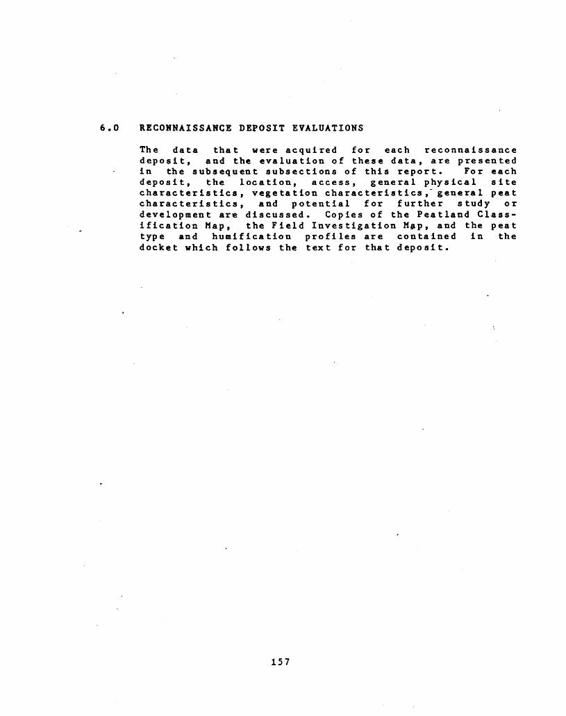
6.0 RECONNAISSANCE DEPOSIT EVALUATIONS
The data that were acquired for each reconnaissance deposit, and the evaluation of these data, are presented in the subsequent subsections of this report. For each deposit, the location, access, general physical site characteristics, vegetation characteristics,~ genera l peat characteristics, and potential for further study or development are discussed. Copies of the Peatland Class ification Map, the Field Investigation Hap, and the peat type and humification profiles are contained in the docket which follows the text for that deposit.
157
6.1 PEATLAND 31G-21
Loca tion
The deposit is located in Cumberland Township, Ottawa, Carleton Region, (Lots 23-24, Cone.7; Lots 23-25 , Cone.9; Lots 21-25, Cone.9; Lots 20-24, Cone.10). It is 1.5 km wes t of Vars.
It is located in UTM Zone 18, Easting 470 000, Northing 5022 000, with latitude 45 degrees 21 minutes north, and longitude 75 degrees 23 minutes east. The designated study area is covered by the following 1978 1:10000 airphotos: 4523-114 #111-122; 4524-114 #29-40; 4525-88 #150-160; 4526-88 #1-15. The peatland is covered by: 4524-114 #32-36; 4525-88 #153-157.
Access
From Carlsbad Springs, the north edge of the deposit may be reached by following Cone. 26 to the intersection with Cone. 31 where it crosses the CNR. line, a distance of approximately 3.2 km. The CNR rail line runs across the northeastern edge of the deposit, providing access south from there.
Dates of Field Study
The field investigations for this deposit were conducted . on October 24, 1983.
Topography and Drainage
This cluster of small, discontinuous wetlands is con tained in shallow depressions in a sand and clay plain. The uplands surrounding these depressions are gently un dulating (0-107. grade), similar to what is believed to be the topographic condition of the substrate. The surface of the deposit itself is too small and irregular to observe any topographic trends.
Inflow to the deposit is from the adjacent uplands, in the north, and from the uplands and Shaws Creek in the south. Four wetland areas in the northwest portion are contained in depressions that lack drainage outlets; and, four wetland areas in the south are drained by Shaws Creek, which flows from west to east through this area, and its tributaries. The flow in these channels is slug gish, due to the lack of sufficient gradient. This may hamper drainage improvement measures and thus the drain age potential of the deposit is rated as moderate.
Area and Shape
These wetland pockets have a total area of 145 ha, the
158
largest of which (vicinity RI) has an area of 45 ha. The individual units are scattered and isolated, and have ir regular shapes containing numerous bays and periperal channels. These would complicate drainage improvement and peat harvesting.
Peat land Vegetation
As a result of the airphoto interpretation and subsequent field checking, it was determined that the wetland in the vicinity of RI is the only area that contains a signifi cant accumulation of peat. Thus, this vegetation des cription applies specifically to this area. This small deposit is part of a large woodland complex. It has three discernible cover types. The most prominent is a thicket swamp of Speckled Alder (Ainus incana), Willow spp. (Salix spp.) and scattered trees of Black Ash (Fraxinus nig ra) , having an average closure density of 607. and covering 931 (42 ha) of the area. In the -southern end is a flooded wetland with an open meadow marsh and 401 standing water. It covers 27. (l ha) of the deposit. Canada Blue Joint (Calamagrostis canadensis) and sedge (Carex spp.) occur here with a 201 to 607. canopy density. In the northern half is a small (41; 2 ha), irregularly- shaped flooded area that supports numerous dead trees.and has a 907. herb cover density.. It appears that an open graminoid fen is regenerating in a former swamp area,, as a result of a change in the hydrological conditions
Peat Depth
Peat depth is very shallow throughout the deposit: the majority of the areas mapped are wetlands containing no or insignificant accumulations of peat. The maximum recorded accumulation is 0.2 m and this is contained in the south portion of the largest wetland area (vicinity of R-l). The only physiognomic cover type within which a sample point is located is meadow marsh (mM), with a recorded total depth of 0.2 m.
Peat Type
The only peat type encountered was sedge peat containing some wood.
Peat Humification
Within the total recorded peat depth of 0.2 m, the top 0.05 m is HI and the lower 0.15 m is H4.
Peat Volume
The amount of peat contained in this area is very limited. Due to the very shallow and scattered nature of the deposit, an estimate of volume was not possible.
159
Potential For F u r th e r Detailed Study
The scattered, isolated nature of the wetlands, and the shallow peat depth make this area unsuitable for further study or development.
Approximately two thirds of the study site is privately owned, with pockets of agreement forest in the eastern part.
Comments
MMR recognizes the area as primarily an upland deciduous forest that may not contain any peat. MNR also indicated that some of the existing ponds are abandoned borrow pits that have flooded.
(The following docket contains the Peatland Classification Map and Peat Profiles for this site.)
160
6.2 PEATLAND 31G-32, OSGOODE BOG
Location
This deposit is located in Osgoode Township, the Region of Ottawa Carleton, (Lots 20-27, Cone. 3; Lots 21-29, Cone. 4). It is 6 km north-east of Osgoode, and 2 km south of Herberts Corners.
It is located in UTM Zone 18, Easting 456 000, Northing 5004 000, with latitude 45 degrees 11 minutes north, and longitude 75 degrees 33 minutes east. The designated study area is covered by the following 1978, 1:10000 airphotos: 4412-172 #220-229; 4413-94 #88-96; 4414-150 #101-109; 4415-149 #203-211. The peatland is-covered by: 4513-94 #91-94; 4514-150 #104-107.
Access
The northwest corner of the deposit may be reached by travelling to the junction of County Roads 25 and 6, 2.2 km south of Herberts Corners. To reach the south- central edge of the deposit, travel northwest on the sideroad from Dalmeny until the end is reached, approxi mately 4.0 km.
this deposit occurred on
Dates of Field Study
The field investigations for September 24, 1983.
Topography and Drainage
This deposit is located in the south end of a gently sloping, north-south oriented trough. This trough slopes down from the south and southeast, to the north. The slopes of this basin and the adjacent uplands are gently undulating (Q-10% grade). The basin substrate is prim arily clay; however, some sand occurs in the southwest.
Drainage into the deposit appears to consist entirely of runoff from the adjacent uplands. In the northern portion of the deposit, outflow is via a channel that flows out of the northwest corner and into the Rideau River. The extreme north portion of the deposit, within the study area, may drain north into the Middle Castor River and eventually into the South Nation River. The south portion is drained by a drainage ditch that is an extension of the South Castor River which flows into the South Nation River. The potential appears to be good for further improving the drainage conditions by upgrading and extending the existing drainage network.
161
Area and Shape
The deposit continues outside the study area for a con siderable distance to the north. The portion of the deposit that is inside the study area has a total area of 415 ha.
The shape is relatively regular and contains few bays or peripheral channels. The regular shape could simplify drainage improvement and peat harvesting procedures.
Peat land Vegeta tion
The predominant cover type in this broad deposit is a mixed swamp of 907. average canopy closure. Over 687. (284 ha) of the deposit is covered by this type. It presents a cover of tall Silver Maple (Acer saccharinum) , Black Ash (Fraxinus nigra) and Eastern White Cedar (Thuj a occi- dentails).There are local concentrations.of the conif erous or deciduous elements here.
A thicket swamp cover type occupies 2ST. (116 ha) of the deposit. An average canopy density of 507, is created by tall shrubs of Speckled Alder (Ainus incana), Willow (Salix spp.) and Red Osier Dogwood (Cornus s tolonifera). There are signs of former clear-cutting in this type.
A deciduous swamp of Silver Maple and Red Ash (Fraxinus pennsyIvanica) occurs around the northern margins of the deposit (47*; 15 ha), presenting an average canopy density of 50Z.
The following is a summary of the peatland classification mapping.
Peatland Classification
Physiognomic Area T. Of Cover Type (ha) Cover
173 42111 2664 1532 820 515 4
Peat Depth
Peat depth appears to be greatest in the central portion of the deposit where a maximum depth of 1.9 m is recorded. The average total depth for all sample points is 1.2 m; however, based on the shallow total peat depth encountered at RI (0.4 m), it is assumed that large por tions of the deposit, particularly in the southwest, have
162
peat depths of less than l m. Therefore, a more realistic average peat depth may be 0.8 m.
The physiognomic cover types within which sample sites are located have the following recorded total peat depths.
Physiognomic Total Peat Cover Type Depth (m)
hcS 0.4hS 0.9
chS 1.9tS 1.5
Peat Type
In the central and northern portions of the study area, the basal peat stratum consists entirely of sedge. This stratum averages approximately 0.7 m and constitutes greater than 50^ of the total peat reserves of the study area. This basal layer is overlain by a sedge-dominated (60Z) peat layer, containing some wood (40Z), which is approximately 0.2 m thick. In the south central portion, a stratum of wood peat containing some sedge (207.) over lies the sedge dominated layer and has a thickness of 0.2 m. In the central and northern portions, a layer, with average thickness of 0.1 m, of varying proportions of sedge, moss and wood forms the surface layer. In the southwest, wood peat constitutes the entire peat layer.
Peat Humification
The sedge, sedge dominated, and woody peats have humific- ations of 6 and 7. This represents in excess of 907. of the peat contained in the study area. The surface layer, consisting of varying proportions of sedge, moss and wood, with an average thickness of 0.1 m, has a humifica tion of l and 2.
Peat Volume
This deposit is similar in average depth, basin configur ation and physiognomic cover type to deposits 31G-58 and 31B-18, which were studied in detail. Correlating infor mation from those deposits and from the limited number of sample sites on this deposit, taking into consideration the differences in area, and assuming an average depth of 0.8 m, it is estimated that this deposit may contain 3.3 x 10⁻⁶ m-3 ± 107L of peat.
Potential For Further S tudy
The drainage potential of the deposit appears to be good, and the regular shape would simplify drainage improvement
163
and peat harvesting. However, the majority of the de posit is heavily forested and the average total peat depth of 1.2 m in the north-central area would be mar ginal to justify further detailed study within the cur rently defined study area. Potential may exist for further study of that portion of the deposit north of this current study area.
The deposit is primarily Patent Land (private ownership); however, a portion of the west side is owned by the Rideau Valley Conservation Authority.
Comments
The Organic Soil Map (1:250,000, Ottawa, 31G)(Ontario Institute of Pedology) indicates the central area as Carry soil series, Typic Humisol subgroup, greater than 1.8 m deep. A small part in the north is Mersea soil series, Mesic Humisol subgroup, greater than 1.8 m deep. A part in the east is Summerstown soil series, Terric Humisol subgroup, 0.4 to 0.9 m deep. The southwest part is made up of Greely soil series, Lithic Humisol subgroup, 0.1 m to 0.9 m deep. The data shown on this Soil Map are generally in agreement with the findings of this study; however, the peat depths indicated .are greater than those encountered.
Mr. Jim Bailey, District Manager, MNR, Carlton Place District, indicated that the area is a deer yard and that his Ministry does not have any other particular concerns regarding this deposit.
(The following docket contains the Peatland Classification Map and Peat Profiles for this site.)
164
6.3 PEATLAND 31G-35, DALMANY BOG,.WEST OSGOODE BOG
Location
This deposit is located in Osgoode Township, the Region of Ottawa Carleton, (Lots 25-32, Cone.5; Lots 26-32, Cone.6). It is 1.5 km west of Spring Hill, and 4.0 km due north of Dalmeny.
It is located in UTM Zone 18, Easting 460 000, Northing 5004 000, with latitude 45 degrees 11 minutes north, and longitude 75 degrees 30 minutes east. The designated study area is covered by the following 1978, 1:10000 airphotos: 4512-172 #225-233; 4513-94 #92-99; 4514-193 #65-70; 4515-149 #207-215. The peatland is covered by;
- 4513-94 #94-97; 4514-193 #65-68.
' Access
The southwest corner of the deposit may be reached by travelling north, approximately 2.2 km, on the first sideroad east of Dalmeny, approximately 1.9 km.
Dates of Field Study
The field investigation for this deposit occurred on September 24, 1983.
Topography and Drainage
This deposit has developed in a gently sloping bowl shaped basin that has a sand and clay, with some silt, substrate. The slopes of this substrate and the adjacent uplands are gently undulating (Q-10% grade).
The only inflow to the deposit appears to be runoff from the adjacent uplands. The deposit is drained by two systems, the primary one consisting of an extensive net work of parallel N-S oriented ditches in the south. These ditches are approximately 1.5 m deep and have been effective in lowering the water table in this portion of the deposit. These ditches are connected at the south end by an east-west oriented drainage ditch that flows to the west into an eastern tributary of the South Castor River which, in turn, flows into the South Nation River. A second drainage system consists of a ditch that flows out of the north end of the deposit, in a northeasterly direction, into the Middle Castor River which also flows into the South Nation River. The potential appears to be good for further improvement of the drainage conditions through extension of the existing ditch drainage systems.
Area and Shape
This deposit has a total area of 560 ha. It has a rela-
165
tively regular shape and contains few bays or peripheral channels, thus simplifying drainage improvement and peat harvesting.
Peat land Vegeta tion
Almost all of the deposit has either been cut over in the past or is currently being cleared. The central portion of this deposit (121; 65ha) has been cleared for peat extraction, leaving only local remnant natural vegetation having an average canopy density of 607. with Black Spruce (Picea mariana), Trembling Aspen (Populus tremuloides) and Paper Birch (Be tula papyrifera). Two major thicket swamp cover types occur, occupying 157. (83 ha) of the deposit. These have scattered Paper Birch over Speckled Alder (Ainus incana), Slender Willow (Salix -petiolaris) and Common Buckthorn (Rhamnus eathartica). Four conif erous swamps occur in the area (237.; 128 ha), having average canopy densities of 407. to 907.. Dominant species are Eastern White Cedar (Thuj a occidentalis) , Black Spruce, Tamarack (Larix laricina) and Paper Birch. These are associated with peat depths of over 2 m. An extens ive mixed swamp lies along the eastern side with an average canopy density of 657., provided by Black Ash (Fraxinus nigra) and Eastern White Cedar. In total, the mixed swamp cover type occupies 407. (224 ha) of the deposit. A treed low shrub bog (67.; 33 ha) occupies the centre of the deposit. This has a tree density of 157. and a 5QT. average canopy density of hummocky low shrub Leatherleaf ( Chama e daphne calycu la ta) . Approximately 57. (27 ha) has been completely cleared and is being used for agriculture.
The following is a summary of the peatland classification mapp ing.
Peatland Classification
Physiognomic Area 7* of Cover Type (ha) Cover
cS 128 23tS 83 15
thS 69 13hcS 58 10chS 97 17
TlsB 33 6U(utilized) 92 16
Peat Depth
The majority of the deposit appears to have peat depths in excess of l m; the average total peat depth recorded at the 7 sample sites is 1.7 m. The peat depth appears to be greatest in the central portion of the deposit where a
166
maximum total depth of 3.1 is recorded at R3.
The physiognomic cover types within which sample sites are located have the following recorded total depths:
Physiognomic Total Peat Cover Type Depth (m)
cS 2.8thS 0.5tS 1.1
TlsB 3.1
Peat Type
The basal peat stratum, encountered at all s-ample sites, consists of sedge with a trace of wood. It has an aver age thickness of aproximately 1.2 m. This stratum is overlain, in some locations, by a layer of sedge domin ated (60-70^) peat containing some wood (30-49^). In oth er locations the overlying layer is a wood stratum con taining some sedge (average thickness 0.4 m). Across the entire deposit, the surface is a layer of sedge and wood peat (average thickness 0.1 m) containing up to 307. moss.
In the central portion of the deposit, in the area indic ated as utilized for peat extraction, the surface stratum of wood and sedge peat has been removed, leaving .the sedge (with a trace of wood) stratum as the surface layer. This material has been removed by Continental Mushroom Farm (Metcalfe) for use as a growing medium for mushrooms. Because of the existing level of development and the current and future economic potential of this deposit, a physical sample was obtained (at R7) and sent for laboratory analysis.
Peat Humification
The majority of the material contained in this deposit (in excess of 80Z) is humified (H5) sedge peat. In the south central portion of the deposit (vicinity R7) an isolated stratum (average thickness 0.3 m) of sedge peat, having a humification of seven, occurs.
The remainder of the peat in the deposit is contained in a surface stratum (average thickness 0.1 m) having a humification of one and two, and consisting of wood and sedge peat with some moss.
Peat Volume
This deposit is similar in average total peat depth, basin configuration and physiognomic cover type to 31B- 38B and 31B-4 which were studied in detail. Based on those data, the limited number of sample points investig-
167
ated, and taking Into consideration the differences in area, it is assumed that this deposit may contain 9.5 x 10⁻⁶ m-3 H^ 107. of peat.
Potential For Further Detailed Study
Based on the estimated volume of peat, the high potential for drainage improvement, the current level of develop ment, excellent road access, and the existence and prox imity (12 km) of a peat user (Continental Mushroom Farm), this deposit has the highest potential for further detailed study of all the reconnaissance deposits invest igated .
This deposit is located entirely on Patent Land (private ownership).
Comments
The Organic Soil Map (1:250,000, Ottawa, 31G)(Ontario Institute of Pedology) indicates the deposit as primarily Lemieux soil series, Humic Mesisol subgroup, greater than 1.8 m deep. There is a small portion of the deposit on the west side that is Carry soil series, Typic Humisol subgroup, greater than 1.8 m dep. The data contained in this Soil Map is generally in agreement with the results of this study; however, the depths indicated on the soil map are slightly higher than encountered.
Mr. Jim Baily, District Manager, MNR, Carleton Place District, indicated that his Ministry does not have any particular concerns regarding this deposit.
An evaluation of this deposit is contained in a report by Graham and Tibbetts (1961). For that study, sampling was confined to the southeast portion of the deposit. As observed during this study, some moss (likely brown moss) but no significant concentration of sphagnum moss, was encountered. The surface vegetation of cotton grass, clumps of birch, poplar, willow and shrubs is similar in both studies. The total peat depth of approximately 2 m and a clay substrate for this area are similar in both studies. The previous study reported the peat as "the first 4.5 to 5 feet is dark brown, humified, locally woody and dry. The bottom layer of 1/2 to l foot is more moist, less humified and locally fibrous." This repre sents a much thicker accumulation of woody peat above the sedge than recorded in this study. This may be the case in the extreme SE portion of the deposit, as no sample sites were investigated there during this study. The laboratory results from a combined sample from the pre vious study are:
Depth (feet) 1-2Absorptive Value at 257.
Moisture (x own weight) 6.7
168
Ash (7. dry) 2.6Nitrogen (1) 1.1pH 5-6
The previous study states that the SE portion of the deposit was burned three years prior to the investigation (1958). Moreover, it made the following conclusion: "The material in this bog is not fibrous and would be unsuit able for horticultural peat moss". This is with specific reference to sphagnum moss and is confirmed by this s tudy.
(The following docket contains the Peatland Classification Map and Peat Profiles for this site.)
169
6.4 PEATLAND 31G-38
Location
The deposit is located in Winchester Township, in the United Counties of Stormont, Glengarry, and Dundas, (Lot
1 21, Cone.6; Lots 17-22, Cone.7; Lots 17-23, Cone.8; Lots 18-24, Cone.9; Lots 20-21, Cone.10). It is located 4.5 km northwest of the bridge in the centre of Chesterville, and approximately 3.0 km southeast of Morewood.
It is located in UTM Zone 18, Easting 480 000, Northing 5000 000, with latitude 45 degrees 9 minutes north, and longitude 75 degrees 15 minutes east. The designated study area is covered by the following 1978, 1:10000 airphotos: 4510-113 #169-179; 4511-172 #88-97; 4512-172 #246-255; 4513-94 #112-121. The peatland is covered by: 4510-113 #172; 4511-172 #91-94; 4512-172 #251-253.
Access
The midwest edge of the deposit may be reached by travel ling south from Morewood, approximately 3.2 km, to the junction of County Roads l and 3, and then following a trail, that extends east from this junction. It is approximately 0.8 km from there to the edge of the depos it.
Pates of Field Study
The field investigation for this deposit occurred on September 24, 1983.
Topography and Drainage
This deposit has developed in a gently sloping bowl shaped depression that has a clay substrate in the south and east and a sand substrate in the north and west. The slopes of the substrate and the adjacent uplands are gently undulating (0-101 grade).
The primary drainage feature is a drainage ditch that flows from south to north through the western porton of the deposit. This ditch is an extension of Moffat Creek which flows into the Little Castor River which eventually flows into the South Nation River. The extreme southern end may be drained by Stoney Creek, which flows southeast also into the South Nation River. Inflow to the deposit is by an extension of the drainage ditch that flows into the south end of the deposit and by runoff from the adjacent uplands. The potential appears to be good for improvement of the drainage conditions through extension and upgrading of the existing drainage system.
170
Area and Shape
The deposit extends for a considerable distance to the north, beyond the study area. The total area of the deposit contained in the study area is 535 ha.
With the exception of the southern and northern bays, thedeposit has a regular shape, which will simplify ditchdrainage and peat extraction.
Peatland Vegetation
The central portion of this deposit has been cut and drained in the past. It currently supports a system of plantations of White Spruce (Picea g lauca) and other species. An extensive treed shrub rich bog system occupies the shallow (to 0.5 m) peats on the deposit's central eastern half (87.; 42ha). This has an average canopy density of 20^ for the tree layer of Wire Birch (Be tula populifolia), Tamarack (Larix laric ina), and Black Spruce (Picea mariana). Small, localized areas of treed graminoid bog occur within the shrub rich bog and occupy 17. (5 ha) of the deposit. Several coniferous swamp cover types of 6QTL canopy density occur throughout the deposit (3771; 200 ha). These have a tree cover of Eastern White Cedar (Thuja occidentalis), Balsam Fir (Abies balsamea) and White Spruce. A deciduous swamp forms a broad deposit margin cover type on the western edge of the area (87.; 43 ha). An average canopy density of 6QT. is created by tall trees of Silver Maple (Acer saccharinum), Red Ash (Fraxinus pennsyIvanica) and Black Ash (Fraximis nigra) . A mixed cover type (24TL; 127 ha) also occurs around the northern and eastern margins of the deposit. It has an average canopy density of 75X of Eastern White Cedar, Black Ash and White Elm (Ulmus americana). Localized thicket swamps occur around the margin, occupying 227. (118 ha) of the deposit.
The following is a summary of the peatland classification mapping.
Peatland Classification
Physiognomic Area 7. of Cover Type (ha) Cover
cS 200 37hS 43 8tS 118 22
chS 32 6hcS 95 18
TsrB 42 8TgB 5 l
171
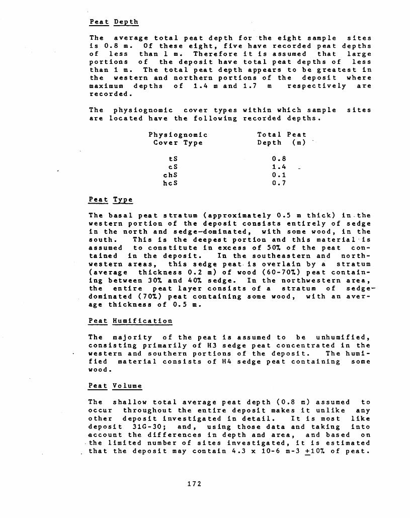
Peat Depth
The average total peat depth for the eight sample sites is 0.8 m. Of these eight, five have recorded peat depths of less than l m. Therefore it is assumed that large portions of the deposit have total peat depths of less than l m. The total peat depth appears to be greatest in the western and northern portions of the deposit where maximum depths of 1.4 m and 1.7 m respectively are recorded .
The physiognomic cover types within which sample sites are located have the following recorded depths.
Physiognomic Total Peat Cover Type Depth (m)
tS 0.8cS 1.4
chS 0.1hcS 0.7
Peat Type
The basal peat stratum (approximately 0.5 m thick) in-the western portion of the deposit consists entirely of sedge in the north and sedge dominated, with some wood, in the south. This is the deepest portion and this material is assumed to constitute in excess of 507. of the peat con tained in the deposit. In the southeastern and north western areas, this sedge peat is overlain by a stratum (average thickness 0.2 m) of wood (60-707.) peat contain ing between 307. and 40^ sedge. In the northwestern area, the entire peat layer consists of a stratum of sedge- dominated (70^) peat containing some wood, with an aver age thickness of 0.5 m.
Peat Humification
The majority of the peat is assumed to be unhumified, consisting primarily of H3 sedge peat concentrated in the western and southern portions of the deposit. The humi fied material consists of H4 sedge peat containing some wood .
Peat Volume
The shallow total average peat depth (0.8 m) assumed to occur throughout the entire deposit makes it unlike any other deposit investigated in detail. It is most like deposit 31G-30; and, using those data and taking into account the differences in depth and area, and based on the limited number of sites investigated, it is estimated that the deposit may contain 4.3 x 10⁻⁶ m-3 +107. of peat.
172
Potential For Further Detailed Study
The deposit appears to have good potential for drainage improvement. This increases its development potential; however, the shallow (0.8 m) average total peat depth does not justify further detailed investigation.
Approximately three-quarters of the study area is priv ately owned. In the central portion there is a large par cel of County Agreement Forest Lands, and a small parcel of South Nation River Conservation Authority Lands.
Comments
The Organic Soil Maps (1:50,000, Winchester 31G/3C, 31G73w)(Ontario Institute of Pedology) indicate the central part as Melvin soil series, Terric Humic Mesisol subgroup, 0.9 m to 1.3 m deep. The southwest part of the deposit is Lemieux soil series, Humic Mesisol subgroup, greater than 1.8 m deep. The northeast and southeast parts are Summerstown soil series, Terric Humisol subgroup, 0.4 m to 0.9 m deep. Generally, the total peat depth data indicated on the Soil Map are in agreement with the data obtained during this study. The only exception is that the peat in the southwest portion .is indicated as deeper than was encountered during this s tudy.
Mr. Richard Morin, District Manager, and Mr. Mike Ecker- sley, Biologist, MNR, indicated that this deposit is a deer yard and that their Ministry had no other specific concerns regarding this deposit.
In some portions of the deposit, the peat was burning during the field investigation.
(The following docket contains the Peatland Classification Map and Peat Profiles for this site.)
173
6.5 PEATLAND 31G-50
Location
The deposit is located in the north corner of Montague Township, Lanark County (Lots 4-7, Cone. 7; Lots 1-10, Cone. 8; Lots 1-10, Cone. 9; Lots 3-7, Cone. 10). It is 8.3 km due south of Dwyer Hill and 13.5 km northwest of Merrickville.
It is located in UTM Zone 18, Easting 425 000, Northing 4986 000, with latitute 45 degrees 2 minutes north, and longi- tude 75 degrees 57 minutes east. The designated study area is covered by the following 1978, 1:10000 airphotos: 4501-155 #102-113; 4502-76 #57-69; 4503-76 #238-248; 4504-116 #134-147; 4505-107 #115-127-. The peat- land is covered by: 4502-76 #60-64; 4503-76 #242-244; 4504-166 #140-142.
Access
The northeast corner of the deposit may be reached by travelling 8.6 km north from Burritts Rapids to Concession Road 8, southeast along this Concession 2.8 km to the Montegue-Rideau Boundary, then north along the boundary sideroad for approximately 3.5 km. The CNR rail line that runs south from Ottawa cross the southeastern portion of the deposit. The rail line may be accessed from the boundary sideroad, 3 km north of Concession Road 8.
Dates of Field S tudy
This deposit was investigated on September 23, 1983.
Topography and Drainage
This deposit has developed in a shallow basin that has sand as the substrate under most of it; however, rock is recorded in the south portions of the SE and SV arms. The slopes of this substrate and the adjacent uplands are gently undulating (0-107. grade). The general gradient of the deposit itself is down, from the SW to the NE.
Drainage from the deposit is very limited and is accomp lished by two channels; one that flows from the SE
. portion of the deposit into Brassils Creek which flows into the Rideau River; and, a second that flows from the N end and eventually into Nichols Creek which joins the Jock River. There is extensive flooding due to beaver activity, particularly in the SE, centre and N portions of the deposit. The apparent lack of drainage outlets and insufficient topographic gradient suggests a low potential for drainage improvement.
174
Area and Shape
This deposit continues for a short distance south beyond the boundary of the study area. Only that portion within the boundary was investigated and is included in the total area of 400 ha. The deposit has a very irregular shape, containing numerous bays and peripheral channels. This would complicate drainage improvement and harvest ing, and thus reduces the development potential.
Peatland Vegetation
Over half of the southern body of the deposit supports a mosaic cover type of coniferous forest of balsam fir (Abies balsamea) and Eastern White Cedar (Thuj a occid- entalis) which has an average canopy density of 807., and of thicket swamp of Speckled Alder (Alnus i neana), Win- terberry (I lex verticillata) and Eastern Wh.ite Cedar with a 657. canopy density. The southern quarter of the deposit and very locally elsewhere along the periphery, in areas too small to map, have flooded floating scrub mat with a tall and low shrub fen mosaic of Slender Willow (Salix petiolaris), Sweet Gale (Myrica gale) and sedges (Carex spp.) . This has an average canopy density of 807., w.ith 407. of the pattern being severely flooded. The northern arm of the deposit supports a mixed swamp of Black Ash (Fraxinus nigra), Silver Maple (Acer saccharinum), White Elm (Ulmus americana) and Eastern White Cedar, having an average canopy density of 701. Three small portions of the area have severely flooded sites in which there is open, perennially standing water with scattered marsh elements such as Canada Blue Joint (Calamagrostis cana- densis). Immediately adjacent to these are drowned con iferous swamps of now-dead Eastern White Cedar having an average canopy density of 607..
The following is a summary of the peatland classification mapping.
Peatland Classification
Area T. of (ha) Cover
cS 199 50tS 127 32
hcS 73 18sM l <l
Peat Depth
Total peat depth appears to be greatest in the SW arm of the deposit where a maximum depth of 1.8 m and an average depth of 1.6 m are recorded. Total depths throughout the
175
remainder of the deposit are <l m, and average 0.4 m.
The physiognomic cover types within which sample sitesare located have the following recorded average totalpea t dep ths.
Physiognomic Total Peat Cover Type Depth (m)
tS 0.6cS 1.0
hcS 0.3
Peat Type
In the SE arm, the basal peat is primarily sedge domin ated with some wood. The surface layer is also sedge- dominated and contains up to A07. moss with some wood. In the centre of the SV arm, the 0.2 m base layer is ooze dominated with some sedge. This is overlain by a layer of 1007. sedge which is overlain by a s edge domina ted layer in the north and a wood dominated layer in the south. The 0.2 m surface layer consists of varying proportions of moss, sedge and wood. The shallow peat in the north is entirely H7 wood-dominated peat with some sedge.
Peat Humification
With the exception of the surface strata in the SE and SV arms, which have humifications of l and 2, all the peat contained in this deposit is humified (H4+), and the maj ority ranges between H4 and H6.
Peat Vo lutne
Due to the highly irregular shape and general overall shallow depth of this deposit, it is not similar to any of the deposits that were investigated in detail. There fore, it is not practical to attempt to estimate the peat volume. Based on the limited available peat depth data, it is assumed that the volume of peat is very limited and that the shallow depth will make development impractical.
Potential For Further Detailed Study
It is assumed that the poor drainage potential, shallow average depth and limited available volume of peat will make development of this deposit impractical. Thus, the need and potential for further detailed study is poor.
The deposit is predominantly privately owned, with a small parcel of crown land in the southwest.
176
Comments
Mr. J. Bailey, District Manager, Carleton Place District MNR indicated that that Ministry has no particular concerns regarding this deposit.
{The following docket contains the Peatland Classification Map and Peat Profiles for this site.)
177
6.6 PEATLAND 31G-54
Location
The deposit is located in Goulbourn (Lots 5-2, Cone. 1; Lots 7-10, Cone. 2) and Rideau (Lots 19-20, Cone. 8; Lots 17-24, Cone. 9; Lots 17-24, Cone. 10) Townships, in the Regional Municipality of O ttawa-Carle ton. It is 3 km southeast of Dwyer Hill, 2.5 km due north of Dwyer Hill Siding, and a portion of its eastern boundary is conti guous with Peatland 31G-30, a deposit that was studied in detail.
It is located in UTM Zone 18, Easting 429 000, Northing 4995 000, with latitude 45 degrees 7 minutes north, and long- itude 75 degrees 54 minutes east. The* designated study area is covered by the following 1978, 1:10000 airphotos: 4506-109 #58-66; 4507-111 #125-135; 4508-111 #180-188; 4509-113 #17-27; 4510-79 #135-143. The peat- land is covered by: 4507-111 #129-133; 4508-111 #183-188; 4509-113 #21-24.
Access
The northeast portion of the deposit may be reached - by travelling southeast, along the sideroad from Munster, for approximately 7.0 km. North of Dwyer Hill Siding, the sideroad intersects the CNR rail line that runs north through the deposit.
Dates of Field Study
This deposit was investigated on September 23, 1983.
Topography and Drainage
This deposit has developed in two bowl-shaped basins connected by a shallow trough. Both of these basins have steeper slopes on the north than on the south side. The slopes of these uplands and the stubstrate are gently un dulating (0-107. grade). Sand and gravel constitute the substrate across the majority of the deposit; however,
. clay is recorded in a portion of the eastern arm.
The highest elevation of the surface of the deposit appears to occur in the central portion of the connecting trough. From this point, the elevation decreases to the southeast toward Nichols Creek and to the north toward Kings Creek and the Jock River.
Flow into the SE is by Nichols Creek and runoff from the adjacent uplands. Flow into the NW appears to consist entirely of runoff from the adjacent uplands.
The SE is drained to the NE by Nichols Creek which flows
178
into the Jock River. The NW is drained to the north by two tributaries of the Jock River. Flooding, as a result of beaver activity, occurs on the west side of the north west arm of the deposit. The potential appears to be good for improvement of drainage conditions through con struction of drainage ditches connecting to the existing drainage systems.
Area and Shape
A considerable portion of the deposit is located outside the study area; however, this area was investigated and is included in the total deposit area of 685 ha. The deposit as a whole has an irregular shape consisting of two main basins connected by a shallow trough; however, each of the basin areas could be treated as an individual deposit for drainage and harvesting purposes. Both of the basin areas have regular shapes with few bays or peripheral channels, thus simplifying drainage improve ment and harvesting.
Peatland Vegetation
Almost all of the northern third of the deposit (431; 295 ha) supports a coniferous swamp that has an average canopy closure of 807.. Dominant trees are Eastern White Cedar (Thuj a occidentalis) and Tamarack (Larix laricina), with White Elm (Ulmus americana) and Speckled AlderrAl- nus incana) as minor components. Extensive cutting has occurred here over the past several decades. The south eastern third and southwestern fringe, totalling 341 (230 ha), support a mixed swamp of 801 average canopy closure with Black Ash (Fraxinus nigra) and Eastern White Cedar as the dominants. A small deciduous swamp cover type occurs in the southeast arm, totaling 41 (30 ha). Silver Maple (Acer saccharinum), Black Ash and White Elm are dominants here, forming a 707* average canopy density. Two thicket swamp cover types are present (in total 191; 130 ha), both being dominated by Speckled Alder, Slender Willow (Salix petiolaris) and having average canopy den sities of 607. to 701. In the eastern arm of the deposit, this thicket is flooded and is strongly dominated by Slender Willow, and there are local marsh-like features. A flooded upland old field occupies the northeastern corner of the deposit. Two plant species of significance are reported for this area: Virginia Mountain Mint (Pycnanthemum virginianum) and Loosestrife (Lythrum a la turn)(Cuddy, 1983). These occupy upland sites adjacent to the west basin.
The following Is a summary of the peatland classification mapping.
179
Peatland Class ification
Physiognomic Area 7. ofCover Type (ha) Cover
cS 295 43chS 230 34tS 130 19hS 30 4
Peat Depth
Total peat depths appear to be greatest in the southern portions of the west and east basins, where maximum peat depths of 1.7 m and 2.5 m, respectively, are recorded. In addition, total depths appear to be greatest in the east ern basin, where the average total peat depjth for the two sites investigated, is 2.2 m. The average total peat depth for the 7 sample sites in the west basin is only 0.8 m. It is assumed that a large percentage of this west basin, especially in the north, has peat depths of <l m.
The physiognomic cover types within which sample si.tes are located have the following recorded average total dep ths.
Physiognomic Total Peat Cover Type Depth (m)
chS 2.1tS 1.8cS 0.7
Peat Type
The peat contained in this deposit consists of approx imately equal proportions of sedge peat containing some wood and wood peat with some sedge, as well as a minor percentage of moss peat containing some wood and sedge.
In the eastern basin, the basal stratum consists of 0.5 m ooze. This stratum was not encountered in the west arm. Overlaying the ooze in the south of the east arm, and forming the basal stratum in the south of the west arm is a layer (average thickness of 0.4 m) of sedge peat. This material is overlain by approximately 0.8 m of sedge dom inated (607.-707.) peat containing some wood (307.-407.), above which is a layer of wood peat. In the east, it con sists of 1007. wood and averages 0.4 m. In the west, it is 807. wood and 207. sedge and also averages 0.4 m. In the .west basin, the surface peat consists of varying proport ions of moss, wood and sedge and averages 0.2 m in thick ness. This layer does not occur in the eastern basin.
180
Peat Humification
The peat humification characteristics are quite different in the east and west basins. In the west, the majority (in excess of 80^) of the material is H6 or H7. The only material that is unhumified is the 0.2 m surface layer of HI,2 moss, sedge and wood peat. In the east, the basal ooze has H9, the subsurface sedge layer H3, and the remaining material H4.
Peat Volume
The highly variable total peat depth encountered in dif ferent portions of the deposit and the assumed large area which have peat depths of <l m make this deposit unlike any of those studied in detail. Therefore, it is impract ical to attempt to estimate the volume of peat available.
Potential For Further Detailed Study
The potential for improvement of drainage conditions appears to be good, thus increasing the development pot ential. The majority of the deposit has a moderate to high density of forest cover, necessitating costly clear ing prior to development, and therefore reducing the dev elopment potential. The shallow average total peat depth encountered in the west basin (0.8 m) may make develop ment in this portion impractical; however, the average total depth of 2.2 m in the east basin may make this atea acceptable for development. Consequently, the overall potential for further detailed study of this deposit is moderate.
The northern half of the study area is privately owned, and the southern half is predominantly within the Marl borough Agreement Forest.
Comments
The Organic Soil Map (1:250,000, Ottawa 31G)(Ontario Institute of Pedology) indicates the entire deposit as Strathmore soil series, Terric Humisol subgroup, 0.9 m to 1.3 m deep. The peat depths indicated on the Soil Map are less than encountered during this study.
The southern portion of the deposit that is within the Marlborough Agreement Forest is referred to as the Richmond Deer Yard by MNR, and in the MNR Sensitive Areas report, it is classified as W-2, "Significant plants, deer yard with lowland forest and beaver ponds".
The narrow central portion of the deposit is crossed by the Canadian National Railway line and a power transmis sion line.(The following docket contains the Peatland Classification Map and Peat Profiles for this site.)
181
6.7 PEATLAND 31G-69/70, WINCHESTER BOG, VERNON BOG,MOUNTAIN PROVINCIAL WILDLIFE PRESERVE
Location
The deposit is located in Mountain Township, in the United Counties of Stormont, Dundas and Glengarry (Lots 11-18, Cone. 9; Lots 9-19, Cone. 10; Lots 9-20, Cone. 11; Lots 11-19, Cone. 12). It is approximately 7 km north west of Winchester.
It is located in UTM Zone 18, Easting 462 000, Northing 4994 000, with latitude 45 degrees 6 minutes north, and long- itude 75 degrees 28 minutes east. The designated study area is covered by the following 1978, 1:10000 airphotos: 4505-107 #154-167; 4506-109 #91-102; 4507-109#189-200; 4508-111 #211-223; 4509-113 #50-62; 4510-113#148-160. The peatland is covered by: 45.06-109 #93-98; 4507-109 #190-200; 4508-111 #216-223; 4509-113 #55-62.
Access
The southwest corner of the deposit can be reached by travelling 1.3 km northwest from Hallville, along Conces sion Road l, to the first sideroad east, and following this sideroad to its end, approximately 2 km.
Dates of Field Study
The field investigation for this deposit was conducted on September 23, 1983.
Topography and Drainage
This deposit has developed in a shallow, broad clay base basin that appears to slope down from the SW to the NE. The slope of the substrate and the adjacent uplands are gently undulating (0-10Z).
The primary drainage feature is Silver Creek, which has been channelized and consists of a drainage ditch through a portion of the deposit. It flows into the southwest corner and then flows northeast through, and out of the deposit. Wylie Creek and one other channel also flows into the southwest where they join Silver Creek. Allen Creek which skirts the northwest periphery, a ditch that flows out of the northeast corner, and Silver Creek all flow into the South Castor River. A series of drainage ditches flow east from the southeast portion of the deposit and into the East Castor River. The interior portion of the deposit are drained by series of small .ditches that connect with the various creeks. The South and East Castor Rivers eventually flow into the South Nation River. A number of small ponds have been created by MNR as part of peat extraction and waterfowl habitat
182
development program. The potential appears to be good for improving drainage conditions through extending the existing drainage systems.
Area and Shape
The peatland continues for a considerable distance east of the study area, where it is called Harmony Church Bog. The area of the peatland that is contained within the study area, and a small portion to the west of the bound ary, is 1910 ha. This section has a relatively regular shape with few bays or peripheral channels. The regular shape could simplify drainage improvement and peat har vesting .
Peatland Vegetation
The cover types of this deposit have been extensively affected by past draining and cutting operations. The northwestern third and central portion of the deposit support a coniferous swamp of 701 average canopy density with Tamarack (Larix laricina), Eastern White Cedar (Thuja occidentalis) and a tall shrub understorey of Winterberry (Ilex verticillata) . This extends over 221 (430 ha) of the area. A second major community pattern is thicket swamp which occupies the 591 (1109 ha) which has been most severely drained. Panicled Dogwood (Cornus racemosa), Willow (Salix spp.) and Meadowsweet (Spirea a Iba) with a sparse overstorey of Trembling Aspen (Populus tremuloides) present an average canopy density of 707. here. There is also a large area of deciduous swamp cover type. It is dominated by two distinctive community patterns. A Trembling Aspen-dominated succes sional type and a Silver Maple-dominated natural remnant type together present a canopy density of 407. - 757. and cover over ST. (160 ha) of the area. In some cases, these are severely flooded by beaver activity. A mixed swamp of 501 to 607. canopy density occurs locally throughout the deposit (71; 126 ha). This includes wet covertypes of Red Maple (Acer rubrum) and Tamarack, and successional covers of Trembling Aspen and Eastern White Cedar. A flooded, shrub rich marsh occupies a small portion of the central deposit (11; 23 ha). Here, a 701 average canopy density of Willow and Speckled Alder (Ainus incana) suc ceeds over a marshland of Canada Blue Joint (Calama- gros tis canadensis).
The following is a summary of the peatland classification mapping.
183
Peatland Classification
Physiognomic Area 7. ofCover Type (ha) Cover
tS 1109 59cS 492 25hS 160 8
chS 126 7srM 23 l
Peat Depth
The total peat depth appears to be greatest in the south- west portion of the deposit, where a maximum -total peat depth of 2.3 m is recorded. The average total peat depth for the six sites samples is 1.4 m It is assumed that large portions of the periphery of the deposit have peat depths less than l m.
The physiognomic cover types within which sample sites are located have the folowing recorded depths.
Physiognomic Total Peat Cover Type Depth (m)
cS 2.3tS 1.5hS 0.4
Peat Type
In the south-central portions of the deposit a basal peat stratum, approximately 0.15 m thick, of wood peat (607.) containing some sedge (407.) occurs. Throughout the south- west and south-central areas the basal peat stratum is overlain by an average thickness of 0.7 m of sedge (807.) peat containing some (207.) wood. In the southwest this is then overlain by a stratum (average thickness 0.5 m) of wood peat (70^) containing 3Q7. sedge.
In the centre, the sedge in the woody peat stratum is replaced by brown moss and, in some locations, the brown moss is dominant (up to 607.).
In the southwest and southeast, the surface layer con sists of wood peat containing some brown moss while in the centre it consists of varying proportions of brown moss, wood and sedge.
In the northeast portion of the deposit, based on the results of one sample site, the upper 0.3 m is brown moss dominated (707.) containing some sedge; and, the bottom 0.5 m is sedge-dominated,containing some wood.
184
In the southeast, based on the.results of one sample site, the entire peat accumulation (0.4 m) consists of brown moss (607.), sedge (207.) and wood (207.).
Peat Humification
The majority of peat contained in this deposit is humified (H4+), with humifications as high as H7 occur ring; however, the majority of it has HA or H5 and is primarily sedge or wood dominated.
The surficial (unhumified) peat mainly consists of H3 subsurface sedge or wood-dominanted material, although some surface, sedge-dominated peat has HI,2.
In the northern portion of the deposit, the peat accumu lation consists of unhumified, HI,2 brown moss-dominated surface peat overlying H3 sedge dominated peat.
Peat Volume
This deposit is similar in average total peat depth, basin configuration and physiognomic cover type to 31B-8 and 31B-28 that were studied in detail. Based on their calculated volumes, and the limited number of sample points on this deposit, it is estimated that there may be 21 x 10-6 m-3 +10T. in this deposit.
Potential For Further Detailed Study
The potential for drainage improvement appears to be good, thus increasing the development potential; however, the entire deposit has a heavy to moderate density of tree and shrub cover that would require costly vegetation clearing prior to development. In addition, the shallow average total peat depth of 1.4 m may not justify devel opment. Moreover, further development oriented studies may not be appropriate considering that the area is designated as a wildlife area (Mountain Provincial Wild life Area) and is currently being managed by MNR for waterfowl habitat improvement. It is also a deer yard. Mr. Richard Morin, District Manager, Cornwall District MNR, confirmed, during this study, that it may be more appropriate to investigate this .deposit at a reconnais sance rather than detailed level, as originally planned. Consequently, the potential for further detailed study appears poor.
The majority of the study area lies within Crown Land (Mountain Provincial Wildlife Area). There are small parcels of land outside the central area that are priv- a tely owned.
185

Comments
The Organic Soil Map (1:250,000, Ottawa 31G)(Ontario Institute of Pedology) indicates the central area as Carry soil series, Typic Humisol subgroup, greater than 1.8 m deep. There is an outer ring surrounding this central area that is Summerstown soil series, Terric Humisol subgroup, 0.9 m to 1.3 m deep. The peat depths indicated on the Soil Map are deeper than those encountered during this study.
An evaluation of a portion of this deposit, located east of the study area (Harmony Church Bog) is contained in Graham and Tibbets (1961). The findings of that study are as fo l lows :
"Cover - The surface is firm, dry and hummocky with tall grasses, flowing (sic) plants and bullrushes. It has been burned at sometime in the past.
"Depth of Bog - The depth, as indicated by 4 samples is 2 1/2 to 5 feet and the bottom is clay.
"Nature of the Peat - The peat is humified, dry, fibrous, and sedge-like.
"The results of laboratory tests follow:
Sample Area lDepth, inches 11-16 Absorptive Value at 257.
Moisture (x own wgt) 11.6Ash, T. Dry 6.5Nitrogen, T. A.OpH 5-6
"General Comment - The shallow depth of the bog does not lend itself to exploitation on a large scale. A small production of peat moss for local use might be possible."
That portion of the deposit was not investigated during this study, therfore it is not possible to make specific comparisons with the study results. However, in general, the conditions encountered in the west portion of the deposit during this study appear similar to those encountered in the east during the previous study.
In conjunction with a waterfowl habitat improvement pro gram by MNR, MNR is removing peat from the deposit and using it for plant bedding at the Kemptville Tree Nursery.
(The following docket contains the Peatland Classification Map and Peat Profiles for this site.)
186
6.8 PEATLAND 31B-10
Location
The deposit is located in Oxford (on Rideau) Township, in the United Counties of Leeds and Grenville (Lots 17-22, Cone. 6; Lots 16-21, Cone. 7). It is 3.5 km southeast of Oxford Hills and 2.5 km northwest of Oxford Station.
It is located in UTM Zone 18, Easting 449 000, Northing 4977 000, with latitude 45 degrees 57 minutes north, and longitude 75 degrees 38 minutes east. The designated study area is covered by the following 1978, 1:10000 airphotos: 4465-80 #161-169; 4466-81 #135-142; 4467-81 #217-225; 4468-110 #30-37. The peatland is covered by:
.4465-80 #164-166; 4466-81 #138-140; 4467-81 #220-222.
Access
The northern portion of the deposit may be reached by travelling southwest from Oxford Station, 0.2 km to the first sideroad, and then travelling north 3.3 km to the second intersection (with a road to the east), which is at the edge of the deposit.
Dates of Field Study
The field investigation of this deposit was conducted on September 11, 1983.
Topography and Drainage
This deposit has developed in a shallow, gently sloping bowl shaped basin. The substrate of this basin is mainly silt; however, sand does occur in the central area. In addition, there are a number of overburden uplands in the south-central and southwest portions of the deposit. The topography of the substrate, and the included and sur rounding uplands is gently undulating (0-107. grade).
Flow into the deposit appears to consist entirely of runoff from the adjacent uplands. At present, beaver activity in the north, central and southwest portions of the deposit is resulting in extensive areas of flooding. There do not currently appear to be any drainage outlets
, from the deposit; however, potential may exist for the construction of drainage ditches in the NW and SV corners of the deposit, to connect with existing natural drainage channels that flow into Kemptville Creek. Consequently, the potential for drainage improvement is rated as moder ate .
187
Area and Shape
The deposit has a total area of 260 ha and, with the exception of a few small bays, has a regular shape. The regular shape, and the lack of uplands in the central portion of the deposit could simplify drainage improve ment and harvesting in that portion of the deposit.
Peatland Vegetation
Since this study area has undergone considerable general cutting and local flooding, many of the cover types display successional disturbance patterns. One of the predominant cover types is thicket swamp which occupies the central and marginal portions of the deposit. Three major phases are evident. The central basi'n and the northern periphery present an average canopy density of 507. with a sparse tree cover of Eastern White Cedar (Thuj a occidentalis) and a closed shrub cov^r of Speckled Alder (Ainus incana) and Slender Willow (Salix petiol- aris). Spanning the ditched county road on the north is a flooded fen-like thicket swamp of Slender Willow, Swamp Birch (Be tula pumila var. glanduli fera) and Tamarack (Larix laricina) with an average canopy closure of 4071. In the southwestern margin is an early successional thic ket swamp of slender willow having an average canopy closure of 60^. This area is severely flooded. In total, thicket swamp covers 407. (102 ha) of the deposit. Small, coniferous swamps are located throughout the depo sit and cover 67. (16 ha) of the deposit. These have an average canopy density of 60^ and are dominated by Eas tern White Cedar. Mixed swamps of Silver Maple (Acer saccharinum), Black Ash (Fraxinus nigra) and Eastern White Cedar occur throughout the deposit (53Z; 138 ha) with an average canopy density of 757*. Two small shallow marshes, occupying 17. (4 ha) are contained in the west central portion of the deposit.
The following is a summary of the peatland classification mapping.
Peatland Classification
Physiognomic Area 7. of Cover Type (ha) Cover
chS 115 44tS 102 40
hcS 23 9cS 16 6sM 41
188
Peat Depth
The total depth appears to be greatest in the south- central and southeast portions of the deposit, where respective depths of 1.5 m and 1.3 m were encountered. The depth throughout the northern portion, where the average depth at two sample sites is 0.7 m, is assumed to be shallow (<l m). The occurrence of numerous uplands in the southwest also indicates a shallow overall peat depth. It is assumed that the shallow, average total peat depth encountered (1.1 m) and the limited area in which peat depth exceeds l m, will preclude this deposit from further detailed study or development for harvesting of peat.
The physiognomic cover types within which sample sites are located have the following recorded total average peat depths.
Physiognomic Total Peat Cover Type . Depth (m)
hcS 1.5chS 1.3tS 0.7
Peat Type
The majority of the peat contained in this deposit is sedge or sedge dominated. In the southeast, the 0.7 m (average) base layer is entirely sedge. In the north, the base layer is a sedge dominated peat containing some wood (average thickness 0.4 m); in the south, this layer overlies the pure sedge layer. With the exception of in the extreme north, this sedge-dominated layer is overlain by a 0.4 m layer of wood peat that contains some sedge. The surface stratum in the north consists of wood with some sedge and moss and averages 0.1 m in thickness.
Peat Humification
The majority of peat in this deposit is humified (H4+) and has a humification of 6. A thin, basal layer of H7 occurs in the south, and a surface stratum of Hl,2 occurs across the entire deposit.
Peat Volume
The shallow average total depth (1.1 m) and limited area in which peat depth exceeds l m make this deposit unlike any of those studied in detail. Therefore, it is imprac tical to attempt to estimate the volume of peat. It should be noted that, based on depth information from the few sample sites, the volume of peat contained in this deposit is assumed to be very limited.
189
Potential For Further Detailed Study
As a result of the shallow average total peat depth and assumed limited volume of peat contained in this deposit, the potential for further detailed study and development for peat harvesting have been rated as poor.
The entire deposit is located on Patent Land.
Comments
The Organic Soil Map (1:250,000, Ogdensburg, 31B)(Ontario Institute of Pedology) indicates the entire deposit has Summers town soil series, Terric Humisol subgroup, 0.4 m to 0.9 m deep. The peat depths indicated on the Soil Map are slightly shallower than encountered during this s tudy .
District Office staff indicate that MNR does not have any specific concerns regarding this peatland.
(The following docket contains the Peatland Classification Map and Peat Profiles for this site.)
190
Ontario
Ministry ofNaturalResources
Hon. Alan W. Pope Minister
John R. Stoan Deputy Minister
ONTARIO GEOLOGICAL SURVEY
Open File Report 5491
Peat and Peatland Evaluation of the Ottawa-Brockville Area Volume V
by
Bird and Hale Ltd.
1984
Ontario
Ministry ofNaturalResources
Hon Alan W. Pope Mtmster
John R. Stoan Deputy Minister
ONTARIO GEOLOGICAL SURVEY
Open File Report 5491
Peat and Peatland Evaluation of the Ottawa Brockville Area Volume V
by
Bird and Hale Ltd.
1984
Ontario
Ministry ofNaturalResources
Hon. Alan W. Pope Minister
John R. Sloan Deputy Minister
ONTARIO GEOLOGICAL SURVEY
Open File Report 5491
Peat and Peatland Evaluation of the Ottawa-Brockville Area Volume V
by
Bird and Hale Ltd.
1984

O OMNR-OGS 1984
Ontario
Ministry of Hon Man w-., . . MinisterNatural
John R. Sloan Resources Deputy Minister
ONTARIO GEOLOGICAL SURVEY
Open File Report 5491
Peat and Peatland Evaluation of the
Ottawa-Brockville Area
Volume V
by
Bird and Hale Ltd.
1984
THIS PROJECT IS PART OF THE HYDROCARBON ENERGY RESOURCES PROGRAM (HERP), AND WAS FUNDED BY THE ONTARIO MINISTRY OF TREASURY AND ECONOMICS UNDER THE BOARD OF INDUSTRIAL LEADERSHIP AND DEVELOPMENT (BILD) PROGRAM.
Parts of this publication may be quoted if credit is given. It is recommended that reference to this report be made in the following form:
Bird and Hale Ltd.
1984: Peat and Peatland Evaluation of the Ottawa- Brockville Area, Volumes 1-5, Ontario Geological Survey Open File Report 5491, 217p., numerous tables and maps.

Ontario Geological Surrey
OPEN FILE REPORT
Open file report* are made available to the public subject to the following conditions:
This report is unedited. Discrepancies may occur for which the Ontario Geological Survey does not assume liability. Recommendations and statements of opinion expressed are those of the author or authors and are not to be construed as statements of government policy.
Open file copies may be read at the following locations:
Mines LibraryOntario Ministry of Natural Resources8th Floor, 77 Grenville Street, Toronto
The office of the Regional or Resident Geologist in whose district the area covered by this report k located.
Handwritten notes and sketches may be made from this report. Check with the Library or Region al or Resident Geologist's office as to whether there is a copy of this report that may be borrowed. The Library or Regional or Resident Geologist's office wffl also give you information on copying ar rangements. A copy of this report is available for Inter-Library Loan.
This report is on file in the Regional or Resident Geologists' offices) located at:
255 Metcalf Street Concession Road Box 70 Kemptville, Ontario Tweed, Ontario KOG 1JO KOK 3JO
The right to reproduce this report is reserved by the Ontario Ministry of Natural Resources. Permission for other reproductions must be obtained in writing from the Director, Ontario Geological Survey.
V.'G. Milne, Director Ontario Geological Survey
111

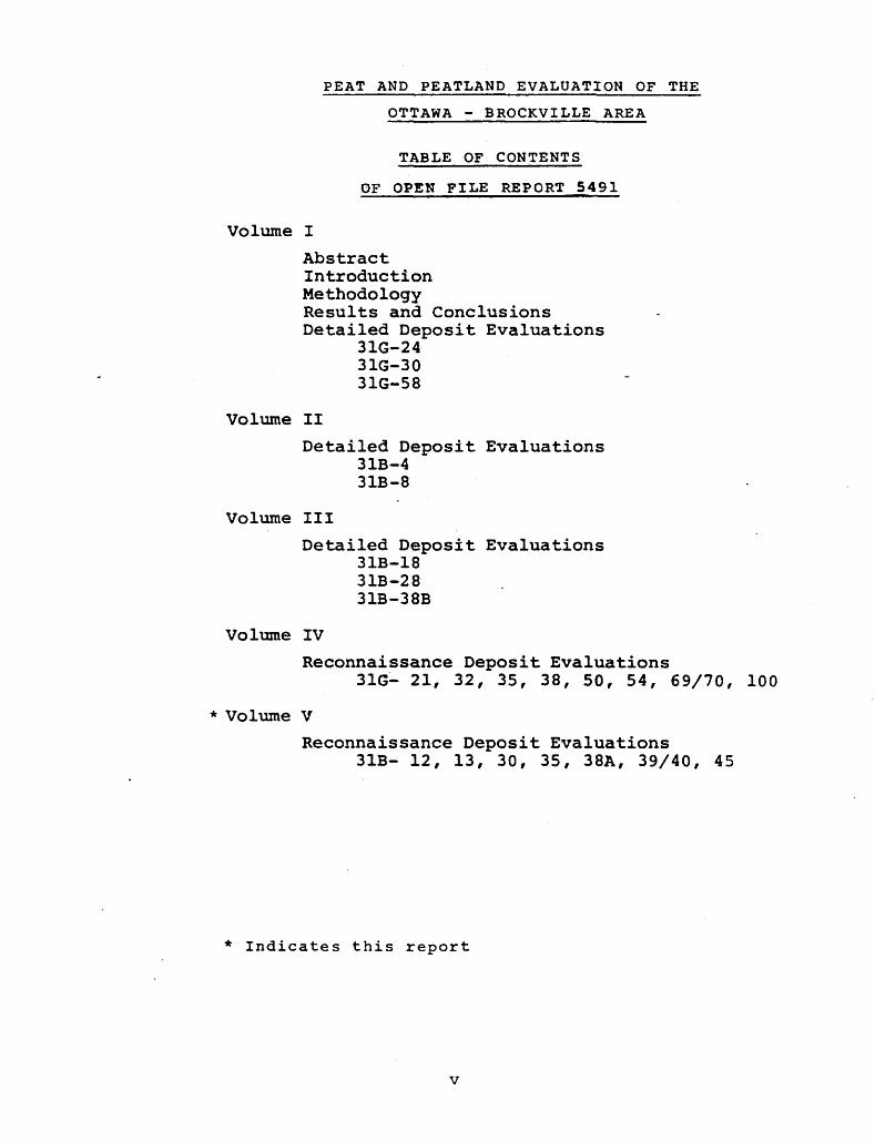
PEAT AND PEATLAND EVALUATION OF THE
OTTAWA - BROCKVILLE AREA
TABLE OF CONTENTS
OF OPEN FILE REPORT 5491
Volume I
AbstractIntroductionMethodologyResults and ConclusionsDetailed Deposit Evaluations
31G-2431G-3031G-58
Volume II
Detailed Deposit Evaluations 31B-4 31B-8
Volume III
Detailed Deposit Evaluations 31B-18 31B-28 31B-38B
Volume IV
Reconnaissance Deposit Evaluations31G- 21, 32, 35, 38, 50, 54, 69/70, 100
* Volume V
Reconnaissance Deposit Evaluations31B- 12, 13, 30, 35, 38A, 39/40, 45
* Indicates this report
v

TABLE OF CONTENTS
page
VOLUME 5
RECONNAISSANCE DEPOSIT EVALUATIONS " 157
6.9 Peatland 3IB-12, Toyes Hill Bog 1916.10 Peatland 31B-13, Glen Becker Bog - 1956.11 Peatland 31B-30 1986.12 Peatland 31B-35, Loyada Lake Bog 2016.13 Peatland 31B-38A, Bellamy Bog 2056.14 Peatland 3IB-39/40, Brockville Long Swamp, Augusta Bog,
Perrins Corners Swamp 2096.15 Peatland 31B-45, Centre Lake Bog, Lees Pond 214
Vll

Peat and Peatland Evaluation of the Ottawa-Brockville Area
prepared for
prepared by
BIRD AND HALE LIMITED
VOLUME 5
l 1263 Bay Street, Tor. Ont. M5R 2C1
Manuscript approved for publication by Owen L. White, Section Chief, Engineering and Terrain Geology Section, August 24, 3.984.This report is published by permission of V.G. Milne, Director, Ontario Geological Survey.
IX


6.9 PEATLAND 31B-12, TOYES HILL BOG
Location
The deposit is located in Matilda (Lots 1-3, Cone. 7; Lots 1-7, Cone. 8; Lots 1-4, Cone. 9) and Williamsburgh (Lot 37, Cone. 6; Lots 35-37, Cone. 7; Lots 36-37, Cone. 8) Townships in Stormont, Dundas and Glengarry United Counties. It is 3 km southwest of Winchester Springs and Toyes Hill is near its southwest boundary.
It is located in UTM Zone 18, Easting 475 000, Northing 4982 000, with latitude 45 degrees 00 minutes north, and long- itude 75 degrees 19 minutes east. The designated study area is covered by the following 1978, 1:10000 airphotos: 4468-110 #56-66; 4469-110 #147-156; 4501-155 #160-169; 4502-76 #112-121. The peatland is covered by 4469-110 #150-153; 4501-155 #164-166.
Access
The southeast corner of the deposit may be reached by travelling west from Elma (through The Sixth) along Concession Road 7 for 5.8 km to its end and then travelling north on a sideroad for 0.3 km.
Dates of Field Study
The field investigation for this deposit was conducted on September 14, 1983.
Topography and Drainage
The deposit has developed in a shallow clay substrate basin, the slopes of which are gently undulating (0-101). The slopes of the adjacent uplands also are gently undul ating. The overall slope of the deposit is from the southwest to the northeast.
Flow into the deposit appears to consist entirely of runoff from the adjacent uplands. A drainage ditch that is an extension of Toyes Creek drains the southwest and flows north to the South Nation River. The Steele Drain and Chas. M. Whittaker Drain flow from the north and southeast portions of the deposit, respectively, in a northerly direction, and join Hess Creek which flows into the South Nation River. A new extension of the Steele Drain crosses the southwest portion of the deposit. The potential appears to be good for improvement of the drainage conditions through extension of the existing ditch drainage system.
Area and Shape
The deposit has a total area of 345 ha. With the except-
191
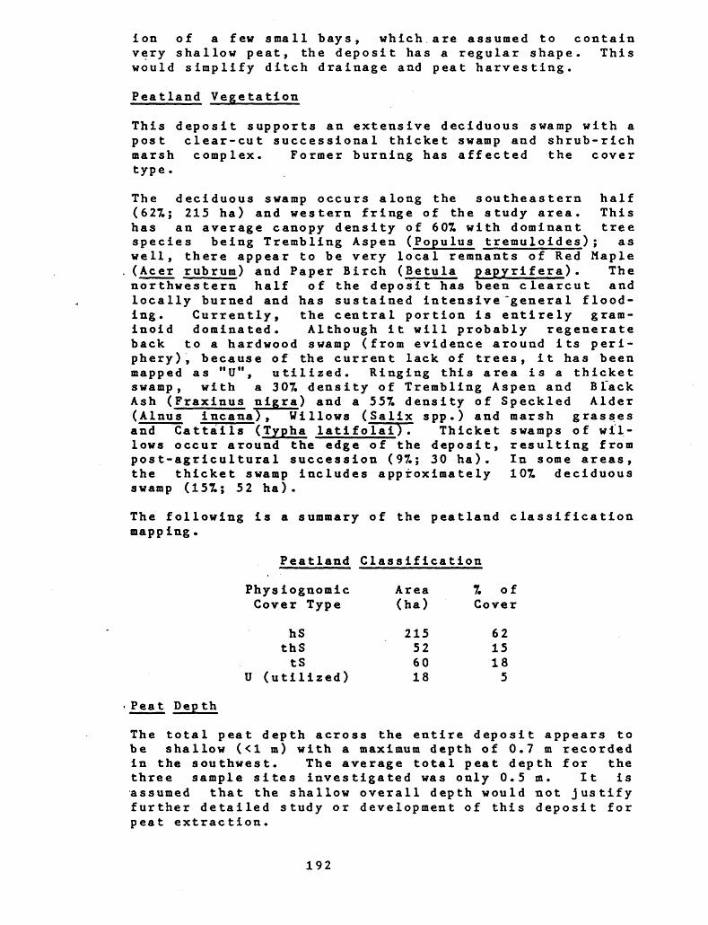
ion of a few small bays, which are assumed to contain very shallow peat, the deposit has a regular shape. This would simplify ditch drainage and peat harvesting.
Peatland Vegetation
This deposit supports an extensive deciduous swamp with a post clear-cut successional thicket swamp and shrub-rich marsh complex. Former burning has affected the cover type.
The deciduous swamp occurs along the southeastern half (627.; 215 ha) and western fringe of the study area. This has an average canopy density of 607. with dominant tree species being Trembling Aspen (Populus tremuloides); as well, there appear to be very local remnants of Red Maple (Acer rubrum) and Paper Birch (Betula papyrifera) . The northwestern half of the deposit has been clearcut and locally burned and has sustained intensive "genera l flood ing. Currently, the central portion is entirely grara- inoid dominated. Although it will probably regenerate back to a hardwood swamp (from evidence around its peri phery), because of the current lack of trees, it has been mapped as "U", utilized. Ringing this area is a thicket swamp, with a 307. density of Trembling Aspen and B Tack Ash (Fraxinus nigra) and a 557. density of Speckled Alder (Alnus incana), Willows (Salix spp.) and marsh grasses and Cattails (Typha latifolai). Thicket swamps of wil lows occur around the edge of the deposit, resulting from post-agricultural succession (97.; 30 ha). In some areas, the thicket swamp includes approximately 107. deciduous swamp (157.; 52 ha).
The following is a summary of the peatland classification mapping.
Peatland Classification
Physiognomic Area 7. of Cover Type (ha) Cover
hS 215 62thS 52 15tS 60 18
U (utilized) 18 5
Peat Depth
The total peat depth across the entire deposit appears to be shallow (<l m) with a maximum depth of 0.7 m recorded in the southwest. The average total peat depth for the three sample sites investigated was only 0.5 m. It is assumed that the shallow overall depth would not justify further detailed study or development of this deposit for peat extraction.
192
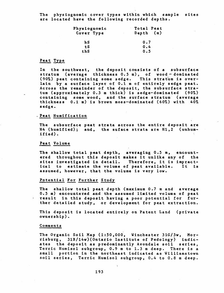
The physiognomic cover types within which sample sites are located have the following recorded depths.
Physiognomic Cover Type
hStS
thS
Total Peat Depth (m)
0.7 0.4 0.5
Peat Type
In the southwest, the deposit consists of a subsurface stratum (average thickness 0.5 m), of wood dominated (907.) peat containing some sedge. This stratum is over lain by a surface layer of 0.1 m of entirely sedge peat. Across the remainder of the deposit, the subsurface stra tum (approximately 0.3 m thick) is sedge-dominated (907.) containing some wood, and the surface stratum (average thickness 0.1 m) is brown moss dominated (607.) with A07. sedge.
Peat Humification
The subsurface peat H4 (humified); and, ified).
Peat Volume
strata across the entire deposit are the suface strata are HI,2 (unhum-
The shallow total peat depth, averaging 0.5 m, encount ered throughout this deposit makes it unlike any of the sites investigated in detail. Therefore, it is impract ical to estimate the volume of peat available. It is assumed, however, that the volume is very low.
Potential For Further S tudy
The shallow total peat depth (maximum 0.7 m and average 0.5 m) encountered and the assumed limited volume of peat result in this deposit having a poor potential for fur ther detailed study, or development for peat extraction.
is located entirely on Patent Land (privateThis deposit ownership) .
Comments
The Organic Soil Map (1:50,000, Winchester 31G/3W, Mor risburg, 31B/14W)(Ontario Institute of Pedology) indic ates the deposit as predominantly Avondale soil series, Terric Humisol subgroup, 0.9 m to 1.3 m deep. There is a small portion in the northeast indicated as Williamstown soil series, Terric Humisol subgroup, 0.4 to 0.8 m deep.
193
The peat depths indicated on the Soil Map are deeper than encountered during this study.
District Office staff indicate that MNR has no particular concerns regarding the deposit.
(The following docket contains the Peatland Classification Map and Peat Profiles for this site.)
194

6.10 PEATLAND 31B-13, GLEN BECKER BOG
Location
The deposit is located in Matilda (Lots 1-2, Cone. 2; Lots 1-3, Cone. 3; Lot l, Cone. 4) and Williamsburgh (Lots 36-37, Cone. 3; Lots 36-37, Cone. 4) Townships, in the United Counties of Stormont, Dundas and Glengarry. It is 3.5 km southwest of Villiamsburg and 5 km northwest of Morrisburg.
It is located in UTM Zone 18, Easting 479 000, Northing 4975 000, with latitude 44 degrees 56 minutes north, and long- itude 75 degrees 15 minutes east. The designated study area is covered by the following 1978, 1:10000 airphotos: 4463-78 #193-200; 4464-78 #249-256; 4465-80 #194-202; 4466-81 #167-174. The peatland is covered by: 4463-78 #196-198; 4464-78 #252-254; 4465-80 #197-199.
Access
The west side of the deposit may be reached by travelling south from Dixons Corners to Concession Road 3 (2.2 km) then east along Concession Road 3 for 6 km. The south end is accessed by travelling south from Dixons Corners to Concession Road 2 (4.2 km) and then east along the .Concession Road for 6* km. The mid-eastern portion of the deposit is reached by travelling 2.5 km north along a sideroad from Muttonville, ending at the northwest corner of Lot 37.
Dates of Field Study
The field investigation of this deposit was conducted on September 14, 1983.
Topography and Drainage
This deposit has developed in a gently sloping, sand base trough with the long axis oriented north-south. The sub strate and adjacent uplands are gently undulating (0-10Z grade).
The deposit is drained by two systems: the Zeron Drain flows from the south end and into Flagg Creek which flows into the St. Lawrence River; and, the Whittaker Drain flows north from the northwest corner into the McMartin Drain, which flows into Hess Creek and then the South Nation River. Flow into the deposit is via extensions of the Whittaker and Zeron Drains and runoff from the adja cent uplands. The potential appears to be good for improvement of the drainage through extension of the existing drainage system.
195
Area and Shape
The total area of the peatland is 565 ha. The deposit has a relatively regular shape containing only a few small bays. This regular shape would simplify ditch drainage and peat harvesting.
Peatland Vegetation
The peatland encloses an extensive deciduous and cut thicket swamp complex. The predominant cover type is a Red Maple (Acer rubrum) deciduous swamp that has an average canopy density of 7 QT. to 907. (587.; 327 ha). Locally, around the periphery of the deposit, are clear- cut areas (317.; 175 ha) of Speckled Alder (Alnus incana) . These have an average canopy density of 307* to 807.. A more recently clear cut section in the centre and the northern edge of the deposit have a 307. density of Common Raspberry (Rubus s trigosus). The deposit also contains a small coniferous swamp that occupies 27. (12 ha) of the peatland surface.
The following is a summary of the peatland classification mapping.
Peatland Classification
Physiognomic Area 7. of Cover Type (ha) Cover
hS 327 58tS 175 31cS 13 2
chS 50 9
Peat Depth
Peat depth throughout the majority of the deposit is assumed to be less than l m. Peat depths of 0.7 m and 0.5 m were encountered in the central and northern areas. The greatest depth appears to be in the south-central areas where a maximum total depth of 1.7 m is recorded. As a result of the average shallow peat depth for the deposit, the potential for further detailed studies and development for peat harvesting is assumed to be poor.
The physiognomic units within which sample points are located have the following recorded average depths.
Physiognomic Total Peat Cover Type Depth (m)
htS 1.7 thS 0.6
196
Peat Type
In the centre, the basal peat consists of approximately 0.2 m of sedge peat containing some wood. This is over lain by approximately 0.7 m of entirely sedge peat. Across the entire deposit, a layer (average thickness 0.6 m) of 90^ wood and 107. sedge is then present. The sur face layer, which averages 0.1 m in thickness, consists ov varying proportions of moss and sedge.
Peat Humification
The majority of the peat is H5. In the southcentral por tion, the subsurface stratum of entirely unhumified sedge peat of H3. The surface stratum of 0.1 m of- moss and sedge has HI,2.
Peat Volume
The overall shallow depth of this deposit makes it unlike any of the deposits studies in detail. Therefore, it is impractical to attempt to estimate the volume of peat in this deposit. From the limited number of samples, however, it is assumed that the volume is very low.
Potential For Further Detailed Study
Based on the shallow average total peat depth encountered (<l m), and the assumed limited volume, the potential is rated as poor for further detailed study and for develop ment for extraction.
This deposit is located on Patent Land, with the exception of a small parcel of Crown Land in the centre.
Comments
The Organic Soil Map (!:50,000, Morrisburg, 31B/14W, 31BXl4e)(Ontario Institute of Pedology) indicate the central region as Carry soil series, Typic Humisol subgroup, greater than 1.8 m deep. The outer edge is Uilliamstown soil series, Terric Humisol subgroup, 0.4 m to 0.9 m deep. The depth of peat indicated on the Soil Map, for the central part of the deposit, is greater than was encountered during this study.
District Office Staff of MNR did not express any specific concerns regarding this peatland.
(The following docket contains the Peatland Classification Map and Peat Profiles for this site.)
197
6.11 PEATLAMD 31B-30
Location
The deposit is located in Edwardsburgh Township, in the United Counties of Leeds and Grenville (Lots 25-26, Cone. 4; Lots 22-31, Cone. 5; Lots 22-31, Cone. 6). It is approximately l km due south of SpencerviIle.
It is located in UTM Zone 18, Easting 457 000, Northing 4963 000, with latitude 44 degrees 49 minutes north, and long- itude 75 degrees 32 minutes east. The designated study area is covered by the following 1978, 1:10000 airphotos: 4455-164 #260-267; 4456-165 #215-225; 4457- 188 #244-253; 4458-189 #267-277; 4459-195 #130-140. The peatland is covered by: 4457-188 #247-251; 4458-189 #270-273.
Access
A trail that runs west from the intersection of Highway 16 and Old Highway 16, approximately 1.7 km southeast of Spencerville, traverses the north portion of the deposit. Three kilometres southwest along a sideroad from Glen Smail, 1.2 km to the north, the CNR lines runs north through the southwestern portion of the deposit.
Dates of Field Study
The field investigation for this deposit was conducted on September 11, 1983.
Topography and Drainage
This deposit has developed in a very shallow, sand-based, bowl shaped depression. The slopes of the substrate and the adjacent uplands are almost level (O7.). Generally, the deposit slopes down toward the northwest.
Flow into the deposit appears to consist entirely of run off from the adjacent uplands. Some flooding occurs in the northwest and southwest, as a result of beaver activ-
. ity. There are currently two drainage outlets. One flows north, from the north end of the deposit into the South Nation River. The second flows from the southeast corner of the deposit into the South Branch of the South Nation River. The potential appears to be good for improving drainage through the extension of the existing drainage network.
Area and Shape
This deposit has an area of 400 ha. It has an irregular shape, consisting of a main body and numerous bays and peripheral channels. The irregular shape would complicate
198
drainage improvement and peat harvesting.
Peatland Vegetation
Over 801 (319 ha) of this deposit is covered by a mixed swamp of Eastern White Cedar (Thuja occidentalis), Black Ash (Fraxinus nigra) and White Elm (Ulmus americana) that has an average canopy density of 807.. There are several age classes for this cover type, due to irregular peat logging. A deciduous swamp cover type, having an average cover density of 7Z, occurs at the northwest margin of the deposit (91; 36 ha). Black Ash and Silver Maple (Acer saccharinum) are dominants here. Two portions of the deposit have been flooded and clear cut, totalling 117. (45 ha) of the surface area. Under the dr.own-ki l led trees, there is a tall shrub cover of Slender Willow (Salix petiolaris), Speckled Alder (Ainus incana) and extensive wet meadows of sedges (Carex spp.) and Canada Blue Joint (Calamagros tis canadensis) , witli an average cover density of 707..
The following is a summary of the peatland classification mapping.
Peatland Classification
Physiognomic Area T. of Cover Type (ha) Cover
hcS 169 42chS 150 38tS 45 11
htS 34 8hS 2 l
Peat Depth
The average total peat depth for the four sites investig ated is 0.3 m; therefore, it is assumed that the peat depth is <l m for the entire deposit.
The physiognomic cover types within which sample sites occur have the following average total peat depths:
Physiognomic Total Peat Cover Type Depth (m)
tS 0.2chS 0.3hcS 0.3
199
Peat Type
The only peat type encountered in the deposit is woody peat containing between 307. and 407. sedge.
Peat Humification
All of the peat contained in this deposit has a humific- a tion o f H6.
Peat Volume
The shallow (<l m) depth of the of the peatlands investigated in is not practical to attempt to
peat makes it unlike anydetail. Therefore, itestimate the volume of
peat; however, the volume is assumed to be very low.
Potential For Further Detailed Study
It is assumed that the shallow ^0.5 m) ove'rall depth and extremely limited volume of peat will make it unsuitable for further detailed study or development for harvesting of peat.
The entire ownership).
Comments
deposit is located on Patent Land (private
District Office staff of MNR has no regarding this deposit.
specific concerns
(The following docket contains the Peatland Classification Map and Peat Profiles for this site.)
200
6.12 PEATLAND 31B-35, LOYADA LAKE BOG
Location
The deposit is located in Rear of Yonge and Escott Town ship, United Counties of Leeds and Grenville (Lots 1-10, Cone. 9; Lots 1-9, Cone. 10). It is 2.5 km northeast of Athens.
It is located in UTM Zone 18, Easting 426 000, Northing 4945 000, with latitude 44 degrees 39 minutes north, and long- itude 75 degrees 56 minutes east. The designated study area is covered by the following 1978, 1:10000 airphotos: 4444-98 #42-51; 4445-97 #197-206; 4446-102 #1-5; 4446-119 #178-184; 4447-130 #182-192. The peatland is covered by: 4445-97 #197-206; 4446-119 #180"-183.
Access
The northwest edge of the deposit may be reached by travelling 2.3 km north along Concession Road 5d from
-- Athens, and then travelling east along the sideroad 3.8 km.
Dates of Field Study
The field investigation for this deposit was conducted on August 23, 1983.
Topography and Drainage
This deposit has developed in a bowl shaped clay and silt base depression that surrounds and extends northeast from Hud Lake. The topography of the substrate and the adja cent uplands is primarily gently undulating (0-107. "grade); however, localized, moderately rolling slopes (lOZ-20% grade) do occur.
Flow into the .deposit is via Hard Island Creek, that flows into the southwest end of the deposit, two minor channels that flow into the northwest end, and runoff from the adjacent uplands. The only body of open water is Hud Lake which has an area of 7 ha (27.). Two areas of flooding, which are assumed to be caused by beaver act ivity, occur in the north portion of the deposit. The only drainage outlet is North Viltse Creek, which flows from the southern end of the deposit and eventually into Charleston Lake via Viltse Lake and Beales Creek. The potential appears to be moderate for improving drainage conditions through the construction of a ditch drainage system utilizing the existing drainage outlet.
Area and Shape
The deposit has a total area of 359 ha and it has a
201
regular shape with few bays or peripheral channels. The regular shape will simplify drainage improvement and peat harvesting*
Peatland Vegetation
The mixed swamp cover type covers the central quarter of this deposit, with a average tree canopy density of 707.. It is dominated by Eastern White Cedar (Thuj a occiden- talis) and Black Ash (Fraxinus nigra), with a variety of post-cutting, successional age classes. Along the mar gins of the deposit, on thinner peat substrates, is the mixed swamp cover type that is dominated by Black Ash and has an average cover density of 607.. In total, the mixed swamp covers approximately 387. (133 ha) of the deposit. The conifer swamp cover type covers 97. (31 ha"), with an Eastern White Cedar dominance associated with the basin swamp substrate and with a Tamarack (Larix laricina) Eastern White Cedar dominance associated with the wetland marshes and fens. These have an average cover density of 701. Occurring locally around the margins and in the body of the deposit (237.; 79 ha) is a thicket swamp cover of Slender Willow (Salix petiolaris) and Speckled Alder (Ainus incana) having an average canopy density of 707.. In the southwestern third of the study area is a 7 ha (27. of peatland) open water body, around which is a marsh system which grades from graminoid dominated to shrub- rich of Water Willow (Decodon verticillata) and Sweet Gale (Myrica gale) (41; 12 ha) . An open tall shrub fen of Slender Willow, Button bush (Cephalanthus orricentalis), Smooth Arrowwood (Viburnum dentatum), Swamp Birch (Betula pumila var. glandulif era) (67.; 21 ha) that has an average canopy density of 101 extends northwards into the depo sit. In the study area's northeastern third is a beaver flooded stream basin with a shrub rich and meadow marsh mosaic of Slender Willow, Sedge (Carex spp.) and aquatics (77., 23 ha), having an average shrub cover density of 401. A deciduous swamp that occupies 127. (44 ha) of the deposit occurs locally around the periphery.
The following is a summary of the peatland classification mapp ing.
Peatland Classification
Physiognomic Area 7. of Cover Type (ha) Cover
133 3879 2344 1231 921 635 117 2
202
Peat Depth
Based on the data obtained from a limited number of sample sites, it is assumed that the majority of the deposit has peat depths in excess of l m. The peat is relatively deep throughout the central portion of this deposit. The average total depth for the four sites tested in this central area is 2.9 m. The maximum depth encountered, which was in the north portion of the depos it, is 4.8 m, while one site in a bay on the north side of the deposit only had a depth of 0.7 m. The generally relatively deep peat contained in this deposit increases its potential for further detailed study and development for the harvest of peat.
The physiognomic cover types within which sample sites are located have the following recorded total peat depths.
Physiognomic Total Peat Cover Type Depth (m)
srM A.8tS 3.3
tcS 2.0chS 1.5hS 0.7
Peat Type
The basal peat throughout the majority of the deposit consists of numerous layers of varying proportions of ooze and sedge ranging from pure ooze to sedge-dominated peat containing 307L ooze*. The average depth of the ooze- dominated and ooze bearing peat is 1.25 m, while the maximum depth is 2.2 m and this occurs in the south portion of the deposit. In most locations this is over lain by a 0.7 m layer of sedge peat containing some wood. The 0.8 m surface layer consists of wood peat containing some sedge.
The occurrence of the ooze bearing strata significantly reduces the depth of quality peat that is available, and this may make development impractical. It is worth noting that ooze- and sedge-dominated peates contiguous with ooze often have high ash contents.
Peat Humification
The majority of the peat in this deposit is humified (H4+). The ooze bearing strata exhibit H7 and H8, while the majority of the wood and sedge peats have H4 and H5.
Surficial (unhumified) peat is restricted to a layer of
203
H3 wood and sedge peat that has an average thickness of 0.7 m. This occurs as a subsurface layer throughout the majority of the deposit, and constitutes the surfce layer in the south.
Peat Volume
The relatively high average total peat depth (2.9 m) of this deposit makes it unlike any of the deposits that were studies in detail. However, based on data for 31G- 24 and 31B-4, which have depths approaching that of this deposit and similar cover types, it is estimated that this deposit may contain 6.7 x 10⁻⁶ ra-3 j+107. of peat, and a significant amount of ooze below it.
Potential For Further Detailed Study
The relatively deep average total basin depth (2.9 m) that occurs in the central portion of the deposit must be considered in light of the fact that only 1.85 m is the average peat depth; the rest is ooze. The existence of of this ooze may make development impractical; thus, the potential for further study and development is rated as moderate.
The entire peatland is located on Patent Land (private ownership).
Comments
The Organic Soil Map (1:50,000, Brockville, 31B7l2)(Ont- ario Institute of Pedology) indicates the eastern and a small northwestern part as Munroe soil series, Terric Humisol subgroup, 0.9 m to 1.3 m deep. The remainder of the west part of the deposit is Carry soil series, Typic Humisol subgroup, reater than 1.8 m deep. Generally, the peat depths indicated on the Organic Soil Map are in agreement with those encountered during this study.
District Office staff of MNR do not have any specific concerns regarding this peatland.
(The following docket contains the Peatland Classification Map and Peat Profilesfnr thie oi+o \f or this site.
204
6.13 PEATLAND 31B-38A, BELLAMY BOG
Location
The deposit is located in Elizabethtown Township, United Counties of Leeds and Grenville (Lots 23-29, Cone. 7; Lots 23-32, Cone. 8). It is 1.5 km due east of Addison and l km due south of Greenbush.
It is located in UTM Zone 18, Easting 432 000, Northing 4946 000, with latitude 44 degrees 40 minutes north, and long- itude 75 degrees 51 minutes east. The designated study area is covered by the following 1978, 1:10000 airphotos: 4445-97 #204-211; 4446-102 #2-11; 4447-130 #190-199; 4448-128 #135-145; 4449-129 #119-128. The peat- land is covered by 4445-97 #206-208; 4446-102 #6-9; 4447- 130 #193-196; 4448-128 #140-144.
Access
Southeast 0.7 km from Greenbush, Concession Road 7 runs through the northern portion of the deposit for approx imately l km.
Dates of Field Study
The field investigations for this deposit were conducted on August 31 and September l, 1983. No precipitation occurred during this time, and dry conditions had pre vailed for the 3 months prior to the field investigation, with the area receiving only 701 of the 30 year normal precipitation.
Topography and Drainage
This deposit has developed in an area where the substrate is primarily clay; however, bedrock occurs in the central and northern portions, and the northern portion also con tains some sand. The adjacent uplands are gently undul ating (0-101 grade) except in the NE where they are moderatly rolling (10-201 grade) and in the SE where they are steep (greater than 201 grade). The surface of the
- peatland appears to slope gradually down from the SV to the NE.
Flow into the deposit is from 4 small creeks that flow in from the west, southwest, south and southeast. The southwestern creek may be an extension of Mud Creek. Runoff from the uplands also contributes to the inflow.
The only drainage outlet is Mud Creek, which flows north east from the northeast arm and eventually flows into Kemptville Creek and thus on to the Rideau River. Mud Lake, a dystrophic lake with an area of 25 ha is the only body of open water. The elevation of the adjacent uplands
205
will likely prevent the construction of additional drain age outlets. Therefore, the only potential for drainage improvement is by cleaning, realigning and deeping Mud Creek. However, the occurrence of bedrock only 0.5 m below the surface where the Creek flows from the deposit may severely limit the drainage improvement potential or may result in excessive development costs.
Area and Shape
The deposit, which is contained in a bowl-shaped depres sion, has a total area of 350 ha within the study area boundary; however, large portions of this peatland are located outside this boundary, especially in the north east. The deposit has a relatively regular shape, with few embayments or peripheral channels. The greatest accumulations of peat are in the centre and south, with the bays appearing to contain <l m of peat.
Peatland Vegetation \
The eastern portion of the deposit supports an extensive mixed swamp (441; 154 ha) having an average canopy den sity of 807. of Eastern White Cedar (Thuj a occidentalis) , B lack Ash (Fraxinus nigra), Whi te Spruce - (Picea glauca), Red Maple (Acer rubrum) a~nd White Elm (Ulmus americana^. In the northern end is a young aged mixed swamp of 807. average canopy closure. In the south is a deciduous swamp of 707. average canopy closure, dominated by 8 m high Silver Maple (Acer rubrum) and Black Ash. A smal ler, denser (907.) deciduous stand occurs to the southwest of the lake. In total, deciduous swamp covers 157. (51 ha) of the deposit. The central western portion of the deposit has a large pond (Mud Lake: 77.; 25 ha) around which is an open low shrub fen (61; 20 ha) of scattered Tamarack (Larix laricina) and a 501 average canopy den sity shrub cover of Leatherleaf (Chamaedaphne calyculata) and characteristic fen associated species. Thicket swamp cover types occur in the north and locally elsewhere. These have an average canopy density of 601 and together cover 151 (54 ha) of the deposit. They have been flooded severely and have a shrub cover dominated by Speckled Alder (Ainus ineana), Slender Willow (Salix petiolaris) and Red Osier Dogwood (Cornus s tolonifera) with extensive marsh elements of sedges(Carex sppTland Broadleaf Cat tail (Typha latifolia).
The following is a summary of the peatland classification mapping.
206

Pentland Classification
Physiognomic Area 7. ofCover Type (ha) Cover
154 4454 1551 1525 713 320 611 310 3
dW (Hud Lake) 25 7
Peat Depth
The deepest peats were encountered in the central and southern portions of the deposit. Peat depths on the periphery and in the embayments appear to be less than l m. The average bf the recorded total peat depths is 1.3 m. As observed during evaluation of detailed deposits, the peat depths are generally greatest in the central portion of a deposit. Thus, it is assumed that the peat depth in this deposit Is also greater in the centre.
The amount of surficial (unhumified) peat contained in this deposit is very limited. It is recorded at only one sample site, in the east, and it is only 0.2 m thick. The remaining reserves consist entirely of humified (H4+) peat, the average recorded depth of which is 1.25 m, with a maximum recorded depth of 2.5 m in the south portion of the deposit.
The physiognomic cover types within which sample sites are located have the following recorded total average depths:
Physiognomic Total Peat Cover Type Depth (m)
chS 0.9hS 1.8
htS 2.5tS 0.5
tsM 1.6
Peat Type
The majority of the material contained in this deposit consists of woody peat containing some sedge. In the north, in association with the marshes and thicket swamp, the peat consists of a single stratum of sedge~~dominated peat containing some shrub wood. In the centre and the east, the subsurface stratum consists of approximately 0.6 m of woody peat containing some sedge. Here the
207
surface layer consists of 0.2 m of moss peat (primarily brown moss) containing some sedge. In the south, the peat is wood dominated, containing some sedge, and has an average thickness of 1.75 m.
Peat Humification
Unhumified (surficial) peat is restricted to a surface layer of HI,2, approximately 0.2 m thick, located in the east and central portions of the deposit. The remaining peat is humified, ranging from H4 to H7 with the majority of the material exhibiting H5.
Peat Volume
This deposit has similar average total depth, basin configuration and physiognomic cover type to 31B-18 which was studied in detail. Based on that information, the limited sampling carried out on this deposit, and propor tioning the peatland areas, it is estimated that this deposit may contain 4.0 x 10⁻⁶ m-3 jflOZ of peat.
Potential For Further Detailed Study
The majority of the deposit is heavily forested which reduces the development potential since it results in increased development costs. Moreover, ditch drainage improvement potential is poor, and the high stump content of 3.57. may further complicate ditching harvesting opera tions thus further reducing development potential. As well, the total estimated peat reserves are small. For these reason, it is not believed that further detailed investigations are warranted.
The entire deposit is located on Patent Land (private ownership).
Comments
The Organic Soil Map (1:50,000, Brockville, 31B/12) (Ontario Institute of Pedology) indicates the central portion, in the vicinity of Mud Lake, as Carry soil series, Typic Humisol subgroup, with depth between 1.3 m and 1.8 m. The remainder of the deposit is Williamstown soil series, Terric Humisol subgroup, with depth 0.4 m to 0.9 m. The depth indicated for the central portion of the deposit is less than encountered during this study; however, the dpeth indicated for the peripheral areas corresponds with that encountered.
District Office staff of MNR do not have any specific concerns regarding this peatland.
(The following docket contains the Peatland Classification Map and Peat Profiles for this site.)
208

6.14 PEATLAND 31B-39/40, BROCKVILLE LONG SWAMP, AUGUSTA BOG,PERRINS CORNERS SWAMP
Location
The deposit is located in Elizabethtown (Lots 1-14, Cone. 6; Lots 1-12, Cone. 7) and Augusta (Lots 36-37, Cone. 5; Lots 33-37, Cone. 6; Lots 36-37, Cone. 7) Townships, in the United Counties of Leeds and Grenville. It is located 9.5 km northwest of the westerly 401/BrockviIle exit; it is l km southwest of Herrons Corners; and, 3.5 km northeast of New Dublin.
It is located in UTM Zone 18, Easting 441 000, Northing 4949 000, with latitude 44 degrees 42 minutes north, and long- itude 75 degrees 44 minutes east. The designated study area is covered by the following 1978, 1:10000 airphotos: 4446-102 #11-23; 4447-130 #198-210; 4448-128
- #143-157; 4449-129 #127-139; 4450-131 #128-140; 4451-143 #196-209. The peatland is covered by: 4447-130 #200-203; 4448-128 #146-150; 4449-129 #132-135; 4450-131 #133-136.
Access
The North Augusta Road, north from Manhard, crosses the mid-portion of the deposit, from southeast to northwest. The southwestern portion of the deposit is crossed by the CPR rail line, from the southeast to the northwest. The rail line crosses the sideroad from New Dublin, 3.2 km northeast of New Dublin. This sideroad runs adjacent to the northwest boundary of the deposit for approximately 4.5 km.
Dates of Field Study
The field investigations for this deposit were conducted on August 31 and September l, 1983.
Topography and Drainage
The deposit has developed in a gently sloping NE to SW oriented trough in the Smiths Falls Limestone Plain. Slopes of the substrate and adjacent uplands are primari ly gently undulating (0-107. grade); however, small local ized moderately rolling (107.-207. grade) slopes occur. Although sand constitutes the substrate across the major ity of the deposit, marl was encountered at R2 in the SW, rock at RIO in the south-central area, and clay at R14 in the NE.
Flow into the deposit appears to consist entirely of run off from the adjacent uplands. Localized areas of flood ing, the result of beaver activity, occur in the east, west-central, and north portions.
209
The deposit drains into two watersheds: the SV portion flows into the Rideau River via a tributary of Mud Creek; and, the NE portion is drained by the headwaters of the South Nation River. The potential for drainage improve ment appears to be good, through upgrading and extension of the existing drainage system. However, a small drain age ditch that has been constructed in the west central area does not appear to have been effective in improving the drainage conditions.
Area and Shape
This deposit has a total area of 855 ha. It has a long, narrow, irregular shape and contains numerous bays and peripheral channels. This shape will complicate drainage improvement and peat harvesting.
Peatland Vegetation
In the southern half of this deposit and locally through out, there is a 266 ha (317.) mixed swamp of Eastern White Cedar (Thuj a occidentalis), Balsam Fir (Abies balsamea), Black Ash (Fraxinus nigra) and White Elm(Ulmus ameri- cana) that has an average canopy closure of 607.. The northern half has a 183 ha (2171) decidous swamp of Black Ash, Silver Maple (Acer saccharinum), White Elm and Yel low Birch (Be tula lutea"!that has an average canopy density of A07. to 207., depending upon the degree of past disturbance. Several large to small thicket swamp cover types, totaling 297. (249 ha) of the deposit occur around its periphery. Having a canopy density of 301 to 607., these are dominated by Slender Willow (Salix petiolaris) and Speckled Alder (Alnus incana) in normal sites, and by Water Willow (Decodon verticillata) and Slender Willow in rather wetter situations. In the central portion of the deposit, there is an extensive treed, tall shrub fen (27.; 21 ha) dominated by low Black Spruce (Picea mariana) and Tamarack (Larix laricina) with an average tree canopy density of 307. and mixed shrub cover of Swamp Birch (Betula pumila var. glandulifera), Labrador Tea (Ledum groenlandicum) and Leather leaf (Chamaedaphne calyculata), with a 701 canopy density. In the central area, there is an open low shrub fen (21; 16 ha). Southwest of this, the treed tall shrub fen tall Tamarack, Black Spruce and Eastern White Cedar having a cover density of 707. and. covering 10 ha (11). Several small, very wet shrub rich marsh, deep marsh and open water cover types occupy the northern margin of the study area. These have an open to 401 closed canopy density of aquatics, sedges (Carex spp.), Canada Blue Joint (Calamagrostis canadensisland others.
The central portion of this deposit, the fens, encom passes a locally significant peatland which supports several plants and animals of interest: White Fringed
210
Prairie Orchid (Platanthera leucophaea; second site in region), HorsetaTl(Equisetum x-.litorale) , and Dragon's Mouth Orchid (Arethusa bulbosa); and, Spotted Turtle (Clemys guttataland Bog Butterfly (Colias interior). This area is designated as a high priority Area of Nat ural and Scientific Interest (ANSI) by the Ontario Min- .istry of Natural Resources (Cuddy, 1983).
The following is a summary of the peatland classification mapping.
Peatland Classification
Physiognomic Area T. of Cover Type (ha) Cover
chS 266 31tS 249 29hS 183 21cS 56 7 -
TtsF 31 4OlsF 16 2srM 22 3dM 22 3sW 10 l
Peat Depth
The average total peat depth (excluding ooze and marl) for all sites sampled (13) is 1.7 m. The depth appears to be greatest in the SW portion of the deposit where a maximum total peat and ooze depth of 6 m was encountered. In general, the bays and periph-eral channels appear to have shallow (<1 m) peat depths.
The physiognomic cover types within which sample sites are located have the following recorded average total peat depths.
Physiognomic Total Peat Cover Type Depth (m)
chS 3.7hS 1.6tS 0.7cS 1.1
TtsF 2.1OlsF 3.2
Peat Type
The majority of peat is entirely sedge, or sedge domin ated containing some wood. In the southwest (vicinity R2) and the centre (vicinity R6), the basal peat stratum
211
(average thickness of 1.2 m and. 0.2 m respectively), consists of ooze* In the centre and northeast, the basal stratum is overlain by a layer (0.8 m ) of pure sedge peat. Throughout most of the deposit, this material is overlain by strata consisting of wood with varying amounts of sedge. In portions of the southwest and north central areas, the surface layer (average thickness 0.1 m) consists of varying amounts of brown and sphagnum moss and sedge.
The majority of the total peat accumulation consists of sedge containing varying proportions of wood.
Peat Humification
The majority of the peat in this deposit is humified (H4+). The sedge and wood dominated strata range from H3 to H7, with the majority being H4 to H6. Surficial (unhumified) material consists primarily of the subsur face H3 sedge layer and the surface HI,2 moss and sedge layer.
Peat Volume
This deposit is similar in total average peat depth and physiognomic cover type to 31G-24 which was studied in detail. Based on the similarities, data from a limited number of sample sites on this deposit, and taking into consideration the differences in area, it is estimated that this deposit may contain 14.5 x 10⁻⁶ m-3 107. of peat.
Potential For Further Detailed Study
The relatively deep average total peat depth of 1.7 m, the large area that is assumed to have peat depths great er than l m, and the large estimated volume of peat contained in the deposit result in the potential for further study and development for peat extraction being rated as good. However, as discussed under "Peatland Vegetation" and "Comments", this peatland contains an example of an intermediate fen of considerable interest. It contains rare plants (provincially and nationally), and is designated as an ANSI of high priority by MNR.
Host of the study area is Patent Land (private owner ship). There is a small parcel of Crown Land in the southwest tip.
Comments
This peatland has been evaluated by MNR, Brockville District, as part of its Nature Reserves Program. The following observations were made:
212
- site has an intermediate sedge fen with sphagnum/shrub hummocks
- most southerly spruce bog in area [sic]
- headwaters of the South Nation River
- potentially important breeding site for Nashville Warbler
- is generally quite species-rich but is of special interest because of the presence of the prairie orchid, Habenaria leucophaea, a species rare in Ontario and else where in North America
MNR recommends that the area be acquired and protected as a Nature Reserve. It should be pointed out that during this study, the deposit is designated as a swamp fen complex. However, in the MNR evaluation i-t is referred to as the "most southerly spruce bog in the area". The cover types of this deposit were discussed with Mr. J. Riley, Peat Specialist, O.G.S., and the concensus is that using the physiognomic classification system, this peatland is correctly mapped as a swamp/fen complex.
The site is being considered for acquisition by the Nature Conservancy of Canada. Copies of the Life Science Inventory Check Sheet, and Check List of Vascular Plants are included with the Site Data Records.
The Organic Soil Map (1:50,000, Brockville, 31B/12) (Ont ario Institute of Pedology) indicates the central part of this deposit as Carry soil series, Typic Humisol sub group, greater than 1.8 m deep. The southeast portion is Summerstown soil series, Terric Humis'ol subgroup, 0.4 to 0.9 m deep. The eastern part is indicated as Williams- town soil series, Terric Humisol subgroup, 0.4 to 0.9 m deep. The peat depths encountered in the southeast are greater than indicated on this Soil Map.
(The following docket contains the Peatland Classification Map and Peat Profiles for this site.)
213
6.15 PEATLAND 31B-45, CENTRE LAKE BOG, LEES POND
Location
The deposit is located in Elizabethtown Township (Lots 32-35, Cone. 4; Lots 31-37, Cone. 5; Lots 34-35, Cone. 6) in the United Counties of Leeds and Grenville. It is 9 km .southwest of Athens and 10 km due west of the westerly 401 /Brockville exit. The CNR line runs north-south adjacent to its northeast boundary.
It is located in UTM Zone 18, Easting 433 000, Northing 4938 000, with latitude 44 degrees 36 minutes north, and long- itude 75 degrees 55 minutes east. The designated study area is covered by the following 1978., 1:10000 airphotos: 4440-191 #234-240; 4441-141 #204-210; 4442- 142 #216-224; 4443-162 #94-102. The peatland is covered by: 4441-141 #206-208; 4442-142 #218-221.
Access
The sideroad which parallels the east side of Centre Lake runs along the northwest boundary of the deposit for ap proximately 1.2 km. A sideroad running northwest from Lillies becomes a trail 0.8 km northwest of Lillies. This trail, which extends for 0.6 km, is near the south ern boundary of the deposit.
Dates of Field Study
The field investigations for this deposit were conducted on August 9 and 10, 1983.
Topography and Drainage
This deposit has developed in a basin on the west side of Lees Pond. The substrate of the basin is clay in the west, clay and silt in the north, and rock in the south- west and south central portions. The topography of the substrate and the adjacent uplands is, to a large extent, controlled by bedrock. The majority of the slopes are gently undulating (0-107. grade); however, localized mod erately (10-207. grade) slopes do occur.
Flow into the deposit is contributed by three small drainage channels in the south, Lyn Creek which flows into the southeast corner of Lees Pond, and runoff from the adjacent uplands. The only drainage outlet is Lyn Creek which flows from the west part of the deposit and into Centre Lake. In the northwest portion of the depo sit, Lyn Creek has been widened and realigned. This attempt to improve drainage has not been completely suc cessful; flow is sluggish, possibly due to insufficient gradient. Consequently, the potential for drainage im provement is rated as moderate.
214
Area and Shape
The total area of this deposit is 225 ha. The shoreline of Lees Pond, and the numerous uplands that extend into the peatland result in giving the deposit an irregular shape. This will complicate drainage improvement and peat harvesting.
Peatland Vegetation
The predominant cover type is an extensive deciduous to mixed swamp that covers over half (597.; 133 ha) of the central portions of the deposit. This cover type is dominated by Black Ash (Fraxinus nigra) with Silver Maple (Acer saccharinum), White Elm (Ulmus americana) and occa sional Eastern White Cedar (Thuja occidentalis), which present an average canopy density of 807.. _ A small lake (Lees Pond) lying on the eastern side of the deposit causes considerable flooding along its shore margin. A quaking open tall shrub fen of Sweet Gale (Myrica gale), Water Willow (Decodon verticillata), Slender Willow (Salix petiolaris)with an average tall shrub density of 30Z forms a marginal mat along the pond shore (10Z; . 23 ha). Interior from this is an open tall shrub fen with a 57. tree and 507. tall shrub canopy density. It covers 217. (46 ha) of the deposit and supports Tamarack (Larix laricina), Black Willow (Salix nigra), Glaucous Willow (Salixglaucophylla), Canada Blue Joint (Calamogrostis canadensis) and sedge (Carex d iandra). Along the nor thern periphery of the deposit (10^; 23 ha) is a flooded thicket deciduous swamp of Slender Willow, Speckled Alder and Silver Maple, often in over 0.5 m of standing water. The average shrub cover density is 207., with a tree density of 207..
Plant species of local significance occur here: Sedge (Carex diandra) and Grey Birch (Betula populifolia) .
The following is a summary of the peatland classification mapping.
Peatland Classification
Physiognomic Area 7. of Cover Type (ha) Cover
hcS 133 59thS 23 10
.OtsF 69 31
.Peat Depth
The average total peat depth, excluding ooze, for the seven sites investigated is 1.2 m. Peat depth appears to
215
be greatest in the central and northeast portions of the deposit where maximum peat depths of 1.2 m and 2.3 m, respectively, are recorded.
The physiognomic cover types within which sample sitesare located have the following recorded average totalpeat dep ths.
Physiognomic Total Peat Cover Type Depth (m)
OtsF 1.6hcS 1.3thS 0.5
Peat Type
The majority of the peat contained in this deposit is dominated by wood and contains up to 307. sedge. In the northeast (vicinity R5, R6), the basal peat stratum (av erage thickness of 0.4 m) is sedge-dominated and contains some wood and ooze. This is overlain by a 0.3 m layer of sedge peat containing some wood. The surface layer con sists of 1.1 m layer of wood peat containing some sedge. In the southern and eastern portions of the deposit, the peat consists of a single stratum which is wood domin ated and contains up to 40^ sedge.
Peat Humification
The majority of the peat contained in this deposit is humified (H4+) . The ooze bearing stratum is H7. The sedge and wood peats have humifications that range from 3 to 6; however, the majority of the material is between H4 and H6.
Surficial (unhumified) peat is restricted to a surface and shallow subsurfce layer of H3 wood peat and, in the southwestern portion of the deposit, a thin (average 0.3 m) surface layer of HI,2 wood peat.
Peat Volume
Considering total average peat depth, basin configuration and physiognomic cover type, this deposit is similar to 31G-58 and 31B-28 which were studied in detail. Based on these similarities, the limited number of sample sites investigated on this deposit, and taking into account the differences in area, it is estimated that this deposit may contain 2.7 x 10⁻⁶ m-3 ^107. of total peat volume.
.Potential For Further Detailed Study
Large portions of the deposit are assumed to have peat depths of less than one metre (average total peat depth
216
is 1.2 m). As well, the majority of the deposit has a moderate to heavy forest density t-hat would require cost ly clearing prior to development. Thus, even though the potential for drainage improvement is moderate, the pot ential for further detailed study and development for harvesting of peat is rated as poor.
This deposit is located entirely on Patent Land (private ownership).
Comments
The Organic Soil Map (1:50,000, Brockville, 31B7l2)(Ont- ario Institute of Pedology) indicates the western and eastern parts of the deposit as Summerstown soil series, Terric Humisol subgroup, 0.4 to 0.9 m deep. The central part is Carry soil series, Typic Humisol subgroup, great er than 1.8 m deep. The peat depths encountered in the northeast part are greater than indicated on the Soil Nap .
District Office staff of MNR do not have any specific concerns regarding this peatland.
(The following docket contains the Peatland Classification Map and Peat Profiles tor this site.)for this site.)
217

Copyright © 2022 FDOKUMEN