Oblique rifting at Tempe Fossae, Mars
21
Oblique rifting at Tempe Fossae, Mars Carlos Ferna ´ndez 1 and Francisco Anguita 2 Received 8 January 2007; revised 23 March 2007; accepted 22 May 2007; published 25 September 2007. [1] This work shows the results of a structural study of the faults observed at the Tempe Rift (northeastern Tharsis region), Mars. A new, detailed map of faults and fault systems was used to geometrically characterize the fracture architecture of the Tempe Rift and to measure fault length, displacement, and spacing data, to analyze the spatial distribution of fault centroids, and to investigate the fractal nature of fault trace maps. A comparison with analog models and the use of conventional techniques of fault population analysis show that the Tempe Rift was most probably generated under sinistral oblique-rifting processes, which highlights the importance of the presence of inherited fractures in the tectonic evolution of the Noachian crust. The angle between the extension direction and the rift axis varies along the Tempe Rift, ranging from 50° –60° at its central southern part to 66° –88° to the southwest. Fault scaling relationships are similar to those found at mid- ocean ridges on Earth with exponential fault length-frequency distributions. Localized, inhomogeneous deformation generated weakly interacting faults, spanning the entire thickness of the mechanical layer. This thickness decreased from southwest to northeast along the rift, along with distance from the central part of the Tharsis dome. Citation: Ferna ´ndez, C., and F. Anguita (2007), Oblique rifting at Tempe Fossae, Mars, J. Geophys. Res., 112, E09007, doi:10.1029/2007JE002889. 1. Introduction [2] From the pioneer works of Carr [1974], Wise et al. [1979], and Melosh [1980], tectonic structures on the Tharsis dome have been extensively studied. Some high- lights of this intense scrutiny are the identification of several episodes of tectonism [Plescia and Saunders, 1982], the publishing of Tharsis paleotectonic maps [Scott and Dohm, 1990], the mapping of stress fields [Tanaka et al., 1991], the hypothesis of nonhydrostatical stresses to account for the contractive deformation [Watters, 1993], countered by Banerdt and Golombek [2000], who attributed the defor- mation to flexure alone, the tentative reconstruction of tectonic stages by Anderson et al. [2001], and the in-depth regional studies of Hauber and Kronberg [2001] at Tempe Fossae, Cailleau et al. [2003] at Alba Patera, Wilkins and Schultz [2003] at Valles Marineris, or Borraccini et al. [2005] at Ceraunius Fossae. [3] Scarce evidence for strike-slip faulting on Mars has been found to date [e.g., Ferrill et al., 2004]. As exceptions to this point of view we could cite Forsythe and Zimbelman [1988], and Schultz [1989], who respectively defined strike- slip fault systems at two Tharsis areas, at 5°N 145°W and 23°S 55°W. Anguita et al. [2001] characterized another fifteen sets of transcurrent structures, which they dated as Late Noachian-Early Hesperian, and whose origin they suggested to be the result of a period of lithosphere mobility. Similarly, a number of studies (e.g., those of Watters [1991, 1993], Watters and Maxwell [1983, 1986], Schultz and Tanaka [1994], Anderson et al. [1999], Mangold et al. [2000], and Mueller and Golombek [2004]) dealt with the clearly compressional wrinkle ridges. Recently, Anguita et al. [2006] have studied the Thaumasia Plateau, the high area south of Valles Marineris, which they propose to be a lithospheric unit thrusted southward. This tectonic transport would explain a number of important transcurrent and thrusting structures, including some rhomb-horst alignments indicative of local transpressional tectonics. On the other side, Borraccini et al. [2005] concluded that a significant horizontal crustal motion was needed to explain Ceraunius Fossae, a set of graben near the Tharsis center. The contrast between ‘‘load’’ and ‘‘thrust’’ hypotheses has been increasing as the investigations on Tharsis’ structure accumulated. In this context, to define a set of fractures of regional importance as purely extensional or implying a component of strike-slip displacement is surely important when selecting models for the tectonic evolution of the Martian western hemisphere. [4] The aim of this work is to put forward a detailed examination of fault systems in Tempe Fossae, north of the Tharsis dome. Many previous structural studies dealt with the characteristics and structural evolution of faults in this interesting zone [e.g., Anderson et al., 2001; Hauber and Kronberg, 2001; Wilkins et al., 2002]. However, our anal- ysis focuses on one particular faulting episode (described as Tempe Rift by Hauber and Kronberg [1999]), and gives an exhaustive description of the fault geometry and scaling properties of this fracturing episode. In the following, we will try to prove that the Tempe Rift is a fine Martian analog JOURNAL OF GEOPHYSICAL RESEARCH, VOL. 112, E09007, doi:10.1029/2007JE002889, 2007 1 Departamento de Geodina ´mica y Paleontologı ´a, Universidad de Huelva, Huelva, Spain. 2 Departamento de Petrologı ´a y Geoquı ´mica, Universidad Complutense de Madrid, Madrid, Spain. Copyright 2007 by the American Geophysical Union. 0148-0227/07/2007JE002889 E09007 1 of 21
-
Upload
independent -
Category
Documents
-
view
0 -
download
0
Transcript of Oblique rifting at Tempe Fossae, Mars

Oblique rifting at Tempe Fossae, Mars
Carlos Fernandez1 and Francisco Anguita2
Received 8 January 2007; revised 23 March 2007; accepted 22 May 2007; published 25 September 2007.
[1] This work shows the results of a structural study of the faults observed at the TempeRift (northeastern Tharsis region), Mars. A new, detailed map of faults and fault systemswas used to geometrically characterize the fracture architecture of the Tempe Rift andto measure fault length, displacement, and spacing data, to analyze the spatial distributionof fault centroids, and to investigate the fractal nature of fault trace maps. A comparisonwith analog models and the use of conventional techniques of fault population analysisshow that the Tempe Rift was most probably generated under sinistral oblique-riftingprocesses, which highlights the importance of the presence of inherited fractures in thetectonic evolution of the Noachian crust. The angle between the extension direction andthe rift axis varies along the Tempe Rift, ranging from 50�–60� at its central southern partto 66�–88� to the southwest. Fault scaling relationships are similar to those found at mid-ocean ridges on Earth with exponential fault length-frequency distributions. Localized,inhomogeneous deformation generated weakly interacting faults, spanning the entirethickness of the mechanical layer. This thickness decreased from southwest to northeastalong the rift, along with distance from the central part of the Tharsis dome.
Citation: Fernandez, C., and F. Anguita (2007), Oblique rifting at Tempe Fossae, Mars, J. Geophys. Res., 112, E09007,
doi:10.1029/2007JE002889.
1. Introduction
[2] From the pioneer works of Carr [1974], Wise et al.[1979], and Melosh [1980], tectonic structures on theTharsis dome have been extensively studied. Some high-lights of this intense scrutiny are the identification of severalepisodes of tectonism [Plescia and Saunders, 1982], thepublishing of Tharsis paleotectonic maps [Scott and Dohm,1990], the mapping of stress fields [Tanaka et al., 1991], thehypothesis of nonhydrostatical stresses to account for thecontractive deformation [Watters, 1993], countered byBanerdt and Golombek [2000], who attributed the defor-mation to flexure alone, the tentative reconstruction oftectonic stages by Anderson et al. [2001], and the in-depthregional studies of Hauber and Kronberg [2001] at TempeFossae, Cailleau et al. [2003] at Alba Patera, Wilkins andSchultz [2003] at Valles Marineris, or Borraccini et al.[2005] at Ceraunius Fossae.[3] Scarce evidence for strike-slip faulting on Mars has
been found to date [e.g., Ferrill et al., 2004]. As exceptionsto this point of view we could cite Forsythe and Zimbelman[1988], and Schultz [1989], who respectively defined strike-slip fault systems at two Tharsis areas, at 5�N 145�W and23�S 55�W. Anguita et al. [2001] characterized anotherfifteen sets of transcurrent structures, which they dated asLate Noachian-Early Hesperian, and whose origin they
suggested to be the result of a period of lithospheremobility. Similarly, a number of studies (e.g., those ofWatters [1991, 1993], Watters and Maxwell [1983, 1986],Schultz and Tanaka [1994], Anderson et al. [1999],Mangold et al. [2000], and Mueller and Golombek[2004]) dealt with the clearly compressional wrinkle ridges.Recently, Anguita et al. [2006] have studied the ThaumasiaPlateau, the high area south of Valles Marineris, which theypropose to be a lithospheric unit thrusted southward. Thistectonic transport would explain a number of importanttranscurrent and thrusting structures, including somerhomb-horst alignments indicative of local transpressionaltectonics. On the other side, Borraccini et al. [2005]concluded that a significant horizontal crustal motion wasneeded to explain Ceraunius Fossae, a set of graben near theTharsis center. The contrast between ‘‘load’’ and ‘‘thrust’’hypotheses has been increasing as the investigations onTharsis’ structure accumulated. In this context, to define aset of fractures of regional importance as purely extensionalor implying a component of strike-slip displacement issurely important when selecting models for the tectonicevolution of the Martian western hemisphere.[4] The aim of this work is to put forward a detailed
examination of fault systems in Tempe Fossae, north of theTharsis dome. Many previous structural studies dealt withthe characteristics and structural evolution of faults in thisinteresting zone [e.g., Anderson et al., 2001; Hauber andKronberg, 2001; Wilkins et al., 2002]. However, our anal-ysis focuses on one particular faulting episode (described asTempe Rift by Hauber and Kronberg [1999]), and gives anexhaustive description of the fault geometry and scalingproperties of this fracturing episode. In the following, wewill try to prove that the Tempe Rift is a fine Martian analog
JOURNAL OF GEOPHYSICAL RESEARCH, VOL. 112, E09007, doi:10.1029/2007JE002889, 2007
1Departamento de Geodinamica y Paleontologıa, Universidad deHuelva, Huelva, Spain.
2Departamento de Petrologıa y Geoquımica, Universidad Complutensede Madrid, Madrid, Spain.
Copyright 2007 by the American Geophysical Union.0148-0227/07/2007JE002889
E09007 1 of 21

for an oblique rifting structure, in which case the whole faultset would be partly transcurrent, instead of simply exten-sional. This solution is also supported by the analysis of oneof the set of faults performed by Anguita et al. [2001] atLabeatis Fossae (30�N 75�W), a shorter (700 km) andnearby (�200 km) fault set which is parallel to TempeFossae and shows clear evidence of strike-slip movement.Our detailed study has allowed us to show for the first timethe oblique nature of the rifting process in Tempe, a caserarely described on planets apart from Earth. Clearly, anevaluation of the relative importance of strike-slip compo-nents of faulting in the kinematics of the Martian litho-sphere is necessary before a coherent model of Mars globaltectonics could emerge.
2. Geological Setting
[5] Tempe Fossae is a set of faults 2,000 km long locatedat Tharsis northeastern sector. The structures are mostlymapped as ‘‘Older Fractured Material (Nf)’’ by Scott and
Tanaka [1986], and are embayed by the Hesperian strati-graphic units Htm (‘‘Tempe Terra Formation, MiddleMember’’), Htu (‘‘Tempe Terra Formation, UpperMember’’), Ht2 (‘‘Member 2 of Tharsis Montes Forma-tion’’), Hr (‘‘Ridged Plains Material’’); and V (volcanics ofunknown relative age), among others (Figures 1 and 2).[6] Tempe Fossae has been the subject of several previ-
ous works: Watters and Janes [1995] suggested that thecurved outline of its southern sector (Figure 2) was due tothe presence of a corona similar to the Venusian ones.Hauber and Kronberg [1999] distinguished four faultingstages affecting the Tempe Fossae region, of which thefourth and most recent stage (the Tempe Rift) correspondsto that studied in our work. Hauber and Kronberg [2001]concluded that the similarities in size, amount of extension,and volcanic activity (which they related to a mantle plume)of the Tempe Rift were similar to those of the Kenya Rift;and, on the basis of specific crater counting, they proposedfor the structures a minimum age of 3.5 Gy. This agreeswith the Noachian age assigned by Anderson et al. [2001] to
Figure 1. Geological sketch of part of the Tempe Fossae region, including the area studied in this work(modified from Scott and Tanaka [1986]). Plateau and high-plains assemblage formed by units Nplh,Hilly unit; Npl1, Cratered unit; Nf, Older fractured material; Hpl3, Smooth unit; Hr, Younger ridgedplains material; and Htl, Htm, and Htu, lower, middle, and upper Tempe Terra formation, respectively.Western volcanic assemblage represented by Ht2, Tharsis Montes formation, second unit. Mercatorprojection. Inset: regional setting of the Tempe Fossae region with respect to Tharsis.
E09007 FERNANDEZ AND ANGUITA: OBLIQUE RIFTING AT TEMPE FOSSAE, MARS
2 of 21
E09007

the same structures. In the most recent investigation ofTempe Fossae, Wilkins et al. [2002] hypothesized on thecontrary that the distinct fault sets of Tempe Terra have beenactive from Noachian through Amazonian times, thoughwith a much slower deformation rate than terrestrial rifts.Nevertheless, Wilkins et al. [2002] considered the TempeRift fault system as Noachian. All investigations agree onthe pure extensional character of the structure as a whole, anassumption that will be discussed in this work.[7] The most exhaustive geometrical analysis of Tempe
Rift is that of Hauber and Kronberg [2001]. The Tempe Riftstructure shows a roughly triangular shape, elongate in anaverage N45�–50�E trend (Figures 1 and 2). The rift widthvaries between less than 60 km at its NE vertex to more than300 km at its SW end. Hauber and Kronberg [2001]described with some detail the internal complex pattern ofgraben and horsts, the geometry of sinuous and en echelonfault traces, fault terraces and rift basins, the location ofmaster faults and rotated blocks, the presence of distinctvolcanic edifices related to the structural evolution of therift, and the regional and local topography according toMOLA data. They also discussed the influence of thepreexisting fault patterns on the rift architecture and pro-vided an estimation of the strain and amount of crustalextension associated with the rifting process. Hauber andKronberg [2001] estimated strain values of 3.5–6.7% for
the northeastern part of Tempe Rift, with apparently smallervalues for the central segment (3–4%). Golombek et al.[1996] obtained strain values of 2–3% for extension of theentire Tempe Terra region. Wilkins et al. [2002] estimatedstrain rates in the range 10�19–10�20 s�1 for the wholeTempe Terra, which parallels the slow deformation ratesmeasured on terrestrial stable intraplate regions. A NW-SEextension direction has been assumed for Tempe Rift andthe entire Tempe Fossae by the previous works [e.g., Megeand Masson, 1996b; Hauber and Kronberg, 2001; Wilkinset al., 2002].[8] Therefore the Tempe Rift is a large Martian structure,
located at a persistently active tectonic region of the planet(northeastern Tharsis dome), from which there exists anexcellent previous geological knowledge. These character-istics make Tempe Rift a very suitable place to perform adetailed structural analysis to characterize its fault popula-tion patterns and statistics.
3. Methodology
[9] A mosaic of Viking Context Images with a typicalresolution of 231 m pixel�1 has been used for this structuralstudy. The selected area approximately coincides with theTempe Rift as defined by Hauber and Kronberg [1999,2001], and it covers a surface of around 335,000 km2,elongate in a NE-SW trend and centered at coordinates
Figure 2. (left) Mosaic of Viking context images of the studied area (Tempe Rift). The mosaic consistsof the following Viking Mosaicked Digital Image Models: mi50n070.img, mi50n063.img,mi50n056.img, mi45n072.img, mi45n067.img, mi45n062.img, mi40n082.img, mi40n077.img,mi40n072.img, mi35n082.img, mi35n077.img, and mi35n072.img. Average resolution: 231 m pixel�1.Lines subdividing the Tempe Rift in the four distinct studied segments are marked. (right) Fracture mapof the studied area. Faults are not distinguished according to their dip direction. Scale bar valid for thecenter of both images. Mercator projection.
E09007 FERNANDEZ AND ANGUITA: OBLIQUE RIFTING AT TEMPE FOSSAE, MARS
3 of 21
E09007

42�N 72�W (Figures 1 and 2). Hauber and Kronberg [2001]subdivided the Tempe Rift into three segments (northeast-ern, central and southwestern) according to their distinctmorphological and structural characteristics. This divisionhas been accepted and followed in our work (Figure 2).However, two zones have been distinguished here in thesouthwestern segment (A and B), due to the contrasted faultpatterns exhibited at each zone, as explained below.[10] Geological photointerpretation of the image mosaic
allowed accurate drawing of fault trace maps in Mercatorprojection (Figures 2, 3, and 4). All observed fractures havebeen recorded and the resulting maps have been analyzedon a Macintosh computer using the public domain NIHImage program (developed at the U.S. National Institutes ofHealth and available on the Internet at http://rsb.info.nih.gov/nih-image/). This software allows measurement of thexy coordinates of fault tips and it automatically computesthe tip-to-tip fault trend and length (L), which are consid-ered as fundamental parameters of fault characterization[e.g., Clifton et al., 2000]. The program also yields thecoordinates of fault centroids (Figure 5, center of the faultellipse projected onto the structural level of observation[Ackermann et al., 2001]). Fault spacings (S) were measuredmanually along scanlines oriented normal to the dominantfault strike (Figure 5) [e.g., Ackermann et al., 2001].Mercator projection is conformal such that it maintains allthe angular relationships. A spreadsheet was used forlatitude correction of lengths and areas. Measurement prob-lems mainly concern data truncation and censoring [Schultzand Fori, 1996; Ackermann et al., 2001]. Truncation is asampling artifact that affects small faults whose maximum
exposed length and displacement is below the resolution ofthe image. Conventional Viking images do not allowobservation of linear features less than 1 km long [Schultzand Fori, 1996], yet the resolution limit in our studied zoneseems located at around 4 km. Other sampling artifacts aredue to exposure characteristics and sampling area dimen-sions, which include curtailment (faults exceeding themeasurement area) or other types of censoring and over-printing by crater impacts, volcanic or sedimentary forma-tions. The selected area was oriented in NE-SW direction tominimize the effects of curtailment (Figure 2). Moreover,the fault traces that became crosscut by the rather arbitrarysegment boundaries were prolonged up to their visiblelength. Volcanic materials coeval to late with respect tofaulting are only abundant in the southwestern-B segmentand must be considered when interpreting that zone. Exceptfor these problems, the slow rate of Martian erosion anddeposition renders an almost intact faulted landscape thatstrongly recalls the images taken from results of scaledphysical models. Apart from this, some truncation andcurtailment bias is apparent in the fault statistics, a subjectthat will be discussed later in this work.[11] MOLA information has been gathered to construct a
series of transversal profiles across the Tempe Rift (Figure 6,profiles a to x) and two longitudinal profiles at selectedplaces of the northeastern segment (Figure 6, profiles yand z). These profiles add valuable information on the three-dimensional geometry of the Tempe Rift. MOLA data havealso been used in combination with fault trace maps toobtain an estimation of fault displacements. The procedureis that explained by Wilkins et al. [2002]: maximum vertical
Figure 3. Detailed fault maps of the northern part of the Tempe Rift. Mercator projection. Volcanicedifices and materials are also represented. (a) Northeastern segment. (b) Central segment.
E09007 FERNANDEZ AND ANGUITA: OBLIQUE RIFTING AT TEMPE FOSSAE, MARS
4 of 21
E09007

relief determined along profiles normal to fault strike yield aminimum magnitude of fault throw. Fault displacement isconsidered as dip-slip, an assumption that holds even underoblique rifting, as shown later in this work. Fault dip isfixed at 60�, although a 10� variation has not resulted inappreciable changes [see also Wilkins et al., 2002].[12] Collected data have been analyzed using geometric,
statistical and fractal methods. Geometry of faults and faultsystems has been carefully studied by comparison withexperimental analog models. Displacement-length scalingrelations for faults on Tempe Rift have been represented inlog-log plots of maximum displacement and length data[e.g., Cowie and Scholz, 1992] and the results are comparedwith previous determinations on Mars [Schultz et al., 2006].Fault trends have been analyzed using fault azimuth histo-grams whose frequencies were weighted according to faultlength [e.g., Tron and Brun, 1991; Bonini et al., 1997], andfault length versus fault azimuth graphs [e.g., Clifton andSchlische, 2001]. Fault lengths were also represented in log-log or log-linear plots of cumulative frequency. The cumu-lative number of faults (N*) having lengths � L has beennormalized with respect to a reference area according toSchultz and Fori [1996]. Fault linkage of closely spaced enechelon fault segments has not been explicitly treated in thiswork [e.g., Wilkins et al., 2002], such that only independentfault length populations have been considered here. Thestudy of the spatial distribution of fault centroids followedthe approach of Ackermann et al. [2001] based in turn on
Cressie [1993] and Swan and Sandilands [1995]. Thismethod compares the mean observed nearest neighbordistance between centroids (d(NN)) with that derived froma random distribution (d(ram)). The ratio d(NN)/d(ram) canbe used as a nearest neighbor index (NNI) to evaluatedeviation from uniformity of the spatial distribution offaults. Fractal analysis of fault trace maps was evaluatedfrom a box-counting method. This method determines thenumber (n) of boxes of a given linear size necessary tocover the studied object. There is a vast amount of literaturedevoted to this topic, but for further details, see, e.g.,Vignes-Adler et al. [1991] and Ackermann et al. [2001].Fractal sets follow a power law box size-frequency distri-bution, where the exponent is –D (capacity dimension,which is a kind of fractal dimension). The analyzed areasdid not extend beyond the mapped areas [Walsh andWatterson, 1993]. In fault patterns, D = 2.0 is indicativeof homogeneity and D < 2.0 points to a more localized faultconcentration [Cowie, 1998, and references therein].Finally, comparison between the histograms of fault direc-tions and the statistical data from the experimental modelsof Tron and Brun [1991] allowed a semi-quantitativeestimation of the extension direction across the rift zone[see also Bonini et al., 1997; Dauteuil et al., 2001]. Theexperimental diagram of Tron and Brun [1991] plots theobliquity angle (angle between the extension direction andazimuth of the rift axis) against the fault azimuth centeredon the rift axis trend. Shaded areas in this diagram mark the
Figure 4. Detailed fault maps of the southern part of the Tempe Rift. Mercator projection. Volcanicedifices and materials are also represented. (a) Southwestern-A segment. (b) Southwestern-B segment.
E09007 FERNANDEZ AND ANGUITA: OBLIQUE RIFTING AT TEMPE FOSSAE, MARS
5 of 21
E09007

most frequent orientation span of faults obtained in theexperiments. Best fit between the main peaks and signifi-cant range of the histograms of fault directions at TempeRift and the shaded areas of the experimental diagramallows the optimal obliquity angle, thus the extensiondirection to be approximately determined.
4. Results
[13] Fault architecture of Tempe Rift is described hereusing two distinct approximations. First, a detailed qualita-tive analysis of the geometry of faults and fault systems inplan view and in profile is presented for each rift segment.And second, a statistical study is provided to better charac-terize the fault populations and to find relevant scalingproperties. In this work, fault analysis involves determina-tion of fault scaling relationships, which statistically de-scribe the size and spatial patterns of fault populations [e.g.,Cowie, 1998].
4.1. Fault and Fault System Geometry: SpatialPatterns of Faults
[14] The northeastern segment is characterized by a well-developed single rift valley that disappears to the north(Figure 6, profile a) against the dichotomy boundary [Hauber
and Kronberg, 2001]. NW-dipping faults are located at thesoutheastern rift flank and show large throws, reaching morethan 3,000 m (Figure 6, profile e), while SE-dipping faults(northwestern flank) reveal shorter displacements, showingthe asymmetric geometry of the rift [Hauber and Kronberg,2001]. An elongate, deep basin is observed in the rift center(Figure 2 and Figure 6, profiles c to e). In plan view, the moststriking feature is the absence of any continuous rift-borderfault system. The segmented and discontinuous geometry offault systems leads to rather short lengths of individual faultsthat do not exceed 150 km. The southeastern master faultsystem is defined by two main fracture alignments, whichshow a branched and segmented internal geometry(Figure 3a). These fault sets are oriented parallel to the riftaxis. Typical structures are right-stepping, en echelonfaults with relay ramps between overlapping segmentsthat inhibited the along-strike propagation of faults(Figure 3a, point I), abandoned splays (Figure 3a, pointII) and wavy and kinked shape of fault traces (Figure 3a,point III) indicative of segmented fault systems [e.g.,Clifton et al., 2000]. The topographic profile y(Figure 6) approximately runs from point I to II showingthe stepped arrangement of fault scarps (arrows in theprofile). Three main fault alignments form the northwesternflank of the rift [see also Hauber and Kronberg, 2001]. They
Figure 5. Location of scanlines used to measure the average fault spacing at each segment of the TempeRift. The average spacing (S) was determined for each scanline, for instance, along the profile shown inthe top left inset, and then all scanlines are averaged to obtain Savg (see main text and Table 1). The rightinset illustrates an example of measurement of the xy coordinates of a fault centroid as the center of thebest fit ellipse of a given fault. Reference map, Mercator projection.
E09007 FERNANDEZ AND ANGUITA: OBLIQUE RIFTING AT TEMPE FOSSAE, MARS
6 of 21
E09007

show the same structural characteristics than the faultsystems on the opposite side of the rift, with typical right-stepping, en echelon faults (Figure 3a, point IV). Of partic-ular interest is the northwestern border fault system, whichshows a double alignment of en-echelon faults partly linked
through an intricate pattern of relay ramps (Figure 3a, pointV). Fault polarity switching is also visible in some sites, inparticular to the north of this area, where a prominent soft-linked accommodation zone (in the sense of, e.g.,McClay etal. [2002]) sub-parallel to the rift axis can be observed
Figure 6. MOLA profiles across and along the Tempe Rift. Arrows and asterisks mark topographicfeatures that are cited and discussed in the main text. Reference map, Mercator projection.
E09007 FERNANDEZ AND ANGUITA: OBLIQUE RIFTING AT TEMPE FOSSAE, MARS
7 of 21
E09007

(Figure 3a, point VI). Soft-linked accommodation zones areformed where groups of like-dipping faults met groups ofoppositely dipping faults. This contrasts with the classicaltransfer faults separating oppositely dipping fault sets, whichcan be defined as hard-linked accommodation zones[McClay et al., 2002]. Soft-linked accommodation zonescan be classified into low-relief and high-relief zones (seeagainMcClay et al. [2002] for more information). Low-reliefaccommodation zones show opposite-polarity faults thatrotate into parallelism with the accommodation zone.High-relief accommodation zones are composed of inter-locking opposite-polarity fault arrays. According to thesedefinitions, the accommodation zone at point VI ofFigure 3a, which marks the northeastern termination of thedeep central basin, corresponds to a right-stepping, low-relief oblique accommodation zone, with curved and inter-locking extensional fault tips. The central and southwesternpart of profile z (Figure 6) strikes parallel to the central basinand it crosses some faults and volcanic constructs. Theoblique accommodation zone appears in this profile as aprominent, stepped slope (marked with an arrow) defined byseveral small faults. To the north of this accommodationzone, faults display two distinct trends, one sub-parallel tothe rift axis (�N50�E), and the other with �N10�E trending,oblique intra-rift faults (Figure 3a, point VII). Structuraldifferences between the areas to the north (profiles a and b)and south (profiles c to e) of the accommodation zone areclearly marked in the topography (Figure 6). As statedbefore, small volcanic constructs appear dispersed alongthis northeastern segment. The most important volcanicedifices are aligned and located in geographical associationwith the northwestern fault alignment (Figure 3a, points VIIIand IX), which suggests a tectonic control on volcanism,already proposed by Hauber and Kronberg [2001].[15] At the southern end of this northeastern segment, its
transition with the central segment is rather sharp (Figures 2and 3; also compare profiles e and f of Figure 6). The mainfaults limiting the central basin of the northeastern segmentbranch southward, reducing their relative throws and givingplace to a complex, compartmented basin (Figure 3b,point I, and Figure 6, profiles f and g). The resulting smallsub-basins align oblique with the large northern basin andwith the rift axis. The other NW- and SE-dipping faults ofthe northeastern segment experience similar changes towardthe central segment. The only structure that keeps itsstructural continuity and geometrical characteristics is thenorthwestern fault alignment, which shows a curvilineartrace (Figure 3b, point II). This explains the change in thelocation of the master fault system that passes to thenorthwestern rift border at this central segment, a featurealready observed by Hauber and Kronberg [2001]. There isno evidence of any structure that could have acted astransfer fault (hard-linked accommodation zone) in theboundary between the northeastern and central segments.The structural architecture of this boundary, with presenceof branching and curvilinear fault sets, can be tentativelydescribed as a soft-link, low-relief accommodation zone(see definitions above in this section).[16] As a whole, the central segment shows a larger fault
density than the northeastern one (compare Figures 3a and3b). Lengths of individual fault segments do not exceed100 km, a value that coincides with the mean rift width at
this zone [Hauber and Kronberg, 2001]. No predominantcentral basin can be observed. Instead, conjugate systems ofshort right-stepping, en echelon faults, and abundant faultpolarity switching, give place to small rhomboidal horstsand graben (Figure 3b, point III). Particularly interesting isthe volcanic region located at the southern part of thiscentral segment (Figure 3b, point IV). Hauber andKronberg [2001] noted the early to synrift age of thevolcanic activity in this area. A striking change in faultpattern takes place at this volcanic center. The northwesternmaster fault system appears branched and displaced(Figure 3b, point V) but it shows no apparent curvature.Other fault systems show interlocking of oppositely dippingfault tips (Figure 3b, point VI). Profiles i and j (Figure 6)show the presence of a few deep graben (arrows in theprofiles), which contrasts with the more compartmentedgeometry observed to the north of the volcanic zone(profiles g and h). Hauber and Kronberg [2001] explainedthis change in the internal structure of the rift as due to apossible transfer zone (hard-linked accommodation zone),of which the small N70�W trending faults observed in thisarea could represent isolated fragments or associated faults(Figure 3b, point VII). However, the available images donot allow recognizing a clear strike-slip or oblique-slipmajor transfer fault. The described geometrical features(interlocking of oppositely dipping, straight fault sets) pointrather to a soft-linked, high-relief accommodation zone,which is therefore the interpretation favored here.[17] The fault pattern at the northeastern half of the
southwestern-A segment shows similar characteristics withrespect to that at the central segment, of which it seemsmerely a southern prolongation (Figure 6, compare profiles jand k). Therefore en echelon fault systems, small soft-linkedaccommodation zones and rhomboidal graben and horstsare common in this area (Figure 4a, point I). What distin-guishes this segment from the central segment is thepresence at its western half of a huge sigmoid, an S-shapedrift-border fault system (Figure 4a, point II). The along-strike length of this structure exceeds 200 km and it shows amaximum width of around 30 km. It shows a complexinternal structure with a central horst (Figure 6, profiles mand o; the arrows mark the horst). Faults that limit the mainsigmoid system are long, curved and almost continuous,although local stepped and tortuous traces suggest faultsegmentation. Faults at the northern tip of this sigmoidsystem smoothly link with the NE-SW trending faultstypical of the northeastern part of this segment. At itscentral part, where the sigmoid system trends approximatelyN-S, it interrupts the trace of the NE-SW trending faults,although these faults merely fade out before encounteringthe sigmoid system, and no clear crosscut relationshipamong them can be observed (Figure 4a, point III). SmallN-S oriented graben can be observed in this zone (point III).The sigmoid fault system branches southward into a right-stepped pattern of curved graben and horsts (Figure 4a,point IV) that give place without continuity solution to thefault systems of southwestern-B segment (Figure 6,profile p). On the other side, a deep, straight, symmetricNE-SW graben outlines the eastern boundary of this seg-ment (Figure 6, marked with an asterisk in profiles l, n, o,and q). As a whole, the southwestern-A segment exhibits a
E09007 FERNANDEZ AND ANGUITA: OBLIQUE RIFTING AT TEMPE FOSSAE, MARS
8 of 21
E09007
width similar to that of the central segment, a feature thatdrastically changes toward the southwestern-B segment.[18] Fault systems are partly covered by volcanic
materials at the southern tip of the southwestern-A segment.At least three major volcanic centers can be observed in thiszone (Figure 4a, point V, and Figure 4b, point I), whichwere active syn- to postrift as shown by Hauber andKronberg [2001]. The fault systems at the southwestern-Bsegment diverge embracing the area covered by the volcanicmaterials (with center near point I of Figure 4b), althoughthe southeastern part of this curved pattern appears some-what effaced (Figure 4b, point II). A prominent graben canbe observed embracing the volcanic area at the north of thissegment (Figure 6, arrows in profiles r and s). Thisgeometry has been described as a ring-like fracture patternand compared to Alba Patera and Venusian coronae byWatters and Janes [1995]. Apart from this feature, faults inthe southwestern-B segment are mostly straight, and enechelon systems are scarcely seen, albeit not completelyabsent (Figure 4b, point III). Similarly, along-strike faultsvariations and rhomboidal basins are rare but present(Figure 4b, point IV). The southern half of the segmentcan be best described as a system of parallel, N40�–50�Etrending graben spanning rather homogeneously the entirerift width (more than 300 km, see also Hauber andKronberg [2001]). Individual graben are narrow (<5 km)(Figure 6, profiles t to x) and short (<100 km). The maintopographic feature of this area is a large plateau (Figure 6,profile x) standing out more than 500 m over its surround-ing plains. Both the northwest and southeast boundaries ofthe plateau are sharp and marked by faults (arrows inprofile x). Systems of crosscutting and apparently youngerNW-SE, ENE-WSW and N-S fractures become predomi-nant to the south and outside the mapped area. This featureand the presence there of recent Tharsis lavas covering theold rift justify the location of the southern limit of thisstudy.
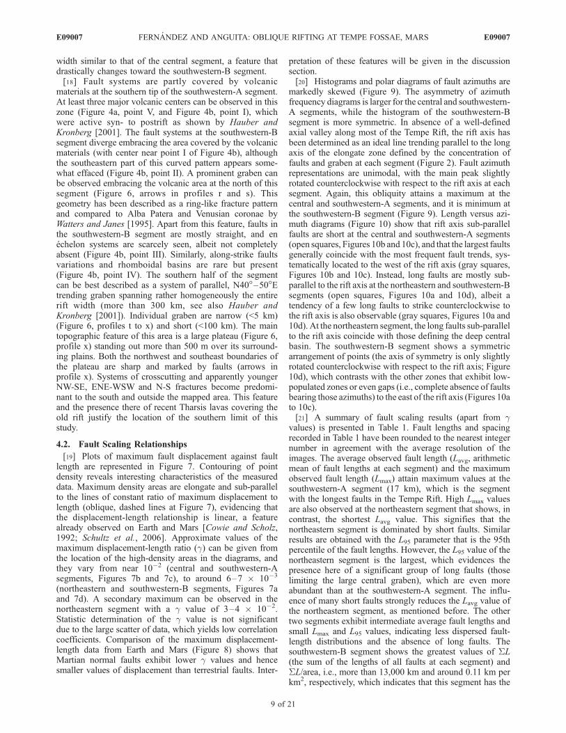
4.2. Fault Scaling Relationships
[19] Plots of maximum fault displacement against faultlength are represented in Figure 7. Contouring of pointdensity reveals interesting characteristics of the measureddata. Maximum density areas are elongate and sub-parallelto the lines of constant ratio of maximum displacement tolength (oblique, dashed lines at Figure 7), evidencing thatthe displacement-length relationship is linear, a featurealready observed on Earth and Mars [Cowie and Scholz,1992; Schultz et al., 2006]. Approximate values of themaximum displacement-length ratio (g) can be given fromthe location of the high-density areas in the diagrams, andthey vary from near 10�2 (central and southwestern-Asegments, Figures 7b and 7c), to around 6–7 � 10�3
(northeastern and southwestern-B segments, Figures 7aand 7d). A secondary maximum can be observed in thenortheastern segment with a g value of 3–4 � 10�2.Statistic determination of the g value is not significantdue to the large scatter of data, which yields low correlationcoefficients. Comparison of the maximum displacement-length data from Earth and Mars (Figure 8) shows thatMartian normal faults exhibit lower g values and hencesmaller values of displacement than terrestrial faults. Inter-
pretation of these features will be given in the discussionsection.[20] Histograms and polar diagrams of fault azimuths are
markedly skewed (Figure 9). The asymmetry of azimuthfrequency diagrams is larger for the central and southwestern-A segments, while the histogram of the southwestern-Bsegment is more symmetric. In absence of a well-definedaxial valley along most of the Tempe Rift, the rift axis hasbeen determined as an ideal line trending parallel to the longaxis of the elongate zone defined by the concentration offaults and graben at each segment (Figure 2). Fault azimuthrepresentations are unimodal, with the main peak slightlyrotated counterclockwise with respect to the rift axis at eachsegment. Again, this obliquity attains a maximum at thecentral and southwestern-A segments, and it is minimum atthe southwestern-B segment (Figure 9). Length versus azi-muth diagrams (Figure 10) show that rift axis sub-parallelfaults are short at the central and southwestern-A segments(open squares, Figures 10b and 10c), and that the largest faultsgenerally coincide with the most frequent fault trends, sys-tematically located to the west of the rift axis (gray squares,Figures 10b and 10c). Instead, long faults are mostly sub-parallel to the rift axis at the northeastern and southwestern-Bsegments (open squares, Figures 10a and 10d), albeit atendency of a few long faults to strike counterclockwise tothe rift axis is also observable (gray squares, Figures 10a and10d). At the northeastern segment, the long faults sub-parallelto the rift axis coincide with those defining the deep centralbasin. The southwestern-B segment shows a symmetricarrangement of points (the axis of symmetry is only slightlyrotated counterclockwise with respect to the rift axis; Figure10d), which contrasts with the other zones that exhibit low-populated zones or even gaps (i.e., complete absence of faultsbearing those azimuths) to the east of the rift axis (Figures 10ato 10c).[21] A summary of fault scaling results (apart from g
values) is presented in Table 1. Fault lengths and spacingrecorded in Table 1 have been rounded to the nearest integernumber in agreement with the average resolution of theimages. The average observed fault length (Lavg, arithmeticmean of fault lengths at each segment) and the maximumobserved fault length (Lmax) attain maximum values at thesouthwestern-A segment (17 km), which is the segmentwith the longest faults in the Tempe Rift. High Lmax valuesare also observed at the northeastern segment that shows, incontrast, the shortest Lavg value. This signifies that thenortheastern segment is dominated by short faults. Similarresults are obtained with the L95 parameter that is the 95thpercentile of the fault lengths. However, the L95 value of thenortheastern segment is the largest, which evidences thepresence here of a significant group of long faults (thoselimiting the large central graben), which are even moreabundant than at the southwestern-A segment. The influ-ence of many short faults strongly reduces the Lavg value ofthe northeastern segment, as mentioned before. The othertwo segments exhibit intermediate average fault lengths andsmall Lmax and L95 values, indicating less dispersed fault-length distributions and the absence of long faults. Thesouthwestern-B segment shows the greatest values of SL(the sum of the lengths of all faults at each segment) andSL/area, i.e., more than 13,000 km and around 0.11 km perkm2, respectively, which indicates that this segment has the
E09007 FERNANDEZ AND ANGUITA: OBLIQUE RIFTING AT TEMPE FOSSAE, MARS
9 of 21
E09007

Figure 7. Log-log plots of fault maximum displacement against fault length (L). The oblique, dashedlines represent distinct values of the ratio displacement/length (g). Contours of point density have beengenerated following standard techniques in structural geology widely used for contouring sphericalorientation data [e.g., Robin and Jowett, 1986]. The size of the counting areas is indicated by the smallwhite square located at the bottom right corner of each diagram. No is the number of measured faults.(a) Northeastern segment. Contour interval: 3%. (b) Central segment. Contour interval: 4%.(c) Southwestern-A segment. Contour interval: 4%. (d) Southwestern-B segment. Contour interval: 2%.
E09007 FERNANDEZ AND ANGUITA: OBLIQUE RIFTING AT TEMPE FOSSAE, MARS
10 of 21
E09007

densest fault concentration of the Tempe Rift. By contrast,the northeastern segment shows the smallest values of theseparameters. Therefore fault density progressively decreasesfrom southwest to northeast.[22] Correlation coefficients suggest that cumulative size-
frequency distribution of fault lengths is better described byan exponential than by a power law relationship at the fourstudied segments (Figure 11 and Table 1). The straight log-linear size-frequency plots (Figure 11a) contrast with thecurved central part of the log-log size-frequency plots(Figure 11b), which suggests that the fault-length distribu-tions are not well described by power law functions.Curtailment, overprinting and truncation are probably pres-ent at Figure 11b, but they are not responsible for the centralcurved part of the log-log plots. Parametric (c2) and non-parametric (Kolmogorov-Smirov) goodness-of-fit tests havebeen applied (Table 1). Fit to an exponential function cannotbe rejected at any zone (significance level, 0.05). Fit to apower law relationship is rejected at this significance levelfor fault populations at the central and southwestern-Bsegments. The tests did not yield rejection to power lawfunctions for the faults of the northeastern and southwestern-A segments, but the calculated test statistics are near therejection critical values. Although not shown on Table 1,goodness-of-fit to normal and log-normal distributions hasbeen checked and rejected at the same significance level.
[23] Average fault spacing (Savg) progressively decreasesfrom northeast to southwest (Table 1). The average standarddeviation of fault spacing also decreases in the samedirection indicating that fault spacing becomes more regu-lar. The slight increase of the standard deviation at thesouthwestern-B segment is due to the presence of syn- andpostrift volcanic materials. The calculated nearest neighborindex (NNI) that measures the spatial distribution of faultcentroids has similar values at the four studied segments(Table 1). These values are well below 2 (uniformity) andeven 1 (randomness), but are larger than 0 (clustered pointpattern). In fact, rejection of randomness has been verifiedwith a two-tailed Z-test, whose statistics are shown inTable 1, while the critical value is of –1.96 (level ofsignificance, 0.05). As long as the statistics are well withinthe rejection region, the randomness hypothesis is rejectedin all the studied zones.[24] Use of the box-counting method to assess the fault
map patterns suggests that the maps of the four studiedsegments are fractal (Figure 12). Correlation coefficients arelarger than 0.998 (Table 1). The capacity or fractal dimen-sion ranges from 1.55 (northeastern segment) to 1.7 (south-western-A segment), which can be interpreted as the resultof inhomogeneous, localized deformation [Cowie, 1998].[25] Histograms of fault azimuths have been compared
with the experimental data of Tron and Brun [1991] to
Figure 8. Log-log plot of fault maximum displacement against fault length for normal faults from Earthand Tempe Terra (data from Schlische et al. [1996], Wilkins et al. [2002], and Hauber and Kronberg[2005]). Compilation of long (>10 km) terrestrial strike-slip and thrust faults by Cowie and Scholz[1992]. Representative data from this work are plotted as the high-density areas enclosed by the 9%(Northeastern segment) and 8% (rest of segments) contour curves (see Figure 7). Thin, dashed straightlines represent the ratio displacement/length (g). The thick, dashed line corresponds to the calculateddisplacement/length scaling relation for Mars basaltic rocks according to Schultz et al. [2006].
E09007 FERNANDEZ AND ANGUITA: OBLIQUE RIFTING AT TEMPE FOSSAE, MARS
11 of 21
E09007

Figure 9. Histograms of fault azimuths (left column) and polar diagrams of fault azimuths (rightcolumn) of the four studied segments. The rift axis (dashed lines) is taken as the reference azimuth. Thevalue of one direction of the histogram or pole diagram is the sum of the length of faults that have thisorientation. No is the number of measured faults. The maximum percentage is indicated at each polardiagram.
E09007 FERNANDEZ AND ANGUITA: OBLIQUE RIFTING AT TEMPE FOSSAE, MARS
12 of 21
E09007

obtain the approximate location of the extension directionacross the distinct segments of the Tempe Rift. Resultsindicate (Figure 13 and Table 1) that the angle betweenthe rift axis and the extension direction (a) could havevaried from 50�–60� (southwestern-A segment) to 66�–88� (southwestern-B segment).
5. Discussion
5.1. Oblique Rifting at the Tempe Rift
[26] Analog models of extensional fault systems [e.g.,Whithjack and Jamison, 1986; Tron and Brun, 1991; Keepand McClay, 1997; Clifton et al., 2000;McClay et al., 2001;Schlische et al., 2002] have considerably improved ourunderstanding of the tectonic evolution of rifts and exten-sional zones on Earth (e.g., the Gulf of Aden Rift [Dauteuilet al., 2001], the Ethiopian Rift [Bonini et al., 1997], or theReykjanes Peninsula [Clifton and Schlische, 2003]).Numerical, analytical and analog models, and field studieshave evidenced that orthogonal and oblique extensionsgenerate quite distinct fault architectures. Further compli-cations include successive orthogonal and oblique exten-sional episodes (orthogonal to oblique or vice versa) thathave been also studied with experimental models [Bonini etal., 1997; Keep and McClay, 1997]. Unfortunately, no
attempt has been made in the Martian exploration to dateto obtain structural insights from available scaled physicalmodels. Oblique rifts present the following diagnosticcharacteristics with respect to orthogonal rifts [Whithjackand Jamison, 1986; Tron and Brun, 1991; McClay et al.,2001]: Segmented and en echelon rift border faults parallelto the rift axis, intra-rift fault domains oblique to the riftaxis, important structural variation along-axis includingfault polarity switching and rhomboidal sub-basins andhorst blocks, presence of relay ramps and accommodationzones inhibiting the along-strike propagation of internalfaults, frequent curved and sigmoid faults. As described inprevious sections, all these elements are present at theTempe Rift, thus suggesting that it can be considered asan example of extraterrestrial oblique rift. This is particu-larly obvious for the central and southwestern-A segments,whose fault patterns (Figures 3 and 4) are strikingly similarto those visible in the oblique-rifting experiments ofMcClay et al. [2001, 2002], Clifton and Schlische [2001],and Schlische et al. [2002]. The northeastern segment showsfault patterns also representing oblique rifting, although thepresence of some long sub-parallel faults limiting deepgraben seems indicative of low obliquity angles. Instead,the fault pattern at the southwestern-B segment is moresimilar to those obtained from models of orthogonal rifting.
Figure 10. Fault length versus fault azimuth diagrams for the studied zone. The rift axis (dashed lines)is taken as the reference azimuth. Resolution cutoff is around 4 km. L95 is the 95th percentile of the faultlengths. No is the number of measured faults. Open squares represent faults whose strike deviates less than10� from the rift axis. Gray squares represent faults whose lengths exceed 40 km and deviating more than10� counterclockwise from the rift axis. Black squares mark the rest of the measured faults. (a) Northeasternsegment. (b) Central segment. (c) Southwestern-A segment. (d) Southwestern-B segment.
E09007 FERNANDEZ AND ANGUITA: OBLIQUE RIFTING AT TEMPE FOSSAE, MARS
13 of 21
E09007

[27] Additional evidence of oblique rifting comes fromthe analysis of fault azimuth diagrams (Figures 9 and 10).Experimental results and field-based observations haveclearly shown that orthogonal rifting generates symmetricdiagrams and that their main peaks parallelize the rift axis.Instead, the strike of the faults is oblique to the strike of therift axis and histograms are asymmetric under obliquerifting [e.g., Tron and Brun, 1991; Schlische et al., 2002].This is precisely the case for at least three of the studiedsegments (Figure 9), and only the southwestern-B segmentshows diagrams of fault azimuths that can be explained byhigh-angle oblique or even orthogonal extension. Theassertion by Tron and Brun [1991] that faults are nevernormal to the displacement direction in oblique extensionwas confirmed by Clifton and Schlische [2001] and laterobserved by Clifton and Schlische [2003] at the ReykjanesPeninsula. Comparison with the experimental results ofTron and Brun [1991] yields obliquity angles (a) clearlyindicative of oblique extension, in particular for thesouthwestern-A segment, where a could be as low as 50�.Although most of the Tempe Rift would have been sub-jected to oblique rifting, the southwestern-B segment showsthe lowest obliquity values (a approaching 88�). Interest-ingly, the ring-like fractures associated with the large
volcano at the north of this segment do not modify thegeneral fault pattern. Transition from orthogonal to obliqueextension has been described at the Kenya Rift [see, e.g.,McClay et al., 2001], which was compared with the TempeRift by Hauber and Kronberg [2001]. Projection of thenormal to the extension direction at the polar diagrams offault azimuths (Figure 14) indicates that the modal peak offault trends is located between that direction and the riftaxis, in close coincidence with that observed in experimentsand terrestrial cases of oblique rifting [e.g., Schlische et al.,2002; Clifton and Schlische, 2003].[28] In summary, our data unequivocally support oblique
extension at the Tempe Rift. This oblique extension couldhave taken place late during the Noachian, as suggested byHauber and Kronberg [2001] according to the estimatedage of the volcanic constructs of the southwestern-Bsegment (3.51 Ga). Location of volcanic edifices at someparticular structural sites of the obliquely rifted zone, assoft-linked accommodation zones, is an evidence of thesharp association between tectonic and magmatic activities,which attests the crustal-scale importance of this riftingprocess. The large-scale strike-slip component of displace-ment should have been sinistral at the four studied segments(Figure 14). Contrary to intuition, analog experiments have
Table 1. Results of the Fault-Population Analysis in the Tempe Fossae Rifta
Northeastern Segment Central Segment Southwestern-A Segment Southwestern-B Segment
Fault length, kmLavg 13 16 17 14Lmax 150 92 196 107SL 3299 7226 8871 13375L95 34 25 29 26SL/area, km�1 0.0724 0.0857 0.1029 0.1110No 199 738 671 1646
Cumulative frequency of fault lengthsExponential N* = 82.27exp(�0.134L) N* = 64.55exp(�0.080L) N* = 63.16exp(�0.066L) N* = 73.07exp(�0.071L)R2 0.9895 0.9838 0.9962 0.9893Lc, km 7 13 15 14c2 test 0.56 (12.59) 10.00 (41.34) 1.05 (19.68) 9.57 (33.92)K-S test 0.04 (0.43) 0.07 (0.24) 0.08 (0.35) 0.13 (0.26)Power law N* = 1875.5L�1.9965 N* = 3787.7L�2.0174 N* = 2372.7L�1.7348 N* = 1341.1L�1.5699
R2 0.9365 0.9577 0.9553 0.9476c2 test 7.88 (12.59) 59.88 (41.34) 12.18 (19,68) 45.69 (33.92)K-S test 0.22 (0.43) 0.41 (0.24) 0.22 (0.35) 0.33 (0.26)
Fault spacing, kmSavg 11 9 6 6St. dev. 4 3 1 2
Spatial distribution of fault centroidsd(NN) 6.33 4.28 4.66 4.24d(ram) 14.99 9.29 6.48 6.78NNI 0.4225 0.4600 0.7193 0.6245Ztest �15.5837 �28.0660 �13.9103 �29.14304
Fractal analysis of fault trace mapsEquation n = 9092.2(bs)�1.5507 n = 20683(bs)�1.585 n = 24461(bs)�1.695 n = 32428(bs)�1.6041
R2 0.9986 0.9992 0.9985 0.9987D 1.55 1.59 1.7 1.6a (obliquity) 60�–75� 52�–70� 50�–60� 66�–88�aL is fault length; Lavg and Lmax are the average and maximum fault length, respectively; SL is the sum of the lengths of all faults at each segment; L95 is
the 95th percentile of the fault lengths, and No is the number of measured faults; R2 is the correlation coefficient for the exponential or power lawdistribution of the cumulative frequency of fault lengths; Lc is the characteristic length or average fault length assuming exponential distribution;c2 goodness-of-fit test and Kolmogorov-Smirnov goodness-of-fit test (significance level, 0.05) to exponential and power law functions: fit is rejected whenthe statistic exceeds the critical value (between parentheses); Savg is the average fault spacing, and the standard deviation is also expressed; d(NN) is thenearest neighbor distance of fault centroids, and d(ram) is the nearest neighbor distance based on a random distribution; NNI is the nearest neighbor index,equal to d(NN)/d(ram); Ztest is the statistic of a standard Z two-tailed test devised to analyze the randomness of fault centroids, rejection of randomness isexpected when the statistic value exceeds the critical value (�1.96 at 0.05 as level of significance); fractal analysis of fault maps includes the fractaldimension (D) and the correlation coefficient (R2) of the box-counting straight line (equation is shown); a is the estimated angle between the extensiondirection and the rift axis.
E09007 FERNANDEZ AND ANGUITA: OBLIQUE RIFTING AT TEMPE FOSSAE, MARS
14 of 21
E09007

proved that faults generated and displaced under obliqueextension are pure dip-slip, normal faults [e.g., Clifton et al.,2000]. Strike-slip or oblique faults are only observed undervery low a values (<30�). Therefore the previous observa-tions and strain measurement at Tempe Rift assuming dip-slip fault displacements are probably well founded and theynot contradict the results of this work. Nevertheless, obliqueextension regimes involve generation of several distinct
coeval fault trends, a feature profusely described in thiswork for the Tempe Rift. Under oblique rifting, the presenceof two or more coeval fault sets differing in their averagetrends do not necessarily indicate distinct episodes ofregional extension [Schlische et al., 2002]. The lack ofevidences for clear crosscutting relationships at our studiedzones (Figures 3 and 4) can be interpreted as due to theessentially contemporary nature of these distinct fault sys-
Figure 11. Cumulative number of faults (N*), normalized by reference area versus length (L).Normalization follows the Schultz and Fori [1996] proposal for Mars, with N* = N � 104/A, where104 km2 is the reference area and A is the area (in km2) of each studied surface containing faults.Northeastern segment: A = 45,594 km2. Central segment: A = 84,337 km2. Southwestern-A segment: A =86,210 km2. Southwestern-B segment: A = 120,445 km2. Calculated uncertainties due to populationstatistics (error bars) are ±1s, with s = [SN* � (104/A)](1/2), where SN* is the cumulative normalizednumber of faults of given length. (a) Log-linear plots. (b) Log-log plots. Straight lines correspond to bestfit regression lines.
E09007 FERNANDEZ AND ANGUITA: OBLIQUE RIFTING AT TEMPE FOSSAE, MARS
15 of 21
E09007

tems. A corollary of this is that some of the tectonicevolution models based on supposedly distinct and succes-sive fault sets differing in their trend could be tentativelyreinterpreted in Tempe Terra as perhaps in the rest of theplanet. Future high-resolution data can help to check faultcrosscut relationships.[29] On Earth, oblique rifting is probably the rule rather
than the exception [Schlische et al., 2002]. This is due,among other causes, to the presence of previous faultsacting as structural inheritances of an older deformationphase [Keep and McClay, 1997]. Reactivation of preexistingstructures impressed in the Tempe Fossae crust was alreadysuggested by Hauber and Kronberg [2001] to explain thegeometrical characteristics of the Tempe Rift. This is anadditional evidence of the long and changing structuralevolution of the Tharsis region during the Noachian [Megeand Masson, 1996a; Anguita et al., 2006]. Spatial variationin the estimated extension direction (Figure 14) could bedue to a deformation field with curved trajectories. How-
ever, the data presented in this work rather favor localdeviations of the principal deformation axes around crustal-scale major fractures or fractured zones. This feature isparticularly evident at the southwestern-A zone, where ananticlockwise rotation of the rift axis is observed, and largesigmoid faults have been generated.
5.2. Implications of the Fault Scaling Relationshipsat the Tempe Rift
[30] Diagrams of maximum fault displacement againstfault length (Figure 7) show a significant scatter that, insome cases, can attain more than two orders of fault-displacement magnitude (e.g., Figure 7a). This scatter islarger than that observed by Wilkins et al. [2002] at theentire Tempe Terra (around one order of fault-displacementmagnitude). Cowie and Scholz [1992] discussed the mainsources of scatter in these types of data. A characteristicfeature of faults at the Tempe Rift, profusely described inthis work, is its segmented geometry and en echelon
Figure 12. Box counting curves for fracture maps of the four studied segments of the Tempe Rift.Number of boxes occupied by faults (n) is represented against the line size of boxes. The single initialbox is completely included within the studied zones. Results show a straight-line distribution over almostfour orders of magnitude of box size. Fractal dimension of the distribution is obtained from the slope(�D) of the straight line relating n with box size. Correlation coefficient is R2. (a) Northeastern segment.(b) Central segment. (c) Southwestern-A segment. (d) Southwestern-B segment.
E09007 FERNANDEZ AND ANGUITA: OBLIQUE RIFTING AT TEMPE FOSSAE, MARS
16 of 21
E09007

arrangement. Peacock and Sanderson [1991] showed thatthe proximity of neighboring faults increases thedisplacement/length ratios determined for each individualsegment. Most of the scatter observed in Figure 7 could bedue to the fundamentally segmented nature of fault systemsat the Tempe Rift. The large scale of the fault trace mapsused by Wilkins et al. [2002] does not allow recognizingsuch detailed geometries, therefore reducing the influenceof this scatter source. Apart from this, the more populatedzones of the displacement/length diagrams for the TempeRift (density contours in Figure 7) show an acceptable
agreement with the previous data from Tempe Terra[Wilkins et al., 2002] and with the theoretical scalingrelations calculated by Schulz et al. [2006] for Mars basalticrock masses (thick dashed line in Figure 8). Comparisonwith data from terrestrial normal faults (Figure 8) suggeststhat displacement/length ratios for Martian normal faults areshifted to smaller values of displacement, apart from thescatter associated with fault geometry, which confirms theresults of Schultz et al. [2006]. This feature is mainly aconsequence of the distinct planetary gravities [Schulz et al.,2006]. As a note of caution, it must be indicated that the
Figure 13. Estimation of the extension direction at the Tempe Rift from fault azimuthal distribution(histograms of fault azimuths; see Figure 9) by comparison with the experimental results of Tron andBrun [1991]. Experimental diagrams plot fault obliquity (a; explanation in the inset) against fault azimuthcentered on the rift axis. Shaded areas represent the orientation span of experimental faults. Thesignificant range of each histogram is adjusted to the light gray area of experimental data, with the mainpeak approximately coinciding with the dark gray area. (a) Northeastern segment. (b) Central segment.(c) Southwestern-A segment. (d) Southwestern-B segment.
E09007 FERNANDEZ AND ANGUITA: OBLIQUE RIFTING AT TEMPE FOSSAE, MARS
17 of 21
E09007

displacement/length ratio seems to be affected by isostaticforces on Earth, which can largely modify and even destroythe correlation between displacement and length for normalfaults tens of kilometers long [Cowie and Scholz, 1992].Most of the faults measured at the Tempe Rift are more than10 km long (Figure 7) and therefore it has not been possibleto compare terrestrial and Martian normal faults spanningthe same length intervals. Future high-resolution images ofMars should be used to obtain detailed displacement/lengthratios of small normal faults, with lengths shorter than a fewkilometers. Comparison with large terrestrial strike-slip andthrust faults that do not show the isostatic influence also
reveals the smaller displacement/length ratio of the Martianfaults (Figure 8).[31] Analog experiments [Clifton et al., 2000; Ackermann
et al., 2001] have shown that fault scaling relationshipsdepend on three main parameters: the obliquity angle (a),the deformation intensity, and the thickness of the mechan-ical layer (tm). The mechanical layer represents the rockbody containing the faults and, for regional-scale studies itsthickness is comparable to the seismogenic thickness[Scholz and Contreras, 1998]. Experimental results indicatethat the average fault spacing, the fractal dimension, and theaverage and maximum fault lengths increase with a [Clifton
Figure 14. Tectonic sketch of Tempe Rift showing the fault map (Mercator projection), the estimatedextension direction at each segment (including confidence intervals and polar diagrams with the locationof the rift axis and the normal to the extension direction), and the location of some relevant structural andvolcanic features, such as accommodation zones, sigmoid fault systems, and volcanic constructs. Theestimation of the obliquity angle (a) is represented in Figure 13.
E09007 FERNANDEZ AND ANGUITA: OBLIQUE RIFTING AT TEMPE FOSSAE, MARS
18 of 21
E09007

et al., 2000]. In turn, the average and maximum observedfault lengths, sum of fault lengths, regularity of faultspacing, and fractal dimension increase with extension,while fault spacing decreases with extension [Ackermannet al., 2001]. The fractal dimension also increases with tm,but the length parameters and the average spacing decreasewith tm [Ackermann et al., 2001].[32] It is not easy to interpret the data on Table 1
according to these experimental results. The available datado not suggest a significant change of strain values alongthe Tempe Rift [Hauber and Kronberg, 2001]. However,new detailed, segment-by-segment determinations are nec-essary. The southwestern-A segment, probably rifted underthe lowest a angle, shows the largest length parameters andfractal dimension. This is contrary to what it is expectedfrom the experimental data unless high extension or low tmvalues overwhelmed the effects of a. The small faultspacing at the southwestern-B segment can only beexplained with a high extension value and/or high tm.Therefore it is here believed that data of Tempe Terra arereflecting a complex interplay between the deformationintensity, a and tm, with the crustal thickness playing thedominant role through a net increase in tm from northeastto southwest along the rift. A thicker mechanical crust at thesouthwest of Tempe Rift could explain the more distributedfault pattern (see Schlische et al. [2002] for a definition ofdistributed normal faulting) and the greater width of the riftzone there. An increase in crustal thickness from TempeFossae toward the center of Tharsis [Banerdt andGolombek, 2000] agrees with these observations.[33] Although fit to power law functions cannot be
completely excluded on statistical grounds for segmentsnortheastern and southwestern-A, the fault-length distribu-tions of Tempe Rift are best described by exponentialfunctions. This is similar to the results obtained at mid-ocean ridges on Earth [e.g., Cowie, 1998]. Exponentialfault-length distributions have been explained due to eithersmall width of the active zone or small thickness of thebrittle crust that generates non-interacting faults spanningthe mechanical layer [Cowie, 1998]. A number of indepen-dent criteria suggest localized deformation and weaklyinteracting faults at Tempe Rift, including the low valuesof the fractal dimension (D < 2) and the non-randomness offault centroids, apart from the observed exponential cumu-lative size-frequency distribution of fault lengths. Wilkinsand Schultz [2000] already considered the graben at TempeTerra as not kinematically coherent (weakly interacting)based on the observed displacement deficit for fault arrays.[34] Non-random and exponential fault populations are
characteristics of the saturation stage of rift evolutiondescribed by Ackermann et al. [2001]. Large extensionvalues are normally needed in the analog experiments toattain this mature stage. This contrasts with the low tomoderate stretching estimated for Tempe Fossae by Hauberand Kronberg [2001]. Three explanations can be advancedto explain this apparent paradox. First, low values ofthickness of the mechanical layer have been deduced atTempe Rift in this work, which rends it more akin from amechanical and structural point of view to the terrestrialoceanic crust. Second, the work of Schultz et al. [2006]shows that faults and fault systems of Mars must necessarilyshow smaller displacements than on Earth, due to differ-
ences in the planetary gravities. And third, the displacementcomponent parallel to the rift axis has not yet been deter-mined. It can be predicted that this component shouldmoderately increase the estimated deformation value in atleast the southwestern-A segment.[35] Scaled experimental models allow us to analyze the
inception and temporal evolution of deformation, and notonly the final deformation state observed in Nature. Modelsare also used to simulate structural systems under differentboundary conditions. Therefore they cast light on and givesupport to real world studies. Benefits of this comparisonbetween experimental models and natural examples areparticularly clear in the interpretation of terrestrial riftsystems [e.g., Clifton et al., 2000; McClay et al., 2001;Schlische et al., 2002]. Although this work shows a suc-cessful application of the results of models of oblique riftingto the Tempe Rift, these models are in fact scaled accordingto terrestrial parameters. Further analog experiments areneeded to simulate orthogonal and oblique extension ofthe Martian crust, that accurately reflect the gravity, crustalthickness and mechanical properties of Mars.
5.3. Tectonic Implications of the Oblique Riftingat the Tempe Rift
[36] The Tempe Rift is a part of a complex group ofextensional structures that radiate outward from Tharsis[e.g., Plescia and Saunders, 1982]. The tectonic history ofthe Tempe Rift is intimately related to that of Tharsis, asshown by the NE-trending alignment of the Tempe Rift withthe Tharsis Montes [Hauber and Kronberg, 2001]. Interest-ingly, the Tharsis Montes are a consequence of an Amazo-nian tectono-magmatic episode [e.g., Anderson et al., 2001],considerably younger than the main event of oblique riftingat Tempe (>3.5 Gy). This attests the long-lived tectonicactivity of some crustal-scale accidents that crosscut theentire Tharsis region, like the Tharsis Montes-Tempe Riftweakness zone (TTWZ). The analysis of the successivetectonic episodes that affected Tharsis [Plescia andSaunders, 1982; Anderson et al., 2001] clearly showscomplex time-evolving stress fields [Mege and Masson,1996b] and changing locations of the estimated centers ofradial structures [Anderson et al., 2001]. Large old struc-tures such as the TTWZ could have been reactivated duringeach new tectonic episode. Apart from rheological andmechanical factors, the relative orientation of previousstructures with respect to the principal stress trajectoriesof the successive stress fields determines whether thesestructures can be potentially reactivated and, if that werethe case, what would the kinematic pattern (orthogonal oroblique rifting, strike-slip displacement) be. Reactivation ofthe northern part of the TTWZ as a sinistral oblique riftoccurred late in the Noachian. Similar detailed analyses ofother zones surrounding Tharsis are necessary before acomplete picture of this episode could be presented.[37] As for Martian tectonic evolution, these results could
indicate that mechanical models based exclusively on sim-ple stress fields are insufficient to explain in detail Tharsisfaults’ architecture. It is increasingly clear that in order toreconstruct the history of a tectono-magmatic province morethan 5,000 km wide we will need to piece together complexand evolving stress fields. Moreover, if Anguita et al. [2006]are right in their assumption of Earth-size mountain chains
E09007 FERNANDEZ AND ANGUITA: OBLIQUE RIFTING AT TEMPE FOSSAE, MARS
19 of 21
E09007

in Hesperian Mars, then huge tangential stresses are surelyinescapable, and every revision of the geometry of Tharsisfractures could add to a new Martian tectonic landscape.
6. Conclusions
[38] A detailed analysis of the fault populations observedat the Tempe Rift on Mars shows that this extensionalregion was probably generated under oblique rifting, witha component of sinistral displacement. Values of the angle(a) between the extension direction and the rift axis varyfrom a minimum of 50� (southwestern-A segment) to amaximum of 88� (southwestern-B segment). By comparisonwith well-known terrestrial examples, structural inheritanceand a long Noachian tectonic activity with time-changingdeformation fields can explain this period of oblique exten-sion. Observation of exponential fault length-frequencydistributions of fault populations suggests that faults wereweakly interacting at Tempe Rift. This fault scaling rela-tionship makes the Noachian crust at Tempe more compa-rable to the oceanic than to the continental crust of ourplanet. Results of the fractal analysis of fault trace maps,with fractal dimension lower than 2, and the non-randomspatial distribution of fault centroids are evidences oflocalized, inhomogeneous deformation. Most fault scalingrelationships indicate that the thickness of the faultedmechanical layer was small and that it increased towardthe southwest (i.e., toward Tharsis center), although theinfluence of deformation intensity, poorly constrained bynow, must be taken into account.[39] Fault crosscutting relationships observed at Mars
should be revisited following the guidelines provided bythe increasing amount of information available fromoblique-extension tectonic scenarios. Although the availablephysical experiments are useful to interpret fault patterns atMars, new models should be designed with the properscaling relations. This could surely contribute to improveour understanding of the tectonic significance and evolutionof intricate Noachian fault sets. It can be anticipated that amore rigorous, complex, lively and interesting tectonicdescription of the entire Tharsis region would emerge fromthese studies.
[40] Acknowledgments. The authors would like to thank ErnstHauber and Robert C. Anderson for a thorough and useful review. Wethank the Viking and Mars Global Surveyor teams for the use of Vikingcontext images. C.F. acknowledges financial support from Spanish Ministryof Education and Science project CGL2004-06808-CO4-02.
ReferencesAckermann, R. V., R. W. Schlische, and M. O. Withjack (2001), The geo-metric and statistical evolution of normal fault systems: An experimentalstudy of the effects of mechanical layer thickness on scaling laws,J. Struct. Geol., 23, 1803–1819.
Anderson, R. C., A. F. C. Haldemann, J. M. Dohm, M. P. Golombek, B. J.Franklin, and J. Lias (1999), Significant centers of tectonic activity asidentified by wrinkle ridges for the western hemisphere of Mars, LunarPlanet. Sci., XXX, Abstract 1972.
Anderson, R. C., J. M. Dohm, M. P. Golombek, A. F. Haldemann, B. J.Franklin, K. L. Tanaka, J. Lias, and B. Peer (2001), Primary centers andsecondary concentrations of tectonic activity through time in the westernhemisphere of Mars, J. Geophys. Res., 106, 20,563–20,585.
Anguita, F., A. F. Farelo, V. Lopez, C. Mas, M. J. Munoz, A. Marquez, andJ. Ruiz (2001), Tharsis dome, Mars: New evidence for Noachian-Hesperian thick-skin and Amazonian thin-skin tectonics, J. Geophys.Res., 106, 7577–7589.
Anguita, F., C. Fernandez, G. Cordero, S. Carrasquilla, J. Anguita,A. Nunez, S. Rodrıguez, and J. Garcıa (2006), Evidences for a Noa-chian-Hesperian orogeny in Mars, Icarus, 185(2), 331–357.
Banerdt, W. B., and M. P. Golombek (2000), Tectonics of the Tharsis regionof Mars: Insights from MGS topography and gravity, Lunar Planet. Sci.,XXXI, Abstract 2038.
Bonini, M., T. Souriot, M. Boccaletti, and J. P. Brun (1997), Successiveorthogonal and oblique extension episodes in a rift zone: Laboratoryexperiments with application to the Ethiopian Rift, Tectonics, 16, 347–362.
Borraccini, F., L. Lanci, F. C. Wezel, and D. Baioni (2005), Crustal exten-sion in the Ceraunius Fossae, Northern Tharsis Region, Mars, J. Geo-phys. Res., 110, E06006, doi:10.1029/2004JE002373.
Cailleau, B., T. R. Walter, P. Janle, and E. Hauber (2003), Modeling vol-canic deformation in a regional stress field: Implications for the formationof graben structures on Alba Patera, Mars, J. Geophys. Res., 108(E12),5141, doi:10.1029/2003JE002135.
Carr, M. H. (1974), Tectonism and volcanism of the Tharsis region of Mars,J. Geophys. Res., 79, 3943–3949.
Clifton, A. E., and R. W. Schlische (2001), Nucleation, growth, and linkageof faults in oblique rift zones: Results from experimental clay models andimplications for maximum fault size, Geology, 29, 455–458.
Clifton, A. E., and R. W. Schlische (2003), Fracture populations on theReykjanes Peninsula, Iceland: Comparison with experimental clay mod-els of oblique rifting, J. Geophys. Res., 108(B2), 2074, doi:10.1029/2001JB000635.
Clifton, A. E., R. W. Schlische, M. O. Withjack, and R. V. Ackermann(2000), Influence of rift obliquity on fault-population systematics: Resultsof experimental clay models, J. Struct. Geol., 22, 1491–1509.
Cowie, P. A. (1998), Normal fault growth in three dimensions in continentaland oceanic crust, in Faulting and Magmatism at Mid-Ocean Ridges,Geophys. Monogr. Ser., vol. 106, edited by W. R. Buck et al.,pp. 325–348, AGU, Washington, D. C.
Cowie, P. A., and C. H. Scholz (1992), Displacement-length scaling rela-tionship for faults: Data synthesis and discussion, J. Struct. Geol., 14,1149–1156.
Cressie, N. A. C. (1993), Statistics for Spatial Data, 900 pp., John Wiley,New York.
Dauteuil, O., P. Huchon, F. Quemeneur, and T. Souriot (2001), Propagationof an oblique spreading centre: The western Gulf of Aden, Tectonophy-sics, 332, 423–442.
Ferrill, D. A., D. Y. Wyrick, A. P. Morris, D. W. Sims, and N. M. Franklin(2004), Dilational fault slip and pit chain formation on Mars, GSA Today,14(10), 4–12, doi:10.1130/1052-5173(2004)014<4:DFSAPC>2.0.CO;2.
Forsythe, R. D., and J. R. Zimbelman (1988), Is the Gordii Dorsum escarp-ment on Mars an exhumed transcurrent fault?, Nature, 336, 143–146.
Golombek, M. P., K. L. Tanaka, and B. J. Franklin (1996), Extension acrossTempe Terra, Mars, from measurements of fault scarp widths and de-formed craters, J. Geophys. Res., 101, 26,119–26,130.
Hauber, E., and P. Kronberg (1999), Differences in style and age of exten-sional faulting: Examples from the Northern Tharsis Province, Mars,Lunar Planet. Sci., XXX, Abstract 1568.
Hauber, E., and P. Kronberg (2001), Tempe Fossae, Mars: A planetaryanalogon to a terrestrial continental rift?, J. Geophys. Res., 106,20,587–20,602.
Hauber, E., and P. Kronberg (2005), The large Thaumasia graben on Mars:Is it a rift?, J. Geophys. Res., 110, E07003, doi:10.1029/2005JE002407.
Keep, M., and K. R. McClay (1997), Analogue modeling of multiphase riftsystems, Tectonophysics, 273, 239–270.
Mangold, N., P. Allemand, P. G. Thomas, and G. Vidal (2000), Chronologyof compressional deformation on Mars: Evidence for a single and globalorigin, Planet. Space Sci., 48, 1201–1211.
McClay, K. R., T. Dooley, R. Gloaghen, P. Whitehouse, and S. Khalil(2001), Analogue modeling of extensional fault architectures: Compar-isons with natural rift fault systems, paper presented at PESA EasternAustralian Basins Symposium, Pet. Explor. Soc. of Aust., Melbourne,Victoria, Australia.
McClay, K. R., T. Dooley, P. Whitehouse, and M. Mills (2002), 4-D evolu-tion of rift systems: Insights from scales physical models, AAPG Bull.,86, 935–959.
Mege, D., and P. Masson (1996a), Stress models for Tharsis formation,Mars, Planet. Space Sci., 44, 1471–1497.
Mege, D., and P. Masson (1996b), A plume tectonics model for the Tharsisprovince, Mars, Planet. Space Sci., 44, 1499–1546.
Melosh, H. J. (1980), Tectonic patterns on a reoriented planet: Mars, Icarus,44, 745–751.
Mueller, K., and M. Golombek (2004), Compressional structures on Mars,Annu. Rev. Earth Planet. Sci., 32, 435–464.
Peacock, D. C. P., and D. J. Sanderson (1991), Displacement and segmentlinkage in relay ramps in normal fault zones, J. Struct. Geol., 13, 721–733.
E09007 FERNANDEZ AND ANGUITA: OBLIQUE RIFTING AT TEMPE FOSSAE, MARS
20 of 21
E09007

Plescia, J. B., and R. S. Saunders (1982), Tectonic history of the Tharsisregion, Mars, J. Geophys. Res., 87, 9775–9791.
Robin, P. Y. F., and E. C. Jowett (1986), Computerized density contouringand statistical evaluation of orientation data using counting circles andcontinuous weighting functions, Tectonophysics, 121, 207–223.
Schlische, R. W., S. S. Young, R. V. Ackermann, and A. Gupta (1996),Geometry and scaling relations of a population of very small rift relatednormal faults, Geology, 24, 683–686.
Schlische, R. W., M. O. Withjack, and G. Eisenstadt (2002), An experi-mental study of the secondary deformation produced by oblique-slipnormal faulting, AAPG Bull., 86, 885–906.
Scholz, C. H., and J. C. Contreras (1998), Mechanics of continental riftarchitecture, Geology, 26, 967–970.
Schultz, R. A. (1989), Strike-slip faulting of ridged plains near VallesMarineris, Mars, Nature, 341, 424–426.
Schultz, R. A., and A. N. Fori (1996), Fault-length statistics and implica-tions of graben sets at Candor Mensa, Mars, J. Struct. Geol., 18, 373–383.
Schultz, R. A., and K. L. Tanaka (1994), Lithospheric-scale buckling andthrust structures on Mars: The Coprates rise and south Tharsis ridge belt,J. Geophys. Res., 99, 8371–8385.
Schultz, R. A., C. H. Okubo, and S. J. Wilkins (2006), Displacement-lengthscaling relations for faults on the terrestrial planets, J. Struct. Geol., 28,2182–2193, doi:10.1016/j.jsg.2006.03.034.
Scott, D. H., and J. M. Dohm (1990), Chronology and global distribution offault and ridge systems on Mars, Lunar Planet. Sci., 20, 487–501.
Scott, D. H., and K. L. Tanaka (1986), Geological map of the westernequatorial region of Mars, U.S. Geol. Surv. Misc. Invest. Ser., Map I-1802–A, scale 1:15M.
Swan, A. R. H., and M. Sandilands (1995), Introduction to Geological DataAnalysis, 446 pp., Blackwell Sci., Oxford, U. K.
Tanaka, K. L., M. P. Golombek, and W. B. Banerdt (1991), Reconciliationof stress and structural stories of the Tharsis region of Mars, J. Geophys.Res., 96, 15,617–15,633.
Tron, V., and J. P. Brun (1991), Experiments on oblique rifting in brittle-ductile systems, Tectonophysics, 188, 71–84.
Vignes-Adler, M., A. Le Page, and P. M. Adler (1991), Fractal analysis offracturing in two African regions, from satellite imagery to ground scale,Tectonophysics, 196, 69–86.
Walsh, J. J., and J. Watterson (1993), Fractal analysis of fracture patternsusing the standard box-counting technique: Valid and invalid methodol-ogies, J. Struct. Geol., 15, 1509–1512.
Watters, T. R. (1991), Origin of periodically spaced wrinkle ridges on theTharsis Plateau of Mars, J. Geophys. Res., 96, 15,599–15,616.
Watters, T. R. (1993), Compressional tectonism on Mars, J. Geophys. Res.,98, 17,049–17,060.
Watters, T. R., and D. M. Janes (1995), Coronae on Venus and Mars:Implications for similar structures on Earth, Geology, 23, 200–204.
Watters, T. R., and T. A. Maxwell (1983), Crosscutting relations and rela-tive ages of ridges and faults in the Tharsis region of Mars, Icarus, 56,278–298.
Watters, T. R., and T. A. Maxwell (1986), Orientation, relative age, andextent of the Tharsis Plateau ridge system, J. Geophys. Res., 91, 8113–8125.
Whithjack, M. O., and W. R. Jamison (1986), Deformation produced byoblique rifting, Tectonophysics, 126, 99–124.
Wilkins, S. J., and R. A. Schultz (2000), Displacement-length relationshipsof grabens in Tempe Terra, Mars, Eos Trans. AGU, 81(48), Fall Meet.Suppl., Abstract T21B-04.
Wilkins, S. J., and R. A. Schultz (2003), Cross faults in extensional settings:Stress triggering, displacement localization, and implications for the ori-gin of blunt troughs at Valles Marineris, Mars, J. Geophys. Res., 108(E6),5056, doi:10.1029/2002JE001968.
Wilkins, S. J., R. A. Schultz, R. C. Anderson, J. M. Dohm, and N. H.Dawers (2002), Deformation rates from faulting at the Tempe Terra ex-tensional province, Mars, Geophys. Res. Lett., 29(18), 1884, doi:10.1029/2002GL015391.
Wise, D. U., M. P. Golombek, and G. E. McGill (1979), Tharsis province ofMars: Geologic sequence, geometry, and a deformation mechanism,Icarus, 38, 456–472.
�����������������������F. Anguita, Departamento de Petrologıa y Geoquımica, Universidad
Complutense de Madrid, E-28071 Madrid, Spain.C. Fernandez, Departamento de Geodinamica y Paleontologıa,
Universidad de Huelva, E-21071 Huelva, Spain. ([email protected])
E09007 FERNANDEZ AND ANGUITA: OBLIQUE RIFTING AT TEMPE FOSSAE, MARS
21 of 21
E09007