Northeast England – A history of flash flooding - JBA Trust
127
Northeast England – A history of flash flooding Introduction The main outcome of this review is a description of the extent of flooding during the major flash floods that have occurred over the period from the mid seventeenth century mainly from intense rainfall (many major storms with high totals but prolonged rainfall or thaw of melting snow have been omitted). This is presented as a flood chronicle with a summary description of each event. Sources of Information Descriptive information is contained in newspaper reports, diaries and further back in time, from Quarter Sessions bridge accounts and ecclesiastical records. The initial source for this study has been from Land of Singing Waters –Rivers and Great floods of Northumbria by the author of this chronology. This is supplemented by material from a card index set up during the research for Land of Singing Waters but which was not used in the book. The information in this book has in turn been taken from a variety of sources including newspaper accounts. A further search through newspaper records has been carried out using the British Newspaper Archive. This is a searchable archive with respect to key words where all occurrences of these words can be viewed. The search can be restricted by newspaper, by county, by region or for the whole of the UK. The search can also be restricted by decade, year and month. The full newspaper archive for northeast England has been searched year by year for occurrences of the words ‘flood’ and ‘thunder’. It was considered that occurrences of these words would identify any floods which might result from heavy rainfall. The words ‘flash flood’ were considered inappropriate as the term only originated around 1930. The archive has the greatest complement of papers during the second half of the 19 th century; a very reduced and patchy number of titles continues to 1950 but for copyright reasons there are no records after 1950. The 1900 to 1950 record has had to be supplemented by microfilm search in libraries. The subsequentpost-1950 record has also had to be accessed directly from Library based microfilm of newspapers and from a newspaper Cuttings file maintained by Newcastle City Library where categories of climate and flooding have been separately maintained. This record commences around 1968 and continues to the present. The period from 1950 to 1968 is therefore the least extensively covered although all dates on which heavy rainfall occurred as listed in British Rainfall were examined in local newspapers. With respect to floods arising from intense rainfall (FFIR) information has been abstracted on the occurrence of lightning (e.g., deaths and injuries) hail (e.g., large hail and window breakages), drowning, bridge failures, whether pluvial or river flooding (or both), whether rapid rate of rise has been described, and whether geomorphological effects have been reported. Locations, where flooding has occurred, are listed. Newspaper descriptions include much that is of human interest but only limited information which could be used to define the magnitude of the flood. It is only the latter information which has been extracted for the most part, indicating levels or depths on roads and buildings which may still be identifiable. Such details provide a means of assessing the comparative magnitude of floods.
-
Upload
khangminh22 -
Category
Documents
-
view
1 -
download
0
Transcript of Northeast England – A history of flash flooding - JBA Trust

Northeast England – A history of flash flooding Introduction The main outcome of this review is a description of the extent of flooding during the major flash floods that have occurred over the period from the mid seventeenth century mainly from intense rainfall (many major storms with high totals but prolonged rainfall or thaw of melting snow have been omitted). This is presented as a flood chronicle with a summary description of each event. Sources of Information Descriptive information is contained in newspaper reports, diaries and further back in time, from Quarter Sessions bridge accounts and ecclesiastical records. The initial source for this study has been from Land of Singing Waters –Rivers and Great floods of Northumbria by the author of this chronology. This is supplemented by material from a card index set up during the research for Land of Singing Waters but which was not used in the book. The information in this book has in turn been taken from a variety of sources including newspaper accounts. A further search through newspaper records has been carried out using the British Newspaper Archive. This is a searchable archive with respect to key words where all occurrences of these words can be viewed. The search can be restricted by newspaper, by county, by region or for the whole of the UK. The search can also be restricted by decade, year and month. The full newspaper archive for northeast England has been searched year by year for occurrences of the words ‘flood’ and ‘thunder’. It was considered that occurrences of these words would identify any floods which might result from heavy rainfall. The words ‘flash flood’ were considered inappropriate as the term only originated around 1930. The archive has the greatest complement of papers during the second half of the 19th century; a very reduced and patchy number of titles continues to 1950 but for copyright reasons there are no records after 1950. The 1900 to 1950 record has had to be supplemented by microfilm search in libraries. The subsequentpost-1950 record has also had to be accessed directly from Library based microfilm of newspapers and from a newspaper Cuttings file maintained by Newcastle City Library where categories of climate and flooding have been separately maintained. This record commences around 1968 and continues to the present. The period from 1950 to 1968 is therefore the least extensively covered although all dates on which heavy rainfall occurred as listed in British Rainfall were examined in local newspapers. With respect to floods arising from intense rainfall (FFIR) information has been abstracted on the occurrence of lightning (e.g., deaths and injuries) hail (e.g., large hail and window breakages), drowning, bridge failures, whether pluvial or river flooding (or both), whether rapid rate of rise has been described, and whether geomorphological effects have been reported. Locations, where flooding has occurred, are listed. Newspaper descriptions include much that is of human interest but only limited information which could be used to define the magnitude of the flood. It is only the latter information which has been extracted for the most part, indicating levels or depths on roads and buildings which may still be identifiable. Such details provide a means of assessing the comparative magnitude of floods.

The information contained in this chronology has been transferred and summarised in an Excel file with one line per event. The file currently contains *** events for the northeast. Associated meteorological information The publication British Rainfall 1863 – 1968 (Symons British Rainfall from 1863 to 1900) was inspected to identify potential flood dates and to ascertain the meteorological conditions associated with flooding – thaw, thaw with rain, frontal rainfall, convectional storms etc. The Climatological Observers Link (COL) has been used to fill out the later period for intense rainfall although the number of stations is small especially in the early years during the 1970s but is supplemented by observer’s descriptions of events. A fuller extraction of digitised records of short period extreme rainfall held by the Environment Agency should eventually be included in the Chronology.

Flood Chronology Date and sources
Rainfall Description
13 Jun 1580 Stowe’s chronicle
At Sheepwash [east of Morpeth] there happened a tempest of lightning and thunder after which of a sudden came a great shower of hail amongst which were stones of divers shapes.
23 Jun 1678 Parish Register of Hunstanworth
Two adults and a child killed by lightning at Hunstanworth.
3 Jul 1678 LSW Sanderson’s Dairy Jones et al 1984
Eggleston, Lunedale and Balderdale ‘carried away grounds’.
12 May 1728 LSW Richardson 1849
In consequence of excessive rains the rivulet which falls into the Tyne at Newburn carried off Charlton’s stable and oat kiln and Parley’s mill and house. The people in the house narrowly escaped with their lives. The flood moved stones in the burn weighing 2 tons. It overflowed the end of Newburn bridge, both arches being choked with trees and stones etc, torn away by the impetuosity of the water.
2 Aug 1737 Gentleman’s magazine
A shepherd and his dog were killed by lightning on Gateshead Fell
22 Sep 1744 Newcastle Journal Richardson 1849
Rain began at 6 am at Alnwick and neighbourhood and continued with such violence that before 12 o’clock the rivers and rivulets were greatly increased and several persons drowned in attempting to ford them – one at Alnwick and 4 in the Coquet.
15 May 1749 Gentleman’s Magazine
Reports of severe storms from Bucks to Northumberland where the violence of the rain ‘tore the ground two feet deep’.
12/16 Jul 1750 A violent shower of rain with thunder and lightning killed a man in a boat. On 13 July excessive heat

Gentleman’s Magazine
was reported in the last days with fish dying in the Thames. Further storms continued in the following days from Kent to Durham. Balls of lightning were reported in several places.
25/26 Aug 1752 Gentleman’s Magazine Richardson 1849
Long duration rainfall 50 hours duration with high winds
The Tyne was so swelled higher than remembered with land about Newbrough under water. The Wear was also affected. Rain fell without intermission from the night of 24th to 26th and laid all the flat country under water. New bridge at Weldon Mill on Coquet destroyed.
30 Jul 1756 Gentleman’s Magazine
At Langleeford near Cheviot a thunderbolt killed 40 sheep.
12 Jul 1761 LSW Newcastle Journal Jul 18
Thunderstorm 1 hour duration
Rothbury. Rivulets turned into rivers in seconds Gravel and stones were brought down, streets in the town were broken up and rutted deeply. Sand and stones thrown in heaps against houses. The earth was ploughed up. The lower part of the town was deluged with water and the streets were broken up and guttered to a great depth. Sheep and cattle were killed in various parts of Northumberland. In one garden 100 tons of gravel were deposited by the storm of 1 hour duration. Sedgefield – a man was struck and killed by lightning.
21 Jul 1766 Dickenson (1903) LSW Newcastle Journal Jul 26
Thunderstorm with rain and hail
At Knarsdale, South Tyne, ‘the flood rolled a yard perpendicular’ and a woman was drowned crossing on stepping stones. Some boys bathing did not have time to save their clothes. At Whitfield Allendale the water rose almost instantly – some bathing boys lost their clothes and one was carried away but rescued ½ mile downstream by a man on horseback. Storms also affected Morpeth and Berwick. At Morpeth meadows were overflowed, large quantities of hay carried away and many sheep drowned.
9 Jul 1765 Gillespie’s Collection
Wooler: a woman was struck dead on a horse. A boy on the same horse was uninjured. The horse also was killed.
20 Jul 1767 Newcastle Courant 22 Aug 1879
A boy was killed by lightning on Killingworth Moor
10 Sep 1768 Newcastle Courant 22 Aug
Wooler was visited by a storm which tore up the pavement and carried away stones of nearly a hundredweight and tore an apple tree up by the roots.

1879 17 Nov 1771 LSW Etc
The Great Flood Some information suggesting that the rate of rise was exceptional as well as having by far the greatest peak level and discharge of any flood on the Tyne in the last 300 years. At Hexham the charity record notes that a resident of Tyne Green saved his family by getting out the door just in time with the water already a yard deep and in an hour’s time ‘side wall high’ so that they had no opportunity to save any of their possessions. At Bywell by the time the alarm was raised the water was already too deep to escape to higher ground and many chose to retreat to their attics and then break through to the roof. Several people were drowned. At Ovingham the boathouse stood on a low terrace on the river bank but just a couple of yards away from the rising ground of a higher bank. By the time they became aware of the flood it was already too high to think of escape and with rising flood levels they too retreated progressively to upper storey to attic and roof before the house gave way and nine people were drowned. At Newcastle ‘The flood was so rapid and sudden that it was with the greatest difficulty that inhabitants escaped with their lives’. Tees,Yarm: ‘On arrival of the messenger from Hurworth, the water was not much above the quays; no person seemed to be in any hurry as it had so much to rise before it could do any damage to the town. But they were deceived for it increased so fast that several were obliged to quit their shops before they had good sufficiently secured in order to save their own lives’.
Sep 1772 Newcastle Courant 22 Aug 1879
Thunderstorms A barn was burned down near Morpeth and an ox was killed near Netherwitton. The River Coquet rose enormously and a farmer lost several hundred sheaves of oats
10 Apr 1776 Newcastle Courant 22 Aug 1879
Thunderstorm Three people were killed by lightning in their home near Bellingham
? Jun 1777 LSW Sykes Local
‘There was a great flood in the high quarter of Hexhamshire; the water descended as it were in sheets and ran smoking along the ground, suddenly turning small rivulets into unfordable streams; the ground was torn up in many places, some houses filled with water and even in danger of being

records carried away; stone walls were thrown down, pavements demolished and the materials rolled to a considerable distance’ The original newspaper source for this description could not be found.
24 Jul 1787 LSW Newcastle Chronicle Jul 28
Heavy and continued rain; for a short time it descended in such torrents as to have the appearance of an immense solid body of water
For the small river that runs past Walbottle a small arch having been cast over the burn was too small for the admission of the body of water so that it was soon choked up forming an immense lake in the valley above. At length it burst down the embankment and instantly carried away the adjoining mill and a workman in it. Downstream it carried away three houses in the east end of Newburn and three more people lost their lives. All the houses in the low part of the village were filled with water and the inhabitants escaped with great difficulty. The Pont was swelled so much as to carry away several tons of hay from the adjoining meadows.
21 Jul 1789 LSW Richardson 1849 Cumberland Pacquet 29 Jul
A series of thunderstorms starting around Newcastle on 17th , general heavy rain on 18th and then a severe thunderstorm at Hexham on 21st – rain with hailstones of immense size.
Hexham. Thunderstorm – rain descended as a waterspout laid the lower part of the town under water; the inhabitants with difficulty saved their lives. Several garden walls were thrown down; two capital tan yards suffered a large amount. [Rain was widespread in the east of Britain with flooding reported from Elgin and Aberdeen, Edinburgh, Berwick, with many towns flooded. The Tweed was in flood and 2 boys were killed by lightning.]
23 Jul 1789 LSW
Incessant heavy rain on 22 and 23 Jul.
This event mainly affected the main river Wear but there were severe effects also on small downstream tributaries. It is not clear whether a burst of intense rainfall caused these small river problems. River Wear ‘was more swelled than at any time since the great flood of 1771’. End of Sunderland Bridge impassable for 7 hours. Considerable damage done at Durham. Serious damage in Chester le Street and along Lumley Park Burn. Chester-le-Street. An Iron Forge mill and skin mill on a small rivulet at Bracken Hill was destroyed. A bridge over the same rivulet near Lumley Castle was also swept away. Several houses in Chester le Street were flooded to a great depth.
22 Jun 1790 Newcastle Courant 22 Aug 1879
A storm of two hours raged in Newcastle and seems to have resembled the great storm of Jun 1872. A gardener was killed by lightning at Redheugh.
31 Dec 1790 LSW Bell (1880)
A young man attempting to ford the River Tees at Leekwath when he was overcome by a flood wave and drowned. ‘just at that instant the flood suddenly rose higher and became more impetuous – as if a reservoir had burst – and he was struck down, engulfed and never seen alive again’

16 Jul 1792 LSW Newcastle Chronicle Jul 21
Thunderstorm lasting just 2 hours
Otterburn. ‘On the hills near Otterburn the tempest increased to a hurricane and the clouds discharged water in volumes resembling waterspouts. Small rivulets which run from these hills were swelled into deep and rapid streams. Rede rose 13 feet (1 foot higher than in 1771). Bridge and several mills carried away near Bellingham. Morpeth: A horse and cattle were killed in the Morpeth/Stannington area. On the Turnpike Road from Hexham to Carlisle two arches of a bridge were carried away (where?).
17 Jul 1792 Morpeth herald 20 Dec 1879
Sedgefield: The streets were filled to a depth of 2 feet by pieces of rugged ice from the size of a marble to the ‘bigness of a man’s hand’. All the windows with a southern aspect were entirely broken. It began near Preston (le Skerne) and continued to rage in the SE towards Kelloe. All the corn was destroyed and trees were stripped of their leaves and numerous birds were killed
16-18 Jul 1792 Newcastle Courant 21 Jul
Widespread thunderstorms In the Bellingham area the rain fell heavily for 2 hours. On the hills a few miles south of Otterburn the tempest increased to a hurricane and clouds discharged water like waters pouts. Small rivulets were swelled into deep and rapid streams and the River Reed rose 13 feet perpendicular when it was one foot higher than in 1771. Many hundred acres of corn and meadow land were covered by water. Trees and bushes were torn up by the roots. At Sedgefield hail and large pieces of ice fell that many panes of glass were broken. At Trimdon some of the ice measured 3 ½ inches in circumference. A horse will killed at Fulwell. A house was struck by lightning at South Middleton; many streets of this town were overflowed and damage done to shops. At Darlington many of the houses were overflowed and the hail had not melted entirely the following day. A cow and a horse were killed by lightning in the Morpeth area. Two arches of a bridge on the Hexham to Carlisle turnpike road were carried away [doesn’t say where].
26 Aug 1792 LSW Newcastle Chronicle Sep 1
Thunderstorm Rain 12 to 7 p.m.
In Newcastle and Gateshead the water ran downs the streets in torrents and did great damage in the lower parts of the towns. At Stockbridge the current which was more than the arch could contain swept down the battlement and flowed into many of the houses there in Pandon and Blyth’s Nook. At the foot of Bottle bank and Pipewellgate Gateshead the water flowed into houses and shops. Two women were washed off their feet and carried for a considerable distance. A man was drowned on crossing a rivulet at Tanfield. Flooding also occurred on Team/Derwent/Tyne. ‘Much damage done on the River Wear’.
8 Aug 1808 Newcastle Courant 22 Aug
Lightning demolished houses in Newcastle, Jesmond, BirtleyLumley and Gateshead. A woman was killed by lightning at Lumley. There were several instances of animals killed by lightning.

1879 12 Aug 1809 LSW Newcastle Chronicle Aug 19
Rain for 6 hours Newcastle. Pandon Burn overflowed its banks and flooded most of the houses in New Pandon Street and the Stock bridge to a depth of three to four feet. A five year old boy was swept away by the Pandon Burn and carried 330 yards, 250 yards of which was through an enclosed culvert with a fall of 16 feet. He was rescued and quickly recovered. A man and 4 horses were killed by lightning at Cowgate. Another 2 people were struck but recovered. A recently built bridge on the Ouseburn over the Ponteland Road at Woolsington was carried away. A man was drowned trying to cross the Ouseburn on his horse.
5 May 1815 Caledonian Mercury 15 May
Thunderstorm in Newcastle with hail but of brief duration. In the Hexham area the hailstones were 3 inches in diameter and destroyed all the glass exposed to their fury. The hail also affected Sandhoe, Acomb and Capheaton
18 Jun 1815 Newcastle journal 21 Jul 1848
Reference back to an exceptional summer storm on this day. No further details given. Nothing found on any of the British Newspaper archive papers available for that date – none from NE
19 Jul 1818 LSW Richardson 1849 Blyth Monthly Gleaner Cumberland Pacquet 14 Jul
A tremendous fall of rain called locally a waterspout.
Otterburn. A 'Waterspout at Davy-shield common' caused the Otter Burn to overflow. The rise was so rapid that the inhabitants of the village were compelled to quit their houses for safety, the women and children carried on the men’s shoulders. ‘In a few minutes all was confusion and desolation’ The lower apartments of the Inn were flooded to a considerable height. Water was 8 inches over the counter at the grocer's and scarcely an inhabitant of the village west of the bridge has escaped. Fortunately the River Rede was not much swollen at the time. CP 14th Jul On the evening of Tuesday last (7th) we were visited by a severe storm of thunder lightning and rain. It was particularly severe on Alston Moor where one man was killed by lightning. CP 21st Jul Wednesday last (15th) after two heavy showers at Newcastle the weather became particularly warm and close It was 79 F and next day reached 82 F (not equalled since 1808 when it reached 85 F on 28 Jul)
18 Jul 1819 Lancaster gaz. 31 Jul
An unfortunate man named George Robinson lost his life near Croft bridge in consequence of the rapid descent of the river Tees.
? Sep 1821 Close (Unpub) LSW
Two young people were crossing the River Tees at a ford Wycliffe Sills when they were overwhelmed by a sudden rush of the ‘well-known Tees wave’ and were both drowned.

4 Jun 1822 Lancaster Gaz 15 Jun Durham County Advertiser 8 Jun
Thunderstorm Thunderstorms were reported in Northumberland and Durham and one farmer was killed by lightning near Morpeth. In St Helens and West Auckland the rain fell in torrents and the water rose so rapidly that the arches of the bridges were found to be too small to admit the floods and those villages were for a short time completely inundated. Rain in Durham extended to Sunderland. House struck in B Auckland and damaged
16 Aug 1827 Berwick Adv Aug 25
A week of dry weather followed by heavy rain in the Cheviot Hills
Till and tributaries excessively swollen. ‘Till never so high in living memory and at one point was 14 feet above normal. The Tweed was swollen below the Till confluence. The water rose and swept away many acres of land. A new stone bridge at the College near Kirknewton was washed away. Ford bridge was covered with water for 24 hours and the battlements were washed away.
12 Jul 1828 Lancaster Gaz. 19 Jul Newcastle Courant 19 Jul
Following four days of continuous rainfall thunderstorms were reported in some areas but floods were widespread in northern England. The road between Newcastle and Carlisle was so overflowed by the south Tyne at Haydon Bridge that coaches were obliged to take another route. Early on 12 there was a violent thunderstorm. The river Coquet overflowed its banks and much loss has been sustained by hay corn and potatoes. The storm was also severe at Alnwick where a new stone wall was thrown down. At Hexham much damage was caused by the floods. Great damage on the Derwent at Shotley Bridge with great damage to the paper manufactory at Shotley Grove. A waterspout fell at the foot of the bank near Hamsterley Lodge and carried part of the road away. [Extensive rain over the whole of northern England affecting the Wear, Tees Swale, North York Moor rivers and the Cocker in Cumbria, mainly as the result of a rainstorm lasting for several days.]
23 Jul 1828 Richardson 1849
Such a deluge occurred that the low part of the town called Cockshaw ad Giles Place had a flood such as never occurred in the memory of the oldest inhabitant. The two rivulets became instantly swollen to an alarming height and overflowed from their regular channels. Great injuries were done to tanneries and gardens. Durham: A great quantity of rain also occurred and damage haystacks and uncut hay.
24 Jul 1829 Lees (1876) LSW Newcastle Chronicle Aug 1
Thunderstorm 3 to 6 p.m. The principal damage ‘has been caused by the smaller streams being as it were instantaneously swollen, and bursting with irresistible fury from the hills, levelled everything before them’. In valley and haugh lands in Alston Moor, Whitfield, Knarsdale etc, the crops have suffered very severely, in some places totally destroyed and soil completely washed away. At Whitfield it was so dark at 4 pm that it was impossible to read. A bridge near Langley smelting Mill was destroyed. On the east and west side of Hartside where the storm was most furious, ‘a more violent and sudden inundation cannot be remembered by the oldest inhabitants’.

In a short time Langley Burn rose to an extraordinary height. The new bridges at Langley Castle and In Gee’s Wood (near Haydon Bridge) over which the new Alston road passes, were entirely swept away. The bridge over Langley Burn at Haydon Bridge was flooded ‘to a great depth’ and the turnpike road on the west side much damaged. In Haydon Bridge the Post Office and several cottages near it were inundated. In Hexham the Hextol or Cockshaw Burn rose with great rapidity, carried away one of the wooden bridges in its course and tearing up a portion of the arching near its junction with the Halgut or Cowgarth Burn. A number of houses in Cockshaw and the lower part of Gilligate were completely inundated in several cases rising above the bases of the windows. The tanyards were damaged. The storm seems to have been even more severe westward while a little to the east of Hexham it was unfelt. (Is there some confusion here between the flood in July 1828 and 1829 or were there two floods?) The South Tyne ‘rose to a height not reached since 1815, if it was higher even then’.
25/30 Aug 1832 Jones et al 1984 LSW Newcastle Chronicle Sep 1 Kington (2010)
Thunderstorm Barnard Castle. 25th Road Barnard Castle to Bowes almost impassable. Barnard Castle and the Tees rose to a great height. 29/30th Following a period of fine weather heavy rain continued through 29th and 30th and was widespread from Yorkshire to Edinburgh. No indication of high intensities or occurrence of thunder or of severe river flooding. Kington lists a heavy thunderstorm at Barnard Castle on 25th with the River Tees high.
14 May 1833 Latimer Local Records. Newcastle Courant 22 Aug 1879
Thunderstorm with hail There is no reference to flooding of any sort in this event but enormous damage from hail. In Newcastle it destroyed the glass in the Arcade domes and many shop and house windows, glasshouses. At Bensham more than 100 panes were broken, 220 of these in Ravensworth Terrace. At the hot houses of Redheugh House over 2000 panes were broken. Similar effects were reported from Durham, Sunderland, Bishop Auckland, Waldridge Fell where one man was struck dead.
11 Jun 1833 LSW Latimer Local Records
Thunderstorm Upwards of 1 hour
Newcastle. In Newgate St opposite the Darn Crook the houses and shops were filled with water to a depth of more than 2 feet. The Sandhill was completely inundated, and the Quayside was overflowed. At the Stockbridge the sewers burst and water stood in some houses to a depth of 4 feet. There was also lightning damage and injuries.

Newcastle journal 15 Jun
Lightning struck and damaged a house in St Anthonys’ One person was struck and injured by lightning on the Town Moor and another in Dean Street
21 Nov 1833 Newcastle Journal Nov 30
The new bridge over the South Tyne at Alston fell, the western abutment having been entirely carried away by a flood. It had a single arch, one of the largest in the country and was nearing completion.
16 Dec 1833 LSW
The River Tees was reported to rise ‘with great rapidity to an unusual height’. A labourer attempting to secure timber at New bridge Blackwell was swept away with his timber. He was observed as he was swept under Croft bridge and rescued at Hurworth by boat.
25 Aug 1834 Richardson
Heavy rain in the morning caused tributaries of the Breamish to rise. Two fishermen attempting to cross a brook were overwhelmed and drowned. A third was rescued but exhausted.
10 Jun 1835 Jones et al 1984 LSW Newcastle Journal 13 Jun
Thunderstorm Newcastle. Violent thunderstorm. River Derwent overflowed. Thunderstorms occurred over a three day period. There was little effect in Newcastle but very severe at Gateshead Fell where one woman was killed by lightning. At Shotley Bridge pieces of ice fell 3 to 4 inches in circumference; the rain was so heavy the roads were flooded and a line of hedge carried away and soil swept entirely from a field. Storms also affected South Shields, Morpeth, Haltwhistle, Hexham, Bishop Auckland and Wolsingham. A house was damaged by lightning at Walbottle. Durham was affected and damage to gardens was noted and one of the small pinnacles of the cathedral as struck and ‘shivered’. Nearby a horse was killed and glass in greenhouses broken by hail. At Sunderland the heavy rain was accompanied by large hailstones with partial inundations in the lower parts of the town. People were struck by lightning but recovered.
23 Feb 1836 Carlisle journal 27 Feb
A hurricane of Northeast wind accompanied by heavy showers of rain and sleet as well as some thunder. The River Tyne rose to an extraordinary height overflowing its banks at several places and caused damage at Shields. It seems flooding was predominantly from a tidal surge which was most felt at Hartlepool and the Tees estuary. A great part of the village of new Scanton was washed down. At Seaton Carew the water flowed through the town like a river. The oldest inhabitants of Hartlepool never knew anything like it by seven feet. Damage was also done at Middlesbrough, Stockton, Redcar and Whitby.

29 Jul 1836 Fordyce Newcastle Journal 6 Aug
Thunderstorms frequent of late On 29th Newcastle had a heavy fall of rain from early morning until midnight
On the following day Tyne and tributaries flooded to a height not equalled for many years’. Loss to stock and hay. Also lightning damage and livestock killed. A farmer in Newburn had 30 acres of hay destroyed by a deposit of sand brought down by the flood 11 sheep were killed by lightning at Walworth near Darlington
6 Jul 1838 Newcastle Journal 14 Jul
During a violent thunderstorm accompanied by heavy rain to the west of Newcastle a man and a boy were struck by lightning between Ovington and Bywell and the boy was killed. They were residents of Ovington and the man was a plasterer.
18 Jun 1839 Richardson 1849 Latimer local Records LSW Newcastle Courant 21 Jun
Storm for 2 hours Storm continued for between 2 and 3 hours
Newcastle. 'damage almost incredible'. In many of the streets even in elevated situations the water flowed to the depth between three and four feet. Water accumulated on the Leazes and overthrew several yards of wall near Leazes Lane and the water rushed towards Percy Street and carried away another wall near Bruce’s school. At Barras Bridge there was also a great flood , completely filling the kitchens of two houses. The flood which rushed from Gallowgate and the Town Moor down the Darn Crook soon caused an immense lake in Newgate Street completely closing the road. Shops and pubs were flooded to a depth of several feet. The torrent rushed with prodigious forced down Westgate Street and houses at the bottom were deeply inundated. The rush of water through Dean Street, The Side, Butcher Bank and the narrow gorge leading thence to the Sandhill was tremendous. Adding to it a large conduit underground burst into the street at the Sandhill casting the pavement upwards. Three of four persons were carried off their feet and washed for a considerable distance. A boy was carried away by the flood in Butcher Bank and caught with some difficulty at the corner of the Sandhill. Nearly all the cellars in that part of town were flooded. At Stockbridge the water was 5 feet deep. In The Side, the common sewer being too small for the immense body of water burst open the pavement in three different places. Many shops were flooded both in the Side and on the east side of the Sandhill. Shops were flooded at The Close and the Castle Stairs. The water passed down Tuthill Stairs and burst through a wall into the George the Fourth public house carrying tons of soil. Many private houses there were flooded and in one apart from furniture had a cradle with a child in it swimming about. In a house in Hanover Square the water was 5 feet 7 inches high and an elderly woman was rescued with difficulty. Several people were struck and injured by lightning at Elswick. Kitchens in Marlborough Street were flooded and several shops and low rooms at the foot of

Northern Liberator 22 Jun
Westgate. In a yard in Thornton Street the rooms of several poor families were completely inundated. At the head of Newgate Street the destruction of goods and furniture was very great. The water came down Darn Crook in such an immense body that it passed through Pipers entry and Glovers Entry and along Green Court where it carried away 30 yards of wall 9 feet high. In the two Entries 20 families have suffered great loss and some were with difficulty saved from drowning having to be dragged out of their rooms when they were nearly filled with water. In the front street the water rose up to the height of the counters with cheesemongers, fruiterers, drapers and grocers all affected. On the Leazes nearly 30 yards of walling 10 feet high were carried away and the stones spread in lines to the foot of the field where it threw down another wall and a high wall in Percy Street. In Pandon Dene some of the houses have been rendered uninhabitable and at the Stockbridge which lies at the foot of these banks shops and houses were four feet deep in water. In Cowgate some of the shops were filled and in Pandon and in Sandgate some of the low houses and shops were filled with water. On the New Road low rooms and underground kitchens were filled. At the Ballast Hills the water poured down the banks and into the houses and as far as Dent’s Hole all the low houses were flooded. Morpeth- one of the greatest thunderstorms in the recollection of the oldest inhabitant. No flooding was reported but lightning set an oat stack afire. With reference to Newgate Street, the paper notes that the sewers are quite inadequate to carry off the water which rushes in from several streets. Most of the other sewers of the town have the same problem of lack of capacity but in those cases it tumbles down the streets till it finds its way to the Tyne. However in the hollow of Newgate Street it accumulates in one sea. This fact ought to be known to the Corporation as this is the third inundation that has happened in the last 2 or 3 years. The Corporation should make good the damage done. Alnwick – Thunderstorm with sheep and cattle killed at various points. A man was conveying a pig to market in a cart. The cart was struck and the pig killed but man and horse were uninjured. The lower part of Gateshead (Pipewellgate, Hillgate etc) was flooded to a great depth with damage to houses and shops

Lightning killed three of a family in Tantoby and a man at Byer’s Green and at Beamish 6 men in a quarry were struck but survived.
15 Sep 1839 LSW Fordyce
Heavy and prolonged rainfall
Very severe flooding occurred on Wansbeck, Coquet, Aln and Tweed (LSW) and Rede. The Coquet presented such a scene as ‘the oldest living man never witnessed’. Incessant rain was accompanied by a gale from the east. The Coquet rose several feet within half an hour. At Felton Bridge there was an unbroken stream of corn, hay, trees, gates and sheep. More than 50 sheep were lost in the Rothbury area. At Morpeth East Mill the water reached nearly the first storey. The wooden bridge at Morpeth quarry was swept away. Much debris and crops were carried down the Wansbeck with many sheep. In some houses in Sheepwash the water flowed into the second storey. At Otterburn, about four o’clock in the morning the water was exceedingly high being half way up the village, the houses near the burn were half full of water causing the inhabitants to move to upper floors. But at half past four, it rose two feet higher in five minutes reaching a peak at 4.45. The water was in all houses except two. The rapid rise was caused by the bursting of two fish ponds. (LSW)
22 Jul 1840 Blakeborough
River Leven. Described later as ‘The Great flood of 1840’. It followed an intense summer storm. The flow in the Leven was augmented by the failure of 2 dams at Kildale. At Gt Ayton water was said to rise vertically by 5 to 6 feet in less than a minute and at peak was 5-6 feet higher than previously observed. Flooded the High Street to door-top level, overtopped the stone bridge, damaged tanyards and mills. At Stokesley it was said to be just 1 foot deeper than known before. No reports of actual extent.
3 Sep 1841 Kington (2010)
Heavy thunderstorms with severe floods in the Tyne and Derwent
22 Jun 1842 Dickenson LSW Yorkshire gazette 25 Jun
Thunderstorm 3 hours Allendale Town Catton, Stublick and neighbourhood were visited the most terrific thunderstorm. Waters from the hills ‘flowed into the different streams with such impetuosity as to carry away everything in their way’ Bridges and roads damaged requiring several hundred pounds to repair. Agricultural loss. The Tees ‘came down in an unusual body of water at one sweep’. Some dyers rinsing yarn for carpet manufacture had a narrow escape but there was considerable loss of livestock. Also some fishermen were marooned on an island in the Tees below barnard Castle when ‘a great body of water came rolling down the river’ so that the water was 7 feet deep between them and the bank. They were rescued next morning.

A fearful thunderstorm occurred at Greta Bridge and neighbourhood (Greta/Tees). Lightning killed sheep and damaged trees. [Nothing in YG on flooding] [Thunderstorms reported at Birmingham, Wales and at Newcastle where a man was killed and a house burned down.
23 Aug 1842 Newcastle Courant 26 Aug
Thunderstorm No flooding was reported but 2 people were killed in separate incidents at Castle Eden Colliery A 14 year old boy was struck and killed by lightning at Hornby near Gt Smeaton (south of Darlington)
9 Oct 1843 Alnwick Cuttings
A sudden influx of water at Pasture Hill colliery near Belford caused the deaths of 7 workmen. No reports were found of the source of the water, whether rainfall or river.
8 Jul 1845 Newcastle courant 11 Jul
Thunderstorm accompanied by heavy showers with little effect other than the breaking of glass at Longbenton. A house at Darlington was damaged by lightning.
19 Jun 1846 Newcastle guardian & Tyne Mercury 20 Jun
During the heavy rains shops in Newgate Street and elsewhere were flooded to a depth of several feet. A letter to the Newcastle Journal on 11 July 1846 berates the corporation for not doing something to enlarge the sewers at Darn Crook where in a very few minutes after a thunder shower a torrent pours down Darn Crook sufficient to loosen yards of pavement and causes water levels to rise very rapidly to 2 or 3 feet flooding houses and shops. Between Friday June 19th and Wednesday June 24th his shop was flooded four times. Six or seven years ago one shopkeeper was entirely ruined by a flood.
5 Jul 1846 Newcastle guardian and Tyne Mercury 11 Jul
Severe thunderstorm in which a young woman was struck and instantly killed by lightning at West Cramlington.
29 Jul 1846 Newcastle Courant 7 Aug
Thunderstorm and prolonged rain
Very high flood on the Tweed and Teviot, though not as high as in 1831. The Bowmont and Kale Waters were hardly swelled.
5 Aug 1846 Latimer (1857)
Thunderstorms Eggleston. Three bridges on Middleton burn carried away. Bridge at Egglesburn damaged. At Egglestone a number of cottages were almost demolished. At Barnard Castle the Tees rose 14 feet

LSW Newcastle Guardian and Tyne Mercury 15 Aug
above its usual level. Similar damage was reported in the Stanhope area. A thunderstorm also occurred on 9th in Newcastle with lightning damage and although the Tyne was high there was no local flooding reported. Another destructive flood occurred on Newgate Street opposite the Darn Crook rising to several feet in shops and houses. This is the second time this week and 6 or 8 floods have occurred during the present summer. Two houses were struck by lightning and badly damaged and 15 people, mostly children, were struck but all recovered.
11 May 1847 Newcastle Guardian & Tyne Mercury 15 May
Letter from Newgate residents to the City Mayor copied to the paper which again demands something to be done about sewerage from Newgate Street and noting that another flood had affected the area as badly as ever.
2 Apr 1848 Newcastle Journal 8 Apr
Thunderstorms occurred in the northeast and a perfect waterspout burst over Morpeth which in a few minutes deluged the lower part of the town. At Wooler the streets were flooded and gardens were damaged.
29 May 1848 Latimer 1857
Thunderstorms Violent thunderstorms with heavy rain in the Sunderland area caused floods
8 Aug 1849 Latimer 1857 LSW
Thunderstorm Newcastle: The heavy rain did great damage in Newcastle and Gateshead. Newgate near St Andrew’s church was impassable for some hours and later 60 cartloads of mud were taken from Gallowgate having been carried there from Leazes and barrack Road. The Stockbridge was also in a similar state and in Gateshead where the fair was being held, several of the stalls were carried into the Tyne. The greatest damage appears to have been caused by lightning with several people killed.
10 Aug 1849 Newcastle Courant 17 Aug
A localised thunderstorm in the vicinity of Lanchester caused flooding of the workhouse to a depth of 2 to 3 feet and part of the building collapsed. Five people were struck by lightning and seriously injured.
17 Aug 1851 Newcastle Jour 23 Aug.
Localised thunderstorm lasting an hour and a half.
The storm affected Durham but the surrounding area was little touched. The lower portion of New Elvet and all the lower parts of the city were under water with damage done by the flooding of cellars etc. The Fighting Cocks pub on Framwellgate Bridge was struck and also a house on Neville Street.

At Stranton [Hartlepool?] a young woman was struck by lightning and killed in her house Blyth and Whitley Bay were affected by thunderstorms on 14 Aug causing the flooding of some houses and cellars. The rain was accompanied by hail.
31 May 1852 Jones et al 1984
A violent thunderstorm occurred in the Aln valley
5 Jul 1852 Latimer 1857 Lees (1876) LSW Yorkshire Gazette 10 Jul Newcastle Journal 10 Jul Newcastle Guardian and Tyne mercury 10 Jul
Widespread thunderstorms and seems to have approached from the north as Alnwick was first affected
Damage from Hail and falling ice. Floods carried away nearly a mile of the Spennymoor Branch of the Clarence railway and other lines near Ferryhill. 10 killed by lightning in various places around Newcastle and Durham. The engine driver and stoker of the coal train stopped their train and went to seek shelter from the rain, and hearing a roaring they went back to look at their engine and were met by a mass of water coming upon them. ‘The water came down like a cataract and breaking up the line of the embankment and so vast was the torrent made by it that a body of water six feet deep rushed down the cutting through which the line passed carrying everything with it including the heavy rails like straws and leaving marks of its course high on the banks on each side of the line’. Several hundred men are now engaged in repairing the damage. On July 7 the railway bridge at Allerwash near Haydon Bridge gave way as the train was passing over during another thunderstorm. At Alnwick the storm commenced at noon and continued almost to sunset and two men were killed by lightning. At Matfen large pieces of ice fell and did great damage to gardens and conservatories. Two men were killed in Gateshead. Two children were drowned when swept away by a torrent in what is described as a drain. At Swinehope two people were killed and at Rookhope a 14 year old boy was killed. Hailstones and square pieces of ice fell during the storm in Newcastle. At Jarrow and at Howdon, houses were flooded and people had to make a rapid escape. Animals were killed at Longhorsley and Ponteland. At Darlington rain was accompanied by hail of a considerable size some an inch in diameter doing damage to greenhouses and conservatories. Animals were killed at Croft and Hulnaby. Hexham, Haydon Bridge were affected by another storm on 7 July.
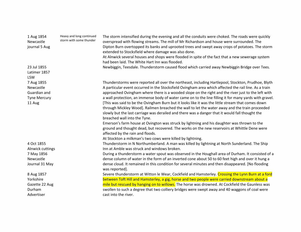
1 Aug 1854 Newcastle journal 5 Aug
Heavy and long continued storm with some thunder
The storm intensified during the evening and all the conduits were choked. The roads were quickly overspread with flowing streams. The mill of Mr Richardson and house were surrounded. The Dipton Burn overtopped its banks and uprooted trees and swept away crops of potatoes. The storm extended to Stocksfield where damage was also done. At Alnwick several houses and shops were flooded in spite of the fact that a new sewerage system had been laid. The White Hart Inn was flooded.
23 Jul 1855 Latimer 1857 LSW
Newbiggin, Teesdale. Thunderstorm caused flood which carried away Newbiggin Bridge over Tees.
7 Aug 1855 Newcastle Guardian and Tyne Mercury 11 Aug
Thunderstorms were reported all over the northeast, including Hartlepool, Stockton, Prudhoe, Blyth A particular event occurred in the Stocksfield Ovingham area which affected the rail line. As a train approached Ovingham where there is a wooded slope on the right and the river just to the left with a wall protection, an immense body of water came on to the line filling it for many yards with gravel. [This was said to be the Ovingham Burn but it looks like it was the little stream that comes down through Mickley Wood]. Railmen breached the wall to let the water away and the train proceeded slowly but the last carriage was derailed and there was a danger that it would fall thought the breached wall into the Tyne. Emerson’s farm house at Ovington was struck by lightning and his daughter was thrown to the ground and thought dead, but recovered. The works on the new reservoirs at Whittle Dene were affected by the rain and floods. At Stockton a milkman’s two cows were killed by lightning.
4 Oct 1855 Alnwick cuttings
Thunderstorm in N Northumberland. A man was killed by lightning at North Sunderland. The Ship Inn at Amble was struck and windows broken.
7 May 1856 Newcastle Journal 31 May
During a thunderstorm a water spout was observed in the Houghall area of Durham. It consisted of a dense column of water in the form of an inverted cone about 50 to 60 feet high and over it hung a dense cloud. It remained in this condition for several minutes and then disappeared. [No flooding was reported].
8 Aug 1857 Yorkshire Gazette 22 Aug Durham Advertiser
Severe thunderstorm at Witton le Wear, Cockfield and Hamsterley. Crossing the Lynn Burn at a ford between Toft Hill and Hamsterley, a gig, horse and two people were carried downstream about a mile but rescued by hanging on to willows. The horse was drowned. At Cockfield the Gaunless was swollen to such a degree that two colliery bridges were swept away and 40 waggons of coal were cast into the river.
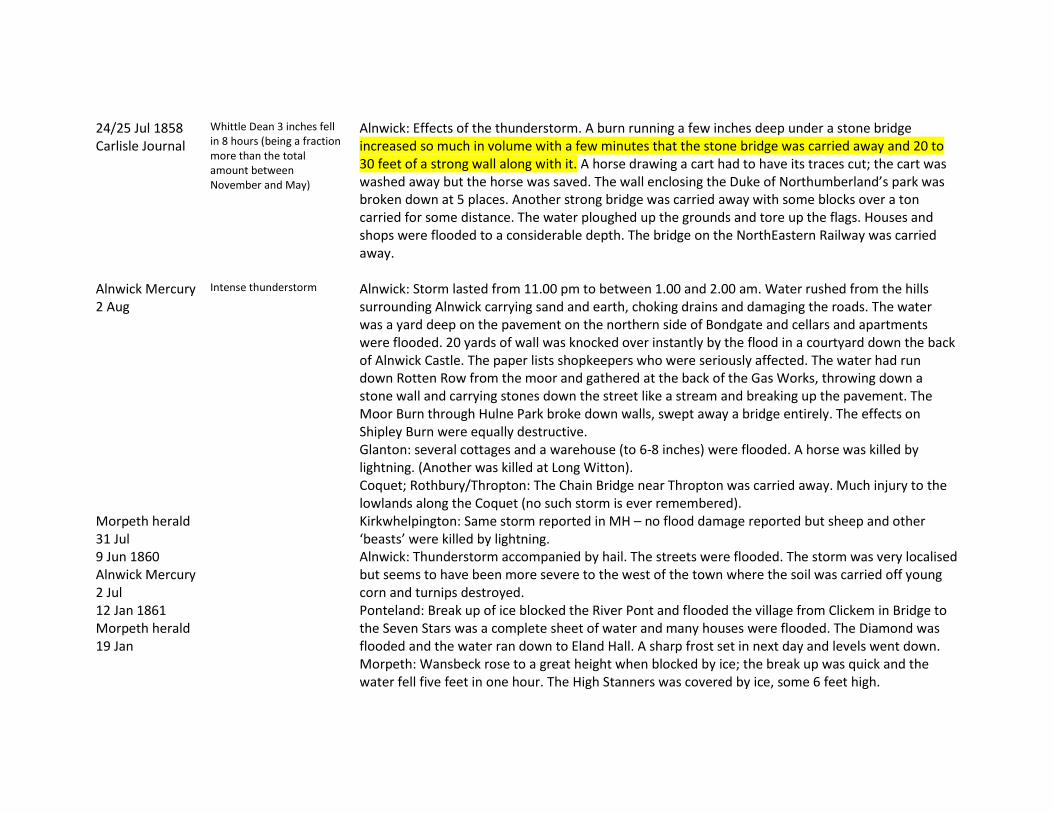
24/25 Jul 1858 Carlisle Journal Alnwick Mercury 2 Aug Morpeth herald 31 Jul
Whittle Dean 3 inches fell in 8 hours (being a fraction more than the total amount between November and May) Intense thunderstorm
Alnwick: Effects of the thunderstorm. A burn running a few inches deep under a stone bridge increased so much in volume with a few minutes that the stone bridge was carried away and 20 to 30 feet of a strong wall along with it. A horse drawing a cart had to have its traces cut; the cart was washed away but the horse was saved. The wall enclosing the Duke of Northumberland’s park was broken down at 5 places. Another strong bridge was carried away with some blocks over a ton carried for some distance. The water ploughed up the grounds and tore up the flags. Houses and shops were flooded to a considerable depth. The bridge on the NorthEastern Railway was carried away. Alnwick: Storm lasted from 11.00 pm to between 1.00 and 2.00 am. Water rushed from the hills surrounding Alnwick carrying sand and earth, choking drains and damaging the roads. The water was a yard deep on the pavement on the northern side of Bondgate and cellars and apartments were flooded. 20 yards of wall was knocked over instantly by the flood in a courtyard down the back of Alnwick Castle. The paper lists shopkeepers who were seriously affected. The water had run down Rotten Row from the moor and gathered at the back of the Gas Works, throwing down a stone wall and carrying stones down the street like a stream and breaking up the pavement. The Moor Burn through Hulne Park broke down walls, swept away a bridge entirely. The effects on Shipley Burn were equally destructive. Glanton: several cottages and a warehouse (to 6-8 inches) were flooded. A horse was killed by lightning. (Another was killed at Long Witton). Coquet; Rothbury/Thropton: The Chain Bridge near Thropton was carried away. Much injury to the lowlands along the Coquet (no such storm is ever remembered). Kirkwhelpington: Same storm reported in MH – no flood damage reported but sheep and other ‘beasts’ were killed by lightning.
9 Jun 1860 Alnwick Mercury 2 Jul
Alnwick: Thunderstorm accompanied by hail. The streets were flooded. The storm was very localised but seems to have been more severe to the west of the town where the soil was carried off young corn and turnips destroyed.
12 Jan 1861 Morpeth herald 19 Jan
Ponteland: Break up of ice blocked the River Pont and flooded the village from Clickem in Bridge to the Seven Stars was a complete sheet of water and many houses were flooded. The Diamond was flooded and the water ran down to Eland Hall. A sharp frost set in next day and levels went down. Morpeth: Wansbeck rose to a great height when blocked by ice; the break up was quick and the water fell five feet in one hour. The High Stanners was covered by ice, some 6 feet high.

23 Jun 1861 Morpeth herald 29 Jun Newcastle Guardian & Tyne Mercury 29 Jun
Darlington: Thunderstorm; two people were killed by lightning. [Severe floods were also reported at Birmingham]
7 Aug 1862 Alnwick Mercury 1 Sep
Alnwick: Thunderstorm; River Aln swollen to an unusual size submerging fields of corn and hay. A bridge at Bassington in Hulne Park was carried away. Near Alnmouth the water stood 3 feet deep in the hayfields. Mussels in the bed of the Aln were completely swept away.
1 Sep 1863 Dickenson LSW
Allendale. Waterspout at Woolly flooded the burn. Water entered flour mill and house at Bridge End. The rush of water filled the open space in front of the mill to a depth of several feet.
16 May 1864 Fordyce BR Carlisle Journal 20 May 1864 Morpeth Herald 21 May
No rainfall record at site or in the vicinity. Nafferton 0.35” in 1 hr 20 mins on 20 May N Shields reported a thunderstorm on 20 May with several houses struck and one life lost. Unusual heat from 15th to 20th.
Destructive Thunderstorm in the north from 10.00 am to just after midday. On Stocksfield Burn the water reached its peak at 2.00 pm. Stocksfield: A heavy fall of rain accompanied by a severe thunderstorm passed over the west on Monday and at Stocksfield some sad ravages have been effected by its fury. The village which is on the line of the Newcastle and Carlisle Railway and about 14 miles from the former town was completely flooded and a house at Ridley Mill was brought to the ground, the occupants making a narrow escape. The Turnpike bridge a structure of two arches was also swept from its foundations carrying fearful ruin and destruction with its fall. The loss of property has really been serious. Properties near the station were flooded. At Ridley Mill two houses were nearly carried away. So sudden was the rise of the flood that the occupant was unable to remove his furniture before the gable wall next to the stream was carried away. A little higher up is a two arch bridge leading to the Ministracres area was destroyed. The mill dam at Ridley Mill was completely destroyed. At Hexham the thunderstorm raged from noon to 4 pm but the storm was strongest to the south of the town and the road to Dipton Mill was impassable. At Stocksfield the burn was at its usual level at 12 oclock. Within an hour it gave indications of overflowing its banks. As it rose higher it brought with it trees tables and other items of furniture from Ridley Mill which had been washed down. Further up a small 2 arch bridge was washed down. The mill race had given way. The main Stocksfield Bridge then gave way.
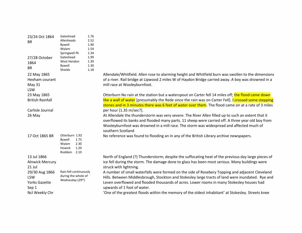
23/24 Oct 1864 BR
Gateshead 1.76 Allenheads 2.52 Bywell 1.90 Wylam 1.54 Springwell Pk 1.34
27/28 October 1864 BR
Gateshead 1.99 West Hendon 1.39 Bywell 1.30 Shields 1.18
22 May 1865 Hexham courant May 31 LSW
Allendale/Whitfield. Allen rose to alarming height and Whitfield burn was swollen to the dimensions of a river. Rail bridge at Lipwood 2 miles W of Haydon Bridge carried away. A boy was drowned in a mill race at Wooleyburnfoot.
23 May 1865 British Rainfall Carlisle Journal 26 May
Otterburn No rain at the station but a waterspout on Carter fell 14 miles off; the flood came down like a wall of water [presumably the Rede since the rain was on Carter Fell]. I crossed some stepping stones and in 3 minutes there was 6 feet of water over them. The flood came on at a rate of 3 miles per hour [1.35 m/sec?]. At Allendale the thunderstorm was very severe. The River Allen filled up to such an extent that it overflowed its banks and flooded many parts. 11 sheep were carried off. A three year old boy from Wooleyburnfoot was drowned in a mill race. The storm was widespread and affected much of southern Scotland
17 Oct 1865 BR Otterburn 1.92 Bywell 1.75 Wylam 2.30 Howick 1.20 Roddam 2.10
No reference was found to flooding an in any of the British Library archive newspapers.
13 Jul 1866 Alnwick Mercury 21 Jul
North of England (?) Thunderstorm; despite the suffocating heat of the previous day large pieces of ice fell during the storm. The damage done to glass has been most serious. Many buildings were struck with lightning.
29/30 Aug 1866 LSW Yorks Gazette Sep 1 Ncl Weekly Chr
Rain fell continuously during the whole of Wednesday (29th)
A number of small waterfalls were formed on the side of Rosebery Topping and adjacent Cleveland Hills. Between Middlesbrough, Stockton and Stokesley large tracts of land were inundated. Rye and Leven overflowed and flooded thousands of acres. Lower rooms in many Stokesley houses had upwards of 1 foot of water. ‘One of the greatest floods within the memory of the oldest inhabitant’ at Stokesley. Streets knee
Sep 1 deep. Road between Stokesley and the rail station was flooded and water entered omnibuses. Great damage was done to shipping and fishing boats in Whitby harbour due to the force of the flood coming down the Esk.
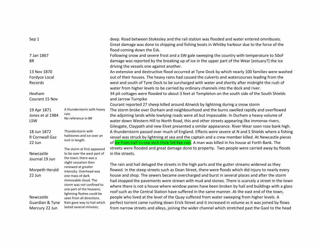
7 Jan 1867 BR
Following snow and severe frost and a SW gale sweeping the country with temperature to 50oF damage was reported by the breaking up of ice in the upper part of the Wear [estuary?] the ice driving the vessels one against another.
13 Nov 1870 Fordyce Local Records Hexham Courant 15 Nov
An extensive and destructive flood occurred at Tyne Dock by which nearly 100 families were washed out of their houses. The heavy rains had caused the culverts and watercourses leading from the west and south of Tyne Dock to be surcharged with water and shortly after midnight the rush of water from higher levels to be carried by ordinary channels into the dock and river. 34 pit cottages were flooded to about 3 feet at Templeton on the south side of the South Shields and Jarrow Turnpike Courant reported 27 sheep killed around Alnwick by lightning during a snow storm
19 Apr 1871 Jones et al 1984 LSW
A thunderstorm with heavy rain. No reference in BR
The storm broke over Durham and neighbourhood and the burns swelled rapidly and overflowed the adjoining lands while lowlying roads were all but impassable. In Durham a heavy volume of water down Western Hill to North Road, this and other streets appearing like immense rivers. Gilesgate, Claypath and new Elvet presented a similar appearance. River Wear soon rose bank high.
18 Jun 1872 R Cornwall Gaz 22 Jun Newcastle Journal 19 Jun Morpeth Herald 22 Jun Newcastle Guardian & Tyne Mercury 22 Jun
Thunderstorm with hailstones and ice over an inch in length. The storm at first appeared to be over the west part of the town; there was a slight cessation then renewed at greater intensity. Overhead was one mass of dark immovable cloud. The storm was not confined to one part of the heavens; lightning flashes could be seen from all directions. Rain gave way to hail which lasted several minutes;
A thunderstorm passed over much of England. Effects were severe at N and S Shields where a fishing vessel was struck by lightning at sea and the captain and a crew member killed. At Newcastle pieces of ice from half to one inch thick fell like rain. A man was killed in his house at Forth Bank. The streets were flooded and great damage done to property. Two people were carried away by floods in the streets. The rain and hail deluged the streets in the high parts and the gutter streams widened as they flowed. In the steep streets such as Dean Street, there were floods which did injury to nearly every house and shop. The sewers became overcharged and burst in several places and after the storm had stopped the pavements were strewn with mud and stones. There is scarcely a street in the town where there is not a house where window panes have been broken by hail and buildings with a glass roof such as the Central Station have suffered in the same manner. At the east end of the town, people who lived at the level of the Quay suffered from water sweeping from higher levels. A perfect torrent came rushing down Erick Street and it increased in volume as it was joined by flows from narrow streets and alleys, joining the wider channel which stretched past the Gaol to the head
some were half and some ¾ inch in diameter with small pieces ice intermingled. The storm lasted an hour and 20 minutes.
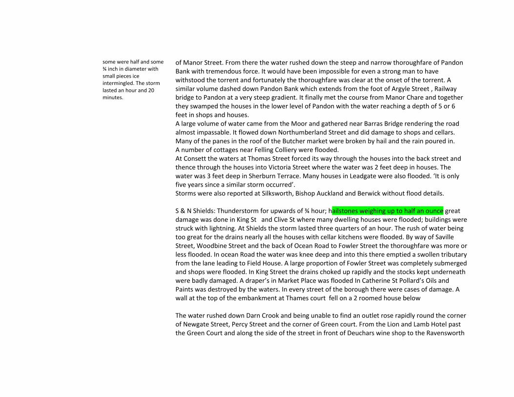
of Manor Street. From there the water rushed down the steep and narrow thoroughfare of Pandon Bank with tremendous force. It would have been impossible for even a strong man to have withstood the torrent and fortunately the thoroughfare was clear at the onset of the torrent. A similar volume dashed down Pandon Bank which extends from the foot of Argyle Street , Railway bridge to Pandon at a very steep gradient. It finally met the course from Manor Chare and together they swamped the houses in the lower level of Pandon with the water reaching a depth of 5 or 6 feet in shops and houses. A large volume of water came from the Moor and gathered near Barras Bridge rendering the road almost impassable. It flowed down Northumberland Street and did damage to shops and cellars. Many of the panes in the roof of the Butcher market were broken by hail and the rain poured in. A number of cottages near Felling Colliery were flooded. At Consett the waters at Thomas Street forced its way through the houses into the back street and thence through the houses into Victoria Street where the water was 2 feet deep in houses. The water was 3 feet deep in Sherburn Terrace. Many houses in Leadgate were also flooded. ‘It is only five years since a similar storm occurred’. Storms were also reported at Silksworth, Bishop Auckland and Berwick without flood details. S & N Shields: Thunderstorm for upwards of ¾ hour; hailstones weighing up to half an ounce great damage was done in King St and Clive St where many dwelling houses were flooded; buildings were struck with lightning. At Shields the storm lasted three quarters of an hour. The rush of water being too great for the drains nearly all the houses with cellar kitchens were flooded. By way of Saville Street, Woodbine Street and the back of Ocean Road to Fowler Street the thoroughfare was more or less flooded. In ocean Road the water was knee deep and into this there emptied a swollen tributary from the lane leading to Field House. A large proportion of Fowler Street was completely submerged and shops were flooded. In King Street the drains choked up rapidly and the stocks kept underneath were badly damaged. A draper’s in Market Place was flooded In Catherine St Pollard’s Oils and Paints was destroyed by the waters. In every street of the borough there were cases of damage. A wall at the top of the embankment at Thames court fell on a 2 roomed house below The water rushed down Darn Crook and being unable to find an outlet rose rapidly round the corner of Newgate Street, Percy Street and the corner of Green court. From the Lion and Lamb Hotel past the Green Court and along the side of the street in front of Deuchars wine shop to the Ravensworth

Inn, the water rose waist high, flooding the cellars and lower floors. Some women and children were taken out by the front windows. A man was struck by lightning in his house at Forth banks and killed. Much damage was done at Tuthill Stairs and the Side where premises were so flooded that goods could not be got in. At the Barracks 400 panes of glass are broken. Shopkeepers in Clayton Street have goods badly damaged – also on Silver Street. The Hospital for Children at Hanover Square was flooded to 5 feet depth bursting down doors. The water careered down Grey Street at great speed and it is said one drapery has had damages to £500. At Stockbridge shops and low lying dwelling were speedily flooded and the damage was increased by the bursting of a sewer which threw stones high in the air. At the Butcher market the water rushed in streams through many of the avenues , compelling the shopkeepers to abandon their stalls for safety. In Elswick Lane a number of private houses were considerably injured and windows were demolished at the Adrian’s Head. The bridge at New Bridge Street was inundated and at its peak the water stood three feet deep on the Bridge. Dobson’s Bazaar was flooded to a depth of several feet, front and back. Skylights in Clayton street were smashed in and glass was broken in Cross Street. Damage was done to St Thomas church. Comparison was made with the storm of 1839; still the storm was not to be compared with that of yesterday, neither with respect to the rapidity of the lightning nor the immense amount of rain and hail. A description follows of conditions in 1839, already noted above. At Gateshead much damage was done by lightning and floods. Shops were flooded in High Street. Two four year old boys were carried off their feet by the flood but rescued by a passing gentleman. Lambton’s Bank at the top of Bottle Bank was completely flooded and also the shops in Pipewellgate, especially one at the Bridge End, the water rushing over the counter. Part of the Brandling Junction Hotel was flooded to a depth of 5 feet 2 inches. Dr Ridley’s house on Hexham Road was struck by lightning and also a house in Romulus Terrace. Houses in Askew Road were all flooded and water in Pipewellgate rose to a depth of 5 feet. The water rushed with high speed down Sherriff Hill and on reaching the new Bank on High Street it was said to be 4 feet deep. On reaching the Half Moon Lane the turbulence of the water increased by the meeting of two waters. The Town Hall was in some parts flooded and also the County Police Station. At Jarrow Franks Chemical works was struck by lightning and serious damage caused. Old pit cottages at High Street, Dog Bank Row and other localities were completely flooded mainly affecting the poor Irish people who live there. Much damage occurred at South Shields. Three men were struck by lightning on a salmon boat and

one was killed instantly, the others seriously injured. A new built wall in Thames Street fell down. At Sunderland it was said that such a storm had not occurred for 10 years at least. Rain was accompanied by hailstones. Water ran down steep streets with great violence including Bodelwell Lane. The Ferry Hotel was invaded by water filling the cellar and covering the bar to a depth of one foot. Neighbouring shops were also flooded. In Silver Street water was ankle deep in houses whilst in Low Street it was sufficient to float furniture and cradles. A large crane at south Dock was struck by lightning and smashed to pieces. Barnard Castle – thunderstorm for one hour. Many houses were flooded at Middleton in Teesdale and scarcely a house in the neighbourhood has escaped having a number of window panes broken. Gardens were wrecked. Bishop Auckland: Several houses were struck by lightning and damaged. Princes Street had the appearance of a large river. Serious damage was done at the Theatre. Numerous cellars were flooded including Boyd’s Hotel to a depth of 5 feet. [Flooding was also reported in Bradford and Birmingham].
22 Jul 1872 Morpeth Herald 27 Jul
Widespread thunderstorms in Northumberland and Durham almost equal to the violence of the storm of the previous month.
Thunderstorms were reported in N Shields, Castle Eden (large ice up to 2 ounces), Consett (lightning injuries), Stockton (lightning injuries and houses struck), Powburn and Glanton (buildings struck and persons injured),Easington (ice 2 inches square), Seaham (houses flooded and windows broken by hail), Berwick (lighthouse struck) Only at Seaham was flooding mentioned.
10 Oct 1872 BR Alnwick Mercury 12 Oct
Rye Hill Newcastle 2.85” Town Moor 2.05” Low Lights N Shields, 2.05” Howick 2.00”. Brinkburn 2.04”
Brinkburn observer reported that the Coquet was higher than at any time since 9 Sep 1839. Elsewhere in England a SW gale was reported with thunder and hail on Dartmoor. Rain began evening of 10th and continued without intermission through the whole of 11th forenoon The streets of Alnwick are flooded.
23 Jul 1873 Morpeth Herald 26 Jul Northern Echo 24 Jul
Widespread thunderstorms Northumberland: many animals killed by lightning (4 cattle 17 sheep etc), buildings struck (Alnwick, Seahouses), Coldstream (monument struck and destroyed), Old Moneylaws(near Cornhill) a young woman killed whilst hoeing. Newcastle/Gateshead: Many streets were flooded (where not specified). A man was killed by lightning in a boat off Shields and a boy killed in bed in Wallsend. Thunderstorms occurred at Darlington (no flooding mentioned), at Shildon (houses in the lower parts of the town flooded) and at Bishop Auckland (no flooding mentioned).

9 Aug 1873 Newcastle Courant 15 Aug
A group of men were at Tees Force when a flood came down so unexpectedly as to surround a man on a small island there placing him in great danger. He was rescued with ropes. However one man on returning home to Middleton One Row on the lower river found it not at all swollen. But next morning men obtaining gravel from the river bed experienced at 10 am the flood which had been experienced the previous day at Tees Force at 2 pm. The flood arrived with such speed that they had barely time to save their shovels and picks. [for 80 miles of river in 20 hours the approx speed was 1.8 m/sec]. Thunderstorm at Bishop Auckland. Little flooding was reported but a man and animals were struck by lightning and injured.
25 Aug 1873 Morpeth Herald 30 Aug 1873 Newcastle Courant 29 Aug
Thunderstorms Morpeth: Storm continued for several hours overnight. Many of the houses on the lower end of Bridge Street were flooded. A thunderstorm was also reported in Newcastle but with no reports of flooding or serious lightning damage.
14 Sep 1873 Morpeth Herald 20 Sep
Thunderstorm Thunderstorm with numerous animals killed by lightning and a woman injured. Morpeth: the rain deluged streets and yards; in the lower part of the town cellars were flooded from 6 inches to 1 foot. Berwick: the streets were flooded and in some places deep ruts were made in the earth. The grounds of Castle vale were damaged. Ancroft: A burn was swollen into a mighty stream 8 feet deep and two people crossing narrowly escaped with their lives. Several pigs were washed away.
13 Jul 1874 Northern Echo 22 Jul
Thunderstorm Allendale – A man taking a cow for milking was struck by lightning and both were killed. Middleton one Row – A whirlwind was observed during a thunderstorm Thunderstorms affected Darlington, Stockton Middlesbrough and Redcar. At Darlington some streets were flooded to a depth of one or two feet.
28 Jul 1874 Northern Courant 31 Jul
Thunderstorm Rainfall at the Lit & Phil was 4.10 inches.
Newcastle was affected with several shops in the town damaged by lightning. Windows were broken in the Scotswood area by very large hailstones. At Stockbridge a number of houses were flooded and also at Cowgate where one house was so badly flooded that a door had to be broken open to let the water through an adjacent house into Blyth’s Nook. At Gateshead there was considerable flooding of low lying areas and some houses had to be abandoned.
4 Jan 1875 Newcastle harbour was completely blocked by ice. Fifteen or twenty ships mostly schooners were

Lancaster Gaz. 9 Jan
driven from their moorings and one steam tug was sunk. The river above the High Level bridge was one mass of moving ice.
2 Jul 1875 Berwick News and Gen. Advert. 6 Jul
Berwick: twenty minute storm; water rushed down streets flooding cellars and houses and shops. The water in Langtongate St was 2 feet deep and drains were blocked
11 Jul 1875 Lees (1876) LSW
No reference in BR Haydon Bridge. Lightning damage. Storm more violent at Grindon and Sewing Shields.
19-23 Jul 1875 Newcastle Journal 24 Jul
Thunderstorms in Newcastle – no mention of flooding but of effects of soil washed down steep banks and roads. Also two men were killed by lightning whilst using scythes.
10 Aug 1875 Morpeth Herald 14 Aug Shields Daily Gaz 11 Aug
Thunderstorms Storm lasted upwards of 2 hours at Shields but one hour at Newcastle
Newcastle: Severe storm lasting one hour. A man was badly injured by lightning. Low-lying houses and cellars were flooded. Rain ran down the streets like rivers and lower parts of the town were greatly flooded. Part of the old wall at Pandon was washed away. Said to be the worst storm in Newcastle since June 1872. House struck by lightning and damaged at Billy Mill near North Shields. Consett: the storm lasted two hours and the cellars in the lower part of town were flooded as well as many houses. A house was struck by lightning and badly damaged.
8 Sep 1875 Morpeth Herald 11 Sep Northern Echo 10 Sep
Thunderstorm with rain and hail Blyth: Many drains and sewers were choked up and several of the streets and cellars of houses were flooded N & S Shields were affected and streets and many cellars were flooded. The Golden fleece public house was flooded as was a chandlery warehouse at N Shields. Many houses were flooded at Corstorphine Town S Shields
20 Sep 1875 Shields Daily Gaz 21 Sep
Thunderstorm at Sunderland affecting a house near Bishopwearmouth church where a family narrowly escaped from drowning when water burst into their house. In the adjoining joiner’s shop the water was 3 to 4 feet deep.
13 Nov 1875 BR
Rain continued without a break for over 24 hours Middleton Tyas 2.03 Darlington, S. End 1.93 Dinsdale 2.30
A general heavy rain in areas extending from Devon to Lancs, Yorks Durham, Northumberland and N Wales. Amounts were generally in the range 1.5 to 2.25” Brinkburn observer noted ‘The flood of November was 18” higher than in July’[Coquet].

Shotley Hall 2.25 Gainford 1.98 Durham Observatory 2.73 Seaham Vic 2.08 Birtley 1.88 Eighton cottage 2.06
5 May 1876 Morpeth Herald 6 May
Long continued rain caused serious flooding of many rivers of Northumberland including the Tweed, Till, Aln, Coquet and Wansbeck. On the Aln the river was higher than for many years and the lower part of Bogg Mill was flooded and Flint Mill was surrounded looking like an island. Till also overflowed and flooded the Chatton area covering roads there and around Chillingham. The Coquet rose ‘with alarming rapidity’ and all lowlying areas were completely inundated. A bridge being erected about a mile west of Rothbury was entirely washed away. Gardens were submerged and fences washed away.
23 Jun 1876 Northern Echo 24 Jun
Thunderstorms Darlington- several houses in the lower part of the town being almost inundated with surface water. Wear valley railway – a bridge half a mile above Harperley Station was damage by lightning and flood and gave way. Middlesbrough – heavy rain and ‘several portions of the town were for some time flooded’. The Exchange was flooded. ‘This was the most terrible thunderstorm to visit Middlesbrough in the memory of man’. Bishop Auckland – the railway all around the station was flooded. Gateshead – houses were struck by lightning and damaged. Storms were also reported at Shields and Jarrow but no flooding was reported.
19 Aug 1876 Morpeth Herald 25 Aug
Thunder occurred during the long continued storm
Long continued rain affecting rivers from Till to Wansbeck including Coquet and upland tributaries and Belford Burn. Many houses were flooded at Belford and ‘the oldest inhabitant.....’ Morpeth: Low and high Stanners flooded etc
20 Dec 1876 BR Berwick Advertiser Morpeth Herald Dec 23
Storm of great severity for the whole of 20th with violent easterly wind. Snow at high levels. Rainfall centred on Rothbury Cragside 3.70” Whitton Tower 3.60”
Tweed swollen and low lying land flooded to a considerable depth Low lying end of Bank St (Berwick) flooded along with a store (Compan’s shop). It is some considerable time since the Coquet was flooded as on Wednesday. Rothbury Racecourse was quite covered with a strong current from bank to brae. Wansbeck also flooded at High Stanners. Flooding also on Wear and Skerne.
Otherwise less than 2”
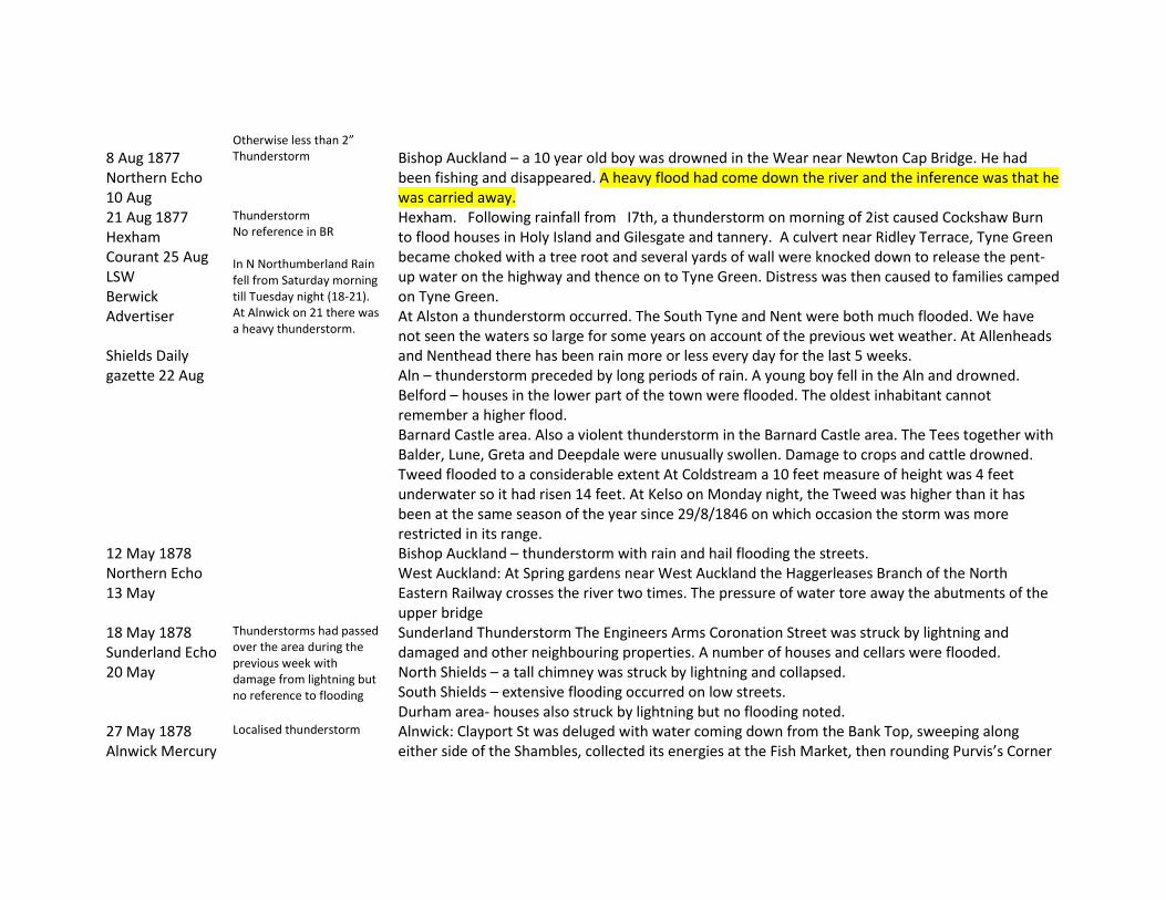
8 Aug 1877 Northern Echo 10 Aug
Thunderstorm Bishop Auckland – a 10 year old boy was drowned in the Wear near Newton Cap Bridge. He had been fishing and disappeared. A heavy flood had come down the river and the inference was that he was carried away.
21 Aug 1877 Hexham Courant 25 Aug LSW Berwick Advertiser Shields Daily gazette 22 Aug
Thunderstorm No reference in BR In N Northumberland Rain fell from Saturday morning till Tuesday night (18-21). At Alnwick on 21 there was a heavy thunderstorm.
Hexham. Following rainfall from I7th, a thunderstorm on morning of 2ist caused Cockshaw Burn to flood houses in Holy Island and Gilesgate and tannery. A culvert near Ridley Terrace, Tyne Green became choked with a tree root and several yards of wall were knocked down to release the pent-up water on the highway and thence on to Tyne Green. Distress was then caused to families camped on Tyne Green. At Alston a thunderstorm occurred. The South Tyne and Nent were both much flooded. We have not seen the waters so large for some years on account of the previous wet weather. At Allenheads and Nenthead there has been rain more or less every day for the last 5 weeks. Aln – thunderstorm preceded by long periods of rain. A young boy fell in the Aln and drowned. Belford – houses in the lower part of the town were flooded. The oldest inhabitant cannot remember a higher flood. Barnard Castle area. Also a violent thunderstorm in the Barnard Castle area. The Tees together with Balder, Lune, Greta and Deepdale were unusually swollen. Damage to crops and cattle drowned. Tweed flooded to a considerable extent At Coldstream a 10 feet measure of height was 4 feet underwater so it had risen 14 feet. At Kelso on Monday night, the Tweed was higher than it has been at the same season of the year since 29/8/1846 on which occasion the storm was more restricted in its range.
12 May 1878 Northern Echo 13 May
Bishop Auckland – thunderstorm with rain and hail flooding the streets. West Auckland: At Spring gardens near West Auckland the Haggerleases Branch of the North Eastern Railway crosses the river two times. The pressure of water tore away the abutments of the upper bridge
18 May 1878 Sunderland Echo 20 May
Thunderstorms had passed over the area during the previous week with damage from lightning but no reference to flooding
Sunderland Thunderstorm The Engineers Arms Coronation Street was struck by lightning and damaged and other neighbouring properties. A number of houses and cellars were flooded. North Shields – a tall chimney was struck by lightning and collapsed. South Shields – extensive flooding occurred on low streets. Durham area- houses also struck by lightning but no flooding noted.
27 May 1878 Alnwick Mercury
Localised thunderstorm Alnwick: Clayport St was deluged with water coming down from the Bank Top, sweeping along either side of the Shambles, collected its energies at the Fish Market, then rounding Purvis’s Corner

1 Jun Newcastle Courant 31 May
spread itself along houses and shops on the north side of Bondgate. Water from Fenkle St down Pottergate flowed into Narrowgate Street. Streets were almost impassable on foot. The storm seems to have been more severe on Alnwick Moor. A horse and other animals were killed by lightning. Rain also fell at Newcastle and Durham but no flooding was reported.
9/10 Jun 1879 Morpeth Herald 14 Jun Newcastle courant 13 Jun
Thunderstorm Newcastle: A house in Seaham St hit by lightning and badly damaged. N Shields: St Cuthberts Catholic School and Artillery Arms, both Albion Road, struck by lightning on 10th Morpeth: Rain accompanied by hail so that hothouse glass was broken at Mitford. The Wansbeck and various burns were much flooded. The storm did not extend far north. The storm was confined to the valley of the Font.
14/15 Sep 1880 BR Northern Echo 16 Sep Newcastle courant 17 Sep
Showers at intervals during the last 3 days with steady downpour Coldstream Pawston Ho 2.57” (highest since 1872 start) Hesleyside N. Tyne 1.65”
Wooler Water destroyed footbridges at Coldgate and Earle Mill. Till flooded road at Doddington Bridge. The Coquet was higher at Rothbury than at any time since the flood on the last day of 1878. Three quarters of Donkin’s Auction yard was covered by the flood. In the Wear Valley there was 2 days continuous heavy rain but thunderstorms were also reported. The Gaunless was much swollen with meadow land flooded between Shildon and South Church. The Wear was at its highest since 1875 with much corn and hay swept down river. A thunderstorm occurred at Ferryhill.
27/26 Oct 1880 BR Shields Daily Gaz. 29 Oct
Widespread prolonged rainfall 3.21” in 36 hours Unfortunately I haven’t noted where
Wear, Gaunless and Skerne and Leven flooded A hurricane accompanied by heavy rain passed over South Durham and low-lying streets in Darlington were flooded. Work was suspended at Pease’s Mills and if the water had risen a few inches higher it would have reached the gas works (as it did some 5 years ago). Wear and Gaunless overflowed at Bishop Auckland
5 Mar 1881 BR LSW
Snowmelt flood Darlington observer noted rapid thaw and Tees flood Widespread and severe flooding of Tyne Wear and Tees
5 Jul 1881 Morpeth Herald 9 Jul Alnwick Mercury
Thunderstorm Extraordinary heat culminated in an even more extraordinary storm sweeping all over England from Scilly Is to northeast.
Morpeth: lightning commenced between 22.00 and 23.00; the main rain occurred the following morning being heaviest between 04.00 and 5.00 but continuing for 6 hours. ’It must have been very heavy in the west for near midday the Wansbeck came down in a rolling flood, the wave being 3 or 4 feet deep. It rushed over the weir head at East Mill and caught a little boy named Dymond who had been plodging in the water and would have been carried away had not three men heard his cries

9 Jul Northern Echo 7 Jul
Temperature in London reached 93F
and came to his rescue. In less than an hour the river was full from bank to bank, the water reaching to the spring of the arches of the Stone Bridge. Much wreckage was brought down’. Brancepeth: A man was killed by lightning. Durham: thunderstorm accompanied by hail. A boy was killed by lightning near Bishop Auckland. Newcastle: Severe lightning but no flooding reported. The deluge of rain has flooded every river. Alston: A young man was killed by lightning The Tees at Darlington is little lower than the great flood on March 9. The Tees swollen to flood proportions tore down the valley with impetuous velocity damaging trees and riverside vegetation. Many sheep were killed by lightning – but there is little reference to flooding (NEcho) Weardale: Owing to the heavy rain which fell mainly in upper Weardale the river suddenly rose after 8 o’clock and by nine was a great flood which carried past Stanhope a footbridge. Thunderstorms were also reported at Durham, Consett, Ferryhill, Sedgefield, South Hetton, Sunderland, N & S Shields all referring to lightning damage to houses but little to flooding. Simonburn: Two wooden bridges were washed away (Castle Burn and Slaterfield Burn) and one dislodged (Prockter’s Burn)
18 Aug 1881 Alnwick cuttings Newcastle Library
Alnwick: Storm of wind rain and hail. The Aln rose greatly; a man was struck by lightning and injured
25 Aug 1881 BR
Observer noted ‘Flood on the Tees’
21 Sep 1881 BR
Belford Middleton Hall 2.66” ‘causing the greatest flood known’. Note that on 23 Sep the Tweed was in high flood.
5 Oct 1881 Alnwick Cuttings Ncl Library
Alnwick: hailstones of uncommon size fell.
6 Jul 1882 Carlisle Patriot 7 Jul
Heavy thunderstorms were reported in Yorkshire and Durham following hot weather. At Allendale a waterspout fell and destroyed a railway bridge and embankment.
22 Aug 1882 Bothalhaugh 2.80
BR Cramlington 2.50 N Shields 2.04 Morpeth Meldon 2.00 Wellburn Jesmond 1.95 N shields Low Lights 1.92 Tynemouth Pier 1.80
27 Sep 1882 Newcastle journal 28 Sep
Chester le Street: A severe thunderstorm flooded all the lower parts of the town. At Craghead west of Chester le Street a woman and her son were killed in their house. A storm was also reported at Ferryhill with heavy rain and hail.
20 May 1883 BR
Thunderstorms in Durham and South Northumberland. A man was killed at Medomsley, another at South Shields, houses struck at Gateshead, Walker and Gosforth. 7 sheep killed at Stocksfield.
9 Jun 1883 Shields Daily Gaz 11 Jun
Thunderstorm Stanhope: Hail fell with rain especially at Stanhope and Rookhope, with some roads being under 2 feet of water. The hailstones which were like large peas completely covered the ground and choked the sewer grates and the floods found their way into houses. The curacy was flooded to 18 inches and in several houses it swept though. A house was struck at Railway Terrace, cattle were killed, Stanhope Castle was flooded. Such a storm is not thought to have been equalled in Stanhope since July 5 1852 Storms were also reported at Bishop Auckland and at Stokesley where streets were flooded
30 Jun 1883 Northern Echo 4 Jul
Thunderstorms occurred over Darlington and between Teesdale and Weardale. No flooding was reported but animals were killed by lightning.
21 Jul 1883 Alnwick cuttings Ncl Library
A thunderstom at Alnwick brought rain and hail of unusual severity. Telegraph poles were struck and splintered. No flooding was noted.
6 Jul 1884 Shields Daily Gaz 7 Jul
Thunderstorms over the whole of England accompanied by heavy downpours and hail
Upper Tyne: Damage was done to the rail line to Alston. Coanwood Colliery was flooded and a pit pony was drowned. The water was so deep on the line west of Haltwhistle that trains had to pass slowly to avoid their fires being put out. Damage to bridges west of Haltwhistle due to the sudden flood water in the burns is reported. Cattle and sheep were killed mainly in North Tyne and a horse near Bellingham. A man was struck and injured. Storms were reported at Morpeth, Weardale, Jesmond with effects of lightning but no reference to flooding. At Durham the storm lasted more than one hour. In Flass Street the water was 2 feet deep and heavily charged with sand from the Red Hills above and having formed a lake at the junction of

Waddington Flass and Sutton Street it flooded cellars and basement apartments in Sutton Street. Similar streams ran down North Road, Claypath, Gilesgate, Elvet Bridge etc doing considerable damage.
10 Jul 1884 Yorkshire Gaz 14 Jul Shields Daily Gaz 14 Jul Newcastle courant 11 Jul
Very heavy rain fell at Stanhope, Wolsingham and Weardale. The result was a very sudden rising of the Wear to an alarming flood height. Stanhope Burn was a raging torrent and ran right through the Lead smelting Mills, putting out the fires, drowning the pots, one of which was under 5 feet of water. Two men were struck by lightning at Lane Head and knocked unconscious but recovered. A house was set alight. A miner was killed by lightning at Consett. Thunderstorms were also reported at Tynemouth, Middlesbrough and Darlington but without flooding. An old man was killed at West Kyo by lightning.
13 Jul 1884 Northern Echo 14 Jul Shields Daily Gaz 17 Jul
Thunderstorms Darlington: Heavy rain flooded some streets. A violent hailstorm lasted several minutes the hailstones being of abnormal size. In Clay Row a number of houses were flooded by the stoppage of the grates. Hail has done much damage to grain crops. There was also a severe storm at Middlesbrough. Alnwick: Thunderstorm and houses flooded
25 Jul 1884 Yorkshire Gaz 26 Jul
A thunderstorm over Sunderland killed one man who was listening to a telegraph message.
10 Aug 1884 Northern Echo 11 Aug Newcastle courant 15 aug
Thunderstorms Storms were reported at Stockton, Hartlepool, Spennymoor. Damage to houses and death of animals was reported but no flooding was reported. Storms were reported at Stocksfield (an ash tree next to St Peter’s Church was struck and splintered causing damage to church windows), Hexhamshire, Hexham, and Bellingham where large pieces of ice fell and damaged windows. (See also Rye and Swale)
4 Sep 1885 Shields Daily Gaz 5 Sep
Bishop Auckland – a short but very severe thunderstorm; sewers were overcharged and many streets flooded.
21 Jul 1886 Yorkshire Gaz 24 Jul Sunderland Daily Echo 22 Jul
A thunderstorm in Durham and neighbourhood killed one man at Shincliffe Village. No flooding was reported there but flooding was reported in Liverpool and Southport. Sunderland – thunderstorm for 30 minutes – no damage reported Newcastle – a house struck by lightning on Gloucester Road – no flooding reported
9 Jun 1888 Newcastle Courant 15 Jun
A man in a rowboat at Hexham was affected by a sudden rush of water from the North Tyne where there had been a thunderstorm. He was carried down the stream against one of the pillars of the bridge. An attempt to rescue him resulted in two men in the water but both were rescued downstream.
25 Jul 1888 Duncan Local Records Carlisle Patriot 3 Aug Carlisle journal 31 Jul Hartlepool Mail 26 Jul Shields Daily Gaz 26 Jul
Sunderland 2.17 Localised flooding of burns drains and cellars in Sunderland and Spennymoor. CP noted the occurrence of ‘waterspouts’ at 2 or 3 places, including Raven Beck near Kirkoswald (Eden) but also on Gildersdale Moor near Alston. On Thursday a waterspout burst on Gildersdale Moor. The bulk of the water appears to have fallen on the space of 1 square mile on the higher part of the moor. Fences recently erected were swept away and much ground silted by the flood. Gildersdale Burn was crossed a a dozen flights of floodgates; these almost without exception have been cleaned out. Many carcasses of sheep have been washed out about Slaggyford and other parts of the Tyne. Thunderstorms occurred over northeast Durham from S. shields to Castle Eden. Ballast was washed from the line at Ferryhill. Sunderland – cellars were flooded Seaham Harbour – tenements flooded in lower part of the town. A small park with rustic bridges was destroyed. Roads were flooded and a bridge destroyed. In Back South Terrace and Back North terrace dwellings below the level of the street were flooded, in one house reaching the level of the windowsill. Middlesbrough – 4 men struck by lightning but survived Sunderland – In many streets the water accumulated to a considerable depth. In streets built on a slope such as High St and Bodlewell Lane just opposite the Police Station it was a foot deep. A boy trying to cross the road was washed away but regained his footing . Serious damage was done at Roker Park. The bowling green was flooded to a great depth. Many cellars and cellar kitchens in the town were flooded. Several houses were struck by lightning. Rainfall was 2.17”, highest in the Health Dept since records began in 1874.
22 May 1889 Morpeth herald 25 May
Thunderstorm Seaham harbour: The water ran in the streets in large streams and flooded low-lying houses and shops. A coal train was derailed and 30 waggons fell on to the beach.
2 Jun 1889 Berwick News
thunderstorm Coldstream: very severe hailstorm. The hail was larger than marbles and some were 3 to 6 inches in circumference. Many of the hailstones were simply conical pieces of ice as large as a pigeon’s egg
and Gen Adv 4 Jun Newcastle Journal 4 Jun
whilst others were a congealed mass of smaller particles which had been frozen into a solid mass on their downward passage; some were round, some flat and some appeared as if clean cut through, showing veined markings from a central ball. Glass was broken and trees destroyed. Low-lying streets were flooded; at the Town Brae the water ran down from Duns Law like a river. The storm lasted half an hour and afterwards it became very cold. Thunderstorms also affected Cornhill and Norham Hexham: Sewers in Hollow Meadon and Hall Stile bank were so overcharged that the water dammed back into Dean Street and Chisholm Place flooding houses to a considerable depth. Houses were struck at Allendale.
16 Jul 1889 Newcastle Journal 17 Jul
Thunderstorm Thunderstorm affecting Newcastle but mainly Gateshead. Water coming down West Street and Mulgrave Terrace completely flooded the road near the Railway Station. Water down West Street and High Street flooded Half Moon Lane to a depth of over a foot.
28 Jun 1890 Shields Daily Gaz 30 Jun
Thunderstorm Chester le Street: Heavy rain with hail occurred. A field of turnips and potatoes near Birtley was almost completely washed out. Houses were flooded in Birtley. On the road leading to the railway station the flood carried all before it and pedestrians had to take to the field. A cow byre was struck at Lamesley and 2 cows killed.
12 Aug 1890 BR Ncl Evg Chronicle Hexham courant 16 Aug
Middlesbrough Albert Park 2.20 Durham Ushaw College 2.38 Houghton le Spring Myre Hall 2.75 Sunderland West Hendon Ho 2.54 Gateshead Eighton Coggate 2.30 Newcastle Clifton Road 2.53 Newcastle Portland Rd 2.50 Newcastle Lit & Phil 2.65 Newcastle Town Moor 2.60 N Shields Rosella Place 2.21
Heavy rainfall in Newcastle and neighbourhood. Considerable flooding from poor drainage. An extraordinary fall of rain occurred in Newcastle and district during last night. After a variable day yesterday, rain came down heavily about half past 10 and for a time continuing with more or less severity at night. About 6 am there was the renewal of the storm and the rain came down in torrents. The result was that in several parts of the town there were serious floods. The worst of these was around the foot of Brandling Park, Jesmond. The Town Moor recreation Ground was transformed into a lake. The pond overflowed its banks and flowed over the railings and through the gates. The roadway outside was feet deep and early wayfarers were ferried over in milkcarts, the water rushing along like a river. In Mistletoe Road the water was deep and the pathway along the side of the Constabulary Ground was covered deeply by the water. At Heaton too floods caused great inconvenience; some people were obliged to get out at their windows, the lower premises being impassable. Underground kitchens suffered especially. The rain ceased about 7 oclock. At the Ouseburn, Central and Westgate Police divisions, reports have been received about the heavy downfall but no serious damage of property is reported. In the lower reaches of the city by the Ouseburn and St Peters some streets contain pools of water and inhabitants have been kept busy

Sunderland Daily Echo 13 Aug
sweeping water from yards and passages. At S Shields heavy rain occurred during the night and a thunderstorm passed over between 4 and 5 am. The most serious accumulation of water was at Tyne Dock. The sewers that run in the low-lying locatlity of Temple Town and Slake Terrace failed to carry the water coming down the street , a wall fell down and water accumulated to 2 ½ feet. At N Shields a violent thunderstorm occurred at 4 am Washington: A girl was found drowned in a small brook that runs through Quarry Row Usworth Colliery At Hexham, the Alemouth Rd leading from Hall Stile bank to the Railway Station was several inches deep in water during a thunderstorm between 7 and 8 in the evening. One house in Westfield Terrace was flooded to 6 inches. Houses in Chisholm Place and Dean Street were flooded due to the inability of sewers to carry off surface water At Chester le St the River Cone (N end of C le S) suddenly rose to an extraordinary height carrying down with it all sorts of debris. So great was the pressure that 70 yards of a retaining wall which runs along the river by the Gasworks gave way. With some difficulty the water was turned down an old watercourse that used to be the Skinners Burn. Piggeries at that location were endangered but willing helpers rescued the pigs. Viaduct houses close by were all flooded. Communication between Chester le Street and Pelton was cut. In Boldon district there were reports of land flooded but none of houses. ‘Many years have elapsed since a sudden rainfall has been so severely felt. A girl was drowned in a brook that runs into Quarry Row Usworth Colliery. ’ Houses were flooded at Seaton Delaval. At Holy well a shower of frogs occurred!! Sunderland: 2.43” in 10 ½ hours the heaviest days rainfall since 1859. Houses were flooded in Portobello Lane, Garfield Street, Pallion, etc. The lakes at Mowbray Park and Roker Park were filled to the brim. A house was struck by lightning.
21 Sep 1891 LSW Alnwick Gaz
Rain began on Saturday night and continued incessantly until midday Monday
Upper Breamish in flood. Damaged county bridge at Powburn. Footbridge at Brandon failed. Bowmont Water said to be highest for 19 years (?). The upper reaches of the Tyne have been in a flooded state for some days.
30 Aug 1892 Morpeth Herald
Thunderstorm Alnwick: houses struck and damaged; North Sunderland, and Chatton also affected. Chillingham: a shepherd was killed on the moor by lightning.

3 Sep Sunderland Daily Echo 31 Aug
Sunderland: heavy rain but no flooding reported. Durham: Lightning damaged a building but no flooding reported. Houghton le Spring: lightning damage to houses
2 Sep 1892 Duncan Local Records
Heaviest rainfall for some time in Haltwhistle district. Houses near the river were flooded (where?) and many roads were impassable. At Bankfoot a number of houses were flooded. At Greenhead, the flood carried away stonework protecting the railway. At Hexham it was the largest flood at this time of year for some years.
3 Oct 1892 LSW
Lunedale. Flood moved a stone weighing more than 2 tons. Tyne much flooded due to heavy rainfall on 2nd with a thunderstorm
2 Jul 1893 LSW BR Dixon 1903 Ncl Evg Chronicle Newcastle Courant 8 Jul Sunderland Echo 3 Jul
Sunderland 0.75” in 20 mins. Widespread thunderstorms
Alwinton/Bloodybush Edge. Thunderstorm. Bucket survey rainfall of 15 inches at Low Bleakhope. Peat slides covering an area of 30 to 40 acres to Breamish, Usway burn and Alwin. Breamish (Ainsey Burn) rose 40 feet in 30 minutes. Two bridges at Ingram carried away. A description of the ‘waterspout’ on the Cheviots with map and photo is contained in this volume of British Rainfall. The text and the photo are scanned in separate files. Severe thunderstorm on Sunday afternoon. Many acres of Bloodybush Edge were scooped out by the force of the water on the watershed of the Breamish Usway and Alwin. These streams were gorged with an enormous volume of black peaty water which overflowed banks, doing irreparable damage to meadows and potato garths and washing away all the footbridges. Usway flood was scarcely as heavy as the Alwin or Breamish. The Coquet above Shillmoor never moved. Coquet from Alwinton to Rothbury for several weeks retained the trace of the flood as a black water mark. A severe thunderstorm visited Newcastle and has been experienced over most of the eastern portion of County Durham. The storm lasted 2 to 3 hours. Rain fell with hailstones the size of strawberries. From noon to about 6 pm thunder was heard almost continuously and at intervals rain and hail fell heavily. Damage reported was mainly from lightning, in Newcastle, Teams, Gateshead and at Chester le Street. Animals were killed by lightning in various parts of the northeast. Sunderland: Rain was accompanied by hail which threatened to break windows. In the Chester Road area the water accumulated under the railway bridge to a great depth. Water flowed past the end of High Barnes Terrace flooding a number of houses and driving the occupants out. There was also

flooding in the Durham Road near Burn Park Chapel where the rain filled a hollow stretching to the park gate. The water was deepest on Chester Road where it was up to a horse’s body. Houses were flooded in the Millfield district. Various sewers burst. Houses in the neighbourhood of Ayre’s Quay were flooded. No reference was found to the Cheviot flood in Newcastle papers.
8 Jul 1893 BR Newcastle Evg Chronicle Yorkshire Gaz 15 Jul Northern Echo 10 Jul Sunderland Daily Echo 10 Jul
Sunderland (West Hendon 1.46” Gateshead (Soutdene Tower) 1.92” Newcastle (Clifton Road) 2.44” Town Moor 1.67” Wellburn Jesmond 1.71”
Thunderstorms Thunderstorms of exceptional severity prevailed over northern, eastern and central portions of England. At Newcastle there was rain initially at 8 to 10 in the morning but then a thunderstorm broke over the city shortly after 4 pm and at its worst between 4.30 and 5. At 9 pm there was the return of thunder. Reports of damage are from effects of lightning and subsequent fires in Newcastle, Sunderland Whitley Bay and Hexham. No reports of flooding were found. Sunderland Daily Echo notes that in the storm of the previous week the total rainfall was only half an inch but the sudden storm choked the drains and caused flooding whereas in this event although the aggregate was greater it was spread over a longer period of time and the drains had the chance to carry it away. Nevertheless some low lying parts were again under water notably in the Millfield area where the water flooded houses. Several people were struck by lightning but none killed. A woman was killed by lightning at Slaley and a man the same day at Settlingstones near Hexham. Darlington: thunderstorm lasted upwards of 3 hours in the afternoon. Streets were flooded but limited damage was done. Middlesbrough: a Church was damaged by lightning Ferryhill: Houses were flooded in Forge Row and at Duncombe Terrace Washington and Houghton le Spring; lightning damage to properties
17 Feb 1894 BR
Staindrop Raby Castle 2.79”
Rainfall widespread with highest daily rainfall in the year at stations from Plymouth to the Wash and Bristol to Firth of Forth, but generally not extreme.
27 Jun 1895 BR Ncl Evg Chronicle
Scots Gap Rothley Lake 3.25” in 3.5 hours An extraordinary deluge of rain which was quite incessant for nearly 24 hours but also thunderstorms
Rainfall observer’s house flooded. Widespread thunderstorms occurred in eastern and Northern England. Two men were killed by lightning at Darlington Show. At Newcastle it was the hottest day of the summer. The weather remained fine but with distant thunder until a thunderstorm broke between 9 pm and 1 am, seriously affecting the Temperance Festival on the Town Moor. Reports of flooding in Newcastle were limited. ‘In several places the yards and cellars of houses were partially flooded. At Blaydon the rush of water was so great as to completely overrun the

Sunderland daily Echo 27 Jun Hartlepool Mail 27 Jun
Hartlepool Hurworth 2.67” Hart Res 2.20” Scots Gap (Rothley Lake) on 27th 3.25”
drains and in a few places the basements of houses were flooded’. In Chester le Street, however, houses and businesses were flooded At the Fighting Cocks the floors were covered with mud to a depth of a foot and the cellar was half full of storm water. Steele’s house and shop were flooded. Ash pits coalhouses etc on the edge of the river were washed bodily away into the river. On some sloping lands the entire crop has been swept away. Sunderland: The lightning was only equalled by the great storm of July 1893. However no casualties or damage were reported. At Blaydon a downpour of one hour rendered manholes and sinks incapable of carrying away the volume of water. Streets were converted into rivers. An Inn was wrecked at Pittington. Ryton; A fall of hailstones occurred; some were over 2 inches across and none were less than an inch in diameter. There was no storm at Wylam. Chester le Street: Very large hailstones also fell and the streets were flooded. Damage feared to the strawberry crop. Hartlepool: Little damage from lightning occurred but there was severe flooding. Many of the drains were choked with water and streets were rapidly flooded. The lower part of Murray St near the Cemetery was especially affected; many houses were flooded some coming over the windowsills of houses. At the corner of Young and Derwent Street near Lynnfield School there was a sheet of water 2 feet deep but houses were not flooded there being set at a higher level. Northgate Street was flooded to 2 feet in parts and similarly in Everard Street. The Tunnel from Church Street to Old Town was flooded to a depth of 1 to 2 feet. Traffic through the iron bridge at Throston was affected by flooding of the road and by gravel washed down from the embankments and from Clifton Street.
21 Jul 1895 BR Ncl Evg Chronicle Alnwick Gazette Jul 27
Sunderland Hendon House 1.00” in 41 mins Total 1.38”
Thunderstorm on Sunday afternoon at Sunderland, brief but very severe with frequent vivid lightning. Frequent floods occurred in the streets where the grates had become choked, especially in Chester Rd where some houses were flooded to a depth of 2 feet, rushing in the front door and out the back. Most damage was again caused by lightning. Cattle were killed by lightning at Seaton Carew. A thunderstorm occurred at Alnwick and low-lying basements and cellars were flooded.
25 Jul 1895 BR Daily Gaz Middlesbrough
Darlington Forcett Park 2.15” Witton le Wear 2.33”
The Wear was heavily flooded. The water stranded two boys on a sand island at Witton le Wear and they were rescued with difficulty. Houses in both Hartlepools were flooded to more than a foot in depth. Cellars of business premises were also flooded. The water under the railway bridge was a yard deep. Streets and houses were

29 Jul flooded in Sunderland. Houses were struck by lightning at S and N Shields, Roker and at Millfield where the water level in one house was up to the level of the bed (downstairs).
26/27 Jul 1895 Morpeth herald 3 Aug
Thunderstorm Blyth: the storm continued for more than one hour; in a short time after the storm began the sewers became choked and the streets between Market Place, Waterloo and the Station became lakes. Turner St, the main thoroughfare in Waterloo was flooded from end to end and several streets leading therefrom including Simpson St. The storm burst suddenly and pedestrian were trapped in doorways. Regent St and Cowpen Quay were also much affected. Bishop Auckland: A boy was drowned in the Gaunless Stanhope: A boy 8 years old was drowned in the Stanhope Burn The River Wear was in flood and At Black Boy and Eldon the water was several inches deep and serious loss and damage is being suffered by the cottagers. Darlington: Two horses killed by lightning and a house struck and badly damaged. New Shildon: Damage was done by floods in Simson Street, Alma road and Soho Street. Drainage was said to be defective.
4/5 Aug 1895 BR Newcastle Evg Chronicle
Coldstream (Pawston) 5th 1.90” heaviest daily total since Sep 14 1880 when 2.57” fell.
Between 3 and 4 pm a waterspout burst on the hills above Callaly Castle causing sudden flooding in the upper parts of the Coquet and Aln, tearing up some of the roadway and flooding much more. The extraordinary deluge of rain on Sunday and Monday has wrought great havoc in the Borders district. The River Tweed is heavily flooded. Berwick and Kelso line is impeded by flooding especially near Sprouston. At Earlston, part of the town was yesterday impassable.
10 Aug 1895 Hartlepool Mail 12 Aug
Thunderstorm Hartlepool: Streets were flooded Stockton: An enormous number of cellars and low lying properties were flooded. The Oxbridge area suffered greatly – the Oxbridge Land subway was flooded to 3 feet depth due to the blockage of the drains. Houses in Light Pipe Hall road in the immediate vicinity of the subway were flooded to a depth of 1 to 2 feet. Thornaby: cellars were flooded
5/6 Jun 1896 Northern Echo 8 Jun
Thunderstorms Bishop Auckland: Damage to buildings from lightning but limited rain occurred so little flooding. Barnard Castle: Rain with hail which has severely damaged fruit trees. Washington: 4 sheep killed by lightning Spennymoor: Thunderstorm with hailstones; the main street was flooded and goods exposed on the street for sale were carried away. Houses were flooded and residents took refuge upstairs. Thornaby: houses struck by lightning and cellars and low lying property flooded. Hartlepool: Rain accompanied by large hailstones flooded many of the streets.
5 Aug 1897 Shields Daily gaz 6 Aug
Thunderstorms Thunderstorms were reported at Blyth, Sunderland, Murton colliery, Chester le Street (streets flooded and manhole covers thrown off), Darlington, Weardale. Houses were struck by lightning but little flooding was reported.
20 Aug 1897 BR
Holwick Hall 2.37” in 24 hr Coldstream Pawston 2.13 Alnwick Castle 2.75
No reference was found to thunder or flooding in newspapers
6 Jun 1898 Sunderland Daily Echo 6 Jun
Sunderland: Thunderstorm at midday; very heavy rainfall for 10 minutes; drains were unable to take the rush and water was up to the pavements. In some low lying parts of the town water went into houses.
28 Jul 1898 Sunderland daily Echo 29 Jul Newcastle courant 29 Jul
Thunderstorm Chester le Street: Gentle rain fell during the morning and then a deluge set in which lasted 20 minutes. Sewers and drains were overcharged and many shops and houses in Front Street were flooded. Corn is badly laid. New Herrington: Numerous houses were flooded in Fenton Terrace New Herrington. In some houses it was 6 inches deep. Alnwick: Lightning killed a horse and injured a man. Morpeth: Roadways were flooded Thunderstorms were reported from Berwick to Redcar but no other flooding was mentioned
7 Sep 1898 LSW BR Alnwick Gazette Morpeth Herald Sep 10
The culmination of very hot weather. The storm was widespread through the Coquet, Wansbeck and Blyth catchments with damage from lightning but limited flooding of houses. Rainfall of 6.70 inches in 3 hours at Angerton. Note British Rainfall report
Angerton. Two other sites had greater than 4 inches. Damage to roads, excavated to 4 to 5 feet. 18 footbridges washed out. British Rainfall description of Angerton storm on this day contained in separate file. Very severe thunderstorm and very rapid rate of rise in Wansbeck. Some houses flooded in Low Stanners. The wooden temporary bridge, which replaced the stone bridge (at Sheepwash) when its southern arch gave way 5 years ago, gave way. ‘It is nearly 13 years since there was such a flood in the Wansbeck (Nov 1886?). The Alnwick Gazette reports severe storm and flooding at Morpeth, Weldon bridge, Rothbury, Amble Felton and West Thirston and at Berwick the lower part of the town had some premises flooded. Morpeth: Rain began about noon and continued with little break until 4 pm. At 3.45 pm the Wansbeck at Morpeth rose without warning. ‘It came with a strong head and increased volume so rapidly that it was in a few minutes rolling over the weirheads’. It continued to rise until 6.30 pm by which time it had spread over the High Stanners. It also overflowed the Low Stanners and at East

Mill. All the feeders also came down in high flood. Houses were struck and damaged by lightning. At Sheepwash the Wansbeck rose 8 or 9 feet in an incredibly short time and covered footpaths to 3 feet deep. At Morpeth the storm reached its height at 3.00 pm. Some houses were struck by lightning. A report from a man travelling between Weldon Bridge and Morpeth says the storm broke about 1.30. Blyth: Sewers were quickly choked and low-lying portions of the town at Cowpen and South Blyth were rapidly flooded. Turner St, Regent St and Bridge St were flooded affecting business premises on either side of the street. In some places the streets were flooded to a depth of 3 feet. The storm duration was only half an hour. Killingworth: Heavy rain accompanied by hail up to nearly an inch in diameter. Many houses in Burradon and West Moor were flooded. Cramlington: Four houses were flooded at East Cramlington. Large hailstones broke much glass in greenhouses. Hailstones were up to an inch in length. Berwick: Some houses in the lower part of the town were flooded. Belsay: Hailstones fell from an inch to 1 ½ inches in diameter and damaged rooflights and glasshouses. The How Burn overflowed to an unprecedented extent. At Angerton a horse was killed grazing in a field. Stamfordham: Hailstones made the green white. Nearly every house in the village had windows broken and the Masons Arms had 26 panes broken. At the outset of the storm the temperature was 72F but at the finish was only 60F.
17 Oct 1898 BR Alnwick Gazette Morpeth Herald
On Monday 17th the rain never ceased and was accompanied by a gale with much loss of shipping. Rothbury Cragside 3.25”
Very severe flooding in the Till, Coquet and Wansbeck with many properties flooded in Rothbury and Morpeth described in Land of Singing Waters. NJ says that it is 59 years since the Wansbeck was as high (1839) Although the main rainfall causing the flood appears to have been prolonged it was followed by a severe thunderstorm. At Middleton where, after 3 days rain a thunderstorm with exceptional severity broke over the district lasting from 6 to 10 pm. The road from the burn to Ox inn was running like a river in full flood. Barrels and jars were floating in the Ox Inn cellars. At a nearby farm the water came in by the back door and out the front. A new bridge at the Post Office was carried away. A slip occurred over the rail embankment over Todridge Burn near Middleton Station, the railway metals hanging 2 feet in the air from the ballast.
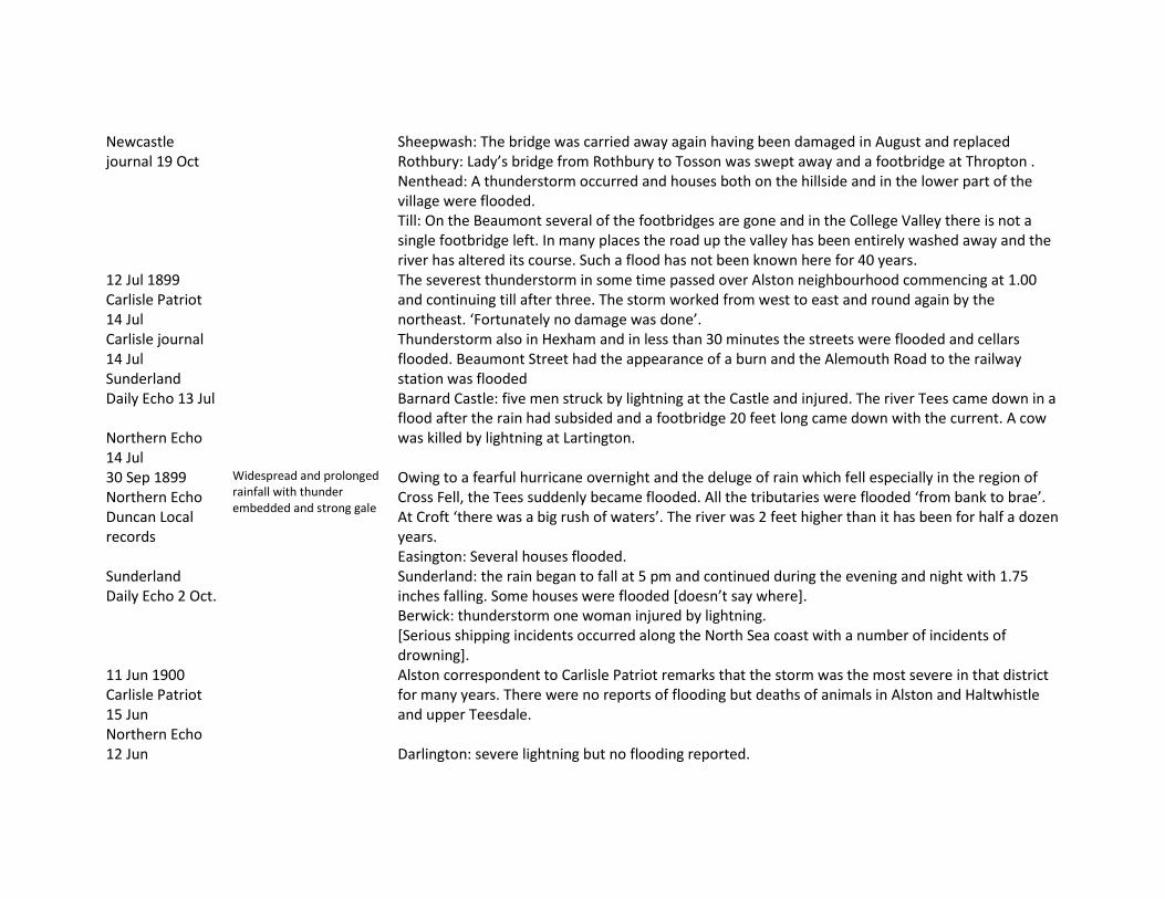
Newcastle journal 19 Oct
Sheepwash: The bridge was carried away again having been damaged in August and replaced Rothbury: Lady’s bridge from Rothbury to Tosson was swept away and a footbridge at Thropton . Nenthead: A thunderstorm occurred and houses both on the hillside and in the lower part of the village were flooded. Till: On the Beaumont several of the footbridges are gone and in the College Valley there is not a single footbridge left. In many places the road up the valley has been entirely washed away and the river has altered its course. Such a flood has not been known here for 40 years.
12 Jul 1899 Carlisle Patriot 14 Jul Carlisle journal 14 Jul Sunderland Daily Echo 13 Jul Northern Echo 14 Jul
The severest thunderstorm in some time passed over Alston neighbourhood commencing at 1.00 and continuing till after three. The storm worked from west to east and round again by the northeast. ‘Fortunately no damage was done’. Thunderstorm also in Hexham and in less than 30 minutes the streets were flooded and cellars flooded. Beaumont Street had the appearance of a burn and the Alemouth Road to the railway station was flooded Barnard Castle: five men struck by lightning at the Castle and injured. The river Tees came down in a flood after the rain had subsided and a footbridge 20 feet long came down with the current. A cow was killed by lightning at Lartington.
30 Sep 1899 Northern Echo Duncan Local records Sunderland Daily Echo 2 Oct.
Widespread and prolonged rainfall with thunder embedded and strong gale
Owing to a fearful hurricane overnight and the deluge of rain which fell especially in the region of Cross Fell, the Tees suddenly became flooded. All the tributaries were flooded ‘from bank to brae’. At Croft ‘there was a big rush of waters’. The river was 2 feet higher than it has been for half a dozen years. Easington: Several houses flooded. Sunderland: the rain began to fall at 5 pm and continued during the evening and night with 1.75 inches falling. Some houses were flooded [doesn’t say where]. Berwick: thunderstorm one woman injured by lightning. [Serious shipping incidents occurred along the North Sea coast with a number of incidents of drowning].
11 Jun 1900 Carlisle Patriot 15 Jun Northern Echo 12 Jun
Alston correspondent to Carlisle Patriot remarks that the storm was the most severe in that district for many years. There were no reports of flooding but deaths of animals in Alston and Haltwhistle and upper Teesdale. Darlington: severe lightning but no flooding reported.
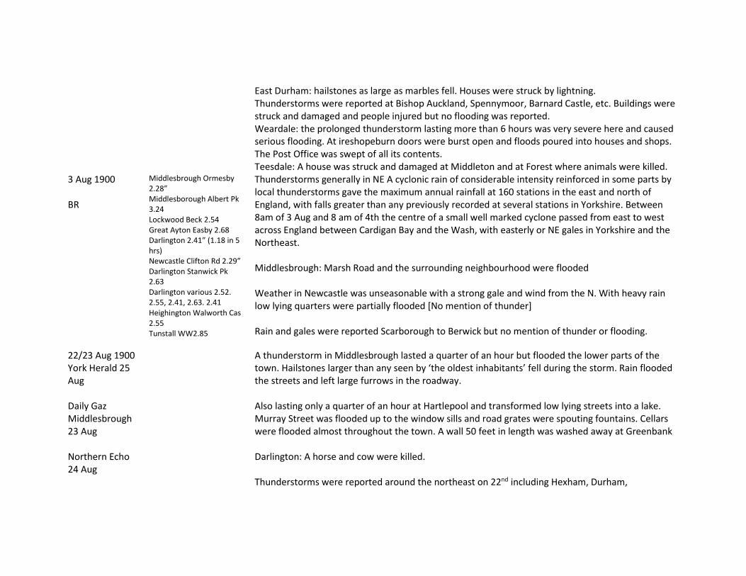
East Durham: hailstones as large as marbles fell. Houses were struck by lightning. Thunderstorms were reported at Bishop Auckland, Spennymoor, Barnard Castle, etc. Buildings were struck and damaged and people injured but no flooding was reported. Weardale: the prolonged thunderstorm lasting more than 6 hours was very severe here and caused serious flooding. At ireshopeburn doors were burst open and floods poured into houses and shops. The Post Office was swept of all its contents. Teesdale: A house was struck and damaged at Middleton and at Forest where animals were killed.
3 Aug 1900 BR
Middlesbrough Ormesby 2.28” Middlesborough Albert Pk 3.24 Lockwood Beck 2.54 Great Ayton Easby 2.68 Darlington 2.41” (1.18 in 5 hrs) Newcastle Clifton Rd 2.29” Darlington Stanwick Pk 2.63 Darlington various 2.52. 2.55, 2.41, 2.63. 2.41 Heighington Walworth Cas 2.55 Tunstall WW2.85
Thunderstorms generally in NE A cyclonic rain of considerable intensity reinforced in some parts by local thunderstorms gave the maximum annual rainfall at 160 stations in the east and north of England, with falls greater than any previously recorded at several stations in Yorkshire. Between 8am of 3 Aug and 8 am of 4th the centre of a small well marked cyclone passed from east to west across England between Cardigan Bay and the Wash, with easterly or NE gales in Yorkshire and the Northeast. Middlesbrough: Marsh Road and the surrounding neighbourhood were flooded Weather in Newcastle was unseasonable with a strong gale and wind from the N. With heavy rain low lying quarters were partially flooded [No mention of thunder] Rain and gales were reported Scarborough to Berwick but no mention of thunder or flooding.
22/23 Aug 1900 York Herald 25 Aug Daily Gaz Middlesbrough 23 Aug Northern Echo 24 Aug
A thunderstorm in Middlesbrough lasted a quarter of an hour but flooded the lower parts of the town. Hailstones larger than any seen by ‘the oldest inhabitants’ fell during the storm. Rain flooded the streets and left large furrows in the roadway. Also lasting only a quarter of an hour at Hartlepool and transformed low lying streets into a lake. Murray Street was flooded up to the window sills and road grates were spouting fountains. Cellars were flooded almost throughout the town. A wall 50 feet in length was washed away at Greenbank Darlington: A horse and cow were killed. Thunderstorms were reported around the northeast on 22nd including Hexham, Durham,
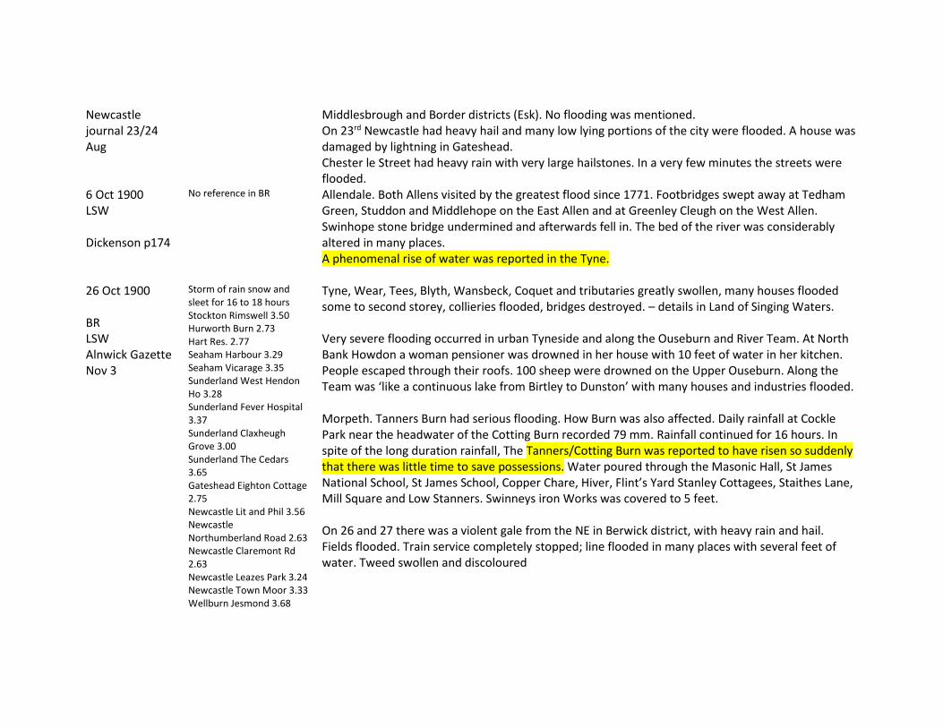
Newcastle journal 23/24 Aug
Middlesbrough and Border districts (Esk). No flooding was mentioned. On 23rd Newcastle had heavy hail and many low lying portions of the city were flooded. A house was damaged by lightning in Gateshead. Chester le Street had heavy rain with very large hailstones. In a very few minutes the streets were flooded.
6 Oct 1900 LSW Dickenson p174
No reference in BR Allendale. Both Allens visited by the greatest flood since 1771. Footbridges swept away at Tedham Green, Studdon and Middlehope on the East Allen and at Greenley Cleugh on the West Allen. Swinhope stone bridge undermined and afterwards fell in. The bed of the river was considerably altered in many places. A phenomenal rise of water was reported in the Tyne.
26 Oct 1900 BR LSW Alnwick Gazette Nov 3
Storm of rain snow and sleet for 16 to 18 hours Stockton Rimswell 3.50 Hurworth Burn 2.73 Hart Res. 2.77 Seaham Harbour 3.29 Seaham Vicarage 3.35 Sunderland West Hendon Ho 3.28 Sunderland Fever Hospital 3.37 Sunderland Claxheugh Grove 3.00 Sunderland The Cedars 3.65 Gateshead Eighton Cottage 2.75 Newcastle Lit and Phil 3.56 Newcastle Northumberland Road 2.63 Newcastle Claremont Rd 2.63 Newcastle Leazes Park 3.24 Newcastle Town Moor 3.33 Wellburn Jesmond 3.68
Tyne, Wear, Tees, Blyth, Wansbeck, Coquet and tributaries greatly swollen, many houses flooded some to second storey, collieries flooded, bridges destroyed. – details in Land of Singing Waters. Very severe flooding occurred in urban Tyneside and along the Ouseburn and River Team. At North Bank Howdon a woman pensioner was drowned in her house with 10 feet of water in her kitchen. People escaped through their roofs. 100 sheep were drowned on the Upper Ouseburn. Along the Team was ‘like a continuous lake from Birtley to Dunston’ with many houses and industries flooded. Morpeth. Tanners Burn had serious flooding. How Burn was also affected. Daily rainfall at Cockle Park near the headwater of the Cotting Burn recorded 79 mm. Rainfall continued for 16 hours. In spite of the long duration rainfall, The Tanners/Cotting Burn was reported to have risen so suddenly that there was little time to save possessions. Water poured through the Masonic Hall, St James National School, St James School, Copper Chare, Hiver, Flint’s Yard Stanley Cottagees, Staithes Lane, Mill Square and Low Stanners. Swinneys iron Works was covered to 5 feet. On 26 and 27 there was a violent gale from the NE in Berwick district, with heavy rain and hail. Fields flooded. Train service completely stopped; line flooded in many places with several feet of water. Tweed swollen and discoloured

N Shields PO 3.22 Tynemouth 3.36 N Shields Chirton Cottage 3.06 Scots Gap Rothley Crag 2.51 Angerton Hall 2.50 Morpeth Bothalhaugh 3.68 and 3.22 Cockle Park 3.07 Cragside 2.55 Alwinton Biddlestone Hall 2.60 Alnwick Castle 3.67 Howick hall 2.85 Longhirst 3.50
26 May 1901 BR Newcastle Chronicle 27 May Newcastle Jour 27 May
Morpeth Bothalhaugh 2.01 Morpeth Longhirst 2.20
Localised convection In Newcastle a heavy downpour of rain on Sunday 26th succeeded by a dull cloudy and threatening morning which affected Whitsuntide celebrations. Heavy rainfall throughout the day at Newcastle and Morpeth but no reference either to thunderstorms or flooding.
12 Jul 1901 BR Newcastle Chronicle Carlisle Journal 13 Aug Newcastle Jour 12 Jul
Sunderland West Hendon 2.50 Newton Hall 3.17 (11th and 12th Thunderstorms generally in northern England and south Scotland Temperature reached 83F in Newcastle and 91F in Hexham
No reference to rain in Newcastle. Thunderstorms were reported at Wooler, Chester le Street (very large hailstones), Morpeth and Alnwick (very brief), and at Consett where hailstones were as big as marbles and gave a ground cover of 1 to 2 inches and caused damage to gardens and trees. There was no mention of flooding at these locations. Alnwinton: Thunderstorm with very large hailstones and ice 1 ½ inches in diameter and sharp. Grouse were killed and some slates were smashed. In West Hartlepool water in some houses rose as high as the windowsills.
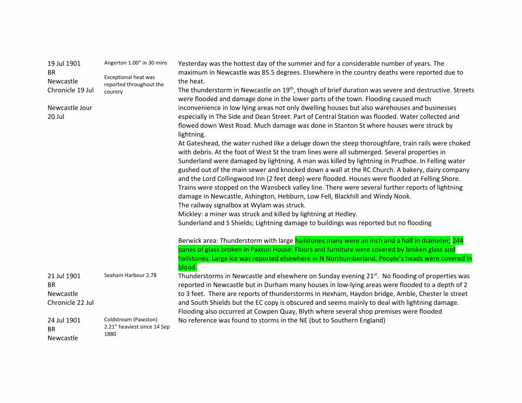
19 Jul 1901 BR Newcastle Chronicle 19 Jul Newcastle Jour 20 Jul
Angerton 1.00” in 30 mins Exceptional heat was reported throughout the country
Yesterday was the hottest day of the summer and for a considerable number of years. The maximum in Newcastle was 85.5 degrees. Elsewhere in the country deaths were reported due to the heat. The thunderstorm in Newcastle on 19th, though of brief duration was severe and destructive. Streets were flooded and damage done in the lower parts of the town. Flooding caused much inconvenience in low lying areas not only dwelling houses but also warehouses and businesses especially in The Side and Dean Street. Part of Central Station was flooded. Water collected and flowed down West Road. Much damage was done in Stanton St where houses were struck by lightning. At Gateshead, the water rushed like a deluge down the steep thoroughfare, train rails were choked with debris. At the foot of West St the tram lines were all submerged. Several properties in Sunderland were damaged by lightning. A man was killed by lightning in Prudhoe. In Felling water gushed out of the main sewer and knocked down a wall at the RC Church. A bakery, dairy company and the Lord Collingwood Inn (2 feet deep) were flooded. Houses were flooded at Felling Shore. Trains were stopped on the Wansbeck valley line. There were several further reports of lightning damage in Newcastle, Ashington, Hebburn, Low Fell, Blackhill and Windy Nook. The railway signalbox at Wylam was struck. Mickley: a miner was struck and killed by lightning at Hedley. Sunderland and S Shields; Lightning damage to buildings was reported but no flooding Berwick area: Thunderstorm with large hailstones many were an inch and a half in diameter; 244 panes of glass broken in Paxton House. Floors and furniture were covered by broken glass and hailstones. Large ice was reported elsewhere in N Northumberland. People’s heads were covered in blood.
21 Jul 1901 BR Newcastle Chronicle 22 Jul
Seaham Harbour 2.78 Thunderstorms in Newcastle and elsewhere on Sunday evening 21st. No flooding of properties was reported in Newcastle but in Durham many houses in low-lying areas were flooded to a depth of 2 to 3 feet. There are reports of thunderstorms in Hexham, Haydon bridge, Amble, Chester le street and South Shields but the EC copy is obscured and seems mainly to deal with lightning damage. Flooding also occurred at Cowpen Quay, Blyth where several shop premises were flooded
24 Jul 1901 BR Newcastle
Coldstream (Pawston) 2.21” heaviest since 14 Sep 1880
No reference was found to storms in the NE (but to Southern England)

Chronicle 27 Jul 1901 BR Newcastle Chronicle 27 Jul Newcastle journal 29 Jul
Darlington Stanwick Pk 2.20 Middlesbrough Ormesby 2.50 Middlesbrough Albert park 2.15 Stockton Ropner 2.85 Heighington Walworth Cas 2.52 West Hartlepool 2.52 Hart Reservoir 1.89
EC mentions a thunderstorm with lightning and rain but no notes of damage or flooding. Hartlepool: flooding of low lying areas was reported [copy unclear and details unreadable]
10 Aug 1901 Carlisle Journal 13 Aug Newcastle Journal 12 Aug
In common with thunderstorms at Carlisle and elsewhere in the Lake District, Alston experience a thunderstorm. ‘Such a downpour of rain has not been experienced for a very long time.’ The water ran down the street like a river and some houses were flooded. It got into Haldon’s shop and warehouses at the Townfoot. The road to the station was flooded and water ran through the stationmaster’s house. Widespread thunderstorms were reported mainly along the coast from Scarborough to Sunderland but also much further inland. Very large hailstones and clear ice were reported. Newcastle: ¾ hour storm with large hailstones and lightning damage to buildings Hartlepool: Many streets and houses suffered severely from flooding. Cellars in Church Street and store basements were flooded – also in Thornton Street and at Stainton. Durham: Several streets were converted to rivulets; drains were blocked and basements and cellars flooded. Chester le Street: Severe flooding of streets occurred, flooding basements. A large amount of glass was broken by hail. Wolsingham: Houses were flooded and glass broken by hail. Storms were also reported at S Shields, Hexham, Consett but no details of flooding or damage given.
11 Oct 1901 BR Newcastle Chronicle
Middlesbrough Ormesby 2.62”
No reference was found to storms or flooding in the NE in NEC.
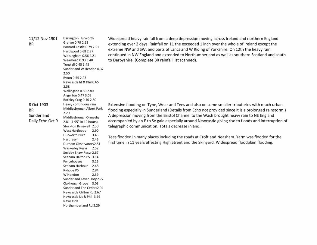
11/12 Nov 1901 BR
Darlington Hurworth Grange 0.79 2.53 Barnard Castle 0.79 2.51 Hartlepool 0.68 2.37 Wolsingham 0.56 4.21 Wearhead 0.93 3.40 Tunstall 0.45 3.45 Sunderland W Hendon 0.32 2.50 Ryton 0.55 2.93 Newcastle lit & Phil 0.65 2.58 Wallington 0.50 2.80 Angerton 0.47 3.09 Rothley Crag 0.40 2.80
Widespread heavy rainfall from a deep depression moving across Ireland and northern England extending over 2 days. Rainfall on 11 the exceeded 1 inch over the whole of Ireland except the extreme NW and SW, and parts of Lancs and W Riding of Yorkshire. On 12th the heavy rain continued in NW England and extended to Northumberland as well as southern Scotland and south to Derbyshire. (Complete BR rainfall list scanned).
8 Oct 1903 BR Sunderland Daily Echo Oct 9
Heavy continuous rain Middlesbrough Albert Park 2.29 Middlesbrough Ormesby 2.81 (1.95” in 12 hours) Stockton Rimswell 2.30 West Hartlepool 2.90 Hurworth Burn 3.45 Hart resvr 2.45 Durham Observatory2.51 Waskerley Resvr 2.52 Smiddy Shaw Resvr 2.67 Seaham Dalton PS 3.14 Fencehouses 3.25 Seaham Harbour 2.48 Ryhope PS 2.84 W Hendon 2.59 Sunderland Fever Hosp2.72 Claxheugh Grove 3.03 Sunderland The Cedars2.94 Newcastle Clifton Rd 2.67 Newcastle Lit & Phil 3.66 Newcastle Northumberland Rd 2.29
Extensive flooding on Tyne, Wear and Tees and also on some smaller tributaries with much urban flooding especially in Sunderland (Details from Echo not provided since it is a prolonged rainstorm.) A depression moving from the Bristol Channel to the Wash brought heavy rain to NE England accompanied by an E to Se gale especially around Newcastle giving rise to floods and interruption of telegraphic communication. Totals decrease inland. Tees flooded in many places including the roads at Croft and Neasham. Yarm was flooded for the first time in 11 years affecting High Street and the Skinyard. Widespread floodplain flooding.
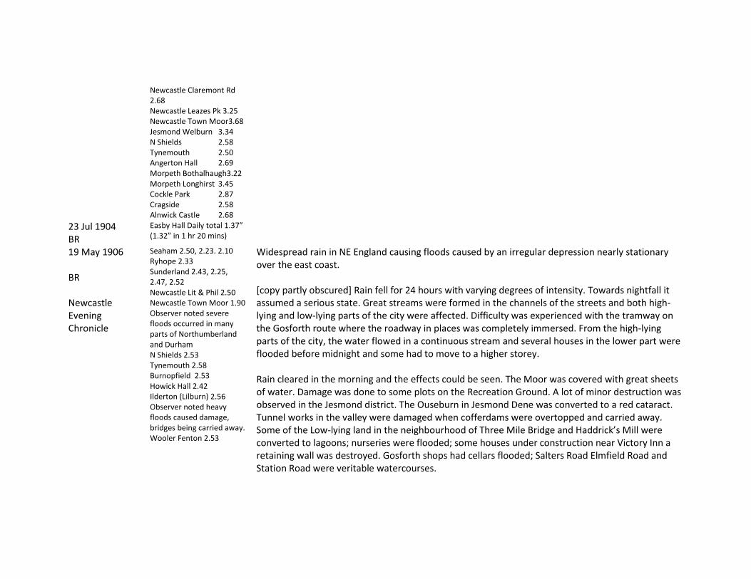
Newcastle Claremont Rd 2.68 Newcastle Leazes Pk 3.25 Newcastle Town Moor3.68 Jesmond Welburn 3.34 N Shields 2.58 Tynemouth 2.50 Angerton Hall 2.69 Morpeth Bothalhaugh3.22 Morpeth Longhirst 3.45 Cockle Park 2.87 Cragside 2.58 Alnwick Castle 2.68
23 Jul 1904 BR
Easby Hall Daily total 1.37” (1.32” in 1 hr 20 mins)
19 May 1906 BR Newcastle Evening Chronicle
Seaham 2.50, 2.23. 2.10 Ryhope 2.33 Sunderland 2.43, 2.25, 2.47, 2.52 Newcastle Lit & Phil 2.50 Newcastle Town Moor 1.90 Observer noted severe floods occurred in many parts of Northumberland and Durham N Shields 2.53 Tynemouth 2.58 Burnopfield 2.53 Howick Hall 2.42 Ilderton (Lilburn) 2.56 Observer noted heavy floods caused damage, bridges being carried away. Wooler Fenton 2.53
Widespread rain in NE England causing floods caused by an irregular depression nearly stationary over the east coast. [copy partly obscured] Rain fell for 24 hours with varying degrees of intensity. Towards nightfall it assumed a serious state. Great streams were formed in the channels of the streets and both high-lying and low-lying parts of the city were affected. Difficulty was experienced with the tramway on the Gosforth route where the roadway in places was completely immersed. From the high-lying parts of the city, the water flowed in a continuous stream and several houses in the lower part were flooded before midnight and some had to move to a higher storey. Rain cleared in the morning and the effects could be seen. The Moor was covered with great sheets of water. Damage was done to some plots on the Recreation Ground. A lot of minor destruction was observed in the Jesmond district. The Ouseburn in Jesmond Dene was converted to a red cataract. Tunnel works in the valley were damaged when cofferdams were overtopped and carried away. Some of the Low-lying land in the neighbourhood of Three Mile Bridge and Haddrick’s Mill were converted to lagoons; nurseries were flooded; some houses under construction near Victory Inn a retaining wall was destroyed. Gosforth shops had cellars flooded; Salters Road Elmfield Road and Station Road were veritable watercourses.

Descriptions (obscured) of flooding in Shields and Sunderland refer to road flooding and only limited effects on property. The River Derwent overflowed its banks; a wood footbridge at Milkwell Burn near Ebchester was washed away. In Washington area houses were flooded in Quarry row at Usworth, Nailers Shop Houses and West View, Washington, William Stree, South Moor. The Houghal Burn overflowed and two houses near East Tanfield crossing were flooded. In Cleveland fishermen’s cottages at Staithes and Runswick bay were flooded. In the north at Coldstream 2 ½ inches rain fell, the heaviest since September 1880.
31 Jul 1906 BR Newcastle chronicle 31 Jul 1906 Morpeth Herald 4 Aug Newcastle journal 1 Aug
Bamburgh 1.86 The storm followed a drought period of nearly 8 weeks and the rain was welcomed Thunderstorm – although widespread very little flooding was reported. Several storm pulses over a six hour period
A severe summer thunderstorm in several separate bursts was reported in Newcastle and many other places in the northeast. The NEC reports flooded streets but not of houses. At Berwick the rainfall ‘flooded houses and lands’. In Sunderland and also in Blaydon, Newburn and Lemington several houses in lower lying parts of the towns were flooded. A number of houses throughout the north were struck by lightning and damaged and animals were killed at Bellingham and in East Northumberland. Newcastle: Flooding of cellars and basements in the lower part of town reported and houses struck by lightning. Gateshead, Sunderland and N Shields: Streets were flooded but there was no reference to property. South Shields: Houses and shops were flooded. Ponteland: Said to be the worst storm for many years with low-lying places flooded Alnwick: Storm came and went over 6 hours. One older resident compared with a great storm in July 40 years ago [1858?].
18 Oct 1906 BR Newcastle Evening Chronicle Newcastle Journal Oct 20
Sunderland 1.63 Rothbury Cragside 2.70 Fencehouses 2.21
Rain snow and floods were reported in NEC but nothing relevant to extreme rainfall Easterly gale force winds were reported over the area from Newcastle to Berwick. There is no reference to thunder. However for both the Tyne (at Corbridge) and the Coquet (at Rothbury) ‘the river rose rapidly. At Rothbury it was at its highest since 9 Oct 1903. The only flooding reported was at Scremerston where the rail station was flooded. Otherwise there was wind damage to roofs and chimneys.
9 Jun 1907 LSW
Thunderstorms with torrential rain on Sunday
The storm affected the upper valleys of Coquet, Rede, N Tyne and their tributaries. It lasted from before 8.00 pm to midnight.
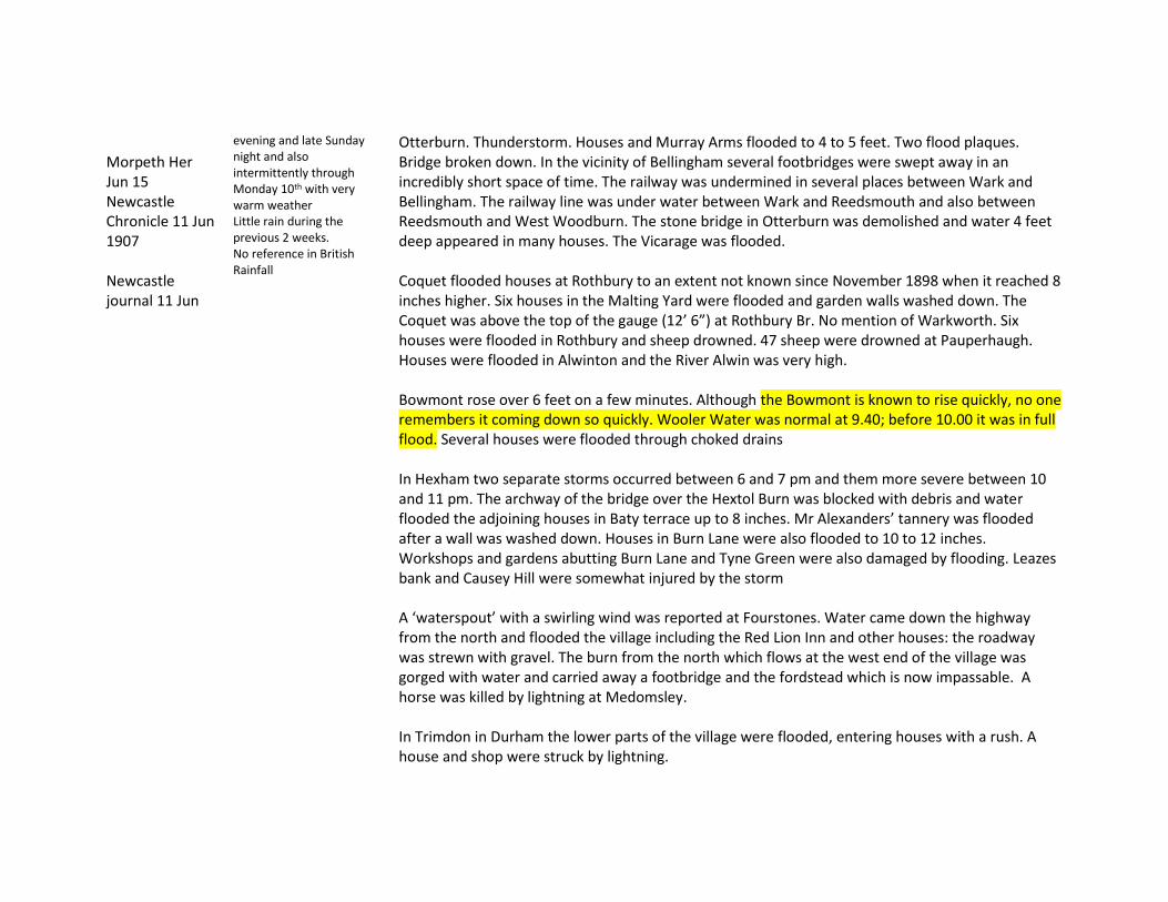
Morpeth Her Jun 15 Newcastle Chronicle 11 Jun 1907 Newcastle journal 11 Jun
evening and late Sunday night and also intermittently through Monday 10th with very warm weather Little rain during the previous 2 weeks. No reference in British Rainfall
Otterburn. Thunderstorm. Houses and Murray Arms flooded to 4 to 5 feet. Two flood plaques. Bridge broken down. In the vicinity of Bellingham several footbridges were swept away in an incredibly short space of time. The railway was undermined in several places between Wark and Bellingham. The railway line was under water between Wark and Reedsmouth and also between Reedsmouth and West Woodburn. The stone bridge in Otterburn was demolished and water 4 feet deep appeared in many houses. The Vicarage was flooded. Coquet flooded houses at Rothbury to an extent not known since November 1898 when it reached 8 inches higher. Six houses in the Malting Yard were flooded and garden walls washed down. The Coquet was above the top of the gauge (12’ 6”) at Rothbury Br. No mention of Warkworth. Six houses were flooded in Rothbury and sheep drowned. 47 sheep were drowned at Pauperhaugh. Houses were flooded in Alwinton and the River Alwin was very high. Bowmont rose over 6 feet on a few minutes. Although the Bowmont is known to rise quickly, no one remembers it coming down so quickly. Wooler Water was normal at 9.40; before 10.00 it was in full flood. Several houses were flooded through choked drains In Hexham two separate storms occurred between 6 and 7 pm and them more severe between 10 and 11 pm. The archway of the bridge over the Hextol Burn was blocked with debris and water flooded the adjoining houses in Baty terrace up to 8 inches. Mr Alexanders’ tannery was flooded after a wall was washed down. Houses in Burn Lane were also flooded to 10 to 12 inches. Workshops and gardens abutting Burn Lane and Tyne Green were also damaged by flooding. Leazes bank and Causey Hill were somewhat injured by the storm A ‘waterspout’ with a swirling wind was reported at Fourstones. Water came down the highway from the north and flooded the village including the Red Lion Inn and other houses: the roadway was strewn with gravel. The burn from the north which flows at the west end of the village was gorged with water and carried away a footbridge and the fordstead which is now impassable. A horse was killed by lightning at Medomsley. In Trimdon in Durham the lower parts of the village were flooded, entering houses with a rush. A house and shop were struck by lightning.

19 Oct 1908 BR Newcastle Jour 19-21 Oct
Alwinton Biddlestone Hall 2.20 Lilburn 1.74
Wet weather was experienced in Newcastle after a dry spell but no flooding was reported
16 Aug 1909 BR Newcastle Jour 17 Oct
Thunderstorm Darlington Hurworth Grange 2.25” in 4.75 hours After a spell of glorious sunshine
Newcastle rainfall was only 0.83” in 12 hours but choking of drains caused flooding of the Benton Road in the vicinity of Walkergate Railway Station to a depth of 3 to 4 feet and got into the cellars of a neighbouring inn. Houses were struck by lightning. Consett: Streets were flooded and lightning struck the church at Hamsterley. A horse was killed by lightning at Seaton Carew. A girl was struck and injured at Hartlepool. Middlesbrough: low-lying populous parts of the city were flooded with up to 1 foot of water in houses. Carts and cabs were used to ferry people over the floods.
20 Feb 1910 BR
Wearhead 2.54” greatest daily rainfall for 14 years accompanied by a gale.
Not further investigated
14 May 1911 LSW Hexham Herald May 20
Thunderstorm initially with large hailstones then rain No reference in British Rainfall
Bellingham. Storm on Hareshaw Burn caused serious flooding. £2000 damage. Burn rose 15 feet. Storm lasted 2 hours. Almost every building abutting the banks was wrecked. Two footbridges washed away. A boulder of ‘hard basic stone’ apparently about 3 tons in weight was carried for over a quarter of a mile downstream. Trees of immense size shot through the archway of the bridge near Bellingham Police Station. Two footbridges which spanned the burn between the Police Station and the Tyne were washed away – the stone pillars being entirely demolished as were stretches of retaining or boundary walls. Seven families were rendered homeless. On Sunday evening furniture was seen floating past Reedsmouth in the River Tyne from wrecked houses. Recovered furniture was removed to the Town Hall. Rede and Tyne above Bellingham nearly normal. Hareshaw Drift colliery flooded. Hareshaw Burn came down in flood with ‘remarkable suddenness and in a manner altogether alarming’. Yesterday’s downpour transformed it within a few minutes into a madly rushing devastating torrent which the channel could not contain. The arch of the bridge was completely filled and a hundred yards further upstream the sides of the stream have been walled up . Here the waters made the first breach; stone after stone was unloosened and carried away and the current scooped out the earth behind until yards of the wall were bodily carried away cutting across the adjoining road. Downstream from the bridge, the foundations of the houses were undermined. A
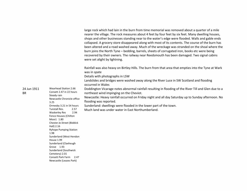
large rock which had lain in the burn from time memorial was removed about a quarter of a mile nearer the village. The rock measures about 4 feet by four feet by six feet. Many dwelling houses, shops and other businesses standing near to the water’s edge were flooded. Walls and gable ends collapsed. A grocery store disappeared along with most of its contents. The course of the burn has been altered and a road washed away. Much of the wreckage was stranded on the shoal where the burn joins the North Tyne – bedding, barrels, sheets of corrugated iron, books etc were being recovered by their owners. The railway near Reedsmouth has been damaged. Two signal cabins were set alight by lightning. Rainfall was also heavy on Birtley Hills. The burn from that area that empties into the Tyne at Wark was in spate Details with photographs in LSW Landslides and bridges were washed away along the River Luce in SW Scotland and flooding occurred in Wales
24 Jun 1911 BR
Wearhead Station 2.66 Consett 2.47 in 22 hours Steady rain Newcastle Chronicle office 3.25 Ormesby 3.21 in 54 hours Tunstall Res. 2.57 Waskerley Res 2.94 Fence Houses (Chilton Moor) 1.80 Chester.le.Street (Biddick Hall) 2.16 Ryhope Pumping Station 1.98 Sunderland (West Hendon House 1.99 Sunderland (Claxheugh Grove 1.93 Sunderland (Southwick Cemetery) 2.01 Consett Park Farm 2.47 Newcastle (Leazes Park)
Doddington Vicarage notes abnormal rainfall resulting in flooding of the River Till and Glen due to a northeast wind impinging on the Cheviot. Newcastle: Heavy rainfall occurred on Friday night and all day Saturday up to Sunday afternoon. No flooding was reported. Sunderland: dwellings were flooded in the lower part of the town. Much land was under water in East Northumberland.

2.16 (Wellburn, Jesmond) 2.02 North Shields (Dockwray Square) 2.57 Tynemouth (Percy Park) 2.15 Whittle Dean Filters (Newcastle W.W.) 2.06 Redewater (Catcleugh)2.79 Scots Gap (Wallington)2.57 Morpeth (Bothalhaugh) 2.49 (Cockle Park) 2.10 Acklington (Broomhill Colliery) 2.24 Rothbury (Cragside) 2.78 Flotterton 2.78 Felton (Newton.on.the.Moor)1.96 Alnwick Castle 2.60 Howick Hall 3.01 Beal (Barmoor Castle) 2.58 Glanton (Glanton Pike Gardens) 3.14 Ilderton (Lilburn Cottage) 2.91 Wooler (Doddington Vicarage) 3.05 Milfield (Flodden) 2.76 Berwick.on.Tweed (Church Street) 2.01
12 Jun 1912 LSW Newcastle Chronicle 11/12 Jun Carlisle journal
Thunderstorms Devil's Water. Ham Burn and Rowley Burn became raging torrents, the former carrying away all foot bridges. At Haydon Bridge adjoining streets and roads of the village were flooded. At Crow Hall 3 miles east of the village a burn overflowed and caused part of the Hexham to Bardon Mill road to be washed away. There was also damage to the railway in Allendale. At Haltwhistle rain and hail continued for 1 ½ hours. The streets were running with water. Westgate

11 Jun Newcastle journal 14-15 Jun
to Main Street was impassable with damage to houses and several badly flooded. The Coop Store boot department was flooded. Several of the business premises of the town had their water spouts completely blocked by hailstones which were of unusual size. The large culvert in Esica Road being unable to carry the rush of water from Comb Hill, the road was flooded, the water passing into the Main Street which for a while was impassable to pedestrians. Sheep were killed by lightning in the neighbourhood. One death by lightning near Haltwhistle was later reported. Middlesbrough: Three youths were killed by lightning and a fourth severely injured [Streets were flooded in Appleby to 6 to 9 inches and a soldier killed by lightning..
1 Jul 1912 BR Evening Chronicle Newcastle journal 1 Jul
Heddon on the Wall 0.20 in 15 minutes, then a lull of 7 minutes and again 0.97” in 35 mins. Hardly any rain occurred 3 miles to the east.
No reports of flooding or rain in Evening Chronicle Thunderstorm was reported over Newcastle. The rush of water down the steep thoroughfares was so strong as to wash away portions of the roadway and tons of stones and mud were deposited in the low-lying portions of the city and Gateshead. In Gateshead the flood washed great quantities of mud at the foot of West Street and blocked the tramlines. A house was struck by lightning and damaged. Several houses and shops were flooded at Dunston some to a depth of 18 inches. Flooding also occurred in Clavering Avenue and Collingwood Terrace.
12 Jul 1912 BR Evening Chronicle Newcastle journal 13 Jul
Hurworth Grange 1.59 in 2 hr 30 min Thunderstorm Darlington Cleveland Parade 1.08” in 1 hour Bamburgh 2.16 (1.75 in 1 hour) Water was running down the village street like a river (Thunderstorm)
No reports of flooding or rain in Evening Chronicle A thunderstorm with heavy rainfall occurred in Newcastle and streams were quickly running down the streets. At Blaydon Church Street was flooded to 1 foot depth and nealy all the business premises were flooded, the gullies being unable to deal with the abnormal fall. Darlington: Streets were flooded and much damage done. A horse was killed by lightning. Sunderland: No flooding reported but a chimney was struck by lightning and the house set afire.
16 Sep 1913 BR Newcastle Evening Chronicle
Newcastle Town Moor 2.65” in 1 hour 30 mins Gosforth Woodbine Rd 2.53 in 2 hr Total 3.28 Jesmond 2.18” occurred in the space of 2 to 3 hours and caused many streets to be flooded to a depth of 2 to 3 feet doing much damage to property in basements of houses.
Quote from Standard: Flooding occurred at numerous points in the city, miniature lakes two feet deep being formed in different thoroughfares. A torrent of water swept through St Thomas churchyard, burst through the floors and windows of Lovaine Hall and flooded it to a depth of 4 feet. Businessmen in order to gain their offices had to take off their shoes and stockings and wade knee deep to a higher level. The Royal Grammar School was flooded and the summer vacation has been extended for a week. See also Met Mag Oct 1913 p 165

Newcastle Journal 17 Sep
Newcastle Lit & Phil 2.85 Newcastle Northumberland Rd 2.00 Newcastle Leazes Park 2.43 Low Fell only 0.89 inches fell. Wylam only had 0.58”
Following a very dry summer, heavy rainfall occurred during the night followed by a severe thunderstorm at about 9 am until just before 11.00. In the streets every gutter was a miniature river, overflowing the sewer boxes. In Newcastle there are many places where water accumulates deeply and in all of these it was necessary to walk though lakes. The North road was under water, Jesmond Road was inundated and the Quayside was under water. At Gosforth Ash Street was flooded to over 2 feet and several shops were flooded. Between Gosforth and Barras Bridge people found their entry to the city cut off at the end of Sandyford Road by a miniature sea fed by water flowing down Eldon Street and Eldon Place. The rain choked the culvert at the bridge [which?] and it overflowed on to the road to a depth of more than 1 foot and then raced down the thoroughfare to South Gosforth. The Little Moor opposite Moorfield was almost entirely under water and there were large ponds on the intakes on the east side of the North Road. On the west side of the North Road from Gosforth to the Blue House, floods hid the roadway and footpath and public seats were awash. Inside the moor there were streams of water 40 feet wide. Barras Bridge was covered to a depth of over a foot and similarly Lovaine Place and Sandyford Road and horse drawn vehicles had difficulty in fording the rapids. Houses in Eldon Place were flooded and also the shops opposite the Post Office and St Thomas Church. Eldon Place was a roaring torrent; water of 3 feet or more was racing down the incline, swirling through house doors, it smashed the window of the registry office. Barras bridge was a lake 2 to 3 feet deep with stranded motor cars, their engines under water, lines of tramcars held up. Businesses at the top of Northumberland Street were damaged including Armstrong’s china shop, their showroom in the basement flooded to 4 ½ feet, also the shops at the corner of St Mary’s Place and the Geographical Institute. Louvaine Hall in St Mary’s Place was flooded to 4 or 5 feet with pianos floating about. At Jesmond the effects of the flooding were worst at Sandyford estate; the drains in the higher continuous parts of the city were unable to cope. The water found an outlet from Osbourne Road down the avenue leading to Jesmond Road and joined forces near Buston Terrace where water ran like a mill race several feet deep. At the foot of Shortridge Terrace and Churchill Gardens there was a space about 100 yards flooded to a depth of several feet. The shops and houses at the end of Jesmond Road were flooded in some cases to several feet. From the Old Cemetery to the Punch Bowl the lake was 2 feet deep; from Jesmond Road the water flowed down Sandyford Road and at

Messrs Deuchar’s brewery where there is a big fall in the road there was a deep lake. The water rushed into a church at the end of Grantham Road. Jesmond Station was flooded, the railway being completely blocked, the water nearly level with the platform. The main river, for such it was, seems to have started from West Jesmond, rushed across Osborne Road down the back of Queens Road and into Ritson’s Field and Jesmond Gardens. From there the water had gathered into the proportions of a lake, and rushing with terrible force in the direction of Shortridge Terrace. At the Royal Grammar School, the playground first flooded, then it burst into the lower class rooms to a depth of 2 feet. The entrance to the school from Eslington Terrace was washed down and part of the wall at the main entrance was also damaged. In the area of Newgate St bordered on the one side by the Co-op Arcade and on the other by the Blackett St junction, practically every shop was flooded. Carts along Newgate St and Percy St were axle deep in water. The waters from the high land in Barrack Road and Stanhope Street all converged upon the market and Gallowgate was impassable. An attempt was made to bridge the flood at the top of Gallowgate with sleepers but these were swept away. At Barrack Road flags were torn up just beyond Corporation St and one flag 3 feet square was carried 60 feet down the road. Not only was the open vegetable market flooded but the closed in market was also invaded. Messrs Wears and Watsons Chancellors Head hotel was seriously damaged; the 12 ft deep cellar filled and overflowed into the bar. The hotel cat was drowned! Toods Nook School on Barrack Road was flooded. In Eldon Place where girl workers were working in the basements, the water threatened to break the basement windows which it eventually did and they had to make their exit, the water soon attaining a height of 10 to 12 feet. Even at ground level the water was 2 to 3 feet deep. People were knocked off their feet. Dean St like a tributary of the Tyne, was joined by water flowing down the Side. In front of the Guildhall and the Sandhill the flood was 2 to 3 feet deep. AT Queen St nearly all rooms on ground level were flooded to 3 or 4 feet. Damage was done to merchandise on Rotterdam Wharf. The water flowed with great force from Manors Railway Station and rushed across the railway lines on the Quay, ran straight through the wharf into the river. Several houses in the lower part of Pilgrim Street were flooded.

Considerable damage was done at Walkergate. At the station at the junction of Shields Road and Benton Lane the water stopped motor vehicles. The cellars of the railway hotel were flooded to several feet and invaded the bar. The Colliery engine inn and the Woolsington were similarly affected. Householders in the lower districts of Byker had rooms flooded and in Chillingham Road, Heaton, the lower rooms of shops and houses was high enough to float furniture. In Gateshead water came down steep streets into the centre of town carrying much debris. It came down High Street and was augmented by flow from West Street. Several large businesses were flooded. Houses in Pipewellgate were flooded. In North Shields flooding took place at the Low Lights and water boiled up from manholes at the foot of Brew House bank. It flooded the fish curing and packing stands and created a large lake at the east end of Union Quay. The flood also affected Gateshead, Byker, Walker, Jarrow, Wallsend, Hebburn, Willington Quay and Walkergate with many houses, businesses, pubs etc flooded. The Chronicle provides descriptions not included here. Storms were also reported from Doncaster and South Lincolnshire. Newcastle journal describes the scene as an ‘unprecedented visitation’. [There is no reference back to 1872.]
9 Jun 1914 BR Newcastle journal 9-11 Jun
Darlington (Hummersknott) 1.78 in Piercebridge (Carlbury Hall) 1.94 Alston (Nenthead) 3.04
Heavy rainfall occurred widely in England during the day but thunder was not reported widely. Two patches of heavy rain occurred in the Northeast with the highest total at Nenthead. No reference to rainfall or flooding in Newcastle Journal
18 Jun 1914 BR Newcastle Chronicle 20 Jun
Weather was extremely hot and sultry thunderstorm pm in Newcastle
At Ruffside, a village on the edge of the Weardale Moors [between Edmondbyers and Blanchland], a cloudburst caused great damage to crops and roads. Hailstones of great size and snow also fell. Extremely violent and very local thunderstorms occurred in parts of the north of England and there were many lightning fatalities. The district most severely affected, lying some eight miles north of Stanhope, on the eastern edge of the Durham Moors, is, unfortunately, one in which no rain gauge

Newcastle Journal 18-20 Jun
is known to be in use, though, if the following account, which we [BR] quote in a somewhat abridged form from a local newspaper, may be accepted, it is doubtful whether any rain gauge could have remained to tell the tale. “The worst effects of the cloudburst were felt in the Ruffside district, near Blanchland. The first indication that the people received of the impending phenomenon was a roaring noise. Many of the residents imagined that the disturbance was caused by the engine of a heavy motor-car, but on looking out of their windows they saw the waterspout approaching at a terrific speed. In appearance it was a dense body of a conical shape, hanging downwards towards the earth, and uniting with a similar cloud from below, the two forming an unbroken column, which extended from the earth to the sky. Presently the cloud burst, and an immense volume of water was discharged on the land adjoining the farmstead occupied by Mr. Steele. The result was that the whole of the countryside was immediately flooded, while at the same time heavy rain fell in neighbouring districts. Hailstones and snow fell to a depth of two and three feet in places, while the position was rendered additionally uncomfortable by the intense heat which prevailed. Large stone walls were dashed to the ground, and their contents scattered over the fields. Many of the highways were flooded to a considerable depth. Upper Harp Bank, leading to Riding Mill, was seriously damaged, and in places entirely destroyed. The gardens at Ruffside Hall caught the full force of the flood, and to get the water away a large wall had to be removed. The waterspout covered the area from Hunter House Gate to West Ruffside, and the storm lasted three hours. Mr. T. Steele, of West Ruffside, had eight valuable sheep killed by the lightning, while several sheep and cattle were seen floating down the river." A severe thunderstorm was also reported from the Cleveland District in North Yorkshire, and at Lockwood Beck Reservoir, near Guisborough, 2.67 in. of rain was measured. A thunderstorm cloudburst occurred at Roughside between Edmondbyers and Blanchland, accompanied by hailstones of immense size. In a few moments the countryside was deluged to about 2 feet of water and hail. Walls were washed down, young crops were partially destroyed and the macadamised surface was removed from roads. The Cooperhaugh Road to Riding Mill has suffered seriously. Blanchland itself had little rain.

A man was killed by lightning at Parsons Byers Quarry (Frosterley). Hailstones the size of marbles fell at Lanchester for half an hour. Streets were flooded and National Schools inundated.
16 Jul 1914 BR Newcastle Journal 17 Jul
Hart Resvr 1.91 Ryhope PS 1.90 Washington 1.86 Newcastle 0.72” in 3 hours Distant thunder
A depression travelled up the North Sea then turned westward across central Scotland bringing heavy rain to the northeast coast, highest on the North York Moors. It also affected the Eden valley. In Newcastle houses and premises were flooded in low-lying parts; part of Benton Road was under water and 2 gardens were flooded in Walker.
14 Dec 1914 BR
The observer at Berwick noted ‘the heavy rainfall of the last 3 days has caused a great deal of floods. Tweed Till and Whitadder are all in high flood bringing down trees and branches. At Berwick considerable damage is done by the great volume of water overflowing the banks.
23 Jul 1915 BR Newcastle journal 23-25 Jul
Middlesbrough Dorman’s Museum 1.84” in 1 hr 15 mins
Observer noted ‘causing serious flooding’. No reference to flooding was found in Newcastle Journal.
24 Jun 1916 BR Ncl Jour 24-26 Jun
Humshaugh Wester Hall 1.88” in 1 hr
Nothing in Evening Chronicle or Newcastle Journal
13 Jun 1917 BR Ncl Jour. 13-15 Jun
Ushaw College 0.55” in 6 minutes
Nothing in Evening Chronicle or Newcastle Journal
13 Aug 1917 BR Evening Chronicle 14 Aug Ncl Jour 13-15 Aug
Rowlands Gill 2.72” Ryton 2.55” Thunderstorm in Newcastle continuing for several hours Chronicle RG 0.72”
Alnwick: Thunderstorm on 11th; a cow was killed by lightning; no reference to flooding was found. In the west end of Newcastle water rushed down from the high lying parts and Westmoreland Road and Scotswood were flooded in some places to a depth of 1 foot. The Newburn and Lemington train service was impeded by rubbish which silted up the rails. Several houses were flooded in the Ouseburn district. Several descriptions are given of property hit by lightning. However ‘the principal damage throughout the district was done by flooding’. Willington: two horses were killed by lightning and a house was badly damaged but there was no reference to flooding at Willington.
22 May 1918 BR Evening
Alnwick Castle 1.14” in 1 hour
Nothing in Evening Chronicle or Newcastle Journal
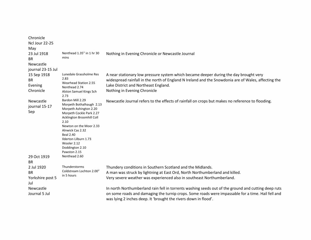
Chronicle Ncl Jour 22-25 May 23 Jul 1918 BR Newcastle journal 23-15 Jul
Nenthead 1.35” in 1 hr 30 mins
Nothing in Evening Chronicle or Newcastle Journal
15 Sep 1918 BR Evening Chronicle Newcastle journal 15-17 Sep
Lunedale Grassholme Res 2.83 Wearhead Station 2.55 Nenthead 2.74 Alston Samuel Kings Sch 2.73 Bardon Mill 2.29 Morpeth Bothalhaugh 2.13 Morpeth Ashington 2.20 Morpeth Cockle Park 2.27 Acklington Broomhill Coll 2.10 Newton on the Moor 2.33 Alnwick Cas 2.32 Beal 2.40 Ilderton Lilburn 1.73 Wooler 2.12 Doddington 2.10 Pawston 2.15
A near stationary low pressure system which became deeper during the day brought very widespread rainfall in the north of England N Ireland and the Snowdonia are of Wales, affecting the Lake District and Northeast England. Nothing in Evening Chronicle Newcastle Journal refers to the effects of rainfall on crops but makes no reference to flooding.
29 Oct 1919 BR
Nenthead 2.60
2 Jul 1920 BR Yorkshire post 5 Jul Newcastle Journal 5 Jul
Thunderstorms Coldstream Lochton 2.00” in 5 hours
Thundery conditions in Southern Scotland and the Midlands. A man was struck by lightning at East Ord, North Northumberland and killed. Very severe weather was experienced also in southeast Northumberland. In north Northumberland rain fell in torrents washing seeds out of the ground and cutting deep ruts on some roads and damaging the turnip crops. Some roads were impassable for a time. Hail fell and was lying 2 inches deep. It ‘brought the rivers down in flood’.

In SE Northumberland there was a gale with rain and in Darlington constant drizzling rain. 12 Jan 1921 BR
Darlington (North Villa) 1.47 Hurworth Burn Crookfoot 1.84 Hurworth Burn Resvr 1.80 Shotton PS 2.04 Bishop Auckland 1.88 Biddick hall Gdns 2.22 Sunderland Claxheugh Grange 1.88 Consett Park Farm 2.03 Chopwellwood 1.76 Newcastle Leazes Park 1.72
‘Serious flooding occurred in various parts of the north of England’ Not investigated in Newcastle journal.
20/21 Aug 1921 BR Evening Chronicle Ncl J. 20-22
Wooler 1.90 (20th) Ford Castle Gdns 1.97 (21st)
Nothing in Evening Chronicle or in Newcastle Journal
29 Aug 1921 BR Evening Chronicle 29/30 Aug Ncl J. 29-30 Aug
Lockwood Resvr 1.97 Newcastle Leazes Park 1.85 Newcastle Town Moor 1.93 Tynemouth Coastguard 1.73 Ashington 2.07
Chronicle reports 2.46” for the day and the wettest day for 10 years including an inch and a half in 12 hours. Although it mentions streams in spate there is no mention of flooding. Exceptional rainfall in Newcastle from early in the morning to late in the eventing with over 2 inches in 18 hours. NJ has no reference to flooding.
22 Oct 1921 BR Newcastle J 22-25 Oct
Alnwick Castle 2.30 Beal 2.04
NJ has no reference to flooding
26 Dec 1921 BR
Falstone Rectory 3.61
Not investigated in NJ
21 May 1922 BR Newcastle J. 21-
Stockton Ropner Park 1.03” in 30 mins
No reference to rain or flooding in Chronicle. This was a generally very warm day with temperatures reaching 88F in London and accompanied by
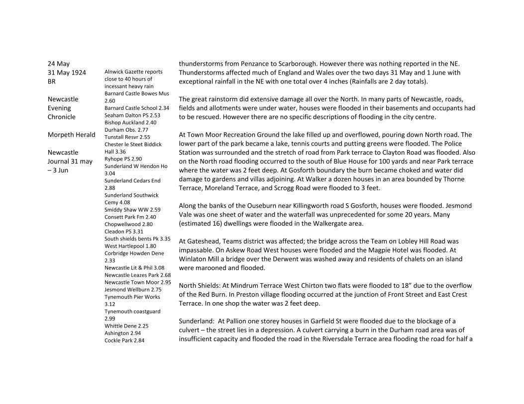
24 May thunderstorms from Penzance to Scarborough. However there was nothing reported in the NE. 31 May 1924 BR Newcastle Evening Chronicle Morpeth Herald Newcastle Journal 31 may – 3 Jun
Alnwick Gazette reports close to 40 hours of incessant heavy rain Barnard Castle Bowes Mus 2.60 Barnard Castle School 2.34 Seaham Dalton PS 2.53 Bishop Auckland 2.40 Durham Obs. 2.77 Tunstall Resvr 2.55 Chester le Steet Biddick Hall 3.36 Ryhope PS 2.90 Sunderland W Hendon Ho 3.04 Sunderland Cedars End 2.88 Sunderland Southwick Cemy 4.08 Smiddy Shaw WW 2.59 Consett Park Fm 2.40 Chopwellwood 2.80 Cleadon PS 3.31 South shields bents Pk 3.35 West Hartlepool 1.80 Corbridge Howden Dene 2.33 Newcastle Lit & Phil 3.08 Newcastle Leazes Park 2.68 Newcastle Town Moor 2.95 Jesmond Wellburn 2.75 Tynemouth Pier Works 3.12 Tynemouth coastguard 2.99 Whittle Dene 2.25 Ashington 2.94 Cockle Park 2.84
Thunderstorms affected much of England and Wales over the two days 31 May and 1 June with exceptional rainfall in the NE with one total over 4 inches (Rainfalls are 2 day totals). The great rainstorm did extensive damage all over the North. In many parts of Newcastle, roads, fields and allotments were under water, houses were flooded in their basements and occupants had to be rescued. However there are no specific descriptions of flooding in the city centre. At Town Moor Recreation Ground the lake filled up and overflowed, pouring down North road. The lower part of the park became a lake, tennis courts and putting greens were flooded. The Police Station was surrounded and the stretch of road from Park terrace to Clayton Road was flooded. Also on the North road flooding occurred to the south of Blue House for 100 yards and near Park terrace where the water was 2 feet deep. At Gosforth boundary the burn became choked and water did damage to gardens and villas adjoining. At Walker a dozen houses in an area bounded by Thorne Terrace, Moreland Terrace, and Scrogg Road were flooded to 3 feet. Along the banks of the Ouseburn near Killingworth road S Gosforth, houses were flooded. Jesmond Vale was one sheet of water and the waterfall was unprecedented for some 20 years. Many (estimated 16) dwellings were flooded in the Walkergate area. At Gateshead, Teams district was affected; the bridge across the Team on Lobley Hill Road was impassable. On Askew Road West houses were flooded and the Magpie Hotel was flooded. At Winlaton Mill a bridge over the Derwent was washed away and residents of chalets on an island were marooned and flooded. North Shields: At Mindrum Terrace West Chirton two flats were flooded to 18” due to the overflow of the Red Burn. In Preston village flooding occurred at the junction of Front Street and East Crest Terrace. In one shop the water was 2 feet deep. Sunderland: At Pallion one storey houses in Garfield St were flooded due to the blockage of a culvert – the street lies in a depression. A culvert carrying a burn in the Durham road area was of insufficient capacity and flooded the road in the Riversdale Terrace area flooding the road for half a
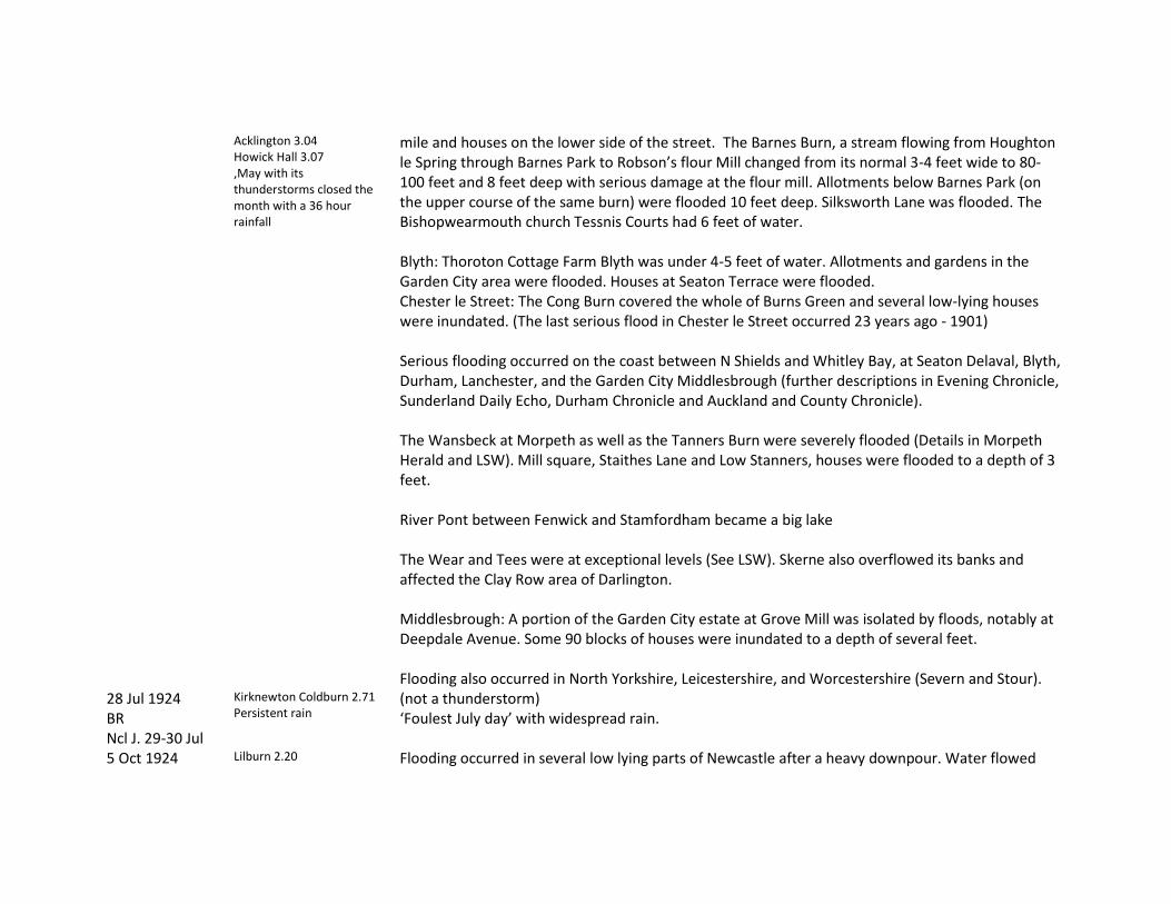
Acklington 3.04 Howick Hall 3.07 ‚May with its thunderstorms closed the month with a 36 hour rainfall
mile and houses on the lower side of the street. The Barnes Burn, a stream flowing from Houghton le Spring through Barnes Park to Robson’s flour Mill changed from its normal 3-4 feet wide to 80-100 feet and 8 feet deep with serious damage at the flour mill. Allotments below Barnes Park (on the upper course of the same burn) were flooded 10 feet deep. Silksworth Lane was flooded. The Bishopwearmouth church Tessnis Courts had 6 feet of water. Blyth: Thoroton Cottage Farm Blyth was under 4-5 feet of water. Allotments and gardens in the Garden City area were flooded. Houses at Seaton Terrace were flooded. Chester le Street: The Cong Burn covered the whole of Burns Green and several low-lying houses were inundated. (The last serious flood in Chester le Street occurred 23 years ago - 1901) Serious flooding occurred on the coast between N Shields and Whitley Bay, at Seaton Delaval, Blyth, Durham, Lanchester, and the Garden City Middlesbrough (further descriptions in Evening Chronicle, Sunderland Daily Echo, Durham Chronicle and Auckland and County Chronicle). The Wansbeck at Morpeth as well as the Tanners Burn were severely flooded (Details in Morpeth Herald and LSW). Mill square, Staithes Lane and Low Stanners, houses were flooded to a depth of 3 feet. River Pont between Fenwick and Stamfordham became a big lake The Wear and Tees were at exceptional levels (See LSW). Skerne also overflowed its banks and affected the Clay Row area of Darlington. Middlesbrough: A portion of the Garden City estate at Grove Mill was isolated by floods, notably at Deepdale Avenue. Some 90 blocks of houses were inundated to a depth of several feet. Flooding also occurred in North Yorkshire, Leicestershire, and Worcestershire (Severn and Stour).
28 Jul 1924 BR Ncl J. 29-30 Jul
Kirknewton Coldburn 2.71 Persistent rain
(not a thunderstorm) ‘Foulest July day’ with widespread rain.
5 Oct 1924 Lilburn 2.20 Flooding occurred in several low lying parts of Newcastle after a heavy downpour. Water flowed

BR NCL J 6-7 Oct
Doddington Vic 2.25 Kirknewton Coldburn 3.09
down the North Road with the greatest depth at Blue house and Park terrace where the roadway and tramlines were completely submerged. Flooding also occurred at Delaval, South Benwell. There was no reference to thunder and only limited flooding of property.
30 Dec 1924 LSW
Remarkable as this was a December event but would seem to qualify as a ‘wall of water’
River Tees rose 12 feet in 45 minutes. Women workers had to be rescued from Croft Mill and 68 sheep were drowned on the haugh land in the same locality.
23 Aug 1925 BR Newcastle Evening Chronicle Newcastle Journal 23-25 Aug
Darlington North Villa 0.80” in 20 mins Ryton Balgonie Ho 2.83 Large hailstones fell at Whickham Lightning struck and damaged two houses at Benwell
A terrific storm of rain and hail accompanied by thunder and lightning affected the Tyne valley. The storm continued from 11.00 intermittently till 15.30. The storm was isolated to an area along the river in Scotswood, Lemington, Ryton, and Blaydon; districts on the north and east of the city go off scot free. In Scotswood buses were stuck fast in the debris carried by rushing torrents and children bathed in the roadway. (‘This is the fourth occasion when the Scotswood Road area has suffered similarly during the last few years’). The main descriptions are of lightning damage but also ‘the extent of the damage caused by flooding was enormous. Lower rooms, basements and cellars were inundated with water’. The low lying section of the Scotswood Road from Atkinson Road to Scotswood itself felt the worst effects. Here, roads lead up to Benwell and down each poured rivers of water carrying tons of gravel which was deposited in the main road causing the road to be closed. In Low Lemington houses in Cross Row were flooded waist deep. Front Street Bell’s Close also suffered including Watson’s butcher shop. Many households in Blaydon in Robinson St, John St, George St, Edward St, Railway St, St Cuthbert’ Sq and businesses in Church St were affected with furniture floating about in their rooms. St Joseph’s RC church was partly flooded whilst a service was in progress and there was a big accumulation near Blaydon Cemetery which held up traffic. The main Hexham highway near Stella Staith was impassable. Several houses in Ryton at Towneley Terrace Barmoor were flooded and damage done to household effects. At Crawcrook most seriously affected was in the vicinity of Mitchell St. Blaydon: worst rainstorm for many years with many houses and business premises flooded. The heaviest rain lasted 45 minutes and manhole covers were displaced and water rushed down Blaydon bank into Church Street flooding there and generally in the lower part of town. Whickham; Three houses and the Post Office were flooded. Flooding also occurred at Swalwell. South Shields: Rain lasted several hours
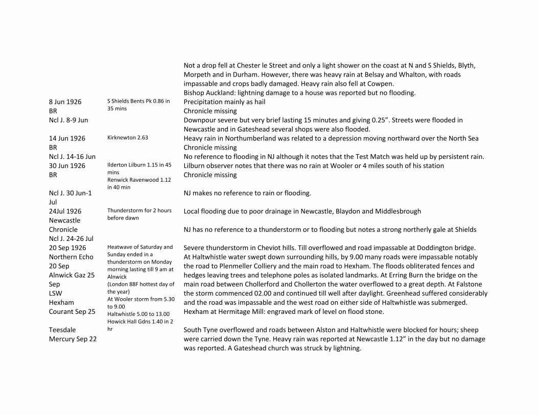
Not a drop fell at Chester le Street and only a light shower on the coast at N and S Shields, Blyth, Morpeth and in Durham. However, there was heavy rain at Belsay and Whalton, with roads impassable and crops badly damaged. Heavy rain also fell at Cowpen. Bishop Auckland: lightning damage to a house was reported but no flooding.
8 Jun 1926 BR Ncl J. 8-9 Jun
S Shields Bents Pk 0.86 in 35 mins
Precipitation mainly as hail Chronicle missing Downpour severe but very brief lasting 15 minutes and giving 0.25”. Streets were flooded in Newcastle and in Gateshead several shops were also flooded.
14 Jun 1926 BR Ncl J. 14-16 Jun
Kirknewton 2.63 Heavy rain in Northumberland was related to a depression moving northward over the North Sea Chronicle missing No reference to flooding in NJ although it notes that the Test Match was held up by persistent rain.
30 Jun 1926 BR Ncl J. 30 Jun-1 Jul
Ilderton Lilburn 1.15 in 45 mins Renwick Ravenwood 1.12 in 40 min
Lilburn observer notes that there was no rain at Wooler or 4 miles south of his station Chronicle missing NJ makes no reference to rain or flooding.
24Jul 1926 Newcastle Chronicle Ncl J. 24-26 Jul
Thunderstorm for 2 hours before dawn
Local flooding due to poor drainage in Newcastle, Blaydon and Middlesbrough NJ has no reference to a thunderstorm or to flooding but notes a strong northerly gale at Shields
20 Sep 1926 Northern Echo 20 Sep Alnwick Gaz 25 Sep LSW Hexham Courant Sep 25 Teesdale Mercury Sep 22
Heatwave of Saturday and Sunday ended in a thunderstorm on Monday morning lasting till 9 am at Alnwick (London 88F hottest day of the year) At Wooler storm from 5.30 to 9.00 Haltwhistle 5.00 to 13.00 Howick Hall Gdns 1.40 in 2 hr
Severe thunderstorm in Cheviot hills. Till overflowed and road impassable at Doddington bridge. At Haltwhistle water swept down surrounding hills, by 9.00 many roads were impassable notably the road to Plenmeller Colliery and the main road to Hexham. The floods obliterated fences and hedges leaving trees and telephone poles as isolated landmarks. At Erring Burn the bridge on the main road between Chollerford and Chollerton the water overflowed to a great depth. At Falstone the storm commenced 02.00 and continued till well after daylight. Greenhead suffered considerably and the road was impassable and the west road on either side of Haltwhistle was submerged. Hexham at Hermitage Mill: engraved mark of level on flood stone. South Tyne overflowed and roads between Alston and Haltwhistle were blocked for hours; sheep were carried down the Tyne. Heavy rain was reported at Newcastle 1.12” in the day but no damage was reported. A Gateshead church was struck by lightning.

Ncl J 20-21 Sep Berwick: heavy flooding occurred in the lower part of town with some flooding of houses and cellars. The North road at Scremerston was under water for a considerable distance. Rapid rise in Tees 10 feet in less than ½ hour at Darlington near the waterworks. At Croft the main Darlington to Northallerton road was under water to a depth of 2 feet for 150 yards. At Barnard Castle the initial river level was almost at its lowest summer level. Two hours after the storm began the river had risen 6 feet higher and the mill dam was invisible by noon. ‘The full force of the storm seems to have been spent on the eastern slopes of the Pennines’. The rail line between Barras and Bowes (Greta) was damaged. [Note severe storm in NW and at Richmond]
21 Jul 1927 LSW Hexham Courant 23 Jul Alnwick Gazette 23 Jul Newcastle J. 21-23 Jul
Thunderstorms Storm over Rothbury about 2.30 pm on 21st with heavy rain for 4 hours
Rothbury. Heavy rain for 4 hours. In lower parts of Rothbury water in houses to 4 or 5 feet. Aged Miners homes were flooded. Water overtopped Tumbleton Lake — engraved flood mark. Flooding also at Reedsmouth and Hexham. Alnwick suffered torrential rain with long-continued thunder. Hexham: ‘The entire town of Hexham was flooded with damage done due to inefficient storm drains’. A torrent swept across the Market Place and flooded the shops. Many business premises were flooded to a depth of several feet. Dwelling houses in the lower part of the town were also seriously flooded, in some cases a foot or more in depth. NJ notes ‘The first fall at Hexham lasted less than an hour but was torrential in character and in the first five minutes the overcharged drains failed to carry the fall and the whole town was flooded in consequence. Nothing of this kind has been experienced in living memory. Beaumont Street was running like a river; Queens Hall cellars were flooded’. In the Market Place all the shops were flooded and then the flood poured down Hall Stile Bank. Water in some houses was 4 feet deep. Great damage was done to houses in Fore Street. Opposite the Catholic church a miniature lake was formed and traffic was held up here and at Shaftoe Leazes. The Hextol and the Halgut Burns overflowed oin the lower parts of town and on the Tyne Green whilst at the Fore Street end where Eastgate runs into it the wash was so tremendous that the three banks had fully four feet of water in their strong rooms. Sunderland: Lower parts of the town were flooded, including houses and cellars of business premises.

Seaton Delaval: Six houses were flooded – some had water 2 feet deep in their rooms. River Rede rose several feet within an hour. Reedsmouth station was flooded.
8 Aug 1927 Newcastle Weekly Chronicle 13 Aug Ncl J. 9 Aug
Newcastle 0.75” in 3 hours but rain continuing for rest of day.
City golf course and Gosforth Golf Course at Three Mile Bridge was flooded through the overflowing of the Ouseburn. Some flooding also at High Heaton Chronicle says ‘heavy rainfall and local flooding but no damage’ (2 photos) NJ notes that a huge volume of water came from the Town Moor on to the Great North Road in the vicinity of Bull Park and the road was covered to a depth of nearly a foot at the old Police Station. There was quite a lake in Bull Park. Some flooding was experience in the High Heaton Estate where some houses were still under construction. Sunderland: Some flooding occurred in the Mount Road district; cellars were flooded in the east end of the town. On 10th houses were struck by lightning at Sunderland and Washington and 6 people stunned. Brancepeth: An old bridge near Brancepeth castle was flooded to a depth of several feet and one of the parapets gave way. Traffic was held up on the Durham to Willington road. Tynemouth: although the rain fell for the whole day there was no flooding.
15 Aug 1927 Teesdale Mercury Aug 17 Northern Echo 16 Aug LSW Ncl J. 15-16 Aug
Thunderstorms Rain all night Sun 14th continuing Monday 15th. About middle of Monday it was descending in torrents. Between 6 and 10 am 2 inches of rain fell near Middleton
River Tees. At Middleton the water flowed through the spandrel openings of the bridge [these are now blocked off]. Lune and Balder were major contributors to the flow. At Barnard Castle it was 1-2 feet above the springing of the arches and nearly lapped on the windows of the mill premises. ‘At Barnard Castle the river had no time to waste round the corner of Startforth Mill but passed straight on in a solid wall 2 or 3 feet high’. The Tees rose 10 ½ feet at Darlington in a few hours. The road at Croft was impassable and the road at Neasham was flooded. Percy Beck, Blader, Deepdale Greta and other tributaries were swollen beyond their usual bounds. River Gaunless. At West Auckland the river burst its banks near the bridge at Spring Gardens and rushed down Toad Pool into houses. People waded through water 3 feet deep. The water flowed down Front Street to Chapel Street and Market Place. People on the Main Street moved their furniture to higher ground. Salisbury Square and the Nursery were also flooded. At St Helens Auckland the back lane to Etherley was flooded and the main streets. Near the brewery 2 bridges were under water. The metal bridge dividing West Auckland and St Helens Auckland broke away. It was stated that it was 37 years since there had been such a scene in West Auckland {1890?). At South Church and vicinity it was the worst flood for 25 years. The river under the bridge was almost level with the top of the arch. Three roads to the village were flooded to nearly 2 feet.

Unprecedented flooding occurred at Staindrop; Langley Beck was in flood and footbridges swept away. There was damage in the Cockfield district; a pit adjoining the Wear had part of a screen structure and implements washed away. Several houses were struck by lightning at Horden and in Blackhalls Road there was severe flooding of houses. Stanley: A bridge spanning a burn collapsed during a 3 hour thunderstorm. Many houses were flooded at Stanley, Shield Row, West Shield Row and Tanfield Lea and footpaths were torn up for yards. The Houghall Burn normal 6 feet wide was swollen in places to 30 yards and a bridge collapsed. A chimney in Tanfield Lea was struck by lightning and partly demolished. (Page of Photos in Northern Echo of Gaunless at West Auckland, Lanchester, Rushyford, Croxdale and bridge over Houghall Burn and Tees at Croft).
21 Sep 1927 Teesdale Mercury Sep 28 LSW Newcastle Chronicle 21 Sep
Rain fell for 25 hours Barnard Castle. The Tees rose rapidly – for the second time in six weeks. At Barnard Castle water was lapping at the sills of Ullathorne’s Mill. Haltwhistle. Tyne overflowed near Haltwhistle with Newcastle to Carlisle road flooded and agricultural losses on the South Tyne. Roads were flooded at various points between Haltwhistle and Gilsland. The Tipalt Burn was in flood over footbridges. Elsewhere, including Hexham, flooding mainly due to poor surface drainage.
9 Jun 1928 Yorkshire Post 11 Jun Ncl J. 11 Jun
Thunderstorm at Berwick with hailstones whitening gardens at Tweedmouth. A street was flooded and some houses also affected. NJ has the same information as the Chronicle.
13 Jun 1928 BR
Rain fell throughout 13th without cessation Crathorne Hall 1.92 Marton in Cleveland 3.26 Middlesbrough Albert Pk 2.47 Middlesbrough Dormans Museum 2.58 Sunderland W Hendon Ho 2.18
Flooding on Browney and Wear at Durham and Chester le Street. Middlesbrough: Also on Tees and Leven and Ormesby and Marton becks through Middlesbrough. Flooding at the point where the beck leaves Albert Park, most serious near North Ormesby level crossing. Toll Bar cottages were cut off. Also houses in Clyde Street and Colne Street where people had to go upstairs. Water came to the bottom of bus bodies in the street. Flooding at Middlesbrough public Library. Residents of Garden City Estate at Marton Grove awoke to find river flowing over their garden railings, 30 houses were flooded on the lower side of the road. NJ notes Middlesbrough has beenfairly free from flooding over the last few years but pumping stations on this occasion were unable to cope with the downpour and with becks in the Nunthorpe and Grove Hill area overflowing hundreds of houses have found themselves without warning

completely marooned from the rest of the town. Ground floors are flooded. At Cargo Fleet and north Ormesby there was a Venetian aspect but only a few houses were flooded. Low lying land at Seaton Carew, Greatham and Graythorpe inundated to as much as 4 or 5 feet. Hartlepool: 35 sheep were killed by rain and cold weather (not drowned). River Tees was high and invaded Croft railway station and the line was more severely flooded at Dalton Bank south of Croft. At Neasham the Fox and Hounds was isolated by the flood.
20 Aug 1928 BR Newcastle Chronicle 20/21 Aug Ncl J, 20-22 Aug
Barnard Castle (Bowes Museum) 3.3 Middleton-in-Teesdale Newbiggin) 2.69 Burnhope Bridge 2.99
Chronicle office daily rainfall 1.30” described as torrential and slight flooding mentioned on the New Coast road. Elsewhere severe rainfall was reported on the River Eden and tributaries. NJ had no reports of rain or flooding
29 Aug 1928 LSW BR Newcastle Weekly Chronicle Sep 1 Ncl J. 29 Aug
Newcastle 0.50 in 15 mins between 11.55 and 12.10. The storm was short lived and by 12.30 rain ceased and the sun shone.
BR notes ‘At Newcastle the storm was one of the severest of recent years being accompanied by vivid lightning. Newcastle. Flooding in Scotswood and Westmorland Road. Ball lightning in Grainger Market. Flooding of Clavering House in Clavering Place. ‘South Shields felt the full force of the storm but no damage was reported’. However Jarrow had only a light shower. Ashington: four houses were struck by lightning and much damaged (no flooding was reported) Blyth: Several shops in Regent street to a depth of 2 to 3 inches.
7 Aug 1929 LSW Ncl Weekly Chronicle 10 Aug Ncl J. 8-9 Aug
No significant rainfalls noted anywhere in BR for this date
Bellingham. Serious flooding in hilly areas north of Bellingham. North Tyne overflowed banks between Falstone and Chollerford. Railway on way to Plashetts flooded for a distance of 20 yards. Footbridges at Plashetts Colliery were washed away. Crops were damaged and lambs drowned. Flood reported serious in the hilly area north of Bellingham. Jarrow: Houses were flooded from the Tyne at Albert road. NJ has a note from a local observer which states that the rainfall was very localised between Whickhope and Plashetts; there was little rain at Kielder village and the rain at Falstone was after the river flood level had reached its highest level. ‘I have seen the Tyne much higher at Falstone but I have never seen it rise so rapidly.’ The river carried down farm implements, trees and a quantity of moss probably from Whickhope bog.
11 Nov 1929 Very heavy rainfall in the South Tyne overflowed its banks in several places but ‘Haydon Bridge did not suffer so much from
Hexham Courant Nov 16 Haltwhistle Echo 15 Nov
Southwest and Lake District but no heavy rainfall noted in BR for NE England. Thunderstorms were noted in Cumberland
the heavy rains as other places appear to have done’. Haltwhistle experienced ‘its greatest flooding in 50 years’. Huge trees were uprooted at Featherstone. Scores of fields were completely covered at Bellister Castle and entered homes in Bellister Haughs. Main roads to Alston and Whitfield impassable for a number of hours. Bardon Mill: Residents said it was many years since they had such torrential rainfall. Haltwhistle: Gardens near the Tyne bridge at Haltwhistle Station were inundated; poultry houses were flooded and stock drowned. Featherstone: Huge trees were uprooted.
26 May 1930 BR Ncl J, 26-27 May
Eggleston School Ho 1.00 in 30 mins
NJ has no reports of rainfall or flooding.
17 Jun 1930 Yorkshire Post 19 Jun Ncl J, 18-19 Jun
Severe Thunderstorms in London Cheshire etc after a long spell of dry weather
Sedgefield: A farm at Harpenden Hill Mordon was struck by lightning; the gable end and part of the roof were shattered. NJ has no reference to flooding in the Northeast.
29 Jul 1930 LSW Alnwick Gazette Aug 2 Yorkshire Post 30 Jul Ncl J. 30 Jul
Alnwick. 3 hours torrential rainfall – said to be an inch in 1 hour.
Alnwick Gutter in Clayport swollen to size of small river flowing into Shambles and Purvis corner. It also flooded the basement of Midland Bank. Denwick lane was flooded. (Historic note: A generation ago there was regular flooding with heavy rains regularly flowing into Purvis’ cellars and those of other people in the Market. The culvert from Bondgate Hill near the fountain to the other side of the street was enlarged. Since then this is the first flood in many years that flooding on the former scale has occurred). The main North Road in the heart of Alnwick was flooded from side to side. Water came up from the culvert grids near the Robinson fountain and tradesmen’s good floated in the street. The Midland bank had its basement flooded to a depth of 2 ½ feet. Denwick Lane was flooded and the railway station was cut off by a sheet of water. North Shields – Manhole covers at the foot of Brewhouse Bank were forced off and the fish market was flooded. The Union road was floodedfrom side to side. Flooding occurred at Low Lights. Monkseaton: A house was struck and damaged by lightning.
29 Aug 1930 BR Ncl J. 30 Aug
Widespread thunderstorms round UK Corbridge Howden Dene 1.61 in 45 mins with hailstones as big as pigeon’s eggs and
Sunderland: Houses were flooded in the Millfield district. Hylton Road resembled a river and shopkeepers had to barricade their doors. The Labour Exchange was flooded. A house at Dean’s yard was struck by lightning and nearly demolished. It was said to be the worst experienced in Sunderland for years. Blaydon: Water entered business premises in Chruch Street and also in Cuthbert and Robinson

greenhouse glass was broken. London had hottest day for 7 years 93.5F (74F in Newcastle)
Street. Hexham: Thunderstorm with very large hailstones. In the lower part of the town some dwellings suffered. A horse was struck and killed at Humshaugh. Corbridge: Reference is made in BR to the considerable quantity of broken glass in greenhouses Blyth: Shopkeepers had to barricade their doorways to prevent flooding of their property. Coxhoe: Flooding occurred in the Main Street and Foundry Row and also at West Cornforth. The road between Coxhoe and Spennymoor was also flooded and was 3 feet deep at Metal bridge. At Quarrington Mill the main street was flooded. A man was struck by lightning at Kelloe. The storm lasted 40 minutes. Chester le Street: It was said to be the worst thunderstorm for many years. Streets were flooded and were 12 inches deep at the junction of Red Rose Terrace and the Great North Road. Several houses in different parts were flooded. Darlington: Rain occurred for more than 2 hours and water was 4 feet deep under the railway bridge at Haughton Road. Large hailstones fell at the height of the storm and a number of house windows were broken. Hartlepool: Storm for three hours and houses were struck by lightning. Stockton: A hotel was struck by lightning. Skerne at Darlington: The Fire engine was held up by floods at Houghton bridge.
9 Jul 1931 BR Ncl J. 9-11 Jul
Ilderton Lilburn 1.28 in 1 hr Coldstream Lochton 0.70 in 20 mins
Angling notes: Rainfall on 8th brought the Coquet down in full spate [Nothing else]
12 Jul 1931 Yorkshire Post
Thunderstorms Two inches fell in an hour at Middlesbrough. Houses were flooded especially in Grange Road and Marsh Road. For about half an hour tramcars were unable to pick up passengers between Grange Road and St Barnabas Road a distance of a little over a mile which was flooded to a depth of one foot. A rowing boat was used in Marsh Road. Grange road basements were flooded to 6 feet in places and residents took to their upper storeys.
17 Aug 1931 BR Newcastle Weekly Chronicle Aug 22
S Shields 1.95 in 2 hr 20 mins Tot=2.40
A cloudburst of considerable violence struck the northeast coastal towns, trains were delayed or stopped, bus services were disrupted and potato hay and corn crops badly damaged. Several buildings were struck by lightning. Extensive urban flooding was reported all over Tyneside due to poor drainage. Houses and shops were flooded at Tynemouth, Shiremoor and South Shields. Rail lines and travel to the coast were

Ncl J. 18-21 Aug
affected. No river flooding was reported. Chronicle has photo of Preston village nr N Shields where a house was flooded in Foots Terrace and 2 in Moor Crest Terrace. Heaton Terrace on the new estate at Balkwell resembled a river and water rushed down the slope from Delaval Avenue covering both roadway and sidewalk. Shops and houses were flooded in Shiremoor. Charles Avenue, Ann St, Morley Place and Colliery row were flooded to knee deep with furniture floating in the rooms. In the Backworth area there were floods to a depth of four feet with houses and a shop flooded at Church Street the first time since the shopkeeper moved there 60 years ago. Extensive flooding of streets was experienced in S Shields especially in Ocean Road and Tyne Dock. At the corner of Bathurst St the water reached a depth of 1.5 feet. High Shields was seriously affected especially in Bertram St and the foot of Victoria Road and a number of houses and shops were flooded. It also flooded the basement of the S Shields police station. Flooding occurred at the Low Lights North Shields where the pressure of water lifted the manholes then the water rushed towards the Fish market and the Fish Quay and accumulated there up to 3 feet. South Shields: Harry nelson Street was flooded. Wooden block pavements in Victoria Road near Green Street were forced up by the water Scotswood road was also flooded A further report indicates many houses flooded in Tynemouth to a depth of 3 feet. Tynemouth railway station was flooded with water to a considerable depth between the two platforms The rainstorm covered a wide area and Chronicle reports a disaster in the Whitadder area and four men drowned near Hutton bridge where they were working at a dam. A survivor said that ‘without warning the river rose to a considerable height and hitting the dam washed us all off our feet. Two men were standing on a barrow in the centre of the river and were swept completely off. I and another man were also washed off our feet. I struck out for the bank and my brother in law who landed before me pulled me ashore’. Another man said ‘there was not the slightest indication of water rising so rapidly’ [Further descriptive information given][Note: This is Scotlan}
5 Sep 1931 Land of Singing Waters
Over 100 mm in 24 hours on the hills 59 mm at Albert Pk
Stokesley flooding just 0.4 m lower than in the previous year which was the highest of the 20th century. Great Ayton the mill race overflowed into Bridge Street and affected many houses including Capt

Middlesbrough Cook’s old house. Middlesbrough: Over 2 miles of streets were flooded and 511 houses affected. It was up to the windowsills in North Ormesby Road and at Cargo fleet. Marton West beck was the main source of the flooding Haverton Hill: the saltworks dam failed.
12 Apr 1934 Newcastle Weekly Chronicle 14 Apr Alnwick Gazette Apr 14 Ncl J. 12-13 Apr
After a severe drought, heavy rains all over the north for past few days becoming very heavy overnight. Sleet fell in Hexham and snow on the hexham to Alston Road.
High flows mainly in lowland tributaries including Stocksfield Burn and Aln. Hexham: Houses were flooded at Gilesgate and Tyne Green and Bell’s warehouse for storing fertiliser (to 1 foot In West End Hexham). The burn which has its source in Highwood and flows between Leazes Nursery Estate and the Hydro – the water is conveyed in a brick culvert from the head of Alexandra Terrace to its confluence with the Cockshaw Burn. The culvert became blocked and water ran down Alexandra Terrace, Leazes Terrace across the main road, continuing down Portland and Pearson Terraces into the Cockshaw Burn. Houses in baty Terrace suffered severely. North Shields: The worst floods occurred at Preston village where the water was up to the axle of vehicles A 10-year old girl slipped on the river bank and was swept away in a flood and drowned in the Pont. Cottages flooded at Bilton near Alnwick. Roads near Scremerston Colliery at Haggerston Gates and Chathill under 3 feet of water. Some houses in Alnmouth were flooded to knee deep The Aln, Till Wooler Water and Coquet were all in full flood. Tyne was said to have the highest flood of the year with water in the dip on the Ovingham to Wylam road. Whittle Burn and Bradley Burn were in spate.
18 Jul 1934 Western Morning news 19 Jul Ncl J. 19 Jul
Berwick; 2 severe thunderstorms within 12 hours
Berwick: cloudburst with torrential rain for one hour; flooded streets and houses. In the lower part of the town at Sandgate the flood rushed down to the quayside nearly 4 feet deep. The picture hall and several private houses were flooded and in the cellar of a hotel barrels were floating about. Newcastle: The City Asylum at Gosforth was struck and damaged. Tynemouth: Dolphin Inn at Spital Dene was struck by lightning and several men were struck. Blyth: Flooding occurred in Regent Street and Turner Street.
31 Aug 1934 Hull Daily Mail 1 Sep
Darlington: Two buildings were struck by lightning

16 Sep 1934 Yorkshire post 17 Sep
South Hylton: Lightning strike on electricity sub-station blacked out the coastal area including shopping centres on much of the coast from Sunderland to Monkseaton – no flooding was reported.
27 Oct 1934 BR Ncl J 27-29 Oct
Newbiggin in Teesdale 0.96 in 35 mins
Total rainfall for 5 days from Oct 23 to 27 was 4.39 inches. No reference in NJ to rainfall or flooding.
28 Aug 1935 Western Morning News 29 Aug Yorkshire Post 29 Aug
Newcastle: a quarter of an inch fell in half an hour but rainfall was higher toward the west affecting business premises in Scotswood, Lemington and Newburn; the water was 18 inches deep on Lemington street. Blaydon: Houses were flooded in Cuthbert, Robinson and Shibdon Streets. The road near Blaydon Cemetery was flooded
2 Sep 1935 Yorkshire Post 3 Sep
Croft near Darlington: A house was struck by lightning and badly damaged. No flooding was reported.
3 Jun 1936 BR Evening Chronicle 4 Jun Ncl J. 5 Jun
Kirknewton Coldburn 2.75 On Tyneside rainfall for 26 hours was 1.85” Said to be the coldest June day in England for 70 years
At Tanfield Lea on the Whickham to Stanley road floods were up to 2 feet deep with traffic diverted. But to many people’s surprise there has been little flooding in most districts. The well known flood spots of the region at Ponteland bridge, Ovingham, Ryton, and Otterburn all report no flooding. The temperature is low for this time of year, the coldest June day in England for 70 years- 51 degrees F at noon. A landslide occurred at Winlaton Mill endangering a cottage at the top.
9 Aug 1936 BR
S Shields Bents Park 0.75 in 20 mins
No reference to rain or flooding in Evening Chronicle or in Newcastle Journal
15 Aug 1936 Yorkshire post 17 Aug
Thunder with hail Hetton: In Easington Lane there was a heavy shower of hailstones which blocked the gullies and when heavy rain followed the water was unable to get into the drains with the result that houses and shops were flooded. Seaham: Houses were struck by lightning.
14 Sep 1936 Yorkshire Post 15 Sep
Thunderstorms Southwest Durham: Roads at Willington became impassable; busses were wheel deep in water. Several low-lying houses were flooded. Hailstorms made the countryside white for a time.
3 Jul 1937 BR
Sunderland Mowbray Pk 1.18 in 1 hr
‘Sunderland and district felt the full force of the severe thunderstorm which approached from the Northwest on Saturday afternoon. Road surfaces were torn up in several places and a large part of a

Sunderland Daily Echo Evening chronicle 5 Jul Ncl J. 5 Jul
15 foot wall collapsed. Hundreds of houses especially in the low-lying parts of the town were flooded to a depth of two and three feet. Four families were made homeless on Saturday (3rd) with houses in Garfield Street, Sunderland, flooded to a depth of more than a foot with rainfall said to be a ‘deluge’. In cellar dwellings in Wellington Road tables floated about in flood water. Ryhope: House flooding was reported on several streets. Newcastle: over 1” fell in two hours. At Walkergate railway station bridge several cars were stuck in floods Gateshead: Sand and gravel was washed into points of the tramway in Wellington Street delaying traffic. South Shields: Ocean Road was flooded to a depth of 2 to 3 feet. There was flooding at the junction of Stanhope Road and Prince Edward Road. Manhole covers were forced off in West Avenue, Harton, Claremont terrace, Lawe Road. Jarrow: Shops were flooded. Tynemouth, Whitley Bay, Monkseaton: Cafes and public house cellars were flooded. The rail tunnel between North Shields and Tynemouth was flooded to 4 feet in parts. A terrible rainstorm lasting half an hour swept over Darlington. Many roads were flooded and also cellars, shops and houses. Many houses were flooded in Rydal Road and Neasham Road. At Seaham Harbour there was also a violent storm and the rail station booking office was flooded. It is was noted that temperatures were generally very high – in London up to 85 degrees F.
13 Aug 1937 The Times 14 Aug 1937
Widespread thunderstorms especially in the southeast.
Tyneside: One hundred houses were flooded to a depth of 2 feet and others were demaged by lightning. [It doesn’t say where].
20 Aug 1939 BR Evening Chronicle 21 Aug
Whorlton Vicarage 2.74 Torrential downpour in Newcastle and Gateshead lasting 20 mins giving 0.50 inches rainfall.
Isolated thunderstorm. Flooding occurred at Scotswood Bridge in the low lying area at the foot of the steep Benton Bank with water over the road to a depth of 18 inches, holding up traffic and invading a number of houses. ‘After previous experiences the residents were prepared and were able to prevent serious damage. The flooding subsided quickly and traffic resumed in half an hour’. The main reference was to lightning damage including a BBC transmitter. Sunderland: the main Stockton road was flooded to a depth of a foot at Grangetown. Other streets
in the town were also under water. Barnard Castle: Storm lasted 6 hours. A house was struck and partially demolished and a heifer was killed by lightning.
12 Oct 1939 BR Newcastle journal Oct 14 Evening Chronicle 13 Oct
Thunderstorm S. Shields (South Pier Wks.) 1.84 Tynemouth (Tyne P'r Wks.) 1.86 Newcastle Uni (Geog) 1.31 (‘exclusive of 0.70 in yesterday’s heavy storm’)
Cloudburst at South Shields caused extensive flooding in low-lying parts of the town. Ocean Road flooded to 2 foot depth. Storm began suddenly (12th) before 7 am with vivid lightning and thunder preceding torrential rain which quickly flooded many roads, drains being unable to cope with the volume of water. Lightning damage reported. ‘Heavy rain during the past 24 hours (13th) has caused flooding in various parts of Tyneside’. Water which poured from the streets on to the Quayside caused the uprooting of paving blocks and slight flooding at No 26 Shed due to the rush of water from City Road. Flooding elsewhere was mostly due to blockage of gulleys by leaves. Gardens at Benton were flooded and fields between Newcastle and Whitley Bay and on Links Road between Seaton Sluice and Blyth were also stated to be waterlogged.
19 Feb 1941 BR
Yarm (Worsall Hall) 2.97 Middlesborough (Albert Park) 2.27 Waterhouses (Clifford House) 2.88 Ushaw College 2.75 Ryhope Pumping Station 2.3 Sunderland (Cleadon P.S.) 2.17 South Shields (South Pier Works) 2.55 Newcastle (Deaf and Dumb Ins.) 2.72 Tynemouth (Tyne Pier Works) 2.08 Tynemouth (C.G. Station) 2.49
Precipitation fell as snow with extraordinary depths , 42 inches at Durham, 33 inches at Ushaw and Chopwellwood, 29 inches at Newcastle.
Morpeth (Cockle Park)2.45 Redcar 1.93
22 Jun 1941 BR LSW Newcastle Evening Chronicle Evening Chronicle 21 May 1979 (Letter)
Newcastle 1.97 in 35 mins; 3.74 in 85 mins Rowlands G. (Chopwellwood) 3.06 Newcastle (King's College) 2.47 Newcastle (Leazes Park) 2.53 Throckley Filters 2.58
Newcastle. A succession of severe thunderstorms causing damage by lightning and flooding. Most damage done at Denton Burn. Photographs in Newcastle library. Rainfall was associated with a shallow depression which moved northeast from off the SW coast. A very heavy downpour of rain during a thunderstorm this afternoon flooded several parts of Newcastle and the Earl Grey Monument was struck by lightning, the head falling on to Grainger Street Owing to restrictions during the war the Chronicle contains not a single mention of the storm or flood. A letter in Evening Chronicle in 1979 provides a description in Jesmond Vale. On a Sunday in the middle of June a scorching hot day was followed by a thunderstorm around 4.00pm and then it rained all night. Next morning the Ouseburn was in high flood and 75% of the allotments were under water up to about 2 feet deep. That was the last time we had the Hoppings down the Vale. This is followed by a description of a garage badly flooded but doesn’t say where. A few photos of the event are held in Newcastle City Library only of the Westerhope and Denton Burn areas. Sample below:

Denton Burn below the A 69
A. Westerhope Chatsworth Gardens off the Stamfordham Rd B. Buxton Gardens 25 Jul 1941 BR
Whittle Dene Filters 2.14 Whittle Dene Reservoir2.13
‘Locally there were thunderstorms and heavy falls
28 Aug 1942 BR
Whittle Dene Filters 1.74 Whittle Dene Reservoir1.75
On 28th temperature reached 90oF at a number of stations and rain was associated with thunderstorms.
25 Oct 1942 BR
Consett (Crookhall Sewage Works) 1.94 Consett (Stockley House) 2.09 Pelton (Council School)1.92 Westwood Sewage Works 1.83 Rowlands Gill (Chopwellwood) 1.9 Hexham Reservoir 1.56 Whittle Dene Filters 1.75 Whittle Dene Reservoir 1.7
5 Aug 1943 BR
Lanchester (Craigmore) 2.18 Annfield Plain 2.12 South Moor (Colliery Office) 2.00 Rowlands Gill (Chopwellwood) 2.52 Throckley Filters 2.18 Whittle Dene Filters 1.93
10 Jul 1944 BR
S Shields Pier Wks 1.47 in 90 mins
BR reports ‘considerable flooding at South Shields. From the autographic record 1.5 ins fell in about 2 hrs from 00.40.
27 Jul 1944 Kielder Moor 2.48 in 5 hrs 12/13 Aug 1946 LSW BR Newcastle
Thunderstorm followed a period of steady rain Howick Hall Gardens 2.82 Stamford 3.18 Doxford Hall 3.48 Chathill (Preston Tower) 3.51 Belford (Newlands) 3.1
On Aug 12th a deep depression deep depression to the south of Ireland moved across Wales and the Midlands to the North Sea. There were strong winds and gales with rain which was heavy just to the north of the track of the centre. The rainfall amounts exceeded half-an-inch over a broad belt between Barrow-in-Furness and Kirkcudbright on the west to Hartlepool and St. Andrews on the east. Many stations in this area recorded more than an inch and the amounts exceeded 2 inches to the south of Carlisle, over the Cheviots extending to the coast between Alnmouth and Berwick upon
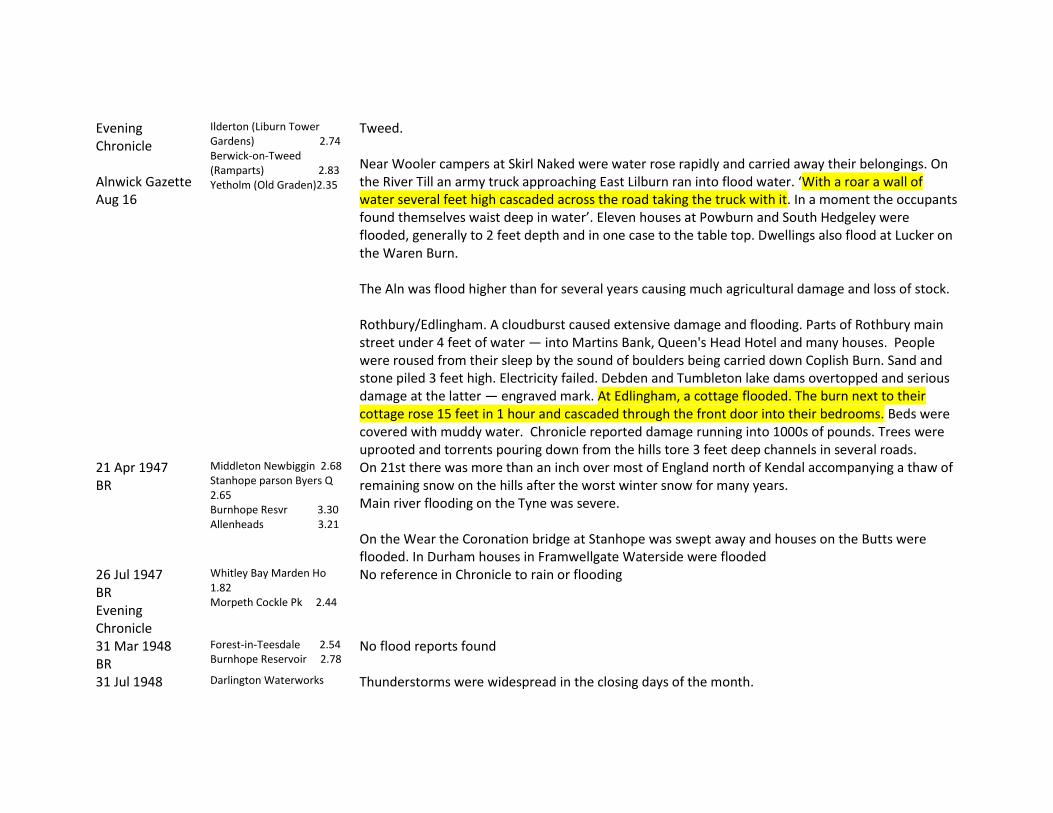
Evening Chronicle Alnwick Gazette Aug 16
Ilderton (Liburn Tower Gardens) 2.74 Berwick-on-Tweed (Ramparts) 2.83 Yetholm (Old Graden)2.35
Tweed. Near Wooler campers at Skirl Naked were water rose rapidly and carried away their belongings. On the River Till an army truck approaching East Lilburn ran into flood water. ‘With a roar a wall of water several feet high cascaded across the road taking the truck with it. In a moment the occupants found themselves waist deep in water’. Eleven houses at Powburn and South Hedgeley were flooded, generally to 2 feet depth and in one case to the table top. Dwellings also flood at Lucker on the Waren Burn. The Aln was flood higher than for several years causing much agricultural damage and loss of stock. Rothbury/Edlingham. A cloudburst caused extensive damage and flooding. Parts of Rothbury main street under 4 feet of water — into Martins Bank, Queen's Head Hotel and many houses. People were roused from their sleep by the sound of boulders being carried down Coplish Burn. Sand and stone piled 3 feet high. Electricity failed. Debden and Tumbleton lake dams overtopped and serious damage at the latter — engraved mark. At Edlingham, a cottage flooded. The burn next to their cottage rose 15 feet in 1 hour and cascaded through the front door into their bedrooms. Beds were covered with muddy water. Chronicle reported damage running into 1000s of pounds. Trees were uprooted and torrents pouring down from the hills tore 3 feet deep channels in several roads.
21 Apr 1947 BR
Middleton Newbiggin 2.68 Stanhope parson Byers Q 2.65 Burnhope Resvr 3.30 Allenheads 3.21
On 21st there was more than an inch over most of England north of Kendal accompanying a thaw of remaining snow on the hills after the worst winter snow for many years. Main river flooding on the Tyne was severe. On the Wear the Coronation bridge at Stanhope was swept away and houses on the Butts were flooded. In Durham houses in Framwellgate Waterside were flooded
26 Jul 1947 BR Evening Chronicle
Whitley Bay Marden Ho 1.82 Morpeth Cockle Pk 2.44
No reference in Chronicle to rain or flooding
31 Mar 1948 BR
Forest-in-Teesdale 2.54 Burnhope Reservoir 2.78
No flood reports found
31 Jul 1948 Darlington Waterworks Thunderstorms were widespread in the closing days of the month.

BR Evening Chronicle 31 Jul-2 Aug
2.66 Darlington (Broken Scar) 2.76
On 31st Chronicle reported ‘North revels in sunshine’ with 10.3 hours of sunshine on 30th. But, as reported on 2 August, Durham had over 0.50 inches of rainfall in a 10 minute thunderstorm although it also had 7 hours of sunshine and was the hottest day of the year with 82 degrees F.
11/12 Aug 1948 BR Northern Echo 13 Aug Northumberland Gazette 13 Aug Berwick Advertiser 19 Aug
Berwick Swinton Ho 1.85 in 2 hr Daily totals 11th West Hartlepool (Waterworks 2.37) Hartlepool (Hart Reservoir) 2.38 Shotton (New Winnings Pump. Stn.) 2.69 Easington (Mill Hill Reservoir) 2.25 Seaham (Dalton Pumping Station) 2.35 Daily totals 12th Howick Hall Gardens 3.22 Doxford Hall 3.86 Chathill (Preston Tower) 4.26 Belford (Newlands) 4.35 Cornhill (Pallinsburn) 4.47 Berwick-on Tweed (Ramparts) 4.62 Yetholm (Old Garden) 4.67 Denholm (Spital Tower) 3.06
Details of the event described in Archer, Land of Singing Waters Extraordinary flooding on the River Tweed, Till and tributaries. Breamish overflowed its banks and flooded Powburn village for the third time in 3 years. Levels on N and S Low highest in living memory and all low lying land between the North Road and the coast flooded. The sluice at Beal overflowed. Waren burn overflowed at Lucker and flooded a cottage and damaged school property. At Belford the Burn burst its banks, flooding streets and carrying away greenhouses and outhouses. Water was 4 feet deep on the main road in places. <Tweedmouth>: Water rushed down the Main Street from Shielfield and swept onto church road and down into Mill Strand. Dock road and the cottage underneath the railway arches at Ord Drive were badly affected. Elderly tenants were sitting on top of table and other furniture. <East Ord>: Several elderly women were trapped in upstairs rooms and were rescued by boat. <Norham>: There was a fall to the Fire Brigade from Norham Boathouse. House newly built on high ground at the side of the Tweed was surrounded by water 10 feet deep. 12 people including 4 sheltering campers were rescued from the marooned building. Cellars in Main Street houses were flooded <Bowsden>: The main street was flooded along with several cottages. <Belford>: The fire station was surrounded by swirling water and a culvert collapsed outside the entrance breventing their exit. A hole was knocked in a back wall and a pump extracted.There was 3 feet of water inside the building.
Kelso (Floors) 6.21 Kelso (Hendersyde Park) 5.42 Lauder (The Roan) 3.00 Caddonfoot (Fairnilee)3.12 Eddlestone (Portmore Reservoir) 4.20 Earlston (Cowdenknowes) 3.3

Earlston (Carolside) 3.23 Coldstream (Lochton) 4.86 Swinton House 5.1 Paxton (Tweedhill) 5.55 Marchmont House 4.00
3 Sep 1948 BR Evening Chronicle 4 Sep
Durham (Houghall Hort. Stn.) 2.59
Gales and rainstorms in Northern England during the night, three quarters of an inch falling in 2 hours on Newcastle, bringing the total in the last 48 hours to 1.57 inches. There was flooding on Grandstand Road and traffic was diverted until workmen drained the greater part of the water on to the Town Moor. In south Durham where the rain was accompanied by thunder and lightning. The railway track between Spennymoor and Ferryhill was blocked by water covering the track and damaging the embankment.
22 Feb 1949 BR
Forest-in-Teesdale 2.55 Burnhope Reservoir 2.7
22 Aug 1949 BR Evening Chronicle 22/23 Aug
Darlington WW 1.80 in 50 mins Tot=1.95 Broken Scar 1.93
A severe thunderstorm in N Yorkshire and Durham gave a rainfall of ‘remarkable’ intensity at Darlington. The Northern Despatch reported: The storm put trolley buses out of action flooded roads and streets and caused the facing walls of a bridge to collapse and brought down two or three chimney stacks in various parts of the town. It was Darlington’s worst storm for many years. The Chronicle reported a cloudburst at Penhill in Wensleydale with 4 feet of water sweeping through the village of Carlton. Streets were also flooded at Northallerton. Chronicle on 19th reports ‘heat wave back again’. On 22 it reported a ‘freak storm at Castle Eden’ – a thunderstorm with hail that lasted 15 minutes – whilst the heat wave continued in Newcastle with a maximum of 84 degrees F. Consett also reported a storm with hailstones.
23 Oct 1949 BR
Acklington (Airfield) 1.52 Amble 1.91 Horwick Hall Gardens2.61 Stamford 2.5 Doxford Hall 2.51 Chathill (Preston Tower) 2.46 Belford (Newlands) 2.08 Berwick-on-Tweed (Ramparts) 1.99

26/10/1949 Northumberland Rivers Catchment Board Northumberland Gazette Oct 28 Land of Singing Waters
Nearly 24 hours of continuous rain after a very dry summer Rainfall 4.8” in 24 hrs at Linhope. Kielder (Ridge End) 2.69 Morpeth (Trilington School) 1.66 Acklington (Airfield) 1.79 Amble 2.23 Callaly Castle Gardens 2.64 Howick Hall Gardens 2.93 Stamford 3.04 Doxford Hall 2.8 Chathill (Preston Tower)2.3 Belford (Newlands) 2.33 Cheviot (Linhope) 4.8 Ilderton (Lilburn Tower Gardens) 2.53 Mindrum 3.00 Cornhill (Pallinsburn) 3.11 Berwick-on-Tweed (Ramparts) 1.46 Yetholm Old Graden 3.09 Kelso floors Castle 2.17 Coldstream Lochton 2.35 Swinton Hoi 2.42 Paxton Tweedhill 3.24
Affected mainly Breamish, Wooler W and College Bn. Enormous erosion on Wooler Water. Fields strewn with boulders and sand. Railway embankment breached near Wooler, flooded road and houses of the railway. Breamish - Powburn flooded. At S. Hedgeley 2 cottages and Presbyterian Manse flooded for 3rd time in 4 years. Road between Ingram and Linhope destroyed. Railway bridge over Lil Burn collapsed. No passage between Chatton and Lyham. Wooler Belford road impassable. Road flooded at Ford. Wooler Berwick bailey bridge at Turvelaws was under water and closed; farm cottages flooded to several feet. Wooler bowling green covered to 3 feet. Nissen huts near Wooler were 3 feet under water. College Burn breached east bank at Kirknewton and flooded the plain to Akeld. Further descriptions and photographs in Land of Singing Waters
9 Apr 1950 BR
Nenthead Whitehall Ho 2.68
Rainfall was associated with showery conditions in the rear of depressions.
22 Aug 1950 BR
Hexham resvr 0.82 in 30 mins
Widespread damage was reported over Northumberland. Thunderstorms also in N Lancashire.
10 Aug 1952 Dton & Stockton Times Aug 16 LSW
Several days of heavy rain and thunderstorms in the upper reaches following a drought of several weeks duration
Several days of heavy rain with thunderstorms at the end of a severe drought. ‘Greatest flood in 25 years’. ‘The onrush followed in the wake of a ‘roll’ estimate by one witness to be 3 feet high’. At High Force the middle rock was completely covered (Photo). (Also photos at Barnard Castle bridge). No mention of events below Darlington.
25 May 1953 Chopwellwood 1.75 in 2 Severe thunderstorms were associated with a cold front accompanying a small depression which

BR Evening Chronicle May 25/26
hrs Yetholm Old Graden 1.12 in 80 mins Berwick Swinton Ho 0.68 in 15 mins Barnard Cas Bowes Mus 2.12 Chopwellwood 1.80
moved eastward across Scotland. Very serious flooding occurred in northern Scotland and at Ballykelly in N Ireland. Several fatalities (from lightning) and much flood damage were reported from northern and Central England. Chronicle on 25th reported NE basks whilst there is flood chaos in Scotland with temperature of 82 degrees F in Newcastle However on 26th Chronicle reports ‘yesterday’s great rainstorm’ (26th) damaged buildings, caused fires and electricity failures and scattered thousands of holidaymakers. Scores of buildings were flooded. Motorists who spent the night stranded at Shirly near Langleeford in the Cheviots were today being rescued. One car which was swept away was located several hundred yards downstream. A mechanical digger in Wooler Water was undermined . Flooded houses and football pitches, beach amusements covered in sand and manholes torn up was the story in Whitley Bay. Rail lines at the Coast were dislocated due to the flood mainly of the N Shields tunnel. Water burst into the Willow Cafe at Tynemouth and flooded it to 6 inches (80 people were in the cafe). Firemen pumped water from Heaton Assembly Rooms
2 Jun 1953 BR Evening Chronicle 2/3 Jun
Uswayford (Cheviots) 2.69 Sourhope 2.55
Nearly all the heavy falls of June were associated with thundery weather. Rain washed out Coronation Week events. With 24 hours continuous rain fireworks displays n Newcastle, Gateshead and Alnwick were postponed.
13 Aug 1953 BR Northern Echo 14 Aug Evening Chronicle 13 Aug
Thunderstorms Durham (University Observatory) 1.83 Ushaw College 1.98 South Moor (CollieryOffice) 1.85
Surface water flooding in Newcastle, Durham, Spennymoor, Stanley, Bishop Auckland, Silksworth, and Darlington. Heavy rain with thunder and hail occurred at Tynemouth and N Shields. Flooding occurred in Waterville St and Howdon road area. Water 1 foot deep swept down Brewer’s bank on to North Shields Fish Quay. A man was killed by lightning at Newburn. Houses were hit by lightning at Blackhall colliery, at Berwick and Holy Island. Hexham and Allenheads telephone service was cut off.
12 Nov 1953 LSW
Continuous rain for 17 hours.
Alston. Fair Hill dam above Alston overflowed. Flooded scores of houses, some to 5 feet depth. Said to be the third and worst flood in Alston in 2 years. Dam outlets blocked by debris.
3 Apr 1954 LSW Northern Echo Apr 5
No reference to heavy rain anywhere in April in BR
Fourstones. Two men drowned when struck by a wall of water in South Tyne. Rose 5 to 6 feet in 1/2 hour. They were marooned on a gravel island. ‘The river rose rapidly and within a few minutes little of the island was visible’.

Evening Chronicle
Evening Chronicle has no reports of rain or flooding.
15 Jun 1954 Moor House (Upper S Tyne) 2.52
Heavy rainfall occurred over the Lake District
9 Jan 1955 BR
Falstone (Wickhope) 2.60
12 Jun 1955 BR Evening Chronicle 12 Jun
Gateshead 1.60
Evening Chronicle has no reports of rain or flooding
3 Jul 1955 BR
Cheviot Hills (Linhope) 2.58
Evening Chronicle has no reports of rain or flooding
27/28 Aug 1956 N’land Gazette Aug 31 Land of Singing Waters Evening Chronicle Aug 29
Uswayford 2.66 Belford (Newlands) 2.16 Cheviot Hills (Linhope 2.92 Mindrum 2.31 Cornhill (Pallinsburn 2.19 Cheviot Hills (Sourhope) 3.31
Northumberland Gazette reports torrential rain for 30 hours from the morning of Monday 27th to early Tuesday evening A secondary depression moving north-eastwards over Wales and northeast England caused heavy falls in northern England and southern Scotland . The Chronicle reports the River Tweed rising at one foot per hour and 12 feet above normal depth at Coldstream and Norham. Border villages and farms were cut off as burns overflowed.At Norham the main street was flooded to a depth of several feet. Severe flooding was reported on the Till (Powburn road flooded to 18 inches), at Wooler and on the Glen and on the Coquet at Thropton and Rothbury. Morpeth. Torrential rain for 30 hours. Bennetts Walk sculleries of a number of houses flooded to several inches. Water swirled over the promenade at Carlisle Park. The entrance to Morpeth Social Club was flooded to 12 inches. Extensive flooding was reported all over Northumberland particularly in the Till and Tweed, Coquet and Wansbeck but also at Blackhall Mill on the River Derwent where 30 homes were flooded . At one time the flood was 2 feet below the soffit of Blackhall Mill Bridge and was the highest point registered since 1939
10 Aug 1957 BR Evening Chronicle 10
Throckley Filters 2.43
A depression moving north-eastward over Wales and northern England on 10th and 11th gave heavy falls in Anglesey, N Wales and locally in N England. ‘Gateshead swamped by freak outburst’ Parts of Gateshead were brought to a standstill and shops
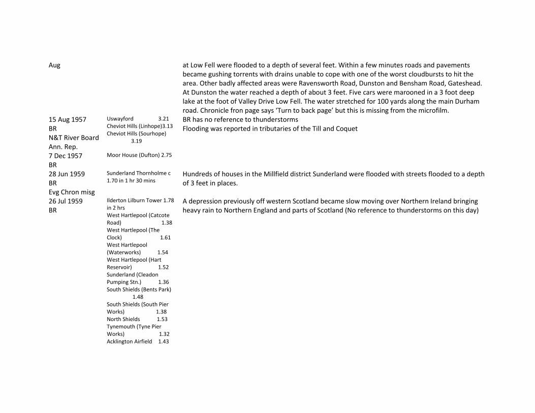
Aug at Low Fell were flooded to a depth of several feet. Within a few minutes roads and pavements became gushing torrents with drains unable to cope with one of the worst cloudbursts to hit the area. Other badly affected areas were Ravensworth Road, Dunston and Bensham Road, Gateshead. At Dunston the water reached a depth of about 3 feet. Five cars were marooned in a 3 foot deep lake at the foot of Valley Drive Low Fell. The water stretched for 100 yards along the main Durham road. Chronicle fron page says ‘Turn to back page’ but this is missing from the microfilm.
15 Aug 1957 BR N&T River Board Ann. Rep.
Uswayford 3.21 Cheviot Hills (Linhope)3.13 Cheviot Hills (Sourhope) 3.19
BR has no reference to thunderstorms Flooding was reported in tributaries of the Till and Coquet
7 Dec 1957 BR
Moor House (Dufton) 2.75
28 Jun 1959 BR Evg Chron misg
Sunderland Thornholme c 1.70 in 1 hr 30 mins
Hundreds of houses in the Millfield district Sunderland were flooded with streets flooded to a depth of 3 feet in places.
26 Jul 1959 BR
Ilderton Lilburn Tower 1.78 in 2 hrs West Hartlepool (Catcote Road) 1.38 West Hartlepool (The Clock) 1.61 West Hartlepool (Waterworks) 1.54 West Hartlepool (Hart Reservoir) 1.52 Sunderland (Cleadon Pumping Stn.) 1.36 South Shields (Bents Park) 1.48 South Shields (South Pier Works) 1.38 North Shields 1.53 Tynemouth (Tyne Pier Works) 1.32 Acklington Airfield 1.43
A depression previously off western Scotland became slow moving over Northern Ireland bringing heavy rain to Northern England and parts of Scotland (No reference to thunderstorms on this day)

14 Jul 1961 BR
Westgate 3.42 Rookhope 3.02 Parsons Byers Quarry, old site 2.55 Waskerley 2.6 Tunstall Res. 3.65 Waterhouses 3.55 Ushaw College 2.5 Fishlake 3.1
Winds SE becoming NE; depression, orographic; depression continued to move SE to the North Sea.
11 Feb 1962 BR
Haltwhistle 2.09 Forest-in-Teesdale 2.59 Hury Res. 2.08
Winds W strong to gale; frontal orographic; warm and cold fronts moving quickly east.
2 Apr 1962 BR
Whickhope 2.06 Burnhope Res. 3.02 Westgate 2.44 Forest-in-Teesdale 2.87 Newbiggin 2.88
Wind SW fresh to strong; frontal, orographic; warm front and cold front with wave moving east.
21 Jul 1962 Lancs Evg post 21 Jul
Barnard Castle: Two children were swept away in a sudden flood in the River Tees caused by heavy rainfall in the headwaters.
4 Sep 1962 BR
Berwick-on-Tweed 2.36 Winds variable light; depression, thundery; depression moving east from N Ireland to North Sea.
11 Sep 1962 BR
Incessant rain Tuesday night Bower 2.16 Barrasford 2.03 Haltwhistle 2.07 Hexham Res. 2.07
Winds mainly SW; depression, frontal, orographic. Storm approached from the NE; thus the lower portion of the Tyne was contributing well before the uplands. Flood banks between Hexham and Corbridge were overtopped in places for 2 hours flooding a limited area of agricultural land. Cockshaw Burn overflowed flooding may business premises in low-lying parts. Bus drivers waded 2 feet deep to get to their vehicles in a garage. Coquet flooded Rothbury racecourse
11 Jun 1963 BR
Hisehope Resvr 2.21
4 Aug 1963 BR Evg Chronicle Misg
Tynemouth 2.1 Cleadon P. Sta. 2.01 Moorhouses Res. 2.33 Middleton Hall 2.34 Mindrum 2.27 Hethpool 2.25
Depression; thundery; depression over the North Sea deepening and moving slowly northeast.

16 Aug 1963 BR
Uswayford, Old Site 2.79 Uswayford, New Site 2.6
Depression, frontal; orographic; thundery. Rainfall >2 inches on the other side of the Tweed.
1 Sep 1963 BR Evening Chronicle 2 Sep
Uswayford, Old Site 2.63 Uswayford, New Site 2.59
Depression; thundery The Tweed burst its banks after torrential rain today. At Belford station the Bamburgh Road was flooded to several inches when the burn burst its banks.
14 Mar 1964 BR
Hethpool 56.1 Frontal; thundery; complex frontal system moving northeast with high totals in the east from Essex to Tay. Only one station noted for northeast.
18 Jul 1964 BR Evening chronicle 18 Aug
Hurworth Burn 20.8 in 15 mins Hart resvr 19.1 in 15 mins W Hartlepool WW 18.5 in 15 mins
‘Washout at Miner’s Gala’ The flooding also created havoc and flooding in other parts of the northeast. Thunderstorms broke over Durham City. ‘Manhole covers are lifting and roads are flooded all over the county’. Widespread flooding in Blaydon and Ryton held up traffic. Several shops closed for bailing out in Church Street and elsewhere in Blaydon. Pieces of ice as big as eggs fell on the Fairfield area of Stockton damaging roofs and windows and shattering greenhouses and even car windows.
18 Aug 1964 BR Evening Chronicle 18/20 Aug
Rothbury 56.9 Depression, frontal, thundery. Eyemouth harbour was flooded from the River Eye – after having been kept dry for the past year – nothing for the northeast.
8 Dec 1964 BR
Kielder Castle 56.1 Whickhope 56.1
Warm front and cold front with wave moving east.
10 Jan 1965 BT
Kielder Castle 59.9 Whickhope 70.6
13 Aug 1966 BR Evening Chronicle 15 Aug
Whitburn 31.5 in 90 mins Newlands 92.5 Seahouses 56.4 Newton House 65.5 Stamford 78.2 Howick Hall 51.3 Callaly Castle 54.6 Acklington 92.3 Allenheads 67.1
Depression, frontal orographic, thundery; wave depression off southwest England deepening and moving north-north-east. Also affecting Lake district and much of Scotland. The storms played havoc with rail and road traffic and flooded the Northumberland countryside. The main rail line had been closed at Belford after flooding made the line unsafe. Many telephone lines were cut, the worst hit area being Consett and Wooler.
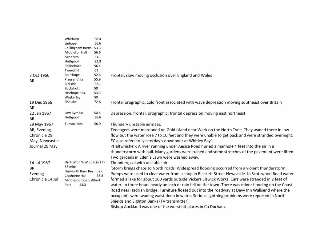
Whitburn 58.4 Linhope 56.6 Chillingham Barns 53.3 Middleton Hall 56.6 Mindrum 51.1 Hethpool 82.3 Pallinsburn 56.4 Tweedhill 63
3 Oct 1966 BR
Boltshope 52.6 Presser Villa 55.9 Birkside 52.1 Buckshott 50 Hisehope Res. 53.3 Waskerley 50
Frontal; slow moving occlusion over England and Wales
19 Dec 1966 BR
Fishlake 72.6 Frontal orographic; cold front associated with wave depression moving southeast over Britain
22 Jan 1967 BR
Low Byrness 50.8 Hethpool 56.6
Depression, frontal, orographic; frontal depression moving east northeast.
29 May 1967 BR, Evening Chronicle 29 May, Newcastle Journal 29 May
Tunstall Res 56.9 Thundery unstable airmass. Teenagers were marooned on Gold Island near Wark on the North Tyne. They waded there in low flow but the water rose 7 to 10 feet and they were unable to get back and were stranded overnight. EC also refers to ‘yesterday’s downpour at Whitley Bay’. <Haltwhistle>: A river running under Aesica Road hurled a manhole 4 feet into the air in a thunderstorm with hail. Many gardens were ruined and some stretches of the pavement were lifted. Two gardens in Eden’s Lawn were washed away.
14 Jul 1967 BR Evening Chronicle 14 Jul
Darlington WW 35.6 in 1 hr 58 mins Hurworth Burn Res. 52.6 Crathorne Hall 53.8 Middlesborough, Albert Park 53.3
Thundery; col with unstable air. ‘Storm brings chaos to North roads’ Widespread flooding occurred from a violent thunderstorm. Pumps were used to clear water from a shop in Blackett Street Newcastle. In Scotswood Road water formed a lake for about 100 yards outside Vickers Elswick Works. Cars were stranded in 2 feet of water. In three hours nearly an inch or rain fell on the town. There was minor flooding on the Coast Road near Hadrian bridge. Furniture floated out into the roadway at Davy Inn Wallsend where the occupants were wading waist deep in water. Serious lightning problems were reported in North Shields and Eighton Banks (TV transmitter). Bishop Auckland was one of the worst hit places in Co Durham.

3 Oct 1967 BR
Alston 50.8 Depression, frontal; occlusion moving east followed by a weak depression
10 Oct 1967 BR
Rothbury 58.2 Harwood 51.3 Hisehope Res. 50.3 Westgate Railway Sta.51.8 Rookhope 56.6 Stanhope, Castle School 56.6 New Winning P. Sta 50.8 Newbiggin 52.6 Bar Gap Farm 54.9 Brignall 53.6
Depression, frontal orographic, thundery; warm sector depression occluding and moving northeast over northern England.
5 Nov 1967 BR
Newlands 50.0 Seahouses 51.9 Newton House 55.6 Stamford 52.3 Blindburn 71.6 Amble 58.4 Acklington 56.3 Font Res. 50.3 Low Byrness 55.4 Allenheads 63 St John's Chapel 66.5 Westgate Railway Sta. 74.7 Rookhope 71.9 Stanhope, Castle School 71.1 Waskerley 52.3 Tunstall Res. 61 Sunderland, Thorneholme 50.8 Greenhills Farm 73.9 Forest-in-Teesdale 68.6 Newbiggin 62.5 Eggleston 60.7 Shildon S. Wks 50.5
Depression, orographic, thundery; depression east of Yorkshire coast

19 Mar 1968 BR
St John’s Chapel 51.5 Newbiggin 52.8
Frontal orographic; cold front with minor wave moving southeast
23 Mar 1968 BR
Kielder Castle 69.8 Whickhope 96 Burnhope Res. 55.9 St John’s Chapel 61.2 Westgate Railway Sta.64.5 Greenhills Farm 64.2 Forest-in-Teesdale 68.1 Newbiggin 72.9
Frontal, orographic; cold front with minor wave moving southeast.
22 Jun 1968 BR Evening Chronicle 24 Jun
Chillingham Barns 62 Depression, frontal, orographic; complex area of low pressure over northern England and Scotland with associated stationary occlusion over northern England. Chronicle has little reference to rain or flooding but reports an accident in which one man was killed when his car hit a patch of floodwater 8 inches deep on the AI at Gateshead, Harlow Green
2 Jul 1968 BR Evening Chronicle 2 Jul
Elton 14.0 in 8 mins W Hartlepool WW 26.7 in 15 mins Darlington WW 15.2 in 13 mins Durham 18.3 in 14 mins Worsall Hall 21.6 in 20 mins Darlington South Pk 23.1 in 40 mins Hambleton Lodge Great Smeaton 28 mm in 10 mins
‘Darkness in Newcastle street as torrential rain drives pedestrians into shops’. Motorists were obliged to use headlights. Newcastle Weather Centre reported that extensive thunder clouds covering 10 to 15 mile patches of sky were passing over the city. Newcastle rainfall was 0.75 inch. At Whitley bay the subway on the seafront was at one time under 8 feet of water. Blyth was badly affected mainly with the loss of telephone services. Teesside was plunged into darkness and shaken by violent thunderstorms. Hailstones up to an inch in diameter hit Stockton and Thornaby. The Fire Brigade reported flooding in a wide area of Durham but especially from the Bishop Auckland area. There is also a note on lightning damaging a home in Gateshead.
13 Aug 1968 BR
Blindburn 51 Widehaugh Nursery53.1
12/13 Sep 1968 LSW BR Morpeth Herald Sep 20 Land of Singing
12th Alwinton 53 Swindon 51 Longhorsely 69.4 Cockle Park 57.4 Harwood 57.7 Low Byrness 91.2 Barrasford 52.3
Depression, frontal, thundery; minor depression east of Yorkshire with front almost stationary over Yorkshire and southwest Scotland. Chronicle on 12th notes roads blocked at Greenhead after a torrential thunderstorm and severe flooding in north Yorkshire where Catterick Camp was cut off by floods up to 4 feet deep. The Leyburn to Bedale road was flooded to a depth of 3 feet. Morpeth. Intense storm affecting Tanner's burn. Walls around St James Church and graveyard breached. Affected Newgate St, Stanley Tce, Wellway, Copper Chare and Staithes Lane. Some
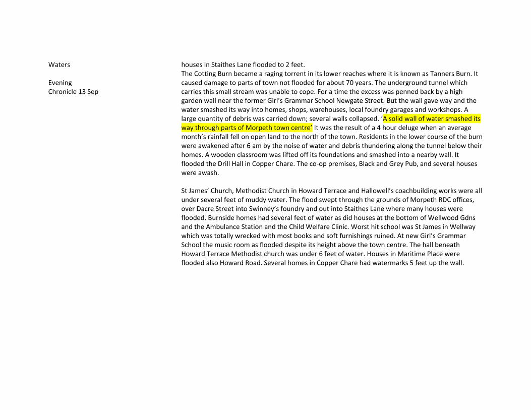
Waters Evening Chronicle 13 Sep
houses in Staithes Lane flooded to 2 feet. The Cotting Burn became a raging torrent in its lower reaches where it is known as Tanners Burn. It caused damage to parts of town not flooded for about 70 years. The underground tunnel which carries this small stream was unable to cope. For a time the excess was penned back by a high garden wall near the former Girl’s Grammar School Newgate Street. But the wall gave way and the water smashed its way into homes, shops, warehouses, local foundry garages and workshops. A large quantity of debris was carried down; several walls collapsed. ‘A solid wall of water smashed its way through parts of Morpeth town centre’ It was the result of a 4 hour deluge when an average month’s rainfall fell on open land to the north of the town. Residents in the lower course of the burn were awakened after 6 am by the noise of water and debris thundering along the tunnel below their homes. A wooden classroom was lifted off its foundations and smashed into a nearby wall. It flooded the Drill Hall in Copper Chare. The co-op premises, Black and Grey Pub, and several houses were awash. St James’ Church, Methodist Church in Howard Terrace and Hallowell’s coachbuilding works were all under several feet of muddy water. The flood swept through the grounds of Morpeth RDC offices, over Dacre Street into Swinney’s foundry and out into Staithes Lane where many houses were flooded. Burnside homes had several feet of water as did houses at the bottom of Wellwood Gdns and the Ambulance Station and the Child Welfare Clinic. Worst hit school was St James in Wellway which was totally wrecked with most books and soft furnishings ruined. At new Girl’s Grammar School the music room as flooded despite its height above the town centre. The hall beneath Howard Terrace Methodist church was under 6 feet of water. Houses in Maritime Place were flooded also Howard Road. Several homes in Copper Chare had watermarks 5 feet up the wall.
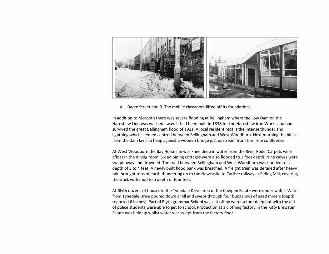
A. Dacre Street and B. The mobile classroom lifted off its foundations In addition to Morpeth there was severe flooding at Bellingham where the Low Dam on the Hareshaw Linn was washed away. It had been built in 1838 for the Hareshaw iron Works and had survived the great Bellingham flood of 1911. A local resident recalls the intense thunder and lightning which seemed centred between Bellingham and West Woodburn. Next morning the blocks from the dam lay in a heap against a wooden bridge just upstream from the Tyne confluence. At West Woodburn the Bay Horse inn was knee deep in water from the River Rede. Carpets were afloat in the dining room. Six adjoining cottages were also flooded to 1 foot depth. Nine calves were swept away and drowned. The road between Bellingham and West Woodburn was flooded to a depth of 3 to 4 feet. A newly built flood bank was breached. A freight train was derailed after heavy rain brought tons of earth thundering on to the Newcastle to Carlisle railway at Riding Mill, covering the track with mud to a depth of four feet. At Blyth dozens of houses in the Tynedale Drive area of the Cowpen Estate were under water. Water from Tynedale Drive poured down a hill and swept through four bungalows of aged miners (depth reported 6 inches). Part of Blyth grammar School was cut off by water a foot deep but with the aid of police students were able to get to school. Production at a clothing factory in the Kitty Brewster Estate was held up whilst water was swept from the factory floor.

31 Oct/ 1 Nov 1968 BR
31st Oct Boltshope 54.9 Presser Villa 53.1 Birkside 53.3 Hisehope Res. 56.4 Smiddy Shaw 50.8 Waskeriey 52.6 Fishlake 70.6 Roundhill Res. 51.1 Raygill House 51.3 1st Nov Hurworth Burn Res.51.1 Kildale Hall 50.4
Depression, frontal, thundery; complex depression extending from southwest Ireland to North Sea with front moving slowly south over Northern Ireland and Northern England.
18 Dec 1968 BR
Hisehope Res. 55.9 Low Wadsworth S. Wks 70.6 Lanchester 53.2 Crookhall S. Wks 54.9
Thundery; unstable airstream
3 May 1969 Evening Chronicle (Cuttings)
Almost an inch of rain at Newcastle Weather Centre
Headline ‘ 7-hour deluge brings chaos to northeast’. Five main roads in County Durham were flooded and Newcastle Races were cancelled. The only property flooding reported was the Board Inn at Herrington village.
21 Aug 1970 Evening Chronicle 21 Aug
The Cotting Burn culvert failed to cope with the torrential rain through the night and Copper Chare was under a foot of water in parts and flooded the house next to the Drill Hall.
20 Mar 1971 Newcastle Journal 20 May Evening Chronicle 20 May
A month’s rain was reported in 2 days – said to be 1 ¼ inches. The rain washed out racing and sporting fixtures but ‘no serious flooding was reported’ Berwick firemen were called to pump water from a frozen pasty factory on Tweedside Trading Estate.
14 Aug 1972 Evg Chronicle 14 Aug
Rain was accompanied by high winds – but there is no mention of thunderstorms.
Flooding was reported over a wide area of the northeast but worst in County Durham Dalton le Dale near Seaham was cut off and families of one of the two streets had to be evacuated by boats – a dozen families mentioned.

Two and a half inches of rain was reported at Teesside. Newcastle Weather centre reported similarly for Newcastle but speaks of continuous rain.
Wingate: 30 houses in Dawson road were evacuated. Three feet of water was reported and the main road into the village was blocked. Spennymoor: A culvert burst flooding homes a working men’s club and a grocery shop. Bishop Auckland: Vinovium Secondary school boiler room was flooded with 5 feet of water. Felling: At least one street was flooded. Sunderland: many homes were flooded at Silksworth Lane. Whitburn: The Bay Hotel was flooded. Blyth: Houses shops, factories and pubs were flooded. The Newsham district was worst affected; the boiler house of the co-op bakery was flooded and there was a foot of water in the cellar of the Newsham Hotel. Cramlington: the George Angus Factory was flooded and pumped out by the Fire brigade. Newcastle: Forest Hall: Seven houses at Otterburn Close, Meadway were flooded with 2 feet of water.
8 Aug 1974 Evening Chronicle 8 Nov
Rain fell between 8.30 and 9.00 am. No reference was made to lightning in the northeast or elsewhere
Hexham was hit by severe flooding after a half hour cloudburst. Police reported up to 4 feet of water. Traffic was held up for several miles into Hexham because of deep water east of the bus station. Water 4 feet deep was reported at Carr’s Garage on Station road. The County Hotel on Priestpopple had 5 inches of water in the bar and water rushed in through the doors. Some flooding occurred in Hencotes where a manhole cover came off.
14 May 1975 Evening Chronicle 14 May
Met Office says 2.27 inches of rain fell in the last 8 days and 0.61” since yesterday.
Flooding occurred at Bloemfontein near Stanley; the main street had water 12 inches deep and threatened to flood houses in Graylingstadt Street. Sunderland: Ferryboat Lane in Hylton Castle was closed by flooding. Cramlington: Almost a mile of road between High Pit and Shankhouse was flooded up to a foot in depth. Blyth: Flooding occurred in the Jubilee Road and Park Road. Frosterley: A radio mast was damaged by lightning. Other road flooding was reported but no property flooding was reported.
4 Aug 1975 Evening Chronicle 4 Aug
Giant cumulonimbus clouds were reported up to 40,000 feet, bringing almost continuous lightning but only a quarter of an inch fell in Newcastle
The storm caused floods and damage by lightning and one man was killed when his car was hit by lightning and the car struck a tree (at Stakeford). South Shields: A house was set on fire by lightning. Widespread damage was done by lightning to power lines in Tyneside, Durham and the Tyne valley. Blackhall (Castle Eden) Co Durham: Flooding was up to 3 feet deep in East Street affecting 7 terrace houses.
Hexham: hillside floodwater rand down into the hospital and into the corridors but none reached the wards. Flooding of houses was also reported in Consett and Barnard Castle where the water was reported to be pouring down roads and into houses and pubs.
14 Aug 1975 Evening Chronicle 14 and 15 Aug
Thunderstorm Newcastle: Flooding occurred on Scotswood Road. Buildings were struck by lightning at Newcastle and Sunderland (4). The worst affected areas were Blaydon, the west end of Newcastle, Winlaton, Newburn Sunderland, Throckley, Newbiggin Hall, Ponteland and Silksworth. A Fire Brigade spokesman said we have had 130 calls an hour and it is impossible for us to cope with all the calls from private houses. Our pumps can’t cope. Hadrian Care Home at Throckley was flooded. Houses in the Whitfield Road area of Scotswood were flooded. South Shields: some flooding of roads occurred in the Tyne Dock and Ocean Roads area N Shields: drains were unable to cope causing flooding of gardens in Whyhill gardens and Meadowell Estate. Problems were experienced with telephone and power lines from Hexham to Otterburn. <Blackhall> The water was 3 feet deep in East Street where 7 terraced houses were flooded and nearby colliery offices were also flooded. <Stanhope>: There were widespread reports of flooding on roads, in homes and in a workinhman;s club.
1 Jun 1976 LSW Northern Echo 3 Jun
Thunderstorm lasting 2 hours
Durham. Flooding of houses in Ushaw Moor, New Brancepeth, East Winning, Brandon and Lanchester. ‘Farmers count the cost after incredible floods hit county’ Worst floods in county Durham for years. Two council houses were flooded on Oakridge Road at Ushaw Moor and became uninhabitable. Farms between Brandon and Bearpark were worst affected. A bullock was washed away by a rising stream and seven acres of kale were lost to water streaming over the land. One small stream rose 10 feet and became 40 feet wide damaging a bridge. Other farmers suffered similar losses from topsoil washed away leaving ‘nasty gutters’.
2 Oct 1976 Newcastle Journal 2 Oct
Heavy prolonged rain after much rain over the previous month at the end of the 1976 drought. More than 3 inches rain in 30 hours
Flooding was reported on roads and fields mainly in the Blyth, Pont and Wansbeck catchments, location not specified. Homes were flooded in Durham city, Blackhall Mill, Evenwood, Shildon, Hamsterley and West Auckland At Riding Mill some houses were flooded to 1 foot deep from the March Burn. One of these was
staff quarters for Wellington Hotel. The burn went overe the top of a bridge and ran across a playground and into gardens of police houses.
15 Jan 1977 Newcastle Journal 15 Jan
Ovingham Dene Garth was flooded from water coming off the hillside and rushing down Horsley Road. ‘A foot-high wave of flood water sped down the slope of Mount Huly’. It flooded a house and 10 garages. Some roads were blocked by snow but near the coast roads were blocked by floodwater. The Sunderland to Gateshead road was blocked with water up to 18 inches deep.
26 Jan 1977 Evening Chronicle 26 Jan
Met Office indicated 1 ½ inches rain in the North Tyne area but only 0.3 inch in Newcastle
A flood brought chaos in parts of Northumberland. Hexham: Homes were flooded in Eastgate, White Cross and Holy Island areas of the town Haydon bridge: Houses were swamped after a burn overflowed its banks Otterburn: The river also burst its banks but subsided before it reached the village. Roads were flooded A686 Hexham to Alston, the A68 between Farnley and Riding Mill and between Byrness and West Woodburn
6 Aug 1978 Sunday Sun 6 Aug Newcastle Journal 7 Aug
Thunderstorms Half an inch in one hour.
Newcastle: The storm mainly affected the Gosforth and Jesmond areas. Water was a foot deep at the Haddrick’s Mill junction in south Gosforth (photo). Surface water was lying on the Central Motorway East from Haymarket out towards Gosforth but traffic was getting through. Flooding was reported by the Fire Service at Pubs, Old People’s Homes and Hostels. Basements in Jesmond were flooded with 2 feet of water. The cellar bar of the Shalimar restaurant in St George’s Terrace was flooded. Also flooded were the White House Old People’s home in Osborne Road and at the Avon and Northumbria Hotels and the Brandling Villas Pub in South Gosforth. Gateshead: Swallwell area and the Whickham Bank were badly affected by cascading water and manhole covers. Flooding was also reported at Easington Lane, Hetton Le Hole and Newton Hall Hartlepool: Flood waters lifted manhole covers
13 Jun 1980 Newcastle journal 13 Jun Evg Chron 13 Jun
No mention of thunder or intensity.
It was said to be the wettest June day in 30 years at Newcastle where 1.66” fell. Some roads were flooded on Tyneside but no reference was made to property. Stanley: Houses were flooded at Holly Hill Garden South Moor: Old People’s bungalows were flooded at Rydal Avenue south Moor.
2 Aug 1980 Newcastle
Thunderstorms Weather Centre noted that
A number of houses in Durham and Chester le Street suffered flood damage. There was widespread flooding of roads.

Journal 2 Aug
at one stage rain had been falling at 1.5 inches an hour. Hailstones ½ inch diameter occurred at Ponteland and on the coast.
Blyth: Flood water was reported to be 6 inches deep in Blyth town centre and the nearby South Beach Estate was also badly hit. Cramlington: Some council houses in the Eastfield Lea Estate were flooded. Durham: Manhole covers were forced off in North Road. One Durham University science laboratory had to be pumped out by the Fire brigade.
7 Aug 1981 LSW COL
COL stations did not report excessive rainfall in the NE although severe thunderstorms were reported elsewhere in the country between 6th and 8th.
Durham/Morpeth. Hail as big as golf balls. Flooding in New Elvet area of Durham.
26 Jun 1982 Evg chronicle 26 Jun
No mention of thunder or of intensity.
Newcastle: New bridge Street was awash. Sporting events were cancelled Blyth: Flooding was reported in Blyth town centre – but no mention of properties.
15 May 1983 Evg Chronicle 15 May
Thunderstorms An inch of rain fell in the day.
There was no reference to flooding except to roads but cuts to electricity usually very brief.
17 Jul 1983 LSW
Ireshopeburn. Peat slides and flash floods on Ireshope Burn, West Grain ,Langdon Beck and West Allen. Full descriptions by Carling (1986 a & b) and Archer (1992) The storm in Weardale was most intense on the catchment boundary in this case between the Wear and the Tees catchments. A separate but concurrent storm cell occurred over the headwaters of the river Allen, a tributary of the Tyne. The nearest raingauge to the storm centre at Ireshopeburn Farm (Fig. 2) recorded 104.8 mm between 3.30 and 6 pm. However, the observer stated that the greater part fell during the core period from 3.45 to 5 pm (1.25 hours) and that the storm seemed more intense over the high moors to the south. Evidence of the effect of the storm was most clearly seen in the occurrence of five peat slides, three draining into the Ireshope Burn, one into the West Grain Beck and one into the Langdon Beck catchment, a tributary to the River Tees (Carling, 1986 a and b). For the two largest slides, peat was completely evacuated from the underlying soil leaving it grooved and bare over areas of more than 2.5 hectares. The moving peat cracked into a jumble of blocks and spindles and carried up to 500 metres downslope. The storm also generated exceptional flood flows and associated bedload and suspended sediment
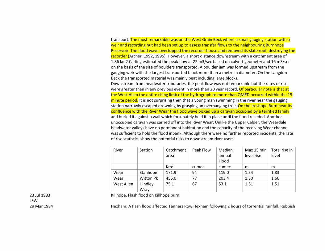
transport. The most remarkable was on the West Grain Beck where a small gauging station with a weir and recording hut had been set up to assess transfer flows to the neighbouring Burnhope Reservoir. The flood wave overtopped the recorder house and removed its slate roof, destroying the recorder (Archer, 1992, 1995). However, a short distance downstream with a catchment area of 1.86 km2 Carling estimated the peak flow at 22 m3/sec based on culvert geometry and 16 m3/sec on the basis of the size of boulders transported. A boulder jam was formed upstream from the gauging weir with the largest transported block more than a metre in diameter. On the Langdon Beck the transported material was mainly peat including large blocks. Downstream from headwater tributaries, the peak flow was not remarkable but the rates of rise were greater than in any previous event in more than 20 year record. Of particular note is that at the West Allen the entire rising limb of the hydrograph to more than QMED occurred within the 15 minute period. It is not surprising then that a young man swimming in the river near the gauging station narrowly escaped drowning by grasping an overhanging tree. On the Ireshope Burn near its confluence with the River Wear the flood wave picked up a caravan occupied by a terrified family and hurled it against a wall which fortunately held it in place until the flood receded. Another unoccupied caravan was carried off into the River Wear. Unlike the Upper Calder, the Weardale headwater valleys have no permanent habitation and the capacity of the receiving Wear channel was sufficient to hold the flood inbank. Although there were no further reported incidents, the rate of rise statistics show the potential risks to downstream river users.
River Station Catchment area
Peak Flow Median annual Flood
Max 15 min level rise
Total rise in level
Km2 cumec cumec m m
Wear Stanhope 171.9 94 119.0 1.54 1.83
Wear Witton Pk 455.0 77 203.4 1.30 1.66
West Allen Hindley Wray
75.1 67 53.1 1.51 1.51
23 Jul 1983 LSW
Killhope. Flash flood on Killhope burn.
29 Mar 1984 Hexham: A flash flood affected Tanners Row Hexham following 2 hours of torrential rainfall. Rubbish
Evg Chronicle 29 Mar
blocked a culvert grill and the Cockshaw Burn overflowed. Within minutes it had risen above the doorsteps of several houses built only a year ago by the Northern Housing Association. The West Cumberland Farmers Mill was also hit.
5 Nov 1984 Ncl Journal 5 Nov
No mention of thunder or extreme intensity.
Widespread rainfall over the Borders and North Northumberland caused much land flooding whilst snow occurred at the highest levels. Rothbury: A house at the Riverside was flooded from the Coquet. Warden: The house at Coastly Burn Foot was flooded from the South Tyne
26 Aug 1986 LSW COL Evg Chronicle 26 Aug
Heavy rain was accompanied by strong winds Low Etherley 47.6
Widespread. Hurricane Charley gave highest rainfall over Greta and Tees. Strong winds and rain for 14 hours. Flood details in Land of Singing Waters. The following is additional information. Consett: Houses at Phoenix court, Blackhill were flooded to 6 inches depth. Water swept off neighbouring fields. It was reported to be the second time in a month that flooding had occurred. Stanley: A shop in the Catchgate area was flooded.
17 Jun 1987 Newcastle Journal 17 Jun
Severe thunderstorm Lightning was reported from Berwick to Whitby
The storm caused damage to houses from lightning strikes and loss of power and in one case broke several windows. However there were no reports of flooding.
21 Aug 1987 Evening chronicle 21 Aug
An 18 hour downpour brought flooding of roads and homes.
The report notes the location of roads flooded but does not specify the location of flooded homes, said to be in South Durham.
23 Jul 1988 Newcastle Journal 23 Jul
Lightning caused damage to a house in Consett . There were no reports of flooding.
28 Jul 1988 COL
Whitley Bay 35.1 Sunderland 20.6
A very wet month – at Sunderland the wettest July since 1940. No reference to thunderstorms on 28th but many thunderstorms elsewhere during the month but not with exceptional daily totals.
30 Nov 1988 Evening Chronicle 30 Nov
The Ncl Weathercentre said ¾ inch fell in Newcastle.
The A69 Newcastle to Carlisle road was blocked by flooding at Haltwhistle. Acomb: Several houses in Alnmouth terrace were flooded from the Red Burn to nearly one foot depth. Hexham: A policeman was marooned when his Panda car was stuck in a flash flood in Hencotes. Other parts of Hexham were flooded as silt and debris blocked drains. Causey Hill and Hallstile Bank were badly affected.
14 Jun 1989 No reports of thunder or of South Shields: The worst flooding occurred at Ullswater Gardens where 10 old folk’s homes were
Evening Chronicle 14 Jun
intense rainfall. flooded. Various other places were affected around Tyneside but no other flooding of property was noted.
24 Aug 1990 Archer and Wheeler (1991) LSW COL
Thunderstorms Sunderland 46.6 (28.8 mm in 1 hr)
Isolated cells in North Yorkshire, mid-Durham and north Northumberland with rainfall totals of 87mm at Brignall, 78mm at Smiddy Shaw reservoir and 80mm at Newton Seahouses. Note also that Archer and Wheeler analyse 4 recording rainfall records within 1 km square measuring at 2 minute intervals during this event at Prudhoe Tynedale where totals of about 50 mm in less than 2 hrs were recorded.
1 Apr 1992 COL Cuttings
Whitley Bay 41.3 Sunderland 36.9 (wettest April day since at least 1940) Uo to 4 inches fell in 36 hours. Following day snow blocked roads.
An occlusion lying across central Ireland and northern England, linked to a low which was moving north across Germany brought prolonged rain with snow on hills near the front and strong northeast winds. ‘Flooding brings chaos’ Breamish at Brandon: bridge washed away. A697 at Hedgeley, Powburn closed due to flooding. Ponteland: Callerton Lane: Old people’s home evacuated.
21 Sep 1992 COL
Rowlands Gill 40.8 Whitley Bay 34.3 Sunderland 33.9 Low Etherley 28.8 Redcar 28.4
Widespread rain spread north during the day reaching Scotland by the evening.
13 May 1993 COL
Rowlands Gill 63.6 Sunderland 54.2 Low Etherley 46.3 Whitley Bay 43.7
Sleet and snow fell in places
5 Aug 1993 Journal 6 Aug 1993
Durham 39.5 Overnight rain – no mention of thunder
Mention was made mainly of road flooding including the A19; none of properties
8 Sep 1993 COL
Rowlands Gill 43.2
18 Sep 1993 Evg Chronicle 18 Sep
Prolonged rainfall over a 3 day period Newcastel 3 day rainfall 1.7 inches
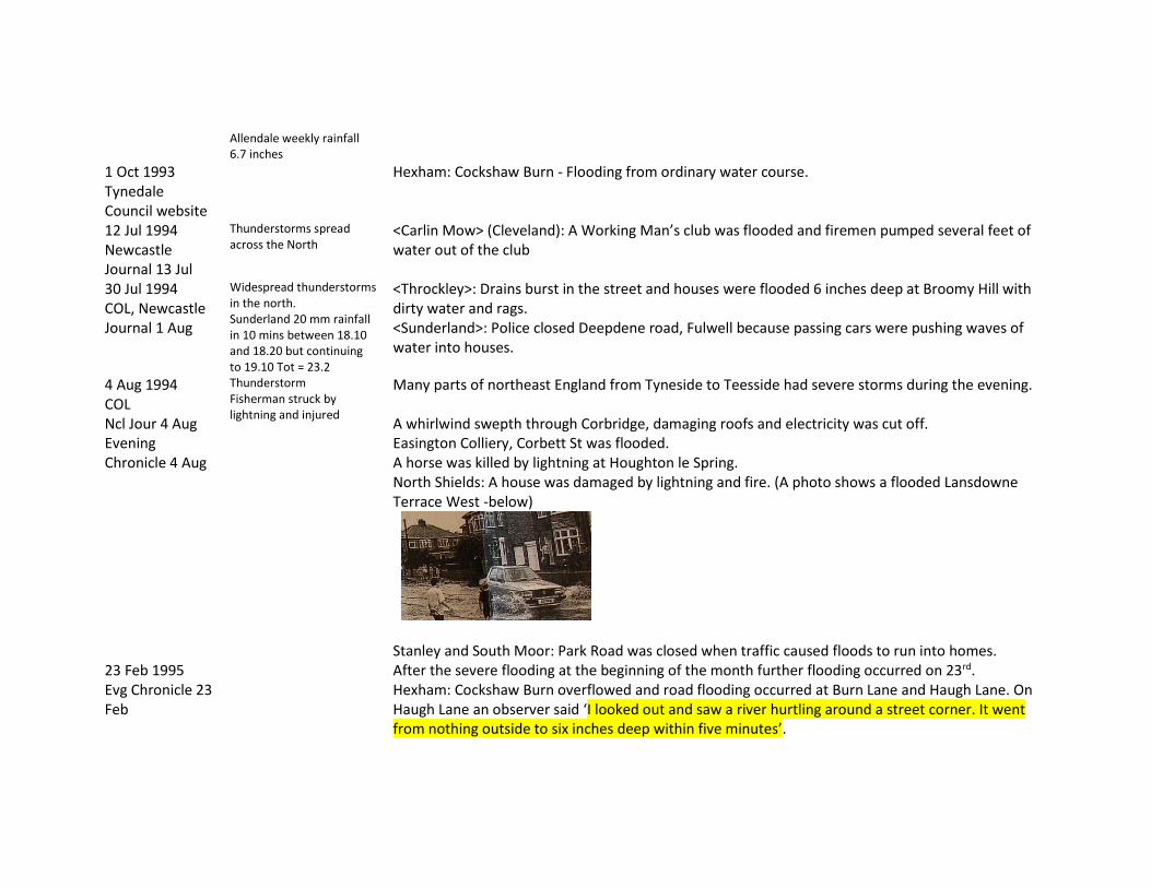
Allendale weekly rainfall 6.7 inches
1 Oct 1993 Tynedale Council website
Hexham: Cockshaw Burn - Flooding from ordinary water course.
12 Jul 1994 Newcastle Journal 13 Jul
Thunderstorms spread across the North
<Carlin Mow> (Cleveland): A Working Man’s club was flooded and firemen pumped several feet of water out of the club
30 Jul 1994 COL, Newcastle Journal 1 Aug
Widespread thunderstorms in the north. Sunderland 20 mm rainfall in 10 mins between 18.10 and 18.20 but continuing to 19.10 Tot = 23.2
<Throckley>: Drains burst in the street and houses were flooded 6 inches deep at Broomy Hill with dirty water and rags. <Sunderland>: Police closed Deepdene road, Fulwell because passing cars were pushing waves of water into houses.
4 Aug 1994 COL Ncl Jour 4 Aug Evening Chronicle 4 Aug
Thunderstorm Fisherman struck by lightning and injured
Many parts of northeast England from Tyneside to Teesside had severe storms during the evening. A whirlwind swepth through Corbridge, damaging roofs and electricity was cut off. Easington Colliery, Corbett St was flooded. A horse was killed by lightning at Houghton le Spring. North Shields: A house was damaged by lightning and fire. (A photo shows a flooded Lansdowne Terrace West -below)
Stanley and South Moor: Park Road was closed when traffic caused floods to run into homes.
23 Feb 1995 Evg Chronicle 23 Feb
After the severe flooding at the beginning of the month further flooding occurred on 23rd. Hexham: Cockshaw Burn overflowed and road flooding occurred at Burn Lane and Haugh Lane. On Haugh Lane an observer said ‘I looked out and saw a river hurtling around a street corner. It went from nothing outside to six inches deep within five minutes’.

Catton: A cottage was flooded and a disabled woman was rescued. 9 Sep 1995 Journal 9 Sep
Newcastle 39 mm in Thursday and 26 mm on Friday.
Heavy rain caused flooding to a depth of 3 feet in Newgate Street flooding the Coop and other shops. The DIY section of the Coop in the basement was flooded. Pubs and restaurants on the Quayside including Courtneys Restaurant were flooded with sewage from overflowing drains. Traffic in Northumberland Street, Newgate Street, Blackett Street and the Quayside stopped as roads became impassable.
Flooding in Newgate Street Newcastle where the flood breached sandbags at the Coop.
13 Sep 1995 Cuttings
Thunderstorm Newspaper reports of chaos to homes and roads on the west side of Newcastle. The Woolsington bypass was closed due to serious flooding. (No further information found)
30 Jun 1997 COL Evg Chronicle 1 Jul Journal 2 Jul
Whitley Bay 34.9 Sunderland 30.1 More than 1 ½ inches fell overnight.
Sunderland observer reports that June rainfall was the highest in his 150 year record but there was no thunder on 30th. Properties flooded included, Council offices at Bedlington, an old people’s home at Kenton Newcastle and Beacon Shopping Centre in North Shields. Main effects were on road flooding including the A19 approach to the Tyne Tunnel, at Sleekburn near Blyth Power Station, and at Cramlington. There were also delays on rain services notably in the Alnwick area where 24 trains were held up for more than 2 hours.
4 Jul 1997 Evg Chronicle 4
Newcastle: The downpour commenced at 1 pm and continued for most of the
Dozens of shops were evacuated in Newcastle City Centre in Newgate Street, Grey Street and the Quayside. At the Coop in Newgate St water came in to the groundfloor and down to the basement

Jul Journal Jul 5
afternoon. It was localised. Sunderland remained dry
and lift wells where the water was 3 inches deep. A Coop spokesman said ‘This seems to happen every time we have a sudden downpour and we have been on to the City Council every time. The drainage system is unable to cope with a sudden downpour’ At Decoflair in Clayton Street heavy rain caused part of the roof to collapse. The Tyne Theatre on Westgate Rd was flooded from water pouring down Bath Lane, flowing down the stairwells and into the foyer. Flooding occurred at Central Station where water poured though the roof and flooded the Metro platform.
24 Jul 1997 Journal 25 Jul
Flooding occurred mainly on Wearside. Flooding swept away a wall on the seafront at Roker. Water pressure forced drains up Whitburn: A house on South Bents was flooded. Washington: 10 houses at Waskerley Way Barmston, Washington were flooded. Stocksfield: The Main Road was flooded to a depth of 4 feet. Morpeth: Part of Tenter Terrace was repored flooded.
2 Apr 1998 COL
Westgate 36.8 Rowlands Gill 29.6 Copley 29.2
No thunder reported on 2nd. Total rainfall in April was one of highest on record. Severe Easter flooding in Midlands No reports of flooding or rainfall effects in Newcastle newspapers.
28 May 1998 COL
Rowlands Gill 56.9 Copley 27.3 Westgate 31.9
Parts of northeast England were affected by a slow moving frontal system (east facing coasts and hills under low Stratus). No reports of flooding or rainfall effects in Newcastle newspapers
20 Jul 1998 Journal Jul 21
Rain fell in a 1 hour burst between 6.15 and 7.15 pm.
Alnwick, Morpeth, Amble and Blyth were all affected. Residents at Royal Oak Gardens in Alnwick were were flooded and Waggonway road was under 1 foot of water. Houses in Bennets Walk in Morpeth were flooded. Gateshead Metro Station was flooded and closed for more than 3 hours. Whickham: the Bay Horse pub had delayed opening following refurbishment when water flooded floors and carpets. Heaton: Chillingham Road was flooded for a 50 yard stretch.
5 Mar 1999 Evg Chronicle 5 Mar
‘Washout as floods hit region’ Road flooding was mainly reported. A184 Felling bypass between Newcastle and Sunderland had 5 feet of water as water swept from neighbouring fields between the A19 Junction and White Mare Pool. Ludworth nr Durham city: Cellars of Queen’s Head Pub were flooded A167 nr Chester le Street was flooded

Bowburn 3 feet of water threatened the Community Centre. 21 Jun 1999 Journal 21 Jun
Bursts of violent rain with hailstones Small tornado reported.
No reports of flooding were found.
17/18 Aug 1999 COL Evg Chronicle 19 Aug Journal 20 Aug
Wet August followed a very dry July. Downpours casued by low pressure system to the south with winds coming off the North Sea. 17th Sunderland 30.5 18th Sunderland 34.3 Whitley Bay 52.1 3 inches reported in 36 hous
Whitley Bay Thunderstorm for 1 hour. The wettest day’s total since records began 1982. Heavy rain damaged the roof of the St James Park Restaurant and caused flooding. Homes were flooded in Wooler S. Widopen, New Herrington, Sunderland and Cleadon Pk South Shields. (Photo of flooding in South Shields below) Whytrigg Middle School gym and boiler room were flooded.
12 Jan 2000 Journal 13 Jan
Around 55 mm rainfall on headwaters overnight
The A69 was closed at Haltwhistle due to flooding from the South Tyne and water reached a maximum depth of 4 feet. Bywell level rose 4 metres in 3 hours. Plysu Plastics factory was hit by flash flooding
3 Jun 2000 COL Climate Northeast website Journal 5 Jun Evg Chonicle 5
Not thunderstorms 3 inches of rain in 18 hours [=on 3rd Copley 65.2 Sunderland 46.6 Westgate 60.9
Copley 81.0 in 36 hours caused major local flooding. Whitley Bay: wettest June day on record from 1982. Flooded roads were reported widely in North and West Yorkshire Teesside and Tyne and Wear. About 700 people were evacuated from Bishop Auckland and Todmorden Mainline train services were also subject to delays. Wear Tees and Gaunless rivers overflowed. West Auckland, South Church: Flooding from the River Gaunless affecting approximately 400 properties including 2 old people’s homes. Ten streets were affected. In Hillbeck St the water came up to the fourth stair. An elderly resident said there had

Jun been nothing like this for her 60 years in S Church. Warnings were insufficient to rescue any belongings. Serious flooding also occurred at Neasham near Darlington.
Flooding at South Church from the Gaunless
Many major roads were closed due to flooding including the A167 south of Durham, A694 Consett to Newcastle, A691 near Durham. Rail service from Newcastle to York was disrupted for several hours due to flooding on the track. Gosforth, Ouseburn: Parts of Princes Close were flooded to a depth of 15-18 inches but water invaded gardens rather than houses. Corbridge: Station road had standing water pumped away (not from the Tyne) Durham: Framwellgate waterside and the Sports fields above Elvet Bridge were flooded and water level at Sunderland Bridge was at its highest level being 4 inches above the 1967 level.
29 Jul 2000 COL
Westgate 18.0 mm in 20 mins
Westgate observer noted violent rainstorm with small hail at 13.00
11 Sep 2000 Evg Chronicle 12 Sep
Thunderstorms An inch of rain fell in less than 2 hours
‘Storm Chaos hits the North’ Electricity was cut of to 7000 homes. Two buildings were struck by lightning in Blyth Valley. A pensioner in Blyth suffered shock when his house was hit. Gateshead: flooding occurred at Heathwell gardens, Windermere St and Mountside Gardens.
30 Oct 2000 Journal 31 Oct
No reports of thunderstorms or exceptional intensity
Torrential rain overnight 30/31 with snow caused becks and drains to overflow. Easington: Water just stopped before entering homes Bishop Auckland and Crook: Were again affected with 76 calls to the emergency services in Bishop Auckland
Newton Aycliffe police station was flooded Howdon le wear near Crook: more than 20 properties were affected with flooding from the beck behind Foxcovert Grove (also flooded in June). Twenty elderly residents in sheltered accommodation were also affected. South Church: Houses affected in June but still empty were again flooded.
2 Nov 2000 Climate NE Website Journal 3 Nov
No reports of thunderstorms or exceptional intensity
Lanchester (River Browney): Flooding from the main river [Event also caused flooding affecting Crook Beck, Team Valley, Fence Houses, Blackhall Mill and River Don]. Crook Beck: Flooding from main river. Also flooding in Ovingham from Whittle Burn and at Corbridge and Prudhoe Lanchester: Front Street was under 2 feet of water Wingate, West Auckland, Durham City (Brassside) and Darlington: homes were flooded West Auckland: Gaunless burst its banks at Toad Pool
6 Nov 2000 Journal 7 Nov
No reference to thunder, or extreme intensity of rainfall.
Wansbeck burst banks and residents at High Stanners evacuated. Ponteland: severe flooding of properties occurred including Atholl House care home and the Diamond Pub. Skinningrove: Two months of rainfall fell in two hours causing high floods from the beck. Floods were due to heavy rainfall combined with high tides and the steep nature of the surrounding valley causing 20 feet high floods of mud and trees from the beck. More than 100 people were evacuated. South Church: Houses were again flooded from the Gaunless. Howdon le Wear: Houses were flooded again (a third time in a week) Streets and homes were affected in West Auckland, Hurworth and Neasham, Tanfield Lea and Brasside near Durham In the Redcar and Cleveland area 26 schools were forced to close or send children home early Lanchester: St Bede’s com was closed due to flooding. Durham Trinity Special School sites at Bek and Hartside were closed due to flooding Journal 7 Nov gives further details of schools closed due to flooding of premises or access or leakage.
8 Jul 2001 COL
Newton Aycliffe 15 mm in 20 mins
7 Aug 2001 COL
Sunderland 37.7 Whitley Bay 31.5 Newton Aycliffe 28.0
Low pressure crossing the British Isles on 7th led to an unsettled day with bands of rain and showers pushing NE. IN later afternoon and evening they became thundery.

19 Aug 2001 Newton Aycliffe 20.0 mm
in 16 mins
24 Sep 2001 COL
Westgate 42.1 Copley 27.1
30 Jul 2002 Sinatra analysis
The peak flow at Alston (118 km2) was the Rank 1 flood in a 30 year record with an estimated return period of 48 years. Whilst the magnitude of the peak flow remained about the same down to the lowest gauging station at Bywell (2175 km2), the flood peak rarity diminished downstream and at none was it the annual maximum (AMAX) for the year. At Featherstone it was equivalent to a 5 year return period flood but at Haydon Bridge the peak was 0.72 QMED and at Bywell only 0.42 QMED. In contrast, the steep wave front was maintained right to the Tyne estuary with notable 15 minute increases in level of 1.22 metres at Featherstone and 1.33 metres at Bywell and associated return periods of 60 years and 57 years respectively and were the highest observed in the record. 15-minute discharge increases of over 150 m3/sec were observed at Featherstone, Haydon Bridge and Bywell. I (Archer) observed the arrival of the wave myself at Ovingham which is 2 km upstream from the tidal limit at Wylam, where I estimated from visual cues on Ovingham bridge structure that the water level rose 1 metre in 9 minutes. The change may not have constituted a ‘wall of water’ but the water surface visibly swelled.
9 Sep 2002 COL
Westgate 25.7 in 2 hrs Newton Aycliffe – torrential downpours gave 28.0 mm No thunder reported.
23 Jun 2004 ClimateNE
South Shields: South Eldon Street and Newcastle Road closed due to deep water from heavy rainfall.

9 Aug 2004 COL ClimateNE Evg chronicle 9 Aug
Cramlington 53.0 Stanhope 47.6 Copley 47.1 Whitley Bay 40.3 Westgate 39.2 Weekend heatwave with temperatures up to 30C came to an end with thunderstorms and downpours
A deep low to the W of Ireland pushed frontal rain slowly E across W Britain during the day. This was heavy and thundery in places. Reports of thunder came from Hull to Northumberland, much of East Anglia, Lancashire, Gloucestershire and counties in SE England. Haltwhistle: A69 was flooded for 1½ hours. Hartlepool: Homes in Owton Manor area were flooded for the third time in 2 years due to overflowing sewers. South Shields: Roads closed as drains were unable to cope with heavy rainfall. Teesside: 47 flooding incidents recorded across Middlesbrough and Stockton as heavy rain blocked drains and flooded homes. St John's Gate area particularly affected by flooding. South Shields: Local roads flooded, properties at risk as local drains were unable to cope with heavy rainfall. The Shields Ferry was cancelled due to severe weather. In Hebburn, the Lakeside Inn cellar flooded affecting the electrics. Teesside: 47 flooding incidents reported as heavy rain blocked drains and flooded homes. The worst locations hit were Eaglescliffe, Egglescliffe, Hardwick, Hartburn, Bishopsgarth and Fairfield in Stockton due to flooding from drains. Evening Chronicle reports on 9 August are mainly for forecasts of heavy rain to come but show some photos of flooded roads but do not report flooding of property.
10 Aug 2004 COL
Westgate 45.3 Stanhope 31.6 Copley 27.8
There were also reports of thunder during the day from Durham and North Yorkshire.
11 Aug 2004 Tynedale Council website
Wark - Flooding from the Dean Burn.
13 Aug 2004 Climate Northeast Berwick Council Website
Wooler - Flooding from the main river due to the channel capacity being exceeded.
19 Aug 2004 Climate Northeast
There were no reports of thunder
The wettest month in Teesdale since records began in 1888. Flash flooding to villages including Evenwood and Butterknowle (also West Auckland). Home owners forced to evacuate and pub flooded. A688 near Staindrop was closed, 30 foot stretch under 5 feet of water. Roads also closed at
Teesdale Council Website Hartlepool council website Ncl Journal 21 Aug
Wackerfield. Weardale: Rubble and mud washed onto Weardale Railway outside Stanhope when gullies in nearby fields burst from torrents of rain water Hartlepool: 11 incidents of flooding in homes, gardens and roads. Flooded from sewage in some areas due to inadequate drainage system. Buildings in Toffs Farm Industrial Estate flooded. 150 sandbags issued to homes inSouth Seaton Carew to Fens area. Weardale: A culvert burst on the C27 between St Johns chapel and Langdon Beck and caused a landslip of an estimated 300 tonnes of peat to slide on to the road blocking for 200 yards on the Ireshope Moor. Homes were flooded in West Auckland and South Church and roads were under several feet of water at Darlington, Ferryhill, Newton Aycliffe, Shildon, Sherburn Hill, Ludworth, Shadforth, Sedgefield, Toft Hill and Framwellgate Waterside Durham.
25 Aug 2004 Climate NE website
North Tyneside:Heavy flooding to roads. A19 closed between Silverlink and Percy Main. Metro tracks flooded up to 3 foot at Backworth between Shiremoor and Palmersville due to damaged drain Sunderland: Homes flooded and businesses closed with roads flooded "like rivers". Houses flooded in Hendon. Rain flooded through roof of Lloyds TSB in Sunderland. Concern over the River Wear bursting its banks at Fatfield and Chester-le-Street due to high water levels.
14/15 Apr 2005 COL Climate NE website
Cramlington 38.6 Stanhope 36.2 Whitley Bay 26.4 15th Westgate-in-Weardale 39.4 Marton 35.3 Cramlington 32.0 Newcastle* 29.6 Carlton-in-Cleveland 28.5 Whitley Bay 27.1 Normanby 26.9
Thunder not reported. South Shields: (16 April 2005) Flooding to Kennedy's pub in Tyne Dock. Rain leaked through the roof at a sheltered housing complex. Flooding to the Community Association on Inverness Road, Jarrow. Flooding affecting electrics to homes on Burdon Road, Cleadon. Flooding affected electricity supply to Westoe Grange Rest Home. Choppington: Flooding from local drainage/surface water issues.
3 May 2005 Climate NE websites
Newcastle: Areas of Heaton, Walker Fawdon and Cradlewell suffered extensive flooding during extreme rainfall events. Water gushed into houses in Woodlands Park, North Gosforth due to inadequate drainage. Flooding in Benton and High Heaton due to a lack of drainage gullies and gulley blockages. Newcastle: Water gushed into houses in Woodlands Park (North Gosforth) due to inadequate
drainage. Properties in North Gosforth also previously flooded 7 years ago. (Heavy rainfall also caused flooding in Wideopen, North Tyneside). Wideopen: Water gushed into houses due to inadequate drainage.
19 Jun 2005 COL
Whitley Bay 72.8 Carlton-in-Cleveland 37.1
The Whitley Bay observer writes: After hazy sun until 1530GMT there was heavy rain, with some thunder and occasional lightning, initially for about an hour. The rain then eased for about 15 minutes before resuming and becoming torrential for around 2 hours. There was frequent thunder and some lightning flashes, but never closer than 2 miles. There was also occasional, but very little, large hail, up to 1cm diameter. The rain finally ceased around 0830GMT. I measured the rainfall at 1845GMT. The total fall since 1530GMT was 72.8mm. This far exceeds the previous 24-hour record of 52.2mm on 18.8.1999. Apart from this deluge, June was a fairly dry month. 75.6% of the month's rainfall fell during this 3-hour storm. Flooding was extensive in this area with several roads closed, including the A1058 dual carriageway to Newcastle. Even the road along the sea front was badly flooded, despite water pouring off the pavement on to the beach. The most intense rain seems to have been to the east of Newcastle, judging by press reports. The local news bulletins said that Newcastle racecourse at Gosforth Park (about 8 miles from Whitley Bay) was watered the following day, as there had been only a very light shower on the 19th. Winlaton: Stream burst its banks causing local flooding. South Shields, June 2005: Numerous road closures after flash flooding. Water and debris flooded homes, pubs and businesses. North Tyneside: 1 month's rainfall fell in 2 hours. A number of roads in Whitley Bay and Cullercoats damaged by flash floods. The heavy rain flooded 7 of 8 operating theatres in North Tyneside Hospital, and operations had to be cancelled or transferred to Hexham. Boldon: Roads flooded. Basement of Jarrow Catholic Club flooded. South Shields: Water and debris flooded homes, pubs and businesses. Water waist deep at Commercial Road. Roads closed and homes evacuated. Flash flooding (following hot dry weather in the morning) pulled up the road surface on Erskine Road and the A194 at Tyne Dock. Pub flooded at Tyne Dock. The Stag's Head basement flooded, affecting the electrics. Numerous roads were closed (including the A19), houses and a residential home were flooded. Customs House and the UGC Cinema car park were flooded.
30 Jun 2005 COL
Thunderstorms Cramlington: A severe thunderstorm in the afternoon of the30th caused roads to flood, and also some houses, in parts of N Tyneside. We escaped with only 4.4mm of rain but lightning caused power surges.

Evg Chronicle 1 Jul
‘Freak storms swamped Tyneside’ The sewer system was surcharged and streets flood to 3 feet. EC shows photo of Linhope Gdns Newcastle (below)
Rain swamped homes in Westerhope, Fawdon, Red House Farm, Kenton and Kingston Park. Reference was made to flooding in Acomb Crescent, Aln Avenue, Etal Place.
6 Jul 2005 COL
Boulmer 47.8 Whitley Bay 29.7
Low pressure close to the coast of E Britain into the 6th meant a rather cloudy start to the day, with rain in the E; there was heavy rain in E Scotland that later spread S into NE England and East Anglia. No thunder reported
28 Jul 2005 COL
45.2 Cramlington 36.1 Copley
Most places had a cloudy start to the 28th, There was some early rain in many places. As the day progressed a band of rain from SW England to Norfolk pushed N into N England and parts of S Scotland, with a low pressure centre moving NE to mid- Wales by 2400GMT. Heavy showers turned thundery to the S of the main rain band, and tornadoes occurred in Birmingham, Peterborough and Lincolnshire; the one in Birmingham did considerable damage and at least 20 people were reported injured by flying debris. Winds were estimated at over 130mph, according to press reports. Heavy rain led to localised flooding in parts of the Midlands. At Carlton-in-Cleveland the day was the wettest July day in a 22-year record with 45.7mm falling; 37.5mm fell in the six hours commencing 1700GMT. One station in Scarborough reported 57.8mm and other similar falls were reported in Wales.
31 Aug 2005 COL Climate NE
29.4 mm in 1 hr at Whitley Bay
The Whitley Bay observer noted: The 31st was a predominantly sunny day at Whitley Bay, with light winds between S and SE. By 1630GMT cloud was building from the S and SW, and by 1700GMT the first spots of rain fell. By this time it was dark enough for cars to be using headlights. Around

website 1705GMT the rain became torrential, with frequent lightning and thunder, initially to the S and SW, then gradually becoming overhead before moving away to the NE by 1750GMT. Throughout this time it was very dark, all the street lights came on. The rain eased at about 1750GMT. I measured the rainfall at 1800GMT (the gauge was empty at 1700GMT). The total for the hour was 29.4mm. There was very little rain after 1800GMT, the 24-hour total for the 31st being 29.8mm. Hebburn, Jarrow: Flooding affecting dozens of homes around South Tyneside, particularly Lukes Lane Estate, Hebburn. Fellgate Primary School, Jarrow, flooded from rainwater.
12 Oct 2005 Climate Northeast Berwick council website Journal 13 Oct
Thunder with lightning effects on electricity supplies in Tyne Valley
Berwick - The Fire Service required to pump flooding from roads and houses and roads in the Borders were closed. A 20m stretch of Wallace Green was under ½ m of water. (This event occurred at the same time as major flooding in Carlisle affected approximately 400 properties). Berwick: Wallace Green road flooded. Houses in Duke St and Mansfield Road were flooded and one family in Glebe Mill St were evacuated to a hotel. Cornhill on Tweed: Old Mill was flooded.
22 May 2006 Climate Northeast Darlington Council Website
Darlington: Half a month's rainfall fell in 48 hours. Sandbags deployed in Hurworth to protect properties from flooding due to surface water run-off from local fields. The houses had previously flooded in 2000. Redcar Half a month's rainfall fell in 48 hours causing areas of the town and local roads to be flooded. Races at Redcar Racecourse cancelled.
17 Jun 2007 Climate Northeast Tynedale Council Website
Haltwhistle, Greenhead: Elderly residents evacuated from bungalows and flats as they flooded up to 8 inches when the drainage system could not cope with heavy rainfall. Greenhead drains unable to cope flooding village, up to 1 foot outside village hall. Hexham Races were abandoned. Seaham: Road closed due to surface water flooding, drains could not cope. Newburn Bridge: (20 June) Flooding from local drainage/surface water issues. Weardale: 1,000m section of C77 road washed away
22 Jun 2007 Climate Northeast Darlington council website
Darlington: Eastbourne and Branksome Secondary Schools and Cockerton CE Primary closed due to flooding from heavy rainfall. Durham Tees Valley Airport, terminal and restaurant flooded, also power cuts (but has back-up generator). Pub and café flooded in town. Darlington Community Safety Partnership office evacuated after roof collapse due to heavy rain. Northumbrian Water took 30 calls from residents and businesses who had flooded in Darlington, Middleton St George, and other areas around Stockton, Middlesbrough and Peterlee affected.
23 Jun 2007 Climate Northeast Darlington council Website
Darlington: Roads closed due to flooding from overflowing drains. Flooding from overloaded sewers caused roads to crack. Commill Centre shops closed, flooding to basement. Library closed, basement flooded. Rainwater leaking into Indoor Market. Power cuts occurred. Chester-le-Street: Front Street flooded and Civic Heart, shops and pubs had to close
30 Jun 2007 Climate Northeast Blyth council Website Journal 2 Jul
Blyth: 18 incidents of flooding within Blyth and Seaton Delaval. Several roads flooded, up to 0.5m deep, and Blyth Sports Centre in Newsham was flooded. Seaton Delaval: Several houses flooded by up to 300mm of water, and the fire services were called to pump houses out. Whytrig Middle School was closed as classrooms were flooded by heavy rain. ‘Flash floods swamp homes’. Torrential rain occurred over the weekend. Newcastle, Longbenton, Ongar Way The water was 3 feet deep in places and with a strong current. A Journal editor who lived there said such flooding had not occurred during the 18 years he lived there. Goathland Avenue and Denby Place were also affected. Main roads were closed including part of Newcastle Central Motorway, Sandy Lane and widespread in North Tyneside.
3 Jul 2007 Climate Northeast Berwick Council Website
Belford - Belford Burn at dangerously high levels and backed-up sewers causing manhole covers to lift (up to 300mm in the air) and holiday cottages to be flooded. The fourth occurrence of flooding in 2 years due to the old drains failing to cope. Also flooding occurred from the main watercourse due to insufficient channel capacity.
16 Jul 2007 Climate Northeast Darlington council Website
Darlington: Drains overflowed causing flooding to a number of roads. Some houses affected and flooding to the rear of the Police Station.
17-20 Jul 2007 News & Star Flow records and Coulthard pers. comm.
As freak storms battered Cumbria a man died in Alston whilst bailing water out of his basement. Homes in Alston were flooded and in Haltwhistle. Landslips blocked the Carlisle to Newcastle rail line. Flow records for Alston and Featherstone show that rapid response occurred on 17th and 19th. On 17th there was little flow from upstream from Alston but significant flow at Featherstone. Coulthard has photos of severe erosion on the Thinhope Burn on that date. The Thinhope is a tributary which

contributes to the South Tyne between Alston and Featherstone. The 19th was the greater event but flow originated mainly from upstream from Alston. The following show the level hydrographs at the two stations and the 15 minute rates of rise.
Top Alston Level and 15 minute rate of level rise from 17 Jul (0000) to 20 Jul (1200) and Bottom same for Featherstone. Tynedale Council website, 19/20 July 2007 - Heavy torrential rain and flash floods across Tynedale. 10 properties in Bardon Mill, Hexham, Henshaw, Haydon Bridge flooded. 18 properties flooded in Town Foot area as Haltwhistle Burn burst its banks. Falstone Burn banks were badly damaged, more than 4 houses in Falstone flooded by several inches of water and road into village flooded. Tree trunks and debris washed through village.

Alston - Properties flooded from Mill Race in Valley View, Garrgill Road area. 7 Eden Housing Association properties damaged by flooding at the Firs. Halton Lea Gate - flood waters raced through village. Eals area, Slaggyford - Flash flood as Mill Burn burst its banks and caused trees and debris to block under the bridge. Rail services between Haltwhistle and Carlisle disrupted after the heavy rain caused minor landslips, and flooding of tracks at Riding Mill. Riding Mill, 20 July 2007 - Surface water field runoff flooded a Nursing Home and elderly residents were evacuated. Blyth Council Website Blyth:Two weeks of rainfall fell in 10 minutes causing flooding to the South Newsham area of Blyth. Also surface water flooding to areas of Cramlington. Cramlington: Drains exceeded and Lapford Drive and Avery Place were flooded by more than 1m deep, although no houses were affected. Durham: Thunder storm and torrential rain causing widespread disruption. Flooded Bowburn Community Centre and some nearby properties with water and sewage, up to 3 feet deep in the boiler room. Also flooded Durham University Library and the car park at The Gates Shopping Centre. A177 closed in both directions, Shincliffe to Bowburn. Peterlee/Horden: Flash floods hit businesses and properties as drains failed to cope, with up to 4 feet of flooding from sewage. Peterlee town centre flooded and several shops were affected. The roof at McDonalds collapsed. Dene Community School of Technology closed. Horden: the Conservative Club flooded. Newcastle: Benton, High Heaton, 3(0 June & 17 July 2007) - Flooding to Fairburn Avenue and Fairhill Close (Benton) and Derwentdale Gardens (High Heaton) due to a lack of drainage gullies and compounded by gulley blockages. Bishop Auckland: 17 July Bishop Barrington School closed due to overflow of sewers There were no entries in the Newcastle Library Cuttings file for this date.
6 Jul 2008 COL
Westgate-in-Weardale 41.1 Stanhope 40.6
A depression over SW areas dominated the weather on the 5th. Overnight rain in W England and Ireland reached E England by dawn; there were reports of thunder from Norfolk to N Yorkshire on 6th many areas were affected by heavy showers and funnel clouds were seen in Lancashire and Yorkshire.
9 Jul 2008 COL
Whitley Bay 42.7 Spittal 37.0
By dawn on the 9th the rain in the SW had spread across much of Cent and S Wales and towards the S Midlands. During the day there were heavy falls in places across England, Wales and Ireland. No

Berwick-upon-Tweed 33.0 Copley 29.0
thunder was reported. Whitley Bay: : 9th - one day fall of 42.7mm set new record for July.
31 Jul 2008 COL Evening chronicle 1 Aug
Whitley Bay 50.1 Westgate 25.7 Newcastle met Office noted that 36 mm had fallen in juust an hour
Low pressure remained close to Ireland during the 31st and pushed a sequence of fronts and troughs E across W and Central parts of the British Isles. Whitley Bay 31st - one day fall of 50.1mm set another new record for July and was the third wettest day on record after 19.6.2005 (72.8mm) and 18.8.1999 (52.2mm). Southeast Northumberland was worst affected. North Seaton, Lyndhurst Terrace had flooded houses. Wallsend, Martin Road: houses flooded abov electricity sockets so homes lost power also. There was widespread flooding of roads and Metro and road services were disrupted. Road flooding of Shiremoor Earsdon Road shown below
14 Aug 2008 Evg chronicle 14 Aug
‘Homes hit by deluge of rainfall’. Newcastle Benwell, Northcote Street: homes were flooded. Vallum Way and Elswick Road were also affected. Hexham: Homes in the Eastgate area were affected. Ponteland: Fire Services pumped water from the flooded Badger pub.
5/6 Sep 2008 COL
Morpeth Cockle Park 80.7 Chillingham Barns 76.2 Westgate-in-Weardale 72.6 Stanhope 69.3
Into the 5th an area of locally heavy rain moved northeastwards across Wales and the southern half of England, with some very heavy bursts pushing into Cornwall, Devon and Pembrokeshire later. The rain was associated with a depression that pushed NE towards SW Wales, before moving on to the

Oughton Passmore and Dilley (2009) Cheviot flood Impacts study
Copley 56.5 Whitley Bay 36.5 6th Chillingham Barns 82.1 Westgate-in-Weardale 47.6 Spittal 29.1 Whitley Bay 26.7
Midlands by midnight. During the day rain continued to move N and E with moderate to heavy falls in many areas S of Cent Scotland. Much of N and Cent England remained dull all day. There were reports of flooding in places, especially across parts of southern Wales and also in parts of south-western England, Up to 60mm fell in parts of southern Wales and 25mm to 40mm fell over large areas, according to the Met Office. 24-hour totals in excess of 40mm were reported widely in the 24 hours from 0900GMT; falls in this period included 80.7mm at Morpeth (Cockle Park) - the highest recorded there in a record that begins in 1897, the previous record being 77.9mm on 26 October 1900. The centre of low pressure was slow-moving over Cent England on the 6th. There were continuing heavy falls of rain overnight across N England, with much of England, Wales and S Scotland seeing rainfall. Over Ireland the rain slowly migrated E, although all areas of the British Isles were rather cloudy overnight. During the day the sunshine was most prolonged over W Ireland, W and N Scotland as the rain continued to fall across much of England - especially heavy in N England. 82.1mm of rain fell in the 24 hours from 0900GMT at Chillingham Barns, Till: Northumberland experienced an intense and prolonged period of heavy rainfall associated with a slow moving low pressure weather system that tracked north east across the UK. At Chillingham Barns weather station in the Till valley near Chillingham, rainfall for the period 4-6th September totalled 158.3 mm, equivalent to 290% of the September average for this location and has been provisionally estimated as equivalent to a 1-in-200 year event. The size and speed of the flood took the participants by surprise. For most people the severity of the floods became clear first when they awoke on the Saturday morning. Several respondents commented that it was the noise of the water that woke them. On the Milfield Plain 800 sheep were drowned in addition to significant numbers of cattle. The Breamish reach witnessed marked bank erosion leading to local undermining of the Brandon -Ingram road, damage to the southern bridge abutment at Ingram and failure of the southern footbridge abutment at Brandon. This event is widely described elsewhere especially with respect to flooding at Morpeth and Rothbury. Northumberland, following 76.2mm in the previous 24 hours. The River Wansbeck burst its banks and flooded Morpeth, forcing 1,000 people to leave their homes.
1 Jul 2009 Copley 87.9 Copley: 1st - 1400-1440GMT 53.0mm of rain, 1440-1630GMT 22.2mm, 1630-1800GMT 10.5mm,

COL Evg Chronicle 2 Jul
Temperatures soared before the rain fell in thunderstorms
1800-1930GMT 2.2mm, total 87.9mm, by far the wettest period on my 40-year record for this area! Rail services on the Metro were disrupted in North Tyneside and South Tyneside Consett: A bridge near Rowley partly collapsed during a thunderstorm and a neighbouring house was flooded. EC gives details of flood locations (below)
16/17 Jul 2009 COL
Copley 64.2 Stanhope 37.3 Westgate-in-Weardale 29.3 Whitley Bay 27.9 17th Spittal 78.2 Westgate-in-Weardale 67.9 Stanhope 50.4 Whitley Bay 41.1 Berwick-upon-Tweed 38.0 Copley 36.9
A low pressure centre crossed the UK on the 17th to give a cool and wet day across Britain. Overnight rain affected much of England, Wales, S and E Scotland with falls also in E Ireland. Thunder in parts of Cent S England around dawn later affected East Anglia as the heaviest rain moved N and E. By the evening rain was falling across much of E Scotland and S'wards to the N Midlands. No thunder was reported. At Leeming 48mm fell in the 12 hours ending 1800GMT. Copley – There was 101.1mm in the 38 hours up to 0200GMT/17th. Westgate-in-Weardale: 91.2mm of rain fell during the 16th and 17th, causing some local flooding. This is the largest continuous fall in my record. Whitley Bay: Two-day rain total of 69.9mm on 16th-17th is a record for July. The fall of 41.1mm on the 17th was the second highest daily total for July.
23 Sep 2010 COL
Behind the cold front, thunderstorms developed over many parts of England, away from the more southern and south-eastern regions, during the afternoon. Intense rainfall in various districts caused localised flooding – notably in Newcastle-upon-Tyne. Whitley Bay: Very heavy rain with thunder for a few minutes at 1330h on 23rd. The Davis AWS indicated a rainfall rate of 371mm/hour, a figure that has to be interpreted with extreme caution. Nevertheless, in the two years the Davis has been operating, rainfall rates of up to 50mm/h have not been particularly unusual, and there have been 2 occasions when the rate has reached 110mm/h, so this rate definitely indicates a different order of magnitude.

6 Aug 2011 The Telegraph 6 Aug 2011 BBC News
Heavy rain caused flooding in the north east of England; Durham and parts of Northumberland were the worst hit areas. Emergency services across north-east England have received hundreds of calls after heavy rain caused localised flooding. Darlington, Durham, Consett and parts of Northumberland were the worst-hit areas, with some homes flooded. The Environment Agency had issued flood alerts for the rivers Pont and Blyth and their tributaries. Newcastle United's friendly match against Italian side Fiorentina at St James' Park was called off after 64 minutes due to torrential rain, with the score tied at 0-0. "There have also been at least two incidents where properties have been struck by lightning. Flooding on the A1058 Coast Road to Tynemouth The A1058 Coast Road to Tynemouth was also partially flooded. Northumbria Police said some minor roads had been affected by the heavy downpours, but no properties had been hit. Tudhoe in Co Durham was one area affected.
28 Jun 2012 Evg Chronicle 24 Jun 2013 (referring back) Alnwick Gaz 28 Jun, COL
Widespread thunderstorms and torrential rain described in detail elsewhere. Whitley Bay 62 mm in 140 m at a maximum rate of 182 mm/h.
A summary report was provided by Evening Chronicle a year on from the floods listing streets etc flooded during the event in the Newcastle area.
Newcastle Council noted that 500 people reported that they had water in their house or garden. One in five homes was not insured. In most cases flooding took place within an hour. Two thirds of residents were flooded for the first time One in five residents had to move out of their homes for repairs. 54 businesses were flooded forcing 40% to close temporarily
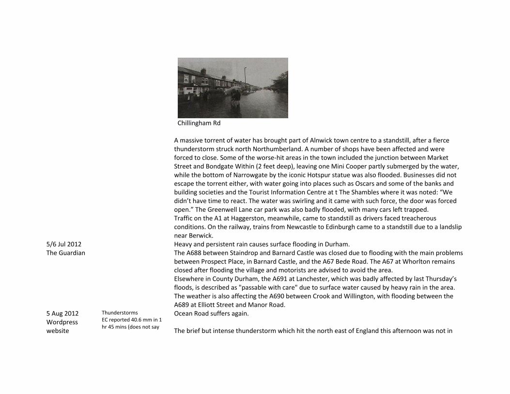
Chillingham Rd
A massive torrent of water has brought part of Alnwick town centre to a standstill, after a fierce thunderstorm struck north Northumberland. A number of shops have been affected and were forced to close. Some of the worse-hit areas in the town included the junction between Market Street and Bondgate Within (2 feet deep), leaving one Mini Cooper partly submerged by the water, while the bottom of Narrowgate by the iconic Hotspur statue was also flooded. Businesses did not escape the torrent either, with water going into places such as Oscars and some of the banks and building societies and the Tourist Information Centre at t The Shambles where it was noted: “We didn’t have time to react. The water was swirling and it came with such force, the door was forced open.” The Greenwell Lane car park was also badly flooded, with many cars left trapped. Traffic on the A1 at Haggerston, meanwhile, came to standstill as drivers faced treacherous conditions. On the railway, trains from Newcastle to Edinburgh came to a standstill due to a landslip near Berwick.
5/6 Jul 2012 The Guardian
Heavy and persistent rain causes surface flooding in Durham. The A688 between Staindrop and Barnard Castle was closed due to flooding with the main problems between Prospect Place, in Barnard Castle, and the A67 Bede Road. The A67 at Whorlton remains closed after flooding the village and motorists are advised to avoid the area. Elsewhere in County Durham, the A691 at Lanchester, which was badly affected by last Thursday’s floods, is described as "passable with care" due to surface water caused by heavy rain in the area. The weather is also affecting the A690 between Crook and Willington, with flooding between the A689 at Elliott Street and Manor Road.
5 Aug 2012 Wordpress website
Thunderstorms EC reported 40.6 mm in 1 hr 45 mins (does not say
Ocean Road suffers again. The brief but intense thunderstorm which hit the north east of England this afternoon was not in

Evening Chronicle 6-8 Aug
where but text refers to Gateshead) Photo in EC 7 Aug has a photo of a large block of coagulated hailstones in Gateshead (below)
any way an exceptional summer weather event, the storm lasted less than an hour and the volume of rain was far less than the last storm to hit us in South Tyneside. Yet once again a familiar story unfolded as parts of South Shields were dealt a miserable hand due mainly to inadequate drainage solutions. Ocean Road once more bore the brunt of the weather as shopkeepers and guest house owners reached for the sand bags and plastic sheeting in a hurried attempt to prevent damage to their flooring. A similar picture was emerging at Tyne Dock at its junction with Eldon Street. ‘Floods return as rain swamps region’. Thunderstorms closed roads and rail lines in a lunchtime deluge which flooded the Coast Road. Eastwood Gardens Felling was hit again with water reaching 5 feet deep in one house. The Central Motorway Newcastle was under 3 feet of water in one place and Shields Road Byker was closed for a time. Causeway, Sheriff Hill Gateshead was flooded again (as Jun 28).
Note the accumulation of hailstones blocking drains
26 Sep 2012 Journal 26 Sep
In Northumberland 68.6 mm fell in 36 hours Durham rainfall reached 79.2
Heavy rain caused serious disruption of traffic on major roads and mororways including A1 north of Newcastle and A1(M)in Co Durham and A690. Ail and metro services were also disrupted. Newburn, Spencer court was evacuated when the building was undermined; 100 people had to leave their homes at Mill Vale.

A Spencer Court and B. Newburn Main St
A1058 Coast Road was closed and properties were flooded at Gosforthe Park Avenue. At least 28 schools were closed or sent pupils home early.
1 Jul 2015 COL <Copley>: 20 mm hail during thunderstorm 2300-2400 GMT. Large hail (up to golf-ball size) was reported, especially over North Yorkshire and Durham, where greenhouse, conservatory and car windows were smashed. Lightning struck and badly damaged buildings and caused widespread power cuts over northern England:
25 Jul 2019 COL <Riding Mill>: Hailstones 3-4.5 cm across at Riding Mill, near Corbridge (Northumberland), where
many vehicles were dented and greenhouses wrecked. These storms were probably from initially isolated cumulonimbus clouds. No precipitation either hail or rain was measured at Ovingham 5 km to the East.

References Alnwick Newspaper cuttings, Newcastle City Library 1881 -1895 L932.82 A 453N Cr98026 Archer, D. (1992) Land of Singing Waters Rivers and Great Floods of Northumbria, Spredden Press, Stocksfield. Blakeborough, J.F. (1901) Bits of West Cleveland, great Ayton, Stokesley and district, past and present, Middlesbrough. British Rainfall (annual 1863 - ) Carling, P. A. (1986a) The Noon Hill flash floods; July 17th 1983. Hydrological and geomorphological aspects of a major formative event in an upland landscape, Trans. Inst. of British Geographers, New Series 11. Carling, P. A. (1986b) Peat slides in Teesdale and Weardale, Northern Pennines July 1983: description and failure mechanisms, Earth Surface Processes and Landforms, 11. Crisp, D.T., Rawes, M, Welch, D. (1964) A Pennine peat slide. Geog. Jnl. 130 519-24. Dickenson, G. (1903) Allendale and Whitfield, Historical Notices of the two Parishes, Newcastle upon Tyne. Duncan, W. Local Newspaper Cuttings 1878-1915 Unpublished Annual compilation. Newcastle uponTyne Public Library. Fordyce, T. (1867 & 1876) Local Records or historical Register of Remarkable Events which have occurred in Northumberland and Durham, Newcastle upon Tyne. (2 Vols) Garrett, W. (1818) An account of the great flood in the Rivers Tyne, Tees, Wear and Eden etc. on 16/17 November 1771, Typographical Society Publications Misc IV Vol 5. Jervoise , E. (1973) The Ancient bridges of the north of England, EP Publishing Ltd. (Written on behalf of the Society for the Protection of Ancient Buildings). Latimer, J.(1857) Local Records or historical Register of Remarkable events which have occurred in Northumberland and Durham, Newcastle upon Tyne and Berwick upon tweed, being a continuation of the work under the same title published by the late Mr Sykes, Newcastle upon Tyne Lees, W. (1876) Historical notes of Haydon Bridge and District, Hexham. Oughton, E. Passmore, A. and Dilley, L (2009) Cheviot flood Impacts study (http://www.cheviotfutures.co.uk/phpdocuments/63.pdf)

Richardson, M.A. (1849) Memorials of the Floods in the Rivers of Northumberland and Durham, Newcastle upon Tyne.