CITY OF TORONTO BASEMENT FLOODING PROTECTION ...
132
WSP Canada Inc. CITY OF TORONTO BASEMENT FLOODING PROTECTION PROGRAM PHASE 4, ASSIGNMENT 17-02, PROJECT 1, PLAYFAIR AVENUE SANITARY SEWER REPLACEMENT FROM EUPHRASIA DRIVE TO ENNERDALE STREET, TORONTO, ONTARIO CITY OF TORONTO GEOTECHNICAL FACTUAL REPORT PROJECT NO.: 161-16086-02/GEO/1701 DATE: JUNE 2018 WSP UNITS 10 & 12 351 STEELCASE ROAD WEST MARKHAM, ON, CANADA L3R 4H9 T +1 905 475-0065 F +1 905 475-0064 WSP.COM
-
Upload
khangminh22 -
Category
Documents
-
view
1 -
download
0
Transcript of CITY OF TORONTO BASEMENT FLOODING PROTECTION ...

WSP Canada Inc.
CITY OF TORONTO BASEMENT FLOODING PROTECTION PROGRAM PHASE 4, ASSIGNMENT 17-02, PROJECT 1, PLAYFAIR AVENUE SANITARY SEWER REPLACEMENT FROM EUPHRASIA DRIVE TO ENNERDALE STREET, TORONTO, ONTARIO
CITY OF TORONTO GEOTECHNICAL FACTUAL REPORT PROJECT NO.: 161-16086-02/GEO/1701 DATE: JUNE 2018
WSP UNITS 10 & 12 351 STEELCASE ROAD WEST MARKHAM, ON, CANADA L3R 4H9 T +1 905 475-0065 F +1 905 475-0064 WSP.COM

WSP Canada Inc.\\CAMRK2DAT01\camrk2\161- Projects\161-16086-02 - COT BFP and Storm Sewer Replacement (KK)\Area 17\Project 1 Playfair\Wp\161-16086-02 Basement Flooding Program, Area 17, Project 1 Playfair Ave. - Factual Report.docx
WSP Canada Inc.
June 25, 2018
Darrell Wunder, P.Eng., PMP Senior Engineer Design & Construction, Linear Underground Infrastructure Engineering and Construction Services City of Toronto Metro Hall, 20th Floor 55 John Street Toronto, Ontario M5V3C6
Dear Mr. Wunder:
We are pleased to submit our factual report of the geotechnical investigation for the proposed sanitary sewer replacement for Project 1 Playfair Avenue included as part of Assignment 17-02 for the City of Toronto Basement Flooding Protection Program Phase 4.
The report is based on information obtained from a pavement coring, borehole investigation and laboratory testing conducted from December 2017 to May 2018.
Geotechnical recommendations relevant to the proposed sanitary sewer replacement will be provided in a separate recommendations report.
We trust that this report meets your present requirements. Please contact us if you have any questions.
Yours sincerely,
Oswin Li, P.Eng Senior Geotechnical Engineer
WSP ref.: 161-16086-02/GEO/1701

Q U A L I T Y M A N A G E M E N T
ISSUE/REVISION FIRST ISSUE REVISION 1 REVISION 2 REVISION 3
Remarks
Date June 25, 2018
Prepared by Jack Li
Signature
Checked by Oswin Li
Signature
Authorised by
Signature
Project number 161-16086-02/GEO/1701
Report number
File reference
Kerolus Khalil

Basement Flooding Protection Program Phase 4, Assignment 17-02, Project 1, Playfair Avenue Sanitary Sewer Replacement From Euphrasia Drive to Ennerdale Street, Toronto, Ontario Project No. 161-16086-02/GEO/1701 City of Toronto
WSP June 2018
S I G N A T U R E S
PREPARED BY
Jack Li, E.I.T. Project Officer, Geotechnical Service
REVIEWED BY
Oswin Li, P.Eng. Senior Geotechnical Engineer

Basement Flooding Protection Program Phase 4, Assignment 17-02, Project 1, Playfair Avenue Sanitary Sewer Replacement From Euphrasia Drive to Ennerdale Street, Toronto, Ontario Project No. 161-16086-02/GEO/1701 City of Toronto
WSP June 2018
1 INTRODUCTION ................................................................... 1
2 INVESTIGATION PROCEDURES ................................... 1
2.1 Permits, Utility Locates, Traffic Control ................................... 1
2.2 Field Investigation ............................................................................. 1
2.2.1 Borehole Program ............................................................................................................................. 1
2.2.2 Pavement Coring............................................................................................................................... 2
2.2.3 Installation of Monitoring Wells .............................................................................................. 2
2.3 Laboratory Testing Program .........................................................3
2.3.1 Geotechnical Testing ...................................................................................................................... 3
2.3.2 Environmental Testing .................................................................................................................. 3
2.3.3 Asbestos Testing ................................................................................................................................ 3
3 FINDINGS ............................................................................... 4
3.1 Existing Pavement Condition ...................................................... 4
3.1.1 Pavement Structure ........................................................................................................................ 4
3.1.2 Intersecting Street Asphalt Composition ........................................................................ 4
3.1.3 Granular Fill (Base and sub-base) .......................................................................................... 5
3.2 Soil Profile ............................................................................................. 6
3.3 Subgrade Permeability .................................................................... 7
3.4 Proctor Testing ................................................................................... 8
3.5 Groundwater and Cave-in Conditions ..................................... 8
3.6 Chemical Testing ............................................................................... 8
3.6.1 Phytotoxicological Analyses ...................................................................................................... 8
3.6.2 BTEX and PHC Analyses ............................................................................................................... 9
3.6.3 PAH Analyses .................................................................................................................................... 10
3.6.4 Leachate Quality (TCLP Extraction) Analysis ............................................................... 10
3.7 Asbestos Testing ................................................................................ 11
3.8 Corrosivity Testing ........................................................................... 12
TABLE OF CONTENTS

Basement Flooding Protection Program Phase 4, Assignment 17-02, Project 1, Playfair Avenue Sanitary Sewer Replacement From Euphrasia Drive to Ennerdale Street, Toronto, Ontario Project No. 161-16086-02/GEO/1701 City of Toronto
WSP June 2018
4 LIMITATIONS ...................................................................... 12
TABLES
TABLE 2.1 BOREHOLE PROGRAM .............................................................. 2 TABLE 2.2 GEOTECHNICAL LABORATORY TESTING
SUMMARY ........................................................................................... 3 TABLE 2.3 ENVIRONMENTAL LABORATORY TESTING
SUMMARY ........................................................................................... 3 TABLE 3.1 EXISTING PAVEMENT STRUCTURE .................................. 4 TABLE 3.2 EXISTING PAVEMENT STRUCTURE –
EUPHRASIA DRIVE ....................................................................... 4 TABLE 3.3 EXISTING PAVEMENT STRUCTURE –
HAVEN ROAD ................................................................................... 5 TABLE 3.4 EXISTING PAVEMENT STRUCTURE –
ENNERDALE STREET ................................................................... 5 TABLE 3.5 GRANULAR FILL PARTICLE SIZE
DISTRIBUTION ANALYSIS RESULT .................................... 5 TABLE 3.6 SANDY SILTY CLAY TILL TO SANDY CLAYEY
SILT TILL PARTICLE SIZE DISTRIBUTION ANALYSES RESULTS .................................................................... 6
TABLE 3.7 SANDY SILTY CLAY TILL TO CLAYEY SILT TILL ATTERBERG LIMITS RESULTS..................................... 7
TABLE 3.8 SAND AND SILT TILL PARTICLE SIZE DISTRIBUTION ANALYSIS RESULTS ................................. 7
TABLE 3.9 SUBGRADE PERMEABILITY VALUES ............................... 7 TABLE 3.10 STANDARD PROCTOR COMPACTION
TESTS ...................................................................................................... 8 TABLE 3.11 GROUNDWATER DEPTHS AND
ELEVATIONS ...................................................................................... 8 TABLE 3.12 RESULTS OF PHYTOTOXICOLOGICAL
ANALYSES ........................................................................................... 9 TABLE 3.13 RESULTS OF BTEX AND PHC ANALYSES ...................... 9 TABLE 3.14 RESULTS OF PAHS ANALYSES ........................................... 10 TABLE 3.15 RESULTS OF TCLP ANALYSES ............................................. 10 TABLE 3.16 ASBESTOS DETECTION RESULTS ..................................... 11 TABLE 3.17 ASBESTOS DETECTION RESULTS OF
INDIVIDUAL ASPHALT LAYERS ........................................... 11 TABLE 3.18 RESULTS OF ANSI/AWWA SOIL
CORROSIVITY POTENTIAL RATING AND SULPHATE CONTENT ................................................................ 12
FIGURES
1 LOCATION MAP 2-3 BOREHOLE LOCATIONS PLANS

Basement Flooding Protection Program Phase 4, Assignment 17-02, Project 1, Playfair Avenue Sanitary Sewer Replacement From Euphrasia Drive to Ennerdale Street, Toronto, Ontario Project No. 161-16086-02/GEO/1701 City of Toronto
WSP June 2018
APPENDICES
A BOREHOLE EXPLANATION FORMS AND BOREHOLE LOGS
B GEOTECHNICAL LABORATORY TEST RESULTS
C CHEMICAL LABORATORY TEST RESULTS
D ASBESTOS LABORATORY TEST RESULTS
Basement Flooding Protection Program Phase 4, Assignment 17-02, Project 1, Playfair Avenue Sanitary Sewer Replacement from Euphrasia Drive to Ennerdale Street, Toronto, Ontario Project No. 161-16086-02/GEO/1701 City of Toronto
WSP June 2018
Page 1
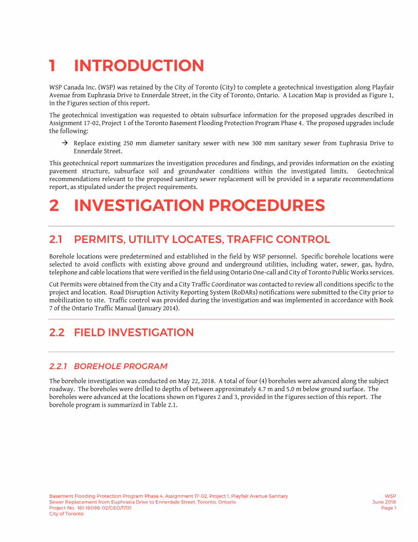
1 INTRODUCTION WSP Canada Inc. (WSP) was retained by the City of Toronto (City) to complete a geotechnical investigation along Playfair Avenue from Euphrasia Drive to Ennerdale Street, in the City of Toronto, Ontario. A Location Map is provided as Figure 1, in the Figures section of this report.
The geotechnical investigation was requested to obtain subsurface information for the proposed upgrades described in Assignment 17-02, Project 1 of the Toronto Basement Flooding Protection Program Phase 4. The proposed upgrades include the following:
Replace existing 250 mm diameter sanitary sewer with new 300 mm sanitary sewer from Euphrasia Drive to Ennerdale Street.
This geotechnical report summarizes the investigation procedures and findings, and provides information on the existing pavement structure, subsurface soil and groundwater conditions within the investigated limits. Geotechnical recommendations relevant to the proposed sanitary sewer replacement will be provided in a separate recommendations report, as stipulated under the project requirements.
2 INVESTIGATION PROCEDURES
2.1 PERMITS, UTILITY LOCATES, TRAFFIC CONTROL Borehole locations were predetermined and established in the field by WSP personnel. Specific borehole locations were selected to avoid conflicts with existing above ground and underground utilities, including water, sewer, gas, hydro, telephone and cable locations that were verified in the field using Ontario One-call and City of Toronto Public Works services.
Cut Permits were obtained from the City and a City Traffic Coordinator was contacted to review all conditions specific to the project and location. Road Disruption Activity Reporting System (RoDARs) notifications were submitted to the City prior to mobilization to site. Traffic control was provided during the investigation and was implemented in accordance with Book 7 of the Ontario Traffic Manual (January 2014).
2.2 FIELD INVESTIGATION
2.2.1 BOREHOLE PROGRAM
The borehole investigation was conducted on May 22, 2018. A total of four (4) boreholes were advanced along the subject roadway. The boreholes were drilled to depths of between approximately 4.7 m and 5.0 m below ground surface. The boreholes were advanced at the locations shown on Figures 2 and 3, provided in the Figures section of this report. The borehole program is summarized in Table 2.1.

Basement Flooding Protection Program Phase 4, Assignment 17-02, Project 1, Playfair Avenue Sanitary Sewer Replacement from Euphrasia Drive to Ennerdale Street, Toronto, Ontario Project No. 161-16086-02/GEO/1701 City of Toronto
WSP June 2018
Page 2
Table 2.1 Borehole Program
ITEM PROJECT 1 – PLAYFAIR
Number of Boreholes One (1) Three (3)
Borehole Depth (m) 4.7 5.0
Borehole Designation BH18-17-1 BH18-17-2, BH18-17-3 and BH18-17-4
Number of Pavement Cores
One (1) Three (3)
Boreholes were advanced using a truck-mounted rig equipped with 110 mm Outside Diameter (O.D.) solid stem augers and 51 mm O.D. split-spoon samplers. A qualified WSP geotechnical engineering technician supervised the drilling, logged and sampled the boreholes in accordance with City standards. Soil samples were recovered and retained in labeled air-tight containers for subsequent review by the project engineer and laboratory testing as required. Asphalt and granular road base thicknesses were recorded at all boreholes advanced through pavement.
The depth to groundwater and/or borehole “cave-in” was measured upon completion of drilling. The boreholes were backfilled immediately after completion with cement grout (1:3 cement sand mortar dry mixed) and compacted with a flat top hand tamper, in accordance with City standards. Compacted cold-mix asphalt was used to restore the boreholes advanced through pavement.
Ground surface elevations at each borehole location were obtained from the project topographic survey data. Borehole locations were obtained based on three (3) tie-in measurements from permanent structures.
Borehole logs detailing the individual pavement and soil profiles are provided in Appendix A. Ground surface elevations and borehole locations are provided on the borehole logs.
2.2.2 PAVEMENT CORING
Coring was conducted at all four (4) borehole locations prior to drilling operations, with an additional three (3) cores obtained along the intersection streets, to evaluate the pavement quality and potential asbestos content, where applicable. The cores were 75 mm in diameter and extended to the bottom of the existing pavement structure at each core location.
2.2.3 INSTALLATION OF MONITORING WELLS
Groundwater was encountered in boreholes BH18-17-1 and BH18-17-3 during the drilling operation. Monitoring wells were installed in boreholes BH18-17-2 and BH18-17-4.
The monitoring wells were constructed using 50 mm O.D. schedule 40 PVC machine slotted and threaded screen and riser pipe, unslotted and threaded cone shaped bottom cap, and a protective plastic J-Plug top cap. The screened intervals were backfilled with filter sand and the annuli riser sections were sealed with bentonite hole plug. Installation was completed to meet Provincial Standards (O.Reg.903 as amended) and the monitoring wells were equipped with flush-to-grade protective casings. Monitoring well details are further described on the borehole logs in Appendix A.
The free standing groundwater levels inside the monitoring wells were measured after a minimum of 24 hours from installation.

Basement Flooding Protection Program Phase 4, Assignment 17-02, Project 1, Playfair Avenue Sanitary Sewer Replacement from Euphrasia Drive to Ennerdale Street, Toronto, Ontario Project No. 161-16086-02/GEO/1701 City of Toronto
WSP June 2018
Page 3
2.3 LABORATORY TESTING PROGRAM
2.3.1 GEOTECHNICAL TESTING
Selected soil samples were submitted to WSP’s certified soils laboratory for geotechnical testing in accordance with Table 2.2. Geotechnical laboratory test results are provided on the borehole logs in Appendix A. A copy of the geotechnical laboratory test results is provided in Appendix B.
Table 2.2 Geotechnical Laboratory Testing Summary
GEOTECHNICAL TEST PROCEDURE/METHODOLOGY NUMBER OF TESTS
Moisture Content ASTM D2974 Twenty-eight (28)
Standard Proctor Test ASTM D698 One (1)
Subgrade Soil Permeability ASTM WK38106 / LS-702 Eight (8)
Sieve Analysis ASTM D422 and/or LS602 One (1)
Atterberg Limits ASTM D4318 Four (4)
2.3.2 ENVIRONMENTAL TESTING
Selected soil samples were submitted to AGAT Laboratories in Mississauga, Ontario for environmental testing in accordance with Table 2.3. A copy of the environmental laboratory test results is provided in Appendix C.
Table 2.3 Environmental Laboratory Testing Summary
ENVIRONMENTAL TEST NUMBER OF TESTS
Phytotoxicological Analyses (including metals and inorganics – O. Reg. 153/04 – as amended)
Four (4)
Regulation of 558 (TCLP-Inorganic) Leachate Quality One (1)
Polychlorinated Biphenyls - PCBs (O. Reg. 558/00) One (1)
BTEX & PHCs (O. Reg. 153/04 – as amended) Four (4)
Volatile Organic Compounds - VOCs (O. Reg. 558/00) One (1)
Polycyclic Aromatic Hydrocarbons – PAHs (O. Reg. 153/04 – as amended) Two (2)
Corrosivity Package Two (2)
2.3.3 ASBESTOS TESTING
Based on a review of the City’s Asbestos Locations map, the subject roadway from Euphrasia Drive to Ennerdale Street on Playfair Avenue (with the exception of Haven Road) is classified as “Contains Asbestos and Testing Required”. Therefore, twenty-five (25) pavement cores were submitted for asbestos testing (O.Reg.278/05).

Basement Flooding Protection Program Phase 4, Assignment 17-02, Project 1, Playfair Avenue Sanitary Sewer Replacement from Euphrasia Drive to Ennerdale Street, Toronto, Ontario Project No. 161-16086-02/GEO/1701 City of Toronto
WSP June 2018
Page 4
Testing was performed using polarized light microscopy (PLM), based on EPA 600, in accordance with the U.S. Environmental Protection Agency Test Method EPA/600/R-93/116: Method for the Determination of Asbestos in Bulk Building Materials (June 1993).
Asbestos test locations are provided on Figures 2 and 3. A copy of the asbestos laboratory test results is provided in Appendix D.
3 FINDINGS
3.1 EXISTING PAVEMENT CONDITION
3.1.1 PAVEMENT STRUCTURE
The existing pavement structure along the subject roadway consists of an asphaltic concrete (AC) pavement structure within the project limits. Asphalt and granular thicknesses at each borehole location are summarized in Table 3.1 below.
Table 3.1 Existing Pavement Structure
BOREHOLE NO.
ASPHALT THICKNESS (mm) GRANULAR THICKNESS
(mm)
TOTAL PAVEMENT STRUCTURE THICKNESS
(mm)
Surface Course
Middle Course Base Course Total
BH18-17-1 80 35 35 150 240 390
BH18-17-2 70 20 50 140 220 360
BH18-17-3 20 35 35 70 160 220 380
BH18-17-4 20 30 90 35 175 290 465
Average 48 60 48 156 243 399
3.1.2 INTERSECTING STREET ASPHALT COMPOSITION
EUPHRASIA DRIVE
The existing pavement structure at the intersection of Euphrasia Drive and Playfair Avenue consists of an asphaltic concrete (AC) pavement structure. Asphalt thicknesses at the cored locations are summarized in Table 3.2. Granular fill thicknesses were not recorded at the cored locations directly below the AC pavement.
Table 3.2 Existing Pavement Structure – Euphrasia Drive
COREHOLE NO. ASPHALT THICKNESS (mm) TOTAL
(mm) Surface Course Middle Course Base Course
CH18-17-1 60 30 65 155

Basement Flooding Protection Program Phase 4, Assignment 17-02, Project 1, Playfair Avenue Sanitary Sewer Replacement from Euphrasia Drive to Ennerdale Street, Toronto, Ontario Project No. 161-16086-02/GEO/1701 City of Toronto
WSP June 2018
Page 5
HAVEN ROAD
The existing pavement structure at the intersection of Haven Road and Playfair Avenue consists of an asphaltic concrete (AC) pavement structure. Asphalt thicknesses at the cored locations are summarized in Table 3.3. Granular fill thicknesses were not recorded at the cored locations directly below the AC pavement.
Table 3.3 Existing Pavement Structure – Haven Road
COREHOLE NO. ASPHALT THICKNESS (mm) TOTAL
(mm) Surface Course Middle Course Base Course
CH18-17-2 50 60 65 175
ENNERDALE STREET
The existing pavement structure at the intersection of Ennerdale Street and Playfair Avenue consists of an asphaltic concrete (AC) pavement structure. Asphalt thicknesses at the cored locations are summarized in Table 3.4. Granular fill thicknesses were not recorded at the cored locations directly below the AC pavement.
Table 3.4 Existing Pavement Structure – Ennerdale Street
COREHOLE NO.
ASPHALT THICKNESS (mm) TOTAL
(mm) Surface Course 1st Middle
Course 2nd Middle
Course Base Course
CH18-17-3 45 25 50 45 165
3.1.3 GRANULAR FILL (BASE AND SUB-BASE)
Granular fill was encountered in all boreholes directly below the asphalt, with approximate thicknesses ranging from 220 mm to 290 mm. The granular fill consists of gravelly sand with some of soil fines (silt and clay).
At the time of the investigation, the granular fill was moist. Laboratory moisture content test results for the fill was 5% to 15%. Based on SPT N-values, the granular fill has a loose to compact state of compactness.
One (1) laboratory particle size distribution analysis was conducted on a composite of samples recovered from the granular fill (Comp A – BH18-17-1 to BH18-17-4). The result is provided in Table 3.5, according to the Unified Soil Classification System (USCS):
Table 3.5 Granular Fill Particle Size Distribution Analysis Result
BOREHOLE NO. SAMPLE
I.D.
% GRADATION PRIMARY SOIL CLASSIFICATION
Gravel Sand Silt & Clay
BH18-17-1 to BH18-17-4 Comp A 34 52 14 Gravelly sand FILL, some silt and clay
The particle size distribution curve is provided in Appendix B.

Basement Flooding Protection Program Phase 4, Assignment 17-02, Project 1, Playfair Avenue Sanitary Sewer Replacement from Euphrasia Drive to Ennerdale Street, Toronto, Ontario Project No. 161-16086-02/GEO/1701 City of Toronto
WSP June 2018
Page 6
3.2 SOIL PROFILE
COHESIVE EARTH FILL
Cohesive earth fill was encountered underlying the granular fill in all boreholes. The fill consists of silty clay. It contains varying amounts of sand (some to sandy) and a trace of gravel. It extends to depths ranging from approximately 0.8 m to 2.1 m below existing ground surface.
At the time of the investigation, the cohesive earth fill was found to be dryer than the plastic limit (DTPL) to wetter than the plastic limit (WTPL). The in-situ moisture contents as determined by laboratory test yielded approximately 5% to 24%. Based on SPT N values, the cohesive fill had a firm to very stiff consistency.
SANDY SILTY CLAY TILL TO SANDY CLAYEY SILT TILL
Native glacial till deposits comprising of sandy silty clay till to sandy clayey silt till were encountered in all boreholes below the fill materials. With the exception of BH18-18-1 in which the sandy silty clay till extends to a depth of approximately 2.1 m, all other boreholes were terminated in the sandy silty clay till to sandy clayey silt till deposits at a depth of approximately 5 m below existing grade.
At the time of the investigation, the sandy silty clay till to sandy clayey silt till was found to be drier than the plastic limit (DTPL). The natural moisture contents as determined by laboratory tests yielded approximately 7% to 14%. Based on SPT N values, the sandy silt clay till to sandy clayey silt till had a very stiff to hard consistency.
Seven (7) laboratory particle size distribution analyses were conducted on selected samples obtained from the encountered clayey glacial till deposits. The results are provided in Table 3.6, according to the Unified Soil Classification System (USCS):
Table 3.6 Sandy Silty Clay Till to Sandy Clayey Silt Till Particle Size Distribution Analyses Results
BOREHOLE NO. SAMPLE I.D. % GRADATION PRIMARY SOIL
CLASSIFICATION Gravel Sand Silt & Clay
BH18-17-1 SS2 4 26 70 Sandy Silty Clay Till, trace
gravel
BH18-17-2
SS4 6 30 64 Sandy Clayey Silt Till, trace
gravel
SS7 3 29 68 Sandy Silty Clay Till, trace
gravel
BH18-17-3
SS4 1 27 72 Sandy Clayey Silt Till, trace
gravel
SS6 4 30 66 Sandy Clayey Silt Till, trace
gravel
BH18-17-4
SS4 4 26 70 Sandy Silty Clay Till, trace
gravel
SS6 3 25 72 Sandy Silty Clay Till, trace
gravel
The results of the analyses are shown on the borehole logs in Appendix A. The particle size distribution curves are provided in Appendix B.

Basement Flooding Protection Program Phase 4, Assignment 17-02, Project 1, Playfair Avenue Sanitary Sewer Replacement from Euphrasia Drive to Ennerdale Street, Toronto, Ontario Project No. 161-16086-02/GEO/1701 City of Toronto
WSP June 2018
Page 7
Atterberg Limits tests were carried out on four (4) of the above selected samples. The results are summarized in Table 3.7 below.
Table 3.7 Sandy Silty Clay Till to Clayey Silt Till Atterberg Limits Results
BOREHOLE NO. SAMPLE I.D. LIQUID LIMIT (LL) PLASTIC LIMIT (PL) PLASTICITY INDEX
(PI)
BH18-17-1 SS2 21 12 9
BH18-17-2 SS7 25 14 11
BH18-17-3 SS4 20 13 7
BH18-17-4 SS6 22 13 9
A review of the Atterberg limits test results indicates that all tested samples with the exception of BH18-17-3/SS4 can be classified as a clay of low plasticity (CL) in accordance with the Unified Soil Classification System. The tested sample SS4 obtained from BH18-17-3 can be classified as either a clay or silt of low plasticity (CL-ML).
The results of the Atterberg limits tests are summarized on the borehole logs in Appendix A and the plasticity charts are provided in Appendix B.
SAND AND SILT TILL
A stratum of native sand and silt till was encountered underlying the sandy silty clay till in borehole BH18-17-1. It contains a trace of gravel and some clay. The extent of the sand and silt till deposit is unknown, as borehole BH18-17-1 was terminated in this stratum at a depth of approximately 4.7 m below existing ground surface.
At the time of the investigation, the sand and silt till was found to be moist. The natural moisture contents as determined by laboratory tests yielded approximately 7% to 9%. Based on SPT N values, the sand and silt till had a very dense state of compactness.
One (1) laboratory particle size distribution analysis was conducted on selected sample obtained from the encountered sandy glacial till deposits. The result is provided in Table 3.6, according to the Unified Soil Classification System (USCS):
Table 3.8 Sand and Silt Till Particle Size Distribution Analysis Results
BOREHOLE NO. SAMPLE I.D. % GRADATION PRIMARY SOIL
CLASSIFICATION Gravel Sand Silt & Clay
BH18-17-1 SS4 4 40 56 Sand and Silt Till, trace gravel, some clay
3.3 SUBGRADE PERMEABILITY The permeability (i.e. hydraulic conductivity) of the subgrade is estimated by comparing the particle size distribution curves of the subject material with established permeability correlation data. Table 3.9 presents the subgrade permeability of the encountered subgrade soil samples.
Table 3.9 Subgrade Permeability Values
BOREHOLE NO. SAMPLE SOIL TYPE PERMEABILITY (m/s)
BH18-17-1 SS2 Sandy Silty Clay Till 1 x 10⁻⁷
SS4 Sand and Silt Till 1 x 10⁻⁶

Basement Flooding Protection Program Phase 4, Assignment 17-02, Project 1, Playfair Avenue Sanitary Sewer Replacement from Euphrasia Drive to Ennerdale Street, Toronto, Ontario Project No. 161-16086-02/GEO/1701 City of Toronto
WSP June 2018
Page 8
BH18-17-2 SS4 Sandy Clayey Silt Till 1 x 10⁻⁷
SS7 Sandy Silty Clay Till 1 x 10⁻⁷
BH18-17-3 SS4 Sandy Clayey Silt Till 1 x 10⁻⁷
SS6 Sandy Clayey Silt Till 1 x 10⁻⁷
BH18-17-4 SS4 Sandy Silty Clay Till 1 x 10⁻⁷
SS6 Sandy Silty Clay Till 1 x 10⁻⁷
3.4 PROCTOR TESTING One (1) Standard Proctor compaction test was conducted on composite soil samples obtained from the subject roadway. The proctor test was conducted on the subgrade soils. Sample details and the respective standard proctor maximum dry density (SPMDD) value and optimum moisture content are detailed in Table 3.10. A copy of the laboratory result is provided in Appendix B.
Table 3.10 Standard Proctor Compaction Tests
MATERIAL LOCATION SPMDD (kg/m3)
OPTIMUM MOISTURE (%)
Subgrade Soil BH18-17-1 to BH18-17-4 1837 13.8
3.5 GROUNDWATER AND CAVE-IN CONDITIONS All boreholes with the exception of BH18-17-1 remained open and dry upon completion of drilling. Borehole BH18-17-1 caved to 4.5 m below ground surface (mbgs) and the water was at a depth of 3.5 m below ground surface (mbgs).
Monitoring wells were installed in boreholes BH18-17-2 and BH18-17-4. Static groundwater measurements were obtained in the monitoring wells after a minimum of 24 hours from installation. The recorded groundwater measurements are provided in Table 3.11.
Table 3.11 Groundwater Depths and Elevations
BH NO. DATE OF
OBSERVATION
DEPTH OF GROUNDWATER
(mBGS)
MONITOR DEPTH (mBGS)
ELEVATION OF GROUNDWATER
(mASL)
BH18-17-2 June 5, 2018 3.9 4.6 172.6
BH18-17-4 June 5, 2018 1.9 4.6 173.6
3.6 CHEMICAL TESTING
3.6.1 PHYTOTOXICOLOGICAL ANALYSES
Four (4) selected soil samples from the boreholes (one (1) sample per borehole) were analyzed for general metals and inorganic parameters under Ontario Regulation O.Reg.153/04 (amended). Test results were compared to the Ministry of the

Basement Flooding Protection Program Phase 4, Assignment 17-02, Project 1, Playfair Avenue Sanitary Sewer Replacement from Euphrasia Drive to Ennerdale Street, Toronto, Ontario Project No. 161-16086-02/GEO/1701 City of Toronto
WSP June 2018
Page 9
Environment and Climate Change (MOECC) guidelines listed in Table 1 (Full Depth Background Site Condition Standards) for Residential/ Parkland/ Institutional/ Industrial/ Commercial/ Community (RPIICC) Property Use, Tables 2 and 3 (Full Depth Generic Site Condition Standards in a Potable & Non-Potable Ground Water Condition) for Residential/ Parkland/ Institutional (RPI) and Industrial/ Commercial/ Community (ICC) Property Uses and Table 2 (Full Depth Generic Site Condition Standards in a Potable Ground Water Condition) for Agriculture or other Property Use (AG) of the Soil, Groundwater and Sediment Standards for Use Under Part XV.I of the Environmental Protection Act (April 15, 2011). The tested soil samples met the relevant MOECC guidelines, with the exceptions listed in Table 3.12. A copy of the laboratory certificate of analysis is provided in Appendix C.
Table 3.12 Results of Phytotoxicological Analyses
TESTED SAMPLE I.D.
BOREHOLE SAMPLE
PARAMETER EXCEEDANCES
MOECC Table 1 RPIICC
MOECC Tables 2 & 3 RPI
MOECC Tables 2 & 3 ICC
MOECC Table 2 AG
BH18-17-1-SS2 BH18-17-1-SS2 SAR SAR None SAR
BH18-17-2-SS2 BH18-17-2-SS2 EC & SAR SAR None SAR
BH18-17-3-SS2+SS3
BH18-17-3-SS2+SS3
EC & SAR EC & SAR SAR EC & SAR
BH18-17-4-SS2 BH18-17-4-SS2 EC & SAR EC & SAR SAR EC & SAR
Note: 1. SAR denotes Sodium Adsorption Ratio and EC denotes Electrical Conductivity
3.6.2 BTEX AND PHC ANALYSES
The above noted four (4) soil samples were also analyzed for benzene, toluene, ethyl-benzene, and xylenes (BTEX) and petroleum hydrocarbons (PHC F1-F4 fractions) under O.Reg.153/04 (amended). Test results were compared to the Ministry of the Environment and Climate Change (MOECC) guidelines listed in Table 1 (Full Depth Background Site Condition Standards) for Residential/ Parkland/ Institutional/ Industrial/ Commercial/ Community (RPIICC) Property Use, Tables 2 and 3 (Full Depth Generic Site Condition Standards in a Potable & Non-Potable Ground Water Condition) for Residential/ Parkland/ Institutional (RPI) and Industrial/ Commercial/ Community (ICC) Property Uses and Table 2 (Full Depth Generic Site Condition Standards in a Potable Ground Water Condition) for Agriculture or other Property Use (AG) of the Soil, Groundwater and Sediment Standards for Use Under Part XV.I of the Environmental Protection Act (April 15, 2011). The tested soil samples met the relevant MOECC guidelines, with the exception as listed in Table 3.13. A copy of the laboratory certificate of analyses is provided in Appendix C.
Table 3.13 Results of BTEX and PHC Analyses
TESTED SAMPLE I.D.
BOREHOLE SAMPLE
PARAMETER EXCEEDANCES
MOECC Table 1 RPIICC
MOECC Tables 2 & 3 RPI
MOECC Tables 2 & 3 ICC
MOECC Table 2 AG
BH18-17-1-SS2 BH18-17-1-SS2 None None None None
BH18-17-2-SS2 BH18-17-2-SS2 None None None None

Basement Flooding Protection Program Phase 4, Assignment 17-02, Project 1, Playfair Avenue Sanitary Sewer Replacement from Euphrasia Drive to Ennerdale Street, Toronto, Ontario Project No. 161-16086-02/GEO/1701 City of Toronto
WSP June 2018
Page 10
BH18-17-3-SS2+SS3
BH18-17-3-SS2+SS3
None None None None
BH18-17-4-SS2 BH18-17-4-SS2 None None None None
3.6.3 PAH ANALYSES
Two (2) selected soil samples were also analyzed for Polycyclic Aromatic Hydrocarbons (PAHs) under O.Reg.153/04 (amended). Test results were compared to the Ministry of the Environment and Climate Change (MOECC) guidelines listed in Table 1 (Full Depth Background Site Condition Standards) for Residential/ Parkland/ Institutional/ Industrial/ Commercial/ Community (RPIICC) Property Use, Tables 2 and 3 (Full Depth Generic Site Condition Standards in a Potable & Non-Potable Ground Water Condition) for Residential/ Parkland/ Institutional (RPI) and Industrial/ Commercial/ Community (ICC) Property Uses and Table 2 (Full Depth Generic Site Condition Standards in a Potable Ground Water Condition) for Agriculture or other Property Use (AG) of the Soil, Groundwater and Sediment Standards for Use Under Part XV.I of the Environmental Protection Act (April 15, 2011). The tested soil samples met the relevant MOECC guidelines, as shown on Table 3.14 below. A copy of the laboratory certificate of analyses is provided in Appendix C.
Table 3.14 Results of PAHs Analyses
TESTED BOREHOLE SAMPLE I.D.
PARAMETER EXCEEDANCES
MOECC Table 1 RPIICC
MOECC Tables 2 & 3 RPI
MOECC Tables 2 & 3 ICC
MOECC Table 2 AG
BH18-17-3-SS1 None None None None
BH18-17-4-SS1 None None None None
3.6.4 LEACHATE QUALITY (TCLP EXTRACTION) ANALYSIS
One (1) composite soil sample was analyzed for metals and inorganic parameters, polychlorinated bi-phenyls (PCBs), and volatile organic compounds (VOCs) by Toxicity Characteristics Leaching Procedure (TCLP) extraction. Test result was compared to Schedule 4 of O.Reg.558. The tested soil sample met the relevant guidelines as summarized in Table 3.15. A copy of the laboratory certificate of analyses is provided in Appendix C.
Table 3.15 Results of TCLP Analyses
TESTED SAMPLE I.D.
BOREHOLE SAMPLE
PARAMETER EXCEEDANCES
METALS & INORGANICS
PCBs VOCs
TCLP – Playfair Ave
BH18-17-1-SS1+SS2 BH18-17-2-SS2
BH18-17-3-SS2+SS3 BH18-17-4-SS2+SS3
None None None

Basement Flooding Protection Program Phase 4, Assignment 17-02, Project 1, Playfair Avenue Sanitary Sewer Replacement from Euphrasia Drive to Ennerdale Street, Toronto, Ontario Project No. 161-16086-02/GEO/1701 City of Toronto
WSP June 2018
Page 11
3.7 ASBESTOS TESTING One (1) composite asphalt core sample was submitted for asbestos testing. Test result indicates potential presence of asbestos was detected in the tested core sample as detailed in Table 3.16. A copy of the laboratory Certificate of Analyses from EMC Scientific Incorporated is provided in Appendix D.
Table 3.16 Asbestos Detection Results
BOREHOLE LOCATION ASBESTOS RESULT
CH18-17-3 2.79% Chrysotile; 97.21% Non-Fibrous
In order to further examine the presence of asbestos, the individual asphalt layers from composite core samples of coreholes CH18-17-1 to CH18-17-3 as well as boreholes BH18-17-1 to BH18-17-4 were submitted for asbestos testing. Test results indicate asbestos was detected in the surface, mid and base layers of core samples from corehole CH18-17-3 and boreholes BH18-17-2 to BH18-17-4 as detailed in Table 3.17. A copy of the laboratory Certificate of Analyses from EMC Scientific Incorporated is provided in Appendix D.
Table 3.17 Asbestos Detection Results of Individual Asphalt Layers
BOREHOLE NO.
ASBESTOS RESULTS
Surface Course 1st Middle
Course 2nd Middle
Course Base Course
CH18-17-1 <0.25% Chrysotile; 100%
Non-Fibrous None Detected; 100 % Non-
Fibrous None Detected; 100% Non-
Fibrous
CH18-17-2 None Detected; 100% Non-
Fibrous None Detected; 100 % Non-
Fibrous None Detected; 100% Non-
Fibrous
CH18-17-3 1.85% Chrysotile; 98.15%
Non-Fibrous
1.8% Chrysotile; 98.2% Non-
Fibrous
None Detected; 100% Non-
Fibrous
None Detected; 100% Non-Fibrous
BH18-17-1 None Detected; 100% Non-
Fibrous None Detected; 100 % Non-
Fibrous None Detected; 100% Non-
Fibrous
BH18-17-2 <0.25% Chrysotile; 100%
Non-Fibrous 0.93% Chrysotile; 99.07 % Non-
Fibrous 0.4% Chrysotile; 99.6% Non-
Fibrous
BH18-17-3 0.93% Chrysotile; 99.07%
Non-Fibrous
0.94% Chrysotile;
99.06% Non-Fibrous
2.71% Chrysotile;
97.29% Non-Fibrous
0.96% Chrysotile; 99.04% Non-Fibrous
BH18-17-4 <0.25% Chrysotile; 100%
Non-Fibrous
0.92% Chrysotile;
99.08% Non-Fibrous
0.95% Chrysotile;
99.05% Non-Fibrous
0.47% Chrysotile; 99.53% Non-Fibrous

Basement Flooding Protection Program Phase 4, Assignment 17-02, Project 1, Playfair Avenue Sanitary Sewer Replacement from Euphrasia Drive to Ennerdale Street, Toronto, Ontario Project No. 161-16086-02/GEO/1701 City of Toronto
WSP June 2018
Page 12
3.8 CORROSIVITY TESTING The following Table 3.18 summarizes the ANSI/AWWA rating for the tested soil samples for the potential for corrosion towards buried grey or ductile cast iron pipe and assess the potential for degradation of buried concrete in contact with the encountered soils. A score of 10 points or more indicates potential for corrosion.
Table 3.18 Results of ANSI/AWWA Soil Corrosivity Potential Rating and Sulphate Content
SAMPLE I.D.
SULPHATE CONTENT
(µg/g or ppm)
RESISTIVITY (ohms-cm)
PH REDOX
POTENTIAL (mV)
SULPHIDE (%) MOISTURE CONTENT
(%)
TOTAL POINTS
BH18-17-1-SS6 23 9900/0 8.83/3 166/0 <0.05/Negative/0 Moist/ 1 4
BH18-17-3-SS5 6 6450/0 8.63/3 195/0 <0.05/Negative/0 Moist/ 1 4
4 LIMITATIONS The comments given in this report are intended for the guidance of design engineers. The number of boreholes required to determine the localized underground conditions between boreholes affecting construction costs, techniques, sequencing, equipment, scheduling, etc., may be greater than has been carried out for current purposes. Contractors bidding on or undertaking the work shall, in this light, decide on their own investigations, as well as their own interpretations of the factual borehole results, so that they may draw their own conclusions as to how the subsurface conditions may affect them.
Information in this report shall not be used by third parties without WSP’s permission. We trust that the information contained in this report is satisfactory. Should you have any questions, please do not hesitate to contact us.

FIGURES

PROJECT 2
PROJECT 1
ALLEN EXPY
DUFFERIN ST
MARLEE AVE
GLENCAIRN AVE
LAWRENCE AVE W
GLENGROVE AVE
STAYNER AVETYCOS DR
SHERMOUNT AVE
TIMES RD
HILLMOUNT AVE
GLEN PARK AVE
DANESBURY AVE
CORK AVE
DELL PARK AVE
BRIAR HILL AVE
APEX RD
WENDERLY DR
WINGOLD AVE
CLAVER AVE
DANE AVE
HOPEWELL AVE
PLAYFAIR AVE
LOCKSLEY AVE
FAIRHOLME AVE
HAVEN RD VIEWMOUNT AVE
CASTLEFIELD AVE
GLEN LONG AVE
ENGLEMOUNT AVE
CAPITOL AVE
GLENBROOK AVE
LILYWOOD RD
LOIS AVE
WHITMORE AVE
COLDSTREAM AVE
LANSDOWNE AVE
NEWGATE RD
RIDELLE AVE
MEADOWBROOK RD
ROSELAWN AVE
FAIRLEIGH CRES
EUPHRASIA DR
ELM RIDGE DR
BOLINGBROKE RD
RISA BLVD
ENNERDALE ST
ELWAY CRT
ENID CRES
PARK HILL RD
LYON CRT
CAROUSEL CRT
CONVENT CRT
BENNER AVE
BEOGRAD GDNS
MAJESTIC CRT
HILLMOUNT AVE
FAIRHOLME AVE
RIDELLE AVE
ALLEN EXPY
GLEN PARK AVE
GLENGROVE AVE
ROSELAWN AVE
GEOTECHNICAL REPORTBasement Flooding Protection Program Phase 4BF Assignment 17-02BF Assignment 17-05Toronto, Ontario
LOCATION MAP
1FILE. NO.:PROJECT: 161-16086-02
DATE: JUNE 2018
FIGURE.1:10000SCALE:
0 200 400100Meters
LegendBF Assignment 17-02-Project 1BF Assignment 17-05-Project 2

PROJECT: 161-16086-02
SCALE: 1:500
FIGURE
FILE NO.:
DATE: MAY 2018
95
93
91
90
88
70
76
1
86
84
79
73
697181
83858789
PA1 PA2TO REPLACE 250 mm DIA SANITARY SEWERPROPOSED 300 mm DIA SANITARY SEWER
TO REPLACE 250 mm DIA SANITARY SEWER
PROPOSED 300 mm DIA SANITARY SEWEREXISTING SEWER
RECONNECT
REMOVE MH I.E. 172.99
PROPOSED 1200 mm DIA MH
REMOVE MH I.E. 172.62PROPOSED 1200 mm DIA MH
TREED AREA
TREED AREA
TREED AREATREED AREA
TREED AREA
TREED AREA
FPFP
210 0 10 metres5
LEGENDBOREHOLE LOCATIONS PLAN
PROPOSED SANITARY SEWER
SE
E FIG
UR
E 3
INDICATES COREHOLE WITHOUT ASBESTOS TESTING to Ennerdale Street,Toronto, Ontario
Sanitary Sewer Replacement From Euphrasia Drive
BF Assignment 17-02, Project 1, Playfair Avenue
Basement Flooding Protection Program Phase 4,
GEOTECHNICAL REPORTMEASURES REQUIRED)
- 5.0 m DEPTH (ACM-ADDITIONAL FIELD PRECAUTION
BOREHOLE LOCATION AND DESIGNATION
WITH ASBESTOS TESTING
COREHOLE LOCATION AND DESIGNATION
GROUND SURFACE ELEVATION (mASL)176.8
MEASURED ON JUNE 5, 2018
GROUNDWATER ELEVATION (MASL)
176.8176.5
(172.2)
(172.2)
32 PE IP Gas Main (Enbridge)
32 PE IP Gas Main (Enbridge)
32 PE IP Gas Main (Enbridge)
G.S.
Fibre Optic (Rogers)
Fibre Optic (Rogers)
32 PE IP Gas Main (Enbridge)
G.S.
G.S.
G.S.
Unknown Utility
Unknown Utility
Unknown Utility
Telecommunication (Rogers)
Telecommunication (Bell)
(Enbridge)
32 PE IP Gas Main
200 mm Conc.Stm.Sewer
200 mm Conc.Stm.Sewer
200 mm Conc.Stm.Sewer
200 mm Conc.Stm.Sewer
200 mm Conc.Stm.Sewer
200 mm Conc.Stm.Sewer
450 mm Conc.Stm.Sewer250 mm Conc.San.Sewer
200 mm Conc.Stm.Sewer
200 mm Conc.Stm.Sewer
250 mm Conc.San.Sewer
525 mm Conc.Stm.Sewer
600 mm Conc.Stm.Sewer675 mm Conc.Stm.Sewer
250 mm Conc.San.Sewer
150 mm C.I.
150 mm C.I. Water Main
150 mm C.I. Water Main
150 mm C.I. Water Main
150 mm C.I. Water Main
150 mm C.I. Water Main
250
mm
Conc.S
an.S
ewer
450
mm
Conc.Stm.S
ewer
150 mm C.I. Water Main Aband'd
Euphra
sia Dr.
CH18-17-1
CH18-17-2
CH18-17-1
Playfair Ave.
Maria
nfeld A
ve.
Haven R
d.
BH18-17-1
BH18-17-1BH18-17-2
*
*
*

PROJECT: 161-16086-02
SCALE: 1:500
FIGURE
FILE NO.:
DATE: MAY 2018
PA3PA4
TO REPLACE 250 mm DIA SANITARY SEWERPROPOSED 300 mm DIA SANITARY SEWER TO REPLACE 250 mm DIA SANITARY SEWER
PROPOSED 300 mm DIA SANITARY SEWERREMOVE MH I.E. 172.20
PROPOSED 1200 mm DIA MH
REMOVE MH I.E. 171.85PROPOSED 1200 mm DIA MH
RECONNECT EXISTING SEWER
TO REPLACE 250 mm DIA SANITARY SEWERPROPOSED 300 mm DIA SANITARY SEWER
EXISTING SEWER
RECONNECT
REMOVE MH I.E. 171.82PROPOSED 1200 mm DIA MH
PA5
TO REPLACE 250 mm DIA SANITARY SEWERPROPOSED 300 mm DIA SANITARY SEWER
SEAL SANITARY MH COVER
PARKING
TREED AREA
310 0 10 metres5
LEGENDBOREHOLE LOCATIONS PLAN
PROPOSED SANITARY SEWER
SE
E FIG
UR
E 2
MEASURES REQUIRED)
- 5.0 m DEPTH (ACM-ADDITIONAL FIELD PRECAUTION
BOREHOLE LOCATION AND DESIGNATION
WITH ASBESTOS TESTING
COREHOLE LOCATION AND DESIGNATION
to Ennerdale Street,Toronto, Ontario
Sanitary Sewer Replacement From Euphrasia Drive
BF Assignment 17-02, Project 1, Playfair Avenue
Basement Flooding Protection Program Phase 4,
GEOTECHNICAL REPORT
GROUND SURFACE ELEVATION (mASL)175.6
MEASURED ON JUNE 5, 2018
GROUNDWATER ELEVATION (MASL)
175.6175.5
(173.6)
(173.6)
32 PE IP Gas Main (Enbridge)32 PE IP Gas Main (Enbridge)
G.S.
32 PE IP Gas Main (Enbridge)
50 PE IP Gas Main (Enbridge)
Telecommunication (Rogers)
Telecommunication (Rogers)
Telecommunication (Bell)
560 x 410 mm (W x H)
Toronto Hydro Ductbank
560 x 410 mm (W x H)
Toronto Hydro Ductbank
Toronto Hydro
560 x 410 mm (W x H)
Toronto Hydro Ductbank
Telecommunication (Bell)Telecommunication (Bell)
Telecommunication (Bell)Telecommunication (Bell)
Toronto Hydro
200 mm Conc.Stm.Sewer
200 mm Conc.Stm.Sewer
1200 mm Conc.Stm.Sewer
250 mm Conc.San.Sewer
250 mm Conc.San.Sewer
450 mm Conc.Stm.Sewer
200 mm Conc.Stm.Sewer
Conc.Stm.Sewer
200 mm Conc.Stm.Sewer
250 mm Conc.San.Sewer Aband'd
200 mm Stm.Sewer
150 mm San.Sewer
150 mm San.Sewer
300 mm Conc. Stm.Sewer
300 mm Conc. Stm.Sewer
250 mm Stm.Sewer
350 mm Conc Stm.Sewer
900 mm Conc.Stm.Sewer
250 mm Conc.San.Sewer
975 mm Conc.Stm.Sewer
900 mm Conc.Stm.Sewer
150 mm C.I. Water Main
900 mm Conc.Stm.Sewer
450
mm
Conc.S
an.S
ewer
150 mm C.I. Water Main
150 mm C.I. Water Main Aband'd
150 mm C.I. Water Main Aband'd
150 mm C.I. Water Main
150
mm
C.I. W
ater
Main
150 mm C.I. Water Main Aband'd
CH18-17-3
CH18-17-3
Playfair Ave.
Ennerd
ale St.
BH18-17-3
BH18-17-3BH18-17-4
53 51
4955575961
65
63
60
67 43
HUMP
SPEED

APPENDIX
A BOREHOLE EXPLANATION FORMS AND BOREHOLE LOGS

20/08/15 1:25 PM Admin/Borehole Log Explanation Form (USCS)
BOREHOLE LOG EXPLANATION FORM
This explanatory section provides the background to assist in the use of the borehole logs. Each of the headings used on the borehole log, is briefly explained.
DEPTH
This column gives the depth of interpreted geologic contacts in metres below ground surface.
STRATIGRAPHIC DESCRIPTION
This column gives a description of the soil based on a tactile examination of the samples and/or laboratory test results. Each stratum is described according to the following classification and terminology.
Soil Classification* Terminology Proportion
Silt & Clay < 0.075 mm "trace" (e.g. trace sand) <10% Sand 0.075 to 4.75 mm "some" (e.g. some sand) 10% - 20% Gravel 4.75 to 75 mm adjective (e.g. sandy) 20% - 35% Cobbles 75 to 300 mm "and" (e.g. and sand) 35% - 50% Boulders >300 mm noun (e.g. sand) >50%
* Extension of USCS Classification system unless otherwise noted.
The use of the geologic term "till" implies that both disseminated coarser grained (sand, gravel, cobbles or boulders) particles and finer grained (silt and clay) particles may occur within the described matrix.
The compactness of cohesionless soils and the consistency of cohesive soils are defined by the following:
COHESIONLESS SOIL COHESIVE SOIL
Compactness
Standard Penetration Resistance "N", Blows / 0.3 m
Consistency
Standard Penetration Resistance "N", Blows / 0.3 m
Very Loose
0 to 4
Very Soft
0 to 2
Loose 4 to 10 Soft 2 to 4 Compact 10 to 30 Firm 4 to 8 Dense 30 to 50 Stiff 8 to 15 Very Dense Over 50 Very Stiff 15 to 30
Hard Over 30
The moisture conditions of cohesionless and cohesive soils are defined as follows.
COHESIONLESS SOILS COHESIVE SOILS
Dry DTPL - Drier Than Plastic Limit Moist APL - About Plastic Limit Wet WTPL - Wetter Than Plastic Limit
Saturated MWTPL - Much Wetter Than Plastic Limit

20/08/15 1:25 PM Admin/Borehole Log Explanation Form (USCS)
STRATIGRAPHY
Symbols may be used to pictorially identify the interpreted stratigraphy of the soil and rock strata.
MONITOR DETAILS
This column shows the position and designation of standpipe and/or piezometer ground water monitors installed in the borehole. Also the water level may be shown for the date indicated.
Where monitors are placed in separate boreholes, these are shown individually in the "Monitor Details" column. Otherwise, monitors are in the same borehole. For further data regarding seals, screens, etc., the reader is referred to the summary of monitor details table.
SAMPLE
These columns describe the sample type and number, the "N" value, the water content, the percentage recovery, and Rock Quality Designation (RQD), of each sample obtained from the borehole where applicable. The information is recorded at the approximate depth at which the sample was obtained. The legend for sample type is explained below.
SS = Split Spoon GS = Grab Sample ST = Thin Walled Shelby Tube CS = Channel Sample AS = Auger Flight Sample WS = Wash Sample CC = Continuous Core RC = Rock Core
% Recovery = Length of Core Recovered Per Run x 100 Total Length of Run
Where rock drilling was carried out, the term RQD (Rock Quality Designation) is used. The RQD is an indirect measure of the number of fractures and soundness of the rock mass. It is obtained from the rock cores by summing the length of core recovered, counting only those pieces of sound core that are 100 mm or more in length. The RQD value is expressed as a percentage and is the ratio of the summed core lengths to the total length of core run. The classification based on the RQD value is given below.

20/08/15 1:25 PM Admin/Borehole Log Explanation Form (USCS)
RQD Classification RQD (%)
Very poor quality < 25 Poor quality 25 - 50 Fair quality 50 - 75
Good quality 75 - 90 Excellent quality 90 - 100
TEST DATA
The central section of the log provides graphs which are used to plot selected field and laboratory test results at the depth at which they were carried out. The plotting scales are shown at the head of the column.
Dynamic Penetration Resistance - The number of blows required to advance a 51 mm diameter, 60º steel cone fitted to the end of 45 mm OD drill rods, 0.3 m into the subsoil. The cone is driven with a 63.5 kg hammer over a fall of 750 mm.
Standard Penetration Resistance - Standard Penetration Test (SPT) "N" Value - The number of blows required to advance a 51 mm diameter standard split-spoon sampler 300 mm into the subsoil, driven by means of a 63.5 kg hammer falling freely a distance of 750 mm. In cases where the split spoon does not penetrate 300 mm, the number of
blows over the distance of actual penetration in millimetres is shown as xBlows mm
Water Content - The ratio of the mass of water to the mass of oven-dry solids in the soil expressed as a percentage.
WP - Plastic Limit of a fine-grained soil expressed as a percentage as determined from the Atterberg Limit Test.
WL - Liquid Limit of a fine-grained soil expressed as a percentage as determined from the Atterberg Limit
Test.
REMARKS
The last column describes pertinent drilling details, field observations and/or provides an indication of other field or laboratory tests that were performed.

0.2
0.4
0.8
2.1
4.7
176.7
176.4
176.0
174.7
172.1
Borehole located on south side(eastbound lane) of Playfair Avenue,adjacent to 79 Playfair Avenue.
GSA SS2:Gravel: 4%Sand: 26%Silt and Clay: 70%
AL SS2:LL: 21%PL: 12%PI: 9%
GSA SS4:Gravel: 4%Sand: 40%Silt and Clay: 56%
Groundwater level was measured at3.5 m below ground surface uponcompletion of drilling.
Borehole caved to 4.5 m belowground surface upon completion ofdrilling.
ASPHALT: (150 mm)
GRANULAR FILL: (240 mm)Brown gravelly sand FILL, some silt and clay, moist,compact.
FILL:Brown silty clay FILL, trace gravel, trace sand, DTPL,stiff.
SANDY SILTY CLAY TILL:Brown SANDY SILTY CLAY TILL, trace gravel, DTPL,hard.
SAND AND SILT TILL:Brown to grey SAND AND SILT TILL, trace gravel,some clay, moist, very dense.
Borehole terminated at 4.7 m below ground surface inSAND AND SILT TILL.
SS1
SS2
SS3
SS4
SS5
SS6
SS7
11
36
53
66/460mm
50/150mm
50/130mm
50/130mm
5
6
10
9
7
9
7
50
67
67
100
100
100
100
WATERCONTENT %
STRATIGRAPHIC DESCRIPTION
ST
RA
TIG
RA
PH
Y
20 30
REMARKS
CONEPENETRATION
"N" VALUE
SHEARSTRENGTH
PROJECT LOCATION: Playfair Avenue from Euphrasia Drive to Ennerdale Street
BOREHOLE TYPE: 110 mm SOLID STEM AUGER / 51 mm O.D. SPLIT SPOON
10 1030
L
20
W
GROUND ELEVATION: 176.8 m
W
BOREHOLE NO. BH18-17-1PROJECT NAME: Playfair Avenue Sanitary Sewer Replacement
DATE COMPLETED: May 22, 2018
SUPERVISOR: KH
REVIEWER: OSL
176.8
ELE
V (
mA
SL)
DE
PT
H (
m)
P
PROJECT NO.: 161-16086-02/GEO/1701
0.0
1.0
2.0
3.0
4.0
5.0
6.0
7.0
8.0
9.0
10.0
SAMPLE
PAGE 1 of 1
MTM CO-ORDINATES
Zone: 10 NAD: 27Easting: 308011Northing: 4840838T
YP
E
N V
ALU
E
% W
AT
ER
% R
EC
OV
ER
Y
RQ
D (%
)
MONITORDETAILS
CO
T M
TM
WIT
H C
OO
RD
S
161-
1608
6-02
PLA
YF
AIR
AV
E.G
PJ
WS
P_E
NV
_V1.
GD
T
19/6
/18
53

0.1
0.4
1.4
5.0
176.4
176.1
175.1
171.5
Borehole located on south side(eastbound lane) of Playfair Avenue,in front of 69 Playfair Avenue.
GSA SS4:Gravel: 6%Sand: 30%Silt and Clay: 64%
Groundwater level measured inmonitoring well at 3.9 m below groundsurface on June 5, 2018.
GSA SS7:Gravel: 3%Sand: 29%Silt and Clay: 68%
AL SS7:LL: 25%PL: 14%PI: 11%Borehole was open and dry uponcompletion of drilling.
ASPHALT: (140 mm)
GRANULAR FILL: (220 mm)Brown gravelly sand FILL, some silt and clay, moist,compact.
FILL:Brown silty clay FILL, trace gravel, trace sand, APL, stiffto very stiff.
SANDY CLAYEY SILT TILL TO SANDY SILTY CLAYTILL:Brown to grey SANDY CLAYEY SILT TILL TO SANDYSILTY CLAY TILL, trace gravel, DTPL, very stiff to hard.
Borehole terminated at 5.0 m below ground surface inSANDY CLAYEY SILT TILL TO SANDY SILTY CLAYTILL.
SS1
SS2
SS3
SS4
SS5
SS6
SS7
11
18
21
37
50/130mm
32
32
11
11
10
9
7
9
9
83
67
100
100
100
100
78
WATERCONTENT %
STRATIGRAPHIC DESCRIPTION
ST
RA
TIG
RA
PH
Y
20 30
REMARKS
CONEPENETRATION
"N" VALUE
SHEARSTRENGTH
PROJECT LOCATION: Playfair Avenue from Euphrasia Drive to Ennerdale Street
BOREHOLE TYPE: 110 mm SOLID STEM AUGER / 51 mm O.D. SPLIT SPOON
10 1030
L
20
W
GROUND ELEVATION: 176.5 m
W
BOREHOLE NO. BH18-17-2PROJECT NAME: Playfair Avenue Sanitary Sewer Replacement
DATE COMPLETED: May 22, 2018
SUPERVISOR: KH
REVIEWER: OSL
176.5
ELE
V (
mA
SL)
DE
PT
H (
m)
P
PROJECT NO.: 161-16086-02/GEO/1701
0.0
1.0
2.0
3.0
4.0
5.0
6.0
7.0
8.0
9.0
10.0
SAMPLE
PAGE 1 of 1
MTM CO-ORDINATES
Zone: 10 NAD: 27Easting: 308080Northing: 4840858T
YP
E
N V
ALU
E
% W
AT
ER
% R
EC
OV
ER
Y
RQ
D (%
)
MONITORDETAILS
CO
T M
TM
WIT
H C
OO
RD
S
161-
1608
6-02
PLA
YF
AIR
AV
E.G
PJ
WS
P_E
NV
_V1.
GD
T
19/6
/18

0.2
0.4
2.1
5.0
175.4
175.2
173.5
170.6
Borehole located on south side(eastbound lane) of Playfair Avenue,in front of 61 Playfair Avenue.
GSA SS4:Gravel: 1%Sand: 27%Silt and Clay: 72%
AL SS4:LL: 20%PL: 13%PI: 7%
GSA SS6:Gravel: 4%Sand: 30%Silt and Clay: 66%Groundwater level was measured at4.1 m below ground surface uponcompletion of drilling.
Borehole was open upon completionof drilling.
ASPHALT: (160 mm)
GRANULAR FILL: (220 mm)Brown gravelly sand FILL, some silt and clay, moist,loose.
FILL:Grey to brown silty clay FILL, trace gravel, trace sand,WTPL, firm to stiff.
SANDY SILTY CLAY TILL TO SANDY CLAYEY SILTTILL:Brown to grey SANDY SILTY CLAY TILL TO SANDYCLAYEY SILT TILL, trace gravel, DTPL, hard.
Borehole terminated at 5.0 m below ground surface inSANDY SILTY CLAY TILL TO SANDY CLAYEY SILTTILL.
SS1
SS2
SS3
SS4
SS5
SS6
SS7
5
6
13
48
82/305mm
50/90mm
33
14
24
12
9
8
7
6
83
67
100
78
67
100
33
WATERCONTENT %
STRATIGRAPHIC DESCRIPTION
ST
RA
TIG
RA
PH
Y
20 30
REMARKS
CONEPENETRATION
"N" VALUE
SHEARSTRENGTH
PROJECT LOCATION: Playfair Avenue from Euphrasia Drive to Ennerdale Street
BOREHOLE TYPE: 110 mm SOLID STEM AUGER / 51 mm O.D. SPLIT SPOON
10 1030
L
20
W
GROUND ELEVATION: 175.6 m
W
BOREHOLE NO. BH18-17-3PROJECT NAME: Playfair Avenue Sanitary Sewer Replacement
DATE COMPLETED: May 22, 2018
SUPERVISOR: KH
REVIEWER: OSL
175.6
ELE
V (
mA
SL)
DE
PT
H (
m)
P
PROJECT NO.: 161-16086-02/GEO/1701
0.0
1.0
2.0
3.0
4.0
5.0
6.0
7.0
8.0
9.0
10.0
SAMPLE
PAGE 1 of 1
MTM CO-ORDINATES
Zone: 10 NAD: 27Easting: 308146Northing: 4840879T
YP
E
N V
ALU
E
% W
AT
ER
% R
EC
OV
ER
Y
RQ
D (%
)
MONITORDETAILS
CO
T M
TM
WIT
H C
OO
RD
S
161-
1608
6-02
PLA
YF
AIR
AV
E.G
PJ
WS
P_E
NV
_V1.
GD
T
19/6
/18
48
82

0.2
0.5
2.1
5.0
175.3
175.0
173.4
170.5
Borehole located on south side(eastbound lane) of Playfair Avenue,adjacent to 49 Playfair Avenue.
Groundwater level measured inmonitoring well at 1.9 m below groundsurface on June 5, 2018.
GSA SS4:Gravel: 4%Sand: 26%Silt and Clay: 70%
GSA SS6:Gravel: 3%Sand: 25%Silt and Clay: 72%
AL SS6:LL: 22%PL: 13%PI: 9%Borehole was open and dry uponcompletion of drilling.
ASPHALT: (175 mm)
GRANULAR FILL: (290 mm)Brown gravelly sand FILL, some silt and clay, moist,loose.
FILL:Brown silty clay FILL, trace gravel, trace sand, WTPL,frm to very stiff.
SANDY SILTY CLAY TILL:Brown to grey SANDY SILTY CLAY TILL, trace gravel,DTPL, hard.
Borehole terminated at 5.0 m below ground surface inSANDY SILTY CLAY TILL.
SS1
SS2
SS3
SS4
SS5
SS6
SS7
6
7
17
33
50/150mm
50/150mm
72
15
14
13
11
10
8
8
50
44
100
78
100
100
89
WATERCONTENT %
STRATIGRAPHIC DESCRIPTION
ST
RA
TIG
RA
PH
Y
20 30
REMARKS
CONEPENETRATION
"N" VALUE
SHEARSTRENGTH
PROJECT LOCATION: Playfair Avenue from Euphrasia Drive to Ennerdale Street
BOREHOLE TYPE: 110 mm SOLID STEM AUGER / 51 mm O.D. SPLIT SPOON
10 1030
L
20
W
GROUND ELEVATION: 175.5 m
W
BOREHOLE NO. BH18-17-4PROJECT NAME: Playfair Avenue Sanitary Sewer Replacement
DATE COMPLETED: May 22, 2018
SUPERVISOR: KH
REVIEWER: OSL
175.5
ELE
V (
mA
SL)
DE
PT
H (
m)
P
PROJECT NO.: 161-16086-02/GEO/1701
0.0
1.0
2.0
3.0
4.0
5.0
6.0
7.0
8.0
9.0
10.0
SAMPLE
PAGE 1 of 1
MTM CO-ORDINATES
Zone: 10 NAD: 27Easting: 308238Northing: 4840907T
YP
E
N V
ALU
E
% W
AT
ER
% R
EC
OV
ER
Y
RQ
D (%
)
MONITORDETAILS
CO
T M
TM
WIT
H C
OO
RD
S
161-
1608
6-02
PLA
YF
AIR
AV
E.G
PJ
WS
P_E
NV
_V1.
GD
T
19/6
/18
72

APPENDIX
B GEOTECHNICAL LABORATORY TEST RESULTS

Jun.05, 2018
50mm Crushed Aggregate (TS1010/April 2015)
PL= LL= PI=
D90= D85= D60=D50= D30= D15=D10= Cu= Cc=
USCS= AASHTO=
*
Gravelly sand, some silt and clay37.5mm26.5mm19mm16mm
13.2mm9.5mm
4.75mm2.36mm1.18mm0.600mm0.300mm0.150mm0.075mm
100.099.694.991.689.682.566.252.041.032.825.318.414.0
70.0 - 100.0
50.0 - 80.0
20.0 - 60.0
15.0 - 40.0
3.0 - 8.0
X
X
X
X
13.7426 10.4757 3.54702.1044 0.4632 0.0895
Sampled by Kether on May.22, 2018Project No: 161-16086-02/GEO/1701
City of Toronto
COT BFP, Area 17, Project 1, Playfair Ave.
161-16086-02/GEO/
Soil Description
Atterberg Limits
Coefficients
Classification
Remarks
Location: Comp. A (Road Granular Fill) BH18-17-01 to BH18-17-04Sample Number: MM-5986 Date:
Client:
Project:
Project No: Figure
SIEVE PERCENT SPEC.* PASS?
SIZE FINER PERCENT (X=NO)
PE
RC
EN
T F
INE
R
0
10
20
30
40
50
60
70
80
90
100
GRAIN SIZE - mm.
0.0010.010.1110100
50mm Crushed Aggregate (TS1010/April 2015)
% +75mmCoarse
% Gravel
Fine Coarse Medium
% Sand
Fine% Fines
0.0 5.1 28.7 17.1 20.0 15.1 14.0
80
56
40
28
20
14
10
5 2.5
1.2
5
0.6
3
0.3
15
0.1
6
0.0
75
Particle Size Distribution Report

Jun.05, 2018
Granular A /Rap/ TS1010 April 2015
PL= LL= PI=
D90= D85= D60=D50= D30= D15=D10= Cu= Cc=
USCS= AASHTO=
*
Gravelly sand, some silt and clay37.5mm26.5mm19mm16mm
13.2mm9.5mm
4.75mm2.36mm1.18mm0.600mm0.300mm0.150mm0.075mm
100.099.694.991.689.682.566.252.041.032.825.318.414.0
100.085.0 - 100.0
65.0 - 90.050.0 - 73.035.0 - 55.0
15.0 - 40.0
5.0 - 22.0
2.0 - 10.0
X
XX
X
X
X
13.7426 10.4757 3.54702.1044 0.4632 0.0895
Sampled by Kether on May.22, 2018Project No: 161-16086-02/GEO/1701
City of Toronto
COT BFP, Area 17, Project 1, Playfair Ave.
161-16086-02/GEO/
Soil Description
Atterberg Limits
Coefficients
Classification
Remarks
Location: Comp. A (Road Granular Fill) BH18-17-01 to BH18-17-04Sample Number: MM-5986 Date:
Client:
Project:
Project No: Figure
SIEVE PERCENT SPEC.* PASS?
SIZE FINER PERCENT (X=NO)
PE
RC
EN
T F
INE
R
0
10
20
30
40
50
60
70
80
90
100
GRAIN SIZE - mm.
0.0010.010.1110100
Granular A /Rap/ TS1010 April 2015
% +75mmCoarse
% Gravel
Fine Coarse Medium
% Sand
Fine% Fines
0.0 5.1 28.7 17.1 20.0 15.1 14.0
80
56
40
28
20
14
10
5 2.5
1.2
5
0.6
3
0.3
15
0.1
6
0.0
75
Particle Size Distribution Report

PROCTOR TEST REPORTD
ry d
en
sity
, kg
/m3
1650
1700
1750
1800
1850
1900
Water content, %
5 7.5 10 12.5 15 17.5 20
13.8%, 1837 kg/m3
ZAV forSp.G. =2.60
Test specification: ASTM D 698-12 Method A Standard
2.60
Subgrade Soil
161-16086- City of Toronto
Sampled by Kether on May.22, 2018Project No: 161-16086-02/GEO/1701
Elev/ Classification Nat.Sp.G. LL PI
% > % <
Depth USCS AASHTO Moist. #4 No.200
TEST RESULTS MATERIAL DESCRIPTION
Project No. Client: Remarks:
Project:
Loc.: PS2 (Subgrade Soil) BH18-17-01 to BH18-17-04 Sample No.: MM-5987
Figure
Maximum dry density = 1837 kg/m3
Optimum moisture = 13.8 %
COT BFP, Area 17, Project 1, Playfair Ave.

May.30, 2018
(no specification provided)
PL= LL= PI=
D90= D85= D60=D50= D30= D15=D10= Cu= Cc=
USCS= AASHTO=
*
Sandy silty clay till, trace gravel16mm
13.2mm9.5mm4.75mm
2mm0.850mm0.425mm0.250mm0.106mm0.075mm
0.0391 mm.0.0283 mm.0.0183 mm.0.0109 mm.0.0078 mm.0.0057 mm.0.0029 mm.0.0012 mm.
100.097.897.495.994.192.990.687.075.770.260.154.949.842.939.534.325.718.9
12 21 9
0.3777 0.2056 0.03890.0187 0.0042
CL A-4(3)
Sampled by Kether on May.22, 2018Project No: 161-16086-02/GEO/1701
City of Toronto
COT BFP, Area 17, Project 1, Playfair Ave.
161-16086-02/GEO/
Soil Description
Atterberg Limits
Coefficients
Classification
Remarks
Location: BH18-17-1 SS2Sample Number: MM-5978 Date:
Client:
Project:
Project No: Figure
SIEVE PERCENT SPEC.* PASS?
SIZE FINER PERCENT (X=NO)
PE
RC
EN
T F
INE
R
0
10
20
30
40
50
60
70
80
90
100
GRAIN SIZE - mm.
0.0010.010.1110100
% +75mmCoarse
% Gravel
Fine Coarse Medium
% Sand
Fine Silt
% Fines
Clay
0.0 0.0 4.1 1.8 3.5 20.4 47.7 22.5
80
56
40
28
20
14
10
5 2.5
1.2
5
0.6
3
0.3
15
0.1
6
0.0
75
Particle Size Distribution Report

May.30, 2018
(no specification provided)
PL= LL= PI=
D90= D85= D60=D50= D30= D15=D10= Cu= Cc=
USCS= AASHTO=
*
Silt and sand till, some clay, trace gravel13.2mm9.5mm4.75mm
2mm0.850mm0.425mm0.250mm0.106mm0.075mm
0.0415 mm.0.0300 mm.0.0195 mm.0.0115 mm.0.0083 mm.0.0060 mm.0.0030 mm.0.0013 mm.
100.098.396.293.692.089.283.063.456.045.140.133.427.523.420.015.010.0
0.4789 0.2842 0.09090.0551 0.0145 0.0030
Sampled by Kether on May.22, 2018Project No: 161-16086-02/GEO/1701
City of Toronto
COT BFP, Area 17, Project 1, Playfair Ave.
161-16086-02/GEO/
Soil Description
Atterberg Limits
Coefficients
Classification
Remarks
Location: BH18-17-1 SS4Sample Number: MM-5979 Date:
Client:
Project:
Project No: Figure
SIEVE PERCENT SPEC.* PASS?
SIZE FINER PERCENT (X=NO)
PE
RC
EN
T F
INE
R
0
10
20
30
40
50
60
70
80
90
100
GRAIN SIZE - mm.
0.0010.010.1110100
% +75mmCoarse
% Gravel
Fine Coarse Medium
% Sand
Fine Silt
% Fines
Clay
0.0 0.0 3.8 2.6 4.4 33.2 43.4 12.6
80
56
40
28
20
14
10
5 2.5
1.2
5
0.6
3
0.3
15
0.1
6
0.0
75
Particle Size Distribution Report

May.30, 2018
(no specification provided)
PL= LL= PI=
D90= D85= D60=D50= D30= D15=D10= Cu= Cc=
USCS= AASHTO=
*
Sandy clayey silt till, trace grave13.2mm9.5mm4.75mm
2mm0.850mm0.425mm0.250mm0.106mm0.075mm
0.0388 mm.0.0281 mm.0.0182 mm.0.0108 mm.0.0078 mm.0.0056 mm.0.0029 mm.0.0012 mm.
100.098.494.390.588.485.581.369.464.456.251.446.640.136.932.124.116.1
1.6958 0.3917 0.05200.0251 0.0049
Sampled by Kether on May.22, 2018Project No: 161-16086-02/GEO/1701
City of Toronto
COT BFP, Area 17, Project 1, Playfair Ave.
161-16086-02/GEO/
Soil Description
Atterberg Limits
Coefficients
Classification
Remarks
Location: BH18-17-2 SS4Sample Number: MM-5980 Date:
Client:
Project:
Project No: Figure
SIEVE PERCENT SPEC.* PASS?
SIZE FINER PERCENT (X=NO)
PE
RC
EN
T F
INE
R
0
10
20
30
40
50
60
70
80
90
100
GRAIN SIZE - mm.
0.0010.010.1110100
% +75mmCoarse
% Gravel
Fine Coarse Medium
% Sand
Fine Silt
% Fines
Clay
0.0 0.0 5.7 3.8 5.0 21.1 43.9 20.5
80
56
40
28
20
14
10
5 2.5
1.2
5
0.6
3
0.3
15
0.1
6
0.0
75
Particle Size Distribution Report

May.31, 2018
(no specification provided)
PL= LL= PI=
D90= D85= D60=D50= D30= D15=D10= Cu= Cc=
USCS= AASHTO=
*
Sandy silty clay till, trace gravel13.2mm9.5mm4.75mm
2mm0.850mm0.425mm0.250mm0.106mm0.075mm
0.0387 mm.0.0278 mm.0.0180 mm.0.0106 mm.0.0077 mm.0.0055 mm.0.0029 mm.0.0012 mm.
100.098.996.893.691.288.584.573.067.761.357.952.847.743.439.230.722.1
14 25 11
0.5841 0.2625 0.03370.0134 0.0027
CL A-6(5)
Sampled by Kether on May.22, 2018Project No: 161-16086-02/GEO/1701
City of Toronto
COT BFP, Area 17, Project 1, Playfair Ave.
161-16086-02/GEO/
Soil Description
Atterberg Limits
Coefficients
Classification
Remarks
Location: BH18-17-2 SS7Sample Number: MM-5981 Date:
Client:
Project:
Project No: Figure
SIEVE PERCENT SPEC.* PASS?
SIZE FINER PERCENT (X=NO)
PE
RC
EN
T F
INE
R
0
10
20
30
40
50
60
70
80
90
100
GRAIN SIZE - mm.
0.0010.010.1110100
% +75mmCoarse
% Gravel
Fine Coarse Medium
% Sand
Fine Silt
% Fines
Clay
0.0 0.0 3.2 3.2 5.1 20.8 40.9 26.8
80
56
40
28
20
14
10
5 2.5
1.2
5
0.6
3
0.3
15
0.1
6
0.0
75
Particle Size Distribution Report

Jun.08, 2018
(no specification provided)
PL= LL= PI=
D90= D85= D60=D50= D30= D15=D10= Cu= Cc=
USCS= AASHTO=
*
Sandy clayey silt till, trace gravel13.2mm9.5mm4.75mm
2mm0.850mm0.425mm0.250mm0.106mm0.075mm
0.0414 mm.0.0300 mm.0.0194 mm.0.0115 mm.0.0083 mm.0.0059 mm.0.0030 mm.0.0013 mm.
100.099.798.696.595.193.289.478.971.958.452.847.139.635.832.126.418.9
13 20 7
0.2678 0.1608 0.04460.0243 0.0048
CL-ML A-4(2)
Sampled by Kether on May.22, 2018Project No: 161-16086-02/GEO/1701
City of Toronto
COT BFP, Area 17, Project 1, Playfair Ave.
161-16086-02/GEO/
Soil Description
Atterberg Limits
Coefficients
Classification
Remarks
Location: BH18-17-3 SS4Sample Number: MM-5982 Date:
Client:
Project:
Project No: Figure
SIEVE PERCENT SPEC.* PASS?
SIZE FINER PERCENT (X=NO)
PE
RC
EN
T F
INE
R
0
10
20
30
40
50
60
70
80
90
100
GRAIN SIZE - mm.
0.0010.010.1110100
% +75mmCoarse
% Gravel
Fine Coarse Medium
% Sand
Fine Silt
% Fines
Clay
0.0 0.0 1.4 2.1 3.3 21.3 48.9 23.0
80
56
40
28
20
14
10
5 2.5
1.2
5
0.6
3
0.3
15
0.1
6
0.0
75
Particle Size Distribution Report

Jun.08, 2018
(no specification provided)
PL= LL= PI=
D90= D85= D60=D50= D30= D15=D10= Cu= Cc=
USCS= AASHTO=
*
Sandy clayey silt till, trace gravel9.5mm
4.75mm2mm
0.850mm0.425mm0.250mm0.106mm0.075mm
0.0414 mm.0.0297 mm.0.0192 mm.0.0114 mm.0.0082 mm.0.0059 mm.0.0030 mm.0.0013 mm.
100.096.292.089.186.281.670.765.656.052.447.040.636.132.525.318.1
1.1325 0.3606 0.05390.0244 0.0047
Sampled by Kether on May.22, 2018Project No: 161-16086-02/GEO/1701
City of Toronto
COT BFP, Area 17, Project 1, Playfair Ave.
161-16086-02/GEO/
Soil Description
Atterberg Limits
Coefficients
Classification
Remarks
Location: BH18-17-3 SS6Sample Number: MM-5983 Date:
Client:
Project:
Project No: Figure
SIEVE PERCENT SPEC.* PASS?
SIZE FINER PERCENT (X=NO)
PE
RC
EN
T F
INE
R
0
10
20
30
40
50
60
70
80
90
100
GRAIN SIZE - mm.
0.0010.010.1110100
% +75mmCoarse
% Gravel
Fine Coarse Medium
% Sand
Fine Silt
% Fines
Clay
0.0 0.0 3.8 4.2 5.8 20.6 44.0 21.6
80
56
40
28
20
14
10
5 2.5
1.2
5
0.6
3
0.3
15
0.1
6
0.0
75
Particle Size Distribution Report

Jun.08, 2018
(no specification provided)
PL= LL= PI=
D90= D85= D60=D50= D30= D15=D10= Cu= Cc=
USCS= AASHTO=
*
Sandy silty clay till, trace gravel13.2mm9.5mm4.75mm
2mm0.850mm0.425mm0.250mm0.106mm0.075mm
0.0402 mm.0.0250 mm.0.0165 mm.0.0112 mm.0.0080 mm.0.0058 mm.0.0029 mm.0.0013 mm.
100.098.195.893.290.188.384.374.769.963.257.753.246.943.337.930.721.7
0.8165 0.2692 0.03070.0136 0.0027
Sampled by Kether on May.22, 2018Project No: 161-16086-02/GEO/1701
City of Toronto
COT BFP, Area 17, Project 1, Playfair Ave.
161-16086-02/GEO/
Soil Description
Atterberg Limits
Coefficients
Classification
Remarks
Location: BH18-17-4 SS4Sample Number: MM-5984 Date:
Client:
Project:
Project No: Figure
SIEVE PERCENT SPEC.* PASS?
SIZE FINER PERCENT (X=NO)
PE
RC
EN
T F
INE
R
0
10
20
30
40
50
60
70
80
90
100
GRAIN SIZE - mm.
0.0010.010.1110100
% +75mmCoarse
% Gravel
Fine Coarse Medium
% Sand
Fine Silt
% Fines
Clay
0.0 0.0 4.2 2.6 4.9 18.4 43.1 26.8
80
56
40
28
20
14
10
5 2.5
1.2
5
0.6
3
0.3
15
0.1
6
0.0
75
Particle Size Distribution Report

May.31, 2018
(no specification provided)
PL= LL= PI=
D90= D85= D60=D50= D30= D15=D10= Cu= Cc=
USCS= AASHTO=
*
Sandy silty clay till, trace gravel13.2mm9.5mm4.75mm
2mm0.850mm0.425mm0.250mm0.106mm0.075mm
0.0393 mm.0.0285 mm.0.0184 mm.0.0110 mm.0.0079 mm.0.0057 mm.0.0029 mm.0.0012 mm.
100.098.696.794.092.089.586.076.371.958.553.348.241.337.832.725.818.9
13 22 9
0.4739 0.2256 0.04240.0215 0.0047
CL A-4(4)
Sampled by Kether on May.22, 2018Project No: 161-16086-02/GEO/1701
City of Toronto
COT BFP, Area 17, Project 1, Playfair Ave.
161-16086-02/GEO/
Soil Description
Atterberg Limits
Coefficients
Classification
Remarks
Location: BH18-17-4 SS6Sample Number: MM-5985 Date:
Client:
Project:
Project No: Figure
SIEVE PERCENT SPEC.* PASS?
SIZE FINER PERCENT (X=NO)
PE
RC
EN
T F
INE
R
0
10
20
30
40
50
60
70
80
90
100
GRAIN SIZE - mm.
0.0010.010.1110100
% +75mmCoarse
% Gravel
Fine Coarse Medium
% Sand
Fine Silt
% Fines
Clay
0.0 0.0 3.3 2.7 4.5 17.6 49.1 22.8
80
56
40
28
20
14
10
5 2.5
1.2
5
0.6
3
0.3
15
0.1
6
0.0
75
Particle Size Distribution Report

LIQUID AND PLASTIC LIMITS TEST REPORTP
LA
ST
ICIT
Y I
ND
EX
0
10
20
30
40
50
60
LIQUID LIMIT0 10 20 30 40 50 60 70 80 90 100 110
CL-ML
CL or OL
CH or OH
ML or OL MH or OH
Dashed line indicates the approximateupper limit boundary for natural soils
4
7
WA
TE
R C
ON
TE
NT
19.6
20
20.4
20.8
21.2
21.6
22
22.4
22.8
23.2
23.6
NUMBER OF BLOWS5 6 7 8 9 10 20 25 30 40
MATERIAL DESCRIPTION LL PL PI %<#40 %<#200 USCS
Project No. Client: Remarks:
Project:
Location: BH18-17-1 SS2Sample Number: MM-5978
Figure
Sandy silty clay till, trace gravel 21 12 9 90.6 70.2 CL
161-16086- City of Toronto
Sampled by Kether on May.22,2018Project No: 161-16086-02/GEO/1701
COT BFP, Area 17, Project 1, Playfair Ave.

LIQUID AND PLASTIC LIMITS TEST REPORTP
LA
ST
ICIT
Y I
ND
EX
0
10
20
30
40
50
60
LIQUID LIMIT0 10 20 30 40 50 60 70 80 90 100 110
CL-ML
CL or OL
CH or OH
ML or OL MH or OH
Dashed line indicates the approximateupper limit boundary for natural soils
4
7
WA
TE
R C
ON
TE
NT
23.6
24
24.4
24.8
25.2
25.6
26
26.4
26.8
27.2
27.6
NUMBER OF BLOWS5 6 7 8 9 10 20 25 30 40
MATERIAL DESCRIPTION LL PL PI %<#40 %<#200 USCS
Project No. Client: Remarks:
Project:
Location: BH18-17-2 SS7Sample Number: MM-5981
Figure
Sandy silty clay till, trace gravel 25 14 11 88.5 67.7 CL
161-16086- City of Toronto
Sampled by Kether on May.22,2018Project No: 161-16086-02/GEO/1701
COT BFP, Area 17, Project 1, Playfair Ave.

LIQUID AND PLASTIC LIMITS TEST REPORTP
LA
ST
ICIT
Y I
ND
EX
0
10
20
30
40
50
60
LIQUID LIMIT0 10 20 30 40 50 60 70 80 90 100 110
CL-ML
CL or OL
CH or OH
ML or OL MH or OH
Dashed line indicates the approximateupper limit boundary for natural soils
4
7
WA
TE
R C
ON
TE
NT
18.6
19
19.4
19.8
20.2
20.6
21
21.4
21.8
22.2
22.6
NUMBER OF BLOWS5 6 7 8 9 10 20 25 30 40
MATERIAL DESCRIPTION LL PL PI %<#40 %<#200 USCS
Project No. Client: Remarks:
Project:
Location: BH18-17-3 SS4Sample Number: MM-5982
Figure
Sandy clayey silt till, trace gravel 20 13 7 93.2 71.9 CL-ML
161-16086- City of Toronto
Sampled by Kether on May.22,2018Project No: 161-16086-02/GEO/1701
COT BFP, Area 17, Project 1, Playfair Ave.

LIQUID AND PLASTIC LIMITS TEST REPORTP
LA
ST
ICIT
Y I
ND
EX
0
10
20
30
40
50
60
LIQUID LIMIT0 10 20 30 40 50 60 70 80 90 100 110
CL-ML
CL or OL
CH or OH
ML or OL MH or OH
Dashed line indicates the approximateupper limit boundary for natural soils
4
7
WA
TE
R C
ON
TE
NT
18
19
20
21
22
23
24
25
26
27
28
NUMBER OF BLOWS5 6 7 8 9 10 20 25 30 40
MATERIAL DESCRIPTION LL PL PI %<#40 %<#200 USCS
Project No. Client: Remarks:
Project:
Location: BH18-17-4 SS6Sample Number: MM-5985
Figure
Sandy silty clay till, trace gravel 22 13 9 89.5 71.9 CL
161-16086- City of Toronto
Sampled by Kether on May.22,2018Project No: 161-16086-02/GEO/1701
COT BFP, Area 17, Project 1, Playfair Ave.
APPENDIX
C CHEMICAL LABORATORY TEST RESULTS

CLIENT NAME: WSP CANADA INC.351 STEELCASE ROAD WEST, UNITS 9-12MARKHAM, ON L3R4H9 (905) 475-0065
5835 COOPERS AVENUEMISSISSAUGA, ONTARIO
CANADA L4Z 1Y2TEL (905)712-5100FAX (905)712-5122
http://www.agatlabs.com
Amanjot Bhela, Inorganic CoordinatorSOIL ANALYSIS REVIEWED BY:
Neli Popnikolova, Senior ChemistTRACE ORGANICS REVIEWED BY:
DATE REPORTED:
PAGES (INCLUDING COVER): 19
Jun 01, 2018
VERSION*: 1
Should you require any information regarding this analysis please contact your client services representative at (905) 712-5100
18T342681AGAT WORK ORDER:
ATTENTION TO: Kerolus Khalil
PROJECT: 161-16086-02
Laboratories (V1) Page 1 of 19
All samples will be disposed of within 30 days following analysis. Please contact the lab if you require additional sample storage time.
AGAT Laboratories is accredited to ISO/IEC 17025 by the Canadian Association for Laboratory Accreditation Inc. (CALA) and/or Standards Council of Canada (SCC) for specific tests listed on the scope of accreditation. AGAT Laboratories (Mississauga) is also accredited by the Canadian Association for Laboratory Accreditation Inc. (CALA) for specific drinking water tests. Accreditations are location and parameter specific. A complete listing of parameters for each location is available from www.cala.ca and/or www.scc.ca. The tests in this report may not necessarily be included in the scope of accreditation.
Association of Professional Engineers and Geoscientists of Alberta (APEGA)Western Enviro-Agricultural Laboratory Association (WEALA)Environmental Services Association of Alberta (ESAA)
Member of:
*NOTES
Results relate only to the items tested and to all the items testedAll reportable information as specified by ISO 17025:2005 is available from AGAT Laboratories upon request

BH18-17-3-SS5BH18-17-1-SS6SAMPLE DESCRIPTION:
SoilSoilSAMPLE TYPE:
2018-05-242018-05-24DATE SAMPLED:
9270750 9270756G / S: A RDLUnit G / S: B G / S: C G / S: DParameter
<0.05 <0.05Sulfide (S2-) 0.05%
6 21Chloride (2:1) 2NAµg/g NA NA NA
23 6Sulphate (2:1) 2µg/g
8.83 8.63pH (2:1) NApH Units
0.101[<A] 0.155Electrical Conductivity (2:1) 0.0050.57mS/cm 1.4 0.7 0.7
9900 6450Resistivity (2:1) 1ohm.cm
166 195Redox Potential (2:1) 5mV
Comments: RDL - Reported Detection Limit; G / S - Guideline / Standard: A Refers to Table 1: Full Depth Background Site Condition Standards - Soil - Residential/Parkland/Institutional/Industrial/Commercial/Community Property Use, B Refers to Table 3: Full Depth Generic Site Condition Standards in a Non-Potable Ground Water Condition - Soil - Industrial/Commercial/Community Property Use - Coarse Textured Soils, C Refers to Table 3: Full Depth Generic Site Condition Standards in a Non-Potable Ground Water Condition - Soil - Residential/Parkland/Institutional Property Use - Coarse Textured Soils, D Refers to Table 2: Full Depth Generic Site Condition Standards in a Potable Ground Water Condition - Soil - Agricultural or Other Property Use - Coarse Textured SoilsGuideline values are for general reference only. The guidelines provided may or may not be relevant for the intended use. Refer directly to the applicable standard for regulatory interpretation.
9270750-9270756 EC/Resistivity, pH, Chloride, Sulphate and Redox Potential were determined on the extract obtained from the 2:1 leaching procedure (2 parts DI water: 1 part soil).*Sulphide analyzed at AGAT 5623 McAdam
Results relate only to the items tested and to all the items tested
DATE RECEIVED: 2018-05-24
Certificate of Analysis
ATTENTION TO: Kerolus KhalilCLIENT NAME: WSP CANADA INC.
AGAT WORK ORDER: 18T342681
DATE REPORTED: 2018-06-01
PROJECT: 161-16086-02
Corrosivity Package
SAMPLED BY:KetherSAMPLING SITE:161-16086-02-BFP, Area 17, Project 1, Playfair Ave. 161-16086-02/GEO/1701
5835 COOPERS AVENUEMISSISSAUGA, ONTARIO
CANADA L4Z 1Y2TEL (905)712-5100FAX (905)712-5122
http://www.agatlabs.com
CERTIFICATE OF ANALYSIS (V1)
Certified By:Page 2 of 19

BH18-17-2-SS2BH18-17-1-SS2
BH18-17-3-
SS2+SS3 BH18-17-4-SS2SAMPLE DESCRIPTION:
SoilSoilSoil SoilSAMPLE TYPE:
2018-05-24 2018-05-24 2018-05-242018-05-24DATE SAMPLED:
9270471 9270751 9270754 9270758G / S: A RDLUnit G / S: B G / S: C G / S: DParameter
<0.8[<A] <0.8[<A] <0.8[<A] <0.8[<A]Antimony 0.81.3µg/g 40 7.5 7.5
3[<D] 3[<D] 5[<D] 3[<D]Arsenic 118µg/g 18 18 11
62[<A] 55[<A] 75[<A] 71[<A]Barium 2220µg/g 670 390 390
<0.5[<A] <0.5[<A] <0.5[<A] 0.5[<A]Beryllium 0.52.5µg/g 8 4 4
<5[<A] <5[<A] <5[<A] <5[<A]Boron 536µg/g 120 120 120
0.11[<C] 0.14[<C] 0.27[<C] 0.21[<C]Boron (Hot Water Soluble) 0.10NAµg/g 2 1.5 1.5
<0.5[<D] <0.5[<D] <0.5[<D] <0.5[<D]Cadmium 0.51.2µg/g 1.9 1.2 1
18[<A] 16[<A] 21[<A] 19[<A]Chromium 270µg/g 160 160 160
8.7[<A] 8.5[<A] 8.4[<A] 8.6[<A]Cobalt 0.521µg/g 80 22 22
17[<A] 16[<A] 17[<A] 15[<A]Copper 192µg/g 230 140 140
8[<D] 8[<D] 10[<D] 13[<D]Lead 1120µg/g 120 120 45
<0.5[<A] <0.5[<A] <0.5[<A] <0.5[<A]Molybdenum 0.52µg/g 40 6.9 6.9
18[<A] 18[<A] 17[<A] 16[<A]Nickel 182µg/g 270 100 100
<0.4[<A] <0.4[<A] <0.4[<A] <0.4[<A]Selenium 0.41.5µg/g 5.5 2.4 2.4
<0.2[<A] <0.2[<A] <0.2[<A] <0.2[<A]Silver 0.20.5µg/g 40 20 20
<0.4[<A] <0.4[<A] <0.4[<A] <0.4[<A]Thallium 0.41µg/g 3.3 1 1
0.6[<A] <0.5[<A] 0.7[<A] 0.6[<A]Uranium 0.52.5µg/g 33 23 23
23[<A] 22[<A] 28[<A] 28[<A]Vanadium 186µg/g 86 86 86
39[<A] 39[<A] 48[<A] 45[<A]Zinc 5290µg/g 340 340 340
<0.2[<A] <0.2[<A] <0.2[<A] <0.2[<A]Chromium VI 0.20.66µg/g 8 8 8
<0.040[<A] <0.040[<A] <0.040[<A] <0.040[<A]Cyanide 0.0400.051µg/g 0.051 0.051 0.051
<0.10[<D] <0.10[<D] <0.10[<D] <0.10[<D]Mercury 0.100.27µg/g 3.9 0.27 0.25
0.458[<A] 0.584[A-C] 0.978[D-B] 1.22[D-B]Electrical Conductivity 0.0050.57mS/cm 1.4 0.7 0.7
5.87[D-B] 8.04[D-B] 14.1[>B] 17.7[>B]Sodium Adsorption Ratio NA2.4NA 12 5 5
8.11 8.03 7.48 7.68pH, 2:1 CaCl2 Extraction NApH Units
Results relate only to the items tested and to all the items tested
DATE RECEIVED: 2018-05-24
Certificate of Analysis
ATTENTION TO: Kerolus KhalilCLIENT NAME: WSP CANADA INC.
AGAT WORK ORDER: 18T342681
DATE REPORTED: 2018-06-01
PROJECT: 161-16086-02
O. Reg. 153(511) - Metals & Inorganics (Soil)
SAMPLED BY:KetherSAMPLING SITE:161-16086-02-BFP, Area 17, Project 1, Playfair Ave. 161-16086-02/GEO/1701
5835 COOPERS AVENUEMISSISSAUGA, ONTARIO
CANADA L4Z 1Y2TEL (905)712-5100FAX (905)712-5122
http://www.agatlabs.com
CERTIFICATE OF ANALYSIS (V1)
Certified By:Page 3 of 19

Results relate only to the items tested and to all the items tested
DATE RECEIVED: 2018-05-24
Certificate of Analysis
ATTENTION TO: Kerolus KhalilCLIENT NAME: WSP CANADA INC.
AGAT WORK ORDER: 18T342681
DATE REPORTED: 2018-06-01
PROJECT: 161-16086-02
O. Reg. 153(511) - Metals & Inorganics (Soil)
SAMPLED BY:KetherSAMPLING SITE:161-16086-02-BFP, Area 17, Project 1, Playfair Ave. 161-16086-02/GEO/1701
5835 COOPERS AVENUEMISSISSAUGA, ONTARIO
CANADA L4Z 1Y2TEL (905)712-5100FAX (905)712-5122
http://www.agatlabs.com
Comments: RDL - Reported Detection Limit; G / S - Guideline / Standard: A Refers to Table 1: Full Depth Background Site Condition Standards - Soil - Residential/Parkland/Institutional/Industrial/Commercial/Community Property Use, B Refers to Table 3: Full Depth Generic Site Condition Standards in a Non-Potable Ground Water Condition - Soil - Industrial/Commercial/Community Property Use - Coarse Textured Soils, C Refers to Table 3: Full Depth Generic Site Condition Standards in a Non-Potable Ground Water Condition - Soil - Residential/Parkland/Institutional Property Use - Coarse Textured Soils, D Refers to Table 2: Full Depth Generic Site Condition Standards in a Potable Ground Water Condition - Soil - Agricultural or Other Property Use - Coarse Textured SoilsGuideline values are for general reference only. The guidelines provided may or may not be relevant for the intended use. Refer directly to the applicable standard for regulatory interpretation.
9270471-9270758 EC & SAR were determined on the DI water extract obtained from the 2:1 leaching procedure (2 parts DI water:1 part soil). pH was determined on the 0.01M CaCl2 extract prepared at 2:1 ratio.
CERTIFICATE OF ANALYSIS (V1)
Certified By:Page 4 of 19

TCLP-PlayfairSAMPLE DESCRIPTION:
SoilSAMPLE TYPE:
2018-05-24DATE SAMPLED:
9270760G / S RDLUnitParameter
<0.010Arsenic Leachate 0.0102.5mg/L
0.554Barium Leachate 0.100100mg/L
<0.050Boron Leachate 0.050500mg/L
<0.010Cadmium Leachate 0.0100.5mg/L
<0.010Chromium Leachate 0.0105mg/L
0.012Lead Leachate 0.0105mg/L
<0.01Mercury Leachate 0.010.1mg/L
<0.010Selenium Leachate 0.0101mg/L
<0.010Silver Leachate 0.0105mg/L
<0.050Uranium Leachate 0.05010mg/L
0.22Fluoride Leachate 0.05150mg/L
<0.05Cyanide Leachate 0.0520mg/L
<0.70(Nitrate + Nitrite) as N Leachate 0.701000mg/L
Comments: RDL - Reported Detection Limit; G / S - Guideline / Standard: Refers to O. Reg. 558 - Schedule IV Leachate Quality CriteriaGuideline values are for general reference only. The guidelines provided may or may not be relevant for the intended use. Refer directly to the applicable standard for regulatory interpretation.
Results relate only to the items tested and to all the items tested
DATE RECEIVED: 2018-05-24
Certificate of Analysis
ATTENTION TO: Kerolus KhalilCLIENT NAME: WSP CANADA INC.
AGAT WORK ORDER: 18T342681
DATE REPORTED: 2018-06-01
PROJECT: 161-16086-02
O. Reg. 558 Metals and Inorganics
SAMPLED BY:KetherSAMPLING SITE:161-16086-02-BFP, Area 17, Project 1, Playfair Ave. 161-16086-02/GEO/1701
5835 COOPERS AVENUEMISSISSAUGA, ONTARIO
CANADA L4Z 1Y2TEL (905)712-5100FAX (905)712-5122
http://www.agatlabs.com
CERTIFICATE OF ANALYSIS (V1)
Certified By:Page 5 of 19

BH18-17-4-SS1BH18-17-3-SS1SAMPLE DESCRIPTION:
SoilSoilSAMPLE TYPE:
2018-05-242018-05-24DATE SAMPLED:
9270753 9270757G / S: A RDLUnit G / S: B G / S: C G / S: DParameter
<0.05[<A] <0.05Naphthalene 0.050.09µg/g 9.6 0.6 0.6
<0.05[<A] <0.05Acenaphthylene 0.050.093µg/g 0.15 0.15 0.15
<0.05[<A] <0.05Acenaphthene 0.050.072µg/g 96 7.9 7.9
<0.05[<A] <0.05Fluorene 0.050.12µg/g 62 62 62
<0.05[<A] <0.05Phenanthrene 0.050.69µg/g 12 6.2 6.2
<0.05[<A] <0.05Anthracene 0.050.16µg/g 0.67 0.67 0.67
<0.05[<A] <0.05Fluoranthene 0.050.56µg/g 9.6 0.69 0.69
<0.05[<A] <0.05Pyrene 0.051µg/g 96 78 78
<0.05[<A] <0.05Benz(a)anthracene 0.050.36µg/g 0.96 0.5 0.5
<0.05[<A] <0.05Chrysene 0.052.8µg/g 9.6 7 7
<0.05[<A] <0.05Benzo(b)fluoranthene 0.050.47µg/g 0.96 0.78 0.78
<0.05[<A] <0.05Benzo(k)fluoranthene 0.050.48µg/g 0.96 0.78 0.78
<0.05[<D] <0.05Benzo(a)pyrene 0.050.3µg/g 0.3 0.3 0.078
<0.05[<A] <0.05Indeno(1,2,3-cd)pyrene 0.050.23µg/g 0.76 0.38 0.38
<0.05[<A] <0.05Dibenz(a,h)anthracene 0.050.1µg/g 0.1 0.1 0.1
<0.05[<A] <0.05Benzo(g,h,i)perylene 0.050.68µg/g 9.6 6.6 6.6
<0.05[<A] <0.05Methyl Naphthalene, 2-and 1- 0.050.59µg/g 76 0.99 0.99
Acceptable LimitsUnitSurrogate
95 111.Chrysene-d12 % 50-140
Comments: RDL - Reported Detection Limit; G / S - Guideline / Standard: A Refers to Table 1: Full Depth Background Site Condition Standards - Soil - Residential/Parkland/Institutional/Industrial/Commercial/Community Property Use, B Refers to Table 3: Full Depth Generic Site Condition Standards in a Non-Potable Ground Water Condition - Soil - Industrial/Commercial/Community Property Use - Coarse Textured Soils, C Refers to Table 3: Full Depth Generic Site Condition Standards in a Non-Potable Ground Water Condition - Soil - Residential/Parkland/Institutional Property Use - Coarse Textured Soils, D Refers to Table 2: Full Depth Generic Site Condition Standards in a Potable Ground Water Condition - Soil - Agricultural or Other Property Use - Coarse Textured SoilsGuideline values are for general reference only. The guidelines provided may or may not be relevant for the intended use. Refer directly to the applicable standard for regulatory interpretation.
9270753-9270757 Results are based on the dry weight of the soil.Note: The result for Benzo(b)Fluoranthene is the total of the Benzo(b)&(j)Fluoranthene isomers because the isomers co-elute on the GC column.
Results relate only to the items tested and to all the items tested
DATE RECEIVED: 2018-05-24
Certificate of Analysis
ATTENTION TO: Kerolus KhalilCLIENT NAME: WSP CANADA INC.
AGAT WORK ORDER: 18T342681
DATE REPORTED: 2018-06-01
PROJECT: 161-16086-02
O. Reg. 153(511) - PAHs (Soil)
SAMPLED BY:KetherSAMPLING SITE:161-16086-02-BFP, Area 17, Project 1, Playfair Ave. 161-16086-02/GEO/1701
5835 COOPERS AVENUEMISSISSAUGA, ONTARIO
CANADA L4Z 1Y2TEL (905)712-5100FAX (905)712-5122
http://www.agatlabs.com
CERTIFICATE OF ANALYSIS (V1)
Certified By:Page 6 of 19

BH18-17-2-SS2BH18-17-1-SS2
BH18-17-3-
SS2+SS3 BH18-17-4-SS2SAMPLE DESCRIPTION:
SoilSoilSoil SoilSAMPLE TYPE:
2018-05-24 2018-05-24 2018-05-242018-05-24DATE SAMPLED:
9270471 9270751 9270754 9270758G / S: A RDLUnit G / S: B G / S: C G / S: DParameter
<0.02[<A] <0.02[<A] <0.02 <0.02Benzene 0.020.02µg/g 0.32 0.21 0.21
<0.08[<A] <0.08[<A] <0.08 <0.08Toluene 0.080.2µg/g 68 2.3 2.3
<0.05[<A] <0.05[<A] <0.05 <0.05Ethylbenzene 0.050.05µg/g 9.5 2 1.1
<0.05[<A] <0.05[<A] <0.05 <0.05Xylene Mixture 0.050.05µg/g 26 3.1 3.1
<5[<A] <5[<A] <5 <5F1 (C6 to C10) 525µg/g 55 55 55
<5[<A] <5[<A] <5 <5F1 (C6 to C10) minus BTEX 525µg/g 55 55 55
<10[<A] <10[<A] <10 <10F2 (C10 to C16) 1010µg/g 230 98 98
<50[<A] <50[<A] <50 <50F3 (C16 to C34) 50240µg/g 1700 300 300
<50[<A] <50[<A] <50 <50F4 (C34 to C50) 50120µg/g 3300 2800 2800
NA[<A] NA[<A] NA NAGravimetric Heavy Hydrocarbons 50120µg/g 3300 2800 2800
9.0 10.1 11.1 8.7Moisture Content 0.1%
Acceptable LimitsUnitSurrogate
109 87 92 104Terphenyl % 60-140
Results relate only to the items tested and to all the items tested
DATE RECEIVED: 2018-05-24
Certificate of Analysis
ATTENTION TO: Kerolus KhalilCLIENT NAME: WSP CANADA INC.
AGAT WORK ORDER: 18T342681
DATE REPORTED: 2018-06-01
PROJECT: 161-16086-02
O. Reg. 153(511) - PHCs F1 - F4 (Soil)
SAMPLED BY:KetherSAMPLING SITE:161-16086-02-BFP, Area 17, Project 1, Playfair Ave. 161-16086-02/GEO/1701
5835 COOPERS AVENUEMISSISSAUGA, ONTARIO
CANADA L4Z 1Y2TEL (905)712-5100FAX (905)712-5122
http://www.agatlabs.com
CERTIFICATE OF ANALYSIS (V1)
Certified By:Page 7 of 19

Results relate only to the items tested and to all the items tested
DATE RECEIVED: 2018-05-24
Certificate of Analysis
ATTENTION TO: Kerolus KhalilCLIENT NAME: WSP CANADA INC.
AGAT WORK ORDER: 18T342681
DATE REPORTED: 2018-06-01
PROJECT: 161-16086-02
O. Reg. 153(511) - PHCs F1 - F4 (Soil)
SAMPLED BY:KetherSAMPLING SITE:161-16086-02-BFP, Area 17, Project 1, Playfair Ave. 161-16086-02/GEO/1701
5835 COOPERS AVENUEMISSISSAUGA, ONTARIO
CANADA L4Z 1Y2TEL (905)712-5100FAX (905)712-5122
http://www.agatlabs.com
Comments: RDL - Reported Detection Limit; G / S - Guideline / Standard: A Refers to Table 1: Full Depth Background Site Condition Standards - Soil - Residential/Parkland/Institutional/Industrial/Commercial/Community Property Use, B Refers to Table 3: Full Depth Generic Site Condition Standards in a Non-Potable Ground Water Condition - Soil - Industrial/Commercial/Community Property Use - Coarse Textured Soils, C Refers to Table 3: Full Depth Generic Site Condition Standards in a Non-Potable Ground Water Condition - Soil - Residential/Parkland/Institutional Property Use - Coarse Textured Soils, D Refers to Table 2: Full Depth Generic Site Condition Standards in a Potable Ground Water Condition - Soil - Agricultural or Other Property Use - Coarse Textured SoilsGuideline values are for general reference only. The guidelines provided may or may not be relevant for the intended use. Refer directly to the applicable standard for regulatory interpretation.
9270471-9270758 Results are based on sample dry weight.The C6-C10 fraction is calculated using Toluene response factor.The C10 - C16, C16 - C34, and C34 - C50 fractions are calculated using the average response factor for n-C10, n-C16, and n-C34.Gravimetric Heavy Hydrocarbons are not included in the Total C16-C50 and are only determined if the chromatogram of the C34 - C50 hydrocarbons indicates that hydrocarbons >C50 are present.The chromatogram has returned to baseline by the retention time of nC50.Total C6 - C50 results are corrected for BTEX contributions.This method complies with the Reference Method for the CWS PHC and is validated for use in the laboratory.nC6 and nC10 response factors are within 30% of Toluene response factor.nC10, nC16 and nC34 response factors are within 10% of their average.C50 response factor is within 70% of nC10 + nC16 + nC34 average.Linearity is within 15%.Extraction and holding times were met for this sample.Fractions 1-4 are quantified with the contribution of PAHs. Under Ontario Regulation 153, results are considered valid without determining the PAH contribution if not requested by the client.Quality Control Data is available upon request.
CERTIFICATE OF ANALYSIS (V1)
Certified By:Page 8 of 19

TCLP-PlayfairSAMPLE DESCRIPTION:
SoilSAMPLE TYPE:
2018-05-24DATE SAMPLED:
9270760G / S RDLUnitParameter
<0.005Polychlorinated Biphenyls 0.0050.3mg/L
Acceptable LimitsUnitSurrogate
74Decachlorobiphenyl % 60-130
Comments: RDL - Reported Detection Limit; G / S - Guideline / Standard: Refers to O. Reg. 558 - Schedule IV Leachate Quality CriteriaGuideline values are for general reference only. The guidelines provided may or may not be relevant for the intended use. Refer directly to the applicable standard for regulatory interpretation.
9270760 The soil sample was leached using the Regulation 558 procedure. Analysis was performed on the leachate.
Results relate only to the items tested and to all the items tested
DATE RECEIVED: 2018-05-24
Certificate of Analysis
ATTENTION TO: Kerolus KhalilCLIENT NAME: WSP CANADA INC.
AGAT WORK ORDER: 18T342681
DATE REPORTED: 2018-06-01
PROJECT: 161-16086-02
O. Reg. 558 - PCBs
SAMPLED BY:KetherSAMPLING SITE:161-16086-02-BFP, Area 17, Project 1, Playfair Ave. 161-16086-02/GEO/1701
5835 COOPERS AVENUEMISSISSAUGA, ONTARIO
CANADA L4Z 1Y2TEL (905)712-5100FAX (905)712-5122
http://www.agatlabs.com
CERTIFICATE OF ANALYSIS (V1)
Certified By:Page 9 of 19

TCLP-PlayfairSAMPLE DESCRIPTION:
SoilSAMPLE TYPE:
2018-05-24DATE SAMPLED:
9270760G / S RDLUnitParameter
<0.030Vinyl Chloride 0.0300.2mg/L
<0.0201,1 Dichloroethene 0.0201.4mg/L
<0.030Dichloromethane 0.0305.0mg/L
<0.090Methyl Ethyl Ketone 0.090200mg/L
<0.020Chloroform 0.02010.0mg/L
<0.0201,2-Dichloroethane 0.0200.5mg/L
<0.020Carbon Tetrachloride 0.0200.5mg/L
<0.020Benzene 0.0200.5mg/L
<0.020Trichloroethene 0.0205.0mg/L
<0.050Tetrachloroethene 0.0503.0mg/L
<0.010Chlorobenzene 0.0108.0mg/L
<0.0101,2-Dichlorobenzene 0.01020.0mg/L
<0.0101,4-Dichlorobenzene 0.0100.5mg/L
Acceptable LimitsUnitSurrogate
98Toluene-d8 % Recovery 60-130
Comments: RDL - Reported Detection Limit; G / S - Guideline / Standard: Refers to O. Reg. 558 - Schedule IV Leachate Quality CriteriaGuideline values are for general reference only. The guidelines provided may or may not be relevant for the intended use. Refer directly to the applicable standard for regulatory interpretation.
9270760 Sample was prepared using Regulation 558 protocol and a zero headspace extractor.
Results relate only to the items tested and to all the items tested
DATE RECEIVED: 2018-05-24
Certificate of Analysis
ATTENTION TO: Kerolus KhalilCLIENT NAME: WSP CANADA INC.
AGAT WORK ORDER: 18T342681
DATE REPORTED: 2018-06-01
PROJECT: 161-16086-02
O. Reg. 558 - VOCs
SAMPLED BY:KetherSAMPLING SITE:161-16086-02-BFP, Area 17, Project 1, Playfair Ave. 161-16086-02/GEO/1701
5835 COOPERS AVENUEMISSISSAUGA, ONTARIO
CANADA L4Z 1Y2TEL (905)712-5100FAX (905)712-5122
http://www.agatlabs.com
CERTIFICATE OF ANALYSIS (V1)
Certified By:Page 10 of 19

9270471 ON T1 S RPI/ICC O. Reg. 153(511) - Metals & Inorganics (Soil) Sodium Adsorption Ratio 2.4 5.87BH18-17-1-SS2 NA
9270471 ON T2 S AG CT O. Reg. 153(511) - Metals & Inorganics (Soil) Sodium Adsorption Ratio 5 5.87BH18-17-1-SS2 NA
9270471 ON T3 S RPI CT O. Reg. 153(511) - Metals & Inorganics (Soil) Sodium Adsorption Ratio 5 5.87BH18-17-1-SS2 NA
9270751 ON T1 S RPI/ICC O. Reg. 153(511) - Metals & Inorganics (Soil) Electrical Conductivity 0.57 0.584BH18-17-2-SS2 mS/cm
9270751 ON T1 S RPI/ICC O. Reg. 153(511) - Metals & Inorganics (Soil) Sodium Adsorption Ratio 2.4 8.04BH18-17-2-SS2 NA
9270751 ON T2 S AG CT O. Reg. 153(511) - Metals & Inorganics (Soil) Sodium Adsorption Ratio 5 8.04BH18-17-2-SS2 NA
9270751 ON T3 S RPI CT O. Reg. 153(511) - Metals & Inorganics (Soil) Sodium Adsorption Ratio 5 8.04BH18-17-2-SS2 NA
9270754 ON T1 S RPI/ICC O. Reg. 153(511) - Metals & Inorganics (Soil) Electrical Conductivity 0.57 0.978BH18-17-3-SS2+SS3 mS/cm
9270754 ON T1 S RPI/ICC O. Reg. 153(511) - Metals & Inorganics (Soil) Sodium Adsorption Ratio 2.4 14.1BH18-17-3-SS2+SS3 NA
9270754 ON T2 S AG CT O. Reg. 153(511) - Metals & Inorganics (Soil) Electrical Conductivity 0.7 0.978BH18-17-3-SS2+SS3 mS/cm
9270754 ON T2 S AG CT O. Reg. 153(511) - Metals & Inorganics (Soil) Sodium Adsorption Ratio 5 14.1BH18-17-3-SS2+SS3 NA
9270754 ON T3 S ICC CT O. Reg. 153(511) - Metals & Inorganics (Soil) Sodium Adsorption Ratio 12 14.1BH18-17-3-SS2+SS3 NA
9270754 ON T3 S RPI CT O. Reg. 153(511) - Metals & Inorganics (Soil) Electrical Conductivity 0.7 0.978BH18-17-3-SS2+SS3 mS/cm
9270754 ON T3 S RPI CT O. Reg. 153(511) - Metals & Inorganics (Soil) Sodium Adsorption Ratio 5 14.1BH18-17-3-SS2+SS3 NA
9270758 ON T1 S RPI/ICC O. Reg. 153(511) - Metals & Inorganics (Soil) Electrical Conductivity 0.57 1.22BH18-17-4-SS2 mS/cm
9270758 ON T1 S RPI/ICC O. Reg. 153(511) - Metals & Inorganics (Soil) Sodium Adsorption Ratio 2.4 17.7BH18-17-4-SS2 NA
9270758 ON T2 S AG CT O. Reg. 153(511) - Metals & Inorganics (Soil) Electrical Conductivity 0.7 1.22BH18-17-4-SS2 mS/cm
9270758 ON T2 S AG CT O. Reg. 153(511) - Metals & Inorganics (Soil) Sodium Adsorption Ratio 5 17.7BH18-17-4-SS2 NA
9270758 ON T3 S ICC CT O. Reg. 153(511) - Metals & Inorganics (Soil) Sodium Adsorption Ratio 12 17.7BH18-17-4-SS2 NA
9270758 ON T3 S RPI CT O. Reg. 153(511) - Metals & Inorganics (Soil) Electrical Conductivity 0.7 1.22BH18-17-4-SS2 mS/cm
9270758 ON T3 S RPI CT O. Reg. 153(511) - Metals & Inorganics (Soil) Sodium Adsorption Ratio 5 17.7BH18-17-4-SS2 NA
Results relate only to the items tested and to all the items tested
Guideline Violation
ATTENTION TO: Kerolus KhalilCLIENT NAME: WSP CANADA INC.
AGAT WORK ORDER: 18T342681
PROJECT: 161-16086-02
SAMPLEID GUIDELINE ANALYSIS PACKAGE PARAMETER GUIDEVALUE RESULTSAMPLE TITLE UNIT
5835 COOPERS AVENUEMISSISSAUGA, ONTARIO
CANADA L4Z 1Y2TEL (905)712-5100FAX (905)712-5122
http://www.agatlabs.com
GUIDELINE VIOLATION (V1) Page 11 of 19

O. Reg. 153(511) - Metals & Inorganics (Soil)
Antimony 9268078 <0.8 <0.8 NA < 0.8 127% 70% 130% 95% 80% 120% 86% 70% 130%
Arsenic 9268078 8 8 0.0% < 1 108% 70% 130% 101% 80% 120% 97% 70% 130%
Barium 9268078 52 53 1.9% < 2 101% 70% 130% 100% 80% 120% 96% 70% 130%
Beryllium 9268078 0.9 0.8 NA < 0.5 80% 70% 130% 115% 80% 120% 78% 70% 130%
Boron
9268078 8 7 NA < 5 71% 70% 130% 116% 80% 120% 70% 70% 130%
Boron (Hot Water Soluble) 9268774 0.24 0.28 NA < 0.10 92% 60% 140% 88% 70% 130% 92% 60% 140%
Cadmium 9268078 <0.5 <0.5 NA < 0.5 94% 70% 130% 104% 80% 120% 102% 70% 130%
Chromium 9268078 25 25 0.0% < 2 87% 70% 130% 101% 80% 120% 120% 70% 130%
Cobalt 9268078 15.5 15.4 0.6% < 0.5 96% 70% 130% 99% 80% 120% 93% 70% 130%
Copper
9268078 27 27 0.0% < 1 94% 70% 130% 106% 80% 120% 96% 70% 130%
Lead 9268078 9 9 0.0% < 1 107% 70% 130% 109% 80% 120% 102% 70% 130%
Molybdenum 9268078 <0.5 <0.5 NA < 0.5 103% 70% 130% 105% 80% 120% 94% 70% 130%
Nickel 9268078 30 29 3.4% < 1 95% 70% 130% 99% 80% 120% 89% 70% 130%
Selenium 9268078 <0.4 <0.4 NA < 0.4 114% 70% 130% 101% 80% 120% 94% 70% 130%
Silver
9268078 <0.2 <0.2 NA < 0.2 118% 70% 130% 100% 80% 120% 94% 70% 130%
Thallium 9268078 <0.4 <0.4 NA < 0.4 94% 70% 130% 104% 80% 120% 99% 70% 130%
Uranium 9268078 0.6 0.6 NA < 0.5 107% 70% 130% 108% 80% 120% 103% 70% 130%
Vanadium 9268078 30 31 3.3% < 1 88% 70% 130% 96% 80% 120% 90% 70% 130%
Zinc 9268078 75 80 6.5% < 5 101% 70% 130% 106% 80% 120% 102% 70% 130%
Chromium VI
9268897 <0.2 <0.2 NA < 0.2 76% 70% 130% 105% 80% 120% 110% 70% 130%
Cyanide 9268895 <0.040 <0.040 NA < 0.040 100% 70% 130% 109% 80% 120% 97% 70% 130%
Mercury 9268078 <0.10 <0.10 NA < 0.10 113% 70% 130% 107% 80% 120% 103% 70% 130%
Electrical Conductivity 9274910 0.249 0.256 2.8% < 0.005 98% 90% 110% NA NA
Sodium Adsorption Ratio 9268078 10.7 10.5 1.9% NA NA NA NA
pH, 2:1 CaCl2 Extraction
9268819 7.33 7.39 0.8% NA 101% 80% 120% NA NA
Corrosivity Package
Sulfide (S2-) 9270750 9270750 < 0.05 < 0.05 NA < 0.05 99% 80% 120%
Chloride (2:1) 9270750 9270750 6 6 NA < 2 103% 80% 120% 100% 80% 120% 104% 70% 130%
Sulphate (2:1) 9270750 9270750 23 22 4.4% < 2 96% 80% 120% 104% 80% 120% 105% 70% 130%
pH (2:1) 9270750 9270750 8.83 8.80 0.3% NA NA 90% 110% NA NA
Redox Potential (2:1)
9269127 192 189 1.5% < 5 103% 70% 130% NA NA
O. Reg. 558 Metals and Inorganics
Arsenic Leachate 9270201 <0.010 <0.010 NA < 0.010 97% 90% 110% 113% 80% 120% 101% 70% 130%
Barium Leachate 9270201 0.553 0.594 7.1% < 0.100 98% 90% 110% 112% 80% 120% 105% 70% 130%
Boron Leachate 9270201 <0.050 <0.050 NA < 0.050 99% 90% 110% 98% 80% 120% 77% 70% 130%
Cadmium Leachate 9270201 <0.010 <0.010 NA < 0.010 102% 90% 110% 117% 80% 120% 104% 70% 130%
Chromium Leachate
9270201 <0.010 <0.010 NA < 0.010 98% 90% 110% 119% 80% 120% 100% 70% 130%
Lead Leachate 9270201 <0.010 <0.010 NA < 0.010 96% 90% 110% 112% 80% 120% 95% 70% 130%
Mercury Leachate 9270201 <0.01 <0.01 NA < 0.01 105% 90% 110% 107% 80% 120% 103% 70% 130%
Results relate only to the items tested and to all the items tested
SAMPLING SITE:161-16086-02-BFP, Area 17, Project 1, Playfair Ave. SAMPLED BY:Kether
AGAT WORK ORDER: 18T342681
Dup #1 RPDMeasured
ValueRecovery Recovery
Quality Assurance
ATTENTION TO: Kerolus Khalil
CLIENT NAME: WSP CANADA INC.
PROJECT: 161-16086-02
Soil Analysis
UpperLower
AcceptableLimits
BatchPARAMETERSample
IdDup #2
UpperLower
AcceptableLimits
UpperLower
AcceptableLimits
MATRIX SPIKEMETHOD BLANK SPIKEDUPLICATERPT Date: Jun 01, 2018 REFERENCE MATERIAL
MethodBlank
5835 COOPERS AVENUEMISSISSAUGA, ONTARIO
CANADA L4Z 1Y2TEL (905)712-5100FAX (905)712-5122
http://www.agatlabs.com
QUALITY ASSURANCE REPORT (V1) Page 12 of 19
AGAT Laboratories is accredited to ISO/IEC 17025 by the Canadian Association for Laboratory Accreditation Inc. (CALA) and/or Standards Council of Canada (SCC) for specific tests listed on the scope of accreditation. AGAT Laboratories (Mississauga) is also accredited by the Canadian Association for Laboratory Accreditation Inc. (CALA) for specific drinking water tests. Accreditations are location and parameter specific. A complete listing of parameters for each location is available from www.cala.ca and/or www.scc.ca. The tests in this report may not necessarily be included in the scope of accreditation.

Selenium Leachate 9270201 <0.010 <0.010 NA < 0.010 97% 90% 110% 107% 80% 120% 97% 70% 130%
Silver Leachate 9270201 <0.010 <0.010 NA < 0.010 103% 90% 110% 115% 80% 120% 121% 70% 130%
Uranium Leachate
9270201 <0.050 <0.050 NA < 0.050 101% 90% 110% 109% 80% 120% 96% 70% 130%
Fluoride Leachate 9270201 0.16 0.16 NA < 0.05 101% 90% 110% 104% 90% 110% 97% 70% 130%
Cyanide Leachate 9270201 <0.05 <0.05 NA < 0.05 100% 90% 110% 109% 90% 110% 110% 70% 130%
(Nitrate + Nitrite) as N Leachate 9270201 <0.70 <0.70 NA < 0.70 98% 80% 120% 97% 80% 120% 93% 70% 130%
Comments: NA signifies Not Applicable.Duplicate Qualifier: As the measured result approaches the RL, the uncertainty associated with the value increases dramatically, thus duplicate acceptance limits apply only where the average of the two duplicates is greater than five times the RL
Certified By:
Results relate only to the items tested and to all the items tested
SAMPLING SITE:161-16086-02-BFP, Area 17, Project 1, Playfair Ave. SAMPLED BY:Kether
AGAT WORK ORDER: 18T342681
Dup #1 RPDMeasured
ValueRecovery Recovery
Quality Assurance
ATTENTION TO: Kerolus Khalil
CLIENT NAME: WSP CANADA INC.
PROJECT: 161-16086-02
Soil Analysis (Continued)
UpperLower
AcceptableLimits
BatchPARAMETERSample
IdDup #2
UpperLower
AcceptableLimits
UpperLower
AcceptableLimits
MATRIX SPIKEMETHOD BLANK SPIKEDUPLICATERPT Date: Jun 01, 2018 REFERENCE MATERIAL
MethodBlank
5835 COOPERS AVENUEMISSISSAUGA, ONTARIO
CANADA L4Z 1Y2TEL (905)712-5100FAX (905)712-5122
http://www.agatlabs.com
QUALITY ASSURANCE REPORT (V1) Page 13 of 19
AGAT Laboratories is accredited to ISO/IEC 17025 by the Canadian Association for Laboratory Accreditation Inc. (CALA) and/or Standards Council of Canada (SCC) for specific tests listed on the scope of accreditation. AGAT Laboratories (Mississauga) is also accredited by the Canadian Association for Laboratory Accreditation Inc. (CALA) for specific drinking water tests. Accreditations are location and parameter specific. A complete listing of parameters for each location is available from www.cala.ca and/or www.scc.ca. The tests in this report may not necessarily be included in the scope of accreditation.

O. Reg. 153(511) - PHCs F1 - F4 (Soil)
Benzene 9255190 < 0.02 < 0.02 NA < 0.02 92% 60% 130% 97% 60% 130% 92% 60% 130%
Toluene 9255190 < 0.08 < 0.08 NA < 0.08 96% 60% 130% 101% 60% 130% 96% 60% 130%
Ethylbenzene 9255190 < 0.05 < 0.05 NA < 0.05 92% 60% 130% 97% 60% 130% 90% 60% 130%
Xylene Mixture 9255190 < 0.05 < 0.05 NA < 0.05 97% 60% 130% 99% 60% 130% 94% 60% 130%
F1 (C6 to C10)
9255190 < 5 < 5 NA < 5 98% 60% 130% 105% 85% 115% 82% 70% 130%
F2 (C10 to C16) 9269249 < 10 < 10 NA < 10 98% 60% 130% 102% 80% 120% 92% 70% 130%
F3 (C16 to C34) 9269249 < 50 < 50 NA < 50 96% 60% 130% 102% 80% 120% 102% 70% 130%
F4 (C34 to C50) 9269249 < 50 < 50 NA < 50 84% 60% 130% 103% 80% 120% 109% 70% 130%
O. Reg. 153(511) - PAHs (Soil)
Naphthalene 9235823 < 0.05 < 0.05 NA < 0.05 105% 50% 140% 79% 50% 140% 75% 50% 140%
Acenaphthylene 9235823 < 0.05 < 0.05 NA < 0.05 112% 50% 140% 81% 50% 140% 76% 50% 140%
Acenaphthene 9235823 < 0.05 < 0.05 NA < 0.05 109% 50% 140% 82% 50% 140% 76% 50% 140%
Fluorene 9235823 < 0.05 < 0.05 NA < 0.05 108% 50% 140% 85% 50% 140% 87% 50% 140%
Phenanthrene
9235823 < 0.05 < 0.05 NA < 0.05 110% 50% 140% 94% 50% 140% 99% 50% 140%
Anthracene 9235823 < 0.05 < 0.05 NA < 0.05 108% 50% 140% 88% 50% 140% 88% 50% 140%
Fluoranthene 9235823 < 0.05 < 0.05 NA < 0.05 112% 50% 140% 108% 50% 140% 100% 50% 140%
Pyrene 9235823 < 0.05 < 0.05 NA < 0.05 112% 50% 140% 107% 50% 140% 102% 50% 140%
Benz(a)anthracene 9235823 < 0.05 < 0.05 NA < 0.05 99% 50% 140% 101% 50% 140% 111% 50% 140%
Chrysene
9235823 < 0.05 < 0.05 NA < 0.05 109% 50% 140% 109% 50% 140% 107% 50% 140%
Benzo(b)fluoranthene 9235823 < 0.05 < 0.05 NA < 0.05 114% 50% 140% 91% 50% 140% 88% 50% 140%
Benzo(k)fluoranthene 9235823 < 0.05 < 0.05 NA < 0.05 115% 50% 140% 108% 50% 140% 102% 50% 140%
Benzo(a)pyrene 9235823 < 0.05 < 0.05 NA < 0.05 114% 50% 140% 98% 50% 140% 101% 50% 140%
Indeno(1,2,3-cd)pyrene 9235823 < 0.05 < 0.05 NA < 0.05 109% 50% 140% 90% 50% 140% 94% 50% 140%
Dibenz(a,h)anthracene
9235823 < 0.05 < 0.05 NA < 0.05 114% 50% 140% 97% 50% 140% 99% 50% 140%
Benzo(g,h,i)perylene 9235823 < 0.05 < 0.05 NA < 0.05 116% 50% 140% 95% 50% 140% 95% 50% 140%
Methyl Naphthalene, 2-and 1- 9235823 < 0.05 < 0.05 NA < 0.05 93% 50% 140% 70% 50% 140% 67% 50% 140%
O. Reg. 558 - VOCs
Vinyl Chloride 9269139 < 0.030 < 0.030 NA < 0.030 78% 60% 140% 94% 60% 140% NA 60% 140%
1,1 Dichloroethene 9269139 < 0.020 < 0.020 NA < 0.020 118% 70% 130% 119% 70% 130% NA 60% 140%
Dichloromethane 9269139 < 0.030 < 0.030 NA < 0.030 108% 70% 130% 111% 70% 130% NA 60% 140%
Methyl Ethyl Ketone 9269139 < 0.090 < 0.090 NA < 0.090 106% 70% 130% 90% 70% 130% NA 60% 140%
Chloroform
9269139 < 0.020 < 0.020 NA < 0.020 103% 70% 130% 114% 70% 130% NA 60% 140%
1,2-Dichloroethane 9269139 < 0.020 < 0.020 NA < 0.020 89% 70% 130% 105% 70% 130% NA 60% 140%
Carbon Tetrachloride 9269139 < 0.020 < 0.020 NA < 0.020 111% 70% 130% 109% 70% 130% NA 60% 140%
Benzene 9269139 < 0.020 < 0.020 NA < 0.020 77% 70% 130% 119% 70% 130% NA 60% 140%
Trichloroethene 9269139 < 0.020 < 0.020 NA < 0.020 108% 70% 130% 119% 70% 130% NA 60% 140%
Tetrachloroethene
9269139 < 0.050 < 0.050 NA < 0.050 101% 70% 130% 98% 70% 130% NA 60% 140%
Chlorobenzene 9269139 < 0.010 < 0.010 NA < 0.010 113% 70% 130% 115% 70% 130% NA 60% 140%
Results relate only to the items tested and to all the items tested
SAMPLING SITE:161-16086-02-BFP, Area 17, Project 1, Playfair Ave. SAMPLED BY:Kether
AGAT WORK ORDER: 18T342681
Dup #1 RPDMeasured
ValueRecovery Recovery
Quality Assurance
ATTENTION TO: Kerolus Khalil
CLIENT NAME: WSP CANADA INC.
PROJECT: 161-16086-02
Trace Organics Analysis
UpperLower
AcceptableLimits
BatchPARAMETERSample
IdDup #2
UpperLower
AcceptableLimits
UpperLower
AcceptableLimits
MATRIX SPIKEMETHOD BLANK SPIKEDUPLICATERPT Date: Jun 01, 2018 REFERENCE MATERIAL
MethodBlank
5835 COOPERS AVENUEMISSISSAUGA, ONTARIO
CANADA L4Z 1Y2TEL (905)712-5100FAX (905)712-5122
http://www.agatlabs.com
QUALITY ASSURANCE REPORT (V1) Page 14 of 19
AGAT Laboratories is accredited to ISO/IEC 17025 by the Canadian Association for Laboratory Accreditation Inc. (CALA) and/or Standards Council of Canada (SCC) for specific tests listed on the scope of accreditation. AGAT Laboratories (Mississauga) is also accredited by the Canadian Association for Laboratory Accreditation Inc. (CALA) for specific drinking water tests. Accreditations are location and parameter specific. A complete listing of parameters for each location is available from www.cala.ca and/or www.scc.ca. The tests in this report may not necessarily be included in the scope of accreditation.

1,2-Dichlorobenzene 9269139 < 0.010 < 0.010 NA < 0.010 112% 70% 130% 113% 70% 130% NA 60% 140%
1,4-Dichlorobenzene 9269139 < 0.010 < 0.010 NA < 0.010 120% 70% 130% 120% 70% 130% NA 60% 140%
O. Reg. 558 - PCBs
Polychlorinated Biphenyls 9270201 < 0.005 < 0.005 NA < 0.005 106% 60% 130% 97% 60% 130% NA 60% 130%
Comments: When the average of the sample and duplicate results is less than 5x the RDL, the Relative Percent Difference (RPD) will be indicated as Not Applicable (NA).
Certified By:
Results relate only to the items tested and to all the items tested
SAMPLING SITE:161-16086-02-BFP, Area 17, Project 1, Playfair Ave. SAMPLED BY:Kether
AGAT WORK ORDER: 18T342681
Dup #1 RPDMeasured
ValueRecovery Recovery
Quality Assurance
ATTENTION TO: Kerolus Khalil
CLIENT NAME: WSP CANADA INC.
PROJECT: 161-16086-02
Trace Organics Analysis (Continued)
UpperLower
AcceptableLimits
BatchPARAMETERSample
IdDup #2
UpperLower
AcceptableLimits
UpperLower
AcceptableLimits
MATRIX SPIKEMETHOD BLANK SPIKEDUPLICATERPT Date: Jun 01, 2018 REFERENCE MATERIAL
MethodBlank
5835 COOPERS AVENUEMISSISSAUGA, ONTARIO
CANADA L4Z 1Y2TEL (905)712-5100FAX (905)712-5122
http://www.agatlabs.com
QUALITY ASSURANCE REPORT (V1) Page 15 of 19
AGAT Laboratories is accredited to ISO/IEC 17025 by the Canadian Association for Laboratory Accreditation Inc. (CALA) and/or Standards Council of Canada (SCC) for specific tests listed on the scope of accreditation. AGAT Laboratories (Mississauga) is also accredited by the Canadian Association for Laboratory Accreditation Inc. (CALA) for specific drinking water tests. Accreditations are location and parameter specific. A complete listing of parameters for each location is available from www.cala.ca and/or www.scc.ca. The tests in this report may not necessarily be included in the scope of accreditation.

Soil Analysis
Sulfide (S2-) MIN-200-12025 ASTM E1915-09 GRAVIMETRIC
Chloride (2:1) INOR-93-6004 McKeague 4.12 & SM 4110 B ION CHROMATOGRAPH
Sulphate (2:1) INOR-93-6004 McKeague 4.12 & SM 4110 B ION CHROMATOGRAPH
pH (2:1) INOR 93-6031 MSA part 3 & SM 4500-H+ B PH METER
Electrical Conductivity (2:1) INOR-93-6036 McKeague 4.12, SM 2510 B EC METER
Resistivity (2:1) INOR-93-6036McKeague 4.12, SM 2510 B,SSA #5 Part 3
CALCULATION
Redox Potential (2:1) McKeague 4.12 & SM 2510 B REDOX POTENTIAL ELECTRODE
Antimony MET-93-6103 EPA SW-846 3050B & 6020A ICP-MS
Arsenic MET-93-6103 EPA SW-846 3050B & 6020A ICP-MS
Barium MET-93-6103 EPA SW-846 3050B & 6020A ICP-MS
Beryllium MET-93-6103 EPA SW-846 3050B & 6020A ICP-MS
Boron MET-93-6103 EPA SW-846 3050B & 6020A ICP-MS
Boron (Hot Water Soluble) MET-93-6104EPA SW 846 6010C; MSA, Part 3, Ch.21
ICP/OES
Cadmium MET-93-6103 EPA SW-846 3050B & 6020A ICP-MS
Chromium MET-93-6103 EPA SW-846 3050B & 6020A ICP-MS
Cobalt MET-93-6103 EPA SW-846 3050B & 6020A ICP-MS
Copper MET-93-6103 EPA SW-846 3050B & 6020A ICP-MS
Lead MET-93-6103 EPA SW-846 3050B & 6020A ICP-MS
Molybdenum MET-93-6103 EPA SW-846 3050B & 6020A ICP-MS
Nickel MET-93-6103 EPA SW-846 3050B & 6020A ICP-MS
Selenium MET-93-6103 EPA SW-846 3050B & 6020A ICP-MS
Silver MET-93-6103 EPA SW-846 3050B & 6020A ICP-MS
Thallium MET-93-6103 EPA SW-846 3050B & 6020A ICP-MS
Uranium MET-93-6103 EPA SW-846 3050B & 6020A ICP-MS
Vanadium MET-93-6103 EPA SW-846 3050B & 6020A ICP-MS
Zinc MET-93-6103 EPA SW-846 3050B & 6020A ICP-MS
Chromium VI INOR-93-6029 SM 3500 B; MSA Part 3, Ch. 25 SPECTROPHOTOMETER
Cyanide INOR-93-6052MOE CN-3015 & E 3009 A;SM 4500 CN
TECHNICON AUTO ANALYZER
Mercury MET-93-6103 EPA SW-846 3050B & 6020A ICP-MS
Electrical Conductivity INOR-93-6036 McKeague 4.12, SM 2510 B EC METER
Sodium Adsorption Ratio INOR-93-6007McKeague 4.12 & 3.26 & EPA SW-846 6010C
ICP/OES
pH, 2:1 CaCl2 Extraction INOR-93-6031 MSA part 3 & SM 4500-H+ B PH METER
Arsenic Leachate MET-93-6103 EPA SW-846 1311 & 3010A & 6020A ICP-MS
Barium Leachate MET-93-6103 EPA SW-846 1311 & 3010A & 6020A ICP-MS
Boron Leachate MET-93-6103 EPA SW-846 1311 & 3010A & 6020A ICP-MS
Cadmium Leachate MET-93-6103 EPA SW-846 1311 & 3010A & 6020A ICP-MS
Chromium Leachate MET-93-6103 EPA SW-846 1311 & 3010A & 6020A ICP-MS
Lead Leachate MET-93-6103 EPA SW-846 1311 & 3010A & 6020A ICP-MS
Mercury Leachate MET-93-6103 EPA SW-846 1311 & 3010A & 6020A ICP-MS
Selenium Leachate MET-93-6103 EPA SW-846 1311 & 3010A & 6020A ICP-MS
Silver Leachate MET-93-6103 EPA SW-846 1311 & 3010A & 6020A ICP-MS
Uranium Leachate MET-93-6103 EPA SW-846 1311 & 3010A & 6020A ICP-MS
Fluoride Leachate INOR-93-6018 EPA SW-846-1311 & SM4500-F- C ION SELECTIVE ELECTRODE
Cyanide Leachate INOR-93-6052EPA SW-846-1311 & MOE 3015 & SM 4500 CN- I
TECHNICON AUTO ANALYZER
Results relate only to the items tested and to all the items tested
SAMPLING SITE:161-16086-02-BFP, Area 17, Project 1, Playfair Ave. SAMPLED BY:Kether
AGAT WORK ORDER: 18T342681
Method Summary
ATTENTION TO: Kerolus Khalil
CLIENT NAME: WSP CANADA INC.
PROJECT: 161-16086-02
AGAT S.O.P ANALYTICAL TECHNIQUELITERATURE REFERENCEPARAMETER
5835 COOPERS AVENUEMISSISSAUGA, ONTARIO
CANADA L4Z 1Y2TEL (905)712-5100FAX (905)712-5122
http://www.agatlabs.com
METHOD SUMMARY (V1) Page 16 of 19

(Nitrate + Nitrite) as N Leachate INOR-93-6053EPA SW 846-1311 & SM 4500 - NO3- I
LACHAT FIA
Results relate only to the items tested and to all the items tested
SAMPLING SITE:161-16086-02-BFP, Area 17, Project 1, Playfair Ave. SAMPLED BY:Kether
AGAT WORK ORDER: 18T342681
Method Summary
ATTENTION TO: Kerolus Khalil
CLIENT NAME: WSP CANADA INC.
PROJECT: 161-16086-02
AGAT S.O.P ANALYTICAL TECHNIQUELITERATURE REFERENCEPARAMETER
5835 COOPERS AVENUEMISSISSAUGA, ONTARIO
CANADA L4Z 1Y2TEL (905)712-5100FAX (905)712-5122
http://www.agatlabs.com
METHOD SUMMARY (V1) Page 17 of 19

Trace Organics Analysis
Naphthalene ORG-91-5106 EPA SW846 3541 & 8270 GC/MS
Acenaphthylene ORG-91-5106 EPA SW846 3541 & 8270 GC/MS
Acenaphthene ORG-91-5106 EPA SW846 3541 & 8270 GC/MS
Fluorene ORG-91-5106 EPA SW846 3541 & 8270 GC/MS
Phenanthrene ORG-91-5106 EPA SW846 3541 & 8270 GC/MS
Anthracene ORG-91-5106 EPA SW846 3541 & 8270 GC/MS
Fluoranthene ORG-91-5106 EPA SW846 3541 & 8270 GC/MS
Pyrene ORG-91-5106 EPA SW846 3541 & 8270 GC/MS
Benz(a)anthracene ORG-91-5106 EPA SW846 3541 & 8270 GC/MS
Chrysene ORG-91-5106 EPA SW846 3541 & 8270 GC/MS
Benzo(b)fluoranthene ORG-91-5106 EPA SW846 3541 & 8270 GC/MS
Benzo(k)fluoranthene ORG-91-5106 EPA SW846 3541 & 8270 GC/MS
Benzo(a)pyrene ORG-91-5106 EPA SW846 3541 & 8270 GC/MS
Indeno(1,2,3-cd)pyrene ORG-91-5106 EPA SW846 3541 & 8270 GC/MS
Dibenz(a,h)anthracene ORG-91-5106 EPA SW846 3541 & 8270 GC/MS
Benzo(g,h,i)perylene ORG-91-5106 EPA SW846 3541 & 8270 GC/MS
Methyl Naphthalene, 2-and 1- ORG-91-5106 EPA SW846 3541 & 8270 GC/MS
.Chrysene-d12 ORG-91-5106 EPA SW846 3541 & 8270 GC/MS
Benzene VOL-91-5009 EPA SW-846 5035 & 8260 P & T GC/MS
Toluene VOL-91-5009 EPA SW-846 5035 & 8260 P & T GC/MS
Ethylbenzene VOL-91-5009 EPA SW-846 5035 & 8260 P & T GC/MS
Xylene Mixture VOL-91-5009 EPA SW-846 5035 & 8260 P & T GC/MS
F1 (C6 to C10) VOL-91-5009 CCME Tier 1 Method P & T GC/FID
F1 (C6 to C10) minus BTEX VOL-91-5009 CCME Tier 1 Method P & T GC/FID
F2 (C10 to C16) VOL-91-5009CCME Tier 1 Method, EPA SW846 8015
GC / FID
F3 (C16 to C34) VOL-91-5009CCME Tier 1 Method, EPA SW846 8015
GC / FID
F4 (C34 to C50) VOL-91-5009CCME Tier 1 Method, EPA SW846 8015
GC / FID
Gravimetric Heavy Hydrocarbons VOL-91-5009 CCME Tier 1 Method BALANCE
Moisture Content VOL-91-5009 CCME Tier 1 Method BALANCE
Terphenyl VOL-91-5009 GC/FID
Polychlorinated Biphenyls ORG-91-5112Regulation 558, EPA SW846 3510C/8082
GC/ECD
Decachlorobiphenyl ORG-91-5112 EPA SW846 3510C/8082 GC/ECD
Vinyl Chloride VOL-91-5001 EPA SW-846 5230B & 8260 (P&T)GC/MS
1,1 Dichloroethene VOL-91-5001 EPA SW-846 5230B & 8260 (P&T)GC/MS
Dichloromethane VOL-91-5001 EPA SW-846 5230B & 8260 (P&T)GC/MS
Methyl Ethyl Ketone VOL-91-5001 EPA SW-846 5230B & 8260 (P&T)GC/MS
Chloroform VOL-91-5001 EPA SW-846 5230B & 8260 (P&T)GC/MS
1,2-Dichloroethane VOL-91-5001 EPA SW-846 5230B & 8260 (P&T)GC/MS
Carbon Tetrachloride VOL-91-5001 EPA SW-846 5230B & 8260 (P&T)GC/MS
Benzene VOL-91-5001 EPA SW-846 5230B & 8260 (P&T)GC/MS
Trichloroethene VOL-91-5001 EPA SW-846 5230B & 8260 (P&T)GC/MS
Tetrachloroethene VOL-91-5001 EPA SW-846 5230B & 8260 (P&T)GC/MS
Chlorobenzene VOL-91-5001 EPA SW-846 5230B & 8260 (P&T)GC/MS
1,2-Dichlorobenzene VOL-91-5001 EPA SW-846 5230B & 8260 (P&T)GC/MS
1,4-Dichlorobenzene VOL-91-5001 EPA SW-846 5230B & 8260 (P&T)GC/MS
Toluene-d8 VOL-91-5001 EPA SW-846 5230B & 8260 (P&T)GC/MS
Results relate only to the items tested and to all the items tested
SAMPLING SITE:161-16086-02-BFP, Area 17, Project 1, Playfair Ave. SAMPLED BY:Kether
AGAT WORK ORDER: 18T342681
Method Summary
ATTENTION TO: Kerolus Khalil
CLIENT NAME: WSP CANADA INC.
PROJECT: 161-16086-02
AGAT S.O.P ANALYTICAL TECHNIQUELITERATURE REFERENCEPARAMETER
5835 COOPERS AVENUEMISSISSAUGA, ONTARIO
CANADA L4Z 1Y2TEL (905)712-5100FAX (905)712-5122
http://www.agatlabs.com
METHOD SUMMARY (V1) Page 18 of 19

Page 19 of 19

APPENDIX
D ASBESTOS LABORATORY TEST RESULTS

EMC Scientific Inc. 5800 Ambler Drive Suite 100 Mississauga Ontario L4W 4J4 T. 905 629 9247 F. 905 629 2607 EMC Scientific Inc. is Accredited by NVLAP (NVLAP Code 201020-0) for Bulk Asbestos Analysis
Page 1 of 1
Laboratory Analysis Report To: Kerolus Khalil EMC LAB REPORT NUMBER: A36803 WSP Canada Inc. Job/Project Name: COT BFP, Area 17, Project 1, Playfair Ave Job No: 161-16086-02/Geo/1701 351 Steelcase Road West, Unit 9-12 Analysis Method: Polarized Light Microscopy – EPA 600 Number of Samples: 1 Markham, Ontario Date Received: Jan 24/18 Date Analyzed: Jan 30/18 Date Reported: Jan 30/18 L3R 4H9 Analyst: Jayoda Perera, Analyst Reviewed By: Fajun Chen, Ph.D., Laboratory Director
Client’s Sample ID
Lab Sample
No. Description/Location Sample Appearance
SAMPLE COMPONENTS (%)
Asbestos Fibres Non-
asbestos Fibres
Non-fibrous
Material
CH18-17-3 A36803-1 Composite asphalt sample Black, tar Chrysotile 2.79 97.21
Note: 1. Bulk samples are analyzed using Polarized Light Microscopy (PLM) and dispersion staining techniques. The analytical procedures are in accordance with EPA 600/R-93/116 method. 2. The results are only related to the samples analyzed. ND = None Detected (no asbestos fibres were observed), NA = Not Analyzed (analysis stopped due to a previous positive result). 3. This report may not be reproduced, except in full without the written approval of EMC Scientific Inc. This report may not be used by the client to claim product endorsement by NVLAP or any other agency of the U.S. Government. 4. The Ontario Regulatory Threshold for asbestos is 0.5%. The limit of quantification (LOQ) is 0.5%. 5. Sample analyzed by gravimetric method.
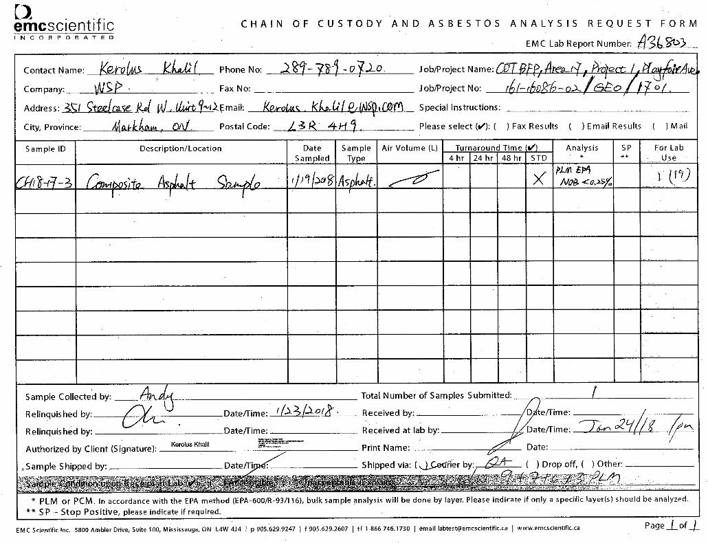
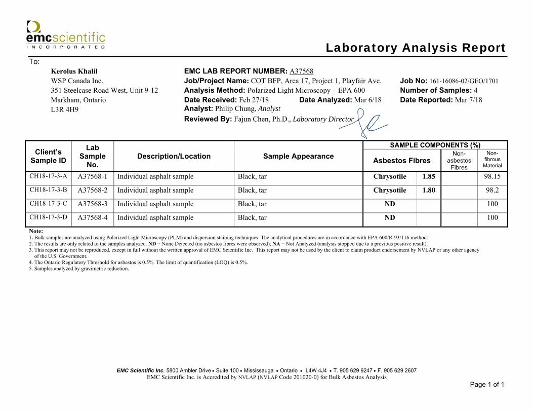
EMC Scientific Inc. 5800 Ambler Drive Suite 100 Mississauga Ontario L4W 4J4 T. 905 629 9247 F. 905 629 2607 EMC Scientific Inc. is Accredited by NVLAP (NVLAP Code 201020-0) for Bulk Asbestos Analysis
Page 1 of 1
Laboratory Analysis Report To: Kerolus Khalil EMC LAB REPORT NUMBER: A37568 WSP Canada Inc. Job/Project Name: COT BFP, Area 17, Project 1, Playfair Ave. Job No: 161-16086-02/GEO/1701 351 Steelcase Road West, Unit 9-12 Analysis Method: Polarized Light Microscopy – EPA 600 Number of Samples: 4 Markham, Ontario Date Received: Feb 27/18 Date Analyzed: Mar 6/18 Date Reported: Mar 7/18 L3R 4H9 Analyst: Philip Chung, Analyst Reviewed By: Fajun Chen, Ph.D., Laboratory Director
Client’s Sample ID
Lab Sample
No. Description/Location Sample Appearance
SAMPLE COMPONENTS (%)
Asbestos Fibres Non-
asbestos Fibres
Non-fibrous
Material
CH18-17-3-A A37568-1 Individual asphalt sample Black, tar Chrysotile 1.85 98.15
CH18-17-3-B A37568-2 Individual asphalt sample Black, tar Chrysotile 1.80 98.2
CH18-17-3-C A37568-3 Individual asphalt sample Black, tar ND 100
CH18-17-3-D A37568-4 Individual asphalt sample Black, tar ND 100
Note: 1. Bulk samples are analyzed using Polarized Light Microscopy (PLM) and dispersion staining techniques. The analytical procedures are in accordance with EPA 600/R-93/116 method. 2. The results are only related to the samples analyzed. ND = None Detected (no asbestos fibres were observed), NA = Not Analyzed (analysis stopped due to a previous positive result). 3. This report may not be reproduced, except in full without the written approval of EMC Scientific Inc. This report may not be used by the client to claim product endorsement by NVLAP or any other agency of the U.S. Government. 4. The Ontario Regulatory Threshold for asbestos is 0.5%. The limit of quantification (LOQ) is 0.5%. 5. Samples analyzed by gravimetric reduction.


EMC Scientific Inc. 5800 Ambler Drive Suite 100 Mississauga Ontario L4W 4J4 T. 905 629 9247 F. 905 629 2607 EMC Scientific Inc. is Accredited by NVLAP (NVLAP Code 201020-0) for Bulk Asbestos Analysis
Page 1 of 2
Laboratory Analysis Report To: Kerolus Khalil EMC LAB REPORT NUMBER: A39999 WSP Canada Inc. Job/Project Name: COT BFP Area 17, Project 1 Job No: 161-16086-02/GEO/1701 351 Steelcase Road West, Unit 9-12 Analysis Method: Polarized Light Microscopy – EPA 600 Number of Samples: 20 Markham, Ontario Date Received: May 24/18 Date Analyzed: Jun 11/18 Date Reported: Jun 11/18 L3R 4H9 Analyst: Jayoda Perera, Analyst Reviewed By: Fajun Chen, Ph.D., Laboratory Director
Client’s Sample ID
Lab Sample
No. Description/Location Sample Appearance
SAMPLE COMPONENTS (%)
Asbestos Fibres Non-
asbestos Fibres
Non-fibrous
Material
BH18-17-1-A A39999-1 Individual asphalt sample Black, tar ND 100
BH18-17-1-B A39999-2 Individual asphalt sample Black, tar ND 100
BH18-17-1-C A39999-3 Individual asphalt sample Black, tar ND 100
BH18-17-2-A A39999-4 Individual asphalt sample Black, tar Chrysotile <0.25* 100
BH18-17-2-B A39999-5 Individual asphalt sample Black, tar Chrysotile 0.93 99.07
BH18-17-2-C A39999-6 Individual asphalt sample Black, tar Chrysotile 0.4* 99.6
BH18-17-3-A A39999-7 Individual asphalt sample Black, tar Chrysotile 0.93 99.07
BH18-17-3-B A39999-8 Individual asphalt sample Black, tar Chrysotile 0.94 99.06
BH18-17-3-C A39999-9 Individual asphalt sample Black, tar Chrysotile 2.71 97.29
BH18-17-3-D A39999-10 Individual asphalt sample Black, tar Chrysotile 0.96 99.04
CH18-17-1-A A39999-11 Individual asphalt sample Black, tar Chrysotile <0.25* 100
CH18-17-1-B A39999-12 Individual asphalt sample Black, tar ND 100
CH18-17-1-C A39999-13 Individual asphalt sample Black, tar ND 100
CH18-17-2-A A39999-14 Individual asphalt sample Black, tar ND 100

2
Laboratory Analysis Report EMC LAB REPORT NUMBER: A39999 Client’s Job/Project Name/No.: 161-16086-02/GEO/1701 Analyst: Jayoda Perera, Analyst
EMC Scientific Inc. 5800 Ambler Drive Suite 100 Mississauga Ontario L4W 4J4 T. 905 629 9247 F. 905 629 2607 EMC Scientific Inc. is Accredited by NVLAP (NVLAP Code 201020-0) for Bulk Asbestos Analysis
Page 2 of 2
Client’s Sample ID
Lab Sample
No. Description/Location Sample Appearance
SAMPLE COMPONENTS (%)
Asbestos Fibres Non-
asbestos Fibres
Non-fibrous
Material
CH18-17-2-B A39999-15 Individual asphalt sample Black, tar ND 100
CH18-17-2-C A39999-16 Individual asphalt sample Black, tar ND 100
BH18-17-4A A39999-17 Individual asphalt sample Black, tar Chrysotile <0.25* 100
BH18-17-4B A39999-18 Individual asphalt sample Black, tar Chrysotile 0.92 99.08
BH18-17-4C A39999-19 Individual asphalt sample Black, tar Chrysotile 0.95 99.05
BH18-17-4D A39999-20 Individual asphalt sample Black, tar Chrysotile 0.47* 99.53
Note: 1. Bulk samples are analyzed using Polarized Light Microscopy (PLM) and dispersion staining techniques. The analytical procedures are in accordance with EPA 600/R-93/116 method. 2. The results are only related to the samples analyzed. ND = None Detected (no asbestos fibres were observed), NA = Not Analyzed (analysis stopped due to a previous positive result). 3. This report may not be reproduced, except in full without the written approval of EMC Scientific Inc. This report may not be used by the client to claim product endorsement by NVLAP or any other agency of the U.S. Government. 4. The Ontario Regulatory Threshold for asbestos is 0.5%. The limit of quantification (LOQ) is 0.5%. 5. Sample analyzed by gravimetric method * Sample analyzed by 400 point count method. The limit of quantification (LOQ) is 0.25


WSP Canada Inc.
CITY OF TORONTO BASEMENT FLOODING PROTECTION PROGRAM PHASE 4, ASSIGNMENT 17-05, PROJECT 2, VIEWMOUNT PARK SANITARY SEWER REPLACEMENT FROM ALLEN ROAD NORTH TO SHERMOUNT AVENUE, TORONTO, ONTARIO
CITY OF TORONTO GEOTECHNICAL FACTUAL REPORT PROJECT NO.: 161-16086-02/GEO/1702 DATE: JUNE 2018
WSP UNITS 10 & 12 351 STEELCASE ROAD WEST MARKHAM, ON, CANADA L3R 4H9 T: +1 905 475-0065 WSP.COM

\\CAMRK2DAT01\camrk2\161- Projects\161-16086-02 - COT BFP and Storm Sewer Replacement (KK)\Area 17\Project 2 Viewmount Park\Wp\161-16086-02 Basement Flooding Program, Area 17, Project 2 Viewmount Park - Factual Report.docx
WSP Canada Inc.
June 25, 2018
Darrell Wunder, P.Eng., PMP Senior Engineer Design & Construction, Linear Underground Infrastructure Engineering and Construction Services City of Toronto Metro Hall, 20th Floor 55 John Street Toronto, Ontario M5V3C6
Dear Mr. Wunder:
We are pleased to submit our factual report of the geotechnical investigation for the proposed sanitary sewer replacement for Project 2 – Viewmount Park included as part of Assignment 17-05 for the City of Toronto Basement Flooding Protection Program Phase 4.
The report is based on information obtained from a pavement coring, borehole investigation and laboratory testing conducted from May 2018 to June 2018.
Geotechnical recommendations relevant to the proposed sanitary sewer replacement will be provided in a separate recommendations report.
We trust that this report meets your present requirements. Please contact us if you have any questions.
Yours sincerely,
Oswin Li, P.Eng Senior Geotechnical Engineer
WSP ref.: 161-16086-02/GEO/1702
Q U A L I T Y M A N A G E M E N T
ISSUE/REVISION FIRST ISSUE REVISION 1 REVISION 2 REVISION 3
Remarks Draft
Date June 25, 2018
Prepared by Dong Gu
Signature
Checked by Oswin Li
Signature
Authorised by Kerolus Khalil
Signature
Project number 161-16086-02/GEO/1702
Report number
File reference

Basement Flooding Protection Program Phase 4, Assignment 17-05, Project 2, Viewmount Park Sanitary Sewer Replacement from Allen Road North to Shermount Avenue, Toronto, Ontario Project No. 161-16086-02/GEO/1702 City of Toronto
WSP June 2018
S I G N A T U R E S
PREPARED BY
Dong Gu, B.A.Sc. Geotechnical EIT
REVIEWED BY
Oswin Li, P.Eng. Senior Geotechnical Engineer

Basement Flooding Protection Program Phase 4, Assignment 17-05, Project 2, Viewmount Park Sanitary Sewer Replacement from Allen Road North to Shermount Avenue, Toronto, Ontario Project No. 161-16086-02/GEO/1702 City of Toronto
WSP June 2018
1 INTRODUCTION ................................................................... 1
2 PHYSIOGRAPHY .................................................................. 1
3 INVESTIGATION PROCEDURES ................................... 1
3.1 Permits, Utility Locates .................................................................... 1
3.2 Field Investigation ............................................................................. 1
3.2.1 Borehole Program ............................................................................................................................. 1
3.2.2 Pavement Coring............................................................................................................................... 2
3.2.3 Installation of monitoring Wells ............................................................................................. 2
3.3 Laboratory Testing Program .........................................................2
3.3.1 Geotechnical Testing ...................................................................................................................... 2
3.3.2 Environmental Testing .................................................................................................................. 3
3.3.3 Asbestos Testing ................................................................................................................................ 3
4 FINDINGS ............................................................................... 4
4.1 Existing Pavement Condition ...................................................... 4
4.1.1 Pavement Structure ........................................................................................................................ 4
4.1.2 Granular Fill ........................................................................................................................................... 4
4.2 Soil Profile ............................................................................................. 4
4.2.1 Fill Materials .......................................................................................................................................... 4
4.2.2 Silty Clay................................................................................................................................................... 5
4.2.3 Sandy Silty Clay Till .......................................................................................................................... 5
4.2.4 Silty Sand ................................................................................................................................................ 6
4.3 Subgrade Permeability ................................................................... 6
4.4 Proctor Testing .................................................................................... 7
4.5 Groundwater and Cave-in Conditions ...................................... 7
4.6 Chemical Testing ................................................................................ 7
4.6.1 Phytotoxicological Analyses ...................................................................................................... 7
4.6.2 BTEX and PHC Analyses ............................................................................................................... 8
4.6.3 PAH Analyses ....................................................................................................................................... 8
4.6.4 Leachate Quality (TCLP Extraction) Analysis .................................................................. 9
TABLE OF CONTENTS

Basement Flooding Protection Program Phase 4, Assignment 17-05, Project 2, Viewmount Park Sanitary Sewer Replacement from Allen Road North to Shermount Avenue, Toronto, Ontario Project No. 161-16086-02/GEO/1702 City of Toronto
WSP June 2018
4.7 Asbestos Testing ................................................................................ 9
4.8 Corrosivity Testing .......................................................................... 10
5 LIMITATIONS ...................................................................... 10
TABLES
TABLE 3.1 BOREHOLE PROGRAM .............................................................. 2 TABLE 3.2 GEOTECHNICAL LABORATORY TESTING
SUMMARY ........................................................................................... 3 TABLE 3.3 ENVIRONMENTAL LABORATORY TESTING
SUMMARY ........................................................................................... 3 TABLE 4.1 EXISTING PAVEMENT STRUCTURE .................................. 4 TABLE 4.2 SILTY CLAY PARTICLE SIZE DISTRIBUTION
ANALYSES RESULTS .................................................................... 5 TABLE 4.3 SILTY CLAY ATTERBERG LIMITS RESULTS ................... 5 TABLE 4.4 SANDY SILTY CLAY TILL PARTICLE SIZE
DISTRIBUTION ANALYSES RESULTS................................ 6 TABLE 4.5 SANDY SILTY CLAY TILL ATTERBERG
LIMITS RESULTS .............................................................................. 6 TABLE 4.6 SUBGRADE PERMEABILITY VALUES ............................... 7 TABLE 4.7 STANDARD PROCTOR COMPACTION TEST ............... 7 TABLE 4.8 PHYTOTOXICOLOGICAL ANALYSIS
EXCEEDANCES ................................................................................ 8 TABLE 4.9 BTEX AND PHC EXCEEDANCES ......................................... 8 TABLE 4.10 PAHS EXCEEDANCE .................................................................... 9 TABLE 4.11 TCLP EXCEEDANCE ...................................................................... 9 TABLE 4.12 ASBESTOS DETECTION RESULTS OF
INDIVIDUAL ASPHALT LAYERS ............................................ 9 TABLE 4.13 RESULTS OF ANSI/AWWA SOIL
CORROSIVITY POTENTIAL RATING AND SULPHATE CONTENT ................................................................ 10
FIGURES
1 LOCATION MAP 2 BOREHOLE LOCATIONS PLAN

Basement Flooding Protection Program Phase 4, Assignment 17-05, Project 2, Viewmount Park Sanitary Sewer Replacement from Allen Road North to Shermount Avenue, Toronto, Ontario Project No. 161-16086-02/GEO/1702 City of Toronto
WSP June 2018
APPENDICES
A BOREHOLE EXPLANATION FORMS AND BOREHOLE LOGS
B GEOTECHNICAL LABORATORY TEST RESULTS
C CHEMICAL LABORATORY TEST RESULTS
D ASBESTOS LABORATORY TEST RESULTS

Basement Flooding Protection Program Phase 4, Assignment 17-05, Project 2, Viewmount Park Sanitary Sewer Replacement from Allen Road North to Shermount Avenue, Toronto, Ontario Project No. 161-16086-02/GEO/1702 City of Toronto
WSP June 2018
Page 1
1 INTRODUCTION WSP Canada Inc. (WSP) was retained by the City of Toronto (City) to complete a geotechnical investigation at Viewmount Park from Allen Road North to Shermount Avenue, in the City of Toronto, Ontario. A Location Map is provided as Figure 1, in the Figures section of this report.
The geotechnical investigation was requested to obtain subsurface information for the proposed upgrades described in Assignment 17-05, Project 2 of the Toronto Basement Flooding Protection Program Phase 4. The proposed upgrades include the following:
Replace existing 675 mm sanitary sewer with a new 2400 mm (W) x 1200 mm (H) box culvert along 35 m length at Viewmount Park from William R. Allen Road North to 28 m East of William Allen Rd North; and
Replace existing 675 mm sanitary sewer with a new 2400 mm (W) x 1200 mm (H) box culvert along 95 m length at Viewmount Park from 23 m East of William R. Allen Road North to Shermount Avenue.
This geotechnical report summarizes the investigation procedures and findings, and provides information on the existing pavement structure, subsurface soil and groundwater conditions within the investigated limits. Geotechnical recommendations relevant to the proposed upgrades will be provided in a separate recommendations report, as stipulated under the project requirements.
2 PHYSIOGRAPHY The project area is situated within Yonge tills (clayey silt till) area as represented in Quaternary Geology: Toronto and Surrounding Area (Ministry of Natural Resources, Ontario Geological Survey, Preliminary Map P.2204).
3 INVESTIGATION PROCEDURES
3.1 PERMITS, UTILITY LOCATES Borehole locations were predetermined and established in the field by WSP personnel. Specific borehole locations were selected to avoid conflicts with existing above ground and underground utilities, including water, sewer, gas, hydro, telephone and cable locations that were verified in the field using Ontario One-call and City of Toronto Public Works services.
Park Access Agreement was obtained from the City and Toronto Park Department was notified prior to the fieldwork.
3.2 FIELD INVESTIGATION
3.2.1 BOREHOLE PROGRAM
The borehole investigation was conducted on May 25, 2018. A total of two (2) boreholes were advanced adjacent to proposed new box culvert. The boreholes were drilled to a depth of approximately 11.1 m below ground surface. The boreholes were advanced at the locations shown on Figure 2, provided in the Figures section of this report. The borehole program is summarized in Table 3.1.

Basement Flooding Protection Program Phase 4, Assignment 17-05, Project 2, Viewmount Park Sanitary Sewer Replacement from Allen Road North to Shermount Avenue, Toronto, Ontario Project No. 161-16086-02/GEO/1702 City of Toronto
WSP June 2018
Page 2
Table 3.1 Borehole Program
ITEM PROJECT 2 – VIEWMOUNT PARK
Number of Boreholes Two (2)
Borehole Depth (m) 11.1
Borehole Designation BH18-17-5 & BH18-17-6
Number of Pavement Cores One (1)
Boreholes were advanced using a truck-mounted rig equipped with 110 mm Outside Diameter (O.D.) solid stem augers and 51 mm O.D. split-spoon samplers. A qualified WSP geotechnical engineering technician supervised the drilling, logged and sampled the boreholes in accordance with City standards. Soil samples were recovered and retained in labeled air-tight containers for subsequent review by the project engineer and laboratory testing as required. Asphalt and granular road base thicknesses were recorded at BH18-17-6 advanced through pavement.
The depth to groundwater and/or borehole “cave-in” was measured upon completion of drilling. The boreholes were backfilled immediately after completion with cement grout (1:3 cement sand mortar dry mixed) and compacted with a flat top hand tamper, in accordance with City standards. Compacted cold-mix asphalt was used to restore the boreholes advanced through pavement.
Ground surface elevations at each borehole location were obtained from the project topographic survey data. Borehole locations were obtained based on three (3) tie-in measurements from permanent structures.
Borehole logs detailing the individual pavement and soil profiles are provided in Appendix A. Ground surface elevations and borehole locations are provided on the borehole logs.
3.2.2 PAVEMENT CORING
Coring was conducted at one (1) borehole location prior to drilling operations to evaluate the pavement quality and potential asbestos content, where applicable. The cores were 75 mm in diameter and extended to the bottom of the existing pavement structure at the core location.
3.2.3 INSTALLATION OF MONITORING WELLS
A monitoring well was installed in each of BH18-17-5 and BH18-17-6 for further monitoring of groundwater level.
3.3 LABORATORY TESTING PROGRAM
3.3.1 GEOTECHNICAL TESTING
Selected soil samples were submitted to WSP’s certified soils laboratory for geotechnical testing in accordance with Table 3.2. Geotechnical laboratory test results are provided on the borehole logs in Appendix A. A copy of the geotechnical laboratory test results is provided in Appendix B.

Basement Flooding Protection Program Phase 4, Assignment 17-05, Project 2, Viewmount Park Sanitary Sewer Replacement from Allen Road North to Shermount Avenue, Toronto, Ontario Project No. 161-16086-02/GEO/1702 City of Toronto
WSP June 2018
Page 3
Table 3.2 Geotechnical Laboratory Testing Summary
GEOTECHNICAL TEST PROCEDURE/METHODOLOGY NUMBER OF TESTS
Moisture Content ASTM D2974 Twenty-two (22)
Standard Proctor Test ASTM D698 One (1)
Subgrade Soil Permeability ASTM WK38106 / LS-702 Four (4)
Atterberg Limits ASTM D4318 Two (2)
3.3.2 ENVIRONMENTAL TESTING
Selected soil samples were submitted to AGAT Laboratories in Mississauga, Ontario for environmental testing in accordance with Table 3.3. A copy of the environmental laboratory test results is provided in Appendix C.
Table 3.3 Environmental Laboratory Testing Summary
ENVIRONMENTAL TEST NUMBER OF TESTS
Phytotoxicological Analyses (including metals and inorganics – O. Reg. 153/04 – as amended)
Two (2)
Regulation of 558 (TCLP-Inorganic) Leachate Quality One (1)
Polychlorinated Biphenyls - PCBs (O. Reg. 558/00) One (1)
BTEX & PHCs (O. Reg. 153/04 – as amended) Two (2)
Volatile Organic Compounds - VOCs (O. Reg. 558/00) One (1)
Polycyclic Aromatic Hydrocarbons – PAHs (O. Reg. 153/04 – as amended) Two (2)
Corrosivity Package Two (2)
3.3.3 ASBESTOS TESTING
Based on a review of the City’s Asbestos Locations map, the subject roadway is classified as “Testing Required”. Therefore, one (1) pavement core was submitted for asbestos testing (O.Reg.278/05).
Testing was performed using polarized light microscopy (PLM), based on EPA 600, in accordance with the U.S. Environmental Protection Agency Test Method EPA/600/R-93/116: Method for the Determination of Asbestos in Bulk Building Materials (June 1993).
Asbestos test locations are provided on Figure 2. A copy of the asbestos laboratory test results is provided in Appendix D.

Basement Flooding Protection Program Phase 4, Assignment 17-05, Project 2, Viewmount Park Sanitary Sewer Replacement from Allen Road North to Shermount Avenue, Toronto, Ontario Project No. 161-16086-02/GEO/1702 City of Toronto
WSP June 2018
Page 4
4 FINDINGS
4.1 EXISTING PAVEMENT CONDITION
4.1.1 PAVEMENT STRUCTURE
The existing pavement structure along the Viewmount Park Trail, adjacent to proposed box culvert, consists of an asphaltic concrete (AC) pavement structure within the project limits. Asphalt and granular thicknesses at the borehole location are summarized in Table 4.1 below.
Table 4.1 Existing Pavement Structure
BOREHOLE NO.
ASPHALT THICKNESS (mm) GRANULAR THICKNESS
(mm)
TOTAL PAVEMENT STRUCTURE THICKNESS
(mm)
Surface Course
Middle Course Base Course Total
BH18-17-6 40 - - 40 140 180
4.1.2 GRANULAR FILL
Granular fill was encountered in the borehole directly below the asphalt, with approximate thickness of 140 mm. The granular fill consists of gravelly sand with some amounts of soil fines (silt and clay).
At the time of the investigation, the granular fill was moist. Laboratory moisture content test result was 4%. Based on SPT N-values, the granular fill has a loose state of compactness.
4.2 SOIL PROFILE
4.2.1 FILL MATERIALS
COHESIVE EARTH FILL
Cohesive earth fill was encountered underlying the granular fill in BH18-17-5 and BH18-17-6. The cohesive earth fill consists of clayey silt to silty clay fill with traces of gravel and varying amount of sand (trace to sandy). The fill extends to depths ranging from approximately 2.1 m to 2.9 m below existing ground surface.
At the time of the investigation, the cohesive earth fill was found to be about plastic limit (APL) to wetter than plastic limit (WTPL). The in-situ moisture contents as determined by laboratory tests yielded approximately 10% to 21%. Based on SPT N values, the cohesive earth fill has a soft to stiff consistency.

Basement Flooding Protection Program Phase 4, Assignment 17-05, Project 2, Viewmount Park Sanitary Sewer Replacement from Allen Road North to Shermount Avenue, Toronto, Ontario Project No. 161-16086-02/GEO/1702 City of Toronto
WSP June 2018
Page 5
4.2.2 SILTY CLAY
A stratum of native silty clay was encountered underlying the cohesive earth fill in BH18-17-5 and BH18-17-6. The silty clay contains a trace of gravel and a trace to some sand. It extends to a depth of approximately 8.5 m and 4.4 m below existing ground surface in BH18-17-5 and BH18-17-6, respectively.
A second silty clay stratum containing traces of gravel and sand was encountered in BH18-17-6 at a depth of approximately 8.6 m below grade. BH18-17-6 was terminated in this second silty clay stratum at a depth of approximately 11.1 m below existing ground surface.
At the time of the investigation, the silty clay was found to be about plastic limit (APL) to wetter than plastic limit (WTPL). The natural moisture contents as determined by laboratory tests ranged from approximately 12% to 26%. Based on SPT N values, the native silty clay has a soft to hard consistency.
Two (2) laboratory particle size distribution analyses were conducted on selected samples obtained from the silty clay deposit. The results are provided in Table 4.2, according to the Unified Soil Classification System (USCS):
Table 4.2 Silty Clay Particle Size Distribution Analyses Results
BOREHOLE NO. SAMPLE I.D. % GRADATION PRIMARY SOIL
CLASSIFICATION Gravel Sand Silt & Clay
BH18-17-05 SS6 0 0 100 SILTY CLAY
BH18-17-06 SS11 0 1 99 SILTY CLAY, trace sand
The results of the analyses are shown on the borehole logs in Appendix A. The particle size distribution curves are provided in Appendix B.
Atterberg Limits test was carried out on one (1) of the above selected samples. The results are summarized in Table 4.3 below.
Table 4.3 Silty Clay Atterberg Limits Results
BOREHOLE NO. SAMPLE I.D. LIQUID LIMIT
(LL) PLASTIC LIMIT
(PL) PLASTICITY INDEX
(PI)
BH18-17-5 SS6 36 17 19
A review of the Atterberg limits test results indicates that BH18-17-5 (SS6) can be classified as a clay of low plasticity (CL) in accordance with the Unified Soil Classification System.
The results of the Atterberg limits tests are summarized on the borehole logs in Appendix A and the plasticity charts are provided in Appendix B.
4.2.3 SANDY SILTY CLAY TILL
A stratum of native sandy silty clay till deposit was encountered underlaying the silty clay at a depth of approximately 8.5 m and 4.4 m in BH18-17-5 and BH18-17-6, respectively. The native sandy silty clay till deposit contains a trace of gravel. It extends to a depth of approximately 11 m and 8.6 m below existing ground surface in BH18-17-5 and BH18-17-6, respectively

Basement Flooding Protection Program Phase 4, Assignment 17-05, Project 2, Viewmount Park Sanitary Sewer Replacement from Allen Road North to Shermount Avenue, Toronto, Ontario Project No. 161-16086-02/GEO/1702 City of Toronto
WSP June 2018
Page 6
At the time of the investigation, sandy silty clay till deposit was found to be about plastic limit (APL) to wetter than plastic limit (WTPL). The natural moisture contents as determined by laboratory tests yielded approximately 11% to 21%. Based on SPT N values, the native sandy silty clay till has a stiff to hard consistency.
Two (2) laboratory particle size distribution analyses were conducted on a selected sample obtained from the sandy silty clay till deposit. The results are provided in Table 4.4, according to the Unified Soil Classification System (USCS):
Table 4.4 Sandy Silty Clay Till Particle Size Distribution Analyses Results
BOREHOLE NO. SAMPLE I.D. % GRADATION PRIMARY SOIL
CLASSIFICATION Gravel Sand Silt & Clay
BH18-17-5 SS10 2 30 68 SANDY SILTY CLAY TILL, trace
gravel
BH18-17-6 SS8 3 26 71 SANDY SILTY CLAY TILL, trace
gravel
The results of the analyses are shown on the borehole logs in Appendix A. The particle size distribution curves are provided in Appendix B.
Atterberg Limits test was carried out on the above selected sample. The results are summarized in Table 4.5 below.
Table 4.5 Sandy Silty Clay Till Atterberg Limits Results
BOREHOLE NO. SAMPLE I.D. LIQUID LIMIT
(LL) PLASTIC LIMIT
(PL) PLASTICITY INDEX
(PI)
BH18-17-6 SS8 20 12 8
A review of the Atterberg limits test results indicates that BH18-17-6 (SS8) can be classified as a clay of low plasticity (CL) in accordance with the Unified Soil Classification System.
The results of the Atterberg limits tests are summarized on the borehole logs in Appendix A and the plasticity charts are provided in Appendix B.
4.2.4 SILTY SAND
A stratum of native silty sand was encountered underlying the sandy silty clay till stratum in BH18-17-5. The silty sand contains a trace of gravel and a trace of clay. BH18-17-5 was terminated in the silty sand at a depth of approximately 11.1 m below existing ground surface.
At the time of the investigation, the silty sand was wet. The natural moisture content as determined by laboratory test was approximately 17%. Based on SPT N values, the native silty sand has a very dense state of compactness.
4.3 SUBGRADE PERMEABILITY The permeability (i.e. hydraulic conductivity) of the subgrade is estimated by comparing the particle size distribution curves of the subject material with established permeability correlation data. Table 4.6 presents the subgrade permeability of the encountered subgrade soil samples.

Basement Flooding Protection Program Phase 4, Assignment 17-05, Project 2, Viewmount Park Sanitary Sewer Replacement from Allen Road North to Shermount Avenue, Toronto, Ontario Project No. 161-16086-02/GEO/1702 City of Toronto
WSP June 2018
Page 7
Table 4.6 Subgrade Permeability Values
BOREHOLE NO. SAMPLE SOIL TYPE PERMEABILITY (m/s)
BH18-17-5 SS6 SILTY CLAY <1 x 10⁻⁷
SS10 SANDY SILTY CLAY, trace gravel <1 x 10⁻⁶
BH18-17-6 SS8 SANDY SILTY CLAY TILL, trace gravel <1 x 10⁻⁶
SS11 SILTY CLAY, trace sand <1 x 10⁻⁷
4.4 PROCTOR TESTING One (1) Standard Proctor compaction test was conducted on composite soil samples obtained from the Viewmount park trail adjacent to proposed new box culvert. The proctor test was conducted on the subgrade soils. The sample recovered for road granular was insufficient to facilitate this test. Sample details and the respective standard proctor maximum dry density (SPMDD) values and optimum moisture contents are detailed in Table 4.7. A copy of the laboratory result is provided in Appendix B.
Table 4.7 Standard Proctor Compaction Test
MATERIAL LOCATION SPMDD (kg/m3)
OPTIMUM MOISTURE (%)
Subgrade Soil BH18-17-5 and BH18-17-6 1,932 11.9
4.5 GROUNDWATER AND CAVE-IN CONDITIONS BH18-17-5 caved to a depth of approximately 2.7 m below existing ground surface and groundwater was measured in this caved borehole at a depth of approximately 2.7 m. BH18-17-6 caved to a depth of approximately 1.7 m below existing ground surface and groundwater was measured in this caved borehole at a depth of approximately 1.7 m.
A groundwater monitoring well was installed in each of BH18-17-5 and BH18-17-6 for further monitoring of groundwater levels. Static groundwater measurements were obtained on June 5, 2018 in the respective monitoring wells after a minimum of 24 hours from installation. The groundwater measurements were recorded as 3.0 m and 3.4 m in BH18-17-5 and BH18-17-6, respectively.
4.6 CHEMICAL TESTING
4.6.1 PHYTOTOXICOLOGICAL ANALYSES
Two (2) selected soil samples from the boreholes (one (1) sample per borehole) were analyzed for general metals and inorganic parameters under Ontario Regulation O.Reg.153/04 (amended). Test results were compared to the Ministry of the Environment and Climate Change (MOECC) guidelines listed in Table 1 (Full Depth Background Site Condition Standards) for Residential/ Parkland/ Institutional/ Industrial/ Commercial/ Community (RPIICC) Property Use, Tables 2 and 3 (Full Depth Generic Site Condition Standards in a Potable & Non-Potable Ground Water Condition) for Residential/ Parkland/ Institutional (RPI) and Industrial/ Commercial/ Community (ICC) Property Uses and Table 2 Full Depth Generic Site Condition Standards in a Potable Ground Water Condition for Agriculture or other (AG) Property Use of the Soil, Groundwater and Sediment Standards for Use Under Part XV.I of the Environmental Protection Act (April 15, 2011). The tested soil samples met the

Basement Flooding Protection Program Phase 4, Assignment 17-05, Project 2, Viewmount Park Sanitary Sewer Replacement from Allen Road North to Shermount Avenue, Toronto, Ontario Project No. 161-16086-02/GEO/1702 City of Toronto
WSP June 2018
Page 8
relevant MOECC guidelines, with the exceptions listed in Table 4.8. A copy of the laboratory certificate of analysis is provided in Appendix C.
Table 4.8 Phytotoxicological Analysis Exceedances
TESTED SAMPLE I.D.
BOREHOLE SAMPLE
PARAMETER EXCEEDANCES
MOECC Table 1 RPIICC
MOECC Tables 2 & 3 RPI
MOECC Tables 2 & 3 ICC
MOECC Table 2 AG
BH18-17-5-SS2 BH18-17-5-SS2 None None None None
BH18-17-6-SS2 BH18-17-6-SS2 EC, SAR EC, SAR SAR EC, SAR
Note: 1. SAR denotes Sodium Adsorption Ratio and EC denotes Electrical Conductivity
4.6.2 BTEX AND PHC ANALYSES
The above noted two (2) soil samples were also analyzed for benzene, toluene, ethyl-benzene, and xylenes (BTEX) and petroleum hydrocarbons (PHC F1-F4 fractions) under O.Reg.153/04 (amended). Test results were compared to the Ministry of the Environment and Climate Change (MOECC) guidelines listed in Table 1 (Full Depth Background Site Condition Standards) for Residential/ Parkland/ Institutional/ Industrial/ Commercial/ Community (RPIICC) Property Use, Tables 2 and 3 (Full Depth Generic Site Condition Standards in a Potable & Non-Potable Ground Water Condition) for Residential/ Parkland/ Institutional (RPI) and Industrial/ Commercial/ Community (ICC) Property Uses and Table 2 Full Depth Generic Site Condition Standards in a Potable Ground Water Condition for Agriculture or other (AG) Property Use of the Soil, Groundwater and Sediment Standards for Use Under Part XV.I of the Environmental Protection Act (April 15, 2011). The tested soil samples met the relevant MOECC guidelines as detailed in Table 4.9. A copy of the laboratory certificate of analysis is provided in Appendix C.
Table 4.9 BTEX and PHC Exceedances
TESTED SAMPLE I.D.
BOREHOLE SAMPLE
PARAMETER EXCEEDANCES
MOECC Table 1 RPIICC
MOECC Tables 2 & 3 RPI
MOECC Tables 2 & 3 ICC
MOECC Table 2 AG
BH18-17-5-SS2 BH18-17-5-SS2 None None None None
BH18-17-6-SS2 BH18-17-6-SS2 None None None None
4.6.3 PAH ANALYSES
Two (2) selected soil sample was also analyzed for Polycyclic Aromatic Hydrocarbons (PAHs) under O.Reg.153/04 (amended). Test results were compared to the Ministry of the Environment and Climate Change (MOECC) guidelines listed in Table 1 (Full Depth Background Site Condition Standards) for Residential/ Parkland/ Institutional/ Industrial/ Commercial/ Community (RPIICC) Property Use, Tables 2 and 3 (Full Depth Generic Site Condition Standards in a Potable & Non-Potable Ground Water Condition) for Residential/ Parkland/ Institutional (RPI) and Industrial/ Commercial/ Community (ICC) Property Uses and Table 2 Full Depth Generic Site Condition Standards in a Potable Ground Water Condition for Agriculture or other (AG) Property Use of the Soil, Groundwater and Sediment Standards for Use Under Part XV.I of the Environmental Protection Act (April 15, 2011). The tested soil samples met the relevant MOECC guidelines, with the exceptions listed in Table 4.10 below. A copy of the laboratory certificate of analysis is provided in Appendix C.

Basement Flooding Protection Program Phase 4, Assignment 17-05, Project 2, Viewmount Park Sanitary Sewer Replacement from Allen Road North to Shermount Avenue, Toronto, Ontario Project No. 161-16086-02/GEO/1702 City of Toronto
WSP June 2018
Page 9
Table 4.10 PAHs Exceedance
TESTED BOREHOLE SAMPLE I.D.
PARAMETER EXCEEDANCES
MOECC Table 1 RPIICC
MOECC Tables 2 & 3 RPI
MOECC Tables 2 & 3 ICC
MOECC Table 2 AG
BH18-17-5-SS1 None None None None
BH18-17-6-SS1A
Benz(a)anthracene, Benzo(a)pyrene,
Benzo(b)fluoranthene, Fluoranthene
Benzo(a)pyrene, Fluoranthene
Benzo(a)pyrene Benzo(a)pyrene,
Fluoranthene
4.6.4 LEACHATE QUALITY (TCLP EXTRACTION) ANALYSIS
One (1) composite soil sample was analyzed for metals and inorganic parameters, polychlorinated bi-phenyls (PCBs), and volatile organic compounds (VOCs) by Toxicity Characteristics Leaching Procedure (TCLP) extraction. Test result was compared to Schedule 4 of O.Reg.558. The tested soil sample met the relevant guidelines as detailed in Table 4.11. A copy of the laboratory certificate of analysis is provided in Appendix C.
Table 4.11 TCLP Exceedance
TESTED SAMPLE I.D.
BOREHOLE SAMPLE
PARAMETER EXCEEDANCES
METALS & INORGANICS
PCBs VOCs
TCLP BH18-17-5-SS2+SS3 BH18-17-6-SS2+SS3
None None None
4.7 ASBESTOS TESTING One (1) individual asphalt layer of BH18-19-6 core sample was submitted for asbestos testing. Test results indicate asbestos was not detected in the top course layer of the core sample BH18-17-6, as detailed in Table 4.112. A copy of the laboratory Certificate of Analysis from EMC Scientific Incorporated is provided in Appendix D.
Table 4.12 Asbestos Detection Results of Individual Asphalt Layers
BOREHOLE NO. ASBESTOS RESULTS
Surface Course
BH18-17-6 None Detected; 100 % Non-Fibrous

Basement Flooding Protection Program Phase 4, Assignment 17-05, Project 2, Viewmount Park Sanitary Sewer Replacement from Allen Road North to Shermount Avenue, Toronto, Ontario Project No. 161-16086-02/GEO/1702 City of Toronto
WSP June 2018
Page 10
4.8 CORROSIVITY TESTING The following Table 4.13 summarizes the ANSI/AWWA rating for the tested soil samples for the potential for corrosion towards buried grey or ductile cast iron pipe and assess the potential for degradation of buried concrete in contact with the encountered soils. A score of 10 points or more indicates potential for corrosion.
Table 4.13 Results of ANSI/AWWA Soil Corrosivity Potential Rating and Sulphate Content
I.D. AND NAME
SAMPLE I.D.
SULPHATE CONTENT
(µg/g or ppm)
RESISTIVITY (ohms-cm)
PH REDOX
POTENTIAL (mV)
SULPHIDE (%)
MOISTURE CONTENT
(%)
TOTAL POINTS
Viewmount Park
BH18-19-5-SS8
41 4270/0 8.06/0 195/0 0.22/Trace/2 Fair
Drainage/ 1 3
BH18-19-6-SS9
28 5240/0 8.22/0 164/0 0.22/Trace/2 Poor
Drainage/ 2 4
5 LIMITATIONS The comments given in this report are intended for the guidance of design engineers. The number of boreholes required to determine the localized underground conditions between boreholes affecting construction costs, techniques, sequencing, equipment, scheduling, etc., may be greater than has been carried out for current purposes. Contractors bidding on or undertaking the work shall, in this light, decide on their own investigations, as well as their own interpretations of the factual borehole results, so that they may draw their own conclusions as to how the subsurface conditions may affect them.
Information in this report shall not be used by third parties without WSP’s permission. We trust that the information contained in this report is satisfactory. Should you have any questions, please do not hesitate to contact us.

FIGURES

PROJECT 2
PROJECT 1
ALLEN EXPY
DUFFERIN ST
MARLEE AVE
GLENCAIRN AVE
LAWRENCE AVE W
GLENGROVE AVE
STAYNER AVETYCOS DR
SHERMOUNT AVE
TIMES RD
HILLMOUNT AVE
GLEN PARK AVE
DANESBURY AVE
CORK AVE
DELL PARK AVE
BRIAR HILL AVE
APEX RD
WENDERLY DR
WINGOLD AVE
CLAVER AVE
DANE AVE
HOPEWELL AVE
PLAYFAIR AVE
LOCKSLEY AVE
FAIRHOLME AVE
HAVEN RD VIEWMOUNT AVE
CASTLEFIELD AVE
GLEN LONG AVE
ENGLEMOUNT AVE
CAPITOL AVE
GLENBROOK AVE
LILYWOOD RD
LOIS AVE
WHITMORE AVE
COLDSTREAM AVE
LANSDOWNE AVE
NEWGATE RD
RIDELLE AVE
MEADOWBROOK RD
ROSELAWN AVE
FAIRLEIGH CRES
EUPHRASIA DR
ELM RIDGE DR
BOLINGBROKE RD
RISA BLVD
ENNERDALE ST
ELWAY CRT
ENID CRES
PARK HILL RD
LYON CRT
CAROUSEL CRT
CONVENT CRT
BENNER AVE
BEOGRAD GDNS
MAJESTIC CRT
HILLMOUNT AVE
FAIRHOLME AVE
RIDELLE AVE
ALLEN EXPY
GLEN PARK AVE
GLENGROVE AVE
ROSELAWN AVE
GEOTECHNICAL REPORTBasement Flooding Protection Program Phase 4BF Assignment 17-02BF Assignment 17-05Toronto, Ontario
LOCATION MAP
1FILE. NO.:PROJECT: 161-16086-02
DATE: JUNE 2018
FIGURE.1:10000SCALE:
0 200 400100Meters
LegendBF Assignment 17-02-Project 1BF Assignment 17-05-Project 2

PROJECT: 161-16086-02
SCALE: 1:500
FIGURE
FILE NO.:
DATE: JUNE 2018
173.75
0
173.750
174.000
174.000
174.250
17
4.0
00
174.000
169.250
169.250
169.250
169.250
169.500
169.500
169.500
169.500
169.750
169.750
17
0.0
00
170.0
00
170.0
00
170.0
00
170.250
170.250
170.500
170.500
170.750
170.750
171.0
00
171.0
00
171.0
00
171.0
00
171.250
171.250
171.500
171.500
171.750
171.750
172.0
00
172.0
00
172.0
00
172.0
00
17
2.0
00
17
2.
250
17
2.
25
0
172.250
172.500
172.500
172.500
172.750
172.750
172.750
173.0
00
173.000
173.000
173.000
173.0
00
173.000
173.000
173.250
173.250
173.250
173.250
173.500
173.500
173.
500
173.750
173.750
173.750
173.750
173.750
174.0
00
174.000
174.000
174.000
174.0
00
174.0
00
174.
000
172.250
173.750
173.500
169
VP1
TO REPLACE 675 mm DIA SANITARY SEWER
PROPOSED 2400 mm (W) x 1200 mm (H) BOX CULVERT
BASEBALL DIAMOND
BENCH
BENCH
EXISTING SEWER
RECONNECT
VP2
VP3
CAP AND PLUG
CAP AND PLUG
TO BE ABANDONED
675 mm DIA SANITARY SEWER
TO BE ABANDONED
675 mm DIA SANITARY SEWER
PROPOSED 1200 mm DIA RISER
PROPOSED 1200 mm DIA RISER
PROPOSED 1200 mm DIA RISER
TO BE ABANDONED
SANITARY MH
EXISTING SEWER
RECONNECT
ORIFICE PLATE, SEE NOTE 1
PROPOSED 600 mm DIA
AVENUE
FROM SHERMOUNT
CONSTRUCTION ACCESS
SEE NOTE 2
TENNIS COURT
210 0 10 metres5
LEGENDBOREHOLE LOCATIONS PLAN
PROPOSED SANITARY SEWER
TESTING
INDICATES BOREHOLE WITHOUT CORING AND ASBESTOS
to Shermount Avenue,Toronto, Ontario
Sanitary Sewer Replacement From Allen Road North
BF Assignment 17-05, Project 2, Viewmount Park
Basement Flooding Protection Program Phase 4,
GEOTECHNICAL REPORT
- 10.0 m DEPTH WITH ASBESTOS TESTING
BOREHOLE LOCATION AND DESIGNATION
GROUND SURFACE ELEVATION (mASL)172.8
MEASURED ON JUNE 5, 2018
GROUNDWATER ELEVATION (MASL)
172.8
173.9
(170.6)
(169.8)
(169.8)
Alle
n R
d.
Viewmount Park
Vie
wm
ount P
ark Trail
BH18-17-5
BH18-17-6
BH18-17-5
*
*

APPENDIX
A BOREHOLE EXPLANATION FORMS AND BOREHOLE LOGS

20/08/15 1:25 PM Admin/Borehole Log Explanation Form (USCS)
BOREHOLE LOG EXPLANATION FORM
This explanatory section provides the background to assist in the use of the borehole logs. Each of the
headings used on the borehole log, is briefly explained.
DEPTH
This column gives the depth of interpreted geologic contacts in metres below ground surface.
STRATIGRAPHIC DESCRIPTION
This column gives a description of the soil based on a tactile examination of the samples and/or laboratory
test results. Each stratum is described according to the following classification and terminology.
Soil Classification* Terminology Proportion
Silt & Clay < 0.075 mm "trace" (e.g. trace sand) <10%
Sand 0.075 to 4.75 mm "some" (e.g. some sand) 10% - 20%
Gravel 4.75 to 75 mm adjective (e.g. sandy) 20% - 35%
Cobbles 75 to 300 mm "and" (e.g. and sand) 35% - 50%
Boulders >300 mm noun (e.g. sand) >50%
* Extension of USCS Classification system unless otherwise noted.
The use of the geologic term "till" implies that both disseminated coarser grained (sand, gravel, cobbles or boulders)
particles and finer grained (silt and clay) particles may occur within the described matrix.
The compactness of cohesionless soils and the consistency of cohesive soils are defined by the following:
COHESIONLESS SOIL COHESIVE SOIL
Compactness
Standard Penetration
Resistance "N",
Blows / 0.3 m
Consistency
Standard Penetration
Resistance "N",
Blows / 0.3 m
Very Loose
0 to 4
Very Soft
0 to 2
Loose 4 to 10 Soft 2 to 4
Compact 10 to 30 Firm 4 to 8
Dense 30 to 50 Stiff 8 to 15
Very Dense Over 50 Very Stiff 15 to 30
Hard Over 30
The moisture conditions of cohesionless and cohesive soils are defined as follows.
COHESIONLESS SOILS COHESIVE SOILS
Dry DTPL - Drier Than Plastic Limit Moist APL - About Plastic Limit
Wet WTPL - Wetter Than Plastic Limit
Saturated MWTPL - Much Wetter Than Plastic Limit

20/08/15 1:25 PM Admin/Borehole Log Explanation Form (USCS)
STRATIGRAPHY
Symbols may be used to pictorially identify the interpreted stratigraphy of the soil and rock strata.
MONITOR DETAILS
This column shows the position and designation of standpipe and/or piezometer ground water monitors installed
in the borehole. Also the water level may be shown for the date indicated.
Where monitors are placed in separate boreholes, these are shown individually in the "Monitor Details" column.
Otherwise, monitors are in the same borehole. For further data regarding seals, screens, etc., the reader is referred
to the summary of monitor details table.
SAMPLE
These columns describe the sample type and number, the "N" value, the water content, the percentage recovery, and
Rock Quality Designation (RQD), of each sample obtained from the borehole where applicable. The information is
recorded at the approximate depth at which the sample was obtained. The legend for sample type is
explained below.
SS = Split Spoon GS = Grab Sample ST = Thin Walled Shelby Tube CS = Channel Sample
AS = Auger Flight Sample WS = Wash Sample
CC = Continuous Core RC = Rock Core
% Recovery = Length of Core Recovered Per Run x 100
Total Length of Run
Where rock drilling was carried out, the term RQD (Rock Quality Designation) is used. The RQD is an indirect
measure of the number of fractures and soundness of the rock mass. It is obtained from the rock cores by
summing the length of core recovered, counting only those pieces of sound core that are 100 mm or more in length.
The RQD value is expressed as a percentage and is the ratio of the summed core lengths to the total length of core
run. The classification based on the RQD value is given below.

20/08/15 1:25 PM Admin/Borehole Log Explanation Form (USCS)
RQD Classification RQD (%)
Very poor quality < 25
Poor quality 25 - 50
Fair quality 50 - 75
Good quality 75 - 90
Excellent quality 90 - 100
TEST DATA
The central section of the log provides graphs which are used to plot selected field and laboratory test results at
the depth at which they were carried out. The plotting scales are shown at the head of the column.
Dynamic Penetration Resistance - The number of blows required to advance a 51 mm diameter, 60º steel cone fitted
to the end of 45 mm OD drill rods, 0.3 m into the subsoil. The cone is driven with a 63.5 kg hammer over a fall of
750 mm.
Standard Penetration Resistance - Standard Penetration Test (SPT) "N" Value - The number of blows required to
advance a 51 mm diameter standard split-spoon sampler 300 mm into the subsoil, driven by means of a 63.5 kg hammer
falling freely a distance of 750 mm. In cases where the split spoon does not penetrate 300 mm, the number of
blows over the distance of actual penetration in millimetres is shown as xBlows mm
Water Content - The ratio of the mass of water to the mass of oven-dry solids in the soil expressed as a percentage.
WP - Plastic Limit of a fine-grained soil expressed as a percentage as determined from the Atterberg Limit
Test.
WL - Liquid Limit of a fine-grained soil expressed as a percentage as determined from the Atterberg Limit
Test.
REMARKS
The last column describes pertinent drilling details, field observations and/or provides an indication of other field or laboratory tests that were performed.

0.3
2.1
8.5
11.111.1
172.5
170.7
164.3
161.8161.7
Borehole located on west side ofparking lot of Viewmount Park, nearwest fence.
Borehole caved to 2.7 m belowground surface upon completion ofdrilling.Groundwater level was measured at2.7 m below ground surface uponcompletion of drilling.Groundwater level measured inmonitoring well at 3.0 m below groundsurface on June 5, 2018.GSA SS6:Gravel: 0%Sand: 0%Silt and Clay: 100%
AL SS6:LL: 36%PL: 17%PI: 19%
GSA SS10:Gravel: 2%Sand: 30%Silt and Clay: 68%
TOPSOIL: (300 mm)
FILL:Brown to dark brown clayey silt FILL, trace gravel, tracesand to sandy, trace rootlets, APL, stiff to firm.
SILTY CLAY:Brown to grey SILTY CLAY, trace gravel, trace to somesand, APL to WTPL, soft to very stiff.
- Spoon wet
SANDY SILTY CLAY TILL:Grey SANDY SILTY CLAY TILL, trace gravel, WTPL toAPL, stiff to hard.
SILTY SAND:Grey SILTY SAND, trace gravel, trace clay, wet, verydense.
Borehole terminated at 11.1 m below ground surface inSILTY SAND.
SS1
SS2
SS3
SS4
SS5
SS6
SS7
SS8
SS9
SS10
SS11
10
10
6
4
6
15
8
5
19
10
58
16
16
21
19
21
20
26
12
12
21
17
33
67
78
78
89
100
78
100
0
100
89
WATERCONTENT %
STRATIGRAPHIC DESCRIPTION
ST
RA
TIG
RA
PH
Y
20 30
REMARKS
CONEPENETRATION
"N" VALUE
SHEARSTRENGTH
PROJECT LOCATION: Viewmount Park, 169 Viewmount Ave, Toronto, Ontario
BOREHOLE TYPE: 110 mm SOLID STEM AUGER / 51 mm O.D. SPLIT SPOON
10 1030
L
20
W
GROUND ELEVATION: 172.8
W
BOREHOLE NO. 18-17-5PROJECT NAME: Viewmount Park Sanitary Sewer Replacement From Allen Road North To Shermount Avenue
DATE COMPLETED: May 25, 2018
SUPERVISOR: DG
REVIEWER: OSL
172.8
ELE
V (
mA
SL)
DE
PT
H (
m)
P
PROJECT NO.: 161-16086-02/GEO/1702
0.0
1.0
2.0
3.0
4.0
5.0
6.0
7.0
8.0
9.0
10.0
11.0
12.0
13.0
14.0
15.0
SAMPLE
PAGE 1 of 1
MTM CO-ORDINATES
Zone: 10 NAD: 27Easting: 309717Northing: 4840535T
YP
E
N V
ALU
E
% W
AT
ER
% R
EC
OV
ER
Y
RQ
D (%
)
MONITORDETAILS
CO
T M
TM
WIT
H C
OO
RD
S
161-
1608
6-02
VIE
WM
OU
NT
PA
RK
.GP
J W
SP
_EN
V_V
1.G
DT
19
/6/1
8
58

0.00.2
2.9
4.4
8.6
11.1
173.9173.7
171.0
169.5
165.3
162.8
Borehole located on south side ofparking lot of Viewmount Park.
Borehole caved to 1.7 m belowground surface upon completion ofdrilling.Groundwater level was measured at1.7 m below ground surface uponcompletion of drilling.
Groundwater level measured inmonitoring well at 3.4 m below groundsurface on June 5, 2018.
GSA SS8:Gravel: 3%Sand: 26%Silt and Clay: 71%
AL SS8:LL: 20%PL: 12%PI: 8%
GSA SS11:Gravel: 0%Sand: 1%Silt and Clay: 99%
ASPHALT: (40 mm)
GRANULAR FILL: (140 mm)Brown gravelly sand FILL, trace silt, trace clay, moist,loose.
FILL:(Dark) brown to grey clayey silt to silty clay FILL, tracegravel, trace to some sand, APL to WTPL, stiff to soft.
- Spoon wet
SILTY CLAY:Brown to grey SILTY CLAY, some sand, WTPL, soft tostiff.
SANDY SILTY CLAY TILL:Grey SANDY SILTY CLAY TILL, trace gravel, APL toWTPL, very stiff to stiff.
SILTY CLAY:Brown to grey SILTY CLAY, trace gravel, trace sand,WTPL, very stiff to hard.
Borehole terminated at 11.1 m below ground surface inSILTY CLAY.
SS1
SS2
SS3
SS4
SS5
SS6
SS7
SS8
SS9
SS10
SS11
6
14
3
9
4
13
19
15
20
27
30
4
10
10
20
25
19
13
11
12
19
25
67
78
17
100
89
89
100
100
100
56
100
WATERCONTENT %
STRATIGRAPHIC DESCRIPTION
ST
RA
TIG
RA
PH
Y
20 30
REMARKS
CONEPENETRATION
"N" VALUE
SHEARSTRENGTH
PROJECT LOCATION: Viewmount Park, 169 Viewmount Ave, Toronto, Ontario
BOREHOLE TYPE: 110 mm SOLID STEM AUGER / 51 mm O.D. SPLIT SPOON
10 1030
L
20
W
GROUND ELEVATION: 173.9
W
BOREHOLE NO. 18-17-6PROJECT NAME: Viewmount Park Sanitary Sewer Replacement From Allen Road North To Shermount Avenue
DATE COMPLETED: May 25, 2018
SUPERVISOR: DG
REVIEWER: OSL
173.9
ELE
V (
mA
SL)
DE
PT
H (
m)
P
PROJECT NO.: 161-16086-02/GEO/1702
0.0
1.0
2.0
3.0
4.0
5.0
6.0
7.0
8.0
9.0
10.0
11.0
12.0
13.0
14.0
15.0
SAMPLE
PAGE 1 of 1
MTM CO-ORDINATES
Zone: 10 NAD: 27Easting: 309813Northing: 4840591T
YP
E
N V
ALU
E
% W
AT
ER
% R
EC
OV
ER
Y
RQ
D (%
)
MONITORDETAILS
CO
T M
TM
WIT
H C
OO
RD
S
161-
1608
6-02
VIE
WM
OU
NT
PA
RK
.GP
J W
SP
_EN
V_V
1.G
DT
19
/6/1
8

APPENDIX
B GEOTECHNICAL LABORATORY TEST RESULTS

Jun.07, 2018
(no specification provided)
PL= LL= PI=
D90= D85= D60=D50= D30= D15=D10= Cu= Cc=
USCS= AASHTO=
*
Silty clay0.106mm0.075mm
0.0337 mm.0.0242 mm.0.0157 mm.0.0094 mm.0.0069 mm.0.0051 mm.0.0027 mm.0.0011 mm.
100.099.998.195.391.584.977.469.857.645.3
17 36 19
0.0133 0.0094 0.00310.0016
CL A-6(19)
Sampled by Dong on May.25, 2018Project No: 161-16086-02/GEO/1702
City of Toronto
COT BFP, Area 17, Project 2 - Viewmount Park
161-16086-02/GEO/
Soil Description
Atterberg Limits
Coefficients
Classification
Remarks
Location: BH18-17-05 SS6Sample Number: MM-5993 Date:
Client:
Project:
Project No: Figure
SIEVE PERCENT SPEC.* PASS?
SIZE FINER PERCENT (X=NO)
PE
RC
EN
T F
INE
R
0
10
20
30
40
50
60
70
80
90
100
GRAIN SIZE - mm.
0.0010.010.1110100
% +75mmCoarse
% Gravel
Fine Coarse Medium
% Sand
Fine Silt
% Fines
Clay
0.0 0.0 0.0 0.0 0.0 0.1 46.8 53.1
80
56
40
28
20
14
10
5 2.5
1.2
5
0.6
3
0.3
15
0.1
6
0.0
75
Particle Size Distribution Report

Jun.07, 2018
(no specification provided)
PL= LL= PI=
D90= D85= D60=D50= D30= D15=D10= Cu= Cc=
USCS= AASHTO=
*
Sandy silty clay, trace gravel13.2mm9.5mm4.75mm
2mm0.850mm0.425mm0.250mm0.106mm0.075mm
0.0408 mm.0.0293 mm.0.0188 mm.0.0111 mm.0.0080 mm.0.0058 mm.0.0030 mm.0.0012 mm.
100.099.698.196.094.091.486.473.768.257.854.250.545.141.537.928.921.7
0.3522 0.2231 0.04730.0177 0.0032
Sampled by Dong on May.25, 2018Project No: 161-16086-02/GEO/1702
City of Toronto
COT BFP, Area 17, Project 2 - Viewmount Park
161-16086-02/GEO/
Soil Description
Atterberg Limits
Coefficients
Classification
Remarks
Location: BH18-17-05 SS10Sample Number: MM-5994 Date:
Client:
Project:
Project No: Figure
SIEVE PERCENT SPEC.* PASS?
SIZE FINER PERCENT (X=NO)
PE
RC
EN
T F
INE
R
0
10
20
30
40
50
60
70
80
90
100
GRAIN SIZE - mm.
0.0010.010.1110100
% +75mmCoarse
% Gravel
Fine Coarse Medium
% Sand
Fine Silt
% Fines
Clay
0.0 0.0 1.9 2.1 4.6 23.2 43.2 25.0
80
56
40
28
20
14
10
5 2.5
1.2
5
0.6
3
0.3
15
0.1
6
0.0
75
Particle Size Distribution Report

Jun.07, 2018
(no specification provided)
PL= LL= PI=
D90= D85= D60=D50= D30= D15=D10= Cu= Cc=
USCS= AASHTO=
*
Sandy silty clay, trace gravel9.5mm
4.75mm2mm
0.850mm0.425mm0.250mm0.106mm0.075mm
0.0397 mm.0.0287 mm.0.0186 mm.0.0111 mm.0.0081 mm.0.0058 mm.0.0030 mm.0.0013 mm.
100.097.194.392.289.885.876.070.961.757.352.143.438.234.725.217.4
12 20 8
0.4383 0.2288 0.03520.0161 0.0041
CL A-4(2)
Sampled by Dong on May.25, 2018Project No: 161-16086-02/GEO/1702
City of Toronto
COT BFP, Area 17, Project 2 - Viewmount Park
161-16086-02/GEO/
Soil Description
Atterberg Limits
Coefficients
Classification
Remarks
Location: Bh18-17-06 SS8Sample Number: MM-5995 Date:
Client:
Project:
Project No: Figure
SIEVE PERCENT SPEC.* PASS?
SIZE FINER PERCENT (X=NO)
PE
RC
EN
T F
INE
R
0
10
20
30
40
50
60
70
80
90
100
GRAIN SIZE - mm.
0.0010.010.1110100
% +75mmCoarse
% Gravel
Fine Coarse Medium
% Sand
Fine Silt
% Fines
Clay
0.0 0.0 2.9 2.8 4.5 18.9 50.0 20.9
80
56
40
28
20
14
10
5 2.5
1.2
5
0.6
3
0.3
15
0.1
6
0.0
75
Particle Size Distribution Report

Jun.07, 2018
(no specification provided)
PL= LL= PI=
D90= D85= D60=D50= D30= D15=D10= Cu= Cc=
USCS= AASHTO=
*
Silty clay, trace gravel4.75mm
2mm0.850mm0.425mm0.250mm0.106mm0.075mm
0.0320 mm.0.0226 mm.0.0143 mm.0.0083 mm.0.0059 mm.0.0043 mm.0.0023 mm.0.0010 mm.
100.099.999.799.599.399.198.897.997.997.997.096.192.579.861.7
0.0037 0.0029
Sampled by Dong on May.25, 2018Project No: 161-16086-02/GEO/1702
City of Toronto
COT BFP, Area 17, Project 2 - Viewmount Park
161-16086-02/GEO/
Soil Description
Atterberg Limits
Coefficients
Classification
Remarks
Location: BH18-17-06 SS11Sample Number: MM-5996 Date:
Client:
Project:
Project No: Figure
SIEVE PERCENT SPEC.* PASS?
SIZE FINER PERCENT (X=NO)
PE
RC
EN
T F
INE
R
0
10
20
30
40
50
60
70
80
90
100
GRAIN SIZE - mm.
0.0010.010.1110100
% +75mmCoarse
% Gravel
Fine Coarse Medium
% Sand
Fine Silt
% Fines
Clay
0.0 0.0 0.0 0.1 0.4 0.7 22.2 76.6
80
56
40
28
20
14
10
5 2.5
1.2
5
0.6
3
0.3
15
0.1
6
0.0
75
Particle Size Distribution Report

LIQUID AND PLASTIC LIMITS TEST REPORTP
LA
ST
ICIT
Y I
ND
EX
0
10
20
30
40
50
60
LIQUID LIMIT0 10 20 30 40 50 60 70 80 90 100 110
CL-ML
CL or OL
CH or OH
ML or OL MH or OH
Dashed line indicates the approximateupper limit boundary for natural soils
4
7
WA
TE
R C
ON
TE
NT
34.6
35
35.4
35.8
36.2
36.6
37
37.4
37.8
38.2
38.6
NUMBER OF BLOWS5 6 7 8 9 10 20 25 30 40
MATERIAL DESCRIPTION LL PL PI %<#40 %<#200 USCS
Project No. Client: Remarks:
Project:
Location: BH18-17-05 SS6Sample Number: MM-5993
Figure
Silty clay 36 17 19 100.0 99.9 CL
161-16086- City of Toronto
Sampled by Dong on May.25, 2018Project No: 161-16086-02/GEO/1702
COT BFP, Area 17, Project 2 - Viewmount Park
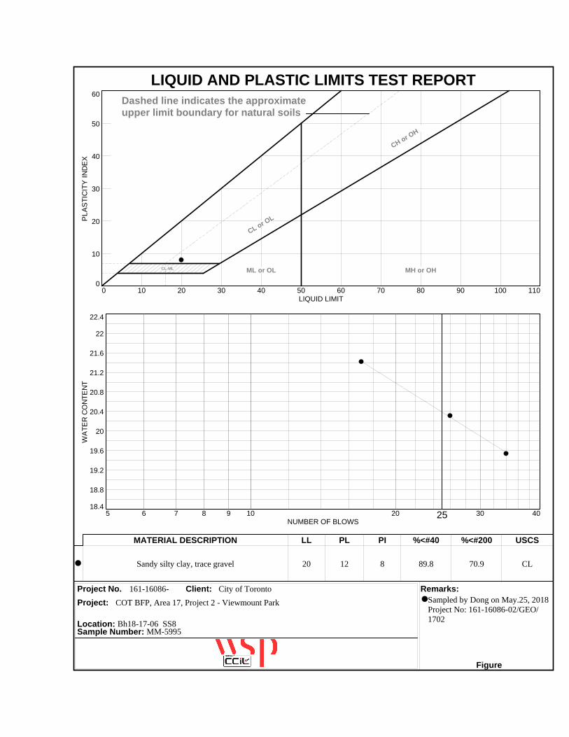
LIQUID AND PLASTIC LIMITS TEST REPORTP
LA
ST
ICIT
Y I
ND
EX
0
10
20
30
40
50
60
LIQUID LIMIT0 10 20 30 40 50 60 70 80 90 100 110
CL-ML
CL or OL
CH or OH
ML or OL MH or OH
Dashed line indicates the approximateupper limit boundary for natural soils
4
7
WA
TE
R C
ON
TE
NT
18.4
18.8
19.2
19.6
20
20.4
20.8
21.2
21.6
22
22.4
NUMBER OF BLOWS5 6 7 8 9 10 20 25 30 40
MATERIAL DESCRIPTION LL PL PI %<#40 %<#200 USCS
Project No. Client: Remarks:
Project:
Location: Bh18-17-06 SS8Sample Number: MM-5995
Figure
Sandy silty clay, trace gravel 20 12 8 89.8 70.9 CL
161-16086- City of Toronto
Sampled by Dong on May.25, 2018Project No: 161-16086-02/GEO/1702
COT BFP, Area 17, Project 2 - Viewmount Park

PROCTOR TEST REPORTD
ry d
en
sity
, kg
/m3
1750
1800
1850
1900
1950
2000
Water content, %
6 7.5 9 10.5 12 13.5 15
11.9%, 1932 kg/m3
ZAV forSp.G. =2.58
Test specification: ASTM D 698-12 Method A Standard
2.58
Subgrade Soil
161-16086- City of Toronto
Sampled by Dong on May.25, 2018Project No: 161-16086-02/GEO/1702
Elev/ Classification Nat.Sp.G. LL PI
% > % <
Depth USCS AASHTO Moist. #4 No.200
TEST RESULTS MATERIAL DESCRIPTION
Project No. Client: Remarks:
Project:
Loc.: PS2 (Subgrade Soil) BH18-17-05 to BH18-17-06 Sample No.: MM-5998
Figure
Maximum dry density = 1932 kg/m3
Optimum moisture = 11.9 %
COT BFP, Area 17, Project 2 - Viewmount Park

APPENDIX
C CHEMICAL LABORATORY TEST RESULTS

CLIENT NAME: WSP CANADA INC.351 STEELCASE ROAD WEST, UNITS 9-12MARKHAM, ON L3R4H9 (905) 475-0065
5835 COOPERS AVENUEMISSISSAUGA, ONTARIO
CANADA L4Z 1Y2TEL (905)712-5100FAX (905)712-5122
http://www.agatlabs.com
Amanjot Bhela, Inorganic CoordinatorSOIL ANALYSIS REVIEWED BY:
Neli Popnikolova, Senior ChemistTRACE ORGANICS REVIEWED BY:
DATE REPORTED:
PAGES (INCLUDING COVER): 18
Jun 05, 2018
VERSION*: 1
Should you require any information regarding this analysis please contact your client services representative at (905) 712-5100
18T343668AGAT WORK ORDER:
ATTENTION TO: Kerolus Khalil
PROJECT: 161-16086-02/GEO/1702
Laboratories (V1) Page 1 of 18
All samples will be disposed of within 30 days following analysis. Please contact the lab if you require additional sample storage time.
AGAT Laboratories is accredited to ISO/IEC 17025 by the Canadian Association for Laboratory Accreditation Inc. (CALA) and/or Standards Council of Canada (SCC) for specific tests listed on the scope of accreditation. AGAT Laboratories (Mississauga) is also accredited by the Canadian Association for Laboratory Accreditation Inc. (CALA) for specific drinking water tests. Accreditations are location and parameter specific. A complete listing of parameters for each location is available from www.cala.ca and/or www.scc.ca. The tests in this report may not necessarily be included in the scope of accreditation.
Association of Professional Engineers and Geoscientists of Alberta (APEGA)Western Enviro-Agricultural Laboratory Association (WEALA)Environmental Services Association of Alberta (ESAA)
Member of:
*NOTES
Results relate only to the items tested and to all the items testedAll reportable information as specified by ISO 17025:2005 is available from AGAT Laboratories upon request

BH18-17-6-SS9BH18-17-5-SS8SAMPLE DESCRIPTION:
SoilSoilSAMPLE TYPE:
2018-05-282018-05-28DATE SAMPLED:
9276000 9276003G / S: A RDLUnit G / S: B G / S: C G / S: DParameter
0.22 0.22Sulfide (S2-) 0.05%
34 8Chloride (2:1) 2NAµg/g NA NA NA
41 28Sulphate (2:1) 2µg/g
8.06 8.22pH (2:1) NApH Units
0.234[<A] 0.191[<A]Electrical Conductivity (2:1) 0.0050.57mS/cm 1.4 0.7 0.7
4270 5240Resistivity (2:1) 1ohm.cm
195 164Redox Potential (2:1) 5mV
Comments: RDL - Reported Detection Limit; G / S - Guideline / Standard: A Refers to Table 1: Full Depth Background Site Condition Standards - Soil - Residential/Parkland/Institutional/Industrial/Commercial/Community Property Use, B Refers to Table 3: Full Depth Generic Site Condition Standards in a Non-Potable Ground Water Condition - Soil - Industrial/Commercial/Community Property Use - Coarse Textured Soils, C Refers to Table 3: Full Depth Generic Site Condition Standards in a Non-Potable Ground Water Condition - Soil - Residential/Parkland/Institutional Property Use - Coarse Textured Soils, D Refers to Table 2: Full Depth Generic Site Condition Standards in a Potable Ground Water Condition - Soil - Agricultural or Other Property Use - Coarse Textured SoilsGuideline values are for general reference only. The guidelines provided may or may not be relevant for the intended use. Refer directly to the applicable standard for regulatory interpretation.
9276000-9276003 EC/Resistivity, pH, Chloride, Sulphate and Redox Potential were determined on the extract obtained from the 2:1 leaching procedure (2 parts DI water: 1 part soil).*Sulphide analyzed at AGAT 5623 McAdam
Results relate only to the items tested and to all the items tested
DATE RECEIVED: 2018-05-28
Certificate of Analysis
ATTENTION TO: Kerolus KhalilCLIENT NAME: WSP CANADA INC.
AGAT WORK ORDER: 18T343668
DATE REPORTED: 2018-06-05
PROJECT: 161-16086-02/GEO/1702
Corrosivity Package
SAMPLED BY:DongSAMPLING SITE:161-16086-02. BFP, Area 17, Project 2,Viewmount Park,161-16086-02/GEO/1702
5835 COOPERS AVENUEMISSISSAUGA, ONTARIO
CANADA L4Z 1Y2TEL (905)712-5100FAX (905)712-5122
http://www.agatlabs.com
CERTIFICATE OF ANALYSIS (V1)
Certified By:Page 2 of 18
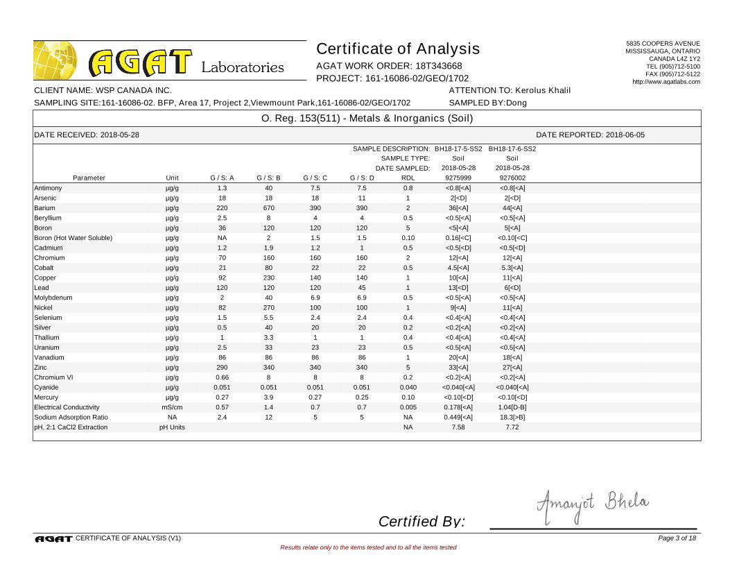
BH18-17-6-SS2BH18-17-5-SS2SAMPLE DESCRIPTION:
SoilSoilSAMPLE TYPE:
2018-05-282018-05-28DATE SAMPLED:
9275999 9276002G / S: A RDLUnit G / S: B G / S: C G / S: DParameter
<0.8[<A] <0.8[<A]Antimony 0.81.3µg/g 40 7.5 7.5
2[<D] 2[<D]Arsenic 118µg/g 18 18 11
36[<A] 44[<A]Barium 2220µg/g 670 390 390
<0.5[<A] <0.5[<A]Beryllium 0.52.5µg/g 8 4 4
<5[<A] 5[<A]Boron 536µg/g 120 120 120
0.16[<C] <0.10[<C]Boron (Hot Water Soluble) 0.10NAµg/g 2 1.5 1.5
<0.5[<D] <0.5[<D]Cadmium 0.51.2µg/g 1.9 1.2 1
12[<A] 12[<A]Chromium 270µg/g 160 160 160
4.5[<A] 5.3[<A]Cobalt 0.521µg/g 80 22 22
10[<A] 11[<A]Copper 192µg/g 230 140 140
13[<D] 6[<D]Lead 1120µg/g 120 120 45
<0.5[<A] <0.5[<A]Molybdenum 0.52µg/g 40 6.9 6.9
9[<A] 11[<A]Nickel 182µg/g 270 100 100
<0.4[<A] <0.4[<A]Selenium 0.41.5µg/g 5.5 2.4 2.4
<0.2[<A] <0.2[<A]Silver 0.20.5µg/g 40 20 20
<0.4[<A] <0.4[<A]Thallium 0.41µg/g 3.3 1 1
<0.5[<A] <0.5[<A]Uranium 0.52.5µg/g 33 23 23
20[<A] 18[<A]Vanadium 186µg/g 86 86 86
33[<A] 27[<A]Zinc 5290µg/g 340 340 340
<0.2[<A] <0.2[<A]Chromium VI 0.20.66µg/g 8 8 8
<0.040[<A] <0.040[<A]Cyanide 0.0400.051µg/g 0.051 0.051 0.051
<0.10[<D] <0.10[<D]Mercury 0.100.27µg/g 3.9 0.27 0.25
0.178[<A] 1.04[D-B]Electrical Conductivity 0.0050.57mS/cm 1.4 0.7 0.7
0.449[<A] 18.3[>B]Sodium Adsorption Ratio NA2.4NA 12 5 5
7.58 7.72pH, 2:1 CaCl2 Extraction NApH Units
Results relate only to the items tested and to all the items tested
DATE RECEIVED: 2018-05-28
Certificate of Analysis
ATTENTION TO: Kerolus KhalilCLIENT NAME: WSP CANADA INC.
AGAT WORK ORDER: 18T343668
DATE REPORTED: 2018-06-05
PROJECT: 161-16086-02/GEO/1702
O. Reg. 153(511) - Metals & Inorganics (Soil)
SAMPLED BY:DongSAMPLING SITE:161-16086-02. BFP, Area 17, Project 2,Viewmount Park,161-16086-02/GEO/1702
5835 COOPERS AVENUEMISSISSAUGA, ONTARIO
CANADA L4Z 1Y2TEL (905)712-5100FAX (905)712-5122
http://www.agatlabs.com
CERTIFICATE OF ANALYSIS (V1)
Certified By:Page 3 of 18

Results relate only to the items tested and to all the items tested
DATE RECEIVED: 2018-05-28
Certificate of Analysis
ATTENTION TO: Kerolus KhalilCLIENT NAME: WSP CANADA INC.
AGAT WORK ORDER: 18T343668
DATE REPORTED: 2018-06-05
PROJECT: 161-16086-02/GEO/1702
O. Reg. 153(511) - Metals & Inorganics (Soil)
SAMPLED BY:DongSAMPLING SITE:161-16086-02. BFP, Area 17, Project 2,Viewmount Park,161-16086-02/GEO/1702
5835 COOPERS AVENUEMISSISSAUGA, ONTARIO
CANADA L4Z 1Y2TEL (905)712-5100FAX (905)712-5122
http://www.agatlabs.com
Comments: RDL - Reported Detection Limit; G / S - Guideline / Standard: A Refers to Table 1: Full Depth Background Site Condition Standards - Soil - Residential/Parkland/Institutional/Industrial/Commercial/Community Property Use, B Refers to Table 3: Full Depth Generic Site Condition Standards in a Non-Potable Ground Water Condition - Soil - Industrial/Commercial/Community Property Use - Coarse Textured Soils, C Refers to Table 3: Full Depth Generic Site Condition Standards in a Non-Potable Ground Water Condition - Soil - Residential/Parkland/Institutional Property Use - Coarse Textured Soils, D Refers to Table 2: Full Depth Generic Site Condition Standards in a Potable Ground Water Condition - Soil - Agricultural or Other Property Use - Coarse Textured SoilsGuideline values are for general reference only. The guidelines provided may or may not be relevant for the intended use. Refer directly to the applicable standard for regulatory interpretation.
9275999-9276002 EC & SAR were determined on the DI water extract obtained from the 2:1 leaching procedure (2 parts DI water:1 part soil). pH was determined on the 0.01M CaCl2 extract prepared at 2:1 ratio.
CERTIFICATE OF ANALYSIS (V1)
Certified By:Page 4 of 18

TCLP-
ViewmountSAMPLE DESCRIPTION:
SoilSAMPLE TYPE:
2018-05-28DATE SAMPLED:
9276005G / S RDLUnitParameter
<0.010Arsenic Leachate 0.0102.5mg/L
0.632Barium Leachate 0.100100mg/L
0.064Boron Leachate 0.050500mg/L
<0.010Cadmium Leachate 0.0100.5mg/L
<0.010Chromium Leachate 0.0105mg/L
<0.010Lead Leachate 0.0105mg/L
<0.01Mercury Leachate 0.010.1mg/L
<0.010Selenium Leachate 0.0101mg/L
<0.010Silver Leachate 0.0105mg/L
<0.050Uranium Leachate 0.05010mg/L
0.18Fluoride Leachate 0.05150mg/L
<0.05Cyanide Leachate 0.0520mg/L
<0.70(Nitrate + Nitrite) as N Leachate 0.701000mg/L
Comments: RDL - Reported Detection Limit; G / S - Guideline / Standard: Refers to O. Reg. 558 - Schedule IV Leachate Quality CriteriaGuideline values are for general reference only. The guidelines provided may or may not be relevant for the intended use. Refer directly to the applicable standard for regulatory interpretation.
Results relate only to the items tested and to all the items tested
DATE RECEIVED: 2018-05-28
Certificate of Analysis
ATTENTION TO: Kerolus KhalilCLIENT NAME: WSP CANADA INC.
AGAT WORK ORDER: 18T343668
DATE REPORTED: 2018-06-05
PROJECT: 161-16086-02/GEO/1702
O. Reg. 558 Metals and Inorganics
SAMPLED BY:DongSAMPLING SITE:161-16086-02. BFP, Area 17, Project 2,Viewmount Park,161-16086-02/GEO/1702
5835 COOPERS AVENUEMISSISSAUGA, ONTARIO
CANADA L4Z 1Y2TEL (905)712-5100FAX (905)712-5122
http://www.agatlabs.com
CERTIFICATE OF ANALYSIS (V1)
Certified By:Page 5 of 18

BH18-17-6-
SS1ABH18-17-5-SS1SAMPLE DESCRIPTION:
SoilSoilSAMPLE TYPE:
2018-05-282018-05-28DATE SAMPLED:
9276001 9276004G / S: A RDLUnit G / S: B G / S: C G / S: DParameter
<0.05[<A] <0.05[<A]Naphthalene 0.050.09µg/g 9.6 0.6 0.6
<0.05[<A] <0.05[<A]Acenaphthylene 0.050.093µg/g 0.15 0.15 0.15
<0.05[<A] <0.05[<A]Acenaphthene 0.050.072µg/g 96 7.9 7.9
<0.05[<A] <0.05[<A]Fluorene 0.050.12µg/g 62 62 62
0.06[<A] 0.34[<A]Phenanthrene 0.050.69µg/g 12 6.2 6.2
<0.05[<A] 0.09[<A]Anthracene 0.050.16µg/g 0.67 0.67 0.67
0.16[<A] 0.84[D-B]Fluoranthene 0.050.56µg/g 9.6 0.69 0.69
0.14[<A] 0.70[<A]Pyrene 0.051µg/g 96 78 78
0.08[<A] 0.37[A-C]Benz(a)anthracene 0.050.36µg/g 0.96 0.5 0.5
0.08[<A] 0.40[<A]Chrysene 0.052.8µg/g 9.6 7 7
0.10[<A] 0.57[A-C]Benzo(b)fluoranthene 0.050.47µg/g 0.96 0.78 0.78
<0.05[<A] 0.16[<A]Benzo(k)fluoranthene 0.050.48µg/g 0.96 0.78 0.78
0.06[<D] 0.42[>A]Benzo(a)pyrene 0.050.3µg/g 0.3 0.3 0.078
<0.05[<A] 0.22[<A]Indeno(1,2,3-cd)pyrene 0.050.23µg/g 0.76 0.38 0.38
<0.05[<A] 0.05[<A]Dibenz(a,h)anthracene 0.050.1µg/g 0.1 0.1 0.1
<0.05[<A] 0.36[<A]Benzo(g,h,i)perylene 0.050.68µg/g 9.6 6.6 6.6
<0.05[<A] <0.05[<A]Methyl Naphthalene, 2-and 1- 0.050.59µg/g 76 0.99 0.99
Acceptable LimitsUnitSurrogate
106 112.Chrysene-d12 % 50-140
Comments: RDL - Reported Detection Limit; G / S - Guideline / Standard: A Refers to Table 1: Full Depth Background Site Condition Standards - Soil - Residential/Parkland/Institutional/Industrial/Commercial/Community Property Use, B Refers to Table 3: Full Depth Generic Site Condition Standards in a Non-Potable Ground Water Condition - Soil - Industrial/Commercial/Community Property Use - Coarse Textured Soils, C Refers to Table 3: Full Depth Generic Site Condition Standards in a Non-Potable Ground Water Condition - Soil - Residential/Parkland/Institutional Property Use - Coarse Textured Soils, D Refers to Table 2: Full Depth Generic Site Condition Standards in a Potable Ground Water Condition - Soil - Agricultural or Other Property Use - Coarse Textured SoilsGuideline values are for general reference only. The guidelines provided may or may not be relevant for the intended use. Refer directly to the applicable standard for regulatory interpretation.
9276001-9276004 Results are based on the dry weight of the soil.Note: The result for Benzo(b)Fluoranthene is the total of the Benzo(b)&(j)Fluoranthene isomers because the isomers co-elute on the GC column.
Results relate only to the items tested and to all the items tested
DATE RECEIVED: 2018-05-28
Certificate of Analysis
ATTENTION TO: Kerolus KhalilCLIENT NAME: WSP CANADA INC.
AGAT WORK ORDER: 18T343668
DATE REPORTED: 2018-06-05
PROJECT: 161-16086-02/GEO/1702
O. Reg. 153(511) - PAHs (Soil)
SAMPLED BY:DongSAMPLING SITE:161-16086-02. BFP, Area 17, Project 2,Viewmount Park,161-16086-02/GEO/1702
5835 COOPERS AVENUEMISSISSAUGA, ONTARIO
CANADA L4Z 1Y2TEL (905)712-5100FAX (905)712-5122
http://www.agatlabs.com
CERTIFICATE OF ANALYSIS (V1)
Certified By:Page 6 of 18

BH18-17-6-SS2BH18-17-5-SS2SAMPLE DESCRIPTION:
SoilSoilSAMPLE TYPE:
2018-05-282018-05-28DATE SAMPLED:
9275999 9276002G / S: A RDLUnit G / S: B G / S: C G / S: DParameter
<0.02[<A] <0.02[<A]Benzene 0.020.02µg/g 0.32 0.21 0.21
<0.08[<A] <0.08[<A]Toluene 0.080.2µg/g 68 2.3 2.3
<0.05[<A] <0.05[<A]Ethylbenzene 0.050.05µg/g 9.5 2 1.1
<0.05[<A] <0.05[<A]Xylene Mixture 0.050.05µg/g 26 3.1 3.1
<5[<A] <5[<A]F1 (C6 to C10) 525µg/g 55 55 55
<5[<A] <5[<A]F1 (C6 to C10) minus BTEX 525µg/g 55 55 55
<10[<A] <10[<A]F2 (C10 to C16) 1010µg/g 230 98 98
<50[<A] <50[<A]F3 (C16 to C34) 50240µg/g 1700 300 300
<50[<A] <50[<A]F4 (C34 to C50) 50120µg/g 3300 2800 2800
NA[<A] NA[<A]Gravimetric Heavy Hydrocarbons 50120µg/g 3300 2800 2800
13.0 11.0Moisture Content 0.1%
Acceptable LimitsUnitSurrogate
128 130Terphenyl % 60-140
Comments: RDL - Reported Detection Limit; G / S - Guideline / Standard: A Refers to Table 1: Full Depth Background Site Condition Standards - Soil - Residential/Parkland/Institutional/Industrial/Commercial/Community Property Use, B Refers to Table 3: Full Depth Generic Site Condition Standards in a Non-Potable Ground Water Condition - Soil - Industrial/Commercial/Community Property Use - Coarse Textured Soils, C Refers to Table 3: Full Depth Generic Site Condition Standards in a Non-Potable Ground Water Condition - Soil - Residential/Parkland/Institutional Property Use - Coarse Textured Soils, D Refers to Table 2: Full Depth Generic Site Condition Standards in a Potable Ground Water Condition - Soil - Agricultural or Other Property Use - Coarse Textured SoilsGuideline values are for general reference only. The guidelines provided may or may not be relevant for the intended use. Refer directly to the applicable standard for regulatory interpretation.
9275999-9276002 Results are based on sample dry weight.The C6-C10 fraction is calculated using Toluene response factor.The C10 - C16, C16 - C34, and C34 - C50 fractions are calculated using the average response factor for n-C10, n-C16, and n-C34.Gravimetric Heavy Hydrocarbons are not included in the Total C16-C50 and are only determined if the chromatogram of the C34 - C50 hydrocarbons indicates that hydrocarbons >C50 are present.The chromatogram has returned to baseline by the retention time of nC50.Total C6 - C50 results are corrected for BTEX contributions.This method complies with the Reference Method for the CWS PHC and is validated for use in the laboratory.nC6 and nC10 response factors are within 30% of Toluene response factor.nC10, nC16 and nC34 response factors are within 10% of their average.C50 response factor is within 70% of nC10 + nC16 + nC34 average.Linearity is within 15%.Extraction and holding times were met for this sample.Fractions 1-4 are quantified with the contribution of PAHs. Under Ontario Regulation 153, results are considered valid without determining the PAH contribution if not requested by the client.Quality Control Data is available upon request.
Results relate only to the items tested and to all the items tested
DATE RECEIVED: 2018-05-28
Certificate of Analysis
ATTENTION TO: Kerolus KhalilCLIENT NAME: WSP CANADA INC.
AGAT WORK ORDER: 18T343668
DATE REPORTED: 2018-06-05
PROJECT: 161-16086-02/GEO/1702
O. Reg. 153(511) - PHCs F1 - F4 (Soil)
SAMPLED BY:DongSAMPLING SITE:161-16086-02. BFP, Area 17, Project 2,Viewmount Park,161-16086-02/GEO/1702
5835 COOPERS AVENUEMISSISSAUGA, ONTARIO
CANADA L4Z 1Y2TEL (905)712-5100FAX (905)712-5122
http://www.agatlabs.com
CERTIFICATE OF ANALYSIS (V1)
Certified By:Page 7 of 18

TCLP-
ViewmountSAMPLE DESCRIPTION:
SoilSAMPLE TYPE:
2018-05-28DATE SAMPLED:
9276005G / S RDLUnitParameter
<0.005Polychlorinated Biphenyls 0.0050.3mg/L
Acceptable LimitsUnitSurrogate
79Decachlorobiphenyl % 60-130
Comments: RDL - Reported Detection Limit; G / S - Guideline / Standard: Refers to O. Reg. 558 - Schedule IV Leachate Quality CriteriaGuideline values are for general reference only. The guidelines provided may or may not be relevant for the intended use. Refer directly to the applicable standard for regulatory interpretation.
9276005 The soil sample was leached using the Regulation 558 procedure. Analysis was performed on the leachate.
Results relate only to the items tested and to all the items tested
DATE RECEIVED: 2018-05-28
Certificate of Analysis
ATTENTION TO: Kerolus KhalilCLIENT NAME: WSP CANADA INC.
AGAT WORK ORDER: 18T343668
DATE REPORTED: 2018-06-05
PROJECT: 161-16086-02/GEO/1702
O. Reg. 558 - PCBs
SAMPLED BY:DongSAMPLING SITE:161-16086-02. BFP, Area 17, Project 2,Viewmount Park,161-16086-02/GEO/1702
5835 COOPERS AVENUEMISSISSAUGA, ONTARIO
CANADA L4Z 1Y2TEL (905)712-5100FAX (905)712-5122
http://www.agatlabs.com
CERTIFICATE OF ANALYSIS (V1)
Certified By:Page 8 of 18
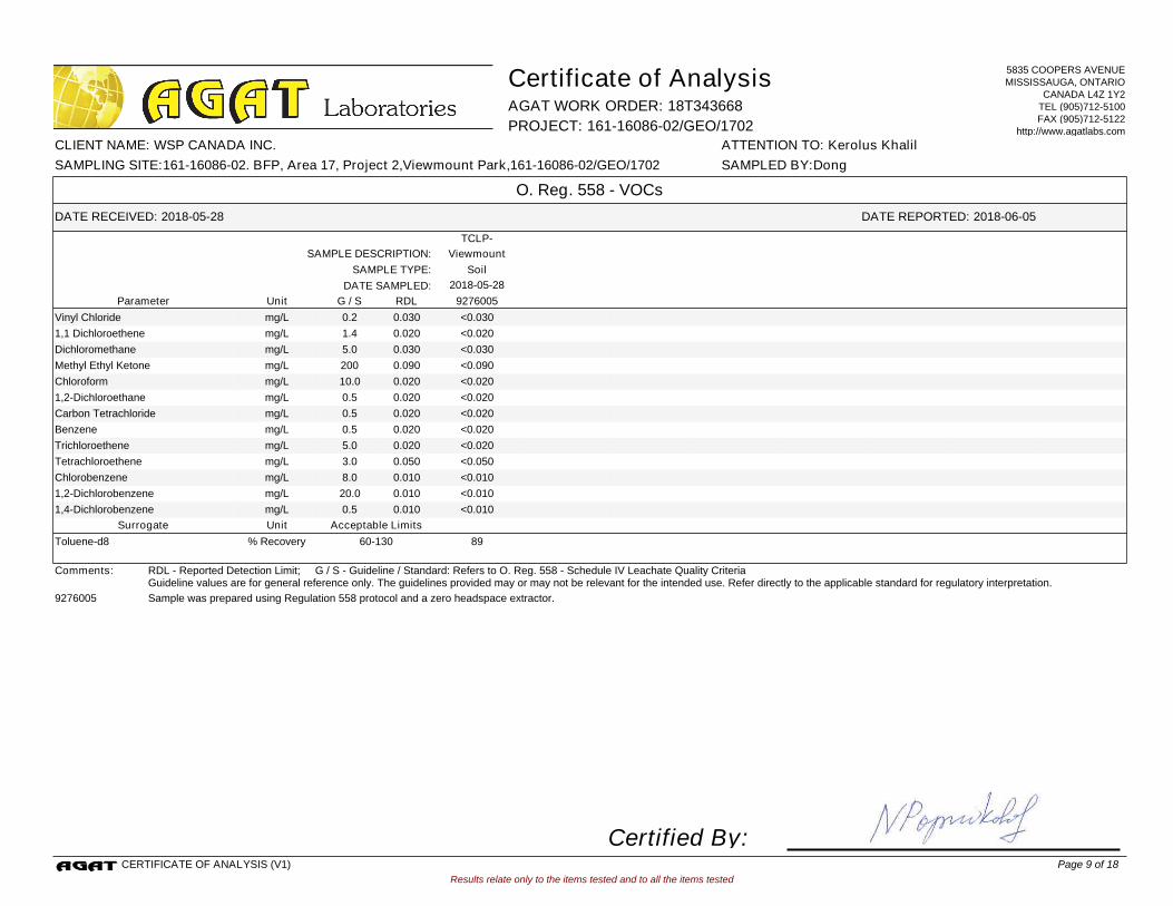
TCLP-
ViewmountSAMPLE DESCRIPTION:
SoilSAMPLE TYPE:
2018-05-28DATE SAMPLED:
9276005G / S RDLUnitParameter
<0.030Vinyl Chloride 0.0300.2mg/L
<0.0201,1 Dichloroethene 0.0201.4mg/L
<0.030Dichloromethane 0.0305.0mg/L
<0.090Methyl Ethyl Ketone 0.090200mg/L
<0.020Chloroform 0.02010.0mg/L
<0.0201,2-Dichloroethane 0.0200.5mg/L
<0.020Carbon Tetrachloride 0.0200.5mg/L
<0.020Benzene 0.0200.5mg/L
<0.020Trichloroethene 0.0205.0mg/L
<0.050Tetrachloroethene 0.0503.0mg/L
<0.010Chlorobenzene 0.0108.0mg/L
<0.0101,2-Dichlorobenzene 0.01020.0mg/L
<0.0101,4-Dichlorobenzene 0.0100.5mg/L
Acceptable LimitsUnitSurrogate
89Toluene-d8 % Recovery 60-130
Comments: RDL - Reported Detection Limit; G / S - Guideline / Standard: Refers to O. Reg. 558 - Schedule IV Leachate Quality CriteriaGuideline values are for general reference only. The guidelines provided may or may not be relevant for the intended use. Refer directly to the applicable standard for regulatory interpretation.
9276005 Sample was prepared using Regulation 558 protocol and a zero headspace extractor.
Results relate only to the items tested and to all the items tested
DATE RECEIVED: 2018-05-28
Certificate of Analysis
ATTENTION TO: Kerolus KhalilCLIENT NAME: WSP CANADA INC.
AGAT WORK ORDER: 18T343668
DATE REPORTED: 2018-06-05
PROJECT: 161-16086-02/GEO/1702
O. Reg. 558 - VOCs
SAMPLED BY:DongSAMPLING SITE:161-16086-02. BFP, Area 17, Project 2,Viewmount Park,161-16086-02/GEO/1702
5835 COOPERS AVENUEMISSISSAUGA, ONTARIO
CANADA L4Z 1Y2TEL (905)712-5100FAX (905)712-5122
http://www.agatlabs.com
CERTIFICATE OF ANALYSIS (V1)
Certified By:Page 9 of 18

9276002 ON T1 S RPI/ICC O. Reg. 153(511) - Metals & Inorganics (Soil) Electrical Conductivity 0.57 1.04BH18-17-6-SS2 mS/cm
9276002 ON T1 S RPI/ICC O. Reg. 153(511) - Metals & Inorganics (Soil) Sodium Adsorption Ratio 2.4 18.3BH18-17-6-SS2 NA
9276002 ON T2 S AG CT O. Reg. 153(511) - Metals & Inorganics (Soil) Electrical Conductivity 0.7 1.04BH18-17-6-SS2 mS/cm
9276002 ON T2 S AG CT O. Reg. 153(511) - Metals & Inorganics (Soil) Sodium Adsorption Ratio 5 18.3BH18-17-6-SS2 NA
9276002 ON T3 S ICC CT O. Reg. 153(511) - Metals & Inorganics (Soil) Sodium Adsorption Ratio 12 18.3BH18-17-6-SS2 NA
9276002 ON T3 S RPI CT O. Reg. 153(511) - Metals & Inorganics (Soil) Electrical Conductivity 0.7 1.04BH18-17-6-SS2 mS/cm
9276002 ON T3 S RPI CT O. Reg. 153(511) - Metals & Inorganics (Soil) Sodium Adsorption Ratio 5 18.3BH18-17-6-SS2 NA
9276004 ON T1 S RPI/ICC O. Reg. 153(511) - PAHs (Soil) Benz(a)anthracene 0.36 0.37BH18-17-6-SS1A µg/g
9276004 ON T1 S RPI/ICC O. Reg. 153(511) - PAHs (Soil) Benzo(a)pyrene 0.3 0.42BH18-17-6-SS1A µg/g
9276004 ON T1 S RPI/ICC O. Reg. 153(511) - PAHs (Soil) Benzo(b)fluoranthene 0.47 0.57BH18-17-6-SS1A µg/g
9276004 ON T1 S RPI/ICC O. Reg. 153(511) - PAHs (Soil) Fluoranthene 0.56 0.84BH18-17-6-SS1A µg/g
9276004 ON T2 S AG CT O. Reg. 153(511) - PAHs (Soil) Benzo(a)pyrene 0.078 0.42BH18-17-6-SS1A µg/g
9276004 ON T2 S AG CT O. Reg. 153(511) - PAHs (Soil) Fluoranthene 0.69 0.84BH18-17-6-SS1A µg/g
9276004 ON T3 S ICC CT O. Reg. 153(511) - PAHs (Soil) Benzo(a)pyrene 0.3 0.42BH18-17-6-SS1A µg/g
9276004 ON T3 S RPI CT O. Reg. 153(511) - PAHs (Soil) Benzo(a)pyrene 0.3 0.42BH18-17-6-SS1A µg/g
9276004 ON T3 S RPI CT O. Reg. 153(511) - PAHs (Soil) Fluoranthene 0.69 0.84BH18-17-6-SS1A µg/g
Results relate only to the items tested and to all the items tested
Guideline Violation
ATTENTION TO: Kerolus KhalilCLIENT NAME: WSP CANADA INC.
AGAT WORK ORDER: 18T343668
PROJECT: 161-16086-02/GEO/1702
SAMPLEID GUIDELINE ANALYSIS PACKAGE PARAMETER GUIDEVALUE RESULTSAMPLE TITLE UNIT
5835 COOPERS AVENUEMISSISSAUGA, ONTARIO
CANADA L4Z 1Y2TEL (905)712-5100FAX (905)712-5122
http://www.agatlabs.com
GUIDELINE VIOLATION (V1) Page 10 of 18

O. Reg. 153(511) - Metals & Inorganics (Soil)
Antimony 9278611 <0.8 <0.8 NA < 0.8 120% 70% 130% 93% 80% 120% 92% 70% 130%
Arsenic 9278611 3 3 NA < 1 100% 70% 130% 104% 80% 120% 102% 70% 130%
Barium 9278611 31 30 3.3% < 2 100% 70% 130% 94% 80% 120% 99% 70% 130%
Beryllium 9278611 <0.5 <0.5 NA < 0.5 103% 70% 130% 116% 80% 120% 105% 70% 130%
Boron
9278611 6 6 NA < 5 73% 70% 130% 116% 80% 120% 103% 70% 130%
Boron (Hot Water Soluble) 9276644 <0.10 <0.10 NA < 0.10 98% 60% 140% 87% 70% 130% 88% 60% 140%
Cadmium 9278611 <0.5 <0.5 NA < 0.5 95% 70% 130% 109% 80% 120% 115% 70% 130%
Chromium 9278611 13 12 8.0% < 2 101% 70% 130% 102% 80% 120% 104% 70% 130%
Cobalt 9278611 4.3 4.2 2.4% < 0.5 97% 70% 130% 100% 80% 120% 100% 70% 130%
Copper
9278611 13 13 0.0% < 1 100% 70% 130% 103% 80% 120% 104% 70% 130%
Lead 9278611 13 13 0.0% < 1 101% 70% 130% 103% 80% 120% 103% 70% 130%
Molybdenum 9278611 <0.5 <0.5 NA < 0.5 101% 70% 130% 101% 80% 120% 101% 70% 130%
Nickel 9278611 9 9 0.0% < 1 97% 70% 130% 102% 80% 120% 100% 70% 130%
Selenium 9278611 0.4 0.5 NA < 0.4 97% 70% 130% 100% 80% 120% 97% 70% 130%
Silver
9278611 <0.2 <0.2 NA < 0.2 95% 70% 130% 107% 80% 120% 105% 70% 130%
Thallium 9278611 <0.4 <0.4 NA < 0.4 96% 70% 130% 103% 80% 120% 97% 70% 130%
Uranium 9278611 <0.5 <0.5 NA < 0.5 98% 70% 130% 92% 80% 120% 96% 70% 130%
Vanadium 9278611 16 16 0.0% < 1 102% 70% 130% 102% 80% 120% 97% 70% 130%
Zinc 9278611 39 38 2.6% < 5 101% 70% 130% 105% 80% 120% 115% 70% 130%
Chromium VI
9287256 <0.2 <0.2 NA < 0.2 75% 70% 130% 98% 80% 120% 97% 70% 130%
Cyanide 9276644 <0.040 <0.040 NA < 0.040 106% 70% 130% 99% 80% 120% 103% 70% 130%
Mercury 9278611 <0.10 <0.10 NA < 0.10 100% 70% 130% 91% 80% 120% 98% 70% 130%
Electrical Conductivity 9278427 0.185 0.182 1.6% < 0.005 96% 90% 110% NA NA
Sodium Adsorption Ratio 9276644 4.33 4.88 11.9% NA NA NA NA
pH, 2:1 CaCl2 Extraction
9276644 7.56 7.57 0.1% NA 101% 80% 120% NA NA
Corrosivity Package
Sulfide (S2-) 9276000 9276000 0.22 0.22 NA < 0.05 99% 80% 120%
Chloride (2:1) 9271519 11 10 7.6% < 2 108% 80% 120% 100% 80% 120% 99% 70% 130%
Sulphate (2:1) 9271519 64 61 4.4% < 2 97% 80% 120% 101% 80% 120% 105% 70% 130%
pH (2:1) 9276000 9276000 8.06 8.10 0.5% NA 90% 110% NA NA
Redox Potential (2:1)
9276000 9276000 195 192 1.7% < 5 103% 70% 130% NA NA
Comments: NA signifies Not Applicable.
O. Reg. 558 Metals and Inorganics
Arsenic Leachate 9278001 <0.010 <0.010 NA < 0.010 99% 90% 110% 108% 80% 120% 110% 70% 130%
Barium Leachate 9278001 0.720 0.758 5.1% < 0.100 101% 90% 110% 102% 80% 120% 106% 70% 130%
Boron Leachate 9278001 0.102 0.105 NA < 0.050 104% 90% 110% 100% 80% 120% 102% 70% 130%
Cadmium Leachate 9278001 <0.010 <0.010 NA < 0.010 100% 90% 110% 105% 80% 120% 113% 70% 130%
Chromium Leachate
9278001 <0.010 <0.010 NA < 0.010 100% 90% 110% 110% 80% 120% 110% 70% 130%
Results relate only to the items tested and to all the items tested
SAMPLING SITE:161-16086-02. BFP, Area 17, Project 2,Viewmount Park, SAMPLED BY:Dong
AGAT WORK ORDER: 18T343668
Dup #1 RPDMeasured
ValueRecovery Recovery
Quality Assurance
ATTENTION TO: Kerolus Khalil
CLIENT NAME: WSP CANADA INC.
PROJECT: 161-16086-02/GEO/1702
Soil Analysis
UpperLower
AcceptableLimits
BatchPARAMETERSample
IdDup #2
UpperLower
AcceptableLimits
UpperLower
AcceptableLimits
MATRIX SPIKEMETHOD BLANK SPIKEDUPLICATERPT Date: Jun 05, 2018 REFERENCE MATERIAL
MethodBlank
5835 COOPERS AVENUEMISSISSAUGA, ONTARIO
CANADA L4Z 1Y2TEL (905)712-5100FAX (905)712-5122
http://www.agatlabs.com
QUALITY ASSURANCE REPORT (V1) Page 11 of 18
AGAT Laboratories is accredited to ISO/IEC 17025 by the Canadian Association for Laboratory Accreditation Inc. (CALA) and/or Standards Council of Canada (SCC) for specific tests listed on the scope of accreditation. AGAT Laboratories (Mississauga) is also accredited by the Canadian Association for Laboratory Accreditation Inc. (CALA) for specific drinking water tests. Accreditations are location and parameter specific. A complete listing of parameters for each location is available from www.cala.ca and/or www.scc.ca. The tests in this report may not necessarily be included in the scope of accreditation.

Lead Leachate 9278001 0.016 0.016 NA < 0.010 98% 90% 110% 98% 80% 120% 99% 70% 130%
Mercury Leachate 9278001 <0.01 <0.01 NA < 0.01 107% 90% 110% 108% 80% 120% 113% 70% 130%
Selenium Leachate 9278001 <0.010 <0.010 NA < 0.010 100% 90% 110% 109% 80% 120% 108% 70% 130%
Silver Leachate 9278001 <0.010 <0.010 NA < 0.010 96% 90% 110% 98% 80% 120% 96% 70% 130%
Uranium Leachate
9278001 <0.050 <0.050 NA < 0.050 101% 90% 110% 98% 80% 120% 103% 70% 130%
Fluoride Leachate 9278001 0.22 0.22 NA < 0.05 103% 90% 110% 104% 90% 110% 98% 70% 130%
Cyanide Leachate 9278001 <0.05 <0.05 NA < 0.05 99% 90% 110% 105% 90% 110% 108% 70% 130%
(Nitrate + Nitrite) as N Leachate 9278001 <0.70 <0.70 NA < 0.70 98% 80% 120% 96% 80% 120% 97% 70% 130%
Comments: NA signifies Not Applicable.Duplicate Qualifier: As the measured result approaches the RL, the uncertainty associated with the value increases dramatically, thus duplicate acceptance limits apply only where the average of the two duplicates is greater than five times the RL
Certified By:
Results relate only to the items tested and to all the items tested
SAMPLING SITE:161-16086-02. BFP, Area 17, Project 2,Viewmount Park, SAMPLED BY:Dong
AGAT WORK ORDER: 18T343668
Dup #1 RPDMeasured
ValueRecovery Recovery
Quality Assurance
ATTENTION TO: Kerolus Khalil
CLIENT NAME: WSP CANADA INC.
PROJECT: 161-16086-02/GEO/1702
Soil Analysis (Continued)
UpperLower
AcceptableLimits
BatchPARAMETERSample
IdDup #2
UpperLower
AcceptableLimits
UpperLower
AcceptableLimits
MATRIX SPIKEMETHOD BLANK SPIKEDUPLICATERPT Date: Jun 05, 2018 REFERENCE MATERIAL
MethodBlank
5835 COOPERS AVENUEMISSISSAUGA, ONTARIO
CANADA L4Z 1Y2TEL (905)712-5100FAX (905)712-5122
http://www.agatlabs.com
QUALITY ASSURANCE REPORT (V1) Page 12 of 18
AGAT Laboratories is accredited to ISO/IEC 17025 by the Canadian Association for Laboratory Accreditation Inc. (CALA) and/or Standards Council of Canada (SCC) for specific tests listed on the scope of accreditation. AGAT Laboratories (Mississauga) is also accredited by the Canadian Association for Laboratory Accreditation Inc. (CALA) for specific drinking water tests. Accreditations are location and parameter specific. A complete listing of parameters for each location is available from www.cala.ca and/or www.scc.ca. The tests in this report may not necessarily be included in the scope of accreditation.

O. Reg. 153(511) - PHCs F1 - F4 (Soil)
Benzene 9276017 < 0.02 < 0.02 NA < 0.02 102% 60% 130% 101% 60% 130% 103% 60% 130%
Toluene 9276017 < 0.08 < 0.08 NA < 0.08 85% 60% 130% 111% 60% 130% 96% 60% 130%
Ethylbenzene 9276017 < 0.05 < 0.05 NA < 0.05 77% 60% 130% 94% 60% 130% 76% 60% 130%
Xylene Mixture 9276017 < 0.05 < 0.05 NA < 0.05 77% 60% 130% 96% 60% 130% 81% 60% 130%
F1 (C6 to C10)
9276017 < 5 < 5 NA < 5 99% 60% 130% 96% 85% 115% 76% 70% 130%
F2 (C10 to C16) 9278274 < 10 < 10 NA < 10 104% 60% 130% 100% 80% 120% 79% 70% 130%
F3 (C16 to C34) 9278274 < 50 < 50 NA < 50 105% 60% 130% 100% 80% 120% 88% 70% 130%
F4 (C34 to C50) 9278274 < 50 < 50 NA < 50 96% 60% 130% 103% 80% 120% 100% 70% 130%
O. Reg. 153(511) - PAHs (Soil)
Naphthalene 9271644 < 0.05 < 0.05 NA < 0.05 109% 50% 140% 106% 50% 140% 94% 50% 140%
Acenaphthylene 9271644 < 0.05 < 0.05 NA < 0.05 90% 50% 140% 102% 50% 140% 104% 50% 140%
Acenaphthene 9271644 < 0.05 < 0.05 NA < 0.05 111% 50% 140% 98% 50% 140% 93% 50% 140%
Fluorene 9271644 < 0.05 < 0.05 NA < 0.05 106% 50% 140% 109% 50% 140% 103% 50% 140%
Phenanthrene
9271644 < 0.05 < 0.05 NA < 0.05 118% 50% 140% 106% 50% 140% 107% 50% 140%
Anthracene 9271644 < 0.05 < 0.05 NA < 0.05 112% 50% 140% 103% 50% 140% 110% 50% 140%
Fluoranthene 9271644 < 0.05 < 0.05 NA < 0.05 114% 50% 140% 103% 50% 140% 94% 50% 140%
Pyrene 9271644 < 0.05 < 0.05 NA < 0.05 104% 50% 140% 91% 50% 140% 99% 50% 140%
Benz(a)anthracene 9271644 < 0.05 < 0.05 NA < 0.05 87% 50% 140% 93% 50% 140% 93% 50% 140%
Chrysene
9271644 < 0.05 < 0.05 NA < 0.05 97% 50% 140% 101% 50% 140% 85% 50% 140%
Benzo(b)fluoranthene 9271644 < 0.05 < 0.05 NA < 0.05 118% 50% 140% 108% 50% 140% 107% 50% 140%
Benzo(k)fluoranthene 9271644 < 0.05 < 0.05 NA < 0.05 109% 50% 140% 98% 50% 140% 107% 50% 140%
Benzo(a)pyrene 9271644 < 0.05 < 0.05 NA < 0.05 83% 50% 140% 95% 50% 140% 97% 50% 140%
Indeno(1,2,3-cd)pyrene 9271644 < 0.05 < 0.05 NA < 0.05 81% 50% 140% 104% 50% 140% 86% 50% 140%
Dibenz(a,h)anthracene
9271644 < 0.05 < 0.05 NA < 0.05 85% 50% 140% 97% 50% 140% 83% 50% 140%
Benzo(g,h,i)perylene 9271644 < 0.05 < 0.05 NA < 0.05 85% 50% 140% 88% 50% 140% 86% 50% 140%
Methyl Naphthalene, 2-and 1- 9271644 < 0.05 < 0.05 NA < 0.05 95% 50% 140% 94% 50% 140% 85% 50% 140%
O. Reg. 558 - VOCs
Vinyl Chloride 9262326 < 0.030 < 0.030 NA < 0.030 93% 60% 140% 118% 60% 140% NA 60% 140%
1,1 Dichloroethene 9262326 < 0.020 < 0.020 NA < 0.020 106% 70% 130% 95% 70% 130% NA 60% 140%
Dichloromethane 9262326 < 0.030 < 0.030 NA < 0.030 102% 70% 130% 102% 70% 130% NA 60% 140%
Methyl Ethyl Ketone 9262326 < 0.090 < 0.090 NA < 0.090 82% 70% 130% 104% 70% 130% NA 60% 140%
Chloroform
9262326 < 0.020 < 0.020 NA < 0.020 111% 70% 130% 115% 70% 130% NA 60% 140%
1,2-Dichloroethane 9262326 < 0.020 < 0.020 NA < 0.020 114% 70% 130% 109% 70% 130% NA 60% 140%
Carbon Tetrachloride 9262326 < 0.020 < 0.020 NA < 0.020 98% 70% 130% 89% 70% 130% NA 60% 140%
Benzene 9262326 < 0.020 < 0.020 NA < 0.020 96% 70% 130% 109% 70% 130% NA 60% 140%
Trichloroethene 9262326 < 0.020 < 0.020 NA < 0.020 96% 70% 130% 78% 70% 130% NA 60% 140%
Tetrachloroethene
9262326 < 0.050 < 0.050 NA < 0.050 114% 70% 130% 107% 70% 130% NA 60% 140%
Chlorobenzene 9262326 < 0.010 < 0.010 NA < 0.010 91% 70% 130% 105% 70% 130% NA 60% 140%
Results relate only to the items tested and to all the items tested
SAMPLING SITE:161-16086-02. BFP, Area 17, Project 2,Viewmount Park, SAMPLED BY:Dong
AGAT WORK ORDER: 18T343668
Dup #1 RPDMeasured
ValueRecovery Recovery
Quality Assurance
ATTENTION TO: Kerolus Khalil
CLIENT NAME: WSP CANADA INC.
PROJECT: 161-16086-02/GEO/1702
Trace Organics Analysis
UpperLower
AcceptableLimits
BatchPARAMETERSample
IdDup #2
UpperLower
AcceptableLimits
UpperLower
AcceptableLimits
MATRIX SPIKEMETHOD BLANK SPIKEDUPLICATERPT Date: Jun 05, 2018 REFERENCE MATERIAL
MethodBlank
5835 COOPERS AVENUEMISSISSAUGA, ONTARIO
CANADA L4Z 1Y2TEL (905)712-5100FAX (905)712-5122
http://www.agatlabs.com
QUALITY ASSURANCE REPORT (V1) Page 13 of 18
AGAT Laboratories is accredited to ISO/IEC 17025 by the Canadian Association for Laboratory Accreditation Inc. (CALA) and/or Standards Council of Canada (SCC) for specific tests listed on the scope of accreditation. AGAT Laboratories (Mississauga) is also accredited by the Canadian Association for Laboratory Accreditation Inc. (CALA) for specific drinking water tests. Accreditations are location and parameter specific. A complete listing of parameters for each location is available from www.cala.ca and/or www.scc.ca. The tests in this report may not necessarily be included in the scope of accreditation.

1,2-Dichlorobenzene 9262326 < 0.010 < 0.010 NA < 0.010 116% 70% 130% 100% 70% 130% NA 60% 140%
1,4-Dichlorobenzene 9262326 < 0.010 < 0.010 NA < 0.010 83% 70% 130% 116% 70% 130% NA 60% 140%
O. Reg. 558 - PCBs
Polychlorinated Biphenyls 9268669 < 0.005 < 0.005 NA < 0.005 104% 60% 130% 103% 60% 130% NA 60% 130%
Comments: When the average of the sample and duplicate results is less than 5x the RDL, the Relative Percent Difference (RPD) will be indicated as Not Applicable (NA).
Certified By:
Results relate only to the items tested and to all the items tested
SAMPLING SITE:161-16086-02. BFP, Area 17, Project 2,Viewmount Park, SAMPLED BY:Dong
AGAT WORK ORDER: 18T343668
Dup #1 RPDMeasured
ValueRecovery Recovery
Quality Assurance
ATTENTION TO: Kerolus Khalil
CLIENT NAME: WSP CANADA INC.
PROJECT: 161-16086-02/GEO/1702
Trace Organics Analysis (Continued)
UpperLower
AcceptableLimits
BatchPARAMETERSample
IdDup #2
UpperLower
AcceptableLimits
UpperLower
AcceptableLimits
MATRIX SPIKEMETHOD BLANK SPIKEDUPLICATERPT Date: Jun 05, 2018 REFERENCE MATERIAL
MethodBlank
5835 COOPERS AVENUEMISSISSAUGA, ONTARIO
CANADA L4Z 1Y2TEL (905)712-5100FAX (905)712-5122
http://www.agatlabs.com
QUALITY ASSURANCE REPORT (V1) Page 14 of 18
AGAT Laboratories is accredited to ISO/IEC 17025 by the Canadian Association for Laboratory Accreditation Inc. (CALA) and/or Standards Council of Canada (SCC) for specific tests listed on the scope of accreditation. AGAT Laboratories (Mississauga) is also accredited by the Canadian Association for Laboratory Accreditation Inc. (CALA) for specific drinking water tests. Accreditations are location and parameter specific. A complete listing of parameters for each location is available from www.cala.ca and/or www.scc.ca. The tests in this report may not necessarily be included in the scope of accreditation.

Soil Analysis
Sulfide (S2-) MIN-200-12025 ASTM E1915-09 GRAVIMETRIC
Chloride (2:1) INOR-93-6004 McKeague 4.12 & SM 4110 B ION CHROMATOGRAPH
Sulphate (2:1) INOR-93-6004 McKeague 4.12 & SM 4110 B ION CHROMATOGRAPH
pH (2:1) INOR 93-6031 MSA part 3 & SM 4500-H+ B PH METER
Electrical Conductivity (2:1) INOR-93-6036 McKeague 4.12, SM 2510 B EC METER
Resistivity (2:1) INOR-93-6036McKeague 4.12, SM 2510 B,SSA #5 Part 3
CALCULATION
Redox Potential (2:1) McKeague 4.12 & SM 2510 B REDOX POTENTIAL ELECTRODE
Antimony MET-93-6103 EPA SW-846 3050B & 6020A ICP-MS
Arsenic MET-93-6103 EPA SW-846 3050B & 6020A ICP-MS
Barium MET-93-6103 EPA SW-846 3050B & 6020A ICP-MS
Beryllium MET-93-6103 EPA SW-846 3050B & 6020A ICP-MS
Boron MET-93-6103 EPA SW-846 3050B & 6020A ICP-MS
Boron (Hot Water Soluble) MET-93-6104EPA SW 846 6010C; MSA, Part 3, Ch.21
ICP/OES
Cadmium MET-93-6103 EPA SW-846 3050B & 6020A ICP-MS
Chromium MET-93-6103 EPA SW-846 3050B & 6020A ICP-MS
Cobalt MET-93-6103 EPA SW-846 3050B & 6020A ICP-MS
Copper MET-93-6103 EPA SW-846 3050B & 6020A ICP-MS
Lead MET-93-6103 EPA SW-846 3050B & 6020A ICP-MS
Molybdenum MET-93-6103 EPA SW-846 3050B & 6020A ICP-MS
Nickel MET-93-6103 EPA SW-846 3050B & 6020A ICP-MS
Selenium MET-93-6103 EPA SW-846 3050B & 6020A ICP-MS
Silver MET-93-6103 EPA SW-846 3050B & 6020A ICP-MS
Thallium MET-93-6103 EPA SW-846 3050B & 6020A ICP-MS
Uranium MET-93-6103 EPA SW-846 3050B & 6020A ICP-MS
Vanadium MET-93-6103 EPA SW-846 3050B & 6020A ICP-MS
Zinc MET-93-6103 EPA SW-846 3050B & 6020A ICP-MS
Chromium VI INOR-93-6029 SM 3500 B; MSA Part 3, Ch. 25 SPECTROPHOTOMETER
Cyanide INOR-93-6052MOE CN-3015 & E 3009 A;SM 4500 CN
TECHNICON AUTO ANALYZER
Mercury MET-93-6103 EPA SW-846 3050B & 6020A ICP-MS
Electrical Conductivity INOR-93-6036 McKeague 4.12, SM 2510 B EC METER
Sodium Adsorption Ratio INOR-93-6007McKeague 4.12 & 3.26 & EPA SW-846 6010C
ICP/OES
pH, 2:1 CaCl2 Extraction INOR-93-6031 MSA part 3 & SM 4500-H+ B PH METER
Arsenic Leachate MET-93-6103 EPA SW-846 1311 & 3010A & 6020A ICP-MS
Barium Leachate MET-93-6103 EPA SW-846 1311 & 3010A & 6020A ICP-MS
Boron Leachate MET-93-6103 EPA SW-846 1311 & 3010A & 6020A ICP-MS
Cadmium Leachate MET-93-6103 EPA SW-846 1311 & 3010A & 6020A ICP-MS
Chromium Leachate MET-93-6103 EPA SW-846 1311 & 3010A & 6020A ICP-MS
Lead Leachate MET-93-6103 EPA SW-846 1311 & 3010A & 6020A ICP-MS
Mercury Leachate MET-93-6103 EPA SW-846 1311 & 3010A & 6020A ICP-MS
Selenium Leachate MET-93-6103 EPA SW-846 1311 & 3010A & 6020A ICP-MS
Silver Leachate MET-93-6103 EPA SW-846 1311 & 3010A & 6020A ICP-MS
Uranium Leachate MET-93-6103 EPA SW-846 1311 & 3010A & 6020A ICP-MS
Fluoride Leachate INOR-93-6018 EPA SW-846-1311 & SM4500-F- C ION SELECTIVE ELECTRODE
Cyanide Leachate INOR-93-6052EPA SW-846-1311 & MOE 3015 & SM 4500 CN- I
TECHNICON AUTO ANALYZER
Results relate only to the items tested and to all the items tested
SAMPLING SITE:161-16086-02. BFP, Area 17, Project 2,Viewmount Park, SAMPLED BY:Dong
AGAT WORK ORDER: 18T343668
Method Summary
ATTENTION TO: Kerolus Khalil
CLIENT NAME: WSP CANADA INC.
PROJECT: 161-16086-02/GEO/1702
AGAT S.O.P ANALYTICAL TECHNIQUELITERATURE REFERENCEPARAMETER
5835 COOPERS AVENUEMISSISSAUGA, ONTARIO
CANADA L4Z 1Y2TEL (905)712-5100FAX (905)712-5122
http://www.agatlabs.com
METHOD SUMMARY (V1) Page 15 of 18

(Nitrate + Nitrite) as N Leachate INOR-93-6053EPA SW 846-1311 & SM 4500 - NO3- I
LACHAT FIA
Results relate only to the items tested and to all the items tested
SAMPLING SITE:161-16086-02. BFP, Area 17, Project 2,Viewmount Park, SAMPLED BY:Dong
AGAT WORK ORDER: 18T343668
Method Summary
ATTENTION TO: Kerolus Khalil
CLIENT NAME: WSP CANADA INC.
PROJECT: 161-16086-02/GEO/1702
AGAT S.O.P ANALYTICAL TECHNIQUELITERATURE REFERENCEPARAMETER
5835 COOPERS AVENUEMISSISSAUGA, ONTARIO
CANADA L4Z 1Y2TEL (905)712-5100FAX (905)712-5122
http://www.agatlabs.com
METHOD SUMMARY (V1) Page 16 of 18

Trace Organics Analysis
Naphthalene ORG-91-5106 EPA SW846 3541 & 8270 GC/MS
Acenaphthylene ORG-91-5106 EPA SW846 3541 & 8270 GC/MS
Acenaphthene ORG-91-5106 EPA SW846 3541 & 8270 GC/MS
Fluorene ORG-91-5106 EPA SW846 3541 & 8270 GC/MS
Phenanthrene ORG-91-5106 EPA SW846 3541 & 8270 GC/MS
Anthracene ORG-91-5106 EPA SW846 3541 & 8270 GC/MS
Fluoranthene ORG-91-5106 EPA SW846 3541 & 8270 GC/MS
Pyrene ORG-91-5106 EPA SW846 3541 & 8270 GC/MS
Benz(a)anthracene ORG-91-5106 EPA SW846 3541 & 8270 GC/MS
Chrysene ORG-91-5106 EPA SW846 3541 & 8270 GC/MS
Benzo(b)fluoranthene ORG-91-5106 EPA SW846 3541 & 8270 GC/MS
Benzo(k)fluoranthene ORG-91-5106 EPA SW846 3541 & 8270 GC/MS
Benzo(a)pyrene ORG-91-5106 EPA SW846 3541 & 8270 GC/MS
Indeno(1,2,3-cd)pyrene ORG-91-5106 EPA SW846 3541 & 8270 GC/MS
Dibenz(a,h)anthracene ORG-91-5106 EPA SW846 3541 & 8270 GC/MS
Benzo(g,h,i)perylene ORG-91-5106 EPA SW846 3541 & 8270 GC/MS
Methyl Naphthalene, 2-and 1- ORG-91-5106 EPA SW846 3541 & 8270 GC/MS
.Chrysene-d12 ORG-91-5106 EPA SW846 3541 & 8270 GC/MS
Benzene VOL-91-5009 EPA SW-846 5035 & 8260 P & T GC/MS
Toluene VOL-91-5009 EPA SW-846 5035 & 8260 P & T GC/MS
Ethylbenzene VOL-91-5009 EPA SW-846 5035 & 8260 P & T GC/MS
Xylene Mixture VOL-91-5009 EPA SW-846 5035 & 8260 P & T GC/MS
F1 (C6 to C10) VOL-91-5009 CCME Tier 1 Method P & T GC/FID
F1 (C6 to C10) minus BTEX VOL-91-5009 CCME Tier 1 Method P & T GC/FID
F2 (C10 to C16) VOL-91-5009CCME Tier 1 Method, EPA SW846 8015
GC / FID
F3 (C16 to C34) VOL-91-5009CCME Tier 1 Method, EPA SW846 8015
GC / FID
F4 (C34 to C50) VOL-91-5009CCME Tier 1 Method, EPA SW846 8015
GC / FID
Gravimetric Heavy Hydrocarbons VOL-91-5009 CCME Tier 1 Method BALANCE
Moisture Content VOL-91-5009 CCME Tier 1 Method BALANCE
Terphenyl VOL-91-5009 GC/FID
Polychlorinated Biphenyls ORG-91-5112Regulation 558, EPA SW846 3510C/8082
GC/ECD
Decachlorobiphenyl ORG-91-5112 EPA SW846 3510C/8082 GC/ECD
Vinyl Chloride VOL-91-5001 EPA SW-846 5230B & 8260 (P&T)GC/MS
1,1 Dichloroethene VOL-91-5001 EPA SW-846 5230B & 8260 (P&T)GC/MS
Dichloromethane VOL-91-5001 EPA SW-846 5230B & 8260 (P&T)GC/MS
Methyl Ethyl Ketone VOL-91-5001 EPA SW-846 5230B & 8260 (P&T)GC/MS
Chloroform VOL-91-5001 EPA SW-846 5230B & 8260 (P&T)GC/MS
1,2-Dichloroethane VOL-91-5001 EPA SW-846 5230B & 8260 (P&T)GC/MS
Carbon Tetrachloride VOL-91-5001 EPA SW-846 5230B & 8260 (P&T)GC/MS
Benzene VOL-91-5001 EPA SW-846 5230B & 8260 (P&T)GC/MS
Trichloroethene VOL-91-5001 EPA SW-846 5230B & 8260 (P&T)GC/MS
Tetrachloroethene VOL-91-5001 EPA SW-846 5230B & 8260 (P&T)GC/MS
Chlorobenzene VOL-91-5001 EPA SW-846 5230B & 8260 (P&T)GC/MS
1,2-Dichlorobenzene VOL-91-5001 EPA SW-846 5230B & 8260 (P&T)GC/MS
1,4-Dichlorobenzene VOL-91-5001 EPA SW-846 5230B & 8260 (P&T)GC/MS
Toluene-d8 VOL-91-5001 EPA SW-846 5230B & 8260 (P&T)GC/MS
Results relate only to the items tested and to all the items tested
SAMPLING SITE:161-16086-02. BFP, Area 17, Project 2,Viewmount Park, SAMPLED BY:Dong
AGAT WORK ORDER: 18T343668
Method Summary
ATTENTION TO: Kerolus Khalil
CLIENT NAME: WSP CANADA INC.
PROJECT: 161-16086-02/GEO/1702
AGAT S.O.P ANALYTICAL TECHNIQUELITERATURE REFERENCEPARAMETER
5835 COOPERS AVENUEMISSISSAUGA, ONTARIO
CANADA L4Z 1Y2TEL (905)712-5100FAX (905)712-5122
http://www.agatlabs.com
METHOD SUMMARY (V1) Page 17 of 18

Page 18 of 18

APPENDIX
D ASBESTOS LABORATORY TEST RESULTS

EMC Scientific Inc. 5800 Ambler Drive Suite 100 Mississauga Ontario L4W 4J4 T. 905 629 9247 F. 905 629 2607 EMC Scientific Inc. is Accredited by NVLAP (NVLAP Code 201020-0) for Bulk Asbestos Analysis
Page 1 of 1
Laboratory Analysis Report To: Kerolus Khalil EMC LAB REPORT NUMBER: A40181r WSP Canada Inc. Job/Project Name: COT, Area 17, Project 2, Viewmount Job No: 161-16086-02/GEO/1702 351 Steelcase Road West, Unit 9-12 Analysis Method: Polarized Light Microscopy – EPA 600 Number of Samples: 1 Markham, Ontario Date Received: May 30/18 Date Analyzed: Jun 8/18 Date Reported: Jun 8/18 L3R 4H9 Analyst: Jayoda Perera, Analyst Reviewed By: Fajun Chen, Ph.D., Laboratory Director
Client’s Sample ID
Lab Sample
No. Description/Location Sample Appearance
SAMPLE COMPONENTS (%)
Asbestos Fibres Non-
asbestos Fibres
Non-fibrous
Material
BH18-17-6A
A40181-1 Individual asphalt sample Black, tar Chrysotile <0.25* 100
Note: 1. Bulk samples are analyzed using Polarized Light Microscopy (PLM) and dispersion staining techniques. The analytical procedures are in accordance with EPA 600/R-93/116 method. 2. The results are only related to the samples analyzed. ND = None Detected (no asbestos fibres were observed), NA = Not Analyzed (analysis stopped due to a previous positive result). 3. This report may not be reproduced, except in full without the written approval of EMC Scientific Inc. This report may not be used by the client to claim product endorsement by NVLAP or any other agency of the U.S. Government. 4. The Ontario Regulatory Threshold for asbestos is 0.5%. The limit of quantification (LOQ) is 0.5%. 5. Sample analyzed by gravimetric method. * Sample analyzed by 400 point count method. The limit of quantification (LOQ) is 0.25