Mujumdar GG, Rajaguru SN, and Pappu RS. 1972. Late Quaternary Fossil Soils from the Tapi Valley,...
10
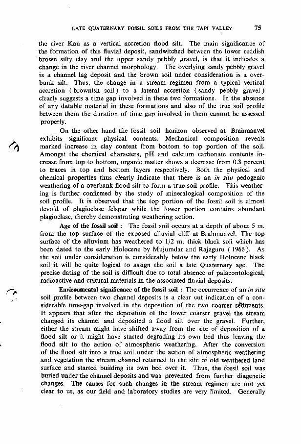
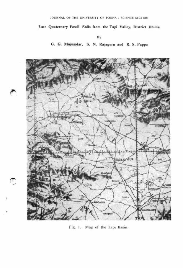
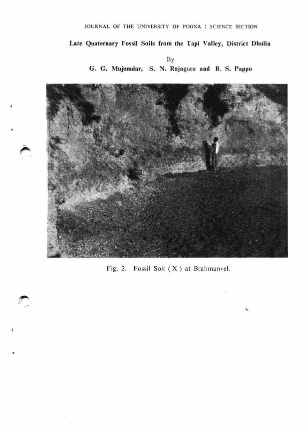
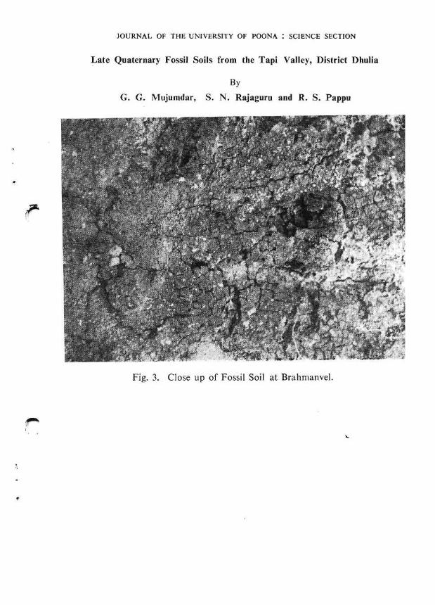
R.eprinted from the Journal of the University of Poona. SCience & Technology Section. No. 42. pp. 71 to 77. 1972. Late Quaternary Fossil Soils from the Tapi Valley, District Dhulia By G. G. Mujumdar, S. N. Rajaguru and R. S. Pappu (Received on 31-8-71 ) In the tropical countries like the Peninsular India the preservation of biological remains in the natural formations, in which we get relics of early man in the form of his stone tools, is generally poor due to strong oxidising environment in the presence of abundant moisture. The only dependable source of information in this connection is the natural formations such as fluvial, lacustrine and eolian deposits and their weathering products like soils·. In this paper an attempt has been made to study some aspects of the depositional history of the Tapi valley during the late Quaternary by under- taking field and laboratory studies of two fossil soil 2 horizons from the Tapi valley, occuring at Bhadne and Brahmanvel (Figs. 2 and 3). These fossil soils were discovered by Shri S. A. Sali of Archaeological Survey of India during his survey of Pleistocene formations from Dist. Dhulia and he ascribed their formation to the depositional gap in the late Pleistocene aggradational phase of the Tapi (Sali, 1967). As desired by Shri Sali, the present laboratory investigations were undertaken to varify and enlarge his views. The soil samples were collected in the field when we undertook the prehistoric survey ofthe Tapi valley under the guidance of Prof. H. D. Sankalia of the Deccan College, P90na. Field Observations The 'rapi valley (Fig. I) occupies a basin, probably of a tectonic'origin, in the two major watersheds of the Deccan viz., the Satpuras to the north and lw the Balaghat to the south. The present westerly course of the Tapi seems to have been pushed towards north by the transverse drainage from the south. There are a few important tributaries from the north. Some of the important southerly tributaries like Girna, Panjhara have their source in the· Western Ghats and they flow towards east for about 60 to 100 km. and then take a sharp tum towards north to meet the Tapi. It appears that these easterly flowing streams were once the tributaries of the Godavari but later on were 1. Soils have been defined as: the products of decomposition of land surface under the influence of climate and vegetation (Zeuner, 1948, p. 7 ). 2. Fossil soils are soils which ,have become fossil because a new stratum was deposited on them arresting the of soil formation. Fossil soils thus retain the chara- cters representative of the .lpast environment.
-
Upload
deccancollegepune -
Category
Documents
-
view
1 -
download
0
Transcript of Mujumdar GG, Rajaguru SN, and Pappu RS. 1972. Late Quaternary Fossil Soils from the Tapi Valley,...
R.eprinted from theJournal of the University of Poona.
SCience & Technology Section. No. 42. pp. 71 to 77. 1972.
Late Quaternary Fossil Soils from the Tapi Valley,District Dhulia
ByG. G. Mujumdar, S. N. Rajaguru and R. S. Pappu
(Received on 31-8-71 )
In the tropical countries like the Peninsular India the preservation ofbiological remains in the natural formations, in which we get relics of earlyman in the form of his stone tools, is generally poor due to strong oxidisingenvironment in the presence of abundant moisture. The only dependablesource of information in this connection is the natural formations such asfluvial, lacustrine and eolian deposits and their weathering products likesoils·. In this paper an attempt has been made to study some aspects of thedepositional history of the Tapi valley during the late Quaternary by undertaking field and laboratory studies of two fossil soil2 horizons from the Tapivalley, occuring at Bhadne and Brahmanvel (Figs. 2 and 3).
These fossil soils were discovered by Shri S. A. Sali of ArchaeologicalSurvey of India during his survey of Pleistocene formations from Dist. Dhuliaand he ascribed their formation to the depositional gap in the late Pleistoceneaggradational phase of the Tapi (Sali, 1967). As desired by Shri Sali, thepresent laboratory investigations were undertaken to varify and enlarge hisviews.
The soil samples were collected in the field when we undertook theprehistoric survey ofthe Tapi valley under the guidance of Prof. H. D. Sankaliaof the Deccan College, P90na.
Field Observations
The 'rapi valley (Fig. I) occupies a basin, probably of a tectonic'origin,in the two major watersheds of the Deccan viz., the Satpuras to the north and
lwthe Balaghat to the south. The present westerly course of the Tapi seems tohave been pushed towards north by the transverse drainage from the south.There are a few important tributaries from the north. Some of the importantsoutherly tributaries like Girna, Panjhara have their source in the· WesternGhats and they flow towards east for about 60 to 100 km. and then take asharp tum towards north to meet the Tapi. It appears that these easterlyflowing streams were once the tributaries of the Godavari but later on were
1. Soils have been defined as: the products of decomposition of land surface under theinfluence of climate and vegetation (Zeuner, 1948, p. 7 ).
2. Fossil soils are soils which ,have become fossil because a new stratum was depositedon them arresting the pr~ss of soil formation. Fossil soils thus retain the characters representative of the .lpast environment.
72 JOURNAL OF THE UNIVERSITY OfJ,'OONA : SCIENCE SECTION
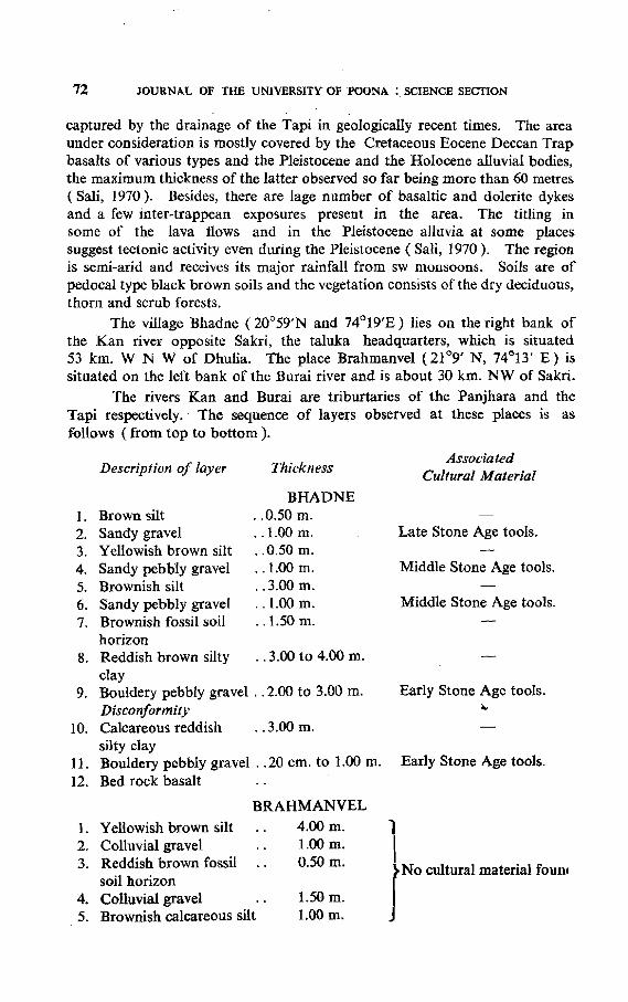
captured by the drainage of the Tapi in geologically recent times. The areaunder consideration is mostly covered by the Cretaceous Eocene Deccan Trapbasalts of various types and the Pleistocene and the Holocene alluvial bodies,the maximum thickness of the latter observed so far being more than 60 metres(Sali, 1970). Besides, there are lage number of basaltic and dolerite dykesand a few inter-trappean exposures present in the area. The titling insome of the lava flows and in the Pleistocene alluvia at some placessuggest tectonic activity even during the Pleistocene (Sali, 1970). The regionis semi-arid and receives its major rainfall from sw monsoons. Soils are ofpedoca1 type black brown soils and the vegetation consists of the dry deciduous,thorn and scrub forests.
The village Bhadne (200 59'N and 74°19'E) lies on the right bank ofthe Kan river opposite Sakri, the taluka headquarters, which is situated53 km. WNW of Dhulia. The place Brahmanvel (21°9' N, 74°13' E) issituated on the left bank of the Burai river and is about 30 km. NW of Sakri.
The rivers Kan and Burai are triburtaries of the Panjhara and theTapi respectively.' The sequence of layers observed at these places is asf-ollows (from top to bottom ).
Description of layer ThicknessAssociated
Cultural Material
BHADNE1. Brown silt .. 0.50 m.2. Sandy gravel · .1.00 m. Late Stone Age tools.3. Yellowish brown silt · .0.50 m.4. Sandy pebbly gravel · .1.00 m. Middle Stone Age tools.5. Brownish silt ..3.00 m.6. Sandy pebbly gravel · .1.00 m. Middle Stone Age tools.7. Brownish fossil soil · .1.50 m.
horizon8. Reddish brown silty · .3.00 to 4.00 m.
clay9. Bouldery pebbly gravel .. 2.00 to 3.00 m. Early Stone Age tools.
Disconformity ..10. Calcareous reddish · .3.oom.
silty clay11. Bouldery pebbly gravel .. 20 em. to 1.00 m. Early Stone Age tools.12. Bed rock basalt
BRAHMANVEL
1. Yellowish brown silt 4.oom.
12. Colluvial gravel 1.oom.3. Reddish brown fossil 0.50m.
soil horizon JNo cultural material fouo'
4. Colluvial gravel 1.50 m.5. Brownish calcareous silt 1.oom.
67778
Layer No.
LATE QUATERNARY FOSSIL SOILS FROM THE TAPI VALLEY 73
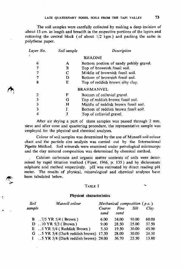
The soil samples were carefully collected by making a deep incision ofabout 15 em. in length and breadth in the respective portions of the layers andremoving the central block (of about 1/2 kgm) and packing the same inpolythene paper.
Soil sample Description
BHADNEA Bottom portion of sandy pebbly gravel.B Top of brownish fossil soil.C Middle of brownish fossil soil.D Bottom of brownish fossil soil.E Top of reddish brown silty clay.
BRAHMANVEL2 F Bottom of colluvial gravel.3 G Top of reddish brown fossil soil.3 H Middle of reddish brown fossil soil.3 I Bottom of reddish brown fossil soil.4 J Top of colluvial gravel.
After air drying a part of these samples was passed through 2 mm.'sieve and after cone and quartering procedure, the representative sample wasemployed for the physical and chemical analyses.
Colour of soil samples was determined by the use of Munsell soil colourchart and the particle size analysis was carried out by the InternationalPipette Method. Soil minerals were examined under petrological microscopeand the clay mineral composition was determined by chemical method.
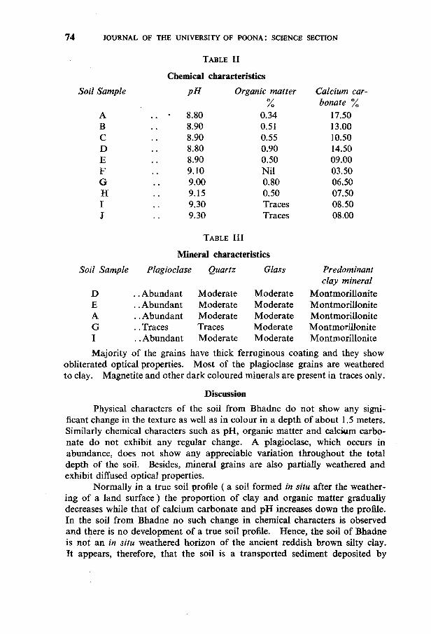
Calcium carbonate and organic matter contents of soils were determined by rapid titration method (Piper, 1966, p. 135) and by dichromatesulphuric acid method respectively. pH was estimated by direct reading pHmeter. The results of physical, mineralogical and chemical analyses have.been tabulated below.
TABLE I
Physical characteristics
Soil.sample
Munsell colour Mechanical composition (p.c.)Coarse Fine Silt Claysand sand
B .. 7/5 YR 5/4 (Brown)D " 10 YR 5/3 ( Brown)E .. 5 YR 5/4 ( Reddish Brown)G .. 5 YR 3/4 (Dark reddish brown)I .. 5 YR 3/4 (Dark reddish brown)
6.009.005.50
17.5024.00
24.0028.5019.5028.0036.70
10.0025.0030.0030.0025.50
60.0037.5045.0024.5013.80
74 JOURNAL OF THE UNIVERSITY OF POONA: SCIENCE SECTION
TABLE II
Chemical characteristics
Soil Sample
ABCDEFGHIJ
pH
8.808.908.908.808.909.109.009.159.309.30
Organic matter%
0.340.510.550.900.50Nil0.800.50TracesTraces
Calcium car-bonate %
17.5013.0010.5014.5009.0003.5006.5007.5008.5008.00
TABLE III
Mineral characteristics
Soil Sample Plagioclase Quartz Glass Predominantclay mineral
D .. Abundant Moderate Moderate MontmorilloniteE .. Abundant Moderate Moderate MontmorilloniteA .. Abundant Moderate Moderate MontmorilloniteG .. Traces Traces Moderate MontmorilloniteI .. Abundant Moderate Moderate Montmorillonite
Majority of the grains have thick ferruginous coating and they showobliterated optical properties. Most of the plagioclase grains are weatheredto clay. Magnetite and other dark coloured minerals are present in traces only.
Discussion
Physical characters of the soil from Bhadne do not show any significant change in the texture as well as in colour in a depth of about 1.5 meters.Similarly chemical characters such as pH, organic matter and calcM.Im carbonate do not exhibit any regular change. A plagioclase, which occurs inabundance, does not show any appreciable variation throughout the totaldepth of the soil. Besides, mineral grains are also partially weathered andexhibit diffused optical properties.
Normally in a true soil profile ( a soil formed in situ after the weathering of a land surface) the proportion of clay and organic matter graduallydecreases while that of calcium carbonate and pH increases down the profile.In the soil from Bhadne no such change in chemical characters is observedand there is no development of a true soil profile. Hence, the soil of Bhadneis not an in situ weathered horizon of the ancient reddish brown silty clay.It appears, therefore, that the soil is a transported sediment deposited by
.I
LATE QUATERNARY FOSSIL SOILS FROM THE TAPI VALLEY 75
the river. Kan as a vertical accretion flood silt. The main significance ofthe formation of this fluvial deposit, sandwitched between the lower reddishbrown silty clay and the upper sandy pebbly gravel, is that it indicates achange in the river channel morphology. The overlying sandy pebbly gravelis a channel lag deposit and the brown soil under consideration is a overbank silt. Thus, the change in a stream regimen from a typical verticalaccretion (brownish soil) to a lateral accretion (sandy pebbly gravel)clearly suggests a time gap involved in these two formations. In the absenceof any datable material in these formations and also of the true soil profilebetween them the duration of time gap involved in them cannot be assessedproperly.
On the other hand the fossil soil horizon observed at Brahmanvelexhibits significant physical contents. Mechanical composition revealsmarked increase in clay content from bottom to top portion of the soil.Amongst the chemical characters, pH and calcium carbonate contents increase from top to bottom, organic matter shows a decrease from 0.8 percentto traces in top and bottom layers respectively. Both the physical andchemical properties thus clearly indicate that there is an in situ pedogenicweathering of a overbank flood silt to form a true soil profile. This weathering is further confirmed by the study of mineralogical composition of thesoil profile. It is observed that the top portion of the fossil soil is almostdevoid of plagioclase felspar while the lower portion contains abundantplagioclase, thereby demonstrating weathering action.
Age of the fossil soil: The fossil soil occurs at a depth of about 5 m.from the top surface of the exposed alluvial cliff at Brahmanvel. The topsurface of the alluvium has weathered to 1/2 m. thick black soil which hasbeen dated to the -early Holocene by Mujumdar and Rajaguru (1966). Asthe soil under consideration is considerably below the early Holocene blacksoil it will be quite logical to assign the soil a late Quaternary age. Theprecise dating of the soil is difficult due to total absence of palaeontological,radioactive and cultural materials in the associated fluvial deposits.
Environmental significance of the fossil soil : The occurrence of an in situsoil profile between two channel deposits is a clear cut indication of a considerable time-gap involved in the deposition of the two coarser s~iments.
It appears that after the deposition of the lower coarser gravel the streamchanged its channel and deposited a flood silt over the gravel. Further,either the stream might have shifted away from the site of deposition of aflood silt or it might have started degrading its own bed thus leaving theflood silt to the action of atmospheric weathering. After the conversionof the flood silt into a true soil under the action of atmospheric weatheringand vegetation the stream channel returned to the site of old weathered landsurface and started building its own bed over it. Thus, the fossil soil wasburied under "the channel deposits and was prevented from further diageneticchanges. The causes for such changes in the stream regimen are not yetclear to us, as our field and laboratory studies are very limited. Generally
3. Sali, S. A.
4. Sali, S. A.
1. Mujumdar, G. G. andRajaguru, S. N.
2. Piper, C. S.
76 JOURNAL OF THE UNIVERSITY OF POONA : SCIENCE SECTION
such morphological changes occur due to climatic and tectonic factors. Theinformation regarding the past climate can be deduced to some extent bythe occurrence of montomoriUonite throughout the fossil soil horizon. Itspresence clearly indicates that the rainfall was not sufficient enough to giverise to kaolinite which only forms in an area with a rainfall more than 1200mm. per annum in a basaltic terrain and where a thorough leaching removealmost all the bases from the profile (Sherman, 1952). The present rainfall in the area is 500 to 600 mm. per annum and the total absence of kaolinite in the fossil soil suggest that the annual rainfall did not reach the figureof 1200 mm. per annum during the late Quaternary. This clearly suggeststhat the formation of black soil started in the late stage of the upper Pleistocene. If we consider the results obtained in laboratory studies as a representative for the eco-zone of the Tapi valley then it can be generalizedthat the change of climate was of degree only and not of a kind. Thesesuggested milder climatic changes were not strong enough to produce manyof the geomorphological features such as various aggradational and erosionalphases in the stream and tilting of the Pleistocene deposits. These featuresare more likely to have formed mainly in response to tectonic changes whichwere taking place throughout the PleiStocene in the Tapi valley.
Thus, these laboratory studies have enabled us to establish the presence of a fossil soil horizon at the Brahmanvel and the absence of such asoil at Bhadne although in the field it appeared like a fossil soil. Similarfossil soil like horizons have been observed at Poona in the Mula-Muthavalley, at Inamgaon in the Ghod valley and at Wai, Bavdhan and Dhamnerin the Krishna valley. The laboratory studies of these soils is in progressand these investigations may help us in throwing more light on the lateQuaternary environment of the Deccan.
Acknowledgements
The authors are thankful to Prof. H. D. Sankalia of the DeccanCollege, Poona and Shri S. A. Sali of Archaeological Survey of India fortheir encouragement and help during our field work.
References
1966 .. Ashmound Excavations at Kupgal, "DeccanCollege, Poona.
1966 .. Soil and Plant Analysis, Hans PublicationBombay.
1967 .. "On the occurrence of Fissured clays inthe Tapti and upper Godavari valleys ",Proc. Ind. Sc. Cong., Abst., p.500.
1967 .. " Quaternary Stratigraphy in the KanBasin at Bhadne and Yesar-Results ofRecent Preliminary Exploration" Journalof the Asiatic Society of Bombay, Vol.39-40, pp. 151-168.
LATE QUATERNARY FOSSIL SOILS FROM THE TAPI VALLEY 77
EO
5. Sali, S. A.
6. Sherman, D. B.
7. Zeuner, F. E.
Archaeology Laboratory,Deccan College,Poona 6.
1970 .. " Some Geomorphic and Tectonic observation in the central Tapti Basin in theDhulia District, Maharashtra", IndianAntiquary, Vol. IV, Nos. 1-4, pp. 205-215.
19520 ."Genesis and Morphology of the Alumina Rich Bauxite Plains" in Problemsof clay and Laterite Genesis: Symposiumheld at annual meeting of American Institute of Mining and Metallurgical Engineersat St. Louis Missouri : Edward H. Robie,New York.
1948 .. The Exhibition of Stone Age and Pleistocene Geology from the Cape to Britain,Institute of Archaeology, London.
•
JOURNAL OF THI; UNIVEM.SI1Y OF "OONA : SCIENCE SECTION
Laic Quaternary Fossil Soils (rom lhe Tapi Valley, District Dhulia
By
G. G. Mujumdar, S. N. Rajaguru and R. S. Pappu
Fig. I. Map or Ihe Tapi Basin.
•
JOURNAL OF THE UNIVERSITY OF POOI'A : SCIEI'C[ SECTION
Late Quaternary Fossil Soils from the Tapi Valley, Dislricl Ohulia
ByG. G. Mujumdar, S. N. Rajaguru and R. S. Pappu
Fig. 2. Fossil SoH (X) at Brahmall\'el.
JOURNAL OF THE UNIVERSITY OF POONA ; SCIENCE SECTION
Late Quaternary Fossil Soils from the Tapi Valley, District Dhulia
By
G. G. Mujurndar, S. N. Rajaguru and R. S. Pappu
Fig. 3. Close up of Fossil Soil at Brahmanvel.