Wainganga (Gosikhurd) – Nalganga (Purna Tapi) link project
45
Chapter 1 Introduction 1.0 General In the year 1980, the erstwhile Union Ministry of Irrigation and the Central Water Commission (CWC) formulated a National Perspective Plan (NPP) for Water Resources Development in the country which comprises two components: (i) Himalayan Rivers Development Component; and (ii) Peninsular Rivers Development Component. The National Water Development Agency (NWDA) was set up by the Government of India as an Autonomous Society under the then Ministry of Irrigation on 17 th July, 1982 to study the feasibility of the proposals of inter linking of rivers under Peninsular Rivers Development Component of NPP and give concrete shape to these proposals. Subsequently in 1990, NWDA Society resolved to take up the studies of the Himalayan Rivers Development Component of NPP also. Further, on 28 th June, 2006, preparation of Detailed Project Reports (DPRs) of link projects under NPP and pre-feasibility / feasibility reports of Intra-State links as proposed by States were also included in the functions of NWDA. Accordingly, the then Ministry of Water Resources (MoWR) vide Resolution No. 2/18/2005-BM dated 30 th November, 2006 has modified the functions of NWDA Society. On the basis of enhanced mandate, NWDA requested all the State Governments to identify the intra-state link proposals in their States and send details to NWDA for taking up pre- feasibility/feasibility studies. The functions of NWDA were further modified vide MoWR Resolution dated 19 th May, 2011 to undertake the work of preparation of DPRs of Intra-State links also which was published in the Gazette on 11 th June, 2011. 1.1 Proposals received from Government of Maharashtra In response to NWDA’s request, Govt. of Maharashtra had furnished 20 nos. of intra-state link proposals to assess their feasibility and survey on priority for carrying out detailed studies vide letter no. Inter Links River- 2009/23(65/09)/WRI dated 10 th June, 2009 (Annexure 1.1). River linking in water short Vidarbha region comprising three links viz. (i) Kanhan–Wardha, (ii) Wainganga-Nalganga-Purna-Tapi and (iii) Indravati-Wardha & Wardha- Penganga-Purna (Tapi) was one such proposal. These proposals have been
-
Upload
khangminh22 -
Category
Documents
-
view
5 -
download
0
Transcript of Wainganga (Gosikhurd) – Nalganga (Purna Tapi) link project

Chapter 1
Introduction
1.0 General
In the year 1980, the erstwhile Union Ministry of Irrigation and the Central
Water Commission (CWC) formulated a National Perspective Plan (NPP) for
Water Resources Development in the country which comprises two components:
(i) Himalayan Rivers Development Component; and (ii) Peninsular Rivers
Development Component. The National Water Development Agency (NWDA)
was set up by the Government of India as an Autonomous Society under the then
Ministry of Irrigation on 17th July, 1982 to study the feasibility of the proposals
of inter linking of rivers under Peninsular Rivers Development Component of
NPP and give concrete shape to these proposals. Subsequently in 1990, NWDA
Society resolved to take up the studies of the Himalayan Rivers Development
Component of NPP also. Further, on 28th June, 2006, preparation of Detailed
Project Reports (DPRs) of link projects under NPP and pre-feasibility / feasibility
reports of Intra-State links as proposed by States were also included in the
functions of NWDA. Accordingly, the then Ministry of Water Resources
(MoWR) vide Resolution No. 2/18/2005-BM dated 30th November, 2006 has
modified the functions of NWDA Society. On the basis of enhanced mandate,
NWDA requested all the State Governments to identify the intra-state link
proposals in their States and send details to NWDA for taking up pre-
feasibility/feasibility studies. The functions of NWDA were further modified vide
MoWR Resolution dated 19th May, 2011 to undertake the work of preparation of
DPRs of Intra-State links also which was published in the Gazette on 11th June,
2011.
1.1 Proposals received from Government of Maharashtra
In response to NWDA’s request, Govt. of Maharashtra had furnished 20
nos. of intra-state link proposals to assess their feasibility and survey on priority
for carrying out detailed studies vide letter no. Inter Links River-
2009/23(65/09)/WRI dated 10th June, 2009 (Annexure 1.1). River linking in
water short Vidarbha region comprising three links viz. (i) Kanhan–Wardha, (ii)
Wainganga-Nalganga-Purna-Tapi and (iii) Indravati-Wardha & Wardha-
Penganga-Purna (Tapi) was one such proposal. These proposals have been

Detailed Project Report of Wainganga (Gosikhurd)-Nalganga (Purna Tapi) link project
2
reviewed by NWDA in light of deficit areas, length of conveyance system and
total lift involved and finally arrived to a comprehensive proposal viz.,
“Wainganga (Gosikhurd) – Nalganga (Purna Tapi)” to divert water from the
ongoing Gosikhurd Project on Wainganga river to serve the water stressed areas
in Wainganga, Wardha and Tapi basins of Vidarbha region. Most of the demands
proposed by the State through the above three links including water supply to
Nagpur city are taken care of in this final proposal.
Consequently, NWDA had prepared the Pre feasibility report (PFR) of
Wainganga (Gosikhurd)- Nalganga (Purna Tapi) Intra-state link project in March
2009 for diversion of surplus waters of eastern Vidarbha available at Gosikhurd
dam to the drought prone western Vidarbha.
1.1.1 Aim and Justification of the Project
The proposed Wainganga (Gosikhurd) - Nalganga (Purna Tapi) link
project as per DPR envisages diversion of 1772 Mm3 from the ongoing Gosikhurd
(Indira Sagar) project (first National Project in the country) on Wainganga river
in Pranhita sub-basin of Godavari basin for extending irrigation, domestic and
industrial water supply benefits in six districts of Vidarbha region of Maharashtra
State viz. Nagpur, Wardha, Amravati, Yeotmal, Akola & Buldhana before
outfalling into Nalganga project on Nalganga river in Tapi basin.
Vidarbha is the eastern region of Maharashtra State made up of Nagpur and
Amravati divisions. It comprises eleven districts: Amravati, Akola, Buldhana,
Washim and Yeotmal in Amravati division while Nagpur, Wardha, Bhandara,
Gondia, Chandrapur and Gadchiroli in Nagpur division. Vidarbha region is not
so developed in irrigation in comparison to the rest of Maharashtra. Though, the
region occupies 31.62% of the State’s geographical area, the cultivable area is
only 25.29% while the surface water resources constitute to only about 17.38%
of the State. The irrigation backlog in Vidarbha region in relation to the State’s
average of 60.27% (2012) is about 11.85 lakh ha, out of which 9.97 lakh ha is in
the Amravati division itself. Due to non-availability of canal irrigation facilities
in the upland areas in the vicinity of the proposed project, the farmers depend
mainly on rainfall and ground water for irrigation.

Chapter 1: Introduction
3
The link canal will bring additional areas under irrigation in the Vidarbha
region to an extent of 371277 ha besides providing drinking and industrial water
supply. The link canal envisages to serve the command areas lying in upper
reaches through pumping and feeding storages/tanks, which could not possibly
be served through conventional projects.
Balanced development of all the regions is an essential feature of India’s
planning process. The scheme will help in removing the backlog in irrigation
development in Vidarbha region by meeting the demands of one of the most water
short areas in the country lying in Akola, Buldhana and Amravati districts apart
from other three districts of Nagpur, Wardha and Yeotmal. This link project will
thus bring economic prosperity to the acute water short, drought-prone command
area lying in the vicinity of the link project in the Vidarbha region.
The link canal takes off from the right flank of the ongoing Gosikhurd dam
with the FSL of 241.00 m and traverses for a length of about 427 km through
Nagpur, Wardha, Amravati, Washim, Akola and Buldhana districts of
Maharashtra. It is proposed to bring 371277 ha of CCA under irrigation in these
districts (except Washim) besides Yeotmal district. In view of limitation of
storage capacity at Gosikhurd, the diversion through the link project is planned
only during the monsoon period (July to September). In order to store the water
received through link canal during monsoon and subsequent utilisation in rabi
season, about 40 enroute storages/tanks are planned to be integrated for extending
the benefits in the command from the link canal. In order to negotiate the
topography and feed the enroute storages/tanks, pumping of water is proposed at
6 locations on the main canal involving a total lift of 155 m (static), with an annual
energy requirement of 839 MU. Besides, another 12 MU of energy will be
required to pump waters from link canal into about five enroute tanks/storages
proposed on higher ground.
1.2 Location of Project Area
Maharashtra is the third largest State in India. The geographical area of the
State is 30.80 million ha with culturable area of 22.54 million ha. Like other major
States, it has different regions with distinct geographical features evolved based
on topographical, meteorological and historical facts. Vidarbha region occupies
31.62% of area and holds 21.3% of population of Maharashtra. It borders the

Detailed Project Report of Wainganga (Gosikhurd)-Nalganga (Purna Tapi) link project
4
State of Madhya Pradesh to north, Chhattisgarh to east, Telangana to south and
Marathwada & Khandesh regions of Maharashtra to the west. Situated in central
India, Vidarbha has its own rich cultural and historical background distinct from
rest of Maharashtra. The region is famous for growing oranges and cotton. It
holds two-thirds of Maharashtra’s mineral resources and about 58% of its forest
resources. However, it is less economically prosperous compared to the rest of
Maharashtra. The largest town in Vidarbha is Nagpur. A majority of Vidarbhians
speak Marathi language. The area of interest is a part of Vidarbha region in
eastern Maharashtra covering Bhandara, Nagpur, Wardha, Amravati, Washim,
Yeotmal, Akola and Buldhana districts. The district map of Maharashtra is shown
at Fig 1.1.
Fig 1.1: District map of Maharashtra State
The Gosikhurd dam (Indirasagar project) across Wainganga river in
Godavari basin is located at latitude of 20⁰ 52' 15'' N and longitude of 79⁰ 37' 00''
E near Gosikhurd village in Pauni tehsil of Bhandara district. The Wainganga
(Gosikhurd) – Nalganga (Purna Tapi) link canal takes off from the Gosikhurd
reservoir near Rajoli village and traverses through Nagpur, Wardha, Amravati,

Chapter 1: Introduction
5
Washim, Akola and Buldhana districts before outfalling into the right flank of
Nalganga reservoir. The Nalganga is a medium irrigation project constructed
across the river Nalganga, a left bank tributary of river Purna Tapi of Tapi basin.
The project is located between latitude of 20⁰ 45' 00'' N to 20⁰ 53' 00'' N and
longitude of 76⁰ 11' 00'' E to 76⁰ 20' 00'' E downstream of village Sanglad in
Motala tehsil of Buldhana district. On its path, the link canal crosses a number of
rivers such as Amb, Veena, Krishna nala, Bor, Panchadhara, Dham, Wardha,
Vidarbha, Pinjar, Katepurna, Gyanganga and Viswaganga through major cross
drainage works. The link canal integrates the existing Lower Wardha reservoir
across Wardha river and Katepurna reservoir across Katepurna river as balancing
reservoirs. The Lower Wardha project is situated across river Wardha, a right
bank tributary of river Wainganga in Godavari basin at latitude of 20⁰ 52' 30'' N
and longitude of 78⁰ 15' 30'' E near village Dhanodi in Arvi tehsil of Wardha
district. The Katepurna project is located at latitude of 20⁰ 28' 53'' N and longitude
of 77⁰ 09' 24'' E near village Mahan in Barshitakli tehsil of Akola district. Besides,
the link feeds several existing and proposed enroute storages in the command
area. The command area of the link project is spread in Nagpur, Wardha,
Amravati, Akola, Buldhana and Yeotmal districts. The link project falls between
latitudes 20⁰ 24' and 21⁰ 05' N; and between longitudes 76⁰ 10' and 79⁰ 40' E.
1.3 Communication Facilities
The ongoing Gosikhurd reservoir which is the head works of the link canal,
is located at about 10 km from Pauni town in Bhandara district and is
approachable from Nagpur through bituminous roads via Umred, Bhiwapur &
Pauni towns. The off-take point from Gosikhurd reservoir near entrance of Rajoli
village in Kuhi taluk of Nagpur district is approachable from Nagpur through
Nagpur- Ambhora road. The nearest airport in the vicinity of the off take point is
located at Nagpur at about 85 km.
The link is crossing Nagpur – Hyderabad road (NH-44) at RD 59.72 km
and Nagpur-Wardha South Central railway line at RD 60.46 km (20 km from
Nagpur railway station). The link will join the Lower Wardha reservoir at RD
167.90 km through Savangi stream, near Savangi village in Wardha district. The
nearest airport in the vicinity of the Lower Wardha reservoir is located at Nagpur
130 km away. Off-taking from Lower Wardha, the link will cross Nagpur-
Mumbai Central railway line at RD 197.71 km (25 km from Amravati), Amravati-

Detailed Project Report of Wainganga (Gosikhurd)-Nalganga (Purna Tapi) link project
6
Yeotmal road at RD 219.13 km (10 km from Amravati) and Nagpur-Aurangabad
road at RD 248.64 km (25 km from Amravati). The link will join Katepurna
reservoir at RD 298.63 km which is 2 km away from Mahan town in Akola
district. Off-taking from Katepurna, the link canal crosses Akola-Washim road at
RD 319.46 km (30 km from Akola), Khamgaon-Buldhana road at RD 391.82 km
(3 km from Khamgaon town and Buldhana-Malkapur road at RD 425.13 km (5
km from Motala town). Finally, the link outfalls in the existing Nalganga
reservoir at RD 426.54 km about 4 km from Motala town.
Thus, the entire link canal traverses in the vicinity of many villages and
towns. The head works, balancing reservoirs, enroute storages/tanks and canal
alignment are well approachable by means of National Highways, State
Highways, major district roads and village roads of bituminous top. All the
villages/towns in the vicinity of head works, balancing reservoirs, enroute
storages/tanks, link canal alignment and outfall point are fully electrified and
connected by telephone lines. Detailed information on the communication
network in the project area is presented in Chapter 4: Surveys & Investigations.
1.4 General Climatic Conditions of the State and Project Area
Maharashtra has typical monsoon climate, with hot, rainy and cold weather
seasons. Tropical conditions prevail all over the State.
Summer: March, April and May are the hottest months. During April and May
thunderstorms are common all over the State. Temperature varies between 22°C-
47°C during this season.
Monsoon: Rainfall starts normally in the first week of June. July is the wettest
month in Maharashtra, while August too gets substantial rain. Monsoon starts its
retreat with the coming of September from the State.
Winter: Cool dry spell, with clear skies, gentle breeze and pleasant weather
prevails from November to February. But the eastern part of Maharashtra
sometimes receives some rainfall. Temperature varies between 12°C - 34°C
during this season.
1.4.1 The Rainfall
The average rainfall of the State is about 1150 mm of which nearly 88%
occurs during monsoon period from June to October. Rainfall in Maharashtra

Chapter 1: Introduction
7
differs from region to region. Thane, Raigad, Ratnagiri and Sindhudurg districts
receive heavy rains of an average of 2000 mm annually. But the districts of Nasik,
Pune, Ahmednagar, Dhule, Jalgaon, Satara, Sangli, Solapur and parts of Kolhapur
get rainfall less than 500 mm annually. Rainfall particularly concentrates to the
Konkan and Sahyadrian Maharashtra. Central Maharashtra receives less rainfall.
However, under the influence of the Bay of Bengal, eastern Vidarbha receives
good rainfall in July, August and September.
The broad variation in weather and rainfall among the five geographical
regions of the State is furnished in Table 1.1.
Table 1.1
Climate & rainfall in various geographical regions of Maharashtra
Sl.
No
Geographical
region
Temperature o C
Humidity Rainfall Weather
Max Min
1 Konkan 27-40 14-27 81%-95%
to
30%- 65%
Heavy rains Mild
winter
2 Western parts of
Nashik, Pune,
Satara, Kolhapur
26-39 8-23 81%-99%
to
20%-39%
Reduced
rainfall
3 Eastern parts of
Nashik, Pune,
Satara, Kolhapur
& Ahmednagar,
Sangli, Solapur,
Aurangabad,
Jalna, Beed,
Osmanabad
36-41 10-16 82%-84%
to
19%-26%
Rain-
shadow
4 Tapi basin, south
of Satpura ranges
& Dhule-Jalgaon
districts
39-43 12-15 82%-87%
to
12%-31%
Heavy
rainfall in
east and
Low
rainfall, in
west i.e
Buldhana,
Akola,

Detailed Project Report of Wainganga (Gosikhurd)-Nalganga (Purna Tapi) link project
8
Amravati
districts
5 Wainganga basin
and hilly region
in the east
39-45 12-14 Good
rainfall
Extreme
climate
Source: PFR of Wainganga (Gosikhurd) – Nalganga (Purna Tapi) Link Project, NWDA,
March, 2009
The command area of the link project is spread in six districts of Vidarbha
region of Maharashtra viz. Nagpur, Wardha, Amravati, Akola, Buldhana and
Yeotmal. At all these six district hqs., IMD observatories are located. Based on
the data of these stations (1981-2010), the climatological parameters in the
command area of the link project are as tabulated in Table 1.2.
Table 1.2
Climatological parameters in the command area of the link project
Sl No. Parameter Max. Min.
1 Air Mean temperature (oC) 42.7 12.9
2 Relative Humidity (%) 87.0 18.0
3 Wind speed (km/hr) 14.1 4.2
4 Cloud Cover (Octas) 6.8 0.3
5 Normal annual rainfall (mm) 1100.3 781.8
Source: Climatological tables of India (1981-2010), IMD
1.5 Topography, Physiography and Geology of the Region 1.5.1 River System & Topography
The area encompassed by the proposed link project is divided into three
major catchments viz. i) Wainganga/Pranhita sub-basin ii) Wardha sub-basin and
iii) Purna Tapi of Tapi Basin.
Wainganga/Pranhita Sub-basin
The Wainganga river after its confluence with the Wardha river is called
the Pranhita river. The Pranhita is one of the northern tributaries of the river
Godavari in its middle reaches. The Pranhita sub-basin lies between latitudes 180
- 48' N and 220 - 43' N and longitudes 780 - 03' E and 800 - 53' E. The river
Chapter 1: Introduction
9
Wainganga rises at an altitude of about 640 m in Seoni district of Madhya
Pradesh, flows east for a short distance and then south for a length of about 274
km in Seoni and Balaghat districts of Madhya Pradesh and then a distance of
about 334 km in Maharashtra before the tributary Wardha joins it. The combined
waters of the Wainganga and the Wardha i.e., Pranhita, flow for a further distance
of 113 km along the boundary of Maharashtra and Telangana before joining the
river Godavari. The catchment area of the full Pranhita (including Penganga and
Wardha) is 109079 km2 while that of the truncated Pranhita sub-basin is 61094
km2 (only Wainganga/Pranhita catchment excluding Penganga and Wardha),
which is 19.53% of the Godavari basin. The catchment area lies in the States of
Madhya Pradesh (24566 km2), Chhattisgarh (271 km2), Maharashtra (30100 km2)
and Telangana (6157 km2).
The Pranhita sub-basin covers Balaghat, Chhindwara, Seoni, Betul and
Mandla districts of Madhya Pradesh; Rajnandgaon and Kowardha districts of
Chhattisgarh; Nagpur, Bhandara, Gondia, Chandrapur and Garchiroli districts of
Maharashtra; and Adilabad district of Telangana. The Pranhita sub-basin is
bounded by Wardha sub-basin of Godavari basin on the west, Godavari river on
the south, Narmada basin on the north and Mahanadi basin on the East. Sagar,
Hirri, Chandan, Bagh, Bawanthari, Kanhan, Garhvi, Andhari, Dina & Peddavagu
are the major tributaries of Wainganga/Pranhita river.
The Pranhita sub-basin is in the shape of a top draining the slopes of
Satpura, Gaikhuri, Ambagarh and Ballahi ranges. Most of the terrain of the
Wainganga river upto its confluence with the Bagh river is mountainous and the
remaining is flat. The entire catchment area of the Pranhita sub-basin is full of
ridges, valleys and low hill ranges.
Wardha Sub-basin
The Wardha sub-basin lies approximately between latitudes 19o-18’ N and
21o-58’ N and longitudes 77o-20’ E and 79o-45’ E. Wardha river is one of the
right tributaries of Pranhita river. It rises at an altitude of about 777 m in the
southern slopes of the Dahawadhana peak in Multai taluk of Betul district of
Madhya Pradesh and drains a catchment area of 24087 km2 which constitutes
7.7% of the area of Godavari basin. The river traverses for a total length of 528
km prior to its joining Wainganga river. From the source, it traverses 42 km in

Detailed Project Report of Wainganga (Gosikhurd)-Nalganga (Purna Tapi) link project
10
Madhya Pradesh, 16 km along the common boundary between Madhya Pradesh
and Maharashtra, 428 km in Maharashtra and 42 km along the common boundary
of Maharashtra and Telangana. The important left bank tributaries are the Kar,
the Jam, the Wena and the Erai while the right bank tributaries are the Madu, the
Bembla and the Penganga.
The Wardha sub-basin is triangular in shape with an average width of about
90 km. The terrain is mountainous consisting of ridges and valleys covered with
forests and the country opens out lower down.
Purna Tapi Sub-basin
The Purna is one of the major tributaries of Tapi that joins from the left.
The Purna is the principal affluent of the Tapi. It is the main artery of a network
of rivers and streams draining Akola, Amravati and Buldhana districts of
Maharashtra and Betul district of Madhya Pradesh. It is the only river in the upper
Tapi Basin, which has a perennial flow. It rises in Betul district of Madhya
Pradesh in Gawaligarh hills of eastern Satpura range at an elevation of 900 m at
North latitude 210 38’ and East longitude 770 36’. The Purna flows first in a south
westerly direction for about 60 km through hills and forests before it enters the
Purna plains. Flowing in a generally westerly direction for a length of 274 Km in
Madhya Pradesh and Vidarbha region of Maharashtra, the Purna joins the Tapi
river north west of Edalabad (Muktainagar) in Jalgaon district of Maharashtra.
The Mun, the Nalganga and the Murna are the main left bank tributaries of the
Purna while the Chandrabhaga and the Wan are the principal right bank
tributaries. Purna drains a total area of 18,929 Sq.km. In Maharashtra, the Purna
flows in Amravati, Akola, Buldhana and Jalgaon districts. Purna after the initial
hilly tracts, flows through the broad and fertile Khandesh Plains which are
bounded on the north by Satpuras and on the south by the Ajanta range.
1.5.2 Physiography
Geographically Vidarbha lies on the northern part of Deccan plateau. There
are no major hill ranges like Western ghats. The Satpura range lies to the north of
Vidarbha region in Madhya Pradesh. The Melghat area of Amravati district is on
the southern offshoot of Satpura ranges. Large basaltic rock formations exist
throughout Vidarbha caused by Deccan trap lava. Gondia district is unique in

Chapter 1: Introduction
11
Maharashtra in the sense that the entire area of the district is occupied by
metamorphic rock and alluvium. Buldhana district has Lonar crater created by
impact of meteorite and comet. Eastern districts of Gondia, Bhandara, Garchiroli
and Nagpur fall in earthquake Zone-1, which is considered safest in India, while
other districts of Vidarbha region fall in Zone-2.
1.5.3 Geology
The entire area of the Maharashtra State (which comprises the project
area), forms a part of the “Peninsular Shield”, which is composed of rocks
commencing from the most ancient rocks of diverse origin, which have
undergone considerable metamorphism. Over these ancient rocks of Precambrian
era lie a few basins of Proterozoic era and of permo carboniferous periods which
are covered by extensive sheets of horizontally bedded lava flows comprising the
Deccan trap. More than 80% area of the State is covered by the Deccan trap,
which has concealed geologically older formations. The Wainganga (Gosikhurd)
– Nalganga (Purna Tapi) link Project is mostly covered by Deccan trap.
The area around the Wainganga-Nalganga link canal alignment from
Gosikhurd to Lower Wardha is predominantly occupied with the rock formations
ranging in age from Archaean to Upper Cretaceous-Palaeocene age. Granite
gneiss and migmatites belonging to the Tirodi Gneissic Complex, Amgaon
Gneissic Complex and Bengpal Group occupy the major eastern and northern part
of the area. They form the basement for the overlying rocks of Sakoli Group,
Sausar Group, Gondwana Super group, Lameta Group and Deccan Trap Super
group.
1.6 Population
Vidarbha has total population of 23012551 according to 2011 census
carried out by Govt. of India. Table 1.3 furnishes the district-wise population
particulars.

Detailed Project Report of Wainganga (Gosikhurd)-Nalganga (Purna Tapi) link project
12
Table 1.3
District-wise population in Vidarbha
Sl.No. Name of the district Male Female Total
1
Akola
932334
881572
1813906
Amravati 1480768 1407677 2888445
3 Buldhana 1337560 1248698 2586258
4 Washim 620302 576858 1197160
5 Yeotmal 1419965 1352383 2772348
6 Wardha 668385 632389 1300774
7 Nagpur 2384975 2268595 4653570
8 Bhandara 605520 594814 1200334
9 Gondia 661554 660953 1322507
10 Chandrapur 1123834 1080473 2204307
11 Garchiroli 541328 531614 1072942
Total 11776525 11236026 23012551
Source: District Census Handbooks, 2011
1.6.1 Population affected/benefited
The existing reservoirs of Gosikhurd, Lower Wardha, Katepurna and
Nalganga are proposed to be integrated with link project and there will not be any
submergence of villages or lands under these reservoirs. However, 38 additional
storages are proposed en route the link canal out of which seven are existing
tanks. Adequate care has been taken while identifying the storages such that
minimum submergence is involved. There will however, be submergence of 29
villages (26 fully and 3 partly) besides land pertaining to 80 villages. Thus, a total
of 109 villages are likely to get affected with loss of 19818 ha land under the
enroute storages along the link project affecting a population of 15640. Further,
there will be land acquisition to the tune of 7342 ha under main canal including
colonies and plant layout. The proposed link canal has been aligned with due care,
so as not to affect/damage any existing dwellings/ residential areas to the extent
feasible.
Chapter 1: Introduction
13
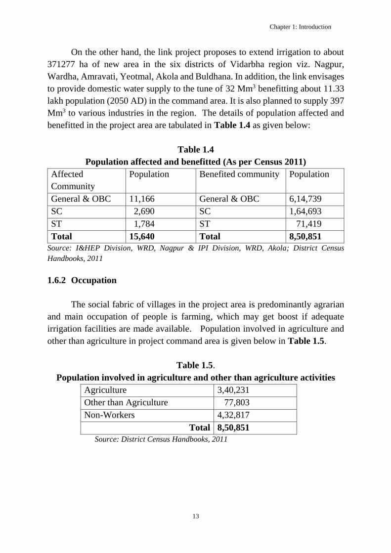
On the other hand, the link project proposes to extend irrigation to about
371277 ha of new area in the six districts of Vidarbha region viz. Nagpur,
Wardha, Amravati, Yeotmal, Akola and Buldhana. In addition, the link envisages
to provide domestic water supply to the tune of 32 Mm3 benefitting about 11.33
lakh population (2050 AD) in the command area. It is also planned to supply 397
Mm3 to various industries in the region. The details of population affected and
benefitted in the project area are tabulated in Table 1.4 as given below:
Table 1.4
Population affected and benefitted (As per Census 2011)
Affected
Community
Population Benefited community Population
General & OBC 11,166 General & OBC 6,14,739
SC 2,690 SC 1,64,693
ST 1,784 ST 71,419
Total 15,640 Total 8,50,851
Source: I&HEP Division, WRD, Nagpur & IPI Division, WRD, Akola; District Census
Handbooks, 2011
1.6.2 Occupation
The social fabric of villages in the project area is predominantly agrarian
and main occupation of people is farming, which may get boost if adequate
irrigation facilities are made available. Population involved in agriculture and
other than agriculture in project command area is given below in Table 1.5.
Table 1.5.
Population involved in agriculture and other than agriculture activities
Agriculture 3,40,231
Other than Agriculture 77,803
Non-Workers 4,32,817
Total 8,50,851
Source: District Census Handbooks, 2011

Detailed Project Report of Wainganga (Gosikhurd)-Nalganga (Purna Tapi) link project
14
1.7 Natural Resources
1.7.1 Water Resources
The water resources potential of Vidarbha region as a whole is normal, but
for the intra-regional disparities. Table 1.6 furnishes the information on water
resources scenario in various basins/ sub-basins in and around the region.
Table 1.6 : Water resources scenario in various basins / sub-basins
Sl.No River basin Sub-basin Categorization for
planning on the basis
of availability of
natural water 1 Godavari Purna (including Dudhna) Deficit
Penganga Normal
Wardha Normal
Middle Wainganga Surplus
Lower Wainganga Abundant
2 Tapi Purna Tapi Deficit
Girna Deficit
Middle Tapi Deficit
Panzara Normal
Source: Water Audit of Irrigation Projects, WRD, Govt.of Maharashtra
1.7.1.1 Wainganga/Pranhita Sub-basin
The water balance study of the Wainganga/Pranhita sub-basin has been
prepared by NWDA in 2015 considering latest guidelines and norms as decided
by the TAC of NWDA from time to time. The 75% and 50% dependable annual
gross yields of the sub-basin are estimated to be 24538 Mm3 and 30439 Mm3
respectively. After providing for the ultimate surface water requirements for
irrigation, domestic, industrial and other uses by 2050 AD, the corresponding
water balance works out to 5045 Mm3 and 10946 Mm3.
1.7.1.2 Wardha Sub-basin
The water balance study of the sub-basin has been prepared by NWDA in
2015 considering latest guidelines and norms as decided by the TAC of NWDA
Chapter 1: Introduction
15
from time to time. The 75% and 50% dependable annual gross yields of the sub-
basin are estimated to be 4880 Mm3 and 7087 Mm3 respectively. After providing
for the ultimate surface water requirements for irrigation, domestic, industrial and
other uses by 2050 AD, the corresponding water balance works out to 1
Mm3 and 2208 Mm3.
1.7.1.3 Tapi Basin
As per the water balance study of Tapi basin upto Ukai dam prepared by
NWDA in 2002, the 75% and 50% dependable annual gross yields of the
catchment are estimated to be 5898 Mm3 and 9362 Mm3 respectively. After
providing for the ultimate surface water requirements for irrigation, domestic,
industrial and other uses by 2050 AD, the corresponding water deficit works out
to 8053 Mm3 and 4589 Mm3. The details of water balance in respect of
Wainganga & Wardha sub-basins of Godavari basin and of the catchment of Tapi
basin upto Ukai dam are furnished in Annexure 1.2.
1.7.1.4 Wainganga/Pranhita Sub-basin upto Gosikhurd
The catchment area of Wainganga upto Gosikhurd dam site is 34862 km2.
As per the yield study at Gosikhurd dam site carried out by WRD, Govt. of
Maharashtra considering data upto 2014-15, the 75% and 50% dependable annual
gross yields in the catchment are estimated to be 14546 Mm3 and 18613 Mm3
respectively. After providing for the reservations for Madhya Pradesh as per
GWDT Award and planned surface water requirements for irrigation, domestic
and industrial uses in Maharashtra, the corresponding water balance was worked
out to 2617 Mm3 and 6684 Mm3.
As part of DPR of Wainganga (Gosikhurd) – Nalganga (Purna Tapi) link
project, the proposed terms of reference for carrying out the Comprehensive
Environmental Impact Assessment Study of the link project were submitted for
approval to MoEF & CC in April, 2016 by the project proponent i.e. WRD, Govt.
of Maharashtra. The Expert Appraisal Committee (EAC) of MoEF & CC after
detailed deliberations on the proposal in its meetings held on 03-06-2016 & 12-
07-2016, recommended the standard ToR subject to the confirmation of the water
flow series availability at Gosikhurd by CWC. Accordingly, the above yield study
prepared by WRD, Nagpur considering the data upto 2014-15 has been submitted

Detailed Project Report of Wainganga (Gosikhurd)-Nalganga (Purna Tapi) link project
16
by the State to CWC in July, 2016 for finalization of hydrology at Gosikhurd.
CWC, in the process of scrutiny, has made an assessment of the yield at
Gosikhurd based on the data available in the yield study submitted by the State.
The net annual yield series for the period from 1970-71 to 2014-15 for each of
the four sub-catchments are arrived at taking into account the respective gross
yields as assessed by CWC, stipulated flows from MP, water needs and
regeneration. These net yield series are summed up duly taking into cognisance
the drainage pattern of the sub-catchments to arrive at the net yield series for the
catchment of Wainganga upto Gosikhurd dam site. From the net yield series, the
water balance at Gosikhurd at 75% and 50% dependabilities have been worked
out to be 1921 Mm3 and 4729 Mm3 respectively. Further, from the simulation
studies of the Gosikhurd reservoir, it has been found that 1772 Mm3 of water can
be transferred from Gosikhurd through the Wainganga (Gosikhurd) – Nalganga
(Purna Tapi) link project at 75% success rate. Detailed hydrology of the
Wainganga/Pranhita catchment upto Gosikhurd and simulation studies of the
Gosikhurd reservoir are presented in Chapter-5: Hydrology and Water
Assessment.
1.7.2 Land Resources
The total geographical area of the Vidarbha region is about 9723300 ha.
Out of this, 5674800 ha is culturable area which is about 58.36 percent of
geographical area. The net area sown is about 4976900 ha which accounts for
87.7 percent of total culturable area. The land use statistics of the region for the
year 2015-16 (Estimated) are placed in Annexure 1.3 while the district-wise gist
of land use is furnished in Table 1.7.
Table 1.7
Gist of district-wise land use details in Vidarbha for the year 2015-16
District Geographical
area
Culturable
area
Net area
sown
Gross
cropped
area
% of net
sown area
to
culturable
area
Gondia 585900 215300 181200 240500 84.16
Bhandara 342000 202400 177700 253100 87.80
Chandrapur 1091800 530100 457600 533800 86.32
Chapter 1: Introduction
17
Garchiroli 1491600 254100 172500 210800 67.89
Nagpur 986400 638900 553200 649800 86.59
Wardha 628900 472900 363400 462500 76.84
Yeotmal 1351900 952700 854700 992600 89.71
Amravati 1221700 814200 751000 983800 92.24
Akola 542900 451200 431000 676100 95.52
Buldhana 967100 736300 659200 921500 89.53
Washim 513100 406700 375400 524900 92.30
9723300 5674800 4976900 6449400 87.70
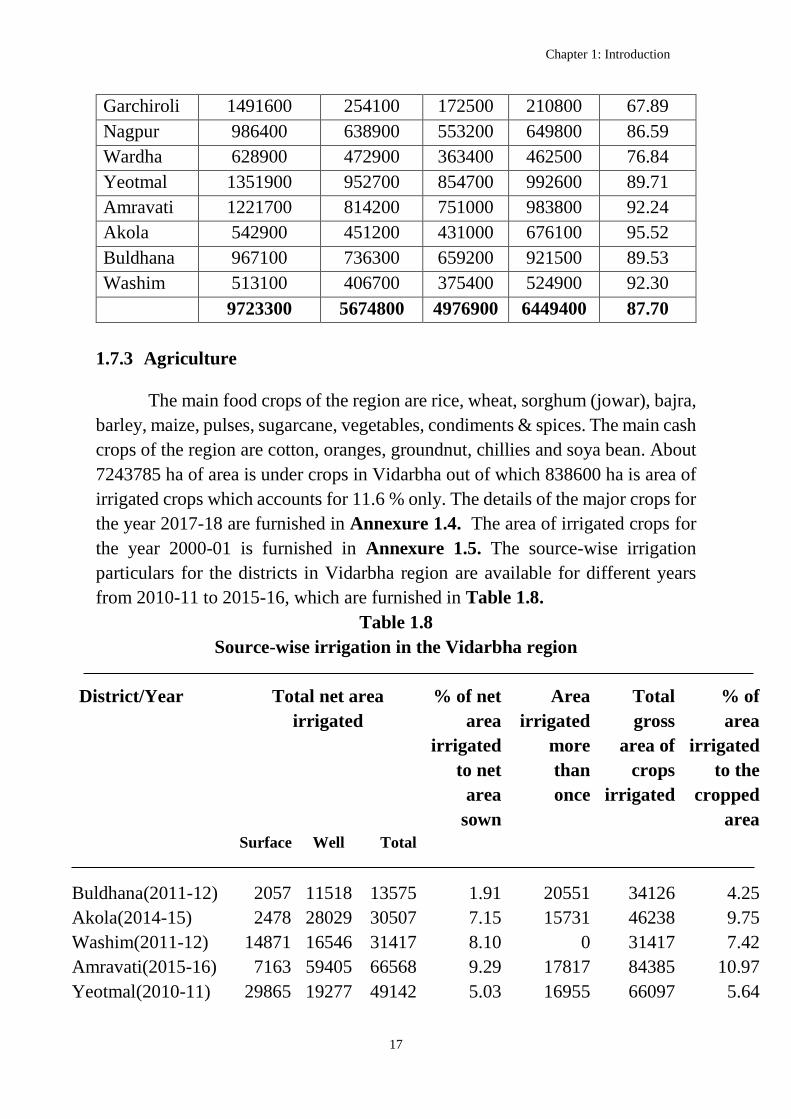
1.7.3 Agriculture
The main food crops of the region are rice, wheat, sorghum (jowar), bajra,
barley, maize, pulses, sugarcane, vegetables, condiments & spices. The main cash
crops of the region are cotton, oranges, groundnut, chillies and soya bean. About
7243785 ha of area is under crops in Vidarbha out of which 838600 ha is area of
irrigated crops which accounts for 11.6 % only. The details of the major crops for
the year 2017-18 are furnished in Annexure 1.4. The area of irrigated crops for
the year 2000-01 is furnished in Annexure 1.5. The source-wise irrigation
particulars for the districts in Vidarbha region are available for different years
from 2010-11 to 2015-16, which are furnished in Table 1.8.
Table 1.8
Source-wise irrigation in the Vidarbha region
District/Year Total net area
irrigated
% of net
area
irrigated
to net
area
sown
Area
irrigated
more
than
once
Total
gross
area of
crops
irrigated
% of
area
irrigated
to the
cropped
area
Surface Well Total
Buldhana(2011-12) 2057 11518 13575 1.91 20551 34126 4.25
Akola(2014-15) 2478 28029 30507 7.15 15731 46238 9.75
Washim(2011-12) 14871 16546 31417 8.10 0 31417 7.42
Amravati(2015-16) 7163 59405 66568 9.29 17817 84385 10.97
Yeotmal(2010-11) 29865 19277 49142 5.03 16955 66097 5.64

Detailed Project Report of Wainganga (Gosikhurd)-Nalganga (Purna Tapi) link project
18
Wardha(2014-15) 5871 79389 85260 20.40 0 85260 18.10
Nagpur(2014-15) 82017 68276 150293 37.91 55082 205375 37.65
Bhandara(2010-11) 89279 19607 108886 52.26 19279 128165 43.37
Gondia(2011-12) 91680 9467 101147 41.87 12025 113172 41.28
Chandrapur(2013-
14)
45978 64757 110735 23.48 34347 145082 27.54
Garchiroli(2014-15) 54605 13025 67630 33.04 5389 73019 33.04
Source: Bureau of Economics & Statistics, Government of Maharashtra, Nagpur/Amravati
As can be seen, there is a wide gap between cropped area and level of
irrigation in Vidarbha, particularly in the districts of Amravati division. Hence,
there is much scope for extending irrigation facilities through non-conventional
means like inter basin water transfer apart from conventional projects.
1.7.4 Mineral Wealth
Chandrapur, Garchiroli, Bhandara and Nagpur districts form the main
mineral belt, with coal and manganese as the prominent minerals found in the
region. Chandrapur district alone contributes to 29% of all mineral wealth found
in Maharashtra. Iron ore and lime stone are identified as potential wealth.
1.7.5 Industry
Butibori Industrial Area (MIDC) outside Nagpur is one of the largest
industrial areas in the country. Ballarpur Paper Industry, India’s largest
manufacturer and exporter of paper is located in Chandrapur district.
1.7.6 Tourism
Vidarbha has lush green deciduous forests which are home to a variety of
flora and fauna. These attract a large number of visitors each year. Most of the
Maharashtra’s tiger reserves are located in Vidarbha such as Melghat Tiger
Reserve in Amravati district, Tadoba Andhari Tiger Reserve in Chandrapur
district, Bor Tiger Reserve in Wardha district and Pench Tiger Reserve in Nagpur
district. Maharashtra's oldest National Park created in 1955, the Tadoba Andhari
Tiger Reserve is in the east at three-hour road journey from the city of Nagpur. It
is one of India's Project Tiger Reserves with 623 km² in area, consisting of two

Chapter 1: Introduction
19
forested rectangles of the Tadoba and Andhari range. Apart being the abode of
around 50 tigers, Tadoba Tiger Reserve is home to rare Indian wildlife like
leopards, sloth bears, gaur, wild dogs, hyenas, civet and jungle cats and many
species of Indian deer like sambar, cheetal, nilgai, and barking deer. The Tadoba
lake sustains the Marsh Crocodile, which were once common all over
Maharashtra. Tadoba is also an ornithologist's paradise with a varied diversity of
aquatic birdlife and Raptors. Thickly clad hills form the northern and western
boundary of the Tiger Reserve. To the southwest is a huge lake which acts as a
buffer between the park's forest and the extensive farmland which extends up to
Irai lake.
1.7.7 Scriptural Importance
Mention of Vidarbha is found in many scriptures:
The marriage of Agastya and Lopamudra.
Rukmini Haran by Lord Krishna
Kundinpur/ Kaundinyapur/ Kundinapuri, the mythological capital of
Vidarbha in Mahabharatha.
The story of king Nala and Damayanti
Ramayana has the reference of Vidarbha as one of the Janapadas at that
time. Kalidasa's epic poem “Meghaduta” also mentions Vidarbha as the place of
banishment of the Yaksha Gandharva.
1.7.8 Culture & People
Vidarbha has its own rich cultural and historical background distinct from
rest of Maharashtra. Even though Marathi culture is most dominant, Vidarbha has
been a melting pot of Andhra speaking people from south, Hindi speaking people
from Central India and tribal people of Chattisgarh. Vidarbha is famous for the
Varhadi dialect of Marathi language. The Garchiroli district of Vidarbha has large
population of tribal people. Hindu festivals like Holi, Diwali and
Vijayadasami/Dussehra are celebrated throughout the region. There are many
prominent cultural and literary societies working in Vidarbha like Vidarbha
Sahitya Sangh (http://en.wikipedia.org/wiki/Marathi) for development of
Marathi, Vidarbha Rashtrabhasha Prachar Samiti and Vidarbha Hindi Sahitya
Sammelan for promoting Hindi. The Nagpur central museum, established in

Detailed Project Report of Wainganga (Gosikhurd)-Nalganga (Purna Tapi) link project
20
1863, maintains collections which are mainly from Vidarbha region. Cricket is
the favorite sports as in rest of India and Nagpur's Vidarbha Cricket Association
Ground hosts international cricket matches.
Vidarbha has been home to some of India's famous people like Jamnalal
Bajaj, Acharya Vinoba Bhave, Baba Amte, Ram Ganesh Gadkari, Pratibha Patil,
S K Wankhede, K B Hedgewar, Madhav Sadashiv Golwalker and C K Nayudu.
Many other notable people like Vikram Pandit and Subramaniam Ramadorai
were also born in Vidarbha (Nagpur).
1.8 Land Use and Socio-economic Aspects
1.8.1 Cropping Pattern
Three dominant cropping patterns can be discerned in Vidarbha: paddy
dominated (37tehsils), cotton dominated (36 tehsils), and diversified (33 tehsils).
High-income tehsils show much lower area under paddy, about the same area
under cotton, and higher area under tur (pigeon pea) and horticultural crops
(banana, orange). The cropping pattern in eastern Vidarbha is paddy dominated.
The paddy-dominated areas show typical signs of backwardness and higher
population density. Paddy in Vidarbha is largely rain-fed. Average yields are
quite low (around 1500 kg/ha) and there is a great deal of rain-induced variation
in the yield. Cotton too has become a harbinger of poverty and deprivation in
recent years and low-income tehsils have marginally high area under cotton.
1.8.2 Socio-economic Aspects
The proposed command area of 371277 ha under the link project is spread
in the following six districts of Vidarbha region. Based on the available statistics
for these districts, certain socio-economic aspects are furnished below in Table
1.9. Table 1.9
Socio-economic aspects in the command area of the link project
Sl
No.
Aspect Nagpur Wardha Amravati Yeotmal Akola Buldhana
1. Area (km2) 9864 6289 12217 13519 5429 9671
2. Population 4653570 1300774 2888445 2772348 1813906 2586258
3. Rural 1474811 877474 1851158 2174195 1094165 2037398

Chapter 1: Introduction
21
4. Urban 3178759 423300 1037287 598153 719741 548860
5. % of Urban 68.31 32.54 35.91 21.58 39.68 21.22
6. Population
density/km2
470 206 237 204 320 268
7. Literates 3673808 1019458 2251875 2022574 1411281 1879874
8. Scheduled
Caste
867713 188830 506374 328518 364059 470895
9. Scheduled
Tribe
437571 149507 404128 514057 100280 124837
10. Total
workers
1868560 608235 1236322 1355999 768154 1219641
11. Cultivators 206606 132989 198793 333504 129680 385447
12. Agricultura
l labourers
423587 282170 667943 739718 388521 603227
13. Workers in
House hold
industry
52419 13785 20998 17899 9660 13770
14. Other
workers
1185948 179291 348588 264878 240293 217197
Source: District Census Handbooks, 2011
1.8.3 Drought Prone Areas
972 blocks with total area of 745914 km2 in 188 districts in the country are
covered under Drought Prone Area Programme (DPAP) (as on 1.4.2008) as per
Department of Land records, Ministry of Rural Development. Out of this, 149
blocks admeasuring 194473 km2 in 25 districts lie in Maharashtra itself. The
districts of Akola, Washim, Amravati, Buldhana, Chandrapur, Garchiroli, Nagpur
and Yeotmal in Vidarbha are placed in the list. About 48183 km2 of area in these
districts is computed to be drought prone. The details of drought prone areas in
Vidarbha are furnished in Annexure 1.6.
1.8.4 Ground Water
As per the State ground water profiles by Central Ground Water Board
(CGWB), the annual replenishable ground water resource of Maharashtra is
33.19 BCM while the net annual ground water availability is 31.48 BCM. The

Detailed Project Report of Wainganga (Gosikhurd)-Nalganga (Purna Tapi) link project
22
annual ground water draft is 17.07 BCM and the stage of ground water
development is 54%. The ground water potential available in Vidarbha region is 9.75 BCM out
of which the ground water draft is 3.91 BCM which indicates 42% of ground
water development in the region. The district wise ground water potential & draft
in Vidarbha are furnished in Table 1.10.
Table 1.10
Ground water resources availability and utilization in Vidarbha
Sl.
No
District Annual
Replenis
hable
Ground
Water
Resource
Net
Annual
Ground
Water
Availabi
lity
Annual
Ground
Water
Draft
for
Irrigati
on
Projected
demand
for
domestic
and ind.
uses upto
2025
Ground
water
availability
for future
irrigation
use
Stage of
Ground
water
Develop
ment
(%)
1. Akola 42850 40428 16147 2820 21461 43
2. Amravati 101605 96524 67496 5121 30229 73
3. Bhandara 55837 52798 19560 6297 26942 43
4. Buldhana 99419 94448 64279 6842 24555 72
5. Chandrapur 112420 106799 10401 16664 79733 18
6. Garchiroli 93140 88483 20553 6261 61668 27
7. Gondia 65729 62015 12301 11920 37794 29
8. Nagpur 115825 110034 55782 11700 42552 56
9. Wardha 87257 82825 37307 7511 38007 50
10. Washim 60058 57053 20174 3231 33649 38
11. Yeotmal 140821 133743 21554 11505 100683 20
Total (ham) 974961 925150 345554 89872 497273 42
Total (BCM) 9.75 9.25 3.46 0.90 4.97
Source: Dynamic Groundwater Resources of India, June, 2017, CGWB (data as on 31st March,
2013)

Chapter 1: Introduction
23
1.8.5 Water Quality
Ground water is an essential and vital component of our life support
system. The ground water resources are being utilized for drinking, irrigation and
industrial purposes. There is growing concern on deterioration of ground water
quality due to geogenic and anthropogenic activities. Increase in overall salinity
of the ground water and/or presence of high concentrations of fluoride, nitrate,
iron, arsenic, total hardness and few toxic metal ions have been noticed in large
areas in several States of India. In Maharashtra, high concentrations of
contaminants such as salinity, fluoride and iron are reported in a no. of districts.
The command area of the link project is spread in six districts of Vidarbha region.
In all these six districts, the ground water in general is good and suitable for
drinking and irrigation purpose, however with localized issues. In Nagpur district,
localized magnesium, nitrate and fluoride contamination and high salinity hazard
is observed. In Akola and Amravati districts, the ground water is not suitable for
drinking and irrigation purpose in the saline areas of the Purna Alluvium. In
Buldhana and Wardha districts, localized nitrate contamination is observed. In
Yeotmal district, high fluoride (>1.5 mg/l) contamination in parts of Kelapur,
Maregaon and Wani talukas is observed.
1.9 Selection of Proposed Scheme
1.9.1 Earlier Proposals
Govt. of Maharashtra framed the following proposals on priority to serve
the Vidarbha districts utilizing the excess waters of Wainganga and Indravati
rivers.
1. Kanhan – Wardha link
. Wainganga –Purna (Tapi) link
3. Indravati – Wardha – Penganga – Purna (Tapi) link
Kanhan -Wardha link
The proposal comprises two alternatives. In Alternative-I, it is suggested
to utilize the releases from the Kanhan Hydro Electric Project (Jamghat project),
which is 60 km away from the Maharashtra-Madhya Pradesh State boundary,
through the Right Bank Canal (RBC) of the Saledhana barrage d/s of Jamghat in
Madhya Pradesh. 425 Mm3 (15 TMC) of water with a static lift of 100 m would

Detailed Project Report of Wainganga (Gosikhurd)-Nalganga (Purna Tapi) link project
24
be irrigating 18000 ha in Saoner and Nagpur rural tehsils in Maharashtra, 15000
ha in Wardha valley besides providing 200 Mm3 of water to Nagpur Municipal
Corporation to augment water supply in the city. Further, the proposal yields 90
MW of power and irrigates 28400 ha in Chhindwara district of Madhya Pradesh,
through the left and right bank canals taking off from Saledhana barrage.
However, this proposal being inter-State in nature, other alternative has been
suggested.
According to Alternative-II, 397 Mm3 (14 TMC) of water is proposed to
be lifted from the Visveswaraya barrage (FPL 278m) at the confluence of Pench
and Kanhan rivers in Wainganga valley to delivery channel at Zilpa village (FSL
450m) via Gorewada tank, Nimboli village, Upper Wena tank (FRL 337m) and
Karla barrage (FPL 395m). The benefits include 100 Mm3 of water supply to
Nagpur city, 100 Mm3 of water for irrigating 15000 ha in Saoner and
Kalmeshwar tehsils and 100 Mm3 of water for irrigating 15000 ha in Narkhed
and Katol tehsils. The length of the canal is 106 km with a total static lift of 208
m in three stages.
Wainganga - Purna (Tapi) link
The water balance at the proposed Dhapewada project across river
Wainganga is estimated to be 1620 Mm3. This includes 1109 Mm3 from its own
catchment, 425 Mm3 as the regulated releases from Madhya Pradesh during the
non-monsoon period from 15th Oct to 15th June and regeneration of 86 Mm3. Out
of this, 1293 Mm3 of water is available for transfer and use leaving to an extent
of 327 Mm3 for the utilisation at Dhapewada.
The scheme is envisaged to divert 1133 Mm3 (40 TMC) to the regions of
Katol, Narkhed, Warud and further to Tapi (Purna) valley. It traverses 222 km
from Dhapewada (FRL 260m) to Purna ridge (RL 400m) via Chandpur tank,
Bagheda tank, Sorna tank, Betekar Bothali, Ramtek, Mansar, Pench Khairi,
Kochi barrage, Kelod, Umari tank, Joga, Wardha ridge and Pandhari tank by lift
and at some reaches by gravity. The total static lift involved works out to 237 m
in 8 stages. The integration of number of tanks enhanced the lift height though
the actual level difference between the off-take and outfall points is only 140 m.

Chapter 1: Introduction
25
The proposal, on implementation, would irrigate 60000 ha in Narkhed,
Katol and Warud tehsils of Kanhan and Wardha valleys and 100000 ha in Purna
valley, mainly in the districts of Amravati, Akola and Buldhana which are
plagued with huge irrigation backlog.
Indravati – Wardha – Penganga – Purna (Tapi) link
The scheme is envisaged to transfer 850 Mm3 (30 TMC) of water out of the
allocated 41 TMC to Maharashtra, from the proposed Bhopalapatnam HEP (FRL
200.25 m), a joint venture project between Maharashtra and Chhattisgarh to
Penganga-Purna ridge (RL 400m) via Dina tank, Asolamendha tank, Naleshwar
tank, Dindora barrage, Saikheda tank, Waghadi tank, Chapdoh tank, Goki tank,
Arunavati project and Adan project. The 449 km long canal involves 287 m static
lift in 7 stages. About 65000 ha of land in Amravati, Akola and Buldhana districts
of Purna valley and 65000 ha in Washim and Yeotmal districts of Penganga and
Wardha valleys would be irrigated on implementation of the scheme. Annexure-
1.7. furnishes the techno-economic parameters of the three proposals.
1.9.2 Proposal at Pre-Feasibility Report Stage (PFR)
NWDA reviewed the above proposal and observed some constraints/
limitations in the formulation of these link proposals as detailed below:
(i) Two of the above proposals are dependent on waters beyond State
boundary. Keeping aside the rights on water, it is felt that the intra-
State link should not be dependent on waters from other States or
inter-State joint projects.
(ii) The canals are mostly intended to feed the existing projects with little
capacity and bringing much new area into irrigation may not
be possible.
In view of the above, NWDA came up with an alternate comprehensive
proposal viz. Wainganga (Gosikhurd) – Nalganga (Purna Tapi) link project
envisaging to take care of most of the objectives of the above three links with due
regard to the deficit areas, length of the conveyance system and total lift involved.
Accordingly, NWDA prepared pre-feasibility study report of Wainganga
(Gosikhurd) – Nalganga (Purna Tapi) link project in March, 2009 and sent to the
Govt. of Maharashtra for further suggestions/views. The proposal involved

Detailed Project Report of Wainganga (Gosikhurd)-Nalganga (Purna Tapi) link project
26
diversion of 2721 Mm3 of water from the ongoing Gosikhurd project across river
Wainganga to the Western Vidarbha. The link canal takes off from the right flank
of the Gosikhurd dam with FSL 243 m. The 478 km long canal traverses through
Bhandara, Nagpur, Wardha, Amravati, Akola and Buldhana districts of
Maharashtra. The link canal has been provided with a total lift of 80 m in three
stages. It was proposed to bring 413750 ha of CCA under irrigation. Later, two
meetings between the Water Resources Department (WRD), Govt. of
Maharashtra and NWDA were held to discuss the above PFR on 19.07.2010 at
Nagpur and on 05.09.2011 at Hyderabad.
1.9.3 Main Components proposed at PFR stage
I. Gosikhurd Dam
The ongoing Gosikhurd dam across Wainganga, a tributary of Godavari
river with FRL 244.00 m
A Head Regulator near Rajoli village on the foreshore of the Gosikhurd
reservoir for conveying water to the link canal
II. Link Canal
A link canal of length 478.00 km i.e. from Gosikhurd to Wardha
(Reach-I):186.00 Km and Wardha - Nalganga river (Reach-II):292.00
km with FSL 243.00 m off-taking from the Gosikhurd head works to
divert water to Nalganga stream, a tributary of Purna Tapi.
Lifting arrangements at RDs 26.00 km (40 m static), 47.00 km (20 m
static) and 293.50 km (20 m static) to facilitate the link canal to serve
areas at higher elevations and to carry water to Western Vidarbha.
Total 325 cross drainage/cross masonry structures including 7 railway
crossings/bridges proposed for onward transmission of water.
At PFR stage, no survey & investigation for the link canal were carried
out.
1.10 Present Studies at DPR Stage
Through mutual discussions and consensus between Govt. of Maharashtra
and NWDA, the link proposal has been further evolved. Finally, it was proposed
to divert 1912 Mm3 of water annually @75% dependability from Gosikhurd
reservoir to Western Vidarbha as communicated vide Govt. of Maharashtra’s
letter no. Misc. 2013/386/2013/WRI dated 06.04.2015 (Annexure 1.8).

Chapter 1: Introduction
27
Meanwhile, Water Availability study at Gosikhurd dam site has been
reassessed by the Water Resources Department, Govt. of Maharashtra during
November, 2016 duly considering the updated yield data of Gosikhurd up to the
year 2014-15 and sent to CWC for further examination/vetting. CWC after
examination, finalized the net surplus yield series at Gosikhurd during May,
2017. Duly considering the gross yield series as arrived by CWC, stipulated flows
from MP, water needs and computation of regeneration as per the TAC guidelines
of NWDA, NWDA assessed the divertible quantum of water at Gosikhurd as
1772 Mm3 at 75% success rate, instead of 1912 Mm3, annually.
Also, as part of optimization of Wainganga (Gosikhurd)-Nalganga (Purna
Tapi) link proposal, WRD, Govt. of Maharashtra, suggested to divert water at
higher elevation in the reach from Wardha river crossing to Nalganga river,
keeping the canal alignment in the initial reach from Gosikhurd to Wardha river,
unaltered. Hence, the canal alignment beyond Wardha river traverses at higher
contour level (as compared to that proposed in PFR) so as to feed the enroute
storage tanks and thereby bring more area located at higher elevation under
irrigation by gravity/pumping with reduced head.
However, in view of the limitation of storage in Gosikhurd reservoir in
meeting the rabi demands of the link project and lack of scope for creation of
supplementary storage upstream of Gosikhurd, the diversion through the link
project is planned (as practically possible) only during the monsoon period. In
order to store the link water during monsoon and subsequent utilisation in rabi
season, about 40 tanks/storages have been identified along the link canal. Further,
out of these, in order to ensure effective functioning of the whole link system,
two existing major projects viz., Lower Wardha and Katepurna are proposed to
be integrated as balancing reservoirs. Detailed studies are made on 1: 50,000
toposheets and the link alignment has been so planned as to feed the proposed
enroute storages/tanks to cater the upland needy areas by gravity as possible while
limiting the lift in the main canal to 155 m in 6 stages (static). This exercise has
reduced the length of the link canal by about 50 km. Thus, through mutual co-
ordination and consultations between the NWDA and the State Government, the
link project is so evolved as to address all possible topographical and storage
constraints while ensuring the project objectives for meeting greater social needs
of water – short Vidarbha region.

Detailed Project Report of Wainganga (Gosikhurd)-Nalganga (Purna Tapi) link project
28
1.10.1 Main Components of the Present Proposal (DPR Stage)
At DPR stage, the Wainganga (Gosikhurd) – Nalganga (Purna Tapi) link
project comprises of the following components:
i) Head works at existing Gosikhurd reservoir (FRL 245.5 m) across
Wainganga river for a peak discharge of 347.2 cumec.
ii) Link canal of length 426.54 km from Gosikhurd reservoir to
Nalganga reservoir, comprising of open canal, pipe lines & tunnels
iii) Lifting arrangements through 6 stages of lifting 23.25 m (RD 2.4 to
2.9 km), 23.5 m (RD 20 to 20.9 km), 29.25 m (RD 39.9 to 42.7 km),
28 m ( RD 169.6 to 170.4 km), 30 m ( RD 176.9 to 178.1 km) and
21.25 m ( RD 292.85 to 293.7 km) totaling to 155 m of static lift
iv) Canal falls at two locations at RDs 302.93 km (7 m) and 426.43 km
(6 m) to dissipate the available excess head and reduce quantum of
filling
v) Pipelines for 25.98 km length in 11reaches viz., RD 27.40 km (1210
m ), RD 44 km (553 m), RD 49.65 km (1937 m), RD 60.05 km (9783
m), RD 83.6 km (3485 m), RD 87.7 km (1819 m), RD 93.4 km
(3551 m), RD 112.45 (1111 m), RD 257.1 km (500 m), RD 363.88
km (1694 m) and RD 370.48 km (331 m)
vi) Seven tunnels for a cumulative length of 13.83 km located at RD
73.50 km (3317 m), RD 141.45 km (776 m), RD 150.25 km (6489
m), RD 298.98 km (668 m), RD 371.53 km (781 m), RD 406.08
km (948 m) and RD 411.78 km (848 m)
vii) Out fall structures and Head regulators for integration of existing
reservoirs of Lower Wardha and Katepurna
viii) Raising of six existing storages to accommodate link waters
ix) Construction of 31 new storages along the link alignment to receive
diverted waters
x) 22 nos. of Feeder canals/Direct sluices for integration of 38 existing/
proposed intermittent storages along the alignment
xi) Subsidiary lift arrangements from main link canal to feeder canals at
RD 115.45 km (7 m), RD 147.55 km (5 m), RD 150.00 km (10 m),
RD 246.30 km (10 m) and RD 377.13 km (8 m)
xii) Cross drainage/cross masonry and regulating works across the link
canal (582 Nos.)

Chapter 1: Introduction
29
xiii) Command area development of about 371277 ha in Nagpur,
Wardha, Yeotmal, Amravati, Akola and Buldhana districts
xiv) Canal top solar power generation arrangement at appropriate reaches
along the link canal alignment.
xv) Outfall structure at existing Nalganga reservoir on Nalganga river, a
tributary of Purna Tapi with FRL 294.44 m
The index map of Wainganga (Gosikhurd) – Nalganga (Purna Tapi) link
project is given as Fig 1.2. and also Plate 1.1. The schematic diagram of the link
proposal indicating the major river crossings is given as Fig 1.3. The salient
features of the link proposal along with those of the three State proposals are
furnished in Table 1.11.
Table 1.11
Salient features of earlier proposals and DPR of Wainganga (Gosikhurd)-
Nalganga (Purna Tapi) link proposal
Sl. No Earlier Link proposals by Maharashtra
DPR of
Wainganga
(Gosikhurd)
-Nalganga
(Purna
Tapi) link
Kanhan
–
Wardha
link
Wainganga
– Purna
(Tapi) link
Indravati –
Wardha –
Penganga –
Purna
(Tapi) link
Total
Area served
(ha)
30000
160000 130000 320000 371277
Quantity (Mm3
)
397 1133 850 2380 1772
Length (km)
Gravity/Rm
57 / 49 143 / 79 244 / 205 444/ 333 427
Lift (m)
Static/ Ope. lift
208 / 246 237 / 346 287 / 436 732/
1028
155 /188
Power(MW) 51 268 254 573 723
Canal Solar
Power
Generation
(MW)
- - - - 1884

Detailed Project Report of Wainganga (Gosikhurd)-Nalganga (Purna Tapi) link project
30

Chapter 1: Introduc�on
31
Detailed Project Report of Wainganga (Gosikhurd)-Nalganga (Purna Tapi) link project
32
1.10.2 Background for Changes at DPR Stage
The background for making changes/modification in various components
proposed earlier in the Pre-Feasibility (PFR) stage in given below, briefly.
During the field inspection and further studies on toposheets, it has been
observed that the link canal alignment of PFR stage, in the reach beyond Wardha
river (RD 167.90 km) onwards and upto Nalganga river outfall point (RD 426.54
km) traverse through lower ground profile, because of which, multiple pumping
system / pumping arrangements to supply the water to various enroute storages
have become necessary. Also, the link canal in Akola district will be passing
through the forest area.
In light of the above facts, it was opined to shift the canal alignment from
Wardha river to Nalganga (outfall point) about 260.00 km long at relatively
higher contour. This has been reviewed in the 6th meeting of the officers of the
WRD, Govt. of Maharashtra and NWDA held on 18.08.2015 at Hyderabad and
vide item no.4 of the minutes of the meeting, it was so finalized. Due to this
modification, most of the enroute storages identified along the link canal which
are located at a higher elevation could be fed from the link canal, by gravity and
provision of multiple lifting points is avoided. Also, passing the link alignment
through the forest area was minimised, besides bringing more new areas located
at higher elevation under irrigation system of the link canal, by gravity.
1.11 Project Planning and Optimisation of Benefits
The water availability study at Gosikhurd dam site has been updated by the
WRD, Govt. of Maharashtra during November, 2016 considering the latest yield
data at Gosikhurd site up to the year 2014-15 and sent to Central Water
Commission (CWC), New Delhi for further examination. The same has been
vetted by CWC in May, 2017. Considering the gross yield series of four sub-
catchments namely Kanhan, Pench, Wainganga and Bagh of Godavari basin upto
Wainganga dam site as assessed by CWC, stipulated flows from MP, water needs
and estimation of regeneration as per NWDA norms adopting the TAC guidelines
of NWDA, NWDA developed the annual net yield series (inflows) at Gosikhurd
dam site. Details are furnished in Chapter-5: ‘Hydrology and Water
Assessment’ of Volume -1: Main Report of the DPR. Based on the above, a

Chapter 1: Introduction
33
quantum of 1772 Mm3 is proposed for diversion from Gosikhurd through the
Wainganga (Gosikhurd) –Nalganga (Purna Tapi) link canal. The water is planned
for diversion through the link canal during monsoon months of July – September
to feed the identified enroute storages/tanks to meet irrigation, domestic and
industrial needs in water-stressed six districts of Nagpur, Wardha, Yeotmal,
Amravati, Akola & Buldhana of Western Vidarbha region of Maharashtra.
The overall benefits from the Wainganga (Gosikhurd) – Nalganga (Purna
Tapi) link project are described below.
I Irrigation Benefits
The link canal will provide irrigation benefits to about 371277 ha of new
command area utilising 1286 Mm3 of water: 92326 ha enroute in Kuhi, Hingna,
Nagpur and Umred tehsils of Nagpur district utilising 265 Mm3, 56646 ha in
Seloo, Wardha and Arvi tehsils of Wardha district utilising 235 Mm3, 83571 ha
in Dhamangaon Rly. and Nandgaon(KH) tehsils of Amravati district utilising 302
Mm3, 15895 ha in Babhulgaon and Ner tehsils of Yeotmal district utilising 60
Mm3, 84625 ha in Akola and Barshitakli tehsils of Akola district utilising 284
Mm3, 38214 ha in Shegaon and Motala tehsils of Buldhana district utilising 140
Mm3.
II Drinking and Industrial Water Supply
The link canal will provide 32 Mm3 of water for drinking water supply to
the enroute villages/towns lying in the command area in the above six districts.
Besides, the link also envisages supplying 397 Mm3 of water to a no. of industries
in the vicinity of the link project.
III Flood Control Benefits
Since there will be a diversion of 1772 Mm3 of water through the proposed
link canal during the three monsoon months of July to September, which
constitute the prime flood season, it is likely that the intensity of flood will be
mitigated / reduced to that extent in the downstream. Thus, the proposed
Wainganga (Gosikhurd) – Nalganga (Purna Tapi) link project is expected to

Detailed Project Report of Wainganga (Gosikhurd)-Nalganga (Purna Tapi) link project
34
provide incidental benefit of flood moderation in the Wainganga river
downstream of the Gosikhurd project.
IV Other Benefits
Though not explicitly quantified as part of the present DPR, many other
tangible and intangible benefits like development of agro based industries, food
processing units, employment generation during construction period and
thereafter, development of infrastructure, improvement of water table and quality
of ground water etc. will accrue from the implementation of the link project. In
all likelihood, the living standards and socio-economic status of the people of the
region is set to be improved.
1.12 Stages/Phases of Development of the Project
The Wainganga (Gosikhurd) - Nalganga (Purna Tapi) link project is a mega
water resources development project with several integrated components as
discussed above.
The development of the project can be planned in the following stages:
1. First stage of development from Gosikhurd to Lower Wardha
2. Second stage of development from Lower Wardha to Katepurna
3. Third stage of development from Katepurna to Nalganga
Integration of storages/tanks with the link canal is the prominent feature of
this project. In each stage of development, the existing enroute storages/tanks
can be integrated on priority while taking up the development of new storages
simultaneously. Subsequently, on their completion, the remaining enroute
storages can also be integrated. The benefits of the project can be partially accrued
right from the completion of first stage of development.
1.13 Fitment of the Scheme in overall Development of the Region
There are vast tracks of culturable area in Maharashtra which needs to be
brought under irrigation. There is striking contrast between eastern and western
parts of Vidarbha. High rainfall and abundant water resources on eastern parts
and low rainfall and shortage of water resources in western parts is a regular
phenomenon. The percentage of irrigation in Vidarbha is abysmally low in

Chapter 1: Introduction
35
comparison with rest of Maharashtra and India as a whole. Farmers are mostly
dependent on open wells, which usually fail during dry years. The usual practice
among the farming community is to irrigate the fields through pumping of water
which often leads to groundwater depletion. All these factors suggest that a water
resources development project like Wainganga (Gosikhurd) - Nalganga (Purna
Tapi) link project is essential so as to provide the necessary impetus to the
irrigation development in the Vidarbha region. The link project will fit well in
contributing to the overall development of the region, like a spoke in the wheel.
1.14 Intimation to other Development Authorities regarding the Scheme
Wainganga, which is called Pranhita after the confluence of river Wardha,
is a major tributary of Godavari. Wainganga / Pranhita is an inter-state river with
Chhattisgarh, Madhya Pradesh, Maharashtra and Telangana (earlier Andhra
Pradesh) being the riparian States. The Wainganga –Nalganga link project is
basically an intra-state link project of Maharashtra that envisages diversion of a
part of waters available at ongoing Gosikhurd dam across Wainganga river, which
is allocated by Godavari Water Disputes Tribunal (GWDT) to the State of
Maharashtra. The Pre-Feasibility Report (PFR) of the link project (2009) was
circulated to Govt. of Maharashtra and Govt. of Andhra Pradesh (being the
downstream State) for offering their comments/suggestions on the link proposal.
Subsequently, the PFR was also sent to Govt. of Madhya Pradesh for the same
purpose. The WRD, Govt. of Maharashtra which is the project proponent, is
associated in the planning of the scheme at all stages.
1.15 Experiences of Inter linking of Rivers in India
A few examples of Inter-basin water transfer projects implemented in the
past as well as of late in India are as under:
Periyar Project: The project is the most notable endeavour of the 19th century
in trans-basin diversion. The project involves transfer of water from Periyar basin
to Vaigai basin. A masonry gravity dam of 47.28 m high has been constructed
across a gorge on west flowing Periyar river. A 1,740 m long tunnel with a
discharging capacity of 40.75 cumec has been driven across the mountain barrier
to convey the water eastwards to Vaigai basin. The project was commissioned in

Detailed Project Report of Wainganga (Gosikhurd)-Nalganga (Purna Tapi) link project
36
1895 and provided irrigation to an area of 57,923 ha initially, which has since
been extended to 81,069 ha. There is also a power station of 140 MW capacity.
Parambikulam - Aliyar: The project is a complex multi-basin, multi-purpose
project of seven streams; five flowing towards the west and two towards the east,
which have been dammed and their reservoirs interlinked by tunnels. The project
envisages transfer of water from Chalakudy basin to Bharatapuzha and Cauvery
basins. The water is ultimately delivered to drought prone areas in Coimbatore
district of Tamil Nadu and the Chittur area of Palakkad District of Kerala. The
command area for irrigation is presently about 1,62,000 ha. Besides, there is a
total power generation capacity of 185 MW at four power houses. This project
was built during the second and third five year plans.
Kurnool - Cuddapah Canal: A private company started this scheme during the
Colonial period in 1863. The project envisages transfer of water from Krishna
basin to Pennar basin. A 8.23 m high anicut was built at Sunkesula village on the
river Tungabhadra upstream of Kurnool town in Andhra Pradesh. A 304 km long
canal with a capacity of 84.9 cumec at its head extends from Krishna to Pennar
basin and irrigates an area of 52,746 ha. The scheme was taken over by the British
Govt. in 1882.
Telugu Ganga Project: This project has been implemented primarily to meet
the pressing need of water supply to Chennai metropolitan area. It brings Krishna
water from Srisailam reservoir through an open canal, first to Somasila reservoir
in Pennar valley. This involves rock cuts upto 35 m deep. From Somasila, the
water is taken through a 45 km canal to Kandaleru reservoir and from there to
Poondi reservoir in Tamil Nadu through another 177 km long canal. By mutual
agreement between Andhra Pradesh and Tamil Nadu, 340 Mm3 (12 TMC) of
water is to be delivered to Tamil Nadu at the border, from Krishna basin. This
project greatly augments the water supply to Chennai city. The canal also
irrigates 2.33 lakh ha. in Andhra Pradesh enroute. The project was made possible
by Maharashtra, Karnataka and Andhra Pradesh voluntarily foregoing 5 TMC
each from their entitlement in Krishna basin displaying the spirit of sharing of
water with a non-co basin State. This project is a classic example not only of
hydraulic engineering but also of Inter- State cooperation.

Chapter 1: Introduction
37
Ravi-Beas-Sutlej-Indira Gandhi Nahar Project: Beas-Sutlej link in
combination with the Indira Gandhi Nahar Project is a standing example of how
inter basin transfers brought about all round socio-economic growth with overall
enhancement in the ecology and environment of the region. Under the Indus
Water Treaty, the water of three eastern rivers viz. Sutlej, Beas and Ravi were
allocated to India. As the land to be benefited in India lies mostly to the east and
south of these rivers, the rivers had to be interlinked and the water conveyed
through canal systems for serving vast tracts in India. The main storage on Sutlej
is at Bhakra, while that on Beas is at Pong. Bhakra system provides irrigation to
26.3 lakh ha. of new area besides stabilization of existing irrigation of 9 lakh ha.
The aggregate generation capacity of power on Bhakra Nangal Project is 1,354
MW. A diversion dam, Pondoh, 140 km upstream of Pong on Beas, enables
diversion of water from Beas to Bhakra reservoir and generates 165 MW of
power. The Beas-Sutlej link is 37.25 km long of which 25.45 km is tunnel through
difficult rock formations. The capacity of the tunnel is 254.70 cumec. Another
dam on Ravi namely, Ranjit Sagar dam will provide additional water to Beas and
also generate a large block of hydro-power. Subsequently, it was decided to link
the Indira Gandhi Nahar Project with these river systems to provide 9.36 BCM of
water to Rajasthan Canal for irrigating the areas of Thar Desert.
It is no exaggeration to say that the transfer of surplus waters of Ravi, Beas
and Sutlej to Rajasthan right upto Jaisalmer and Barmer through Indira Gandhi
Nahar Pariyojana has ameliorated drought conditions, provided power benefits,
transformed desert waste land into an agriculturally productive area by bringing
irrigation and vegetation to about 2 million hectare area. Contribution in
agricultural production due to implementation of the project is worth Rs. 1,750
crores annually. Besides, canal water is also available for meeting domestic
needs. The project has substantially changed the living standard and socio-
economic conditions of the people in the area.
Sardar Sarovar Project: The Sardar Sarovar Project across river Narmada is a
landmark project for harnessing the water resources of Narmada river basin in an
integrated manner to meet the in-basin water requirements as well as to transfer
surplus water to Saurashtra and Kachchh region of Gujarat and desert area of
Jallore and Barmer districts in Rajasthan which have no other dependable water
source, while ensuring minimum ecological degradation, advancement of desert
and salinity ingress in the regions. The main canal of Sardar Sarovar Project

Detailed Project Report of Wainganga (Gosikhurd)-Nalganga (Purna Tapi) link project
38
which is 458 km long in Gujarat and 75 Km in Rajasthan crosses several river
basins in western part of the country: Dhadhar, Mahi, Sabarmati, Banas and Luni.
The transfer of water from Narmada to these river basins has regenerated some
of the rivers which have become dry in recent past. Although the project is still
only partially completed, Narmada water has already been transferred to 370
village ponds in Gujarat.
These examples amply illustrate that to balance the uneven distribution of
water resources in space and time across various regions of the country,
Interlinking of Rivers projects are the need of the future.
1.16 Methodology Adopted
The Pre-feasibility Report of Wainganga (Gosikhurd) - Nalganga (Purna
Tapi) link project prepared by NWDA formed the basis for the preparation of
Detailed Project Report.
1.16.1 Surveys & Investigations
A field division at Nagpur under the administrative control of the
Superintending Engineer, Investigation Circle, Hyderabad under the jurisdiction
of the Chief Engineer (South), National Water Development Agency, Hyderabad
has been set up by NWDA for preparation of Detailed Project Report of
Wainganga (Gosikhurd) - Nalganga (Purna Tapi) link project in April, 2012. The
field topographical surveys of the link project have been commenced in February,
2013.
While the topographical surveys from Gosikhurd to Lower Wardha were
carried out by NWDA, the same for the reach beyond Lower Wardha upto
Katepurna were carried out through outsourcing and from thereon to Nalganga ,
the outfall point, the link alignment is fixed on the ground and the levels were
generated from the available DEM using software. Other investigations and
special studies were got done through expert agencies/organizations.
Chapter 1: Introduction
39
1.16.2 Topographical Surveys
Topographical surveys were carried out as per the “Guidelines for
Preparation of Detailed Project Reports of Irrigation and Multipurpose Projects”
of Ministry of Water Resources (Now MoWR, RD & GR), Govt of India, 2010,
to the extent applicable.
(i) Survey for connection of GTS Bench Marks and establishing Permanent
Bench Mark (PBMs) and Temporary Bench Mark (TBM) levels along the
link canal and at various locations in the vicinity of the project area.
(ii) Firming up of the link canal alignment and L-section and Cross section
surveys over a length of 427 km.
(iii) Grid survey of various major CD/CM structures enroute the link canal.
Wainganga (Gosikhurd) – Nalganga (Purna Tapi) link project takes-off
from the ongoing Gosikhurd reservoir and outfalls into existing Nalganga
reservoir. Besides, the existing reservoirs of Lower Wardha and Katepurna are
utilised as balancing reservoirs. No new dams are proposed across any of the
rivers along the length of the link canal. Therefore, no submergence/ reservoir
surveys are involved. In respect of the 40 enroute storages/tanks in the command
area, detailed surveys for 37 storages / tanks (leaving existing Lower Wardha,
Katepurna and Bembla) will be carried out by the State at pre-construction stage.
Also, no field surveys in the proposed command area are contemplated at this
stage of study. However, the estimate for on-farm development works with pipe
distribution network is considered in the report based on the information available
for nearby projects.
1.16.3 Investigations carried out by other Organisations/Agencies
Various other investigation works including canal-top solar power
potential study leading to preparation of DPR were got done through expert
organizations/outside agencies as enumerated below in Table 1.12.
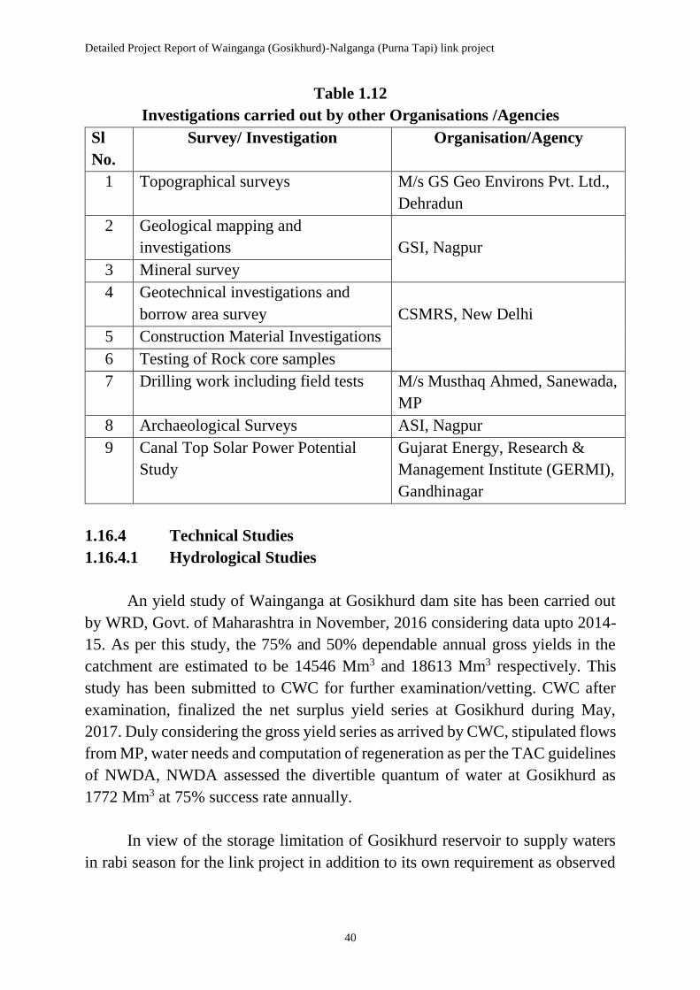
Detailed Project Report of Wainganga (Gosikhurd)-Nalganga (Purna Tapi) link project
40
Table 1.12
Investigations carried out by other Organisations /Agencies
Sl
No.
Survey/ Investigation Organisation/Agency
1 Topographical surveys M/s GS Geo Environs Pvt. Ltd.,
Dehradun
2 Geological mapping and
investigations
GSI, Nagpur
3 Mineral survey
4 Geotechnical investigations and
borrow area survey
CSMRS, New Delhi
5 Construction Material Investigations
6 Testing of Rock core samples
7 Drilling work including field tests M/s Musthaq Ahmed, Sanewada,
MP
8 Archaeological Surveys ASI, Nagpur
9 Canal Top Solar Power Potential
Study
Gujarat Energy, Research &
Management Institute (GERMI),
Gandhinagar
1.16.4 Technical Studies
1.16.4.1 Hydrological Studies
An yield study of Wainganga at Gosikhurd dam site has been carried out
by WRD, Govt. of Maharashtra in November, 2016 considering data upto 2014-
15. As per this study, the 75% and 50% dependable annual gross yields in the
catchment are estimated to be 14546 Mm3 and 18613 Mm3 respectively. This
study has been submitted to CWC for further examination/vetting. CWC after
examination, finalized the net surplus yield series at Gosikhurd during May,
2017. Duly considering the gross yield series as arrived by CWC, stipulated flows
from MP, water needs and computation of regeneration as per the TAC guidelines
of NWDA, NWDA assessed the divertible quantum of water at Gosikhurd as
1772 Mm3 at 75% success rate annually.
In view of the storage limitation of Gosikhurd reservoir to supply waters
in rabi season for the link project in addition to its own requirement as observed

Chapter 1: Introduction
41
from the simulation studies of the reservoir, the diversion through the link project
is proposed only during the three monsoon months from July to September.
1.16.4.2 Irrigation Planning and Command Area
The link is proposed to provide irrigation to a new command of 371277 ha
in six districts of Vidarbha region. Since the proposed diversion from Gosikhurd
is only during monsoon period from July to September, about 40 medium sized
enroute storages/tanks are proposed to be integrated for storing the link waters
and utilising the same during post-monsoon in the command area. Out of these,
it is planned to utilise two existing reservoirs viz. Lower Wardha reservoir on
Wardha river and Katepurna reservoir on Katepurna river as balancing reservoirs.
Feeder canals are identified at various locations along the link canal keeping in
view the FSL of the canal, FRL of storages, natural soil level etc. Each feeder
canal is proposed to feed one or a group of storages. In all, 22 feeder canals/direct
sluices are proposed from the main link canal to feed the enroute storages. The
requirements of the command area are worked out by climatological approach
considering the approved cropping patterns by the State Agriculture Department
as appropriate.
1.16.4.3 Design of Important Project Components
No new head works / storage structures are proposed as part of the project
for diversion of water through the 427 km long canal. The link off-takes from the
Gosikhurd reservoir across river Wainganga, utilises Lower Wardha reservoir on
Wardha river and Katepurna reservoir on Katepurna river as balancing reservoirs
and finally outfalls into Nalganga reservoir on Nalganga river, which are all
existing projects. Thus, the design of any new major dam is not involved. Since
detailed surveys in respect of enroute storages/tanks shall be carried by the State
at pre-construction stage, no detailed design is done for these tanks. The design
of various other components of the project involves designs of i) Link canal
section, ii) Canal head regulator (off-take regulator), iii) Out-fall structure, typical
designs of iv) Aqueduct, v) Super-passage, vi) Canal siphon, vii) Canal escape
viii) Double lane/single lane road bridge, ix) Lift arrangement, x) Tunnels, xi)
Pipe lines etc. All the above designs have been carried out following the
guidelines laid down in the respective BIS codes.

Detailed Project Report of Wainganga (Gosikhurd)-Nalganga (Purna Tapi) link project
42
1.16.4.4 Construction Program, Man-Power Deployment and Plant
Planning
The planning of Construction Programme, Man-Power Deployment and
Equipment has been carried out departmentally.
1.16.4.5 Environmental Impact Assessment (EIA), Environmental
Management Plan (EMP) and Socio-economic Survey
The Environmental Appraisal Committee (EAC) of Ministry of
Environment, Forests and Climate Change (MoEF&CC) has been approached by
the Govt. of Maharashtra for obtaining the approval for the proposed Terms of
Reference (ToR) to take up the comprehensive EIA studies including Socio-
economic survey of the link project. These studies will be carried out through the
expert agencies on consultancy basis. The details of the study will be incorporated
later in the DPR.
In the project proposal, no major dam is proposed but about 40 medium
sized storages are proposed to be integrated. It has been strived to ensure that the
tanks involve minimum submergence issues. While fixing the canal alignment
also, due care has been exercised to avoid traversing through the habitations to
the extent feasible. These aspects are discussed in detail in the relevant chapters
on ‘Environmental Impact Assessment’ and ‘Socio-Economic Studies’.
1.16.4.6 Cost Estimate
The cost estimate has been prepared considering the quantities worked out
based on the field surveys & investigations and the design of various structures
involved in the project. The estimates for the project are prepared based on the
’Guidelines for Preparation of Detailed Project Report of Irrigation and
Multipurpose Projects’ (2010) of the then Ministry of Water Resources (Now
MoWR, RD and GR), Govt. of India. The cost estimates have been framed on
the basis of the 2016-17 Schedule of Rates of WRD/ PWD, Govt. of Maharashtra
to the extent available and updated to 2017-18.
1.17 Monitoring Mechanism
The Chief Engineer (South), NWDA, Hyderabad and the Superintending
Engineer, Investigation Circle, NWDA, Hyderabad closely monitored the

Chapter 1: Introduction
43
progress of preparation of DPR including surveys as well as other investigation
works carried out through expert Govt. organizations on consultancy basis and
private agencies through tendering, by conducting meetings from time to time
and inspecting the offices and field sites.
In order to monitor and supervise the overall work of preparation of DPR
of Wainganga (Gosikhurd) – Nalganga (Purna Tapi) link project, the following
committees have been formed by CE (WRD), Nagpur vide letter no. 4400/T.S.-
4/NWDA/2015 dated 25.08.2015 as per the decisions taken in the meeting held
between the officers of NWDA and WRD, Govt. of Maharashtra at Nagpur on
22.04.2013 & at Hyderabad on 18.08.2015
1. Chief Engineer Level Committee to suggest policy decision regarding
preparation of DPR of the link and to coordinate between NWDA and
Govt. of Maharashtra as well as with other Central and State Govt.
departments
2. Superintending Engineer Level Committee to coordinate the
implementation of policy decisions and to review the planning of the link
from time to time
3. Executive Engineer Level Committee to share the information on the
activities going on in NWDA and the State, to ensure timely supply of
data/information, to make the field visits as would be required etc.
1.18 Clearances required
The Wainganga (Gosikhurd)-Nalganga (Purna Tapi) intra-State link
project will require the following clearances from the Govt.
Departments/Agencies indicated below in Table 1.13.
Table 1.13
Clearances Required from Govt. Departments/Agencies
Sl.
No.
Clearance Department/Agency
(i) Techno-economic
clearance
Central Water Commission/TAC, MoWR,
RD and GR, Govt. of India
(ii) Environmental
clearance
Ministry of Environment, Forest and Climate
Change, Govt. of India (iii) Forest Clearance

Detailed Project Report of Wainganga (Gosikhurd)-Nalganga (Purna Tapi) link project
44
(iv) Wild Life Clearance
The above clearances shall be obtained by the Government of Maharashtra,
as the project proponent, before taking up the implementation of the project.
1.19 Public Announcements and Public Hearings
The details of the link proposal have been communicated by the State
Government to the concerned District Collectors of the Project area. The benefits
to be accrued from the proposed project have been brought to the notice of the
general public during the field survey and other investigation works of the scheme
by the NWDA officials as well as by the respective State authorities from time to
time bringing out the importance of scheme to meet the water shortage of the
region. Thus, the people in the vicinity are well conversant of the link project.
The State Government authorities are duly associated in preparation of the
detailed project report. The public hearings will be taken up at appropriate time,
in connection with environmental impact assessment of the link project.
1.20 Interlinking of the Scheme with Neighboring Schemes
The integration of existing reservoirs Gosikhurd, Lower Wardha,
Katepurna, Nalganga besides other medium storages/tanks is the crucial
component of the link project. Due to this, the development under/ in the
upstream of these projects gets realised. For instance, in the reach between Upper
Wardha and Lower Wardha, a no. of schemes were planned for development of
water resources upstream of Lower Wardha, which have been however, held up
for want of availability of water at 75% dependability . These projects can be
realised now as the reduction in inflows into Lower Wardha on account of taking
up of these projects will be supplemented through the link project.
1.21 Inter-State / International Aspects
There are no international boundaries concerning the project area and
hence no such issues are involved. Wainganga / Pranhita is an inter-State river
with Chhattisgarh, Madhya Pradesh, Maharashtra and Telangana being the
riparian States. The Godavari Water Disputes Tribunal (GWDT) in its Award
endorsed the Agreements reached among the riparian States in respect of sharing
of waters of various tributaries of Godavari basin including Wainganga / Pranhita.
There is no effect of the project on the Inter-State adjudication on sharing the

Chapter 1: Introduction
45
waters of Pranhita sub-basin, which is incorporated in GWDT Award. The inter-
State issues are dealt in detail in Chapter 3: Inter-State aspects
1.22 Cost and Benefits of the Scheme
1.22.1 Cost of the Project
The total cost of the Wainganga (Gosikhurd)-Nalganga (Purna Tapi) link
project is about Rs. 53752 crore comprising of Unit I: Head works and storages
Rs. 23834 crore; Unit II: Conveyance system including lifting arrangements Rs.
29531 crore and Unit VI: Command area development Rs. 387 crore. The annual
cost of the project including cost of maintenance of head works, lifting
arrangements, depreciation, interest on capital cost etc. works out to Rs. 677427
lakh.
1.22.2 Benefits from the Project
The total annual benefits from the project works out to Rs. 11800 crore.
The benefits from irrigation are estimated at Rs. 218950 lakh and that from
municipal and industrial water supply at Rs. 952912 lakh. Further, the benefits
from pisciculture and canal plantation are estimated to be Rs. 3230 lakh and Rs.
4866 lakh respectively. The Benefit-Cost Ratio (B.C.R) and Internal Rate of
Return (IRR) of the Project work out to 1.74 and 9.50% respectively, considering
the life of the link project as 100 years.
1.23 Public Co-operation and Participation
The project will provide impetus to all-round development of the region
and reduce the socio-economic imbalance by enhancing agricultural production
and employment opportunities. Hence, good co-operation and whole hearted
participation is anticipated from the beneficiary areas.
On the other hand, 37 out of total 40 enroute storages involve submergence
issues, but keeping in view the market value of land and liberal R&R package in
accordance with the latest Govt. of India Act, there is likelihood of acceptance
from the affected population to the project. Moreover, it has been perceived while
carrying out topographical surveys that the farmers are in favour of such large
water resources project in the region keeping in view the chronic and continuous
spell of droughts and ever growing irrigation, domestic and industrial water
needs.