Joshi RV, Rajaguru SN, and Pappu RS. 1983. Quaternary studies in the Karwar-Gokarn Region, Karnataka...
12
. ·'f· '-:.. _ .•.__ . Prof. Kelkar Memorial Volume. 1983: 97-106 , I ;f • L r l t t Quaternary studies in the Karwar-Gokarn region, Karnataka State R. V. Joshi, S. N. Rajaguru and R. S. Pappu Department of Archaeology, Deccan College Postgraduate & Research Institute, Pune 411006, India
-
Upload
deccancollegepune -
Category
Documents
-
view
1 -
download
0
Transcript of Joshi RV, Rajaguru SN, and Pappu RS. 1983. Quaternary studies in the Karwar-Gokarn Region, Karnataka...

. ·'f·'-:..
_ __~"' ~_h -.'-.~-' .~--,-.-...-~_.~_ .•.__.
Prof. Kelkar Memorial Volume. 1983: 97-106
,I;f
•
Lr
l
t
t
Quaternary studies in the Karwar-Gokarn region,Karnataka State
R. V. Joshi, S. N. Rajaguru and R. S. Pappu
Department of Archaeology, Deccan College Postgraduate & Research Institute, Pune 411006, India
,Prof. Kelkar MemoriaJ Volume, 1983: 97-106
Quaternary studies in the ~arwar-Gokarnregion.Karnataka State [
R. V. Joshi, S. N. Rajaguru and R. S. Pappu
Department of Archaeology, Deccan College Postgraduate & Research Institute, Pune 411006, India
Erosional surface of 60-40 m above mean sea level, the occurrence of a buriedchannel of th~ river Kali, 20 m below mean sea level and the presence of afairly extensive gravel fill in the coastal strip indicate positive as well negativebase level changes during the Quaternary in the Karwar-Gokarn region. Theextreme rugged nature. of the country and the absence of suitable.lfw mate~ials
for making stone tools possibly account for the meagre evidence '6f Stone Ageremains in the area.
Introduction
The importance of environmental studies inprehistoric investigations has been wellunderstood in India and it is gratifying tonote a growing awareness in this respect inrecent years. Research is now being systematically carried out in the cold parts of thesub-Himalayas as well as the arid and semiarid parts of the Thar desert and the DeccanPeninsula. So far quite a few meaningfulresults have already been achieved. Howeever, a reliable correlation of the Quaternaryevents between the two contrasting regionsthe extra-Peninsula and the Peninsula-doesnot as yet seem to be in view. In additionto these regions, the coastal tract of theIndian Peninsula offers opportunities forinvestigations into another aspect of prehistoric studies, namely the evidence of possible changes of sea level during the Quaternary and their bearing on coastal habitational sites of early man. A beginning in
this direction has already been made alongthe coasts of Gujarat, Maharashtra, Goaand Kerala.
Geoarchaeological investigations carried outin recent years by Marathe (1981) inSaurashtra, Guzder (1980) in coastalMaharashtra, Kale, and Rajagucu ( 1983} inGoa and Rajendran (1979) in Kerala haveconclusively proved that early man appearedin the semi-arid parts of Saurashtra duringthe mid Pleistocene and in tropical parts ofwest coast s6meti"mes during the hite Pleistocene. Geomorphological' and geological'studies in this region have shown that late~.
rites developed over near sliore sedinientariesof late Tlrtiary age in Kerala, Goa and'MaharasMra are of early Pleistocene age.Some of 'the gravel beds capping these laterites in Kerala, Maharashtra and the miliolite formations in Saurashtra are of midPlei4ttocene age. The late Pleistocene formations are represented by various alluvial
98
~,~.R. V. Joshi, S. N. llaja&uru aud So N. Pappu
_ J
fins inset into early Quaternary lateritesand miliolites and by aeolianites and littoralformations. Beach rocks, tidal flats, aeolianites and low alluvial fills represent earlyto mid Holocene formations. Both tectonicsand glacio-eustatic factors are responsiblefor positive ( + 75 ) and negative ( - 100m)movements of sea level in this region. Ithas Dot yet been possible to establish pure
glacio-eustatic model for this region. The'present study in Karwar-Gokarn coastalparts of Karnataka is a part of our majorproject on prehistory and Quaternary environment in western coast of India.
Present Environments
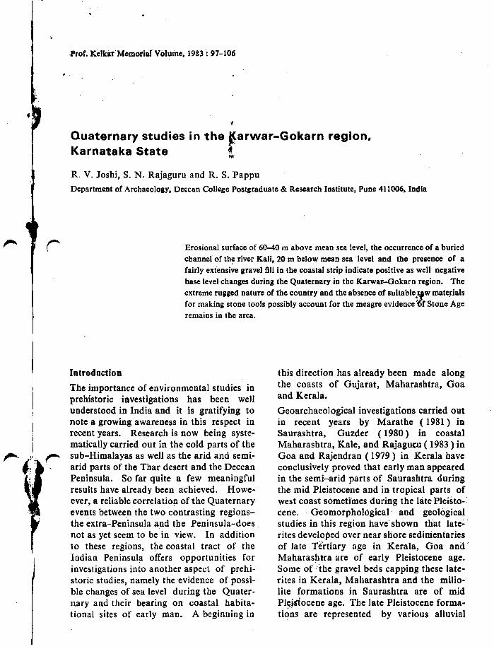
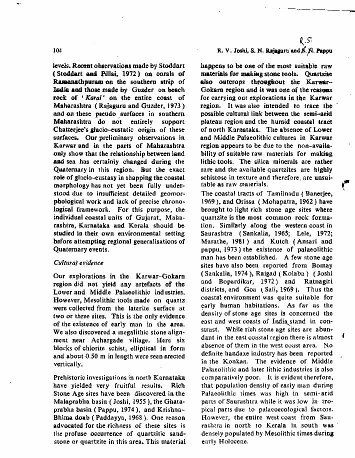
The region between Karwar and Gobrn(Fig. 1) on the west \.:oast of the indian
, ,
,,I
20,
SIRSI•
Km...
SOUTHKANARA
o 10I
YEUAPUR•
•HONAVAR
U'
~
"1"
.-.. -... _- ... :JOO FALLS
"" ~,\ ~ ,•,\
" .N BHATKAL00 I·.. ~:~:··:J STUDY AREA
-
7l06E 7 00
Fig. 1 : Kali-Gangavali Basin
Peninsula forms an administrative part ofthe North Kanara (Karwar) district ofKarnataka state. The area under consideration lies between the we~t facing scarp of theWestern Ghats (Sahyadris) and the ArabianSea. Physiographically the region may beroughly divided into three main zones; thecoastal fringe, the hilly region lying betweenthe coast and the ghats ( the sub-Sahyadrianzone ), and the Western Ghats. On the wholeKarwar coast is hilly, narrow and highly
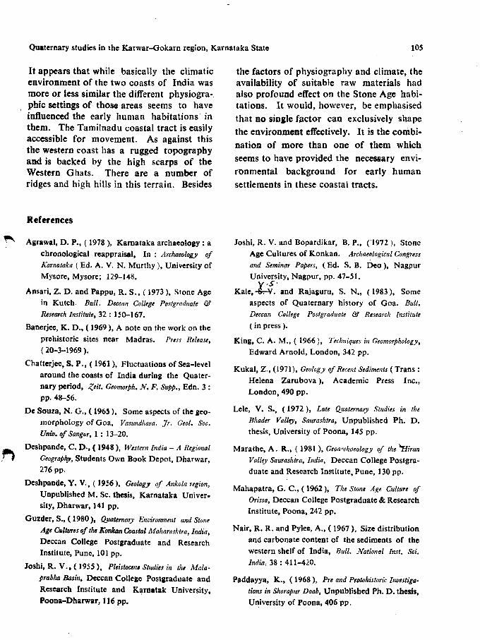
dissected with the transverse ridges of theGhats stretching - westward and in manycases extending as promontories right up tothe Arabian Sea. The region is drained bystreams like the Kali and Gangawali riverswhich are ungraded, and have steep gradientswith their catchment area in the amphitheatrelike basins of the Western Ghats. The 270 mhigh waterfall on the river Gangavali nearMagod (about 70 km upstream from themouth), is one of the most conspicuous
Quaternary studies in tbe Kal'wllr-Gokam R.elion. Karnataka State 99
750
600
4501!1
300::E
150
0
KALI RIVER
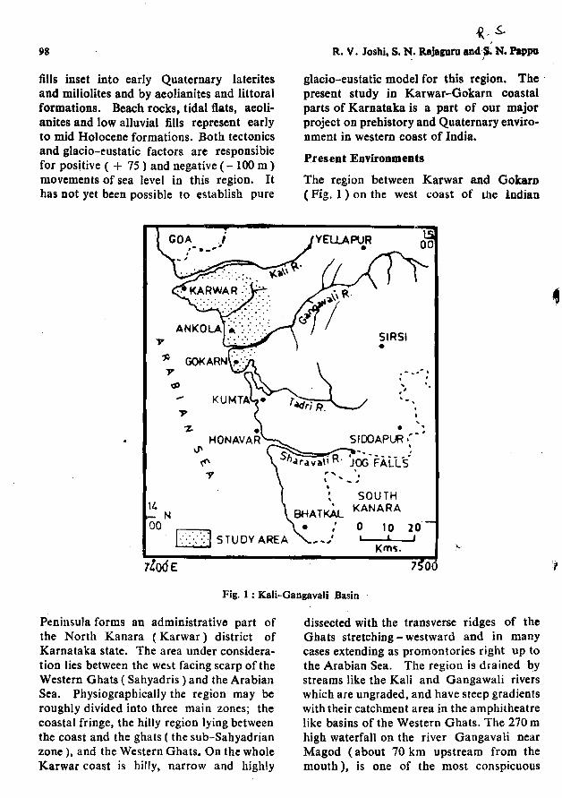
Fig. 2 : Longitudinal Profiles of the Kali and Gangavali.
represented by metamorphic crystallines.foliated schists, phyllites, quartzites andepidiorites. Granite gneisses are the mostcommon hardrock formations observedin this area and are traversed by a numberof dolerite dykes. Both the primary andsecondary detrital varieties of laterites .arecommonly found to be capping the Precambrian formations almost upto the coastnear the towns of Karwar and Gokam. Thelateritic gravel fill in the narrD,\V coastal tractbetween Karwar and Gokam is signidcantfrom the point of view of understanding theQuaternary history of the region. •
Climatically this is a region of heavy rainfall, about 3000 mm per year receivingmostly from SW monsoons from June tomid November. Winters (November-February) and summers ( March-May) are mildand humidity is high ( 70% ) almost for 9 to10 months of the year. The natural vegetation is of a moist deciduous and tropicaleverareen type and the soils are of pedalfertype, semi-lateritic reddish brown varieties.Surprisingly the depth of in situ soil covernever exceeds more than 2 m and profile
750
600
J!I 450:::E"
300
150
oL-----L..._---I...-_.1...-------'-_----'--_~:=L===::::t:::==-~~_=o 16 32 48 6/, 80 96 112 128 W. 160 176GANGAVALI RIVER Kms
morphological features (Fig. 2). The highdensity of the drainage network can beattributed to the relatively softer metamorphic country rocks, the vast catchment area,and heavy precipitation wh.i"h is of the orderof about 3000 mm per annum. The presentdrainage system seems to have adjusted withthe geological structures, such as the NNWstrike and ENE dip of the Dharwars. Thishas resulted in a distinct trail is drainagepattern in the area.
The watershed between the westerly flowingGangawali and the easterly flowing Malaprabha - a tributary of the Krishna - is veryinteresting. The Gangawali has encroachedon the headwater draiooge of the Malaprabha and has thus pushed back the continental divide, from the usual 40-45 km to adistance of 133 km from the coast. Thecity ofHubli is situated in the water gapzone of the Gangavali and the Malaprabha(Deshpande, 1948).
Geologically the Karwar region is coveredby Plecambrian Dharwars, Newer Dolerites,Cenozoic laterites, alluvit--' and littoralformations. The Dharwarian rocks are
100 . R; Vdosbi. S. N..Jbjaguru, and R. S. Pappu
development is poor (A I C type). '{hethicker soil covers are mostly of colluvialorigin. It is against tbis brief geographicalbackground that an attempt is being madeto trace tbe Quaternary history of theregion.
The grains are sub-rounded and seem tohave been derived from the nearby outcropsof gneisses. On the whole the texturalcharacters of these beach sands comparevery well with the textural characters ofbeach sands from the coast of Ratnagiri inMaharashtra ( Guzder, 1980). The textural
Field observatioDS
Oweing to the rugged nature of the terrain,surficial formations are either absent orpoorly preserved in the sub-Sabyadriantract. Consequently field work was concentrated in the narrow coastal zone betweenKarwar and Gokarn and we studied surficialformations, coastline morphology and subsurface features particlarly.from the point ofview of locating prehistoric sites. Ourobservations have brought to light the following salient features:
1. Surficial formations
a~ Neor.shore formations: In general coastline is highly indented. Gneissic and lateriticcliffs and promontories alternating with theria-like estuaries of the Kali and the GangawaH are common. The crescentic beaches,estuarine plains and tidal flats are moderatelydeveloped between Karwar and Ankola(Plate 1, fig. I). The modern beach sand iswhite or pink in colour and is chiefly composed of quartz microcline. plagioclase, biotite,a little magnetite, hematite, ilmenite and shellfragments. The textural characters of thesesands have been found out as per methodsdescribed by King (1966) and are asfollows:
Mean grain size 2.23Sorting Index 0.61Skewness 0.3:Kurtosis 1.0'
These values particularly sorting index aJskewness, in comparison with thosemodern dunes at Binge with mean grssize 2.742, sorting index: 1.02 and skeness: 0.967 are significant.
The differences in textural observationsthe stabilized and modern dunes are maildue to the greater proportion of silt aclay « 0.06 mm) fiaaction in the UP)
half meter of the Binge dune. It, therefcsuggests slight degree of weathering ofdune at Binge.
These relatively stabilized old dunes,the one at Binge, are found on the wes'margins of the tidal flats which forrprominent depositional surface,1-2above high tide level. A road. cutting fdrainage pipeline near Binge has revethe following sequence of layers in the 1
flat ( from top to bottom ):0-10 em-yellowish brown (10 YRmodern sandy soil under rice (vation.
characters of Ratnagiri sands are as follows:
Mean grain size 2.31Sorting Index 0.362Skewness 0.095Kurtosis 1.32
On the other hand modern dune sands atKarwar are domi~l~ by quartz, microcline,biotite and hematitf'~'i1ltehigher propor!ionof heavy minerals in ,. ds is signifi&iMIfrom the point of view ating beacbsands from dune sands", ly in 2
fossil context. Kukal ( 1971 ) 11 r·ved similar higher proportion 0
minerals (beach sands - 1.5"/" andsands - 2.2% ) in modern dune sand'!> ~\\\et
were products of reworking ofThe textural charaCtM'bf.'•.at Binge 1.2 km from tbe Karwaras follows:
2.3830.4190.086
1.34
Mean grain sizeSorting IndexSkewnessKurtosis
Quaferaarr stlldies in ihelCarwar-Gokarn region, Karnataka State
11-90 em-brown (10 YR 5/3) subrounded semi consolidated mediumsand, slightly current bedded.
91-140 cm-dark brown ( 10 YR 3/3 )fairly compact medium to fine sandwith some fragments of semi-carbonized plants and with 4.6% of organicmaUer.
below 140 cm - water.
(The colours of sediments are described asper the Munsell colour notation ).
The lowermost layer exposed in a trench isthe product of a marshy environment, whilethe overlying brown sand appears to havebeen deposited in a beach environment.These tidal 1\ats imperceptibly merge intothe pure aHuvial deposits towards the eastwithin a distance of less than IO km. Someof the typical alluvial formations from thisregion have been described below:
b. A/iuyial formations: These are most freqUeDtly noticed along meander sweeps bothof the main rivers Kali and Gangavali aswell as their tributaries and are found toattain a height from 2 to 5 m above themodern bed level. The top surface of thealluvium forms a terrace like feature andextends laterally for a distance of about lessthan a kilometer on either bank of a stream.These terra<:e like surfaces imperceptiblypass laterally into rock-cut plains. Thelower portion of the alluvial cliff is domi·nantly a channel or point bar deposit, comprising semi-consolidated bouldery orpebbly gravel. The upper portions are interchannel or, overbank deposits, about 1 to2 m thick and made up of brown (10 YR5/3) non-kankary sandy silts. The pebblelithology of the gravels is dominated byquartzites. Such coarser gravels are observedto occur almost upto 16 km upstream fromthe mouth of the Gangavali near Gundbaleand Achargade villages (Plate I, fig. 2 & 3 ).These alluvial deposits did not ) ield anystone tools, animal and plant fossils andmaterials suitable for radiometric dating.
101
c. Lateritic grave/fill: This is one of themost conspicuous geomorphic feature observed between Hattikeri and Gokarn andoccurs at an elevation varying from 75 m to20 m with a gradual westward slope, towardsthe coast. The maximum exposed section ofthis formation is about 10 m and it restsunconformably on primary laterite and Precambrian rocks, at many places, e. g. righton the coast at Belekeri. Sub-roundedpebbles of gneiss, dolerite, chlorite schist,quartzite and quartz are found embeddedin a ferruginous clayey matrix. The gravelis well cemented, poorly sorted and unstratified. The interlayering of silty sand andsilty clay is not uncommon. The poor sorting, dominance of a clayey matrix and thegentle coastward slope would indicate thatthese gravels were deposited as an alluvialfan at the base of the coastal Archac:an hilloccurring a few kilometers inland from thecoast. No datable material was found inthis formation. Although the dating of thesevarious surfadal formations is not possibleat this stage they can be fixed up in a tentative geOlogical time scale in the light of ourobservations of the some of the erosionalfeatures described below.
2 Erosional features
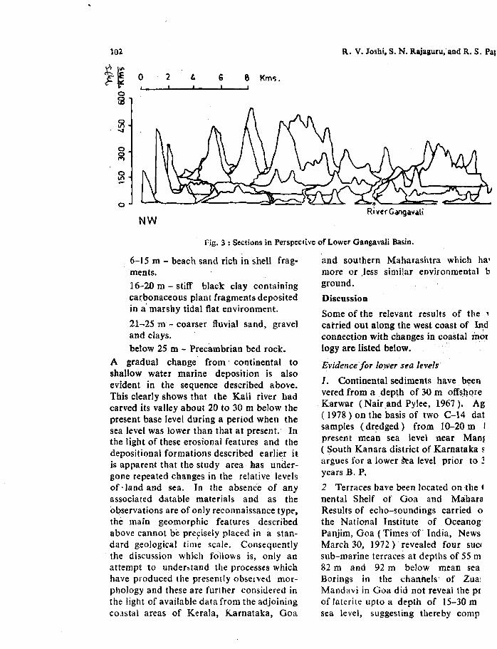
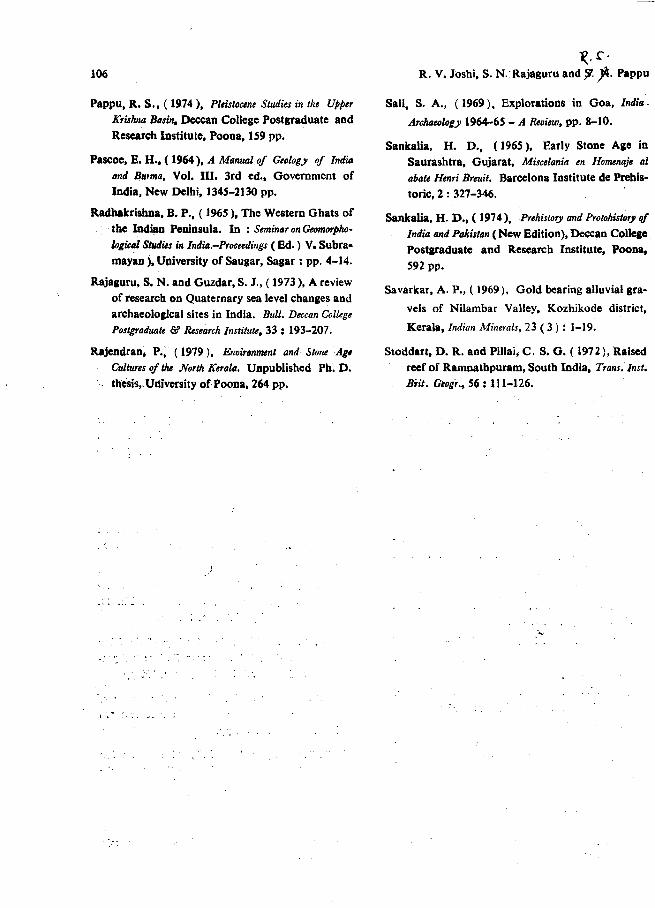
a. Planation surfaces: Planation surfaces atelevations between 400 m and 200 m inthe sub-Sahyadrian zone have been shownin the persective diagram (Fl'g. 3). Thesesurfaces have been devdoped on foldeJDharwarian formations. Another importantcoastal planation surface occurs at an elevalion 60-40 m on the lateritic gravel fill.
b. Buried channel of the Kali: Borehole dataat the bridge construction site at the mouthof the river Kali at Kodibag near Karwar<Plate 1, fig. 2) revealed a rocky bed at a depthof abuut 25 to 30 m below present mean sealevel. Stratigraphic data from the boreholereveal the following sequence:
0-5 m - water surface of the Kali at itsmouth near Kodibag.
102
t~ 2FE 0 t.
053
~-4
0
~
:x
0
NW
R. V.Joshi. S. N. Rajalluru.and R. S. Pal
6 6 Kmc;.
t'-----..!=-== .c::;,-- _
Ri ver Gangavali
Fig. 3 : Sections in Perspective of Lower Gangavali Basin.
6-15 m - beach sand rich in shell fragments.16-20 m - stiff black clay containingcarbonaceous plant fragments depositedin a'marshy tidal flat environment.
21-25 m - coarser fluvial sand, graveland clays.below 25 m - Precambrian bed rock.
A gradual change from' continental toshallow water marine deposition is alsoevident in the sequence described above.This clearly shows that the Kali river hadcarved its valley about 20 to 30 m below thepresent base level during a period when thesea level was lower than that at present. Inthe light of these erosional features and thedepositional formations described earlier itis apparent that the study area· lias undergone repeated changes in the relative levelsof' land and sea. In the absence of anyassociated datable materials and as theo1:>servations are of only reconnaissance type-,the main geomorphic features describedabove cannot be pre~isely placed in a standard geological time scale. Consequentlythe discussion which follows is, only anattempt to under~tand the processes whichhave produced the presently observed morphology and these are furl her considered inthe light of available data from the adjoiningco~stal areas of Kerala, Karnataka, Goa
and southern Maharashtra which ha'more or ,less similar environmental bground.
Discussion
Some of the relevant results of the 1
carried out along the west coast of Indconnection with changes in coastal morlogy are listed below.
Evidencefor lower sea levels
1. Continental sediments have beenvered from a depth of 30 m offshoreKarwar (Nair _and Pylee, 1967). Ag( 1978 ) on the basis of two C-14 datsamples (dredged) from 10-20 m Ipresent mean sea level near Manl( South Kanara district of Karnataka sargues for a lower ~a level prior to ~
years B, P.
2 Terraces have been located on the l
nental Shelf of Goa and M<iharaResults of echo-soundings carried 0
the National Institute of Oceanog:Panjim, Goa ( Times of' India, NewsMarch 30, 1972) revealed four SUC(
sub-marine terraces at depths of 55 ill
82 m and 92 m below mean seaBorings in the {:hannels of Zua!Mandavi in Goa did not reveal the Piof laterite upto a depth of 15-30 msea level, suggesting thereby COfllP
Quaternary studies in the Karwar-Gokarn Region, Karnataka State 103
recent age of coastal laterites on Goa. ( Kaleand Rajaguru, 1983). A submerged forest"was located at a depth of 6-12 m belowmean sea level on the eastern side of Bombay(Pascoe, 1964 ).
In view of this data, it is possible to affirmthat base level changes have taken place inthe coastal tracts adjoining Karwar,Although only a few absolute dates are presently available, both in the light of" thetheory of Quaternary glacio-eustesy, as wellas current hypothesis. regarding the date, !ofthe origin of the w~st coast of India, it is
-likely that evidence f,Qra lowering of baselevel at the mouth of the KaJi river can alsobe dated to the Quaternary.
"!:vide';ce jor higher sea levels
"I. 'Savarkar ( 1969) has located "auriferousalluvial gravels in the Nilambur valley(Kerala) at an elevation of 150 m above~ean sea level. These gravels have beenascribed to Pli.ocene marine processes, whilethose observed ( at a lower elevation) slightlybelow these gravels in the same valley havebeen dated to the Pleistocene.
2. River gravel deposits have been recordedat an elevation of 30-40 m above mean sealevel at Ratnagiri ( Maharashtra ) and ascribed to Quaternary fluvial processes (Rajaguru and Guzder, 1973). The Karwarlateritic gravel fill can, therefore, also bedated to Quaternary.
3. The alluvial fills of the Kali and Gangavali are very similar to those observed by usin Goa and Maharashtra. These depositsare representative of cut and fill activity ofthe short and steeply graded coastal streams,in response to Quaternary base level changes.That stich changes have occurred in recenttimes is also indicated by the sequenceobserved in the excavation for a pipe line atBinge. The occurrence of beach sand overtidal marsh (fine sand). strongly indicatessUbmergence of the coastal area.
4. The plan'ation surface at 200 mis quiteconspicuous along the western coast ofIndia and occurs on varieties of geologicalformations, e. g. Deccan traps, Archaeansand Dharwars and on laterites. Chatterjee(1961) has also observed a marine terracesurface at 150~180 m at the foot of theWestern Ghats and has ascribed its origin tohigher sea level. Our detailed studies ofthis surface developed on laterites in Ratnagiri district of Maharashtra and in Goa haveshown that this surface is essentially a product ofsub~aerial deep weathering andstripping of the weathered mantle and resembles etch plains (Guzder, 1980; Kale andRajaguru, 1983). We, therefore, do notaccept the marine origin of this surface. Inthe light of late Teritiary tectonic history ofthe coastal strip of western India, as indicated by a relatively fresh escarpment of thewestern Ghats of Miocene age and by theseries of nonhard rock capping type waterfalls Magod, on the Gangavali river, Jog onthe Sharavati river in Karnataka (Radha·krishna, 1965 ) and at Dudhsagar" in Goa(De Souza, 1965) of Pliocene or earlyQuaternary age, this planation surface alsoappeares to be of tectonic origin.
In view of this late Tertiary tectonic history,the lower surface developed on lateriticgravel fill at Karwar at an elevation of60-40 m above mean sea level is certainly ofthe Quaternary age and is more likely to beof pre-alluvial fill phase as the Gangavaliriver and its tributaries have carved theirvalleys in the laterite gravel fill prior to thedeposition of their own transported detritus.Therefore, the gravel fill and the' surfacedeveloped on it are possibly of mid Pleistocene age.
Similar surfaces of planiilion have beenobserved at 8U-100 10, 30-35 m, 15-20 m,8-20 m imd 2-510 along the· we~t coast ofIndia by Chatterjee ( 196 t). He has explained their origin in terms of· once widelyaccepted Meditarranean marineterrace sequence,developed due to high interglaCial sea
104
levels. Recent observations made by Stoddart(Stoddart aacl Pillai, 1972) 00 corals ofRaJDaBathparam on the southel'D strip ofWieand those made by Guzder on beachrock. of 'Karal' on the entire coast ofMaharashtra (Rajagucuand Guzder, 1973 )and on these pseudo surfaces in southernMaharashtra do not entirely supportCl1atterjee's &lacio-eustatic origin of thesesurfaces. Our preliminary observations inKarwar and in the pacts of Mabarasbtraonly show that the relationship between landaad sea has certainly changed during theQutemary in this region. But the eXllctrole of glacio--eustasy in shapping the coastalmorphology has not yet beeD fully understood due to insufficient detailed geomorphological work and lack of precise chronological framework. For this purpose, theindividual coulal units of Gujarat, Mallarasbtra, Karnataka and Kerala should bestudied in their own environmental settingbefore attempting regional generalisations ofQuaternary events.
Cui/ural evidence
Our explorations in the Karwar-Gokarnregion did not yield any artefacts of theLower and Middle Palaeolithic industries.However, Mesolithic tools made on quartzwere collected from the laterite surface attwo or three sites. This is the only evidenceof the existence of early man in the area.We also discovered a megalithic stone alignment near Achargade village. Here sixblocks of chlorite schist, elliptical in formand about 0.50 m in length were seen erectedvertically.
Prehistoric investigations in north Karnatakahave yielded very fruitful results. RichStone Age sites have been discovered in theMalaprabha basin (Joshi, 1955), the Ghataprabha basin (Pappu, 1974). and KrishnaBhima doab (Paddayya, 1968). One reasonadvocated for the richness of these sites isthe profuse occurrence of quartzitic sandstone or quartzite in this area. This material
~.S'.
R. V. Joshi. S. M. Rajquru and.B. f. Pappu
ha'ppens to be one of the most suitable rawmaterials for makit\g stone tools. Quartzite.Iso outcrops throgpout the KarwarGobro region and it was one of the reasonsfor carrying out expl.orations in tbe Karwarregion. It was also intended to trace thepossible cultural link between the semi....aridplateau region and the humid coastal tractof north Karnataka. The absence of Lowerand Middle Palaeolithic cultures in Karw~r
region appears to be due to the non-av.ailability of suitable raw materials for makioglithic tools. The silica minerals are ratbei'rare and the available quartzites are highlyschistose in texture and therefore, are unsui-table as raw materials. .'"The coastal tracts of Tamilnadu ( Banerjee,1969). and Orissa (Mohapatra, 1962) havebrought to light rich stone age sites wherequartzite is the most common rock forma-tion. Similarly along the western coast inSaurashtra (Sankalia, 1965; LeJe, 1972;Marathe, 1981) and Kutch (Ansari andpappu, 1973) the existence of palaeolithicman has been established. A few stone agesites have also been reported from Bomay(Sankalia, 1974), Raigad ( Kolaba) (Joshiand Bopardikar, 1972) and Ratnagiridistricts, and Goa (Sali, 1969). Thus thecoastal environment was quite suitable forearly human habitations. As far as thedensity of stone age sires is concerned theeast and west coasts of India....stand in constrast. While rich stone age sites are abun-dant in the ea,t coastal region there is almost ,absence of them in the west coast area. Nodefinite handaxe industry has been reportedin the Konkall. The evidence of MiddlePalaeolithic and later lithic industries is alsocomparatively poor. It is evident therefore,that population density of early man duringPalaeolithic times was high in semi-aridparts of Saurashtra while it was low in tro-pical parts due to palaeoecological factors.However, the entire west coast from Saurashtra in north to Kerala in south wasdensely populated by Mesolithic times durin&early Holocene.
Quaternary studies in the Karwar-Gokarn region, Karnataka State 105
It appears that while basically the climaticenvironment of the two coasts of India wasmore or less similar the different physiographic settings of thos., areas seems to haveinfluenced the early human habitations inthem. The Tamilnadu coastal tract is easilyaccessible for movement. As against thisthe western coast has a rugged topographyand is backed by the high scarps of theWestern Ghats. There are a number ofridges and high hills in this terrain. Besides
References
Agrawal, D. P., ( 1978), Karnataka archaeology: achronological reappraisal, In: Archaeology of
Karnataka (Ed. A. V. N. Murthy), University ofMysore, Mysore; 129-148.
Ansari, Z. D. and Pappu, R. S., ( 1973), Stone Agein Kutch. Bull. Deccan College Postgraduate &
Research Institute, 32 : 150-167.
Banerjee, K. D., ( 1969), A note on the work on theprehistoric sites near Madras. Prtss Release,
(20-3-1969 ).
Chatterjee, S. P., ( 1961), Fluctuations of Sea-levelaround the coasts of India during the Quaternary period, Zeit. Geomorph. N. F. Supp., Edn. 3 :pp.48-56.
De Souza, N. G., ( 1965), Some aspects of the geomorphology of Goa, Vasrmdhara. Jr. Geol. Soc.
Univ. of Sang",r, 1 : 13-20.
Deshpande, C. D., ( 1948), Western India - A Regional
Geograp"" Students Own Book Depot, Dharwar,276 pp.
Deshpan(1e, Y. V" ( 19;6), Geology of Ankola region,
Unpublished M. Sc. thesis, Karnataka University, Dharwar, 141 pp.
Guzder, S., ( 1980), Quaternary ll'nvironment and Stone
Age Cultures of the Konkan Coastal Maharashtra, India,
Deccan College Postgraduate and ResearchInstitute, Pune, 101 pp.
Joshi, R. V., ( 1955), PleistoclIl' Studies in th, Mala
prabha Basin, Deccan College Postgraduate andResearch Institute and Karnatak University,Poona-Dharwar, 116 pp.
the factors of physiography and climate, theavailability of suitable raw materials hadalso profound etrecton the Stone Age habitations. It would, however, be emphasisedthat no single factor can exclusively shapethe environment effectively. It is the combination of more than one of them whichseems to have provided the necessary environmental background for early humansettlements in these coastal tracts.
Joshi, R. V. and Bopardikar, B. P., ('1972), StoneAge Cultures of Konkan. Archaeological Congress
and Seminar Papers, (Ed. S. B. Deo), NagpurUniversity, Nagpur, pp. 47-51.
V-SoKale, -s.-¥. and Rajaguru, S. N.. (1983), Some
aspects of Quaternary history of Goa. Bull.
Deccan College Postgraduate & Research Institute
(in press).
King, C. A. M., ( 1966), Techniques in Geomorphology,
Edward Arnold, London, 342 pp.
Kukal, Z., (1971), Geology if Recent Sedimmts (Trans:Helena Zarubova), Academic Press Inc.,London, 490 pp.
Lele, V. S., (1972), Late Quaternary Studies in the
Bhader Valley, Saurashtra, Unpublished Ph. D.thesis, University of Poona, 145 pp.
Marathe, A. R., ( 1981 ), Geoa"chaeology of the ""Himn
Valley Saurashira, InditJ, Deccan College Postgraduate and Research Institute, Pune, 130 pp.
Mahapatra, G. C., ( 1962), The Stone Age Culture ofOrissa, Deccan College Postgraduate & ResearchInstitute, Poona, 242 pp.
Nair, R. R. and Pylee, A., ( 1967). Size distributionand carbonate content of the sediments of thewestern shelf of India, Bull. National Inst. Sci.
India, 38 : 411-420.
Paddayya, K., (1968), Pre and Protohistoric Investiga
tions in Shorapur Doab, Unpublished Ph. D. thesis,University of Poona, 406 pp.
106
Pappu, R. S.• ( 1974), Pleistocene Studies in the Upper
Krislula Basin. Deccan College Postgraduate andResearch Institute, Poona. 159 pp.
Pascoe, E. H •• ( 1964 ). A Manual of Geology of India
and Burma, Vol. III. 3rd ed., Government ofIndia, New Delhi, 1345-2130 pp.
Radhakrishna, B. P., ( ]965), The Western Ghats ofthe Indian Peninsula. In : Seminar on Geomorpho
logical StIIIlies in India.-Proceedillgs (Ed.) V. Subramayan j. University ofSaugar, Sagar: pp. 4-14.
Rajaauru, S. N. and Guzdar, S. J., ( 1973), A reviewof research on Quaternary sea level changes andarchaeological sites in India. Bull. Deccan College
Postgraduate & Research Institute. 33: 193-207.
R.jendran. P.; (1979). Environment anti $wneAge
Cultures of the North Kerala. Unpublished Ph. D.thesis,> University of Poona, 264 pp.
li:. r -R. V. Joshi, S. N.Rajaguru and 7- jt Pappu
SaU, S. A.• (1969), Explorations in Goa, India.
ArchaeololY 1964-65 - A Review, pp. 8-10.
Sankalia, H. D., (1965), Early Stone Age inSaurashtra, Gujarat, Miscelania en Homenaje 01
abate Henri Breuit. Barcelona Institute de Prehistoric, 2 : 327-346.
Sankalia, H. D., ( 1974), Prehiswry and Protohiswry ofIndw and Pakistan (New Edition), De<:can CollegePostaraduate and Research Institute, Poona.592 pp.
Savarkar, A. P., ( 1969). Gold bearing alluvial gra
vels of Nilambar Valley, Kozhikode district,
Kerala, Indian Minerals, 23 (3) : 1-19.
Stod"'art, D. R. and Pillai, C. S. G. ( 1972). Raisedreef of Ramnathpuram, South India,Trans.Inst.
Bjit. Geogr., 56: 111-126.

Quaternary studies in the Karwar-Gokarn region, Karnataka State
P.LATE I
-
Fig. I : Landscape around Binge.
FiC' 1: Mouth of the Kali at Kodibag.
Fig. :I: Bouldery - Cobbly gravel bed of the Gangavali at Gundabale.
FiC. 4: Pebbly gravel bed of the Gangavaij at Achargade.