
Pappu RS. 1988. Site Catchment analysis. In: Dhavalikar MK, Sankalia HD, and Ansari ZD, editors....
17
PRINTED FROM: EXCAVATIONS AT INAMGAON VOL. I Part i M.K. DHA VALIKAR H.D. SANKALIA Z.D. ANSARI DECCAN COLLEGE POST -GRADUATE AND RESEARCH INSTITUTE PUNE 411 006. 1988
-
Upload
deccancollegepune -
Category
Documents
-
view
1 -
download
0
Transcript of Pappu RS. 1988. Site Catchment analysis. In: Dhavalikar MK, Sankalia HD, and Ansari ZD, editors....

PRINTED FROM:
EXCAVATIONS AT INAMGAON
VOL. I Part i
M.K. DHA VALIKAR H.D. SANKALIA Z.D. ANSARI
DECCAN COLLEGE POST -GRADUATE AND RESEARCH INSTITUTEPUNE 411 006.
1988

6. Site Catchment Analysis
R.S. Pappu
Introduction
The study of prehistoric economy has now beenrecognised as an important aspect of archaeology. Morerecently there have been attempts to introduce themethods of quantitative geography, notably locationalanalysis in archaeological investigations forunderstanding palaeoeconomy. This territorial approachis known as "Site catchment analysis". The explicitrealisation that human groups procure resources fromthe regions immediately surrounding their settlementsled to the formulation in the late 1960s of the analyticmethod of site catchment analysis. This method was firstintroduced by Claudio Vita-Finzi and Eric Higgs in theirstudy of prehistoric economy in the Mount Carmel areaof Palestine. According to them, the site catchmentanalysis is the study of relationship between technologyand the natural resources lying within the economicrange of individual archaeological sites (1970:5).Catchment area is that area from which resources aretaken to support human populations and occur withinreasonable walking distance from a site. The biophysicalenvironment is not uniform either spatially or seasonally.The size, shape and location of an individual site'scatchment area is, therefore, largely the function ofzonation spacing and seasonal differentials of resourcezones (Roper 1979: 121). Site catchment analysis is thusconcerned with the exploitation of plant, animal, mineraland other resources by human groups in a particularterritory and encompasses both theory and method inassessing the resource potential of an archaeological site.
The concept of site catchment analysis rests on theassumption that the further the area is from the inhabited
locus, the less likely it is to be exploited and lessrewarding is its exploitation, since energy consumed inmovement to and fro from the site will tend to cancel outthat derived from the resource. In other words, as onemoves from the site, the intensity of exploitation reachesto that limit beyond which it proves uneconomic.Prehistoric communities were aware of this decrease inyield/cost ratio and resided in the most advantageouslocations to mini mise food procurement efforts.
Studies of modern hunting and gathering andagriculture economies have shown that the territoryexploited from a site tends to lie within certain welldefined limits. This will vary according to a number offactors such as the nature of economy, means oftransport available, population pressure and thecharacter of terrain. Vita-Finzi and Higgs (1970:7) reliedalmost exclusively upon two ethnographic sources toestimate the probable size of catchment areas associatedwith prehistoric communities. The first was the study byLee (1969:61) of the present hunter-gatherer KungBushmen of Africa who observed that Kung obtainedmost of their food within a lOkm radius of their camp.The second was by Chisholm (1979: 108) whoconcluded after the study of the present Europeanpeasant societies that only very exceptionally thesefarmers cultivated lands more than 3 to 4km from theirsettlements. On the basis of these data, Higgs (1975:22)suggested that the distance covered in two hours walkingas the critical threshold for hunting and gatheringeconomies and one hour for agriculture economies.Dennel (1980:3) has summarised these findings in theform of the following equations:

Tehuacan, Mexico reversed this procedure. Instead ofevaluating what resources would have been availablefrom an arbitrary analytical territory perhapsunrealistically demarcated area, he based his analysis onemperical data available on plant, animal and mineralresources recovered at sites and asked from how faraway they must have come (Flannery 1976: 103-104).
In the present catchment analysis studies of Inamgaon,the writer has followed the procedure adopted byFlannery. This is because the large scale excavationsconducted at Inamgaon have provided ample evidencefor the material equipment of early farming communities.This data from excavations and the data collected onpresent resource potential (modem land use) aroundancient site has been integrated to assess the prehistoricresource potential contained within the catchment area,to reconstruct subsistence activities and to suggestreasons for site location. The attempt will also be madeto ascertain the nature and magnitude of environmentalchanges that have taken place during and since the sitewas occupied.
-•..
As proposed by Higgs (1975:223), the catchment areaaround ancient site of Inamgaon for a radius of 5km wasstudied by a series of transects in different directions fromthe inhabited locus. The one hour exploitation territory(5km) was further divided into time contours of 12minutes (Ikm), 30 minutes (2.5km) and 60 minutes(5km). As the relief around the ancient site is notpronounced, the exploitation territory is more or lesscircular. The details of modem land use zones, terraintypes, plant, animal and mineral resources encounteredall the way from the core to the periphery were recorded.In addition to this detailed analysis, a reconnaissancesurvey was also undertaken for 2 hours exploitationterritory (lOkm) to have overall appreciation of thelandscape and resource potentiality within this largerarea around the ancient site.
Modem land use
Site catchment analysis seeks to determine theeconomic orientation and in particular subsistencepractices of the ancient inhabitants of a site from the site'slocation with respect to present resources. The data onmodem land use, therefore, is given in detail in thefollowing pages which is partly based on publishedsources (Palande 1954; Govind Rajan and Gopal Rao1978; Kajale 1979) and partly on writer's ownobservations.
Location
The Chalcolithic site of Inamgaon (18°36' N:74°32' E)is located on the right bank of the Ghod river at anelevation of 530m (1740ft) above mean sea level and lies
6. Site Catchment Analysis 109
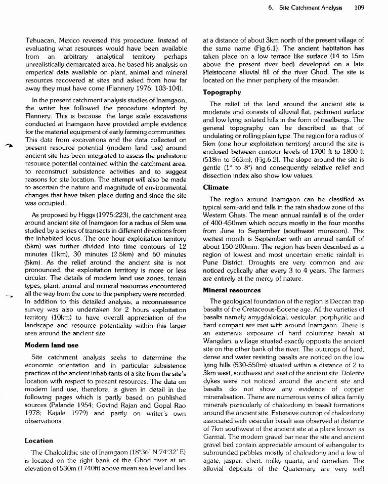
at a distance of about 3km north of the present village ofthe same name (Fig.6.1). The ancient habitation hastaken place on a low terrace like surface (14 to 15mabove the present river bed) developed on a latePleistocene alluvial fill of the river Ghod. The site islocated on the inner periphery of the meander.
Topography
The relief of the land around the ancient site ismoderate and consists of alluvial flat, pediment surfaceand low lying isolated hills in the form of inselbergs. Thegeneral topography can be described as that ofundulating or rolling plain type. The region for a radius of5km (one hour exploitation territory) around the site isenclosed between contour levels of 1700 ft to 1800 ft(518m to 563m), (Fig.6.2). The slope around the site isgentle (1° to 8°) and consequently relative relief anddissection index also show low values.
Climate
The region around Inamgaon can be classified astypical semi-arid and falls in the rain shadow zone of theWestern Ghats. The mean annual rainfall is of the orderof 400-450mm which occurs mostly in the four monthsfrom June to September (southwest monsoon). Thewettest month is September with an annual rainfall ofabout 150-200mm. The region has been described as aregion of lowest and most uncertain erratic rainfall inPune District. Droughts are very common and arenoticed cyclically after every 3 to 4 years. The farmersare entirely at the mercy of nature.
Mineral resourcesThe geological foundation of the region is Deccan trap
basalts of the Cretaceous-Eocene age. All the varieties ofbasalts namely amygdaloidal, vesicular, porphyritic andhard compact are met with around Inamgaon. There isan extensive exposure of hard columnar basalt atWangdari, a village situated exactly opposite the ancientsite on the other bank of the river. The outcrops of hard,dense and water resisting basalts are noticed on the lowlying hills (530-550m) situated within a distance of 2 to3km west, southwest and east of the ancient site. Doleritedykes were not noticed around the ancient site andbasalts do not show any evidence of coppermineralisation. There are numerous veins of silica familyminerals particularly of chalcedony in basalt formationsaround the ancient site. Extensive outcrop of chalcedonyassociated with vesicular basalt was observed at distanceof 7km southwest of the ancient site at a place known asGarmal. The modem gravel bar near the site and ancientgravel bed contain appreciable amount of subangular tosubrounded pebbles mostly of chalcedony and a few ofagate, jasper, chert, milky quartz, and camelian. Thealluvial deposits of the Quaternary are very well

Tehuacan, Mexico reversed this procedure. Instead ofevaluating what resources would have been availablefrom an arbitrary analytical territory perhapsunrealistically demarcated area, he based his analysis onemperical data available on plant, animal and mineralresources recovered at sites and asked from how faraway they must have come (Flannery 1976: 103-104).
In the present catchment analysis studies of Inamgaon,the writer has followed the procedure adopted byFlannery. This is because the large scale excavationsconducted at Inamgaon have provided ample evidencefor the material equipment of early farming communities.This data from excavations and the data collected on
..- , present resource potential (modem land use) aroundancient site has been integrated to assess the prehistoricresource potential contained within the catchment area,to reconstruct subsistence activities and to suggestreasons for site location. The attempt will also be madeto ascertain the nature and magnitude of environmentalchanges that have taken place during and since the sitewas occupied.
As proposed by Higgs (1975:223), the catchment "reaaround ancient site of Inamgaon for a radius of 5km wasstudied by a series of transects in different directions fromthe inhabited locus. The one hour exploitation territory(5km) was further divided into time contours of 12minutes (I krn), 30 minutes (2.5km) and 60 minutes(5km). As the relief around the ancient site is notpronounced, the exploitation territory is more or lesscircular. The details of modem land use zones, terraintypes, plant, animal and mineral resources encounteredall the way from the core to the periphery were recorded.In addition to this detailed analysis, a reconnaissancesurvey was also undertaken for 2 hours exploitationterritory (10km) to have overall appreciation of thelandscape and resource potentiality within this largerarea around the ancient site.
Modem land use
Site catchment analysis seeks to determine theeconomic orientation and in particular subsistencepractices ofthe ancient inhabitants of a site from the site'slocation with respect to present resources. The data onmodem land use, therefore, is given in detail in thefollowing pages which is partly based on publishedsources (Palande 1954; Govind Rajan and Gopal Rao1978; Kajale 1979) and partly on writer's ownobservations.
Location
The Chalcolithic site of Inamgaon (18°36' N:74°32' E)is located on the right bank of the Ghod river at anelevation of 530m (1740ft) above mean sea level and lies
6. Site Catchment Analysis 109
at a distance of about 3km north of the present village ofthe same name (Fig.6.1). The ancient habitation hastaken place on a low terrace like surface (14 to 15mabove the present river bed) developed on a latePleistocene alluvial fill of the river Ghod. The site islocated on the inner periphery of the meander.
Topography
The relief of the land around the ancient site ismoderate and consists of alluvial flat, pediment surfaceand low lying isolated hills in the form of inselbergs. Thegeneral topography can be described as that ofundulating or rolling plain type. The region for a radius of5km (one hour exploitation territory) around the site isenclosed between contour levels of 1700 ft to 1800 ft(518m to 563m), (Fig.6.2). The slope around the site isgentle (1° to 8°) and consequently relative relief anddissection index also show low values.
Climate
The region around Inamgaon can be classified astypical semi-arid and falls in the rain shadow zone of theWestern Ghats. The mean annual rainfall is of the orderof 400-450mm which occurs mostly in the four monthsfrom June to September (southwest monsoon). Thewettest month is September with an annual rainfall ofabout 150-200mm. The region has been described as aregion of lowest and most uncertain erratic rainfall inPune District. Droughts are very common and arenoticed cyclically after every 3 to 4 years. The farmersare entirely at the mercy of nature.
Mineral resourcesThe geological foundation of the region is Deccan trap
basalts of the Cretaceous-Eocene age. All the varieties ofbasalts namely amygdaloidal, vesicular, porphyritic andhard compact are met with around Inamgaon. There isan extensive exposure of hard columnar basalt atWangdari, a village situated exactly opposite the ancientsite on the other bank of the river. The outcrops of hard,dense and water resisting basalts are noticed on the lowlying hills (530-550m) situated within a distance of 2 to3km west, southwest and east of the ancient site. Doleritedykes were not noticed around the ancient site andbasalts do not show any evidence of coppermineralisation. There are numerous veins of silica familyminerals particularly of chalcedony in basalt formationsaround the ancient site. Extensive outcrop of chalcedonyassociated with vesicular basalt was observed at distanceof 7km southwest of the ancient site at a place known asGarmal. The modem gravel bar near the site and ancientgravel bed contain appreciable amount of subangular tosubrounded pebbles mostly of chalcedony and a few ofagate, jasper, chert, milky quartz, and carnelian. Thealluvial deposits of the Quaternary are very well

108 R.S. Pappu
a. 2 hours catchment radius =mobile economies=hunting/gathering economies =Palaeolithic andMesolithic communities;
b. 1 hour catchment radius =sedentary economy= agricultural economies = Neolithic and latercommunities.
In Vita-Finzi and Higg's analysis of Upper Palaeolithicand later cultural sites, 5km circles were drawn aroundeach site, the area thus circumscribed was designated asthe catchment area. Aweighting factor was introduced tocompensate for decreasing intensity of exploitation asdistance from a site increases as follows. Land within1km radius of the site is weighted 100% (fullyexploited),land between 1 and 2 km is given 50% weighting, landbetween 2 and 3km is given 33% weighting and so on.Percentages of types of land suitable for given activitieswithin the catchment areas were calculated andcomparison of these percentages led Vita-Finzt andHiggs (1970: 28-31) to conclude about the nature andfunction of each site. For example, sites with lowpercentage of Mable lands within catchment areas werethought to be mostly non-agricultural.
Over the last fifteen years, the concept of sitecatchment analysis has been employed at a number ofprehistoric sites/regions in widely seperated countrieslike Yugoslavia (Barker 1975a), Spain (Gilman andThomes 1985), Mexico (Flannery 1976), Peru (West1980), Greenland (McGovern 1980), Italy (Barker1975b), England (Ellison and Harriss 1972), Bulgaria(Dennel and Webley 1975), etc. and this technique hasplayed an important role in the study of prehistoric landuse patterns and palaeoeconomic studies. However, likemost new techniques, site catchment analysis has alsobeen confronted with a number of problems and a greatdeal of criticism has been levelled at this approach.Flannery who employed this technique in his analysis ofEarly Formative villages in Oaxaca, Mexico hasappreciated the basic principles underlying the concept;however, at the same time he has pointed out the majorproblems besetting catchment analysis. He questions theassumptions that the sites are non agricultural if onlysmall percentages of arable land are found within thecatchment circles and argues that population estimatesfor the area must be taken into account in inferring sitefunction from catchment area. For example althoughsmall percentages of arable land may be found within acatchment area, the same may have been quite adequateto support a small prehistoric population (Flannery 1976:93). The other objection often raised against the conceptconcerns the use of modern conditions of environmentand land use as a basis for reconstructing prehistoric landuse (Hodder and Orton 1976: 233). This objection isaptly answered by M.R. Jarman, a close associate of late
Eric Higgs, the former Director of the British AcademyMajor Research Project in the Early History ofAgriculture. He has emphasised that modem situationsshould indeed be taken as one of the critical sources ofinformation, particularly with regard to the land usepotential. However, considerable efforts should be madeto perceive the extent and nature of environmentalchanges during and since the site's occupation (Jarman,Bailey and Jarman 1982: 38-39). There are many otherproblems confronted by archaeologists using sitecatchment analysis such as the exact estimation of thesize and shape of prehistoric catchments andaccurate modelling and ranking of environmentalvariables measured within these catchments (Findlowand Ericson 1980: V). While commenting on theseinherent problems, Dennel (1980: 16) has opined thatthese problems are no more serious than many others inprehistoric archaeology, and the best remedy wouldseem to lie in using statistical techniques for modellingcatchment areas under a variety of spatial boundaries,productivity levels and subsistence strategies to seewhich combinations of each parameter emerge as themost plausible one. To sum up, site catchment analysishas proved to be a valuable device for more than fifteenyears for palaeoeconomic studies. The attention it hasalready received among archaeologists in widelyseparated countries is an accurate reflection of itsimportance.
As far as we are aware, the concept of site catchmentanalysis has not yet been introduced in archaeologicalstudies in India. The Chalcolithic site of Inamgaon offersan excellent opportunity to undertake such type ofinvestigations. The present study is, therefore, the firstofits kind to be carried out for any archaeological site in thecountry.
Methodology
Site catchment analysis necessarily involves threesteps. Firstly, one must delimit the exploitation territoryof a site, that is to say, one must estimate theapproximate size of the area regularly exploited from thesite. Secondly, one must establish a relevantcategorisation of resources within this area and finallydescribe the distribution of resources within the territory.The resources ascertained are then mapped inseveral ways in terms of modern land use, soil types,geomorphic units, etc. The attempt is then made tocalculate the amount of various types of land categories(in hectares or acres) available and the resourcedistribution within them. This framework for catchmentanalysis proposed by Vita-Finzi and Higgs (1970) startswith a specified catchment area and tries to evaluate theresource potential within it. Flannery in his study ofcatchment analysis of formative villages in Oaxaca and
-.
Tehuacan, Mexico reversed this procedure. Instead ofevaluating what resources would have been availablefrom an arbitrary analytical territory perhapsunrealistically demarcated area, he based his analysis onemperical data available on plant, animal and mineralresources recovered at sites and asked from how faraway they must have come (Flannery 1976: 103-104).
In the present catchment analysis studies of Inamgaon,the writer has followed the procedure adopted byRannery. This is because the large scale excavationsconducted at Inamgaon have provided ample evidencefor the material equipment of early farming communities.This data from excavations and the data collected onpresent resource potential (modem land use) aroundancient site has been integrated to assess the prehistoricresource potential contained within the catchment area,to reconstruct subsistence activities and to suggestreasons for site location. The attempt will also be madeto ascertain the nature and magnitude of environmentalchanges that have taken place during and since the sitewas occupied.
-.
As proposed by Higgs (1975:223), the catchment areaaround ancient site of Inamgaon for a radius of 5km wasstudied by a series of transects in different directions fromthe inhabited locus. The one hour exploitation territory(5km) was further divided into time contours of 12minutes (Ikrn), 30 minutes (2.5km) and 60 minutes(5km). As the relief around the ancient site is notpronounced, the exploitation territory is more or lesscircular. The details of modem land use zones, terraintypes, plant, animal and mineral resources encounteredall the way from the core to the periphery were recorded.In addition to this detailed analysis, a reconnaissancesurvey was also undertaken for 2 hours exploitationterritory (Iflkrn) to have overall appreciation of thelandscape and resource potentiality within this largerarea around the ancient site.
Modern land use
Site catchment analysis seeks to determine theeconomic orientation and in particular subsistencepractices of the ancient inhabitants of a site from the site'slocation with respect to present resources. The data onmodem land use, therefore, is given in detail in thefollowing pages which is partly based on publishedsources (Palande 1954; Govind Rajan and Gopal Rao1978; Kajale 1979) and partly on writer's ownobservations.
Location
The Chalcolithic site of Inamgaon (18°36' N:74°32' E)is located on the right bank of the Ghod river at anelevation of 53 Om (1740ft) above mean sea level and lies
6. Site Catchment Analysis 109
at a distance of about 3km north of the present village ofthe same name (Fig.6.1). The ancient habitation hastaken place on a low terrace like surface (14 to 15mabove the present river bed) developed on a latePleistocene alluvial fill of the river Ghod. The site islocated on the inner periphery of the meander.
Topography
The relief of the land around the ancient site ismoderate and consists of alluvial flat, pediment surfaceand low lying isolated hills in the form of inselbergs. Thegeneral topography can be described as that ofundulating or rolling plain type. The region for a radius of5km (one hour exploitation territory) around the site isenclosed between contour levels of 1700 ft to 1800 ft(518m to 563m), (Fig.6.2). The slope around the site isgentle (1° to 8°) and consequently relative relief anddissection index also show low values.
Climate
The region around Inamgaon can be classified astypical semi-arid and falls in the rain shadow zone of theWestern Ghats. The mean annual rainfall is of the orderof 400-450mm which occurs mostly in the four monthsfrom June to September (southwest monsoon). Thewettest month is September with an annual rainfall ofabout 150-200mm. The region has been described as aregion of lowest and most uncertain erratic rainfall inPune District. Droughts are very common and arenoticed cyclically after every 3 to 4 years. The farmersare entirely at the mercy of nature.
Mineral resources
The geological foundation of the region is Deccan trapbasalts of the Cretaceous-Eocene age. All the varieties ofbasalts namely amygdaloidal, vesicular, porphyritic andhard compact are met with around Inamgaon. There isan extensive exposure of hard columnar basalt atWangdari, a village situated exactly opposite the ancientsite on the other bank of the river. The outcrops of hard,dense and water resisting basalts are noticed on the lowlying hills (530-550m) situated within a distance of 2 to3km west, southwest and east of the ancient site. Doleritedykes were not noticed around the ancient site andbasalts do not show any evidence of coppermineralisation. There are numerous veins of silica familyminerals particularly of chalcedony in basalt formationsaround the ancient site. Extensive outcrop of chalcedonyassociated with vesicular basalt was observed at distanceof 7km southwest of the ancient site at a place known asGarmal. The modem gravel bar near the site and ancientgravel bed contain appreciable amount of subangular tosubrounded pebbles mostly of chalcedony and a few ofagate, jasper, chert, milky quartz, and carnelian. Thealluvial deposits of the Quaternary are very well
•...••....o
::t:J.Cn;;p
:gt:
27 K MANClloNT SITE (REGIONAL CENTR£)
*:-~"'>
A10D~RN :-VILLAGE ",
GARMAL 3KM GOTI(HILA (FARMS TEAO)(CHALCEDON'Y OUTCROP)
WALI(I (SEASONAL CAMP)
8~ ~2kM
F;g. 6.1 Cha/cOlithic lnamgaon and its satellites.

6. Site Catchment Analysis 111
SKM
-
::.-- ---- ---- - --- - - --- - - --
N
5 K MLEGEND
ANCIENT SITEmo~~F-=:.=It=::=::I~
LAND BELOW 1700 FEET
LAND BETWEEN 1700-1750 FEET
LAND BETWEEN 1750-1800 FEET
LAND ABOVE 1800 FEET
Fig. 6.2 Inamgaon, topography.
112 R.S. Pappu
preserved around the ancient site. Gravel, sand, silt andclay are the main components of the alluvium. Thealluvium as a whole is predominantly of fine nature (siltand clay) and has a thickness varying from 12 to 15m.Silty deposits are traversed by Kankars (calcareousconcretions) of different forms, sizes and shapes.
Soils
The soils in this low rainfall region around the ancientsite are pedocal type black soils or vertisols. Soils with adepth of 30cm or less are described as shallow, thosehaving depth varying from 30cm to 100cm as mediumand those with a depth over 100cm as deep black soils.The distribution of these three types of soils around theancient site is shown in Fig. 6.3.
Deep black soils occupy a very small portion in the5km catchment area. They are deep black in colour andare highly fertile thereby supporting excellentvegetational growth. They are alkaline with pH varyingfrom 7.5 to 8.5. The soils are heavy textured with a claycontent varying from 40% to 60%. The main claymineral is montmorillonite and show strong swelling andsevere shrinkage properties under changing moistureconditions leading to heavy fissuring and deep crackingon drying. As a result of falling surface material into thecracks, the whole soil gets churned up. Hence they areoften referred as self ploughing soils (Joshi and Deotare1983: 17). Medium black soils which are also goodarable possess more or less the same characters asexhibited by deep soils but to a lesser degree. Theseoccupy major portion in the 5km catchment area. Theyare mildly alkaline and are poor in nitrogen and organicmatter but contain adequate amount of potash and lime.Shallow soils also occupy major portion in 5kmcatchment area. These are relatively low in organicmatter and usually quite poor in fertility.
Natural vegetation
The natural vegetation occurring around lnamgaonconsists of thorn and scrub type forest represented byxerophytic plant species. The region within 5 km radiusfrom the ancient site is at present sparsely wooded and60'X. to 70% of the land is under cultivation. The seriousdepletion of natural vegetal cover has taken place as aresult of dearing land for agriculture, felling trees andovergrazing. The following types of vegetation arecommonly met with : Bor (Zizyphus jujuba Larnk.),Chinch (Tamarindus indica Linn.), Babhul (Acaciaerebice), Khair (Acacia catechu), Tarati (CapparisHorrida Linn.), Nepati (Capparis aphylia Roth.) etc. Thegrowth of these species is usually small and stunted.Wherever the soil is better and additional soil moisture isavailable as along the river banks, Babhul (Acaciaerebice) shows good growth.
Fauna
The reclamation in recent years of vast areas of scrubjungle and waste land and the evergrowing pressure ofpopulation have a disastrous effect upon wild life. Thisprocess of deforestation has naturally affected the wildanimals in the region and the only species seen presentlyare fox (Canis bengalensis Show.), jackal (Canis aureusLinn.), wolf (Canis lupus Linn.) and hare (Lepusreticeucletus).
A number of varieties of birds are found in the region.Among the birds occurring all the year round, thecommon ones are spotted owl, crow, parrot, pigeon,sparrow, quail and crane. The pool in the bed of the riverGhod near ancient site abounds in fishes. Thedomesticated animals include, cow, buffalo, oxen, horse,sheep, goat, ass, cat, dog, etc.
Agriculture
The present agriculture in the region depends mainlyon the rainfall received from southwest monsoon. Thedistribution of rainfall is most uneven and erratic and theregion is chronically drought affected. This situation hasimproved to some extent in recent years because of theconstruction of a dam on the river Ghod some 20kmupstream at Chinchani which irrigates large tracts of landaround Inamgaon. Both Khari! (summer) and Rabi(winter) types of crops are raised. The main crops of theregion at present are as follows :
Graincrop
Indian millet - Jveri (Sorghum vulgare),Spiked millet - Bajri (Pennisetum typhoides),Wheat - Gahu (Triticum eestivum}, Rice-Bhat (Oryza sativa).
Horse gram - Kulith (Dolichos biilorus),Gram - Harbara (Cicer otietinum), Cajanpea - Tur (Cajanus indicus), Green gram-Mug (Phaseolus mungo).
Sesame - Til (Sesamum indicum), Linseed -Alshi (Linum usitatissimum), Safflower-Karadi (Carthamus tinctorious).
Pulses
Oil Seeds:
Among these, Indian millet (Jveri) is grown on largescale and forms the staple food in the region. Rice isgrown in small carefully tended plots.
Environmental changes
The Chalcolithic site of Inamgaon was continuouslyinhabited for a period of nearly 900 years between 1600B.C. and 700 B.c. In order to assess the development ofagriculture at Inamgaon by means of site catchmentanalysis, we must first estimate as far as possible thenature and the magnitude of the environmental changesduring and since the site was occupied.

As the region under study is tectonically stable, thearchaeological settlement has not been disturbed. Thelandscape has also not changed much during the last3600 years. The river Ghod was flowing at the same bedlevel as it does today. The alluvial terrace situated 15mabove the present bed and on which ancient habitationwas located was not then dissected by gully erosion andcovered by mineral rich black soil. The region at presentenjoys a semi-arid monsoonal type climate and similartype of climate with fluctuations in the form of slightly
6. Site Catchment Analysis 113
higher or lower precipitation than the present oneprevailed during the Chalcolithic times.
Attempts have been made to understand the nature ofclimatic changes during the Mid Holocene times.Palaeobotanical. archaeozoological and cultural studiesat the ancient site of Inamgaon have indicated culturaldeterioration between 1000 B.C. and 700 B.C. Thisphenomenon has been explained as a result of frequentdroughts which occurred due to relatively dry climate
5KM
~
!ITK]..:................·.·a ..
C"]~
LEGEND
ANCIENT SITE
5 K M
N
t• FARMSTEAD
DEEP SOIL-HEAVY ARABLE
MEDIUM SOIL-GOOD ARABLE AND GRAZING
SHALLOW SOIL-ROUGH GRAZING
Fig. 6.3 Inamgaon, soil types and modem land use.

114 RS. Pappu
(Dhavalikar 1984: 144). The climatic fluctuations in theform of wet and dry phases have been suggested duringthe Mid Holocene period. The suggested climaticchanges are based on the climatic sequence worked outat Rajasthan lakes by Krishnamurty et el. (1981) which isas follows:
5000 - 3700 years B.P. Relatively wet.3700 - 3500 years B.P. Relatively dry.3500 - 3000 years B.P. Relatively wet.3000 - 2500 years B.P. Distinctly dry.
There was thus a deterioration in climate in the form ofdry spell around 3700 years B.P. and it continued upto3500 years B.P. The climate again relatively became wetfrom 3500 years ·B.P. onwards. There was a drasticchange in the climate around 3000 years B.P. whenincreasing aridity set in. The effects of these climaticfluctuations are very well reflected in the materialremains of the Malwa, Early Jorwe and the Late Jorweperiods at the ancient site.
The other environmental changes that have occuredsince the region was occupied by early farmers arevegetational degradation and soil erosion. The naturalvegetation around Inamgaon has been reduced to relictstands by deforestation resulting from sheep and goatgrazing, tree felling and extensive cultivation. The factorsaffecting soil erosion are: (1) the amount and intensity ofprecipitation and wind velocity; (2) topography withspecial reference to slope of land; (3) physical andchemical properties of soils and (4) vegetational cover.
The black soils in the form of palaeosols buried underhabitational deposits of Chalcolithic period at Chandoli,Nevasa, Sonegaon and Navadatoli and also the modernblack soils of the same region in the vicinity of theseChalcolithic sites were investigated by Mujumdar (1974:147). These investigations have indicated that modernblack soils compare poorly with the fossil soils andexhibit degraded pedological characters. (Table 6.1).Fossil soils are characterised by higher proportion oforganic matter and better development of soil profilewhich is suggestive of dense vegetational cover.
TABLE 6.1
Results of chemical analysis of soilsamples from Inamgaon.
pH Orga- N% P%niccarbon%
1. Buried black soil 8.5underlying Malwamound
1.323 0.067 0.0687
2. Modern deep black 9.00 0.751 0.065 0.0675soil
3. Modern medium 8.5 0.483 0.042 0.0621black soil
4. Modern shallow 8.2 0.420 0.036 0.0632black soil
5. Yellow silt 8.00 0.199 0.060 0.0468below buriedblack soil
In recent years, agricultural scientists have carried outstudies to assess the magnitude of soil erosion over aperiod of 75 to 100 years in different parts of the country.The studies undertaken of the present black soils in thesemi-arid tract of Sholapur district, Maharashtra State arerelevant and also instructive for our investigations. Thesestudies revealed that soil which initially belonged toeither deep or medium soil groups at 2 to 4'1" slopes-some 75 years, ago has now become shallower due tolossof regolith cover and can be classed in the mediumor shallow soil groups (Vaidya and Sahasrabuddhe 1973:125).
-
The studies concerning the environmental changesaround the ancient site of Inamgaon thus indicate thatthe landforms within the catchment area have been fairlystable over the last 4000 years. These studies also showthat the vegetational degradation and regolith loss havetaken place and ancient soils were of better qualitypossessing good arable potential. Interdisciplinarystudies point out that there were climatic fluctuations inthe form of wet and dry phases. Increasing aridity set inby about 1000 B.c. which led to the decline of farmingcommunities and final desertion of the settlement byabout 700 B.C.Discussion
The early farming communities at Inamgaon mainlysubsisted on farming, but hunting, fishing, collection offorest products and pastoral activity also played animportant role in their subsistence activities. Dhavalikar(1984: 137) has shown that Chalcolithic agriculture wasnot confined to narrow alluvial patches and the black soilwhich is known for its fertility and moisture retainingcapacity was also cultivated. The black soil, therefore,was a significant factor in the efflorescence ofChalcolithic cultures of the Deccan. It is for this reasonthat our approach to site catchment analysis is mainlybased on the distribution of arable land around theancient settlement. Modern land use categories and inparticular soils will be taken as a guide line for thereconstruction of prehistoric land use classes. It hasalready been shown that landscape during theChalcolithic times was not much different from thepresent one and soil conditions in general were alsobetter. We can, therefore, safely presume that the
-

distribution of ancient and modem resource spacescorrespond systematically to one another.
The one hour exploitation territory is almost circular asthe relief within 5km radius is quite moderate. Theperimeter of this exploitation territory is 5km and thetotal area is 78.57 sq km i.e. 7857 hectares. The areasenclosed within lkm (12 minutes walking distance),2.5km (30 minutes walking distance) and 5km (60minutes walking distance) from inhabited locus are 3.142sqkm (314.20 hectares), 19.65 sqkm (1965 hectares) and78.58 sqkm (7857 hectares) respectively. The areaoccupied by each type of black soil namely deep,medium and shallow within concentric rings is shown inthe Table below:
TABLE 6.2Distribution of soils in concentric territorial rings
Area Deep Medi- Shall- Water Totalblack um owsoil black black
soil soil
Within 1 km Area in 0.60 1.75 0.60 0.20 3.15radius sq km
Percent- 19.0555.5519.05 6.35 100.0age
Between area in 2.50 9.90 3.10 1.0016.50lkm & 2.5 sq kmkm radius
Percent- 15.1560.0018.80 6.05100.0age
Between2.5km&5km radius
Area insqkm
6.2520.5528.55 3.5558.90
Percent- 10.5534.8548.55 6.05100.0age
The total arable land (deep and medium black soils)around lkm radius is 2.35 sq km (235 hectares) andaround 2.5km radius is 12.40 sq km (1240 hectares).Dhavalikar and Possehl (1974:41-42) have estimated theapprox1mate population of Chalcolithic lnamgaon asbetween 800 and 1200 and the arable land required forthis population as between 250 (minimum) to 800(maximum) hectares. According to our calculations, theavailable arable land around 2.5km radius comes toabout 1240 hectares. This land, therefore, was more thanadequate for the Chalcolithic farmers.
We have already established the categorisation of thepresent resources around ancient site. This data will nowbe integrated with the data obtained from excavations toreconstruct subsistence activities and to suggest reasons
6. Site Catchment Analysis 115
for site location. The systematic excavations andscientific investigations conducted at the ancient site ofInamgaon have brought to light ample evidence for thematerial equipment of the Chalcolithic communities. Theimportant plant remains, faunal remains and objectsfashioned on inorganic and organic materials recoveredfrom excavations are listed below:1. Plant remains (Kajale, 1979; Kajale et al. 1976)
a. Cultivated - Barley (Hordeum vulgare Linn.), Wheat(Triticum Sp.), rice (Oryza Sp.), lentil (Lens escu/entaMoench), horse gram (Dolichos bitlovus Linn.).hyacinth bean (Dolichos /ab/ab Linn.), grass pea(Lathyrus sotious Linn.), pea (Pisum arvense Linn),black gram (Phaseo/us mungo), green gram(Phaseo/us aureus. Roxb.).
b. Wild - Ber (Zizyphus jujuba Lamk.), Jamun (Syzigiumcumini Linn), behada (Terminalia ba/erica Roxb.),wild date (Phoenix sy/vestris Roxb.)
2. Faunal Remains (Thomas 1984a)
a. Domesticated animals - humped cattle (Bos indicus),buffalo (Buba/us bubelis), goat (Ceprehircusaegagrus), sheep (Ovis eries}, dog (Canis familavis),horse (Equus cabal/us), ass (Equus esinus), pig(Susscrofa crisatatus).
b. Wild animals - Sambar (Cervus unicolor}, Chita/ (Axisaxis), black buck (Anti/ope cervicapre), four homedantelope (Tetracerus quedricomis), hare (Lepusniqricollis), Mongoose (Herpestes edwards).
c. Birds, reptiles, fishes, molluscs, and crabs.
3. Objects fashioned on inorganic materials (Dhavalikar,1984a,b.)
a. Clay - pottery and terrocota objects.
b. Chalcedony and other silica family minerals bladeindustry, and beads.
c. Basalt stone objects such as saddle querns, muliersor grinders, rubber stones, sling balls, hammer stones,pounders, polished stone axes, etc.
d. Kankars Lime balls.
e. Copper copper objects such as bangles, anklets,anklets, axes, rings, chisels, arrowheads, needles, fishhooks, beads, etc.
f. Gold gold objects such as beads.
4. Objects fashioned on organic materials bone toolssuch as points, punches, chisels and awls and a fewobjects on ivory and shells.
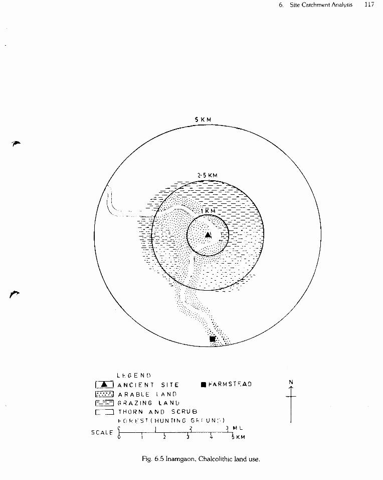
The attempt will now be made to evaluate thedistribution of prehistoric resources within territory rings(catchment circles) of lkm, 2.5km and 5km. radii(Fig.6.4-5).

116 R.5.Pappu
*-~/'/" /~4../,<::)0/
(,,~/..."("~,,.. LEG END
". 1 CLAY
2 CHALCEDONY3 HARD BASAL TI. KANKARS CULTIVATED PLANTS
6 WILD PLANTS7 SMALL GAME
8 BIG GAME
A ANCIENT SITE
MARl NE SHELLS-20Q K M~~~-+--t
Fig. 6.4 Inamgaon. Chalcolithic resources,
5KM
2·5 KM
:-'~j?:?("::'::?>,-' '~,':.':::' .,c·,,:-:-:: ;--,,::-~......r::::: :0:.
Li-,GENO
~ IANCIENT SITE .t-ARMST:::AD
h'~::···1A R A B L E:: LAN [)E-~ G IiA Z I N G LAN [j
[~-=:JTHO R NAN 0 S C RUBI- 0 R F S T ( HUN TI N G G~. (U N :-, )
! ! 2 3 t-1lSCALE ' ,5 5 ~ S KM
Fig. 6.5 Inamgaon, Cha\colithic land use.
6. Site Catchment Analysis 117
N
t
118 RS. Pappu
1. Within the settlement
Several resources were available within and in closevicinity of the village such as clay for pottery, terracotaobjects and house building material, chalcedony for lithicartefacts, kankar and shells for lime making, typha grassfor roof-thaching, domestic animals and fishes and otheraquatic animals.
2. From the settlement to lkm radius (12 minuteswalking distance)
There is well developed arable black soil (deep andmedium) within the area enclosed bv the inner bend ofthe meander loop of the Ghod river. It appears that amajority of the fields were located in this portion and theChalcolithic farmer had rarely crossed the river foragricultural purposes. Barley was the staple food andwas planted more frequently than wheat because it has ashort growing season, requires less water and withstandsalkaline soils prevalent in the area. The occurrence ofboth Khari! (summer) and Rabi (winter) crops during theChalcolithic times indicates that the early farmerspractised rotation of crops. The intensive agriculture waspossible because of artificial irrigation during Early Jorweperiod (Dhavalikar 1984).
The area on the other bank (left) within 1km radius ismostly covered by thin soil cover and bare outcrops ofbasalt. Agriculture was rarely practised on this side of theriver and this area may have been used as pasture landand also for hunting small' game. There is an extensiveoutcrop of hard compact columner basalt on the leftbank near the present village, Wangdari. The rock showsboth horizontal and vertical joints and blocks of suitablesize and shape come out easily because of this jointpattern. The Chalcolithic man had just to cross the riverto reach this resource. Another small exposure of hardbasalt is located in the river bed itself on the right bank.Both these basalt outcrops have served as a main sourceof raw material for early farming communities forpreparing different types of stone objects.
Lithic blade industry is one of the salient features of theChalcolithic culture. The raw material used for preparinglithic artifacts was mainly chalcedony and occasionallyother silica family minerals such as chert, jasper, milkyquartz, carnelian, agate, etc. Sub-angular tosub-rounded nodules and pebbles of chalcedony andother silica family members are found in plenty in thegravel bar developed in the river around the site and alsoin the gravel deposits of Older Alluvium. This was thenearest source of chalcedony for the Chalcolithiccommunities for preparing lithic artifacts and beads.
Pottery has been found in enormous quantities in allthe cultural periods at ancient Inamgaon. Thepredominant pottery in all the periods is a black-on-red
painted were with a few variations in shape, fabric,design, etc. The potter's kilns, one each of period I and II,were recovered in the course of excavations. The potterywas thus made locally. The clay, the main raw materialrequired for pottery preparation, is available inabundance in the finer alluvial deposits exposed on theriver banks. The good quality clay is generally formedwhen stagnant pool water conditions (ponds) prevail.Such situations were observed at a number of placesaround the ancient site within a radius of lkm.
It has been noted that the Chalcolithic people werepreparing lime on a large scale. There is evidence of limeballs and also lime kiln. It is probable that kankars(calcareous concretions) which are found associated withOlder Alluvium and occurring in various sizes andshapes around ancient site were mostly used forpreparing lime. Riverine shells which also occur in thealluvium might also have been employed to some extentfor this purpose.
3. Area enclosed between 1 and 2.5km radiusfrom the ancient site (12 to 30 minutes walkingdistance).
A few fields may have been located in this regionespecially along the left bank, within a distance of 2kmfrom the site whenever there was a good arable land.This area otherwise was mainly used on both the sides ofthe river as grazing ground. The major portion of thisland might have been covered by natural thorn and scrubvegetation during Chalcolithic times. The seasonal wildfood plants might have been gathered from this area.This area was rich in small and big game and had servedas an ideal hunting ground. A number of outcrops ofhard dense basalt also occur in this zone. Basalt fromthese outcrops might have been also occassionally usedfor preparing stone objects.
4. Area enclosed between 2.5km and 5km radiusfrom the site (30 to 60 minutes walking distance)
At present this area is not forested but duringChalcolithic times, it was like the adjacent one definitelycovered by thorn and scrub type forest. We haveevidence from the excavations of faunal remainsparticularly of the following important wild speciesSam bar (Cervus unicolor), Chitel (Axis axis), black buck(Antilope cervicapra), and four horned antelope(Tetracerus quadricomis). At present only small gamelike hare, jackal, fox and very rarely wolf are observed inthis zone. The presence of above mentioned faunalassemblage during the Chalcolithic times indicates arelatively thick vegetation cover than the present oneand the area was teeming with varieties of deer and otherwild fauna. As this zone lies quite far away from theancient site, it appears that no agricultural activity was

carried out here. However, we have evidence for theexistence of a hamlet of the main site situated 5km southof the ancient site where there is development of deepsoil especially along river bank (Gotkhila) (Fig.6.1). Thiscamp might have served as a seasonal camp (farmstead)of the main regional centre.
Little beyond tis zone of 5km radius, that is at adistance of 7km southwest of the ancient site, anextensive exposure of chalcedony associated withvesicular basalt was noticed at a place called Garmal.Artefacts in different stages of manufacture were foundhere in Significant number. It is probable that this mineralresource was also exploited to some extent for fashioninglithic artefacts. It is significant to note that this chalcedonyresource is located at a distance of 3km southwest ofGotkhila, a satellite of the main settlement.
In the course of excavations, the evidence wasavailable for copper, gold and ivory objects. As thesematerials are not locally available, we have to search fortheir nearest sources. The remains probably of a furnacefor smelting copper was recovered during theexcavations. This evidence clearly indicates that thecopper was smelted at the site and the objects werefashioned locally. Native copper has been reported atRasin (18"20', 74"45') in Ahmednagar district, Jalkawadi(1T24', 73"45') in Satara district and Ladole (18"05',75"47') in Sholapur district, all in Maharashtra State(Geology and Mining Resources of Maharashtra 1968:105). All these localities are situated within a radius of 60to 150km from the ancient site. It is to be noted, however,that the copper in all these localities occurs mostly innative form in insignificant quantity and hence these
6. Site Catchment Analysis 119
occurrences have only academic significance. Theselocalities may not have been, therefore, exploited. Thenearest source of copper for the Inamgaon Chalco lithicpeople was in the present Gulbarga and Raichur districtsin Karnataka State. The good quality copper ores such aschalcopyrite, cuprite and malachite have been reported.These localities are situated about 200 to 300km south ofthe ancient site of Inamgaon (Sri Sathyan 1966: 22;Abhishankar 1970: 15). For gold objects also the nearestsource was Hatti in Raichur district (Abhishankar 1970:15) and Gadag in Dharwad District (Palande 1959: 16).Disc beads of ivory have been found in the excavations.This item also might have come from south Karnataka. Afew marine shells were also recovered in theexcavations. These were perhaps obtained from the westcoast region lying about 200km west of the ancient site.Copper, gold and ivory objects were, however, used ona restrictive scale. This suggests that these objects wereluxury items used by a small proportion to display andstore their wealth. Dhavalikar (1984: 73) has suggested.that the Chalcolithic people might have exchangedmaterials with their contemporaries including the hunter-gatherers and this process has been described asreciprocal exchange characteristic of a chiefdom society.
The distribution of various resources within concentricrings of lkm, 1 to 2.5km radius and 2.5 to 5km radius aresummarised in the table 6.3 :
On the basis of this data, we can say that theChalcolithic Inamgaon needed a circle of 2.5km radius tosatisfy its basic agricultural requirements. Grains of thedomesticated species were cultivated in the vicinity ofthe site within walking distance of 15 to 20 minutes. An
TABLE 6.3
Distribution of Resources in Catchment Circles
Plant Resources Animal Resources Inorganic Resources
Cultivaed Wild Dornesti- Wild Wild Clay Chal- Basalt Kankarcated small big cedony
game game
Withinradius 3 2 ')
.)
of lkm
Between1-2km 2 2 2 2 2 2 2 2
Between2.5-5km 2 4 2 3 2 2radius
1= Abundant 2 = Moderate 3 = Traces 4 = Absent.

120 R.S. Pappu
area enclosed between 2.5km and 5km radius satisfiedalmost all the other resource requirements such as smalland big game, wild plants, and to some extent mineralresources. This area might have served as an ideal forhunting small and big game and for collecting forestproducts. All these evidence clearly shows that theChalcolithic farmers of Inamgaon mostly exploited localresources lying within a radius of 5km from thesettlement (Fig.6.5).
There is also evidence for the setting of temporarycamps near the main regional centre (Fig.6.1). Theseasonal camp of the main settlement was located at aplace known as Gotkhila situated 5km south of theancient site. This camp served as an annexe of the mainsite. It occupies an area of about 0.40 to 0.50 hectares. Itappears that a group of farmers from the main regionalcentre set up temporary camps in such favourablelocalities where they could carry out a number ofactivities such as planting, harvesting, collection of wildplants and hunting. Another such camp was located atWalki which lies at a distance of 27km west of the ancientsite of Inamgaon. The excavations are in progress at thissite. There is development of good deep black soil botharound Walki and Gotkhila and because of this mostsignificant ecological factor, these seasonal camps wereestablished by early farmers of Inamgaon.
The Chalcolithic communities established theirsettlement in the form of regional centre at Inamgaonbecause of the number of prevailing favourableecological factors. The proximity to perennial supply of
water is the most important determinant for theestablishment of any settlement. A deep pool formed inthe meander near the ancient site provided an assuredsupply of water throughout the year. In addition, thisdeep pool supported aquatic creatures and also attractedthe terrestrial animals. The site was located in the innerperiphery of the meander because the meander affordednatural protection from three sides and this was a veryimportant factor from security point at view. The site wasalso established on the elevated terrace surface to avoiddanger from normal flood. The early farmers havedisplayed their intelligence in establishing their site onthe right bank because on this side of the bank, there wasgood arable land, a vast reservoir of forest and presenceof thinly forested rolling plateau. The mineral resourceswere also located in the close vicinity of the site. It, thus,appears that early farmers selected this specific localityfor establishment of their settlement because of theseprevailing favourable ecological niches.
The site catchment analysis when applied to a singlesite gives a rough idea about the way in which theresources were exploited by any community and is alsohelpful to some extent in assessing the economicpotential of an archaeological site. However, there isneed to apply the method of site catchment analysis in aregional context rather than to individual sites. It is onlywhen the catchment characteristics of a series of sites areexamined statistically in search of one or more repetitivepatterns then only the techniques serves to define thesystem of land use.


![?ReZ`_R]Zd^ ]Z\V_VU e` ?RkZd^+ 3YRXhRe - Daily Pioneer](https://static.fdokumen.com/doc/165x107/63149b25b1e0e0053b0ecf0b/rezrzd-zvvu-e-rkzd-3yrxhre-daily-pioneer.jpg)


![B^\TaTU^a\b\Ph[^^Zd]UPXaPcUXabc QdcWT[_] - Daily Pioneer](https://static.fdokumen.com/doc/165x107/63256fdf051fac18490d434e/btatuabphzdupxapcuxabc-qdcwt-daily-pioneer.jpg)