Joshi RV, Chitale SV, Rajaguru SN, Pappu RS, and Badam GL. 1981. Archaeological Studies in the...
32
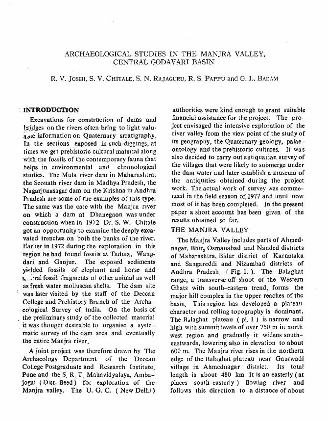
ARCHAEOLOGICAL STUDIES IN THE MANJRA VALLEY. CENTRAL GODAVARI BASIN R. V. JOSHI, S. V. CHITALE, S. N. RAJAGURU, R. S. PAPPU and G. L. BADAM " INTRODUCTION Excavations for construction of dams and on the rivers often bring to light valu- ilPle information on Quaternary srratigraphy. In the sections exposed in such diggings, at times we ge t prehistoric cultural mateJial a 10Dg with the fossils of the contemporary fauna that helps in environmental and chronological studies. The Mula river dam in Maharashtra, the Seonath river dam in Madhya Pradesh, the Nagarjunasagar dam on the Krishna in Andhra Pradesh are some of the examples of this type. The same was the with the Manjra river on which a dam at Dhanegaon was under construction when in 19'12 Dr. S. W. Chitale got an opportunity to examine the deeply exca- vated trenches on both the banks of the river. Earlier in 1972 during the exploration in this region he had found fossils at Tadula, Wang- dari and Ganjur. The exposed sediments yielded fossils of elephant and horse and fossil fragments of other animal as well as fresh water molluscan shells. The dam site was later visited by the staff of the Deccan College and Prehistory Branch of the Archa- eological Survey of J ndia. On the basis of the preliminary study of the collected material _ it was thought desirable to organise a syste- matic survey of the dam area and eventually the entire Manjra river. A joint project was therefore drawn by The Archaeology Department of the Deccan College Postgraduate and Research Institute, Pune and the S. R. T. Mahavidyalaya, Amba- jogai (Dist. Beed) for exploration of the Manjra valley. The U. G. C. (New Delhi) authorities were kind enough to grant suitable financial assistance for the project. The pro- ject envisaged the intensive exploration of the river valley from the view point of the study of its geography, the Quaternary geology, palae- ontology and the prehistoric cultures. It was also decided to carry out antiquarian survey of the village51 that were likely to submerge UDder the dam water and later establish a museum of the antiquities obtained during the project work. The actual work of survey .vas comme- nced in the field season of, 1977 and until now most of it has been completed. In the present paper a short account has been given of the results obtained so far. THE MJ\NJRA VALLEY The Manjra Valle) includes parts of Ahmed- nagar, Bhir, Osmanabad and Nanded districts of Maharashtra, Bidar district of Karnataka and Sangareddi and Nizambad districts of Andhra Pradesh. (Fig. 1.). The Balaghat range, a transverse off-shoot of the Western Ghats with south-eastern trend, forms the major hill complex in the upper reaches of the basin. This region has developed a plateau character and rolling topography is dominant. The Balaghat plateau (pI. I, is narrow and high with summit levels of over 750 m in north west region and gradually it widens south- eastwards, lowering also in elevation to about 600 m. The Manjra river rises in the northern edge of the Balaghat plateau near Gaurwadi village in Ahmednagar district. Its total length is about 480 km. It is an easterly (at places south-easterly) flowing river and follows this dirrction to a distance of about
-
Upload
deccancollegepune -
Category
Documents
-
view
1 -
download
0
Transcript of Joshi RV, Chitale SV, Rajaguru SN, Pappu RS, and Badam GL. 1981. Archaeological Studies in the...
ARCHAEOLOGICAL STUDIES IN THE MANJRA VALLEY.CENTRAL GODAVARI BASIN
R. V. JOSHI, S. V. CHITALE, S. N. RAJAGURU, R. S. PAPPU and G. L. BADAM
" INTRODUCTION
Excavations for construction of dams and~)'idges on the rivers often bring to light valuilPle information on Quaternary srratigraphy.In the sections exposed in such diggings, attimes we ge t prehistoric cultural mateJial a10Dgwith the fossils of the contemporary fauna thathelps in environmental and chronologicalstudies. The Mula river dam in Maharashtra,the Seonath river dam in Madhya Pradesh, theNagarjunasagar dam on the Krishna in AndhraPradesh are some of the examples of this type.The same was the ca~e with the Manjra riveron which a dam at Dhanegaon was underconstruction when in 19'12 Dr. S. W. Chitalegot an opportunity to examine the deeply excavated trenches on both the banks of the river.Earlier in 1972 during the exploration in thisregion he had found fossils at Tadula, Wangdari and Ganjur. The exposed sedimentsyielded fossils of elephant and horse and~ .;~ral fossil fragments of other animal as wellas fresh water molluscan shells. The dam sitewas later visited by the staff of the DeccanCollege and Prehistory Branch of the Archaeological Survey of Jndia. On the basis ofthe preliminary study of the collected material
_it was thought desirable to organise a systematic survey of the dam area and eventuallythe entire Manjra river.
A joint project was therefore drawn by TheArchaeology Department of the DeccanCollege Postgraduate and Research Institute,Pune and the S. R. T. Mahavidyalaya, Ambajogai (Dist. Beed) for exploration of theManjra valley. The U. G. C. (New Delhi)
authorities were kind enough to grant suitablefinancial assistance for the project. The project envisaged the intensive exploration of theriver valley from the view point of the study ofits geography, the Quaternary geology, palaeontology and the prehistoric cultures. It wasalso decided to carry out antiquarian survey ofthe village51 that were likely to submerge UDderthe dam water and later establish a museum ofthe antiquities obtained during the projectwork. The actual work of survey .vas commenced in the field season of, 1977 and until nowmost of it has been completed. In the presentpaper a short account has been given of theresults obtained so far.
THE MJ\NJRA VALLEY
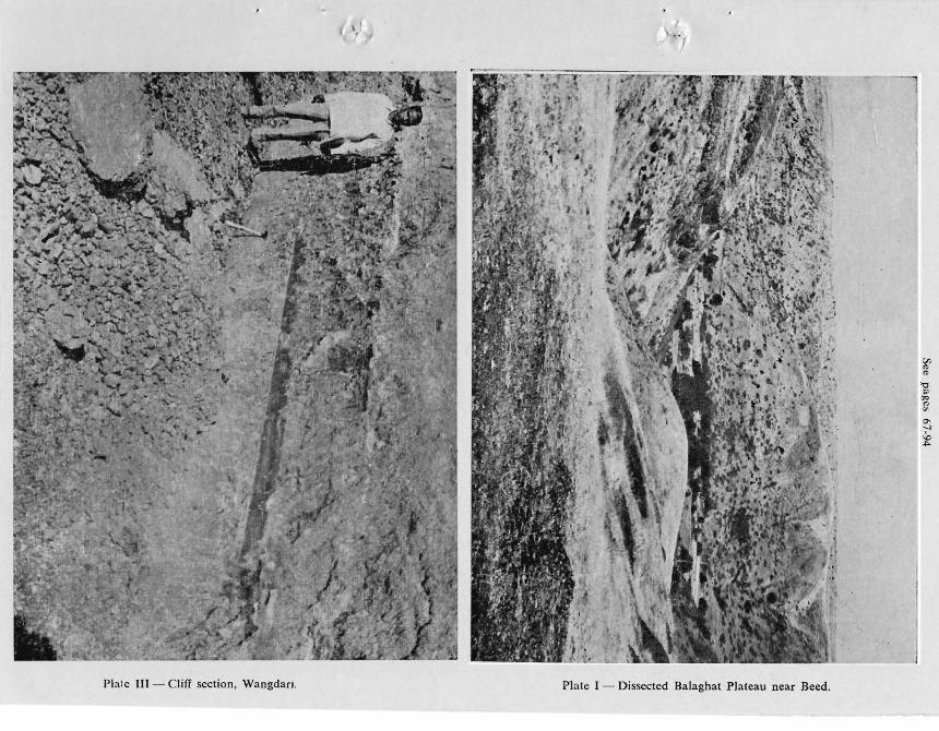
The Manjra Valle) includes parts of Ahmednagar, Bhir, Osmanabad and Nanded districtsof Maharashtra, Bidar district of Karnatakaand Sangareddi and Nizambad districts ofAndhra Pradesh. (Fig. 1.). The Balaghatrange, a transverse off-shoot of the WesternGhats with south-eastern trend, forms themajor hill complex in the upper reaches of thebasin. This region has developed a plateaucharacter and rolling topography is dominant.The Balaghat plateau (pI. I , is narrow andhigh with summit levels of over 750 m in northwest region and gradually it widens southeastwards, lowering also in elevation to about600 m. The Manjra river rises in the northernedge of the Balaghat plateau near Gaurwadivillage in Ahmednagar district. Its totallength is about 480 km. It is an easterly (atplaces south-easterly) flowing river andfollows this dirrction to a distance of about
68 R. V. JOSHI, S. V. CHITALE, S. N. RAJAGURU, R. S. PAPPU and G. L. BADAM
300 km from the source. It then takes almostright angle turn nearSangareddi in AodhraPradesh and flows northwards till its confluencewith the Godavari. This anomalous course ofthe river may be due to the capture of Manjrariver over the plateau of Balaghat by a tributary of Godavari (Dikshit, 1971). Welldeveloped erosional surfaces occur at 800 to500 m above mean sea level both on DeccanTraps as well as on pre-Cambrian formations.These surfaces owe their origin to Tertiarytectonic movements of epeirogenic type andclimatic changes (Dikshit, 1970). Similar types
.of surfaces have been observed almost all overthe Deccan Peninsula (Vaidynadban, 1977).
Geologically the upper and middle reachesof the Manjra valley are covered by theCretaceous - Eocene Deccan Traps. TheArchaeans are met with in the lower parts ofthe valley. Extensive laterite formationscapping Deccan Traps are noticed aroundBidar town. The region experiences a typicalmonsoonal climate and can be classed assemi-arid. The annual rainfall is of the orderof 900-650 mm.
QUATERNARY GEOLOGY
( a) Laterite
Extensive outcrop of laterite was observedon the interfluve between the Manjra and theBhima in Bidar district of Karnataka ( PI. II).Laterite occurs at elevations between 710 and680 m around Bidar town, between 670 and680 m on Hyderabad - Sholapur nationalhigrway between Zahirabad (Andhra Pradesh)and Homnabad (Karnataka) towns. Theroad cutting sections and freshly dug wells inthis area revealed that the depth of lateritevaries from 5 to 15 m and the laterite profileshows characteristic 3 layered structure viz.massive vermiform crust capping lithomargewhich passes into weathered basalt. On thebasis of these field characters we are inclinedto classify this laterite as groundwater type
(Maignien, 1966). These seem to havedeveloped within the zone of fluctuating watertable associated with gently sloping landsurface. The occurrence of two distinctlaterit ized surfaces in the area poses someproblems. Can a laterite form synchronouslyat different levels possibly blanketting surfacesof different ages? Or can a single near-levellaterite surface be differentially lowered, eitherduring the formation or as post-incisionmodification, which gives the impression oftwo chronologically separate sheets or surf~~.Similar types of laterite surfaces occurring .A!~
different elevations were observed by us in theUpper Krishna valley and in the coastalMaharashtra (Guzdar, 1980). Incidently, suchsituation has also been noticed in East Africa(Mcfarlane, 1971 ).
(b) Alluvial deposits
These deposits in the area are confined tobroad and shallow valleys cut into lower pediplained surfces which have discordant relationship with laterite-capped surfaces. In general,the fluvial deposits are of cut-and-fill typeand do not exceed in thickness of more than10 to 12 m. The maximum lateral extent ofthe fluvial formations on both banks of theManjra is not more than 2 km· There aremainly two types of fills ( i ) calcreted yelJowjohbrown silt associated with pebbly and sa~..';'
. gravels, (ii) brownish less calareous clayey ~
silt associated with sandy pebbly gravels.Older fill forms a higher surface at 10 to IS melevations, while later fill occurs as an insetsurface at lower elevations of 6 to 8 m.
IMPORTANT STRATIFIED SITES
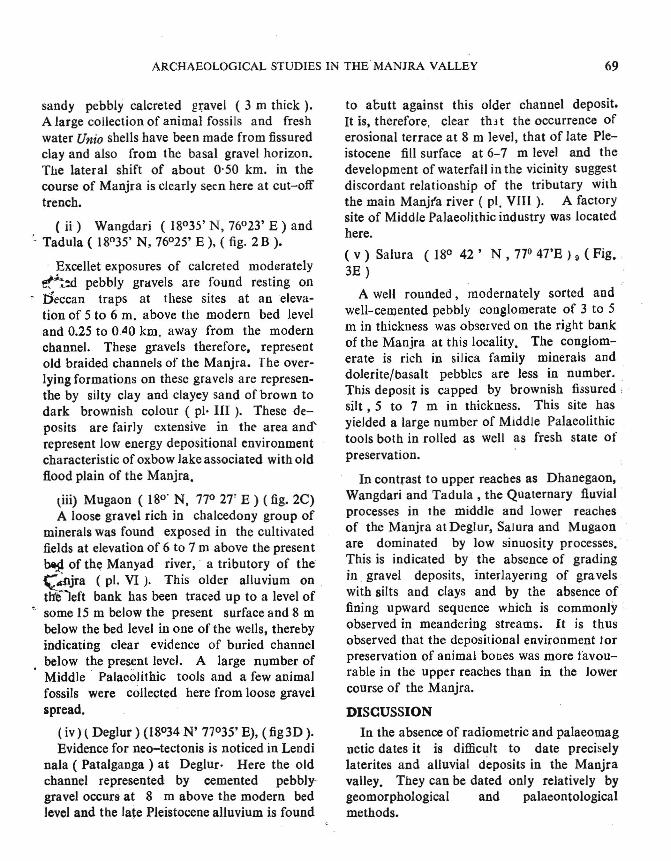
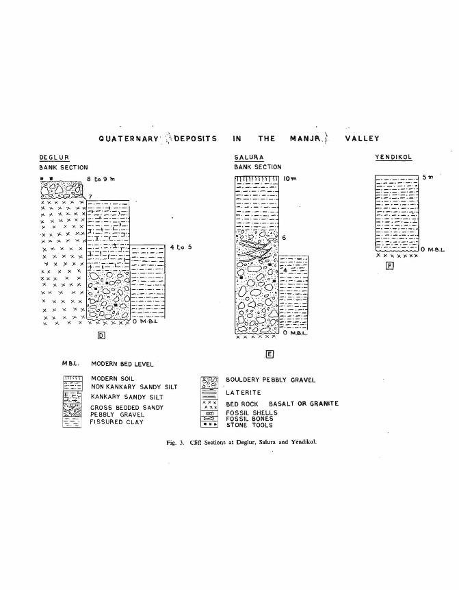
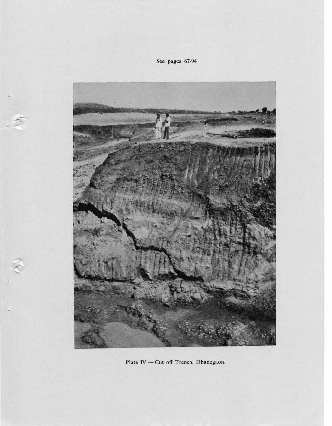
( i ) Dhanegaon (18°36' N, 76°10' E),( Fig. 2A).
The cut-off section on the right bank oftheManjra reveals !t,e following strata ( pI. IV).Brownish calcareous silty saud ( 4 m thick) isresting conformably on dark brown fissuredclay ( 3 m thick) which conformably grades to
ARCHAEOLOGICAL STUDIES IN THE MANJRA VALLEY 69
sandy pebbly calcreted gravel (3 m thick ).A large collection of animal fossils and freshwater Unio shells have been made from fissuredclay and also from the basal gravel horizon.The lateral shirt of about 0'50 km. in thecourse of Manjra is clearly seen here at cut-offtrench.
, ( ii) Wangdari (18°35' N, 76°23' E) and- Tadula ( 18°35' N, 76°25' E), ( fig. 2 B ).
Excellet exposures of calcreted mod~rately
~...:d pebbly gravels are found resting on:t1eccan traps at these sites at an elevation of 5 to 6 m. above the modern bed leveland 0.25 to 0040 km. away from the modernchannel. These gravels therefore, representold braided channels of the Manjra. The overlying formations on these gravels are representhe by silty clay and clayey sand ofbrown todark brownish colour ( pl· III). These deposits are fairly extensive in the area and'represent low energy depositional environmentcharacteristic of oxbow lake associated with oldflood plain of the Manjra.
tiii) Mugaon ( 18°' N, 77° 27' E ) (fig. 2C)A loose gravel rich in chalcedony group of
minerals was found exposed in the cultivatedfields at elevation of 6 to 7 m above the present~ of th~ Manyad river,' a tributory of the~~pjra (pI. VI). This older alluvium onth'fleft bank has been traced up to a level ofsome 15 m below the present surface and 8 mbelow the bed level in one of the wells, therebyindicating clear evidence of buried channelbelow the present level. A large number ofMiddle . Palaeolithic tools and a few animalfossils were collected here from loose gravelspread.
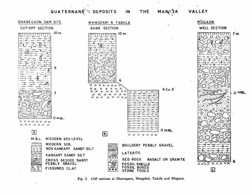
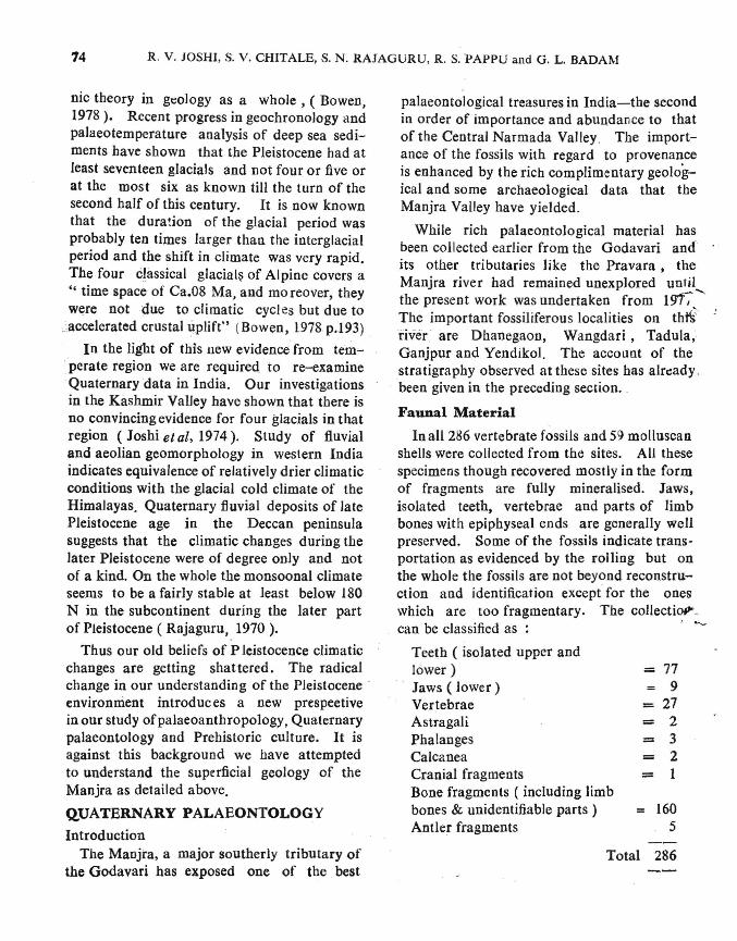
( iv ) ( Deglur ) (18°34 N' 77°35' E), (fig 3D ).Evidence for neo-tectonis is noticed in Lendi
nala ( Patalganga ) at Deglur· Here the oldchannel represented by cemented pebblygravel occurs at 8 m above the modern bedlevel and the late Pleistocene alluvium is found
to abutt against this older channel deposit.It is, therefore, clear th:1 t the occurrence oferosional terrace at 8 m level, that of late Pleistocene fill surface at 6-7 m level and thedevelopment of waterfall in the vicinity suggestdiscordant relationship of the tributary withthe main Manjfa river ( pl. VIIl). A factorysite of Middle Palaeolithic industry was locatedhere.
( v) Salura (18° 42' N, 770 47'E ) 9 ( Fig.3E)
A weH rounded, modernately sorted andwell-celI)ented pebbly conglomerate of 3 to 5m in thickness was observed on the right bankof the Manjra at this locality. The conglomerate is rich in silica family minerals anddolerite/basalt pebbles are less in number.This deposit is capped by brownish fissured,silt,S to 7 m in thickness. This site hasyielded a large number of Middle Palaeolithictools both in rolled as well as fresh state ofpreservation.
In contrast to upper reaches as Dhanegaon,Wangdari and Tadula , the Quaternary fluvial.processes in the middle and lower reachesof the MllOjra at Deglur, SaJura and Mugaonare dominated by low sinuosity processes.This is indicated by the absence of gradingin. gravel deposits, interlayering of gravelswith silts and clays and by the absence offining upward sequence which is commonly·observed in meandering streams. It is thusobserved that the depositional environment torpreservation of animal bones was more favourable in the upper reaches than in the lowercourse of the Manjra.
DISCUSSION
In the absence of radiometric and palaeomagnetic dates it is difficult to date preciselylaterites and alluvial deposits in the Manjravalley. They can be dated only relatively bygeomorphological and palaeontologicalmethods.
QUA T ERN A Rli(\(, DE POSIT S IN THE VALLEY
o M.e.l..
M''OGAON
WELL SECTION
-'-'-'-.-'-'--._.-.-.-.-.- .. -.-.-.-._.-.-.-._._.-.--. _.-.- .. -.-.--. -.--_. - .-.---.. -.-._.-.-
o M.B.!..
._._._0_._._.-._._.-. _.-
BOULDERY PEBBLY GRAVEL
LATERITE
BED ROCK BASALT OR GRANITE
FOSSIL SHELLSFOSSIL BONE.SSTONE TOOLS
cz:::)
•••
WANGDARI & TADULA
BANK SECTION
10 lT1
[K]M. B.L. MODERN BED LEVEL
MODERN SOILNON KANKARY SANDY SILT
KANKARY SANDY SILT
CROSS BEDDED SANDYPEBBLY GRAVEL
FISSURED CLAY
0_. _._._._
DHANEGAON DAM SITE
CUT-OFF SECTION
10 'tn
Fig. 2. Cliff sections at Dhanegaon, Wangdari, Tadula and Mugaon.
ARCHAEOLOGICAL STUDIES IN THE MANJRt\ VALLEY 71
In the Deccan Peninsula, laterites occur onvarious surfaces ranging in elevations from1500 m to 600 m AMSL. The average depthof laterite profile on these surfa~es does notexceed 20 m. It appears that the earliestlaterites developed on highest erosional surfaces are of early Tertiary age, as these surfacesare of post Do::ccan Trap of Cretaceous-
. Eocene age. These laterites were partly eroded- and provided materials on lower surface
belonging to subsequent cycles of erosion ofI~ Tertiary age. It, therefore, seems likelytb':H laterites developed on lower and youngersurfaces of erosion (750-650 m) in the ManjraValley are of late Tertiary or early Quaternaryage. This dating of laterite in the Manjravalley is tentative because we are not yetcertain about the origin of these plateau laterites occurring in isolation in the present semiarid parts of the Deccan. In fact, there areno outcrops of laterites on higher erosionalsurfaces in the immeJiate vicinity. As such itis difficult to explain the origin only in termsof the theory of " dee p weathering, erosion andrelateritisation " (Guzder, 1980) or in a schemewhere "the continuous process of profileaccretion, subsequent or intermiHent erosionand stripping of laterite cover from the bedrock,the detrital products being relateritized by some~cess, and the availability of fresh rock fori'Je'ritisation " ( Karunakaran and Ray, 197~).
r One faces many problems in interpretinglaterites as palaeoclimatic indicator. RecentInternational Seminar on "LateritisationProcesses " held at Trivandrum in December,197::.1 has vividly brought out complexitiesinvolved in laterite formation. It seems thatthere are laterites of different origins and ages,though superficially they may closely resemblein field characters. As no detailed geochemicaland petrological studies on laterites from theManjra valley have so far been carried out, weretrain from drawing any conclusion on thepalaeoclimatic significance of laterite in thearea under investigation.
As stated earHer so far not a single radiometric date has been obtained for these formations. Presence of Elephas maximus, Bubalusbubalis, Cervus unicolor, Cervus duvauceli,Equus namadieus, and Bos ndmadieus (PI. IXA and B ) in the alluvial deposits Of Dhanegaon, Wangdari, Tadula, etc. suggest a late:Pleistocene age for the alluvial deposits exposed in the upper reaches ( Badam, 1979).At Deglur , Salura and Mugaon good numberof Middle Paiaeolithic tools· have been foundin gravel beds. Absence of Upper Palaeolithic tools and microliths in the~e gravels showsthat these gravel~ are contemporary with theMiddle Palaeolithic period which have beendated to the late Pleistocene by pataeontological and radio-metric methods in the Godavarivalley ( Joshi et al , 1978). Thus the alluvialfills, characterised by brownish colour andm0derate degree of calCification are of thelate Pleistocene age only. Thus there is a longtime gap between the late Tertiary or EarlyPleistocene laterites and the late Pleistocene.all uvial fills.
If we take into consideration the lithologicalcharaclers such liS the degree of oxidation andcalcification of alluvial deposits and the palaeontological contents of the alluvium, thenthese deposits compare well with Upper Groupof the Older Alluvium of the Central Narmada,the major portion of the exposed OlderAlluvium of the Upper Godavari, UpperBhima and the Upper Krishna. If one gives astatus of Group to the Older Alluvium of theCentral Narmada, then the Upper Group of theCentral Narmada and other equivalent alluviaCan be placed in a category of 'formation'. Weprefer to call this as a" Bhima Formation"as tbis " formation" has been well defined interms of lithostratigraphy, biostratigraphy andchronostratigraphy in the Ghod river, a tributary of the Bhima river in Maharashtra ( Kajaleet al, 1'J76). Bhima formation thereforerepresents moderately oxidised and calcified
72 R. V. 1Osm, S. V. cmTALE, S. N. RAJAGURU, R. S. PAPPU and G. L. BADAM
alluvia with animal fossils such as Elephasmaximus , Bubalus bubalis, Cervus unicolorEquus namadicus etc; and dates between40,000 years B. P. and 11,000 years B. p.Composite stratigraphy of Quaternary formations in the Manjra Valle) is as follows(Fig.4):
Geomorphologically, younger alluviumforms an insect fill terrace in the Older Alluvium or Bhima formation which occurs as anaIJu"ial fiJI resting against the rock-cut valleyslopes developed as a result of strong rejuvenation of the Manjra sometimes during themid (?) Pleistocene.
Litho Units Stratigraphy Probable Age
Non·Calcareous darkbrown silts and gravels
Young Alluvium (+ 8m) Early to Mid Holocene
Calcareous brownishsilts and gravels
Laterite
DISCONFORMlTY
Older Bhima AlluviumFormation (+ 15m)
ANGULAR UNCONFORMITY
Laterite formation
Late Pleistocene
Late Tertiary toEarly Pleistocene
In recent years it has been realised thatthere is no simple correlation between climateand characters of alluvial deposits. Forexample braided rivers are common in cold aswell as hot semi-arid regions. Similarlystriated pebbles can occur in glacial andmarine deposits as well as in mud flows characteristics of hot deserts. Stream aggradationand erosion may be the net result of variousnatural factors. Climate is only one of thenatural factors which controls the stream behaviour.
Presence of kankars in alluvial deposits,brownish colour of finer sediments as a resultof strong oxi1isig environment and abundanceof montmoJilioIlite type of clay mineral influvial sediments of the area under consideration only show that hot semi-arid environmentprevailed throuhout the later Quaternary.Presence of large number of herbivorousanimals during the period indicate savannahvegetation in the area~
Our studies in the Manjra Valley in particular and in the Godavari Valley in generalshow that the Quaternary formations in thesemi-arid monsoonic parts of the DeccanPlateau are confined to shallow box-type rivervalleys and or po ssibly not older than the latePleistocene i.e· they are of later Brunhesperiod in terms of geomagnetic time scale.Broad mineralogical characters of thi'.'~deposits suggest that the region never experienced drastic climatic changes. In fact themonsoon machine seems to have operatedfairly ~ moothly at lesst in the last 40,001.1 years.Variability in monsoonal system cannot bedetected by merely studying mineral characters of alluvial deposits. Future investigationsot ponen contents in lake sediments in westernand northeastern India and of oxygeg isotopiccompoiition of shelf sediments in Arabian seamay give some clues to the riddle of Quaternary climatic changes in monsoonal India.
Quaternary systematics have been subject toa revolution comparable to that of plate tecto-
.,.QUATERNARY' ;;.H)EPOSITS IN THE \
MANJfl..) VALLEY
DEGL UR
BANK SECTION
4 t.o 5
M.B.L. MODERN BED LEVEL
SALURA
BANK SECTION
10'"
YENDIKOL
r-_-.-_-.-_-._-._~. 5 11>_.-_.-._.-_. _. -'-'_._._._._._._. -'-.-.._.-.-.- ..
-'-'-'-'-,'-'-'-'-'-'-'-'-'-'-_.-.-._.~
_. -. _. --_.-.-._._.-.. -.-.---- 0 M·B.~
X x x x xxx
g._._.-'_.-F;:;..=1'-\~.~. ~
'''::.'' " :.~.:
. ,'.:.' ,
MODERN SOILNON KANKARY SANDY SILT
KANKARY SANDY SILT
CROSS BEDDED SANDYPEBBLY GRAVE.LFI SSURED CLAY
KKK>< ....coD
=...
BOULDERY PEBBLY GRAVEL
LA TERITE
BED ROCK BASALT OR GRANITE
FOSSIL SHELLSFOSSIL BONESSTONE TOOLS
Fig. 3. Cliff Sections at DegJur, Salura and yendikol.
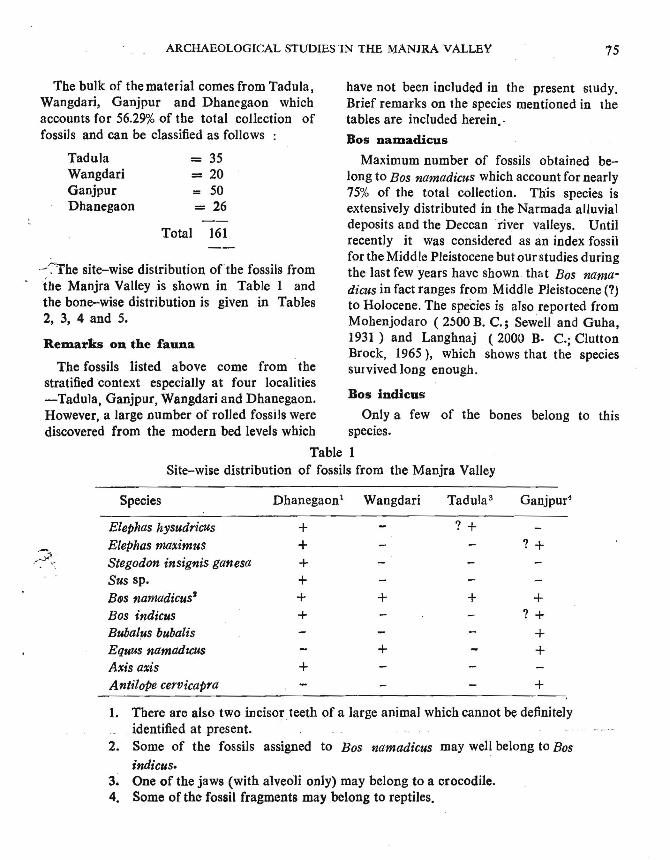
74 R. V. JOSHI, S. V. CHITALE, S. N. RAJAGURU, R. S.J.>APPU and G. L. BADAM
Total 286
palaeontological treasures in India-the secondin order of importance and abundance to thatof the Central Narmada Valley. The importance of the fossils with regard to provenanceis enhanced by the rich complimentary geological and some archaeological data that theManjra Valley have yielded.
While rich palaeontological material hasbeen collected earlier from the Godavari andits other tributaries like the Pravara. theManjra fiver had remained unexplored until_.......
the present work was undertaken from 191,The important fossiliferous localities on th~river are Dhanegaon, Wangdari, Tadula,Ganjpur and Yendikol. The account of thestratigraphy observed at these sites has alrt:ady.been given in the preceding section..
Faunal Material
In all 286 vertebrate fossils and 59 molluscanshells were collected from the sites. All thesespecimens though recovered mostly in the formof fragments are fully mineralised. Jaws,isolated teeth, vertebrae and parts of limbbones with epiphyseal ends are generally wellpreserved. Some of the fossils indicate transportation as evidenced by the rolling but onthe whole the fossils are not beyond reconstruction and identification except for the oneswhich are too fragmentary. The coliectioP'_can be classified as : I .......
nic theory in gt:ology as a whole, ( Bowen,1978). Recent progress in geochronology andpalaeotemperature analysis of deep sea sediments have shown that the Pleistocene had atleilst seventeen glacials and not four or five orat the most six as known till the turn of thesecond half of this century. It is now knownthat the dura~ion of the glacial period wasprobably ten times larger than the interglacialperiod and the shift in climate was very rapid.The four classical glacial~ of Alpine covers a" time space of Ca.08 Ma, and mo reover, theywere not due to climatic cycles but due to
. accelerated crustal uplift" (Bowen, 1978p..I93)
In the light of this new evidence from telil'"".perate region we are required to re-examineQuaternary data in India. Our investigationsin the Kashmir Valley have shown that there isno convincing evidence for four glacials in thatregion (Joshi et al, 1974). Study of fluvialand aeolian geomorphology in western Indiaindicates equivalence of relatively drier climaticconditions with the glacial cold climate of theHimalayas, Quaternary fluvial deposits of latePleistocene age in the Deccan peninsulasuggests that the climatic changes during thelater Pleistocene were of degree only and notof a kind. On the whole the monsoonal climateseems to be a fairly stable at least below 180N in the subcontinent during the later partof Pleistocene (Rajaguru, 1970).
Thus our old beliefs of P leistocence climaticchanges are getting shattered. The radicalchange in our understanding of the Pleistoceneenvironment introduces a new prespeetivein our study ofpalaeoanthropology. Quaternarypalaeontology and Prehistoric culture. It isagainst this background we have attemptedto understand the superficial geology of theManjra as detailed above.
QUATERNARY PALAEONTOLOGY
IntroductionThe Manjta, a major southerly tributary of
the Godavari has exposed one of the. best
Teeth ( isolated upper andlower)Jaws ( lower)VertebraeAstragaliPhalangesCalcaneaCranial fragmentsBone fragments ( inclUding limbbones & unidentifiable parts)Antler fragments
=779
= 27= 2- 3= 2= 1
= 1605
ARCHAEOLOGICAL STUDIES IN THE MANJRA VALLEY 75
Bos indicus
have not been included in the present study.Brief remarks on the species mentioned in thetables are included herein.·
Bos nalDadicus
Maximum number of fossils obtained belong to Bas namadicus wbich account for nearly75% of the total collection. This species isextensively distributed in the Narmada alluvialdeposits and the Deccan fiver valleys. Untilrecently it was considered as an index fossilfor the Midd Ie Pleistocene but our studies duringthe last few years have sbown tbat Bas namadims in fact ranges from Middle Pleistocene (7)to Holocene. The speCies is also reported fromMohenjodaro ( 2)00 B. C.; Sewell and Guha,1931 ) and Langhnaj (2000 B· c.; CluUonBrock, 1965), which shows that the speciessurvived long enough.
161
= 35= 20= 50= 26
Total
TaduJaWangdariGanjpurDhanegaon
The fossils listed above come from thestratified context especially at four localities-Tadula, Ganjpur, Wangdari and Dbanegaon.However, a large number of rolled fossils were Only a few of the bones belong to thisdiscovered from the modern bed levels which species.
Table 1Site-wise distribution of fossils from tbe Manjra Valley
Remarks on the fauna
The bulk of the material comes from Tadula,Wangdari, Ganjpur and Dhanegaon whichaccounts for 56.29% of the total collection offossils and can be classified as follows
~~he site-wise distribution oftbe fossils fromthe Manjra Valley is shown in Table 1 andthe bone-wise distribution is given in Tables2, 3, 4 and 5.
Species Dhanegaon1 Wangdari Tadula3 Ganjpur4
Elephas hysudrieusElephas maximusStegodon insignis ganesaSus sp.BfJS namadicus'Bas indicusBubalus bubalisEquus namadu:usAxis axisAntilope cervicapra
++++++
+
+
+
? +
+
7 +
+? +
++
+
1. There are also two incisor; teeth of a large animal which cannot be definitelyidentified at present.
2. Some of the fossils assigned to Bas namadicus may well belong to Bas
indicus.3. One of the jaws (with alveoli only) may belong to a crocodile.4. Some of the fossil fragments may belong to reptiles.
76 R. V. JOSHI,S. V. CHITALE, S. N. RAJAGURU, R. S. PAPPU andG. L. BADAM
Table 2
Bone-"wise distribution of fossils from the Manjra Valley
Site
Dhanegaon
Species
Elephas hysudricus
Elephas maximus
Stegodon insignis ganesa
Sus sp.
Bas namadieus
AXis aXis
Identifiable parts
Lower molar
Lower molar ( fragment), Tusk (fragments of anterior tip )
Lower molar ( fragment of a cone) /_Humerus (with the distal and proxim!!lends)
... Acetabulum (Part, Ischium side), Ischium(end part), Calcaneum (proximal anddistal ends)
...* Rib ( fragment)Radius ( Proximal end, unfused')Vertebra ( Thoracic, centrum)Metapodial ( distal trochlea)Teeth ( isolated upper and lower)
Lower jaw ( with diastema and alveoli forpermolars )
... Vertebra ( cervical ), carpal bone
ScapUla ( glenoid cavity)
* Metatarsal (Proximal end)
Lower jaw ( with Ms )
Mandibular symphysis (with alveoli l~
incisors)
* Humerus (fragmen,t of shaft)
* Tibia ( fragment of :shaft )
* Tibia ( Proximal articular facet)... Metacarpal ( Proximal ):Ii Metatarsal (Proximal ), carpal bone* Phalanx ( 1st)
Antler (fragments)
* They all may belong to Bas indieus.
** Rib fragments cannot be definitely identified and have been provisio.t;lallyassigned to Bos namadicus since they were found in the same area.
.ARCHAEOLOGICAL STUDIES INTHE MANJRA VALLEY
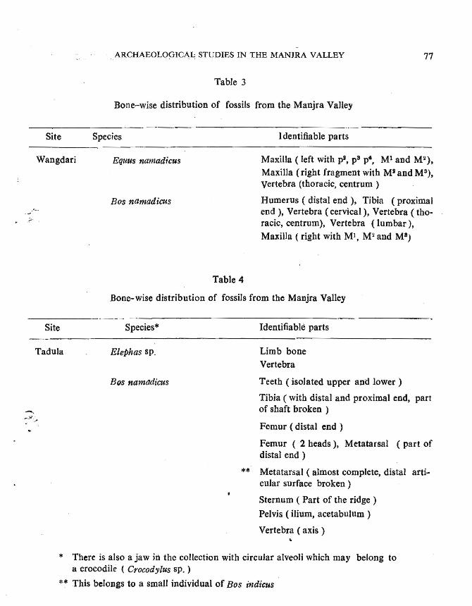
Table 3
Bone-wise distribution of fossils from the Manjra Valley
77
.;;.
Site
Wangdari
Species
Equus namad;cus
Bos namadicus
Table 4
Identifiable parts
Maxilla ( left with pi, p8 p., Ml and Mi),Maxilla (right fragment with Mi and M3),vertebra (thoracic, centrum)
Humerus ( distal end), Tibia (proximalend ), Vertebra (cervical), Vertebra (thoracic, centrum), Vertebra (lumbar),Maxilla (right with MI, M2 and M8)
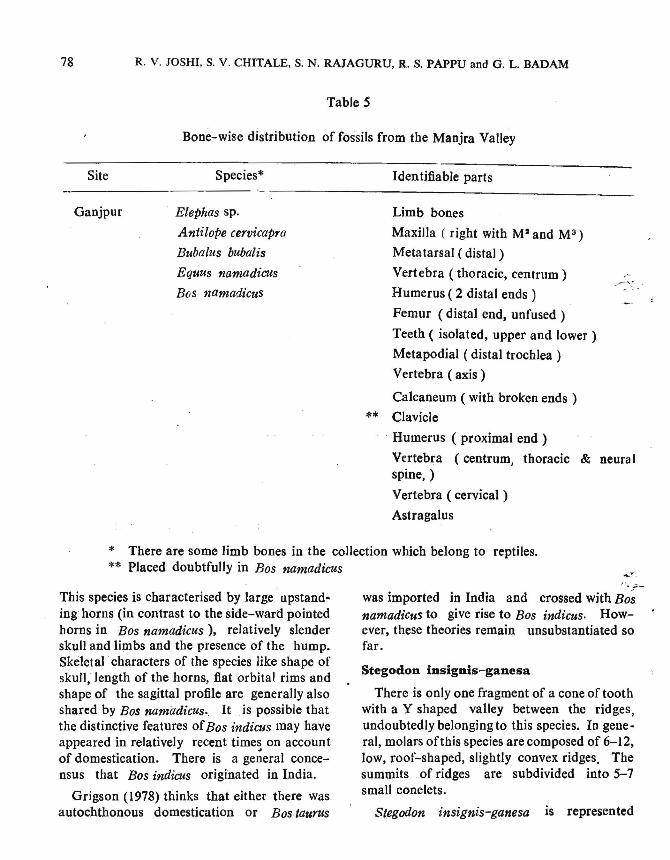
Bone-wise distribution of fossils from the Manjra Valley
Site
Tadula
Species*
Elephas sp.
BQS namadicus
Identifiable parts
Limb boneVertebra
Teeth (isolated upper and lower)
Tibia ( with distal and proximal end, partof shaft broken )
Femur (distal end)
Femur ( 2 heads), Metatarsal ( part ofdistal end)
** Metatarsal ( almost complete, distal articular surface broken)
Sternum ( Part of the ridge )
Pelvis ( ilium, acetabulum)
Vertebra ( axis),
* There is also a jaw hi the collection with circular alveoli which may belong toa crocodile ( Crocodylus sp. )
** This belongs to a small individual of Bos indicus
78 R. V. JOSHI, S. V. CHITALE, S. N. RAJAGURU, R. S. PAPPU and G. L. BADAM
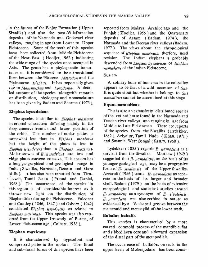
Table S
Bone-wise distribution of fossils from the Manjra Valley
Site
Ganjpur
Species*
Elephas sp.
Antilope cervicapra
Bubalus bubalis
Equus namadicus
Bos namadicus
Identifiable parts
Limb bones
Maxilla ( right with M' and M3)
Metatarsal (distal)
Vertebra (thoracic, centrum)
Humerus (2 distal ends)
Femur (distal end, unfused )
Teeth ( isolated, upper and lower)
Metapodial ( distal trochlea)
Vertebra ( axis)
Calcaneum ( with broken ends )
** Clavicle
Humerus ( proximal end)
Vertebra (centrum, thoracic & neuralspine, )
Vertebra ( cervical)
Astragalus
* There are some limb bones in the collection which belong to reptiles.** Placed doubtfully in Bos namadieus .......
This species is characterised by large upstanding horns (in contrast to the side-ward pointedhorns in Bos namadicus), relatively slenderskull and limbs and the presence of the hump.Skeletal' characters of the species like shape ofsku)), length of the horns, flat orbital rims andshape of the sagittal profile are generally alsoshared by Bos namiJdieus.. It is possible thatthe distinctive features ofBos indicus may haveappeared in relatively recent times on accountof domestication. There is a ge~eral concensus that Bos indieus originated in India.
Grigson (1978) thinks that either there wasautochthonous domestication or Bostaurus
".;;:-was imported in India and crossed with Bo;namadicus to give rise to Bos indicus. However, these theories remain unsubstantiated sofar.
Stegodon insignis-ganesa
There is only one fragment of a cone of toothwith a Y shaped valley between the ridges,undoubtedly belonging to this species. In gene·ral, molars ofthis species are composed of 6-12,low, roof-shaped, slightly convex ridges. Thesummits of ridges are subdivided into 5-7small conelets.
Stegodon insignis-ganesa is represented
. ARCHAEOLOGICAL STUDIES IN THE MANJRA VALLEY 79
. in the faunas of the Pinjor Formation ( UpperSiwaliks) and also the post-Villafranchiandeposits of the Narmada and Godavari rivervalleys, ranging in age f rom Lower to UpperPleistocene. Some of the teeth of this specieshave been collected from Middle Pleistoceneof the Near-East (Hooijer, 1%2) indicatingthe wide range of the species once occupied inAsia. The genus has a phylogenetic importance as it is considered to be a transitionalform between the Pliocene Mastodon and theP~eistocene Elephas. It has reportedly givenliSe to Mammuthus and Loxodonta. A detailed account of the species alongwith. remarkson distribution, phylogeny and nomenclaturehas been given by Badam and Sharma ( 1973).
Elephas hysudricus
The species is similar to Elephas maximusin cranial characters diffeI ing mainly in thedeep conca ve frontals and lower position ofthe orbits. The number of molar plates issomewhat less than in Elephas maximusbut the height of the plates is less inElephas hysudrieus than in Elephas maximus.Molar crowns of E. hysudricus are low andridge plates convexo-concave, This species hasa long geographical and geological range inIndia t Siwaliks, Narmada, Deccan and GaroRi1Is). Jt has also been reported from Tiru-
':~Jelveli; Tamil Nadu (Prasad and Daniel,1968); The occurrence of the species intbis region is of considerable interest as itthrows new light on the distribution ofElephantidae during the Pleistocene. Falconerand Cautley ( 1846, 1847) and Osborn ( 1942)considered Elephas hysudrz'cus as related toElephas maximus. This species was also reported from the Upper Trrawady of Burma, ofLower Pleistocene age (Colbert, 1938 ).
Elephas maximus
It is characterised by hypsodont andcompressed plates in the molars. The fossiland sub-fossil forms of this species have been
reported from Malaya Archipelago and thePunjab (Hooijer, 1955) and the Quaternarydeposits of Assam (Badam, 1974), theNarmada and the Deccan river valleys (Badam,1977). The views about the chronologicalsequence of E!ephas maximus, therfore, needrevision. The Indian elephant is probablydescended from Elephas hysudricus or ElePhasnamadicus of the Indian Pleistocene.
Sus sp.
A solitary bone of humerus in the collectionappears to be that of a wild ancestor of Sus.It is quite stout but whether it belongs to Susnamadieus cannot be ascertained at this stage.
Equus namadicus
This is also an extensively distributed speciesof the extinct horse found in the Narmada andDeccan river valleys and ranging in age fromMiddle to Late Pleistocene. There are reportsof the species from the Siwaliks (Lydekker,1882 ), Ariyalur, Tamil Nadu (Khan, 1971 )and Susunia, West Bengal (Sastry, 1968 ).
Lydekker ( 1883) regards E. namadicus as asurvival from the Siwaliks. Matthew ( 1929 )suggested that E. namadicus, on the basis of itsyounger geological age, may be a progressiveform of E. sivalensis of the Upper Siwaliks.Azzaroli ( 19f)6 ) treats E. namadicus as separate on the basis of its larger and broaderskull. Badam ( 1979) on the basis of extensivemorphological and statistical stud ies treatedE. namadicus as a synonym of E. sivalensis.E. namadicus was also zerbine in nature asevidenced by a V-shaped groove between themetaconid and metastylid of the lower teeth.
Bubalus bubalis
This species is characterised by a morecurved coranoid process of the mandible, flatand ribbed horn core and sideward expansionof the distal part of the metapodials.
The occurrence of buffaloes on seals in theupper levels of Mohenjodaro has been consi-
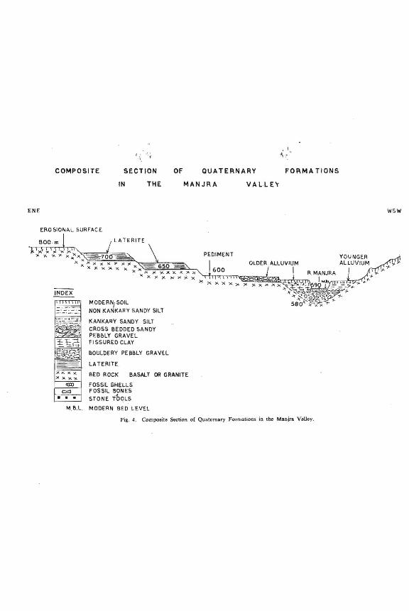
COMPOSITE SECTION OF QUATERNARY FORMA TIONS
ENE
ERO SIONAL SURFAC E
IN THE MANJRA VA LL E'r
wsw
INDEX
M.ll.L.
MODE RN, SOIL
NON KANKARY SANDY SILT
KANKARY SANDY SILTCROSS BEDDED SANDYPE'BI>LY GRAVELFI SSURED CLAY
BOULDERY PEBBLY GRAVE.L
LA TERITE
BED ROCK BASAlT OIl GRANITE.
FOSSIL SHELLSFOSSIL BONES
STONE TOOLS
MODERN BED LEVU
PEDIMENT
600
Fig. 4. Composite Stttion of Quaternary ForrnatiollS in the Manjra. VoUcy.
ARCHAEOLOGICAL STUDIES IN THE MANJRA VALLEY 81
dered evidence for their domestication in N·W.India by the period (Zeuner, 1963). It isgenerally believed that Bubalus bubalis is adirect descendant' of Bubalus pa1aeindicus ofthe Siwaliks and was domesticated within theIndian subcontinent.
Axis axisThe species is represented in the collection
by a couple of antler fragments which aresmaller in dimensions than those of Cervus.
. ~4n Axis axis the main beam forks into two, .the outer one is always longer. The browtine is at right angles to the main beam. However, in Cervus, the antlers are stout andrugged. The main beam branches into twoequal tines at its summit and the brow-tine isfused at an acute angle to the main beam(Prater, 1977).
Antilope cervicapra .
This species is characterised by a spiral horncore. As compared to the teeth of Ovis/Caprathe enamel of the teeth on the lingual side isU-shaped whereas, in .Ovis/Capra it is Vshaped. The dentition is selenodont in character.
As mentioned earlier' in the section on Qua- .~rnary geology it is only on the basis of faunal
( ......ita that we have been able to firmly dateOlder'Alluvium of the Manjra Valley to the latePleistocene. These studies also throw light onbiological environment during the late Pleistocene. Predominance of herbivores indicalegood veget~tion cover, probably a savannahforest in the area during the late Pleistocene.Presence of fossil reptiles indicates abundantwater in the channels of the Manjra. In viewof the great adaptability of mammals, it is verydifficult to draw any firm conclusions on thelale Pleistocene climate. However, the available faunal data' suggest that the climateduring this· period was certainly not drierthan the present one.
STONE AGE CULTURES
The discovery of rich Late Pleis tocene fauna.at Dhanegaon encouraged us to undertakedetailed exploration of the valley for locatingthe stone age sites. Accord ingly the entireManjra river was surveyed from its sourceregion upto its confluence with the Godavari.Interestingly this tract did not yield aoyLower Palaeolithic site. Such sites havebeen found on the Godavari proper only litGangapur near Nasik and on the basis ofthe associated fauna this advanced Acheulianassemblage belongs to Late Pleistocene.Further downstream, the Pravara basin, asubsidiary to the Godavari Valley bas turnedout to be another potential area for the LowerPl11aeolithic cultures particularly around thefamous ChalcoJithic site at Nevasa. The absence of the Lower Palaeolithic industries inthe Manjra is however enigmatic, particularlywhen there was no dearth of suitable rawnlaterial, the fauna was plentiful and so alsothere was possibility of fairly thick vegetationcover during the late Pleistocene.
The story of the Middle Palaeolithic of theManjra Valley is slightly different. No site ofthis culture was found in the command area ofthe dam which is going to submerge nearly 55villages on the Manjra. Stray specimens ofartefacts comparable to the culture were fou,odhere and there but by and large the regiondoes not seem to have been preferred for habitation during MIddle Palaeolithic timesEven c1o'se to the sites yielding .animal fossilsno tools of the Middle Palaeolithic industrywere' found.
We have however discovered. 11 sites ofMiddle Palaeolithic cultures in the .middle andlower reaches of this river and at some of themwe could collect large number of tools. Basically this iridustry bas the same characteristicsas are commonly noticed in the' collectionfrom various sites in India. At all the
,,,,,'10,-
r)
'\D'-
I
'-,-~_:_---
In
I,,,..,1,._~
--,
I./
i:
I
I:etI
I ClD :_, '.
i--~- .:' :~
------ ._~_-4
•:"'::: 4J'~;-::'.... --.. I I _
;::. \ ~,~~-? :,..... ,_
'--.-- 1-
, .' 1- _. II "
, I_.____ G_'1 to 10, Side scrapers: 11 to 16,
;10
,1'-"\'~
:~-,
- :~~--_.-,
Middle Palaeolithic Artefacts, Hollow Scrapers :Fig. 5.
,
-"
~,.N~-~
ARCHAEOLOGICAL STUDIES IN THE MANJRA VALLEY 83
localities the cherts and allied raw material isplentiful· It is derived from the DeccanTrap formations of the area. The sizes ofindividual tools vary according to the size ofthe available raw material. Although goodstratigraphic sections _are exposed at a fewlocalities, as is commonly noticed at largenumber of sites ehewhere, those yieldingtools are few. Majority of them occur asscatters over the banks and plenty of themare found in the river bed apparently dislodged~m their original position. The proportion
·of rolled tools is, however, small and as suchthe primary sites do not seem to be far awayfrom the present cluster-sites.
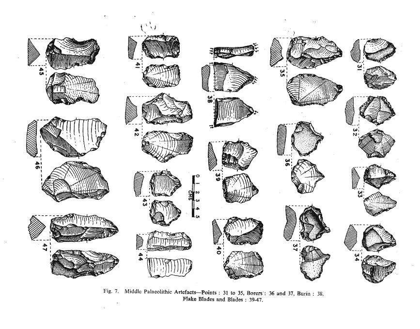
In the tool types the scrapers are dominantand in them the notched or concave varietiesare most common ( Figs 5 and 6). The pointsare very rare and the borers are few ( Fig. 7 )Only one burin has been found at Yendikol( Fig. 7-38 ).
Discussing site-wise, at Metkonda there is
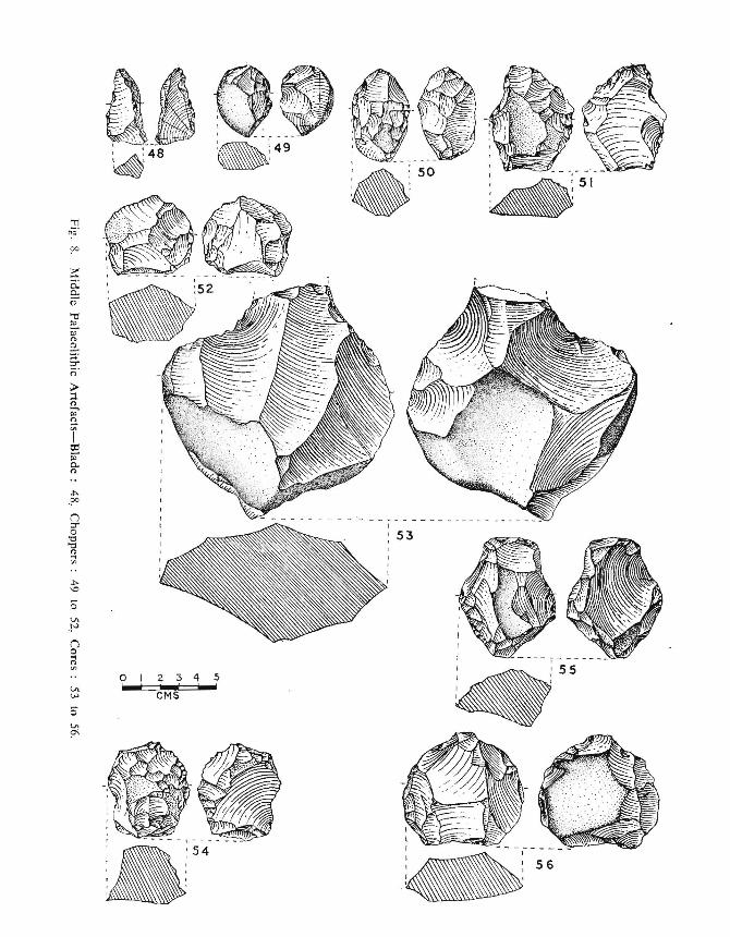
an exposure of Inter Trappean bed with whiteor grey spotted chert. It yielded the largestnumber of core or nodule scrapers havingsteeply worked edge (PI. V). Such Heep corescrapers, a few resembling push-planes werealso found at Yendikol (PI. VII) Nandikalli, and Deglur (Fig. 6-26 to 30). Typologically the collection from Nandikalli showsadvanced Acheulian character in the larger sizeof the tools and the occurrence of number ofchoppers and core-scrapers. It perhapsrepresents Wainganga --A horizon as has beennoticed in central. India (Joshi, 1966). AtDeglur we obtained the largest collection oftools and its special significance lies in largecores or bifacial choppers (Fig. 8-49 to 52 ).recalling a similar assemblage flom Raigarh inthe Tap. valley IJoshi et al, 1909). In their presenee of microlithic element the sites Mugaonand Alladurg appear to be of later date.
The site-wise distrib ution of main tool-typesis given in table 6.
Table 6.
Middle Palaeolithic Typology
Site Choppers Scrapers Point Borers Burias Flakes Cores Total~-'
1. Sangam 15 1 8 2 26
2. Kavadgaon 26 2 3 5 6 42
3. Zahirabad 1 I I 3
4. Naodikalli 3 21 3 4 315. Metkonda 6 63 2 13 13 97
6. Yendikol 50 10 I 15 5 81
7. Chintgunta 10 1 2 I 14
8. Alladurg 5 I 7
9. Deglur 10 3 3 4 20
10. Salora 6 38 2 21 1 68
11. Mugaon 6 7 2 15
16 245 16 8 1 78 40 404
._-,----_.I
I.I,I .
00 ..
>, .
If)
o
<r
l'll~<'l 0
,--CD
of_!:'
I \' \~: &.~.l~~__ . . 'S.' ':if ..... \I ~".' :. I
I < : : ~.--,:111 : (\I
•. _-_..... _----- " ...
---.- -; . I. ,~ , ..... +-' ,_:-~E,~ -0- .. 1
.~ !-;4' 0'·Ilif. :, /.. '",
:(\1
~f/~ .. " ~;'-j
ED ~1~:"·~;,;\;·.\\f ':.:. :1
. '- ,\~\\\\\I•...~ :"~.•.\\.\. .~':':::::' ." , ", i~~" ' ~11I11I"!I\llllIl\llIHIIIH"""
~
~<~_ .. _-_.-."
•
..,.j •.• .' ..• a~:;··~·:-·~·?~:~::-I - ';
, : '" I ':':_
:.-~_.. e':~_.. , ", ..~__ "'iI .':~
Fig, 6. Middle Palaeolithic Artefacts-Side Scrapers: 17 to 23, Core Scrapers: 24 to 30.
--•....f ...':- \;:}
. ,.' ::.. :,~,,:~
I ., .o . •I .... _
-_ ...
Col.:.N: .:~ J~'··7.·.... :::.......
"
t---~-.
" '.~ "
........: 'r?; .
.. - --,
Col' ~."':~'--\~
6","._-,
. )
I.-.-/I))tf~
~:!~!%((;~,
.:._ ... __' ~r.
:-
~~
, I-~·,,)"
'
---.-'/1'"~' -~~1.".~"• C1lO',,. . .o •
. .'
'~-1Q) .'. ,. .
'~ ,"."
~D1~",' ~}=::
I..~:·;: ","-;. !'-..- .....
-~ .
w'· .ClD:~'
o
l./I
r---,.";:,I • ',.
.. - _-I
~~~
~
~-'
~'- .. ''''''''''''''''.• ' 0
:.~
~
\\ \ \}"
~';~;:::,~r_~
~'a_.
:. I ,
..-.....,
~-:.~-
~-:'"
~-I
•';'-_J
Fig. 7. Middle Palaeolithic Artefacts-Points; 31 to 35, Borers':Flak.e Blades and Blades: 39-47.
36 and 37, Burin; 38,
I
I I
~r56r Ir ,J,
:~/··-:so, ,, ,
~~.. -
.:49~~:
2 3 4 5... Iwww4eMS
IooowIo I
a:---- :54, ,' ,, ., ,,
(joa
9o'0'0
'"...,or>
---~
~- I
~I~I
.~;~.,~~N:~~-:'00 ~-~-~~_' J~
'~J§.~-~: •~~--,~~~~ fl~_~-, ~~~
&-,.---~ __ I:'-
--I -\De' "., \ .".: .:~. ,',-,:;
~-~[-1
\\ )
w
....,
o
~
n3:VI-
~~I '"
a--.-,L t-~7'\'~, : ~, I' "~.',"\ '.~
I -;;:" ,-, ,
:.:~~ -_:""_I
~_ OI~1tI((" ~ .,.,'. \' , "'.' ";;
~-- - - -,
l\>
Fig. 9. Mesolithic Artefasts-Blades; 1, 3, 5, 7, 8, Backed Blade: 2. Scrapers: 4, 9, 13,Burins: 10, 11, Flakes: 12.
88 R. V. JOSHI, S. V. CHITALE, S. N, RAJAGURU, R. S. PAPPU and G. L.BADAl\!
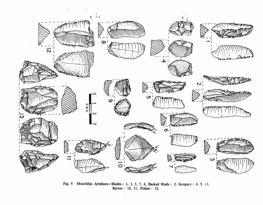
Mesolithic sites are very widely scattered throughout this tract· Although tbe collections offinished tools were smaller at the localities inthe dam area, their presence is a sure proof thatby tbe begInning of Holocene the entire rivervalley had tbe most suitable environment formicrolith users. Further downstream also thetools occur at several places on the riverbanks, on the rolling hilly region, near waterfalls, on the rock exposure and plenty in theriver gravel. As our present aim was of thereco~naissance survey and since we did not .come across richer deposit yielding mesolithic-cultures we could not undertake excavation. The tabulated collections reflect onlythe m;ost common typology and no percentagesof iJ.:ldividual tool types have been attempted(F(gs. 9 & 10). We have listed nearly 34 s,tes.In the tool types the mention should be madeof the occurrence of burins from Pimpalgaon( Fig. 9-10& 11). None of the cullectionsshowed affinities with the Upper Pahieolithiccultures.
Tbere is no evidence of neolithic, chalcolithicand megalithic culture in tbe area surveyed byus. The Early Historical and Historical mater·ial has been dealt in the subsequent section.
The table 7 gives the site-wise distribution ofthe ~ain tool-types of the Mesolithic industry.
HISTORICAL PERIOD
The Manjra the major tributary of the God·avari, appears to be quite a famous river sinceancient times. The Manjra sometimes called
. as Wanjara, bas been mentioned in the VayuPurana by the name Vanjula. Vayu Puranastates that Godavari, Bbima, Krishna, Vennaand Vaojula that rise in tbe Sahyadri Mountains are the main rivers of Dakshinapatba (VayuPurana, 104-45 ).
Even though the vedic literature referst1J"<'
Dakshinapatba, it was only at a later peri'~~
that we find Aryan settlements on the Godavari under the guidance of Sage Agastya.Immediately after tbis the Deccan plateau wasstudded with many such settlements.
In course of time a large kingdom wasfounded .North of Godavari by Vidarbha(Bhagwat Purana 5.5.10). His capital wasKundinapura which tben was in the presentAmravati District of Maharashtra. Duringthe lJrahamana and Upanishadic period thisregion was ruled over by king Danda ( Bhandarkar, 1973). It was probably during theend of his reign that the country was devastedby a violent storm. The area subsequentlyturned into a great forest that afterwards cameto be known as Dandkaryana (Ramayana,Uttarakanda 81.8 ). .••.
Mesolithic Typology
Site Scrapers Points Burins Blades Flakes Cores. Total
UPPER REACHES
1. Borgaon ( Tal-kaj) - 4 3 1 82. Hingangaon 10 9 2 213. Kalam 2 4 3 94. Pimplegaon (Tonga) - 1 2 7 4 145. DevIa 3 3 66. Tat Borgam 1 3 3 6 137. Apegaon 3 3 1 78. Isthal 2 3 59. Soundara 4 3 7
-It----:···-"". ll~~~~ ~.rfl!?,7T~
_--'
III 0p: ~
n -"
3: (J1VI
rv
~ w
~ ')
,::~-- -l\\\''A~//J'//~No
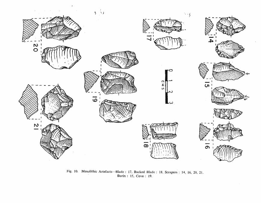
Fig. 10. Mesolithic Artefacts-Blade; 17, Backed Blade; 18, Scrapers: 14, 16, 20. 21.Burin; 15, Cove: 19.
90 R. V. JOSHI, S. V. CHITALE, S. N. RAJGURU, R. S. PAPPU and G. L. BADAM
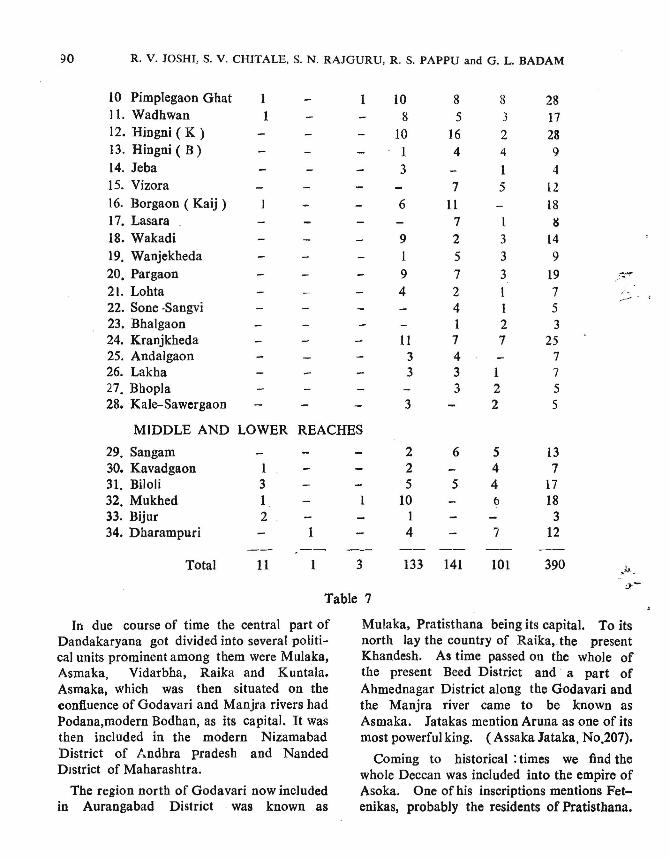
10 Pimplegaon Ghat 1 10 8 8 2811. Wadhwan 1 8 5 3 1712. Hingni ( K ) 10 16 2 2813. Hingni ( B) 1 4 4 914. Jeba 3 1 415. Vizora 7 5 1216. Borgaon ( Kaij ) 6 11 1817. Lasara . 7 1 g
18. Wakadi 9 2 3 1419. Wanjekheda 1 5 3 9
20. Pargaon 9 7 3 1921. Lohta 4 2 1 722. Sone -Sangvi 4 1 523. Bhalgaon 1 2 324. Kranjkheda 11 7 7 2525. Andalgaon 3 4 726. Lakha 3 3 1 727. Bhopla 3 2 528. Kale-Sawergaon 3 2 5
MIDDLE AND LOWER REACHES
29. Sangam 2 6 5 1330. Kavadgaon 1 2 4 731. Biloli 3 5 5 4 1732. Mukhed 1 1 10 0 1833. Bijur 2 1 334. Dharampuri 4 7 12
Total 11 1 3 133 141 101 390
Table 7
In due course of time the central part ofDandakaryana got divided into several political units prominent among them were Mulaka,Asmaka, Vidarbha, Raika and Kuntala.Asmaka, which was then situated on theconfluence of Godavari and Manjra rivers hadPodana,modern Bodhan, as its capital. It wasthen included in the modern NizamabadDistrict of Andhra pradesh and NandedDistrict of Maharashtra.
The region north of Godavari now includedin Aurangabad District was known as
Mulaka, Pratisthana being its capital. To itsnorth Jay the country of Raika,. the presentKhandesh. As time passed on the whole ofthe present Beed District and a part ofAhmednagar District along the Godavari andthe Manjra river came to be known asAsmaka. latakas mention Aruna as one of itsmost powerful king. (Assaka Jataka, No.207).
Coming to historical: times we find thewhole Deccan was included into the empire ofAsoka. One of his inscriptions mentions Fetenikas, probably the residents of Pratisthana.
ARCHAEOLOGiCAL STUDIES IN THE MANJRAVALLEY 91
After his death the Deccan was r-uled over bythe powerful Satvahana dynasty for nearly 450years. Gautamipura Satakarni one of the renowned King ruled over a wider region of theupper Deccan and his domain included thewhole of the Godavari and tbe Manjra riverbasins. This region in Eastern Mabarasbtra isconsiderably fertile and therefore it was covetedfor by his contemporary rulers. .
The Satvabanas were supplemented by theV.:tkatakas of Vidarbba, the Chalukyas of
1!3d'ami, tbe Rastrakutas of Manyakbet, theLater Chalukyas of Kalyani and the Yadavasof Deogari.
The region ruled over by tbe above dynasties covered the most of the above fertile areaalong the Godavari and the Manjra river. OnmaDy occasions this region was the bone ofcontention of the powers that fought for theirsupremacy over the Deccan.
After the fall of the Yadavas, the last HinduKingdom over Eastern Mabarashtra (Godavaribasin ), the area came under the sway of theSultans of Delhi, from A. D. 1317.
In A. D. 1347 Hasan Gangu Bahamanifounded the famous Bahaman kingdom. The~hamanis ruled over the Deccan for a,eei'iod of 150 years, when after A. D. 1481the empire started disintegrating and subsequently there rose five independent Sbahikingdoms over Deccan plateau. They alwaysfought battles for the possession of theGodavari basin. This internal struggle invitedthe Mugals who for sometimes ruled over theDeccan plateau with Aurangabad as theirheadquarters. When tbe Mughal power atDelhi became weak their Governor Nizamwho was then in charge of their administrativedivision in the Deccan, rebelled and carvedfor himself a separate prineJpality whichafterwards came to be known as the Nizam'sDomain.
In the meantime the Marathas under theable leadership of Shivaji established theirindependence and were in possession of thewhole of Western Maharashtra.
The Marathas under the Peshwas and theNizam fought many battles mostly in Marathwada for the possession of the fertile Godavariand Manjra river vallies.
After A. D. 1790, the Maratha powerbecame weak due to internal rivalries. TheBritish power in India defeated them in manybattles and A. D· 1818 saw the end of theMaratha power.
But the Nizam wisely held all the territoryhe had in Maharashtra, Karnatak andAndhra Pradesh that mostly covered all thearea along the Godavari and the Manjra rivers.It was only after the action of A. D. 1948that his domain was merged into the adjacentprovinces of Karnatak, Andhra Pradesh andMaharashtra.
The historical monuments observed in thesurvey of the area, which will be submergedafter the completion of the dam on theManjra are described in the following section.
ARCHAEOLOGICAL REMAINSOne of the main objects of tbe project was
to systematically carry out a detailed survey ofthe archaeological and historical material ofthe area that would be submerged permanentlyunder the impounded waters of the Manjrariver at Dhanegaon dam site. The area wasto cover five villages viz. Dhanegaon, Bhalgaon,Son-Sangvi, Sadola and Surdi from the Osmanabad district; and five viz., Kale-Savargaon,BorgaoD, HingangaoD, Lohta Pimpalgaon fromthe Beed district and a part of Kalam city. A.plan was therefore drawn for the detailed survey of these villages. It was felt that in orderto get a clear picture it was desirable to surveysome more villages along the upper co urse of
92 R. V. JOSHI, S. V. CHlTALE, S. N. RAJGURU, R. S. PAPPU and G. L. BADAM
the river and thus their number was raisedupto sixty.
For this village-to-village survey work weutilized the proforma prepared by the Archaeological Survey of India with a few changesto suit our requirements.
After a careful study of all the ~urvey reports of these villages the following observationsmay be made.
1. Barring a very few villages such as Isthaland Wajingar- Kheda all the others have comeup during the past two to three hundred years.At that time the area was probably coveredwith a thick forest with spare localities carryingout cultivations in the adjacent area. Averagerainfall then was 30 to 40 inches in a year andManjra river during the rainy season when infloods probably seems to have changed itscourse many a times. On flood-plains of thePleistocene alluvial depo5its along both thebanks of the river, upto a distance of nearlyhalf a meter, there used to grow, upto a heightof 7 to 10 feet, a peculiar type of grass. Assuch this marshy area made the river crossingdifficult for many months. Herds of animalsmoved in the area.
2. In the stream-beds, in the bank sectionsof the river, and its modern' nalas ' fossils ofteeth jaws, bone fragments, fresh water molluscan shelis of different sizes are collected.The fossils mostly belong to the Pleistoceneherd of animals that moved in the area. Theconcentration of fossils is more at Dhanegaon,Bodaka, Wadhgaon, Pangaon and PimplegaonGhat etc. Microlithic tools are mostly fashioned from chalcedony and were collectedfrom the upper course of the river. Theirconcentration is more at places like Pargaon,Wadhwan, Pimpalgaon-Ghat and HinganKhurd which are nearer to the source of theriver. They include flakes, blades and cores.Finished tools are of rare occurrence.
A few potsherds collected from some villagges in the area generally belong to the
Medieval (Muslim-Maratha) period and assuch are of little importance for the presentstudy.
Almost every village has a temple eitherdedicated to god Hanuman or Mahadeo, theworship of which was generally popular amongthe people. Tradition bas it that Hanumanworship ( Balopasana ) was propogated in tbisarea by Ramdas, the famous saint of Maharashtra. Vetal, Khandoba, Mhasoba, Satwai,Yamai and many other minor deities whO'-jetemples are also located in the area, were probably popular with the lower strata of thesociety. The structure of all temples is verysimple but a few of them are in the' Hemadpanti ' style.
A few' Maths 'are also present in some ofthese villages. In these 'Maths' generallytradition of the founder ( Maharaj ) and theconnected literature is well preserved. it canbe said that he represented a minor-local formof the Bhakti cult. Mention may be made ofthe' Math' at Deola ( Parmeshwar Maharaj )etc. The oldest among them was founded inthe first half of the seventeenth century A.D,
From the presence of various tombs and• Samadhis " which is generally a commonfeature at many a villages, we can say th~\_
many' Sadhus ' and recluse who renouncedthe worldly pleasures were venerated by thelocal people. Their religious monuments ofrectangular stone structure are built up onthe spot where they lie buried.
A few of mosques, where the local muslimsfrom the villages gathered for their dailyprayers are also recored from the area of oursurvey_ None is of any importance since theyare simple and very recent in structure'
, Peers' and ' Dargas', which togethernumber about sixty, are also recent structures.The' Peers' generally belong to the' Sufi '

JR. V. JOSHI, S. V. CHITALE, S. N. RAJAGURU, R. S. PAP~ and G. L. BADAM 93
Saints - a muslim cult much more akin toto the Yoga system of Indian philosophy.
Quite a number of' Ghadis' are recorded., Ghadis ' or fortifications of the local chiefswhich are squerish in construction with bastions at the four corners and with a high parapet wall around of a height of 5 to f feet, areagenerally constructed out of heavy and broadmud bricks. The Ghadi was used for thedefence of the village when it was under enemies attack-all the people of the village taking.s~11er in it with their belongings.
./
From the above described archaeologicalinvestigations in the Manjra Valley it is evidentthat although the region is comparatively poorin cultural remains it is extremely rich in thematerial like laterite and alluvial deposits forthe studies of prehistoric environment. Itis one of the important regions in India richin Quaternary fauna and further work in thisarea is hightly desirable. Historic monuments
REFERENCES
Azzaroli, A. 1966. Pleistocene and Living Horses orthe Old World, Palaeontogr. italica. 61 : 1-15.
Badam, G. L. 1974. Fossil Elephants from theBrahmaputra Valley of Assam, India, Jour. AssamSci. Soc., 17 (1-4) : 75-8.
-2 1977. Significance of Palaeontological Studies in-tlie Indian Pleistocene deposits, Jour. Arch. Studies.""'2: 71-82.
--1979. Pleislocene Fauna of India, Deccan College, Pune.
lladam, G. L. and S. P. Sharma. 1973. Observationson a Milk Dentition of Stegodon insignis (Falconerand Cautley) collected from the Upper Siwaliksaround Chandigarh, JOllr. Univ. Poona (Sci, andTech.), 44: 165-73. .
Badam, G. L. and B. S. Tewari. 1974. On the ZcbrincAffinities of the Pleistocene Horse Eqllus sivall'llsisFalconer and Cautley, BIlIf. Deccan Col/eKe Res.inst., 34 (1-4): 7-11.
Bhandarkar, G. G. 1973. Early History of the DecGandown to Mohamadan Conquest, Bharatiya Pub.House, Varana~i.
in this region are not older than last 300years and tho~e present are not worth preservation. There are a few Satvahana sitesIittes away from the main valley viz., nearSalura, Dt. Nizamabad, Andhra Pradesh butexcepting Mulaj and Siddeshwar Wadgaon, Dt.Osmanabad, Maharashtra State there is notenough cultural debris for excavation and further study. The pattern of settlements fromprehistoric to historic was basically riverine.Only during Holocene the region as a wholebecame most suitable for extensive habitationfrom Mesolithic onwards. The Pleistoceneenvironment however was varied as far as theactual location of the palaeolithic cultures areconcerned. The rigion seems to be totally unfavourable for Lower Palaeolithic times, whereas during the Middle Palaeolithic period themiddle and lower course of the rivers appearsto have been preferred by the prehistoricinhabitants.
Bowen, D. O. 1978. Quaternary Geology. PregmanPress, London.
Clutton Brock, J. 1965. Excavations at Lallghnaj,1944-63. ll- The Faulla, Deccan College, Pun::.
Colbert, E. H. 1938. Fossil Mammals from Burmain the American Museum of Natural History, Bull,Amer. Mus. Nat. Hist., 74 : 255-436.
Dikshit, K. R. 1970. Polycyclic Landscape and theSurfaces of Erosion in the Deccan Trap Countrywith special reference to Upland Maharashtra,National Geographical Journal of india, Hj:
236-52.
Dikshit, K. R. 1971. Mabarashtra Region, in lndiaA Regional Geog'raphy, Ed. R. L. Singh, Varamsi :698-734.
Falconer, H. and P. T, Cautley. 1846. Fauna AlltiquaSillalensis. PI. I, Proboscidea, Smith, Elder & Co..London.
Grigson, C. 197'8. Bos illdicus and Bos namadicusand the Problem of Autochthonous Domesticationin India. Seminar on Recent Advances in Indo-

94 R. V. JOSHI, S. V. CHITALE, S. N. RAJAGURU, R. S. PAPPU and G. L. BADA~f
Pacific Prehistory, Dec. 19-22, 1978, Deccan College,Pune.
Guzder, S. 1980. Quaternary Environment and StoneAge Cultures of the Konkan, Coastal Maharashtra,Tndia, Deccan College, Pune.
Hooijer, D. A. 1955. Fossil Proboscidea from theMalay Archipelago and the Punjab, ZooI, Verh.Mils. Leiden, 28: 1-146.
--1960. A Stegodon from Israel, Bull. Res. Council of Israel, 9 (G) : 104-8.
Joshi, R. V. 1966. Middle Stone Age in India ATTI,del VI. Congresso Internazionale Delle Science,Prchistoriche-Protohistoriche, 276·80.
Joshi, R. V. and S. A. Sali. 1969. Middle Stone AgeFactory Sites in Western India, Anthropos, 63/64 :818-27.
Joshi, R. V., S. N. Rajarugu, R. S. Pappu and B. P.Bopardikar. 1974. Quaternary Glaciation andPalaeolithic Sites in the Liddar Valley (Jammu andKashmir), World Archaeology, 5(3) : 369-79.
Joshi, R. V., G. G. Mujumdar, S. N. Rajaguru, R. S.Pappu and G. L. Badam. 1978. Pleistocene History of the Upper Godavari Valley, India, RecentResearches· in Geology, 4 : 380-87.
Kajale, M. D., G. L. Badam and S. N. Rajaguru. 1976.Late Quaternary History of the Ghod Valley,Maharashtra, Geophytology, 6 (1) : 122-32.
Karunakaran, C. and S. Sinha Roy. 1979. LateriteProfile Development linked with Polycyclinic Geomorphic Surfaces in South Kerala, InternationalSeminar on Lateritisation Processes, held at Trivandrum in Oct. 1979, Abstracts, 57-59.
Khan, E. 1971. Pleistocene Deposits around Ariyalur(Madras), Curro Sci., 40 (2) : 37-38.
Lydekker, R. 1882. Siwalik and Narmada Equidae,Pal. Ind., Ser. 10, 2 (3) : 67-98.
--1883. Synopsis on Fossil Vertebrata of India,Rec. Geol. Surv. India, 16 (2) : 61-93.
Maignien, R. 19'66. Review of Research on Laterites,UNESCO, National Resource Research IV, Paris.
Matthew, W. D. 1929. Critical Observations lIponSiwalik Mammals, Bull. Amer. Mus. Nat. Hist.,56 : 437-560.
McFarlane, M. J. 1971. Lateritisation and LandscapeDevelopment in Kyajwe, Uganda, Quat. Jr. Geo.Soc. Lond., 126: '501-39.
Osborn, H. F. 1942. Proboscidea. 2, Stegodontoidea,Elephantoidea, Amer. Mus. Nat. Hist., 805-1676;.. _
Prasad, K. N. and J. A. Daniel. 1968. On the oi:c~r-
rence of Hypselephas hysudricus in the Pleisto~neDeposits of Tirunelveli, Madras State, Curl'. Sc.,37 (18) : 516-17.
Prater, S. H. 1971. The Book of Indian Animals,Natural History Society, Bombay.
Rajaguru, S. N. 1970. Studies in the Late Pleistoceneof the Muia-Mlitha Valley, Unpublished Ph.D.Thesis, Poona Univ;;rsity.
Sastry, M. V. A. 1968. Pleistocene Vertebrates fromSusunia, Bankura District, West Bengal, Ind. Min.,22: 20.
Sewell, R. B. S. and B. S. Guha. 1931. ZoologicalRemains: in Marshall, J., Mohenjodaro and the.Indus Civilization, 2: 649-763, Arthur Probsthain,London.
Vaidyanadhan, R. 1977. Recent Advances in Geomorphic Studies in the Peninsular India : A Review, .Indian Journal of Earth Science, S. Roy Volum.t\..:13-35. . .
Zeuner, F. E. 1963. A History of Domesticated Animals. Hutchinson, London.
o [J
v;
""'0p;
rro~
0-.l
~
Plate 111 - ClilT section, Wangdari. Plate I - Dissected Balaghat Plateau near Beed.
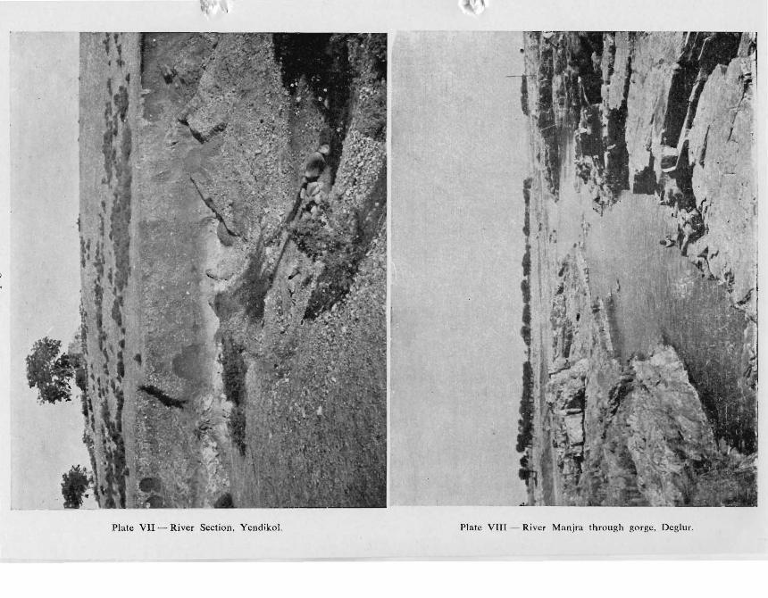
Plate VII - River Section. Ycndikol. Plate VII' -- River Manjra through gorge. Degluf.
See page 67-94
Plate IV - Cut off Trench. Dhanegaon.
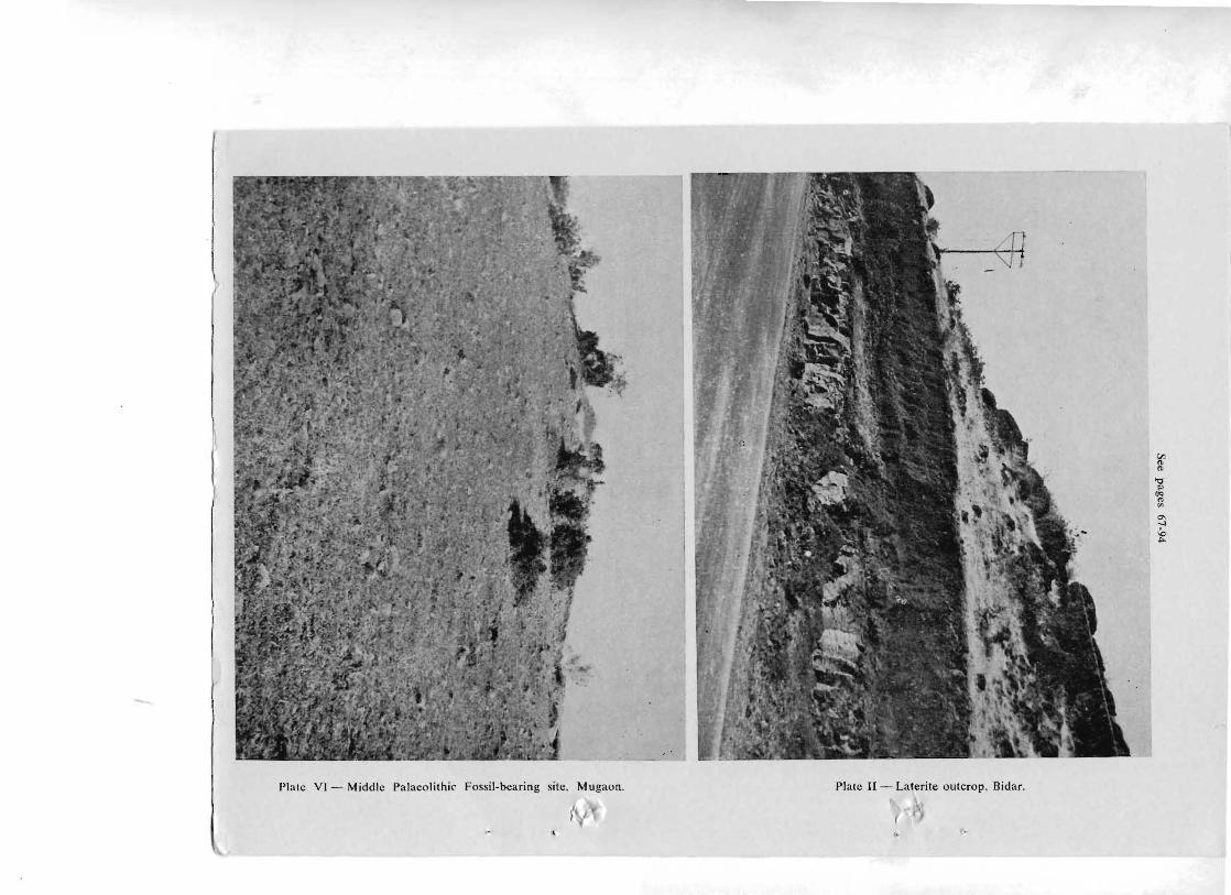
Plate VI - Middle Palaeolithic Fossil-bearing site. Mugaon. Plate II - Laterite outcrop. Bidar.
(I'J
""'Q10~
"'"0-.-I
~


![[IJET-V1I3P7] Authors : Prateek Joshi, Mohammad UmairZaki](https://static.fdokumen.com/doc/165x107/63330122576b626f850dab29/ijet-v1i3p7-authors-prateek-joshi-mohammad-umairzaki.jpg)