Misra VN, Rajaguru SN, Raju DR, Raghavan H, and Gaillard C. 1982. Acheulian Occupation and Evolving...
15
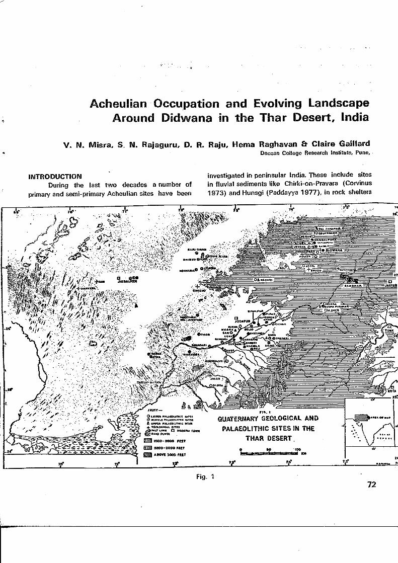
Acheullan Occupation and Evolving Landscape Around Didwana in the Thar Desert, India V. N. Misra, S. N. Rajaguru, D. R. Raju, Hema Raghavan & Claire Gaillard Deccan College Research Institute, Pune, INTRODUCTION During the last two decades a number of primary and semi-primary Acheulian sites have been investigated in peninsular India. These include sites in fluvial sediments like Chirki-on-Pravara (Corvinus 1973) and Hunsgi (Paddayya 1977), in rock shelters Iff : •••- ^••• ;: " Wffii^J^r °u^ QUATERNARY GEOLOGICAL PALAEOLITHIC SITES IN THAR DESERT Fig. 1 72
-
Upload
deccancollegepune -
Category
Documents
-
view
0 -
download
0
Transcript of Misra VN, Rajaguru SN, Raju DR, Raghavan H, and Gaillard C. 1982. Acheulian Occupation and Evolving...
Acheullan Occupation and Evolving LandscapeAround Didwana in the Thar Desert, India
V. N. Misra, S. N. Rajaguru, D. R. Raju, Hema Raghavan & Claire GaillardDeccan College Research Institute, Pune,
INTRODUCTIONDuring the last two decades a number of
primary and semi-primary Acheulian sites have been
investigated in peninsular India. These include sitesin fluvial sediments like Chirki-on-Pravara (Corvinus1973) and Hunsgi (Paddayya 1977), in rock shelters
Iff :•••- ^•••;:"
Wffii^J^r °u^
QUATERNARY GEOLOGICAL
PALAEOLITHIC SITES IN
THAR DESERT
Fig. 172
Man and Environment VI—1982
like Bhimbetka (Wakankar 1973; Misra 1978) andopen air surfaces as in Raisen area (Jacobson1975). In the arid zone of India, however, while alarge number of Middle Palaeolithic and later siteswere?located between 1958 and 1976: (Misra 1961,1968; Mohapatra et al 1963; Allchin et al 1978),the=evidence-,for Lower Palaeolithic occupation .hasbeen scanty until recently (Fig. 1). Small LowerPalaeolithic assemblages were found by Allchin,Goudie-and Hegde-(1978) at Hdkira near Ajmerl atMarwar Bagra south'of Jalor and'at Gurha southof Jodhpur between 1971 and 1976. Misra, Rajaguruand:Agrawal (IAR 1977-78:45-46) located a LowerPalaeolithic site in a buried gravel at Bhadrajun south,of Pali in 1978 • In 1979 the same team . located and.excavated a very rich Acheulian site at Jayal, 50 kmeast of Nagaur. Here thousands "of Acheulian
.—^artefacts were found scattered on and near_the.-- surface of a fossil gravel ridge (Agrawal et al 1980;
Misra et all 980a). In January, 1980 V.N. Misra,S.N. Rajaguru, R.J. Wasson and G. Singh (1980b)located an Acheulian site in a calcareous loam quarryin Singi Talav near the town of Didwana. Since fromthe nature of the sediment as well as of the artefactsthe site appeared to be in a primary context, it wasdecided to carry out detailed investigations.
Accordingly, excavations and explorationswere carried out .at and around Didwana duringJanuary-February, 1981. Using , multi-disciplinarytechniques of archaeology, geomorphology, sedimen-tology and palynology it has become possible to
: reconstruct the story of human cultural evolution,- climatic changes and evolution of landscape in the
Didwana area. The present paper reports the preli-minary results of these investigations. But before wedo so, it will be useful to briefly summarise thegeographical position of the desert in general and ofthe Didwana area in particular.
The arid zone or Thar Desert covers the territorywest of adjoining parts of Haryana, the Aravallr hillsin Rajasthan and the Panjab, Gujarat andPakistan east of the Indus (Fig, 1). Excepting thesmall and low hill ranges around Jodhpur, Balotra
- --and.Batmer, the rocky-plateau west of Jaisalmer and
occasional inselbergs elsewhere, the Desert is a flatalluvial plain formed by the sedimentation of theHimalayan drainage in the north and the Aravallidrainage in the south. Barring the country near theAravalli hills drained by the Luni and its tributaries,rocky plateaux, gravelly plains and hard clayeysurfaces, the plain is covered by sand dunes whosesize and thickness increases progressively from eastto west and from south to north. A significant featureof4he?Desertis the absence of stream channels overa stretch of nearly 400 km between the Ghaggar inthe north and the Luni in the south, and over astretch of nearly 600 km between the -Aravallis- inthe east and the Indus in the west. There are/- how-ever, .a large number of saline lakes of varying sizesall over the Desert. These receive the drainage of thedune country surrounding therrr. The annual" average'rainfall in the Desert is over 500 mm in the east andbelow 200 mm in the west.
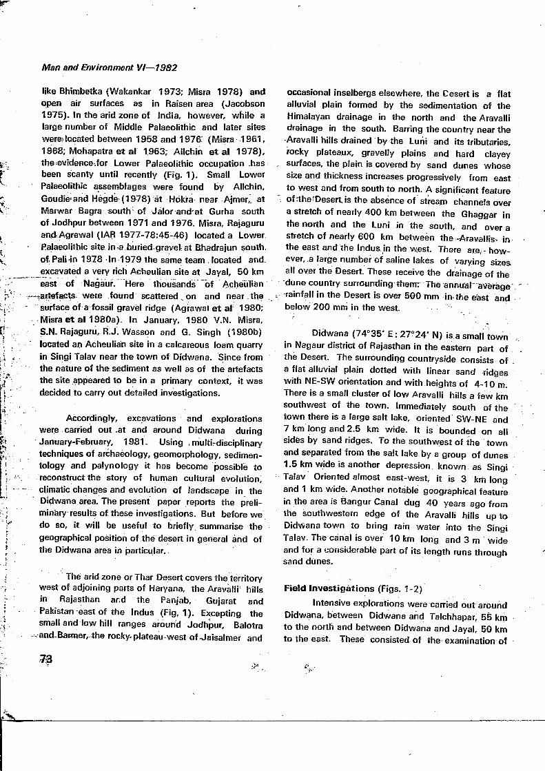
Didwana (74°35* E: 27°24' N) is a small townin Nagaur district of Rajasthan in the eastern part ofthe Desert. The surrounding countryside consists ofa flat alluvial plain dotted with linear sand ridgeswith NE-SW orientation and with heights of 4-10 m.There is a small cluster of low Aravalli hills a few kmsouthwest of the town. Immediately south of thetown there is a large salt lake, oriented SW-NE and7 km long and 2.5 km wide. It is bounded on allsides by sand ridges. To the southwest of the townand separated from the salt lake by a group of dunes1.5 km wide is another depression known as SingiTalav Oriented almost east-west, it is 3 km longand 1 km wide. Another notable geographical featurein the area is Bangur Canal dug 40 years ago fromthe southwestern edge of the Aravalli hills up toDidwana town to bring rain water into the SingiTalav. The canal is over 10 km long and 3 m wideand for a considerable part of its length runs throughsand dunes.
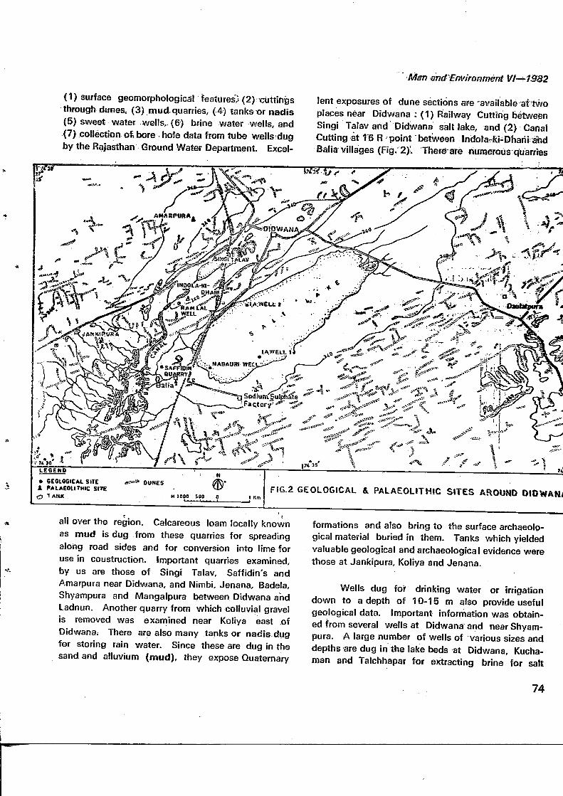
Field Investigations (Figs. 1-2)
Intensive explorations were carried out aroundDidwana, between Didwana and Tafchhapar, 55 kmto the north and between Didwana and Jayal, 50 kmto the east. These consisted of the examination of
" fl/tan GTi&EriVironment \f 1-^1582
(1) surface geomorphological features,- (2) cuttingsthrough dunes, (3) mud quarries, (4) tanks or nadis(5) sweet water wells,, (6) brine water wells, and(7) collection of, bore hole data from tube wells dugby the Rajasthan Ground Water Department, Excel-
lent exposures of dune sections are -available at twoplaces near Didwana : (1) Railway Cutting betweenSingi Talav and Didwana salt lake, and (2) CanalCutting at 16 R point between Indola-ki-Dharii andBalia villages (Fig. 2). There are numerous cfuarries
• GEOLOGICAL SITEi (••LAEOUTHIC SITE
TANK
FIG.2 GEOLOGICAL & PALAEOLITHIC SITES AROUND DlDWANJ
all over the region. Calcareous loam locally knownas mud is dug from these quarries for spreadingalong road sides and for conversion into lime foruse in coustruction. Important quarries examined,by us are those of Singi Talav, Saffidin's andAmarpura near Didwana, and Nimbi, Jenana, Badela,Shyampura and Mangalpura between Didwana andLadnun. Another quarry from which colluvial gravelis removed was examined near Koliya east .ofDidwana; There are also many tanks or nadis dugfor storing rain water. Since these are dug in thesand and alluvium (mud), they expose Quaternary
formations and also bring to the surface archaeolo-gical material buried in them. Tanks which yieldedvaluable geological and archaeological evidence werethose at Jankipura, Koliya and Jenana.
Wells dug for drinking water or irrigationdown to a depth of 10-15 m also provide usefulgeological data. Important information was obtain-ed from several wells at Didwana and near Shyam-pura. A large number of wells of various sizes anddepths are dug in the lake beds at Didwana, Kucha-man and Talchhapar for extracting brine for salt
74
v i Man and Environment VI—1982
industry. We examined many wells for strati-.-. graphical evidence and samples for sedimentological'"•and palynological analysis. In addition, in January,4,198.0 jointly with ;our colleagues; ,Dr. R. J. -Wasson: .-and Dr; G; Singh of the Australian National University,
Canberra, we dug two new wells in the Didwana lake.These have been named IA (Indo-Australian) well
. 1 and 2. .' - \.,: - . . ' . "•'....:
' Excavations mainly for obtainining archaeolo-gical evidence were carried out at two places, Indola-ki-Dhani and Singi Talav near Didwana.
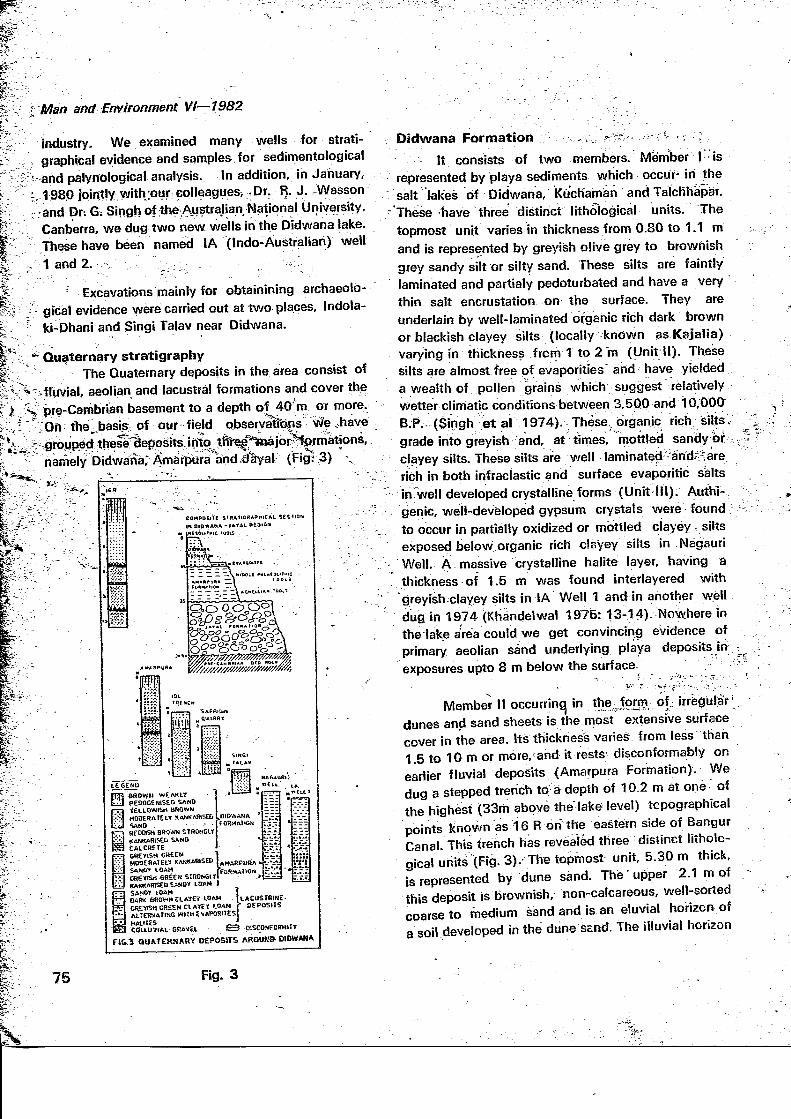
*•" Quaternary stratigraphyThe Quaternary deposits in the area consist of
-fluvial, aeolian and lacustral formations and cover thepre-Cambrian basement to a depth of 40 m or more.'On the basis of our field observatfens vSe ..have
' - - •^•^ — ~ ' • ~ - "'•'» - " •• • * - * • . . . . - _
5 groupedr these;̂ cleposits,into tfir̂ t%sajor̂ %).rmations,.namely Didwana," Amarpura and,dlyal (Fig: 3) \*
ajox
W?i&
COMPOSITEIN DIOWAHA
iff-•-•>.'.
m
PEQQCENtSED SANDVEtLQWISM BROWWMQOERftlEU KANKARlSED5AND •SfOOKH 9ROWN S1RONGUKANKARiSU SAND .CALCRETEGREflSH GftECMMOOERAIE1.? KANKARtSED
i:<\t 10AM" OKEtrStl GREEK SIROWSlt
KAW.ARiSED SANDY LOAM
ACUSTRIHE-DEPOStIS
t-j MAIIIESEl COLLUViAL GRAKEl ^3 pSCONFORHII!f
FI&.5 QU*TERS4ARV DEPOSITS AROUKB-OIOWAM*
Didwana Formation - ,;,,\ ?;*:---.-...;:-rv - v . ' ; - ,
It consists of two members. Member I ' isrepresented by playa sediments which occur- in thesalt lakes of Didwana, Kuchaman and Talchhapar.
" These -have three distinct lithological units. Thetopmost unit varies in thickness from 0.80 to 1.1 mand is represented by greyish olive grey to brownishgrey sandy silt or silty sand. These silts are faintlylaminated and partialy pedoturbated and have a verythin salt encrustation on the surface. They areunderlain by well-laminated organic rich dark brownor blackish clayey silts (locally known as Ksjalia)varying in thickness from 1 to 2 m (Unit II). Thesesilts are almost free of evaporitles and have yielded .a wealth of pollen grains which suggest relativelywetter climatic conditions between 3,500 and 10,000B.P. (Singh et al 1974). These organic rich; siltsgrade into greyish and, at times, mottled sandy orclayey silts. These silts are well laminated -and^arerich in both infraclastic and surface evaporitic saltsin well developed crystalline forms (Unit III). Authi-genic, well-developed gypsum crystals were found;to occur in partially oxidized or mottled clayey siltsexposed below organic rich clayey silts in NagauriWell. A massive crystalline halite layer, having athickness of 1.5 m was found interlayered withgreyish clayey silts in IA Well 1 and in another welldug in 1974 (Khandelwal 1975: 13-14). Novvhere inthe lake area could we get convincing evidence ofprimary aeolian sand underlying playa deposits in :exposures upto 8 m below the surface.
-y•' T - :*.»•;••-•--.. - • • ' , - . . -,x - " . '
Member I! occurring in the ..form of. irregular';dunes and sand sheets is the most extensive surfacecover in the area. Its thickness varies from less than1.5 to 10 m or more,'and it rests- disconformably onearlier fluvial deposits (Amarpura Formation). Wedug a stepped trench to a depth of 10.2 m at one. ofthe highest (33m above the-lake level) topographicalpoints known as 16 R on the eastern side of BangurCanal. This trench has revealed three distinct litholo-gical units (Fig. 3).-The topmost unit, 5.30 m thick,is represented by dune sand. The'upper 2.1 m ofthis deposit is brownish/ non-calcareous, well-sortedcoarse to medium sand and is an eluvial horizon ofa soil developed in the dune Send. The illuvial horizon
75 Fig. 3
from 2.10 to 5.30 m Is yejlowish brown in colour and-contains diffused powdery carbonate and small('0.5 to 2 cm) amorphous carbonate pellets. Thisweakly pedogenised dune sand is represented notonly in the Didwana area, but over a .major portionof the eastern part of the Desert. We have found•a large number of fMesolithic sites over the surface ofthis unit in this region.
At the base of the dune sand there is a 10 cmcolluvial gravel, rich in subangular' slate and schistfragments. This gravel represents hill wash depositsderived from the nearby hills during stormy rains ofthe past. It rests disconformably on a calcreted
•• surface-Which fcnms the top of the second litholo-Igical unit. The calcrete grades into yellowish brown,well sorted fine to medium grade sand rich in hard.microerystalline carbonate nodules of 3 to 6 cm sizeto a depth of 6.8 ,m, and then into a sandy layerrelatively poor in carbonate nodules and containing
, powdery carbonate diffused throughout the mass ofthe sand to a depth of 8.92 m. At its. base thisdeposit contains a colluvial grave! 5-10 cm thick.The gravel rests disconformably on a calcreted layerdeveloped on the reddish brown fine to mediumsand, exposed to a depth of 10.2 m (Unit III). Thecarbonate nodules are hard, crystalline and vary insize from 2 to 8 cm. They are found to be dissemi-nated throughout the mass of this basal most unit.
Unit I is definitely of aeolian origin. Units IIand III represent strongly pedogenised or calcifiedfine to medium sands without any trace of deposi-tional structures. Presence of calcrete layers overlainby colluvial washes between units II and III, andbetween units I and II clearly suggests that units III,II and I are separated by palaeosols which suggeststabilization of the landscape prior to the depositionof successive younger sediments. We have not yetbeen able to decide about the exact origin of unitsII and III, though they are likely to be of aeolianorigin. All the three units are also seen in Ramlal'sWell, 1 km NEof 16 R Point, while units I and IIare found to be disconformably resting over stronglykankarised greyish green loam at several places inthe area. Jv .
Man and Environment VI—1982
Amarpura FormationThis formation consists of calcareous loamy
alluvium, and is exposed in topographic lows. Its.colour is predominantly greyish green or greenishgrey, at times whitish or mottled. The white colouris due to a high proportion of calcium carbonate, and.mottling is due to the presence of soft amorphousferruginous segregates. Calcium carbonate -occursas hard crystalline nodules, coalesced nodulesvarying in size from 1.5 to TO cm, as 'bedded 'Caiibornates and as fine powdery carbonate fillings todessication cracks in clayey deposits. Thin (2 to 5 cm))calcrete bands also occur throughout the formation.Texturally there is variation from sandy or gravellyloam to clayey loam. Lamination is-either-absentor crude.. On the basis of bore hole .data the Amar-pura Formation extends as far as Sujangarh, 46 Kmnorth of Didwana. It is thick (up to 30-40 iri)beneath salt lakes and thin (1-2 m) on rock-basedinterfluves as near Ladnun. At Jenana, 23 km north-east of Didwana the Amarpura f ormation forms aninset fill terrace and rests against the bouldery gravelof the Jayal Formation. .
These characters suggest that the sedimentshave been deposited by a low gradient/ suspendedload highly sinuous stream. Gravel was contributed bystreams coming from the nearby Balia hills. Thecalcareous clay at Singi Talav represents stagnantwater deposition in flood plain pools or lakes. Colourmottling suggests soil gleying in which reductionand mobilisation of iron has taken place at the airground water interface as a result of fluctuatingwater table. It also indicates periodic water logging.
Presence of nodular kankars as in IDL trenchand Amarpura quarry indicates that the loamy depositswere sub-aerially exposed at least seasonally. In thissituation upper zone soluble carbonates near thesurface seems to have been carried downward andprecipitated when soil moisture is removed byevapotranspiration. Deeper soluble carbonates risewith capillary waters. The occurence of thin butmassive calcrete layers indicates that on severaloccasions the. floodplain was exposed to subaerialpedogenesis for a considerable- period of time. Thepresence of Middle Palaeolithic tools in the upper
76
Man and Environment VI— 1982
part of the formation suggests this portion to beearly Late Pleistocene age. The lower portionshould therefore belong to the late Middle Pleisto-cene. In view of slow rate of sedimentation in a lowenergy fluvial environment, the total thickness ofabout 30-40 m of Amarpura Formation may cover amajor part of the Middle Pleistocene. Tentativelywe are inclined to date the Acheulian industry foundin and around Didwana in the middle portion of thisformation to Middle Pleistocene. If this datingproves to be correct, then the Acheulian industryfound at Didwana will be one of the earliest LowerPalaeolithic industries found in the Indian sub-continent.
Jayal FormationThis formation is represented by an extensive
and thick (20 to 60 m) deposit of bouldery- cobblygravel. Its best exposure is seen in the Kathoti-Jayalarea where it occurs in the form of a highly dissectedhill-like ridge over a length of 16 km and width of7 km. Its extensions are seen at Jenana northeastof Didwana, near Rol east of Jayal, at Khinala northof Jayal and at Mokheri south of Phalodi. Thegravel is composed of rounded to sub-roundedboulders and cobbles laid down in a matrix ofyellowish brown silty sand and cemented by calciumcarbonate. It is poorly sorted, ungraded, unimbricatedand unstratified. Lenticular patches of silty sand,pebbly sand and clayey silt are common. Carbonatecoatings on pebbles are common and the carbonateconcretions are soft, nodular and amorphous. Themain rock types present are varieties of quartzite,veinquartz and quartzitic sandstone. The gravelwas deposited by high energy bedload braidedstreams with their origin in the Aravallis. In itsupper parts the gravel is interlayered by a 2-10 m.thick crystalline oalcrete deposit which appears tohave originated through non-pedological processes inwhich ground water enrichment of carbonates hadtaken place. Acheulian tools lie littered in thousandson the surface of the ridge, and they also occur inthe redeposited gravel in well sections.
Briefly, the Quaternary stratigraphy andassociated Palaeolithic industries can be correlatedas follows :
Geological Unit
DidwanaFormationDisconformityAmarpuraFormationDisconformityJayalFormationUnconformityBed Rock
Probable AgeEarly Holocene toterminal LatePleistoceneEarly Late Pleistoceneto Middle Pleistocene
EaUy Pleistocene orlate Tertiary
Table 1
Depositional Environment
Dominantly aeolian andplaya
Dominantlyalluvial
low energy
High energy alluvial
Cultural ContextMesolithic and Upper Pala-eolithic
Middle Palaeolithic andAcheulian
Eocene to pre-Cambrian
Excavations & Archaeology
Excavations were carried out at two places—Singi Talav and Indola-ki-Dhani to get a clear pictureof stratigraphy and stone industries.
Singi Talav
There is a large, shallow quarry in Singi Talavimmediately west of the railway line. A 4 x 4mtrench was dug on the western edge of the quarrynear the area which had revealed a dense concentra-tion of Acheulian tools during quarrying operations.The trench was divided into sixteen 1 m squares(A1—4, E1-4, C1—4 and D1—4) and was dug toa depth of 1.25 m. The stratigraphy is as follows :
Layer Depth belowsuaface (cm)
1 0-8
8-25
Description of rock unit
Brown silty sand sharpcontact to
Greyish clayey silt sharpcontact to
77
Man and Environment VI—1982
3 20—80 Greyish green, stronglykarrkarised clayey loamgrades to
4 80—90 Kankar crust or calcretegrades to
5 90 — 125 Greyish green, moderateiykankarised clayey loam ;ferruginous pellets common
The sediment between 25 and 125 cm corres-ponds to the middle part of Amarpura Formation as
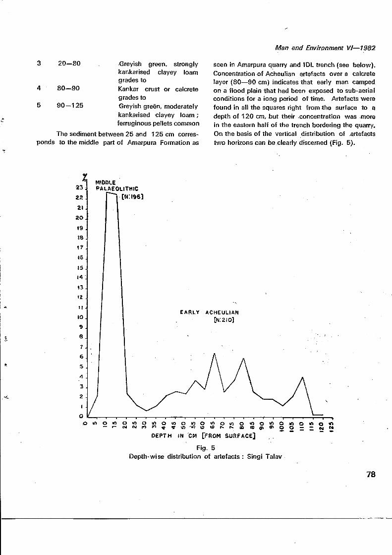
seen in Amarpura quarry and IDL trench (see below).Concentration of Acheulian artefacts over a calcretelayer (80—90 cm) indicates that early man campedon a flood plain that had been exposed to sub-aerialconditions for a iong period of time. Artefacts werefound in all the squares right from the surface to adepth of 120 cm, but their -concentration was .morein the eastern half of the trench bordering the quarry.On the basis of the vertical distribution of .artefactstwo horizons can be clearly discerned (Fig. 5).
MIDDLEPALAEOLITHIC
EARLY ACHEULIAN[N:2IO]
o « o i o o i o o i o o i o o < n o t n o mo O <o oo o — o *>
DEPTH IN CM [FROM SURFACE]
Fig. 5Depth- wise distribution of artefacts : Singi Talav
78

fen and Environment VI—1982
Horizon 2 (15—120 cm). Though artefactsoccurred at all depths in this horizon, they were moreconcentrated between 40 and 80 cm depth. Thishorizon yielded a total of 210 artefacts. Of tttese 31(14.76%) are completed tools and the remaining 179(85.24%) debitage. The finished tools include 8(25.81%) handaxes, 7 (22.51%) specimens each ofchopping tools and scrapers, 6 (19.35%) choppersand 3 (9.68%) polyhedrons. The tools are made onlarge tabular pieces of rock and occasionally onpebbles of vein quartz and quartzite. The rock piecesmust have been obtained from the nearby Aravallioutcrops, and pebbles from a Jayal Formation expo-sure now buried under alluvium and sand. The.association of finished tools with a high proportionof flakes and chips (58.10%) and cores (5.17)clearly .shows that Singi Talav is a manufacturing-oum-habitation '.c£mp.
HoKZoin 1(0=15 cm). This horizon yielded'a total 0$ 196 artefacts. The top 5 cmdeposit yielded only 9 artefacts but the next two5 cm spits gava 95 and 94 artefacts, respectively.Of these only 7 (3.57%) are finished tools and therest 189 (96.43%) unfinished. Finished tools include1 handaxe, 2 choppers, 3 chopping tools and 1scraper. Among unfinished artefacts, flakes and chipsconstitute 54% and debris (slightly worked pieces)44%. The size of the artefacts is very much smallerthan those of horizon 2.
Indola-ki-Dhani (IDL)Another trench of 4x4m was dug on the
southern bank of Bangur Canal opposite the villageof Indola-ki-Dhani. This was also divided into 16squares of 1 sq. m each (A1—4, B1 — 4, C1—4 andD1 — 4). While digging in all squares was done to adepth of 3.85 m, further digging to a depth of 5.15 mwas restricted to four squares (A1—2 and B1—2).The stratigraphy of tne trench was as follows.
Layer Depth below Description of rock unitsurface (cm) - •
, 1 0—60 Reddish brown, non-calcareous,moderately consolidated dunesand sharp contact to
2
3
60—135
135—240
4 240—272
5 272—4-10
410—515
Brown, weakly kankarised dunesand sharp contact to
Greyish green, strongly kankri-sed (concretionary) loam
grades to
Greyish green, strongly kanka-rised (less concretionary) loam
grades to
Gravelly-sandy, greyish green,moderately kankarised andweakly laminated loam
grades to
Gravelly-sandy, greyish green,moderately kankarised, lamina-ted loam with soft ferruginouspellets.
Layers 3-6 represent Amarpura Formation. Thepresence of hard microerystalline kankar concretionsbetween 135 and 240 cm indicates periodic dryingof the flood plain. As a whole the nature of the sedi-ments shows that there was a gradual lowering ofthe water table and consequent disorganisation ofthe drainage system in the area. Stone artefactswere found in all layers of the Amarpura Formationbut parts of layers 4 and 5 (S3S—445 cm) weresterile. On the basis of vertical distribution of arte-facts three archaeological horizons can be discerned(Fig. 4).
•IATC ACNEUUA*
* rfi lO *. M C < O l ^ r « " « l " > O ^ O C >
DEPTH, in CM jf ROM SURFACE)
DISTRIBUTION Of ARTEFACTS IN tNDOLA-KI- OHANI tlDtjEKCAVAiiONl. (
? 5 g «
Fig. 4
79
Man and Environment VI—1982
Horizon 3 (446—505 cm). In this horizononly 10 artefacts were found, due to digging beingconfined to a 4 sq. m area and that too, in a part ofthe trench where the density of artefacts in the upperlevels was much less than in other parts. Amongfinished tools there is only one chopper, and theassemblage is, therefore, far from representative.
Horizon 2 (186-385 cm). This horizonyielded 441 artefacts. Although the artefacts weredistributed all through, they were much fewer below335 cm. In this collection only 30 (6.81%) piecesare finished tools and the remaining 411 (93.19%)debitage. The percentage of flakes and chips is ashigh as 76, thus suggesting the horizon to be pri-marily of a workshop. The finished tools include 2(6.67%) incomplete handaxes, 7 (23.33%) points,7 (23.33%) scrapers, 6 (20.00) choppers, 3(10.00%) t̂ipping tools, 3 (10.00%) polyhedronsand 2 (6.67%) knives. Among unfinished arte-facts flakes and chips constitute nearly 77%, thustestifying to the workshop nature of the assemblage.The proportion of flake tools like scrapers andpoints is higher and the size of tools smaller incomparison to the assemblages from Singi Talav,Jankipura and Koliya.
Horizon 1 (135-185 cm). This yielded a totalof 266 artefacts. Of these 17 (6.40%) were finishedtools and 249 (93.61%) debitage. The percentage offlakes and chips (75.56%) is as high as in horizon2, thus showing unity in the nature of occupationsin the two horizons. Among finished tools handaxesand polyhedrons are absent. The types presentinclude? (41.18%) discoids, 5 (29.49%) choppers,2 (tl.76%) denticulates and 1 (5.89%) specimeneach of scraper and point. Discoid and denticulateare new types not present in horizon 2. The averagesize of tools is smaller than in horizon 2 and thesingle point in the collection is typically Mousterian.
The raw material and state of preservation ofthe artefacts are similar to those of Singi Talavtrench.
Other Archaeological Sites
Archaeological material was also collectedfrom several other sites. Though it does not comefrom a proper excavation and is of a mixed nature,its geological context in each case is clear. In spiteof these limitations the material from these sites isvaluable because it comes from among the firstPalaeolithic sites to be discovered in this part of theDesert.
Singi Talav Quarry
The stratigraphy of the quarry sections isidentical to that of the trench which was dug on itsedge. With the help of the workmen digging in thequarry we collected 215 artefacts. Because of thecircumstances of its collection the assemblage isheavily weighted in favour of larger and heaviertools. In this collection 114 (53,04%) are finishedtools and 101 (46.99%) debitage. Among thefinished tools handaxes (54.39%) form the maingroup. Other common types are chopping tools(12.28%), choppers (11.40%) and polyhedrons(9.65%). Cleavers are only 4.39.% Other toolstypes are denticutates (3.51%), scrapers (3.51%) anddiscoid (0.88%). Levallois flakes are present, butare not common. This collection is similar to thatfrom the Singi Talav excavation in every respect.
Amarpura
Around Amarpura village, 2 kra west ofDidwana, there are several large and deep (up to7.0 m) quarries. The typical section in the quarriesis as follows.
Layer Depth belowsurface (cm)
1 0—110
110-360
360—385
Description ofrock unit
Brownish, weakly kankarisedaeolian sand
sharp contact to
Greyish green, strongly kan-karised concretionary loam
sharp contact to
Calcretegrades to
80
Man and Environment V.t—1982
4 385—475 Pinkish brown, stronglykankarised sand loam
sharp contact to
5 475-495 Calcretegrades to ,.
6 495—595 Brown, calcareoussandy loam
grades to
7 595— 605 Greyish silty clay with softcarbonate segregates
grades-to : - ' "" ;
8 605—700 Greyish, moderately kan-. karised clayey silt with soft
ferruginous pellets
Artefacts occur occasionally in the Amarpura .Formation (layers 3-8) from its surface down to adepth of SjQ.cm. Of the 41 artefacts eolteGtedjfromthe quarries, 32 (78.05%) are finished-.tooJsv§nd 9(21.95%) unfinished. The finished toots' cojrhprise14 (53.75%) polyhedrons, 8 (25.00%) choppers, 8(25,00,%).chopping tools and 2 (6.25%) handaxes.This assemblage is broadly similar, to that of Singi
• Talgy. The small size of the collection shows thatthe Amarpura area was not part of the main habita-tion,zone of-Acheulian man in the Didwana region.
Bangur Canal
From the dug out mud of Bangur Canala collection of 139 artefacts was made over a stretchof about 1 km opposite the village of Indola-ki-Dhani. Of these, 64 (46.04%) are finished toolsand 75 (53.96%] debitage. The finished tools-include polyhedrones (28.13%), choppers (29.31%),handaxes 20.13%, chopping tools (15.63), scrapers(5.81%), points (3.13%), denticulates (3.13%) anddiscoids (1.56%).
Jankipura
From the surface of the mud of a tank nearthe village of Jankipura, 5 km'west of Didwana acollection of 221 artefacts was :made. Of these132 (59.73%) are finished tools and 89 (40.27%)debitage. The finished tools comprise handaxes
81
(26.52%), chopping tools (20;45%), scrapers(15.91%), choppers (14.39%), polyhedrons (8.33%);denticulates (6.82%), discoids (5.30)%, points(1.52%) and deader (0.76%).
Koliya I
Two km west of the village of Koliya and 13km west of Didwana there is a large gravel quarryin the colluvium (more than 2 m thick) formedon the southern slope of an Aravalli hill. From thesurface as well as from the quarry sections, a collec-tion of 258 artefacts was made. Of these 145(56.21%) are finished tools and 113(43.81%)
.debitage. The finished tools comprise handaxes(70.34%), scrapers (10.34%), choppers (9.66),chopping tools (4.14%), polyhedrons (2.07%), r
cleavers (1.38), denticulates (.38%) and knivess
(0.69%). The low proportion of choppers, choppingtools and polyhedrons is probably explained by the.-absence of pebbles as raw material.
Koliya II . '.'"', ' '!
From the surface of mud of a tank, about '•500m east of the quarry a small collection of 63'artefacts was made. These include 34 (53.97%)'finished tools and 29 (46.05%) pieces of debitage. 'The finished tools "comprise handaxes (58.82%),scrapers (2353%), cleavers (11.76%) and discoids(5.85%). Though part of this material may be derivedfrom the Koliya hill slope, some of it seems to., haveits origin near the point where it was found.
IVIangalpura :. . - . - - . . .
Thirty-three km north of .Didwana and 2 Km ofsouth Ladnun there are two mud .quarries separatedby road. Ninety-one artefacts were collected fromthe dug out mud as wall as in situ from exposedsections, a number of the latter at the junction of theAmarpura and Didwana formations. Many artefactsare made of chert which must be derived from alime.stone formation in the vicinity, but now buriedunder surface alluvium. These comprise 30(33.00%)finished tools and 61 (67.03%) pieces of debitage.The finished tools include choppers tools (30.00%),scrapers (16.67%), handaxes (13.33%), choppers
^T
Man and Environment VI—1982
(13,33%), denticulates (13.33%), points (6,67%),polyhedrons, (3.33%) and notchds (3.33%). Thetools are much smaller than in Acheulan assemblages.
Shyampura
Five km east of the village of Baklia, located25 km north of Didwana on the road to Ladnun thereare two mud quarries near the village of Shyampura.From the quarry nearer the village, 14 artefacts werecollected on the surface and in the exposed sections.These include 2 handaxes, 2 scrapers, 5 flakes and 3chips. The size of the tools is similar to those ofMangalpura.
Jenana
Thirty-one artefacts were collected in situ inthe mud from its surface to a depth of 2.5 m in atank at Jenana, 23 km northeast of Didwana. Theseinclude 1 chopper, 2 chopping tools, 1 polyhedron,3 scrapers, 2 points, 20 flakes, 1 chip and 1 pieceof debris The size of tcols is smaller than in Achau-lian assembleges ard there is one topical Mousterianpoint in the collection.
Cultural Sequence & Nature of Occupation
The range of typological and technologicalvariation present in the artetact assemblages fromsites in the Didwana area shows continuous culturalevolution from Early Acheulian to Middle Palaeolithic.The assemblages from horizon 2 of Singi Talav exca-vation and from Singi Talav quarry are very distinctivein character. The large and heavy tools likehandaxes, choppers, chopping tools and polyhedronsare made mainly on cores. Handaxes in particularare massive and thick, are worked by stone hammertechnique and have large unflaked areas both on thebutt and surfaces. The few cleavers present in thequarry assemblage are of convergent type with nar-row working edges, and are technologically close tohandaxes. These two assemblages are technologi-cally rhe most archaic and represent an Early Acheulianstage (Pis. l-ll).
Both the assemblages come from a well-defined horizon between 40 and 80 cm in the
Amarpura Formation. They occur in a soft loamysediment in which heavier transported material istotally absent. The tools are remarkably fresh inappearance, and devoid of any damage, so that theycould not have undergone the slightest transporta-tion, Both in the quarry and the excavation, artefactsare concentrated rather than being evenly distributedthroughout the deposit. All these characters showthat the tools are in their primary context. They seemto have been made, used and discarded on the shoresof water pools or lakes where they were incorporatedin the soft sediment during periods of lake flooding.
Acheulian assemblages from Bangur Canal,Jankipura and Koliya I come from non-archaeologicalexcavations in Amarpura Formation and that fromKoliya II from a hill slope deposit. As the artefactsare derived from the surface of the dug out mud orcolluvium, they cannot be fully representative of theoriginal composition of the Acheulian industries ofthese sites. In all these assemblages technologi-cally both primitive and advanced elements arepresent. At. Jankipura in particular, there are manyhandaxes which pre characterised by extreme symme-try of outline, thinness, small size, small and shallowscars and even surface. They can be compared withthe finest products of Acheulian craftsmanship any-where in the world. These handaxes, and those ofSirgi Talav, represent two extremes of the Acheuliantechnological spectrum. The high percentages offlake tools like scrapers, denticulates, knives andpoints in these assemblages also shows the presenceof advanced elements. These assemblages can there-fore be regarded as representing a mixture of Earlyand Late Acheulian stages. The assemblage fromhorizon 2 cf Indola-ki-Dhani excavation, on the otherhand, is characterized by a low proportion of handaxesand core tools like choppers, chopping tools andpolyhedrons and a high proportion of flake tools likethe original composition of the Acheulian industriesscrapers, points and knives. This assemblage, there-fore, clearly represents a late stage of the Acheulian(PI. Ill),
The assemblages from horizon 1 of Singi Talavand Indola-ki-Dhani and from Mangalpura, Shyam-
82
Man and Environment VI—1982
pura and Jenana are clearly of Middle Palaeolithiccharacter in view of the small size of tools, comparedto Acheulian tools from all sites, a higher proportionof Levallois flakes, a predominance of flake tools likescrapers, points, denticulates and knives, and thepresence of some typical Moiisterian points. Thechange of raw material from quartzite to chert atMangalpura is also indicative of cultural change(PI. IV),
The Acheulian aasemblages occur at several•*•?sites from Didwana to Jayal over a stretch of 50 km.There is no doubt that examination of other mudquarries and nadis will bring to light many moresuch sites. The wide distribution, large numbers andthe presence of artefacts of several technologicalstages in these assemblages, suggest extensive habi-tation of the flood plains by large Acheulianpopulations over a considerable period of time. Incontrast, the Middle Palaeolithic assemblages occuronly at a few sites and are few in number. Stratigra-phically they are found in the topmost concretionaryloam of the Amarpura Formation when the drainagewas becoming more disorganised and was already onits way to becoming defunct.
Man-land relationship during the Quaternary
Before we discuss the environmental implica-tions of Quaternary formations studied by us, it isworth reviewing briefly the information alreadyavailable on the Quaternary history of the TharDesert. Blanford (1976), La Touehe (1902) andHolland and Christie (1909) laid the solid foundationof Quaternary studies in western Rajasthan. Someof their ideas were modified by geologists likeKrishnan (1952) and Ghosh (1952]. The applica-tion of new techniques such as aerial photography,radiocarbon dating, pollen analysis, sub-surface drill-ing for ground water and the study of Quaternarylandforms in relation to archaeological data providedsome new information on the Quaternary history ofregion (Misra 1961. 1968 ; Singh et al 1974; Dhir1 976; Ghosh 1976 ; Sinha 1976 ; Allchin et al 1978:Ghosh et al 1979, 1980 ; Agrawal et al 1980 :Misra et al 1980a. 19SO b: Yashpal et al 1981).
Studies by these scholars show that there wasa sea or an arm of the sea in southern, western andpart of the northern Thar during Eocene times.Though there is a strong possibility of the contin-uation of marine or littoral environment in the lowerLuni and Indus valleys during late Tertiary and possiblyearly Quaternary times, there is absolutely no evidencefor the existence of marine environment in the majorpart of Thar Desert during the Quaternary. In fact,this region had a well-integrated drainage systemalmost up to the beginning of the Late Pleistocene.Aeolian landforms are superimposed on the earlyQuaternary fluvial landscape. The source of aeoliansand is mainly local, mostly the defunct floor plains.The presence of calcareous forcminifera in dunesands right up to Bikaner probably indicates some longdistance contribution from the Rann of Kutch (LaTouehe, 1902,). Though there is a possibility ofsalt particles being blown into the present playasby strong southwesterly winds coming from Rann theof Kutch, the major source of salt in lakes is fromthe surrounding country rock only. Playas like Sam-bhar, Didwana, & kuchaman and Tal Cheppar are noth-ing else but shallow depressions surrounded by duneson three sides and by low hiil ranges of pre-Cambrianrocks on one side. Bcre hole data from various saltlakes does not support the existence of marine sedi-ments below playa sediments. The terminal Pleistocenewas dominated by strong seolian activity, and themajor dune field of Rajasthan seems to have deve-loped during this period. The Ghaggar in the northand the Luni in the south continued to flow evenduring this arid phase. The Ghaggar lost its conti-nuity of flow probably during early historic times.Changes in the fluvial dynamics of western Rajas-than during early and mid Holocene period havebeen detected on aerial photographs and sateliteimages. Neotectonic movements, climatic changesand fluctuations in sea levels have been responsiblefor the formation of Quaternary landforms of theThar Deset. Man seems to have first inhabited thisregion in early Palaeolithic times and there is almosta continuity in human habitation since then.
There are certain lacunae in Quaternarystudies so far carried out in this region by various
83
Man and Environment Vt—1982
scholars. These are mainly due to lack of both adetailed stratigraphical framework and Palaeolithicassemblages recovered from careful excavations.Our geoarchaeological investigations in Nagaurdistrict, particularly around Didwana, have helped usto gain insight into the problem of palaeodrainage,its relationship with the formation of aeolian land-forms and playas, and the relationship of both theseto the history of human occupation in this region.Our findings, essentially based on field work, .canbe summarised as follows.
The sea retreated from the region under con-sideration in early Tertiary times, and since then ithas been subjected to sub-aerial weathering and toerosiohal and depositional processes. Fluvial for-mations such as the Jayal and Amarpura, aeolianformations represented by dunes and sand sheets,and salt lake deposits are the only superficialdeposits present in the area. The palaeoenviron-mental history of this region is therefore based onan understanding of drainage evolution and aeolianprocesses of the Cenozoic period.
The earliest traces of an ancient fluvial systemare represented by the Jayal Formation of lateTertiary of Early Pleistocene age (Agrawal et al1980; Misra et al 1980a). The formation consistingof a 60 m thick well-rounded pebbly-bouldery graveland interlayered by a 2-10 m thick calcrete, isexposed as a resistant plateau-like surface betweenJayal and Ladnun and between Khatu and Rol(Fig. 1), The gravels were deposited by a highenergy bed-load braided stream system having itsorigin in the Aravalli hills and probably flowingtowards the west north wesk. The occurrence of anextensive and high gravel ridge around Jayal indicatesthat these braided stream deposits were technicallydisturbed and uplifed sometime during the Early Pleis-tocene. The rejuvenation of the area helped thestreams to carve out deep valleys into the JayalFormation. It is probably during this stage of thedrainage history that Acheulian man arrived in thearea. His cultural remains are found in theform of rich stone tool assemblages at numerousplaces on the surface of the Jayal ridge and in the
floodloam deposits of the Amarpura Formation, Thepost-Jayal Formation drainage system is representedby low gradent, highly sinuous streams with theirwide flood plains and associated pools and lakes.These flood plains were occupied by Palaeolithic manfor a long time, probably from Middle Pleistoceneto early Late Pleistocene, Abundance of kankarbeds in various forms, and the presence of mottlingin clay loams, indicate that the climate was essen-tially hot semi-arid throughout this long period ofoccupation. -
The drainage system represented by theAmarpura Formation existed under two critical hydro-climatic situation. Firstly it had its catchment in therelatively low part of the Aravalli range, getting less .^rainfall than in its southern counterpart where the 1Luni and its tributaries originate. Secondly, it did-not receive water from the Himalayas as the Sutlej fand the Ghaggar did. Due to these hydrologies!factors it is likely that relatively minor tectonic and.climatic changes of the Late Pleistocene broughtabout the disorganisation of this sluggish system,,thus, giving rise to playas and dunes of the DidwanaFormation. The cessation of through f lowing.drain^age some time in the early Late Pleistocene musthave forced Palaeolithic man to move further southinto the Luni valley where streams continued to flowthroughout the Late Pleistocene and the Holocene.The presence of abundant Middle Palaeolithic sitesin the middle "Luni valley ̂ supports this view.
Preliminary field studies :&t\d bore well data iromSambhar (Auden 1952), Kuch'aman, Didwaria andTalchhaparsalt lakes show that 'the depth pf bedrock below the"j3resent surface of these teikes "varies"from 7 to 20 m ancNhe playa sediments dofiMmablygrade to fluviarsediments of the Amarpura Forte-tion. It is therefore deal that the playas in misarea are situated in an ancient flood plain repre-sented by the Amarpura Formation. As in the easeof Pachbhadra where the salt lake is situated in anabandoned channel of the Luni (Fig* -1), these lakespossibly represent remnants of flood plain lakeswhich got isolated due to the total cessation ofthrough flowing drainage system. Changes in
84
Man 'ancf Environment "W-—T982
climate and and geomorphology of the area triggered'the aeolian activity in this region represented byDidwana Formation. The relationship betweenplayas and surrounding dunes is not yet clearlyknown. The presence of halite beds in the Didwanasalt lake; and of evaporites in alf the salt lakes,indicates ; that these lakes were carrying highlysaline waters when dunes were actively formingin this region, probably during the terminal Pleisto-cene. This period was one of the driest climaticphases in the history of western Rajasthari. The-paucity of Upper Palaeolithic sites in this regionsuggests that the area around Didwana in particularand -the Thar in general, was environmentally notconducive to large-scale human occupation duringthe terminal Pleistocene. The Presence of darkbrown evaporite-free clayey beds over evaporitesiivihe salt lakes shows that the lakes )Mtfere harrying:fresh-water, and the surrounding dime fields got
stabilized dire to vegetation growth, during the earlyHolocene. The climate at this stage was relativelywetter and provided a congenial environment forMesoiithic man. Our findings thus confirm theconclusions of Allchin. Goudie and Hegde (1 978)regarding the climatic and cultural history of terminalPleistocene and Holocene while they are at variance
, with those of these scholars in respect of the EarlyPleistocene to early Late Pleistocene.
• - . ' " . . ' ' ' . J/' >"/• ,:
• '. ' . ' . - - - -' ' •->'"'
Acknowledgments , . . - _ , - , . . . .We would like to express . bur thanks to Mr.
A. L. Mathiir, Assistant Executive Engineer (P.W.D.),Mr. M. ,C. Arya,*-,,Sub- Divisional Magistrate, Mr,
' • .!" ,j •"-",'•' , ' • ' • " ' ' • ' . - •
i Aditya^.Sharmai., Junior' Engineer, Rajasthan Salt" Works, Prof.. N.,"M. Khandelwal of Bangur College,
*' • '** t ' ' -*-r"S-t . , ' . - ! • '
• ,,jall,of,pjdwaria, Mr. P. C, Jain, Collector and District; Magistrate, Nagaur, and Mr, Madan Lai Sarma
.-? ,V!(Maharajjij of .Balia for hejp in various ways during-'ii'Du'r investigations at.Didwana. We^arealso thankful«•' to Dr. R. P. Dhir of .th^ Central Arid Zone Research
Institute, Jodhpuroffor clarification of our ideasthrough many discussions in the field and at Jodhpur.and to Dr, R. J/jrWasson of the Australian NationalUniversity,''Ga*nberra. for reading the draft of thispaper and making valuable suggestions.' " ' "'
References ' '• - - • " - • : • • •Agrawal, D. P., Datta, P. S., Husaih, S? Krishna-
murthy, R. V., Misra, V.1 N., Rajaguru, S;-N., and-Thomas, P. K. 1980. Palaeoclimate, Stratigraphy"and Prehistory in north and west Raj'asthan. Pro->ceedings of the Indian Academy of Sciences89(1): 51-66.
Allchin, B., Goudie, A . and Hegde, K. 1978. ThePrehistory and Palaeogeography of theGreat Indian Desert. London : Academic. Press.
Auden, J. B. 1952.Some Geological and Chemical Aspects, of theRajasthan Salt Problem: Bulletin erf the National,Institute of Sciences of India. •
Blandford, W. T, 1877.Geological Notes on the Great Indian Desert betweenSind and Rajputana. Records -of the1 GeologicalSurvey of India 10 (1): 10-21: :
Corvinus, G. K. 1973 •Excavations at an Acheulian Site at Chirki-on-Pravara,'India. In N. Hammond (ed.) South Asian Archaeo-logy, pp. 13-28.Dhir, R. P. 1976.Palaeoclimate Inferences from Quaternary PedogeneticProcesses in Arid Zone. In D.P. Agrawal and B. M."Pande (ed.) Ecology and Archaeology of WesternIndia, pp. 127-134. Delhi : Concept.Ghose, B., Kar, A., and Husain,'Z. 1979.The Lost courses of the Saraswati river in the GreatIndian Desert: New Evidence from Landsat Imagery:The Geographical Journal 145 (3): 446-451'.Ghose, B., Kar, A., and Husain, Z. 1980.Comparative Role of the Aravalli and the HimalayanSystems in the Fluvial Sedimentation of the RajasthanDesert. Man and Environment 4 : 8-12.Ghosh, R. N. 1976.Photogeological Studies on Ancient Water Regimesof Rajasthan, Rivers. In D.P. Agrawal and B:,M.Pande (ed.) Ecology and Archaeology of Westernmdia, pp. 157-168. Delhi : Concept.Ghosh, P. K. 1952. ,Western Rajputana - Its Tectonics and Minerals,including Evaporites. BuHetiri^of the NationalInstitute of Sciences of India 1 : 101-129.
85
Man and Environment VI—1982
Holland, T. H. and Christie, W.A.K. 1909.The Origin of the Salt Deposits of Rajputana. Re-cords of the Geological Survey of India 38 (2) :154-184.
IAR — Indian Archaeology - a Review New Delhi :Archaeological Survey of India.
Jacobson, J. 1975.Early Stone Age habitation sites in eastern Malwa.Proceedings of the American PhilosophicalSociety 119 : 280-297.
Khandelwal, N. M. 1975.On the occurrence of halite in Didwana Salt LakeArea, Rajasthan, Current Science 44 (1) : 13-14.
Krishnan, M. S. 1952.Geological History of Rajasthan and its Relation toPresent day Conditions. Bulletin of the NationalInstitute of Science of India. 1 : 19-31.
La louche, T.H.D. 1902.Geology of Western Rajputana. Memoirs of theGeological Ssarvey of India 35 (1) : 1-110.
Misra, V. N. 1961.Palaeolithic Cultures of Western Rajputana. Bulletinof the Deccan College Research Institute 21 :85-156.
Misra, V. N. 1968.Middle Stone Age in Rajasthan. In F. Bordes andD. de Sonneville-Bordes (ed.) La Prehistoire : Pro-blems et Tendances, pp. 295-302.Paris : CNRS.
Misra, V. N., Rajaguru, S.N., Agrawal, D. P., Thomas,P. K., Husain. Z., and Dutta P. S. 1980a.Prehistory and Palaeoenvironment of Jayal, WesternRajasthan. IVIan and Environment 4 : 19-31.
Misra, V, N., Rajaguru, S. N., Wasson, R. J., Singh,G. and Agrawal, D. P. 1980b.Further light on Lower Palaeolithic Occupation andPaiaeoenvironment in Semi-arid zones of Rajasthan.Paper presented at the Seminar on Prehistory, Allaha-bad University, Allahabad, 29 Nov. - 3 Dec. 1980.(in press).
Mohapatra, G. C., Bhatia, S. B., and Sahu, B. K. 1963.Discovery of a Stone Age Site in the Indian Desert.Research Bulletin (M. S.) of the Punjab Univer-sity 14 (3 and 4) : 205-223.
Paddayya, K. 1975.Investigations into the Acheulian Phase in the Shora-pur Doad, Peninsular India. Quarter 16:5-11.
Singh, G-, Joshi, R. D., Chopra, S. K., and Singh,A. B. 1974. Late Quaternary History of Vegetationof the Rajasthan Desert, India. PhilosophicalTransactions of the Royal Society of London267 (889) : 467-501.
Sinha, S. 1976.Origin of Salinity of Rajasthan Salt Lake. In D. P.Agrawal and B. M. Pande (ed.) Ecology andArchaeology of Western India, pp. 147-156.Delhi : Concept.
Wakankar, V. S. 1973.Bhimbetka Excavations. Journal of Indian History51 : 23-33.
Yashpal, Sahai, B., Sood, R. K., and Agrawaf, D. P.1980. Remote Sensing of the Lost Saraswati River.Proceedings of the Indian Academy of Sciences89 (3) : 317-331.
86


![[M19 PS 1101] SAGI RAMA KRISHNAM RAJU ENGINEERING ...](https://static.fdokumen.com/doc/165x107/6327111d051fac18490e1053/m19-ps-1101-sagi-rama-krishnam-raju-engineering-.jpg)