Misra VN, Rajaguru SN, and Raghavan H. 1988. Late Middle Pleistocene Environment and Acheulian...
14
© Proc. Indian Min. Sci. Acad., 54, A, No.3, 1988, pp. 425-438. Printed in India. LATE MIDDLE PLEISTOCENE ENVIRONMENT AND ACHEULIAN CULTURE AROUND DIDWANA, RAJASTHAN VN MISRA, SN RAJAGURU and H RAGHAVAN Deccan College, Poona 411 006, 1ndia ( Received 1 February 1988 ) Several primary Acheulian sites have been investigated around Didwana in Nagaur district of Rajasthan in the context of relict channel deposits, calc pans, fossil dunes and palaeosols. On the basis of lithostratigraphy and a few ..c, U/Th and TL dates, these, sites have been dated to late Middle Pleistocene (c. 200,OOOyr B. P.). Acheulian assemblages consist of handaxes, cleavers, choppers, chopping tools, polyhedrons, spheroids. scrapers, denticulates, unmodified flakes and cores, and are made on quart- zite and quartz. They occur mostly buried in the calcareous loam of the Amarpura Formation. The artefacts are in a remarkably fresh condition. This fact together with the geological context of the assemblages effectively rules out transportation or re-sorting of the artefacts. The Didwana Acheulian industry thus provides us a rare example of a true primary con- text situation for open air Acheulian sites in the country. Most of the known assemblages belong to the early stage of Acheulian technology. They are characterized by predominance of core tools, low proportion of retouched flake tools, extensine use of stone hammer technique and comp- lete absence of the use of LevaIJois technique. Presence of aridicsoils within the aeolian member of Didwana Formation, prolific occurrence of calcium carbonate in all the Quaternary formations, and the gradual weak- ening of the fluvial system indicate that the climate was semi-arid to arid during the late Middle Pleistocene. Key Words: Middle Pleistocene; Palaeoenvironment; RajastJum; Acheulian Culture INTRODUCTION DURING the last two decades, considerable progress has been made by earth scientists and archaeologists in understanding the environment of Late Pleistocene and early Holocene Stone Age cultures of western India and northern Deccan. Stratigraphic, sedimentological and palynological evidences combined with radio- metric dates clearly show that the semi-arid zone of Rajasthan experienced a distinct dry climate during the terminal Pleistocene (c.20,OOO-lO,OOOyr B. P.) and a marked sub-humid climate during Early and Middle Holocene (c.IO,OOO-4,OOOyr B. P.).! The paucity of Upper Palaeolithic sites and the abundance of Mesolithic sites can both be explained in terms of climatic fluctuations. However, our knowledge of Middle and early Late Pleistocene has remained inadequate due to the paucity of geological, archaeological and geochronological evidence, speciaDy from Rajasthan. The availability of U/Th series dates on MiIioIite Formation from the Hiran valley in Saurashtra enabled us to understand
-
Upload
deccancollegepune -
Category
Documents
-
view
2 -
download
0
Transcript of Misra VN, Rajaguru SN, and Raghavan H. 1988. Late Middle Pleistocene Environment and Acheulian...

© Proc. Indian Min. Sci. Acad., 54, A, No.3, 1988, pp. 425-438.
Printed in India.
LATE MIDDLE PLEISTOCENE ENVIRONMENT ANDACHEULIAN CULTURE AROUND DIDWANA, RAJASTHAN
V N MISRA, S N RAJAGURU and H RAGHAVAN
Deccan College, Poona 411 006, 1ndia
( Received 1 February 1988 )
Several primary Acheulian sites have been investigated around Didwana inNagaur district of Rajasthan in the context of relict channel deposits,calc pans, fossil dunes and palaeosols. On the basis of lithostratigraphyand a few ..c, U/Th and TL dates, these, sites have been dated to lateMiddle Pleistocene (c. 200,OOOyr B. P.). Acheulian assemblages consist ofhandaxes, cleavers, choppers, chopping tools, polyhedrons, spheroids.scrapers, denticulates, unmodified flakes and cores, and are made on quartzite and quartz. They occur mostly buried in the calcareous loam of theAmarpura Formation. The artefacts are in a remarkably fresh condition.This fact together with the geological context of the assemblages effectivelyrules out transportation or re-sorting of the artefacts. The DidwanaAcheulian industry thus provides us a rare example of a true primary context situation for open air Acheulian sites in the country. Most of theknown assemblages belong to the early stage of Acheulian technology.They are characterized by predominance of core tools, low proportion ofretouched flake tools, extensine use of stone hammer technique and complete absence of the use of LevaIJois technique. Presence of aridicsoilswithin the aeolian member of Didwana Formation, prolific occurrence ofcalcium carbonate in all the Quaternary formations, and the gradual weakening of the fluvial system indicate that the climate was semi-arid to aridduring the late Middle Pleistocene.
Key Words: Middle Pleistocene; Palaeoenvironment; RajastJum; AcheulianCulture
INTRODUCTION
DURING the last two decades, considerable progress has been made by earthscientists and archaeologists in understanding the environment of Late Pleistoceneand early Holocene Stone Age cultures of western India and northern Deccan.Stratigraphic, sedimentological and palynological evidences combined with radiometric dates clearly show that the semi-arid zone of Rajasthan experienced adistinct dry climate during the terminal Pleistocene (c.20,OOO-lO,OOOyr B. P.) anda marked sub-humid climate during Early and Middle Holocene (c.IO,OOO-4,OOOyrB. P.).! The paucity of Upper Palaeolithic sites and the abundance of Mesolithicsites can both be explained in terms of climatic fluctuations.
However, our knowledge of Middle and early Late Pleistocene has remainedinadequate due to the paucity of geological, archaeological and geochronologicalevidence, speciaDy from Rajasthan. The availability of U/Th series dates onMiIioIite Formation from the Hiran valley in Saurashtra enabled us to understand

426 V N MISRA et.al;
the lower and upper Palaeolithic cultures of the region in the context of sea levelchanges of the Late ,Pleistocene. The Acheulian culture in Saurashtrapehinsulaexisted when the sea level was lower than the present at least by 20in arid theclimate was hot and dry.2 In the northern Deccan. the Acheulian culture flourishedin open pediment valleys drained by shallow braided streams which were lined bygallery forests. The climate was dry and semi-arid.
In the Thar desert, one of us (VNM) had discovered Middle Palaeolithic siteswith late Acheulian elements in association with palaeo channels of the Luni riverin the late fifties) Later on, Allchin ef al.4 discovered Middle Palaeolithic sitesin the context of fossil dunes and palaeosols at Budha Pushkar in Ajmer districton the western flank of the Aravallis. They also found a few Acheulian artefactsin a hilIslope wash at this site and on surface at Marwar Bagra in Jalor Jistrict.Conclusive evidence of any significant Acheulian occupation of the region, however, remained elusive.
This gap in our knowledge has largely been filled by the interdisciplinaryresearch carried out by the scientists of the Department of Archaeology, DeccanCollege, Pune, over five years between 1980 and 1985. The work involved locationand excavation of Acheulian and later sites, mapping of Quaternary sediments,construction of firm stratigraphic sequences, morphometric and chemical studiesof sediments and pedogenic products, and dating of sediments and archaeologicalhorizons by several radiometric techniques. While exploratory surveys werecarried out across the entire arid and semi-arid zone of Rajasthan, intensive work,specially excavation, has been concentrated around the town of Didwana in Nagaurdistrict of the StateY6'7
Didwana (740 35'; 27° 24') is located on a flat, undulating plain formed bystabilized longitudinal and obstruction dunes (Fig. I). South of the town there is asalt lake 7km long and 2.5km wide. To the southwest of the town there is a shallowdepression known as Singi Talav. It is 3km long and lkm wide and is orientedalmost east to west. This depression is bound on the north by the DidwanaJayal road, on the west by low hills and on the south by sand dunes and sandsheets which separate it from the salt lake. The hills are outliers of the Aravallis.They are composed of carbonaceous phyllites and schists with quartzitic intrusionsin them. The quartzites in tum are traversed by vein quartz. Quartzite inselbergsare also seen further west near Kalia village. Towards north ofDidwana the landrises gently and becomes more sandy until near Ladnun where Vindhyan sandstone'crops up on the surface.
Observations on· surficially exposed deposits reveal the existence of three majorgeological formations of Quaternary age in the area. These are; (I) Jayal, (2) Amar~pura, and (3) Didwana. To understand the internal stratigraphy of these formations,their relatio~ship with one another and to recover archaeological material buriedin them a large number of available exposures were examined. Besides, regularexcavations were carried out at four sites, namely, (I) Jayal, (2) Singi Talav, (3)Indola-ki-Dhani, and (4) 16R locality, the last three located close to Didwana

LATE MIDDLE PLEISTOCENE ENVIRONMENT 427
7 15 .,. 30 7 4
QUATERNARY GEOl,OG'CAl AND PALAEOLITHIC
FIG 1 Quaternary geological and Palaeolithic sites around Didwana, Rajasthan.
town. The exposures available for study consist of (1) quarries of calcareous loam,tanks and Bangur canal dug in Amarpura Formation, (2) quarries in colluvium
,alo~g hill slopes, (3) road and rail cuttings, Bangur canal and wells dug in the sandmember of Didwana Formation, and (4) wells and trenches dug in the playa

428 V N MISRA et al.
member of Didwana Formation in several salt lakes for commercial extractionof brine.
JAYAL FORMATION
This formation is best exposed over a stretch of nearly 50km between Ladnun andJayal. Patches of gravel bed are also observed between Rol and Jenana. Thisformation is nearly 20-60m thick and is composed of poorly sorted, clast-supportedbouldery-cobbly gravel. Lenticular patches of silty and clayey sands are common.Lithologically the boulders and cobbles are dominated by orthoquartzite, quartziticsandstone and vein quartz. Gneiss and sandstone are also present in minor amounts. The gravel is well sorted to rounded and exhibits two generations of cementation. Evidence of ferricretisation is observed in the quarries at Ambali, southeastof Jayal.
This represents one of the earliest evidences of humid climate in the region.Ferricretised outcrops of the formation are overlain conformably by calcretisedgravels. The gravel spread is in the form of an undulating ridge. Considerablemodification of the gravel bed by erosional processes and the degree of calcretisation suggest high antiquity for the formation. The high degree of rounding ofthe gravels is indicative of long distance transport over a steep gradient on thebasis of the occurrence of similar gravels near Mokheri, south of Phalodi andstratigraphical observations on Shumar and Marh Formations in Bikaner distriCt.8'9 The Jayal Formation can be tentatively dated to Late Neogene to EarlyPleistocene.
AMARPURA FORMATION
This formation is named after village Amarpura located 3km west of Didwana.It rests either against or on the Jayal Formation. It comprises calcareous loam,marl and calcrete nodules. It, is extensively exposed in low lying areas. The formation extends from Didwana to Pallu, about lOOkm north and to Ramgadh, 90kmeast. The thickness of the formation varies from 1 to 20m. It is best exposed inthe lime quarries of Amarpura village. The following description is based onobservations made in several quarries around Didwana and on detailed geoarchaeological excavations between Singi Talav and 16R locality.
Light yellowish brown (2.5YR 6/4 or IOYR 6/4), 1.10m thick, structureless andpedogenised aeolian sand disconformably overlies the Amarpura Formation in theAmarpura quarry. This brownish sand is similar to Litho-unit I of 16R dune. Theupper 2m of the formation consists of calcrete nodules varying in size from 3 to 6em across. The top 60cm of this unit comprises calcium carbonate clasts. They arepale brown (lOYR 6/3), well-rounded and vary in size from 2 to 3cm across. Thematrix between the calcrete nodules is predominantly greyish green or light grey(2.5YR 7/0), fine sand, mottled and crudely laminated. This unit grades into a unitof alternating pinkish, medium to coarse grained, moderately calcretised sand. It
. varies in thickness from 15 to 20cm with a dip of 5-80 southeast, i.e., towardsthe depression of Singi Talav. Laminations are crude. Desiccation cracks in

LATE MIDDLE PLEISTOCENE ENVIRONMENT 429
sandy layers are filled with greyish. calcreous silty clay. Lenses of greyish clayoccur within the bands of fine silty clay. Three hard. indurated caJcretised horizontal layers of 5 to 30cm thickness occur within this horizon at depths of 2.602.90m. 4.50-4.60m and 5.40-5.45m. indicating periodic subaerial exposures. LowerPalaeolithic tools commonly occur just above these calcretised bands. The lowerpart of this formation is best exposed in Singi Talav quarry (Figs. 2 and 3) where3.50m deposit ofgreyish silty calcareous clay is strongly mottled and well laminated.The Amarpura Formation rests on Precambrian granites and phyllites. and has atotal thickness of] 5 to 20m. Field characters such as crude laminations. alternations of medium coarse sand with silty clay, mottling, weak calcretisation in thelower unit, abundance of diffused carbonate and a high content of calcareous claysuggest that these sediments were deposited in shallow water pans or in flood plainflats or in weakly organised low energy channel pools. The upper part of thisformation has yielded Middle Palaeolithic tools at Mangalpura and several otherlocalities while the lower part has preserved Acheulian assemblages. On thebasis of archaeological data. the formation spans in time from Middle to earlyLate Pleistocene.
DIDWANA FORMATION
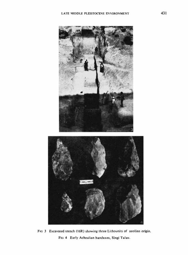
This formation consists of aeolian and lacustrine sediments which are well andextensively exposed in the desert. The best exposure of the aeolian member ofthi!: formation is seen in the profile of the 20m trench excavated by us at 16Rlocality in the Bangur canal near Didwana (Fig. 3). This dune section has beendivided into three major lithological units. Litho-unit I consists of well-sorted.loose. structureless fine sand which is yellowish brown in colour (lOYR 6/4) in theupper 80cm from the surface. This sand is noncalcareous in the upper part andgrades to a pale brown (lOYR 7/3). structureless, loose fine sand. and contains small(l to 2cm) powdery calcrete pellets down to a depth of 4.90m. Litho-Unit I isseparated from Litho-Unit II by a lOcm thick layer of coarse sand comprisingangular to sub-rounded pieces of schist. phyllite. slate, quartz and quartzite. Thislayer is of colluvial origin. The following 3.05m of Litho-Unit II is characterisedby densely packed calcitic nodules (2 to 4cm) within light grey (lOYR 7/2), loose.well-sorted calcareous fine sand alternating with calc bands of 3 to 5cm thickness.The sediments within the bands reveal a light yellowish brown (lOYR 6/4) to palebrown (lOYR 7,'4) loose, massive, moderately sorted loamy sand. The underlyingsequence of 1O.95m of Litho-Unit III is brown to pale red (7.5YR 7/4), mediumsand with ~trong development of large. hard, microcrystalline calcareous nodules(5 to 25cm). These nodules are concentrated in the upper layer of 1m and arerandomly dispersed in the lower part. This unit is interspersed with eight calcbands of 5 to 20cm thickness. The calc band at 18.60m is pinkish, strongly indurated, oolitic and is calssified as petrocalcic horizon.
Field observations reveal that the top 80cm ofLitho-Unit I is a cambic horizonand the 3.50m of Litho-Unit II is a complex BCa horizon. Litho-Unit HI is largelyaffected by calciorthid type pedological processes. The occurrence of colluvial

430 V N MISRA et al.
7 • ~ •••
I -_-_
4 ~:~••~.......s :::::
1&
tot WELllD __
'l ... _ ..
5 •.•.•
I. •••.•
WELL
'3
"1l00LE PALAEOLITHIC
LATE: ACHEULIAN
UPPER P.... LAEOLITHIC
MIDDLE PALAEOLITHIC
AM "PUR.&F"Olll ..,TlON =.
DIDWAMAF"QRMATrON
cOJotPOSITE $TRATIGRAPNICAl SECTIONIN OIOWANA-JAVAl RE&t:)N
~ MESOLITHIC
".I-'=-;....;-::....;::-::..;-:::...-:::....~---,...,
AMARPURAMQ
GREY1~H 'REt,., NOOERArEl't
WAHWAAIS[D SANOY lQAJr04
'R('iISH GREtN STRONGLY
kA.HKAAISEO SANOY loO"''''''
SANOY LO ....
DARN BROW,", CLAVEY LOA ..
GR(TI~H GRElN CLAVEY lOA"
AlT(AMAn,.,c .11H !VAPOR.TI'S
S Al'flOlt4
QUARRY
~~_.. -1 •••••
l _::::
J :',::: ::::I~•••• M
:::: o~.c. :"_'':'~
I"-.."-~'-:;•........
~ :~:;:;~
COLLUVIAL &1 A14lL
PI5CONFOAMfT! ~ IOULD£., " ... 'r:L
QUAnllNARY DEPOSITS AROUND DIDWANA
N "'(,1 TE 5
BROW,., WE"'kl.~ IiItQ.OSEN'SED $""0
'U,,-OWISII SAO"" MODERATELY
....-IiAR NOOU'-£S
N '5A
• :lllinllii1~':I~i:i1111
0-
I' ...
1_,,==-........II It
No1
_-- --_.-...
r»:lB
FIG 2 Stratigraphical sections around Didwana.
LATE ~UDDLE PLEISTOC'ENE ENVIRONMENT
...., .\,{to
;~. ~"" ... "
I •• >\ : .\. ..... . ....
~y' .- r': "
~f'\ " .... \.
a:::
.~
~~. ...,.,:') 1 ~ , .., ,
.' ,.• • J
FIe 3 ExC.aV3Ied lrench C16R) showing three LithounHs of aeolian origin.
FIG 4 Early Acheulian handaxes, Singi Talav.
43\

432 V N MISRA el 01.
wash in the form of locally derived schists and slate fragments and the presence ofcalcrete clasts in ullits II and III indicate local fluvial contribution in the formationof this entire profile. All the three lithological units of 16R section are exposedin a well owned by one Mr Ram Lal, Ikm northeast of 16R and several otherplaces in Nagaur district. Mesolithic artefacts have been found on the surface ofthe dune. Upper Palaeolithic tools occur between 5.40 and 6.lOm of Litho-Unit II,Middle Palaeolithic between 9 and 13m of Litho-unit III and a few LowerPalaeolithic tools between 17.20 and 18.40m in Litho-unit III.
Radiometric (I4C and U/Th) dates were obtained by one of us (HR) on pedogenic carbonates of various lithological units. One 14C date on calcium carbonatenodule from the Upper Palaeolithic layer is 26,210 ± 2,200yr B. P. (PRL 911).Three uncorrected U/Th dates on pedogenic carbonates from three differentlevels of Litho-unit III are: 1,44,000 ± 12,000yr B. P. (l2.65m), 1,50,000 ± 10,000yr B. P. (14.25m), and 1,31,000 ± 15.000yr B. P. (l7.55m). These dates representminimum ages only. TL dating on quartz grains has been attempted for the fineas well as coarse grains at the depth of 17/18m. The date for the fine fractionranges between 1,08,000 and I ,44.000yr (Alpha Lab No. 963) whereas the date forthe coarse fraction is 1,63,000 ± 21,000yr B. P.
Lithostratigraphy, archaeological finds and the few radiometric datestogether strongly indicate that the dune building activity began > 2,00,000yr agoand continued with interruptions almost throughout the Late Pleistocene. Theplaya member of the Didwana Formation is represented in the salt lake sedimentswhich range in age from c.13,000yr B. P. to c.4000yr B. P. Field observationsindicate that Litho-unit I of l6R is contemporary with the aeolian sand disconformably capping the Amarpura Formation. A few TL dates on quartz sands fromthe Amarpura quarry indicate terminal Pleistocene and early Holocene age.Detailed study of litho-facies exposed between 16R and Singi Talav has shown thatlower part of Litho-unit II of l6R interfingers with the upper part of AmarpuraFormation. and a part of Litho-unit III of l6R is contemporary with the lowerpart of Amarpura Formation. Thus on the basis of field data and available absolute dates we can assign a late Middle Pleistocene age to the Acheulian siteslocated in dune-palaeoso! context of l6R and in mud flat-pool context of SingiTala.... In order to understand the depositional environment of aeolian sedimentsof the Didwana Formation, detailed sedimentological studies were carried out andthey have been summarised below.
SEDIMENTOLOGICAL STUDIES
Textural study of the sediments of Litho-unit I shows that the mean grain size ofthe sands ranges from 2.1 9 to 4.13phi. The sands are well-sorted with standarddeviation varying between 0.040 and 1.435. The sand grains are negatively skewedand have greater percentage of fine population. These textural characters stronglyindicate aeolian deposition. On the other hand, the sand grains of Litho-units IIand III range in mean size from 2.42 to 3.07 phi. They are moderately sorted,negatively skewed and have an admixture of fine and coarse populations. Since

LATE MIDDLE PLEISTOCENE BNVIRONMENT 433
textural attributes of units II and III did not provide an unequivocal answer to themode of deposition of the sand, we carried out SEM studies on ten samples cove~
ring the entire 16R profile. SEM studies reveal aeolian features like well-roundedgrains with dish-shaped concavities, upturned plates, and chemical solution pits onfine sand grains in Litho-unit I. As against this, the grains of litho-units II and IIIshow a combination of fluvial and aeolian features. Characters such as sub-angulargrains with V-shaped pits, parallel steps and grooves indicate fluvial actiVity whilesubrounded grains with solution pits, upturned plates, and striations suggest modification of the original fluvial material by aeolian agency. Thus textural and SEMstudies together suggest wind as the major agency responsible for the depositionof the sands of the entire profile. Micromorphological analysis of 24 samplescovering all the three litho-units reveals two sub-populations of grain size; coarseand fine. Proportion of coarse (300 to 500",m) to fine (110 to 20jJm) is 1:4. Thecoarse population predominantly consists of rounded quartz and quartzitic grainswith weakly developed corrosion fissures infilled with iron oxide. On the otherhand, the fine sand fraction is moderately to well-sorted, rounded to subangular,and consists of quartz (30-35 per cent), feldspars (15-20 per cent), quartzitic schist(10-12 per cent), amphiboles (5 per cent) and other minerals like zircon, tourmaline, garnet. pyroxene and opaques (5 per cent). All these mineral grains are freshto weakly altered. Hornblende and plagioclase grains in Litho-units II and IIIhave hematitic coatings around them. Other mineral grains have a clay coatingwith weak orientation, medium birefringence and wavy extinction. Developmentof channels and calcium carbonate nodules within dune sediments indicates pedogenesis. Clay elluviation and iIluviation features were not observed in anyone ofthe soils. The red colouration in Litho-unit III is due to in situ weathering of ironrich minerals like hornblende and plagioclase. Weak pedogenesis of the dunesediments appears to have kept pace with the slow rate of aeolian sedimentationand thus has given rise to cumulative aridic soils within Litho-units II and III. Inorder to understand the mode of calcification of the sediments we carried outdetailed studies on varieties of calcretes encountered in 16R profile, AmarpuraFormation and on valley pediments. Important aspects of these studies are summa.rised below.
Calcretes vary in their morphology, spatial extent, degree of cementation andcrystallinity. On the basis of these characters they have been classified as (0)calcrete soil. (b) powdery calcrete, (c) nodular calcrete and (d) hardpan calcrete.Calcrete soil and powdery and nodular calcretes are found to occur in the 16R duneprofile, Singi Talav and Amarpura quarry. Hardpan calcretes are observed asvalley pediments over granites, calc-phyllites and the Jayal Formation.
Micromorphological studies of all types of calcrete reveal that in general thecalcretes, irrespective of their type, shape and size, consist of detrital grains ofquartz, plagioclase, microcline, biotite, muscovite, harnblende, etc. They are cemented by low magnesium calcite. Micrite (2-4",m) occurs as a cementing materialbetween the grains and also as a rim around the nodules. Biological features arerepresented by root pores, channels and voids. Nodules within the aeolian sedi-

434 V N MISRA et al.
ments are at times diffused and show high porosity, and the soils adjacent tonodules are depleted of calcium carbonate. Some of the nodules, particularly inthe hardpan variety, have coating of fibrous attapulgite. 1O These characters ofvarious calcretes show that they have Cormed subaerially either in pure pedogenicenvironment or in fluctuating groundwater conditions. Calcbands of 16R profileowe their origin primarily to groundwater fluctuation, while nodules, soft pelletsand powdery calcretes and crystalline concentrations of 16R profile are the product of pedogenic as well as groundwater processes. Presence of attapulgitesuggests highly evaporating environment.
Field and laboratory studies of the profile thus show that these aeolian sediments have undergone slow but complex pedogenesis in semi-arid and aridenvironment.
PALAEOENVIRONMENT
To understand the changes in stream behaviour and the interplay between fluvialand aeolian processes in the area it is necessary to know the effective role playedby two important physical parameters, neotectonism and climate, in shaping theearly Quaternary landforms of western Rajasthan.
Neotectonics
Recent investigations by Das Sarma ll and Sinha Royl2 clearly show thatfeatures like raised terraces, stream captures in the continental divide of theAravallis, uplifted Gossan zones and changes in the hydrology of the lakes aresuggestive of the activation of gravity and strike slip faults (e.g. conspicuous eastwest running Didwana-Dausa fault). The renewed tectonic activity probably tookplace along the faults in the Delhi ridge and/or at the contact of BundelkhandBerach massif and the Vindhyan ridge. These neotectonic movements can beexplained :lS a backlash due to the resistance to the Indian plate movements at itsnorthern collision front. [3
Geomorphic features like Jayal gravel ridge, raised hardpan calcrete and saltlakes like Didwana not only support observation of Sinha Royl2 but also help us indating the Quaternary tectonic activity as follows.
(a) Jayal Formation: As mentioned earlier, it represents braided fluvial systemof late Tertiary or early Pleistocene age. Petrographic study of lithocomponentsof this formation shows that the ancient stream was draining the western slopes ofthe Aravallis. Today this formation occ;urs as a ridge in an otherwise flat landscape and does not have any linkage with the Aravallis.- Thus the anamolousgeomorphic expression of the gravel ridge is suggestive of Late Neogene tectonicactivity.
(b) Raised Calcrete Beds: These are conspicuous calcrete platforms aroundJa'yal, Didwana and other places in Nagaur district. Detailed micromorphologicalstudies of these hardpans have shown that they represent valley floor accumulations. These valley floor calcretes are older than Amarpura and Didwana Forma-

LATE MIDDLE PLEisTOCENE ENVIRONMENT 435
tions and probably younger than the Jayal Formation. The exposition of thesevalley floor calcretes as raised plateaux therefore supports tectonic activity duringthe Early Pleistocene.
(c) Didwana Salt Lake: Detailed geoarchaeological studies l4 have shown thatthe salt lake is at least 20,000 years old. Recent studies of the subsurface geologybetween Sambhar and Didwana by the Geological Survey of India (1985) have shownthat valley floor calcretes occur as channel deposit which in turn got affected bytectonic activity during the late Pleistocene along the Didwana-Dausa strike fault.
These three geomorphological features thus clearly show the importance ofneotectonic activity in shaping the Quaternary landforms of the area.
PALAEOCLIMATE
In view of the importance of Quaternary tectonics in the Thar desert, it is verydifficult to interpret geomorphic events like shift from a braided to anastomisingor meanderil1g system, formation of inland lakes, disorganisation of drainage systems and expansion and stabilisation of dunes in terms of climatic changes alone.As stated earlier, the late Quaternary climatic history of the Thar desert is comparatively well-documented due to the availability of adequate number of 14Cdates and of climatically sensitive parameters like evaporites and pollens of inlandlakes. For the late Middle Pleistocene (200,OOO-130,OOOyr B. P.) we have todepend heaVily on mineral characters of the Didwana and Amarpura Formations.
Amarpura Formation
It represents sedimentation either in an interdunal pan environment or poolsin structural depressions or in mudflats associated with an anastomising streamsystem or a meandering system with low sinuosity. Presence of dolomite in thesecalcium carbonate-rich loamy sediments indicates a system with highly fluctuatinggroundwater under the influence of strong evaporation. Microscopic features suchas sesquioxidcs miniscus cement and micritic rims indicate shallow waterlogging. Study of borehole logs down to a depth of SOm east and northeast ofDidwana reveals presence of medium to coarse sands resting disconformably onvalley floors and complete absence of well rounded pebbly-cobbly gravels. Thesetwo features indicate ephemeral braided streams characteristic of desertic environment. Gradual weakening of drainage system and more or less steady decline insouthwest monsoon both perhaps influenced by Himalayan orogeny have producedlate Middle Pleistocene landscape of the region. The depositional environment ofAmarpura Formation reveals the existence of a moderately organised drainagesystem in the area which implies existence of surface water on a significant scale.How this became possible has to be investigated. Precipitation during this periodwould have been relatively higher than in the terminal Pleistocene when thedrainage system became totally defunct.
Didwana Formation
Detailed field and laboratory studies of 16R aeolian sand and associated carbonates and palaeosols (of 16R) have shown that the sand accumulation was slow,

436 V N MISRA el al.
and weak pedogenesis kept pace with it. These processes were periodically interrupted by the accumulation of colluvium. Calc bands, hardpan calcretes and hardkankar concretions (of unit III) show strong influence of groundwater as a resultof fluctuations in precipitation. These features broadly suggest strong evaporating environment characteristic of semi-arid climate. In this dry environment duststorms were not rare. This is indicated by the presence of sand-silt grade calcicgrains. Similarly, colluvial gravels indicate intermittent rainstorm activity duringthe late Middle Pleistocene.
ACHEULIAN OCCUPATION
Except for sites located on the surface of the Jayal gravel ridge, Acheulian, asindeed all Palaeolithic, sites in western Rajasthan are buried beneath the surface inthe Quaternary deposits. Absence of stream channels, low rainfall and high porosity of the sandy mantle have all contributed to the almost total elimination offluvial erosional processes and consequently to the lack of natural exposures of theQuaternary deposits. This in turn has greatly restricted the scope of locatingPalaeolithic sites. Such sites as are known to us have all been exposed because ofhuman activities like quarrying for calcareous loam of the Amarpura Formation orhillslope collUVium and tank digging. Most of these sites are located near andaround Didwana town where our exploration work was largely concentrated. However, we have also found Acheulian sites far away from this core area at placeswhere artificial exposures are available. One small late Acheulian handaxe wasfound in the calcareous loam spread along roadside near Ramji-ka-Gol villagenorth of Sanchor in Jalor district. This loam came from a nearby calcareous loamquarry. A small Acheulian assemblage was found in the section of an irrigationchannel dug through the hillslope colluvium near Bhadrajun village between Paliand Jalor towns. Thus it seems fairly certain that Acheulian occupation waswidely distributed in the desert. Investigation of available exposures will certainlybring to light many more Acheulian and later Palaeolithic si tes.
Our knowledge of the Acheulian culture is at present confined essentially tostone tool technology and the nature of the settlement pattern. At no site hasany biological material been preserved to give us an insight into the Acheuliandiet and hunting and butchery practices. Most of the known Acheulian sites arelocated in the Amarpura Formation which implies that the Acheulian populationslived when this formation was being deposited. Our excavations at Singi Talavnear Didwana and our examination of many quarries in the area has shown thatthe artefacts are not uniformly spread through this deposit; instead they occur inclusters at some spots intervened by sterile zones. The artefacts are remarkablyfresh, often giving the impression of having been made only yesterday. Thesefacts together with the complete absence of coarse sediment in the formationeffectively preclude the possibility of archaeological material having been transported or resorted. In other words, the Acheulian sites in the Didwana area arein a true primary context. Infact, among the buried open air Acheulian sites knownin India the Didwana group of sites provide the best primary context example.The depositional environment of Amarpura Formation suggests that the Acheulian

LATE MIDDLE PLEISTOCENE ENVIRONMENT 437
human groups camped along the shores of floodplain pools and along thebanks of low shallow energy channels. Extensive Acheulian scatters occur on thesurface of the Jayal gravel ridge over several kilometres south of Jayal. Here nodoubt the main attractions for Acheulian populations were the unlimited supply ofsuitable raw material for tool making and the commanding view of the landscapefrom the height of the ridge. Adequate water must have been available to thehuman and animal populations in the inter-ridge depressions and stream channelsin the Vicinity. One such channel survives to this day near Chhajoli village southof Jayal. The same attractions must have operated in the case of hillslopeoccupations.
The raw material used for making artefacts was generally quartzite and quartz.These were obtained, in the case of sites close to Didwana, as blocks from thenearby Aravalli exposures, in the case of hillslope sites as cobbles from the colluvium, and in the case of sites on the Jayal gravel ridges as boulders. The materialon the Jayal gravel ridge sites is of a fine-grained quality while that from the othersites is usually coarse-grained. The assemblages comprise handaxes, cleavers,chopping tools, polyhedrons, spheroids, scrapers, denticulates, flakes and cores.Majority of the tools including the bifaces are made on cores (Fig. 4). Cleaversare rare and are crudely made. Most of the sites represent early stage of Acheulian technology. However, a fairly large assemblage collected from the loamremoved during the digging of a tank at Jankipura village, 3km west of Didwanaincludes thin and symmetrical handaxes representing late Acheulian technology.Since the upper part of the Amarpura sedimentation contains at least two phasesof the Middle Palaeolithic at Mangalpura and Jenana, respectively, the presenceof a late Acheulian stage in the area is perfectly understandable.
CONCLUSION
To sum up, the Ache ulian sites investigated around Didwana are in the best primarycontext situation known for open air Acheulian sites in India. Detailed field studiesof Quaternary geological formations and laboratory studies of sediments and soilshave provided us a fairly clear picture of the environmental setting in which Acheulian populations flourished in western Rajasthan. And finally, application of C14,U{Th and TL dating techniques on pedogenic carbonates and sands has given us afairly reliable timeframe for the Acheulian culture in this region. At the momentthis kind of multidisciplinary effort for understanding the nature of Acheuliantechnology, settlement pattern, environmental setting and temporal context isconfined only to the semi-arid regions of Rajasthan and Saurashtra. Extension ofsimilar effort to other parts of the country will considerably help in augmenting ourknOWledge of the Acheulian culture.
ACKNOWLEDGEMENTS
The authors are grateful to Drs Martin Williams of Geography Department, LaTrobe University, Melbourne and Marie Courty of Agronomical Research Institute of Grignon, France, for their help in the study of Quaternary geology and

438 V N MISRA et al.
pedology around Didwana. Thanks are also due is Drs D P Agrawal and S KGupta for their help in radiometric dating of carbonate samples and Dr R P Dhirof CAZRI, Jodhpur and Shri Das Sarma of the GSI, Jaipur, for academic discusions. The financial support received from the Ford Foundation, New Delhi, forcarrying out the research reported in this paper is gratefully acknowledged.
REFERENCES
1. G Singh R D Joshi S K Chopra and A B Singh Late Quaternaly history of vegetation andclimate of the Rajasthan desert India. Phil Trans R Soc London 267B (1974) 467
2. M Baskaran A R Marathe S N Rajaguru and B L K Somayajulu Geochronology of thepalaeolithic cultures in the Hiran Valley, Saurashtra, India J archaeol Sci 131 (1986)
3. V N Misra The Stone Age Cultures of Rajaputana Unpublished PhD Thesis PoonaUniv (1961)
4. B Allchin A S Goudie and K T M Hegde The Prehistory and Palaeogeography of the GreatIndian Desert Academic Press London (1978)
5. V N Misra S N Rajaguru D R Raju H Raghavan and C Gaillard Acheulian occupationand evolving landscar:e around Didwana in the Thar desert, India Man and Environment 6(1982) 72
6. C Gaillard D R Raju V N Misra and S N Rajguru Acheulian occupation at Singi Talavin the Thar Desert: a report on 1982 excavation Man and Environment 7 (1983) 1I2
7. C Gaillard V N Misra S N Rajaguru D R Raju and H Raghavan Acheulian occupation atSingi Talav in the Thar Desert: a preliminary report on 1981 excavation Bull DeccanCollege Res Inst 44 (1985) 141
8. H S Pareelc Basin configuration and sedimentary stratigraphy of western Rajasthan J geolSoc India 22 (1981) 517
9. R K Ganjoo H Raghavan S N Rajaguru and C Gaillard Late Neogene fossil wood fTomBilcaner gravel bed Curr Sci 53 (1984) 1207
10. H Raghavan Quatemery geology of Nagaur district, Rajasthan Unpublished PhD ThesisPoona Univ (1987)
11. DC Das Sarma Geomorphology of arid zones of Rajasthan and Gujarat Presented at theWorkshop at Central Arid Zone Research Institute, Jodhpur (1984)
12. S Sinha Roy Himalayan collision and indentation of Aravalli orogeny by Budellchandwedge: implications for neotectonics in Rajasthan Proc Symp Neotectonics in South AsiaDehradun India (1986) 13
13. D P Dhoundial Some aspects of Quaternary geology and neotectonics in India Inaug AddrSem Mod Trends Quat Geol Calcutta (1987) March 20--21
14. R J Wasson S N Rajaguru V N Misra D P Agrawal D P Dhir A K Singhvi and K Kameshwara Rao Geomorphology and late Quaternary stratigraphy and palaeoclimatology ofthe Thar dune field Z f Geomorphol 45 (1983) 1I7