Late persistence of the Acheulian in southern Britain in an MIS 8 interstadial: evidence from...
18
Late persistence of the Acheulian in southern Britain in an MIS 8 interstadial: evidence from Harnham, Wiltshire M.R. Bates a, * , F.F. Wenban-Smith b , S.M. Bello c , D.R. Bridgland d , L.T. Buck c, e , M.J. Collins f , D.H. Keen g, 1 , J. Leary h , S.A. Parfitt c, i , K. Penkman f , E. Rhodes j , C. Ryssaert k , J.E. Whittaker c a School of Archaeology, History and Anthropology, University of Wales Trinity St. David's, Lampeter Campus, Ceredigion SA48 7ED, Wales, UK b Department of Archaeology, University of Southampton, Southampton SO17 1BF, UK c Department of Earth Sciences, The Natural History Museum, Cromwell Road, London SW7 5BD, UK d Department of Geography, University of Durham, Science Laboratories, South Road, Durham DH1 3LE, UK e Centre for Research in Evolutionary and Ecological Anthropology, Whitelands College, University of Roehampton, Holybourne Avenue, London SW15 4JD, UK f BioArch, Biology S Block, University of York, PO Box 373, York YO10 5YW, UK g Institute of Archaeology and Antiquity, University of Birmingham, Birmingham B15 2TT, UK h Department of Archaeology, University of Reading, Whiteknights, Reading RG6 6AB, UK i Institute of Archaeology, University College London, 3134 Gordon Square, London WC1H 0PY, UK j Department of Earth and Space Sciences, University of California Los Angeles, 595 Charles Young Drive East, Box 951567, Los Angeles, CA 90095-1567, USA k ODIN, Oude Brugsepoort 17, 9800 Deinze, Belgium article info Article history: Received 25 June 2013 Received in revised form 20 June 2014 Accepted 1 July 2014 Available online Keywords: Northwest European Lower/Middle Palaeolithic Acheulian MIS 8 Middle Pleistocene environment Vertebrates Molluscs Ostracods Undisturbed occupation Handaxes abstract This paper presents evidence of the discovery of a new Middle Pleistocene site in central southern En- gland, with undisturbed evidence of hominin occupation well-dated to an interstadial towards the end of Marine Isotope Stage 8, c. 250,000 BP. The site consists of a preserved remnant of a river terrace and its alluvial floodplain overlain by chalk-rich bankside deposits, all abutting a Chalk bedrock riverbank. It preserves an area of occupation with activity focused on the riverbank, complemented by occasional activity on a palaeo-landsurface developed on the surface of the alluvial floodplain. Lithic technology at the site consists almost entirely of handaxe manufacture, allowing attribution to an Acheulian industrial tradition. Mammalian and other palaeo-environmental remains are present and associated with the occupation horizons, including large mammal bones showing signs of hominin interference. Dating was based on OSL determinations on the sediments and amino acid racemisation of molluscan remains, supported by biostratigraphic indications. Besides being a rare instance of an undisturbed Palaeolithic palaeo-landscape covering several hectares, the site contributes to wider Quaternary research concerns over the ability of Middle Pleistocene hominins to tolerate colder climatic episodes in higher latitudes, and over settlement history and changing lithic industrial traditions of northwest Europe in relation to climate change and British peninsularity. It is suggested that the Harnham evidence may represent an insular population that had persisted in southern Britain since MIS 10/9, which became locally extinct during the glacial maximum 8.2 marking the end of MIS 8. © 2014 Elsevier Ltd. All rights reserved. 1. Introduction Over the last 50 years our understanding of the British Lower/ Middle Palaeolithic record has mainly been enhanced by reinvestigation of sites first discovered and described in the 19th or early 20th century, e.g. Swanscombe (Ashton et al., 1996), Hoxne (Singer et al., 1993; Ashton et al., 2008), Barnham (Ashton et al., 1998), High Lodge (Ashton et al., 1992) and Baker's Hole, North- fleet (Wenban-Smith, 1995). However, it has been rare that entirely new sites, such as the undisturbed landscape at Boxgrove in Sussex (Roberts and Parfitt, 1999) and the evidence of very early occupa- tion on the East Anglian coast at Pakefield and Happisburgh (Parfitt et al., 2005, 2010) are discovered and excavated. The decreased * Corresponding author. E-mail address: [email protected] (M.R. Bates). 1 Deceased. Contents lists available at ScienceDirect Quaternary Science Reviews journal homepage: www.elsevier.com/locate/quascirev http://dx.doi.org/10.1016/j.quascirev.2014.07.002 0277-3791/© 2014 Elsevier Ltd. All rights reserved. Quaternary Science Reviews 101 (2014) 159e176
Transcript of Late persistence of the Acheulian in southern Britain in an MIS 8 interstadial: evidence from...

lable at ScienceDirect
Quaternary Science Reviews 101 (2014) 159e176
Contents lists avai
Quaternary Science Reviews
journal homepage: www.elsevier .com/locate/quascirev
Late persistence of the Acheulian in southern Britain in an MIS 8interstadial: evidence from Harnham, Wiltshire
M.R. Bates a, *, F.F. Wenban-Smith b, S.M. Bello c, D.R. Bridgland d, L.T. Buck c, e,M.J. Collins f, D.H. Keen g, 1, J. Leary h, S.A. Parfitt c, i, K. Penkman f, E. Rhodes j, C. Ryssaert k,J.E. Whittaker c
a School of Archaeology, History and Anthropology, University of Wales Trinity St. David's, Lampeter Campus, Ceredigion SA48 7ED, Wales, UKb Department of Archaeology, University of Southampton, Southampton SO17 1BF, UKc Department of Earth Sciences, The Natural History Museum, Cromwell Road, London SW7 5BD, UKd Department of Geography, University of Durham, Science Laboratories, South Road, Durham DH1 3LE, UKe Centre for Research in Evolutionary and Ecological Anthropology, Whitelands College, University of Roehampton, Holybourne Avenue,London SW15 4JD, UKf BioArch, Biology S Block, University of York, PO Box 373, York YO10 5YW, UKg Institute of Archaeology and Antiquity, University of Birmingham, Birmingham B15 2TT, UKh Department of Archaeology, University of Reading, Whiteknights, Reading RG6 6AB, UKi Institute of Archaeology, University College London, 3134 Gordon Square, London WC1H 0PY, UKj Department of Earth and Space Sciences, University of California Los Angeles, 595 Charles Young Drive East, Box 951567, Los Angeles, CA 90095-1567, USAk ODIN, Oude Brugsepoort 17, 9800 Deinze, Belgium
a r t i c l e i n f o
Article history:Received 25 June 2013Received in revised form20 June 2014Accepted 1 July 2014Available online
Keywords:Northwest European Lower/MiddlePalaeolithicAcheulianMIS 8Middle Pleistocene environmentVertebratesMolluscsOstracodsUndisturbed occupationHandaxes
* Corresponding author.E-mail address: [email protected] (M.R. Bates).
1 Deceased.
http://dx.doi.org/10.1016/j.quascirev.2014.07.0020277-3791/© 2014 Elsevier Ltd. All rights reserved.
a b s t r a c t
This paper presents evidence of the discovery of a new Middle Pleistocene site in central southern En-gland, with undisturbed evidence of hominin occupation well-dated to an interstadial towards the end ofMarine Isotope Stage 8, c. 250,000 BP. The site consists of a preserved remnant of a river terrace and itsalluvial floodplain overlain by chalk-rich bankside deposits, all abutting a Chalk bedrock riverbank. Itpreserves an area of occupation with activity focused on the riverbank, complemented by occasionalactivity on a palaeo-landsurface developed on the surface of the alluvial floodplain. Lithic technology atthe site consists almost entirely of handaxe manufacture, allowing attribution to an Acheulian industrialtradition. Mammalian and other palaeo-environmental remains are present and associated with theoccupation horizons, including large mammal bones showing signs of hominin interference. Dating wasbased on OSL determinations on the sediments and amino acid racemisation of molluscan remains,supported by biostratigraphic indications. Besides being a rare instance of an undisturbed Palaeolithicpalaeo-landscape covering several hectares, the site contributes to wider Quaternary research concernsover the ability of Middle Pleistocene hominins to tolerate colder climatic episodes in higher latitudes,and over settlement history and changing lithic industrial traditions of northwest Europe in relation toclimate change and British peninsularity. It is suggested that the Harnham evidence may represent aninsular population that had persisted in southern Britain since MIS 10/9, which became locally extinctduring the glacial maximum 8.2 marking the end of MIS 8.
© 2014 Elsevier Ltd. All rights reserved.
1. Introduction
Over the last 50 years our understanding of the British Lower/Middle Palaeolithic record has mainly been enhanced by
reinvestigation of sites first discovered and described in the 19th orearly 20th century, e.g. Swanscombe (Ashton et al., 1996), Hoxne(Singer et al., 1993; Ashton et al., 2008), Barnham (Ashton et al.,1998), High Lodge (Ashton et al., 1992) and Baker's Hole, North-fleet (Wenban-Smith, 1995). However, it has been rare that entirelynew sites, such as the undisturbed landscape at Boxgrove in Sussex(Roberts and Parfitt, 1999) and the evidence of very early occupa-tion on the East Anglian coast at Pakefield and Happisburgh (Parfittet al., 2005, 2010) are discovered and excavated. The decreased

M.R. Bates et al. / Quaternary Science Reviews 101 (2014) 159e176160
discovery of new sites in the later 20th century is probably due toincreased mechanisation of quarrying activities together withreduced collector access to active quarries. However, since the early1990s archaeological evaluations in advance of construction havebecome more frequently required under the terms of British gov-ernment planning policy guidance, note PPG 16 (Department of theEnvironment, 1990). Consequently large transects of the landscapeaffected by major infrastructural projects have begun to be morethoroughly investigated for threatened archaeological/Quaternaryremains. As well as providing for further investigations of knownsites affected by such works (e.g. at Baker's Hole, Wenban-Smithet al., in press), this has led to the discovery of entirely new sitese for instance, the Middle Pleistocene elephant butchery site inKent, found during archaeological work in advance of High Speed 1(Wenban-Smith, 2013), and the Late Pleistocene Neanderthal site atLynford, Norfolk, found during routine monitoring of gravelextraction (Boismier et al., 2012).
Here we report on the discovery of a previously unknown lateMiddle Pleistocene occupation site at Harnham in the Avon Valleysouth of Salisbury, Wiltshire, UK (national grid reference SU 15202785) (Fig. 1). The site, found during archaeological evaluation inadvance of a proposed ring road to the south of Salisbury, lies c.500 m from a small mapped patch of river terrace gravel, butotherwise there was no prior indication, from either geologicalmapping or previous finds, of the nature of the deposits present ortheir significant archaeological content. This report reviews thediscovery of the site, the geology and palaeoenvironmental re-mains, the age of the deposits, and provides a summary of theartefactual remains. Of particular relevance to wider Quaternaryresearch issues are (a) the demonstration of British occupation inan interstadial within the cold stage MIS 8, (b) the abundant evi-dence of a technology dominated by handaxe manufacture,without any sign of Levalloisian prepared-core knapping ap-proaches thought to be broadly coeval in other parts of the UK andnorth-west continental Europe, and (c) the contribution of the siteto increasing understanding of the wider picture of lithic industrialvariation and settlement history in Britain and north-west conti-nental Europe in the later Middle Pleistocene.
2. Background
The site lies within the Hampshire Basin (Melville and Freshney,1982) in a Chalk-dominated landscape on an interfluve betweenthe Avon and Ebble valleys (Fig. 1) between c. 70 and 75 m O.D.Pleistocene sediments were first described in the Salisbury area by
Fig. 1. Site location plan. A: location of study area in United Kingdom; B: site location planSalisbury.
Lyell (1827) who drew attention to the fossiliferous deposits atFisherton (see Green et al., 1983). Subsequently, the area wasinvestigated by Reid (1903) and Sealey (1955) and most recently bythe British Geological Survey (1976).
Current understanding of the Lower/Middle Palaeolithic in theHampshire Solent Basin was synthesised by the Southern RiversPalaeolithic Project (Wessex Archaeology, 1993), but the region hasbeen relatively neglected for Palaeolithic archaeological researchsince the first half of the 20th century, although this is nowbeginning to change (Wenban-Smith and Hosfield, 2001;Westaway et al., 2006; Ashton and Hosfield, 2010). Artefact find-spots are generally abundant within the region, although concen-trated in particular areas. The majority of finds come from gravelterraces associated with the main axis of the former Solent River(Fox, 1862), heading east from Dorchester, through Bournemouthand Southampton to Portsmouth. In the vicinity of Harnham,associated with the tributary valley of the Avon, there are threemajor sites where substantial quantities of Palaeolithic handaxeshave been recovered from Pleistocene terrace gravels: Bemerton,Salisbury; Milford Hill, Salisbury; and Wood Green, north of For-dingbridge (Wessex Archaeology, 1993; Wymer, 1999). The site ofMilford Hill in particular is a relevant comparator to the Harnhamsite, being only a few km to the north and associated with terracedeposits at a broadly similar height. The rich handaxe collectionsare dominated by pointed forms, including ficrons, some of whichare in fresh condition suggesting contemporaneity with depositionof the terrace deposit (Roe, 1981: 213; Harding and Bridgland,1998). There are also occasional find-spots of isolated artefacts,generally associated with mapped bodies of fluvial sand/gravel (e.g.along the courses of the Bourne and the Nadder upstream of Sal-isbury, and the Avon downstream), although several are associatedwith outcrops of Clay-with-flints or at locations with no knownPleistocene sediments (ibid.).
3. Site investigation
The site was discovered during archaeological evaluation inadvance of a proposed new road scheme e the Harnham ReliefRoad e to the south of Salisbury in late 2002. Following the dis-covery of a cluster of handaxes on the surface of a ploughed fieldalong the proposed road route, a fieldwork programme wasdeveloped to investigate the Palaeolithic potential of the underly-ing sediments by fieldwalking, trial-trenching and deep test-pitting. This work identified a buried bank of chalk-rich slope-wash/solifluction deposits e parallel with the 2002 Trench 58
showing superficial geology, distribution of rivers and location of site in the vicinity of

M.R. Bates et al. / Quaternary Science Reviews 101 (2014) 159e176 161
(Fig. 2) e as being particularly rich in Palaeolithic artefacts whereploughing was cutting into the bank and disturbing a dense artefactconcentration. Seven trial trenches (Fig. 2, TR 58-63, 65) wereopened to expose the sub-ploughsoil deposits. Deeper test-pittingand hand excavation in some of the trenches allowed the sub-surface deposit sequence to be examined in more detail and
Fig. 2. Distribution of trenches from 2002 to 2004 investigations and results of the fieldwalksondages in selected 2002 trenches; black boxes indicate deeper machine-dug test pits in sethe reader is referred to the web version of this article.)
sampled. The floor of Trench 59 was hand-excavated to a depth of c.30 cm into the underlying Pleistocene deposits, and a deepersondage (c. 1 m2) was dug for environmental sampling. A c. 1 m2
test pit was excavated by hand at the south end of Trench 58 inorder to assess the density and nature of the artefact concentrationwithin the chalk-rich deposits, followed by further hand excavation
ing survey for Palaeolithic archaeology. Red boxes indicate position of hand-excavatedlected 2004 trenches. (For interpretation of the references to color in this figure legend,

Table
1Site
phases,d
escription
ofsedim
ents,inferred
environmen
tsof
dep
ositionan
dsu
mmaryof
arch
aeolog
y(includingnumbe
rsof
artefactsreco
veredby
phase).
Phases
Site
phasedescription
Molluscan
eviden
ceOstraco
dev
iden
ceVertebrateev
iden
ceAge
estimates
Archae
olog
yInferred
environmen
tof
dep
osition
eMod
ernplough
soil
Mod
ern
IVChalkrubb
le/peb
bles
andflintclasts
inch
alky
paste
matrix
MIS
8Highco
ncentration
ofmint/freshartefacts
includinghan
dax
esan
dwaste
from
han
dax
eproduction(163
1)
Coo
l/co
ldclim
atewith
major
massmov
emen
tsduringsp
ringmelt
III
Wea
theringhorizon
onsu
rfaceof
sands
MIS
8Mintco
nditionsartefacts
(waste
deb
itag
e)with
highdeg
reeof
refitting(56)
Stab
ilisedlandsu
rfaceunder
cool
clim
ateco
nditions
IISa
ndswithoc
casion
alpatch
esof
tufa
andrare
flintclasts.M
olluscs
abundan
tin
places
Coo
l,interstadial
clim
atewithsp
ecies
typical
ofen
vironmen
tsassociated
with
shallow
stream
sat
base
ofslop
eor
shee
twash
situations
Smallve
getated
pon
dsan
dco
olsp
rings
withelem
ents
ofslop
ewashinferred
Assem
blag
eproba
bly
winnow
edby
shee
twashor
fluvial
activity.
MIS
8Raremintco
nditions
artefactsin
closeproximity
tomam
malianremains(2)
Coo
lclim
atesh
allow
water
orba
seof
slop
ewith
localsm
allpoo
lsan
dsp
ring
seep
s.Inwashof
fluvial
water
orsh
eetwashdow
nslop
e.
IFlintgrav
elswithva
riab
lech
alkco
ntent.Crude
horizon
talbe
ddingin
places
MIS
8Occasional
abraded
artefactsincluding2
han
dax
es(12)
Highen
ergy
cool
toco
ldclim
atefluvial
environmen
twithinputof
materiallocally
from
Chalkbe
drock
aswellas
from
thewestfrom
thevicinity
oftheValeof
Wardou
r.
M.R. Bates et al. / Quaternary Science Reviews 101 (2014) 159e176162
of an undisturbed landsurface at the west end of Trench 65. Sam-ples were taken for dating by optically stimulated luminescence(OSL) in Trenches 59 and 60, and vertical series of samples forvarious types of environmental remains were taken through theupper fine-grained sequence in Trench 59.
A second investigationwas undertaken in late 2004 to refine themodel of site stratigraphy and to delimit the extent of key sedimentbodies more precisely. This phase of works involved nine furthertrial trenches (Fig. 2, T1eT9), with machine excavation of deepertest pits within four of them (Trenches 3e6). Coarse sieving forartefacts was undertaken in all trenches where gravels wereencountered. Samples of 100 L at regular (c. 25 cm) intervals weretaken in the gravels as excavation progressed and dry-sieved on sitethrough a 1 cm mesh for recovery of lithic artefacts and biologicalevidence. When the sediment was finer or not suitable for drysieving, excavation proceeded in shallower spits of 5 cm and thespit samples were investigated for any archaeological evidence.
4. Stratigraphy
Individual stratigraphic units and a series of events document-ing site development are described in Table 1; a schematic sectionthrough the site is shown in Fig. 3B.
The lowermost deposits (phase I) consisted of a series of coarseflint gravels overlying the Chalk bedrock at about 72 m O.D. Thesegravels contained a variable quantity of chalk clasts, significantamounts of cobble-sized material, mainly nodular flint, but alsoPalaeogene flint pebbles and Greensand chert were also noted. Thegravels to the west (e.g. Trenches 4, 59 and 65) (Fig. 4) werecarbonate-rich but to the east (Trenches 5 and 6) the gravels weredecalcified. The gravel units exhibited a crude sub-horizontalstructure and sand horizons were noted in places. The basalgravels were overlain by a series of sand units (phase II) that aretypically rich in carbonate material and up to 0.8 m thick(Figs. 3e6). These phase II sands (sampled in Trench 59 and Trench4) only existed in thewestern part of the site andwere absent to theeast in Trenches 5 and 6. In places, tufa (in the form of fine-grainedtufa-sand or silt) was noted in the sands. The phase II sand con-tained small flint and chalk clasts in places as well as abundantshells and shell fragments and rarer mammal remains. Occasionallarge mammal bones and flint artefacts were recovered fromwithin, as well as resting on the surface of, the sand. A non-depositional event (phase III) has been inferred from weatheringof the upper surface of the sands. This surface, when sealed byoverlying chalk-rich deposits in Trench 65, appears intact and acluster of refitting artefacts was recovered resting on the sealedsurface. Where the chalk-rich deposits are absent, a truncated sandsequence is overlain by Holocene sediments.
The phase II sandwas overlain across thewestern part of the siteby the afore-mentioned “chalk-rich deposits” (phase IV), whichcomprised chalk gravels (angular to sub-angular chalk clasts) in aputty chalk-silt matrix with common flint inclusions e these latterincluding minimally-abraded whole and broken flint nodules, andsharp very angular flint artefacts of widely varying size, from tinychips to large handaxes, and including various sets of refitting flakeremovals, discussed in more detail further below. These depositsare attributed to slopewash/solifluction processes, specificallycollapse of the chalk riverbank and slopewash from nearby higherchalk bedrock under cooling/cold conditions. They are thick andwell-developed in Trench 65 and 58 but absent in Trench 59. A thinchalk pellet gravel in Trench 4 is also attributed to this group ofdeposits, thought to be the tail end of the better-developed bed inTrench 58. Flint artefacts have been recovered from these chalk-richphase IV deposits at the west end of Trench 65 and substantialnumbers from the 1m2 test pit excavated at the south end of Trench
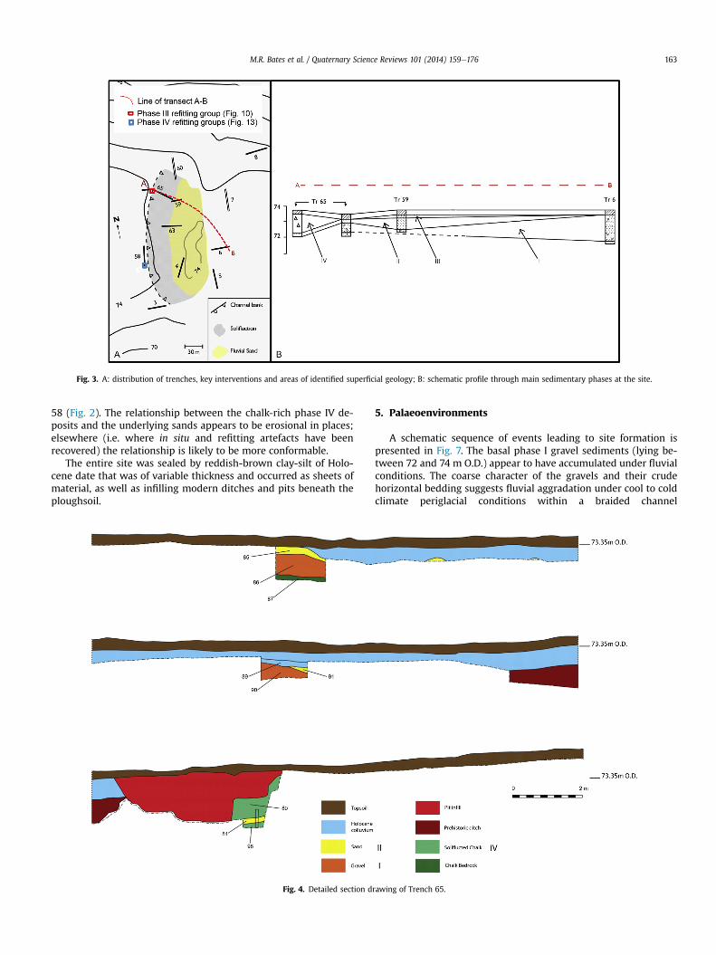
Fig. 3. A: distribution of trenches, key interventions and areas of identified superficial geology; B: schematic profile through main sedimentary phases at the site.
M.R. Bates et al. / Quaternary Science Reviews 101 (2014) 159e176 163
58 (Fig. 2). The relationship between the chalk-rich phase IV de-posits and the underlying sands appears to be erosional in places;elsewhere (i.e. where in situ and refitting artefacts have beenrecovered) the relationship is likely to be more conformable.
The entire site was sealed by reddish-brown clay-silt of Holo-cene date that was of variable thickness and occurred as sheets ofmaterial, as well as infilling modern ditches and pits beneath theploughsoil.
Fig. 4. Detailed section d
5. Palaeoenvironments
A schematic sequence of events leading to site formation ispresented in Fig. 7. The basal phase I gravel sediments (lying be-tween 72 and 74 m O.D.) appear to have accumulated under fluvialconditions. The coarse character of the gravels and their crudehorizontal bedding suggests fluvial aggradation under cool to coldclimate periglacial conditions within a braided channel
rawing of Trench 65.

Fig. 5. Sequence of deposits present in Trench T4, from base: Phase I e flint gavels,variably chalky; Phase II e calcareous sands/silts, finer-grained in upper part; Phase IVe tail end of chalk-rich solifluction/slopewash deposits.
M.R. Bates et al. / Quaternary Science Reviews 101 (2014) 159e176164
environment. The eastern boundary of these deposits is notcurrently well-mapped, and they (like the overlying Pleistocenesequence) are truncated to east, south and west by subsequenterosion. However the impression given from the local topographyand the test pit exposures is that the sediments may have been laiddown in a curved channel across the study area (Fig. 3A). Thelithological and angularity analyses indicate local source areas, withthe farthest travelled elements (excluding the two Palaeozoiccherts) derived from the older, pre-Chalk rocks exposed towardsthe west (in the Vale of Wardour). The limited nature of the ex-posures did not allow detailed observations of these gravels to bemade and it remains possible that the gravels have been affected bysome periglacial reworking, as solifluction material. The trend ofthese gravels appears to suggest that they are most likely valley-marginal sediments of a loop of the main Avon.
Fig. 6. Detailed section drawing of excavated pit in Trench 59 showing sampling locationostracods.
Sediments ascribed to phase II (the sand-rich deposits con-taining the majority of the mammal remains and other palaeo-environmental evidence as well as some artefactual material)overlie the basal gravel in some trenches. The evidence from thesampling carried out in Trench 59 suggests that the waters wererich in carbonate. Ostracods, although scarce, are represented byPotamocypris zschokkei, Prionocypris zenkeri, Ilyocypris gibba andjuvenile Candona spp., which indicate local seepages of springs mayhave dominated the landscape at the edge of the floodplain.Associated charophyte oospores indicate clear (standing or slow-flowing) water, whereas earthworm granules and root-etching onsome of the mammal bones indicate soil formation and vegetationon the floodplain.
Molluscan remains from the fluvial sands (Table 2) indicatemixed environments of flowing water, marshland, grassland anddisturbed ground probably indicative of wet relatively open con-ditions with shallow water in sheet wash or ephemeral channels.The similarity between this fauna and that of the Late-glacialInterstadial at Holywell Coombe (Preece, 1998) suggests theclimate was not particularly cold. The fauna consists of 23 taxa (11from freshwater and 12 from terrestrial environments), but onlyfour are present in high numbers and occur in all of the stratifiedsamples. All of these are land taxa (Pupilla muscorum, Trichia his-pida, Limax spp. and Succineidae). The complete shells ofP. muscorum are all of the tall (3.5e4.0 mm) cylindrical form knownas P. muscorum pratensis to European authors (Gedda, 2001). The“plates” of the slug genus Limax are unidentifiable to species andthe Succineidae are difficult to identify to species as fossils espe-cially when, as at Harnham, the shells are broken and juvenilespecimens.
Four species of mammal are represented in samples from phaseII (Table 3). Of the mammalian species the most interesting isnorthern vole Microtus oeconomus. Today the northern vole isfound widely in the boreal and tundra regions of northern Eurasia,and in isolated ‘relict’ populations further south, such as coastalislands in The Netherlands, but it is no longer found in Britain.South of its present-day range, the northern vole is often common
s. Samples 8e14 and 22 were for molluscs and small mammals, samples 28e42 for

Fig. 7. Model for site development (by phase) in section (left) and plan (right).
M.R. Bates et al. / Quaternary Science Reviews 101 (2014) 159e176 165
in small mammal assemblages attributable to cold phases of theMiddle and Late Pleistocene. The remaining diagnostic smallmammal material consists of unrooted molar teeth of small sizedmicrotine rodents (Microtus sp.), molar fragments attributable to
Table 2Mollusc results from samples from Trenches 4 and 59 from Phase II (sands).
Trench 4 59
Phase II II
Sample number 8 9
Freshwater GastropodaValvata piscinalis (Müller, 1774) 19 1 3Bithynia tentaculata (Linn�e, 1758) 5 1 7
OperculaGalba truncatula (Müller, 1774) 16 1Radix balthica (Müller, 1774) 18Lymnaeidae indet 7Gyraulus crista (Linn�e, 1756) 1Planorbidae undet. 1Anisus leucostoma (Millet, 1813)Ancylus fluviatilis Müller, 1774 10 3 1
BivalviaPisidium nitidum Jenyns, 1822Pisidium casertanum Poli, (1791) 3Pisidium obtusale (Lamarck, 1818) 5Pisidium spp. 23 2 2
Land GastropodaCarychium minimum Müller, 1774Carychium spp.Succineidae undet. 356 1Cochlicopa lubrica (Müller, 1774) 4 1Cochlicopa spp. 24Pupilla muscorum (Linn�e, 1758) 33 1 7Vallonia species undet. 5Vallonia costata (Müller, 1774) 1Vallonia pulchella (Müller, 1774) 3 3 2Vallonia spp. 12 6Punctum pygmaeum (Draparnaud, 1801) 4Vitrina pellucida (Müller, 1774) 25Cecilioides acicula (Müller, 1774) [7] [3Limax spp. 418 6 2Helicella itala (Linn�e, 1758)Trichia hispida (Linn�e, 1758) 597 11 1Arianta spp. 11
Total 1600 29 7
red-backed vole (Clethrionomys sp.) and water vole (Arvicola sp.),and the incisor of mouse (Apodemus sp.). In terms of ecologicalreconstruction, M. oeconomus is a very useful indicator of localenvironmental conditions, for its ecology is closely associated with
10 11 12 13 14
2 1 148
11 1 12
1
1 1 3
11
1 4 1 4 1 153 4
1 225 10 2 14 4
1 212 27 4 111 2 1
1] [19] [4] [3] [17]0 47 2 11 2 22
13 52 25 50 128 30
1
4 155 41 76 155 116

Table 3Small mammals remains from Trenches 59, 60 and 63 from Phase II (sands) Harn-ham. In British Pleistocene contexts, the presence of Clethrionomys and Apodemus isgenerally taken to indicate woodland. At Harnham, however, the material is toofragmentary to exclude non-native, tundra, taiga species, such as red vole Cleth-rionomys rutilus, grey-sided vole C. rufocanus, and steppic mice, such as the stripedfield mouse Apodemus agrarius.
Trench 4 60 59 63
Phase II II II II
Sample no. 1 7 8 9 11 12 13 14 50
Clethrionomys sp., red-backed vole 1Arvicola sp., water vole 1Microtus oeconomus, northern vole 1Microtus sp., vole 1 1 1 1Apodemus sp., mouse 1Microtine rodent 11 4 2 1 3 2 10 6
M.R. Bates et al. / Quaternary Science Reviews 101 (2014) 159e176166
wet grassland, bogs and the edges of rivers or lakes. Grassland on amarshy floodplainwith good ground cover would accommodate allof the taxa recorded. Rare large mammal remains include fivepieces of bone, of which two can be identified to taxon: horse Equusferus represented by a scapula from within the sand/silts (phase II)in Trench 59 and a large bovid identified from a humerus fragmentfrom solifluction deposits (phase IV) in Trench 58 (Table 4). Thepresence of these large herbivores indicates that a ready supply ofhigh-quality forage was available throughout the year with little ifany deep winter snow-cover (cf. Guthrie, 1990).
Consequently we suggest that the fine-grained sedimentsaccumulated in an open landscape with shallow ephemeral chan-nels at the edge of the floodplain and/or at the foot of the valley sidesubject to intermittent phases of sheet wash. Local springs may alsohave existed. Although themembers of the Harnhammollusc faunaall live in the British Isles at present, the occurrence of a molluscassemblage dominated by a small number of species of open, wetground is typical in the later Pleistocene record of periglacial con-ditions in the British Isles (Keen, 1987). However, the presence ofT. hispida as the most abundant species present suggests that theclimate during deposition was not of the most extreme periglacialcharacter, as the geographical range of this snail only just reachesnorth of the Arctic Circle at present in the relatively warm, mari-time conditions of the Norwegian coast (Kerney and Cameron,1979). Carychium minimum, although only represented by a singleindividual, also has a distribution in southern Scandinavia ratherthan in more northerly areas. As with the similar molluscanassemblage at Fisherton (Green et al., 1983) it is probable that theHarnham deposit was formed in an episode of warmer climate in acold stage rather than the cold of a full glacial event. Several of theostracod species live in cool (temperate) waters but this is in thevery nature of springs and seepages and should not be taken asdefinitive evidence for a cool climate; all live in southern Englandtoday.
A weathering horizon and palaeosol (attributed to the non-depositional event, phase III) is present at the top of the sequence
Table 4Large mammal remains from Trenches 58, 59 and 65.
Trench Find no. Phase Taxon and element
59 SF.15 II Equus ferus, right scapulaSF.16 II Large mammal, vertebrae II Large mammal, indet. bone frag.
58 SF.23 IV Bovid, left humerus (shaft frag.)65 SF.54 II Large mammal, indet. bone frag.
of phase II fine-grained sediments and beneath the phase IV chalk-rich slopewash/solifluction deposits in Trench 65. Evidence ofearthworm activity and root-etching on bones indicate pedogenicactivity associated with this phase. Archaeological material restingon this surface probably represents undisturbed remains of activityon the palaeo-landsurface; little information exists to determinethe precise local environmental conditions associated with thisphase of pedogenic activity.
Deteriorating climatic conditions are inferred by the presence ofthick accumulations of chalk-rich slopewash/solifluction deposits(phase IV) in Trenches 58 and 65. These can be traced to theirfeather edge in Trench 4, and abut the outcropping Chalk bedrockthat is present in the western part of the site. These depositscontain the majority of artefactual remains recovered from the site.The mint condition of the artefacts and the high degree of refitting(discussed in more detail further below) is taken to indicate aminimum of transport and disturbance, and that they representremains of riverbank activity broadly contemporary with, or closelyfollowing from, the more temperate event represented in phase II.Likewise, the evidence in places for a conformable junction andpreserved palaeo-landsurface between phases II/III and IV suggeststhat the postulated cooling event associated with phase IV depo-sition followed the more temperate event of phase II, with a minordepositional hiatus during which the phase III palaeo-landsurfacedeveloped but without a major stratigraphic/chronologicalunconformity.
The final phases of sequence development are associated withHolocene colluviation and human activity involving the excavationof pits in the vicinity of Trench 3 and, most recently, ploughing ofthe field surface. This paper focuses upon the Pleistocene horizonsand their contained Palaeolithic and palaeo-environmental evi-dence. The current phase of ploughing is however noteworthy,because it is cutting directly into sediments with Palaeolithic faunaland artefactual remains. These are becoming incorporated in theploughsoil, from which a large derived lithic assemblage wasrecovered by field-surface collection.
6. Dating
OSL dating was applied in an attempt to directly date the sandsof phase II at two locations (Table 5). Age estimates are based onsand-sized quartz grains extracted from each sample. Dose rateswere calculated entirely by Neutron Activation Analysis (NAA) asthe site was not visited and samples were taken by site staff. Lowinfrared stimulated luminescence (IRSL) values were observed,suggesting good quartz separation had been achieved. A relativelylow degree of variability between aliquots was observed for one ofthese samples, X1362 (standard deviation of 9% was observed),while the other sample, X1364 had one aliquot lower than themajority, and one value higher. These aliquots have been excludedin the calculation, as it seems very likely that they represent theeffects of incomplete zeroing or post-depositional processes.Otherwise, no signs of significant incomplete zeroing wereobserved.
The observed luminescence characteristics, namely good OSLsensitivity, adequate recycling values (means at 1.055 and 1.031respectively for X1362 and X1364) and low thermal transfer values(both mean values below 1% of the natural OSL signal) stronglysuggest that these age estimates are likely to be reliable; demon-strating the veracity of the method at sites of this age, and forsamples with such high De values, is however very difficult. TheOSL results from the two Harnham samples suggest a date foraccumulation of the phase II sediments during the later part of thecold phase of MIS 8 or the very start of MIS 7, between c. 267,000and 235,000 BP based on the overlapping range of the individual

Table 5OSL dating results. Sand-sized quartz samples were measured using a SAR OSL technique (Murray and Wintle, 2000). Gamma and beta dose rate values were calculated usingNAA; a value of 10 ± 5% water content was assumed for these samples.
Field code and location Laboratory code Depth (metres) Phase De (Gy) Dose rate (mGy/a) Age estimate code Age (years before 2000A.D.)
IHRR02Tr 60, sample 18
X1362 1.25 II 229 ± 10 0.92 ± 0.06 OxL-1341 248,000 ± 19,000
IHRR02Tr 59, sample 20
X1364 0.08 II 223 ± 10 0.87 ± 0.06 OxL-1342 255,000 ± 20,000
M.R. Bates et al. / Quaternary Science Reviews 101 (2014) 159e176 167
dates. The very close agreement in age between the two samplesfrom different locations reinforces their credibility.
Amino acid racemization (AAR) analyses (see Penkman, 2005 formethod), were undertaken on two Bithynia tentaculata opercula(NEaar 1966e1967). On the basis of the relative D/L ratios andconcentrations (Table 6) the amino acid data from these opercula,when compared with a control framework of values from UK sitesindependently dated between MIS 5a and 17 (Penkman, 2005;Penkman et al., 2011), suggest correlation for the Harnham sam-ples with MIS 8 or early MIS 7 (Fig. 8). However, although bothopercula indicate the same age correlation, the variability betweenthem is surprisingly high compared to other studies, which typi-cally have much more consistent results for different specimensfrom the same deposit, and this is likely to be due to the poor stateof the material analysed.
Biostratigraphic indications from the mammalian fauna providefurther insights into the age of the sediments. Among the smallmammals, the presence of water vole in phase II provides a usefulbiostratigraphical signal. The water vole molar is unrooted and cantherefore be assigned to the genus Arvicola, which evolved from arooted ancestor (Mimomys savini) during the later part of the earlyMiddle Pleistocene (~600,000 years ago) (Preece and Parfitt, 2012).Subsequent evolutionary trends are seen in the distribution andrelative thickness of the molar enamel (Sutcliffe and Kowalski,1976; van Kolfschoten, 1990; Parfitt et al., 1998). The enamel typeobserved in the Harnham molar represents an intermediate formbetween the living west Europeanwater vole Arvicola terrestris andearly Middle Pleistocene Arvicola cantianus. This evidence, albeitmeagre, suggests that the site is not as old as the Hoxnian (MIS 11)or MIS 9 (e.g. Purfleet, Cudmore Grove) and probably no youngerthan the Ipswichian (MIS 5e). At Harnham, the presence of horse isalso significant. This species is absent from British sites correlatedwith MIS 5e. Furthermore, the relatively large size of the scapulawould preclude a link with the Devensian and late MIS 7- early MIS6, when British horses were relatively small (Parfitt et al., 1998).
Results from the various methods for deriving an age estimate ofthe site do, perhaps surprisingly for a Middle Pleistocene site,appear to be remarkably consistent. The chronometric evidenceindicates a likely date for formation of the phase II sands in laterMIS 8 or early MIS 7, between c. 280,000 and 230,000 BP. This issupported by the evidence from the faunal material which,although restricted, suggests a pre-Ipswichian/post-Hoxnian date.The palaeoenvironmental evidence from the molluscs and the os-tracods is incompatiblewith deposition of the phase II sands duringa fully temperate (interglacial) period. This appears to rule out the
Table 6Amino acid geochronological data.
NEaar no. L-Asx(pmol mg�1)
D-Asx(pmol mg�1)
L-Glx(pmol mg�1)
D-Glx(pmol mg�1)
L-Ser(pmol mg�
1966bF 6333 4659 1126 292 15621966bH 7394 4593 7675 1644 22881967bF 5990 4393 1009 248 15841967bH 14065 8356 13530 3070 3421
possibility that the sequence accumulated during a temperatephase of MIS 7, the oldest stadial part of which (MIS 7d) dates to c.225,000 BP, beyond the standard deviation of the younger OSLresult. Therefore a date in the later part of the predominantly cold-climate MIS 8 is suggested for site events II, III and IV, which areassociated with the most significant archaeological and faunal re-mains. Since the environmental evidence suggests cool interstadialconditions, and the cold peak of MIS 8.5/9a is, at c. 285,000 BP,beyond the chronometric range established for the Harnhamsequence, we suggest deposition of the phase II sands in the laterpart of MIS 8 between the cold isotopic events 8.2 and 8.4 (Bassinotet al., 1994), followed by a climatic deterioration associated withformation of the phase IV chalk solifluction deposits.
7. Palaeolithic archaeology
Lithic artefacts were recovered by three methods: controlledfieldwalking, during excavation of trial trenches by a combinationof machine and hand-digging, and from small hand-excavatedsondages in Trenches 58 and 65 (Fig. 2). At the southern end ofTrench 58 a small sondage (c.1m2) sampled the phase IV chalk-richbank-side deposits, which were excavated in seven (10 cm-thick)spits without reaching the base of the deposits. Artefacts identifiedduring the sondage excavation were bagged by spit. The excavatedsediment (including any flint clasts and nodules not considered atthe time as artefacts) from each spit was then sieved off-sitethrough a mesh of 2 mm. This led to total recovery of artefactsabove 2 mm. Sieving was particularly useful for recovery of nodularpercussors and minimally worked flint nodules that otherwisemight not have been recognised during fieldwork, as well as forrecovery of the smaller chips and spalls. About ten metres in fromthe west end of Trench 65, a sloping section was exposed throughthe phase IV deposits where they were cut through by a largemodern pit (Fig. 4). Theywere found to overlie a palaeo-landsurface(phase III) at their base, developed on the surface of a thin sand bed(phase II). A small, shallow sondage c. 0.6 � 1 m in plan and 25 cmdeep was dug here to expose the palaeo-landsurface. Assemblagesof flint artefacts were recovered from both the overlying phase IVdeposits and the phase III palaeo-landsurface.
In total 2537 Palaeolithic artefacts were recovered including 36handaxes, but excluding the thousands of smaller pieces (<2 cm)recovered by sieving for micro-debitage in the sondage at the southend of Trench 58. The great majority of artefacts came from eitherthe Trench 58 sondage (62%) or the fieldwalking collection (33%)but smaller assemblages were recovered from a range of other
1)D-Ser(pmol mg�1)
L-Ala(pmol mg�1)
D-Ala(pmol mg�1)
L-Val(pmol mg�1)
D-Val(pmol mg�1)
1530 6365 2844 3318 7801584 7618 2860 5761 10021544 5806 2590 3184 7212715 12315 4969 7769 1608

Fig. 8. Correlation between Free and Total (Hydrolysed) DMKv2.0Glx for bleached opercula from Harnham ( ) compared with separation between UK Pleistocene sites. Theopercula form discrete clusters (of interglacial isotope stages?). DMK values from opercula at Harnham fall within the range of MIS 7, and are therefore likely to be of early MIS 7 orMIS 8 age.
M.R. Bates et al. / Quaternary Science Reviews 101 (2014) 159e176168
locations and deposits (Table 7). All artefacts were made of locallyavailable nodular flint, which would have been readily accessiblefrom the bank of the palaeo-channel where it cut into the Chalkbedrock. Artefacts were recovered from all of phases I to IV, but themost important evidence is from phases II, III and IV where they areassociated with mammalian and other palaeo-environmental evi-dence, and where their fresh condition and (for phases III and IV)refitting evidence (Fig. 9) suggests they are relatively undisturbedand represent horizons of Palaeolithic occupation.
7.1. Phase I e gravel
The two assemblages from phase I come from medium-coarsefluvial gravel deposits in the bases of Trenches 60 and 65. Twelveartefacts were found from phase I, 10 from Trench 60 and 2 fromTrench 65 (Table 7). The artefacts are all in moderately to veryabraded condition with variable development of staining andpatination. They probably represent a slightly mixed/transportedcollection resulting from activity on the braided floodplain of the
Table 7Overview of Palaeolithic artefact recovery by phase, then trench.
Phase Trench Percussors Tested Rough-outs
e Field surface e e 1
IV 4 e e e
58 8 26 1665 e e e
III 65 e e e
II 59 e e e
60 e e e
I 60 e e 165 e e e
Total 8 26 18
river in the vicinity of the site, or near its banks, during the periodof the gravel's formation. The phase I collection includes twohandaxes e one of them a pointed and thick-butted sub-cordate,and the other quite a sharply-pointed triangular formwith straightsides e and one flake-tool. This latter is a moderately large flake(9 cm long) with convex working around its distal end. As such, itmight commonly be characterised as a “scraper”, although it ismore likely that the working is merely to facilitate comfortablehandling, and the utilised part of the tool was the sharp straightedge down one side. The debitage is mostly technologicallyundiagnostic large primary flakes with a high proportion of cortex,although there are also smaller flakes with less cortex.
7.2. Phase II e sands/silts
The phase II sands/silts produced small assemblages fromTrenches 59 and 60, comprising just 2 artefacts from the former and4 from the latter (Table 7). Those from Trench 60 were recoveredfrom pockets and channels of sands/silts overlying the contorted
Handaxes Flake-tools Cores Debitage Total
14 e 2 815 832
e e e 3 318 1 1 1502 15721 e 2 53 56
e 1 e 55 56e 1 e 1 21 e e 3 4
1 e e 8 101 1 e e 2
36 4 5 2440 2537

Fig. 9. A: distribution of refitting flakes from Phase III in west end of Trench 65; B: refitting assemblage group from the west end of Trench 65.
M.R. Bates et al. / Quaternary Science Reviews 101 (2014) 159e176 169
phase I gravel and have been subject to some post-depositionaldisturbance. Those from Trench 59 are in mint condition, andwere found close to the horse scapula and the large mammalvertebra. One is a flake-tool with a convex retouched edge (Fig. 10).Rather than forming a working-edge itself, the retouching here tooappears to have been aimed at blunting one edge to facilitatehandling of the tool to use the adjacent sharp edge for cutting;slight nicks in this edge may represent use-damage.
7.3. Phase III e palaeo-landsurface
An assemblage of over 50 artefacts was recovered from the smallarea (c. 0.6 m2) of the phase III landsurface excavated towards thewest end of Trench 65 (Fig. 3), on the surface of the weatheredhorizon at the top of the phase II sands/silts. Most artefacts were inmint or very fresh condition, and there was a high degree of refit-ting (Table 8; Fig. 9). The excavated area seems to represent theedge of an undisturbed flint scatter, whose main concentrationcontinues northwest towards the palaeo-riverbank, under a trail ofchalk-rich slopewash sediments. All of the artefacts recovered werewaste debitage, with the exception of one flake-tool that had asingle straight sharp edge with some fine unifacial scalar retouchopposed by a natural cortical edge. The assemblage provides littleindication of any knapping strategies in use. No handaxes werefound, and all of the debitage was technologically undiagnostic,although a few flakes appear to most likely be from handaxeshaping/thinning. However this does not rule out that all of thedebitage results frommanufacture of handaxes; experimental work(Wenban-Smith, 1996: 131, 2000, 2004) has established that c.85e90% of debitage from handaxe manufacture, and 100% fromearly stages of reduction, is typically technologically undiagnostic.
Fig. 10. Flake tool, probably a backed knife (L
Although full quantitative analysis has yet to be carried out, thelarge size and high proportion of cortex on many of the flakessuggest an early stage of reduction is represented by most of theassemblage. Therefore if it was associated with the early stages ofhandaxe manufacture, this would not be reflected in debitagecharacteristics.
7.4. Phase IV e chalk-rich bankside deposits
The greatest part of the lithic artefact collection came from thephase IV chalk-rich slopewash/solifluction deposits developed atthe bank of the alluvial floodplain (Table 7). The great majority ofthese (n ¼ 1572) came from the Trench 58 sondage, where therewas a staggeringly high artefact concentration of c. 2000 per m3,discounting the even more numerous chips <2 cm. Small assem-blages were also recovered from chalk-rich solifluction depositsoverlying the landsurface at thewest end of Trench 65 (n¼ 56), andfrom the tail end of the similar deposits in Trench 4 (n ¼ 3). All ofthe artefactual material is in mint or very fresh condition, sug-gesting a minimum of transport or disturbance.
The collection from the phase IV deposits is dominated bywastedebitage. The tool component consists almost entirely of handaxesand rough-outs, with just one secondarily worked flake (Table 7).There are also common tested nodules (with only one or two smallremovals) and eight small, rounded pieces of flint nodule withcortical battering marks suggesting use as knapping percussors(Fig. 11). In total 19 handaxes are present, including one made on aflake, as well as 16 rough-outs abandoned at some point inmanufacture. There is hardly any evidence of non-bifacemanufacturing activity. The two artefacts from Trench 65 regar-ded as cores are both bifacially worked and could equally be
.18, Phase II context 47/49 in Trench 59).

Table 8Summary of refitting results.
Trench Phase Spit - context Total spitassemblage size
Refitting details
58 IV 1 e context 55 361 - One joining pair of proximal and distal flake-ends- One refitting group: two sequential flake removals
3 e context 65 110 - One refitting group: two large sequential primary cortical flakes4 e context 66 166 - Three refitting groups: two pairs of small flakes and one group of
four sequential removals (three large flakes and one small one)5 e context 67 108 - Two joining pairs of proximal and distal flake-ends
- Two refitting groups: one small flake to a tested nodule,one secondary flake to a flake-tool
7 e context 74 135 - One refitting group: two sequential flake removals
65 III Context 81 56 - One joining pair of broken proximal and distal flake-ends: L.40eL.32- One refitting group: four different flakes: L.44eL.33eL.31eL.37- Four flakes thought to be from same nodule as refitting group: L.45, L.38, L.43, L.30
M.R. Bates et al. / Quaternary Science Reviews 101 (2014) 159e176170
interpreted as abandoned handaxe rough-outs. The “core” fromTrench 58 consists of a small cylindrical nodule with a few smallflakes removed at each end, and thus could easily likewise beregarded as a tested nodule or a discontinued handaxe attempt. Thesingle flake-tool is a pointed piece of probable handaxe-manufacturing waste with at least two small notch-like removalsbeside each other down one side, forming a flake-tool that is uni-facially worked, although handaxe-like in plan-view. The largedebitage assemblage has not yet been studied in detail, but pre-liminary examination shows numerous flakes that are clearly fromhandaxe shaping/thinning, including some that refit (Fig. 12). Therelative proportions of identifiable handaxe flakes and technolog-ically undiagnostic debitage also appear compatible with anassemblage entirely resulting from handaxe manufacture (seeWenban-Smith, 1996: 131, Fig. 3.29). The strong predominance ofhandaxe manufacture allows the collection to be characterised asan Acheulian industry.
Typologically, the handaxes are predominantly pointed. Theassemblage includes large and well-made ficrons (Fig. 13), with athick butt and concave sides tapering to a sharp point. One of these(Fig. 13) appears however to have had its point deliberatelyremoved by a small flake to create a short transverse sharp edge. Italso includes several more-sub-cordate forms, still with a thickbutt, often partly unworked with some cortex remaining as aconvenient handle, but with a rounded or transverse tip, some-times tranchet-sharpened (Fig. 14). All the handaxes are made onfresh flint, almost certainly locally obtained from nearby exposuresof Chalk bedrock or chalk-rich bankside deposits, both of whichcontain abundant flint nodules.
A preliminary refitting study was done on material from eachspit of the Trench 58 sondage. Each spit was studied rapidly and
Fig. 11. Flint percussors from Phase IV sediments, Trench 58 sondage.
separately, so it is likely that further work would produce signifi-cantly enhanced refitting results, as well as establishing the verticaldistribution of refitting material within the deposit. Each spit wasgiven a separate context number to aid record keeping, althoughthere were no apparent sedimentological boundaries within thespit sequence. This exercise produced 11 separate refitting groupsfrom throughout the spit sequence (Table 8), including one group offour sequential removals (Fig. 12), one instance of a small flakerefitting to a tested nodule, and a secondary retouching flakerefitting to the above-mentioned double-notched flake-tool.
Analysis of the proportions of debitage in different size rangesthroughout the sondage sequence was also carried out, andcompared with evidence from experimental handaxe manufacture(Table 9). This produced a remarkably close correspondence,providing strong confirmation in combination with the refittingresults and artefact condition that the lithic evidence was essen-tially undisturbed. It represents remains of activity from the riverbank area contemporary with, or closely following from phasesIIeIII that has been incorporated in deposits of phase IV.
Finally, evidence of human modification was observed on thehumerus of large bovid with impact notches and an embedded flintchip, excavated from the top spit of the sondage in Trench 58. Thishumerus fragment consists of a short section of the shaft from theposterior face, close to the distal end (Fig. 15). The breaks and theentire surface of the bone are covered in a dense network ofsinuous root-channels that have removed much of the externalsurface (SI Fig. 1). Towards the distal end of the fragment is a small
Fig. 12. Refitting handaxe thinning/shaping group from Phase IV spit 4 (context 66),Trench 58.

Fig. 13. Pointed ficron handaxe (L.21, Phase IV spit 7 (context 74), Trench 58).
M.R. Bates et al. / Quaternary Science Reviews 101 (2014) 159e176 171
chip of flint (length 5.5 mm), which is firmly embedded in theposterio-medial surface the bone (Fig. 15b). (See SupplementaryInformation for analytical details.) The chip is cortical on one sidewith a flexion fracture at the distal end.
Explanations for the chip include the possibility that the flint isthe tip of a projectile armature, which fractured on impact with thebone. Archaeological evidence for the hafting of lithic projectilepoints is first observed in late Middle Palaeolithic contexts (Shea,1988; Rots, 2009, 2011), and includes rare examples of Levalloispoints embedded in bones of hunted large mammals (Bo€eda et al.,1999). Such an interpretation seems unlikely for the Harnhamexample, given the partially cortical nature of the flint chip and theabsence of lithic projectile points from any Acheulian stone toolassemblage. Another possibility for this feature is that the bonewasused as a knapping percussor or retoucher. However, the Harnhamhumerus does not display the characteristic attritional damage, aswould be expected had it been used as a knapping hammer (Mallyeet al., 2012; Bello et al., 2013).
A more plausible explanation is that the impacted flint chip is apiece of the percussor or anvil, which broke off and becameimpacted during an attempt to extract bone marrow. This inter-pretation is supported by the presence of opposing impact notches,
Fig. 14. Tranchet-sharpened handaxe with transverse cleav
which are identified from characteristic semi-lunar flake removalsthat penetrate the cortical bone and associated conchoidal scars onthe medullary surface (Fig. 15). Three of the notches are located onthe lateral side of the bone and a less distinct (?anvil) notch,associated with the flint chip, is locatedmedially. The configurationof the marks suggests that the humerus had been placed on ananvil-stone and struck several times on the medial face, in order tofracture the bone shaft and break into the marrow cavity (cf.Binford, 1981). Hammerstone percussion and anvil damage onbones is frequently accompanied by striae and pitting with ham-merstone or anvil scratches (Blumenschine and Selvaggio, 1998).Such marks were not visible on the Harnham specimen, but anyevidence for them could have been obliterated by superficial root-channelling that has removed much of the cortical surface.
7.5. Site usage and hominin behaviour
More detailed interpretation of site usage and behaviour mustfollow further excavation and analysis. However it is alreadypossible to identify a number of key aspects. Firstly, based on thesample of material from the Trench 58 sondage, there is a highquantity of debitage present in relation to the number of recovered
er edge at tip (L.27, Phase IV context 80 in Trench 65).

Table 9Debitage and micro-debitage size distribution (phase IV chalk-rich deposits, Trench58 sondage), compared with experimental handaxe-manufacturing debitage(Wenban-Smith, 1996).
Spit Context Proportion of each size of debitage (as %)
2e4 mm 4e20 mm 2e5 cm �5 cm
1 55 43 27 20 102 56 54.5 25.5 14 63 65 59.5 28.5 10 24 66 67 25 6 25 67 63 27 7.5 2.56 68 59.5 30.5 7 37 74 60.5 27 9 3.5
Experimental 64 26 7 3
M.R. Bates et al. / Quaternary Science Reviews 101 (2014) 159e176172
handaxes. There are also substantial numbers of tested nodules andlarge primary flakes. Overall, the evidence suggests a location in thelandscape where good quality flint nodules were available, whichtherefore acted as a focus for making and tooling-up with han-daxes. These, although evidently sometimes discarded nearby,were mostly removed from the site, and used and discarded else-where. There are also several nodular flint percussors within theTrench 58 sondage assemblage (Table 7 and Fig. 11), attesting to aprocess of on-site tool manufacture that was entirely served bylocally available materials. There is also evidence for on-site faunalprocessing at the edge of the fluvial channel in the form of marrowextraction from the bovid bone. It is not possible to be sure whetherthe horse scapula and flake-tool in Trench 59 represent activitynearer the centre of the channel (at a time when a dry surface was
Fig. 15. a: Outline of a bovid humerus showing the anatomical position of the shaft fragmduring marrow processing (arrows) and the embedded flint chip. bec: Virtual micro-CT reclocation of flint chip. c: View of medullary cavity with impact notches (arrows). d: Photogshowing the flint chip (highlighted in red) with the cortical bone rendered opaque. (For ithe web version of this article.)
exposed), although this is a reasonable probability as the flake-toolwas found only c. 1 m away from the scapula in a part of the sitewith few other remains. The picture is similar to the situation at RedBarns (Wenban-Smith et al., 2000), although the proportion ofhandaxes compared to debitage at Harnham is higher, suggesting aless strong focus at Harnham on tooling-up for activities elsewhere,and a slightly higher incidence of local activity. The local landscapewould have consisted primarily of open grassland, which wouldhave supported a high biomass of large herbivores, making Harn-ham, with its availability of flint raw material, nodular percussorsand water, a prime focus of hominin activity.
8. Discussion
The discovery of the site at Harnham is of importance to bothQuaternary scientists and Palaeolithic archaeologists. Reliablydated to an interstadial late in MIS 8 around 250,000 years ago,Harnham is the youngest well-dated example of an Acheulian in-dustry in the UK, and one of the youngest in northwest Europe,where most Acheulian sites dating to MIS 8 or later (Tuffreau et al.,2008; Scott and Ashton, 2011) have bifaces in conjunction withsignificant elements of flake production strategies and flake-tools,or are less robustly dated. The suggestion (Pettitt and White,2012) that the industry at Harnham is derived from an earlierperiod cannot be sustained in light of multiple complementarystrands of evidence: stratigraphic sequence conformity, refitting,artefact condition and quantitative assemblage size-profile. Theonly comparable UK sites are Broom in the Axe Valley on theDevon/Dorset border c. 85 km to the west, and Cuxton in the
ent from Harnham (Trench 58, phase IV), the distribution of impact damage inflictedonstruction of shaft fragment (see SI for technical details). b: cortical surface showingraph of the embedded flint chip (note root-etching of the bone surface). e: CT-imagenterpretation of the references to color in this figure legend, the reader is referred to

M.R. Bates et al. / Quaternary Science Reviews 101 (2014) 159e176 173
Medway Valley, Kent, c. 150 km to the east. At Broom, OSL datingsuggests an MIS 8 date for the Wadbrook Member, regarded on thebasis of historical records and collecting notes as the source of themajority of Bean's substantial handaxe collection from the 1930s(Hosfield and Green, 2013). At Cuxton, recent OSL dates suggest aneven younger date for the Acheulian industry, in MIS 7 (Wenban-Smith, 2006; Wenban-Smith et al., 2007), although this result iscurrently under more careful scrutiny (Wenban-Smith et al., inpress). There are also numerous handaxe finds, at least some infresh condition, from Milford Hill, Salisbury (Wessex Archaeology,1993; Harding and Bridgland, 1998), a few km north of Harnham.Here, there are fluvial terrace remnants at a similar height to thoseat Harnham and therefore potentially of broadly similar age;however, no material has been found at Milford Hill in an inde-pendently dateable context or with any associated palae-oenvironmental indications.
The Harnham occupation belongs to a period for which rela-tively little is known about the Palaeolithic in England, compared tothe abundance of older sites of MIS 11/10/9 age. It confirms anAcheulian presence in the central southern UK in MIS 8, broadlycontemporary with Levalloisian technology being practised at sitessuch as Baker's Hole (Wenban-Smith, 1995;Wenban-Smith et al., inpress), Creffield Road (Ashton et al., 2003) and Purfleet (Schreveet al., 2002), where Levallois is claimed to be present from MIS 8or perhaps even earlier in late MIS 9 (ibid.;White and Ashton, 2003;Bridgland et al., 2013), although see the more detailed discussion ofPurfleet further below. It is however, uncertainwhat are the precisedates of occupation of these sites and whether they overlap withthe Harnham occupation. Furthermore uncertainty exists overwhether we should regard handaxe-making and Levalloisiantechnology as mutually exclusive technological practices whenthere is no evidence of one or the other at a specific location, orwhether apparently exclusive handaxe-makers might be practisingLevalloisian technology in other parts of the landscape, and vice-versa. The flint-rich Chalk outcrop site at Harnham would haveprovided an ideal raw material source for Levalloisian technology,so one would have to consider why there is no evidence of it, if itwas part of the technological repertoire of the Harnham knappers.
If one accepts the absence of Levalloisian technology at face-value, then it appears that the Harnham evidence (alongside thatfrom Broom, where the minimal possible-Levalloisian evidencecould be an incidental product of non-Levalloisian core reduction orhandaxe shaping, and furthermore is insufficiently provenanced totie it in firmly with MIS 8) represents the presence in MIS 8 incentral southern England of a hominin population focussingentirely on handaxe manufacture, broadly contemporary with adistinct Levalloisian industrial tradition being practised in theLower Thames basin in south-east England. The particular impor-tance of Harnham is that this occupation is more-specifically tied inwith the interstadial within the later part of MIS 8. This demon-strates the capability of hominin populations of this era to survivein this latitude even within the cool conditions of this period,refining biogeographic models of human occupation of higher Eu-ropean latitudes (Roebroeks et al., 1992; Roebroeks, 2006; Stewartand Stringer, 2012). This needs to be considered within theframework of British insularity-peninsularity (cf. White andSchreve et al., 2002; Ashton et al., 2011), the potential impact onhominin settlement in Britain of the cold maxima of MIS 9.2, 8.6and 8.4, and the archaeological record of nearby continental north-west Europe for the period MIS 10/9/8/7.
Before considering the continental evidence, however, it isworth reconsidering the claims for the presence and date ofLevalloisian evidence at Purfleet, which is becoming increasinglyreferenced (Schreve et al., 2002; White and Ashton, 2003;Bridgland et al., 2013) as an early MIS 8, and perhaps late MIS 9,
occurrence of Levallois in the UK. If there is Levalloisian evidence atPurfleet dating to MIS 9, or even persisting through MIS 8, it bothhighlights the contrast with its absence at the younger orcontemporary sites of Broom and Harnham to the west, and is alsoanomalously early in relation to other well-dated occurrences ofLevalloisian in south-east England. If there is Levalloisian evidencedating to the end of MIS 8, then it fits in entirely with the better-dated evidence from the Ebbsfleet Valley and West London. How-ever, as discussed in more detail below, claims for early Levalloisianat Purfleet are undermined on at least three grounds: (1) thedubious technological recognition and great paucity of unambig-uous Levalloisian material in the collections from the various Pur-fleet sites, (2) poor provenance of the most relevant lithic evidence,and (3) even if Levalloisian lithic material is present in the upperhorizons of the Purfleet sequence as claimed, then these depositsare of uncertain date and not reliably associated with MIS 9.
First, concerning technological recognition, most of the materialcategorised as “Levalloisian” from the Purfleet complex of sites e
Botany Pit, Esso Pit, Greenlands and Bluelands quarries e is moreprecisely categorised as “proto-Levalloisian”. This categorisationcovers material that fails to show definitive Levalloisian charac-teristics such as clear pre-determination of a privileged flake byprior radial preparation of a core surface, but which appears toshow some evidence of smaller, possibly-preparatory flakes of onecore face prior to a larger removal from the same face. As recog-nised by White and Ashton (2003) this is quite distinct from trueLevalloisian technology, so retention of the term “Levallois” issomewhat misleading. Furthermore, much material described as“proto-Levalloisian” by some can alternatively be regarded byothers as nothing more than a series of opportunistic flakes off onesurface of a core, the last one of which may be slightly larger thansome earlier ones (e.g. the two proto-Levalloisian cores shown asFig. 22 in Bridgland et al., 2013: 458). This is a highly subjectivedifferentiation, and collections from Purfleet abound in thisambiguous proto-Levalloisian material, which is far removed frombona fide Levalloisian technology. So, even before considering theprovenance of claimed Levalloisian elements at Purfleet, it isimportant to recognise that much of the reported Levalloisianmaterial is at best proto-Levalloisian, and the quantity of unam-biguous Levalloisian elements in the various Purfleet collections istiny. None of Palmer's (1975) collection shows clear Levalloisiancharacteristics. Although White and Ashton (2003) do not identifyany unambiguous Levalloisian elements in the collections fromPurfleet, other subsequent analyses of mostly the same material(Scott, 2011: 18e33; Bridgland et al., 2013) identify small quantitiesof material that show more genuine Levalloisian characteristics.This material is restricted to three assemblages: a small proportionof material from Snelling's huge Botany Pit collection of the early1960s (8% of the 300 þ cores in the collection, and just threeLevallois flakes, forming 0.1% of the 2500þ flakes in the collection),four Levallois flakes from Bed 8 at the Armor Road extensionexcavation of 1998, and a Levallois core found out-of-context in atalus heap in McKellar's Yard during the HS1 investigations in 2001.
Concerning provenance, none of Snelling's Botany Pit collectionhas a secure provenance to a known context. This collection wasrecovered from deposits 1 km to the west of the better-recordeddeposits of Bluelands and Greenlands quarries. Although most ofthe collection probably did come from “the Botany Gravel” at Bot-any Pit e a current-bedded sand and gravel deposit described byWymer (1968: 312e313) but for which there is no published pri-mary record apart from the simplified sketch lacking heights OD inScott (2011, p. 21), which shows a distinct basal gravel horizonunder an upper bedded sand horizone none of Snelling's collectionis precisely provenanced, so no one knows which stratigraphichorizon any particular artefact came from. It is likely that at least

M.R. Bates et al. / Quaternary Science Reviews 101 (2014) 159e176174
some, and possibly a fair proportion, of Snelling's collection did notcome from the main sand/gravel deposit at Botany Pit. This depositis reported (Wymer,1968,1985) as abutting a steep chalk cliff to thesouth. There are numerous records (including from subsequentwork along the nearby southern valleyside channel bank to the eastof Botany Pit: Bridgland and Allen, 1994; Oxford Archaeology, 1995;Bates et al., 1998; Bridgland et al., 2013) that show that the val-leyside channel-fill stratigraphy is complex and includes numerousdistinct sand/gravel and bedded sand/silt deposits, as well as chalk-rich slopewash deposits that underlie, overlie and interdigitatewith the channel-fill deposits at their southern margin. All records(including Wymer's 1968 report, made nearest the time of Snel-ling's work) report that lithic artefacts were concentrated at thesouthern channel margin, where the channel-fill stratigraphy ismost complex and interdigitated with chalk-rich slopewash de-posits. It is thereforemisleading to confidently provenance the veryscarce Levalloisian elements in the Snelling collection to anyparticular part of the reported Botany Pit deposit sequence. It is alsoentirely uncertain how the date of the chalk-rich channel-marginslopewash deposits relates to the gravel abutting them. These de-posits may not all be of the same date, and it is likely they includedeposits younger than the gravel that have become mixed into itsupper part. Since Snelling's work, numerous well-provenancedartefacts have been excavated from the Botany Pit sand/gravel orpresumed equivalent deposits (see Bridgland and Allen, 1994;Schreve et al., 1998; Bridgland et al., 2013), and none of theseshow true Levalloisian indications. The most parsimonious expla-nation is therefore that the (relatively sparse, within the context ofSnelling's huge collection) Levalloisian evidence from Botany Pit isnot associated with the main current-bedded sand/gravel depositsof the Botany Gravel, but with the intrusion of bankside slopewashdeposits into the upper part of the main Botany Pit sand/graveldeposit near its southern valley-side bank.
Other than material from Snelling's Botany Pit collection, theonly bona fide Levalloisian material that is claimed to come from agood provenance are the Levallois flakes reported from the BotanyGravel [Bed 8 of Schreve et al., 2002] at the top of the Bluelands/Greenlands sequence (Bridgland et al., 2013: 471). Besides thatthere is no published primary record of these flakes' appearanceand recovery, and that they have gonemissing so now cannot be re-examined for further consideration on whether or not they can beregarded as truly Levalloisian, the main point is that even if they aregenuinely Levalloisian there is very weak evidence to relate thisgravel bed to MIS 9. It occurs at a substantially higher level than theMIS 9 interglacial horizons at Bluelands/Greenlands [Purfleetmember, Beds 3e5 of Schreve et al., 2002], and is divided fromthem by two major stratigraphic unconformities. These include thechalk-rich slopewash deposit at the base of Bed 6, and the junctionbetween the base of Bed 8 and the top of Bed 7. These deposits areentirely lacking in environmental indicators, and they might muchmore reasonably be regarded as associated with cold-climatefluvial activity and slopewash (or solifluction) deposition afterMIS 9, rather than within it.
Concerning dating of Snelling's Botany Pit collection, even if theLevalloisian material from this collection did come from the mainsand/gravel deposits there, it is likewise questionable whether thiswould allow attribution to MIS 9. It remains unknown whetherthese sand/gravel deposits are equivalent to Bed 6 or Bed 8 of theGreenlands/Bluelands type-sequence. All that can be said about theBotany Pit deposits is that they post-date the securely-dated MIS 9interglacial horizons [beds 3e5, the Purfleet Member], and aredivided from them by an uncertain number of major stratigraphicunconformities. However, if as is argued above, it is more likely thatLevalloisian elements in Snelling's collection originate from bank-side slopewash deposits, then it is very likely that they come from
MIS 8 or later. Following Bridgland's fluvial terrace formationmodel (Bridgland, 2001), downcutting would occur after the peakof MIS 8, during warming at the onset of MIS 7e. The basal gravelbed of the Botany Gravel would most naturally be regarded as acold climate deposit linked to the onset of MIS 8, so overlying (andinterdigitating bankside) deposits could reasonably be regarded asMIS 8 or younger. The landscape through most of MIS 8 would havebeen formed of the chalk-rich channel bank and the Botany Gravelfloodplain with braided channels, and it is during this period, orafter, we suggest that any Levalloisian evidence was accumulating.As outlined below, this is a period when Britain was probablyconnected to the rest of the European continent. It is thereforemostfeasible to suggest that the appearance of genuine Levallois inBritain in MIS 8 and after could have been associated with influx ofpopulations from northwest continental Europe, where there isbetter evidence of Levalloisian in MIS 9 or before.
Turning now to the Palaeolithic record in northern France andBelgium for the earlier part of this period it is characterised byindustries with a dominance of core technology and varying oc-currences of handaxes and Levallois technology. Although recog-nition of Levalloisian technology is often a contested matterbetween different analysts and some of the north-west Europeanevidence has disputed provenance (cf. White and Ashton, 2003;Scott and Ashton, 2011), Levalloisian technology seems to appearearlier on the continent than in Britain, with evidence fromMIS 9 orearlier claimed from, for instance, the Petit-Spiennes terrace in theHaine basin (Ryssaert, 2006; Van Balen and Ryssaert, 2011) andfrom Cagny-la-Garenne and Cagny La Ferme d'�Epinette in theSomme Valley (Tuffreau and Antoine, 1995), where it occursalongside a strong handaxe-making tradition. Later sites from theperiod MIS 8/7/6 in the eastern part of this region show variedproportions of Levalloisian, discoidal and simple flake core tech-nologies, but they never have a strong handaxe component, forinstance Mesvin IV in the Haine valley (Ryssaert, 2006), Carri�ereH�elin (lower level) and Rissori (Van Balen and Ryssaert, 2011).Further west, there is a stronger handaxe presence at the sites ofRanville (Cliquet, 2008), Gentelles (Tuffreau et al., 2008) and Gou-zeaucourt (Somm�e, 1975; Tuffreau and Bouchet, 1985; Lamotte,2001). At Ranville, the assemblage includes two minute handaxes,a Levalloisian core and evidence of unstructured flake/core tech-nology. At Gentelles, themain handaxe industry CLG is dated toMIS8, contemporary with Harnham, and the younger handaxe industry,associated with horizon LBN is regarded as dating to early in MIS 6.At Gouzeaucourt, to the south of Lille in northern France, richhandaxe assemblages were found in loessic deposits sealedbeneath an interglacial soil. No direct dating techniques have beenapplied; it has been suggested that the soil may date to MIS 7within the context of the wider regional sequence, but this attri-bution remains uncertain.
It has previously been suggested (Ashton and Hosfield, 2010;Ashton et al., 2011; Scott and Ashton, 2011) that this patternmight reflect western and eastern zones for a late Lower Palae-olithic and earlyMiddle Palaeolithic transition (defined on the basisof the appearance of Levalloisian technology), where sites withhandaxes (such as Harnham, Broom, Gentelles and Ranville) aremore predominant in the west, while sites dominated by Levalloisare more prominent in the east such as Ebbsfleet/Baker's Hole,Creffield Road, Crayford, Oisiers, Biache and Maastricht Belvedere.This is taken as perhaps indicating different routes into Britain fromthe continent, although it is acknowledged that this interpretationneeds further evidence to substantiate it. Here, we present thealternative suggestion that the MIS 8 south-western English evi-dence of handaxe manufacturing - and in particular the evidencefrom Harnham - may not represent colonisation from the north-western continent, but may instead represent persistence of a UK

M.R. Bates et al. / Quaternary Science Reviews 101 (2014) 159e176 175
Acheulian industrial tradition from MIS 9 through to the late MIS 8interstadial.
It is clear from marine isotopic data and sea level modelling(Bassinot et al., 1994; Waelbroeck et al., 2002; Lisiecki and Raymo,2005) that the cold maxima of MIS 9.2, 8.6 and 8.4 are nothing likeas severe as those of MIS 12, 10 and 6, so it is possible that a pop-ulation could persist in the UK from MIS 9 through to a late MIS 8interstadial, although the cold peak of MIS 8.2 may have been tooharsh for this population to persist through toMIS 7.We also regardit as questionable whether it would have been feasible for thepostulated western pioneer population of MIS 8 to enter south-west Britain directly from the south, since the lower reaches ofthe Channel River would have presented a formidable barrier. TheHarnham occupation is therefore taken as continuing an industrialtradition represented at southern UK sites that are most likely fromMIS 10/9 such as Wolvercote (Bridgland, 1994), Red Barns(Wenban-Smith et al., 2000) and Priory Bay (Wenban-Smith et al.,2009). Then the apparent proliferation of Levalloisian technology inthe eastern Thames Valley in late MIS 8 and early MIS 7 (forinstance as best-dated in the Ebbsfleet Channel complex in theEbbsfleet Valley, where there are undisturbed Levalloisian occu-pation levels attributable to MIS 7d/e, which in turn are probablyyounger than the classic large tortoise-core Levalloisian materialfrom the Baker's Hole Coombe Rock e see Wenban-Smith et al., inpress) may represent repopulation from the continent after thecold maximum of MIS 8.2.
It also appears, once the contested evidence from Purfleet istaken out of the discussion, that true Levalloisian industries appearlater than on the north-west continental mainland, and predomi-nantly in southeast Britain. In this context, although the isolationcreated by an island context does perhaps intuitively favour somekind of specialisation or different adaptive responses (White andSchreve, 2000), it has also been argued that some technologicaladaptations and innovations are more likely to be developed andsustained within a larger population network (Kuhn, 2012). ThusLevallosian technologies may be more sustainable in a widespread,denser and numerically greater northwest European population,only spreading to Britain during post-MIS 8 peninsular phases. Inorder to assess this possibility further, it is necessary to find moresites in Britain and northwest Europe where occupation can bepinned down to a relatively tight time period, and when it can bereasonably confidently ascertained whether or not Britain wasconnected to the continent. As it stands, we here suggest that sitessuch as Harnham, Broom and Cuxton represent persistence in theUK of a handaxe-dominant adaptation through to a late MIS 8interstadial, followed by local extinction of the British populationduring the cold maximum at the end of MIS 8. This is then followedby colonisation from the north-west European continent of apopulation with Levalloisian technology during the transition fromlate MIS 8 to early MIS 7 while Britain was still connected to thecontinent, but ameliorating climate made it habitable.
Acknowledgements
The authors would like to thank Ken Whittaker of RPS, MarkBeasley and Sean Steadman who managed the project on behalf ofGifford and Partners and Tim Carew of Pre-Construct Archaeologywho supervised on-site works. The following individuals are alsothanked for help: Denis Bates for help in preparing the figures forpublication; Sharon Gerber-Parfitt and Su Bates for undertaking theonerous task of sorting the samples for vertebrate remains; andGilbert Marshall for sorting micro-debitage from the sondage bulk-samples. Simon Parfitt and Silvia Bello acknowledge the support ofthe Ancient Human Occupation of Britain project and funding fromthe Leverhulme Trust and the Calleva Foundation.
Appendix A. Supplementary data
Supplementary data related to this article can be found at http://dx.doi.org/10.1016/j.quascirev.2014.07.002.
References
Ashton, N.M., Cook, J., Lewis, S.G., Rose, J. (Eds.), 1992. High Lodge: Excavations by G.de G. Sieveking 1962e68 and J. Cook 1988. British Museum Press, London.
Ashton, N., Hosfield, R.T., 2010. Mapping the human record in the British earlyPalaeolithic: evidence from the Solent River system. J. Quat. Sci. 25, 737e753.
Ashton, N.M., Lewis, S.G., Parfitt, S.A., 1998. Excavations at Barnham 1989e94.British Museum Occasional Paper 125.
Ashton, N., Jacobi, R., White, M., 2003. The dating of Levallois sites in west London.Quat. Newsl. 99, 25e32.
Ashton, N.M., Lewis, S.G., Hosfield, R., 2011. Mapping the human record: populationchange in Britain during the later Middle Pleistocene. In: Ashton, et al. (Eds.),The Ancient Human Occupation of Britain. Elsevier, Amsterdam, pp. 39e51.
Ashton, N., Lewis, S.G., Parfitt, S.A., Penkman, K.E.H., Coope, G.R., 2008. New evi-dence for complex climate change in MIS 11 from Hoxne, Suffolk, UK. Quat. Sci.Rev. 27, 652e668.
Bates, M.R., Lambrick, G., Welsh, K., White, M., Scaife, R., 1998. Evaluation ofPalaeolithic deposits at Purfleet, Essex. Lithics 19, 72e86.
Bello, S.M., Parfitt, S.A., De Groote, I., Kennaway, G., 2013. Investigating experimentalknapping damage on an antler hammer: a pilot-study using high-resolutionimaging and analytical techniques. J. Archaeol. Sci. 40, 4528e4537.
Bassinot, F.C., Labeyrie, L.D., Vincent, E., Quidelleur, X., Shackleton, N.J., Lancelot, Y.,1994. The astronomical theory of climate and age of the Brunhes-Matuyamamagnetic reversal. Earth Planet. Sci. Lett. 126, 91e108.
Binford, L.R., 1981. Bones: Ancient Men and Modern Myths. Academic Press, NewYork.
Blumenschine, R.J., Selvaggio, M.M., 1998. Percussion marks on bone surfaces as anew diagnostic of hominin behaviour. Nature 333, 763e765.
Bo€eda, �E., Geneste, J.-M., Griggio, C., Mercier, N., Muhesen, S., Reyss, J.L., Taha, A.,Valladas, H., 1999. A Levallois point embedded in the vertebra of a wild ass(Equus africanus): hafting, projectiles and Mousterian hunting weapons. An-tiquity 73, 394e402.
Boismier, W.A., Gamble, C.S., Coward, F., 2012. Neanderthals among Mammoths:Excavations at Lynford Quarry, Norfolk. English Heritage, Swindon.
Bridgland, D.R., 1994. Quaternary of the Thames. Chapman & Hall, London.Bridgland, D.R., 2001. The Pleistocene evolution and Palaeolithic occupation of the
Solent River. In: Wenban-Smith, F.F., Hosfield, R.T. (Eds.), Palaeolithic Archae-ology of the Solent River, pp. 15e25. Lithic Studies Society Occasional Paper 7.
Bridgland, D.R., Allen, P., 1994. Land off Stonehouse Lane, Purfleet, Essex: Archae-ological Evaluation, Trial Trenching. Unpublished client report by Essex CountyCouncil Field Archaeology Group [Planning Application THU 581/93].
Bridgland, D.R., Harding, P., Allen, P., Candy, I., Cherry, C., George, W., Horne, D.J.,Keen, D.H., Penkman, K.E.H., Preece, R.C., Rhodes, E.J., Scaife, R., Schreve, D.C.,Schwenninger, J., Slipper, I., Ward, G.R., White, M.J., White, T.S., Whittaker, J.E.,2013. An enhanced record of MIS 9 environments, geochronology and geo-archaeology: data from construction of the High Speed 1 (LondoneChannelTunnel) rail-link and other recent investigations at Purfleet, Essex, UK. Proc.Geol. Assoc. 124, 417e476.
British Geological Survey, 1976. Sheet 298. Salisbury. Drift Edition. 1:50 000 Series.British Geological Survey, Keyworth.
Cliquet, D. (Ed.), 2008. Le site Pl�eistoc�ene Moyen R�ecent de Ranville (Calvados e
France) dans son contexte environmental. ERAUL 119, Liege.Department of the Environment, 1990. Planning Policy Guidance: Archaeology and
Planning. PPG 16. HMSO, London.Fox, W.D., 1862. When and howwas the Isle of Wight separated from the mainland?
Geologist 5, 452.Gedda, B., 2001. Environmental and Climatic Aspects of the Early to Mid Holocene
Calcareous Tufa and Land Mollusc Fauna in Southern Sweden. LundQua Thesis45, PhD thesis. University of Lund.
Green, C.P., Keen, D.H., McGregor, D.F.M., Robinson, J.E., Williams, R.B.G., 1983.Stratigraphy and environmental significance of Pleistocene deposits at Fish-erton, near Salisbury, Wiltshire. Proc. Geol. Assoc. 94, 17e22.
Guthrie, R.D., 1990. Frozen Fauna of the Mammoth Steppe. University of ChicagoPress, Chicago.
Harding, P.A., Bridgland, D.R., 1998. Pleistocene deposits and Palaeolithic imple-ments at Godolphin School, Milford Hill, Salisbury. Wilts. Archaeol. Nat. Hist.Mag. 91, 1e10.
Hosfield, R.T., Green, C.P. (Eds.), 2013. Quaternary History and Palaeolithic Archae-ology in the Axe Valley at Broom, South West England. Oxbow Books, Oxford.
Keen, D.H., 1987. Non-marine molluscan faunas of periglacial deposits in Britain. In:Boardman, J. (Ed.), Periglacial Processes and Land-forms in Britain and Ireland.Cambridge University Press, Cambridge, pp. 257e263.
Kerney, M.P., Cameron, R.A.D., 1979. A Field Guide to the Land Snails of Britain andNorth-west Europe. Collins, London.
Kuhn, S., 2012. Emergent patterns of creativity and innovation in early technologies.In: Elias, S. (Ed.), Origins of Human Innovation and Creativity. Elsevier,Amsterdam, pp. 69e87.

M.R. Bates et al. / Quaternary Science Reviews 101 (2014) 159e176176
Lamotte, A., 2001. Les industries �a bifaces de l'Europe du Nord-Ouest au Pl�eistoc�enemoyen: l'apport des donn�ees des gisements du bassin de la Somme, de l'Escautet de la Baie de St-Brieuc. In: British Archaeological Reports: International Se-ries, vol. 932 (Oxford).
Lisiecki, L.E., Raymo, M.E., 2005. A Plio-Pleistocene stack of 57 globally distributedbenthic d180 records. Paleoceanography 20. http://dx.doi.org/10.1029/2004PA001071. PA1003.
Lyell, C., 1827. On some fossil bones of the elephant and other animals, found nearSalisbury. Proc. Geol. Soc. Lond. 1, 25e26.
Mallye, J.-P., Thi�ebaut, C., Mourre, V., Costamagno, S., Claud, �E., Weisbecker, P., 2012.The Mousterian bone retouchers of Noisetier Cave: experimentation andidentification of marks. J. Archaeol. Sci. 39, 1131e1142.
Melville, R.V., Freshney, E.C., 1982. The Hampshire Basin and adjoining Areas. BritishRegional Geology. HMSO, London.
Murray, A.S., Wintle, A.G., 2000. Luminescence dating of quartz using an improvedsingle-aliquot regeneration protocol. Radiat. Measur. 32, 57e73.
Oxford Archaeology, 1995. Purfleet, Thurrock, Essex: Archaeological EvaluationReport. Unpublished report prepared by OAU for Union Railways Limited[reference TIS 192/84-10411].
Palmer, S., 1975. A Palaeolithic site at North Road, Purfleet, Essex. Trans. EssexArchaeol. Soc. 7, 1e13.
Parfitt, S.A., Barendregt, R.W., Breda, M., Candy, I., Collins, M.J., Coope, R.G.,Durbridge, P., Field, M.H., Lee, J.R., Lister, A.M., Mutch, R., Penkman, K.,Preece, R.C., Rose, J., Stringer, C.B., Symmons, R., Whittaker, J.E., Wymer, J.J.,Stuart, A.J., 2005. The earliest record of human activity in Northern Europe.Nature 438, 1008e1012.
Parfitt, S.A., Ashton, N.M., Lewis, S.G., Abel, R.L., Coope, G.R., Field, M.H., Gale, R.,Hoare, P.G., Larkin, N.R., Lewis, M.D., Karloukovski, V., Maher, B.A., Peglar, S.M.,Preece, R.C., Whittaker, J.E., Stringer, C.B., 2010. Early Pleistocene humanoccupation at the edge of the boreal forest zone in northwest Europe. Nature466, 229e233.
Parfitt, S.A., Owen, F., Keen, D.H., 1998. Pleistocene stratigraphy, vertebrates andMollusca; Black Rock, Brighton. In: Murton, J.B., Whiteman, C.A., Bates, M.R.,Bridgland, D.R., Long, A.J., Roberts, M.B., Waller, M.B. (Eds.), The Quaternary ofKent and Sussex. Field Guide. Quaternary Research Association, London,pp. 146e150.
Penkman, K.E.H., 2005. Amino Acid Geochronology: a Closed System Approach toTest and Refine the UK Model. Unpublished PhD thesis. University of Newcastle.
Penkman, K.E.H., Preece, R.C., Bridgland, D.R., Keen, D.H., Meijer, T., Parfitt, S.A.,White, T.S., Collins, M.J., 2011. A chronological framework for the British Qua-ternary based on Bithynia opercula. Nature 476, 446e449.
Pettitt, P., White, M., 2012. The British Palaeolithic. Routledge, London and NewYork.
Preece, R.C., 1998. Mollusca. In: Preece, R.C., Bridgland, D.R. (Eds.), Late QuaternaryEnvironmental Change in North-west Europe. Excavations at Holywell Coombe,South-east England. Chapman and Hall, Norwell, pp. 158e161.
Preece, R.C., Parfitt, S.A., 2012. The Early and early Middle Pleistocene context ofhuman occupation and lowland glaciation in Britain and northern Europe. Quat.Int. 271, 6e28.
Reid, C., 1903. The geology of the Country around Salisbury. Memoir of theGeological Survey of Great Britain.
Roberts, M.B., Parfitt, S.A., 1999. Boxgrove. A Middle Pleistocene Hominid Site atEartham Quarry, Boxgrove, West Sussex. English Heritage ArchaeologicalReport 17. English Heritage, London.
Roe, D.A., 1981. The Lower and Middle Palaeolithic Periods in Britain. Routledge &Kegan Paul, London.
Roebroeks, W., 2006. The human colonisation of Europe: where are we? J. Quat. Sci.21, 425e435.
Roebroeks, W., Conard, N., van Kolfschoten, T., 1992. Dense forests, cold steppesand the palaeolithic settlement of northern Europe. Curr. Anthropol. 33,551e586.
Rots, V., 2009. The functional analysis of the Mousterian and Micoquian assem-blages of Sesselfelsgrotte, Germany: aspects of tool use and hafting in the Eu-ropean late Middle Palaeolithic. Quart€ar 56, 37e66.
Rots, V., 2011. Tool use and hafting in the western European Middle Palaeolithic. LePal�eolithique Moyen en Belgique. M�elanges Marguerite Ulrix-Closset. ERAUL128, 277e287.
Ryssaert, C., 2006. Some new insights in an old collection: lithic technology atMesvin IV. Notae Praehist. 26, 91e99.
Schreve, D.C., Allen, P., White, M.J., Haggart, B.A., Bridgland, D.R., 1998. Armor RoadExtension, Excavations at Bluelands and Greenlands Quarries, Purfleet, Essex:Evaluation Report. Unpublished client report for Essex County Council FieldArchaeology Unit [February 1998, Planning Application THU/0479/94].
Schreve, D.C., Bridgland, D.R., Allen, P., Blackford, J.J., Gleed-Owen, C.P., Griffiths, H.I.,Keen, D.H., White, M.J., 2002. Sedimentology, palaeontology and archaeology oflate Middle Pleistocene River Thames terrace deposits at Purfleet, Essex, UK.Quat. Sci. Rev. 21, 1423e1464.
Scott, B., 2011. Becoming Neanderthals: the Earlier British Middle Palaeolithic.Oxbow Books, Oxford.
Scott, B., Ashton, N.M., 2011. The Middle Palaeolithic: the European context. In:Ashton, et al. (Eds.), The Ancient Human Occupation of Britain. Elsevier,Amsterdam, pp. 67e89.
Sealey, K.R., 1955. The terraces of the Salisbury Avon. Geogr. J. 121, 350e356.Shea, J.J., 1988. Spear points from the Middle Palaeolithic of the Levant. J. Field
Archaeol. 15, 823e846.
Singer, R., Gladfelter, B.G., Wymer, J.J., 1993. The Lower Palaeolithic site at Hoxne,England. The Univertsity of Chicago Press, Chicagon and London.
Somm�e, J., 1975. Les Plaines de la Nord de la France et leur bordure, �etudeg�eomorphologiques (Unpublished Phd Thesis, Paris).
Stewart, J.R., Stringer, C.B., 2012. Human evolution out of Africa: the role of Ice Agerefugia and long term climate change. Science 335, 1317e1321.
Sutcliffe, A.J., Kowalski, K., 1976. Pleistocene Rodents of the British Isles. Bull. Br.Mus. (Nat. Hist.) Geol. 27 (2).
Tuffreau, A., Antoine, P., 1995. The earliest occupation of Europe: continentalnorthwestern Europe. In: Roebroeks, W., van Kolfschoten, T. (Eds.), The EarliestOccupation of Europe. University of Leiden, Leiden, pp. 147e164.
Tuffreau, A., Bouchet, J.P., 1985. Le gisement acheul�een de la Vall�ee du Muid aGouzeaucourt (Nord). Bull. Soc. Pr�ehist. Française 82, 291e306.
Tuffreau, A., Lamotte, A., Goval, E., 2008. Les Industries acheul�eenes de la Franceseptentrionale. L'Anthropologie, 112,104e112,139.
Van Balen, A., Ryssaert, C., 2011. The early Middle Palaeolithic in Belgium. LePal�eolithique Moyen en Belgique. M�elanges Marguerite Ulrix-Closset. ERAUL128, 197e212.
van Kolfschoten, T., 1990. The evolution of the mammal fauna in the Netherlandsand the middle Rhine area (Western Germany) during the late Middle Pleis-tocene. Meded. Rijks Geologischen Dienst 43 (3), 1e69.
Waelbroeck, C., Labeyrie, L., Michel, E., Duplessy, J.C., McManus, J.F., Lambeck, K.,Balbon, E., Labracherie, M., 2002. Sea-level and deep water temperaturechanges derived from benthic foraminifera isotopic records. Quat. Sci. Rev. 21,295e305.
Wenban-Smith, F.F., 1995. The Ebbsfleet Valley, Northfleet (Baker's Hole). In:Bridgland, D.R., Allen, P., Haggart, B.A. (Eds.), The Quaternary of the LowerReaches of the Thames: Field Guide. Quaternary Research Association, Durham,pp. 147e164.
Wenban-Smith, F.F., 1996. The Palaeolithic Archaeology of Baker's Hole: a CaseStudy for Focus in Lithic Analysis. Unpublished PhD thesis. Department ofArchaeology, University of Southampton.
Wenban-Smith, F.F., 2000a. Lithic artefacts. In: Wenban-Smith, F.F., Gamble, C.S.,ApSimon, A.M. (Eds.), The Lower Palaeolithic Site at Red Barns, Portchester,Hampshire: Bifacial Technology, Raw Material Quality and the Organisation ofArchaic Behaviour, Proceedings of the Prehistoric Society, vol. 66, pp. 209e255.
Wenban-Smith, F.F., 2004. Bringing behaviour into focus: Archaic landscapes andlithic technology. In: Walker, E.A., Wenban-Smith, F.F., Healy, F. (Eds.), Lithics inAction: Proceedings of the Lithic Studies Society Conference held in Cardiff,September 2000. Oxbow Books, Oxford, pp. 48e56. Lithic Studies Society Oc-casional Paper No. 8.
Wenban-Smith, F.F., 2006. Handaxe typology and Lower Palaeolithic culturaldevelopment: ficrons, cleavers and two giant handaxes from Cuxton. In:Pope, M., Cramp, K. (Eds.), Lithics 25 (Papers in Honour of R.J. MacRae),pp. 11e21.
Wenban-Smith, F.F. (Ed.), 2013. The Ebbsfleet Elephant: Excavations at SouthfleetRoad, Swanscombe in Advance of High Speed 1, 2003e4. Monograph in OxfordArchaeology CTRL Series.
Lithic Studies Society Occasional Paper 7. In: Wenban-Smith, F.F., Hosfield, R.T.(Eds.), Palaeolithic Archaeology of the Solent River. Lithic Studies Society,London.
Wenban-Smith, F.F., Bates, M.R., Bridgland, D.R., Marshall, G., Schwenninger, J.-L.,2009. The Pleistocene sequence at Priory Bay, Isle of Wight (SZ 635 900). In:Briant, R.M., Bates, M.R., Hosfield, R.T., Wenban-Smith, F.F. (Eds.), The Quater-nary of the Solent Basin and West Sussex Raised Beaches: Field Guide. Qua-ternary Research Association, London, pp. 123e137.
Wenban-Smith, F.F., Bates, M.R., Marshall, G., 2007. Medway Valley PalaeolithicProject Final Report: the Palaeolithic Resource in the Medway Gravels (Kent)(Unpublished report submitted to English Heritage).
Wenban-Smith, F.F., Gamble, C.S., ApSimon, A.M., 2000. The Lower Palaeolithic siteat Red Barns, Portchester, Hampshire: bifacial technology, raw material qualityand the organisation of Archaic behaviour. Proc. Prehist. Soc. 66, 209e255.
Wenban-Smith, F.F., Schwenninger, J.-L., Bates, M.R., Marshall, G., 2014a. New Workat the Late Middle Pleistocene Handaxe Site at Cuxton, Kent (UK): Single-grainOSL Dating, Post-depositional Sediment Disturbance and Giant Handaxe Finds(in press).
Wenban-Smith, F.F., Stafford, E., Bates, M.R. (Eds.), 2014b. Prehistoric Ebbsfleet:Excavations and Research in Advance of High Speed 1 and STDR 4. Monographin Oxford/Wessex Archaeology CTRL Series (in press).
Wessex Archaeology, 1993. Southern Rivers Palaeolithic Project, Report 1: Region 3(The Upper Thames Valley, the Kennet Valley) and Region 5 (The SolentDrainage System). Wessex Archaeology, Salisbury.
Westaway, R., Bridgland, D.R., White, M., 2006. The Quaternary uplift history ofcentral southern England: evidence from the terraces of the Solent river systemand nearby raised beaches. Quat. Sci. Rev. 25, 2212e2250.
White, M.J., Ashton, N.M., 2003. Lower Palaeolithic core technology and the originsof the Levallois method in NW Europe. Curr. Anthropol. 44, 598e609.
White, M.J., Schreve, D.C., 2000. Island Britain-Peninsula Britain: palaeogeography,colonisation and the Lower Palaeolithic settlement of the British Isles. Proc.Prehist. Soc. 66, 1e28.
Wymer, J.J., 1968. Lower Palaeolithic Archaeology in Britain as Represented by theThames Valley. John Baker, London.
Wymer, J.J., 1985. The Palaeolithic Sites of East Anglia. Geo Books, Norwich.Wymer, J.J., 1999. The Palaeolithic Occupation of Britain. Wessex Archaeology,
Salisbury.